TRANSIT TRAVERSE IN MISSOURI - USGS Publications ...
186
GEOLOGICAL SURVEY W. C. Mendenhall, Director Bulletin 916-B TRANSIT TRAVERSE IN MISSOURI PART 2. SOUTH-CENTRAL MISSOURI 1908-37 J. G. STAACK Chief Topographic Engineer Prepared in cooperation with the STATE OF MISSOURI GEOLOGICAL SURVEY AND WATER RESOURCES H. A. Buehler, Director UNITED STATES GOVERNMENT PRINTING OFFICE WASHINGTON : 1939 For sale by the Superintendent of Documents, Washington, D. C. ....... Price 25 cents
-
Upload
khangminh22 -
Category
Documents
-
view
1 -
download
0
Transcript of TRANSIT TRAVERSE IN MISSOURI - USGS Publications ...

GEOLOGICAL SURVEY W. C. Mendenhall, Director
Bulletin 916-B
TRANSIT TRAVERSE IN MISSOURI
PART 2. SOUTH-CENTRAL MISSOURI
1908-37
J. G. STAACKChief Topographic Engineer
Prepared in cooperation with the
STATE OF MISSOURI
GEOLOGICAL SURVEY AND WATER RESOURCES
H. A. Buehler, Director
UNITED STATES
GOVERNMENT PRINTING OFFICE
WASHINGTON : 1939
For sale by the Superintendent of Documents, Washington, D. C. ....... Price 25 cents
CONTENTS
Page
Introduction. ................................. Ill
Scope of report. ............................. Ill
Cooperation. ................................ Ill
Classification of transit traverse .................... Ill
Adjustments. ............................... IV
Station marks. .............................. IV
Azimuth marks and supplemental points. .................. VI
Preservation and restoration of station marks. .............. VI
Datum. ................................... VI
Location of the area ........................... VII
Index map. ................................ VII
Diagrams of quadrangles showing routes of transit traverse ........ VII
Personnel. ................................ VIII
Explanation of tabulation of geodetic positions. ............. IX
Transit traverse. .............................. 125
Index .................................... XI
ILLUSTRATIONS
Plate 1. Geological Survey station marks. ................. IV
Figure 5. Outline map of Missouri showing the names and relative position of
the eight sections 'covered by the parts of Bulletin 916, on
transit traverse in the State. .................. VIII
l|.. Index map of south-central Missouri showing the quadrangles, into
which this section of the State has been divided ........ IX
II

TRANSIT TRAVERSE IN MISSOURI
PART 2. SOUTH-CENTRAL MISSOURI, 1908-57
J. G. Staack, Chief Topographic Engineer
INTRODUCTION
Scope of report. This bulletin, which for convenience Is to be published In eight
parts, contains the results of all transit traverse* done In Missouri through 1937 by the
Geological Survey, United States Department of the Interior, Including those heretofore
published. (See page X.) Each of the parts deals with one of eight sections Into which
the State has been divided for this' purpose and which have been designated northeastern,
northwestern, southeastern, southwestern, central, east-central, south-central, and
west-central Missouri. In each part descriptions of the points for which geodetic po
sitions have been determined are listed according to the quadrangles In which the points
occur. Results of transit traverse other -than that done by the Geological Survey have
not been Included.
Cooperation. The State has contributed financially to the work of transit traverse
In Missouri since 1907, ordinarily cooperating with the United States Geological Sur
vey on a dollar-for-dollar basis. The agencies concerned in this cooperation are the
Missouri Geological Survey and Water Resources and, since 1929, the Missouri State High
way Commission. Since 1951)-, the Missouri Geological Survey and Water Resources, under
allotments from the Federal Emergency Relief Administration and the Works Progress Ad
ministration, has also supplied the funds to pay the personnel working on extensive proj
ects of horizontal control in the State. For these projects the United States Geological
Survey has furnished equipment and supervision as its share of the cooperation.
Classification of transit traverse. Lines of transit traverse are classified with
respect to the degree of refinement in the instruments and methods used and according
to the magnitude of the closure errors. The lines are run in loops or are connected at
each end to trlangulatlon or transit traverse of the same or higher order. When started
from and ended upon adjusted positions, lines of transit traverse are required to close
within the limitations prescribed by the Federal Board of Surveys and Maps,1** which are
as follows:
First-order, 1 part In 25,000Second-order, 1 part In 10,000Third-order, 1 part in 5,000Fourth-order, 1 part in less than 5,000
Fourth-order traverse, employing the use of transit or compass fqr, direction and paced,
taped, or stadia measurements for distance,is utilized by the Geological Survey for
plotting topographic detail In mapping operations only; It is not used as geodetic con
trol, and the points determined are not marked by standard tablets.
All transit.traverse run by the United States Geological Survey in Missouri is of
third-order accuracy unless otherwise stated.
Formerly designated primary traverse.**See "Specifications for horizontal and vertical control," approved by the Board
May 9, 1933.
Ill

IV TRANSIT TRAVERSE IN MISSOURI
*Adjustments. The computing of traverse begins with an adjustment of the azimuths
of courses, as first determined through the measured angles between them, so that they
will be consistent with the azimuths obtained by frequent observations made upon the
sun or Polaria. With azimuths thus adjusted, and with taped distances corrected for
the temperature of the tape, latitudes and departures are computed; these are accumu
lated for sections of the traverse between marked points and are converted into dif
ferences of geodetic latitude and longitude, which are then applied successively, mak
ing it possible to carry computed positions through the line from Its Initial point.
A line of traverse beginning at one previously established position and closing upon
another usually does not fit exactly between them. The discrepancy thus developed at
the end of the line is called the error of closure, and, If not excessive, it is pro
rated back through the line.
Generally, however, the circumstances of adjustment are not so simple; the lines are
run In complicated nets, with many Junction points that are not already fixed In posi
tion. The adjustment of any one line then depends upon the adjustment of the others In
the net. Such nets of traverse lines are adjusted by a method of least squares, so that
all links in the net may simultaneously exert their influence proportionately In attain
ing the result. The coordinates published in this bulletin, having been based upon or
brought into agreement with the best information available for the fundamental trlangu-
lation and higher orders of transit traverse, are likely to be changed only slightly by
future adjustments.
For some of the topographic mapping in Missouri, lines of transit traverse run by
the Interstate Commerce Commission for railroad evaluation surveys were used as aux
iliary control. In adapting the surveys to this purpose, for which they were not pri
marily intended, It was necessary to connect Independent sections, to tie them to es
tablished geodetic positions, and to observe true azimuths at intervals along their
routes, in order that transcriptions from the field notes could be recomputed to yield
the geodetic positions required.
While the original surveys were undoubtedly well done, the complications involved in
the recovery of stations and in recomputations introduced minor Inconsistencies which
often resulted In excessive closure errors. It Is recommended, therefore, that the
positions of points in these lines as published in this bulletin be used with caution,
particularly where a footnote indicates that an excessive closure was found.
Station marks. The station marks used by the United States Geological Survey (pi. 1)
consist of Iron posts and bronze or aluminum tablets of the same form and design as
those used as principal benchmarks along lines of leveling. They ar« placed at Inter
vals of about three miles at sites selected for accessibility and permanence.
The tablets are circular in shape, measure 3-7/8 inches in diameter, and taper from
a thickness of three-eighths of an inch at the center to about a quarter of an inch
near the rounded edge. During a short pdrioH in the years of the earlier surveys
the tablets used were made of aluminum. The softness of this metal, however, made them
susceptible to damage, so that aluminum as a materi'al for tablets was soon discarded.
The earliest tablets were made of bronze, and bronze Is the material now specified for
standard tablets. Each tablet is cast with a J-lnch shank extending from the center
of its reverse side, by means of which It Is cemented in place, and each bears an In
scription on its face. The inscriptions on the tablets already placed differ In many
*See Birdseye, C. H., Topographic Instructions of the United States Geological Sur vey: U. S. Geol. Survey Bull. 788, pp. 112-116, 1918.
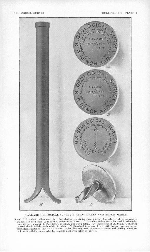
(iEOU)GICAIy SURVEY JU'I.I.KTIX 91fi PLATE 1
E
STANDARD GEOLOGICAL SURVEY STATION MARKS AND HENCH MAKkS.
A and B. Standard tablets used for triangulatipn, transit traverse, and leveling wliere rock or imisotiry i« available to hold them; A is used in cooperating States. C. Standard reference tablet used in trianjiula- tion; the arrow points to the station to which this mark refers. D, Under side of A^ B, and C showing twisted shank which holds tablet in plane. E, Standard iron post filled with bronze cap bearing an inscription similar to that on a standard tablet, formerly used in transit traverse and leveling where no rock was available: superseded by concrete post with tablet set in top.

PART 2. SOUTH-CENTRAL MISSOURI, 1908-1937 V
details, because of changes in design at various times. The face of every tablet,
however, is cast with the words "U. S. Geological Survey," a cross at the center which
indicates the fiducial point for position or elevation, and the words "Elevation above
sea." On some tablets the inscription indicates that they were set in connection with
a project in which a State or other organization cooperated; on some the inscription
Includes a triangle, which signifies a located point, enclosing the cross at the center.
Tablets bearing a triangle enclosing a cross may be used not only as traverse- or
triangulation-statlon marks but also as benchmarks. The inscription on most of the tab
lets already set Includes the warning "250 dollars fine for disturbing this mark," but
the latest design omits this phrase and adds the sentence "For information write the
Director, Washington, D. C."
If the tablet is to mark a transit-traverse station, the traverseman stamps it with
letters indicating this use of it, such as "Prim. Trav. Sta.," "P.T.S.," or "T.T.," as
well as his own identifying letter or letters, the serial number of the station, and
the year, using steel dies. If the tablet Is set as a benchmark, the levelman stamps
it with his identifying letter or letters, the serial number, and the year. He may at
the same time stamp upon it with steel dies the figures of elevation to the nearest
foot, or these figures may be added later. Tablets that serve as station marks may
have been set as such or they may have been originally established as benchmarks. Thus
some of them serve a dual purpose, but each has stamped upon it the date and the iden
tifying designation of only the engineer who established It.
The figures of elevation that appear on a tablet are usually determined by field
computation only. It is sometimes found, therefore, that they do not represent the
latest information. This has happened either because they refer to some independent
datum temporarily adopted before first-order trunk lines made standard datum available,
or because a later adjustment made in the office has rendered necessary an appreciable
change in the figures as determined in the field. In June 1958 a field party was or
ganized and charged with the responsibility of stamping figures of elevation, to the
nearest foot, on the permanent benchmarks established in the State by the Geological
Survey. Thus, these figures may appear stamped on the tablets in addition to the iden
tifying letters and numbers quoted in the printed descriptions. It is assumed that
engineers and others who require accurate figures of elevation for the marks will use
those printed in Bulletin 898, Instead of accepting the stamped figures. If the appro
priate part of the bulletin is not conveniently accessible, a request for the desired
information may be addressed to the Director, Geological Survey, United States Depart
ment of the Interior, Washington, D. C.
The tablets, of whatever style, are cemented Into holes drilled in solid rocks or in
the walls of public buildings, bridge abutments, or other masonry structures. Where ma
sonry or rock Is not available, the tablets are set in the tops of reinforced concrete
posts, which may be either precast or mixed and. molded at the selected site. The posts
are about 8 inches square or 8 inches In diameter at the top and larger at the base.
They vary in length from 36 to 1).8 inches and are generally set so as to project about
6 Inches above ground.
Antedating the concrete posts which are now constructed to hold the tablets, In
places where masonry or rock la not available, are wrought-iron posts, to the tops of
which are riveted bronze caps of similar design to the tablets. These iron posts meas
ure k feet in length and 3& Inches in outer diameter and are set about 3 feet in* the

VI TRANSIT TRAVERSE IN MISSOURI
ground. The bottom of the post' spreads out to a width of about 10 Inches In order to
give it a firm footing in the earth. No iron posts have been set in recent years.
They have proved Impracticable, as they are easily disturbed or are often destroyed
by rust at the ground level.
Azimuth marks and supplemental points. When practicable two or more reference points
have been observed In the Immediate vicinity of each station mark from which azimuths
may be found for future use. Such points as church steeples, windmills, water tanks,
or copper nails within triangles blazed on large trees have been utilized for, this pur
pose. ' -
Geodetic coordinates have also been determined for road or highway Junctions'and in
tersections, railroad stations and crossings, mileposts, and stream crossings.
Preservationand restoration of station marks. Any person who finds that a station
mark has been damaged, disturbed, or destroyed or that it should be reset or redoscrlbed
on account of highway or other improvements will render a public service by communicat
ing the facts to the Director, Geological Survey, United States Department of the Inte
rior, Washington, D. C., before taking any action affecting the location or elevation of
the mark. A proper form, accompanied by a return-addressed, franked envelope, will be
sent for use in reporting the action taken and In recording the revised description of
the mark, if any,_and the notes made in obtaining the prevised position.
Datum. Horizontal control surveys for the earlier topographic maps made by t£e
United States Geological Survey were expanded as local projects by small arcs of tri-
angulation based upon regipnal astronomic stations* purposely established to meet such
needs.
Later, additional area were expanded from locally adjusted positions referred to the
astronomic daturns of these original projects. This process eventually led to difficul
ty when the trlangulatlon based on the datum of one region was connected to that based
on the datum of another region. It waa then found that the closing arc was forced to
receive excessive corrections.
Eventually the arcs of first- and second-order triangulatlon were extended through
out the country so aa to form a comprehensive net of auch extent and strength that when
adjusted it provided one consistent general datum. Using this framework, it was then
possible to readjust the earlier local projects on a more uniform,and rigid basis. The
adjustment of the first-order net as a whole included and represented the averaged re
sults of all available astronomic observations.
Geodetic coordinates resulting from and affected by this adjustment of the first- and
second-order triangulatlon were distinguished from the coordinates accepted as the re
sult of previous adjustments by being referred to the "U. S. standard datum." -Subse
quently, arcs of triangulatlon In Canada and in Mexico were adjusted to agree with the
net in the United States, and the designation U. S. standard datum was changed to North
American datum. For stations in the United States no corrections to coordinates were
made as a result of the change In the designation.
*See Woodward, R. S., Latitudes and longitudes of certain points in Missouri, Kansas, and New Mexico: U. S. Geol. Survey Bull. £9, p. 10, 1889. See also Trlangulatipn and spirit leveling Missouri: U. S. Geol. Survey l8th Ann. Rept., pt. 1, pp. lltf-llw.» 1°97«

.PART 2. SOUTH-CENTRAL MISSOURI, 1908-195? .yji
.In 1927 the United Statea Coast and Geodetic Survey began a complete readjustment
of the entire first-order trlangulatlon net, which by that time contained a great many
arcs of triangulatlon that were done after the first general adjustment was completed.
The readjustment changed the coordinates of triangulatlon stations-throughout the coun
try. The new datum resulting from this change la referred to as the "North American
datum of 1927."
Transit traverse was first used by the United States Geological Survey in 1889 to
provide control for a mapping project in northern Missouri. It was adopted as a method
of establishing horizontal control to supplant triangulatlon in wooded or cultivated
regions In which the scant relief in topography rendered the continuation oftriangula
tlon for mapping requirements alow, costly, and deficient in the number and distribution
of stations and useful supplemental points. The regulations of the United States Geo
logical Survey at that time specified that the traverse llnea be started and ended
either at an astronomic station or at a triangulatlon station. Thus the changes in
datum made in the triangulatlon net have neceaaitated corresponding changes in the
transit trsfrtrae net.
The published results of transit traverse done by the United States Geological Sur
vey contain coordinates referring to one or another of the daturas described here, accord
ing to theidate of the computation or publication. Many of the earlier lines were cor
rected from their original astronomic daturas to the U.S. standard datum soon after the
basic coordinates referred to the latter became available. Recently much work has been
done to make the coordinates of all transit-traverse stations and supplemental points
refer to the North American datum of 1927, but the correction of the records probably
will not approach completion for a number of years. The latitude and longitude of all
triangulation- and transit-traverse stations, reference marks, and supplemental points
In Missouri published in this bulletin are referred to : Horth American datum of 1927.
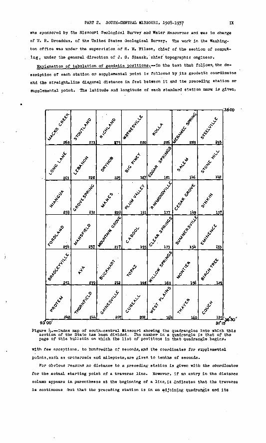
Location of the area. South-central Missouri, as the term is used In this bulletin
and as the subject of part 2 of the bulletin, is that section of the State lying south
of latittude ,38°00« and between longitudes 91°15' and 93°00'. (See fig. 3.)
Index map. The accompanying index map of south-central Missouri (fig. !(.) shows the
relative position of the quadrangle areas which make up this section. A quadrangle is
the unit of topographic survey adopted by the United States Geological Survey for di
viding the area of the United States. All the quadrangles In south-central Missouri
measure 15 minutes in latitude by 15 minutes in longitude.
Maps of many of the quadrangles in south-central Missouri may be purchased at 10 cento
each retail or 6 cents each in lots of 50 or more. Prepayment is required and may be
made by money order, payable to the Director, Geological Survey, United States Depart
ment of the Interior, or in cash the exact amount, at sender's risk. Postage stamps
should not be sent.
Diagrams of quadrangles showing routes of transit traverse. At the beginning of the
list of descriptions and positions of stations for each quadrangle is a diagram showing
the routes followed by the lines of transit traverse in and immediately adjacent to
that quadrangle. To aid in identifying these routes, the boundaries of the townships
and ranges in the quadrangle are indicated by light dashed lines, and the designations

VIII TRANSIT TRAVERSE IN MISSOURI
of these land subdivisions are given on the margin. The principal settlements are also
shown. The solid lines represent the routes of transit traverse of the United States
Geological Survey. To each of these is assigned a number, and the same number is as
signed to the list of descriptions and positions of stations along that route.
Personnel. The transit traverse of'the United States Geological Survey in south-
central Missouri was done under the supervision of the several chief geographers or
chief topographic engineers who were in administrative charge 'of the topographic branch
during the years when the lines were run. Included In the heading that precedes the
descriptions and positions of stations established along any line of transit traverse
are the name of the traverseman who ran that line and the- date when it was run.
36°3tf
Figure J. Outline map of Missouri showing the names and relative position of the eight sections covered by the parts of Bulletin 916, on transit traverse in the State. The shaded portion represents the section designated as south-central Missouri.
If this Information has been omitted, it may be assumed that the traverseman and the
date.are the same as those indicated for the line immediately preceding. The adjust
ment of the transit-traverse net was done partly by J. R. Bills, associate geodetic
engineer, assisted by ( P. W. Goln, Junior engineer, in the Washington office and partly
by engineers in the.field office at Holla, Mo. The revision, correlation, and compila
tion of the descriptions and positions of stations was done at Rolla by employees.of the
Works Progress Administration of Missouri, who also assembled the lists and made new
typewritten copies -of them suitable for reproduction by photography. The work at Rolla
PART 2. SOUTH-CENTRAL MISSOURI, 1908-1937 EC
was sponsored by the Missouri Geological Survey and Water Resources and was in charge
of W. R. Broaddus, of the United States Geological Survey. The work in the Washing-,
ton office was under the supervision of R. M. Wilson, chief of the section of comput
ing,, under the general direction of J. 0. S.taack, chief topographic engineer.
Explanation of tabulation of geodetic positions. In the text that follows, the de
scription of each station or supplemental point is followed by Its geodetic coordinates
and the straight-line diagonal distance in feet between it and the preceding station or
supplemental point. The latitude and longitude of each standard station mark is given,
268
263
259
254
251
9300'
271
228
232
J21
239
21*1*
875
225
220
_§il
212
207
187
191
^25.
198
202
286
177
^s.
/
I6q
16U
289
11*6
166
160
293
137
133
129
125
38"00
riS1
Figure 4. Index map of south-central Missouri showing the quadrangles into which this section of the State has been divided. The number in a quadrangle is that of the page of this bulletin on which the list of positions in that quadrangle begins.
with few exceptions, to hundredths of seconds, and the coordinates for supplemental
points,such as crossroads and mileposts,are given to tenths of seconds.
For obvious reasons no distance to a preceding station is given with the coordinates
for the actual starting point of a traverse line. However, if an entry in the distance
column appears in parentheses at the beginning of a line,it Indicates that the traverse
is continuous 'but that the preceding station is in an adjoining quadrangle and its

X TRANSIT TRAVERSE IK MISSOURI
description and coordinates may be found In the appropriate list. No descriptions ar«
repeated. Stations at traverse Junctions are fully described In the line In which they
first appear and are thereafter referred to by their designation followed by the paren
thetical phrase (previously described)." The coordinates of the closing station of a
traverse are repeated,and the last diagonal distance Is Indicated.
TRANSIT TRAVERSE IN MISSOURI PREVIOUSLY PUBLISHED
Triangulatlon and spirit leveling, Missouri; U.S. Oeol. .Survey, 19th Ann. Rept., pt. 1, pp. 158-160, 1898.
Results of primary triangulation and primary traverse, fiscal year 1900-1901, Missouri! U.S. Oeol. Survey Bull. l8l, pp. 165-170, 1901.
Resulta of primary triangulatlon and primary traverse, fiscal year 1901-2, Missouri: U.S. Oeol. Survey Bull. 201, pp. 76-78, 1902.
Results of primary triangulatlon and primary traverse, fiscal year 1902-3, Missouri: U.S. Oeol. Survey Bull. 2l6, pp. 135-136, 1903.
Results of primary triangulation and primary traverse, fiscal year 1903-14., Missouri: U.S. Oeol. Survey Bull. 2\\5, pp. 61-6?, 65-71, 19 (>[(..
Results of primary triangulation and primary traverse, fiscal year 1905-6, Missouri: U.S. Oeol. Survey Bull. 310, pp. 58-62, 1907.
Results of triangulatlon and primary traverse for the years 1906, 1907, and 1908, Mis souri: U.S. Oeol. Survey Bull. 1^0, pp. 258-259, 379-389, 1910.
Results of triangulation and primary traverse for the years 1909 and 1910, Missouri: U.S. Geol. Survey Bull. 1#6, pp. 205-219, 1912.
Results of triangulatlon and primary traverse for the years 1911 and' 1912, Missouri: U.S. Qeol. Survey Bull. 551, pp. 21+14.-2J1, 1911*..
Triangulation and primary traverse, 1913-15, Missouri: U.S. Oeol. .Survey Bull. 61&., PP. 353-390, 1916.
Triangulation and primary traverse, 1916-18, Missouri: U.S. Oeol. Survey Bull. 709, pp. 215-226, 1925.

INDEX
Page Abo ................ 229Ackerman, C. N., traverse by. . . . 211,
215-216, 238, 242-243, 258 Adams School. ........... 291Adjustment of transit traverse. . . IV Alley ............... 131;, 136Alley Spring. ........... 136Almartha. ......... 213, 240, 2k3Alton ...... 125, 128, 129, 130, IblAlton triangulation sta ...... 12SAmy ..._............. 204Amy triangulation sta ....... 204Anderaon, J. P., traverse by. . . . 228,
27!;, 277-279, 281-282 Archie Grove School ........ 166Arlington ............ 286, 288Arroll. .............. 155Ashley Church ........... 151Ava .......... 238, 239-240, 241Ava quadrangle. ......... 239-243Azimuth marks and supplemental
points, establishment of. . VI
Bakersfield ............ 205Baldridge School. ......... 189Bangert .............. 292Banner School ............ 131Banner triangulation ata. ..... 131Barger School ........... 251Barren Creek (Stone Hill quadrangle) l44 Barren Pork Creek (Montier quad
rangle) .......... 159Bartlett. ............ 133. 13°Basher. .............. 2k2Bateman triangulation sta ..... 261;Baxter School ........... 183Bear.Creek. ............ 275Belnllch, J.J. .traverse by. 127-128,132-J.3.3,
l40-l4l. 152-153, 159-160,163, 172, 180-181, 194-195
Bennett Spring (village). ..... 267Benton School ........... 293Bertha. .............. 213Beulah. .............. 185Bidwell ..............' 271Big Creek ............. 177Big Hollow. ............ 131Big Piney Creek .......... 129Big Piney quadrangle. ...... 187-190Birch Tree. ........... 129, 131Birch Tree quadrangle ...... 129-133Black Pond School ........ 154, 156Blanche .............. 2l6Bloodland ............. 190Blooming Rose .......... 181;, 185Boss. .............. 144, ll;5Boulware Ford across Gasconade
River ........... 286Bradford School .......... 166Bradleyville. .......... 250, 253Bradleyville quadrangle ..... 251-254Branch. .............. 269Branch triangulation sta. ..... 269Brands triangulation sta. . . t . . l62 Brandsville ........... 162, 166Brixey. .............. 215Broadauf, Heinz, traverse by. . . Ik7-l48,
150-151, 177-178, 182-185 Broaddus, W. R., traverse by. . . 125-127,
130, 136, l46-lk7, 349-150, 154-155, 157, 160-162,1614., 170-171, 173-1714., 17?,187, 191-192, 196-197, 198-199, 207-208, 212-213, 220-221, 225-226, 229, 232-234, 237-238, 239-214.0, 2144-214.6,
>, 256-258, . .' 273-274,
275-277, 295 Brown, R. E., traverse by. . 127, 131-132,
158-159, 162-163, 165-169, 171-172, 200-202, 203-336, 211
Brownbranch ............ 252Bruner. ............. 256, 258
251-252,
260-261, 264,272,
Page 213
179215
263 l44 ll|0
Brush Creek (Buckhart quadrangle)Brushy Creek (Raymondville quad
rangle) .........Brushyknob. ...........Bryant Creek. ......... 213, 238Buckhart. ............ 212Buckhart quadrangle ...... 212-216Buckhorn. ............ 278Bucyrus ............. 193Buffalo ...........Bunker. .......... 139-114.0,Bunker triangulation sta. ..
Cabool. ............ 196, 197Cabool quadrangle ........ 195-198Camdenton ............ 274Caney Creek ........... 211Caney School. .......... 210Cascade ............. 220Casey Ferry across Gasconade
River ........... 226Cassll, L. A., traverse by. . . . 200,
202-203, 208-211. 213-215, 217-218, 240-242, 246, 249-250, 252-254
Caulfleld ............ 20kCedar Bluff School. ....... 188Cedar Gap ............ 237Cedar Grove (village) ...... 150Cedar Grove quadrangle. .... 149-153Cedar Hill School ........ l4lCedarcreek. ........... 249Chadwick. ............ 254Charity ............ 264, 265Cherryville .......... 294, 295Clara .............. 19!Classification of transit traverse III Claxton Church. ......... 224Clear Springs School. ...... 175Clear Springs quadrangle. . . . 173 -17°Clementine. ........... 280Cloverdale School ........ 265Coldsprlng. ..........'. 215Colllns School. ......... 206Competition ........... 222Congo triangulation sta. (High HilL) 158 Convray. ....... 259, 263, 265-266Cookville ............ 188Cooperation ........... IllCouch .............. 128Couch quadrangle. ....... 125-129Craig, C. D. , traverse by . 138, lk3-l44i
188,226-227,269,285, 2§8Crocker ............ 277, 28lCrooked Creek .......... 294Cull. .............. 161Cureall quadrangle. ...... 202-206Current River ......... 135, 153Ouster. ............. l4?
Datum of positions. ....... VI -VIIDavis Creek School. ....... 204Dawt. ............. 203, 210Dawson School .......... 222De Camp ............. 29!Decaturvllle. .......... 271Denlow. ............. 215Diagrams of quadrangles .... VII-VIII
See also Individual quadrangles Diggins ............. 255Dlllard ............. lL2Dixon .......... 281, 282, 285Dogwood ............ 256-257Dousinbury Creek. ........ 265Dry Auglaize Creek. ....... 2?4Dry Fork. ........ lk6, 148, 290Drynob. ............ 226, 227Drynob quadrangle ....... 225-228Dugglnsvllle. .......... 2k6Duram, L. D., traverse by. .... 281Dunoan. ............ 232-233Dunlvin ............. 289, 29!Durbin School .......... 236Dykes ............. 191, 195
XI

XII INDEX
Page Earl ............... ll;6Eastvlew .......... 2l;5, 2l;8-2l;9Ebenezer Church.. ......... 157Edgar Springs quadrangle .... 181-186Eldrldge ............ 268, 271Eleven Point River ........ 158, 170Elk Prairie. ........... 291Elkhead. ............. 2§6Elkland. ............. 261Elkland trlangulatlon ata. .... 26lEllia, J. R., traverse by. ... 181-182,
280, 286-287, 289 Bills Prairie. .......... l8lBills School ........... 193Ellsworth School .......... 193Embree .............. 223Eminence ............. 134Eminence quadrangle. ...... 133-137Eunice .............. 154., 177Evergreen School
227
291226160126
III III
Falrview School (Drynob quadrangle) Pairview School (Meramec Spring
quadrangle)........Falcon ..............Fanchon. ............ 159Farewell .............Federal Board of Surveys and Maps,
limitations prescribed by. Federal Emergency Relief Adminis
tration, cooperation with. Plat .............. 181, 183Flat Grove School. ........ 291Flat Rock School ......... 201Fordland .......... 25l;-255. 256Fordland quadrangle. ...... 25l;-258Fothergill, J. W., traverse by . . 19k,
219-220, 222-221;, 227-228,229-232, 23k-236, 262,26^-266, 27^-275
Fox Creek. ........... 213, 211;Franks .............. 280, 285Frederick Creek. ........ 127, 128Friendship Church. ........ 272Fudge Hollow ........... ll|.8Pus on store. ........... 221;
Oainesville. ..... 207, 208, 209, OkOainesville quadrangle ..... 207-212Gardner National Forest. ..... 201Gardner School ..........Gasconade River. ...... 221, 222,
Boulware Ford across. .....Casey Ferry across. ......Lick Fork of. .........Osage Fork of .........Woods Fork of .........
Gentryville. .......... 213,Girdner. .............Glover Chapel. ..........Goodhope ............ 252,Grassy School. ......... 135,Green Mountain ..........Greenview.
230
226 238 260 238 211;
136220226
3Greer. ............ 130,..132-133Grogan trlangulatlon sta .... .liB, Iu9Gross, H. W., traverse by. . . . 18I;-l8o,
188-189, 150, 277-278, 279, 282-281;, 287-288
Grovesprlng. ........... 233-23UGrovesprlng quadrangle .....' 232-236Gunters Creek. .......... 159
Hammond. ............. 2k5Hancock. ............. 283Hanna. ........ 187, 188, 226-227Hardenvllle. ........... 209Harrlson Creek .......... 207Harsha, B. D., traverse by . 22l;-225, 236 Hartshorn. ........... 150, 152Hartvllle. ......... 232, 233, 238Hawkeye. ............. 276Hawklna, G. T., traverse by. . . 27!)., 277 Hazlegreen ............ 279Helm ................ 283Hercules ............. 250Hickory Grove Church (Birch Tree
quadrangle). ....... 130Hickory Grove School (Stoutland
quadrangle). ....... 272Hleks School ........... 238High Prairie School. ....... 229Hodgson Mill ........... 210Hogard Creek ........... 207
Holmes' store (WoodsIde) .....Homeland trlangulatlon sta ....Hooker ..............Hopewell School (West Plains quad
rangle). .........Hopewell School (Steelvllle quad
rangle). .........Hopklns School ..........Hough School ...........Houston. ......... 179, 181Houston.School (Steelvllle quad
rangle). .........Houston School (Clear Springs quad
rangle )..........Howards Ridge (village). . 202, 208Howe .............. llj2Howe trlangulatlon sta ......Howes Mill School. ........Huben spur ............Hugglns. .............Hutton Valley (village). .....Hyde Creek ............
Page 132 165 281;
168
295201230
. 193
293
175
192169234
Indian Creek ........... 236Indian Trail State Park. .... 114.3, 295Ink. ......... 138, 114.0, 11(1, 152Interstate Commerce Commission,
transit traverse by. ... IVIra. ............... 268Isabella ............ 214!;, 2l;7
Jacks Fork ........... 131;, 155North Fork of ......... 176South Fork of ......... 176
Jadwln .............. 150James River. .......... 258, 260Jameson School .......... 26lJeff ................ 126Jerlco .............. 239Jerome .............. 288Job. .............. 126, 128Joy. ................ 1U.7
Sage School. ........... ll;7Kennedy, W. V., traverse by. . . 165-169,
200-202, 203-206, 211Keysvllle. ............ 29!;Kiasee Mills ........... 250Knight trlangulatlon sta ..... 2k8Krattler, 0. L., traverse by ... 136,
138, 1144, 114.8, 292Lake Spring (village). ...... 290Lanton ............. 167-168Lead Mine. ............ 269Leavltt, J. B., traverse by. . . . llj.6,
287, 290-292, 293 Lebanon. ......... 231, 271;. 275Lebanon quadrangle ....... 228-232Leooma ............. 289, 292Lenox. .............. 182Leota. .............. 205Lewis trlangulatlon sta. ..... 130Liberty School .......... 172Lick Fork of Gasconade River ... 2 Licking. ............ 183-1Little Beaver Creek. ....... 281Location of the area ....... VII
outline map showing . . . . ^ . VIIILone Star School ..... ..^.- '^ . 187Long Lane. ........<.. 26k, 266Long Lane quadrangle ...... 263-267Low Wassle ............ 130Lower Hepslde School ....... 151Lutle. .............. 2foLynchburg. ........... 221, 222
Macks Creek (village). ..... 269. 270Macks Creek quadrangle ..... 268-270Maoomb .............. 217Mammoth. ............ 208, 209Manes. .......... 220, 221, 223Manes quadrangle ........ 220-225Mansfield. ........... 237-238Mansfield quadrangle ...... 237-239Maples ............. 182-183Marble Hill School ........ 158Marcoot. ............. la.5Marshfield ........... 259, 260Marshfleld trlangulatlon sta . . . 260McNair, E.L., traverse by .129-130, 133-136,
: 137-138,15k, 156-157,169-170,173, 195-196, 2lf, 228-229,237, 25[;-255, 259-260, 263,271-272, 27&, 277

Page Meadville. ............ 265Meramec River. ......... lk2, 295
Steelville Ford across. .... 292Meramec Spring .......... 291Meramec Spring quadrangle. . . . 289-292Midridge ............ ikO-lip.Missouri Geological Survey and Water
Resources, cooperation with in,IX Missouri School of Mines triangula
tion sta ......... 287Missouri State Highway Commission,
cooperation with ..... IllMountain View. ....... 155, 157, 170Montauk State Park ........ 151Montier. ............. 157Montier quadrangle ....... 156-160Montreal ............. 27kMoody. ............. 168, 169Mooney Creek ........... 128Morgan ............. 229-250Morgan School. .......... 126Mount Ararat School. ....... 198Mount Pleasant School. . . . 202-203, 206Mountain Dale School ....... 257Mountain Grove (town). . . 217, 218, 219 Mountain Grove quadrangle. . . . 217-22&Mungy School No. 1 ........ 286Myatt Creek. .......... 163, l6?Myrtle .............. 126
Nance. .............. 2k8Near Home Church ......... 17kNebo .............. 225-226Needmore School. ......... 203New Hope School (Galnesvllle quad
rangle). ......... 208New Hope School (Salem quadrangle) ll(.6 New Liberty. ........... 132New Orleans School ........ 198New Salem Baptist Church ..... looNiangua. . . . ... . . 23k, 259, 260-261Niangua River. . . . . 263, 265, 267, 270Niangua quadrangle ....... 259-262Noel's store ........... 197Northview. ........... 255, 260Norwood. ....... 21k, 217, 218, 219Nottinghlll. ........... 2k5
Oakdale Church ......... 177 > 179Oakland School .......... 226Oakslde. ............. 155Ocle ............... 2k8, 251Odin ............... 233Odom School. ........... 203Orla ............... 230Osage Fork of Gasconade River. . . 260 Oscar. .............. 180
Painter triangulation sta. . . . 257, 258Palace .............. 188Parker, R. H., traverse by .... lk5,
183, 187-188, 281, 2 Parkview School. ........Peace Valley ..........Pease. .............Penrod triangulation sta ....Personnel. ............ VIIIPhllllpsburg .......... 263, 26kPigeon Creek ........... 186Pine Grove (village) ....... 156Pine Park School ......... 2k2Pine Ridge School (Plum Valley
quadrangle)........ 193Pine Ridge School (Raymondville
quadrangle)...'..... ISOPiney Creek. .......... l8k, 193Plnwood triangulation sta. .... l6lPlank School ........... 26lPlato. ..... 187, 189, 192, 221, 225Pleasant Hill School (Clear Springs
quadrangle)........ 17kPleasant Hill School (Gainesville
quadrangle). ....... 210Pleasant Hill School (Meramec
Spring quadrangle) . . . 290 Pleasant Valley School ...... 239Plum Valley quadrangle ..... 191-195Pomona .............. l7lPomona triangulation sta ..... 171Pondfork ............. 2k5Pontiao. ............ 2k6-2k7Positions, datum of. ....... VI-VII
tabulation of ......... IX-X
Ik3 160 23k
PagePosts, use of, to hold tablets . . V Pottersville ........ 203-20k, 206Prairie Creek. .......... 238Prior. .............. 217Protem ............. 2k8, 2k9Protem quadrangle. ....... 2k&-251Pulltlght. ............ 153
Quadrangles in south-central Mis souri, index map showing . IX
maps of, how to obtain. .... VII See also descriptions and dia
grams under individual quadrangles.
Rader. .............. 235Rat. ............... lfj.0Rayborn. ............ 220, 221Raymondville ........... 180Raymondville quadrangle. .... 177-18!Rector ............. 152, 153Rlchland ......... 277, 278, 279Rlchland quadrangle. ...... 275-279Richville. ........ 199, 200, 213Roach. ............. 269, 270Roby ................. 189Rockbridge ............ 213Rogersvllle. ........... 255Rolla. .......... 287, 288, 283Rolla quadrangle ........ 286-288Romance. ......... 207, 210, 2k6Romance triangulation sta. . . . 207, 210Rome ............... 252Rose School. ........... 223Rover. .............. l6lRover triangulation sta. ..... 159Royal Oak School ......... 128
St. Annie School ......... 188St. George ............ 223St. James. ............ 29!Salem. ........ lk5, lk6-lk7, Ik8Salem quadrangle ........ lip-Ik^Sampson. ............. 259Sand Spring School ........ 261Sanders, J. L., traverse by. . . . 11+2,
292, 293-295 Sargent. ............. 196Sawyers School .......... 29!Scope of report. ......... IllSeaton .............. 290Seymour. ............ 255, 257Shady Grove School ........ 205Shawnee. ............. 134Shiloh School. .......... 127Short Bend store ......... Ik2Slmmons. ............. 197Sinkln .............. 139Sinkin Creek ........... 139Sinkln quadrangle. ....... 137-llilSleeper. ............ 27k, 275siigo. ............. ik3, 295Smallett ............. 2klSolo ............... 17kSouder .............. 213Spring Branch Creek. ....... 165Spring Creek ........... 2klSpring Creek (village) . . 190, 28l, 287 Spring Valley Creek. ....... 139Squires. ............ 2kO, 2lp.Squires triangulation sta. .... 2klStar School. ........... 199State Highway Department, traverse by. 128-129,
Ik8-lk2, 164, 175-176,181, 186, 190, 267, 270
Station marks, classes of. .... IVforms of. ........ IV-VI, pi. 1how set ............ IV-VIpreservation and restoration of VI
Steelville ......... 293-29k, 295Steelville Ford across Meramec
River. .......... 292Steelville quadrangle. ..... 293-295Sterling ............. 196Stone Hill quadrangle. ..... lk2-lk5Stoutland. ........ 272, 273, 27k.Stoutland quadrangle ...... 271-275Stultz store ............ 17kSuccess. ............ igk-195Summeraville .......... 15k-155Summersvllle quadrangle. .... 15k-156Surprise School. ......... 133Swedeborg. ........ 276, 277, 278
XIV INDEX
Sweden .......... 213, 2k2, 2k3Sycamore ............. 203, 210
Taney trlangulation sta. .... 251, 253Tecumseh ............. 209Teresita ............. 157Thayer ............. 127, 163Thayer quadrangle. ....... l6o-l6kTheodosia. ............ 214).Thomasvllle. .......... 132, 159Thompson, C. P., traverse by ... 269 Thornfield ........ 2kO, 2k5. 2k6Thornfield quadrangle. ..... 2kk-2k7Tigris .......... 238, 2k3, 258Topaz. .......... 199, 200, 211;Topaz quadrangle ........ 198-202Toronto. ............. 273Transit traverse, adjustment of. . IV
classification of ....... Illin Missouri, earlier publica
tions on ......... XTraak. .............. 170Tribune. ............ 187, 28lTurner's mill. .......... 1J3Turtle ........... 138, lk3-lkkTwin Bridges (village) ...... 199Twin Hickory store ........ 177Twin triangulatlon sta ...... 212Tyrone .............. 17k
Vada ............... 19kVanzant. ....... 21k, 2l6, 217-218Vera Cruz. ........... 215, 2k3Victor School (Clear Springs quad
rangle). ........ 17k-175Victor School (Stone Hill quad
rangle ).......... lk3Victory School .......... 212Vilean .............. 290
Walnut Valley Branch ....... l6kWasola .............. 2kOWaynesville. ..... 281-282, 283, 28kWaynesvllle. quadrangle ..... 280-285Webb trlangulation ata ...... 13&
Page Weber, D. W., traverse by 255-256, 260,
263-26k, 268-269, 27?Wesco .............. 29t|.Weat Eminence .......... 13kWest Plains . 159, 160, l6k, 165, 167,170 Weat Plains quadrangle. .... l6k-lo9Wet Glaize. .......... 273, 275Wharton ............. 187Wheelers.Mill .......... 283Whetstone Creek ........ 221, 22kWhite, C. S., traverse by ... lk2-lk5 White Church (village). ..... 170White River, North Pork of. ... 199
200, 210, Whites Creek. ..........Wild Cat Creek. .........Wilderness. ...........Wlldwood. ............Wlllhoit. ............Williams, C. W., traverse by. . . _^_,
136, 138-iko, ik5, ik9,172,202, 236, 238-239, 251
Willow Springa (town) . l6$H70, 173, 201Willow Springs quadrangle . . . 169-172Wilson, R. S., traverse by. . . 211-212.
216, 2k6-2k7, 250-251, 25kWindy Curve store ........ 19kWindyville. ........ 263-26k, 267Winona. ............ 130, 136Winona Junction ........ 133, 1?6Woods Pork of Gasconade River . . 238 Woodside. ............ 132Works Progress Administration, co
operation with. ... Ill, VIIIWyrlck, C.-.E., traverse by 136-137, ikO,
151-152, 155-156, I7k-i75, 178-180, 183-lSk, 189 , 192-19k, 197-198, 219,222
Yukon .......... 17k, 177. 179Young triangulation sta « . . 136, 137
Zanoni. .....Zion Hill Church.
211290
O

TRANSIT TRAVERSE
COUCH QUADRANGLE (Latitude 36?30'-36«45' ', longitude 91°15'-91°30']
Oregon County
1. PROM POINT 4.8 MILES NORTHEAST OP ALTON SOUTHWEST TO POINT 1 MILE NORTHEAST OP ALTON, THENCE NORTH INTO BIRCH TREE QUADRANGLE AT SEC. 10, T. 2k N., R. 4 W. (by W. R. Broaddus In 193!)
Station
Alton triangulatlon.sta; ; U.S.C; & G.S. standard
Rd. corner In front of mall box at foot of hill - Alton, 2.3 ml. E. of, along rd. to Braswell,
30 ft. E. of creek crossing, at angle In rd. from W.-NE.', In concrete post; standard tablet
Alton, 2 ml. N. of, near center of S 1/2 sec. 22, T. 2k N., R. I). W. , 20 ft. N. and 20 ft. E. from Junction of dim rd. E. , 4 ft. NW. of fence corner, In concrete post; standard tablet
T. 24 :HJ., R. l± W. , N. 'sixteenth, cor. sec. 15>
Latitude
0 1 tt
36 U2.55-07 36 42 35.0
36 42 13*66 36 41 48.6 36 42 41.8
36 43 20.81
36 W* 39-2
Longitude
0 1 II
91 19 22. 1 6k 91 20 45.4
91 21 1)4.73 91 22 lj.7.3 91 23 25.7
91 23 17.97
91 23 16.3
Distance
Feet
6,982
5.2&0 li 696 6,219
4,000
7,924(Continued In Birch Tree quadrangle; see line 2.)
PROM POINT 4-8 MILES NORTHEAST OF ALTON EAST TO SEC. 30, T. 24 N., R. 2 W., THENCE SOUTH TO MYRTLE, THENCE WEST INTO THAYER QUADRANGLE AT SEC. 34, T. 22 N., R. 5 W., INCLUDING THAT PART OF'THE LINE IN
:BARl»y, ARKANSAS, ASD GATEWOOD QUADRANGLES (by W. R. Broaddus In 1932) *
AJLton triangulatlon sta. (previously described) -
T ____J O T-___
T rd N -" *T. 24 N., R. 3 W., center sec. 27, l6 ft. N. and
27 ft* W. from crossroads, diagonally opposite farmhouse of Clarence Nlohols, In concrete post; standard tablet stamped "T T 87 B 1932" -
Junction of dim rd. S. at triangular-blazed pine
T-rd. S. near quarter cor* between sees. 25 and?(. m ot, rt P 7 W
T. 24 N., R, 3 W. , stone at center sec. 25, 10 ft. S. of rd., 5 ft. W. of NE. corner of field-
T. 24 N., R. 2 W., W. quarter cor. sec. 30, 8 ft. N. and 8 ft. W. from rd. forks, 172 ft. ,N. of stone at E. quarter cor. sec^ 25> T; 24 » > R ^5 W - - - - . - _ r __- ____ H
T. 24 N;| R. 2 W., about 700 ft. E. of W. cor. sees. 30 and 31, 27 ft. N. and 31 ft. E. from rd. corner, 4 ft. W. of triangular-blazed pine tree, In concrete post; standard tablet stampeddm m Op n TO7? n «_ _
36 42 55.07 36 42 48.2 56 42 56.7 36 42 36.6
56 42 36.3436 42 35.6 36 42 35.536 42 34^7
36 42 35-9
56 42 34-7
36 42 08.68 36 42 oy-9
*Iiln« 1 of Omtewood quadrangle includes a portion of this line PP. 95-96).
91 19 22.64 91 18 14.0.291 18 01.1 91 17 28.3
91 16 39.8291 15 49.1 91 15 40.4
91 15 02.6
91 14 29.5
91 13 57-2
91 13 48.88 91 13 16.3 (see Bull. 91(
5^22 5,585 2,670
5,952
4,129 710
3,090
2,689
2,637
2,711 2,653
-A,
125

126 TRANSIT TRAVERSE IN MISSOURI
Station
T. 21). H., R. '2 V»., center of SE 1/4 sec. 31, Iron
Morgan School, near center of S 1/2 aec. 6, T. 23 N., R. 2 W., 6 ft. W. of W. door of schoolhouse, in concrete porch; standard
Triangular-blazed tree near rd. at bottom 'of
T. 23 N., R. 2 W., W. cor. sees. 7 and 18, rd. at
T. 23 N., R. 3 W., In NE 1/4 sec. 2k, 1 mi. E. of Dry Creek. 38 ft. K. and 3! ft. W. from State. Highway llj. at crossroad, in concrete post;
T. 23 N., Rs. 2 and 3 W. , cor. sees. 25, 30, 31,
Job, 1.3 mi. N. of, in SW lA sec. 36, T. 23 N., R. 3 W. , kOO ft. N. of Dry Creek ford, 25 ft. N. and 30 ft. E. from junction of rd. E., 7 ft- N. of fence corner, in concrete post; standard tablet stamped "T T 91 B 1932" -
Job, crossroads at cor. sees. 1, 2, 11, and 12,
T. 22.»., R. 3 W., cor. sees. 11, 12, 13, and lk,
Job, 2 ml. S. of, 31 ft. S. and 22 ft. W. from crossroads, at cor. sees. 13, Ik, 23, and 21)., T. 22 H., R. 3 W. , 20 ft. S. of fence corner, in concrete post; standard tablet stamped
Myrtle, 1 ml. NE. of, kk2 ft. N. and kO ft. E. from S. sixteenth cor. between sees. 35 and 36, T.. 22 N., R. 3 W., 25 ft. N. and 40 ft. E. from T-rd. N. , in concrete post; standard
T. 22 N., R. 3 W., S. sixteenth cor. between
T-rd. N. : Myrtle, T-rd. N. at W. sixteenth cor. on S. line
sec. 55, T. 22 N., R. 3 W. - ------Myrtle, in front porch of general store of
John M. Crass, W. of frontf door; standard
T. 21 N., R. 3 W., N. cor. sees. 3 and k, rd. at
T. 21 N., R. 3 W., N. cor. sees. I), and 5, rd. at
Myrtle, 2.8 ml. W. of, In SE 1/4 SW 1/T| sec. 32, T. 22 N., R. 3 W., at Jog In rd. , k6 ft. N. and 67 ft. E. from NE. corner of farmhouse of Mrs. Wetzell, 13 ft. S. 52° W. of walnut tree, in concrete post; standard tablet stamped
Rd. at fences N. and S. on line -between sees. 1 and 6, T. 21 N., Rs. 3 and 1; W. --
Farewell, 20 ft. S. and 36 ft. E. from rd. forks, 11 ft. E. of fence corner, in concrete post;
Ark. -Mo. State line, 0.3 ml. S. of Farewell, rd.
Rd. fork N. to schoolhouse, opposite trlangular-
T. 21 N., R. k W., W. slxteehth cor. on N. line
Jeff; 1.3 ml. W. of, 31 ft. S. and 160 ft. E. from . sixteenth cor. 0.2 ml. E. of N. cor. sees, k and 5, T. 21 N., R. k W. , kO ft. N. of NW. corner of farmhouse of Grover Alien, 31 ft. S. of rd., in concrete post; standard tablet
Latitude
0 | II
36 kl kl.7 36 kl kl.k
36 kl 28.3
36 ko 51.73 36 ko 52.736 39 56.6
3.6 39 34.1 56 39 31.2 36 39 05.3 36 38 54.8
36 38 35-57 36 38 15-5 36 37 57-2 36 37 22.5 36 37 li.O
36 36 55-1
36 36 Ok. 70 36 35 53-3
36 35 00.3
36 jk 06.7 36 33 39-4
36 33 11.78. 36 32 26.2 36 31 51.0 36 31 37.4
36 30 48.04
36 30 43-7 36 30 30.3
36 30 30.6
36 30 30.86
36 30 30.8
36.30 32-5
36 30 36.99
36 30 06.5
36 30 Ok. 38
36 29 49.7
36 30 06.1 36 30 18.236-30 37.7
36 30 37.82 36 30 38.6
Longitude
01 II
91 13 16.9 9] 13 00.5
91 13 00.7
9* 13 30.17 91 14 00.0
91 Ik 01 .;3
91 Ik 01. k 91 14 01.6 91 14 02.2 91 Ik 02-5
91 lk 15.25 91 lk 17-1 91 lk 20.091 lk ok. 7 91 lk 13.3
91 ll). 05.3
91 lk 57.65 91 15 Ok.8
91 15 06.191 15 07.1 91 15 07.9
91 15 08.8591 15 08.6 91 15 15-0 91 15 15-4
91 15 10.78
91 15 11.5 91 15 1*4-8
91 16 01.2
91 16 01.00
91 17 25.9
91 18 30.7
91 18 59.85
91 20 35-3
91 21 40.90
91 21 kl.k
91 22 47-6 91 23 03.8
91 23 34-9
91 2k 36.93 91 25 10. 1).
Distance
Feet 2,650 1,340
1,330
4,4042,k30
5,672
2,276 294
2,625 1,055
2,203 2,037 1,870 3,723 1,353
1,737
6,648 1,297
5,358
5,422 2,766
2,792 k,6lk 3,593 ii>379
5,00k
445 3,0ko
1,340-
31
6,931
5,292
2,424 8,384
5,358
i,48o
5,6531,799 3,215
5,065 2,733

PART 2,,SOUTH-CENTRAL MISSOURI, 1908-193? 12?
Station
T. 21 N.>, R. 4 W., N. cor. sees.' 5- and 6, T-rd;
T. 22 {H., R. 4 W-» S. cor. sees. 31 and 32, rd.
Thayer, 4-9 ml. E. of, 0;2 ml. W. of cor. Tps. 21 and 22 N., Rs. 14. and 5 W. , 33 ft. S. of rd. , 55 ft. N. and 42 ft. W. from NW. corner of farmhouse of 0. 1U Young, 5 ft.' SE. of fence corner, In concrete post; standard tablet
Thayer, 3-2 ml.; E. of, along rd. to Myrtle, 15 ft. S. and 35 ft- w « from crossroads at top of hllli In concrete post; standard tablet stamped"T T QQ R IQ^P" »______________ ______________
Latitude
o t «
36 30 39-4
36 30 39-3 36 30 39-2
36 30 39.2? 36 30 k.0.2 36 30 42.7
*6 10 kfi.7?
Longitude
0 | II
91 25 56.3
91 26 10.1 91 26 33.1
91 27 13.18 91 28 2J.ii 91 29 07.9
Q1 ?Q Pfl.13
Distance
Feet
3,748
1,125 1,875
3,274 6,057 3,320
1.716
(Continued in Thayer quadrangle; see line 2.)
FROM MYRTLE SOUTH TO ARKANSAS-MISSOURI STATE LINE (by W. R. Broaddus In 1932)
Ark.-Mo. State line, In sec. 3, T. 21 N., R. 3 W., corner stone, 80 ft. W. of fence N., 10 ft; S. of fence corner(in Hardy, Ark., quad.) 56 29 50.5
91 16 01.00
91 16 1|7.9 4,216
4. FROM SEC. 6, T. 21 N., R. k W., SOUTH TO ARKANSAS-MISSOURI STATE LINE (by W. R. Broaddus In 1932)
T-rd Ark.
E.-Mb. State line at rd. N., 10 ft. S. of rd,.
36
36
30
29
39-14-
50.3
91
91
25
25
56
58
3
9 k, 959
FROM THAYER QUADRANGLE AT SEC. 34, T. 2k N., R. 5 W., SOUTHEAST TO SEC. 18 j T.' 23 N., R. k W., THENCE SOUTHWEST ALONG STATE HIGHWAY INTO THAYER QUADRANGLE (by R. E. Brown In 1935)
19
Dim crossroads (In Thayer. quadrangle; see . line 1 ') * _ _ '-
T-rd. N., 80 ft. W. of rd. at blazed 26-ln, oak
Rd/ fork NW. , opposite blazed 22-ln. oak tree T. 2k N., R. 5 W., S. cor. sees; 35 and 36, 125
ft.' E. of N. cor. sees. 1 and 2, T. 23 N.,
T. 23 N., R. 5 W., E. sixteenth cor. between sees. 1 and 12, l8k ft. N. 72° W. of rd. at fence N,, 13 ft. N. and 8 ft. E. from NE. corner of Shlloh School, In concrete post; standard tablet stamped "T T lk70 ERA 1935" -
T. 23 N., Rs.- k and 5 W., cor.; sees. 1, 6, 7, and
T. 23 N., R. k W., W. sixteenth cor. sec. 7,
T-rd. N., 12 ft. W. of rd. at fences N. and S. at approximate W. sixteenth cor. between sees. 7
U.S.C; & O.S, standard disk stamped 1W 51 1934"- Frederlok Creek, center of bridge over U.S.C. & G.S. standard disk stamped "X Jjl 1934"- T. 23 N., R. 5 W., cor. sees. 23, ^k, 25j> and 26,
T. 23 N., R« 5 W. , E. sixteenth cor. sec. 26,
U.S.C. & G.S. standard disk stamped "Y 5! 1934"-
Corner stone In N 1/2 sec. 3, T. 22 N., R. 5 W. - U.S.C. & G.S. standard disk stamped "Z 51 1934"-
36 kl 26.7
36 kl 26.036 kl 25.7
36 kl 25.636 4l 02.9
36 40 33.27 36 ko 32.9
36 39 U0.636 39 21.2036 38 38.136 38 08.79
36 37 30.556 36 49.67
36 36 00.7 36 35 14-0.72
91 30 ok. 9
91 28 39.1
91 27 38.67
91 27 19.8
91 27 03.8
91 26 46-98 91 27 05.9, 91 27 49-74
91 28 30.8
91 28 14.7.891 28 30.6991 28 50.1 91 29 314 91 29 50.11
4,2752,705
2,594
3,869
1.5142
2,940
2,6602,429 4,628 4,636
3,635
4,359
3,534 2,535 ,
(Continued In Thayer quadrangle; see line 6.)
6. FROM STATE HIGHWAY 19 EAST ALONG. COUNTY ROUTESGATEWOOD QUADRANGLE AT SEC.in 1936)
T. 23 N., R. 5 W., approximate S. cor.
T. 23 N., R. 5 W. , approximate SE. cor h1o>hwav at r-leht-of-wav of -rd. N. --
1, T.
sees.
. sec.
22 N., R.
35
36,
36
3636
*fi
3
36
3636
x6
A Aim E AND ROADS INTOW.
491110
in
(by J.
i.n
4 9
.7
91
9191 en
J.
oQ
oQ
27 P7
Belnllch
30.69
&l
yf..n
t:^
QTP
io4xcn

128 TRANSIT TRAVERSE IN MISSOURI
Station
Couch, 2.8 ml. W. of, along County Route A, in NE 1/k NW lA 360.- 5,. T. 22 N., R. k W., 28 ft. S. and 390 ft. E. from highway at rd. S., on top of hill, 58 ft. N. and 17 ft. E. from NE. corner of dwelling of H. C. Groom, in concrete post; standard tablet stamped "T T 1 J J 1936"-
Highway at fence N. on line through center
Couch, £93 ft. S. and 285 ft. W. from sixteenth cor. 0.25 ml. S. of quarter cor. between sees. 3k and 35, T. 23 N., R. k W., 3! ft. S. of County Route A at rd. N. to business district, 6 ft. S. and 2 ft. E. from fence corner, in concrete post; standard tablet
Mooney Creek, center of concrete low-water bridge
Junction of rds. S. and NE. , 225 ft< s - of s - sixteenth cor. between sees. 35 an<^ 36,
T. 23 N., Rs. 3 and k W. , S. cor. sees. 31 and
Couch, 3-7 mi- SE. of, along County' Route E, In SE l/tj. sec. 6, T. 22 N., R. 3 W., 25 ft. S. and 32 ft. E. from highway at rd. E. , near top of hill, k ft. S. and 2 ft. W. from fence corner, in concrete post; standard tablet stamped "T T 3 J J 1936" -
Job,, 2 mi. W. of, along Garfield-Job rd., in NE 1/k NW 1/k sec. 10, T. 22 N. , R. 3 W. , 3k ft. S. and 17 ft. E. from Junction of rd. S., 15 ft. S. and 2 ft. E. from fence corner, in concrete post; standard tablet 'stamped "T T 14- J J 1936"
T. 22 N., R. 3 W., quarter cor. between sees. 3 and 10, iron pin in rd. at fence? N. and S.
T. 22 N., R. 3 W. , approximate cor', sees. 2, 3,
T. 22 N., R. 3 W. , approximate quarter cor. between sees. 2 and 11, rd. at rail fence S.
T. 22 N., R. 3 W. , approximate quarter cor. between sees. 1 and 2, rd. at right-of-way W. -
Latitude
36 36 05.6
36 36 01.8k 36 36 01.9 36 36 09.0 36 36 08.8
36 36 16.0
36 36 16.27
36 .36 16.5
36 36 18.3 36 36 07.0
36 36 06.8 36 3§ 3^.6
36 35 pk.9i 36 3f 14-7 36 3k 37.6 36 3k £5.2 36 3k k8.5
36 3k 5k. ik
36 35 Ol.l
36 35 00.6
36 35 oo.k
36 35 26.8 36 36 ok.70
Longitude
0 | 11
91 26 22.3
91 25 58.11 91 25 l^. 8 91 2k 21.3 91 2l». 08.5
91 23 30.8
91 23 00.53 .
91 22 28.1
91 21 504 91 21 21.5
91 20 kk.3 91 20 .08.6
91 19 59*31 91 19 23.2 91 18 59-2 91 18 10.8 91 17 37-3
91 17 03.51*.
91 16 k6.9
91 16 12.8
91 15 394 91 15 05-391 4 57-65
Distance
Feet 5,225
2,007 3.530H42k1,038
3,160
2469
.2,6k7
3,078 2,617
3,031 4,366
3,097 3.583 2,051 k,082 2,71*7
2,8ll».
1,528 2,78k 2,720 3,859
7. PROM THAYER QUADRANGLE AT SEC. 15, T. 2k N., R. 5 W.. EAST AND NORTH INTO BIRCH TREE QUADRANGLE AT SEC. 11, T. 21; N., R. 5 W. (by J. J. Beinlleh In 1936)
(Continued from Thayer quadrangle; see line 8.)
T. 2k N., R. 5 W., cor. s'ecs. lk, 15, 22, and 23,
State Highway Ik- at rd. N. , 14 ft. E. of rd. S. - Old Alton-Thomasville rd. at N.-S. crossroad, ;
T. 2k N., R. 5 W. , E. sixteenth cor. between
(Continued in Birch Tree quadrangl
36 kk 034
3f 14 03.1 36 kk 02.3
36 lik 39.8
36 kk 5k. 5
e; see line 7
91 29 51.1
91 29 26.2 91 28 36.9
91 28 36.1
91 28 35-5
.)
(2,759)2,026 ft, 010
3,796 1, 14.81
PROM POIRT 1.1 MILES NORTHEAST OP ALTON SOUTHWEST ALONG STATE HIGHWAY 19 TO SEC. 19, T. 23 N., R. k W. (fourth-order traverse by State Highway Department In 193k)
Rd. at triangular-blazed tree (previously
Alton, near filling sta., center of concrete
Frederick Creek, center of bridge over (prevlous-
36 k2 kl.8
36 lil 16.1
36 39 1*.0.136 39 13.1
91 23 25.791 23 Sk.291 23 fe.k91 23 58.091 25 05.6
91 26 59.6
91 27 05.9
6*9162 -rco
7,0657,7503,591
J CTO

PART 2, SOOTH-CENTRAL MISSOURI, 1908-1937 129
Station Latitude
0 | II
Longitude
0 i .1
Distance
Feet
PROM ALTON NORTHWEST ALONG STATE HIGHWAY l4 INTO THAYER QUADRANGLE (fourth-order traverse by State Highway Department In 1934)
Alton, near filling sta., center of concrete
Highway at N.-S. fence on line between sees. 19
(Continued In Thayer quadrangle; s
36 41 37.4 36 42 06.1 36 k2 a.8 36 43 36.2 36 43 38.3
36 44 00.8
ee line 10. )
91 23 5k.2 91 24 o4-6 91 24 07.8 91 2k 55.6 91 26 00.3
91 27 15-3
3.025 1,608 8,474 5,272
6,509
10i PROM SEC. 6, T. 22 N., R. 3 W., SOUTH AND EAST ALONG COUNTY ROUTES E AND D TO SEC. 23> T. 22 N.. R. 5 W. (fourth-order traverse by State Highway Department In 1934)
36 35 04.91 36 34 45.2 36 34 18-9 36 33 29.3 36 32 54.8 36 32 33.0 36 32 31.1 36 32 48.8 36 32 35.2 36 32 37-5 36 32 46.1 36 33 11.78
91 19 59-31 91 19 24.6 91 18 55.5 91 18 51.6 91 18 45-2 91 18 4o«6 91 18 29.7 91 17-33.1 91 16 49.6 91 16 17.4. - 91 15 16.991 15 08.85
3,462 3,5705,02s 3,528 2,231 1,1555"
4,953 3,810
- 2,637 5.017 2,679
Magnetic declination 5° 52' E.
, BIRCH TREE QUADRANGLE* (Latitude 36 <*45'-37 <?00 I ; longitude 91°15'-91^30')
Oregon and Shannon Counties
I
1. PROM MONTIER QUADRANGLE EAST ALONG ST. LOUIS-SAN FRANCISCO RAILWAY TO LOW 'W8SIE, THENCE NORTH INTO EMINENCE QUADRANGLE (by E. L. McNalr In 1913)
(Continued from Montle'r quadrangle; see line 1.)
Station
Birch Tree sta*, 6lO ft. W. of, 48 ft. 3. of track at rear of blacksmith and Iwalgon shop of M. L. Lee, 2 ft. from fence corner; Iron post
T. 27 N. , R. 5 W., quarter cor. between sees. 22
R.R. at line between sees.- 19 and 24, T, 27 N.,
Latitudeo i n
36 59 24.43 36 59 37-4
36 59 43-1 36 59 26.6
36 59 44-1*Bandyville quadrangle as published In Bulletin 898-8 has been quadrangle .
Longitude
01 n
91 29 41-51 91 29 l8il
91 28 28.9 91 26 50.9
91 26 18.3
renamed Blroh
Distance
Feet
(2,217) 2,306
4.027 8,128
. 3.180.
Tree

130 'TRANSIT TRAVERSE IN MISSOURI
Station
R.R. R.
at line between sees. 19 and 20, T. 27 N.,
Latitude
0 | II
36 59 54.9
Longitude
0 1 II
91 25 19.1
Distance
Feet
4,925
(For balance in Eminence quadrangle, see line 1.)
T. 27 N., R. 3 W.,. cor. aecs. 20, 21, 28, and 29- R.R. at rd. crossing under track Low Wassle, 600 ft. W. of post office, 300 ft. W.
of St. Louis-San Francisco Ry. sta., 190 ft. N.of track, on E. side of rd; N., 2 ft. W. 'offence; iron post stamped "Prim Trav Sta No 521913 Mo 809"
T. 27 N., R. 3 W., cor. sees. 22, 23, 26, and 27,lane at fence E.
36 59 19.95
36 59 11.5
(Continued in Eminence quadrangle; see line 2.)
36 59 14-2 36 59 324
91 IT 33.1 13.1II
91 15 28.5791 15 22.2
(9,570) 6,74l
3,826
994
FROM COUCH QUADRANGLE AT SEC. 10, T. 24 N., R. 4 W., NORTH TO SEC. 19, T. 27 N., R. 3 W., THENCE EAST ALONG ST. LOUIS-SAN FRANCISCO RAILWAY TO LOW WASSIE' (by W. R. Broaddus In 1931)
(Continued from Couch quadrangle; see line 1.)
Greer, 24 ml. W. of, 15 ft. N. and 100 ft. W. from crossroads, near Hickory Grove Church, 2 ft. N. of fence, in concrete post; standard
T. 2k N., R. 4 W., in NW lA sec. 2, 15 ft. W. of rd., in front of farmhouse of H. E. Perego, in concrete post; standard tablet stamped "T T 7
Rd. In front of blazed tree, 400 ft. from river - Alton, 11 ml. N. of, 0-3 mi. E. of three-forked
ford across Eleven Point River, 25 ft. S. of rd., in front of barn, in concrete post;
Rd; at creek crossing^ 200 ft. from mouth of
Rd. at blazed tree at upper end of field, near
Wlnona, 13 mi. S. of, along rd. to Alton, 50 ft. N. of rd. fork to sawmill of Dolfie Gray, 20 ft. E. of rd., in concrete post; standard
Crossroads, l\O ft; NE. of blazed black-oak tree - Wlnona, 9«7 mi- S. of, along rd. to Alton, in
NE lA sec. 36, T. 26 N., R. 4 W. , 100 ft. S. 60° W. of dwelling of Tom Lindsey, 15 ft. E. of rd. , in concrete post; standard tablet stamped
T. 26 N., R. 3 W. , cor. sees. 25, 30, 31, and 36, on Oregon-Shannon county line, 5°0 ft. E. of
Rd; at upper end of field, 25 ft. SW. of bla;zed
Wlriona, 6.;7 ml. S. of, along rd. to Alton, 2;020 ft. S. and 30 ft. E. from NW. cor. sec. 18, T. 26 N., R. 3 W. , 25 ft. E. of rd., 80 ft* S. and W ft. W. from dwelling of G. W. Needle,- in concrete post; standard
Wlnona, 3.3 mi. S. of, along rd.' to Alton, 20 ft. W. of rd., 20 ft. N. and 25 ft. E. from dwelling of Arley Comely, In concrete post;
Rd. at drain crossing, 700 ft. S. of dwelling
36 14.5 12.1
36 45 58.17 36 lie 50.2
36 47 01.0536 48 00.236 [4.9 01.7
36 lt-8 39.10
36 48 47 ? 8
36 (4.9 50.7 36 50 17.9
36 51 0441 36 52 03.5
36 53 04.58
36 53 09.0
36 53 kl-1 36 <& 25.9
.36 55 25.50 36 56 38.0 36 57 314
56 57 4p48 36 58 4V 3 36 59 og.4
91 23 154
91 23 15.714. 91 22 14.0.6
91 22 25.70 91 21 144.6 91 21 52.6
91 21 21.09
91 21 06.6
91 21 10.5 91 20 56.2
91 21 12.77 91 20 14.0.6
91 20 13.67
91 19 59-9
91 20 09.5 91 19 57-8
91 19 57-28 91 19 p-5-9 91 19 41-6
91 19 10.21 91 19 40.6 91 19 54-0
(3,328)
4,659 5,985
1,637 6;853 6,251
3438
1473
6,360 2,990
k,89l 6,528
6,548
1,212
3,995 3,966
6,034 8,064 5,795
926 6460 2,66l
(For balance in Eminence quadrangle!, see line 7.)
Wlnona, 2.4 ml- E. of. 2.3 mi. W. of Low Wassie, 160 ft. N. and 150 ft. W. from bridge 334.5, 50 ft. SW. of tracks, 2 ft. SW. of right-of-way fence, in top of concrete post; standard tablet
R.R. at E. end of bridge 33o.2 over creek and rd. Prim Trav Sta No 52 1913 Mo 809 (previously
36 59 16.43 36 59 01.9 36 59 33-2
36 59 19-95
91 17 24.21 91 16 59-0 91 16 12.0
91 15 28.57
10,24k) 2,518 4,962

PART 2, SOUTH-CENTRAL MISSOURI, 1908-1937 131
Station Latitude
0 1 II
Longitude
0 | II
Distance
FeetFROM MONTIER QUADRANGLE AT SEC. 28, T. 26 N;, R. 5 W., EAST TO SEC. 56,
T.- 26 N., R. 4 W. (by R.- E. Brown in 1935)(Continued from Montler quadrangle; see line 5>)
T. 26 N., R, 5 W., in SE lA NE %fa aec. 28, 814- ft. N. and 540 ft. W. from mouth of Cave Spring, 8k ft. N. and 108 ft. W. from ford aoroas upper branch of Spring Creek, 12 ft. S. of dim E.-W. trail, 23 ft* N. of triangular- blazed 30-ini walnut tree; in lowland clearing occupied by John House, in concrete post; standard tablet stamped "T T 1482 ERA 1935" -
Triangular-blazed l8-ln. white-oak tree, W. sideof trail
Junction of trails N. and NE. Rd. at rail fence N. and S. - Junction of trails W. and SW. T. 26 N., R. 5 W., in SW lA SW lA see.- 13>
185 ft. N. and 7 ft. E. from NE. corner of farmhouse occupied by J. Keeling^ 4 ft. S. and 15 ft. E. from NE. corner of picket fence around garden, in concrete post; standard tablet stamped "T T 114.85 E R A 1935" -
T. 26 N., R. 4 W., approximate W. cor. sees. 18and 19, rd. corner from N.-NE. ---
T. 26 N., R. 4 W., near cor. sees. 17, 18, 19, and 20j 29 ft; N. and 15 ft. E. from cross- roads> 0.3 ml; N. of Banner School, 7 ft. N. and 1 ft. W. from fence corner, in concrete post; standard tablet stamped ''T T 1484 ERA1955"
T. 26 N., R. 4 W., approximate quarter cor.between sees. 17 and 20, rd. at fence N.
T» 26 N., R^ 4 W., probable cor. sees. l6, 17,20, and 21 ---
T; 26 N., R. 4 W*, N. sixteenth cor. betweensees* 20 and 21, Intersection of rail fence N.and .wire fence-S
Six5- In. blaok^qak tree, 60.5 chains S. from corT~secT."l6, 17, 20, and 21, T. 26 N. ,'R. 4'W.
Triangular-blazed 12-ln. black-oak treej 6 ft. S. of trail -
T. 26 N., R. 4 W., 0.7. mi. S. of cor. sees. 15> 16, 21, and 22, 1.2 mi. SE. along rdi from dwelling of Henry Garrett, in locality known as Big Hollow, 24:ft. S. of trail, 30 ft. S. of triangular-blazed 8-ln-; white-oak tree bearing Forest Service Poster, 16 ft. N. of triangular- blazed 8-ln. hickory tree. In concrete post; standard tablet stamped "T T 1485 ERA 1935" -
Trail at ford Intersection of rail fences N. and E. -T. 26 N., R. 1). W., 720 ft. N. of E. sixteenth
cor. between sees. 23 and 26, 320 ft. S. of SW. corner of dwelling of J. B. Davls, 20 ft. S. ' and 51 ft. W. from 20-ln«' white-oak tree, In concrete post; standard tablet stamped "1 T i486 ERA 1935"
T. 26 N. , R. 4 W., N. sixteenth cor. between sees; 25 and 26, 10-ln.' walnut tree
T T 4 B 1931 (previously described) - -\
36 53 40*8$
36 54 p'7.6 36 54 42.5 36 54 54-9 56 54 56.6
56 55 00.18
56 54 i"5'3-7
56 54 5^-66
36 54 5^7
36 54 54-1
36 54 4l-5
56 54 14*0 36 54 05.2
36 54 16,7736 54 28.736 54 16.7
36 54 08.63
36 53 48.3D 36 53 04.58
91 29 45-29
91 29 55.9 91 29 00.5 91 28 42.0 91 27 43-4
91 27 28.00
91 26 25.3
91 25 24.72
91 24 52.5
91 24 20.2
91 24 20.7
91 24 20.7
91 23 43-6
91 23 15-57 91 22 50.7 91 21 40.6
91 21 22.70
791 21 05.91 20 15.
(5.005)
2,8064.5551.9554.761
1,305
5.155
4,922
2,619
2,624
1,275
2,778
3,145
2,5585,8404,244
1,666
2,4846,104
FROM SEC. 17, T. 26 N,, R. 4 w-» SOUTH TO BANNER TRIAHGULATION STATION (by R. E. Brown in 1935)
T. 26 N. , R. 4 w«f approximate cor. sees. 19, 20>
T. 26 N. , R. 4 "" . approximate quarter cor.
Banner trlangulatlon sta.; U.S.C. & G.S. standard
3,6; 54 5^.66
36 54 01.9
36 53 56.2
56 52 57.97
91 25 24*72
91 25 25.6
91 25 25.5
91 25 55.54
5,559
2,591
5>955
5. FROM BIRCH TREE SOUTH ALONG STATE HIGHWAY 80 INTO MONTIER QUADRANGLE (by R. E, Brown in 1955)
Prim Trav Sta No 50 1915 Mo (previously
Birch Tree, at NE. corner of small park, on St. Louls^San Francisco Ry. sta. property, 75 ft. S. of track; iron post stamped ?Mo 989!1-
TJ.S.C. & G.S. standard disk stamped -B 51 1934"- T. 27 N., R. 5 W. , S. sixteenth cor. .sec. 27,
U.S.C. & G.S. standard disk stamped ?C 51 1934?-
36 59 24:45
56 59 28.28 56 59 18.92
56 58 37-5 36 57 57-45 5§ 57 51-5 56 56 59.2
91 29 41.51
91 29 34-02 91 29 27.52
91 29 02.8 91 29 02.76 91 29 03.5 91 29 06.8
722 1,084
4,645 4,054 2,6245,298

132 TRANSIT TRAVERSE IN MISSOURI
Station
U.S.C. & Junction U.S.C. &
G.S of G.S
. standard disk
. standard, disk
stamped
stamped
"P
"E
51
51
193V-
19314."-
Latltude
0 1
36 56 28 36 56 08 36 55 33
27 .1.k2
Longitude
o i n
91 29 08.75 91 29 li.l 91 29 29.85
Distance
Feet 1,11k 2,051 3,823
(Continued In Montjler quadrangle; see line k.)
6. PROM SEC. 11, T. 25 N. , R. k W. , EAST INTO VAK BUREN QUADRANGLE AT SEC. 3, T. 25 N., R.. 3 W. (by C, W. Williams In 1935)
Slxteeri-lp. hickory tree, 22 chains N. to HE. COIN sec. 6, T. 25 N. , R. 3 W. , 15 ft. S. of
Twelve-ln. hickory tree, 28 chains- E. and 15 chains N. to NE. cor. sec. 5, T. 25 N. ,R TF in T I") .p*- w f» Y«ri __
T. 25 N., R. 3 W. , N. cor. sees. l\. and 5, pile
New Liberty, 1.1 ml. W. of, In SW lA SW 1/1). sec. 33, T. 26 N., R. 3 W. , 350 ft. N. of Palling Springs Cemetery, 12 ft. E. of T-rd. W. , 1 ft. W. of fence, In concrete post; standard tablet stamped "T T l6l8 ERA 1935" -
T. 25 N., R. 3 W., S. sixteenth cor. between sees. 3 an& 1*-, pile of rocks around stake In
Rd. In line with E. side of shed, E. of site of
Pour-In, hickory tree, 20 ft. W. of rd., Forest Service poster marked "29 oh. Si 'to SE. cor. sec. 3, T. 25 N., R. 3 W." ( see .BulU.giD-A, p.102)
Elght-ln. black-oak tree, 105 ft. S. and 100 ft. W. from dim T-rd. S., Forest Service poster marked "approximate cor. sees. 1, 2, 11^ and 12, T. 25 N., R. 3 W." (In Van -Buren quad rangle; see Bull, 9l6-A,. p. 102}
36 51 pk.kl 36 51 14-6-3 36 52 Ok. 5 36 52 08.0
36 52 01.2
36 52 05.2 36 52 15.14.
36 52 17.78 36 51 53.1
36 51 33.836 51 30.8
36 51 39-5
36 51 17.7
91 21 12.77 91 20 5k. 0 91 20 lj.0.2 91 19 38.1
91 18 50.0
91 18 07.2
91 17 52.5
91 17 39-57 91 17 11.7
91 16 k9.Q.
91 16 Ok.O
91 15 kk.7
91 114,29.3
1^,505 2,157 5,057
3,966
3A98 .
1,577
1,079 3,373
2,689
3,663
1,806
6»515
7. PROM COUCH QUADRANGLE AT SEC. 11, T. 2k N., R. 5 W. , EAST INTO VAN BUREN QUADRANGLE AT SEC. 11, T. 2k N., R. 3 W. (by J. J. Belnllch In 1936)
(Continued from Couch quadrangle; see .line 7«)
Thomasvllle, 5'.8 ml. SE. of, 0.7 ml. N. of Royal Oak School, 15 ft. W. of rd. junction, on E. side of -field near SW. corner of old field, In concrete post; standard tablet stamped "66 B1925" --: -
Chiseled square on NE. corner of concrete cistern
T. 2k N., R. k W., approximate quarter cor. between sees. 7 and 8, E.-W. rd. at rd. S. and
Holmes' store (In locality known as Woods-lde), k.l). ml. W. of Greer, 128 ft. E. of store building, 10 ft. N. of rd., jlj. ft. S. of dwelling of T. P. Kaajtum, In concrete post;
T-rd. W. Blazed 12-ln» red-oak tree, 27 ft, N. of T-rd. E.
T. 2k N., R. k W., icpr. sees. 2, 3, 10, and 11,
Greer, 6.1). ml. W. of post office, 300 ft. N. and 170 ft. E. from County Route B at rd. NW. , 280 ft. SE. of dwelling- of W. H. Parrott, 95 ft. SW. of rd., In barnyard, In rock ledge;
Blazed 20-ln. post-oak tree, 25 ft. W. of rdi
County Route B, 38 ft. W. of Forest Service poster marked "1). chains and 30 links W. of NE.
Greer, 2 ml. N. of, at Bellows Palls Farm, 25 ft. E. of rd., 15 ft. 3. of Eleven Point River, In limestone ledge; standard tablet stamped "70 BlOPR"
36 k5 20.70
36 k5 19.6 36 K 584 36 Itf 27.3
36 k5 21.2 36 14.5 33.14.
36 k5 32.00 36 k5 32.5 36 k5 58.9 36 k5 58.5 36 k5 58.17 36 k5 57 ,k
36 ks k5-k 36 U6 06.5
36 k6 12.60 36 k6 2k.7
36 k6 51.3
36 k7 02.8
*A Ii7 liH.73
91 28 35.23
91 27 56.1; 91 27 lk. 9 91 26 52.5
91 25 59.5 91 25 10.3
91 2k 51.00 .91 2k 2^4 91 214. 28.1). 91 23 k7.3 91 23 15. 7k 91 22 kl.6
91 22 kk.5 91 21 30.5
91 21 20.71). 91 20 k6.2
91 20 37.0
91 20 3k.7
O1 3D nli-fV7
(2,653)
3,l6o 3,f76 5*659
2,7Ul k,i89
1,5.76 2,245 2,696 3,350 2,5f5 2,760
1,231 5,931
i^Uai 3,10632,789
1,172
1, C.1R

PART 2, SOUTH-CENTRAL MISSOURI, 19Q8<-1937 153
Station
Blazed 2l*-ln. red-oak-tree, 100 ft. SW. of rd.
T. 25 Nw, R. 3 W. , S. sixteenth cor. sec. 32,
Triangular-blazed l*2-ln. sycamore tree, 20 ft. S.
Greer, '2 ml. N. of to Bellows Falls ford, thence' 3. 7 ml. down Eleven Point River, 1.1* ml. W. of
. Turnert mill, 35 ft. N. of rd. forks to ford and to field, In top of 6- by 5- by 2-ft. boulder; standard tablet stamped "71 B 1925° ~ .
Turnerte mill, 0.3 ml. E. of, 5 ml. W. of Wilderness, 150 ft. NW. of Surprise School, at foot of N. bluff along Eleven Point River, 20 ft. N. and 10 ft. above rd., In top of and 0.5 ft. N. of face of limestone ledge; standard
Latitude
36 1*7
361*7
36 1*7
36 1*6 361*6
36 1*5 36 1*5
26.9
13.5
11.8
31.13
53-85 57-6
Longitude
o i n
91 19 15-6
91 18 27.2
91 17 1*4-9
91 17 08.67 91 16 29.8
91 IS 1*9.90 91 l4 52.9
Distance
Feet
I*, 182
1*,168
3,439
5,063 3,181
4)653Magnetic declination 6° 02" E.
EMINENCE QUADRANGLE(Latitude 57*00'-37^15';'longitude 91"15 I -91°30')
Shannon County
R3W
1. PROM BIRCH TREE QUADRANGLE EAST ALONG ST. LOUIS-SAN FRANCISCO RAILWAY INTO BIRCH TREE QUADRANGLE'(by E. L.MoNalr In 1913)
(Continued from Birch Tree quadrangle; see line 1.)
Statlbn
Bartlett, 350 ft. N. 25° E. of Stj Louie-San Franoleoo Ry. Stai signpost, 325 ft. NE. 01 store and post office, 85 ft; N. of track, ' 2 fti Si' of fenoe; Iron post stamped ''.Prim
T, 27 N», R. Ij. W», quarter OOP;- between seoe. 17 and 20 « r - ̂~
R.R. at line between sees. 15 and 16, T. 27 N.,
Wlnona Junction, head block at turn-out to West
T. 27 N., R.- 1| W. , quarter cor. between sees. 13 and 14, 550 ft. S. of R.R.
T. 27 N., R. 3 W., quarter cor. 1 between sees. 18 and 19, 320 ft. S, of R.R.
(Continued In Birch Tree quadrangl
Latitude
o i n
37 00 13.88
37 00 08.2 37 00 09,8
37 00 22.3
37 00 37-7 37 po UliO
3.7 00 33-5 3? oo 35.1 37 oo 12.0
37 oo 08.6
e; see line ]
Longitude
o i n
91 2k 53.35
91 2k 1^.8 91 23 5^-1
91 23 07.0
91 22 11.7 91 21 52.8
91 20 55.191 19 50.0 91 19 09.8
91 19 09.5
.)
Distance
Feet
(2,839)
81*0 1*,201
U,022
i^,752 1,566
i^,735 5,286 4,018
329

TRANSIT TRAVERSE IN MISSOURI
Station
2. PROM BIRCH TREE QUADRANGLE AT SEC. 22, T. CARDAREVA QUADRANGLE AT SEC. ll+, T. 29 In 19114.)
(Continued from Birch Tree quadran
T. 27 N., R. 3 W., cor. sees* ll+, 15, 22, and
T. 27 N., R. 3 W., quarter cor. between sees. ll+
T. 27 N., R. 3 W., quarter cor. between sees. 2
T. 28 N., R. 3 W., S. cor. aecs. 3!+ and 35, l6 ft. W. of N. cor. sees. 2 and 3, T. 27 N.,R Z 'W _ __.-.-.. _____
T. 28 N., R. 3 W., In NW 1/1+ sec. 35, top of small stump, 10 ft. W. of rd. on top of divide above Rocky Creek (in Cardareva
T. 28 N., R. 3 W., eor. sees. 22, 23, 26, and 27-
Junction of lane W. (In Cardareva quadrangle) T. 28 N., R. 3 W., eor. sees. 2, 3, 10, and 11 Shawnee, 72 ft. W. of post office and store,
across rd. and W. of fence; Iron post stamped
T. 28 N. , R. 3 W., N. cor. sees. 3 and 1+, 900 ft.
T. 29 N., R. 3 W., cor. sees. .28, 29, 32, and 33- T. 29 N., R. 3 W. ', quarter cor. between sees. 20
Blazed water-oak tree, in NE 1/1+ sec. 20, T. 29 N., R. 3 W., at Junction of rd* W. to
T. 29 N., R. 3 W., quarter cor. between sees. 17 and 20, pile of rocks in line with fence W.,
Blazed elm tree,. 100 ft. N. of bank of Current
Rd. forks, in sec. ll+, T. 29 N., R. 3 W. (in
Latitude
0 | 11
27 N., R. 3 N., R. 3 W. (
gle; see line
37 00 03.8
37 00 29.9
37 02 11+.8
37 02 38.3
37 03 28.1). 37 Ok 23.0 37 05 03.9 37 06 33.7 37 O? 00.3
37 07 16.5
37 07 52.8 37 06 1+7-1+
37 09 14.0.1;
37 10 19.6
37 10 32.6 37 11 00.14.
37 11 10.6
37 10 51.0
Longituda
0 1 II
W., NORTH -INT by E. L. McNa
1.)
91 15 20.1+
91 15 19.5
91 15 16.6
91 15 16.1;
91 11+ 50.1). 91 15 13.5 91 i£ 56.2 91 il+ 5^.2 91 15 09.7
91 15 38.1+
91 16 114..8 91 17 19.6
91 17 50.6
91 17 58.7
91 17 14.9.5 91 17 17.0
91 15 1*4.8
91 U+ 36.7
Distance
Feet
3 Lr
(5,290)
2,639
.10,610
2,381+
54% 5,626f+,373 9,0822,965
2,852
fcsz5,923
l+,0l8
1,509 3,851
7,529 5,856
3. FROM SEC. 20, T. 29 N., R. 3 W. , WEST TO SEC. 28, T. 29 N. , R. 5 W. , THENCE SOUTH INTO BIRCH TREE QUADRANGLE AT SEC. 21, T. 27 N., R. 5 W. (by E. L. McNalr In 1911+)
Blazed water-oak tree (previously described) - Rd. forks on W. side of Jacks Pork at second
Elm tree on W. side of Jacks Pork at second
Eminence, in NE. corner of courthouse yard, 12 ft. S. and 6 ft. W. from ciorner of stone wall; Iron post stamped "Prim Trav Sta No 6 1911+
Eminence, about 1,500 ft. W. of Riverside Hotel, cor. sees. 26, 27, 3!+, and 35, T. 29 N.,
West Eminence, R.R. at Salem, Winona & Southern
T. 29 N., R. 1+ W., cor. sees. 27, 28, 33, and 3!+,
Salem, Winona & Southern Ry. (now abandoned) at rd. crossing, 200 ft. W. of old trestle over
Salem, Winona & Southern Ry. (now abandoned) at rd. crossing, near switch at loading spur on
Salem, Winona & Southern Ry. (now abandoned) at
Salem, Winona & Southern Ry. (now abandoned) at rd.. crossing, near small frame dwelling N. of
T. 29 N., Rs. 14. and 5 W.,lcor. sees. 25, 30, 31, and 36, buckeye tree in fence corner In field
Alley, flagpole on cupola of concrete-block
Black-oak tree at junction of trail E. on top of
(For balance in Summersvllle quadr
37 10 19.6
37 10 28.0 37 09 59-6
37 09 1+2.5
37 08 51+.8
37 08 50.9
37 08 37.1+
37 08 50. h
37 09 11.8
37 09 32.6
37 09 39-1
37 09 1».5.0 37 09 39.2 37 09 36.3
37 08 51.6 37 08 57.1;
37 09 13.5 37 09 37.0 37 09 38.9
37 09 03.2
angle, see 11
91 17 58.7
91 18 30.8 91 19 50.9
91 20 27.14.
91 21 27.8
91 21 14.6.14.
91 22 l).8.8
91 22 51.6
91 22. 39.5
91 23 28.0
91 2k 01.2
91 2k '14.5.9 91 25 00.7 91 25 28.7
91 26 06.2 91 26 27.14.
91 26 38.6 91 28 03.1 91 28 1+0.0
91 29 5l4-.lv
ne 1.)
2,731 7,092
3,1+26
6,870
1,51+9
5,237
1,339
2,377
l+,W+6
2,771
3,so6 1,1+802,293
?$?
1,863 7,21+2 2,991+
7,021+

PART 2, SOOTH-CENTRAL MISSOURI, 1908-1937 135
Station
T, 28 N., R. 5 W., cor. sees. 15, l6, 21, and
T. 28 N., R. 5 W. , cor. sees. 21, 22, 27, and 28, pile of rocks, 250 ft. N. of ravine, 12
T. 28 N., R. 5 W.., corw seos^ 27, 28, 33, and 314., pile of rooks under N.-S. fence near
T. 28 N., R. 5 W., S. cor. sees. 33 and 34 y 58 ft. E. of N. cor. seos. 3 and 4, T. 27 N.,
T. 27 N., R, 5 W., cor. sees. 3, 4, 9, ftnd 10 T, 27 N. , R. 5 W. , cor. sees; 9, 10, 15, and l6>
T. 27 N., R. 5 W., cor. seos. 15, 16, 21, and 22,
Prim Trav Sta No 50 1913 Mo (In Birch Tree
Latitude
0 | II
37 Ofr.jr.li.
37 05 24.9
37 Ok 32.8
37 03 40.1
37 02 47. 7 37 01 514.0
37 01 01.8.
37 00 09.9
36 59 24.43
Longitude
0 | II
91 29 43.5
91 29 26.5
93.;. 29 28.1
91 29 28.6
91 29 28.5 91 29 31.9
91 29 32.6
91 29 33«6
91 29 14.1.51
Distance
Feet (4>l60)
6,871
5,272
5,522
5,300 5,445
5,279 5,250
4,641
4. PROM SEC. 2k, T. 29 N., R. 4 W., NORTH INTO SINKIN QUADRANGLE AT SEC. 35, T. 30 N., R. 4 W. (by E. L. McNair in 19l4)
Oak tree, 500 ft. NB. of dwelling SE. of rd. -Rd. at top of Mil r- .--- Tree on line between sees. 12 and 13, T. 29 N.,
R.- 14. W., 29 ft. E. of black-oak tree, 14 ft. W.
T. 29 N., Rs. 3 and 4 W., cor. seca. 1, 6, 7, and
Black-oak tree above ford on E. side of Current
Blazed maple tree on top of bank, 170 ft. E. of ford across Current River, 15 ft. S. of
Grassy School, about 1.8 ml.' .E; of, along Grassy Creek rd. , 65 ft. N. and 66 ft. W. from ford across creek, at junction of rd. N. along Current River, 14.0 ft. N. of site of old water mill, 30 ft. W. of rd.; Iron post stamped
37 09 59-6 37 11 00.7 37 11 09.0
37 11 27.9
37 12 20.6
37 13 06.0 37 13 27.2
37 14 36.1
37 14 W.o
91 19 50.9 91 20 17.0 91 20 16.1
91 19 56.3
91 19 31.1
91 19 18.8 91 19 56.2
91 20 16.7
91 21 12.14.
7,955840
2,494
5,714
4,694 3,709
7,159
U, 610
(Continued In Sinkin quadrangle; see line 1.)
5- PROM SINKIN QUADRANGLE AT SEC. 32, T. 30 N.,T. 30 N., R. 5 W.,-THENCE SOUTH TO -SEC. 22,(by E. L. McNair in 19l4)
(Continued from Sinkin quadrangle; see
Pine tree, 100 ft/ W. of ridge, N. of rd. N.
White-oak tree Just N. of ridge, 3 ft. E. of
3737^7
R.T4 Wi, WEST TO SEC. 34,
. 29 N., H . 4 W.
line 1.)
1414iii
41.1
=iS.^
9191
Q1
24 112456?«; 16
.3
.2
.q
(33?
.532),64.0
-5171
(For balance in Slnkln quadrangle, see line 1.)
T. 30. N., R. 5 W., S. cor. sees. 33 and 34, pile
White-oak tree, 20 ft. S. of rd. forks, 20, ft. E.
Old logging R.R. (now abandoned) at rd. crossing- T. 29 N., R. 5 W,, cor. sees. 2, 3, 10, and 11, "~
Black-oak tree, 150 ft. S. of foot of hill, S. of
White-oak tree W, of wagon track, about 1 ml. N.
37 14 42.7
37 13 33.2 37 13 14.3
37 12 24.7
37 11 20.1
37 10 14.9
91 29 04.2
91 28 39.0 91 28 37.0
91 28 12.1
91 28 28.5
91 28 21.0
(4,015)
7,320 1,918
5,401
6,664
6,1620
6.- PROM WEST EMINENCE SOUTH ALONG SALEM, WINONA & SOUTHERN RAILWAY (now abandoned) TO SEC. 15, T. 27 N., R. 14. W. (by E. L. McNair in
R p
R p
R p
R p
R p
R p
R_R.
a 4-
a f.
fl t
atatQ 4-
atat
3737373737373737373717
nfl07060606
S%0403 n*
3756VT O
19
OO
29
36?n
4 7 7 .0
%.2.6.6i
91919191919191919191Q1
2323
23
42423 242323 ?x
1 O O
17'. 531.659.625.202. h57.802.9c £ £
40.6ns.n
9,:r»
2, 6,
3,2,X
550Oli*
014.21148739929X*O

136 TRANSIT TRAVERSE IN MISSOURI
Station Latitude
o i n37 02 4,6.4 37 02 lit.. 5 37 01 50.1 37 01 18.7 37 00 '37.7
Longitude
at n91 23 08.0 91 23 35.6 91 23 49,0 91 22 57.17 91 22 11.7
Distance
Feet3,4103,931 2,693 5,23.9, 5,525
7. PROM BIRCH TREE QUADRANGLE AT SEC. 19, T. 27 N., R. 3 W. , NORTH TO WINONA, THENCE SOUTHEAST INTO BIRCH TREE QUADRANGLE AT SEC. 19, T. 27 N., R. 3 W. (by W. R. Broaddus In 193!)
(Continued from Birch Tree quadrangle} see line 2.)
Wlnona, 200 ft. N. of St. Louis-San Francisco Ry. , at NE. corner of street Intersection;
Wlnona, about 0-5 ml. SE. of, St. Louis-San37 oo 21.66
vi nn i?.n
91 19 142.61
Q1 1Q nc.fi
(7,470)
P.RV7
(Continued In Birch Tree quadrangle; see line 2.)
FROM SEC. 7, T. 27 -N., R. 4 W., SOUTH TO SEC. 17, T. 27 N., R. 4 W. (by G. L. Krattler In
Webb trlangulatlon sta.; U.S.C. & G,S. standard
Prim Trav Sta No 51 1913 Mo 1045 U S
Bartlett, 0.2 ml. E. of post office, about 1,000 ft. 5. of schoolhouse, 90 ft. N. of small wooden trestle on St. Louis-San Francisco Ry. , 25 ft. N. and 22 ft. W. from T-rd* N.}
37 01 02.00
37 00 13*88
37 00 '18.01
91 25 20.00
91 214. 53-35
91 21; 14.5.59
5,326
756
9. FROM SINKIN QUADRANGLE SOUTH ALONG STATE HIGHWAY 19 TO SEC. 5, T. 29 N., R. I; W. (by 0. W. Williams In 1935)
(Continued from Slnkln quadrangle; see line 14..)
U.S.C. & G.S. standard disk stamped "W
Young trlangulatlon sta.; U.S.C. & G.S.
50 1934%
standard-
37 373737
37
Ik
1313
12
32 07
0639
33
;i£o
91 919191
91
24
?24
24
nfl03153305
.6
.08
3
01
(32
43
,556
,558
,524
10. FROM SEC. 5, T. 29 N., R. 4 W«, EAST TO SEC. 35, T. 30 N., R. 4 (by C. W. Williams In 1935)
Junction of rd. E. (previously described) T. 29 N., R. 4 W., N. cor. sees. 4 &nd 5, pile
T. 30 N., R. 4 w«» s « quarter cor. sec. 33, pile
Rd. in line with W. face of Grassy School
Prim Trav Sta No 8 1914 Mo 66l (previously
37 14 32.2
37 14 38.7
37 14 37-8 57 ^ 50.0 37 14 45-537 14 46.0
91 24 06.6
91 23 50.4
91 23 06.9 91 22 ij.1.691 22 02.5
91 21 12.4
I,6l3
3,5202,588 3,196U.051
11. FROM SUMMERSVILLE QUADRANGLE AT SEC. 28, T. 29 N., R. 5 W., NORTH TO SEC. 3, T. 29 N., R. 5 W., THENCE EAST ALONG COUNTY ROUTE D TO STATE HIGHWAY 19, THENCE SOUTH TO SEC. 5, T. 29 N., R. 4 W. (by C. E. Wyrlck In 1935)
(Continued from Summersvllle quadrangle; see line 4-)
T. 29 N., R. 5 W., approximate quarter cor. between sees. 28 and 33, rd. at fences N.
Rd. at lane S. on line between sees* 26 and 27,T ir» 111 p r wi
Alley Spring, 2. 5 'ml. NW. of post office, along Alley Spring-Spur rd. , In Njffj 1/k- sec. 26, T. 29 N., R. 5 W., 400 ft. W. of rd. forks, 35 ft. N. of center of rd. , 20 ft. E. of granary, 50 ft. SW. of SW. corner of dwielllng of S. A. Branson, In concrete post; standard
Rd. at triangular-blazed l8-ln. white-oak tree - -
Alley, 3.6 ml. N. of, 0.3 ml. N. of trail, 25 ft. E. of rd., opposite old cabin, In sandstone ledge; standard tablet stamped iMo 828"
37 08 53.2 37 09 16*7 37 09 49.0
37 09 24*7
37 09 40.88 37 09 57.2 37 10 17.8
37 10 45.35
91 29 58.5 91 29 39.3 91 28 43 -'9
91 28 18.6
91 28 05.76 91 28 05.7 91 28 18.9
91 28 21.87
(2, 600) 2,8142 5,543
3,196
1,939 1,651 2,34\
2,793

PART 2, SOUTH-CENTRAL MISSOURI, 1908-1937 137
Station
T. 29 N. , R. 5 W., E. sixteenth cor. sec. 10,
T. 29 N., R. 5 W. , E. sixteenth cor. between
T. 29 N., R. 5 W., In NE lA sec. 3, k-5 mi. W. of junction of State Highway 19 and County Route D, 650 ft. N. and 40 ft. E. from Route D at new rdi N. to Ink, 70 ft. N. of old R.R. grade crossing, in concrete post; standard
Junction of farm entrance leading to rd. forks T. 29 N. , R. 5 W. , in NW 1/fy. sec. 1, about
2.2 mi. W. of Junction of State Highway 19 and County Route D, 40 ft. S. and 120 ft. E. from Route D at farm entrance, 37 ft. N. of NE. corner of farmyard, in concrete post; standard
Young triangulatlon sta; (previously described) -
Latitude
o i n
37 11 10.3 37 11 30.2
37 11 58.7
37 12 25.1 37 12 56^6
37 13 15-09 37 13 31.8
37 13 14.79 37 13 22.0 37 13 15.2 37 13 06. k 37 12 39-62
Longitude
a t n 91 28 12.0 91 28 33.8
91 28 29.3
91 28 29.6 91 28 35-4
91 28 35.8891 27 46-4
91 26 46.27 91 25 26.6 91 2k 57.6 91 2k 33.2 91 24 05.01
Distance
Feet 2,646 2,674
2,914
2,663 3,228
1,8674,344
5,1606,4822,4412,169 3,540
12, PROM SEC. 3, T. 29 N., R. 5 W., NORTH ALONG COUNTY ROUTE N INTO SINKIN QUADRANGLE (by C; E. Wyrick in 1935)
Highway at trlpngular-blazed Highway at triangular-blazed
_ _ ____ 37 13 15.09 37 13 48-7 37 14 21.517' Ik ^6.1
91 28 35.88 91 28 47.1 91 28 58.001 23 1R.1
5.5183,4301.781
(Continued in Sinkln quadrangle} see line 8.)
Magnetic declination in 1915, 6° 30' E.
SINKIN QUADRANGLE (Latitude 37°15 I -37°.30'; longitude 91°15'-91°30 ! )
Dent and Shannon Counties
\ R 4W\ R 3'W f
1. FROM EMINENCE QUADRANGLE AT SEC. 35, T. 30 N., R. 4 W., WEST INTOEMINENCE QUADRANGLE AT SEC. 33, T. 30 N., R. 5 W. (by E. L. McNair in 1914)
(Continued from Eminence quadrangle; see line 4-)
Station
T. 30 N., R. 4 "., approximate cor. sees. 26, 27. 34, an<i 35, redr-oak tree on side of steep bluff
White-oak tree, 100 ft. W. of Randolph dwelling - Blaok-oak tree on top of ridge, 0.9 ml. SW. of Randolph dwelling, E. of rd., 15 ft. NE. of
Latitude
0 | 11
37 15 2|.5 37 15 46.8
37 15 30.9
Longitude
o i n
91 21 28.S91 21 46.4
91 22 39.6
Distance
Peet
(4,560) 2,28?
4,586

138 TRANSIT TRAVERSE IN MISSOURI
Station
Black-oak tree N. of rd., 1 Randolph dwelling, 20 ft.
.9 mi. SW. of
Latitude
Of 11
37 15 08.9
Longitude
o i n
91 23 4M
Distance
Feet
5,716
(For balance in Eminence quadrangle, see line 5>)
Center of triangle at rd. forks on top of ridge -
Rd. at point 30 ft. S. of SW. corner of old
T. 30 N., R. 5 W., cor. sees. 27, 28, 33, and 34- Ink, 0.2 mi: S. of post office, in NW 1/fy. sec.
34, T. 30 N., R. 5 W. , 170 ft. S. of ford across creek, 70 ft. Si of triangular-blazed 30-ln. oak tree, 10 ft. W. of rd.; iron post
(Continued in Eminence quadrangle;
37 15 06.7 37 15 11.0 37 16 00.6
37 15 42.3 37 15 34-7 :
37 15 22.4
see line 5-
91 26 05.7 91 26 43.0 91 26 31.5
91 28 43.7 91 29 .01.9
91 29 03.8
(9,600) 3,048 5,09910,845 1,664
1,253
2. PROM STONE HILL QUADRANGLE EAST ALONG OLD STATE HIGHWAY 72 INTO STONE HILL QUADRANGLE (by C. D. Oraig in 1934)
(Continued from Stone Hill quadrangle; see line 4')
Junction of private rd. to dwelling of. Sam Nash - Turtle, 7 mi. SB. of, 100 ft.' N. and 600 ft. E.
from SW. cor. sec. 6, T. 32 N., R. 3 W. , 15 ft. N. of old State Highway 72, 6 ft. E. of fence corner, in concrete post; U.S.C. & G.S. and State Survey standard tablet stamped "T T 359/"" W A T QXli T XfWfi
. (Continued in Stone Hill quadrangl
37 29 43-4 37 29 29.6
37 29 25.73 37 29 19-7
e; see line L
91 20 41.9 91 19 08.7
91 18 41.88 91 17 39-8
.)
(8,931) 7,636
2,199 5,041
3. PROM SEC. 14, T. 32 N., R. 5 W., NORTH ALONG STATE HIGHWAY 19 INTO STONE HILL QUADRANGLE (by G. L. Krattler in 1934)
Lewis triangulation sta. ; U.S.C. & G.S. standard
U.S.C. & G.S. standard disk stamped "M 50 1934"-
U.S.C. & G.S. standard disk stamped "L 50 1934"-
( Continued in Stone Hill quadrangl
37 27 07.12 37 27 57.3 37 28 17.0 37 28 37.02 37 28 49-1 37 29 09.6 37 29 29.8 37 29 53-93
e; see line 5
91 27 40.23 91 27 02.4 91 26 47.091 26 4° .1891 26 45-1* 91 27 05.4 91 27 16.6 91 27 24.98
.)
5,921 2,351 2,026 1,221 2,633 2,225 2,538
4. PROM SEC. 14, T. 32 N., R. 5 W. , SOUTH ALONG STATE HIGHWAY 19 INTO EMINENCE QUADRANGLE (by 0. W. Williams in 1935)'
Lewis triangulation sta. (previously described) -
U.S.C. & G.S. standard disk stamped "N 50 1-934"- T. 32 N., R. 5 W. , center of SE 1/4 sec. 34, pile
T. 32 N., R. 5 W., S. eori sees. 34 and 35, iron
U.S.C. & G.S. standard disk stamped "P 50 1934"-
Flfteen-ln. .white-oak tree, Forest Service poster marked "17 oh. and 50 Ik. N. of cor. sees. 11, 12, 13, and 14, T. 31 N. , R. 5 W."
U.S.C. & G.S. standard disk stamped "R 50 1934"- T. 31 N., R. 4 W., W. eor. sees. 19 and 30,
U.S.C. & G.S. standard disk stamped "S 50 1934"- Twelve-ln. black-oak tree, Forest Service poster
marked "18 eh. 71 Ik. N. of SW. cor. sec. 31,T 7 1 TT T) )i OT n -J_
U.S.C. & G.S. standard disk stamped "T 50 1934"- T. 30 N., R. 4 "., cor. sees. 5, 6, 7, and 8,
pile of rooks 86 ft. SW. of SW. corner of frame
37 27 07.12 37 26 04.9 37 25 25.20
37 25 21.5
37 25 08.6 37 2f(. 44-3 37 24 21.89 37 23 39.0
37 23 34-4 37 23 29.1 37 22 43.3 37 21 48.90
37 21 37.6 37 20 50.7 37 20 20.62
37 20 06.1 37 19 53.0 37 18 56.62
37 19 00.5 37 18 34-2
91 27 40.23 91 28 09.3 91 28 06.37
91 28 06.2
91 27 49-7 91 28 04.291 27 20.2391 26 53.7
91 26 44.8 91 26 21.6 91 26 02.7 91 25 36.63
91 25 44-4 91 25 30.2 91 25 52.78
91 25 41-2 91 25 10.291 24 44-18
91 2k 39-2 91 24 45-9
6)714 4,027
370
1,872 2,722 4,209 4,836
863 1,9464,8§4 5,88i1,293 4,882 3,548
1,744 2,837 6,075
562 2,711

PART 2, SOUTH-CENTRAL MISSOURI., 1908-1957 159
Station
U.S.C. & G.S. standard disk stamped ' Spring Valley Creek, N. end of bridge U.S.C. & G.S. standard disk stamped "
u 50over
v 501954"-
193k"-
Latitude
O | II
37 18 11.7 37 17 13.51 37 16 55-7, 57 15 42.1.6 57 15 02.1
Longitude
0 | II
91 2k k5.9 91 2k 51.55 91 24 52.1 91 24 13.22 91 23 58.6
Distance
Peet 2,287 5,991 1,7827.595 4,223
(Continued in Eminence quadrangle; see line 9.)
5. PROM SEC. 34, T. 32 N., R. 5 W. , EAST TO SEC. 31, T. 32 N. , R. 2 W. , INCLUDING THAT PART OP THE LINE IN CORRIDON QUADRANGLE (by C. W. Williams In 1935)
Sinkln, 2.2 mi. NW. of, along Reotor-Sinkln rd., in NE 1/4 sec. 1, T. 31 N., R. 5 W. , near foot of hill, 10 ft. S. of rd. at end of E.-W. lane, in field of C. A. Banks, 2 ft. S. of fence, in concrete post; standard tablet stamped "T T
T. 31 N., R. 5 W., N. sixteenth cor. on E. line
Rd. at triangular-blazed 8-ln. post-oak tree
T. 31 N., R. k W. , in sec. 9, on top of ridge, in triangle formed by logging rds. E., W., and N. , in concrete post; standard tablet stamped ?T T
Rd. at triangular-blazed l6-ln. post-oak tree
Pourteen-ln. white-oak tree, Forest Service poster marked "30 oh. W. and 7 oh. S. of SW.
Pile of rocks In line with wire fence N. probably at center of SW lA sec. 35, T. 32 N., R. 4 ".-
T. 32 N., R. ^ W. , In SW 1/4 NE 1/4 sec. 35/ 95 ft. W. of ford across Little Creek, 165 ft. N. 10° E. of NH. corner of dwelling of J. A. Stagner, 25 ft. S. of graded rd. , in concrete post; standard tablet stamped "T T
T. 51 N. , R. ij. W. , E. cor. sees. 1 and 12, pile
T. 31 N., R. 5 W., in NW lA NW lA aeo. 7, on farm of L. N. Karr, 25 ft. E. of rd. fork N., 4 ft. N. of barnyard fence, in corner. of field, in concrete post; standard tablet stamped "T T l6ll ERA 1935"
Thirty-s Ix-ln. oak 'tree at end of County Route A, Forest Service poster marked "10 ft. S. 10° E. of S. cor. sees. 31 and 32, T. 32 N., R. 3 W. n -
T. 32 N., R. 3 W. , E. sixteenth cor. on S. line
T. 31 N., R. 3 W., in NE 1/4 sec. k, 0.5 ml. S. of Dent-Shannon county line, 25 ft. S. of forks of logging rds., on top of E.-W. ridge, In concrete post; standard tablet stamped "T T
E. point of triangle formed by Junction of 3
Rd. fork S., 15 ft. N. and 25 ft. W. from pile of
T. 52 N., R. 5 W., S. quarter cor. sec. 55, pile
Bunker, 5.9 mi. S. of, in NE lA sec- 55* T. 32 N., R. 3 W., at old lumber camp site in small clearing, 30 ft. N. and 40 ft. W. of dim T-rd. E.. In concrete post; standard tablet
37 25 25.20 37 2k 44.3 37 21^ 43.937 24 49.o 37 25 00.2
37 2k 53.0k
57 2k 52.2 37 2k 40.7 37 24 33.6 57 '4 45.7 57 24 44.6
57 2k 51.26 37 24 55-6 37 25 16.6
37 25 08.8
37 25 17-0
57 25 36.58 57 25 38.0 37 25 09.8 57 4 40 .'8
57 24 09.2
57 2k 03.37 37 24 26.5
37 25 00.8
37 2k 59-9 57 24 47.7
57 24 24.65
57 24 18.0
57 24 43.0
57 24 56,5
57 25 50.17 57 25 44,1 57 25 27.8 37 25 10.5 57 25 15.2
91 28 06.37 91 28 04.2 91 27 14.8 91 26 50.7 91 26 18.2
91 25 40.97
91 25 37.6 91 2R 04.6 91 2k 23.9 91 24 o4-l 91 23 30.4
91 22 58.34 91 22 28^5 91 22 19.8
91 21 35-4
91 20 52.0
91 20 50.28 91 19 49-6 91 19 38.2 91 19 37-5
91 19 00.4
91 18 5941 91 18 42.2
91 18 13.0
91 17 25.5 91 17 13.7
91 16 20.57
91 16 07.0
91 14 38.1
91 14 20.4
91 14 12.05 91 15 36.7 91 13 04.6 91 12 56.8 91 12 11.8
4,151 1,571 k,393 2,857
3,119
276 2,905 3,365 1,900 2,718
2,915 3,443 2,235
3,669
3,599
2,6k5 3,283 2,991 2,938
4,564
597 2,720
4,199
5,846 1,547
4,884
1,280
7,601
1,968
3,493 5,180 3,071 2,856 .2,081

TRANSIT TRAVERSE IN MISSOURI
Station
Bunker, 3 ml. SE. of, along Big Creek, In SE lA SE lA sec- 31, T. 32 N., R. 2 W. , 5 ft. N. and 2lj. ft. W. of rd. at rail fence W. on approximate Shannon-Reynolds county line, l).2 ft. S. of triangular-blazed JO-ln. black-oak tree, In concrete post; standard tablet stamped
Latitude
01 II
37 2k 5l*.-'22
Longitude
o t ri
91 11 14.2.39
Distance
Feet
3,156
6. PROM BOSS QUADRANGLE SOUTHEAST ALONG STATE HIGHWAY 72 TO BUNKER (in.Corrldon quadrangle; by C. W. Williams In 1935)
T. 32 N., R. 3 W. , approximate quarter cor. between sees. 1 and 2, Forest Service poster on
U.S.C. & G.S. standard disk stamped "3 115 1935"
T. 3'2 N., R. 3 W., approximate E. cor. sees. 12 and 13, Forest Service poster, on corner post
Bunker,' trlangulatlon sta;; U.S.C. & G.S. standard
37 30 19-59
37 29 1*8.737 29 33.5 37 29 09.28
37 27 Mt-5
91 114. 14.8.19
91 13 55-1 91 13 39.891 13 28.82 91 13 08.2
91 12 1<.7.991 12 lA-3
91 12 39.29
5,302 1,9682,602 3,14*8
2,3013,973o c.££
FROM CEDAR GROVE QUADRANGLE AT SEC. 5. T. 31 N., R. <j W., EAST TO STATE HIGHWAY 19 (by 0.' E. Wyrlck In 1935)
(Continued from Oedar Grove quadrangle; see line 5.)
T. 31 N., R. 5 W., W. sixteenth cor. see. 1;,373737
21*?21*
J8ll'l
.0
.2
919191 oQ
1*5
S
i.2
(1*,2,
ti*,
51)
7''
FROM EMINENCE QUADRANGLE AT SEC. jl;, T. 30 N., R. 5 W., NORTHWEST BY WAY OF INK INTO CEDAR GROVE QUADRANGLE AT SEC. 28, T. 30 N., R. 5 W. (by C. E. Wyrlck In 1935)
(Continued from Eminence quadrangle; see line 12.)
Prim Trav Sta No .9 1914 Mo (previously
37 15 284* ? m ̂7.1
91 29 03.8091 29 01.7Ql PQ J16.3
(2,791)636
?.Q?f,
(Continued In Cedar Qrove':quadrangle; see line 6.)
FROM SEC. k> T. 31 N., R. 3 W., SOUTH INTO CARDAREVA QUADRANGLE AT SEC. JO; T. 30 N., R. 2 W.,. INCLUDING THAT PART OF THE LINE IN ' CORRIDON QUADRANGLE (by J. J. Belnllch In 1936)
Rd. fork S., 10 ft.' S. and 30 ft; E, from blazed
T. 31 N. , R. 3 W., [njear cor;' sees. 9, 1°, 15, and 16, rd. forks, 28' ft. W. of blazed 8- In. black-
Bunker, 8-3 ml. S. and W. of, by rd., In NW lA SE lA sec. 16, T. Jl N., R. 3 W., about '520 ft. E. of Conway dwelling, 12 ft. N. and 100 ft. E. from rd. fork W., k ft. S. and 15 ft. E. from rail-fence corner,- In concrete post; standard tablet stamped "T T 11 J J 1936"
T. 31 N. , R. 3 W. , quarter cor. between seca. 21
Rat, 1.5 ml. W. of, In SW lA SW lA sec. 22, T. 31 N., R. 3 W. , near Junction of Big Creek and Mill Greek, 14.5 ft. N. and 15 ft. W. from rd. Junction; 3 ft. N. and 10 ft. W-. from fence corner, In conorete post: standard
T «ri , a
T7H fV»T-lr WW __ __« _H ___ _ uj.
Mldrldge, 1 ml. N: of, along Missouri Southern R.R., In NW lA SE lA seo. 25, T. }1 N. , R. 3 W. , 26 ft. S. and 22 ft. W. from R.R. at oroaslng of Mldrldge-Rat rd. , 12 ft. S. and 2 ft. W. from fence corner, In concrete post; standard tablet stamped "T T 16 J J 1936"
Mldrldge, Junction of rd. N. , 300 ft. E. of store
37 214. 21^ 63
37 23 1^5.1
37 23 03.2
37 22 314.. 03
37 21 5^.3
37 I2&. 39.22 37 21 38.9 37 21 45.6 37 21 26.8 37 20 5l4.*0
37 20 57.50 37 20 31.6 37 20 06.5
91 16 20.57
91 16 214..8
91 16 02.7
91 16 25.19
91 16 02.2
91 15 57.02 91 l£ 51.8 91 l|* 30.8 91 ll; 26.4 91 llj, OO.li
91 1J 12.01 91 I? 02.2 91 13 124
koil*
lv,59l|
3.^
k.kzi
1.5T9 5,263 1,827 I,9l4.1 3»719
3,925 2,736 2,670

PART 2, SOUTH-CENTRAL MISSOURI, -1908-1937
Station
Rd. fork S., 10 ft. W. of rd. at triangular-
T. JO N., Rs^ 2 and 3 W., cor. sees. 1, 6, 7,
Mldrldge, 3.6 ml. S. of., in NW lA SW lA seo - 18, T. 30 N., R. 2 W., at Junction of Blalr Greek and Laxton Creek, 80 ft. S. and 160 ft. W. from rd. forks, 55 ft. S. and 11 ft. E. from dwelling of Sherd Phillips, In -concrete post;
Rd. at fence N. , about 200 ft. N. of approximate
Slxteen-ln. maple tree, about 200 ft.- S. of small farmhouse, 15 ft. S. and 15 ft. W. from rd.
Rd., 30 ft. S. of blazed l8-ln. sycamore tree
Prim Trav Sta No 5!; 1913 Mo ?17 (In Cardareva
Latitude
37 18 59-1
37 18 1^6. 3
37 17 18.99
37 17 01;. 6 37 16 23.2
37 15 la -6 37 15 064 37 15 00.7
37 ll* 11-78
Longitude
O | II
91 12 55-2
91 12 1*7-5
91 12 ia. 1191 12 1;8.6 91 12 58.3
91 12 50.8 91 12 30.0 91 12 16.1
91 12 51.87
Distance
Peet
6,958
1,1*38
8,81;5
1,576 14-, 262
1*,251 3,931 1,262
5,732
10. PROM SEC. 22, T. 3! N., R. 3 W., SOUTHWEST INTO EMINENCE QUADRANGLE AT SEC. 35, T. 30 N.,' R. U W. (by J. J. Belnllch In 1936)
Rd. fork E., .80 ft. S. and- 20 ft. E. from blazed
Rd. fork SE., .55 ft. S. and 70 ft. W. from blazed
T. 31 N., R. 3 W., In SE lA sec.- 32, at Junction of Brushy-Rat rd. and rd. made by CCC, 10 ft. N. and 1 ft. E. from SW. corner of low-water concrete bridge; standard tablet stamped "T T
T. 31 N., R. 3 W., center sec. 32, pile of rooks-
Twelve-ln. pin-oak tree, 10 ft. N. and 20 ft. W. from rd. forks on bank of Big Creek, In NW lA
Cedar Hill School, in NW lA aec. 7, T. 30 N., R. 3 W., 51 ft. S. and l;8 ft. W. from SW. corner of schoolhouse, In limestone boulder; standard tablet stamped "T T ll; J J 1936"
T. 30 N. , R. 1; W., cor. sees. 11, 12, 13, and ll;,
Rd. fork SW. T. 30 N., R. 1; W. , in NW lA sec. 21;, O.I; mi. W.
of old Meade place, 78 ft. N. and 335 ft. W. from Junction of Current River and Big Creek rds., In limestone ledge; standard tablet
Rd., 27 ft. E. of crooked, triangular-blazed
T. 30 N., R. 1; W., cor. sees. 21, 22, 27, and 28, pile of rocks j 65 ft. S. of leaning white-oak
Rd. fork N., 33 ft. S. and 3 ft. W. from 2l;-in.
Prim Trav Sta No 8 1911; Mo 66l (In Eminence
37 21 39.22
37 20 1;3.6
37 19 58.0
37 20 12.95 37 20 13.337 20 02.7
37 18 46;1
57 1840.1*9 37 18 1*1.337 18 29.9
37 18 05.037 17 1*1-1
37 16 55-10 yr-f T £ iQ Q
37 15 1*2-0
37 15 17-5
37 ll* 1*5-97
91 15 57-02
91 16 15-591 16 29.8
91 16 53-0
91 17 22.55 91 17 1*2491 17 57.3
91 18 52.8
91 18 58.9!; 91 19 244
91 20 22.7
91 20 14^23
91 20 14.9.3
91 21 14.5.0
91 21 02.2
I'pli)!
2,1*53
1,606 1,611
4,6931*494
7542,057
4,935
2,436
3,278
7,294
1;,260
3,293
11. PROM CEDAR GROVE QUADRANGLE AT SEC. 5, T. 30 N., R, 5 W., SOUTH TO (by J. J. Belnllch in 19?6)
(Continued from Cedar Grove quadrangle; see line 7.)
INK
Rd., 12 ft. W. of triangular-blazed 12-in.
Rd. fork NE. Ink, 3.6 mi. N. of, In NE lA sec- 22, T. 30 N. ,
R. 5 W., 10 ft. S. and 10 ft. E. from rd. fork W. , 6 ft. S. and 6 ft. E. from triangular- blazed 15~ln. oak tree, In concrete post; standard tablet stamped "T T 20 J J 1936"
T Wf Q
Prim Trav Sta Ho 9 19ll* Mo (previously describe- '
.'37 18 36.8
37 18 09.5 37 17 50-3
37 17 27. 11* 37 16 16.0 . 37 15 1*84
37 15 22.38
91 29 36.0
91 29 38.0 91 29 08 ..3
91 27 58.51* 91 28 Hi.i.8 91 28 15.9
91 29 03.80
(2,96!*)
2,760 3,091
6,101; 7,319 2,791
1*,683
Magnetic declination 6° 03' E.

TRANSIT TRAVERSE IN MISSOURI
STONE HILL QUADRANGLE (Latitude 37°30'-37 045'; longitude 91 015'-91 030')
Crawford, Dent, and Reynolds Counties
RSW /\R4W
1. PROM BOSS QUADRANGLE NORTHWEST ALONG ST. LOUIS-SAN FRANCISCO RAILWAY(now abandoned) INTO STEELVILLE QUADRANGLE (by J. L. Sanders in 1926-27)
Station
Dlllard, 3.5 ml. W. of, along St, Louis-San Francisco Ry. (now abandoned), 1 ml. W. of 'deep fill at James Creek, at approximate quarter cor. between sees. 21 and 28; T. 35 N -» R. 3 W., 500 ft. W. of junction of abandoned side track, 40 ft. S. of track, on top of high bank at deep cut, In concrete post; standard
Latitude
0 | II
3^ 43 41.8
37 43 35.7837 44 15.037 44 4*U
Longitude
0 1 II
91 14 19.0 "
91 15 32.17 91 16 30.7 91 16 51-3
Distance
Feet
1,2526,425 3,423
(Continued in Steelville quadrangle; see line 5.)
2. FROM STEELVILLE QUADRANGLE SOUTHWEST ALONG STATE HIGHWAY 19 INTO SALEM QUADRANGLE (by J. L. Sanders in 1926-27)
(Continued from Steelville quadrangle; see line 5-)
Short Bend Store, 0.5 ml. SW. of, along State Highway 19, 450 ft. W. of highway, 75 ft. SW. of SW. corner of dwelling of John Bigg, In concrete post; standard tablet stamped "P T
Howe, 2.2 ml. NE. of, 2.8 ml. SW. of Short Bend Store, 0.2 ml. SW. of farmhouse on poultry farm, at sharp angle In highway (temporary 19) S. and E. , 60 ft. N. of highway, In corner of rail fence, in concrete post; standard tablet-
P T Sta No 8 Mo 1920 J B L (In Salem quadrangle;soo lino 1. J
37 44 59.0 57 44 44.1
37 44 25.64 37 44 15-4 37 43 48.o
37 43 33-56 37 43 08.3 37 43 05.8
37 42 35-20
91 25 23.3 91 26 06.6
91 26 23.83 91 27 p4-4 91 27 47.7
91 28 44-72 91 29 28.3 91 29 55-4
91 30 52.10
(1,021) 3,799
2,324 3, 4" 19 4,449
4,809 4,335 2,195
5,513
3. FROM STEELVILLE QUADRANGLE FOLLOWING THE WEST, SOUTH, AND EAST BOUNDARIES OF INDIAN TRAIL STATE PARK INTO STEELVILLE QUADRANGLE (by C. S. White In 1934)
Prim Trav Sta No 135 S 1927 1092 (In Steelville
Fence on line between sees. 17 and 20, T. 35 N.,
T. 35 N. , R. 4 W., quarter cor. between sees. 19
T. 55 N.-, R. 4 W., cor. sees. 19, 20, 29, and 30,
37 45 31-46
37 44 40.2
37 44 14-1
37 43 46-9
91 22 59.83
91 23 34-1
91 24 04-9
91 24 05.2
5,862
3,610
2,750
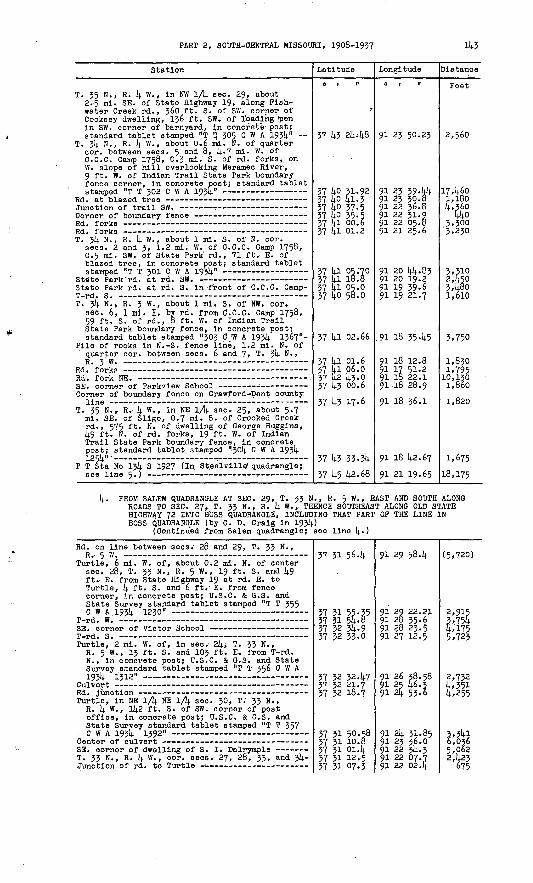
PART 2, SOOTH-CENTRAL MISSOURI, 1908-1937 143
Station
T. 35 N., R. 4 W., in NW 1/fy. sec. 29, about 2-5 ml. SE. of State Highway 19, along Fish- water Creek rd., 360 ft. S. of SW. corner of Cooksey dwelling, 136 ft. SW. of 1'oadihg !pen in SW. corner of barnyard, in concrete post; standard tablet stamped "T ti 305 C W A 1934" ~
T. 34 H., R. 4 W. , about 0.6 nil. N. of quarter cor. between sees. 5 an(^ 8, 4-7 mi. W. of C.C.C. Camp 1758, 0.3 mi. S. of rd. forks, on W. slope of hill overlooking Meramec River, 9 ft. W. of Indian Trail State Park boundary fence corner, in concrete post; standard tablet stamped "T T 302 C W A 1934"
T. 34 N., R. 4 W. , about 1 mi. S. of N. cor. sees. 2 and 3, 1.2 mi. W. of C.C.C. Camp 1758, 0-5 mi. SW. of State Park rd., 71 ft. E. of blazed tree, in concrete post; standard tablet
State Park rd. at rd. S. in 'front of C.C.C. Camp-
T. Jlj, N., R. 3 W., about 1 mi. S. Of NW. cor. aec. 6, 1 mi. E. by rd. from C.C.C. Camp 1758, 59 ft. S. of rd., 8 ft. W. of Indian Trail State Park boundary fence, in concrete post; standard tablet stamped "303 C :W A 193!). 1367"-
Pile of rocks in N.-S. fence line, 1.2 mi. N. of quarter cor. between sees. 6 and 7, T. 34 N.,
Corner of boundary fence on Crawford-Dent county
T. 35 N. , R.- 4 W. , in NE 1/k sec.- 25, about 5*7 ml. SE. of Sligo, 0.7. mi. S. of Crooked Creek rd., 575 ft.' N. of dwelling of George Huggins, 49 ft. N. of rd. forks, 19 ft. W. of Indian Trail State Park boundary fence, in concrete post; 'standard tablet ' stamped "301). C W A 1934
P T Sta No 13!). S 1927 (In St.eeivllle1 quadrangle;
Latitude
0 1 II
37 43 2448
37 40 31.92 37 40 41.3 37 40 37-5 37 40 35-5 37 41 00.6 37 4l 01.2
37 41 05.70 37 41 18.8 37 41 05.0 37 40 50.0
37 41 02.66
37 41 01.6 37 4l 06.0 37 42 43-0 37 43 00.6
37 43 17-6
37 43 33-34 37 45 42.68
Longitude
0 | II
91 23 50.23
91 23 39-44 91 23 30.8 91 22 36.8 91 22 31.9 91 22 05.8 91 21 25.6
91 20 14).. 8391 20 19.2 91 19 39-6 91 19 21.7
.91 18 3545
91 18 12.8 91 17 51.2 91 18 22.1 91 18 28.9
91 18 36.1
91 18 42.67
91 21 19.65
Distance
Feet
2,560
17,460 1,180k'&3,300 3,230
3.310 2,450 348o 1,610
3.750
1,8301.795 10,130 l,86o
1,820
1.675
18,175
4. PROM SALEM QUADRANGLE.AT SEC. 29, T. 33 N., R. 5 W., EAST AND SOUTH ALONG ROADS TO SEC. 27, T. 33 N., R. 4 W., THENCE SOUTHEAST ALONG OLD STATE HIGHWAY 72'INTO BOSS QUADRANGLE, INCLUDING THAT PART OP THE LINE IN BOSS QUADRANGLE (by 0. D. Craig in 193!).}
(Continued from Salem quadrangle; see line 1)..)
Rd k on line between sees. 28 and 29, T. 33 N.,R C W
Turtle, 6 ml. W. of, about 0.2 ml. N. of center sec. 28, T. 33 N., R. 5 W. , 19 ft.. S. and 49 ft. E. from State Highway 19 at rd. E. to Turtle, 4 ft* S. and 6 ft. E. from fence corner, in concrete post; U.S.C. & G.S. and State Survey standard tablet stamped "T T 355 C W A 1934 1230"
m _j g ^_ _ _ _ _ _ _ _» _ _ _
Turtle, 2 mi. W. of, in see. 24, T. 33 N. , R. 5 W., 13 ft. S. and 103 ft- E- fro T-rd - N. , In concrete post; U.S.C. & G.S. and State Survey standard tablet stamped "T T 356 C W A *-/s^- ^ J*-1-
Turtle, in NE 1/4 NE 1/4 see. 30, T. 33 N. , R. 4 w> . 142 ft.: S. of SW. corner of post office, in concrete post; U.S.C. & G.S. and State Survey standard tablet stamped "T T 357
T. 33 N., R. 4 W. , cor. sees. 27, 28, 33, and 34-
37 31 564
37 31 55-35 37 31 54-8 37 32 34-9 37 32 33.0
37 32 32.47 37 32 21.7 37 32 18.7
37 31 50.58 37 31 10.8 37 31 01.4 37 31 12.5X7 XT IT?.*
91 29 58.4
91 29 22.21 91 28 35.6 91 28 23.5 91 27 12.5
91 26 38.58 91 25 46.3 91 24 53.6
91 2k 31.85 91 23 36.0 91 22 3!;. 3 91 22 07.7 01 ?p np.lt
(5.720)
2,915 3.754 4.175 5,723
2,732 4,351 4,255
3,34l 6,036 5,062 2,423
h-7C.

i44 TRANSIT TRAVERSE IN MISSOURI
Station
Turtle, 3 ml. SE. of, near center sec. 3!)., T. 33 N., R. [4. W. , 172 ft. E. of N. corner of old Miller dwelling, \& ft. N. of old shed, 20 ft. W. of old State Highway 72, In concrete post; U.S.C. & G.S. and State Survey standard
Latitude
0 1 11
37 30 U5-89
Longitude
01 II
91 21 43-32
Distance
Feet
o C.C.C.
(For balance In Slnkln quadrangle,' see line 2.)
Bunker, 6.6 ml. NW. of, In SW 1/4 sec. 33, T. 33 N., R. 3 W., 29 ft. S. and 108 ft. W. from State Highway 72 at rd. to stave mill of Gus Nash, In concrete post; U.S.C. & G.S. and State Survey standard tablet stamped "T T 360c w A 1934 1360" - -- --
Bunker, 4>5 ml- NW. of, In SE V4 SE 1/4 sec. 34, T. 33 N. , R. 3 W., 45 ft- N. and. 27 ft. W. from Junction of State Highway 72 and rd. to Cross- vllle Church, In concrete poat; standard tablet
SE. corner of board fence around barnyard of
Bunker, 6 ml. NW. of, In NW 1/fy. sec. 26, T. 33 N., R. 3 W., 940 ft. E. of Croasvllle church, 25 ft. N. and 70 ft. E. from rd. forks, 80 ft. S. and 60 ft. W. from dwelling of T. E. Baker, In concrete post; standard tablet stamped "T T 362 C W A 1934 1091"
37 30 21.47
37 30 19-59
37 31 254
37 31 1+2.14.0
91 16 38.28
91 14 48.19
91 14 06.0
91 13 144-01
(7,974)
8,874
7,481
2,467
5. FROM SINKIN QUADRANGLE NORTHWEST ALONG STATE HIGHWAY 19 INTO SALEM QUADRANGLE (by G. L. Krattler in 1934)
(Continued from Slnkln quadrangle; see line- 3,)
U.S.C. & G.S. standard disk stamped "K 50 1934"- '
Junction of lane W. on line between sees. 21 and28, T. 33 N., R. 5 w.
Dim E.-W. crossroad on line through center
(Continued In Salem quadrangle; se
37 30-29.0 37 31 02.96 37 31 29.0 37 31 35-6 37 31 55-3537 32 08.8
37 32 35.1 37 32 48.2
e line 6. )
-91 27 47-4 91 28 08.63 91 28 48.2 91 29 08.9 91 29 22.21
91 29 29.9
91 29 34-0 91 29 48.2
.(3,979) 3,839 4,1352)268
1,496
2,682 1,748
6. FROM SEC. 29, T. 34 N., R. 3 W. , EAST ALONG STATE HIGHWAY 32 TO BOSS, INCLUDING THAT PART OF THE LINE IN BOSS QUADRANGLE (by 0. L. Erattlerm 1934)
Penrod trlangulatlon sta.; U.S.C. & G.S.
U.S.C. & G.S. standard disk stamped "H 52 1934"-
T. 34 N., R. 3 W., cor. sees.- 15, 16, 21, and 22,
Boss, near the town of. In N 1/2 sec. 18, T. 34 N., R. 2 W., 100 ft. S. and 150 ft. E. of State Highway 32 bridge J-573 over Huzzah Creek, 72 ft. HE. of NE. corner of store, In concrete post; standard tablet stamped "T TTT? P IV ft 1 O^li T flOfV
37 37 08.52 37 37 1149 37 37 46.3 37 38 04.6
37 38 06.2 37 37 57-4 37 37 31.9 37 37 46.5 37 37 50.3 37 38 04.7
37 38 1|2.83
91. a? OS. 33 91 17 18.95 91 16 36^5 91 15 53-5
91 15 47-1 91 15 16.991 i4 14.091 13 34.4 91 13 09.8 91 13 o4.1
.91 ll 37.72
1)138 4,905 3,922
539 2,585 5,6853,513 2,016 1,528
7,943
7. FROM SEC. 21, T. 34 N. , R. 3 W. , NORTHWEST TO SEC. 6, T. 34 N., R. 3 W. (by 0. L. Krattler In 1934)
Junction of rd. NW. (previously described)
303 C W A 1934 1367 (previously described)
37 3§ 04.6 37 38 13.5 37 39 47-3 37 40 13.7" 37 4l 02.66
91 15 53-5 91 16 19.3 91 16 53-9 91 17 o8.4 91 18 35.45
2,259 9,875 2,912 8,550

PART 2, 'SOOTH-CENTRAL MISSOURI, 1908-1957 145
Station
8. PROM BOSS SOUTH TO SEC. 26, T. 55 N., R. R. H. Parker In 1954)
T T 572 C W A 1934 1020 (previously described) - U.S.C, & G.S. standard disk stamped "E 52 1934"-
T. 34 N. , R. 3 W. , probable quarter cor. between
Boss, 3 ml. SW. of, 1.5 ml. S. of State Highway 32, along ridge rd. to Marcoot, near center sec. 25, T. 34 N., R. 3 W., near center of triangle formed by Junction of three rds.. In concrete post; standard tablet stamped "T T rrj-7 C* W A T Ozli "IX1£"
T. 33 N. , R. 3 W. , S. sixteenth cor. between
Marcoot, 1 ml. HE. of. In SE 1/4 sec. 10, T. 33 N., R. 3 W., 410 ft. E. of dim cross.- roads,. 30 ft. K. of E.-W. rd., In concrete post; standard tablet stamped "T T 374 C W A 1954 1297" -- -- - -- -
Crossvllle-Marcoot rd. at line between sees. 22
T T 562 C W A 1954 1091 (previously described) -
Latltude
H 1 "
3 W. (in Bos
57 5§ 42.85 57 58 40.59 57 38 27.1
37 37 45-6
57 56 36.05 57 36 17-0 37 35 56.7 37 35 35-4 37 35 00.? 37 34 37-2
37 35 54-8
57 55 51-12 37 33 19-6
37 32 40.6 57 31 42.40
Longitude
o i n
a . quadrangle ;
91 11 37.72 91 11 57.66 91 12 344
91 13 03.5
91 13 12.40 91 13 38.6 91 13 53-9 91 14 12.9 91 14 25.4 91 14 45-6
91 14 43-7
91 14 54.05 91 i4 53-391 14 4,6-3 91 15 44-01
Distance
Peet by
1,624 3,250
4,806
7,068 2,855
1' III 5*660 2,878
4,297
912 3.195
5,982 7,734
9. FROM SALEM QUADRANGLE EAST ALONG STATE HIGHWAYS 32 AND 72 TO SEC. 29, T. 514. N. , R. 3 W. (by C. W. Williams In 1935)
(Continued from Salem quadrangle; see line 11.
T. 34 N., R. 5 W. , cor. sees. 16, 17, 20, and
Salem, 2.5 ml. E. of State Highway 19 at, 186 ft. SE. of gateway to large dwelling N. of highway, 152 ft. N. of large chicken house at top of small hill, 51 ft. S. of highway, 7 ft. N. of fence, In concrete post; U.S.C. & G.S. and
Salem, 2.7 ml. E. of State Highway 19; at, 52 ft. S. and 675 ft. E. from highway at fence N,, 32 ft. S. and 45 ft- E. from highway at farm entrance, In concrete post; U.S.C. & G.S. and
U.S.C. & G.S. standard disk stamped HN 52 1934"-
T. 34 N. , Rs. 4 an<* 5 w -> quarter cor. between sees. 19 and 24, corner of fences E. , W. , and
U.S.C. & G.S. standard disk stamped. "M 52 1934"- Oorner of fences E., W., and S. on line between
U.S.C. & G.S. standard disk stamped "5I/52. 1934"-
U.S.C. & G.S. standard disk stamped '.K 52 1934"-
U.3.C. & G.S. standard disk stamped "J 52 1934"- Hlghway at rd. N., 647 ft. .3. and 20 ft. W. from
pile of rocks around stake at W. cor. sees. 19
Penrod trlangulatlon sta. azimuth mark; U.S.C. &
Penrod trlangulatlon sta. (previously descrlbed)-
37 38 17.9
57 38 17.21
37 3§ 16.41 37 38 02.1 57 58 01.8 57 37 43-09 37 37 37.2
57 57 44-9 57 38 12.55
37 38 12.7 37 37 46.4 57 38 03.00 37 38 19.0 37 37 5§-6 37 37 16.53 37 37 22.2 57 57 13-0 37 37 12.0 37 37 05.49
37 37 12.6 37 37 00.7
37 37 10.20 37 37 08.52
91 29 55-4
91 29 43-21
91 29 l4.=!291 28 09.8 91 27 59.9 91 27 03.55 91 25 55.4
91 25 31.2 91 4 47.53
91 24 52.0 91 23 244, . 91 22 51.34 91 22 28.0 91 22 01.1 91 21 25.42 91 20 58.5 91 20 32.9 91 19 52.9, 91 19 14.16
91 18 4l.l 91 17 44-6
91 17 19-85 91 17 05.35
(5, 425'}
983
2,326 5,387
801 4,913 5,516
2,097 4476
1,252
382,475 2,9855,2292,087 2,259 3,219 3,189
2,757 4,7052,211 1,180
Magnetic declination 5° 52' E.
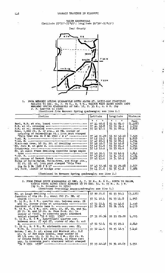
114-6 TRANSIT TRAVERSE IN MISSOURI
SALEM QUADRANGLE (Latitude 37°50'-370l4.5'; longitude 91°30' -91°l4.5')
Dent County
PROM MERAMEC SPRING QUADRANGLE SOUTH ALONG ST. LOUIS-SAN FRANCISCO RAILWAY TO SEC. 31, T. 35 N., R. <j W., THENCE WEST ALONG ROADS INTO MERAMEC SPRING QUADRANGLE AT SEC. 18, T. 35 N., R. 6 W. (by J. B.' Leavitt in 1920)
(Continued from Meramec Spring quadrangle; see line 6.)
Station
Howe, 1,000 ft. N. of sta., at NE. corner of crossing of Salem-Sllgo rd.; iron post stamped
T _J T? _ .
Rd. at small frame dwelling opposite large maple
Porks of Rolla-Salem, Rolla-Howe, and Sllgo rds., 60 ft. SE. of; iron post stamped "Prim TravSta No 9 Mo 1920 J B L" .
Latitude
37 {4 12.8 37 14-3 47-1
37 }^ 35-2037 ^2 33-1^ | U^_ f~\J . A
J I rr*- * *- * I
37 ^2 51.-0 37 1+3 12.2
37 J4-3 33-537 ^3 45.0 37 14.3 41.6
37 14.3 37.9637 i4 21.6
Longitude.
O | It
91 31 4-1
91 30 52.10
91 32 06.691 32 52.891 33 01.2 91 35 03.6
91 33 42.991 3t 19.6.91 Ik 56.3
91 35 29.0891 36 51-8
Distance
Feet44o8)5,930
7,5231,901).3,7923,9512,1503,8413,171+2,962
1 ££-7
7 nQf ,9°°
(Continued in Meramec Spring quadrangle; see line 2.)
2. PROM CEDAR GROVE QUADRANGLE AT SEC. 2, T. 32 N., R. 6 W., NORTH TO SALEM, THENCE'NORTH ALONG STATE HIGHWAY 19 TO SEC. 31, T. 35 N., R. 5 W. (by W. R. Broaddus in 1931)
(Continued from Cedar Grove quadrangle; see line 1.)
Junction of dim rd. S., about 200 ft. NE. of
T. 33 N., R. 6 W., quarter cor. between sees. 26 and 35, corner stone at crossroads
T. 33 N., R. 6 W., cor. sees. 27, 28, 33; and }4, 20 ft. N. and 30 ft. E. from T-rd. E., in corner of field, in concrete post; standard
T. 33 N., R. 6 W., approximate quarter cor. between sees. 27 and 28, corner of rdsi S. and E. -L--
T. 33 N., R. 6 W., W. sixteenth cor. sec. 22,
Salem, 7 ml. S- of, along old Montauk rd., 0.8 mi.' W. of New Hope School, near center of NE lA sec. 15, T. 33 N., R. 6 W. , 250 ft. W. of County Route K at crossroad, In fence cor ner, in concrete post; standard tablet stamped"Rli fi ion ivtfi"
37 30 21.6
37 31 104
37 31 23.14. 37 31 24.9
37 31 26.36
37 31 52. k
37 32 144-5
17 II PPjiR
91 33 50.1
91 33 144.8
91 33 1+2.6 91 % 394
91 35 29.20
91 35 29.1
91 35 12.5 "
01 *li PP. 60,
(3,128)
l+,958
1,330 l+,579
lt.,015
2,614.0
5432
c CCT

PART 2, SOUTH-CENTRAL MISSOURI, 1908-1937 Ik7
Station
Salem, k ml. S. of, along old Montauk rdi, 350 ft. SE. of cor. sees; 1, 2, 35, and 36,1 Tps. 33 and 3k N. r R. 6 W., 30 ft. N. and k ft-* K. from rd. fork NW. , 2 ft. S. of fence, In concrete post; standard tablet stamped ,
§alem, 8 ft. N. of W. entrance to courthouse, in limestone step; standard tablet stamped "Mo 1182* - T
Salem, 0:6 ml* N. of courthouse, center of bridge
Salem, 2^6 ml. NE. of, 1,800 ft. S. 15" W. of farmhouse of J. J. Cope, 150 ft. SW.-of NE. end of a 1,200-ft. tangent in highway, kj ft. S. of highway, 5 ft -' HE- of fence corner, In top of concrete post; standard tablet stamped"T T 51 B 1931"
Prim Trav Sta No 8 Mo 1920 J B L (previously
Latitude
o i «
57 55 56^0 57 5k 01.3 37 3k 28.0 37 35 17.8
37 35 kk.60 37 5& 10.7 37 37 55-5 37 38 09.2
37 38 kk42 37; 39 13.5 37 59 59.9 , 57 59 59-9
37 ko 26.76 37 kO 56.9 57 k2 02.5
37 k2 35.20
Longitude
0 | tl
91 3k 16.6 91 35 k9-0 91 55 k9-0 91 53 20.2
91 55 11-87 91 52 ko.8 91 32 2k- 2 91 32 2k 4
91 32 0848 91 52 074 91 51 51.1 91 51 55-8
91 30 kki29 91 30 39.5 91 50 57-2
91 30 52.10
Distance
Feet 1459 5,585 2,705 5,5k5
2,79k 3,6kl 10,683 1,590
5,78k 2,975 2,9k7 2451
k,820 5,065 6,766
5,357
3.- FROM EDGAR SPRINGS QUADRANGLE AT SEC. 31, T. 35 N., R. 7 W., SOUTH INTOEDGAR SPRINGS QUADRANGLE AT SEC; 6, T. 3k N., R. 7 W. (by Heinz Broadauf in 193k) ' . .
(Continued from Edgar Springs quadrangle; see line 2.)
T. 3k Hv, R. 7 W. , In NE lA 9eo « 6, about 0.2 ml.'-NW. of crossroads, 80 ft. E. of top of hill, 15 ft; N. of rdV, in concrete post; U.3.C, & O.S. and State Survey standard tablet stamped "336 C W A 193^ 1278" .
Ti 5k N., R. 7 W., lil NW lA aecv 5, kO .ft. N. and. JO -ft; W.- from crossroads, In concrete post; U.S.Ci. & G.S: and State Survey standardtablet stamped "5^7 C W. A 193k 1285"
57 k2
57 k2
09-38
02.37
91 kk 15.21
91 kk oo.ki
(8400)
1,385
(Continued In Edgar Springs quadrangle; see line 2.)
ft. F«BC JHiJSHQSKJ QUADRANGLE AT SEC. 3* T. 32 N., R INTO STONE HILL QUADRANGLE AT SECi 29; T. 33 N.Helriz' Broadauf In l95k) .
(Continued from [Cedar-Grow.) quadrangle; see line J.)
7 W., NORTH AND EAST R. 5 W. (by
T. 32 N;, RV 7 W*>'lri NE lA Seo. 3, about 9°° ft.- NE. of Junction .of State Highway 119 and County Route E, 26 ft. Ni of Route E, 50 ft. S. of abandoned. rd<> 3 ft. S. of fence, In concrete post; U.S.O. & G.S. and State Survey standard tablet s tamped. "T T 352.0 W-A 193k 1220N --- - -- -
Iron pipe culvert : T» 33 Ni, R, 6 W,,- quarter cor. between sacs. 30
and 31>. 04 ml* W, of crossroads, 290 ft. E. of County Route E at N^-S. fences, 25 ft; N. of highway, In concrete post; U.S.C. & O.S. and State Survey standard tablet stamped "T T 353 c w A 193k 1358 tt
Ouster, 1.'5 mli SW. of, quarter cor. between sees. 25 and 36,' T* 33 N., Rs. 5 and 6 W., at rd.' corner from N. to W. , 30 ft. SE. of rd., In concrete post; standard tablet stamped "T T
(Continued In Stone Hill quadrangl
37 30 20.8
37 30 2k,j2 37 30 51-7 37 31' 11.1
37 31 30.81 37 31 29-5 57 31 31.2, 57 31 26^36 37 31 23.9 37 31 k9-7
37 31 k6.88 57 31 53-5 37 32 11.5
9.; see line k
91 kl 03.2
91 kg 5k;5o91 W 26.5 91 39 53.6
91 38 09.93 91 37 17.591 56 i4.s91 35 29.20 91 35 51.8 91 55 55-k
91 32 11.27 91 51 574 91 31 06.8
.)
(3,6io)
790m
&5,0555,710 7,8502, |920
6,7802,810 3,060
18410J O Sa 3
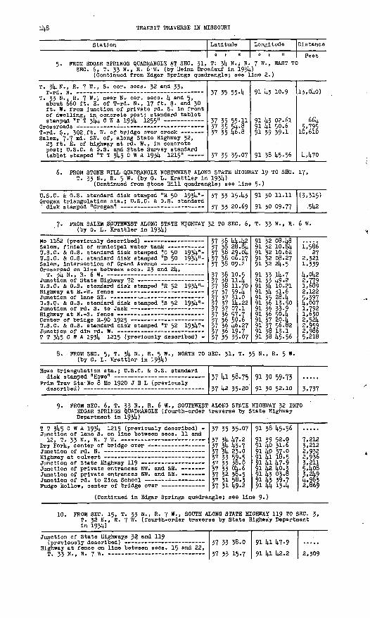
TRANSIT TRAVERSE IN MISSOURI
Station Latitude
0 1 II
Longitude
0 | II
Distance
PeetFROM EDGAR SPRINGS QUADRANGLE AT SEC. 3!, T; 3k N.j R. 7 W., EAST TO
SEC. 6> T. 33 N., R. 6 W. (by'Heinz Broadauf In 193k)(Continued from Edgar Springs quadrangle} see line 2.)
T. 3k,N., R. 7 W., S. cor. sees. 32 and 33,
T. 33 N., R. 7 W. , near N. cor. sees; k and 5» about 660 ft. E. of T-rd. N., 17 ft. S. and 30 ft. W. from Junction of private rd. S. In front of dwelling, In concrete post; standard tablet stamped "T T 3kk C W A 193k 1255"
Salem, 7.7 ml. SW. of, along State Highway 32, 23 ft. E. of highway at rd* W. , In concrete post; U.S.C. & G.S. and State Survey standard
37 35 554
57 55 55-11 57 55 54.857 55 4-6.8
57 35 35.07
91 k3 10.9
91 lj.1 50.691 39 39.1
91 38 14.5.56
I3,0ko)
66k5,795
U470
6. PROM STONE HILL QUADRANGLE NORTHWEST ALONG STATE HIGHWAY 19 TO SEC. T. 33 N., R. 5'W. (by G. L. Krattler In 193U)
(Continued from Stone Hill quadrangle) see line 5.)
17,
U.S.C. Grogan
& O.S. standard disk stamped triangulation sta.; U.S.C. &
"H 50 G.S. £
193U"- tandard
57
57
33
35
1543 20.69
91
91
30
30
11
09
.11
77
(3,515)
5U2
PROM SALEM S'pUTHWEST ALONG STATE HIGHWAY 32 TO SEC. 6, T. 33 N., R. 6 W. (by G. L.' Krattler In 193k) '
Mo 1182 (previously described) Salem, flnlal of municipal water tank U.S.C. & G.S. standard disk stamped "C 50 193kn - U.S.C. & G.S. standard disk stamped "D §0 1934-"- Salem, Intersection of Grand Avenue - Crossroad on line between sees. 2J and 2k,
T. jU N., R. 6 W. Junction of State Highway 72 U.S.C. & G.S. standard disk stamped "R 52 193kn- Hlghway at E.-W. fence . -- --------Junction of lane SE. U.S.Q. & G.S. standard disk stamped "!s 52 193k 1?- Junctlon of rd. S. to Jack Highway at N.-S. fence - Center of bridge H-90 1925 : U.S.C. & G.S. standard disk stamped "T 52 193k?- Junctlon of dim rd. W. -- : - T T 3k5 C W A 193k 1215 (previously described) -
37 38 kk.k2 57 3§ 28.3k 37 38 29.0k 37 38 06.17 37 38 09.2
37 38 37 3§ 57 58 57 57 57 37 37 57 57 57 57 3& 57 56 37 36 37 36 37 35
10.511411.705943.1.0Ik.2207.157-750.6U6.2719-735-07
91 32 08.k8 91 32 10. 6k 91 32 10.62 91 32 08.27 91 32 2k.5
1,58627
2,5211,559k,0k2 2,779 1,689 2,122 5.397 k,007 1,792 1,630 2,52k 2,959 2,986 5,218
PROM SEC. 5, T. 3k N., R. 5 W., NORTH TO SEC. 31, T. 35 N., R. 5 W. (by G. L. Krattler In 193k)
Howe trlangulatlon sta disk stamped "Howe"
Prim Trav Sta- No 8 Mo
.; U.S.C.
1920 J B
& G.S. standard
L (previously37 Ul 58.75
37 U2 35.20
91 30 59.73 91 30 52.10 5,737
PROM SEC. 6, T. 33 N., R. 6 W., SOUTHWEST ALONG STATE HIGHWAY 32 INTO EDGAR SPRINGS QUADRANGLE (fourth-order traverse by State Highway Department In 193U)
T T 3k5 C W A 193k 1215 (previously described) - Junction of lane S. on line between sees. 11 and
Junction of private entrances NW. and SE.
(Continued In Edgar Springs quadra
37 35 35.0737 5k k7.2 37 |U 10.7 37 %. 23.0 37 35 59-5 37 35 38.0 37 33 Ok. 6 37 32 35.5 37 31 58.3 37 31 U9-2
ngle; see lln
91 38 U5.56
91 39 52.0 91 Uo 31.6 91 Up 57-0 91 ki 18.5 91 Ui U7-9 91 k2 ko.g 91 k3 03.8 91 U3 59-7 91 14 134
e 9.)
7,212 3,212 2,932 2,936 3,211 5408 3,2k9 U»9§3 2,669
10. PROM SEC. 15, T. 33 N., R. 7 W., SOUTH ALONG STATE HIGHWAY 11$ TO SEC. 3, T. 32 'N., R. 7 W. (fourth-order traverse by State Highway Department In 193k)
Junction of State Highways 32 and 119
Highway at fence on line between sees. 15 and 22,T. 33 N., R. 7 w.
37 33 38.0
37 35 15.7
91 kl 14.7.9
91 kl k2.2 2,509

PART 2, SOUTH-CENTRAL MISSOURI, 1908-1937 114-9
Station
Highway at line between sees. 27 and 3^»
T T 352 C W A 193!). 1220 (previously described) -
Latitude
0 1 II
37 32 50-5 37 31 57-2
37 31 32-1 37 30 59-3 37 30 20.8 37 30 17.6 37 30 214.. 32
Longitude
0 1 II
91 14.1 14.8.2 91 lj.1 38.6
91 ia 2k-2 91 la 114.. o 91 14.1 03.291 ia oo: . 2 91 14.0 514.. 50
Distance
Peet 2,588 5,&3
2,797 3.U5 3,995
LofJ. 820
11. PROM SALEM EAST ALONG STATE HIGHWAYS 32 AND 72 INTO STONE HILL QUADRANGLE (by 0. W. Williams In 1935)
T. 314. N., R. 5 W., N. sixteenth cor. sees. 19 and 20, corner of fences
between N., S., and
37 38 06.17 37 38 08.2
37 38 06. q
91 32 08.27 91 31 k2-2
Ql 31 01. li
2,105
3.288
(Continued In Stone Hill quadrangle; see line 9.)
12. PROM SALEM SOUTH ALONG STATE HIGHWAY 19 TO SEC. 17, T. 33 N., R. 5 W. (by C. W. .Williams in 1935)
U.S.C. & G.S. standard disk stamped "E 50 19314.?-.
U.S.C. & G.S. standard disk stamped "P 50 19314."- T. 33 N., R. 5 W. , N. sixteenth cor. sec. 7,
U.S.C. & G.S. standard disk stamped "G 50 19314."-
Orogan triangulation sta.; (previously described)
37 38 06.17 37 37 28.9
37 36 14.9.2 37 36 4.17 37 35 55-5 37 35 15-53
37 3f4- 3,6.3 37 31; 2V. 70 37 33 1*3-0 37 33 20.69
91 32 08.27 91 32 07.8 91 31 53-0 91 31 58.21 91 31 35-7 91 31 35.69
91 31 35-7 91 31 36.03 91 31 05-. 6 91 30 09.77
3,772 £;{86 2,^67 3, £18 £> 014.8
3,970 1,172 k,879 5,033
Magnetic declination 6° 07' E.
CEDAR GROVZ QUADRANGLE (Latitude 37 0'15'-37°.30 I 5 longitude 91°30'-91°l4.5'-)
Dent, Shannon, and Texas Counties
R 7W S " * /
1. PROM SUMMERSVILLE QUADRANGLE AT SEC. 32, T. 30 N., R. 7 W., NORTH INTO SALEM QUADRANGLE AT SEC. 2, T. 32 N., R. 6 W. (by W. R. Broaddus in 193D,
(Continued from Summersville quadranglej see line 2.)
Rd. at 15-in.
Station
black-oak tree at top of hill
Latitude
0 1 II
37 15 23.9 37 15 23.137 IS P?.0
Longitude
91 J4-3 lt-7-9 91 14.3 08.8 en dp 17_£
Distance
Feet (2, g8)
1, 'nlid
150 TRANSIT TRAVERSE IN MISSOURI
. Station
Hartshorn, 0.5 ml. S., thence 1 ml. W. of, quarter cor. between sees. 35 an<i 35, T. 30 N., R. 7 W., 20 ft. N. and kb ft. W. from T-rd. N. , 3 ft. N. and 12 ft. W. from fence corner, In concrete post; standard tablet
Hartshorn, 2 ml. N. of, near N. sixteenth cor. sec. 23, T. 30 N., R. 7 W. , 20 ft. S. and 30 ft. E. from T-rd. E., In concrete post; stand-
Rd. at fence N. along Shannon-Texas county line -T _J m
T. 30 N., R. 6 W. , quarter cor. between sees. 7 and 8, 9° ft. N. and 30 ft. E. from crossroads, In NW. corner of yard of E. C. Edwards, In concrete post; standard tablet stamped "57 G1931 1229"
Rd. at fence E. along S. side of lane, near mall
Corner stone at S. end of long tangent N., In line with fences E. and W., 10 ft. E. of rd.
Cedar_Grove,6 ml. S. of, along old Salem-West Plains rd., near quarter cor. between sees. 29 and 30, T. 31 N., R. 6 W. , 6 ft. S. and 21 ft. E. from rd. forks, 10 ft. E. of mall box of G. W. Riley, In concrete post; standard tablet
Cedar Grove, 2.6 ml. S. of, along old Salem-West Plains rd., 25 ft. S. and 70 ft. W. from Junction of Hartshorn-Salem rd. , 10 ft. N. and 70 ft. E. from NE. corner of Street Chapel, In yard, in concrete post; standard tablet stampedr'59 G 1931 857"
Cedar Grove, 300 ft. S. of mill race, 30 ft. E. of rd. , 9 ft. S. and 9 ft. E. from NW. corner of fence around yard of C. H. Hawn, In limestone ledge; standard tablet stamped "50 G 1931 855"
Rd. at triangular-blazed tree at foot of hill Cedar Grove, 3«6 ml. NE. of, along old Salem-West
Plains rd., In NE lA NE lA aeo. 22, T. 32 N. , R. 6 W. , 300 ft. N. of Junction of rd. W. , In NW. corner of yard of A. A. McDonald, In concrete post; standard tablet stamped "5! G1931 1237".
Jadwln, about 300 ft. S. of post office, rdw fork
Jadwln, 1 ml. NE. of, quarter cor. between sees. 2 and 11, T. 32 N., R. 6 W., 30 ft. S. and 20 ft. E. from T-rd. S., In fence corner, In concrete post; standard tablet stamped "52 G
Latitude
0 | II
37 15 21.15 37 15 50.9 37 15 53.1 37 16 38.9
37 17 18.05 37 17 16.8 37 17 16.7 37 17 56.9 37 18 33-6
37 18 59.85
37 19 5l4
37 20 06.6 37 20 38.0
37 21 25-93 37 22 09.1 37 22 25.6 37 22 55.5
37 23 3340 37 2k 00.9 37 25 53.0
37 25 16.29 37 26 01.5 37 27 07.6
37 27 5249 37 2(3 20.9
37 29 12.0 37 29 38.5
37 29 51.11
Longitude
91 51 05.7591 5i 03.5 . 91 5o 13-5 91 5o 12.7
91 50 23.85 91 3§ 59.7 91 38 26.3 91 38 12.5 91 37 50-0
91 37 55.89
91.37 50.8
91 37 27.7 91 37 264
91 37 17-78 91 37 01.3 91 37 06.3 91 37 25-6
91 37 19-76 91 36 26.7 91 36 ko.9
91 36 25.32 91 35 57.1 91 35 16-7
91 35 51.59 91 35 16.8
91 35 13-9 91 33 50.1
91 33 59-37
Distance
Peet
3^0195,951 5,621
5,0637,53.2 1,966 5,217 5,135
1,685
5,223
2,757 3,100
k$£1,713 3,270
k,093 5,5H 5,390
2,668 5,112 7,535
5,523 .5,375
5,175 3,291
1,270
(Continued In S_alem quadrangle; see line 2.)
2. PROM HARTSHORN SOUTH INTO SUMMERSVILLE QUADRANGLE AT SEC. 35, T. 30 N. , R: 7 W. (by W. R. Broaddus In 1931)
Hartshorn,T_W1- W. _
crossroads (previously described) 37VI \l 53.1
3CI_*91 O1
5oin tf 5
_* X *1O
(Continued In Summersvllle quadrangle; see line 3«)
3. PROM RAYMONDVILLE QUADRANGLE AT SEC. 18, T. 32 N., R. 7 W;, NORTHEAST INTO SALEM QUADRANGLE AT SEC. 3, T. 32 N., R. 7 W. (by Heinz Broadauf In 19314.)
(Continued from Raymondvllle quadrangle} see line 3>)
Rd. at mall box of W, A. Bogart 37 28 5k.l 91 kk 5k.6 (5>88o) 37 29 06\6 91 14 29.1
PART 2, SOUTH-CENTRAL MISSOURI, 1908-1937 151
Station
Lower Hepslde School, In NE lA.SW 1/1+ sec. 8, T. 32 N., R. 7 W., 20 ft. N. of rd. S. of sohoolhouse, in concrete post; U.S.C. & G.S. and State Survey standard tablet stamped "T T351 C w A 193k 1147" -
Latitude
0 1 II
37 29 15.68 37 29 19-9 37 29 23.037 29 <^.7
Longitude
0 t 'I
91 43 50.57 91 43 01.7 91 lj.2 06.7 91 kl 12. S
Distance
Feet
3,2kO 3,960 4,450 k.160
(Continued In Salem quadrangle; see line 14..)
4. FROM SALEM QUADRANGLE SOUTH ALONG STATE HIGHWAY 119 TO MONTAUK STATE PARK, THENCE SOUTHEAST ALONG ROADS TO CEDAR GROVE, THENCE WEST INTO RAYMONDVILLE QUADRANGLE AT SEC. 7, T. 31 N., R. t w« ( fey C. Ei Wyrlck In 1935)
T T 352 C W A 19314. 1220 (In Salem quadrangle;
Highway at fences N. and S. on line through
T. 32 N., R. 7 W., cor. sees; 9, 10, 15, and l6,
T. 32 N., R. 7 W., near center of SW 1/k sec. 15, 3 ml." S. along State Highway 119 from junction of County Route E, 30 ft. N. and 30 ft. E. from highway at rd. E., In concrete post: standard tablet stamped "1200 ERA 1935 1186" -
Highway at entrance to Montauk State Park T; 32 N., R. 7 W., S. sixteenth cor. sec. 22,
Montauk State Park, on grounds of, about 800 ft. E. of concrete overflow bridge over Current River, l40 ft. NE. of post office, 3 ft. W. of stone steps leading Into Old Mill, In concrete post; standard tablet stamped "l801 ERAT O7 IT Q^li "
T. 32 N. , R.j 7 "« » quarter cor. between sees. 23 and 26, limestone rock near fence post, 10 ft.
T. 32 N.,. R. 7 W. , cor. sees; 23,. 2k, 25, and 26, corner fence post at SE. corner of Montauk
Montauk State Park, 3.2 ml. E. of post offlce> In SW 1/4 sec. 19, T. 32 N., R. 6 W., 28 ft. S. and 150 ft. W. from T-rd. S., 50 ft. W. of Hoodenpyle store, 8 ft.< S.'and 8 ft. W. from NE. corner bf yard fences In concrete post; standard tablet stamped "1802 E R A 1935 12l6 n - - _ - - - _ _ --'
Rd. at fence E. on line through center of N 1/2
T. 32 N., R. 6 W., center of NW lA sec.- 32, Iron bar in center of rd., 14 ft.'N. of black-oak
T-rd. S. on line between sees. 5 and 6, T. 31 N. ,
T. 31 N., R. 6 W., W. cor. sees. 6 and 7, pile of rooks on ShanhonrTexas county line, 32 ft.' NW.
Rd. at fences N.-S. on line through centeran/* > T* rp 71 W R *7W
M fni-Trfi _ ___.._. _ « .*_ _ ____«_ u _i__
T-?rd/ E. opposite 23-in» black-oak tree - Ashley Church, 0.4 ml. SW. of, In SE 1/4 sec. 3,
T.:, 31 N.,. R. 7 W., 20 ft. E. of rd/, 37 ft. NW. or. NW. corner of dwelling of Frank Spencer, 8 ft;' E. of NW. corner of farmyard, In concrete post; standard tablet stamped "1803 ERA 1935"
T. 31 N., R. 7 W«: r center sec. 10, limestone rook
T-rd. N. opposite l8-ln. white-oak tree Rd. fork E. opposite 22-ln. black-^oak tree Ashley Church, 3.5 ml.; W. of, In S 1/2 sec; 5,
T; 31 N., R. 7 W., 25 ft. S. and 25 ft. E. from T-rd. S., In concrete post; standard tablet
(Continued In Raymondvllle quadran
37 30 2k. 32
37 29 22.5
37 28 51-9
37 28 12.12 37 27 30.9 37 26 534 37 26 56.1
37 27 20.5
37 27 01.61
37 27 06.6
37 27 06.3 37 27 124 37 27 15.9
37 27 14. 68
37 26 53.8
37 25 58.8 37 25 40.7 37 25 16.29 37 24 5k. 3
37 2k ki.6 37 *4 40.1
37 214. 29.3
37 2k 20.8 37 2k 32.0 37 2k 57.2 37 2,5 03.0
37 24 45.30
37 2k 03.6 37 2k 24; 0 37 24 42.8
37 2k 36'84 37 24 35-*
gle; see line
91 40 54-50
91 kl 29.2
91 42 02.1
91 4l 48.35 91 4i 51.2 91 41 45-1 91 41 32.2
91 4i 28.9
91 4i 02.69
91 4o 24.2
91 39 50.8 91 39 20.5 91 30 50.1
91 38 20.99
91 37 45-6
91 37 24.8 91 36 51.9 91 36 25.32 91 36 56.7
91 37 40.6 91 38 08.5
91 38 48.1
91 39 20.5 91 ?9 49-9 91 4o 20.0 91 40 49.2
91 41 04.46
91-41 31.0 91 42 04.1 91 42 26; 5
91 43 17.04 91 44 32.2
8.1
6,81+7
4,079
4,174 4,171 3,823 1,075
2,484
2,851
3,i44
2,686 2/524 2,471
2,351
3,547
5,806 3,225 3,268 3,3733,766 2,250
3,381
2,750 2,627 3,521 2,425
2,172
4,733 3,375 2,621
k,120 6,063
152 TRANSIT TRAVERSE IN MISSOURI
Station
5. FROM CEDARGROVE.EAST INTO SINKIN QUADRANG R. 5 W. (by C. E. Wyrick in 1935)
T. 31 N., R. 6 W., N. sixteenth cor. sec. 3,
T. 31 N., R. 6 W., N. cor. sees. 2 and 3, pile of
T. 31 N., R. 6 W., in NW lA sec. 2, 90 ft. N. and 70' ft. W. from County .Route K at dim rd. E. on top of hill, 13 ft. SE. of triangular- blazed oak tree, in concrete post; standard
Rd. at fences N. and S; on line between sees. 1
Tps. 31 and 32 N. , R. 6 W., quarter cor. between sees. 1 and 36, limestone rook in fence line on
T. 31 N., R. 5 W., In sec. 6, limestone rock,
Rector, in SW lA sec. 5, T. 31 N., R. 5 W., 30 ft. S. of rd., 25 ft. NE. of NE. corner of general merchandise store, 5 ft. E. of fence corner, in concrete post; standard tablet
(Continued in Sinkln quadrangle; s
Latitude
0 | 11
[,E AT SEC. 5,
37 25 16.29 37 2L 57. * 37 214. 53-6
37 25 07.6
37 25 17.1
37 25 0246
37 25 06.9
37 25 15.0 37 2k 47-8
37 214- 31*.. 0
37 214. 26.62
ae line 7.)
Longitude
T. 31 N.,
91 36 25.32 91 36 08.5 91 35 15-9
91 34 57-7 91 3l4. 25.3
91 31; 03.07
91 33 20.2
91 32 U6-3 91 31 5l4-3
91 31 45-3
91 30 3746
Distance
Feet
2,3524,2652,039
2,788
2,327
3490
2,857 5,018
1,576
5,526
6. PROM SINKIN QUADRANGLE AT SEC. 28, T. 30 N., R. 5 W., WEST TO HARTSHORN (by C. E. Wyrick in 1935)
(Continued from Sinkin quadrangle; see line 8.)
Ink, 3.5 ml. W. of, in NW -lA sec. 30, T. 30 N. , R. 5 W., 0.2 mi. NE. of dwelling of Elijah Piles, 65 ft. NE. of rd. fork NE., 5 ft. S. of triangular-blazed tree, in concrete post; standard tablet stamped "1822 ERA 1935 lljlj."
Rd. at fences N. and S. on line through center
T. 30 N., R. 6 W., cor. sees. 25, 26, 35', and 36;
Hartshorn, 5 ml. E. of, In SW lA SW lA sec. 2?, T. 30 N., R. 6 W. , 20 ft. N. of E.-W. rd. , 20 ft. S. of dwelling of G. W. Huskey, in farm yard, In concrete post; standard tablet stamped ftl823 ERA 1935 1065" -
Hartshorn, 1 mi. E. of, about 800 ft. E. of cor. sees. 25, 30, 31, and 36, T. 30 N., Rs. 6 and 7 W. , 36 ft. S. and [4.5 ft. E. from crossroads, in NW. corner of yard of I. V. Young, In concrete post; standard tablet stamped "l82i|.
T. 30 N., R. 7 W., quarter cor. between sees. 25
T. 30 N., R. 7 W. , cor. sees. 25, 26, 35, and 36,
Hartshorn, crossroads (previously described) T. 30 N., R. 7 W., cor. sees. 26, 27, 3!;, and 35,
37 15 50.8 37 16 05.6
37 16 10.90
37 15 58.2 .
37 15 39.6 37 15 £0.2 37 15 52.9 37 15 14.6.2
37 15 50.2537 15 55-9 37 15 57-2 37 15 54-5 37 16 00.0
37 15 14.541
37 15 14.6.0
37 15 46.6 37 15 53.137 15 47-1 37 15 21.15
91 30 00.8 91 31 ll.l
91 32 09.9)4.
91 32 39-1
91 33 214.-3 91 33 52.8 91 34 13-0 91 3l». 37-0
91 35 17.82 91 35 la-8 91 36 15-5 91 36 59-6 91 37 46.7
91 38 14.3.06
91 39 22.6
91 39 574 91 4o 13.5
91 4i 03.5 91 lt.1 0^.714.
(2,k2k) 5,876
4,786
2,685
4,102 2,3032,082 2,059
3,3262,023 2,7233,574 4,005
4,635
3,201
2,805 l,48l4,083 2,622
7. FROM RECTOR SOUTH INTO SINKIN QUADRANGLE AT SEC. 5, T. 30 N., R. 5 W. (by J. J. Belnllch in 1936)
1807 ERA 1935 929 (previously described)
T. 31 N., R. 5 W. , center of SW lA sec- 17, Pile
37 24 26.62 37 214. 06.5 37 23 38.1 37 23 Oi.o
37 2249.0*7 PI e;7.t;
91 30 3746 91 30 35-8 91 30 27.0 91 30 27.5
91 30 204 en *n *«;.7
2 1039 2,9,60 3,747
1,35.1£.*lOi

PART 2, SOOTH-CENTRAL MISSOURI, 1908-1957 153
Station
Rector, 5.7 mi. S. of, in NW ifa NE 1/lj. sec. 29, T. 51 N. , R. 5 W., 1*6 ft. W. of rd., 5 ft. S. and 14.6 ft. E. from SE. corner of dwelling of George Banks, in concrete post; standard
Center of Current River at Junction of stream from sawmill hollow, 150 ft. N. and 14.0 ft. E. ' from triangular-blazed l|.0-ln. sycamore tree
Triangular-blazed 20-ln. whlt(fl-oak tree, 20 ft.
T. 30 N. , R. 5 W., in S 1/2 sec. 5, pile of rocks 90 ft. S. of rd., 95 ft. S. and 15 ft.
Pulltight, at site of old post office, 7.5 ml. N. of Ink, in SE 1^. SE l/l* sec. 5, T. 30 N., R. 5 W. , 20 ft. S. and la ft. E. from SE. corner of dwelling of J. P. Patton, in concrete post; standard tablet stamped "T T 19 J J 1936
Latitude
0 | II
57 21 1*0.51
37 21 20.5
37 19 52.1 37 19 214.. 0
57 19 05.1
57 18 56.1*5
Longitude
0 | It
91 50 21.66
91 30 15-7
91 30 50.3 91 50 57-6
91 50 25.6
91 50 05.20
Distance
Feet
2,076
2,058
9,376 2,902
3,213
2,008
(Continued in Sinkln quadrangle; see line 11.)
8. PROM RAYMONDVILLE QUADRANGLE AT SEC. 51, T. 51 N., R. 7 W. , NORTHEAST TO SEC. 5, T. 51 N., R. 7 W. (by J. J. Belnlloh in 1956)
(Continued from Raymondville quadrangle; see line 9.)
T. 31 N., R. 7 W. , in SW 1/1* NW lA sec. 21, 14.0 ft. S. and 17 ft. E. from rd. fork NE.> about 60 ft. S. of proposed new rd., in concrete post; standard tablet stamped "T T 23
57 21 09.6 57 21 1*1.7 57 22 19.8
57 22 50.91 57 22 28.1* 57 22 09.5 37 23 01.8 57 2L ll.l* 57 21* 1*5-50
91 1*1* 1*0.2 91 1*5 55-6 91 1*5 25.1
91 1*2 58.87 91 k2 57.5 91 1*2 164 91 1*1 28.091 1*1 17.8 91 1*1 Ol*.l*6
(3,571)
2,255
3^596
Magnetic declination 5° 59' E.
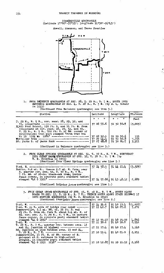
15k TRANSIT TRAVERSE IN MISSQURI
SUMMERSVILLE QUADRANGLE (Latitude 37?00' -57°15' ; longitude 91«30' -
Howell, Shannon, and Texas Counties
R 7 W lj R 6 W
\
1. PROM EMINENCE QUADRANGLE AT SEC. 28, T. 29 N., R. 5 W., SOUTH INTO EMINENCE QUADRANGLE AT SEC. k» T. 28 N., R. 5 W. (by E. L. McNalr In 1913)
(Continued from Eminence quadrangle; see line 3.)
Station
T. 29 N., R. 5 W., cor. sees. 28, 29, 32, and
Black Pond School, 150 ft. S. and 15 ft. E. from crossroads at cor. sees; 28, 29, 32, and 33, . T. 29 N., R. 5 W. , '122 ft. W. of NW. corner of sehoolhouse; Iron post stamped "Prim Trav Sta
Latitude
o i n
37 08 53-6
37 08 52.1 37 07 kl.k vi m oA.R
Longitude
o 1 tt
91 30 30.9
91 30 30.6 91 30 30.8 QI *n 0)1.7
Distance
Feet
( 3<003.)
155 7,153*-O.11
(Continued In Eminence quadrangle; see line 5.)
2. PROM CLEAR SPRINGS QUADRANGLE AT SEC. 31, T. 30 N., R. 7 W., NORTHEAST INTO CEbATT QBOVEQUADRANGLE AT SEC. 32, T. 30 N., R. ^ W. (by W. R. Broaddus in 1931) "' "
(Continued from Clear Springs quadrangle; see line 3-)
Eunice, 0.2 ml. N., thence 2.7 ml. E. from/ near S. quarter cor. sec. 32, T. 30 N., R. 7 W. , 7 ft. NW. of 20-ln. black-oak tre-e', Inside fence obrner, In concrete post; standard tablet
57
37
1^ 58.5
Ik 57-86 (
91 kk 214
91 k3 k8.12
(5.329)
2,689
(Continued InICedar .Grove quadrangle; see line 1.)
3. PROM CEDAR GROVE QUADRANGLE AT SEC. 35, T. 30 N., R. 7 W., SOUTH ALONGROADS TO SEC: 13, T."29 N., R. '7 W., THENCE SOUTH ALONG STATE HIGHWAY 17 INTO.MONTIER QUADRANGLE (by W. R. Broaddus In 1932)
(Continued from !C_edar jSrove quadrangle; see line 2.)
Summersvllle, 3.1 ml. NW. of, 36 ft. N. and 25 ft. W. from rd. fork W. about. O.k ml. N. of SE. cor. seci 2, T. 29 N., R. 7 W. , In pasture fence corner, In concrete post; standard tablet
T-rd. W. - , T. 29 N. , R. 7 W. , quarter cor. between sees. 13
Rd. Junction on line between sees. 13 and 2k,
Summersvllle, 13 ft. E. of NE. corner of E. gatepost at S. entrance to high-school grounds, In concrete post; standard tabletat.atnnAri "lit; rt 1 Q*1 IPlfl" -
37 Ik 3^.6 37 13 k2.7
37 12 55-17 37 ll 30.6
37 ll 174
37 10 514
*7 in t;?.fl7
91 ko 134 91 ko 07.2
91 ko 15.3991 kO 16.8
91 ko 174 91 ko oi.o
Q1 *Q XT _c.o
(k,628) 5,272
k,856 3,5k6
i,3kO
2,951 .
?. 7flfl

PART 2, SOUTH-CENTRAL MISSOURI,. 1908-1937 155
Station
Junction of rd. S. at S. limits of Summersville -
Summer svljile, 3 ml. S. of, along State Highway 17, 295 ft. K. of highway at crossroad, 40 ft. E. of highway, 35 ft. S. and 2 fit]. W. from fence corner opposite farmhouse of W. R. Williams, In concrete post; standard
Summersvllle, 5.2 ml. S. of, along State Highway 17, about 0.3 ml. S. of store of Louis Beasley, 32 ft. N. and 40 ft. E. from highway at E.-W. crossroad (rd. W. to Arroll), 16 ft; N, and 2 ft. W. from fence corner. In concrete post;
Junction of rd. N. opposite trl angular rblazed
Summersvllle, 8.3 ml.' S. of, along State Highway 17, 0.8 ml; N. of bridge over Jacks Fork, about 100 ft. N. of top of grade leading out of valley, 30 ft. W. of highway, 17 ft. S. and 4 ft. E. from triangular-blazed 36-ln. white- oak tree. In concrete post; standard tablet stamped f!49 B 1951 1142? r ~
Jacks Fork, center of old highway bridge over -r Mountain View, 2.9 ml. NE. of/ along UiS. Highway
60 and State Highway 17, 1.2 mi. N, of Highway 60, 37 ft. E. of Highway 17, at top of hill, 165 ft* S. of dwelling of Lester Parrar, 40 ft. S. and 4 ft. W. from fence corner. In concrete post; standard tablet stamped ; II SO B 1931*TpncB __ ____ __ _ __________ _______
Rd. in line with/old State Highway 17, 12 ft. N.
(Continued In Montier quadrangle;
Latitude
0 1 II
37 10 '214.. 1 37 10 07.0 37 09 19-9
37 08 17.71 37 07 36-9 37 07 04.4
37 06 24.61 37 05 26.5
37 0)4. 13.9
57 03 52.13 37 03 23.14.
37 01 00.17
37 00 41.3
see line 2;)
Longitude
0 | II
91 39 28.8 91 39 16.5 91 39 45-1
91 39 46.14.6 91 39 46-7 91 39 32.3
91 39 30.67 9.1 39 28.3
91 39 23.1
91 39 35-79 91 40 03.3
91 40 23.35 91 4o 24-4
Distance
Peet 2; 918 1,994 5,292
6,297 4,119 3,491
4,032 5,873
7,359
2A32 3,659
114^590
l,9PO
4. PROM CLEAR SPRINGS QUADRANGLE AT SEC. 7, T. 28 N., R. 7 W., EAST TO 'SEC. 29, T.. 29 N.; R; 5 W. (by Oi E. Wyrick In 1935)
(Continued from Clear Springs quadrangle; see line 4«)
T. 28 N. , R. 7 W. , quarter cori between sees; 7
T. 28 N., Ry 7 W., cor. sees* 7, 8, 17, and 18,
T. 28 N. , R. 7 ". ,- quarter cor. between sees; 8
Arroll, 25 ft. N. and 135 ft- E. from crossroads at cor. sees. 8; 9; l6, and 17, T. 28 N.-, R. 7 W. , 10 ft. N. of SE. corner of churchyard, In concrete post; standard tablet stamped "T T 1815 ERA 1935" -
T-. 28 N., fl. 7 W., cor. sees; 9, 10, 15, and 16,
T. 28 N., R. 7 W., cor; sees. 10, 11, l4> and 15,
Rd. at fences N. and S. on line between sees. 13 and 14, T. 28 N., R. 7 W. «
T. 28 N., R. 6 W. , quarter cor. between sees. 7
T. 28 N., R. 6 W., cori sees. 7, 8', 17, and 18,. sandstone rock at center of T-rd. W., 10 ft.' S.
T. 28 N., R.. 6 W. ."quarter cor. .between sees. 7
Oakslde, 1.5 ml. N. of post office, 18 ft. S. and 23 ft,' E. from crossroads at quarter cor; between sees. 5 and 6, <T. 28 N. , R. 6 W. , 10 ft. E. of fence corner, near triangular- blazed tree, in concrete post; standard tablet
T. 28 N., R. 6 W., Ni cor. sees. 5 and 6> rd.
T. 28 N., R. 6 W. , N. cor. sees, 4 and 5, cross-
T. 28 N., R. 6 W. , quarter cor. between sees. 4
1. 28 N., R. 6 W., center sec. 4, T-rd. S.
37 06 53.5
37 06 274
37 06 27.3
37 06 27 .-32 37 06 264
37 06 25,8
37 06 26.9 37 06 25.0
37 06 26.5 37 06 24;6l
37 06 27,1
37 06 26.2
37 06 52.6
37 07 45-61
37 08 12.0
37 08 10.5
37 07 144.3 37 07 14.3.7
91 44 4i.i 91 44 4i.7 91 44 08.1
91 43 33,23 91 43 03.8
91 42 30.7
91.41 25.7 91 40 56 -1
91 4b 17-5 91 39 30.67
91 38 '44;9
91 38 11.9
91 38 11.3
91 38 09.48
91 38 09.5
91 37 04.5
9.1 37 05.1 91 36 32.5
(3,747)
2,632
2,715
2,828 2,390
2,681
5.261 2,361
3,208 3,814
3,716
2,673
2,665
5*362
2,667
5*270
2,646 2,636

156 TRANSIT TRAVERSE IN MISSOURI
Station
T. 28 N., R. 6 W. , quarter cor. between sees. 3 and li, 30 ft. N. and .12 ft. W. from rd. at
N.-S. lane, 1.2 mi. W. of Pine Grove, 800 ft. E. of dwelling, 5 ft. N. of fence, corner, in concrete post; standard tablet stamped "1817
T. 28 N., R. 6 W. , quarter cor. between sees.
T. 29 N. , R. 6 W. , quarter cor. between sees. 3^
T. 29 N./R. 6 W., cor. sees. 26, 27, 3)4., and 35, 50 ft. S. and 23 ft. E. from crossroads, 0.2 ml. W. of Randolph School, 1|0 ft. S. of fence corner, 3 ft. E. of fence, In concrete post; standard tablet stamped "l8l8 ERA 1935
T. 29 N., R. 6 W. , quarter cor. between sees. 26 and 35, large, square sandstone rock with chiseled cross, In pile of rocks 3 ft- N - °f
T. 29 N., R. 6 W., cor. sees. 25, 26, 35, and 36, large sandstone rock with chiseled cross, in
T. 29 N., R. 5 W. , E. sixteenth cor. sec. 30,
T. 29 N., R. 5 W., in SW 1/lj. sec. 29, 1.2 mi. N. of Black Pond School, 180 ft. N. of rd. , 105 ft. S. of SE. corner of farmhouse of Boons Hodge, 25 ft. S. of lane leading Into farmyard, in sandstone ledge; standard tablet stamped "1819 ERA 1935 1126" -
T. 29 N., R. 5 W., quarter cor. between sees. 29
Prim Trav Sta No 10 191!). Mo 1086 (previously
Latitude
0 1 II
37 07 10.20 37 07 lj.l.9
37 07 kl-k
37 08 33.8
37 08 59.87
37 08 59.0
37 08 58.2 37 09 06.1; 37 09 16.9 37 09 314.. 6
37 09 21.8
37 09 07.09
57 08 514.. 3
37 08 52.08
Longitude
0 | II
91 35 59-71 91 35 17-7
91 & 5^-2
91 3U 53-5
91 314. 5245
91 3U 19-6
91 33 1+6.8 91 33 12-6 91 32 37-8 91 32 06.0
91 31 52-8
91 31 32-30
91 31 03.8
91 30 30-614.
Distance
Feet
2,657 3^07
1,901
5,292
2,614.0
2,663
2,6S8 2,883 3,016 3,130
1,672
2,233
2,614.9
2,691
Magnetic declination 6° 8' E.
MONTIER QUADRANGLE (Latitude 36°l4.5'-37°00'; longitude 9!"30'-91 =14.5')
Howell, Oregon, and Shannon Counties
R 7 w I Be*
1. PROM WILLOW SPRINGS QUADRANGLE EAST ALONG ,ST* LOUIS-SAN FRANCISCO RAILWAY INTO BIRCH TREE QUADRANGLE (by E. L. McNalr In 1913)
(Continued from Willow Springs quadrangle; see line 1.)
Station
T. 27 N., R. 7 W. , quarter cor. between sees. 20Hnrt ?Q. T*.n ft-., a. of R.R. - '_ - -
Latitude
0 1 II
36 59 28.9
*6 t;o pfL*
Long! tude
91 144 18.8en Mi ix.p
Distance
Feet (5. 1<-90)
l,t;o

PART 2, SOUTH-CENTRAL MISSOURI, 1908-195? 157
Station
Mountain View, 760 ft. W. of St. Louis -San Francisco Ry. sta., 200 ft. W. of rd., 57 ft. N. of track, on side of bank, 2 ft. from fence; Iron post stamped "Prim Trav Sta
R.R. at rd. crossing, 14.37 ft. S. of quarter cor. between sees. 22 and 2J, T. 27 N., R. 7 W.
R.R. at line between sees. 2J and 21)., T. 27 N.,
R.R. at Howell-Shannon county line, 1,420 ft. N. of rd. W. at E. cor. sees. 2k and 25, T. 27 N. , R. 27 W. , 1,27(4. ft. N. of rd. E. at W. cor.
T. 27 N., R. 6 W. , quarter cor. between sees. 19 and 30, 20 ft. E. of R.R. at rd. crossing -----
R.R. at line between sees; 29 and JO, T. 27 N. ,
R.R. at line between sees. 28 and 29, T. 27 N.,
R.R. at line between sees. 27 and 28, T. 27 N. ,
T. 27 N., R. 6 W., quarter eor. between sees. 26 and 27, R.R. at point about 95 ft. W. of rd.
Montler, 190 ft. W. of St. Louis-San Francisco Ry. sta., 80 ft. E. of section house, 15 ft N. of track, 2 ft. from fence corner; iron post stamped "Prim Trav Sta No [4.9 1913 Mo"
R.R. at rd. crossing, 750 ft. N. of eor. sees.
R.T?. at line between sees. 25 and 30, T. 27 N. ,
R.R. at line between sees. 29 and JO, T. 27 N. ,
R.R. at line between sees. 28 and 29, T. 27 N., R- 5 W., 935 ft. S. of cor. sees. 20, 21, 28,anH 2O T 37 W R tz W
R.R. at rd. crossing, 380 ft. S. of quarter cor. between sees. 21 and 28, T. 27 N., R. 5 W.
(Continued in Birch Tree quadrangl
Latitude
0 1 II
36 59 38.63
36 59 14.6.2 36 59 50.7
36 59 51.6 36 59 1*4.7
36 59 38.0
36 59 2k- 7
36 59 08... 3 36 59 034
36 58 56.5
36 58 14.6.1
56 58 55-8
36 58 5^47
36 58 35-3
36 58 14.0.7
36 58 55-1 36 59 05.8
36 59 08.7
36 59 13-9
e; see line :
Longitude
0 1 II
91 k2 15.87
91 1;! 30.1 91 £0 &2.0
91 14-0 23.9 91 39 50-7
91 39 21.5
91 38 lt.9-7
91 38 17.0 91 37 M4-991 37 12.9
91 36 07.0
91 35 01.9
91 31*. 39.00
91 33 57-2
91 32 51.8
91 31 44.2 91 30 55-7
91 30 38.7
91 30 05.14.
.)
Distance
Feet
9,575
3,7914. 3,9321,1*72 2,785
2,14.60
2,915
3,126 2,650
2,681+
5454
5,370
1,865
3,912
5,3355,681 £,081
i,l*io
2,751
2. FROM SUMMERSVILLE QUADRANGLE SOUTH ALONG STATE HIGHWAY 17 TO JUNCTION OF U.S. HIGHWAY'60, THENCE WEST ALONG U.S. HIGHWAY 60 TO MOUNTAIN VIEW, THENCE SOUTHWEST ALONG ROADS INTO WILLOW SPRINGS QUADRANGLE AT SEC. 18, T. 26 N. , R. 7 W. (by W. R. Broaddus in 193!)
(Continued from Summersvllle quadrangle; see line 3.)
Prim Trav Sta fro 48 1913 Mo (previously
Rd. forks
Mountain View, 2.5 ml. SW. of, 20 ft. S. and 100 ft. W. from T-rd. N. about 0.2 mi. W. of eor. sees. 3, kt 33, and 34, TPS- 26 and 27 N.,. R. 7 W. , in concrete post; standard tablet
T-rd S - - T. 26 N. , R. 7 w -» quarter cor. between sees, k
T. 26 N., R. 7 W., cor. sees. Ij., 5, 8, and 9,
Mountain View, 5.6 mi. SW. of, 60 ft. S. and 55 ft. W. from crossroads near quarter cor. between sees. 8 and 17, T. 26 N., R. 7 W. , in NE. corner of Ebenezer churchyard, in concrete post; standard tablet stamped "33 G 1931''.
T. 26 N., R. 7 w«, quarter cor. between sees. 8
(Continued in Willow Springs quadr
36 59 59-1
36 59 38.63 36 59 24.736 58 51,436 58 07.6
36 57 14.1-59 36 57 29.6
36 57 16.8
36 56 50.7
36 55 59-07
36 55 59-6 36 55 34.3
angle; see 11
91 1*0 29.7
91 1*2 15.87 91 Ii2 12.3 91 42 35-2 91 42 li.5-9
91 1;2 50.65; 91 14-3 10.-3
91 14.3 14.2.7
91 10 14.3.5
91 144 18.22
91 1*4 174 91 41* 14.9-5
ne 3.)
4,289)
8,859I'M4,533
2,665 2,005
2,927
2,635
5,94192
3,655

158 TRANSIT TRAVERSE IN MISSOURI
Station Latitude
0 1 .11
3. FROM WILLOW SPRINGS QUADRANGLE AT SEC. 31, T. 26 N., E BIRCH TREE QUADRANGLE AT SEC. 28, T. 26 N., R. 5 W. In 1935)
(Continued from Willow Springs quadrangle; see
T. 26 N., R. 7 W., 256 ft. N. of stone at S. quarter cor. sec. 32, 180 ft. E. of NE. corner of stone dwelling on W. side of rd., 2 ft. E> of rail fence on E. side of rd. , In concrete post; standard tablet stamped "T T 1465 ERAT O X C "
Eleven Point River, center of ford across
T. 26 N., R. 7 W. , in sec. 27, 57 ft. E. of rd. , 3 ft. S. and 14 ft. W. .from SW. corner of dwelling on Donaldson farm, 4 ft- E. of concrete well curb, In concrete post; standard
T. 26 N., R. 7 W. , quarter cor. between sees. 26 and 27, stone in N.-S. lane at fences E. and W.
T. 26 N., R. 7 W. , cor. sees. 23, 24, 25, and 26, stone 20 ft. H. and 14 ft. W. from T-fence S.,
T. 26 N., R. 7 W. , 25 ft. N. and 526 ft. E. from stone In rd. corner from S. to E. at N. sixteenth cor. sec. 24, 42 ft* N. of rd.', 48 ft. S. and 21 ft. W. from SW. cornerstone of dwelling of Robert Woody, 2 ft. E. of yard fence, In concrete post; standard tablet
Rd. at fence N. on Howell-Shannon county line at N. sixteenth cor. on E. line sec. 24, T. 26 H,,R i w _ __ .. _.i__ _____ ____
T. 26 N., R. 6 W. , quarter cor. between sees. 19
T. 26 N., R. 6 W., center sec. 20, rd. at fence
T. 26 N., R. 6 W., quarter cor. between sees. 20
Marble Hill School, chiseled square on top step - T. 26 N. , R. 6 W. , center see. 21, stone, T-rd.
T. 26 N., R. 6 W., quarter cor. between sees. 21
Congo trlangulatlon sta.; U.S.C. & G.S. standard
Stone at rd. corner from N.-E. (previously
Corner of rd. from 3.-W. and lanes from N.-E.
T. 26 N., R. 6 W., In sec. 25, 36 ft. N. of rd. , 18 ft. S. of SW. corner of dwelling of John Ledgewood, In front yard, in concrete post; standard tablet stamped "T T l468 ERA
T. 26 N., Rs. 5 an(^ 6 W. , approximate cor. sees. 19, 24, 25, and 30, rd. at fences N. and S. -
T. 26 N., R. 5 W., quarter cor. between sees. 19
T. ,26 N...R. 5 W. , S, quarter cor. se.'c.. 3Q, on Oregon-Shannon county line, large stone In
U.S.C. & G.S. standard disk stamped "0 51 1934"- State Highway 80 at E.-W. crossroad, 44° ft. N.
and 117 ft. W. from Intersection of fences 3. and W. at approximate quarter eor. betweep
(Continued In Birch Tree quadrangl
36 52 32-7
36 52 34.73 36 52 56.4 36 52 55-3 36 53 08.2 36 53 33-4
36 53 48.60
36 53 45-9 36 53 59-1
36 54 10-3
36 54 49-04
36 54 48.1 36 54 35-536 54 36.2
.36 54 36.2
36 54 36.0 36 54 36.5
36 54 36.0
36 54 09.9
36 54 02.43
36 54 09.9 36 54 09.9 36 5k 09.3 36 54 p8.4 36 53 42.2 36 53 48.4 36 53 48.7
36 53 54-20
36 54 06.8
36 54 06.4
36 53 14-3 36 53 14.09
36 53 43-9 36 53 23.1 36 53 26,3
e; see line 3
Longitude Distance
0 ' " Feet
. 7 W. , EAST INTO (by R. E. Brown
line 7.)
91 44 58.0
91 44 21.68 91 43 12.6 91 42 43-991 42 19-9 91 42 02.0
91 41 56.2691 41 36.8 91 4i 36.5
91 40 33.4
91 39 52-93
91 39 26.2 91 38 51.0
91 38 18.9
91 37 46.7
91 37 14-4 91 37 04-0
91 36 42.3
91 36 43-0
91 36 45-34
91 36 43-0 91 36 10.8 91 55 58.2 91 35 07.1 91 35 07.1 91 34 34-491 34 01.8
91 33 55-51
91 32 57-7
91 32 21.2
91 32 22.0 91 32 05.49
91 31 50.4 91 31 24.1 91 30 17-5
.)
(2,622)
2,957 6,023 2,342 2,343 2,929
1,610
1,6061,340
5,256
5,113
2,172 3,132
2,6io
2,6lO
2,624 845
1,767
2,645
779
2,616 2,650 2,525 2,657 2,733 2,649
752
4,868
2,962
5,269 1,344
3,260 3,016 '5,423

PART 2, SOUTH-CENTRAL MISSOURI, 1908-1937 159
Station Latitude Longitude
q i n o i n
4. PROM BIRCH TREE QUADRANGLE SOUTH ALONG" STATE HIGHWAY 80 INTO THAYER QUADRANGLE (by R. E. Brown in 1935)
' (Continued 'from Birch Tree quadrangle; see line 5.)
U.S.C. & G.S. standard disk stamped "P 51 1934''- T. 26 N., R. 5 W., cor. sees. 19, 20, 29, and 30,
U.S.O. & G.S. standard disk stamped "H 51 1934"- T. 25 N., R. 5 W. , cor. sees. 7, 8, 17, and 18, .
U.S.C. & G.S. standard disk stamped "J 51 1934''- Thomasvllle, 3 ml. N. of, along old State Highway
19, on top of ridge, 2J ft. W. of Junction of rd., 16 ft. E. of fence, In concrete post;
T. 25 N., R. 5 W., cor. sees. l6, if, 20, and 21,
U.S.C. & G.S. standard disk stamped HK 51 1934"-
U.S.C. & G.S. standard disk stamped "L 51 1934"- Thomasvllle, 8 ft. S. of entrance of. Bank of
Thomas vllle, In porch floor; standard tablet
T. 25 N., R. 5 W., S. c,or. sees; 31 and 32, stone
U.S.C. & G.S. standard disk ajtamped "M 51 1934"-
Thomasville, 2.7 mi. SE. of," along old State Highway 19, in NE 1/k sec. 9, T. 24 N., R. 5 W., 15 ft. W. of highway at dim rd. E., 95 ft. S. of Pose mall box, in concrete post;
(For balance in Thayer quadrangle,
(Continued, in Thayer quadrangle; a
36 55 03.5 36 54 22.29
36 54 06.0 36 53 43-9 36 53 14,. 09 36 52 221.4 36 51 36.03
36 50 41-7 36 50 06.37
36 49 31.61
36 49 46.6 36 49 07.536 48 26.94 36 47 42.5 36 47 21.75
36 47 17-37 36 4? H-6 36 46 40.7 36 46 08.85 3645 44-4
36 45 30.65 36 45 09.7
see line 5.)
36 45 02.4ee line 5.)
91 30 30-9 91 30 55-02
91 31 48.5 91 31 50.4 91 32 05.49 91 31 54-6 91 31 55-80
91 31 56.3 91 31 09-89
91 31 37-76
91 30 51-5 91 30 37.3 91 31 11.45 91 31 52.0 91 31 50.18
91 31 53-81 91 31 59.2 91 31 53.1 91 32 08. 21). 91 31 42-7
91 31 01.42 91 31 28.3
91 32 06.2
Distance
Feet
(5,810) 4,6o6
4,646 2,239 3,260 5,306 4,687
5,493 5,196
4,182
4,055 4,128 4,953 5,577 2,102
532 731
3,169 3,445 3,230
. 3,638 3,042
(2,964)
=;. PROM SEC. -5, T. 24 N., R. 5 W., SOUTHWEST ALONG STATE HIGHWAY l4 TO SEC. 12, T. 24 N., R. 6 W. '(by R. E. Brown in 1935)
fiighway at lane. S. and fence N. oh line between
Rover trlangulation sta.; U.S.C. & G.S. standard
36 46 08.8536 46 12.3 36 46 10.236 45 53.10
91 32 08.24
91 32 39-5 91 33 27-2-
91 34 16.84
2,564 3,894
4,391
6. PROM THAYER QUADRANGLE -AT SEC. 14, T. 24 N., R. 7 W. , NORTH AND WEST INTO WILLOW SPRINGS QUADRANGLE AT SEC. 17, T. 25 N. , R. 7 W. (by J. J. Beirillch in 1936)
(Continued from Thayer quadrangle; see line 9.-)
West Plains, 10.2 mi. NE. of, along State Highway 80, 30 ft. S. and 34 ft. E. from highway at crossroad at quarter cor. between sees. 11 and l4, T. 24 N., R. 7 W., 1 ft. N. and 15 ft. E. from fence corner , in concrete post; standard tablet stamped nT T 5 J J 1936"-
T. 24 N., R. 7 "., center sec. 2, stone in rd. at
Fanchon, 0.5 mi. S. of, 2 ft. N. and 26 ft. W. from sixteenth cor. 0.25 ml - w - °f s > oor . sees. 34 and 35, T. 25 N., R. 7 W., 2 ft. H. and 10 ft. W. from fence corner, in concrete post; standard tablet stamped "T T 6 J J 1936"-
T. 25 N., R. 7 W., E. sixteenth cor. sec. 34,
Ounter's Creek, center of wooden bridge over r Panohon, 1.7 mi. E. of. in SW I/l± NW 1/4 sec. 36,
T. 25 N., R. 7 W., 18 ft. N. and l£ ft. E. from T-rd. N., 2 ft. Ni and 8 ft. E. from fence corner, in concrete post; standard tablet
Gunter's Creek, center of low-water bridge over -
36 45 09.56 36 46 02.8
36 46 30.4
36 47 16.03
36 47 43.7 36 47 55-8
36 47 42.31 36 48 08.9 36 48 49-5
91 42 07.68 91 42 07.6
91 42 07-3
91 42 03.35
91 42 02.491 4i 14.2
91 40 27-75 91 40 30-4 91 4o 48 .'0
(5,617) 5.3792,800
4,825
2,595 4,105
4,0202,697 4,352

i6o TRANSIT TRAVERSE IN MISSOURI
Station
T. 25 N., R. 7 W., center of SW lA sec. 23, wooden stake in pile of rocks at rd. corner
Peace Valley, J.2 ml. SE. of, 10 ft. W. of rd. corner from E. to N. at center of NE 1/fy. sec. 22, T. 25 N., R. 7 W., 295 ft- w- °f T-rd. S., in concrete post; standard tablet stamped
T-rd. E., IX) ft. S. of rd. at fence W. at cor. sees. 16, I?, 20, and 21, T. 25 N., R. 7 W.
Peace Valley, 2 ft. S. and 28 ft. E. from stone at Wi sixteenth cor. sec. 17, T. 25iN., R. 7 W., 23 ft. S. and 28 ft. E. from cross roads, 25 ft. S. and 28 ft. E. from fence corner, in concrete post; standard tabletstnmnftrl "T T 10 .T .T 1Q*6" - ________ _
Latitude
0 1 11
36 49 14.3 36 49 40.4
36 49 14.0.88 36 49 5^.8 36 49 5k'9
36 49 55-8 36 50 22.0
16 ^0 ??Ji*
Longitude
0 1 II
91 4l 25.9 91 41 254
91 41 59-08 91 42 49.6 91 43 06.5
91 43 56.2 91 43 56.0
Q1 lili )i^.77
Distance
Feet
3»967 2M
2,7354,3451,3704,o48 2,650
li .n)i7
(Continued in Willow Springs quadrangle; see line 8.)
PROM SEC. 36, T. 25 N., R. 7 W., NORTHEAST TO SEC. 30, T. 25 N., R. (by J. J. Beinllch in 1936)
T. 25 N., R. 7 W. , center sec. 36, rd. at fences
T. 25 N., R. 6 W., W. cor. sees. 30 and 31, fence corner on Howell-Shannon county line,
T. 25 N., R. 6 W. , cor. sees. 29, 30, 31, and 32,
Fanchon, 3.7 ml. E. of, 96 ft. S. and 2 ft. W. from cross fence at approximate center sec. 30, T. 25 N., R. 6 W. , 38 ft. N. and 102 ft. W. from NW. corner of Pettlbone dwelling, in concrete post; standard tablet stamped. .T T
36 47 42.31 36 47 4i.8
36 48 07.8
36 48 07.1
36 48 32.26
91 4o 27.75
91 40 07.2
91 39 34-1
91 38 29.8
91 39 02.06
1,670
3,766
5,233
3,657Magnetic declination 6° 9' E.
THAYER QUADRANGLE (Latitude 36°30'-36°45'; longitude 91'30' -91*14.5')
Howell and Oregon Counties
R 7 W I R 6W ,_,
1. FROM WEST PLAINS QUADRANGLE AT SEC. 29, T. 24 N., R. 7 W., EAST TO SEC. 34, T. 24 N:, R. 5 W. (by W. R. Broaddus in 1931)
(Continued from West Plains.quadrangle; see line 1.)
Station
West Plains, 6.3 Ml. E. of, along Rover rd. , 39 ft. S. and 58 ft. W. from rd. fork N. , 35 ft. S. and 5 ft. W. from rd. fork SE. , 4 ft. S. of fence corner, in concrete post;' standardt-.nhlHt-. shnmnnd "fl .T "IQ^I" - - -_ -__"__
Latitude
0 | II
if. )i? lift-in
Longitude
o T n
en Mi K7_lit;
Distance
Feet
f3 C.fif.\

PART 2, SOUTH-CENTRAL MISSOURI, 1908-1937 161
Station
T. 24 N., R. 7 W. ,. quarter cor. between sees. 27 and 28, rd. In line with tangent E. and fence
T. 24 N., R. 7 W., quarter cor. between sees. 26 and 27, about 25 ft. S. of rd. fork N. , point
Cull, 0.6 ml. W. of, 9.6 ml. E. of West Plains, along Rover rd., 32 ft. S. and 19 ft. E. from crossroads, 7 ft. S. and 3 ft. W. from fence corner, In concrete post; standard tablet
Rover, 2-5 ml. W. of, along rd. to West Plains, 36 ft. N. and 18 ft. W. from junction of rd. N., 18 ft. N. of fence corner, Inside fence, In concrete post; standard tablet stamped "6 J.1931" ._ _ - , -
T. 24 N. , R. 6 W. , W. sixteenth cor. sec. 20,
T. 24 N. ,.R. 6 W., W. sixteenth cor. between
T. 24 N., R. 6 W., cor. sees. 20, 21, 28, and 29,
Rover, 80 ft. NE. of store and service sta. of E. A. White, 90 ft. N. and 48 ft. E. from T-rd. W. , 18 ft. N. and 80 ft. W. from NW. corner of stone church, 30 ft. E. of fence corner, In concrete post; standard tablet
T t 24 N., R. 6 W. , cor. sees. 27, 28, 33, and 34-
Rover, 2 ml. S., thence 1 ml. E. from, 11-7 ml. W. of Alton; 19 ft. N. and 39 ft. W. from T-rd. N., 20 ft. W. of corner , post of rock fence N. and wire fence W. , 12 ft. S. of 15-ln. oak tree, Inside fence, In concrete post; standard
T. 24 N., R. 6 W. , S. quarter cor. sec. 35,
T. 23 N., R. 6 W. , N. cor. sees. 1 and 2, T-rd.
T. 24 N., R. 6 W., S. cor. sees. 35 and 36,
Alton, 8.7 ml. W. of, along old Alton-West Plains rd., 25 ft. S. and '55 £* E - from Junction of rd. SE., 6 ft. S. and 20 ft. E. from'blazed l8-ln. oak tree. In concrete post; standard
Plnwood trlangulatlon sta.; U.S.C. & O.S.
Latitude
0 I »
36 42 57-2
36 43 02.1 36 43 00.9
36 43 00.6
36 43 2k. 30 36 43 3§-9 36 43 41-3
36 43 46.83
36 43 46.1
36 43 20.0
36 43 18.836 43 18.4
36 43 09.09 36 42 25.6 36 41 59.236 4i 36.6
36 41 32.07 36 4i 31.3 36 41 30.736 4i 30.7 36 41 30.4 36 4i 29-7
36 41 28.44 36 41 28.6 36 41 28.2 36 4i 27.7 36 4i 27.3 36 41 26.736 41 48.16
Longitude
ot n91 44 02.4
91 45 49-6 91 43 00.3
91 42 44-3
91 41 36.99 91 41 04.5 91 4o 31-3
91 39 23.66
91 39 07.0
91 39 07.9
91 38 19.2 91 37 45-5
91 37 13-54 91 37 15-2 91 37 15-8 91 37 02.8
91 36 11.35
91 35 38.3
91 35 06.9
91 35 05.5 91 34 49-3 91 34 00.3
91 32 51-93 91 32 43-6 91 32 00.9 91 31 13-0 91 30 5,0-7 91 30 04.9
91 30 03.76
Distance
Feet 4,577
1,154 4,010
1,307
5,980 3,027 2,719
5,533
1,359
2,64l
3,965 2,740
2,766 4,400 2,660 2,535
4,210
2,695
2,555110
1*320 3,995
5,570 676
3,481 3,9001,8143,735
2,174
2. FROM COUCH QUADRANGLE AT SEC. 34, T. 22 N., R. 5 W. , WEST TO THAYER, THENCE NORTHWEST ALONG ST. LOUIS-SAN FRANCISCO RAILWAY TO BRANDS VILLE, THENCE EAST ALONG ROADS 1 MILE (by W. R. Broaddus In 1932)
(Continued from Couch quadrangle; see line 2.)
U.S.C. & G.S, standard disk stamped "F 9 1928" - U.S.C. & G.S. standard disk stamped "E 9 1928!1 - U.S.C. & G.S. standard disk stamped "D 9 1928" - Main track of R.R. under U.S. Highway 63 bridge - U.S.C. & G.S. standard disk stamped "C 9 1928" -
U.S.C. & G.S. standard disk stamped "B 9 1928" -
U.S.C. & G.S. standard disk stamped "A 9 1928" -
U.S.C. & O.S. standard disk stamped n,Z 8 1928" - U.S.C. & G.S. standard disk stamped "Y 8 1928" - U.S.C. & O.S. standard disk stamped "X 8 1928" - U.S.C. & G.S. standard disk stamped "W 8 1928" -
36 31 06.3 36. 31 23.7 36 31 24.2 36 31 07.96 36 31 30.26 36 31 52.25 36 31 58.6 36 31 59.32 36 32 23.5 36 33 00.77 36 33 23.2 36 34 15-44 36 34 44-4 36 34 51-22 36 35 39.19 36 35 56.49 36 36 55..62XA X7 3C: i
91 30: 07.0 91 30 23.~5 91 31 02.9 91 32 12.59 91 32 17-38 91 32 38.71 91 32 54-4 ' 91 32 57.07 91 33 37-1 91 33 35-24 91 34 00:,0 91 34 52.54 91 36 06.5 91 37 36.84 91 36 45-14 91 38 49.33 91 39 23.0401 lin zn o
(3,723) 2,216 3,211 5,922 2,289 2,8241,431 228
4,078 3,777 3,039 6,800 6,7067,397 7,386 ilfte 6,581C. ooR

162 .TRANSIT TRAVERSE IN MISSOURI
Station
U.S.C. & G.S. standard disk stamped
U.S.C. & G.S. standard disk stamped
Brands triangulatlon sta^; U.S.C. &
"V 8 1928" -
"u 8 1928" .-
G.S. standard
Latitude
0 I It
36 37 35.27 36 37 45-0 36 38 03.0 36 38 53.6 36 39 061.38 36 39 02.2
36 38 57-42
Longitude
o.i n91 40 48.0191 41 05.3 91 4i 3&;6 91 42 00.9 91 42 00.05 91 41 23.3
91 41 08.92
Distance
Feet 1,716 1,715 3,130 5,490 1,296 3,026
1,266
FROM THAYER SOUTH ALONG ST. LOUIS-SAN FRANCISCO RAILWAY TO ARKANSAS-MISSOURI STATE LINE INCLUDING THAT PART OF THE LINE IN MAMMOTH SPRING 'QUADRANGLE (by W. R. Broaddus In 1932)
U'.S.C, & G.S. standard disk stamped "E 1 1928 " - Wooden post marked "Mo-Ark" on right-of-way at
36 31 07.96 36 30 564 36 30 35.4 36 30 084 36 29 56.33
36 29 56.5 36 29 56.5
91 32 12.59 91 31 52491 31 4oa91 31 37-6 91 31 41.30
91 31 4i.o 91 31 46.6
2,026 2,344 2,736 1,255
,30 457
4. PROM WEST PLJAINS QUADRANGLE AT SEC. l6> T. 23 N., R. 7 W., EAST TO BRANDSVILLE (by R. E. Brown In 1935)
' (Continued from West Plains quadrangle; see line 5.)
T. 23 N. , R. 7 " , quarter cor. between sees. l6
Brandsville, 1.7 ml. W. of, cor; sees. 15> 16* 21, and 22, T. 23 N. , R. 7 W. , 22 ft-. N. and 42 ft. W. from crossroads, 18 ft. W. of fence corner, In concrete post; standard tablet
T. 23 N., R. 7 W., quarter cor. between sees. 15
T. 23 N., R. 7 W., cor. sees. l4; 15, 22, and 23,
T. 23 N. , R. 7 W. , quarter 'dor. between sees. 14
Brandsville, St. Louis-San Francisco Ry. at rd.
36 39 07.5
36 39 06.64
36 39 05.0
36 39 03.9
36 39 034
3f 39 03.1 36 39 06.38
91 44 28.8
91 43 56.27
91 43 23.0
91 42 51-6
91 42 19.8
91 42 00.3 91 42 00.05
(2,720)
2,648
2,719
2,560
2,589
1,588 533
FROM MONTIER QUADRANGLE'.SOUTH ALONG STATE HIGHWAY 80, 1 MILE, THENCESOUTH ALONG'ROADS TO SEC. 32, T. 24 N., R. 5 W; (by R. E.'Brown In 1935)
(Continued from Montler quadrangle; see line'4;)
U.S.O. & G.S. standard disk stamped "N 5! 1934"-
(For balance in Montler quadrangle
T. 24 N., R. 5 "*, quarter cor. between sees. 17
T. 24 N., R. 5 W. , \quarter cor. between secsi 19 and 20, 498 ft. 3. and 4 ft. E. from T-rd. S., 6 ft. S. and 30 ft. W. from NW. corner of dwelling on property of Olbson Land and Credit Co., in concrete post; standard tablet stamped
36 44 56.56, see line 4*
56 44 04*8
36 43 34.21 36 42 47.o36 42 07.736 4i 28.44
91 31 30.48
)
91 52 08.6
91 32 4l.6l 91 32 42.291 32 43.091 32 51.93
(1,343)
(5,825)
4,098 4,776 3*9734,o4o
6. FROM COUCH QUADRANGLE SOUTHWEST ALONG STATE HIGHWAY 19 TO JUNCTION OF U.S. HIGHWAY 63, THENCE SOUTH ALONG U.S. HIGHWAY 63 TO THAYER, THENCE WEST ALONG ROADS INTO WEST PLAINS QUADRANGLE AT SEC. 32, T. 22 N., R. 7 W. (by R. E. Brown in 1935) .
(Continued from Couch quadrangle; see line 5.)
U.S.O. & G.S. standard disk stamped ?A 57 1934"- T. 22 N. r R.' 5 W. , quarter cor. between sees. l6
and 17* stone, corner of fences N; and E.
U.S.C. & G.S. standard disk stamped "B 5.7 1934"- Center of triangle at Junction of U.S. Highway 63
36 34 554 36 34 17.72
36 33 49-8 36 33 30.9 36 33 07.17 36 32 44.7 36 32 16.4 36 31 52.2S ifi 11 xn.p£
91 30 31-5 91 31 03.23
91 31 14.7 91 31 38.0 91 32 22.87 91 32 40.8 91 32 14.7.4 91 32 38.71en *.? 17.*fl
(5,692) 4,604
2,9,75 2,695 4,37° 2,699 2,714 2,737 p.Asli
PART 2, SOUTH-CENTRAL MISSOURI, 1908-1937 163
Station
Rd. Junction, 15 ft. N. and 715 ft. E. from
Thayer, 2.5 mi. W. of, along Lanton-Thayer rd., in SW lA sec. 36, T. 22 N. , R. 6 W. , 27 ft. N. of rd., 32 ft. S. and 11 ft. W. from SE. corner of dwelling of Exle Ragan, in yard, in concrete post; standard tablet stamped "T T
T. 22 N., R. 6 W. , W. sixteenth cor, on S. line sec. 36, stone, 12 ft, S. of rd. at fence N.
Stone, about 0.8 mi. N. of S. cor. sees. 2 and 3,
Thayer, 5.4 mi. W. of, along Lanton-Thayer rd., in NE lA SE lA seo« 4, T, 21 N., R. 6 W., 17 ft. N. and 96 ft. E. from Junction of rd. SE. , 104 ft. S. and 104 ft. E. from SE. corner of dwelling of Joe Rlley, . in concrete post; standard tablet stamped "T T. 1472 ERA 1935" -
T. 21 N. , R. 6 W. , quarter cor. between sees. 5
Thayer, 8.5 mi. W. of, along Lanton-Thayer rd., In SW lA NW lA sec'. 6> T. 21 N., R. 6 W., 30 ft. S. of rd;, 72 ft. N. and 15 ft. W. from NE. corner of dwelling of J. W. Jewell, in concrete post; standard tablet stamped
Junction of lane E., on Howell-Oregon county line
T. 21 N. , R. 7 W. , S. sixteenth cor. between
Thayer, ' about 11.4 ml. W. of, along Lanton-Thayer rd., about 500 ft. N. of center sec. 3, T. 21 N., R. 7 W., 124 ft. N. 3° 15' E. of concrete silo, 79 ft. S. of rd., 18- ft. W. of lane to Kenyon farm, in concrete post; standard tablet stamped "T T 1474 ERA 1935" -
Myatt Creek, center of wooden bridge over T T 1450 ERA 1935 ( In Wast Plains quadrangle;
Latitude
o i n
36 31 11.8 36 30 55.5
36 30 44.73
36 30 45-2 36 30 35.4
36 30 37-1 36 30 25.4
36 30 25.44 36 30 26.1 36 30 26.8
36 30 27.8
36 30 30.17 36 30 31.5 36 30 29.2 36 30 00.3
36 30 17.2
36 30 22.56 36 30 32.2 36 31 03.9
36 31 17-95
Longitude
o i n
91 32 50.6 91 33 32.2
91 34 30.71
91 34 40.8 91 35 26.7
91 35 58.1 91 37 03.3
91 37 14.67 91 37 36.8 91 38 02.7
91 39 13-5
91 40 13.68 91 40 19.5 91 4o 51.1 91 41 37-7
91 42 29.7
91 43 04.36 91 43 25 .6 91 44 18.2
91 45 12.51
Distance
Peet
3,293 3,775
4,902
82L 3,878
2,571 5,450
931 1,808 2,119
5,778
4,920494
2,594 4,794
4,572
2,880 1,847 5,491
4,654
7. PROM WEST PLAINS QUADRANGLE AT SEC. 29, T. 22 N., R. 7 W., SOUTH INTO WEST'PLAINS QUADRANGLE AT SEC. 32, T. 22 Ni,. R. 7 W. (by R. E. Brownin 1935)
(Continued from West Plains quadrangle; see line 7«)
Rd. at fences E. and W. - Stone in NE lA se°' 32, T. 22 N., R. 7 W.
36 32 36.5 36 31 51-0
91 44 50.891 44 52.5
5,268) t,607
(Continued in West Plains quadrangle; see line 7.)
8. PROM MONTIER QUADRANGLE AT SEC. 10, T.- 24 N., R. 5 W., SOUTHEAST'INI COUCH QUADRANGLE AT SEC. 15, T. 24 N.,- R. 5 W. (by J. J. Beinllch in 1936)
65
Rd.
B 1925 (In Montler
at fence W. along
quadrangle
S. side of
; see line
abandoned
±L-rd;.
36 3636KW
30.65 59.429^6
9191 91
3130 30
01.42 41.200 i 2 4,487
(Continued in Couch quadrangle; see line 7«')
9. PROM SEC. 24, T. 24 N., R. 7 W., NORTH INTO MONTIER QUADRANGLE AT SEC. 14, T. 24 N., R. 7 W. (by J. J. Beinlioh in 1936)
7 J 1931 (previously described) - ̂ - -J 36 43 24.30 . T 36 4* 51.0 *fi hi, t7.li
91 4i 36^99 91 4l 39.6Ql il hh.-t
2)764 P.6Q7
(Continued in Monties quadrangle; see line 6.)
It was reported by highway engineer January 7, 1937 that this monument was reset 11 ft. S. and 95 ft. E. from described location and position.
1841010 89 i

16k TRANSIT TRAVERSE IN MISSOURI
Station Latitude
0 1 II
Longitude
o i n
Distance
Peet
10. PROM COUCH QUADRANGLE MORTHWEST ALONG STATE HIGHWAY ik TO SEC. 16,T. 21). N., R. 5 W. (fourth-order traverse by State Highway Department in 193k)
(Continued from Couch quadrangle; see line 9-)
36 kk 03.536 l|k 05.8
36 IS ki.636 kk 56-56
91 30 14.5.991 31 il.l 91 31 22.191 31 3048
13,k6o) 9 fLQrj
2,0583,93>I /DO
Magnetic declination 6° 28' E.
WEST PLAINS QUADRANGLE (Latitude 36 030 I -36°k5'; longitude 91°k5'-92°00')
1. FROM WILLOW SPRINGS QUADRANGLE AT SEC. 15, T. 2k N., R. 8 W., SOUTHWEST TO WEST PLAINS, THENCE SOUTHEAST ALONG ST. LOUIS-SAN FRANCISCO RAILWAY TO SEC. 36, T. 2k N., R. 8 W., THENCE EAST INTO THAYER QUADRANGLE AT SEC. 29, T. 2k N., R. 7 W. (by W. R. Broaddus in 1931)
(Continued from Willow Springs quadrangle; see. line 3.)
Station
West Plains, Olden Street at Junction of rd. N. -. U.S.C. & G.S. standard disk stamped "N 8 1928" - U.S.C. & G.S. standard 'disk stamped "M 8 1928" - U.S.C. & G.S. standard disk stamped "0 8 1928" -
U.S.C. & G.S. standard disk stamped "P 8 1928" -
West Plains, 3.5 ml. E. of, along Rover rd., 19 ft. E. of rd., 2 ft. SW. of SW. corner of rock wall around Howell Valley Cemetery, in concrete post; standard tablet stamped "9 J 19511 ...__.
T-rd. N. - -
Latitude
o i n36 kk 55.14. 36 kk 30.2 36 kit Ok.l 36 k3 ,5k. 67 36 k? 5§.86 36 L.3 Ij.6.03 36 k3 35.2 36 k2 5^.9k 36 k2 35-2
36 k2 (4.9.99 36 k2 L.0.3 36 k2 k2.1 36 k2 lj.9.3
Longitude
o i n91 k9 58. k 91 50 27.0 91 50 27.7 91 51 07.21 91 51 17.98 91 50 14.0.57 91 50 13.2 91 k8 51.214 91 k8 11.3
91 (4.7 k6.67 91 k7 Ik.l91 lie 03.191 tt-5 29.2
Distance
Peet (1,378) 3,450 2,6lio 3,357
97k 3,^10 2,k8l 7,818 3,811
2,501 2,822 5,785 2,855
(Continued in Thayer quadrangle; see line 1.)
2. PROM WEST PLAINS NORTH ALONG ST. LOUIS-SAN FRANCISCO RAILWAY INTO WILLOW SPRINGS QUADRANGLE (by W. R. Broaddus in 1931)
nnnt-.m- nf hr-lriirB *19.* -. ______ ____ 36 4*K i,
z cD QC.
fi *£_X91 51 17.98QT C1 C3.C 1. AxR
(Continued in Willow Springs quadrangle; see line k.)

PART 2, SOUTH-CENTRAL MISSOURI, 1908-1957 16 5
Station
3. PROM WEST PLAINS SOUTHWEST INTO CUREALL Q R. 9 W. (-by R. E. Brown and W. V. Kenne
West Plains, Intersection of U.S. Highway 63 and
Crossroads on line between sees. 20 and 29,
Rd. et fence W. on line between sees. 20 and 29,
Rd. at fences N. and S., in NE 1/V sec. JO,
Rd. at fences N. and S., on line between sees.
Junction of dim rd. W. , [4.5 ft. E. of rd. at fence N. at approximate center of NE 1/fy. sec. 25,
West Plains, 3.5 mi. W. of, along Pottersville- Weat Plains rd., quarter cor. between sees. 25 arid 26, T. 24 N., R. 9 W., 26 ft. N. and k5 ft. W. from junction of rd. S., 2 ft. N. and 26 ft. W. from fence corner, in concrete poatj
T-rd. W., 334 ft. N. of cor. sees. 26, 27, j4,
Rd. on curve at fences N. and S., on line between
West Plains, 6.7 ml. W. of, along Pottersville- West Plains rd., 6k ft. N. and 137 ft. E. from stone at fence cor. on N. side of rd. E. at center E 1/2 sec. 33, T. 21). N., R. 9 W., Itf ft. S. and 25 ft. W. from rd. forks, 2 ft. S. of fence, In concrete post; standard tablet
Rd. at fences N. and S., 500 ft. N. of stone at fence corner N.-E. at S. quarter cor. sec. 32,
Rd.'at fence S., in SW 1/1). sec. 32, T. 2lj. N., R. 9 W., 3l).6 ft. N. of fences N. and W. , and
(Continued in Cureall quadrangle;
Latitude
o i n
UADRANGLE AT dy In 1935)
36 10 58.86
36 l).3 k2.0
36 10 kO.O
36 10 1*0.8 36 10 32-9
36 10 28.8 36 10 33.5
36 10 39-0
36 10 31. 1). 36 10 18.3
36 10 1745
36 k2 57-6 36 10 02.0
36 1*2 k8.8
36 k2 29.69 36 42 17.7
36 42 11. k
36 42 10.8 36 42 06. k
see line k. )
Long! tude
0 | II
SEC. 6, T. 23
91 51 17-98
91 51 37-1
91 51 5°.2
91 52 22.5 91 52 38.7
91 52 55-5 91 53 20.0
91 53 52.2
91 5k 07.8 91 54 21.5
91 5k 57.83
91 56 03.1 91 56 4o.8
91 57 08.5
91 57 26.93 91 57 58.8
91 58 47-3
91 59 20.8 91 59 k9.k
Distance
Peet N.,
2.314
1,086
2,625 1,547
1431 2,046
2,682
1490 1,727
2,963
5.679 3.105
2,622
2,450 2,86k
4,005
2,7262,379
I).. PROM CUREALL QUADRANGLE NORTHEAST ALONG, STATE HIGHWAY 80 TO HOMELAND TRIANGULATION STATION (by R. E. Brown and W. V. Kennedy in 1935)
T. 22 N., R. 10 W., N. cor. sees. 1 and 2, State Highway 80 at rd. S. to Amy (In Cureall
tl.S.C. & G.S. standard disk stamped ''T 66 1934"- Abandoned crossroad, 70 ft. S. of rd. N. at produced centerline of rd. E. at S. sixteenth cor. between sees. 3! and 32, T. 23 N., R. 9 W.
Highway at fence N. on N. and S. line through center sec ^52 T 2*5 N R 9 W
Highway at fence .S., j6 ft. S. of rail fence W. at N. sixteenth cor. between sees. 32 and 33,
U.S.C. & G.S. standard disk stamped "S 66 193!)." - Crossroad on line between sees. 27 and 28,
T 23 N R 9 W --- _ - _ _ - __ _ -- _ --- - _Highway at intersection of fences N., S., and E.- U.S.C. & G.S. standard disk stamped "R 66 1934"- Hlghway at fences E. and W. , 135 ft. E, of fence
corner N. and E. at center of SE \/\± sec. 22,T OT W P O W
U.S.C. & G.S. standard disk stamped "Q 66 1934"-
T. 23 N., R. 9 W., S. sixteenth cor. sec. ll).»
T. 23 N., R. 9 w -> S. sixteenth cor. between
Homeland trlangulatibn ate'.; U.S.C. & G.S.
36 36 53-2 36 36 5543
36 37 ok.k
36 37 15-9
36 37 27.6 36 37 39-79
36 37 55-5 36 38 18. k 36 38 31.87
36 38 44.3 36 38 59-79 36 39 18.8
36 39 55-7 36 39 314.- 6
36 3-9 39.5^
92 oo 11.7 91 59 48.23
91 59 23.6
91 58 50.8
91 58 17. k 91 57 43-4391 57 12.3 91 56 46.9 91 56 33-35
91 56 20.1 91 56 07.53 91 55 39-2
91 55 32.5
91 55 00.3
91 5k 3747
1,927
2,206
2,910
2,97,0 3.0342,992 3,1111,752
1,654 1,877 3,001
1,794 2,622
1,927

166 TRANSIT TRAVERSE IN MISSOURI
Station
5. PROM SEC. 28, T. 23 N., R. 9 W., EAST INT T. 25 N., R. 7 W. (by R. E. ' Brown and W
T. 2J N., R. 9 W., cor. sees. 2?, 28, 33, and 3!).,
T. 23 N., R. 9 w «> quarter cor. between sees. 27 and 314., iron pin in rd. at fences N. and S.
T. 23 N., R. 9 W., cor. sees. 26, 27, 314., and 35,T f*H C! ' ......
T. 23 N., R. 9 W> , quarter cor. between seca. 26
Bradford School, center sec. 26, T. 23 N., R. 9 W., 101 ft. S. and 26 ft. E. from T-rd. E. , 12 ft. S. and [4.9 ft. W. from SW. corner of schoolhouse, in concrete post; standard tablet
T. 23 N., R. 9 "' » quarter cor. betv/een sees. 25
T. 23 N., R. 9 W., center sec. 25, rd. at point
T. 23 N., R. 9 W. , E. quarter cor. sec. 25, T-rd. W. , 1014. ft. N. of T-rd. E. at W. quarter
T. 23 N., R. 8 W. , center sec. 30, rd. at fences
South Pork Branch, center of ford across - T. 23 N., R. 8 W. , W. sixteenth cor. sec. 29>
T. 23 N., R. 8 W. , center sec. 29, rd. at timber
Archie Grove School, 6.5 ml. S. of West Plains, along. County Route A, quarter cor. between sees. 28 andt29, T. 23 N., R. 8 W. , 62 ft. S. and l+O ft. W. from E.-W. crossroads, 18 ft. S. and 108 ft. W. from SW. corner of schoolhouse, 1 ft. E. of fence, in concrete post; standard
T. 23 N., R. 8 W. , center sec. 28, rd. at fence
T. 23 N. , R. 8 W., E. sixteenth cor. sec. 28,
T. 23 N., R. 8 W. , quarter cor. between sees. 27
T. 23 N., R. 8 W. , center see. 27, crossroads T. 23 N;, R. 8 W., quarter cor. between sees. 22
and 27, Junction of private rd. E. and fence W. T-rd. E., 96 ft. E. of produced center line of
rd. S. and fences E. and W. at S. sixteenth
T. 23 N., R. 8 W. , S. sixteenth cor. between
Evergreen School, 0.2 mi. N. of, center of' 3 1/2 see. 23, T. 23 N., R. 8 W. , 18 ft. N. of rd. corner from W.-S., 3 ft. N. and J ft. W. from fence corner, in concrete post; standard
T. 23 N., R. 8 W. , quarter cor. between sees. 23
T. 23 N., R. 8 W., cor. sees. 23, 2k, 25, and 26,
T. 23 N. , Rs. 7 and 8 W., approximate cor. sees. 19, 2k, 25, and 30, rd. at fence S.
Center of triangle formed by rds. N., S., and W.- T. 23 N., R. 7 W., center see. 19, T-rd. W. T. 23 N., R. 7 W., quarter cor. between sees. 18
and 19, about k-5 ml. W. of Brandsville, 1.5 ml. S. of U.S. Highway 63, 70 ft. N. and 18 ft. E. from T-rd. E., 2 ft. N. and 97 ft. W. from SW. corner of dwelling of J. I. Burris, 1 ft. W. of fence, in concrete post; standard tablet
T. 23 N., R. 7 W., cor. sees. 17, 18, 19, and
T. 23 N., R. 7 W. , quarter cor. between sees. 17
T. 23 N., R. 7 W., cor. sees. ,16, 17, 20, and 21,
(Continued in Thayer quadrangle; s
Latitude
O. | tt
0 THAYER QUAT . V. Kennedy
36 37 39-79 36 37 39-6
36 37 38.9
36 37 38.1
36 37 37-5
36 38 02. Ik
36 38 03.0
36 38 02.5
36 38 02.0
36 38 00.5 36 38 00.2
36 37 59.8
36 37 59-5
36 37 58.28
36 37 58.3
36 37 57-9
36 37 57-5 36 37 56-8
36 38 23.0
36 38 36.1
36 38 35.1).
36 38 314-70
36 38 214
36' 38 20.5 36 38 20.0
36 38 18.9 36 38 18.3 36 38 17.8 36 38 14.6
36 39 11-58
36 39 10.1
36 39 09.3
36 39 08.5
ee line I)..)
Longitude
0| II
RANGLE AT SEC in 1935)
91 57 14-343 91 57 12-5
91 56 14.0.0
91 56 07.0
91 55 314.- 7
91 55 33-93 91 55 02.0
91 51* 29.3
91 53 56.6
91 53 221.7 91 53 00.7
91 52 33.6
91 52 17.3
91 51 W-59
91 51 10.7
91 50 514.-3 .
91 50 37-9 91 50 014.. 9
91 50 olj..2
91 50 03.0
91 lt-9 30.9
91 14.8 58.08
91 U8 58.3
91 {4.8 254 91 1|7 56.0
91 {4-7 19.5- 91 U6 55.2 91 lj.6 £4.1.6 91 lj.6 14-0.2
91 U6 39-214.
91 W 07-lj.
91 14.5 3^.7
91 14.5 02.1 .
Distance
Feet . 16,
2,523
2,650
2,690
2,636
2,559
2,600
2,673
2,66l
2,771 1,792
2,2114.
1.329
2,685
. 2,750
l,33l4-
l,3l4.0 2,691
2,652
1,332
2,618
2,673
l.3lv5
2,678 2,3952,980 1,983 1,1102,712
2,725
2,596
2,666
.2,658

PART 2, SOUTH-CENTRAL MISSOURI, 1908-1957 16?
Station
64 PROM SEC. 19, T. 25 N., R. J W. , NORTHWES (by R. E. Brown and W. V. Kennedy In 19
T. 25' N. , R. 7 W. , center sec. 18, rd. at fences
T. 23 N., R.: 7 W. , quarter cor. between sees. 7
T. 25 N., R. 7 W., center sec* 7, rd. at fence W. .and centerllne of U.S. Highway 65 E. produced -
West Plains, about 6 ml. SE. of, along U.S. Highway 65, In SE lA NW 1/4. sec. 7, T. 25 N. , R. 7 W., 30 ft. S. and 14. ft. E. from highway on curve at rd. N. , 52 ft. S. and 8k ft. E. from S. head wall of concrete culvert, 3 ft. Inside fence, In concrete post; standard
T. 23 N., R. 7 W., quarter cor. between sees. 6
T. 23 N. , R. 7 W., center sec. 6, rd. at fence W. T. 23 N., R. 7 W., N. quarter cor. sec. 6,
produced centerllne of rd. S. at timber line E., 8l ft. W. of produced centerllne of rd. N. at timber line E. at S. quarter cor. sec. 31, Tolt w n n w
Latitude
Of II
T TO SEC. 56, 35)
.36 39 11-58
36 39 36.9
36 14.0 03.0
36 14.0 29.5
36 14.0 k2.06
56 ko 55.956 Ij.! 22.1
56 ki kv.5 56 1^2 08.1 36 14.2 27.856 k2 ko.536 k2 k9.99
Longitude
0 1 1
T. 2k N., R.
91 k6 39.214
91 k6 39.0
91 k6 38.6
91 U6 37-6
91 k6 k0.21
91 k$ 3§.7 91 lj.6 36.1
91 k6 55.6 91 (4.6 fy.k
. 9.1 W 56.0 .9.1 ^7 li.i 91 14.7 kg. 67
Distance
Peet 8 W.
2,560
2,6kO
2,679
1,289
1,429 2,650
2,5^5 2,1082,657i,m2,822
7. PROM SEC. 19, T. 23 N., R.' 7 W. , SOUTHEAST TO SEC. 32, T. 22 N. , R. 7 W. , THENCE WEST INTO CUREALL QUADRANGLE AT SEC. 56, T. 22 N., R. 10 W. (by R. E. Brown and W. V. Kennedy ln'1955)
Center of triangle formed by rds. N., S., and W.
Rd. at fence W., on line through center ofsec. 50, T. 25 N., R. 7 W. -
T. 23 N. , R.'7 W., center of SE 1/k sec. 30,
Rd. N. at produced oenterllne of rd. W. , near cor. sees. 29, 50, 31, and 32, T. 23 N.,
T. 23 N., R. 7 W., center of W 1/2 sec. 52, 56 ft. S. and 21 ft. E. from T-rd. E. , 15 ft. N. and 79 ft. E. from NE. corner of dwelling of A. E. Dlxon, 15 ft. S. and 5 ft. E." from fence corner. In concrete post; standard tablet
T. 25 N., R. 7 W., center of SW 1/k see.- 52, rd.
T. 23 N., R. 7 W. , S. cor. sees. 3! and 32, rd»
Center of rd. forks E. , W. , and SE. , about kOO
T. 22 N., R. 7 W., cor. sees. 5, 6, 7, and 8,
Rd. at fences E. and W. , 150 ft. W. of old rd. at E.-W. fence, at quarter cor. between sees. 7
T. 22 N., R. 7 W., cor. sees. 7, 8, 17, and 18,
Myatt Creek, center of low-water bridge over T. 22 N. , R. 7 W., in SE 1/k SW 1/k sec; 17,
96 ft. SE. of NE.-SW. rd. at rd. W. , 18 ft. E. of rd., 185 ft. E. of NE. corner of dwelling of Jim Thomas, In concrete post; standard tablet stamped "T T lkk9 ERA 1955"
Rd. at fence E., 110 ft. W. of stone at center
Rd. opposite triangular-blazed ik-ln. white-oak tre'e, at Intersection of produced lines of
(For balance In Thayer quadrangle,
Lanton, 2.7 ml. E. of, In SE I/k sec. 32, T. 22 N., R. 7 W., 276 ft. E. of T-rd. S., 50 ft. S. of triangle formed by rds. N. , E. , and W. , 5 ft. E. of 20-ln. white-oak tree, In concrete post; standard tablet stamped "T T 114.50 ERA 1955"
Rd. at rall'fence S. and wire fence N. , approximate line between sees. 5! and 32,
' '
36 38 17.8
56 57 51-6
36 37 38.3
56 37 2k. 7
36 36 57.714.
36 36 14.5.0
36 36 32.2
36 35 52.8
36 35 29.0
56 35 02.9
36 5J4- 36.5 36 5k 08.5
36 33 14-5-59
36 55 16.5
36 33 03.2
see line 7.
36 31 35.9
36 31 17.95
36 31 20.9
91 k6 ki.6
91 W 55.0
91 k6 25.8
91 k6 08.8
91 k5 5k.52
91 lt-5 55.1
91 k6 11.9
91 14.5 56,6
91 14.5 49.2
91 14.5 50/.8
91 {4.5 1|8.8 91 14-5 28.5
91 14.5 i8.k8
91 k5 16.9
91 U5 13.14.
91 k5 ik.6
91 14.5 12.51
91 U5 k8.k
2,707
l,5te
1,952
2,971'
1,287
1,882
' U.178
2,k79
2,6kO
2 ' 673 3,288
2,k56
2,96k
1,356
(2,k97)
1,62k
2,914.0

168 TRANSIT TRAVERSE IN MISSOURI
Station
Rd. at triangular-blazed 15-ln. white-oak tree S. of rd. and 20-ln. white-oak witness tree N. of rd., on line between sees. 3! an^- 36,
T. 21 N., R. 8 W., stone at -N. cor. sees. 1 and 2, 80 ft. W. of S. cor. sees. 35 and 36;m op W R 8 W - .-.
Lanton, o'-5 mi. W. of, in NE 1/4 NW 1/4 sec. 2, T. 21 N., R. 8 W. , 13 ft. S. of rd., 25 ft. N. and 14.8 ft. E. from NE. corner of dwelling of Sarah Williams, 3 ft. N. of E.-W. fence, in concrete post; standard tablet stamped "T TlliCl 17 R A "IQXCM _
T. 22 N., R. 8 W., S. cor; sees. 34 and 35, rd.
Hopewell School, near center of SW 1/4 sec. 33, T. 22 N., R. 8 W. , 111 ft. S. and 50 ft. W. from T-rd. E., 163 ft. S. and 50 ft. W. from T-rd. W., 68 ft. N. and 20 ft. W. from NE. corner of achoolhouse, in concrete post; standard tablet stamped. ''T T 114.52 ERA 1935" -
Rd. at rail fence S. and wire fence N. , 10 ft. S. of quarter cor. between sees. 14. and !5'»
Moody, 6 mi. E. of, in NW 1/4 NE 1/4 sec. 1, T. 21 N., R. 9 W., 135 ft. S. of rd. , 195 ft. N. and 14.6 ft. E. from fireplace chimney of dwelling of 0. W. Dunavln, 96 ft. S. and 2 ft. W. from fence corner, in concrete post; : ! standard tablet stamped "T T 114.53 ERA 1935" "-
T. 21 N., R. 9 W., N. cor. sees. 1 and 2, rd. at
T. 22 N., R. 9 W., S. quarter cor. sec. 35> rd.
T. 21 N., R. 9 W. , N. cor. sees. 2 and 3, T-rd.
Moody, 3 ml. E. of, N. cor. sees. 3. and 14., T. 21 N., R. 9 W. , 26 ft. S. and 2 ft. W. from rd. at fence' S., 36. ft. N. and 31 ft. E. from NE. corner of dwelling of J. W. Hoglen, in concrete post; standard tablet stamped "T T 114.514. ERA 1935" -
T. 21 N., R. 9 W., N. cor. sees. 1+ and 5, rd. at fence S., 47 ft. E. of rd. at fence N. at S.-
T. 21 N., R. 9 W. , N. cor. sees. 5 and 6, rd. at fence S., 9° ft- E. of rd. at fence N. at S.cor. sees. 31 and 32, T. 22 N., R. 9 W.
Moody, 0.1; mi. S. of, cor. Tps. 21 and 22 N. , Rs. 9 and 10 W. , 115 ft- N. and l\B ft. W. from crossroads, 22 ft. N. and 33 ft. E. from foundation of burned dwelling, 3 ft. SW. of fence corner at NE. corner of lawn, in concrete post; standard tablet stamped "T T 1455 ERA1935" -
(Continued in Oureall quadrangle;
Latitude
0 1 It
36 31 llf-9 36 3.1 13-5
36 31 08.7
36 31 09.26
36 31 09.7 36 31 10.0 36 31 10.1 36 31 05.9
36 31 26.21 36 30 144.3
36 30 14.1.0 36 30 li.1.2 36 30 14.1.9 36 31 05 .-7 36 31 08.3
36 31 09.86
36 31 11.3
36 31 12.0
36 31 12-5
36 31 12.81 36 31 134
36 31 13.5 36 31 44
36 31 114.. 3
36 31 16.16 36 31 16.9
see line 7.)
Longitude
0 1 II
91 46 50.3 91 47 25.5
91 47 59-1
91 48 41.39
91 49 ok.4 91 49 36.9 91 50 oo.i 91 50 31.1
91 51 01.25 91 51 01.8
91 51 17.1 91 51 3.3.1 91 51 W-6 91 52 22.1 91 52 53-9
91 53 18.20
91 53 59-0
91 5U 32.0
91 55 04.0
91 56 09.22 91 56 42.5
91 57 14.5 91 57 ltf-6
91 58 18.9
91 59 16.64 91 59 49.0
Distance
Feet
5,095 2,876
2,782
3,456
1,877 2,659 1,898 2,561
3,206 4,237
1,290 1,309 1,3^7 3,447 2,641
1,990
3,336
2,693
2,617
5,322 2,718
2,610 2,710
i2,5514.
4,716 2,645
8. FROM SEC. 36, T. 22 N., R. 10 W., NORTH TO SEC. 32, T. 23 N., R. 9 W. (by R. E. Brown and W. V. Kennedy in 1935)
T. 22 N., R. 10 W., E. cor. sees. 25 and 36, rd. at triangular-blazed 10-in. post-oak tree W.
T..22 N., R. 9 W., W. quarter cor. sec. 30, rd. at fence E., 67 ft. N. of E. quarter cor.
T. 22 N., R. 10 W., E. cor. sees. 24 and 25, rd.
36 31 16.16
36 32 07.6
36 32 35-0
36 33 00.3
91 59 16.64
91 59 16.2
91 59 15.5
91 59 14.9
5,202
2,773 2,561

PART 2,-SOOTH-CENTRAL MISSOURI, 1908-19J7 169
Station
Moody, 2.5 ml. N. of, [p. ft. S. and 22 ft. E. from corner of wire fence N. and rail fence W. at E. cor. sees. 13 and 2k, T. 22 N. , R. 10 W. , 12 ft. E. of rd., 5 ft. S. of blazed white-oak tree, In concrete post; standard tablet stampedllm m l)|C£ P p A "IQZC"
T-rd. W. , 181; ft. S. and 6 ft. W. from rd. at
T. 22 N., Rs. 9 and 10 W. , N. cor. aeca. 1 and 6,
Latitude
0 1 II
36 33 52.64 36 34 32.0
36 34 59-3 36 35 14.5 36 35 39-5 36 36 20.0
36 36 51.0 36 37 09.7 36 36 55.43
Longitude
0 1 II
91 59 13.61 91 59 16.6
91 59 11.8 91 59 11-1 91 59 10.5 91 59 09.8
91 59 08.3 91 59 08.6. 91 59 48.23
Distance
Feet
5,295 3,990
2,792 1,537 2,525 4,102
3,136 1,896 3,545
Magnetic declination 6° 44'
WILLOW SPRINGS QUADRANGLE (Latitude 36 Q45'-37°00'f; longitude 91°45'-92°00')
Howell County
x /R OW
y^
1
^£2 WILLOW
J//l^^^^^/* \ ^~~ ' l
'^ PlBURNHAM 1 \I \ '
RSW
* r ~~ ~ ~
\( V0140^*, Lfi" "\~1 * iJk') Y:~ !\
1. FROM CLEAR SPRINGS QUADRANGLE EASTINTO MONTIER QUADRANGLE (by E. L.
m ^^ fl
WHITE 1CHURCH!
4\ 1 !VALONG ST.McNair 1
1i
i
yf&ii.
«**
T26 N
25 N
LOUIS-SAN FRANCISCO RAILWAYi 1913)
(Continued from Clear Springs quadrangle; see line
Station
Willow Springs, 300 ft. S. of St. Louis-SanFrancisco Ry. sta;, 25 ft. N. of overheadbridge crossing tracks, 25 ft. E. of yardtrack; Iron post stamped "Prim Trav Sta No 1913 Mo"
T. 27 N., R. 9 W., quarter cor. between aecaand 32, rd. forks N., S., and E. , 540 ft.
R.R. at rd. crossing ; _R.R. at rd; crossing R.R. at line between aecs. 33 and 34, T. 27
R.R. at rd. crossing on line between aeos. 2 3, T. 26 N., R. 9 W.
R.R. at line between sees. 35 and 36, T. 27 Ro w __ ~ .
45
29N.
N.,
and
N.,
Hutton Valley, 103 ft. W. of W. end of St. Louis-San Francisco Ry. sta., 35 ft. S. of track2 ft. from fence corner; Iron post stamped"Prim Trav Sta No 46 1913
Tps. 26 and 2? N. , Rs. 8 andft. S. of R.R. at N.-S. fen
R.R. at rd. crossing near lln
MO;" _9 W. , cor. of,
e between sees.and 32 T 27 N R 8 W -
,
^
31
T. 27 N., R. 8 W., cor. sees. 28, 29, 32, and 33,atone, 400 ft. N. of R.R'. -
Latitude
0
3636 36 36
36
36
36
36
36
36
36
i i
5928.
58 52. 58 25. 58 03.
57 59-
57 '49.
57 51-
5746.
57 51-
58 23.
58 40.c.R ],ft.
05
4 3
6
2
1
730
7
5c
l.)
Longitude
0
91
91 91 91
91
91
91
91
91
91
91 01
i n
58 12.07
57 21.5 5£ 53-7 56 00.4
55 44-5
54 38.1
53 33-0
53 03.68
52 21.8
51 14.8
50 14.5hO C7.fi
Distance
Feet
(5>8lO)
5,458 3,550 4,879
1,335
5,490
5,290
2,422
3,425
''
5,1821 C.TI

170 TRANSIT TRAVERSE IN MISSOURI
Station
Trask, 200 ft. W. of St. Louis-San Francisco Ry. flag sta., 60 ft. S. and 35 ft. W. from cor. sees. 26, 27, 35, and 35, T. 27 N., R. 8 W, , 8 ft. below track, 2 ft. from fence corner; iron post stamped "Prim .Trav Sta No [4.71 OT -i ir/4,11
R.R. at line between secs^ 25 and 30, T. 27 N.,
Latitude
36 58 55-2
36 58 38.86 36 58 59-5
36 58 58.7 *(, CLQ m.?
Longitude
0 | II
91 kQ 39-3
91 k8 05.52 91 57 15-6
.91 55 53-9 QI it; 16.0
Distance
Feet 6,375
2,826 5,185
6,639 zi.pui
(Continued in Montier quadrangle; see line 1.)
2. FROM WILLOW SPRINGS NORTH INTO CLEAR SPRINGS QUADRANGLE AT SEC. 20, T. 27 N., R. 9 W. (by W. R. Broaddus in 1931)
Prim Trav Sta No 55 1913 Mo (previously
Willow Springs, T-rd. E. at SW. corner of lot
(Continued in Clear Springs quadra
36 59 28.05
36 59 52.6
ngle; see lin
91 58 12.07
91 57 52-3
e 2.)
2,961
3. FROM MONTIER QUADRANGLE AT SEC. 18, T. 26 N. , R. 7 W., SOOTH INTO WEST PLAINS QUADRANGLE AT SEC. 15, T. 2k N. , R. 8 W. (by W. R. Broaddus In 1931)
(Continued from Montier quadrangle; see line 2.
T -nri T?
Mountain View, 8.6 mi. SW. of, along old West Plains rd., in NE 1/5 sec. 2k, T. 26 N., R. 8 W., about 0.2 mi. NE. of low-water bridge over Eleven Point River, ll+O ft. S. and kO ft. E. from rd. forks, in concrete post; standard
Eleven Point River, center of low-water bridge
m v*f\ in
White Church, 1.1 mi. N. of, S. sixteenth cor. between sees. 1 and 2, T. 25 N., R. 8 W. , 23 ft. S. and 55 ft. E. from T-rd. E. , 3 ft. S-. of E.-W. fence, in concrete post; standard
T. 25 N., R. 8 W., cor. sees. 1, 2, 11, and 12,T pd yy _ _ _ ......_ , _ __...._. _
T. 25 W., R. 8 W., cor. sees. 13, 15, 23, and 2k,
White Church, 1.2 ml. S., thence 0.5 mi. W. from, about 225 ft. E. of cor. sees. l5, 15, 22, and 23, T. 25 N., R. 8 W., 30 ft. N. of rd. fork S., 3 ft.. N. of fence, in concrete post;
West Plains, about 5.3 ml. NE. of, on Hi., to Mountain View. S. cor. sees. 35 and 35, T. 25 N., R. 8 W., 33 ft. S. and 25 ft. W. from T-rd. W., 3 ft. W. of fence, in pasture, in concrete post; standard tablet stamped HX*? n To^i 11 _ - _ ._
West Plains, 3 ml. NE. of, on rd. to Mountain View, quarter cor. between sees. 10 and 11, T. 25 N., R. 8 W., 15 ft. S. and 36 ft. E. from T-rd. N., In concrete post; standard tablet stamped "38 G 1931" ; :
West Plains, about 2 ml. NE. of, T-rd. E.
(Continued in West Plains quadrang
36 55 35-2 36 55 00.0
36 55 23.5l
36 55 13.5 3§ 53 394 36 53 134 36 52 35.3
36 51 55. 514.
36 51 51.636 51 02;0
36 59 57-3
36 59 57-79 36 kq 13.7-36 56 52.836 58 08.1
36 k? 21.30 36 k6 39.036 56 13.0
36 55 56.70 36 55 08.5
Le; see line
91 55 53-7 91 55 56.2
91 56 05.08
91 56 08.191 56 33.7 91 56 51.0 91 57 02.8
91 57 07-95
91 k7 09.9 91 57 06.7
91 57 124
91 kv k24l91 5s 01.8 91 58 02.591 58 20.2
91 k8 33.59 91 59 19-3 91 59 19-8
91 59 19-87 91 59 53-7l.)
(54°o) 3,705
3,775 1,0355,0202,698 5,329
5,o591,319 5,0116,565
2,55i 5,730 2,1155,753
5,856 5,6752,631
2,661 5,75i

PART 2, SOOTH-CENTRAL MISSOURI, 1908-1937 171
Station
4. PROM WEST PLAINS QUADRANGLE NORTH ALONG S TO WILLOW SPRINGS (by W. R. Broaddus In
(Continued from West Plains quadra
U.S.C. & G.S. standard disk stamped "L 8 1928" -
U.S.C. & G.S. standard disk stamped "K 8 1928" -
D.S.C. & G.S. standard disk stamped "J 8 1928" -
U.S.C. & G.S. standard disk stamped "H 8 1928" - Pomona trlangulatlon sta.; U.S.C. & G.S. standard
U.S.C. & G.S. standard disk stamped "G 8 1928" - U.S.C. & GiS. standard disk stamped "F 8 1928" -
U.S.C. & G.S. standard disk stamped "E 8 1928" -
U.S.C. & G.S. standard disk stamped "D 8 1928" -
U.S.C. & G.S. standard disk stamped "C 8 1928" - U.S.C. & G.S. standard disk stamped "B 8 1928" - U.S.C. & G.S. standard disk stamped "A 8 1928" - Prim Trav Sta No 45 1915 Mo (previously
Latitude
O I 11
T. LOUIS -SAN 1931)
ngle; see lin
36 45 12.1 3f k5 5i.Uk 36 46 ok. 4 36 k6 59.25 36 k? 48. 4 36 48 17.5836 49 12.256 49 57.7456 51 03.15 56 51 58.05 36 52 10.97 36 52 40-4 36 53 20.7 36 53 59.60 56 54 26.8 36 55 42.35 36 56 39.1, 56 57 28.24 56 56 45-09 56 59 27-59
36 59 28.05
Longitude
O 1 II
FRANCISCO RAI]
8 2.)
91 52 15 -40 91 52 11.68 91 52 13.091 52 36.08 91 53 22.8 91 53 35-57 91 53 50.3 91 54 34-10
91 55 01.69 91 5k 50.76 91 54 44-42 91 55 02.291 55 lj-8.4 91 56 14.2091 56 33-1 91 57 28.38 91 57 24-5 91 57 19-82 91 57 21.15 91 56 11. ou
91 58 12.07
Distance
Feet ..WAY
(4,o§4)3,9801,3203,9877,959 3,127 5,659 5,816
6;985 5,623 i>4o4 3,311 5,537 2,855 5,015 8,863 5,749 4,982 7,57.0 6,054
95
FROM TOPAZ QUADRANGLE EAST ALONG STATE HIGHWAY l4 TO SEC. 56, T. 25 N., R. 9 W. (by W. R. Broaddus in 1951)
(Continued from Topaz quadrangle; see line 2.)
Highway at fences N. and S. on line between
T. 25 N., R. 9 w-» near line between sees. 52 and 53, 52 ft. S. and 28 ft. E./from State Highway 14 at N.-S. crossroad,/in concrete post; standard tablet stamped/"! T l49 B 1952"-
Cross lane on line between sees'. 55 and 54, T. 25 N R 9 W ______ _______ _________
T. 25 N., R. 9 w> , quarter cor. between sees. 27
Crossroad on line between sees. 54 and 35,
36 48 02.556 47 55-056 47 54-1
56 48 05.45 36 48 13.52 / I. Q T Q rj
56 48 16.536 4? 47.156 46 17.58
OT CH ZX O
91 58 07.5
91 57 01.21
91 55 55-7
91 5k 50.291 53 45 -:891 53 35--57
., .k',000
2 1 ££
5,4545,42kj ji-}.i___f.
2,727
3,187
6. FROM TOPAZ QUADRANGLE AT SEC. 1, T. 26 N., R. 10 W., NORTHEAST TO WILLOW SPRINGS (by R. E. Brown in 1935)
(Continued from Topaz quadrangle; see line 6.)
Trrd. W., 830 ft. S. and 15 ft. W. from T-rd. E.-
Prlm Trav Sta No 45 1915 Mo (previously
A 8 1928 (previously described) -
36 57 55-1 56 5& 56.3
36 59 ,28.05 36 59 27-59
91 5§ 55-9
91 58 12.07 91 58 11.04
(5,599)6,191
4,730 95
7. FROM POMONA EAST INTO MONTIER QUADRANGLE AT SEC. 51, T. 26 N., R. 7 W. (by R. E. Brown in 1955)
T. 25 N. , R. 9 W., S. sixteenth cor. between
T. 25 N., R. 8 W. , S. sixteenth cor. sec. 6, rd.. at N.-S. fence, 5 ft. S. and 6l4: ft. W. from T-rd. N. , 5 ft. S. and 645 " W. from T-rd. S.
Pomona, 5.5 ml. E, of, along County Route N, center of S 1/2 see. 5, T. 25 N., R. 8 W. , 55 ft. N. and 55 ft. E. from .highway at rd. N., in concrete post; standard tablet stamped
T. 25 N., R. 8 W. , S. sixteenth eor. see. kjaro
T. 25 N., R. 8 W. , cor. sees. 3, 4, 9, and 10,
T-rd. N. ,
36 51 58.0556 51 59-6
36 51 59.5 36 51 59-1 36 51 57.8
36 51 57-9 56 51 57.5
36 51 57-66 56 51 57.0
36 51 56.9 36 51 56.7
36 51 43.6 36 51 43.0 16 m )\?.T,
91 5U 50.76 91 54 26.4
91 53 37-5 91 53 21.8 91 52 34-3
91 52 02.5 91 51 31-3
91 50 57.34 91 50 2k. 8
91 49 52.0 91 49 19-4
91 49 19.7. 91 k8 47-4QT ifl 111. 7
i,'990
3,967 1,281 3,865
2,594 2,520
2,762 2,647
2,665 2,651
1,3232,626 ? (,(,n

172 TRANSIT TRAVERSE IN MISSOURI
Station
Tps. 25 and 26 N., Rs, 7 and 8 W., cor. of,
Latitude
Of II
36 51 kl.836 51 'lil.6
36 52 314.4
36 52 33.2
Longitude
0 1 II
91 k7 1^.591 k7 09.991 k7 07.9591 k7 02.6
91 k5 30.2
Distance
Feet
k', Ok9
^,8792,6k5
(Continued in Montier quadrangle; see line 3-)
8. FROM MONTIER QUADRANGLE AT SEC. 17, T. 25 N. , R. 7 W., WEST TO SEC. lk, T. 25 N., R. 8 W. (by J. J. Belnlich in 1936)
(Continued, from Montier quadrangle; see line 6.)
T _J 0 36 50 22.9 56 W 56.736 k9 57.1 36 k9 57.79
91 k5 3k.8 91 ^5 35-2 91 k6 kO.l 91 k? k2.kl
(3,985) 2,655 5,276 5,063
9. FROM BURNHAM SOUTH INTO TOPAZ QUADRANGLE AT SEC. 2k, T. 25 N., R. 10 W. (by C. W, Williams in 1937)
T. 26 N., R. 9 W., W. quarter cor. sec. 18,
T. 26 N., R. 10 W., E. cor. sees. 13 and 2k,
T. 26 N. , R. 10 W., E. quarter cor. sec. 2k, lk ft. E. of rd., stake with Forest Service
T. 26 N., R. 9 W. , W. cor, seooi .1? and 30, 91 ft. S. and 16 ft. W. from T-rd. E., 11 ft. N. of fence corner, in concrete post; standard
T. 26 N., R. 9 W., W. quarter cor. sec. 30, rd.
T. 26 N., R. 10 W., E. cor. sees. 25 and 36, rd. at fence W., 72 ft. N-. of rd. at fence E. at W. cor. sees. 30 and 31, T. 26 N., R. 9 W.
Tps. 25 and 26 N. , Rs. 9 and 10 'W. , .cor. of,
T. 25 N., R. 9 W., W. cor. sees. 6 and 7, 529 ft. S. and 6 ft. W. from T-rd. E. , 19 ft. S. and 6 ft. W. from rd. corner N.-W., 2 ft. N. of fence, in concrete post; standard tablet
T. 25 N., R. 10 W., quarter cor. between sees* 1
T. 25 N., R. 10 W., quarter cor. between sees. 12
T. 25 N., R. 10 W., E. sixteenth cor. between sees. 13 and 2k, I,0l6 ft. S. and 8 ft. W. from rd. at fence W., 26 ft. N. and 18 ft. W. from rd. fork NE. , in concrete post; standard tablet
(Continued in Topaz quadrangle; se
36 55 ^2.35 36 55 W.I
'36 55 k9.8
36 55 254
36 5lt 594
: 36 5U 30.16
36 5^ 05.0
36 53 39-8
36 52 k7..3
36 51 [(.7.76
36 51 5^4 36 51 28.1
36 51 01.8 36. 50 31.0
36 kg 59.59 36 k9 29.8
e line 8.)
91 57 28.38 91 57 56.2
91 58 59-1
91 59 OO.l
91 59 00.2
91 59 01.59
91 59 02.2
91.59 03.0
91 59 ok4
91 59 06.08
91 59 38.3 91 59 39-0
91 59 39-5 91 59 4o.5
91 59 25.78 91 59 23.6
2,330
5,111
2472
2,638
2,955
2,550
2,5^7
5,3.13
6,028
2,70k 2,660
2,660 3,127
3,391 3,018
Magnetic declination 6° lj.6 1 E.

PART 2, SOUTH-CENTRAL MISSOURI, 1908-1957 173
CLEAR SPRINGS QUADRANGLE (Latitude 57°00'-57°15'; longitude 91°45'-92°00')
Howell and Texas Counties
£" \
\
1. PROM CABOOL QUADRANGLE SOUTHEAST ALONG ST. LOUIS-SAN FRANCISCO RAILWAY INTO'WILLOW SPRINGS QUADRANGLE (by E. L. MeNair in 1915)
(Continued from Cabool quadrangle; aee line 1.)
Station
R.R. at line through center sec. 15
T. 27 N., R. 10 W., E. quarter cor.
, T. 27 N.,
aec. 24,
Latitude
o i n
37 01 57*7
57 01 07.6 37 00 28.0
57 00 14.8
Longitude
O 1 II
91 59 51-7
91 59 54.1 91 59 06.0
91 58 53-7
Distance
Feet (4,605)
5,256 4,520
1,761
(Continued in Willow Springs quadrangle; see line 1.)
2. FROM WILLOW SPRINGS QUADRANGLE AT SEC. 20, T. 27 N., R. 9 W., NORTH INTO RAYMONDVILLE QUADRANGLE AT SEC. 6, T. 29 N., R. 9 W. (by W. R. Broaddua In 1951)
(Continued from Willow Springs quadrangle; see line 2.)
Willow Springs, 2.8 mi. NE. of, along Clear Springs rd., about 400 ft. W. of quarter cor. between sees. 8 and 17, T. 27 N., R. 9 .W. , 52 f:t. S. and 52 ft. E. from crossroad, 5 ft. SE. of fence corner, in concrete post; standard
Rd. in line with garden fence at Cobell dwelling
Willow Springs, 6.2 mi. NE. of, along Olear Springs rd., 50 ft. E. of rd. at E.-W. fences on line between sees. 5 and 54, Tps. 27 and 28 N., R. 9 W. , on Howell-Texas county line, 5 ft. W. of fence corner^ in large limestone boulder; standard tablet stamped "2 G 1951"
T. 28 N., R. 9 W., quarter cor. between sees.
Willow Springs, 9.1 mi. NE. of, in NE lA SW 1/4 sec. 25, T. 28 N., R. 9 W. , 20 ft. S. and 12 ft. E. from rd. forks, 2 ft. N. and 1 ft. W. from fence corner, In limestone post;
Rd. at crossing of South Fork of Jacks Fork Liberty School, 1.2 mi. N. of, 12 -ml. N. of Willow Springs, In N 1/2 sec. 11, T. 28 N. , R. 9 W. , 12 ft. S. and 40 ft. E. from rd. fork NE., 50 ft. N. and 45 ft. E. from gate to field, 5 ft. SW. of rail fence, in limestone
57 00 24.9
57 01 29.51 37 01 55.2
57 02 22.9
57 05 08.23 57 04 13.9
37 04 26.4 37 04 50.1
37 05 10.61 37 05 16.9 37 05 56.1
37 07 26. 97 *7 r>7 «;6.R
91 57 55-0
91 57 22.77 91 56 28.1
91 55 30.9
91 54 42.39 91 54 29.5
91 54 29.6 91 53-55-7
91 54 00.93 91 53 56.4 91 53 40.2
91 54 00.20 QI c;)i PA.*
(3,711)
6,58! 5,1545,421
6,054 6,7291,260 5,650
2,116 , 740 4,172
9,532 *.RRt;

TRANSIT TRAVERSE.IN MISSOURI
Station
Stultz store, 0.2 ml. N. of, ll;.? mi. N. of Willow Springs, In NW lA aec. 35, T. 29 N., R. ° W., 10 ft. N. and 20 ft. W. from rd. forks, 3 ft. W. of N.-S. fence; In concrete
Rd. at top of hill in front of old dwelling near
Twenty-four-in. white-oak tree In HE. corner of
Near Home Church, 0.7 ml. NW. of, about O.J ml. N. of quarter cor. between sees. 22 and 27, T. 29 N., R. 9.W., 6 ft. N. and 20 ft. W. from rd. fork E., 20 ft. W. of rd. to Houston, In concrete post; standard tablet stamped "6 G1931" -
T. 29 N., R. 9 W., cor. sees; 10, 11, lU, and 15,
Rd. corner from S.-NE. In front of dwelling of
Tyrone, 1 ml. NWi. of, near quarter cor. between sees. 11 and 12, T. 29 N., R. 9 W., 20 ft.. S. and JO ft. W. from T-rd. N. , In concrete postj
Pleasant Hill School, 1.7 ml. NE. of, 3.1). ml. E. of Solo, near center of N 1/2 sec. 2, T. 29 N., R. 9 W., li|.0 ft. N. 30° W. of dim T-rd. HW. to Solo, 15 ft. W. of rd., In concrete post;
Rd. at fence N. on line between sees. 3 an(i k'r T. 29 N. , R. 9 W. , about 500 ft. W. of Pleasant
Solo, 15 ft. N. and 15 ft. E. from rd. forks at store,. .27 ft. N. and 150 ft. W. from NW. corner of store, 3 ft. NE. of fence corner of field, In concrete post; standard tablet
(Continued In Raymondvllle quadran
Latitude
0 | II
37 08 30.1
37 08 59-67
37 09 31.3
37 10 12.7
37 10 ltf.92 37 11 10.7
37 11 55-7
37 12 06.9
37 12 23.77 37 13 37-0
37 13 58.59 37 4 02.9
37 1V014.-7 37 13 52.0
37 13 59. T^ 37 l4 16.8
gle; see line
Longitude
0| II
91 53 55-3
91 <& Ok-k9
91 5V51-6
91 514. 36.5
91 5jt- 55-87 91 5k 35-2
91 5U 23.1
91 51*. 23.1
91 53 18.20 91 53 3lj-9
91 55 14.9.93 91 5t 52.0
91 55 27.0 91 56 31-5
91 57 12.214. 91 57 18.14.
l.)
Distance
Feet 14..2014.
5,080
k, 980
l+,366
3,517 3,185
l4.,l».6l
1,355
5,518 7,535
2,1^95 5,035
2,814.05,376
3,3821,800
3. PROM SEC. 2, T. 29 N., R. 9 W., EAST INTO SUMMERSVILLE QUADRANGLE AT SECi 31, T. 30 N., -R. 7 W. (by W. R, Broaddus In 1931)
T-rd. E. i
T-rd. W, on line between sees. 1 and 6, T. 29 N. ,
Yukon> J ml. S. of, 1.2 ml. S. and 0.2 ml. E. from NW. cor. sec; 5> T. 29 N.-, R. 8 W., '600 ft. N. of ford across Big Greek, In NW. corner, of barnyard of V. L. Jones, in concrete
(For balance in Raymondville quadr
(Continued In Summersvllle quadran
57 13 58.59 37.4 30.9 37 4 27.0
37 ll). 26.0
37 lit- 02.71 37 4 33-3
angle, see 11
37 ll*. 59.2
gle; see line
91 53 {i-9.93 91 53 ij-7.891 52 214..3
91 52 07.9
91 51 0045 91 50 35-9
ne 2.)
91 l*-5 27-5
2.)
3,277 6,7701,329
5,9^2 3,685
(6,1;29)
PROM CABOOL QUADRANGLE AT SEC. 2, T. 28 N., R. 10 W., EAST INTOSUMMERSVILLE QUADRANGLE AT SEC. 7, T. 28 N., R. 7 W. (by C. E. Wyrlckin 1935) . , , '
(Continued from Cabool quadrangle; see line 14..)
Rd. at fence N. on line between sees; 1 and 2,
Rd. fork SW. and fence S. on line between 'sees; 1
Victor School, In NW 1/Ij. sec. 6, T. 28 N., R. 9 W. , 25 ft. N. of old Oabool-Clear Springs rd., 115 ft. E. of SE. corner of sehoolhouse, 8 ft. E. of oak tree/ In concrete post; standard tablet stamped "1809 ERA 1935"
T. 28 N. f R. 9 W. , N. cor. sees. 5 and 6, T-rd.Sv _. _ '.-.
57 07 14:6.5 37 07 ,55-2
37 08 17.14.
37 08 26.87 vt nfl f.-\.f,
91 59 52.0 91 59 08.7
91 58 14.6.0
91 58 27.1(2Q1 C.7 liO.P
(1,557) 3,610
2,899
1,785*.ftR1

PART 2, SOOTH-CENTRAL MISSOURI, 1908-1937 175
Station
Victor School, 3 ml; NE. of, along old Cabool- Clear Springs rd., in SE 1/4 NE 1/4 sec. 33, T. 29 N., R. 9 W. , 22 ft. W. of rd. forks, 31 ft. W.'. of triangular-blazed l8^in. oak tree, in concrete post; standard tablet stamped HiAir* T? R A IOXK'I _*.
Rd. at fences E. and W. on line through center. ofS I /O a<\t\ XC T 9O. W P ' O W .
Rd. forks opposite trlangularVblazed tree - Rd. at fence W. on line through center of sec.' 1,
T. 28 N.-, R. 9 W.
T. 28 N., R. 8 W., ln~NW 1/4 sec. 7, 2..5 ml. N. of County Route J at bridge over South Pork of Jacks pork, 37 ft. N. and. 35 ft. W. from Route J at rd. W., In concrete post; standard
Rd. forks at fences N. arid S; on line betweensees. 7 and 8, TV 28 N., R*. 8 -W.
T-rd. E. on line between sees.-' 8 and 17, Too w p A W
T. 28 N.- f R. 8 W. , quarter cor. between sees. 8 and 17, rd. at rail fence N. and wire fence S.-
T. 28 N., R. 8 W.,. cor. sees.. 8, 9, l6> and 17,
Clear Springs School, 1.2 ml. E. of, in SW.1/4 sec; '9, Ti 28 N., R. 8 W. , 20 ft. N. and 70 ft. E. from Junction of rd. NE. , In concrete post; standard tablet stamped "1812 ERA 1935" i
T nrt ' <Z _ . - ... ... ' . _
Houston School; in SW V4 sec. 11, T. 28 N., R, 8 W. , in bottom concrete step; standard
T. 2'8 N.,'R. 8 W. , cor. sees. 11,> 12, 13, and 14,
Houston School, 3 "'I-' NE. of, on rd. to Arroll, 564 ft. E. of line between sees. 7 and 12, T. 28 N., Rs. 7 and 8 W., 25 ft. S. of rd.-, 63 ft. NW. of NW. corner of log cabin, 8 ft. NW. of triangular-blazed tree, in concrete post; standard tablet stamped nl8l4 ERA
T. 28 N., R. 7 W. ,. quarter cor; between sees. 6
(Continued in Summers ville quadran
latitude
O 1 II
37 08 46*0 37 09 os. 3 37 09 08.9
37 09 07.17 37 09 29.2 37 09 31.7 37 09 l6;2 37 08 59.67
37 08 34-7 37 08 20.6
37 07 52.2 37 07 36;2
37 07 19.78 37 07 07.3
37 06 55.8
37 06 29.5
37 06 29.4
37 06 29.2
37 06 3k;50 37 06 2B.fi 37 06 28,7 37 06 03.3 37 06 27.7
37 06 41.92 37 06 29.6
37 06 25.2 37 06 52,9 37 07 06. k 37 07 18.6
37 07 19.71
37 07 19.8
gle; see line
Longitude
0 I II
91 57 .34-0 91 57 02.6 91 56 16.5
91 55 38.01 91 55 15.6 91 54 51.7 91 54 34.7 91 5k 04.49
91 53 53.7 91 53 29.1
91 53 p4«7 91 52 47-6
91 52 05.86 91 51 44.2
91 51 12.1
91 51 02.2
91 50 39.6
91-50 07.3
91 49 50.45 91 49 16.3 91 49 01.7 91 48 33.0 91 47 52-9
91 47 31.16 91 47 02.5
91 46 49.2 91 46 47-1 91 46 37.291 46 15.6
91 45 39.18
91 45 13.6
4-)
Distance
Feet 1,547 3,20k 3,744
3,12k 2,879 1,949 2,085 2,960
2,672 2,450
3,483 2,129
3,769 2,158
2,851
2,784
1,830
2,619
1,46s 2,826 1,1853,4644,077
2,278 2,63'6
1,166 2,808 1,587 2,139
2,956
2,070
5. PROM WILLOW SPRINGS QUADRANGLE NORTHEAST ALONG STATE HIGHWAY 137 I -RAYMONDVILLE QUADRANGLE (fourth-order traverse by State Highway Department In 1934)
Prim Trav Sta No k5 1913 Mo (In Willow Springs
Crossroad in SW lA sec. 20, T. 27 N., R. 9 W. Junction of rd. E. in NW 1/U sec. 20, T. 27 N. ,
Highway at fences E. and W. , in SW 1/4 sec. 17,T 27 N. R 9 W - ___ ___ ' ___ - ____ _ --
Highway at pipe culvert in NE 1/4 sec. 8,T 27 N R 9 W -
Highway at fences E. and W. , In SW 1/4 sec. 4,
Junction of farm entrances N. and S., in SE lA
Junction of farm entrances NW.- and SE. , In NW lA- sec 3 T 27 N R 9 W
Highway at fences N. and S. , in SE lA see. 34,T pD TT P O W
36 59 28.0537 00 02.2
37 00 24.9
37 00 51.137 01 30.0 37 01 54.8
37 02 03.5
37 02 20.7
37 02 39.0
37 03 00.9
91 58 12.0791 57 52-0
91 57 35-391 57 34-191 57 24.291 57 21.4
91 57 oo.o
91 56 17.9
91 55 53-4
91 55 15-7
91 54 46.9
3,825
2,662
4,0112,511
1,942
3,839
3,774

176 TRANSIT TRAVERSE IN MISSOURI
Station
Highway at fence E., In NW lA sec. 35,.T. 28 N., R. 9 W. -
Highway at pipe culvert In SE lA sec. 27,T. 28 N., R. 9 W. T -
Junction of farm entrances N. and S., In NE lA sec. 26, T. 28 N., R. 9 W.
Highway at pipe culvert In NW lA se°- 25» T. 28 N., R. 9 W.
Junction of private entrances N. and S-, In NE lA sec. 2k, T. 28 N. , R. 9 W.
South Fork of Jacks Pork, center of bridge over - Highway at rail fences N. and S., In SW lA
sec. 18, T. 28 N., R. 8 W. : Junction of private entrances E. and W. , In
Junction of private entrances E. and W. , In
Highway at two-pipe culvert In SE lA sec. 12,T. 28 N., R. 9 W.
Junction of rd. E. In SW lA sec. 6, T. 28 N., R. 8 W.
Junction of rd. E. In SE lA sec. 6, T. 28 N., R. 8 W.
Junction of private entrances E. and W. , In NE lA sec. 6, T. 28 N., R. 8 W.
Junction of dim woods rds* NW. and SE., In
North Pork of Jacks Pork, center of bridge over -
Highway at fences E. and W. , In NE lA see. 29, T. 29 N., R. 8 W. -
Junction of rd. SE. In SE 1/1). sec. 20, T. 29 N.,
Junction of private entrances E. 'and W. , in
Junction of private entrances E. and W. , in
Junction of private entrances E. and W., In NW lA sec. 17, T. 29 N., R. 8 W.
Junction of rd. E. and private entrance W. , In
(Continued In Raymondvllle quadran
Latitude
o i n
37 03 33-9 37 014. 07.14.
37 01; 26.1
37 ok 2k. 9 37 ok 10.1
37 05 15.8 37 05 4.2
37 05 k8.0
37 06 13.7
37 06 30.8
37 06 55.8
37 07 22.8
37 07 ki.5
37 08 ok. 8
37 08 25.0 37 08 14.7.3 37 09 21.7
37 09 14.7.2
37 10 10.5 37 10 27.6
37 10 k5-7
37 11 13-0
37 11 37 -5 37 12 11 4
37 12 37-7 37 Ik 02.71 37 Ik 394
gle; see line
Longitude
0 | II
91 5^4- 29-9
91 5^ 50.2
91 53' 52-9
91 53 09^0 91 52 52.3
91 52 20.2 91 51 50.1
91 52 03.091 52 22.8
91 52 284
91 52 20.0
91 51 594
91 51 38.2
91 51 294
91 51 15-0 91 50 39-3 91 50 36.7
91 50 33-8
91 50 29.1 91 50 25.7
91 50 30.0
91 50 ki.y
91 50 38.6 91 50 384
91 50 38.2 91 51 0045 91 51 09.6
ll.)
Distance
Peet
2,147
3,391
3,565
3,566 2,282
k,203 2,589 *
2,627
3,0k5
1,790 2,620
3,198
2,556
2,k62
2.3U5 3,665 3490
2,582
2,385 1,755l,86k
.2,911
2491; 3,k25
2,6 5S 8,778 3,790
Magnetic declination 6° 7" E.

PART 2, SOUTH-CENTRAL MISSOURI, 1908-1937 177
RAYMONDVILLE QUADRANGLE (Latitude 37 0:15'-37 030 l j longitude 91^5'-92°00')
Dent and Texas Counties
irae*
1. PROM CLEAR SPRINGS QUADRANGLE AT SEC. 6, T. 29 N., R. 9 W., WEST INTOPLUM VALLEY QUADRANGLE AT SEC, 35, T. JO N., R. 10 W. (by W. R. Eroaddus In 19Ji)
(Continued from Clear Springs quadrangle; see line 2.)
Station
Tps. 29 and 30 N. , Rs; 9 and 10 W., cor. of, rd.
Oakdale Church, 0.7 ml. E. of, 0.2 ml. W. of cor. Tps. 29 and 30 N., Rs. 9 and 10 W. , In NW. corner of yard of A. D. Odle, In concrete post; standard tablet stamped "10 G 1931"
T. 29 N., R. 10 W. , N. cor. sees. 1 and 2, rd.
(Continued In Plum Valley quadrang
Latitude
0 | 11
37 15 00.7
37 15 H.6 .
37 15 11.66
37 15 12.2
lej see line
Lohgl tude
a 1 H
91 58 20.3
91 58 37-5
91 58 53.98
?1 59 It4.5
1.)
Distance
Feet (6,695)
1,771
1,334
4,082
2. PROM CLEAR SPRINGS QUADRANGLE AT POIKT ONE MILE SOUTH OP YUKON, EAST ALONG 'OLD STATE HIGHWAY 17 INTO CLEAR SPRINGS QUADRANGLE (by W. R. Broaddus In 1931)
(Continued from Clear Springs quadrangle; see line 3.)
.Crossroads, 250 ft. N. of dwelling of
Yukon, 1.5 ml. S. and 1.5 ml. E. from, on State Highway 17, 300 ft. S. of N. quarter cor. sec. 4, T. 29 N., R, 8 W., 68 ft. S. of high way, 3 ft. SE. of SW. corner of garden of E. W. Ford, In concrete post; standard tablet
June'tion of lane S. on line between sees. 34 and 35, T. 30 N.,-R. 8 w. -'- -
Eunice, 0.2 ml. N. of, NW. cori sea. 1, T. 29 N., R. 8 W., 30 ft. S. and 25 ft. E. from T-rd. S., Inside fence corner, In concrete post; standard tablet stamped "4l G 193111
(Continued In Clear Springs quadra
37 15 04.1
37 15 00.83 37 15 te-i
37-15 20.0
37 15 00.37
ngle; see lln
91 50 07.8
91 49 30.72 91 48 39.6
91 47 38.6
.91 46 46.83
e 3-)
(3,856)
3,0205,880
5 AH
4,636
PROM EDGAR SPRINGS QUADRANGLE AT SEC. 8, T. 32 N., R. 8 W., SOUTH AND .EAST INTO CEDAR OROVB QUADRANGLE AT SEC. 18, T. 32 N., R. 7 W. (by Heinz Broadauf In 1934)
(Continued from Edgar Springs quadrangle; see line 3.)
T. 32 N., R. 8 W., cor. aecs. k, 5, 8, and 9 ---- T. 32 N., R. 8 W., cor. sees. 8> 9, 16, and 17,
T. 32 N., R. 8 W., cor. sees. 16, 17, 20, and 21, 55 ft. N. and- 25 ft. E. from T-rd. N., In concrete post; U.S.C. & G.S. and State Survey
37 29 14.9.0
37.28 56.8
37 28 06.09 '37 28 04.5
91 49 36.3
91 49 364
91 49 36.16 91 14-9 02.9
(1,490)
5,280
5.130 2,690

178 TRANSIT TRAVERSE IN MISSOURI
Station
T. 32 N., R. 8 W., cor. sees; 15, 16, 21, and
T-rd. S.
T. 32 N.,. R. 8 W., near center of NE 1/4 sec. 23, 35 ft. N. and 25 ft. E. from Junction of Joy rd. S. and Montauk rd. NE., In concrete post; standard tablet stamped "T T 350 C W A 19314.'.' ~
Latitude
Q i n
37 28 Ok. 6
37 27 37-5
37 27 50. k7VI .?H *1.b
Longitude
01 II
91 48 30.991 47 59-691 hi 03.8
91 46 33.72 93 L^ IiR.i
Distance
Feet
2,5803,6604,505
2,755R.^O
(Continued In Cedar Grove quadrangle; see line 3.)
k.' PROM EDGAR SPRINGS QUADRANGLE WEST ALONG STATE HIGHWAY 32 INTO EDGAR SPRINGS QUADRANGLE (by C. E. Wyirlck In 1935)
(Continued from Edgar Springs quadrangle; see line 5')
U.S.C. & G.S
U.S.C. & G.S
. standard
. standard
disk
disk
stamped
stamped
"C
"D57
57
1934"-
1934"-37 2937 29 37 2937 29V7 29
56.09r f fj
57-38 CO H
R7.1
91 4991 50 91 5191 51 91 "52
55.21ILk18.9553-517.0
(1,706)
4>3962 HOO
l.Qkl
(For balance In Edgar Springs quadrangle?, see line 5-)
T. 32 N., R. 9 W., cor. sees. 5, 6> 7, and 8, flint rock,.120 ft. S. of SW. corner of schoolhouse -
T. 32 N., R. 9 W., quarter cor. between sees. 6 and 7, highway at fence S. ---
T. 32 N., Rs. 9 and 10 W., cor; sees. 1,. 6, 7, and 12, sandstone rock with chiseled cross, 300 ft. W. of rd. forks 37 29 58-5 91 58 29-6
(Continued In Edgar Springs quadrangle; see line 5.)
37 29 56.9
37 29 57-8
57 07.9
57 40.5
(3,289)
2,625
3,957
FROM LICKING SOUTHWEST ALONG U.S. HIGHWAY 63 AND HOUSTON TO SEC. 36, T. 30 N., R. 10 W.
BY WAY OF RAYMONDVILLE (by C. E. Wyrlck In 1935)
U.S.C; & GJS. standard disk stamped "G 57 193k?-
Junctlon of rd. E. on line between sees. 7 an<i
T. 32 N., R; 8 W., cor..secs. 17,^ 18, 19, and 20, corner fence post, 316 ft. W. of Junction of
U.S.C/& G.S. standard disk stamped "B 3k 1934"- T. 32 N. , R. 8 W. , cor. sees. 19, 20, 29, and JO,
T. 32 N., R. 8 W; , quarter cor. between sees;' 29
U.S.C, & G.S. standard disk stamped "A 54 1954"- Junotlon of rd. W. on line between sees. 5 an(i
U.S.C. & G.S. standard disk stamped "Z 33 1934"* Crossroad on line between sees. 9 an(^ l°j
Highway at fences E. and W. on line through
U.S.C. & G.S. standard disk stamped "Y 33 1934"-
U.S.C. & G.S. ^tandard disk stamped "X 33 1934"- Hlghway at fences E. and W. on line 'through
U.S.C. & G.S. standard disk stamped n-W 33 1934"- Crossroad on line between sees. 1 and 6,-
Highway at fences N. and S. on line through
U.S.C. & G.S. standard disk stamped "V 33 1934"- Junctlon of rd. S. on line through center sec. 2,T 7niTT7OW ' «___
Junction of rd. S. on line between sees. 2 and 3,
Junction of rd. N. on line through center sec. 3,
37 29 57.3837 29 52-33 37 29 26^6
yrj oQ OQ 1
37 27 32.67
37 27 13.937 26 14.7.3
57 25 49-95
37 25 29. k 37 25 04.0.37 24 11.77
37 23 14.5.2
37 23 19-2 37 22 kO.OO
37 21 09.38
37 20 14.3.8
37 20 18.8k
37 20 Ik. 8
37 20 03.937 19 50.70
37 19 39.2
37 19 lt^.8
37 19 kk.7
91 51 18-9591 51 2k;1091 51 20.1
91 51 ok.i91 5° 49-9
91 50 40.491 5° Uo-51
91 50 ko.891 50 18.0
91 50 ioa 91 50 10.6k
91 49 56a91 49 36.07
91 49 28.6
91 49 06.59 91 49 02.791 49 35.76
91 49 52.491 50 15.491 50 31-4..91 51 02i09
91 51 52-9
91 52 25.791 53 oi.7k
91 53 32.5
91 5k 05.6
91 5k 38.0
659 2,64
3,145
2,3963,368
I QnQ
2,719 5,157
2,7985,52k
2,755
2,7414,091 o A£R7,045
2 6-zt
1,3162,557
4,125
3,198
2,699
2,620
It was reported that this monument was reset by highway engineer 220 ft. N. of given position.

PART 2, SOUTH-CENTRAL MISSOURI, 1908-1937
Station
U.S.C. & G.S. standard disk stamped "tJ 33 193V-
U.S.C. & G.S. standard disk stamped "T 33 193V- Houston, at S. limits of, flnial of municipal
Highway at fences E. and W. on line between sees.
U.S.C. & G.S. standard disk stamped "S 33 193V- Crossroad on line between sees. 19 and 30,
T xn M ROW __ *. _ _ ____ .. _ __Crossroad on line between sees. 25 and 30 >
T Xfl M Pa 'Q art^ TO W _ __ __~ _ _ «
U.S.Ci & G.S. standard disk stamped "R 33 193V- Hlghway at fences E. and W. on line between
Rd. at Oakdale Church (previously described)
Latitude
0 T n
37 19 }^.8 37 19 1;0.9337 19 39-9 37 19 37-7.37 19 09.30
37 19 07.95
37 18 1).0.2
37 17 16-99
37 16 55-8
37 16 25. 1).37 16 15.33
37 16 0^.737 15 29-637 15 12-2
Longitude
0 1 II
91 55 26.10). 91 5& 3^-191 57 03.591 57 31-21
91 57 1)-6,70
91 57. W.k91 57 W. K91 57 56-82
91 58 09.0
91 58 37-691 59 10-35
91 59 4-2 91 59 5k-k91 59 Ok- 5n 91 58 53-98
Distance
Feet 2,6101,361 5.W9
3,61)2
1,259
3,9983,3121,338
2,355
3,8502,835
1,555If, 301;1,937 A, 078
PROM RAYMONDVILLE SOUTH ALONG STATE HIGHWAY 17 TO SEC. 1)., T. 29 N., R. 8 W. (by C. E. Wyrick In 1935)
Highway at fences E. and W. on line between sees. 5 and 8, T. 30 N., R. 8 W.
Yukon, 2-5 ml. N. of, along State Highway 17,- In NW lA NW 1/1). sec. 17, T. 30 N., R. 8 W., 300 ft. S. and 35 ft. E. from highway at rd. SE. , near triangular-blazed tree, In concrete post; standard tablet stamped "T T 1188 ERAT OZC'I
T. 30 N. , R. 8 W., quarter cor.- between sees. 17
T. 30 N. , R. 8 W. , quarter cor. between sees.- 19
Yukon, near N. limits of, near quarter cor. between sees. 29 and 30, T. 30 N. , R. 8 W., 225 ft. N. and 38 ft. E. from State Highway 17 at E.-W. crossroad, across highway from school- house, In concrete post: standard tablet stamp-6 ft tlm m TlOQ r? p A TQZCn _
Junction of rd. W. near N. cor. sees. l\. and 5,
37 20 18.81). 37 19 52.0
37 19 26.1 37 19 01^.6
37 18 29.21).
37 18 07.6 37 17 28.6
37 17 12.9
37 16 25.55 37 15 te-l 37 15 30.2
37 15 ol)..2 37 15 00.83
91 51 02.0991 50 1^64
91 50 30.9 91 50 27.8
91 5° 39-97
91 50 1*9-2 91 50 514
91 50 52.0
91 5° 53-19 91 50 5U-2 91 50 24.9
91 50 00.2 91 k9 30.72
2,997 '
2,899 2,198
3,70i».
2,312 3,950
1,591
U,790 U,297 2,703
3,296 2,1).09
7. PROM PLUM VALLEY QUADRANGLE AT SEC. 15, T. 32 N., R. 10 W. , SOUTH ALONG ROADS TO SEC. 11, T. 30 N., R. 10 W., THENCE EAST ALONG STATE HIGHWAY 17 TO HOUSTON (by C. E. Wyrlok In 1935)
(Continued from Plum Valley quadrangle; see line 1)..)
(For balance In Plum Valley quadra
Rd forks _ -
Rd, at fence W. on line through center sec. 35,T 2O W R T n W
T. 32 N., R. 10 W., near center of SE lA see. 35* 33 ft- E. of N.-S. rd., In NW. corner of farmyard of Charles Venable, In concrete post; standard tablet stamped "1183 ERA 1935"
Rd. at fence W. on line between sees. 2 and 35, Tps. 31 and J2 N. , R. 10 W.
Rd. fork W. - T. 31 N., R. 10 W. , N. sixteenth eor. between
sees. 11 and 12, sandstone rook at center ofT _,a m
T. 31 N. , R. 10 W. , quarter cor. between sees. 11 and 12, square sandstone rock about 75 ft. W.
T. 31 N., R. 10 W. , center of SE lA see. 11,
184101 0 SO 5
37 28 12.4 37 27 55-7
ngle., see lln
37 26 53.2 37 26 £6.9
37 26 07.8
37 25 5!;. 33
37 25 384 37 25 09.0
37 21). 3l;.2
37 21). 21.1
37 2lj. 08.3
91 59 52.1 91 59 52-1
e k-}
91 59 Jt-0.7 91 59 te.O
91 59 49-8
91 59 52.26
91 59 54-1 91 59 £6.5
91 59 37-8
91 59 37-8
91 59 5^-7
(3,§99) 1,690
(3 ,U73) 61).5
lt-,013
1,572
1,621 3,031;
3,590
1,326
1,879

180 TRANSIT TRAVERSE IN MISSOURI
Station
T. 31 N., R. 10 W., in NW lA NE lA sec. Ik, 13 ft. W. of N.-S. rd., 23 ft. NW. of triangular-blazed 8-in. black-oak tree, in concrete post; standard tablet stamped "T T
Latitude
37 23 k947
Longitude
91 59 5843
Distance
Feet
1,931
(For balance in Plum Valley quadrangle, see line 14..)
T 33 I93lj.373737
1919 19
07 09
9 7.30
91 9191
n57
2k-50.31-
2
21
(3
6
,580),7l42432
PROM CEDAR GROVE QUADRANGLE AT SEC. 7, T. 31 H., R. 7 W., WEST TO SEC. 9, T. 31 N., R. 8 W. (by C. E. Wyrlck in 1935)
(Continued from Cedar Grove quadrangle; see line 4-)
Rd. fork S., 50 ft. E. of blazed 17-in. black-oak
Rd. at fence S. on line between sees. 7 and 12,
T. 31 N., R. 8 W., quarter cor. between sees. 11 and 12, 53 ft. S. and 8? ft. W. from rd. at old N.-S. crossroads, 263 ft. SW. of SW. corner of rock dwelling, 5 ft. N. of rail fence, in concrete post; standard tablet
T-rd. S. opposite blazed l8-in. black-oak tree T. 31 N., R. 8 W., center sec. 10, T-rd. N. ----- T. 31 N., R. 8 W. , quarter cor. between sees. 9
37 2k 11-3
37 2k 08.3
37 2k 07.83 37 2k 09.0 37 2k 09.8
37 2k 10.3 37 2k 11.77
91 45 00.8
91 45 18.3
.91 k6 23.6291 47 11.6 91 14.7 59-8
91 48 32.5 91 49 36.07
(3,373)
1,1448
5,268 3,870 3,890
2,639 5,133
9- FROM RAYMONDVILLE EAST ALONG COUNTY ROUTE T INTO CEDAR GROVE QUADRANGLE AT SEC. 31, T. 31 N., R. 7 W. (by J. J. Beinlich in 1936)
T. 30 N., R. 8 W., N. cor. sees. 5 and 6, U.S.
T. 31 N., R. 8 W., S. cor. sees. 33 and jk, highway at fence N., 210 ft. W. of highway at fence S. at N. cor. sees. 3 and k, T. 30 N.,
Raymondville, 2.k mi. E. of, along County Route T, at S. cor. sees. 3k and 35, T. 31 aN., R. 8 W., k2 ft. N. and 25 ft. W. from highway at rd. N., 2 ft. S. and 9 ft. W. from fence corner, in concrete post; standard tablet
Raymondville, 4-9 mi. E. of, along County Route T, in SW lA NW lA see. 31, T. Jl N., R. 8 W., about 135 ft. E. of range line, 90 ft. N. and 25 ft. E. from highway at old rd. SE., In concrete post; standard tablet stamped "T T 22 J J 1936'f
(Continued in Cedar Gapove quadrangl
37 20 18. 8k
37 20 2k. 7 37 20 l8.2 37 20 17.2
37 20 16. k37 20 15.8
37 20 15.67 37 20 14.2 37 20 22.6
37 20 50.77
e; see line £
91 51 02.09
91 5° 14.7-6 91 50 03.5 91 49 23.5
91 kg 36.5 91 5.8 00.8
91 k? 31.22 91 46 2k. 5 91 45 56.1
91 14.5 i7.6k
.)
1,312 3,622 3,230
3,8002,881
2,389 5,390 2,140
4,218
10. FROM SEC. 32, T. 32 N. , R. 8 W. , WEST TO SEC. ik, T. 31 N., R. 10 W. (by J. J. Beinlich in 1936)
T..31 N,, R. 8 W., N. cor. sees. 5 and 6, T-rd. S., 130 ft. E. of T-rd. N. at S. cor. sees. 31
Tps. 31 and 32 N. , Rs. 8 and 9 W. , cor. of, rd.
Oscar, 1 mi. N. , thence 3.5 ml. W. and S. from, in NW lA NE lA 3ec. 11, T. 31 N. , R. 9 W. , [4.6 ft. S. and 9k ft. W. from SW. corner of Pine Ridge School, 205 ft. S. and 135 ft. W. from rd. corner N.-W. , in limestone ledge; standard tablet stamped "T T 2k J J 1936"
Ont.H 1n K.-W. ffino.fi -. .-. . _
37 25 14.9.93
37 25 29.8 37 25 30.3
37 25 30.7 37 25 31.0 37 2k 55-3
37 2k 3k. 95 37 2k 01.1 *7 ?}< in. i
91 50 10.6k
91 50 kl.991 51 15.8
91 51 l4.6.k 91 52 19.8 91 52 54.0
91 53 28.2991 54 30.5 en cc n*-h
3,240 2,733
2469 2,700 4,547
3,447 6,081 ? AT 3

PART 2, SOUTH-CENTRAL MISSOURI, 1908-1937 181
Station
Houston, 7-5 ml. N. of, along old Houston-Licking rd., in NE lA NE lA sec. 9, T. 31 N., R. 9 W., about 500 ft. N. of dwelling of C. M. Covlness, 22 ft. W. of junction of rd. E., in limestone ledge; standard tablet stamped
T. Jl N., R. 9 W., cor. sees. 3, 4, 9, and 10, pile of rocks, 50 ft. W. of rd. , 100 ft. N.
Bills Prairie, 3.5 ml. E. of, in SW lA NW lA sec. 7, T. 31 N., R. 9 W., at plain cut-off in Bills Prairie-Oscar rd. , 0.4. mi. E. of Junction of Success mall route, 33 ft. N. and 22 ft. W. from Junction of rd. N., 12 ft. N. and 12 ft. W. from triangular-blazed 6-ln. white-oak tree, in concrete post; standard
T T 11814. ERA 1935 (previously described)
Latitude
0 | II
37 24 35-57
37 2k lik-7 37 2k 39-4 37 2k 39-7 37 2k 14.7.3 37 2k 34-0
37 2k 30.23 37 2k 13.6 37 23 14.9.47
Longitude
0 | II
91 55 15-98
91 55 02.4 91 55 59-2 91 56 20.8 91 56 5§.9 91 57 38.4
91 58 27.90 91 56 46.S 91 59 58.43
Distance
Feet
2,746
i:SI? 1,742 3,167 3,459
4,015 2,365 6,150
11. FROM CLEAR SPRINGS QUADRANGLE NORTH ALONG STATE HIGHWAY 137 TO POINT ONE MILE SOUTH OF YUKON, THENCE SOUTHEAST ALONG STATE HIGHWAY 17 TO SEC. ki T. 29 N., R. 8 W. (fourth-order traverse by State Highway Department in 1934)
(Continued from Clear Springs quadrangle; see line 5.)
Center of bridge in NE lA sec. 6, T. 29 N. ,37 15 02.2
37 15 00.83
91 51 09.591 50 55.2 91 49 50.72
(2,300)4,2736,052
Magnetic declination 6° l6' E.
EDGAR SPRINGS QUADRANGLE (Latitude 37°30'-37 045'; longitude 91°45'-92°00')
Dent, Phelps, and Texas Counties
1. FROM ROLLA QUADRANGLE AT SEC. 17, T. 35 N., R. 9 W., EAST INTO ROLLA QUADRANGLE AT SEC. 13, T. 35 N., R. 8 W. (by J. R. Bills in 1908)
(Continued from Rolla quadrangle; see line 3.)
Station
T. 35 N. , R. 9 W. , cor. aecs. l6, 17, 20, and
Latitude
37 44 46.6
37 kk 56.2 37 44 47-5 37 44 28.2 37 44 28.0
Longitude
0 | II
91 56 49-8
91 56 03.0 91 56 00.3 91 54 46.1 91 53 53-3
Distance
Feet(5,034)3,882
906 6,272 4,24i

182 TRANSIT TRAVERSE IN MISSOURI
Station
T. 35 N., R. 9 W., near center of E 1/2 sec. 23, 1.7 mi. W. of rd. t'o Houston, O.l^mi. E. of dwelling of Avert Jenkins, at ford across Corn Creek, in top of large sandstone; aluminum tablet stamped "Prim Trav Sta No 6 1908 Mo1057" -
T. 35 N., R. 9 W., E. quarter cor. sec. 25 Rd. forks, 10 ft. NE. of blazed poat-oak tree
T. 35 N., R. 8 W., cor. sees. 15, 16, 21, and 22,
Latitude
0 t 'I
37 44 27.30 37 10; 27.0 37 44 27-2 37 43 35-2 37 44 11-8 37 44 32.2
37 1*4 52-0
Longitude
0 1 II
91 53 02.30 91 52 25.3 91 51 23.1 91 51 Uo-5 91 50 06.5 91 49 44-2
91 48 21.9
Distance
Feet
4,098 2,972 4,980 5,442 8,1*11 2,732
6,908(For balance in Rolla quadrangle, see line 3>)
T-rd. N shop
T. 35 N T-rd.
. about
., R. 8
400 ft. SE.
W. , E. cor.
(Continued
of Curtls blacksmith
sees. 13 and 24,
in Meramec Spring quadr
3744
37 44
angle ;
51.8
51.6
see 11
91
91
ne
45 1*5 i.)
36.5 03-3
(4,2,
109) 668
2. FROM ROLLA QUABRAttGEE AT SEC. 13, T. 35 N., R. 8 W., S6OTH INTO SALEM QUADRANGLE AT SEC. Jl, T. 34 N., R. 7 W. (by Heinz Broadauf in 1934)
Prim Trav Sta No 7 1908 Mo 1173" (In Meramec
T. 35 N., R. 7 W., 4?5 ft. N. of rd. at fence E. and W. quarter cor. sec. 30, at? top of hill, 25 ft. W. of rd., in rail-fence line, in concrete post; U.S.C. & G.S. and State Survey standard tablet stamped "T T 334 C W A 1934"
T. 35 N., R. 8 W., about 0.2 mi. N. of SE. cor. sec. 25, 245 ft. N. and 18 ft. E. from T-rd. W., 70 ft. S. and 55 ft. W. from SW. corner of dwelling on Shady Lawn Farm, In concrete post; U.S.C. & G.S. and State Survey standard tablet
37 45 03.10
37 43 37-11
37 43 22.44-
91 44 25.80
91 45 04.40
91 45 04.24
9,260
i,48o
(For balance in Salem quadrangle, see line 3>)
Lenox, 1.3 mi. NE. of, in NE 1/4 NE 1/4 sec. 12, T. 34 N., R. 8 W., 35 ft. W. of rd., 190 ft. S. and 20 ft. E. from log dwelling, 5 ft. W. of fence, in concrete post; U.S.C. & G.S. and State Survey standard tablet stamped "338 C W A 1934"
Lenox, 1 ml. HE. of, about 800 ft. W. of E. quarter cor. sac. 12, T. 34 N., R. 8 W., 135 ft. N. and 90 ft. E. from crossroads, in concrete post; U.S.C. & G.S. and State Survey standard tablet stamped "339 C W A 193k"
Lenox, l.Q ml. SW. of, about 0.3 mi. E. of SW. cor. sec. 24, T. ?4 N., R. 8 W., 150 ft. SW. of rd. forks, 220 ft. NW. of dwelling, 23 ft. W. of rd., in concrete post; U.S.C. & G.S. and 'State Survey standard tablet stamped "340 C WA 1934"
Lenox, about 2.2 ml. SW. of, 130 ft. N. and 300 ft. E. from N. sixteenth cor. between sees. 25 and .26, T. 34 N., R. 8 W., 135 ft. E. of dwelling, In concrete post; U.S.C. & G.S. and State Survey standard tablet stamped "34l C W A 1934" --- -
Maples, about 1.7 mi. NE. of, about 9°0 ft. E. of cor. sees. 1, 2, 35, and 36, Tps. 33 and 34 N., R. 8 W., 15 ft. S. and 150 ft. W. from rd. at lane N., near edge of pond, in concrete post; U.S.C. & G.S. and State Survey standard tablet stamped "T T 342 C W A 1934"
Maples, about 2 ml. NE. of, near quarter cor. between sees. 1 and 36, Tps. 33 and 34 N., R. 8 W., at top of hill, 15 ft. N. and 140 ft. W. from T-rd. N., 1 ft. S. of fence, In concrete post; U.S.C. & G.S. and State Survey standard tablet stamped "?T T 343 C W A 1934" 37 35 55-72
(Continued in Salem quadrangle; see line 5.)
37 40 12.23
37 39 53-73
37 37 38.93
37 37 26.14.7
37 35 55-35
91 45 19.78
91 45 22.28
91 46 00.90
91 46 15.90
91 46 11.72
91 45 52.90
12,840)
1,880
13,985
1,745
9,220
1,515

PART 2, SOUTH-CENTRAL MISSOURI, 1908-1937 185
Station
3. PROM SEC. 36, T. 3ft N., R. 8 W. , SOUTH IN
AT SEC. 8, T. 32 N;, R. 8 W. (by Heinz
Crossroads on Dent-Texas county line - - Crossroads on line between sees. 2 and 11,
Maples, 1.2 mi. SW. of, 800 ft. SW. cf NE. cor. sec. 15, T. 33 N., R. .8 W., about 630 ft. SW. of NW. corner of cemetery, 20 ft. E. of rd., In concrete post; U.S.C. & G.S. and State Survey standard tablet stamped "3ft6 C W A 193ft"
Licking, 2.8 ml. NE. of, along Lenox-Licking rd. , 20 ft. N. and 20 ft. E. from rd. Junction at S. sixteenth cor. between sees. 28 and 29, T. 33 N., R. 8 W., about ^80 ft. E. of Baxter School, In concrete post; U.S.C. & G.S. and State Survey standard tablet stamped "314-7
T. 33 N., R. 8 W., S. cor. sees. 32'and 33, T-rd. ,W.
Licking, 2 ml. E. of, along State Highway 32, about 0.3 ml. N. of NE. cor. sec. 8, T. 32 N., R. 8 W. , 30 ft. N. and 10 ft. W. from highway at N.-S. crossroad, In concrete post; U.S.C. & G.S' and State Survey standard tablet stamped
(Continued In Raymondvllle quadran
Latitude
0 1 tl
TO RAYMONDVIL Broadauf In 1
37 35-55-35 37 35 55-7
37 35..0f.k 37 3ft 364
37 3ft 02.21 37 33 ft8.7 37 33 05.6 37 32 26. 9
37 31 ft8.15 37 31 10.8
57 5° ft3-0
37 30 03.71
gle; see line
Longitude0 , .,
LE QUADRANGLE93ft)
91 ft6 11.72 91 ft6 57.0
91 kl oo.o 91 ft7 lo.ft
'91 ft7 28.09 91 ft7 ftl-ft 91 fto 31.1 .91 ft6 ftft. 2
91 ft9' 37-38 91 ft9 22.5
91 ft9 58.6
91 ft9 36.35 3-)
Distance
Feet
3,6ft5
5,390 2,760
3,7fto 1,730 5,920 U-,055
5,810 3,960
5,100
3,980
ft. PROM SEC. 23, T. 35 N.-i R. 9 W., WEST INTO BIG PINEY QUADRANGLE AT SEC. T. 35 N., R. 10 W. (by R. H. Parker In 193ft)
23,
Prim Trav Sta No 6 1908 Mo (previously
T. 35 N., R. 9 W., W. sixteenth' cor. sec.. 23,
Plat, in NW 1/U aeo. 21, T. 35 N., R. 9 W. , in SW. corner of Intersection of County Route T and crossroad E. and W. , in concrete post; standard tablet stamped "T T 375 'C- W A 193ft"
37 ftft 27.30
37 ftft 27-9
37 ftft 37-0
37 ftft ft2.85
91 53 02.30
91 53 36.691 54 09.991 55 16-7
91 55 ft8.ft7
2,6915,505
2,621
(For 'balance in Rolla quadrangle,.see line 6.)
T. 35 N-» R - 10 w-> quarter cor. between sees. 13 and 2ft, corner of fences N., S., E., and W. 37 ftft 58.2 91 58 ft.7-3
(For balance in Rolla quadrangle, see line 6.)
Pile of rocks - 37 ftft ft2.5 | 91 59 53.6
(Continued In Big Piney quadrangle; see line 2.)
5; PROM SEC. ft, T. 32 H., R. 8 W., WEST ALONG STATE HIGHWAY 32 INTO RAYMONDVILLE QUADRANGLE (by C.'E. Wyrlck in 1935)
26ft)
371)
(For balance in Raymondville quadr
Highway at fence N. on line between sees. 1 and2 m TL<J M P O TO
Highway at fences N. and S. on line through
Licking, 2.8 mi. NW. of , along State Highway 32, 355 ft. N. of cor. sees. 2, ,3, 3ft, and 35, Tps. 32 and 33 N., R. 9 W. , 30 ft. S. of highway at N.-S. 'crossroad; 10 ft. W. of fence corner, in concrete post; standard tablet stamped "T T 1168 W 1935" r ? -
Highway at fencer S\ on line through center
Highway at rail fences N. and S. on line between
37 30 03.71
angle, see 11
37 30 15-2
37 30 33-6
37 30 ft8.32
37 31 ll.ft
37 31 32.2 37 31 32.0VJ XT "\R.?
91 ft9 36-35
ne ft.-)
91 52 ft9-6
91 53 21.6
91 53 55-35
91 5ft 28.0
91 55 00.5 91 55 17-3Ql si; en 1?
(3,207)
3,179
3,102
3,519 3,3631,352 *-nx)i

1814. TRANSIT TRAVERSE IN MISSOURI
Station
Licking, 5.8 mi. W. of, along State Highway 32, at S. sixteenth cor. sec. 32, T. 33 N., R. 9 W., 30 ft. S. and 85 ft. W. from highway at rd. E. , in concrete post; standard tablet
Highway at fence E. on line through centerSBO. t;. T. *? N. . R. Q W. - _______
Latitude
0 | Tl
37 30 58.39
*7 *n ?*.n
Longitude
0 | II
91 56 32.39
en c.£ li*.£
Distance
Feet
3,909
*.fion
(For balance in Raymondvllle quadrangle, aee line 14..)
Licking, 9 mi. W. of, along State Highway 32, in SVV I/Li. sec. 1, T. 32 N., R. 10 W. , about 04 ml. S. of bridge over Plney Creek, 115 ft « N> and 28 ft. W. from highway at rd. W., in concrete post; standard tablet stamped "T TT H "7^ W 1 Ozli "
(Continued In Plum Valley quadrang
37 30 01.50 37 30 204 37 30 05.2
le; see line
91 59 02.014. 91 58 59-9 91 59 1+2.3
5.)
(2,636) 1,925 3,754
6. PROM RAYMONDVILLE QUADRANGLE NORTH ALONG U.S. HIGHWAY 63 TO EDGAR SPRINGS, THENCE WEST AND NORTH ALONG COUNTY ROUTE M TO SEC. 26, T. 35 N. , R. 9 W., THENCE NORTHEAST ALONG ROADS TO SEC. 23, T. 35 N., R. ° W. (by C. E. Wyrick in 1935)
D 57 193U (In Raymondvlile quadrangle; see
Tps. 32 and 33 N., Rs. 8 and 9 W., cor. of, stone
U.S.C. & G.S. standard disk stamped "D 34 1934"- Junction of rd. E. on line through center sec.
Junction of rd. W. on line between sees. 25 and36, T. 33 N., R. 9 w.
U.S.C. & G.S. standard disk stamped "E 314. 1934"-
U.S.Q, & G.S. standard disk stamped ''F 314. 1934"-
U.S.C. & G.S. standard disk stamped "Q 34 1934"-
Crossroad on line between sees. 25 and 36,
U.S.C. & G.S. standard disk stamped >'H 314 1934"-
Junctlon of farm entrances E. and W., on line between sees. 13 and 21;, T. 314. N. , R. 9 W.
Highway at fence E. on line through center sec. 13, T. 3!). N., R. 9 W.
U.S.C. & G.S. standard disk stamped ''J 34 1934"-
U.S.C. & G.S. standard' disk stamped "K 314. 1934"-
T. 35 N., R. 9 W., sixteenth cor. at center of SW 1/4 sec. 36, highway at fences N. and S. -
T. 35 N., R. 9 W. , sixteenth cor. at center of SE 1/1+ sec. 35, highway at fences N. and S.
T. 35 N., R. 9 W., N. sixteenth cor. sec. 35,
Prim Trav Sta No 6 1908 Mo 1057 (previously
37 29 57.38 37 30 18.3 37 30 214.. 5
37 30 42.6 37 30 43.88
37 31 09.1
37 31 35-6 '37 31 5§-7 37 32 2843 37 33 17 -.3 37 33 47.6 37 34 11-94 37 34 324 37 35 Ok.o 37 35 48.78 37 36 3l4-8
37 36 14-7-5 37 37 15.0 37 37 14.5.31 37 38 09.0
37 38 32.8
37 38 584 37 39 41.00 37 40 08.9 37 40 14.1.0 37 4l 10.2 37 41 23. 01* 37 42 16.6 3742 29.8
37 14-2 29.9
37 42 30.0 37 142 30.2
37 1+2 56.3 37 14-3 084. 37 43 35-7 37 14-3 48.7
37 14 27.30
91 51 18.95 91 51 24.2 91 51 37-2
91 51 Wt-.2 91 52 00.59
91 52 09.0
91 52 17.2 91 52 17-3. 91 52 29.78 91 52 1+64 91 53 09.1 91 53 08.65 91 52 584 91 52 36.1 91 52 07.87 91 51 56.9
91 51 52.2 91 51 W+.5, 91 51 48.96 91 51 57-2
91 52 01+. 8
91 52 11-5 91 52 22.79 91 52 214.5 91 52 25.5 91 52 17.0 91 52 10.99 91 51 59-5 91 52 03.8
91.52 31.8
91 53 05.2 91 53 21.9
91 53 21.5 91 53 29.5 91 53 45.9; 91 53 1+5-6
91 53 02-30
2,155 1,213
1,925 1,326
2,61+0
2,753 2,340 3,169 5,125 3,564 2,459 2,227 3,663 5,066 4,732
z'.tikB 3,087
2,493
2,636 4408 2,827 3,246 3,039 1,382 5495 1,377
2,250
2,680 1,3452,61451,379 3,064 1,312
5,230
7. FROM BIG PINEY QUADRANGLE AT SEC. 26, T. 3!; N., R. 10 W. ,'EAST TO SEC. 25, T. 3l4. N., R. 8 W. (by H. W. Gross In 1935)
(Continued from Big Piney quadrangle;- see line 5.)
Blooming Rose, 0.2 mi. E. of, 30 ft. S. of rd. near E. ' end of curve NW. , 50 ft. N. of creek, in concrete post; standard tablet stamped
37 37 03.1 37 36 1+64
37 36 141.97
91 59 17.6 91 58 28.2
91 58 09.23
(4,013)4,324
1,591

PART 2, SOUTH-CENTRAL MISSOURI, 1908-1937 185
Station
Rd. at fence S., ll*6 ft. S. of N. sixteenth cor. between sees. 31 and 32, T. 3!; N. ,R. 9 W. ̂
T. 3!* N., R. 9 W. , quarter cor. between sees. 29
T. 3l(. N., R. 9 W., center sec. 29, .sandstone rock Rd. at fence N. on line between sees. 28 and 29,
Beulah, cross on top of Catholic Church - - Beulah, in S. part of, near cemetery, 1*9 ft. W.
of rd., 80 ft. N. and 5 .ft. E. from school- house, 1* ft. S. of fence, in concrete post;
T. 314. N. , R. 9 W. , cor. sees. 22, 23, 26, and 27,
T. 3!* N., R. 9 W., :cpr. sees". 23, 2l*, 2<y, and 26,
Pointed sandstone rock, 370 ft. S. of rd., near quarter cor. between sees. 2l* and 25, T. 3!* N. ,
T. 3!* N., R. 9 W., E. cor. sees. 24 and 25, stone, 202 ft. S. of rd. at W. cor. sees. 19
T. Jl* N. , R. 8 W., cor. sees. 19, 20 j 29, and JO,
T. 34 N., R. 8 W. , in SE 1/1* NE 1/1). sec. 32, 18 ft. S. of rd. in front of dwelling of R. L. Cook, 3 ft. S. of fence, in concrete post; standard tablet stamped "llt.72 ERA 1935"
Rd. at triangular-blazed 2l*-in. white-oak tree
Rd. corner from S.-E. at fence W. , 15 ft. E. of sixteenth cor. at center of SW lA sec. 26,
Latitude
0 | II
37 36 Ul-5
37 36 55.137 37 2l4
37 37 3l)-0
37 37 H.20
37 37 14.3.5
37 37 Us4
37 37 14-2.937 37 U5.31
37 37 1*0.1
37 37 1*1.637 36 58.137 36 1*8.5
37 36 35.05 37 36 35.0 37 36 30.3
37 36 30.1
37 37 Ol.O 37 37 00.6Z*7 Z'? O/^ li'?
Longitude
0 T, "
91 57 12.2
91 56 39-791 56 39.5
91 55 05.2
91 5U 52.5891 51* 12-5
91 53 55-6
91 52 50.0
91 52 16.1*91 51 1*8.96
91 51 1*3-9
91 50 1*3.291 50 16.691 1*9 5l*-2
91 1*9 39-61 91 k& 56.9 91 1*8 32.091 1*8 16.591 1*7 1*3-7
91 1*7 09.891 1*6 33-791 1*6 15.90
Distance
Feet
1*,589
2,951*2,657
2,961*1*,950
2,521 3,31*1
2,753
2,702
665
1*,8851*,8972,050
1,796 3,1*1*9 2,0561,1*91*2,755
1*,H*92,9062,987
FROM BIG PINEY QUADRANGLE AT SEC. 26, T. 35 N., R. 10 W., SOUTH TO SEC. 1, T. 32 N., R. 10 W. (by H. W. Gross in 1935)
(Continued from Big Piney quadrangle; see line 7.)
Rd. at N.-S. fence W. of garden and E. of barn-
T. 3!* N., Rs. 9 and 10 W. , N. cor. sees. 1 and 6-
T. 35 N., R. 9'W., about 1*60 ft. W.'of E. sixteenth cor. on S. line sec. 31, 1*5 ft. N. and 15 ft. E. from triangle at rd. forks, in concrete post; standard tablet stamped "ll*7l*E RA! QX£ 1
Rd. corner from N.-E., 70 ft. W. of fence S. Center of triangle at rd. forks SE. , SW. , and
T. 3!* N., R. 1.0 W., in SE 1/1* sec. 1, 0.3 mi. N. of. dwelling of L. J. Robblns, 0.2 mi. S. of winding rd. NW. , 28 ft. W. of rd. near center of curve, in concrete post; standard tablet
T. 3l*.N., R. 9 W., W. cor. seca. 6 and 7, oak
T. 3!* N., R. 10 W. , center sec. 13, stone Blooming Rose, 3 ml. N. of, in SE 1/lj. sec. 13,
T. 3!* N., R. 10 W., 2l* ft. S. and 1*0 ft. W. from center of triangle at junction of rd. to C.C.C. Camp 1732, in concrete post; standard
T. 3t* N., R. 10 W., W. cor. sees. 13 and 2l*,
Rd. at triangular-blazed 30-ln. white-oak tree
Fence corner from N.-W. on line between sees. 30
lli70 R R A 1Q3^ (n-pfl-fflnns'l v riAsn-plhnrl i --. . -
37 1*3 23.0 37 1*3 01 .1* 37 1*2 1*7-7 37 1*2 21.2 37 1*2 27.7
37 1*2 19.51* 37 h2 06.87 37 1*1 28.6
37 1*1 11.6 37 1*1 il.O
37 1*0 51.96
37 1*0 26.2 37 1*0 09.0 37 39 1*24 37 39 09.5
37 38 564737 3g 1*2.1* 37.38 10.1* 37 37 1*7.3 37 37 18437 36 56.9 *7 *6 Fn 07
91 59 26.3 91 58 56.1 91 58 33.2 91 58 27.2 91 57 50.5
91 57 35-91* 91 57 324 91 57 1*1-2
91 57 26.2 91 58 014
91 58 3946
91 58 27.9 91 58 1*5-2 91 59 15-1 91 59 01.2
91 58 28.68
91 58 28.5 91 58 1*1*.S 91 58 14.7 91 58 32.2
91 58 18.1*01 cH no oz
(1*,545) 3,269 2,298 2,731 3,022
1,1*311,3173,932
2,101 2,828
3,6182,771 2,221 3,607 3,520
2,927
1,1*23 3,1*822,31*5 3,092
2,1*1*2 T fcfln
186 TRANSIT TRAVERSE IK MISSOURI
Station
T. 33 N., R. 9 W., N. -quarter cor. sec. 6, corner fence post on Phelpe-Texas county line,
Rd. at biased 2lj.-ln. black-oak tree at dim rd.
T. 33 N. , R. 10 W. , at S. sixteenth cor. between sees. 11 and 12, 18 ft. W. of rd. , 295 ft* N - of dwelling of Archie Kllne, 3 ft. E. of rail fence, In concrete post; standard tablet
T. 33 N., R. 10 W. , cor. sees. 11, 12, 13, and l4, 9l». ft. N. of fence corner, 33 ft. E. of
T. 33 N., R. 10 W., N. quarter cor. between
T. 33 N., R. 10 W., W. sixteenth cor. sec. 13,
T. 33 N. , R. 10 W., quarter cor. between sees. 23 and 2lj., sandstone rook In line with fence
T. 33 N., R. 10 W., 268 ft. W. of E. sixteenth cor. between sees. 23 and 26, 15 ft. S. of Junction of rd. HE., 3 ft. S. and 62 ft. W. from fence corner. In concrete post; standard tablet stamped "litfB ERA 1935*
T. 33 N. , R. 10 W. , E. sixteenth cor. between
T. 33 N., R. 10 W. , quarter cor. between sees. 25
Triangular-blazed l6-ln. post-oak tree on abandoned N.-S. fence line, near cor. sees.
T. '33 N. , R. 10 W. , N. sixteenth cor. between sees. 35' and 36, sandstone rook 10 ft. N. and
T. 33 N», R. 10 W., S. sixteenth cor. between ' sees. 35 and 36, stone at corner of lane E.
Flint rook In line with fence N. and rd. E., near N. cor. sees. 1 and 2, T. J2 N. , R. 10 W. -
T. 32 N. , R. 10 W., center see. 1, sandstone rock on S. aide of State Highway 32, 50 ft. SE. of
U.S.C. & G.S. standard disk stamped "S 113 1935"
Latitude
0 I 1!
37 36 Ol)..3
37 35 46.6 37 35 23.14. 37 35 09.0 37 34 50.2
37 3^ 35.08
37 3l4- 22,6
37 31)- 09.5
37 33 55-8 37 33 29.5
37 33 03.7
37 32 37.78
37 32 37.8
37 32 ll.l
37 31 14-5-5
37 31 31.8
37 31 05.5
37 30 52.2
37 30 25.6 37 30 2143 37 30 01.50
Longitude
0 I II
91 57 14.7.8
91 58 05.8 91 58 142.5 91 59 054 91 59 20.3
91 59 34.?6
91 59 34.8
91 59 35-0
91 59 18.3 91 59 144
91 59 35.0
91 59 5k. 67
91 59 51.3
91 59 34-9
91 59 34.8
91 59 34. 9
91 59 35-0
91 59 33-2
91 59 01.2 91 58 59-67 91 59 02.01J.
Distance
Feet
1;, 182
2,301 3,7762,344 . 2,255
1,929
1,260 1,3301,923 2,678
3,096
3,06)4268
3,008
2,593
1,389
2,660
1,345
3,72514^2
2,025
FROM SALEM QUADRANGLE SOUTHWEST ALONG STATE HIGHWAY 32 TO SEC. 1+.,T. 32 N., R. 8 W. (fourth-order traverse by State Highway Department In 1934)
(Continued from Salem quadrangle; see line 9-)
Highway at fence S. on Dent-Texas county line, on line between sees. 31 and 36, T. 33 N., Rs. 7
Junction of rd. N., about 120 ft. N. of New
Highway at fence on line between sees. 2 and 35, Tps. 32 and 33 N...R. 8 W.
Highway at fences N. and S., on line between
37 31 21.3
37 31 154
37 30 54437 30 1*1-7 37 30 25.5
37 30 16.8 37 30 18.6 37 30 03.71
91 45 03.6
91 45 17-1
91 1+6 31-4
91 ^6 58.6 9147 4i-7
91 (t-8 30.3 91 lj.9 11-3 91 k9 56.35
(4,929)
1,214'
6,357
2,534 3,o4o
4,015 3,311 2,520
Magnetic declination 6° 6' E.
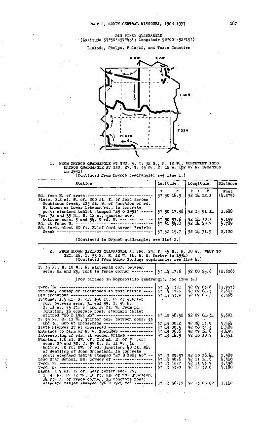
PART 2, SOUTH-CENTRAL MISSOURI, 1908-1937 187
BIO PINKY QUADRANGLE (Latitude 37 q30'-37°45'; longitude 92°bO'-92°15!)
Laclede, Phelps, Pulaski, and Texas Counties
R II W RIOW
\
1. ROM DKYNOB QUADRANGLE AT S&V. $, T. ^H ft.. K. id W. , HOKTaVKJSST J.MTW DRYNOB QUADRANGLE AT SEC. 27, T. 33 N., R. 12 W. .(by W. R. BroadduaIn 1931) .
(Continued from Drynob quadrangle; see line 1.)
Station
Plato, 0.2 ml. W. of, 200 ft. E. of ford across ' Roubldoux Creek, 125 ft - w > of Junction of rd. N. known as Lower. Lebanon rd. , In concrete post; standard tablet stamped "29 0 1931 1*
Tps. 32 and 33 N., R. 12 W. , quarter cor.
Rd. fork, about 80 ft. E. of ford across Prairie
Latitude
o i ei37 30 18.3
37 30 17.38
37 30 57.6 37 31 54-8
vi *.? m.7
Longitude
o i n92 14 12.1
92 13 51.14
92 14 30.5 92 14 29.7Q2 Ik *l.q
Distance
Peet (4,275)
1,688
5,159 5,7892.1PO
(Continued In Drynob quadrangle; see line 2.)
2. PROM EDGAR SPRINGS QUADRANGLE AT SEC. 23, T. 35 N., R. 10 W., WEST TO SEC. 26, T. 35 N., R. 12 W. (by R. H. Parker In 1934)
(Continued from Edgar Springs quadrangle; see line 1)..)
T. 35 N., R. 10 W., N. sixteenth cor. between sees. 22 and 23, post In fence corner -- 37 44 47-6 92 oo 25.6
(For balance In Waynesvllle quadrangle, see line 3.)
(2,626)
Tribune, center of crossroads at post office
Tribune, 1.5 ml. S. of, 150 ft. E. of quarter cor. between sees. 34 and 35, T. 35 N., R. 11 W., 35 ft. S. and 15 ft. W. from rd. Junction, In concrete post; standard tablet
T. 35 N., R. .11 W., quarter cor. between sees. 33
Wharton, 1.8 ml. SW. of, 0.2 ml. E. of W. cor. sees. 29 and 32, T. 35 N., R. 11 W., in hollow, 40 ft. NW. of rd. Junction, 40 ft. NE. of dwelling of John Orossland, In concrete post; standard tablet stamped "27 B 1925 Mo"
T _,J IT
T-rd. S. -- Hanna, 1.7 ml. E. of, near center sec. 26,
T. 35 N., R. 12 W. , 40 ft. NE. of rd. Junction, 14 ft. N. of fence corner, In .concrete post;
37 44 43-4 37 44 17-3 37 43 53-9
37 42 58.52
37 43 00.2 37 43 00. s 37 43 06.6 37 43 14-9
37 43 29.37 37 43 30.6 37 43 12.7 37 43 33-0
37 43 56.17
92 07 03.6 92 07 04.3 92 07 05.2
92 07 04.34
92 08 13.5 92 08 33-3 92 09 14.8 92 10 10.9
92 10 18.44 92 11 14.992 11 53-7 92 12 39.0
92 13 05.02
(3,957) 2,6lLl 2,368
5,601
5, .564 1,585 3,435 4,551
1,589 4,54g 3,598 4,180
.3,142

188 TRANSIT TRAVERSE IN MISSOURI
Station
3. PROM DRYNOB QUADRANGLE AT SEC. 21, T.'?5 SEC. 26, T. 35 N., R. 12 W. (by R. H. P
25 B 1925 Mo (In Drynob quadrangle; see line 3.)-
Latitude
0 1 II
N., R. 12 W., arker In 1934
37 44 14.5.33 37 144 Ok. 6 37 43 56.17
Longitude
SOUTHEAST TO )
92 15 16.8192 l4 13-5 92 13 05.02
Distance
Feet
6,546 5.567
14.. PROM DRYNOB QUADRANGLE AT SEC. 15, T. 33 N., R. 12 W. , NORTH INTO DRYNOB QUADRANGLE AT SEC. 21, T. 35 N., R. 12 W. (by C. D. Craig in 19314.)
(Continued from Drynob quadrangle; see line 3-
Ten-in. tree in SW. corner of yard of
Cedar Bluff School, in SW lA sec. 10, T. 33 N., R. 12 W., in SW. angle of dim rd. forks, 132 ft. S. and 105 ft. W. from SW. corner of schoolhouse, in concrete post; standard tablet
(For balance in Drynob quadrangle,
T. 314. N., R. 12 W., cor. sees. 27, 28, 33, and £ ..... .......... - ........
Forest Service poster marked "8 chains N. of cor. sees. 21, 22, 27, and 28, T. & N. ,R TP W " . »
(For balance in Drynob quadrangle,
SE. corner of garden fence of Jesse Williams Hanna, 1.9 ml. SE. of, In center of SE lA
sec. 31;, T. 35 N., R. 12 W., 14.0 ft. W. of rd. at private crossroad between dwelling and garage of C. W. Berry, in top of concrete runway to garage; standard tablet stamped
SE. corner of barn with concrete silo at E. end -
(Continued in Drynob quadrangle; s
37 34 27-1
37 5k 53-88
see line 3.
37 37 09.1
37 38 06.0
see line 3.
37 4l 31.5 37 42 19-7
37 43 Ok. 59 37 144 21.0
ee line 3')
92 14 41.2
92 14 43-61
92 14 58.2
92 14 58.2
92 ik 25.5 92 14 20.3
92 ik 05.43 92 14 35-6
(4,876)
2,720
(6,672)
5,753
(3,883) 4,892
4,695 8,095
5. FROM DRYNOB QUADRANGLE AT SEC. 21, T. 314. N.. R. 12 W. , EAST INTO EDGAR SPRINGS QUADRANGLE AT SEC. 26, T. 314. N. , R. 10 W. (by H. W. Gross in 1935)
71). M 1931 (In Drynob quadrangle; see line 3.) T. 3k N. , R. 12 W., cor. sees. 21, 22, 27; and
28, stone at E.-W. fence and abandoned fence N..
T. 3k N., R. 12 W., quarter cor. between sees. 26 and 27, stake In pile of rocks in fence line S.
Rd. at driveway in front of dwelling ofF. L. Woody
Cookville, 1.5 mi. SW. of, in SW lA NE lA sec. 26, T. 31). N., R. 12 W. , [4.5 ft. N. of St. Annie School, 25 ft. E. of rd., in concrete post; standard tablet stamped "Ik6kERA 1935"
Rd. at fences E. and W. on line between sees. 23 and 26, T. 3k N., R. 12 W.
Rd. at fence W. on line between- sees. 13 and 24,
T. 34 N., R. 12 W., E. cor. sees. 1J and 2k, large crib of rooks in fence corner at fences
Cookville, about 1 ml. SE. of, in NW lA -NW lA sec. 19, Ti 34 N., R. 11 W., 36 ft. N. and ko ft. E. from T-rd. S., 4 ft. inside fence, in concrete post; aluminum tablet stamped "Ik65 ERA 1935"
Rd. corner from W.-S. at abandoned E.-W. fence T. 3k N. , R. 11 W., quarter cor. between sees. 19
and 30, sandstone rock in E.-W. fence line on
T. 3k N., R. 11 W., S. sixteenth cor. sec. 29,
Palace, 1.2 ml. W. of, In SE lA SE lA sec. 29, T. 34 N., R. 11 W. , 0.5 ml. S- of schoolhouse, 20 ft. S. and 14.0 ft. E. from rd., junction, in concrete post; standard tablet stamped "1466E n A -1 07 f- It
37 38 14.48
37 38 02.0 37 37 14.0.5
37 37 35-1
57 37 57-2
37 37 41.78
37 3§ 02.7 ' 37 38 35.0
37 38 56.0 37 39 16.6
37 38 57-6
37 38 144.19 37 38 30.3
37 38 04.0 37 37 45.0 37 37 24-2
37 37 23.2
37 37 22.38*7 XV 11 .O
92 15 29.58
92 14.5,6-9 92 l4 22.2
92 13 52.2
92 13 40.9
92 13 09.38
92 13 08.3 92 12 38.5
92 12 35.8 92 12 15.5
92 11 40.4
92 11 30.65 92 11 07.1
92 11 07.6 92 11 02.092 10 51.7 92 10 01.4
92 09 35-36 o? no ix. A
2,921 3,537
2,470
955
2,580
2,118 4,051
2,135 2,650
5>417
1,567 2,361
2,662 1,971 2,260
4,0144
2,1011 TIC.

PART 2, SOUTH-CENTRAL MISSOURI, 1908-1937 189
Station
Center of triangle at rd. forks at entrance to
T. 3^ N., R. 11 W., cor. sees. 27, 28, 33, and
T. 31). N., R. 11 W., cor. sees. 26, 27, 3!)., and
Baldrldge School, about 0.7 ml. SW. of, on top of prominent hill, 3 ft. N. and 287 ft. W. from stone at E. sixteenth cor. between sees. 26 and 35, T. 34 N. , R. 11 W. , In concrete post; standard tablet stamped "114.67
T. 34 N. , R. 11 W. , quarter cor. between sees. 25 and 26, rd. at fence W. on S. 'side of lane
T. 3!). N., R. 11 W. , oor. sees. 23, 24, 25, and
Rd. forks near ford across small stream -
T. 314. N., R. 10 W. , In NE 1/k sec. 31, {4.5 ft. S. and 30 ft. E. from Junction of rd. SE. to Prewett Spring, In concrete post; standard
Rd. at blazed tree and U.S. Forest Service poster on line between sees. Jl and 32, T. 34 N., Rif»tfj ___ __
T. 314. N., R. 10 W., E. sixteenth cor. between sees. 29 and 32, sandstone rock in line with
T. 3l| N., R. 10 W. , cor. sees. 28, 29, 32, and 33, stone at corner of fences E., W., and S.
Rd. at point 55' ft. 5, of triangular-blazed
T. 34 N., R. 10 W. , E. eor. sees. 28 and 33, stone at corner of fences N. , S., and W. -
T. 314. N., R. 10 W., 32 ft. N. and 285 ft. E. from approximate W. sixteenth cor. between sees. 27 and 3!)., 71 ft. S. of dwelling of G. A. Knapp, In concrete post; standard tablet stamped
T. 314. N., R. 10 W. , S. sixteenth cor. between sees. 26 and 27, stone, 1 ft. E. of blazed
T. 314. N., R. 10 W., quarter cor. between sees. 26 and 35, stone at corner of fences W. and S.,
(Continued In Edgar Springs quadra
Latitude
0 1 II
37 37 07.14.
37 37 09.0
37 37 07.6
37 37 0740
37 37 35-6
37 37 55-8 37 38 28.7 37 37 55-4 37 37 58.4 37 37 39-9
37 36 55-64
37 36 54.8 37 36 51.8
37 37 03.8
37 37 03.3
37 36 45-8
37 37 01-9
37 36 59-76
37 37 13-7
57 36 59-7
ngle; see lln
Longitude
92 08 52.8
92 08 23.3
92 07 16.8
92 06 .30.31
92 06 09.6
92 06 09.2 92 06 05.8 92 05 20.9 92 04 14.8.7 92 014. 35-1
92 ok 23.21
92 03 57.4 92 03 39.8
92 03 11.8
92 02 51.7
92 02 31.8
92 01 14.6.1
92 01 26.57
92 oo 14.0.3
92 oo 07.3e 7-)
Distance
Feet
2,108
2,386
5,547
3,745
.3,131
2,614.62,939 4,943 2,606 2,172
4,578
2,079 1,447
2,562
1,618
2,390
4,024
1,588
3,980
3,001
6. FROM PLUM VALLEY QUADRANGLE WEST ALONG STATE HIGHWAYS 17 AND 32 TO PLATO (by C. E. Wyrick In 1935
(Continued from Plum Valley quadrangle; see line 5.)
Highway at fences E. and W. on line between
Roby, in NW lA NW 1/U sec. 3, T. 32 N., R. 11 W. , 20 ft. N. and 42 ft. E. from junction of State Highways 17 and 17-A, In concrete post; standard tablet stamped "T T 1175 w 1935" .
Junction of rd. S. on line between sees. 14. and 5,T ZO M R 1 T W
Highway at fences N. and S. on line between
Plato, 2 ml. E. of, along State Highway 17-A, about 500 ft. N. of quarter cor. between sees. 6 and 7, T. 32 N., R. 11 W., 14.0 ft. S. and 55 ft. W. from highway at rd. S;, In concrete post; standard tablet stamped "T T
Junction of rd. N. and fence S. on line between sees. 1 and 6, T. 32 N. , Rs. 11 and 12 W.
Crossroad on line between sees. 1 and 2,
37 30 20.7 37 30 34-1
37 30 55-90 37 30 57-3
37 30 14.3-3
37 30 29.1
37 30 17-81
37 30 18.5
37 30 12. 3n 37 30 17.38
92 07 33-7 92 08 02.1..
92 08 19.50 92 09 01.5
92 09 35.1
92 10 14.0.9
92 11 114.. 85
92 11 14.6.8
92 12 52.0 92 13 51.114.
(3,995) 2,344
2,599 3,391
3,049
5,498
2,963
2,579
5,291 4,791

190 TRANSIT TRAVERSE IN MISSOURI
Station Latitude Longitude Distance
<* i " o i it Peet
7. PROM WAYNESVILLE QUADRANGLE AT SEC. 22, T. 35 N. , R. 10 W. , SOUTHEAST INTO'EDGAR SPRINGS QUADRANGLE AT SEC. 26, T. 35 N., R. 10 W. (by H. W. Gross In 1935)
(Continued from Waynesvllle quadrangle; see line 6.)
Rd. at gate .W. of ford, about 350 ft. W. (?) of
T. V) N., R. 10 W. , cor. sees. 21, 22, 27, and.
Spring Creek, 3 ml. SE. of, In SE lA SE 1/1; aec. 27, T. 35 N., R. 10 W. , ll(.0 ft. .3. of rd. , 50 ft. N. of dwelling of Will Duncan, In concrete post; standard tablet stamped "ll(.73E Tt A TQZCtt ____ _____ __ '_ __ ___ __ __
(Continued In Edgar Springs quadra
37 hk 34.237 |44 08.5 37 14.3 47-7
37 14.3 22.91
ngle; see lln
92 01 1^.7
92 01 32.992 00 59.3
92 oo 22.87e 8.)
(3,096)
2,982 3,421
3,859
8. PROM SEC. 27, T. 35 N., R. 10 W., SOUTH TO SEC. 3, T. (by H. W. Gross in 1935)
N., R. 10 W.
Proposed rd. opposite triangular-blazed 2lj.-ln.
Slxteeri-ln. black-oak tree and Forest Service poster marked "approximate location NW. cor. sec. 3, T. 3lj. N., R. 10 W. , 18 links N;", 1*2 ft. S. and 23 ft. W. from corner of fences W.
Piney Lookout Tower k of U.S. Forest Service
37 14-3 22.91
37 te M4--9'
37 te 29-6 37 lj-2 12-99
92 oo 22.87
92 oo 56.0
92 pi 14.5.3 92 01 23.10
1^,676
U,252 2453
FROM SEC. 33, T. 35 N., R. 11 W., SOUTH ALONG STATE HIGHWAY 17 TO SEC. 33, T. 314. N., R. 11 W. (fourth-order traverse by State Highway Department in 1936)
Highway at line between sees, k and 33, Tps. 3lj..
Junction of old rd. about 70 ft. W. of crossing
Highway at line between sees, k and 9, T. 3!; N. ,R 1T W __ _ __ _ __ _ _
Highway at point about 25 ft. E.'of quarter cor. between sees. 8 and 9, T. 314. N., R. 11 W.
Junction of rd. W. on line between sees. 8 and-|»7 m T|. W P IT W '
Junction of rd. S. on line between sees. l6 and
Crossroad on S. side of cemetery, 5° ft - S. and 150 ft. E. from W. sixteenth cor. sec. 28,
T. }!». N.,"R. 11 W. , cor. sees. 27. 28, 33, and
37 14.3 00.5
37 \\2. 31*.. 9
37 {A 59-0 37 la 06:2
37 14.0 14.0.0
37 Uo 13-5
37 39 14.6.9
37 39 10.0 37 38 14.0.7
37 37 3M
37.37 09-0
92 08 33-3
92 08 39.0
92 09 07.14. 92 09 094
92 09 16.9
92 09 26.2
92 09 31-9
92 09 27.14. 92 09 07.2
92 08 37.5
92 08 23.3
2,620
1*,3U9 5,329
2,707
2,763
2,720
3,73l4. 3,381
7,078
2,814.0
Magnetic declination 6? 8' E.

PART 2, SOUTH-CENTRAL MISSOURI, 19p8-1937 191
PLUM VALLEY QUADRANGLE (Latitude 37°15'-J7 0JO'; longitude 92°00'-92°15')
Texas County
R II W RIOW
\
1. PROM RAYMONDVILLE QUADRANGLE AT SEC. J5, T. JO N., R. 10 W.,.WEST INTO MANES QUADRANGLE AT SEC, 15, T. JO N., R. 12 W. (by W. R. Broaddus In 1951)
(Continued from Raymondville quadrangle; see line 1.)
Station
U.S. Highway 63 at rd. E. on line between sees. 2 and 35, Tps. 29 and JO N., R. 10 W.
Clara, J. 5 mi. 3. of, at S. sixteenth cor. between seoa. JJ and j4, T. JO N., R. ,101 W., 18 ft. S. and 12 ft. .E. from stone In center of T-rd. E. , 9 ft. S. and j ft. W. from fence corner, in concrete post; 'standard tablet
T-rd. W. on line between sees. JJ and j4»
Rd. forks near W. sixteenth cor. sec. 22, Tzn w R i n w
Clara, 25 ft. S. and 95 ft. E. from SE. corner of post office and store, ij.0 ft. S. of Houston rd., 5 ft. W. of fence, In concrete post;
Rd. corner near center sec. 15, T. JO N.,R T f\ W
T. JO N., R. 10 W., quarter cor. between sees. 9
T-rd. W. near quarter cor. between sees., 4 and 9,
Lutheran Church, JOO ft. W. of, cor. sees. 4, 5, 8, and 9, T. JO N., R. 10 ff. , 18 ft. S. and 20 ft. W. from T-rd. S., 5 ft. N. and 40 ft. W. from NW. corner of cemetery, In concrete post; standard tablet stamped "1J G 19J1"
Rd. fork - - T. JO N., Rs. 10 and 11 W., cor. sees. 1, 6, 7,
Dykes, 0-5 ml. S. and 1.5 mi. E. from post office, 40 ft. S. and 200 ft. W. from quarter cor. between sees. 1 and 12, T. JO N., R. 11 W. , 45 ft. W. of rd. forks, In concrete post; standard tablet stamped "l4 G 19J1"
T". JO N., R. 11 W. , quarter cor. between sees. 1
Dykes, 1.2 ml. W. of post office, S. sixteenth cor. between sees. J and 4, T. JO N., R. 11 W. , 10 ft. N. and 40 ft. E. from T-rd. N., in large limestone ledge; standard tablet stamped "15 G 1931 n
Latitude
0 | II
J7 15 12-5 37 15 31.2 J7 15 26. J
J7 15 26.61
J7 1.5 46.4 37 16 34-5
37 17 17.5
37 17 58.46
37 18 17-3 37 18 4o.o
37 18 1*4-3 37 18 57-5
57 19 374
37 19 37-16 37 19 37-9 37 19 38.1
37 19 36.9
37 19 J6.5537 20 Oj.j J7 19 54-6
J7 19 48.14
Long! tude
0 | II
92 00 OJ.792 01 07.5 92 01 21.8
92 01 56.6092 01 56.2 92 01 25.892 01 J8.0
92 01 15.15 92 01 20.492 01 5J.4
92 02 26.1 92 02 25.8
92 02 25.1
92 02 58.64 92 OJ 48.1 92 04 17.5
92 05 16.1
92 05 51.42
92 06 21.8 92 07 J8.J
92 08 JJ.43
Distance
Feet
(1.555) 5,499 1,254
2,8l4
2,008 5,456
4,455
4,534
1,953 3,518
2,681 1,335
4,oj5
2,711 J,i998 2,J70
4,736
2,856
m4,498
192 TRANSIT TRAVERSE IN MISSOURI
Station
Rd. at fence N. on E. side of dim rd. N. , about
Rd. corner from N.-W. at private lane S. on line between sees. 7 and 8, T. 30 N. , R. 11 W.
Hugglns, quarter cor. between sees. 7 an<l 12, T. 30 N., Rs. 11 and 12 W. , 30 ft. N. and 42 ft. E. from Hartville-Houston rd. at crossing of Mountain Grove rd. , in concrete post;
T. 30 N., R. 12 W. , cor. sees. 11, 12, 13,- and 14, rd.. at S. yard fence, about 45 ft. S. and
Rd. forks on line between sees. 14 and 15,
Huggins, 3 mi. SW. of, near center see. 15, T. 30 N., R. 12 W., 3 ft. N. and 9 ft. E. from NW. corner of yard of W. A. Ratterbee, in concrete post; standard tablet stamped "17 G
(Continued in Manes quadrangle; se
Latitude
0 | II
37 19 42.5 37 19 41.8
37 19 12.5
37 19 13-34
37 18 46.9 37 18 34-4
37 18 34-9
37 18 17.39 37 18 16.4
e line 1.)
Longitude
0 | II
92 09 23-3 92 10 28.2
92 10 46.1
92 11 51.72
92 12 56.6 92 13 29.2
92 14 01.8
92 14 31-19 92 14 52.1
Distance
Feet
4,065 5,246
3,294
5,299
5,863 2,9192,635
2,963 1,695
2. PROM BIG PINEY QUADRANGLE AT SEC; 2, T. 32 N., R. 12 W. , SOUTH TO SEC. 15, T. 30 N., R. 12 W. (by C. E. Wyrick in 1935) '
29 G 1931 (In Big Plney quadrangle; see line 1.)
T. 32 N., R. 12 W. , quarter eor. between sees. 11
Plato, 1.5 mi. S. of, in SW lA NE 1/1; see. l4, T. 32 N., R. 12 W., 14.0 ft. S. and 35 ft. E. from Junction of rd. E. , 75 ft. NW. of NW. corner of porch of S. S. Smith, in concrete post; standard tablet stamped "T T 1177 w 1931)-"
T. 32 N., R. 12 W., S. sixteenth cor. sec. 23,
T. 32 N., R. 12 W., quarter eor. between sees. 26
Plato, 5 mi. S. of, along Mountain Grove-Plato rd., in SW lA NW 1/1). sec. 35, T. 32 N., R. 12 W., 27 ft. E. of rd., 40 ft. NW. of NW. corner of dwelling of Ernest Miller, in concrete post; standard tablet stamped "T T
T. 32 N., R. 12 W. , quarter cor. between sees. 31; and 35, flint rooks at center of T-rd. S. -----
T. 31 N., R. 12 W., center sec. 3, large lime- atone rock, 12 ft. N. of fence corner on line
Baptist Church No. 1, about 3 ml. NW. of, along Mountain Grove-Plato rd., in SE lA SW lA see. 10, T. 31 N. , R. 12 W. , 14.5 ft. N. of NW. corner of log dwelling, In concrete post; standard tablet stamped "T T 1179 W 1935"
T. 31 N., R. 12 W., center sec. 15, large
Re. corner from H.-E. opposite blazed l4-in.
Baptist Church No. 1, about 0.2 mi. E. of quarter cor. between sees. 23 and 26, T. 31 N., R. 12 W., 30 ft. S. and 40 ft. W. from T-rd. W. , 120 ft. SW. of SW. corner .of church, in concrete post; standard tablet stamped "T T
T. 31 N., R. 12 W., N. sixteenth cor. sec. 35,
Rd. at triangular-blazed 24-in. white-oak tree Baptist Church No. 1, 3.5 mi. S. of, in NW lA
NY/ lA sec. 11, T. 30 N., R. 12 W. , 25 ft. E. of N.-S. rd., 25 ft. NW. of NW. corner of dwelling of Olen Wilson, in concrete post; standard tablet stamped "T T Il8l W 1935" --
37 30 17.38 37 29 31.8
37 29 18.3
37 28 58.56 37 28 24.8
37 27 14.5.0 37 27 02.3
37 26 14.0.1 37 26 4o.l
37 26 20.12
37 26 13.7
37 25 23.5 37 24 14.9-9
37 214. 11.1)1). 37 23 50.6
37 23 37-5 37 23 16.9
37 22 44-3
37 22 17.62 37 21 51. L 37 21 214.6
37 21 11.9 37 20 lj.6.5 37 20 10.0
37 19 31-05 37 18 5-3.0
92 13 51-14 92 13 33-9
92 13 25.8
92 13 14-41 92 13 17-7
92 13 27.1 92 13 27.6
92 13 27.9 92 13 144.2
92 13 44-07
92 14 00.8
92 Ik 33-3 92 14 34-1
92 14 45-4392 14 39-3
92 14 314-. 2 92 13 37-2
92 13 29.4
92 13 16.79 92 13 13-2 92 13 13-6
92 13 30.0 92 13 44-0 92 13 55-3
92 14 01.14 92 14 17.8
4,813
1,515
2,200 3,429
4,091 4,321
2,250 1,319
2,019
i,494
5,713 3,402
4,ooo 2,162
1,390 5.o45
3,309
2,884 2,694 2,710
1,840 2,810 3,807
3,968 4,079

PART 2, SOUTH-CENTRAL MISSOURI-, 1908-1957 193
17 G 1931
St«
(previous
ition Latitude
37 18 17.39
Longitude
0 1 Tl
92 Ik 31.19
Distance
Feet 3,759
3. PROM CABOOL QUADRANGLE NORTHWEST ALONG COU1ITY ROUTE M TO HUGG1NS (by C. E. Wyrick in 1935)
(Continued from Cabool quadrangle; see line 5-)
Junction of rd. E. and fence W. on line between
T. 30 N., R. 11 W. , about 600 ft. W. of quarter cor. between sees. 22 and 27, 1.1 mi. N. of County Route M bridge over West Plney Creek, 30 ft. E. of highway, 10 ft. N. of fence corner, in concrete post; standard tablet
T. 30 N. , R. 11 W. , quarter cor. between sees. 21
T. 50 N., R. 11 W., cor. sees. 16, 17, 20, and
T. 50 N., R. 11 W., cor. sees. 17, 18, 19, and
Bills School, in SW 1/4 SE I/k sec. 18, T. 30 N., R. 11 W., 35 ft. N. of County Route B, 65 ft. SE. of SE. corner of schoolhouse, in concrete post; standard tablet stamped "T T 1195 ERA 3.935" ~- - -- ----- -----
T. 30 N. , Rs. 11 and 12 W. , cor. sees. 7, 12, 13,
37 15 13-8
37 16 07. k 37 16 1+4-7
37 .17 00.50
37 17 27. 4
37 17 534
37 17 53-7
37 17 54-25 37 17 54-5
37 18 46.8 37 19 13.34
92 07 19.4
92 07 28.092 07 45-1
92 08 05.62
92 08 33.9
92 09 40.1
92 10 46.1
92 11 09.63 92 11 52.4
92 11 52.4 92 11 51.72
(3,427)
5,461 4,023
2,300
5,548
5,966
5,330
1,901 3,458
5,305 2,690
4. PROM SEC. 14, T. 32 N., R. 10 W. , SOUTH ALONG ROADS TO BUCYRUS, THENCE SOUTH ALONG STATE HIGHWAY 17 INTO RAYMONDVILLE QUADRANGLE (by C. E. Wyrick in 1935)
T. 32 N., R. 10 W. , 0.2 ml. N. of quarter cor. between sees. l4 and 15, 40 ft. S. and 65 ft. W. from State Highway 32 at rd. E. , 55 ft. W. of NW. corner of store, In concrete post;
(For balance in Raymondvllle quadr
Ellsworth School, 0.5 ml. S. of, about 600 ft; E. of quarter eor. between sees. 23 and 26, T. 32 N., R. 10 W., 17 ft. N. and 28 ft. E. from T-rd. N. , In concrete post; standard
(For balance in Raymondvllle quadr
Rd. forks opposite blazed l6-ln. black-oak tree. -
Pine Ridge School, 0.8 mi. S. and 0-5 mi. W. from, on old Houston-Venable rd., in SW I/k SW.lA sec.. 23, T. 51 N., R. 10 W., 68 ft. NE. of rd. forks, 8 ft. NE. of triangular-blazed l6-in. white-oak tree, in concrete post; standard tablet stamped "T T 1185 ERA 1935" -
Rd. forks opposite triangular-blazed 20-in.
Bucyrus, about 1 ml. NW. of, in SW lA SW 1/4 sec. 27, T. 31 N., R. 10 W. , 65 ft. E. of rd., 35 ft. S. of NE. corner of Emery Methodist Church, In concrete post; standard
Bucyrus, Junction of rd. N. opposite post office- T. 30 N., R. 10 W., N. cor. sees. 2 and 5,
Houston, 2.5 mi. W. of, along State Highway 17, near center sec. 11, T. JO N., R. 10 W., 58 ft. S. and 550 ft. W. from Junction of highway and County Route Z, In concrete post; standard tablet stamped "T T 1187 ERA 1955" -
(Continued In Raymondvllle quadran
37 28 57-91 37 28 50.1
angle, see 11
37 27 23.67
angle, see 11
37 23 30.6 37 23 03.0 37 22 57.4
37 22 17.11 37 22 03.7
37 21 57.6
37 21 22.96 37 21 05.3 37 20 39.3
37 20 25.9 37 19 51-8 37 19 36.8
37 19 IP- 87
gle; see line
92 oo 47-7592 00 02.2
ne 7.)
92 oo 00.60nfl 7.)
92 oo 06.0 92 oo 25.5 92 oo 52.6
92 oo 29.53 92 01 31.692 02 17.6
92 01 27.3292 oo 56.2 92 oo 59.592 oo 36.2 92 oo 09.8 92 oo 09.4
92 00 07.42
7-)
3,753
(5,314)
(2,005) 5,202 2,273
4,48o 5,190
3,768
5,364 3,084 2,639
2,319 '4,053 1,522
2,626

TRANSIT TRAVERSE IN MISSOURI
Station Latitude
0 , II
Longitude
O | .11
Distance
Feet
PROM RAYMONDVILI.E QUADRANGLE SOUTHWEST 'ALONG STATE HIGHWAY 32 TO SEC. 25, T. 32 N., R. 11 W., THENCE NORTH ALONG STATE HIGHWAY 17 INTO BIG PINEY QUADRANGLE (by 0. E. Wyrick in 1935)
(Continued from Edgar Springs quadrangle; see line 5.)
T. 32 N. , R. 10 W. , cor. sees. 10, 11, Ik, and 15, sandstone rock with chiseled cross about
Highway at fence N. on line between sees. 15 and 16, T. 32 N., R. 10 W.
Vada, 0.8 mi. SW. of, along State Highway 32, S. sixteenth cor. sec. 20, T. 32 N. , R. 10 W. , kO ft. S. and 100 ft. E. from highway at E.-W. crossroad, in concrete post; standard tablet
T. 32 N. , Rs. 10 and 11 W. , cor. sees. 25, 30, 31, and 36, limestone rock in fence of pigpen; ' 400 ft. S. and 96 ft. E. from junction of State Highway 17, 12 ft. S. of 2k-ir,. white-oak
T. 32 N., R. 11 W. , in SW lA SE 1/4 sec. 25, 0.5 ml. NW. of junction of State Highway 17 and 32, kO ft. S. and 33 ft. E. from -Highway 17 at N.-S. crossroad, 12 ft. N. of triangular- blazed 12-in. white-oak tree, in concrete post;
T. 32 N., R. 11 W. , cor. sees. 23, 2k, 25, and
Windy Curve Store, 1 mi. SE. of, along State Highway 17, in W 1/2 sec. Ik, T. 32 N. , R. 11 W., 275 ft. ... of filling sta. , 30 ft. W. of highway, 25 ft. S. o'f fence corner, 8 ft. N. of triangular-blazed 24-ln. tree, in con crete post; standard tablet stamped ?T T 1174W 1 OX£ n
Highway at fences N. and S. on line between
Junction of rd. W. at .fence E. on line between
(Continued in Big Piney quadrangle
37 29.51.0
37 29 09.2 37 28 57.91
37 .29 01.5 37 28 S7.8- 37 -28 4-0.7 37 28 19.2
37 27 41.04 37 27 28.0 37 27 20.3 37 26 57.0
37 26 36*6
37 26 50.43
37 27 27.1 . 37 27 52.1 37 28 08.8 37 28 38.8
37 28 50.26
37 29 09.4
37 29 14.7 37 29 4l-2
; see line 6.
92 'oo 09.1
92 oo 4i>9 92 oo 47.7592 01 47-8.92 02 29.7 92 02 57-7 92 03 03.5
92 03 26.08 92 03 47-8 92 03 59.9 92 04 51-3
92 05 12.7
92 05 45-15
92 06 16'. 3 92 06 22.4 92 06 22.9 92 06 50.5
92 06 58.85
92 07 23.7
92 07 39-8 92 07 414
)
(2,590)
4,991 1,2364,850 mi2,221
4,270 2,193 1,47 4,773
2,687
2,971
4,569 2,557 1,684 3,770
1,337
2,782
r,4o7. 2,682
6; PROM MANES QUADRANGLE AT SEC. 9, T. 5! N. , R. 12 W., EAST TO SEC. 10, T. 31 N., R. 12 W. (by J. W. Pothergill in 1935)
. (Continued from Manes quadrangle; see line 5.)
37 2k 49.- 9, 37-24 1144
92 14 34-p 92 14 4543
(2,689) 4,000
7. FROM SEC. 25, T. 32 N./R. 11 W. , SOUTH ALONG STATE HIGHWAY 17 TO SEC. 19, T. 31 N., R. 10 W., THENCE WEST AND SOUTH ALONG ROADS TO
SEC.. 3, T. 30 N., R. 11 W. (by J. J. Beinlich In 1936)
U.S.C. & G.S. standard disk stamped "N 113 1935"
Highway at fence W., 25 ft. W. of Forest Service poster marked "14-95 chains W. to SW. eor.
Success, 3 mi. S. of, along State Highway 17, at Mitchell's store, 395 ft.. S. and 2 ft. W. from center of NE 1/4 sec. 7, T. 31 N. , R. 10 W. , 25 ft. S. and 50 ft. W. from highway at rd. N., in concrete post; standard tablet stamped "T T
37-26 50.43 37 26 4o.99. 37 25 56.8
37 25 44.0 37 25 33-1 37 24 59-1
37 2k 33.71 37 24 244 37 23 40.9 37 23 19.8 37 22 39.5
92 .05 45-15 92 05 16.60 92 04 534
92 05 01.192 05 02.892 o4 50.8
92 04 18.2192 04 14-5 92 Ok 35-3 92 04 17-992 04 11.2
2,4944,849
1,432 1,111 3,58o
3,678, "2 4,7082,559 4,119

PART 2, SOOTH-CENTRAL MISSOURI, 1908-1937 195
Station
Success, 5.5 mi. S. of, along State Highway 17, thence 1 ml. W. , about 300 ft. N. and 30 ft. E. from approximate W. quarter cor. sec. 19» T. 31 N. , R. 10 W., 300 ft. N. of T-rd. E., 28 ft, N. and 28 ft. E. from rd. corner S.-W., 2 ft. S. and 4 ft. W. from fence corner, in concrete post; standard tablet stamped "T T 28
Rd. at point 2? ft. N. and 21 ft. W. from sand stone rock at cor. seas. 22, 23, 26, and 27, T. 31 N., R. 11' W., 244 ft. N. and 156 ft. E.
Dykes, 3.1 mi. N. of old site of post office, along Dykes-Roubidoux rd., in HE 1/4 NE lA sec. 27, T. 31 N. , R. 11 W., 25 ft. S. and 7 ft. E. from rd. at rd. E. to Coffey School, 4 ft. S. of triangular-blazed 24-in. post-oak tree, in concrete post; standard tablet stamped
T-rd. W. , 40 ft. W. of stone at cor. sees. 2, 3,34, and 35, Tps. 30 and 31 N. , R. 11 W. .
Latitude
0 1 It
37 22 43.00 37 22 54.2 37 22 31.0
37 22 15.4
37 22 05.02 37 21 22.2 37 21 22.3
37 20 29.7 37 19 57-0 57 19 48.14
Longitude
92 05 13.8392 05 30.892 06 36.6
92 07 26.8
92 07 30.82 92 07 43-2 92 07 26.9
92 07 27.6 92 07 27.1 92 08 55-45
Distance
Peet
5,063 1,779 5,802
4,347
1,1054,442 1,3205,3i6 3,309 5.454
Magnetic declination 6° 15! E.
CABOOL QUADRANGLE (Latitude 37°00'-37°15'; longitude 92°00'-92 015')
Douglas, Howell, Texas, and Wright Counties
Rll W / RIOW
1. PROM MOUNTAIN GROVE QUADRANGLE EAST AND SOUTHEAST ALONG ST. LODIS-SAN FRANCISCO RAILWAY INTO CLEAR SPRINGS QUADRANGLE (by E. L. McNalr in1913) '
(Continued from Mountain Grove quadrangle; see line 1.)
Station
R.R. at line between sees. 9 and 10, T. 28 N. ,
R.R. at line between sees. 2 and 3, T. 28 N.,
R.R. at line between sees. 1 and 6, T. 28 N.,
Stone In E.-W. rd. on line between sees. 31 and 32, T. 29 N., R. 11 W., 820 ft. N. of R.R.
184101 O 3!t 6
Latitude
0| II '
37 07 47.5
37 07 49.2 37 07 .57.9 37 08 19.3
37 08 24.8 37 08 26-5
37 08 42.8
37 07 47-2
Longl tude
0 | II
92 14 56.692 13 52.7 92 13 19.6 92 12 06.9
92 11 41-3 92 11 08.2
92 10 37'. l 92 10 01.4 92 08 4l-3
Distance
Peet
(2,735)
5,175 2,8216,275
2,143 2,687
3,0023,695 7,292

196 TRANSIT TRAVERSE IN MISSOURI
Station
R.R. at line between sees. 3 and 14, T. 28 N. ,
R.R. at line between aecs. 10 and 11, T. 28 N. ,
Cabool, 550 ft. VV. of St. Louis-San Francisco Ry. sta., 90 ft. N. of main track, 10 ft. S. of N. spur, 9 ft. NE. of base of oil stand; iron post stamped "Prim Trav Sta No 143 1913
Stone and iron rod at fence corner on line between sees. 5 and 6, T. 28 N. , R. 10 W.,
R.R. at rd. crossing on line between sees. 5 an<^
Fence corner on line between sees. 8 -and 9,
Sargent, 300 ft. S. of St. Louis-San Francisco Ry. flag sta., 90 ft. S. 27° W. of R.R. at rd. crossing, 50 ft. S. of rd., at fence corner, iron post stamped "Prim Trav Sta No kk 1913
T. 27 N., R. 10 W. , N. cor. sees. 2 and 3, rd. corner from E.-S. on Howell-Texas county 1/ln'e -
(Continued in Clear Springs quadra
Latitude
37 07 47.1
37 07 41 -1| 37 07 22.5
37 07 15-65 37 07 27.3 .37 07 43.0 37 OB 19.2
37 07 57.2
37 07 41-1
37 07 04-5 37 06 45-5 37 06 11.7
37 05 11.20 37 04 26.2
37 03 20.2 37 02 33-7
ngle; see lin
Longitude
0 1 II
92 08 28.8
92 07 21).. 9 92 06 1;5.5
92 06 14.30 92 05 39.0 92 05 20.14. 92 ok [42.7
92 ok 14.1
92 03 51-9
92. 03 09.8 92 02 57-9 92 02 30.5
92 01 36.08 92 01 16.392 01 02.3 92 oo 26.5
e 1.)
Distance
Feet
999
5,212 3,720
2,627 3,095 2,180 1^,758
3,213
2,14.28
5,037 2,151 14., 082
7,514-8 lj-,813
6,7614 5,515
2. FROM SARGENT SOUTHWEST INTO TOPAZ QUADRANGLE AT SEC. 22, T. 27 N. , R. 11 W. (by W. R. Broaddus in 1932)
Prim Trav Sta No 144 1913 Mo (previously
U.S.C. & G.S. standard disk stamped "V 7 1928" - St. Louis-San Francisco Ry. at semaphore 2865 St. Louis-San Francisco Ry. at semaphore' 2873 U.S.C. & G.S. standard disk stamped "W 7 1928" -
Sterling, 3 mi. NW. of, along U.S. Highway 63, about 2.8 mi. SW. of Sargent, about 680 ft. SW. of point where highway crosses' dividing ridge. 10 ft* S. and 50 ft. E. from highway at rd. SE. , 2 ft. E. of fence, In concrete post;
Triangular-blazed white-oak tree about 20 ft. W.
Rd. forks about' 20 ft'. W. of triangular-blazed
Sterling, 3.7 mi. SW. of, along mall route to Cabool, about 0.6 mi. W. of ford across Indian Creek, 60 ft. S. and 10 ft. E. from rd. junction, 33 ft. SW. of rd., 5 ft. inside fence, 2 ft. S. of N. edge of large limestone ledge; standard tablet stamped "T T 70 B 1932"-
T. 27 N., R. 10 W. , cor. sees. 7, 8, 17, and 18,
T. 27 N. , Rs. 10 and 11 W. ,.. cor. sees. 7, 12, 13, and 18, T-rd. E. at Douglas -Howell county line
Sterling, about 6.8 ml. SW. of, 1 ml. S. of corner of Douglas, Howell, and Texas Counties, 25 ft. S. and 20 ft. W. from approximate cor. sees. 1, 6, 7, and 12, T. 27 N., Rs. 10 and 11 W., 25 ft. S. and JO ft. W. from T-rd. W., 14 ft. SW. of fence corner, on property of F. W. Neff, in concrete post; standard tablet
T. 27 N., R. 11 W., cor. sees. 1, 2, 11, and 12,
T. 27 N., R. 11 W., quarter cor. between sees. 2
T. 27 N. , R. 11 W., approximate quarter cor. between sees. 11 and 14, 125 ?* S. of rd.
37 05 11.20 37 05 1J.64 37 04 32.5 37 03 47-2 37 03 kj-kk 37 03 46.5
37 03 52.17
37 03 26.3 37 03 21.0
37 02 1;8.0 37 01 56.9
37 01 28.47 37 01 36.1
37 01 36.3
37 01 37-2
37 02 29:19 37 02 29-4
. 37 02 30.2
37 02 30.7
37 01 38.2
92 01 36.0892 01 37.59 92 01 18.5 92 01 09.9 92 01 11.11 92 01 14.3.2
92 02 12.69
92 02 53.6 92 02 56.9
Q2 03 13.2 92 03 20.7
92 03 20.7792 ok 03.592 014. 19.9
92 05 21.1
92 05 -20.28 92 05 52.0
92 06 24.9
92 06 57-6
92 06 58.8
275 14428 1;,636
398 2,621
2,1456
14,222 595
3,591 5,207
2,876 3,55lv1,330
1*,963
5,256 2,5712,667
2,655
5,312

PART 2, SOUTH-CENTRAL MISSOURI, 1908-1937 197
Station
New Orleans School, 2.6 mi. NE. of, in SW lA sec. 14, T. 27 N., K. 11 W. , 22 ft. E. of rd., 210 ft, S. 24 4 W. of dwelling of E. W. Freeman, 2 ft. W. of fence, in concrete post; standardtablet stamped "T T 72 B 1932"
Latitude
37 01 02.50 *7 nn ?i .£
Longitude
0 1 II
92 07 l4.6lQ? O7 liO-Q
Distance
Peet
3,835 fi .fan
(Continued in Topaz quadrangle; see line 1.)
3- PROM PLUM VALLEY QUADRANGLE SOUTHWEST ALONG U.S. HIGHWAY 6j TO CABOOL, THENCE WEST 2 MILES ALONG ST. LOUIS-SAN FRANCISCO RAILWAY, THENCE NORTH ALONG COUNTY ROUTE M INTO PLUM VALLEY QUADRANGLE (by C. E. Wyrick in 1935)
Junction of rd. NW. (In Raymohdville quadrangle;
U.S.C. & G.S. standard disk stamped "Q 33 1934"-
U.S.C. & G.S. standard disk stamped "P 33 1934"- T. 29 N., R. 10 W. , quarter cor. between sees. 9
and 10, Junction of rd. S. and wire fence N. Junction of rd. W. on line between sees. 9 an(i
U.S.C. & G.S. standard disk stamped "N 33 1934"- Highway at fence W. on line between sees. l6 and
T. 29 N., R. 10 W., cor. sees. 20, 21, 28, and
U.S.C. & G.S. standard disk stamped "M 33 1934"-
U.S.C. & G.S. standard disk stamped "L 33 1934"-
U.S.C. & G.S. standard disk stamped "K 33 193k"- U.S.C. & G.S. standard disk stamped "R 7 1928" - Prim Trav Sta No 43 1913 Mo (previously
Cabool, 2 mi. W. of, along U.S. Highway 60, 215 ft. N. and 40 ft. W. from Junction of County Route M, 20 ft. N. of farm entrance, along W. fence, in concrete post; standard
Highway at fence E. on line between sees. 3 an<i
Highway at fence W. on line between sees. 28 and^* T PO TJ R "M W - - - -
Cabool, 2 mi. W. , thence 3.5 mi. N. from, along U.S. Highway 60 and County Route M, in SW 1/k SW V4 see. 22, T. 29 N., R. 11 W. , 30 ft. W. of highway, 20 ft. N. of farm entrance W., in concrete post; standard tablet stamped "1191
T. 29 N. , R. 11 W. , N. sixteenth cor. between
Cabool, 2 ml. W., thence 6.2 ml. N. from, along U.S. Highway 60 and County Route M, in SW 1/Ij. SE 1/k sec. 10, T. 29 N., R. 11 W. , 30 ft. W. of highway, 6 ft. S. of fence corner, in concrete post; standard tablet stamped "1192
Highway at fences E. and W. on approximate line between sees. 3 and 10, T. 29 N. , R. 11 W.
Noel's store, 0.8 mi. N. of, along County Route M, in NW 1/4 see. 3, T. 29 N., R. 11 W., 150 ft. S. and 27 ft. W. from highway at E.-W. crossroad, in concrete post; standard tablet
(Continued in Plum Valley quadrang
37 15 29.6 37 14 44-3 37 14 31-71 37 13 50.6 37 13 12.75
37 12 32.7
37 12 06.5 37 11 41-47
37 ll 13.9 37 10 k7.8
37 10 21. k 37 10 11.26 37 09 4k.k 37. 09 02.4 37 08 36.83 37 08 35.3 37 07 45-09 37 07 14-91
37 07 15-65 37 07 22.5 37 07 45.1
37 07 53.3437 08 38.8 37 09 18.9
37 09 31-9
37 10 29.88 37 ll 02. k 37 11 17-6
37 ll 57-8
37 12 21.11
37 13 00.5 37 13 23.9 37 13 52.4 37 14 19-3
37 14 58.14
Le; see line
91 59 54-4 92 oo 19.192 00 33-13 92 00 5k. o 92 01 26.24
92 01 59-7
92 02 27.3 92 02 20.82
92 02 15.3 92 02 33.9
92 03 06.6 92 03 07.26 92 03 25.4 92 03 44.992 o4 24.0592 04 51-9 92 05 26.11 92 06 09.21
92 06 ik. 30 92 06 92 07 32.6
92 08 03.83
92 08 oi.o 92 08 22'. 9
92 08 40.4
92 08 20.9092 08 kk.l 92 09 00. k
92 08 22.7
92 07 46.91
92 07 36.6 92 07 44-1 92 08 00.792 08 06.9
92 07 56.93
3.)
5,003 1,7034,493 4,630
4,873
3,462 2,591
2,828 3,0353,757 1,033 3,087 4,542 4,0§9 2,257 5,786 4,638
419 2,6274,445
2,658k,6014,433'
1,930
6,076 3,785 2,032
5,083
3,735k,072 2,4k3 3,179 2,769
4,006

198 TRANSIT TRAVERSE IN MISSOURI
Station Latitude
0 , .1
Longitude
0 , ,
Distance
Feet
1+.. PROM U.S. HIGHWAY 6j AT POINT 2.6 MILES NORTHEAST OF CABOOL, EAST INTOCLEAR SPRINGS QUADRANGLE AT SEC. 2, T. 28 H., R. 10 W. (by C. E. Wyrick in 1935)
T. 28 N., R. 10 W., quarter cor. between sees. i|
T. 28 N. , R. 10 W. , quarter cor. between sees. J
T. 28 N., R. 10 W. , 15 ft. N. of' stone at E. sixteenth cor. sec. 3, 12 ft. N. of old Cabcol- . Clear Springs rd., 12 ft. E. of lane to farm of Charles McCarter, 3 ft. S. of fence corner, in concrete post; standard tablet stamped "1808E TJ A 1 QZ C'l
Crossroads on line between sees. 2 and 3,
37 08 09.837 06 09.6
37 08 08.337 07 52.2 37 07 £7-7
92 03 09.092 02 56.2
92 oo 57.2no nn o$ It
14.. 5522,k202,650
3,989
^1.14-73
(Continued in Clear Springs quadrangle; see line I)..)
Magnetic declination 6° 36' E.
TOPAZ QUADRANGLE (Latitude 36°l4.5' -57°00'; longitude 92°00' -92°15' )
Douglas, Howell, and Ozark Counties
FROM CABOOL QUADRANGLE AT SEC. 22, T. 27 N.,. R. 1.1 W., SOUTHWEST INTO BUCKHART QUADRANGLE AT SEC. 15, 'T. 26 N., R. 12 W. (by W. R. Broaddua in 1932)
(Continued from Cabool quadrangle; see line 2.)
Station
T. 27 N., R. 11 W. , quarter cor. between sees. 27 and 28, fence corner about 100 ft. SW. of New
New Orleans School, O.lj. ml. SW. of, near center of SE lA sec. 28, T. 27 N. , R. 11 W. , 20 ft. N. and 25 ft. E. from Cabool-Topaz rd. at crossing of Ava-Willow Springs rd. , 3 ft. NE. of fence corner, in concrete post; standard
T. 26 N., R. 11 W., N. cor. sees, k and 5, rd. at
Rd. at fences E. and W. on line between sees. 5
Mount Ararat School, near center of SW \/\\. sec. 8, T. 26 N., R. 11 W., 50 ft. S. of rd., 150 ft. N. of. NW. corner of schoolhouse, in line with W. side, 3!; ft. E. of NW. corner of achoolyard, in concrete post; standard tabletstnmnnri »T T 7li R iq*2"
Latitude
O I 11
36 59 29.5
36 59 13-13 36 59 10.7
-36 58 12.3 36 58 12.2
36 57 20.5
*6 c,f> lili .P)I
Longitude ,
92 08 39.2
92 08 51.9692 09 12.1
92 09 14.6.2 92 09 52.1
92 10. 12.0
Q? in xv.nfl
Distance
Feet
(7.080)
1,95,6 1.651).
6,523 475
5.1*75
1, TOfi

PART 2, SOOTH-CENTRAL MISSOURI, 1908-1937 199
Station
Topaz, 10 ft. N. of door to post office and general store; standard tablet stamped nT T75 B 1932" -
T. 26 N., R. 12 W. , quarter cor. between sees. 13
Topaz, 2.8 ml. SW. of, near 3. sixteenth cor. between sees. 13 and 14, T. 26 N. , R. 12 W. , 150 ft. S. 30° W. of ford across Cllfty Creek, 20 ft. N. of rd. W., 10 ft. W. of line of rd. SW., 25 ft. W. of W. end of blacksmith shop, in concrete post; standard tablet stamped "T T
Rd. forks about 2k ft. E. of 12-ln. black-oak tree --- -- - - - -- - -
Latitude
O | II
36 56 28.1 36 56 20.9 36 §6 20.3
36 56 ltk.57 36 56 56.8 36 56 25.0
36 56 05-i
56 55 50.19
?6 55'49.0
Longitude
0 | M
92 10 58.0 92 11 13.592 11 26.9
92 12 11.23 92 12 36.0 92 13 04.6
92 13 05.3
92 13 03.31
92 15 58.5
Distance
Feet 2,3531,449 1,397
4,353 2,364 3,962
2,019
1,518
4.479
(Continued in Buckhart quadrangle; see line 1.)
PROM BUCKHART QUADRANGLE EAST ALONG STATE HIGHWAY l4 INTO WILLOW SPRINGS QUADRANGLE (by W. R. Broaddus in 1932)
(Continued from Buckhart quadrangle; see line 2.)
Richville, 0.6 mi. W. of, along State Highway l4, 30 ft. N. and 40 ft. E. from highway at rd. N., in concrete post; standard tablet stamped "T T1 It Z Tl T QXPH ' ~
T. 25 N., R. 12 W. , cor. sees. 14, 15, 22, and 23, N.-S. crossroad about 20 ft. N. of highway
Crossroad on line between sees. 23 and 24,
Richville, 2-5 ml. E. of, along State Highway 14, 15 ft. N. and 55 ft. W. from highway at N.-S. crossroad, in concrete post; standard tablet
Richville, 6.2 ml. E. of, along State Highway 14, 125 ft. S. and 65 ft. E. from E. end of bridge over North Pork of White River, 55 ft. S. of highway, In concrete post; standard tablet
Highway at top of hill at triangular-blazed tree-
Twin Bridges, 3.5 ml. E. of, along State Highway 14, 7 ft. E. of fence on line between sees. 25- and 30, T. 25 N., Rs. 10 and 11 W., on Douglas- Howell ppunty line, 30 ft. N. and 25 ft. W7 from highway at rd. SW. , in concrete post;
Rd. at triangular-blazed tree about 200 ft. S. of
Star School, about 520 ft. SB. of, 30 ft. N. and 30 ft. W. from State' Highway l4 at rd. N.'^ln concrete .post; standard tablet stamped "T T 147 B 1932", -
Highway at fences N. and S. on line between
T. 25 N., R. 10 W., in SE V4 NE 1/k sec. 35, 0.2 mi. W. of State Highway 14 at N.-S. cross road on line between sees. 35 an<^ 36, in N. head wall of concrete culvert; standard tablet
Crossroad on line between sees. 35 an<* 36,
(Continued in Willow Springs quadr
36 50 35.91
36 50 25.6 36 49 53-8
.36 49 40.22 3§ 49 45-1 36 49 39-8 36 49 36-0 36 49 06.2
36 48 37-45 36 48 37-4 36 48 59-3 36 48 45-7
36 49 20.19
36 49 07.3 36 4,8 27.5
36 48 36.73 36 48 26.9 36 48 18.1
36 48 06.2
36 48 07.99
36 48 08.5
angle; see 11
92 14 56.66
92 14 21.0
92 13 15-9
92 12 11.9292 11 46.192 11 06.092 10 53.0 92 10 oo.o
92 08 54.08 92 08 47-9 92 07 49-0 92 06 57.2
92 05 41 -4o92 04 34-4 92 03 42-5
92 02 33.24 92 02 11.292 01 55.3
92 01 25.5
92 oo 31.94 92 oo 17.7
ne 5.)
(6,795)
3,080
6,187
5,384 2,156 3,309 1,121 5,255
6,106 502
4,794 4,254
7,085
5,604 5,833
5,7p6 2,047 1,572
2,707
4,355
1,162
It was reported June 4, 1936 that this monument was reset by T. G. Drummond 6 ft. S. of described location and position.

TRANSIT TRAVERSE IN MISSOURI
Station Latitude
0 1 II
Longitude
0 1 »
Distance
PeetFROM CUREALL QUADRANGLE NORTH ALONG COUNTY ROUTE H TO SEC. 13,
T. 214. N., R. 12 W., THENCE SOUTHWEST INTO CUREALL QUADRANGLE AT SEC. 2k, T. 21; N., R. 12 W. (by L. A. Cassll In 1933-314.)
(Continued from Cureall quadrangle; see line 2.)
Richville, about 5.4 ml. SE. of, along State Highway l4 and County Route H, near E. cor. sees. 12 and 13, T. 24 N., R. 12 W., 4 ft. S. and 25 ft. E. from highway at rd. W. , 2 ft. W; of fence, In concrete post; standard tablet
36 45 01.7
36 45 52.52 36 45 54-2 36 45 09.2
92 13 20.5
92 13 18 ..94 92 13 52.0 92 14 09.7
(1,360)
4', 782(Continued in Cureall quadrangle; see line 3.)
14.. PROM SEC. 13, T. 214- N., R. 12 W., NORTH ALONG COUNTY ROUTE H TO STATE 'HIGHWAY l4, THEHCE WEST TO POINT 2-5 MILES EAST OP RICHVILLE (by L. A. Cassil in 1933-314.)
Richville, about 3.2 ml. SE. of, along State Highway 14 and County Route H, near Douglas- Ozark county line, 58 ft. W. of highway, 36 ft. N. of rd. W., 16 ft. W. of triangular-blazed 15-in. hickory tree, in concrete post;
36 45 52.52 36 46 18.9 36 46 40.536 47 11.8
36 k7 47.31 36 48 00.4 36 48 20.0 36 48 39-7 36 49 05.8 36 49 24.1 36 49 53-8 36 49 45-2 36 49 40.22
92 13 18.94 92 13 18.6 92 13 18.1 92 13 17.4
92 13 16.86 92 13 19.6 92 13 19.6 92 13 18.7 92 13 17.8 92 13 17.1 92 13 16.0 92 12 38.7 92 12 11.92
2,672 2,165 3,185
3,592 1,344 1,981 1,9952,6kO 1,860 3,006 3,154 2,232
PROM TOPAZ NORTHWEST INTO EUOKHART QUADRANGLE AT SEC. 3, T. 26 N. , R. 12 W. (by L. A. Cassll In 1933-314.')
Topaz, 2.7 ml. NW. of, along Topaz-Vanzant rd., near N. sixteenth oor. between sees. 1 and 2, T. 26 N. i R. 12 W., 24 ft. S. of rd. W. , 21 ft. W. of rd., 15 ft. SE. of triangular-blazed 24-in. hickory tree, In concrete post;
Rd. at corner of brush fence S. and rail fence E.
36 56 44.57 36 56 57-0 36 57 01.3 36 56 57-1 36 57 09-6
36 58 02.63 36 58 03^6 36 58 04.3 36 57 49.6 36 57 51.7
92 12 11.23 92 12 20.5 92 12 36.1 92 13 03.6 92 13 07.2
92 13 01.74 92 13 34.0 92 14 06.192 14 23.1 92 14 4l.o
l,'3ko 2,280 1,300
5,380 2,620 2,610 2,030 1,470
(Continued in Buckhart quadrangle; see line 4-)
6. FROM POINT 2.5 MILES SOUTHEAST OF RICHVILLE, NORTHEAST INTO WILLOW SPRINGS QUADRANGLE AT SEC. 1, T. 26 N., R. 10 W. (by R. E. Brown and W. V. Kennedy In 1935)
North Pork of White River, center of bridge over- T. 25 N., R. 11 W., 21 ft. N. and 288 ft. E.
from stone at cor. sees. 7, 8, 17, and 18 (Forest Service poster) ,. 15 ft. N. of rd., 52 ft.'S. and 7 ft. W. from SW. corner of dwelling of. Noble Smallwood, In concrete post; standard tablet stamped "T T 1475 ERA 1935" -
T. 25 N., R. 1-1 W., N. sixteenth, oor. between sees.. 8 ,and 9, stone, .12 ft. S. and 12 ft. W.
36 49 40.22 36 49 56.036 50 06.8 36 50 42.8 36 51 05.5
36 51 13.97 36 51 26.2
36 51 51.5
92 12 11.92 92 11 38.6 92 11 20.6 92 11 08.0 92 11 11.3
92 10 59.70 92 10 30.4
92 09 57-3
3^145 1,819 3,792 2,313
1,2752,684
3,717
It was rep6rted March 30, 1936 that this monument was reset by highway engineer 13 ft. E. of described location and position.

PART 2, SOOTH-CENTRAL MISSOURI, 1908-1937 201
Station
T. 25 N., R. 11 W. , 14 ft. S. and 154 ft. E. from stone at E. sixteenth cor. between sees. 4 and 9, 37 ft. N. and 6l ft. W. from rd. . forks, 76 ft. S. and 68 ft. E. from SE. corner of dwelling of Ernest Colllna, In concrete post; standard tablet stamped "T T 1476 ERA 1935" -
T. 25 N., R. 11 W., N. cor. sees. J and 4, rd. at fence S., 7 ft. S. and 112 ft. E. of S. cor. sees. 33 and 34, T. 26 N. , R. 11 W.
T. 26 N., R. 11 W. , about 0.2 ml. E. of cor. sees. 27, 28, 33, and 3!)., 92 ft. E. of rd., 3 ft. S. of fence on line between sees. 27 and 314., In concrete post; standard tablet stampedfim m t|.'7'7 T? R A T QZCW
Stake, 1,178 ft. E. of Iron pin at cor. sees; 21,
T.. 26 N. , R. 11 W. , cor. sees, 14, 15, 22, andOZ ip ~»J . JT
Plat'Rock School, 92 ft. S. and 18 ft. E. from rd. at fence S. at quarter cor. between sees. 14 and 23, T. 26 N. , R. 11 W. , 8 ft. N. and 2 ft. E. from NW. corner of sehoolhouse, In concrete post; standard tablet stamped "T T 1478 ERA 1935". ' -
T. 26 N., R. 11. W., cor. aeos. 13, llj., 23, and
T. 26 N., R. 10 W. , W. cor. sees. 19 and 30, on
Willow Springs, 9>4 ml. SW. of, along Forest Service rd.. In SE VU see. 19, T. 26 N., R. 10 W., 34. ft. S. of rd. at curve, In concrete post; standard tablet stamped !'T T
Triangular-blazed 24-ln. black-oak tree, 14.0 ft.
T. 26 N., R. 10 W., quarter cor. between sees. 16 and 17, 8-ln. blaek-oak tree with Forest
Willow Springs, 6 ml. SW. of, along Forest Service rd., In .Gardner National Forest, 172 ft. S. and ''58 ft. E. from quarter cor. between sees. 10 and 15, T. 26 N., R. 10' W. (Forest Service poster;, 15 ft. S. of rd., In concrete post; standard tablet stamped "T T
T. 26 N. , R. 10 W., cor. sees. 10, 11, l4> and 15, stake, 47 ft. N. and 32 ft. W. from rd.
Willow Springs, 3.5 ml. SW. of, along Forest Service rd., In Gardner National Forest, 49 ft. N. and 7 ft. E. from Junction of rd. W., 32 ft. S. and 70 ft. E. from SE. corner of Noblett School, In concrete post; standard tablet
Latitude
O 1 II
36 52 04.4436 52 10.9
36 52 57.1
36 53 49.17
.36 54 41.4 36 55 02.1
36 55 32.2
36 55 30.59
36 55 3p.6 36 54 34;8
36 514- 38.1
36 54 55.47
36 55 44-1
36 55 54.6 36 56 02.7 36 56 13.2
36 56 18.22
36 56 19.0 36 56 35-7 36 57 oi.o 36 57.30.3
36 57 36.99
Longitude
0 | II
92 09 38.41 92 09 05.6
92 08 48.2
92 08 33.80
92 08 33.6 92 08 16.3
92 07 40.5
92 07 07.84
92 06 35.8 92 05 49.1
92 05 32.3
92 04 41.62
92 03 44-5
92 03 21.2 92 03 00.9 92 02 04.1
92 01 41.60
92 01 08.992 oo 53.592 00 02.092 oo 01.4
92 oo 01.08
Distance
Feet
2,012 2,745
4,886
5.392
5,286 2,526
4,206
2,658
2,605 6,7931,408
4,477
6,759
2,174 l,84l 4,733
1,892
2,659 2,100 4,897 2,960
678
(Continued in Willow Springs quadrangle; see line 6.)
7. FROM CUREALL QUADRANGLE AT SEC. 13, T. 24 N., R. 10 W., NORTH TO 'SEC. 35, T. 25 N'.;"R.: 10 W. (by R.'E. Brown and W. V. Kennedy In 1935)
(Continued from Cureall quadrangle; see line 4«)
T. 24 N., R. 10 W., quarter cor. between sees. 13 and 14, point at fence W. In line with rds. S. and E.
T. 24 N., R. 10 W., center of NW 1/lj. seo. 13, rd. at fences E. and W.
Rd. at rail fence E. . - - Hopkins School, in NE 1/4 SW 1/4 sec. 12,
T. 24 N., R. 10 W., 3 ml. S. of State Highway 14, 10 ft. S. and 24 ft. E. from rdV corner S.-NW., 146 ft. S. 31? 50' E. of SE. corner of sehoolhouse, 4 ft. inside fence; in concrete post; standard tablet stamped "1439 ERA 1935" ______ ......._______________________
36 45 13-8
36 45 26.9 36 45 39-9
36 46 01.55
92 01 22.4
05.6 45-7
92 oo 48-46
(2,650)
1,9042,082
2,199
It was reported by E. J. Noonan, Feb. 23, 1936, that this monument had been partially destroyed and tablet removed.

202 TRANSIT TRAVERSE IN MISSOURI
Station
Rd. at- fence E. and old lane W. , 270 ft. E. of T-fence S. at center of SE l/l^. sec. 1,T T|. M p 1 n W .._ _ _
T-rd. N., 221 ft. S. of rd. at fence E. at E. sixteenth cor. sec. 1, T. 2k N. , R. 10 W.
T. 25 N., R. 10 W., E. sixteenth cor. on S. line
T. 25 N., R. 10 W., E. sixteenth cor. sec. 35,
T. 25 N., R. 10 W., quarter cor. between sees. 35 and 36, rd. corner from W--N., dim rd. S., and.
Latitude
.36 k6 18.9
36 k6 k5.7
36 k6 56.7
36 k'7 32.8
36 itf 59.1
36 L.7 58.6 36 k& 07.99
Longitude
92 oo 50.5
92 oo 28.392 00 31.3
92 00 3k. 9
92 00 3k. 3
92 oo 18.092 00 31.9k
Distance
Feet 1,763
3,256
1,136
3,669
2,660
1,326 1,476
FROM WILLOW SPRINGS QUADRANGLE AT SEC. 2k, T. 25 N., R. 10 W., SOUTH TO SEC. 35, T. 25 N., R. 10 W. .(by C. W. Williams In 1937)
(Continued from Willow Springs quadrangle; see line 9-)
T. 25 N., R. 10 W.,. quarter cor. between sees. 25
Forest Service poster marked "17 links S. 5° W. to approx. cor. sees; 25, 26, 35, and 36,T oe W T3 1 n W
36 k9 16.0
36 k8 2k. 736 k& 08436 k8 07.99
92 oo 15.14.92 oo 15.9
92 oo 17.7 92 oo 31.914.
(k,kk3)
2,519
2,66k1,653
Magnetic declination 7° 09' E.
CUREALL QUADRANGLE (Latitude 36'?30 I -36°k5< ; longitude 92°00'-92°15' )
/"I R II W
T22N
1. FROM GAINESVILLE QUADRANGLE AT SEC. 35, T. 22 N., R. 12 W., NORTHWEST INTO GAINESVILLE QUADRANGLE AT SEC. 23, T. 22 N., R. 12 W. (by L. A. Cassll in 1933)
(Continued from Galnesville quadrangle; see line 4..)
Station
Rd. at E. side of dwelling of Charles Price Howards Ridge, 6.5 mi. NE. of, along River rd.,
at Junction of Udall rd. , 75 ft. N. of rd. forks, k7 ft. N. of triangular-blazed 2J4.-in. white-oak tree, in concrete post; standard
Rd. at point 20 ft. S. of gate to front yard
Latitude
0 | II
36 32 15.736 32 31-7
36 32 k5.5k 36 32 52.9 36 33 07.6 .36 33 39-8 36 33 fe.s 16 *i si J<
Longitude
0 | II
92 Ik sk. 7 92 ik 14.6.8
92 Ik 14.3.17 92 l5 22. k 92 13 50.8 92 Ik 3.5.2 92 Ik 5^.0 Q? Ill he,.Q
Distance
Feet (2,155) 1,7$
I,k27 1,853 2,973 1^,752 1,716 ^ .nli

PART 2, SOUTH-CENTRAL MISSOURI, 1908-1937 203
Station
Mt. Pleasant School, 2.1 mi. N. of, along Udall Td'., 80 ft. NE. of rd. forks, 7 ft. SE. of triangular-blazed l8-ln. oak tree, in concrete poat; standard tablet stamped "T T 15 C 1933 Aflo" ________________
Latitude
P i ii
16 ik 09.28
Longitude
0 | II
Q.2 lli 35.78
Distance
Feet '
l.QQO
(Continued in Galnesvllle quadrangle,; see line 7.)
2. PROM OAINESVILLE QUADRANGLE AT SEC. 26, T. 23 N., R. 12 W., NORTH ALONGROADS TO SEC. 25, T. 2k N., R.-12 W., THENCE NORTH ALONG COUNTY ROUTE H INTO TOPAZ QUADRANGLE (by.L. A. Cassll in 1933)
(Continued from Galnesville quadrangle; see line 8.)
Rd. fork E. - - - - I 36 38 k?.o I 92 ik 56.2 (2,771)(For balance in Galnesvllle quadrangle, see line 8.)
'Dawt, k-9 mi' N. of, along Dora rd., in triangle formed by Junction of Elijah rd., 65 ft. E. of rd. N. , 60 ft. S- of rd. W. , In concrete post; standard tablet stamped «T T 21 C 1933 922"
T. 23 N.,,R. 12 W., quarter cor; between sees. 13
Odom School, 0.5 mi. N. of, along Dora rd. , k5 ft. E. of rd., 180 ft. NW. of NW. corner of dwelling of W. J. Hunt> in line with N. side of yard fence, In concrete post; standard tabletat-amrtor) NT T 33 H 1QZX . OH3R _ _____
Rd. fork W., ikO ft. 3. and 40 ft. E. from rd.f nnlr- T? { *> \ _. '
Odom School, 3.5 ml. N. of, along Dora rd*. 600 ft. N. of dwelling of John Warren, 38 ft. 3. and 17 ft. W, from rd. forks, .In concrete post; standard tablet stamped "T T 23.0,1933
(Continued in Topaz quadrangle; se
36 39 1148 36 39 38.7 36 ko 12.3
36 kO 12.2 36 kO 3k- 6 36 ko 594
36 kl 16.27 36 kl 29.8, 36 kl 56.0 36 42 3k- 936 k2 51.1
36 k3 12.2
3643 38.73 36 44 33.4 36 44 48.2
e line 3.)
92 ik 47.90 . 92 ik 51.9 92 ik 48.7
.92 111. 32-5 92 ik 22.0 92 ik 15.1
92 13 57-80 92 13 42.0 92 13 41.5 92 13 34-0 92 13 36-9
92 13 40.5
92 13 k6-90 92 13 21.2 92 13 '20.8
(2,331) 2,776 3403
1,322 2,428 2,571
2,2091,8802,654 ?'$2l,6ko
2,158
2,73k 5,912 1,:500
PROM TOPAZ QUADRANGLE AT SECi 24, T. 24.N., R. 12 W., SOUTHWEST INTO - GAINESVILLE QUADRANGLE AT SEC. 23, T. 24 N., R. 12 W. (by L. A. Cassil
in 1933)(Continued from Topaz quadrangle; see line 3.)
Sycamore, 4«1 mi. NE. of, 1.1 ml. N. of Needmore School, 31 ft. S. of rd., 75 ft. N. of NW. corner of dwelling of J. U. Sanders, 5 f*« ". of triangular-blazed 24-ln. oak tree. In concrete post; standard tablet stamped IT T 26 C 1933 920" - -
(Continued In Galnesville quadrang
36 36
36
le;
S
44see
55-6 37-6
23.90
line
92 92
92
90
lk 14
14
06.9 i4iO
55-98
(1,389)
3,686
4. PROM WEST PLAINS QUADRANGLE AT SEC. 6, T. 23 N., Hi, 9 W., WEST AND NORTH INTO'TOPAZ QUADRANGLE. AT SEC. 13, T. 24 N.,. R. 10 W. (by R. E. Brown and W. V. Kennedy in 1935)
(Continued from West Plains quadrangle; see line 3.), ,
Pottersvllle, 1.5 mi.' E. of, along Pottersvllle- West Plains rd. , In NE lA SE 1/4 sec; 1, T. 23 N., R. 10 W. , 52 ft. S. and 21 ft. W. from rd. on range line at rd. E. r 8 ft. S. and 131 ft. E. from NE. corner of dwelling of 0. E. Longston, 1 ft. W. of fence, In concrete post; standard tablet stamped ^1436 E R.A 1935"
Rd. at old stone fence S., 362 ft. N. of stone at center sec. 1, T. 23 N., R. 10 W., 6 ft. N. and*fi ft-.. W. f-?vwn T-T-rtj W. -. '_- _- __
36.41 43-3
36 41 39.53
x< lii JiVjn
92 oo 05.0
92 00 22.57
oo nn cli .f
(2,655)
1479
y -791
It was reported by highway engineer, Dec. 30, 1936, that this monument was reset 30 ft. S. 20° 20' W. from described location and position;

201). TRANSIT TRAVERSE IN MISSOURI
Station
Pottersville, in SW l/k NE l/k sec. 2, T. 23 N. , R. 10 W., 117 ft. E. of post-office building, 35 ft. N. and 89 ft. E. from T-rd. N., 5 ft. N. and 2 ft. E. from concrete corner post in fence, in concrete post; standard tablet
Rd. at fence E. , 66l ft. E. of fence corner from N.-E. at S. quarter cor. sec. 35, T. 24 N. ,
T. 2k N., R. 10 W., quarter cor. between sees. 26
T. 2k N., R. 10 W. , approximate center sec. 26, old rd. at triangular-blazed post-oak tree -
Pottersville, 3 mi. II. of, near cor. sees. 23, 2k, 25, and 26, T. 2k N., R. 10 W. , 22 ft. S. and 225 ft. W. from T-rd. N. , 22 ft. S..and k5 ft. E. from T-rd. S., 2 ft. S. and 27 ft. E. from fence corner, in concrete post; standard tablet stamped " 11)3 8 ERA 1935".
T. 2k N. , R.-10 W., S. sixteenth cor. between
T. 2k N., R. 10 W., cor. sees. 13, Ik, 23, and
Latitude
0 1 II
36 ki k545
36 k2 10.5 36 k2 37.0
36 k3 03.0
36 k3 28.8
36 k3 5k. 98
36 14 08.2
*,{, Mi )i7.6
Longitude
0 1 II.
92 01 50.76
92 01 51.292 02 03.0
92 01 k5.k
92 01 39.5
92 01 23.83
92 01 2k. 1
Q? m ??.R
Distance
Feet
k,570
2,533 2,855
2,995
2,651
2,9kO
1,337
*_qq?
(Continued in Topaz quadrangle; see line 7>)
5. FROM SEC. 1, T. 23 N., R. 10 W. , SOOTH TO AMY (by R. E. Brown and W. V. Kennedy in 1935)
T. 23 N., R. 10 W. , E. cor. sees. 1 and 12, rd.
T. 23 N., R. 10 W., E. cor. sees. 12 and 13,
T. 23 N., R. 10 W., E. quarter cor. sec. 13, rd.
Davis Creek School, in SE 1/k SE lA sec, 13, T. 23 N., R. 10 W., about 3-2 mi. N. of State Highway 80, 20 ft. N. and 19 ft. E. from rd. fork SE., 6 ft. N. and 92 ft.'E. from NE. corner of sohoolhouse, 11 ft. N. and 2 ft. E. from fence corner, in concrete post; standard
T. 23 N., R. 10 W. , E. quarter cor. sec. 2k, rd.
T. 23 N., R. 10 W., N. sixteenth cor. on E. line
T. 23 N. , R. 9 ^' , W. quarter eor. see. 30, rd.
T. 23 N., R. 10 W. , E. cor. sees. 25 and 36, rd.
Amy, 1 mi. N. and 0.2 ml. W. from, along State Highway 80, S. eor. sees. 31 and 36, T. 23 N. , Rs. 9 and 10 W. , J>k ft. S. of highway at rd. N., 5 ft. S. and 22 ft. W. from fence corner at rail fence S., in concrete post; standard
T. 22 N., R. 10 W., N. eor. sees. 1 and 2, .State
Amy triangulation sta.; U.S.C. & G.S. standard
36 la 39.5336 la 16.836 ij.o 51.636 14.0 2k- 2
36 39 57-8
36 39 39-73 36 39 05-2
36 38 25.8
36 38 ll.l).
36 37 tt-64 36 37 17.8
'36 36 53-51
36 36 53.2
36 36 20.66
92 oo 22.57
92 oo 23.0 92 oo 23.6
92 00 21).. 1).
92 oo 25.1
92 oo 25.39 92 oo 264 92 oo 27.7 92 oo 28.292 oo 29.0 92 oo 29.8
92 00 30.55
92 oo 11.7 92 oo 15.60
2,291). 2,5552,771
2,666
1,8283497
3,9791455
2,535 2,890
2453 1,536
3,307
6. FROM AMY WEST ALONG STATE HIGHWAY 80 INTO GAINESVILLE QUADRANGLE (by R. E. Brown and W. V. Kennedy in 1935)
Highway at property line N. on probable N.-S. line through center see. 36, T. 23 N.,
U.S.C. & G.S. standard disk stamped "U 66 193!)."-
T. 22 N., R. 10 W. , N. -quarter eor. see. ki
T. 22 N., R. 10 W., N. cor. sees, k and 5,
U.S.C. & G.S. standard disk stamped "V 66 193V-
T. 22 N., R. 10 W., approximate N. cor. sees. 5
U.S.C. & G.S. standard disk stamped "W 66 193l).n - fiAiilfl «1r! . 1iinf.t-.1on of Oountv Route M - --
36 36 53.51
36 36 53-136 36 52.27 36 36 IJ.8.2
36 36 56.9
36 36 57-5 36 36 57.39
36 36 5141Afi *fi t;T .c
92 oo 30.55
92 01 U3-79
92 03 28.7 92 o? 1)34592 Ok 17-5
92 ok 54.892 05 07.2 92 05 23.15OP nK 1 fi . c
2 /nD
3,3{i51.9W
lj.,099
2,650 1,2012 QoD
1.4632 rff i
1,298li zcn

PART 2, SOUTH-CENTRAL MISSOURI, 1908-1937 205
Station
TJ.S.C. & G.S. standard disk stamped "X 66 1934"- T. 23 N., R. .10 W. , S. quarter cor. sec. 31,
T. 23 N., Rs. 10 and 11 W., 500 ft. S. of E. quarter cor. sec. 36, highway at wire fence. N. and rail fence W. on Howell-Ozark county
U.S.C. & G.S. standard disk stamped "Y 66 1934"-
U.S.C. & 6.S.. standard disk stamped "Z 66 1934"- T. 23 N., R. 11 W., quarter cor. between sees. 33
U.S.C. & G.S. standard disk stamped "A 67 1934"-
U.S.C. & G.S. standard disk stamped "B 67 1934"- Highway at fences N. and S. and abandoned cross-
U.S.C. & G.S. standard disk stamped "C 67 1934"-
Latitude
36 36 51.96
36 37 00.3
36 37 21.036 37 27.436 37 28.08 36 37 22.1;
36 37 30.18
36 37 30.136 36 56.67
36 36 15-30 36 36 10.78
36 36 08.1).
36 35 35-036 35 33-65
Longitude
0 I II
92 06 27.98
92 08 10.42 92 08 38.4
92 09 52.68
92 11 32.56 92 12 11.892 12 39-292 13 02.79
92 13 34-292 14 32-492 14 53.35
Distance
Feet 938
Q).*7
3,419
2,1433,6012,3532,806
1,9107,090 5,316
1,979
1,4025,5691,719
(Continued in Gainesville quadrangle; see line 11.)
7. FROM WEST PLAINS QUADRANGLE AT SEC. 36, T. 22 N. , R. 10 W. , WEST TO SEC. 25, T. 22 N., R. 12 W. (by R. E. Brown and W. V. Kennedy in 1935)
(Continued from West Plains quadrangle; see line 7«)
Tps. 21 and 22 N. , R. 10 W. , cor. sees. 2, 3, 34,
T. 22 N., R. 10 W., center sec. 34, T-rd. N. and
Leota, in SW lA sec. 34, T. 22 N. , R. 10 W. , 27 ft. S. and 175 ft. W. from T-rd. S. at store, 35 ft. N. and 28 ft. W. from NW. corner of dwelling of J. W. Ulman, in concrete post; standard tablet stamped "T T 1457 ERA 1935" -
Dim T-rd. N. and fence S. on N.-S. line thru
T-rd. N. and fence S. on line between sees. 32
Bakersfleld, 3 mi. E. of, in sec. 6, T. 21 N. , R. 10 W. , 77 ft. S. of T-rd. SE. , 48 ft. W. of NW. corner of Shady Grove School, in concrete post; standard tablet stamped "T T 1458 ERA 1935" -
Dim crossroad on Howell-Ozark county line Tps. 21 and 22 N. , Rs. 10 and 11 W. , cor. of, rd.
on Howell-Ozark county line at wire fence W.
Bakersfleld, In NE 1/4 sec. 2, T. 21 N., R. 11 W., 35 ft. N. of West Main Street (County Route M) , 2 ft. S. of T-fence N. , in concrete post; standard tablet stamped "T T 1459 ERA 1935"
Bakersfield, about 3.1 ml. NW. of, along Bakersfleld-Udall rd., in NW 1/4 sec. 33, T. 22 N., R. 11 W. , 32 ft. S. of rd., 159 ft. E. of NE. corner of barn of A. B. James, 1 ft. N. and 3 ft. W. from fence corner, in concrete post; standard tablet stamped "T T llj.60 ERA1935" - - -
T. 22 N. , R. 11 W., quarter cor. between sees. 32
T-rd. N. : T-rd. N., 32 ft. N. of cor. sees. 29, 30, 31, and
*.? . T. ?? N. . R. 11 W. _ _ _ _
36 31 16.1;36 31 25.1 36 31 22.936 31 51-3
36 31 52.25
36 31 53-4
36 31 50.5 36 31 44-7 36 31 28.1 36 31 16.7 36 31 05.8
36 31 00.79 36 31 18.6
36 31 45-4 36 31 19-9 36 31 20.6
36 31 21.28 36 31 20.5 36 32 01.2 36 32 01.5 36 32 13.0 36 32 13-0
36 32 14.21 36 32 16.036 32 35-8*A.*p liX.A
92 00 21.692 01 09.9 92 01 25.9 92 01 58.2
92 02 16.51
92 03 03.2
92 03 35.6 92 05 52.0 92 04 20-292 01; 54. 8 92 05 14.7
92 05 34.58 92 07 10 ..592 07 .09.792 07 42.6 92 08 15.9
92 08 41.07 92 09 20.3 92 09 45-5 92 10 08.2 92 10 37.3 92 10 56.7
92 11 12.97 92 11 29.192 12 02.6
op IP *), .1
(2,656) 4,0401,3313,896
1,500 3,8172,662 1.L58 2,857 2,972 2,087
1,698 8,035
2,701 3,722 2,714
2,057 3,2004,600 1,850 2,648 1,586
1,3331,332 3,3823 AO"7

206 TRANSIT TRAVERSE 'IN MISSOURI
Station
Mt. Pleasant School, blazed, 22-ln. black-oak
Latitude
36 33 Ok. 7
36 33 06.8 36 32 14.5 .'5k:
Longitude
0 < II
92 13 16.1
92 13 k8.5 92 4 14.3.17
Distance
Feet k,036
2,651
PROM POTTERSVILLE WEST TO SEC. 2k, T. 2k N., R. 12 W. (by R. E. Brown and W. V. Kennedy in 1935)
T. 23 N. , R. 10 W. , W. sixteenth cor. sec. 2,
T. 23 N., R v 10 W.., center sec. 3, T-rd. E.
Rd. corner from E.-N. , 15 ft. E. of fence S.
Pottersville, 3.5 mi. .W. of, In SE VU sec. 32, T. 2k N., R. 10 W. , 55 ft. S. of rd. , 28 ft. N. and 27 ft. E. from NE. corner of dwelling of C. P. Hudlow, 5 ft. N. of fence corner, In concrete post; standard tablet stamped "T T
T. 2k N. , R. 10 W., center sec. 31, stone ----- Tps. 23 and 2k N. , Rs. 10 and 11 W. , cor. of,
T. 21). N., R. 11 W. , approximate center sec. 36, fence corner from N.'-E. near cross trails
Pottersville, 7 ml. W. of, 33k ft. N. 'of cross fences at quarter cor. between sees. 35 and 36, T. 2k N., R. 11 W. , 32 ft. S. of rd., 99 ft. E. of SB. ; corner of log dwelling of Grant Pox, in concrete post; standard tablet
T. 2k N., R. 11 W., quarter cor. between sees. 26 and 35, 6 ft. S. and 3 ft. E. from blazed
T. 2k N., R. 11 W. , cor. sees. 26, 27, 3(4., and
T. 2k N., R. 11 W. , cor. sees. 27, 28, 33, and
Rainbow Spring, just above and opposite mouth of, about 275 ft. E. of E. bank of North Pork of White River, 20 ft. S. and 77 ft. E. from SE. corner of northernmost cabin, 2 ft. N. and k3 ft. E. from fence corner, 'In concrete post; standard tablet stamped "T T lk.63 ERA 1935" "
T. 2^ N., R. 11 W., cor. sees. 28, 29, J2, and 33, iron hub and Forest Service sign on Island at mouth of Rainbow Spring on W. bank of N.
T. 2k N., R. 11 W. , center sec. 29, iron hub
T. 2k N., R. 11 W., cor. sees. 19, 20, 29, and
T. 2)4. N. , R. 11 W., S. sixteenth cor. sec. 19, iron Ivub, 10 in. below surface of rd., in line
T. 2k N., R. 11 W., W. cor. sees. 19 and 30,
36 14,1-4545
.36 ia 14 .636 ki 14,5 4- 36 ki 14.5.6 36 ki 58.7 36 ki 594. 36 k2 n.l36 k2 12. k 36 l[2 20.6
36 1|2 26.28 36 k2 35.036 k2 39.936 42 Ij.1.0
36 k2 15.6 36 k2 33.7
36 k2 k2.1
36 k2 k5.86
36 k3 09.6
3643 10.336 14.3 10.8 36 k3 01.5
36 10 12.8
36 k3 22.514.
36 14.3 12.6 36 14.3 264 36 k3 ki.o 36 kk Ok. 5 36 14 15.2
36 14 07.5
36 14 21.2 36 1)4 21.6
36 kk 08.2 3610 &.3 36 14.3 38.73
92 01 50.76
92 02 15.9 92 02 k8.2 92 03 ok. 7 92 03 ok.k92 03 36.8 92 OJ5 .36.792 ofj. 09.6 92 olj. 26.0
92 04 5k. 60 92 05 31.0 92 06 03.1 92 06 21.6
92 06 53.792 07 03.0
92 07 25.6
92 07 58.16
92 08 30.3'
92 09 03.0 92 09 19.2 92 10 08.5
92 10 08.7
92 ii 08.09
92 11 13.792 11 k44 92 11 14.5.2 92 11 55.192 12 17.1
92 12 17.3
92 12 50.1 92 13 214
92 13 21.6 92 13 37.7 92 13 14.6.90
2,050 2,6301,3501,330 2,639 1,180 2,685 1,570
2400 3,098 2,6514. 1,517
3,669 '1,983
2,032
2,676
3,514.8
2,6614.1,327k,122
I,lk2
14-.932
1,099 2,859 1484 2,509 2,093
779
3,006 2.5W
1,351 1,9191,7144
Magnetic declination 7° 10" E.
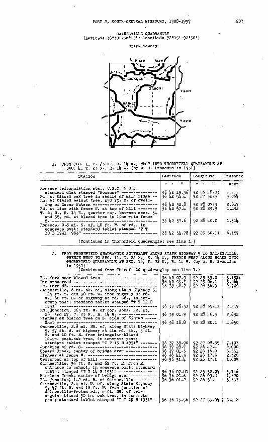
PART 2, SOUTH-CENTRAL MISSOURI, 1908-1937 207
GAINESVILLE QUADRANGLE (Latitude 36°30'-36'45'; longitude 92°15'-92°30')
Ozark County
R I3W RI2^-J
1. FROM SEC. 1, T. 23 N., R. 14 W., WEST INTO THORNFIELD QUADRANGLE AT SEC. 4, T. 23 N.J R. 14 W. (by W. R. Broaddus in 193!)
Station
Romance trlangulatlon sta.; U.S.C. & O.S.
Rd. at blazed oak tree in saddle of main ridge Rd. at blazed walnut tree, 250 ft. S. of dwell-
T. 2k. N., R. 14 W., quarter cor. between seca. 3k and 35, rd. at blazed tree In line with fenceQ _ __ ______ __«__
Romance, 0.8 ml. S. of, kO ft. W. of rd. , in concrete post; standard tablet stamped "T T10 R 1Q2;i Q6V
Latitude
0 1 II
36 42 19.36 36 42 544
36 k2 52.8 36 42 574
36 42 57-6
*(, li? ill. 7fl
Longitude
O 1 H
92 26 48.03 92 27 32.3
92 28 07;3 92 28 23.9
92 28 kO.O
q? 29 RO.ll
Distance
Feet
5,o64
2,847 1452
1,314
6.157
(Continued In Thornfleld quadrangle; see line 1.)
FROM THORNFIELD QUADRANGLE SOUTHEAST ALONG STATE HIGHWAY 5 TO GAINESVILLE, THENCE WEST TO SEC. 11, T. 22 N., R. lk W., THENCE WEST ALONG ROADS INTO THORNFIELD QUADRANGLE AT SEC. 16, T. 22 N., R. lk W. (by W. R. Broaddus in 1931)
(Continued from Thornfield quadrangle; see line 1.)
Gainesville, 6 ml. NW. of, along State Highway 5, 125 ft. S. and 30 ft. W. from highway at rd. W., 60 ft. S. of highway at rd. SE. , in con crete post; standard tablet stamped 'IT T 12 B
Rd. Junction, 165 ft. W. of cor. sees. 22, 23,
Highway at blazed tree on S. side of Kinman
Gainesville, 2.8 mi. NW. of, along State Highway 5, 37 ft. W. of highway at dim rd. SW., 3 ft. S. and 10 ft. E. from triangular-blazed 10-ln. post-oak tree, In concrete post;
Gainesvllle, 36 ft. S. and 62 ft. E. from E. entrance to school, in concrete post; standard
Gainesville, 2.k mi. W. of, along State Highway 5, l(.7 ft. N. and 18 ft. W. from junction of Galnesvllle-Protem rd. , 8 ft. NW. of trl- angular-blazed 30-ln. oak tree, in concrete post; standard tablet stamped "T T 15 B 1931" -
36 ko 07.9 36 ko 03.5 36 39 50.7
36 39 28.51
36 39 01.9
36 38 18.8
36 37 3§.96 36 37 28.7 36 37 pk. 336 36 41-336 36 3l4
36 36 07.81 36 36 00.6 36 36 01.2
36 36 13.56
92 29 53-2 92 29 06.1 92 28 36.9
92 28 354l
92 28 46.3
92 28 20.1
92 27 08.35 92 26 47.4 92 26 16.0 92 26 17.3 92 .26 17.1
92 25 52.04 92 26 09.8 92 26 544
92 27 59-014.
(5,192) 3,864 2,709
2,249
2,832 4,850
7,107 2,0003,551 2,325 1,005
3,146 1,620 3,637
5,418
208 TRANSIT TRAVERSE IN MISSOURI
Station
Rd. Rd.
forks forks
Latitude
36 35 47-8 36 35 34-6
Longitude
92 28 1).6.2 92 29 51-7
Distance
Feet4,6ia 5.509
(Continued in Thornfleld quadrangle; see line 1.)
3. PROM SEC. 11, T. 22 N. , R. ll}. W. , SOUTH ALONG STATE HIGHWAY 5 TO ARKANSAS-MISSOURI STATE LINE INCLUDING THAT PART OP THE LINE IN MOUNTAIN HOME NO. 2, ARKANSAS, QUADRANGLE (by L. A. Cassil in 1933)
Gainesvllle, 5 mi. SW. of, along State Highway 5, 22 ft. S. and 50 ft. E. from highway at rd. E., 10 ft. N. of triangular-blazed 2l4.-in. oak tree, in concrete post; standard tablet stamped "T T I; C 1933 1021"
Galnesville, 8.2 ml. SW. of, along State Highway 5, 35 ft. W. of highway, 550 ft. H. of dwell ing of R. W. Graves, 3 ft. E. of fence corner, in concrete post; standard tablet stampednmrnc/-iTQ^T11o£tl
New Hope School, Junction of driveway to --
Gainesvllle, 11.6 mi. S. of, along State Highway 5, 35 ft. W. of highway, 23 ft. S. of tri angular-blazed 12-in. white-oak tree, on Arkansas-Missouri state line, In concrete post; standard tablet stamped "T T 6 C 1933 1193"
36 36 13.56 36 35 52-5 36 35 15-2
36 34 16-95 36 33 31.3 36 33 06.1 36 32 45-6 36 32 31.9
36 32 16.20 36 31 33-1 36 31 16.9 36 30 38.2 36 30 20.3 36 30 08.2
36 29 55-13
92 27 59- olt. 92 28 09.3 92 28 20.7
92 28 09.714. 92 29 01.4 92 29 22.1 92 29 34-2 92 29 21.7
92 28 38.14.6 92 28 22.1 92 28 35.0 92 29 00.14. 92 29 05.2 92 29 06.0
92 28 58.02
2,286 3,886
5,9,62 6,2k7 3,0614. 2,291 1,724
3,8724,5,64 1,948 14.4261,651 1,231
1,471
14.. FROM SEC. 2, T. 21 N. , R. ll(. W. , EAST INTO CUREALL QUADRANGLE AT SEC. 35, T. 22 N., R. 12 W. (by L. A. Cassil in 1933)
Junction of rd. E. to -Mammoth (previously
Mammoth, 2.6 mi. Iff. of, along Mammoth mail route,
of triangular-blazed 10-in. cedar tree, 36 ft. S. of triangular-blazed tree, in concrete post; standard tablet stamped "T T 7 C 1933 910"
Corner of N.-S. wire fence and E.-W. rail fence -
Mammoth, 22 ft. NW. of rd.' forks, 70 ft. E. of SE. corner of Mammoth School, in concrete post; standard tablet stamped "T T 9 C 1933 672"
Mammoth, 2 ml. E. of, along Howards Ridge mail route, 14.5 ft. N. and 25 ft. W. from junction of private rd., 285 ft. S. of dwelling, 66 ft. W. of triangular-blazed 15-ln. oak tree, in con crete post; standard tablet stamped "T T 10 C 1933 831" -- - -
Rd. at point 16 ft. H. of NW. corner of garden
Triangular-blazed 12-in. walnut tree, 15 ft. from
Triangular-blazed 8-ln. oak tree, 20 ft. N. of
Howards Ridge, 21 ft. N. and 30 ft. W. from rd. forks, 51 ft. N. of triangular-blazed 2l(.-in. oak tree, 6 ft. from fence corner. In concrete post; standard tablet stamped "T T 11 C 1933
Howards Ridge, 2.2 mi. E. of, along River rd. , 19 ft. S. of rd., 14.0 ft. S. and 21 ft. E. from SW. corner of yard of H. E. Baxter, In concrete post; standard tablet 'stamped "T T 13 C 1933
Rd. at triangular-blazed 2l4.-in. black-oak tree -- Rd. at .point [|.0 ft. N. of NW. corner of Liner
36 31 33-1 36 31 39.2 36 31 54.0 36 32 05.7
36 31 59-21 36 31 4o.7 36 31 26.2 36 31 26.5
36 32 10.36 36 32 25.1
36 32 03.18
36 31 45-9
.36 32 08.5
36 31 50-1
36 31 14.3.14.5 36 31 17-6 36 31 16.6 36 31 18.7
36 31 20.7436 31 15.1
*(, *i nli. 7
92 28 22.192 27 52.392 27 23.0 92 26 k2.'k
92 25 52.63 92 25 19.6 92 2k 58.0 92 24 29.6
92 214. 02.91 92 23 00.5
92 22 31.14.8
92 21 50.9
92 21 03-5
92 20 18.9
92 19 53.63 92 19 4,6.2 92 19 o4.8 92 18 14.8.6
92 17 59.514. 92 17 22.7
Q? l£ P7.O
2,5072,826 3,519
4,115 3,281 2,2914. 2,319
^'945 5,258
3,108
3,744
4,493 4,090
2,1702,6823,3781,337
4,013 3,0591, I,-?*

PART 2, SOUTH-CENTRAL MISSOURI, 1908-1937 209
Station
North Fork of White River, center of Humphrey
Triangular-blazed twin white-oak tree, 20 ft. S.
Latitude
0 | II
36 31 11.7
36 31 34.2
^6 *1 c;q.t;
Longitude
0 1 II
92 15 54-092 15 40.9
q? 1R n .0
Distance
Feet6io
3,1982,164
p.ltfifl
(Continued in Cureall quadrangle; see line 1.)
FROM SEC. 33, T. 22 N., R. 13 W., SOUTH TO ARKANSAS-MISSOURI STATE LINEINCLUDING THAT PART OF THE LINE IN MOUNTAIN HOME NO. 2, ARKANSAS, QUADRANGLE (single-run unchecked spur line by L. A. Cassil in 1933)
Rd. at gate to barnyard on E. side of rd. - -
Rd. at elm tree at approximate center of bed
Mammoth, 3.2 mi. S. of, along Possum Walk rd., 10 ft. S. and 40 ft. W. from blazed 10-ln. oak tree, 25 ft. SE. of rd., in concrete post; standard tablet stamped VI T 8 C 1933 769"
36 31 26.5 36 31 02.6 36 30 52.1
36 30-44-3
36 29 54.07
92 24 29.6 92 24 47-592 24 56-792 25 02.1
92 25 57.76
2,823 1,301
901
6,818
6. FROM SEC. 6, T. 21 N., R. 12 W., SOUTH TO ARKANSAS-MISSOURI STATE LINEINCLUDING THAT PART OF THE Lip IN MOUNTAIN HOME NO. 2", ARKANSAS,'QUADRANGLE (single-run unchecked spur line by L. A. Cassil in 1933)
Triangular-blazed 30-ln. oak tree, 12 ft. W. of
Howards Ridge, 2.5 mi. S. of, 15 ft. E. of rd., In concrete post; standard tablet stamped "T T
36 31 17.6
36 30 41.9
36 29 50-74
92 19 46.292 20 11.5
92 20 13-48
4,166
5,172
FROM CUREALL QUADRANGLE AT SEC. 23, T. 22 N., R. 12 W., NORTHWEST ALONG ROADS TO SEC. li|, T. 22 N., R. 12 W., THENCE .WEST ALONG STATE HIGHWAY 80 TO GAINESVILLE (by L. A. Cassil In 1933)
(Continued from Cureall quadrangle; see line 1.)
Tecumseh, 1.8 mi. E. of State Highway 80 bridge over North Fork of White River, 26 ft. N. and 20 ft. E. from highway at N.-S. crossroad, In concrete post; standard tablet stamped "T T
Tecumseh, highway at water pump at store of Upton
North Fork of White River, center of bridge over- Hardenville, 45 ft- S. of post office, 24 ft. S.
of State Highway 80, in concrete post; standard
Junction of rd. S., 290 ft. N. and 320 ft. W.
Hardenville, 3.2 ml. W. of, along State Highway 80, 35 ft. S. and 20 ft. W. from highway at private drive, 60 ft. N. and 10 ft. E. from NE. corner of small dwelling, in concrete post; standard tablet stamped ".T T l8 C 1933 955"
Junction of rd. S., 25 ft. S. and 130 ft. E.
Galnesville, 2 mi. E. of, along Highway 80, 44 ft. S. and 54 ft. W. from junction of County Route E, in concrete post; standard tablet
36 34 31.436 34 43-9 36 35 18.7
36 35 23.14 36 35 07-2
36 35 11-8 36 35 15.6
36 35 05.85 36 34 57-7 36 34 55-1
36 35 19-5 36 35 19-8
36 35 13.30 36 35 21.2
36 35 33.1 36 35 30.7 36 35 28.2 36 35 29-1 36 35 45-9
36 36 46.22 36 36 36.2 36 36 43-4 36 36 29.556 36 12 .-736 36 07.81
92 15 12 .: 9; 92 15 15-9 92 15 18.5
92 15 44-74 92 16 34.0
92 17 10.6 92 17 19.4
92 18 45-29 92 19 15-9 92 19 54-6
92 20 43.2 92 21 30.0
92 21 51.23 92 22 15.8
92 22 57-4 92 23 19.4 92 23 20.292 23 49.1 92 23 49-1
92 24 07.94 92 24 41.292 25 26.492 25 33-5 92 25 28.7 92 25 52.04
(3,765)1,293 3,526
2,1884,327 3,023811
7,0762,632 3,1684,6653,816
1,854 2,159
3,597 1,809
918 1.544 1,^99
6,287 2,898 3,750 1,530 1,735 1,966

210 TRANSIT TRAVERSE IN MISSOURI
Station
8. PROM SEC.' 11, T. 22 N. , R. 12 W. , NORTH I SEC. 23, T. 23 N., R. 12 W. (by L. A. C
North Pork of White River, center of bridge over-
Dawt, 2.2 mi. NE. of, along Dora rd. , 215 ft- w - of NW. corner of cemetery, 31 ft. E. of rd., 8 ft. SE. of triangular-blazed 30-ln. black-oak tree, in concrete post; standard tablet stamped "T T 20 C 1933 653" ---
Triangular-blazed 30-in. black-oak tree, 10 ft.
(For balance in Cureall quadrangle
(Continued in Oureall quadrangle;
Latitude
.01 II
NTO CUREALL Q assll In 1933
36 35 23.14 36 35 43-0 36 36 01.5 36 36 13.2 36 36'20.7 36 36 22.436 36 56.636 37 20.4
36 37 32.56 36 37 53-936 3§ 00.7 36 38 20.1
, see line 2.
36 38 514see line 2.)
Longitude
O I H
tJADRAHOLE AT )
92 15 44-74 92 15:45-3 92 15 55-6 92 15 58.7 92 16 00.7 92 15 47-4 92 15 43-6 92 15 36.0
92 15 39-59 92 15 34.2
92 15 08.8 92 15 02.5
) 92 15 01.9
Distance
Peet
2,003 2,058 1,212 773
1,096 3,494 2,434
1,232 2,207
2,177 2,030
(636)
9. PROM CUREALL QUADRANGLE AT SEC. 23, T. 24 N. , R. 12 W. , SOUTH AND WEST TO SEC. 1, T. 23 N., R. 14 W. (by L. A. Cassil in 19 J3)
(Continued from Cureall quadrangle; see line 3.)
T vtH W
Bryant Pork of White River, center of wooden
Hodgson Mill, 0.4 mi. SW. of, 70 ft. S. of rd. , 124 ft. N. of NE. corner of yard fence of M. T. Smith, 22 ft. W. of blazed 12-ln. hickory tree, in concrete post; standard tablet stamped "T T 27 C 1933 729" -
Caney School, 4>6 ml. E. of, 20 ft. NW. of NW. corner of dwelling of E. M. Scribner, 63 ft. W. of N.-S. rd., 17 ft. N. of E.-W. rd., In concrete post; standard tablet stamped "T T 28 c 1933 1093" -
Rd. at triangular-blazed l6-in. red-oak tree - - Rd. fork. SE.
Rd. fork N., 24 ft. N. and 48 ft. E. from rd.
Caney School, 1.4 mi. E. of, 30 ft. N. and 33 ft. W. from rd. forks, 8 ft. S. 45° W- of tri angular-blazed 24-ln. oak tree, in concrete post; standard tablet stamped "T T 31 C 1933 1087"
Romance, 7 mi. E. of, 48 ft. S. and 13 ft. W. from junction of dim rd. S., 10 ft. W. of triangular-blazed l8-ln. black-oak tree, In concrete poat; standard tablet stamped "iT T
Rd. at creek crossing and junction of dim rd. W. Romance triangulation sta. (previously described)
36 44 15.2 36 43 5&.7 36 43 30.2 36 43 17.8 36 43 pq.o 36 42 44-536 42 28.5
36 42 17.6236 42 13-3 36 42 13.1 36 42 13-336 42 23.7
36 42 06.80 36 42 33-5 56 42 52.5 36 42 53-p 36 43 09-4 36 43 05.6
36 43 04.8
36 43 08.74 36 43 00.8 36 42 56.6 36 43 04.4 36 43 12.5 36 43 20.8 36 43 05.9 36 43 04.1
36 43 12-49 36 43 22.3 36 43 22.8 36 43 11-9 36 42 53.4 36 42 45-3, 36 42 19-36
92 15 28.7 92 15 33.0 92 15 50.7 92 16 04.6 92 16 23.1 92 16 16.8
92 16 00.6'
92 16 05.72 92 16 28.6 92 16 56.5 92 17 '35-9 92 17 52-5
92 18 51.50 92 19 12.4- 92 19 16.2 92 19 '50.792 20 15.6 92 20 34.0
92 20 44-7
92 21 04.19 92 21 34.8 92 21 50.9 92 22 05.0 92 22 19.5 92 22 37.0 92 22 42.0 92 22 54.9
92 24 10.69 92 24 44-i 92 24 55.192 25 25.9 92 25 38.4 92 26 09.7 92 26 48.03.
(2,806) i,9p55'9kZ 1,6881,750 2,525
2,096
1,175 1,915 2,269 3,214 1,710
5,1023,196 i.m 2,611 2,6231,546
873
1,638 2,613 1,379 1,396
1*658 i,5§4 1,064
6,229 2,897
8942,7422,127 2,679 4,075

PART 2, SOUTH-CENTRAL MISSOURI, 1908-1937 211
Station
10. PROM SEC. k, T. 22 N. , R. 13 W. , NORTH A TO SEC. 6, T. 23 N., R. 12 W. (by L. A
Zanoni, 5-1 mi. SW. of, along County Route E, 23 ft. N. and 32 ft. E. from highway at dim rd. N., 29 ft. W. of triangular-blazed oak tree, in concrete post; standard tablet stamped
Highway at gate in picket fence to small frame
Zanoni, 1.5 mi. W. of post office', along County Route E, 26 ft. NE. of highway, 23 ft. E. of driveway across ditch, 6 ft. SW. of triangular- blazed oak tree, in concrete post; standard
Highway at iron pipe culvert at crossing to old
Center of triangle formed by Junction of N.-S.
Latitude
0 | It
ND EAST. ALONG . Cassil in }
36 36 k6.22 36 37 08.836 37 2k.e3§ 37 38.9 36 37 52.7 36 38 05.1 36 38 55.3
36 39 Ik- 8k 36 39 35-7 36 ko 08.7 36 ko 13.9
36 ko k5.7 36 ko k9.3
56 ko 55.2036 kO 43-736 ko 50.236 1).! 01. k
36 kl 12.736 kl k8.0 36 k2 06.80
Longitude
0 1 II
COUNTY ROUTE933)92 2k 07.9k 92 23 53.8 92 23 48.2 92 23 k5.i 92 23 51.1 92 23 45-7 92 23 23.8
92 23 35 -ok 92 23 kl-7 92 22 59-7 92 23 05.7
92 22 45.0 92 22 23.9
92 21 25.29 92 21 01.1 92 20 21.692 19 51-1
92 19 27.0
92 18 5k. 7 92 18 51.50
Distance
Feet
E
2,561 1,677
H£1,485 l»;32k 5,390
2,177 2,180 k,787
717
3,631 1,755
4,810 2,289 3,282 2,732
2,268
k,kk51,915
11. PROM CUREALL QUADRANGLE WEST ALONG STATE HIGHWAY 80 TO SEC. 10. T. 22 N., R. 12 W. (by R. E. Brown and W. V. Kennedy in 1935)
(Continued from Cureall quadrangle; see line 6.)
T.'22 N. , R. 12 W., quarter cor. between sees. 11 and Ik, stone, 2kk ft. S. and 108 ft. E. from
36 35 22.7, 36 35 23-lk
92 15 12.0 92 15 kk-lk
(1,879) 2,671
PROM BUCKHART QUADRANGLE AT SEC. 21, T. 2k N., R. 13 W., SOUTHEASTTO SEC. 35, T. 2k N., R. 13 W. (by C. N. Ackerman in 1905)
(Continued from Buckhart quadrangle; see line 7.)
T. 2k N. , R. 13 W., In SW lA sec. 27, k5 " S. and 17 ft. W. from SW. corner of dwelling, 25 ft. N. of rd., 2 ft. S. of yard fence, in concrete post; standard tablet stamped "1392
36 kk 53-9 36 kk Ij.1.0 36 kk 28.7
36 k3 39.56 36 k3 20.8 36 k3 15.9 36 k2 56.6 36 k3 08. 7k
92 2k 09.1 92 23 k6.9 92 23 kO.4
92 23 03.97 92 22 37-2 92 22 24.0 92 21 50.892 21 ok. 19
(l,06l) 2,224 1,357
5,7872,8871,176 3,332 3,990
13. PROM SEC. 35, T. 24 N., R. 13 W., NORTHEAST INTO BUCKHART QUADRANGLE AT SEC. 21, T. 24 N., R. 12 W. (by R. S. Wilson in 1935)
T. 24 N., R. 12 ff., near quarter cor. between sees. 29 and 30, 29 ft. S. and 24 ft. W. from SW. corner of dwelling of J. M. Hutchlson, 6 ft. SW. of corner of yard fence, In concrete
post; standard tablet stamped "1393 ERA 1935" T-rd. N.
36 43 08.74 36 k2 53.2 36 k2 52.6 36 k2 52.036 ij.3 20.2
36 k3 ki.ok 36 k^ k6.536 kk 11.1 36 kk kk.8
92 21 Ok. 19 92 19 50.6 92 19 16.3 92 19 07.7 92 19 05.0
92 18 k8.25 92 18 33-6 92 17 58.2 92 17 594
6ii& 2,802
700 2,861
2,512 1,315 3,807 3,402
(Continued In Buckhart quadrangle; see line 10.)
1W1W O-S9 7

212 TRANSIT TRAVERSE IN MISSOURI
Station Latitude
o.i n
Longitude
o ' r n
Distance
Feet
PROM THORNFIELD QUADRANGLE AT SEC. 9, T. 2i N., R. 14 W., SOUTHEAST TO' ARKANSAS-MISSOURI STATE LINE INCLUDING THAT PART OP THE LINE IN MOUNTAIN HOME NO. 2, ARKANSAS, QUADRANGLE (by R. Si Witson in 1935)
(Continued from Thornfleld quadrangle; see line 5".)~ .'
Rd.U.S C. & G.S.6 c 1933
standard disk stamped "H 66 1934"-3636 36
30 3029
37-07-55-
ll13 92 9292
29 29 05.75
50*02(4,928)3,6831,14.16
Magnetic declination 6* 52' E.
BUCKHART QUADRANGLE* (Latitude 36°45'-37°00'; longitude 92°15' -92°30')
Douglas a»di Ozark Counties
RMW r^ R 13 W 1
\1. PROM TOPAZ QUADRANGLE AT SEC. 15, T. 26 N., R. 12 W., SOUTHWEST INTO AVA
QUADRANGLE AT SEC. 9, T. 2(4. N., R.l4 ,W. (by W. R. Broaddus In 1932) (Continued from Topaz quadrangles! see line 1.)
Station '
T. 26 N.,. R. 12 W. , quarter cor. between sees. 15 and 16, Iron pin In center of rd. at fence E.
T. 26 N., R. 12 W., cor. sees. 15, l6, 21,. and
Twin trlangulatlbn sta.; U.S.C. & G.S. standard
T. 26 N. , R. 12 W. , S. sixteenth cor. sec. .28, rd. at curve In line with fences E. and W. :
T'» 26 N., R. 12 W. , S. sixteenth cor. between
BucTchart, 2.7 ml. NE. of, In SW lA SE lA sec. 29, T. 26 N., R. 12 W. , 23 ft. S. of rd. , 77 ft. N. of NW. corner of Victory School, In line with W. face, In concrete post;, standard
T. 26 N. , R. 12 W., S. sixteenth cor. bjetween sees. 29 and 30, Iron pin 20 ft. S. of rd.
Buckhart, near center sec. 36* T. 26 N. , R. 13 W., 16 ft. N. and 22 ft. E. from T-rd. E., In concrete post; standard tablet stamped
T. 26 N., R. 13 W. , E. sixteenth cor. on S. line sec. 36, stone, 220 ft. N. of rd. corner, 15
T. 25 N., R. 13 W., N. sixteenth cor. sec. 1,
Buckhart, about 2 ml. S. of, In NE lA sec. 11, T. 25 N., R. 13 W., 23 ft. E. of rd., 11 ft. N. and 30 ft. W. from dwelling of John Ousley, In concrete post; standard tablet stamped
*Flelden quadrangle as published in Bulletin 898-6 rangle .
Latitude
0 1 II
36 56 08.6
36 55 42-4
36 55 l6.kO 36 54 50.5
36 5k 11.9 36 54 03.8
36 5k 12.8
36 5k 13.44
,36 54 14-4:# 54 17-5
36 53 37-55
36 53 10.9
36 52 56.1
36 52 15.05
has been ren
Longitude
0 1 II
92 15 14-7
92 15 15-3
92 15 14-10 92 15 50.2
92 15 51-1 92 15 55-8
92 16 23.7
92 16 53.03
92 17 28.2 92 17 56^3
92 19 08.27
92 18 53.1
92 19 10.5
92 19 56.39 aned Buckhart
Distance
Peet
(6,499)
2,649
2,642 3,904
3,9^5 910
2,449
2,3792,858 2,307
7,109
2,963 2,059
5,583 quad-

PART 2, SOUTH-CENTRAL MISSOURI, 1908-1937 213
Station
Brush Creek, W. end of State Highway Ik bridge
Oentryville, In NE lA SW 1/4 se°- 10, T. 25 N. , R. 13 W. , kO ft. S. and 80 ft. E. from Junction of State Highway l4 and County Route D, 45 ft. NE. of highway, In concrete post; standard
T. 25 N. , R.- 13 W. , S. sixteenth cor. between
Bertha; kO ft. 1 S. and 60 ft. E. from SE. corner of post office^' 19 ft.- S. of fence corner. In concrete post; standard tablet stamped "T T
Junction of lane N. on line fbjetween aecs. 20 and
Bryant Creek, center of low-water bridge over
T. 25 N. , R. 13 W., center sec. 31, stone
Rookbridge, 1.3 ml. NE. of, 25 ft. W. of rd., about 10 ft. N. of Douglas -Oz ark county line, 11 ft* Nr 70°. W. of triangular-blazed 36-ln. white-oak tree* In concrete post; standard tablet stamped "T T 82 B 1932" '
Rockbrldge, SE. corner of Bushong Bros. General
Rd. at triangular-blazed tree In line with fence
Rockbrldge/ 2.8 ml. W. of, on rd. 'to Almartha, 55 ft. S.v.and 36 ft. W. from SW. corner of dwelling of Herman Kemper, In corner of garden, In concrete post; standard tablet stamped "T T
Rd. forks, 25 ft. NE. of triangular-blazed tree - Souder, SW. corner of post office and general
Almartha, 1.8 ml. E. of, 20 ft. N. of rd., 8l ft. S. of SW. corner of dwelling of J. G. B&nnett, 3 ft. E. of line of W. face, In concrete post;
(Continued In Ava quadrangle; see
Latitude
o i n36 51 28.k
36 51 09.0
36 51 kg. 73 3§ 51 :i5-4 36 50 56.3
36 50 47-0 36 50 27.7
36 50 lk.(i|2 36 49 52-5
36 49 1*7.1 36 49 35.9 36 49 12.9 36 kg 33-7 36 48 26.1 36 48 26. k 36 i].8 13.0
36 k8 00.60
36 47 20.7 y6 47 32.8
36 47 .31.7
36 47 26.84 36 47 11-9
36 46 52.4 36 46 42.6
36 46 29.17line 2.)
Long! tude
0 1 II
92 20 18.7
92 20 28.7
92 21 37-0792 21 42.892 21 44-5
92 21 57.8 92 22 55-1
92 23 04.4492 22 53.6
92 23 02.9 92 23 2k. 5 92 23 36.692 24 10.9 92 24 36.792 2k 43.7 92 24 37.4
92 24 35.1592 24 34-9 92 25 08.992 26 39.6
92 27 p4.5792 27 40.4
92 28 26.0 92 29 07.2
92 29 51-42
Distance
Feet5,o45 2,125
6,911 3,503 1,9351,432 5,046
1,573 2,350
931 2,094 2,531 4,849 2,227
1,5+7
1,2714,026 3,027
7,574
2,09k 5>283
4,2003,491
3,850
2. PROM GJENTRYVILLE SOUTHEAST ALONG* STATE HIGHWAY l4 INTO ,TOPAZ QUADRANGLE (by W. R. Broaddus In 1932)
Brush Creek, W., end of State Highway ll). bridge
Rlohvllle, 4*2 ml. W. of, 20 ft. N. and 63 ft. E. from State Highway 14 at crossroad, in concrete post; standard tablet stamped "T T 142 B 1932H-
Hlghway at fence N. on E. aide of lane near top
36 51 49-73
36 51 pq.o '36 50 48-5
36 50 21.4836 50 02.1 36 50 09.2 36 50 12.0 36 50 12.3
92 21 37.07
92 20 28.7 92 19 14.6
92 18 41.08
92 17 20.1 92 16 55.4 92 16 31.0 92 16 14.9
6,925 6,355
3,861
6,870 2,132 2,002 1,306
(Continued In Topaz quadrangle; see line 2.)
3. PROM AVA QUADRANGLE EAST ALONG STATE HIGHWAY l4 TO OENTRYVILLE (by L. A. Oassll In 1933-34)
(Continued from Ava quadrangle; see line 5.)
Sweden, 5.3 ml. E. of, along State Highway 14, 2 mi. E. of Bryant Creek, 300 ft. NE. of store, 4o ft. 'N. of highway, in ledge;
36 52 43.2 36 52 55.6 36 53 12.4 36 53 34-1
36 53 44-19*(> R* lili .t;
92 29 36.792 29 03.692 28 23.5 92 27 31.1
92 26 38.11QP ?A PI;. A
(2,104) 2,9743,670 4,790
4,425i me

211). TRANSIT TRAVERSE IN MISSOURI
Station
Gentryvllle, 3.5 ml. W. of, along State Highway Ik, 2.2 mi. W. of Fox Creek, 30 ft. NE. of highway at rd. NE., 25 ft. N. of highway, in ledge; standard tablet stamped "T T k3 C 1933'!-
Latitude
0 1 II
36 53 31-1 36 53 07.7 36 53 08.8
36 53 25.82 36 53 p74 36 52 14.3.9 36 52 37.7 36 52 23.2 36 51 14.9.73
Longitude
92 26 18.5 92 25 39-292 25 02.1
92 2k 12.k8 92 23 k7.2 92 23 05.6 92 22 M.2 92 22 28.3 92 21 37.07
Distance
Feet i486 - 3,971 3,0l6
1|,386 2,770 k,i58 1,927 1,907 5,368
k. FROM TOPAZ QUADRANGLE AT SEC. 3, T. 26 N., R. 12 W.,, WEST ALONG ROADS TO VANZANT, .THENCE NORTH ALONG COUNTY ROUTE D INTO MOUNTAIN GROVE QUADRANGLE (by L. A. Cassil in 1933-3k)
(Continued from Topaz quadrangle; aee line 5.)
Crossroads on line between sees. 3 an(i k>
Topaz, 5-k mi. W. of, along Topaz-Vanzant rd., in center of E 1/2 sec. k, T. 26 N., R. 12 W. , 380 ft. E. of Prairie Hollow Creek, 25 ft. W. of rd. at curve, kk ft. E. of triangular-blazed twin oak tree, 6 ft. W. of fence, on land of J. R. Coble, in concrete post; standard tablet
Vanzant, in center of NW 1/k sec. 6, T. 26 N. , R. 12 W., 150 ft. N. of post office, 23 ft. N. and 33 ft. W. from County Route D at E.-W. crossroad, in corner of field, in concrete post; standard tablet stamped ?T T 3 C 193k"
Highway at fences E. and W. on line between sees. 6 and 31, Tps. 26 and 27 N., R. 12 W.
(Continued In Mountain Grove quadr
36 57 53-3
36 57 5k. 01 36 58 02.5 36 58 08.8 36 58 10.1 36 58 ll.l
36 58 11.82
36 58 2k.6 36 58 50.7 36 59 10.7 36 59 33-7
angle; see 11
92 15 12.1
92 IS 28.3k 92 16 12.0 92 16 27.7 92 17 O5.k 92 17 55-0
92 18 11. k9
92 18 09.092 17 58.592 18 oo. C92 18 06.5
ne 2.)
(2,530)
1,^20 3,6k5 I,k30 3,060 £,020
1.3UO
1,305 2,780 2.0JO 2,380
5. FROM' MOUNTAIN GROVE QUADRANGLE SOUTH ALONG COUNTY ROUTE C TO SEC. 35, T. 26 N. , R. Ik W. (by L. A. Cassil In 1933-314.)
(Continued from Mountain Grove quadrangle; see line 3.)
Highway at triangular-blazed l8-in. black-oak
T. 26 N., R. ll). W. , N. cor. aeos. 2 and 3, stone, 14|.0 ft. W. of highway - -- r-
T. 26 N. , R. Ik W., in SW 1/k NW 1/k sec. 2, 11.5 ml. S. of Norwood, along County Route C, 22 ft. E. of highway, 29 ft. S. of NW.-SE. crossroad, <y.ft. S. of triangular-blazed 2l(.-ln. black-oak tree, in concrete post;
T. 26 N., R. Ik W., in NW 1/k NW 1/k sec. 2k, 15 mi. S. of 'Norwood, along County Route C, 28 ft. S. and 32 ft. E. from highway at rd. E. , 9 ft. S. and 12 ft. W. from triangular-blazed 12-in. black-oak tree, in concrete post;
State Highway Ik at County Route C (previously
36 59 14.7.9 36 59 35-8 36 59 05.0
36 58 50.5
36 58 10.80 36 57 53.8 36 57 39-3 36 57 25.1 36 57 11.9 36 56 14.5.6 36 56 20.5
36 .55 36.97 36 55 21.2 36 5k 57.6 36 5k 32.9 36 5k ik. 9
36 53 W4-5
92 26 50.592 26 5k. S 92 26 56.9
92 27 10.5
92 26 58.5k 92 26 38.1 92 26 20.0 92 26 iq.O 92 26 18.9 92 26 08.0 92 26 07-9
92 25 58.00 92 26 O5.k 92 26 09.8 92 26 31.3 92 26 25.9
92 26 25.6
(3,075) 1,260 3,130
3,610
2,210 2,390 2,075 1450 1,330 2,810 2,530
k,k80 1,710 2,14.203,oko 1,880
3,070
PART 2, SOOTH-CENTRAL MISSOURI, 1908-1957 215
Station
6. PROM SEC. 2, T. 26 N. , R. ik W. , WEST INT T. 26 N., R. Ik W. (by L. A. Cassil in
Stone on line between sees. 2 and 5» T - 26 N. ,
Brushyknob, 0.6 mi. W. of, along Basher-Brushy- knob rd., 100 ft. S. and 500 ft. E. from E. sixteenth cor. between sees. 5 an<^ 8, T. 26 N., R. Ik W., 50 ft. E. of rd., 9 ft. N. of triangular-blazed 10-ln. hickory tree, in yard of Ed. Morgan, in concrete post; standard
(Continued in Ava quadrangle; see
Latitude
0 AVA QUADRA!1935-5W
56 58 10.80
56 58 05.336 57 M3.9 ?6 57 5,6.9 56 57 £k-o 56 57 50.1
36 57 59.85
line 6.)
Longitude
0 1 II
OLE AT SEC. 8
92 26 58.5!;
92 27 11.5 92 27 kk.2 92 28 17. k 92 28 56.5 92 29 11.8
92 29 5k- 38
Distance
Feet
1,190 3,150 2,960 5,250 1,390
2,110
PROM SEC. 32, T. 25 N., R. 13 W., SOOTH INTO GAINESVILLE QUADRANGLE AT SEC. 21, T. 2k N., R. 15 W. (by C.'N. Ackerman in 1935)
Brlxey, 1.2 ml. N. of, in HE 1/k sec. 17, T. 2l\. N., R. 13 W. , 5k ft. N. and 77 ft. W. from NW. corner of dwelling of P. S. Mahan, 10 ft. S. and 2 ft. W. from NW. corner of yard, in concrete post; standard tablet stamped r'l59i E,R A 1955"
36 k8 00.602/C ], I7 9*7 T
36 k6 55.8
56 k5 51.1936 £5 18.8
92 2k 35.1592 2k lk-3
92 2k 2k. 9892 2k 25492 2k 16.0
3,790 3,562
6,kl6
(Continued in Galnesvllle quadrangle; see line 12.)
8. PROM AVA QUADRANGLE AT SEC. 20, T. 26 N. , R. Ik W. , SOUTH INTO AVA QUADRANGLE AT SEC. 29, T. 26 N. , R. llj. W. (by C. N. Ackerman in 1935)
(Continued from Ava quadrangle; see line 7')
Vera Cruz, 0.2 ml. W. of, about 175 ft. S. and 390 ft. E. from stone at quarter cor. between sees. 20 and 29, T. 26 N, , R. l4 W. , 130 ft. S. and 50 ft. W. from Vera Cruz School, 3 ft. N. and k5 ft. E. from rd. at fence E. , in concrete post; standard tablet stamped "1386 ERA 1935"
(Continued in Ava quadrangle; see
36 55 02.08
line 7.)
92 29 53.. 55 (k,500)
9. PROM SEC. 2, T. 26 N., R. Ik W. , EAST TO VANZANT (by C: N. Ackerman in 1935)
T. 26 N., R. ik W., center of NE lA sec. 2, rd.
Rd. at point 25 ft. S. of gasoline pumps, 50 ft. N. and 60 ft. W. from center of NW lA sec. 1,
Rd. corner from W.-N. , approximately 115 *"* N. and 275 ft. E. from center of SW lA sec. 56,
Coldspring , 1.2 mi. N. and 1.5 ml. E. from, 15 ft. "S. and 805 ft. E. from approximate quarter cor. between sees. 50 and 51, T. 27 N., R. 13 W., 15 ft. S. and 10 ft. W. from rd. corner N. to E. and fence S., .15 ft. S. and 20 ft. W. from rd. at fence N. , in concrete post; standard tablet stamped "1382 ERA
T. 27 N. , R. 13 W., cor. sees. 29, 30, 31, and
T. 27 N., R. 15 W. , W. sixteenth cor, between
T. 27 N., R. 15 W. , W. sixteenth cor; sec. 55, stone, 50 ft. SW. of small creek crossing
Denlow, 0.5 mi. S^ and 0.8 ml. E. from, about 0.2 mi. E. of N. cor. sees. 5 and k, T. 26 N. , R. 15 W. , 25 ft. N. and 50 ft. W. from NW. corner of dwelling, 10 ft. W. of blazed 15-ln. oak tree, In concrete post; standard tablet stamped "1585 ERA 1955"
36 58 10.8036 58 17.2
36 58 17.6
36 58 kk.9 36 59 15.9
56 59 21.70
36 59 21.3
36 59 21.5 56 59 05.8 36 58 59.lt-
36 58 5lt-3
36 58 26.98
92 26 58. 5!*
92 26 22.3
92 25 50.5
92 25 k5.5 92 4 564
92 2k 15.29
92 25 52- k
92 25 56.2 92 25 Ok.O 92 22 58.6
92 22 51.5
92 21 27. 1±2
5,012
2,599
2,819 k,84
3,^k
1,8601,310 3,1562,111
771
5,89k

216 TRANSIT TRAVERSE IN MISSOURI
Station
T. 26 N., R. 13 W., N. sixteenth cor. sec. 3,
Vanzant, 0.5 mi. S. and 1-5 ml. W. from, 130 ft. N. and 150 ft. W. from' center of SE 1/fy. sec. 2, T. 26 N., R. 13 W. , 75 ft. S. and 90 ft. W. from rd. forks, 20 ft. N.. of blazed 2k-ln. tree, on property of Sarah Hopper, in concrete post; standard tablet stamped "138k ERA
Rd. at point 10 ft. W. of blazed 15-ln. oak tree-
Latitude
0 1 II.
36 58 13^6 36 57 14.1.0
36 57 Itf.kj 36 56 01.5 36 58 23.6 36 58 11.82
Longitude
o i n
92 21 10.6 92 20 56.1.
92 19 59.614. 92 19 28.092 18 14.3.892 18 1149
Distance
Peet
1,919 3,511
I*., 660 2,83?k.zik .2,882
PROM GAINESVILLE QUADRANGLE AT SEC. 2l, T. 2k N., R. 12 W., NORTH ALONG ROADS TO SEC. 21, T. 25 N., R. 12 W., THENCE EAST ALONG STATE HIGHWAY 114. INTO TOPAZ QUADRANGLE (by R. S. Wilson In 1935)
(Continued from Gainesvllle quadrangle; see line 13.)
T. 2k N., R. 12 W. , W. sixteenth cor. on line between sees. l6 and 21, rd; E. In line with
T. 2)4. N. , R. 12 W. , S. sixteenth cor. sec. l6, 50 ft. N. and 360 ft. W. from rd. at rail- fence N., 30 ft. S. and 35 ft.. W. from SW. corner .of dwelling of E. C. Parsley, in concrete post;
T. 2k N., R. 12 W., E. sixteenth cor. sec. 16,
T. 2k N., R. 12 W. , quarter. cor. between sees. 10 and 15, stone in side rd. at rail fence W., '
T. 2k N., R. 12 W., S. sixteenth cor. sec. 10,
T. 2U N., R. 12 W. , 60 ft. S. and 214-0 ft. E. from W. sixteenth cor. between sees; 3 an(i 10, 82 ft. S. and 31 ft. E. from dwelling of J. R. Driscole, In concrete post; standard
Rd. corner from E. to N. on Douglas -Ozark countyline - T
T. 25 N., R. 12 W. , E. sixteenth cor. between
Blanche, 2 ml. E. of, 125 ft - N * and I20 ft « w - from stake at center of E 1/2 sec . 28, T. 25 N., R. 12 W., 10 ft. S. and 25 ft. W. from Junction of rd. S., 10 ft. SE. of tri angular-blazed 2k-ln. black-oak tree, In concrete post; standard tablet stamped "139°
State Highway ll; at lane S. (previously
Highway at triangular-blazed 30-ln. oak tree . T T 1U3 B 1932 (In Topaz quadrangle; see line 2.)
36 14.5 05.3
36 k5 19.00 36 14.5 16; 5
36 k5 : 32.0
36 14.5 57-9
36 k6 11.5 36 14.6 36.7
36 14.6 51.27
It B Si36 U8U2.14.
36 k9 10.0336 [4.9 35.1
36 50 1,21.3 56 50 29.8 36 50 35.91
92 17 26.0
92 17 13.57 92 16 53.0
92 16 52.6
92 16 02.8
92 16 02.5 92 16 29.6
92 5g Ik. 85
.92 16 66.1 92 16 oU.o
92 15 14.5.14.
92 15 14.5.67 92 15 59-6
92 16 Ik. 992 15 26.2 92 l4 56.66
(3,1*21)
1,715 1,678
1,365
k,828
1,375 3,370
1,901
6,025 1,703
3,872
2,795 2,779
3,966£'?k§ 2,U78
Magnetic declination 6 8 5k' E.

PART 2, SOUTH-CENTRAL MISSOURI, 1908-1937 217
MOUNTAIN GROVE QUADRANGLE* (Latitude. 37°00<-37 <U5 I ; longitude 92°15' -92*30')
: 'Douglas, Texas, and ffright Counties
R 14 W I R 13 W I
1. PROM MANSFIELD QUADRANGLE EAST ALONG ST. LOUIS-SAN FRANCISCO RAILWAY INTO /CABOOL QUADRANGLE (by E. L.. MoNalr in 1913) ,
(Continued from Mansfield quadrangle; see line 1.)
. Station
Macomb, 35" ft* NE. of St.: Louis-San Francisco Ry. flag sta.; 70 ft. SB. of R.R., 2 ft;, .from fence corner; iron post stamped "Prim Trav Sta
R.R. at N.-S. line in SE 1/1± sec; l6> T. 28 N. , .R. ll| W. r -- -- _ ---- -
R.R. at rd. crossing on line between sees. 22
T _J « . ' - -Land corner, probably S. sixteenth cor; between
Norwood, .-66 ft. N. 58? W, of NW. corner of St. Louis-San PranolacJo Ry, sta.; iron post
T. 28 N.J R. 1J W;, W. cor. sees ; 18 and 19, 327 ft. S. of R.R. ' -
T. 28 N., R. 13 W., cor. sees. 17, 18; 19,; and
T. 28 N., R. 13 W., quarter cor.' between eeoe. 16
T. 28 N., R. 13 W., cor. sees. 9, 10, 15,, ..and. l6/
T. 28 N., R. 13 " , quarter cor. between sees. 10
R.R. at rd. crossing on line between sees. 7 and 12, T. 28 'N., Rs, 12 and 13 W. -
R.R. at line between scea.' 7 and 8, T. 28 N.,
Mountain Grove j 0.2 mi. E. of St. Louls"-San Francisco Ry. sta., 50 ft. S. and 25 ft. E. from R.R. at street crossing, 4 ft. from fence corner; iron post stamped "Prim Trav Sta No 42T Ql X Mn n _ _._ - '
(Continued in Cabool! quadrangle) s
Latitude
o t n
37 05 39.74 37 06 24.9
37 06 35,3
37 06 20.9 37 06 37.3
37 06 36*5
57 ..06 29.514.
37 06 23.2 f
,37 06 22.0 37 06 40.9
37 06 47-0
37 07 12. U
37 07 57.8 37 07 23-7
37 07 42.6
37 07 31.5 37 07 35^6
57 07 U2.55
ee line 1. )
Longitude.o i n
92 22 28. kO 92 28 1|6.6
92 28 17.7
92 26 56*6 92 26 55'9
92 25 50.0
92 2l| 58.90
92. 2k 1*4-6 92 23 40.892 22 47 '2
.92 22 34-7
92 21 28.4
92 20 23.4 92 19 15-1
92 18 13-8
92 17 08.3 92 16 19.6
92 15 29.70
Distance
Feet
(4,095) 5,692
2,570
6,726 1,654
5,338
4,216
1,304
5,171 4,7481,180
5,9515,865 5,710
5,322
5,422 3,962
4,098
2. FROM BUCKHART QUADRANGLE NORTH ALONG COUNTY ROUTE D TO MOUNTAIN GROVE (by L. A. Cassil in 1934) i
(Continued from Buckbart quadrangle; see line 4*)
37 0.0 07.2 92 18 06.3 (3,380JPrior, highway at post office - > -. Vanzant, 2.9 ml. N. of, along Coiaity Route D,
center of W 1/2 sec. 19, T. 27 N., R. 12 W., 36 ft. W. of highway, 40"ft. N. of rd. W., 42 ft. NE. of triangular-blazed 24-ln. white- oak tree, in corner of field, in concrete post; standard tablet stamped "T T 4 C 1934* 37 00 54.14 92 18 07.00 2,730
*Maoomb quadrangle as published in Bulletin 898-8 ias been renamed Mountain I >ro7e-quadrangle. ' .

218 TRANSIT TRAVERSE IN MISSOURI
Station
Junction of rd. W. on line between sees. 7 an<i
Vanzant, 6.1 ml. N. of, along County Route D, in SE lA sec. 6, T. 27 N., R. 12 W. , jk ft. W. of highway, 32 ft. N. of private drive, 78 ft. NE. of NE. corner of small dwelling, in con crete post; standard tablet stamped 'IT T 5 C1934" .---
Junction of rd. W. on Douglas -Wrlght county line-
Mountain Grove, 2.3 ml. S. of, along County Route D, 9.3 mi. N. of Vanzant, center of S 1/2 sec. 20, T. 28 N. , R. 12 W. , 35 ft. W. of highway, 25 ft. N. of rd. W., in corner of field, In concrete post'; standard tablet
..Crossroad on line between sees. 17 and 20,T OQ M TD TOW
Mountain Grove, Junction of South Main and South
Prim Trav Sta No k2 1913 Mo (previously
Latitude
o i ri
37 00 52.8 37 01 19.0 37 01 29.6
37 01 52.7 37 02 26.6 37 02 kk.5
37 03 05.18 37 03 36.9 37 04 28.4 37 ok k7,.o 37 05 18.7
37 05 34-57
37 06 13-7 37 06 39.9 37 07 19.3 37 07 18.9
37 07 28-4
37 07 42-35
Longitude
92 18 05.9 92 17 54-7 92 17 36.7
92 17 k2.2 92 17 43.0 92 17 28.2
92 17 28-53 92 17 16.2 92 16 52-592 16 Ij.o.1 92 16 39.2
92 16 39.18
92 16 37.4 92 16 36.0 92 16 3k. 6 92 16 19.9
92 15 51-5
92 15 29.70
Distance
Feet 1,890 2,810 1,810
2,380 3,420 2,180
2,090 3,360 5/560 2,130 3,210
1,610
3,'96o 2,650 3,990 1,190
2,500
2,260
3. PROM NORWOOD SOUTH ALONG COUNTY ROUTE C INTO BUCKHART QUADRANGLE (by L. A. Cassil in 193k)
Prim Trav Sta No kl 1913 Mo (previously
Highway at S. side of small concrete dwelling
T. 28 N., R. 13 W. , W. cor. sees. 30 and 31, 50 ft. N. of E. cor. sees. 25 and 36, T. 28 N.,
Norwood, 3 ml. S. of, along County Route C, In NE lA SE lA sec- 36, T. 28 N., R. ik W. , 35 ft. W. of highway, 60 ft. S. and 55 ft. E. from SE. corner of small stucco dwelling, in corner of field, in concrete post; standard
T. 27 N., R. Ik W. , cor. sees. 1 and 12, stone -
Highway at approximate E. cor. sees. 7 and 18,
Norwood. 6 mi. 3. of, along County Route C, In SW lA NW lA sec. 18, T. 27 N., R. 13 W., 82 ft. S. of Junction of rd. W., 22 ft. E. of highway, In front yard of stucco dwelling, In concrete post; standard tablet stamped "T T 8 C 193V -
Highway at fence W. on line between sees. 13 and
Stone, probably the S. sixteenth cor. between sees. 23 and 2k, T. 27 N. , R. Ik W. , 22 ft.
Norwood, 9 ml « S. of, along County Route C, In SE lA SW 1A sec. 23, T. 27 N. , R. Ik W., 205 ft/N. of fence on sec. line, 34 ft. N. of highway, 15 ft. S. and 15 ft. E. from SE. corner of dwelling of P. L. Thorpe, in concrete post; standard tablet stamped "Mr T 9 C 193k"
(Continued in Buckhart quadrangle;
37 06 29-54 3.7 06 10.3 37 05 k8.0 37 05 30.8
37 05 11.6
37 04 37-9
37 04 08.59 37 03 45-0 37 03 19-0 37 02 52.4 37 02 £2.3 37 02 4o.i
37 02 00.9
37 01 14.5. 6k 37 01 35.9
37 01 07.8 37 00 51.9 37 00 35.5
37 00 28.7
37 00 16.57
see line 5-)
92 2k 58.90 92 2k 35.2 92 24 43. k 92 24 44-8
92 2k ^7.2
92 2k k8.5
92 24 57.02 92 25 02.9 92 25 07.6 92 25 08.4 92 4 52-3 92 2k 52.6
92 24 53-9
92 2k 5k. 05 92 25 10.792 25 23-2 .92 25 2B.k92 25 39.9
92 26 01.7
92 26 37.98
2,740 2,360 1,740
1,950
3,405
3,050 2,k30 2,6602,685 1,3001,2403,960
1,550 1,6703,010 1,660 1,910
1,900
3,190

PART 2, SOOTH-CENTRAL MISSOURI, 1908-1937 219
Station Latitude
0 1 II
Longitude
0 1 II
Distance
Feet
4- PRPM MOUNTAIN GROVE NORTH ALONG COUNTY ROUTE A INTO MANES QUADRANGLE (by C. E. Wyrick in 1935)
Prim Trav Sta No 42 1913 Mo (previously
E.-W. crossroad on line between sees, 4 and 33,
Mountain Grove, 2-5 ml. N. of, along County Route 'A, near center of SW 1/4 sec. 28, T. 29 N., R. 12 W. , 15 ft. N. and 15 ft. W. from old rd. W. and lane to property of W. R. Warsham, 5 ft. W. of fence corner, in concrete post; standard tablet stamped "T T
Junction of rds. W. and N. , near cor. sees. 20,
T. 29 N. , R. 12 W. , approximate quarter cor. between sees. 17 and 20, junction of rd. E.
Mountain Grove, 5-5 m^' N * °^» &l°ng County Route A, near N. sixteenth cor. between sees. 17 and 18, T. 29 N., R. 12 W. , 14.10. ft. S. and 25 ft. E. from highway at rd. N., 75 ft. NW. of NW. corner of dwelling of ' E. A. Mayfleld, 35 ft.. N. of NE. corner" of" yard, in concrete post; standard tablet
T. 29 N. , R. 12 W. , approximate center sec. 7,
T. 29 N. , R. 12 W., center sec; 6; Junction of
Mountain Grove, 8.2 ml. N. of, along County Route A, in NW lA sec. 6, T. 29 N. , R. 12 W., 15 ft. S. and 33 ft. E. from highway at rd. W. , 320 ft. NW. of NW. corner of dwelling of T. C. Weaver, in concrete post; standard tablet stamped "T T 1198 ERA 1935"
(Continued in Manes quadrangle; se
37 07 42.35 37 07 51.0
37 08 49-4 37 09 15-6
37 09 54.97
37 10 34.6 37 11 05.3
37 11 27.1
37 12 01.11 37 12 20.9
37 12 14.7-1
37 13 39-6
37 Ik 09.78 37 14 33.1 37 14 49-1
e line 3.)
92 15 29-70 92 15 47-2
92 15 46.2 92 15 46.0
92 15 45-14
92 16 oi.o 92 16 16.3
92 16 32.2
92 17 03.33 92 17 13-592 17 34-9 92 17 33-9
92 18 01.44 92 18 01.2 92 18 00.8
1,662
5/910 2,650
3,980
4,207 3,342
2,555
4,256 2,159
3,169
5,328
3,763 2,358 1,620
5. FROM NORWOOD NORTH ALONG COUNTY ROUTE E INTO MANES QUADRANGLE (by J. W. Pothergill In 1935)
Prim Trav Sta No lj.1 1913 Mo (previously
T. 28 N., R. ill W., center sec. 13, crossroad T. 28 N., R. l4 ff., quarter cor; between sees. 12
T. 28 N.', R. 114. W. , quarter cor. between sees. 1
Norwood, about 3.2 mi. N. of, along County Route E, 0.2 mi. W. of cor. Tps. 28 and 29 N., Rs. 13 and 14 W. , 20 ft. N. and 43 ft. E. from highway at fences N. and S., 4 ft. S. and 31 ft. E. from highway at fences E. and W. , In concrete post; standard tablet stamped "1915 E R .A 1935"
Highway at fences N. and S. on line between sees. 31 and 36, T. 29 N. , Rs; 13 and 14 W.
T. 29 N., R. 13 W. , W. sixteenth cor. between
T. 29 N., R. 13 W. , cor. sees. 19, 20, 29, and
Crossroads Store, about 0.5 ml. S. of, along. County Route E, S. sixteenth cor; between sees. 19 and 20, T. 29 N. , R. 13 W. , 137 ft. S. and 27 ft. E. from highway at fences E. and W. , 14 ft. S. and 58 ft. W. from SW. corner of dwelling of Earl Barnett, in concrete post; standard tablet stamped "1916 ERA 1935"
T. 29 N., R. 13 W, , N. sixteenth cor. between
T. 29 N., R. 13 W.,'cor. sees. 17, 18, 19, and
37 06 29-54 37 06 38.3 37 06 49-3
37 07 15-5
37 08 08.0 37 08 34-4
37 09 00.18 37 09 39.6
37 09 50.8
37 09 52.0 37 10 17-0
37 10 434
37 10 55-10
37 11 22.6
VJ 11 ZC li
92 24 58.90 92 25 11.* 92 25 16.6
92 25 16.7
92 25 13.8 92 25 11.2
92 2k 54.5692 24 54-9 92 24 36.792.24 26.2 92 23 42.092 23 35-7
92 23 35.08
92 23 34-9
1,55.1 1,188
2,6505,320 2,568
2,940 3,987
1,864
854 4,382
2,715
1,186
2,783
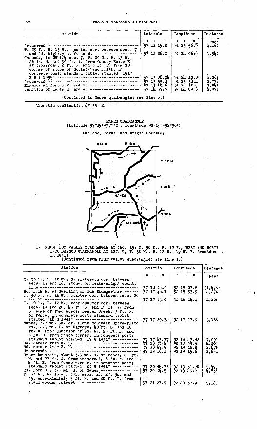
220 TRANSIT TRAVERSE IN MISSOURI
Station
T. 29 N., R. 13 VV. , quarter cor. between sees. 7
Cascade, In NW 1/k sec. 7, T. 29 N., R. 13 W. , 26 ft. N. and 39 ft. W. from County Route E at .crossroad, 2 ft. N. and .3 ft. E. from SE. corner of store of Goolsby and Smith, in concrete post; standard tablet stamped "1917ERA 1935"
Latitude
o t 't
37 12 15-2
37 12 28.0
37 13 08.0k 37 13 33,8 37 13 59,6VJ 111 *Q.fi
Longitude
a t n 92 23 56. '5
92 2k 06V8
92 2k 10.09 92 23 58.k92 4 15. kQ? ?i OQ.h
Distance
Feet k,k69
1,514.0
J4.,062 2,776 2,9U7
i .071
(Continued in Manes quadrangle; see line 6.)
Magnetic declination 6° 53" E.
MANES QUADRANGLE (Latitude 37°15 I -37°30 I ; longitude 92 015'-92 0 30')
Laclede, Texas, and Wright Counties
1. FROM PLUM VALLEY QUADRANGLE AT SEC. 15> T. 30 N., R. 12 W., WEST AND NORTH INTO DRYNOB QUADRANGLE AT SEC. 9, T. 32 N., R. 12 W. (by W. R. Broaddus in 193D
(Continued from Plum Valley quadrangle; see line 1.)
Station
T. 30 N., R. 12 W., S. sixteenth cor. between sees. 15 and 16, stone, on Texas-Wrlght county
T. 30 N., R. 12 W.,. quarter cor. between sees. 20
T. 30 N., R. 12 W. , near quarter cor. between sees. 19 and 20, k$ ft. 3. and 15 ft. W. from S. edge of ford across Beaver Greek, 3 ft* N. of fence, in concrete post; standard tablet
Manes, 7.2 ml. SE. of, along Mountain Grove-Plato rd., 2.5 ml- E. of Rayborn,- ko ft. S. and k5 ft. W. from Junction of' rd. W., 2<y ft. S. and 3 ft. E. from fence corner, in concrete post;
Green Mountain, about 3.5 mi. S. of Manes, 2k ft. N. and 27 ft. W. from crossroad, 6 ft. N. and k ft. E. from fence corner, in concrete post;
T. 31 N., R. 13 W., cor. sees. 26, 27, 3k, and 35, approximately 5 ft. N. and 20 ft. W. from
Latitude
o i n
37 18 08.9 37 17 1*8.1
37 17 35-0
37 17 29.31;
37 17 10.77 37 16 23.k 37 18 1*9.9 37 19 16.1
'37 20 08.76 37 20 5k. 5
37 21 27.5
Longitude
o i n
92 15 07.8 92 15 53-9
92 16 Ik.k
92 17 17.91
92 18 10.82 92 18 59.3 92 19 12.2 92 19 15.6
92 19 31.78 92 19 W-2
92 20 37.9
Distance
Feet
(1,1*75) k,276
2 ,(126
5,165
7,09k k,207 2,876 2,66k
5477 £,838
5,i6k

PART 2, SOUTH-CENTRAL MISSOURI, 1908-1937 221
Station
Manes, in top of concrete platform of village
Rd. fork W. -
Junction of lane E. on line between sees. 4 and
Manes, 2.9 mi. N. of, along Mountain Grove-Plato rd., 0.2 mi. SE. of Austin's store, 12 ft. S; and 21 ft. W. from Junction of rd. E. to Lynohburg and Plato, In concrete post; standard
T. 31 N. , R. 13 W. , N: quarter cor. sec. 3, rd. in line with fence E. about 150 ft. NW.
t. 32 N., R. 13 W., E. sii^eienth cor. sec. 314.,
Manes, 3 mi. N. , thence 3.3 ml. E. ' f rom, on rd. to Lynchburgy 30 ft. S. and 15 ft. W. from Junction of rd. W. to Mingsvllle, 18 ft. S. and 3 ft. W. from fence corner, In concrete
T». 32 N. , R. 13 W. , quarter cor. between sees. 24 and 25, stone, about 180 ft. N. of dwelling of
T. J2 N,, R. 12 W., W. cor. sees. 18 and 19, on
Lynohburg, 1.1* mi. S. of, along Mountain Grove- P-lato rd;, 25 ft. S. and (4.5 ft. W. from rd. in line with private drive to dwelling of W. C. Dorrls, In SE. corner of barnyard, in concrete post j standard tablet stamped "2^ G1931* __ ___ _
Junction of Lynchburg-Manes and Hartvllle rds. Rd. at point about' 66 ft. W. of Lynchburg
Plato, 3 ml. SW. of, quarter cor. between sees. 8 and 9, T. 32 -N., R. 12 W. , 9 ft. N. and 60 ft. W. from SW. corner of Sycamore School, in schoolyard. In concrete post; standard tablet
(Continued in Drynob quadrangle; s
Latitude
o i n
37 21 39-8 37 22 20.1
37 22 46.77 37 2-5 39-6 37 4 35-257 24 58-3
37 25 10.97
.37 35 48 ."2
37 26 14.2
37 27 02.85
57 27 31-5^
37 28 25,14
37 28 34.11 37 29 02.8
57 29 33-0
37 29 47-21
ae line 1.)
Longitude
01 II
92 20 37.7 92 21 09.7
92 21 50.56 92 21 1^8.9 92 21 57-2
92 21 56.8
92 21 5642
92 21 08.5
92 20 52.2
92 20 12.77
92 18 56.5
92 18 23.3
92 18 23. 44 92 18 18.2
92 17 45-2
92 16 10.42
Distance
Peet 1,214.0 4, 828
1^,258 5,545 5.671
2,333
1,279
5,403
2,935
5,858.
6,800
6*077
876 2,938
4,156
7,613
'2; FROM GROVESPRING QUADRANGLE AT SEC. 6, T. 29 N., R. l4 W. , NORTHEAST TO . SEC. 2k, T. 30 N.,'R. 13 W. (by W. R. Broaddus in 1931)
(Continued from Grovespring quadrangle; see line 1.)
T-4-H ^ _ .._ _ -_
T. 30 N., R, 14 W., in SW. eor. sec. 314., about 0-5 ml. SW. of HE. end'of County Route B,
36 ft. S. of private rd. through gate to pasture, 3 ft; E. of fence, In concrete post;
T**rd S 'T. 30 N., R. 14 W., In NW. cor. sec. 25, 55 ft.
N. and 25 ft. E. from E. edge of Deep 'ford across Gasconade River, 27 ft. N. of deep cut in bank- at approach to ford, 5 ft. N. of fence, In concrete p⪫ standard tablet
Whetstone Creek, rd. fork at NW. end of bridge
Rayborni about 1 ml. SW. of post office, in NE 1/4. NW lA sec. 21, T. 30 N^, R. 13 W. , 30 ft. N. and 15 ft. W. from rd. fork NW., 25 ft. N* and 4° ftv E. from large spring, 30 ft.' W. of rd. , In concrete post;' standard
37 15 23.9 37 15 25.2
37 15 32.02 37 16 35-8
37 17 02.90 37 17 27-1
37 17 59.8 37 17 59.6
37 18 01.06 57 18 13-5 37 18 14-9 57 18 13.5 57 17 44-3 57 17 45-77
92 29 40.5 92 29 20.3
92 28 06.59 92 25 53-2
92 25 21.80 92 4 14.5.7
92 23 1*8.9 92 23 14.7
92 22 29.79 92 21 39.3 92 21 28.0 92 20 38.8 92 19 10.2 92 18 14.3.82
(5,121) i,64o
5,995 12,565
3,736 3,812
5,661 2,760
3,631 4,268
928 3,9807,735 2,130

222 TRANSIT TRAVERSE IN MISSOURI
Station Latitude
0 | tl
Longitude
0 , II
Distance
Feet .
3- PROM MOUNTAIN GROVE QUADRANGLE NORTH ALONG COUNTY ROUTE A TO SEC. 21;, T. 30 N., R. 13 W. (by C. E. Wyriek in 1935)
(Continued from Mountain Grove quadrangle; see line I;.)
E.-W. crossroad near S. cor. sees. 31 an& 36,
Dawson School, about O.I}, ml. N. of, along County Route A, about J20 ft. S. of quarter cor. between sees. 31 and 36, T. 30 N. , Rs. 12 and 13 W. , 26 ft. W. of highway, 85 ft. SE. of SE. corner of dwelling, in SE. corner of yard, in concrete post; standard tablet stamped "T T1199 ERA 1935"
T. 30 N., Rs. 12 and 13 W., approximate cor. sees. 25, 30, 31, and 36, junction of rd. W.
T. 30 N. , Rs. 12 and 13 W., approximate quarter cor. between sees. 25 and 30, junction of old
T. 30 N. , Rs. 12 and 13 W. , approximate cor. sees. 19, 2k, 25, and 30, junction of rd. W. ~
37 15 15-6
37 15 204
37 15 H3-29
37 16 12.5
37 16 38.5
37 l? Ok- 8 37 17 lt.3-77
92 18 10.5
92 18 27.3
92 18 29.35
92 18 28.9
92 18 28.7
92 18 28.2 92 18 l|.3.82
(2,793)
1A39
2,321
2,950
2,630
2,660 It-, 139
1;. PROM GROVESPRING QUADRANGLE AT SEC. 8, T. 32 N., R. ll; W., EAST TO SEC. 8, T. 32 N., R. 12 W. (by J. W. Pothergill in 1935)
(Continued from Grovespring quadrangle; see line 4..)
Competition, 1; ml. W. of, 52 ft. S. and 14.35 ft- W. from rd. at fence S. at approximate center of S 1/2 sec. 8, T. 32 N., R. ll; W. , 119 ft. N. and 28 ft. W. from NW. corner of McBride Church, in NW. corner of churchyard, in con crete post; standard tablet stamped "128lE P A 1 QZC; "
T. 32 N., R. if). W. , cor. sees. 8, 9, 16, and 17,
T. 32 N., R. ll; W. , eor. sees. 9, 10, 15, and 16,
T. J2 N. , R. ll; W., quarter cor. between sees. 10
T. 32 N., R. ll; W., cor. sees. 10, 11, ll;, and
Competition, 1 mi. W. of, 50 ft. N. and 14.00 ft. E. from rd. at fences N. and S. at approximate W. sixteenth cor. between sees. 11 and ll;, T. 32 N., R. ll; W. , 53 ft. S. and 1;0 ft. E. from SE. corner of dwelling of R. A. Stewart, 2 ft. W. of garden fence, in concrete post; standard tablet stamped "1282 ERA 1935" -----
T. 32 N., R. it; W., quarter cor. between sees. 12
Gasconade River, W. end of low-water bridge over- T. 32 N., R. 13 W., eor. sees. 7, 8, 17, and 18,
Competition, 2 mi. E. of, about 33 ft. N. and 680 ft. E. from cor. sees. 7, 8, 17, and 18, T. 32 N., R. 13 W. , 33 ft. N. of rd., 62 ft. S. and 26 ft. W. from SW. corner of dwelling of M. P. Rlttenburg, 22 ft. SW. of 10-in. cedar tree, in concrete post; standard tablet
T. 32 N., R. 13 W., cor. sees. 8, 9, 16, and 17,
Rd. at fences N. and S., 9 ft. N. of fence corner at center of NW 1/1; sec. 10, T. 32 N.,T?- IX W. __ -
37 29 39-12 37 29 28.8
37 29 25.6
37 29 23.5
37 29 22.3
37 29 21.1
37 29 21.52 37 29 12.8
37 29 20.6 57 29 19.1 37 29 25.6
37 29 19-8
37 29 20.03 37 29 18.7
37 29 18.2 37 29 kt'k
*7 ?Q <;7.n
92 29 1;S.1;1 92 29 21;. 2
92 29 07.6
92 28 03.9
92 27 32.1
92 27 00.1
92 26 38.87 92 25 53.1
92 25 22.1; 92 2S 06.2 92 21; 32-5
92 23 50.9
92 23 1;2.59 92 23 02.2
92 22 i;6.0 92 21 56.14.
Q? ?1 P1.li
(1;,776) 2,006
1,373
5,138
2,570
2,580
1,710 3,793
2,599 1,312 2,798
3,398
672 3,258
1,311 14-.910
?. R67
(For balance In Drynob quadrangle, see line 5>)
Lynchburg, 0.2 mi. N. of, center see. 7, T. 32 N., R. 12 W., 1;0 ft. W. of rd., 30 ft. N. and 36 ft. E. from HE. corner of dwelling of W. E. Lee, 6 ft. S. and 2 ft. E. from NE. corner of yard fence, in concrete post; standard tablet stamped "1285 ERA 1935"
T. 32 N., R. 12 W. , quarter cor. between sees. 7
T. 32 N., R. 12 W., center sec. 8, rd. at fence
37 29 W.05
37 29 W;.l .
37 29 U|..2 37 29 1;7-21
92 17 50. ll;
92 17 16.1;
92 16 l;3.3 92 16 1042
(3,1440)
2,7U7
2,670 2,667
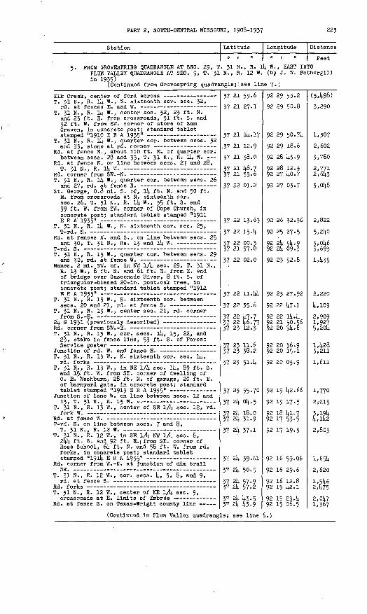
PART 2, SOOTH-CENTRAL MISSOURI, 1908-1937 223
Station Latitude Longitude Distance
o i ii o i it Peet
5. PROM GROVESPRING QUADRANGLE AT SEC. 29, T. 31 N., R. Ik W. , EAST INTO PLUM VALLEY QUADRANGLE AT SEC. 9, T. 3! N., R. 12 W. (by J. W. Fothergillin 1935)
(Continued from Grovespring quadrangle; .'see line 7«)
T. 31 N., R. it). W., N. sixteenth cor. sec. 32,
T. 31 N., R. Ill W., center sec. 32, 23 ft. N. and 23 ft. E. from crossroads, 31 ft. S. and 32 ft. W, from SW. corner of store of Sam Craven, in concrete post; standard tablet
T. 31 N., R. ll| W., quarter cor. between sees. 32
Rd. at fence TS. , about 110 ft. E. of quarter cor; between sees. 28 and 33, T. 31 N., R. ll| W.
Rd. at fence N. on line between sees. 27 and 28,
T. 31 N., R. Ik W., quarter cor. between sees. 26
St. George, 0.8 mi. S. of, ll). ft. N. and 50 ft. E. from crossroads at N. sixteenth eor. sec. 26, T. 31 N., R. ll| W., 35 ft. S. and 39 ft. W. from SW. corner of Cope Church, in concrete post; standard tablet stamped "1911
T. 31 N., R. ll| W. , N. sixteenth cor. sec. 25,
Rd. at fences N. and S., on line between sees. 25
T. 31 N., R. 13 W., quarter cor. between sees. 29
Manes, 2 ml. SW. of, in NW 1/1| sec. 29, T. 31 N., R. 13 W., 8' ft. S. and 6l ft. E. from E. end of bridge over Gasconade River, 8 ft. S. of triangular-blazed 20-ln. post-oak tree, in concrete post; standard tablet stamped "1912 ERA 1935"
T. 31 N., R. 13 W., S. sixteenth cor. between
T. 31 N. , R. 13 W., center sec. 21, rd. corner
T. 31 N., R. 13 W., cor. sees. li|, 15, 22, and 23, stake in fence line, 53 ft. S. of Forest
T. 31 N., R. 13 W., N. sixteenth cor. sec. ll|,
T. 3! N., R. 13 W. , in NE lA sec. li|, 89 ft. S. and 15; ft. W. from SE. corner of dwelling of C. E. toashburn, 28 ft. N. of garage, 20 ft. E. of barnyard gate, in concrete post; standard
Junction of lane W. on line between sees. 12 and
T. 31 N. , R. 13. W., center of SE lA sec. 12, rd.. '" .
T-rd. S. on line between sees. 7 and 8,
T. 31 N., R. 12 W., in SE.lA NW lA sec. 8, 2l|k ft. S. and 92 ft. E.i from SE. corner of Rose School, 61| ft. N. and 58 ft. W. from rd. forks, in concrete post; standard tablet
Rd. corner from W.-N. at Junction of dim trail
T. 31 N., R. 12 W., cor. sees. 1|, 5, 8, and 9,
T. 31 N., R. 12 W. , center of NE lA sec. 9,
Rd. at fence S. on Texas-Wright county line
(Continued in Plum Valley quadrang
37 21 59.6
37 21 27.1
37 21 ll|.17
: 37 21 12.9
37 21 38.0
37 21 k8.7 37 21 55-6
37 22 01.2
37 22 13.63
37 22 15. li
37 22 00-3 37 21 57.0
37 22 02.0
37 22 11.1)14
37 22 35.6
37 22 i|7.7 37 22 k6.77 37 23 12.3
37 23 11.6 37 23 38.2
37 23 514
37 23 55-70
37 2l| ol|.5
37 2l| 18.0 37 2l| 31.9
37 2l| 37.1
37 2k 39-61
37 2l| 50.5
37 2k 57.9 37 2l| 57.2
37 2k {13.5 37 2l| i|3.9
le; see line
92 29 53.2
92 29 50.8
92 29 50.711
92 29 18.6
92 28 10-9
92 28 12.3 92 27 ko.7
92 27 03.7
92 26 32.36
92 25 27.5
92 2k 5k. 992 2k 09.3
92 23 52.8
92 23 27.92
92 22 i|7.1
92 22 Ik.k 92 21 50.56 92 20 5k. 6
92 20 36.9 92 20 15.1
92 20 03.9
92 19 i|2.66
92 19 17.5
92 18 kl.7 92 17 53-5
92 17 19-3
92 16 59.06
92 16 29.6
92 16 12.8 92 15 1|2.1
92 15 23. ll92 15 06.5
6.)
(3:,ll98}
3,290
1,307
2,602
3,780
2,771 2,61|3
3,0k8
2,822
5,2kO
3,ok-6 3,693
1A35
2,220
1|',H>3
2,909 1,927 5,20k
I,k28 3,211
1,611
1,770
2/215
fc$2,803
l,65k
2,620
1,5^6 2,475
2,0k7 1,367
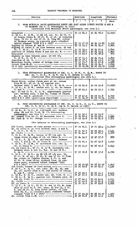
22k TRANSIT TRAVERSE IN MISSOURI
Station
6. PROM MOUNTAIN GROVE QUADRANGLE NORTH AND TO RAYBORN (by J. W. Fotherglll In 1935
(Continued froin Mountain Grove qua
T..30. N-, R. 13 W., In SE lA sec- 31, 32 ft. W. of County Route E, 18 ft. N. of rd. on township line, 56 ft. N. and 18 ft. E. from NE. corner of Talmage store, In concrete post; standard
Highway at fence E. on line between sees. 30 and31, T. 30 N., R. 13 w. :
Highway on line between sees. 19 and 3<V
Latitude
0 1 II
EAST ALONG CC ) ' dr angle; see
37 15 Ok. 5
37 15 27-75 3r7 15. 53-537 16 .19,5 37 16 36.1 37 16 I4.5-7
37 17 11,3 37! 17 37-3 37 17 59.7 37 18 02. k 37 18 01.06
Longitude
0 1 11
UNTY ROUTES E
line 5;) ..
92 2k 08.2
92 2k 13.83 92 2k llj..2
92 2k 27.k 92 2k 39.k 92 2k. 38*9
92 2k 034 92 2k 13-5 . 92 23 k7.9 92 23 Ik. 7 92 22 29.79
Distance
Feet AND B
'
(2,519)
2,399 2,606
2,835 l»9W . '973
3,859 2>753 3,068 2,699. 3y-629
7. PROM GROVESPRING QUADRANGLE AT SEC. 5, T. 30 N., R. lk W., NORTH TO SEC. 32, T. 31 N., R. ll|. W. (by B. D. Harsha In 1935)
(Continued from Grovesprlng quadrangle; see line 8.)
Puson Store, corner fence post at rd. corner from W.-N., kO ft. E. of quarter cor. between sees. 5 and 8, T. 30 N., R. lk W.
T. 30 N., R. 11+. W. , center sec. 5, r<^- at fences
Tps. 30 and 31 N. , R. lk W. , approximate quarter cor. between sees. 5 an^- 32, .corner of fences
37 19 55 "0
37 20 21.2
37 20 k7<9 37 21 lk.17
92 29 53-6
92 29 53-3
92 29 51-8, 92 29 50.7k
(2,068)
2,650
2,710 2,655
PROM GROVESPRING QUADRANGLE AT SEC. '20, T. 3! N., R. 1^ W., NORTH TO SEC. 8, T. 32 N., R. lk W. (by B. D. Harsha In 1935)
T. 31 N., R. llj. W., W. sixteenth cor. between sees. 20 and 29, T-rd. W. (In Grovesprlng
Rd. corner from SW.-N. at abandoned lane S.
(For balance In Grovesprlng quadra
Rd. at fence W. on line between sees. 5 an(i 8,T XT M R ill W _» _ »
T. 31 N., R. lk W. , center of NW 1/k sec. 9,
T. 31 N., R. li|. W., W. sixteenth cor. between
T. 31 N., R. lk W. , W. sixteenth cor. sec. k,
Rd. at fence E., 90 ft. W. of W. sixteenth cor. between sees. k and 33, Tps. 31 and 32 N. , R T)I w
T. 32 N., R. lk W., In NE lA SW 1/k see. 33, 6l ft. W. of rd., 58 ft. S. and 10 ft. E. from SE. corner of Claxton Church, 14. ft. S. and 30 ft. W. from l6-ln. hickory tree. In con crete post; standard tablet stamped "1921 ERA 1935"
T. 32 N., R. lk W. , cor. sees. 28, 29, 32, and 33, rd. corner from S.-W. and' corner of fences
T. 32 N.,, R. lk W., center sec. 29, T-rd. N. T. 32 N., R. lk VI., quarter cor. between sees. 20
and 29-, T-rd. W.
T. 32 N., R. 114. W., 67 ft. S. and 12 ft. W. from pile of rock at S. cor. sees J. 21 and 22, 5 ft- S. and 29 ft. E. from fence corner. In line with rd. N., In concrete post; standard tabletstamped "1922 ERA 1935"
37 22 32.6 37 23 02.0 37 23 2k. 8
ngle, see lln
37 25 Ok.l4.
37 2k 52.5 '37 2k Iik-0
57 2k 52.7
37 25 05.1
37 25 31.2
37 25 58.8
37 26 16. kl 37 26 29.6
37 26 so.l 37 27 16.5
37 27 k2.3 37 27 k3.0 37 27 ko.2
37 27.39.12 37 26 06.8
92 30 05.8 92 29 k8. 14. 92 29 5k-9
e $»>'
92 29 58.k:
92 29 32.14. 92 28 57.2
92 28 57.0
92 28 56.8
92 28 56.6
92 28 57.0
92 28 k7.52 92 28 55,3
92 29 11.192 29 k3.2
92 29 k24 92 29 02.9 92 28. 29.8
92 28 05.37 92 28 12.2
3ie86 2,'3*71
.(1,693)
2,k21 2,970
880 1,2502,6k5
2,782
l,9kO 1,496
2,kl2 3,719
2,611 3,185 2,689
1,969 2,851

PART 2, SOOTH-CENTRAL MISSOURI, 1908-1937 225
Station
SWi corner of log cabin at turn. In dim trail
Latitude
0 | II
37 28 19 .k
37 28 59.6 37 29 39-12
Longitude
01 tl
92 28 32.6
92 28 53.? 92 29 fe4l.
Distance
Peet 2,079
il-,392 5,799
Magnetic declination 6« 28' E.
DRYNOB QUADRANGLE (Latitude 37°30'-37 0l4.5 l ; longitude 92°15«-92°30')
Laclede and Pulaskl Counties
1. FROM MANES QUADRANGLE AT SEC. 9; T. J2 N., R. 12 W,, NORTHEAST INTOBIG. PIKEY QUADRANGLE AT SEC. 3, T.' 32 N., R. 12 W. (by W. R. BroadduaIn 1951) v
(Continued from Manes quadrangle; see line 1.)
Station Latitude
fl i n
37 30 10;737 30 10.5
Longitude
o i n
92 15 37.14.92 15 oli.2
Distance
Feet (3.569)O Kit*
(Continued In Big Plney quadrangle; see line 1.)
2. FROM BIO PINEY QUADRANGLE AT SEO. 27, T. 33 .N., Ri 12 ff., NORTHWEST INTO HIGHLAND QUADRANGLE AT SEC. 21, T. 35 N., R. 1^ W. (by W. R. Broaddus In 1931)
. (Continued from Big Plri«y quadrangle; see line I."-)
T. 33 N., R. 12 W. f S. sixteenth cor. between sees. 27 and 28, stone at T-fenoe E. , on Laclede-Texas county line, 1^.10 ft. S. of rd.
Plato, U ml. NW. of, about 1^2$ ft* S. of quarter cor; between sees. 27 and 28, T. 33 N-» R. 12 W., 20 ft. E. of rd. forks, 10 ft. N. of rd. S. and W. , 20 ft. 'SJ3. of mall box of F. L. Cook, In concrete post; standard tablet stamped "77 M 1931" -
Triangular-blazed l8-ln* black-oak tree at
Nebb, 3.1 ml.' SE. of, In NW lA «eo. 30, T. 33 N., R* 12 W., Oil; ml. NW. of Pine Creek Baptist Church, 112 ft. N. and l6 ft. E. from T-rd. E., 9 fti N. and l6 ft. E. from rd. corner from S.-W., 10 ft. S. of fence corner. In concrete post; standard tablet stamped"7R V 10*1" ___--___--. _ _.______. _ __. _ ______ .;
T» 33 N., Rs. 12 and 13 W. , approximate cor. sees. 19, 2l(., 25, and 30, rd. corner from
T. 33 N>, R. 13 W. , center seo« 24, rd. at fence W., about 110 ft. N. of rd. corner from E.-fei -
37 32 07.9
37 32 16*67
37 32 17.8 37 32 06.6.
37 32 32.95
37 32 U5'3
3-7 33 12.8
92 15 02.5
92 15 02.26
92 15 53-1 92 17 28.1
92 18 02.99
92 18 20.9
92 18 534
(2,587)
886
M96 7,732
3,875
1,907
3,819

226 TRANSIT TRAVERSE IK MISSOURI
Station
Nebo, In NW 1/k sec. ll\., T. 33 N. , R. 13 W. , k50 ft. E. of post office, 15 ft. S. and 19 ft. W. from crossroads, 10 ft. S. of fence corner, In concrete post; standard tablet
Rd. at triangular-blazed oak tree at rd. forks
Casey Perry, rd. at triangular-blazed tree on W.
T. 33 N., R. 13 ff., N. cor. sees. k and 5 Falcon, In NE. cor. sec. 5, T. 33 N. , R. 13 W. ,
80 ft. W. of post office, 50 ft. S. and 30 ft. W. from rd. corner from S.-W. , 20 ft. S. of fence corner, In concrete post; standard tablet
Falcon, 2.5 ml. NW. of, near cor. sees. 25, 30, 31, and 36, T. 314. N., Ra\. 13 and Ik W. , 14.30 ft. N. of T-rd. E., 21 ft. N. and 35 ft. W. from T-rd. W. , 20 ft. N. of rd. corner from S.-W., In fence corner, In concrete post; standard
Rd. at fences N. and S. at top of hill, on line between sees. 26 and 27, T. 3!; N. , R. Ik W.
Hanna ford on Osage Pork of Gasconade River, about 500 ft. SE. of bridge, T-rd. E. on W.
Dryhob, in SE 1/k sec. 22, T. 314. N., R. Ik W., 100 ft. E. , thence 23 ft. SE. from T-rd. SE. , In concrete poat; standard tablet stampe'd
(For balance In Lebanon quadrangle
R'd. on W. bank of Osage Fork of Gasconade River - T-rd. W. on line between sees. [4. and 5, T. 314. N.,
Tps. 314. and 35 N., R. lit W. , N. cor. sees. 14. and
T. 35 N., R. 114. W., near quarter cor. between sees. 32 and 33, 160 ft. W. of crossroads, 30 ft. .N. and 50 ft. W. from T-rd. N., 1 ft. S. and 6 ft. E. from fence corner, In concrete
Crossroads, at NW. corner of cemetery -
(Continued In Rlchland quadrangle;
Latitude
37 33 32.5
37 3k 15.02 37 3k 30.1 37 35 06. h
37 35 22.8 37 36 18-9
37 36 18.55 37 36 32.5 37 36 ft.6.8
37 37 12.91 37 37 12.8
37 .37 35-2
37 37 57-k
37 38 15.68 37 3g 06.9 37 38 13-3
, see line 2.
37 kl 35-9 37 kl 55.1
37 k2 33.9
37 lj-2 5^-5
37 lt.3 22.ko 37 U3 55-5
see line 1. }
Longitude
0 1 tl
92 18 57.0
92 19 58.68 92 20 32.5 92 21 06.2
92 22 05.7 92 22 kl.5
92 22 U3-23 92 23 13.3 92 2/4. kl.5
92 2k kk.51 92 25 17.0
92 26 5k. 9
92 27 20.1
92 27 26.97 "92 27 524 92 29 29.1
)92 29 3U-9 92 29 19.1
92 29 00.7
92 29 00.3
92 29 16.26 92 29 13-5
Distance
Feet 2,016
6,5723,12k£,7295,007 6,360
^2,801 7,2k5
2,6k9 2,613
8,198
3,021
1,927 2,231 7,803
(7,020)2,318k,200
2,080
3,099 3,359
5. PROM SEC. 27, T. 55 N., R. 12 W., NORTH TO SEC. 21, T. 55 N., R. 12 W. (by C. D. Cralg In 193!).) '
(For balance In Big Plney quadrang
Greenvlew, 3-8 ml. S. of, In SW ~L/\± sec. 33, T. 31). N., R. 12 W. , 32 ft. N. and 125 " E - from T-rd. NE., opposite Cook dwelling, In concrete post; standard tablet stamped "75 M 1951" ...
(For balance In Big Plney quadrang
Oreenvlew, 1.3 ml. S. of, near center sec. 21, T. 314. N., R. 12 W. , 26 ft. N. and 70 ft. W. from rd. forks, opposite dwelling of George Carroll, In concrete post; standard tablet
Hanna, 8 ml. SW. of, In SE 1/k sec. 8, T. 314. N., R. 12 W., 65 ft. SW. of T-rd. SW. , at N. edge of rd., In top of large rock; standard tablet
37 32 16.67 37 33 OO.k 37 33 39-1 37 33 C8.1
le, see line
37 35 U6.k
37 36 16.27
le, see line
37 38 lk.k8 37 38 k2.0 37 39 14.8
37 59 50.98
92 15 02.2692 15 20.8 92 15 39.6 . 92 15 16.8
k-)
92 16 01.3
92 15 k7.87
k.)
92 15 29.58 92 15 29.2 92 15 28.2
92 16 12.96
U,673 14-, 191 2,0^8
(8,208)
3,208
(2,668) 2,783 3,315
5,137

PART 2, SOUTH-CENTRAL MISSOURI, 1908-195? 227
Station
Hanna, 5.8 ml. SW. of, In S 1/2 sec. 5, T. 3k N., R. 12 W., In SW. corner of top step at entrance to Fairview School; standard tablet
nlo^oH lfl_<n nalr +-T.OO , XD f¥. _ BT! nf Trt . ___
Latitude
37 kO 2k.8 . 37 kl 12.1;
37 kl 15.27*7 il ih-6
Longitude
0 1 "
92 16 J2.0 92 16 £2.6
92 16 13.08 QP it; -ifKn
Distance
Feet
»
2,393 S.Q77
(For balance In Big Plney quadrangle, see line k.)
Hanna, 1.5 ml. NW. of, In NE lA SE lA se<v. 21, T. 35 N., R. 12 W., 50 ft. SW. of dwelling of James Nichol, 17 ft. N. of rd., In concrete post; standard tablet stamped "25 B 1925 Mo" 37 kk k5-33 92 15 16.81 (k,l30)
k. FROM DRYNOB EAST TO SEC. 8, T. 3k N. , R. 12 W. (by J. W. Fotherglll In 1935)
Drynob, 2-5 ml. NE. of, In SE lA SE lA sec. 13, T. 3k N., R. Ik W., 20 ft. N. and 57 ft. W. from Junction of rd. N., 95 ft. S. and 180 ft. W. from dwelling of Joe Randolph, k ft. N. of fence, In concrete post; standard tablet stamped "1286 ERA 1935"
T.- 3k N., R. Ik W., E. quarter cor. sec. 13,
T. 3k N., R. 13 W., cor. sees. 7, 8, 17, and 18, Junction of abandoned rd, S. and fence N.
T. 3k N., R. 13 W., cor. sees. 8, 9, 16, and 17,
T. 31; N., R. 13 W., In NE lA NE lA sec- l6, 35 ft. E. of rd. at trail E.,, 6 ft. S. and 30 ft. E. from rd.' at. fence S., 1 ft. W. of large boulder. In concrete post: standard tablet stamped "1287 ERA 1935''
T. 3l| N. , R; 13 W., cor. sees. 10; 11, Ik, and
T. 3k N., R. 13 W. , In NE lA sec. lk, 97 ft. SE. of curve in rd., 35 ft. N. and 112 ft. W. from NE. corner of dwelling of Henry Meeth, 2 ft. W. of garden fences In concrete post;
Rd. at fence S. on line between seca^ 13 and 18,
Rd. at fence S. on line between sees. 17 and 18,
37 38 15.68 37 3§ k3-7 37 38 31-1
37 39 Ok. 10
37 39 23.9 37 39 36-2
37 39 W 4
37 39 k8.l
37 39 38.86 37 39 55-3
37 3947-3
37 39 31.63 37 39 k6.8
37 39 35-6 37 39 3k- 337 39 37-2 37 39 50.98
92 27 26.97 92 26 k8-9 92 26 07.9
92 2k 55.0
92 2k k2.292 2k 27.8 92 23 k5>l92 22 kO.O
92 21 50.26 92 21 18.8
92 20 27.2
92 19 39.13 92 18 57.2
92 18 23.8 92 17 k2-592 17 12.0 92 16 12.96
k,l69 3,535
6,7W
2,251 1,701
3,680
5,2kl
k,iok3,025
k,2i9
k,i79 3,702
2,920 3,3172,k72 k,9W
5- FROM MANES QUADRANGLE AT SEC. 10, T. 32 N. , R. 13 W. , EAST INTO MANES QUADRANGLE AT SEC. 7, T. 32 N. , R. 12 W. (by J. W. Fothergill in 1935)
(Continued from Manes quadrangle; see line k.)
T. 32 N., R. 13 W. , near E. sixteenth cor. between sees. 3 and 10, 16 ft. S. and k8 ft. E. from rd. at fences N. and S., 33 ft. N. and 10 ft. W. from NW. corner of dwelling of Albert Blaine, 2 ft. N. of yard fence, in concrete post; standard tablet stamped "128k
T. 32 N. , R. 13 W. , cor. sees. 2, 3, 10, and 11,
T. 32 N. , R. 13 W. , quarter cor. between sees. 2
Rd. fork SW. near triangular-blazed 8-ln. post-
( Continued in Manes quadrangle; se
37 30 09.69
37 30 09.5
37 30 09.1 37 30 08.1
37 30 03.7
9 line k;)
92 20 k947
92 20 334
92 20 00.8 92 19 01.792 18 28.0
(3,02k)
1,299
2,628 ^,763
2,7k8
6. FROM LEBANON QUADRANGLE -:AT SEC. 17, T. 33 N., R. lk W. , NORTH INTO LEBANON QUADRANGLE AT SEC. 32, T. 3k N., R. lk W. (by J. W. Fotherglll in 1935)
(Continued from Lebanon quadrangle; see line 5.)
T. 33 N., R. lk W. , in SW lA SE lA sec. 8, k2 ft. W. of rd., 9k ft. S. and 35 ft. E. from SE. corner of dwelling of George Cosse, in concrete post; standard tablet stamped "129k
37 3U 12.6
37 & ̂3 45
92 29 k8.6
92 29 3l.k8
(2,226)
3409184101 O 89 8

228 TRANSIT TRAVERSE IN MISSOURI
Station
T. 33 N., R. ll* W. , quarter' c6iv between sees. 5
T. 33 N. , R. li* W. , S. sixteenth cor. sec. 5,T-rd. W, ' -
Tps. 33 and 3!). N. , R. ll* W.,. approximate quarter cor; between sees, 5 and 32, 22 ft. N; and 22 ft. W. from T-rd. E. and abandoned rd. W. ,- 3 ft. E. of fence corner, in concrete post; standard tablet stamped "1295 ERA 1935"
Latitude
a i nz*7 xc nz ~Q
37 35 30-6
37 35 14-3-8
37 36 2l*.27X7 *7 flP-li
Longitude
a i n92 29.20.0
92 29 1*0.1
92 29 1*0.2
92 29 14.0.30 QP PQ M .?
Dlstainqe
Feeto ?(.£.
3,152
U,09g T.osfl
(Continued lln Lebanon quadrangle; see line 5.)
FROM HIGHLAND QUADRANGLE WEST ALONO U.S. HIGHWAY 66 INTO .HIGHLAND"QUADRANGLE (by J. P. Anderaon.ln 1935)
11*53 E Rline 9
T. 35 N.150 ft
A 1935 (In Rlchland quadrangle; see
of rd. S. , R. 13 W., In SE 1/1* seo. 21, about. S. and 60 ft. E. from U.Sli Highway
at drive S. to dwelling of E. E. Watson,- 35SW. oftablet
highway, In concrete post; standardstamped "li*57 ERA 1935"
66ft.
373737
37
1*5 06
1*5 33
1* 53(Continued In Rlohland quadrangle; see line
.61*-9-3
-5?
929292
92
10.)
19 20
21
I?'?2
55-9
38.21*
5,272
3,971
Magnetic declination 6" 10 E.
LEBANON QUADRANGLE .(Latitude 37°30«-37°1*5'; longitude 92°3Q'-92°1*'5')
Laclede County
R 16 W R I5W
T33 N
1. PROM STOUTLAND QUADRANGLE AT SEC. 20, T. 35 N., R. 16 W., SOUTH INTO LONG LANE QUADRANGLE AT SEC. 1, T. 33 N., R. 17 W. (by E. L. MoNalr In 1913) ' '
(Continued from Stoutland quadrangle; see line 1.)
Station
T. 35 N., R. 16 W., cor. sees. 19, 20, 29, and
T. 35 N., R. l6 W., quarter cor. between sees. 29
T. 35 N., R. l6 W. , cor. sees. 29, 30, 31, and
T. 35 N., R. 16 W., S. cor. sees. 31 and 32,
T. 35 N., R. l6 W., 1*1*0 .ft. E. of S. cor. sees. 31 and 32, l6 ft. S. of rd. on township line, 6 ft. N. of fence, near ditch; Iron post
T. 3!* N. , Rs. 16 and 17 W., N. cor. sees. 1 and
Latitude
o i n
37 1*1* 52.5
37 1*1* 26.3
37 1*1* 00.0
37 U3 07.6
37 1*3 07.3l<.
37 10 08.6
Longitude
o i n
92 1*3 lj-6.6
92 1*3 1*7-3
92 1*3 1*8.0
92 1*3 U8.9
92 1*3 1*3^0
92 1*1* 1*3-3
Distance
Peet
(2,655)
2,650
2,660
5,302
WH
W15
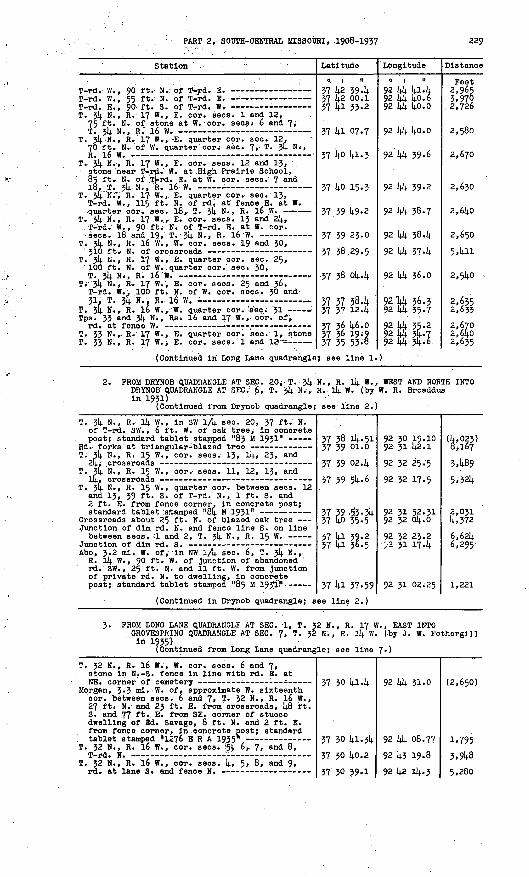
PART 2, SOOTH-CENTRAL MISSOURI, -1908-195? 329
Station '
T-rd. W. , 55 ft. N. of T-rd. E. --
T. 34 N., R. 17 W. f E. cor. sees. 1 and 12, 75 ft. N. of stone at W. cor. sees* 6 and 7,
T. 34 N., R. 17 W..,. -E. quarter cor. sec. 12. 70 ft. N. of W. quarter cor^ a.eo. 7,. T. j4 Ni,
T. JU N.,. R. 17 W., E. cor. sees. 12 and 13, . atone near T-,rd. W. at .High Prairie School, 85 ft.'- N. ' of .TJ-rd. E. at W. cor. sees. 7 an<^
T. 34 N;'V R.' 17 W. ,..E. quarter cor. see. 1J, T-rd. W., 115 ft. N. of rdi at fence E. at W. quarter- cor., sec. 18, T. 3!). N. , R. l6 W.
T. 54 N., R. 17 W., E. cor. sees. 13 and 24> T-rd. W., 90 ft. N. of T-rd. E. at W. cor.
T. 3!). N., R. 16 W. , W. cor. sees. 19 and 30,
T. 34 N., R. .17 W., E. quarter cor. sec. 25, 100 ft. N. of W.. quarter cor. sec* 30, T. 54 N., R, 16 "W. -T
TV '34 N., R, I? W., E. cor. sees. 25 and 36, T-rd< W.. 100 ft. N. of W. cor. sees.. 30 andZT ' T jtfi W D 1 £ 'W
Tps. 33 and 3!). N; , Rs; l6 and 17 W. , cor. of,
T. 33 N. r R. 17 W, , E. quarter cor. sec.' 1, stone T. 33 N., R. 17 Wrj E. cor. sees. 1 and 12;-=
(Continued In Long Lane quadrangle
Latitude
0. 1 II
37 42 39-437 42 00;137 4l 33-2
37 4l 07.7
37 4o 41-3
37 40 15.3
37 39 49.2
37 39 23.0
37 38.29.5
37 38 04.4
37 37 38.1 .37 37 12.4
37 36 46.0 57 36 19-9 37 35 55-8
} see line 1.
Longitude
.0 i ii92 44 41.4 92 44 h.o.6 92 44 40.0
92 44 40.0
92 44 39.6
92 44 39-2
92 44 38.7
92 44 38.4 92 44 37.4
92 .44 36.0
92 U 36.3 92 44 35-792 44 55-2 92 44 54.7 92 44 54; 6.
)
Distance
Feet 2,965 5,970
. 2,726
2,580
2,670
2,630
2,640
2,650
5,411
2,540
2,635 2,633
2,670 2,6402,635
2. PROM DKYNOB QUADRANOLE AT SEC. 20; T. 54 N. , R. l4 W. , WEST AND NORTH INTO DRXNOB QUADRANOLE AT SEC. 1 6, T. 34 N.-, R. . l4 W. (by W. R. Broaddus In 1931)
(Continued from Drynob quadrangle; see line 2.)
T. 34 N., R. 14 W., In SW 1/4 see. 20, 37 ft.. N. of T-rd. SW. , 6 ft. W. of oak tree,- In concrete
. post; standard tablet stamped "83 M 1931"
T. 34 N., R. 15 W., cor. sees. 13, 14, 23, and
T. 34 N. , R. 15 W., cor. sees. 11, 12, 13, and
T. 34 N., R. 15 W., quarter cor. between sees. 12 and 13, 39 ft. S. of T-rd. N.,. 1 ft. S. and 2 ft. E. from fence corner. In concrete post;
Crossroads about 25 ft. N. of blazed oak tree Junction of dim rd. N. and fence line S. on line between sees. :i and 2, T. 34 N., R. 15 W.
Abo, 3.2 ml. W. of, In NW 1/fy. sec. 6, T. 34 N., R. 14 W. , 90 ft. W. of Junction of abandoned rd. SW., 25 ft. N. and 11 ft. W. from Junction of private rd. N. to dwelling, In concrete
(Continued In Drynob quadrangle; s
37 38 14.51 37 39 Ol.o
57 39 02.4
37 39 54-6
37 39 ,53-34 37 40 35-5
37 4l 39-2 57 41 36.5
37 41 37-59
ee line 2.)
92 30 19.10 92 51 42.192 52 25.5 92 52 17.5
92 51 52.51 92 52 04.0
92 52 25.2 - ii 31 17-4
92 31 02.25
(4,023) 8,167
3,489
5;324
2,031 4,372
6,624 6,295
1,221
3. PROM LONG LANE QUADRANGLE AT SEC. '1, T. 52 N., R. 17 W. , EAST INTO OROVESPRINO QUADRANOLE AT SEC. 7, T. 32 N., R. 14 W. (by J. W. Fothergill in 1935)
(Continued from Long Lane quadrangle; see line 7-)
T. 32 N., R. 16 W., W. cor; sees. 6 and 7, stone in N.-S. fence In line with rd. E. at
Morgan, 3.5 ml.-W. of, approximate W. sixteenth cor. between sees. 6 and 7, T. 32 N., R. 16 W. , 27. ft* N. and 25 ft. E. from crossroads, 48 ft. S. and 77 ft. E. from SB. corner of stucco dwelling of Ed. Savage, 8 ft. N. and 2 ft. E. from fence corner, In .concrete post; standard
T. 52 N,, R. 16 W., cor. sees. ''5V 6, 7, and 8,T_ A Iff -. ^L_ ~
T. 32 N. , R. l6 W., cor. sees. 4, 5, 8, and 9,
37 30 41-4
57 50 41-34
37 30 40.2
*7 xn xo-i
92 44 31.0
92 44 08.77 92 43 19.8OP liP lli -X
(2,650)
1,795
3,948Q pAn

230 TRANSIT TRAVERSE IN MISSOURI
Station
T. 32 N., R. 16 W., quarter cor. between
T. 32 N. , R. 16 W. , cor. sees. 3, 1+, 9, and 10,
Morgan, at quarter cor. between sees. 3 an(i 10, T. 32 N. , R. 16 W. , 25 ft. S. and 23 ft. W. from crossroads, 210 ft. N. and 14.6 ft. E. from NE. corner of Lutheran Church, 14. ft. S. and 1+ ft. W. from fence corner, In concrete post;
T. 32 N., R. 16 W., cor. sees. 2, 3, 10, and 11,
T. 32 N., R. l6 W., quarter cor. between sees. 2
T. 32 N., R. 16 W., cor. sees. 1, 2, 11, and 12,
(For balance In Grovesprlng quadra
T. 32 N., R. IS W., center sec. 11, rd. at fence N.
Orla, 2.5 ml. S. of, at center of E 1/2 sec. 11, T. 32 N., R. 15 W. , 213 ft. H. and 6k ft. W. from T-rd. W. , 1+2 ft. N. and 92 ft. E. from NE. corner of Gardner School, In concrete post; standard tablet stamped "1280 ERA
T. 32 N. , R. 15 W., center of SE lA sec. 2,
T. 32 N., R. 15 W., center of SW lA aec. 1, rd.
T. 32 N., R. 15 W., center of SE lA sec. 1, rd.
T. 32 N., R. ll+ W. , quarter cor., between sees. 6
(Continued In Grovesprlng 'quadrang
Latitude
0 | II
37 30 384
37 30 37-7
37 50 36.83
37 30 364
37 30 36.1
37 30 35-7 37 30 35-2 37 30 17-0
ngle,, see lin
37 30 174
37 30 004
37 30 0245
37 30 39-5
37 30 37-8
37 30 35-9 37 30 32.6
37 30 19-8
le; see line
Longitude
0 | II
92 i).i ia 4 92 ia 08.7
92 l+o 35-52 92 14.0 01.8 92 39 29.192 38 56.0 92 38 1+2-9 92 38 4.2
e 1+.)
92 33 21+4
92 32 55-1+
92 32 39-68
92 32 38.2
92 32 05.2
92 31 32.7 92 30 1+8.6
92 30 1+3.5
1+-)
Distance
Feet
2,650
2,61+0
2,675
2,718
2,639
2,660 1,062 2,957
(5.206)
2,899
1,281+
3,71+6
2,658
2,638 3,561
1,368
14.. PROM SEC. 31, T. 35 N., R. 16 W., NORTHEAST INTO STOOTLAND QUADRANGLE AT SEC. 22, T. 35 N., R. 16 W. (by J. W. Fotherglll In 1935)
Prim Trav Sta No 29 1913 Mo (previously
T. 35 N., R. 16 W., S. cor. sees. 32 and 33,
T. 35 N., R. 16 W. , cor. sees. 28, 29, 32, and
T. 35 N., R. 16 W., center of SE lA sec. 29,
T. 35 N., R. 16 W., near E. sixteenth cor. between sees. 20 and 29, 26 ft. S. and 25 ft.E. from T-rd. E. , 30 ft: N. and 80 ft. E. from log dwelling of W. P. Stldham, In fence corner, In concrete post; standard tablet stamped
T. 35 N. , R. 16 W. , W. sixteenth cor. between
T...35 N., R. 16 W. , cor. sees. 21, 22, 27, and
T. 35 N., R. 16 W. , cor. sees. 22, 23, 26, and
(Continued In Stoutland quadrangle
37 1+3 07.3!).
37 14.3 06.9
37 1+3 59-3
37 14 12.5
37 14 51-56
37 14 51-3
37 14 50.3
37 14 1+9-2
; see line 6.
92 1+3 1+3-1+0
92 1+2 1+1.8
92 1+2 1+0.6
92 1+2 57.0
92 1+2 55.81
92 1+2 22.5
92 1+1 31-3
92 l+o 25.5
)
l+,9l+8
5,306
1,870
3,91+7 2,676
l+,ll6
5.291
5. FROM SEC. 6, T. 32 N., R. ll+ W. , NORTH TO SEC. 20, T. 314. N., R. ll+ W. (by J. W. Fotherglll In 1935)
Junction of rd. SE., 171 ft. E. of rd. at fences N. and S. at W. sixteenth cor. between sees. 6
T. 33 N., R. 4 W., N. sixteenth cor. sec. 31,
T. 33 N. , R. ll|. W., 197 ft. W. of S. sixteenth cor. between sees. 29 and 30, 58 ft. S. and 129 ft. W. from SW. corner of Hough School, 35 ft. W. of N.-S. rd. In line with fence E. , In limestone ledge; standard tablet stamped n 12;9i3 ERA 1935" - - ....
T. 33 N., R. 11). W., N. sixteenth cor. between
37 30 32.6
37 31 11.7
37 31 50.0
37 32 1549
37 32 1+1-6
92 30 1+8.6
92 30 58.1
92 30 14-6
'92 30 ii+.o6
92 30 11.0
1+.025
1+,028
3,566 2,659

PART 2, SOUTH-CENTRAL MISSOURI, 1908-1937 251
Station
T. 33 N., R. Ik W., quarter cor. between sees. 19
T. 33 N. , R. Ik W, f S. sixteenth cor. betweenOHPH. T7 nnri 1 ft . T-r-rl . R. - --, - --
Latitude
0 | II
57 55 21.2
17 *)i nn.?
Longitude
9? *0 11 Ji
Distance
Feet
5,996
zi.QRI
(For balance in Drynob quadrangle, see line 6.)
U.S.C. & O.S. standard disk stamped "U 112 1935" 37 57 57 58
45-86 lk-51
92 92
50 50
09. 19.
58 10.
(4,657) 2,998
6. FROM GROVESPRING QUADRANGLE AT SEC. 12, T. 52 N., R. 17 W., NORTH TO SEC. 6, T. 52 N., R. 16 W. (by J. W. Fotherglll in 1955)
(Continued from Grovespring quadrangle; see line 6.)
T.. 52 N., R. 17 W., E. quarter. cor. sec. 12,57 50 14-0 37 30 41.34
92 44 \92 44 c
1.78-77
(5,997) 5,552
7- FROM GROVESPRING QUADRANGLE NORTH ALONG STATE HIGHWAY 5 TO SEC. T. 55 N., R. 16 W. (by J. W. Fotherglll in 1955)
22,
1279 ERA 1955 ( In Grovespring quadrangle; see
U.S.C. & G.S. standard disk stamped "B 29 1934"-
U.S.C. & G.S. standard disk stamped "A 29 1934"-
T. 35 N., R. 15 W., cor. sees. 19, 20, 29, and
U.S.C. & G.S. standard disk stamped "Z 28 1934"- Junction of lanes E. and W. , 26 ft. W. of
Junction of lane S. at quarter cor. between
TJ.S.C. & G.S. standard disk stamped "Y 28 1934"-
T. 55 N"» R. 16 W., quarter cor. between sees. 11
T. 33 N., R. 16 W. , cor. sees. 1, 2, 11, and 12,
U.S.C. & G.S. standard disk stamped "X 28 193k"- T. 54 N., R. 16 W., S. cor. sees. 55 and 56, rd.
E. and fence W. in line with highway N. , kO ft. W. from rdTE. In line with highway S. at N.
T. 3k N. , R. 16 W., oor. sees. 25, 26/55, and
U.S.C. & G.S. standard disk stamped "W 28 1954"- Alrway beacon at NE. corner of landing field T. 5k N., R. 16 W., quarter cor. between sees. 15
U.S.C. & O.S. standard disk stamped "V 28 1954"-
U.S.O. & G.S. standard disk stamped "U 28 1954"- Lebanon, 285 ft. SW. of St. Louis-San Francisco
Ry. sta. , on W. side of tracks, 5 ft. E. of Commercial Hotel, in concrete sidewalk;
U.S.O. & O.S. standard disk stamped «N 112 1955" U.S.O< & O.S. standard disk stamped "U 50 1954"-
T.' 3k N-;> R. 16 W. , N. ';c!or. sees. 2 and 5,
U.S.C. & O.S. standard disk stamped "B 50 1954"- T. 35 N., R. 16 W., cor; sees. 26, 27, .3k, and
T. 35 N., R. 16 W., cor. sees. "22, 23, 26, and 27, State Highway 5 at rd. W. (previously
57 29 57. k7 57 50 30.it. 57 50 44.24 37 31 2k- 5 57 51 55-0 37 52 lk-92 57 52 55-757 55 06.7 57 55 19.11
57 55 57-1 57 3k 19-3 37 5k 28.11 57 5k 55.557 55 2l.lj.
57 55 47-5 57 56 20.61
57 56 40.2
57 57 52.4 57 58 25.90 57 59 05.6
57 59 45-2 37 40 09.80 57 ko 54.7 57 40 46.95
57 40 45.41 57 4p 56-55 57 kl 29.05 37 42 08.1 37 42 54-5
37 45 05-9 57 45 20.75
57 45 56.8
57 44 49-2
92 35 16.95 92 55 07.6 92 35 03.19 92 34 54-7 92 55 05.2 92 35 27.82 92 36 09J.7
92 36 42.6 92 36 59.11
92 57 15.0 92 58 08.9 92 58 31.52 92 58 48.5
92 58 57-8-
92 58 58.2 92 58 59.06
92 58 59.5
92 58 59-0 92 58 58.01 92 58 59-5
92 58 57-9 92 58 59- ''09 92 59 So.l 92 59 V7.15
92 59 52.07 92 ^9 50.57 92 40 04.21 92 40 04.6 92 40 05. .2
92 40 05.7 92 40 15.42
92 40 26.6
92 40 25.5
5'k,°,81,444k,i075:,2232,716 ' 5,176
2,955 1,831
k'2k8 4,889 2,011 3,066
2,758
2,640 5,547
1,980 5,2855,522 5,901
4,012 2,695 5,545 1,851
426 1,15k 5,471 5,950 2,650
2,999 1,87k
5,759
5,295
8; FROM SEC. 12, T, 3k N. , R. 16 W. , EAST ALONG STATE HIGHWAY 32 TO SEC. 12, T. 5k N., R. ISi W. (by J. W. Fothergill In 1935)
U.S.C. It G.S. standard disk stamped "P 112 1935" T.' 5k N.', R. 16 W., quarter oor. between sees; 12
T. 3k N., R. 16 W., E. cor. sees; 12 and 13; Junction of rdi N., 326 ft. N. of fence S. in line with highway E. at W. cor. sees. 7 and 18,T. =?k H.i B. m W.
57 4o 09.80 57 40 09; 79
37 40 08.8
vj )in nfl.i
92 58 59-09 92 58 56.57
92 58 25.5
00 2-7 C2.Q
"264
2/500
p.iOiR

2J2 TRANSIT TRAVERSE IN-MISSOURI
Station . :
TJ.S.C. & Q.S. standard disk stamped JQ 112 1955" T. $li N. f R. 15 W., cor. sees-; 7, 8, 1?, an*. 10,
T. 3k N., R. 15 W., cor. sees. 8>; 9, 16, and 17,
U.S.C. & O.S. standard disk stamped. ;?R 112 1935" T. 314. N., R. 15 W., W. sixteenth <xor; 'between
T. 31; N., R. 15 W., cor. sees. 10,' 11, l4»- and
TJ.S.C. & O.S. standard disk stamped "3 112 1935" 84 M 1931 {previously described) - ' -:
Latitude
A 1 n
37 lid ,o4.;'6l
37 4<5 04-8
37 kO :Or.7-. 37 39 97-86
37 39 58.1
37.39 561.1-. " 37 39 5545 37 39 53-34
Longitude .0 i n-92 37 "00.29
92 36 1^6*2
92 35 40.8 9? 35 05.92
92 '34 19.5
92 33 «L,O 92 32 47.77 92 31 52.31
Distance
Feet 4,325
1,138
5,272 2,830
3.737
3,907mMagnetic declination 6« kl<
'GROVESPRINQ QUADRANGLE(Latitude 37U5" -37?30'; longitude. 92>30« -92°45')
Laclede, Webster, and Wrlght Counties
1. PROM MANSFIELD QUADRANGLE NORTH ALONG STATE HIGHWAY 5 TO HARTVILLE. THENGE EAST ALONG ROADS INTO MANES QUADRANGLE AT SEC. 6, T. 29 N., R. 14 W. (by W. R. Broaddus In 1931)
(Continued from Mansfield quadrangle; see line 2.)
Station
Hartvllle, at E. entrance to courthouse lawn, !<. ft. S. of S. edge of sidewalk, 3 ft. W. of retaining wall of lawn, In concrete postj
Latitude
0 1 II
37 15 01.28 v? in r>7.n
Longitude
o i n
92 30 37.51 OP xn ip_ft
Distance
Peet
(l,92>) p.nfli
(Continued in Manes quadrangle; see line 2.)
2. FROM NIANOUA QUADRANGLE AT SEC. 1, T* 29 N., R. 17 W., EAST ALONG ROADS AND STATE HIGHWAY 5 TO HARTVILLE (by W. R. Broaddus In 1932)
(Continued from Nlangua quadrangle; see line Ij..)
T. 30 N., Rs. 16 and 17 W. , S. cor. sees. 31 and 36, iron pin at junction of rd. E. , in
T. 30 N., RSj. 16 and 17 W., cor. sees. 25, 30,
Duncan, about 3.2 ml. W. of, near N. sixteenth cor. between sees. 25 and 30, T. 30 N., Rs. 16 and 17 W. , 25 ft. S. and 55 ft. E. from T-rd. E., 2 ft. S. and 11 ft. E. from fence corner^ in concrete post; standard tablet stamped "T T110 B 1932"
Rd. at fence N. about 80 ft. NE. of schoolhouse -
Junction of private rd. N., about 150 ft. E. of
37 15 51.7 37 16 Ok-7
37 16 1»4.1
37 17 23.08 37 17 15-p 37 17 224
37 17 13-U
92 kk 50.1 92 kk 49.8
92 kk k8.9
92 kk {4.7.31 92 k.3 k2.0 92 14.3 09.0
92 k2 10,4k
(1,852) 1,315
3,981
3,944 5,337 2,769
4,822

PART 2, SOUTH-CENTRAL MISSOURI, 1908-1937 235
Station
Duncan, In NW 1/4 SW \/k sec. 27, T. 30 N., R. 16 W. , 37 ft. N. and 59 ft. W. from County Route J at rd. N. , 5 ft. N. and 158 ft. E. from SB. corner of store building, In concrete post;
T. 30 N. , R. 16 W., quarter cor. between sees. 26
Rd. at rail fence on line between sees. 25 and
Odin, 1.6 ml. NW. of, 10 ft. S. and 17 ft. E. from quarter cor. between sees. 25 and 30, T. 30 N., Rs. 15 and 16 W. , 20 ft. N. and 17 ft. E. from rd. forks, In concrete post;
Odin, 2 ml. SE. of, In SE 1/4 sec. 35, T. 30 N. , R. 15 W., 5 ft. S. and 135 ft. E. from rd. forks, k8 ft. N. of rd. , In concrete post;
T. 30 N., R. 15 W., W. sixteenth cor. sec. 36, point 5 ft. N. of rdi and in line with fence on
Hartvllle, 2 ml: NW. of, on State Highway 5, near center of W 1/2 sec. 36, T. 30 N. , R. 15 W., 22 ft. N. and kO ft. E. from highway at cross road, In concrete post; standard tablet stamped
Highway at fence S., about 320 ft. W. of cross-
Latitude
0 | II
37 16 5k. 32
57 17 05.7 57 17 05.5
57 17 12-5
37 17 02.7k 57 16 ll.k 57 '16 Ok. 5 37 16 08.9
37 15 52,. 12 37 16 Ik. 5 37 16 18.7 37 16 Ok. 6
37 16 03.3
37 16 03.48
37 15 55.1 57 15 55-1 37 15 32.k 37 15 01.28
Longitude j
0 I It
92 kl 29-54
92 kO 2k. 7 92 40 08.0
92 39 18.1
92 38 12.05 92 37 11.5 92 37 044 92 36 50^8
92 55 12-55 92 5k 58.9 92 34 22.6 92 35 53-6
92 52 27.9
92 52 24.27
92 51 31.5 92 50 46.1 92 30 45-0 92 30 37.51
Distance
Feet
3,825
5,365 1,545
4,097
5,te7 7,150
910 1.185
8; 138 5,5§7 1,387 4,206
5,315
297
k,350 4,191 291
5,207
3. PROM SEC. 36, T. 30 N., R. 15 W. , NORTHWEST ALONG STATE HIGHWAY 5 TO GROVESPRING, THENCE WEST ALONG ROADS INTO NIANGUA QUADRANGLE AT SEC. 25, T. 31 N., R. 17 W. (by W. R. Broaddua In 1932)
T. 30 N., R. 15 W. , quarter. cor. between sees. 23 and 26 , stone at fence corner about 30 ft. E.
Hartvllle, 5.6 ml. NW. of, along State Highway 5, In NE V4 NE 1/4 sec. 23, T. 30 N. , R. 15 W., 45 ft. N. of highway at crossing of old route of highway, In concrete post; standard tabletof-OTmiArl HT T 1 1 £ R 1QX5II .___ __ .. _ «
E.-W. crossroad on line between sees. 11 and Ik,
Hartvllle, 8.6 ml. N. of,, along State Highway 5, near center sec. 10, T. 30 N., R. 15 W. , 30 ft. N. and kO ft. E. from highway at N.-S. crossroad, In concrete post; standard tablet
Crossroad on line between sees, k and 33, Tps. 30 and 31 N., R. 15 W., 880 ft. E. of rd. at fence N. at S. cor. sees. 32 and 33, T. 31 N. ,R TC m __ _ ___. _ _ _..
Highway at fences E. and W. on line between
Orovesprlng, about 3.5 ml. SE. of, along State Highway 5, In SW \/k sec. 28, T. 31 N., R. 15 W. , 20 ft. S. and 35 ft. W. from highway at dim crossroad, In concrete post; standard
T. 31 N., R. 15 V7., center sec. 21, rd. -at fence
T. 31 N«» R. 15 w*r quarter cor; between sees. 20
T. 51 N., R. 15 W. , cor. sees. 16, 17, 20, and
Grovespring, Oik ml. E. of, center of E 1/2 . sec. 17, T. 31 N., R. 15 W., 70 ft. S. and 25 ft. E. from State Highway 5 at crossroad. In churchyard, in concrete post; standard tabletntfunnnd "T T lift H 1Q*9« _ _
37 16 03.48 57 16 35-8
57 17 22.6 37 17 48.7
37 18 13.33 37 19 04.0
57 19 07.8 37 19 39-9
57 19 55-61
37 20 55.7
37 21 47.5
37 21 56.35 37 22 45.4
57 23 05.6
37 23 06.2
37 23 32.6
VI 3* Cfl-lA
92 32 24.27 92 35 03.1
92 53 15.1 92 55 H.6
92 52 51-31 92 35 13 -li
92 53 18.0 92 54 01.7
92 34 48.92
92 35 42.1
92 35 30.0
92 35 35-19 92 35 23.2
92 35 16.5
92 55 49-7
92 35 48.9
Q3 *£ nli-CP
4,532
4,836 2,652
2,977 5,422
, 5k5 4,802
4,128
7,446
5,326
586 4,8592,309
2,674
2,666
? five

TRANSIT TRAVERSE IN MISSOURI
Station
T. 31 N., R. 15 W. , eor. sees. 17, 18, 19, and 5H T vtrl W *.
Grovesprlng, 2.3 ml. W. of, In NE lA sec. 21;, T. 31 N., R. 16 W., 20 ft. N. of rd., 250 ft. W. of dwelling of B. M. Price, In fence corner, In concrete post; standard tablet stamped "T T
Crossroads, 320 ft. N. of quarter cor. between
T. 31 N., R. 16 W., center sec. 23, T-rd. E. T. 31 N., R. 16 W. , quarter cor. between sees. 23
T. 31 N., R. 16 W. , cor. sees. 22, 23, 26, andO*7 T -nH TJ ___
Nlangua, 9.8 ml. E. of, near cor. sees. 21, 22, 27, and 28, T. 31 N. , R. l6 W. , 15 ft. N. and 12 ft. W. from rd. corner, 8 ft. E. of fence corner, In concrete post; standard tablet
Nlangua, 7 ml. E. of, In NE 1/4 see. 30, T. 31 N., R. 16 W., 20 ft. S. of rd., 60 ft. S. and 65 ft. W. from SW. corner of dwelling of M. L. Rader, In concrete post; standard
Rd. at fence S., near cor. sees. 19, 2lf, 25, and
(Continued in Niangua quadrangle;
Latitude
0 | II
37 23 59-3
37 23 33.6 37 23 24-2
37 23 21.27
37 23 14-0 37 23 11-7
.37 22 45.5
37 22 14.6.2
37 22 47-78 37 22 26.2 37 22 21;. 7
37 22 46.01
37 22 50.5
see line 5>)
Longitude
0 1 II
92 36 34-1
92 36 514-- 5 92 38 02.2
92 38 18.914.
92 39 08.4 92 39 14.1.6
92 39 lt.2.0
92 14.0 15.1
92 1;! 20.51 92 42 21;. 0 92 1|2 59-0
92 43 48.68
92 144 ^2.8
Distance
'Feet 2,387
. 3,077 5.552
1,381
U.056 2,693
2,655
2,676
5,281 5,570 2,829
14., 552
4,388
1;. PROM LEBANON QUADRANGLE AT SEC. 7, T. J>2 N., R. 15 W., EAST INTO MANESQUADRANGLE AT SEC. 8, T. 32 N., R. llj. W. (by J. W. Fotherglll In 1935)
(Continued from Lebanon quadrangle; see line J>.)
Pease, In SW lA SW lA sec. 7, T. 32 N. , R. 15 W., 7 ft. S. and 1; ft. E. from NE. corner of concrete-block store building, In concrete post; standard tablet stamped "1278E TJ A -I Q2 c It
T. 32 N., R. 15 W. , quarter cor. between sees. 8 and 17, Iron pin In N.-S. fence line 7 ft. S.
T. 32 N., R. 15 W., about l;0 ft. N. and 760 ft. W. from quarter cor. between sees. 9 and l6, 1 ml. N. of Laclede-Wrlght county line, 1;0 ft. N. and 37 ft, E. from State Highway 5 at E.-W. crossroad, In concrete post; standard tablet
T. J2 N., R. 15 W. , quarter cor. between sees. 10
37 29 kl-^2. 37 29 38.8
37 29 38.5
37 29 37.14-7 37 29 364
37 29 55-5
92 37 lt.7-69 92 37 19.2
92 36 13.6
92 35 16.93 92 34 14.0.0
92 jli 02.0
(3,678) 2457
5.291
l4-,566 2,980
3,069
(For balance In Lebanon quadrangle, see line 3.)
T. 32 N., R. ll; W., S. sixteenth cor. sec. 7, Icrossroads - 37 29 l;0.1;
(Continued In Manes quadrangle; see line 1;.)
92 30 1;1;.6 (3,982)
PROM POINT 0.1; MILE EAST OP GROVESPRING NORTH ALONG STATE. HIGHWAY 5 TO SEC. 9, T. 32 N., R. 15 W. (by J. W. Fotherglll In 1935)
T. 31 N., R. 15 W., E. sixteenth eor. between
U.S.C. & G.S. standard disk stamped "E 29 193V- Junctlon of lane W. on line between sees. 5 and
32, Tps. 31 and 32 N., R. 15 W. U.S.C. & G.S. standard disk stamped "D 29 193V-
Crossroad on line between sees. 21 and 28,
U.S.C. & G.S. standard disk stamped "C 29 1934 11 -
37 23 58.16
37 21; 25.0 37 25 14.39
37 26 09.6 37 26 49-82 37 27 27-2
37 27 53.2 37 28 06.2 37 28 4548 37 29 ll.l 37 29 3747
92 36 01;. 52
92 36 03.8 92 36 0342
92 36 02.6 92 35 14.743 92 35 31-9
92 35 35-3 92 35 31.6 92 35 23.71 92 35 32.5 92 35 16.93
2,713 5,002
5,584 4,252 3,98l
2,6491,314-1 4,0302,683 2,952
It was reported that this monument was reset 62 ft. N. and 11 ft. W. from described location and position by J. W. Fotherglll, June 5, 1935-

PART 2, SOOTH-CENTRAL MISSOURI, 1908-193? 235
Station
6. FROM SEC. JO, T. 30 N., R. l6 W. , NORTH I SEC. 12, T. 32 N., R. 17 W. (by J. W. F
T. 30 N., Rs. 16 and 17 W. , approximate cor. sees. 19, 214., 25, and 30, crossroads ----------
T. JO N., Rs. l6 and 1? W. , approximate quarter
(For balance in Niangua quadrangle
T. 31 N., R. 17 W. , E. sixteenth cor. between
T. 31 N., R. 17 W., E. sixteenth cor. sec. 2k, Junction of abandoned rd. W. and fence E. -----
T. 31 N., Rs. 16 and 17 W., cor. sees. 13, l8,
T. 31 N., Rs. l6 and 17 W., approximate quarter cor. between sees. 13 and 18, rd. corner from
T. 31 N., Rs. 16 and 17 W. , 550 ft. S. of rd. corner at cor. sees. 1, 6, 7, and 12, 5 1 ft- s > and 25 ft. W. from junction of rd. N., 2 ft. S. and 2 ft. W. from fence corner, in concrete post; standard tablet stamped "1905 ERA 1935"
T. 32 N., R. 16 W. , W. sixteenth cor. on S. line sec. 31, T-rd. E. and fence W., 214.0 ft. E. of stone at W. sixteenth cor. on N. line sec. 6,
T. 32 N., R. 16 W. , W. sixteenth cor. sec. 31, stone at rd. corner from S.-E. and fence W. -
T. 32 N., R. 16 W., N. sixteenth cor. sec. 3!,
Rader, 27 ft. S. and 52 ft.- W. from center of W 1/2 sec. 29, T. 32 N., R. 16 W. , 27 ft. 3. and 40 ft. W. from T-rd. W. , .67 ft. S. of front door of store of John Roper » In concrete post; standard tablet stamped "1906 ERA1935" - -
T. 32 N., R. 16 W. , center sec. 19, T-rd. W. - T. 32 N., R. 17 W. , E. quarter cor. sec. 24,
T. 32 N., R. 16 W., in NW 1/4 NW 1/k sec. 19, 13 ft. N. and 11 ft. E. from crossroads, '57 ft. N. and 77 ft; W. from NW. corner of dwelling of Edna Miller, in concrete post; standard tablet
(Continued in Lebanon quadrangle;
Latitude
O I 11
NTO LEBANON Q othergill in
37 17 23-08
37 17 36.6
37 18 02.8
, see line 7.
37 22 50.6 37 22 Ij.6.01 37 22 50.6
37 23 16.9
37 23 42-7
37 21; 08.8 37 214. 14.8.1;
37 25 22.1037 25 53.6
37 26 18.9
37 26 14.5.2
37 26 57.8 37 26 59.U
37 27 36.28 37 27 14-2.6 37 28 29.6
37 28 29.3
37 28 49.62 37 29 344
see line 6.)
Longitude
0 1 II
UADRANOLE AT1935)92 44 47.31
92 44 47.8 92 44 47-1
)
92 44 59.o 92 43 48. '68 92 44 59-0
92 44 58.4 92 44 41-2
92 44 40.6 92 44 56.2
92 hk 39-3592 44 26.1
92 44 15.3
92 44 14-8
92 lt-3 57.6 92 43 27.8
92 43 08.55 92 43 50.7 92 43 55-992 44 34-1
92 44 33-55 92 44 31.1
Distance
Feet
1,363
2,656
(5,288) 5,694
2,6.64
2,959
2,642 4,197
3,672 5,365
2,703
2,659
1,888 2,402
4,038J,458 4,779
3,080
2,056 4,538
FROM POINT 0*4 MILE EAST OF GROVESPRING EA&T INTO MANES QUADRANGLE SEC. 29, T. 31 N., R. 14 W. (by J. W. Fothergill In 1935)
T. 31 N., R. 15 W., center sec. 16, T-rd. N. T. 31 N., R. 15 W.,- cor. sees. 15, 16, 21, and
22, T-rd. N.
T. 31 N., R. 15 W., in NE V4 HE 1/4 sec. 22, 20 ft. E. of rd. Junction, 45 ft- W., thence 366 ft. NW. along rd. from NW. corner of dwelling of Omar Prock, in concrete post; standard tablet stamped "1908 ERA 1935"
T. 31 N., R. 15 W. , quarter cor. between sees. 22
T. 31 N., R. 15 ff., S. sixteenth cor. between
T. 31 N., .R. 15 W. r center of SE 1/4 aeo. 23, rd.
T. 31 N., R. 1$ W. , cor. sees. 23, 24, 25; and26 T rd S " * * ~» »» -
T. 31 N., R. 15 W. , E. cor; sees. 24 and) 25,
T. 31 N., R.. 14 W., in SW V4 SW 1/4 sec. 19, 60 ft. S. of SW. corner of dwelling of Jim Burris, 25 ft. S. of rd;, 2 ft. N. lajnd 3 ft. W. from NE. corner of garden, In concrete post; standard tablet stamped "*1909 ERA1-7JJ
37 23 58.1
37 23 31-537 23 25;0
37 23 23.23
J \ ^J VH-**T
37 22 50.4
37 22 36.9
J 1 *-*- ./*+ w
37 22 35.52
92 36 04.5292 35 15-5 92 34 43 -492 34 13.5
92 33 39-72
92 33 38.4
92 32 49-7
92,32 33-7
92 3Jl : 28.6
92 31 16.75
3,959
2,730
1,910
1,316
3.965
5,256
961

256 TRANSIT TRAVERSE IN MISSOURI
Station
T. 31 sec
T. 31
N.
N.19or\
R. 34W., E. sixteenth cor. and 30, rd. corner from N.
R. ll* W., W. sixteenth cor.
between-E. between
Latitude
0 1
37 22
*7 ??
33-3
*?. f>
Longitude
0 1
92 30
q? *0
384
OR. ft
Distance
Peet
3,108
?;6?q
(Continued In Manes quadrangle; see line 5.)
PROM HARTVILLE NORTH INTO MANES QUADRANGLE AT SEC. 5, T. 30 N.,--R. li; W. (by B. D. Harsha In 1935) .
T. 30 N., R. lit. W.., in SW l/l). sec. 20, 35 ft. N. and 27 ft. W. from ford across Brush Creek, on property of Roy Curtiss, 6 ft. N. and 6 ft. W. fron ll4.-in. oak tree at SE. corner of fence, in concrete post; standard tablet stamped"1919 ERA 1935"
37 15 01 .'28 37 15 32-2 37.15 58.5 37 16 Ik.i 37 16 344 37 17 05.3 37 17 21.3
37 17 14.7.00 37 18 15.7 37 18 14.3.3 37 19 16-3 37 19 29-5 37 19 H.24
92 30 37.51 92 30 14-9 . 92 30 35-6 92 30 32-6 92 30 25.6 92 30 094 92 30 ii.o
92 30 33-57 92 30 28.7 92 30 15-2 92 30 16.8 92 30 16.8 92 30 13.8
3,188 2,759 1.595m1,621).
3,172 2,9292,998 3,3113 1,330 1,331
(Continued in Manes quadrangle; see line 7-)
PROM MANES QUADRANGLE AT SEC. 17, T. 31 N., R. ll* W., NORTH INTO MANES QUADRANGLE AT SEC. 5, T. 3! N., R. it* W. (by B. D. Harsha in 1935)
(Continued from Manes quadrangle; see line 8.)
Durbln School, 1.9 ml. N. of, in NW 1/k sec. 17, T. 31 N...R.' Il4. W. , 52 ft. N. and 1).0 ft. E. from rd. at junction of wood rd. NE. , 1; ft. S. and 1). ft. W. from 10-in. oak tree, in concrete post; standard tablet stamped "1920 ERA1935" -
T. 31 N., R. lU W., E. sixteenth cor. between
T. 31 N., R. l4 W., cor. sees. 5, 6, 7, and 8,
(Continued in Manes quadrangle; se
37 23 Itf.i
37 214. 06.60 37 2k 1*2-5
37 25 08.8
37 25 08.2
e line 8.)
92 30 02.0
92 30 07.73 92 30 37-3
92 30 35-2
92 30 18.8
(2,320)
2,027 lf.,3l(.9
2,667
1,319
10. PROM SEC. 25, T. 30 N., R. 16 W., WEST AND SOUTH INTO MANSFIELD QUADRANGLE AT SEC. 3, T. 29 N., R. l6 W. (by C. W. Williams in 1937)
Rd. at fences N. and S. on line between sees. 25
T. 30 N., R. 16 W., W. sixteenth cor. sec. 35,
T. 29 N., R. 16 W. , in NE 1/1). sec. 3, 17 ft. S. of T-rd. N., 1 ft. S. of fence, in concrete post; standard tablet stamped "T T 50 W 1937" -
(Continued in Mansfield quadrangle
37 17 02. 74 37 17 10.8
37 17 12.6 37 17 11-3 37 16 53.0 37 16 53.1 37 16 53-6
.37 16 5U-.32
37 16 13.3 37 15 M-6.6
37 15 23.97
; see line 5.
92 38 12.05 92 3845-2
92 39 18.0 92 ?9 51-3 92 £o 084 92 1*0 25.0 9240 57.9, 92 l).l 29-5U'
92 1*0 09.2 92 39 58.5
92 39 59-38
)
2J798
2,663 2,689 2,3,4 1,342 2,660 2,560
7,678 2,814
2,286
Magnetic declination 6° 52' E.

PART 2, SOUTH-CENTRAL MISSOURI, 1908-1937 237
' MANSFIELD QUADRANGLE* (Latitude 37?00'-37°15'; longitude 92030'-920k5')
Douglas, Webster, and Wrlght Counties
-,... RI6W I RISW /"^
\
1. FROM FORDLAND QUADRANGLE 'EAST ALONG ST. LOUIS-SAN FRANCISCO RAILWAY INTO MOUNTAIN GROVE QUADRANGLE (by E. L. McNalr in 1913)
(Continued from Fordland quadrangle; see line 1.)
Station
T. 28 N. , R. '17 W. , quarter cor. between sees. "1>
T. 28 N.. , R. 16 W. , cor. sees. 7/8, 17, and l8,
Cedar Gap, 85 ft. E. of SE. corner of St. Louis- San Francisco Ry. sta., 60 ft. E. of track, 20 ft. W. of W. corner of small frame dwelling, 2 ft. from corner of yard fence, on top of bank; iron post stamped ''Prim Trav Sta No 38 1913 Mo" -
R.R. at line between. sees. 22 and 23, T. 28 N. ,
T. 28 N. , Rs. 15 and 16 W. , approximate coir, .sees. 19, 2k, 25, and JO, point k50 ft. S. of
T. 28 N., R. 15 W. , cor. sees. 16, 17, 20, and
Mansfield, near St. Louis-San Francisco Ry. sta., 200 ft. S. 72° W. of semaphore post, 80 ft. N. k3° W. of NW. corner of Mansfield Hotel, 3 ft. from sidewalk, in fence corner; Iron post
h.R. at line between sees. 26 and 27, T. 28 N. ,R 1 c W ^ .
R.R. at line between sees. 25 and 30, T. 28 N. ,
(Continued in Mountain Grove quadr
Latitude
O | H
37 08 25.5 37 .07 14.9-3
37 07 33.5 37 07 06.6
37.06 18.1*3
37 06 03.3 37 05 k7.8
37 OS kk.k 37 06 16.5
37 06 34.6'
37 06 20.22
37 05 26,7
37 05 08.9 37 05 234
angle; see 11
Longitude'
92 14). 14.3.292 43 10.7
92 k3 11.3 92 1|1 39-5
92 ko 15.7092 39 .56.9 92 37 52.7
92 37 47-7 92 36-14.3.6
92 35 36.2
92 314. 57-79
92 33 27.1
92 31 17.5 92 30 l4- 6
ne 1.)
Distance
. Feet
(3,202) 8,332
1.595 7,922
8,359
2,157 10,185
. 529 ;6',iio
5.773
3.437
9,129
10,659 5.299
2. FROM MANSFIELD NORTH ALONG STATE HIGHWAY'5 INTO OROVESPRINO QUADRANGLE (by W. R. Broaddus in 1931)
Prim Trav Sta No 39 1913 Mo (previously ;
Curve in highway near Junction of private lane E. Crossroad on old route of highway, about 600 ft.
Mansfield, 3.4 mi. N. of, along State Highway 5, 9 ft. N. of highway right-of-way, 15 ft. N. of N. gatepost at barnyard of Ira. Kelly, Inside fence, In concrete post; standard tablet
Old highway at -Junction of rd. E. near school-
37 06 20.22 37 06.46.4
37 07 34.2 37 08 13.2
.37 08 56.96 37 09 34-8 37 09 51-0
37 09 59-8 37 10 29.0 *7 in *A.«;
92 3k 57.79 92 34 38.0
92 3k 2k. 5 92 34 26.8
92 34 11-45 92 33 56- 5 92 33 38.4
92 33 19-8 92 32 59-4 a? *p sn.n
3^6984.953 3,955
4.5924,014 2,202
1,7463,378! . ?PQ
Cedar Gap quadrangle aa published In Bulletin 898-8 has boon renamed Mansfield quadrangle.

238 TRANSIT TRAVERSE IN MISSOURI
Station
Mansfield, 6.8 ml. N. of, along State Highway 5, 25 ft. N. of T-fence E. at quarter cor. between sees. 23 and 2k, T. 29 N. , R. 15 W. , 35 ft. E. of highway, inside pasture, in concrete post;
Lick Fork of Gasconade River, center of bridge
Hartville, 2.14- mi. S. of, along State Highway 5, 25 ft. S. and 65 ft. E. from junction of rd. E., inside pasture fence, 3 ft. E. of l8-in. hickory tree, In concrete post; standard tablet
Woods Fork of Gasconade River, center of bridge
Latitude
37 11 17-37
37 12 16.0 37 13 02.1;
57 13 25.84 37 14 33-1
17 ill liP.ft
Longitude
92 32 08.33
92 32 05.7 92 32 05.5
92 31 35-26 92 30 31.6
Q? ^n 31 .6
Distance
Feet
5,177
5,936 4,698
3A04 8,537
QflO
(Continued in Grovespring quadrangle; see line 1.)
3. FROM AVA QUADRANGLE NORTH ALONG STATE HIGHWAY 5 TO MANSFIELD (by W. R. Broaddus in 1931)
(Continued from Ava quadrangle; see line 1.)
Ava, 6.3 ml. NE. of, along State Highway 5, 1.6 ml. S. of crossing of Bryant Creek, 57 ft. E. of highway at dim rd. E., 15 ft. N. of rd., 63 ft. N. 13° 13' E. of triangular-blazed tree, in concrete post; standard tablet
Ava, 9.!; mi. NE. of, along State Highway 5, 970 ft. SE. of Hicks School, 23 ft. N. and 34. ft. E. from highway at rd. E. , 17 ft. N. and 3 ft. E. from fence corner, In concrete post;
Ava, 11-5 mi. NE. of, along State Highway 5, 34 ft. N. and 23 ft. E. from highway at rd. W. on Douglas-Wrlght county line, in top of head- wall of concrete culvert; standard tablet
Mansfield, at E. limits of town, junction of
U.S.C. & G.S. standard disk stamped "V 6 1928" - Prim Trav Sta No 39 1913 Mo (previously
37 00 45 -U4 37 01 09.8 37 01 J7.2 37 01 14.6.1
37 02 38.55 37 02 fo.2 37 03 20.3
37 03 56.39 37 ok 24.5 37 01+ 53.5
37 06 04.9 37 06 21.30
37 06 20.22
92 37 03.25 92 36 5t.l 92 35 41-8 92 35 U-7
92 35 H).. 35 92 35 17-3 92 36 05.6
92 36 00.82 92 35 11-3 92 35 24-3
92 34 30.2 92 34 50.78
92 34 57-79
(6,003) 3,4i5 5,068
903
5,775 1,105 5,028
3,6634,918 3,113
S,W7 2,347
577
4. FROM FORDLAND QUADRANGLE SOUTHEAST ALONG STATE HIGHWAY 14 INTO AVA QUADRANGLE (by C. N. Acker-man in 1935)
(Continued from Fordland quadrangle; see line 6.)
Tigris, 2.3 ml. E. of, along State Highway 14, 90 ft. NW. of junction of rd. S., 60 ft. W. of concrete bridge, 15 ft. N. of highway, in concrete post; standard tablet stamped "16 R
T. 27 N., R. 16 W., W. sixteenth cor. sec. 30,
(Continued in Ava quadrangle; see
37 00 13.48
37 00 14.5
line 8.)
92 44 37.58 92 44 09.0
(4,U6)
2,323
FROM GROVESPRING QUADRANGLE AT SEC. 3, T. 29 N., R. 16 W., SOUTH TO CEDAR GAP (by C. W. Williams In 1937)
(Continued from Groveapring quadrangle; see line 10.)
T. 29 N., R. l6 W., E. sixteenth cor. between
T. 29 N., R. 16 W. , E. sixteenth cor. sec. 10, 3 ft. S. and 22 ft. W. from rd. corner from N. to E., 3 ft. N. and 8 ft. W. from gate, 5 ft. W. of fence, In concrete post; standard
T. 29 N., R. 16 W., cor. sees. 10, 11, 14, and
37 14 57-837 14 40.537 14 18.337 14 05.3
37 13 39-0
37 13. 12.73
37 12 46.4* ? IP on.n
92 39 54-792 39 47-792 39 40.092 39 57-1
92 39 58-1
92 39 59.27
92 39 43-3OO 2O ill C
(2,673)i,84o2,333
2 ££i
n L r O
2,9645 e,a\

PART 2, SOOTH-CENTRAL MISSOURI, 1908-1937 239
Station
T. 29 N., R. 16 W., cor. sees. Ik, 15, 22, and
T. 29 N., R. 16 W., cor. sees. 22, 23, 26, and
Jerico, near E. edge of, in NE 1/fy. SE 1/k sec. 27, T. 29 N., R. 16 W. , 22 ft. N. and 60 ft. W. from rd. forks, 18 ft. N. of rd., on bank, in concrete post; standard tablet stamped
T. 28 N., R. 16 W. , cor. sees. 1, 2, 11, and 12, 3 ft. S. and 16 ft. E. from T-rd. W. , 2 ft. W. of fence, in concrete post; standard tablet
T. 28 N., R. 16 W., quarter cor. between sees. 2
Prim Trav Sta No 38 1913 Mo (previously
Latitude
0 | 11
37 11 53-8 37 11 2?.k
37 11 01.0 37 10 29.8
37 10 23.61 37 09 55.2 37 09 23-1 37 09 01. k 37 08 k9.8
37 08 23. ko
37 08 2k. 0 37 08 ll.O 37 07 57-7 37 07 55.2 37 07 06.1 37 06 33.9
37 06 l8.k3
Long! tude
0 1 II
92 39 {4.54 92 39 1*6-5
92 39 {4.7.2 92 39 14-8.2
92 39 51-39 92 39 38.1 92 39 18.2 92 39 18.0 92 38 k8.0
92 38 k6.1,k
92 39 19.6 92 39 36.5 92 39 36.9 . 92 39 53.6 92 £o 28.0 92 £0 29.1
92 ko 15.70
Distance
Feet
2,660 2,673
2,669 3,156
677 3,067 3,269 2,190 2,700
2,669
2,682 1,895
1*580 5,. f$5 5,261
1,903
Magnetic declination in 1937, 7° E.
AVA QUADRANGLE (Latitude 36°k5'-37^00'; longitude 92°30 T -92°k5')
PROM BRADLETVILLE QUADRANGLE AT SEC. 2k, T. 26 N., R. 17 W.," NORTHEAST TO AVA, THENCE NORTH ALONG STATE HIGHWAY 5 INTO. MANSFIELD QUADRANGLE (by W. R. Broaddus in 1931)
(Continued from Bradleyvllle quadrangle; see line 2.)
Station
Rd. .In.lliie with fence on E. side of private
Ava, 5.2 mi. W. of, along rd. to Goodhope, O.k mi. N. and 0.2 mi. E. from Arno post office, 28 ft. W. of rd., 17 ft. K. and 20 ft. E. from NE. corner of farmhouse of Mrs. D. M. Phiilllps, in concrete post; standard tablet stamped "kOB T QXT T (TTX**
T. 26 N., R. 16 W. , N. sixteenth cor. between
T_Tv1. R. _--_ _ _ _ ______
Latitude
0 1 II
36 55 k6.l36 56 15.1
36 56 kl.22 36 56 53.1
36 56 50.2 *£ c£ c£o
Longitude
o t N
92 kk 51.792 Ijk 20.6
92 kk 15.38 92 kit. 09.5
92 10 31.0O3 i5 CR 2
Distance
Feet
(3,817) 3,872
2,669 1,300
3,133
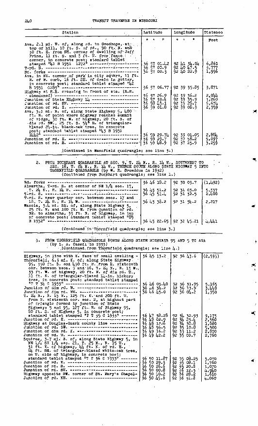
2Ij.O TRANSIT TRAVERSE IN MISSOURI
Station . ' .-
Ava, 2.1 ml. W. of, along rd. to Goodhope, . at top of hill, 30 ft. S. of rd., '90 ft.; N. and- 30 ft. E. from NE. corner of dwelling .of ; Jeff Prlne, 11 ft. S. and 3 ft. W. from fence. : corner, In concrete post; standard tablet
Ava, In NW. corner of park' In city square, 11 ft. E. of W. curb, 16 ft. SE. of drain In gutter, In concrete post; standard tablet stamped "k2
Highway at R.R. crossing In front of sta. (R.R.
Ava, 3.1 ml. N. of, along State Highway 5, kOO ft. N. of point where highway reaches summit of ridge, 30 ft. W. of highway, 20 ft. S. of dim rd. NW. , 25 ft. S. 54° E. of triangular- blazed 2k-ln. black-oak tree, In concrete post; standard tablet stamped "k3 B 1931
.(Continued In Mansfield quadrangle
Latitude
O 1 M
36 57 01.42 36 57 00.9 36 57 00.5
36 57 06.77
36 57 26.9 36 57 394 36 58 45-1 36 59 01.8
36 59 29-74 36 59 29.7 36 59 48.9
; see line 3'
Longitude
o i n
92 ki 3k.ok 92 kO £7,592 lj.0 22.9
92 39 35-85
92 39 36.2 92 39 35-9 92 39 28.7 92 39 08.3
92 39 01.05 92 37 58.2 92 37 25.9
)
Distance
Feet
6,861 3,777 1,996
3,871
2,044 1,260 6,67k 2,359
2,88k 5,097 3,259
2. PROM BUCKHART QUADRANGLE AT SEC. 9,' T. 2k N., R. ik W., SOUTHWEST TOSEC. 18, T. 24 N., R. Ik W., THENCE SOUTH ALONG STATE HIGHWAY 5 INTO THORNPIELD QUADRANGLE (by W. R. Broaddus In 1932)
(Continued from Buckhart quadrangle; see line 1.)
Almartha, T-rd. S. at center of NE 1/4 sec. 17,
T-rd. S. near quarter cor. between sees. 17 and 18, T. 24 N., R. l4 W. --.--..i-. ______
Wasola, 3.4ml. SE. of, along State Highway. 5, 25 ft. N. and 100 ft. E. from -Junction of rd. NE. to Almartha, 35 ft. N. of. highway, In top of concrete post; standard tablet 'stamped "85 B 1932" . : -r - ---
36 46 18.2
36 k5 51.2 36 4.5 51-4
36 45 38.2
36 45 22.65
92 30 03.7
92 31 03.0 92 31 32-5
92 31 54.2
92 32 45-21
(1,492)
5,537 2,400
2,217
' 4,441
(Continued in'Thornfleld quadrangle; see line 3-
3. PROM THORNPIELD QUADRANGLE NORTH ALONG STATE HIGHWAYS 95 AND 5 TO AVA (by L. A. Cassil in 1933) . . ' ;
- .('Continued, from Thornf leld quadrangle; see line k.)
Highway, In line with N. face 'of small dwelling - Thornfield, 6.3 ml. N. of, along State Highway.
95, 350 ft. S. and k50 ft. W. from E. sixteenth cor. between sees. 9 and 16, T.- 24 N., R. 15 W., 33 ft. W. of highway, 20 ft. N. of dim rd. W., 11 ft. N. of triangular-blazed l4-in. hickory tree, In concrete post; standard tablet stamped
T. 24 N., R. 15 W. , 125 ft. N.- and .200 ft. W. from N. sixteenth cor. sec. 2, at highest part of triangle formed by junction of 'State Highways 5 and 95, 127 ft.- E. of Highway 95, 80 ft. S. of Highway 5, In conorete-'post;a 4-anrioWl +-aV»1«4- at-amnAri nrP T >t£ C1 lQZ7 n
Squires, 3.7 mi. S. of, along State Highway 5> in NE 1/1' SE 1/4 sec. 21, T. 25 N., R. 15 W. , 31 ft. E. of highway, 44 ft. N. of rd. E., 6k ft. NE. of triangular-blazed white-oak tree, on W. side of highway, in concrete post;
Highway opposite SW. corner of St. Mary's Chapel-
36 45 13.2
36 46 03.40 36 k6 34.2 36 46 45-0
36 4? 38.2836 48 02.936 48 12 & 36 48 56.5' 36 49 16.2 . 36 49 42.2
36 50 11.8736 50 29.3 36 50 26.6 36 50 00.8 36 50 10.2 36 50 k5.6
92 36 43-6
92 36 31-95 92 36 13-9 92 36 04.2
92 34 32.93 92 34 25.4 92 34 30.8 92 35 10.8 92 35 11.2 92 35 00.7
92 35 08.25 92 35 08.1 92 35 20.8 92 36 12.3 92 36 28.2 92 36 51.8
(2,595)
5,165 3,440 1,350
9,175 2,560 1,080 5,500 2,000 2,760
3,070 l,7oO 1,070 4,940 1,610 4,060

PART 2, SOUTH-CENTRAL MISSOURI, 1908-1937 241
Station
Squires trlangulatlon sta.; U.S.C. & G.S.
Ava, 6.5 ml. S. of, along State Highway 5, 40 ft- N. and 60 ft. W. from quarter cor. between sees. 2 and 11, T. 25 N., R. 16 W., 24 ft. S. of highway, In center of triangle formed by junction of rd. SW. , 13 ft. N. of 8-ln. triangular-blazed cedar tree, In concrete post; standard tablet stamped "T T 37 C 1933" -
Ava, 3.3 ml. S. of, along State Highway 5» in NW 1A. SW 1/4 sec. 26, T. 26 N., R. 16 W. , 30 ft. W. of highway, 12 ft. S. of fence on S. side of barnyard, 70 ft. N. of triangular- blazed 30-in. oak tree on farm of Ernest Kester, In concrete post; standard tablet
Latitude
o i n
36 50 59-20 36 51 30.2 36 52 10.2
36 52 37-43 36 53 01.2 36 53 24v5 36 53 32.6 36 5^ 45-2 36 5C 23.0
36 51; 57.02 36 55 30.4 36 56 03.7 36 56 48-1 36 57 06.77
Longitude
O 1 II
92 37 47-58 92 37 16.0 92 37 51-9
92 39 49-6692 4o 20.792 40 55-5 92 4i 01.792 4o 50.2 92 4o 26.2
92 40 10.69 92 39 44-4 92 39 32-9 92 39 37-1 92 39 35-85
Distance
Feet
4,737 4,OS1 4,988
9,960 3,486 3,580
960 1,580 4,290
1,900 5,810 3,490 4,500 1,890
4. PROM SEC. 18, T. 25 N., R. 15 W. , WEST INTO BRADLEYVILLE QUADRANGLE AT SEC. 24, T. 25 N., R. 17 W. .(by L. A. Cassll In 1933)
Squires triangulatlon sta. (previously described)
Squires, 3-1 ml. W. of, along Smallett-Squires rd. , near quarter cor. between sees. 23 and 26, T. 25 N., R. 16 W., In center of triangle form ed by Junction of private rd. to farm of Bailey Burton, 29 ft. N. of main rd., In concrete post; standard tablet stamped "T T 3.9 0 1933"
Smallett, near E. sixteenth cor. between sees. 17 and 20, T. 25 N., R. 16 W., 54 ft. S. of E.-W. rd., 78 ft. E. of rd. S., 56 ft. NW. of NW. corner of dwelling of Roy Surguine, In fence corner, In concrete post; standard tablet
(Continued In Bradleyvllle quadran
36 50 59.20 36 50 24.8 36 50 22.9. .36 50 15.9 36 49 57-8
36 50 00.40 36 50 13-4 36 50 42-3 36 50 50.5 36 50 58-4
36 50 54.38 36 50 42.3 36 50 42.8 36 50 43.6
gle; see line
92 37 47.58 92 38 17.1 92 38 46.9 92 39 03-6 92 39 36.2
92 39 53-12 92 40 17.2 92 4l 28.292 41 49 .'i .;92 42 00.8
92 k2 48.kl92 42 53.4 92 43 37.8 92 44 10.5
3.)
4,225 2,435 1,5303,220
1,400 2,360 6,4701,680 1,250
3,900 1,290 3,6io 2,660
5. FROM AVA SOUTHEAST ALONG STATE HIGHWAY 14 INTO BUCKHART QUADRANGLE (by L. A. Cassll In 1933-34)
Junction of rd. S. on line between eecs. 13 and
Avay 2.9 ml. SE. of, along State Highway 14, 0.8 ml. W. of West Liberty School, near SE. cor. seo. 18, T. 26 N. , R. 15 W. , 300 ft. W. of rd. N., 35 ft. S. of highway, In ledge:
Ava, 6 ml. SE. of, along State Highway 14, 2.3 ml. W. of bridge over White Creek, center sec. 28, T. 26 N., R. 15 W., 800 ft. NW. of store, 185 ft. N. of highway, In ledge;
36 57 06.77 36 57 04.6 36 56 32.8
36 56 25.9 36 56 12.1
36 56 02.9236 55 41.8 36 55 01.9 36 54 54*0
36-54 36.60 36 54 19-7 36 54 23.5
92 39 35.8592 3§ 57-1 92 38 32.6
92 38 04.7 92 37 32.2
92 37 20.90 92 36 45-1 92 36 28.7 92 35 56.6
92 35 19.06 92 34 57-2 92 34 23.6
3,150 3,802
2,374 2,969
1,301 3,609 4,249 2,709
3,535 2,466 2,761

2k2 TRANSIT TRAVERSE IN MISSOURI
Station
Sweden, 3 mi. W. of post office, along State Highway lk, 0.6 mi. E. of Whites Creek, in NW lA NE lA sec- 35, T ' 26 N., R. 15 W. , 90 ft. S. of drain, 60 ft. E. of highway, in ledge; standard tablet stamped "13 R 19321025"
Sweden, l.k mi. E. of post office, along State Highway lk, in S 1/2 sec. 5, T. 25 N., R. lk W., 120 ft. SE. of highway at crossroad, 60 ft. S. of highway, 26 ft. S. and 8 ft. W. from NW. corner of dwelling, in boulder;af-on^nWl f-oVilot- af.nnrnArt "1 IT R T Q1? "M?c;" -
Latitude
0 t II
36 514. Ui.i
36 514. 08.7936 53 5^-7 36 53 39-3 36 53 13.1 36 52 S0.8 36 52 U2.1- 36 52 39-5
ifi n? 17. m
Longitude
0 1 II
92 33 20.1
92 33 03-Ok 92 32 k9.2 92 32 li.2.0 92 32 20. k 92 32 01.7 92 31 22.992 30 ks4
q? 10 m JiQ
Distance
Feet54*
3,5* 1,817 1,667 3,185 2,709 3,273 2,817
l.R?l
(Continued in Buckhart quadrangle; see line 3.)
6. PROM BUCKHART QUADRANGLE AT SEC. 8, T. 26 N., R. li|. W., NORTHWEST TO POINT 3 MILES NORTH OF AVA (by L. A. Cassll in 1933-3k)
(Continued from Buckhart quadrangle; see line 6.)
Rd. at fences E. and W. on line through center
T. 26 N., Rs. lk and 15 W. , N. sixteenth cor. between sees. 7 and 12, stone, 215 ft ' s - of
Basher, 6.k mi. E. of, along Basher-Brushy Knob rd., 365 ft. N. and 75 ft. E. from quarter cor. between sees. 1 and 12, T. 26 N., R. 15 W., 17 ft. E. of rd., 7 ft. N. and "13 ft. W. from NW. corner of dwelling of Reed Johnson, 8 ft. W. of triangular-blazed twin walnut tree, in concrete post; standard tablet stamped "T T 13 c 193)4. 983"
Pine Park School, stone at center sec. 1,
Rd. at line between sees. 1 and 2, T. 26 N.,
Basher, 3.3 ml. E. of, along Basher-Brushy Knob rd., in NE lA NE lA sec. 3, T. 26 N., R. 15 W., 35 ft. S. and 50 ft. W. from junction of Pea Vine rd. , In concrete post; standard
Rd. on line between sees. 3 and, jk, Tps. 26 and 27 N., R. 15 W., at point O.J7 { > o45) nil. E.
Basher, center of S 1/2 sec. 29, T. 27 N., R. 15 W., 25 ft. W. of N.-S. rd., 2lj. ft. N. of E.-W. rd., in corner of field, in concrete post; standard. tablet stamped "T T 15 C 193k I 5k2" _______ .....-_. .... . .
Rd. at fence N. on line between sees. 29 and 30,
Junction of State Highway 5 and rd. to Basher
36 57 23.5 36 57 084
36 57 15-3 36 57 19.5
36 57 29.6 36 57 36.2
36 57 14.8.02
36 58 10.7 36 58 26.7
36 58 30.2 36 58 31.2 36 58 16.0
36 58 26.07
36 5§ 38.U 36 58 33.6 36 58 14.8.7 36 59 06.6 36 59 26.6 36 59 31.0
36 59 14.7.914.
36 59 {4-9.7 36 59 kS.o 36 59 304 36 59 29.7 36 59 35-9, 36 59 29.714.
92 30 02.9 92 30 33.5
92 30 57.5 92 30 59-1
92 31 29.9 92 31 52.3
92 32 01.2792 32 01.8 92 32 01.5
92 32 37.7 92 32 55-0 92 33 23*8
92 33 51.36
92 3(4. 164- 92 3k k6.2 92 * 58.0 92 35 12-5 92 35 32.5 92 35 53-8
92 36 20.60
92 36 53-8 92 37 25.9 92 37 50.7 92 37 58.5 92 38 31.3- 92 39 01.05
(2,81*0) 2,920
1,330 1,028
2,702 1,914.0
1,3952,295 1,620
2,960 i,k!0 2,800
2460
2,385 2470 1,800 2,160 2,590 1,780
2,770
2,700 2,6052>225 l,kkO 2,750 2490
PROM BUCKHART QUADRANGLE AT SEC. 8, T. 26 N., R. lk W., SOUTH INTO BUCKHART QUADRANGLE AT SEC. 9, T. 2k N., R. lk W. (by C. N. Ackerman in 1935)
T T 12 C
T. 26 N.
1931;* '
, R.
(In Buckhart
15 W. , 0.25 mJ
quadrangle; see
. W. and 655 ft. N. of
363636
ff,
575757C7
391 Q
if,
.85.5
.3
9292 92OP
293031 xi
31;. 38
13-75,773
3OC

PART 2, SOUTH-CENTRAL MISSOURI,.1908-1937 243
Station
Vera Cruz, 1.8 ml. N. and 2 mi. W. from,- in SW lA NW lA sec. 18, T. 26 N., R. l4 W., 30 ft. N. and 15 ft. W. from T-rd. E. , In concrete post; standard tablet stamped "1385 Ep A iQZK inQQ" « « _ __
T. 26 N., R. 14 W. , E. sixteenth cor. between
T. 26 N., R. 14 W., center of NW lA sec. 20,
Latitude
a i M
36 56 35.2236 55 57-216 RR li*.7
Longitude
6 t "
92 31 31.49
92 30 45-3Q2 30 1=V.2
Distance
Feet
4*320
2 iq|,«;
(For balance in Buckhart quadrangle, see line 8.
T. 26 N., R..14 W. , center of NE lA sec. 30,
T. 26 N., R. 14 W., center sec. 30, rd. at fence E
Sweden, 1.2 ml. N. and 0.8 mi. W. from, 10 ft. N. and 10 ft. E. from approximate center sec. 36. T. 26 N., R. 15 W., 20 ft. S. and 30 ft. W. from T-rd. S., In NE. corner of peach orchard of C. F. Smith, In concrete post; standard
T. 26 N., R. 15 W. , approximate S. sixteenth cor. 'between sees. 35 and 36, State Highway l4
T-rd. E. approximately 630 ft. E. of center sec. 1, T. 25 N., R. 15 W.
Sweden, 6.5 ml. S. and 0.8 ml. W. from, near center of N 1/2 sec. 12, T. 25 N., R. 15 W., 30 ft. N. and 25 ft. W. from T-rd. W., on property of Otls Welton, in concrete post; standard tablet stamped "1388 ERA 1935 1176"
Olrdner, 0.2 ml. S. and 3.2 mi. E. from, In SB. cor. sec. 13, T. 25 N., R. 15 W. , 400 ft. S. and 20 ft. W. from rd. >.at S. edge of Rlppee Creek, in SE. corner of clearing, 3 ft. W. of . fence, In concrete post; standard tablet
T. 25 N., R. 15 W., probable center of NE lA sec. 24, stone, 75 ft. S. of rd., 30 ft. W.. of
Almartha, 3 mi. NE. of, near center of E 1/2 sec. 31, T. 25 N., R. 14 W., 100 ft. W. of rd., 20 ft. S. and. 68 ft. E. from SE. corner of dwelling of William Palmer, In concrete post; standard tablet stamped "1390 ERA 19351255" - _ -_ _. _..._ _._
T. 21). N. , R. ll). W., N. quarter cor. sec. 4, |rd. at fences E. and W. on Douglas-Ozark.. county
T T 84 B 1932 (la Buckhart quadrangle; see line 1.) -
36 54 51-9
36 54 39-2
36 53 48.09
36 53 36.2 36 55 13.1
36 52 554
36 52 16.67 36 51 10.3
36 50 47-94
36 so 31.7 36 49 42-7 36 49 26.7 36 48 49-2
36 48 35-21 36 48 21.8
36 48 05i7 36 4? 56.2 36 46 56.8
36 46 29.17
.92 30 47-2
92 31 03.6
92 32 08.40
92 32 41.1 92 32 20.4
92 32 01.9
92 32 10.41 92 31 44-6
92 31 52.00
92 31 58.6 92 32 02.3 92 32 11.4 9? 31 39-3
92 30 57-03 . 92 30 08.9
92 30 10 ..5 92 30 11 4 92 30 12.4
92 29 51-42
(4478) 1,848
7,380
2,911 2,872
2,339
3,980 7,035
2,336
1,725 4,966 1,778 4,607
j, 715 4,146
' 1,636 2,978 3,9923,268
FROM MANSFIELD QUADRANGLE SOUTHEAST ALONO STATE HIGHWAY l4 TO AVA (by C. N. Ackerman in 1935)
(Continued from Mansfield quadrangle; see line 4.?)
Highway in line with S. fence of farmyard, 100 ft. N. of approximate center of NW lA
Tigris, 5.6 ml. E. of, along State Highway 14, 200 ft. E. of Oowskin River, 60 ft. N. of highway, in ledge; standard tablet stampedrt l 7 R 1 Q^? 1 T PI n __ __ __ - - _
T. 26 N., R. 16 W. , N. sixteenth cor. between
36 59 29.2 36 58 58.3
36" 58 52.75 36 58 19.6 36 57 53-5
36 57 40.0 36 5.7 394 36 57 06.77
92 43 09-3 92 42 40.8
92 42 17.15 92 41 17.8 92 4o 46^2
92 40 13.8 92 39 36.0 92 39 35-85
(6,665) 3,890
1,994 5,866 3,682
2,958 3,070 3,300
Magnetic declination 7"! 02' E.1841010 38 0

2kk TRANSIT TRAVERSE IN MISSOURI
THORNPIELD QUADRANGLE (Latitude 36°30' -36°k5' ; longitude 92 0 30' -92°k5')
Ozark County
Riew IRISW /^
\
t
PROM OAINESVILLE QUADRANGLE AT SEC.-k, T. 2J N., R. lk W., SOUTH TO SEC. 16, T. 22 N., R. lk W., THENCE WEST INTO PROTEM QUADRANGLE AT SEC. 20, T. 22 N., R. 16 W. (by W. R. Eroaddus In 1931)
(Continued from Galneavllle quadrangle; see line 1.)
Station
Junction of private rd. (at blazed tree) to
Qalnesvllle, 8.9 ml. N. of, along State Highway 5, In NW lA sec. 16, T. 2J N-. , R. lk W. , 30 ft. N. and 75 ft. E. from highway at crossroad, at S. end of bridge over Barren Fork Creek, , 20 ft. SE. of rd. to Wlllholt, In concrete ' post; standard tablet stamped "T TUB 1931" -
Latitude
0 | 11
36 kl kl.3 36 kl 27.2 "36 ki oo.i
j36 kO kl.02
Longitude
o i n
92 30 09.0 92 30 07.6 92 30 23.1
92 30 ki.9i
Distance
Peet
(5.622)i,k3l* 5.013
2,k68(For balance in- Galnesvllle quadrangle, 'see line 2.)
Galnesvllle, 5-7 ml. W. of, along Protem rd., / 10 ft. N. and 10 ft. W. from rd. at private/ lane S. to dwelling of J. A. Reynolds, 8 ft. S. 30° E. of triangular-blazed tree, In concrete post; standard tablet stamped "T T 16 B 1951"
Rdi. at fence corner - - ; - - Rd. corner at fence S. --- _____ Rd. forks at blazed tree -- - Rd. forks opposite blazed tree -_ _- T. 22 N., R. 15 W., approximate center sec. 13 Isabella, about 3.8 mi. E. of, along Galnesvllle
rd., 800 ft. W. of center sec. 13, T. 22 N. , R. 15 W. , on W. bank of West Pork of Spring Creek, 27 ft. S. of rd. , 5 ft. S. and 3 ft. W. from fence corner, In concrete post; standard tablet stamped "T T 17 B 1931"
Blazed oak tree - - - Rd. opposite blazed tree Culvert, 20 ft. E. of quarter cor. between sees.
10 and 15, T. 22 N. , R. 15 W. Isabella, 0.8 mi. N. of, along Galnesvllle rd.,
35 ft. N. and 3 ft. W. from rd. Junction, 32 ft. NE. of triangular-blazed oak tree, in concrete post; standard tablet stamped "T T 18 B 1931"
T. 22 N.-, R. 15 W. , center of SE 1/ty. sec. 16,atone In cemetery -- -
Isabella, rd. at top of hill opposite dwelling Rd. at blazed hickory tree ________ _Rd. at fence corner __-_ North Fork of White River, center of bridge over- Theodosia, at front entrance to dwelling of
P. A. Grishman, in E. end of lower 'concrete step; standard tablet stamped "22 J 1931"
Blazed l8-ln. locust tree, 10 ft. N. of rd. ;
/
36 35 20.k7 36 55 08.936 35 00.6 36 3k 57-k36 35 09.036 35 09.7
--io" ik36 35 57 ".236 35 59-6
36 35 39.0
36 35 27.00
36 3k 59-5 56 3k 50.0 36 3k 31.5 36 3k 35-836 3k 39-1
36 3k kl.6o 36 3k 17-7
92 30 59.0k 92 31 29.592 31 kl.2 92 31 57-592 33 03-392 33 1*2-1
. 92 33 51.8k92 3k ko.o92 35 18.3
92 35 52.7
92 36 30.88
92 36 1*2.1 92 36 k5-l* 92 37 30.5 92 38 02.192 38 51-7
92 39 02.5k 92 39 1*1.6
5,675 2,7iU*1,273
54953,170
. 7906,1773,129
3 49k
3,3k72,930, "P k,i2k 2,617k,057
920 3,997

PART 2, SOUTH-CENTRAL MISSOURI, 1908-1937 245
Station
Lutie, large sumac tree, 70 ft. E. of front entrance to artbs-e of Jack Jones, JO ft.- S. of
Lutie, 1.5 ml. NW. of, along Protem rd., at quarter cor. between sees, 14 and 15, T. 22 11., R. l6 W., 21 ft. N. and 46 ft. W. from Junction of rd. N., In concrete post; . standard tablet
T. 22. N., R» 16 W. , quarter cor. between sees. 15 and 22, stone, 5 ft. N. and 1J ft. E. from 'i
. T-rd..N. - - T* 22 N., R. 16, W. , quarter cor. between sees. 16
Lutie, 4«5 ml. W. of, along Protem rd. , 24 ft. N. and 37 ft. W. from rd. at dim rd. SW. , 14.50 ft. W. of dwelling of Arch Tabor, 11 ft. N. and 21 ft. W. from fence corner, In limestone boulder? standard tablet stamped ^20 J 1931"
NE. corner of triangle formed by rd. forks, 1 ml.N. nf rifiln - -
Latitude
0 1 II
36 Jlj. 45-2
36 35 13-79 36 35 14.0
36 34 47-8
36 314. W.I
36 314. 14.8.5)4.
*.(> *k *<;.a
Longitude
0 | II
92 14.0 37.7
92 4l 50.8692 142 23.3
92 14.2 23.3
92 14.3 28.7
92 1414. 25.39
Q? liJi i;?Ji
Distance
Feet
5,35°
6,631 2,645
2, 6144
5,339
14., 620
2.c;Rfl
(Continued in Protem quadrangle; see line 1.)
2. PROM PROTEM QUADRANGLE AT SEC. 31, T. 2k N., R. 16 W., EAST TO SEC. 16, T. 2J N., Rv l|4. Wr (by W. R. Broaddus In 19J1)
(Continued from Protem quadrangle; see line 1.)
Eastvlew, 3 ml. E. of, along rd. to Pondfork, 25 ft,. S. of rd., 37 ft. N. and 10 ft. W. from dwelling of L. D. Ewlng, 3 ft. S. and 6 ft. W. from fence corner, In concrete post; standard
Junction of rd. NE. to Thornfield,-. 10 ft. NE. of
Pondfork, in SW lA see. 3,. T. 23 N., R. l6 W., 20 ft. N..of rd., 814- ft. N. and 32 ft. E. from NW. corner of post office, 3 ft. N. of yard fence, In concrete post; standard tablet stamp ed "T T 26 B 1931" .
Polht 15 ft. NW. of triangular-blazed tree
Thornfield, 0.3 mi. SW. of post office, 600 ft. E. of bridge across Little North Fork of White River, 45 'fib. S. and 15 ft. W. from rd. forks, 310 ft. S. and 120 ft. W. from general store, in concrete post; standard tablet
Rd. at triangular-blazed tree on S. side of ford- Rd. at T-fence W. about 250 ft. SW. of dwelling - Hammond, 45 ft. S. and 96 ft. W. from bank
building, 17 ft. S. and 15 ft. E. from front entrance to general store of Johnson Bros., 1 ft. N. of fence, In concrete post; standard
Rd. at blazed tree about 130 ft. SE. of old saw-
Nottlnghlll, 1.8 ml. W. of, along rd. to Hammond, 15 ft. S. of rd. corner, 310 ft. S. and 520 ft. E. from dwelling of R. M. Lattamus, 3 ft. N. of rail fence, In concrete post; standard tabletflt*nmnAri NT T ?Q R 1OX1 R ..
T rd W Nottinghill, 7 ft. S. and 4 ft. E. from NE.
corner of post office and store of W. C. Mahan, in concrete post; standard tablet stamped "T T30 B 1931" ' -
SW. corner of dwelling of P. 0. Sims, 70 ft. N. and 65 ft. E. from quarter cor. between sees. 24 and 25, T. 23 N. , R. 15 W.
Nottinghill, 2-5 ml. SE. of, along rd. to Wlllholt, in Barren Pork Creek Valley, near Junction of lane to dwelling of Elmer Dunnegan, 4 ft. S. of rd.- In front of blazed tree, 60 ft. N. of rock fence, in concrete post; standard
Rd. at triangular-blazed sycamore tree at'.SE. end
36 10 06.51 36 42 35-7
36 4i 36.2
36 (42 01. ll<. 36 142 15.3
36 142 14.8
36 142 32.85 36 14.1 48.236 41 24.2
36 40 32.00 36 40 09.236 40 14.2
36 4o 16.45 36 4o 34.7 36 4o 34-7
36 40 06.53 36 39 42.8
36 39 05.7
36 -38 54-73
36 39 23.5 36 39 57-5 36 4o 41.02
92 44 54-51 92 44 32-1
92 43.38.6
92 42 31.10 92 41 37-0
92 41 23-9
92 39 47-59. 92 39 46.3 92 39 20.8
92 38 40.38. 92 38 01.1
92 37 21.8
92 35 52.20 92 35 16.9 92 35 13.7
92 34 28.54 92 34 06.4
92 33 36.4
92 32 59.81
92 32 04.7 92 31 25.3 92 30 41.91
(4,5.45) 3,607
7,430
6,045 4,630
1,073
8,048 4,514 3,196
6,223 3,944
3,234
7,305 3,418 260
4,664 2,984
4,477
3,i8l
fcjS5,638

2k6 TRANSIT TRAVERSE IN MISSOURI
Station
3. PROM AVA QUADRANGLE SOUTHEAST ALONG STATE T. 23 N., R. Ik W. (by W. R. Eronddus 1
(Continued from Ava quadrangle; se
T. 2k N. , R. Ik W. , approximate cor. sees. 20,
Romance, 2 ml. KW. of, 30 ft. S. and 850 ft. W. from cor. sees. 28, 29, 32, and 33, T. 2k N., R. ll; W., 28 ft. S. and 25 ft. E. from State Highway 5 at E.-W. crossroad, 1 ft. Inside fence, in concrete post; standard tablet
Latitude
0 1 »
HIGHWAY 5 TC n 1932) e line 2.)
36 kk 59. §36 kk 32.8
36 l+k 18.7 36 k3 35.2
36 k3 2S.57 36 k2 k8.9 36 k2 18.1 36 kl kl.2 36 lj.0 ij.1.02
Longitude
o t n
SEC. 16,
92 32 23.792 31 11.7
92 30 k8.7 92 JO 1+9.3
92 31 oo.oo 92 31 03.9 92 31 25.5 92 31 11.8 92 30 kl.9l
Distance
Feet
(2,925)6,m2,360k,4oo
1,308 3,719 3,579
6^555
k. PROM THORNPIELD NORTHEAST ALONG STATE HIGHWAY 95 INTO AVA QUADRANGLE (by L. A. Cassll In 1933)
Thornfleld, 3.3 ml. N. of, along State Highway 95, 250 ft. N. and about 1,100 ft. E. from quarter cor. between sees. 28 and 29, T. 2k N;, R. 15 W., 55 ft. E. of highway, l\. ft. S. and 9 ft. W. from angle In fence, 5 ft. S. and 15 ft. E. from triangular-blazed l6-ln. white-oak tree,, in concrete post; standard
(Continued in Ava quadrangle; see
36 k2 32.85 36 l\2 32.1 36 k2 31.6 36 k2 50.6 36 k3 19.3 36 k3 '£6.3
36 k3 57.59 36 kk 21.6 36 kk k7 .8
line 3.)
92 39 1+7.59 92 39 31-7 92 39 15.9 92 38 17-7 92 38 02.1 .92 37 20:3
92 37 pk. 26 92 36 k9.i 92 36 1+7.9
ii295 1,280 5,120 3,170 4,370
1,730 2,730 2,650
5. PROM PROTEM QUADRANGLE AT SEC. 8, T. 21 N., R. 16 W. , EAST INTO GAINESVILLE QUADRANGLE AT SEC. 9, T. 21 N., R. ik W. , INCLUDING THAT PART OP THE LINE IN YELLVILLE NO. 1, ARKANSAS, QUADRANGLE, (by R. .S. Wilson in_1935)
(Continued from Protem quadrangle; see line 5.)
Rd. at fences N, and S., about 60 ft. S. of N. sixteenth cor. between sees. 9 and 10,
Dugglnsvllle, 1 mi. NW. of, in NW lA NE 1/1). sec. 10, T. 21 N. , R. 16 W., 35 ft. N'. and J2 ft. W. from Junction of rd. N., 2 ft. S. and 5 ft« E. ;from triangular-blazed 2k-ln. oak tree, In concrete post; standard tablet stamped "9flnc T? R A ioz£ M
Rd. at triangular-blazed 12-in. post-oak tree
Dugglnsville, 2 ml. NE. of, in SE lA SE lA sec. 1, T. 21 N., R. l6 W., k5 ft. N. and 30 ft. W. from Junction of rd. SE. , 19 ft. S. of triangular-blazed 8-ln. cedar tree, In sand stone ledge; standard tablet stamped "2006E n A iqzcii ___ _ _-. _ _. ____ _. _ _ ___ __ _ __ . _
Rd. at fence N. on line between sees. 7 an<i 8,
Corner of E.-W. wire fence and rail fence N.
Center of Little North Fork of White River opposite triangular-blazed 36-ln. red-oak tree-
Pontlac, 1 ml. S. of, In NW lA SW lA sec. 15, T. 21 N., R. 15 W., 100 ft. S. and 165 ft. E. from rd. forks, 2 ft. N. and 3 ft. -E. from fence corner, on Ark. -Mo. State line, In concrete post; standard tablet stamped "2007E p A T OXC*1
T. 21 N., R. 15 W. , W. sixteenth cor. between sees. 10 and 15, stone near corner of fences
36 31 00.6
36 31 03-7
36 31 Ok. 71 36 30 kl.l 36 29 51.0 36 30 56.0 36 31 034
.36 31 i5.-.ok. 36 30 57.1 ;
36 30 Itf.^ 36 30 51-7 36 30 [+2.0
36 30 21.6
36 29 52-93
36 30. 23.2
92 1+4 ok,3
92 k2 59.7
92 k2 18.08 92 kl 57.3 92 kl 33-6 92 kl 01.8 92 £o 21.9
92 39,k.6r58 9239,21.9 :
92 38 ki.8 92 37 57-2 92 37 01. k
92 36 k8.1
92 36 18.71
92 36 I3.k
(5,636)
5,283
3,398 2,93& 5,klS 7,067 3,3k2
3,llU 2,.7l5
^662
2,330
3,765
3,09U

PART 2, SOOTH-CENTRAL MISSOURI],; 1908-1937 247
Station
T. 21 N. ,. R. 15 W., cor. sees.; 2', 3, 10, and 11, stone about 125 ft. E. of barri of H, S. Sanders
Pontiac, 1.2 ml. E. of, In SW 1 /4 NE 1/4 sec* 11, T. 21 N., R. 15 W., 50 ft. N. of Little Spring Creek, 15 ft. N. of rd., 62 ft. W. of triangular-blazed l6-lm hickory tree, 8 ft. S. of rail fence, in concrete post; standard
Pontiao, J.8 ml. E. of, in NE 1/4 sec. 7, T. 21 N., R. lit. W., 20 ft. S. and 30 ft. W. from SW. corner of Charity School!, In concrete postj standard tablet stamped n2t>09 ERA 1935"
T. 21 N., R. 34. W. , cor. sees. U, 5, 8, and 9,
Rd. at triangular-blazed 12-ln. black'Jack-oak
Latitude
q I II
36 30 56436 31 l4;6
36 30 55.6236 30 49-7
36 31 09-57 36 31 12.3
36 31 12.1
Longitude
0 | II
92 36 12.4
92 35 24.1
92 3k 46.9192 33 46.692 32 56.7
92 32 21.03 92 31 314-. 5
92 30 27.5
Distance
Feet5,359
14-, 3*4.9
5,592
4, 235
3,035 3,810o i- Ql
3,310
(Continued in Oalnesville quadrangle; see line 14-)
6. PROM PONTIAC NORTH TO SEC. 16> T. 22 N., R. 15 W. (by R. S. Wilson In 1935)
Rd. at fences N; and S. on line between sees. 3
Pontiac, 1*2 mi. N. of, center of E 1/2 sec. 4r T. 21; N., R. 15 W., 200 ft. S. of ,Big Spring Creek", 25 ft. W. of rd;, 22 ft, H. and 22 ft.' E. from log dwelling, 15 ft. S. and 47 ft. W* from triangular-blazed 12-ln; oak tree, In concrete post; standard tablet stamped. "2010
Isabella, 1.7 ml.' S. of, along Isabella-Pontiao rd., In SE 1/k NE 1/4 sec; 28, T. 22 N., R. 15 W., 75 ft* W. of rd., 117 ft.. N. and l80 ft. E. from NE. corner of log dwelling, 25 ft. E. of triangular-blazed 12-in. oak tree, in concrete post; standard tablet stamped»'epn..E R A 1935" - -- ,
36 30 564
36 31 23.6
36 31 42.56 36 32 18.8 36 32 58.0
36 33 29.88 36 34 06.5 36 3U 464 36 35 27.. 00
92 36 12492 36 27.0
92 36 4341 92 36 18.0 92 36 32.4
92 36 41.09 . 92 36 334 92 36 41.5 92 36 30.88
3,000
2,318 4,253 4,151
3,501'm4,195

TRANSIT TRAVERSE IN MISSOURI
PROTEM QUADRANGLE (Latitude 36°30> -36°45< ; longitude 92 '14.51-93 "00 ')
Ozark and Taney Counties
RI8W \ RI7W
PROM THORNFIELD QUADRANGLE AT SEC. 20, T. 22 N., R. 16 W., SOUTHWEST ALONG GAINESVILLE ROAD TO SEC. 35, T. 22 N., R. 17 W., THENCE NORTH ALONG ROADS INTO THORNFIELD QUADRANGLE AT SEC. Jl, T. 2k N., R. 16 W. (by W..R. Broaddus In 1931)
(Continued from Thornfield quadrangle; see line 1.)
Station
Rd. at Ozark-Taney county llii'e, near rd. forks,
Protem, 6 ml. NE. of, along Galnesvllle rd., 1 ml. W. of Dole, kkO ft. S. of Junction of rd. E. to Ode, 8 ft. N. and 18 ft. E. from Junction of rd. SW. , Inside fence, in concrete post; standard tablet stamped "19 J 1951" - -
T. 22 N., R. 1? W., cor. sees. 25, 26,; 35, and
Nance, 2 mi. S. of, kOO ft. N. of forks of Big Creek, 70 ft. E. of rd. forks, 12 ft. S. of Getz rd. , 5 ft. N. of rock fence on N. side of field belonging to Russel Morris, in concrete post; standard tablet stamped ".T T
Blazed locust tree E. of rd. on W. bank of Big
Nance, 2l|-5 ft. N. and 75 ft. E. from ford across Big Creek, k60 ft. S. of dwelling of W. P. Hodge, J ft. S. and 33 !fjt. W. from corner of field fence, In concrete post;
Nance, 3.5 mi. NW. of, 10 ft. W. of rd. , 100 ft. N. and 120 ft. E. from dwelling of James Brewer, kO ft. N. and 20 ft. E. from corner, of field fence, in concrete post; standard
Nance, 6.8 ml. NW. of, 8.5 mi. SW. of Eas.tvlew, about 0.7 mi. E. along rd. from Discus dwelling, 10 ft. N. of rd. , k ft. E. of fence, in concrete post; standard tablet stamped "T T
Junction of rd. (near blazed tre"e) to dwelling of
Eastvlew, 5.1 ml. SW. of, along rd. to Rueter, about 9.4. mi. NW. of Nance, .1.1 mi. SW. of dwelling of George Lee, In prominent saddle of dividing ridge, 20 ft. N. of rd., 8 ft. N. of triangular-blazed tree, In concrete post;
Knight trlangulation sta.; UJS.C.' & O.S. standard
Latitude
36 3l<. 06.1
36 33 09.92
36 33 O6;k 36 33 07.1 36 3H 23.0
36 35 20.20
36 35 W.2.
36 36 3^.31 36 37 18.3
36 38 36.114. 36 39 33-5 36 kQ 03.7
36 14.0 06.87 36 ij.0 ll^.l
36 14.0 17.1
36 kl 15.89 3.6 kl 14.7.5
*6 l.p n .OR
Longitude
92 k6 lk.2
92 k6 30.60
92 k7 20.1 92 Itf 53.9 92 k7 06.9
92 k6 k7.k6
92 itf 31.0
92 k8 10.15 92 k8 574
92 50 12. k2 92 51 05.2 92 50 35-7
92 k9 51.714. 92 kg 30.1
92 k8 ki.k
92 k7 33.26 92 k7 02.3
Q? I.*; t;i .si.
Distance
Peet
(7,285)
5,837
k,058 2,756 8,58k
5>996
lt-420
5,817 5^891
9,962 7,228 3,892
3,592 1,908
3,982
8,129 k,073
?_t;*6

PART 2, SOOTH-OENTRAL MISSOURI,-1908-1937 21+9
Station
Rd. at blazed tree at fence corner In .'sa'ddle of
Eastvlew, 30 ft. N. and 58 ft. E. from rd; forks, 27 ft. N. of rd-. , 2 ft. N. and 9 ft. W. from fence corner, In concrete post; standard tablet
Latitude
O | 11
36 1+2 29.7
36 lj.3 28.9 36 i+3 53.3.
36 14 38.k6 36 44 08.5 36 10 38.2
Longitude
ot n
92 1+7 10; 5
92 1+6 52.7 92 k6 fa A
92 1+7 10.75 92 k6 07.7 92 1+5 34-0
Distance
Feet 2437
6,169 2,512
l+,9595,944 4,130(Continued In Thornfleld quadrangle; see line 2.)
2. PROM SEC. 35, T. 22 N., R. 17 W. , WEST INTO BRANSON QUADRANGLE AT SEC. 21)., T. 22 N., R. 19 W. (by W. R. Broaddus In 1931)
Rd. corner on W. side of Big Creek Valley
Rd. fork N. about 30 ft. SW. of triangular-blazed
Protem, 3 ml. E. of, along Gainesvllle; rd. , 17 ft. N. and 65 ft. W. from center 'of rd. In front of dwelling of P. M. Jennlngs, about 80 ft. SW. of SW. corner of dwelling, 2 ft. SW. Of SW. corner of picket fence around yard, in concrete post; standard tablet stamped "l8 j 1931" . :
Protem, In concrete potrbh of store of 0. A. Coiner; standard tablet stamped "17 J 1931"
Protem, 3 ml. W. of, along Cedarcreek rd., 8 ft. N. and 14.8 ft. W. from NW. corner of dwelling of J. H. Adams, 19 ft. S. and 16 ft. E. from mall box, 2 ft. NW. of fence corner, In concrete post; standard tablet stamped "16 J1931" . . . ________ _
Rd. at buckeye tree about 100 ft. W. of Elbow
Protem, 5-8 ml. W. of, along Cedarcreek rd., 20 ft. N. of rd., 95 ft. S. and 35- ft. W^ from SW. corner of dwelling of C. Yandell, 12 ft. N. and 1+7 ft. W. from mall box, 16 ft. W. of W. gatepolst, 1 ft. S. of fence, In limestone boulder; standard tablet stamped "15 J 1931"
Sunnyslde School, about ll+O ft. N. of, rd. at
Cedarcreek, 3.2 ml. SE. of, along Protem rd. , 65 ft. N. and 12 ft. E. from NW. corner of dwelling of Alvey Huey, 5 ft. W. of foot gate, 2 ft. N. of fence. In concrete post; standard
Cedarcreek, 17 ft. N. and 62 ft. E. from front door of store and post office, 36 ft. N. of 15-in. cedar tree, In limestone boulder;
Rd. fork near triangular-blazed tree (In Branson
36 33 07.1
36 32 564
36 32 49-94 36 32 32.0 36 32 19-5
36 31 1+2.07 36 31 304 36 31 £3.6
36 31 11-34 36 30 57-3
36 30 29.3
36 30 1+8.1+6 36 30 52.3
36 31 13.1 36 32 01.9
36 32 28.81 36 32 38.6 36 33. 21+.1 36 33 51.6
36 3!). 36.36"
36 35 26.5
92 1+7 53-9
92 1+8 25.1
92 49 02.9892 50 21).. 092 50 51.6
92 51 31.21+ 92 52 21).. 0 92 53 07.7
92 54 09.89 92 54 57-5
92 55 37-8
92 56 16.33 92 56 38.8
92 57 08.6- 92 57 58.8
92 58 U9.73 92 59 18.9. 92 59 31-6 92 59 48.2
92 59 52.69
. 93 oo 1+2.0
2,762
H59 6,8532,580
4,98i 1+461+ 3,803
6,036 4,139
4,337
3,696 1,875
3,21? 6,1+19
4,961 2,579 4,715 3,092
4,542
6,475
3. FROM SEC. 21, T. 23 N., R. 17 W. , WEST INTO BRANSON QUADRANGLE AT SEC. 12, T. 23 N., R. 19 W. (by L. A. Cassll In 193!+)
County Route D at corrugated iron pipe culvert
Junction of County Routes C and D, 2.8 ml. N. of, along County Route D, In NW 1/4 NW 1/4+ sec. 32, T; 23 N., R. 17 W., 30 ft. S. and 110 ft. W. from highway at old rd. W. to Eipsee Mills, 30 ft. N. and 33 ft. E. from NE. corner of small dwelling, In concrete post; standard
36 l+o 06.87 36 4o 10.0 36 i+o 03.7 36 39 35-9 36 39 08.2 36 38 274
36 38 16.07 36 38 22.5
92 1+9 5,1.74 92 50 H+-9 92 50 35-7 92 51 06.1 92 51 22.6 92 51 27.5
92 .51 31.36 92 51 57-4
1,910 1,800 3,750 3,1204,145
1,1802,220

250 TRANSIT TRAVERSE IN MISSOURI
Station
Rd. at fences N. and S. on line between sees. 31
T. 23 N., R. 18 W., near center of HE 1/k sec. 35, 5 ft. N. and 45 ft. W. from T-rd., 5 ft. E. of rail fence, 6 ft. N. of triangular-blazed 15-ln. black-oak tree, In concrete post;
Rd. at triangular-blazed 15-ln. white-oak tree
Rd. at triangular-blazed tree on line between
Klssee Mills, 7.6 ml. E. of, along old Cane. Creek rd., In N. part of NW lA sec. 33, T. 23 N., R. 18 W., 30 ft. N. and 35 ft. W. from NW. corner of dwelling of Lou Roberts, 15 ft. W. of fence corner, in concrete post;
Junction of private rd. S. to small dwelling
Rd. In creek bed at triangular-blazed water-oak
Klssee Mills, k.l ml. E. of, along old Cane Creek rd. , In NW lA SW 1/k sec. 18, T. 23 N., R. 18 W. , on slope leading to. dwelling of I. M. Roberts, 65 ft. W. of SE. corner of barnyard fence, 22 ft. S. of fence, 35 ft. N. and 10 ft. W. from triangular-blazed cedar tree, In concrete post; standard tablet
T. 23 N., Rs. 18 and 19 W. , approximate cor.
Latitude
36 38 19-6
36. 38 13-3 36 38 19.9
36 38 12.k5 36 38 08.0 36 38 06.6 36 38 03.3
36 38 034 36 38 17-3
36 38 22.88 36 38 kk.8 36 38 56.8 36 39 10.9 36 39 ko.6
36 ko 07.0
36 ko 37.32 36 ko 54.0.
36 kl 08.936 4i 13.0
Longitude
01 II
92 52 19.6
92 52 38.6 92 53 ll.O
92 53 59.44 92 5k 334 92 54 55.2 92 55 21.3
92 55 53-9 92 56 29.1
92 56 46.81 92 57 ok. 6 92 57 22.8 92 57 38.8 92 57 54*7
92 58 13-5
92 56 27.76 92 58 kl+,.5
92 59 os..9: 93 00 04.6
Distance
Feet-1,8401,675 2,730
4,020 2,800 1,7§5 2,160
2,650 3,200
1,550 2,650 1,920 1,930 3,280
3,070
3,285 2,l60
2,310 4,800
4. PROM BRADLEYVILLE QUADRANGLE SOUTH ALONG STATE HIGHWAY 125 TO SEC. 32, T. 23. N., R. 17 W. (by R. S. Wilson In 1935)
(Continued from Bradleyvllle quadrangle; see line 6.)
Bradleyvllle, 3-5 ml « SE - O:f , along County Route D, in SW 1/4 sec w 24, T. 2ft N., R. 18 W., 95 ft. S. and 55 ft. E. from highway at rd. SW'. , 55 ft. TV. of highway at rd. E., 13 ft. W. of triangular-blazed l6-ln. white-oak tree, In concrete post; standard
T. 24 N., R. 18 W., quarter cor. between sees. 24 and 25, pile of rocks near Forest Service
Hercules, In SE 1/4 NW 1/4 sec. 6, T. 23 N., R. 17 W., 30 ft. E. of County Route D, 95 ft. S. and 55 ft. W. from SW. corner of school- house, In concrete post; standard tablet
Junction of rd. SW. to Hercules Lookout Tower
T. 23 N., Rs. 17 and 18 W., Forest Service stake at northernmost one of either the W. cor. sees.- 7 and 18, or the E. cor. sees. 12 and
Highway at triangular-blazed l8-ln. white-oak
Hercules, 3.5 mi. S. of, along County Route D, in SW lA SW lA sec- 18, T. 23 N., R. 17 W. , 31 ft. S. and 30 ft. W. from highway at rd. W, , 12 ft. W. of triangular-blazed 24-ln. black-oak tree, In concrete post; standard tablet stamped nonnx T? D A IQZCII
Black-oak tree, 20 ft. S. of highway, Forest Service poster marked "14.6 chains N. of cor. sees. 19, 20, 29, and 30, T. 23 N. , R. 17 W."
T. 23 N., R. 17 W., quarter cor. between sees. 20 and 29, stone on E. side of highway, 55 ft. SE. of triangular-blazed l6-ln. black-oak tree with
36 44 58.52
36 44 32.7 56 43 52.6 36 4? 28.0 36 42 484
36 lt£ 18.32 36 kl 35-7 36 4l 09 .'636 41 04.9
36 41 03.9 36 40 38.9
36 40 17.80
36 39 51.8 36 39 35-9
36 39 18-7
92 53 03.40
92 55 02.0 92 52 53.0 92 52 52.3 92 52 30.9
92 52 15.02 92 52 10.8 92\5246-5, 92^52 57.8
92 52 344
?d 52 27.0
92 52 .23.79
92 51 31.2 92 51 06.1
92 51 15.3
(2,107)
2,618 4,1132,4874,374
3,301 4,321 3,930 1,1031
1,903-
2,606
2,146:
5,024 2,605
1,894

PART 2, SOUTH-CENTRAL MISSOURI, 1908-1937 251
Station
Junction of rd T T 19 C 1934
Latitude
O 1 II
36 38 52.4 36 38 16*07
Longitude
0 | II
92 51 24.1 92 51 31-36
Distance
Feet2,751 3,722
PROM SEC. 25, T. 22 N., R. 17 W., SOUTHEAST INTO THORNFIELD QUADRANGLE AT SEC. 8, T. 21 N., R. l6 W. (by R. S. Wilson in 1935)
Rd. at triangular-blazed l8-ln. elm tree W. of rd.
T. 21 N., R. l6 W. , N. sixteenth cor. between
Ode, 3 mi. S. of, in SE 1/k NE 1/1; sec. 7, T. 21 N., R. 16 W. , 280 ft. E. of Junction of Dugglnsville, Ocie, and Protein rds., 100 ft. E. of McVay Creek, 35 ft. E. of triangular^ biazed 24-ln. walnut tree, 5 ft. N. of rail fence, in concrete post; standard tablet
(Continued In Thornfleld quadrahgl
36 33 09.92 36 33 31-5 36 33 15.8
36 32 36.2
36 31 58.lt.
36 31 06.12
a; see line 5
92 46 30.60 92 45 50.8 92 45 31-8
92 45 314..1
92 45 09-3
92 45 12.98
.)
3,913 2,226
3,987 4,326
5,296
6. PROM BRANSON QUADRANGLE AT SEC. 36; T. 22 N., R. 19 W., NORTH TO SEC. 24, Ti 22 N.', R. 19 W. (by C. W. Williams In 1937)
Rd. In llrie| with NW. face of Liberty School 36 33 .03'.' 36 33 29-3 36 34 09.636 34 36. 361 :
93 00 '08 .'9 92 59 38.8 92 59 47-7 92 59 52.69]
3,607 4,135 2,735
Magnetic declination 79 03' E.
BRADLEYVILLE QUADRANGLE (Latitude 36°45'-37 000 I j longitude 92?45'-93000 ')
Christian, Douglas, Ozark, and Taney Counties
1. PROM CHADWICK QUADRANGLE AT' SEC. 13, T. 24 N., R. 19 W.. NORTHEAST TO SEC. 7, T. 21). N, r R; 18 W. (by W. R. Broaddus in 1931)
Station
Crossroads (In Chadwlek quadrangle) State Highway. 78 at Junction of old Taney trlangulation sta;; U.S.O. &.
ampe y
highway W. O.S. standard
Latitude
0 | It
36 45 56.2 36 46 23.9
36 lt.6 27.41-
Longitude
.01 n93'; oo 39.1 92 59 29.192 58 42.32
Distance
Feet
6y354 3,821
2. .FROM PROTEM QUADRANGLE AT SEC. 23, T. 21; N., R. 17 W., NORTH BY WAY OF BROWNBRANOH TO GOODHOPE, THENOE EAST INTO AVA QUADRANGLE AT SEOi. 24, T. 26 N., R. 17 W. (by W. -R. Broaddus In 1931)
T T 24 B 1931 (In Protein quadrangle; see line 1,) Triangular-blazed oak tree E. of rd. Barger Sohopl, NE. corner of
36 44 38.4636 45 18.236 45 42.7
92 4792 4792 47
41762,654

252 TRANSIT TRAVERSE IN MISSOURI
Station
Brownbranch, 3 ml. SE. of, 0.6 mi. NW. of Barger School, 21 ft. S.' and 50 ft. E. from rd. forks, 120 ft. N. and 260 ft. W. from dwelling of H. B. Lawson, 7 ft. N. and 13 ft. W. from triangular-blazed oak tree, in concrete post; standard tablet stamped "T T 3k B 1931'! -
Rd. at blazed hickory tree, 75 ft. W. of gate In front of dwelling of J. W. Nalley, 12 ft. S. of
Brownbranch, 300 ft. N. of post office, 33 ft. S. and 36 fit. W. from State Highway 78 at rd. S. to Eastview, 2 ft. N. and 12 ft. W. from 'fence corner, in concrete post; standard tablet
State Highway 78 a *- Douglas-Taney county line Intersection of tangents S. and E. at rd. corner- T. 25 N., R. 17 W., center sec. 32, stone at rd.
Brownbranch, 3 ml. NE. of, 20 ft. N. and 10 ft. W. from rd. corner S.-E. at center of NE 1/fy. sec. 29, T. 25 N., R. 17 W., in concrete post;
T. 25 N., R. 17 W. , center sec. 21, rd. corner
T. 25 N., R. 17 W., E. sixteenth cor. between
T. 25 N., R. 17 W., center of SE l/k sec. l6,
Brownbranch, 6.2 ml. NE. of, about 0.3 mi. S. of cor. sees. 9, 10, 15, and 16, T. 25, N., R. 17 W., 18 ft. W. of N.-S. rd., 3k ft. N. and 58 ft. E. from NE. corner of dwelling of F. C. Nowlln, in concrete post; standard
T. 26 N., R. 17 W., cor. sees. 9, 10, 15, and 16, stone In center of rd. at fences E. and W.
T. 25 N., R. 17 W., cor. sees. 3, k, 9, and 10,
T. 25 N., R. 17 W., center of NE 1/k sec. k,
Goodhope, k6 ft. S. and 55 ft. W. from stone at quarter cor. between sees. 28 and 33, T. 26 N., R. 17 W., 25 ft. S. and 50 ft. W. from T-rd. S., 8 ft. N. of front door to general store of J. W. Stout, in concrete porch; standard tablet
T. 26 N., R. 17 W., quarter cor. between sees. 28
T. 26 N., R. 17 W., center sec. 27, stone
Goodhope, about 2.k ml. NE. of, along rd. to Ava, 8.3 mi. W. of Ava, at top of hill, 15 ft. S. and 20 ft.'W. from rd. Junction, 200 ft. NW. of dwelling of T. M. Brown, 15 ft. W. of rail fence, 1 ft. S. of wire fence, in concrete post; standard tablet stamped "T T 39 B 1931" -
(Continued In Ava quadrangle; see
Latitude
36 k6 10.07
36 k6 35-7 36 k7 13.8
36 k? 14.3.11 36 k8 26.5 36 k8 '27.2
36 k8 52.6 36 k9 3k. l
36 k9 57.86 36 k9 56.9
36 50 35.9
36 51 02.0
36 51 15.0
36 51 37-16
36 51 53.9 36 52 13.536 52 k6.U
36 53 25-6 36 53 52.0
'36 51)- 31-36
36 5^ 31.8 36 5t 56.6 36 55 09.3
36 55 21.20 36 55 3k.6
line 1.)
Longitude
0 | II
92 k7 14.3.25
92 k8 22.2 92 k9 15.8
92 k9 52.7)4. 92 k9 55.7 92 k9 55-7
92 k9 ko.2 92 k9 26.9
92- kg 22.28 92 k8 kk.i
92 k8 32.2
92 k8 15. k
92 k8 15.1
.92 k7 58.65
92 k7 58.2 92 k7 57-7
92 k7 56.9
92 k8 12.292 k8 11. k
92 k8 27.09
92 k8 26. k 92 k7 20.2 92 k6 30.7
92 k6 ik.kl 92 k5 3?. 5
Distance
Feet
2,823
k'295 5,823
k,2l8 k,39k
75
2,857 k,338
2,k28 3,100
k,062
2,97k
1,310
2,609
1,699 1,980
3,330^,153 2,670
k,l75
72 5,927 C,223
l,78k 3,363
FROM AVA QUADRANGLE AT SEC. 2k, T. 2 T. 25 N., R. 17 W., THENCE NORTH T' (by L. A. Cassll in 1933)
(Continued from Ava quadrangle;, see line k.)
N., R. 17 W., WEST TO SEC. 21, SEC. 16, T. 25 N., R. 17 W.
Junction of private rd. N. - - Rome, about 0.8 mi. E. of, along rd. to Squires,
about 270 ft. N. of center of SW 1/k sec. 2k, T. 25 N., R. 17 W., 18 ft. S. of E.-W. rd. near Huffman property, 1 ft; E; of N.-S. fence,'In concrete post; standard tablet stamped "T T kl C 1933" -
Center of triangle formed by rd. fork E. Rome, center of bridge over Beaver Creek Rd. at concrete walk to small dwelling - Rome, 1.6 mi. W. of, quarter cor. between sees.
21 and 22, T. 25 N., R. 17 W., kl ft. W. of T-rd. S. to McClurg, 17 ft. S. of E.-W. rd., 3k ft. S. of triangular-blazed 18-ini oak . tree, In concrete post; standard tablet stamped "T T k2 C 1933"
Rd. fork N. -
36 50 22.1
36 50 21.66 36 50 2k. 5 36 50 31.0 36 50 21. 14.
36 50 35.16 36 50 35-7
92 k5 09.9
92 k 92 k
3k. 57 07.0
2 k6 23- k 92 k6 55.6
92 k8 00i8 92 k8 16.3
(5,290)
2,010 2,6'55i,k85 2,800
5 1,260

PART 2, SOUTH-CENTRAL MISSOURI, 1908-1937 253
Station
T. 25' N. , R. 17 W. , center of SE 1/4 rd. corner from S.-E. (previously
T T 37 B 1931 (previously described)
sec. l6,' desorlbed)
Latitude
0 | tl
36 51 15.036 51 14-7,36 51 37-16
Longl tude
0 | II
92 48 15.1 92 47 5§«o 92 47 58.65
Distance
Feet
3,980 1,310 2,270
PROM BROWNBRANCH WEST ALONG STATE HIGHWAY 78 TO SEC. 7, T. 2k N., R. 18 W. (by L. A. Cassll in 193k)
Highway at rail fences E. and W., 82 ft. W. of stone at cor. sees, k, 5, 8, and 9, T. 24 N.,R T 7 W _ « _
Bradleyvllle, 3.3 mi. HE. of, along State Highway 78. in NW 1/4 'sec. 7, T. 2k N. , R. 17 W., 80 ft. N. of rd. in line with N. side of small farmhouse, 60 ft. N. of farm house, 32 ft. W. of highway, 8 ft. N. and 7 ft. E. from triangular-blazed l6-ln. walnut tree, in concrete post; standard tablet
T. 2k N., Ra. 17 and 18 W. , quarter cor. between sees. 7 and 12, Iron pin in center of highway
Bradleyville, 0.2 ml. S. of post office, 36 ft. N. and l45 ft. W. from Junction of State Highway 25, at edge of right-of-way, in concrete post; standard tablet stamped "T T 17 c 193k" -
Bradleyvllle, ?4 ml- W. of, along State Highway 78, in NW 1/4 sec. 8, T. 24 N., R. 18 W. , 250 ft. E. of three-span bridge, jk ft. N. of highway, 7 ft. E. of triangular-blazed l6-ln. black-oak tree, in concrete post; standard
Highway at line between sees. 7 and 8, T. 24 N., R. 18 W., about 0.2 ml. S. of cor. sees. 5, 6,
Taney triangulation sta. (previously described) -
36 47 43.11
.36 47 08.0 36 46 38.8
,-36 46 44-05
36 46 52.65
56 46 44-6 3646 30.6 36 46 49-9 36 47 °54 36 116 494
36 46 52.61 36 46 40.7 36 46 44-9 36 46 50.0 36 46 5^.3 36 46 47-0 3646 36.9
36 46 52.72
36 47 01.8 36 47 l4-3 36 47 08.8 36 46 2741
92 49 52.74
92 50 is4 92 50 24.0 92 51 03.9
92 51 58.14.
92 52 24.6 92 52 38.0 92 52 584- 92 53 21.4 92 & 07.6
92 54 38.74 92 55 03.9 92 55 25.1 92 55 35-5 92 55 58.0 92 5§ 29.6 92 56 53-0
92 57 29.82
92 57 50.7 92 58 21.0 92 58 58.1 92 58 42-32
3,997 3,039 3,282
4,501
2,307 1,781 2,558 2,437 4,098
2,551 2,375 1,777
1,889 2,670 2,165
3,392
1,931 2,769 3,066 4,374
5. PROM GOODHOPE WEST ALONG COUNTY ROUTE T TO SEC. 36, T. 26 N., R. 18 W. , THENCE WEST ALONG ROADS INTO CHADWICK QUADRANGLE AT SEC, 3, T. 25 N., R. 19 W. (by L. A. Cassll in 193k)
T. 26 N., R. 17 W., cor. sees. 28, 29, 32, and
T. 26 N., R. 17 W., quarter cor. between sees. 29
T. 26 N., R. 17 W.; cor. sees. 29, JO;, 31, and
T. 26 N., R. 17 W., quarter cor. between sees. 30 and 31, stone in center of highway at fence S.-
Ooodhope, 3.5 ml; W. of, along County Route T, 0.3 mi. E. of concrete bridge over Little Beaver Creek, about 280 ft. S. and 300 ft. E. from W. sixteenth cor. sec^ 36, T. 26 N., R. 18 W. , 80 ft. S. of highway, 15 ft. S. of Junction of rd. N. to Pansy, in concrete post;
T. 26 N., R. 18 W., approximate S. sixteenth cor.
Rd. at Christian-Douglas county line, 200 ft. S.
Goodhope, 6.2 ml. W. of > in SE 1/fy. sec. 33, T. 26 N., R. 18 W., about 0.2 ml. W. of Ouffy Creek, 20 ft. N. of rd., in ledge; standard
T. 26 N., R. 18 W-. , W. sixteenth cor. sec. 33,
36 54 31-36
36 54 32-2
36 54 32-8
36 54 33-536 54 34.1 36 54.16.4
36 54 06.99 36 53 57436 53 58.3 36 54 02.936 54 05.5
36 54 01.18
36 54 13-7
92 48 27.09
92 48 59-0
92 49 jM92 50 04.1
92 50 36.7 92 50 53-6
92 51 5349 92 52 49-1
92 53 19-0 92 53 47-0
92 54 24-8
92 54 31.27
92 55 13.4
2,595 2,645
2,640
2,6502,260
4,960 4,620
2,430 2,3203,080
685 3,650

25k TRANSIT TRAVERSE IN MISSOURI
Station
T. 26 N., R. 18 W. , E. sixteenth cor. sec. 32,
Chadwick, 8.8 mi. E. of, along rd. to Merritt, in N 1/2 sec. 31, T. 26 N., R. 18 W. , 27 ft. N. of rd., 63 ft. NE. of triangular-blazed l8-ln. hickory tree at corner of field, 214. ft. W. of triangular-blazed 12-in. hickory tree, in ledge; standard tablet stamped "T T 26 C 193k"-
Chadwick, 5.2 ml. E. of, along rd. to Merritt, about 200 ft. S. and 50 ft. W. from NE. cor. NW 1/k NW 1/k sec. 2, T. 25 N. , R. 19 W. , 100 ft. W. of creek crossing, 3k ft. N. of rd., 3k ft. W. of triangular-blazed 9-ln. locust tree in fence row, in ledge; standard
Rd. at triangular-blazed tree in fence corner (in
Latitude
0 1 II
36 5k lli. 5 36 5k 18.3
36 5k 25.38 36 5k 2^.8 36 5k ik- 9 36 5k 08.9
36 53 51.85.
36 53 56.9
Longitude
0| II
92 55 kk.6 92 56 38.5
92 57 05.31 92 57 38-5 92 58" 25. 6 92 58 55.0
92 59 36.19
93 00 26.6
Distance
Feet
2,SkO k.kOO
2,290 2,7003,930 2,k70
3,760
k,120
6. PROM BRADLEYVILLE SOUTH ALONG STATE HIGHWAY 125 INTO PROTEM QUADRANGLE (by R. S. Wilson in 1935)
T T 17 C 193k (previously described) U.S.C. & G.S. standard disk stamped "G 62 193k"- Junction of State Highway 78 - - Junction of dim rd. N. -- --- Junction of rd. E. ---------
36 k6 52.61 36 k6 k7-73 36 k6 k9.l 36 k6 12.5 36 k5 19.5
92 5k 38.7^ 92 5k 27.56 92 53 57-9 92 53 58.8 92 53 05.5
(Continued in Protem quadrangle; see line k.)
1,03k 2,klg 3,707 6,912
Magnetic declination 7° 7' E.
PORDLAND QUADRANGLE (Latitude 37°00'-37 815'; longitude 92°k5'-93°00')
Christian, Douglas, and Webster Counties
1. PROM NIANGUA QUADRANGLE AT SEC. k, 'T. 29 N., R. 18 W., SOUTH TO PORDLAND, THENCE EAST ALONG ST. LOUIS-SAN FRANCISCO RAILWAYilNTO MANSFIELD QUADRANGLE ((by E. L. McNair in 1913)
(Continued from Nlangua quadrangle; see line 1.)
Station
T. 29 N., R. 18 W. , cor. sees, k, 5> 8, and 9 Pordland, 5 ml. N. of, in E 1/2 sec. 8, T. 29 N.,
R. 18 W., 69 ft. S. 67° W. of SW. corner of church, on E. side of rd.; iron post stamped
Rd. at line between sees. 8 and 17, T. 29 N.,
Latitude
0 | II
37 Ik 56.9 37 13 53-3
37 13 21.k2
37 13 01.6
Longitude
o i n
92 5k 32.5 92 55 Ol.l
92 55 07.69
Q? t:c; yt.Q
Distance
Feet (5,62k) 6,829
2,083 y . vfln

PART 2, SOUTH-CENTRAL .MISSOURI, 1908-1957 255
Station
T. 29 N., LH. 18 W., cor. sees. 19, 20, 29, and 50, fence corner about 400 ft. E. of church
T. 2§ N., R. 18 W. , cor. sees. 29, 50, 51, and
T. 2b N., R. 18 W., N. cor. sees. 5 and 6, 1814. ft. E. of S. cor. sees. 51 and 52,
Fordland, 0.2 mi. E. of St. Louis-San Francisco Ry. sta., 250 ft. N. of track, 57 ft. N. 76° E. of SE. corner of church building, at rd. corner N. to Marshfield, 4 ft. N. of sidewalk; iron post stamped "Prim Trav StaNo 55 1915 Mo"
T. 28 N., R. 18 W. , N. cor. sees. 14. and 5, 65 ft. N. of R.R., 150 ft. E. of S. cor. sees. 52 andZZ T 2Q W R ift W _ _
T. 29 N., R. 18 W., cor. sees. 25, 26, 55, and
Dlgglns, 150 ft. W. of St. Louis-San Francisco Ry. sta., 21). ft. K. of track, 15 ft. W. of roadway; iron post stamped "Prim Trav Sta
R.R. at line between sees. 51 and 56, T. 29 N. , Rs. 17 and 18 W. - - .
T. 29 N. , R. 17 W., cor. sees. 29, 50, 51, and32, 700 ft. N. of R.R.
T. 29 N», R. 17 W., S. cor. sees. 53 and 5!)., 876 ft. S. of R.R., 286 ft. W. of N. cor. sees. 5 and 4, T. 28 N., R. 17 W. -
T. 28 N., R. 17 W. , quarter cor. between sees. 2-
Seymour, 175 ft. W. of St^ Louis-San Francisco Ry. sta;, 35 ft. N. of track, . 5 ft. W. of sidewalk, 5 ft.- from telegraph pole; iron post
R.R. at line between sees. 1 and 2, T. 28 N.,R l 7 W
(Coinjtlnued In Mansfield quadrangle
Latitude
0 1 II
57 11 19-1
57 10 27.0
37 09 34-7
57 09 29.16
37 09 32.7 57 09 55-6
37 10 16.9
57 10 20.9k
57 10 16.7
37 10 14.8 37 10 07.1 57 09 44.3
57 09 20.5
57 08' 51.8
57 08 514.. 60
37 08 1+4-9
; see line 1.
Longitude
O 1 II
92 56 11.2
92 56 12.6,
92 56 11.6
92 56 12.01
92 55 06.8 92 55 51-9
92 51 50.5
92 51 14.66 92 50 44-7
92 49 36.892 48 47.6 92 47 50.4
92 47 26.6
92 46 18.2
92 46 09.82
92 45 14.4
Distance
Feet
8,555
5,281
5,300
555
5,287 6,070
10,709
2,906
2,471
?'5°P 4,054 5,174
3,081 6,246
7kk
4,58.9
2. FROM STRAFFORD QUADRANGLE AT SEC. 4, T. 29 N., R. 19 W. , SOUTH TO - ROGERSVI'LLE, INCLUDING THAT PART OF THE LINE IN OZARK QUADRANGLE
(by D. W. Weber in 1931) (Continued from Nlangua quadrangle; see line 2.)
Northvlew, .about 2.5 ml. S. of, in NE 1/4 sec. 4, T. 29 N., R. 19 W. , 650 ft. N. of old Dallas School, 100 ft. ff. of rd. forks, 49 ft. W. of small concrete culvert, on property of Otto Brooks, in concrete post;
Twelve-ln. triangular-blazed oak tree E. of rd. - Northview, 4 mi. ;S. and 1 ml. E. from, 1.5 ml.
E., thence 8 mi. N. from Rogersville, 25 ft. S. and 26 ft. W. from T-rd. W., 6 ft. S. and 2 ft. E. from small oak tree in fence corner, in concrete post; standard tablet stamped "T T 50W lOZin __ __. __ __, __ _' _ __ _
Rogersville, 1.5 ml. E., thenee 5 ml. N. from, in NE lA NW 1/fy. see. 28, T. 29 N., R. 19 W. , 25 ft. N. of rd. E. and in line with rd. S., 28 ft^ N. and 85 ft. E. from NE. corner of concrete porch of dwelling of 0. C. Yandell, 5 ft. N. and 4 ft. W. from fence corner, in concrete post; standard tablet stamped "T T51 w 1951"
Crossroads on line between sees. 4 and 55,
Rogersville, 1.5 ml. E. , thence 2 mi. N. from, 0.2 mi. E. of cor. sees. 4, 5, 8, and 9, T. 28 N., R. 19 W., 18 ft. N. and 48 ft. W. from crossroads, 15 ft. N. of oak tree, in concrete post; standard tablet stamped "T T
T-rd. S. -
37 14 54-15 37 14 28.1
37 15 21.29 57 15 08.1 57 12 49-0 57 12 42.9 37 11 43-3
37 11 21.55 37 11 pk. 3 37 10 46.1 37 10 06.7
37 09 40.4
37 08 47.34 37 08 07.8*7 m ?H.c,
95 oo 26.52 92 59 01.6
92 59 22.L8 92 59 26.6 92 59 57-9 93 00 19.9 95 00 44.1
95' oi 15.66 93' 01 16.8 93 01 30.6 93 01 36.3
93 01 24.6
93 01 29.45 95 01 3C.4 o* m fill.*
(2,572) 7,557
6,968 1,576 5,177 1,880 6,552
5,389 1,733 2,079 4,010
2,825
5,382 4,013
, nc-7

256 TRANSIT TRAVERSE IN MISSOURI
Station
St. Louis-San Francisco Ry. at rd. crossing on line between sees. l6 and 17, T. 28 N., R TQ W
TJ.S.C. & G.S. standard disk stamped "0 6 1928" -
Latitude
37 07 04.37. 07 02.
667
Longitude
Of tl
93 01 44.993 03 14.26
Distance
Feet
2,4137,239
PROM FORDLAND SOUTHWEST ALONG ST. LOUIS-SAN FRANCISCO RAILWAY TO SEC. 13, T. 28 N., R. 19 W., THENCE SOUTH ALONG ROADS TO BRUNER, THENCE EAST, ALONG STATE HIGHWAY 14 TO SEC. 20, T. 27 N., R. 17 W. (by W. R. Eroadd.ua In 1932)
Prim Trav Sta.No 35 1913 Mo (previously
U.S.C. & G.S. standard disk stamped "0 6 1928" -
U.S.C. & G.S. standard disk stamped "F 6 1928" -
U.S.C. & G.S. standard disk stamped "E 6 1928" -
T. 28 N. R. 19 W., quarter cor. between sees. 13
T. 28 N. R. 19 W., cor. sees. 13, 14, 23, and
T. 28 N. R. 19 W. , quarter cor. between sees. 23
T. 28 N. R. 19 W. , cor. sees. 23, 24, 25, and
Fordland, 2-4 ml. SW., 'thence 3.2 ml. S. from, along St. Louis-San Francisco Ry. and rds., cor. sees. 25, 26, 35, and 36, T. 28 N., R. 19 W., 25 ft. S. of T-rd. N. :ori Christian^ Webster county line, in concrete post;
Triangular-blazed tree at rd. forks on N. side of
Bruner, about 4-1 mi. N. of, in SE lA SW 1/4 sec. 1, T. 27 N., R. 19 W., In forks of Flnley and Steward Creeks, 30 ft. W. of rd. on hill, 45 ft. S. and 60 ft. E. from SE. corner of dwelling of 0. H. Hyde, in concrete post;
Bruner, 2.4 mi. N. of, about 0.3 ml. E. of cor. sees. 10, 11, 14, and 15, T. 27 N. , R. 19 W. , 50 ft. N. and 15 ft. E. from crossroads, in concrete post; standard tablet stamped "T T
T. 27 N., R. 19 W., quarter .cor. between sees. 14
Bruner, quarter cor. between sees. 23 and 26, T. 27 N,, R. 19 W., 38 ft. S. 'and i28 ft. E. from State Highway l4 at N;-S. crossroad, in concrete post; standard tablet stamped "T T 103 B 1932" '
T. 27 N. , R. 19 W., cor. sees. 23,. 24, 25, and 26, highway at fence S. and private rd. N.
T. 27 N. , Rs. 18 and 19 W., approximate quarter cor. between sees. 25 and 30, highway at
Elkhead, 0.2 mi. IV. of, along State Highway 14, 393 ft. E. of Junction of rd. N. , In ledge;
Elkhead, 1-7 mi. E. of, along State Highway 14, on Christian-Douglas county line, 25 ft. N. of highway, in concrete post; standard tablet
T. 27 N., R. 18 W., quarter cor. between sees. 23
Dogwood, 2.6 ml. VI. of, on old State Highway l4, 0.4 mi- NE. of Swearengin store, 10 ft. E. of highway, Inside pasture, In concrete post;
T. 27 N., R. 18 W., quarter cor. between sees. 13 and 24, stone In line with lane Q. and fence E.
T_T.rl- 9. - : - - -
37 09 29.16 37 09 27.78 37 09 24-1 37 09 20.23 37 08 56.1 37 07 59-4, 37 07 59.56 37 07 .50.7
37.07 25.9
37 06 59.6
37 06 33.5
37 06 07.3
37 05 14.71 37 05 01.6
37 .04 06.0
37 03 34-57 37 03 17.1
37 02 38.75
37 01 44-8
37 00 51.80
37 00 52.0
37 00 24.0 37 00 39.7 37 00 48.7
37 00 48.43 37 00 47.3-
37 oo 31.92 37 00 51.4 37 01 08.7 37 01-08.2
37 .01 07.9
37 01 21.37
37 01 44-6 *7 n? 11 . i
92 56 12.01 92 56 07-46 92 56 25.4 92 56 47.97 92 57 16.1 92 58 25.0 92 58 25.62 92 58 25.3
92 58 25.8
92 58 26.5.
92 58 27.2
.92 58 27.9
92 58 29.40 92 58 41-5
92 57 53-6
92 57 59.96 92 58 48.9
92 59 20.04
92 59 07.5
92 59 08.33 92- 58 36.1
92 57 31-3 92 56 56.6 92 56 07.4
92 56 02.61 92 55 35-0
92 54 ,14-59 92 53 41-7 92 52 44.6 92 52 20.6
92 52 04.1
92 51 46.76
92 51 14.1 OP «;n ?*.i
394
%451 7,885
52 893
2,505..
2,666
2,635
2,660
5,312IM6,831
3,219 4, 345.
4,624
5,546
5,363 2,617
5,969 3,229 4,086
593 2,245
6,703 3,317 4,950 1,950
1,339
1,956
3,544li . Q*7

PART 2, SOUTH-CENTRAL MISSOURI, 1908-1937 25?
. -Station
Dogwood, 100 ft. NE. of store, 50 ft. HE. of State Highway 14 at rd. N. , in concrete post}
Painter triarigulation sta. r U.S.'C. \ ff.'S.
Latitude
0 1 II
37 02 15.11
37 01 09.61
Longitude
o i n
92 k9 50.31
92 k8 57-55
Distance
Feet
2,688
7,891*
FROM DOGWOOD NORTH BY WAY OP SEYMOUR TO SEC. 11, T. 29 N.> R. 17 W., THENCE WEST TO SEC. 8, T. 29 N., R. 18 W. (by W. R. Broaddus In 1932)
T-rd. W. on line between sees. 5 and 8, T. 27 N.,
T. 27 N. , R. 17 W., W. sixteenth cor. on N. line sec. 5, stone In line with rail fences S. and
Dogwood; 3 ml. N. of, in'W 1/2 sec. 32, T. 28 N. ,- R. 17 W., 150 ft. SW. of fiord, 20 ft. S. of rd., in concrete post; standard tablet stamped
Seymour, 4-5 ml - s -> thence 1.7 mi. W. from, In S 1/2 sec. 28, T. 28 N., R. 17 W., 60 ft. SE. of mall box of Mrs. Grace Delvln, 10 ft. S. of rd., in pasture, In concrete post;
T. 28 N., R. 17 W., S. sixteenth -cor. between
T. 28 N., R. 17 W. , quarter cor. between sees. 22
Seymour, 3-7 "! S. of, about 0.3 ml. N. of cor. sees. 22, 23, 26, and 27, T. 28 N.,'R. 17 W. ,. 70 ft.: N. of rd. corner at fence corner, 100 ft. NW. of mall box 93, in ledge; standard
T. 28 N., R. 17 .W., cor. sees. 10, 11, ll|, and .
T. 28 N., R. 17 W., cor. sees. 2, 3, 10, and 11,.
U.S.C. &. G.S. standard disk stamped "M 6 1928" - Prim Trav Sta No 37 1913 Mo (previously
U.S.C; & O.S. standard disk stamped "N 6 1928" -
T. 29 N., R. 17 W., S. cor. sees. 35 and 36;
T. 29 N. ,. R. 17 W. , quarter cor. .b'etween sees. 35
Mountain Dale School, about 0.2 ml. N. of SW. cor. see. 24, -T. 29 N. , R. 17 W.,. 6 ft. W. of S. entrance to school, in concrete 'step:
T. 29 N., R. 17 W., cor. sees. 13, l4> 23, and
T. 29 N. , R. 17 W., quarter cor. between sees. 13
T.- 29 N., R. 17 W., cor. sees. 11, 12, 13, and
T. 29 N., R. 17 W., 0.2 ml. N. of cor. sees. 11, 12, 13, and Ik, 9 ft. N. and 28 ft. E. from Junction of dim rd. E. , 2 ft. N. and 2 ft. E. from fence corner, In concrete post; standard
T. 29 N., R. ; 17 W., cor. sees* 1, 2, 11, and 12,
T.. 29 N. , R. 17 W., 1.2 ml. N. of cor. sees. 1, 2, 11, and 12, 17 ft. N. and 39 ft. W. from crossroads, 13 ft. W. of fence corner, In concrete post; standard tablet stamped "T T
Crossroads on line between sees. 2 and 3,
Crossroads on line between sees. 3 and 4,
T. 29 N., R. 17 W., 1.2 mi. N. and 0.2 ml. E. from eor. sees. 3, 4, 9» and 10, 0.8 mi. W. of Carpenter's store, 25 ft. N. and 15 ft. W. from rd. corner E.-N., in concrete post;standard tablet atanraed "T T 1O7 R 1Q*P"
37 02 15.11
37 03 15-9
37 04 07.5
37 ok 33.75 37 Ok 55.2
37 05 11.27
37 05 11.2
37 05 49.9
37 06 05.36 37 06 39.3 37 07 07.5 37 07 18.0
37,07 33.537 08 26.0 37 09 00.26
37 08 54.69 37 08 47-46 37 08 50.8
37 09 19-1
37 09 45-2 37 10 4-5
37 11 17-50
37 11 56.2
37 12 22.8
37 12 48.7
37 13 01.93
37 13 41-1 37 i4 20.2
37 14 46.68
37 14 46.8 ' 37 14 47-1
37 14 47-3
V7 ill lit-Qf.
92 k9 50.31
92 1*9 1*4-8
92 k9 304 .
92 49 21.34 92 14.9 20.4
92 48 07.18
92 k7 31.7
92 46 57.6
92 46 244092 46 10.4 92 46 06.3 92 k6 21.592 k6 20.9
92 14.6 19.2 92 k6 24-95
92 L6 09.82 92 k5 51.65 92 45 14.4
92 45 15-5
92 45 14.9 92 45 14-1
92 45 11.12
92 k5 12.1
92 45 11-5
92 14.5 10.8
92 k5 10.10
92 45 09.5 92 45 08.3
92 45 08.03
92 46 13.0 92 46 46-3
92 47 19-7
Q3 liO no in
6,164
5,345
2,757 2,175
6,149
2,873
4,801
3,106 3,617 2,870 1,633
1,571
5.310 3 4921,352 1,638 3,032
2,862
2,646 3,971
5,368
3,922
2,685
2,621
1,339
3,967 3,96l
2,671
5,250 2,700
2,700
(For balance in Niangua quadrangle, see line 3.)

258 TRANSIT TRAVERSE IH MISSOURI
Station
NW. corner of dwelling of J. G. Justice in
T. 29 N., R. 18 W. , near center sec. 2, 6 mi. N. of U.S. Highway 60, in top of W. wing wall of N. abutment of County Route A bridge over James River; standard tablet stamped "T T 109
T. 29 N., R. 18 W., cor. sees. 2, 3, 10, and 11,
T. 29 .N., R. 18 W., E. sixteenth cor. between
T. 29 N., R. 18 W., cor. sees. 3, k, 9, and 10,
T. 29 N. , R. 18 W., quarter cor. between sees. 1^.
Prim Trav Sta No jlj. 1915 Mo (previously
Latitude
0 | II
37 111. 53-7
37 114. k8.o8
37 15 1+9-1
37 15 14-9-6
37 15 51-5
57 15 52:- 3
37 15 2l.k2
Longitude
o I n
92 51 5k. 3
92 52 14.6.77
92 52 50.2
92 53 06.3
92 55 55-7 92 514. 28.6
92 55 07.69
Distance
Feet
(7,279)
U , 280
5,966
l,5Qi*
k,.000
2,661k,kk5
FROM OZARK QUADRANGLE AT SEC. 22, T. 27 N. (by 0. N. Ackerman in 1935)
R. 19 W., EAST TO BRUNER
T. 27- N., R. 19 W., cor. sees. 22, 23, 26, and37 00 k7;8
57 00 52.7 57.00 51.80
95 00 14.7.1
92 59 la. 592 59 08.33
5,328
5,35^ 2,677
6. FROM SEC. 20, T. -27 N., R. 17 W., EAST ALONG STATE HIGHWAY 1(4. INTO MANSFIELD QUADRANGLE (by C. N. Ackerman in 1955) '
PaJLnter triangulation ata. (previously
Highway at fences N. and S., 620 ft. S. of center
Highway at fence S., 260 ft. S. of center of
Tigris, in NE l/k NW 1/1). aec. 23, T. 27 N., R. 17 W. , 75 ft. N. and 25 ft. E. from State Highway llj. at fence S., 75 ft. N. and 75 ft. W. from highway at fence S., on property of J. L. Moffett, In concrete post; standard
Highway at fences E. and W. , 1^50 ft. E. of N. sixteenth cor. sec. 2J, T. 27 N. , R. 17 W.
(Continued in Mansfield quadrangle
57 01 09.61
37 01 10.7
37 01 13.7 .
37 01 23.80
37-01 ik. 9 37 00 14^.9
; see line k.
92 [4.8 57.55
92 >7 58.3
92 14-6 53.1
92 14.6 13.01
92 14.5 14.9.0 92 14.5 09.5
)
I*, 790
5,295
,.3j-l4-06
?1Ua 1^11*8
Magnetic declination 6° 50' E.

PART 2, SOUTH-CENTRAL MISSOURI, 1908-1937 259
NIANGTJA QUADRANGLE (Latitude 37°15' -37°30'; longitude 92?l4.5'-93°00<)
Dallas, Laclede, and Webster Counties
ie w / R 17 w 1VCONWAYI
1. PROM LONG LANE QUADRANGLE SOUTHWEST ALONG ST. LOUIS-SAN FRANCISCO RAILWAY TO MARSHFIELD, THENCE SOUTH ALONG ROADS INTO FORDLAND QUADRANGLE AT SEC. li, T. 29 N., R. 18 W. (by E. L, McNalr in 1913)
(Continued from Long Lane quadrangle; aee line 1.)
Station
Conway, 0;2 ml; SW. of St. L'oulsr-San Francisco Ry.- sta., 110 ft. NW. of track, about 250 ft. Bfij 82"? 30' E. of cupola of brick school bulldlngy 2 ft. E. of NE. corner of board fence around Catholic Church grounds; iron post stamped "Prim Trav Sta No 31 1913 Mo"
T. 32 N., R. 17 W., cor. sees; 17, 18, 19> and
T. 32 N., R. 17 W., oor. sees. 19, 20, 29, and
R.R. at line between sees. 6 and 31,1 Tps; 31 andX9 W P T7 VS
R.R. at line between sees; 6 and 7, T. 31 N. , R. 17 W., 150 ft. S. of rd. crossing
T. 31 N., R. 17 W., cor; sees. 17, 18, 19, and
Nlangua, 830 ft. S. of Sfc'I Louisa-Sari Francisco Ry. sta., 60 ft. W. of track, 3 ft. N. of fence; iron post stamped "Prim Trav Sta No 32T QT -i \Hrt n _ - ___ .
T. 31 N., R. 17 W., N. sixteenth oor. between sees; 31 and 32, iron pin, 285 ft. N. of R.R. -
Crossroads > 0.2 ml. S. of cor. Tps. 30 and 31 N.,
R.R. at rd. crossing on line between sees. 1 and19 T1 *CH W P 1 A W
T. 30 N., R. 18 W., cor. sees. 2, 3, 10> and 11,
Marshfield, 500 ft. S. and 14.50 ft. E. from St. Louis-San Francisco Ry. sta;, 1|.0 ft. W. of N.-S. street, on property of T. B. Pamplln; iron post stamped "Prim Trav Sta No 33 1913
U.S.C. & G.S. stone post (meridian monument) T. 30 N., R. 18 W. , eor. sees. 10, 11, l4> and
T. 30 N., R. 18 W., oor. sees, l4, 15, 22, and'
T. 30 N., R. 18 W. , cor. sees. 22, 23, 26, and 27, T-rd. E.
T. 30 N. , R. 18 W., cor. sees. 26, 27, 314., and
Latitude
0 | II
37 29 55-33
37 27 44-837 26 29.3
37 25 31.9 37 24 13.6
37 23 14,7.1 .37 23 16.6
57 23 08.514.
37 21 14.9.6
37 20 58.14.37 20 19. 8"
37 19 43-5.737 19 29.7
57 17 W*-7V7 l£ C.9.9
Longitude
91 n
92 49 18,. 20
92 1|9 59-8
92 50 03.3
92 50 20.092 50 07.7
92 1|9 55.85
92 50 12.1
92 51 22.6
92 51 56.7
92 53 36.092 54 14.3
92 514. 08.8092 53 43-60.
92 53 36.1
92 53 36.6
92 53 36.9O9 CI XT :>
Distance
Feet
(1,002)
6,459
5,339
573
7*9792 fGf
3,260
830
8,120
7,695
8,0213,254
3,121
1,533
5*310
5, -310c xin
1841010 89 JO

260 TRANSIT TRAVERSE IN MISSOURI
Rd.Prt .
at line
Station
between Tps. 29 and 30 N., R. 18 W,- -
Latitude
0 1 II
37 16 00.3 17 i*; ^o.q
Longitude
0 | II
92 5k Ok.k0,2 Rt 16.1
Distance
Peet5,697
i.^ko
(Continued in Pordland quadrangle; see line 1.)
2. PROM MARSHFIELD SOUTHWEST ALONG ST. LOUIS-SAN FRANCISCO RAILWAY TO NORTHVIEW, THENCE SOUTHWEST ALONG ROADS INTO OZARK QUADRANGLE AT SEC. k, T. 29 N., R. 19 W., INCLUDING THAT PART OF THE LINE IN STRAFFORD QUADRANGLE (by D. W. Weber in 1931)
Marshf ield' trlangulatlon sta.; U.S.C. & Q.S.
Prim Trav Sta No 33 1913 Mo (previously
Marshfleld, R.R. at semaphore (previously
Marshfleld, 3 ml. SW. of, along St. Louis-San Francisco Ry. , 10 ft. S. and 19 ft. E. from semaphore 2162, 8 ft. N. of telegraph pole, in concrete post; standard tablet stampedHm m 0*7 w i ozT 1'
Northvlew, 23 ft. S. and 59 ft. W. from St. Louis-San Francisco Ry. at rd. crossing, 22 ft. S. and 1 ft. E. from NE. corner of mill and feed store, In concrete post; standard
(Continued in Fordland quadrangle;
37 19 51-56
37 20 06.86
37 20 12.0 37 20 11.0
37 19 00.13 37 18 19-9 .37 16 07.3 37 17 59-3
37 17 12.23 37 16 3^-5 37 16 03.8 37 15 ^6.9 37 15 194see line 2.)
92 53 22;26
92 5k 08.80
92 5|4- 14-3 92 5k 53-3
92 56 57.06 92 57 37.192 57 57-7 92 58 16.1
92 59 [4.7.75 92 59 50.p 93 oo I9.k 93 00 19.3 93 00 29.6
k,o66
682 3,49
12,293 5,198 2,090 1,696
8,806 3,815 3,911 1,711 2,901
3- FROM PORDLAND QUADRANGLE AT SEC. k, ?. 29 N., R. 17 W., WEST INTOFORDLAND QUADRANGLE AT SEC. 1, T. 29 N., R. 18 W. (by W. R. Broaddus in 1932)
(Continued from Pordland quadrangle; see line k.)
T. 29 N., R. 18 W., in N. part sec. 1, 15 ft. S. of Marshf ield-Seymour rd., 3 ft. E. of line of W. face of dwelling of A. E. Justice, in concrete post; standard tablet stamped "T T 10ft R IQ^P" ....
37 15 01.5 37 15 28.0 37 15 29.0
vi m liA.ni;
92 k8 ki.j 92 k& 56.8 92 50 02.2
QO en q?.)i*
(2,9kO) 2,963 5,286
Ii Jiin
(Continued in Fordland quadrangle; see'line k.)
k. PROM FORDLAND QUADRANGLE AT SEC. 2, T. 29 N., R. 17 W., NORTH INTOGROVESPRING QUADRANGLE AT SEC. 1, T. 29 N., R. 17 W. (by W. R. Broaddus in 1932)
T T 106 B 1932 (In Pordland quadrangle; see
Stone in line with fence on S. side of T-rd. E.
37 Ik k6.6837 15 ll.O
37 15 12.6*7 it; xfl.R
92 k5 08..0392 14.5 06.992 k5 06.9Q9 ic: r>6.P
2463
165 2 .ten
(Continued in Grovespring quadrangle; see line 2.)
5- PROM GROVESPRINO QUADRANGLE AT SEC. 25, T. 3! N., R. 17 W., WEST TO SEC. 22, T. Jl N., R. 19 W., THENCE NORTH INTO BUFFALO QUADRANGLE AT SEC. 9, T. 32 N., R. 19 W., INCLUDING THAT PART OF THE LINE IN STRAFPORD QUADRANGLE (by W. R. Broaddufl in 1932)
(Continued from Grovespring quadrangle; see line 3.)
Niangua, 3.9 mi. E. of, in SE 1/k NW 1^4. sec. 26, T. 31 N., R. 17 W., about 0.8 mi. E. of Osage Forti of Gasconade River, on top of hill, 23 ft. S. and 65 ft. W. from rd. forks, in concrete post; standard tablet .stamped "T T 122 B 1932"-
Osage Pork of Gasconade River, center of bridgeover
37 22 39.137 22 19.0
37 22 26.53
37 22 524
92 k5 32.1 92 k6 05.7
92 k6 33.71
92 [4.7 01.6
4,lU8)?>?oj
2,388
3451

PART 2, SOOTH-CENTRAL IHSSOTJRI, 1908-4&37 261
Station
T. ^1 H;, R. 17 W., cor. aecs. 21 r 22, 27, and-
T. 31 N.i R. 17 W./, S. sixteenth cor. between
T. 31 N., R. 17 W., S. sixteenth cor. sec. 20,
Prim Trav Sta No 32 _J3l3 Mo (previously
T. 31 N.-, Rs; 17 and 18 W., cor., sees. 19; 2k;
T. 31 N., R. 18 W., cor. secsv 23, 2k t 25; and . 26, stone, 20 ft. 3. of rd, ; ' 6 ft.' NW. of .
Nlangua, 3.3 ml. W. of, near quarter cor; .between sees. 23 and 26, T. -31 N., R. 18 W.,
. atout 380 ft. NE. of Plank School, 20. ft. S. and 15 ft. W. from' crossroads, In concrete post; standard tablet stamped "T T 123 B 1952?1 -.
T. 31 N. , R. 18 W., approximate cor. sees; 22, 23, 26, and 27, rd. in line with fence S.,
T. 31 N., R,- 18 W. , quarter cor. between sees. 22.
T. 31 N;, R. 18 W., quarter cor. between sees. .21
Jameson School, 0.2 ml. E. of, near quarter cor. between sees. 20 and. 29, T. 31 N.', R. 18 W;, 30 .f t. E. of rd. forks, In concrete post;
T. 31 N., R. 18 W., cor. sees;. 19, 20, 29, and
T. 31 N., R. 19 W.,'E. sixteenth cor. between . sees. 2k and 25* I'd. at fences N. and- 3.
T. 31 N., R. 19 W., cor. sees. 23, 2k, 25, and
Sand Spring School, 68 ft. S. of SE. corner of, at quarter cor; between sees. 23 and 26; T. 31 N., R. 19 W., 28 ft. N. and 72 ft. W. from T-rd'. N. , In concrete post; . standard
T. 31. N., R. 19 W., cor.. sees. 22, 23, 26, and
T. 31 N., R. 19 W. , cor. sees. 14, 15, 22, and
T. 31 N.-, R. 19. W., oor. sees. 10, 11, ikt andT r m J n
T. 31 N., R. 19 W., quarter cor. between sees. 10 and 15, 38 ft.'N. and 20 ft. E. .from T-rd. E. , In concrete post; standard tablet stamped
T_JW1 M »^ » .. ̂. _____ __ ___
T. 31 N., R. 19 W., W. sixteenth cor. see. 9,
T. 31 N., R. 19 W. , W. sixteenth cor. between
Elkland, 0.2 mi. E. of, :Lo5 ft. N. and 72 ft. E. from T-rd. S., 26 ft. N. of rd., 15 ft. W. of fence corner, in concrete post; standard
T-rd. Ni- at Elkland - - T. 32 N., R. 19 W.", cor. sees. .28, 29, 32, and
Elkland trlangulatlon sta.; U.S.C. & O.S.
T. 32 N., R. 19 W. ,'W. sixteenth cor; between
T. 32 N., R. 19 W. , cor. sees; 21, 22, 27, and 28; T-rd. W.
Elkland, k ml. NE. of, 15 ft. S. and 5 ft. E. from rd. corner E. to N. at cor. sees; 1J5J, 16; 21, and 22, T. 32 N., R. 19 W., on Dailas- Webster county line, 6 ft. E. of fence corner, in concrete post; standard tablet stamped "-T TT oQ n TOX^H _
T. 32 N., R. 19 W., N. sixteenth cor. between
(Continued In Long Lane quadrangle
Latitude
o i n
37 22 52 r.9
37 23 07.1
37 23 07. k-
37 23 .08.54 37 22 56.0
37 22 55,9 37 22 56.1
37 22 56; 9
37 22 57.19
37 22 57.8
37 22 58.4
57 22 59-3
37 23 00 ;47 37 23 00.7
37,23 01.1
37 23 02.9
37 23 05.0
37 23 05.30
37 23 06.3
37 23 58.6
37 zk '51.0
37 2k 52.05: 37 25 05.0
37 25 19.3
37 25 U5-3
37 26 35.81 37 26 35:9
37 27 28.0
37 27 35,97
37 28 19.9
37 28 19.2 37 28 51.7
37 29 11.13
37 29 50.3
; see line 3.
Longitude
o I n
92 47 59-6
92 49 Ol*;7
92 k9 37-492 1^9 53-85 92 51 14.1
92 51 20.2 92 52 2k-Q
92 52 26.2
92 52 59.10
92 53 31-4
92 514. Qk'O
92 55 09.2
92 56 12.09 92 56 30.4
92 56 46.5
92 58 07.0
92 58 55-8
92 59 29.65
93 oo' 01,3
9:3: oo oo.o
92 59 58-3
93 oo 31.10 93 oo 47-7
93 01 53-9
93 oi 53-6
93 01 52.17 93 02 06; 9
93 02 05.8
93 01 35.76
93 01 47-7
93 00 58.5 93 00 57.7
93 00 56;88
93 00 56.2
)
Distance
Peet
4*683
5,1*43
2,61j.O
1,334 6,600
495 5,146
196
2,657
2,6ll
2,632
5*263
5,079 1,480
1,295
6,502
3,936
2,739 .
2,555 5,286
5,306
2,6kR 1,876
5,|525
2,630
5,111 1,190
5,271
2,555
4,545
3,97i 3,296
1,959
3,961
It was reported that this monument was reset by A. C. McCutchen April 13, 1936; 51 ft. 3. and 15 ft. E. from described location and position.

262 TRANSIT TRAVERSE IN MISSOURI
Station
6. FROM NORTHVIEW NORTH TO SEC. 26, T. 31 N. PART OP THE LINE IN STRAPPORD QUADRANGL
T. 30 N., R. 19 W. , N. sixteenth cor. sec. llj.,
T. JO N., R. 19 W. , about 14.55 ft. S. of center sec. 11, 20 ft. N. and 25 ft. E. from T-rd. E., 7 ft. S. and 122 ft. E. from dwelling of Mary Barnhart, In concrete post; standard
T. JO N., R. 19 W., cor. sees. 1, 2, 11,- and 12,
T _,J m
T. 30 N., R. 19 W., N. cor. sees. 1 and 2, T-rd. S., 62 ft. W. of T-rd. N. at S. cor. sees. 35
T. 31 N., R. 19 W. , 39 ft. S. and 123 *"* W. from rd. at fence S. at approximate center sec. 35» 18 ft. N. and lj.6 ft. W. from NW. corner of dwelling of H. J. Koby, 3 ft. E. of garden fence, In concrete post; standard tablet
T. 31 N. , R. 19 W. , quarter cor. between sees. 3^
T. 31 N., R. 19 W., cor. sees. 27, 28, 33, and
T. 31 N., R. 19 W., cor. sees. 21, 22, 27, and
Latitude
0 1 II
, R. 19 W., IE (by J. W. F
37 17 12.23 37 17 58.8 37 18 08.2 37 18 30.5
37 19 22.8
37 19 57-38 37 20 27-9
37 20 27.2 37 20.53.3
37 21 19,7
'37 21 1|.6.22
37 21 14.7.2 37 21 1^8.2
37 22 114.. e37 22 14.1.2
37 23 07.5 37 23 05.30
Longitude
0 | 11
HCLUDING THAT othergill In
92 59 {4.7.75 92 59 kV-k 92 59 36.9 92 59 36-0
92 59 35-8
92 59 3{t.-93 92 59 3^-3
92 59 00.7 92.59 00.3
92 59 oo.i
92 59 32.59
93 oo 03.9 93 00 53.. 0
93 01 06.9 93 01 08.3
93 01 07.8 92 59 29.65
Distance
Feet
1935)
2,69^ 3,109 2,262
5.291
3,5023,088
2,711 2,638
2,671
3,753
2,53p 3,961v
2,982 2,673
2,661 7,930
PROM GROVESPRING QUADRANGLE AT SEC. 2l;> T. 30 N., R. 17 W., NORTH INTO GROVESPRING QUADRANGLE AT SEC. 25, T. 31 N., R. 17 W. (by J.. W. Fotherglll in 1935) '
(Continued from Grovesprlng quadrangle; see line 6.)
T. 30 N., R. 17 W., quarter cor. between
T. 30 N., R. 17 W., N. sixteenth cor. sec. 13,
T. 30 N., R. 17 W., about 790 ft. N. of quarter cor. between sees. 12 and 13, 2l|. ft. E. of N.-S. rd., 25 ft. S. and l(.8 ft. W. from SW. corner of dwelling of W. Deckard, In concrete post; standard tablet stamped "190^ ERA 1935"
T. 30 N., R. 17 W. , N. sixteenth cor. sec. 12,
T-rd. N. -
T. 31 .N., R. 17 W. , E. sixteenth cor. sec. 36, 37 ft. E. of N.-S. rd., 23 ft. S. and 2l± ft. W. from SW. corner of dwelling of Charles Watson, in concrete post; standard tablet
T. 31 N. , R. 1? W.', .E. sixteenth cor. between
(Continued in Grovespring quadrang
37 18 294
37 19 08.6
37 19 29-57
37 20 oi.o 37 20 21J..8 57 21 19.0
37 21 31.15
37 21 58.3
le; see line
92 14.5 20.3
92 14.5 19*9
92 14.5 19.26
92 {4.5 19.1 92 k5 02.3 92 £5 01.2
92 14.5 00.14.8
92 14.5 00.3
6.)
(3,798)
3.962
2,123
3,175 2,768 5A81
1,232
2,7^
Magnetic declination 7° 03" E.

PART 2, SOUTH-CENTRAL MISSOURI, 1908-1957 263
LONG LANE QUADRANGLE (Iiatltude 57°.30 1 -37°45 I ; longitude 92 045'^93 000')
Pallas and-Laolede Counties
RI6W RI7W
FROM.LEBANON QUADRANGLE SOUTHWEST ALONG ST. LOUIS-SAN FRANCISCO RAILWAY INTO NIANGUA QUADRANGLE (by E. L. McNair in 1913)
(Continued from Lebanon quadrangle; see line 1.)
Station
Huben spur, on St. Louis-San Francisco Ry., i).5 ft. S. 54* W. of switch stand, 15 £t. W. of rd. crossing, 18 ft. H.-of track ; |g ft. H. of oat tie-guard fence; Iron post scamped "Prim Trav Sta No JO 1913 Ho* - .
T..; J3 'N., R. 17 W. r cor. seonv 11, 12, 15, and . 'l4V 300 ft. W..of rd.' broffotngj 500 ft. S. oft"naclc ' . " -^ " _
5Pi r 33 N., R. 17 W., cor; seos. 14, 15, 22, and*j* ' "" * ''' J
Phllllpsburg, R«R' at sta* --
R.R. at rd* crossing ~: : -~-~ - - T»- 32 N., R. 17 W.> oor* seosv.l^- 5» 8> and 9>
0;'2 mi;' .E. of iUH. -~ - - Oonway,-R.R. at sta; semaphore . :.
Latitude
0 1 II
37 35 14.06
57 55 02.2
J 1 J*T ** J
57 33 12-5
37 31 12.6
37 30 14.8 57 30 Oi^;6
Longitude
0 | II
92 45 05.37
92 k5 39.2
92 L6 (4.5492 47 05.1 92 47 59-592 49 09.7
92 48 53-1 92 49 14-0
Distance
Peet
4,733
2,976
7,2986,200 7,6198,165
3,112 4,596
(Coritilnued in Niangua quadrangle; see line 1.)
2. .PROM BUFFALO QUADRANGLE. AT SECi 10, T. 54 N., R. 19 W., EAST AND SOOTH TO SEC, 33, Ti 33 H., R. 17 W.' (by D. W. Weber in 193!)
Bufralo,' 2«5 ml.' N* and 5«5 ml. E. from, near ' W. sixteenth cor. between sees; 10 and 15,
T. 54 N., R. 19 W., 40 ft. N. and 270 ft. E. from T-rd.' S., 16 ft. S. of rd. , 2 ft. S. of fence, in concrete post; standard tablet stamped "-T T 19 W 1951" (In Buffalo quadrangle)
T W1 ^ _»
Triangular-blazed l4-*-ln. oajt tree N. of rd.' near
Stone, probably W. sixteenth cor. between sees; 1 and 12, T. 54 N. , R. 19 W.
Buffalo, 5.5 ml. N. and 7.5 ml. E. from, in SE. cor. see; 1, T. 54 N. , R. 19 W.,. 0.2 ml; W; of Niangua River, 23 ft. S. of rd. , in fence line on W.1 side of Williams Cemetery, .in concrete post; standard tablet stamped "T T 20 W 1931" -
T Wl P ' . ^
Wlndyvllle, 0.5 mi.' E. of, 12 ft. S. and 312 ft. E. from Junction of rd. N; on line between sees. 4 and 5, T. 34 N., R. 18 W. , 15 ft. S. of fence, in concrete post; standard tablet stamped ftT T 21 W 19511'
T _J Q .
37 ko 50.90 57 4o 45-5 37 40 51.5
37 4l 09.4 37 4l 07.5 37 4l 15-7
57 41 19-5
57 4l 25.17 57 41 32.5 37 41 44.6 57 42 15-3 37 42 25.2
37 42 55-85 57 42 20.0
95 oo 21.56 92 59 48.6 92 59 35-392 59 08.7 92 58 58.6 92 58 34a
92 58 12.8
92 57 51.00 92 57 20^5 92 57 04.8 92 56 19-9 92 55 59-9
92 55 07.93 92 54 06.9
2, '937 1,348
2,809 854
2,155
1,757
3,l*.li 1,121 1,765Usl5,454
2,7145,099

261;
Station
Twin stumps on N. bank of Niangua River at ford - Windyville, U-U ">* E. of.,' in NW 1/U sec. 1.
T. 314. N., R. 18 W., 29 ft. W. of rd.. B., 33 "» N. of rd. E., 28 ft. N. of rd. W., 2 ft. 3. of fence, in concrete post; standard tablet
Long Lane, 3.6' mi. N. and 2 ml. E. from, UOO ft. NW. of quarter cor. between sees. 13 and lU» T. 3(4. N., R. 18 W. , on top of N. bank of Cave Creek, 54. ft. S. 60° 30' E. of triangular- blazed 22-ln. oak tree, 50 ft.' N. 3° 301 E. of triangular-blazed box-elder tree, in concrete post; standard tablet stamped "T T
T. 3U N., R. 18 W., cor. sees. 23, 2U, 25, and
Long Lane, 2 ml. E. of, 38 ft. N. and 20 ft. E. from T-rd. N. on line between sees. 1 and 2, T. 33 N., R. 18 W. , 10 ft. N|. and'U ft. E. from fence corner, in concrete post; standard
Tps. 33 and 3U N. , Rs. 17 and 18 W. , cor. of,
'Tps. 33 and 314. N., R. 17' W. , approximate cor. sees. 5, 6, 31, and 32, crossroads '-- -
Philllpsburg, 3 ml. N. and 2-5 ml. W. from, cor. sees. 5, 6, 7, and 8, T. 33 N., R. 17 W. ,. U9 ft. S. and 27 ft. E. from crossroads, 5! ft- from fence, in concrete post; standard tablet
T. 33 N., R. 17 W., cor. sees. 7, 8, 17, and 18,
Phllllpsburg, 2.5 mi. W. of, cor. sees. 19; 20, 29, and 30, T. 33 N. , R. 17 W., 21; ft. N. and 15 ft. E. from T-rd. N. , 2 ft. N. and U ft. E. from fence corner, in concrete post; standard
T. 33 N., R. 17 W., cor. sees. 20, 21, 28, andOQ m ^J q
Bateman triangulatlon sta.; U.S.C. & G.S.
Latitude HI , 1
37;U2;;b7,5
37 U2 06.19 37 Ul 52.8 37 Ul 394 37 Ul 26.3 37 Ul 12.5 37 Ul 02.6 37 Ul 00.8 37 Uo jr. 7 37 Uo 20.3
37 Uo 00.03 37 39 28.2
37 38 37.0 37 37 UU-9
37 36 U7-UO 37 36 51-9
37 36 51-8
37 36 50.8
37 35 58.19 37 35 25.937 35 06.2
37 33-22.0U 37 33 21. U
37 33 20.9
37.32 22.35
Longitude
01 II
92 52-50^3
92 51 U0.0292 51 3U-9 92 51. 3U.1 92 51.25.6 92 51 21J..O 92 51 25.092 51 57.3 92 51 58.1 92 51 57.0
92.52 00.93 92 52 00.2
92 52 01.5 92 52 .02.9
92. 52 OU.36 92 51 iU.8
92 50 58.8 92 50 02.7
92 50 01.3292 50 01.2
92 50 61. o
92 U9 59-10 92 U9 32-8
92 U8 53-5
92 U8 28.72
Distance
Feet 6,28U
5,655 1,U1U1,355*4
985 2,601 2.9U8 1,153
2,077 3,212
5,183 5*270
5,821 U,013
1,290
U.520
5,327 3,265
1,990
io,5Uo2,121
3,1656.2U7
PROM STRAFFORD QUADRANGLE AT SEC. 9, T. 32 N., R. 19 W., NORTH TO CHARITY (in.Buffalo quadrangle; by W. R. Broaddua in 1932)
(Continued from Niangua quadrangle; see line 5*')
T. 32 N., R. 19 W., cor. sees. 9, 10, 15, and
Charity, in SE VU SE lA se°- U, T. 32 N., R. 19 W., 55 ft. S. of front entrance to general store of 0. 0. Atteberry, 2U ft.- E. of rd., in concrete post; standard tabletstamped "T T 129 B 1932" -
37 30 03. U 37 30 29. U
37 31 01.17
93 00 56.1 93 01 01.7
93 01 02.U8
(1,3,26) 2,6?U
3,209
U- FROM CHARITY NORTH TO SEC. 22, T. 3U N., R. 19 W., INCLUDING THAT PART OF THE LINE IN BUFFALO QUADRANGLE (by J. W. Fotherglll in 193U)
T _H q . ,_ »»». _ ______ _______ __.._ _ _ _
Tps. 32 and 33 N., R. 19 W. , cor. sees. 3, U, 33,
T _J i? - ._ _ _______ _ _________T. 33 N., R. 19 W., S. sixteenth cor. between
T. .33 N., R. 19 W., in SE 1/U NW 1/U sec. 27, 1U ft. W. of rd., U ft. S.1 and 95 ft. W. from NW. corner of dwelling formerly occupied by Everett Gann, in concrete post; standard
37 31 01 .-17 37 31 21.7 37 31 21.5
37 Jl U7-2 37 32 13-3
37 32 52-5
37 33 10.12
93 01 02.U8 93 01 11.0 93 00 5U4
93 QO 5;3j.9 93 oo 53.U
93 oo 52.3
93 oo 33.28
2, '187 1,336
2,59U 2,6UO
3,971
2,3U8

PART 2, SOUTH-CENTRAL MISSOURI, 1908-1937 265
Station
T-rd. N. , 166 ft. N. and k. ft. E. from stone at cor. sees. 21, 22, 27, and 28, T. 33 N.,R T Q W _ - _.
T. 33 N. , R. 19 W. , N. sixteenth .cor. between sees; 22 and 23, stone, 3 ft. S'. and Ik ft.
Meadvllle, center of W 1/2 sec. Ik, T. 33 N., R. 19 W. , 75 ft. S. and k7 ft. W. from cross roads, 236 ft. N. and 29 ft. W. from Prospect Baptist Church, In concrete post; standard
T. 33 N. , R. 19 W., quarter cor. between sees. 12
Dousiribury Creek, S. end of concrete low-water
T. 33 N., R. 19 W., approximate cor. sees. 1, 2,
T. 33 H. , R. 19 W., near quarter cor. between sees. 2 and 11, 92 ft* S. and 297 ft. W. from dwelling of R. L. Hall, near angle In rd.,- 2 ft. S. of fence, In concrete post; standard
T. 33 H. , R. 19 W. , quarter cor. between sees. 2
Cioverdale School, ikl ft. N. and 128 ft. W. from NW. corner of, E. sixteenth cor. sec. 3k, T. 3!). N., R. 19 W., k2 ft. S. and 28 ft. E. from County Route A at rd. S., In concrete post; standard tablet stamped "1220 C W A 193k'< -
T. 34 N. , R. 19 W., quarter .cor;- between sees. 26
Stone near cor; sees. 22, 23, 26, and 27, T. 3k N., R. 19 W., 175 ft. N. and 20 ft. W.
T. 3)4. N., R. 19 W. , In NE \/k NE lA see. 27, 11 ft. N. and 28 ft. E. from NE. corner of dwelling of J. G. Whltney, 2 'ft. W. of fence, In concrete post:, standard tablet stamped
Latitude
o i n
57 55 53.3 37 33 i57-8 37 & 10.1
37 jk 09.7 37 5U 22.3
37 3{l k7.52 37 3^ 56 4 37 35 Ol.O 37 fr 55.937 35 13-2 37 35 13-5
37 35 tea 37 36 05.9
37 36 05.16 37 36 19.8
37 36 33.2 37 36 £64
37 37 25.6k 37 37 4.8 37 37 31-5
37 37 5ia 37 36 16.9
37 38 ko.9
37 38 14.3.76 37 39 10*6 57 59 2k. 3
Longitude
o i n
93 00 51. j| 93 00 50.8 93 00 17.8
92 59 14.5.2 92 59 28.5
92 59 28.10 92 59 11.5 92 5g 554 92 58 284.
92 58 05.8 92 58 22.1
92 58 37.8 92 58 37.3
92 59 06.37 92 59 23.2
92 59 k2.k 92 59 58.2
92 59 57.68 92 59 U4 92 59 08.6
92 52 08.2 92 58 5^-7
92 59 te-5
92 59 5049 92 59 58.9 93 oo 12.0
Distance
Feet
2,758 2475 2,956
2,62k 1,858
2,5l<-9 1,629 1,355 2,237
2,527 1,306
5,156
2 410
2,3*a2,0092,051i.efo
3,969 1,309 2,7231,996 2,831
k,5k°
7062,7981,7^3
5. PROM CHARITY EAST TO CONWAY INCLUDING THAT PART OF THE LINE IN BUFFALO QUADRANGLE (by J. W. Fotherglll In 193k)
T T 129 B 1932 (previously described)
T. 32 N., R. 19 W., cor.' sees. 2, 3, 10, and 11,
Nlangua River, center of pier at W. end of main
Charity, 2.5 ml. E. of, about 0.2 ml. N. of cor. sees. 1, 2, 11, and 12, T. 32 N., R. 19 W. , 22 ft. S. and 15 ft. W. from Junction of rd. E., 30 ft. W. of mall box of Lester Boyd^ 2 ft. W. of fence. In concrete post; standard tablet stamped "llj. J 1932^
Rd. fork S.
Rd! at W. side of lane N., 55 ft. N. of stone at cor. sees. 5, 6, 7, and 8, T. 32 N., R. 18 W. -
Conway, 6.6 ml. W. of, about 500 ft. E. of quarter cor. between sees; 5 and 8, T. 32 N. , .R. 18 W. , 39 ft. S. and 9 ft. W. from T-rd. N. to Handley, 2 ft. E. of fence. In concrete
T. 32 N., R. 18 W., cor. sees, k, 5, 8, and 9,-
37 31 01.17 37 50 5^.8
37 30 55-7 37 31 06.2
37 51 15.5
57 51 Ok. 90 57 31 10.3 37 51 Ok.o 57 50 52.8 57 50 52.5
57 50 52-3
57-50 50^93
37 30 5l>0 37 30 52.5 37 30 50»9
93 01 02 48 93 oo 224
92 59 1».9.9 92 59 17.6
92 58 594
92 58 kk.77 9!2! 58 18.6 92 57 55.0 92 57 26.0 92 56 53.5
92 56 56.8
92 55 5740
92 55 51.1 92 55 lM 92 5k te-3
3,29^
2,619 2,900
l>635
1455 2,179 2,005 2,598 2,639
1,33P
5,1782,119 l,3te . 2,607

266 TRANSIT TRAVERSE IN MISSOURI
Station
Conway, 3.8 mi. W. of, center of NW 1/k sec. 11, T. 32 N., R. 18 W.', 81 ft. S. and 21 ft.' E. from T-rd.-S. f -5 ft. E. of fence, in line with rd. N., in concrete^ post; standard tablet
T. 32 N., R. 18 W., N. sixteenth cor. between
Crossroads at DallaB-tLaclede county line on line between sees; '7 and 12, T. 32 N., Rs. 17 and
Conway, at W. limits of, Junction of U.S.
Conway, main N.-S* street at intersection of
Prim Tray Sta No 31 1913 Mo (In -Nlangua
Latitude
0 1 II
37 30 46.337 30 ko.237 30 35-6
37 30 34.22
37 30 33-637 30 33-3
37 30 09.8
37 30 09.2
37 29 55-33
Longitude
0 1 II
92 54 09.692 53 36.9
92 53 03.95
92 52 15.2 92 51 58.992 51 25.6
92 50 31.7 92 49 58.9
92 49 33.1
92 49 14.0
92 49 18.20
Distance .
Feet 1,4021,454
2 /[-Q
3,926
2,680
1,398
2,077
1,564
1,189
6. PROM SEC; 34, T. 34 N., Ri 19 W.,. EAST ALONG COUNTY ROUTE A TO SEC. T. 33 N., R. 18 W. (by J. W. Fothergill in 1934)
1,
Wall Street, in NW 1/4 sec. 6> T. 33 N., R. 18 W., 760 ft. N. of store building, 543 ft. S. .and 60 ft. E. from store and filling sta. of Herbert Prazier, 28 ft.' W. of Comity Route A, in concrete post; standard tablet stamped "1240 C W A 1934" -
T. 33 N., R. 18 W.,. center of NW 1/4 sec. k,
Long Lane, 32 ft; N. and 65 ft. W. from Oounty Route A at N.-S. crossroad,' 72 ft.' N. and 5 ft. E. from NE. corner of First State Bank Building, In concrete post; standard tablet
37 37 25.6k 37 37 31.3 37 37 43.8 37 37 3,6^7 37 37 24-2 37 36 57-1
37 36 53^05 37 36 45.5 37 36 47-6 37 36 45.8 37 36 44.937 36 kl.9
37 36 41.97 37 36 kl.k 37 36 ko.g 37 36.41.6 37 36 42.3 37 36 47-4o
92 59 57.68 92 59 08.6 92 58 35-5 92 58 02.8 92 57 41-9 92 57 51.4
92 57 30.99 92 57 18,3 92 56 14.5.3 92 56 12.4 92 55 39.0
92 55 06.2 '
92 5k 33.7k 92 54 00.4 92 53 27.5 92 52 54-5 92 52 38.0 92 52 04.36
3,988 2,947 2,733 2,096 2,866
klk 1,276 2,665 2,652 2,691
2,658
2,615 2,689 2,647 2,657 1,327 2,758
FROM CONWAY EAST INTO LEBANON QUADRANGLE AT SEC. 1, T. 32 N., R. 17 W; (by J. W. FothergiliL in 1935)
Prim Trav Sta No 31 1913 Mo (In Nlangua
TJiS.C. & G.S. standard disk stamped "D 112 1935" T-rdi" N., 38 ft. W. of rd. at fence S. at quarter
cor.- between sees. 8 and 9, T. 32 N. , R. "17 W.-
T.' 32 N., R. 17 W.,- center sec. 10, crossroads Oonway, 3 ml.: E. of, near quarter cor. between
sees; 10 and 11, -T. 32 N., R. 17 W. f 38 ft. W. of rd., 20 ft. N. and k2 ft. E. from NE. corner of dwelling of Mrs; J. T. Price, 15 ft. S. of garden gate; 2 ft. E. of fence, in concrete post; standard tablet stamped "1275 ERA1935" - - - - --
T. 32 N., R. 17 W., cor. sees. 2, 3, 10, and 11,,
T. 32 N., -R. 17 W., quarter cor. between sees. 2
T. 32 N., R. 17 W., quarter cor. between sees. 1
37 29 55.33 37 30 01.47
37 30 18.6 37 30 18.1 37 30 17-0
37 30 18. k 5
37 30 42-7
37 30 42.3
37 30 ki.o
92 49 18.2092 49 14.2292 48.53.992 48 20.492 47 15.2
92 46 41.12
92 46 41.8
92 46 09.3
92 45 03-9
"699
2,380 2,700 5,260
2,749
2,455 2,621
5,270
(Continued in Lebanon quadrangle; see line 3.)

PART 2, SOUTH-CENTRAL MISSOURI, 1908-1937 267
Station
-
Latitude
0 1 II
.Longitude
0 1 II
Distance
Feet
PROM BUFFALO QUADRANGLE EAST ALONG STATE HIGHWAY 65 INTO LEBANONQUADRANGLE (fourth--order traverse by State Highway. Department In 1935)*
Highway !ajt rd> N. and private entrance (In
Junction of private entrance S. near church and .
(For balance in Macks Creek quadr
Highway at E.-W. fence, 14.9 ft. E. of W. sixteenth cor. between seosi 30 and 31, T. 35 N;,H I'7 W __.. ____ .. »_«
Highway at E.-W. fence on line between sees. 6
Junction of rd. to Bennett Spring State Park -
Junction of private entrance S. , on top of hill -
Junction of N.-S. rd. (In Lebanon quadrangle;
37 55 33<5
37 W)- 55.9 37 55 59,9
angle), see 11
37 55 55-9 37 55 16.6
37 55 09.9
37 U3 16.2 37 53 07.0 37 h2 59-5 37 52 25.0 37 52 06.2 37 51 53437 5l 33-2
93 00 07.2
92 59 po4 92 57 524
ne 5.)
92 52 284 92 51 51.5
92 51 17.6
92 50 32.9 92 SO 25.7 92 k'9 17.692 57 59-6 92 5° 38.2 92 55 5o-3
92 55 5o«o
5*851; 6,287
(5,071) 5,799
6,516 1,137 5,675 7,591 6,055 5,833
5,265
9. FROM SEC. 30, T. 35 N,, R. -18 W., SOUTH ALONG COUNTY ROUTE K TOWINDYVILLE (fourth-order traverse by State Highway Department In 1935)*
Junction of State Highway 65 and County Route K
Junction of lane N. and fence S. on line between
Ti 35 N -» B» 18 W.» approximate 3. quarter cor. see. 32, Junction of rd. N. and fence S»
Wlndyvllle, crossroads at (previously described) -
37 55 59.9
37 55 i.Qi;j837 {4.3 22.8 37 53 21.7 37 52 25*2
92 57'524
92 57 O5i3
92 5° 334 92 55 53-0 92 55 39-9
5,756
5,671 5,053 5,716
10. FROM SEC. 25, T. 35 N., R. 18 W., SOUTHEAST TO SEC. 1,. T. 35 N...,:R, 18 W. (fourth-order traverse by State Highway Department In 1935)*
Junction of rd.
Bennett Spring
to Bennett Spring State
State Park, Junction of
Park
rds; E.,37
373737
53
535252
08.5cQ - n
06i 19
92
9292 92
50
g51.
235o
7
*.o
.02
5,
5, 516
Magnetic' declination in 1937, 7*j E.Results of lines 8, 9, and 10~K?e not of third-order accuracy.

268 TRANSIT TRAVERSE IN .MISSOURI
MACKS CREEK QUADRANGLE (Latitude 37°k5'-38^00'; longitude 92°45'-93°00')
Camden, Dallas, and Laolede Counties
PROM STOUTLAND QUADRANGLE AT SEC. 2k, T. 36 N., R. 1? W., WEST TO SEC. Ik, T. 36 N., R. 19 W., THENCE NORTH ALONG STATE HIGHWAY 73 AND U.S. HIGHWAY %. TO MACKS CREEK, THENCE NORTH ALONG ROADS INTO VERSAILLES NO. 3 QUADRANGLE AT SEC. 36, T. 38 N., R. 19 W. (by D. W. Weber In 1931) *
(Continued from Stoutland quadrangle; see line 3-)
Station
T. 36 N., R. 17 W., cor. sees. .23, 2k, 25, and
T. 3° N. , R. 17 W. , approximate quarter cor* between sees. 23 and 2k, fence corner from
Eldrldge, 1 ml. N. and 1.5 mi. W. from, center sec. 23, T. 36 N. , R. 17 W., k8 ft. N. and 110 ft. W. from oak tree and mall. box at T-rd. N., 7 ft. E. of twin oak tree at fence corner, In concrete post; standard tablet stampedllm m C4-o T W T OX1 H
Eldrldge, 2 ml. N. and 3. 8 .ml. W. from, center of SW 1/k sec. 16, T. 36 N.,\R. 17 W., near rd. corner from E.-N., 2k ft. N. and k ft. E. from fence corner, In concrete post; standard
Ira, In SW lA sec. 7, T. 36 N. , R. 17 W. , 3 ml. N. and 5.5 ml. W. from Eldrldge, 67 ft. N. of NW. corner of store, 2 ft. 3. and 4. ft. E. from SW. corner of yard, In concrete post; standard tablet stamped "T T Sta 3 W 1931"
Triangular-blazed 2k-ln. oak tree, 1.5 ml. W. 'of
Ira, 3-7 ml, W. of, near center sec. 10, T. ,36 N., R. 18 W. , k3 ft. N. and kO ft. E. from NE. corner of Urle dwelling, In concrete post; standard tablet stamped "T T Sta k W19311 .... ____.,:____ . ._-.__ ..
T. 36 N. , R. 18 W. , quarter cor. between sees. 16
Triangular-blazed 2k-lri. oak tree E. of rd.
Latitude
0 | II
37 50 U.k
37 50 H.6
37 50 38.3
37 50 38.42 37 50 37.8 37 50 45.5 37 51 05.8 37 50 55-7 57 50 55.7
37 51 20.69 37 51 56.0 37 52 01.3 37 52 01. 3 37 52 22.5
37 52 23.02 37 52 28.0 37 52 2k.7
37 52 13.2 37 52 10.1 37 52 39.7
37 52 26.39 37 52 09.8 37 52 03.0
37 51 39-2 37 51 29.2
Longitude
0 | II
92 14.5 33.3
92 45 50.1
92 14.5 49.1
92 k6 22.35 92 46 37.7 92 k6 48.5 92 (4.7 28.3 92 k? 50.2 92 48 00.1
92 48 50.31 92 49 38.6 92 49 kl.O 92 50 Si. 792 50 25.6
92 51 00.36 92 51 30.9 92 52 02.2
92 52 3p.4 92 53 Ok.l 92 53 1<J.O
92 5k 06. ki 92 54 394 92 55 10.8
92 55 45.6 92 55 $.4
Distance
Feet (4,042)
1,350
2,70k
2,668 1,238 1,170 3,79k 2,03k 79k
k,7625'P
1,660 2,880
2,792 2,499 2,537
2,540 2,723 3,230
4,031 3,133 2,6lO
3,688 1,014.0
Tlesulta not of third-order accuracy.

PART 2, SOUTH-CENTRAL MISSOURI, 1908-1937 269
Station
Lead Mine, 2. 3 mi. NE. of blacksmith shop, In . NW lA sec. 21, T. 56 N. , R. 18 W., at rd. forks, 75 ft. W. 'of triangular-blazed 20-ln. oak tree on S. aide of,; rd.> 20 ft. N. and 30 ft. E. from triangular-blazed 12-ln. oak tree on N. side 'of' rd., In concrete post; standard tablet stamped "T T Sta 5 W 1951" *
Crossroads on line between sees. 19 and 50, T. 36 N., R. 18 W. *
Lead Mine, 1 ml. N. and 0.2 ml. W. from black smith shop, W. cor. sees. 18 and 19, T. 36 N., R; 18 W., 15 ft. W. of rd. at fence E., 92 ft. S. and 15 ft. W. from rd. at fence W., 2 ft. W. of fence, In concrete post; standard
T wS Q *
Tree In center of triangle formed by T-rd.- i_N,» *
T; 36 N., R. 1.9 W., cor. sees. 11, 12, 15, and
Branch trlangulatlon sta.; U.S.C- & Q.S. standard
Branch, crossroads at (In Urbana quadrangle)
Branch, 5 ml. NE. of, along U.S. Highway 54, 2 ml. SW. of Macks Creek, In SW lA sec; ll;, T. 57 N., R. 19 W. , 45 ft. W. of highway, 11 ft. S. of private rd. W. , 46 ft. E. of triangular-blazed 18-ln. oak tree, in concrete post; standard tablet stamped "T T Sta 8 W
Macks Creek; 1 ml. N. of, along rd. to Bannister, in NW lA NE lA sec. 1, T. 57 N., R. 19 W. , 70 ft. S. and 15 ft. W. from T-rd. E., 7 ft. S. and 4 ft« E. from triangular-blazed 15-ln. oak tree, in concrete post; standard tabletat-flmnnri dm T Qt*a O W 1 QX1 A
Rd. a,t fence E. , on line between sees. 25 and 56, T. 58 N;, R. 19 W. (In Versailles No. 5qua r ng e;
Latitude
PI n
57 50 59-68 37-50 35.2 37 50 36.6 37 50 37.637 50 244 37 50 25.2
37 51 1749 57.51 10;.! 57 52 02.0 37 52 09.4
37 52 12.2 37 52 1142 37 53 07.2 57 53 59-657 & 20.34 37 54 39 4 37 55 44-5
37 56 38.54 37 57 00.? 37 57 37.3 37 57 59-6 37 58 49-3
;jfr 59 02.51 57 59 16.4
58 00 Ol;o3
Longitude
O | fl
92 55 46.14 92 56 37.2 92 57 10.4 92 57 26.7 92 57 27. k
92 57 43.8
92 57 53.31 92 57 52.1 92 57 56.3 92 58 24.1
92 58 57.3 93 00 03.55 93 00 Ol.l92 59 58.992 59 58.59 93 00 17.8 93 00 16.1
92 59 31.08 92 58 56.8 92 58 41.8 92 58 10.3 92 57 52.1
92 57 55.14 92 57 49-3
92 58 00.9
Distance
Peet
2,989 lt-,791 2,668 1,309 1,339
1,334
5,347 2,699 1,836 2,3552,681 5,312 5,646 5,298
2,103 2472 6,581
6,549 3,550 3,889 3*386 5,240
1,337 1,499
4,934
PROM SEC. 14* T. 37 N., R. 19 W., NORTHEAST ALONG\U.S. HIGHWAY 5!; TO SEC; 12, T. 57 N., R. 19 W., THENCE NORTHWEST ALONG ROADS INTO URBANA QUADRANGLE AT SEC. 3, T. 57 N., R. 19 W. (by C. P. Thompson In 1931;)
U,SJ. Highway 54 at rd.. N. 0V 57 N., R. 19 W., approximate center see. 11,
3}.; 37 N., R. 19 W., N. sixteenth cor; setf.Jljl Macks Creek, 2.5 ml. W. of, along Hickory Grove
rd., 158 ft. S. and 14 ft. W. from cor. sees. 2, 5, 10, and 11, T. 57 N., R. 19 W., 55 ft. SW. of T-rd., 20 ft. W. of N.-S. 'rd.y 233 ft. SW. of dwelling of J. T. Guest, 2 ft. S. and 2 ft. W. from fence corner, In concrete post; U.S.C. & G.S. and State Survey standard tablet
Junction of Hickory Grove rd. (in Urbana
57 56 5§.54
% ii ll:l
37 58 19.04
37 58 12,5.'.
92 59 31.08 92 58 144
92 59 16.9 92 59 16.0
92 59 48.9.2
93 oo 234
6,921;
5,1)))^ 1,33k
2,914
2 QtQ
PROM ROACHj NORTH INTO VERSAILLES NO. 5 QUADRANGLE AT SEC. 50, T; 38 N., R. 17 W. (by C. D. Craig In 1934)
Roach, in NE lA sec. 31, T. 38 N. , R. 17 W., 60 ft. SW. of U.S. Highway 5!;, in top of NW. corner of concrete platform at entrance to Kami el store; standard tablet stamped "98 M1 OXT " _ _ ~
NW. corner of farmhouse of A. 0. Byler (In
37 59 38.57 37 59 48.6
38 00 02.2
92 50 12.75 92 50 29.1
92 51 05.8
i»655
3,250
*Reaulta not of third-order accuracy.
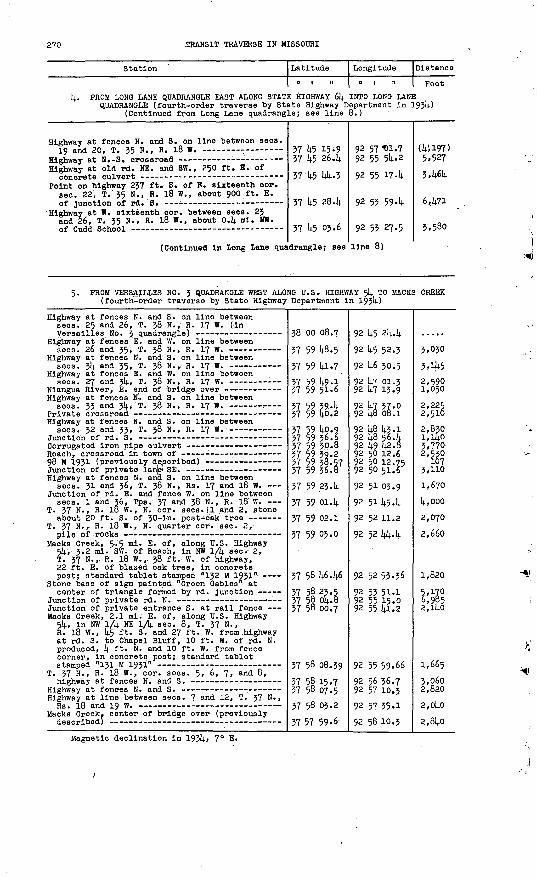
2?0 .TRANSIT TRAVERSE IN MISSOURI
Station Latitude
0 | 11
Longitude
0 1 .1
Distance
Feet
k. PROM LONO LANE QUADRANGLE EAST ALONG STATE HIGHWAY 61*. INTO LONG LANEQUADRANGLE (fourth-order traverse by State Highway Department In 193W
(Continued from Long Lane quadrangle; see line 8.)
Highway at fences N. and S. on line between sees.
Highway at N.-S. crossroad - - Highway at old rd. NE. and SW., 250 ft. E. of
Point on highway 237 ft. S. of E. sixteenth cor. sec. 22, T. 35 N., R. 18 W., about 900 ft. E.
Highway at W. sixteenth cor. between sees. 2? and 26, T. 35 N., R. 18 W., about 04 ml. BW.
(Continued In Long Lane qua
37 U5 15.9 37 U5 26.14.
37 14-5 W4--3
37 k5 284
37 1*5 03.6
drangle; see
92 57 t)l.7 92 55 5l*..2
92 55 174
92 53 594
92 53 27.5
line 8)
(I; 1, 197) 5,527
346k
6471
3,580
5. PROM VERSAILLES NO. 3 QUADRANGLE WEST ALONG U.S. HIGHWAY 5k TO MACKS CREEK (fourth-order traverse by State Highway Department In 193k)
Highway at fences N. and S. on line between sees; 25 and 26, T. 38. N., R. 17 W. (In
Highway, at fences E. and W. on line between sees. 26 and 35, T. 38 N., R. 17 W.
Highway at fences N. and S. on line between sees. 314. and 35, T. 38 N.,, R. 17 W.
Highway at fences E. and W. on line between
Highway at fences iN.:. and S. on line between
Highway at fences N. and S. on line between sees.- 32 and 33, T. 38 N., R. 17 W.
Highway at fences N. and S. on line between sees. 31 and 36, T. 38 N., Rs. 17 and 18 W.
Junction of rd. E. and fence W. on line between sees. 1 and 36; Tps. 37 and 38 N. , R. 18 W.
T. 37 N., R. l8 W., N. cor. sees. 11. and 2, stone
T. 37 N., R. 18 W., N. quarter cor. sec. 2,
Macks Creek, 5.5 ml. E. of, along U.S. Highway 514., 3.2 ml. SW. of Roach, In NW 1/fy see* 2, T. 37 N., R. 18 W.,. 38 ft. W. of highway, 22 ft. E. of blazed oak tree, In concrete post; standard tablet stamped "132 M 1931"
Stone base of sign painted "Green Gables, at
Junction of private entrance S. at rail fence Macks Creek, 2.1 ml. E. of, along U.S. Highway
5^, In NW lA NE lA sec. 8, T. 37 N., R. 18 W. , k5 ft. S. and 27 ft. W. from highway at rd. S. to Chapel Bluff, 10 ft. W. of rd. N. produced, k ft. N. and 10 ft. W. from fence corner, in concrete post; standard tablet
T. 37 N., R. 18 W., cor. sees. 5, 6, 7, and 8>
Highway at line between sees. 7 and 12, T. 37 N.,Rs. 18 and 19 W.
Macks Creek, center of bridge over (previously
38 oo 08.7
37 59 14.8.5
37 59 141.7
37 59 kg.l 37 59 51-6
37 59 394 37 59 fro. 2
37 59 ko.9 37 59 36.6 37 59 30.8 37 59 39.2 37 59 38.57 37 59 36.8
37 59.234
37 59 014
37 59 02.1
57 59 05.0
37 58 k6.k6
37 58 23.5 37 5§ Q&.B 37 58 00.7
37 58 08.39
37 5§ 15.7 37 58 07.537 58 05.2
57 57 59-6
92 k5 2l|.4
92 U5 52.3
92 1|.6 30.5
92 k7 01.3 92 14.7 13.9
92 k? 37.0 92 lj.8 08.1
92 kg 14.3.1 92 k8 56. k92 14.9 42.592 50 12.6 92 50 12.75 92 50 51.5
92 51 03.9
92 5H*54
92 5211.2
92 52 kk.k
92 5253.36
92 53 51.1 92 55 15.0 92 55 1(1.2
92 55 59.66
92 56 36.7 92 57 10.392 57 35.1
92 58 10.3
3,030
3,iJ+52,590 1,050
2,225 2,510
2,830 1,1/4.0 3,770 2,530
107 3,110
1,670
k,000
2,070
2,660
1,820
5 '17°6,9652,1^0
1,6653,060 2,8202,OkO
2,8kO
Magnetic declination in 193k, 7° E.

BART 2, SOUTH-CENTRAL MISSOURI, -1908-193? 271
STOUTLAND QUADRANGLE (Latitude 37?45'-38°00'; longitude 92°30<-92°45')
PROM VERSAILLES NO. 4 QUADRANGLE AT SEC. INTO LEBANON QUADRANGLE AT SEC. 20, T. In 1913)
29, T. 38 N.,'R. 16 W., SOUTH 35 N., R. 16 W. (by E. L. MoNalr
T-rd. W. T. 38 N., R. l6 W., quarter cor. between sees. J2
and 33 ̂ - T-rd. E. on line between sees. 4 and 33, Tps. 37
and 38 N., R. 16 -W. -7 Rd. at line between sees. 4 and 9, T. 37 Ni,
Deoaturvllle, 4«2 ml. N. of, along State Highway 5, In NW lA sec. 9, T. 37 N., R. 16 W.> 40 ft. E. of highway, 79 ft. N. of NW. corner of churchj Iron post stamped "Prim Trav Sta No 26 19113 Mo" -----
Crossroads on line between sees.* 8 and 17,
T-rd. S. on line between sees. 20 and 21,
Rd. at line between sees. 28 and 33, T. 37 N. , R. 16 W.
Decaturvllle, junction of rd. W. , 45° f fc - s - ofl
Decaturvllle, 1 ml. S. of, on line between sees. 4 an^ 55, Tps. 36 and 37 N., R. 16 W., about 550 ft. E. of State Highway 5, on Camden-Laelede county line, on W. side of old rd., 2 f.t. from fence, Iron post stamped
Bldwell, oak tree In center of rd., about 20 ft.
T-rd. W. T-rd. . N. T. 36 N., R. 16 W. , W: quarter cor. see. 18 .T. 36 N., R. 16 W., W. cor. sees. 18 and 19 ~ T. 36 N., R. l6 W. , W. quarter cor. sec. 19 T. 36 N., Rs. 16 and 17 W., cor. sees. 19, 24>
Eldridge, about 0.1 ml. E. of store and post office, 225 ft. N. and 10 ft. E. from stone at quarter cor. between sees. 25 and 30, T. 36 N., Ra. 16 and 17 W. , 15 ft. SB. of crossroads, 2 ft. from fence corner j Iron post stamped "Prim Trav Sta Nri 28 1913 Mo"
T. 36 N., Rs. l6 and 17 W. , cor.' sees. 25, 30,
T. 3° ". , R" l^ w > quarter cor. between sees; 50
T. 36 N., R. 16 W. S. quarter cor. sec. 31, stone, 318 ft. E of stone at N. quarter cor. sec. 6, T. 35 N. R. 16 W.
T-rd. W. and lane E. on line between sees; 17 and
T. 35 N., R. 16 W., eor. sees'. 17, 18, 19, and
38 02 22.0 57 59 25.0
37 59 18.1
57 58 51-8
57 57 59-6
37 57 41-70
57 57 08.1
57 55 51.5
57 54 29.9
57 54 23.2
57 55 57-50
57 52 14.2 57 52 05.6 57 51 55-4 37 51 28.2 37 51 02.0 57 50 55-7
57 50 09.5
37 49 45-47
37 49 17 .'o
57 49 15.9
37 48 23.7 37 46 50.0
37 46 24.1*7 liC M> .O
92 42 45.2 92 42 32.8
92 42 09.6
92 41 55-6
92 41 46.7
9. 42 03.70
92 42 31-4
92 42 15-9
92 42 01.5 92 4i 58.5
93 4i 58.00
92 42 28.3 92 42 58.9 92 45 46.1 92 44 40.1 92 44 4i.i 92 44 42.0
92 44 45-0
92 44 45.90 92 44 44-9 92 44 07.9
92 44 09.8 92 45 56.492 43 43-7O3 liX lit. V
li7,.'958
1,983
2,892
5,519
2,268
4,064
9,85:0:
6,314.0
712
4,655
8,764 1,21? 5,528 5,022 2,658 2,657
2,650
2,441
2,881
2,974
5,285 9,5592,814Z OC.-3
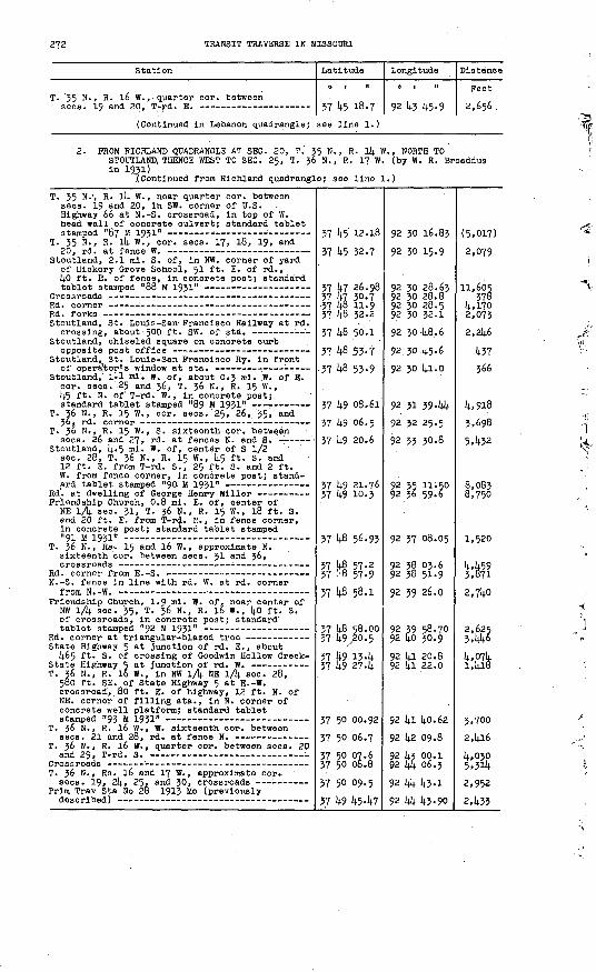
TRANSIT TRAVERSE IN MISSOURI
Station
T. 35 N. sees. 19
R. 16 W., quar and 20., T-rd.
ter cor. between E.
Latitude
O | M
37 45 18-7
Longitude
0 1 11
92 43 45-9
Distance
Feet
2,656 .
(Continued in Lebanon quadrangle; see line 1.)
2. PROM HIGHLAND QUADRANGLE AT SEC. 20, ?'. 35 N. , R. l4 W. , NORTH TO STOUTLAND, THENCE WEST TO SEC. 25, T. 36 N. , R. 17 W. (by W. R. Broaddus in 1931)
.(Continued from Richland quadrangle; see line 1.)
T. 35 N.', R. 14 W. , near quarter cor. between sees. 19 and 20, in SW. corner of U.S. Highway 66 at N.-S. crossroad, in top of W. head wall of concrete culvert; standard tablet
T. 35 N., R. 14 W., cor. sees. 17, 18, 19, and
Stoutland, 2.1 mi. S. of, in NW. corner of yard of Hickory Orove School, 51 ft. E. of rd., 40 ft. E. of fence, in concrete post; standard
Stoutland, St. Louis-San- Francisco Railway at rd.
Stoutland, chiseled square on concrete curb
Stoutland, St. Louis-San Pranolseo Ry. in front
Stoutland, lil ml. w. of, about 0.3 ml. W. of E. cor. sees. 25 and 36, T. 36 N., R. 15 W., 45 ft. N. of T-rd. W. , In concrete post;
T. 36 N., R. 15 W. , cor. sees. '25, 26, 35, and
T. 36 N., R. 15 W., S. sixteenth cor. between ' sees. 26 and 27, rd. at fences N. and S. - '
Stoutland, 4-5 ml. W. of, center of S 1/2 sec. 28, T. 36 N., R. 15 W., {4.5 ft. S. and 12 ft. E. from T-rd. S., 25 ft. S. and 2 ft. W. from fence corner, In concrete post; stand-
Friendship Church, 0.8 ml. E. of, center of NE lA sec. 31, T. 36 N., R. 15 W., 18 ft. S. and 20 ft. E. from T-rd. E., in fence corner, in concrete post; standard tablet stamped
T. 36 N., Rs. 15 and 16 W. , approximate N. sixteenth cor. between sees. 31 and 36,
N.-S. fence In line with rd. W. at rd. corner from N.-W. -
Friendship Church, 1.9 mi. W. of, near center of NW lA sec. 35, T. 36 N., R. 16 W. , 40 ft. S. of crossroads, in concrete post; standard
State Highway 5 at Junction of rd. E., about 465 ft. S. of crossing of Ooodwln Hollow Creek-
T. 36 N., R. 16 W., in NW lA NE 1/4 sec. 28, 580 ft. SE. of State Highway 5 at E.-W. crossroad, 80 ft. E. of highway, 12 ft. N. of NE. corner of filling sta., in N. corner of concrete well platform; standard tablet
T. 36 N., R. 16 W., W. sixteenth eor. between
T. 36 N. , R. 16 W. , quarter cor. between sees. 20
T. 36 N., Rs. 16 and 17 W. , approximate cor..
Prim Trav Sta No 28 1913 Mo (previously
37 45 12.18
37 k5 32.7
37 47 26.98 37 47 30.7 -37 U6 11.9 37 48 32.2
37 48 50.1
37 l»B .53-7
37 48 53-9
37 to 08.61
37 49 06.5
37 49 20.6
57 49 21.76 37 49 10-3
37 48 56.93
37 4§ 57-2 37 -'B 57-9
37 l»fi 58.1
37 48 58.00 37 49/20.5
37 49 13.14- 37 14-9 274
37 50 00.92
37 50 06.7
37 50 07.6 37 50 08.8
37 50 09.5
37 49 U5.14.7
92 30 16.83
92 30 15-9
92 30 28.63 92 30 28.8 92 30 28.5 92 30 32.1
92 30-14.8.6
92. 30 14.5-6
92 30 14.1.0
92 31 39.144
92 32 25.5
92 33 30.8
92 35 11-50 92 36 59.6
92 37 08.05
92 38 03.6 92 38 5L9
92 39 26.0
92 39 58.70 92 40 30.9
92 I;! 20.8 92 41 22.0
92 1*1 14.0.62 92 142 09.892 14.3 oo.i 92 Ik 06.392 44 U3.1
92 W4. 43.90
(5,017)
2,079
11,605 378
4,1702,0732,246
437
366
4,918 3,6985,432
8,083 8,750
1,520
4,459 3,8712,71*0
2,625 3,446l+,p74 1,418
3,700 2,4164,030 5*3il».2,952
2,433

PART 2, SOUTH-CENTRAL MISSOURI, 1908-1957 273
Station
3. PROM ELDRIDGE WEST INTO MACKS CREEK QUADR R. 17 W.' (by D. W. Weber In 1931)
Prim Trav Sta No 28 1913 Mo (previously
T. 36 N. , Rs. 16 and 17 W. , cor. sees. 19, 24,
(Continued In Macks Creek quadrang
Latitude
0 t "
ANGLE AT SEC
37 49 4547 37 50 09.5
le; see line
Longitude
o r . "
24, T. 56 N.
92 44 45-90 92 44 45.0
1.)
Distance
Feet
2,437
4. FROM HIGHLAND QUADRANGLE AT SEC. 31, T. 58 N., R. l4 W. , SOUTH TO SEC. 25, T. 56 N., R. 15 W. (by W. R. Broaddus In 1952)
T T 165 B 1952 (In Richland quadrangle; see
Wet Glalze. 5 ml. RE. of, In SE 1/4 SE 1/4 gee. 51, T. 56 N., R. 14 W., on S. side of rd. , in NE. corner of concrete porch of old store;
Wet Glalze, 1 ml. NE. of, In NE 1/4 sec. 24, T. 57 N., R. 15 W. , 12 ft. NE. of large spring, 8 ft. NW. of rd., in concrete wing wall of culvert; standard tablet stamped
Junction of private rd. to dwelling of W. Ash -
Wet Glalze, 2 ml. S. of, In SE 1/4 SW 1/4 sec. 36, T. 37 N. , R. 15 W. , 40 ft. SE. of rd., In center of large rock outcrop; standard tablet
T. 36 N. , R. 15 W. , W. sixteenth cor. sec. 11,
Stoutland, 4«6 ml. N. of, In NE 1/4 aec. l4, T. 36 N. , R. 15 W., 45 ft. N. of rd. to Wet Glalze, 50 ft. NE. of mall box of George Hlllhouse, In boulder; standard tablet
37 59 0844
37 56 44.08 37 57 59.7 37 57 37.2 37 56 57-0 57 56 52.8
57 55 52-20 57 55 18.1 37 54 46.8 37 54 38.0 57 54 32.9 37 53 58.4
37 55 56.07 57 53 26.0 37 52 49-7
37 52 10.7 37 51 32.3
37 51 31-11 37 51 16.8 37 50 50-9 37 50 37-5 37 49 58-5 37 49 27.7 37 49 08.61
92 29 58.50
92 30 08.85 92 30 22.3 92 50 18.3 92 50 30.9 92 50 43-0
92 51 23.67 92 31 564 92 31 56.1 92 31 51.9 92 51 46.4 92 51 56.7
92 51 4946 92 51 56.7 92 52 41.6
92 53 09.7 92 35 10.6
92 32 45-53 92 32 04.7 92 32 05.9 92 31 59-4 92 31 S9-8 92 31 49-5 92 31 39-44
3,471 4,6l6 2,504 4,187 2,629
4,819 4,916 3,163
3,575
2,4§4 1,166 5,i42
4,54o 3,892
2,017 ' 3.5822,620 1.470 3,924 3,228 2,095
5. PROM RICHLAND QUADRANGLE AT SEC. 31, T. 38 N., R. 14 W. , WEST INTO VERSAILLES NO. 4 QUADRANGLE ' AT SEC. 50, T. 58 N. , R. 16 W. (by W. R. Broaddua In 1932)
(Continued from Richland quadrangle; see line 2.)
T. 38 N. , R. l4 W. , quarter cor. between sees.
T. 38 N., Rsu 14 and 15 W., approximate S.
Toronto, 0.2 ml. S. of, In NE 1/4 SW 1/fy. sec. 25, T. 38 N., R. 15 W., 120 ft. NW. of' Junction of rd. to Montreal, In ledge; standard tablet
T. 38 N., R. 15 W. , center sec. 26, T-rd. (In
T. 34 N., R. 15 W., center sec. 34, Junction of
Toronto, 3.2 mi. SW. of, 0.2 ml. S. of center sec. 34, T. 38 N., R. 15 W. , at rd. corner from N.-W. , In line with rd. W. , In ledge; standard
Rd. forks on line between sees. 3 and 34,
T. 38 N., R. 15 W., S. cor. aecs. 35 and 54,
T. 38 N., R. 15 W., S. quarter cor. sec. 33, T-rd. N.
37 59 08.9 37 59 28.1
57 59 55-2
57 59 22.7
57 59 58.9938 oo 04.3 37 59 52.337 59 13.1
37 59 01.06
37 58 47-0
57 58 47-1T.1 Sft )i7.K
92 50 29.1 92 50 29.2
92 50 28.5
92 51 01.4
92 51 42.52
92 52 40-5 92 53 22.1
92 53 47.9
92 53 46.84
92 34 14-5
92.34 22.1
o? z), cc i
(4,070) 1,937729
2,919
4,928
4,373 3,548
4,473
1,220
2,634
605
3 U.n

21k TRANSIT TRAVERSE IN MISSOURI
Station
T. 38 N., R. 15 W. , S. cor. sees. J2 and 33,
T. 37 N., R. 15 W., N. cor. sees, k and 5, T-rd.
Montreal, S. sixteenth cor. between sees. Ij. and 5, T. 37 N., R. 15 W. , l).a ft. NW. of T-rd. W. , 130 ft. SW. of post office, In concrete post;
T. 37 N., R. 15 W., S. sixteenth cor. between
T. 37 N. , R. IS W., S. sixteenth cor. between
T. 37 N., R. 15 W., S. sixteenth cor. sec. 6
Montreal, 3.9 mi. NW. of, along County Route T, In NW lA SW lA sec. 36, T.' 38 N. , R. l6 W. , 600 ft. S. of bridge over Dry Auglaize Creek, 30 ft. NE. of mall box of H. P. Wilson, on E. side of rd. , in ledge; standard tablet stampedn Q*7 T31QX9" - __.-...._....___ __.._
T. 38 N. , R. l6 W. , center sec. 31)., fence corner
Camdenton, 2-5 ml. SE. of, along State Highway 5, in SW lA NE lA sec. 32, T. 38 N., R. l6 W. , 75 ft. N. of highway at rd. N. , in NE. head wall of concrete culvert; standard tablet
Camdenton, municipal water tower (in Versailles
Latitude
37 58 47-8
37 58 47.937 58 34-4
37 58 08.14.0
37 58 08.1
37 58 09.2
37 58 41-6
37 59 03.68V7 C.Q 1 ii X
37 59 08.637.59 16.1
37 5§ 51-1
37 59 25.7237 59 46.7
38 oo 25.51
Longl tude
92 35 28.5
92 35 30.992 35 31.6
92 35 33-llf
92 35 32-2
92 36 38-192 37 11.292-37 344
92 38 14.2.8592 38 46.792 39 39-892 39 53-2
92 4o 29.892 4o 45-o92 4i 52.9
92 [4.2 28.914. 92 43 29.492 U4 39-71
Distance
Feet
195.1.365
rjQ
5»277
2,656
3.503
4,313
1,123
4,290
1,308
2,9342 0 /r c
5,443s f ***+*/
4,4625.372
6,745
PROM HIGHLAND QUADRANGLE SOUTHWEST ALONG ST. LOUIS-SAN FRANCISCO RAILWAY TO SLEEPER (Originally run by G. T. Hawklns in 1897. Recomputed, with some additional positions, by E. L. McNalr in 1932.)
(Continued from Rlchland quadrangle; see line 5.)
R.R. at line between sees. 31
T. 35 N., R. 15 W. , cor. sees15 .... ... _-
and 36, T. 36 N. ,
10, 11, 11;, and
37 48 53-9
37 48 46.2in \ C. oQ i
37 45 38.3
92 31 19-192 33 37-1
92 33 34-192 35 34.6
17,809
240
FROM HIGHLAND QUADRANGLE AT SEC. }1, T. 37 N., R. ll+. W., WEST TO SEC. 36, T. 37 N., R. 15 W. (by J. P. Anderson in 1935)
(Continued from Richland'quadrangle; see line 6.)
8. FROM LEBANON QUADRANGLE AT SEC. 22, T. 35 T. 35 N. , R. 14 W. (by J. W. Fotherglll
(Continued from Lebanon quadrangle
U.S.C. & G.S. standard disk stamped "C 30 1935"- T. 35 N., R. 16 W., cor. sees. l4, 15, 22, and
T. 35 N., R. 16 Vf., cor. sees. 13, 114., 23, and
T. 35 N., R. 16 W. , S. sixteenth cor. see. 13,
Lebanon, 5 mi. N. and. 1.5 mi. E. from, along State Highway 5 and other rds., In NE lA NE lA sec. 24, T. 35 N., R. 16 W. , 20 ft. W. of N.-S. rd., 34 ft. S. and 96 ft. W. from SW. corner of dwelling of Floyd Gross, in concrete post; standard tablet stamped "1290
T. 35 N., R. 15 W. , W. sixteenth cor. between sees. 17 and 20, Junction of. lane N. and
37 53 55-3 37 54 04.737 54 15-837 54 00.837 53 36-07
N., R. 16 W. in 1935)
; see line 4..
37 45 15-73
37 45 41-7
37 45 4o-4'37 45 53-8
37 45 35-88 37 45 40.0
v? l.i; *fi.R
oo IT (T7 n
92 31 35-792 31 49-46
, EAST TO SEC
)
92 14.0 25.34
92 14.0 244
.92 39 13-4
92 38 39-9
92 38 07.67
Q? xA In _*
(2,256)
3,9082,7142,730
19,
(2,688)o £o£
5.707
3,016
3,163 2,374
Ii .finfl

PART. 2, SOUTH-CENTRAL MISSOURI, 1908-1937 275
Station '
T. 35 N., R. 15 W. , cor. sees. 16, 17, 20, and
Sleeper, St. Louis-San Francisco Ry. at ata. -- Sleeper, 0.2 ml. S. and 1 mi. E. from, near NE.
cor. sec. 21, T. 35 N., R. 15 W. , kO ft. NE. of rd, at curve from E.-SE., 22 ft. SW, of triangular-blazed l8-in. oak tree, in concrete post; standard tablet stamped "1291 ERA 1935"
Lebanon, 10 ml. NE. of, along U.S. Highway 66, about 200 ft, N. and 5 ft. E. from quarter cor. between sees. 23 and 2k, T. 35 N., R. 15 W. , 39 ft. S. and 5 ft. E. from highway at fences N. and S., 100 ft. NE. of old borrow pit, on S. side of highway, in concrete post; standard
Latitude
0 1 II
37 1*5 38.1 37 k5 38.8
37 14.5 32.ki 37 ^5 01.fi 37 k5 07.1
37 1*5 09-57 37 k5 22.7 37 k5 29-1; 37 1*5 12.18
Longitude
0 1 II
92 35 51.1 92 35 33-0
92 31* kk.ko 92 3l(. 13-7 92 33 1*1-9
92 32 30.67 92 31 £8.2 92 31 05.1 92 30 16.83
Distance
Feet
1*,031 1,^58
3,957 3,957 2,609
5,732 3,66k 3,52§ 4,251
^Magnetic declination 7^ E.
HIGHLAND QUADRANGLE (Latitude 37°1|.5 I -58 0 00 I ; longitude 92°15'-92 030')
Camden, Laclede,and Pulaski Counties
t
1. PROM DRYNOB QUADRANGLE AT SEC. 21, T. 35 N., R. ll* W., WEST INTOSTOUTLAND QUADRANGLE AT SEC. 20, T. 35 N., R. li* W. (by W. R. Broaddus in 1931)
(Continued from Dryhob quadrangle; see line 2.)
Station
U.S. Highway 66 at rd. S. to Abo, near filling
Latitude
O 1 II
37 lit; ill .7
Longitude
Q?
i ii
pq lli.li
Distance
Fest
ffl.npt;!
(Continued in Stoutland quadrangle; see line 2.)
2. FROM IBERIA QUADRANGLE AT SEC. 29, T. 38 N., R. ik W., SOUTHWEST INTOSTOUTLAND QUADRANGLE AT SEC. 31, T. 38 N., R. llj. W. (by W. R. Broaddus in 1932)
Wet Glaize, 6 mi. NE. of, near W. sixteenth cor. sec. 32, T. 38 N. , R. Ik W., 15 ft. N. and 95 ft. W. from Rlchland-Toronto rd. at rd. S. to Stoutland, in concrete post; standard
(Continued in Stoutland quadrangle
38 oo 01.7
37 59 08.30
; see line 5.
92 29 194
92 29 38.20
)
5,607

276 TRANSIT TRAVERSE IN MISSOURI
Station
3. PROM SEC. .32, T. 38 N., R. ll; W. , SOUTHEA W. R. Broaddus in 1932)
T. 38 N. , R. ll(. W. , quarter cor. between sees. 28
T. 38 N., R. ll; W., W. sixteenth cor. sec. 28,
Glover Ohapel, 2.8 ml. E. of, along rd. to Crockery In SB lA NE l/l; sec. y±, T. 38 N., R. ll; W. , 75 ft. E. of ford across Deane Creek, 20 ft. S. of rd., 10 ft. SW. of triangular- blazed tree, In concrete post; standard tablet
T. 38 N., R. Hi. W., N. sixteenth cor. between
Rd. at small drain In front of triangular-blazed
Junction of private rd. S. to dwelling of
Rd. at fence S. on Camden-Pulaskl county line T. 38 N., R. 13 W. , in SW I/I; SW 1/1; seo. 31,
15 ft. S. and 20 ft. W. from rd. fork NE. , 1; 5 ft. NE. of NE. corner of dwelling of J. C. Sears, in concrete post; standard tablet
Hawkeye, 125 ft- S. of post office, 20 ft. N. and 25 ft. W. from T-rd. E., in concrete post; standard tablet stamped "T T 168 B 1932" (in
T. 38 N., R. 13 W. , W, sixteenth cor. between sees. 20 and 29, TTrd. W. (in Iberia
T. 38 N., R. 13 W. , W. sixteenth cor. sec. 29,
T. 38 N., R. 13 W. , E. sixteenth cor. sec. 29,
Hawkeye, 2.8 mi. E. of, near quarter cor. between sees. 27 and 28, T. 38 N., R. 13 W., 150 ft. S. of rd. forks, l;5 ft. E. of rd., in concrete post; standard tablet stamped "T T
T. 38 N., R. 13 W., quarter cor. between sees. 27
Junction of Crocker-Hawkeye and Rlchland rds. - T. 37 N., R. 13 W., about 600 ft. W. of quarter
cor. between sees. 3 and 1|, 33 ft. S. and 20 ft. E. from crossroads, In concrete post;
T. 37 N., R. 13 W., cor. sees. J, k> 9, and 10,
T. 37 N., R. 13 W., cor. sees. 9, 10, 15, and l6,
T. 37 N., R. 13 W. , quarter cor. between sees. 10 and 15, 55 ft. S. and 25 ft. E. from T-rd. S., in concrete post; standard tablet stamped "T T
Swedeborg, St. Louis-San Francisco Ry. in front
Swedeborg, in NW 1/1). sec. 26, T. 37 N., R. 13 W. , 280 ft. W. of St. Louis-San Francisco Ry. sta., 86 ft. S. of post office, 23 ft. N. and 130 ft. W. from N. track at rd. crossing, in concrete post; standard tablet stamped "129 M 1931" ----
Latitude
ST'TO SWEDEBC
37 59 08.30
37 59 59-5
37 59 59-3 37 59 U9-6 37 59 34.0
37 59 17-14;
37 59 18.0
37 58 534
37 5§ L5-3 37 58 l;5-5
37 58 1;0.97 37 59 33.0 37 59 Ul-8
38 00 21.11
38 oo 20.9
37 59 5l;.U
37 59 5U-3
37 59 52.10
37 59 53.6 37 50 01.3 37 58 53.3
37 58 05.53
37 57 39-6 37 57 13.2 37 56 5k-5
37 56 ltf.0
37 56 ltf.70 37 55 57.8 37 55 52.1; 37 55 31.1 37 55 Ol.O 37 5k 57-137 5k 1*9-1
37 5k- 1;9«75
Longitude
o i n
RG (by
92 29 38.20
92 28 1;8.7
92 28 31-8 92 27 59-1 92 27 21.6
92 26 1*2.65
92 26 36.1;
92 25 1;5.0
92 25 31.0 92 2k 28.6
92 2k 21.21 92 23 57.2 92 23 37.2
92 23 37.15
92 23 03.1 92 23 03.692 22 30.6
92 21 Ol;.87
92 21 06.1 92 21 21;. 3 92 21 21;. 8
92 21 11^.71
92 21 07.6 92 21 16.1; 92 21 26.7
92 21 09.0
92 20 35.37 92 20 06.2 92 20 02.1 92 19 L6.5 92 19 1»8.9 92 19 50.1
92 19 53.0
92 19 56.73
Distance
Feet
6,521
1,355 2,793 3,387
3.5M;
503
U,8o6 .
1,393 U.99U
, 7U8 6,329 890
3,979
2,680
2,0*5
6,861
182H8J
1;,896
2,686 2,757 2,067
1,613
2,6935,m
645 2,$9 3,pl;9
14.10
837
301

PART 2, SOOTH-CENTRAL MISSOURI, 1908-1937 277
Station
4 4 FROM IBERIA QUADRANGLE SOUTH ALONG STATE W. R. Broaddus in 1932)
Crocker, 2-7 mi. N. of, along State Highway 17, in NE 1/k sec. 32, T. 38 N., R. 12 W. , 70 ft. E. of rd. junction, 15 ft. 3. of rd. , 2 ft. Inside fence, in concrete post; standard tablet
Crocker, l60 ft. SW. of St. Louis-San Francisco Ry..3Jta., in concrete ;f pots tone at entrance to Crocker State Bank; standard tablet stamped
Crocker, St. Louis-San Francisco Ry. in front of
Latitude
0 1 II
HIGHWAY 17 TC
38 00 02.6 37 59 45-5 37 59 27.2
37 59 05.74 37 5§ 51-9 37 5§ 134 37 58 p4.2' 37 57 47.2
37 56 56.10
37 56.56.4
Longitude
o t "
CROCKER (by
92 15 43.6 92 15 37'. 6 92 15 32-4
92 15 37 :.'65 92 15 39.7 92 15 27.7 92 15 23.8 92 15 38.5
92 15 50.02
92 15 474
Distance
Feet
1,820 1,871
2,214 1,4134,oo4
984 2,087
5,246
209
5. FROM CROCKER SOUTHWEST- ALONG ST. LOUIS-SAN FRANCISCO RAILWAY INTO STOUTLAND QUADRANGLE (Originally run by 0. T. Hawklns in 1897. Recomputed, with some additional positions, by E. L. McNair In 1952.)
Crocker, R.R. in front of operator's window at
R.R. at line between sees. 19 and 24, T. 37 N.,
T. 37 N., R. 13 W., cor. sees. 22, 23, 26, and
T. 36 N., R. 13 W., cor. sees. 7, 8, 17, and 18,
T. 36 N. , R. 14 W., cor. sees. 20, 21, 28, and
(Continued in Stoutland quadrangle
37 56 56.4 37 56 48.7 37 55 56.4 37 55 27-437 55 Ok. 6 37 55 06.7 37 54 49-137 55 01.3 37 52 27.1 37 51 33-0
37 51 33-7 37 51 20.2 37 51 27-0 37 50 20.0 37 49 44.2
37 49 55-1
; see line 6.
92 15 474 92 15 50.0 92 15 43.8 92 16 53-8
92 17 53-2 92 18 49.8 92 19 53.0
92 20 05.1 92 22 37-7 92 23 01.7
92 23 28.392 24 13.692 24 22.6 92 26 39.0 92 29 00.4
92 29 00.4
800 5,314 6,339
5,291 4,551 5409
1,527 19,807 5,806
2,130 3,880
965 12,867 11,921
1,120
6. FROM WAYNESVILLE QUADRANGLE AT SEC. 33, T. 38 N., R. 12 W., WEST ALONG ROADS TO SEC. 32, T. 38 N., R. 12 W., THENCE SOOTH ALONG STATE HIGHWAY 17 TO SEC. 20, T. 37 N., R. 12 W., THENCE SOUTHWEST ALONG COUNTY ROUTES B AND A TO HIGHLAND, THENCE NORTHWEST ALONG ROADS INTO STOUTLAND QUADRANGLE AT SEC. 31, T. 37 N., R. 14 W. (by H. W. Gross and J. P.- Anderson In 1935)
(Continued from Waynesville quadrangle; see line 7.)
T. 38 N., R. 12' W., S. cor. sees. 32 and 33,
Junction of County Route C (previously described)
Crocker, R.R. in front of operator's window at
D.S.C. & G.S. standard disk stamped '"R 31 1934"- T. 37 N. , R. 12 W. , quarter cor. between sees. 19
Swedeborg, 2.7 mi. NE. of, along. St. Louis-San Francisco Ry. , in SE !/!(. NW 1/4 sec; 19, T. 37 N. , R. 12 W., 55 ft. S. of track, 180 ft. S. and 115 ft. W. from curve in County Route B, 3 ft. S. of fence; in concrete post;
T. 37 N. , R. 13 W. , E. cor. sees. 24 and 25, stone in N.-S. fence, 179 ft. N. of stone at fence corner at W. cor. sees. 19 and 30, T. 37 N., R. 12 W., about 600 ft. S. of
T. 37 N. , R. 13 W. , cor., sees. 23, 24, 25, and
37 59 05.77
37 5g 27.0 37 58 04.1 37 57 47-2 37 57 19-8 37 56 56.10
37 56 5,64 37 56 14-3 37 55 27.15
37 55 23.2
37 55 26.51
37 54 59.8 37 55 00.2
92 15 37.80
92 15 35-5 92 15 23.9 92 15 38.6 92 15 51.8 92 15 50.02
92 15 474 92 15 49.5 92 16 50.90
92 16 45-9
92 17 27.46
92 17 53-8
92 18 59-3
(4,413)
3,9jl 2,488 2,073 2,972 2,398
214 4,260 0,838
567
3,345
3,433 5,248

278 TRANSIT TRAVERSE IN MISSOURI.
Station
Swedeborg, St. Louis-San Francisco Ry. in front of operat6r's window at sta. (previously
T. 37 N., R. 13 W., in sec. 29, 1.2 mi. N. of St. John, 30 ft. N. and 30 ft. E. from County Route B at rd. N., in concrete post; standard
Rlchland, 3 ml. NE. of, in SE 1/4 sec. 5, T. 36 N., R. 13 W. , 30 ft. S. and 50 ft. E. from County Route B at rd. E. , 3° ft- w - of St. Louis-San Francisco Ry.. in concrete post;
Rlchland, at E. limits of, highway at fence S. Rlchland, R.R. at sta. (previously described)
U.S.C. & G.S. standard disk stamped "J 31 1934"- Richland, 0.6 ml. W. of, along rd. to Wet Glaize,
in SE 1/4 sec. 12, T. 36 N. , R. Ik W. , 100 ft. NW. of three tanks belonging to Shell Oil Company, 60 ft. N. of rd. , In concrete post;
T J n . _ -. -____
Rlchland, 3.6 mi. NW. of, along rd. to Wet Glaize, in SE 1/4 aec. 3, T. 36 N., R. Ik W. , 100 ft. N. of Beulah Church, 4° ft. S. of rd. , in concrete post; standard tablet stamped
T wi w « __.. _- _.__«
Richland, 6.5 ml. HW. of, along rd. to Wet Glaize, in SW lA sec. 32, T. 37 N. , R. Ik W. , 25 ft. SW. of rd., In front yard of Clyde Gideon, in concrete post; standard tablet
(Continued in Stoutland quadrangle
Latitude
O 1 It
37 55 pl.5 37 54 49.75-
37 54 49-1 37 54 55-6 37 54 37-9
37 5k 30.21 37 54 07.5 37 53 37-5 37 53 10-9
37 52 37-39 37 52 24-9 37 51 33.3 37 51 33-7 37 51 26.0 37 51 27.0 37 51 26.7 37 51 28.24
37 51 36.11 37 51 38.1 37 52 15-0 37 52 41-8
37 52 43-53 37 52 58.0 37 53 10.2 37 53 25.3
37 53 40.08
; see line 7-
Longitude
92 19 16.3 92 19 56-73
92 19 53-0 92 20 22.0 92 22 00-5
92 22 23.27 92 22 34-9 92 22 53.9 92 22 34-9
92 22 27.84 92 22 kO.2 92 23 04.0 92 23 2§.3 92 23 k5.2 92 24 22.6 92 24 18.7 92 2k 23.92
92 24 58.04 92 25 22.992 25 kO.l 92 26 27.2
92 27 10.35 92 28 06.5 92 28 36.4. 92 29 ok. 7
92 29 ko.68
)
Distance
Feet 1,370 3,447
305 2,412 8,09k
1,987 2,479 3,398 3,090
3,440 1,605 5,555 1,953 1,474 3,00;5m2,852 2,003 3,983 4:656
5 -,k6l 4,734 2,695 2,741
3,251
7. FROM CROOKER SOUTH ALONG STATE HIGHWAY 17 INTO WAYNESVILLE QUADRANGLE (by J. P. Anderson In 1935)
Crossroad on line between sees. 20 'and 21,
(Continued in Waynesvllle quadrang
37 ,56 56.10 37 56 lL3 37 55 46-3
37 55 24-7 37 55 03.8 37 54 41-9
le; see line
92 15 50.02 92 15 W-8 92 16 01.592 15 40-4 92 15 24.2 92 15 12.9
5-)
4,223 2,980
2,766 2,482 2,391
FROM WAYNESV1LLE QUADRANGLE SOUTHWEST ALONG U.S. HIGHWAY 66 TO SEC. 8, T. 35 N., R. 12 W., THENCE SOUTHEAST ALONG ROADS INTO DRYNOB QUADRANGLE AT SEC. 21, T. 35 N., R. 12 W. (by J. P. Anderson and H. W. Gross In 1935)
(Continued from Waynesvllle quadrangle; see line 9«)
Buckhorn, in NW 1/4 NE lA sec. 8, T. 35 N. , R. 12 W., 150 ft. SW. of store, k8 ft. N. and 24 ft. W. from U.S. Highway 66 at rd. N. , 2 ft. N. of fence, in concrete post; standard tablet
Junction of County Route P, near cor. sees. 7, 8, 17, and 18, T. 35 N. , R. 12 W.
T. 35 N., R. 12 W. , W. sixteenth cor. between sacs. 8 and 17, Iron pin at rd. corner fromW o
T. 35 N. , R. 12 W., cor. sees. 16, 17, 20, and
25 B 1925 Mo (In Drynob quadrangle; see line 3.)-
37 47 10-7
37 k7 00.3337 k6 36-1
37 46 12.1
37 46 11.737 45 37-6
37 45 18.437 44 45-33
92 15 10.1
92 17 01. k
92 16 kk.392 16 17.1
92 15 55-8 92 15 16.81
(3,965)
4,9313,540
2,884
1,372k,080
2,590 4,5»3
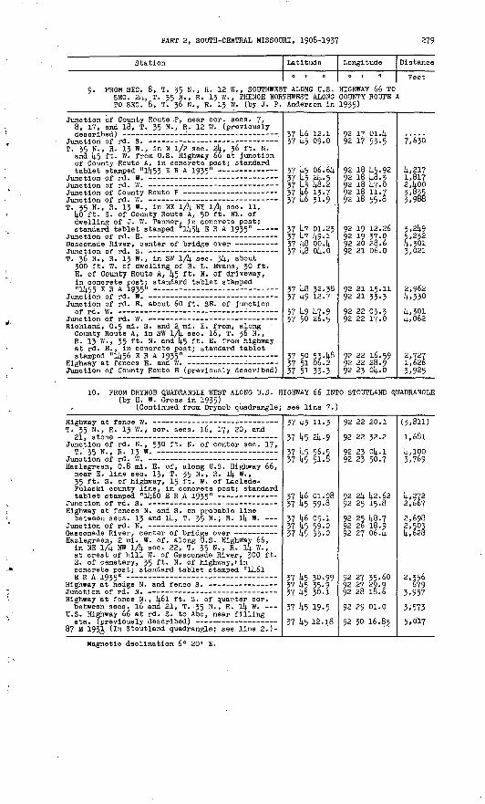
PART 2, SOUTH-CENTRAL MISSOURI, 1908-1937 279
Station Latitude
0 | II
Longitude
0 , .1
Distance
Feet
PROM SEC. 8, T. 35 N., R. 12 W., SOUTHWEST ALONG U.S. HIGHWAY 66 TO SEC. 2l(., T. 35 N., R. 13 W., THENCE NORTHWEST ALONG COUNTY ROUTE A TO SEC. 8, T'. 36 N., R. 13 W. (by J. P. Anderson In 1935)
Junction of County Route P, near cor. sees. 7» 8, 17, and 18, T. 35 N. , R. 12 W. (previously
T. 35 N., R. 13 W., in N 1/2 sec. 2k, 36 ft. N. and 45 ft. W. from U.S. Highway 66 at junction of County Route A, in concrete post; standard
T. 35 N., R. 13 W., in NE 1/1). NE lA sec. 11, 40 ft. S. Of County Route A, 50 ft. NE. of dwelling of J. W. Tanner, in concrete post;
T. 36 N., R. 13 W. , in SW 1/k sec. 3k, about 300 ft. W. of dwelling of B. L. Evans, 30 ft. E. of County Route A, 45 ft. N. of driveway, in concrete post; standard tablet stamped"1455 ERA 1935"
Junction of rd. E. about 60 ft. SE. of Junction
Richland, 0.5 mi. S. and 2 ml. E. from, along County Route A, in SW 1/4 sec. 16, T. 36 N., R. 13 W., 35 ft. N. and 45 ft. E. from highway at rd. E., In concrete post; standard tablet
J*unction of County Route B (previously described)
37 45 09.0
37 45 06. 6k37 45 2k- 537 45 48.2
37 46 31.9
37 47 01.2337 47 49-137 48 oo. k37 48 ok.o
37 48 33.3837 49 12.7
37 49 47-9
37 50 534837 51 06.237 51 33-3
92 17 53-5
92 18 45.9292 18 48. 392 18 14.7-0
92 18 55.8
92 21 06.0
92 21 33.3
92 22 03.3
92 22 16.59
92 23 Ok.O
7,630
4,217
z'qftfi
3,2495,2324,3013,021
4,330
4,3014,062
1,6263,925
10. PROM DRYNOB QUADRANGLE WEST ALONG U.S. HIGHWAY 66 (by H. W. Gross in 1935)
(Continued from Drynob quadrangle; see line
INTO STOUTLAND QUADRANGLE
7')
T. 35 N., R. 13 W. , cor. sees. 16, 17, 20, and
Junction of rd. N. , 530 ft. N. of center sec. 17,
Hazlegreen, 0.8 mi. E. of, along U.S. Highway 66, near E. line sec. 13, T. 35 N. , R. Ik W. , 35 ft. S. of highway, 15 ft. W. of Laclede- Pulaskl county line, In concrete post; standard
Highway at fences N. and S. on probable line between sees. 13 and Ik, T. 35 N. , R. 14 W.
Gasconade River, center of bridge over _--- Hazlegreen, 2 ml. W. of, along U.S. Highway 66,
in NE 1/4 NW l/4j. sec. 22, T. 35 N. , R. 14 W. , at crest of hill W. of Gasconade River, 300 ft. E. of cemetery, 35 ft. N. of highway, tin concrete post; standard tablet stamped "l46l
Highway at fence N. , 46l ft. S. of quarter cor. between sees. 16 and 21, T. -35 N., R. 14 W.
U.S. Highway 66 at rd. S. to Abo, near filling
87 M 1931, (In Stoutland quadrangle; see line 2.)-
37 45 11-3
37 45 24-9
37 45 56.5 37 45 51-8
37 46 01.08 37 45 59-8
37 46 05.1 37 45 59-0 37 45 33-0
37 45 30.99 37 45 35-9 37 45 30.1
37 45 19-5
37 45 12.18
92 22 20.1
92 22 32.2
92 23 04.1 92 23 50.7
92 24 42.62 92 25 15.892 25 48.7 92 26 18.9 92 27 06.4
92 27 35-60 92 27 29.9 92 28 18.6
92 29 oi.o 92 30 16.83
(3,811)
1,681
4,1003,769
4,2722,6672,698 2,503 4,628
2,356679
3,957
3i573 5,017
Magnetic declination 6" 20' E.

280 TRANSIT TRAVERSE IN MISSOURI
WAYNESVILLE QUADRANGLE (Latitude 37°1|.5 I -38°00'; longitude 92°00'-92°15')
Phelpa and Pulaskl Counties
1. PROM ROLLA QUADRANGLE AT SEC. 26. T. 38 N., R. 10 W., SOUTHWEST TO PRANKS (by J. R. Bills In 1908}
(Continued from Rolla quadrangle} see line 1.)
Station
Dixon-Rolla rd. at rd. NW. near dwelling of
Corner at tree on Phelps-Pulaskl county line, about O.J ml. SW. of dwelling of A. N. Duncan -
Pranks, at W. limits of, St. Louis-San Francisco
Franks, S. rail of St. Louis-San Francisco Ry. at
Pranks, St. Louis-San Francisco Ry. at rd.
Latitude
0 1 11
57 58 51.3
37 58 21.6
37 58 254 57 57 56-1
37 57 18.0
37 57 17-5
37 57 11-7
Longitude
0, | II
92 oo 06.7
92 oo 59.6
92 01 ll|.. 8 92 01 37.1
92 02 23.8
92 02 22.7
92 02 13.1
Distance
Feet (2,914.0)
5.193
1,276 3,Uo
5.371
102
968
2. PROM ROLLA QUADRANGLE AT SEC. 26, T. 37 N. , R. 10 W., SOUTH INTO ROLLA . QUADRANGLE AT SEC. llj., T. 35 N., R. 10 W. (by J. R. Bills in 1908)
(Continued from Rolla quadrangle; see line 2. )
Rd. forks at N. end of lane Just N. of
Clementine, at post office, lj.0 ft. N. and 30 ft. E. from quarter cor. between sees. 3 and 10, T. 36 N. , R. 10 W., lj.0 ft. N. and 15 ft. E. from T-rd. W. , In 30- by llj,- by 8-ln. sand stone; aluminum tablet stamped "Prim Trav Sta
T. 36 N., R. 10 W., cor. sees. 10, 11, llj.. and
T-rd. E. on line between sees. 11 and lij.,
Arlington-Spring Creek rd. at Junction of rd. NW.
T. 36 N., R. 10 W., E. quarter cor. s|ec. 27 -- T. 36 N., R. 10 W., cor. sees. 26, 27, $±, and
Rd. forks, 15 ft. E. of blazed black-oak tree T. 35 N., R. 10 W. , cor. sees. 3, l±, 9, and 10,
Spring Creek School, in SW. corner of school- house; aVuminum tablet stamped "Prim Trav Sta
Black-oak tree at NW. corner of field near
(Continued in Rolla quadrangle; se
37 52 50.5
37 51 58.33
37 51 05.2
37 51 05.1
37 50 02.6 37 W 5l*. 7
37 W 28 ;0 37 14-7 56.5
37 14-6 14.5.2
.37 U5 51-1
37 U5 25.1
e line 3.)
92 oo 57.7
92 oo 50.37 92 oo 18.9 92 oo 15.0 92 oo 05.592 00 18.1
92 oo 17.2 92 oo 33.0
92 01 28.7
92 00 514.. 7
92 oo 15.7
(8,59D
5.312
5,935 313
6; 3686,9l;i
2,702 3,14.26
8A87
6,119
14-.085

PART 2, SOOTH-CENTRAL MISSOURI, 1908-1937 281
Station Latitude
0 , 11
Longitude
0 t "
Distance
Feet
PROM BIO PINEY QUADRANGLE AT SEC. 22, T. 35 N., R. 10 W., WEST INTO BIG PINEY QUADRANGLE AT SEC. 23, T. 35 N., R. 11 W. (by R. H. Parker In 193k)
(Continued from Big Plney quadrangle; see line 2.)
Spring Creek, 800 ft. W. of post office, in HE lA sec. 16, T. 35 N., R. 10 W. , 28 ft. S. of NW. corner of cemetery, 2 ft. E. of fence W. , in concrete post; standard tablet
NW. corner of barn with s.tphe foundation
E. side of wooden silo on farm of J. P. Graham, jr . . .__-_ -
Tribune, 1 mi. N. and 3 ml. E. from, In SE 1/14. SE lA sec. 18, T. 35 N., R. 10 w., 0.8 ml. SW. of ford across Plney Creek, on point of hill, 85 ft. HE. of drain, kO ft. N. and 15 ft. above rd. at curve, in vertical face of limestone ledge; standard tablet stamped
Upstream end of corrugated Iron pipe culvert Tribune, 1.8 ml. N. of, N. sixteenth cor. between sees. lij. and 15, T. 35 N., R. 11 W., 70 ft. NW. of church, 18 ft. S. and 18 ft. E. from T-rd. E. , in concrete post; standard
T. 35 N., R. 11 W., S. sixteenth cor. between
(Continued In Big Plney quadrangle
37 1*5 14.7.07
37 1+5 55-5
37 k5 1+2-8
37 1*5 10-02 37 k5 32-2 .37 k'5 5^-0 37 1*5 56.8 37 U6 13-2 37 14.6 114
37 14.5 k8.6i
37 1+5 22-5
; see line 2.
92 01 32.9792 02 30.2
92 03 23.1
92 03 58.50 92 ok kz-9 92 05 16.3 92 05 14.9.0 92 06 09.6 92 06 14.7.6
92 07 01.714.
92 07 02.5
)
(8,088)
k,614
k,38l
k, 366£,lik 34762,631* 2,3^7 3,057
2,571;
2,6ko
k. PROM TAVERN QUADRANGLE SOOTH ALONG STATE HIGHWAY 133 TO JUNCTION OP COUNTY ROOTS C, THENCE EAST ALONG COUNTY ROUTE C TO DIXON, THENCE NORTHEAST ALONG STATE HIGHWAY 28 INTO TAVERN QUADRANGLE (by L. D. Dumm In 19314.)
T. 38 N., R. 11 W., quarter cor. between sees. 15 and 22, crossroad (in Tavern
Center, of triangle at Junction of County Route C-
Dixon, at SW. corner of park, 14.0 ft. N. and 75: ft. E. from street intersection, 3 ft. Inside of walk, In concrete post; standard tablet
Center of triangle formed by wye of St. Louis-San
Center of triangle at Junction of .rd. E. to
38 oo 14.9.2 37 59 5,6-8 37 59 5^.9
37 59 36-39
37 59 50.2 37 59 55-6 37 59 51-3
37 59 56-6 58 00 09.0
92 07 17.0 92 07 17.5 92 06 32.0
92 05 59.33
92 05 10.992 ok 31.2 92 oli 15.892 03 37.3 . 92 03 28.8
5)295 3,650
3,219
U,H9 3,230 1,305
3,130 1,1+20
PROM HIGHLAND QUADRANGLE SOUTH ALONG STATE HIGHWAY 17 TO SEC. 33, T. 37 N., R. 12 W., THENCE SOUTHEAST ALONG OLD STATE HIGHWAY 1? TO SEC. Ik, T. 36 N., R. 12 W., THENCE SOUTHEAST ALONG STATE HIGHWAY 17 TO WAYNESVILLE, THENCE EAST ALONG U.S. HIGHWAY 66 TO SEC. 13, T. 36 N., R. 11 W., THENCE NORTH ALONG STATE HIGHWAY 28 TO DIXON (by J. P. Anderson in 1935)
(Continued from Richland quadrangle; see line 7.)
Crocker, 14. ml. S. of, along State Highway 17, 100 ft. S. of Junction of old rd. to Waynes- ville, 30 ft. E. of old rd. , in concrete post; standard tablet stamped "114.50 ERA 1935"
Waynesvllle, 14.. 8 mi. N. of, along rd. to Crocker, In NW lA SE lA sec. 3, T. 36 N. , R. 12 W. , 0.3 ml. NW. of bridge over Gasconade River, 14,5 ft. NW. of rd. forks, In' top of stone post;
Waynesvllle, 2.J ml. N. of, along rd. to Crocker, In SE lA #E lA sec. Ik, T. 36 N., R. 12 W. , 150 ft.' SE. of entrance to cave at Krapf Resort, 25 ft. N. and 15 ft. W. from NE. corner of building, 33 ft« above rd., in stone ledge;
37 53 14.9.14.
37 53 18.22 37 52 U2.8 37 52 29.6
37 52 33-78 37 52 10.7 37 51 14.84
37 51 07.22
92 Ik 58.9
92 Ik 55.9!; 92 Ik 04.7 92 Ik 05.3
92 13 50.50 92 13 22.5 92 13 38.1
92 12 k3.01
(5430)
3,l625451 1,333
1,2593,4o2,573
6,07k

282 TRANSIT TRAVERSE IN MISSOURI
Station
Waynesvllle, at S. entrance to courthouse, In E. side of footstone; standard tablet stamped"5 B 1925 Mo" -
Waynesvllle. 3 ml. E. of, along former State Highway 14, In NE 1/4 sec. 29, T. 36 N., R. 11 W., 0.2 ml. W. of stone garage, 240 ft. S. of U.S. Highway 66, 20 ft. N. of old Highway l4, 20 ft. SW. of old foundation of dwelling, In top of stone post; standard
Waynesvllle, 5.7 mi. E. of, along U.S. Highway 66, In SE 1/4 SW 1/4 sec. 23, T. 36 N. , R. 11 W., 10 ft. N. and 45 ft- E. from junction of rd. S., in concrete post; standard tablet
Highway at E.-W. line through center sec. 23,
T. 36 N., R. 11 W., cor. sees. 13, 14, 23, and
Stone, probably N. sixteenth cor. sec. 1,T zA W T3 1 1 W
Tps. ;6 and 37 N. , Rs. 10 and 11 W. , cor. of,
Dlxon, 9 ml. S. of, along State Highway 28, in SE 1/4 SE 1/4 sec. 36, T. 37 N. , R. 11 W.,
" 0-7 mi. SE. of bridge over Gasconade River, 800 ft. S. of highway, 540 ft. H. of dwelling of Dave Spaldlng, 75 ft. W. of old highway, 5 ft. W. of fence, In top of stone post; standard tablet stamped "14 B 1925 Mo" (This
T. 37 N., R. 11 W. , cor. sees. 23, 24, 25, and
Dixon, 6 mi. S. of, along State Highway 28, in SE 1/4 sec. 23, T. 37 N., R. 11 W. , 85 ft. SW. of highway at dim rd. SW. down river bluff, 10 ft. W. of dim rd. at gate, in top of stone post; standard tablet stamped "10 B 1925 Mo" '
Junction of rd. W. on line between sees. 14 and23, T. 37 N., R. 11 W. -
Dixon, 3 mi. S. of, along State Highway 28, near W. sixteenth cor. between sees. 1 and 12, T. 37 N., R. 11 W. , 270 ft. S. of highway at rd. E. , in top of W. head wall of concrete , culvert; standard tablet stamped "11 B 1925
Highway at fences E. and W., 174 ft. W. of N.
Latitude
0 | II
37 50 37-5 37 50 08.0
37 49 44.34 37 49 40-5 37 49 42-3 37 49 -15.0
37 49 14-34 37 49 18.2 37 49 24.6 37 49 25.6
.37 49 33-79
37 49 57-037 50 21.3 37 50 26.4 37 51 00.4 37 51 16-9 37 51 44-5
37 52 39-7
37 52 53-9
37 53 03^69 37 53 30.9 37 54 01. S 37 54 27.8
37 54 39-9
37 54 53.23
37 55 32.4 57 5b 34-3
37 57 13-53 37 57 50.8
37 58 08.5 37 59 po. o 37 59 40.2 37 59 36.39
Longitude
0 t II
92 11 46.6 92 11 38.0
92 12 04.25 92 11 22.292 10 43.492 09 21.6
92 09 07.5392 08 42.592 08 12.6 92 07 58.4
92 06 22.22
92 05 55.2
92 05 45-592 05 37.992 05 42.1 92 05 42.2 92 05 oo.i92 05 05.2 92 04 36.1
92 04 39.30 92 04 53.3 92 05 32.0 92 05 37-992 05 41.0
92 05 54.1892 05 57.0 92 05 24.1
92 05 27-35 92 05 24.0
92 05 43-2 92 05 36.1 92 05 37.8 92 05 59.33
Distance
Feet 5,432 3,059
3,194 3,392 3,ll8 7,132
1,127 2,044 2,491 1,140
7,763
3,1972,578
7945'^7 1,8644,260
5,603
2,743
1,0232,97.2 4,363 2,704
1,248
1,716
3,965. 6,797
3,978 3,785
2,356 5,237 4,067 1,762
6. PROM SEC. 16, T. 35 N., R. 10 W. , SOUTH INTO BIG PINEY QUADRANGLE AT SEC. 22, T. 35 N., R. 10 W. (by H. W. Gross in 1935)
T. 35 N., R. 10 W., quarter cor. between sees. 15
(Continued In Big Piney quadrangle
37 45 47-0737 45 26.5 37 45 02.7
; see line 7«
92 01 32.97
92 01 30.8 92 01 28.4
)
2,087 2,412

PART 2, SOUTH-CENTRAL MISSOURI, 1908-1937 283
Station
7.' PROM DIXON WEST INTO HIGHLAND QUADRANGLE (by"H. -W. Gross in 1935)
T. 38 N., R. 11 W., cor. sees. 22, 23, 26, and
U.S.C. & G.S. standard disk stamped "Y 31 1934"-
Helm, 0.7 mi. NE. of, near center of SW 1/4 sec. 28, T. 38 H., R. 11 W. , 47 ft. S. of St. Louis-San Francisco Ry. at crossing of private lane, 28 ft. W. of rd. corner, 3 ft. S. of fence corner, in concrete post; standard
Helm, St. Louis-San Francisco Ry. at rd. crossing
U.S.C. & G.S. standard disk stamped "W 31 1934"- Hancock, near line between sees. 30 anc* 31,
T. 38 N., R. 11 W., 125 ft. SW. of St. Louis- San. Francisco Ry. sta*, 95 ft. W. of rd. crossing, 5 ft. E-. of fence corner, in concrete post; standard tablet stamped "20 B ,
Hancock, St. Louis-San Francisco Ry. In front of
T. 38 N. , R. 12 W. , E. cor. sees. 25i_anfl 36,
T. 38 N. , R. 12 W., center sec. 25, Junction' of
Hancock, 3 mi. W. of, about 0.3 ml. W. of center sec. 26, T, 38 N. , R^ 12 W. , 0.4 mi. E. of creek, 620 ft. W. of T-rd. N. on top of hill, on W. slope of .hill, 13 ft. N. of rd. , 3 ft. from fence, in top of limestone ledge;
T. 38 N. , R. 12 W. , center sec. 27, T-fence W. ,
T. 38 N., R. 12 W., center of SW 1/4 sec. 27,
(Continued in Rlchland quadrangle;
Latitude Longitude
0 I II 0 | II
AT'SEC. 33, T. 38 N., R. 1
'37 59 36.39
,37 59 55.4 37 59 .54.88 37 59 32.8
37 59 17.97 37 59 OL.4 37 59 16-7 37 59 16.9 37 59 12.64
37 59 08.67
37 59 09.1
37 59 13.2
37 59 40.2 37 59 46.1 37 59 54-3
37 59 42-33
37 59 43.037 59 30.1 37 59 16.3
see line 6.
92 05 59.33
92 06 45.692 07 48.20 92 08 24.1
92 08 43.56 92 09 16.192 09 48-4 92 10 19.2 92 10 46.46
92 10 54-59
92 10 52.5
92 11 08.5 92 11 40.892 12 04.2 92 12 39.0
92 13 11.96
92 13 53-9
92 14 11.0 92 14 44.3
Distance
Feet 2 W.
4,1765,008 3,64o
2,164 2,94i 2,872 2,463 2,227
767
169
1,3473,758 i,9°5 2,907
2,901
3,3571,893 3,010
8. FROM SEC. 3, T. 36 N. , R. 12 W. , NORTHEAST TO SEC. 23, T. 37 N. , R. 11 W. (by H. W; Gross in 1935)
Rd. at triangular-blazed l4-ln. sycamore tree, at
T. 37 N., R. 12 W., E. sixteenth cor; sec.- 35,
Waynesvllle, 7.7 mi. N. of, 2.3 ml. SW. of Wheelers Mill," about 0.3 mi. W. of quarter cor. between sees; 25 and 36, T. 37 N., R. 12 W., 35 ft. SW. of dwelling of Riley Carver, 2 ft. outside of yard fence, In top of stone post;
T. 37 N. , R. 12 W. , quarter cor. between sees* 25
T. 37 N., R. 12 W. , S. sixteenth cor. on E. line
Wheelers Mill, in NE 1/4 sec. 30, T. 37 N. , R. 11 W. , 50 ft. N. of store building, 20 ft. W. of rd. , in concrete post; standard tablet
Wheelers Mill, 0-4 ml. NE. of, in SW lA SW 1^. sec. 20, T. 37 N., R. 11 W., 600 ft. E. and 66 ft. above ford across Gasconade River, 400 ft. NE. of rd. forks, 60 ft. SW. of rd., In stone ledge; standard tablet stamped "9 B 1925 Mo" =
T. 37 N. , R. 11 W. , quarter cor. between seosi 21
tifrd. W. Riddle Bridge over Gasconade River, 0.5 ml. SE.
of, In NW 1/4 SW 1/fy. sec. 27, T. 37 N. , P. 11 W., 200 ft. S. of dwelling of Davidson Hand, 30 ft. N. of rd. , In concrete post; standard tablet stamped ^1463 E R..A 1935"
37 52 33-78
37 53 04.9 37 53 32-9 37 53 33-4
37 53 33-2
37 53 59-20
37 53 59-137 54 11.8 37 54 30.8
37 54 42.32
37 54 56.86 37 54 40.4 37 54 45-537 54 45-6 37 54 32-3
37 54 10.32
92 13 50.5092 13 50.4 92 13 38.5 92 12 57.1
92 12 40.4
92 12 09.29
92 11 49.8
92 11 16.3 92 10 33.5
92 10 22.76
92 10 04.87 92 09 31.5 92 09 15.692 08 26.1 92 07 53.6
92 07 40.40
3,i4j 2,986 3,320
1,335
3,629
1,559
2,979 3,930
1,450
2,054 3,l49 1,3753,968 2,933
2,464

2814. TRANSIT TRAVERSE IN MISSOURI
Station
Stone, 15 ft. 3. of rd. at fence N. Rd. opposite E. face of dwelling of Flfteen-ln. hickory tree in fence ct
10 B 1925 Mo (previously described)
William Doyle srnerj k20 ft.
Latitude
0 | It
57 5k 15-2 37 51*. 28.1
57 5^ 145.- 6 37 5k 55-23
Longitude
o i n
92 07 27. k 92 06 56.7
92 06 21.8 92 05 5k. 18
Distance
Feet 1,156 2,786
3,3p9 2,3l4.5
9. FROM WAYNESVILLE SOUTHWEST ALONG U.S. HIGHWAY 66 INTO RICHLAND QUADRANGLE (by H. W. Gross In 1955)
Waynesvllle, 2.2 ml. SW. of, along former State Highway Ik, in NW 1/k NE. lA sec. 3k, T. 36 N. , R. 12 W. , 215 ft. W. of Junction of rd. W. , 38 ft. NW. of old rd., on hillside; in rook outcrop; standard tablet stamped "23 B 1925 Mo"
(Continued in Richland quadrangle;
37 k9 kk.3k 57 U9 22.1 57 U8 594
57 k8 k6.02 57 k7 ko.5
see line 8. ]
92 12 Ok. 25 92 12 k2.2 92 15 05.0
92 Ik 05.05 92 Ik 57.9
5,78k 2,9)4.0
k,85|7,198
10. FROM SEC. 28J, T. 36 N. , R. 11 W. , SOUTH ALONG STATE HIGHWAY 17 TO SEC. 15, T. 55 N., R. 11 W. (by H. W. Gross in 1955)
W. Junction of State Highway 17 (previously
T. 36 N., R. 11 W. , center sec. 28, highway at
T. 35 N., R. 11 W., N. cor. sees. 3 and k, oak
Wildwood, 380 ft. S. of State Highway 17 at rd. E., at top of hill, 35 ft. W. of highway, 6 ft. W. of fence, In concrete post; standard tablet
Stone, 20 ft. S. and 10 ft. W. from rd. Junction- Junction of rd. W. , 25 ft. S. and 320 ft. W. from
cor. sees. 9, 10, 15, and 16, T. 35. N.,
57 k9 18.2
37 k°. 06.8 37 k8 27.8
37 k7 k7-9
37 k7 28.95 37 lib k94 57 14-6 16.7
57 W 03. k 37 k5 M.4 37 Ii5 ke.fei
92 08 k2.5
92 08 52.2 92 08 37-9
92 08 06.2
92 07 58.21 92 08 284 92 08 18.3
92 08 12.8 92 07 37-8, 92 07 01.7k
5*972 14,775
2,017 k,68l 3,677
1,586 3,239 2,899
11. FROM SEC. 13, T. 36 N., R. 11 W. , NORTHEAST ALONG U.S.. HIGHWAY 66 INTO ROLLA QUADRANGLE (by H. W7 Gross ih 1935)
Junction of State Highway 28 (previously
Junction of rd. N. , 150 ft. S. of S. sixteenth
Hooker, 1-9 ml« SW. of, along former State Highway Ik, 0.2 ml. E. of center sec. 18, T. 36 N., R. 10 W., 04 mi. SW. of bridge over Plney Creek, 670 ft. W. of Gllkey Elbow Store, in top of N. head wall of concrete culvert;
T. 36 N. , R. 10 W., probable quarter cor. between
Hooker, 0.7 ml. NE. of schoolhouse, along former State Highway Ik, about 0.2 mi. W. of center sec. 9, T. 36 N., R. 10 W. , In top of NW. head wall of concrete culvert; standard tablet
T. 56 N. , R. 10 W. , cor. sees. 5, k, 9, and 10, on Phelps-Pulaskl county line, about 200 ft.
Prim Trav Sta Ho k 1908 Mo 1058 (previously
T. 57 N., R. 10 W., 691 ft. E. of quarter cor. between sees. 27 and 3k, 575 ft. S. of Junction of rd. W. , 37 ft. W. .of highway, in concrete post; standard tablet stamped "lk58
T. 57 N., R. 10 W. , quarter cor. between sees. 27
(Continued In Rolla quadrangle; se
57 50 264
37 50 31.6 37 50 ii.l
57 50 39-70 37 51 11.2 57 51 1*2.8
57 51 5^5 57 51 2k.8
37 51 29,29 37 51 14-6.3
37 51 584
37 51 58-35 57 52 2k.9 57 52 52.2. 37 53 304
37 53:k2.1l
37 55 U.5 e line 9.)
92 05 37.9
92 05 10.8 92 ok 25.9
92 03 53.52 92 Ok Ok- 1 92 03 14.7.5
92 05 35492 02 I&.1
92 02 ;15. 9k 92 01 k2.8
92 01 22.792 00 50.37 92 01 02.0 92 00 57.392 oo kk'O
92 oo 39.05 92 oo 14.7.7
2,235 3,729
2,601 3,293 5468
1,272
2459 ' 5,169
2,020
2,592 2,6k9 2,732 5,988
1,277
691

PART 2, SOOTH-CENTRAL MISSOURI, 1908-1937 285
Station
12. PROM DIXON SOUTHEAST ALONG ST. LOUIS-SAN QUADRANGLE (by 0. D. Craig in 1936)
U.S.C. & O.S. standard disk stamped "Z 3! 1934"-
U.S.C. & G.S. standard disk stamped "A 32 1934"- T. 38 N. , R. 11 W. , quarter cor. between sees. 25
and 26
U.S.C. & G.S. standard disk stamped "B 32 1934"-
U.S.C. & G.S. standard disk stamped "C 32 1934"- Dlxon, 3 ml. SE. 6?, along Pranks rd., In NE l/k
NW 1-/4 sec. 6, T'. 37 N., R. 10 W., 55 ft. SE. of rd. Junction, In top of stone post; standard
T. 38 N., R. 10 W., S. cor. sees. 31 and 32, rd.
Pranks, at W. limits of. R.R. at rd. crossing
U.S.C. & O.S. standard disk stamped "D 32 1934"- Franks, R.R. in front of old location of sta.,
33 ft. N. and 33 ft. W. from present location
Pranks, R.R. at rd. crossing. 1,000 ft. E. of
U.S.C. & G.S. standard disk stamped "E 32 1934"-
(Continued in Rolla quadrangle; se
Latitude
0 1 II
FRANCISCO RA
37 59 36.39 57 59 27. lik 37 59 27.7 37 59 28. ko
37 59 26.8 37 59 55-6, 37 59 11.91). 37 58 28.3 37 58 03.02
37 57 58.88 37 58 03.02
37 58 Ok. 7
37 57 18.0 37 57 16.26
37 57 17-5
37 57 11.7 37 56 26.58 37 55 59-1
e line 10.)
Longitude
0 1 II
ILWAY INTO RO
92 05 59.3392 05 50. 4592 05 69.8 92 05 38.07
92 05 38.392 ok 31.2 92 o4 19.30 92 oli 09.792 03 14.0.76
92 Ol4. 06.15 92 03 kO.76
92 03 26.9
92 02 23.8 92 02 21-59
92 02 22.7
92 02 13.1 92 01 22.7092 oo 39.6
Distance
Peet
LLA
1,151
sS/ 159 6,103k '52S 14-476 3,14-52
2,076
1,127
6,9172kb
152968
6,0914,436
13. PROM FRANKS EAST ABOUT 1 MILE, THENCE SOUTH .TO ST. LOUIS-SAN FRANCISCO RAILWAY (by C. D. Craig In 1936)
T. 37 N., R. 10 W., quarter cor. between sees, k
T. 37 N., R. 10 W., N. sixteenth cor. between see's- 9 and 10, T-rd. S., 15 ft. S. of stone on
Pranks, 1.3 ml. E. and 0.5 mi. S. from, along Pranks- Jerome rd. , in SE lA NW 1/k sec. 10, T. 37 N., R. 10 W. , kOO ft. NE. of dwelling of John Roblrison, 30 ft. N. and 15 ft. E. from Junction of dim rd., in top of stone post;
37 57 16.26
37 57 ll.O
37 56 57-2
37 56 50.7§ 37 56 26.58
92 02 21.59
92 01 14.9.0
92 01 16.7
92 oo 50.51 92 01 22.70
2,667
2,938
2,193 3,555
14. PROM PRANKS NORTHEAST INTO ROLLA QUADRANGLE AT SEC. 35, T. 38 N., R. 10 W. (by C. D. Craig in 1936)
T. 37 N., R. 10 W., quarter cor;. 1 between sees, k
T. 38 N., R. 10 W. , quarter cor. between sees. 33 and 3k, on Phelps-Pulaskl county line, lane at
Rd. at fences N. and 3., 30 ft. S. of N. sixteenth cor. between sees. 34 and 35, Tzo M p i n w
Prim Trav Sta No 3 1908 Mo (In Rolla quadrangle;
37 57 16.26
37 57 37-5 37 58 fo.837 58 32.2
37 56 39-2
92 02 21.892 01 26.892 01 15.8
92 oo 59-5
91 59 53-06
2,11*88,02k1,462
}4-95 1,1*23
4,287
4.197
Magnetic declination 5° 29' E.

286 TRANSIT TRAVERSE IN MISSOURI
ROLLA QUADRANGLE (Latitude 37°^5' -38°00' ; longitude 91 0l4-5' -92°00')
Dent and Phelps Counties
" v
PROM VIENNA QUADRANGLE AT SEC. 20, T. 58 N., R. 8 W., QUADRANGLE AT SEC. 26, T. 38 N., R. 10 W. (by J. R.
WEST INTO WAYNESVILLE Bills In 1908)
Station
Corner fence post at rd. fork W. near Carney
T. 38 N. , R. 8 W. , quarter cor. between sees. 17
T. 38 N., R. 9 W., center sec. 23, atone (in
T. 38 N., R. 9 W. , quarter cor. between sees. 26
Cave Creek, Just W. of, rd. on line between sees. 20 and 21, T. 38 N., R. 9 W. (In Vienna
Intersection of Perkins ford and Newburg rds., about 0.8 mi. W. of dwelling of Pet Smith (in
T. 38 N., R. 10 W. , E. cor. sees. 2k and 25 Boulware ford across Gasconade River, ash tree on
Blazed post-oak tree at corner of wire fence on Preeler farm, about 30 ft. W. of Junction of
T. 38 N., R. 10 W., S. sixteenth cor. between
Mungy School No. 1, in SE. corner of foundation; alumlmun tablet stamped "Prim Trav Sta No 3
(Continued in Waynesvllle quadrang
Latitude
0 | II
38 oo 14.0.8 37 59 52.0
38 00-30.2
38 oo 03.7 37 59 14.8.1
37 59 12.2
38 oo 09.7
38 oo 07.7 37 59 14.6.9 37 59 14.1-0
37 59 29.14.
37 59 23.8
37 59 ol;. 2
37 59 18.28
le; see line
Long! tude
0 | II
91 14.8 14.1.691 49 18.691 49 14.8.8
91 53 07.8 91 53 10.2
91 53 14.1.7
91 55 51-2
91 56 52.7 91 57 35-7 91 57 59.4
91 57 53-5
91 58 lt-3-2
91 59 ol;. l
91 59 53-06
1.)
Distance
Peet
5,757
4,558
11,886
l',989
1,264
4,019
2,599
2. PROM ARLINGTON SOUTHWEST INTO WAYKESVILLK QUADRANGLE AT SEC. 26, T. 37 N. , R. 10 W. (by J. R.' Bills in 1908)
Arlington, at St. Louis-San Francisco Ry. bridge over Gasconade River, in SE. corner of E. stone pier; aluminum tablet stamped "687" *-
Arlington, 1 ml. SW. of, rd. forks to Clementine and to Spring Creek, 25 ft. NW. of blazed
T. 37 N., R. 10 W., cor. sees. 23, 21; , 25, and
(Continued in Waynesvllle quadrang
37 55 16.17
37 514. 31.7
37 5U 32.0 37 53 56.6
le; see line
91 58 30.11
91 59 03.0
91 59 09.0 91 59 50.14.
2.)
5,214 .
4,882
* It was reported that this tablet has been destroyed.

PART 2, SOUTH-CENTRAL MISSOURI, 1908-1937 287
Station Latitude
0 1 11
Longitude
0 1 II
Distance
Feet
3. FROM WAYNESVILLE QUADRANGLE AT SEC. l4, T. 35 N., R. 10 W., EAST INTOEDGAR SPRINGS QUADRANGLE AT SEC. 13, T. 35 N., R. 8 W. (by J. R. Bills in 1908)
(Continued from Waynesvllle quadrangle; see line 2.)
T. T.
35 N., 35 N.,
R. 10 W., R. 10 W. ,
E. quarter cor. sec. E. cor. sees. 12 and
15 _____13
3737 37 *3737
4545^5 ^ 45
23.8 50.2 10.6
91 9191 9191
5958 5857
12.3 15.912.5- 11.644-7
( ?'&? }k24
2,6714,550
(For balance in Edgar Springs quadrangle, see line 1.)
T. 35 N., R. 8 W., center of NE 1/1+ sec. 15 T-rd. N. at log cabin ___--_ _ -
37 45 31.137 19.0
91 47 31-9 91 46 14-5
(5,637) 6,335
(Continued in Edgar Springs quadrangle; see line 1.)
1+. FROM MERAMEC SPRING QUADRANGLE AT SEC. 13, T. 37 N., R. 8 W., NORTHWEST TO ROLLA, THENCE EAST INTO MERAMEC SPRING QUADRANGLE AT SEC. 12, T. 37 N., R. 8 W. (by J. R. Bills in 1908)
(Continued from Meramec Spring quadrangle; see line 1.)
Rolla, at SW. corner of post office building, 2 ft. above sidewalk, in S. side of corner1- stone; standard tablet .stamped "Prim Trav Sta
Rolla, SE. corner Twelfth and Pine Streets, in front yard of B. L. Knapp; iron post stamped
Rolla, cor. sees. 1, 2, 11, and 12, T. 37 N.,
(Continued in Meramec Spring quadr
37 57 .01.0
37 57 02.80
37 57 10.40
37 57 054
angle; see 11
91 46 10.6
91 46 16.14.8
91 46 16.50
91 45 58.6
ne 1.)
(8,334)
505
769
1,521
FROM ROLLA NORTHEAST ALONG ST. LOUIS-SAN FRANCISCO RAILWAY INTO MERAMEC SPRING QUADRANGLE (by J. B. Leavltt in 1920)
Prim Trav Sta No 9 1908 Mo 1130 (previously
(Continued in Meramec Spring quadr
37 57 37 57
angle;
10.40 51-4
see 1J
9146 91 45
ne 5.)
16.50 38.9 K*
FROM EDGAR SPRINGS QUADRANGLE AT SEC. 21+, T. 35 N., R. 10 W., WEST INTO EDGAR SPRINGS QUADRANGLE AT SEC. l4, T. 35 N., R. 10 W. (by R. H. Parker in 1931;)
(Continued from Edgar Springs quadrangle; see line [4.)
(For balance in Edgar Springs quad
Spring Creek, 3 ml. SE. of, in SE 1/4 SE 1/1+sec. 34, T. 35 N., R. 10 W., 2.2 mi. E. of oldfarmhouse on Len Stuart farm, on top of ridge,50 ft. S. of old wagon rd., 30 ft. S. oftriangular-blazed 12-ln. black-oak tree, insmall rock outcrop; standard tablet stamped
3737TSJ
^̂5,r
rangle
37(Continued in Edgar Springs quadrangle
45
;
0909
r*x*12.,
, see 1
02
see
.48
919191
ine
91
line 4
56 2g.2
57 57.2
4-)
59 20.02
(4,3,3,
(2,
.)
O-lQ \
920
663)
7. FROM ROLLA WEST ALONG U.S. HIGHWAY 66 TO ARLINGTON (by H. W. Gross in 1935)
M.S.M. triangulation sta.; U.S.C. & G.S.
Rolla, 40 ft. N. and 11 ft. W. from Intersection of Main and Twelfth Streets, on Missouri School of Mines Campus, In concrete post; bronze
Rolla, in SW. part of, U.S. Highway 63 at Intersection of city route of U.S. Highway 66 -
Highway at fences N. and S. on W. side of lane N. , 533 ft. N. of stone at quarter cor. between
37 57 24.64
37 57 11-84
37 56 49-6
37 56 39.1 37 56 35-9
91 46 24.68
91 14.6 24.27
91 46 38.0
91 47 08.4 91 47 20.8
1,295
2,504
2,654 1,043
* Established Dee. 15, 1921 by Chas. E. Cooke.** This post has been destroyed.

288
Station
Rolls, 3 ml. W. of, along U.S. Highway 66, 12 ft. N. and 21). ft. W. from Junction of rd. N. , 36 ft. S. and 12 ft. W. from center of bridge at entrance to Old Carral Farm, 3 ft. S. of right- of-way fence, In concrete post; standard
Highway at fences N. and S., 238 ft. N. of quarter cor. between sees. 8 and 17, T. 37 N. , R. 8 W.
Little Beaver Creek, center of bridge over T. 37 N., R. 8 W. , cor. sees. 7, 8, 17, and 18,
Junction of rd. R., on line between sees. 7 and
Rolla, 6 ml. W. of, along U.S. Highway 66, 314. ft. S. and 5 ft. W. from crossroad, In concrete post; standard tablet stamped "lk80 ERA1935" - - - " -
N.-S. crossroad on line between sees. 11 and 12,T. 37 N., R. 9 w.
Junction of rd. S., 167 ft. S. of S. sixteenth cor. between sees. 9 and 10, T. 37 N.,R ow * «. _ . _ _ _
Rolla, 9 ml. W. of, along U.S. Highway 66, In SE I/I; SW 1/1). sec. 9, T. 37 N. , R. 9 W., 12 ft. S. and 80 ft. W. from 'Junction of private rd. S., k ft. N. of fence. In concrete post; standard tablet stamped "1481 ERA 1935"
T. 37 N., R. 9 W. , center see. 18, concrete post
Arlington, 700 ft. SE. of post office, In top of N. abutment on W. side of Tjormer State Highway Ik bridge over Little Plney Creek; standard
U.S.C. & G.S. standard disk stamped "G 32 193k"-
Latltude
57 56 2k.8
37 56 18.35
.57 56 13-3 57 55 5&-B
57 56 10.9 57 56 2k. l
57 56 14.7.1
37 56 55-85
37 56 2S.8 57 56 24.5 57 56 25.5 57 56 59-5
37 56 22.2
37 56 20.18 57 56 55-8 57 56 07.2
37 55 k8.6
57 55 08. 6k 57 55 15-86
Longitude
91 k8 11.8
91 k9 13.51
91 k9 51.0 91 50 18.2
91 50 23-9 91 50 59.3
91 51 55-0
91 52 15-97
91 52 ko.i 91 52 51.2 91 55 25-5 91 54 00.8
91 5t lj.9-9
91 55 52.k2 91 56 15-0 91 56 5^.2
91 57' 33-1
91 58 10. ?4 91 58 28.30
Distance
Peet k,238
k,988
5,0502,7^1
i,k99 5,151
5,567
5,6952,097
899 2,595 5,309
1^,507
3,412 5,679 3,096
5,080
5,020 1,621
PROM MUNGY SCHOOL NORTH INTO VIENNA'QUADRANGLE AT SEC. 2k, T. 38 N., R. 10 W. (by H. W. Gross In 1935)
Prim Trav Sta No
Rd. at gate in N
5
W-S.
1908 Mo (previously
fence (in Vienna quadrangle)
37373714
59595959 00
T Q
12l°?28
od
7 9 .0.6
91919191 91
595959
59
53.06
0^.2kO.O21 ..3
2,
k,5,
6kl598kOl675
9. PROM WAYNESVILLE QUADRANGLE NORTHEAST ALONG U.S. HIGHWAY 66 TO ARLINGTON (by H. W. Gross In 193k-35)
(Continued from Waynesvllle quadrangle} see line 11.)
Highway at fence E. -- Junction of rd. N. - - T. 37 N., R. 10 W., cor. sees. 25, 2k, 25, and
26, highway at fence E. - Junction of rd. N. about 220 ft. SW. of bridge 15 B 1925 Mo (previously described) Arlington. St. Lpuls-San Francisco Ry. at sta. G 32 1954- (previously described) 687 * (previously described)
57 51* 19-657 51* 26.2
57 5U 52.057 5^ 51-4.57 55 08_- 6k37 55 l?.,857 55 15.8637 55 16.17
91 59 58.6 91 59 52-7
91 59 09-9 91 58 27.0 91 58 10.2k 91 58 17.1 91 '58 28.50 91 58 50.11
(5.1*510 2,173
.9914.
.895,20369095048
10. FROM WAYNESVILLE QUADRANGLE EAST ALONG ST. LOUIS-SAN FRANCISCO RAILWAY TO ARLINGTON (by C. D. Cralg .In 1956)
(Continued from Waynesvllle quadrangle; see line 12.)
U.S.C. & G.S. standard disk stamped "F 32 195k"- Porest Service poster in vicinity of cor. sees.
11, 12, 13, and Ik, T. 37 N., R. 10 W.
Arl^lni^ton, R.R. at ;sita. ^previously described)
57 56 19.W
57 56 06.857 55 %-l37 55 3o-0
57 55 12.8 57 55 08. 6k
91 59 kk-51
91 59 ok. 591 5§ 59-291 5§ 57-6 91 58 .28.5091 5§ 17.1,
(k,870)
3.1*51QoQ
i 1 £B
951 iaa
Magnetic declination 6* 20' E.
# Tablet Is covered with concrete and cannot be definitely located.

PART 2, SOUTH-CENTRAL MISSOURI, 1908-1937 289
MERAMEC SPRING QUADRANGLE (Latitude 37°1;5' -38°00' ; longitude 91°30' -91°45' )
Crawford, Dent, and Phelps Counties
R7W ST' JAMES R6W
1. PROM ROLLA QUADRANGLE AT SEC.' l8, T. 35 N., R. 7 W., NORTH INTO RED BIRDQUADRANGLE AT SEC. 19, T. 38 N., R. 7 W. (by J. R. Bills in 1908)
.(Continued from Edgar Springs quadrangle; see line 1.)
Station
Leooma, 2 ml. SW. of, along Edgar Springs -Lecoma rd., S. of Junction of rd. N. , -E.'of dwelling of iS. L. Amerson, in 2L(.- by 8- toy 5-ln. sand stone; aluminum tablet stamped "Prim Trav Sta No 7 1908 Mo 1173"
T. 35 N., R. 7 W., cor. sees. 7, 8, 17, and 18,
T. 35 N., R. 7 W. , cor. sees. 5, 6, 7, and 8,
T. 35 N. , R. 7 W. , N. cor. sees. 5 an<^ 6, stone
Crossroads at mail box of F. P. Stone', 10 ft. NW.
T. 36 N., R. 8 W. , E. quarter cor. sec. 13, stone T. 36 N., R. 8 W. , E. cor. sees. 12 and 13, stone
Rolla, 6.6 ml. SE. of, on Lecoma rd., 1|.5 ft. S. and 20 ft. W. from E. cor. sees. 1 and 12, T. 36 N. , R. 8 W. , in stone; aluminum tablet stamped "Prim Trav Sta No 8 1908 Mo 1173" -
T. 37 N., R. 7 W., W. cor. sees. 30 and }1, rd.
T-rd. S. on line between sees. 13 and 18,
(For balance in Rolla quadrangle,
T. 37 N., R. 8 W., E. cor. sees. 1 and 12,
NE.-SW. rd. at line between sees. 31 and 36,
Dunlvln, St. Louis-San Francisco Ry. at rd.
T. 38 N., R. 7 W., cor. sees. 29, 30, 31, and 32- T. 38 N., R. 7 W., cor. sees. 19, 20, 29, and 30,
T. 38 N., R. 7 W., cor. sees. 17, 18, 19, and 20, crossroads, 10 ft. N. of post-oak tree (in Red
Latitude
37 45 03.35
37 45 42."3
37 46 3lj-.lt
37 lj-7 27.6 37 V? 27.6 37 £8 21.2
37 14.9 42.9 37 50 31.6
37 50 58-7
37 51 50.39 37 51 50.8 37 52 43.0
37 53 36.2 . 37 54 28.0
37 56 07.14.
see line Ij..)
37 57 05.3 37 57 57.9
37 58 03.7
37 58 34.4 37 58 49-0
37 59 41.4
38 00 33.9
Longitude
91 104- 25.8591 10 52.2
91 10 50.7
91 43 49-8 91 43-47.2 . 91 44 46.8
91 44 44-1 91 44 58.3
91 44 57.5
91 44 56.63 91 44 56.3 91 44 55-0
91 44 54-5 91 44 54.2
9i 44 51.9
9i 44 55-3 9i 44 52.09i 44 52.091 43 46.«5 91 43 28.291 .43 28.2
91 43 28.1
Distance
Feet
(5,236)
4,784
5,250
5,14.02 217
7,223
8,277 5,056
2,732
5,239 V?
5,271
5,381 5,250
io,oU6
(5,327) 5,310
587
6,1022,069 5,290
5,320
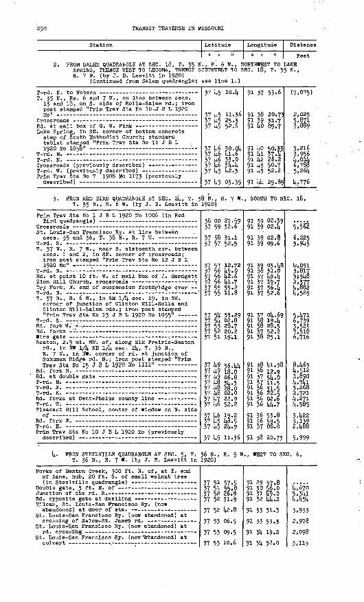
290 TRANSIT TRAVERSE IN MISSOURI
Station Latitude
0 | 11
Longitude
o t n
Distance
Peet
FROM SALEM QUADRANGLE AT SEC. 18, T. 35 N., R. 6 W., NORTHWEST TO LAKE SPRING, THENCE WEST TO LECOMA, THENCE SOUTHWEST TO SEC. 18, T. 35 N., R. 7 W. (by J. B. Leavltt In 1920)
(Continued from Salem quadrangle; see line 1.)
T. 35 N., Rs. 6 and 7 W. , on line between sees. 13 and 18, on S. side of Rolla-Salem rd.; Iron post stamped "Prim Trav Sta No 10 *J -B L 1920
Lake Spring, In SE. corner of bottom concrete step of South Methodist Church; standard tablet stamped "Prim Trav Sta No 11 J B L 1920 Mo 1058"
Prim Trav Sta No 7 1908 Mo 1173 (previously
37 k5 lo.k
37 t5 11.36 57 k5 25.3 57 k5 52.6
37 k6 30.0k 37 k6 fa. 6 37 k6 33.0 37 k6 ^t-k 37 k5 k2.3
57 k5 03.35
91 57 55.6
91 58 20.73 .91 59 51.7 91 to 05.7
91 ko 50:5? 91 kl 37 -k 91 k2 26.2 91 k3 50.7 91 k3 52.2
91 kk 25.85
(7,075)
2,025 5,871 3,889
5,216 5,956 t,0lk 6,785
. 5,26k
k.,776
3. FROM RED BIRD QUADRANGLE AT SEC. 2k, T. 38 N. , R. 7 W. , SOUTH TO SEC. 18, T. 35 N., R. 6 W. (by J. B. Leavltt In 1920)
Prim Trav Sta No 1 J B L 1920 Mo 1006 (In Red
St. Louis-San Francisco Ry. at line between
T W1 C3
T. 37 N. , R. 7 W., near S. sixteenth cor. between sees. 1 and 2, in SE. corner of crossroads; Iron post stamped "Prim Trav Sta No 12 J B L
Rd. at point 10 ft. W. of mall box of J. Bardgett
Dry Fork, N. end of suspension footb'rldge over
T. 37 N., R. 6 W. , In SE 1/k sec. 19, In SW. corner of Junction of Clinton Klll-Rolla and Clinton Mlll-Salem rds.; Iron post stamped
Seaton, 2.5 ml. NW. of, along Elk Pralrie-Seaton rd., In NW 1/k NE 1/k sec. 2k, T. 36 N., R. 7 W. , in NW; corner of rd. at junction of Schuman Ridge rd. N. ; Iron post stamped "PrimTrav Sta No 15 J B L 1920 Mo 1111" --'-
Pleasant Hill School, center of window on N. side
Prim Trav Sta No 10 J B L 1920 Mo (previously
38 00 27.59 37 59 52.6
57 58 51.1 57 57 52.5
37 57 12.72 57 56 k5.0 37 56 k2.6 37 56 kl.7 57 55 55.| 37 55 11.8
37 5k 53.29 37 5k 02.8 37 55 28.7 37 52 20.2 37 51 19.1.
57 k9 56. kk 57 t9 18.0 57 kg 06.8 57 k§ 3k. 3 57 kg jj&.o 57 k8 02.0 57 'k7 22.9 37 k6 52.2
37 k6 19.2 57 k5 k6.5 37 k5 2k.9
37 k5 11.56
91 59 02.39 91 39 02. U
91 39 02.8 91 59 09.6
91 39 03. k8 91 38 51.0 91 37 k9«k 91 37 19.7 91 37 56.k 91 37 52.6
91 37 Ok. 69 91 3§ 19. k 91 38 28.5 91 37 52.2 91 38 25*1.
91 38 kl.58 91 58 12 .o 91 57 5t-0 91 37 11.5 91 56 31.5 91 56 22.4 91 36 02.6 91 36 kt.7
91 36 55.8 91 36 59.5 91 37 08.0
91 38 20.73
5*,5^
6,225 3,9t5
k!,05i. 3,817 3(5k8 2,377 k,882 k,585
5,k7l 6,739 3,525 7,510 6,716
8,k65 k,512 1,890 k,7ki 5,268 2,721 k,271 k,585
5,k22
2|k88
5,999
t- PROM STEELVILLE QUADRANGLE AT SEC. 5, T. 36 N., R. 5 W. , WEST TO SEC. 6, T. 36 N., R. 7 W. (by J. B. Leavltt In 1920)
Forks of Benton Creek, 300 ft. N. of, at E. end of lane, hub, 20 ft. S. of small walnut tree
Vllean, St. Louis-San Francisco Ry. (now
St. Louis-San Francisco Ry. ("now abandoned) at
St. Louis-San Francisco Ry. (now abandoned) at
St. Louis-San Francisco Ry. (now ' 'Abandoned) at
57 51 57-5 37 51 55.0 .57 52 26.$ 57 52 31-9
37 52 k2.8
37 55 06.5
57 55 09.5 vi ST. in.fi
91 29 57.8 91 30 56.0 91 31 k970 91 32 kt.2
91 33 51.3
91 33 55.3
91 5k 19.2 en 1)1 t;FLn
ki670
I'hk
5,933 2,978
2,098 *.ii*

PART 2, SOUTH-CENTRAL MISSOURI, 1908-1937 291
Station
St. Louis-San Francisco Ry. (now abandoned) at
Adams School, 66 ft. N. of,, rd. at mall box of
Prim Trav Sta No 13 J B L 1920 Mo 1055
T. 37 N., R. 7 W., in NW lA 3 ee. 27, 150 ft. SE. of Wilkins dwelling, 110 ft. E. of culvert, 20 ft. W. of Clinton'lMill-Rolla' rd. at rd. S., on N. aide of rd. , in sandstone ledge; standard tablet stamped "Prim Trav Sta No lk
Falrvlew School, 100 ft. W. of, stake in center
T-rd. E. - -
Elk Prairie, in SW lA sec. k, T. 36 N. , R. 7 W. , In front face of NW. corner of foundation of porch to store; standard tablet stamped "1137"-
T. 36 N., R. 7 W., quarter cor. between sees. 5
Prim 'Trav Sta No 8 1908 Mo 1175 (previously
Latitude
0 | II
37 52 57.0 37 53 12.8
37 5k 05. k
37 5k 33.29 37 5k 23.0 37 5k 23.9
37 5k 11.77 37 5k 11.8 37 53 59-k37 5k 00.2 37 53 3k-0 37 52 kl.l
37 51 k9.Q8
37 51 k9«2
37 51 50.39
Longitude
o i n
91 36 13. k 91 36 25.3
91 36 22.9
91 37 ok. 69 91 39 2k.k 91 kO 1^4
91 kl 07.11 91 kl 37.6 91 k2 10.8
91 k3 00.2. 91 k3 00.8 91 k2 23.8
91 k2 i6.9k
91 k3 06.3 91 kk 56.63
Distance
Feet
6,207 1,887
5,328
k,375 ii,2k7 6,kio
2,19k 2,kk§ 2,9ki
3,960 2,6396,122
5,291
3,961
8,850
5. FROM ROLLA QUADRANGLE EAST ALONG ST. LOUIS-SAN FRANCISCO RAILWAY TO DUNIVIN, THENCE NORTH ALONG ROADS INTO RED BIRD QUADRANGLE AT SEC. 20, T. 38 N., R. 7 W. (by J. B. Leavitt in 1920)
(Continued from Rolla quadrangle; see line 5.)
Dunlvln, St. Louis-San Francisco Ry. at rd.
Prim Trav Sta No 1 1908 Mo 117k (in Red Bird
37 58 3k-k 37 59 15.2
38 oo 3k.l3
91 k3 k6-5 91 k3 28.2
91 k3 27.60
(9,981) k,38l
7,982
6. FROM RED BIRD QUADRANGLE AT ST. JAMES SOUTHEAST TO BAtiGERT, THENCE SOUTH ALONG ST. LOUIS-SAN FRANCISCO RAILWAY INTO SALEM QUADRANGLE (by J. B. Leavitt in 19J2b)
St. James, 0-5 ml. N. of, State Highway 68 at
St. James, St. Louis-San Francisco Ry. opposite
T. 38 N., R.. 6 W., near cor. sees. 20, 21, 28, and 29, S. of rd.; iron post stamped "Prim
Rock Spring Branch, center of ford across
Sawyers School, 0.2 mi. E. of, 100 ft. NW. of Smallwood dwelling, N. of rd. ; iron post stamped "Prim Trav Sta No 3 J B L 1920 Mo"
HE. corner post in foundation of clubhouse on W. bank of Meramec River, 500 ft. N. of mouth of
Merameo Spring, 500 ft. W. of, 300 ft. W. of bridge over Spring Branch, 50 ft. N. of Steelville rd. , in limestone ledge; standard tablet stamped "Prim Trav Sta No k J B L 1920 Mo 79k"
Meramec Spring, 1.2 ml. SE. of, rd. corner at S.
T-rd. E., kO ft. N. of dwelling of J. M. Pinson -
T-rd. E., 150 ft. E. of log cabin, 5 ft. SW. of
Meramec Sprlng-Wesco rd. , 100 ft. SW. of dwell ing known as Skipper Place, 5 ft. N. of white-oak tree; iron post stamped "Prim Trav
Rd. fork to log barn at foot of hill on Benton
38 00 25.1
37 59 k9«3
37 59 31.58 37 59 33. k 37 59 21.0
37 59 ik.k9 37 58 k9-6
37 57 k7«9
37 57 17.3k 37 57 08.0
37 56 26.5 37 5606.8 37 55 3k.l 37 5k5k-3
37 5kki.6 37 53 k9«8
37 53 28.79
37 53 17.8*7 C.2 Hh-H
91 37 10.9
91 36 5k-6
91 35 56.08 91 3k k5-9 91 3k 16.5
91 32 ko.90 91 32 31.4
91 31 59.3
91 32 03.22 91 31 5LO
91 31 57. k 91. 31 26.8 91, 31 23,1 91 31 ok.k
91 31 02.5 91 31 2k-9
91 31 08.13
91 30 2o.k01 xn i*-3
3,8k9
5,017 5,618 2,669
7,685 2,635
6,7k5
3,iok 1,360
k,338 2,170 3,326 k,299
1,293 5,537
2,518
3,99k r, ?h-\
(For balance in Steelvllle quadrangle, see line 1.)

292 TRANSIT TRAVERSE IN MISSOURI
Station
Benton Creek, rd. forks at center of stream
Crawford-Dent county line, 1.5 mi. N. of, on Gravate;e farm on W. bank of Benton Creek, 200 ft. SW. of crossing of Salem-Cllnton Mill rd. , in large limestone rock; standard tablet stamped "Prim Trav Sta No 7 J B L 1920 Mo"
Latitude
0 I 11
37 U8 53.6'
37 (4-8 2k.29 37 ^7 3§.8 37 M> ll.O 37 U5 29.14.
Longitude
0 | II
91 30 16.6
91 30 16.00 91 30 55-5 91 30 58.1 91 30 38.1
Distance
Feet
(7-;i42)
2,9£5
<H V,508
(Continued in Salem quadrangle; see line -1.)
7. PROM SEC. 1, T. 37 N. , R. 6 W., EAST INTO STEELVILLE QUADRANGLE AT SEC. 5, T. 37 N., R. 5 W. (by J. L. Sanders in 1926-27)
Prim Trav Sta No k J B L 1920 Mo 79^ (previously
Meramec River, center of Steelville ford across -
(Continued in Steelville quadrangl
37 57 17.314. 37 57 18.7 37 57 pi. 1 37 56 14-6-1).
e; see line Z
91 32 03.22 91 31 48 .k 91 30 kk.k91 30 32.2
.)
1,196
i,'780
8. PROM LAKE SPRING WEST TO LECOMA, THENCE SOUTHWEST TO SEC. 18, T. 35 N., R. 7 W. (by G. L. Krattler in 19314.)
Prim Trav Sta No 11 J B L 1920 Mo 1058
T. 35 N. , R. 7 W. , quarter cor. between sees.- [4.
Lecoma, crossroads at cor. sees. 5, 6, 7, and 8,T Z C. M TJ 7 W '
T. 35 N., R. 7 W. , cor. sees. 7, 8, 17, and 18,
T. 35 N., R. 7 W., quarter cor. between sees. 7
T. 35 N., R. 7 W. , near center see. 18, 90 ft. N. and 180 ft. E. from dwelling on property of V. L. King, 15 ft. W. of Edgar Springs-Lecoma rd., in concrete post; standard tablet stamped
Prim Trav Sta No' 7 1908 Mo 1173 (previously
37 14.6 30.01; 37 k6 41.5 37 k6 32.2
37 k6 32.3 37 W 33.8
37 46 3k.3 37 k6 08.3
37 l)-5 1)2.14.
37 14.5 1)2.6
37 45 16.55
37 lt-5 03.35
91 14-0 50.33 91 14-1 374 91 41 37.7
91 k2 10.9 91 14.2 kk.o
91 k3 k3.2 91 14-3 51.5
91 43 52.0
91 4k 25.1
91 kk 25.91
91 kk 25.85
3,958
2,665 2,660
k,750 2,710
2,625
2,65k
2,636
1,336
Magnetic declination in 1921)., 6 9 E.
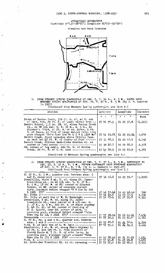
PART 2, SOUTH-CENTRAL MISSOURI, 1908-1937 293
STEELVILLE QUADRANGLE(Latitude 37°45'-38«00'; longitude 91°15' -91°30')
Crawford and Dent Counties
J1. FROM MERAMEC SPRING QUADRANGLE AT SEC. 5, T. 36 N., R. 5 W., SOUTH
MERAMEC SPRING QUADRANGLE AT SEC. 20, T. 36 N., R. 5 W. (by J. B. in 1920)
(Continued from Meramec Spring quadrangle; see line 6.)
INTO Leavltt
Station
Forks of Benton Creek, 300 ft. N. of, at E. endof lane, hub, 20 ft. S. of small walnut tree
Benton School, 1.1 mi. SE. of, along Benton Creekrd., in NW 1/4 sec. 9, T. 36 N., R. 5 W. , inClinton's field, 20 ft. N. of rd. forks, 5 ft.N. of fence, at foot of large walnut tree; ironpost stamped "Prim Trav Sta No 6 J B L 1920 Mo"
Benton Creek, first crossing above Clinton farm,on sand bar 1*0 ft. W. of center of ford
Benton Creek, Clinton Bank-Cooks Station rd. atcenter of ford across -- -- -----
SE. corner of log cabin, 600 ft. W. of BentonCreek, 20 ft. N. of E.-W. lane
Latitude
0 | II
37 51 57.5
37 51 33.73
37 51 08.1
37 50 46.7
37 49 55-5
Longitude
0 | II
91 29 57.8
91 29 23.24
91 29 12.5
91 29 01.9
91 29 33-9
Distance
Feet
(4,115)
3,670
2,732
2,328
5,783(Continued in Meramec Spring quadrangle; see line 6.)
2. PROM MERAMEC SPRING QUADRANGLE AT SEC. 5, T. -37 N., R. 5 W., NORTHEAST TO SEC. 28, T. 38 N., R. 3 W., THENCE SOUTHEAST INTO BERRYMAN QUADRANGLE AT SEC. 3, T. 37 N., R. 3 W. (by J. L. Sanders in 1926-27)
(Continued from Meiramec Spring quadrangle; see line 7.)
T. 37 N - , R' 5 w - » quarter cor. between sees. 5
Steelville, about 9 nl« w - °f* along St. James- Steelvllle rd., in SE 1/4 sec. 5, T. 37 N. , R. 5 W., 18 ft. W. of NW. corner of Houston School, in NW. corner of concrete cistern curb; standard tablet stamped "P T Sta No 103 S 1926 970" : '
Steelville, 6 mi. W. of, along St. James- Steelvllle rd., near center of W 1/2 sec. 2, T. 37 N., R. 5 W., 500 ft. N. of State Highway 8, 40 ft. SE. of SE. corner of dwelling of G. A. Wycoff, near SE. corner of yard, in concrete post; standard tablet stamped "Prim
T. 37 N., Rs. k and 5 W. , quarter cor. between
Steelville, 3 ml. W. of, along State Highway 8, k2 ft. S. and 195 ft. E. from Junction of County Route M, J ft. N. of wire fence, in concrete post; standard tablet stamped "Prim
St. Louis-San Francisco Ry. at rd. crossing
37 56 52.6
37 56 52.W 37 56 49.6 37 56 234
37 57 18.12 37 57 20. i*
37 57 20 -8 37 57 33.1
37 57 38.50 37 57 45.8 37 57 57.2
91 29 55.2
91 29 1*6.50 91 29 07.3 91 27 55-8
91 26 53.5!* 91 25 56.7
91 2i* 56.1* 91 21* 34-9
91 21* 17.67 91 23 09.8 91 22 02.2
(3,030)
700 3.154 6,311
7,1*54 4,561
4,829 2,124
1,484 5,488 5,533

29k TRANSIT TRAVERSE IN MISSOURI
Station
Steelville, 30 ft. E. of NE. corner of court house, 6 ft. S. and 2 ft. W. from NW. corner of office of circuit clerk; iron post stamped
St. Louis-San Francisco Ry. at rd. crossing
Rd. fork SW. at farmhouse of George Carter - Steelvllle, 3 mi. E. of, along Scotia-Steelville
rd., In SW lA sec. 30, T. 38 N., R. 3 W. , 60 ft. SE. of front door of dwelling of Joe Pinson, 22 ft. N. of rd. , 1 ft. inside fence, in concrete post; standard tablet stamped
St. Louis-San Francisco Ry. at rd. crossing -
Steelville, 5.8 ml. NE. of, along Scotia- Steelville rd., k mi- SW. of Scotia, in NE lA sec. 28, T. 38 N., R. 3'W., 150 ft. NW. of dwelling of F. C. Wallls, at SW. corner of junction of lane S., in concrete post; standard tablet stamped "Prim Trav Sta No 108
St. Louis-San Francisco Ry. at rd. crossing - Steelvllle, 6 mi. SE. of, in NE lA sec. 5,
T. 37 N., R. 3 W. , 23 ft. S. and 15 ft. E. from T-rd. N. to Clayer switch, in concrete post; standard tablet stamped "P T Sta No 109S 'T Q9A"
St. Louis-San Francisco Ry. at rd. crossing
Center of large gate (in Berryman quadrangle)
Latitude
37 56 02.7637 58 21.2
37 58 kk.9
37 58 k6.k237 56 ko.5
37 59 10-3
37 58 pk-5 37 57 kk.5
37 57 23.9637 57 15.937 57 pk-k 37 56 k2.g
Longitude
0 1 11
91 20 35.5 91 19 33.39> 18 50.0
91 18 01. kg91 17 33-8 91 16 57. &91 16 10.8
91 15 18.3191 15 k7-391 16 17. Q91 16 20. k
91 15 53-9 91 15 02.091 4 k5-3
Distance
Feet
3,323k,ll8
3,538
1:1113,913
k,2057,2172,k522,ok9
2,093 k,3l62,570
FROM BERRYMAN QUADRANGLE AT SEC. 27, T. 37 N., R. 3 W., SOUTH TO CHERRYVILLE, THENCE NORTHWEST TO SEC. 9, T. 36 N., R. 5 W. (by J. L. Sanders in 1926-27)
T. 37 N., R. 3 W., cor. sees. 27, 28, 33, and 3k,
Cherryville, 3 ml. N. of, along Cherryvllle- Westover rd., 1.5 ml. E. of State Highway 19, in NE lA sec. 33, T. 37 N., R. 3-W.,, kO ft. S. and l(.0 ft. E. from dwelling of S. S. Wolf, in concrete post; standard tablet stamped "P T
Cherryville, ikO ft. W. of store and post office, 50 ft. S. and 310 ft. W. from junction of State Highways 19 and k9, 12 ft. E. of wire fence, in concrete post; standard tablet stamped "Prim Trav Sta No 112 S 1926 1021"
State Highway 19 at front door to farmhouse of
State Highway 19 at junction of rd. to Keysville-
Cherryville, 3. ml. NW. of, 3 mi. SE. of Keysvllle, along Cherryville-Keysville rd., in NE lA sec. 11, T. 36 N. , R. k W. , 30 ft. N. and 20 ft. E. from dwelling of J. M. Smith, in concrete post; standard tablet .stampedn~p rn 04-0 Wri 1TX <? 109^1
Keysvllle, 200 ft* W. of St. Louis-San Francisco Ry. sta., 50 ft. S. of track, 5 ft. W. of NE.
. corner of Key lot; iron post stamped "P T
St. Louis-San Francisco Ry. at private rd.
St. Louis-San Francisco Ry. at rd. crossing --
Crooked Creek, center of St. Louis-San Francisco
Wesco, 100 ft. S. of St. Louis-San Francisco Ry. sta., 25 ft. E. of track, 5 ft. E. of right- of-way line, on W. side of rd.; Iron post
Prim Trav Sta No 6 J B L 1920 Mo .(previously
37 53 5k.i
37 53 17.7
37 53 00.79 37 52 39.6 37 52 ko.i 37 51 58.0
37 51 05. k9
37 50 k7.k 37 50 ki.8 37 50 k2.6 37 50 5k.o
37 51 15. pk 37 51 3.6.k 37 51 59-6
37 52 30.k5
37 52 52.0 37 52 5k.k 37 52 k&.2
37 52 k8.6
37 51 33.23 37 51 k2.2 37 51 k?.8 37 52 03.1
37 51 33-73
91 ik k7-8
91 15 10.2
91 15 12.66 91 16 00.6 91 16 33«k 91 16 33-3
91 16 ko.97
91 17 20.6 91 17 k2,3 91 18 2k. 3 91 19 28.2
91 19 kk.27 91 21 22.091 22 30.8
91 23 20. kl
91 2k kka91 25 10.7 91 25 17 .k
91 26 06.0
91 25 5k. 87 91 26 30.6 91 27 53.3 91 28 36.6
91 29 23.2k
k,090
1,726 k,398 2,635 k,26o
5,3513,670 1,833 3,3665,25k
2,k868 ' a& 5,986
5,060
7,058 2,ik5
990
3,901
7,680 3,0076,699 3,762
k,773

PART 2, SOOTH-CENTRAL MISSOURI, .1908-1937 295
Station
4. FROM CHERRYVILLE SOUTH INTO BERRYMAN QUAD R. 3 W. (by J. L. Sanders In 1926-27)
Brim Trav Sta No 112 S 1926 1021 (previously.
Cherryville, 3 ml. SE. of, along Cherryville- Dlllard rd., 16 ft. N. and 35 ft. .W.. from front door of Henry Eaton School, 24 ft. E. of rd., In concrete post; standard tablet stamped "P T
Tps. 35 and 36 N. , R. 3 W. , cor. sees. 3, 4, 33,
Center of ford across small stream (in Berryman
Latitude
RANGLE AT SEC
37 51 05-49 37 50 47-3 37 5° 07.1 37 49 ?6.2
37 48 41.56 37 48 01.7 37 47 34.2
37 47 09.7
37 46 22.8
Longitude
0 1 11
. 3, T. 35 N.
91 16 40.97 91 16 37-9 91 15 58.7 91 15 49.6
91 15 55.15 91 15 28.0 91 15 52.1
91-15 18.8
91 14 54.2
Distance
Feet
1,857 5,135 3,212
5,61+4 4,072 2,805
2,696
5,495
5. FROM STONE HILL QUADRANGLE NORTHWEST ALONG ST. LOUIS-SAN FRANCISCO RAILWAY (now abandoned) TO SLIGO, THENCE SOUTHWEST ALONG ROADS AND STATE HIGHWAY 19 INTO STONE HILL QUADRANGLE (by J. L. Sanders in 1926-27)
(Continued from Stone Hill quadrangle; see line 1.)
T. 35 N. , R. J W. , cor. sees. 7, 8, 17, and 18,
Sllgo, 5 mi. E. of, along St. Louls^San Francisco Ry. (now abandoned), in NE 1/4 NE 1/4 sec. 18, T. 35 N., R. 3 W., 400 ft. SE. of large barn of C. E. Powell, 45 ft. N. and 45 ft. W. from rd. crossing, 12 ft. S. of gate in fence corner, In concrete post; standard tablet stamped "Prim
R.Ri. : at gate N. of track, on Crawford-Dent county
T. 35 N., R. 4 " , °°r. sees. 10, 11, 14, and 15,
Sllgo, 1.7 mi. SE. of, along St. Louis-San Francisco Ry. (now abandoned), near center of S 1/2 sec. 10, T. 35 N., R. 4 W., 200 ft. SE. of dwelling of Everett Coteyer, 145 ft. E. of rd. crossing, 17 ft. N. of track, 18 ft. S. of rd., in concrete post; standard tablet stamped
Sllgo, 1 ml. SW. of, along old route of State Highway 19, in SE. cor. sec. 8, T. 35 N., R. 4 "-, 150 ft. E. of dwelling of J. G. Talley, 40 ft. S. and 30 ft. E. from rd. forks, 2 ft. W. of NW. corner of Indian Trail State Park, In concrete post; standard tablet stamped "Prim Trav Sta No 135 S 1927 1092"
Highway at line between sees. 13 and 18,
(Continued in Stone Hill quadrangl
37 45 28.5
37 45 19.76
37 45 52.9 ' 57 45 29.4 57 45 23.9
37 45 29.1
37 45 42.74 37 46 29.8
37 45 31.46 37 45 19-9
57 45 01.4
e; see line 2
91 17 50.7
91 17 59.15
91 18 35-6 91 19 37-7 91 20 11.3
91 20 42.2
91 21 19.64 91 22 39.4
91 22 59.8391 23 39.6 91 25 06.1
.)
(5,1^0)
1,109
4,73p 4,994 2,759
2,540
3,306 7,355
6,384 3,397
7,203
6. PROM CUBA QUADRANGLE SOUTH ALONG STATE HIGHWAY 19 TO STEELVILLE (by W. R. Broaddus in 1932)
Steelvllle, 2.8 ml. N. of, along State Highway 19, 850 ft. S. of Big Bend School, 20 ft. S. and 45 ft - E ' from Junction of rd. E., in concrete post; standard tablet stamped "T T
Junction of rd. E. to Wildwood Springs Club Steelvllle, St. Louis-San Francisco Ry. at
Prim Trav Sta No 106 S 1926 755 (previouslyescr e
.38 oo 45.7
37 59 59-41 37 58 50.4 37 58 22.7
37 58 03.6
37 58 02.76
91 23 08.4
91 22 28.13 91 22 17.5 91 22 02.8
91 21 40.8
91 21 21.32
7,440 5,030 3,046
2,609
1,565
Magnetic declination in 1932, 6° E.