Traverse XL V1 0
61
Traverse XL Overview: Traverse XL provides an easy way to input and analyze traverse data for closed polygon traverses as well as open l traverses. This program uses the graphing tools provided in Excel and automatically displays the traverse data as entered. For closed polygon traverses, the program balances the traverse using the compass method, provides statistics rega misclosure and precision and calculates traverse perimeter and area. For open linear traverses, the program determ the distance and direction of the ending point relative to the starting point. Some additional features that are b in to the traverse worksheets are the ability to rotate traverse data as well as a way to convert horizontal measu data from meters to feet (or vice versa). In addition to the data entry and traverse analysis worksheets, there is a page that provides methods for converti angular data. Finally, an example traverse is provided that includes an annotated map showing the type of output t can be generated using the charting functions provided in Excel. Instructions: Enter traverse data in to the appropriate yellow shaded cells on the 'Data Entry' worksheet. Traverse points must specified by either entering x,y coordinates or by entering a combination of a distance and an angle. With respect distances, the spreadsheet is designed to accept either horizontal distance directly or calculate a horizontal dis when a slope distance and slope percentage is supplied. With respect to angles, the spreadsheet will accept either azimuth or bearings. The data from the 'Data Entry' worksheet is automatically linked to the 'Compass Rule Adjustment' and 'Linear Trav worksheets. Worksheets Included: Data Entry:This worksheet should be used for enteringr traverse data. Traverse data must be entered in the yellow cells only. A valid traverse point is defined by x,y coordinates OR a combination of a distance measurement and an measurement. If you choose to paste coordinate point data into this worksheet, you might consider using Excel's 'P Special' -> Values option so that the cell formats are preserved. Compass Rule Adjustment: This worksheet can be used for analyzing closed (polygon) traverse measurements and provi tools for assessing traverse closure. In addition to the traverse measurements input by the user, adjusted measure for a mathematically closed traverse are automatically generated and can be copied for use in other applications. visual display contains a map of the original and adjusted traverse measurements. Linear Traverse: This worksheet can be used when analyzing open (linear) traverse measurements and provides measur statistics including distances (Euclidean and total traverse length), directions between starting and ending point number of traverse courses. A visual display of the traverse course is included. Conversion Tools: This worksheet contains tools that allow users to convert angle units and to calculate distance direction between a set of coordinates. Example Data Entry: This worksheet contains example data for a closed polygon traverse. Example Compass Adjustment: This worksheet demonstrates the sample output from the values in the 'Example Data Ent worksheet. Example Traverse Map: This chart demonstrates the type of traverse maps that can be generated using this program. Other Comments / Suggestions: If you wish to use this workbook to analyze multiple traverses, you might consider saving the original file as a template (File -> Save As Type (Template: *.xlt). When you wish to enter data for a traverse, open Excel, select ' New' and choose the template name. This will ensure that the workbook will always be opened in the same state.
-
Upload
independent -
Category
Documents
-
view
0 -
download
0
Transcript of Traverse XL V1 0

Traverse XLOverview:
Traverse XL provides an easy way to input and analyze traverse data for closed polygon traverses as well as open linear traverses. This program uses the graphing tools provided in Excel and automatically displays the traverse data as it is entered.
For closed polygon traverses, the program balances the traverse using the compass method, provides statistics regarding misclosure and precision and calculates traverse perimeter and area. For open linear traverses, the program determines the distance and direction of the ending point relative to the starting point. Some additional features that are built in to the traverse worksheets are the ability to rotate traverse data as well as a way to convert horizontal measurement data from meters to feet (or vice versa).
In addition to the data entry and traverse analysis worksheets, there is a page that provides methods for converting angular data. Finally, an example traverse is provided that includes an annotated map showing the type of output that can be generated using the charting functions provided in Excel.
Instructions:
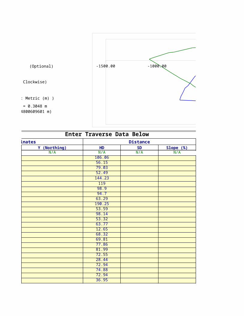
Enter traverse data in to the appropriate yellow shaded cells on the 'Data Entry' worksheet. Traverse points must be specified by either entering x,y coordinates or by entering a combination of a distance and an angle. With respect to distances, the spreadsheet is designed to accept either horizontal distance directly or calculate a horizontal distance when a slope distance and slope percentage is supplied. With respect to angles, the spreadsheet will accept either azimuth or bearings.
The data from the 'Data Entry' worksheet is automatically linked to the 'Compass Rule Adjustment' and 'Linear Traverse' worksheets.
Worksheets Included:
Data Entry:This worksheet should be used for enteringr traverse data. Traverse data must be entered in the yellow shaded cells only. A valid traverse point is defined by x,y coordinates OR a combination of a distance measurement and angle measurement. If you choose to paste coordinate point data into this worksheet, you might consider using Excel's 'Paste Special' -> Values option so that the cell formats are preserved.
Compass Rule Adjustment: This worksheet can be used for analyzing closed (polygon) traverse measurements and provides tools for assessing traverse closure. In addition to the traverse measurements input by the user, adjusted measurements for a mathematically closed traverse are automatically generated and can be copied for use in other applications. A visual display contains a map of the original and adjusted traverse measurements.
Linear Traverse: This worksheet can be used when analyzing open (linear) traverse measurements and provides measurement statistics including distances (Euclidean and total traverse length), directions between starting and ending points and number of traverse courses. A visual display of the traverse course is included. Conversion Tools: This worksheet contains tools that allow users to convert angle units and to calculate distance and direction between a set of coordinates.
Example Data Entry: This worksheet contains example data for a closed polygon traverse.
Example Compass Adjustment: This worksheet demonstrates the sample output from the values in the 'Example Data Entry' worksheet.
Example Traverse Map: This chart demonstrates the type of traverse maps that can be generated using this program.
Other Comments / Suggestions:
If you wish to use this workbook to analyze multiple traverses, you might consider saving the original file as a template (File -> Save As Type (Template: *.xlt). When you wish to enter data for a traverse, open Excel, select 'FIle-> New' and choose the template name. This will ensure that the workbook will always be opened in the same state.

Traverse XLOverview:
Traverse XL provides an easy way to input and analyze traverse data for closed polygon traverses as well as open linear traverses. This program uses the graphing tools provided in Excel and automatically displays the traverse data as it is entered.
For closed polygon traverses, the program balances the traverse using the compass method, provides statistics regarding misclosure and precision and calculates traverse perimeter and area. For open linear traverses, the program determines the distance and direction of the ending point relative to the starting point. Some additional features that are built in to the traverse worksheets are the ability to rotate traverse data as well as a way to convert horizontal measurement data from meters to feet (or vice versa).
In addition to the data entry and traverse analysis worksheets, there is a page that provides methods for converting angular data. Finally, an example traverse is provided that includes an annotated map showing the type of output that can be generated using the charting functions provided in Excel.
Instructions:
Enter traverse data in to the appropriate yellow shaded cells on the 'Data Entry' worksheet. Traverse points must be specified by either entering x,y coordinates or by entering a combination of a distance and an angle. With respect to distances, the spreadsheet is designed to accept either horizontal distance directly or calculate a horizontal distance when a slope distance and slope percentage is supplied. With respect to angles, the spreadsheet will accept either azimuth or bearings.
The data from the 'Data Entry' worksheet is automatically linked to the 'Compass Rule Adjustment' and 'Linear Traverse' worksheets.
Worksheets Included:
Data Entry:This worksheet should be used for enteringr traverse data. Traverse data must be entered in the yellow shaded cells only. A valid traverse point is defined by x,y coordinates OR a combination of a distance measurement and angle measurement. If you choose to paste coordinate point data into this worksheet, you might consider using Excel's 'Paste Special' -> Values option so that the cell formats are preserved.
Compass Rule Adjustment: This worksheet can be used for analyzing closed (polygon) traverse measurements and provides tools for assessing traverse closure. In addition to the traverse measurements input by the user, adjusted measurements for a mathematically closed traverse are automatically generated and can be copied for use in other applications. A visual display contains a map of the original and adjusted traverse measurements.
Linear Traverse: This worksheet can be used when analyzing open (linear) traverse measurements and provides measurement statistics including distances (Euclidean and total traverse length), directions between starting and ending points and number of traverse courses. A visual display of the traverse course is included. Conversion Tools: This worksheet contains tools that allow users to convert angle units and to calculate distance and direction between a set of coordinates.
Example Data Entry: This worksheet contains example data for a closed polygon traverse.
Example Compass Adjustment: This worksheet demonstrates the sample output from the values in the 'Example Data Entry' worksheet.
Example Traverse Map: This chart demonstrates the type of traverse maps that can be generated using this program.
Other Comments / Suggestions:
If you wish to use this workbook to analyze multiple traverses, you might consider saving the original file as a template (File -> Save As Type (Template: *.xlt). When you wish to enter data for a traverse, open Excel, select 'FIle-> New' and choose the template name. This will ensure that the workbook will always be opened in the same state.

Traverse XL: Enter Traverse Data
X (Easting) Y (Northing)
Starting Coordinates 0 0 (Optional)
Rotation Angle 0 (In degrees; 0 is Up; Clockwise) North Arrow Adjustment
Add Length 0
Distance Units 0 ( 0: English (ft.), 1: Metric (m) ) Left/Right Shift 0
0.3048 Up/Down Shift 0
Tip Width 30# Of Traverse Legs: 0 Tip Length 25%
Enter Traverse Data Below Unadjusted DataNorth Arrow Data
Point # Data Check Coordinates Distance Angle Comments HD Azimuth Departure Latitude Unaltered Coordinates Rotated CoordinatesX (Easting) Y (Northing) HD SD Slope (%) Azimuth Bearing Given Calculated X (Easting) Y (Northing) X (Easting) Y (Northing) X Y
START N/A 0 0 N/A N/A N/A N/A N/A N/A N/A N/A N/A N/A N/A 0.0000 0.0000 0.0000 0.0000 0.00 0.001 0.00 0.002 -15.00 0.003 0.00 0.004 15.00 0.125 0.00 0.006789101112131415161718192021222324252627282930313233343536373839404142434445464748495051525354555657585960616263646566676869707172737475767778798081828384858687888990919293949596979899100
For Conversions:1 ft -> ? m
( 1 International Foot = 0.3048 m 1 Survey Foot = 0.304800609601 m)
-20.00 -15.00 -10.00 -5.00 0.00 5.00 10.00 15.00 20.00-0.02
0.00
0.02
0.04
0.06
0.08
0.10
0.12
0.14
Rotated TraverseRotation Direction

Rotation Arrow Data
X Y0.00 0.000.00 0.00
-15.00 0.000.00 0.0015.00 0.000.00 0.00

Traverse XL: Balancing A Closed Traverse Using The Compass (Bowditch) Rule
Measured Distance Units English (ft)1 ( 0: English (ft.), 1: Metric (m) )
Metric (m)
Rotation Angle 0 (In degrees; Clockwise)X Shift 0Y Shift 0
X (Easting) Y (Northing)Starting Point 0.00 0.00
Unadjusted End Point 0.00 0.00Balanced End Point 0.00 0.00
Units
Balanced Area 0.00 m^20.00 hectares
Balanced Perimeter 0.00 m
# Of Traverse Legs 0
Linear Misclosure 0.00 m
Relative Precision
1984 FGCS Horizontal Control Survey Accuracy Standards:Required Accuracy
First-order 1/100,000 Second-order Class I 1/50,000 Second-order Class II 1/20,000 Third-order Class I 1/10,000 Third-order Class II 1/5,000
Greater Than Third-order Class II > 1/5,000
Point #Unadjusted Traverse Data
HD AzimuthSTART N/A N/A
Adjustment Data Display Units


Traverse XL: Balancing A Closed Traverse Using The Compass (Bowditch) Rule
( 0: English (ft.), 1: Metric (m) )
(In degrees; Clockwise)
1984 FGCS Horizontal Control Survey Accuracy Standards:
Unadjusted Traverse DataDeparture Latitude
CoordinatesX (Easting) Y (Northing)
N/A N/A 0.0000 0.0000
-15.00 -10.00 -5.00 0.00 5.00 10.00 15.00
0.00
0.00
0.00
Unadjusted TraverseBalanced TraverseNorth Direction


Balanced Traverse Data (Bowditch Rule)HD Azimuth DepartureN/A N/A N/A
-15.00 -10.00 -5.00 0.00 5.00 10.00 15.00
0.00
0.00
0.00
Unadjusted TraverseBalanced TraverseNorth Direction


Balanced Traverse Data (Bowditch Rule)Latitude
CoordinatesX (Easting) Y (Northing)
N/A 0.0000 0.0000
-15.00 -10.00 -5.00 0.00 5.00 10.00 15.00
0.00
0.00
0.00
Unadjusted TraverseBalanced TraverseNorth Direction


North Arrow AdjustmentAdd Length 0
Left/Right Shift 0Up/Down Shift 0Tip Width 20Tip Length 25%
Area By Coordinates North Arrow Data:Xcurrent * Ynext Ycurrent * Xnext X Y
0.00 0.000.00 0.00

10.00 0.000.00 0.00-10.00 0.000.00 0.00

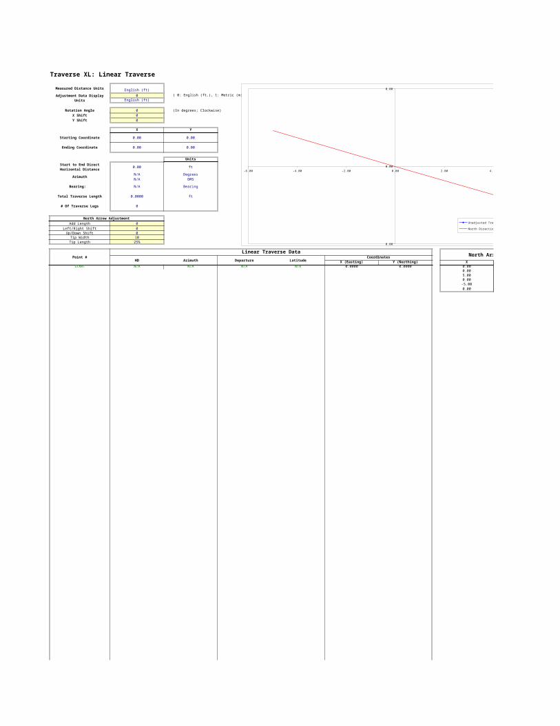
Traverse XL: Linear Traverse
Measured Distance Units English (ft)0 ( 0: English (ft.), 1: Metric (m) )
English (ft)
Rotation Angle 0 (In degrees; Clockwise)X Shift 0Y Shift 0
X Y
Starting Coordinate 0.00 0.00
Ending Coordinate 0.00 0.00
Units
0.00 ft
Azimuth N/A DegreesN/A DMS
Bearing: N/A Bearing
Total Traverse Length 0.0000 ft
# Of Traverse Legs 0
North Arrow AdjustmentAdd Length 0
Left/Right Shift 0Up/Down Shift 0
Tip Width 10Tip Length 25%
Point #Linear Traverse Data North Arrow Data:
HD Azimuth Departure LatitudeCoordinates
X (Easting) Y (Northing) XSTART N/A N/A N/A N/A 0.0000 0.0000 0.00
0.005.000.00-5.000.00
Adjustment Data Display Units
Start to End Direct Horizontal Distance -6.00 -4.00 -2.00 0.00 2.00 4.00 6.00
0.00
0.00
0.00
Unadjusted Traverse
North Direction


North Arrow Data:Y
0.000.000.000.000.000.00
-6.00 -4.00 -2.00 0.00 2.00 4.00 6.00
0.00
0.00
0.00
Unadjusted Traverse
North Direction

-6.00 -4.00 -2.00 0.00 2.00 4.00 6.00
0.00
0.00
0.00
Unadjusted Traverse
North Direction

Traverse XL: Data Conversion ToolsConvert Azimuth To BearingsAzimuth: Bearing:90.5 S89.5E
Convert Bearings To AzimuthBearing: Azimuth:
<--- Enter Bearing
Convert D M' S" to DegreesD.M.S.s Degrees 123 45' 13.2" should be
<--- Enter D.M.S.s entered as 123.45.13.2
Convert Degrees to D M' S"Degrees D M' S"
<--- Enter Degrees
Starting CoordinateX (Easting) Y (Northing)
Ending CoordinateX (Easting) Y (Northing)
Horizontal Distance: Enter X,Y CoordinateAzimuth (Degrees): Pair Data In The Yellow
Azimuth (DMS): Shaded Cells AboveBearing:
Calculate Horizontal Distance and Direction From Known Coordinates

Input Format Conversion ExamplesExample Azimuth Convert Azimuth To Bearings0<Azimuth<360 Azimuth: Bearing:
Eg: 120, 134.5643, … 169.7078 S10.2922E
Example Bearing Convert Bearings To AzimuthS10E, n45w, … Bearing: Azimuth:
s10.2922e 169.7078
Example D M' S" Convert D M' S" to Degrees123 45' 13.2" should be D.M.S.s Degreesentered as 123.45.13.2 19.42.28.07 19.7078
Example Degrees Convert Degrees to D M' S"0<Degrees<360 Degrees D M' S"
Eg: 124.364, 275, … 19.7078 19 42' 28.07"
Starting CoordinateX (Easting) Y (Northing)1024.236 2045.34
Ending CoordinateX (Easting) Y (Northing)
234.102 -300.931Horizontal Distance: 2475.7422
Azimuth (Degrees): 198.6115Azimuth (DMS): 198 36' 41.57"
Bearing: S 18.6115 W
Calculate Horizontal Distance and Direction From Known Coordinates
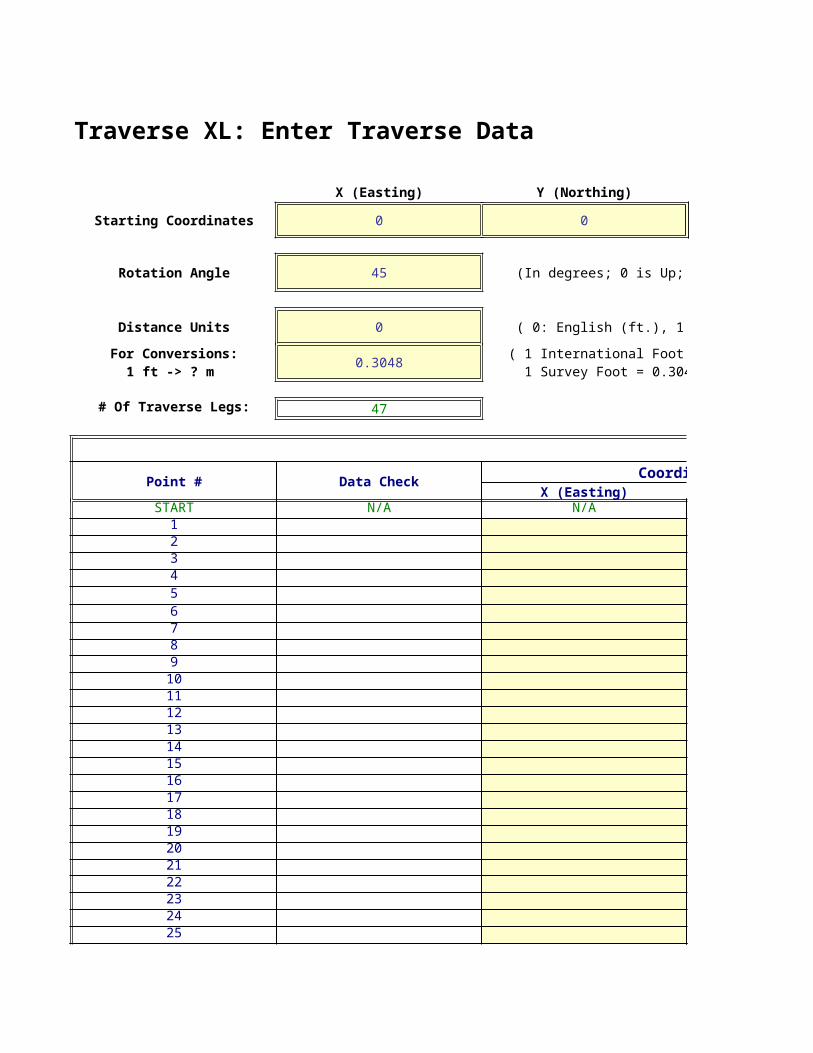
Traverse XL: Enter Traverse Data
X (Easting) Y (Northing)
Starting Coordinates 0 0
Rotation Angle 45 (In degrees; 0 is Up; Clockwise)
Distance Units 0 ( 0: English (ft.), 1: Metric (m) )
0.3048
# Of Traverse Legs: 47
Enter Traverse Data BelowPoint # Data Check Coordinates
X (Easting)START N/A N/A12345678910111213141516171819202122232425
For Conversions:1 ft -> ? m
( 1 International Foot = 0.3048 m 1 Survey Foot = 0.304800609601 m)

262728293031323334353637383940414243444546474849505152535455565758596061626364656667686970717273747576

7778798081828384858687888990919293949596979899100
(Optional)
(In degrees; 0 is Up; Clockwise)
( 0: English (ft.), 1: Metric (m) )
Enter Traverse Data BelowCoordinates Distance
Y (Northing) HD SD Slope (%)N/A N/A N/A N/A
106.0656.1579.0352.49144.2311998.994.763.29190.2553.5998.1453.3263.7712.6568.3269.8177.8681.9972.5528.4472.9474.8872.9436.95
( 1 International Foot = 0.3048 m1 Survey Foot = 0.304800609601 m)
-1500.00 -1000.00 -500.00 0.00 500.00 1000.00
-1200.00
-1000.00
-800.00
-600.00
-400.00
-200.00
0.00
200.00
400.00
Rotated TraverseRotation Direction

82.6191.6144.1685.7843.1894.0854.5
103.5634.3589.480.7563.6389.4142.2780.589.6214.6265.9194.172.3114.255.5

Enter Traverse Data BelowAngle CommentsAzimuth Bearing
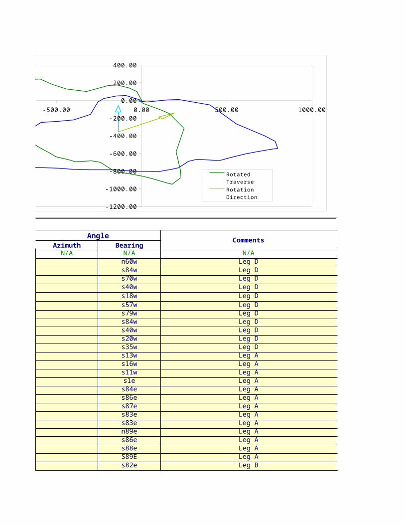
N/A N/A N/An60w Leg Ds84w Leg Ds70w Leg Ds40w Leg Ds18w Leg Ds57w Leg Ds79w Leg Ds84w Leg Ds40w Leg Ds20w Leg Ds35w Leg Ds13w Leg As16w Leg As11w Leg As1e Leg As84e Leg As86e Leg As87e Leg As83e Leg As83e Leg An89e Leg As86e Leg As88e Leg AS89E Leg As82e Leg B
-1500.00 -1000.00 -500.00 0.00 500.00 1000.00
-1200.00
-1000.00
-800.00
-600.00
-400.00
-200.00
0.00
200.00
400.00
Rotated TraverseRotation Direction

s83e Leg Bs90e Leg Bs85e Leg Bn70e Leg Bn74e Leg Bn39e Leg Bn61e Leg Bs84e Leg Bs84e Leg Bn61e Leg Bn65e Leg Bn70e Leg Bn74e Leg Bn75e Leg Bn11w Leg Cn42w Leg Cn52w Leg Cn35w Leg Cn72w Leg Cs85w Leg Cs78w Leg Cn78w Leg C


North Arrow Adjustment
Add Length 0
Left/Right Shift 0
Up/Down Shift 0
Tip Width 30Tip Length 25%
Unadjusted DataHD Azimuth DepartureGiven CalculatedN/A N/A N/A N/A
106.0600 300 -91.850756.1500 264 -55.842479.0300 250 -74.263952.4900 220 -33.7399144.2300 198 -44.5695119.0000 237 -99.801898.9000 259 -97.082994.7000 264 -94.181263.2900 220 -40.6820190.2500 200 -65.069353.5900 215 -30.738098.1400 193 -22.076753.3200 196 -14.697063.7700 191 -12.167912.6500 179 0.220868.3200 96 67.945769.8100 94 69.639977.8600 93 77.753381.9900 97 81.378972.5500 97 72.009228.4400 89 28.435772.9400 94 72.762374.8800 92 74.834472.9400 91 72.928936.9500 98 36.5904

82.6100 97 81.994291.6100 90 91.610044.1600 95 43.992085.7800 70 80.606843.1800 74 41.507394.0800 39 59.206554.5000 61 47.6668103.5600 96 102.992734.3500 96 34.161889.4000 61 78.191080.7500 65 73.184463.6300 70 59.792689.4100 74 85.946442.2700 75 40.829780.5000 349 -15.360189.6000 318 -59.9541214.6000 308 -169.1071265.9000 325 -152.5140194.1000 288 -184.600172.3000 265 -72.0249114.2000 258 -111.704555.5000 282 -54.2872


Unadjusted DataLatitude Unaltered Coordinates Rotated Coordinates
X (Easting) Y (Northing) X (Easting)N/A 0.0000 0.0000 0.0000
53.0300 -91.8507 53.0300 -27.4503-5.8693 -147.6931 47.1607 -71.0871-27.0299 -221.9570 20.1309 -142.7126-40.2097 -255.6969 -20.0788 -195.0029-137.1709 -300.2664 -157.2497 -323.5127-64.8120 -400.0682 -222.0617 -439.9123-18.8710 -497.1511 -240.9327 -521.9041-9.8988 -591.3324 -250.8316 -595.4998-48.4830 -632.0144 -299.3145 -658.5490-178.7765 -697.0837 -478.0911 -830.9741-43.8984 -727.8217 -521.9894 -883.7499-95.6247 -749.8984 -617.6141 -966.9773-51.2545 -764.5954 -668.8686 -1013.6121-62.5984 -776.7633 -731.4669 -1066.4798-12.6481 -776.5425 -744.1150 -1075.2672-7.1414 -708.5967 -751.2564 -1032.2720-4.8697 -638.9568 -756.1261 -986.4726-4.0749 -561.2035 -760.2010 -934.3741-9.9921 -479.8246 -770.1930 -883.8960-8.8416 -407.8154 -779.0347 -839.22970.4963 -379.3797 -778.5383 -818.7717-5.0880 -306.6174 -783.6263 -770.9188-2.6133 -231.7830 -786.2396 -719.8507-1.2730 -158.8542 -787.5126 -669.1823-5.1424 -122.2637 -792.6550 -646.9453

-10.0676 -40.2695 -802.7227 -596.08550.0000 51.3405 -802.7227 -531.3074-3.8488 95.3324 -806.5715 -502.921929.3385 175.9393 -777.2330 -425.178811.9020 217.4466 -765.3310 -387.412873.1139 276.6530 -692.2171 -293.848226.4221 324.3198 -665.7949 -241.4594-10.8250 427.3125 -676.6199 -176.2870-3.5906 461.4743 -680.2105 -154.669843.3420 539.6653 -636.8685 -68.733034.1264 612.8497 -602.7421 7.147221.7627 672.6423 -580.9793 64.815524.6447 758.5887 -556.3346 143.015310.9403 799.4184 -545.3943 179.622279.0210 784.0583 -466.3733 224.637266.5858 724.1042 -399.7875 229.3265132.1210 554.9971 -267.6666 203.1733217.8125 402.4831 -49.8541 249.346459.9802 217.8830 10.1261 161.2268-6.3014 145.8581 3.8248 105.8418-23.7435 34.1537 -19.9187 10.065611.5391 -20.1335 -8.3796 -20.1618


Unadjusted DataNorth Arrow Data
Rotated CoordinatesY (Northing) X Y
0.0000 -137.92 -355.08102.4461 -137.92 -131.63137.7824 -152.92 -131.63171.1820 -137.92 -57.15166.6071 -122.92 -131.52101.1281 -137.92 -131.63125.8696181.1738240.7704235.2543154.8512145.545493.539167.689132.029322.9297-30.1649-82.8512-140.7125-205.3215-262.4916-282.2477-337.2962-392.0600-444.5286-474.0382

-539.1358-603.9139-637.7424-673.9946-694.9286-685.0946-700.1168-780.5981-807.2930-831.9350-859.5532-886.4444-929.7912-950.9262-884.1887-794.7114-581.7110-319.8507-146.9063-100.4328-38.23508.3112


Rotation Arrow Data
X Y-137.92 -355.08110.63 -197.08100.02 -186.47193.48 -144.41121.23 -207.69110.63 -197.08
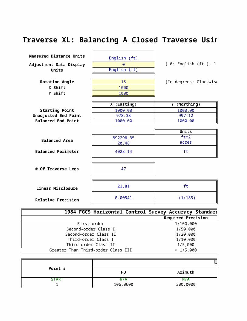
Traverse XL: Balancing A Closed Traverse Using The Compass (Bowditch) Rule
Measured Distance Units English (ft)0 ( 0: English (ft.), 1: Metric (m) )
English (ft)
Rotation Angle 15 (In degrees; Clockwise)X Shift 1000Y Shift 1000
X (Easting) Y (Northing)Starting Point 1000.00 1000.00
Unadjusted End Point 978.38 997.12Balanced End Point 1000.00 1000.00
Units
Balanced Area 892298.35 ft^220.48 acres
Balanced Perimeter 4028.14 ft
# Of Traverse Legs 47
Linear Misclosure 21.81 ft
Relative Precision 0.00541 (1/185)
1984 FGCS Horizontal Control Survey Accuracy Standards:Required Precision
First-order 1/100,000 Second-order Class I 1/50,000 Second-order Class II 1/20,000 Third-order Class I 1/10,000 Third-order Class II 1/5,000
Greater Than Third-order Class III > 1/5,000
Point #Unadjusted Traverse Data
HD AzimuthSTART N/A N/A1 106.0600 300.0000
Adjustment Data Display Units

2 56.1500 264.00003 79.0300 250.00004 52.4900 220.00005 144.2300 198.00006 119.0000 237.00007 98.9000 259.00008 94.7000 264.00009 63.2900 220.000010 190.2500 200.000011 53.5900 215.000012 98.1400 193.000013 53.3200 196.000014 63.7700 191.000015 12.6500 179.000016 68.3200 96.000017 69.8100 94.000018 77.8600 93.000019 81.9900 97.000020 72.5500 97.000021 28.4400 89.000022 72.9400 94.000023 74.8800 92.000024 72.9400 91.000025 36.9500 98.000026 82.6100 97.000027 91.6100 90.000028 44.1600 95.000029 85.7800 70.000030 43.1800 74.000031 94.0800 39.000032 54.5000 61.000033 103.5600 96.000034 34.3500 96.000035 89.4000 61.000036 80.7500 65.000037 63.6300 70.000038 89.4100 74.000039 42.2700 75.000040 80.5000 349.000041 89.6000 318.000042 214.6000 308.000043 265.9000 325.000044 194.1000 288.000045 72.3000 265.000046 114.2000 258.000047 55.5000 282.0000

Traverse XL: Balancing A Closed Traverse Using The Compass (Bowditch) Rule
( 0: English (ft.), 1: Metric (m) )
(In degrees; Clockwise)
1984 FGCS Horizontal Control Survey Accuracy Standards:
<--- This Traverse
Unadjusted Traverse DataDeparture Latitude
CoordinatesX (Easting) Y (Northing)
N/A N/A 1000.0000 1000.0000-74.9957 74.9957 925.0043 1074.9957
-200.0000 0.0000 200.0000 400.0000 600.0000 800.0000 1000.0000 1200.0000 1400.0000 1600.0000 1800.0000
-200.0000
0.0000
200.0000
400.0000
600.0000
800.0000
1000.0000
1200.0000
Unadjusted TraverseBalanced TraverseNorth Direction
0.0000 200.0000 400.0000 600.0000 800.0000 1000.0000 1200.0000 1400.0000 1600.0000 1800.0000 2000.00000.0000
200.0000
400.0000
600.0000
800.0000
1000.0000
1200.0000
Unadjusted TraverseBalanced TraverseNorth Direction

-55.4587 8.7838 869.5456 1083.7795-78.7293 -6.8879 790.8163 1076.8916-42.9973 -30.1070 747.8190 1046.7846-78.5533 -120.9615 669.2657 925.8231-113.1757 -36.7730 556.0900 889.0501-98.6591 6.8989 457.4309 895.9490-93.5341 14.8143 363.8968 910.7634-51.8441 -36.3017 312.0527 874.4617-109.1229 -155.8437 202.9298 718.6180-41.0523 -34.4470 161.8774 684.1711-46.0739 -86.6525 115.8035 597.5186-27.4618 -45.7042 88.3417 551.8144-27.9549 -57.3161 60.3867 494.4983-3.0603 -12.2742 57.3264 482.224163.7822 -24.4837 121.1086 457.740466.0067 -22.7279 187.1153 435.012574.0493 -24.0601 261.1646 410.952476.0198 -30.7140 337.1844 380.238467.2672 -27.1777 404.4516 353.060727.5952 -6.8803 432.0468 346.180468.9661 -23.7469 501.0129 322.433571.6081 -21.8928 572.6210 300.540770.1144 -20.1050 642.7354 280.435734.0127 -14.4375 676.7481 265.998276.5947 -30.9463 753.3427 235.052088.4885 -23.7104 841.8312 211.341541.4968 -15.1036 883.3280 196.237985.4536 7.4762 968.7816 203.714243.1734 0.7536 1011.9550 204.467876.1123 55.2988 1088.0673 259.766652.8811 13.1847 1140.9485 272.951396.6816 -37.1126 1237.6300 235.838732.0685 -12.3099 1269.6985 223.528886.7444 21.6278 1356.4430 245.156679.5232 14.0221 1435.9662 259.178763.3879 5.5457 1499.3541 264.724489.3964 1.5604 1588.7505 266.284942.2700 0.0000 1631.0205 266.28495.6154 80.3039 1636.6358 346.5888
-40.6775 79.8342 1595.9583 426.4229-129.1495 171.3872 1466.8088 597.8101-90.9432 249.8643 1375.8656 847.6744-162.7860 105.7144 1213.0797 953.3888-71.2016 12.5548 1141.8781 965.9436-114.0435 5.9768 1027.8346 971.9204-49.4509 25.1965 978.3837 997.1168


Balanced Traverse Data (Bowditch Rule)HD Azimuth DepartureN/A N/A N/A
105.7122 300.2472 -74.4266
-200.0000 0.0000 200.0000 400.0000 600.0000 800.0000 1000.0000 1200.0000 1400.0000 1600.0000 1800.0000
-200.0000
0.0000
200.0000
400.0000
600.0000
800.0000
1000.0000
1200.0000
Unadjusted TraverseBalanced TraverseNorth Direction
0.0000 200.0000 400.0000 600.0000 800.0000 1000.0000 1200.0000 1400.0000 1600.0000 1800.0000 2000.00000.0000
200.0000
400.0000
600.0000
800.0000
1000.0000
1200.0000
Unadjusted TraverseBalanced TraverseNorth Direction

55.8588 264.0891 -55.157478.6026 250.0141 -78.305252.2379 219.8566 -42.7156143.7231 197.7636 -77.7793118.3664 236.9437 -112.537198.3756 259.0627 -98.128494.2088 264.0891 -93.025962.9860 219.8566 -51.5045189.5544 199.7708 -108.102053.3453 214.8330 -40.764797.8317 192.7470 -45.547353.1404 195.7568 -27.175763.5796 190.7409 -27.612712.6250 178.7110 -2.992468.6450 95.8522 64.148870.1481 93.8618 66.381378.2404 92.8666 74.467182.3762 96.8475 76.459872.8918 96.8475 67.656528.5832 88.8864 27.747873.2933 93.8618 69.357575.2488 91.8715 72.009973.3020 90.8764 70.505837.1223 97.8428 34.210982.9992 96.8475 77.038092.0681 89.8814 88.980144.3720 94.8570 41.733886.2439 69.9860 85.913943.4122 73.9646 43.405194.5283 39.1468 76.617254.7932 61.0344 53.1736104.0526 95.8522 97.237334.5134 95.8522 32.252889.8810 61.0344 87.224281.1868 65.0129 79.956563.9741 69.9860 63.729389.8909 73.9646 89.876242.4968 74.9592 42.496880.5887 349.3035 6.047489.4400 318.2931 -40.1967214.0320 308.2709 -127.9979265.5945 325.3033 -89.5163193.3033 288.2027 -161.744471.9270 265.0943 -70.8136113.5924 258.0573 -113.430755.2529 282.1769 -49.1530


Balanced Traverse Data (Bowditch Rule)Latitude
CoordinatesX (Easting) Y (Northing)
N/A 1000.0000 1000.000075.0717 925.5734 1075.0717
-200.0000 0.0000 200.0000 400.0000 600.0000 800.0000 1000.0000 1200.0000 1400.0000 1600.0000 1800.0000
-200.0000
0.0000
200.0000
400.0000
600.0000
800.0000
1000.0000
1200.0000
Unadjusted TraverseBalanced TraverseNorth Direction
0.0000 200.0000 400.0000 600.0000 800.0000 1000.0000 1200.0000 1400.0000 1600.0000 1800.0000 2000.00000.0000
200.0000
400.0000
600.0000
800.0000
1000.0000
1200.0000
Unadjusted TraverseBalanced TraverseNorth Direction

8.8240 870.4160 1083.8956-6.8314 792.1108 1077.0643-30.0695 749.3952 1046.9948-120.8582 671.6159 926.1366-36.6878 559.0787 889.44886.9697 460.9504 896.418514.8821 367.9245 911.3006-36.2564 316.4199 875.0442-155.7075 208.3179 719.3367-34.4086 167.5532 684.9281-86.5822 122.0059 598.3459-45.6660 94.8302 552.6799-57.2705 67.2175 495.4094-12.2652 64.2250 483.1442-24.4348 128.3739 458.7094-22.6779 194.7551 436.0315-24.0043 269.2222 412.0271-30.6553 345.6820 381.3718-27.1258 413.3385 354.2460-6.8599 441.0863 347.3861-23.6947 510.4438 323.6914-21.8392 582.4538 301.8522-20.0528 652.9596 281.7994-14.4111 687.1705 267.3884-30.8871 764.2085 236.5012-23.6448 853.1886 212.8564-15.0720 894.9224 197.78447.5376 980.8362 205.32200.7845 1024.2414 206.106555.3662 1100.8586 261.472713.2238 1154.0321 274.6964-37.0385 1251.2694 237.6580-12.2854 1283.5223 225.372621.6918 1370.7464 247.064414.0799 1450.7030 261.14435.5913 1514.4323 266.73561.6244 1604.3085 268.36000.0303 1646.8053 268.390280.3615 1652.8527 348.751879.8983 1612.6559 428.6501171.5408 1484.6580 600.1908250.0546 1395.1417 850.2454105.8534 1233.3973 956.098812.6065 1162.5837 968.70536.0585 1049.1530 974.763825.2362 1000.0000 1000.0000


North Arrow AdjustmentAdd Length 0
Left/Right Shift 800Up/Down Shift 200Tip Width 20Tip Length 25%
Area By Coordinates North Arrow Data:Xcurrent * Ynext Ycurrent * Xnext X Y1075071.65646761 925573.392192663 1646.98 840.011003224.96467905 935759.574228776 1723.62 1000.75

937493.991644007 858565.470528517 1733.28 998.16829335.938245001 807146.812833729 1749.17 1054.33694042.330766363 703178.355768473 1713.96 1003.34597367.909988948 517783.278784424 1723.62 1000.75501168.494488059 409991.726810334420064.334006807 329814.272293566321950.170639062 288353.68251341227612.487660491 182287.417415245142682.813602723 120527.169036791100254.762358273 83565.266277499667430.2020814251 56741.252498246746979.7690452894 37149.739446856732475.729900377 31817.686837302329460.6289169426 62023.092123418855975.0466387342 89336.013844619480244.3996033636 117389.35384278102673.763173259 142430.356709281122456.474038178 157635.652731171143588.0612495 156253.080294653142775.847556461 177321.116966456154078.600569498 188535.277229178164135.134820215 197097.296166757174593.793396372 193644.2607348162516.677613668 204340.451825545162666.658944874 201780.143433987168747.373057563 190489.938308906183747.247109055 193994.092564831202156.725789308 210299.28839926267811.132149865 226894.102876771302401.907677884 301747.864751452274264.922162892 343719.239909113282001.855920492 305039.281708274317112.670988866 308928.696874889357962.614228484 358417.07730785386954.071110618 395485.358428474406413.011529136 427926.118083905430580.716191712 441936.626831529574326.231278314 443609.505800815708495.406235017 562416.580460361967901.324225019 636398.7541165931262323.68273558 837351.28741681333893.30919792 1048690.447814011194798.53966139 1111544.880766831133244.52290769 1016320.109509941049153.03891694 974763.80376219


0.0000 500.0000 1000.0000 1500.0000 2000.00000.0000
200.0000
400.0000
600.0000
800.0000
1000.0000
1200.0000Rusty Axle Traverse
Leg ALeg BLeg CLeg D
Easting (ft.)
Nort
hing
(ft
.)
N
Traverse Legs
2x2 Wooden HubFenceDraw BottomCulvertTrail
Symbol Legend
Graded Dirt Road
B. Fredericks2/5/2005

B. Fredericks2/5/2005