D1.1 – Cartography of the flexibility services ... - MAGNITUDE
Upload
independentCategory
view
1download
0
Geo log i cal Quar terly, 2014, 58 (3): 623–658DOI: http://dx.doi.org/10.7306/gq.1198
Geo log i cal car tog ra phy in Po land in the 19th cen tury
Stanis³aw WO£KOWICZ1, * and Krystyna WO£KOWICZ1
1 Pol ish Geo log i cal In sti tute – Na tional Re search In sti tute, Rakowiecka 4, 00-975 Warszawa, Po land
Wo³kowicz, S., Wo³kowicz, K., 2014. Geo log i cal car tog ra phy in Po land in the 19th cen tury. Geo log i cal Quar terly, 58 (3):623–658, doi: 10.7306/gq.1198
The his tory of mod ern geo log i cal map ping in Po land be gan with the Carta Geologica totius Poloniae, Moldaviae,Transylvaniae, Hungariae et Valachiae by S. Staszic, of ten called the “fa ther of Pol ish ge ol ogy”. Be fore Staszic, a gen eralmap of Po land had been pub lished by J.-E. Guettard (1764a); ones of the Sudety Mts. by J. Jirasek (1791), L. von Buch(1797), and Raumer (1813); and that of the Tatra Mts. by Hacquet (1796). In times of the par ti tion of Po land (1772 to 1918),ar eas an nexed by Prus sia were cov ered by sys tem atic geo log i cal sur veys. These car to graphic pro jects re sulted in the com -pi la tion of two geo log i cal at lases com pris ing maps of the stan dard sheet type, in the pe riod from 1826 to 1836. These at laseswere com piled by teams of out stand ing ge ol o gists, un der the lead er ship of L. von Buch and F. Hoffmann. An other out stand -ing con tri bu tion to the ge ol ogy of Po land was made by G.G. Pusch, the au thor of the ex cel lent Geognostische Beschreibungvon Polen (1833–1836), sub se quently sup ple mented by Geognostyscher At las von Polen. One of the great est achieve -ments of L. Zejszner was the geo log i cal map of the Tatra Mts., Carte de la chaine du Tatra, pub lished anon y mously in Berlinin 1844, and a se ries of geo log i cal maps pre pared as drafts of Geognostic maps of the East ern Dis trict of the Pol ish King -dom. Spe cial at ten tion should be also paid to two ex ten sive stud ies which cov ered ar eas of Up per and Lower Silesia. Thefirst of these, Geognostische Karte von Oberschlesien und den Angrenzenden Gebieten, was com pleted by a team led byF. Roemer, and pub lished in 1870. The sec ond, Geologische Karte von dem Niederschlesischen Gebirge und den angre -zenden gegenden, was com piled by a team led by R. von Carnall, and pub lished in the same year. Out of all the stud ies car -ried out by Aus trian ge ol o gists, it is nec es sary to men tion those of E. Tietze, as they pro duced ex cel lent geo log i cal maps ofthe Carpathians and vi cin i ties of Kraków and Lviv. It is also worth men tion ing the con tri bu tions made by the Phys io graphicCom mis sion, ac tive from 1866 un til the be gin ning of the First World War. Its mem bers de cided to pre pare the Geo log i cal At -las of Galicia. The fi nal prod uct of works of this com mis sion was a set of 25 book lets, with over a hun dred geo log i cal maps ata scale 1:75000, is sued in the years 1885–1912. From 1881, the com mis sion was also pub lish ing its fa mous Phys io graphicDi a ries, which in clude pa pers on the ge ol ogy of ar eas an nexed by Rus sia, writ ten by fa mous Pol ish ge ol o gists such asJ. Siemiradzki, A. Michalski, and E. Habdank-Dunikowski, il lus trated with rel e vant geo log i cal maps pre pared by them.
Key words: old geo log i cal maps, his tory of ge ol ogy, Po land, Cen tral Eu rope.
INTRODUCTION
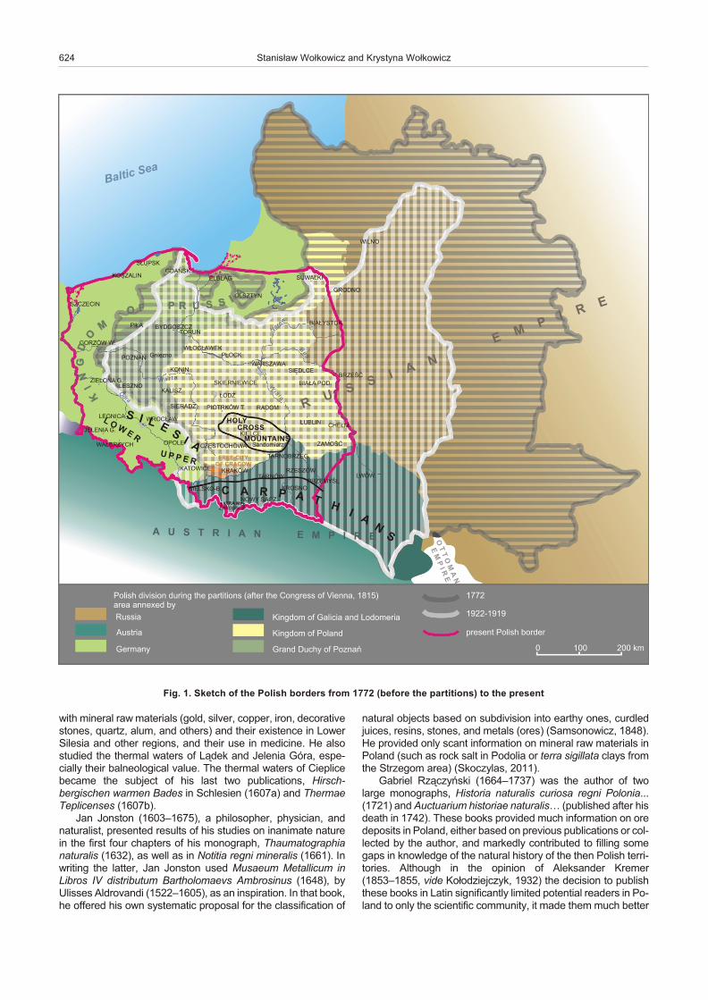
In Eu rope, geo log i cal car tog ra phy be gan to emerge in themid-18th cen tury, with dy namic de vel op ment at the be gin ningwith the 19th cen tury. These were the times when Po land be -gan to lose its in de pend ence and was par ti tioned in the years1772, 1793, and 1795 by Prus sia, Rus sia, and Aus tria and dis -ap peared from the map for 123 years. These par ti tions also ledto some prob lems for car to graphic anal y sis, es pe cially thosecon nected to the re peated shifts of po lit i cal bor ders and the re -sult ing changes in the geo graphic set ting of spe cific ar eas (Fig.1). The aim of this pa per is to draw at ten tion to the car to graphicachieve ments of ge ol o gists of Pol ish or i gin and of for eign erstaking part in the mapping of areas of our country.
In or der to have a solid start ing point to dis cuss the de vel op -ments of geo log i cal car tog ra phy, we pro vide a brief re view ofsci en tific works on is sues cur rently deemed to be a part ofbroadly un der stood ge ol ogy, namely those which con cern thege ol ogy of Pol ish ter ri to ries. Here, we should start with JanD³ugosz (1415–1480), who pro vided much in for ma tion on thenat u ral re sources of Po land in his mon u men tal chron i cleAnnales seu cronicae incliti Regni Poloniae. In gen eral, his de -scrip tion of the coun try in cluded nu mer ous ref er ences to de -pos its of iron, lead, salt, and sul phur. He de voted much at ten -tion in that mono graph to earth quakes as dan ger ous phe nom -ena of ten oc cur ring in It aly and other Eu ro pean coun tries, andoc ca sion ally also af fect ing Po land. A de tailed col la tion of in for -ma tion on naturalia de scribed or men tioned in the Jan D³ugoszchron i cle was pro vided by Zygmunt Gloger (1888).
Caspar Schwenckfeldt (1563–1609), a Hirschberg (JeleniaGóra) phy si cian and nat u ral ist – called by his con tem po rar iesthe Silesian Pliny – was the au thor of an im pres sive mono -graph, Stirpium & fossilium Silesiae catalogus, pub lished in1601. A third part of that mono graph en ti tled Omnis generismineralia, metallica, metalla, succros, terras, lapillos, fontesmedicatos thermas, 59 pages long (pages 349–407), deals
* Corresponding author: stanis³[email protected]
Received: August 25, 2014; accepted: September 23, 2014; firstpublished online: October 28, 2014
with min eral raw ma te ri als (gold, sil ver, cop per, iron, dec o ra tivestones, quartz, alum, and oth ers) and their ex is tence in LowerSilesia and other re gions, and their use in med i cine. He alsostud ied the ther mal wa ters of L¹dek and Jelenia Góra, es pe -cially their balneological value. The ther mal wa ters of Cieplicebe came the sub ject of his last two pub li ca tions, Hirsch -bergischen warmen Bades in Schlesien (1607a) and ThermaeTeplicenses (1607b).
Jan Jonston (1603–1675), a phi los o pher, phy si cian, andnat u ral ist, pre sented re sults of his stud ies on in an i mate na turein the first four chap ters of his mono graph, Thaumatographianaturalis (1632), as well as in Notitia regni mineralis (1661). Inwrit ing the lat ter, Jan Jonston used Musaeum Metallicum inLibros IV distributum Bartholomaevs Ambrosinus (1648), byUlisses Aldrovandi (1522–1605), as an in spi ra tion. In that book, he of fered his own sys tem atic pro posal for the clas si fi ca tion of
nat u ral ob jects based on sub di vi sion into earthy ones, cur dledjuices, res ins, stones, and met als (ores) (Samsonowicz, 1848).He pro vided only scant in for ma tion on min eral raw ma te ri als inPo land (such as rock salt in Podolia or terra sigillata clays fromthe Strzegom area) (Skoczylas, 2011).
Ga briel Rz¹czyñski (1664–1737) was the au thor of twolarge mono graphs, Historia naturalis cu ri osa regni Polonia...(1721) and Auctuarium historiae naturalis… (pub lished af ter his death in 1742). These books pro vided much in for ma tion on orede pos its in Po land, ei ther based on pre vi ous pub li ca tions or col -lected by the au thor, and mark edly con trib uted to fill ing somegaps in knowl edge of the nat u ral his tory of the then Pol ish ter ri -to ries. Al though in the opin ion of Aleksander Kremer(1853–1855, vide Ko³odziejczyk, 1932) the de ci sion to pub lishthese books in Latin sig nif i cantly lim ited po ten tial read ers in Po -land to only the sci en tific com mu nity, it made them much better
624 Stanis³aw Wo³kowicz and Krystyna Wo³kowicz
Fig. 1. Sketch of the Pol ish bor ders from 1772 (be fore the par ti tions) to the pres ent
known in Eu rope. For ex am ple, ref er ences and ci ta tions fromRz¹czyñski’s books can be found in Magnalia dei in locissubterraneis… by Franz Ernst Brückmann (1730) and in A His -tory of Fos sils by John Hill (1748). His books also served as themain source of in for ma tion on the ge ol ogy of Po land for J.-E.Guettard in his fact-find ing mis sions con ducted in our coun tryfrom 1760–1762.
Jan Filip Carosi (1744–1799) pub lished three books on thege ol ogy of Po land. The most im por tant one, Reisen durchverschiedene polnische Provinzen, minealogischen und ande -ren Inhalts (in two vol umes, pub lished in 1781 and 1784, re -spec tively), has the form of a col lec tion of let ters de scrib ing ar -eas through which he trav elled. Due to his geo log i cal and min -ing back ground, he paid spe cial at ten tion to the ac cu racy of thede scrip tions of geo log i cal pro files and min ing op er a tions. Hisstud ies mainly fo cused on the Holy Cross Moun tains, whichmade him a pre cur sor of geo log i cal sur veys of that re gion. It isworth add ing that he was the first au thor to re port min eral wa -ters from Busko Zdrój.
A two-vol ume book by Krzysztof Kluk (1739–1796), en ti tledMin ing mat ters, es pe cially use ful ones – ex plo ra tion, rec og ni -tion and uti li za tion (Rzeczy kopalnych, osobliwie zdatnie -yszych, szukanie, poznanie i za¿ycie), was pub lished in War -saw in 1781–1782. It pres ents the most com plete de scrip tionsof min eral re sources in the area of Po land, the best prac tices inpros pect ing and ex trac tion, and the pos si bil i ties of their prac ti -cal use. The idea be hind this book was to ad vise on how to usenat u ral re sources to en hance eco nomic de vel op ment. There -fore, Kluk gave that book the form of a comprehensive and eas -ily ac ces si ble guide, writ ten es pe cially for small- and me -dium-sized land lords – no ble men man ag ing their own lands.
MAPS OF EARLY NATURAL HISTORIANS –STANIS£AW STASZIC EPOCH
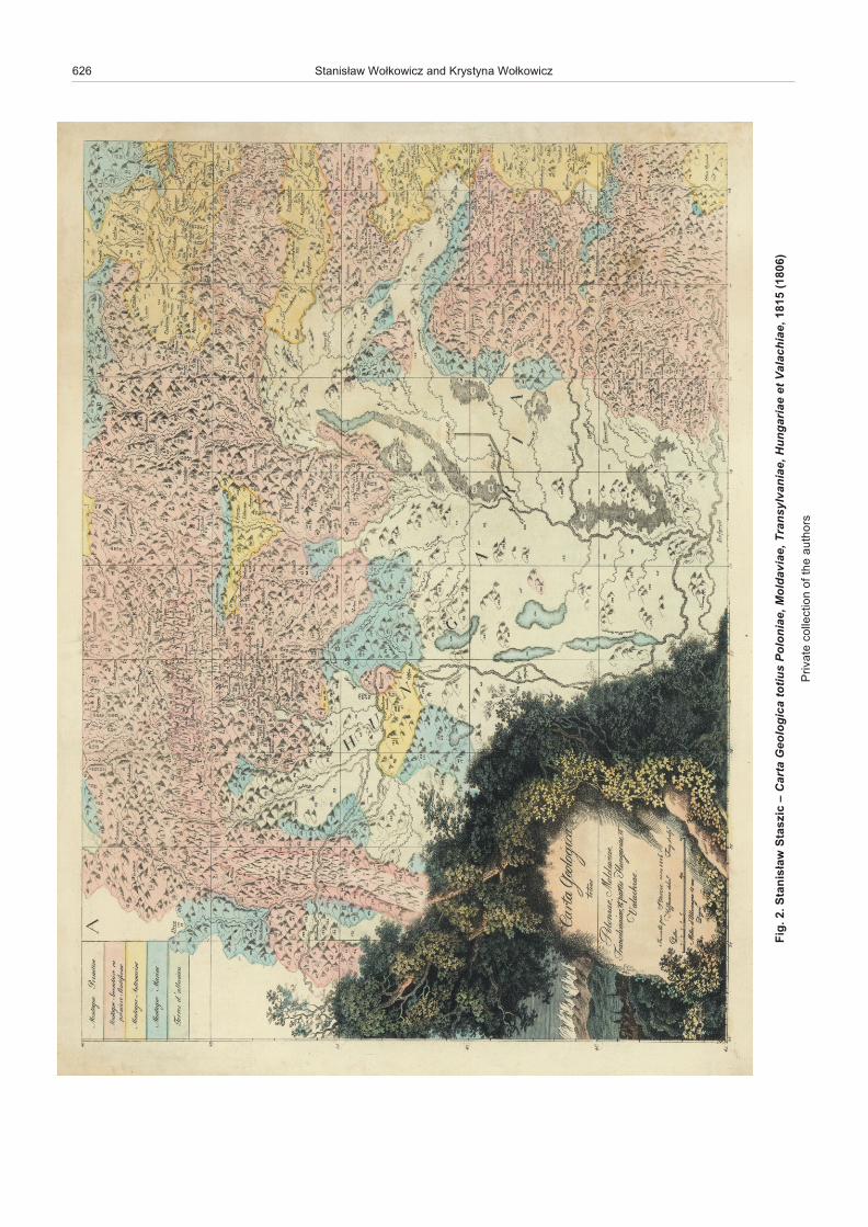
Carta Geologica totius Poloniae, Moldaviae, Transylvaniae, Hungariae et Valachiae by Stanis³aw Staszic (1815a) is the firstmap of Po land, com piled by a Pol ish ge ol o gist (Grigelis et al.,2011). It con sists of four sheets and cov ers an area from theBal tic Sea in the north to the Black Sea in the south, and fromthe Sudety Moun tains in the west to Vitebsk in the east. Themap is a hand-col oured cop per plate en grav ing, with beau ti fulcartouche with the ti tle and date of com pi la tion (Fig. 2). In draw -ing that map, Stanis³aw Staszic (1755–1826) used an an cientform of re lief de pic tion, known as hill pro files, mark ing li thol ogyand/or in stances of us able raw ma te rial with num bers. The map was an il lus tra tion for his es says pub lished by the War saw So ci -ety of the Friends of Learn ing since 1805. The es says weresub se quently col lected and pub lished with mi nor changes, inthe form of a truly mon u men tal mono graph en ti tled Oziemiorództwie Karpatow i innych gor i rownin polskich (On theearth-for ma tion of the Karpaty Moun tains and other moun tainsand plains of Po land, 1815b). The map is the core part of thatat las, and is ac com pa nied by: by two geo log i cal cross-sec tions; a beau ti ful pan oramic ar tis tic vi sion of the Tatra Moun tains,drawn by Zygmunt Vogel on the ba sis of Staszic’s sug ges tionsin 1804; a por trait of a young moun tain eer, by Jan ZachariaszFrej; a draw ing of a great ea gle and cham ois moun tain goat;three ta bles of fos sils; six ta bles with lists of foundries, metalworks, and other fac to ries and smitheries, as well as rock salt,
brine, sul phur, and coal mines, sur face ef fu sions of crude oil,and the lo ca tions of am ber.
Stanis³aw Staszic was a sup porter of Wernerian Neptunistthe ory. Thus, in his work he adopted the strati graphic clas si fi ca -tion of Werner with mi nor mod i fi ca tions (Grigelis et al., 2008),and dis tin guished on his map (us ing the French lan guage):montagne prim i tive, montagne secondaire ou prim i tive strati -forme, montagne antemarine, montagne ma rine, and terresd’alluvien.
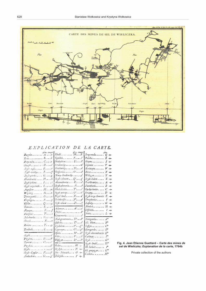
The Staszic’s map was pre ceded by the pub li ca tion of sev -eral other maps of the area of Po land. Of these, the map pub -lished by Jean-Etienne Guettard (1715–1786) in Historie del’Académie Royale des Sci ence, a print of the Royal Print ingHouse in Paris from 1764, is re garded as the old est(Daszkiewicz and Tarkowski, 2009). This map, based on the re -sults of his stud ies in 1760–1762 and named as min er al og i calby the au thor (Carte minéralogique de Pologne), was en closedas an il lus tra tion for his two-part pa per, en ti tled Na ture du Ter -rain de la Pologne, et des Minéraux qu’il renferme (1764a). It isfairly sim ple, show ing a sandy for ma tion ex tend ing through outthe ma jor part of Po land and a salt for ma tion in the south ernpart (Fig. 3). In the same vol ume of Historie de l’AcadémieRoyale des Sci ence, Guettard also pub lished one more im por -tant pa per on the ge ol ogy of Po land, deal ing with the fa moussalt mine at Wieliczka (Les mines de sel Wieliczka en Pologne,1764b). The lat ter pa per was il lus trated by a litho graph, show -ing the lo ca tion of ma jor ob jects of the Wieliczka Mine, and across-sec tion through mine ex ca va tions (Fig. 4).
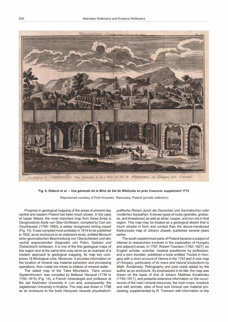
Here it worth em pha siz ing the spe cial im por tance of theWieliczka Salt Mine as one of the best known mines in theworld. The spe cial sta tus of this mine was well-re flected in ex -ten sive de scrip tions given in many books on nat u ral his toryand encyclopaedias. Robert Townson was one of the first for -eign re search ers to de scribe and draw cross-sec tions of theWieliczka salt struc tures (Fig. 5). At ten tion should be paid tothe de scrip tions and draw ings of the mine (Fig. 6) given in the18th-cen tury great French encyclopaedia by Denis Diderotand other au thors (Encyclopédie, ou dictionnaire raisonné des sci ences, des arts et des métiers, 1751–1766), a mon u men talwork of un ques tion able sci en tific and po lit i cal im pact (seeKrzywiec, in prep a ra tion).
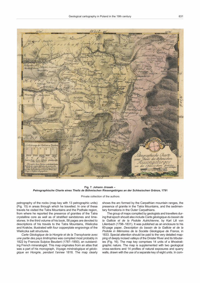
The old est known map of the Karkonosze Moun tains –Petrographische Charte eines Theils de BöhmischenRiesengebirges an der Schlesischen Grenze (1791) of JohannJirasek (1754–1797) shows the dis tri bu tion of gran ites, gneiss -es, schists, lime stones, and the lo ca tion of quar ries, min ing ex -ca va tions, and smitheries (Fig. 7). At ten tion should be paid tothe atyp i cal ori en ta tion of this map, as north is at the right andwest is at the top. This is a hand-col oured cop per plate en grav -ing on high qual ity hand made pa per, with beau ti ful wa ter marksand with the clear edges of an orig i nal plate clearly im printed.The map was pub lished as an in te gral part of a book by J.Jirasek and his co-au thors (T. Haenke, A. Gruber and F.Gerstner), en ti tled Beobachtungen auf Reisen nach demRiesengebirge.
The Karkonosze area was also stud ied by Carl von Raumer(1783–1865), who drew a sketch map Geognostische Skizzevon einem Theile des schlesischen, böhmischen, und lausitzerGebirges from 1813.
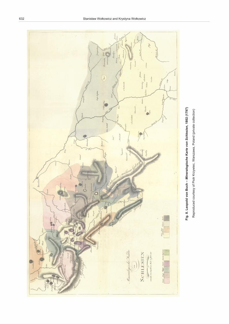
The map Mineralogische Karte von Schlesien (Fig. 8), com -piled by Leopold von Buch, a lead ing Ger man ge ol o gist, vol ca -nol o gist, and palaeontologist, shows the southwest ern parts of
Geological cartography in Poland in the 19th century 625
626 Stanis³aw Wo³kowicz and Krystyna Wo³kowicz
.2 .
giF
sin
atS
w
a³ci
zs
atS
–
atra
Ca
cig
olo
eG
s
uitot
e
ain
olo
P ,
eai
va
dlo
M ,
eai
na
vly
sn
arT
,e
aira
gn
uH
te
eai
hc
ala
V)
60
81(
51
81 ,
sro
h tu
a e
ht fo
noi t
ce ll
oc
eta
virP

Po land. Al though dated at 1797, it was pub lished as an in sert to the book Geognostische Beobachtungen auf Reisen durchDeutsch land und Italien, in 1802. This hand-col oured cop per -plate en grav ing clearly shows the main fea tures of struc turalunits of the Sudetes Moun tains: the Karkonosze Mas sif,Kaczawa struc ture, Intra-Sudetic De pres sion, Sowie GóryBlock, K³odzko-Z³oty Stok Mas sif, a belt of meta mor phic rocksof the Bystrzyckie and Orlickie Moun tains, and the Up per NysaK³odzka Trough. There are also marked out crops of lime stoneand ”Older Sand stone” (Alterer Sandstein) in ar eas of pres -ent-day Opole Silesia and Up per Silesia. Large parts of thatbook are de voted to ex ten sive de scrip tions of the land scapeand coun try through which the au thor trav elled, which is typ i calof the lit er a ture of the time. Spe cial at ten tion should be paid togen er ally ac cu rate de scrip tions of min eral re sources, to getherwith brief char ac ter is tics of the in di vid ual types of rocks.
The first de cades of the 19th cen tury were a time of sig nif i -cant ad vance in the car tog ra phy of Silesia. In 1818(?), Au gustKaluža (1776–1836), a high-school teacher from Wroc³aw, pub -lished a map Mineralogische Karte von Schlesien, in foursheets, com pris ing ter ri to ries of Po land that were gen er ally thesame as in the map of Leopold von Buch. The ex plan a tory noteto that map was en ti tled Ûbersicht der Mineralien Schlesiensund Glatz nebst ihren Fundõrtern und vielen neuenHõhenmessungenauf 4 Karten dargestellt (Kaluža, 1818). Inmap ping the area, A. Kaluža dif fer en ti ated 14 lithological units,not much more than the ten units in the map of L. von Buch.How ever, his map shows much more de tail than the lat ter, es -pe cially in the case of the Sudetes Moun tains, thus re flect ingmarked prog ress in the knowl edge of the ge ol ogy of these ar -eas (Fig. 9). In turn, the car to graphic im age of Opole Silesiaand Up per Silesia in the two maps re mained gen er ally sim i lar.
Geological cartography in Poland in the 19th century 627
Fig. 3. Jean Etienne Guettard – Carte minéralogique de Pologne, 1764
Pri vate col lec tion of the au thors
628 Stanis³aw Wo³kowicz and Krystyna Wo³kowicz
Fig. 4. Jean Etienne Guettard – Carte des mines desel de Wieliczka; Ex pla na tion de la carte, 1764b
Pri vate col lec tion of the au thors
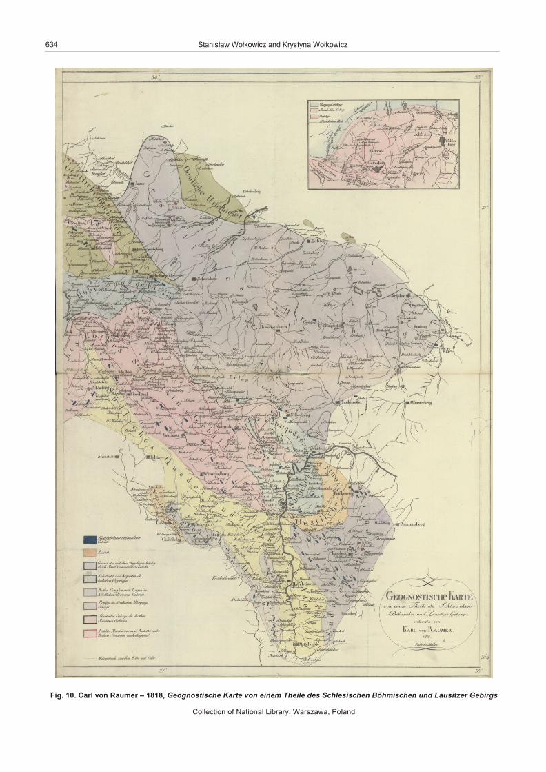
The above-men tioned Carl von Raumer map, Geogno -stische Karte von einem Theile des schlesischen böhmischenund lausitzer Gebirges, also dated to 1818, shows the areafrom the Nysa £u¿ycka River to the ar eas of Strzelin. Al thoughthe map key is lim ited to eight lithological units with mod er ately com plex ex pla na tions, C. von Raumer (1818) dif fer en ti atednu mer ous lo cal lithological units on the map by in tro duc ingrock names not shown in the key (Fig. 10). There fore, thiscould be the first at tempt to in tro duce a re gional sub di vi sion ofthe Sudetes Moun tains into lithological units. It is also worthnot ing a large-scale map of the Walden burg (pres entlyWa³brzych) area and its coal re sources, placed as an in sert inthe up per-right cor ner of the east ern sheet of that map. More -over, the map is sup ple mented with six geo log i cal cross-sec -tions. The qual ity of the map and ac com pa ny ing cross-sec -tions makes it pos si ble to rec og nize C. von Raumer as one ofthe best and most cre ative ge ol o gists study ing the SudetesMoun tains at the time.
Prints of maps of August Kaluža and Carl von Raumer arevery rare in Po land and cop ies in col lec tions of the Na tional Li -brary in War szawa are the only ones iden ti fied by the au thors ofthis paper.
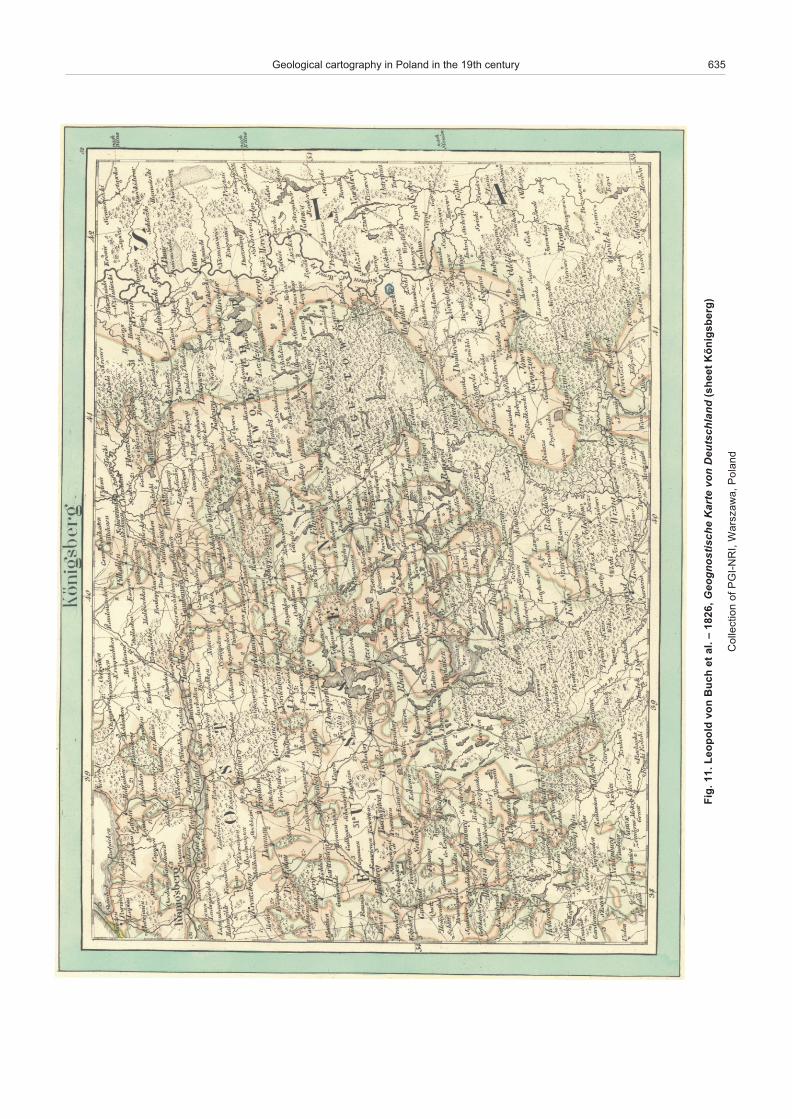
In 1826, a team headed by Leopold von Buch pub lishedGeognostische Karte von Deutchland, pre sum ably one of thefirst se ries of geo log i cal maps in the world. It con sists of 42sheets at a scale close to 1:1,000,000. The maps show a largepart of Eu rope from Paris and Clermont Ferrand in the west, toKlaipÅda (Ger man Memel) in the east, and Torino in the south.Ar eas of pres ent-day Po land are shown on sev eral sheets:
Stralsund, Breslau (Wroc³aw), Brûnn (Brno), Eperies (Presov),Danzig (Gdañsk), and Königsberg (Królewiec, now Kalinin -grad); this is pre sum ably the first mod ern geo log i cal map ofnorth-east Po land (Fig. 11). Com par i sons show that the mapswere mainly based on a com pi la tion and/or re in ter pre ta tion ofear lier ones, such as those of C. von Raumer and A. Kaluža, aswell as some still un iden ti fied sources of geo log i cal data.
A suc ces sive edi tion of geognostic maps of Ger many, com -piled by a team headed by Fredrich Hoffmann, was pub lished in 1836. This at las, Geognostische Charte von Sachsen, Schle -sien einem Theile Bõhmens und der Rheinlande in 50 Blätternzur östlichen und westlichen Erweiterung der geognostischenCharte vom nordwestlichen Deutsch land, com prises 50 sheetspub lished at a scale close to 1: 200,000. The pres ent-day areaof Po land is cov ered by the Spremberg, Bunzlau, Zittau, Hirs -chberg, Breslau, Brieg, Kreutzburg, Mûnchengrätz, Trautenau,Glatz, Oppeln, Gleiwitz, Königgrätz, Mittelwalde, Troppau andRatibor sheets. The map key com prises 44 units of a mixedchar ac ter: from lithological (for ex am ple, gran ite, syenite, andsyenitoporphyry units) to lithostratigraphic (for ex am ple, sand -stones of Ju ras sic age with coal lay ers). The map key in cludesex pla na tions in Ger man as well as in Eng lish and/or French.The Hirschberg (Jelenia Góra) sheet (Fig. 12) may be treatedas fur ther ev i dence of re mark able prog ress in the knowl edge ofthe ge ol ogy and car tog ra phy of these ar eas in the 1820s and1830s. This map is gen er ally sim i lar to pres ent-day maps of that area. Com plete cop ies of that at las are very rare. The Na tionalGeo log i cal Ar chives of Pol ish Geo log i cal In sti tute – Na tionalRe search In sti tute hold only 15 sheets of this map.
Geological cartography in Poland in the 19th century 629
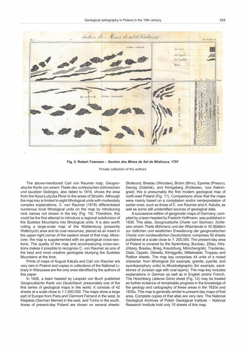
Fig. 5. Rob ert Townson – Sec tion des Mines de Sel de Wieliczca, 1797
Pri vate col lec tion of the au thors
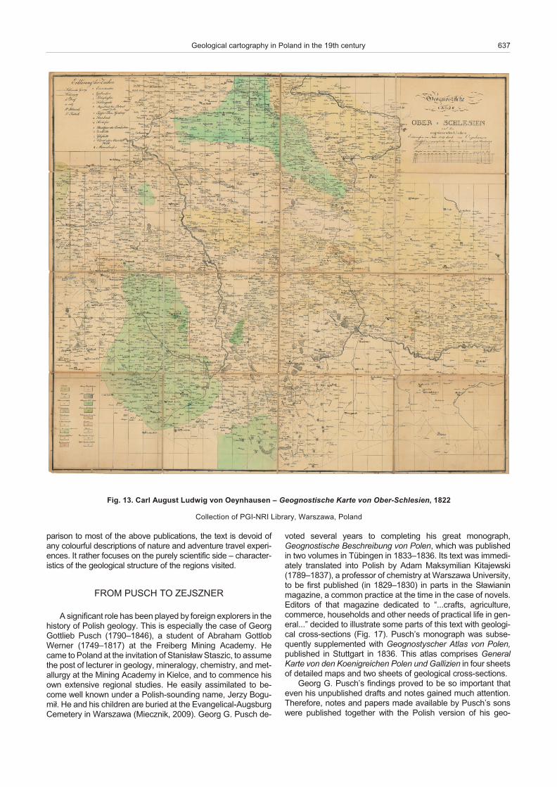
Prog ress in geo log i cal map ping of the ar eas of pres ent-daycen tral and east ern Po land has been much slower. In the caseof Up per Silesia, the most im por tant map from these times isGeognostiche Karte von Ober-Schlesien, com piled by Carl vonOeynhausen (1795–1865), a widely rec og nized min ing ex pert(Fig. 13). It was com piled most prob a bly in 1819 to be pub lished in 1822, as an en clo sure to an ex ten sive study, en ti tled Bersuch einer geonostischen Beschreibung von Oberschlesien und den nachst angrenzenden Gegenden von Polen, Galizien undÖstreichisch-Schlesien. It is one of the first geo log i cal maps ofthis re gion and at the same time may serve as an ex am ple of amod ern ap proach to geo log i cal map ping. Its map key com -prises 18 lithological units. More over, it pro vides in for ma tion onthe lo ca tion of min eral raw ma te rial ex trac tion and pro cess ingop er a tions, from metal ore mines to in takes of min eral wa ter.
The old est map of the Tatra Moun tains, Tatra ver susSeptemtrionem, was com piled by Baltazar Hacquet (1739 or1740–1815) (Fig. 14), a French min er al o gist and pro fes sor atthe Jan Kazimierz Uni ver sity in Lviv and, sub se quently, theJagiellonian Uni ver sity in Kraków. The map was drawn in 1796as an en clo sure to the book Hacquets neueste physikalisch-
politische Reisen durch die Dacischen und Sarmatischen odernordlichen Karpathen. It shows types of rocks (gran ites, gneiss -es, and lime stones) as well as sil ver, cop per, and iron ore in that re gion. This map may be treated as a geo log i cal sketch that ismuch sim pler in form and con text than the above-men tionedKarkonosze map of Johann Jirasek, pub lished sev eral yearsear lier.
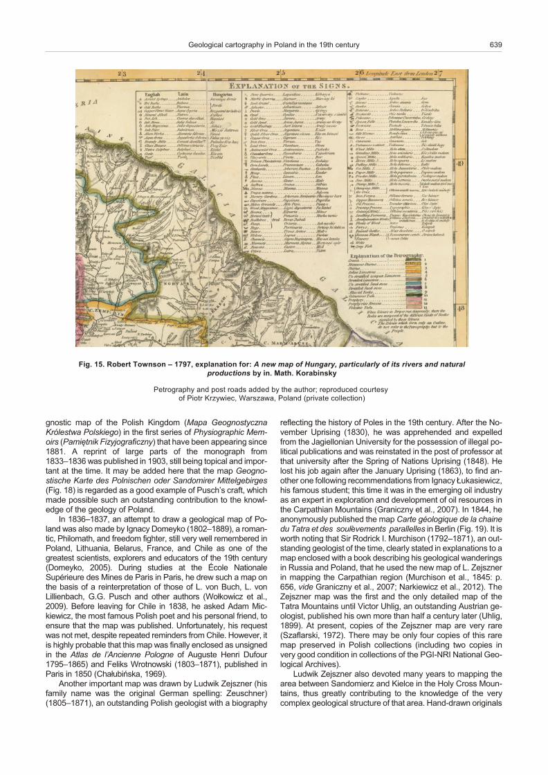
The south-east ern most parts of Po land be came a sub ject of in ter est to re search ers in volved in the ex plo ra tion of Hun garyand ad ja cent ar eas. In 1797, Rob ert Townson (1762–1827), anEng lish scholar, sci en tist, med i cal prac ti tio ner by pro fes sion,and a born trav el ler, pub lished a book en ti tled Trav els in Hun -gary with a short ac count of Vi enna in the 1793 and A new mapof Hun gary, par tic u larly of its rivers and nat u ral pro duc tions byMath. Korabinsky. Pe trog ra phy and post roads added by theau thor as an en clo sure. As em pha sized in its ti tle, the map wasdrawn on the ba sis of that of Johann Matthias Korabinsky(1740–1811), and pres ents ex ten sive in for ma tion on the oc cur -rences of the main min eral re sources, the main crops, live stockand wild an i mals, sites of food and min eral raw ma te rial pro -cess ing, sup ple mented by R. Townson with in for ma tion on the
630 Stanis³aw Wo³kowicz and Krystyna Wo³kowicz
Fig. 6. Diderot et al. – Vue générale de la Mine de Sel de Wieliczka en prés Cracovie; sup ple ment 1772
Re pro duced cour tesy of Piotr Krzywiec, War szawa, Po land (pri vate col lec tion)
pe trog ra phy of the rocks (map key with 13 petrographic units)(Fig. 15) in ar eas through which he trav elled. In one of thesetrav els he vis ited the Tatra Moun tains and the Podhale re gion,from where he re ported the pres ence of gran ites of the Tatracrys tal line core as well as of strat i fied sand stones and lime -stones. In the third vol ume of his book, 58 pages are de voted tode scrip tions of his trav els to the Tatra Moun tains, Wieliczkaand Kraków, il lus trated with four cop per plate en grav ings of theWieliczka salt struc tures.
Carte Géologique de la Hongrie et de la Transylvanie avecune partie des pays limitrophes was com piled most prob a bly in1822 by Francois Sulpice Beudant (1787–1850), an out stand -ing French min er al o gist. This map orig i nates from an at las thatwas a part of his mono graph, Voy age minéralogique et géolo -gique en Hongrie, pen dant l’annee 1818. The map clearly
shows the arc formed by the Carpa thian moun tain ranges, thepres ence of gran ite in the Tatra Moun tains, and the sed i men -tary for ma tions in the Outer Carpa thians.
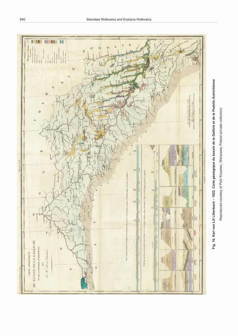
The group of maps com piled by ge ol o gists and trav el lers dur -ing that ep och should also in clude Carte géologique du bassin de la Gallicie et de la Podolie Autrichienne, by Karl Lill vonLilienbach (1798–1831). It was pub lished as an en clo sure to his60-page pa per, De scrip tion du bassin de la Gallicie et de laPodolie in Mémoires de la Sociéte Géologique de France, in1833. Spe cial at ten tion should be paid to the very de tailed map -ping of deeply in cised val leys of the Dnister River and its trib u tar -ies (Fig. 16). The map key com prises 14 units of a lithostrati -graphic na ture. The map is sup ple mented with two geo log i calcross-sec tions and 14 pro files of nat u ral ex po sures and quarrywalls, drawn with the use of a sep a rate key of eight units. In com -
Geological cartography in Poland in the 19th century 631
Fig. 7. Johann Jirasek – Petrographische Charte eines Theils de Bõhmischen Riesengebirges an der Schlesischen Gränze, 1791
Pri vate col lec tion of the au thors
632 Stanis³aw Wo³kowicz and Krystyna Wo³kowicz
n
ov
dlo
po
eL .
8 .gi
Fh
cu
B
–
eh
csi
gol
are
niM
etr
aK
n
ov
nei
sel
hc
S)
79
71(
20
81 ,
fo y
se tr
uo
c d
ec
u d
or p
eR
rtoi
P
cei
wyzr
K ,
aw
az
sra
W)
noi t
ce ll
oc
eta
virp(
dn
a lo
P ,

Geological cartography in Poland in the 19th century 633
ts
u g
uA .
9 .gi
Ful
aK
,8
18
1 –
až
eh
csi
gol
are
niM
etr
aK
n
ov
nei
sel
hc
S)
ES t
ee
hs(
,yrar
biL l
an
oi ta
N fo
noi t
ce ll
oC
aw
az
sra
Wd
na l
oP ,
634 Stanis³aw Wo³kowicz and Krystyna Wo³kowicz
Fig. 10. Carl von Raumer – 1818, Geognostische Karte von einem Theile des Schlesischen Bõhmischen und Lausitzer Gebirgs
Col lec tion of Na tional Li brary, War szawa, Po land
Geological cartography in Poland in the 19th century 635
n
ov
dlo
po
eL .
11 .
giF
hc
uB
,6
28
1 – .l
a te
eh
csit
so
ng
oe
G
etra
Kd
na l
hc
stu
eD
no
v t
ee
hs(
gre
bs
gin
õK
)
fo
noi t
ce ll
oC
IR
N-IG
P ,
aw
az
sra
Wd
na l
oP ,

636 Stanis³aw Wo³kowicz and Krystyna Wo³kowicz
.2
1 .gi
Fh
cird
erF
,6
38
1 –
nn
amff
oH
eh
csit
so
ng
oe
G
etra
hC
n
ov
ne
sh
ca
S ,
nei
sel
hc
S
me
nie
eli
eh
T
sn
em
hõ
B r
ed
dn
u e
dn
alni
eh
R
05
ni nr
ettäl
B
ru
z
ne
hcilt
sõ
d
nu
ne
hcilt
se
w
gn
ureti
ewr
E r
ed
ne
hc
sits
on
go
eg
etr
ah
C
mo
v
ne
hcilt
se
wdr
on
dn
a lh
cst
ue
D (
te
eh
sgr
eb
hc
sriH
)
fo
noi t
ce ll
oC
IR
N-IG
P ,
aw
az
sra
Wd
na l
oP ,
par i son to most of the above pub li ca tions, the text is de void ofany colour ful de scrip tions of na ture and ad ven ture travel ex pe ri -ences. It rather fo cuses on the purely sci en tific side – char ac ter -is tics of the geo log i cal struc ture of the re gions vis ited.
FROM PUSCH TO ZEJSZNER
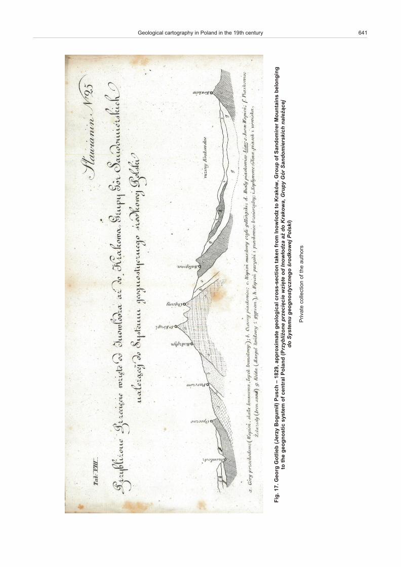
A sig nif i cant role has been played by for eign ex plor ers in the his tory of Pol ish ge ol ogy. This is es pe cially the case of GeorgGottlieb Pusch (1790–1846), a stu dent of Abra ham GottlobWerner (1749–1817) at the Freiberg Min ing Acad emy. Hecame to Po land at the in vi ta tion of Stanis³aw Staszic, to as sume the post of lec turer in ge ol ogy, min er al ogy, chem is try, and met -al lurgy at the Min ing Acad emy in Kielce, and to com mence hisown ex ten sive re gional stud ies. He eas ily as sim i lated to be -come well known un der a Pol ish-sound ing name, Jerzy Bogu -mi³. He and his chil dren are bur ied at the Evan gel i cal -AugsburgCem e tery in Warszawa (Miecznik, 2009). Georg G. Pusch de -
voted sev eral years to com plet ing his great mono graph,Geognostische Beschreibung von Polen, which was pub lishedin two vol umes in Tübingen in 1833–1836. Its text was im me di -ately trans lated into Pol ish by Adam Maksymilian Kitajewski(1789–1837), a pro fes sor of chem is try at War szawa Uni ver sity,to be first pub lished (in 1829–1830) in parts in the S³awianinmag a zine, a com mon prac tice at the time in the case of nov els.Ed i tors of that mag a zine ded i cated to “...crafts, ag ri cul ture,com merce, house holds and other needs of prac ti cal life in gen -eral...” de cided to il lus trate some parts of this text with geo log i -cal cross-sec tions (Fig. 17). Pusch’s mono graph was sub se -quently sup ple mented with Geognostyscher At las von Polen,pub lished in Stuttgart in 1836. This at las com prises Gen eralKarte von den Koenigreichen Polen und Gallizien in four sheetsof de tailed maps and two sheets of geo log i cal cross- sec tions.
Georg G. Pusch’s find ings proved to be so im por tant thateven his un pub lished drafts and notes gained much at ten tion.There fore, notes and pa pers made avail able by Pusch’s sonswere pub lished to gether with the Pol ish ver sion of his geo -
Geological cartography in Poland in the 19th century 637
Fig. 13. Carl Au gust Lud wig von Oeynhausen – Geognostische Karte von Ober-Schlesien, 1822
Col lec tion of PGI-NRI Li brary, War szawa, Po land

638 Stanis³aw Wo³kowicz and Krystyna Wo³kowicz
.4
1 .gi
Fr
az
atla
B
te
uq
ca
H ,
69
71
– art
aT
s
u sr
ev
me
noirt
met
pe
S
,e
cn
eic
S fo y
m e
da
cA
hs il
oP ,
mu
e s
uM
htra
E fo
noi t
ce ll
oC
aw
az
sra
Wd
na l
oP ,
gnostic map of the Pol ish King dom (Mapa GeognostycznaKrólestwa Polskiego) in the first se ries of Phys io graphic Mem -oirs (Pamiêtnik Fizyjograficzny) that have been ap pear ing since 1881. A re print of large parts of the mono graph from1833–1836 was pub lished in 1903, still be ing top i cal and im por -tant at the time. It may be added here that the map Geogno -stische Karte des Polnischen oder Sandomirer Mittelgebirges(Fig. 18) is re garded as a good ex am ple of Pusch’s craft, whichmade pos si ble such an out stand ing con tri bu tion to the knowl -edge of the ge ol ogy of Po land.
In 1836–1837, an at tempt to draw a geo log i cal map of Po -land was also made by Ignacy Domeyko (1802–1889), a ro man -tic, Philomath, and free dom fighter, still very well re mem bered inPo land, Lith u a nia, Belarus, France, and Chile as one of thegreat est sci en tists, ex plor ers and ed u ca tors of the 19th cen tury(Domeyko, 2005). Dur ing stud ies at the École NationaleSupérieure des Mines de Paris in Paris, he drew such a map onthe ba sis of a re in ter pre ta tion of those of L. von Buch, L. vonLillienbach, G.G. Pusch and other au thors (Wo³kowicz et al.,2009). Be fore leav ing for Chile in 1838, he asked Adam Mic -kiewicz, the most fa mous Pol ish poet and his per sonal friend, toen sure that the map was pub lished. Un for tu nately, his re questwas not met, de spite re peated re mind ers from Chile. How ever, itis highly prob a ble that this map was fi nally en closed as un signedin the At las de l’Ancienne Pologne of Auguste Henri Dufour1795–1865) and Feliks Wrotno wski (1803–1871), pub lished inParis in 1850 (Cha³ubiñska, 1969).
An other im por tant map was drawn by Ludwik Zejszner (hisfam ily name was the orig i nal Ger man spell ing: Zeuschner)(1805–1871), an out stand ing Pol ish ge ol o gist with a bi og ra phy
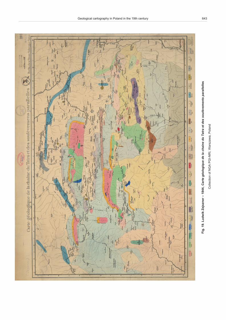
re flect ing the his tory of Poles in the 19th cen tury. Af ter the No -vem ber Up ris ing (1830), he was ap pre hended and ex pelledfrom the Jagiellonian Uni ver sity for the pos ses sion of il le gal po -lit i cal pub li ca tions and was re in stated in the post of pro fes sor atthat uni ver sity af ter the Spring of Na tions Up ris ing (1848). Helost his job again af ter the Jan u ary Up ris ing (1863), to find an -other one fol low ing rec om men da tions from Ignacy £ukasiewicz, his fa mous stu dent; this time it was in the emerg ing oil in dus tryas an ex pert in ex plo ra tion and de vel op ment of oil re sources inthe Carpathian Moun tains (Graniczny et al., 2007). In 1844, heanon y mously pub lished the map Carte géologique de la chainedu Tatra et des soulÀvements parallelles in Berlin (Fig. 19). It is worth not ing that Sir Rodrick I. Murchi son (1792–1871), an out -stand ing ge ol o gist of the time, clearly stated in ex pla na tions to a map en closed with a book de scrib ing his geo log i cal wan der ings in Rus sia and Po land, that he used the new map of L. Zejsznerin map ping the Carpathian re gion (Murchi son et al., 1845: p.656, vide Graniczny et al., 2007; Narkiewicz et al., 2012). TheZejszner map was the first and the only de tailed map of theTatra Moun tains un til Vic tor Uhlig, an out stand ing Aus trian ge -ol o gist, pub lished his own more than half a cen tury later (Uhlig,1899). At pres ent, cop ies of the Zejszner map are very rare(Szaflarski, 1972). There may be only four cop ies of this raremap pre served in Pol ish col lec tions (in clud ing two cop ies invery good con di tion in col lec tions of the PGI-NRI Na tional Geo -log i cal Ar chives).
Ludwik Zejszner also de voted many years to map ping thearea be tween Sandomierz and Kielce in the Holy Cross Moun -tains, thus greatly con trib ut ing to the knowl edge of the verycom plex geo log i cal struc ture of that area. Hand-drawn orig i nals
Geological cartography in Poland in the 19th century 639
Fig. 15. Rob ert Townson – 1797, ex pla na tion for: A new map of Hun gary, par tic u larly of its rivers and nat u ralpro duc tions by in. Math. Korabinsky
Pe trog ra phy and post roads added by the au thor; re pro duced cour tesy of Piotr Krzywiec, War szawa, Po land (pri vate col lec tion)
640 Stanis³aw Wo³kowicz and Krystyna Wo³kowicz
n
ov lr
aK .
61 .
giF
lliL
h
ca
bn
eiliL
,2
28
1 –
etr
aC
eu
qig
olo
ég
u
d ni
ss
ab
al
ed
eicill
aG
al
ed t
e eil
od
oP
e
nn
eih
cirtu
A
fo y
se tr
uo
c d
ec
u d
or p
eR
rtoi
P
cei
wyzr
K ,
aw
az
sra
W)
noi t
ce ll
oc
eta
virp(
dn
a lo
P ,
Geological cartography in Poland in the 19th century 641
gr
oe
G .7
1 .gi
Fb
eilto
G(
yzr
eJ
i
mu
go
B )³
hc
su
P
morf
ne
kat
noi t
ce
s-s
sor
c la
c ig
o lo
eg
eta
m ix
or p
pa ,
92
81
– z
dol
wo
nI
ot w
ók
arK
fo
pu
orG ,
reri
mo
dn
aS
g
n ig
no l
eb
sni
a tn
uo
M
eht
otcit
so
ng
oe
g(
dn
a lo
P lar t
ne
c fo
me t
sy
s P
en
o¿il
by
zr
eic
êic
ezr
p
etêi
zw
d
o
wo
nI³
az
do
o
d ¿
a a
wo
kar
K ,
yp
urG
r
óG
h
cik
srei
mo
dn
aS
¿
ela
n¹
je
c
o
du
met
sy
S
og
en
zc
yts
on
go
eg
j
ew
ok
dor
œ
ik
slo
P)
sro
h tu
a e
ht fo
noi t
ce ll
oc
eta
virP

of these maps are kept in col lec tions of the Silesian Li brary inKatowice (Graniczny et al., 2007).
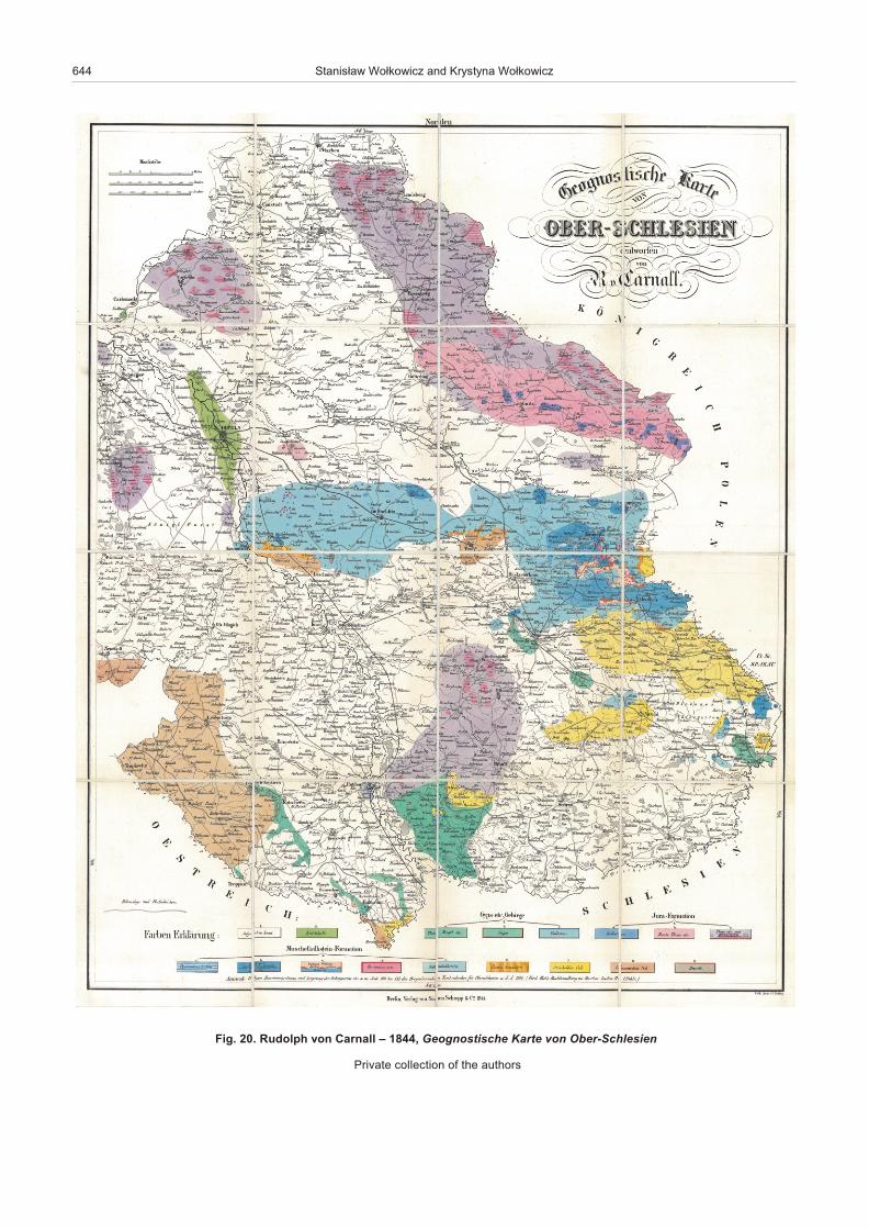
In 1844, the Geognostische Karte von Ober-Schlesien (Fig.20), of Rudolph von Carnall (1804–1874), was also pub lished. Incom par i son to the above map of Oeynhausen, he dif fer en ti atedgeo log i cal units of a lithostratigraphic type with re gional el e ments as, for ex am ple, the Opatowitzer Kalkstein (Wo³kowicz et al., inpress). He used only 17 units, yet the map is very de tailed in theTarnowskie Góry and other ar eas. This is es pe cially the case ofiron, zinc, and lead ores.
In 1848, Hieronim £abêdzki pub lished a trans la tion of a F.Beudant man ual of min er al ogy and ge ol ogy, sup ple mentedwith his com pi la tion of An out line of ge ol ogy of moun tains andplains of the Pol ish King dom and ad join ing ar eas (Zarys ziemio -znawczy gór i równin Królestwa Polskiego i krain przyleg³ych).This man ual, de signed for sec ond ary school stu dents, was
char ac ter ised by a very good trans la tion and well writ ten chap -ters on the ge ol ogy of Po land.
Ed i to rial work on pro duc ing the Ag ri cul ture Encyclopaediastarted in the late 1860s. In its sec ond vol ume (Lubomirski et al.,1874), three geo log i cal maps were pub lished, which showed thegrow ing role of ge ol ogy as a sep a rate dis ci pline in Pol ish sci en -tific cen tres. These maps were com piled by: Win centy Kosiñski(Geo log i cal map of the Pol ish King dom – Mappa GeologicznaKrólestwa Polskiego), Jakub Stanowski, Albin Kohn(1820–1880) and Au gust Lubomêski (1820–1889) (Geo log i calMap of the Great Duchy of Poznañ – Mappa Geolo gicznaWielkiego Ksiêstwa Poznañskiego) (Fig. 21), and Karol Langie(Geo log i cal Map of the King dom of Galicia and Lodo meria –Mappa Geologiczna Królestwa Galicji i Lodomerii). The mapsrep re sented an in te gral part of the encyclo paedia en try about ge -ol ogy, 100 pages long.
642 Stanis³aw Wo³kowicz and Krystyna Wo³kowicz
Fig. 18. Georg Gotlieb (Jerzy Bogumi³) Pusch – Geognostyscher At las von Polen. Geognostische Karte des Polnischen oderSandomirer Mittelgebirges zwischen Sandomierz und Ma³ogoszcz, 1836
Collection of PGI-NRI Li brary, War szawa, Po land
Geological cartography in Poland in the 19th century 643
.9
1 .gi
Fki
wd
uL
r
en
zsj
eZ
,4
48
1 –
etr
aC
eu
qig
olo
ég
al
ed
eni
ah
c
ud
arta
T
se
d te
lu
os
Àst
ne
me
v
ellell
ara
ps
fo
noi t
ce ll
oC
AG
N
IR
N-IG
P ,
aw
az
sra
Wd
na l
oP ,
644 Stanis³aw Wo³kowicz and Krystyna Wo³kowicz
Fig. 20. Rudolph von Carnall – 1844, Geognostische Karte von Ober-Schlesien
Pri vate col lec tion of the au thors

Geological cartography in Poland in the 19th century 645
Fig. 21. Jakub Stanowski, Albin Kohn, August Lubomêski – 1873, Geo log i cal Map of the Great Duchy of Poznañ(Mappa Geologiczna Wielkiego Ksiêstwa Poznañskiego)
Pri vate col lec tion of the au thors
AUSTRO-HUNGARIAN
AND PRUSSIAN/GERMAN MAPS
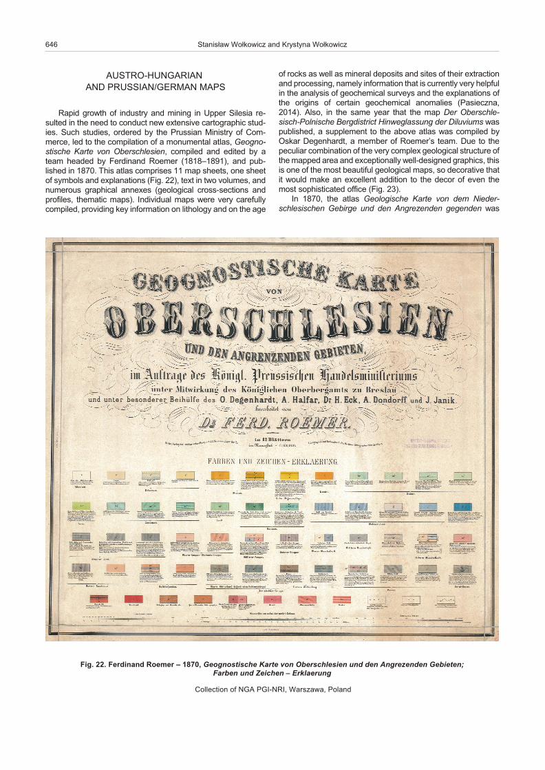
Rapid growth of in dus try and min ing in Up per Silesia re -sulted in the need to con duct new ex ten sive car to graphic stud -ies. Such stud ies, or dered by the Prus sian Min is try of Com -merce, led to the com pi la tion of a mon u men tal at las, Geogno -stische Karte von Oberschlesien, com piled and ed ited by ateam headed by Ferdinand Roemer (1818–1891), and pub -lished in 1870. This at las com prises 11 map sheets, one sheetof sym bols and ex pla na tions (Fig. 22), text in two vol umes, andnu mer ous graph i cal an nexes (geo log i cal cross-sec tions andpro files, the matic maps). In di vid ual maps were very care fullycom piled, pro vid ing key in for ma tion on li thol ogy and on the age
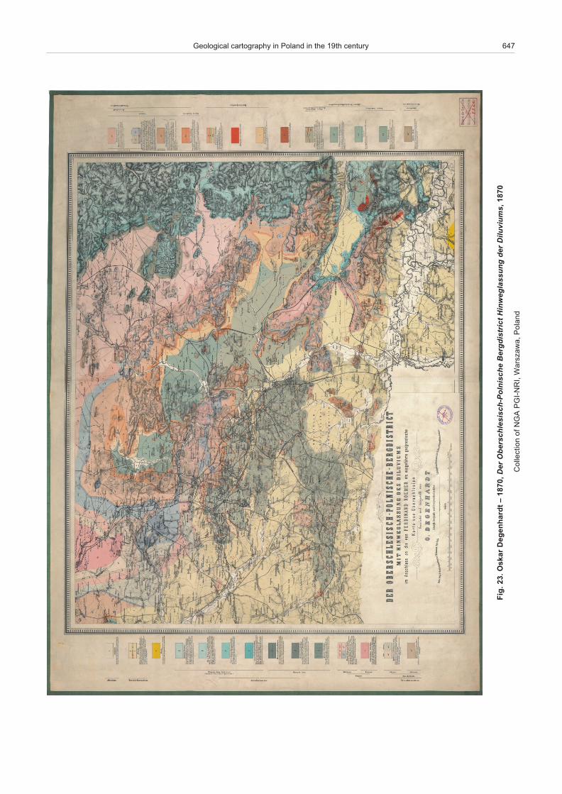
of rocks as well as min eral de pos its and sites of their ex trac tionand pro cess ing, namely in for ma tion that is cur rently very help ful in the anal y sis of geo chem i cal sur veys and the ex pla na tions ofthe or i gins of cer tain geo chem i cal anom a lies (Pasieczna,2014). Also, in the same year that the map Der Oberschle -sisch-Polnische Bergdistrict Hinweglassung der Diluviums waspub lished, a sup ple ment to the above at las was com piled byOskar Degenhardt, a mem ber of Roemer’s team. Due to thepe cu liar com bi na tion of the very com plex geo log i cal struc ture of the mapped area and ex cep tion ally well-de signed graphics, this is one of the most beau ti ful geo log i cal maps, so dec o ra tive thatit would make an ex cel lent ad di tion to the de cor of even themost so phis ti cated of fice (Fig. 23).
In 1870, the at las Geologische Karte von dem Nieder -schlesischen Gebirge und den Angrezenden gegenden was
646 Stanis³aw Wo³kowicz and Krystyna Wo³kowicz
Fig. 22. Ferdinand Roemer – 1870, Geognostische Karte von Oberschlesien und den Angrezenden Gebieten;Farben und Zeichen – Erklaerung
Col lec tion of NGA PGI-NRI, War szawa, Po land
Geological cartography in Poland in the 19th century 647
.3
2 .gi
Fr
ak
sO
t
dra
hn
eg
eD
,0
78
1 –
re
De
hc
sinl
oP-
hc
sis
elh
csr
eb
O
tcirt
sid
gre
B
gn
us
sal
ge
wni
H r
ed
sm
uiv
uliD
07
81 ,
fo
noi t
ce ll
oC
AG
N
IR
N-IG
P ,
aw
az
sra
Wd
na l
oP ,
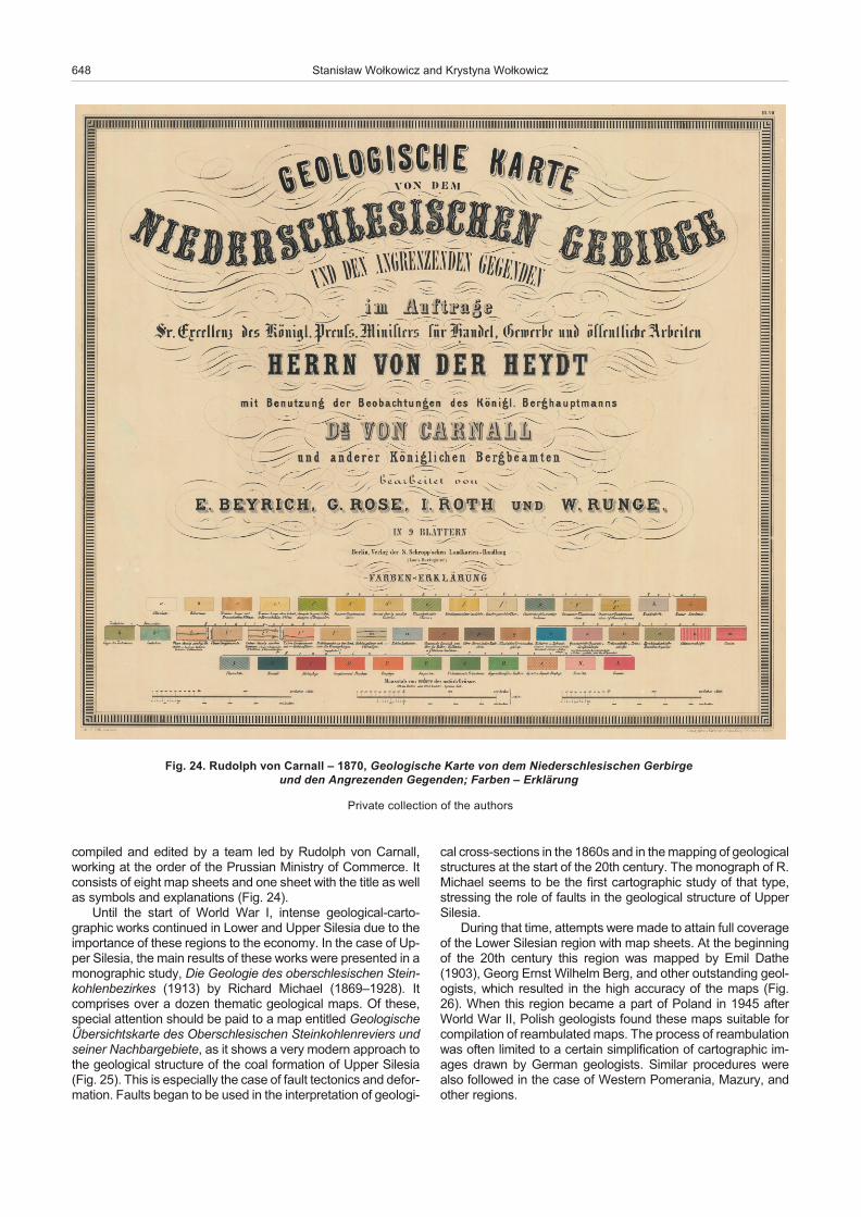
com piled and ed ited by a team led by Rudolph von Carnall,work ing at the or der of the Prus sian Min is try of Com merce. Itcon sists of eight map sheets and one sheet with the ti tle as wellas sym bols and ex pla na tions (Fig. 24).
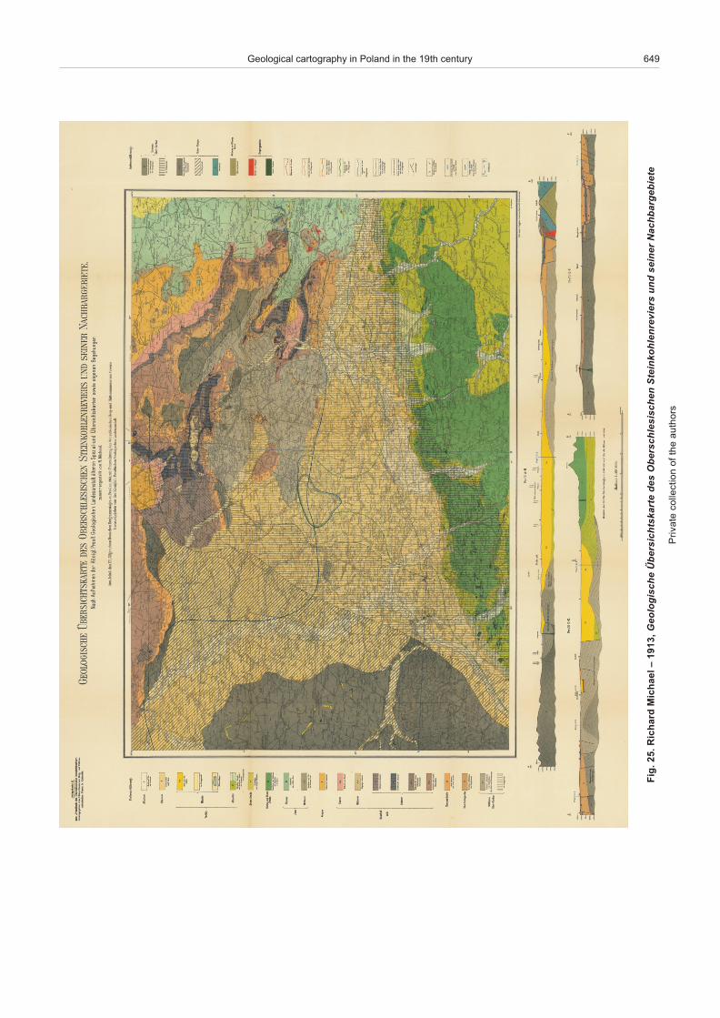
Un til the start of World War I, in tense geo log i cal-car to -graphic works con tin ued in Lower and Up per Silesia due to theim por tance of these re gions to the econ omy. In the case of Up -per Silesia, the main re sults of these works were pre sented in amono graphic study, Die Geologie des oberschlesischen Stein -kohlen bezirkes (1913) by Rich ard Mi chael (1869–1928). Itcom prises over a dozen the matic geo log i cal maps. Of these,spe cial at ten tion should be paid to a map en ti tled GeologischeÛbersichtskarte des Oberschlesischen Steinkohlenreviers undseiner Nachbar gebiete, as it shows a very mod ern ap proach tothe geo log i cal struc ture of the coal for ma tion of Up per Silesia(Fig. 25). This is es pe cially the case of fault tec ton ics and de for -ma tion. Faults be gan to be used in the in ter pre ta tion of geo log i -
cal cross-sec tions in the 1860s and in the map ping of geo log i cal struc tures at the start of the 20th cen tury. The mono graph of R.Mi chael seems to be the first car to graphic study of that type,stress ing the role of faults in the geo log i cal struc ture of Up perSilesia.
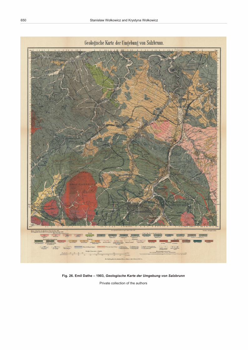
Dur ing that time, at tempts were made to at tain full cov er ageof the Lower Silesian re gion with map sheets. At the be gin ningof the 20th cen tury this re gion was mapped by Emil Dathe(1903), Georg Ernst Wil helm Berg, and other out stand ing ge ol -o gists, which re sulted in the high ac cu racy of the maps (Fig.26). When this re gion be came a part of Po land in 1945 af terWorld War II, Pol ish ge ol o gists found these maps suit able forcom pi la tion of reambulated maps. The pro cess of reambulationwas of ten lim ited to a cer tain sim pli fi ca tion of car to graphic im -ages drawn by Ger man ge ol o gists. Sim i lar pro ce dures werealso fol lowed in the case of West ern Pomerania, Mazury, andother re gions.
648 Stanis³aw Wo³kowicz and Krystyna Wo³kowicz
Fig. 24. Rudolph von Carnall – 1870, Geologische Karte von dem Niederschlesischen Gerbirge und den Angrezenden Gegenden; Farben – Erklärung
Pri vate col lec tion of the au thors
Geological cartography in Poland in the 19th century 649
,3
19
1 – l
ea
h ci
M dr
ah
ciR .
52 .
giF
eh
csi
gol
oe
G
etra
kst
hci
sre
bÛ
s
ed
ne
hc
sis
elh
csr
eb
O
srei
ver
nel
ho
kni
etS
d
nu
re
nie
s
etei
be
gra
bh
ca
N
sro
h tu
a e
ht fo
noi t
ce ll
oc
eta
virP
650 Stanis³aw Wo³kowicz and Krystyna Wo³kowicz
Fig. 26. Emil Dathe – 1903, Geologische Karte der Umgebung von Salzbrunn
Pri vate col lec tion of the au thors

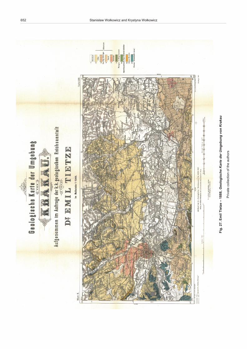
Un til 1918, most of south ern Po land be longed to theAustro- Hun gar ian Em pire, there fore, it had to be cov ered byde tailed maps, con ducted by the K.K. Geologische Reich -sanstalt. The first di rec tor of that of fice was Wil helm vonHaidinger (1795–1871), an out stand ing min er al o gist, who paidspe cial at ten tion to the ap pro pri ate cov er age of ar eas of theem pire with re view geo log i cal maps. Map ping pro grams of theK.K. Geologische Reichsanstalt also com prised a com pi la tionof nu mer ous de tailed maps. Good ex am ples of the lat ter in -clude maps of Franz von Hauer (1822–1899) (such asGeologische Ûbersichtkarte der Österreichischen Monarchie.Blatt III, 1869), Emil Tietze (1845–1931) (Geologische Karteder Umgebung von Lemberg (1882), Geologische Karte derUmgebung von Krakau (Fig. 27) and Geologische Karte derUmgebung von Chrzanów und Krzeszowice, 1888), as well asthose of Vic tor Uhlig (1857–1911), an out stand ing re searcherof the Tatra Moun tains re gion, pub lished at the be gin ning of the20th cen tury (Uhlig, 1899, 1903).
CARTOGRAPHIC ACHIEVEMENTS OF THE PHYSIOGRAPHIC COMMITTEE
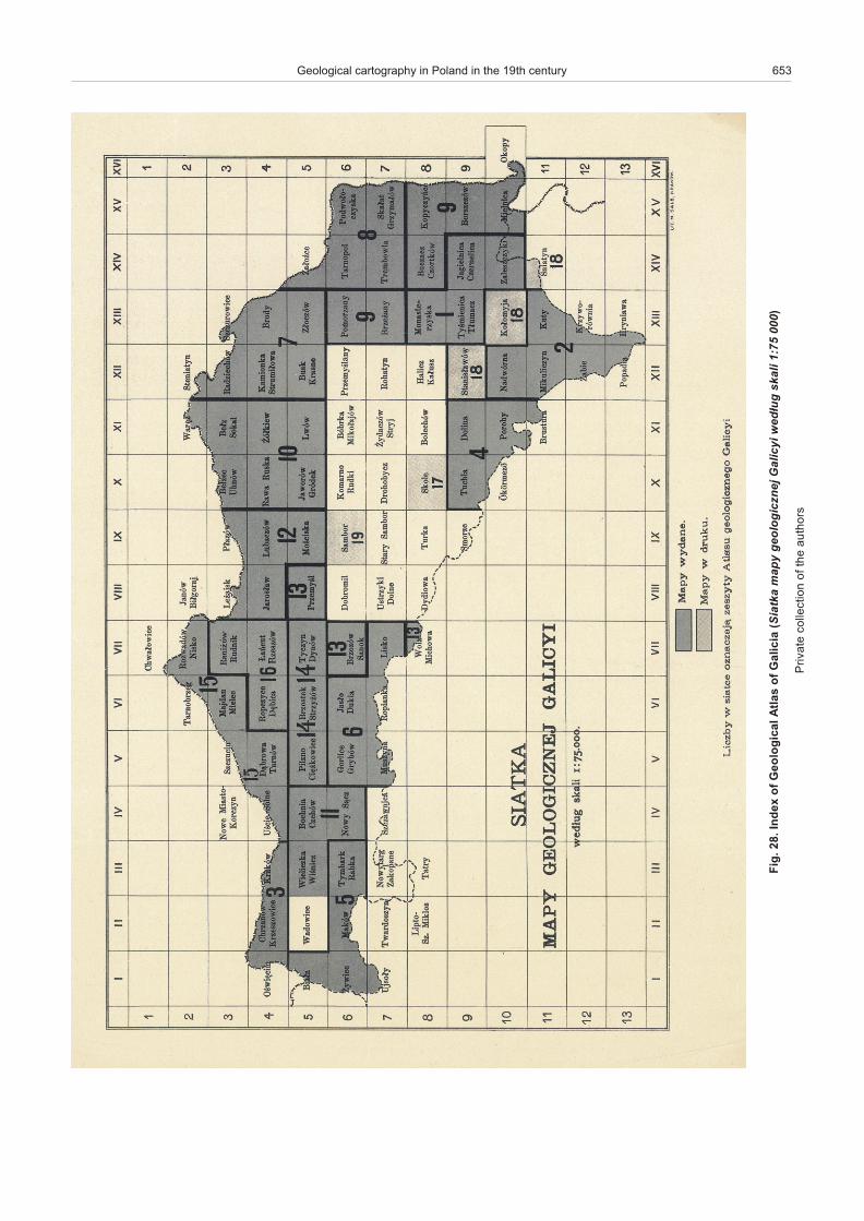
Geo log i cal map ping of Pol ish ter ri to ries gath ered mo men -tum in the late 1870s, that is, times cor re spond ing to the fourthstage in the his tory of geo log i cal stud ies of the Pol ish ter ri to ries, as dif fer en ti ated by W³adys³aw Szajnocha (1918). He namedthese main stages af ter Stanis³aw Staszic, Georg GottliebPusch, Ludwik Zejszner, and the Geo log i cal At las of Galicia.The idea to com pile the Geo log i cal At las of Galicia was put for -ward by mem bers of the Phys io graphic Com mit tee, a body es -tab lished in 1866. Work on an at las of such vast ter ri to ries wasa true chal lenge, as this would re quire sig nif i cant means tocover the costs of ex ten sive geo log i cal, strati graphic, andpalaeontological stud ies, as well as sur veys of min eral raw ma -te ri als. The ini tia tive came from Alojzy Alth, a dig ni fied-look ingman ed u cated in law and a nat u ral ist at heart, very vol u ble inspeech as is of ten the case with skilled law yers. To gether withStanis³aw Olszewski and Franciszek Bieniasz, he com piled ini -tial map sheets of that at las, which were pub lished in 1885. By1912, 25 map book lets were pub lished with over 100 mapsheets at a scale 1:75,000 (Alexandrowicz, 2008). Of theplanned map sheets, only two were not com piled (Wadowiceand Sambor sheets) (Fig. 28). This at las was pre pared by avery small team of 16 au thors. In ad di tion to those men tionedabove, this team com prised such out stand ing ge ol o gists suchas Emil Habdank-Dunikowski, Wil helm Friedberg, Jan Grzybo -wski, Mar ian £omnicki, Jaros³aw £omnicki, Piotr Mi¹czyñski,W³adys³aw Szajnocha, Wawrzyniec Teisseyre, Tadeusz Wiœ -nio wski, Kazimierz Wójcik, Stanis³aw Zarêczny, Rudolf Zuber,and the only non-Pole – the above-noted Vic tor Uhlig, the fa -mous Aus trian ge ol o gist. Nev er the less, in di vid ual map sheetsand their ex plan a tory notes vary dra mat i cally in qual ity. In some cases ex plan a tory notes are only sev eral pages long, whereasBook let no. 3, com pris ing ex plan a tory notes to two map sheetsfrom 1894 (Okrêg Krakowski – Fig. 29 and Oœwiêcim- Chrzanów-Krzeszowice), is prac ti cally a 290-page mono graphin two vol umes, with seven ta bles and in serts of 24 geo log i calcross-sec tions. Com piled by Stanis³aw Zarêczny, this book let is widely re garded as the crown ing piece of the en tire ini tia tive.
Spe cial at ten tion should be also paid to three map sheets of the Tatra Moun tain re gion (Tatry, Nowy Targ i Zakopane andSzczawnica map sheets – Fig. 30), com piled by Vic tor Uhligand pub lished af ter his death in 1912. These sheets are char -ac ter ized by pre cisely dif fer en ti ated geo log i cal units and in -
tense colours, char ac ter is tic of the Austro-Hun gar ian school ofgeo log i cal car tog ra phy.
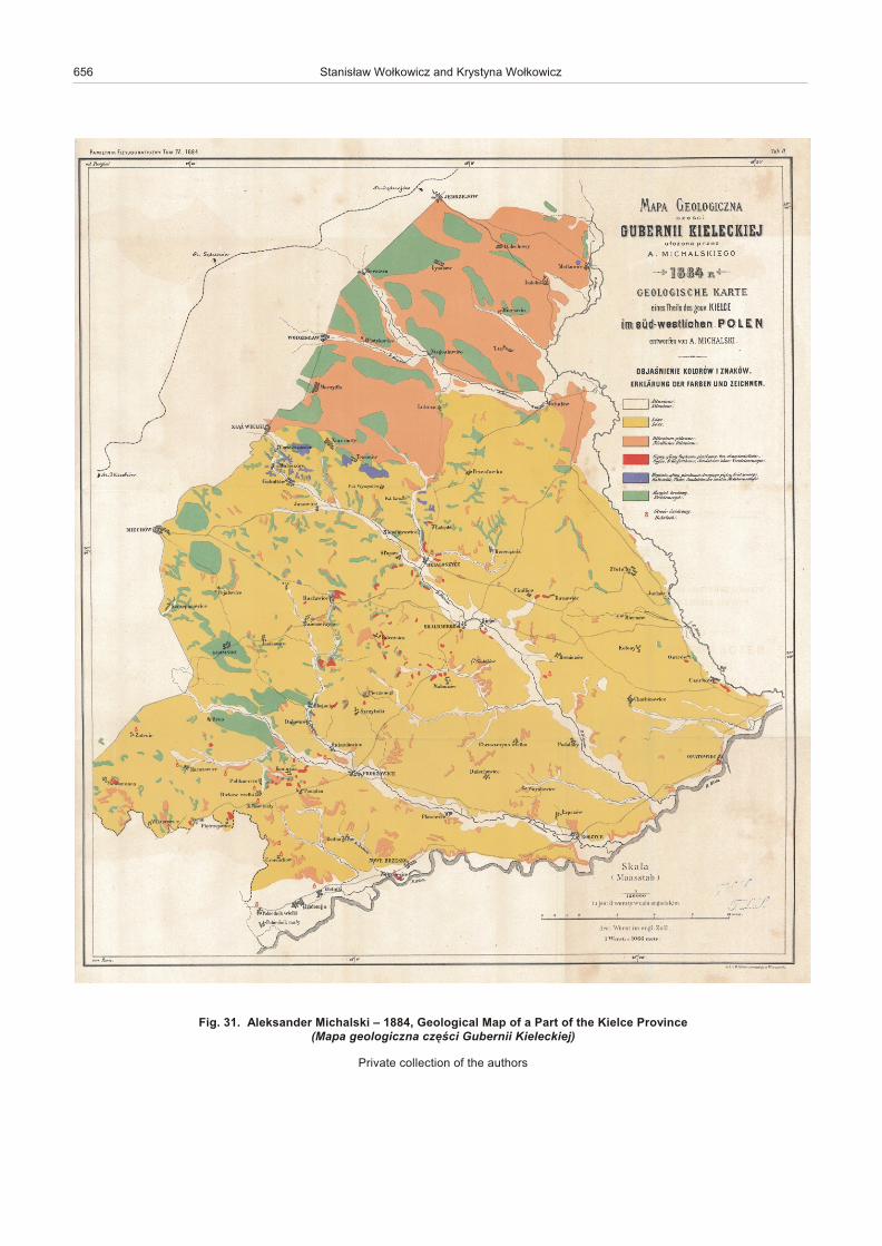
From 1881, the Phys io graphic Com mit tee be gan to pub lishPhys io graphic Mem oirs to which geo log i cal maps were very of -ten added as in serts. At least one map was added to each vol -ume of the mem oirs in the first few years. The first vol ume in -cluded the Geognostic Map of the Pol ish Kingdom of J.B.Pusch, com piled by the ed i to rial of fice on the ba sis of un pub -lished sketches, drafts, and notes made avail able by his sons. It is also worth not ing the Geo log i cal Map of a Part of the KielceProv ince of Aleksander Michalski from vol ume IV (1884) (Fig.31), the Geo log i cal Map of the Kielce-Sandomierz Moun tains of Józef Siemiradzki from vol ume VII (1887), and the Geo log i calMap of the Lublin Prov ince of Jan Trejdosiewicz from vol umeXII (1892). Spe cial at ten tion should be paid to the Geo log i calMap of the Pol ish King dom, Galicia and Ad join ing Coun tries ofJózef Siemiradzki and Emil Habdank-Dunikowski, pub lished to -gether with an ex ten sive ex plan a tory note in vol ume IX (1891).In that ex plan a tory note to that map, Józef Siemiradzki laid thefoun da tion for the ge ol ogy of gla cial de pos its, so it is treated asa mile stone in the knowl edge of the ge ol ogy of ar eas of Po land(Graniczny et al., 2008). It is be yond the scope of this pa per tolist all maps pub lished in the mem oirs, but it should be notedthat these maps mainly show ar eas of Po land un der Rus sianoc cu pa tion.
Among main car to graphic stud ies pub lished at the start ofthe 20th cen tury, it is worth re call ing Józef Grzybowski’s com pi -la tion, A Re view Geo log i cal Map of Po land and Ad join ing Ar eas with an Ex plan a tory Note from 1912. Al though that map wascom piled more than 20 years af ter the above map of JózefSiemiradzki and Emil Habdank-Dunikowski, it ap pears to be farless de tailed than the lat ter.
FINAL REMARKS
The 19th cen tury wit nessed re mark able prog ress in nat u -ral sci ence. These were times of the emer gence of ge ol ogy asa sep a rate branch of sci ence, as rep re sented in the first de -cades of that cen tury by such out stand ing per son al i ties asL. von Buch, F.S. Beudant, and R. Murchi son, and in Po landby Georg G. Pusch and L. Zejszner. In ear lier times, rocks,min er als, and min eral raw ma te ri als, called “un earthed ob -jects” by the priest K. Kluk (1797), used to be the sub ject of in -ter est of sci en tists known as nat u ral ists. Grow ing spe ciali sa -tion in geo log i cal sci ence gave rise to new dis ci plines – palae -on tol ogy, stra tig ra phy, and min er al ogy, to gether with rapid in -dus trial is ation and a re sult ing in crease in de mand for min eralre sources – eco nomic ge ol ogy. This led to the steadily in -creas ing ac cu mu la tion of geo log i cal in for ma tion, mak ing itnec es sary to find the best man ner of its pre sen ta tion. Car to -graphic pre sen ta tion was found to be the so lu tion, and mapsshow ing geo log i cal in for ma tion be gan to be named min eral,petrographic, geo gnostic, and, fi nally, geo log i cal maps. Asshown by Oldroyd (2013), S. Staszic, with his “Carta geolo -gica” from 1815, may be viewed as a pre cur sor to the idea ofus ing the term “geo log i cal map”.
Com par i sons of maps com piled from the time pe riod cov -ered in this pa per show how they evolved from very sim pledraw ings with sev eral geo log i cal units, to very de tailed maps,of ten with ex ten sive map keys com pris ing sev eral dozen var i -ous geo log i cal units. The units were ini tially of a lithological typeto be sup ple mented and later re placed by var i ous in creas inglycom plex com bi na tions of lithostratigraphic and strati graphicunits. Fi nally, el e ments of fault tec ton ics be gan to be in tro duced at the start of the 20th century.
Geological cartography in Poland in the 19th century 651
652 Stanis³aw Wo³kowicz and Krystyna Wo³kowicz
lim
E .7
2 .gi
Fe
ztei
T ,
88
81
– e
hc
sig
olo
eG
etr
aK
re
d g
nu
be
gm
U
no
v u
ak
arK
sro
h tu
a e
ht fo
noi t
ce ll
oc
eta
virP
Geological cartography in Poland in the 19th century 653
fo
sa lt
A la
c ig
o lo
eG f
o x
e d
nI .8
2 .gi
Fai
cila
G(
akt
aiS
y
pa
m
je
nz
cig
olo
eg
i
ycil
aG
³d
ew
gu
il
ak
s0
00
57:
1 )
sro
h tu
a e
ht fo
noi t
ce ll
oc
eta
virP

654 Stanis³aw Wo³kowicz and Krystyna Wo³kowicz
.9
2 .gi
Fsi
nat
S
wa³
yn
zc
êra
Z ,
49
81
– f
o s
a ltA l
a c i
go l
oe
Gai
cila
G t
ee
hS .III t
e lk
oo
B .g
êrk
O
ik
sw
ok
arK
(a
pa
M
an
zci
gol
oe
g
og
eik
sw
ok
ark
u
gêr
ko
.i
cœ
êz
C
je
nló
go
z
su
kra
y
zs
wrei
p)
sro
h tu
a e
ht fo
noi t
ce ll
oc
eta
virP

Geological cartography in Poland in the 19th century 655
ro t
ciV .
03 .
giF
gilh
U f
o s
a ltA l
a c i
go l
oe
G ,2
19
1 –
aicil
aG
te
eh
S .4
2 te l
ko
oB .
aci
nw
az
cz
S(
s
a ltA
yn
zci
gol
oe
G
iy
cila
G
– a
cin
wa
zc
zS
)
sro
h tu
a e
ht fo
noi t
ce ll
oc
eta
virP
656 Stanis³aw Wo³kowicz and Krystyna Wo³kowicz
Fig. 31. Aleksander Michalski – 1884, Geo log i cal Map of a Part of the Kielce Prov ince (Mapa geologiczna czêœci Gubernii Kieleckiej)
Pri vate col lec tion of the au thors
At pres ent, these clas sic maps can be also seen as uniquepic tures or graphic de signs. The use of colours de pended onadopted con ven tion, with as sign ment of colours to in di vid ualrocks de pend ing on their age and, in the case of ig ne ous rocks,also li thol ogy. There fore, the fi nal colour ing of a given mapsolely de pends on na ture, that is, on the types of rocks ex posed at the sur face. More over, ed i to rial of fices of ten took spe cialcare to elab o rate the graphic form of such maps, es pe cially thelet ter ing and lay out, as well as highly elab o rate beau ti fulcartouches with map ti tles. As a re sult, the view ing of clas sicgeo log i cal maps as works of art may be a real pleasure.
Ac knowl edge ments. The au thors are greatly in debted toProf. Z. Kukal, Dr A. Èejchanová, Prof. P. Krzywiec, Prof.T.M. Peryt and Dr W. Brochwicz-Lewiñski for his con struc tivecom ments on im prov ing the manu script. We would like to thankProf. P. Krzywiec for nu mer ous dis cus sions about the his tory ofgeo log i cal map ping in Po land, and for per mis sion to use mapsfrom his col lec tion to il lus trate this ar ti cle. The stud ies were con -ducted as a part of Grant no. 61.9610.1401.00.0, fi nanced bystat u tory funds of PGI-NRI.
REFERENCES
Aldrovandi, U., 1648. Musaeum Metallicum in Libros IV distributum Bartholomaevs Ambrosinus, Bo lo gna.
Alexandrowicz, S.W., 2008. Sekcja Geologiczna Komisji Fizjo -graficznej TNK i AU – dzia³alnoœæ i osi¹gniêcia. Studia i materia -³y do dziejów Polskiej akademii Umiejêtnoœci, V. Kraków.
Beudant, F.S., 1822.Voy age minéralogique et géologique enHongrie, pen dant l’annee 1818. VerdiÀre, Paris.
Brückmann, F.E., 1730. Magnalia Dei In Locis Subterraneis OderUnterirdische Schatz = Kammer Aller Königreiche und Länder, InAusführlicher Beschreibung Aller, mehr als MDC. Bergwer ckeDurch Alle vier Welt=Theile, Welche Von Entdeckung der selbenbis auf gegenwärtige Zeit gebauet worden, und noch gebauetwerden; in was Stand sie jemahls gewesen/ und wie sie jetzobeschaften; was vor Ertze Steine und Berg=Arten aus solchenjemahls gewonnen/und noch zu Tage ausgefördert wer den;Nebst Anmerckung aller derjenigen Länder und Oerter/ woEdelgesteine zu finden/In Geographischer Ordnung und eini genKupffer=Figuren zu besichtigen dargestellet von Fran ciscoErnesto Brvckmann, Med. Doct. Acad. CFsar. Nat. Cvriosor. EtSoc. Reg. Prvs. Scient. Colleg. Et Pract. Brvnsvic., Wolffenbuttel.
Buch, L. von, 1802. Geognostische Beobachtungen auf Reisendurch Deutsch land und Italien. Haude und Spener, Berlin.
Buch, L. von, Rothenburg, F.R., Kliewer, H., Jättnig, C.,Schmidt, P., 1826. Geognostische Karte von Deutsch land undden umliegenden Staa ten in 42 Blättern nach den vorzügli -chsten mitgetheilen Materialien. Si mon Schropp and Comp.,Berlin.
Carnall, R. von, 1844. Geognostische Karte von Ober-Schlesien.BerlinVerlag von Si mon Schropp and Co., .
Carnall, R. von, 1870. Geologische Karte von dem Niederschlesis -chen Gebirge und den Angrezenden gegenden. Verlag des S.Schropp’schen Landkarten Handlung (Luis Beringuier), Berlin.
Carosi, J.F., 1781 and 1784. Reisen durch verschiedene polnischeProvinzen, mineralogischen und anderen Inhalts. J.G.I. Breit -kopf, Leip zig.
Cha³ubiñska, A., 1969. Con tri bu tion d’Ignace Domeyko B lagéographie de la Pologne (in Pol ish with French sum mary). Pañstwowe Wydawnictwo Naukowe, Warszawa.
Daszkiewicz, P., Tarkowski, R., 2009. Pobyt i badania przyro dniczeJeana-Etienne’a Guettarda w Rzeczypospolitej (1760–1762) (inPol ish). Wyd. Nauk. Uniw. Pedagogicznego, Kraków.
Dathe, E., 1903. Geologische Karte der Umgebung von Salzbrunn.Ber liner Lithogr. Institut.
Degenhardt, O., 1870. Der Oberschlesisch-Polnische BergdistrictHinweglassung der Diluviums. Verlag der Landkartenhandlungvon J.H. Neuman. Verlag der Landkartenhandlung von J.H.Neumann, Lithographie und Farbendruck des Ber liner Lithogra -phischen Instituts, Berlin.
Dufour, A.H., Wrotnowski, F., 1850. At las de l’Ancienne Pologne.Paris.
Diderot, D., le Rond d’Alembert, J., Breton, A., Condillac, E.,Daubenton, L.J., Helvétius, C.A., Holbach, P., Jaucourt, C.,
Montesquieu, C.L., Rous seau, J.-J., Turgot, A.R.J., Vol taire., Quesnay, F., 1751–1766. Sup ple ment 1772. Encyclo pédie, oudictionnaire raisonné des sci ences, des arts et des métiers.
D³ugosz, J., 1455–1480. Annales seu cronicae incliti RegniPoloniae.
Domeyko, P., 2005. A Life in Ex ile. Ignacy Domeyko 1802–1889.Syd ney, Aus tra lia.
Gloger, Z., 1888. Wyci¹gi z dziejów Polskich D³ugosza dotycz¹cefizyjografii dawnej Polski. Pamiêtnik Fizyjograficzny, VIII. Dzia³V – Mis cel la nea. Drukarnia Emila Skiwskiego, Warszawa.
Graniczny, M., Kacprzak, J., Ur ban, H., Krzywiec, P., 2007.Ludwik Zejszner – ce leb rity nat u ral ist, one of the pi o neers ofgeo log i cal car tog ra phy in Po land (in Pol ish). Przegl¹d Geolo -giczny, 55: 925–932.
Graniczny, M., Kacprzak, J., Marks, L., Ur ban, H., 2008. JózefSiemiradzki (1858-1933) – un un usual ge ol o gist (in Pol ish).Przegl¹d Geologiczny, 56: 366–372.
Grigelis, A., Wójcik, Z., Narebski, W., GelumbauskaitÅ, L.Z.,Kozák, J., Czarniecki, S., 2008. The first large geo log i cal mapof Cen tral and East ern Eu rope (1815). Geologija, 50, 125–134.
Grigelis, A., Wójcik, Z., Narebski, W., GelumbauskaitÅ, L.Z.,Kozák, J., 2011. Stanis³aw Staszic: an early sur veyor of the ge -ol ogy of cen tral and East ern Eu rope An nals of Sci ence, 68:199–228.
Grzybowski, J., 1912. Przegl¹dowa Mapa geologiczna Polski iobszarów s¹siednich (in Pol ish). Zygmunt Weyberg, Warszawa.
Guettard, J.-E., 1764a. Na ture du Ter rain de la Pologne, et desMinéraux qu’il renferme. Historie de l’Académie Royale des Sci -ence. de l’Imprimerie Royale, Paris.
Guettard, J.-E., 1764b. Les mines de sel Wieliczka en Pologne.Historie de l’Académie Royale des Sci ence. de l’ImprimerieRoyale, Paris.
Hill, J., 1748. A His tory of Fos sils. Printed for Thomas Osborne, inGray’s-Inn, Holbourn, Lon don.
Hacquet, B., 1796. Hacquets neueste physikalisch-politischeReisen durch die Dacischen und Sarmatischen oder nordlichenKarpathen. Raspe, Nuremberg.
Hauer, F.R. von, 1869. Geologische Ûbersichtkarte der Österreichi -schen Monarchie. Blatt III. Jahrbuch Der Kaiserlich- KöniglichenGeologischen Reichsanstalt. Druck Der K.K. Hof- UndStaatsdruckerei, Wien.
Hoffmann, F., 1836. Geognostische Charte von Sachsen, Schlesieneinem Theile Böhmens und der Rheinlande in 50 Blättern zuröstli chen und westlichen Erweiterung der geognostischen Charte vom nordwestlichen Deutsch land. Si mon Shropp et Comp., Berlin.
Jirasek, J., Haenke, T., Gruber, A., Gertner, F., 1791. Beoba -chtungen auf Reisen nach dem Riesengebirge. Dresden.Böhmische Gesellschaft der Wissenschaften in WaltherischeHofbuchhandlung, Prague-Dresden.
Jonston, J., 1632. Thaumatographia naturalis, in decem classesdistincta. G. Blaev, Am ster dam.
Jonston, J., 1661. Notitia regni mineralis. “Collerianorum”, Lipsiae.
Geological cartography in Poland in the 19th century 657
Kaluža, A., 1818? Mineralogische Karte von Schlesien.
Kaluža, A., 1818. Ûbersicht der Mineralien Schlesiens und Glatznebst ihren Fundõrtern und vielen neuen Hõhenmessungen auf4 Karten dargestellt. Breslau.
Kluk, K., 1781–1782. Rzeczy kopalnych osobliwie zdatnieyszychszukanie, poznanie i za¿ycie (in Pol ish). W drukarni XX. Scho -larum Piarum, Warszawa.
Ko³odziejczyk, J., 1932. Ks. Krzysztof Kluk: dzie³a i twórczoœæ. PAU.Rozprawy Wydzia³u Matematyczno-Przyrodniczego, 69 (10).
Krzywiec, P., in prep a ra tion. Early (17th – early 19thcen tury) geo -log i cal re marks and re ports about the Wieliczka Salt Mine.
Lill von Lilienbach, K., 1833. De scrip tion du bassin de la Gallicie et de la Podolie in Mémoires de la Sociéte Géologique de France.Tom. 1er, Mém. No 4: 35–105.
Lubomirski, J.T., Stawiski, E., Przystañski S., ed., 1874. Encyklo -pedya Rolnictwa (in Pol ish). Wyd. Gebethner and Wolf, War -szawa.
£abêdzki. H., 1848. Trans la tor’s In tro duc tion to Pol ish edi tion ofBeudant, F.S., Cours elementaire de mineralogie. DrukarniaStanis³awa Str¹bskiego, Warszawa.
Mi chael, R., 1913. Die Geologie des oberschlesischen Steinko -hlen bezirkes. Abhandlungen der Kõniglich PreussischenGeolo gischen Landesanstalt, Berlin.
Michalski, A., 1884. Mapa Geologiczna czêœci Guberni Kieleckiej(in Pol ish). Pamiêtnik Fizyjograficzny, 4. Drukarnia Emila Skiw -skiego, Warszawa.
Miecznik, J.B., 2009. Graves of ge ol o gists at the War saw cemen -teries (in Pol ish). Przegl¹d Geologiczny, 57: 861–865.
Narkiewicz, M., Krzywiec, P., Diemer, J., 2012. Ge ol ogy of theHoly Cross Mts. in the eyes of Roderick Murchi son – visit in June of 1843 and its ech oes (in Pol ish with Eng lish sum mary).Przegl¹d Geologiczny, 60: 220–225.
Oeynhausen, von C., 1822. Bersuch einer geognostischen Besch re -ibung von Oberschlesien und den nachst angrenzenden Gegen -den von Polen, Galizien und Östreichisch-Schlesien, Essen.
Oldroyd, D., 2013. Maps as pic tures or di a grams: the early de vel op -ment of geo log i cal maps. GSA Spe cial Pa pers, 502: 41–101.
Pasieczna, A., 2014. Mer cury in soils, and river and stream sed i -ments in the Silesia-Cra cow Re gion (South ern Po land) (in Pol -ish with Eng lish sum mary). Biuletyn Pañstwowego InstytutuGeologicznego, 457: 69–86.
Pusch, G.G., 1829–1830. Geognostyczny Opis Polski. S³awianin.25, 392–396. Pub lisher: A.M. Kitajewski, w Drukarni Banku.
Pusch, G.G., 1933–1836. Geognostische Beschreibung von Polen. J.G. Cotta, Stuttgart und Tûbingen.
Pusch, G.G., 1836. Geognostyscher At las von Polen. J.G. Cotta,Stuttgart und Tûbingen.
Pusch, J.B., 1881. Mapa Geognostyczna Królestwa Polskiego.Pamiêtnik Fizyjograficzny, 1. Drukarnia Emila Skiwskiego,Warszawa.
Raumer, C. von, 1813. Geognostische Skizze von einem Theile desschlesischen, böhmischen, und lausitzer Gebirges. In: Granit des Riesengebirges und die ihn umgebenden Gebirges Familien.
Raumer, C. von, 1818. Geognostische Karte von einem Theile desSchlesischen Böhmischen und Lausitzer Gebirgs.
Roemer, F., 1870. Geognostische Karte von Oberschlesien und den Angrezenden Gebieten. Verlag der Landkartenhandlung vonJ.H. Neuman. Lithographie und Farbendruck des Ber linerLithographischen Instituts. Berlin.
Rz¹czyñski, G., 1721. Historia naturalis cu ri osa regni Poloniae,Magni Ducatus Lituaniae, annexarumq; provinciarum intractatus XX divisa: Ex scriptoribus probatis, servata primigeniaeorum phrasi in locis plurimis, ex M.S.S. variis, Testibusoculatis, relationibus fide dignis, experimentis, Sandomirae.
Rz¹czyñski, G., 1742. Auctuarium Historiae Naturalis Regni Polo -niae Magnique Ducatus Lithuniae Annexarumque Provinciarum in Puncta XII, Gedani.
Samsonowicz, J., 1948. Histoire de la géologie en Pologne (in Pol -ish with French sum mary). Polska Akademia Umiejêtnoœci.Historia Nauki Polskiej w monografiach, VI, Kraków.
Schwenckfeldt, C., 1601. Stirpium & Fossilium Silesiae Catalogus.In quo praeter etymon, natales, tem pus; Natura & vires cumvariis experimentis assignatur. Impensis Davidis Al ber ti Biblio -polae Vratislauiensis, Lipsiae.
Schwenckfeldt, C., 1607a. Hirschbergischen warmen Bades inSchlesien. Johann Rhambaw, Gorlitz.
Schwenckfeldt, C., 1607b. Therm³ Teplicenses, Von deß Töplit -zen Warmen Bades in Böhmen: Nicht weit vom Graupen gele -gen/Vrsprung/Gelegenheit/Abetheilung/Natur/Eigenschaft undrech tem gebrauch. Kurtzer vnd gründlicher Bericht. JohannRhambaw, Gorlitz.
Siemiradzki, J., 1887. Mapa Geologiczna Gór Kielecko- Sando -mierskich (in Pol ish). Pamiêtnik Fizyjograficzny, 7. DrukarniaEmila Skiwskiego, Warszawa.
Siemiradzki, J., Hadbank-Dunikowski, E., 1891. Mapa Geolo -giczna Królestwa Polskiego, Galicji i Krajów Przyleg³ych (in Pol -ish). Pamiê tnik Fizyjograficzny, 11. Drukarnia Emila Skiwskiego,Warszawa.
Skoczylas, J., 2011. The His tory of Geo log i cal Stud ies in GreaterPo land un til 1939 (in Pol ish with Eng lish sum mary). Wyd. Nauk.Uniw. Adama Mickiewicza, Poznañ.
Stanowski, J., Kohn, A., Lubomêski, A., 1873. Mappa Geolo -giczna Wielkiego Ksiêstwa Poznañskiego (in Pol ish). In:Encyklo pedya Rolnictwa (eds. J.T. Lubomirski, E. Stawiski andS. Przystañski). Wyd. Gebethner and Wolf, War szawa.
Staszic, S., 1815a. Carta Geologica totius Poloniae, Moldaviae,Transylvaniae, Hungariae et Valachiae.
Staszic, S.,1815b. O ziemiorództwie Karpatow i innych gor i rowninpolskich. W Drukarni Rz¹dowei, Warszawa.
Szaflarski, J., 1972. Poznanie Tatr (in Pol ish). Wyd. „Sport i Tury -styka”, Warszawa.
Szajnocha, W., 1918. Geologia (in Pol ish). In: Polska w kulturzepowszechnej cz. II szczegó³owa (ed. F. Koneczny). Kraków.
Tietze, E., 1882. Geologische Karte der Umgebung von Lemberg.
Tietze, E., 1888. Geologische Karte der Umgebung von Krakau,Geologische Karte der Umgebung von Chrzanów und Krzeszo -wice. Jahrbuch der k.-k. Geologischen Reichsanstalt, 37. Al fredHolder K.K. Hof- und Universit¬ts Buchh¬ndler, Wien.
Townson, R., 1797. Trav els in Hun gary, with a short ac count of Vi -enna in the year 1793. Rob in son, G. I., Pa ter nos ter Row. Jany2d 1797, Lon don.
Trejdosiewicz, J., 1892. Mapa geologiczna Gubernii Lubelskiej (inPol ish). Pamiêtnik Fizyjograficzny, 12. Drukarnia Emila Skiw -skiego, Warszawa.
Uhlig, V., 1899. Geologische Karte des Tatra-Gebirges. Denks -chriften der Kaiserlichen Akademie der Wissenschaften,Mathematisch-Naturwissenschaftliche Classe, Band, 68. Wien.
Uhlig, V. 1903. Bau und Bild der Karpaten. Wien
Uhlig, V., 1912. At las Geologiczny Galicji: Zeszyt 24, arkusze: Tatry, Nowy Targ i Zakopane, „Szczawnica”. Nak³adem AkademiiUmiejêtnoœci. Sk³ad g³ówny w Ksiêgarni Spó³ki WydawniczejPolskiej, Kraków.
Wo³kowicz, S., Wo³kowicz, K., Miecznik, J.B., 2009. Geo log i calcar tog ra phy of Pol ish ter ri to ries till 1919 – the exibition cat a -logue (in Pol ish). PGI-NRI, War szawa.
Wo³kowicz, S., Graniczny, M., Wo³kowicz, K., Ur ban, H.,Kowalski, Z., Zdanowski, A. in press. Rozwój kartografii geolo -gicznej na Górnym Œl¹sku w œwietle wybranych map histo -rycznych – od Leopolda von Bucha do Stanis³awa Doktorowicza – Hrebnickiego. Przegl¹d Górniczy.
Zarêczny, S., 1894. At las Geologiczny Galicji: Zeszyt 3, arkusze:Okrêg Krakowski i Oœwiêcim-Chrzanów-Krzeszowice (in Pol -ish). Nak³a dem Akademii Umiejêtnoœci. Sk³ad g³ówny wKsiêgarni Spó³ki Wydawniczej Polskiej, Kraków.
Zejszner, L., 1844. Carte géologique de la chaine du Tatra et dessoulÀvements parallelles. Chez Si mon Schropp and Co., Berlin.
658 Stanis³aw Wo³kowicz and Krystyna Wo³kowicz
Copyright © 2022 FDOKUMEN