PER:SATUAN GEOLOGI MALAYSIA
78
pp ISSN 0126-5539 PER : SATUAN GEOLOGI MALAYSIA NEWSLETTER OF THE GEOLOGICAL SOCIETY OF MALAYSIA Jil. 19, No. H (Vol. 19, No.6) Nov-Dec 1993 KANDUNGAN (Contents) Wan Fuad Wan Hassan: Mineral ofthe schoenfliesite-wickmanite series from 239 Sungai Gow, Pahang: A preliminary finding H.D. Tjia: The Kisap Thrust in the Kampung Kilim ar ea, Pulau Langkawi 247 Bruce W. Nelson: Estuarine sediments in Malaysia J.W. Ceri James: The marine geology off the North Lantau coast, Hong Kong and its application to infrastructure development K Fletcher: Exploration geochemistry of gold in stream sediments Petroleum Geology Seminar '93 - Laporan (F:eport) Welcoming Address by the Mr. Fateh Chand, President ofGSM Opening Address by Tuan Haji Mohamed Zohari Shaharun Progra mme Abstr acts of Papers and Posters 251 252 253 256 261 263 265 268 ::: aER1Tl fa.E .·.·.R .· . ••. · • . i.t r .··. · •. •. ·' aiR$.I .T .•• · •. U .··.· •. P.:. .·· . ••.• ·. • •. N .· •. ·• .•. · •. : •. < .• ·. ··. N . ••.• •. · • . S . ' .· • . " '.W . •• ·.· •. ' •. ' •. S .·'.". Qf. ··. · •. · •. t .··. h .· •. >. e .·. ·.· .• •• .• ·.S .·.· •. ··. P .' •. • •. '·.¢. ' •. •·. · •. l .e .·. '· .' •. t¥ . · •. { .••. l.·.. ' ........ -:-:.»:-:;:;:;:;:;:;:;:;:;:;:;:;:;:;:;:;:;:;:;:;:;:;:;: ;:;:;:;:; :::;:: :;:-:-:-:- .....................................•..•. ,'.' ..... :.:.:.:.:-:::::::::::::::::::::::::::::::::::::::::::::::::;:::;: ::;:::::::::::;::::::::::::::::::::;::::;:;:::.:.:::.:.:.:........ . .............. . ....... ... ....... ... .. . '" ........... : ••. :-.. :-:-:-.-:.;.;.:::::::::::::::::::::::::::::::::::::::-:-:-:. rrrrrmrrr Permo-Triassic of Malaysia & Associated Mineralization - Seminar & Fieldtrip Keahlian (Membership) P ertukaran Al amat (Change of Address) Curren t Ad dress Wan ted P ertambahan Baru Perpustakaan (New Library Additions) Tectonic Evolution of SE Asia Second South Asia Geological Congress (GEOSAS-II: 1995) Centennial Geocongress - Geological Society of S. Mrica Geological Atlas of Japan Kalendar (Calendar) ;),l G \f; .i jJ}) • . '" .l I "'.Jo tj. .. 1967 (' -1"_" WI\"1 I GEOLOGICAL SOCIETY OF MALAYSIA DIKELUARKAN DWIBULANAN ISSUED BIMONTHLY 291 293 293 294 294 295 297 300 301 303
-
Upload
khangminh22 -
Category
Documents
-
view
4 -
download
0
Transcript of PER:SATUAN GEOLOGI MALAYSIA
pp 168/12/9~~ ISSN 0126-5539
PER:SATUAN GEOLOGI MALAYSIA
NEWSLETTER OF THE GEOLOGICAL SOCIETY OF MALAYSIA
Jil. 19, No. H (Vol. 19, No.6) Nov-Dec 1993
KANDUNGAN (Contents)
Wan Fuad Wan Hassan: Mineral ofthe schoenfliesite-wickmanite series from 239 Sungai Gow, Pahang: A preliminary finding
H.D. Tjia: The Kisap Thrust in the Kampung Kilim area, Pulau Langkawi 247
Bruce W. Nel son: Estuarine sediments in Malaysia J.W. Ceri James: The marine geology off the North Lantau coast, Hong Kong and
its application to infrastructure development K Fletcher: Exploration geochemistry of gold in stream sediments Petroleum Geology Seminar '93 - Laporan (F:eport)
Welcoming Address by the Mr. Fateh Chand, President ofGSM Opening Address by Tuan Haji Mohamed Zohari Shaharun Programme Abstracts of Papers and Posters
251 252
253 256 261 263 265 268
:::aER1Tlfa.E.·.·.R.· .••. · •. i.tr.··.· •. ~.· •. ·'aiR$.I.T .•• · •. U.··.· •. P.:..·· .••.• ·.• •. N.· •. ·• .•. · •. : •. < .• ·.··.N .••.••. · •. S .. '.· •. "'.W .•• ·.· •. ' •. ' •. S.·'.". Qf.··.· •. · •. t .··.h.· •. >.e.·.·.· .•••..• ·.S.·.· •. ··.P.' •. • •. '·.¢.' •. •·.· •. l .e.·.'·.' •. t¥.· •. { .••. l.·.. ::,.."""::,::::",~,, , ' ........ -:-:.»:-:;:;:;:;:;:;:;:;:;:;:;:;:;:;:;:;:;:;:;:;:;:;:;:;:;:;:;:;:::;:::;:-:-:-:- .....................................•..•. ,'.' ..... :.:.:.:.:-:::::::::::::::::::::::::::::::::::::::::::::::::;:::;:::;:::::::::::;::::::::::::::::::::;::::;:;:::.:.:::.:.:.:........ . .............. . ....... ... ....... ... .. . '" ........... : ••. :-.. :- :-:-.-:.;.;.:::::::::::::::::::::::::::::::::::::::-:-:-:. rrrrrmrrr
Permo-Triassic of Malaysia & Associated Mineralization - Seminar & Fieldtrip Keahlian (Membership) Pertukaran Alamat (Change of Address) Curren t Ad dress Wan ted Pertambahan Baru Perpustakaan (New Library Additions)
Tectonic Evolution of SE Asia Second South Asia Geological Congress (GEOSAS-II: 1995) Centennial Geocongress - Geological Society of S. Mrica Geological Atlas of Japan Kalendar (Calendar)
/S,/~8---~ ;),l G oco~ \"l~X' \f; .i jJ}) ~ • . '" .l I
"'.Jo tj. .. 1967 ('
-1"_" WI\"1 I
GEOLOGICAL SOCIETY OF MALAYSIA
DIKELUARKAN DWIBULANAN ISSUED BIMONTHLY
291 293 293 294 294
295 297 300 301 303
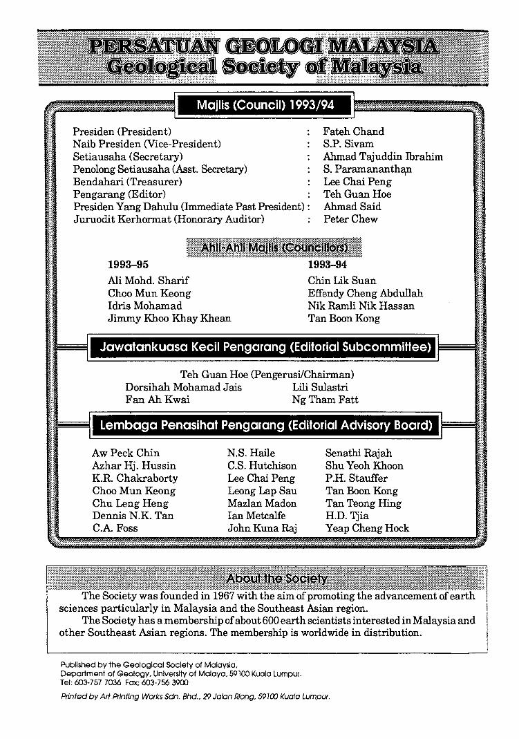
Majlis (Council) 1993/94
Presiden (President) Naib Presiden (Vice-President) Setiausaha (Secretary) Penolong Setiausaha (Asst. Secretary) Bendahari (Treasurer) Pengarang (Editor)
FatehChand S.P. Sivam Ahmad Tajuddin Ibrahim S. Paramananth~ Lee Chai Peng TehGuanHoe
Presiden Yang Dahulu (Immediate Past President) : Ahmad Said Juruodit Kerhonnat (Honorary Auditor)
1993-95 Ali Mohd. Sharif Choo Mun Keong Idris Mohamad Jimmy Khoo Khay Khean
Peter Chew
1993-94 Chin Lik Suan Effendy Cheng Abdullah Nik Ramli Nik Hassan Tan Boon Kong
Jawatankuasa Kecil Pengarang (Editorial Subcommittee)
Teh Guan Hoe (PengerusilChairman) Dorsihah Mohamad Jais Lili Sulastri Fan Ah Kwai Ng Tham Fatt
Lembaga Penasihat Pengarang (Editorial Advisory Board)
AwPeckChin Azhar Hj. Hussin K.R. Chakraborty Choo Mun Keong Chu Leng Heng Dennis N.K. Tan C.A Foss
N.S. Haile C.S. Hutchison Lee Chai Peng Leong Lap Sau Mazlan Madon Ian Metcalfe John Kuna Raj
Senathi Rajah Shu Yeoh Khoon P .H. Stauffer Tan Boon Kong Tan Teong Ring H.D. 'fjia Yeap Cheng Hock
The Society was founded in 1967 with the aim of promoting the advancement sciences particularly in Malaysia and the Southeast Asian region.
The Society has a membership of about 600 earth scientists interested in Malaysia and other Southeast Asian regions. The membership is worldwide in distribution.
Published by the Geological Society of Malaysia. Department of Geology. University of Malaya. 59100 Kuala Lumpur. Tel: 603-757 7036 Fax: 603-756 3900
Printed by M Printing Works Sdn. Bhd .. 29 Jolon Riong. 59100 Kuala Lumpur.
Mineral of the schoenfliesite-wickmanite series from Sungai Gow, Pahang: A preliminary finding
WAN FUAD WAN HAsSAN Jabatan Geologi, Universiti Kebangsaan Malaysia
43600 Bangi
Abstract. A mineral of the schoenfliesite-wickmanite series found in an abandoned mine of skarn-type tin mineralization is described. This mineral, essentially composed of Sn02 (48.15-54.51%) and FeO (24.46-28.85%) and very little (about 1%) of other metallic elements, is an iron-rich end member of the series.
IN1'RODUCTION
Minerals of the schoenfliesite-wickmanite series are rare. Schoenfliesite, MgSn(OH)6' the magnesium end-member of the series, has been described from two previous occurrences, in Brooks Mountain, Alaska, and Pitkaranta, USSR, (Faust and Schaller, 1971; Nefedov et al., 1977). Wickmanite, MnSn(OH)6' the manganese analogue of schoenfliesite, is equally rare. Some descriptions of the mineral from previous localities are found in Moore and Smith (1967), Amli and Griffin (1972) and Nefedov et al. (1977).
OCCURRENCE
Previous descriptions (N efedov et al., 1977) suggest that this mineral is associated with skarn-type tin mineralization. For example, in Pitkaranta, .Kareli, USSR, wickmanite is found in an altered garnet skarn from the dump of an old mine shaft. The skarn consists of andradite, tremolite, calcite, chlorite, quartz, sphalerite, chalcocite and small amounts of scheelite and cassiterite.
ISSN 0126-5539
For the present study, some time ago Dr. von Knorring of Leeds University gave the writer a specimen of the mineral for microexamination. This specimen was recovered from mineral samples that he collected from an abandoned tin mine, the Sungai Grow Tin Mine Company, Pahang Darul Makmur. The geology of the area is described in Syed Sheikh Almashoor (1971) and Jaafar Ahmad (1976). Briefly, the tin ore in this mine is found in a number of irregularly-shaped bodies, in a country rock consisting of hornfels, schist and slate ofKarak Formation. The irregular bodies contain highgrade concentrations of cassiterite, commonly associated with pyrite, chalcopyrite, arsenopyrite and a variety of skarn minerals. Prismatic quartz and acicular cassiterite crystals were observed on the floors and walls of the mine adit.
The schoenfliesite-wickmanite mineral, together with malayaite, the tin analogue of sphene, occur as encrustation on cassiterite or on any other crystals. Close examination of the encrustation shows there are two shades of colours; a pale yellow translucent mass and an
Warta Geoiogi, Vol. 19, No.6, Nov-Dec 1993, pp. 239-245
240 WAN FuAD WAN HAsSAN
orange globular mass. The pale yellow mass is recognised as the iron-rich member, FeSn(OH)s' while the orange type is the Fe-Mn member, (Fe Mn)Sn(OH)s'
Mineral of the schoenfliesite-wickmanite series has been described as being of a very late hydrothermal, low temperature origin (Moore and Smith, 1967; Nefedov et al., 1977). The vuggy nature of the present specimen (Plate 1) and the constant occurrence offine coatings of cryptocrystalline quartz, viz., chalcedony, on the specimen suggests that the occurrence in Sungai Gow too, is of late hydrothermal, low temperature type.
TEXTURAL RELATIONSHIP
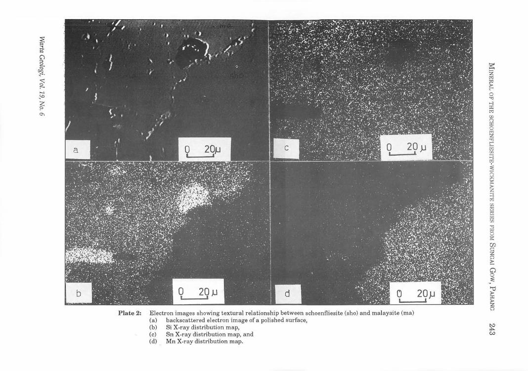
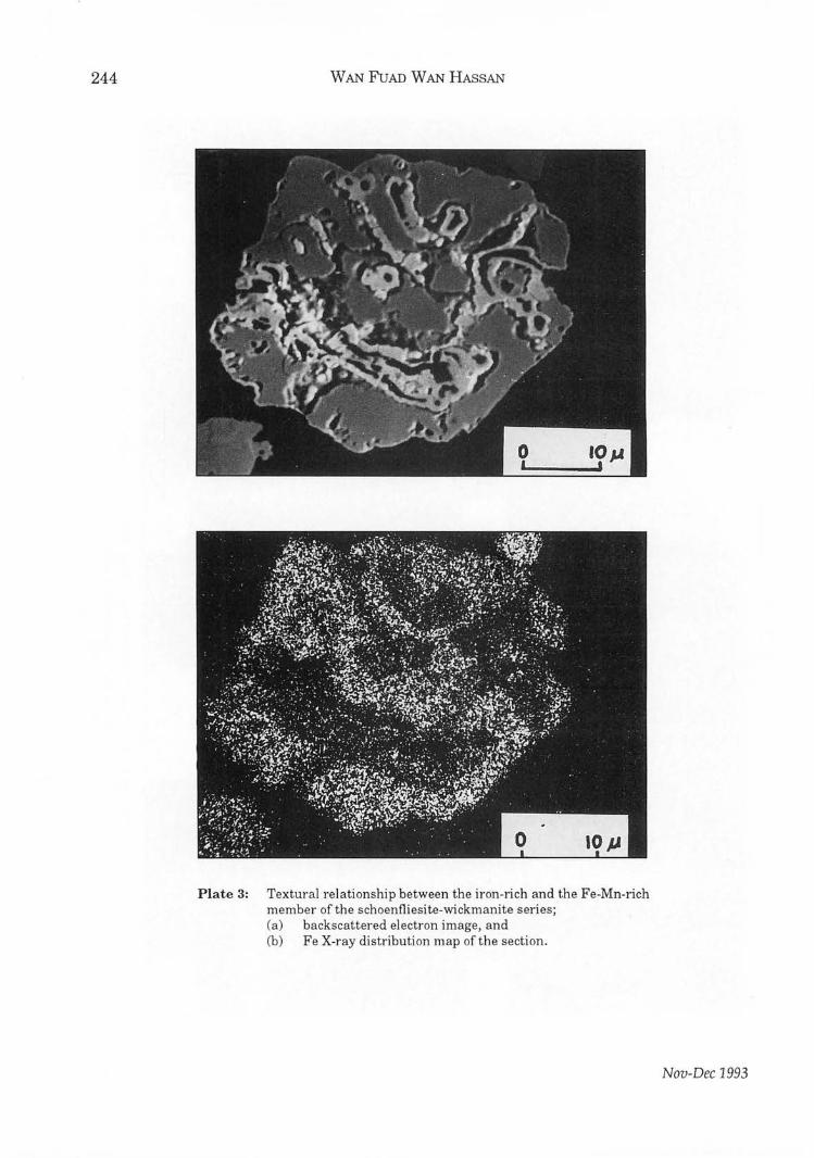
From polished sections, it is observed that the minerals of the series are associated with malayaite, calcite, euhedral grains of cassiterite (Plates 1, 2 and 3) and pyrite, and are being coated with a layer of chalcedony. The mineral may surround malayaite or cassiterite but there is no indication of replacement. The Fe-rich variety may form coatings over the Fe-Mn variety.
CHEMICAL COMPOSITION
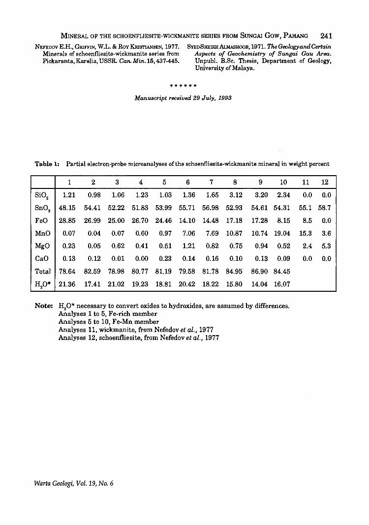
In the present study the amount of available material is very limited, suitable only for examination and analysis by an electronmicroprobe. Qualitative elemental composition of the mineral can be seen from the scanning images under the SEM (Plates 1, 2 and 3). Partial microprobe analysis of the two members of the series is given in the Table 1. The water content, about 20 percent according to previous reports, cannot be determined by the present method.
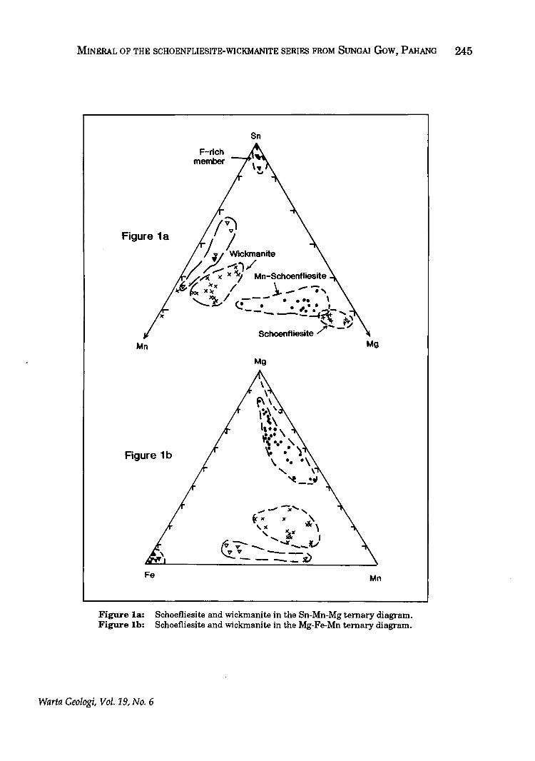
Present analysis shows considerable compositional variation than those reported by previous workers. Magnesium and manganese contents are much lower and iron content is much higher. High Fe in this specimen, in excess of Mn and Mg, makes it different from those described in the previous occurrences. Accordingly, two new species of minerals are recognised:
1. Fe-rich member 2. Fe-Mn-rich member
The composition of the two members conform reasonably well with the general formula of the series, (Fe,Mn,Mg)Sn(OH)s' The deviation from the established formula is probably due to analytical error. The considerable iron-enrichment results in the new analyses filling the hitherto empty fields of the ternary diagrams used by Nefedov et al. (1977) to illustrate compositional changes (Figure 1a and 1b). On looking at the composition, one is tempted to conclude that this mineral is varlamoffite, but the lower percentages of tin and silica oxides, together with a much higher percentage of iron oxide in the present mineral makes it unlikely to be so.
DISCUSSION AND CONCLUSION
The existence of the iron-rich member of the schoenfliesite-wickmanite series has been postulated, for instance by Grubb and Hannaford (1966), who attributed the dark colour of cassiterite from Pelepah Kanan to submicroscopic inclusions of FeSn(OH)s' but the naturally occurring species has never before been reported. The finding in this report is important, and this iron-rich end member of (Fe,Mn,Mg)Sn(OH)s is a new mineral since no description of a naturally occuring species has ever been reported before.
REFERENCES
AMu, R. & GRIFFIN, W.L., 1972. Three minerals new to Norway: wickmanite, leadhillite and hydrocerussite. Norsk Geol. Tids. 52,193-196.
FAUST, G.T. & ScHAlJ..ER, W.T., 1971. Schoenfliesite, MgSn(OH)6' Z. Krist., 134, 116-141.
GRUBB P.L.C. & HANNAFORD, P., 1966. Magnetism in cassiterites: Its source and paragenetic significance as exemplified by a prominent Malaysian Tin Deposit. Min. Deposita 2, 148-171.
JAAFAR AHMAD, 1976. Geology and Mineral Resources ofKarak and Temerloh Areas, Pahang. Geological Survey Malaysia, District Memoir No. 18.
MOORE P.B. & SMITH J.R., 1967: Mn2+Sn4+(OH)6' a new mineral from Longban. Arkiv. Mineral. GeoL 4, 395-399.
Nov-Dec 1993
MINERAL OF THE SCHOENFLIESITE-WICKMANITE SERIES FROM SUNGAI GoW, PAHANG 241 NEFEDOvE.H •• GRIFFIN, W.L.&RovKRISTIANSEN,1977.
Minerals of schoenfliesite-wickmanite series from Pickaranta, Karelia, USSR. Can. Min. 15, 437-445.
SYEDSHEIKHALMAsHOOR, 1971. The Geology and Certain Aspects of Geochemistry of Sungai Gau Area. Unpubl. B.Sc. Thesis, Department of Geology, University of Malaya.
******
Manuscript received 29 July, 1993
Table 1: Partial electron-probe microanalyses of the schoenfliesite-wickmanite mineral in weight percent
1 2 3 4 5 6 7 8 9 10
Si02 1.21 0.98 1.06 1.23 1.03 1.36 1.65 3.12 3.20 2.34
Sn02 48.15 54.41 52.22 51.83 53.99 55.71 56.98 52.93 54.61 54.31
FeO 28.85 26.99 25.00 26.70 24.46 14.10 14.48 17.18 17.28 8.15
MnO 0.07 0.04 0.07 0.60 0.97 7.06 7.69 10.87 10.74 19.04
MgO 0.23 0.05 0.62 0.41 0.51 1.21 0.82 0.75 0.94 0.52
CaO 0.13 0.12 0.01 0.00 0.23 0.14 0.16 0.10 0.13 0.09
Total 78.64 82.59 78.98 80.77 81.19 79.58 81.78 84.95 86.90 84.45
HO* 2 21.36 17.41 21.02 19.23 18.81 20.42 18.22 15.80 14.04 16.07
Note: H20* necessary to convert oxides to hydroxides, are assumed by differences. Analyses 1 to 5, Fe-rich member Analyses 5 to 10, Fe-Mn member Analyses 11, wickmanite, from Nefedov et al., 1977 Analyses 12, schoenfliesite, from Nefedov et al., 1977
Warta Geologi, Vol. 19, No.6
11 12
0.0 0.0
55.1 58.7
8.5 0.0
15.3 3.6
2.4 5.3
0.0 0.0
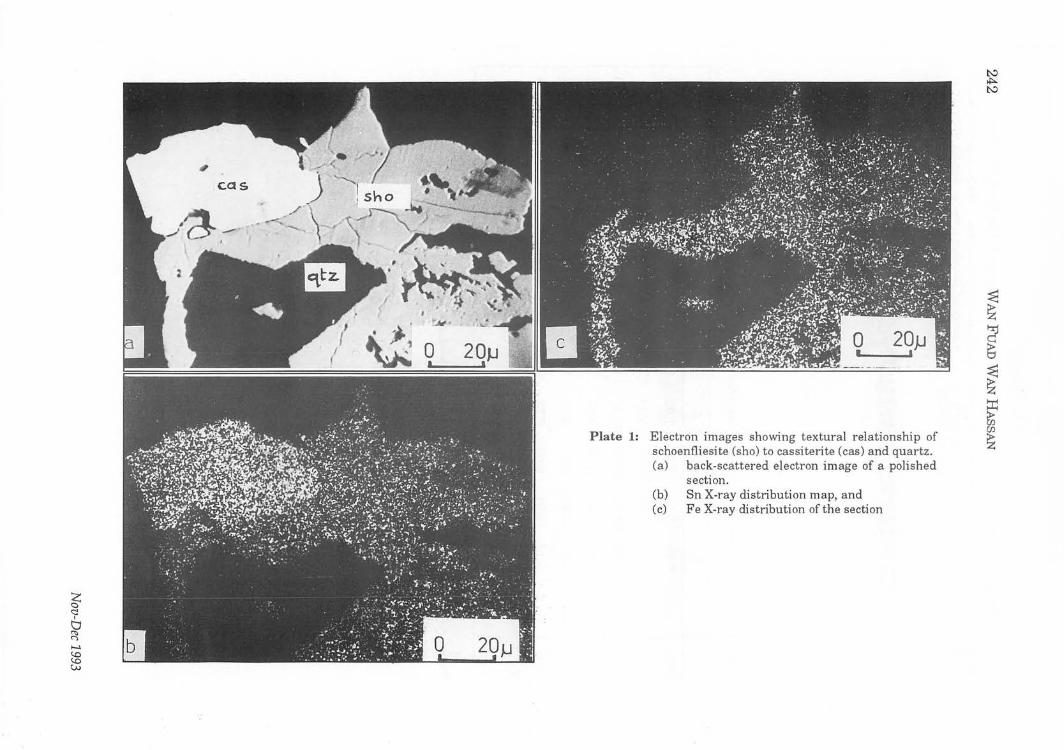
Plate 1: Electron images showing textural relationship of schoenfliesite (sho) to cassiterite (cas) and quartz. (a) back-scattered electron image of a polished
section. (b) Sn X-ray distribution map, and (c) Fe X-ray distribution of the section
~ .... B" CJ ~
r% ~.
~ ....., ;.0
:z: ~ 0'1
b o 20}J I .-'
Plate 2: Electron images showing textural relationship between schoenfliesite (sho) and malayaite (rna) (a) backscattered electron image of a polished surface, (b) 8i X-ray distribution map, (c) 8n X-ray distl;bution map, and (d) Mn X-ray distl;bution map.
~ Z M ;:0 ;I> r o '-=:l >-3 ::r: M en (1
::r: o r-:l Z '-=:l t: r-:l en H ~
~ (1
2 ~ ~ r-:l
en M
~ M en '-=:l :::;I o 3:: r:n. §2 Q
~
§? ::E
'"'d ;I> ::r: ~ Q
~
*"'" C.:>
244 WAN FuAD WAN HAsSAN
Plate 3: Textural relationship between the iron-lich and the Fe-Mn-rich member of the schoenfliesite-wickmanite series; (a) backscattered electron image, and (b) Fe X-ray distribution map of the section.
Nov-Dec 1993
MINERAL OF THE SCHOENFLIESITE-WICKMANITE SERIES FROM SUNGAI GoW, PAHANG 245
Figure 1a
Mn
Figure 1b
Fe
F-rich member
Sn
Iv:, jilL ....
(// ....... ~1/ ~~..-; )( ~ Mn-Schoenfliesite
~~ x~)( / i--., '- ~ / ,;--- . ... \ -£-' ~. • •• I
----!!~~-, {\ I'r' /'--:/
Schoenfliesite
Mg
..... --;", ~K x ~
\.IC \ " ~" ~-... ...... -..Jt M J v ~ ~ __ -v'" - __ , ---_v
Mg
Mn
Figure la: Figure Ib:
Schoefliesite and wickmanite in the Sn-Mn-Mg ternary diagram. Schoefliesite and wickmanite in the Mg-Fe-Mn ternary diagram.
Warta Geologi, Vol. 19, No.6
Computer-designed and handprinted with the latest technology of hand printing from the East Coast, the Society's batik shirt is of soft, rayon material and comes in a cool, soothing, grey colour.
The Society's logo is craftily concealed in the background so that besides the Society's functions you can even wear your batik shirt anywhere, anytime!
Priced reasonably at MR60, the batik shirt is a real bargain and worth adding to your wardrobe. So place your orders now before stocks run out!
For further inquiries:
GSM Batik Shirt, Geological Society of Malaysia, Geology Department, University of Malaya, 59100 Kuala Lumpur.
Tel.: (603) 7577036 Fax.: (603) 7563900
......................................................... Order Form ................................................. ..
GSM Batik Shirt, Geological Society of Malaysia, Geology Department, University of Malaya, 59100 Kuala Lumpur.
GSM Batik Shirt
I would like to purchase ................................................ GSM batik shirt(s).
The size or sizes are as follows:
S D No. of shirt(s) ................ ..
M D No. of shirt(s) ................ ..
L D No. of shirt(s) ................ ..
XL D No. of shirt(s) ................ ..
Enclosed please fmd a cash/check/money orderlbank draft* for RM ...................... .. made to "Geological Society of Malaysia II for the purchase [* Please delete where applicable].
For overseas orders please write in to indicate ordinary mail or air mail and you will be charged accordingly.
Please mail to: ............................................................................................. ............................................................................................. ............................................................................................. ............................................................................................ . ..............................................................................................

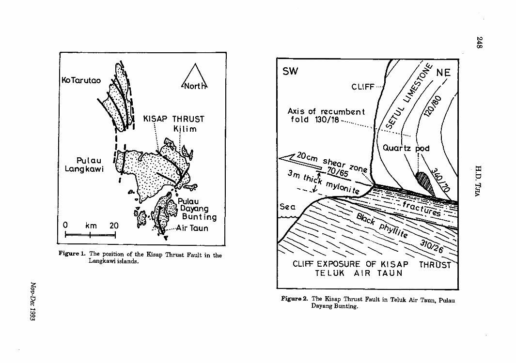
The KI~ap Thru§t In the Kampung Killm area, Pulau Langkawi
H.D TJiA pmTRONA~ R~§~l\lrlJh & ~Ci~fitift{! ~~rvi{!~§ ~dn, Bhd,
Ltlt 10~~ PKN~ Indu§tril\ll m§tlat~ 4~OOO Huiu K~ll\ln~
The Klsap Tbrust was fi rst mapped by coloured linie§tone. The latter iliay ocCUr aili6fi~ Jones (1981). It outcrops in a few localities on the dominantly silicified(?) and black breccia Pulau Dayang Bunting and on the main island clasts are broken bands some 20-cm thick and of Langkawi (Fig. 1). Until now, the best known a few metres long. The phyllonitised wellexposure is from the south end of Dayang bedded clastics show the effect of, presumably Bunting island (Fig. 2). On a recent visit to subsequent, foliation-parallel slippage towards the islands, the thrust zone was also found east. This "normal" slip sense is indicated by exposed in the large west-facing wall of the light-coloured calcite plates that occupy the Hosna stone quarry at Kampung Kilim on Pulau position of accretionary spalls on the striated Langkawi (Fig. 3). As far as I know, the outcrop foliation planes. These striations also pitch has not been described before. This towards east. communication results from a cursory study of that outcrop. More detailed observations will The major observations are the following:
be carried out in the very near future, that is, (1) before quarrying obliterates the field relationships.
In the Hosna quarry, the Kisap Thrust comprises thick fault breccia horizons that are separated by discrete fault planes from unbroken but phyllonitised thin-bedded calcareous and carbonaceous clastics. The fault planes have markings indicating west vergence, which is also. shown by the attitude of kink folds and the low-oblique, crosscutting pattern between fault planes and foliation/bedding. The total thickness of the Kisap Thrust Zone exceeds 20 metres measured across the gently to moderately inclined reverse fault planes. In other words, the existence of a major thrust on Pulau Langkawi is established.
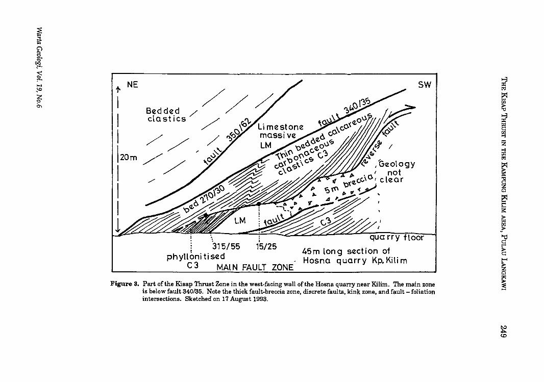
The sketch of Figure 3 shows part of the thrust zone in Ordovician to Lower Devonian Setul Formation: Limestone and thin-bedded, calcareous and carbonaceous beds of its Detrital Member. The thrust zone consists of(1) discrete low-angle to moderately inclined fault planes, (2) metres-thick fault breccia zones , and (3) black phyllonite hori zons in the thin-bedded calcareous and carbonaceous clastics. The ramp-like fault plane above the thick fault-breccia zone is wavy and possesses attitudes of 315/55 (strike/dip angle) and 15/25. Reverse fault motion is indicated by fault-plane features such as fault roche moutonnee and accretion spalls (these terms are explained in Tjia, 1972) on the 25-degree dipping part of the fault surface. The metre-wide kink zone in the thin-bedded clastics also indicates west vergence. The thick fault breccia horizon consists of centimetresized, angular clasts of black mylonite and brown
ISSN 0126-5539
(2) The Kisap Thrust in the Hosna quarry appears to occur within the Setul Formation, and therefore, long-distance lateral transport that is usually associated with overthrusting and nappe structure is ruled out. The Kisap Thrust that outcrops in the south end of Pulau Dayang Bunting also occurs within the Setul Formation (Fii. 2).
Warta Ceolngi, Vol, 19, No, 6, Nov-Dec 1993, pp. 247- 250
KoTarutao
Pulau Langkawi
o km 20 I
KISAP THRUST ~ Kj li m
Figure 1. The position of the Kisap Thrust Fault in the Langkawi islands.
sw
Axis of recumben t fold 130/18· .... -... -.....
Figure 2. The Kisap Thrust Fault in Teluk Air Taun, Pulau Dayang Bunting.
~ '"'I B" C) !! c§ ... ~ :-..... .!-O
~ 0'\
.,.. NE
I I I 120m I ./
I I
,
i 315/55 15125
I
phylloni ti sed C 3 MAl N FAULT ZONE
I
45m long section of Hosna quarry Kp. Kili m
sw
Figure 3. Part of the Kisap Thrust Zone in the west-facing wall of the Hosna quarry near Kilim. The main zone is below fault 340/35. Note the thick fault-breccia zone, discrete faults, kink zone, and fault - foliation intersections. Sketched on 17 August 1993.
2150 H.D.TJIA (8) In the KUhn AfM, the Setu! FormAtion
overUel the YOWl,If Cupin, FormAtion. Porvuively frActured, li,lit"coloUfld Umtlltofie otthil tormAtiOll OUtcroPI in lilmall fOAdC\ltlil Alon, the tfllDk fOAd to the welt of the HOlnA quAff)'.
(4) Sul)lu~quently, foUAtion/blddln,,,pAfAllll IlIpP. took plAOI tlAu8inl VMIIftOl towAfclI . IAli.
UI'IUNOEI
JONllII, O.R., 1881. o.ology ma minlrlll NII01lrOlIL ot "rUII, north Kldllh llna thl Llllllkllwt till mall. o.ologiollllurvlY ot Mlllll)'lltll, Mlmoirll 1".
Tm, K.D., 1878. 'llwt moY@m@nt, rlori@nt@a IIV@1I11 fliia ma lIublltatll17 IItruotur@lI. 'lloitto o.ology Ii: 48=70.
****** /tIfJllY§@l'ipf f@@@ilJ@d"AIIIY§f 1881
Nov-Dec 2993
Laporan (Report)
Estuarine sediments in Malaysia
BRUCE W. NELSON
251
On Wednesday, November 3,1993, Professor Bruce W. Nelson ofthe University of Virginia (U.S.A,) and a former Fulbright Senior Lecturer in the UM Department of Geology (1982·83) presented a talk on estuarine sedimentation in Malaysia. This talk summarized work carried out in the Klang, Selangor, and Pahang rivers during the last ten years.
Professor Nelson pointed out that river discharge (which is determined by cHmate and catchment area) and tidal range are the two most important variables in estuarine sedimentation. Under conditions of high discharge and low tidal range (Pahang) the river flushes marine water from its mouth and a delta forms at the shoreline. Under low discharge and high tidal range (Klang) marine water enters the river mouth, a salinity gradient develops, and the seaward transport of sediment is inhibited. Sand and muddy sediment then deposits within the river mouth. The Selangor River is of intermediate size, and under freshet conditions and during the rainy season it pushes marine water from its mouth and discharges sediment to the sea; during the dry season sediment is trapped within the estuary.
The trapping mechanism is the chief characteristic of estuarine sedimentation. The very high turbidities of Malaysian estuaries are caused by sediment that is trapped within them. On neap tides the tidal currents are too weak to entrain sediment, and the mud rests on the bottom as a highly concentrated suspension, known as "fluid mud". During intermediate and spring tides, fluid mud is entrained and the water column contains high sediment concentrations. These reach 8·10 grams per liter on spring tides in the Klang and Selangor estuaries.
Professor Nelson discussed some environmental aspects of estuaries in Malaysia. For example, he and co·workers from UM and UPM have studied the affect of suspended sediment on the dissolved oxygen distributions in the Klang and Selangor estuaries. The highest dissolved oxygen is found during neap tides when little sediment is suspended in the water. During spring tides when large concentrations of suspended sediment occur, the dissolved oxygen is depressed. This is caused by the oxygen demand of the sediments. Professor Nelson pointed out that the geochemical behavior of trace metals in estuaries must be influenced by this neap·spring tidal oxygen cycle.
Another example, is the trace metal content of sediment in polluted (Klang) estuaries compared to relatively pristine ones (Selangor). The concentrations of trace metals contributed by human discharges, such as Cu, Zn, and Pb, are much higher in the Klang than in the Selangor. Of course, every geologist knows that these trace metals occur at natural concentrations in the source rocks and sediments derived from them. Thus, the natural background must be
Warta Geologi, Vol. 19, No.6

252 subtracted from the total observed in the Klang, for example, to detect the human contributions. Professor Nelson suggested at the conclusion of his talk-that geologists should become more actively involved in environmental studies where their expertise on the characteristics and compositions of earth materials would be valuable. Human pollution of environments, for example, should be considered as just one part of the geochemical cycle that geologists understand operates at the earth's surface. Most environmentalists and government planners require the help of informed geologists in order to understand these processes. A lively discussion about the processes and the role of geologists in environmental planning followed these remarks. BRUCE W NELSON
The marine geology off the North Lantau coast, Hong Kong and its application to infrastructure development
J.W. CERI JAMES
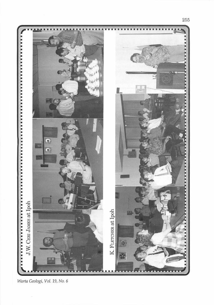
Laporan (Report)
Dr. J.W. Ceri James, who is with the Coastal Geology Group, British Geological Survey, gave the above talk on 24 November 1993 at 5.00 pm at Geology Department, University of Malaya, Kuala Lumpur. It was attended by 32 members. For the benefit of members in the Ipoh area, Dr. Ceri James gave the talk again at the Makmal Jabatan Penyiasatan Kajibumi, Ipoh.
The talk proved to be very interesting and well illustrated as Dr. Ceri James touched on the geology and borehole data before focusing on the progress of reclamation and construction of the different infrastructure projects in particular the replacement airport site at Chek Lap Kok and the North Lantau Expressway.
G.H. Teh & V.R. Vijayan
Abstrak (Abstract) In recent years an extensive grid of seismic reflection profiles, boreholes and some
piezocones have been completed off the North Lantau Coast, Hong Kong. The grid is formed from a number of different infrastructure projects including, the replacement airport site at Chek Lap Kok, the North Lantau Expressway to the replacement airport, marine fill resource surveys reclamations and surveys commissioned by the Hong Kong Geological Survey to complete the grid. This data has been integrated by the Hong Kong Geological Survey to produce 1:5,000 and 1:20,000 geological maps of the area .
The interpretation of these seismic profiles, calibrated with boreholes and piezocones, has led to the subdivision of the offshore Quaternary sediments into a number offormations based on seismic reflector style, lithology, palaeontology and erosional and depositional history. The Quaternary formations can be connected to major oscillations in sea level associated with glacial and interglacial cycles. The form and lithologies of the formations can be related to their response to the erosional and depositional events associated with these cycles.
Nov-Dec 1993
These global and regional events have an important influence on the character of the geology oflocalities such as the new replacement airport. The form of the geology at this site, and elsewhere in the area, can be more readily understood for design, reclamation and construction when the regional context is taken into account.
The topics addressed in the talk included:-
• Sediment and bedrock distribution and their relationship to the tidal current regime
• Seismic stratigraphy, lithology, sedimentology and palaeontology of the principal off-shore Quaternary formations
• Erosion surfaces, oxidised paleosols, minor and major channel networks
• Detailed analysis of two stratigraphic boreholes on and adjacent to the new airport site
• Sand bodies within major channels
• Age, thickness and extent of Holocene compressive mud blanket and its relationship to minor and major basal channelling and post-glacial tidal current conditions
• Relationship of gas and acoustic turbidity to Holocene mud filled channels
The area and topics covered are an example of the application of geological interpretation to infrastructure developments within the coastal zone. The methods, procedures and geological model produced are relevant to developments in the Malaysian coastal and marine environment including reclamations, dredging, marine fill and aggregate resources, tunnels, pipelines and cable routes.
Exploration geochemistry of gold in stream sediments
K FLETCHER
Laporan (Report)
253
Prof. K Fletcher gave the above-talk on Friday, 17 December 1993, at 11.00 am at Makmal Jabatan Penyiasatan Kajibumi, Ipoh, Perak. It was attended by an audience of 43.
V.R. Vijayan
Summary Geochemical anomalies for gold in drainage sediments are typically erratic, both locally
on the bed of the stream and seasonally. In part, this is a consequence of the rarity of gold particles leading to the so called nugget effect. However, even when care is taken to collect samples of sufficient size to be representative gold concentrations may still show considerable variability as a result of the variable transport and deposition of sediment and gold in response to local hydraulic conditions.
Field studies in Harris Creek, a small gravel bed stream in British Columbia, Canada, have shown that gold is preferentially accumulated at high energy bar-head sites as the annual flood, caused by melting snow, passes. The gold anomaly at such sites may remain constant or even show increasing concentrations downstream away from the source of the gold. In contrast, there is no preferential enrichment of gold at low energy bar-tail sites. Gold anomalies at such sites therefore have lower concentrations of gold with values that decrease going downstream. The degree of enrichment of gold concentrations between high and low energy sites decreases as the size of the gold particles decreases.
Similar observations have been made for distribution of gold in a small stream in northern Thailand and for other heavy minerals elsewhere, for example cassiterite in Malaysia. Furthermore it has been shown that the field observations of the distribution of gold and other heavy minerals on the stream bed are consistent with the theoretical predictions of
Warta Geologi, Vol. 19, No.6
254 bed load transport modell. Such models prodlct that proforontial-accumulation of gold will be favourod by high bod roughnels and docrolsing stroam wadiont.
The fiold obsorvations and theory havo importlnt implications for tho design and in1lorprotation of stnam lodimont survOYI for gold.
1. BecaullO gold concentrations are weatest and thelnomllous dispersion trlinslongelt in the hiSh energy environment, such si1lo1 are to be preferred for low densityrlconnwlIlIance surveys. Howlver, clre must be taken to obtain samplol from sumctlnt dlpth in the bed of the strlam to obtain gold.rich sediments doposl11od during flood events. Also eonc~n· tratlons of gold at such si1los may deerellll (rlther than increase) towarde thl bedrock source of the gold. Clro is therefore required for in1lorpretation and follow-up.
2. Gold concentrations at low energy sites are relatively low and the anomalous dispersions trains short. Howovor, becaulIQ concentrations of gold are more likely to inerealle upstream towards the source, they may provide a more suitable medium for follow.up or detailed surveys.
3. Whatever medium iii! sampled it is important that:
(a) the same hydraulic environment be sampled lUI consistently as possible.
(b) at all stages of sampling and analysis, samples are of sumeient size to be represen· tative = ideally samples and subsamples should be ofsumeient size to contain at least 20 particles of gold if" sampling errors are to be better than :t: 45% at the 95% confidence level.
(c) For a given concentration of gold, number of gold particles will increase a8 particle size decrea8es. More consistent results are therefore usually obtained with finer grain sizes (e.g. ·200 mesh). Use of finer sizes also decreases the effects of hydraulic variability on gold concentrations.
4. In interpreting results iUs important to remember that gold concentrations on the stream bed are a function of hydraulic conditions and can increaBe, downstream away from the primary source. Hydraulic ("mini·placer") gold anomalies can be identified by their association with accumulation of other heavy minerals (e.g. magnetite) and by correlation of gold concentrations with stream width, velocity and bed roughness.
Nov-Dec 1993
255
Warta Geologi, Vol . 19, No. 6
256
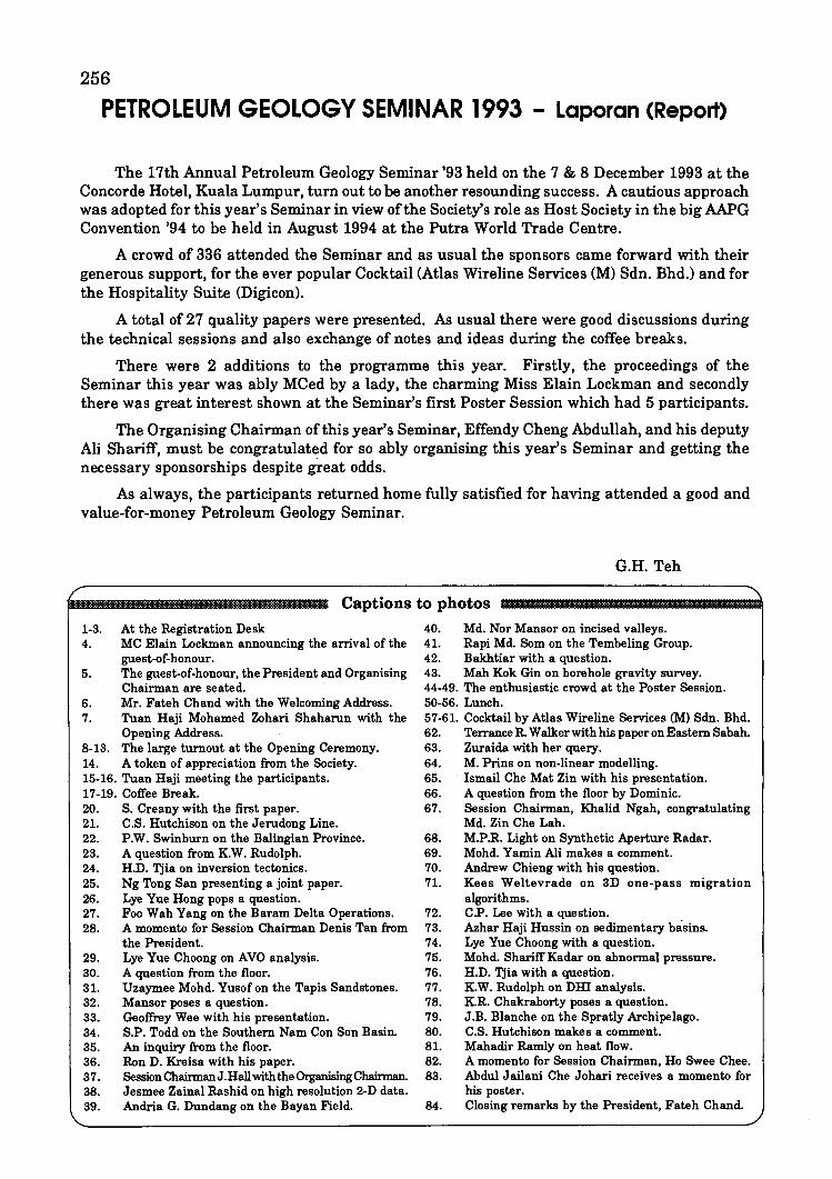
PETROLEUM GEOLOGY SEMINAR 1993 - Laporan (Report)
The 17th Annual Petroleum Geology Seminar '93 held on the 7 & 8 December 1993 at the Concorde Hotel, Kuala Lumpur, turn out to be another resounding success. A cautious approach was adopted for this year's Seminar in view of the Society's role as Host Society in the big AAPG Convention '94 to be held in August 1994 at the Putra World Trade Centre.
A crowd of 336 attended the Seminar and as usual the sponsors came forward with their generous support, for the ever popular Cocktail (Atlas Wireline Services (M) Sdn. Bhd.) and for the Hospitality Suite (Digicon).
A total of 27 quality papers were presented. As usual there were good discussions during the technical sessions and also exchange of notes and ideas during the coffee breaks.
There were 2 additions to the programme this year. Firstly, the proceedings of the Seminar this year was ably MCed by a lady, the charming Miss Elain Lockman and secondly there was great interest shown at the Seminar's first Poster Session which had 5 participants.
The Organising Chairman of this year's Seminar, Effendy Cheng Abdullah, and his deputy Ali Shariff, must be congratulated for so ably organising this year's Seminar and getting the necessary sponsorships despite gt.eat odds.
As always, the participants returned home fully satisfied for having attended a good and value-for-money Petroleum Geology Seminar.
G.H. Teh
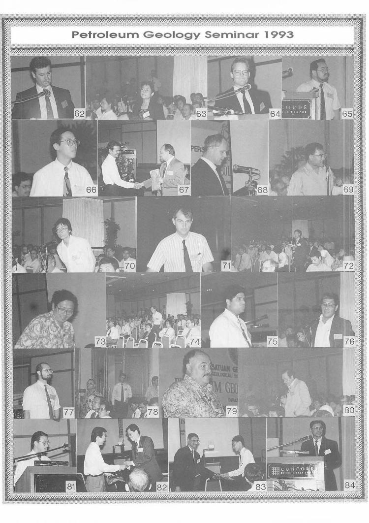
Captions to photos
1-3. At the Registration Desk 4. MC Elain Lockman announcing the arrival of the
guest-of-honour . 5. The guest-of-honour, the President and Organising
Chairman are seated. 6. Mr. Fateh Chand with the Welcoming Address. 7. Tuan Haji Mohamed Zohari Shaharun with the
Opening Address. 8-13. The large turnout at the Opening Ceremony. 14. A token of appreciation from the Society. 15-16. Tuan Haji meeting the participants. 17-19. Coffee Break. 20. S. Creany with the first paper. 21. C.S. Hutchison on the Jerudong Line. 22. P.W. Swinburn on the Balingian Province. 23. A question from K.W. Rudolph. 24. H.D. Tjia on inversion tectonics. 25. Ng Tong San presenting a joint paper. 26. Lye Yue Hong pops a question. 27. Foo Wah Yang on the Baram Delta Operations. 28. A momento for Session Chairman Denis Tan from
the President. 29. Lye Yue Choong on AVO analysis. 30. A question from the floor. 31. Uzaymee Mohd. Yusof on the Tapis Sandstones. 32. Mansor poses a question. 33. Geoffrey Wee with his presentation. 34. S.P. Todd on the Southern Nam Con Son Basin. 35. An inquiry from the floor. 36. Ron D. Kreisa with his paper. 37. Session ChainnanJ.Hall with the Organising Chairman. 38. Jesmee Zainal Rashid on high resolution 2-D data. 39. Andria G. Dundang on the Bayan Field.
40. Md. Nor Mansor on incised valleys. 41. Rapi Md. Som on the Tembeling Group. 42. Bakhtiar with a question. 43. Mah Kok Gin on borehole gravity survey. 44-49. The enthusiastic crowd at the Poster Session. 50-56. Lunch. 57-61. Cocktail by Atlas Wireline Services (M) Sdn. Bhd. 62. Terrance R. Walker with his paper on Eastern Sabah. 63. Zuraida with her query. 64. M. Prins on non-linear modelling. 65. Ismail Che Mat Zin with his presentation. 66. A question from the floor by Dominic. 67. Session Chairman, Khalid Ngah, congratulating
Md. Zin Che Lah. 68. M.P.R. Light on Synthetic Aperture Radar. 69. Mohd. Yamin Ali makes a comment. 70. Andrew Chieng with his question. 71. Kees Weltevrade on 3D one-pass migration
algorithms. 72. C.P. Lee with a question. 73. Azhar Haji Hussin on sedimentary basins. 74. Lye Yue Choong with a question. 75. Mohd. Shariff Kadar on abnormal pressure. 76. H.D. Tjia with a question. 77. K.W. Rudolph on DHI analysis. 78. K.R. Chakraborty poses a question. 79. J.B. Blanche on the Spratly Archipelago. 80. C.S. Hutchison makes a comment. 81. Mahadir Ramly on heat flow. 82. A momento for Session Chairman, Ho Swee Chee. 83. Abdul Jailani Che Johari receives a momento for
his poster. 84. Closing remarks by the President, Fateh Chand.

Welcoming Address by Mr. Fateh Chand, President, Geological Society of Malaysia, at the 17th Petroleum Geology Seminar
on December 7-8, 1993 at Concorde Hotel, Kuala Lumpur
Warta Geologi, Vol. 19, No.6
261
262
Concorde Hotel, Kuala Lumpur 7 & 8 December 1993
Nov-Dec 1993
Opening Address by Tuan Haji Mohamed Zohari Shaharun, Vice-President, Exploration & Production
Sector, PETRONAS at the 17th Petroleum Geology Seminar
on December 7-8, 1993 at Concorde Hotel, Kuala Lumpur
Warta Geologi, Vol. 19, No.6
263
264
Nov-Dec 1993
PETROLEUM GEOLOGY SEMINAR 1993
::~~~~;;;~~ME
7th December 1993 (Tuesday)
08:00 Registration
08:50 Arrival of Invited Guests
09:05 Welcoming Address by Mr. Fateh Chand, President, Geological Society of Malaysia
09:20 Opening Address by Tuan Haji Mohamed Zohari Shaharun, Vice-President, Exploration & Production Sector, PETRONAS
09:30 Coffee Break
10:00 Paper 1: Petroleum migration in the Malay Basin - our current understanding S. Creaney (EPMI), P.s. Koch (EPR) & K. w. Rudolph (EPMI)
10:25 Paper 2: First record of melange on the Jerudong Line, Brunei Darussalam Charles S. Hutchison (University of South Carolina, USA)
10:50 Paper 3: Tectonic styles of the Balingian Province P.M. Swinbum (SSB)
265
11: 15 Paper 4: A quantitative study ofthe seismic time-amplitude reflection characteristics in an oil field Ng Tong San (PCSB), Idrus Mohd Shuhud (PRSS) & Leong Lap Sau (School of Physics, USM)
11:40 Paper 5: Inversion tectonics in the Malay Basin: Evidence and timing of events H.D. Tjia (PRSS)
12:05 Paper 6: The use of 3D seismic in Baram Delta Operations, Sarawak Ton ten Have & Faa Wah Yang (BDOIPCSB)
12:30 LUllch Break
14:00 Paper 7: Overview of AVO analysis in the Malay Basin Lye Yue Choong (EPMI) & M.R. Daneshvar (EPR)
14:25 Paper 8: Petrography and reservoir quality of the Tapis sandstones, Sotong Field, southeast Malay Basin Uzaymee Mohd Yusof(PETRONAS Exploration Dept.)
Warta Geologi, Vol. 19, No.6
266
14:50 Paper 9: Structural framework and trap styles in south-western Offshore Sabah Geoffrey Wee (SSPC)
15:15 Tea Break
15:45 Paper 10: A tectonostratigraphic model for the southern Nam Con Son Basin, offshore Vietnam S.J. Matthews & S.P. Todd (BP Exploration)
16:10 Paper 11: Continental sedimentation in humid-tropical climates: impact on Tertiary strata of the South China Sea area, with modem analogues Ron D. Kreisa, M.H. Carter & B.S. Smith (Mobil Oil Co., USA)
16:35 Paper 12: High resolution 2-D seismic data in the Malay Basin Abdul Razak Nurin, Kurt B. Tweedy & Jesmee Zainal Rashid (EPMI)
17:00 Paper 13: Geological constraints in the development of the BayanField, offshore Sarawak, East Malaysia Andria G. Dundang, Norazlam Norbi, G.F. Canjar, Boniface Bait & Bert Heijna (Sarawak Shell Bhd.)
17:25 Close of Day One
19:30 Cocktail (Concorde V)
8th December 1993 (Wednesday)
08:35 Paper 14: Seismic recognition of incised valleys in the Malay Basin Md. Nor Mansor & K. W. Rudolph (EPMI)
09:00 Paper 15: Petroleum potential of the Tembeling Group Khalid Ngah, H.D. Tjia, Abdul Jalil Mohamad, Liew Kit Kong, Mohd. Yamin AI~ Mohd. Rapi Md. Som & Shamudin Jirin (PRSS)
09:25 Paper 16: Borehole gravimetry survey in Central Luconia carbonate reservoirs Mah Kok Gin (Sarawak Shell Berhad)
09:50 Paper 17: A seismic tour of eastern Sabah: Play types and tectonic settings Terrance R. Walker (WMC Petroleum (M))
10:15 Coffee Break
10:45 Paper 18: The integration of 3-D seismic and geological computer mapping in defining further development opportunities in a mature field Md. Zin Che lLlh, Jonathan K. Westbury & George Ciesla (BDOIPCSB)
11: 10 Paper 19: Improved characterisation of carbonate reservoirs using non-linear modelling M. Prins (Sarawak Shell Berhad)
11: 35 Paper 20: Application of sequence stratigraphy techniques on the non-marine sequences: An example from the Balingian Province, Sarawak Ismail Che Mat Zin & Jaafar Sipan (PCSB)
Nov-Dec 1993
267
12:00 Paper 21: Complex transtensional structures and the hydrocarbon potential of the greater Sarawak Basin, East Malaysia, defined by Synthetic Aperture Radar D.J. Bird (Pan Canadian Petroleum Ltd), G.A. Posehn (Amax Petroleum o/Canada Inc.), M.P.R.Light(InteraIn/ormationTechnologies(Canada)Ltd)&M.A.A.Hudi(PEI'RONAS)
12:25 Lunch Break
14:00 Paper 22: A comparison of 3-D one-pass migration algorithms Herman van Voorst Vader & Peter Chia Teck Fook (SSBISSPC)
14:25 Paper 23: Locations of sedimentary basins in Peninsular Malaysia: Speculations on basement control, basin extension and hydrocarbon potential Azhar Haji Hussin & S.P. Sivam (Geology Department, University 0/ Malaya)
14:50 Paper 24: Abnormal pressure study in the Malay-Penyu Basin Mohd. Shariff Kader (PCSB)
15:15 Tea Break
15:45 Paper 25: DHI analysis in the Malay Basin K. W. Rudolph & F. W. Richards (EPMI)
16: 10 Paper 26: A comparison of quality of present-day heat flow obtained from BHTs, Homer Plots, RFTs and DSTs of Malay Basin Douglas W. Waples & Mahadir Ramly (PCSB)
16:35 Paper 27: An overview of the hydrocarbon potential of the Spratly Archipelago, South China Sea and its regional implications for oil and gas development J.B. Blanche & J.D. Blanche (Blanche Oil and Gas Cons., U.K.)
17:00 Close of Seminar
Poster 1: Bukit Keluang Formation: A proposed new stratigraphic unit and its sedimentology Kamal Roslan Mohamed & Ibrahim Abdullah (Universiti Kebangsaan Malaysia)
Poster 2: Engineering acquisition and processing: Anintegrated design approach for optimal seismic data A. Easton Wren (Hydrocarbon Explorer, Canada)
Poster 3: On-board processing/interpretation, PPL 82 Papua New Guinea Sean Rooney, Joeseph Kmeck & Larry Gale (Mobil )and Michio Higashi (Japex)
Poster 4: Reversal of wrench movement at the west-central margin of the Malay Basin Liew Kit Kong (PETRONAS Research & Scientific Services)
Poster 5: Sequence stratigraphy and reservoir distribution of the J-15 sequence in PM9, Malay Basin Abdul Jailani Che Johari & John R. Bedingfield (Esso Production Malaysia Inc.)
Warta Geologi, Vol. 19, No.6
268
Paper 1
Petroleum migration in the Malay Basin - Our current understanding 121
S. CREANEY , P.S. KOCH & K W. RUDOLPH 1 Esso Production Malaysia Inc.
Kompleks Antarabangsa Jalan Sultan Ismail
Kuala Lumpur 2Exxon Production & Research Co.
Houston, Texas
The Malay Basin consists of a number of separate petroleum systems all driven by non-marine source rocks ranging from algal-dominated (lacustrine) sources of Oligocene age to delta plain/coastal plain sources of Miocene age. Oils of the Malay Basin appear to generally migrate and accumulate within reservoir sections co-associated with their inter-bedded source rocks. Thus migration for oil follows a strata parallel style. To date, significant cross stratal migration has only been documented for certain pools in the northwest of the basin where large volumes of overmature, carbonate sourced carbon dioxide occurs in Immature clastic reservoirs. Preliminary results on the K petroleum (K sandstone reservoir) have revealed that fill and spill is a dominant secondary migration style with considerable lateral migration occurring on to the immature northern flank of the basin . Significant oil accumulations occur up to 100 km updip from mature K sources. The low regional dips in this area have required regional structural mapping on a I-km grid to allow resolution of subtle shifts in drainage direction. Future work will concentrate on refining source rock definition, structural and maturation timing, drainage analysis at time of migration and geochemical corroboration of inferred migration pathways. This latter step is complicated by the effects of evaporative fractionation, biodegradation and possible mixing of oils from multiple sources.
Paper 2
First record of melange on the Jerudong line, Brunei Darussalam
CHARLES S. HUTCHISON
Earth Science & Resources Institute of the University of South Carolina (ESRI) c/o Department of Geology
University of Malaya 59100 Kuala Lumpur
The Jerudong Line is interpreted as a narrow N-S zone of major wrench faulting, which extrapolates to sea as the Morris Fault. Facies differences across the Line between the Miri and Belait Formations suggest an order of 40 km left-lateral post-depositional displacement.
I wish to record new observations along the Jerudong Line, taking advantage of a proliferation of hillside building sites. There is a singular lack of field evidence for transcurrent motion. There are no transverse folds but localized mud diapiric structures are well known. There used to be a coastal outcrop of mudstone containing small blocks of petroliferous sandstone. There is a well developed conjugate set of mud-draped cross-fractures, which, however, can be explained by E-W compression during the anticline formation . In the field, the J erudong Line resembles a narrow very tight anticline, where dips become near vertical, but rapidly flatten out both eastwards and westwards . No fold closure has actually been observed
Nov-Dec 1993
269 along the mapped anticline.
The Jerudong Anticlinal axis exposes the conformable transition from underlying (younger) Setap Shale, through a mudstone containing thin fine-grained sands, to the conformable base of the sanddominant Belait Formation.
The geomorphology of Brunei Darussalam is characterized by continuous and persistent sandstone ridges with intervening mudstone valleys, except around the upper reaches of the Brunei River, south of Pangkalan Batu. The vicinity of Masin Hill is characterized by hummocky topography without strike persistence - discontinuous hills separated by flat land. Extensive building site development shows this topography to have resulted from disrupted stratigraphy. Convoluted and rolled blocks up to 2 or 3 m diameter of sandstone are embedded randomly in Setap Shale. In less disturbed zones, there is an interbedded mudstone-sandstone sequence. The outcrops are interpreted as olistostrome (sedimentary melange) in which yet unconsolidated sand bodies (at a delta front) slid down an unstable depositional slope into a predominantly muddy environment. Turbidites may be expected to occur here, but have not been recorded, although in an identical stratigraphical setting they do occur on SW Labuan Island to the northeast.
The Bukit Masin olistostrome coincides with the southern extrapolation of the Jerudong Line just before it passes into Sarawak. It is possible that the slumps were triggered by syn-sedimentary earthquakes on the incipient Jerudong Fault. The Belait Formation is thin over the anticlines and many times thicker in the synclines. The Jerudong Line must therefore have been active during sedimentation. My observations and interpretation of the melange are preliminary, meant to encourage a detailed study of this fascinating area.
A note is added on the Setap Shale. A field comparison was made of its outcrops south of Bangar (Temburong district ofE Brunei) with those along the Jerudong Line. The latter are conformable with the Belait Formation. The lignitic material of the basal Belait Formation has a reflectance of only 0.3% (immature, above the oil window). The oil in the numerous seeps has moved up along the steep anticlinal limbs from the mature depocentre of the northwards-plunging Berakas Syncline. Road cuts south of Bangar show that identical Belait Formation sits with a distinct angular unconformity on metamorphosed and foliated "Older Setap Shale" (= Temburong Formation ?). Any preserved coaly material is anthracitic and should have reflectivities> 3.0. It has been metamorphosed beyond the oil window and could have contributed no hydrocarbons to the Belait Formation, which unconformably overlies it about 5 km south of Bangar.
Paper 3
Tectonic styles of the Balingian Province
PETER M. SWINInJRN Sarawak Shell Berhad, Malaysia
Lutong, Miri Sarawak
The Balingian Province is situated offshore Sarawak. It is bounded to the north by the more stable Central Luconia Province, while to the south lies the Anau-Nyalau fault zone bordering the onshore Tatau Horst. Deformation in Tertiary times is related to periodic movement along major bounding transform faults and the opening of the South China Sea. To the west and east lie the West Balingian Line and West Baram Line respectively. Both these lines are major NW-SE trending lineations, similar to the Lupar Line, and may represent old transform faults.
The Balingian Province can be divided into three sub-provinces, each with different structural trends and timing:
i) The East Balingian sub-province is an area of strong, late Miocene to Pliocene wrench-related deformation with structural axes oriented NE-SW. Individual structures are typically large, high amplitude folds, bounded by reverse faults which converge at depth and can be related to oblique strike-slip movements;
Warta Geologi, Vol. 19, No.6
270 ii) The SW Balingian sub-province is an area of Oligocene to early Miocene wrench-related deformation of
varying intensity. Structural axes trendNW -SE. The dominant fault trend is NE-SW and is characterised by basement faulting in the west and growth faults on the flanks of the Balingian Basin to the southeast;
iii) The NW Balingian sub-province was subjected to several phases of strong deformation from Oligocene to Pliocene and is characterized by en echelon NW-SE trending folds with complex fault patterns.
The 'hardness of the pre-Tertiary basement observed on seismic strongly influences the style of deformation of the overburden. High amplitude reflections are present over basement highs and are associated with gentle deformation of the overburden. Major fold belts are underlain by a weak. top basement reflector.
Paper 4
A quantitative study of the seismic time-amplitude reflection characteristics in an oil field
1 2 3 NG TONG SAN , IDRUS MOlID. SHUHUD & LEONG LAP SAU
.' PETRONAS Carigali Sdn. Bhd.
."" Wisma Peladang, Jalan Bukit Bintang
P.O. Box 12407 50776 Kuala Lumpur
2PETRONAS Petroleum Research Institute Lot 1026, PKNS Industrial Estate
54200 Hulu Klang, Selangor 3School of Physics
Universiti Sains Malaysia 11800 Penang
The seismic time-amplitude reflection characteristics of selected sandstone horizons in a recently developed oil field are examined for effects of thicknesses, continuity and bed quality. This study uses an integrated approach of well data calibration, forward seismic modelling and 3D seismic data set for interpretation.
In this area, wire line logs indicate velocity to be a poor lithologic descriptor. The acoustic impedance at sand-shale interfaces could be accounted for by changes in the density instead. Gassman's equation confirms the minor effect of velocity perturbation with gas. Forward amplitude modelling ID for sandstone encased in shale in the selected stratigraphic horizons permit values of tuning thicknesses to be ascertained for each lithologic unit. This learning phase quantizes subsequent reflection parameters and aids 3D seismic interpretation.
Preliminary results suggest an east-west trending sandstone reservoir with thicker and better developed sandstone horizons towards the flanks of the anticlinal structure.
Nov-Dec 1993
271 Paper 5
Inversion tectonics in the Malay Basin: Evidence and timing of events
H.D. Tjia PETRONAS Research & Scientific Services
Lot 1026 PKNS Industrial Estate 54200 Hulu Kelang
Pre-Oligocene half grabens of the Malay Basin suggest a tensional origin, while their uparched/ folded Oligocene to upper Miocene sedimentary fills have been accepted to represent a later-stage compressional deformation. This structural inversion probably took place in middle to late Miocene time. The tensional regime has been attributed to "extrusion" of continental Southeast Asia (including the Malay Basin basement) as result of hard collision between the Indian subcontinental plate with the Asian Plate in the vicinity of Tibet. The regional compression of Miocene time was most probably the result of change in motion of the Pacific Plate from an earlier NNW direction to a westward direction combined with the buttressing effect ofthe northward progression of the Indo-Australian Plate. Interference by the spreading of the South China Basin may also be a factor.
New evidence of inversion tectonics in the Malay Basin comprises the following examples. (1) The planimetric shapes and patterns of fault-bounded basins along the Hinge Fault Zone on the west edge of the Malay Basin suggest them to represent pull-apart depressions formed by dextral wrenching, but the NNW-striking folds of Tertiary sediments within these depressions indicate sinistral strike-slip motion as their cause. (2) The shapes of pull-apart basins within one (Laba to Mesah) of the five major, northtrending fault zones and associated en echelon fracture patterns indicate sinistral wrenching, whereas drag features and approximately 30-km horizontal separation of anticlinal zones suggest dextral lateral motion. (3) The right-stepping arrays of fractures across post-Oligocene basin fill suggest sinistral wrenching on a buried NW-trending fault zone along the basin's axis. However, the east-west striking folds involving Oligocene to upper Miocene sediments display en echelon arrays formed by dextral transcurrent motion along the basin's axial zone.
There are indications that apart from these major changes in the regional stress regime, at least one other Late Tertiary deformational phase had occurred. Furthermore, distinct tectonic domains (characterised by different geological trends, or different patterns offolds and faults) can be recognized within the Malay Basin. For certain structural patterns it was found that the stress regimes must have been different and could not have existed contemporaneously. Hence, sequences of seismic reflectors of different domains in the Malay Basin may not be directly correlatable.
Paper 6
The use of 3D seismic in Baram Delta Operations, Sarawak
Ton ten Have & Foo Wah Yang PETRONAS Carigali Sdn. Bhd.
PETRONAS Carigali Sdn. Bhd. (Baram Delta Operations), under a joint venture agreement with Sarawak Shell Berhad, operates 9 producing fields in the Baram Delta, offshore Sarawak. During the last few years, 3D seismic has been acquired over the four largest fields with the purpose of improving the structural definition and hydrocarbon prediction in order to optimise the hydrocarbon inventory and further development of these fields.
The 3D seismic data quality is adversely affected by the presence of:
i) seismic anomalies related to shallow gas and complex (near) surface geology,
ii) non-optimum data coverage in obstructed areas (with production installations) which required undershooting.
Warta Geologi, Vol. 19, No.6
272 Of particular concern is the seismic velocity distortion resulting from the above seismic anomalies.
Due to th:e geological complexity, the impact of the these velocity effects cannot be easily quantified. In addition, the presence of lateral velocity variation has further complicated the seismic interpretation. It has been demonstrated that depth conversion based on simplistic velocity models are untenable.
To further enhance the added value of the 3D seismic data, BDO has concentrated on two crucial issues. Firstly, an integrated geophysical and geological approach is applied in velocity modelling using a combination of checkshotIVSP data with horizon compatible stacking velocities, calibrated to well data. The utilisation of computerised mapping techniques has greatly facilitated the application of this dataand time-intensive modelling.
Secondly, extensive use of seismic attributes, in particular amplitude analysis, has shown some very prQDlising results in the delineation of hydrocarbons, notably in areas where conventional interpretation is complicated by the seismic anomalies.
This paper focuses on the various usages of 3D seismic in Baram Delta fields, highlighting the main technical problems and challenges, and demonstrating the added value of using an integrated geophysicall geological approach in the identification of further appraisal and development opportunities, and in maximisation of the hydrocarbon inventory.
Paper 7
Overview of AVO Analysis in the Malay Basin 1 2
LYE YUE CHOONG & M. REZA DANESHVAR 1 Esso Production Malaysia Inc.
Kompleks Antarabangsa Jalan Sultan Ismail
Kuala Lumpur 2Exxon Production & Research Co.
Houston, Texas
Esso Production Malaysia Inc. has conducted AVO (Amplitude Versus Offset) processing and interpretation of OVj3r 1200 km of seismic data since April 1991. The major part of this effort was concentrated in PM-5 and PM-8 blocks where an extensive exploration program is underway. Statistical analysis of the AVO results indicates a 65% chance of observing a favorableAVO response, i.e. an increase of amplitude with offset for hydrocarbon-bearing sands and a decrease for wet sands. Inconsistent AVO responses have been documented to be caused by (a) physical properties of rocks not supporting and AVO anomaly, (b) poor signal to noise ratio, (c) poor processing, and (d) presence of tight streaks. EPMI has also been working on quantifying AVO attributes in an attempt to differentiate between gas and oil DHIs. AVO analysis is mainly used. as a risking tool at EPMI.
Paper 8
Petrography and reservoir quality of the Tapis sandstones, Sotong Field, southeast Malay Basin
Uzaymee Mohd Yusof PETRONAS Exploration Department
Kuala Lumpur
The reservoir properties of the Upper Oligocene-Lower Miocene Tapis sandstones of the Sotong Field depend on primary depositional facies, mineralogical contents and burial diagenesis. The Tapis sandstones are deposited as deltaic deposits in a fhivio-marine environment.
Nov-Dec 1993
273 Post-depositional diagenetic changes of the reservoir rocks are influenced by the original mineral
content of the sandstones. The loss of porosity in these sandstones is due to precipitation of authigenic clays and quartz cementation. Mechanical compaction caused a major loss of primary porosity during shallow burial. Deformation of ductile grains through further mechanical compaction and subsequent formation of clays through degradation oflithic fragments and feldspars caused the major loss of intergranular porosity.
Secondary porosity has been generated by partial and complete dissolution of lithic fragments and feldspars. Appreciable microporosity occurs in altered grains and between clays, especially kaolinite. Late stage calcite cement infills both intergranular and secondary solution pores. Other less common diagenetic products include siderite cement, illite, mixed layer illite/smectite clays with subordinate chlorite.
The best quality reservoirs are found in the predominantly medium grained, non bioturbated sandstones. Generally, the very fine to fine grained sandstones, with varying degrees of bioturbation, are of relatively poor quality reservoirs.
Paper 9
Structural framework.and trap styles in southwestern offshore Sabah
GEOFFREY WEE Sabah Shell Petroleum Company limited
On the basis of different tectonic and depositional history, the Tertiary sedimentary sequences in southwestern offshore Sabah are divided into three tectono-stratigraphic provinces: Inboard Belt, East Baram Delta and Outboard Belt provinces.
The Inboard Belt province is characterised by intense compressional wrench features. The dominant feature is the NE-SW trending Hankin-Tulak High, continuing northward as the Saracen High. The Hankin-Tulak High is a tight, crestally-collapsed anticli.ne. Two deformation phases are evident: a major regional Late Miocene phase, and a Late Pliocene phase. The Saracen High is affected mainly by the Late Miocene deformation phase, with fault closures associated with wrench-related 'pop-up' structures. The stratigraphy can be simplified into an early Middle Miocene regression, a late Middle Miocene transgression and a Late Miocene to Pliocene regression.
The sedimentary succession in the East Baram Delta province consists of a regressive sequence of Middle Miocene and younger sediments expanding basinwards towards the northwest. This province is characterised by delta growth tectonics and dominated by two NE-SW trending megastructural trends: Champion-Padas and Nosong-Tapir. The former consists of the Champion, Timbalai, Samarang and Padas growth fault-related rollover macrostructures. This trend was subjected to two deformation phases: a Late Miocene phase with some degree of basement-controlled wrenching and uplift forming collapsed anticline fault-traps, and a Late Pliocene phase forming simple fault- and dip-closed traps. The NosongTapir trend is dominated by NW-hading growth faults which were active from Late Miocene to Late Pliocene.
In the Outboard Belt province, Late Miocene to Pliocene regressive sediments prograde northwestward over shale-prone deep marine Late Miocene sediments. Within this prograding sequence, deformation is essentially extensional, marked by large NE-SW trending down-to-basin normal faults at the shelf/slope breaks. The underlying shale-prone sediments exhibit compressive deformation and result in high relief anticlines with shale cores, e.g., in the Kinarut area.
Warta Geologi, Vol. 19, No.6
GEOLOGICAL SOCIETY OF MALAYSIA PUBLICATIONS BULLETIN OF THE GEOLOGICAL SOCIETY OF MALAYSIA
W ART A GEOLOGI- NEWSLETl'ER OF THE GEOLOGICAL SOCIETY OF MALAYSIA
ADVERTISING SPACE ORDER FORM
WARTA GEOLOGI BULLETIN
RATES:
Inside full page per issue Inside half page per issue Inside full page for 6 issues Inside half page for 6 issues
Formal: 20 cm X 28 em
Black" White
MS300 MS200 MSISOO MSIOOO
Colour
MS600 MS500 MS3000 MS2500
Fonnat: 18 cm X 25 cm
Black" White Colour
MSIOOO MSISOO MS500 MS800
Anwork and positive films or slides (for colour or black It while) should be supplied by the adveniser.
Please send lhe completed form below logether with remiuance payable to "Geological Society of Malaysia' 10
The Editor. Geological Society of Malaysia c/d Dept. of Geology. University of Malaya; 59100 Kuala Lumpur. Malaysia.
For funher information. please ring 03-7577036.
The Editor. 0e0l0gicaI Society of Malaysia, c/o Dept. of Geology. University of Malaya. 59100 Kuala Lumpur.
We would like to take up advertising spac:e in WARTA GEOLOGI/BUUEI1N in the form (please lick as appropriate):
WARTA GEOLOGI BULLETIN
Black " WhIte Colour Black " WhIte Colour
Inside full page oneissueQ oneissueQ one issue Cl oneissue Q six issues Cl six issues Q issues Q issuesQ
Inside half page one issue Q one issue Cl one issue Q one issue Q six issues Cl six issues Cl issues Q isSuesQ
ArtwodcIPositive film/slide* enclosed Cl not enclosed Cl
Company ..•...•....•••••.•..•.....•..••.•••••••••••.•.•••..••.••.•••••......••....•••..••....•..•••.••.•.........•............................•••...•.....•••.•..•.••••.•
Address •.....•..•..........•.•........•...••••••••.•..•................•••.........•....................•................................•.......••.••.•.•....•.....••..•.•
Enclosed cheque/money orderlbank draft· ......................................... for MS .................................................. ..
Person to be contacted ......................................................................... Tel ......................................................... .
Designation .......................................................................................... Signature .............................................. .
• Please delete as appropriate
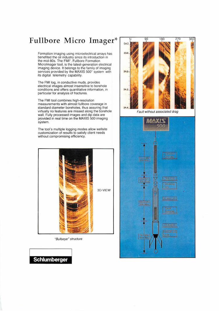
Fullbore Micro Imager*
Formation imaging using microelectrical arrays has benefited the oil industry since its introduction in the mid-80s. The FMI' , Fullbore Formation Microlmager tool , is the latest-generation electrical imaging device. It belongs to the family of imaging services provided by the MAXIS 500' system with its digital telemetry capability.
The FMI log , in conductive muds, provides electrical images almost insensitive to borehole conditions and offers quantitative information, in particular for analysis of fractures .
The FMI tool combines high-resolution measurements with almost fullbore coverage in standard diameter boreholes, thus assuring that virtually no features are missed along the borehole wall. Fully processed images and dip data are p~ovided in real time on the MAXIS 500 imaging system.
The tool's multiple logging modes allow wellsite customization of results to satisfy client needs without compromising efficiency.
3D-VIEW
"Bullseye " structure
276 Paper 10
A tectonostratigraphic model for the southern Nam Con Son Basin. offshore Vietnam
S.J. MAT1'HEWS & S.P. TODD BP Exploration Stockley Park
Uxbridge UB111BP, U.K.
The Nam Con Son Basin is a Tertiary rift complex that lies on the western margin of the East Vietnam Sea. As one of the more underexplored of several petroliferous provinces in the region, it is currently the focus of substantial exploration effort. Its underexplored status does however result in an inherent lack of data about stratigraphy, structure and petroleum geology. We have attempted to create a template for exploration through identification, mapping and interpretation of the major tectonostratigraphic units or megasequences visible in the available seismic and well data.
Four major tectonostratigraphic units may be defined. The boundaries of these units represent phases of rapid tectonic reorganisation in the depositional systems in the basin. Only some portions of the depositional systems tracts have to date been penetrated by wells and these facies define currently recognised lithostratigraphic formations. However, our template allows prediction outside well control into untested areas.
A gently divergent Palaeogene rift-fill seismic package which onlaps NE-SW to N-S trending fault blocks represents sedimentation in generally coastal plain to deltaic environments during the first pulse of extension in the basin. Preservation of Oligocene on footwall crests and lack of pronounced seismic terminations indicate that regional subsidence occurred synchronously with the observed extension and that sediment supply broadly kept pace with subsidence. Lower Miocene post-rift sediments characterised by parallel seismic reflections record regional thermal subsidence. Wells so far have penetrated a generally transgressive megasequence in coastal plain, delta, estuarine and lagoonal environments.
A Middle Miocene rift-fill package is characterised by a prominent unconformity at its base with truncation of underlying reflections on footwall crests of rejuvenated and new faults, and which is immediately overlain by a pronounced surface of marine onlap recording a second pulse of extension. Failure of regional clastic sediment supply is indicated in wells by transgression of fully open marine conditions, onset of deep water environments in depocentres and commencement of carbonate deposition on drowned highs.
A major late Middle Miocene truncational unconformity records gentle compression and uplift of depocentres probably combined with uplift on a more regional scale. Thin syntectonic packages are preserved which onlap structural highs.
A third pulse of mild extension is recorded by minor faulting and is combined with major regional subsidence that very rapidly flooded the remnant highs during the Late Miocene and Plio-Pleistocene. Platform-type carbonate build-ups which developed on fault blocks during the flooding were sequentially inundated by the easterly prograding palaeo-Mekong clastic wedge.
The processes responsible for these megasequences can be related to plate tectonic processes in the East Vietnam Sea and greater region. Palaeogene extension and regional subsidence is a function of both opening and spreading of the East Vietnam Sea, and relative motion of Indochina and the Sunda Shield resulting from IndialEurasia collision. Middle and Late Miocene extensional and compressional pulses are related to complex motions, possibly in response to the major collisional and compressional processes resulting from the propagating collision of Australia with Indonesia and the continued northward drive of India into Eurasia.
Nov-Dec 1993
277 Paper 11
Continental sedimentation in humid-tropical climates: Impact on Tertiary strata of the South China Sea area, with modern
analogues
R.D. KREISA, M.H. CARTER & B.S. SMITH Mobil Oil Co., Dallas
Continental deposits in humid-tropical settings are characterized by water-lain fluvial, lacustrine, and marsh facies, in contrast with the depositional models derived from arid and periglacial climates that dominate the geological literature. Resulting stratal geometries are illustrated using modem analogues from Sarawak and Papua New Guinea, and Tertiary strata from the Malay, Natuna, and Sarawak basins. Humid-tropical facies tracts include 1) upper coastal-plain braided stream, coarse-grained meandering stream, and interfluve paleosols; 2) lower coastal-plain meandering stream and overbank backswamp and lacustrine facies; and 3) deltaic, strand-plain, coastal mangrove swamp, and lacustrine-deltaic facies. In addition, climatic cycles related to Milankovitch cyclicity far more influence stratal architecture in continental facies than does eustatic sea-level fluctuation. Climatic cyclicity may leave palynological "fingerprints" that can be used for high-resolution biostratigraphy.
Tertiary strata in Southeast Asia contain economically important hydrocarbon accumulations reservoired and sourced in strata deposited in humid-tropical continental environments. Source facies formed in cyclic lacustrine and marsh/swamp settings and reservoir rocks were deposited in upper and lower coastal-plain channels, deltaic and lacustrine deltaic settings. Progradational versus "transgressive" phases of sedimentation in lacustrine deposits, and aggradation versus incision in fluvial sediments typically reflect climatic cyclicity. Stratal packaging is also influenced by local tectonics, continental drainage patterns, and other allocyclic forcing mechanisms. Coastal plain to deltaic Lower Miocene strata of Sarawak (Cycle II) and East Natuna (Arang Formation) and syn-rift lacustrine and swamp deposits of the Natuna Basins (Gabus and Lama Formations) contain good examples of strata influenced by these factors.
Paper 12
High resolution 2-D seismic survey in the Malay Basin
ABDUL RAzAK NURIN, KURT B. TwEEDY & JESMEE ZAmAL RAsHID Esso Production Malaysia Inc.
Kompleks Antarabangsa Jalan Sultan Ismail
Kuala Lumpur
On June 7, 1993, Esso Production Malaysia Incorporated (EPMI) completed another successful 2-D seismic survey in the Malay Basin. This year's 2-D acquisition differed slightly from previous years in that we employed two survey designs: the conventional 2-D survey and the shallow seismic high resolution 2-D survey, both targeted at different objectives. The conventional 2-D acquisition was designed to firm up prospects as well as to infill existing coarse regional grid over prospective areas in both PM-5 and PM-8 areas. The high resolution 2-D survey was designed to improve resolution of thin reservoir units at relatively shallow depths « 1500 meters) on the north flank ofPM-8 area. A total of2889 kms (chargeable) of conventional 2-D and 1649 kms (chargeable) of high resolution 2-D data were acquired using Digicon's MNGeotide.
The recording of high resolution 2-D seismic survey idea surfaced as a result of excellent data quality obtained during recent site survey work where reservoir units were better resolved down to 1 second two way travel time when compared to conventional 2-D. To meet this challenge, EPMI, with the assistance of the Geophysical Operations Group at EEC, designed acquisition parameters for the high resolution survey. This parameter design included the modelling of the air-gun array for broad band signal
Warta Geologi, Vol. 19, No.6
278 generation, using shorter group interval for high frequency preservation and finer subsurface sampling, and shallower cable and gun depths to help preserve data at the higher end ofthe frequency spectrum. The most challenging parameter design to honor in the field was to keep the cable at the depth of 3 meters which requires near perfect sea conditions.
At the time this abstract is written, most of the high resolution data is being processed. Test processing results are very encouraging with indications that the reservoir units are better resolved with significantly wider bandwidth compared to the conventional 2-D data set acquired in previous years. There does not appear to be any problem with penetration down to the target depths of at least 1500 meters (basement) and we consider this data to be an important improvement in seismic acquisition.
Paper 13
Geological constraints in the development of the Boyan Field, offshore Sarawak East Malaysia
ANDRIA G. DUNDANG, NoRAZLAM NORBI, G.F. CANJAR, BONIFACE BAIT & BERT HEJINA Sarawak Shell Berhad
Lutong, Miri Sarawak
The Bayan Field is located 80 miles NW of Bintulu, in sub-block 4Q-2l of the Balingian geological province, offshore Sarawak. The field was discovered in 1976 by the exploration well BY-l based on 2D seismic acquired in 1968 and 1974. 3D seismic was acquired in 1986 after the first drilling platform BYDPA was installed.
The field is a tectonically complex structure, comprising NW-SE trending anticlines dissected by predominantly E-W striking and mainly south hading normal faults which divides the field into various fault blocks. The field may be subdivided into 3 major development areas namely North, West and Northwest Bayan area. The productive reservoirs comprise Early Miocene (Cycle II) lower coastal plain to delta plain deposits.
A total of 13 appraisal wells were drilled to determine the prospectivity of various fault blocks. Some 1,065 feet of cores were taken in the field. The main development constraints are the structures, channel sands development and the trap mechanism.
The subsequent 3 platforms and wells were planned using the 3D-seismic data. Horizontal wells were drilled to optimise oil recovery from thin oil rim reservoirs.
Paper 14
Seismic recognition of incised valleys in the Malay Basin
MD. NOR MANSOR & K W. RunoLPH Esse Production Malaysia Inc.
Kompleks Antarabangsa Jalan Sultan Ismail
Kuala Lumpur
Because of the heterogeneity and discontinuity of many reservoirs, seismic recognition and mapping of incised valleys and other channels is an important aspect of development geoscience. Incised valleys also represent an exploration target in themselves, although limited in size. However, as shown by examples and seismic modelling, there is no single seismic signature that is characteristic of incised valleys/channels in the Malay Basin. The most important criteria in seismic recognition of incised valleys is the map distribution of seismic attributes. Horizon slices and isochron slices are among the many
Nov-Dec 1993
279 seismic attributes that are very useful in recognizing incised valleys and channels. Sand versus shalefilled channels and their encasing stratigraphy can be distinguished (on a risked basis) based on well calibration, seismic modelling, DHI characteristics and compactional geometry.
Paper 15
Petroleum potential of the Tembeling Group
KHALm NGAH, H.D. TJIA, ABDUL JALIL MUHAMAD, MOlID. YAMIN Au, MOlID. R.API MD. 80M, 1IEw Krr KONG & SHAMSUDIN JmIN PETRONAS Research & Scientific Services
Lot 1026 PKNS Industrial Estate 54200 Hulu Kelang
Mesozoic sequences occur extensively in the central belt of Peninsular Malaysia (E.H. Yin, 1988). Except for two small Mesozoic conglomerate occurrences at Pulau Kapas in Terengganu and Mersing in Johor, no other occurrences of the Mesozoic sequences in tjie offshore area have previously been reported. Extensive exploration for hydrocarbons by oil companies has provided new information on the possible extension to the offshore region, of the Mesozoic sequences. In the Malay basin, pre-Tertiary (?) sequences have been observed, and a few wells have been drilled into these sections. One well, Tok Bidan-1, situated east of Pulau Redang, north Terengganu, was claimed to have TDed in the Jurassic-Cretaceous section. Could these pre-Tertiary sections observed outside Tok Bidan area are also the lateral equivalent of the Jurassic-Cretaceous sections mapped in the central belt and the extreme east coastal regions of Peninsular Malaysia? The fieldtrip to the Sungai Tekai area where Jurassic-Cretaceous Tembeling Group is wellexposed, attempted to understand:
i) broad geological settings of the Tembeling Group and how these relate to the observed structural features in the Malay basin,
ii) age of the group, and
iii) hydrocarbon source and reservoir potentials of the Termus Shales and Mangking Sandstones respectively.
The Tembeling Group consists of three lithologically distinct formations: Lanis Conglomerates, Mangking Sandstones, and Termus Shales in stratigraphically ascending order (H.P. Khoo, 1983). The Lanis Conglomerates are polymictic, consisting of quartz, granite and meta-sediment clasts of pebble to cobble size, embedded in fine to coarse grained matrix which is generally red in colour.
The Mangking Sandstones exhibit the most spectacular outcrops along Sungai Tekai. The sandstones are generally fine-to-medium grained, whitish to light pinkish grey, and are "inter-bedded" usually with thin light grey shales. Small to very large scale cross bedding is common within the sandstones. True fossils (burrows and trails) have been observed. Under the microscope, quartz constitutes 75% of the framework grains, with 10% chert, 10% feldspar and 5% rock fragments. Illite is the dominant clay mineral. Porosity is generally poor, with less than 10%, and porosity destruction appears to have been caused primarily by quartz overgrowth.
The Termus Shales are generally reddish, and occasionally pinkish colouration and contain sporadically thin fine grained sandstones. These sandstones in places exhibit sharp erosional boundaries. Mineral composition analysis of the sandstones indicate"s a high content of framework feldspar (40%), which are generally highly altered, quartz (40%), and rock fragment (15%), and 5% of biotite, muscovite and iron oxide.
Tectonically, based on field evidence, it appears that the Tembeling Group was folded once, resulting in tight folds (in shale sequences) to open folds (in sandstone sequences). The direction of regional compression is established by the pattern ofleft and right-stepping arrays of quartz veins in the sandstones. This compression within the NE-ENE sector (of probable post-Neocomian-Palaeocene age) also developed slaty cleavage, reverse faulting, and moderate-sized wrench faults. The presence of pencil cleavage in the Termus Shales may be a manifestation of mid-Miocene(?) compressive deformation, which in the Malay basin had caused significant folding, wrench faulting and local reverse faulting.
Warta Geologi, Vol. 19, No. 6
280 It is difficult to determine the age of the Lanis Conglomerates, but the presence of Classopollis,
Exesipollenites, Ephedrapites, and Cicatricosisporites in the Termus Shales and Mangking Sandstones indicates an Early Cretaceous age, and probable a pre-Barremian age for the two formations, based on the absence of angiosperm miospores. No dinoflagellate cysts or microforaminifera were observed.
Surface shale samples of the Mangking Sandstones and Termus Shales, which have been subjected to weathering effects, indicate generally poor residual total organic carbon content and poor hydrocarbon generating potential. Hydrogen Index values are also very low, indicating Type IV inertinitic kerogen with no hydrocarbon potential. However, Thermal Alteration Index suggests that the samples are matured in the Termus Shales to highly matured in the Mangking Sandstones.
Paper 16
Borehole gravimetry survey in Central Luconia carbonate reservoirs .
MAHKOKGIN Sarawak Shell Berhad
Lutong, Miri Sarawak
A borehole gravimetry log (BHGM) was run in four wells during the MLNG-2 Appraisal Campaign in 1992. The gravimetry tool is a wireline logging tool that records formation density far away from the wellbore. Its investigation depth is dependent on the density contrast as well as the size of the structure which has to be resolved. Density differences from large structures can be detected several thousand feet away from the borehole compared to a conventional density log which only measures the immediate surrounding of the wellbore. The objective of running BHGM in the wells was to determine lateral continuity of the gas-bearing carbonate reservoirs.
General performance of the tool was good. An accurate BHGM density profile was obtained for each well without major operational difficulty. The BHGM density showed an overall agreement with wireline density log indicating a good lateral continuity of the reservoirs. Small scale differences between wireline density log and BHGM can be explained by local variations in porosity. In one of the wells, the BHGM confirmed that a tight layer observed on the density log is a localised feature. BHGM measurement is nondirectional; integration between wireline density log, BHGM and geological/seismic data would be required to produce a geometrical reservoir model.
Paper 17
A seismic tour of eastern Sabah: play types and tectonic seHings
TERRANCE R. WALKER
WMC Petroleum (Malaysia) 12 Floor Bangunan Getah Asli
148 Jalan Ampang 50450 Kuala Lumpur
Some 2,900 km of modern seismic data have been acquired in the 1990's in the Malaysian sector, offshore eastern Sabah. These data, the first acquired since 1973, together with 1,400 km of vintage reprocessed data and over 1,000 km of vintage data, reveal a great deal about the play types and tectonic settings of the area. Play types include faulted anticlines, compressional anticlines, reactivated growth faults, pinnacle and platform reefs, compartmentalized fault traps and slope/basin floor fans. Tectonic settings include Miocene back-arc, intra-arc and fore-arc basins, all of which are overprinted by Pliocene compression. Evidence is presented for some 45° anticlockwise rotation of the area since the late
Nov-Dec 1993
281 Oligocene. We conclude that the area has considerable potential to be a future hydrocarbon-producing provinc!!.
Paper 18
The integration of 3-~ seismic and geological computer mapping in defining further development opportunities in a mature field
Mn ZIN CHE LAB, JONATHAN K WESTBURY & GEORGE CIEsLA PETRONAS Carigali Setn. Bhd.
Wisma Peladang, Jalan Bukit Bintang P.O. Box 12407
50776 Kuala Lumpur
The Baronia field is located some 40 km offshore Sarawak. Discovered in 1967 and producing since 1972, it is one of the largest fields in the Baram Delta Province. To date, it has a total of 47 wells drilled, of which 40 wells have been completed to drain some 10 major reservoirs.
The field comprises a series of multiple stacked deltaic to shallow marine sandstone reservoirs which contain oil and gas. The oil accumulations are found with both significant oil columns and thin oil rims with drive mechanisms consisting of a combination of gas cap expansion, water drive and natural depletion.
In 1991/92, a 3-D seismic survey was acquired with the objectives of providing a detailed structural interpretation for-volumetric estimates as well as the prediction of fluid distribution and movement within the major producing reservoirs to support an infill drilling campaign.
This paper focuses on the use of state of the art interpretation techniques - an integrated geophysical and geological approach was applied in seismic interpretation, depth conversion, seismic amplitude studies and computer reservoir mapping in order to achieve these objectives. This has enabled the identification and optimisation of additional drainage locations which include horizontal wells as either oil-rim producers or downdip water injectors.
Further use of these results is being made in providing input to a full field reservoir simulation on the major reservoirs in the field.
This paper demonstrates the value of an integrated geophysicaVgeological approach in identifying further development opportunities in a mature field.
Paper 19
Improved characterisation of carbonate reservoirs using nonlinear modelling
M. PRINs Sarawak Shell Berhad
Lutong, Miri Sarawak
Physical properties of reservoir rocks such as type of lithofacies, porosity and permeability, are directly related to the recoverable volumes of hydrocarbons. Therefore it is important to determine these properties as accurate as possible. These properties however, can only be directly measured on cores of. which, for economic reasons, only a limited number are available for a gas/oil field. Open hole logs on-the other hand, are available in most wells and therefore it is common practice to derive the reservoir properties by calibrating the log responses to the core measured properties.
Warta Geologi, Vol. 19, No.6
282 Common techniques such as multi-variate linear regression are not always successful for carbonate
reservoirs due to diagenetic effects that can strongly affect the relationship between reservoir properties such as porosity and permeability.
To improve the determination of carbonate reservoir properties from logs, the use of non-linear modelling was investigated with commercially available PC based software. Use of this user-friendly technique has proved useful in the prediction of the type of lithofacies and reservoir permeability and results in a better estimate of reservoir properties.
Paper 20
Application of sequence stratigraphic techniques on the nonmarine sequences: An example from the Balingian Province,
Sarawak
ISMAIL CHE MAT ZIN & JAAFAR SIPAN PETRONAS Carigali Sdn. Bhd.
Wi sma Peladang, Jalan Bukit Bintang P.O. Box 12407
50776 Kuala Lumpur
The Oligocene to Early Miocene sediments penetrated by several wells in the onshore Balingian and also outcropping in the area were deposited in predominantly lower coastal plain environment of deposition. Based on the present stratigraphic framework, whereby the Tertiary sediments in the Sarawak Basin were subdivided into seven (7) sedimentary cycles, these sediments are of age equivalent to the Cycle I and II.
By applying the sequence stratigraphic techniques, the Cycle I sediments in the area, could be subdivided into several sequences. In brief, the sequence stratigraphic technique subdivides the sedimentary succession into the smallest unit of lamina to the highest hierarchy called sequence. The sequence is defined as a relatively conformable succession of genetically related strata bounded by the unconformities or their correlative conformities. Further, the sequence can be subdivided into system tracts based on objective criteria including types of bounding surfaces and the position within the sequence.
The established sequence boundaries which provide the basis for the regional mapping and well correlation, help in the understanding the depositional setting and reservoir distribution for the nonmarine sequences.
Paper 21
Complex transtensional structures and the hydrocarbon potential of the greater Sarawak Basin, East Malaysia, as defined by
Synthetic Aperture Radar 1 2 3 4
BIRD, D.J. ,POSEHN, GA. ,LIGHT, M.P.R. & M.A.A HUDI 1PanCanadian Petroleum Ltd. 2 .
Amax Petroleum of Canada Inc. 31ntera Information Technologies (Canada) Ltd.,
Calgary, Alberta, Canada 4Petroliam Nasional Berhad, Kuala Lumpur, Malaysia
Synthetic Aperture Radar (SAR) is an active microwave sensor which operates both day and night and is capable of penetrating cloud cover and tropical haze. SAR has proved to be an excellent tool for unraveling the critical structural elements of the region which have a major control on the location and
Nov-Dec 1993
283 size ~fprospective hydrocarbon accumulations in East Malaysia. Interpretation ofSAR data acquired over the Greater Sarawak Basin in East Malaysia has revealed the complex tectonostratigraphic history of the region when combined with other geoscientific information. The high quality radar images are of primary use in field logistics, particularly in orienting and locating seismic acquisition programs and prospective boreholes.
Borneo underwent complex transtensional deformation during the Tertiary related to strike-slip motion caused by the indentation of India against the Indochina-South East Asian block. These sinistral strike-slip zones are best developed in the Sabah Shear, West Baram-Tinjar Lines and Lupar LinePaternoster Fault. The onshore extension of the seismically defined transverse faults in the South China Sea controlled the migration and accumulation of hydrocarbons near Miri, Sarawak and prospective regions further southeast delineated by high resolution SAR data.
The collision of the Australian continent with the Banda Arcs to the southeast and renewed subduction to the east and west put Borneo under compression in the Middle Miocene. Complex fold interference patterns produced by Cenozoic aged strike-slip displacement and the northward advance of the Rajang Accretionary Prism are well displayed on SAR data as are several suites of lineaments correlated to the prevailing regional stress regime. The lithological terrain units and structure defined in the SAR interpretation agree well with documented field observations.
Paper 22
A comparison of 3-~ one-pass migration algorithms
HERMAN VAN VOORST VADER & PETER CHIA TECK FOOK Sarawak Shell Berhad
Lutong, Miri Sarawak
During 1993 a number of 3D surveys have been processed for SSB/SSPC by processing contractors in Kuala Lumpur and Singapore. In order to select the optimal 3D migration algorithm for each of the surveys, the contractors were asked to do a number of tests using various algorithms and parameter settings. The results of those tests will be shown together with a brief theoretical introduction to each method and will also be compared to those of a 3-D one-pass migration performed inhouse using Shell software. Strengths and weaknesses of the various methods are evaluated.
Paper 23
Locations of sedimentary basins in Peninsular Malaysia: Speculations on basement control, basin extension and
hydrocarbon potential
AzHAR HA.n HUSSIN AND S.P. SIVAM Geology Department University of Malaya 59100 Kuala Lumpur
The three-fold geology division of Peninsular Malaysia demarcates the major locations ofits sedimentary basins. These broad divisions are the depocentres of several superimposed and successor basins.
The Western Basin represent the continental and shallow marine in the west with the slope and basinal environment in the east. Carbonate platforms of various ages occur in different parts of the basins. To the east, lower Paleozoic volcanics and black shales are dominant. Periodic inversion and folding within this basin (e.g. Mid-Devonian) led to breaks in sedimentation and restriction of water circulation.
Warta Geologi, Vol. 19, No.6
284 The successor basins here are of the following ages:
1) Early Paleozoic 2) Late Paleozoic-Triassic 3) Jurassic-Cretaceous 4) Tertiary.
The Central Basin is dominated by three successor basins:
a) Late Paleozoic-Middle Triassic b) Late Triassic-Cretaceous c) Tertiary.
The Late Paleozoic-Middle Triassic basin is dominated by carbonate platform and volcanics to the west. To the east, turbidites, black shales, volcanics and some carbonates sited on volcanic highs dominate the lithologies.
The Late Triassic-Cretaceous basin is essentially composed of many small to medium intermontane basins composed of alluvial fan sequence and red beds. There are probable Tertiary continental basins which have not been recognised as they occur on the older Late Triassic-Cretaceous basin.
The Eastern Basin is composed of:
a) Carboniferous-Triassic b) Jurassic-Cretaceous c) Tertiary.
The Carboniferous-Triassic basin represent a shelf-slope facies of carbonate, black shale and other clastics. The younger basin are continental in character.
The presence of superimposed basins from Late Paleozoic through Tertiary suggests strong basement control on their locations. The corresponding patterns in the three belts suggest that their tectonic history is quite similar from the Late Paleozoic.
The superimposed basins have produced sequences of alternating source rocks and reservoirs e.g. the Upper Paleozoic-Triassic black shales overlain by the Jurassic-Cretaceous and Tertiary continental reservoirs.
The concept of superimposed basins promotes the possibility of further exploration targets. In the Straits of Malacca where Upper Paleozoic-Triassic, Jurassic-Cretaceous and Tertiary basins are predicted, e.g. offshore Kuala Perak-Kuala Selangor and offshore Muar-Batu Pahat.
This'study also open an opportunity to consider the importance of the older sequences as being important exploration targets in the existing offshore fields. Reservoir facies may be present in the deeper areas where porosity has been preserved or secondary porosity created during their diagenetic history.
Paper 24
Abnormal pressure study in the Malay-Penyu Basin
MOIm SHARIFF KAnER PETRONAS Carigali Sdn. Bhd.
Wisma Peladang, Jalan Bukit Bintang P.O. Box 12407
50776 Kuala Lumpur
Drilling of approximately two thirds of the structures in the Malay-Penyu Basin were terminated due to abnormal pressure. Blowouts and the subsequent loss of technical data has always been a concern during drilling operations.
This study uses data from 91 exploratory wells spread throughout the Malay-Penyu Basin. The postdrill abnormal pressure predictive method used in this study is pressure versus depth plots of data obtained from RFT (Repeat Formation Tester) readings.
Nov-Dec 1993
285 Results indicate that abnormal pressure occurs in progressively older units towards basin flanks.
The margins of the Malay Basin and the entire Penyu Basin are normally pressured. The onset of abnormal pressure is abrupt in the northern and more gradual in the southern portion of the Malay Basin. Abnormal pressure in the Malay Basin is neither depth dependant nor age related.
This phenomenon is crucial to the understanding of the hydrocarbon migration and will also enable the planning of safe and efficient drilling campaigns.
Paper 25
OHI analysis in the Malay Basin
K W. RUDOLPH & F.W. RICHARDs Esso Production Malaysia Inc.
Kompleks Antarabangsa Jalan Sultan Ismail
Kuala Lumpur
In this paper we will discuss the distribution and controls on direct hydrocarbon indicators in the Malay Basin, and focus on the techniques applied in DHI analysis. Our conclusions highlight the applicability and business imporlance of this technology to Malay Basin exploration and development.
We have found four techniques to be invaluable in DHI analysis in the Malay Basin: seismic modelling, seismic attributes, historical statistics and AVO (not discussed here). A thorough understanding of physical properties, as they relate to seismic signature via seismic modelling, is a key concept. Seismic attributes, applied on the workstation, are a powerful tool for evaluating potential DHI distribution for risking, assessment, and reservoir mapping. Historical statistics are critical in using DHI analysis for risking, as evidenced by the 70% DHI success rate for EPMI in the last three years.
Paper 26
A comparison of quality of present-day heat flow obtained from BHTs, Horner plots, RFTs, and 05Ts of Malay Basin
DOUGLAS W. WAPLES & MAHAnIR RAMLy c/o PETRONAS Carigali Sdn. Bhd.
Wisma Peladang, Jalan Bukit Bintang P.O. Box 12407
Reconciling temperature data obtained from measurement of single BHT, multiple BHT at a single depth, RFTs and DSTs is very difficult. Quality of data varied widely and DST data were assumed to be most reliable. Data from 145 wells were used in this study but only 47 wells have DST data.
The BASINMOD software program was used to calculate the present-day heat flow using measured thermal conductivities. The heat flows obtained from the DST data were assumed to be correct and representative throughout the basin. Heat flows were then calculated using (1) uncorrected RFT data, (2) multiple BHT data corrected by the Homer plot method, and (3) single BHT values corrected upward by a standard 10%. All three of these heat flow populations had identical standard deviations to that for the DST data, but with significantly lower mean values. Correction factors were then calculated to give each of the three erroneous populations the same mean value as the DST population.
Warta Geologi, Vol. 19, No.6
286 Heat flows calculated from RFT data had to be corrected upward by a factor of 1.13 to be equivalent
to DST data; Horner plot data corrected by a factor of 1.15, and single corrected BHT data by an additional factor of 1.17. These results suggest that present-day subsurface temperatures calculated using RFT, Horner plot and BHT data are considerably lower than what they should be.
We suspect qualitatively similar results would be found in other areas. Hence, we recommend significant corrections be routinely made until local calibration factors are established.
Paper 27
An overview of the hydrocarbon potential of the Spratly Archipelago, South China Sea, and its regional implications for oil
and gas development
J.B. BLANCHE & J.D. BLANCHE Blanche Oil and Gas Consultants
'Tara' Laighill Place Dunblane, Perthshire FK15 OBJ, Scotland
The Spratly Island Archipelago in the South China Sea will become the focus of exploration for hydrocarbons over the next decade, once the multi-national boundary disputes are resolved by negotiation and peaceful means by the claimant states.
International attention on the hydrocarbon potential of the area was focused by the award of the 25,155 sq km, with an additional adjacent Contingent Contract Area covering 5,076 sq km, W AB -21 Block in the Wan'an basin located 100 km to the south-west of the Spratly Islands which are claimed by China and Vietnam. Recent press reports indicate that these governments are willing to settle boundary disputes without force. The award was to the Crestone Energy Corporation from the China National Offshore Oil Corporation (CNOOC) on 8 May 1992.
Basin development occurred during the Early Paleogene as a consequence of rifting and pull apart of the south-west South China Sea producing numerous grabens and half-grabens. These contain potential source and reservoir rocks of Oligocene and Miocene age which are indicated to be thermally mature for hydrocarbon generation.
The Spratly Islands Archipelago is surrounded by prolific oil-producing areas, i.e. the Nam Con Son (Wan'an) basin of Vietnam, the East Natuna basin of Indonesia, the Northwest Palawan basin of the Philippines, the productive Luconia Shelf offshore Sarawak and the BruneiINorth West Sabah basins.
By analogue with these areas, this frontier region may yield considerable reserves, possibly in excess of 1-2 billion barrels of oil.
Nov-Dec 1993
287
c Poster 1
Bukit Keluang Formation: A proposed new stratigraphic unit and its sedimentology
KAMAL RoSLAN MOHAMED & IBRAHIM ABDUlLAH Jabatan Geologi
Universiti Kebangsaan Malaysia 43600 Bangi
Koopmans (1968) described the rocks from Bukit Keluang, Bukit Bubus, Bukit Dendong and Pulau Rhu of Besut, Terengganu as parts of the conglomerate member of the Triassic-Jurassic Tembeling Formation. On the other hand, the Geological Survey Department of Malaysia mapped the area as Triassic-Jurassic (1973) but later changed it to Carboniferous (1985). Recent observations by authors, however, indicated that the rock sequence in this area is very different from the underlying complex-folded undoubted Carboniferous rock formation in that it is separated from the underlying Carboniferous rocks by marked angular unconformity.
At least six sedimentary facies were recognised in this sequence, from the bottom upwards: massive conglomerate, dominantly conglomerate with interbedded sandstone, dominantly sandstone with conglomerate lenses, thickly bedded sandstone, sandstone interbedded with siltstone and siltstone interbedded with mudstone. From facies distribution, facies association and facies sequence, i.e. a fining and thinning upwards sequence, it is interpreted that this rock unit was deposited in a continental environment, i.e. initially braided stream, later changing to meandering stream.
From overall general dip direction distribution, it is interpreted that the rocks represent the western limb of southeast plunging anticline. Medium scale asymmetrical west-plunging folds, found at the southern part of Bukit Keluang and Bukit Dendong, are interpreted as fault related. Reverse and normal faults are commonly observed.
Since the lithology, sedimentology and structure of this rock unit is very different from the underlying rocks formation and is separated by an angular unconformity, it is proposed that this rock sequence to be given its own stratigraphic unit, namely Bukit Keluang Formation, with its type locality at Bukit Keluang, Bukit Bubus and Bukit Dendong. It is believed to be of Jurassic-Cretaceous age.
Poster 2
Engineering acquisition and processing: An integrated design approach for optimal seismic data
A. EASTON WREN Hydrocarbon Explorer
2020-28 Ave. S.W., Calgary Alberta, Canada T2TIK3
Traditional approaches to seismic acquisition focus on noise reduction with arrays and always prove to be inadequate since they also filter the signal. Traditional processing procedures thus have a dual role - initially to repair the damage signal and then enhance it. It is too late. The damage is already done.
Warta Geologi, Vol. 19, No.6
288 Anstey (1987) was the first to suggest better methods of acquisition. His "design on the signal" and
"STACKARRAY" ideas were followed by Ongkiehong (1988) who advocated spatial aliasing of the noise as the optimal method for signal-to-noise separation and therefore signal enhancement. Ongkiehong's method, however, forces the data user into the domain of F -K space, a domain where geophysicists are not comfortable.
This paper will briefly review these techniques and demonstrate by example that properly designed acquisition and processing in F-K space can produce seismic data with virtually zero linear noise. The method is usually valid for land or marine exploration targets.
Poster 3
On-board processing/interpretation. PPL 82 Papua New Guinea 1 2 3 3
LARRy GALE , MIcmo HIGASHI, JOE KMEcK & SEAN RoONEY 'MobilExploration and Producing Technology Co.
2Japan Petroleum Exploration Co., Ltd. 3Mobil New Business Development Co.
Mobil and partners used a team of geoscientists to process, interpret, and map marine seismic data as it was being acquired in order to make decisions saving over US$200M and reducing the exploration cycle time by several months. During a survey offshore Papua New Guinea the team processed and mapped over 400 km of seismic data, 200 km of which were processed and mapped within a period of 1 week. The map created from those 200 km substantially changed the existing interpretation of the area and led to a reduction in program kilometers and the addition of several new lines. Through the use of onboard processing and interpretation a better quality survey was acquired for less cost than planned. In addition, the time between acquisition of seismic data and generation of a time structure map was drastically reduced.
Several leads, interpreted as Miocene reefs and potentially contained several TCF of gas, had been mapped on existing data. Two wells drilled on similar structures nearby had discovered nearly 2TCF. The new survey was designed to acquire the data needed to upgrade the leads to prospect status for possible drilling within 8 months after acquisition. The on-board interpretation objective was to demonstrate whether structural closure on the Miocene reefs was large enough to justify drilling. This objective was achieved.
Poster 4
Reversal of wrench movement at the west-central margin of the Malay Basin
LIEw KIT KONG PETRONAS Research & Scientific Services
Lot 1026 PKNS Industrial Estate 54200 Hulu Kelang
Right lateral wrench movement could have occurred on the west-central margin of the Malay Basin as early as Jura-Cretaceous and continued till pre-Oligocene. This is evidenced by the occurrence of basement faults transecting pre-Oligocene/Jura-Cretaceous(?) sequences in the Tok Bidan graben., Tok Bidan graben resembles a rhomboid pull apart basin by right lateral wrench movement.
The continual right lateral wrench movement during pre-Oligocene could have initiated the formation of NW -SE trending Dungun fault system and its associated half grabens. The Dungun graben is located at the southeast end of the Dungun faults. This graben also resembles a right lateral wrenched rhomboid
Nov-Dec 1993
289 pull apart basin. The location of this graben at the southeast end of the Dungun faults suggests the movement of the Dungun faults dextrally.
Left stepping en echelon faults within Miocene sequences in the Dungun graben suggests a reversal of wrench movement during Miocene time. However, such reversal was not recorded in Tok Bidan Miocene sequences: the Dungun faults could have buffered the changes in stress during Miocene. The absence of wrench reversal in the Tok Bidan graben indicates that Tok Bidan area could be stabilising during Miocene.
This Miocene reversal of wrench movement could be the manifestation of the changes in the stress regime within this portion of the Malay Basin. These changes could have resulted from the change of motion of the Pacific Plate and the northward advancement of the Indo-Australian Plate during Miocene.
Poster 5
Sequence stratigraphy and reservoir distribution of the J-15 sequence in PM9, Malay Basin
ABDUL JAILANI CHE JOHARII & JOHN R. BEDINGFlELD2
'PETRONAS Carigali Sdn. Bhd. Wisma Peladang, Jalan Bukit Bintang
P.O. Box 12407 50776 Kuala Lumpur
2Esso Production Malaysia Inc. Kompleks Antarabangsa
Jalan Sultan Ismail Kuala Lumpur
The J-15 sequence is one of several early Miocene aged stratigraphic units in the central portion of the Malay Basin associated with comparatively small magnitude relative sea level falls superimposed upon a higher order relative sea level rise. In the area of interest, the J-15 sequence is characterized by a stratal succession comprising offshore mudstones and siltstones abruptly overlain by more proximal lower shoreface sandstones. These lower shoreface sandstones are overlain in tum by distal lower shoreface and offshore sediments. The lower bounding surface of this unit, interpreted as the downdip correlative conformity of a sequence boundary, separates the lowstand systems tract of the J-15 sequence above, from the highstand systems tract of the preceding sequence below. The more distal lower shoreface to offshore sediments overlying the J-15 lowstand systems tract make up the transgressive and highstand systems tracts of the J-15 sequence. The sandstone of the J-15 lowstand form part of a strandline system deposited in a marginal marine setting. Hydrocarbons are only found in the sandstones of the lowstand systems tract of the J-15 sequence and are trapped in part by the pinchout of reservoir quality san.dstones in a basinward direction as the depositional facies change rapidly from lower shoreface to an offshore environment. The recognition of the stratigraphic trap component of the J-15 and other similar sequences has positive economic implications for the current phase of exploration in PM-9.
Warta Geologi, Vol. 19, No.6
GEOLOGICAL SOCIETY OF MALAYSIA
GEOSEA V PROCEEDINGS VOLUMES I & II
(Bulletin Geological Society of Malaysia Nos. 19 & 20)
FIFTH REGIONAL CONGRESS ON GEOLOGY, MINERAL AND ENERGY RESOURCES
OF SOUTHEAST ASIA
GEOSEA V PROCEEDINGS
KUALA LUMPUR MALAYSIA
VOLU ME I
&-13th APRIL 1984
Some of (he: articles appearing include:-
Massive sulphide deposits and their possible significance to other ores -R.W. Hutch inson: Palaeogeognphic devdopmffi( o f "nl S.rawak Denis N.K. Tan: Geological evolution or lhe Southern Philippines - C.K. Burton: Southeast Asia as a p1lft of an urly Palaeozoic Austra lian Gondwanaland - CO Burrett & B. Sial I; Tertiary basins of S.E. Asia their dispara te t«:lonic ori gins snd eustatic sin lignphica l similariti ts e.S. H ulchison: Lale Palaeozoic pa l lt'O~tognph~' of Southeasl Asb: some stratigraphical. pab.wntologita l and palatomaglletic constraints -I. Metcalfe: The REE geochemistry of Li ngsha n \\i-So-bea ring gran itn and (heir Ipplicltions to petrogeM'Sis of the gra ni tes - Yuan Zhongxi ng 1.'/ al.: Chromite deposits of P.a JllllI New Guinu - P.M. Afenya: Recent Idv.ances in ex plontion modelling for tin deposits aod tMir Ipplicltion to the SE Asil n environment - R.G . Taylo r & P.J . Po llard: Some thoughts on the development of the I liuvilitin fie ids of theMally.Th.ai Peninsu l.a -D. Ta ylo r: Base met I I explonuion in Sa bah - Da vid TC Lee & H .S. Weber: The nlt ure I nd potenti al of gold minera lisation in Kel.aDta n -L.H . Chu & D. Santok h Singh: Q u.a tem l ry deposits of Thailand - Po Dhetradilok & W. Kaewyana: Soil la ndscapes in Peninsul ar Malaysia _. S. Paramananthan & S. Zauyah: Aspects of lhe geochemistry of Malaysia n cassiterites - W. Fuad Hassa n: Geological evolution of the Indonesian Archi pelago - H.M.S. Hartono & S. TjOkrOsapoetTO: The nature, distribu tion I nd genesis of cert ain lluthigenic minerals in the stanniferous I lluvial deposi ts of S.E. Asi.a - K .F.G. Hosking: G lobal tec ton ics I nd resour~ -W.S. Fyfe: lin/lungsten-be.aring gr.ani tcs in S. Chinl 2nd their met.aUogenttic rela tions - Xu Keqin & Zhu J inchu: Hydrogeological Slctil; lies in Peninsular Ml laysia and SSi rawSik - F.S. Chong & Denis N.K . Tan: S tl tus of ura nium explontion in Peninsular Mallysia - L H. Chu & F. Chand: Direc tions of geologic transport in PeninSlJ lar Malaysia - H .D. Tjia: Cathaysia. Gonch u na land a nd the PSllae-otethys in the evolution of Coo tinenlal S.E. Asia - Y.G . Ga linsky & CS. Hutchison: Marginal seSi formation by ri fting of the Chinese -and .4.ustra lia n Con tinental Margins and impl ications for Bomeo - CS. Hutchison: MesozOK: and Cenozoic regional tectoaics a nd meta llogenesis in M2inl lndS.E. Asia - -A.H.G. Mitchell: Coal pottutia l l nd explora tion in Sanw.lk - S.P. Chen: The succession of vertebrate faunas in lhe continental Mesozoic of nl il l Dd - E. BufTetaut & R. Inga vat: Reg-:ona\ controls of hydrot hermal ore localization in DOf"thern Th .liland - P. Asnachinda & S. Chantardmet: u te Palaeozoic glllcial mllrine fac~ in S .£. Asi2 .lnd its implica tions - P. H . StaufTer & CP. Lee. Cretaceous melange in West K.alim2nt an .and its fec toaic implica tions - P.R. Williams 1'/ af.: Recenl .ldvances in the knowledgt or geology, minera l I nd mergy resources of Singapore since 198 I - Ansafur Rahman & P.P. Wong: The integr2tion of remote sensing. tern in evalua tion .lnd engiM'tring geology in Southe.lst Asi.l - Beaumont. T .E. & Hunt. T : Rectnt adnnces in the knowledge of geology .lod mineu l resoufcn of Vietnam since 1981 - - Le Thai Xinh & Nguyen Xuan An .
This 2-vol ume GEOSEA V PROCEEDINGS of about 500 pages each conta ins 95 art icles presented a t the Fifth Regional Congress on Geology, Mineral and Energy Resources of Southeas t Asia held in Kuala Lumpur, April 1984.
To: Han. Ass ist. Sec retary Geo logical Society of Malaysia , c/o Department of Geology, Un iversit y of Malaya, 59100 Kuala Lumpur. MALAYS IA.
Date:
O rder for GEOSEA V PROCEEDINGS
I wish to pl ace a n o rder fo r set(s) of the GEOSEA V PROCEED INGS which will be in 2 volumes of abo ut 500 pages each. Volume I will be avai lable in Ap ril/May 1986 and Volume II in Jul y/A ugust 1986.
Both Volumes
Members Non-membe rs
Name/Company/Inst itution
Add ress
Enclosed cheq ue/money o rder/bank d raft
Price
MS50.00 (USS2 1.90) MS I25.00 (USS53.20)
for M$/ US$
Prices include surface mai l. For airma il please call 03-7577036 o r telex UN I MA L MA37453.
1lilIIiIllilllilllilllilllilllilIIiIIIiIIIHllIIiIIII
PERSATUAN GEOLOGI MALAYSIA GEOLOGICAL SOCIETY OF MALAYSIA
.:tf~~ :;IX-~~)!'
\ ,. ~~
'i §;~ lr,... 1967 t-
or- ,,.1\-'\ I
SEMINAR AND FIELDTRIP
on
PERMO-TRIASSIC OF MALAYSIA
AND ASSOCIATED
MINERALIZATION Bangi, Selangor
April 14-17, 1994
$trst Circular Information and Call for rJ>apers
Organized by: Geological Society of Malaysia • (Sedimentology & Stratigraphy Study Group) • (Economic Geology Working Group)
With Cooperation from: Department of Geology, Universiti Kebangsaan Malaysia Department of Geology, Universiti Malaya
1lil1lil1lil1ll1ll1ll1lil1lil1ll1ll1ll1lil1IiI1II
Warta Geologi, Vol. 19, No.6
291
GEOLOGICAL SOCIETY OF MALAYSIA ~,~
INTRODUCTION
The Geological Society of Malaysia under its Sedimentology & Stratigraphy Study Group and Economic Geology Working Group is organizing aone-day SEMINAR ON PERMO-TRIASSIC OF MALAYSIA AND ASSOCIATED MINERALIZATION with the cooperation of Department of Geology, Universiti Kebangsaan Malaysia and Department of Geology, University of Malaya.
The Permo-Triassic related mineralization has brought Malaysia world fame and prosperity. Though their role is becoming less important in the wake of the industrial-oriented Malaysia, they have undoubtedly played a very important role in the development of the country in the past. The geology, stratigraphy and mineralization of Malaysian PermoTriassic have been studied for decades, initially by foreign geologists and lately by growing numbers of Malaysia's own geologists. The Geological Society of Malaysia which organizes this seminar has given countless number of contributions towards the understanding of the subject matter through its Annual Conferences and various other seminars and forums.
The Geology Department of the Universiti Kebangsaan Malaysia hosted the Annual Conference of the Geological Society of Malaysia in 1987. Since then very few activities d the Geological Society of Malaysia have been organiz!KJ there. This one-day seminar will be the second biggest activity organised by of the Geological Society of Malaysia at the Universiti Kebangsaan Malaysia.
OBJECTIVES
1. To present newly acquired data on the geology ofthe Permo-Triassic of Malaysia.
2. To review and correlate different aspects of the Permo-Triassic of Malaysia.
3. To provide a platform for discussion on the economic and regional sign~icance of the Malaysian Permo-Triassic.
4. To generate interest for further research into the Malaysian PermoTriassic.
VENUE
The seminar will be held in the Department of Geology, Universiti Kebangsaan Malaysia, Bangi.
292
CALL FOR PAPERS
The organising committee invites the submission of papers to be presented at the seminar. Authors may submit extended abstracts (minimum of two pages) or full papers.
GUIDELINES FOR ABSTRACTS AND PAPERS:
1. Typed extended abstracts or papers on A-4 sheet (size 297x210mm). It is recommended that the author(s) also submh the extended abstracts or papers on flolly disk, Preferred programmes include MS-Word, Word Star and Word Perfect.
2. Submit clear original illustrations (Figures and Tables). Please indicate title of paper, author(s), and no. of figures/tables at the back.
3. The sizes of figures and tables can be designed in one of the following block sizes (6.2S"x9 .S", 6.2S''x6.2S'', 3"xS" or 3"x3").
4. The length of paper should not exceed S,ooo words or 10 pages.
April 15 -17, 1994
A three-day fieldtrip will be organized to study the Permo-Triassic of the western part of the Central Belt and their associated gold mineralization.
The first day will involve a visit to three gold mines and prospects (Le. the Raub, Selinsing and Buffalo Reen. The second day will involve a visn to the Triassic geology of the Taman Negara while the PermoTriassic geology along the route from Gua Musang to Kuala Lipis will be examined on the third day. Accommodation for two nights (at the Kuala Jerum hostel in Taman Negara) and food are inclusive in the cost. Lunches during the travel to and from Taman Negara will be at participants' own expenses. Transport by four wheel drive will be arranged.
Seminar (inclusive of lunch) Members : MR S.OO Non-members : MR1S.oo
Fieldtrip (inclusive of accommodation, transport and meals) Members : MR40.00 Non-members : MR90.00
(The fieldtrip is limited to 20 participants and will be confirmed upon payment on first-come-first-serve basis)
GEOLOGICAL SOCIETY OF MALAYS~A
~.~
rJteply to .Fzrst Circular
Name
Address
Telephone
Fax
I would like to:
D attend the seminar
D present a paper on
D join the fieldtrip
Endorsed is a *cheque/M.O. no. for RM to cover the registration fee (*RMS/ RM1S) and the fieldtrip (*RM40.00/RM90.00).
Date Signature
*delete which is not applicable
Nov-Dec 1993
293
The following applications for membership were approved:
Full Members
1. M. Naser bin Husin Geoeast (M) Sdn. Bhd., Lot 10.10, Tingkat 10, Wisma Stephens, Jalan Raja Chulan, 50200 K Lumpur.
2. Aswin Hariman Triton Oil Co. of Thailand, Menara Haw Par, Level 28, Jalan Sultan Ismail, 50250 Kuala Lumpur.
3. Nasiman bin Sapari Jabatan Sains Persekitaran, Universiti Pertanian, 43400 Serdang.
Student Members
1. Ruzman bin Ismail J abatan Geologi, U niversiti Malaya, 59100 Kuala Lumpur.
. .....
The following members have informed the Society of their new addresses:
1. E.O. Cox Geophysical Consultants, Pen Lan, Trofarth, Abergele, CLWYD, U.K. LL22 8BW.
2. Andrew Racey 23 Fernlea, Whitehill, Near Bordon, Hampshire, England GU35 9QQ.
3. Abd Hanan B Ahmad N adzeri 47 J alan 4B/6, Taman Setapak Indah, 53300 Kuala Lumpur.
4. Lee Chow Hooi 81 Jalan SS1I23, 47300 Petaling Jaya, Selangor Darul Ehsan.
5. Sulong Enjop 7 RollscourtAve., London SE 24 OEA
6. Mohd For Mohd Amin University of Bradford , Department of Civil Engineering, Bradford West Yorkshire, BD7 1DP, United Kingdom.
7. Kong Ing Chung 23-24 Lot 8635-36 (3rd Floor), Section 64, Jalan Simpang Tiga, 93300 Kuching.
------------.~.~~~.H.~----------
Warta Geologi, Vol. 19, No.6
294
The GSM is seeking the addresses of the following members. Will anyone who knows their whereabouts please inform the Hon. Secretary of their new addresses:
1. Kamarudin Zakaria 3. Ha Kong Yin formerly ofPergau Hydro Electric Project, Locked Bag 74, 17500 Tanah Merah, Kelantan.
formerly of Blk 337 # 03-302, Clementi Ave. 5, Singapore 0512
2. Yusri Zakariah
1.
2.
3.
4.
5.
formerly of 6 Lorong 6N6, 43650 Bandar Baru Bangi, Selangor.
----------~.~ • ._~_4.~.~----------
The Society has received the following publications:
Belgium Geological Services, Professional 6. Geological Survey of Japan, vol. 44, nos. 5-Paper 1993/8 - N. 266, 1993/9 - N.267, 8,1993. 1993/7 - N. 265, 1993/6 - N. 264 .. 7. Earthquakes & volcanoes, vol. 23, no. 5, AAPG Explorer, Oct & Nov 1993. 1992.
AAPG Bull., vol. 77/10, 1993. 8. Bulletin of the Belgian Geological Survey,
Journal of Hebei College of Geology, vol. 001100, nos. 3 & 4, 1991, 1993.
15, no. 5, 1992. 9. USGS Professional Paper: 1992: 1405-C,
Bulletin of the Chinese Academy of 1506-A.
Geological Sciences, no. 26, 1993. 10. USGS Bulletin: 1993: 2011.
----------~.~ • ._~_4.~.~----------
Nov-Dec 1993
Tectonic Evolution of SE Asia The Geological Society London
Burlington House
December 7-8 1994
CONVENORS Prof. Oerek Blundell
Roval HollowaV London
Dr. Robert Hall University College London
First Circular an4 Call for P~ers
Sponsored by University of London Sf As/a Research Group
Morine Studies Group Tectonic Studies Group
295
SE Asia is the region that must be understood if we are to understand mountain belt, arc development, marginal basin evolution and more generally, the behaviour of the lithosphere in collision settings. It is a spectacular r egion in which the manifestations and processes of plate collision can be observed at present and in which their history is recorded.
The region records the break-up of Gondwana, the subsequent movement of Gondwana fragments northwards, and their collision with Eurasia. The SE Asian volcanic rocks record a long history of Pacific and Indian Ocean subduction. The impact of the rigid Indian indentor is commonly cited as the cause of extrusion and rotation of continental fragments and opening of some of the marginal basins of SE Asia.
This two day international discussion meeting at the Geological Society in London will review the present and past tectonics of the region. We intend to devote one day to present·day tectonics and a second day to past tectonics.
The meeting will provide an opportunity to consider how data collected in the last few years in SE Asia test current tectonic models. It will form a UK contribution to two current IGC Projects: IGCP321 Gondwana Dispersion and Accretion and IGCP306 Stratigraphic Correlation in SE Asia.
PRESENTATIONS
We invite papers on all aspects of SE Asia tectonics, such as GPS studies, seismicity, marine geophysics, palaeomagnetism, and tectonic reconstructions, to be presented as oral and poster contributions to the meeting.
PUBLICATION
Papers presented at the meeting are expected to be published in a Geological Society Special Publication in 1995. We would like to collect manuscripts before the meeting in order to start the review process and produce the volume as soon as possible after the meeting.
Warta Geologi, Vol. 19, No.6
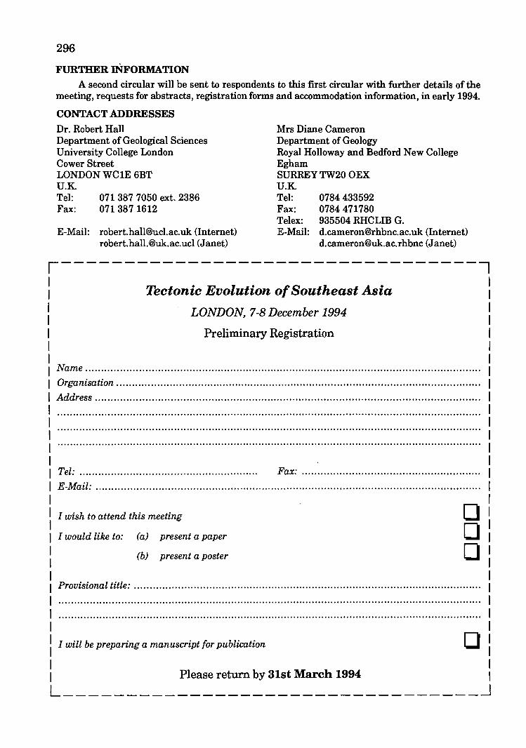
296
FURTHER INFORMATION A second circular will be sent to respondents to this first circular with further details of the
meeting, requests for abstracts, registration forms and accommodation information, in early 1994.
CONTACT ADDRESSES
Dr. Robert Hall Department of Geological Sciences University College London Cower Street LONDON WC1E 6BT U.K Tel: 0713877050 ext. 2386 Fax: 071 387 1612
Mrs Diane Cameron Department of Geology Royal Holloway and Bedford New College Egham SURREY TW20 OEX U.K Tel: 0784 433592 Fax: 0784 471780 Telex: 935504 RHCLIB G.
E-Mail: [email protected] (Internet) [email protected] (Janet)
E-Mail: [email protected] (Internet) [email protected] (Janet)
,---------------------------------, Tectonic Evolution of Southeast Asia
LONDON, 7-8 December 1994
Preliminary Registration
Name .................................................. ........................................................................... .
Organisation .................................................................................................................... .
Address .......................................................................................................................... .
Tel: ......................................................... Fax: ........................................................ .
E-Mail: .......................................................................................................................... .
I wish to attend this meeting
I would like to: (a) present a paper
(b) present a poster
o o o
Provisional title: .............................................................................................................. .
I will be preparing a manuscript for publication o Please return by 31st March 1994 L _________________________________ ~
Colombo, Shri Lanka February 20-25, 1995
The Ministry of Industries, Science and Technology, Government of the Democratic Socialist Republic of Shri Lanka, is organizing the Second South Asia Geological Congress, GEOSAS-II, to be held in Colombo, Shri Lanka from February 20 to 25, 1995, in cooperation with the Association of Geoscientists for International Development (AGID), Sao Paulo, Brazil. GEOSAS-II will cover the region of the SAARC and ECO countries, namely, Pakistan, India, Nepal, Bhutan, Bangladesh, Maldives, Shri Lanka, Turkey and Iran.
The GEOSAS Region forms a geographical and geological entity stretching across southern Asia over a land area of about 7 million sq km, inhabited by over one billion people. On the south, the Region is bounded by the Arabian Plateau and the Indian Ocean, including the Persian Gulf, the Arabian Sea and the Bay of Bengal; on the north it is bordered by some ofthe greatest mountain ranges of the world, namely, the Himalayas, Karakoram, Hindu Kush, Alburz and Caucasus, and the Caspian and Black Seas. The Mediterranean Seamarks its western limits with Europe.
The GEOSAS Region has witnessed a complex geodynamic history and the tectonic activities continue even today. Geologically, it is characterized by the presence of shields, cratons
Warta Geologi, Vol. 19, No.6
297
and platforms as well as by mobile fold belts, many of which cross national frontiers and extend into neighbouring countries.
The Region is endowed with rich resources of water, oil, gas, coal and industrial and metallic minerals , but many of its riches remain unexplored and unexploited. A concerted effort is, therefore, needed to study the geological features and their genesis in the Region, not only for scientific advancement but also for optimum use of the potential resources in an environmentally benign manner. GEOSAS-II will provide a platform for professional exchange of views to achieve these goals, and will continue the tradition ofregular Congresses in the Region.
• To provide a forum to the geoscien tists of the Regional countries for the exchange of professional ideas and for discussion of common geological problems among themselves and with leading international experts.
• To increase the competence of the Regional countries in better understanding and utilization of the earth's resources, while ensuring a sustainable environment.
• To find avenues of Regional trade of geological commodities for the mutual benefit of the countries.
298 • To attract involtmcmt for incroalod oil, lal,
wawr and minoral oxploration activitiol by hilhlilhtinl regional prospects and by dilleminatinl leololical information throulh doUberations and subsoqucmt publication.
• To holp train the younlleoscientists of the Rogion.
The participants will include the senior as well as young geoscientists from all the nine Regional coun tries, plannel'll and administrators associated with dovelopment of earth resources, and oxperts from various other countries who specialize in the geology of the Region.
Individuals and Organizations desirous of participating in GEOSAS-II should till in the respective Pre-Registration Return and send it to theGEOSAS Secretariat, by 30th Jun8 1993. The Second Circular will be mailed to all those who send the Pre-Registration Retum in time. A nominal Registration Fee of Shri Lankan Rupees 500/= (or US$10.00) will be charged from each participant, which will entitle the person to entry and participation in all the Congress Sessions. Registration Fee for Accompanying Members (spouses and children) will be SL Rs.250/- (US$5.00)
Limited funding may be available for a restricted number of outstanding as well as young geoscientists from within the Region. Those desirous of making use of this facility should write to the GEOSAS-II Secretariat, before 31st December 1993 at the latest, along with detailed biodata particulars and recommendations of their employers, where applicable. Preference will be given to those making an acceptable contribution to the Sessions. All such requests will be placed before a Committee who will make the selection based on merit, while ensuring a balanced Regional participation.
The Congress will be structured into Plenary Sessions, Technical Sessions, Poster Sessions.
and Seminar Selsions. Plena.~ Sess~on. will include the Inaulural· Senion, Keynoto AddrelJlil8s, Popular Lectures and the Closin, Selsion. Technwa.l Session. will comprise oral papor presentation lessions whoro the audtonce may allo participaw by alkinl questions. The following Technical Sessions 8ro tentatively planned, subject to further refinement as papers are received. Two or three Technical Sessions will run concurrently during the OOllll'esl.
TS.1 Regional Geology TS.2 Tethyan Orogenic Belts TS.S Pre-Cambrian Geology TS.4 Quaternary Geology TS.S Stratigraphic Boundaries TS.6 Marine Geology TS.7 Agro-Geology, Environmental
Geology & Urban Geology TS.S Hydrogeology " Engineering
Geology TS.9 Geological Hazards TS.l0 Ophiolites TS.ll Metallic Minerals TS.12 Industrial Minerals and Rocks TS.13 Energy Resources TS.14 Others
Poster Sessions will be organized to display research outputs in the form of charts and posters where author(s) will be available for discussion and for answering queries of the Congress delegates.
Seminar Sessions will be conducted as discussions between selected panelists and delegates. The following three themes have been identitied:
SS.l Regional Cooperation in Geoscientific Services (e.g. Laboratory, Mineral Exploration, Training)
SS.2 Environmental Monitoring and Planning in the South Asian region.
SS.3 Earth Science as a Basic Component of all Education.
Based on the response of this First Circular, the fmal programme will be published in the Second Circular.
Nov-Dec 1993
OrlslMll'Illllll'Ch contributionll, lIynthollll pApOrlil Md toplCAll'lvloWIL An Invltod for GEOWall. Tholo Ihould proforAbly bo of KOltonAl IIt,ntftcAnco, conformtnl to tho propolod SlctionAl Tttlil. Thl AbltrAatl tn not mOfl thM 100 wordl mAY bl lint to thl GEOSAS:II SICfltAriAt by 01 Dlclmbor 1000 Ai thllAilli. Authors will bl infofmld Aboui AOOlpiAfiOI or oth,lfwisl otth@ifpAp@fs by OlsiMAfoh 1004. A VolWll@ of AbsirAotl!l will b@ AvAillbl@ to In pmioiplHli§ ill tIl@ Conjf@§§: Ii i§ pfopo§1d to ptlbli§hld tIl@ Pfo@@@diHI§ of fiEg~M:1I1 IHld authors are encouraged to send in the full papers by 30 Sept. 1994. Guidelines will be sent to intending authors.
Concurrent with the GEOSAS-II, an international exhibition of literature, publications and displays on geoscientific developments of the participating countries will also be arranged. The state and private organisations of the GEOSAS Countries concerned with geoscientific and earth resource development are invited to display their respective achievements in the Exhibition.
Seven Geological Excursions are tentatively planned to be organized after the congress, i.e., beginning on 26 February 1995. The Excursions will be subject to sufficient participation.
Those interested should indicate their desire to participate in these Excursions on the PreRegistration Return. Cost of travel, board and lodging on account of these Excursions will be
Warta Geologt, Vol. 29, No.6
299 bomo by the pArttatpAntlj the GEOSAS·II SecretariAt will provide teahntaal,wdMce Md mMqement.
The exAat COlt Md dotAUIL of tho EXCtlfllonl wUl bo Indlaatod In thl Sicond OlrO\lIAr. MOMwhllo, thOIO Intoreltld mAY wrtil to tho GEOW .. II SlontAfiAi tor t\lrihor dltAtll.
B:l!
B:i! B:6! EX.4:
EX.5: . EX.6:
EX. 7:
Th@ pmst6H@ IHd\lS~ IlHd pmorplioloD of Ilm LllHlta Th@ Pf@:(}ilHiBfillH of l\Jlifi LllHltil 'fli@ Plpjl~w@lil Apil~U~. d@P6S1~ Coastal Quaternary, Miocene and Godwana deposits of Shri Lanka The Bogala Graphite Mine Kandy, the Hill Capital Galle and the Southwest coast
Approximate costs of excursions: 3 days - US$125; 2 days - US$75; 1 day - US$25
06 dlijfS
06 dlijfs Oi dlijfS 02 days
02 days 01 days 01 days
Ifthere is sufficient demand, there will be a programme for accompanying Members during the Congress.
Address: NARA, Crow Island, Mattakuliya, Colombo 15.
Telex: 21700 IFS CE Tel: 941522008 Fax: 941522532, 941522881, 94832131
Secretary General and Chairman, Organizing Committee:
Prof. P,G, Cooray Tel: (08 88541 [Res])
300
CENTENNIAL GEOCONGRESS Johannesburg South Africa 3-7 April 1995
South Africa - Land of Geological Superlatives!
Lecture and poster presentations on economic, igneous, sedimentary, metamorphic and environmental geology, tectonics, palaeo
environments, geophysics and remote sensing, focusing mainly on Africa and Gondwana, will be included in the scientific programme.
Contributions on global geology will also be welcomed.
Pre- and post-congress excursions will cover various geological formations and ore deposits, e.g. the Witwatersrand Golf Field and the
Bushveld Complex, as well as interesting tourist attractions.
This is an invitation to visit the country that has it all!
Respond to this announcement and your name and address will be placed in the database to receive furher
announcements and call for papers.
Contact The Congress Secretariat, Centennial Geocongress, P.O. Box 36815, MENLO PARK, 0102 SOUTH AFRICA
T el./Fax no. +27 12 47 3398
Nov-Dec 1993
301
GEOLOGICAL ATLAS OF JAPAN (Second Edition)
GEOLOGICAL SURVEY OF JAPAN 26 sheets (594 mm x 841 mm) Price: YEN 51500
r--- Celebration to Geological Atlas of Japan (Second Edition) --,
The Earth has evolved in her 4.6 billion years of history, having separation of continental crust from primitive mantle by magmatism and sedimentation. Structure of ocean and composition of sea water and atmosphere were also changed to have plants and animals, the final stage of which was the birth of Homo sapiens about 3 million years ago. The Homo sapiens lived in most oftheir time with natural energy resources, such as sun, wood and water. However, the industrial revolution of the late 18th century open a new era of high productivity in industry by using fossil fuels such as coal, petroleum and natural gas. The economic development was followed by expansion of the world population; both are the main reason for the Earth pollution. Protection of global environment is the first subject to study in the coming future.
In order to live properly, we have to know and understand our planet Earth deeply, and have appropriate planning on industry, economics etc. with the deep understanding. The Earth has a very complicated structure, especially in mobile belt like Japan. All geological, geochemical and geophysical information based on precise mapping is needed to find mineral and energy resources, to prevent natural hazards and to protect urban environment.
This atlas is summarized results of the 110 years activities of the Geological Survey of Japan. The publication is in a good timing in many aspects, and it must be a great contribution to both domestic and international societies.
Warta Geologi, Vol. 19, No.6
Shunso Ishihara
Director-General
Agency of Industrial Science and Technology
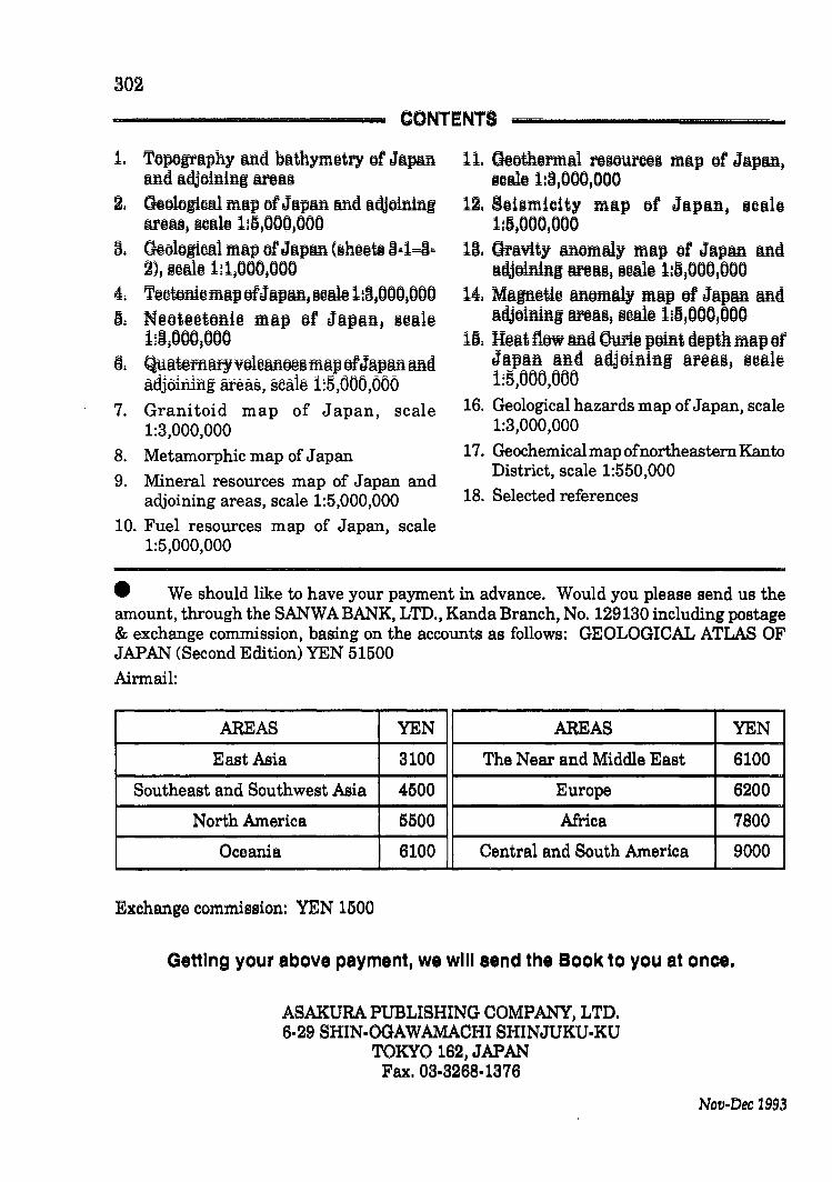
802
CONTENTS
1. TOPOgrAphy ed bAthymotry of JApAn ADd Adjoining AI'OAII
2. Geological mAp of JApAn and Adjoinlng oreu, IcAlo l:lS,OOO,OOO
8. Geological mAp of JApan hlhooUl 8=1=8= 2), I(UU@ 1:1,000,000
4: T@otoHiom~potJ~PMJ IO~@ l:OJ(}(}(}J(}(}(} 15: N@ot@@tofti@ m~p of J~p~ftJ I@~l@
liO,(}(}(},(}(}(}
~: QU!li@flUlf)fVoloMO@§m!lpofJ!lPMMd adjoirufi! areas, seale 1:5,000,000
7. Granitoid map of Japan, scale 1:3,000,000
8. Metamorphic map of Japan
9. Mineral resources map of Japan and adjoining areas, scale 1:5,000,000
10. Fuel resources map of Japan, scale 1:5,000,000
11. GeothormAl I'OtJOUl'OotJ mAp of JApe, ICWO 1:8,000,000
12. Soillmicity mAp of JApAn, ICAlo l:lS,OOOJOOO
18. GrAvity eomwy mAp of JApe ed Adjoininl ANIlIJ I@~@ l:lSJ(}(}(}J(}(}(}
14, MIlIll@ti@ Moml!lly mAP of Jllpe Md ~djoinlnlllf@llSJ S@~@ 11IS,(}(}(}J(}(}()
115: H@llt flow Md CYfi@ poiftt d@pth mllp of J!lPllft Ilftd Ildjoiftiftl Ilf@Il§J §Olllt~ 1:5,000,000
16. Geological hazards map of Japan, scale 1:3,000,000
17. Geochemical map ofnortheastem Kanto District, scale 1:550,000
18. Selected references
• We should like to have your payment in advance. Would you please send us the amount, through the SANWA BANK, LTD., Kanda Branch, No. 129130 including postage & exchange commission, basing on the accounts as follows: GEOLOGICAL ATLAS OF JAPAN (Second Edition) YEN 51500
Airmail:
AREAS YEN AREAS YEN
East Asia 3100 The Near and Middle East 6100
Southeast and Southwest Asia 4500 Europe 6200
North America 5500 Africa 7800
Oceania 6100 Central and South America 9000
Exchange commission: YEN 1500
Getting your above payment, we will send the Book to you at once.
ASAKURA PUBLISHING COMPANY, LTD. 6·29 SHIN·OGAWAMACHI SHINJUKU-KU
TOKYO 162, JAPAN Fax. 03·8268-1876
Nov-Dec 1993
< F~Bk;hANNU!~CHIE 68!~~RENCE, Houston, Texas. (Society of Exploration Geophysicists, P.O. Box 702740TulsaOK74170-2740. Phone: 918/943-3516. Facsimile: 918/ 2074.
CIR6~~PACIFI8tD CIRd~~ATLANTIC TERRANE, Int'l mtg., Guanajuato, Mexico. (David G. Howell, USGS, MS 902, 345 Middlefield Road, Menlo Park, Calif. 94025. Fax: 415354-3224)
THEig~~ NEW~I!tAND } RMAL WORKSHOP LONG-TERM USE OF GEOTHERMAL RESOURCES: PROBLEMS AND SOLUTIONS. Auckland, New Zealand. (Professional Courses, Centre for Continuing Education, University of Auckland, Private Bag 92019, Auckland, N.Z. Phone: 64-9-373 7599 Ext. 7050. Fax: 64-9-3737419.
/ iN¥~~N A T I 6dxL ?}??ici:k<:?o::?L??O??G I CAL
CORRELATION PROGRAMME, mtg., Santiago, Chile. (M. Vergara, Universidad de Chile, Departmento de Geologia y Geofisica, Casilla 13518-Correo 21, Santiago, Chile. Fax: 56-2-6963050)
TEM PROCESSES, PRODUCTS AND ECONOMIC SIGNIFICANCE (IGCP Project 294 Thematic Meeting), Santiago, Chile. (Professor M. Vergara, Universidad de Chile, Departmento de geologia y Geofisica, Casilla 13518-Correo 21 Santiago, chile. Telefax: 56 2-6963050)
Warta Ge%gi, Vo1.19, No.4
303
DYNAMIC GEOTECHNICAL TESTING, symposium, Reno, Nev. (Dorothy Savini, American Society for Testing and Materials, 1916 Race St., Philadelphia, 19103-1187. Phone: 215/299-5413)
MINING AND METALLURGICAL INSTITUTIONS, South Africa. (Bill Emmett Congress Manager 15th CMMI Congress, P.O. Box 809 Johannesburg 2000 South Africa. Phone: (27)(11) 838-8211 (office), (27)(11) 788-2518 (home). Fax: (27)(11) 834-1884)
INTERNATIONAL CO~:~ERENCE 0 RECENT ADVANCES IN MATERIALS AND MINERAL RESOURCES (RAMM '94), Penang, Malaysia (The Secretariat of the International Conference oil Recent Advances in Materials and Mineral Resources (RAMM '94), School of Materials and Mineral Resources Engineering, Universiti Sains Malaysia, Perak Branch Campus, 31750 Tronoh, Perak, Malaysia. Attn: Dr. Zainal Arifin Ahmad)
GEOC AND ISOTOPE GEOLOGY ClCOG-8), mtg., Berkeley, Calif. (Gamiss H. Curtis, Institute of Human Origins-Geoochronology Center, 2453 Ridge Road, Berkeley, 94709. Phone: 4151845-4003. Fax: 415/845-9453)
Of Q (;I, ~~~ . .
-c~:~.:es~ Money Orders or Bank Drafts must accompany all orders. Please add US$1.30 ror bank charges. Orders should be addressed to: The Hon. Assistant Secretary
GEOLOGICAL SOCIETY OF MALAYSIA do Dept. o·r Geology university or Malay;; 59100 Kua la Lumpur MALAYSIA
304
PP 167/12190 ISSN 0126-6187
~lUJ[L~~~ ~~~~~
@l~®~(D~~ ffi~~~~~~~ BULLETIN OF THE GEOLOGICAL SOCIETY OF MALAYSIA
SPECIAL ISSUE ON PETROLEUM GEOLOGY VOL. VI
KANDUNGAN (CONTENTS)
1 Tertiary stratigraphic palynology in Southeast Asia: current status and new directions
R.J. Morley
37 An integrated approach to reservoir petrophysical parameters evaluation Elio Poggiagliolmi and Dominic Lowden
51 Units of measurement in petroleum geoscience: towards the elimination of ambiguity N.S. Haile
sa Cross-border correlation of geological formations in Sarawak and Kalimantan Robert B. Tate
97 Shallow marine seismic survey ov.er Saracen Bank, offshore Sabah Eileen M.C. Lau. R.C. Hoogenboom and J. Smethurst
107 Recent developments in petroleum geochemistry Douglas W. Waples
123 Geochemistry of selected crude oils from Sabah and Sarawak Awang Sapawi Awang Jamil. Mona Liza Anwar & Eric Seah Peng Kiang
151 A time migration before stack Richard Cooper & Malcolm Hobson
165 Palaeoenvironments of the Lower Miocene to Pliocene sediments in offshore NW Sabah area Emeliana D. Rice-Oxley
Editor G.H. TEH
NOVEMBER 1991
Price: M$40.00
Ch"<lues,.Money Orders Dr Bank Drafts must accompany all orders. Please add US$1.30 for bank charges. Orders should be addressed to: The Han. Assistant Secretary
GEOLOGICAL SOCIETY OF MALAYSIA cia Dept. of Geology University of Malaya 59100 Kuala Lumpur MALAYSIA
,-
Fo6~¥~ANNU!~CHIE6'8:!;ERENCE, Houston, Texas. (Society of Exploration Geophysicists, P.O. Box 702740TulsaOK74170-2740. Phone: 918/943-3516. Facsimile: 918/ 2074.
CI~6~-PACi~18ANDCI~~~-ATLANTIC TERRANE, Int'l mtg., Guanajuato, Mexico. (David G. Howell, USGS, MS 902, 345 Middlefield Road, Menlo Park, Calif. 94025. Fax: 415354-3224)
THE 15TH NEW WORKSHOP - LONG-TERM USE OF GEOTHERMAL RESOURCES: PROBLEMS AND SOLUTIONS. Auckland, New Zealand. (Professional Courses, Centre for Continuing Education, University of Auckland, Private Bag 92019, Auckland, N.Z. Phone: 64-9-373 7599 Ext. 7050. Fax: 64-9-3737419.
' ~~¥~RN ATi8~:L/dko LO G I CAL CORRELATION PROGRAMME, mtg., Santiago, Chile. (M. Vergara, Universidad de Chile, Departmento de Geologia y Geofisica, Casilla 13518-Correo 21, Santiago, Chile. Fax: 56-2-6963050)
!:~¥~MORPHISM: PROCESSES, PRODUCTS AND ECONOMIC SIGNIFICANCE ClGCP Project 294 Thematic Meeting), Santiago, Chile. (Professor M. Vergara, Universidad de Chile, Departmento de geologiay Geofisica, Casilla 13518-Correo 21 Santiago, chile. Telefax: 56 2-6963050)
Warta Ge%gi, Vo/.19, No.4
303
DYNAMIC GEO'~CHNIC~rTESTING, symposium, Reno, Nev. (Dorothy Savini, American Society for Testing and Materials, 1916 Race St., Philadelphia, 19103-1187. Phone: 215/299-5413)
MINING AND METALLURGICAL INSTITUTIONS, South Africa. (Bill Emmett Congress Manager 15th CMMI Congress, P.O. Box 809 Johannesburg 2000 South Africa. Phone: (27)(11) 838-8211 (office), (27)(11) 788-2518 (home). Fax: (27)(11) 834-1884)
INTERNATi~!~L c6~'IRENCE ON RECENT ADVANCES IN MATERIALS AND MINERAL RESOURCES (RAMM '94), Penang, Malaysia (The Secretariat ofthe International Conference on Recent Advances in Materials and Mineral Resources (RAMM '94), School of Materials and Mineral Resources Engineering, Universiti Sains Malaysia, Perak Branch Campus, 31750 Tronoh, Perak, Malaysia. Attn: Dr. Zainal Arifin Ahmad)
GEOCHRONOLOdy:cOSMO :: AND ISOTOPE GEOLOGY ClCOG-8), mtg., Berkeley, Calif. (Ga~iss H. Curtis, Institute of Human Origins-Geoochronology Center, 2453 Ridge Road, Berkeley, 94709. Phone: 415/845-4003. Fax: 415/845-9453)
304
EUROPEAN ASSOCIATION OF EXPLORATION GEOPHYSICISTS (56th) Annual Meeting and Exhibition), Austria Center, Vienna, Australia. (Evert Van der Gaag, Business Manager, European Association of Exploration Geophysicists, Utrechtseweg62, NL-3704 HE Zeist, the Netherlands. Phone: (03404) 56997; telefax (03404) 62640; telex:33480)
SECOND . EUROPEAN METALS CONFERENCE FROM AGRICOLA TO THE PRESENT (EMC '94), Dresden and Freiberg. (The Institution of Mining and Metallurgy, Conference Office, 44 Portland Place, London W1N 4BR, England. Phone: 44 71 580 3802. Telex: 26 14 10 Fax: 44 71 436 5388.)
England, by Society of Chemical Industry and Institution of Mining and Metallurgy. (SCI, 141 15 Belgrave Square, London, England SW1X8PS. Phone: 071235 3681. Fax: 017 823 1698) [December '92]
D INTERNATIONAL ASSOCIATION ON THE GENESIS OF ORE DEPOSITS (lAGOD 1994), Beijing, China. (Dr. Wang Zejiu, 9th IAGOD Symposium, Chinese Academy of Geological Sciences, 26 Baiwanzhuang Road, Beijing 100037, China)
CONGRESS (IA VCEIANKARA 1994),Ankara. (Dr. Ayla Tankut, Organizing Secretary, International Volcanological Congress, IA VCEI Ankara 1994)
EUROPEAN EXPLORATION GEOPHYSICISTS (57th Annual Meeting and Exhibition), Glasgow, UK (Evert van der Gaag, European Association of Exploration Geophysicists, Utrechtseweg 62, NL-3704 HE Zeist, The Netherlands. Phone: (03404) 56997; telefax: (03404) 62640; telex: 33480)
lui-Aug 1993
PP 187/12/89 ISSN 0126-6187
~(UJ[L~~~ ~~~~
Q}~Q)~Q)Q}a Wla~a)J~aa BULLETIN OF THE GEOLOGICAL SOCIETY OF MALAYSIA
SPECIAL ISSUE ON PETROLEUM GEOLOGY VOL. V
KANDUNGAN (CONTENTS)
1 A Triassic "reefal" limestone in the basement of the Malay Basin, South China Sea: Regional implications Fontaine Henri, Rodziah Daud & Singh Updesh
27 Depositional environments, diagenesis, and porosity of reservoir sandstones in the Malong Field, offshore West Malaysia Noor Azim Ibrahim & Mazlan Madon
57 A discussion of "SNIFFER" geochemical surveying offshore Malaysia Mark E. Geneau
76 Application of sonic wavefonn attributes in reservoir studies R. Gir
103 Thin bed resolution and the detennination of flushed zone resistivity in oil based mud Joseph F. Goetz, Roland Chemali & Douglas J. Seifert .
117 Miocene-Pliocene paleogeographic evolution of a tract of Sarawak offshore between Bintulu and Miri El"aS Agostinelli, Mohamad Raisuddin, Eugenio Antonielli & Mohamad
137 The application of detailed reservoir geolQgical studies in the D18 Field, Balingian Province, offshore Sarawak. J. Almond, P. Vincent & L.R. Williams
un The use of SAR imagery for hydrocarbon exploration in Sarawak Chiu Shao-Kang, Mohd Khair Abd Kadir'
183 Re.ervoir Description: A synergistic approach to more accurate detennination of oil and gas reserves D. G. Bowen, T. Kennaird, J. Hill & E.J. Frost
211 Induction, resistivity and MWD tools in horizontal wells S. Gianzero, R. Chemali & S.M. Su .
227 Structuralstyl~ and tectonics of Western and Northern Sabah Felix Tongkul
241 Tectonic evolution of the NW Sabah continental margin since the Late Eocene Denis N.K. Tan & J.M. Lamy
261 The Maliau Basin, Sabah: Geology and tectonic setting H. D. 'l)ia, Ibrahim Komoo, P.S. Lim & Tungah Surat
.~}!!~£ :):lX'"\;' \ f l~
• .,~ \~ ' •• 7 ,jr:;
Editor G.H. TEH
NOVEMBER 1990 Price: M$40.00
<- "'''"'\ Ii " Ch~ques, Money Orders or Bank Drafts must accompany all orders. Please add US$1.30 for bank charges. Orders should be addressed to: The Hon. Assistant Secretary
GEOLOGICAL SOCIETY OF MALAYSIA do Dept. o'f Geology University of Malaya 59100 Kuala Lumpur MALAYSIA
PP 167/12190 ISSN 0126-6187
~(UJ[L~mN] ~~~~[N]
~~®~®~~ [U)~~~~~~lj BULLETIN OF THE GEOLOGICAL SOCIETY OF MALAYSIA
SPECIAL ISSUE ON PETROLEUM GEOLOGY VOL. VI
KANDUNGAN (CONTENTS)
1 Tertiary stratigraphic palynology in Southeast Asia: current status and new directions
R.J. Morley
37 An integrated approach to reservoir petrophysical parameters evaluation
Elio Poggiagliolmi and Dominic Lowden
51 Units of measurement in petroleum geoscience: towards the elimination of ambiguity
N.S. Haile
6;3 Cross-border correlation of geological formations in Sarawak and Kalimantan
Robert B. Tate
97 Shallow marine seismic survey over Saracen Bank, offshore Sabah
Eileen M.C. Lau, R.C. Hoogenboom and J. Smethurst
107 Recent developments in petroleum geochemistry
Douglas W. Waples
123 Geochemistry of selected crude oils from Sabah and Sarawak Awang Sapawi Awang Jamil, Mona Liza Anwar & Eric Seah Peng Kiang
151 A time migration before stack Richard Cooper & Malcolm Hobson
165 Palaeoenvironments of the Lower Miocene to Pliocene sediments in offshore NW Sabah area Emeliana D. Rice-Oxley
,;(,}.f.~£ :J~"·X1.v. ... \ i \~ . .. i~ ... " .£ It ~ '''.711' -r •
- W,,"'\ I
Editor G.H. TEH
NOVEMBER 1991
Price: M$40.00
Cheques,. Money Orders or Bank Drafts must accompany all orders. Please add US$1.30 for bank charges. Orders should be addressed to: The Hon. Assistant Secretary
GEOLOGICAL SOCIETY OF MALAYSIA clo Dept. of Geology University of Malaya 59100 Kuala Lumpur MALAYSIA
-
IMi
'M'
PP 63/1/92 ISSN 0126-6187
~QJJ~~~[M ~~~~u~[M
~~(D~(D(l1a [W~~~u~a~ BULLETIN OF THE GEOLOGICAL SOCIETY OF MALAYSIA
Annotated bibliography of the geology of the South China Sea and adjacent parts of Borneo
Emphasis on publications relevant to Petroleum Geology
Compiled and annotated by N.S.IIAILE
Edited by G.H. TEH
APRIL 1992
Price: RM20.00
Cheques, Money Orders or Bank Drafts must accompany all orders. Orders will be invoiced fot pos~ge:~nd.bank . charges. Orders should be addressed to: The Hon. Assistant Secretary . .:. . . . . ". ':: .
GEOLOGICALSOCIETYOFMALAYSIA" ".: .. clo Dept. of Geology University of Malaya 59100 Kuala Lumpur MALAYSIA
.' - ' ..
": : . ~. -':. -, . . :. ~ -. . . : ' --'. '. . :.., :. . ..... ~
. . . -' .. '. ~.' ~ ~ ~ , .. :: .
" .
PP 63/11/92 ISSN 0126-6187
~(U)[Lm~ ~~~~
al~(!)~(!)~~ Wl~l1~~~~~ BULLETIN OF THE GEOLOGICAL SOCIETY OF MALAYSIA
I
15
45
59
69
89
109
135
155
165
186
213
233
239
247
261
SPECIAL ISSUE ON PETROLEUM GEOLOGY VOL. VII KANDUNGAN (CONTENTS)
New insight into the ncent evolution of the Banun Delta from satellite imagery Bruno Cline" John Huong Clay ~eralolY in subsurface sandstones ofMalayaia and the effects on petrophysical properties JOM A. Hill Unc1eratan~reaervoirbehaviourtbroughanintegratedgeologicaJ.andengineeringatue1y Duncan C. Barr . S~pboard processing and interpretation D.M. Angstaat The Eocene unconformity on Southeast and East Sunclaland Charles S. Hutchison The Southeast Sulu Sea, a Neogene marginal'basin with outcropping ezteDaiona in Sabala Charles S. Hutchison Regional seiamostratigraphic study of the Tembungo area, offshore West Sabah Ismail Che Mat Zin Anoverviewofthe~lorationhiatoryandhyclrocarbonpotentialofCambodiaandLa08 J.B. Blanche" J.D. Blanche An o~c petrolo(ical and organic geochemical study of North Sea Middle Jurassic Brent coals and coaly sediments Abdullah, W.H. Integration of 3-D and site survey seismic data in analysis of near-aurface hazards to platform location at Dulang Field, Mala~ Basin " Zuraida Mat Isa, F.W. Richards" Hamzah Yunus Carbonate cementatratigJ::aphyand timing of hydrocarbon migration: anezamplefrom Ti2apapan Unit, offshore SaDU . MOhammad Yamin Ali Possible source for the Tembungo oila: evidences from biomarker fingerprints Abdul Jalil Muhamad" Mohd Jamaal Hoesni 3D Seismic an indispensable tool to delineate hydrocarbons B.R.H. Anderson COs and N. contamination in J32-1, SW Luconia, offshore Sarawak M.B. Idri~ Multiple aliasing p"roblema in marine data P. Chia, C.O. KueK,-P. Ward" K.S. Lee Petrographic and diagenetic studies of the reservoir sandstone of the Malay Basin Chu Yun Shing
Editor: G. H. Teh
NOVEMBER 1992 Price: RM50.00
Cheques, Money Orders or Bank Drafts must accompany all orders. Please add US$1.30 for bank charges. Orders should be addressed to: The Hon. Assistant Secretary
GEOLOGiCAL SOCIETY OF MALAYSIA do Dept. of Geology University of Malaya 59100 Kuala Lumpur MALAYSIA
Bulletin 1 (1968). 79p. Studies in Malaysian Geology. EdftedbyP.H.Stauffer. A collectiOtl of papers presented at a meeting of the Geological Society on 31st January 1967. Price: RM3.oo. Out of Stock.
Bulletin2(1968). 152p. Bibliographyand IndexoftheGeologyofWest Malaysia andSingaporebyD.J.Gobbett. Price: RM10.oo - Softcover,M$15.oo.
Bulletin 3 (1970). 146 p. Papers in Geomorphology and Stratigraphy (with Bibliography supplement). Edfted by PH Stauffer. Price: RM10.oo.
Bulletin 4 (1971). 100 p. Papers in Petrology, Structure and Economic Geology. Edfted by PH Stauffer. Price: AM10.oo.
Bulletin 5 (1973). 70 p. The Search for Tungsten Deposfts by K.F.G. Hosking. Price: AM 1 0.00.
Bulletin 6 (1973). 334 p. Proceedings, Regional Conference on the Geology of Southeast Asia. A collection of papers, Kuala Lumpur, March, 1972. Edfted by B.K. Tan. Price: AM22.oo - hardcover only.
Bulletin 7 (1974). 138 p. A collection of papers on geology. Edfted by B.K. Tan. Price: RM12.oo.
dulletin8(1977). 158p. A collection of papers on geology. Edfted byT.T. Khoo. Price: RM12.oo.
~ulletin 9 (1977). 2n p. The relations between granftoids and associated ore deposits of the Circum-Pacific region. A collection of papers presented at the IGCP Circum-Pacific Plutonism Project Fifth Meeting. 12-13 November 1975, Kuala Lumpur, Edfted by J.A. Roddick & T.T. Khoo. Price: RM25.oo. Out of stock.
lulletin10(1918). 95p. A collection of papers on the geology of SoutheastAsia. · Edfted by C.H. Yeap. Price: RM10.00. ifulletin 11 (1979). 393 p. Geology of Tin Deposits. A collection of papers · presented at the Intemational Symposium of 'Geology of Tin Deposfts',
23-25 March 1978, Kuala Lumpur. Edfted by C.H. Yeap. Price: . RM50.00.
IiUlietin 12 (1980). 86 p. A collection of papers on geology. Ed~ed by G.H. T eh. Price: RM20.oo.
lulletin 13 (1980). 111 p. A collection of papers on geology of Malaysia and · Thailand. Edfted by G.H. Teh. Price: RM20.00. "Olletin 14(1981). 151 p. A collection of papers on geology of Southeast Asia. ,'. Edfted by GH. Teh. Price: AM30.00. $Cllletin15(1982). 151 p. A collection of papers on geology. EditedbyG.H. Teh. '. Price: RM30.oo. Bulletin16(1983). 239p. Acollectionofpapersongeology. EditedbyGH. Teh. . Price: AM30.oo. ~lIetin17(1984). 371 p. A collection of papers on geology. EdftedbyG.H. Teh. ; Price: RM35.oo. ~!Jlletin 18 (1985). 209 p. Special Issue on Petroleum Geology. Edfted by G.H. , Teh & S. Pararnananthan. Price: RM30.00. ~Ulletin 19 & 20 (1986). GEOSEA V Proceedings Vols.1 & II, Fifth Regional , Congress on Geology, Mineral and Energy Resources of Southeast Asia,
KuaiaLumpur,9-13ApriI1984. Edfted byG.H. Teh & S. Paramananthan. Price for both Bulletins 19 & 20: Members - RMSO.OO, Non-Members
.: - RM125.oo. ~lIetin 21 (1987). 271 p. Special Issue on Petroleum Geology Vol. II. Edfted .:: . by G.H. Teh. Price: RM40.00. ~lletin 22 (1988). 272 p. Special Issue on Petroleum Geology Vol. III. Edfted ; by G.H. Teh. Price: RM40.00. ~lIetin 23 (1989). 215 p. A collection of papers on the geology of Malaysia, ';", Thailand and Bunna. Edfted by GH Teh. Price: RM35.oo. IY!letin 24 (1989). 199 p. A collection of papers presented at GSM Annual • Geological Conference 1987 and 1988. Edfted by G.H. Teh. Price:
,:;, RM35.00. "Ietin 25 (1989). 161 p. Special Issue on Petroleum Geology Vol. IV. Edfted t byG.H. Teh. Price: RM40.00. 'Iletin 26 (1990). 223 p. A collection of papers presented at GSM Annual , Geological Conference 1989 and others. Edfted by G.H. Teh. Price:
RM4O.00.
Bulletin 'l1 (1990). 292 p. Special Issue on Petroleum Geology Vol. V. Edfted by G.H. Teh. Price: RM40.00.
Bulletin 28 (1990). 292 p. Special Issue on Petroleum Geology Vol. VI. Edfted by G.H. Teh. Price: RM40.oo.
Bulletin 30 (1992). 90 p. Annotated bibliography of the geology of the South China Sea and adjacent parts of Borneo by N.S. Haile. Edfted by G.H. Teh .. Price RM20.oo
Bulletin 32 (1992). 283 p. Special Issue on Petroleum Geology Vol. VII. Edfted by G.H. Teh. Price RMSO.OO
Field Guide 1 (1973). A 7-dayonethousand mile, geological excursion in Central and South Malaya (West Malaysia and Singapore). 40 p. by C.S. Hutchison. Price: RM5.oo.
Abstracts of papers (1972). Regional Conference on the Geology of Southeast Asia, Kuala Lumpur, 1972. 64 p. 8 figs, 3 tables, many extended abstracts. Edfted by N.S. Haile. Price: RM6.00.
Proceedings of the Workshop on Stratigraphic Correlation of Thailand and Malaysia VO/.1. (1983). Technical Papers. 383 p. Price: RM25.00 (Members: RM12.oo).
WARTA GEOLOGI (Newsletter of the Geological Society of Malaysia). Price: RM5.oo per bimonthly issue from July 1966.
PACKAGE DEAL 1: Bulletin nos. 2-8, 10 + Field Guide 1 Student Members : RM10.00 Members ~ RM20.OO Non-Members : RM40.00
PACKAGE DEAL 2: Bulletin nos. 11-14 Student Members : RM30.00 Members : RM40.00 Non-Members : RM60.00
PACKAGE DEAL 3: Bulletin nos. 15-18 and 21 Student Members : RM60.00 Members : RM80.oo Non-Members : RM1oo.00
PACKAGE DEAL 4: Combination of Package Deals 1-3 Student Members : RM1oo.00 Members : RM14O.00 Non-Members : RM200.00
PACKAGE DEAL 5: Bulletin nos. 19 & 20 + Proceedings of Workshop on Stratigraphic Correlation of Thailand & Malaysia Vol. 1. Student Members : RM30.00 Members : RM50.00 Non-Members : RM125.00
Please note that the Package Deal offers is limfted to ONE order per member only. There is to limft on the number of orders for non-members. Prices may be changed without notice.
Individual copies of Bulletin nos. 1-10 and Warta GeoIogi are available to members at half price. All prices quoted are exclusive of postage and packing by surface mail; Please send in your order and we will invoice you. Allow 8-1 0 weeks for delivery. Cheques, money orders or bank drafts must accompany all orders.
Orders should be addressed to: The Hon. Assistant Secretary Geological Society of Malaysia do Dept. of Geology Universfty of Malaya 59100 Kuala Lumpur MALAYSIA TEL: 603-7577036 FAX: 603-7563900
For orders, please write to the Society and you will be invoiced.
ORDER FORM
GEOLOGICAL SOCIETY OF MALAYSIA PUBLICATION
'i'he AssistantSecretaty, GeologiCal "Society of Malaysia, clo Department (){ Geology,
Date: ....................... .
University of Malaya, ":: " 5910() Kuala.LumpUf'~ .::."
. :' ,:;·::MALAYSIA . . . ;. ", ,,;"
4. ,',
.. ' .
Dear SiI.",
Please send me the following publications. I enclose US$IRM* ........................... in cheqtie/moiley orderlbank dtafl *
Item ., No. of Copies Price ". 0,'
••••••••••••••••• __ ••••••••••••••••••••••••••••••••••••••• u •••••• u ................ ,; ....................................................................................................................... __ ••••••••••••••••••••••••••••••
..................... _ ................................ ~._ ••••••••• ..: ••••••••••••••••••••••••••••••••••••••••••••••••••••••••••••• u .......................................... u ........................................................................ ..
........................... ~ .............................................................. : ................................................................................................................................................... .
...................................................................................................... _.'1': ................................................................................................................................................................................................... ..
........................... -............................ :. ............ .: ............................ .: ............................................................................................................................................................................................................................... ..
*Delete ,there applicable
Sub-Total Total
Signature: ....................................................... _ ..... _._.
. .
. Please mail to: ............ :~ ........ ~ .... :.:~;:.,~ ................ , .................................................................................................................................. . '.' (Pie""'''''': ..w.iy.;"t) . ~ 1'&....... _ ................... _ ................... --...... _ ........................ _ ............................................................. _ ........ _ ......................... _ .......... _ .... _ .................. _-_._ ... -
... ~ ......
... t';', '
.. ~. . ":
.. ,,'"
............. _::-.-..................... _ .......................................................................................................................................................................... -.... ~ ..... -............... -
. ............. -._--...;_ .. _. __ ._ ............. __ ... _ ........................... _ ................................. _ .............................................................. - ................... _._ .......... .. . ' . ';, .
...... : •• ~-.. - .• ~.-.-\; ........ ..:..;f.~ ........................ - ••••• _ ............ _ .. - ............. _ ............................................................. - •••• - ..... -~ •• - .............. - •• ---
The Society publishes the Buletin GeologiMalaysia (Bulletin of the Geological Society of Malaysia) and the bimonthly Warta Geologi (Newsletterofthe Geological Society of Malaysia).
Papers of general interest or on the geology of the Southeast Asian region (South China, Burma, Thailand, Indochina, Malaysia, Singapore, Indonesia, Brunei and the Philippines) and also marine areas within the region are welcome for publication in the Buletin. Short notes, progress reports and general items of information are best submitted to the Warta Geologi.
Papers should be as concise as possible. However there is no fixed limit, as to the length and number of illustrations. Therefore, papers of monograph length are also welcome. Normally, the whole paper should not exceed 30 printed pages and it is advisable that authors of papers longer than 30 printed pages should obtain the consent of the Editor before submission of the papers.
The final decision of any paper submitted for publication rests with the Editor who is aided by an Editorial Advisory Board. The Editor may send any paper submitted for review by one or more reviewers. Scripts of papers found to be unsuitable for publication may not be returned to the authors but reasons for the rejection will be given. The authors of papers found to be unsuitable for publication may appeal only to the Editor for reconsideration if they do not agree with the reasons for rejection. The Editor will consider the appeal together with the Editorial Advisory Board.
Unless with the consent of the Editor, papers which have been published before should not be submitted for consideration.
Authors must agree not to publish elsewhere a paper submitted to and accepted by the Society.
Authors alone are responsible for the facts and opinions given in their papers and for the correctness of references etc.
Twenty-five reprints of each paper are free-of-charge. Contributors should notify the Editor of extra reprints (which are of non-profit costs) required.
All papers should be submitted to the:
Editor, Geological Society of Malaysia, c/o Department of Geology, University of Malaya, 59100 Kuala Lumpur, MALAYSIA.
Format Warta Geologi & Buletin (20x28 em)
Scripts must be written in Bahasa Malaysia(Malay) or English.
Two copies of the text and illustrations must be submitted. The scripts must be typewritten doublespaced on papers not exceeding 21 x 30 cm. One side of the page must only be typed on.
Figure captions must be typed on a separate sheet of paper. The captions must not be drafted on the figures.
Original maps and illustrations or as glossy prints should ideally be submitted with sufficiently bold and large lettering to permit reduction to 15 x 22 cm: fold-outs and large maps will be considered only under special circumstances.
Photographs should be of good quality, sharp and with contrast. For each photograph, submit two glossy prints, at least 8 x 12 cm and preferably larger. Use of metric system of measurements (lSU) is strongly urged wherever possible.
Reference citedin the text should be listed at the end of the paper and arranged in alphabetical order and typed double-spaced. The references should be quoted in the following manner: Suntharalingam, T., 1968. Upper Palaeozoic stratigraphy
of the area west of Kampar, Perak. Geol. Soc. Malaysia Bull., 1, 1 - 15.
Hosking, K.F.G., 1973. Primary mineral deposits. In Gobbett, D.J. and Hutchison, C.S. (Eds), "Geology of the Malay Peninsula {West Malaysia and Singaporer. Wiley-Interscience, New York, 335-390.
Goh Yok Leng, 1975. Bedrock geology and mineralization oftheSeng Mines, Sungei Way, Selangor. Unpublished University of Malaya B.Sc. (Hons.) thesis, 62 p.
Hutchison, C.S., 1989. Geological Evolution of South-east Asia. Oxford Monographs on Geology and Geophysics, 13, Oxford University Press, England, 368p.
The name of the book or publication must be underlined and will be later printed in italics.
A concise and informative abstract in English is required for each paper written in Bahasa Malaysia or English.
A paper written in Bahasa Malaysia must have an abstract ill Bahasa Malaysia as well.
For format, kinds of subheadings and general style, use this and the previous Bulletins as a guide.
The final decision regarding the size of the illustrations, sections of the text to be in small type and other matter relating to printing rests with the Editor.
If authors have trouble over the script requirements, please write in to the Editor.
100 0 E .
o
N.
i 100 0 E.
200 km
LAUT CHINA SELATAN (South China Sea)
\) Natuna
o
NEGERI-NEGERI MALAYSIA <STATES OF MALAYSIA)
1. PER LIS 8. PAHANG 2. KEDAH 9. NEGERI SEMBI LAN 3. PULAU PINANG 10. MELAKA 4. PERAK 11 . JOHOR 5. KELANTAN 12. SABAH 6. TERENGGANU 13. SARAWAK
7. SELANGOR
#cP P. Banggi
KALIMANTAN
CYH/ 10/89
0 0
N.