Geo-Resources - Jurnal Geologi dan Sumberdaya Mineral
13
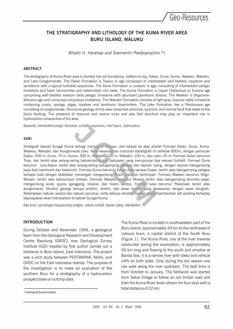
THE STRATIGRAPHY AND LITHOLOGY OF THE KUMA RIVER AREA BURU ISLAND, MALUKU Bhakti H. Harahap and Soemantri Poedjoprajitno *) ABSTRACT The stratigraphy of Kuma River area is divided into six formations, bottom to top, Dalan, Duna, Kuma, Waeken, Wakatin, and Leko Conglomerate. The Dalan Formation is Trassic in age composed of interbedded well-bedded claystone and sandstone with a typical turbidite sequences. The Duna Formation is Jurassic in age, consisting of interbedded pelagic limestone and fossil (ammonites and belemnites) rich beds. The Kuma Formation is Upper Cretaceous to Eocene age comprising well-bedded medium beds pelagic limestone with abundant planktonic forams. The Waeken is Oligocene- Miocene age and comprises micaceous mudstone. The Wakatin Formation consists of light gray massive reefal limestone containing corals, sponge, algae, bivalves and benthonic foraminifers. The Leko Formation has a Pleistocene age consisting of conglomerate. Structural geology of this area comprises anticline, syncline, and normal fault that relats to the block faulting. The presence of reservoir and source rocks and also fold structure may play an important role in hydrocarbon prospective of the area. Keywords: interbedded pelagic limestone, turbidite sequences, chert layers, hydrocarbon SARI Stratigrafi daerah Sungai Kuma terbagi menjadi 6 formasi, dari bawah ke atas adalah Formasi Dalan, Duna, Kuma, Waeken, Wakatin, dan Konglomerat Leko. Tebal keseluruhan runtunan staratigrafi ini berkisar 800m, dengan perincian Dalan: 200 m, Duna: 75 m, Kuma: 300 m, Waeken: 100 m, Wakatin: 100 m, dan Leko: 25 m. Formasi Dalan berumur Trias, dan terdiri atas selang-seling batulempung dan batupasir yang mempunyai tipe sekuen turbidit. Formasi Duna berumur Jura-Kapur, terdiri atas selang-seling batugamping pelagos dan lapisan rijang, dengan lapisan batugamping kaya fosil (ammonit dan belemnit). Formasi Kuma berumur Kapur Atas sampai Eosen, terdiri atas batugamping pelagos berlapis baik dengan ketebalan menengah mengandung foram plangton berlimpah. Formasi Waeken berumur Oligo- Miosen, terdiri atas batulumpur mikaan. Formasi Wakatin berumur Miosen terdiri atas batugamping terumbu pejal, mengandung koral, spons, ganggang, bivalve, dan foram bentos. Formasi Leko berumur Pleistosen terdiri atas konglomerat. Struktur geologi berupa antiklin, sinklin, dan sesar normal yang berasosiasi dengan sesar bongkah. Keberadaan batuan waduk dan batuan penutup, serta adanya struktur lipatan dapat memberikan arti penting terhadap keprospekan akan hidrokarbon di daerah Sungai Kuma. Kata kunci: perselingan batugamping pelagos, sekuen turbidit, lapisan rijang, hidrokarbon *) Geological Survey Institute INTRODUCTION During October and November 1994, a geological team from the Geological Research and Development Centre Bandung (GRDC) now Geological Survey Institute (GSI) headed by first author carried out a fieldwork in Buru Island, East Indonesia. The project was a joint study between PERTAMINA, Mobil, and GRDC on the East Indonesia islands. The purpose of the investigation is to make an evaluation of the southern Buru for a stratigraphy of a hydrocarbon prospect base on outcrop data. The Kuma River is located in southwestern part of the Buru Island, approximately 40 km to the northwest of Leksula town, a capital district of the South Buru (Figure 1). The Kuma River, one of the river traverse conducted during the exploration, is approximately 50 km long and flowing to the south and empties at Banda Sea. It is a narrow river with steep and vertical cliffs on both sides. Only during the dry season one can walk along the river upstream. The best time is from October to January. The fieldwork was started from Sekat Village to follow an old timber road and then the Kuma River down stream for four days with a total distance of 22 km. 62 JSDG Vol. XVI No. 2 Maret 2006 Geo-Resources J G S M
-
Upload
khangminh22 -
Category
Documents
-
view
0 -
download
0
Transcript of Geo-Resources - Jurnal Geologi dan Sumberdaya Mineral
THE STRATIGRAPHY AND LITHOLOGY OF THE KUMA RIVER AREA
BURU ISLAND, MALUKU
Bhakti H. Harahap and Soemantri Poedjoprajitno *)
ABSTRACT
The stratigraphy of Kuma River area is divided into six formations, bottom to top, Dalan, Duna, Kuma, Waeken, Wakatin,
and Leko Conglomerate. The Dalan Formation is Trassic in age composed of interbedded well-bedded claystone and
sandstone with a typical turbidite sequences. The Duna Formation is Jurassic in age, consisting of interbedded pelagic
limestone and fossil (ammonites and belemnites) rich beds. The Kuma Formation is Upper Cretaceous to Eocene age
comprising well-bedded medium beds pelagic limestone with abundant planktonic forams. The Waeken is Oligocene-
Miocene age and comprises micaceous mudstone. The Wakatin Formation consists of light gray massive reefal limestone
containing corals, sponge, algae, bivalves and benthonic foraminifers. The Leko Formation has a Pleistocene age
consisting of conglomerate. Structural geology of this area comprises anticline, syncline, and normal fault that relats to the
block faulting. The presence of reservoir and source rocks and also fold structure may play an important role in
hydrocarbon prospective of the area.
Keywords: interbedded pelagic limestone, turbidite sequences, chert layers, hydrocarbon
SARI
Stratigrafi daerah Sungai Kuma terbagi menjadi 6 formasi, dari bawah ke atas adalah Formasi Dalan, Duna, Kuma,
Waeken, Wakatin, dan Konglomerat Leko. Tebal keseluruhan runtunan staratigrafi ini berkisar 800m, dengan perincian
Dalan: 200 m, Duna: 75 m, Kuma: 300 m, Waeken: 100 m, Wakatin: 100 m, dan Leko: 25 m. Formasi Dalan berumur
Trias, dan terdiri atas selang-seling batulempung dan batupasir yang mempunyai tipe sekuen turbidit. Formasi Duna
berumur Jura-Kapur, terdiri atas selang-seling batugamping pelagos dan lapisan rijang, dengan lapisan batugamping
kaya fosil (ammonit dan belemnit). Formasi Kuma berumur Kapur Atas sampai Eosen, terdiri atas batugamping pelagos
berlapis baik dengan ketebalan menengah mengandung foram plangton berlimpah. Formasi Waeken berumur Oligo-
Miosen, terdiri atas batulumpur mikaan. Formasi Wakatin berumur Miosen terdiri atas batugamping terumbu pejal,
mengandung koral, spons, ganggang, bivalve, dan foram bentos. Formasi Leko berumur Pleistosen terdiri atas
konglomerat. Struktur geologi berupa antiklin, sinklin, dan sesar normal yang berasosiasi dengan sesar bongkah.
Keberadaan batuan waduk dan batuan penutup, serta adanya struktur lipatan dapat memberikan arti penting terhadap
keprospekan akan hidrokarbon di daerah Sungai Kuma.
Kata kunci: perselingan batugamping pelagos, sekuen turbidit, lapisan rijang, hidrokarbon
*) Geological Survey Institute
INTRODUCTION
During October and November 1994, a geological
team from the Geological Research and Development
Centre Bandung (GRDC) now Geological Survey
Institute (GSI) headed by first author carried out a
fieldwork in Buru Island, East Indonesia. The project
was a joint study between PERTAMINA, Mobil, and
GRDC on the East Indonesia islands. The purpose of
the investigation is to make an evaluation of the
southern Buru for a stratigraphy of a hydrocarbon
prospect base on outcrop data.
The Kuma River is located in southwestern part of the
Buru Island, approximately 40 km to the northwest of
Leksula town, a capital district of the South Buru
(Figure 1). The Kuma River, one of the river traverse
conducted during the exploration, is approximately
50 km long and flowing to the south and empties at
Banda Sea. It is a narrow river with steep and vertical
cliffs on both sides. Only during the dry season one
can walk along the river upstream. The best time is
from October to January. The fieldwork was started
from Sekat Village to follow an old timber road and
then the Kuma River down stream for four days with a
total distance of 22 km.
62JSDG Vol. XVI No. 2 Maret 2006
Geo-Resources
J G S M
The team was supported by eight local people to
carry foods, personal equipment, and rocks. The
traverses were mapped into 1:10.000 scale bases
and compass by using map grade and Global
Positioning System (GPS). The distance between
GPS point was estimated by stepping and sketching
out the river, and finally adjusted with the GPS
location points. Every outcrop was plotted directly on
the map sheet. The traverse was started at Sekat
Village, located 4 km to the NW of the river mouth
with GPS point 03°33’96”S and 126 09’99”. The
traverse passes through the abandoned area of the
timber company and followed the old road first to the
north and then to the Northeast till finally crosses the
Kuma River at Km 25. The road follows a valley of
one kilometer wide and 5 km long. The hills nearby
are composed of alluvial terraces which are probably
Leko Formation of Pleistocene in age.
REGIONAL GEOLOGICAL SETTING
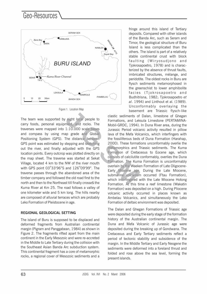
The island of Buru is supposed to be displaced and
deformed fragments from Australian continental
margin (Pigram and Panggabean, 1984) as shown in
Figure 2. The fragments rifted apart from the main
continent in the Early Mesozoic and were re-accreted
in the Middle to Late Tertiary during the collision with
the Southeast Asian Banda Arc subduction system.
This continental fragment has a core of metamorphic
rocks, a regional cover of Mesozoic sediments and a
°
clastic sediments of Dalan, limestone of Ghegan
Formations, and Leksula Limestone (PERTAMINA-
Mobil-GRDC, 1994). In Duna River area, during the
Jurassic Period volcanic activity resulted in pillow
lava of the Mefa Volcanics, which interfingers with
the fossiliferous beds of Duna Formation (Harahap,
2000). These formations unconformably overlie the
metamorphics and Triassic sediments. The Kuma
Formation of Cretaceous to Eocene age, which
consists of calcilutite conformably, overlies the Duna
Formation. The Kuma Formation is unconformably
overlain by the Waeken Formation of Late Oligocene-
Early Miocene age. During the Late Miocene,
submarine volcanism occurred (Ftau Formation),
which interfingered with the Late Miocene Hotong
Formation. At this time a reef limestone (Wakatin
Formation) was deposited on a high. During Pliocene
volcanic activity occurred in places known as
Ambelau Volcanics, and simultaneously the Leko
Formation of deltaic environment was deposited.
The Dalan and Ghegan Formations of Triassic age
were deposited during the early stage of the formation
history of the Australian continental margin. The
Duna and Mefa Volcanic of Jurassic age were
deposited during the breaking up of Gondwana. The
Cretaceous and Early Tertiary sediments reflect a
period of tectonic stability and subsidence of the
margin. In the Middle Tertiary and Early Neogene the
sediments were deformed into a foreland thrust and
folded and rose above the sea level, forming the
present islands.
Figure 1. Location Map
fringe around this island of Tertiary
deposits. Compared with other islands
of the Banda Arc, such as Seram and
Timor, the geological structure of Buru
Island is less complicated than the
others. The island is part of a relatively
stable continental crust with block
f a u l t i n g ( W i r y o s u d j o n o a n d
Tjokrosapoetro, 1978) and is charac-
terized by the absence of thrust faults,
imbricated structures, mélange, and
peridotite. The oldest rocks in Buru are
flysch sediments metamorphosed in
the greenschist to lower amphibolite
f a c i e s ( T j o k r o s a p o e t r o a n d
Budhitrisna, 1982; Tjokrosapoetro et
al. 1994) and Linthout et al. (1989).
Unconformably overlaying the
basement are Triassic flysch-like
16
Kum
a riv
er
Kuma River ChannelSEKAT
LEKSULA
TIFU
NAMROLE
BARA
AIRBUAYA
NAMLEA
BURU ISLAND
P.AMBELAU
SERAM SEA
MA
NIPA
SR
AIT
S
T
Bara Bay
Kayali Bay
BANDA SEA0 10 20 30km
JSDG Vol. XVI No. 2 Maret 200663
Geo-Resources
J G S M
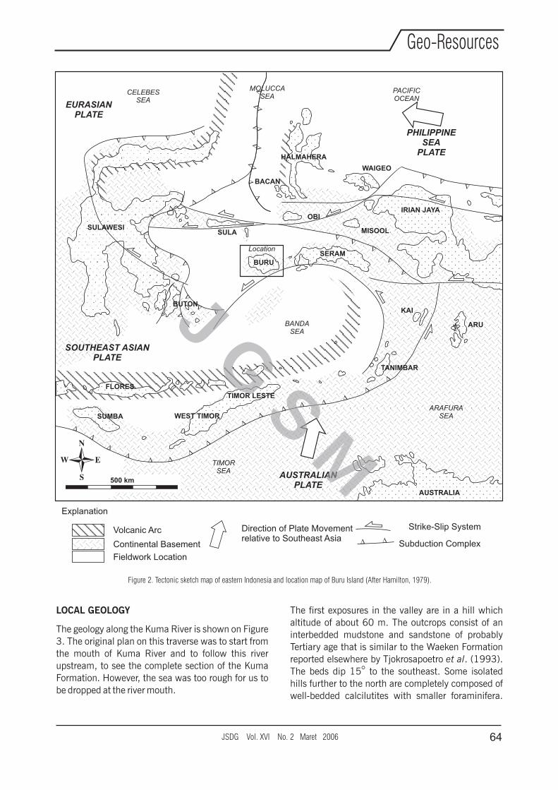
LOCAL GEOLOGY
The geology along the Kuma River is shown on Figure
3. The original plan on this traverse was to start from
the mouth of Kuma River and to follow this river
upstream, to see the complete section of the Kuma
Formation. However, the sea was too rough for us to
be dropped at the river mouth.
The first exposures in the valley are in a hill which
altitude of about 60 m. The outcrops consist of an
interbedded mudstone and sandstone of probably
Tertiary age that is similar to the Waeken Formation
reported elsewhere by Tjokrosapoetro et al. (1993).
The beds dip 15° to the southeast. Some isolated
hills further to the north are completely composed of
well-bedded calcilutites with smaller foraminifera.
D D D
D D D D D D D D D D D D D D D D D
D
D D D D D D
D D D
D D D D
D D D D D
BANDASEA
Volcanic Arc
Continental Basement
Strike-Slip System
D D Subduction Complex
Direction of Plate Movementrelative to Southeast Asia
500 km
EURASIANPLATE
CELEBESSEA
MOLUCCASEA
PACIFICOCEAN
PHILIPPINESEA
PLATE
SULAWESI
BUTON
FLORES
SUMBA WEST TIMOR
TIMOR LESTE
BURU
SULA
BACAN
OBI
SERAM
MISOOL
HALMAHERA
WAIGEO
IRIAN JAYA
KAI
TANIMBAR
ARU
TIMORSEA
AUSTRALIAN PLATE
ARAFURASEA
AUSTRALIA
SOUTHEAST ASIANPLATE
D D
D D
D D
D
D D
D D
D D D D
Location
Explanation
Fieldwork Location
Figure 2. Tectonic sketch map of eastern Indonesia and location map of Buru Island (After Hamilton, 1979).
JSDG Vol. XVI No. 2 Maret 2006 64
Geo-Resources
J G S M
The outcrops have a thickness of up to 20 m. The
beds are gently dipping and unduling. They belong to
the Kuma Formation. Most of the hills in the area
further to the north consist of thick soil with gravel
and blocks of calcilutite. They are mapped as Leko
Formation by Tjokrosapoetro et al. (1993) but may
be the weathered Kuma Formation.
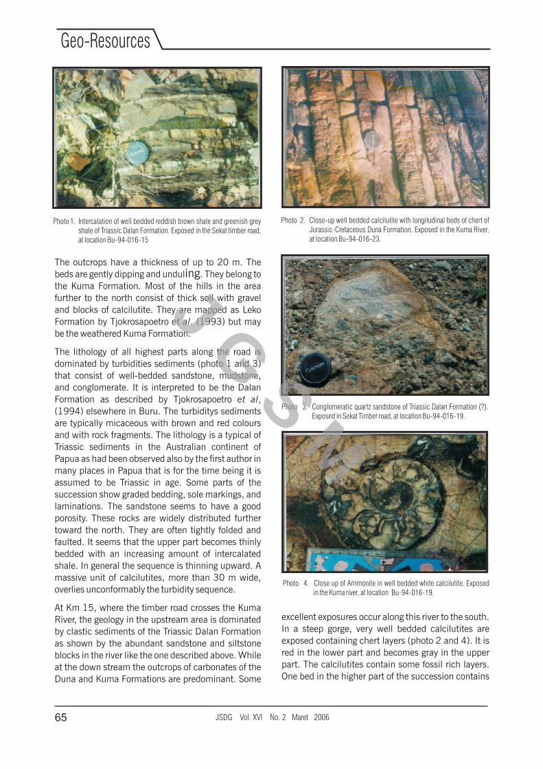
The lithology of all highest parts along the road is
dominated by turbidities sediments (photo 1 and 3)
that consist of well-bedded sandstone, mudstone,
and conglomerate. It is interpreted to be the Dalan
Formation as described by Tjokrosapoetro et al,
(1994) elsewhere in Buru. The turbiditys sediments
are typically micaceous with brown and red colours
and with rock fragments. The lithology is a typical of
Triassic sediments in the Australian continent of
Papua as had been observed also by the first author in
many places in Papua that is for the time being it is
assumed to be Triassic in age. Some parts of the
succession show graded bedding, sole markings, and
laminations. The sandstone seems to have a good
porosity. These rocks are widely distributed further
toward the north. They are often tightly folded and
faulted. It seems that the upper part becomes thinly
bedded with an increasing amount of intercalated
shale. In general the sequence is thinning upward. A
massive unit of calcilutites, more than 30 m wide,
overlies unconformably the turbidity sequence.
At Km 15, where the timber road crosses the Kuma
River, the geology in the upstream area is dominated
by clastic sediments of the Triassic Dalan Formation
as shown by the abundant sandstone and siltstone
blocks in the river like the one described above. While
at the down stream the outcrops of carbonates of the
Duna and Kuma Formations are predominant. Some
excellent exposures occur along this river to the south.
In a steep gorge, very well bedded calcilutites are
exposed containing chert layers (photo 2 and 4). It is
red in the lower part and becomes gray in the upper
part. The calcilutites contain some fossil rich layers.
One bed in the higher part of the succession contains
Photo 1. Intercalation of well bedded reddish brown shale and greenish grey shale of Triassic Dalan Formation. Exposed in the Sekat timber road, at location Bu-94-016-15
Photo 2. Close-up well bedded calcilutite with longitudinal beds of chert of Jurassic-Cretaceous Duna Formation. Exposed in the Kuma River, at location Bu-94-016-23.
Photo 3. Conglomeratic quartz sandstone of Triassic Dalan Formation (?). Exposed in Sekat Timber road, at location Bu-94-016-19.
Photo 4. Close up of Ammonite in well bedded white calcilutite. Exposed in the Kuma river, at location Bu-94-016-19.
JSDG Vol. XVI No. 2 Maret 200665
Geo-Resources
J G S M
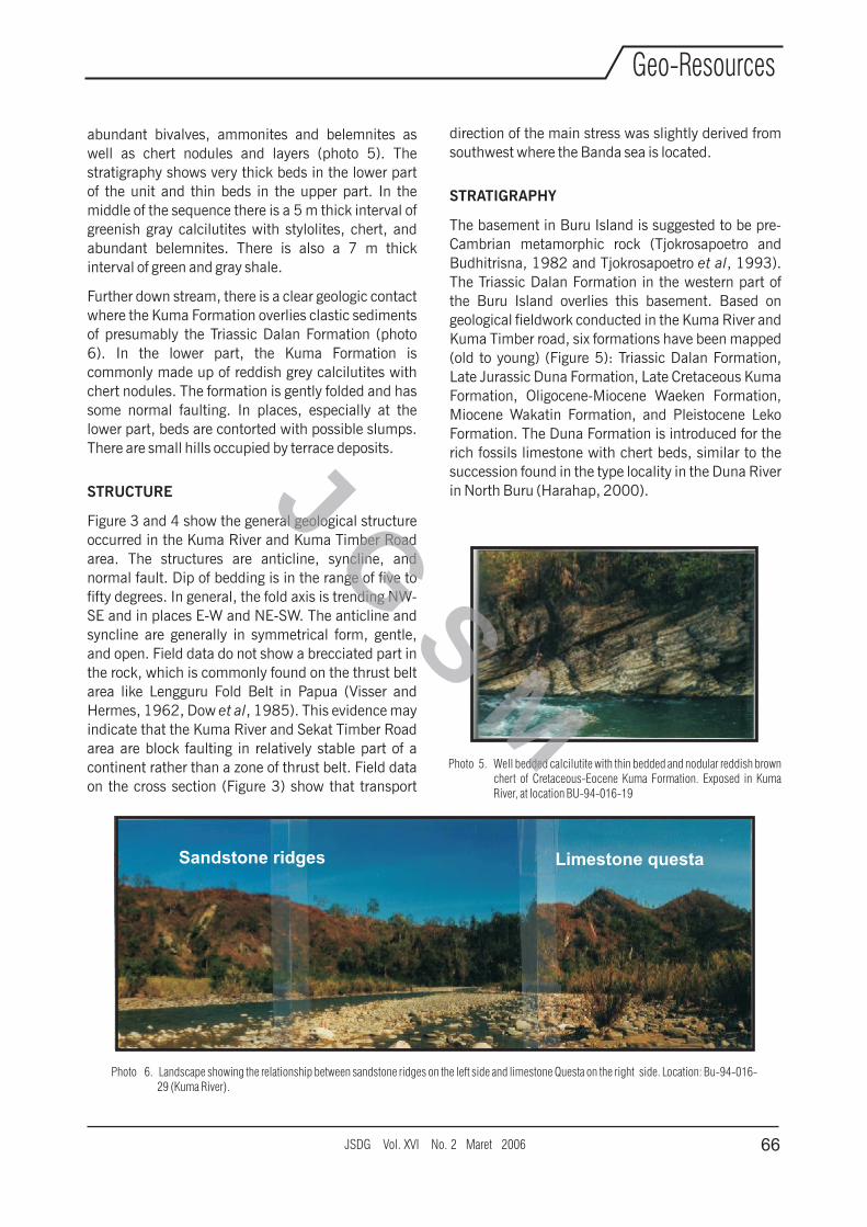
abundant bivalves, ammonites and belemnites as
well as chert nodules and layers (photo 5). The
stratigraphy shows very thick beds in the lower part
of the unit and thin beds in the upper part. In the
middle of the sequence there is a 5 m thick interval of
greenish gray calcilutites with stylolites, chert, and
abundant belemnites. There is also a 7 m thick
interval of green and gray shale.
Further down stream, there is a clear geologic contact
where the Kuma Formation overlies clastic sediments
of presumably the Triassic Dalan Formation (photo
6). In the lower part, the Kuma Formation is
commonly made up of reddish grey calcilutites with
chert nodules. The formation is gently folded and has
some normal faulting. In places, especially at the
lower part, beds are contorted with possible slumps.
There are small hills occupied by terrace deposits.
STRUCTURE
Figure 3 and 4 show the general geological structure
occurred in the Kuma River and Kuma Timber Road
area. The structures are anticline, syncline, and
normal fault. Dip of bedding is in the range of five to
fifty degrees. In general, the fold axis is trending NW-
SE and in places E-W and NE-SW. The anticline and
syncline are generally in symmetrical form, gentle,
and open. Field data do not show a brecciated part in
the rock, which is commonly found on the thrust belt
area like Lengguru Fold Belt in Papua (Visser and
Hermes, 1962, Dow et al, 1985). This evidence may
indicate that the Kuma River and Sekat Timber Road
area are block faulting in relatively stable part of a
continent rather than a zone of thrust belt. Field data
on the cross section (Figure 3) show that transport
Photo 5. Well bedded calcilutite with thin bedded and nodular reddish brown chert of Cretaceous-Eocene Kuma Formation. Exposed in Kuma River, at location BU-94-016-19
Photo 6. Landscape showing the relationship between sandstone ridges on the left side and limestone Questa on the right side. Location: Bu-94-016-29 (Kuma River).
Sandstone ridges Limestone questa
direction of the main stress was slightly derived from
southwest where the Banda sea is located.
STRATIGRAPHY
The basement in Buru Island is suggested to be pre-
Cambrian metamorphic rock (Tjokrosapoetro and
Budhitrisna, 1982 and Tjokrosapoetro et al, 1993).
The Triassic Dalan Formation in the western part of
the Buru Island overlies this basement. Based on
geological fieldwork conducted in the Kuma River and
Kuma Timber road, six formations have been mapped
(old to young) (Figure 5): Triassic Dalan Formation,
Late Jurassic Duna Formation, Late Cretaceous Kuma
Formation, Oligocene-Miocene Waeken Formation,
Miocene Wakatin Formation, and Pleistocene Leko
Formation. The Duna Formation is introduced for the
rich fossils limestone with chert beds, similar to the
succession found in the type locality in the Duna River
in North Buru (Harahap, 2000).
JSDG Vol. XVI No. 2 Maret 2006 66
Geo-Resources
J G S M
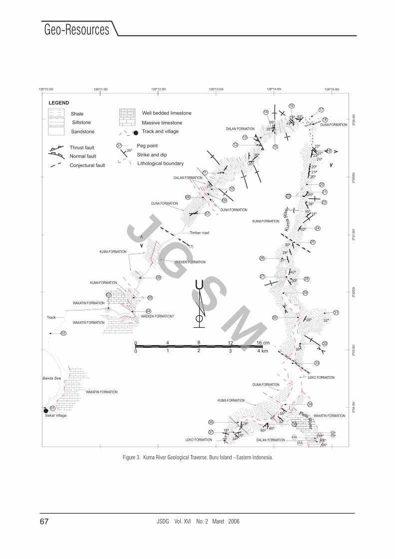
Figure 3. Kuma River Geological Traverse, Buru Island - Eastern Indonesia.
U
0 1 2 3 4 km
0 4 8 12 16 cm
2221
23
Ku
ma
Rive
r
Thrust fault
Normal fault
Conjectural fault
WAKATIN FORMATION
KUMA FORMATION
Sekat Village
Timber road
DALAN FORMATION
WAKATIN FORMATION
Banda Sea
Track and village
Massive limestone
Well bedded limestone
WAEKEN FORMATION?
DUNA FORMATION
KUMA FORMATION
Peg point
Strike and dip35º
37
Lithological boundary
KUMA FORMATION
WAKATIN FORMATION
DUNA FORMATION
KUMA FORMATION
DUNA FORMATION
DALAN FORMATION
DUNA FORMATION
WAEKEN FORMATION
WAKATIN FORMATION
(?)
Track
DALAN FORMATION
02A03A
05A
04ALEKO FORMATION
Siltstone
Shale
Sandstone
LEKO FORMATION
34º05º
15º
32º28º
50º40º
55º
30º
30
32
20º
50º
42º
28º
31º
30º
29
2827
26
25
35º15º
38º
32º
25º
24
20
1519
20º
21º
20º
22º
22º
20º
25º
15º 43º
05º 45º
30º
35º
13
12
11
25º10
09
07
08
06
05
04
03
02
01
14
1617
18
23º
32º
31
33
34
PeleRive
r3536
37
126º12.00í126º11.00í126º10.00í 126º13.00í 126º14.00í 126º15.00í
3º2
9.0
0í
3º3
00
0í
3º3
1.0
0í
3º3
20
0í
3º3
3.0
0í
3º3
4.0
0í
35º
34º
55º
LEGEND
JSDG Vol. XVI No. 2 Maret 200667
Geo-Resources
J G S M
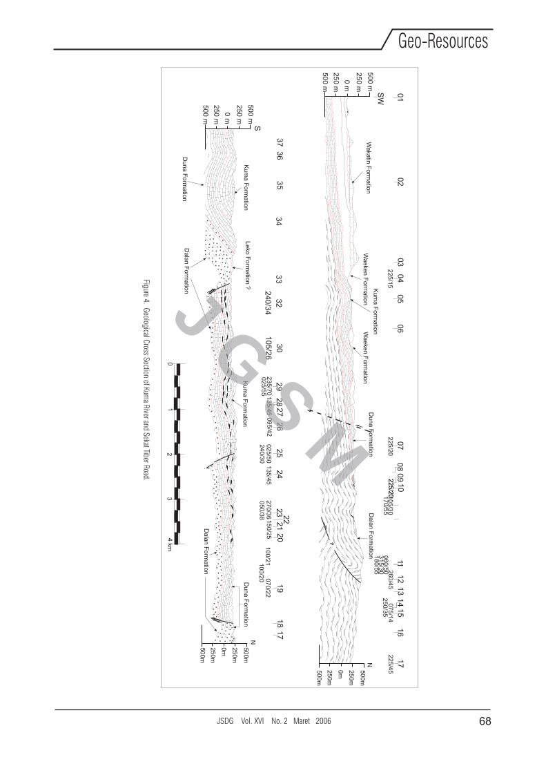
Figure 4. Geological C
ross Section of Kum
a River and S
ekat Tiber Road.
N5
00
m
25
0m
0m
50
0m
25
0m
0 m
50
0 m
25
0 m
25
0 m
50
0 m
0 m
50
0 m
25
0 m
25
0 m
50
0 m
N5
00
m
25
0m
0m
50
0m
25
0m
Ku
ma
Fo
rma
tion
Wa
katin
Fo
rma
tion
Wa
eke
n F
orm
atio
nD
un
a F
orm
atio
n
111
72
25
/45
Da
lan
Fo
rma
tion
15
07
5/1
4
16
25
0/3
5
13
12
26
0/4
5
14
06
0/5
03
15
/30
18
0/5
5
10
5/3
01
70
/55
10
22
5/2
02
25
/20
07
22
5/2
0
08
09
05
06
04
22
5/1
5
03
02
01
SW
Wa
eke
n F
orm
atio
n
Ku
ma
Fo
rma
tion
Ku
ma
Fo
rma
tion
Da
lan
Fo
rma
tion
Du
na
Fo
rma
tion
Le
ko F
orm
atio
n ?
33
34
35
36
37
32
24
0/3
4
30
10
5/2
6
29
23
5/7
0
28
27
13
5/4
50
25
/55
26
09
5/4
2
25
02
5/5
0
24
13
5/4
52
40
/30
27
0/3
60
50
/38
15
0/2
5
23 2
221
20
19
10
0/2
10
70
/22
10
0/2
0
18
17
01
4 km
32
S
Du
na
Fo
rma
tion
Da
lan
Fo
rma
tion
JSDG Vol. XVI No. 2 Maret 2006 68
Geo-Resources
J G S M
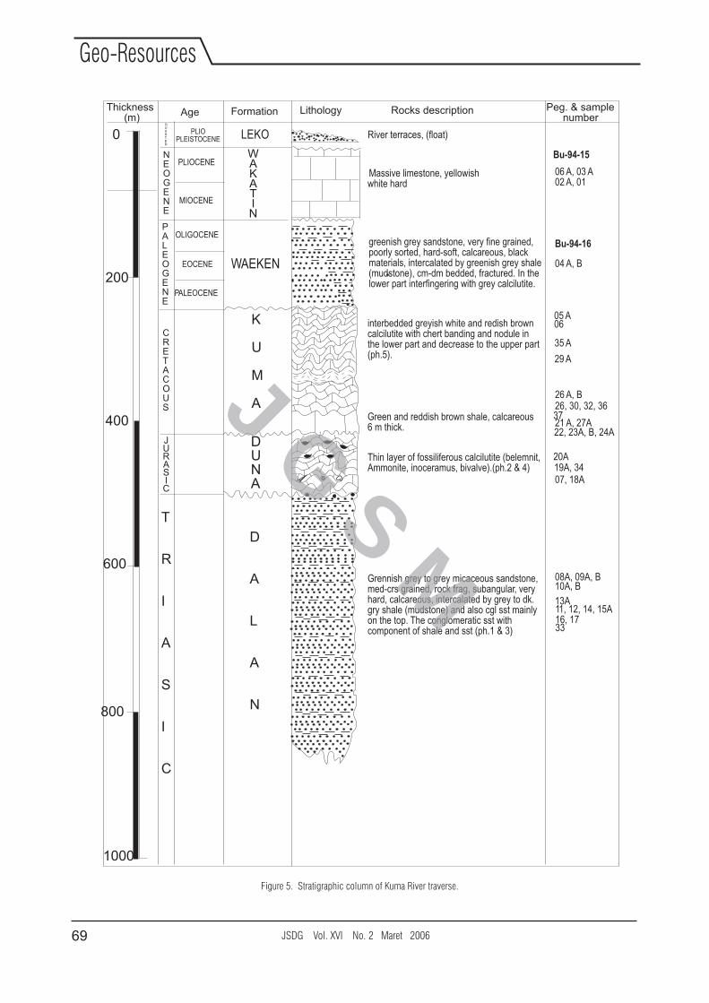
Figure 5. Stratigraphic column of Kuma River traverse.
0
200
400
600
800
1000
Thickness(m)
Age Formation Lithology Rocks description Peg. & samplenumber
River terraces, (float)
Massive limestone, yellowishwhite hard
greenish grey sandstone, very fine grained,poorly sorted, hard-soft, calcareous, blackmaterials, intercalated by greenish grey shale(mudstone), cm-dm bedded, fractured. In thelower part interfingering with grey calcilutite.
interbedded greyish white and redish browncalcilutite with chert banding and nodule inthe lower part and decrease to the upper part(ph.5).
Green and reddish brown shale, calcareous6 m thick.
Thin layer of fossiliferous calcilutite (belemnit,Ammonite, inoceramus, bivalve).(ph.2 & 4)
Grennish grey to grey micaceous sandstone,med-crs grained, rock frag, subangular, veryhard, calcareous, intercalated by grey to dk.gry shale (mudstone) and also cgl sst mainlyon the top. The conglomeratic sst withcomponent of shale and sst (ph.1 & 3)
04 A, B
05 A06
35 A
29 A
26 A, B
21 A, 27A
26, 30, 32, 36
22, 23A, B, 24A
37
19A, 3420A
07, 18A
08A, 09A, B10A, B
13A11, 12, 14, 15A16, 1733
DUNA
K
U
M
A
WAEKEN
WAKATIN
D
A
L
A
N
T
R
I
A
S
I
C
NEOGENE
PALEOGENE
CRETACOUS
JURASIC
LEKO
Bu-94-16
Bu-94-15
06 A, 03 A02 A, 01
PLIOCENE
MIOCENE
OLIGOCENE
EOCENE
PALEOCENE
QUARTER
PLIOPLEISTOCENE
JSDG Vol. XVI No. 2 Maret 200669
Geo-Resources
J G S M
Triassic Shale and Sandstone (Dalan Formation)
In the Dalan River at Buru Island, the type locality
proposed by Tjokrosapoetro et al. (1993), the unit is
characterized by well bedded sandstone, shale,
siltstone, and conglomerate. Beds range in thickness
from several cm to about 1 m. Graded bedding, cross-
bedding, flow ripples, load structures, and flute
marks are present. The formation contains the
Triassic trace fossil Halobia (PERTAMINA-Mobil-
GRDC, 1994). Wanner (1922) concluded a Triassic
age based on more complete bivalve content. A
thickness of 1000 to 2000 meters is estimated,
based on the regional distribution of the formation. A
much greater thickness of the original Dalan Basin
may have existed because the base of the formation
disappears where it is a gradual transition to its
metamorphosed equivalent, the Rana Metamorphic
Complex (Tjokrosapoetro et al, 1993).
In Kuma River and Sekat Timber Road areas the unit
is about 250 m thick. The lithology consists of light to
dark grey shale with common sandstone and
siltstone, and rare conglomeratic beds. The
sandstone are grey to brown, typically fine to medium
grained, micaceous, and poorly sorted, composed of
quartz, brown and green minerals, feldspar,
muscovite, and black material. Plant materials are
common in this formation but the kind of coaly beds
as observed in some sections in Seram is not present.
Metamorphic rock fragments can sometimes be
recognized in the sediments. Apart from common
lamination, the beds show occasional graded
bedding and sole marks.
Based on primary sedimentary structure such as
graded bedding, lamination and pelitic rocks, which
is a typical of turbidite sediments of Bouma
sequences, the Dalan Formation was deposited on a
slope at bathyal depths in a restricted environment.
The environmental conditions remain basically
unchanged during the deposition of the entire
sequences. Mica flakes and poor sorting of the
sediments show that the source of the rocks was
nearby. Small scale folding in the formation is caused
by slumping of the sediments and must be the result
of tectonic instability of the developing slope. The
monotonous, fine-grained composition of the
formation is indicative of a relatively stable hinterland
(Gondwana), delivering the sediments to the Dalan
Basin. Probably the hinterland was peneplained.
Some red and green coloured sand-stone are
reported to occur in the Dalan Formation
(Tjokrosapoetro et al., 1993). These sandstones
reflect an oxidizing environment and may represent
short periods of aerial exposure of the basin
sediments. Such red and green colours are much
more common in the Triassic of Papua (Pieters et al.
1983).
A gradual change from metamorphosed to non-
metamorphosed sediments at the base of the Dalan
Formation had been observed in Watina River (by the
first author), approximately 75 km to the southeast of
Kuma River. The metamorphic fragments found in the
sandstones and in the rare conglomerates of the
formations represent a Triassic unconformity
somewhere at the margins of the Dalan Basins but
not visible in the studied sections. It is futher
reported`that the top of the formation has an
interfingering contact with the limestone of the
Geghan Formation (Tjokrosaputro et al., 1993), that
is exposed approximately 30 kms north of Kuma
River.
Jurassic-Cretaceous Belemnite and Bivalves (Duna Formation)
Harahap (2000) introduced the Duna Formation for
the fossilferous carbonate beds in the Duna River,
northern Buru Island. It is a unit of only some tens
meters thick, but with very typical fauna and
lithology; where it consists of alternating beds of
belemnite-rich limestone, lumachelles (bivalve
boundstones) and chert-rich beds. The colours are
red, green, and grey. The Duna Formation comprises
beds of grey, chert- rich limestone and it interfingers
with the volcanics of the Mefa Formations. The
number of the chert-rich beds increases towards the
top of the unit and finally they replace the bioclastic
limestone completely. Wanner (1922) named this
fossil rich limestone of Buru as the Kartina
Limestone, and Tjokrosapoetro et al. (1993)
included the unit in the basal part of the Kuma
Formation. The Duna Limestone is the equivalent of
the belemnite and bivalve-rich “Fatjeh Shales” of
Misool (Wanner, 1931), which is now called the
Demu Formation (Pigram et al., 1982).
In the Kuma River area, the Duna Formation is very
well bedded consisting of calcilutite with rare beds of
green and grey shale. The calcilutite contains some
fossil-rich layers. The lower part of the unit is thickly
bedded, while the upper part of the sequence is thinly
bedded. Here the calcilutite contains abundant
bivalves, ammonite, and belemnites as well as
JSDG Vol. XVI No. 2 Maret 2006 70
Geo-Resources
J G S M
cherts. In the middle part of the sequence, there is an
interval of 5 m thick greenish grey calcilutite with
stylolite, chert and abundant belemnite. The Duna
Formation is thought to be deposited in the shallow
water environment (Harahap, 2000). The unit is
probably conformably overlain by the Kuma
Formation. The basal contact of the Duna is assumed
to be an unconformity. The thickness of the formation
is estimated to be 100 m.
Wanner (1922) dated the Duna Formation in Buru as
Late Jurassic, based on the assemblage of belemnite
Taliabuticus (Boehm), bivalve Inoceramus sp., the
coral Lovcenipora Vanassai (Giattini), Auxella sp. and
Aptychus. For the equivalent unit in Misool, Pigram et
al. (1982) dated the rocks as Late Jurassic, based on
ammonite content.
Late Cretaceous to Eocene Calcilutites (Kuma
Formation)
Tjokrosapoetro and Budhitrisna (1982) defined the
Kuma Formation. In the definition they included the
shallow marine, Late Jurassic Duna Formation as
described above. The Kuma Formation in the present
definition consists only of pelagic limestone and does
not include any shallow water deposits. It is the
equivalent of the Miting Limestone of Wanner's
(1922).
In the Kuma River area, the Kuma Formation consists
of well-bedded reddish gray calcilutites with chert
bands and nodules, and contains abundant
planktonic foraminifers. The formation is gently
folded and has some normal faulting. In places, beds
are contorted with possibly slumps. Based on these
foraminifers, the age of Kuma Formation is Late
Cretaceous to Eocene (Harahap, 2000 and
Tjokrosapoetro et al., 1993). The environment of
deposition of the unit is interpreted as bathyal. The
thickness of this formation is estimated to be 300 m.
The Kuma is unconformably overlain by the Waeken
Formation.
Oligo-Miocene Sandstone (Waeken Formation)
The first occurrence of clastic rocks in Buru during the
Tertiary was defined Waeken Formation by
Tjokrosapoetro and Budhitrisna (1982). The Waeken
Formation is composed of light coloured shale,
siltstone, sandstone, and conglomerate. The rocks
are in general poorly consolidated and have a variety
of light yellow and green colors. The sandstone beds
are fining grained and micaceous and often contain
reworked plant debris. They were observed as
turbidites inside the shale as well as in thickly and
irregularly bedded units with large scale fore-sets,
probably representing channels. Tjokrosapoetro et al.
(1993) considered the age of this formation to be
Late Oligocene-Middle Miocene. Based on samples
collected in this area that contain abundant
planktonic foraminifers, the age of this unit is Early to
Late Miocene. The environment of deposition is open
marine, sublittoral to neritic, and bathyal. The
presence of quartz and metamorphic detritus in the
formation indicates that the Paleozoic basement of
Buru was already eroded in the Oligocene-Miocene.
The formation has a thickness of 100 meters.
Miocene platform limestone (Wakatin Formation)
The Wakatin Formation was defined by
Tjokrosapoetro et al. (1993) to describe Miocene
reefal limestone in Buru. It consists of light grey
massive reefal limestone containing corals, sponge,
algae, bivalves, and benthonic foraminifera. The
rocks are commonly hard, and occasionally
recrystallised and brecciated.
In Pele River, the unit is dominated by massive
limestone. In some places there the unit is composed
of brecciated fine crystalline limestone containing
foraminifers and gastropods. The environment of
deposition of this unit is a coast, open marine. The
thickness of this formation is 100 meters. Wanner
(1922) and Tjokrosapoetro et al. (1993) determined
a Late Miocene age for the formation based on larger
foraminifers.
Plio-Pleistocene Deltaic Deposits (Leko Formation)
The Leko Formation was defined by Tjokrosapoetro et
al. (1993) for the terrace deposits in Buru. The unit
varies in composition from place to place dependent
upon the hinterland lithologies as the source of the
rocks. In Kuma River area, the unit consists of coarse
and poorly sorted conglomerates of calcilutites
coming from the Kuma Formations exposed
upstream. The conglomerates form very large fore
sets. No fossils were found, but it is obvious that the
age is Pliocene or Quaternary. The formation consists
of the raised apexes of deltas in the southern part of
Buru. The thickness of the formation is estimated to
be about 25 m. The Leko has an unconformable
relation to all older units.
JSDG Vol. XVI No. 2 Maret 200671
Geo-Resources
J G S M
PETROLEUM GEOLOGY
Source Rocks
The main period of source rock deposition in Buru is
in the Triassic to Early Jurassic succession. The
sediments succession consists of a turbidite and
shale sequences with a high content of plant remains
(Dalan Fm). The upper section of the Dalan
Formation is interfingering and equivalent with the
Ghegan Formation where it has a TOC of 2.6%
(PERTAMINA-Mobil-GRDC, 1994) considered to be
good source rock. Organic rich shale is indicated
from that part of the stratigraphic sequence of Dalan
Formation. Therefore, there is a possibility that the
Dalan Formation may have potential source rocks
which has similar value of TOC with the Ghegan
Formation.
The Dalan has a total stratigraphic thickness of 1000
- 2000 meters. It was deposited in subsiding graben
structures that developed during the breakin-up stage
of the Gondwana craton (Tjokrosapoetro and
Budhitrisna, 1982). PERTAMINA-Mobil-GRDC
(1994) further reported that about 5% of the
observed limestone blocks derived from the Ghegan
Formation contain solid oil filling cracks. The solid oil
is expelled from the limestone blocks by sun heated.
This research confirms that the main source rock in
this area is the unit of Triassic equivalent to Ghegan
Formation found in NW Buru. Its thickness is up to
1000 m although it became thinning into less than
200 m in SW Buru which is believed to be an upper
part of the Dalan Formation. Minor source potential
may also be present in dark shales of Paleogene age
(Waeken Formation), but it is assumed to be
immature.
Reservoir Rocks
The Triassic Limestone which is interfingering with
the Triassic shales act as a fractured reservoir in NW
Buru (Harahap, 2000). In the Kuma River and Sekat
Timber road area, the conglomerate and sandstone of
Dalan Formation may act as reservoir rocks. These
clastic rocks are clean and consist mainly of quartz
and rock fragments. The porosity of sandstone within
the Dalan Formation is estimated to be about 5-10%.
Fine grained sandstone in the Paleogene may act as a
reservoir but the porosity is low. The thickness of
these sandstones is up to 500 m. No oil stain is
observed in these rocks. Reefal limestone of
Oligocene-Miocene age is up to 300 m thick and has
a fair porosity. They are not covered by a seal and no
oil stains were observed in these rocks.
Seal
Dense limestone in the top of the Triassic acts as a
seal. Mud rock of Paleogene age has a sealing
capacity but these do not have a regional distribution.
Traps
The problem in Buru is a lack of trap. The 1:250.000
scale geological map of Buru shows that Triassic
reservoir is obviously breaching and eroding in the
most elevated parts of the island, here along the
shoreline that Mesozoic strata dip seawards at angle
of 20 to 45 degrees, indicating that there is very little
hope for structural traps in the nearby offshore areas.
In Kuma River and Sekat Timber Road areas, the
structure consists of low angle fold (anticline and
syncline) and normal fault. These folds are generally
open and without closure.
CONCLUSIONS
The geological investigation in Kuma River and Sekat
Timber Road areas have resulted a more detailed
illustration of the geology in the area, including a
production of a total length of the geological traverse
for 20 km with excellent exposures especially in
Kuma River area. The area comprises sandstone,
limestone and conglomerate that is divided into six
formations, base to top part, Dalan, Duna, Kuma,
Waeken, Wakatin and Leko Conglomerate. The
important additional information of the geology is that
the presence of Duna Formation that is an additional
new unit in this area. The stratigraphy of the Kuma
River area can be correlated with the stratigraphy of
Duna River area in the north, at least since Jurassic
which supports the idea that the Buru Island is an
anticline having east-west axis. The Dalan Formation
in this area can be the flank of Buru anticline. The
Dalan Formation changed in facies to be limestone of
the Ghegan Formation towards north. Total thickness
of the stratigraphy in Kuma River is about 800 m
where Dalan is 200 m, Duna is 75 m, Kuma is 300m,
Waeken is 100 m, Wakatin is 100 m and Leko 25 m.
JSDG Vol. XVI No. 2 Maret 2006 72
Geo-Resources
J G S M
The structure geology along the traverse section is in
the form of anticline, syncline, and normal fault
associated with block faulting. Forces direction of
tectonics was thought to be derived from the south
(Banda Arc). From the petroleum point of view, based
on field observation, it can be said that the area
posses several criteria of prospective, such as the
present of sandstone as reservoir rocks within the
Dalan Formation. While the cap rocks of the Kuma
and Duna Formations, have a trap of fold structure.
Some parts of the succession of formation found in
this area have a significant source rock potential.
Evidently, the petroleum system occurs in this area by
the presence of dripped oil at the limestone block in
Duna River area (PERTAMINA-Mobil-GRDC, 1994
and Harahap, 2000) and in Leksula area (Dr.
Munarsi pers. Com, 1988). Here the Triassic Dalan
Formation containing plant remain, although it is not
really significant compared to the Permian Aifam
Group in Papua (Pieters et al., 1983). However, the
geochemistry of the source rocks and reservoir
analyses of sandstone rocks need a further study.
Aknowledgement
We would like to thank the geological team Dr.
Djadjang Sukarna, Ir. Baharuddin, Ir. Jati Hadiwinoto,
Sri Sulistiono, Sidarto (GRDC), and Dr. Michael de
Smet (Core Lab) for the excellent cooperation during
the fieldwork in Buru and Seram. The authors wish to
thank Dr. Ir Djadjang Sukarna, the Head of the
Geological Survey Institute, for his permission to
publish this paper.
REFERENCES
Dow, D.B., Robinson, G.P.and Ratman, R., 1985. New Hypothesis for Formation of Lengguru Foldbelt, Irian
Jaya, Indonesia. The American Association of Petroleum Geologists Bulleti, v.69, No. 2, p. 203-
214.
Hamilton, W., 1979. Tectonics of the Indonesian Region United States Geological Survey Professional Paper
1078.
Harahap, B.H., 2000. Stratigraphy of the Duna River Buru Island, Maluku: Hydrocarbon indications. Bulletin.
No. 22, p. 1-18. Geological Research and Development Centre Bandung.
Linthout, K., Helmers, H., Sopaheluwakan, J and Surya Nila, E., 1989. Metamorphic complexs in Buru and
Seram, northern Banda Arc, Proceedings of Snellius-II Symposium, Theme: Geology and
Geophysics of the Banda Arc and Adjacent Areas, part 1. Netherlands Journal of Sea Research 24
(2/3), 345-356.
PERTAMINA-Mobil-GRDC, 1994. Geology and hydrocarbon prospect of Buru and West Seram Banda Arc,
Eastern Indonesia (Internal report).
Pieters, P.E., Pigram C.J Trail D.S, Dow D.B, Ratman, N. and Sukamto, R., 1983. The stratigraphy of Western
Irian Jaya, Bull.Geol.Res.Dev.Centr., 8, p. 14-48.
Pigram, C.J. and Panggabean, H., 1984. Rifting of the northern margin of the Australian continent and the origin
of some microcontinents in eastern Indonesia. Tectonophysics 107, 331-353.
Pigram, C.J. Challinor, A.B., Hasibuan, F., Rusmana, E. and Hartono, U., 1982. Lithostratigraphy of the Misool
Archipelago, Irian Jaya, Indonesia. Geol.Mijnb., 61, p. 245-279.
Tjokrosapoetro, S., Budhitrisna, T. and Rusmana, E., 1994. Geological report of the Buru Island Quadrangle,
Maluku. Geological research and Development Centre, Bandung (Internal Report), 1-22.
Tjokrosapoetro, S and Budhitrisna, T., 1982. Geology and tectonis of Northern Banda Arc. Bulletin Geological
Research and Development Center, Bandung 6, 1-17.
JSDG Vol. XVI No. 2 Maret 200673
Geo-Resources
J G S M
Tjokrosapoetro, S., Budhitrisna, T. and Rusmana, E., 1993. Geology of Buru Quadrangle, Maluku. Geological
Research and Development Centre, 23 pp.
Visser, W.A., and Hermes, J.J., 1962. Geological results of the exploration for oil in Netherlands New Guinea:
Koninklijk Netherlads Geologisch Mijnbouwkundig Genootschop Verhandelingen, Geologische
serie, v. 20, 265 p.
Wanner, J., 1922. Beitrage zur Geologie der Insel Boeroe, Geologische Ergebnisse der Reisen K. Deningers.
Palaeontographica (Suppl.) 4 (3), 59-112.
Wanner, J., 1931. Mesozoicum (of Indonesia) In: Feestbundel K. Martin. Leidsche Geologische Mededelingen
(The Netherlands) V, 567-610.rdWiryosudjono, S., and Tjokrosaputro, S., 1978. Ophiolites in Eastern Indonesia 3 Regional Conference on
Geology and Mineral Resources of Southeast Asia-Bangkok Thailand 14-18 November 1978.
JSDG Vol. XVI No. 2 Maret 2006 74
Geo-Resources
J G S M