Chinese Cartography among the Arts: Objectivity, Subjectivity ...
42
6 · Chinese Cartography among the Arts: Objectivity, Subjectivity, Representation CORDELL D. K. YEE Those able to evoke a mood that persists beyond the rendition of physical objects completely understand the art of writing. -Liu Xie (ca. 465-522) Wenxin diaolong, chap. 46 "World" does not refer only to scenes and objects; joy, anger, sorrow, and happiness are also a world within the human heart. Thus, those poems that can describe true scenes and objects and true emotions and feelings are said to have a world; otherwise, they are said to lack a world. -Wang Guowei (1877-1927) Renjian cihua, sec. 1 Cartography in China did not emerge as a repre- sentational practice fully independent from the visual and literary arts until late in the imperial period, under the influence of Western examples. One would expect it to have done so earlier only if one took Western carto- graphy as the standard or norm. Although some would have it otherwise, cartography in China followed a dif- ferent course. What contributed to its distinctiveness was an idea of representation that went beyond the dupli- cation of physical forms, that stressed its multifaceted function. Neglect of this multidimensional concept of representation has resulted in a distorted view of Chinese cartographic history-as the development and refinement of a practice based on measurement and mathematical techniques. Chinese maps produced before the twentieth century, however, can be said to fall neatly into such a quantitative tradition only if one takes a too narrow view of what qualifies as a map. There is little doubt that maps were important for representing and understanding the physical world. What is at issue is the mode of that repre- sentation and understanding. Geometric and mathemat- ical fidelity to observed reality was not an overarching aim: maps were often placed in contexts where they com- plemented verbal representations of geographic know- ledge. As a means of storing geographic information, both verbal and graphic modes of representation were held to have their uses. What is now called cartography thus had its place in a unified conception of the arts. To extend an argument begun elsewhere (pp. 91 and 101-4), the distinction between word and visual image, so strong in the Western tradition, is not nearly as sharp in China. This difference in traditions can be traced to differing conceptions of representation and its purposes. As a result of this critical difference, historians of Chinese cartography may need to adjust their definitions of what constitutes cartographic representation. The usual oppo- sitions between visual and verbal, cartographic and pic- torial, mimetic and symbolic representation may not apply. THE RELATION BETWEEN ART AND REALITY An example suggesting that such a change is necessary occurs in the Zuozhuan (Zuo's tradition [of interpreting the Chunqiu, or Spring and autumn annals]) and other early texts. The Zuozhuan, which perhaps dates from about 300 B.C., states that during the legendary Xia period, visual representations of information useful to travelers were molded into nine cast-bronze caldrons, the jiu ding. The historical existence of these caldrons is by no means certain, especially since there is no evidence of Bronze Age culture during the putative period of the Xia. 1 This situation, however, has not stopped previous schol- ars from speculating on the cartographic nature of the representations on them. 2 The Zuozhuan, written cen- turies after the caldrons were supposedly made, says that "representations" of objects from the "nine regions" 1. The Zuozhuan's account may be supplemented by one in the Shi ji (Records of the grand historian, completed ca. 91 B.C.) by Sima Qian. According to Sima Qian's account, the nine caldrons were cast during the reign of Yu and handed down to the Chou rulers. When the Zhou's virtue declined and the Song state's altars were destroyed, the caldrons "sank into the waters and were seen no more." Before the time of Yu, the Huang Oi (Yellow Lord) made "three precious caldrons, repre- senting heaven, earth, and man." Sima Qian, Shi ji, chap. 28; see the modern edition in 10 vols. (Beijing: Zhonghua Shuju, 1959), 4:1392. The translated excerpts here are based on those in Burton Watson, trans., Records of the Grand Historian of China, 2 vols. (New York: Columbia University Press, 1961), 2:49. 2. See, for example, Wang Yong, Zhongguo ditu shi gang (Brief history of Chinese cartography) (Beijing: Sanlian Shudian, 1958), 1; and idem, Zhongguo dilixue shi (History of geography in China) (1938; reprinted Taipei: Shangwu Yinshuguan, 1974), 16-19. 128
-
Upload
khangminh22 -
Category
Documents
-
view
3 -
download
0
Transcript of Chinese Cartography among the Arts: Objectivity, Subjectivity ...

6 · Chinese Cartography among the Arts:
Objectivity, Subjectivity, Representation
CORDELL D. K. YEE
Those able to evoke a mood that persists beyond therendition of physical objects completely understandthe art of writing.
-Liu Xie (ca. 465-522)Wenxin diaolong, chap. 46
"World" does not refer only to scenes and objects;joy, anger, sorrow, and happiness are also a worldwithin the human heart. Thus, those poems that candescribe true scenes and objects and true emotionsand feelings are said to have a world; otherwise, theyare said to lack a world.
-Wang Guowei (1877-1927)Renjian cihua, sec. 1
Cartography in China did not emerge as a representational practice fully independent from the visual andliterary arts until late in the imperial period, under theinfluence of Western examples. One would expect it tohave done so earlier only if one took Western cartography as the standard or norm. Although some wouldhave it otherwise, cartography in China followed a different course. What contributed to its distinctiveness wasan idea of representation that went beyond the duplication of physical forms, that stressed its multifacetedfunction. Neglect of this multidimensional concept ofrepresentation has resulted in a distorted view of Chinesecartographic history-as the development and refinementof a practice based on measurement and mathematicaltechniques. Chinese maps produced before the twentiethcentury, however, can be said to fall neatly into such aquantitative tradition only if one takes a too narrow viewof what qualifies as a map. There is little doubt that mapswere important for representing and understanding thephysical world. What is at issue is the mode of that representation and understanding. Geometric and mathematical fidelity to observed reality was not an overarchingaim: maps were often placed in contexts where they complemented verbal representations of geographic knowledge. As a means of storing geographic information,both verbal and graphic modes of representation wereheld to have their uses. What is now called cartographythus had its place in a unified conception of the arts.
To extend an argument begun elsewhere (pp. 91 and
101-4), the distinction between word and visual image,so strong in the Western tradition, is not nearly as sharpin China. This difference in traditions can be traced todiffering conceptions of representation and its purposes.As a result of this critical difference, historians of Chinesecartography may need to adjust their definitions of whatconstitutes cartographic representation. The usual oppositions between visual and verbal, cartographic and pictorial, mimetic and symbolic representation may notapply.
THE RELATION BETWEEN ART AND REALITY
An example suggesting that such a change is necessaryoccurs in the Zuozhuan (Zuo's tradition [of interpretingthe Chunqiu, or Spring and autumn annals]) and otherearly texts. The Zuozhuan, which perhaps dates fromabout 300 B.C., states that during the legendary Xiaperiod, visual representations of information useful totravelers were molded into nine cast-bronze caldrons, thejiu ding. The historical existence of these caldrons is byno means certain, especially since there is no evidence ofBronze Age culture during the putative period of the Xia.1
This situation, however, has not stopped previous scholars from speculating on the cartographic nature of therepresentations on them.2 The Zuozhuan, written centuries after the caldrons were supposedly made, says that"representations" of objects from the "nine regions"
1. The Zuozhuan's account may be supplemented by one in the Shiji (Records of the grand historian, completed ca. 91 B.C.) by Sima Qian.According to Sima Qian's account, the nine caldrons were cast duringthe reign of Yu and handed down to the Chou rulers. When the Zhou'svirtue declined and the Song state's altars were destroyed, the caldrons"sank into the waters and were seen no more." Before the time of Yu,the Huang Oi (Yellow Lord) made "three precious caldrons, representing heaven, earth, and man." Sima Qian, Shi ji, chap. 28; see themodern edition in 10 vols. (Beijing: Zhonghua Shuju, 1959), 4:1392.The translated excerpts here are based on those in Burton Watson,trans., Records of the Grand Historian of China, 2 vols. (New York:Columbia University Press, 1961), 2:49.
2. See, for example, Wang Yong, Zhongguo ditu shi gang (Briefhistory of Chinese cartography) (Beijing: Sanlian Shudian, 1958), 1; andidem, Zhongguo dilixue shi (History of geography in China) (1938;reprinted Taipei: Shangwu Yinshuguan, 1974), 16-19.
128
Chinese Cartography among the Arts: Objectivity, Subjectivity, Representation 129
FIG. 6.1. PAINTED POTSHERDS FROM THE YANGSHAOCULTURE. The radiating pattern on these sherds has beeninterpreted as a representation of the sun.Size of the original: approximately 8.5 X 13 em (at the widest
appeared on them. According to the Zuozhuan, the caldrons, in addition to securing the favors of heaven, werepartly intended to represent knowledge of the nineregions, knowledge that would be useful to travelers. Theknowledge imparted by the representations on the caldrons supposedly had magical-religious efficacy. Armedwith this knowledge, travelers could ward off evils.3 TheZuozhuan, however, gives no details about the representations themselves. It says nothing of the objects orinformation represented, so we cannot determinewhether the caldrons can be considered cartographic artifacts. 4
Some art historians question whether designs with thedegree of formal resemblance attributed to the nine caldrons appeared before the Zuozhuan was composed.According to Loehr, art with concrete representationsdeveloped in late Bronze Age China, that is, during thelate Chunqiu (722-468 B.C.) or during the Zhanguo (Warring States) period (403-221 B.C.), about the time theZuozhuan was composed.s A fully representational artdoes not develop until the Han (206 B.C.-A.D. 220).Before that time any representational elements-to whichearly cartography may perhaps be linked-coexisted withthe ornamental. In general, Loehr says, art had few references to reality. By implication, artifacts purporting topromote spatial understanding of geographic realitywould have been unlikely. Art dating from before the
points). Zhengzhou Municipal Museum. From Zhongguo Shehui Kexueyuan Kaogu Yanjiusuo, Zhongguo gudai tianwenwenwu tuji (Album of ancient Chinese astronomical relics) (Beijing: Wenwu Chubanshe, 1980),3.
Shang (ca. sixteenth to eleventh century B.C.) is generallylimited to geometric patterns-for example, spirals, zigzags, and interlocked Ts. The same lack of references toreality characterized Shang and Zhou (ca. 1027-256 B.C.)art:
Seen in the entire perspective of Chinese art history,most of the decorative designs on Shang and [Zhou]bronzes may be characterized as purely ornamental.They were typical creations of a phase that precededrepresentational art, the art concerned with, anddependent on, reality. The shift toward representationoccurred during the Han period. The moment itoccurred, the art of the ornament-heretofore the artof greatest consequence-took second place andbegan to stagnate. It is a noteworthy fact that at thesame time the day of the bronze vessel, too, was over.6
3. Zuozhuan (ca. 300 B.C.), Xuan 3, in Chunqiu jingzhuan yinde(Concordance to the Chunqiu [Spring and aurumn annals) and its commentaries),4 vols. (1937; reprinted Taipei: Chengwen Chubanshe, 1966),1:182.
4. According to the Shi ji, the caldrons were used to "boil offeringsto Shangdi [Lord on High) and other spirits" (chap. 28 [4:1392); translation based on Watson, Grand Historian, 2:49 [both in note 1)).
5. Max Loehr, Ritual Vessels of Bronze Age China (New York: AsiaSociety, 1968), 12; and idem, "The Fate of the Ornament in ChineseArt," Archives of Asian Art 21 (1967-68): 8-19.
6. Loehr, Ritual Vessels, 12 (note 5).

130
FIG. 6.2. BRONZE HU VESSEL. The surface of the vessel isdecorated with Chinese graphs and realistic and abstract designs.Size of the original: 30.7 x 17-22.5 cm. Xinyang District Cultural Relics Administration. From Robert L. Thorp, Son ofHeaven: Imperial Arts of China, exhibition catalog (Seattle:Son of Heaven Press, 1988), 53.
There are, to be sure, referential elements in pre-Hanart, as Loehr recognizes. Certain designs on Neolithicpottery, for example, have been interpreted as early formsof numerals. One symbol in particular may be a representation of the sun (fig. 6.1), and another may be anearly cosmographical diagram (fig. 1.12 above)? In addition, certain zoomorphs in Zhou bronzes have been interpreted as representing actual animals (fig. 6.2). Such examples, however, seem sparse in relation to the existing bodyof artifacts, and they may turn out to be exceptions thatprove Loehr's rule.8 At any rate, ancient conventions ofrepresentation are not well understood-the ritualbronzes were intended for use solely by initiates, whowould presumably be versed in any conventions of representation-and before dismissing what seem to be purelydecorative designs as nonrepresentational, one should
Cartography in China
remember that one may be dealing with a cotradition orcoexisting practice of abstract representation.
A case in point is the ancient divination manual Yi jing(Book of changes), parts of which may date from theWestern Zhou (ca. 1027-771 B.C.). The manual consistsof oracle texts ("judgments" or "verbalizations") that are"attached" to a system of symbols. The symbols, madeup of various combinations of unbroken (yang) and broken (yin) lines, fall into two groups: eight trigrams, madeup of three lines, and sixty-four hexagrams, each composed of two trigrams. A commentary on the Yi jing, the"Xici zhuan" (Commentary on the attached verbalizations), dating from about the third century B.C., explainsthe hexagrams as representations of natural phenomena:"The holy sages instituted the hexagrams, so that phenomena might be perceived therein."9 In the course ofthe Yi jing's development, each of the hexagrams wasgiven a name, regarded as encapsulating its significance.One hexagram, Qian (heaven), made up of six unbrokenlines, embodies "the strong, light, active creative power,whose symbol is heaven," and the hexagram Kun (earth),made up of six broken lines, embodies the "dark, receptive, maternal element" symbolized by the earth. to Fromthis one could infer that, by the Han, these two hexagrams represent heavenly and earthly phenomena, andthe "Xici zhuan" does suggest that the Yi jing providesaccess to astronomical and geographical knowledge:"The Yi contains the measure of heaven and earth; there-
7. The representation of the sun appears on pottery dating from about3000 B.C., and the "cosmographical" symbol appears on pottery datingfrom about 2900-2400 B.C. See Zhongguo Shehui Kexueyuan KaoguYanjiusuo (Archaeological Research Institute, Chinese Academy ofSocial Sciences), Zhongguo gudai tianwen wenwu tuji (Album ofancient Chinese astronomical relics) (Beijing: Wenwu Chubanshe, 1980),3,17, and 113; and Kwang-chih Chang, The Archaeology of AncientChina, 4th ed. (New Haven: Yale University Press, 1986), 167-69 and172. On the origins of Chinese graphs, see Cheung Kwong-yue, "RecentArchaeological Evidence relating to the Origin of Chinese Characters,"trans. Noel Barnard, in The Origins of Chinese Civilization, ed. DavidN. Keightley (Berkeley and Los Angeles: University of California Press,1983), 323-91.
8. For further discussion of representation in Zhou art, see Wen Fong,"The Study of Chinese Bronze Age Arts: Methods and Approaches,"20-34, esp. 29-33, and Ma Chengyuan, "The Splendor of AncientChinese Bronzes," 1-19, esp. 6-10, both in The Great Bronze Age ofChina: An Exhibition from the People's Republic of China, ed. WenFong (New York: Metropolitan Museum of Art, 1980).
9. "Xici zhuan," A.2, in Zhou yi yinde (Concordance to the Zhouyi [¥i jing]) (1935; reprinted Taipei: Chengwen Chubanshe, 1966), 39.The translation is that in Richard Wilhelm and Cary F. Baynes, trans.,The I Ching or Book of Changes, 3d ed. (Princeton: Princeron University Press, 1967), 287.
10. Hellmut Wilhelm, Change: Eight Lectures on the "I Ching,"trans. Cary F. Baynes (1960; reprinted New York: Harper and Row,1964), 50, 59. It is not clear whether the names are as early as thehexagrams themselves, which appear in rudimentary form during theShang, without the Zhou divination texts.

Chinese Cartography among the Arts: Objectivity, Subjectivity, Representation 131
fore it enables us to comprehend the way of heaven andearth. Looking upward, we use it to comprehend the signsin the heavens; looking down, we use it to examine thepatterns of the earth."l1 Of course the "Xici zhuan,"compiled centuries after the oldest stratum of the Yi jing,does not necessarily reflect the original intentions behindthe hexagrams. But the possibility that it is transmittinga much older tradition, though seldom accepted, cannotbe completely discounted. The rough dates of the "Xicizhuan" fall slightly after the period Loehr identifies asmarking the beginning of concrete representationalism inart-the fourth century B.C. The example of the "Xicizhuan" at least opens the possibility that at the time artwith clear references to reality was being produced, conventions of interpreting abstract designs with no resemblance to the empirically observed objects as referring toreality had already been established.
These two broad categories-formal resemblance as ameans of representing empirical reality and its counterpart, a "supraempiricism" that sought to go beyond physical appearance-were seen not as opposed, but as complementary. For this reason I have tried to avoid termssuch as "realism" and "symbolism." In European aesthetic discourse these terms have been applied to tendencies often regarded as countercurrents. To emphasizethe complementarity of these two tendencies in theChinese context, I have applied the term "representation"to both. Both are means of depicting what is conceivedas being in the world. The two modes of representationdescribed here do differ, however, in the kinds of thingsthey seek to depict, and I use terms such as "concrete"and "abstract," "objective" and "subjective," and "material" and "spiritual" in an attempt to render that distinction.
The urge to go beyond material form is not usuallyassociated with maps, but this aesthetic tendency doesmanifest itself in Chinese cartography. This is not to' saythat formal resemblance had no part in the Chinese artof mapmaking. It is clear from the artifactual and textualrecord that such an idea of representation had been formulated by the Qin period (221-207 B.C.).12 Qin Shihuang's tomb, for example, reportedly contains replicasof mountains, streams, and buildings. During the Han,artisans were producing bronze censers clearly recognizable as mountains (fig. 6.3), and soon after, if not during,the Han, literary artists were valuing graphic representations for their correspondence to geographic reality.
LITERATURE, MAPS, AND REPRESENTAnONOF THE MATERIAL WORLD
The literature of the Han dynasty was marked by theappearance of a form known as the fu (rhapsody), characterized by the exhaustiveness of its descriptions, par-
FIG. 6.3. BRONZE INCENSE BURNER-RELIEF MODELOF A MOUNTAIN FROM THE HAN DYNASTY.Size of the original: height 18.4 em and diameter of dish 20.3em. By courtesy of the Board of Trustees of the Victoria andAlbert Museum, London (M. 275-1910).
ticularly of geographic subjects. In light of this geographicemphasis, it is hardly surprising that a number of worksrefer to mensuration, surveying, and maps. Fidelity to thematerial world accounts for a large part of the significanceof these references, but their importance, as we will seebelow, extends beyond that aim. An example of thedescriptive meticulousness of the Han rhapsody occursin the literary writings of Zhang Heng (78-139), alsoknown for his work in cartography and astronomy. His"Er jing fu" (Two metropolises rhapsody, ca. 107), bearsperhaps a twofold cartographic significance. First is itsuse of measurement and surveying, often closely associated with cartography, as political metaphor. In a description of how the Han emperor Gaozu established hiscapital at Chang'an, measurement and surveying aresuggestive of the dynasty's initial political order:
He [Gaozu] measured the diameter andcircumference,
Reckoned the length and breadth.They built the city walls and moat,
11. "Xici zhuan," A.3, in Zhou yi yinde, 40; the translation is basedon that of Wilhelm and Baynes, I Ching, 293-94 (note 9). The compound translated as "patterns of the earth," diU, means the morphologyof the land and in later texts is often interpreted as meaning "geography."
12. For more citations of the evidence for this assertion, see MichaelSullivan, The Birth of Landscape Painting in China (Berkeley and LosAngeles: University of California Press, 1962),4-6, 10-15.

132
Constructed the outer enclosures.He adopted various patterns from the capitals of
the eight directions,And never considered following the measures of the
ancient past.13
It is doubtful that Zhang Heng's description of the founding emperor, written nearly three centuries after theevent, has much basis in literal fact. Zhang is takingadvantage of the association, commonplace in much preHan and Han political discourse, between measurementand the ideal role of a ruler. As it says in the H uainanzi([Book of the] Master of Huainan), a philosophical textcompiled about 120 B.C., "Law is the rule and measureof the empire, and the level and plumb line of theruler."14 In the application of law, for example, the idealruler is like a suspended plumb line, showing no bias.Zhang uses the trope to suggest that the planning for thenew capital reflected a restoration of political order bythe founding emperor-order especially welcome afterthe excesses of the Qin. The emperor's planning followedthe example of the ancient sage-kings:
In the past, when a former king planned the city,He thoroughly examined the nine provinces,And there was no site that went unsurveyed.The jade tablet measured the shadow;It was neither too short nor too long.They sought a place where all winds and rains
converged,And then established the Royal City.They examined curvature, direction, and
topography.15
But though the emperor had the right idea in his planning,his work, Zhang suggests, did not amount to a completerenewal of the way of the ancient sage-kings. For hiscapital, the emperor Gaozu selected a site different from,and hence less favorable than, that chosen by theancients, and as a result the reigns of succeeding rulerswere marked by increasing disorder, culminating in theusurpation of power by Wang Mang (45 B.C.-A.D. 23).When the Han returned to power, it established its capitalat Luoyang, the same site chosen by the ancients, and asa result, Zhang implies, political order continued up tohis time.
Zhang Heng's rhapsody also contains possible evidencefor the political as well as literary use of maps. Accordingto Zhang's description, the founding emperor consultedunspecified "patterns" (cai) of other capitals when planning his own. Whether the patterns abstracted from thoseother capitals took the form of verbal descriptions or cityplans is unclear, but city plans or maps predating ZhangHeng have been discovered in tombs (see below, p. 147).
Besides a possible description of map use, Zhang'srhapsody contains phraseology suggesting that it could
Cartography in China
have been composed with reference to a map. In partsof it, Zhang might be described as constructing a "verbalmap." His fu's directional orientation is pronounced, asthe account moves left and right, then south and north:
The first capital of the Han houseLay on the banks of the Wei River....To the left, there are
The double defiles of the Yao and Han,The barrier of Taolin,Connected by the Two Hua peaks....
To the right, there isThe gap of Longdi,Which partitions China from the barbarian
lands....At its southern front, there are
Zhongnan and Taiyi,Twisting upward tall and stately ...
At its northern rear, there areHigh hills and level plains ...
In the distance, there areNine Peaks and Sweet Springs.16
There is no external evidence that Zhang Heng used mapsto compose his rhapsody, but at least one writer, inspiredby Zhang's fu, did do so-Zuo Si (ca. 250-ca. 305). Inhis preface to the "San du fu" (Three capitals rhapsody),Zuo Si describes the preparatory research for his fu:"When I first thought of writing the 'Three Capitals' inimitation of the 'Two Metropolises,' for the mountainsand streams, cities and towns, I consulted maps. Birdsand animals, plants and trees, I have verified in gazetteers."I? The aim of his research is to enhance the credibility of his fu: "One who praises an object considersfirst and foremost its true nature, and one who honorsa deed should base himself on the facts. Without thetruth and facts, what can the reader believe?"18 Zuo Si
13. Xiao Tong, comp., Wen xuan (Literary selections, completed ca.526-31), ed. Hu Kejia (1809; reprinted Kyoto: Chubun Shuppansha,1971), 2.5a. The translation is that in David R. Knechtges, trans. andannotator, Wen Xuan; or, Selections of Refined Literature (Princeton:Princeton University Press, 1982-), 1:187. The "Er jing fu" was completed about 107. See Sun Wenqing, Zhang Heng nianpu (Chronological biography of Zhang Heng), rev. ed. (Shanghai: Shangwu Yinshuguan,1956), 48.
14. Huainanzi (ca. 120 B.C.) attributed to Liu An (d. 122 B.C.), inHuainanzi zhu (Commentary to Huainanzi, third century), ed. GaoYou, chap. 9; see the modern edition (Taipei: Shijie Shuju, 1962), 140.
15. Wen xuan, 3.6a-b; the translation is that of Knechtges, RefinedLiterature, 1:249 (note 13).
16. Wen xuan, 2.2b-3b; the translation is that of Knechtges, RefinedLiterature, 1:183, 185 (note 13). That the south precedes the north inZhang's description suggests that south was at the top of the map, ifthere was a map.
17. Wen xuan, 4.13a-b; the translation is that of Knechtges, RefinedLiterature, 1:339 (note 13).
18. Wen xuan, 4.13b; the translation is that of Knechtges, RefinedLiterature, 1:339 (note 13).

Chinese Cartography among the Arts: Objectivity, Subjectivity, Representation 133
regards maps as reliable representations of geographicknowledge, so much so that he stakes the veracity of hisliterary work on them. Their authority is equal to thatof firsthand observation. We may recall that it was aprime concern of Pei Xiu (223-71) to make maps thatconformed to observed reality, and Zuo Si happens tobe roughly contemporaneous with Pei.
A similar belief in the verisimilitude of maps is perhapsexpressed by Tao Qian (365-427) in two lines from thefirst of his series of poems on reading the Shanhai jing(Classic of mountains and seas). In these lines, Taodescribes the Shanhai jing, a geographic work, as containing illustrations of some kind: "I glance over the pictures [maps?] of mountains and seas. / In the space of anod, I completely [comprehend] the universe."19 Thegraph translated as "pictures," tu, can also mean "maps,"but the context of the poem does not make clear whethermaps are specified. What is clear is that Tao Qian takesfor granted the verisimilitude of the illustrations, theircorrespondence to reality. In other words, they havemimetic (in a sense closer to Aristotelian as opposed toPlatonic usage) and consequently cognitive value.Although much of the material in the Shanhai jing isconsidered mythical, Tao clearly does not treat it as such.He regards the illustrations in the book as providingknowledge of the universe by their ability to convey reality.
From the text of the Shanhai jing, it is not difficult todivine why Tao might have been impressed by the work.The Shanhai jing, the present text of which was firstedited by Liu Xin (ca. 50 B.C.-A.D. 23), describes thehydrography, minerals, fauna, and flora of various mountain systems. The geographic information contained inthe text may have served as glosses to illustrations, orperhaps maps.20 These illustrations do not survive; whatever illustrations extant editions may contain are renditions of artists after the Song (960-1279). Nevertheless,as scholars since the Song have observed, some passagesin the book read much like the descriptive notes foundon a map, or like captions pointing to items in an illustration.21 The following excerpt-besides exemplifyingthe kind of mineralogical, botanical, and zoological information to be found in the Shanhai jing-reads as if onewere moving eastward across a map or illustration drawnon a scroll:
[The head of the Que mountain range] overlooks thewestern sea. It produces much cinnamon and muchgold and jade. There is a plant there whose shaperesembles scallions and that has blue blossoms. Itsname is zhuyu, and if one eats it, one will notstarve.... And 300 Ii to the east is the mountain calledTangting, which has many yan-fruit trees, many whitegibbons, much crystal, and much gold. Another 380
Ii to the east is the mountain called Yuanyi. In it thereare many strange beasts, and in its waters are manystrange fish.... Another 370 Ii to the east is the mountain called Niuyang.22
Tao Qian, however, in his poetic sequence, is notresponding specifically to the text, but is commenting onaccompanying illustrations. The poet's response to theillustrations implies a shared interest in verisimilitudebetween illustrator (perhaps mapmaker) and poet. Sucha common interest would not have been entirely coincidental. During the Liuchao (Six Dynasties) period (222589), verisimilitude, xingsi, was a technical term inChinese aesthetics and literary criticism, particularly indiscussions of landscape poetry. The prevalence of geographic topics in literature-in rhapsodies and poemsmay have prompted the literary theorist Liu Xie (ca. 465522) to link the land with poetic creation: "Mountainforests and river banks are actually the deep repositoryof literary thought."23 Liu Xie also asserts that verbal artcan reproduce the effects of visual art:
Poets respond to things, endlessly associating ideas.They flow among the ten thousand things, completelysubmerged in visual and aural sensations. They depictthe atmosphere and paint the appearance of things,following their changing aspects.... Recently literature has been valued for verisimilitude [xingsi]. Writers perceive the true form of landscape, and penetratethe appearance of grass and plants.... Thus this technique of apt expression for form can be likened tothe ink used for imprinting seals, for an impressionmade reproduces the seal to the smallest detail with-
19. Tao Qian, "Du Shanhai jing" (Reading the Shanhai jing, ca.400), in Tao Yuanming juan (Collected materials on Tao Yuanming[Tao Qian]), 2 vols. (Beijing: Zhonghua Shuju, 1962), 2:286-87.
20. Wang Yong speculates that the book was known by at least twoother titles, both of which imply the inclusion of illustrations: Shanhaitu (Maps/illustrations of mountains and seas) and Shanhai jing tu (Illustrated classic of mountains and seas). See Wang's Zhongguo ditu shigang, 1 (note 2). There is little evidence to support Wang's surmises.The first known reference to the Shanhai jing occurs in a Han work,the Shi ji, which makes no mention of maps, illustrations, or evenalternative titles. It calls attention to the "strange things" described inthe Shanhai jingo See Shi ji, chap. 123 (10:3179) (note 1).
21. See Zhang Xincheng, Weishu tongkao (Comprehensive study offorged books) (1939; reprinted Taipei: Hongye Shuju, 1975), 575-76.
22. Shanhai jing (Classic of mountains and seas, compiled ca. secondcentury B.C.), chap. 1, in Shanhai jing jiaozhu (Edited and annotatedShanhai jing), ed. Yuan Ke (Shanghai: Shanghai Guji Chubanshe, 1980),1-3.
23. Liu Xie, Wenxin diaolong (The literary mind and the carving ofdragons, ca. 500), chap. 46, in Wenxin diaolong yizhu (Wenxin diaolong interpreted and annotated), ed. Lu Kanru and Mou Shijin, 2 vols.(Jinan: Qilu Shushe, 1981-82), 2:345. A complete English translationof the Wenxin diaolong is The Literary Mind and the Carving ofDragons, trans. Vincent Yu-chung Shih (Hong Kong: Chinese Universityof Hong Kong, 1983).

134
out further carving and cutting. Thus we can perceiveappearances by looking at words, or know the seasonfrom the graphs.24
Liu Xie's comments affirm the importance of language asa means of representing physical reality: language, Liusuggests, functions not just as a means of preserving utterances, but also as a way of seeing. After all, the Chinesewritten language, with its pictographic elements, constitutes the basis of calligraphy, traditionally the most highlyregarded of the visual arts. A painter's training, in fact,traditionally began with writing. "Learning painting,"says a Song dynasty theoretician of landscape art, "is nodifferent from learning calligraphy."25 Calligraphy andpainting both emphasized brushwork, and by practicingcalligraphy a painter strengthened hand-eye coordinationand gained a sense of arrangement and proportion. In asense, painting was an extension of language. The interconnections among poetry, calligraphy, and painting werefelt to be so strong that the three arts became known asthe "three perfections" (san jue).
THE DUAL FUNCTION OF REPRESENTATIONIN LITERATURE
Part of the reason for this strong association among thearts may have been a shared physical medium-thescroll-on which all three arts came to share the samespace. Another, and perhaps more important, reason forthe unified view of the arts is that language and paintingwere regarded as having similar representative powersa notion that contrasts with modern ideas about the primacy of visual modes in representing reality.26 At the rootof this Chinese belief in shared modes of representationis not a simple assertion that linguistic art is like painting,in the manner of the Horatian tag ut pictura poesis (asis painting, so is poetry).27 The idea of representation, ormimesis, in the arts, as it developed during the Han andlater, does not end with fidelity to external or empiricalreality. Thus, representational value is imparted to designsas seemingly abstract as the trigrams and hexagrams inthe Yi jingo The artist Wang Wei (415-43), for example,refers approvingly to a statement by the poet-official YanYanzhi (384-456) that "a painting should not be merelyfor the exercise of craft, but when perfected should correspond in form to the images in the Yi [jing]."28 Thatis, a painting would not necessarily look like a hexagram,but it would represent configurations of reality underlyingthe material world. Similarly, in the case of Zhang Heng'srhapsody, the physical descriptions suggest an abstractpolitical principle. Physical descriptions are a means toanother end, that of penetrating appearances to reachunderlying realities, an aim attainable through languageas well as through the visual arts.
Cartography in China
Insofar as the arts strove for formal resemblance, literary artists could learn much from the cartographer orillustrator, as examples cited previously suggest. Theattainment of formal resemblance alone did not satisfyChinese art theorists, and this, as we will see below, hadsome effect on cartographic representation. The relationship between the literary and visual arts was not onesided. From literature, the visual artist might come toappreciate another aspect of representation-that representation also has a subjective element.
"Poetry expresses intention," says the Shu jing (Bookof documents); objective representation, though considered an important aspect of literary art, does not completely account for its value. In the "Wen fu" (Rhapsodyon literature), the literary critic Lu Ji (261-303) makesthis point clear, using imagery associated with mensurational science:
[The writer] encages heaven and earth in form; hegrinds the ten thousand things against the tip of hisbrush.... Forms have a thousand variations; thingsdo not have a single measure. Various and fleeting,forms are hard to delineate. Words display talent andshow one's skill. ... In the midst of being and nonbeing, one struggles; facing the shallow and the deep,one does not yield. Although one leaves the squareand discards the compass, one hopes to probe formsand exhaust appearances.29
To paraphrase Lu Ji, even with instruments useful forobjective measurement, the square and compass, theforms of the phenomenal world are difficult to capture:there is "no single measure." In trying to capture reality,a writer must do more than faithfully render the objective
24. Liu, Wenxin diaolong yizhu, chap. 46 (2:341-45) (note 23). Fora detailed discussion of verisimilitude and Chinese poetry, see Kang-iSun Chang, "Description of Landscape in Early Six Dynasties Poetry,"in The Vitality of the Lyric Voice: Shih Poetry from the Late Han tothe T'ang, ed. Shuen-fu Lin and Stephen Owen (Princeton: PrincetonUniversity Press, 1986), 105-29.
25. Guo Xi, Linquan gaozhi ji (Lofty aims in forests and springs,eleventh century), in Hualun congkan (Collection of treatises on painting), ed. Yu Anlan (Haiyan), 2 vols. (Beijing: Renmin Meishu Chubanshe,1962),1:16-31, esp. 18.
26. Manifestations of the visual emphasis in modern culture, especially in the United States, include the importance of television and thedecline in the status of the spoken (and written) word. On the primacyof vision in modern culture, see Walter J. Ong, Orality and Literacy:The Technologizing of the Word (London: Methuen, 1982).
27. For an account of the history of this tag in the European tradition,see Jean H. Hagstrum, The Sister Arts: The Tradition of Literary Pictorialism and English Poetry from Dryden to Gray (Chicago: Universityof Chicago Press, 1958).
28. Zhang Yanyuan, Lidai minghua ji (Record of famous paintersthrough the dynasties, completed 847), chap. 6; see the modern edition(Beijing: Renmin Meishu Chubanshe, 1963), 132.
29. Lu Ji, "Wen fu" (third century), in Wen xuan, 17.3b-4b (note13).

Chinese Cartography among the Arts: Objectivity, Subjectivity, Representation 135
appearance of things: a writer must give up the squareand compass. A literary work also represents somethingof its author. This idea is elaborated by Liu Xie, who, aswe saw above, also asserted the power of linguistic artto render objects in the physical world: "The writer ismoved emotionally and produces words. Readers openthe literary work and enter the writer's sensibility; theyfollow the waves to trace the source, so that even thoughit is secluded, it will be manifest. An age may be remoteso that we cannot see its face, but reading its literature,we can always see its heart. "30 Representation in literaturethus fuses the rendering of physical reality with that ofsubjective experience. This differs from traditional Western art criticism, which tends to polarize, not unite, objectivity and subjectivity, preferring to limit representationto the former and to regard the rendering of subjectiveexperience as a separate phenomenon-expression.
PAINTING AND REPRESENTATION
Representation in Chinese painting ultimately serves adual function similar to that of literature. To be sure,formal resemblance, as I noted above, was an importantaim in the visual arts. But as an artistic standard, it wasoften paired with another: qiyun, or "breath-resonance."The use of this compound dates back to at least the sixthcentury when the critic Xie He (fl. ca. 500-535?) used itto refer to personal and representational vitality, or"breath," and harmoniousness, "resonance," of execution.31 By striving for qiyun, a painter could achieve thepurpose of painting, "to express the spirit through form,"in the words of Gu Kaizhi, a fourth-century painter.32
The "breath" that painters tried to express involved twosenses of innerness: the innerness of the objects represented and the innerness of the painter. In aesthetic theory the two were inseparable: recognition of the innerness, the underlying essence, of external phenomenarequired the active perception of an artist. In this waypainting could be linked more closely with calligraphy.As one art theoretician expresses it, the two arts "arisein thoughts and feelings and are transferred to silk andpaper": "Painting is like calligraphy ... 'words are thesounds of the mind; calligraphy is the delineation of themind'; when the sound and delineation take form,whether one is a superior man or an ignoble one isrevealed."33 In theory, then, the visual arts could not onlyexpress the artist's emotions, but also reveal the artist'smoral quality-both were bound up with the notion ofvitality, breath-resonance in the personal sense. Anemphasis on subjectivity in representation would naturally lead to deviation from formal resemblance.
In practice, however, the complementarity of the verisimilitude and breath-resonance-or, if one prefers, thedialectic of objectivity and subjectivity-does not express
itself so unequivocally. The history of Chinese artIstICpractice in painting can be viewed as a series of pendulumswings between formal likeness and expression or, interms taken from Chinese art criticism, between the artisanly and the scholarly. Here artisanly implies professionalism, being supported by and having to satisfy someoneelse-thus an outward orientation. Scholarly implies amateurism, in its best sense: art performed not as one's livelihood or main pursuit, but at leisure, to satisfy onlyoneself-thus an inward orientation. At anyone time,one tendency might be dominant, but the other wouldnot be entirely forgotten.34 From the Tang (618-907) tothe Northern Song (960-1126), formal resemblanceseems to have been dominant, prompting a number ofcritics of the period to remind artists of the necessity forexpressiveness in art-reminders that, as will be seenbelow, were heeded by mapmakers. The Tang dynastyart historian Zhang Yanyuan, for example, remarked thatpaintings of his day lacked breath-resonance because artists focused too narrowly on formal resemblance. Headvised painters to strive for breath-resonance, for "if apainter sought for only breath-resonance in a painting,formal likeness would be achieved."35 In the NorthernSong, Su Shi (1037-1101), who achieved a lasting reputation in poetry, calligraphy, and painting, helped to initiate a reaction against the emphasis on formal verisimilitude, a reaction that became dominant in succeedingperiods as painters increasingly explored the possibilitiesof self-expression with a less rigid adherence to theobserved world. In Su's view, the attainment of formallikeness was hardly the primary end of art: "To discusspainting in terms of formal resemblance / Is a view similar to a child's."36 According to Su, artists should sub-
30. Liu, Wenxin diaolong yizhu, chap. 48 (2:390) (note 23).31. Xie He, Gu huapin lu (Classification of ancient painters, ca. sixth
century), ed. Wang Bomin (Beijing: Renmin Meishu Chubanshe, 1962),1.
32. See Zhang, Lidai minghua ji, chap. 4 (118) (note 28).33. Guo Ruoxu, Tuhua jianwen zhi (Record of experiences in paint
ing, 1074), seventeenth-century edition, chap. 1; reprinted in Songrenhuaxue lunzhu (Song treatises on painting), ed. Yang Jialuo (Taipei:Shijie Shuju, 1962), 30-31.
34. A number of scholars have proposed oscillating models forChinese art history. See, for example, Max Loehr, "Some FundamentalIssues in the History of Chinese Painting," Journal of Asian Studies 23(1964): 185-93; and Wen C. Fong, "Archaism as a 'Primitive' Style,"in Artists and Traditions: Uses of the Past in Chinese Culture, ed.Christian F. Murck (Princeton: Art Museum, Princeton University,1976), 89-109. For a discussion of the problem of periodization in thearts, see Maureen Robertson, "Periodization in the Arts and Patternsof Change in Traditional Chinese Literary History," in Theories of theArts in China, ed. Susan Bush and Christian Murck (Princeton: Princeton University Press, 1983), 3-26.
35. Zhang, Lidai minghua ji, chap. 1 (3) (note 28).36. Su Shi, Dongpo shi jizhu (Poetry of Dongpo [Su Shi] with col
lected annotations, compiled twelfth century), ed. Wang Shipeng, Sikuquanshu edition, 27.22b.

136
ordinate the attempt to render appearance to the attemptto go beyond appearance: "The artisans of the world maybe able to completely render its forms, but as far as itsprinciples are concerned, unless one is a superior personwith outstanding talent, one cannot discern them."37
Su Shi's sentiments are echoed by one of his contemporaries, Guo Ruoxu (fl. ca. 1075), whose Tuhua jianwenzhi (Record of experiences in painting, 1074) wasaccepted as an authoritative treatise as early as the twelfthcentury. Most of the precious works of the past, Guoobserves, were painted by those of noble character whoimparted to their works their "elevated and fine emotions." The lesson to be learned is this: "In general, apainting must encompass breath-resonance in order tobe called a treasure of the age."38 In short, painting, likepoetry, is an "imprint of the mind" (xinyin). The similarity between the powers of the two arts was not loston Song dynasty artists. Interartistic comparisons werecommonplace. Bush has generalized aptly: "Chinesepainting always strove for the status of poetry.... Despitechanging evaluations of painting's function, most Chineseart critics remained consistent in their low estimate offormal likeness. For them painting like poetry could fusemood and scene, joining the subjective and objectiveworlds."39 Thus Su Shi states, "Poetry and painting areat root the same: / Effortless craft and clear freshness."Because of their common nature, it is possible, as Su Shisuggests elsewhere, to conceive of poems as "paintingswithout forms" and paintings as "unspoken poems."40One of Su's acquaintances, the landscape master Guo Xi(ca. 1010-ca. 1090), suggested that the comparison ofpoetry and painting was conventional wisdom: "Just aspeople previously have said, poems are paintings withoutform; paintings are poems with form."41 He also discernsa human element in landscape painting, anthropomorphizing one of its major subjects-mountains: "A mountain has streams as blood vessels, grass and trees as hair,mist and clouds as its countenance."42 By focusing merelyon reproduction of form, a painter risks sacrificing thevitality beneath external appearances.
The breath-resonance seen here as uniting painting andpoetry also joins art and science. The term qi, "breath"or "pneuma," a constituent of the compound qiyun, pervades traditional Chinese scientific thought. The linkbetween art and science can also be seen in Guo Xi'spassage on mountains, quoted above, where he draws onan idea common in traditional Chinese medical texts: thatof body as microcosm. Understanding for artist and scientist involved seeing the resonance or correspondencebetween human being and nature. Human understandingcould lead to natural understanding, and vice versa. Artistand scientist both dealt with vital processes.43
Thus Shen Kuo (1031-95), noted for his scientific writing, also demonstrates an understanding of aesthetic the-
Cartography in China
ory. Here he expresses the belief that pictorial representation must do more than reproduce external forms:
The wonders of calligraphy and painting should besought through spiritual understanding; it is difficultto seek them through material forms. Many of thosewho look at paintings in this day and age can pickout the flaws in formal likeness, arrangement, andcolor, and no more. It is rare to see those able todiscern the abstruse principles and hidden structures.
According to Shen, a painter could give up adherence tomaterial reality and still communicate something true.For example, a painting in his own home, Shen writes inthe Mengxi bitan (Brush talks from Dream Brook, ca.1088), shows a plantain tree in a snowy landscape. Thescene is improbable but is one that, in Shen's words,"creates pattern, penetrates the spirit, and is so different
37. Su Shi,Jingjin Dongpo wenji shilue (Arranged and presented prosecollection of Dongpo [Su Shi] with brief commentary, presented 1191),ed. Lang Ye, Sibu congkan edition, 54.9a-b. Su Shi's use of the wordIi, or "principle," in this and other passages has prompted discussionsof Song dynasty aesthetics in terms of Neo-Confucian thought, in whichIi functioned as a basic metaphysical term. The devaluation of formallikeness, expressed by Su Shi and others, however, is not necessarily aconsequence of a Neo-Confucian outlook. It is possible to detect ideasand terminology from diverse sources in the same aesthetic writings.Chinese art criticism, Pauline Yu has noted, is highly syncretistic, sothat one can find support for just about any philosophical position ina particular critical work (see her "Formal Distinctions in Chinese Literary Theory," in Theories of the Arts in China, ed. Susan Bush andChristian Murck [Princeton: Princeton University Press, 1983], 27-53,esp. 27). A problem with this syncretist view is that in the Song andafter, it is hard to locate texts outside explicitly religious writing thatcan be identified as "purely" Buddhist or "purely" Daoist. Thus it maybe more reasonable to regard the conventional views of the literateelite as inseparably combining ideas from a number of traditions for athousand years before the Song. It has been, however, a standard scholarly exercise to identify particular influences or allusions in art. Examples of studies exploring particular philosophical contexts of Chineseart are James F. Cahill, "Confucian Elements in the Theory of Painting,"in The Confucian Persuasion, ed. Arthur F. Wright (Stanford: StanfordUniversity Press, 1960), 115-40; Richard Mather, "The Landscape Buddhism of the Fifth-Century Poet Hsieh Ling-yun," Journal of AsianStudies 18 (1958): 67-79; and Lothar Ledderose, "Some Taoist Elements in the Calligraphy of the Six Dynasties," T'oung Pao 70 (1984):246-78.
38. Guo, Tuhua jianwen zhi, chap. 1 (30) (note 33).39. See Susan Bush, The Chinese Literati on Painting: Su Shih (1037
1101) to Tung Ch'i-ch'ang (1555-1636) (Cambridge: Harvard UniversityPress, 1971), 23.
40. Su, Dongpo shi jizhu, 27.22b (note 36); Bush, Chinese Literation Painting, 25, 188 (Chinese text) (note 39). Su Shi's comparison resembles that of Simonides of Ceos, who said that poetry is a speakingpicture, and painting silent poetry.
41. Guo, Linquan gaozhi ji, 1:24 (note 25).42. Guo, Linquan gaozhi ji, 1:22 (note 25).43. For a detailed treatment of the terminology and ideas of Chinese
science, particularly those of traditional Chinese medicine, see ManfredPorkert, The Theoretical Foundations of Chinese Medicine: Systemsof Correspondence (Cambridge: MIT Press, 1974).

Chinese Cartography among the Arts: Objectivity~ Subjectivity, Representation 137
that it attains divine meaning-this is difficult to discusswith common people."44
Shen Kuo's writings on art are rarely discussed in relation to his ideas on cartography. In histories of cartography, Shen is usually seen as exemplifying a quantitativetradition. But the evidence is not so univoca1.45 Shen'sown writings and other sources suggest that the distinction between map and painting may not have been asclearly demarcated as previous historians have suggested-that what is now considered to be cartographyparticipated in the same "economy" of representation aspoetry and painting. Because of this participation, onewould expect cartographic artifacts to fall within a representational complex accommodating both rigid adherence and no adherence to material forms.
THE ARTISTIC ECONOMY:COMMON TECHNOLOGIES OF PRODUCTION
At a more basic level than theory of representation, theinterrelatedness of calligraphy, painting, and cartographywould have been reinforced by their shared technologyof production and common physical media: for example,silk, paper, wood, and stone. Silk was often used as amedium because of its elegance, resilience, and lightweight, which made it preferable to wood; wood wasused for maps as early as the late Zhanguo period. Despitesilk's desirability as a base material for artistic works, itsexpensive production process and social value precludedusing it to satisfy ordinary demands. An alternative, inexpensive medium, however, was available from the secondor first century B.C.46 Like silk, paper was held in esteemeven sent to the imperial capital as tribute-but it wasless expensive to produce than silk.
On silk, paper, and even wood, maps-like paintingsand calligraphic works-were drawn with brush and ink.The Han silk maps discovered at Mawangdui, for example, seem to have been drawn with brush and pigments,though those who have studied these maps firsthand havesaid little about how they were made. The Tang mapmaker Jia Dan (730-805) is also known to have paintedmaps, but virtually nothing is known of his drafting methods.47
Stone was used as a medium because of its permanence.48 Engraving a map on stone was a three-stage process, beginning with the drawing of a rough draft, normally on perishable material such as paper, followed bythe transfer of the image or text to the stone surface.This image took the form of a provisional outline to guidethe hand of the stonecutter. Creating the outline involvedtwo simultaneous processes: incising thin, rectilinearguidelines with a chisel, and incising the image itself.Distinctions were usually made between sections for
image or decoration and sections for text. Finally, thecarving of the image itself took place: a rounded or Vshaped chisel was used to broaden and rectify the initialcuts.
Paper could be pressed on the engraved image, thentamped with a soft, ink-soaked cloth to produce a reproduction. This aspect of the artifacts engraved in stoneallies them technically with those printed from woodblocks, in use in China from at least the eighth century.Both printing and engraving required that an image betransferred from paper to a prepared surface and thencut out with chisels and other cutting tools.49 Stone surfaces were typically engraved in intaglio, whereas woodblocks were typically, though not always, carved in relief.As a result, their corresponding images would be quitedistinct, the woodblock producing a black mirror imageon a white background and the stone engraving producing a white-on-black image oriented in the same way asthe original.
Although the techniques for reproducing images from
44. Shen Kuo, Mengxi bitan (ca. 1088), chap. 17, par. 280, in Xinjiaozheng Mengxi bitan (Newly edited Mengxi bitan), ed. Hu Daojing(1957; reprinted Hong Kong: Zhonghua Shuju, 1975), 169. The sameparagraph number (280) can be used to locate this passage in Mengxibitan jiaozheng (Mengxi bitan edited), 2 vols., ed. Hu Daojing, rev. ed.(1960; reprinted Taipei: Shijie Shuju, 1961).
45. The idea that Shen exemplified a quantitative tradition is onlypartly true for his scientific work in areas other than cartography. Forexample, Shen was aware of the limits of systematic observation andcomputation for attaining an understanding of the cosmos. See NathanSivin, "On the Limits of Empirical Knowledge in the Traditional ChineseSciences," in Time, Science, and Society in China and the West, Studyof Time, vol. 5, ed. J. T. Fraser, N. Lawrence, and F. C. Haber (Amherst:University of Massachusetts Press, 1986), 151-69, esp. 159-61.
46. Joseph Needham, Science and Civilisation in China (Cambridge:Cambridge University Press, 1954-), vol. 5, pt. 1, by Tsien Tsuen-hsuin,Chemistry and Chemical Technology: Paper and Printing (1985), 1-2,38-40.
47. According to his biography in the Jiu Tang shu, Jia Dan paintednumerous maps. In one instance, because of the press of official duties,he engaged an artisan to paint a map for him. See Liu Xu et aI., JiuTang shu (Old history of the Tang, compiled 940-45), chap. 138; seethe edition in 16 vols. (Beijing: Zhonghua Shuju, 1975), 12:3784 and3786.
48. Unlike stone, other documentary media such as paper, silk, bamboo, and wood were vulnerable to fire and water.
49. Nicolas Trigault's 1615 published version of Matteo Ricci's diaries includes a description of the transfer of image from paper to woodblock: "The text is written in ink, with a brush made of very fine hair,on a sheet of paper which is inverted and pasted on a wooden tablet.When the paper has become thoroughly dry, its surface is scraped offquickly and with great skill, until nothing but a fine tissue bearing thecharacters remains on the wooden tablet. Then, with a steel graver, theworkman cuts away the surface following the outlines of the charactersuntil these alone stand out in low relief." See China in the SixteenthCentury: The Journals of Matthew Ricci, 1583-1610, trans. Louis J.Gallagher from the Latin version of Nicolas Trigault (New York: Random House, 1953), 20-21.

138 Cartography in China
r
FIG. 6.4. JIEHUA, OR RULED-LINE PAINTING. This is adetail from the hand scroll Longchi jingdu (Dragon boat regattaon Longchi, 1323), ink on silk, by Wang Zhenpeng.
stone and from wood are similar, stone and woodblockmaps seem to have assumed distinct functions. Tsiendescribes the distinction using an apt spatial metaphor:documents on perishable materials were intended primarily for "horizontal" communication among contemporaries, and those on more durable materials were for"vertical" communication across generations.50 Stonestele maps implied permanence, an expression of culturalheritage to be passed down through the ages: "Bronzeand stone are engraved on," a Song dynasty writer notes,"because one wants to transmit what is lasting."51 Thusthe difficult and time-consuming task of engraving on adurable material like stone was reserved for only the mostauthoritative maps. This attitude may offer at least a partial explanation of why the Song stone maps were morecarefully drawn than printed gazetteer maps made centuries later. In contrast, the comparatively simpler processof woodblock engraving was intended foremost forduplication. It seems to have implied immediacy: woodwas inexpensive; it was softer than stone and thus easierto carve; a woodcut could be carved quickly, as Jesuitmissionaries witnessed in the late Ming (1368-1644).52Making corrections was a simple matter of recutting orinserting plugs. Stone engravings could also be used forduplication, but their bulk and weight made them
Size of the entire original: 30.2 x 243.8 em. By permission ofthe National Palace Museum, Taipei.
impractical for reproduction in large quantities. In addition, "rubbing" stone was much slower and trickier thanprinting from an inked block.
The aesthetic qualities of woodblock maps comparedwith those on stone often seem to reflect their distinctcommunicative roles. Woodblock maps generally lackthe attention to arrangement and design, the pictorialdetail, and the fine line work often lavished on stoneimages. One reason for this was that woodblock mapswere most often part of gazetteers, where they servedprimarily as illustrative accompaniments to a text. Theirincorporation into text, furthermore, determined theirformat. Whereas stones and silk scrolls could be cut toa desired size, woodblock maps were restricted to thedimensions of the printed page. Limitations of space mayaccount for some of the "faults" observed in gazetteermaps.
50. TSllen-hsllin Tsien, Written on Bamboo and Silk: The Beginningsof Chinese Books and Inscriptions (Chicago: University of ChicagoPress, 1962), 179.
51. Zhao Yanwei, Yunlu manchao (Random jottings at Yllnlll, 1206),Siku quanshu edition, 4.17a.
52. See China in the Sixteenth Century, 20-21 (nore 49).

Chinese Cartography among the Arts: Objectivity, Subjectivity, Representation 139
CARTOGRAPHY AND THE VISUAL ARTS:CONCEPTUAL AND STYLISTIC CONNECTIONS
Beyond their shared media, there is theoretical justification for the linkage between cartography and visualart, since both maps and paintings present informationalcontent in the form of visual representations. In otherwords, map content, like pictorial content, often takesthe form of analogues meant to reproduce certain characteristics of the objects represented-characteristics thatare apprehended visually. Because of this shared modeof representation, historians of art and cartography havepreviously speculated about connections between cartography and the visual arts but have felt hampered bya lack of map artifacts.53 In recent years artifacts for theHan have been discovered, but even without artifacts theevidence for connections between maps and painting iscompelling. Like Liu Xie's conception of literature, theidea of painting also has links to geography-it is perhapsconnected etymologically to land configuration. According to the Han dictionary Shuowen jiezi (Explanation ofwriting and explication of graphs), the graph hua (topaint, painting) means "boundary" and "represents thefour boundaries of a field [tian]."54 The Shuowen maynot be a reliable guide to etymology, but it at least serves
as a useful indicator of Han opinion and misconceptionsabout it. In the case of painting, the Shuowen's opinionseems to have been influential. Since at least the Songdynasty, landscapes have constituted the most highly valued genre of painting, and maps by Zhang Heng and PeiXiu appear in Zhang Yanyuan's catalog of paintings.55
Zhang Yanyuan provides another indication that ZhangHeng enjoyed some repute as a painter: he records ananecdote in which Zhang Heng paints a strange beastwith his toes.56
53. See, for example, Sullivan, Birth of Landscape Painting, 35-37(note 12); Wang, Zhongguo ditu shi gang, 25-28 (note 2); and AlexanderC. Soper, "Early Chinese Landscape Painting," Art Bulletin 23 (1941):141-64, esp. 149. Soper states that it is unlikely that Han mapmaking"had any important effect on the development of a landscape an," buthe seems to leave open the possibility of influence in the oppositedirection.
54. Xu Shen, comp., Shuowen iiezi (Explanation of writing and explication of graphs, compiled ca. 100), s.v. hua, in Shuowen iiezi gulin(Collected glosses to the Shuowen iiezi), 12 vols., ed. Ding Fubao(Taipei: Shangwu Yinshuguan, 1959), 3:1275a.
55. See Zhang, Lidai minghua ii, chap. 3 (76) (note 28).56. Zhang, Lidai minghua ii, chap. 4 (l02) (note 28). For a translation
of this anecdote, see William Reynolds Beal Acker, trans. and annotator,Some T'ang and Pre-T'ang Texts on Chinese Painting, 2 vols. (Leiden:E. J. Brill, 1954-74),2.1:12-13.

140
Ii::
•
Cartography in China
FIG. 6.5. DETAIL OF A MAP OF CHANG'AN, 1080. Thisdetail of a lithographic copy of a rubbing of a stone map ofChang'an, by La Dafang (from a modern reproduction of thecopy), appears to use ruled lines. To the left is a fragment ofthe stone map.Size of the entire original: estimated to have been 200 x 136cm. Kyoto University Humanities Research Institute. FromHiraoka Takeo, Choan to Rakuyo: Chizu (Chang'an and Luoyang: Maps), rang Civilization Reference Series, no. 7 (Kyoto:Jinbunkagaku Kenkyasho, Kyoto University, 1956), map 2.Photograph of the fragment courtesy of Cao Wanru, Institutefor the History of Natural Science, Academia Sinica, Beijing.
Another anecdote, besides illustrating the military significance attached to maps, suggests that mapmakingcalled for the skills of a visual artist:
Lady Zhao in the court of the lord of Wu was theyounger sister of the prime minister Zhao Da. She wasskilled in painting; her technique had no peer. Betweenher fingers, using colored silk, she could weave brocades with clouds and dragons. The large ones werea full chi in size; the small ones were one cun square.In the palace she was called the matchless weaver. SunQuan [r. 228-48, first emperor of Wu] often lamentedthat the states of Wei and Shu had not been con-

FIG. 6.6. THE PINGfIANG TV (MAP OF PINGJIANG PREFECTURE [PRESENT-DAY SUZHOU, JIANGSU PROVINCE)). This is a rubbing of the Pingjiang tu, carved on stonein 1229 and seeming to use ruled lines. The map depicts morethan 640 features of the landscape, both human and natural.Human features include temples, administrative and militaryorganizations, workshops, bridges, and roads. Natural features
include hills and mounds, rivers, lakes, marshes, and streams.Directions are marked on the map; north is at the top. Comparefigures 6.5, 6.7, and 6.8.Size of the original: 279 x 138 cm. Photograph courtesy of CaoWanru, Institute for the History of Natural Science, AcademiaSinica, Beijing.

142 Cartography in China
FIG. 6.7. WOODBLOCK MAP OF THE SEAT OF LOCALGOVERNMENT AT JIZHOU IN PRESENT-DAY HEBElPROVINCE. Besides its use of what appear to be ruled lines,this example is notable for its variable perspective, used on city
quered. To facilitate troop movements, he was thinking of getting someone skilled in painting to makemaps of their mountains, streams, topography, andmilitary positions. Zhao Da then presented hisyounger sister, and Sun Quan asked her to draw therivers and lakes of the nine regions and their mountains. The Lady said: "It is extremely easy for pigmentsto fade; they cannot be preserved for long. But I amable to embroider a map." She made the various principalities on a square piece of silk, and drew the fivepeaks, the [Yellow] River and the sea, and cities, aswell as the disposition of troops. When the map wasfinished and presented to the king of Wu [Sun Quan],people called her the "wonder of needlework."57
One style of painting seems particularly close to thedrafting style often associated with mapmaking: ;iehua(ruled-line painting), the only category of painting thatinvolved tools other than the brush. It was used fordetailed and scaled depiction of objects, especially architectural subjects (see fig. 6.4). Practitioners of this style
maps since the Han dynasty. Compare figures 6.5, 6.6, and 6.8.Size of the original: 19.5 X 29 cm. From]izhou zhi (Gazetteerof Jizhou, 1831), 1.25b-26a. Reproduced courtesy of the Harvard-Yenching Library, Harvard University, Cambridge.
of painting were skilled not only with drafting tools suchas the calibrated ruler, compass, and square, but also withsurveying instruments such as the water level and plumbline and with building calculations (mu;ing suanfa).58
Although the use of rules and compasses in drawingdates back to antiquity, the category ;iehua and its terminology seem to have developed in the Song. In fact,one source credits Guo Zhongshu, a painter of theNorthern Song, with mastering and defining the measureddrawing or "boundary" style. In the beginning, ;iehuaseems to have been somewhat of a pejorative term among
57. Wang Jia, Shiyi ji (Gleanings, fourth century), Baibu congshujicheng edition, 8.2a-b. A less detailed account of Lady Zhao's mapappears in Zhang, Lida; minghua ji, chap. 4 (105-6) (note 28).
58. More detailed discussions of jiehua can be found in Robert J.Maeda, "Chieh-hua: Ruled-Line Painting in China," Ars Orientalis 10(1975): 123-41; and Joseph Needham, Science and Civilisation inChina (Cambridge: Cambridge University Press, 1954-), vol. 4, pt. 3,with Wang Ling and Lu Gwei-djen, Physics and Physical Technology:Civil Engineering and Nautics (1971), 104-7.
Chinese Cartography among the Arts: Objectivity, Subjectivity, Representation 143
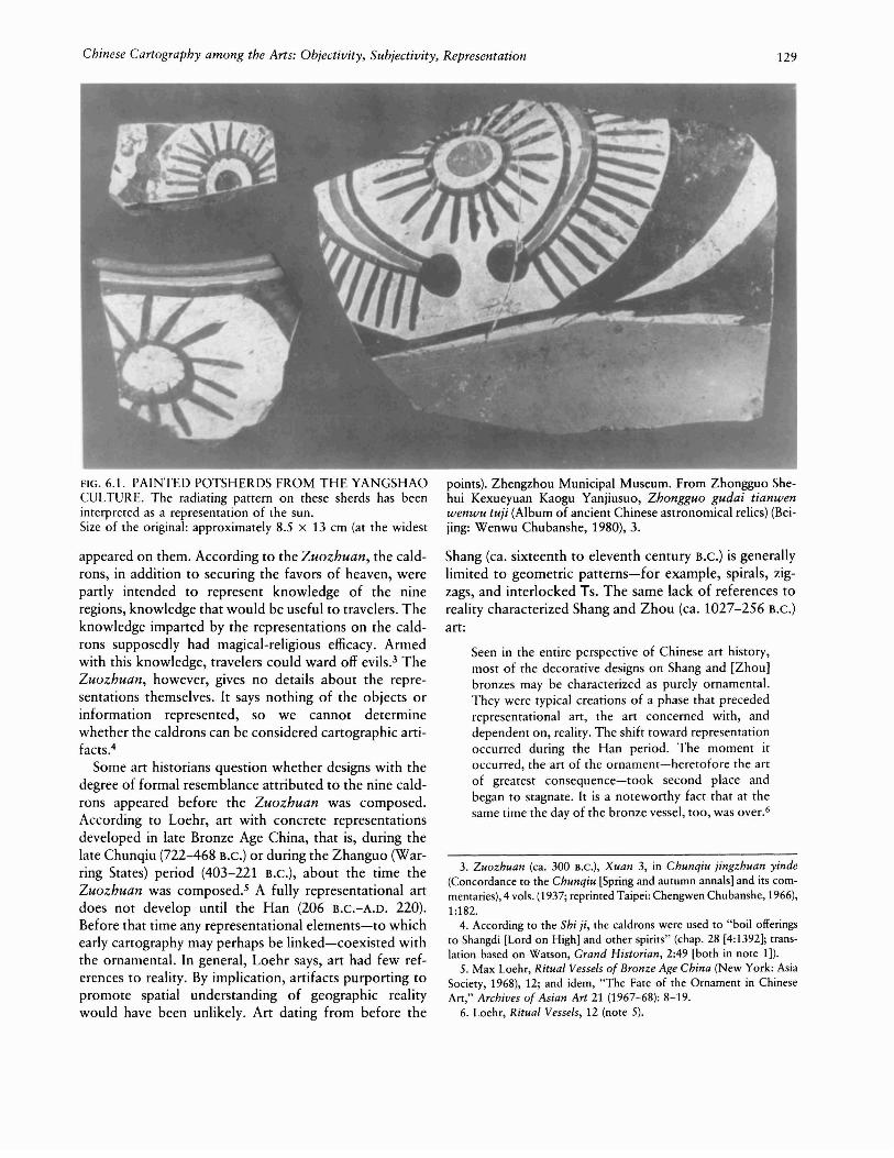
the scholarly elite; it derived from an artisanal craft withtools borrowed from the carpenter's trade-tools that LuJi, one will recall, had urged artists to discard. jiehua,like many maps, seems to have occupied a zone betweenfine art and practical craft, and a number of maps seemto have been produced with the aid of straightedges: forexample, city plans and gazetteer maps (figs. 6.5 to 6.8).
The links between painting and cartography seem tohave gone beyond technique. There is also some evidenceof a conjunction between painting theory and cartographic theory. Pei Xiu's emphasis on correspondence,as I mentioned previously, parallels an emphasis on verisimilitude in aesthetics. Xie He, for example, formulatedsix principles of painting, two of which are "correspondence to objects, that is, resemblance to forms," and"division and planning, that is, placement and arrange-
ment."59 Xie He does not elaborate on these principles,but correspondence and arrangement are concerns thatPei Xiu shares. Even before Xie He, Zong Bing (375443) had thought about the idea of scale in relation tolandscape painting: "Now, if one spreads thin silk tocapture the distant scene [of the Kunlun Mountains], theform of Kunlun's Lang Peak can be encompassed in asquare cun. A vertical stroke of 3 cun will equal a heightof thousands of ren [equal to 80 cun or 8 chi], and ahorizontal stretch of several chi will form a distance of100 Ii [equal to 1,800 chi]."6o
59. Xie, Gu huapin lu, 1 (note 31). For a translation of Xie's six principles, see Susan Bush and Hsio-yen Shih, comps. and eds., Early Chinese Texts on Painting (Cambridge: Harvard University Press, 1985),40.
60. Zong Bing, Hua shanshui xu (Preface to painting landscape, ca.fifth century), in Zhang, Lidai minghua ii, chap. 6 (131) (note 28).
FIG. 6.8. WOODBLOCK ILLUSTRATION OR MAP, 1894.This image is of the examination hall in Guangping Prefecturein present-day Hebei Province (compare figs. 6.5 to 6.7).Size of the original: 23 X 27 em. From Guangping fu zhi (Gaz-
eueer of Guangping Prefecture, 1894), chap. 1, map 9. Reproduced courtesy of the Harvard-Yenching Library, Harvard University, Cambridge.

144 Cartography in China
FIG. 6.9. WOODBLOCK MAP OF THE SEAT OF LOCALGOVERNMENT AT RONGZHOU IN PRESENT-DAYGUANGXI PROVINCE. Here and in figure 6.10 one mustchange the orientation of the map to view the objects correctly.Size of the original: 15 X 19.5 cm. From Yongle dadian (Grand
In Chinese painting, however, pictorial scale tends todominate natural scale; that is, the size of an objectdepicted was determined by needs of design and not rulesof geometric perspective. Foreground features might bediminished to avoid obstruction and overemphasis, whiledistant objects might be enlarged to act as counterpointto the middle distance and foreground. The practice ofvariable scale obviously conflicts with Pei Xiu's insistenceon consistent map scale to "preserve actualities." Manymapmakers, however, apparently chose to adhere to thepictorial technique of variable scale well into the Mingand Qing (1644-1911), as suggested by an artifactualrecord containing an abundance of maps that do notmaintain a consistent scale. This and other examples ofthe conjunction between painting and mapmaking per-
encyclopedia of the Yongle reign period [1403-24), presented1409), photo-reprint edition (Taipei, 1962), chap. 2337.16ab.Reproduced courtesy of the Harvard-Yenching Library, Harvard University, Cambridge.
haps help explain the ambiguity of the graph tu in itsapplication to drawings and pictures or to charts andmaps.
A shared conception of space also strengthens the bondbetween mapmaking and painting. To state some broadgeneralizations, the experience of space was dynamic andfluid, intimately related to one's experience of time.Space, emptiness, was regarded almost as an entity initself-as such it was boundless and unlimited. Objectscould be measured and defined; space could not be sofixed, since it changed with vantage point and time. Asa result, no abstract geometrical system governed space,and points within it were not definable or delimitable inany absolute terms. This conception of space, consonantwith what Needham has described as an organismic and

Chinese Cartography among the Arts: Objectivity, Subjectivity, Representation 145
FIG. 6.10. WOODBLOCK MAP OF NANNING PREFECTURE IN PRESENT-DAY GUANGXI PROVINCE. Comparefigures 6.9 and 6.11.Size of the original: 14.3 x 19 em. From Yongle dadian (pre-
processual worldview, differs from the one that has prevailed among European cartographers and artists sinceabout the fifteenth century-a conception that definesspace abstractly, as an entity that is bounded, static, andtherefore organizable and measurable. Under this conception, which accords with the scientific tendencytoward what Pepper has called "discrete mechanism,"space can be viewed as particulate rather than as a continuum and can be represented as a mathematical equation. It is conceived as being made up of a coordinatesystem of points, each of which has its own discrete identity and can be treated objectively from a single vantagepoint.61
The difference in the two treatments of space leads todifferences in the graphic treatment of perspective, theprojection of three-dimensional space on a plane surface.
sented 1409), photo-reprint edition (Taipei, 1962), chap.8506.2ab. Reproduced courtesy of the Harvard-YenchingLibrary, Harvard University, Cambridge.
In European Renaissance art, depth was represented as acontinuously receding ground plane directed toward avanishing point on the horizon, with a correlative diminution in the height of verticals. The geometry essentialto the European artist's use of convergent perspective,however, was generally unknown to, or at least unusedby, traditional Chinese painters. The problem of perspective, or yuanjin (far-near), in the graphic arts wasresolved by different conventions.
61. On the Chinese organismic worldview, see Joseph Needham,Science and Civilisation in China (Cambridge: Cambridge UniversityPress, 1954-), vol. 2, with Wang Ling, History of Scientific Thought(1956); on discrete mechanism, see Stephen C. Pepper, WorldHypotheses: A Study in Evidence (Berkeley and Los Angeles: Universityof California Press, 1942); on the mathematization of space in Europe,see Samuel Y. Edgerton, Jr., The Renaissance Rediscovery of LinearPerspective (1975; reprinted New York: Harper and Row, 1976).

146
FIG. 6.11. RUBBING OF A STONE MAP, T AI SHAN QUANTU (COMPLETE MAP OF TAl SHAN [MOUNT TAl]),PROBABLY QING DYNASTY. Tai Shan, in central ShandongProvince, is one of the five sacred mountains of China. Thismap was apparently meant as a guide for pilgrims to the mountain: it shows the route from the temple of the god of Tai Shanat the foot to the shrines at the summit and identifies placesand buildings. The mountain and buildings are presented inelevation, while temple grounds and walls are presented in plan,which creates a multiplicity of ground planes. In addition tothis variable perspective, the map makes use of variable scale:the temple complex at the foot of the mountain is disproportionately large, apparently to permit the buildings within it tobe represented.Size of the rubbing: 110 X 62 em. By permission of the FieldMuseum of Natural History, Chicago (235581).
One was the use of variable viewpoint (see figs. 6.9 to6.11 for examples of variable perspective in maps). Thestandpoint of the observer, instead of being fixed, is mov-
Cartography in China
able without restriction or else multiple.62 Each portionof the composition is drawn with its own viewpoint perpendicular to it at some distance. This convention wasuseful for composing a spatially dynamic sequence ofscenes on, for example, scrolls, one of the traditionalmedia for Chinese painting and maps. Unlike paintingsin frames, scroll paintings are often too long to be viewedall at once. A moving viewpoint seems well suited for amedium in which the image passes before the observersection by section as it is unrolled. On sheet maps ofrestricted length, this technique could be adapted to create multiple ground planes: one might have to imagineoneself rotating, instead of moving laterally, in order toview the depicted objects correctly.
There were, however, exceptions to the general application of variable perspective. Shen Kuo recognized themerits of certain experiments that pointed toward convergent perspective. He says that painters who employeda stationary viewpoint were able to diminish heights anddistances accurately but attached too much importanceto this diminution. Shen advocates the use of a largeviewing area in which the artist combines the vantagepoints of multiple observers:
In general, the method of landscape painting is to takea large view of the small, as when a person observesan artificial mountain. If it were the same as themethod for [viewing] a real mountain, looking up frombelow, one would see only a single layer of the mountain; how can one see layer on layer, or its valleys andgorges and other details? Similarly in the case of dwellings and houses, one would not see what was happening in their courtyards and in the lanes behindthem.63
Elsewhere the idea of multiple viewpoint is describedin terms of three depths or perspectives: gao yuan (high"distance" or perspective), shen yuan (deep distance orperspective), and ping yuan (level distance or perspective). The three perspectives are also explained in a Qingdynasty manual of painting:
Mountains have three perspectives: looking at a peakfrom below is called gao yuan; looking from a mountain in front to one in back is called shen yuan; andlooking from the near to the far is called ping yuan.The effect of high perspective is a precipitous view;the effect of deep perspective is the repetition of layers[or planes]; the effect of level perspective is of anexpanse. These principles govern the overall composition. If it is deep but without perspective, it will seem
62. This mode of presentation can also be observed in pre-Renaissance European art and in the art of other cultures. See, for example,Edgerton, Renaissance Rediscovery, 7-10 (note 61).
63. Shen, Xin jiaozheng Mengxi bitan, chap. 17, par. 283 (170) (note44).

Chinese Cartography among the Arts: Objectivity, Subjectivity, Representation 147
shallow. If it is level but without perspective, it willseem too close. If it is high but without perspective,it will seem low.64
Distance is represented by height so that objects behindor beyond another object are placed above it on a twodimensional surface. The resulting composition is a seriesof plane ground surfaces or terraces, each with its ownvanishing point.65
MAPS AS PAINTINGS/PAINTINGS AS MAPS
The parallels between maps and paintings in the use ofperspective seem roo striking to be a case of independentdevelopment-a suspicion supported by textual sourcesalready cited. To judge from Zhang Yanyuan's lists ofpaintings, maps were considered a genre of painting during the Tang. Existing artifacts suggest that this view ofmaps as painting may have been prevalent well beforethen. This is not to say that purely planimetric representation was unknown. The mausoleum map (zhaoyu tu)and wooden maps dating from the Zhanguo period, stonemaps from the Song, and some manuscript and printedmaps from later periods do seem to employ an essentiallyplanimetric mode. But Chinese maps characteristicallypresent a mixed mode of representation. For example, atomb mural from the Former Han dynasty (206 B.C.-A.D.
8) discovered at Horinger (Holingol), Inner Mongolia,presents a city plan of Fanyang (present-day Chuwangvillage in Henan Province) (fig. 6.12). All the structuresdepicted are presumably on the same horizontal plane,as suggested by the representation of the surroundingwalls in plan. The depiction of buildings in elevation,however, creates the impression that there are severalhorizontal planes. The human figures also seem ro beexaggerated in size; they are as large as buildings, Theplan may perhaps be taken as an illustration of a technique of variable scale.
A more complex example (fig. 6.13) comes from thesame tomb as the Fanyang city plan. This is a city planof Ningcheng. All the objects represented in the plan areon the same ground plane, but some are depictedobliquely, some in plan, and some in elevation, so thatthey seem ro occupy different ground planes. In the upperleft quarter of the plan, the facade of a building is presented in elevation. The scene inside the building is alsodepicted, and the artist recognizes that a different perspective would allow a fuller representation of that interior scene. Thus, in accordance with what Shen Kuowould write centuries later on variable perspective, theinterior of that same building is presented obliquely sothat everything inside can be seen.
The use of variable perspective is not restricted to artifacts from the tomb at Horinger. It also appears on two
FIG. 6.12. CITY PLAN OF FANYANG FROM THE HANDYNASTY. This is a copy of the Fanyang city plan discoveredin a Han tomb at Horinger, Inner Mongolia. According to JanFontein, comparison of photographs of the original murals atHoringer with photographs of the modern copies shows thatthe copies are extremely faithful. The copies are importantbecause the originals have begun to deteriorate. See Jan Fonteinand Wu Tung, Han and T'ang Murals Discovered in Tombsin the People's Republic ofChina and Copied by ContemporaryChinese Painters (Boston: Museum of Fine Arts, 1976).Size of the original: 94 X 80 em. Photograph courtesy of CaoWanru, Institute for the History of Natural Science, AcademiaSinica, Beijing.
of the silk maps discovered in one of the Han tombs atMawangdui in 1973. One depicts buildings in a mannerthat forces a viewer ro rotate in order ro maintain properorientation (see fig. 3.7 above). The same style of rendering can be seen at the center of the other map in arepresentation of a military headquarters (plate 8). Thismap has been described as a garrison map because of thecentrality of the headquarters and the map's depiction ofvarious military installations. The scholars responsible forthe initial reports on which almost all subsequent work
64. Wang Gai, Jiezi yuan huapu (Mustard seed garden manual ofpainting, 1679) (Taipei: Wenguan Tushu Gongsi, 1967), chu;i (pt. 1) 19.
65. For more detailed treatment of perspective in Chinese painting,see Benjamin March, "Linear Perspective in Chinese Painting," EasternArt 3 (1931): 113-39; and George Rowley, Principles of Chinese Painting (Princeton: Princeton University Press, 1959).

148 Cartography in China
FIG. 6.13. MAP OF NINGCHENG FROM THE HANDYNASTY. This is a copy of the map of Ningcheng discoveredin a Han tomb at Horinger, Inner Mongolia (see also fig. 6.12).
on this map has been based have argued that this mapwas drawn to scale and would therefore have been usefulin planning strategy. The map bears no scale indications,but based on comparison with a modern map of the areadepicted, it was claimed that the silk map was drawn toa fairly consistent scale. This conclusion, however, seemssomewhat tenuous: scale in the most consistent portionof the map was found to vary ftom 1:80,000 to 1:100,000,with greater variance in other portions.66 A variation of25 percent may not seem large, but it is not difficult toimagine military situations in which it would be significant-for example, in directing reinforcements to particular locations. Rather than demonstrating that Han mapmakers already practiced Pei Xiu's first principle ofconsistent scale, the map seems to exemplify the practiceof variable scale. This and other evidence to be adducedbelow suggests that the map may have more in common
Size of the original: 129 x 159 em. By permission of WenwuChubanshe, Beijing.
with pamtmg than with the quantitative cartographyadvocated by Pei Xiu.
One curious feature of this map lies in its treatmentof curved lines, which represent mountains and streamsin the same manner that curved lines represent hills,waves, and clouds in late Zhou art. The regularity of thecurvature is also striking. If Pei Xiu had seen a map likethis, it probably would have raised his ire for its lack ofcorrespondence to observed reality. A tendency towardidealization of landscape, however, has long been recognized as a characteristic of Chinese art. In addition,the pointed and trefoil motifs on the mountain con-
66. Mawangdui Han Mu Boshu Zhengli Xiaozu (Study Group on theHan Silk Manuscripts from Mawangdui), "Mawangdui sanhao Han muchutu zhujun tu zhengli jianbao" (Preliminary restoration report on themilitary map found in Han tomb 3 at Mawangdui), Wenwu, 1976, no.1:18-23.

FIG. 6.14. LACQUERED WINE CUP. Cups of this type werediscovered in the Han tombs at Mawangdui.Size of the original: 4.5 x 17.3 x 17.8 cm. By permission ofthe Hunan Provincial Museum.
FIG. 6.15. SILK GAUZE FROM THE HAN DYNASTY. Thisis a small pan of a piece of fabric discovered in a Han tombat Mawangdui. The designs in five colors were painted onto thefabric.By permission of the Hunan Provincial Museum (no. 340-32).
FIG. 6.16. MANOR MAP FROM THE HAN DYNASTY. Thisis a copy of a manor map mural discovered in the Han tombat Horinger, Inner Mongolia (see also fig. 6.12)
Size of the original: ca. 191 x 300 cm. By permission of WenwuChubanshe, Beijing.

150 Cartography in China
FIG. 6.17. PAINTING OF WANGCHUAN. Section of a lateMing copy of the Wangchuan tu (Picture [or map?] of Wangchuan), by Wang Wei.
tours-the latter perhaps deriving from the graph formountain-seem to lend an abstract quality to the map.This conjecture is corroborated by the appearance ofsimilar motifs on artifacts from the Han tombs atMawangdui. These motifs are painted on lacquerwareand painted and printed on textiles (figs. 6.14 and 6.15).Considered with the regularity of the curves and the lackof scalar indication, the designs seem to point toward aless practical application for the map than has been previously claimed, especially if one were to use it to plantroop movements as some scholars have suggested.
Because of its affinities with visual art, the garrison mapought to be viewed in relation to the other examples oftomb cartography discussed previously. In its mode ofrepresentation, the Mawangdui map shares some characteristics with the ones found at Horinger. One Horingermap of a manor (fig. 6.16) depicts roads and mountainswith not nearly as much symmetry as the one fromMawangdui. But the variable perspective used on themanor map resembles the mode of representing objectsseen on the garrison map: the manor map offers frontalviews of some objects and overhead views of otherobjects lying on the same plane as those depicted frontally. Similarly, the garrison map gives overhead views ofstreams and military installations but depicts mountainsand buildings in elevation.
The garrison map's burial with an official also allies it
Size of the entire original: 30 X 480.7 em. By permission of theSeattle Art Museum (Eugene Fuller Memorial Collection47.142). See also plate 9.
with the Horinger mural maps. The maps at Horinger,drawn on the inside walls of a tomb, would serve nopractical purpose in this world; as symbols of the tomboccupant's official standing and personal wealth, however, they would have helped the deceased gain standingin the afterworld. The entombment of the garrison mapfrom Mawangdui seems to indicate that its function wasconceived at least in part as ceremonial, that it was aritual object, part of the funerary rites. This use wouldexplain the presence of decorative motifs shared withother artifacts buried in the same tomb. Seen in this light,the map appears to have been drawn not to help militaryplanners, but to dignify the official's passage to the otherworld by serving as a representation of his former military authority. This conclusion is also consistent withthe message to the otherworld found with the artifactsin the official's tomb. The message was written on a woodtablet by a member of the deceased's household staff:"On wuchen [the twenty-fourth day], second month, thetwelfth year [of Wendi's reign, 168 B.C.], HouseholdAssistant Fen to Gentleman in Charge of the Dead: a listof mortuary objects is herewith forwarded to you. Uponreceiving this document, please memorialize withoutdelay to the Lord of the Dead."67 The message implies
67. Hunansheng Bowuguan and Zhongguo Kexueyuan Kaogu Yanjiusuo (Hunan Provincial Museum and Institute of Archaeology, Aca-

Chinese Cartography among the Arts: Objectivity, Subjectivity, Representation 151
that the deceased is being entrusted to an otherworldlybureaucracy, and the artifacts are apparently expected tohelp sustain him there.
Although the conclusions reached here question thevalidity of earlier conclusions about the garrison map,they do not necessarily undercut the argument that duringthe Han, the Chinese produced maps based on direct andindirect measurements of distances. The garrison mapdoes correspond closely enough to observed geographicreality for identification of the area depicted. As the regularity of the mountain contours suggests, the mapmakerprobably did not rely on survey data. But it is conceivablethat the map was based on an archetype relying on suchdata, perhaps a map considered too valuable in this worldto be buried. This would explain why some investigatorshave insisted that the garrison map reflects a quantitativetradition while overlooking its obvious connections withartistic and political practices. The counterargumentsoffered here, however, do have their difficulties. There isno evidence, for example, that the map was newly drawnfor the burial.
In any case, though, the garrison map exemplifies thedifficulty of separating cartographic from artistic tradi- .tions. That difficulty is not confined to early artifacts, inwhich case one might argue that the two traditions wouldbecome easier to separate as they "matured." To thispossible counterargument, a number of examples can be
offered in rebuttal. One of the more notable is a scrollpainting by the Tang poet and painter Wang Wei (70161). The original has been lost, and the painting is knownonly through painted or printed copies of later date (fig.6.17 and plate 9). The painting depicted the artist's estate,and copies show that it was executed with a variableperspective or moving focus often associated with thescroll form. The moving focus is accentuated by the spatial organization of the painting: the points of interest arearranged so that space flows completely around them.They are enclosed in what have been described as "spacecells."68 In addition, the ground plane is tilted, but mountains and trees are shown frontally. Also, each point ofinterest on the painting is labeled.
Wang Wei's painting has generated some debate overits proper classification-landscape painting or map. In
demia Sinica), "Changsha Mawangdui er, sanhao Han mu fajue jianbao"(Preliminary excavation report on Han tombs 2 and 3 at Mawangdui,Changsha), Wenwu, 1974, no. 7:39-48, 63, esp. 43. The translation isa modification of that of Ying-shih Yo, "New Evidence on the EarlyChinese Conception of Afterlife-A Review Article," Journal of AsianStudies 41 (1981): 81-85, esp. 82. The inventory of funerary objectsfound in the tomb in question consists of 410 wooden strips and boards.According to published reports, the list corresponds fairly well withthe objects found, but I have been unable to determine whether themaps are named in the inventory.
68. Sherman E. Lee, Chinese Landscape Painting (Cleveland: Cleveland Museum of Art, 1954), 19.

152 Cartography in China
FIG. 6.18. TWO DETAILS FROM A TENTH-CENTURYPAINTING OF WUTAI SHAN. From the mural of Wutai Shanin the Cave of the Thousand Buddhas at Dunhuang.
favor of those who would call it a landscape, the paintinglacks the high degree of abstraction usually associatedat least in the twentieth century-with maps. Other thanthe labels, it makes no use of conventional symbols torepresent geographic features but tries to approximatethe actual appearance of those features. On the otherhand, it certainly has elements that suggest cartographicintent: it represents an actual place; it seems intended topromote spatial understanding of that place, as suggestedby the labels; and it does manifest some abstraction inits spatial organization into squarish enclosures. Thepainting's combination of pictorial and cartographic elements makes it suitable for classification under Harvey'sterm "picture map."69
The same can be said of the mural of Wutai Shan(Wutai Mountains, in present-day Shanxi Province) in theCave of the Thousand Buddhas at Dunhuang (fig. 6.18).Measuring about 4.6 meters high and 13 meters wide,the mural was painted between 980 and 995. As in WangWei's painting, the pictorial space of the mural is organized into space cells, though in this case the cells areconnected by paths and roads so that a viewer "is notforced to leap barriers in order to pass from place toplace but is able to follow easily the same paths takenby travellers in the painting."7o And like the artifacts discussed above, the Wutai Shan mural is marked by variableperspective: the objects depicted occupy several groundplanes. The cartographic character of the mural derivesin part from its use of cartouches identifying objects onthe ground as well as in the heavens, and in part fromthe abstraction evident in the pictorial representations:the representations of mountains, buildings, and towns
Size of the entire mural: 4.6 x 13 m. By permission of WenwuChubanshe, Beijing.
show some uniformity in appearance, implying at leastsome conventionalization.71
Even after the introduction into China of Europeancartography and its planimetric and abstract modes ofrepresentation, Chinese maps still make use of variableperspective and pictorial representation. Both wereregarded as proper to cartography. The Sancai tuhui(Illustrated compendium of the three powers [heaven,earth, man]), an encyclopedia completed in 1607, classifies landscapes, grid maps, and maps combining pictorialand planimetric modes of representation together as diUtu, "geographic illustrations" or maps (fig. 6.19). Theencyclopedia is a compilation of earlier as well as contemporaneous materials, so its contents may not be representative of seventeenth-century cartography, but a similar situation involving mixed modes of representationholds for contemporary and even later maps. A prefectural map from an eighteenth-century atlas (plate 10), for
69. See P. D. A. Harvey, The History of Topographical Maps: Symbols, Pictures and Surveys (London: Thames and Hudson, 1980). Onthe basis of Wang Wei's painting, Berthold Laufer concludes that Tangdynasty masters of landscape painting "received a strong impetus fortheir work from the high development of contemporaneous map-making." A work like Wang Wei's, Laufer goes on to say, is "not intendedto represent any landscape, but it is the topography of the Wang rivercherished and minutely investigated by the artist." Painters had to practice methods similar to those of the cartographers. See Berthold Laufer,"The Wang Ch'uan T'u, a Landscape of Wang Wei," OstasiatischeZeitschrift 1, no. 1 (1912): 28-55, esp. 53-54.
70. Ernesta Matchand, "The Panorama of Wu-t'ai Shan as an Example of Tenth Century Cartography," Oriental Art, n.s., 22 (1976): 15873, esp. 159.
71. Matchand, "Panorama of Wu-t'ai Shan," 159,169-70 (note 70).

Chinese Cartography among the Arts: Objectivity, Subjectivity, Representation 153
example, bears some striking stylistic resemblances toWang Wei's painting. The prefectural map, colored inhues of green and blue, shows a similar spatial organization with an emphasis on cell-like enclosures. It makesuse of variable perspective: the ground plane is tilted, yetmountains are depicted in elevation. As in Wang Wei'spainting, points of interest are labeled, consistent withthe map's function as an aid to understanding spatialrelation between objects. The relatively late date of thismap suggests that in manner of presentation cartography,even after the introduction of European models, had stillnot fully distinguished itself from other forms of visualrepresentation.
This conclusion is corroborated by examples from geographic works dating from the sixteenth through thenineteenth century, in which pictorial and planimetricrepresentations are all labeled tu. For example, reproduced in figures 6.20 to 6.22 are sequences of tu fromregional and local gazetteers. If one were to remove theplace-names, some of these tu would be indistinguishablefrom what would unequivocally be called landscape pictures. This is especially true in cases where human figures,animals, and boats-elements not usually associated withcartographic representation-make up part of the mapcontent. Compilers of gazetteers saw both planimetricand pictorial representation as essential to their task: gridmaps are the "warp," and maps of mountains, streams,and villages are the "woof."72 In Qing dynasty gazetteers,one influence of representational practices imported fromEurope does manifest itself in the greater use of linearor convergent perspective in maps. These techniques didnot displace the variable perspective seen in earlier paintings and maps but were juxtaposed to traditional spatialrepresentation (see figs. 6.23 and 6.24).73 Like grids oftraditional Chinese cartography and graticules of European mapmaking, convergent perspective and variableperspective often appear on the same map.
TOWARD A REDEFINITION OF THE MAP
The influence on Chinese cartography of Europeanmodels of both cartography and the visual arts providesyet another indication of the close relation of paintingand cartography in Chinese culture. Further evidenceappears in an eighteenth-century anthology of poemsinscribed on paintings, commissioned by the Kangxiemperor (1654-1722), who also commissioned Jesuit missionaries to undertake a survey of his empire and to drawnew maps using European techniques. Despite the introduction of European map styles into the Kangxi emperor's court, the compilers of the anthology express a conception of maps that seems uninfluenced by Europeanideas. Among the classifications of illustrations used inthis collection are dili (geographic) and shanshui (land-
scape). According to the statement of principles thatintroduces the collection, a geographic picture or tu isone that gives an overall view of all the mountains, seas,and topographic configurations. A landscape is a picturein which one creates a scene out of nothing "to portrayone's impressions" or a picture in which one "embellishes[reality] as one wishes without identifying names so as tomake any mountain or river whatever."74 What makes ageographic map a map, according to this statement, is itsdepiction of an actual place as opposed to one that isimaginary or even unnamed. A landscape painting seemsto allow for more self-expression and greater use of theimagination than a geographic map, although it is unclearhow much embellishment would disqualify a picturefrom being classified as a map.
Unfortunately, the collection of poetry does not contain reproductions of the pictures on which the poemsare inscribed so that the distinction between map andlandscape might be clearly illustrated. As the definitionstands, any painting of an actual place, such as the oneby Wang Wei, in which the artist strove for fidelity without embellishment and identified the geographic featuredepicted, would be considered a dili tu or map. Thus, inthe gazetteer maps of the Qing period one often seesboth pictorial and planimetric modes of depiction, sometimes within the same representation.
Beneath the term dili lies an additional explanation fortraditional Chinese cartographic practice. Besides "geography," the term can also refer to the traditional Chinesescience of "siting," used to evaluate the configurationsof qi underlying proposed sites for buildings and tombs.The importance of qi in siting hints at another connection
72. Yuzhou zhi (Gazetteer of Yuzhou [in present-day Henan Province]) (1835; reprinted Taipei: Taiwan Xuesheng Shuju, 1968), 1.1a-b.
73. As I mentioned above, convergent perspective may have beenused, but infrequently, before the arrival of the Europeans. The principles of convergent perspective do not seem to have been widelyknown. Jesuits are known to have given lectures on the principles ofperspective, and several Chinese writers marveled at the realism of European pictorial art. On the influence of European art on Chinese painting,see James Cahill, The Compelling Image: Nature and Style in Seventeenth-Century Chinese Painting (Cambridge: Harvard University Press,1982), 70-105; and Harrie Vanderstappen, "Chinese Art and the Jesuitsin Peking," in East Meets West: The Jesuits in China, 1582-1773, ed.Charles E. Ronan and Bonnie B. C. Oh (Chicago: Loyola UniversityPress, 1988), 103-26.
74. Chen Bangyan et aI., comps., Yuding /idai tihua shi lei (Imperiallycommissioned, classified [collection] of poems inscribed on paintingsthrough the dynasties, commissioned 1707), Siku quanshu edition,"Fanli" (principles), 1b. This collection is also discussed by KazutakaUnno in "Maps as Picture: The Old Chinese Views of Maps" (paperpresented at the Thirteenth International Conference on the Historyof Cartography, Amsterdam and The Hague, 26 June to 1 July 1989).Unno shares the view expressed here that cartographic representationin traditional China was generally not conceived as separate from otherforms of visual representation.
154
(a)
FIG. 6.19. THREE MAPS FROM A MING ENCYCLOPEDIA.Selection of dili tu (geographic pictures or maps) from the Sancai tuhui. Note the range of representational modes used inthese woodblock maps-planimetric, pictorial, and a mixtureof both.(a) "Jiubian lOngtu" (Comprehensive map of the nine frontiers).(b) Map of Xihu (West Lake), in Hangzhou.
between traditional Chinese art and science, and the linksbetween siting and the graphic arts are not difficult todiscern. Landscape paintings and maps often depictedideal siting configurations (fig. 6.25). Among practitionersof siting, straight lines were regarded as signs of maligninfluences, of a lack of qi, and traditional Chinese painterstended to hold straight lines in low esteem for the samelack of vitality. Mapmakers, too, show a similar interest
. in vitality with their predilection for asymmetry and irregularity, qualities best expressed pictorially rather thanplanimetrically. Even on grid maps, one frequently findsthat the uniformity imposed by the squares is broken upby pictorial elements.75
The interest in the vitality underlying material formsserves as a reminder that maps fell within a representational complex, that adherence to the physicalworld took no precedence over the subjective. As discussed above, in Chinese theories of representation,objective presentation does not preclude subjectivity.
Cartography in China
(c) Map of Yanglongkeng (in present-day Guizhou Province).Size of each page: 21 X 14 em. All from Wang Qi, comp.,Sancai tuhui (completed 1607, printed 1609), chapters on dili(geography): (a) 3.1b-2a, (b) 9.20ab, (c) 12.39a. Reproducedcourtesy of the Harvard-Yenching Library, Harvard University,Cambridge.
75. In one instance, an emperor is said to have altered a map toeliminate straight lines. According to Yue Ke (b. 1183), in 968 the firstemperor of the Song was planning to refurbish the capital (present-dayKaifeng) and enlarge rhe foundations of the city wall. The wall "woundand curved as if earthworms wriggled within it." The secretary-generalgathered artisans and produced a plan that "seized upon the square andstraight": all four sides had gates, and the wards and marketplaces werearranged in gridlike fashion. The emperor inspected the plan and grewangry, apparently revolted by its straight lines: "He personally took upa brush to smudge them out and ordered that a large circle be madeon a sheet of paper. It wound and turned, went up and down andslanted. [The emperor's] side note said: 'Repair the wall according tothis.' " See Yue Ke, Ting shi (History [recorded] on a stand [by thebed], ca. 1210), chap. 1; see the modern edition (Beijing: ZhonghuaShuju, 1981),8-9. In the episode just cited, although Yue Ke does notexplicitly say so, the emperor seems to be acting in accordance withwell-known siting principles. The best introduction to the science ofsiting; also known by the names (eng shui (wind and water) and kanyu(cover and support, that is, heaven and earth), is Steven J. Bennett,"Patterns of the Sky and Earth: A Chinese Science of Applied Cosmology," Chinese Science 3 (1978): 1-26. Siting is often erroneouslycalled "geomancy," which actually refers to an unrelated practice. forfurther discussion of siting within this volume, see pp. 216-22 and 27679.

(b)
(c)

(a)
(b) ~~~~~~~~~~:]
FIG. 6.20. FOUR MAPS OF ZHEJIANG PROVINCE. Compare figures 6.21 and 6.22.Size of each page: ca. 19.5 X 14 em. From Zhejiang tongzhi(Comprehensive gazetteer of Zhejiang, 1736), from an 1884
edition: (a) Chuzhu fu, 1.28b-29a, (b) Yuhuan Shan, 1.30b-31a,(c) Tianmu Shan, 1.32b-33a, (d) Wulin Shan, 1.34b-35a. Reproduced courtesy of the Harvard-Yenching Library, Harvard University, Cambridge.

(d)

158
E"'
FIG. 6.21. THREE MAPS OF GANSU PROVINCE.Size of each original: 22 X 34 em. From Gansu tongzhi (Comprehensive gazetteer of Gansu, 1736): (a) 1.35b-36a, (b) 1.36b-
Representation of physical appearance was a means ofunderstanding underlying realities, the innerness of bothobject and artist. This method is recognized in a Qinghydrological work: "Those who draw territorial mapsmust discern details, and later they can abstract theirordering principles. They must also take into account thecomplete configuration [of the land], and later they cangrasp its essential structure."76 A map, like a painting, isnot just a record, but is a product of the mapmaker'sintuitive sense of underlying form-mapmaking involvesabstraction of external details into something internal, a"mindscape." A cartographic image can thus representnot only physical appearances, but also the mapmaker'smemories and reflections. The collection of poemsinscribed on paintings referred to above provides ampleevidence that maps were read in this way, not only as ameans of gaining knowledge of the physical world butas a means of enriching one's subjective world or emotional experience.
As is well known, Chinese landscape paintings haveinspired much poetry; in fact, after the Song, a landscapewas often not considered complete unless a poem-bythe artist or by another-was inscribed on it.77The paint-
Cartography in China
.....---~
........._-------- .
37a, (c) 1.37b-38a. Reproduced courtesy of the Harvard-Yenching Library, Harvard University, Cambridge.
ing and poem would thus exemplify the "three perfections," the entire artifact constitituting a unity of linguistic, calligraphic, and visual art. Perhaps less knownis that maps also inspired poetry-poems inscribed on themaps themselves and serving to bring out subjective elements submerged in the attempt to render the physicalworld. This adds another dimension to the relationshipbetween map and text discussed in other chapters.
These poems suggest that maps were viewed not onlyfor intellectual understanding, as a means of increasingone's understanding of spatial relationships, but also foremotional experience-for example, as a means of renewing one's sense of place. "Space is transformed into placeas it acquires definition and meaning," Tuan has noted;place "is a concretion of value," and values carry emo-
76. Wang Niansun, He yuan ii/ue (Short accounts of the sources ofthe Yellow River, commissioned and printed 1782) (reprinted Taipei:Guangwen Shuju, 1969), 1.6a.
77. See Michael Sullivan, The Three Perfections: Chinese Painting,Poetry, and Calligraphy (London: Thames and Hudson, 1974); andShen C. Y. Fu et a!', Traces of the Brush: Studies in Chinese Calligraphy(New Haven: Yale University Press, 1977), 179-80.

1
::.
ti-~-----'
..
+/;-1;ii'J:il~ 1 ":i;
,.
-]
(b)
(e)

160 Cartography in China
(d)
,,~,
FIG. 6.22. THREE MAPS OF YONGPING PREFECTURE.Size of each original: 26.5 x 32 em. From Yongping fu zhi(Gazetteer of Yongping Prefecture [in modern Hebei Province],
tional weight,78 This is illustrated by the poetic responseof Ding Henian (1335-1424) to a map titled Changjiangwanii tu (Ten thousand Ii map of the Changjiang [YangtzeRiver]), which apparently does not survive. Maps withthe same name or similar names do survive, and fromthese we may gain a sense of what might have beendepicted on the map that elicited Ding's response (detailsfrom two examples of maps/landscapes of the YangtzeRiver are figs. 6.26 and 6.27). Although the map artifactis no longer extant, the text of Ding's poem is preservedin the anthology of poems inscribed on paintings andappears in the section on maps (dili tu). The descriptionof the lost artifact as a map thus merely follows theclassification of the compilers of the anthology. In Ding'scase the map is a pretext for a search for origins, a placeof familiarity:
1879): (a) tu 15ab, (b) tu 16ab, (e) tu 17ab. Reproduced courtesyof the Harvard-Yenching Library, Harvard University, Cambridge.
The Changjiang extends thousands and thousandsof Ii;
Where is myoid home?Suddenly through the clear sky I see stream and
trees,And vaguely make out Hanyang.?9
Although the poem is written in response to a map, thetext of the poem itself gives no indication that the speakeris looking at a map. Rather, the poet writes as if he were
78. Yi-fu Tuan, Space and Place: The Perspective of Experience (Minneapolis: University of Minnesota Press, 1977), 136, 12.
79. In Chen et aI., Yuding lidai tihua shi lei, 6.8a (note 74). Hanyangis a county in Hubei Province, north of the Yangtze, near its junctionwith the Han River. In the first line of the poem, Ding engages in somewordplay, describing the Changjiang in terms that justify the literalmeaning of its name, "long river."


162 Cartography in China
FIG. 6.23. MAP OF THE TEMPLE OF THE GUANGPINGPREFECTURE'S GUARDIAN DEITY. See also figure 6.24.Both are examples of convergent perspective in woodblockmaps.
viewing an actual scene, not a representation. In effect,the map serves as a substitute for reality, implying a highdegree of formal likeness. But in accordance with Chineseaesthetic theory, the physical world and the psychologicalbecome fused. Physical descriptions are intertwined withacts of perception: the poet is actively looking ("Whereis myoId home?"), not just seeing, and the poem closeswith an act of recognition-a rediscovery of the familiarin Hanyang.
A similar blending of objective and subjective experience takes place in these lines by the painter-poet YangJi (ca. 1334-ca. 1383), which, like Ding Henian's, wereinscribed on a map entitled Changjiang wanli tu, a workthat also does not seem to have survived. Like Ding Henian's poem, Yang Ji's appears in the anthology of poemsinscribed on paintings, appearing under the classification
Size of the original: 23 X 27 cm. From Guangping fu zhi (Gazetteer of Guangping Prefecture [in modern Hebei Province),1894), chap. 1, map 7. Reproduced courtesy of the HarvardYenching Library, Harvard University, Cambridge.
of maps. It too gives no hint that the speaker is lookingat a map, and the process of viewing the map becomesthe occasion of emotional release. The movement of thispoem differs from Ding's, however, in that its emotionalscope expands as the poem progresses-from the poet'spersonal situation to more generalized experience ofthose traveling on the Yangtze, perhaps figures depictedon the map:
My home lies farther west of the Min Mountains,Directly facing where the Min River issues forth.In Sanba, under a clear spring sky, the snow first
thaws;And through a hundred bends and a thousand
turns, it Aows east.The Jiang Aows east for ten thousand Ii;

Chinese Cartography among the Arts: Objectivity, Subjectivity, Representation 163
1I ""i..i1
~J.
i ~ ". 11t. I)lJ
i: I~
~~~ ~,
Q .,N:. iJ
fi,,~- - ::;: :!""Tl.T'.2j 'j-
FIG. 6,24, MAP OF THE SEAT OF LOCAL GOVERNMENTAT TONGZHOU,Size of each page: 22.5 x 14.5 em. From Tongzhou zhi (Gaz-
etteer of Tongzhou [in modern Hebei Province, near Beijing],1879), tu 2b-3a. Reproduced courtesy of the Harvard-YenchingLibrary, Harvard University, Cambridge.
People now drift and Aoat toward other places.The mist, waves, and green grass at times draw our
their sorrow;The sounds of wind, rain, and gibbon are about to
break their hearts.8o
As the preceding examples suggest, traditional Chinesemapmakers worked in an environment where they themselves or map readers might inscribe poems on maps, asthey would be expected to do on paintings. To completethe parallel between cartography and painting-to extendthe argument for a unity of map and landscape-a cartographic work was often not considered complete until apoem was inscribed on it. The cartographic artifact at itsbest was a fusion of graphic and verbal art, and like apoetic work, it was meant to be appreciated on at leasttwo levels. The inscribed poems themselves demonstratethat at least viewers read mapmakers' intentions in those
terms and responded accordingly. In other words, cartographic forms were meant not only to reproduce but toexpress. Painters of landscape paintings had similarexpectations, and poems inscribed on landscapes areoften difficult to distinguish from those inscribed onmaps. For example, here is a poem inscribed by the NeoConfucian philosopher Zhu Xi (1130-1200) on a landscape by Mi Youren (1072-1151). As with the poemsinscribed on maps, the poet treats the representation asactuality and animates the scene by inserting a humanagent:
80. In Chen et aI., Yuding lidai tihua shi lei, 6.8b-9a (note 74). TheMin Mountains and Min River are in Sichuan. It is possible to translatethe last three lines as referring to the speaker in the poem, so that thepoem remains personal throughout. In this case the graph ren, translatedhere as "people," would be interpreted as referring to the speaker ("aperson").

164
FIG. 6.25. QING MAP OF GUANGDONG. Detail of theGuangdongsheng quantu (Complete map of Guangdong Province), drawn in the eighteenth century. The estuary of the PearlRiver has been displaced so that it is due south of the city ofGuangzhou (Canton) instead of to its southeast, and its twobanks are symmetrically aligned in relation to the north-southaxis passing through the center of the city. The deviations fromactuality are intended to situate the city in a favorable positionaccording to the principles of the science of siting.Size of the entire original: 151 X 277 em. Courtesy of theGeography and Map Division, Library of Congress, Washington, D.C. (G7823.K8A5 17--.K8 Vault).
The mountains of Chu are densely arrayed;Trees shed, autumn clouds rise.Toward dawn, as soon as I ascend the terraceBehold, the vast Jiang, daily going a thousand Ii.sl
COMBINING FACT AND VALUE
On the basis of the evidence considered here, it seemsthat Chinese cartography often shared the aesthetic principles of painting and poetry. This conclusion is hardlysurprising, since cartographers, painters, and poets generally occupied the same social stratum, as part of theintellectual elite, and came from similar educationalbackgrounds. In some cases the same person might beinvolved in cartography, painting, and poetry. In such aperson's mind, it seems likely that the principles governing those pursuits would have blended together and not
Cartography in China
formed three disparate sets. The cultural environmentwas such that self-expression was as important as reproduction of external reality, if not more important. Itmight therefore be possible to write a history of Chinesecartography showing its assimilation into the fine arts.This calls for an adjustment in the sorts of artifactsselected for attention, artifacts chosen not only for signsof quantification and mensuration, but for expressive andaesthetic value. It has been customary, however, to regardmaps with a seemingly utilitarian aim-planimetric gridmaps presenting quantitative information and ideallybased on direct and indirect measurements-as the defining achievements of Chinese cartography.82 According tothis view, pictorialism and expressionism in cartographyare something to be outgrown, just as they were inEurope. Enough has been said in this and other chaptersto weaken that view of the Chinese cartographic tradition, which privileges the objective and quantitative overthe subjective and qualititive-in short, fact over value.But the split between fact and value was never as strongin China as it has become in the European tradition.
To elevate objectivity over subjectivity, presentationover expression, is to introduce a hierarchy foreign toChinese aesthetics, an economy of representation thatseems to have involved cartography. Maps were madenot only to be studied, not only for reference, but alsoto be enjoyed, and the record shows that mapmakers hadusers capable of appreciating their works intellectuallyand aesthetically. If one goal of the history of cartographyis to reconstruct the reception of maps by particular usersin particular cultures, accounts of Chinese cartographymust take these theories of representation into account.When viewing a Chinese map, one may have to considernot only landscape-the representation of visible earthforms-but also what might be called "inscape": "But asair, melody, is what strikes me most of all in music anddesign in painting, so design, pattern or what I am in thehabit of calling 'inscape' is what I above all aim at inpoetry. Now it is the virtue of design, pattern, or inscapeto be distinctive and it is the vice of distinctiveness to
81. "Ti Mi Yuanhui hua" (Inscribed on a painting by Mi Yuanhui[Mi Youren)), in Chen et aI., Yuding lidai tihua shi lei, 11.11a (note74). This poem appears under the shanshui, or landscape, classification.Chu is a region comprising much of the Yangtze basin: it encompassesHubei Province and parts of other present-day provinces. The Jiang isthe Changjiang, or Yangtze River.
82. For example, see Edouard Chavannes, "Les deux plus anciensspecimens de la cartographie chinoise," Bulletin de I'Ecole Fran~aise
d'Extreme Orient 3 (1903): 214-47; Joseph Needham, Science and Civ·ilisation in China (Cambridge: Cambridge University Press, 1954-), vol.3, with Wang Ling, Mathematics and the Sciences of the Heavens andthe Earth (1959); Chen Feiya et aI., eds., Zhongguo gudai dilixue shi(History of ancient Chinese geography) (Beijing: Kexue Chubanshe,1984); Lu Liangzhi, Zhongguo dituxue shi (History of Chinese cartography) (Beijing: Cehui Chubanshe, 1984).
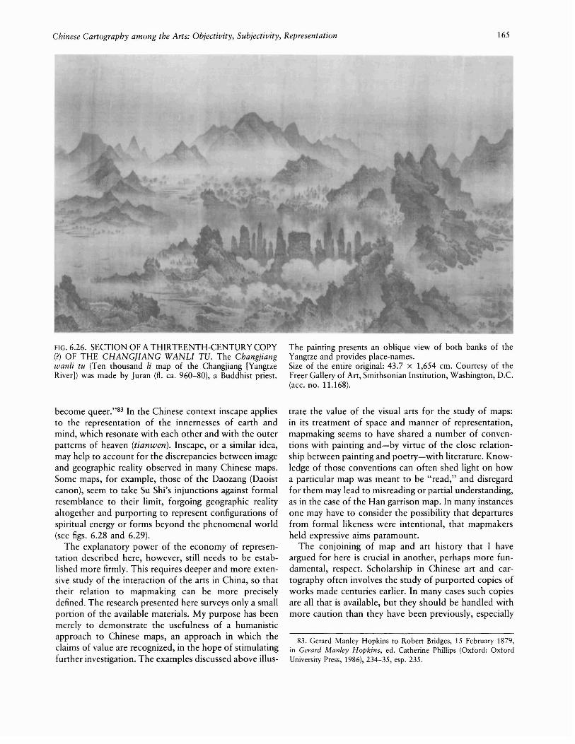
Chinese Cartography among the Arts: Ob;ectivity, Sub;ectivity, Representation 165
FIG. 6.26. SECTION OF A THIRTEENTH-CENTURY COpy(?) OF THE CHANG]IANG WANLI TV. The Chang;iangwanli tu (Ten thousand Ii map of the Changjiang [YangtzeRiver]) was made by Juran (fl. ca. 960-80), a Buddhist priest.
become queer."83 In the Chinese context inscape appliesto the representation of the innernesses of earth andmind, which resonate with each other and with the outerpatterns of heaven (tianwen). Inscape, or a similar idea,may help to account for the discrepancies between imageand geographic reality observed in many Chinese maps.Some maps, for example, those of the Daozang (Daoistcanon), seem to take Su Shi's injunctions against formalresemblance to their limit, forgoing geographic realityaltogether and purporting to represent configurations ofspiritual energy or forms beyond the phenomenal world(see figs. 6.28 and 6.29).
The explanatory power of the economy of representation described here, however, still needs to be established more firmly. This requires deeper and more extensive study of the interaction of the arts in China, so thattheir relation to mapmaking can be more preciselydefined. The research presented here surveys only a smallportion of the available materials. My purpose has beenmerely to demonstrate the usefulness of a humanisticapproach to Chinese maps, an approach in which theclaims of value are recognized, in the hope of stimulatingfurther investigation. The examples discussed above illus-
The painting presents an oblique view of both banks of theYangtze and provides place-names.Size of the entire original: 43.7 X 1,654 em. Courtesy of theFreer Gallery of Art, Smithsonian Institution, Washington, D.C.(ace. no. 11.168).
trate the value of the visual arts for the study of maps:in its treatment of space and manner of representation,mapmaking seems to have shared a number of conventions with painting and-by virtue of the close relationship between painting and poetry-with literature. Knowledge of those conventions can often shed light on howa particular map was meant to be "read," and disregardfor them may lead to misreading or partial understanding,as in the case of the Han garrison map. In many instancesone may have to consider the possibility that departuresfrom formal likeness were intentional, that mapmakersheld expressive aims paramount.
The conjoining of map and art history that I haveargued for here is crucial in another, perhaps more fundamental, respect. Scholarship in Chinese art and cartography often involves the study of purported copies ofworks made centuries earlier. In many cases such copiesare all that is available, but they should be handled withmore caution than they have been previously, especially
83. Gerard Manley Hopkins to Robert Bridges, 15 February 1879,in Gerard Manley Hopkins, ed. Catherine Phillips (Oxford: OxfordUniversity Press, 1986), 234-35, esp. 235.

166 Cartography in China
FIG. 6.27. SECTION OF THE "WANLI CHANGJIANG TU"(TEN THOUSAND Ll MAP OF THE YANGTZE RIVER).As in figure 6.26, this map shows both banks of the river andgives place-names.
since the validity of conceptions about the sequence ofstyles and modes of representation depends on the establishment of authenticity. What Loehr has said about thehistory of Chinese art holds also for cartography:
The authenticity question results in a true paradox: (1)Without knowledge of styles, we cannot judge theauthenticity of individual works, and (2) without convictions about authenticity, we cannot form conceptsof style.... The case for or against authenticity, therefore, rests on convictions, and for the convincingnessof a work, style is the foremost criterion. A judgmentabout authenticity, therefore, remains itself arbitraryand subjective unless it is fully compatible with thecriteria of style.84
Historians of Chinese cartography need to be sensitiveto Loehr's concerns. Some judgments about the appearance and accuracy of maps supposedly made during theSong, for example, have been based on copies dating
Size of each page: 22.5 x 14.5 cm. From Zhang Huang, comp.,Tushu bian (Compilation of illustrations and writings, compiled1562-77, printed 1613), 58.2a-3b. Reproduced courtesy of theHarvard-Yenching Library, Harvard University, Cambridge.
from the Ming and Qing. The fidelity of the Qing copiesto the Song originals cannot be taken for granted. True,copying was taken seriously: Xie He identifies copying,"the transmission of models," as the sixth principle ofpainting.85 But copying was not a purely mechanicalaffair. Manual copying of past masterpieces of paintingand calligraphy was a crucial element in defining one'sown artistic style, and therefore a copy was supposed notmerely to reproduce, but also to introduce something ofthe copyist. In the case of woodblock printing, there isevidence that fidelity of copies to the physical appearanceof original woodcuts was not quite complete, as onemight expect from the place of formal resemblance inChinese aesthetics. Maps in Song and Ming editions ofthe same work could differ appreciably in appearance (seefigs. 6.30 and 6.31).86
84. Loehr, "Some Fundamemallssues," 187-88 (note 34).85. Xie, Gu huapin [u, 1 (note 31).86. There are also differences in the cartographic images on the two

Chinese Cartography among the Arts: Objectivity, Subjectivity, Representation 167
FIG. 6.28. MAP OF TAl SHAN (MOUNT TAl) FROM THEDAOIST CANON. Titled "Dongyue zhenxing tu" (Map of thetrue form of the sacred peak of the east), it represents themountain's caverns. Maps like this were meant to harness thespiritual power of the mountain for the benefit of the user: theycould repel evil spirits and help one attain immortality.Size of the page: 11 x 10.5 em. From Lingbao wuliang durenshangjing dafa (Great rituals of the supreme scripture on theinfinite salvation of Lingbao [numinous treasure]), 21.16a, inZhengtong Daozang (Daoist canon of Zhengtong reign period[1436-49]), 1,120 volumes, vol. 89. From Commercial Pressreprint, 1923-26, reproduced courtesy of the Harvard-YenchingLibrary, Harvard University, Cambridge.
Before we can draw conclusions about the cartographyof a period from later copies, we need to know moreabout the attitudes of the block cutters themselves andthose who drew the paper images that were transferredto the blocks. To what extent were the artists allowedto deviate from the physical appearance of the originalimages, and to what extent were the block cuttersallowed to deviate from the transferred image? On thesequestions, scholars have yet to reach even tentative conclusions. But answers to such questions are crucial if historians of Chinese cartography are to arrive at even aprovisional understanding of the chronology of their ownsubject. Solutions seem to require the expertise of bothhistorians of science and historians of the arts, since thequestions involve technology, production processes,
\:.FIG. 6.29. MAP OF THE UNDERWORLD FROM THEDAOIST CANON. The "Jiu yu deng tu" (Map of the lanternsof the nine purgatories) represents the nine chambers wheresouls of the dead undergo various punishments, such as flogging,boiling, and immersion. The chambers are laid out followingthe nonary square pattern typical of many cosmographic representations (see pp. 204-5). The map was supposed to be usedto help win the release of underworld prisoners.Size of the page: 11.5 x 11 em. From Lu Shizhong, Wushangxuanyuan santian yutang dafa (Great rituals of the jade hallfrom the three heavens of the supreme, sublime, and primal,compiled 1158), 14.5b, in Zhengtong Daozang (Daoist canonof the Zhengtong reign period [1436-49]), 1,120 volumes, vol.101. From Commercial Press reprint, 1923-26, reproducedcourtesy of the Harvard-Yenching Library, Harvard University,Cambridge.
artistic style, and aesthetic theory. In short, what isneeded is a merger of fact and value.
The stress here has admittedly fallen on value, but thatshould not be misconstrued as a denial of the claims offact. Both are equally important aspects of the culturalrealities we seek to understand, and one should not beignored at the expense of the other. In the field of thehistory of cartography, it is time to heal what might becalled a dissociation of sensibility. This chapter isintended as a first step toward this reunification, and asa first step, it reasserts the value of value-partly as amatter of analytical convenience, but mainly to direct
surviving versions of the Yu ji tu (Map of the tracks of Yu) carved inSlOne. (See figs. 3.14 and 3.15.)

168
FIG. 6.30. "GUJIN HUA YI QUYU ZONGYAO TU" (GENERAL MAP OF THE ANCIENT AND PRESENT TERRITORIES OF CHINA AND FOREIGN COUNTRIES). Thismap, as well as figure 6.31-both from a Ming edition of theLidai dili zhizhang tu (Easy-to-use maps of geography throughthe dynasties, 1098-1100, supplemented 1162)-should be compared with those from a Southern Song edition (figs. 3.23 and
attention to an area that tends to be slighted in much
research into Chinese cartography.87
87. Though there is little movement among historians of Chinesecartography toward art history, in Chinese art history there are indications of movement in the opposite direction. Kiyohiko Munakata,for example, consults traditional Chinese maps in order to understandChinese attitudes toward sacred mountains, a traditional subject oflandscapes. See Kiyohiko Munakata, Sacred Mountains in Chinese Art(Urbana: University of l\Iinois Press, 1991).
Cartography in China
3.24 above). There are differences in the density of the labels,in the forms of certain graphs, and in the depictions of thecoastlines.Size of the original: unknown. Photograph courtesy of CaoWanru, Institute for the History of Natural Science, AcademiaSinica, Beijing.

FIG. 6.31. "TANG YIXING SHAN HE LIANGJIE TU" (MAPOF THE TWO BOUNDARIES FORMED BY MOUNTAINSAND RIVERS ACCORDING TO YIXING OF THE TANG).See figure 6.30.
Size of the original: unknown. Photograph courtesy of CaoWanru, Institute for the History of Natural Science, AcademiaSinica, Beijing.