GEOGRAPHY - OnlineIAS.com
124
www.OnlineIAS.com APPSC - PRELIMS GEOGRAPHY WORLD GEOGRAPHY +91-9246365622 Vidyarthi - Bharat Ki Shakti [email protected] www.OnlineIAS.com N. Kalyana Chakravarthy 1
-
Upload
khangminh22 -
Category
Documents
-
view
0 -
download
0
Transcript of GEOGRAPHY - OnlineIAS.com

www.Onli
neIA
S.com
APPSC - PRELIMS
GEOGRAPHYWORLD GEOGRAPHY
+91-9246365622 Vidyarthi - Bharat Ki Shakti [email protected]
www.OnlineIAS.com N. Kalyana Chakravarthy 1

www.Onli
neIA
S.com
Sl. No.
CONTENTS
TOPICS
GENERAL GEOGRAPHY
Pg. No.
1. Our Universe ...........................................................................................7
2. Interior Infrastructure of Earth ............................................................... 16
3. Mineral & Rocks ......................................................................................21
4. Forces Effecting the Earth Movements ....................................................25
5. Weathering & Erosion. ............................................................................. 27
6. Geogmorphological Landforms ................................................................ 30
7. Volcanoes Earthquakes ............................................................................ 34
8. Erosional and Depositional Landforms................................................... 39
9. Drainage System & Patterns ..................................................................44
10. Atmosphere. .............................................................................................46
11. Climatic Classification...............................................................................58
12. Hydrosphere ............................................................................................60
13. Soil ...........................................................................................................69
14. Natural Vegetation ..................................................................................73
15. Population ...............................................................................................79
16. Human Settlement.................................................................................. 84
17. Agriculture. ............................................................................................. 89
18. Fisheries ................................................................................................. 100
19. Minerals ................................................................................................ 103
20. Industries.............................................................................................. 108
21. Energy Resources .................................................................................. 117
22. Transport ..............................................................................................122
+91-9246365622 Vidyarthi - Bharat Ki Shakti [email protected]
www.OnlineIAS.com N. Kalyana Chakravarthy 2

www.Onli
neIA
S.com
+91-9246365622 Vidyarthi - Bharat Ki Shakti [email protected]
www.OnlineIAS.com N. Kalyana Chakravarthy 3

www.Onli
neIA
S.com
GENERAL
GEOGRAPHY
+91-9246365622 Vidyarthi - Bharat Ki Shakti [email protected]
www.OnlineIAS.com N. Kalyana Chakravarthy 4

www.Onli
neIA
S.com
+91-9246365622 Vidyarthi - Bharat Ki Shakti [email protected]
www.OnlineIAS.com N. Kalyana Chakravarthy 5

www.Onli
neIA
S.com
OUR UNIVERSE
Origin
The big bang theory explains the origin of our universe. According to this theory, 15 billion years ago, cosmic matter was in a compressed state from which expansion started by a primordial explosion. The super-dense ball broke to form galaxies, which again broke to form stars and finally stars broke to form planets including earth.
Since the outer space is limitless, conventional units for measuring distances are not suitable. Hence new units as follows are used:
• Light Year: Distance covered by light inone year in vacuum at a speed of 3x10⁸
m/s. One light year is equal to 9.46 ×10¹² kilometers.
• Astronomical Unit: The Mean distancebetween the Sun and the Earth (1.49 x10⁸ km). One light year is equal to 60,000AU.
• Cosmic Year: Sun's period of revolutionaround the galactic centre (250 millionyears). Also called as 'galactic year'
• Parsec: Distance at which the mean ra-dius of the Earth's orbit subtends anangle of one second of an arc. It is equalto 3.26 light years.
Galaxies
These are huge congregation of stars that hold together by force of gravity e.g. the Milky Way, Andromeda galaxy, large and small magellanic cloud, Ursa Minor system, sculptor system, etc. Milky Way or Akashganga is our home galaxy. Our solar system is located in this galaxy.
Stars
Stars are self luminous bodies that account for 98 percent of the matter in a galaxy. In the universe, some stars appear small but emit more energy than the other stars of the Milky Way. Such stars are called 'Quasars'. When the dense galactic nucleus is compressing to form a star, this stage in star formation is called a 'protostar' stage. Due to high temperature hydrogen converts to
helium and heat and light is emitted. Thus a staris formed. When the hydrogen of a star is depleted,its outer regions swell and redden. This stage of a star is called a 'Red Giant'. Our sun will turn intoa 'Red Giant' in 5 billion years. 'Novae Stars' arestars whose brightness increases suddenly by 10 to 20 magnitudes due to explosion and then the starsagain fade into normal brightness. 'Super Novae'are stars whose brightness suddenly increases by more than 20 magnitudes. After the explosion,the dense core of comparatively smaller stars iscalled the 'white dwarf'. The dense core of thecomparatively larger stars is called the'Neutron star'. The neutron star rotates at a highspeed emitting radio waves. Such stars are called'Pulsar'. 'Black hole' stage of the star occurs whenthe ancient star collapses. Gravity becomes so intense in the hole that nothing escapes, evenlight.
Constellations
In the sky at night there are various patterns formed by different groups of stars. These are called constellations. Ursa Major or Big Bear is one such constellation. One of the most easily recognizable constellations is the small bear or Saptarishi (Sapta-seven, Rishi-sages). It is a group of seven stars that forms a part of the large Ursa Major Constellation.
Solar System
The sun along with its eight planets, asteroids and comets comprise the 'solar system'. The planets are divided into inner or terrestrial planets which have higher densities e.g. Mercury, Venus, Earth and Mars and outer planets which have lower densities e.g. Jupiter, Saturn, Uranus and Neptune.
The Sun
• The sun is in the center of the solarsystem.
• It is made up of extremely hot gases par- ticularly hydrogen.
• The sun is 109 times bigger than the
+91-9246365622 Vidyarthi - Bharat Ki Shakti [email protected]
www.OnlineIAS.com N. Kalyana Chakravarthy 6

www.Onli
neIA
S.com
earth and weighs 2 × 1027 tonnes. • The sun is about 150 million km away
from the earth. The light from the sunreaches earth in about 8 minutes.
• The glowing surface of the sun is called'Photosphere'. Above the 'Photosphere'is red coloured 'Chromosphere'. Beyondthe Chromosphere is the 'Corona', vis- ible during eclipses.
• The temperature of the photosphere isabout 6000°C and that of the Chromo- sphere is about 32400°C, and that of thecorona about 2,700,000°C. The core ofthe sun has a temperature about 15million degrees Kelvin. But that tremen- dous heat is not felt so much by us be- cause despite being our nearest star, it isfar away from us.
• It takes 250 million years to completeone revolution round its centre. Thisperiod is called 'Cosmic year'.
• Sun spots' are dark patches notched onthe surface of the sun. They appear darkbecause they are cooler i.e. they have atemperature of about 1500°C.
• The 'Aurora Borealis' or northern lightsare multicoloured lights that sweepacross the sky in waves and are visiblein the arctic region. The 'Aurora Aus-tralis' or southern lights are similarlyvisible near the Antarctica region.
The Moon
• The moon is the only satellite of the earth.• Its size is approximately one-fourth that
of the earth. It has a diameter of 3475km.
• Its orbit is elliptical. The maximum dis-tance (apogee) of the moon from theearth is 406,000 km and the minimumdistance (perigee) is 364,000 km.
• The moon moves around the earth inabout 27 days. It takes exactly the same time to complete one spin. As a result, only one side of the moon is visible to us on the earth.
• The bright parts of the moon are moun- tains whereas the dark patches are low- lying plains.
Asteroids
Asteroids are a series of very small planets or fragments of planets lying between the orbit of Mars and that of Jupiter. They number about
45,000. 'Ceres' whose length is about 1000km is the largest one. They revolve around the sun in the same way as the planets.
Meteors and Meteorites
The meteors are the remains of comets which are scattered in the interplanetary space of the solar system. On contact with the earth's atmosphere, they burn due to friction. Those which completely burn out into ash are called meteors or 'shooting star.' Those which do not burn completely and strike the earth in the form of rocks are called 'meteorites'.
Planetary System
There are eight planets in our solar system.They are: Mercury, Venus, Earth, Mars, Jupiter,Saturn, Uranus and Neptune. Earlier, Pluto wasconsidered as a planet. But recently it has lost thisstatus. All the eight planets of the solar systemmove around the sun in fixed paths. These pathsare elongated. They are called orbits. A new planet2003 UB 313 has been discovered recently in oursolar system. It is bigger than Pluto and farthestfrom the Sun.
A. Mercury
1. Mercury is the smallest and the nearestplanet to the Sun.
2. It takes only about 88 days to completeone round along its orbit.
3. It has no atmosphere and no satellite.
4. Its days are scorching hot and nights arefrigid.
B. Venus
1. Venus is considered as 'Earth's-twin'because its size and shape are very muchsimilar to that of the earth.
2. It is also called the 'morning' or 'evening star'.
3. It is probably the hottest planet because itsatmosphere contains 90-95% of carbondioxide. The day and night temperaturesare almost the same.
4. The atmospheric pressure is 100 times thatof the earth.
5. It has no satellite.
+91-9246365622 Vidyarthi - Bharat Ki Shakti [email protected]
www.OnlineIAS.com N. Kalyana Chakravarthy 7

www.Onli
neIA
S.com
C. The Earth
1. The earth is the third nearest planet to theSun.
2. In size, it is the fifth largest planet.
3. It is slightly flattened at the poles. That is whyits shape is described as a Geoid.
4. From the outer space, the earth appearsblue because its two-thirds surface iscovered by water. It is, therefore, called a blueplanet.
D. Mars
1. It is marked with dormant volcanoes and deepchasms where once water flowed.
2. It has a thin atmosphere comprising ofNitrogen and Argon.
3. Beneath its atmosphere, Mars is barren,covered with pink soil and boulder.Because of this it is known as 'red planet'.
4. It has two satellites namely 'Phobos' and'Demos'.
5. The highest mountain here is Nix Olympiawhich is three times higher than MountEverest.
6. Recent explorations have thrown light onthe possibility of existence of life here.
E. Jupiter
1. It is the largest planet of the solar system.
2. Its atmosphere contains hydrogen, helium,methane and ammonia.
3. It contains two and a half times the massof all the other planets combined.
4. It reflects more than three times the energyit receives from the sun.
5. It has the great red spot which is anenormous eddy in the turbulent cloud cover.It also contains dusty rings and volcanoes.
6. It has 16 satellites like Ganymede, Aayo,Europa, Callisto etc.
F. Saturn
1. It is the second largest planet of the solarsystem.
2. It has a celebrated rings composed ofthousands of rippling, spiraling bands oficy rock and dust just 200 feet thick and
270,000 km in diameter.
3. It has 21 known satellites. Among themTitan, Phobe, Tethys and Mimas areimportant.
4. Its moon, Titan has nitrogen atmosphereand hydrocarbons, the necessity of life butno life exists.
G. Uranus
1. It is the only planet that lies on its side.Hence, one pole or the other faces the sunas it orbits.
2. It is one of the coldest planets because ofhaving an average temperature of -223?C.
3. Its atmosphere is made of mainly hydrogen.The landscape is barren and there is frozenmethane cloud.
4. There are 9 dark compact rings around theplanet and a corkscrew shaped magneticfield.
5. It has 15 satellites; prominent ones areAerial, Ambrial, Titania, Miranda etc.
6. It rotates north to south.
H. Neptune
1. It is the most distant planet from the sun.
2. There are five rings of Neptune. The outer ringseems to be studded with icy moonlets whilethe inner ring appears narrow and nearlysolid.
3. It has 8 satellites like Titron, Merid, N-1,N-2, N-3 etc.
4. Its atmosphere mostly containshydrocarbon compounds. The atmosphereappear blue, with quickly changing white icy methane clouds often suspended high above an apparent surface.
Pluto from Planet to Plutoid
Pluto, demoted from planet status in 2006, got a consolation prize - it and other dwarf planets like it will be called plutoids. Plutoids are celestial bodies in orbit around the Sun at a distance greater than that of Neptune that have sufficient mass for their hydrostatic equilibrium (near- spherical) shape. The two known plutoids are Pluto and Eris. It is expected that more plutoids will be named as science progresses and new discoveries are made.
+91-9246365622 Vidyarthi - Bharat Ki Shakti [email protected]
www.OnlineIAS.com N. Kalyana Chakravarthy 8

www.Onli
neIA
S.com
IAS
Motions of the Earth
The earth has two main motions: (i) Rotation and (ii) Revolution.
The axis of the earth, which is an imaginary line, makes an angle of 66½° with its orbital plane.
The plane formed by the orbit is known as the orbital plane. The earth receives light from the sun. Due to the spherical shape of the earth, only half of it gets light from the sun at a time. The portion facing the sun experiences day while the other half away from the sun experiences night. The circle that divides the day from night on the globe is called the circle of illumination. This circle does not coincide with the axis as you see in the given figure.
Rotation: The earth rotates around its axis. The axis is an imaginary line passing through the centre of the earth. The earth completes one rotation in 23 hours, 56 minutes, 4.09 seconds to be exact. The earth rotates from west to east. The period of rotation is known as the earthday.
(ii) A difference of 1 hour between two meridians which are 15°apart.
(iii) Deflection of ocean currents and winds.
(iv) Rise and fall of tides every day
Revolution: It is earth's motion in its elliptical orbit around the sun. One revolution is completed in 365 1/4 days, resulting in one extra day every fourth year. The year, consisting of 366 days is called a "leap year" having 29 days in the month of February.
Effects of the Rotation of the Earth
(i) Causation of day and night
A year is usually divided into summer, winter, spring and autumn seasons. Seasons change due to the change in the position of the earth around the sun.
On 21st June, the Northern Hemisphere is tilted towards the sun. The rays of the sun fall directly on the Tropic of Cancer. As a result, these areas receive more heat. The areas near the poles receive less heat as the rays of the sun are slanting. The North Pole is inclined towards the sun and the places beyond the Arctic Circle experience continuous daylight for about six months. Since a large portion of the Northern Hemisphere is getting light from the sun, it is summer in the regions north of the equator. The longest day and the shortest night at these places occur on 21st June. At this time in the Southern Hemisphere all these conditions are reversed. It is winter season there. The nights are longer than the days. This position of the earth is called the Summer Solstice.
On 22nd December, the Tropic of Capricorn receives direct rays of the sun as the South Pole tilts towards it. As the sun's rays fall vertically at the Tropic of Capricorn (23½° S), a larger portion of the Southern Hemisphere gets light. Therefore,
+91-9246365622 Vidyarthi - Bharat Ki Shakti [email protected]
www.OnlineIAS.com N. Kalyana Chakravarthy 9

www.Onli
neIA
S.com
it is summer in the Southern Hemisphere with longer days and shorter nights. The reverse happens in the Northern Hemisphere. This position of the earth is called the Winter Solstice.
On 21st March and September 23rd, direct rays of the sun fall on the equator. At this position, neither of the poles is tilted towards the sun; so, the whole earth experiences equal days and equal nights. This is called an equinox.
On 23rd September, it is autumn season in the Northern Hemisphere and spring season in the Southern Hemisphere. The opposite is the case on 21st March, when it is spring in the Northern Hemisphere and autumn in the Southern Hemisphere. Thus, we find that there are days and nights and changes in the seasons because of the rotation and revolution of the earth respectively.
Some terminologies related to revolution are:
• Perihelion: The position of the earth when it is at its nearest point to the sun. The earth reaches its perihelion on about 3rd January at a distance of about 147 million km from the sun.
• Aphelion: The position of the earth when it is at its greatest distance from the sun. The earth reaches its aphelion on 4th July when it is at a distance of 152 million km from the sun.
• Perigee: The point in the orbit of the moon when it is nearest to the earth.
• Apogee: The point in the orbit of the moon when it is farthest from the earth.
Effects of the Revolution of the Earth
(i) Change of seasons.
(ii) Variation in the lengths of day and night at different times of the year.
(iii) Shifting of wind belts.
(iv) Determination of latitudes.
Lattitude and Longitude
Latitude:
Latitude of a place on the earth is the angular distance of the place from the equator. 1° of latitude is approximately equal to 111 km.
Parallels of Latitude: They are circles drawn on the globe parallel to the equator. All the places on a parallel of latitude will have the same
latitudinal angle.
Important Parallels of Latitude
1. Equator 0°
2. Tropic of Cancer 23 ½°N
3. Tropic of Capricorn 23½°S
4. Arctic circle 66½°N
5. Antarctic circle 66½°S
Heat Zones of the Earth
The mid-day sun is exactly overhead at least once a year on all latitudes in between the Tropic of Cancer and the Tropic of Capricorn. This area, therefore, receives the maximum heat and is called the Torrid Zone.
The mid-day sun never shines overhead on any latitude beyond the Tropic of Cancer and the Tropic of Capricorn. The angle of the sun's rays goes on decreasing towards the poles. As such, the areas bounded by the Tropic of Cancer and the Arctic Circle in the Northern Hemisphere, and the Tropic of Capricorn and the Antarctic Circle in the Southern Hemisphere, have moderate temperatures. These are, therefore, called Temperate Zones.
Areas lying between the Arctic Circle and the North Pole in the Northern Hemisphere and the Antarctic Circle and the South Pole in the Southern Hemisphere, are very cold. It is because here the sun does not rise much above the horizon. Therefore, its rays are always slanting. These are, therefore, called Frigid Zones.
Great Circles: Any circle which divides a globe into hemispheres is a great circle. The equator is a great circle and Greenwich meridian together with meridian 180° make another great circle. The number of great circle is limitless. Great circle can extend in any direction: east to west, north to south, north east to south west, and so on. Great circles are of equal length.
Longitude:
The longitude shows the distance of a point east or west of the Prime Meridian which is at 0° and passes through Greenwich, near London. For each degree of longitude there is a difference of four minutes in time.
Longitude and Time: The best means of
+91-9246365622 Vidyarthi - Bharat Ki Shakti [email protected]
www.OnlineIAS.com N. Kalyana Chakravarthy 10

www.Onli
neIA
S.com
measuring time is by the movement of the earth and the moon. The sun regularly rises and sets every day, and naturally, it is the best time-keeper throughout the world.
When the Prime Meridian has the sun at the highest point in the sky, all the places along this meridian will have mid-day or noon. As the earth rotates from west to east, those places east of Greenwich will be ahead of Greenwich time and those to the west will be behind it. The rate of difference can be calculated as follows. The earth rotates 360° in about 24 hours, which means 15° an hour or 1° in four minutes. Thus, when it is 12 noon at Greenwich, the time at 15° east of Greenwich will be 15 × 4 = 60 minutes, i.e., 1 hour ahead of Greenwich time, which means 1 p.m. But at 15° west of Greenwich, the time will be behind Greenwich time by one hour, i.e., it will be 11.00 a.m. Similarly, at 180°, it will be midnight when it is 12 noon at Greenwich.
Greenwich Mean Time: The local time at Greenwich or any place on the Prime Meridian. All meridians to the east of Greenwich meridian have sunrise before that meridian. Local times along these meridians are therefore ahead of G.M.T. Meridians to the west of Greenwich meridian have sunrise after this meridian and therefore their local times are behind G.M.T.
Standard Time: A particular meridian of longitude passing through a country is chosen as the reference meridian. The local time along this meridian, calculated with respect to Greenwich Mean Time in terms of its longitude is taken as the Standard Time for that country.
Why do we have standard time?
The local times of places which are on different meridians are bound to differ. For example, it will be difficult to prepare a time-table for trains which cross several longitudes. In India, for instance, there will be a difference of about 1 hour and 45 minutes in the local times of Dwarka in Gujarat and Dibrugarh in Assam. It is, therefore, necessary to adopt the local time of some central meridian of a country as the standard time for the country.
Indian Standard Time: Time along 82 ½° E meridians, calculated with respect to G.M.T. India, for being a large country, is unusual in having a single time zone all over the country. It is 5½ hours ahead of G.M.T.
International Date Line: An imaginary zigzag line on the globe, approximately along the 180° meridian of longitude. When a person crosses this line from East to West, he gains one day and when he crosses from West to East, he loses one day.
Solar Day: It is the time interval between successive crossings of the sun across the meridian of the celestial sphere of any fixed place in the same direction. This is equal to 24 hours.
Sidereal Day: The period of rotation of the earth about its axis. This is calculated with respect to any fixed star. It is 4 minutes less than 24 hours.
Solar Year (Tropical year): It is the average interval between successive returns of the sun in its apparent motion along the ecliptic to a fixed position on the celestial sphere of any fixed place. This is equal to 365.24 mean solar days.
Sidereal Year: The period of revolution of the earth around the sun. It is calculated with reference to any fixed star. It is approximately equal to 365.26 days.
To account for 1/4 of a day in a year, the leap year system is adopted in the Gregorian calendar. To account for the excess of 11 minutes in a year, the centurial year is considered a leap year only when it is divisible by 400.
Earth in Figures
1. Age 4,550 million years
2. Mass 5.976 × 1024 kg.
3. Mean density 5.518 kg/litres.
4. Total Surface Area 510,000,000 km2.
5. Land Area 29.2% of the total
surface area.
6. Water Area 70.8% of the total
surface area.
7. Highest point
(Mt. Everest) 8,848 m
8. Lowest point
(Dead Sea) 397 m.
9. Greatest Ocean Depth 11,033 m
(Mariana Trench)
10. Mean Equatorial
Diameter 12,756 km.
+91-9246365622 Vidyarthi - Bharat Ki Shakti [email protected]
www.OnlineIAS.com N. Kalyana Chakravarthy 11

www.Onli
neIA
S.com
11. Equatorial
circumference 40,076 km.
Theories of Origin of Earth
1. Buffon-Hypothesis: Based on sun-comet collision.
2. Kant-Gaseous Mass Theory: Based on Newton's law of gravitation.
3. Chamberlain-Moulton: Planetesimal Hypothesis.
4. Jeans & Jeffery: Tidal Hypothesis: Based on sun-giant star attraction.
5. Alfven: Electromagnetic Hypothesis.
6. Russell and Littleton: Binary Star Hypothesis.
7. Ross-Gun-Fission Hypothesis: Rotational and Tidal hypothesis.
8. F. Hoyle: Super Nova Hypothesis.
9. Big Bang Theory: Latest idea.
Major domains of the earth
Earth is the only planet which has life. Human beings can live here because the life sustaining elements of land, water and air are present on the earth. The surface of the earth is a complex zone in which three main components of the environment meet, overlap and interact. The solid portion of the earth on which we live is called the lithosphere. The gaseous layers that surround the earth, is the atmosphere, where oxygen, nitrogen, carbon dioxide and other gases are found. Water covers a very big area of the earth's surface and this area is called the hydrosphere. The hydrosphere comprises water in all its forms, that is, ice, water and water vapour. The biosphere is the narrow zone where we find land, water and air together, which contains all forms of life.
A. Lithosphere
The solid portion of the earth is called the lithosphere. It comprises the rocks of the earth's crust and the thin layers of soil that contain nutrient elements which sustain organisms. There are two main divisions of the earth's surface. The large landmasses are known as the continents and the huge water bodies are called the ocean basins. All the oceans of the world are connected with one another. The level of seawater remains
the same everywhere. Elevation of land is measured from the level of the sea, which is taken as zero.
The highest mountain peak Mt. Everest is 8,848 metres above the sea level. The greatest depth of 11,022 metres is recorded at Mariana Trench in the Pacific Ocean.
Continents
There are seven major continents. These are separated by large water bodies. These continents are - Asia, Europe, Africa, North America, South America, Australia and Antarctica.
Asia is the largest continent. It covers about one-third of the total land area of the earth. The continent lies in the Eastern Hemisphere. The Tropic of Cancer passes through this continent. Asia is separated from Europe by the Ural Mountains on the west. The combined landmass of Europe and Asia is called the Eurasia (Europe + Asia).
Europe is much smaller than Asia. The continent lies to the west of Asia. The Arctic Circle passes through it. It is bound by water bodies on three sides.
Africa is the second largest continent after Asia. The Equator or 0° latitude runs almost through the middle of the continent. A large part of Africa lies in the Northern Hemisphere. It is the only continent through which the Tropic of Cancer, the Equator and the Tropic of Capricorn pass. The Sahara Desert, the world's largest hot desert, is located in Africa. The continent is bound on all sides by oceans and seas. The world's longest river, the Nile, flows through Africa.
North America is the third largest continent of the world. It is linked to South America by a very narrow strip of land called the Isthmus of Panama. The continent lies completely in the Northern and Western Hemisphere. Three oceans surround this continent.
South America lies mostly in the Southern Hemisphere. The Andes, world's longest mountain range, runs through its length from north to south. South America has the world's largest river, the Amazon.
Australia is the smallest continent that lies entirely in the Southern Hemisphere. It is
+91-9246365622 Vidyarthi - Bharat Ki Shakti [email protected]
www.OnlineIAS.com N. Kalyana Chakravarthy 12

www.Onli
neIA
S.com
surrounded on all sides by the oceans and seas. It is called an island continent.
Antarctica, completely in the Southern Hemisphere, is a huge continent. It is larger than the combined area of Europe and Australia. The South Pole lies almost at the centre of this continent. As it is located in the South Polar Region, it is permanently covered with thick ice sheets. There are no permanent human settlements. Many countries have research stations in Antarctica. India also has research stations there. These are named as Maitri and Dakshin Gangotri.
B. Hydrosphere
The earth is called the blue planet. More than 71 per cent of the earth is covered with water and 29 per cent is with land. Hydrosphere consists of water in all its forms. As running water in oceans and rivers and in lakes, ice in glaciers, underground water and the water vapour in atmosphere, all comprise the hydrosphere. More than 97% of the Earth's water is found in the oceans and is too salty for human use. A large proportion of the rest of the water is in the form of ice-sheets and glaciers or under the ground and a very small percentage is available as fresh water for human use.
Oceans
Oceans are the major part of hydrosphere. They are all interconnected. The ocean waters are always moving. The three chief movements of ocean waters are the waves, the tides and the ocean currents. The four major oceans are the Pacific Ocean, the Atlantic Ocean, the Indian Ocean and the Arctic Ocean, in order of their size.
The Pacific Ocean is the largest ocean. It is spread over one-third of the earth. Mariana Trench, the deepest part of the earth, lies under the Pacific Ocean. The Pacific Ocean is circular in shape. Asia, Australia, North and South Americas surround it.
The Atlantic Ocean is the second largest Ocean in the world. It is 'S' shaped. It is flanked by the North and South Americas on the western side, and Europe and Africa on the eastern side. The coastline of Atlantic Ocean is highly indented. This irregular and indented coastline provides ideal location for natural harbours and ports. From the point of view of commerce, it is the busiest Ocean.
The Indian Ocean is the only ocean named after a country, that is, India. The shape of ocean is almost triangular. In the north, it is bound by Asia, in the west by Africa and in the east by Australia.
The Arctic Ocean is located within the Arctic Circle and surrounds the North Pole. It is connected with the Pacific Ocean by a narrow stretch of shallow water known as Bering Strait. It is bound by northern coasts of North America and Eurasia.
C. Atmosphere
The earth is surrounded by a layer of gas called the atmosphere. This thin blanket of air is an integral and important aspect of the planet. It provides us with the air we breathe and protects us from the harmful effects of sun's rays. The atmosphere extends up to a height of about 1,600 km.
The atmosphere is divided into five layers based on composition, temperature and other properties. These layers starting from earth's surface are the troposphere, the stratosphere, the mesosphere, the thermosphere and the exosphere.
The atmosphere is composed mainly of nitrogen and oxygen, which make up about 99 per cent of clean, dry air. Nitrogen 78 per cent, oxygen 21 per cent and other gases like carbon dioxide, argon and others comprise 1% by volume.
The density of the atmosphere varies with height. It is maximum at the sea level and decreases rapidly as we go up. The climbers experience problems in breathing due to this decrease in the density of air. The temperature also decreases as we go upwards.
The atmosphere exerts pressure on the earth. This varies from place to place. Some areas experience high pressure and some areas low pressure. Air moves from high pressure to low pressure. Moving air is known as wind.
D. Biosphere
The biosphere is the narrow zone of contact between the land, water and air. It is in this zone that life exists. All the living organisms including humans are linked to each other and to the biosphere for survival. The organisms in the biosphere may broadly be divided into the plant kingdom and the animal kingdom.
+91-9246365622 Vidyarthi - Bharat Ki Shakti [email protected]
www.OnlineIAS.com N. Kalyana Chakravarthy 13

www.Onli
neIA
S.com
The three domains of the earth interact with each other and affect each other in some way or the other. For example, cutting of forests for fulfilling our needs of wood, or clearing land for agriculture may lead to fast removal of soil from slopes. Similarly earth's surface may be changed due to natural calamities like earthquakes or tsunamis.
Discharge of waste material into lakes and rivers makes the water unsuitable for human use. It also damages other forms of life. Emission from industries, thermal power plants and vehicles, pollute the air. Carbon dioxide (CO2) is an important constituent of air. But increase in the amount of CO2 leads to increase in global temperatures. This is termed as global warming. There is thus, a need to limit the use of resources of the earth to maintain the balance of nature between the domains of the lithosphere, the atmosphere and the hydrosphere.
Points to Remember
1. Mercury, Venus, Earth and Mars are known as' Inner Planets' whereas Jupiter, Saturn, Uranus and Neptune are known as "Outer plants".
2. Planets bigger than the earth are Jupiter, Saturn, Uranus and Neptune.
3. Earth and Venus have almost same size, hence these two are known as' Twin planets"
4. All planets rotate in the same direction in which they revolve except Venus and Uranus.
5. Saturn is surrounded by three luminous, concentric rings.
6. Earth has the maximum density of 5.52 in the solar system while the Saturn has the least density of 0.69.
7. According to gravity Jupiter stands first followed by Neptune, Uranus, Saturn and Earth.
8. Mercury and Venus have no satellite.
9. Neptune's atmosphere has poisonous gases like methane, ammonia, etc.
10. Comets revolve around the Sun and when broken are converted into "Meteors".
11. Earth is spherical in shape with compression at the poles and a bulge at the equator. Hence earth is an oblate spheroid or called a Geoid.
12. A solar day is greater than a sidereal day by 4 minutes.
13. Each degree of latitude is equals to 111 km.
14. A person crossing International Date Line from the East to West loses one day.
15. Mercury is the nearest planet to Sun.
16. Venus is the nearest planet to Earth.
17. Venus is the hottest planet; its atmosphere contains 97% CO2.
18. Jupiter is the biggest planet.
19. Venus is the brightest planet.
20. Earth is the blue planet.
21. Mars is the Red planet.
22. Venus is the Morning and Evening Star.
23. Pluto is the double planet.
24. Saturn and Uranus are known as the planets with rings.
25. Mercury has the maximum diurnal range of temperature.
26. Saturn has maximum no. of satellites.
27. Pluto has the most eccentric orbit.
28. Jupiter is the fastest rotating planet.
29. Venus is the slowest rotating planet.
30. Venus has the same period of rotation as revolution.
31. The length of the day is nearly same on the planet Mars as that of the Earth.
32. Jupiter, Saturn, Uranus and Neptune are the Jovian planets.
33. The angle of inclination of Mars is nearly same as that of Earth.
34. Jupiter, Saturn, Uranus and Neptune are the outer planet.
35. Mercury, Venus, Earth and Mars are the inner planets.
36. Venus rotates from East to West.
37. Uranus rotates from North to South.
38. Mercury is the fastest revolving planet.
39. Pluto is the slowest revolving planet.
40. Planet revolves around the sun in Anti- clockwise direction.
41. "Hydra" is the largest constellation.
42. The nearest galaxy. "Andromeda" is 22, 00,000 Light years away.
43. Existence of galaxies beyond Milky Way was first demonstrated by Edwin Hubble.
44. Galaxies are also called "Islands of universe"
+91-9246365622 Vidyarthi - Bharat Ki Shakti [email protected]
www.OnlineIAS.com N. Kalyana Chakravarthy 14

www.Onli
neIA
S.com
INTERIOR OF THE EARTH
The interior of the earth can be understood only by indirect evidences as no one has reached the interior of the earth. The surface configuration of the earth is largely a product of the processes operating in its interior. A proper understanding of the physiographic character of a region remains incomplete unless the effects of both endogenic processes as well as exogenic processes are studied.
Sources of information about the interior
The earth’s radius is 6,370 km. Reaching the centre of the earth and make observations or collect samples of the materials is almost impossible. Under such conditions, most of our knowledge about the interior of the earth is largely based on analogies and inferences. Yet, a part of the information is obtained through direct observations and analysis of materials.
Direct Sources
The readily available solid earth material is surface rock we get from mining areas. Besides mining, scientists world over are working on two major projects such as “Deep Ocean Drilling Project” and “Integrated Ocean Drilling Project”. The deepest drill at Kola, in Arctic Ocean, has so far reached a depth of 12 km. These drilling projects have provided large volume of information through the analysis of materials collected at different depths. Volcanic eruption forms another source of obtaining direct information. As and when the magma comes out to the surface of the earth during volcanic eruption it becomes available for laboratory analysis.
Indirect Sources
Analysis of properties of rocks and magma indirectly provides information about the interior. Through mining we know that temperature and pressure increase with the increasing depth. It is also known that the density of the material also increases with depth.
Scientists have estimated the values of temperature, pressure and the density of materials at different depths.
Meteor is another source of information about the interior of the earth. However, the material, that becomes available for analysis from meteors, is not from the interior of the earth. It is only similar to that of the earth. Meteors are solid bodies developed out of materials same as, or similar to, earth. So, by analogy meteors provide valuable information about the earth’s interior.
Other indirect sources include gravitation, magnetic field and seismic activity. The gravitational force is greater near the poles and less at the equator. It also differs according to the mass of material. Thus the uneven distribution of material within the earth influences its value. The readings of the gravity, may, at places differ from the expected values. Such a difference is called gravity anomaly. Gravity anomalies give us information about the distribution of mass of the material in the crust of the earth.
Seismic/Earthquake Waves
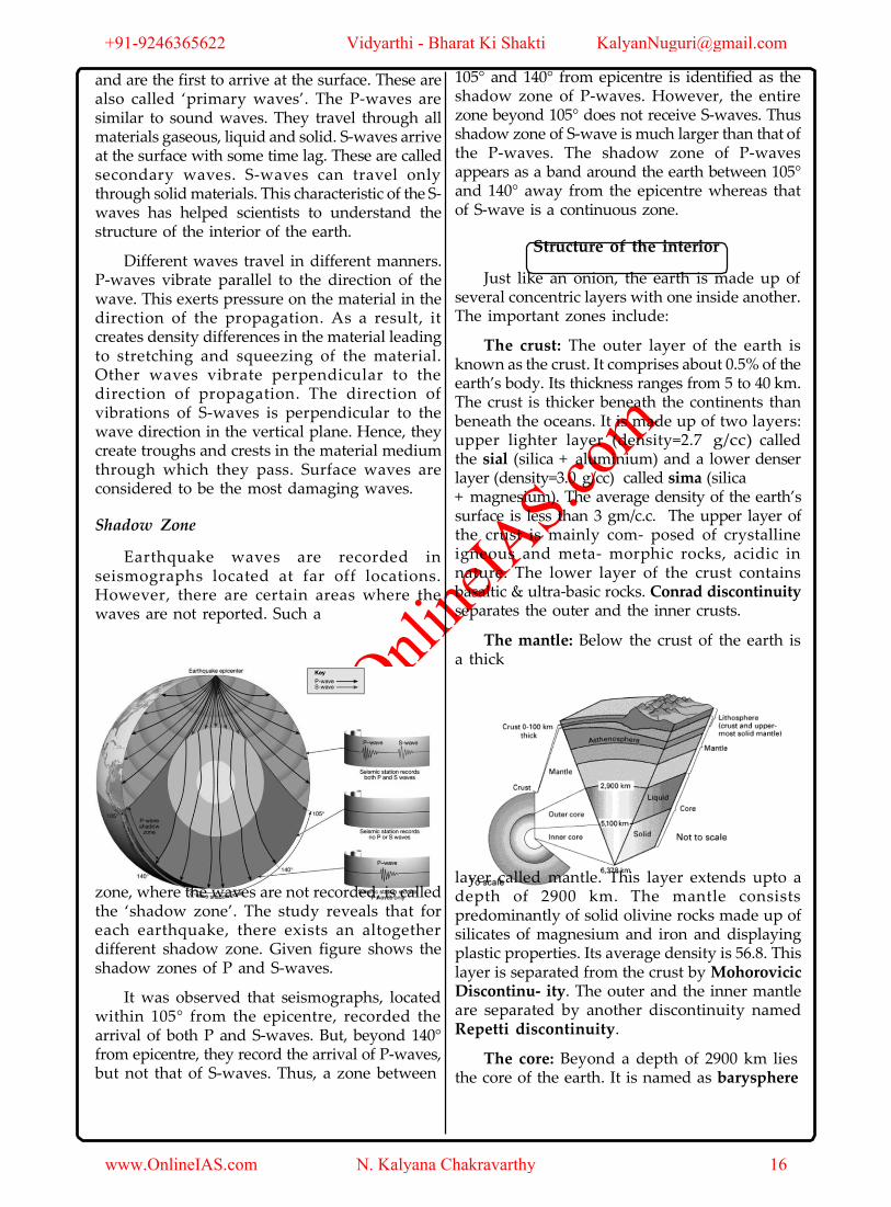
The study of seismic waves provides a complete picture of the layered interior. An earthquake in simple words is shaking of the earth. It is a natural event. It is caused due to release of energy, which generates waves that travel in all directions. The energy waves travelling in different directions reach the surface.
Earthquake waves are basically of two types- body waves and surface waves. Body waves are generated due to the release of energy at the focus and move in all directions travelling through the body of the earth. They interact with the surface rocks and generate new set of waves called surface waves. These waves move along the surface. The velocity of waves changes as they travel through materials with different densities. Denser the material, higher is the velocity.
There are two types of body waves. They are called P and S-waves. P-waves move faster
+91-9246365622 Vidyarthi - Bharat Ki Shakti [email protected]
www.OnlineIAS.com N. Kalyana Chakravarthy 15
www.Onli
neIA
S.com
and are the first to arrive at the surface. These are also called ‘primary waves’. The P-waves are similar to sound waves. They travel through all materials gaseous, liquid and solid. S-waves arrive at the surface with some time lag. These are called secondary waves. S-waves can travel only through solid materials. This characteristic of the S-waves has helped scientists to understand the structure of the interior of the earth.
Different waves travel in different manners. P-waves vibrate parallel to the direction of the wave. This exerts pressure on the material in the direction of the propagation. As a result, it creates density differences in the material leading to stretching and squeezing of the material. Other waves vibrate perpendicular to the direction of propagation. The direction of vibrations of S-waves is perpendicular to the wave direction in the vertical plane. Hence, they create troughs and crests in the material medium through which they pass. Surface waves are considered to be the most damaging waves.
Shadow Zone
Earthquake waves are recorded in seismographs located at far off locations. However, there are certain areas where the waves are not reported. Such a
105° and 140° from epicentre is identified as the shadow zone of P-waves. However, the entire zone beyond 105° does not receive S-waves. Thus shadow zone of S-wave is much larger than that of the P-waves. The shadow zone of P-waves appears as a band around the earth between 105° and 140° away from the epicentre whereas that of S-wave is a continuous zone.
Structure of the interior
Just like an onion, the earth is made up of several concentric layers with one inside another. The important zones include:
The crust: The outer layer of the earth is known as the crust. It comprises about 0.5% of the earth’s body. Its thickness ranges from 5 to 40 km. The crust is thicker beneath the continents than beneath the oceans. It is made up of two layers: upper lighter layer (density=2.7 g/cc) called the sial (silica + aluminium) and a lower denser layer (density=3.0 g/cc) called sima (silica + magnesium). The average density of the earth’s surface is less than 3 gm/c.c. The upper layer of the crust is mainly com- posed of crystalline igneous and meta- morphic rocks, acidic in nature. The lower layer of the crust contains basaltic & ultra-basic rocks. Conrad discontinuity separates the outer and the inner crusts.
The mantle: Below the crust of the earth is a thick
zone, where the waves are not recorded, is called the ‘shadow zone’. The study reveals that for each earthquake, there exists an altogether different shadow zone. Given figure shows the shadow zones of P and S-waves.
It was observed that seismographs, located within 105° from the epicentre, recorded the arrival of both P and S-waves. But, beyond 140° from epicentre, they record the arrival of P-waves, but not that of S-waves. Thus, a zone between
layer called mantle. This layer extends upto a depth of 2900 km. The mantle consists predominantly of solid olivine rocks made up of silicates of magnesium and iron and displaying plastic properties. Its average density is 56.8. This layer is separated from the crust by Mohorovicic Discontinu- ity. The outer and the inner mantle are separated by another discontinuity named Repetti discontinuity.
The core: Beyond a depth of 2900 km lies the core of the earth. It is named as barysphere
+91-9246365622 Vidyarthi - Bharat Ki Shakti [email protected]
www.OnlineIAS.com N. Kalyana Chakravarthy 16

www.Onli
neIA
S.com
and also nife (nickel and ferrous). Average thickness is 4671 kms. Average density is 17.2. By volume it constitutes 17% of the earth’s body. The temperature of the core is about 200°c. The core is believed to be a reason for the earth’s magnetism. It is separated from the mantle by Gutenburg-Wiechert Discontinuity.
Lithosphere & Aesthenosphere: Beneath
the upper mantle there is a soft layer in which the mantle rock is at the temperature close to the melting point. It sets in at an average depth of about 80 km which is well below the base of the continental crust. This layer is called as “Aesthenosphere” and the rigid layer above it is called as “lithosphere”. The aesthenosphere extends to a depth of about 400 km.
Composition and properties of different layers of the earth
Name of the Chemical Average Density Physical Properties
layer Composition Thickness (g cm-3) (km)
A.(i) Crust Sial 6 to 45 2.2 to 2.9 Solid part of lithosphere; partly molten under the continents.
The solid crust and upper mantle
It transmits both S-
and P-wave but with
reduced velocities.
Slightly solid and slightly plastic material close to melting point.
Transition zone of mixed metals and silicate
Liquid or in a plastic state. Fe, Ni and S mixture.
Iron and nickel. Solid and rigid due to tremendous overlying pressure.
(ii)
Inner part of
Outer silicate
45 to 100
lithosphere layer, Basaltic
B Aesthenosphere 50 to 400
C.(i)
Upper Mantle
Sima (Peridotite
100 to 1700
3.1 to 4.75
(mainly under iron- magnesium-
oceans) rich silicate rock)
(ii)
Lower Mantle
Wholly Sima
1700 to2900
4.75 to 5.6 (Olivine-
Ultrabasic rocks)
D.(i) Outer core Nife 2900 to 4980 9.9 - 12.3
(ii)
Inner core
Barysphere (heavy
4980 to 6400
13.5
metallic rocks)
Temperature: In upper 100 km the increase in temperature is estimated at the rate of 12°C per km descend. In the next 300 km, the increase is of 2°C per km and below that the rate of increase is 1°C per km. In the core the temperature is about 2000°C. But at the same time there is a huge pressure of overlying layers of the earth’s interior. So even under extremely high temperature towards the central part of the earth the liquid nature of the earth core has acquired the properties of a solid and is probably in a plastic state.
Composition of the Earth
1. Iron 35%
2. Oxygen 30%
3. Silicon 15%
4. Magnesium 13%
5. Nickel 2.4%
6. Sulphur 1.9%
7. Calcium 1.1%
8. Aluminium 1.1%
+91-9246365622 Vidyarthi - Bharat Ki Shakti [email protected]
www.OnlineIAS.com N. Kalyana Chakravarthy 17

www.Onli
neIA
S.com
IAS
Continental drift
The theory of continental drift, expounded by Alfred Wegener in 1915, holds that portions of the original continent which comprised the entire landmass of the world underwent a series of horizontal displacement before the present continents were formed.
According to this theory, about 280 million years ago, the entire landmass formed one super continent, called Pangea. According to Wegener, after the breaking of the super continent pangae, the movement of the continents took place in two directions- one towards the equator due to centrifugal force of the earth which gave rise to fold mountains like the Himalayas, the alps, etc. and another towards west due to tidal force of sun and the moon which gave rise to Andes and Rockies.
A glance at the world map shows that S. America particularly Brazil can be fitted into the Gulf of Guinea of Africa; Antarctica can roughly be fitted into S. Australian coast and S.E-African coast. Similarly NW-Australian coast and E- Indian coast are liable to fit. After the drifts some water bodies developed between them. Geological evidences prove that S. America and Africa were probably joined together till the upper Triassic. Biological history of certain animals like marsupials and placental mammals also throw significant light on the continental drift.
called “aesthenosphere” and carry the continents and oceans on their back. The edges of the plates are designed as boundaries and margins, where movements occur.
Major plates of the world are:
1. American plate 2. Pacific plate 3. Antarctic plate 4. African plate 5. European plate and 6. Australian plate.
Some minor plates are:
1. Caribbean plate. 2. Cocas plate 3. Nazca plate 4. Juan de Fuca plate 5. Philippine plate, etc.
All these plates are in constant motion both in relation to each other and with regard to the earth’s motion. Some movements are responsible for the volcanic activities, seismic and other plate disturbances on the margins of the plates.
Types of movements of plates
A. Convergence: When the oceanic lithosphere moves towards the continental lithosphere, due to its thickness the continental crust is unable to go down and it is the oceanic crust which is involved in subduction. The downwent plate of the oceanic crust melts and produces magma. This magma rises
Plate Tectonics
Plate tectonics deals with rock structures which are in the form of the plates and it is not only the continents which are in motion but the oceans as well. These plates include not only the earth’s upper crust but also the part of denser mantle below. They have an average thickness of 100 km. They float on the plastic upper mantle
slowly and emerges as intrusive igneous rock in the form of volcanic mountains on the continental crust. Thus origin of volcanic mountains like Andes takes place.
+91-9246365622 Vidyarthi - Bharat Ki Shakti [email protected]
www.OnlineIAS.com N. Kalyana Chakravarthy 18

www.Onli
neIA
S.com
When the two oceanic lithospheres lie on both side of subduction, then either of the two plates may subduct. The subducted part melts and the magma rises above the oceanic surface and volcanic islands are formed in arc form like Aleutian island, Kuril Island, Ryuku Island, etc.
When the continental lithosphere lies on both sides of subduction, the sediments get scrapped off the descending plate margin. In the next stage the two continents collide, squeezing the sediment mass and throwing it into complicated fold and high alpine ranges like Himalayas and Alps are formed.
B. Divergence/continental rupturing: It is
also termed as “ocean floor spreading”. Deep beneath the continental plate a column of heated mantle rock begins to rise and reach the plate above, causing the plate to fracture, which is called “continental rupture”. At first block mountains are formed. Next a long narrow valley called “rift valley” appears. The widening crack in its center is continuously filled in with magma rising from the mantle below. The magma solidifies to form new crust and also a new oceanic crust and lithosphere.
C. Parallel movements of plates: Parallel plates, as they slide past each other along a common boundary, do not create a new crust or destroy the old one but they produce “transform faults” which are fractures in rock formation. Fractures imply displacement of rocks. As the plates continue to move, the locked rocks snap. They shift violently back to equilibrium like a bent - stick breaking. This violent shift causes earth - quakes.
+91-9246365622 Vidyarthi - Bharat Ki Shakti [email protected]
www.OnlineIAS.com N. Kalyana Chakravarthy 19

www.Onli
neIA
S.com
MINERALS & ROCKS
Minerals
A mineral is a naturally occurring substance that is solid and stable at room temperature, representable by a chemical formula, usually abiogenic, and has an ordered atomic structure
Mineral are divided as follows:
A. Metallic Minerals
These minerals contain metal content and can be sub-divided into three types:
(i) Precious metals: gold, silver, platinum etc.
(ii) Ferrous metals: iron and other metals often
mixed with iron to form various kinds of steel.
(iii) Non-ferrous metals: include metals like copper, lead, zinc, tin, aluminium etc.
B. Non-Metallic Minerals
These minerals do not contain metal content. Sulphur, phosphates and nitrates are examples of non-metallic minerals. Cement is a mixture of non-metallic minerals.
Some Major Minerals and Their Characteristics
• Feldspar
Silicon and oxygen are common elements in all types of feldspar and sodium, potassium, calcium, aluminium etc. are found in specific feldspar variety. Half of the earth’s crust is composed of feldspar. It has cream to salmon pink colour. It is used in ceramics industries.
• Quartz
It is one of the most important components of sand and granite. It consists of silica. It is a hard mineral virtually insoluble in water. It is white or colourless and used in radio and radar. It is one of the most important components of granite.
• Pyroxene
Pyroxene consists of calcium, aluminum,
magnesium, iron and silica. Pyroxene forms 10 per cent of the earth’s crust. It is commonly found in meteorites. It is in green or black colour.
• Amphibole
Aluminium, calcium, silica, iron, magnesium are the major elements of amphiboles. They form 7 per cent of the earth’s crust. It is in green or black colour and is used in asbestos industry. Hornblende is another form of amphiboles.
• Mica
It comprises of potassium, aluminium, magnesium, iron, silica etc. It forms 4% of the earth’s crust. Commonly found in igneous and metamorphic rocks, it is used in electrical instruments.
• Olivine
Magnesium, iron and silica are major elements of olivine. It is used in jewellery. It is usually a greenish crystal, often found in basaltic rocks. Other minerals like chlorite, calcite, magnetite, haematite, bauxite and barite are also present in some quantities in the rocks.
Rocks
The earth’s crust is composed of rocks. A rock is an aggregate of one or more minerals. Rock may be hard or soft and in varied colours. For example, granite is hard, sandstone is soft. Gabbro is black and quartzite can be milky white. Rocks do not have definite composition of mineral constituents. Feldspar and quartz are the most common minerals found in rocks.
The crustal rocks are classified on the basis of mode of formation, physical and chemical properties, location etc. On the basis of mode of formation the rocks are divided into three categories (i) igneous rocks (ii) sedimentary rocks (iii) metamorphic rocks.
A) Igneous rocks
As igneous rocks form out of magma and lava from the interior of the earth, they are known as primary rocks. The igneous rocks are
+91-9246365622 Vidyarthi - Bharat Ki Shakti [email protected]
www.OnlineIAS.com N. Kalyana Chakravarthy 20

www.Onli
neIA
S.com
formed when magma cools and solidifies. When magma in its upward movement cools and turns into solid form it is called igneous rock. The process of cooling and solidification can happen in the earth’s crust or on the surface of the earth.
Igneous rocks are characterized on the basis of texture. Texture depends upon size and arrangement of grains or other physical conditions of the materials. If molten material is cooled slowly at great depths, mineral grains may be very large. Sudden cooling (at the surface) results in small and smooth grains. Intermediate conditions of cooling would result in intermediate sizes of grains making up igneous rocks. Granite, gabbro, pegmatite, basalt, volcanic breccia and tuff are some of the examples of igneous rocks.
Igneous rocks are roughly hard rocks and water percolates with great difficulty. They do not have strata and are less affected by chemical weathering. They don’t contain fossils. The number of joints increases upwards. They are mostly associated with volcanic activity.
They are classified on several grounds as mentioned below:
(a) On the basis of silica content:
(i) Acidic igneous rocks have more silica e.g. Granites
(ii) Basic igneous rocks have less silica e.g. Gabbro.
(b) On the basis of chemistry and mineralogical composition:
(i) Felsic igneous rock (feldspar is dominant)
(ii) Mafic igneous rock (magnesium and ferrous
are dominant)
(iii) Ultra mafic igneous rock (Peridotite and dunite are dominant).
(c) On the mode of occurrence:
(i) Intrusive igneous rocks— they are cooled and solidified below the surface of the earth. They are further divided into plutonic and hypabyssal igneous rocks. Plutonic rocks cool deep beneath the earth e.g. Granite. Hypabyssal rocks cool just beneath the earth surface e.g. Batholith, laccolith, phacolith, lapolith, sills, dykes, etc.
(ii) Extrusive igneous rocks are formed due to cooling and solidification of hot and molten lava at the earth’s surface e.g. Basalt, Gabbro, obsidian.
B) Sedimentary rocks
The word ‘sedimentary’ is derived from the Latin word sedimentum, which means settling. Rocks (igneous, sedimentary and metamorphic) of the earth’s surface are exposed to denudational agents, and are broken up into various sizes of fragments. Such fragments are transported by different exogenous agencies and deposited. These deposits through compaction turn into rocks. This process is called lithification. In many sedimentary rocks, the layers of deposits retain their characteristics even after lithification. Hence, we see a number of layers of varying thickness in sedimentary rocks like sandstone, shale etc.
Depending upon the mode of formation, sedimentary rocks are classified into three major groups: (i) mechanically formed - e.g. sandstone, conglomerate, shale, loess etc. (ii) organically formed - e.g. chalk, limestone, coal etc. (iii) chemically formed – e.g. chert, halite, potash etc.
These rocks are formed due to aggregation and compaction of sediments. These rocks contain fossils of plants and animals. They cover 75 percent of surface area of the globe. However they form only 5 percent of the volume of earth’s crust. They contain several layers or strata but these are seldom crystalline rocks. They are seldom found in original and horizontal manner. They may be well consolidated, poorly consolidated and even unconsolidated. They are characterized by different sizes of joints. Most sedimentary rocks are porous and permeable.
The formation of sedimentary rocks takes place in three stages:
• Transportation: after weathering and erosion the fragments of parental rocks are transported by the agents of erosion like stream, wind, air, etc.
• Deposition: transported materials are deposited in sea, lakes, etc. The particles are deposited in parallel layers and their process of layer formation is called “stratification”.
• Consolidation: when the number of layer
+91-9246365622 Vidyarthi - Bharat Ki Shakti [email protected]
www.OnlineIAS.com N. Kalyana Chakravarthy 21

www.Onli
neIA
S.com
is large, the weight of upper layer begins to affect the lower layers and the further compression solidifies the sediments into rocks.
They are classified under different schemes:
1. On the basis of nature of sediments:
(a) Mechanically formed or clastic rocks e.g. Sandstones. Conglomerates, clay rock, shale, loess.
(b) Chemically formed sedimentary rocks e.g. gypsum, salt rock.
(c) Organically formed sedimentary rocks e.g. Limestone, dolomites, coal, peats, etc.
2. On the basis of transporting agents:
(i) Argillaceous or aqueous rocks: (a) Marine rocks, (b) Lacustrine rocks, (c) Riverine rocks
(ii) Aeolian rocks e.g. Loess.
(iii) Glacial sedimentary rocks e.g. Till, moraine.
C). Metamorphic rocks
The word metamorphic means ‘change of form’. These rocks form under the action of pressure, volume and temperature (PVT) changes. Metamorphism occurs when rocks are forced down to earth’s interior by tectonic processes or when molten magma rising through the crust comes in contact with the crustal rocks or the underlying rocks are subjected to great amounts of pressure by overlying rocks. Metamorphism is a process by which already consolidated rocks undergo recrystallization and reorganization of materials within original rocks.
Mechanical disruption and reorganization of the original minerals within rocks due to breaking and crushing without any appreciable chemical changes is called dynamic metamorphism. The materials of rocks chemically alter and recrystallize due to thermal metamorphism. There are two types of thermal metamorphism - contact metamorphism and regional metamorphism.
In contact metamorphism the rocks come in contact with hot intruding magma and lava and the rock materials recrystallize under high temperatures. Quite often new materials form out of magma or lava are added to the rocks.
In regional metamorphism, rocks undergo recrystallization due to deformation caused by tectonic shearing together with high temperature or pressure or both. In the process of metamorphism in some rocks grains or minerals get arranged in layers or lines. Such an arrangement of minerals or grains in metamorphic rocks is called foliation or lineation.
Sometimes minerals or materials of different groups are arranged into alternating thin to thick layers appearing in light and dark shades. Such a structure in metamorphic rocks is called banding and rocks displaying banding are called banded rocks. Types of metamorphic rocks depend upon original rocks that were subjected to metamorphism.
Metamorphic rocks undergo complete alteration in the appearance of pre-existing rocks due to change in mineral composition and texture through temperature and pressure changes. Gneiss, granite, slate, schist, marble, quartzite etc. are some examples of metamorphic rocks. They are classified as mentioned below:
1. Contact or thermal metamorphism: here metamorphism occurs when the mineral composition of the surrounding rocks is changed due to intense heat e.g. Limestone is changed to marble.
2. Regional or dynamic metamorphism: here pressure plays an important role so that rocks are altered in their forms in an extensive area.
Rock Cycle
Rocks do not remain in their original form for long but may undergo transformation. Rock cycle is a continuous process through which old rocks are transformed into new ones. Igneous rocks are primary rocks and other rocks (sedimentary and metamorphic) form from these primary rocks. Igneous rocks can be changed into metamorphic rocks. The fragments derived out of igneous and metamorphic rocks transform into sedimentary rocks. Sedimentary rocks themselves can turn into fragments and the fragments can be a source for formation of other sedimentary rocks. The crustal rocks (igneous, metamorphic and sedimentary) once formed may be carried down into the mantle (interior of the earth) through subduction process (parts
+91-9246365622 Vidyarthi - Bharat Ki Shakti [email protected]
www.OnlineIAS.com N. Kalyana Chakravarthy 22

www.Onli
neIA
S.com
or whole of crustal plates going down under another plate in zones of plate convergence). The same can melt down due to increase in temperature in the interior and turn into molten magma, the original source for igneous rocks.
+91-9246365622 Vidyarthi - Bharat Ki Shakti [email protected]
www.OnlineIAS.com N. Kalyana Chakravarthy 23

www.Onli
neIA
S.com
FORCES EFFECTING THE EARTH MOVEMENTS
The forces which affect the earth’s movement are involved in the creation, destruction, recreation and maintenance of various types of relief features of varying magnitudes. On the basis of origin these forces are divided into (i) endogenetic forces and (ii) exogenetic forces. While endogenetic forces create relief features on the earth’s surface, the exogenetic forces through their erosional and depositional activities destroy them and help in the planation process.
Endogenetic forces
Term endogenic refers to internal processes and phenomena that occur beneath the Earth's surface. These forces are divided into sudden forces and diastrophic forces.
(a) Sudden forces: events like earthquake and volcanic eruption occur suddenly and the resultant forces work very quickly. They are constructive forces as they create cones, lakes, plateaus, lava plains etc.
(b) Diastrophic forces: they include both vertical and horizontal movements.
(i) Vertical movement: they include emergence and subsidence of land masses. Emergence may occur due to upliftment of the whole continent or part there of or upliftment of coastal land of the continents. Submergence may occur when the land near the sea coast subsides below sea level.
(ii) Horizontal movement: these forces work into two ways
a) In opposite direction - this includes tensional or divergent forces which create faults, rupture, fracture, cracks etc.
b) Towards each other - This includes compressional or convergent forces which create folding, warping etc.
Folding:
It is the process whereby the rock strata are bent into a series of arches (anticlines) and toughs
(syncline) as a result of horizontal earth movements which cause compression within the crust. The anticlines of the folds generally form the mountains and the adjacent synclines form the valleys. Most of the mountain ranges of the world consist of Fold Mountains e.g. the Alps, the Andes, the Rockies and the Himalayas.
Geometry of Folds - Folds are described by their form and orientation. The sides of a fold are called limbs. The limbs intersect at the tightest part of the fold, called the hinge. A line connecting all points on the hinge is called the fold axis. In the diagrams above, the fold axes are horizontal, but if the fold axis is not horizontal the fold is called a plunging
fold and the angle that the fold axis makes with a horizontal line is called the plunge of the fold. An imaginary plane, that includes the fold axis and divides the fold as symmetrically as possible, is called the axial plane of the fold.
Types of Folds
Not all folds are equal on both sides of the axis of the fold. Those with limbs of relatively equal length are termed symmetrical, and those with highly unequal limbs are asymmetrical. Asymmetrical folds generally have an axis at an angle to the original unfolded surface they formed on. Other kinds of folds are:
• Anticlines - Up folds.
When the upper part of the fold is eroded away, the oldest rocks are in the center of the fold, and the youngest rocks are on
+91-9246365622 Vidyarthi - Bharat Ki Shakti [email protected]
www.OnlineIAS.com N. Kalyana Chakravarthy 24

www.Onli
neIA
S.com
each side. Also, the rocks dip (or slope) away from the central axis of the fold.
• Synclines - Down folds.
When the upper part of the fold is eroded away, the youngest rocks are in the center of the fold, and the oldest rocks are on each side. Also, the rocks dip toward the central axis of the fold.
• Monoclines - a bend in otherwise horizontal strata.
• Isoclinal folds have undergone greater stress that has compressed the limbs of the folds tightly together.
• The limbs of overturned folds dip in the same direction, indicating that the upper part of the fold has overridden the lower part. Depending
by the sinking of a block of land between two more or less parallel faults. Examples: East African rift valley, Narmada and Tapti valleys.
Columns of faulting bring four distinguishable landforms as:
I. Rift valley: it is the result of the subsidence of the central column. When the central column of the two fault-lines subsides, the rift valley is made. "Damodar valley" is such an example.
II. Ramp valley: when both side columns are raised and the central column is standstill, then the made landform is ramp valley. "Brahmaputra" river passes through a ramp valley.
III. Block Mountain: this is the result of the subsidence of side column. The central column gets
on where the exposure is in an overturned fold, the oldest strata might actually be on top of the sequence and be misinterpreted as the youngest rock unit.
• Recumbent folds, found in areas of the greatest tectonic stress, are folds that are so overturned that the limbs are essentially horizontal and parallel.
• Chevron: angular fold with straight limbs and small hinges.
Faulting:
It is the process by which the tensional earth movements under the effect of considerable pressure create a fracture in the earth's crust. Faulting gives rise to relief features like block mountains (horsts), rift valleys, etc. A rift valley is a long, relatively narrow depression formed
steep rim along the fault scarps and the raised landform is Block Mountain. "Satpura hills" of India is such an example.
IV. Horst: Horst is a similar landform but is supposed to be due to upward force from beneath the central column. Side-columns are standstill. "Harz Mountain" of Germany is an example.
Exogenetic forces
Exogenic forces refer to external processes and phenomena that occur on or above the Earth's surface. Comet and meteoroid impacts, the tidal force of the moon and sun's radiations are all exogenic. Weathering effects and erosion are also exogenic processes. They also affect the planation processes. These are also called denudational or destructive forces. The erosional process is affected by running water, ground water, glaciers, sea waves etc. These processes form erosional and depositional land forms.
WEATHERING & EROSION
+91-9246365622 Vidyarthi - Bharat Ki Shakti [email protected]
www.OnlineIAS.com N. Kalyana Chakravarthy 25

www.Onli
neIA
S.com
Weathering
Weathering is the process of disintegration and decomposition of rocks while erosion is the process of removal, transportation and deposition of the weathered particles. These processes together are known as “Denudation.”
Weathering is defined as mechanical disintegration and chemical decomposition of rocks through the actions of various elements of weather and climate. Weathering process brings mechanical disintegration and chemical decaying of rocks. Weather conditions are the most decisive phenomenon hence the name weathering. However the type and rate of weathering are also influenced by rock structure, topography and vegetation. Weathering is a static process. It is also the process of soil genesis. It is of three types:
I. Mechanical Weathering: When a region undergoes mechanical weathering, rocks are broken into small pieces. Physical or mechanical weathering processes depend on some applied forces. The applied forces could be: (i) gravitational forces such as overburden pressure, load and shearing stress; (ii) expansion forces due to temperature changes, crystal growth or animal activity; (iii) water pressures controlled by wetting and drying cycles.
Many of these forces are applied both at the surface and within different earth materials leading to rock fracture. Most of the physical weathering processes are caused by thermal expansion and pressure release. These processes are small and slow but can cause great damage to the rocks because of continued fatigue the rocks suffer due to repetition of contraction and expansion.
This mechanical disintegration takes place in different ways.
(a) Frost Action: Frost weathering occurs due to growth of ice within pores and cracks of rocks during repeated cycles of freezing and
melting. This process is most effective at high elevations in mid-latitudes where freezing and melting is often repeated. Glacial areas are subject to frost wedging daily. In this process, the rate of freezing is important. Rapid freezing of water causes its sudden expansion and high pressure.
The resulting expansion affects joints, cracks and small inter granular fractures to become wider and wider till the rock breaks apart.
(b) Thermal Expansion and Contraction: Various minerals in rocks possess their own limits of expansion and contraction. With rise in temperature, every mineral expands and pushes against its neighbour and as temperature falls, a corresponding contraction takes place. Because of diurnal changes in the temperatures, this internal movement among the mineral grains of the superficial layers of rocks takes place regularly. This process is most effective in dry climates and high elevations where diurnal temperature changes are drastic. Though these movements are very small they make the rocks weak due to continued fatigue.
The surface layers of the rocks tend to expand more than the rock at depth and this leads to the formation of stress within the rock resulting in heaving and fracturing parallel to the surface. Due to differential heating, the resulting expansion and contraction of surface layers and their subsequent exfoliation from the surface results in smooth rounded surfaces of rocks.
In rocks like granites, smooth surfaced and rounded small to big boulders called tors form due to such exfoliation. In the area of hot deserts, the diurnal range of temperature brings the expansion and contraction of surface rocks, leading to their disintegration into smaller pieces.
(c) Exfoliation: This is the expansion by
+91-9246365622 Vidyarthi - Bharat Ki Shakti [email protected]
www.OnlineIAS.com N. Kalyana Chakravarthy 26

www.Onli
neIA
S.com
unloading process. Unloading occurs when large igneous bodies are exposed through the erosional removal of overlying rock and the reduction in the pressure. On being exposed to the surface they expand slightly in volume. This leads to the peeling of thick shells like an onion’s layers from the parent rock.
(d) Spalling: When there is a sudden shower in the hot desert area, the highly heated rocks when struck by sudden drizzle develop numerous cracks.
(e) Cavernous Weathering: It occurs generally in hot arid region and also in the rocks of coastal area.
(f) Salt Weathering: Salts in rocks expand due to thermal action, hydration and crystallization. Many salts like calcium, sodium, magnesium, potassium and barium have a tendency to expand. Expansion of these salts depends on temperature and their thermal properties. High temperature ranges between 30°C and 50°C of surface temperatures in deserts favour such salt expansion.
Salt crystals in near-surface pores cause splitting of individual grains within rocks, which eventually fall off. This process of falling off of individual grains may result in granular disintegration or granular foliation.
Salt crystallization is most effective of all salt-weathering processes. In areas with alternating wetting and drying conditions salt crystal growth is favoured and the neighbouring grains are pushed aside. Sodium chloride and gypsum crystals in desert areas heave up overlying layers of materials and with the result polygonal cracks develop all over the heaved surface. With salt crystal growth, chalk breaks down most readily, followed by limestone, sandstone, shale, gneiss and granite etc.
(g) Sheeting: The development of cracks and fractures, parallel to the ground surface, caused by removal of superincumbent load.
(h) Cambering process: Due to expansion caused by unloading of super-incombitant load and consequent release of confining pressure.
(i) Flaking: Different heating of outer and lower shells of a rock mass causes flaking.
II. Chemical Weathering: It changes the basic properties of the rock. Principal processes of chemical weathering are:
(a) Solution: Here the rocks are completely dissolved. This process involves removal of solids in solution and depends upon solubility of a mineral in water or weak acids.
On coming in contact with water many solids disintegrate and mix up as suspension in water. Soluble rock forming minerals like nitrates, sulphates and potassium etc. are affected by this process. So, these minerals are easily leached out without leaving any residue in rainy climates and accumulate in dry regions. Minerals like calcium carbonate and calcium magnesium bicarbonate present in limestones are soluble in water containing carbonic acid (formed with the addition of carbon dioxide in water), and are carried away in water as solution. Carbon dioxide produced by decaying organic matter along with soil water greatly aids in this reaction. Common salt (sodium chloride) is also a rock forming mineral and is susceptible to this process of solution.
(b) Oxidation and Reduction: In weathering, oxidation means a combination of a mineral with oxygen to form oxides or hydroxides. Oxidation occurs where there is ready access to the atmosphere and oxygenated waters. The minerals most commonly involved in this process are iron, manganese, sulphur etc. Though it is a universal phenomenon but it is more apparent in rocks containing iron.
In the process of oxidation rock breakdown occurs due to the disturbance caused by addition of oxygen. Red colour of iron upon oxidation turns to brown or yellow. When oxidized minerals are placed in an environment where oxygen is absent, reduction takes place. Such conditions exist usually below the water table, in areas of stagnant water and waterlogged ground. Red colour of iron upon reduction turns to greenish or bluish grey.
(c) Hydration: Hydration is the chemical
+91-9246365622 Vidyarthi - Bharat Ki Shakti [email protected]
www.OnlineIAS.com N. Kalyana Chakravarthy 27

www.Onli
neIA
S.com
addition of water. Most of the rock-forming minerals absorb water. Minerals take up water and expand. This not only increases their volume but also produces chemical changes resulting in the formation of new minerals which are softer and more voluminous. E.g. this process converts hematite into limonite. Calcium sulphate takes in water and turns to gypsum, which is more unstable than calcium sulphate.
This process is reversible and long, continued repetition of this process causes fatigue in the rocks and may lead to their disintegration. Many clay minerals swell and contract during wetting and drying and a repetition of this process results in cracking of overlying materials. Salts in pore spaces undergo rapid and repeated hydration and help in rock fracturing. The volume changes in minerals due to hydration will also help in physical weathering through exfoliation and granular disintegration.
(d) Carbonation: Carbonation is the reaction of carbonate and bicarbonate with minerals and is a common process helping the breaking down of feldspars and carbonate minerals. Carbon dioxide from the atmosphere and soil air is absorbed by water, to form carbonic acid that acts as a weak acid. Calcium carbonates and magnesium carbonates are dissolved in carbonic acid and are removed in a solution without leaving any residue resulting in cave formation.
(e) Hydrolysis: The mineral of the rocks and water molecules react in such a way that new mineral compounds are formed. Silicate minerals are most affected by defrosts.
(f) Chelation: Chelation is a complex organic process by hydrocarbon molecules. Chelation is form of Chemical weathering by plants.
These weathering processes are interrelated. Hydration, carbonation and oxidation go hand in hand and hasten the weathering process.
III. Biological Weathering: This type of weathering is performed by the tree roots, animals and human beings. As the plant roots grow, they wedge the rocks apart and cause the widening of joints and other fractures. Micro animals like earthworms, ants, termites and other burrowing animals
move materials to or near the surface where they are more closely subjected to chemical weathering.
Erosion
Erosion is concerned with the various ways in which the mobile agencies acquire and remove rock debris. The acquisition of materials by the mobile agencies and their transport, i.e. corrasion and transportation are considered to be the integral part of erosion. The principal erosional agents are running water, groundwater, glaciers, wind and coastal waves. Each of the agents does erosion by distinctive processes and gives rise to distinctive landforms. There are five common aspects of erosion by the above mentioned agents.
(1) The acquisition of rocks fragments.
(2) Wearing away of rocks fragments.
(3) The breaking down of the rock particles by mutual wear while in transit.
(4) Transportation of the acquired rock debris.
(5) Ultimately the deposition in the low lying areas.
Mass Wasting
Mass wasting is the movement of material down a slope under the influence of gravity. It is a transitional phenomenon between weathering and erosion. Mass Wasting is of Various Types: Land-slide, Debris avalanche, Earth-flow, Mud-flow, and Sheet-flow etc.
(a) Soil creep: In soil covered slope extremely slow downslope movement of soil and over burden may be found. This process is called as soil creep.
(b) Talus cones: Steep rocks walls of gorges and high mountains shed countless rock particles under the attack of physical weathering processes.
(c) Earth Flows: In humid climate region, if slope are steep, masses of water-saturated soil due to over burden or weak bedrock may side down slope during a period of few hours.
(d) Mud flow: Rapid flowage of mud stream down a canyon floor and spreading out on plain at the foot of a mountain range is called as mud flow.
(e) Landslide: The downslope movement of regolith of bed rock is called as landslide.
+91-9246365622 Vidyarthi - Bharat Ki Shakti [email protected]
www.OnlineIAS.com N. Kalyana Chakravarthy 28

www.Onli
neIA
S.com
GEOMORPHOLOGICAL LANDFORMS
Mountains
A mountain is defined as “a natural elevation of the earth surface rising more or less abruptly from the surrounding level and attaining an altitude which, relative to the adjacent elevation, is impressive or notable”. Mountains can be classified on the basis of their structure or their origin.
A. Structural classification:
I. Fold Mountains: These mountains have originated due to compressional tectonic forces and have been thrown up to form fold mountains e.g. Himalayas, Andes, Alps etc. The folds consist of two inclined parts called limbs, the upfold is called anticline and the downward portion is called syncline.
All young folded mountains have originated from geosynclines. Geosynclines are long narrow and shallow water depressions characterized by sedimentation and the subsequent subsidence. The conversion of geosynclines into folded mountains requires geologically long time with definite phases of mountain building process-
(b) Orogenesis: After horizontal compression has completed its task, vertical uplift starts. This is the real stage of mountain building.
(c) Glyptogenesis: In this phase the characteristic land forms are sculptured by erosion.
On the basis of age the Fold Mountains can be grouped into:
(i) New or Young fold Mountains: Example: The Alps, the Himalayas, the Circum-Pacific oceanic Mountains, etc. The main features of these mountains are the complex folding of the rocks, faulting, volcanic activities, and the erosion caused by running water, ice, winds, etc.
(ii) Old Fold Mountains: Example: The Caledonian and Hercynian mountains of
central Europe, the Pennines, the Highland of Scotland, etc. These mountains were folded in very ancient times, and then subjected to denudation and uplift. Many faults were formed and the layers of the rock were wrapped. Many mountains exist as relicts due to erosion.
II. Block Mountains: They are originated by tensile forces leading to formation of rift valleys. They are also called horst mountains e.g. black forest, Vosges, Vindhya, Satpura, Sierra Nevada etc. When the crust cracks due to tension or compression faulting takes place. A section of the landform may subside or rise above the surrounding level giving rise to Rift valley or Graben and Block Mountains or Horst. The Block Mountains have a steep slope towards the rift valley but the slope on the other side is long and gentle.
III. Dome Mountains: They are originated by magmatic intrusion and upwarping of crustal surface e.g. lava domes, Batholith domes etc.
IV Mountain of Accumulation: They are originated by accumulation of volcanic material e.g. cinder cones, composite cones etc. These are formed by the emission and deposition of lava and so they are also called volcanic mountains. The slope of the mountains becomes steep and the height increases due to the development of the cones of various types like Cinder cones, Composite Cones, Acid lava cones, Basic lava cones, etc. Some of the examples of this type are Popocatepetl of Mexico, Mount Rainier of Washington, Lessen Peak of California, the Vesuvius of Italy, the Fujiyama in Japan, the Aconcagua in Chile etc.
V Circum Erosional or Relict Mountain: e.g. Vindhyachal ranges, Aravallis, Satpura, Eastern and Western Ghats, Nilgiris, Parasnath, Girnar, Rajmahal. These
+91-9246365622 Vidyarthi - Bharat Ki Shakti [email protected]
www.OnlineIAS.com N. Kalyana Chakravarthy 29

www.Onli
neIA
S.com
mountains have been subjected to weathering and erosion for a long time and lowered down. They represent the old stage of mountain life cycle.
B. Classification on the basis of Mountain Building periods
• Pre-Cambrian Mountains: Rocks of these mountains are older than the Cam- brian era, and are found in older stable blocks or old shields which are now metamorphosed. Some of those old shields are Laurentia, Fennoscandinevia (Europe), Angaraland (Asia), Gondwanaland (Asia), etc.
• Caledonian Mountains: (320 m.yrs.): Mountains of Scandinavia, Scotland, N. America, Aravallis, Mahadeo, Satpura fall under this category. This mountain building process started at the end of the Silurian period or at the beginning of the Devonian period.
• Hercynian Mountains: (240m.yrs.): These Mountains were formed during Permian and Permo-Carboniferous pe- riod. They include Appalachian in N. America, Meseta in Spain, Vosges and Black Forest in Germany, Harz, Donetz area of Ural , Altai, Kinghan ,Tien Shan, Alai, Nan-Shan, etc. Meseta Mountains in Morocco; the High Atlas Mountains also represent this category.
• Alpine Mountains (30m.yrs.): It started by the end of the Mesozoic era and con- tinued upto the Tertiary period. These are the highest mountains of the world. Being newer, the erosional forces could not erode them into a Peneplain like the Himalayas, the Alps, the Rockies, the Andes, the Atlas, etc.
Stages of Mountains Building: The life history of mountains can be divided into youth, maturity and old stage. Following are the characteristics of mountains in different stages:-
A. The Youth Mountains:
1. The rivers are youthful and the valleys are deep and their flow is fast.
2. Landslide and volcanic activities are common.
3. The mountains are high.
4. The slopes are steep and the piedmont is bare.
5. The sky line is irregular.
B. The Maturity of Mountains:
1. The rivers are mature and many water- gaps exist in the area.
2. The height of the mountains is not much.
3. The peaks are rounded, generally covered by thick vegetation.
4. Landslides are uncommon and no earthquakes are experienced.
5. Slopes are not steep. Pebbles and rock fragments are accumulated in the piedmont area.
C. The Old-Age of Mountains:
1. The rivers have attained old age.
2. Monadnocks are found denuded and are a common sight.
3. The mountains are low. Peneplain condition seems imminent.
4. The area is broad, low and leveled which has wavy hills at some places.
Plateau
Plateaus are extensive upland areas characterized by flat and rough top surface and steep walls which rise above the neighbouring ground surface at least for 300 m.
On the basis of mode of formation the plateaus can be classified into:
1. Plateaus Formed by Running Water: Many parts of the Deccan of India (Kaimur Plateau, Rewa Plateau, Rohtas Plateau, Bhander Plateau), Brazilian Plateau.
2. Plateaus formed by Glacial Erosion: Plateau of Greenland and Antarctica, Garhwal Plateau.
3. Plateaus formed by Glacial Deposition: Russian Plateau, Finland Plateau, Merg of Kashmir.
4. Aeolian plateaus: Loess Plateau of China, Potwar Plateau of Rawalpindi in Pakistan.
5. Plateaus formed by endogenic processes:
(a) Intermontane Plateaus: Tibetan Plateau,
Bolivian Plateau, Peruvian Plateau, Columbian Plateau, Mexican Plateau.
(b) Piedmont Plateaus: Appalachian Pla-
+91-9246365622 Vidyarthi - Bharat Ki Shakti [email protected]
www.OnlineIAS.com N. Kalyana Chakravarthy 30

www.Onli
neIA
S.com
teau, Patagonian Plateau, Colorado Pla- teau.
(c) Dome Plateaus: Ozark Massif (USA), Chhotanagpur Plateau.
(d) Lava Plateaus: Columbian Plateau, Mahabaleshwar Plateau.
(e) Continental Plateau: Deccan plateau, Ranchi plateau, Shillong plateau, Colum- bia Plateau, Mexican Plateau etc. etc.
(f) Coastal Plateau: Coromandal coastal upland of India.
(g) Rejuvenated Plateau: Missouri Plateau (USA).
(h) Mature Plateau: Ranchi Plateau, Hazaribagh Plateau, Appalachian Pla- teau (USA).
(i) Young Plateau: Idaho Plateau (USA), Colorado Plateau (USA), Mahabaleshwar Plateau, Khandala up- land (Maharashtra).
Plains
Plains can be defined as flat areas with low height. They may be above or below sea level e.g. coastal plains of Netherlands.
The plains may be classified as under:
1. Formation of plain due to deposition of sediments over submerged coastlands e.g. Coromandal coastal plains.
2. River deposited plains e.g. north Indian plains
3. Piedmont alluvial plain e.g. Bhabar plain
4. Flood plains e.g. Khadar and Bhangar plains
5. Lava plains e.g. plains of New Zealand, Iceland etc.
6. Glaciated plains e.g. north west Eurasian plain.
A. Erosional Plains
1. Plains of Fluvial Erosion: The plains formed by river erosion have a lot of variation because of the stages of erosional development, the initial slope and the structure of basal rocks.
(a) The Dissected Plains of the Youth: The Colorado, Kansas, Nebraska, east of the Rockies belong to this category of plains. The broad water-divides, large valleys are the main characteristics of such plains. The
drainage is dendritic in nature.
(b) The Dissected Plains of Maturity: Such plains are found in North Missouri, Southern Iowa and Eastern Nebraska of USA. Areas of gentle slope are very limited and plain areas are available more in the valleys and the water divides are reduced to small ridges.
(c) The Plains of Old Age: Peneplain and Panplains usually represent this stage of plains.
Peneplain: Very few areas like Guinea plain in the north-east S. America are fully developed peneplains. The Appalachian had developed into peneplains in the ancient times but was later uplifted again. Here the high summits are of equal heights.
Panplains: A plain formed of flood plains joined by their own strength. It is a product of lateral erosion by streams.
2. Glaciated Plains : When the ice sheet melted specially in N. America and W. Eurasia , the area eroded by ice was exposed . Here the rivers have adjusted themselves before the extension of ice sheet. Lakes, swamps, waterfalls and rapids are common.
3. Aeolian Plains: Winds blow the sand and starts the activities of deflection, abrasion, etc. The plains produced by the wind actions are Reg, Serir and Hamada.
4. Plains of Semi-arid Denudation : This type of plain includes the peneplains of USA and the pediplains of south-west of Africa.
5. Plains at Continental Edges: Theses have evolved at the sea coast by the action of waves and later uplifted. The flat plains situated at the coast of Norway fall into this category.
6. Karst Plains: They are found in limestone areas. The underground water removed the limestone layer by the process of solution. A large number of depressions are produced in these plains e.g. the coastal plain of Adriatic Sea and the Karst plain of Florida (USA).
B. Depositional Plains
1. Plains of Alluvial Deposition : The
+91-9246365622 Vidyarthi - Bharat Ki Shakti [email protected]
www.OnlineIAS.com N. Kalyana Chakravarthy 31

www.Onli
neIA
S.com
deposition of the sediments takes place in three areas - the floor , the mouth and the valley of the river where the slope suddenly decreases. The shape of such depositional plain changes according to the method and place of deposition and forms three types of plains.
• Flood Plains: Here the river deposits its sediments by meandering through its course. The flood plains of Mississippi, Ganga, Indus and Nile are good ex- amples.
• Deltaic Plains: When the river termi- nates in the sea or lake, the deltas are formed due to deposition. The deltaic plains resemble flood plains but the ex- istence of large number of distributaries provides them with a distinction. Marshes and natural levees are common here. The Deltaic plains of the Ganga, the Indus, the Nile and the Mississippi are famous.
• Piedmont Alluvial Plains: The piedmont alluvial fans combine together and form a plain. Rough particles are found at the apex but the particles of debris get finer as we move towards the periph- ery.
2. Plains of Glacial Deposition: These are found in N. America and Europe, in areas which were affected by glacial action. The surface is slightly undulating and has low and broad ridges and depressions.
3. Desert Plains of Wind Erosion: The Loess Plain of China was formed by the windblown deposition of Gobi desert, situated west of it. Some other examples of such plains are the Sahara of Africa, the Koum of Russian Turkistan, the north- central Nebraska, etc.
4. Plains of Marine Deposition: They develop near the coast of shallow sea. Sand, alluvium, vegetation, etc. are deposited at the coastal areas of Netherlands, Germany,
Denmark, The Gulf of Mexico in U.S.A., etc.
Lakes
Lakes may be defined as non-permanent features of static water on the land surface. The lakes can be classified as under:
1. Fresh water lakes e.g. the great lakes of U.S.A.
2. Saline lakes e.g. great salt lake of Utah, Caspian sea, dead sea, lake van etc.
3. Fluvial lakes e.g. Wular lake, Marigot lake, Mayeh lake
4. Lakes formed by volcanic Activity: Crater and Caldera Lakes- Lake Oregon (USA), Lakes Toba (Sumatra)
5. Lakes formed by earth movements:
I. Tectonic Lakes: - Lake Titicaca (Andes), (highest Lake of world), Caspian Sea (Largest Lake of the world).
II. Rift valley Lakes:- Tanganyika, Malawi, Rudolf, Edward, Albert, Dead Sea (1256 ft below mean sea level the world’s Lowest Lakes)
6. Lakes formed by deposition:
I. Due to river deposits – Ox-bow Lakes
II. Due to marine deposits – Lagoons, Delta
7 Lakes formed by Erosion:
I. Karst Lakes – Lake Scutari (Yugoslavia) II. Wind – deflated Lakes (Salt Lakes & Pla-
yas)
8. Lakes formed by Glaciations:
I. Cirque Lakes of Tarns – Lake Red Tarn (U.K.)
II. Kettle Lakes – Orkney (Scotland) III. Rock-hollow Lakes – Lakes of Finland
(the land of lakes) IV. Lake due to Moraines – Lake
Windermere (U.K.) V. Lakes due to deposition of glacial drifts-
North Ireland.
+91-9246365622 Vidyarthi - Bharat Ki Shakti [email protected]
www.OnlineIAS.com N. Kalyana Chakravarthy 32

www.Onli
neIA
S.com
VOLCANOES AND EARTHQUAKES
Volcano
A volcano is a vent or opening usually circular in form through which heated materials consisting of gases, water, liquid lava and fragments of rocks are ejected from the highly heated interior to the surface of the earth. Magma is molten rock within the Earth’s crust. When magma erupts through the earth’s surface it is called lava. Lava can be thick and slow-moving or thin and fast-moving. Rock also comes from volcanoes in other forms, including ash (finely powdered rock that looks like dark smoke coming from the volcano), cinders (bits of fragmented lava), and pumice (light-weight rock that is full of air bubbles and is formed in explosive volcanic eruptions - this type of rock can float on water).
Volcanic eruptions are closely associated with several interconnected processes such as
(i) The gradual increase in temperature with increasing depth at a rate of 1°c per 32m due to heat generated by degeneration of radioactive elements inside the earth.
(ii) origin of magma because of lowering of melting point caused by reduction in pressure of overlying rocks due to fractures caused by splitting of plates
(iii) origin of gases and water vapour due to heating of water
(iv) ascent of magma due to pressure from gases and vapour
(v) Occurrence of volcanic eruption. These eruptions are closely associated with plate boundaries.
Volcanoes are classified under different schemes:
1. Classification on the basis of periodicity of eruptions:
(a) Active volcano e.g. Etna, Stromboli, Pinatubo etc.
(b) Dormant volcano e.g. Vesuvius, Barren island volcano (Andaman)
(c) Extinct volcano e.g. where no indica- tion of future eruption is estimated.
2. Classification on the basis of the mode of eruption:
(A) Volcanic of central Eruption type- Eruption occurs through a central pipe and small opening are rapid and violent. Such volcanoes are very destructive and disastrous. It is divided into 5 sub types as follow:-
(a) Hawaiian Types: Such Volcanoes erupt quietly due to less viscous Laves and non-violent natures of gases. They emit long glossy threads of red molten Lava known as peel’s hair e.g. Hawaiian Is- land.
(b) Strombolian Type: The eruptions are almost rhythmic or nearly continuous in nature but sometimes they are inter- rupted by long intervals. Ex- Stromboli volcano of Lipari island.
(c) Vulcanian Type: Such volcanoes erupt with great force and intensity The Lava is so viscous and pasty that these are quickly solidified e.g. Mt. Vulcano of Lipari Island of Mediterranean Sea.
(d) Peleean Type: Most violent and most explosive type of volcanoes, named as Nuee Ardente, meaning thus by glow- ing cloud e.g. Pelee volcano of Martinique Island in the Caribbean Sea, Krakatau volcano between Java and Sumatra in Sunda strait.
(e) Visuvian type: Extremely violent and enormous volume of gases and ashes forms which clouds like cauliflower. This is also called Plinian type.
(B) Fissure eruption or quiet eruption type e.g. Lava flow or flood, mud flow and fumaroles. Large quantities of lava quietly well up from fissure and spread out over the surrounding countryside. Successive lava flows results in the growth of a lava platform which may be extensive to be
+91-9246365622 Vidyarthi - Bharat Ki Shakti [email protected]
www.OnlineIAS.com N. Kalyana Chakravarthy 33

www.Onli
neIA
S.com
called a plateau like “Deccan” “Columbia snake plateau”, Drakensberg mountains”, “Victoria and Kimberley” districts of Australia, “ Java island”.
Plate tectonics and Volcanoes
A. Divergent plate boundaries
At the mid-oceanic ridges, two tectonic plates diverge from one another. New oceanic crust is being formed by hot molten rock slowly cooling and solidifying. The crust is very thin at mid-oceanic ridges due to the pull of the tectonic plates. The release of pressure leads to partial melting of the mantle causing volcanism and creating new oceanic crust. Most divergent plate boundaries are at the bottom of the oceans, therefore most volcanic activity is submarine, forming new seafloor. Black smokers or deep sea vents are an example of this kind of volcanic activity. Where the mid-oceanic ridge is above sea-level, volcanic islands are formed, for example, Iceland.
B. Convergent plate boundaries
Subduction zones are places where two plates, usually an oceanic plate and a continental plate, collide. In this case, the oceanic plate subducts or submerges under the continental plate forming a deep ocean trench just offshore. Water released from the subducting plate lowers the melting temperature of the overlying mantle wedge, creating magma. This magma tends to be very viscous due to its high silica content so that it often does not reach the surface and cools at depth. When it does reach the surface, a volcano is formed. Typical examples for this kind of volcano are Mount Etna and the volcanoes in the Pacific Ring of Fire.
C. Hotspots
Hotspots are not usually located on the edges of tectonic plates, above mantle plumes, where the convection of the Earth’s mantle creates a column of hot material that rises until it reaches the crust, which tends to be thinner than in other areas of the Earth. The temperature of the plume causes the crust to melt and form pipes, which can vent magma. Because the tectonic plates move whereas the mantle plume remains in the same place, each volcano
becomes dormant after a while and a new volcano is then formed as the plate shifts over the hotspot. The Hawaiian Islands are thought to be formed in such a manner, as well as the Snake River Plain, with the Yellowstone Caldera of the North American plate currently above the hot spot. Another example is India’s Deccan plateau which is the result of lava outflow from the Reunion hotspot.
Topography produced by volcanoes:
(i) Cinder or ash cone: They are of low height and are formed of volcanic dust, ashes and pyroclastic matter. Its formation takes place due to accumulation of finer particles around the volcanoes vent.
(ii) Shield volcanoes: So named for their broad, shield-like profiles, are formed by the eruption of low-viscosity lava that can flow a great distance from a vent, but not generally explode catastrophically. Since low-viscosity magma is typically low in silica, shield volcanoes are more common in oceanic settings. The Hawaiian volcanic chain is a series of shield cones, and they are common in Iceland as well.
(iii) Composite cones: They are formed due to the accumulation of different layers of various volcanic materials.
(iv) Parasite cones: When lava comes out of the minor pipes coming out of the main central pipe, parasite cones are formed.
(v) Basic lava cone: It has less quantity of silica in its lava.
(vi) Acidic lava cone: It has more silica in its lava.
(vii)Lava domes: These are formed due to accumulation of solidified lavas around the volcanic vents.
(viii)Lava plugs: They are formed due to plugging of volcanic pipes and vents when volcano becomes extinct.
(ix) Craters: The depression formed at the mouth of a volcanic vent is called a crater. When it is filled with water, it becomes a ‘crater lake’ e.g. Lake Lonar in Maharashtra.
(x) Calderas: Generally enlarged form of craters is called caldera. It is formed due to
+91-9246365622 Vidyarthi - Bharat Ki Shakti [email protected]
www.OnlineIAS.com N. Kalyana Chakravarthy 34
www.Onli
neIA
S.com
subsidence of a crater.
(xi) Geysers: They are intermittent hot springs that from time to time spout steam and hot water from their craters.
(xii)Fumaroles: It is a vent through which there is emission of gases and water vapour.
(xiii)Cryptodomes: These are formed when viscous lava forces its way up and causes a bulge. The 1980 eruption of Mount St. Helens was an example. Lava under great pressure forced a bulge in the mountain, which was unstable and slid down the north side.
(xiv)A supervolcano is a large volcano that usually has a large caldera and can potentially produce devastation on an enormous, sometimes continental, scale. Such eruptions can cause severe cooling of global temperatures for many years afterwards because of the huge volumes of sulphur and ash erupted. They are the most dangerous type of volcano. Examples include Yellowstone Caldera in Yellowstone National Park and Valles Caldera in New Mexico (both western United States), Lake Taupo in New Zealand, Lake Toba in Sumatra and Ngorogoro Crater in Tanzania. Supervolcanoes are hard to identify centuries later, given the enormous areas they cover. Large igneous provinces are also considered supervolcanoes because of the vast amount of basalt lava erupted, but are non-explosive.
Distribution of volcanoes
Volcanoes are unevenly distributed over the earth and vast areas have no active volcanoes at all. There are no volcanoes in Australia. In Asia, they are largely concentrated in circum-pacific region and Africa has a few of them. Thus, the pacific belt is truly known as the “ring of fire” because of the largest number of active volcanoes along the coasts of America and Asia around this region. Iceland, Sicily and Japan are the biggest volcanic islands in the world. Most of the volcanoes in the world occur along linear belts
or lines of weakness marked by intense folding and faulting.
Earthquake
An earthquake is a vibration or oscillation of the surface of the earth caused by a transient disturbance of the elastic or gravitational equilibrium of the rocks at or beneath the surface. The magnitude or intensity of energy released by an earthquake is measured by the richter scale. The place of the origin of an earthquake is called focus which is hidden inside the earth. The place on the ground surface which is perpendicular to the buried focus is called ‘epicentre’. Seismic waves are recorded by an instrument called ‘seismograph’. Isoseismal lines join places which experience the earthquake at the same time.
Causes of Earthquakes:
If seen broadly we can say that earthquakes are caused due to two major reasons. The first reason is the eruption of volcanoes, which are sudden. Volcanoes are seats of inner disturbance and can affect the plates which are the second cause of earthquakes. Earthquakes are caused due to disturbance in the movement of plates, which again can be caused due to various reasons like under-crust waves or cracks in the plates.
A. Plate Tectonic Theory
The outer layer of the earth is divided into many sections known as plates, which are floating on the molten magma beneath the earth’s crust. Now the movement of these plates is determined by the convection current in the molten magma. Therefore after intervals there are plates that get submerged in the molten magma and there are plates that rise upwards and at times even new crust is formed from the molten magma which in turn forms a new plate until it connects itself with the already existing ones. At times these plates and can be pushed up to form mountains and hills and the movement is so slow that it is really hard to comprehend that there is any movement at all. The movement and the results come out to be visible suddenly. Now these plates are the bases on which the continents stand and when these plates move the continents also move. Most of the earthquakes occur on the edges of the plates
+91-9246365622 Vidyarthi - Bharat Ki Shakti [email protected]
www.OnlineIAS.com N. Kalyana Chakravarthy 35

www.Onli
neIA
S.com
where a plate is under, on or across another plate. This movement disrupts the balance and position of all plates, which leads to tremors, which are called earthquakes.
B. Volcanic Eruptions
When volcanoes erupt it is because the molten magma under the crust of the earth is under enormous pressure and to release that pressure it looks for an opening and exerts pressure on the earth’s crust and the plate in turn. A place, which is the seat of an active volcano, is often prone to earthquakes as well. Earthquakes are also caused after a volcanic eruption since the eruption also leads to a disturbance in the position of plates, which either move further or resettle and can result into severe or light tremors.
The excessive exploitation of earth’s resources for our own benefits like building dams to store large volumes of water (earthquake at Koyna Nagar Township) and blasting rocks and mountains to build bridges and roads is also the reason behind such natural disruptions.
Effects
(1) Landslides and damming of the rivers in highland regions.
(2) Causes depression forming lakes. May cause faults, thrusts, folds, etc
(3) Formation of cracks or fissures in the epicenter region and some- times water, mud, gas are ejected from it.
(4) Causes the raising or lowering of parts of the sea floor e.g. “Sangami bay” in 1923. This causes “tsunamis” or tidal waves.
(5) May change surface drainage & underground circulation of water like the sudden disappearance of springs in some places.
(6) Rising and lowering of crustal regions for example in Alaska in 1899-16 m upliftment.
(7) Devastation of cities, fires, diseases, etc.
Classification of earthquakes
Earthquakes are classified on the basis of causative factors:
1. Natural earthquakes: They are caused by
endogenetic forces:
I. Volcanic earthquake: they are caused due to volcanic eruptions. E.g. Earth- quakes caused by explosion of Krakatau volcano in 1883 and Etna volcano in 1968.
II.Tectonic earthquake: they are caused due to dislocation of rock blocks during faulting e.g. 1906 earthquake of Califor- nia and 1923 earthquake of Sangami bay, Japan etc.
III. Isostatic earthquake: they are triggered due to sudden disturbance in the isos- tatic balance at regional scale due to imbalance in geological processes e.g. near active mountain building zones.
IV.Plutonic earthquakes: these are deep focus earthquakes generally located be- tween 240 and 670 km deep.
2. Artificial earthquakes: They are caused due to man-made activities like pumping water and mineral oil underground, blasting of rocks, nuclear explosion, storage of huge volume of water in reservoirs etc. Examples of earthquake due to construction of huge dams include Koyna earthquake of 1967 and Hoover dam earthquake of 1936.
Distribution of Earthquakes
About 68% of all the earthquakes are observed in the vast region of the pacific ocean known as the “ring of fire” and is closely linked with the region of crustal dislocations and volcanic eruptions. Chile, California, Alaska, Japan, Philippines, New Zealand constitute the ring of fire.
Around 21% of the earthquakes occur in the mid-word mountain belt extending parallel to the equator from Mexico across Atlantic Ocean, the Mediterranean Sea from Alpine-Caucasus ranges to the Caspian, Himalayan Mountains
+91-9246365622 Vidyarthi - Bharat Ki Shakti [email protected]
www.OnlineIAS.com N. Kalyana Chakravarthy 36

www.Onli
neIA
S.com
and the adjoining belts: the earthquakes in India are at present mainly confined to the Himalayan regions and its foot hills. They are also felt in the Ganga valley.
Points to Remember
1. The largest crater known to have formed by a meteorite is Coon Butte or Barringer crater in USA. Lonar lake of Maharashtra is the largest meteoric Crater Lake in India.
2. Earth’s rotational velocity at equator is 1690 km/hr.
3. Elastic rebound theory explains anthropogenic earthquake.
4. Earth’s magnetic north and South Pole are located on Prince of Wales Island in Canada and South Victoria island in Antarctica, respectively.
5. “Homoseismal line” is the line joining places that experience earthquake at the same time.
6. The only active volcano in India is Barren Island in Andaman-Nicobar islands.
7. Seismic waves that cause maximum destruction is ‘L’ or long waves.
8. Magnitude of earthquake is measured on Richter scale.
+91-9246365622 Vidyarthi - Bharat Ki Shakti [email protected]
www.OnlineIAS.com N. Kalyana Chakravarthy 37

www.Onli
neIA
S.com
EROSIONAL AND DEPOSITIONAL LANDFORMS
Fluvial Landforms
Rivers are a sizable stream of freshwater flowing through a natural channel in the land. Rivers are among the most powerful natural forces in shaping the earth’s surface. In draining the land of surplus water, rivers wear down mountains, plateaus, and other high landforms. In a never-ending process, eroded material is carried by rivers. Some is deposited to form floodplains in the valleys, some forms deltas at the rivers’ mouths, and some is deposited in the sea.
• Erosional Landforms
A. Valleys
Valleys start as small and narrow rills; the rills will gradually develop into long and wide gullies; the gullies will further deepen, widen and lengthen to give rise to valleys. Depending upon dimensions and shape, many types of valleys like V-shaped valley, gorge, canyon, etc. forms.
A gorge is a deep valley with very steep to straight sides and a canyon is characterised by steep step-like side slopes and may be as deep as a gorge. A gorge is almost equal in width at its top as well as its bottom. In contrast, a canyon is wider at its top than at its bottom. In fact, a canyon is a variant of gorge. Valley types depend upon the type and structure of rocks in which they form. For example, canyons commonly form in horizontal bedded sedimentary rocks and gorges form in hard rocks.
B. Potholes and Plunge Pools
Over the rocky beds of hill-streams more or less circular depressions called potholes form because of stream erosion aided by the abrasion of rock fragments. Once a small and shallow depression forms, pebbles and boulders get collected in those depressions and get rotated by flowing water and consequently the depressions grow in dimensions. Such large and deep holes at the base of waterfalls are called plunge pools.
C. Meanders
River meanders refers to the bends of longitudinal cources of the rivers. The shape of the meander is usually semi circular. It is governed by lithological characteristics, topographic characteristics, annual precipitation, cycle of erosion etc.
• Depositional Landforms
A. Alluvial Fans
Alluvial fans are fan-shaped deposits of water-transported material (alluvium). They typically form at the base of topographic features where there is a marked break in slope. Consequently, alluvial fans tend to be coarse- grained, especially at their mouths. At their edges, however, they can be relatively fine- grained.
B. Delta
Deltas are built from primarily river-borne sediment. It forms when the amount of sediment delivered at the mouth of a river exceeds the amount removed by waves and tidal currents
+91-9246365622 Vidyarthi - Bharat Ki Shakti [email protected]
www.OnlineIAS.com N. Kalyana Chakravarthy 38

www.Onli
neIA
S.com
C. Natural leeves
The narrow belt of ridges of low height built by the deposition of sediments by the spill water of the stream on the either bank is called natural leeve.
Karst Topography
Karst is a distinctive topography in which the landscape is largely shaped by the dissolving action of water on carbonate bedrock (usually limestone, dolomite, or marble).
This geological process, occurring over many thousands of years, results in unusual surface and subsurface features ranging from sinkholes, vertical shafts, disappearing streams, and springs, to complex underground drainage systems and caves.
The process of karst formation involves what is referred to as “the carbon dioxide cascade.” As rain falls through the atmosphere, it picks up CO2 which dissolves in the droplets.
Once the rain hits the ground, it percolates through the soil and picks up more CO
2 to form
a weak solution of carbonic acid: H
2O+CO
2=H
2CO3.
The infiltrating water naturally exploits any cracks or crevices in the rock. Over long periods, with a continuous supply of CO
2 - enriched
water, carbonate bedrock begins to dissolve.
Openings in the bedrock increase in size and an underground drainage system begins to develop, allowing more water to pass, further accelerating the formation of karst. Eventually this leads to the development of subsurface caves.
• Erosional Landforms
A. Pools, Sinkholes, Lapies and Limestone Pavements
Small to medium sized round to sub- rounded shallow depressions called swallow holes form on the surface of limestones through solution. Sinkholes are very common in limestone/karst areas. A sinkhole is an opening more or less circular at the top and funnel- shapped towards the bottom with sizes varying in area from a few sq. m to a hectare and with depth from a less than half a metre to thirty metres or more. Some of these form solely through solution action (solution sinks) and others might startas solution forms first and if
the bottom of a sinkhole forms the roof of a void or cave underground, it might collapse leaving a large hole opening into a cave or a void below (collapse sinks). Quite often, sinkholes are covered up with soil mantle and appear as shallow water pools. The term doline is sometimes used to refer the collapse sinks. When sink holes and dolines join together because of slumping of materials along their margins or due to roof collapse of caves, long, narrow to wide trenches called valley sinks or Uvalas form. Gradually, most of the surface of the limestone is eaten away by these pits and trenches, leaving it extremely irregular with a maze of points, grooves and ridges or lapies.
B. Caves
In areas where there are alternating beds of rocks (shales, sandstones, quartzites) with limestones or dolomites in between or in areas where limestones are dense, massive and occurring as thick beds, cave formation is prominent. Water percolates down either through the materials or through cracks and joints and moves horizontally along bedding planes. It is along these bedding planes that the limestone dissolves and long and narrow to wide gaps called caves result. There can be a maze of caves at different elevations depending upon the limestone beds and intervening rocks. Caves normally have an opening through which cave streams are discharged. Caves having openings at both the ends are called tunnels.
• Depositional Landforms
Many depositional forms develop within the limestone caves. The chief chemical in limestone is calcium carbonate which is easily soluble in carbonated water (carbon dioxide absorbed rainwater). This calcium carbonate is deposited
+91-9246365622 Vidyarthi - Bharat Ki Shakti [email protected]
www.OnlineIAS.com N. Kalyana Chakravarthy 39

www.Onli
neIA
S.com
when the water carrying it in solution evaporates or loses its carbon dioxide as it trickles over rough rock surfaces.
A. Stalactites, Stalagmites and Pillars
Stalactites hang as icicles of different diameters. Normally they are broad at their bases and taper towards the free ends showing up in a variety of forms. Stalagmites rise up from the floor of the caves. In fact, stalagmites form due to dripping water from the surface or through the thin pipe, of the stalactite, immediately below it
erosion forms a broad erosional platform called a wave-cut bench or wave-cut platform. After the constant grinding and battering, eroded material is transported to adjacent bays to become beaches or seaward coming to rest as a wave-built terrace. If tectonic forces raise the bench above the water level a marine terrace forms. Some shorelines have several marine terraces creating during various episodes of uplift.
Stalagmites may take the shape of a column, a disc, with either a smooth, rounded bulging end or a miniature crater like depression. The stalagmite and stalactites eventually fuse to give rise to columns and pillars of different diameters.
Coastal Geomorphology
Coastal Geomorphology encompasses the study of coastal processes and the evolution of landforms.
The formation and development of cliffs, beaches, salt marshes, reefs and other coastal landforms reflect the pressures and forces acting upon a coastline, both natural and manmade.
• Erosional Coastal Landforms
Some of the most spectacular scenery is found along coastlines and produced by the effects of wave erosion. Wave erosion undercuts steep shorelines creating coastal cliffs.
A. Sea cliff is a vertical precipice created by waves crashing directly on a steeply inclined slope. Hydraulic action, abrasion, and chemical solution all work to cut a notch at the high water level near the base of the cliff. Constant undercutting and erosion causes the cliffs to retreat landward.
B. Sea caves form along lines of weakness in cohesive but well-jointed bedrock. Sea caves are prominent headlands where wave refraction attacks the shore.
A sea arch forms when sea caves merge from opposite sides of a headland. If the arch collapses, a pillar of rock remains behind as a sea stack.
Seaward of the retreating cliffs, wave
• Depositional Landforms
A. Beaches and Dunes
Beaches are characteristic of shorelines that are dominated by deposition, but may occur as patches along even the rugged shores. Most of the sediment making up the beaches comes from land carried by the streams and rivers or from wave erosion. Beaches are temporary features. The sandy beach which appears so permanent may be reduced to a very narrow strip of coarse pebbles in some other season.
Most of the beaches are made up of sand sized materials. Beaches called shingle beaches contain excessively small pebbles and even cobbles.
B. Bars, Barriers and Spits
A ridge of sand and shingle formed in the sea in the off-shore zone (from the position of low tide waterline to seaward) lying approximately parallel to the coast is called an off-shore bar.
An off-shore bar which is exposed due to further addition of sand is termed a barrier bar. The off-shore bars and barriers commonly form across the mouth of a river or at the entrance of a bay. Sometimes such barrier bars get keyed up to one end of the bay when they are called spits (Figure 7.15). Spits may also develop attached
+91-9246365622 Vidyarthi - Bharat Ki Shakti [email protected]
www.OnlineIAS.com N. Kalyana Chakravarthy 40

www.Onli
neIA
S.com
to headlands/hills. The barriers, bars and spits at the mouth of the bay gradually extend leaving only a small opening of the bay into the sea and the bay will eventually develop into a lagoon. The lagoons get filled up gradually by sediment coming from the land or from the beach itself (aided by wind) and a broad and wide coastal plain may develop replacing a lagoon.
Glaciated Topography
Glaciers have played an important role in the shaping of landscapes in the middle and high latitudes and in alpine environments. Their ability to erode soil and rock, transport sediment, and deposit sediment is extraordinary. During the last glacial period more than 50 million square kilometers of land surface were geomorphically influenced by the presence of glaciers.
• Erosional Landforms
Glacial erosion consists of two processes: (i) plucking or the tearing away of blocks of rock which have become frozen into the base and sides of a glacier, and (ii) abrasion or the wearing away of rocks beneath a glacier by the scouring action of the rocks embedded in the glacier.
A. Cirque
Cirques are the most common of landforms in glaciated mountains. The cirques quite often are found at the heads of glacial valleys. The accumulated ice cuts these cirques while moving down the mountain tops. They are deep, long and wide troughs or basins with very steep concave to vertically dropping high walls at its head as well as sides. A lake of water can be seen quite often within the cirques after the
glacier disappears. Such lakes are called cirque or tarn lakes. There can be two or more cirques one leading into another down below in a stepped sequence.
B. Horns and Serrated Ridges
Horns form through head ward erosion of the cirque walls. If three or more radiating glaciers cut headward until their cirques meet, high, sharp pointed and steep sided peaks called horns form. The divides between cirque side walls or head walls get narrow because of progressive erosion and turn into serrated or saw- toothed ridges sometimes referred to as arêtes with very sharp crest and a zig-zag outline.
C. Glacial stairways
The advancing ice of glaciers carves out giant stairways through the process of abrasion and plucking of step faults coming across the path of moving glaciers
• Deposional Landforms
A. Moraines
A valley glacier carries a large amount of rock waste called moraine. The moraine forming along the sides of a glacier is called lateral moraine; that along the front of a glacier is called terminal moraine; that at the bottom of a glacier is the ground moraine. When two glaciers join together, their inner lateral moraines coalesce to give a medial moraine. Terminal moraine material is carried down-valley by the melt waters issuing from the glacier’s snout (front) and is deposited as a layer called an outwash plain. One of the most conspicuous features of lowlands which have been glaciated by ice sheets is the widespread morainic deposits. Because of the numerous boulders in the clay these are called boulder clay deposits.
B. Drumlins
The swarms of rounded hummocks resulting from the deposition of glacial till are called drumlins. They look like inverted boat or spoon.
C. Eskers
When glaciers melt in summer, the water flows on the surface of the ice or seeps down along the margins or even moves through holes
+91-9246365622 Vidyarthi - Bharat Ki Shakti [email protected]
www.OnlineIAS.com N. Kalyana Chakravarthy 41

www.Onli
neIA
S.com
in the ice. These waters accumulate beneath the glacier and flow like streams in a channel beneath the ice. Such streams flow over the ground (not in a valley cut in the ground) with ice forming its banks. Very coarse materials like boulders and blocks along with some minor fractions of rock debris carried into this stream settle in the valley of ice beneath the glacier and after the ice melts can be found as a sinuous ridge called esker.
D. Outwash fan
An outwash fan is a fan-shaped body of sediments deposited by braided streams from a melting glacier. Sediment locked within the ice of the glacier, gets transported by the streams
of meltwater, and deposits on the outwash plain, at the terminus of the glacier. The outwash, the sediment transported and deposited by the melt water and that makes up the fan, is usually poorly sorted due to the short distance traveled before being deposited.
+91-9246365622 Vidyarthi - Bharat Ki Shakti [email protected]
www.OnlineIAS.com N. Kalyana Chakravarthy 42

www.Onli
neIA
S.com
DRAINAGE SYSTEM & PATTERNS
The origin and evolution of any drainage system in a particular region are determined and controlled by two factors- (a) Nature of original surface and slope (b) Geological structure.
Streams or drainage systems are divided in two broad categories-
I. Sequent Drainage System
(a) Consequent Stream: The upland forms the catchment area of rivers, where pre- cipitation is heaviest and where there is a slope down which the run off can flow. The initial stream that exists as a consequence of the slope is called the consequent stream. Most of the streams, draining the coastal plains of India are of this type.
(b) Subsequent Stream: When the master consequent stream is joined by its tribu- tary at right angles, it is called subse- quent stream. For example, the river Son, a tributary of the Ganga is a subsequent stream.
(c) Obsequent Streams: The stream which flows following the direction of the slope opposite to master consequent stream. For example the Mahabharata Range of Lesser Himalayas has originated several streams from its northern slope which join the subsequent stream from the di- rection opposite to the consequent stream e.g. Sun Kosi runs west to east as obsequent stream and the master conse- quent streams like Ganga and Yamuna flow in the opposite direction.
(d) Resequent Streams: Such streams fol- low the direction of master consequent stream and meet the subsequent streams at right angles.
II. Insequent Drainage System: The streams which do not follow the regional slopes and drain across the geological structures are called insequent or inconsequent streams.
(a) Antecedent Drainage: The stream which originated before the upliftment of the surface on which they flow. For
example, Indus, Sutlej, Alaknanda and Brahmaputra are antecedent rivers as they originated before the upliftment of Himalayan ranges.
(b) Superimposed Drainage: It is formed when the nature and characteristics of the valley and the flow direction of a consequent stream, developed on the upper geological formation and struc- ture, are superimposed on the lower geological formation of entirely differ- ent characteristics. For example the river Subarnarekha is superimposed on Dalma Hills of Chhotanagpur Plateau of Jharkhand.
Drainage Patterns
(1) Dendritic Drainage: A drainage pattern consisting of a single main stream with tributaries, resembling the branches of a tree. This pattern develops perfectly where the underlying rocks are of a uniform type and the structures are simple.
(2) Trellis Drainage: It is a rectangular pattern of river channels. It may develop where a slope is crossed at right angles by the strike of alternating hard and soft rock strata. Long streams develop along the soft rock strata and the short streams follow the slope.
(3) Radial Drainage: Here the streams radiate from a central peak or upland mass in all directions. Dome structures commonly develop radial drainage as in the English Lake District of England. The entire drainage network of Sri Lanka, Hazaribagh Plateau, Panchet Hills and Maikal Range are of such type.
(4) Rectangular Drainage: A pattern of drainage consisting of two main directions of flow at right angles to one another. This pattern is common where the streams follow the fault lines.
(5) Annular Drainage: Here streams follow roughly in circular pattern. Such patterns
+91-9246365622 Vidyarthi - Bharat Ki Shakti [email protected]
www.OnlineIAS.com N. Kalyana Chakravarthy 43

www.Onli
neIA
S.com
are usually produced on domed structures where the rivers follow the outcrops of weaker beds of rock in an alternating band of hard and soft beds.
(6) Parallel Drainage: A pattern in which the main streams and tributaries follow virtually parallel courses. This develops where there is a strong structural control in one direction or where strata are gently dipping.
(7) Barbed Drainage: In this pattern the tributaries flow in opposite direction to their master streams. The tributaries join their master streams in a hook-shaped bend. Such pattern is generally developed due to river capture.
(8) Centripetal Drainage: When the streams converge at a point, which is generally a depression or a basin they form centripetal or inland drainage pattern.
(9) Herringbone Drainage: When the consequent streams are developed in the longitudinal parallel valley while the tributaries, after originating from the hill slopes of the bordering parallel ridges, join the longitudinal consequents almost at right angle, it is known as herringbone pattern or rib pattern. Jhelum River in the Vale of Kashmir receives many tributaries from both the sides, following the rib pattern.
+91-9246365622 Vidyarthi - Bharat Ki Shakti [email protected]
www.OnlineIAS.com N. Kalyana Chakravarthy 44

www.Onli
neIA
S.com
ATMOSPHERE
Composition of Atmosphere
The atmosphere, a mixture of many gases, contains huge amount of solid and liquid particles, collectively known as “aerosols”. Pure dry air consists mainly of Nitrogen (78%), Oxygen (21%), Argon (0.93%), Carbon dioxide (0.03%), Hydrogen, Helium and Ozone. Besides, water vapour, dust particles, smoke, salts are also present in air in varying quantities. As a result, the composition of air is never constant and varies from time to time and place to place.
Some of the gases behave like permanent atmospheric components as they remain in fix proportion of the total gas volume. Two gases, nitrogen and oxygen constitute about 99% of the clean dry air. The deep layer through which the gaseous composition of the atmosphere is generally homogeneous is called the “homosphere”. At higher altitude, the chemical constituents of air changes considerably and this layer is known as “heterosphere”.
Data on Composition of Atmosphere
Gases Volume Height Characteristics and Functions
Nitrogen 78.084% upto 100 km Not very active chemically, dilutant for
oxygen, regulates
combustion, Enters protein molecules via Soil planets
Oxygen 20.946% upto 100 km chemically active combines readily with
other elements, Released by plants in
photosynthesis, taken up by plants and
animals in respiration.
Argon 0.934% — Chemically inactive, Present in tiny portion absorbs heat radiation from the earth in the atmosphere
Carbon-Dioxide 0.039% upto 50 km
Neon 0.001818% —- —-
Helium 0.000524% — —-
Methane 0.000179% — —-
Krypton
0.000114%
—
—
Hydrogen 0.000055% — —-
Nitrous Oxide 0.00003% — —-
Carbon Monoxide 0.00001% — —-
Xenon 9 × 10"6% 30 to 50 km —-
Ozone 7 × 10"6% 20 to 45 km Absorbs Ultra violet rays of Sun
Nitrogen Dioxide 2 × 10"6% — —-
+91-9246365622 Vidyarthi - Bharat Ki Shakti [email protected]
www.OnlineIAS.com N. Kalyana Chakravarthy 45

www.Onli
neIA
S.com
IAS
Water vapour 0.40% over upto 8km Recycles in Evaporation –
Condensation
Full atmosphere
Typically 1%-4%
at surface
Dust particles — Lower layers Gives the colour to sky (Blue) by
Scattering, decides the
intensity of sunrays, acts as
hygroscopic nuclei
Structure of the Atmosphere
The atmosphere consists of almost concentric layers of air with varying density and temperature. Density is highest on the earth’s surface and goes on decreasing upwards.
The atmosphere can be divided into following layers:
A. Troposphere:
The lowest layer of the atmosphere extending to an average altitude of 10 km, varying between 18 km above the equator and 8 km above poles. It is a region of clouds, water vapour and weather. Troposphere literally means the region of mixing. It contains about 75 percent of the total mass of the atmosphere and practically all the moisture and dust particles.
Temperature decreases at the rate of 6°C per km of height above Sea level. The temperature at the end of the troposphere is around -80°C. The boundary line separating troposphere from stratosphere is known as Tropopause.
Stratosphere: The region above the tropopause extending up to 50 km above the earth is known as Stratosphere. Temperature ceases to fall with the increase in height at this level. The temperature at tropopause is about - 80°C over the equator and about - 45°C over the poles.
In the lower part of the stratosphere i.e. upto height of 20 km, temperature remains constant. Afterwards it gradually increases upto a height of 50 km because of the presence of ozone layer. Clouds are almost absent and there is little dust or water vapour. The air movements are almost horizontal. The Stratospheric layer provides ideal conditions for flying large aeroplanes. Cirrus clouds, called the “mother of pearl clouds”, occasionally form in the lower stratosphere. Above the tropopause no visible weather phenomena ever occur. The upper boundary of the stratosphere is called “Stratopause”.
B. Mesosphere:
It exists over the stratosphere extending upto a height of about 80 km above the earth. Temperature sharply decreases with height and reaches the lowest level of -100°C at the top. Bulk of the meteors is destroyed in this region. Because of the preponderance of chemical processes this sphere is sometimes called the ‘Chemosphere’.
C. Ionosphere:
It is located between 80 and 400 km. It is an electrically charged layer. Radio waves transmitted from the earth are reflected back by this layer. Temperature again starts increasing
+91-9246365622 Vidyarthi - Bharat Ki Shakti [email protected]
www.OnlineIAS.com N. Kalyana Chakravarthy 46

www.Onli
neIA
S.com
with the height because of radiation from the Sun. At this level, the ionization of atmosphere begins to occur. This layer was first of all discovered by Kennelly and Heaviside.
Layers of Ionosphere:
(i) D-Layer: It is the lowest layer of Ionosphere (60 km to 90 km). It reflects low-frequency radio waves but absorbs medium and high frequency waves. It disappears as soon as the sun sets.
(ii) E-Layer: It extends from 90 km to 120 km and called as “Kennelly-Heaviside layer”. It reflects the medium and high frequency radio waves. This layer also does not exist at night.
(iii)F-Layer: The F layer, also known as the Appleton layer extends from about 200 km to more than 500 km above the surface of Earth. This layer is important in long distance radio communication. It reflects the medium and high frequency radio waves.
(iv) G-Layer: This is the uppermost part of Ionosphere. Because of the interaction of ultraviolet photons with nitrogen atoms, free electrons are produced in this layer.
D. Exosphere/Thermosphere:
It is the uppermost layer of the atmosphere extending beyond the ionosphere above a height of 400 kilometres. This layer is extremely rarified and gradually merges with the outer space. Hydrogen and helium gases dominate this region. Here the temperature may reach a high value of about 5568°C.
Insolation/ Solar Radiation
Incoming solar radiation is known as Isolation and it is received in the form of short waves. The earth’s surface receives the radiant energy at the rate of 2 calories per sq. cm. per minute.
Factors effecting the distribution of Insolation:
1. Distance between Earth & Sun: The average distance between these two bodies is about 149 million km. On January 3 the earth comes closer to the sun, called “perihelion”. On July 4, the earth is little
farther from the sun and this position is called ‘aphelion’. Hence the amount of incoming solar radiation is about 7 percent more in January.
2. Angle of Incidence: The oblique rays have to travel longer distance through the atmosphere before they strike the surface of the earth and large amount of energy is lost by various processes of reflection, absorption, scattering, etc. At mid-day the intensity of insolation is maximum. In winter and high latitudes the insolation received is small.
3. Duration of Sunshine: The most important causes for the variation in the amount of solar energy reaching the earth are the seasonal changes in the angle at which the sun’s rays strike the surface and the length of the day.
Summer Solstice: 21st June Winter
Solstice: 22nd December Autumnal
Equinox: 23rd September Spring
Equinox: 21st March.
4. Solar Constant: When the sun-spots appear in larger number, the intensity of the solar radiation received is increased. The number of sunspot changes on a regular basis in a cycle of 11 years.
5. Transparency of Atmosphere: Reflection from dust, salt, smoke particles, etc returns short wave radiation to space. Similarly cloud tops deplete the amount of insolation. Transparency of the atmosphere is closely related to the latitudes. In the higher latitudes the sun’s ray are more oblique. In winter when the altitude of the sun is relatively lower, there is greater loss of incoming solar radiation than in summer.
Heat Budget
The average temperature of the earth remains rather constant. It has been possible because of the balance between the amount of incoming solar radiation and the amount of terrestrial radiation returned to space. This balance of incoming and outgoing radiation has been termed as the earth’s heat budget.
Let us assume that the total heat received at the top of the atmosphere is 100 units. About 35
+91-9246365622 Vidyarthi - Bharat Ki Shakti [email protected]
www.OnlineIAS.com N. Kalyana Chakravarthy 47

www.Onli
neIA
S.com
units are reflected back to space even before reaching the earth’s surface. Of these, 27 units are reflected back from the top of the clouds and 2 units from the snow and ice-covered areas of the earth. The reflected amount of radiation is called the Albedo of Earth.
The remaining 65 units are absorbed, 14 units within the atmosphere and 51 units by the earth’s surface. The earth radiates back 51 units in the form of terrestrial radiation. Of these, 17 units are radiated to space directly and the remaining 34 units are absorbed by the atmosphere - 6 units absorbed directly by the atmosphere, 9 units through convection and turbulence and 19 units through latent heat of condensation. About 48 units absorbed by the atmosphere (14 units from insolation and 34 units from terrestrial radiation) and also radiated back into the space. Thus the total radiation returning from the earth and the atmosphere respectively is 17 + 48 = 65 units which balance the total of 65 units received from the sun. Hence the heat balance of the earth is always maintained.
Mechanism of Heat Transfer
There are certain processes which play significant role in the transfer of energy from the earth surface to its atmosphere. The atmosphere is heated and cooled by the following processes:
1. Absorption by Atmosphere: About 14 percent of insolation is directly absorbed by dust particles and water vapour. Nearly 50 percent of this absorption occurs in the lower 2 km of air.
2. Conduction: When two bodies of unequal temperature are in contact with one another, there is a flow of energy from the warmer to the cooler body, until both the bodies attain the same temperature. Since air is very poor conductor of heat, it affects only the lowermost layer of the air. It is least important in the heat transfer for the atmosphere as a whole.
3. Terrestrial Radiation: Radiant solar energy reaches the earth’s surface in the form of short electro-magnetic waves but is radiated in the form of long waves or infrared radiation. Gases and water vapour are almost transparent to short wave radiation. Thus atmosphere receives a larger part of
its energy supply from the earth and not directly from the sun.
4. Convection & Advection: Heat gained by the layers of air at or near the earth’s surface from radiation or conduction is transferred to the upper atmospheric layers by the process of convection. Whereas the term convection is used for vertical motion in the atmosphere, the term advection is used for horizontal transport of heat. Advection is responsible for slow heat transfer from the equatorial to the polar regions. “Loo” is the example of advection.
5. Latent Heat of Condensation: Half of the insolation received at the ocean surface is consumed in the evaporation of surface water. When the water vapour is condensed, the latent heat is again released into the atmosphere and is used in heating it.
6. Expansion and Compression of Air: Whenever air moves upward it passes through region of successively lower pressure and whenever descends the vice- versa. Rising air expands and cools adiabatically. The descending air is compressed and heated. Thus the temperature changes brought about in the air aloft simply due to changes in the air pressure are very important in the heating or cooling of the atmosphere.
Factors Influencing Temperature
1. Latitude: In general the temperature decreases from the equator to the poles as per the altitude of the mid-day sun.
2. Altitude: Temperature falls by 6.5° C for every 1 km ascent.
3. Ocean Currents: Warm ocean currents, moving polewards, carry tropical warmth into the high latitude. This warming influence is very marked in latitudes 40° to 65° on the west side of the continents, especially along the sea-board of Western Europe. Cold currents have fewer effects upon temperature because they usually lie under offshore winds. However, there are some exceptions e.g. the coast of Labrador, where the summer temperatures are lowered by on shore winds which blow over the cold Labrador current.
+91-9246365622 Vidyarthi - Bharat Ki Shakti [email protected]
www.OnlineIAS.com N. Kalyana Chakravarthy 48

www.Onli
neIA
S.com
4. Distance from Sea: The sun’s heat is absorbed and released more slowly by water than by the land. So the sea-adjoining areas experience warming and cooling effects. The climatic regions whose temperatures are influenced greatly by the sea are called “maritime or oceanic or insular climate”. Climate whose temperature is greatly influenced by the remoteness from the sea are called “continental climate”
5. Winds: In temperate latitudes, prevailing winds from the land lower the winter temperature but raise the summer temperature and the prevailing winds from the sea raise the winter temperature but lower the summer temperature. In tropical latitudes, on-shore winds modify the temperature of the coastal regions. Local winds sometimes produce rapid upward or downward changes in the temperature.
6. Cloud Cover and Humidity: Clouds reduce the amount of solar radiation reaching the earth’s surface and the amount of earth radiation leaving the earth’s surface. The heavy cloud cover of equatorial regions doesn’t allow a day temperature over 30°C. In hot desert the absence of clouds results in very high day temperature of over 38°C and clear sky allows the earth heat to escape freely resulting in fall of temperature up to 20°C at night.
7. Aspects: South facing slopes are warmer than north-facing slopes in the Northern Hemisphere while in the Southern Hemisphere the reverse is true. In the high latitude the mid-day sun is at a low angle in winter and hence blocks of flats are usually built far apart to enable all the flats to receive some sunshine.
8. Length of Day: The length of day also influences the temperature.
9. Amount of Dust and Other Impurities in the Air: In the industrial areas and large urban centres, the polluted particles are abundant in the air. These particles not only absorb larger amount of insolation but also greatly absorb the terrestrial radiation. Hence these areas show larger temperature than the surrounding areas and are converted into “Heat Islands”.
Between January and July all the isotherms in the northern hemisphere move northward. This movement of isotherm is greater over the land than over the oceans. The highest temperatures for both January and July are over the continents. The isotherms bend poleward over the ocean but equatorward over the continent in January. The isotherms bend equatorward over the ocean but poleward over the continents in July.
The seasonal changes are less marked over the southern continents than over the northern ones. The range of temperature increases from the equator to the poles. The coastal regions have a smaller range of temperature than the continental interiors. The range of temperature on the eastern sides of Asia and North America is greater than on the Western side in the same latitude.
Temperature Anomaly: Temperature varies even along the same parallel of latitude because of the factors like altitude, land and water contrasts, prevailing winds and ocean currents. The difference between the mean temperature of any place and the mean temperature of its parallel is called the Temperature Anomaly or Thermal Anomaly. It therefore, expresses deviation from the normal.
Inversion of Temperature: Air temperature also varies according to the altitude. At higher altitudes air becomes less dense; it is unable to absorb heat, resulting in colder air temperature. The normal drop of temperature with height is known as normal lapse rate which is 6.4°C per km on an average. Temperature inversion is the situation where there is increase in temperature with height before beginning to drop into the normal lapse rate. In cases where the temperature remains the same with increase of altitude, the layer of atmosphere is called Isothermal.
Humidity
It refers to the content of water vapour present in air in gaseous form at a particular time and place. It is measured through an instrument called ‘hygrometer.’
• Absolute Humidity: The total weight of moisture content or water vapour per volume of air at definite temperature is
+91-9246365622 Vidyarthi - Bharat Ki Shakti [email protected]
www.OnlineIAS.com N. Kalyana Chakravarthy 49

www.Onli
neIA
S.com
called absolute humidity. • Specific Humidity: It is defined as the
mass of water vapour in grams con- tained in a kilogram of air and it repre- sents the actual quantity of moisture present in a definite air.
• Relative Humidity: It is defined as a ratio of the amount of water vapour actually present in the air having defi- nite volume and temperature (i.e. abso- lute humidity) to the maximum amount the air can hold at that temperature (i.e. humidity capacity).
Dew point: It is the temperature at which a parcel of air would have to be cooled in order to reach saturation. The favourable conditions are moist air, light winds and clear night skies to ensure maximum cooling by radiation.
Evaporation:
Evaporation can be defined as the process by which liquid water is converted into a gaseous state. Evaporation can only occur when water is available. It also requires that the humidity of the atmosphere be less than the evaporating surface (at 100% relative humidity there is no more evaporation). The evaporation process requires large amounts of energy. For example, the evaporation of one gram of water at a temperature of 100° Celsius requires 540 calories of heat energy (600 calories at 0° Celsius).
Condensation:
In this process the water vapour is changed into liquid state. If air is cooled below its dew point, some of air’s water vapour becomes liquid. Thus any further cooling of saturated air starts the process of condensation. Condensation depends upon two factors - relative humidity of air and degree of cooling.
Necessary conditions for condensation are:
1. The air must be saturated. Saturation occurs either when the air is cooled below the dew point or when vapour is added to the air.
2. There must be a surface on which the water vapour may condense. For dew or frost, solid objects at the ground do this work. But when the condensation occurs in the air, the surface is provided by the dust
particles or aerosols and these particles are known as “hygroscopic nuclei”.
Condensation in Atmosphere: The cooling needed to produce condensation can occur in a number of ways:
1. Relatively warm moist air moving over a colder surface.
2. The mixing of warm, moist unsaturated air with colder unsaturated air.
3. Radiative cooling from the land surface.
4. Upward motion of air.
Condensation Nuclei: The particles which serve as condensation nuclei are hygroscopic, that is, they have affinity for water.
Adiabatic Lapse Rate: The rate at which temperature decreases in rising and expanding as parcel is known as the adiabatic lapse rate. Until condensation occurs, temperature fall at the rate of about 9.8°C per/km. This is known as dry adiabatic lapse.
Fog
It is microscopically small drops of condensed water suspended in the air near the earth surface in sufficient number. It reduces the horizontal visibility to less than 1 km. For aviation purpose the reporting of fog is done only when the visibility is less than 9 km. On the basis of appearance the fogs may be classified as-
1. Smog: It is formed in the polluted air of large industrial centres having large number of soot and dust particles, generally dirty and mixed with smoke.
2. Haze: It limits the visibility between 2 km and 5 km.
3. Mist: It is intermediate between fog and haze (visibility between 1 and 2 km).
4. Smaze: It is an admixture of smoke and haze.
5. Frost-Smoke: It is formed in the Arctic region when the air temperature falls much below the freezing point. It is kind of fog having innumerable ice particles and super- cooled water droplets is formed by the process of condensation. It generally takes place on the surface of water bodies and later carried over the land by winds.
+91-9246365622 Vidyarthi - Bharat Ki Shakti [email protected]
www.OnlineIAS.com N. Kalyana Chakravarthy 50

www.Onli
neIA
S.com
Zero Visibility: When the object cannot be seen easily beyond 25 m.
‘9’ Visibility: When the object can be seen easily upto 50 km
Clouds
Clouds are aggregates of innumerable tiny water droplets, ice particles or mixture of both in air generally above ground surface. On the basis of height clouds are classified as under:
A. High Clouds (mean height 6 to 13 km):
1. Cirrus: Detached clouds; fibrous (hair like) silky appearance composed of ice crystals; do not give precipitation.
2. Cirro-cumulus: Thin, white patch; sheet or layer of cloud; often connected with cirrus or cirro-stratus clouds; when arranged uniformly it forms a “mackerel sky”.
3. Cirro-stratus: Transparent, whitish cloud of fibrous or smooth appearance; produces “halo” phenomena around the sun and moon; mainly formed of ice-crystals.
B. Middle Clouds (mean height 2 to 6 km.):
1. Alto-cumulus: Do not produce “halos”; have dark shading on their under surface; also referred as “sheep clouds”; composed of super-cooled liquid droplets.
2. Alto-stratus: The sun may be totally obscured but “halos” are never seen; shadow on the ground is never cast; precipitation may fall either as fine drizzle or snow.
3. Nimbo-stratus: A low cloud form and may be thousands of feet thick; it is a rain, snow or sleet cloud; never accompanied by lightening, thunder or hail.
C. Low Clouds (mean height 0 to 2 km.):
1. Strato-cumulus: A low cloud layer consisting of large lumpy masses or rolls of dull grey colour with brighter interstices.
2. Stratus: A fairly uniform base which may give drizzle, ice-prisms or snow grains; sky may be completely covered by this cloud; difficult to differentiate between high fog and stratus.
3. Cumulus: Detached dense clouds with
sharp outlines; develop vertically in the form of rising mounds; generally found in the day time over land areas; they dissipate at night.
4. Cumulo-nimbus: Heavy and dense cloud in the form of anvil; they are associated with heavy rainfall, thunder, lightning and hail; have flat top and a flat base; it obstructs the sun.
Precipitation
It is the process by which condensed water vapour falls to the earth’s surface as rainfall, snowfall and other forms. On the basis of its origin, precipitation may be classified into three main types:
1. Convectional Precipitation: It is caused when moist winds are drawn into the convection currents of a hot region. It generally occurs in equatorial region. The thundery rain of a summer afternoon is a typical example.
2. Orographic Precipitation: It is caused by the surface relief of the land, mainly, by the presence of mountain range. There is heavy rain on the windward side.
Cyclonic Precipitation: It is associated with the passage of a cyclone or depression.
Forms of Precipitation
Rain: Of liquid water particles in the form of drops of more than 0.5 mm dia.
Drizzle: Fine drops of water (diameter less than 0.5 mm), very close to one another.
Snow: White and opaque grains of ice.
Sleet: Mixture of rain and snow
Hail: small pieces of ice with a diameter ranging from 5 to 50 mm.
Rainfall
When precipitation is in the form of water drops, we call it rainfall. Only when temperature of water vapour is above 0°C, rainfall will occur. At sub-zero level temperatures, snowfall will occur. Main determinants of rainfall are- latitude, distance from the sea, direction of winds, proximity of mountains and seasons. The regions of heavy rainfall in the world are - Equatorial regions,
+91-9246365622 Vidyarthi - Bharat Ki Shakti [email protected]
www.OnlineIAS.com N. Kalyana Chakravarthy 51

www.Onli
neIA
S.com
Tropical Monsoon regions and mid-latitude West Margin regions. Regions of low rainfall (below 25 cm annual) are- tropical desert, mid-latitude deserts and Polar Regions.
World Distribution of rainfall: After examining the latitudinal pattern of distribution of rainfall it will be seen that the maximum is received in the equatorial zone and the minimum is in the Polar Regions. A secondary maximum lies in the belt of 40°–60° N and 40°–60° S and a secondary minimum occurs around 30° N and 30° S latitudes. This pattern of rainfall distribution is closely related to the distribution of major pressure belts of the world. The two zones of maximum precipitation are related to the equatorial low pressure and sub-polar low pressure. These low pressure belts are regions of ascending air and therefore precipitation is greater than elsewhere. The belts of minimum precipitation are zones of polar high pressure and subtropical high pressure. As the capacity to hold water vapour decreases sharply with temperature, precipitation is generally higher in the low latitudes than in the high latitudes.
This broad latitudinal pattern is modified by the distribution of continents and oceans, and the direction of prevailing winds. Winds blowing from the oceans towards the landmasses are called on shore winds. Such winds are moisture laden and give rainfall along the coast. When winds blow from the land masses towards the oceans, they are called off-shore winds. These are not rain bearing winds.
In the belt of trade winds, there is maximum precipitation in the eastern margins of continents as the easterly winds blow from the oceans. In this belt rainfall decreases towards the west. The western margins of continents are deserts. These are the tropical deserts of the world.
In the mid-latitudes, the westerly winds give maximum “rainfall to the western margins of continents. Rainfall decreases gradually towards the east and the interiors of large continents are dry. These are mid-latitude deserts.
The location of mountain ranges with reference to prevailing winds also influences the distribution of precipitation. Maximum precipitation is received where the mountain ranges lie right across the path of prevailing winds e.g. the Western Ghats in India.
(a) The regions of heavy precipitation (more than 150 cm.):
1. Equatorial regions: The Amazon and the Congo basins, Malaysia, Indonesia and New Guinea.
2. Tropical Monsoon regions: Parts of India, South-east Asia and South China.
3. Mid-latitude West Margin regions: Coastal regions of British Columbia, North-west Europe, South Chile and South Island of New Zealand.
(b) Moderate rainfall of 100 to 150 cm per year is received in the eastern margins of continents in the trade-wind belt. These are the sub-tropical eastern margins of China, the U.S.A., Brazil, South Africa and Australia.
(c) Regions of extremely low rainfall (less than 25 cm.):
1. Tropical deserts Western margins of continents in the trade wind belt– Californian desert in the United States, Atacama, Kalahari, southern Africa, Sahara, Arabia and then in Afro Asia, and West Australia.
2. Mid-latitude desert in the interiors of large continents such as Asia and North America.
3. Polar regions.
Pressure & Wind
Wind can be defined as air in motion. The principal cause of winds is the difference in pressure. Air always moves from areas of high pressure to those with low pressure. The slope of the pressure from high to low is known as the pressure gradient and the direction of this gradient decides the direction of the winds.
Owing to the earth’s rotation, all the winds are deflected to the right in the northern hemisphere and to the left in the southern hemisphere. This is referred to as the Ferrel’s Law and the force occuring due to the rotation of the earth is called the Coriolis force.
Buys Ballot’s Law: In northern hemisphere, if a person stands with his back to the wind, low pressure lies to his left and high pressure lies to his right. In S-Hemisphere it is reversed since the Coriolis deflection is to his left.
+91-9246365622 Vidyarthi - Bharat Ki Shakti [email protected]
www.OnlineIAS.com N. Kalyana Chakravarthy 52

www.Onli
neIA
S.com
Types of winds:
(i) Planetary winds or Prevailing winds; Trade winds, Westerlies and Easterlies.
(ii) Periodic winds: Land breeze, Sea breeze & Monsoon winds.
(iii) Local winds: Loo, Fohn, Chinook, Mistral and Jet Streams.
(iv) Atmospheric Disturbances: Tropical Cyclones and Temperate Cyclones.
I. Planetary Winds: The wind systems that are bound to occur at the global level on any planet having an atmosphere and rotating about its axis. The specific characteristics of trade winds, Westerlies and Easterlies may be determined by several conditions but the broad features are constant over the globe.
Trade Winds: These winds blow from the subtropical high pressure towards the equatorial region of low pressure regularly throughout the year. It brings little rain except on the line of convergence of the two trade wind systems.
Westerlies: The Westerly winds are those which blow with great frequency from the Horse latitudes towards the Polar region throughout the year with varying intensity and cause rain near the polar regions. Westerlies are stronger in the Southern Hemisphere because of the vast expanse of ocean waters. Owing to their ferocious nature, they are also described as “Roaring Forties”, “Furious Fifties” and “Shrieking Sixties” in southern hemisphere.
Doldrums: Also known as Intertropical convergence, it is the equatorial belt of low atmospheric pressure where the north-east and south east Trade winds converge. It is a region of calmness, the calm periodically broken by storms, accompanied by heavy rains.
Horse Latitude: They are the subtropical belts of high atmospheric pressure over the oceans (near 30° latitude) between the regions of trade winds and Westerlies. They are regions of calm, light variable winds and dry air.
II. Periodic Winds:
Monsoon: The word monsoon has been derived from the Arabic word “Mausim” which means season. The monsoon winds thus refer to the wind systems that have a pronounced
seasonal reversal of direction. The monsoon winds blow over India, Pakistan, Bangladesh, Burma, Sri Lanka, Arabian sea, Bay of Bengal, S.E. Asia, N. Australia, China and Japan.
Summer Monsoon: During summer, a thermal low is developed over southern Asia in the lower levels of the atmosphere. From the Indian Ocean and the south western Pacific, warm humid air moves northward and north westward into Asia passing over India, Indo China and China. This summer monsoon is accompanied by heavy rainfall in south-east Asia.
Winter Monsoon: The Winter monsoon is a gentle drift of air in which the winds generally blow from the north east. Retreating monsoon causes sporadic rainfall especially in the north- eastern parts and Tamil Nadu coastal areas of India. Outside India, in the East Asian countries e.g. China and Japan, the winter monsoon is stronger than the summer monsoon.
III. Local Winds: There are winds that develop as a result of local conditions in temperature and pressure of air. They affect small areas in the lowest levels of Troposphere.
Loo: A very hot and dry wind (hot wave) in the North Western India and Pakistan which blows from the west in the afternoon of May and June and may cause sunstroke.
Chinook and Fohn: Warm and dry local winds, also called ‘snow-eater’, blow on the leeward sides of the mountains. These are called Chinook in the USA and Fohn in Switzerland.
Harmattan: The warm and dry winds blowing from north-east and east to west in the eastern parts of Sahara desert are called Harmattan. Similar winds are called ‘brick fielder’ in Australia, ‘blackroller’ in USA, ‘Shamal’ in Mesopotamia and Persian Gulf and ‘Norwesters’ in Newzealand.
Sirrocco: It is a warm, dry and dusty wind which blows in northward direction from Sahara desert and after crossing Mediterranean Sea reaches Italy, Spain etc. Similar winds are known as ‘Khamsin’ in Egypt, ‘Gibli’ in Libya, ‘Chilli’ in Tunisia, and ‘Simoom’ in Arabia.
+91-9246365622 Vidyarthi - Bharat Ki Shakti [email protected]
www.OnlineIAS.com N. Kalyana Chakravarthy 53

www.Onli
neIA
S.com
Khalid\D:\Campus 100\Geo
Local and Regional Winds
Winds
Region / Country
Nature
1. Fohn Alps / Europe (Germany) Dry / Warm
2. Chinook Rockies, U.S.A. & Canada Dry / Warm
3. Mistral Alps /France to Mediterranean Sea Dry / Cold
4. Sirocco N. Africa / Sicily / Italy Dry / Hot
5. Khamsin Egypt / N. Africa Dry / Hot
6. Harmattan W. Africa / Ghana / Nigeria Dry / Hot
7. Norwesters Bengal / Assam / India Moist / Hot
8. Berg South Africa Dry / Cold
9. Pampero Argentina Dry / Cold
10. Zonda Chile / Peru / Brazil/ Argentina Dry / Warm
11. Brick Fielder Australia Dry / Hot
12. Buran Siberia / Russia Dry / Cold
13. Bora Italy / Yugoslavia (To Adriatic Sea) Dry / Cold
14. Southerly Buster Australia Dry / Cold
15. Samun Persia / Iran Dry / Hot
16. Nevadas Ecuador Dry / Hot
17. Norwesters New Zealand (South Island) Dry / Hot
18. Leveche Algeria / Morocco Dry / Hot
19. Blizzard Siberia, Canada and USA. Dry / Cold (Snow laden)
20. Bise France Dry / Cold
21. Levanter Spain Dry / Cold
22. Santa Ana USA Dry / Warm
23. Yamo Japan Dry / Warm
24. Tramontane Central Europe Dry / Warm
Diurnal Variation in
Atmospheric Circulation
Diurnal wind systems occur frequently in many tropical areas. They also occur in other areas but rather irregularly and less frequently. There are two major types of diurnal wind systems:
1. Land and Sea Breezes: These occur along the coast or near large water bodies. They
are caused by the thermal differences between the land and water surface.
Sea Breeze: Takes place during the day when a local thermal low develops over the land with the winds blowing from the sea towards the land.
Land Breeze: Take place during the night when the land cools off rapidly while the sea is still warm. Then the winds blow from the land towards the sea.
+91-9246365622 Vidyarthi - Bharat Ki Shakti [email protected]
www.OnlineIAS.com N. Kalyana Chakravarthy 54

www.Onli
neIA
S.com
2. Mountain (Katabatic) and Valley (Anabatic) Winds: During the day when insolation is intense the more exposed hill slopes are heated more than the valley bottoms. Thus winds blow upward from the valley. These are valley or anabatic (upslope) winds. The high lands cool off rather rapidly because of terrestrial radiation losses. Cold and dense air then drains downslope into valleys. Such cold winds are known as mountain or Katabatic winds.
Cyclones
This is a depression in a mass of air whose isobars form an oval or circular shape with low pressure at the centre. The air converges at the centre and then rises. The winds rotate anti-clock wise in the northern hemisphere while in the southern hemisphere the circular movement of winds is in a clockwise direction. Moving cyclones are of three types:
A. Extratropical Cyclones:
1. Typical of middle and high latitudes; usually called a depression.
2. This cyclone varies in diameter from 200 km to 300 km.
3. Appearance may be circular or elongated or may be broad shallow, week depressions.
4. Usually travel in groups or “Families” from the West to East.
5. Average speed is about 30-50 km per hour.
B. Tropical Cyclones:
1. Tropical Cyclones are found in low latitudes over oceans.
2. It is almost circular centre of extremely low pressure into which winds spiral.
3. The diameter of the storm ranges from 160 to 650 km and the velocity of the wind varies from a minimum of about 120 to 200 km per hour.
4. The life span of a tropical cyclone is about a week and the storm travels at the rate of 15-30 km per hour.
5. Tropical cyclones are characterized by violent winds and heavy rains.
6. The source of energy for the maintenance of tropical cyclones is the latent heat of condensation.
C. Tornadoes:
1. The most violent storms of lower troposphere.
2. The funnel shape cloud extends downwards from the base of cumulonimbus cloud layer.
3. Tornadoes which occur in conjunction with scattered thunderstorms are usually short- lived and have irregular paths.
4. The circulation of wind is usually in a counter clock wise direction; wind velocities are very high almost about 100 m/sec.
5. Occur frequently east of the Rockies Mountains in the Mississippi Basin in USA, in eastern India and east of the Andes Mountain.
6. At sea, tornadoes become water spouts having same characteristic except that they are small in diameter.
Anti-cyclones
It is opposite to the cyclones where two types of anticyclones are observed:
1. Relatively Stationary, also called as warm anticyclones.
2. Travelling anticyclones, which are also called as cold anticyclones, are mainly found in the high latitude within continental polar air.
3. Barometric pressure is highest at its centre and decreases outward. Anticyclonic wind system blows out from the centre and because of the Coriolis Effect it has a clockwise circulation in the Northern hemisphere and counter clockwise in Southern hemisphere.
Beaufort scale: In 1806 “Admiral Beaufort” proposed a scale for estimating the wind velocity and developed the Beaufort scale.
+91-9246365622 Vidyarthi - Bharat Ki Shakti [email protected]
www.OnlineIAS.com N. Kalyana Chakravarthy 55

www.Onli
neIA
S.com
Beaufort Wind Speed Common effects
No. (Mph)
0 Calm 0 Smoke rises vertically.
1 Light air 2 Wind vanes not applicable.
2 Light Breeze 5 Wind felt on the face.
3 Gentle Breeze 10 Leaves & small things in motion.
4 Moderate 15 Raises dust & loose paper & small branches moved.
5 Fresh Breeze 21 Wavelets in water.
6 Strong Breeze 28 Large branches in motion.
7 Moderate Gale 35 Whole tree in motion.
8 Fresh Gale 42 Breaks twigs of trees
9. Strong Gale 50 Slight structural damage
10 Whole Gale 59 Tree uprooted; great damage
11. Storm 69 Widespread damage
12 Hurricane > 75 Most destructive.
Points to remember
1. “Eye” is the central low pressure core of tropical cyclone.
2. In the tropical cyclone the pattern of isobar is “circular”.
3. Willie-Willie is a type of tropical cyclone of Australia.
4. Chinook is also known as “Snow-Eater”.
5. “Squall” is a very short lived fast wind.
6. Frozen raindrops are called “Sleet”.
7. “Stevenson Screen” is a Meteorological
shelter.
8. Weather cock is used to ascertaining “wind direction”.
9. The condensation at dew point below 0°C produces frost.
10. The scattering of light by dust particles is known as “Tundal effect”.
11. Cirrostratus is a type of cloud around which a halo is created.
+91-9246365622 Vidyarthi - Bharat Ki Shakti [email protected]
www.OnlineIAS.com N. Kalyana Chakravarthy 56

www.Onli
neIA
S.com
CLIMATIC
CLASSIFICATION
Climate can be classified on the basis of temperature, precipitation, evaporation and their seasonal characteristics. The classification scheme of W. Koppen is the most popular system and universally accepted. A classification of the world climatic types is given ahead:
1. Tropical Rain Forest/Equatorial Forest Type
Extent: 5°N to 5°S; Amazon Basin, Zaire Basin, Malaysia, Indonesia.
Average daily temperature: 25°C throughout the year
Annual range of temperature: Less than 5°C
Daily range of temperature: Less than 10°c, due to high % of cloudiness.
Rainfall: Convectional, throughout the year. No dry season.
Annual rainfall: 150 to 200 cm.
Characteristics: Hot wet condition throughout the year favours rich vegetation.
2. Tropical Grassland/Savanna Type
Extent: 5°N to 15°N & 5°S to 15°S; Africa, East & central S. America, Transitional zone between Monsoon and desert climates of Australia.
Monthly mean temperature: 32°C in summer and 20°C in winter.
Annual rainfall: 50 to 100 cm.
Characteristics: Distinct dry season in winter. Rainfall is in summer owing to convectional ascent of air.
They have tropical grassland with scattered trees.
Llanos: Colombian Highland.
Campos: SE highland of Brazil,
Granchaco: Argentina & Uruguay.
Savanna: Australia and Africa.
3. Tropical Monsoon Type
Extent: South-east and East Asia, N. Australia, India, Myanmar, Thailand and South China.
Annual range of temperature is greater in the interior than along the coast.
Annual rainfall may exceed 150 cm. along the coast
Characteristics: Strongly developed dry season and the rainfall of the driest mouth is less than 6 cm. Great contrast in temperature between summer and winter.
4. Tropical Deserts
Extent: Western margin of the continent; N. America- Colorado Desert, Mexican Desert; Africa - Sahara & Kalahari Desert; S.W.- Asia - Arabian, Iranian & Thar Deserts; S. America- Atacama Desert; Australia- Great Australian Desert.
Mean monthly temperature is 36°C in summer and 15°C in winter.
Diurnal range of temperature is very high.
Annual rainfall: It is a region of descending air so precipitation is scanty. It remains very hot during the day (45°C) and quite cool at night (15°C). Annual rainfall is less than 20 cm.
5. Mid-Latitude/Temperate Deserts
Extent: Tibet, Mongolia, Gobi, Patagonia, Parts of Soviet, Central CIS.
Average annual temperature: above 18°C
Rainfall: scanty.
Charactereristic: Winter is colder because of its interior location. Some are inter- mountain deserts.
6. Tropical Dry-hot Steppe
Extent: N.Australia, Arabia, Rajasthan, Deccan Plateau, S.African Plateau, North Argentina.
Annual rainfall: 30 cm, maximum in summer.
Charactereristic:Climate is semi-arid characterized by grasslands.
7. Mid-Latitude Dry-cold Steppe
Extent: Ukraine W. Siberia, Western U.S.A
Annual rainfall: less than 30 cm, maximum in summer.
+91-9246365622 Vidyarthi - Bharat Ki Shakti [email protected]
www.OnlineIAS.com N. Kalyana Chakravarthy 57

www.Onli
neIA
S.com
Charactereristic:It has semi-arid climate with grasslands.
8. Mild Humid Climate with no Dry Season/ West European Type
Extent: South of 45°S, Western margin between 45°N and 60°N; N.W.-Europe including British Isles, west coast of Canada, S.Chile, Southern New Zealand, Tasmania.
Rainfall of driest month: more than 3 cm.
Monthly mean temperature: 5°C in winter and 15°C in summer.
Annual range of temperature: 10°C. Winters are milder than the similar latitude in the eastern margin of the continent.
Annual rainfall: 75 to 100 cm. No dry Season as the westerly winds blow from the ocean throughout the year. Rainfall is mostly of cyclonic origin.
9. Mild-Humid Climate with a Dry Winter/ China Type
Extent: Along the eastern margin of the continent in sub-tropical belt; 25°-35° in both the hemispheres; Central China, S.E.- USA, South Bengal; Eastern Argentina, S.E.-Africa, S.E.-Australia, S-Brazil, S-Japan.
Annual rainfall: 100 cm, maximum in summer. Warmest summer month has ten times more rainfall than the driest winter month. Winter is a dry season as in winter, cold winds blow from the interior landmass. These areas are exposed to tropical cyclones.
10. Mid-Humid Climate with Dry Summer/ Mediterranean Type
Extent: 30° to 45° L on western side of the continent in both hemispheres; Around the Mediterranean sea, in S. Europe, N. Africa, California coast, Central Chile, Cape of Good Hope, S.E. -Australia
Rainfall of driest month of summer: less than 3 cm. Winter is the wettest month; 70% rainfall in the 6 winter months.
Monthly mean temperature: 20°C in summer and 10°C in winter.
Annual rainfall: 40 to 90 cm only in winter (Cyclonic rainfall).
Off shore trade winds blow in summer; they are dry and give no rainfall.
Local winds like Sirocco, Mistral, Boro are prevalent.
11. Snowy Forest Climate with moist Winter/ Taiga
Extent: beyond 60° N in Europe, Asia and N. America.
Annual rainfall: 30 to 40 cm; both in winter and summer; No dry season.
Characteristics: Summers are short and warm, warmest month temperature is 10°C to 15°C.
Winter are long and severe, coldest month temperature below-3°C. Have coniferous forest vegetation.
12. Snowy Forest climate with Dry Winter/ Manchurian Type
Extent: Eastern Siberia, Northern China, Part of Japan, Korea, N.E. -USA, E- Canada,
Temperature range is 20°C in summer and 5°C in winter
Annual rainfall: 50 cm. to 75 cm. Summer is the season of rainfall, winter is dry.
Vegetation consists of mixed forest of deciduous and coniferous trees.
13. Tundra Climate
Extent: Arctic Ocean coast, Iceland, Greenland
Mean temperature of the warmest month: 0°C to 10°C
Vegetation: Mosses, Lichens.
Annual range of temperature: 40°C to 50°C
Annual rainfall: 20-25 cm.
Characteristics: Summer is short, ground may be snow free. During long winter soil moisture freezes and snow covers the land totally.
14. Perpetual Forest Climate/Ice-cap Type
Extent: Antarctica, Greenland.
Temperature is always below 0°C, throughout the year.
Winter- continuous night and summer- continuous days
15. High Mountain Type
Extent: On high mountain slope of both hemispheres. Himalayas and Andes have vertical zonation of climate from tropical to ice-cap type. Windward slope receives heavy rainfall while the leeward sides are dry. In the N-Hemisphere southern slopes are warmer.
+91-9246365622 Vidyarthi - Bharat Ki Shakti [email protected]
www.OnlineIAS.com N. Kalyana Chakravarthy 58

www.Onli
neIA
S.com
Ocean Area in Percentage of sea area sq. km
Pacific 1, 66,240,000 46.0
Atlantic 86,560,000 23.9
Indian 430,000 3.7
HYDROSPHERE
All the water of the earth including the oceans, lakes, rivers, ice sheets and the water in the atmosphere is called hydrosphere and it covers about 71% of the earth's surface. The ocean predominates over land areas in the S-Hemisphere far more than that in the N-Hemisphere.
Major Oceans
The Pacific Ocean: It is the largest and deepest ocean covering one third of the globe. Its average depth is 4200 m. The deepest parts are the Philippine Trench about 10,380 m. and the Marina Trench about 10,800 m. The Pacific -Ocean has a string of volcanoes along the coastal margins of the conti-nents known as 'The Ring of Fire'.
The Atlantic Ocean: Though the Atlantic is smaller than the Pacific, its total coastline is more than that of the Pacific and the Indian Ocean combined. There is a long submarine ridge run- ning north to south in the middle of Atlantic. It is the greatest mountain chain in the world (16,000 km long). It is known as the Dolphin Ridge in the North Atlantic and the Challenger Ridge in the South Atlantic. There are also con- tinental islands such as the British Isles, New- foundland, the West Indies etc. The Atlantic is the greatest commercial highway of the world.
Indian Ocean: It is small in size but has an average depth of 4,000 m. The two great bays on either side of the peninsula of India, namely the Bay of Bengal and the Arabian Sea belong to the India Ocean. The Indian Ocean is dotted with thousands of small islands some of which are of coral formation, e.g. the Maldives and Lakshadweep islands, while other like the Mauritius and the Reunions are volcanic. Sri Lanka and Malagasy are continental islands.
Arctic Ocean: It is found around the North Pole. It covers only one thirtieth of the sea area. It is almost completely covered with ice to a depth of about 3 m.
Antarctic Ocean: The remaining area of the sea is included in the Antarctic Ocean surround- ing the Antarctic Continent.
Profile of Ocean Floor
The ocean basins are in many ways similar
to the land surface. There are submarine ridges, plateau, canyons, plains and trenches. The great variety of relief is largely due to the interaction of tectonic, volcanic, erosional and depositional processes. In general the ocean floor can be divided into four major divisions - the continental shelf, the continental slope, the continental rise and the Abyssal Plain.
Continental Shelf: It is the land portion, submerged under sea water and is a transitional zone between the land and the actual sea bottom.
1. The isobath of 100 fathoms (around 200m) demarcates the continental shelf.
2. The average width is about 70 km. and the mean slope is less than 1°.
3. About 7.5 percent of the total ocean area is covered by it.
4. It is almost absent in the eastern Pacific ocean, especially in South America.
5. At the eastern coast of USA it is about 120 km wide and also very wide on the eastern coast of India.
6. Individually it covers about 13.3% part of Atlantic Ocean, 5.7% of Pacific Ocean and 4.2% of Indian Ocean.
7. It is the area of terrigenous deposits i.e. sediments are derived from land.
8. They provide the richest fishing ground in the world.
+91-9246365622 Vidyarthi - Bharat Ki Shakti [email protected]
www.OnlineIAS.com N. Kalyana Chakravarthy 59

www.Onli
neIA
S.com
9. About 20% of world petroleum and natural gas are found here.
Continental Slope: It lies at the edge of the continental shelf, generally up to the depth of 2000 fathoms (3660 m) from the mean sea level.
1. It has a steep slope with the angle of slope varying from 2° to 5°.
2. It covers about 8.5% of the total oceanic area and individually about 12.4% of the Atlantic Ocean, 7.1% of the Pacific Ocean and 6.5% of the Indian Ocean.
3. The continental blocks are supposed to end at the site of continental slope.
4. The continental slope along the many coasts of the world is furrowed by deep canyons like trenches terminating as fan-shaped deposits at the base.
Continental Rise: The place where the continental slopes end, the gentle sloping continental rise begins. The average slope is between 0.5° and 1° & its general relief is low. With increasing depth the Continental Rise becomes virtually flat and it merges with abyssal plain.
Abyssal/Deep Sea Plains: Beyond Continental Rise, it is found at the depth of 3000 to 6000 m. They cover about 40% of the total ocean floor and generally are bounded by hills (ridges) on the seaward side. They are almost flat with a gradient less than 1:100. The irregular topography of the abyssal plain are buried forming relatively flat areas due to large supply of sediments.
Submarine Ridges: These are the mountain ranges on the ocean floor and some of them are the largest mountain system on the earth.
1. A large number of submarine ridges are placed centrally in the oceans.
2. At some places their summits may rise above the sea level forming islands.
Abyssal Hills: A deep sea floor also contains numerous isolated abyssal hills, sea- mounts and guyots.
1. A submarine mountain peak rising more than 1000 m above ocean floor are known as "seamount".
2. Flat topped seamounts are known as "Guyots".
3. All the above features are volcanic in origin,
very common in Pacific Ocean.
Submarine Trenches or Deeps: A long narrow and steep sided depression on the ocean floor is called trench. These are the deepest part of the ocean.
1. They lie along the fringes of the deep sea plains and usually run parallel to the bordering fold mountains or the island claims.
2. They are believed to have resulted from faulting or down folds of the earth crust and so tectonic in origin.
3. They are most common in the Pacific Ocean like "Mariana Trench" off the Guam Island Chain which is deepest (11 km) in the world.
Submarine Canyons: These are the deep gorges on the ocean floor and are restricted to the continental shelves, slopes and rises.
1. Some canyons begin at the edge of the continental shelf and extend down the continental slope. For example - "Oceanographer Canyon" near New England.
2. Some canyons have dendritic appearance like off the east coast of Southern California.
3. Some begins at the river mouth and extends over the continental shelf as "Zaire", "Mississippi" and "Indus" canyons.
Bank, Shoal & Reef: Banks are almost flat topped elevation located in the continental margin. Shoals are detached elevation with shallow depth. Reefs are the mound or rocky elevation like ridges made of organic deposit.
+91-9246365622 Vidyarthi - Bharat Ki Shakti [email protected]
www.OnlineIAS.com N. Kalyana Chakravarthy 60

www.Onli
neIA
S.com
1. The depth of water is relatively small in banks but adequate for navigation.
2. These are sites of rich fishing e.g. "Dogger Bank" (North Sea), "Grand Bank" (off Newfoundland).
3. Shoals are dangerous for navigation as they are only 18-20 m below the sea level.
4. 'Great Barrier Reef' (off Queens land, Australia) is the largest reef in the world.
ATLANTIC OCEAN
Ridges: Rio Grande Ridge, Wyville-Thomp- son Ridge, Newfoundland Ridge, Walvis Ridge, Telegraphic Plateau, Sierra Leone Ridge, Raykjanes Ridge, Cape Swell, Dolphin Rise, Challenger Rise.
Basins: Labrador Basin, Iberian Basin, Cape- Verde Basin, Guinea Basin, Sierra Leone Basin, Cape Basin, Argentina Basin, Agulhas Basin Deeps & trenches: Moseley Deep, Buchanan Deep, Valdivia Deep, Romanche Deep, Puerto- Rico Deep, Nares Deep
PACIFIC OCEAN
Ridges: Albatross Plateau, Cocos Ridge, San- Felix-Juan Ridge, Hawaiian Swell, Marcus Necker Rise, Chatham Rise, Lord Howe Rise, Norfolk Ridge, S. Tasmania Ridge
Basins: Aleutian Basin, E&W Caroline Basin, Fiji Basin, E. Australian Basin, Jeffrey's Basin, S W Pacific Basin, SE Pacific Basin, Pacific Atlantic Basin.
Trenches: Aleutian Trench, Kuril Trench, Phil- ippine Trench, Cape-Johnson Deep, Nero Deep, Mariana Trench, Tonga-Kermadec Trench, Aldrich Deep, Brook Deep, Planet Deep
INDIAN OCEAN
Ridges: Socotra-Chagos Ridge, St. Paul Ridge, Seychelles Ridge, Crozet Ridge, Crozet Ridge, Kerguelen Ridge, Laccadives-Chagos Ridge, Chagos St. Paul Ridge, Kergel-Gausberg Ridge, Andaman Rise.
Basins: Somali Basin, Oman Basin, Natal Ba- sin, Mauritius Basin, Agulhas Basin, Andaman Basin, Cocos-Kelling Basin, E. Indian-Antarc- tic Basin
Trenches: Sunda Trench, Valdivia Deep, Jef- frey deep
ARCTIC OCEAN
Ridges and Basins: Faeroe-Iceland Rise, East Jan Mayen Ridge, Spitsbergen Ridge, Greenland Basin, Norwegian Basin, N-Polar Basin
Temperature
Horizontal Distribution of Temperature: The
mean annual temperature of the surface water of the oceans is 25°C varying from - 5°C to over 33°C.
1. The temperature decreases as we move away from the equator. The average temperature of ocean water is 26°C at the equator, 23°C at latitude 20°.
2. The coldest month in the ocean is February and the warmest month is August in the Northern Hemisphere and reverse in the Southern Hemisphere.
3. The highest temperature of ocean water is found in enclosed or partially enclosed seas in the equatorial areas e.g. a temperature of 38°C has been recorded in Red Sea though the average temperature in summer is only 29°C.
4. The temperature of the warm current is higher than the surrounding areas. Thus Gulf Stream does not allow the Norwegian coast to freeze even in winter.
5. The prevailing winds deflect the warm and cold currents and cause change in temperature of the ocean water. So, in the tropical zone the western section of the oceans are warmer than the eastern section owing to the influence of trade winds. In the Temperate zone the westerlies makes the eastern section warmer than the western section.
6. The temperature decreases as we move away from equator.
Vertical distribution of temperature: Though the sea temperature decreases with in- creasing depth, the rate of decrease is not uni- form. The change in sea temperature below 200 m is negligible.
+91-9246365622 Vidyarthi - Bharat Ki Shakti [email protected]
www.OnlineIAS.com N. Kalyana Chakravarthy 61

www.Onli
neIA
S.com
Oceanic Salt Ratio Salt Name Percentage
NaCl Sodium Chloride 77.8
MgCl2 Magnesium Chloride 10.9
MgSO4 Magnesium Sulphate 4.7
CaSO4 Calcium Sulphate 3.6
K2SO4 Potassium Sulphate 2.5
CaCO3 Calcium Carbonate 0.3
MgBr2 Magnesium 0.2
Salinity
The salinity of the Ocean means the degree of saltiness of the oceans. The average salinity of the oceans is 35.3% i.e. about 35 parts of salt in 1,000 parts of water. In the Baltic Sea, where there is much dilution by fresh water and melting ice, the salinity is much lower only about 4%. Very high salinity is recorded in inland seas and lakes. Lake van in Turkey records the highest salinity of 330%. Red Sea (240%), Dead sea (238%), Great Salt Lake with (220%) are other areas of high salinity.
The variation of salinity in the various seas and oceans is affected by:
1. The rate of evaporation. 2. The amount of fresh water added by
precipitation, streams and icebergs; and 3. The degree of water mixing by currents.
• The origin of salinity is attributed to erosion of earth's crust by dissolving action of running water which causes erosion in the oceanic crust and volcanic ash which contains minerals like Calcium, Boron, Iodine, etc.
• Salinity is excessive in region of high temperature, strong winds and less rain. For example, it is lower in the equatorial region due to high relative humidity.
• Influx of fresh water by rivers reduces the salinity and so there is less salinity near the mouths of rivers like Amazon, Congo, Niger, Ganga etc.
• In spite of high temperature salinity is less is equatorial region because of his rainfall. Around the Poles there is a belt of low salinity because of addition of fresh water in the form of icebergs and excessive snow falls.
Horizontal Distribution of Salinity
I. Latitudinal Distribution: It decreases from Equator towards the Poles. The average salinity of N-Hemisphere is 34‰while for S- Hemisphere it is 35‰. In general there is low salinity in equatorial zone, high in tropical belt, low in temperate zone and minimum in sub-polar zone.
Latitudinal Zones Salinity (%)
10-15 N 34.5-35
35-36
33-34
30-31
35-36
34-35
33-34
15-40 N
40-50 N
50-70 N
10-30 S
30-50 S
50-70 S
II. Regional Distribution: The amount of salinity varies from ocean to ocean, mainly due to supply of fresh water, rapidity of evaporation and water mixing tendency. The greatest proportion of salt is found in two areas which lie about the Tropic of Cancer and the Tropic of Capricorn. From these regions the salinity decreases both towards equator and the poles. Salinity of the inland seas and lakes is very high because of the regular supply of salt by the rivers flowing into them and the evaporation makes their water continuously more and more saline.
Vertical Distribution of Salinity
1. Salinity of the ocean decreases or increases towards the bottom according to the nature of the water mass.
2. In high latitude salinity increases with depth due to dense water found at the bottom. In the middle latitude salinity increases with the depth upto 200 fathoms and then it starts decreasing.
3. At equator surface salinity is low but just below it greater salinity is found which again decreases at the bottom due to presence of cold water mass.
Ocean Deposits
The unconsolidated sediments derived
+91-9246365622 Vidyarthi - Bharat Ki Shakti [email protected]
www.OnlineIAS.com N. Kalyana Chakravarthy 62

www.Onli
neIA
S.com
from various sources, deposited at the sea floors are called ocean deposits. The ocean deposits are classified on the basis of their location as terrigenous and pelagic deposits.
Terrigenous Deposits: These are deposits of the continental shelf and slope. They consist of material derived from wear and tear of land, the remains of animals and plants that live on the bed of the sea and volcanic material. On the basis of size of rock fragments, the sediments are classified into gravel, sand and mud. Mud is further classified as red, blue or green mud on the basis of their colour. Volcanic deposits consist of sub-aerial and sub marine volcanic deposits. The organic deposits consist of shells and skeletons of animals living in the continental shelf.
Pelagic Deposits: These deposits are found in deep sea plains. They cover 75 per cent of the ocean area. The organic deposits consist of liquid mud known as 'ooze' which contain shells of various organisms. They are subdivided into Calcareous ooze and Siliceous ooze. The former contains Pteropod and Globigerina ooze. The latter consists of Radiolarian and Diatom ooze. The inorganic deposits contain Red Clay, which is formed from the decomposition of volcanic material which is carried out to sea and occupies the maximum space of the ocean floor.
World Islands
Atlantic Ocean Islands: Greenland, Baffin,
Ireland, Great Britain, Iceland, Hispaniola, Pico Island of Azores, Cuba, Cape Verde Island, Perks Projected Island, Bermuda Island, Ascension Island, St. Helena Island, Gough Volcanic Island, Newfoundland, West Indies.
Indian Ocean Islands: Andaman & Nicobar, Madagascar, Zanzibar (all are the de- tached part of continental block), Lakshadweep & Maldives (coral islands), Mauritius & Reunion Island (Volcanic), Sumatra, Java, Sri Lanka,
Pacific Ocean Islands: New Guinea, Borneo, Honshu, Hokkaido, Honshu, Shikoku, Celebes, South Island and North Island (New Zealand), Luzon, Mindanao, Sakhalin,
Atlantic Ocean Islands: Ellesmere, Victoria, Banks, Devon, Melville, Axel Heiberg,
Other Islands: Tasmania, Terra del Fuego, Southampton.
Important Gulfs and Seas Part of the Ocean
1. South China Sea Pacific Ocean
2. Caribbean Sea Atlantic Ocean
3. Mediterranean Sea Atlantic Ocean
4. Bering Sea Pacific Ocean
5. Gulf of Mexico Atlantic Ocean
6. Sea of Okhotsk Pacific Ocean
7. East China Sea Pacific Ocean
8. Hudson Bay Atlantic Ocean
9. Sea of Japan Pacific Ocean
10. Andaman Sea Indian Ocean
11. North Sea Atlantic Ocean
12. Black Sea Atlantic Ocean
13. Red Sea Indian Ocean
14. Baltic Sea Atlantic Ocean
15. Persian Gulf Indian Ocean
16. Gulf of St. Lawrence Atlantic Ocean
17. Gulf of California Pacific Ocean
18. Irish Sea Atlantic Ocean
19. English Channel Atlantic Ocean
20. Bass Strait Pacific Ocean
21. Arabian Sea Indian Ocean
22. Bay of Bengal Indian Ocean
Coral reefs & Atolls
Corals are a kind of calcareous rock chiefly made of the skeletons of minute sea organisms called 'polyps'. Coral reefs and atolls are formed due to accumulation and compaction of skeletons of these lime secreting organisms.
Conditions for Growth of Coral Reefs
1. The coral and the associated organisms and algae which are the most common reef builders are con-fined to the tropical belt. The water temperature must not fall below 20°C and not exceed 35°C; the most favourable is 23°C to 25°C.
+91-9246365622 Vidyarthi - Bharat Ki Shakti [email protected]
www.OnlineIAS.com N. Kalyana Chakravarthy 63

www.Onli
neIA
S.com
2. Corals can live only in saline water, and for their proper growth the average salinity should be between 27 to 40%.
3. For growth of coral the depth of the water should not exceed 200m. Most vigorous growth is confined to shallow water less than 50 m. deep.
4. Corals also require sediment-free, clean water which is disturbed by ocean waves and currents is beneficial for the corals.
5. In the open seas it is necessary to have platforms which may act as foundations for the corals. These platforms should not be deeper than 90 m.
The coral reefs are classified on the basis of nature, shape and mode of occurrence into (i) Fringing reef (ii) Barrier reef (iii) Atoll.
Fringing Reef: Coral reefs that develop along the continental margins or along the islands are called fringing reefs. The seaward slope is steep and vertical while the landward slope is gentle. Such reefs are found near Rameshwaram in the Gulf of Mannar. Occasionally the fringing reef is separated from the shore by shallow lagoon known as "Boat Channel" as found in Madagascar and Red Sea. Example of fringing reefs: South Florida reef, Mehetia Island, Sakau Island in New Hebrides.
Barrier Reef: They are the largest, most extensive, highest and widest reefs of all types of coral reefs. They are formed off the coastal platforms and parallel to them. There is an extensive but shallow lagoon between the coastal land and the barrier reef. Generally barrier reefs encircle islands in an irregular and broken ring. The Great Barrier Reef of Australia is the largest barrier reef in the world.
Atoll: A ring of narrow growing corals of horse shoe shape and crowned with palm trees is called an atoll. It is generally found around an island or in an elliptical form on a submarine platform. There is a lagoon in the middle of a coral ring. They are more common in Pacific Ocean. The circular ring is broken at few places to allow the free flow of water. The depth of the lagoon is only a few metres with sand and limestone debris at the bottom. Example of Atolls: Fiji Atoll, Trunt Atoll of W-Carolinas, Suvadivo
in Maldives, Funafoothis Atoll of Ellice.
Geographical Distribution of Coral Reefs
1. Coral reefs are limited to the tropical seas and are found almost entirely between latitudes 30°N and 25°S.
2. Rich growth of reefs is found off the eastern coasts of North America and Australia.
3. On coasts where the rivers bring large quantities of sediments from the land, corals are not found e.g. coasts of South America.
4. The coral reefs are most common in the Pacific and the Indian Ocean, due to their shallow, warm and clean water.
5. The most important area of coral reef growth lies in the seas off the east coast of Australia and in the Philippines.
6. Only a few coral reefs lie outside the Indo- Pacific tropical area, those of Gulf of Mexico and the Caribbean Sea have some reefs.
El Nino and La Nina
El Nino is a warm sub-surface current in the
Pacific Ocean off the Peruvian coast. El Nino literally means 'child of the Christ'. It is a destructive weather system pushed into action by the warming of the cold ocean current in the east pacific. El Nino's destructive capacity peaks by late October or November, when it starts to cool down and is called La-Nina or literally 'The girl'. El Nino affects the monsoon in India. An El Nino circulation in the winter suggests a strong walker circulation in the following summer and consequently a weak monsoon. However scientists are still skeptical about its relation with monsoon. Recently its link with the fire in Indonesia has been subjected to much debate.
Ocean currents
The regular movements of water from one
part of the ocean to another are called "Ocean Currents". They are mainly caused by the difference in density of sea water due to variations in temperature and salinity. The prevailing winds push them onwards. The position of the land masses and the shape and depth of the ocean basins also have some
+91-9246365622 Vidyarthi - Bharat Ki Shakti [email protected]
www.OnlineIAS.com N. Kalyana Chakravarthy 64

www.Onli
neIA
S.com
influence. Main causes of ocean currents include - winds, differences in density owing to variations in temperature and salinity. Ocean currents may be cold or warm.
A. Atlantic Ocean Current
1. North Equatorial Current: Attributed to NE-Trade winds, it starts from west coast of Africa where upwelling of cold water takes place and moves westward between 5° and 20° N as warm current. A branch of it is diverted into Caribbean Sea as "Antilles Current."
2. South Equatorial Current: Flows south of the equator between 0° and 12° latitude in between the coast of Africa and S. America. This warm current is virtually the continuation of cold Benguela current.
3. Equatorial Counter Current: This warm current flows between the two strong equatorial currents and moves towards the opposition direction in the east. In the eastern part it is known as "Guinea Current."
4. Florida Warm Current: It flows from the strait of Florida to Cape Hatteras which is a continuation of North Equatorial current in the Gulf of Mexico.
5. Gulf Stream: The warm water of Antilles and Florida current after joining together flows as Gulf Stream, off the Cape Hatteras. After it, it is deflected eastward under the combined influence of westerlies and the rotation of the earth.
6. North Atlantic Drift: East of Grand Bank, the Gulf Stream flows as slow moving North Atlantic Drift. It is further divided into two parts - the northern branch flows in the Norwegian Sea and the southern branch flows south of Ireland as "Irminger Current"; another branch flows along the coast of France and Spain as "Canary Current".
7. Labrador Cold Current: It flows from Arctic Ocean and move southward along the coast of Canada and meets the warm Gulf Stream producing famous fog ground along the Newfoundland as the great fishing ground.
8. Brazilian Warm Current: It flows along the S. American coast as the southward
continuation of South Equatorial Current.
9. Falkland Cold Current: Similar to Labrador cold current, this cold water of Antarctica moves on along the Argentina coast. It brings icebergs with it.
10. South Atlantic Drift: It is the continuation of easterly deflected Brazilian current which moves earthward between 45°S to 60°S under the influence of strong westerlies. A branch of it is diverted along the west coast of Africa and moves north as "Benguela Current."
11. Benguela Current: This cold current flows northward along the west-African coast. If finally joins South Equatorial current.
B. Indian Ocean Currents:
Being blocked in the north by the continental mass the Indian Ocean represents only the southern part of the ocean. The northern part develops a reversal system of currents as per the seasonal rhythm of Monsoon. In summer the North Equatorial current is replaced by SW- Monsoon current flowing from west to east and throwing branches into the Bay of Bengal and the Arabian Sea. On the northern coast of Africa along Somaliland the upwelling takes place and a cold current develops, known as "Somali Current". South Equatorial current flows north of 20ºS between Australia and Africa. After striking the landmass of Africa it splits into many branches; the major one turning southward to form the "Agulhas Current".
Mozambique Current: A branch of South Equatorial Current at 65°E is bifurcated towards the north of Malagassy Republic and flows through the Mozambique Channel known as Mozambique current.
West Wind Drift: Under the stress of westerly wind the cold water at 40°S moving in the easterly direction is known as West Wind Drift. One Branch of it flows northward along Australia which forms West Australian Cold Current.
West Australian Cold Current: Flowing on the west coast of Australia, its gains its water from west wind drift.
C. Pacific Ocean Currents:
The Ocean Currents in the Pacific Ocean
+91-9246365622 Vidyarthi - Bharat Ki Shakti [email protected]
www.OnlineIAS.com N. Kalyana Chakravarthy 65

www.Onli
neIA
S.com
have a pattern similar to that in the Atlantic Ocean. Due to vast water masses the counter current has become very stable.
1. North Equatorial Current: It flows from Mexican coast to Philippines between 5N and 10N latitude. It is a warm well developed current.
2. South Equatorial Current: It is also a warm current, south of North Equatorial Current.
3. Counter Equatorial Current: This warm current is very sable in nature.
4. Kuroshio Warm Current : Similar to Gulf stream of Atlantic Ocean, it flows from Formosa to Rique, "Tsushima Current" is its branch which goes to Japan Sea and is a warm current.
5. Kurile / Oyashio Cold Current: It flows southward from the baring strait. Near 50°N latitude it meets to Kuroshio Current causing fog.
6. Californian Cold Current: Similar to Canaries current it flows along the west coast of N. America.
7. Peru / Humboldt Cold Current: It flows along the Peru coast.
8. East Australian Current: It is a warm current along the east Australian coast.
9. West Wind Drift: This cold current flows from west to east direction between 40°S and 50°S. It is also called as "Roaring Forties".
Tides
The alternative rise and fall of the level of the
Sea, approximately twice a day, caused by the gravitational pull of the moon and the Sun is called tide. The gravitational attraction of the moon is twice as powerful as that of the Sun. The moon despite being much smaller in size than the Sun is relatively very close to the earth and is thus able to attract more than the Sun.
High Tide: When the intensity of the wave is great, the waves are of considerable amplitude and so the sea water comes over the coast to some extent. Such waves constitute a high tide.
Low Tide: When the height of the wave is
not much, sea water recedes from the shore. Such waves constitute a low tide.
Ebb Tide: The tide between a high tide and a low tide is known as ebb tide.
Spring Tide: When the amplitude difference of the tide in a day is at maximum, the tide is called spring tide. It occurs on new moon and full moon days. High tides are very high and low tides very low on those days.
Neap Tide: When the amplitude of the tide is minimum. It occurs on the first quarter and last quarter of the moon. High tides are comparatively low and low tides comparatively high.
Tidal Bores: When a tidal wave meets a tidal river or estuary, a tidal bore is formed. Where the outgoing river currents are strong and the tidal river rather shallow and tunnel shaped, the rapidly rising high water advances up stream like a high vertical wall, known as tidal bore.
• Bore occurs at river mouths that face the direction of tidal surge and where tidal range is large. Rivers like Amazon, Hooghly, Colorado, Yangtze are characterized by tidal bores.
• Although tides occur twice a day, their interval is not exactly 12 hours; actually it is of 12 hours and 25 minutes. This is due to the revolution of the moon and the rotation of the earth.
• Generally tides occur twice a day. But Southampton, along the southern coast of England experiences tides four times a day because the tidal water comes through the English Channel and through the North Sea at different intervals.
• Tides in the area of the sea, known as "Gulf Tides" also causes the horizontal movement of water of the sea known as "Tidal Current".
• Monthly tides occur due to revolution of moon and its position at perigee and apogee.
• Equinoctial Spring tides recur at an interval of 6 months, due to revolution of the earth around the sun and sun's varying declination.
• Yearly tides recur due to revolution of the
+91-9246365622 Vidyarthi - Bharat Ki Shakti [email protected]
www.OnlineIAS.com N. Kalyana Chakravarthy 66

www.Onli
neIA
S.com
earth and its position at perihelion and aphelion.
Importance of tides
1. Tides make some of the rivers navigable for ocean going vessels e.g., Kolkata, London etc.
2. Tides clear the sediments brought by rivers and thus retard the process of delta formation.
3. Tides are agents of distribution; biologically they distribute and redistribute the plankton and nektons along with coastal water which helps in fishing industries.
4. The tidal force may be used as the source of electricity e.g. In France, Japan, India etc.
Points to remember
1. Waves caused by earthquakes are known as "tsunamis."
2. "Cirrus" and "small cumulus" type of cloud are associated with fair weather.
3. A rock layer through which groundwater moves freely is "aquifer".
4. Lake Knebel in Iceland is a "crater lake".
5. Drizzle is produced generally by "stratus" or "Strato Cumulus".
6. Sargasso Sea is in "Atlantic" Ocean.
7. Country having largest deposits of organic phosphates is "Peru".
8. Hammerfest, the northernmost ice free port, is in "Norway".
9. The region with maximum tidal power potential in India is "Gulf of Cambay".
10. Dogger Bank is in North Sea.
11. The tidal theory of Jeans and Jeffery explains the formation of Earth.
12. Oceanic ridge are found along the diverging boundary.
13. The tidal producing forces of Sun and Moon are in the ratio of 4:9.
14. The tract of land between two adjacent rivers is called "interfluve".
15. The tidal mouth of a river where saltwater meets freshwater is called "Estuary".
16. End of the continental block is marked by the seaward limits of continental slope.
17. Maximum thickness of sediments is found over "continental Slope".
18. Region of maximum salinity over the Indian coast is the "Gulf of Kutch".
19. Spring Tides occur when Sun and Moon are either in conjunction or opposition.
20. The unit of measurement of flow of a fluid is "Cusec".
21. The busiest ocean route in the world is "North-Atlantic route".
22. OTEC has the maximum power generation potential in India.
23. The average one kg of sea water contains 345 gram of salts.
+91-9246365622 Vidyarthi - Bharat Ki Shakti [email protected]
www.OnlineIAS.com N. Kalyana Chakravarthy 67

www.Onli
neIA
S.com
SOIL
Soil may be defined as a thin layer of earth's crust which serves as a natural medium for growth of plants. It is the unconsolidated mineral matter that has been subjected to, and influenced by, genetic and environmental factors-- parent material, climate, organisms and topography all acting over a period of time. Soil differs from the parent material in the morphological, physical, chemical and biological properties. Also, soils differ among themselves in some or all the properties, depending on the differences in the genetic and environmental factors. Thus some soils are red, some are black; some are deep and some are shallow; some are coarse textured and some are fine-textured. They serve as a reservoir of nutrients and water for crops, provide mechanical anchorage and favourable tilth. The components of soil are mineral matter, organic matter, water and air, the proportions of which vary and which together form a system for plant growth; hence the need to study the soils in perspective.
Soils are derived from consolidated parent rocks by the process of weathering followed by pedogenesis. Weathering refers to the physical and chemical disintegration and decomposition of rocks which are not under equilibrium under temperature, pressure and moisture conditions on the earth's surface. In the begin- ning, weathering precedes soil formation, more so in hard rocks. In other words, weathering creates the parent material over which soil for- mation takes place. Later, weathering, soil for- mation and development proceed simulta- neously. The product of weathering is called re- golith (small particle of rock). Under the influ- ence of pedogenic processes, it finally develops into mature soil.
Factors affecting soil formation other than the regolith are:
1. Climate 2. Vegetation
3. Relief, 4. Parental materials
5. Living organism 6. Time
Soil textures:
Soils Types Sand Clay Silt
Sandy Loam 65% 15% 20%
Clay Loam 33% 33.5% 33.5%
Loam 40% 18% 42%
Silty Clay 10% 45% 45%
Silt Loam 17% 13% 70%
Water retention of different soil types:
Pure sand holds least water while pure clay holds the most. Loam holds the intermediate amount. Sand transmits the water downward most rapidly and the clay most slowly. Sand reaches its full capacity very rapidly and added water is wasted. Clay-rich loam takes up water very slowly and if irrigation is too rapid, water will be lost by surface runoff. Sandy soil requires more frequent watering than clay-rich soil. The intermediate loam texture is generally best as agricultural soil because it drains well and also has favourable water-retention properties.
Soil Profile
It is a vertical section of soil through all its
horizons and extends upto the parent materials. A study of soil profile is important both from the standpoint of soil formation and development (pedology) and crop husbandry (edaphology). In deep soils the soil profile may be studied upto one metre and a quarter and in others upto the parent material. The layers (horizons) in the soil profile which vary in thickness may be distinguished from the morphological characteristics which include colour, texture, structure, etc.
• O Horizon
At the top of the profile is the O horizon. This is primarily composed of organic matter. Fresh litter is found at the surface, while at depth all signs of vegetation structure have been destroyed by decomposition. The decomposed
+91-9246365622 Vidyarthi - Bharat Ki Shakti [email protected]
www.OnlineIAS.com N. Kalyana Chakravarthy 68

www.Onli
neIA
S.com
organic matter or humus enriches the soil with
nutrients, aids soil structure (acts to bind particles), and enhances soil moisture retention.
• A Horizon (The Top Soil)
Beneath the O horizon is the A horizon. The A horizon marks the beginning of the true mineral soil. In this horizon organic material mixes with inorganic products of weathering. A horizon is typically dark colored due to the presence organic matter. Eluviation, the removal of inorganic and organic substances from a horizon by leaching, occurs in the A horizon. Eluviation is driven by the downward movement of soil water.
• E Horizon
The E horizon generally is a light-colored horizon with eluviation being the dominant process. Leaching or the removal of clay particles, organic matter and/or oxides of iron and aluminum is active in this horizon. Under coniferous forests, the E horizon often has a high concentration of quartz giving the horizon an ashy-gray appearance.
• B Horizon (Subsoil)
Beneath the E horizon, lies the B horizon.
This is a zone of illuviation where eluviated materials from the upper horizons are accumulated. The accumulation of fine material leads to the creation of a dense layer in the soil. In some soils the B horizon is enriched with calcium carbonate in the form of nodules or as a layer. This occurs when Capillary action brings cations like calcium and sodium dissolved in soil water upwards where they precipitate from the water.
Eluviation is significant in humid climates where ample precipitation exists and a surplus in the water balance occurs. Illuvial layers are found low in the soil profile. Illuvial zones are found closer to the surface in semiarid and arid climates where precipitation is scarce.
• C Horizon - Big rocks
The C horizon represents the soil parent material, either created in situ or transported into its present location. Beneath the C horizon lies Horizon R (Bedrock). The bedrock layer is present in just about every different type of soil profile. This layer is made of hard, solid rock, which is eroded and weathered to produce most of the soil above it.
Soil Classification
Soil Orders: Soils can be subdivided into three orders known as zonal, intrazonal and azonal.
(i) Zonal soils: They are formed under the conditions of good soil drainage through the prolonged action of climate and vegetation and are by far the most important and widespread of the three orders.
(ii) Azonal soils: They have no well-defined profile either because they have had insufficient time to develop or because they are on slopes too steep to allow profile development.
(iii) Intrazonal soils: They are simply those formed under condition of very poor drainage or upon limestone whose influence is dominant.
Order zone Groups Soils
Zonal Humid Podzolized soil Podzols.
Brown Podzolic
+91-9246365622 Vidyarthi - Bharat Ki Shakti [email protected]
www.OnlineIAS.com N. Kalyana Chakravarthy 69

www.Onli
neIA
S.com
Gray Brown Podzol
Latosols
Red- Yellow Podzol
A. Reddish- Brown Laterite B. Black & Dark Gray Tropical.
Soil of Forest-
A. Chernozem
Intra-Zonal
Semi- arid,
Dark coloured
A. Prairies Soil (Brunizem Soil).
Sub-humid soil of semi- arid
of marshes, swamps,
bogs, and flat uplands:
B. Reddish Prairies
B. Meadow Soil (Wiesenboden Soil)
C. Alpine Meadow. D. Planosols.
Arid,
Halomorphic Soil of
A. Saline Soil (Solanchak) Semi-Arid poorly drained Arid B. Alkali Soil (Solonetz)
and coastal regions Calcimorphic Soils
A. Rendzina
Azonal Sub-Humid Lithosols (Mt. Soils) A. Alluvial
Regosols B. Sandy (dry)
Grassland transition
Major soil groups and their characteristics:
1. Podzol: one of the most widespread and most developed soils. Rich in humus, low in fertility, deficient in bases like calcium, magnesium, potassium and phosphorous. Closely associated with the sub-arctic climate and the cooler parts of the marine west coast climate.
2. Latosols: characteristics of humid tropics. Chief characteristics include:
(a) Complete chemical and mechanical decomposition of the parent rock.
(b) Silica entirely leached from the soil.
(c) Complete lack of humus.
(d) A reddish brown colour given by the oxides of iron, aluminium and manganese.
3. Chernozem soil: zonal soil in a semi-arid climate. Horizon ‘A’ is rich in humus. Horizon ‘B’ is rich in bases. Generally acidic. It is found in Ukraine, central USA, central Africa, South America and Australia; it is highly productive for small grain crops like wheat, oat, barley etc.
4. Prairies soil: similar to chernozem. But it lacks the excess calcium carbonate of the chernozems. Extremely productive. Maize and wheat are the main crops associated with it.
5. Chestnut soil: it is the zonal soil of mid- latitude grasslands that occurs in drier region. It has considerably low content of organic materials. Its parent material is generally loess. The chestnut soil occurs in south Ukraine, the great plains of the U.S.A. and South African veldts.
6. Hydrographic soil: it is associated with marshes, swamps, bogs or poorly drained flat uplands. They are all intra-zonal soils. "Bog" soils are formed under bog vegetation in regions of cool continental climate.
7. Desert soil: It is grey in colour in temperate region and red in hot deserts of tropic. The cold desert soil is found in mid-latitude cold desert region and lack in humus. It has one of the best cotton producing regions of the world.
8. Tundra soils: It develops in such regions where summer is short (3 months) and winter is long (9 months). Plant growth is
+91-9246365622 Vidyarthi - Bharat Ki Shakti [email protected]
www.OnlineIAS.com N. Kalyana Chakravarthy 70

www.Onli
neIA
S.com
restricted. Even percolated water is frozen during the winter. No chemical and biological action takes place for over nine months. Wherever frozen ice melts, marshy soil is developed. Canada and the erstwhile U.S.S.R. have this type of soil.
Points to remember
1. The “soil profile” refers to the arrangement
of the soil into horizons of differing texture, colour and consistency.
2. “Brunizem” soils are also termed as “prairie” soil.
3. “Calcification” is a pedogenic regime of climate in which evaporation on the average exceeds precipitation.
4. The deposition of colloids and bases in the underlying B horizon is a process known as “illuviation”.
5. The grey-brown podzolic soil differs from podzols in that leaching is less intense and contains more of the important base than the podzols.
6. The pedogenic regime of “gleization” is characteristic of poorly drained environments under a moist and cool cold climate.
7. The dark-coloured soil absorbs more of sun’s heat than the light coloured one.
8. Most matured soils have a layered arrangement of strata called “horizon”.
9. “Podzolisation” commonly occurs in a typical regime of coniferous forest regions.
10. “Leaching” is a process of removal of minerals in solution from the upper layers to the lower layers of soils e.g. “Podzol” type of soils.
+91-9246365622 Vidyarthi - Bharat Ki Shakti [email protected]
www.OnlineIAS.com N. Kalyana Chakravarthy 71

www.Onli
neIA
S.com
NETURAL
VEGETATION
• Equatorial Evergreen Forest
1. These forests are located close to the equa- tor- Amazon and Congo basins, Malay- sia, Coastal Burma, Cambodia, Vietnam, Indonesia, New Guinea etc. - where the rainfall is heavy. Example of trees - Ebony, Mahogany, Rosewood, Rubber etc.
2. Consists of tall, closely set trees. Their crown form continuous canopy of foliage.
3. Trees are smooth-barked and un- branched in the lower two-third part.
4. Leaves are large and evergreen so called "Broadleaf Evergreen Forest".
5. Thick, woody lianas are common with tendrils or suckers to climb.
6. Epiphytes are numerous and they in- clude fern, orchid, mosses and lichens.
7. Trees are not found in a single stand. Thus considerable labour is involved in economic activities.
8. Due to high temperature there is a rapid consumption of dead plant matters by bacterial action which results in the absence of humus on the soil-surface.
9. In the absence of cold and dry season plant growth goes on continuously throughout the year. Individual species have their own seasons of leaf-sheding.
• Tropical Rain Forest
1. Quite similar in structure to the equato- rial variety and extends in the tropical gone of 10° to 25°N along the wind- ward coast of trade winds.
2. The trade wind littoral climate in which the tropical rainforest thrives has a short dry season.
3. Epiphytes are abundant because of con- tinued exposure to humid air.
4. Area: Caribbean Land, SE-Florida, South and South-east Asia, Eastern Brazil coast, Madagascar coast, North-east Australian coast.
• Tropical Monsoon Forest
1. They are located in Burma, Thailand, Cambodia, Laos, North Vietnam, parts of India, North Australia etc. Species - Teak, Rubber, Bamboo, Mango, Sal, San- dalwood, Acacia, Eucalyptus etc.
2. More open tree growth than Equatorial and Tropical Rain Forests.
3. Less competition among trees for light so greater development of vegetation in lower layers.
4. Trees trunks are massive with rich and rough bark.
5. Most of the trees are deciduous, and sheds their leaves in long dry season.
6. Teakwood trees are representative ex- ample of monsoon forest.
7. Clumps of bamboo are the important part of vegetation.
• Temperate Evergreen Forests
1. Located chiefly on the eastern sides of landmasses in warm temperate latitudes - South China, South Japan, Southeast Australia, South Brazil etc. Examples of trees - Evergreen Oak, Magnolia (China & U.S.A.), Camphor and Bamboo (China), Eucalyptus (Australia) etc.
2. Unlike Equatorial and Tropical Rain forest it has relatively few species of trees.
3. Leaves tend to be smaller and more leathery; the leaves canopy is also less dense.
4. Have a well developed lower stratum of vegetation. Lianas and epiphytes are abundant.
+91-9246365622 Vidyarthi - Bharat Ki Shakti [email protected]
www.OnlineIAS.com N. Kalyana Chakravarthy 72

www.Onli
neIA
S.com
5. The annual range of temperature is small or moderate and rainfall is abundant and well distributed throughout the year.
• Mediterranean Forest
1. This type occurs on the Western sides of land masses in the warm temperate lati- tudes: low lands around the Mediterranean Sea, South-West Australia, Southwest Af- rica, Central Chile and Central California. Examples of trees: Evergreen Oak, Olive, Grape, Eucalyptus, Redwood etc.
2. Consists of low trees with small, hard leathery leaves.
3. Today large areas consist of dense scrub, locally known as "Maquis".
4. In the Californian coast it is known as "Chaparral" and in Australia as "Sclerophyll Forest".
• Cool Temperate Forest
1. Deciduous trees predominant.
2. Regions include - West and Central Eu- rope, Eastern U.S.A., North China, North Japan New Zealand etc. Examples of tree - Maple, Birch, Ash, Alm, Oak, Beech, Chestnut, Walnut etc.
3. Dominated by tall, broadleaf trees.
4. Trees provide dense canopy in summer but shed their leaves completely in the winter.
5. It is almost entirely limited to the mid- latitude landmass of the N-Hemisphere.
6. This forest represents a response to a continental climate in which rainfall is adequate throughout the growth season.
7. Rainfall in greater in summer months and the soil water demand is high.
• Temperate Mixed Forests:
1. Between temperate deciduous and tem- perate coniferous forests.
2. Trees: Aspen, Birch, Alder etc.
• Coniferous Forests or Taiga
1. This type of forest is most extensive in
high latitudes and on high mountains.
2. This is a forest of evergreen, cone-bear- ing trees.
3. Examples of trees: Spruce, Blue Pine, Hammock, Larch.
4. These conifers are extremely important for their soft wood required for the pa- per, match and synthetic fibre industry, found mainly in Northern Canada and Northern Eurasia.
5. The trees have straight trunk, conical shape with short branches and small needlelike leaves.
6. In N. America, Europe and western Si- beria it is known as "Boreal Forest."
7. In Canada it bears the hygrophytic veg- etation as forming a bog succession and leading to large thick peat accumulation known as "Muskeg".
• Tropical Grasslands
1. Tropical grasslands are located mainly in the continental regions of tropical latitudes where rain occurs in the hot season which lasts for about 5 months.
2. Important regions - north and south of Zaire Basin, West Africa and east Af- rica plateau, parts of Brazil, Guiana Highlands and part of Deccan plateau in India.
3. These are known by different names in different regions:
Campos - Brazil
Llanos - Guiana Highlands
Savanna - Africa and Australia
• Temperate Grasslands
1. These grasslands are almost treeless- thus contrasting with tropical grass- lands.
2. They are best developed in continental interiors of temperate latitudes.
3. Important temperate grasslands of the world include:
+91-9246365622 Vidyarthi - Bharat Ki Shakti [email protected]
www.OnlineIAS.com N. Kalyana Chakravarthy 73

www.Onli
neIA
S.com
Steppe - Eurasia Prairie - North America Pampas- Argentina Veldt- South Africa Downs- Australia
• Tropical Desert
1. These are mostly situated between 15º - 30º N and S on the western sides of land masses.
2. The chief regions are: Sahara (North Africa), Arabia, parts of Iran, Iraq, Syria, Jordan and Israel, parts of Pakistan, Central Australia, Namib Desert (South West Africa), Atacama (coastal Peru and North Chile).
3. The most common plants are cacti, thorn bushes and coarse grasses.
• Mid-latitude Deserts
1. These are situated in the interior of Asia and North America between 300 and
350 latitudes.
2. Aridity and a great annual temperature with extremes of winter cold mark the region.
3. In North America these deserts are found in basins surrounded by the Rockies.
4. In South America the Patagonia desert lying to the east of the Andes is a typi- cal example.
• Tundra
1. This type of vegetation is chiefly con- fined to the northern hemisphere, fring- ing the Arctic “ocean in the continents of Eurasia, North America and Greenland Coast.
2. Important vegetation includes - mosses, lichens end a few small shrubs.
Sn Type of Forests Important Areas Main Characteristics Important Species
A Evergreen
1. Equatorial Rain Amazon basin, Zaire basin.
Forests are called Selvas in
Brazil. Indonesia, Andaman-
Nicobar, Borneo, etc.
Broad leaves; evergreen;
growth never stops; Tall trees;
very dense, darkness at the gr-
ound, hard wood. Many kinds
of trees in a small piece of land.
Economically not developed.
Mahogany, ebony,
Forests Rose wood, Iron wood,
Rubber, mangrove
along the coasts.
2. Mid Latitude South China, S.E., USA and
South Brazil. East coast S.
Africa & S.E. Australia
Hard wood, broad leaves, mixed
trees, most of forests have been
cleared for agriculture.
Oak, Eucalyptus, Wattle
have economic value. Evergreen Forests
3. Mediterranean Western margins of Continents
in the subtropical belt. Areas
surrounding Mediterranean
Sea, Central Chile, California,
S.Australia.
Moderate rainfall in winter, Cork, Oak, Olive,
Chestnut and Citrus
fruits.
Forests summers are dry. Plants have
spiny, waxy or small leaves.
Thick bark and deep roots can
withstand long dry summer.
4. Coniferous Continuous belt between
55°-70°N latitudes. Siberia,
northern Europe and Canada,
high mountains.
Growing season limited; Trees
are tall, evergreen and conical
in shape. Needle shaped leaves.
Soft wood. Highly exploited.
Pine, Hemlock, Cedar,
Fir & Spruce; Wood is
used for making pulp
and paper.
Forests
+91-9246365622 Vidyarthi - Bharat Ki Shakti [email protected]
www.OnlineIAS.com N. Kalyana Chakravarthy 74

www.Onli
neIA
S.com
B. Deciduous
5. Tropical Decidu- Monsoon regions of Asia, part Trees shed their leaves in the Teak, Sal, mango,
6.
ous Forests parts of Central America,
Brazil, Northern Australia.
W. Europe, NE China, NE
dry season; Less dense; broad
leaves; economically valuable.
Trees shed their leaves in winter.
Sandal wood, bamboo,
Mid latitude
Beach, Elm, Oak,
C.
New Zealand..
Rapid plant growth in summers. Poplar and Chestnut
Grasslands
7. Tropical Either sides of Congo and Long and coarse grass, with Savanna or Elephant
8.
Grasslands Amazon valleys. few small trees. Land of big
games.
Low rainfall in summer helps
grass long up to 9
feet.
Soft and nutritive grass
Mid-latitude
Temperate continental
D.
Grasslands interior. Steppes (Europe),
Prairies(N.America),Pampas
(S. America), Veld (S.Africa),
Downs (Australia)
togrow small grass well developed.
Commercial herdingispracticed.
Famous for wheat (Bread Bask-
ets of the world).
for animals, very fertile
soil for wheat growing.
Extensive farming.
Desert
9. Hot Desert Sahara, Kalahari, Thar, Arab, West Thorny trees like ‘Babul’, Acacia, Cactus, Acacia, thorny
Thorny Forests Australia, Atacama and Mexico. Date, Palm, Thorny bushes. bushes, thorny grass etc
10.
Tundra Type
North polar areas in Eurasia
Very long winter with snow clad
Patches of mosses,
Vegetation and North America area, very short summer. lichens, shrubs.
Deciduous Forests U.S.A., Japan, S. Chile and
Order Sub-order Associated Climate
Forest Biome Equatorial & Tropical Rainforest Wet Equatorial
Monsoon & Trade wind Littoral
Highland Wet Equatorial
Highland Monsoon & Trade wind belt
Wet Dry Tropical
Dry Tropical, Semi-arid
Moist Sub-tropical
Marine west coast
Marine west coast
Moist continental
Marine west coast (N. America)
Moist continental (N. America)
Boreal Forest
Montane Forest
Monsoon Forest
Broad leaf Evergreen/ Laurel Forest
Mid-latitude Deciduous Forest
Needle-leaf Forest
[76]
+91-9246365622 Vidyarthi - Bharat Ki Shakti [email protected]
www.OnlineIAS.com N. Kalyana Chakravarthy 75

www.Onli
neIA
S.com
Sclerophyll Forest Mediterranean
Savanna Biome Savanna Woodland Wet-dry-Tropical
Thorn tree tall grass – Savanna Dry-tropical, semi-arid, Semi desert
Dry-subtropical, Semi-arid Semi-desert
Grassland Biome Prairie (Tall grass) Moist Sub-tropical
Moist Continental
Steppe (Short grass) Dry Mid-latitude, Semi-arid
Moist Continental, Sub-humid
Desert Biome Thorn tree-Semi-desert Dry Tropical Semi-desert, Desert
Dry Subtropical, Semi desert, Desert
Semi-desert Dry Tropical, Semi-desert, Desert
Dry Subtropical, Semi desert, Desert
Mid Latitude, Semi desert, Desert
Dry Desert Dry-Tropical Desert
Dry sub-tropical Desert
Dry Mid-latitude Desert
Tundra Biome Arctic Tundra Tundra
Alpine Tundra Highland climate, Alpine zone
World Classification of Vegetation
Trophophyte: Tropical deciduous vegetation and grass.
Hygrophyte: Humid areas i.e. Equatorial
hot wet forests.
Hydrophyte: Vegetation of watery areas.
Xerophyte: Tropical Deciduous desert vegetation.
Mesophyte: Temperate areas vegetation.
Cryophyte: Vegetation of Tundra and cold regions.
Halophyte: Salty areas vegetation (Mangrove).
Lithophyte: Vegetation of Rocks & Stones.
Points to remember
1. Maple, Walnut, Mulberry, Magnolia and Camphor trees are found in temperate evergreen forests.
2. The “Mediterranean” type of vegetation oc- curs in central California and central Chile.
3. The “desert type” of vegetation is found in coastal Peru and southern California.
4. Alternate wet and dry seasons cause the growth of distinctive vegetation called “Tropical Savannah”.
5. The tropical evergreen forest consists of the trees like lions, broad-leaved evergreens, flowering and fruit plants and their leaves fall all at the same time.
6. The occurrence of wet winter and dry sum- mer is unique among Mediterranean climate types and results in distinctive natural veg- etation known as “Sclerophyll forest”.
7. In tropical monsoon type of climate, the rainfall is seasonal and generally occurs in summer and may be as high as 300 cm in favourable location.
8. In “Tropical Savanna” climate, the rainfall
+91-9246365622 Vidyarthi - Bharat Ki Shakti [email protected]
www.OnlineIAS.com N. Kalyana Chakravarthy 76

www.Onli
neIA
S.com
is 160 cm and temperature is about 23°c.
9. The “Steppe” are the areas of compara- tively lower temperature and slightly more precipitation.
10. The “China-type” climate is a type of humid “mesothermal climate” and characterized by warm summer and cool-winter. Its average tem- perature is 19°c and annual rainfall is “120 cm”.
11. The “highlands type of climate” is found in the Mountainous region of Himalayas, Ti- bet plateau, Rockies, Andes and Alps, which have high diurnal range of “temperature”.
12. The “alpine” forests are found from “2880 to 3600” m height on Himalayas.
+91-9246365622 Vidyarthi - Bharat Ki Shakti [email protected]
www.OnlineIAS.com N. Kalyana Chakravarthy 77

www.Onli
neIA
S.com
POPULATION
Human geography embraces the study of human race, the growth of human numbers, the movements and density of population, etc. Thus human geography is a science which studies the relationship between man and environment.
Factors Influencing Population Distribution
1. Accessibility: Man was unable to reach inaccessible areas of forest, islands, mountains for a long time, so such areas have low density as in the Amazon basin, S. American Plateaus, etc.
2. Relief: Steep gradients, high mountains, rugged-terrain restrict settlement because of hindrances in movement. Similarly rivers may exert either a positive or negative effects. Most attract settlement but some are liable to flooding, change of coarse and so hinder settlements.
3. Altitude and Latitude: There are very few settlements above 5500 m in Andes and Himalayas. 'La Paz' (Bolivian Capital) is at the height of 3640 m. Low latitude high plateau areas provide positive advantage.
4. Climate: Extreme heat, cold, humidity and aridity deter settlement. Success of crops also depends on climate. But no specific climate is optimum for settlement as obvious from the fact that two of the world primary concentration of population lie in middle latitude and the third is located in the tropics. For example Java Island and Amazon Basin have the same climate but population density of Java is over 500 whereas Amazon basin has less than 1.
5. Soil: Deltaic and alluvial soils attract settlement while laterites and podzols repel. All ancient civilizations evolved in alluvial soil regions. Higher density of Jawa as compared to Sumatra is also due to soil fertility.
6. Natural Vegetation: It may also exert positive as well as negative effects on settlement.
7. Mineral and Energy Resources: Population map of W. Europe is more or less identical to distribution of coalfields and other industries. S. African Rand, Appalachian Coalfield, Donetz Basin, W-Australia also show its effects.
8. Economic Factor: Density of population is directly proportional to technological and economic advancement. Migration of Indian labourers to Mauritius, Trinidad and Fiji under colonial rule shows this pattern.
9. Political Factors: Unlike communist countries in the western world various inducements may be offered to encourage migration to new towns. Mass migration of Asian from Uganda in 1972 is another example.
10. Historical Factor: Relatively recent settlement of Australia is the basic reason for its low density of 2. While high density of India is liable to be explained in terms of its long history of civilization and occupancy.
I. High Density zone
1. East Asia including China, Japan, Korea, Philippines, etc.
2. S.E. Asia including Burma, Malaysia, Indonesia, Thailand, Cambodia, Vietnam.
3. S.Asia including India, Srilanka, Bangladesh, Bhutan, Nepal, Pakistan etc.
4. N.W. Europe: including European former USSR.
5. N.E. Coastal N. America
• The first three concentration zones belong to Monsoonal regions having about 57% of the world population. China and India alone constitute 38% of world population. East Asia has 25% and S.Asia has 23% of World Population.
• Monsoonal regions are characterized by vast fertile land, favourable
+91-9246365622 Vidyarthi - Bharat Ki Shakti [email protected]
www.OnlineIAS.com N. Kalyana Chakravarthy 78

www.Onli
neIA
S.com
climate for agriculture, perennial rivers, paddy farming and historical inertia of human settlement and all these favour greater concentration.
• Western Europe and NE N. America have very high population density due to tremendous development of secondary and tertiary industries.
• Although having almost infertile lands small countries like Netherlands, Belgium, Luxemberg have very high density because of high industrial development and other non-primary activities like fisheries and forestry.
II. Medium Density Zone
• The density of this zone is between 50 and 70. Their zone contains 5% of the world population.
• It includes most geographical regions of Savanna land, mid-latitude regions and the plateau regions of Equatorial and Monsoonal condition.
• Most of the countries in this region have entered into the 2nd phase of demographic transition, i.e. witnessing population explosion.
• It includes Mediterranean coastal parts of Morocco, Algeria, Tunisia in N. Africa, Mediterranean coast of Asia, Plains of Tigris and Euphrates, Eastern Brazil, S.E. Australia, Californian Region, Coastal Argentina, Venezuela and Chile, South Africa etc.
III. Low Density Zone
• It includes regions having population density below 50. It includes about 55% geographical area of the world.
• They are the regions of invariable geographical condition or the regions of extremely low density, e.g.
1. Dense forest like Amazon and Zaire basin.
2. Dense forest like Taiga
3. Cold deserts like Central Asiatic, Patagonia.
4. Hot deserts like Sahara (density of about 1), Australian desert.
5. High altitude plateau like Tibet (density of below 3), Bolivia.
6. Mountains with altitude above 5000 ft.
7. High latitude regions like Alaska, N. Canada, Greenland, Siberia (density of about 1).
Demographic Transition Theory
Formulated by Frank Notestein in 1953, the theory of Demographic Transition makes an attempt to document the experience of developing countries as affected by the present- day economic growth. 'Demographic Transition' is described as the passage through which countries move from high birth and death rates to low ones. This has been the experience of countries going through a process of modernizing economic and social development.
Stages of Demographic Transition
1. The first stage is characterized by high birth and death rates. High death rates in such a society could be due to chronic malnutrition, famines and epidemics, inadequate medicinal and health services and poor living condition. High birth rates are influenced by the socio-cultural system (i.e. illiteracy, early marriage, traditional values, religious beliefs, demand for family labour, etc.).
2. In stage two, that of a developing country, the death rates drop rapidly due to improvements in food supply and sanitation, which increase life spans and reduce disease. These changes usually come about due to improvements in farming techniques, access to technology, basic healthcare, and education. Without a corresponding fall in birth rates this produces an imbalance, and the countries in this stage experience a large increase in population.
+91-9246365622 Vidyarthi - Bharat Ki Shakti [email protected]
www.OnlineIAS.com N. Kalyana Chakravarthy 79

www.Onli
neIA
S.com
World Population Growth
1 AD 0.25 billion
1650 AD 0.50 billion
1820 AD 1 billion
1930 AD 2 billion
1960 AD 3 billion
3. In stage three, birth rates fall due to access to contraception, increases in wages, urbanization, a reduction in subsistence
1975 AD 4 billion
1987 AD 5 billion
agriculture, an increase in the status and education of women, a reduction in the 2000 AD 6 billion
value of children's work, an increase in 2025 AD 8.5 billion (estimated) parental investment in the education of children and other social changes.
2050
AD
10 billion (estimated)
Population growth begins to level off.
4. During stage four there are both low birth rates and low death rates. Birth rates may drop to well below replacement level as has happened in countries like Germany, Italy and Japan, leading to a shrinking population, a threat to many industries that rely on population growth. As the large group born during stage two ages, it creates an economic burden on the shrinking working population. Death rates may remain consistently low or increase slightly due to increases in lifestyle diseases due to low exercise levels and high obesity and an aging population in developed countries.
Growth Rate of Developing Countries
1. Countries of Explosion: Most of the Islamic countries, Latin America, S. Africa, S.E- Asian countries. It has very high birth rate over 30% and low death rate of 15%, so natural increase is very high.
2. Countries of Potential Explosion: Central African & some S.E Asian countries like Cambodia, Laos, Vietnam. At present both high birth rate and high death rate over 40%. But in the near future death rate will go down hence the population explosion.
3. Countries of Managed Population: They have successfully managed the growth rate like China (1.2%), Jamaica (1.4%), S. Africa (0.8%) and El-Salvador (1.2%).
Races of the World
(a) Caucasoid: The Caucasoids are numerically one of the largest groups and it includes not only white Europeans and people of European origin living elsewhere, but also Arabs and most of the people of the Indian sub-continent. It accounts for 33% of the world population. Caucasoids are also divided into Nordic (Northern Europe), Alpine (central Europe) and Mediterranean people (Arabs, Jews and People of Indian sub-continent).
(b) Mongoloids: Mongoloids are represented by the Chinese. Amerinds (native American Indians) are perhaps an early offshoot while the Polynesians are a sub-group of the Mongoloids with a great deal of racial intermixture. They constitute 43% of the world population.
(c) Negroids: The Negroids are represented by the African people.
(d) Australoids: Mostly tribal people are represented by these races.
(e) Hottentots and Bushmen: Africa tribe of West coast and Atacama desert.
Population Terms
Birth Rate: Number of the live births per year per 1,000 of the population.
Death Rate: Number of deaths per year per 1,000 of the population.
Infant Mortality: Number of deaths of children below 1 year of age per 1,000 of the population.
Life Expectancy: The average age at which people die. It does not mean the age at which most people die.
Migration: Migration is broadly defined as permanent or semi-permanent shifting of residence.
+91-9246365622 Vidyarthi - Bharat Ki Shakti [email protected]
www.OnlineIAS.com N. Kalyana Chakravarthy 80

www.Onli
neIA
S.com
Natural Increase: Excess of births over deaths per 1,000 of population. This does not include increase in population due to immigration.
Net Reproduction Ratio: Rate at which women are replaced by daughters who will have children.
Optimum Population: A country is said to have optimum population when the number of people is in balance with the available resources.
Regional Variation in Growth
World growth rate : 1.7%
Africa : 3.0%
Latin America : 2.2%
Asia : 1.7%
Former USSR : 1.0%
N. America : 0.9%
Europe : 0.3%
Oceania : 1.5%
Developing Countries : 2.0%
Developed countries : 0.6%
Tribes of World
Aborigines Earliest people of Australia
Bantus Central and Southern Africa
Bedouins Nomadic tribe in Africa and South West Asia
Berbers Algeria, Morocco, Tunisia.
Bindibu Western Australia
Bushman South west-Africa, Kalahari Desert Eskimo Tundra region in Canada and
Greenland
Finns Tundra of Europe
Gaucho Uruguay, Argentina
Hamits North-West Africa
Kirghiz Steppes of Asia
Kikuyu Kenya
Lapps Tundra of Europe
Maori New Zealand
Masai East Africa
Mbuti North Equatorial region
Papuans New Guinea
Poonan Borneo
Pygmies Congo (Zaire) Basin
Red Indians North America
Samoyeds Asiatic Tundra
Tartars Siberia
Tawa Near Equator
Veddas Sri Lanka
Yakut Tundra region
Yukaghirs East Siberia
Points to remember
1. 'Life expectancy' refers to the average age at which people die; it is 62 years in India, 80 years in Japan and 77 years in Britain.
2. "Jarawas" are inhabitants of Little Andaman.
3. "Gauchos" are nomads of the Pampas or Uruguay and Argentina.
4. "Eskimos"are the group of people known as Mongoloid.
5. The Nilotic and Hamitic people of eastern Africa belong to the Negroid group.
6. North-West Europe has the highest density of population.
7. "Kikuyu" are the group of people of the Kenya region.
8. "Masai" is the aborigines of tropical grassland of east Africa.
9. "Bushmen" is the aborigines of Kalahari Desert of Africa especially living in Namibia, Botswana and Angola.
10. "Bedouins" are the pastoral nomadic tribe in Arabia who depends upon camel breeding and roam in search of fodder.
11. The "working age group" or "population" is
+91-9246365622 Vidyarthi - Bharat Ki Shakti [email protected]
www.OnlineIAS.com N. Kalyana Chakravarthy 81

www.Onli
neIA
S.com
constituted by the people of "15 to 59" years.
12. The population below the 13 years of age is designated as young and over 60 years as "old".
13. Five largest linguistic group in descending orders in India: Hindi, Bengali, Telugu, Marathi and Tamil which constitute 40.42%, 8.30%, 7.87%, 7.45% and 6.32% respectively.
14. In terms of the number of speakers "Hindi" occupies "fourth" place in the world.
15. The highest density of urban population in a descending order; Singapore (100%), Belgium (96.8%), U.K. (88.2%) and Netherlands (70.0%).
+91-9246365622 Vidyarthi - Bharat Ki Shakti [email protected]
www.OnlineIAS.com N. Kalyana Chakravarthy 82

www.Onli
neIA
S.com
HUMAN
SETTLEMENT
The functional typology of human settle- ments is shaped, among others, by their politi- cal? administrative function. Its distinctive place is determined by subjective factors, such as the political administrative decisions, which have changed the course of some settlements to the benefit of others, or reverted them from their normal, natural evolution. That means outside involvement in space organization to the detri- ment of self?organization, the latter being the outcome of the permanent tendency of territo- rial systems to rebalance from exogenous factors?induced dysfunctions.
Settlements are classified on the basis of size and function into URBAN and RURAL.
1. Urban settlements:
i. These types of settlement are nodal in character and have secondary and ter- tiary activities.
ii. The chief occupation of the people of ur- ban areas is non-agricultural i.e. indus- try, trade and services.
iii. The major function of an urban area are trades and commerce, transport and communication, mining and manufac- turing, defence, administration, cultural and recreational activities.
iv. Population density is high and the settle- ment size is large.
2. Rural settlements:
i. These settlements are chiefly concerned with primary activities such as agricul- ture, mining, fishing, forestry etc.
ii. Most of the people of rural settlement are engaged in agricultural work.
iii. The major function of rural settlement is agriculture and each settlement special- izes in various activities.
iv. Population density is small and the settle- ment size is small.
Settlements can also be classified on the basis of shape and pattern into:
1. Compact settlements:-
i. In these settlement houses are built very close to each other.
ii. Such settlements are found in river val- leys and fertile plains.
iii. The people are closely tied and share common occupations.
2. Dispersed settlements:-
i. In these settlements houses are built far apart from each other.
ii. These settlements consist of one or two houses and cultural feature such as a church or a temple binds the settlement together.
iii. Such settlements are found over hills, pla- teau and highlands.
Rural Settlements
Rural Settlements: Rural settlements are most closely and directly related to land. They are domi- nated by primary activities such as agriculture, ani- mal husbandry, fishing etc. The settlements size is relatively small. Types of the settlement are deter- mined by the extent of the built-up area and inter- house distance. The three factors are:
• Physical factors -
a. Nature of terrain:- Dispersed type of settlements is found in remote jungles, small hills of Himachal Pradesh. Compact settlements are found in highly produc- tive alluvial plains of Punjab.
b. Altitude:- Dispersed settlements are found in hills of Meghalaya and clustered and semi-clustered settlements are found in Gujarat plains.
c. Climate:- due to frequent droughts settle- ment may become hamleted.
+91-9246365622 Vidyarthi - Bharat Ki Shakti [email protected]
www.OnlineIAS.com N. Kalyana Chakravarthy 83
www.Onli
neIA
S.com
d. Availability of water:- Scarcity of water in Rajasthan has resulted in development of compact settlements.
• Cultural and ethnic factors -
a. Caste and tribal structure:- due to eth- nic factors settlement may become frag- mented and Hamleted e.g. Chhattisgarh.
b. Religion:- people of same religion prefer to live together making a settlement large or small.
• Security factors -
a. Defence from invasions and Wild ani- mals:- due to defence from dacoits, wild animals or fear settlements may cluster and form compact settlements.
On the basis of the type of rural settle- ments found in India are:
1. Clustered, agglomerated and nucleated settlement: -
a. In this type of settlement the built-up area is compact and inter-house distance is small.
b. In this type of village the general living area is distinct and separatedfrom the surrounding farms.
c. Such settlements are found in highly pro- ductive alluvial plains (Punjab), in the valleys of Shiwaliks (Deheradun) and in north eastern states.
d. Such settlements are also formed due to security and defence reasons (e.g. Madhya Pradesh) or scarcity of water or cultivable land (Rajasthan).
2. Semi-clustered settlements: -
a. In this type of settlement the built-up area is less compact as compared to the clus- tered settlement.
b. It may result from segregation or frag- mentation of a large compact village.
c. Some sections of a village society choose or is forced to live a little away from the main cluster or village.
d. The land-owning and dominant commu- nity occupies the central part of the main village, whereas people of lower status of
settle on the outer flanks of the village.
e. Such settlements are found in Gujarat plain and parts of Rajasthan.
3. Hamleted settlement: -
a. When a large settlement gets fragmented into several smaller units physically sepa- rated from each other but bears a com- mon name it forms hamleted settlement.
b. It occurs due to social and ethnic factors.
c. These small units of settlements are known as panna, para, palli, nagla, dhani etc.
d. Such settlements are found in Ganga plains, lower valleys of Himalayas.
4. Dispersed settlement: -
a. When a settlement has a few isolated huts it is called dispersed settlement.
b. These types of settlements are found in remote jungles, small hills with a few farms and pastures on the slope.
c. It results from extremely fragmented and small resource support.
d. They are found in Meghalaya, Uttaranchal, Himachal Pradesh and Kerala.
On the basis of forms or shapes of the settle- ments:
These may be a number of geometrical forms and shapes such as:
a. Linear Pattern: It is commonly found along main roads, railways, streams, etc. It may have a single row of houses arranged along the main artery. For example rural settle- ments found along the sea coast, river val- ley, mountain ranges etc.
b. Rectangular Pattern: This is a very common type which develops around the rectangular shape of agricultural fields as it is common to find a system of land measurement based on square units. Village paths and cart tracks also confirm to the rectangular field patterns and run through the village in north-south and east-west directions. Accessibility to farms and fields and connectivity to other settlements lead to rectangular shape of settlements. The settle- ments of coastal Maharashtra and Andhra
+91-9246365622 Vidyarthi - Bharat Ki Shakti [email protected]
www.OnlineIAS.com N. Kalyana Chakravarthy 84

www.Onli
neIA
S.com
Pradesh and either side of Aravali hills, etc. may be cited for examples.
c. Square Pattern: This is basically a varient of rectangular type. Such a pattern is asso- ciated with villages lying at the crossing of cart tracks or nroads and also related to features restricting the extension of the vil- lage outside a square space. These features may include an old boundary wall, thick orchards, a road or a pond.
d. Circular Pattern: In the upper Doab and Trans - Yamuna districts, Malwa region, Punjab and Gujarat, large villages are char- acterized by a very high degree of com- pactness. The outer walls of dwellings ad- join each other and present a continuous front so that when viewed from outside, the villages look like a walled and fortified enclosure pierced by a few openings. The round form was a natural outcome of maximum aggregation for the purpose of defence during the past.
e. Radial Pattern: In this type, a number of streets converge on one centre which may be a source of water (pond, well), a temple or mosque, a centre of commercial activity or simply an open space. Thus, the streets seem to be radiating from a common cen- tre. Examples are settlements near Gurushikar, Mount Abu in Rajasthan, Vindhyachal in Uttar Pradesh, etc.
f. Checker Board Pattern: This is a type of settlement found generally at the junction of two roads. The village streets meet each other at an angle or are parllel to each other. This is because of the tendency to align the dwellings along cardinal axes. This pattern is common in the northern plains.
g. Elongated Pattern: Such settlement occurs as a result of elongation of the rectangular pat- tern due to influence of site features. For in- stance, in the Ganga plains, in areas liable to inundation, the rectangular pattern becomes unusually elongated along the high ground. Even otherwise the advantage offered by riv- erside location forces such a pattern.
h. Fan Shaped Pattern: This is seen where some focal points or line is situated at one end of the village. A focal object may be a tank a
riverside, a road, an orchard, a well or even a place of worship. Such patterns are com- mon in the delta region where the dwellings simply follow the fan shaped profile of the delta as in the case of Mahanadi, Godavari, Krishna, Cauvery, etc. Such patterns are also common in the Himalyan foothills.
Major problem of rural settlements are:
i. Rural settlements in the developing coun- tries have poor infrastructure facilities.
ii. Supply of water to rural settlements in developing countries is not adequate. People in villages, particularly in mountain- ous and arid areas have to walk long dis- tances to fetch drinking water.
iii. Water borne diseases such as cholera and jaun- dice are common problem because of lack of safe drinking water and unhygienic conditions.
iv. Villages are adversely affected by the con- ditions of drought and flood. This in turn affects the crop cultivation.
v. The absence of toilet and garbage disposal facilities cause health related problems.
vi. The houses made up of mud, wood and thatch get damaged during heavy rains and floods.
vii. Most houses have no proper ventilation.
viii.Unmetalled roads and lack of modern com- munication network causes difficulties in providing emergency services during floods.
ix. It is also difficult to provide adequate health and educational infrastructure for large rural population. The problem is particu- larly serious where houses are scattered over a large area.
Urban Settlements
According to the census of India urban ar- eas are those which satisfy the conditions given below.
(a) All places with a municipality corporation, cantonment board or notified town area committee etc.
(b) All other places which satisfy the follow- ing criteria:
+91-9246365622 Vidyarthi - Bharat Ki Shakti [email protected]
www.OnlineIAS.com N. Kalyana Chakravarthy 85
www.Onli
neIA
S.com
(i) a minimum population of 5000
(ii) at least 75 percent of male working population engaged in non-agricultural sector, and
(iii) a density of population of at least 4,000 persons per square kilometer.
Therefore, there are two broad groups of town or urban settlement. The places which sat- isfy the conditions mentioned in category (a) are known as statutory town and the conditions men- tioned in category (b) are known as census towns.
Urban agglomeration may consist of any one of the three combinations given below:
(i) a town and its adjoining urban outgrowth;
(ii) two or more contiguous towns with or without their outgrowths; and
(iii) a city and one or more adjoining towns with their outgrowths together forming contiguous streatch.
Examples of urban outgrowths are univer- sity campus, cantonment area, port area-seaport and air port, railway colonies, etc.
Functional Classification of urban settlements
This is the most popular and widely accepted classification of urban places in India as well as in other parts of the world.
The cities are divided as:
1. Administrative Towns:- National capitals, which have headquarters of the adminis- trative offices of Central Government, are called administrative towns, such as new Delhi, Canberra, Moscow, and Washington.
2. Defence Towns:- Centres of military ac- tivities are known as defence towns. They are of three types: Fort towns, Garrison towns and Naval bases. Jodhpur is a fort town; Mhow is a garrison town; and Kochi is a naval base.
3. Cultural Towns:- towns famous for reli- gious, educational or recreational functions are called cultural towns. Places of pilgrim- age, such as Jerusalem, Mecca, Jagannath Puri and Varanasi etc. are considered as religious towns. There are also recreational towns such as Las Vegas in the USA.
4. Industrial Towns:- Mining and manufactur- ing regions. Dhanbad and Khetri are ex- amples of mining towns. Towns which have developed due to setting up of industries such as Jameshdpur are called industrial towns.
5. Trading and Commercial Towns:- Many old towns were famous as trade centres such as Lahore in Pakistan, Baghdad in Iraq and Agra in India. Some towns have developed as transport towns such as Rotterdam in the Netherlands, Aden in Yemen and Mumbai in India are port towns.
Classification on the basis of size:
Depending on the size and the services avail- able and functions rendered, urban centres are designated as town, city, million city, conurbation, and megalopolis.
i. Town: Population size in town is higher than the village. Functions such as, manu- facturing, retail and wholesale trade, and professional services exist in towns.
ii. City: A city may be regarded as a leading town. Cities are much larger than towns and have a greater number of economic functions. They tend to have transport ter- minals, major financial institutions and regional administrative offices. When the population crosses the one million mark it is designated as a million city.
iii. Conurbation: The term conurbation was coined by Patrick Geddes in 1915 and ap- plied to a large area of urban development that resulted from the merging of originally separate towns or cities. Greater London, Greater Mumbai, Manchester, Chicago and Tokyo are examples.
iv. Megalopolis: This Greek word meaning "great city", was popularised by Jean Gottman (1957) and signifies 'super- metro- politan' region extending, as union of conurbations. The urban landscape stretch- ing from Boston in the north to south of Washington in U.S.A. is the best known ex- ample of a megalopolis.
Problems in urban settlements:
The town and cities grow in size and num- ber as the urban population expands. The rapid
+91-9246365622 Vidyarthi - Bharat Ki Shakti [email protected]
www.OnlineIAS.com N. Kalyana Chakravarthy 86

www.Onli
neIA
S.com
rate of Urbanisation in developed and devel- oping countries brings a host of urban prob- lems due to a large increase in the number of urban dwellers.
The problems are:
1. Housing- lack of house and can't afford of proper housing which leads to development of squatter settlement.
2. Water supply- shortage of water supply due to the demand of water supply and poor piping system.
3. Transport- too many cars in major cities. Poor public transport system
4. Pollution- domestic and industrial waste contribute to land pollution in urban areas.
Some steps that can be taken to overcome these problems are:
(a) Provide low cost housing to relocate slum dwellers and squatter.
(b) Improve the living condition of slum and
squatter settlements instead of removing them by providing piped water and sanitation.
(c) Control the rural urban migration, it can reduce the overcrowding in the city
(d) increase water supply by building more reservoirs.
(e) more treatment plants should be built and old rusty pipes must be replaced to increase water quality.
(f) educate the public in the virtues of water conservation.
(g) to ease congestion in the developed countries road and railways network have to extended.
(h) Build extensive expressways and wider roads to ensure smooth flow of traffic.
(I) Encourage to use public transport to re- duce traffic congestion such as MRT.
(j) Increase awareness of health, hygiene and ills of pollutions.
+91-9246365622 Vidyarthi - Bharat Ki Shakti [email protected]
www.OnlineIAS.com N. Kalyana Chakravarthy 87

www.Onli
neIA
S.com
AGRICULTURE
Different Agricultural types
(1) On the basis of supply of land: Intensive agriculture and Extensive agriculture
• Intensive method is practiced where the supply of land is limited and density of population is high. China, Japan, India, UK, Holland, Germany and Belgium practice this method.
• Extensive method is practiced in sparsely populated area - where per man land area is higher and where there is scope for bringing additional land under culti- vation e.g. USA, Russia, Australia, Ar- gentina and Brazil.
(2) On the basis of supply of moisture: Hu- mid farming, Irrigation farming and Dry farming.
• Humid farming is practiced where there is no dearth of rainwater for the production of crops. Problems of water logging and drainage and soil erosion are present in the heavy rainfall areas.
• Irrigation farming is practiced in those areas where rainfall is seasonal and the amount is not satisfactory for crop production. In the river valleys of the world this farming is practiced.
• Dry farming: areas having very little rainfall less than 50cm and very little irrigation facilities practice dry farming. Crops which can bear the high cost of production e.g. cotton and wheat is grown under this method.
The types of farming practised are discussed below:
A. Shifting cultivation
A primitive form of agriculture practiced mainly in the tropics wherein a plot of land in cultivated for a few years, until the production declines due to soil exhaustion. Slash and burn method is practiced in which forests are cut and
burnt nutrients are returned to the soil. On the interval few years the process is repeated and this a cycle is formed in the long run.
Different local names of shifting Cultivation:
Ladang Malaysia
Chengin Philippines
Milpa Central America & Mexico
Rocha Brazil
Masole Zaire & Central Africa
Jhum N.E. Indie
Ray Vietnam & Laos
Fang Equatorial African Countries
Logan West Africa
Conuco Venezuela
Tongya Myanmar
Chenna Sri Lanka
Tamarai Thailand
Huma Java & Indonesia
Jhum N.E. India
Bewar Bundelkhand
Deepa Bastar
Jara & Erica Southern States
Batra South-eastern Rajasthan
Podu Andhra Pradesh
Kumari Western Ghats in Kerala
Kaman, Winga
& Dhavi Orissa
B. Plantation farming:
An estate farming mostly in tropical and subtropical regions devoted to large scale pro- duction of one or more cash crops e.g. Coffee, Rubber and Tea, etc.
+91-9246365622 Vidyarthi - Bharat Ki Shakti [email protected]
www.OnlineIAS.com N. Kalyana Chakravarthy 88

www.Onli
neIA
S.com
C. Truck farming:
Refers to the intensive cultivation of veg- etables for the market and therefore is corre- sponding to the term market gardening that is usually done in U.K. Truck farms, however, ap- pears to be more specialized and truck farms are generally situated farther from the markets.
D. Mixed farming:
It refers to the combination of agriculture and livestock farming.
E. Collective farming:
A type of agricultural organization started in former USSR and then adopted in Eastern Europe, China, N. Vietnam and N. Korea. Large farms covering thousands of hectares are man- aged by co-operative bodies and the govt. and called Kolkhoz and Sovkhoz respectively. The workers receive shares of the sale proceeds as wages, according to the work done.
Kibbutz- community farming in Israel. These are smaller than the collective farms.
F. Nomadic Herding:
It's a type of shifting pastoral farming in which pastoralists move from one place to an- other in search of good pasture. It is mainly prac- ticed in arid and hilly regions and primitive so- cieties. Animals like Cattle, sheep and goat are reared for milk, meat, wool etc.
G. Transhumance:
It is also concerned with animal husbandry but in thin the people have their permanent settlement and they move to a suitable place only in adverse climatic condition and return back to their homeland as the climatic condition be- comes normal. Mountains of Himalayas, Rockies, Alps and Norway are famous region for tran- shumance. In India Gaddis of Himachal Pradesh and Bakarwals of J&K practice transhumance.
Food Grains
I. Wheat
Wheat is the dominant grain of world com- merce and is the staple food of millions of people. It is also an important part of the daily diet of many millions more. The world wheat market is enormous. Annual global wheat consumption is in excess of 550 million tonnes (20 billion bush-
els). Approximately two-thirds of the wheat pro- duced in the world is used for human food and about one-sixth is used for livestock feed. Indus- trial uses, seed requirements, and post-harvest losses account for the remaining withdrawals from the world wheat granaries. The geographi- cal concentration of wheat is found between 30- 55°N latitude in the Northern hemisphere and between 20-40°S in Southern hemisphere.
Conditions of Growth
(a) A minimum temperature of 16°C and bright sunshine for ripening, and 100 frost free days.
(b) A mild moist season with annual rainfall ranging between 50 cm and 100 cm.
(c) A relatively stiff, preferably loamy and non- acidic soils.
(d) Level or slightly rolling lands to facilitate mechanical methods of farming.
In terms of net output four countries viz. Russia, U.S.A., China and India contribute over 50% of world production. But temperate coun- tries like France, Spain, Argentina, and Austra- lia are also important contributing most (20%) of world's wheat.
Distribution of Wheat:
USA: According to regional diversity of cli- mate four major wheat growing belt can be dis- tinguished they are:
(a) White wheat region of the Colombian plateau;
(b) Hard red spring wheat of the N provinces;
(c) Hard red winter wheat of the W and S provinces, and
(d) Soft red winter wheat of the Southern states.
Russia: The wheat production is concen- trated in black chernozem soil belt. They are
(a) The north Caucasus region producing winter wheat in the south-western part and
(b) The Volga region of the spring wheat
(c) The eastern regions including trans-Ural and western Siberia producing best hard spring wheat in the world.
+91-9246365622 Vidyarthi - Bharat Ki Shakti [email protected]
www.OnlineIAS.com N. Kalyana Chakravarthy 89

www.Onli
neIA
S.com
China: China is the largest producer of wheat in the world. Wheat is produced in the area irrigated by the Huang-Ho, Hopei, Shansi, Shantung and Hainan districts are important wheat producing areas.
Australia: The important wheat growing areas are in the fertile plains of Murray Darling basin and in the S.W. Australia. Uncertainty of rainfall, great distance from markets and low population are main deterrents.
Argentina: Wheat farming is confined to the great wheat crescent which is bounded to the west by the 40 cm isohyets and to the east by the 100 cm isohyets lines.
Export:-
USA, Canada, Argentina and Australia are leading exporting countries whose share is al- most 80%. Britain, Japan, Germany, Belgium, Holland, Italy are leading importers.
II. Rice
Rice is normally grown as an annual plant, although in tropical areas it can survive as a perennial crop for up to 30 years. The rice plant can grow to 1-1.8 m tall, occasionally more de- pending on the variety and soil fertility.
Conditions of growth
(i) Hot and humid climate - high degree of temperature ranging between 20°-27°C and minimum rainfall 120 cm. It also requires water logging particularly in the early parts of its growth and deep clayey loams.
(ii) Rice needs a level surface to ensure annual flooding of the fields. It's most ideal habitat is therefore, the great riverine flood-plains of the world.
Distribution:
Monsoonal low lands of South-east Asia is the most outstanding region for rice growing in the world-accounting for 85% of the total rice acre- age of the world and produce 90% of the world output. The noted rice producing countries in the world include China, India, Indonesia, Bangladesh, Thailand, Vietnam, Myanmar, Italy, Spain, USA and Brazil are other producing countries.
China
China is also the largest producer of rice in
the world. Sichuan basin is the largest producer followed by Red Basin, riverine flood plain of Yangtze basin, Yunnan and Kweichow prov- inces, Fukien, Kwanghing and Kwangsi and Hunan, Kiangsi and Chungking province. The soil fertility, use of manures and unified management are responsible for higher productivity.
India is the second longest producer of rice in the world.
Bangladesh is the third largest producer of rice, though rice is grown everywhere Dacca, maymansingh, Bakharganj, Faridpur, Barisal districts account bulk of the country's output.
Japan: rice is grown throughout the coun- try; per hectare production is very high. But high domestic demand and limited land forces the country to import rice.
The fertile alluvial plains of Irrawady in Myanmar, the Red Basin of North Vietnam, the Mekong Basin of South Vietnam, and the Menam Basin of Thailand are also notable in rice pro- duction. Rice is also grown in Nile valley and delta of Egypt, S.E. Brazil and Gulf of Mexico in the USA and Po river valley in Italy.
Export:-
Very meager amount of rice (2 to 5%) come to the international market. The major rice ex- porting countries are China, Myanmar, USA, Thailand, Brazil, India and Italy. Major import- ing countries are Indonesia Korea, Hongkong, Srilanka and Bangladesh.
III. Maize
Maize is widely cultivated throughout the world, and a greater weight of maize is produced each year than any other grain. The United States produces (42.5%) of the world's harvest; other top producing countries includes China, Brazil, Mexico, Argentina, India and France.
Conditions of growth:
No other cereal is cultivated under such di- verse climatic conditions and no other cereal crop is so widely distributed both in tropical and warm temperate latitudes. Even then favorable conditions are:
(i) Temperature 20-25°C
(ii) Long and warm summer with considerable
+91-9246365622 Vidyarthi - Bharat Ki Shakti [email protected]
www.OnlineIAS.com N. Kalyana Chakravarthy 90

www.Onli
neIA
S.com
rainfall followed by little rainfall of autumn and cold winters is ideal and optimum conditions
(iii) Rainfall 7-15 cm per month and during season of 130 to 170 days.
(iv) Deep rich soils of the sub-tropical latitudes with high nitrogen content well drained plain lands are most commonly preferred for maize growing.
Distribution:
USA, Brazil, Mexico, China and Russia account for 65% of the total world maize production.
USA accounts for half of the world's maize production. The Corn Belt extends from central Ohio to Central Nebraska. Iowa, Illinois, Indi- ana, Minnesota, Pennsylvania and Nebraska are the principal maize producing states of the USA. In this belt maize is grown as rotation crop.
In Argentina, Corn belt lies in the humid Pam- pas region, wet of the Parana river. Despite con- tributing only 3.5% in world production Argen- tina exports more than half of the total export.
China is the second largest producer.
Brazil - Minas Gerais, Sao Paolo, Rio Grande are important maize producing zone. The pro- duction is almost double of Argentina but con- sumed locally.
Export: 16 per cent of the total global output enters world market is sale. Argentina, USA, France and South Africa are major exporting coun- tries. Japan is the largest buyer, followed by Neth- erlands, Italy, Spain, UK, Germany and Denmark.
IV. Barley
Barley is a widely adaptable crop. It is cur- rently popular in temperate areas where it is grown as a summer crop and tropical areas where it is sown as a winter crop. Its germina- tion time is anywhere from 1 to 3 days. Barley likes to grow under cool conditions but is not particularly winter hardy. Barley is more toler- ant of soil salinity than wheat
Conditions of Growth
(i) A moderate amount of rainfall 75-100 cm.
(ii) Short growing season, resistant to a number of conditions, grown on lands which are
not used for rice/wheat short supply of moisture led barley to be grown in further forward to the pole in the north and high on the high monitions slope.
Distribution:
Russia is the largest producer of barley in the world. No other can causes is the most im- portant producing zone. China is the second largest producer of barley.
In Europe the Mediterranean belt is of great importance for barley cultivation. From Medi- terranean region in the south-European barley belt structures as far north's Arctic Circle and from the Atlantic coast to the trade.
Export: USA & Canada export 60% of the world barley Argentina, Denmark and France are other exporters. Germany, UK, Japan and Neth- erlands import almost half of the world's barley.
V. Oats
Oats are the hardest of all cereals. It is al- most confined to northern hemisphere. The oats are of paramount importance in the old damp countries like Greenland, UK, Sweden, Norway and grown in a significant propor- tion by the countries of Central and Eastern Europe. Russia is the largest producer of oats followed by the USA, Canada, Germany, France and Poland.
VI. Rye
Rye is essentially a European agro-product and is grown primarily in Eastern, Central and Northern Europe. The main rye belt stretches from northern Germany through Poland, Ukraine, Belarus, Lithuania and Latvia into cen- tral and northern Russia. Rye is also grown in North America (Canada and the USA), in South America (Argentina, Brazil), in Turkey, in Kazakhstan and in northern China.
VII.Sorghum
USA is the largest producer of Sorghum, in China Sorghum is called Kaolin. In China, sor- ghum is fermented and distilled to produce maotai, which is regarded as one of the country's most famous liquors.
VIII. Millet
Millets are major food sources in arid and
+91-9246365622 Vidyarthi - Bharat Ki Shakti [email protected]
www.OnlineIAS.com N. Kalyana Chakravarthy 91

www.Onli
neIA
S.com
semi-arid regions of the world and India is the largest producer of millets in the world.
IX. Cotton
The largest producers of cotton, currently (2009), are China and India, with annual produc- tion of about 34 million bales and 24 million bales, respectively; most of this production is consumed by their respective textile industries. The largest exporters of raw cotton are the United States,
Conditions of growth
(i) Uniformly high temperature 20-25°C during the growing period.
(ii) A frost-free season of 100-200 consecutive days.
(iii) Annual rainfall ranging between 60-90 cm. during the maturing period higher rainfall is detrimental.
(iv) Well drained fertile soils with high water retentive capacity.
(v) Plentiful supply of cheap labour.
Distribution:
The crop is quite widely distributed in the sub-tropical latitudes and a host of countries are engaged in its production, but a few countries viz. Russia, USA, China, India, and Egypt domi- nate the output.
USA: The area to the S.W. of Mississippi river enjoys the overwhelming superiority in cotton cultivation. Texas, Oklahoma and Arkan- sas are the most important. Mississippi, Nevada, California are also important cotton producing states. USA is the second largest producer of cotton in the world.
China: Great plains of Northern China that encompasses the Hwang Ho, Yangtze Kiang, Weitto valley and Szechwan Province, china is the largest producer of cotton in the world.
Egypt is the producer of best quality cotton in the world. The reasons for importance of raw cotton in the world are (i) highly suitable climatic and edaphic condition (ii) high demand for Egyp- tian long-staple cotton; (iii) long experience in cotton mixing. Egypt accounts for 60-70% pro- duction of long staple cotton in the world.
Export:
The leading cotton producing nations like the USA, Egypt, Mexico, Brazil, Peru, Sudan, Pa- kistan and Turkey are all leading exporters of cotton in the world. The countries alone account for 50% of the world's export. Japan is the single largest buyer of cotton in the world.
X. Jute
Jute is a rain-fed crop with little need for fertil- izer or pesticides. The production is concentrated in Bangladesh and some in India. The jute fibre comes from the stem and ribbon (outer skin) of the jute plant. The fibres are first extracted by retting.
Conditions of growth
(i) A hot and humid climate with a minimum temperature of 28°C and more than 200 cm of rainfall with 80 to 90% humidity especially during the season.
(ii) Cheap and plentiful supply of labour is another contributing factor.
India, Bangladesh and China account for almost 98% of the world's jute production.
Distribution:
Bangladesh - Jute is the most important cash crop in Bangladesh and is grown in almost all the districts. The jute belt of Maymansingh, Decca and Tippera and the old valley of Brahmaputra is noted for very higher grade of jute. On the banks of river Jamuna, Pabna, Bogra and Rangpur district are also famous. Maymansingh is the largest producer of jute in the world.
China is the largest producer of jute in the world. Jute producing regions are principally located to the south of Yangtze Kiang river the important provinces are Guangdong, Zhejiang, Guanik, Jiangsu and Hunan.
India is one of the largest producers of the jute in the world.
Apart from these countries, Russia, Brazil, Myanmar, Thailand and Nepal are also grow- ing jute.
Export:
Bangladesh is the largest exporter in the
+91-9246365622 Vidyarthi - Bharat Ki Shakti [email protected]
www.OnlineIAS.com N. Kalyana Chakravarthy 92

www.Onli
neIA
S.com
world, contributing 65% of the world's export. India (5%), Nepal and Thailand are other ex- porters. U.K., Germany, Japan, Pakistan and Spain are important importers.
XI. Flax
Flax is an erect annual plant growing to 1.2 m (3 ft 11 in) tall, with slender stems. In the United States, three states, North Dakota, South Dakota, and Minnesota, raise nearly 100% of this plant. It is used for manufacture of linen, is pro- duced from seed from which linseed oil is ex- tracted.
Conditions of growth
(i) Grows in areas having moderate rainfall distributed evenly during the growing periods warm and uniforms summer temperature with high humidity are required for the growth of plant.
(ii) Clay loam soil so as to able to retain moisture.
(iv) Constant weeding is required in order to ensure a better growth of the plant.
(v) Like jute it requires rottening
Distribution:
Practically all the flax fiber is produced in Europe, Russia, Poland, France, Belgium, Holland and Czech Republic are the principal producers.
Russia is the largest producer. More than 80% of the world's flax comes from Russia. Kahn Leningrad and Smolensk are the chief areas of production. Poland, France and Belgium's place come accordingly in production after Russia.
XII. Hemp
Hemp is one of the faster growing biomasses known, producing up to 25 tonnes of dry mat- ter per hectare per year, and one of the earliest domesticated plants known. For a crop, hemp is very environmentally friendly as it requires few pesticides and no herbicides.
Conditions of growth
(i) Moderate rainfall, well distributed over growing period of 110 days warm conditions and high humidity.
(ii) Well prepared and fertilized soil and
(iii) Large supply of labour
Kursk, Ukraine and Monrovia are important producing areas. Italy produces the best quality hemp, in the Po river valley and volcanic plains in the south. India, Yugoslavia, Rumania, Hun- gary, Poland and Spain are other notable pro- ducers of hemp in the world.
XIII. Silk
Silk is a natural protein fiber, some forms of which can be woven into textiles. The best- known type of silk is obtained from cocoons made by the larvae of the mulberry silkworm Bombx mori reared in captivity. The birth place of silk is China as from there it spread to Japan, India, Southern Europe and Western Asia.
Commercial production of silk involves four different stages: (a) growing of mulberry trees (b) rearing of silk (c) tendering of cocoons (d) reeling of silk.
The temperature should be between 20-30°C each cocoon has 762 to 915 meters of filament. For the ideal growth of cocoon, high temperature and heavy rainfall is required. The mulberry trees can be grown on poor acid and infertile soils. This is why they are relegated to the rugged lands or hilly tracts which are not available for food production.
Distribution:
Japan is leading producer of silk in the world - the production is taking place from northern Honshu to South Kyushu. The great concentra- tion of production is in Lake Suwa region of Central Honshu - high temperature heavy rain- fall and rugged topography is easily available.
China - Production is centered in south and west of Shanghai, in parts of Szechwan basin, in the delta region of Si-Kiang near Canton. Shantung Peninsula also participates in production.
Korea - the relief, soil and climatic condi- tions favors the growth and throughout the country it is the subsidiary occupation of the farmers.
In Europe - PO valley of Italy is famous for silk production. France is also important.
India is the only country where all four types of raw silk are produced- Mulberry, Eeri, Tusser, and Muga.
+91-9246365622 Vidyarthi - Bharat Ki Shakti [email protected]
www.OnlineIAS.com N. Kalyana Chakravarthy 93

www.Onli
neIA
S.com
Export: Japan is the largest exporter contrib- uting more than 70% followed by China, Korea and Italy. USA is the largest country importing more than 60% followed by UK, France, and In- dia.
XIV. Tea
Tea is the agricultural product of the leaves, leaf buds, and internodes and is the most popu- lar drink in the world in terms of consumption. Its consumption equals all other manufactured drinks in the world - including coffee, chocolate, soft drinks, and alcohol - put together.[4] Most tea consumed outside East Asia is produced on large plantations in India or Sri Lanka.
Conditions of growth
(i) High temperature of 27°C abundant rainfall of about 200 cm and high amount of moisture in the air. This climatic condition confines the cultivation in rainy tropical and humid tropical regions. High humidity, heavy dews and morning fog favors rapid development of young leaves.
(ii) Relatively high sloping ground - so as to prevent water logging in the plant and should contain iron content acidic in nature.
(iii) Large and cheap labour supply.
Distribution:
These environmental and economic features are present in South and East Asian countries and hence more than nine-tenth of production comes from there continuously. More than 75% of the global output of tea comes from India, China, Srilanka, Japan and Indonesia. Outside the realm of monsoonal Asia. The tea is grown in USSR Kenya, Malawi and Turkey.
India is the largest producer of tea in the world.
China: Chief production areas are lying be- tween the Yangtze and Sinkiang valleys. Red soils of the hilly areas of the provinces of Hunan, Anhui, Sichuan, Zhejiang and Fujian are impor- tant producing states. China has the largest area under tea cultivation in the world. China is the largest producing green leaf tea in the world.
Srilanka - Tea states are highly concen- trated in the Nuwara Eliya and the Badulla
areas. In small quantity of tea is also grown in Kandy and in the hills behind Gale and Malara. Srilanka is the second largest exporter of tea in the world.
Japan - Tea is grown mostly on the Pacific coast on the low terraced slopes of the moun- tains enriched with highly fertile volcanic soils. Uzi and Shizouka districts of southern Honshu are most important tea growing areas.
Indonesia: In Java island, the production is concentrated the slopes of two extinct volcanoes Godak and Salak on the western side. In N.East part of Sumatra tea is also grown.
Taiwan is known for its wuling tea. The ter- raced fields around Taihoku are important tea growing areas.
Kenya is an important producer outside the monsoonal realm. There tea is grown on the Nairobi high lands Malawi, Mozambique at Tan- zania are other producing countries in Africa.
Export:
India and Srilanka are first and second larg- est exporter of tea in the world followed by In- donesia, Bangladesh, Japan and Kenya. Euro- pean and American countries are major import- ers e.g. U.K., USA, Russia, Australia, Canada, Netherlands and Pakistan.
XV. Coffee
Coffee is a brewed drink prepared from roasted seeds, commonly called coffee beans, of the coffee plant. They are seeds of coffee cher- ries that grow on trees in over 70 countries. Cof- fee is usually propagated by seeds. The traditional method of planting coffee is to put 20 seeds in each hole at the beginning of the rainy season
Conditions of growth
(i) Warm climate conditions annual range of temperature is between 21° and 26°c and winter temperature should not fall below 10°.
(ii) High rainfall ranging between 125 and 150 cm. The hot rainy season helps the plants to grow rapidly and dry winter seasons favors the proper ripening and harvesting.
(iii) Well drained fertile, soil rich in plant nutrient such as iron and potash are useful. Terra
+91-9246365622 Vidyarthi - Bharat Ki Shakti [email protected]
www.OnlineIAS.com N. Kalyana Chakravarthy 94

www.Onli
neIA
S.com
Roxa soil is ideal for coffee plant. The plant grows usually on hill slopes and highlands having in altitude of 1800 to 2500 ft.
Distribution:
Four major coffee producing regions in the world are:
(a) South American region comprising Brazil, Columbia, Ecuador and Venezuela and Peru - account for 50% of the world's production.
(b) Caribbean Region - Mexico and Al Salvador, Guatemala and Costa Rica - 15% of the world production.
(c) Africa including Uganda, Ivory Coast, Angola, Ethiopia, Malawi, Congo and Kenya - contributes 30% of world output.
(d) S.E. Asia comprising Indonesia Indian and Philippines - 5% of the total output.
Brazil - Four states of Sao Paulo region Parana, Espirito, Santos and Minas Gerais are leading producers. Good soil and good drain- age condition and intensive network of trans- portation apart from the favorable climatic con- ditions favor the concentration in this region. Brazil is the largest producer and exporter of coffee in the world.
Columbia is the second largest producer. The great majority coffee estates are located with in the high mountain slopes of the Andes- around Bogotá, Madellin, Manizales and Tolima are the principal centers of the regions.
African Countries - The rainy uplands, rich fertile soils and favorable climatic condition in addition to abundant supply of cheap labor lead to the rapid increase in output in recent years. Ivory Coast is the third largest producer of cof- fee in the world.
Export:
More than 80% of total output enters the global trade market. Brazil, Columbia, Ivory Coast Uganda and Mexico are the chief export- ing countries. USA, Germany, France, Italy, the Netherlands and Japan are the main buying countries. USA is the largest importer of coffee.
XVI. Cocoa
Cocoa is essentially a tropical crop, is best
developed in the regions having about 27°C of temperature and 200 cm of rainfall. It requires deep clay soils rich in iron and potash and cheap labor supply is also significant.
Distribution:
West African countries of Ghana, Ivory Coast, Cameroon and Nigeria are the most im- portant Cocoa producers in the world account- ing for more than 70% of the world production, rest of the production come from South Ameri- can countries including Brazil, Ecuador, Venezu- ela, Dominican Republic and Mexico. Ghana is the largest producer and exporter of cocoa is the world-contributing half the country's export earn- ings. Cocoa cultivation is concentrated in the form of a triangle which includes the three important towns of Accra, Kumasi and Takoradi.
Nigeria - Important Cocoa growing regions in the country are concentrated around Ibadan in S.W. Nigeria which has the largest acreage.
Brazil is the largest South American pro- ducer of cocoa. Bahia distt in N.E. Brazil is the most important region. Ecuador - most of the cocoa growing areas are concentrated in the Guayaquil Lowlands which provides almost optimum climatic condition for cocoa growing.
Papua New Guinea is the most important producer of cocoa of Oceania contributing a little over 2% of world production.
Export:
The West African countries viz. Ghana, Ivory coast, Cameroon and Nigeria are more or less solely dependent on the earning from the exports of cocoa, Ghana is the largest exporter followed by Nigeria, Brazil and Ivory coast, USA is the largest importer followed by UK, Germany and Netherlands along with France, Japan, Bel- gium and Italy.
XVII. Sugarcane
Sugarcane growing countries of the world are lying between the latitude 36.7° north and 31.0° south of the equator extending from tropi- cal to subtropical zones.
Condition of growth
(i) Warm climatic conditions the annual temperature ranging between 21-27°C
+91-9246365622 Vidyarthi - Bharat Ki Shakti [email protected]
www.OnlineIAS.com N. Kalyana Chakravarthy 95

www.Onli
neIA
S.com
(ii) It grows best in the regions having about 125 cm of annual rainfall. If the amount of rainfall exceeds the optimum level, the sucrose content declines.
(iii) Deep, well drained fertile soils are most important for sugarcane cultivation water logging is highly detrimental.
(iv) Sugarcane growing is, highly labor intensive in nature. Therefore, densely populated topi- cal countries are most imported for sugar- cane cultivation.
Distribution:
Sugarcane is most widely grown in a num- ber of tropical and sub-tropical countries but the two principal sugarcane areas are (i) South-east Asia-India, Pakistan, China, Indonesia and Thai- land and (ii) Latin America - Cuba and Brazil.
China - contributes about 6% of the world's sugarcane rugged Terrain limit the cultivable areas only to river basins.
Indonesia - cane is most intensively a culti- vated in the Java islands where the climo- edaphic- economic condition is ideal.
India is the largest producer of cane in the world.
Pakistan - produces a little over 4% of the world output - cultivation is mainly concerned in irrigated plains.
Brazil - produces more than 15% of the world output and comes next only to India - due to suitability of environmental conditions. The principal area of concentration include (a) the coastal lands of the north-east in the states of Prarahiba, Peruamnbuo, Alagoas and Bahia (b) The Minas Gerais district and (c) the coastal plains North-east of Rio-de-Janerio.
Cuba - its economy is to a great extent de- pendent on sugarcane cultivation - is the third largest producer of sugarcane in the world. The favorable environmental and economic conditions led the concentration in the districts of Havana, Metanzas, Orienta and Santa Clara. Nearness to vast American market is an added advantage.
Australia - Produces little over 4% of the world's sugarcane cultivation predominates along the east coastal plains of Australia stretch- ing from northern New South Wales to North Queensland. Queensland is the most important
producing state.
Mauritius and Fiji is two important islands, countries grow sugarcane mainly for experts and their economy is based on cane cultivation.
XVIII. Sugar Beet
Sugar beet is a plant whose root contains a high concentration of sucrose. It is grown com- mercially for sugar production. Sebewaing, Michigan is known (to Americans) as the sugar beet capital of the world.
Conditions of growth
(i) Sugar beet is a native of temperature climatic regions with moist and mild winter and moderate summer temperature. It is very sensitive to annual ranges of rainfall which should necessarily be around 60-65 cm.
(ii) Loose friable deep soils which favor uninterrupted penetration of the beet roots.
(iii) Since it is a highly capital intensive crop, its cultivation limited only to the rich countries.
Distribution:
Europe and America have over whelming superiority in beet cultivation since they contrib- ute almost 85% of the global output.
Russia is the largest producer contributing the fourth of the global output. Apart from Russia France, Germany, Czech Republic is the dominant producers.USA is the third largest producer con- tributing more than 8% of global output-mainly concentrated east of the Mississippi river and in the plains stretching from Montana to South Colo- rado in the Snake River Valleys. The bulk of country's output comes from California. China, Japan and Turkey are other producing countries.
XIX. Tobacco
Tobacco is an agricultural product processed from the leaves of plants in the genus Nicotiana. It can be consumed, used as an organic pesti- cide and, in the form of nicotine tartarate.
Conditions of growth
(i) The plant prefers considerable warmth and moisture; temperature, rainfall and soil affect the quality. Excessively heavy rainfall reduces
+91-9246365622 Vidyarthi - Bharat Ki Shakti [email protected]
www.OnlineIAS.com N. Kalyana Chakravarthy 96

www.Onli
neIA
S.com
yield and increases the acid content in the leaf.
Distribution:
Most of the producing areas are in the south- ern part of the middle latitudes and along the north- ern margin of the topics - USA, China, Brazil, India and Russia are the chief producing countries.
China is the largest producer - production takes place in the irrigated region of the Chengdu in the Red Basin and in the Sikiang valley in the south.
USA is the second largest producer - North Carolina, South Virginia, Georgia, Northern Florida and South Carolina participate in to- bacco production. North Carolina account 95% of the national output.
Indonesia - Tobacco is produced in eastern java and North Eastern part of Sumatra islands. The quality of cigar is very high.
Philippines - Cagayan valley and glaciers coastal plains of Luzon, and the central Visayan Islands, Panay and Cebu.
Brazil: Tobacco is grown on the eastern coast plain.
Export:
USA, Dominican Republic, Cuba, India, Tur- key, Brazil and Zimbabwe are important export- ing countries, UK, Holland, Belgium, Germany and Spain are the most important. UK is the larg- est importer country.
XX. Rubber
The commercial source of natural rubber la- tex is the Para rubber tree. Rubber latex is ex- tracted from Rubber trees. The economic life period of rubber trees in plantations is around 32 years - up to 7 years of immature phase and about 25 years of productive phase.
Conditions of Growth
(i) Rubber is a tropical crop of the humid tropical countries, therefore, thrives best in the regions having high temperature and annual precipitation, where temperature is less than 21°C it may not be grown. Rubber survives best in the regions with about 150 to 250 cm. of rainfall.
(ii) Deep loose and well-drained alluvial soils
provide the most ideal ground for rubber growing. Gently undulating surface conditions prevent water logging and check soil erosion.
Distribution:
South-east Asian countries including Ma- layan Archipelago, Indonesia, Thailand, Srilanka and India have maintained their monopolistic con- trol over global production of natural rubber. Leba- non and Nigeria are other producing countries.
Malaysia ranks third in naturals rubber pro- duction. Accordingly favorable rainfall and tem- perature, extensive flat coastal plain cheap labor and government patronage helped a lot to expand rubber plantation. Here rubber is grown over 30% of the cultivate land. Malaysia is the third pro- ducer and exporter of rubber in the world.
Indonesia - Ranks second only to Thailand in production. Mostly in Sumatra islands, and climatic condition prevail here but small hold- ings, over taxation, lack of re-plantation and over-exploitation of trees are reason for lower production in Indonesia.
India - Kerala accounts for 90% of the na- tional rubber output.
Thailand is the largest producer of rubber in the world. Southern Thailand out-ranks all other regions.
Liberia, Nigeria, Ghana and Zaire are the most important rubber producing of countries in West Africa hold second place after South- East Asian nations.
Export:
Malaysia and Singapore account for nearly 50% of the global share of exports. Indonesia accounts for another 25% of exports. Srilanka and Thailand are other important exporting countries. USA is the largest buyer of global rubber and account for half of the total imports. UK, Russia and France are other important buyer. Today, natural rubber is facing stiff competition from synthetic rubber.
XXI. Coconut
The plant grow well in areas of high tem- perature, (25°C) heavy rainfall (over 200 cm) and high humidity, along sea coasts the coco- nut trees grow well.
Distribution:
Coconut production is concentrated within
+91-9246365622 Vidyarthi - Bharat Ki Shakti [email protected]
www.OnlineIAS.com N. Kalyana Chakravarthy 97

www.Onli
neIA
S.com
20° on either side of the equator. The Philippines, Indonesia, New Guinea, Fiji, Solomon Island, Malaysia, Srilanka, Mozambique and India are important producing countries.
Philippines produce almost 30% of the total global output. Srilanka and Indonesia are sec- ond and third largest producer and exporter of coconut in the world USA, Germany, Holland and UK are chief buying nations.
XXII. Oilseeds
• Groundnut:
India is the largest producer followed by China, Nigeria and most Africa. India is also the larger exporter of groundnut.
• Linseed:
USA is the largest producer of linseed in the world. Argentina, Canada and Russia are other important linseed producing countries.
Canada is the largest exporting country fol- lowed by USA, India and Argentina, UK, Holland, Germany, France and Belgium are importing countries.
• Sunflower:
Russia and China is the chief producer and exporters - Germany and UK are chief im- porters.
• Sesame:
India and China are main producers. China is the largest exporting country.
• Soybeans:
USA is the largest producer of Soybeans in the world followed by China, Japan and In- donesia are other producing countries. USA accounts for three-fourth of the total Soy- beans exports. Japan is the largest buyer fol- lowed by Germany and Canada.
+91-9246365622 Vidyarthi - Bharat Ki Shakti [email protected]
www.OnlineIAS.com N. Kalyana Chakravarthy 98

www.Onli
neIA
S.com
FISHERIES
The principal fishing grounds of the world are located on the plankton rich banks of the continental shelves especially in the cool water of the northern hemisphere in comparatively high latitudes. In terms of production, Japan is para-mount followed by the CIS, China, Norway and USA.
Locational Considerations
(I) Supply of Plankton: Important conditions for its presence are (a) Shallow water above continental shelf (b) Cool Water- Plentiful in polar water where cold & warm currents meet. (c) Land- derived minerals which nourishes planktons.
(II) Cool Climate: Best developed where temp. is below 20°C; tropical water is too warm so fishes are of less commercial value while in the temperate latitude water is cool so most suitable; fish cannot be kept long in hot, moist tropical conditions. While the temperate land of cold winters originally provides natural ice for preservation of fish.
(III)Physical & Environmental Influences : Both Atlantic and Pacific ocean coast-lines of middle and high latitude in N-Hemisphere are very much indented and are backed by strong relief. There are sheltered inlets & estuarine coasts that make ideal sites for fishing ports & villages. The rugged mountains & short growing period in Norway, Hokkaido, Iceland, Alaska restricts agricultural activities & people take to the sea to enrich their diet. In S-Hemisphere fishing activities are hampered by lack of harbours or of labour. In Argentina & Australia meat & other foodstuffs are so plentiful that it has not been necessary to develop a fishing industry.
(IV)Moderate or Large Population: It is a labour intensive industry, small scale fishing in well- populated areas as China, Japan, etc.
Types of Fish
Salt Water Fish: They spend their entire life in the oceans and seas.
Fresh Water Fish: They are found in inland streams, rivers and lakes.
Anadromous Fish: They are spawned in the inland rivers but spend most of their life in the seas and only return to the rivers to spawn and die, e.g. Salmon.
Pelagic Fish: They live at or near the surface of water like herring.
Demersal Fish: They live at the bottom like cod, haddock.
1. Pelagic: Light loving & found near the ocean surface and form schools e.g.
Herring: most important catch of N. Atlantic region & also the chief fish caught in Japan & China.
Mackerel: generally found south of the main herring areas, e.g. in the Mediterranean Sea, Off- South Scandinavia, Off- Cornwall (UK), Off- Carolina (USA), Yellow sea.
Sardines:temperate water fish; Mediterranean sea, Bay of Biscay, Coastal New England States are its main regions.
Brisling: temperate water fish; off-south Norway.
Anchovies: temperate water fish, Off- Europe, Peru (90% of Peru catch).
Menhaden: off-USA (from Newfoundland to Caribbean Sea); due to oily nature unsuitable for human, generally used as animal feeding, fertilizer, soap, etc.
Capelin: Like: Menhaden, caught in the N.E-Atlantic.
2. Demersal: not light loving, on ocean bottom, also known as ‘White Fish’ e.g.
+91-9246365622 Vidyarthi - Bharat Ki Shakti [email protected]
www.OnlineIAS.com N. Kalyana Chakravarthy 99

www.Onli
neIA
S.com
Cod: in terms of value more important than Herring; North Sea, Off- Norway & Iceland, Grand Bank off Newfoundland.
Haddock: N. Atlantic Coast.
Halibut: Off- British Columbia, N.W-USA,
Hake and Flat fishes like Plaice, Sole, Flounder.
Tuna: Japan, Mediterranean Sea, Indian Ocean, California.
II Fresh Water Fish (10%): They rarely swim in large shoals & their fishing areas are rather restricted. Inland fishing is important in former USSR & E. Asia.
Trout, Perch, Pike, Salmon: N.America & Europe.
Sturgeon: Caspian Sea, Black sea, Volga, Danube, Dnieper, St. Lawrence.
Carp: China & Japan.
Eels: Denmark, Netherlands, USA.
III Anadromous Fish: Both fresh water& salt water fish.
Salmon: N. America (from Alaska to Oregon on Pacific coast)-Young salmons live in sea but after 2-5 yrs they return to the stream where they were born to lay their eggs & die. Today Salmon’s greatest haul is in Alaska.
Major Fishing Regions
• North - West Pacific Region: It extends from Pacific Bering Sea in north to Philippines Sea in the South. In this Region Japan is the leading producer of fish.
• North-East Pacific Region : It extends from Alaska to California along the western coast of North America Salmon, Pilchard, Tuna, Sardines and Halibut are the important catch of this region.
• North Atlantic Region: It extends from the Arctic circle in the north to the borders of the Mediterranean Sea along the West European Coasts.
• North-West Atlantic Region: It extends mainly between long island and Newfound
land and to a little extent in its surroundings.
Leading Fishing Areas
(1) North West Pacific Region:
• Extends form Bering Sea in the north to Philippine sea in the south bordering Central & Northern Japan, N. China, Korea & NE. Russia.
• Mixing of Kuroshio Warm & Oyashio Cold currents favours the vigorous growth of fishes and form the greatest fishing ground of the world.
• Japan leads the world in fish production (9.2%in 1993). Other important countries are Baltic nations, Russia, China, Korea.
(2) North-East Atlantic Region:
• Comprising shallow waters of the European coast extending from the Barents Sea in the north to the Bay of Biscay.
• ‘Dogger Bank’ of the North Sea is the most important fishing ground of this region.
• The warm waters of North Atlantic Drift keep the coast open, throughout the year.
• Major fishing countries are Norway, Sweden, Denmark, Netherlands, France, Iceland, UK.
• ‘Grimsby’ is the greatest fishing port in the world, in variety & value of fish landed.
• Cod, Herring, Halibut, Sardines form the main catch of this region.
(3) North West Atlantic Region:
• Meeting of warm Gulf Stream & Cold Labrador favours the growth of plankton.
• Cod, Perch, Herring, Haddock, Lobsters, Oysters are the main catch of this region.
• Maximum fishes are caught from the coast of Newfoundland & Novascotia.
• Chesapeake Bay is famous for oyster catches.
+91-9246365622 Vidyarthi - Bharat Ki Shakti [email protected]
www.OnlineIAS.com N. Kalyana Chakravarthy 100

www.Onli
neIA
S.com
• Halifax, St. John, Boston, New York are important fishing ports of this region.
(4) North-East Pacific Region:
• From Alaska to California along the western coast of N. America.
• It is noted for Salmon, Pilchard, Tuna & Halibut.
The deep waters in the continental shelf off- Alaska & the British Columbia are the best Halibut fishing source of the world.
+91-9246365622 Vidyarthi - Bharat Ki Shakti [email protected]
www.OnlineIAS.com N. Kalyana Chakravarthy 101

www.Onli
neIA
S.com
MINERALS
Minerals generally occur in any of the following formations:
1. Minerals found in sedimentary beds or horizontal strata are mainly coal and some grades of Iron ores. Other minerals of this origin are gypsum, potash and salt. Petroleum also belongs to this category.
2. Alluvial Deposits contain those minerals which are resistant to erosion e.g. gold, platinum and tin.
3. Some metallic minerals like tin, silver, copper, zinc and lead are obtained from cracks, crevices, faults or joints in rocks. The smaller varieties of such occurrences are called veins and the larger lodes.
4. Deep weathering products also contain some of the mineral resources and bauxite, the ore of aluminium is formed by this process.
Classification of Minerals
Industrial Metallic Mineral: Iron.
Non-Metallic Minerals: Salt, Sulphur, Potash, Nitrates and precious stones like Diamond.
Non Ferrous Metallic Minerals: Aluminum, Copper, tin.
Ferro-alloy Metallic Minerals: Manganese, Vanadium, Cobalt, Molybdenum, Nickel.
Power Minerals: Coal, Petroleum and Gas.
Precious metallic minerals: Gold, Silver and Platinum.
Iron Ore
Important Ores:
a) Magnetite (Iron content > 70%),
b) Hematite (Iron content = 55-70%),
c) Limonite (iron content = 40-55%),
d) Siderite (iron content = 10-45%).
Reserves:1. Former USSR
2. India
3. USA
4. Brazil
Production:1. Former USSR
2. Brazil
3. China
4. Australia
5. India.
Distribution
• India:
(1)Orissa- Mayurbhanj, Keonjhar, Sundergarh
(2) Bihar- Singhbhum
(3) M.P.-Bailadila
(4) Karnataka- Chikmanglur, Chitra-durg, · Tumkur, Bellary
• Former USSR: 40% of world reserves; 50% is obtained from European part.
(1) Krivoyrog Region (Ukraine)
(2)KMA (Kursk-Magnetic-Anomaly) in Ukraine.
(3) Kerch Peninsula
(4) W-Azerbaijan.
(5) Ural Region- Sverdlovsk (N. Ural), Nizhny Taghil (C-Ural), Magnitogorsk (S-Ural).
(6) Kuzbas Region-Kustanay (Kaza-khstan).
(7) E-Siberia-Krasnoyarsk, Angara.
(8) Karaganda.
(9) Kutnai (Kazakhstan)
• USA:
(1) Lake Superior Region: Mesabi (Limonite,
+91-9246365622 Vidyarthi - Bharat Ki Shakti [email protected]
www.OnlineIAS.com N. Kalyana Chakravarthy 102

www.Onli
neIA
S.com
70% of US Production), Vermilion, Cuyana, Gogebic, Menominee, Marquette
(2) NE. Region (magnetite) - Adiron-dacks region of New York, Cornwell region of Pennsylvania.
(3) SE Region (Hematite and Limonite) - Birmingham, Alabama, Red-mountain.
(4) W. Region - Utah, Nevada, Wyo-ming, California.
• Canada:
(1) Lake Superior region- Steep Rock.
(2) Labrador & E-Quebec- Schefferville, Wabush city.
• China:
(1) Shenyang (Mukden) region of Manchuria
(2) Yangtze Valley- Moon Shan, Tayeh, Wuhan
(3) Shandong Peninsula
(4) Hainan Island
(5) Hunan
(6) Baotao
• Australia:
(1) Pilbara Region of W.Australia: Mt. Goldsworthy, Mt. Whaleback, Mt. Bruce, Mt. Tom Price, Yampi Sound, Mt. Newmann, Tailoring Peak, Koola-nooka,
(2) S. Australian region: Iron Knob, Karlgoorlie, Coolgardie.
• France:
(1) Lorraine (2nd important area in Europe after KMA)
(2) Normandy
(3) Pyrenees
(4) Central Massif.
• Sweden: (1) Kiruna (2) Gallivare (3) Dannemore (4) Grangeberg (5) Kopparberg
• Britain: (1) Scunthorpe (2) Frodingham (3) Cleveland (4) Midland (5) Scotland
• Spain: (1) Bilbao (2) Santander (3) Oviedo
• Germany: (1) Salzgitter (2) Siegen (3) Siegerland
• Brazil: (1) Carajar in Para district (2) Itabira (SE-Brazil).
• Venezuela: (1) Lower Orinoco Valley, (2) Guiana Highland - Cerro Bolivar, El- Pau.
• Chile: (1) La Sarena (2) Algarroba
• Peru: Nazca- Marcona area.
• Africa: Liberia (Bomi Hills, Mt. Mimba), S.Africa, Algeria, Morocco, Tunisia, (Iron & Steel industry is not developed so ores are exported).
Copper
Found almost in igneous & metamorphic rocks in the form of Native, Oxide or Sulphide. Often occurs together with gold, silver, lead, zinc, etc.
Ores: Cuprite, Malachite, Chalcocite, Coveite, Pyrite.
Production: 1. Former USSR
2. USA
3. Chile
4. Canada
5. Zambia
6. Zaire
Distribution:
• India:
(1) Bihar- Singhbhum, Hazaribagh
(2) Rajasthan- Khetri, Aguncha- Rampura.
• USA:
(1) Arizona-Morenci, Globe, Bisbee, Casa- Grande,
(2) Utah- Bingham
(3) Montana- Butte
+91-9246365622 Vidyarthi - Bharat Ki Shakti [email protected]
www.OnlineIAS.com N. Kalyana Chakravarthy 103

www.Onli
neIA
S.com
(4) Nevada
(5) New- Mexico
(6) Michigan Lake
• Former USSR:
(1) Ural Region
(2) Kazakhstan
(3) S- Georgia
(4) Armenia
(5) Balkash Lake
(6) Norilsk
• Chile:
(1) Chuquicamata (world’s largest copper mining town)
(2) El-Temente
(3) Poterillos
(4) Bradue
• Canada:
(1) Sudbury (Ontario)
(2) Noreda (Quebec)
(3) Flin- flon
(4) Sheridan
(5) Lynn Lake (Manitoba)
(6) Coppermine.
• Zambia: (1) Nechanga (2) Kitwe (3) Mufulira
• Zaire: Lubumbashi-Katanga.
• Peru: (1) Morococha (2) Casapatla
• Australia: (1) Mt. Isa (2) Mt. Morgan (3) Mt. Lyell.
• Papua New Guinea: Bougainville Island.
Aluminium
Most abundant metal; 8% of the Earth’s crust.
Ores: Bauxite (in the form of oxide), Cryotite (found only in Greenland),
Corundum, Kaolin,
Commercial Bauxite has 50% alumina & 7% silica, so it is the most wan-ted ore, mostly mined in tropical region but aluminium is manufactured in developed countries where cheaper electricity is available. World’s first Bauxite mine was in the village ‘Les-Baux’ in France from which the ore name bauxite is derived.
Process: Hall-Herault Process, Bayer Process.
Production: 1.Australia
2. Guinea
3. Jamaica
4. Brazil
Distribution:
• India: Bihar, MP, Maharashtra, T.N., Karnataka.
• Australia: Weipa (east of Gulf of Carpentaria), N.E Arnhem (west of Gulf of Carpentaria), Cape York Peninsula.
• USA: Arkansas, Georgia, Alabama
• Former USSR: Urals (Karsnya- Shapochka, Kamansk Ural-Skiy), Turgay.
• France: Brignoles (N.E of Toulon), Les Baux
• Guinea, Jamaica, Brazil, Surinam, China, Malaysia, Indonesia, Turkey
Exporters: Jamaica, Guinea, Hungary, Surinam, Greece.
Tin
Ores: Cassiterite or Tinstone (75% Tin) generally found in alluvial deposits comprising 80% of world supplies, also occurs in lodes & veins in Bolivia.
2. Indonesia
3. Thailand
Distribution:
• Malaysia: Kinta valley, Larut Plain,
+91-9246365622 Vidyarthi - Bharat Ki Shakti [email protected]
www.OnlineIAS.com N. Kalyana Chakravarthy 104

www.Onli
neIA
S.com
Keylong Valley, Jelepu Valley.
• Thailand: Kra Peninsula, Phuket
• China: Yunnan (Geiju), Tauchin, Nanling Shan
• Indonesia: Bangka, Billiton, Singkep, Mt. of Malacca.
• Bolivia: Potosi, Oruro
• Nigeria: Bauchi Plateau (Bauchi, Jos, Jaria)
• Zaire: Manano, Maniemo
• Australia: Cornwall, New England.
• Myanmar: Shan Plateau, Kayinni plateau
Lead
Ore: Galena (Lead sulphide) Lead, Zinc & Silver are almost found together.
Use: Storage batteries, Minium (steel coating red point), Type-metals, Bullet- making.
Distribution:
Australia: Broken Hill, Mt. Isa, Roseberry.
Canada: British Colombia, Laurentian shield.
USA: Rockies, Ozark Plateau of Missouri, Idaho, Utah, Arizona, Colorado, Washington.
Peru: Cerro de Pasco
Zinc
Ores: Zinc-blende (zinc sul-phide), Calamine
Use: In galvanization.
Distribution:
Canada: Sullivan Valley, Canadian Shield, N.W-Territories, British Colombia.
Australia: Broken Hill, Mt. Isa.
USA: Missouri, Oklahoma, Kansas.
Peru, Mexico, Japan, N. Korea
Gold
It occurs in quartz veins and as placer deposit.
Production:
S. Africa: Witwatersrand, Transvaal, Johannesburg, Lydenburg, Orange Free State.
USSR: Lena river placer deposit, Ural & Trans-Baikal region.
Canada: Flin Flon, Red Lake region (Hollinger mine is one of the largest mine of the world).
Australia: Kalgoorlie, Coolgardie.
USA: Salt Lake Region, Alaska
Japan, India.
Silver
Ores: Argentite, Galena; in lodes or veins.
Production: 1.Mexico
2. Peru
3. Former USSR
4. Canada.
Distribution:
Mexico: Chihuahua, Fresnillo, Taxco, Hacienda.
USA: Utah, Montana, Arizona, Colorado, Butte.
Canada: Kootenay, Ontario, British Colombia, Quebec.
Peru: Cerro-de-Pasco.
Bolivia: Potosi.
Australia: Mt. Isa, Kalgoorlie, Broken hills.
USSR
Platinum
Always found with other rare metals like Osmium, Palladium, Iridium, Rhodium.
Distribution: Canada:
Sudbury Colombia: San
Juan region S. Africa:
Rustenburg
+91-9246365622 Vidyarthi - Bharat Ki Shakti [email protected]
www.OnlineIAS.com N. Kalyana Chakravarthy 105

www.Onli
neIA
S.com
USA: California
Former USSR: Nizhni Taghil, Ural area, Siberia.
Diamond
It occurs as crystals in igneous rock called ‘Kimberlite’.
‘Carbonado’ is black diamond used in industry, produced in Bahia, Brazil, Africa (‘Bort’ variety).
Distribution
S. Africa (leading gems stone producer), Zaire (mainly Bort) USSR, Ghana, Namibia, Angola, Botswana, S. Africa, Venezuela, India (Panna).
Manganese
Ores: Pyrolusite, Psilomelane, as nodule on sea-floor.
Distribution: Former USSR (31%): Nikopol (Ukraine), Chaitura (Georgia), S. Africa (Kimberley, Postmasburg) Brazil (Mines-Gerais), Gabon (Maonda), India
Mica
Ores: Muscovite (white), Phlogopite (brown); generally found in the form of placer deposit
Production: 1. India (80%)
2. Former USSR
3. S. Africa.
Distribution: India (Hazaribagh, Nellore), USA, USSR, France, Argentina, South Korea.
+91-9246365622 Vidyarthi - Bharat Ki Shakti [email protected]
www.OnlineIAS.com N. Kalyana Chakravarthy 106

www.Onli
neIA
S.com
INDUSTRIES
Industry refers to an economic activity that is concerned with production of goods, extrac- tion of minerals or the provision of services. There are several industries like iron and steel indus- try (production of goods), coal mining industry (extraction of coal) and tourism industry (ser- vice provider). Industries can be classified on the basis of raw materials, size and ownership.
Types of Industries
1. On the basis of Raw Materials they use, industries can be divided into:-
(a)Agro based Industries: use plant and animal based products as their raw ma- terials. Example - Food processing, veg- etable oil, cotton textile, dairy products and leather industries.
(b)Mineral based industries: use mineral ores as their raw materials. Example - heavy machinery, building materials and railway coaches.
(c) Marine based industries: use products from the sea and oceans as raw materi- als. Example - industries processing sea food or manufacturing fish oil.
(d)Forest based industries: Utilize forest produce as raw materials. For example: pulp and paper, pharmaceuticals, fur- niture and buildings.
2. Size of an industry refers to the amount of capital invested, number of people em- ployed and the volume of production. Based on size, industries can be classified into:-
(a)Small-scale Industries: Cottage or household industries like basket weav- ing, pottery and other handicrafts, silk weaving and food processing.
(b)Large-scale Industries: automobiles and heavy machinery industries.
3. On the basis of ownership industries can be divided into:-
(a)Private Sector Industries: owned and operated by individuals or a group of individuals e.g. Tata Motors, Reliance Industries, Bajaj Group etc.
(b)Public Sector Industries: owned and operated by the government. Exp - Hindustan Aeronautics Limited and Steel Authority of India Limited.
(c) Joint Sector Industries: owned and op- erated by the state and individuals or a group of individuals. Exp - Maruti Udyog Limited.
(d)Cooperative Sector Industries: owned and operated by the producers or sup- pliers of raw materials, workers or both. Exp - Anand Milk Union Limited and Sudha Dairy.
4. Other Classification:
(a)Raw Material based industries: Iron and Steel, Sugar, Cement, Fish, Meat, Milk and Food processing, Rayon etc.
(b)Power based industries: Aluminium.
(c) Skilled labour based industries: Jewellery, Diamond cutting, Watch, Toys and electronics in Japan, Jagadhari.
(d)Transportation based: Trans- Siberian Railway region industries, Industries of Great Lake waterways region of U.S.A and Canada, industries of coastal areas of Japan, refineries in coastal areas, Jute mills on the bank of river Hugli, indus- tries of Perth. Sydney railway region of Australia etc.
(e)Capital based industries: Many indus- tries of developing countries of colonial period established by ruler nations during their colonial period e.g. industries of Zaire
+91-9246365622 Vidyarthi - Bharat Ki Shakti [email protected]
www.OnlineIAS.com N. Kalyana Chakravarthy 107

www.Onli
neIA
S.com
and Guinea were developed by Belgium.
(f) Market based industries: Textile, Refine- ries, Electronics, Bakery, Ice-Cream, Bis- cuits, Hosiery and other consumer goods.
(g)Footloose industries: Industries that can be established both in the market as well as in the raw material source region e.g. Paper industry.
Factors Influencing Industrial Location
The factors affecting the location of indus- tries are:
(i) he availability of raw material,
(ii)land,
(iii) water,
(iv) labour, (v)power,
(vi) capital,
(vii) transport and
(viii) Market.
Industries are situated where some or all of these factors are easily available. Sometimes, the govern- ment provides incentives like subsidized power, lower transport cost and other infrastructure so that industries may be located in backward areas.
Major Industries Of The World
• Iron and Steel Industry
Russia:
The major producing centres are:-
(a)The southern districts – existence of Krivoi Rog iron ore, Donbas coalfields, Yeleno-vka limestone, Nikopol’s manga- nese and Kirch iron-ore are added ad- vantage. Zaporozhe, Zhdanov, Toganov are important centres.
(b)Moscow – Tula region- Tula, Vyksa, Kulebadi and Gorki are important coun- tries.
(c) Ural Kuznetsk Combine: Magn- itogorsk, Nizhnitaghil, Chelyabinsk and Sverdidlo-vsk are prominent centres.
USA:
It has greater concentration of iron & steel in north-eastern part. Here three steel district have developed:-
(i) Pittsburg district: Pittsburg has developed at the junction of Ohio, Allegheny and Mononga-hela rivers. Local coal, iron-ore from Lake Region, local lime and stone are added advantage. Besides, Pittsburg Youngstown and Johnstown are important centers.
(ii) Lake shore region: steel centers are located at Buffalo, Erie, Cleveland, Detroit and Loraine – Lake’s transport facility and Mesabi are chief locational factors.
(iii) Atlantic coastal Region: Maryland, Sparrows Point and Pennsylvania are important centres.
(b)In South-Eastern Region, Birmingham is the largest center.
(c) In Western Region, Fontana in Califor- nia and Provo in Utah are important centers.
Japan:
(a) Honshu: Osaka-Kobe, Tokyo- Yakohama
(b) Kyushu: Yawata (50%)
(c) Hokkaido: Muroran.
Japan’s iron and steel industry depends on imports of iron ore from India, Philippines, Ma- laysia, Canada etc. and cooking coal from Aus- tralia and China. Now electric hearth process is widely used to save coal.
China:
(a) Manchuria region has the largest steel plant of China is at Anshan Fushun. Pensinn and Mukden are other important steel produc- ing centers. The region accounts for two fifth of China’s steel output.
(b) Lower Yangtze Valley: Chungking, Wuhan and Hankow are important cen- ters.
(c) Northern China: Large steel plants are lo- cated at Shantung, Beijing, Anyang and Shensi.
+91-9246365622 Vidyarthi - Bharat Ki Shakti [email protected]
www.OnlineIAS.com N. Kalyana Chakravarthy 108

www.Onli
neIA
S.com
Germany:
Essen, Dusseldorf, Dortmouth, Bochum, Gelsenkirchen, Duesburg and Krefeld are impor- tant centers because of the extensive deposits of good quality coal within the region. Presence of Ergyberg and Lahn-Sieg iron and excellent im- port facilities helped immensely for the rapid growth of Ruhr- Region iron steel industry.
Other important Areas:
a) France: Lorraine- Metz, Briey, Nancy and Longway along with Sambre- Meuse field contributes more than 90% of the national output.
b) Australia: Newcastle and Port-Kembla along the coast of New South Wales are important steel centres.
c) Brazil: Volta Redonda is the most impor- tant center.
d) Italy: Naples, Genoa, Aosta and Trieste are important centers. These plants use scrap iron-ore.
Export:
Japan is the largest exporter followed by Germany France, Belgium, Netherlands, South Korea, Italy, USA and Taiwan. These countries account for 80% of the International export.
• Cotton Textile Industry
Location of this industry is highly diffused- perhaps due to omnipresent market of cotton textile throughout the world.
Russia:
In Russia Ivanovo and Moscow were the most important centres. Stalingrad, Kirorabad, and Leningrad are other important centers. Ivanovo is still the largest center of cotton textile in Russia.
USA:
Concentrated mainly is (i) North-eastern area in the southern part of New England states, and (ii) South East area encompass- ing cotton growing states of North Carolina, South Carolina, Tennessee and Georgia. Providence, New Bedford, Fall River, Lowell, Holyoke and Manchester are important cen- ters. Local raw materials, favorable climatic condition, cheap hydel power, local market,
cheep labour and low cost of land are fac- tors for helping the growth of industry in this zone.
Japan:
Natural humid climate, cheap labour, new and upto date machines, cheap hydel power, big markets are important factors of growth of cot- ton textile industries in Japan. Majority of the cotton mills are located in the following regions:
(i) Kwanto Region: around Tokyo and Yakohama.
(ii) Kinki Region: Osaka is the main center
(iii) Nagoya and
(iv) Northern Coastal area, other producing centers.
China
China is the largest producer of cotton tex- tile in the world. The prominent centers are Shanghai, Manchuria, Tienshan, Beijing Chuang, Nanchang and Hankow. Shanghai is still the largest center of cotton textile in the country. Large market, cheap labour, local raw material, coastal location and equitable climatic condition are the important factors of location of cotton textile industries in this region. Most of the plants are integrated.
U.K.
Once pioneer of modern textile industry, it does not find place even among the ten largest producers Manchester, Paisley, and Glasgow are important centers.
Other Centres
India: (Mumbai, Ahmedabad, Madurai,
Coimbatore, Kota, Calcutta etc.)
Italy: (Milan- Manchester of Italy)
Spain: (Barcelona)
Production and Trade:
China, India, Russia, USA, Japan and Italy produce more than 70% of world total output of cotton textile in the world. India is one of the largest exporters of cotton textile in the world.
• Woolen Textile Industry
+91-9246365622 Vidyarthi - Bharat Ki Shakti [email protected]
www.OnlineIAS.com N. Kalyana Chakravarthy 109

www.Onli
neIA
S.com
The bulk of the wool is produced by a hand- ful of developed countries- Soviet Union, USA, Japan, UK, Germany, China, France and Italy.
1) Soviet Union is the largest producer. The leading centers are the Moscow, Tula, and Leningrad. Ready market for the product traditional base and abundant supply of raw wool are the important advantages.
2) USA: In Massachusetts, Rhode Islands, Pennsylvania, New York, Wisconsin and New Jersey states the woolen textile indus- try has developed. Favorable cool climate, large-scale sheep rearing in northern plains, easy and cheap labour and market facility are the chief factors of localization.
3) Italy is a leading producer. Most of the plants are located at Naples and Po-river valley.
• Jute Textile
First jute mill was established at Dundee (Scotland) in 1838; but now only India & Bangladesh are significant producers.
• Silk Textile
This industry is confined to tropical and sub- tropical regions as silkworm needs a tempera- ture greater than16oC.
Important Centres
(a) Raw silk: (i) Japan (50%) (ii) China (iii) Former USSR (iv) India.
(b) Silk Textile: (i) China (70%) (ii) Japan
Main Problems: High labour cost and com- petition with synthetics.
• Synthetic Textiles
Main synthetic textiles are: Rayon made from cellulose, Nylon, Acrylic and Dacron made from coal and petroleum.
Centres: USA (Southern States, Pennsylva- nia, New England); Japan; France.
• Mechanical & Electrical Industries
It is based on the availability of metal (iron and steel, copper, aluminium etc) and techni- cally skilled labour.
Important Centres:
USA: Chicago, Philadelphia, Boston, Los Angeles.
Former USSR: Moscow, Lenin-grad and iron and steel industries regions
UK: Birmingham.
West Germany: Cologne, Essen.
East Germany: Leipzig, Dresden.
Italy: Eulogna
Japan: Tokyo-Yokohama, Osaka, Kobe, Nagoya.
China: Shanghai, Canton, Harbin, Tientsin.
• Chemical Industries
Generally these industries are located near coal- fields, iron-ore fields and agro- industries like Sugar mill etc.
Important Centres: U.S.A (N.E Industrial region), Former U.S.S.R (Moscow Leningrad), Germany (Ruhr basin– Potash and Sulphur de- posit area), France.
• Petrochemicals
Those industries are generally located either in the source region or near markets.
Important Centres: USA (Texas = 40%, Ala- bama), Former USSR (Volga is the largest cen- tre), Japan (Tokyo- Yakohama)
• Other Industries
A. Farm Machinery: USA (Chicago-Mil- waukee belt), Former USSR (Kharkov), Canada (Winnipeg)
B. Aircraft Industry: USA (Los Angles, San Diego, Seattle, New York, Wichita), Former USSR (Moscow, Gorki, Kuybyshev, Tomsk), UK, France.
C. Shipbuilding: Requires coastal location of iron and steel industry and large harbours. Centres: USA (East coast), For-mer USSR (Leningrad, Vladivostok), Japan.
D. Automobile Industry:
I. Japan
+91-9246365622 Vidyarthi - Bharat Ki Shakti [email protected]
www.OnlineIAS.com N. Kalyana Chakravarthy 110

www.Onli
neIA
S.com
II. USA (Detroit: 30%)
III. West Glerrary (45% of Europe)
IV.Canada (Windsor-Detroit of Canada)
V. Italy (Turin-Detroit of Italy, Milan)
E. Paper: First paper industry was estab- lished in China. USA leads in produc- tion of fine paper from grasses
News Print and Pulp: Production Ranking, I Canada II USA III Japan.
Industrial Regions of the World
Industrial regions emerge when a number of industries locate close to each other and share the benefits of their closeness. Major industrial regions of the world are eastern North America, western and central Europe, Eastern Europe and eastern Asia. Major industrial regions tend to be located in the temperate areas, near sea ports and especially near coal fields.
USA
(a) New England Region- The region comprises six states viz. Connecticut, Rhode Island, Massachusetts, Vermont, New Hampshire and Maine. The nucleus of this region is Boston. Major industries in the region are electrical machinery, textiles, engineering, and other metal industries- comprises 15% of the yearly output of the nation. Huge capital, good communication, export facilities, cheap and skilled labour and vast market are the chief advantages. Major industrial areas are Providence, Bedford, New Haven and Springfield.
(b) North-Eastern Region- In between Lake Superior and Baltimore on Atlantic coast, the region covers one tenth of the area and three-fourth of manufacturing industries and half of the population. Pittsburgh and Cleveland districts known for iron and steel industries; Akron for rubber manufacturing; New York, Philadelphia, Baltimore districts- for textiles, steel, leather goods and chemical industries; Detroit district (the greatest automobile centre of the world) for automobiles.
(c) Southern Industrial Region- Extends over
a wide area from Texas to North Carolina. 20 per cent of the country’s labour force is engaged in various industries of this region. Cotton textile, goods, aircrafts, aircraft industry and petroleum refining are important industries. Charlotte, Columbia, August, Atlanta, Knoxville, Chattanooga and Birmingham are important industrial centers.
(d) Pacific coast industrial region- Extends over the states of Washington, Oregon and California along the Pacific coast in the West. About 10% of the country’s labour force is engaged in manufacturing industries of this area. This is the smallest industrial region of the country. Los Angeles, San Francisco, Seattle, San Diego are important industrial centers.
Russia
(a) Moscow-Tula Industrial Region-Moscow, Tula Gorky, Ivanovo and Yaroslava are the chief industrial centres of the region. Iron- steel, heavy chemical, metallurgy, machine tools, textiles, automobiles etc. are the chief industries. Ivanovo is known as the Manchester of Russia. This is the oldest and most important industrial center of the country.
(b) Ural Industrial Region: Stretches from Magnitogorsk to Nizhnitaghil. The development owed much to the huge iron- ore deposits and good communication system. Magnitogorsk in one of the largest steel centres of the world. Mining, metal engineering and chemicals are the most important industries here. Out of eight big industrial centres Magnitogorsk, Sverdlovsk, Chelyabinsk, Nizhnitaghil, Orsk, Molotar, are important.
(c) The Volga Region: The development of manufacturing activities is a new pheno- menon in this region. Tartar and Kyubushev oil fields are helping factors for concentration of industries here. Volgograd is the chief centre.
Europe
(a) Ruhr Industrial Region is known as one of the largest industrial region of Europe. The
+91-9246365622 Vidyarthi - Bharat Ki Shakti [email protected]
www.OnlineIAS.com N. Kalyana Chakravarthy 111

www.Onli
neIA
S.com
large reserve of Ruhr coal and Siegerland iron ore and transportation route through Rhine were the major factor for concentration of number of industries with in an area of less than 50 miles from east to west and 25 mills from north to south. There are more than dozen of industrial cities with population varying from one lakh to five lakhs. Local large coal deposit, in land waterways, local skill are major factor for industrial conglomerations.
(b) Po valley of North Italy: Textile industries including cotton, rayon and woolen are the most important industries of this plain. Cotton textiles rank high in Italy’s export trade. Turin, Lombardy, Pia Cenza, Emilia, Bologna and Ravena are major industrial cultures.
Japan
(a) Tokyo-Yokohama (Kwanto Plain): This region accounts for 30% of nation industrial output. Local hydel power, excellent rail connections and abundant supply of labour are the other favorable factors. Tokyo, Yakohama and Kawasaki are important centres.
(b) The Kinki Region (Osaka-Kobe-Kyoto): Lies at the head of the Osaka Bay. Today this area produces about 30% of country’s pig and steel and 45% of its rolling mill output. The four principal groups of industries of this district are metals, machines and tools, textiles and chemicals. Ship-building, oil-refries and aircraft factories are also important.
(c) The North-Kyushu Region: The region covers large tracts of Hiroshima, Yamaguci, Okayama and Kitakyushu. The major centers of production in this region are Tokuyama, Kokura, Yawata and Waka- matsu.
China
(a) Manchuria Industrial Region: The factors those were responsible for the growth of this region is agricultural hinterland, good transportation network, skilled labour, local capital and Japanese participation. Iron and steel, machines building, heavy engineering industries were set up in Mukden, Harbin, Fushun and Darten.
Major Industrial Centres
Country Major Industrial Centers Industries
Britain
(Midland is the
largest Industrial
region centered
at Birmingham)
Birmingham
Coventry
Burton-on-Trent
Stoke-on-Trent
New Castle
Middlesborough
Bradford & Halifax
Leeds
Shefield (World’s largest
cutlery town)
Manchester (Lancashire region)
Liverpool & Birkenhead
Along Manchester Canal
Glasgow
Hamilton
Motherwell
Coatbridge
Iron & Steel, Heavy Machinery
Automobile
Brewing (largest brewery town of
Britain)
Pottery (Pottery capital of Britain)
Shipbuilding
Iron & Steel
Worsted textile
Garments
Cutlery and Iron & Steel
Cotton textile
Shipbuilding
Heavy chemicals
Iron & Steel
+91-9246365622 Vidyarthi - Bharat Ki Shakti [email protected]
www.OnlineIAS.com N. Kalyana Chakravarthy 112

www.Onli
neIA
S.com
Pot Glasgow Shipbuilding
Belfast region (Main industrial Shipbuilding &
region of Ireland) Linen industry
France Lille Textiles
Dunkirus Iron & Steel
St. Etienne Armaments & Bicycle
Limoges Pottery
Lyon Silk making
Marseilles Oil refineries
Paris Champaque Aircraft & Transport Wine
Lorrensar Iron & Steel
Germany Frankfurt Railway engineering
(Ruhr-Westphalia Mainz Leather, Brewing, Engineering
region, served by Mannheim Chemical, electrical engineering,
Rhine River, is the Ludwigshafen Iron & Steel.
largest industrial
region of Germany Hamburg Shipbuilding
This industrial Munich Photographic equipment, Musical
region is connected instrument
to North sea by Stuttgart Automobile
Dortmund-Ems Canal) Aachen Iron & Steel, Textile
Leipzig Optical instrument Jena
Dresden
Zeiss Photographic equipment Porcelain
Karl Marx Stadt Textiles
Belgium Antwerp
Liege Diamond cutting
Iron & Steel, Guns, pistols & other firearms.
Ghent Linen textiles
Luxemberg
Luxemberg city
Engineering
Netherland Amsterdam
Rotterdam Diamond cutting
Shipbuilding & marine engineering
Arnhem Tin smelting
Sweden Goteborg Shipbuilding
Stock- holm Shipbuilding
Switzerland Zurich Engineering & Textiles
Basel & Baden Engineering
Denmark Copenhagen Dairy
Italy Milan (main industrial region) Silk textile
Turin (Detroit of Italy) Motor Car
U.S.A. Boston Shipbuilding
(Great Lake region is Pittsburg (Iron & Steel Iron & Steel
the most important capital of the world)
+91-9246365622 Vidyarthi - Bharat Ki Shakti [email protected]
www.OnlineIAS.com N. Kalyana Chakravarthy 113

www.Onli
neIA
S.com
Industrial region) Akron tyre making center
World’s largest synthetic rubber &
Detroit Motor car & Aeroplane
Pontiac Cars & its spare parts
Flint
Gary Iron & Steel
Chicago
Toledo Automobile
Birmingham Iron & Steel
Troy Garment
Buffalo Iron Steel and Machinery (Also the largest Flour milling center of U.S.A)
San Francisco (Silicon Valley) Los Ange- les (Hollywood)
Oil refining, Shipbuilding, Computer technology
Film & Aircrafts
Canada Montreal Shipbuilding & Aircraft
Toronto Engineering & Automobile
Ottawa Paper
Hamilton (Birmingham Iron & Steel and Engineering
of Canada)
Quebec Shipbuilding & Marine engineering
Russia Moscow & Gorky Iron & Steel, Chemicals
Magnitogorsk Iron & Steel & Oil refining
Leningrad (St. Petersburg) Textile, Chemical, Paper
Ukraine Krivoyrog Iron & Steel and Heavy Machinery
Argentina Buenos Aires Shipbuilding
China Shanghai Textile and Machinery
Wuhan Textile, Machinery, Shipbuilding Iron & Steel
Japan Nagoya (Detroit of Japan) Aircraft, Car, Machinery
Osaka (Manchester of Japan) Shipbuil-ding, Textile, Iron & Steel
Kyoto & Kobe Shipbuilding, Textile, Iron & Steel,
Tokyo Shipbuilding, Engineering, and Textile
Nagasaki Shipbuilding, Iron & Steel, Machinery
Points to Remember
1. Japan is the leading producer of shipbuilding industry.
2. Some of the important automobile industry of the world are; Volkswagen and Mercedes in Germany, British Leyland in the U.K., Ford and Chrysler and General Motors of the U.S.A, Toyota and Mazda of Japan.
3. The United States is the world's largest locomotive producer; the prominent
industrial units are centered at Detroit, Chicago, New York and Philadelphia.
4. The U.S.A. is the largest producer of planes; the other countries in the descending order are; U.S.S.R, U.K, France, Canada, Italy, Australia and Japan.
5. The chief producers of chemical industry are, U.S.A, West Germany, U.K and Japan.
6. The main petrochemical manufacturing countries are the" U.S.A" , The European
+91-9246365622 Vidyarthi - Bharat Ki Shakti [email protected]
www.OnlineIAS.com N. Kalyana Chakravarthy 114

www.Onli
neIA
S.com
countries, West Germany, Netherlands, Spain and Britain.
7. Flour milling and meat packing are the important industries of Chicago, Kansa City, Omaha and Mid - West of the U.SA.
8. The "Ruhr-Westphalia" region of Germany is the largest industrial region.
9. Leipzig is famous for optical instrument and Jena for Zeiss photographic equipment .
10. The leading industries in Norway are marine engineering, shipbuilding, fish catching and the pulp and paper industries.
11. The leading industries of Denmark is centered at "Copenhagen" in "Zealand"; it is known for "dairying and agricultural" industries.
12. Switzerland is highly industrialized and known for watch-making, engineering, chemical and textile industries.
13. The "Lombardy plain" of Italy is the largest industrial region and contain major industrial cities of Milan, Turin, Genoa.
14. In New England, Boston is known for shipbuilding and shoe-making industry.
15. "Pittsburg" of the U.S.A is the "iron and steel capital" of the World.
16. Canada's main industrial region stretches from Lake Peninsula to Montreal.
17. World's largest refinery is located at "Sarnia", on the Huron shore.
18. The Moscow -Gorki Region is the oldest and the greatest of Soviet industrial region which includes the towns like Moscow, Gorki, Tula and Ivanova.
19. The industrial region of Ukraine is chiefly based on the rich Donetz or Donbas Coalfield and the "Krivoi Rog - Kerch" iron field.
20. Some of the important industrial regions of Japan are: "Keihin region", Tokyo (noted for electrical engineering), Yokohama & (precision engineering, shipbuilding, oil refining), Kawasaki (marine engineering), Hansin region; Osaka (textile town), Kobe (shipbuilding), Kyoto (craft); Bay region; Muroran (Iron steel,), Hiroshima (ship- building) etc.
21. "Keylong Valley" of Malaysia is the main industrial region.
22. In Australia, the Coalfield of Sydney, iron and steel industry of New Castle and port Kembla, shipbuilding, chemical, air craft industries of Melbourne; agricultural industries of Adelaide, Locomotive of Brisbane are known
+91-9246365622 Vidyarthi - Bharat Ki Shakti [email protected]
www.OnlineIAS.com N. Kalyana Chakravarthy 115

www.Onli
neIA
S.com
ENERGY
RESOURCES
Most of the world's energy resources are from the sun's rays hitting earth. Some of that energy has been preserved as fossil energy; some is directly or indirectly useable; for example, via wind, hydro- or wave power.
Coal
Coal is the most abundant fossil fuel found in sedimentary source most of which has been formed during Carboniferous period. This was the fuel that launched the industrial revolution and has contin- ued to grow in use; China, which already has many of the world's most polluted cities, is building about two coal-fired power plants every week. Coal is the fastest growing fossil fuel and its large reserves would make it a popular candidate to meet the en- ergy demand of the global community, short of glo- bal warming concerns and other pollutants.
Types of Coal:
• Anthracite:
1. Carbon content - 90%, gives off little smoke and leaves little ash after being burnt.
2. Very hard, shiny and free of impurities but has very little reserves (57% of total coal)
3. Important reserves are in USA (Pennsylva- nia, 50%), former USSR (Donetz basin), Germany, U.K and Vietnam
• Bituminous:
1. Carbon content - 70-90% gives smoky flame and leaves behind much ash.
2. Black & Shiny and gives tar (bitumen) when heated. It is found in abundance (80% of total coal)
• Lignite (Brown Coal):
1. Carbon content - 45-70% burns with high smoky flames.
2. It is of much more recent origin & there- fore contains higher proportion of humus.
• Peat:
1. Represents first stage in the formation of coal from vegetation.
2. Having high humidity content & therefore have no industrial value.
Distribution:
Important areas famous for mining Donetsk basin (Ukraine), Kuznetsk basin (Russia), Karaganda (Kazakhstan) and Kansu-Achinsk basin (S. Siberia) are important and plays a very crucial role in the world economy.
1. China:
Datong (Shansi province), Ho-lin-Ho (Inner Mongolia), Huainan & Huaibei, Yan Zhon (Shantung Peninsula) Pindingshan (Henan) and Kailnan (Hegei Province).
2. USA:
The coal mining area of USA lies in the eastern part. The Appalachian coal region extends from northwestern Pennsylvania to Alabama. Ken- tucky and Western Virginia are the major coal producing states in this region. Illinois, Utah, Wyoming, Colorado, Washington, Arizona and New Mexico are other important states.
3. Europe:
Main belt extends from N.E. France to Po- land having Franco-Belgian Coalfields, Campine-Limburg Coalfields, Ruhr, Saar, Silesia, Saxony and Pilsen.
4. Australia:
Most of the coalmines lie in New South Wales. Some coal is mined in Queensland and Western Australia.
5. Africa:
South Africa is most important country, where important coal mines are located in Transvaal, Natal and Orange-Free state.
+91-9246365622 Vidyarthi - Bharat Ki Shakti [email protected]
www.OnlineIAS.com N. Kalyana Chakravarthy 116

www.Onli
neIA
S.com
6. India:
W.Bengal, Orissa, Bihar, M.P, Maharashtra.
Mineral Oil
It is obtained from those decomposed tiny marine creatures, minute plants and animals, which were buried under the sediments about 10 to 20 crores years ago. It is generally found in dome like structures of sedimentary rocks but all sedimentary rocks may not have mineral oil.
Global distribution:
USA: Appalachian Mt. Region (Oil was first drilled in Pennsylvania), Texas, Oklahoma, Kansas, California, Louisiana and Wyoming. Alaska region have enormous reserves of both oil & gas but production in expensive due to cold climate and lack of transporta- tion. Most of the refineries of USA are lo- cated in N.E. USA due to high demand.
Former USSR: Volga-Ural region (75% of total production), Caucasus region (20% of total production) Mykope, Baku and Grozny of Georgia, Armenia and Azerbaijan), West- ern Siberia.
West Asia: Southern Arabia (Dahran, Ghawar), Kuwait (Burgan), Iran (Gachasaran, Masjid-e-Sulaiman), Iraq (Kirkuk, Mosul, Zubair, Rumeilla). Abadan (Iran) is the big- gest refinery of West Asia. Basra is the most important refining centre of Iraq.
South East Asia: Indonesia (central Sumatra, Java & Kalimantan), Myanmar (Irrawady & Chindwin basin), Brunei.
Natural Gas
Natural gas primarily consists of methane. It is found associated with fossil fuels, in coal beds, as methane clathrates, and is created by methanogenic organisms in marshes, bogs, and landfills. It is an important fuel source, a major feedstock for fertiliz- ers, and a potent greenhouse gas.
The world's largest proven gas reserves are located in Russia. Russia is also the world's larg- est natural gas producer, through the Gazprom Company. Major proven resources are Russia, Iran, Qatar, Saudi Arabia and United Arab Emirates.
The world's largest gas field is Qatar's off- shore North Field, estimated to have 25 trillion cubic metres of gas in place—enough to last more than 200 years at optimum production levels. The second largest natural gas field is the South Pars Gas Field in Iranian waters in the Persian Gulf. Generally natural gas occurs together with mineral oil in the anticlines of sedimentary rocks.
Distribution:
USA: Mid-Continental areas have largest reserves (Texas, Louisiana, Oklahoma, Kan- sas), Rocky Mountains, New Mexico, Cali- fornia.
Former U.S.S.R: Western Siberia (Uregny has world’s largest known reserves), North Caucasus.
Canada: Alberta, British Colombia
Others: North Sea (Europe), U.K, Netherland, China.
Nuclear Energy
Nuclear power is power produced from con- trolled nuclear reactions. Commercial plants in use to date use nuclear fission reactions. Electric utility reactors heat water to produce steam, which is then used to generate electricity. 14% of the world's electricity came from nuclear power, despite concerns about safety and radio- active waste management.
Nuclear fusion reactions are widely believed to be safer than fission and appear potentially viable, though technically quite difficult. Fusion power has been under intense theoretical and experimental investigation for many years.
Both fission and fusion appear promising for some space propulsion applications in the mid- to distant-future, using low thrust for long du- rations to achieve high mission velocities.
On June 27, 1954, the USSR's Obninsk Nuclear Power Plant became the world's first nuclear power plant to generate electricity, and produced around 5 megawatts of electric power.
The world's first commercial nuclear power station, Calder Hall in Sellafield, England was opened in 1956 with an initial capacity of 50 MW (later 200 MW). The first commercial nuclear
+91-9246365622 Vidyarthi - Bharat Ki Shakti [email protected]
www.OnlineIAS.com N. Kalyana Chakravarthy 117

www.Onli
neIA
S.com
generator to become operational in the United States was the Shipping port Reactor.
Many countries remain active in devel- oping nuclear power, including China, In- dia, Japan and Pakistan, all actively devel- oping both fast and thermal technology, South Korea and the United States, devel- oping thermal technology only, and South Africa and China, developing versions of the Pebble Bed Modular Reactor (PBMR). Sev- eral EU member states actively pursue nuclear programs, while some other mem- ber states continue to have a ban for the nuclear energy use.
Uranium and thorium are major sources which are radioactive minerals having immense capacity to generate energy through nuclear fis- sion.
1. Uranium:
Two primary ores of Uranium; Pitchblende (Uranium content 50 to 80%) and Uraninite (Uranium content 65 to 80%)
Distribution:
Canada: Uranium city (on northern bank of lake Athabasca), Port Radium (Lake Great Bear).
• USA: Colorado plateau has rich deposits.
• South Africa (Witwatersrand),
• Australia (Mary-Kathleen),
• Europe (Central Massif), and
• Japan (Tobo)
2. Thorium:
Important Ores: (i) Monazite (ii) Thorianite (iii) Allnite
Distribution:
Monazite: Malabar Coast of Kerala & T.N. (India), Brazil, Australia, Malaysia, and USA, Srilanka.
Thorianite: Sri Lanka (Ratnapur dist.)
Allnite: Rajasthan & Andhra Pradesh (In- dia)
Hydel Energy
Hydroelectricity is electricity generated by hydropower, i.e., the production of power
through use of the gravitational force of falling or flowing water. It is the most widely used form of renewable energy. Once a hydroelectric com- plex is constructed, the project produces no di- rect waste, and has a considerably lower output level of the greenhouse gas carbon dioxide (CO2) than fossil fuel powered energy plants. World- wide, an installed capacity of 777 GWe (Giga watt - Electric) supplied 2998 TWh (tera watt hours) of hydroelectricity in 2006. This was around 20% of the world's electricity and about 88% of electricity from renewable sources.
Distribution:
In the Scottish Highlands of United Kingdom, there are examples at Kinlochleven and Lochaber, constructed during the early years of the 20th century. The Grand Coulee Dam, switched to support Alcoa aluminum in Bellingham, Wash- ington, United States for irrigation and power (in addition to aluminum power).
In Surinam, the Brokopondo Reservoir was constructed to provide electricity for the Alcoa aluminium industry. New Zealand's Manapouri Power Station was constructed to supply elec- tricity to the aluminium smelter at Tiwai Point. As of 2007 the Kárahnjúkar Hydropower Project in Iceland remains controversial.
Failure Hazard:
Dam failures have been some of the largest man-made disasters. Also, good design and con- struction are not an adequate guarantee of safety.
For example, the Banqiao Dam failure in Southern China resulted in the deaths of 171,000 people and left millions homeless. Also, the cre- ation of a dam in a geologically inappropriate location may cause disasters like that of Vajont Dam in Italy, where 2000 people died in 1963.
Smaller dams and micro hydro facilities cre- ate less risk, but can form continuing hazards even after they have been decommissioned. For example, the Kelly Barnes small hydroelectric dam failed in 1967, causing deaths with the Toccoa Flood, ten years after its power plant was decommissioned in 1957.
Famous Hydel Projects of the world:
USA: Colorado River – (i) Davis (ii) Parker (iii) Boulder (Hoover) dams.
+91-9246365622 Vidyarthi - Bharat Ki Shakti [email protected]
www.OnlineIAS.com N. Kalyana Chakravarthy 118

www.Onli
neIA
S.com
Colombia River – (i) Grand Coolie dam (ii) Bonneville dam
Tennessee River – (i) Wheeler (ii) Wilson (iii) Norris (iv) Chickamauga Dam.
Mississippi River – (i) St. Anthony fall project.
Sacramento River (California) – Shasta dam.
Africa: Zambezi River – Victoria Falls – Shasta dam.
Sudan – Nile River – Senar dam.
Zaire or Congo River – Stanley dam
Parana River – Itiapu Project.
Ghana (Africa) – Volta River – Akosombo dam
Egypt – Nile River – Aswan dam.
Uganda – Owen Falls project
China: Huangnihe River – Lubuge Project.
Three go rges Dam of china is the largest hydel power project in the world.
Country Annual Hydroelectricity“
Production (TWh)
Installed“
Capacity (GWe)
Percent of“
total electricity
China 585.2 171.52 17.18
Canada 369.5 88.974 61.12
Brazil 363.8 69.080 85.56
United States 250.6 79.511 5.74
Russia 167.0 45.000 17.64
Norway 140.5 27.528 98.25
India 115.6 33.600 15.80
Sweden has maximum energy from oil but also has the largest share of her energy of HEP in the world. Netherlands has maximum energy from natural gas. 80% of oil & 90% of coal is found north of 20° n latitude while 80% of hydel power energy potential is south of 20° n latitude.
Solar Energy
It is common knowledge that solar radiation is unevenly distributed, and that it varies in inten- sity from one geographic location to another de- pending upon the latitude, season, and time of day. Until recently, valid records for solar radiation have been very scanty in the vast majority of the devel- oping countries. In the absence of such useful in- formation as a guide for the proper exploitation of solar energy, only general hints can be offered re- garding the geographic areas with favourable con- ditions for solar energy applications.
For convenience and simplicity, the geo- graphic distribution of total solar radiation on a global scale is divided in terms of intensity into four broad belts around the earth. These are il-
lustrated in Figure 2, and also described briefly hereunder with respect to the northern hemi- sphere, with the understanding that the same conditions apply to the corresponding belts in the southern hemisphere:
(I) Most Favourable belt
This belt, lying between latitudes 15°N, and 35°N, embraces the regions that are naturally endowed with the most favourable conditions for solar energy applications. These semi-arid regions are characterized by having the greatest amount of solar radiation, more than 90% of which comes as direct radiation because of the limited cloud coverage and rainfall (less than 250 mm per year).
(II) Moderately Favourable belt
This belt lies between the equator and lati- tude 15°N, and is the next most favourable re- gion for the purpose previously mentioned. Be- cause the humidity is high, and cloud cover is frequent, the proportion of scattered radiation is quite high. There is a total of about 2,500 hours
+91-9246365622 Vidyarthi - Bharat Ki Shakti [email protected]
www.OnlineIAS.com N. Kalyana Chakravarthy 119

www.Onli
neIA
S.com
of sunshine per year. The solar intensity is al- most uniform throughout the year as the sea- sonal variations are only slight.
(III) Less Favourable belt
This belt lies between latitude 35°N and 45°N. Although the average solar intensity is roughly about the same as for the other two belts, there are marked seasonal variations in both ra- diation intensity and daylight hours. During the winter months solar radiation is relatively lower than in the rest of the year.
(IV)Least Favourable belt
The regions in this belt lie beyond latitude 45°N. They include the USSR, and the greater parts of northern Europe and North America. Here, about half of the total radiation is dif- fuse radiation, with a higher proportion in winter than in summer primarily because of the rather frequent and extensive cloud cov- erage.
+91-9246365622 Vidyarthi - Bharat Ki Shakti [email protected]
www.OnlineIAS.com N. Kalyana Chakravarthy 120
www.Onli
neIA
S.com
TRANSPORT
Transportation means movement of goods and passengers from one place to another. It plays a vital role in production and distribution and hence is called the life blood of commerce.
The means of transport are grouped under three heads (i) land transport (ii) water trans- port (iii) air transport.
Land Transport
1. Road Transport
They are the most universal form of trans- port. It was only in the eighteenth century that roads were systematically built and surfaced. Highways have been constructed to facilitate speedy transportation of goods and passengers. The Pan-American Highway, Brasilia - Belem road etc are some of the important highways. U.S.A has the largest length of roadways and also the largest number of automobiles.
2. Railway
The first railway was opened between Stock- ton and Darlington in England in 1825. The main railway routes of the world are as under:
(a) Northern trans-continental railway- It runs from Seattle to New York in U.S.A.
(b) Central transcontinental railway- It runs from San Francisco to New York.
(c) Southern transcontinental railway- It runs from Los Angeles to New York.
(d) Canadian- Pacific railway- It runs from Halifax to Vancouver in Canada.
(e) Canadian national railway - It runs from Saint John to Vancouver.
(f) Trans-Siberian railway - It is the longest rail route of the world and runs from Leningrad to Vladivostok.
(g) Trans Caucasian railway- It runs from Batum to Kursk.
(h) Cape Cairo railway- It runs from Cape Town to Cairo in Egypt.
(i) Orient Express railway- It runs from Paris to Constantinople in Turkey.
(j) Trans-Andean railway- It runs from Valparaiso in Chile to Buenos Aires in Ar- gentina.
(k) Australian transcontinental railway- It runs from Perth to Sydney in Australia.
Trans Continental Railways Routes
The Iran Siberian Railway: It connects Leningrad and Moscow in the west to Vladivostok in the East. Length of this route is 5600 miles.
The Canadian Pacific Route: It Connects Halifax (East of Canada to Vancouver in west the length of 7500 kms. The route has been con- nected to Lake Superior via Winnipeg.
The Australian Transcontinental Railway: It run from Fremantle (Perth) to Sydney via Kalgoorlie, Adelaide, Canberra and Melbourne.
3. Pipelines
Pipelines are becoming an increasingly im- portant form of transport. They generally trans- port petroleum and natural gas. The most fa- mous pipeline in U.S.A is the ‘big inch pipeline’ which transports oil from Gulf of Mexico to the north-eastern parts. The longest pipeline of the world is called ‘Tapeline’.
Water Transport
Water transport can be divided into: (i) in- land waterways and (ii) Ocean transport. Inland Waterways
Inland waterways consist mainly of navi- gable rivers and canals. The largest rivers of the world like Amazon, Yangtze Kiang, Mississippi’ Rhine, Volga, St Lawrence etc are navigable.
+91-9246365622 Vidyarthi - Bharat Ki Shakti [email protected]
www.OnlineIAS.com N. Kalyana Chakravarthy 121

www.Onli
neIA
S.com
Ocean Transport
The main oceanic routes of the world are:
1. North Atlantic route: It is the busiest trade route of the world and connects ports of Western Europe with ports on the eastern coast of North America.
2. The panama route: It connects the ports of the pacific with the ports in the Atlantic ocean.
3. The Mediterranean:Suez-Asiatic route. It connects the western European countries with the Asian countries.
4. The cape route: It connects the western and southern sections of Africa with west- ern Europe.
5. South Atlantic route: It links Europe with the Caribbean islands and the eastern coun- tries of south America.
6. The pacific route: It connects the western seaboard of North America with eastern part of Asia.
Important Waterways and Sea Routes
The Mediterranean or Suez- Asiatic Route: Considered as the line of Britain, this route con- nects East Africa, South West Asia, Far East via Mediterranean Sea and Arabian Sea.
The Panama Canal or West Indies: Cen- tral American Route: Considered as the Gate- way to the Pacific, this route has facilitated trade in the West Indies islands and the pacific states of North, Central and South America especially the Andean States Panama and Co- lon are the ports on two sides.
The South Atlantic Route: It connects Eu- ropean countries with Brazil, Argentina and Uruguay.
The North Pacific Oceanic Route: Western coast towns of United States are connected with Tokyo, Kohima etc.
The South Pacific Oceanic Route: Austra- lia, New Zealand, North America and Western Europe are connected.
The North Atlantic Route: It connect East- ern coast of United States to Western Europe and is one of the busiest routes of the world.
The Cape of Good Hope Route: It connects Western African Countries, South Africa, Aus- tralia and New Zealand.
Important Canals of World
Canal link
Suez Canal Mediterranean Sea and Red sea
Panama Canal Pacific Ocean and Atlantic Ocean
Kiel Canal North Sea and Baltic Sea
Soo canal Lake Superior and Lake Huron
Manchester canal Manchester and isthmus.
North Sea canal North Sea and Amsterdam
New waterway canal North Sea and Rotterdam
Stalin canal Rostor and Stalingrad
Gota Canal Stockholm and Guttenberg
Mitteland canal Ems, Weser and Elbe rivers
Dortmund-Ems canal Rhine and Bremen
Ludwig canal Main and Rhine rivers
Air Transport
Air routes can be broadly classified into (i) Intercontinental (ii) Continental (iii) National and (iv) Regional air routes.
U.S.A has the largest number of Airports. London’s Heathrow airport is the busiest airport in the world. The main national airways include British airway, Lufthansa (Germany), KLM (Dutch), Air Italia, Air France, SAS (Norway, Sweden, Denmark), Qantas (Australia), Aeroflot (Russia), Japan airlines and United air- lines, TWA, Pan-American airlines (all USA) etc.
Points To Remember 1. “Autobahn”, a 3,200 km long highway of
Germany was built by Hitler
2. The first public railways was opened be- tween Stockholm and Darlington in north- ern England in 1825.
+91-9246365622 Vidyarthi - Bharat Ki Shakti [email protected]
www.OnlineIAS.com N. Kalyana Chakravarthy 122

www.Onli
neIA
S.com
3. The greatest railways densities are found in the industrial region of the “Western Europe” in which “Belgium” has the greatest density.
4. The Trans - Siberian railway of Asia, runs from Leningrad to Moscow, is the most important east - west link. It has the con- necting links with Odessa in Ukraine, Baku in the Caucasus, Tashkent in Russia, Ulan Bator in Mongolia, Shenyang in Manchu- ria and Beijing in China.
5. “India” has the densest railway network in Asia.
6. It is possible to travel entirely by river and canals from the Mediterranean sea to the English channel or from Rhine to the At- lantic ocean.
7. The “Mitteland Canal” joins the three major rivers of Ems, Weser and Elbe
8. The “Kiel Canal” links the Elbe estuary to the Baltic Sea.
9. Dortmund -Ems canal runs north-south and links the Rhine with ports of Bremen and Emden.
10. The Ludwig Canal of Germany links the Rhine to the Danube and allows water born traffic from Black sea to the Mediterranean Sea through the Rhone-Rhine canal.
11. The “Saint Lawrence Waterways” of North America is the most important; it is ice - bound for three to four months in a year.
12. The Mediterranean Suez - Asiatic route which links Europe with the far east is considered as the life - line of Britain be- cause oil supplies from middle - east and tropical raw materials and food stuff from the Asiatic colonies comes through the Suez.
13. The “Panama Canal” which came into existence in 1913 is the gateway to the Pacific. It has facilitated the trade in the West Indian islands and the Pacific states of North, Central and South America.
14. The first regular air service was started in 1919 between London and Paris.
15. The “Commonwealth Air Route” passes through London, Rome, Kuwait, Bahrain, Karachi, Bombay, Colombo, Kuala Lumpur and Singapore.
+91-9246365622 Vidyarthi - Bharat Ki Shakti [email protected]
www.OnlineIAS.com N. Kalyana Chakravarthy 123

www.Onli
neIA
S.com
+91-9246365622 Vidyarthi - Bharat Ki Shakti [email protected]
www.OnlineIAS.com N. Kalyana Chakravarthy 124