INTRODUCTION TO PHYSICAL GEOGRAPHY
38
MODIS Natural Color 10/11/00 Essentials of Geography Danny M. Vaughn, Ph.D., CMS
-
Upload
independent -
Category
Documents
-
view
3 -
download
0
Transcript of INTRODUCTION TO PHYSICAL GEOGRAPHY

MODIS Natural Color10/11/00
Essentials of GeographyDanny M. Vaughn, Ph.D., CMS

Essentials of Geography
• The Science of Geography. • Earth Systems Concepts. • Location and Time on Earth. • Maps, Scales, and Projections.
• Remote Sensing and GIS.

The Science of Geography
• Geography – from geo “Earth” and graphein “to write.”
• Geography is –– A method, not a body of knowledge.– Holistic.– Eclectic.
• Geographers use spatial analysis.• Geographers use Earth systems science.

Geography is –• The science that studies the relationships among – Natural systems. – Geographic areas.– Society. – Cultural activities.– Interdependence of all of these
over space.

Geographic Science is –
• Location – Where are the spatial objects?• Place – Tangible & untangible living/nonliving characteristics.
• Central Park, N.Y.• Region – Uniform physical characteristics.
• Colorado Plateau.• Human-Earth Relationships – How does each impact the other?
• Desert SW & Navajo Americans lifestyle.• Movement – Energy exchanges, physical/human movement.
• Winds, ocean currents, human relocation.


Physical Geography is –
• The spatial analysis of all the physical elements and processes that make up the environment.
Process – actions resulting in a change.Governed by – physical, biological, chemical laws.
Climate Weather EnvironmentEnergy Air WaterLandforms Soils PlantsAnimals

• Geographers use the scientific method.

Earth Systems Concepts
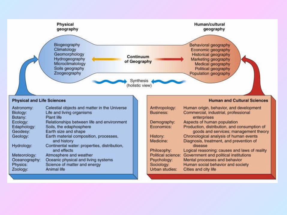
• System – ordered, interrelated objects functioning as a unit.
• Open systems – energy & matter flow into & out of the system.
• Closed systems – energy flows in & out of the system.

Systems

• Positive feedback – encourages system response, higher discharge, more sediment transported.• Negative feedback – more volcanism, cooled temperatures.• System Equilibrium – a maintenance of structure over time through energy-material exchanges.


Earth’s Four Spheres
•Atmosphere•Hydrosphere•Lithosphere•Biosphere

Earth Shape • Oblate Ellipsoid – flattened at the poles, bulging at the equator. • Greater centrifugal force at the equator (faster rotation).
• Geoid – sea level surface in balance between gravitational attraction & centrifugal pull due to rotation.

Earth’s dimensions

Measuring Earth in 247 B.C.

Location and Time on Earth
• Latitude.• Longitude.• Great circles.• Prime Meridian and standard time.

Latitude

Longitude

Great Circles and Small Circles


Latitudinal Geographic Zones

• Greenwich Mean Time – World standard (UT) time. Longitude (prime meridian) established by International Meridian Conference, Washington, D.C., 1884.
• Universal Time Coordinated (UTC) – standardized by French in 1912, determined by the International Bureau of Weights & Measures (Paris).
• Daylight savings time – Spring forward (lengthens daylight time), fall back.
International Date Line –
West crossing – one day ahead.East crossing – one day behind.

Prime Meridian and Standard Time

Maps, Scales, and Projections
• Map – a generalized view of an area, as seen from above and reduced in size.
Cartography – map making.

• Scale – ratio of map units to ground units.Descriptive, graphic, & representative fraction.

• Projection – process of transforming spherical Earth to flat map. • Earth can not be projected without distortion of its:Shape, area, distance, &/or direction.

Properties of the spherical (Earth) graticule – • Latitudes are parallel, evenly spaced along meridians (longitudes), & decrease in length poleward.
• Meridians converge at the poles & decrease in length to a point at the poles.
• Parallels & meridians intersect at 90º.

Classes of Projections

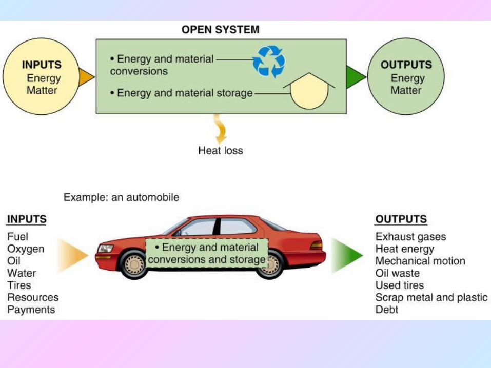
Remote Sensing• Active remote sensing.• Passive remote sensing.
Active and Passive Remote Sensing
Passive sensingvisible light.
Active sensingRADAR.

Remote Sensing
• MODIS sensor on board a TERRASatellite, June, 2001.

Geographic Information Systems (GIS)
• GIS systems combine spatial and attribute data.
• Maps can contain multiple data layers:– Physical features.– Cultural features.
• Layers can be added to create composite overlay.
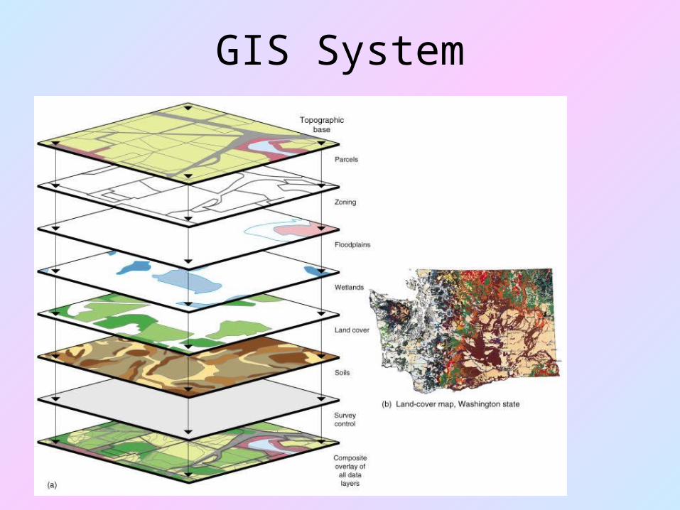
GIS System