GeoGraphy - Drishti IAS
50
Drishti IAS Presents... e-mail: [email protected], Website: www.drishias.com Contact: 011430665089, 7669806814, 8010440440 Drishti IAS, Tonk Road, Vasundhra Colony, Jaipur, Rajasthan Drishti IAS, 641, Mukherjee Nagar, Opp. Signature View Apartment, New Delhi Drishti IAS, Tashkent Marg, Civil Lines, Prayagraj, Uttar Pradesh Drishti IAS, 21 Pusa Road, Karol Bagh New Delhi - 05 Detailed Explanation Answers Explanation Explanation Answers Answers Answers Explanation Answers Answers Answers Explanation Answers Answers Answers Answers Explanation Answers Answers Answers Explanation Answers Explanation Answers Explanation Answers Answers Explanation Answers (January 2021 — March 2022) (January 2021 — March 2022) G EOGRAPHY G EOGRAPHY
-
Upload
khangminh22 -
Category
Documents
-
view
3 -
download
0
Transcript of GeoGraphy - Drishti IAS

Drishti IAS Presents...
e-mail: [email protected], Website: www.drishtiias.comContact: 011430665089, 7669806814, 8010440440
Drishti IAS, Tonk Road, Vasundhra Colony, Jaipur, Rajasthan
Drishti IAS, 641, Mukherjee Nagar, Opp. Signature View Apartment,
New Delhi
Drishti IAS, Tashkent Marg,Civil Lines, Prayagraj,
Uttar Pradesh
Drishti IAS, 21Pusa Road, Karol Bagh
New Delhi - 05
DetailedExplanation
Answers
ExplanationExplanation
Answers
Answers
Answers
Explanation
Answers
Answers
Answers
Explanation
Answers
Answers
Answers
AnswersExplanationAnswers
Answers
Answers
Explanation
Answers
Explanation
Answers
Explanation
Answers
Answers
Explanation
Answers
(January 2021 — March 2022)(January 2021 — March 2022)GeoGraphyGeoGraphy
2 PT SPRINT (2022) GEOGRAPHY EXPLANATION www.dr ish t i IAS.com
1. Ans: BExp: zThe Brahmaputra river originates under the name of
Siang or Dihang, from the Chemayungdung glacier of the Kailash range near the Mansarovar lake. Hence, statement 2 is not correct. �It enters India west of Sadiya town in Arunachal
Pradesh. Hence, statement 3 is correct. zThe river is known as Yarlung Tsangpo in China. Hence,
statement 1 is correct. �Its tributaries include Dibang, Lohit, Siang, Burhi
Dihing, Tista, and Dhansari.zIt is a perennial river and has several peculiar
characteristics due to its geography and prevailing climatic conditions.�The river is in itself dynamic as frequent landslides
and geological activity force it to change course very often.
zHence, option B is correct. 2. Ans: BExp:Savannas:zSavanna, also spelled savannah, vegetation type that
grows under hot, seasonally dry climatic conditions and is characterised by an open tree canopy (i.e., scattered trees) above a continuous tall grass understory (the vegetation layer between the forest canopy and the ground).
zThe largest areas of savanna are found in Africa, South America, Australia, India, the Myanmar (Burma)–Thailand region in Asia, and Madagascar.
zIn general, savannas grow in tropical regions 8° to 20° latitudes from the Equator. Hence statement 1 is not correct.
zConditions are warm to hot in all seasons, but significant rainfall occurs for only a few months each year—about October to March in the Southern Hemisphere and April to September in the Northern Hemisphere.
zMean annual precipitation is generally 80 to 150 cm although in some central continental locations it may be as low as 50 cm .
zThe dry season is typically longer than the wet season, but it varies considerably, from 2 to 11 months. Mean monthly temperatures are about 10 to 20 °C in the dry season and 20 to 30 °C in the wet season.
zGrasses and trees that grow in the savanna have adapted to life with little water and hot temperatures. Hence statement 2 is correct.
�Grasses, for example, grow quickly in the wet season when water is abundant and turn brown in the dry season to conserve water.
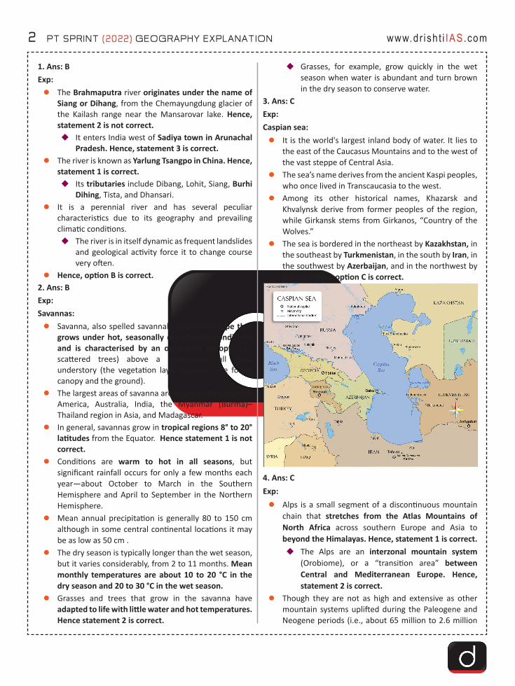
3. Ans: CExp: Caspian sea:zIt is the world's largest inland body of water. It lies to
the east of the Caucasus Mountains and to the west of the vast steppe of Central Asia.
zThe sea’s name derives from the ancient Kaspi peoples, who once lived in Transcaucasia to the west.
zAmong its other historical names, Khazarsk and Khvalynsk derive from former peoples of the region, while Girkansk stems from Girkanos, “Country of the Wolves.”
zThe sea is bordered in the northeast by Kazakhstan, in the southeast by Turkmenistan, in the south by Iran, in the southwest by Azerbaijan, and in the northwest by Russia. Hence option C is correct.
4. Ans: CExp: zAlps is a small segment of a discontinuous mountain
chain that stretches from the Atlas Mountains of North Africa across southern Europe and Asia to beyond the Himalayas. Hence, statement 1 is correct. �The Alps are an interzonal mountain system
(Orobiome), or a “transition area” between Central and Mediterranean Europe. Hence, statement 2 is correct.
zThough they are not as high and extensive as other mountain systems uplifted during the Paleogene and Neogene periods (i.e., about 65 million to 2.6 million
PT SPRINT (2022) GEOGRAPHY EXPLANATION 3www.dr ish t i IAS.com
years ago)—such as the Himalayas (great mountain system of Asia) and the Andes and Rocky mountains (in South America and North America respectively) —they are responsible for major geographic phenomena.
zMont Blanc is the highest peak in the Alps. �Mount Aconcagua, the highest point in the
Western Hemisphere, lies in the Southern Andes Mountains. Hence, statement 3 is not correct.
5. Ans: BExp:zChambal river is the primary habitat of Gharials but
they are found in many other parts in the freshwater of northern India eg. Ghagra, Gandak river, Girwa river (Uttar Pradesh), the Ramganga river (Uttarakhand) and the Sone river (Bihar). Hence, statement 1 is not correct.
z Population of Gharials is a good indicator of clean river water. Hence, statement 2 is correct.
zIndia has three species of Crocodilians namely:�Gharial (Gavialis gangeticus): IUCN Red List-
Critically Endangered. Hence, statement 3 is correct.
�Mugger crocodile (Crocodylus palustris): IUCN- Vulnerable.
�Saltwater crocodile (Crocodylus porosus): IUCN- Least Concern
6. Ans: CExp:zAfter the defeat of Japan in World War II, the Allied
forces at the Yalta Conference (1945), agreed to establish a “four-power trusteeship over Korea”.
zThe fear of the spread of communism and the mutual distrust between the USSR and the USA led to the failure of the trusteeship plan.�Before a concrete plan could be formulated, the
USSR invaded Korea.�This led to a condition where the north of Korea
was under the USSR and the south under the rest of the allies, mainly the USA.
�The Korean peninsula was divided into two regions by the 38th parallel.
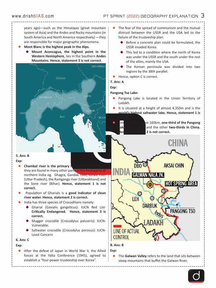
zHence, option C is correct.7. Ans: AExp: Pangong Tso Lake: zPangong Lake is located in the Union Territory of
Ladakh.zIt is situated at a height of almost 4,350m and is the
world’s highest saltwater lake. Hence, statement 1 is correct.
zExtending to almost 160km, one-third of the Pangong Lake lies in India and the other two-thirds in China. Hence, statement 2 is not correct.
8. Ans: BExp:zThe Galwan Valley refers to the land that sits between
steep mountains that buffet the Galwan River.
4 PT SPRINT (2022) GEOGRAPHY EXPLANATION www.dr ish t i IAS.com
�The river has its source in Aksai Chin, on China’s side of the Line of Actual Control (LAC), and it flows from the east to Ladakh, where it meets the Shyok river on India’s side of the LAC.
�The valley is strategically located between Ladakh in the west and Aksai Chin in the east, which is currently controlled by China as part of its Xinjiang Uyghur Autonomous Region. Hence, statement 1 is correct.
zKarakoram Range is also known as Krishnagiri which is situated in the northernmost range of the Trans-Himalayan ranges. It forms India's frontiers with Afghanistan and China. Hence, statement 3 is not correct.�It extends eastwards from the Pamir for about
800 km. It is a range with lofty peaks (elevation 5,500 m and above).
�Some of the peaks are more than 8,000 metre above sea level. K2 (8,611 m)[Godwin Austen or Qogir] is the second highest peak in the world and the highest peak in the Indian Union.
zThe Ladakh Plateau lies to the north-east of the Karakoram Range. Hence, statement 2 is correct.
9. Ans: CExp: Indonesia:zIt is a country in Southeast Asia and Oceania between
the Indian and Pacific oceans. It consists of over 17,000 islands, including Sumatra, Sulawesi, Java etc.
zThe westernmost and second largest island of Indonesia is Sumatra which is 1,790 km long and 435 km wide and is fringed with smaller islands off its western and eastern coasts.
zHence option C is correct.
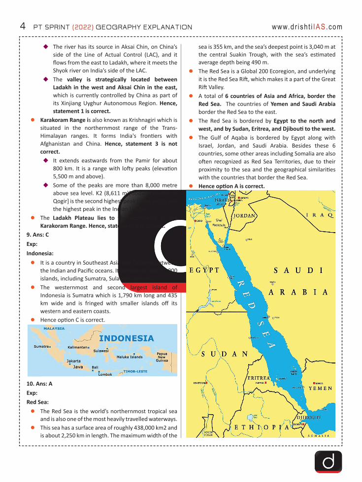
10. Ans: A Exp: Red Sea:zThe Red Sea is the world’s northernmost tropical sea
and is also one of the most heavily travelled waterways. zThis sea has a surface area of roughly 438,000 km2 and
is about 2,250 km in length. The maximum width of the
sea is 355 km, and the sea’s deepest point is 3,040 m at the central Suakin Trough, with the sea’s estimated average depth being 490 m.
zThe Red Sea is a Global 200 Ecoregion, and underlying it is the Red Sea Rift, which makes it a part of the Great Rift Valley.
zA total of 6 countries of Asia and Africa, border the Red Sea. The countries of Yemen and Saudi Arabia border the Red Sea to the east.
zThe Red Sea is bordered by Egypt to the north and west, and by Sudan, Eritrea, and Djibouti to the west.
zThe Gulf of Aqaba is bordered by Egypt along with Israel, Jordan, and Saudi Arabia. Besides these 6 countries, some other areas including Somalia are also often recognized as Red Sea Territories, due to their proximity to the sea and the geographical similarities with the countries that border the Red Sea.
zHence option A is correct.

PT SPRINT (2022) GEOGRAPHY EXPLANATION 5www.dr ish t i IAS.com
11. Ans: CExp:zLa Nina, the “cool phase” of El Nino-Southern
Oscillation (ENSO), is a pattern that describes the unusual cooling of the tropical eastern Pacific. Hence, statement 1 is correct.�La Nina events may last between one and three
years, unlike El Nino, which usually lasts no more than a year.
zEffects of La Nina:�Effects of La Nina kept world temperatures lower.
�La Niña is a weather pattern that happens in the Pacific Ocean but affects weather around the world.
�A La Niña event happens when ocean surface waters cool along the Pacific coast of the South American tropics. Hence, statement 2 is correct.
12. Ans: DExp: zThe Pacific ‘Ring of Fire’ or the Circum-Pacific Belt, is
an area along the Pacific Ocean that is characterized by active volcanoes and frequent earthquakes. �It is home to about 75% of the world’s volcanoes
– more than 450 volcanoes. Also, about 90% of the world’s earthquakes occur here. Hence, statement 1 is correct.
zThe Ring of Fire is stretched to approximately 40,000 kilometers tracing boundaries between several tectonic plates including the Pacific, Juan de Fuca, Cocos, Indian-Australian, Nazca, North American, and Philippine Plates. Hence, statement 2 is correct.
zThe chain runs up along the western coast of South and North America, crosses over the Aleutian Islands in Alaska, runs down the eastern coast of Asia past New Zealand and into the northern coast of Antarctica. Hence, statement 3 is correct.
13. Ans: DExp:zWetlands are defined as: "lands transitional between
terrestrial and aquatic eco-systems where the water table is usually at or near the surface or the land is covered by shallow water". Hence, statement 1 is not correct.�2nd February is World Wetlands Day. It was on this
date in 1971 that the Ramsar Convention on Wetlands was adopted in Ramsar, Iran.
zIt is a specialised body set up under the National Green Tribunal Act - 2010 (not 2014) for effective and expeditious disposal of cases relating to environmental protection (including wetland conservation) and conservation of forests and other natural resources. Hence, statement 2 is not correct.�With the establishment of the NGT, India became
the third country in the world to set up a specialised environmental tribunal, only after Australia and New Zealand, and the first developing country to do so.
14. Ans: D Exp: zThe Darvaza gas crater also known as the ‘Gateway to
Hell’ is located in the Karakum desert, 260 kilometres away from Turkmenistan’s capital, Ashgabat, the crater has been burning for the last 50 years. �The details of the origin of the crater are not
actually known but it has been said that the crater was created in 1971 during a Soviet drilling operation.
�The crater has become a significant tourist attraction in the country. In 2018, the country’s president officially renamed it as the “Shining of Karakum”.
zHowever, recently, Turkmenistan has decided to find a way to extinguish the fire in the Darvaza gas crater as it negatively affects both the environment and the health of the people living nearby along with the loss of valuable natural resources for which the country can get significant profits �Turkmenistan has been at the centre of methane
leakages. zHence, option D is correct.

6 PT SPRINT (2022) GEOGRAPHY EXPLANATION www.dr ish t i IAS.com
15. Ans: DExp:Gulf of Aqaba:zGulf of Aqaba, Arabic Khalīj al-ʿAqabah, northeastern
arm of the Red Sea, penetrating between Saudi Arabia and the Sinai Peninsula. It varies in width from 12 to 17 miles (19 to 27 km) and is 110 miles (177 km) long.
zThe Gulf of Aqaba is part of the complex East African Rift System, and its head touches the Egyptian, Israeli, Jordanian, and Saudi Arabian boundaries.
zHence, option D is Correct.
16. Ans: BExp:zGreat Nicobar is the southernmost island of the
Nicobar Islands Archipelago. Hence, statement 1 is not correct.
zIt covers 1,03,870 hectares of unique and threatened tropical evergreen forest ecosystems.�It is home to a very rich ecosystem, including 650
species of angiosperms, ferns, gymnosperms, bryophytes, among others.
zThe Mongoloid Shompen Tribe, about 200 in number, live in the forests of the biosphere reserve particularly along the rivers and streams. Hence, statement 2 is correct.�Another Mongoloid Tribe, Nicobarese, about 300
in number, used to live in settlements along the west coast.
�After the tsunami in 2004, which devastated their settlement on the western coast, they were relocated to Afra Bay in the North Coast and Campbell Bay.
17. Ans: AExp:
zWestern Disturbance (WD), labeled as an extra-tropical storm originating in the Mediterranean, is an area of low pressure that brings sudden showers, snow and fog in northwest India. Hence, statement 1 is correct.�The disturbance travels from the “western” to the
eastern direction.�These travel eastwards on high-altitude westerly
jet streams - massive ribbons of fast winds traversing the earth from west to east.
zWestern Disturbances are the cause of the most winter and pre-monsoon season rainfall across North-West India. This phenomenon is usually associated with a cloudy sky, higher night temperatures, and unusual rain. Hence, statement 2 is not correct.�It is estimated that India gets close to 5-10% of its
total annual rainfall from western disturbances18. Answer: DExplanationzDams built on major rivers of Himachal Pradesh:
�Sutlej (Bhakra Dam, Gobind Sagar reservoir, Koldam Dam), �Hence, pair 1 is correctly matched.
�Beas (Pandoh Dam, Maharana Pratap Sagar Reservoir).�Hence, pair 2 is correctly matched.
�Ravi (Chamera Dam), Parbati�Hence, pair 3 is correctly matched.
19. Ans: CExp: zBaltic Sea is an arm of the North Atlantic Ocean,
extending northward from the latitude of southern Denmark almost to the Arctic Circle and separating the Scandinavian Peninsula from the rest of continental Europe.
zThe largest expanse of brackish water in the world, the semi enclosed and relatively shallow Baltic Sea is of great interest to scientists, while to historians it represents the economic core of the Hanseatic League, the great mediaeval trading group of northern European ports.
zThe many names for the sea attest to its strategic position as a meeting place of many countries.
zProceeding clockwise from the west, the countries bounding the Baltic are Denmark, Sweden, Finland, Russia, Estonia, Latvia, Lithuania, Poland, and Germany.
zHence option C is correct.
PT SPRINT (2022) GEOGRAPHY EXPLANATION 7www.dr ish t i IAS.com
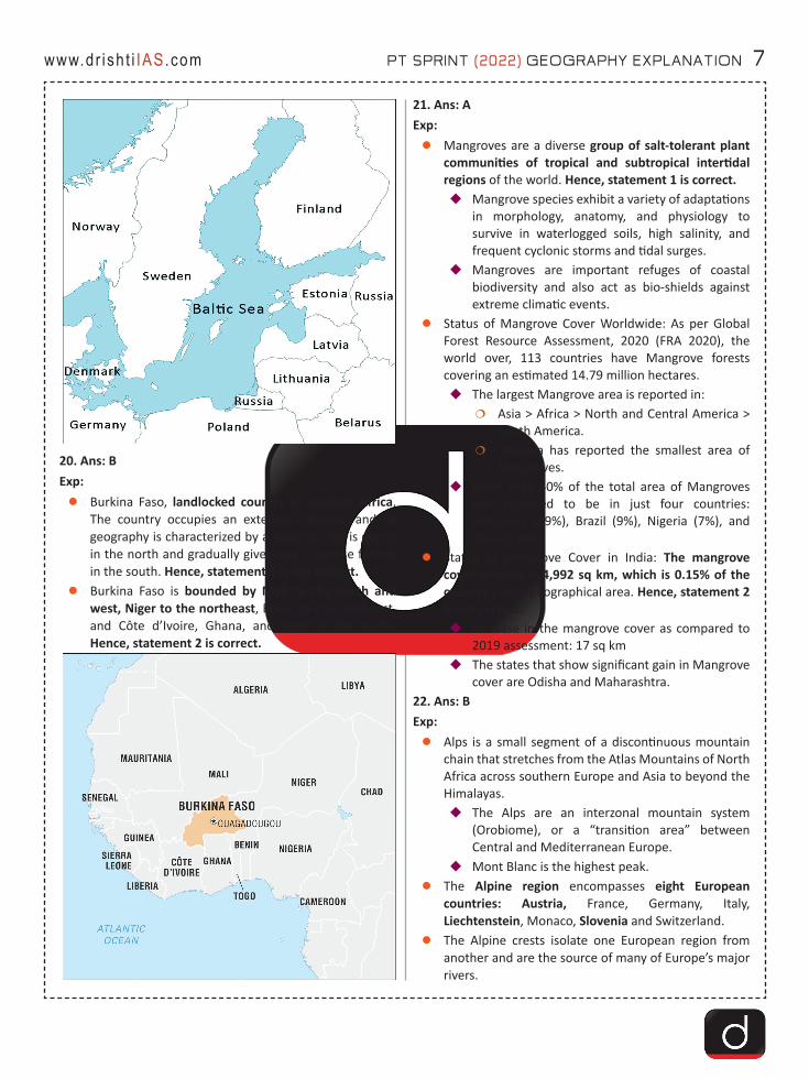
20. Ans: BExp:zBurkina Faso, landlocked country in western Africa.
The country occupies an extensive plateau, and its geography is characterized by a savanna that is grassy in the north and gradually gives way to sparse forests in the south. Hence, statement 1 is not correct.
zBurkina Faso is bounded by Mali to the north and west, Niger to the northeast, Benin to the southeast, and Côte d’Ivoire, Ghana, and Togo to the south. Hence, statement 2 is correct.
21. Ans: AExp:zMangroves are a diverse group of salt-tolerant plant
communities of tropical and subtropical intertidal regions of the world. Hence, statement 1 is correct.�Mangrove species exhibit a variety of adaptations
in morphology, anatomy, and physiology to survive in waterlogged soils, high salinity, and frequent cyclonic storms and tidal surges.
�Mangroves are important refuges of coastal biodiversity and also act as bio-shields against extreme climatic events.
zStatus of Mangrove Cover Worldwide: As per Global Forest Resource Assessment, 2020 (FRA 2020), the world over, 113 countries have Mangrove forests covering an estimated 14.79 million hectares. �The largest Mangrove area is reported in:
�Asia > Africa > North and Central America > South America.
�Oceania has reported the smallest area of Mangroves.
�More than 40% of the total area of Mangroves was reported to be in just four countries: Indonesia (19%), Brazil (9%), Nigeria (7%), and Mexico (6%).
zStatus of Mangrove Cover in India: The mangrove cover in India is 4,992 sq km, which is 0.15% of the country’s total geographical area. Hence, statement 2 is not correct.�Increase in the mangrove cover as compared to
2019 assessment: 17 sq km�The states that show significant gain in Mangrove
cover are Odisha and Maharashtra.22. Ans: BExp: zAlps is a small segment of a discontinuous mountain
chain that stretches from the Atlas Mountains of North Africa across southern Europe and Asia to beyond the Himalayas. �The Alps are an interzonal mountain system
(Orobiome), or a “transition area” between Central and Mediterranean Europe.
�Mont Blanc is the highest peak. zThe Alpine region encompasses eight European
countries: Austria, France, Germany, Italy, Liechtenstein, Monaco, Slovenia and Switzerland.
zThe Alpine crests isolate one European region from another and are the source of many of Europe’s major rivers.

8 PT SPRINT (2022) GEOGRAPHY EXPLANATION www.dr ish t i IAS.com
�Waters from the Alps ultimately reach the North, Mediterranean, Adriatic, and Black seas.
zHence, option B is correct.
23. Ans: BExp:zTyphoons are a kind of storm. The storms, depending
on where they occur, may be called hurricanes, typhoons or cyclones.�Typhoons: In the China Sea and Pacific Ocean.�Hurricanes: In the West Indian islands in the
Caribbean Sea and Atlantic Ocean.�Tornados: In the Guinea lands of West Africa and
southern USA.�Willy-willies: In north-western Australia and�Tropical Cyclones: In the Indian Ocean Region.
zHence, option B is correct.24. Ans: D Exp: About Chilika Lake:zChilika is Asia's largest and world's second largest
lagoon.�In 1981, Chilika Lake was designated the first
Indian wetland of international importance under the Ramsar Convention.
zMajor attraction at Chilika is Irrawaddy dolphins which are often spotted off Satapada Island.
zThe large Nalabana Island (Forest of Reeds) covering about 16 sq km in the lagoon area was declared a bird sanctuary in 1987.
zKalijai Temple - Located on an island in the Chilika Lake.
zChilika lake hosts birds migrating from thousands of miles away from the Caspian Sea, Lake Baikal, Aral Sea, remote parts of Russia, Kirghiz steppes of Mongolia, Central and South East Asia, Ladakh and the Himalayas.�The birds find the vast mud-field and abundant
fish stock here suitable to congregate.zHence, option D is correct.
25. Ans: CExp: zThe Cerrado is spread across several states of Brazil
and is one of the world’s largest savannas, is often called an “upside-down forest” because of the deep roots its plants sink into the ground to survive seasonal droughts and fires.�Cerrado is a major carbon sink that helps to stave
off climate change.zDeforestation in 2021 rose to the highest level since
2015 in Brazil’s Cerrado, prompting scientists to raise alarm over the state of the world’s most species-rich savanna.
zHence, option C is correct. 26. Ans: AExp:zKalapani is a valley that is administered by India as a
part of the Pithoragarh district of Uttarakhand. It is situated on the Kailash Mansarovar route.�The Kali River in the Kalapani region demarcates
the border between India and Nepal. Hence, statement 1 is correct.
zRiver Mahakali is also known as Sharda river or Kali Ganga in Uttarakhand.
zIt joins Ghagra river in Uttar Pradesh, which is a tributary of Ganga. Hence, statement 2 is not correct.�Recently, the Union Cabinet has cleared a plan to
build a new bridge connecting India and Nepal over the Mahakali river and link Dharchula in Uttarakhand with Nepal’s Dharchula.
27. Ans: C Exp: zBomb Cyclone: It is a large, intense midlatitude storm
that has low pressure at its center, weather fronts and an array of associated weather, from blizzards to severe thunderstorms to heavy precipitation. Hence, statement 1 is not correct.�Bomb cyclones put forecasters on high alert,
because they can produce significant harmful impacts.
zBomb Cyclone v/s Hurricane:
PT SPRINT (2022) GEOGRAPHY EXPLANATION 9www.dr ish t i IAS.com
�Hurricanes tend to form in tropical areas and are powered by warm seas. For this reason, they’re most common in summer or early fall, when seawater is warmest.
�Bomb cyclones generally occur during colder months because cyclones occur due to cold and warm air meeting. �During the summer, there’s generally not
much cold air across the atmosphere; this means a bomb cyclone is much less likely to occur. Hence, statement 2 is correct.
�Hurricanes form in tropical waters, while bomb cyclones form over the northwestern Atlantic, northwestern Pacific and sometimes the Mediterranean Sea. Hence, statement 3 is correct.
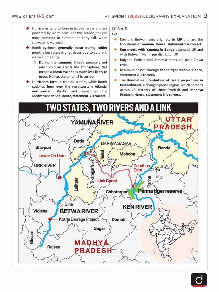
28. Ans: DExp:zKen and Betwa rivers originate in MP and are the
tributaries of Yamuna. Hence, statement 1 is correct.zKen meets with Yamuna in Banda district of UP and
with Betwa in Hamirpur district of UP.zRajghat, Paricha and Matatila dams are over Betwa
river.zKen River passes through Panna tiger reserve. Hence,
statement 2 is correct.zThe Ken-Betwa inter-linking of rivers project lies in
Bundelkhand, a drought-prone region, which spreads across 13 districts of Uttar Pradesh and Madhya Pradesh. Hence, statement 3 is correct.
10 PT SPRINT (2022) GEOGRAPHY EXPLANATION www.dr ish t i IAS.com
29. Ans: DExp:zGoa is located on the southwestern coast of India
within the region known as the Konkan, and geographically separated from the Deccan highlands by the Western Ghats. Hence, statement 1 is correct.
zOfficial Language of Goa is Konkani.�Konkani is one of the 22 languages from the Eight
Schedule. Hence, statement 3 is correct.�It was added in the list along with Manipuri and
Nepali by the 71st Amendment Act of 1992.zIt is surrounded by Maharashtra to the north and
Karnataka to the east and south, with the Arabian Sea forming its western coast.
zWildlife Sanctuaries and National Parks:�Dr Salim Ali Bird Sanctuary�Mhadei Wildlife Sanctuary�Netravali Wildlife Sanctuary�Cotigao Wildlife Sanctuary. Hence, statement 2
is correct.
�Bhagwan Mahaveer Sanctuary�Mollem National Park
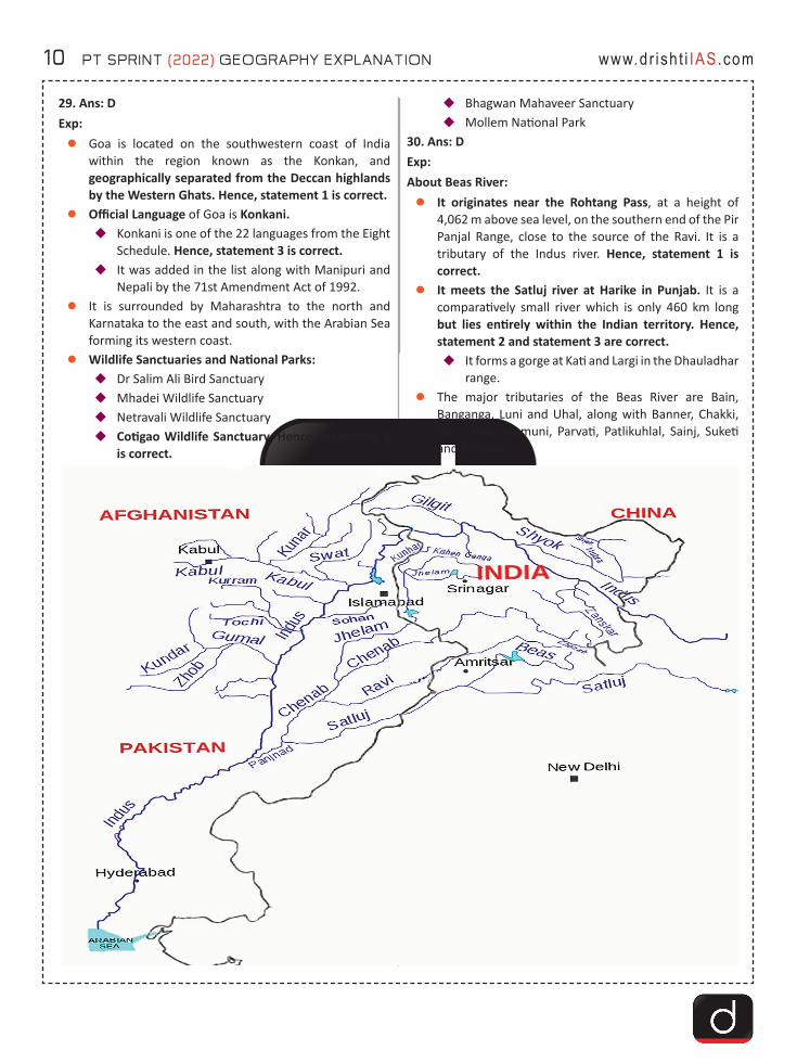
30. Ans: D Exp: About Beas River: zIt originates near the Rohtang Pass, at a height of
4,062 m above sea level, on the southern end of the Pir Panjal Range, close to the source of the Ravi. It is a tributary of the Indus river. Hence, statement 1 is correct.
zIt meets the Satluj river at Harike in Punjab. It is a comparatively small river which is only 460 km long but lies entirely within the Indian territory. Hence, statement 2 and statement 3 are correct.�It forms a gorge at Kati and Largi in the Dhauladhar
range. zThe major tributaries of the Beas River are Bain,
Banganga, Luni and Uhal, along with Banner, Chakki, Gaj, Harla, Mamuni, Parvati, Patlikuhlal, Sainj, Suketi and Tirthan.

PT SPRINT (2022) GEOGRAPHY EXPLANATION 11www.dr ish t i IAS.com
31. Ans: C Exp:
zHence, option C is correct. 32. Ans: CExp:zKameng River originates in Tawang district from the
glacial lake below snow-capped Gori Chen mountain on the India-Tibet border.�Kameng is not a transboundary river. Hence,
statement 1 is not correct.�It flows through Bhalukpong circle of West
Kameng District, Arunachal Pradesh and Sonitpur District of Assam.
zIt becomes a braided river in its lower reaches and is one of the major tributaries of the Brahmaputra River. Hence, statement 2 is correct.�It joins Brahmaputra river at Tezpur, just east of
the Kolia Bhomora Setu bridge, Assam.zTributaries: Tippi, Tenga, Bichom and Dirang Chu.zIt forms the boundary between East Kameng District
and West Kameng Districts.�It also forms the boundary between the Sessa and
Eaglenest sanctuaries to its west (Arunachal Pradesh) and the Pakke tiger reserve to the east (Arunachal Pradesh).
�The Dafla Hills are east and the Aka Hills are located west of the Kameng River. Hence, statement 3 is correct.
33. Ans: CExp: zThe river Yamuna, a major tributary of river Ganges,
originates from the Yamunotri glacier near Bandarpoonch peaks in the Mussoorie range of the lower Himalayas at an elevation of about 6387 meters above mean sea level in Uttarkashi district of Uttarakhand. Hence, statement 1 is correct. �Yamuna meets the Ganges at the Sangam (where
Kumbh mela is held) in Prayagraj, Uttar Pradesh after flowing through Uttarakhand, Himachal Pradesh, Haryana and Delhi.
zImportant Dams built on the river include; Lakhwar-Vyasi Dam (Uttarakhand) and Tajewala Barrage Dam (Haryana). Hence, statement 2 is correct.
zImportant Tributaries of the Yamuna river are Chambal, Sindh, Betwa and Ken.
34. Ans: AExp: Continental Drift TheoryzContinental drift theory deals with the distribution of
the oceans and the continents. It was first suggested by a German meteorologist, Alfred Wegener in 1912.
zAccording to the theory, all the continents formed a single continental mass- Pangea and mega ocean- Panthalassa surrounded it.
zAround 200 million years ago Pangaea started splitting and broke down into two large continental masses as Laurasia and Gondwanaland forming the northern and southern components respectively.

12 PT SPRINT (2022) GEOGRAPHY EXPLANATION www.dr ish t i IAS.com
zSubsequently, Laurasia and Gondwanaland continued to break into various smaller continents that exist today.
Hence, option A is correct.35. Ans. DExp: zBaltic sea is an arm of the North Atlantic Ocean,
extending northward from the latitude of southern Denmark almost to the Arctic Circle and separating the Scandinavian Peninsula from the rest of continental Europe.
zProceeding clockwise from the west, the countries bounding the Baltic are Denmark, Sweden, Finland, Russia, Estonia, Latvia, Lithuania, Poland, and Germany. Hence option D is correct.
36. Ans: CExp:zLamkhaga Pass is a high altitude pass in Garhwal
Himalayas (Uttarakhand) which connects with Sangla in Himachal Pradesh. Due to its altitude and remoteness, it is considered one of the toughest treks in the Himalayas (Uttrakhand).
zHence, option C is correct.
PT SPRINT (2022) GEOGRAPHY EXPLANATION 13www.dr ish t i IAS.com
37. Ans: CExp: zIndia is one of the highly earthquake affected countries
because of the presence of technically active young fold mountains - Himalaya. Hence, statement 1 is correct.
zIndia has been divided into four seismic zones (II, III, IV, and V) based on scientific inputs relating to seismicity, earthquakes that occurred in the past and tectonic setup of the region.
zPreviously, earthquake zones were divided into five zones with respect to the severity of the earthquakes but the Bureau of Indian Standards (BIS) grouped the country into four seismic zones by unifying the first two zones. Hence, statement 2 is correct.�BIS is the official agency for publishing the seismic
hazard maps and codes.38. Ans: B Exp: zAn earthquake in simple words is the shaking of the
earth. It is a natural event caused due to the release of energy, which generates waves that travel in all directions.
zThe vibrations called seismic waves are generated from earthquakes that travel through the Earth and are recorded on instruments called seismographs.
zThe location below the earth’s surface where the earthquake starts is called the hypocenter, and the location directly above it on the surface of the earth is called the epicenter.
zHence, option B is correct. 39. Ans: CExp:zThe Trans-Himalayas Mountain Region or Tibet
Himalayan Region is located to the north of the Great Himalayas which consists of Karakoram, Ladakh, Zaskar and Kailash mountain ranges. Hence, statement 1 is correct.�It is also called the Tibet Himalayan Region
because most of the part of these ranges lies in Tibet.
�They are the eastward continuation of the most northerly ranges of the Himalayas.
zIt consists of an ill-defined mountain area about 600 miles long and 140 miles wide in the centre, narrowing to a 20-mile width at the eastern and western ends.
zIt is mainly composed of granites and volcanic rocks of the Neogene and Paleogene age. Hence, statement 2 is correct.
40. Ans: CExp:zThe Lukha is located in the southern part of east
Jaintia Hills of Meghalaya where most of Meghalaya’s rat-hole coal mines are located. Hence, statement 1 is correct.�It has become a victim of the unsustainable large-
scale mining of coal and limestone, allegedly responsible for the pollution that turns the river its surreal winter hue.
�It receives water from the Lunar river (Wah Lunar) and small streams draining from the Narpuh Reserve Forest and the undulating hills of the area while flowing down. Hence, statement 2 is correct.
�The river is mainly fed by monsoon rain and flows in the south-west direction and later takes a southern path after joining the Lunar river near the Gaddum village.
�The river passes via the Sonapur village and then into southern Assam’s Barak Valley and ends up in the floodplains of Bangladesh.
41. Ans: CExp: zA heatwave is a period of abnormally high
temperatures, more than the normal maximum temperature that occurs during the summer season in the North-Western and South Central parts of India.�The India Meteorological Department (IMD)
classifies heat waves according to regions and their temperature ranges. Hence, option C is correct.
zRecently, a study has found a spatial shift of heatwaves in India, now occurring in new regions in the country.�It also added that the eastern and western
coasts, which are currently unaffected by heatwaves, wil be severely impacted in the future. Hence, option A is not correct.
�Also, heatwaves were found in southern Madhya Pradesh, Andhra Pradesh, Karnataka and Tamil Nadu, where they would traditionally not take place. Hence, option B is not correct.
zThe heatwave is considered when the maximum temperature of a station reaches at least 40°C for Plains and at least 30°C for Hilly regions. Hence, option D is not correct. �An increase of 5°C to 6°C from the normal
temperature is considered to be heat wave condition..
14 PT SPRINT (2022) GEOGRAPHY EXPLANATION www.dr ish t i IAS.com
42. Ans: B Exp: zLa Nina is one part of the El Nino Southern Oscillation
(ENSO) cycle. In a la Nina event, ocean water from off the coast of South America to the central tropical Pacific cools to below average temperatures.�This cooling occurs because of stronger than
normal easterly trade winds, which churns cooler, deeper sea water up to the ocean’s surface.
�Sea temperatures can warm above average in the far western Pacific when this happens.
zImpacts of La Nina�On Walker Circulation: The unusually cool water
in the eastern Pacific influences the Walker Circulation and suppresses cloud, rain, and thunderstorms. This change impacts weather patterns around the world, but in a different way than El Niño does.
�On the Pacific Jet Stream: These cold waters in the Pacific push the jet stream northward. This tends to lead to drought in the southern US and heavy rains and flooding in the Pacific Northwest and Canada. It can also lead to a more severe hurricane season.
�On the Indian Ocean: There are increased temperatures in Western Pacific, Indian Ocean and off the Somalian coast. It also leads to heavy floods in Australia and a comparatively better monsoon rains in India.
zHence, option B is correct. 43. Ans: AExp:zDrought fueled by climate change has dropped Lake
Tahoe in the US below its natural rim and halted flows into the Truckee River.
zLake Tahoe is the largest alpine lake in North America, and the second deepest lake in the US, with Crater Lake in Oregon being the deepest in the US.
zAlpine lakes are lakes or reservoirs at high altitudes, usually over above sea level or above the tree line.
zHence, option A is correct.44. Ans: AExp: zThe Periyar River is the longest river in the state of
Kerala with a length of 244 km.�It is also known as the ‘Lifeline of Kerala’ as it is
one of the few perennial rivers in the state.zPeriyar River originates from the Sivagiri hills of
Western Ghats, in Tamil Nadu and flows through the Periyar National Park.
�The main tributaries of Periyar are Muthirapuzha, Mullayar, Cheruthoni, Perinjankutti.
zIt is located in the State of Assam and covers 42,996 Hectare (ha). It is the single largest undisturbed and representative area in the Brahmaputra Valley floodplain.�Mullaperiyar Dam is located on the confluence
of the Mullayar and Periyar rivers in Kerala’s Idukki district.
zHence, option A is correct.45. Ans: B Exp: zThe Mullaperiyar Dam is located on the confluence of
the Mullayar and Periyar rivers in Kerala’s Idukki district. The reservoir is within the Periyar Tiger Reserve.
zIt is operated and maintained by Tamil Nadu for meeting the drinking water and irrigation requirements of five of its southern districts.�According to a 999-year lease agreement made
during British rule the operational rights were handed over to Tamil Nadu.
zThe water diverted from the reservoir is first used for power generation in lower Periyar (by Tamil Nadu) before flowing into the Suruliyar, a tributary of Vaigai river, and then for irrigating nearly 2.08 lakh hectares in Theni and four other districts farther away.
zHence, option B is correct.46. Ans: CExp: zThe Idukki Dam is located in Kerala (168.91 m). The
dam stands between the two mountains – Kuravan Mala (839 m) and Kurathi Mala (925 m).
zIt is one of the highest arch dams in Asia and third tallest arch dam.
zIt is built on the Periyar River, in the ravine between the Kuravan and Kurathi Hills in Kerala.
zIt was constructed and is owned by the Kerala State Electricity Board. It supports a 780 MW hydroelectric power station.
zHence, option C is correct. 47. Ans: A Exp: zThe Periyar River is the longest river in the state of
Kerala with a length of 244 km.zIt is also known as ‘Lifeline of Kerala’ as it is one of the
few perennial rivers in the state.zPeriyar River originates from Sivagiri hills of Western
Ghats, in Tamil Nadu and flows through the Periyar National Park.

PT SPRINT (2022) GEOGRAPHY EXPLANATION 15www.dr ish t i IAS.com
zThe main tributaries of Periyar are Muthirapuzha, Mullayar, Cheruthoni, Perinjankutti.
zLakshmana and Theertha are the tributaries of Cauvery river. Its other tributaries are Arkavathi, Hemavathi, Shimsa, Kabini and Harangi.
zHence, option A is correct.48. Ans: D Exp: zRecently, the Union government has renamed Mount
Harriet of Andaman and Nicobar (A&N) Islands to Mount Manipur.
zMount Harriet, the third-highest island peak in A&N Islands, where Manipur’s Maharaja Kulchandra Singh and 22 other freedom fighters were imprisoned during the Anglo-Manipuri war (1891).�It has been renamed in a tribute to those freedom
fighters of Manipur.�Manipur celebrates Khongjom Day on 23rd April
in commemoration of the freedom fighters of Anglo-Manipuri War.
zHence, option D is correct.
49. Ans: DExp: zSubmarine volcanoes are exactly what they sound
like—volcanoes located beneath the ocean’s surface.�From Hawaii to Indonesia to Iceland, hundreds of
islands across the globe have been formed by submarine volcanoes.
zBecause they erupt into water instead of air, submarine volcanoes behave quite differently than terrestrial volcanoes. For instance, it’s uncommon for submarine volcanoes to have explosive eruptions. Hence, statement 1 is not correct.
zThe sheer weight of the water above them creates very high pressure, usually resulting in what are known as passive lava flows along the seafloor. Most submarine eruptions do not disturb the ocean surface. Hence, statement 2 is not correct.
50. Ans: CExp: zRecently, the Indian and Algerian navies participated in
a maiden naval exercise off the Algerian coast in a bid to increase maritime cooperation.�The naval exercise with Algeria is crucial for India
as it is strategically located in the Maghreb region and is the largest country of Africa. Hence, statement 1 is correct.�The region also includes Algeria, Libya,
Mauritania, Morocco and Tunisia. �It includes the disputed territories of Western
Sahara and the cities of Ceuta and Melilla.�The Maghreb region of North Africa borders the
Mediterranean Sea. Hence, statement 2 is correct.

16 PT SPRINT (2022) GEOGRAPHY EXPLANATION www.dr ish t i IAS.com
51. Ans: BExp:zLadakh was established as a Union Territory (UT) of
India on 31st October 2019, following the enactment of the Jammu and Kashmir Reorganization Act.�Before that, it was part of the Jammu and Kashmir
state.zIt is the largest and the second least populous union
territory of India.zIt extends from the Siachen Glacier in the Karakoram
Range to the north to the main Great Himalayas to the south. Hence, statement 1 is correct. �The eastern end, consisting of the uninhabited
Aksai Chin Plains, is claimed by the Indian Government as part of Ladakh, and has been under Chinese control since 1962.
zThe largest town in Ladakh is Leh, followed by Kargil, each of which headquarters a district.�The Leh district contains the Indus, Shyok and
Nubra river valleys. Hence, statement 2 is not correct.
�The Kargil district contains the Suru, Dras and Zanskar river valleys.
zEarlier, in 2020 Indian and Chinese troops were engaged in a temporary and short duration face-off along the Line of Actual Control (LAC) at Naku La (Sikkim) and near Pangong Tso Lake (Eastern Ladakh). Hence, statement 3 is not correct. �However, recently India and China have agreed in
principle to disengage at a key patrol point in eastern Ladakh.
52. Ans: DExp:zEl Nino is a climate pattern that describes the unusual
warming of surface waters in the eastern tropical Pacific Ocean. Hence, statement 1 is not correct.
�It is the “warm phase” of ENSO.�It occurs more frequently than La Nina. Hence,
statement 2 is correct. zImpact:
�The warmer waters cause the Pacific jet stream to move south of its neutral position. With this shift, areas in the northern US and Canada are dryer and warmer than usual. �But in the US Gulf Coast and Southeast, these
periods are wetter than usual and have increased flooding.
�As El Nino brings rain to South America, it brings droughts to Indonesia and Australia. Hence, statement 3 is not correct.
�El Niño also has a strong effect on marine life off the Pacific coast.
53. Ans: DExp:zBrahmaputra River originates under the name of
Siang or Dihang, from the Chemayungdung glacier of the Kailash range near the Mansarovar lake (Tibet). Hence, statement 1 is correct. �It enters India west of Sadiya town in Arunachal
Pradesh. Hence, statement 2 is not correct. zTributaries: Dihing River, Dibang River, Lohit River,
Dhansiri River, Kolong River, Kameng River, Manas River, Beki River, Raidak River, Jaldhaka River, Teesta River, Subansiri River. Hence, statement 3 is correct.
54. Ans: AExp:zThe Thar desert is also called the ‘Great Indian Desert’.
�It is located partly in Rajasthan state, northwestern India, and partly in Punjab and Sindh provinces, eastern Pakistan.
PT SPRINT (2022) GEOGRAPHY EXPLANATION 17www.dr ish t i IAS.com
�It is bordered by the irrigated Indus River plain to the west, the Punjab Plain to the north and northeast, the Aravalli Range to the southeast, and the Rann of Kachchh to the south. Hence, statement 1 is correct.
zThe surface of Thar consists of aeolian (wind-deposited) sand that has accumulated over the past 1.8 million years.�Presents an undulating surface, with high and low
sand dunes separated by sandy plains and low barren hills, or bhakars, which rise abruptly from the surrounding plains. �Barchan, also spelled Barkhan are crescent-
shaped sand dune produced by the action of wind predominately from one direction. Hence, statement 2 is not correct.
�Several playas (saline lake beds), locally known as dhands, are scattered throughout the region.
55. Ans: DExplanation:zFactors Causing Rainfall Patterns Change:
�Moisture and Drought Together:�An aspect of warming that influences rainfall
is the drying of the land, which increases the frequency and intensity of dry periods and Droughts.
�An increase in moisture and the drying up together change the rainfall patterns in unpredictable ways.
�Hence, statement 1 is correct.�Increased Snowfall in the Eurasian Region:
�Increased snowfall in the Eurasian region also impacts monsoon rainfall in NE India as the excessive snowfall in Eurasia causes cooling of the atmosphere of the region, which triggers events eventually leading to a weak summer monsoon season there.
�Hence, statement 2 is correct.�Change in Pacific Decadal Oscillation (PDO):
�Sea surface temperatures over the subtropical Pacific Ocean, which vary in a cycle and each phase of which lasts a decade. The peak comes every 20 years and is known as the Pacific Decadal Oscillation (PDO).
�It may have an impact on the monsoon rainfall in NE.
�Hence, statement 3 is correct.� Sunspot Epoch:
�During the monsoon, rainfall patterns in NE differed significantly from one Sunspot epoch to another, suggesting a differential
intensification of the seasonal trough of low pressure over the country.
� Hence, statement 4 is correct.56. Ans: DExp:zAs per a report by Save the Children (a humanitarian
organisation), migration in East Africa’s Burundi in recent years has been seen mainly because of the rapid and significant rise of Lake Tanganyika.
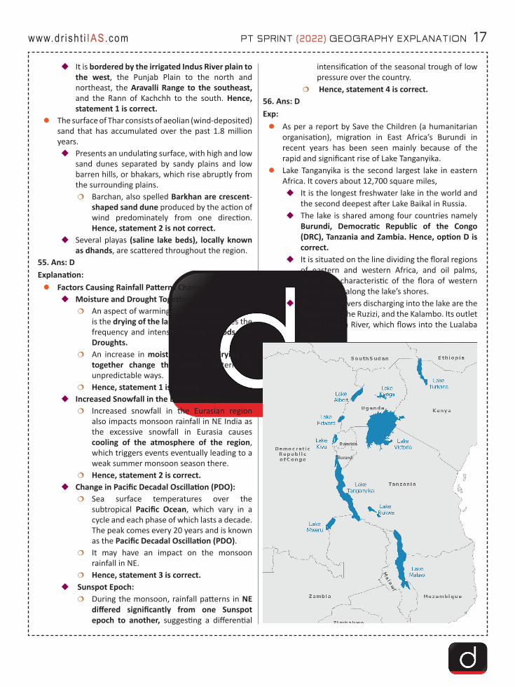
zLake Tanganyika is the second largest lake in eastern Africa. It covers about 12,700 square miles,�It is the longest freshwater lake in the world and
the second deepest after Lake Baikal in Russia.�The lake is shared among four countries namely
Burundi, Democratic Republic of the Congo (DRC), Tanzania and Zambia. Hence, option D is correct.
�It is situated on the line dividing the floral regions of eastern and western Africa, and oil palms, which are characteristic of the flora of western Africa, grow along the lake’s shores.
�The largest rivers discharging into the lake are the Malagarasi, the Ruzizi, and the Kalambo. Its outlet is the Lukuga River, which flows into the Lualaba River.

18 PT SPRINT (2022) GEOGRAPHY EXPLANATION www.dr ish t i IAS.com
57. Ans: BExp: zThe Cumbre Vieja volcano erupted for the first time in
50 years. The last time hot molten lava erupted and spread was in 1971.
zLa Palma is the most north-westerly island of the Canary Islands, Spain.�It’s geography is a result of a volcanic formation
and has an area of 708 square kilometres making it the fifth largest of the eight main Canary Islands.
zThe Canary Islands are a group of ocean island volcanoes located off the coast of western Africa that have been formed by volcanic activity since around 20 million years ago. �It comprises the Spanish provinces of Las Palmas
and Santa Cruz de Tenerife.zHence, option B is correct.
58. Ans: BExp:zCauvery is known as ‘Ponni’ in Tamil, also known as
Ganga of the south, and it is the fourth largest river of southern India.
zIt is a sacred river of southern India. It rises on Brahmagiri Hill of the Western Ghats in southwestern Karnataka state, flows in a southeasterly direction through the states of Karnataka and Tamil Nadu, and descends the Eastern Ghats in a series of great falls and drains into Bay of Bengal through Pondicherry.
zSome of its tributaries are:�Left: Harangi, Hemavati, Shimsha, Arkavathy�Right: Lakshmana Tirtha, Kabini, Bhavani, Noyyal,
Amaravati, MoyarzHence, option B is correct.
59. Ans: AExp: About Rajaji National Park:zRajaji National Park was established in the year 1983
after amalgamating three sanctuaries in Uttarakhand i.e. Rajaji, Motichur and Chila.�It was named after the famous freedom fighter
C. Rajgopalachari; popularly known as “Rajaji”. �It is located around Haridwar, along the foothills
of the Shivalik range.�It also encompasses Rajaji Tiger Reserve in 2015
as the 48th tiger reserve of the country.zFlora: Broadleaved deciduous forests, riverine
vegetation, scrubland, grasslands and pine forests form the range of flora in this park.�Sal (Shorea robusta) is the characteristic
dominant tree species.zFauna: The tiger reserve is home to both elephants
and tigers in India.�The reserve is home to more than 50 species of
mammals including tiger, leopard, Himalayan black bear, sloth bear, jackal, hyena, spotted deer, sambhar, barking deer, nilgai, monkeys and over 300 species of birds.
�The Park is also home to many migratory birds in winters.
zRivers: The Ganga and Song rivers flow through this.zHence, option A is correct.
60. Ans: DExp:zThe International North-South Transport Corridor
(INSTC) connected Europe with India (mainly through territorial route) for the first time with a Finnish logistics company despatching a consignment from Finland to India.

PT SPRINT (2022) GEOGRAPHY EXPLANATION 19www.dr ish t i IAS.com
zINSTC is a 7,200-km-long multi-mode network of ship, rail, and road routes. The route primarily involves moving freight from India, Iran, Azerbaijan and Russia.
zThe major cities involved are Mumbai, Bandar Abbas, Tehran, Baku, Astrakhan, Moscow, etc.�The INSTC does not pass through Iraq (Baghdad).
Hence, option D is correct.zIt is also in consonance with the Ashgabat agreement,
a Multimodal transport agreement signed by India (2018 - year of joining), Oman (2011), Iran (2011), Turkmenistan (2011), Uzbekistan (2011) and Kazakhstan (2015).
61. Ans: BExp: zThe Red Sea is a semi-enclosed tropical basin, bounded
by northeastern Africa, to the west, and the Arabian peninsula, to the east.
zThe elongated and narrow-shaped basin extends between the Mediterranean Sea, to the north-west,
and the Indian Ocean, to the south-east.�At the northern end, it separates into the Gulf of
Aqaba and the Gulf of Suez, which is connected to the Mediterranean Sea via the Suez Canal.
zIt is surrounded by Egypt, Sudan and Eritrea in the West and Saudi Arabia and Yemen in the East.
zHence, option B is correct.

20 PT SPRINT (2022) GEOGRAPHY EXPLANATION www.dr ish t i IAS.com
62. Ans: AExp: zActive volcanoes are the volcanoes that have a recent
history of eruptions or are likely to erupt again.zMt. Sinabung is an active volcano on Indonesia’s
Sumatra island. �Sinabung is among more than 120 active
volcanoes in Indonesia, which is prone to seismic upheaval due to its location on the Pacific Ring of Fire.
�The volcano was dormant for 400 years before exploding in 2010.�It exploded again in 2014 ,2016 and 2020.
zSangay volcano is one of the highest active volcanoes in the world and one of Ecuador's most active ones.�Sangay is the southernmost stratovolcano (a
volcano built up of alternate layers of lava and ash) in the northern volcanic zone of the Andes. It is 5230 m high.
zVolcanoes in India:
�Barren Island, Andaman Islands (India's only active volcano)
�Narcondam, Andaman Islands�Narcondam is an oceanic island of volcanic
origin located in the Andaman Islands, in the Bay of Bengal.
�It is classified as a dormant volcano by the Geological Survey of India.
�Baratang, Andaman Islands�Deccan Traps, Maharashtra�Dhinodhar Hills, Gujarat�Dhosi Hill, Haryana
zHence, option A is correct. 63. Ans: BExp:zLithium is a soft, silvery-white metal with the symbol
Li.�Under standard conditions, it is the lightest metal
and the lightest solid element.�It is highly reactive and flammable, and must be
stored in mineral oil.zLithium metal is used to make useful alloys
�It is also used in thermonuclear reactions. Hence, statement 2 is correct.
�It is used to make electrochemical cells. zLithium in India:
�Researchers at the Atomic Minerals Directorate (under India’s Atomic Energy Commission) have estimated lithium reserves of 14,100 tonnes in a small patch of land surveyed in Southern Karnataka’s Mandya district recently.�Also to be India’s first ever Lithium deposit
site found. Hence, statement 3 is correct. zLithium Production in Stars:
�Scientists from the Indian Institute of Astrophysics (IIA) have provided evidence for the first time that Lithium (Li) production is common among low mass Sun-like stars during their Helium (He) core burning phase. Hence, statement 1 is not correct.
64. Ans: BExp: zLa Nina, the “cool phase” of ENSO, is a pattern that describes
the unusual cooling of the tropical eastern Pacific.�La Nina events may last between one and three
years, unlike El Nino, which usually lasts no more than a year.
zImpact:
PT SPRINT (2022) GEOGRAPHY EXPLANATION 21www.dr ish t i IAS.com
�Off the west coast of the Americas, upwelling increases, bringing cold, nutrient-rich water to the surface.�It usually has a positive impact on the fishing
industry of western South America.�It can also lead to a more severe hurricane
season. Hence, statement 3 is correct. �Causes the jet stream to move northward and to
weaken over the eastern Pacific.�Causes drought in the South American countries
of Peru and Ecuador.�There are increased temperatures in Western
Pacific, Indian Ocean and off the Somalian coast. Hence, statement 1 is correct. �It also leads to heavy floods in Australia.
Hence, statement 2 is not correct. zHence, option B is correct.
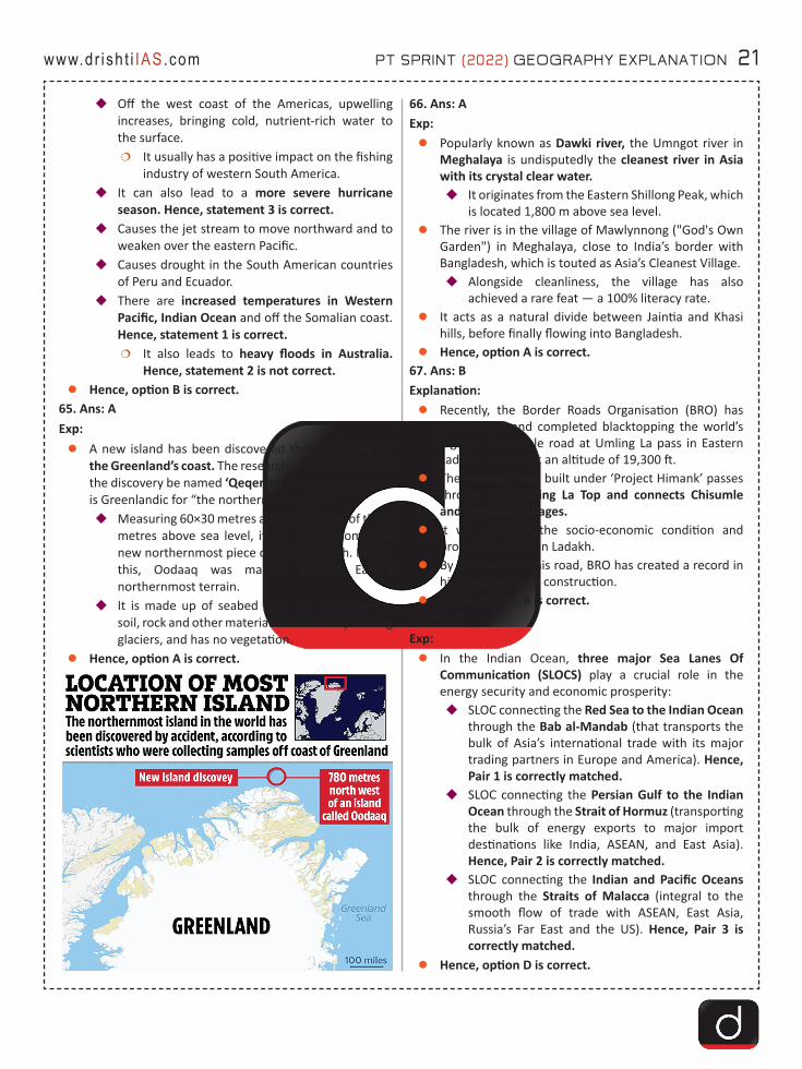
65. Ans: AExp:zA new island has been discovered that is located off
the Greenland’s coast. The researchers have suggested the discovery be named ‘Qeqertaq Avannarleq’, which is Greenlandic for “the northernmost island”.�Measuring 60×30 metres and with a peak of three
metres above sea level, it has now become the new northernmost piece of land on Earth. Before this, Oodaaq was marked as the Earth’s northernmost terrain.
�It is made up of seabed mud and moraine, i.e. soil, rock and other material left behind by moving glaciers, and has no vegetation.
zHence, option A is correct.
66. Ans: AExp: zPopularly known as Dawki river, the Umngot river in
Meghalaya is undisputedly the cleanest river in Asia with its crystal clear water. �It originates from the Eastern Shillong Peak, which
is located 1,800 m above sea level.zThe river is in the village of Mawlynnong ("God's Own
Garden") in Meghalaya, close to India’s border with Bangladesh, which is touted as Asia’s Cleanest Village.�Alongside cleanliness, the village has also
achieved a rare feat — a 100% literacy rate.zIt acts as a natural divide between Jaintia and Khasi
hills, before finally flowing into Bangladesh.zHence, option A is correct.
67. Ans: BExplanation:zRecently, the Border Roads Organisation (BRO) has
constructed and completed blacktopping the world’s highest motorable road at Umling La pass in Eastern Ladakh, located at an altitude of 19,300 ft.
zThe strategic road built under ‘Project Himank’ passes through the Umling La Top and connects Chisumle and Demchok villages.
zIt will enhance the socio-economic condition and promote tourism in Ladakh.
zBy constructing this road, BRO has created a record in high-altitude road construction.
zHence, option B is correct.68. Ans: DExp:zIn the Indian Ocean, three major Sea Lanes Of
Communication (SLOCS) play a crucial role in the energy security and economic prosperity:�SLOC connecting the Red Sea to the Indian Ocean
through the Bab al-Mandab (that transports the bulk of Asia’s international trade with its major trading partners in Europe and America). Hence, Pair 1 is correctly matched.
�SLOC connecting the Persian Gulf to the Indian Ocean through the Strait of Hormuz (transporting the bulk of energy exports to major import destinations like India, ASEAN, and East Asia). Hence, Pair 2 is correctly matched.
�SLOC connecting the Indian and Pacific Oceans through the Straits of Malacca (integral to the smooth flow of trade with ASEAN, East Asia, Russia’s Far East and the US). Hence, Pair 3 is correctly matched.
zHence, option D is correct.

22 PT SPRINT (2022) GEOGRAPHY EXPLANATION www.dr ish t i IAS.com
69. Ans: CExp: zIndia hosts around 104 million (that is almost 8.6% of
the country’s population).zThough there are 705 ethnic groups that have been
formally identified, out of which around 75 are Particularly Vulnerable Tribal Groups (PVTGs).�The Gond comprise the largest tribal group of
India.�The largest number of tribal communities (62) are
found in Odisha. Hence, statement 1 is correct. zThe central tribal belt which comprises the
Northeastern states of India (including the region ranging from Rajasthan to West Bengal) boasts of the maximum concentration of indigenous population. Hence, statement 2 is correct.
70. Ans: AExp: zA Glacial Lake Outburst Flood (GLOF) refers to the
flooding that occurs when the water dammed by a glacier or a moraine (accumulations of dirt and rocks fallen onto the glacier surface) is released suddenly.�When glaciers melt, the water in glacial lakes
accumulates behind loose, natural “glacial/moraine dams” made of ice, sand, pebbles and ice residue.
�Unlike earthen dams, the weak structure of the moraine dam leads to the abrupt breach of the dam on top of the glacial lake which could cause flash floods in the downstream areas. Hence, statement 1 is correct.
zAccording to NDMA, glacial retreat due to climate change occurring in most parts of the Hindu Kush Himalaya has given rise to the formation of numerous new glacial lakes, which are the major cause of GLOFs. Hence, statement 2 is not correct.
71. Ans: CExp:zGlacier is a large, perennial accumulation of crystalline
ice, snow, rock, sediment, and water that originates on land and moves down slope under the influence of its own weight and gravity.
zDepositional Landforms:�Glacial Till: The unassorted coarse and fine debris
dropped by the melting glaciers is called glacial till..
�Moraines: They are long ridges of deposits of glacial till.
�Eskers: These are ridges made of sands and gravels, deposited by glacial meltwater flowing through tunnels within and underneath glaciers, or through meltwater channels on top of glaciers.
�Drumlins: They are smooth oval shaped ridge-like features composed mainly of glacial till with some masses of gravel and sand.
zErosional Landforms of Glaciers:�Glacial Valleys/Troughs: These valleys are trough-
like and U-shaped with broad floors and relatively smooth, and steep sides.
�Cirques: Often are found at the heads of glacial valleys, these are the most common of landforms in glaciated mountains.
�Horns and Serrated: Ridges Horns form through headward erosion of the cirque walls.
72. Ans: AExp: zHirakud Dam is a multipurpose scheme conceived by
Er. M. Visveswaraya in 1937, after recurrence of devastating floods in Mahanadi river.�Its first hydro power was commissioned in 1956.�It is the longest dam of India.
zThe dam is built across river Mahanadi at about 15 km upstream of Sambalpur town of Odisha.
zThe Debrigarh wildlife sanctuary is located near Hirakud dam. It is bounded on the east and north by the huge Hirakud reservoir.�It is one of the select few sanctuaries in the state
supporting both terrestrial and aquatic biodiversity.
zHence, option A is correct.73. Ans: C Exp:zIt is a sacred river in southern India that flows through
the state of Karnataka to Andhra Pradesh. The ancient name of the river was Pampa. The river is approximately 710 km long, and it drains an area of 72,200 sq km.�It flows in a more or less northwest direction
before joining the eastern river Krishna. The Krishna River finally ends into the Bay of Bengal. Hence, statement 1 is not correct.
zTungabhadra dam also known as Pampa Sagar is a multipurpose dam built across Tungabhadra River in Hosapete, Ballari district of Karnataka. It was built by Dr. Thirumalai Iyengar in 1953. Hence, statement 2 is correct.
PT SPRINT (2022) GEOGRAPHY EXPLANATION 23www.dr ish t i IAS.com
zIt’s major tributaries are the Bhadra, the Haridra, the Vedavati, the Tunga, the Varda and the Kumdavathi. Hence, statement 3 is correct.
74. Ans: AExp: Geo-heritage sites in Northeast:zMajuli (Assam): A river “island”, among the world’s
largest, in Brahmaputra river.�The island is also the hub of spiritualism in Assam.
zSangetsar Tso (Arunachal Pradesh): It is popularly known as Madhuri Lake. hence, statement 2 is not correct. Hence, statement 2 is not correct.�It is close to the border with Tibet and was formed
due to the damming of a river during a major earthquake in 1950.
zLoktak Lake (Manipur): It is the largest freshwater lake in the Northeast. Hence, statement 1 is correct. Hence, statement 1 is correct.�The attractions of this lake are the ‘phumdis’ or
floating biomass and the ‘phumsangs’ or huts of fishermen on them.
�The Keibul Lamjao National Park, the only floating wildlife habitat on earth, is on the southwestern part of the lake and is the last natural habitat of the sangai or brow-antlered dancing deer.
75. Answer: C Explanation:zThe earthquake is characterized by severe shaking of
the ground and severe shaking of structures above the ground. �They move slowly and steadily over the Earth’s
interior and many smaller plates. Earthquakes are basically tectonic, that is, moving plates are mainly responsible for the shaking in the ground. Hence, statement 1 is correct.
zThe location below the earth’s surface where the earthquake starts is called the hypocenter, and the location directly above it on the surface of the earth is called the epicentre. Hence, statement 2 is not correct.
zDeep earthquakes (300-700 km) are produced in Wadati–Benioff zones.�It is a zone of subduction, along which earthquakes
are common, which are produced by the interaction of a downgoing oceanic crustal plate against a continental plate. Hence, statement 3 is correct.
76. Ans: BExp:z'Sambhar lake' is located 80 km south-west of Jaipur in
east-central Rajasthan, it is the country’s largest inland saline water body. Hence, statement 1 is correct.
�Represents the depression of the Aravalli Range.zIt is famous for the production of brine/salt, houses
one of the largest salt manufacturing units in the country.�Thousands of migratory birds every year.
zA wetland of ‘international importance’ under the Ramsar Convention, declared in 1990. Hence, statement 2 is correct.
zReceives water from six rivers, namely Samaod, Khari, Mantha, Khandela, Medtha, and Roopangarh. Hence, statement 3 is not correct.
zMostly xerophytic type (Xerophyte is a plant adapted for growth under dry conditions).
zFlamingoes, pelicans and the waterfowls are commonly sighted.
77. Ans: DExp:zIt is a rare form of marine bioluminescence where the
nocturnal ocean surface produces a widespread, uniform and steady whitish glow. �Bioluminescence is light produced by a chemical
reaction within a living organism.�It is also called mareel. Hence, statement 1 is
correct.zArises from a saprophytic relationship between
luminous bacteria and microalgae that expresses on the macroscale. �A strain of luminous bacteria called Vibrio harveyi
colonizing algae at the water's surface has been found. Hence, statement 2 is correct.
zLuminous bacteria cause the particles they colonize to glow. The purpose of this glow could be to attract fish that eat them.�These bacteria thrive in the guts of fishes, so
when their populations get too big for their main food supply, a fish's stomach makes a great second option.
zDuring its positive phase, the Indian Ocean Dipole (IOD) corresponds to warm/wet conditions with warm pooling waters on the western side of the Indian Ocean, and cool/dry conditions with strong easterly winds on the eastern side.�These winds generate upwelling of cool, nutrient-
rich coastal waters which drift offshore with the currents, leading to algal blooms over a broad region, and potentially, conditions favourable for milky sea genesis. Hence, statement 3 is correct.
24 PT SPRINT (2022) GEOGRAPHY EXPLANATION www.dr ish t i IAS.com
78. Ans: AExp:zRecently, the central government has said that no new
Hydropower projects would be allowed in the upper reaches of the Ganga and those sanctioned would have to abide by environment regulations that prescribe a minimum flow in the river at all times of the year to preserve its health.
zSeven projects, all in Uttarakhand, have been allowed to complete construction primarily on the ground that they were over 50% complete.�The seven projects are the:
�Tehri Stage 2 is a 1000 MW project on Bhagirathi river. Hence, pair 1 is correctly matched.
�Tapovan Vishnugad is a 520 MW project on Dhauliganga river. Hence, pair 2 is not correctly matched.
�Vishnugadh Pipalkoti is a 444 MW project on Alaknanda river. Hence, pair 3 is not correctly matched.
�Other projects in Uttarakhand are:�Singoli Bhatwari: 99 MW on Mandakini river�Phata Bhuyang: 76 MW on Mandakini river�Madhyamaheshwar: 15 MW on
Madhyamaheshwar Ganga�Kaliganga 2: 6 MW on Kaliganga river
79. Ans: BExp: zA Mangrove is a small tree or shrub that grows along
coastlines, taking root in salty sediments, often underwater.�They are flowering trees, belonging to the families
Rhizophoraceae, Acanthaceae, Lythraceae, Combretaceae, and Arecaceae.
zFeatures of Mangroves:�Saline environment: They can survive under
extreme hostile environments such as high salt and low oxygen conditions.
�Low oxygen: Underground tissue of any plant needs oxygen for respiration. But in a mangrove environment, the oxygen in soil is limited or nil.
�Survival in Extreme Conditions: With their roots submerged in water, mangrove trees thrive in hot, muddy, salty conditions that would quickly kill most plants.
�Succulent leaves: Mangroves, like desert plants, store fresh water in thick succulent leaves.
�A waxy coating on the leaves seals in water and minimises evaporation.
�Viviparous: Their seeds germinate while still attached to the parent tree. Once germinated, the seedling grows into a propagule.�The mature propagule then drops into the
water and gets transported to a different spot, eventually taking root in a solid ground.
zHence, option B is correct. 80. Ans: BExp: zIndia hosts around 104 million (that is almost 8.6% of
the country’s population).zThough there are 705 ethnic groups that have been
formally identified, out of which around 75 are Particularly Vulnerable Tribal Groups (PVTGs).�The Gond comprise the largest tribal group of
India. zThe largest number of tribal communities (62) are
found in Odisha. Hence, statement 1 is not correct.zThe central tribal belt which comprises the
Northeastern states of India (including the region ranging from Rajasthan to West Bengal) boasts of the maximum concentration of indigenous population. Hence, statement 2 is correct.
81 Ans: CExp:zRecently, the Pacific Northwest and some parts of
Canada recorded temperatures around 47 degrees, causing a “historic” heat wave.�This is a result of a phenomenon referred to as a
“heat dome”. Hence, statement 1 is correct.zThe phenomenon begins when there is a strong
change (or gradient) in ocean temperatures. In the process known as convection, the gradient causes more warm air, heated by the ocean surface, to rise over the ocean surface. Hence, statement 2 is correct.
zAs prevailing winds move the hot air east, the northern shifts of the jet stream trap the air and move it toward land, where it sinks, resulting in heat waves.
82 Ans: BExp:zThe River Nile is in Africa. It originates in Burundi,
south of the equator, and flows northward through northeastern Africa, eventually flowing through Egypt and finally draining into the Mediterranean Sea. Hence, statement 1 is not correct.
PT SPRINT (2022) GEOGRAPHY EXPLANATION 25www.dr ish t i IAS.com
�The source of the Nile is sometimes considered to be Lake Victoria, but the lake itself has feeder rivers of considerable size like the Kagera River.
�The Nile River is considered as one of the longest rivers in the world.
�The Nile is formed by three principal streams: the Blue Nile, the Atbara, and the White Nile.
zThe Nile basin is huge and includes parts of Tanzania, Burundi, Rwanda, Congo (Kinshasa), Kenya.
zThe Nile River forms an arcuate delta as it empties into the Mediterranean Sea. Deltas with triangular or fan-shape are called arcuate (arc-like) deltas. Hence, statement 2 is correct.
zEthiopia has started the second phase of filling a Grand Ethiopian Renaissance Dam’s (GERD) reservoir on the upper Blue Nile, which raised tensions from Sudan and Egypt ahead of an upcoming UN Security Council meeting on the issue.
zEthiopia began the construction of the GERD in 2011 on the Blue Nile. Hence, statement 3 is correct
zBlue Nile is a tributary of the Nile river and it carries about two-thirds of the river’s water volume and most of the silt.
zThis 145-meter-tall hydropower project is Africa’s biggest dam project and will have lasting impacts on its longest river- Nile.
z
83 Ans: AExp:zAmazon Rainforests are large tropical rainforests
occupying the drainage basin of the Amazon River and its tributaries in northern South America. Hence, statement 1 is correct.�It is a vast region that spans eight rapidly
developing countries: Brazil, Bolivia, Peru, Ecuador, Colombia, Venezuela, Guyana, Suriname, and French Guiana, an overseas territory of France.
�Tropical forests are closed-canopy forests growing within 28 degrees north or south of the equator.
�They are very wet places, receiving more than 200 cm rainfall per year, either seasonally or throughout the year.
�Temperatures are uniformly high - between 20°C and 35°C.
�Such forests are found in Asia, Australia, Africa, South America, Central America, Mexico and on many of the Pacific Islands.
zComprising about 40% of Brazil’s total area, it is bounded by the Guiana Highlands to the north, the Andes Mountains to the west (not Pacific Ocean ), the Brazilian central plateau to the south, and the Atlantic Ocean to the east. Hence, statement 2 is not correct.
84 Ans: DExp: Alps MountainszThe Alps emerged during the Alpine orogeny
(mountain-building event), an event that began about 65 million years ago as the Mesozoic Era was drawing to a close.
zThey are the most prominent of western Europe’s physiographic regions.
zThe Alps form part of France, Italy, Switzerland, Germany, Austria, Slovenia, Croatia, Bosnia and Herzegovina, Montenegro, Serbia, and Albania.
zOnly Switzerland and Austria can be considered true Alpine countries.
zThe Alps extend north from the subtropical Mediterranean coast near Nice, France, to Lake Geneva before trending east-northeast to Vienna, Austria. �There they touch the Danube River and meld
with the adjacent plain. zMont Blanc is the highest peak in the Alps and in
Europe, reaching a lofty 4,804 meters above sea level. It is located in the Graian Alps and lies within France, Switzerland, and Italy.
zHence, option D is correct.85 Ans: CExp: zThe ancient name of Sutlej River is Zaradros (Ancient
Greek) Shutudri or Shatadru (Sanskrit).zIt is the longest of the five tributaries of the Indus
River that give the Punjab (meaning “Five Rivers”) its name. Hence, statement 1 is not correct. �Jhelum, Chenab, Ravi, Beas and Sutlej are main
tributaries of Indus.zIt rises on the north slope of the Himalayas in Lake
La’nga in southwestern Tibet. Hence, statement 2 is not correct. �Flowing northwestward and then west-
southwestward through Himalayan gorges, it enters and crosses Himachal Pradesh before beginning its flow through the Punjab plain near Nangal.
26 PT SPRINT (2022) GEOGRAPHY EXPLANATION www.dr ish t i IAS.com
�Continuing southwestward in a broad channel, it receives the Beas River (and forms 65 miles (105 km) of the India-Pakistan border before entering Pakistan and flowing another 220 miles (350 km) to join the Chenab River west of Bahawalpur. �Sutlej River meets the Beas River in Harike
in the Ferozpur district before entering Pakistan. Hence, statement 3 is correct.
�The combined rivers then form the Panjnad, the link between the Five Rivers and the Indus.
86 Ans: CExp:zTides can be defined as the alternate rise and fall of
the ocean water. It is caused by the combined effects of the gravitational force exerted on Earth by the Sun, the gravitational force exerted on Earth by the Moon and rotation of the Earth.�Spring Tide: It occurs during the full moon and
new moon days when the sun, the moon and the earth are in the same line twice each lunar month all year long, without regard to the season. Hence, statement 1 is correct.
�Neap Tide: It occurs when the moon is in its first and last quarter, the ocean waters get drawn in diagonally opposite directions by the gravitational pull of sun and earth resulting in low tides. Hence, statement 2 is correct.
zStages of Tidal Changes:�High tide is the stage when the tidal crest arrives
at a particular location on shore, raising the local sea level.
�Low tide is the stage when the trough arrives, lowering the local sea level.
�Flood tide is a rising or incoming tide between low tide and high tide.
�Ebb tide is a falling or outgoing tide between high tide and low tide.�The vertical distance between high tide and
low tide is the tidal range.87 Ans: CExp:zCaucasus mountain system and region lying between
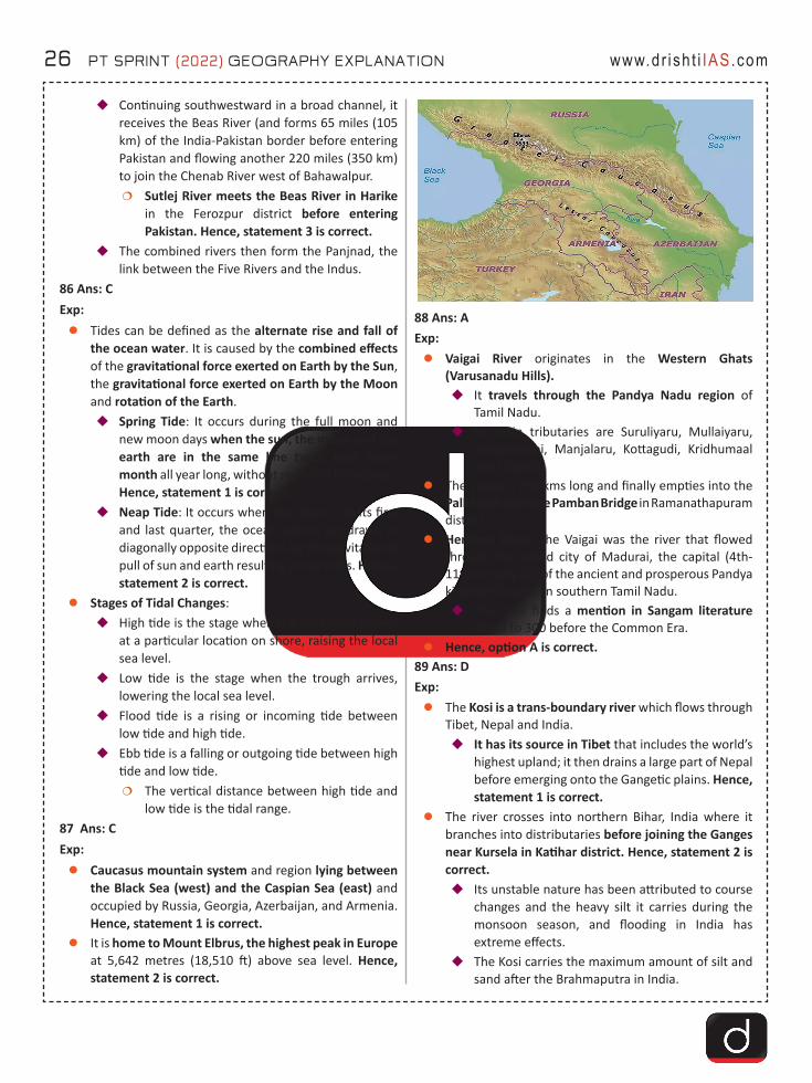
the Black Sea (west) and the Caspian Sea (east) and occupied by Russia, Georgia, Azerbaijan, and Armenia. Hence, statement 1 is correct.
zIt is home to Mount Elbrus, the highest peak in Europe at 5,642 metres (18,510 ft) above sea level. Hence, statement 2 is correct.
88 Ans: AExp:zVaigai River originates in the Western Ghats
(Varusanadu Hills).�It travels through the Pandya Nadu region of
Tamil Nadu.�Its main tributaries are Suruliyaru, Mullaiyaru,
Varaganadhi, Manjalaru, Kottagudi, Kridhumaal and Upparu.
zThe Vaigai is 258 kms long and finally empties into the Palk Strait near the Pamban Bridge in Ramanathapuram district.
zHeritage River: The Vaigai was the river that flowed through the noted city of Madurai, the capital (4th-11th century CE) of the ancient and prosperous Pandya kingdom located in southern Tamil Nadu.�The river finds a mention in Sangam literature
dated to 300 before the Common Era.zHence, option A is correct.
89 Ans: DExp:zThe Kosi is a trans-boundary river which flows through
Tibet, Nepal and India.�It has its source in Tibet that includes the world’s
highest upland; it then drains a large part of Nepal before emerging onto the Gangetic plains. Hence, statement 1 is correct.
zThe river crosses into northern Bihar, India where it branches into distributaries before joining the Ganges near Kursela in Katihar district. Hence, statement 2 is correct. �Its unstable nature has been attributed to course
changes and the heavy silt it carries during the monsoon season, and flooding in India has extreme effects.
�The Kosi carries the maximum amount of silt and sand after the Brahmaputra in India.
PT SPRINT (2022) GEOGRAPHY EXPLANATION 27www.dr ish t i IAS.com
zIt is also known as the “Sorrow of Bihar” as the annual floods affect about 21,000 km2 of fertile agricultural lands thereby disturbing the rural economy. Hence, statement 3 is correct.
90 Ans: AExp:zThe climate of India is described as the ‘monsoon’
type. In Asia, this type of climate is found mainly in the south and the southeast.
zFactors Influencing South-West Monsoon Formation:�The differential heating and cooling of land and
water creates a low pressure on the landmass of India while the seas around experience comparatively high pressure. Hence, statement 1 is correct.
�The shift of the position of Inter Tropical Convergence Zone (ITCZ) in summer, over the Ganga plain (this is the equatorial trough normally positioned about 5°N of the equator. It is also known as the monsoon-trough during the monsoon season).
�The presence of the high-pressure area, east of Madagascar, approximately at 20°S over the Indian Ocean. The intensity and position of this high-pressure area affect the Indian Monsoon.
�The movement of the westerly jet stream to the north of the Himalayas and the presence of the tropical easterly jet stream over the Indian peninsula during summer.
�Tropical Easterly Jet (African Easterly Jet).�El Nino/Southern Oscillation (SO): Normally when
the tropical eastern south Pacific Ocean experiences high pressure, the tropical eastern Indian Ocean experiences low pressure. But in certain years, there is a reversal in the pressure conditions and the eastern Pacific has lower pressure in comparison to the eastern Indian Ocean. This periodic change in pressure conditions is known as the SO.
�The Tibetan plateau gets intensely heated during summer, which results in strong vertical air currents and the formation of low pressure over the plateau at about 9 km above sea level. Hence, statement 2 not is correct.�The Northeast monsoon occurs during
October to December, and is a comparatively small-scale monsoon, which is confined to the Southern peninsula. It is called the winter monsoon.
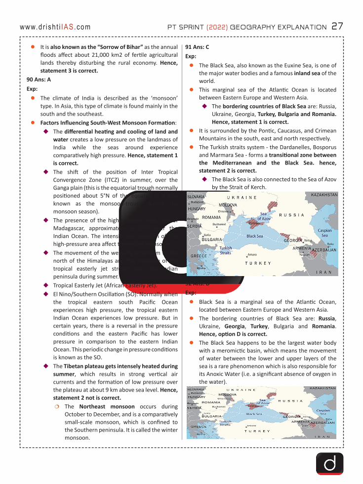
91 Ans: CExp: zThe Black Sea, also known as the Euxine Sea, is one of
the major water bodies and a famous inland sea of the world.
zThis marginal sea of the Atlantic Ocean is located between Eastern Europe and Western Asia.�The bordering countries of Black Sea are: Russia,
Ukraine, Georgia, Turkey, Bulgaria and Romania. Hence, statement 1 is correct.
zIt is surrounded by the Pontic, Caucasus, and Crimean Mountains in the south, east and north respectively.
zThe Turkish straits system - the Dardanelles, Bosporus and Marmara Sea - forms a transitional zone between the Mediterranean and the Black Sea. hence, statement 2 is correct. �The Black Sea is also connected to the Sea of Azov
by the Strait of Kerch.
92 Ans: DExp:zBlack Sea is a marginal sea of the Atlantic Ocean,
located between Eastern Europe and Western Asia.zThe bordering countries of Black Sea are: Russia,
Ukraine, Georgia, Turkey, Bulgaria and Romania. Hence, option D is correct.
zThe Black Sea happens to be the largest water body with a meromictic basin, which means the movement of water between the lower and upper layers of the sea is a rare phenomenon which is also responsible for its Anoxic Water (i.e. a significant absence of oxygen in the water).
28 PT SPRINT (2022) GEOGRAPHY EXPLANATION www.dr ish t i IAS.com
93 Ans: BExp: zThe Summer Solstice is the longest day and shortest
night of the year in the Northern Hemisphere. Hence, statement 2 is correct. �During this, countries in the Northern Hemisphere
are nearest to the Sun and the Sun shines overhead on the Tropic of Cancer (23.5° North).
�The Winter Solstice is the shortest day and longest night of the year in the Northern Hemisphere and is also known as the ‘first day of winter’ in the Northern Hemisphere as well as ‘Hiemal solstice or Hibernal solstice’. Hence, statement 1 is not correct.
zDuring the solstice, the Earth’s axis — around which the planet spins, completing one turn each day — is tilted in a way that the North Pole is tipped towards the sun and the South Pole is away from it.�At the Arctic Circle, the sun never sets during the
summer solstice. Hence, statement 3 is correct. 94 Ans: DExp: zAntarctic Circumpolar Current (ACC) is the only current
in the global ocean to close upon itself in a circumpolar loop.�This trait makes the ACC the most important
current in the Earth’s climate system because it links the Atlantic, Pacific and Indian Oceans and is the primary means of inter-basin exchange of heat, carbon dioxide, chemicals, biology and other tracers. Hence, statement 1 is correct.
�The current flows from west to east around Antarctica. Hence, statement 3 is correct.
zThe ACC is created by the combined effects of strong westerly winds across the Southern Ocean, and the big change in surface temperatures between the Equator and the poles. Hence, statement 2 is correct.
95 Ans: BExp: zThe Mahanadi River system is the third largest of
peninsular India after Godavari and Krishna, and the largest river of Odisha state.
zThe catchment area of the river extends to Chhattisgarh, Madhya Pradesh, Odisha, Jharkhand and Maharashtra.
zThe river rises from a place near Sihawa in Bastar hills in the state of Chhattisgarh to the south of Amarkantak.
zMajor Tributaries of Mahanadi river include Seonath River, Hasdeo river, Mand river, Ib river, Jonking river and Tel river.
zHence, option B is correct. 96 Ans: CExp:zSince the 1990s, climate change has caused billions of
tonnes of glacial ice to melt into oceans. This has caused the Earth’s poles to move in new directions.
zThe north pole has shifted in a new eastward direction since the 1990s, because of changes in the hydrosphere (meaning the way in which water is stored on Earth). Hence, statement 1 is correct.
zFrom 1995 to 2020, the average speed of drift was 17 times faster than from 1981 to 1995.
zAlso, in the last four decades, the poles moved by about 4 metres in distance.�The calculations were based on satellite data
from NASA’s Gravity Recovery and Climate Experiment (GRACE) mission.
zCauses of Polar Drift:�Ice Melting:The faster ice melting under global
warming was the most likely cause of the directional change of the polar drift in the 1990s.�As glaciers melt, water mass redistributes,
causing shifts in the planet’s axis.�Change in Non-Glacial Regions (Terrestrial Water
Storage): Due to climate change and unsustainable consumption of groundwater for irrigation and other anthropogenic activities.
�Groundwater Depletion: As millions of tonnes of water from below the land is pumped out every year for drinking, industries or agriculture, most of it eventually joins the sea, thus redistributing the planet’s mass. Hence, statement 2 is correct.
97 Ans: DExp:zFactors Influencing Southwest Monsoon Formation:
�The differential heating and cooling of land and water creates a low pressure on the landmass of India while the seas around experience comparatively high pressure. Hence, statement 1 is correct.
�The shift of the position of Inter Tropical Convergence Zone (ITCZ) in summer, over the Ganga plain (this is the equatorial trough normally positioned about 5°N of the equator. It is also known as the monsoon-trough during the monsoon season).
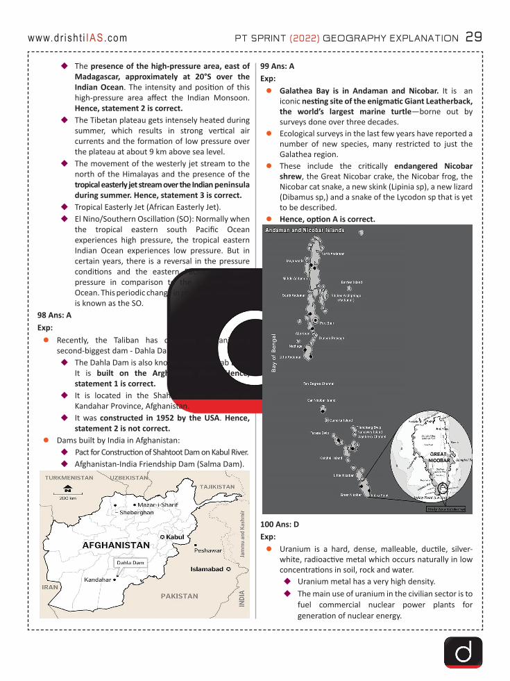
PT SPRINT (2022) GEOGRAPHY EXPLANATION 29www.dr ish t i IAS.com
�The presence of the high-pressure area, east of Madagascar, approximately at 20°S over the Indian Ocean. The intensity and position of this high-pressure area affect the Indian Monsoon. Hence, statement 2 is correct.
�The Tibetan plateau gets intensely heated during summer, which results in strong vertical air currents and the formation of low pressure over the plateau at about 9 km above sea level.
�The movement of the westerly jet stream to the north of the Himalayas and the presence of the tropical easterly jet stream over the Indian peninsula during summer. Hence, statement 3 is correct.
�Tropical Easterly Jet (African Easterly Jet).�El Nino/Southern Oscillation (SO): Normally when
the tropical eastern south Pacific Ocean experiences high pressure, the tropical eastern Indian Ocean experiences low pressure. But in certain years, there is a reversal in the pressure conditions and the eastern Pacific has lower pressure in comparison to the eastern Indian Ocean. This periodic change in pressure conditions is known as the SO.
98 Ans: AExp:zRecently, the Taliban has captured Afghanistan’s
second-biggest dam - Dahla Dam.�The Dahla Dam is also known as Arghandab Dam.
It is built on the Arghandab River. Hence, statement 1 is correct.
�It is located in the Shah Wali Kot District of Kandahar Province, Afghanistan.
�It was constructed in 1952 by the USA. Hence, statement 2 is not correct.
zDams built by India in Afghanistan:�Pact for Construction of Shahtoot Dam on Kabul River.�Afghanistan-India Friendship Dam (Salma Dam).
99 Ans: AExp:zGalathea Bay is in Andaman and Nicobar. It is an
iconic nesting site of the enigmatic Giant Leatherback, the world’s largest marine turtle—borne out by surveys done over three decades.
zEcological surveys in the last few years have reported a number of new species, many restricted to just the Galathea region.
zThese include the critically endangered Nicobar shrew, the Great Nicobar crake, the Nicobar frog, the Nicobar cat snake, a new skink (Lipinia sp), a new lizard (Dibamus sp,) and a snake of the Lycodon sp that is yet to be described.
zHence, option A is correct.
100 Ans: DExp: zUranium is a hard, dense, malleable, ductile, silver-
white, radioactive metal which occurs naturally in low concentrations in soil, rock and water.�Uranium metal has a very high density.�The main use of uranium in the civilian sector is to
fuel commercial nuclear power plants for generation of nuclear energy.
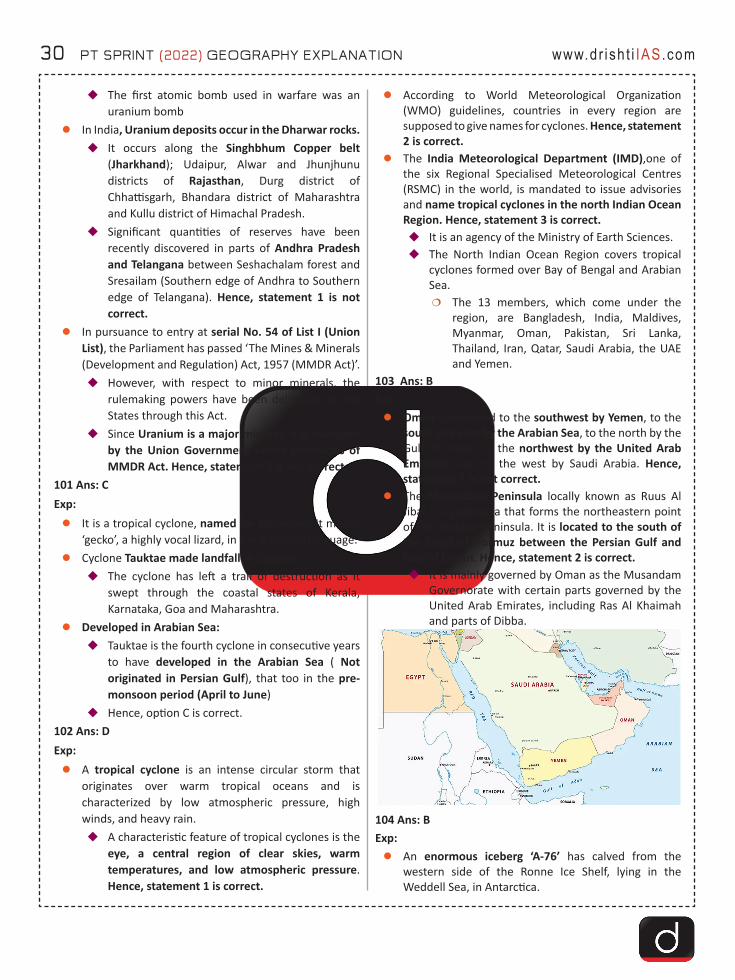
30 PT SPRINT (2022) GEOGRAPHY EXPLANATION www.dr ish t i IAS.com
�The first atomic bomb used in warfare was an uranium bomb
zIn India, Uranium deposits occur in the Dharwar rocks.�It occurs along the Singhbhum Copper belt
(Jharkhand); Udaipur, Alwar and Jhunjhunu districts of Rajasthan, Durg district of Chhattisgarh, Bhandara district of Maharashtra and Kullu district of Himachal Pradesh.
�Significant quantities of reserves have been recently discovered in parts of Andhra Pradesh and Telangana between Seshachalam forest and Sresailam (Southern edge of Andhra to Southern edge of Telangana). Hence, statement 1 is not correct.
zIn pursuance to entry at serial No. 54 of List I (Union List), the Parliament has passed ‘The Mines & Minerals (Development and Regulation) Act, 1957 (MMDR Act)’.�However, with respect to minor minerals, the
rulemaking powers have been delegated to the States through this Act.
�Since Uranium is a major mineral, it is managed by the Union Government under provisions of MMDR Act. Hence, statement 2 is not correct.
101 Ans: CExp:zIt is a tropical cyclone, named for Myanmar. It means
‘gecko’, a highly vocal lizard, in the Burmese language. zCyclone Tauktae made landfall in Gujarat.
�The cyclone has left a trail of destruction as it swept through the coastal states of Kerala, Karnataka, Goa and Maharashtra.
zDeveloped in Arabian Sea:�Tauktae is the fourth cyclone in consecutive years
to have developed in the Arabian Sea ( Not originated in Persian Gulf), that too in the pre-monsoon period (April to June)
�Hence, option C is correct.102 Ans: DExp: zA tropical cyclone is an intense circular storm that
originates over warm tropical oceans and is characterized by low atmospheric pressure, high winds, and heavy rain.�A characteristic feature of tropical cyclones is the
eye, a central region of clear skies, warm temperatures, and low atmospheric pressure. Hence, statement 1 is correct.
zAccording to World Meteorological Organization (WMO) guidelines, countries in every region are supposed to give names for cyclones. Hence, statement 2 is correct.
zThe India Meteorological Department (IMD),one of the six Regional Specialised Meteorological Centres (RSMC) in the world, is mandated to issue advisories and name tropical cyclones in the north Indian Ocean Region. Hence, statement 3 is correct. �It is an agency of the Ministry of Earth Sciences.�The North Indian Ocean Region covers tropical
cyclones formed over Bay of Bengal and Arabian Sea.�The 13 members, which come under the
region, are Bangladesh, India, Maldives, Myanmar, Oman, Pakistan, Sri Lanka, Thailand, Iran, Qatar, Saudi Arabia, the UAE and Yemen.
103 Ans: BExp:zOman is bounded to the southwest by Yemen, to the
south and east by the Arabian Sea, to the north by the Gulf of Oman, to the northwest by the United Arab Emirates, and to the west by Saudi Arabia. Hence, statement 1 is not correct.
zThe Musandam Peninsula locally known as Ruus Al Jibal is a peninsula that forms the northeastern point of the Arabian Peninsula. It is located to the south of the Strait of Hormuz between the Persian Gulf and Gulf of Oman. Hence, statement 2 is correct.�It is mainly governed by Oman as the Musandam
Governorate with certain parts governed by the United Arab Emirates, including Ras Al Khaimah and parts of Dibba.
104 Ans: BExp:zAn enormous iceberg ‘A-76’ has calved from the
western side of the Ronne Ice Shelf, lying in the Weddell Sea, in Antarctica.
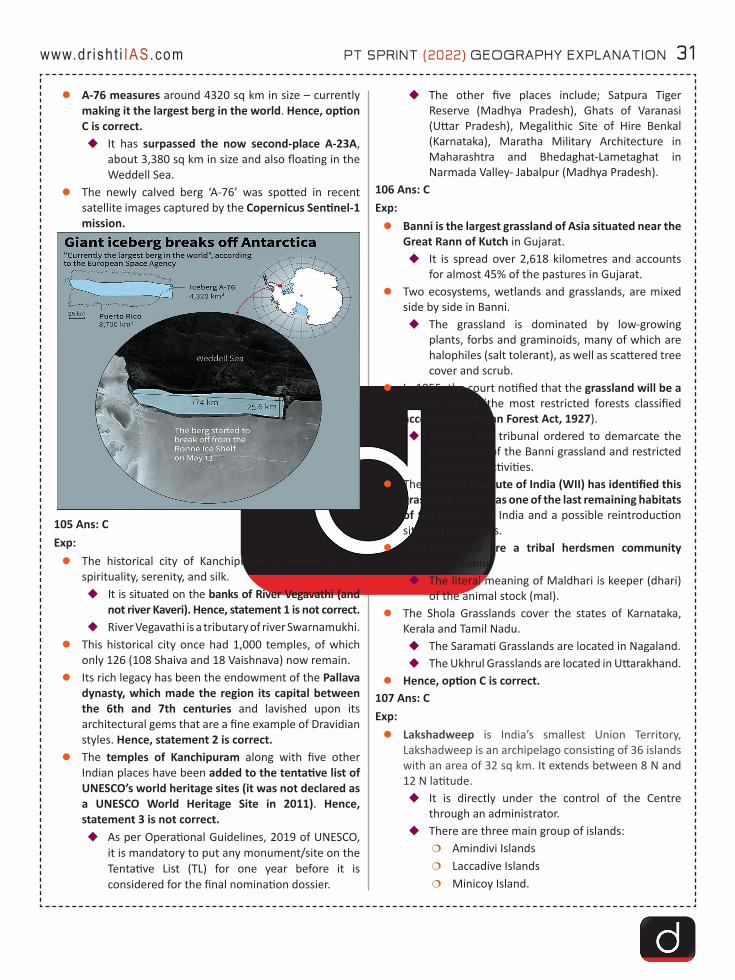
PT SPRINT (2022) GEOGRAPHY EXPLANATION 31www.dr ish t i IAS.com
zA-76 measures around 4320 sq km in size – currently making it the largest berg in the world. Hence, option C is correct.�It has surpassed the now second-place A-23A,
about 3,380 sq km in size and also floating in the Weddell Sea.
zThe newly calved berg ‘A-76’ was spotted in recent satellite images captured by the Copernicus Sentinel-1 mission.
105 Ans: CExp: zThe historical city of Kanchipuram is known for its
spirituality, serenity, and silk.�It is situated on the banks of River Vegavathi (and
not river Kaveri). Hence, statement 1 is not correct. �River Vegavathi is a tributary of river Swarnamukhi.
zThis historical city once had 1,000 temples, of which only 126 (108 Shaiva and 18 Vaishnava) now remain.
zIts rich legacy has been the endowment of the Pallava dynasty, which made the region its capital between the 6th and 7th centuries and lavished upon its architectural gems that are a fine example of Dravidian styles. Hence, statement 2 is correct.
zThe temples of Kanchipuram along with five other Indian places have been added to the tentative list of UNESCO’s world heritage sites (it was not declared as a UNESCO World Heritage Site in 2011). Hence, statement 3 is not correct. �As per Operational Guidelines, 2019 of UNESCO,
it is mandatory to put any monument/site on the Tentative List (TL) for one year before it is considered for the final nomination dossier.
�The other five places include; Satpura Tiger Reserve (Madhya Pradesh), Ghats of Varanasi (Uttar Pradesh), Megalithic Site of Hire Benkal (Karnataka), Maratha Military Architecture in Maharashtra and Bhedaghat-Lametaghat in Narmada Valley- Jabalpur (Madhya Pradesh).
106 Ans: CExp: zBanni is the largest grassland of Asia situated near the
Great Rann of Kutch in Gujarat.�It is spread over 2,618 kilometres and accounts
for almost 45% of the pastures in Gujarat.zTwo ecosystems, wetlands and grasslands, are mixed
side by side in Banni.�The grassland is dominated by low-growing
plants, forbs and graminoids, many of which are halophiles (salt tolerant), as well as scattered tree cover and scrub.
zIn 1955, the court notified that the grassland will be a reserve forest (the most restricted forests classified according to Indian Forest Act, 1927).�In 2019, the tribunal ordered to demarcate the
boundaries of the Banni grassland and restricted non-forest activities.
zThe Wildlife Institute of India (WII) has identified this grassland reserve as one of the last remaining habitats of the cheetah in India and a possible reintroduction site for the species.
zThe Maldharis are a tribal herdsmen community inhabiting Banni.�The literal meaning of Maldhari is keeper (dhari)
of the animal stock (mal).zThe Shola Grasslands cover the states of Karnataka,
Kerala and Tamil Nadu. �The Saramati Grasslands are located in Nagaland. �The Ukhrul Grasslands are located in Uttarakhand.
zHence, option C is correct. 107 Ans: CExp:zLakshadweep is India’s smallest Union Territory,
Lakshadweep is an archipelago consisting of 36 islands with an area of 32 sq km. It extends between 8 N and 12 N latitude.�It is directly under the control of the Centre
through an administrator.�There are three main group of islands:
�Amindivi Islands�Laccadive Islands�Minicoy Island.
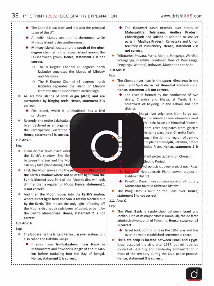
32 PT SPRINT (2022) GEOGRAPHY EXPLANATION www.dr ish t i IAS.com
�The Capital is Kavaratti and it is also the principal town of the UT.
�Amindivi Islands are the northernmost while Minicoy island is the southernmost.
�Minicoy Island, located to the south of the nine-degree channel is the largest island among the Lakshadweep group. Hence, statement 1 is not correct.�The 8 Degree Channel (8 degrees north
latitude) separates the islands of Minicoy and Maldives.
�The 9 Degree Channel (9 degrees north latitude) separates the island of Minicoy from the main Lakshadweep archipelago.
zAll are tiny islands of coral origin (Atoll) and are surrounded by fringing reefs. Hence, statement 2 is correct.�Pitti island, which is uninhabited, has a bird
sanctuary.zRecently, the entire Lakshadweep group of islands has
been declared as an organic agricultural area under the Participatory Guarantee System (PGS) of India. Hence, statement 3 is correct.
108 Ans. CExp:zLunar eclipse takes place when the Moon moves into
the Earth’s shadow. The Earth has to be directly between the Sun and the Moon, and a lunar eclipse can only take place during a full Moon.
zFirst, the Moon moves into the penumbra – the part of the Earth’s shadow where not all of the light from the Sun is blocked out. Part of the Moon’s disc will look dimmer than a regular full Moon. Hence, statement 1 is not correct.
zAnd then the Moon moves into the Earth’s umbra, where direct light from the Sun is totally blocked out by the Earth. This means the only light reflecting off the Moon’s disc has already been refracted, or bent, by the Earth’s atmosphere. Hence, statement 2 is not correct.
109 Ans: AExp:zThe Godavari is the largest Peninsular river system. It is
also called the Dakshin Ganga.�It rises from Trimbakeshwar near Nasik in
Maharashtra and flows for a length of about 1465 km before outfalling into the Bay of Bengal. Hence, statement 1 is correct.
�The Godavari basin extends over states of Maharashtra, Telangana, Andhra Pradesh, Chhattisgarh and Odisha in addition to smaller parts in Madhya Pradesh, Karnataka and Union territory of Puducherry. Hence, statement 2 is not correct.
zTributaries: Pravara, Purna, Manjra, Penganga, Wardha, Wainganga, Pranhita (combined flow of Wainganga, Penganga, Wardha), Indravati, Maner and the Sabri.
110 Ans: BExp: zThe Chenab river rises in the upper Himalayas in the
Lahaul and Spiti district of Himachal Pradesh state. Hence, statement 1 is not correct. �The river is formed by the confluence of two
rivers, Chandra and Bhaga, at Tandi, 8 km southwest of Keylong, in the Lahaul and Spiti district.�The Bhaga river originates from Surya taal
lake, which is situated a few kilometers west of the Bara-lacha la pass in Himachal Pradesh.
�The Chandra river originates from glaciers east of the same pass (near Chandra Taal).
zChenab flows through the Jammu region of Jammu and Kashmir into the plains of Punjab, Pakistan, before flowing into the Indus River. Hence, statement 2 is correct.
zSome of the important projects/dams on Chenab:�Ratle Hydro Electric Project�Salal Dam- hydroelectric power project near Reasi�Dul Hasti Hydroelectric Plant- power project in
Kishtwar District�Pakal Dul Dam (under construction)- on a tributary
Marusadar River in Kishtwar DistrictzThe Pong Dam is built on the Beas river. Hence,
statement 3 is not correct.111 Ans: CExp: zThe West Bank is sandwiched between Israel and
Jordan. One of its major cities is Ramallah, the de facto administrative capital of Palestine. Hence, statement 2 is correct.�Israel took control of it in the 1967 war and has
over the years established settlements there.zThe Gaza Strip is located between Israel and Egypt.
Israel occupied the strip after 1967, but relinquished control of Gaza City and day-to-day administration in most of the territory during the Oslo peace process. Hence, statement 3 is correct.
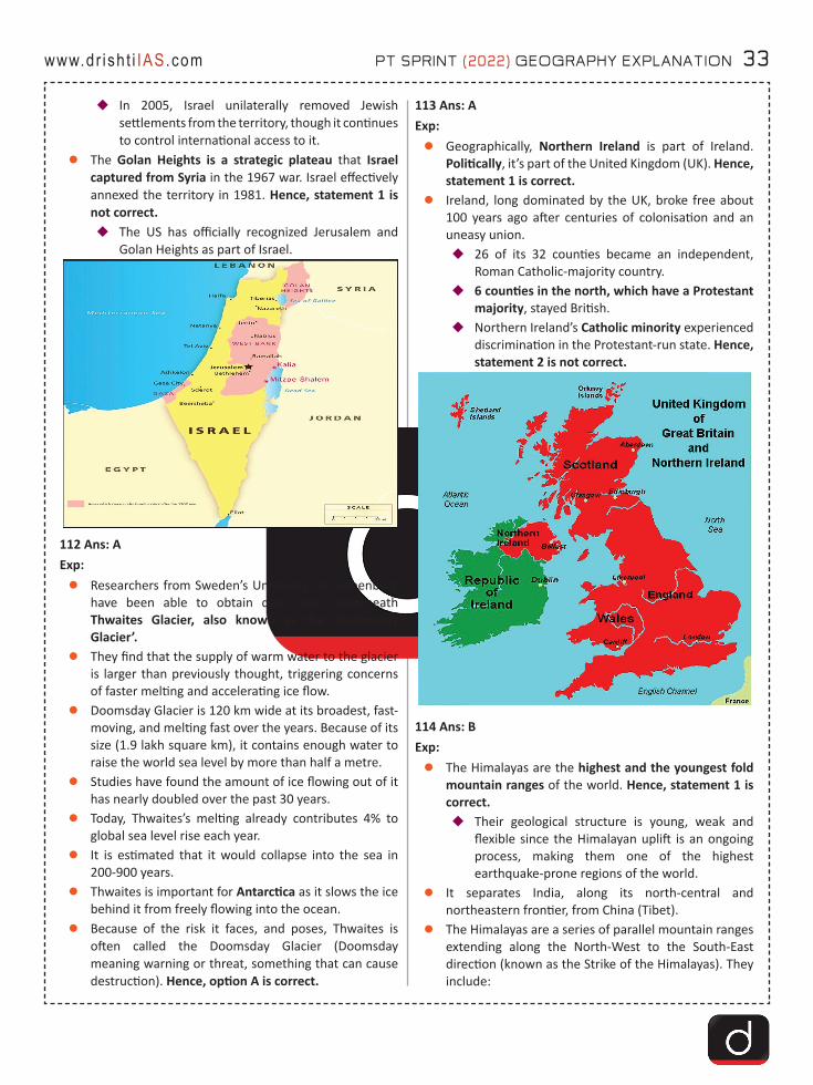
PT SPRINT (2022) GEOGRAPHY EXPLANATION 33www.dr ish t i IAS.com
�In 2005, Israel unilaterally removed Jewish settlements from the territory, though it continues to control international access to it.
zThe Golan Heights is a strategic plateau that Israel captured from Syria in the 1967 war. Israel effectively annexed the territory in 1981. Hence, statement 1 is not correct.�The US has officially recognized Jerusalem and
Golan Heights as part of Israel.
112 Ans: AExp: zResearchers from Sweden’s University of Gothenburg
have been able to obtain data from underneath Thwaites Glacier, also known as the ‘Doomsday Glacier’.
zThey find that the supply of warm water to the glacier is larger than previously thought, triggering concerns of faster melting and accelerating ice flow.
zDoomsday Glacier is 120 km wide at its broadest, fast-moving, and melting fast over the years. Because of its size (1.9 lakh square km), it contains enough water to raise the world sea level by more than half a metre.
zStudies have found the amount of ice flowing out of it has nearly doubled over the past 30 years.
zToday, Thwaites’s melting already contributes 4% to global sea level rise each year.
zIt is estimated that it would collapse into the sea in 200-900 years.
zThwaites is important for Antarctica as it slows the ice behind it from freely flowing into the ocean.
zBecause of the risk it faces, and poses, Thwaites is often called the Doomsday Glacier (Doomsday meaning warning or threat, something that can cause destruction). Hence, option A is correct.
113 Ans: AExp:zGeographically, Northern Ireland is part of Ireland.
Politically, it’s part of the United Kingdom (UK). Hence, statement 1 is correct.
zIreland, long dominated by the UK, broke free about 100 years ago after centuries of colonisation and an uneasy union.�26 of its 32 counties became an independent,
Roman Catholic-majority country. �6 counties in the north, which have a Protestant
majority, stayed British.�Northern Ireland’s Catholic minority experienced
discrimination in the Protestant-run state. Hence, statement 2 is not correct.
114 Ans: BExp: zThe Himalayas are the highest and the youngest fold
mountain ranges of the world. Hence, statement 1 is correct. �Their geological structure is young, weak and
flexible since the Himalayan uplift is an ongoing process, making them one of the highest earthquake-prone regions of the world.
zIt separates India, along its north-central and northeastern frontier, from China (Tibet).
zThe Himalayas are a series of parallel mountain ranges extending along the North-West to the South-East direction (known as the Strike of the Himalayas). They include:
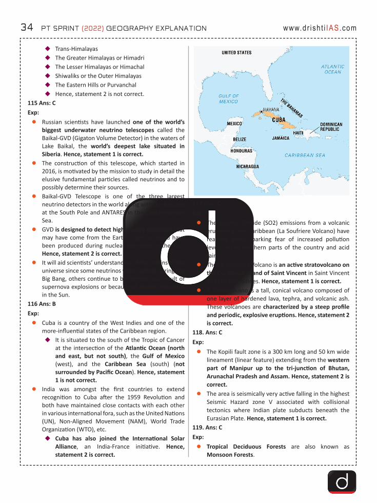
34 PT SPRINT (2022) GEOGRAPHY EXPLANATION www.dr ish t i IAS.com
�Trans-Himalayas�The Greater Himalayas or Himadri�The Lesser Himalayas or Himachal�Shiwaliks or the Outer Himalayas�The Eastern Hills or Purvanchal�Hence, statement 2 is not correct.
115 Ans: CExp:zRussian scientists have launched one of the world’s
biggest underwater neutrino telescopes called the Baikal-GVD (Gigaton Volume Detector) in the waters of Lake Baikal, the world’s deepest lake situated in Siberia. Hence, statement 1 is correct.
zThe construction of this telescope, which started in 2016, is motivated by the mission to study in detail the elusive fundamental particles called neutrinos and to possibly determine their sources.
zBaikal-GVD Telescope is one of the three largest neutrino detectors in the world along with the IceCube at the South Pole and ANTARES in the Mediterranean Sea.
zGVD is designed to detect high-energy neutrinos that may have come from the Earth’s core, or could have been produced during nuclear reactions in the Sun. Hence, statement 2 is correct.
zIt will aid scientists’ understanding of the origins of the universe since some neutrinos were formed during the Big Bang, others continue to be formed as a result of supernova explosions or because of nuclear reactions in the Sun.
116 Ans: BExp: zCuba is a country of the West Indies and one of the
more-influential states of the Caribbean region.�It is situated to the south of the Tropic of Cancer
at the intersection of the Atlantic Ocean (north and east, but not south), the Gulf of Mexico (west), and the Caribbean Sea (south) (not surrounded by Pacific Ocean). Hence, statement 1 is not correct.
zIndia was amongst the first countries to extend recognition to Cuba after the 1959 Revolution and both have maintained close contacts with each other in various international fora, such as the United Nations (UN), Non-Aligned Movement (NAM), World Trade Organization (WTO), etc.�Cuba has also joined the International Solar
Alliance, an India-France initiative. Hence, statement 2 is correct.
117 Ans: CExp:zThe Sulphur Dioxide (SO2) emissions from a volcanic
eruption in the Caribbean (La Soufriere Volcano) have reached India, sparking fear of increased pollution levels in the northern parts of the country and acid rain.
zThe La Soufriere Volcano is an active stratovolcano on the Caribbean island of Saint Vincent in Saint Vincent and the Grenadines. Hence, statement 1 is correct.
zA stratovolcano is a tall, conical volcano composed of one layer of hardened lava, tephra, and volcanic ash. These volcanoes are characterized by a steep profile and periodic, explosive eruptions. Hence, statement 2 is correct.
118. Ans: CExp:zThe Kopili fault zone is a 300 km long and 50 km wide
lineament (linear feature) extending from the western part of Manipur up to the tri-junction of Bhutan, Arunachal Pradesh and Assam. Hence, statement 2 is correct.
zThe area is seismically very active falling in the highest Seismic Hazard zone V associated with collisional tectonics where Indian plate subducts beneath the Eurasian Plate. Hence, statement 1 is correct.
119. Ans: CExp: zTropical Deciduous Forests are also known as
Monsoon Forests.

PT SPRINT (2022) GEOGRAPHY EXPLANATION 35www.dr ish t i IAS.com
zMoist Deciduous Forests are found in the north-eastern states along the foothills of Himalayas, eastern slopes of the Western Ghats and Odisha.�Dry Deciduous Forests are found throughout the
northern part of the country except in the north-east.
zThese forests are found in the regions which record rainfall between 70-200 cm.
zTrees of the moist deciduous forest include: Teak, sal, shisham, hurra, mahua, amla, semul, kusum, and sandalwood.�Tendu, palas, amaltas, bel, khair, axlewood, etc.
are the common trees of dry deciduous forests.zHence, option C is correct.
120. Ans: DExp:zIndia is one of the highly earthquake affected countries
because of the presence of technically active young fold mountains - Himalaya.
zIndia has been divided into four seismic zones (II, III, IV, and V) based on scientific inputs relating to seismicity, earthquakes occurred in the past and tectonic setup of the region. Hence, statement 1 is not correct.
�Previously, earthquake zones were divided into five zones with respect to the severity of the earthquakes but the Bureau of Indian Standards (BIS) grouped the country into four seismic zones by unifying the first two zones.
�BIS is the official agency for publishing the seismic hazard maps and codes. Hence, statement 2 is not correct.
121. Ans: CExp: zChad is a landlocked state in north-central Africa.
Hence, statement 1 is not correct. zIt is named after Lake Chad.
�This is the second-largest lake in Africa (after Lake Victoria) and its basin covers parts of Nigeria, Niger, Chad and Cameroon.
zChad is also a part of the Sahel region. Hence, statement 2 is not correct. �Sahel is a semiarid region of western and north-
central Africa extending from Senegal eastward to Sudan.
�It forms a transitional zone between the arid Sahara (desert) to the north and the belt of humid savannas to the south.
zChad is a member country of International Solar Alliance (ISA), an India-France initiative.�The in ase in the import of Crude Oil from Chad
is the main reason for the significant increase in the bilateral trade between India and Chad. (USD 513.59 million in 2018-19). Hence, statement 3 is correct.
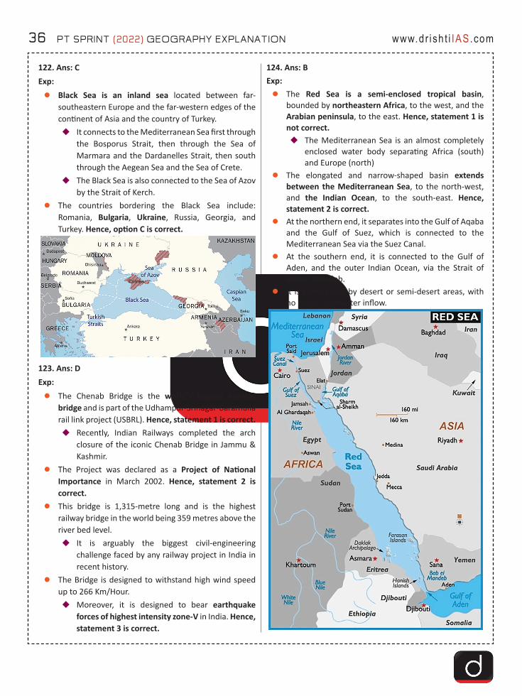
36 PT SPRINT (2022) GEOGRAPHY EXPLANATION www.dr ish t i IAS.com
122. Ans: CExp: zBlack Sea is an inland sea located between far-
southeastern Europe and the far-western edges of the continent of Asia and the country of Turkey.�It connects to the Mediterranean Sea first through
the Bosporus Strait, then through the Sea of Marmara and the Dardanelles Strait, then south through the Aegean Sea and the Sea of Crete.
�The Black Sea is also connected to the Sea of Azov by the Strait of Kerch.
zThe countries bordering the Black Sea include: Romania, Bulgaria, Ukraine, Russia, Georgia, and Turkey. Hence, option C is correct.
123. Ans: DExp: zThe Chenab Bridge is the world’s highest railway
bridge and is part of the Udhampur-Srinagar-Baramulla rail link project (USBRL). Hence, statement 1 is correct. �Recently, Indian Railways completed the arch
closure of the iconic Chenab Bridge in Jammu & Kashmir.
zThe Project was declared as a Project of National Importance in March 2002. Hence, statement 2 is correct.
zThis bridge is 1,315-metre long and is the highest railway bridge in the world being 359 metres above the river bed level.�It is arguably the biggest civil-engineering
challenge faced by any railway project in India in recent history.
zThe Bridge is designed to withstand high wind speed up to 266 Km/Hour.�Moreover, it is designed to bear earthquake
forces of highest intensity zone-V in India. Hence, statement 3 is correct.
124. Ans: BExp: zThe Red Sea is a semi-enclosed tropical basin,
bounded by northeastern Africa, to the west, and the Arabian peninsula, to the east. Hence, statement 1 is not correct. �The Mediterranean Sea is an almost completely
enclosed water body separating Africa (south) and Europe (north)
zThe elongated and narrow-shaped basin extends between the Mediterranean Sea, to the north-west, and the Indian Ocean, to the south-east. Hence, statement 2 is correct.
zAt the northern end, it separates into the Gulf of Aqaba and the Gulf of Suez, which is connected to the Mediterranean Sea via the Suez Canal.
zAt the southern end, it is connected to the Gulf of Aden, and the outer Indian Ocean, via the Strait of Bab-el-Mandeb.
zIt is surrounded by desert or semi-desert areas, with no major freshwater inflow.
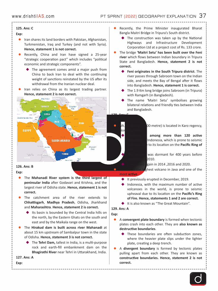
PT SPRINT (2022) GEOGRAPHY EXPLANATION 37www.dr ish t i IAS.com
125. Ans: CExp: zIran shares its land borders with Pakistan, Afghanistan,
Turkmenistan, Iraq and Turkey (and not with Syria). Hence, statement 1 is not correct.
zRecently, China and Iran have signed a 25-year “strategic cooperation pact” which includes “political economic and strategic components”.�The agreement comes amid a major push from
China to back Iran to deal with the continuing weight of sanctions reinstated by the US after its withdrawal from the Iranian nuclear deal.
zIran relies on China as its largest trading partner. Hence, statement 2 is not correct.
126. Ans: BExp: zThe Mahanadi River system is the third largest of
peninsular India after Godavari and Krishna, and the largest river of Odisha state. Hence, statement 1 is not correct.
zThe catchment area of the river extends to Chhattisgarh, Madhya Pradesh, Odisha, Jharkhand and Maharashtra. Hence, statement 2 is correct. �Its basin is bounded by the Central India hills on
the north, by the Eastern Ghats on the south and east and by the Maikala range on the west.
zThe Hirakud dam is built across river Mahanadi at about 15 km upstream of Sambalpur town in the state of Odisha. Hence, statement 3 is not correct. �The Tehri Dam, tallest in India, is a multi-purpose
rock and earth-fill embankment dam on the Bhagirathi River near Tehri in Uttarakhand, India.
127. Ans: AExp:
zRecently, the Prime Minister inaugurated Bharat Bangla Maitri Bridge in Tripura’s South district.�The construction was taken up by the National
Highways and Infrastructure Development Corporation Ltd at a project cost of Rs. 133 crore.
zThe bridge ‘Maitri Setu’ has been built over the Feni river which flows between Indian boundary in Tripura State and Bangladesh. Hence, statement 2 is not correct. �Feni originates in the South Tripura district. The
river passes through Sabroom town on the Indian side, and meets the Bay of Bengal after it flows into Bangladesh. Hence, statement 1 is correct.
�The 1.9 Km long bridge joins Sabroom (in Tripura) with Ramgarh (in Bangladesh).
�The name ‘Maitri Setu’ symbolises growing bilateral relations and friendly ties between India and Bangladesh.
128. Ans: CExp: zMt. Sinabung (2,600-metre) is located in Karo regency,
North Sumatra.�Sinabung is among more than 120 active
volcanoes in Indonesia, which is prone to seismic upheaval due to its location on the Pacific Ring of Fire.
�The volcano was dormant for 400 years before exploding in 2010.
�It exploded again in 2014 ,2016 and 2020.zSemeru is the highest volcano in Java and one of the
most active.�It previously erupted in December, 2019.�Indonesia, with the maximum number of active
volcanoes in the world, is prone to seismic upheaval due to its location on the Pacific’s Ring of Fire. Hence, statements 1 and 2 are correct.
�It is also known as “The Great Mountain”.129. Ans: AExp:zA convergent plate boundary is formed when tectonic
plates crash into each other. They are also known as destructive boundaries.�These boundaries are often subduction zones,
where the heavier plate slips under the lighter plate, creating a deep trench.
zA divergent boundary is formed by tectonic plates pulling apart from each other. They are known as constructive boundaries. Hence, statement 2 is not correct.
38 PT SPRINT (2022) GEOGRAPHY EXPLANATION www.dr ish t i IAS.com
�Divergent boundaries are the site of seafloor spreading and rift valleys.
�At divergent boundaries in the oceans, magma from deep in the Earth’s mantle rises toward the surface and pushes apart two or more plates. Mountains and volcanoes rise along the seam. The process renews the ocean floor and widens the giant basins.�The best-known example of divergent
boundaries is the Mid-Atlantic Ridge where the American Plates are separated from the Eurasian and African Plates.
�This single mid-ocean ridge system connects the world’s oceans, making the ridge the longest mountain range in the world (10,000 miles).
�On land, giant troughs such as the Great Rift Valley in Africa form where plates are tugged apart.�If the plates there continue to diverge,
millions of years from now eastern Africa will split from the continent to form a new landmass.
�A mid-ocean ridge would then mark the boundary between the plates. Hence, statement 1 is correct.
130. Ans: BExp: zSangay volcano is one of the highest active volcanoes
in the world and one of Ecuador’s most active ones. Hence, option B is correct.�Sangay is the southernmost stratovolcano (a
volcano built up of alternate layers of lava and ash) in the northern volcanic zone of the Andes. It is 5230 m high.
�The Andes is the longest above water mountain range in the world and boasts some of the highest peaks.
zSangay National Park is located in the central part of Ecuador on the Andes mountains’ eastern side. It is a world heritage site. The earliest report of a historical eruption was in 1628. More or less continuous eruptions were reported from 1728 until 1916, and again from 1934 to the present. Sangay has had frequent eruptions in historic times, mostly of strombolian type.
zEcuador, part of the Pacific Rim’s “Ring of Fire” region, has eight volcanoes such as Cotopaxi (5,897m), Cayambe (5,790m), Pichincha (4,784m) etc. in its territory.
131. Ans: DExp:zThe Bhadar is one of the major rivers of Kathiawar
(Saurashtra) peninsula in Gujarat.�It originates near Vaddi in Rajkot district at an
elevation of 261 m above mean sea level. Hence, statement 1 is not correct.
zIt flows through the Saurashtra region (does not cross the Aravali Range) and finally confluence with Arabian sea at Naviobandar (Porbandar). Hence, statement 2 is not correct.�The total length of this river is 198 km. It drains
about 1/7th of the area of Saurashtra.132. Ans: CExp:zThe Periyar River is the longest river in the state of
Kerala with a length of 244 km.zIt is also known as ‘Lifeline of Kerala’ as it is one of the
few perennial rivers in the state.�A perennial river is a channel that has continuous
flow in parts of its stream bed all year round.zPeriyar River originates from Sivagiri hills of Western
Ghats and flows through the Periyar National Park. Hence, statement 1 is correct.
zThe main tributaries of Periyar are Muthirapuzha, Mullayar, Cheruthoni and Perinjankutti. Hence, statement 2 is correct.
133. Ans: DExp: zChambal River is one of the most pollution-free rivers
of India.�It originates at the Singar Chouri peak in the
northern slopes of the Vindhya mountains (Indore, Madhya Pradesh).
�From there, it flows in the North direction in Madhya Pradesh for a length of about 346 km and then follows a north-easterly direction for a length of 225 km through Rajasthan.
zIt is a rainfed river and its basin is bounded by the Vindhyan mountain ranges and the Aravallis.
zThe Chambal and its tributaries drain the Malwa region of northwestern Madhya Pradesh.�Main Tributaries: Banas, Kali Sindh, Sipra, Parbati, etc.
zHence, option D is correct.134. Ans: BExp: zKen and Betwa rivers originate in MP and are the
tributaries of Yamuna. Hence, statement 1 is correct.
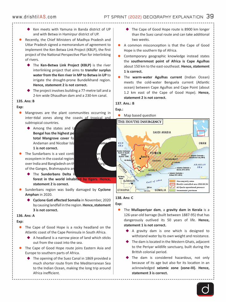
PT SPRINT (2022) GEOGRAPHY EXPLANATION 39www.dr ish t i IAS.com
�Ken meets with Yamuna in Banda district of UP and with Betwa in Hamirpur district of UP.
zRecently, the Chief Ministers of Madhya Pradesh and Uttar Pradesh signed a memorandum of agreement to implement the Ken Betwa Link Project (KBLP), the first project of the National Perspective Plan for interlinking of rivers.�The Ken-Betwa Link Project (KBLP) is the river
interlinking project that aims to transfer surplus water from the Ken river in MP to Betwa in UP to irrigate the drought-prone Bundelkhand region. Hence, statement 2 is not correct.
�The project involves building a 77-metre tall and a 2-km wide Dhaudhan dam and a 230-km canal.
135. Ans: BExp: zMangroves are the plant communities occurring in
inter-tidal zones along the coasts of tropical and subtropical countries.�Among the states and Union Territories, West
Bengal has the highest percentage of area under total Mangrove cover followed by Gujarat and Andaman and Nicobar Islands. Hence, statement 1 is not correct.
zThe Sundarbans is a vast contiguous mangrove forest ecosystem in the coastal region of Bay of Bengal spread over India and Bangladesh on the delta (world’s largest) of the Ganges, Brahmaputra and Meghna rivers.�The Sunderbans Delta is the only mangrove
forest in the world inhabited by tigers. Hence, statement 2 is correct.
zSunderbans region was badly damaged by Cyclone Amphan in 2020.�Cyclone Gati affected Somalia in November, 2020
by causing landfall in the region. Hence, statement 3 is not correct.
136. Ans: AExp: zThe Cape of Good Hope is a rocky headland on the
Atlantic coast of the Cape Peninsula in South Africa.�A headland is a narrow piece of land which sticks
out from the coast into the sea.zThe Cape of Good Hope route joins Eastern Asia and
Europe to southern parts of Africa.�The opening of the Suez Canal in 1869 provided a
much shorter route from the Mediterranean Sea to the Indian Ocean, making the long trip around Africa inefficient.
�The Cape of Good Hope route is 8900 km longer than the Suez canal route and can take additional two weeks.
zA common misconception is that the Cape of Good Hope is the southern tip of Africa.
zContemporary geographic knowledge instead states the southernmost point of Africa is Cape Agulhas about 150 km to the east-southeast. Hence, statement 1 is correct.
zThe warm-water Agulhas current (Indian Ocean) meets the cold-water Benguela current (Atlantic ocean) between Cape Agulhas and Cape Point (about 1.2 km east of the Cape of Good Hope). Hence, statement 2 is not correct.
137. Ans.: BExp.:zMap based question
138. Ans: CExp: zThe Mullaperiyar dam, a gravity dam in Kerala is a
126-year-old barrage (built between 1887-95) that has dangerously outlived its 50 years of life. Hence, statement 1 is not correct. �A gravity dam is one which is designed to
withstand water by its own weight and resistance.�The dam is located in the Western Ghats, adjacent
to the Periyar wildlife sanctuary, built during the British colonial period.
�The dam is considered hazardous, not only because of its age but also for its location in an acknowledged seismic zone (zone-III). Hence, statement 3 is correct.
40 PT SPRINT (2022) GEOGRAPHY EXPLANATION www.dr ish t i IAS.com
�The dam is operated and maintained by Tamil Nadu for meeting the drinking water and irrigation requirements of five of its southern districts.
�According to a 999-year lease agreement made during the British rule the operational rights were handed over to Tamil Nadu. Hence, statement 2 is correct. �The lease allows Tamil Nadu to operate the
dam and divert 640 million cubic metres of water annually for irrigation and power generation through a tunnel bored into the Western Ghat mountains that form a wall between the two states.
139. Ans: CExp:zChambal River is one of the most pollution-free rivers
of India.�It originates at the Singar Chouri peak in the
northern slopes of the Vindhya mountains (Indore, Madhya Pradesh). From there, it flows in the North direction in Madhya Pradesh for a length of about 346 km and then follows a north-easterly direction for a length of 225 km through Rajasthan. Hence, statement 1 is correct.
�It enters U.P. and flows for about 32 km before joining the Yamuna River in Etawah District.
zIt is a rainfed river and its basin is bounded by the Vindhyan mountain ranges and the Aravallis. The Chambal and its tributaries drain the Malwa region of northwestern Madhya Pradesh. Hence, statement 2 is correct.
zThe Hadauti plateau in Rajasthan occurs in the upper catchment of the Chambal River to the southeast of the Mewar Plains.
zTributaries: Banas, Kali Sindh, Sipra, Parbati, etc.zMain Power Projects/ Dam: Gandhi Sagar Dam, Rana
Pratap Sagar Dam, Jawahar Sagar Dam, and Kota Barrage.
zThe National Chambal Sanctuary is located along river Chambal on the tri-junction of Rajasthan, Madhya Pradesh and Uttar Pradesh. It is known for critically endangered gharials, the red-crowned roof turtle, and the endangered Ganges river dolphin.
140. Ans: AExpzThe Suez Canal is an artificial sea-level waterway
running north to south across the Isthmus of Suez in Egypt, to connect the Mediterranean Sea and the Red Sea. Hence, statement 1 is correct.
�The canal separates the African continent from Asia.
�It provides the shortest maritime route between Europe and the lands lying around the Indian and western Pacific oceans.
�It is one of the world’s most heavily used shipping lanes, carrying over 12% of world trade by volume.
zThe Suez Canal is actually the first canal that directly links the Mediterranean Sea to the Red Sea. It was opened for navigation in November 1869.�The 150-year-old canal was controlled by British
and French interests in its initial years, but was nationalised in 1956 by Egypt. Hence, statement 2 is not correct.�Suez Crisis, international crisis in the Middle
East, precipitated in July 1956, when the Egyptian president, Gamal Abdel Nasser, nationalized the Suez Canal. The canal had been owned by the Suez Canal Company, which was controlled by French and British interests.
zThe Canal was closed five times; the last time was the most serious one since it lasted for 8 years. The Canal was then reopened for navigation in June 1975.
141. Ans: CExp: Little Andaman IslandzThis island is part of the Little Andaman Group (Little
Andaman is the counterpart of Great Andamans). This island is the fourth largest island in Andamans.�It is famous by the name of its main village and
the largest settlement –Hut Bay (rarely known by its other name Kwate-tu-kwage). Hence, statement 1 is correct.
zAt a distance of about 120 Kilometers by sea from the capital town of Port Blair, this island has become a tribal reserve from sometime near to 1957.�This is considered home to the Onge Tribes, even
though there are multilingual settlers of Bengali, Tamil, Telugu, and Ranchi communities. Hence, statement 2 is correct.
zLying at the southern end of the archipelago, Hut Bay Jetty is the only harbor for ships or boats coming into this island from the capital town –Port Blair.�Little Andamans is less explored due to the limited
mode of connection with the capital town of Port Blair.
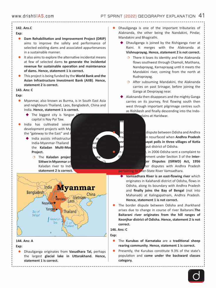
PT SPRINT (2022) GEOGRAPHY EXPLANATION 41www.dr ish t i IAS.com
142. Ans.CExp:zDam Rehabilitation and Improvement Project (DRIP)
aims to improve the safety and performance of selected existing dams and associated appurtenances in a sustainable manner.
zIt also aims to explore the alternative incidental means at few of selected dams to generate the incidental revenue for sustainable operation and maintenance of dams. Hence, statement 1 is correct.
zThis project is being funded by the World Bank and the Asian Infrastructure Investment Bank (AIIB). Hence, statement 2 is correct.
143. Ans: CExp: zMyanmar, also known as Burma, is in South East Asia
and neighbours Thailand, Laos, Bangladesh, China and India. Hence, statement 1 is correct.�The biggest city is Yangon (Rangoon) but the
capital is Nay Pyi Taw.zIndia has cultivated several infrastructure and
development projects with Myanmar, which it sees as the “gateway to the East” and ASEAN countries:�India assists infrastructure projects such as the
India-Myanmar-Thailand trilateral highway and the Kaladan Multi-Modal Transit Transport Project.�The Kaladan project will link Kolkata to
Sittwe in Myanmar and then from Myanmar’s Kaladan river to India’s north-east. Hence, statement 2 is correct.
144. Ans: AExp: zDhauliganga originates from Vasudhara Tal, perhaps
the largest glacial lake in Uttarakhand. Hence, statement 1 is correct.
zDhauliganga is one of the important tributaries of Alaknanda, the other being the Nandakini, Pindar, Mandakini and Bhagirathi.�Dhauliganga is joined by the Rishiganga river at
Raini. It merges with the Alaknanda at Vishnuprayag. Hence, statement 2 is not correct.�There it loses its identity and the Alaknanda
flows southwest through Chamoli, Maithana, Nandaprayag, Karnaprayag until it meets the Mandakini river, coming from the north at Rudraprayag.
�After subsuming Mandakini, the Alaknanda carries on past Srinagar, before joining the Ganga at Devprayag near.
�Alaknanda then disappears and the mighty Ganga carries on its journey, first flowing south then west through important pilgrimage centres such as Rishikesh and finally descending into the Indo-Gangetic plains at Haridwar.
145. Ans: DExp:zRecently, a border dispute between Odisha and Andhra
Pradesh once again resurfaced when Andhra Pradesh announced panchayat polls in three villages of Kotia panchayat in Koraput district of Odisha.
zIn another dispute, in 2006 Odisha sent a complaint to the Central Government under Section 3 of the Inter-State River Water Disputes (ISRWD) Act, 1956 regarding its water disputes with Andhra Pradesh pertaining to Inter-State River Vamsadhara.�Vamsadhara River is an east-flowing river which
originates in Kalahandi district of Odisha, flows in Odisha, along its boundary with Andhra Pradesh and finally joins the Bay of Bengal (not into Mahanadi) at Kalingapatnam, Andhra Pradesh. Hence, statement 1 is not correct.
zThe border dispute between Odisha and Jharkhand arises due to change in course of river Baitarani.The Baitarani river originates from the hill ranges of Keonjhar district of Odisha. Hence, statement 2 is not correct.
146. Ans: CExp: zThe Kurubas of Karnataka are a traditional sheep
rearing community. Hence, statement 1 is correct.zPresently, the Kurubas constitute 9.3% of the state’s
population and come under the backward classes category.
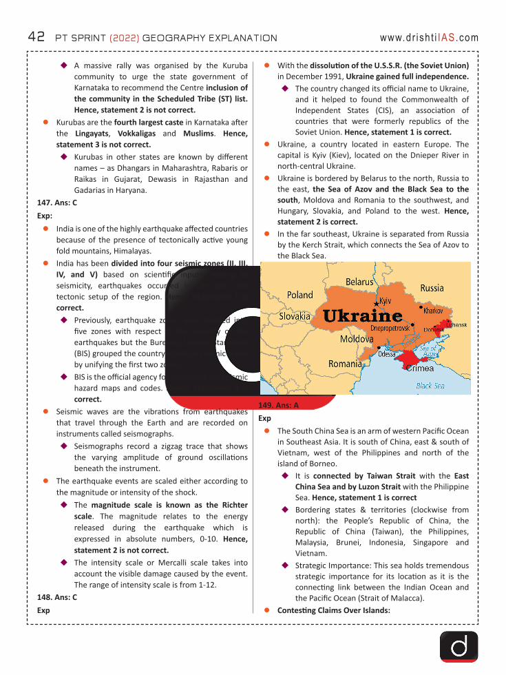
42 PT SPRINT (2022) GEOGRAPHY EXPLANATION www.dr ish t i IAS.com
�A massive rally was organised by the Kuruba community to urge the state government of Karnataka to recommend the Centre inclusion of the community in the Scheduled Tribe (ST) list. Hence, statement 2 is not correct.
zKurubas are the fourth largest caste in Karnataka after the Lingayats, Vokkaligas and Muslims. Hence, statement 3 is not correct. �Kurubas in other states are known by different
names – as Dhangars in Maharashtra, Rabaris or Raikas in Gujarat, Dewasis in Rajasthan and Gadarias in Haryana.
147. Ans: CExp: zIndia is one of the highly earthquake affected countries
because of the presence of tectonically active young fold mountains, Himalayas.
zIndia has been divided into four seismic zones (II, III, IV, and V) based on scientific inputs relating to seismicity, earthquakes occurred in the past and tectonic setup of the region. Hence, statement 1 is correct.�Previously, earthquake zones were divided into
five zones with respect to the severity of the earthquakes but the Bureau of Indian Standards (BIS) grouped the country into four seismic zones by unifying the first two zones.
�BIS is the official agency for publishing the seismic hazard maps and codes. Hence, statement 3 is correct.
zSeismic waves are the vibrations from earthquakes that travel through the Earth and are recorded on instruments called seismographs.�Seismographs record a zigzag trace that shows
the varying amplitude of ground oscillations beneath the instrument.
zThe earthquake events are scaled either according to the magnitude or intensity of the shock.�The magnitude scale is known as the Richter
scale. The magnitude relates to the energy released during the earthquake which is expressed in absolute numbers, 0-10. Hence, statement 2 is not correct.
�The intensity scale or Mercalli scale takes into account the visible damage caused by the event. The range of intensity scale is from 1-12.
148. Ans: CExp
zWith the dissolution of the U.S.S.R. (the Soviet Union) in December 1991, Ukraine gained full independence.�The country changed its official name to Ukraine,
and it helped to found the Commonwealth of Independent States (CIS), an association of countries that were formerly republics of the Soviet Union. Hence, statement 1 is correct.
zUkraine, a country located in eastern Europe. The capital is Kyiv (Kiev), located on the Dnieper River in north-central Ukraine.
zUkraine is bordered by Belarus to the north, Russia to the east, the Sea of Azov and the Black Sea to the south, Moldova and Romania to the southwest, and Hungary, Slovakia, and Poland to the west. Hence, statement 2 is correct.
zIn the far southeast, Ukraine is separated from Russia by the Kerch Strait, which connects the Sea of Azov to the Black Sea.
149. Ans: AExpzThe South China Sea is an arm of western Pacific Ocean
in Southeast Asia. It is south of China, east & south of Vietnam, west of the Philippines and north of the island of Borneo.�It is connected by Taiwan Strait with the East
China Sea and by Luzon Strait with the Philippine Sea. Hence, statement 1 is correct
�Bordering states & territories (clockwise from north): the People’s Republic of China, the Republic of China (Taiwan), the Philippines, Malaysia, Brunei, Indonesia, Singapore and Vietnam.
�Strategic Importance: This sea holds tremendous strategic importance for its location as it is the connecting link between the Indian Ocean and the Pacific Ocean (Strait of Malacca).
zContesting Claims Over Islands:
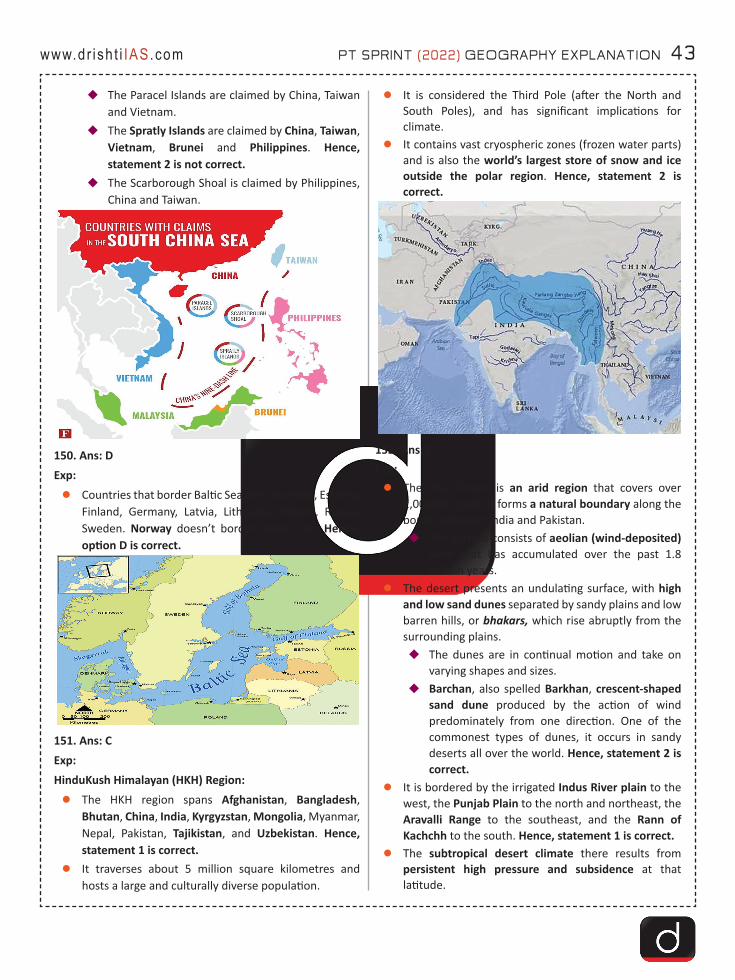
PT SPRINT (2022) GEOGRAPHY EXPLANATION 43www.dr ish t i IAS.com
�The Paracel Islands are claimed by China, Taiwan and Vietnam.
�The Spratly Islands are claimed by China, Taiwan, Vietnam, Brunei and Philippines. Hence, statement 2 is not correct.
�The Scarborough Shoal is claimed by Philippines, China and Taiwan.
150. Ans: DExp:zCountries that border Baltic Sea are: Denmark, Estonia,
Finland, Germany, Latvia, Lithuania, Poland, Russia, Sweden. Norway doesn’t borders baltic sea. Hence, option D is correct.
151. Ans: CExp: HinduKush Himalayan (HKH) Region: zThe HKH region spans Afghanistan, Bangladesh,
Bhutan, China, India, Kyrgyzstan, Mongolia, Myanmar, Nepal, Pakistan, Tajikistan, and Uzbekistan. Hence, statement 1 is correct.
zIt traverses about 5 million square kilometres and hosts a large and culturally diverse population.
zIt is considered the Third Pole (after the North and South Poles), and has significant implications for climate.
zIt contains vast cryospheric zones (frozen water parts) and is also the world’s largest store of snow and ice outside the polar region. Hence, statement 2 is correct.
152. Ans: CExp:zThe Thar Desert is an arid region that covers over
2,00,000 sq km. It forms a natural boundary along the border between India and Pakistan. �The surface consists of aeolian (wind-deposited)
sand that has accumulated over the past 1.8 million years.
zThe desert presents an undulating surface, with high and low sand dunes separated by sandy plains and low barren hills, or bhakars, which rise abruptly from the surrounding plains. �The dunes are in continual motion and take on
varying shapes and sizes. �Barchan, also spelled Barkhan, crescent-shaped
sand dune produced by the action of wind predominately from one direction. One of the commonest types of dunes, it occurs in sandy deserts all over the world. Hence, statement 2 is correct.
zIt is bordered by the irrigated Indus River plain to the west, the Punjab Plain to the north and northeast, the Aravalli Range to the southeast, and the Rann of Kachchh to the south. Hence, statement 1 is correct.
zThe subtropical desert climate there results from persistent high pressure and subsidence at that latitude.
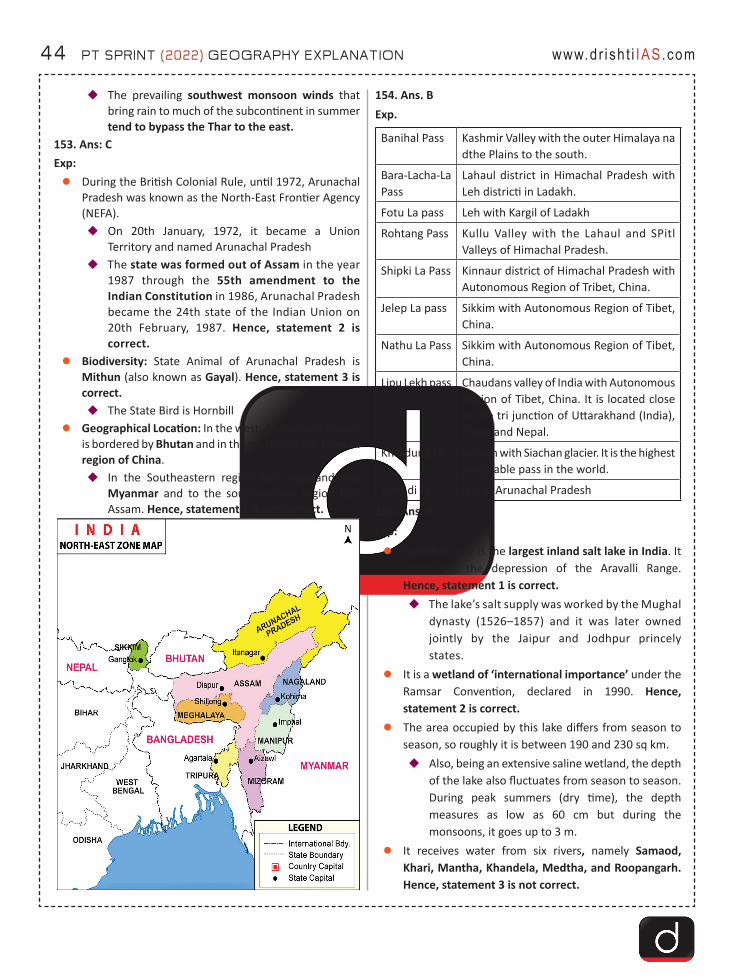
44 PT SPRINT (2022) GEOGRAPHY EXPLANATION www.dr ish t i IAS.com
�The prevailing southwest monsoon winds that bring rain to much of the subcontinent in summer tend to bypass the Thar to the east.
153. Ans: CExp: zDuring the British Colonial Rule, until 1972, Arunachal
Pradesh was known as the North-East Frontier Agency (NEFA).�On 20th January, 1972, it became a Union
Territory and named Arunachal Pradesh�The state was formed out of Assam in the year
1987 through the 55th amendment to the Indian Constitution in 1986, Arunachal Pradesh became the 24th state of the Indian Union on 20th February, 1987. Hence, statement 2 is correct.
zBiodiversity: State Animal of Arunachal Pradesh is Mithun (also known as Gayal). Hence, statement 3 is correct. �The State Bird is Hornbill
zGeographical Location: In the west, Arunachal Pradesh is bordered by Bhutan and in the north falls the Tibetan region of China.�In the Southeastern region falls Nagaland and
Myanmar and to the southwestern region falls Assam. Hence, statement 1 is not correct.
154. Ans. BExp.
Banihal Pass Kashmir Valley with the outer Himalaya na dthe Plains to the south.
Bara-Lacha-La Pass
Lahaul district in Himachal Pradesh with Leh districti in Ladakh.
Fotu La pass Leh with Kargil of Ladakh
Rohtang Pass Kullu Valley with the Lahaul and SPitl Valleys of Himachal Pradesh.
Shipki La Pass Kinnaur district of Himachal Pradesh with Autonomous Region of Tribet, China.
Jelep La pass Sikkim with Autonomous Region of Tibet, China.
Nathu La Pass Sikkim with Autonomous Region of Tibet, China.
Lipu Lekh pass Chaudans valley of India with Autonomous Region of Tibet, China. It is located close to the tri junction of Uttarakhand (India), China and Nepal.
Khardung La Ladakh with Siachan glacier. It is the highest motorable pass in the world.
Bom di La It is in Arunachal Pradesh
155. Ans: AExp: zSambhar Lake is the largest inland salt lake in India. It
represents the depression of the Aravalli Range. Hence, statement 1 is correct. �The lake’s salt supply was worked by the Mughal
dynasty (1526–1857) and it was later owned jointly by the Jaipur and Jodhpur princely states.
zIt is a wetland of ‘international importance’ under the Ramsar Convention, declared in 1990. Hence, statement 2 is correct.
zThe area occupied by this lake differs from season to season, so roughly it is between 190 and 230 sq km.�Also, being an extensive saline wetland, the depth
of the lake also fluctuates from season to season. During peak summers (dry time), the depth measures as low as 60 cm but during the monsoons, it goes up to 3 m.
zIt receives water from six rivers, namely Samaod, Khari, Mantha, Khandela, Medtha, and Roopangarh. Hence, statement 3 is not correct.
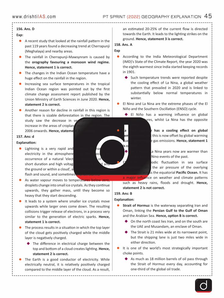
PT SPRINT (2022) GEOGRAPHY EXPLANATION 45www.dr ish t i IAS.com
156. Ans. DExp:zA recent study that looked at the rainfall pattern in the
past 119 years found a decreasing trend at Cherrapunji (Meghalaya) and nearby areas.
zThe rainfall in Cherrapunji-Mawsynram is caused by the orography favouring a monsoon wind regime. Hence, statement 1 is correct.
zThe changes in the Indian Ocean temperature have a huge effect on the rainfall in the region.
zIncreasing sea surface temperatures in the tropical Indian Ocean region was pointed out by the first climate change assessment report published by the Union Ministry of Earth Sciences in June 2020. Hence, statement 2 is correct.
zAnother reason for decline in rainfall in this region is that there is sizable deforestation in the region. The study saw the decrease in vegetation cover and increase in the areas of cropland mainly from the year 2006 onwards. Hence, statement 3 is correct.
157. Ans: dExplanation:zLightning is a very rapid and massive discharge of
electricity in the atmosphere. It is the process of occurrence of a natural ‘electrical discharge of very short duration and high voltage between a cloud and the ground or within a cloud’, accompanied by a bright flash and sound, and sometimes thunderstorms.
zAs water vapour moves to temperatures below zero, droplets change into small ice crystals. As they continue upwards, they gather mass, until they become so heavy that they start descending.
zIt leads to a system where smaller ice crystals move upwards while larger ones come down. The resulting collisions trigger release of electrons, in a process very similar to the generation of electric sparks. Hence, statement 1 is correct.
zThe process results in a situation in which the top layer of the cloud gets positively charged while the middle layer is negatively charged. �The difference in electrical charge between the
top and bottom of a cloud creates lighting. Hence, statement 2 is correct.
zThe Earth is a good conductor of electricity. While electrically neutral, it is relatively positively charged compared to the middle layer of the cloud. As a result,
an estimated 20-25% of the current flow is directed towards the Earth. It leads to the lighting strikes on the ground. Hence, statement 3 is correct.
158. Ans. AExpzAccording to the India Meteorological Department
(IMD)’s State of the Climate Report, the year 2020 was the eighth warmest since India started keeping records in 1901.�Such temperature trends were reported despite
the cooling effect of La Nina, a global weather pattern that prevailed in 2020 and is linked to substantially below normal temperatures in winter.
zEl Nino and La Nina are the extreme phases of the El Niño and the Southern Oscillation (ENSO) cycle. �El Niño has a warming influence on global
temperatures, whilst La Nina has the opposite effect.
zLa Nina typically has a cooling effect on global temperatures, but this is now offset by global warming due to greenhouse gas emissions. Hence, statement 1 is correct. �As a result, La Nina years now are warmer than
years with El Nino events of the past.zENSO is a periodic fluctuation in sea surface
temperature and the air pressure of the overlying atmosphere across the equatorial Pacific Ocean. It has a major influence on weather and climate patterns such as heavy rains, floods and drought. Hence, statement 2 is not correct.
159. Ans: BExplanation:zStrait of Hormuz is the waterway separating Iran and
Oman, linking the Persian Gulf to the Gulf of Oman and the Arabian Sea. Hence, option B is correct.�On the north coast lies Iran, and on the south are
the UAE and Musandam, an enclave of Oman.�The Strait is 21 miles wide at its narrowest point,
but the shipping lane is just two miles wide in either direction.
zIt is one of the world’s most strategically important choke points.�As much as 18 million barrels of oil pass through
the Strait of Hormuz every day, accounting for one-third of the global oil trade.
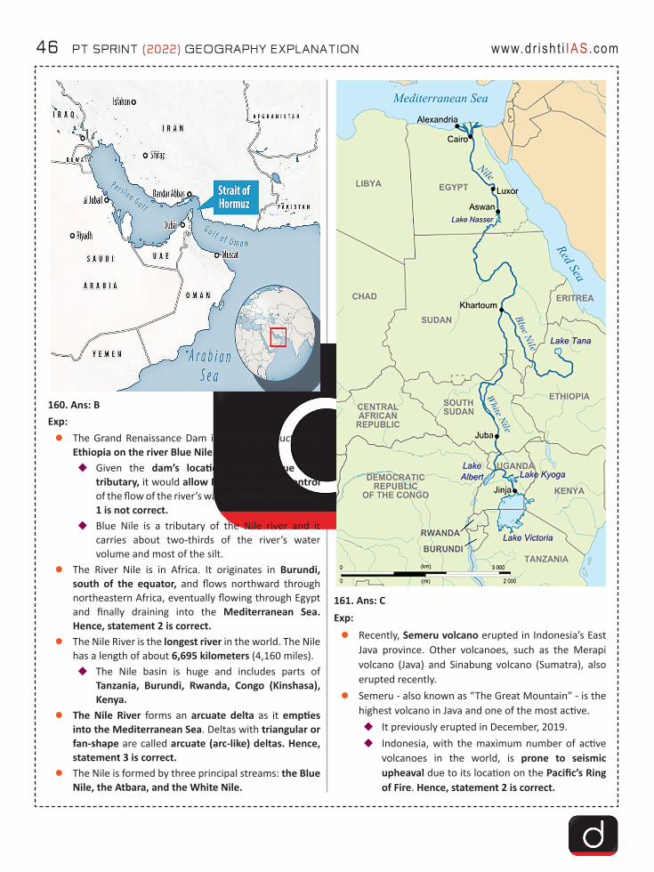
46 PT SPRINT (2022) GEOGRAPHY EXPLANATION www.dr ish t i IAS.com
160. Ans: BExp: zThe Grand Renaissance Dam is being constructed by
Ethiopia on the river Blue Nile.�Given the dam’s location on the Blue Nile
tributary, it would allow Ethiopia to gain control of the flow of the river’s waters. Hence, statement 1 is not correct.
�Blue Nile is a tributary of the Nile river and it carries about two-thirds of the river’s water volume and most of the silt.
zThe River Nile is in Africa. It originates in Burundi, south of the equator, and flows northward through northeastern Africa, eventually flowing through Egypt and finally draining into the Mediterranean Sea. Hence, statement 2 is correct.
zThe Nile River is the longest river in the world. The Nile has a length of about 6,695 kilometers (4,160 miles).�The Nile basin is huge and includes parts of
Tanzania, Burundi, Rwanda, Congo (Kinshasa), Kenya.
zThe Nile River forms an arcuate delta as it empties into the Mediterranean Sea. Deltas with triangular or fan-shape are called arcuate (arc-like) deltas. Hence, statement 3 is correct.
zThe Nile is formed by three principal streams: the Blue Nile, the Atbara, and the White Nile.
161. Ans: CExp:zRecently, Semeru volcano erupted in Indonesia’s East
Java province. Other volcanoes, such as the Merapi volcano (Java) and Sinabung volcano (Sumatra), also erupted recently.
zSemeru - also known as “The Great Mountain” - is the highest volcano in Java and one of the most active.�It previously erupted in December, 2019.�Indonesia, with the maximum number of active
volcanoes in the world, is prone to seismic upheaval due to its location on the Pacific’s Ring of Fire. Hence, statement 2 is correct.
PT SPRINT (2022) GEOGRAPHY EXPLANATION 47www.dr ish t i IAS.com
�Semeru volcano is also the part of the Island arcs formed by the subduction of the Indo-Australian plate below Sunda Plate (part of Eurasian Plate). The trench formed here is called Sunda trench whose major section is the Java Trench. Hence, statement 1 is correct.
162. Ans:CExp: zAccording to the India Meteorological Department
(IMD), a western disturbance is likely to affect the Himalayan region soon.�The disturbances will result in fairly widespread
light to moderate snowfall and rains in the plains of Jammu.
�Western Disturbance (WD), labelled as an extra-tropical storm originating in the Mediterranean, is an area of low pressure that brings sudden showers, snow and fog in northwest India. Hence, option A is correct.
zIn the term “extra-tropical storm”, storm refers to low pressure. “Extra-tropical” means outside the tropics. As the WD originates outside the tropical region, the word “extra-tropical” has been associated with them.
zA WD is associated with rainfall, snowfall and fog in northern India. It arrives with rain and snow in Pakistan and northern India. The moisture which WDs carry with them comes from the Mediterranean Sea and/or from the Atlantic Ocean. Hence, option B is correct.
zWD brings winter and pre-monsoon rain and is important for the development of the Rabi crop in the Northern subcontinent. Hence, option C is not correct.
zThe WD disturbance travels from the “western” to the eastern direction. These travel eastwards on high-altitude westerly jet streams - massive ribbons of fast winds traversing the earth from west to east. Hence, option D is correct.
163. Ans: AExp: zThe Union Cabinet has given its approval for 850
MegaWatt (MW) Ratle hydropower project on Chenab river in Jammu and Kashmir.�Ratle Hydroelectric Project is a run-of-the-river
hydroelectric power station on the Chenab River, Kishtwar district of the Indian Union Territory of Jammu and Kashmir. Hence, statement 3 is not correct.
zChenab River rises in the upper Himalayas in the Lahaul and Spiti district of Himachal Pradesh.
�The river is formed by the confluence of two rivers, Chandra and Bhaga, at Tandi, 8 km southwest of Keylong, in the Lahaul and Spiti district. Hence, statement 1 is correct.�The Bhaga river originates from Surya taal
lake, which is situated a few kilometers west of the Bara-lacha la pass in Himachal Pradesh. Hence, statement 2 is correct.
�The Chandra river originates from glaciers east of the same pass (near Chandra Taal).
zChenab River flows through the Jammu region of Jammu and Kashmir into the plains of Punjab, Pakistan, before flowing into the Indus River.
164. Ans: BExp: zThe Mohorovicic Discontinuity, or “Moho,” is the
boundary between the crust and the mantle. Hence, statement 1 is not correct.
zIn geology the word “discontinuity” is used for a surface at which seismic waves change velocity.
zOne of these surfaces exists at an average depth of 8 kilometres beneath the ocean basin and at an average depth of about 32 kilometres beneath the continents.
zAt this discontinuity, seismic waves accelerate. This surface is known as the Mohorovicic Discontinuity or often simply referred to as the “Moho.” Hence, statement 2 is correct.
zThe Mohorovicic Discontinuity was discovered in 1909 by Andrija Mohorovicic, a Croatian seismologist.
165. Ans: DExp:Arunachal Pradesh:zThe state was formed out of Assam in the year 1987.
�In the west, Arunachal Pradesh is bordered by Bhutan and in the north falls the Tibetan region of China.
�In the Southeastern region falls Nagaland and Myanmar and to the southwestern region falls Assam. Hence, statement 1 is correct.
zThe state is home to 26 major tribes, there are more than 100 sub-tribes, many of them are still unexplored. About 65% of the population of the state is tribals.
zBiodiversity:�State Animal: Mithun (also known as Gayal).
Hence, statement 3 is correct.�State Bird: Hornbill�It is also home to the Dihang Dibang Biosphere
Reserve.
48 PT SPRINT (2022) GEOGRAPHY EXPLANATION www.dr ish t i IAS.com
zProtected Areas:�Namdapha National Park�Mouling National Park�Sessa Orchid Sanctuary�Dibang Wildlife Sanctuary�Pakke Tiger Reserve
zHence, statement 2 is correct.166. Ans: BExp:zThe formalization of Mizoram State took place on 20th
February, 1987 after the 53rd Amendment of the Indian Constitution, 1986.
zThe Mizo hills area became the Lushai Hills district within Assam at the time of independence. Further, in 1954 it was renamed the Mizo Hills District of Assam.�Mizoram was granted the status of a Union
Territory in 1972 after signing an accord with the moderates of the Mizo National Front (MNF).
�The Union Territory of Mizoram was conferred the status of a full state in 1986 after signing of a memorandum of settlement (Mizoram Peace Accord) between the Central government and the MNF. Hence, statement 3 is not correct.
zAccording to India State of Forest Report (ISFR), 2021 Mizoram has the maximum forest cover as a percentage of their own geographical area at (84.53%) from the North eastern region of the country. Hence, statement 1 is correct.
zProtected Areas:�Dampa Tiger Reserve�Murlen National Park�Phawngpui National Park�Ngengpui Wildlife Sanctuary�Tawi Wildlife Sanctuary
zHence, statement 2 is correct.167. Ans: BExp:zIraq’s Razzaza Lake was once a tourist attraction known
for its beautiful scenery and an abundance of fish that locals depended on. Now, dead fish litter its shores and the once-fertile lands around it have turned into a barren desert.
zIt’s the second largest lake in Iraq and is part of a wide valley that includes the lakes of Habbaniyah, Tharthar and Bahr al-Najaf.�Lake Tharthar is the largest.
z Hence, option B is correct.
168. Ans: BExp:zMore than a quarter of the world’s wheat export
comes from Russia and Ukraine.�Russia is the world’s largest exporter of wheat,
accounting for more than 18% of international exports.
�In 2019, Russia and Ukraine together exported more than a quarter (25.4 %) of the world’s wheat. Hence, statement 1 is correct.
�The top five countries that exported the highest dollar-value worth of wheat include Russia > United States > Canada > France > Ukraine.
zEgypt is the world’s biggest importer of wheat. Hence, statement 2 is correct.�Turkey is also a big spender on Russian and
Ukrainian wheat with 74% of its imports coming from those two countries in 2019.
zIndia is the second largest producer of wheat with a share of around 13.5% of world total production. Wheat is the second most important cereal crop in India after rice. It is the main food crop, in northand north-western part of the country.�Wheat is a rabi crop that requires a cool growing
season and bright sunshine at the time of ripening.
�Success of the Green Revolution contributed to the growth of Rabi crops, especially wheat.
�The kharif cropping season is from July –October during the south-west monsoon and the Rabi cropping season is from October-March (winter). Hence, statement 3 is not correct.
169. Ans: CExp:zOcean currents are the continuous, predictable,
directional movement of seawater. It is a massive movement of ocean water that is caused and influenced by various forces. They are like river flows in oceans.
zOcean currents are influenced by two types of forces namely:�Primary forces:
�Heating by solar energy: Heating by solar energy causes the water to expand. That is why, near the equator the ocean water is about 8 cm higher in level than in the middle latitudes. This causes a very slight gradient and water tends to flow down the slope.

PT SPRINT (2022) GEOGRAPHY EXPLANATION 49www.dr ish t i IAS.com
�Wind: Wind blowing on the surface of the ocean pushes the water to move. Friction between the wind and the water surface affects the movement of the water body in its course.
�Gravity: Gravity tends to pull the water down the pile and create gradient variation.
�Coriolis force. The Coriolis force intervenes and causes the water to move to the right in the northern hemisphere and to the left in the southern hemisphere. Hence, statement 2 is correct.
�These large accumulations of water and the flow around them are called Gyres.
�These produce large circular currents in all the ocean basins.
�Secondary forces:�Differences in water density: It affects vertical
mobility of ocean currents.�Water with high salinity is denser than water
with low salinity and in the same way cold water is denser than warm water.
�Denser water tends to sink, while relatively lighter water tends to rise.
�Temperature of water: Cold-water ocean currents occur when the cold water at the poles sinks and slowly moves towards the equator. Hence, statement 1 is correct.�Warm-water currents travel out from the
equator along the surface, flowing towards the poles to replace the sinking cold water.
170. Ans: CExp:zKuroshio Current is the west boundary current and is
also known as Japan current or Black Current. The term “Kuroshio” in Japanese means “Black Stream ‘’.�It is the Pacific analogue of the Gulf Stream in the
Atlantic Ocean.�The average surface temperature of this current is
warmer than the surrounding ocean.�This also helps in regulating the temperature of
Japan, which is relatively warmer.zHence, option C is correct.
171. Ans: D Exp:Solomon Islands:zSolomon Islands is a nation in Melanesia, east of
Papua New Guinea, comprising more than 990 islands.
Its capital is Honiara, located on the island of Guadalcanal.
zThe Solomon Islands have been inhabited by Melanesian people for at least 30,000 years.
zIt consists of a double chain of volcanic islands and coral atolls in Melanesia.�Melanesia is a subregion of Oceania in the
southwestern Pacific Ocean.zThe country comprises most of the Solomons chain—
with the exception of Buka and Bougainville, two islands at the northwestern end that form an autonomous region of Papua New Guinea.
zThe island is a constitutional monarchy, with the British monarch, represented by a governor-general, serving as the formal head of state. Still, the country, a member of the Commonwealth, is independent, and the governor-general is appointed on the advice of the unicameral National Parliament.
zHence, option D is correct.
172. Ans: B Exp: zDevika river originates from the hilly Suddha Mahadev
temple in Udhampur district of Jammu and Kashmir and flows down towards western Punjab (now in Pakistan) where it merges with the Ravi river. Hence, statement 1 is not correct but statement 3 is correct.
zThe river holds religious significance as it is revered by Hindus as the sister of river Ganga. Hence, statement 2 is correct.

50 PT SPRINT (2022) GEOGRAPHY EXPLANATION www.dr ish t i IAS.com
zIn June 2020, Devika Bridge was inaugurated in Udhampur. Apart from taking care of traffic congestion, the Devika Bridge was also meant to help smooth passage of Army convoys and vehicles.
173. Ans: CExp: Tropical Evergreen Forests:zThese forests are found in the western slope of the
Western Ghats, hills of the northeastern region and the Andaman and Nicobar Islands.
zThey are found in warm and humid areas with an annual precipitation of over 200 cm and mean annual temperature above 22℃.
zTropical evergreen forests are well stratified, with layers closer to the ground and are covered with shrubs and creepers, with short structured trees followed by a tall variety of trees.
zIn these forests, trees reach great heights up to 60 m or above. There is no definite time for trees to shed their leaves, flowering and fruition. As such these forests appear green all the year round.
zHence, option C is correct. 174. Ans: BExp:
zThe Maldive Ridge is an aseismic ridge that is not associated with earthquake activities. Hence, statement 1 is not correct.
zIt is of paramount importance to gain knowledge on the structure and geodynamics of aseismic ridges (as it provides valuable inputs towards understanding the evolution of ocean basins).
zIt is a very crucial geodynamic feature in the western Indian Ocean whose origin has been the centre of many a scientific debate. Hence, statement 2 is correct.
175. Ans: B Exp: zDevika river originates from the hilly Suddha Mahadev
temple in Udhampur district of Jammu and Kashmir and flows down towards western Punjab (now in Pakistan) where it merges with the Ravi river. Hence, statement 1 is not correct but statement 3 is correct.
zThe river holds religious significance as it is revered by Hindus as the sister of river Ganga. Hence, statement 2 is correct.
zIn June 2020, Devika Bridge was inaugurated in Udhampur. Apart from taking care of traffic congestion, the Devika Bridge was also meant to help smooth passage of Army convoys and vehicles.