representation - Department of Geography
30
1 esf geovis 2002, mar. 14, 2002 re re re presentation sara irina fabrikant geography department uc santa barbara, u.s.a according to... René Magritte a famous pipe 1 i n t r o d u c t i o n
-
Upload
khangminh22 -
Category
Documents
-
view
1 -
download
0
Transcript of representation - Department of Geography

1111
esf geovis 2002, mar. 14, 2002
rererepresentation
sara irina fabrikantgeography departmentuc santa barbara, u.s.a
aaaaccccccccoooorrrrddddiiiinnnngggg ttttoooo............
René Magritte
a famous pipe
1
i n t
r o
d u
c t
i o
n

2222
representation
is the cat’s tail represented in above graphic?
i n t
r o
d u
c t
i o
n
1Mark and Smith (ongoing)
representation
is western Wyoming represented in above map?
1
i n t
r o
d u
c t
i o
n

3333
overview
motivation
background
building of theory
application of theory
conclusion outlook
1
o u
t l
i n e
ontologyrepresentation follows reality...
1. philosopher: “the nature of what exists”
– ontology <> epistemology
– what/why is it: ponder nature and organization of stuff
• things, parts and wholes, relationships
2. information scientist: “explicit account ofconceptualization”
– ontologies <> data models
– what is it for: solve the tower of babel problem
• formalisms to share knowledge across communities
2
b a
c k
g r
o u
n d

4444
why care for GeoVis?
representation formalisms beyond depiction
• generalization
– taxonomic relations: a map is-a kind of graphic representation
– semantic and semiotic abstractions: distance is proximity
• association
– membership relations: choro maps/cartograms are value-by-area maps
– semantic and semiotic mappings: magnitude is like size
• aggregation
– part-whole relations: a legend is-a-part of a map
– level of detail, scale: a county is-a part of an enumeration hierarchy
2
b a
c k
g r
o u
n d
proximity is like similarity
dddd iiii ssss tttt aaaa nnnn cccc eeee ffffrrrroooommmm RRRRoooommmmeeee............
Jung CG (1964)

5555
of parts and wholes
2
b a
c k
g r
o u
n d
Levy (1990)
overview
motivation
background
building of theory
application of theory
conclusion outlook
1
o u
t l
i n e

6666
GeoVis < Y2K
3
t h
e o
r y
MacEachren (1994)
wwwwhhhhaaaatttt ????
wwwwhhhhoooo ????wwwwhhhhiiiicccchhhh ????
GeoVis is like InfoVis
• dealing with the information overload problem– information space is always multidimensional (automation)
– GeoVis: 1-3D usually reserved
– cognizable space is 3/4 dimensional (human processing)
• graphics as cognitive aids for knowledge discovery (EDA)– task models for problem solving
• data and space transformations
– raw data � data table � visual structures
• spaces as visual structure
– metric space (spherical, hyperbolic, cartesian grid)
– topological space (node-link networks, trees)
• direct data manipulation/collaboration through GUIs
3
t h
e o
r y

7777
InfoVis3
iiiinnnntttteeeerrrraaaaccccttttiiiioooonnnn
hhhhiiiigggghhhh
lllloooowwww
ddddoooommmmaaaaiiiinnnnmmmm
uuuullllttttiiii----DDDD
uuuunnnniiii----DDDD sssstttt rrrr
oooonnnn
ggggwwww
eeeeaaaa
kkkkcccc
oooollll llll
aaaabbbb
oooorrrr aaaa
tttt iiiioooo
nnnn
eeeexxxx p
pppllll aaaa
nnnnaaaa
tttt iiiioooo
nnnn
eeeexxxx
ppppllll oooo
rrrr aaaatttt iiii
oooonnnn
tttt aaaassss
kkkk
3
t h
e o
r y
wwwwhhhhyyyy //// wwwwhhhhaaaatttt ffffoooorrrr ????
wwwwiiiitttthhhh wwwwhhhhoooommmm ????
wwwwhhhhaaaatttt ????
InfoVis3
ddddoooommmmaaaaiiiinnnn
iiiinnnntttteeeerrrraaaaccccttttiiiioooonnnn
hhhhiiiigggghhhh
lllloooowwww
mmmmuuuullllttttiiii----DDDD
uuuunnnniiii----DDDD
eeeexxxx p
pppllll aaaa
nnnnaaaa
tttt iiiioooo
nnnn
sssstttt rrrr
oooonnnn
ggggwwww
eeeeaaaa
kkkkcccc
oooollll llll
aaaabbbb
oooorrrr aaaa
tttt iiiioooo
nnnn
eeeexxxx p
pppllll oooo
rrrr aaaatttt iiii
oooonnnn
tttt aaaassss
kkkk
VVVVRRRR
IIIIMMMMSSSS
aaaattttllllaaaassss
3
t h
e o
r y

8888
CS/EEHCI
cartography
HCIcognitive science
information scienceGIScience etc.
technical/engineering issues...
• scalability
• graphics/information density
• speed and efficiency
theoretical/scientific issues...
• lack of theory– what are the foundations?
• usability– does it work?
InfoVis challenges
3
t h
e o
r y
cognitively plausible representations to solve problems
• task primitives?– task ontology
• semantic primitives?– domain ontology
• semiotic primitives?
– Bertin Y2K (+ time!)
• theory informed by empirical evidence
� cognitively adequate representations!
problem-driven representation
mappings, metaphors
data transformations
3
t h
e o
r y

9999
cognitively plausible InfoVis
metaphorssemantic gen.semiotic gen.
task modelsprimitives
space/time typestransformations
sign-vehiclesmappings
3
t h
e o
r y
task primitives?• task models in geovisualization
– goals: why visualize?
– tasks: what needs to be visualized to solve goal?
• task analytical approaches
– psychology, cognitive science, HCI (Leont’ev, 1978; Nardi, 1995)
GOMS: Goals, Operators, Methods and Selection(Card, Moran, & Newell, 1980, 1983)
– task-based usability engineering(Lewis, 1990, Norman 1990, Nielsen, 1993)
– object-action model (Shneiderman, 1998)
• and for ill-structured problems
– Wehrend and Lewis (1990)
– Knapp (1995)
– Zhou and Feiner (1998)
3
t h
e o
r y

1111 0000
cognitively plausible InfoVis
metaphorssemantic gen.semiotic gen.
task modelsprimitives
space/time typestransformations
sign-vehiclesmappings
3
t h
e o
r y
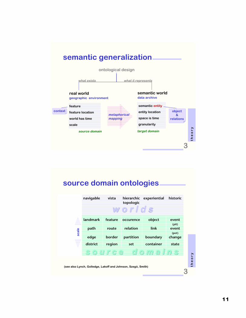
preservation of meaning through abstraction
• semantic generalization
– source domain ontologies
• geographic primitives: point, line, areal features
• formalized spatial structure: space types, scale continuum
graphic representation of meaning
• semiotic generalization
– target domain mappings
• semantic primitives: entities, trajectories, aggregates
• formalized symbology: sign-vehicles
InfoVis process
(Fabrikant, 2000; Fabrikant and Buttenfield, 2001)
3
t h
e o
r y
1111 1111
semantic generalization
metaphoricalmapping
ontological design
what exists
real worldgeographic environment
feature location
world has time
feature
scale
source domain
semantic entity
entity location
space is time
granularity
what it represents
semantic worlddata archive
target domain
object&
relations
object&
relations
contextcontext
3
t h
e o
r y
s o u r c e d o m a i n ss o u r c e d o m a i n ss o u r c e d o m a i n ss o u r c e d o m a i n ss o u r c e d o m a i n ss o u r c e d o m a i n s
w o r l d sw o r l d sw o r l d s
source domain ontologies
primitives navigable vista hierarchictopologic
experiential historic
entity landmark feature occurence object event(pit)
trajectory path route relation link event(pot)
boundary edge border partition boundary change
aggregate district region set container state
(see also Lynch, Golledge, Lakoff and Johnson, Szegö, Smith)
3
t h
e o
r y
scal
e

1111 2222
source domain ontologies
s o u r c e d o m a i n ss o u r c e d o m a i n ss o u r c e d o m a i n ss o u r c e d o m a i n ss o u r c e d o m a i n ss o u r c e d o m a i n s
w o r l d sw o r l d sw o r l d s
primitives navigable vista hierarchictopologic
experiential historic
entity landmark feature occurence object event(pit)
trajectory path route relation link event(pot)
boundary edge border partition boundary change
aggregate district region set container state
(see also Lynch, Golledge, Lakoff and Johnson, Szegö, Smith)
3
t h
e o
r y
target domain mappings
semantic
primitives
semiotic
primitives
entity point
trajectory line
boundary line
aggregate area
3
t h
e o
r y

1111 3333
target domain mappings
semantic
primitives
semiotic
primitives
entity point
trajectory line
boundary line/area
aggregate area
3
t h
e o
r y
scal
e
(Bertin, 1967, MacEachren, 1995)
target domain mappingspointpoint lineline areaarea
vv ii
ss uu
aa l
v
l
v aa
rr ii
aa bb
ll ee
ss
scal
e
semantic
primitives
semiotic
primitives
entity point
trajectory line
boundary line
aggregate area

1111 4444
cognitively plausible InfoVis
metaphorssemantic gen.semiotic gen.
task modelsprimitives
space/time typestransformations
sign-vehiclesmappings
3
t h
e o
r y
a space is a space is a space
it depends!
are a coffee cup and a donut the same?
...on spatial perspective, context, task etc.
naïve physics (Hayes, 1985)naïve geography (Egenhofer & Mark, 1995)
3
t h
e o
r y

1111 5555
space transformations• metric space � cognitive space � topological space
– physical space shapes navigational space shapes mental
space
a library ADL
(after Hillier, 1996)
444
4
3 3
3
3
t h
e o
r y
time-space transformations• metric space � movement space � cartesian space
– physical space shapes functional space shapes interaction
space
3
t h
e o
r y
ADL 3
4
5
6
0 1
2
t1
t2
t3
t4
t5t6
t7
t1 t2 t3 t4 t5 t60
t1
t2
t3
t4
t5
t6
t7
t7
(after Imfeld, 2001)

1111 6666
overview
motivation
background
building of theory
application example
conclusion outlook
1
o u
t l
i n e
text database representation
4
p r
a c
t i
c e

1111 7777
5
c o
n c
l u
s i
o n
s
National Imagery and Mapping Agency (NIMA)(NMA-201-00-1-2005)
collaborators:
UCSB: D. Montello, M. Ruocco, R. Middleton
UB: D. Mark, C. Jorgensen
acknowledgements
preservation of meaning through abstraction
• semantic generalization
– source domain ontologies
• geographic primitives: features, regions, boundaries
• formalized spatial structure: space types, scale continuum
graphic representation of meaning
• semiotic generalization
– target domain mappings
• semantic primitives: entities, aggregates, trajectories
• formalized symbology: sign-vehicles
spatialization in two steps
(Fabrikant, 2000; Fabrikant and Buttenfield, 2001 )
4
p r
a c
t i
c e

1111 8888
semantic news wire space
• unstructured reuters news articles– 504 full-text news stories
– snapshot: February 9/10, 2000
www.reuters.com/
4
p r
a c
t i
c e
FOCUS-Confusion over Afghan hijack motives Jane BarrettAFGHAN PLANE 5THLD (PICTURE, GRAPHIC)STANSTED England British police restored calm on ahijacked Afghan airliner on Wednesday after the surpriseescape of the four-man flight crew had sent tension soaring.But confusion reigned over the motives of the hijackers. Kabul's national airline said it could be a mass asylum bid but Britishpolice said they were ``not aware of any asylumapplications.'' ``We are back on an even keel now -- overnightthere was a degree of tiredness and frustration,'' said aspokeswoman for Essex police handling the hijack at Stanstedairport east of London . Assistant chief constable Joe Edwardssaid the crew escaped using a rope ladder through a cockpitwindow at around 1045 GMT on Tuesday after ``up anddown'' negotiations with the hijackers, who took over the planeafter it took off from Kabul on Sunday. [...]
the reuters data base• XML extracts from starlight database (PNL)
• automatically indexed and formatted
one article out of 504

1111 9999
latent semantic analysis (LSA)
• latent semantic indexing (LSI) (Deerwester et al., 1990)
– automatic indexing by latent associations of terms– based on semantic proximity
• large vector space of term-document associations
– two mode factor analysis (singular value decomposition)– SVD into term-term, doc-doc, term-doc matrices
– terms and documents are vectors in n-dimensional space
• angular proximity is similarity between documents
– e.g. cosine or dot product
• result: document * document proximity matrix
4
p r
a c
t i
c e
preservation of meaning through abstraction
• semantic generalization
– source domain ontologies
• geographic primitives: features, regions, boundaries
• formalized spatial structure: space types, scale continuum
graphic representation of meaning
• semiotic generalization
– target domain mappings
• semantic primitives: entities, aggregates, trajectories
• formalized symbology: sign-vehicles
spatialization in two steps
(Fabrikant, 2000; Fabrikant and Buttenfield, 2001 )
4
p r
a c
t i
c e

2222 0000
task primitivesdescribe, summarize, locate
features � entities
spring-node algorithm(Kamada and Kawai 1989)

2222 1111
0
2
4
6
8
10
12
14
16
18
20
1 2 3 4 5 6 7 8 9
0
2
4
6
8
10
12
14
16
18
20
1 2 3 4 5 6 7 8 9
solid cluster effect
mmmmeeeeaaaannnn 6666....7777ssssttttddddeeeevvvv 2222....2222
mmmmeeeeaaaannnn 5555....4444ssssttttddddeeeevvvv 1111....4444
Fabrikant et al. (ongoing)
DISCLAIM
ER:
prelim
inary re
sults!
task primitivescategorize, distinguish, compare

2222 2222
intramax (Masser and Brown 1975),voronoi tessellation
regions � aggregatesscale 1:2
0
2
4
6
8
10
12
14
16
18
20
1 2 3 4 5 6 7 8 9
weak region effect
0
2
4
6
8
10
12
14
16
18
20
1 2 3 4 5 6 7 8 9
mmmmeeeeaaaannnn 4444....0000ssssttttddddeeeevvvv 1111....9999
mmmmeeeeaaaannnn 5555....6666ssssttttddddeeeevvvv 2222....4444
Fabrikant et al. (ongoing)

2222 3333
task primitivesidentify, associate, locate
scale � level of detail

2222 4444
task primitivesrelate, associate, emphasize
paths � trajectories
ppppaaaatttthhhhffffiiiinnnnddddeeeerrrr (Schvaneveldt and Durso, 1988)

2222 5555
0
2
4
6
8
10
12
14
16
18
20
1 2 3 4 5 6 7 8 9
mmmmeeeeaaaannnn 4444....0000ssssttttddddeeeevvvv 1111....9999
0
2
4
6
8
10
12
14
16
18
20
1 2 3 4 5 6 7 8 9
mmmmeeeeaaaannnn 6666....5555ssssttttddddeeeevvvv 2222....1111
solid network effect
Fabrikant et al. (ongoing)
task primitivesenjoy the fruit salad!

2222 6666
boundaries, paths � trajectories
combo effects?
0
2
4
6
8
10
12
14
16
18
20
1 2 3 4 5 6 7 8 90
2
4
6
8
10
12
14
16
18
20
1 2 3 4 5 6 7 8 9
mmmmeeeeaaaannnn 5555....4444ssssttttddddeeeevvvv 1111....2222
mmmmeeeeaaaannnn 5555....0000ssssttttddddeeeevvvv 1111....3333

2222 7777
task primitivesfilter, reveal
mt. rigi in winter
Remote Sensing Lab, Geography Dept., University of Zürich

2222 8888
information filterscale 1:2
information filterscale 1:4

2222 9999
information densityscale 1:9
overview
motivation
background
building of theory
application of theory
conclusions & outlook
1
o u
t l
i n e

3333 0000
conclusions & outlooksummary
• ontological approach to representation– what are the primitives?– what are the transformations rules?
• thrive for cognitively plausible InfoVis3
• based on sound theory and formalisms
– towards problem-driven, collaborative representations
next steps...
• many more empirical evaluations needed
• cognitively adequate information visualizations!
5
c o
n c
l u
s i
o n
s
thank you.
esf geovis 2002, mar. 14, 2002