Political Geography - Alvin ISD
36
CHAPTER S Ikonos satellite images of the World Trade Center (top) June 30, 2000, before the September 11, 2001, attack, and (bottom) September 1 5, 200 I ,four days after the attack. ..,. Political Geography 254 ow many countries can you name? Old-style geography sometimes required memorization of countries and their capitals. Human geographers now emphasize a thematic approach. We are concerned with the location of activities in the world, the reasons for particular spatial distributions, and the significance of the arrangements. Despite this change in emphasis, you still need to know the locations of countries. Without such knowledge, you lack a basic frame of reference-knowing where things are. It would be like translating an article in a foreign language by looking up each word in a dictionary. In recent years, we have repeatedly experienced military conflicts and revolutionary changes in once obscure places. No one can pre- dict where the next war will erupt, but political geography helps to explain the cultural and physical factors that underlie political unrest in the world. Political geographers study how people have organized Earth's land surface into countries and alliances, reasons underlying the observed arrangements, and the conflicts that result from the organization. Political conflicts during the twentieth century were dominated by wars between states or collections of allied states. For the United States, World War I, World War II, the Korean War, and the Vietnam War were the bloodiest of these conflicts with other states. In contrast, the attack against the United States on September 11 , 2001, was initiated not by a hostile state but by a group of individual terrorists. For political geography, the challenge is to explain "why" terrorism occurs if "where" facts about the terrorists, such as countries of birth and current places of residence, are not particularly important factors in the explanation. Even so, reasons for terrorist attacks may relate to the political geography of particular regions of the world. KEY ISSUES 1. Where are states located? 2. Why do boundaries between states cause problems? 3. Why do states cooperate with each other? 4. Why has terrorism increased?
-
Upload
khangminh22 -
Category
Documents
-
view
0 -
download
0
Transcript of Political Geography - Alvin ISD

CHAPTER S Ikonos satellite images of the World Trade Center (top) June 30, 2000, before the September 11, 2001, attack, and (bottom)
September 1 5, 200 I ,four days after the attack . ..,.
Political Geography
254
ow many countries can you name? Old-style geography sometimes required memorization of countries and their capitals. Human geographers now emphasize a thematic approach. We are concerned with the location of activities in the world, the reasons for particular spatial distributions, and the significance of the
arrangements. Despite this change in emphasis, you still need to know the locations of countries. Without such knowledge, you lack a basic frame of reference-knowing where things are. It would be like translating an article in a foreign language by looking up each word in a dictionary.
In recent years, we have repeatedly experienced military conflicts and revolutionary changes in once obscure places. No one can predict where the next war will erupt, but political geography helps to explain the cultural and physical factors that underlie political unrest in the world. Political geographers study how people have organized Earth's land surface into countries and alliances, reasons underlying the observed arrangements, and the conflicts that result from the organization.
Political conflicts during the twentieth century were dominated by wars between states or collections of allied states. For the United States, World War I, World War II, the Korean War, and the Vietnam War were the bloodiest of these conflicts with other states.
In contrast, the attack against the United States on September 11 , 2001, was initiated not by a hostile state but by a group of individual terrorists. For political geography, the challenge is to explain "why" terrorism occurs if "where" facts about the terrorists, such as countries of birth and current places of residence, are not particularly important factors in the explanation. Even so, reasons for terrorist attacks may relate to the political geography of particular regions of the world.
KEY ISSUES
1. Where are states located?
2. Why do boundaries between states cause problems?
3. Why do states cooperate with each other?
4. Why has terrorism increased?


256 Chapter 8 Political Geography
CASE STUDY
Changing Borders in Europe Daniel Lenig lives in the village of Rittershoffen and works at a Mercedes-Benz truck factory in the town of Worth, about 50 kilometers (30 miles) away. Lenig's journey to work takes him across an international border, because Rittershoffen is in France, whereas Worth is in Germany.
As a citizen of France, Lenig has no legal difficulty crossing the German-French border twice a day; no guards ask him to show his passport or require him to pay customs duties on goods he purchases on the other side. If he is delayed, the cause is heavy traffic on the bridge that spans the Rhine River, which serves as the border between the two countries.
The boundary between France and Germany has not always been so easy to cross peacefully. The French have long argued that the Rhine River forms the logical physical boundary between France and Germany. But the Germans once claimed that they should control the Rhine, including the lowlands on the French side between the west bank of the river and the Vosges Mountains, an area known as Alsace. In fact, Alsace was initially inhabited by Germanic tribes but was annexed by France in 1670.
Two centuries later, in 1870, Alsace and its neighboring province of Lorraine were captured by Prussia (which a year later formed the core of the newly
For several decades during the Cold War, many countries were polarized into two regions, one allied with the former Soviet Union and the other allied with the United States. But with the end of the Cold War in the 1990s, the global political landscape changed fundamentally. Geographic concepts help us to understand this changing political organization of Earth's surface. We can also use geographic methods to examine the causes of political change and instability and to anticipate potential trouble spots around the world.
When looking at satellite images of Earth, we easily distinguish places- landmasses and water bodies, mountains and rivers, deserts and fertile agricultural land , urban areas and forests. What we cannot see are where boundaries are located between countries. Boundary lines are not painted on Earth, but they might as well be, for these national divisions are very real. To many, national boundaries are more meaningful than natural features. One of Earth's most fundamental cultural
proclaimed German Empire). France regained Alsace and Lorraine after Germany was defeated in World War I and has possessed them ever since, except between 1 940 and 1945 when Germany controlled them during World War II.
With the end of the Cold War and the demise of communism in Eastern Europe, France and Germany now lie at the core of the world's wealthiest market area. Most French and German people consider the pursuit of higher standards of living to be more important than rehashing centuries-old boundary disputes.
Although old boundaries between France and Germany have been virtually eliminated, new ones have been erected elsewhere in Europe. Travelers between Ljubljana and Zagreb now must show their passports and convert their cash into a different currency. These two cities were once part of the same country-Yugoslavia-but now they are the capitals of two separate countries, Slovenia and Croatia. Similarly, travelers between Vilnius and Moscow-both once part of the Soviet Union-now must show their passports and change money when they cross the international boundary between Lithuania and Russia. Russians, who once made up a majority of the Soviet Union's population, now find themselves in the minority in such countries as Estonia, Turkmenistan, and Ukraine.
characteristics-one that we take for granted-is the division of our planet's surface into a collection of spaces occupied by individual countries.
In the post-Cold War era, the familiar division of the world into countries or states is crumbling. Geographers observe why this familiar division of the world is changing. Between the mid-1940s and the late 1980s two superpowers-the United States and the Soviet Union-essentially "ruled" the world. As superpowers, they were involved in a global scale. But the United States is less dominant in the political landscape of the twenty-first century, and the Soviet Union no longer exists.
Today globalization means more connections among states. Individual countries have transferred military, economic, and political authority to regional and worldwide collections of states. Power is exercised through connections among states created primarily for economic cooperation.

Despite (or perhaps because of) greater global political cooperation, local diversity has increased in political affairs, as individual cultural groups demand more control over the territory they inhabit. States have transferred power to local governments, but this does not placate cultural groups who seek complete independence. Wars have broken out in recent years-both between small neighboring states and among cultural groups within countries-over political control of territory. Old countries have been broken up in a collection of smaller ones, some barely visible on world maps.
KEY ISSUE 1
Where Are States Located? • Problems of defining states
• Development of the state concept
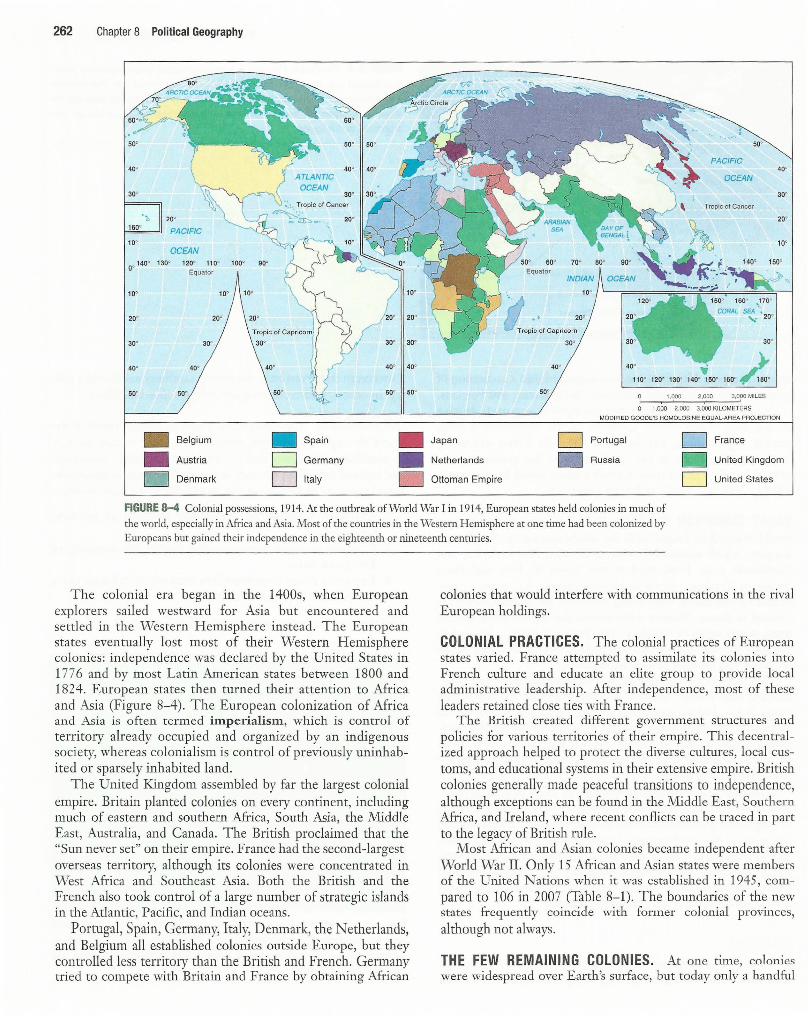
The question posed in this key issue may seem self-evident, because a map of the world shows that virtually all habitable land belongs to a country. But for most of history, until recently, this was not so. As recently as the 1940s, the world contained only about 50 countries, compared to 192 members of the United Nations as of 2007 (Figure 8-1 ).
A state is an area organized into a political unit and ruled by an established government that has control over its internal and foreign affairs. A state occupies a defined territory on Earth's surface and contains a permanent population. A state has sovereignty, which means independence from control of its internal affairs by other states. Because the entire area of a state is managed by its national government, laws, army, and leaders, it is a good example of a formal or uniform region. The term country is a synonym for state.
The term state, as used in political geography, does not refer to the 50 regional governments inside the United States. The 50 states of the United States are subdivisions within a single state-the United States of America.
Problems of Defining States Antarctica is the only large landmass on Earth's surface that is not part of a state. Several states, including Argentina, Australia, Chile, France, New Zealand, Norway, and the United Kingdom, claim portions of Antarctica (Figure 8-2). Argentina, Chile, and the United Kingdom make conflicting, overlapping claims. The United States, Russia, and a number of other states do not recognize the claims of any country to Antarctica.
The Treaty of Antarctica, signed in 1959 and renewed in 1991, provides a legal framework for managing Antarctica. States may establish research stations on Antarctica for scientific investigations, but no military activities are permitted.
There is some disagreement about the actual number of sovereign states. Among places that test the definition of a state are Korea, China, and Western Sahara (Sahrawi Republic) .
Problems of Defining States 257
Korea: One State or Two? A colony of Japan for many years, Korea was divided into two occupation zones by the United States and former Soviet Union after they defeated Japan in World War II. The country was divided into northern and southern sections along 38° north latitude. The division of these zones became permanent in the late 1940s, when the two superpowers established separate governments and withdrew their armies. The new government of the Democratic People's Republic of Korea (North Korea) then invaded the Republic of Korea (South Korea) in 1950, touching off a 3-year war that ended with a cease-fire line near the 38th parallel.
Both Korean governments are committed to reuniting the country into one sovereign state. Leaders of the two countries agreed in 2000 to exchange visits of families separated for a half century by the division, and for increased economic cooperation. However, progress toward reconciliation was halted by North Korea's decision to build nuclear weapons even though the country lacke<l the ability to provide its citizens with food, electricity, and other basic needs. Meanwhile, in 1992, North Korea and South Korea were admitted to the United Nations as separate countries.
China and Taiwan: One State or Two? Is the island of Taiwan a sovereign state? According to China's government officials, Taiwan is not a separate sovereign state but is a part of China. Until 1999 the government of Taiwan agreed.
This confusing situation arose from a civil war between the Nationalists and the Communists in China during the late 1940s. After losing, nationalist leaders in 1949 fled to the island
North and South Korea. A nighttime satellite image recorded by the U.S. Air Force Defense Meteorological Satellite Program shows the illumination of electric lights in South Korea, whereas North Korea has virtually no electric lights, a measure of its poverty and .limited economic activity.

258 Chapter 8 Political Geography
200
150
100
50
NUMBER OF MEMBERS IN THE UNITED NATIONS
0 1945 1955 1965 1975 1985 1995 2005
60°
D\~
50°
40°
30°
20° [[]] 10°
oo 140°
10°
20°
30°
40°
50°
CANADA
~
Tropic of Cancer
PACIFIC
OCEAN
130° 120° 110°
192 MEMBERS
Original members: 51
1940s: Added 8
1950s: Added 24
1960s: Added 42
1970s: Added 25
1980s: Added 7
1990s: Added 31
2000s: Added 4
Nonmember
100° 90° D-.
Tropic of Capricorn
40°
50°
FIGURE 8-1 U.N. members. When it was organized in 1945, the United Nations had only 51 members, including
49 sovereign states plus Byelorussia (now Belarus) and Ukraine, then part of the Soviet Union. The number increased to 192 in 2007. The greatest increase in sovereign states has occurred in Africa. Only four African states were original members of the United Nations-Egypt, Ethiopia, Liberia, and South Africa-and only six more joined during the 1950s. Beginning in 1960, however, a collection of independent states was carved from most of the remainder of the region. In 1960 alone, 16 newly independent African states became UN members. Creation of new sovereign states slowed during the 1980s. The breakup of the Soviet Union and Yugoslavia stimulated the formation of more new states during the early 1990s, and several
microstates in the Pacific Ocean joined during the late 1990s.
60°
50°
40°
30°
OCEAN
20°
10'
BRAZIL
20°
30°
40°
50°
of Taiwan, 200 kilometers (120 miles) off the Chinese coast. The N ationalists proclaimed that they were still the legitimate rulers of the entire country of China. Until some future occasion when they could defeat the Communists and recapture all of China, the Nationalists argued, at least they could continue to govern one island of the country.
and sovereign states. Taiwan's president announced in 1999 that Taiwan would also regard itself as a sovereign independent state, but the government of China viewed that announcement as a dangerous departure from the long-standing arrangement between the two.
Most other governments in the world consider Mainland China (officially the People's Republic of China) and the island of Taiwan (officially the Republic of China) as two separate
The question of who constituted the legitimate government of China plagued U.S. officials during the 1950s and 1960s. The United States had supported the Nationalists during the civil war, so many Americans opposed acknowledging that China was

Problems of Defining States 259
· ..... ~ ..... J 50° 50'
PACIFIC 40° • 40°
OCEAN
30°
•· .. Tropic<Of Cancer
MALDIVES :. (1965) ::·
SRI
iJANKA
60° 70° .~ 80° 90°
SEYCHELLES (1976) Equator
IND/AN
ATLANTIC () MOZA BtQUE MA~Rl~IUS (1968)
MAU CAR Tropic of Capricorn
20° OCEAN
30° 20°
40' 40° 30°
1,000 2 ,000 50°
3,000 MILES 40°
0 1,000 2. 000 3,000 KILOMETERS
AUSTRALIA
. \
\}
160° • NAURU (1990)
CORAL VANUAn( : . SEA (19.81) ·~ . .
,,. ·~.
Equator
, . KIRIBATI • ... (1999)
, TUVALU (2000)
FIJI
SAMOA (1976) -
<1 S70) 41' TONGA ~ 0 (1999)
Tropic of Capricorn
PACIFIC
OCEAN
MODIFIED GOODE'S HOMOLOSINE EQUAL·AREA PROJECTION 110° 120° 130° 140° 150°
NEW ZEALAND h 160° f,80° 170° 160°
firmly under the control of the Communists. Consequently, the United States continued to regard the Nationalists as the official government of China until 1971, when U.S. policy finally changed, and the United Nations voted to transfer China's seat from the Nationalists to tl1e Communists. Taiwan is now the most populous state not in the United Nations.
Western Sahara (Sahrawi Republic) T he Sahrawi Arab Democratic Republic, also known as Western Sahara, is considered by most African countries as a sovereign state on the continent's west coast between Morocco and Mauritania. Morocco, however, claims the territory, and to prove it has built a 3,000-kilorneter wall around the territory to keep out rebels.
Spain controlled the territory until withdrawing in 1976. An independent Sahrawi Republic was declared by the Polisario Front and recognized by most African countries, but Morocco
and Mauritania annexed the northern and southern portions, respectively. Three years later Mauritania withdrew, and Morocco claimed the entire territory. Morocco controls most of the populated area, but the Polisario Front operates in the vast sparsely inhabited deserts, especially the one-fifili of the territory that lies east of Morocco's wall.
Morocco and the Polisario Front signed a cease-fire in 1991, which is supervised by UN peacekeeping forces. The United Nations has also attempted to hold a referendum for the residents of Western Sahara to decide whether they want independence or want to continue to be part of Morocco, but it has been repeatedly postponed.
Meanwhile, two cities in Morocco-Ceuta and Melilla-are controlled by Spain. Spain annexed the two cities along Morocco's northern Mediterranean coast around 500 years ago. The 7 5 ,000 residents of Ceuta and 65 ,000 residents of Melilla were given limited autonomy in 1994, but they strongly favor remaining part of Spain.
30°
. 20°
10°
0'
10°
20°
30°
40°

260 Chapter 8 Political Geography
120°
140°
130°
120°
110° 100°
IND/AN OCEAN
110° 100°
90°W
90°E
80° 70° 60°
50°
40°
OCEAN
30°
20°
10°
oo
10°
30°
40°
250 500 MILES
0 250 500 KILOMETERS 50°
80' 60°
FIGURE 8-2 National claims to Antarctica. Antarctica is the only large landmass in the world that is not part of a sovereign state. It comprises 14 million square kilometers (5.4 million square miles), which makes it 50 percent larger than Canada. Portions are claimed by Argentina, Australia, Chile, France, New Zealand, Norway, and the United Kingdom; claims by Argentina, Chile, and the United Kingdom are conflicting. In 1959 these seven countries, plus Belgium, Japan, South Africa, the Soviet Union, and the United States, signed a treaty suspending any territorial claims for 3 0 years and establishing guidelines for scientific research. In 1991, 24 countries agreed to extend the treaty for another 50 years, established new pollution control standards, and banned rnining and oil exploration for 50 years.
Varying Size of States The land area occupied by the states of the world varies considerably. The largest state is Russia, which encompasses 17 .1 million square kilometers (6.6 million square miles), or 11 percent of the world's entire land area. The distance between the country's borders with Eastern European countries and the Pacific Ocean extends more than 7,000 kilometers (4,300 miles).
Other states with more than 5 million square kilometers (2 million square miles) include China (9.3 million square kilometers; 3.6 million square miles), Canada (9.2 million square kilometers; 3 .6 million square miles), the United States (9.2 million square kilometers; 3.5 million square miles), Brazil (8.5 million square kilometers; 3.3 million square miles), and Australia (7 .6 million square kilometers; 2.9 million square miles).
At the other extreme are about two dozen microstates, which are states with very small land areas. The smallest microstate in the United Nations-Monaco-encompasses only 1.5 square kilometers (0.6 square miles). Other UN member states that are
Tonga is a microstate of 102,000 inhabitants and 169 islands, which together add up to 748 square kilometers (289 square miles).
smaller than 1,000 square kilometers include Andorra, Antigua and Barbuda, Bahrain, Barbados, Dominica, Grenada, Kiribati, Liechtenstein, Maldives, Malta, Micronesia, Nauru, Palau, St. Kitts & Nevis, St. Lucia, San Marino, St. Vincent & the Grenadines, Sao Tome e Principe, the Seychelles, Singapore, Tonga, and Tuvalu. Many of these are islands, which explains both their small size and sovereignty.
Development of the State Concept The concept of dividing the world into a collection of independent states is recent. Prior to the 1800s, Earth's surface was organized in other ways, such as city-states, empires, and tribes. Much of Earth's surface consisted of unorganized territory.
Ancient and Medieval States The modern movement to divide the world into states originated in Europe. However, the development of states can be traced to the ancient Middle East, in an area known as the Fertile Crescent.
ANCIENT STATES. The ancient Fertile Crescent formed an arc between the Persian Gulf and the Mediterranean Sea. The eastern end, Mesopotamia, was centered in the valley formed by the Tigris and Euphrates rivers, in present-day Iraq. The Fertile Crescent then curved westward over the desert, turning southward to encompass the Mediterranean coast through present-day Syria, Lebanon, and Israel. The Nile River valley of Egypt is sometimes regarded as an extension of the Fertile Crescent. Situated at the crossroads of Europe, Asia, and Africa, the Fertile Crescent was a center for land and sea communications in ancient times (Figure 8-3).
The first states to evolve in Mesopotamia were known as city-states. A city-state is a sovereign state that comprises a town and the surrounding countryside. Walls clearly delineated the boundaries of the city, and outside the walls the city controlled agricultural land to produce food for urban residents. The countryside also provided the city with an outer line of defense against attack by other city-states. Periodically, one city or tribe in Mesopotamia would gain military dominance over the others and
200 MILES I
SAUDI ARABIA
,.-----------' Satellite imagery provided by GlobaXplorer.com
form an empire. Mesopotamia was organized into a succession of empires by the Sumerians, Assyrians, Babylonians, and Persians.
Meanwhile, the state of Egypt emerged as a separate empire to the west of the Fertile Crescent. Egypt controlled a long, narrow region along the banks of the Nile River, extending from the N ile Delta at the Mediterranean Sea southward for several hundred kilometers. Egypt's empire lasted from approximately 3000 B.C. until the fourth century B.C.
EARLY EUROPEAN STATES. Political unity in the ancient world reached its height with the establishment of the Roman Empire, which controlled most of Europe, North Africa, and Southwest Asia, from modern-day Spain to Iran and from Egypt to England. At its maximum extent, the empire comprised 3 8 provinces, each using the same set of laws that were created in Rome. Massive walls helped the Roman army defend many of the empire's frontiers. The Roman Empire collapsed in the fifth century after a series of attacks by people living on its frontiers and because of internal disputes.
The European portion of the Roman Empire was fragmented into a large number of estates own ed by competing kings, dukes, barons, and other nobles. Victorious nobles seized control of defeated rivals ' estates, and after these nobles died, others fought to take possession of their land. Meanwhile, most people were forced to live on an estate, working and fighting for the benefit of the noble.
A handful of powerful kings emerged as rulers over large numbers of estates begi1ming about the year 1100. T he consolidation of neighboring estates under the unified control of a king formed the basis for the development of such modern Western European states as England, France, and Spain. However, much of central Europe-notably present-day Germany and Italy- remained fragmented into a large number of estates that were not consolidated into states until the nineteenth century.
Colonies A colony is a territory that is legally tied to a sovereign state rather than being completely independent. In some cases,
Development of the State Concept 261
FIGURE 8-3 The Ferti le Crescent is a crescent-shaped area of relatively fertile
land situated between the Persian Gulf and the Mediterranean Sea. The territory
was organized into a succession of empires starting several thousand years ago. As
shown in Chapter 10, many important early developments in agriculture also
originated in this region.
a sovereign state runs only the colony's military and foreign policy. In others, it also controls the colony's internal affairs.
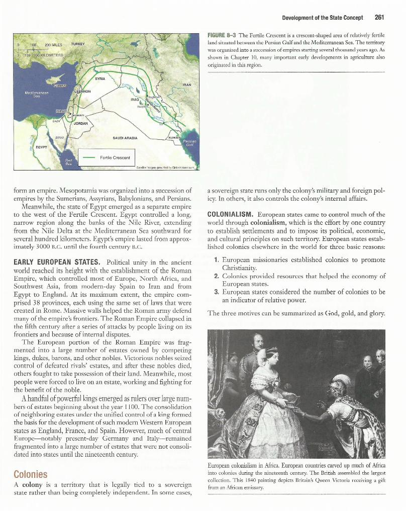
COLONIALISM. European states came to control much of the world through colonialism, which is the effort by one country to establish settlements and to impose its political, economic, and cultural principles on such territory. European states established colonies elsewhere in the world for three basic reasons:
1. European missionaries established colonies to promote Christianity.
2. Colonies provided resources that helped the economy of European states.
3. European states considered the number of colonies to be an indicator of relative power.
The three motives can be summarized as God, gold, and glory.
'L
European colonialism in Africa. European countries carved up much of Africa into colonjes during the nineteenth century. T he British assembled the largest
collection. T his 1840 painting depicts Brirnin's Queen Vicroria receiving a gift from an African emissa1y.
262 Chapter 8 Political Geography
40°
30'
20°
PACIFIC
OCEAN QG 140° 130° 120° 110° 100°
Equator
10°
20°
30°
40°
50°
20°
30°
40°
50°
Belgium
• Austria
D Denmark
30°
40°
50°
• Spain
D Germany
D Italy
40°
so•
40°
so•
• Japan
• Netherlands
D Ottoman Empire
50°
PACIFIC 40°
OCEAN
30°
Tropic of Cancer
20°
10°
60° 70° 140° 150°
30° 30°
40° • ).
110° 120° 130° 140•~50• 160° tif/'i oo• 50°
l ,q<>O 2 .0?IJ 3,000 MILES
0 1,000 2,000 3,000 KILOMETERS MODIFIED GOODE'S HOMOLOSINE EQUAL-AREA PROJECTION
D Portugal D France
D Russia D United Kingdom
D United States
FIGURE 8-4 Colonial possessions, 1914. At the outbreak of World War I in 1914, European states held colonies in much of
the world, especially in Africa and Asia. Most of the countries in the Western Hemisphere at one time had been colonized by Europeans but gained their independence in the eighteenth or nineteenth centuries.
The colonial era began in the 1400s, when European explorers sailed westward for Asia but encountered and settled in the Western Hemisphere instead. The European states eventually lost most of their Western Hemisphere colonies : independence was declared by the United States in 177 6 and by most Latin American states between 1800 and 1824. European states then turned their attention to Africa and Asia (Figure 8-4). The European colonization of Africa and Asia is often termed imperialism, which is control of territory already occupied and organized by an indigenous society, whereas colonialism is control of previously uninhabited or sparsely inhabited land.
The United Kingdom assembled by far the largest colonial empire. Britain planted colonies on every continent, including much of eastern and southern Africa, South Asia, the Middle East, Australia, and Canada. The British proclaimed that the "Sun never set" on their empire. France had the second-largest overseas territory, although its colonies were concentrated in West Africa and Southeast Asia. Both the British and the French also took control of a large number of strategic islands in the Atlantic, Pacific, and Indian oceans.
Portugal, Spain, Germany, Italy, Denmark, the Netherlands, and Belgium all established colonjes outside Europe, but they controlled less territory than the British and French. Germany tried to compete with Britain and France by obtaining African
colonies that would interfere with communications in the rival European holdings.
COLONIAL PRACTICES. The colonial practices of European states varied. France attempted to assimilate its colonies into French culture and educate an elite group to provide local administrative leadership. After independence, most of tl1ese leaders retained close ties with France.
The British created different government structures and policies for various territories of their empire. This decent:ralized approach helped to protect the diverse cultures, local customs, and educational systems in their extensive empire. British colonies generally made peaceful transitions to independence, although exceptions can be found in the Middle East, Southern Africa, and Ireland, where recent conflicts can be traced in part to the legacy of British rule.
Most African and Asian colonies became independent after World War II. Only 15 African and Asian states were members of the United Nations when it was established in 1945, compared to 106 in 2007 (Table 8-1). The boundaries of the new states frequently coincide with former colonial provinces, although not always.
THE FEW REMAINING COLONIES. At one time, colonies were widespread over Earth's surface, but today only a handful
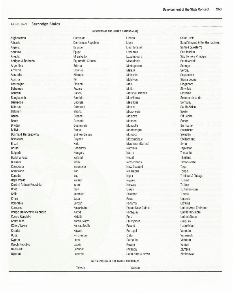
TABLE 8-1 I Sovereign States
Afghanistan Albania Algeria Andorra Angola Antigua & Barbuda Argentina Armenia Australia Austria Azerbaijan Bahamas Bahrain Bangladesh Barbados Belarus Belgium Belize Benin Bhutan Bolivia Bosnia & Herzegovina Botswana Brazil Brunei Bulgaria Burkina Faso Burundi Cambodia Cameroon Canada Cape Verde Central African Republic Chad Chile China Colombia Comoros Congo Democratic Republic Congo Republic Costa Rica Cote d'Ivoire
Croatia Cuba Cyprus Czech Republic Denmark Djibouti
MEMBERS OF THE UNITED NATIONS (192)
Dominica Liberia Dominican Republic Libya Ecuador Liechtenstein Egypt Lithuania El Salvador Luxembourg Equatorial Guinea Macedonia Eritrea Madagascar Estonia Malawi Ethiopia Malaysia Fiji Maldives Finland Mali France Malta Gabon Marshall Islands Gambia Mauritania Georgia Mauritius Germany Mexico Ghana Micronesia Greece Moldova Grenada Monaco Guatemala Mongolia Guinea Montenegro Guinea-Bissau Morocco Guyana Mozambique Haiti Myanmar (Burma) Honduras Namibia Hungary Nauru Iceland Nepal India Netherlands Indonesia New Zealand Iran Nicaragua Iraq Niger Ireland Nigeria Israel Norway Italy Oman Jamaica Pakistan Japan Palau Jordan Panama Kazakhstan Papua New Guinea Kenya Paraguay Kiribiti Peru Korea, North Philippines Korea, South Poland
Kuwait Portugal Kyrgyzstan Qatar Laos Romania Latvia Russia Lebanon Rwanda Lesotho Saint Kitts & Nevis
Taiwan
NOT MEMBERS OF THE UNITED NATIONS (2)
Vatican
Development of the State Concept 263
Saint Lucia Saint Vincent & the Grenadines Samoa (Western) San Marino Sao Tome e Principe Saudi Arabia Senegal Serbia Seychelles Sierra Leone Singapore Slovakia Slovenia Solomon Islands Somalia South Africa Spain Sri Lanka Sudan Suriname Swaziland Sweden Switzerland Syria Tajikistan Tanzania Thailand Timor-Leste Togo Tonga Trinidad & Tobago Tunisia Turkey Turkmenistan Tuvalu Uganda Ukraine United Arab Emirates United Kingdom United States Uruguay Uzbekistan
Vanuatu Venezuela Vietnam Yemen Zambia Zimbabwe

264 Chapter 8 Political Geography
remain. Nearly all are islands in the Pacific Ocean or Caribbean Sea (Figure 8-5).
With the return to China of Hong Kong and Macao by the British in 1997 and Portuguese in 1999, respectively, the most populous remaining colony is Puerto Rico, which is a Commonwealth of the United States. Its 4 million residents are citizens of the United States, but they do not participate in U.S. elections, nor do they have a voting member of Congress. Puerto Ricans are split between those who want to maintain commonwealth status and those who want to see the island become a U.S. state.
Other than Puerto Rico, remaining colonies with populations between 100,000 and 300,000 include France's French Polynesia, Mayotte, and New Caledonia; the Netherlands' Netherlands Antilles; and the United States' Guam and U.S. Virgin Islands.
The world's least populated colony is Pitcairn Island, possessed by the United Kingdom. Pitcairn, in the South Pacific, has 47 people on an island less than 5 square kilometers (2 square miles). T he island was settled in 1790 by British mutineers from the ship Bounty, commanded by Captain William Bligh. Today the islanders survive by selling fish and postage stamps to collectors.
KEY ISSUE 2
Why Do Boundaries Cause Problems? Shapes of states
• Types of boundaries
• Boundaries inside states
A state is separated from its neighbors by a boundary, an invisible line marking the extent of a state's territory. Boundaries resu lt from a com bination of natural physical features (such as rivers, deserts, and mountains) and cultural features (such as language and religion). Boundaries
Shaoes of tat s The shape of a state controls the length of its boundaries with other states. The shape therefore affects the potential for communication and conflict with neighbors. The shape of a state, such as the outline of the United States or Canada, is part of its unique identity. Beyond its value as a centripetal force , the shape of a state can influence the ease or difficulty of internal administration and can affect social unity.
Five Basic Shapes Countries have one of five basic shapes-compact, prompted, elongated, fragmented, and perforated. Examples of each can be seen in southern Africa (Figure 8-6). Each shape displays distinctive characteristics and problems.
COMPACT STATES: EFFICIENT. In a compact state, the distance from the center to any boundary does not vary significantly. The ideal theoretical compact state would be shaped like a circle, with the capital at the center and the shortest possible boundaries to defend.
10° 30° 50°
completely surround an individual state to mark the outer limits of its 20°
territorial control and to give it a distinctive shape. Boundaries interest geographers because the process of selecting their
location is frequently difficult. Boundary locations also commonly generate conflict, both within a country and with its neighbors. The boundary line, which must be shared by more than one state, is the only location where direct physical contact must take place between two neighboring states. Therefore, the boundary has the potential to become the focal point of conflict between them.
AGURE 8-5 Colonial possessions, 2006. M ost remaining colonies are tiny specks in
the Pacific Ocean or the Caribbean Sea, too small to appear on the map. Svalbard,
which belongs to Norway, is the only remaining colony with a land area greater than
I 0,000 square kilometers.
Ascension (U.K.) Pop. 1,050 Area 88
\
i 20° St. Helena (U.K.)
Pop. 7,502 Area 410
ATLANTIC
OCEAN 40°
60'
Equator
Mayotte (FRANCE) Pop. 201 , 734 Area 376 IND/AN
G OCEAN
Tropic of Capricorn
Antarctic Circle

Compactness is a beneficial characteristic for most smaller states, because good communications can be more easily established to all regions, especially if the capital is located near the center. Examples of compact states in southern African include Burundi, Kenya, Rwanda, and Uganda. However, compactness does not necessarily mean peacefulness, as compact states are just as likely as others to experience civil wars and ethnic rivalries.
PRORUPTED STATES: ACCESS OR DISRUPTION. An otherwise compact state with a large projecting extension is a prompted state. Proruptions are created for two principal reasons. First, a proruption can provide a state with access to a resource, such as water. When the Belgians gained control of the Congo, they carved out a westward proruption about 500 kilometers (300 miles) long. The proruption, which followed the Zaire (Congo) River, gave the colony access to the Atlantic. The proruption also divided the Portuguese colony of Angola (now an independent state) into two discontinuous fragments, 50 kilometers (30 miles) apart. The northern fragment, called Cabinda, constitutes less than 1 percent of Angola's total land area.
Proruptions can also separate two states that otherwise would share a boundary. When the British ruled the otherwise compact state of Afghanistan, they created a long, narrow proruption to
70' 110' 130' 150° 170' 170' 150' 130'
PACIFIC
OCEAN
Tropic of Cancer Nor1hern Mariana ts. (U.S .)
\ Pop. 82,459 .. ,
: Area 477
' Guam(U.S.) Pop. 171 ,019 Area 549
Christmas I. (AUSTRALIA) Pop. 361 Area 135
\ _
0
Shapes of States 265
the east, approximately 300 kilometers (200 miles) long and as narrow as 20 kilometers (12 miles) wide. The proruption prevented Russia from sharing a border with Pakistan (refer to Figure 8-15 later in this chapter).
In their former colony of South West Africa (now Namibia), the Germans in 1890 carved out a 500-kilometer (300-mile) proruption to the east. This proruption, known as the Caprivi Strip, provided the Germans with access to one of Africa's most important rivers, the Zambezi. The Caprivi Strip also disrupted communications among the British colonies of southern Africa. South Africa, which controlled Namibia from the 1910s until its independence in 1990, stationed troops in the Caprivi Strip to fight enemies in Angola, Zambia, and Botswana.
ELONGATED STATES: POTENTIAL ISOLATION. There are a handful of elongated states, or states with a long and narrow shape. The best example is Chile, which stretches north- south for more than 4,000 kilometers (2,500 miles) but rarely exceeds an east-west distance of 150 kilometers (90 miles). Chile is wedged between the Pacific Coast of South America and the rugged Andes Mountains, which rise more than 6, 700 meters (20,000 feet).
A less extreme example of an elongated state is Italy, which extends more than 1, 100 kilometers (7 00 miles) from northwest to
40'
Tokelau (NEW ZEALAND) ~ Pop. 11405
-.:&' ~ :"-~, Area <O
Cook Is. (NEW ZEALAND) Pop. 21 ,571
tl;_na 1s;\ FRANCE) '-.. Pop. 16,168 ""
A(ea 274 •
------Area 241
·. ·. · ___,-French Polynesia (FRANCE)
\
.. ----: Pop. 274,578 , ~·.-··,.;.< · . Area 4, 167
Pop. 57,794
\
American Samoa (U.S.)
Area 199 ·"'-
Niue (NEW ZEALAND) Pitcairn Island (U.K.) Pop. 47
Pop. 2 ,166 Area 259
Area 47
1,000 2,000 MILES
1,000 2,000 KILOMETERS
60'

266 Chapter 8 Political Geography
FIGURE 8-6 Southern Africa. Burnndi, Kenya, Rwanda, and Uganda are
examples of compact states. Malawi and Mozambique are elongated states. Namibia and the Democratic Republic of Congo are prorupted states. Angola is a fragmented state, because the northern portion, called Cabinda, is separated from the rest of the country by the Democratic Republic of Congo. South Africa is a perforated stare. The map also shows landlocked African states, which must import and export goods by land-based transportation, primarily rail lines, to
reach ocean ports in cooperating neighbor states. Colors show the European colonial rnlers in 1914.
southeast but is only approximately 200 kilometers (120 miles) wide in most places. In Africa, Malawi measures about 850 kilometers (530 miles) north-south but only 100 kilometers (60 miles) east-west (refer to Figure 8-6).
In West Africa, Gambia is an elongated state extending along the banks of the Gambia River about 500 kilometers (300 miles) east-west but only about 25 kilometers (15 miles) north-south . Except for its short coastline along the Atlantic Ocean, Gambia is otherwise completely surrounded by Senegal. The shape of the two countries is a legacy of competition among European countries to establish colonies during the nineteenth century. Gambia became a British colony, whereas Senegal was French. The border between the two countries divided families and ethnic groups but was never precisely delineated, so people trade and move across the border with little concern for its location.
Elongated states may suffer from poor internal communications. A region located at an extreme end of the elongation might be isolated from the capital, which is usually placed near the center.
FRAGMENTED STATES: PROBLEMATIC. A fragmented state includes several discontinuous pieces of territory. Technically, all states that have offshore islands as part of their territory are fragmented. However, fragmentation is particularly significant for some states. There are two kinds of fragmented states-those with areas separated by water, and those separated by an intervening state.
'o'
5'
25°
30'
35'
40°
5'
200 400 MILES
0 200 400 KILOMETERS
10' 15° 20° 25° 30°
5'
10'
nfAND COLONIAL POSSESSIONS, 1914
35°
D Belgium
D France
D Germany
D Italy
D Portugal
D United Kingdom
Major rai lroad
The most extreme example is Indonesia, which comprises 13,677 islands that extend more than 5,000 kilometers (3,000 miles) across the Indian Ocean. Although more than 80 percent of the country's population live on two of the islands-Java and Sumatra-the fragmentation hinders communications and makes integration of people living on remote islands nearly impossible. To foster national integration, the Indonesian government has encouraged migration from the more densely populated islands to some of the sparsely inhabited ones.
Not all of the fragments joined Indonesia voluntarily. A few days after Timor-Leste (East Timor) gained its independence from Portugal in 197 5, Indonesia invaded. A long struggl e against Indonesia culminated in a 1999 UN-managed referendum, when the overwhelming majority of Timorese voted for independence. Pro-Indonesia soldiers then went on a rampage, terrorizing the population, until an international peacekeeping force restored order. UN officials took over administration of the territory until an independent sovereign state was established in 2002.
West Papua, another fragment of Indonesia (the western portion of the island shared with Papua N ew Guinea), followed Timor-Leste's lead, claiming that it too should be an independent country. However, West Papua's attempt to break away from Indonesia gained less support from the international community. Unlike Indonesia's takeover of Timor-Leste, other countries had never challenged Indonesia's right to govern West Papua.

A difficult type of fragmentation occurs if the two pieces of territory are separated by another state. Picture the difficulty of communicating between Alaska and the lower 48 states if Canada were not a friendly neighbor. All land connections between Alaska and the rest of the United States must pass through a long expanse of Canada. The division of Angola into two pieces by Congo's proruption creates a fragmented state.
Even Russia, the world's largest state, is fragmented by other independent states. Kaliningrad (Konigsberg), an area measuring 16,000 square kilometers (6,000 square miles), is along the Baltic Sea. It is west of the remainder of Russia by 400 kilometers (250 miles), separated by the states of Lithuania and Belarus (refer to Figure 7-11). The area was part of Germany until the end of World War II, but the Soviet Union seized it after the German defeat. The German population fled westward after World War II, and virtually all of the area's 400,000 residents are Russians. Russia wants Kaliningrad because it has the country's largest naval base on the Baltic Sea.
Perhaps the most intractable fragmentation results from a tiny strip of land in India called Tin Bigha. The Tin Bigha corridor measures only 178 meters (about 600 feet) by 85 meters (about 300 feet). It fragments Dahagram and Angarpota from the rest of Bangladesh (Figure 8-7). The problem is a legacy of the late 1940s, when the British divided the region according to religion, allocating predominantly Hindu enclaves to India and predominantly Muslim ones to Bangladesh (formerly East Pakistan, refer to Figure 7-16).
India agreed to lease the Tin Bigha corridor to Bangladesh in perpetuity, so that Dahagram and Angarpota could be connected to the rest of Bangladesh. But by eliminating one fragmentation, India created its own: Cooch Behar is now fragmented from the rest of India. The agreement between the two
FIGURE 8-7 The Tin Bigha corridor. Less than 300 meters (900 feet), the Tin Bigha corridor is a part of India that fragments Dahagram and Angarpota from the rest of Bangladesh. India agreed to lease the corridor to Bangladesh in perpetuity, so that Dahagram and Angarpota could be connected to the rest of Bangladesh. But by eliminating one fragmentation, India created another one: Cooch Behar is now fragmented from the rest of India.
Shapes of States 267
countries gives Indians the right to move between Cooch Behar and the rest of India at certain times without submitting to passport inspection, customs declarations, and other international border controls. But given the long history of unrest between Hindus and Muslims, maintaining peace in the Tin Bigha corridor is difficult.
Panama was an example of a fragmented state for most of the twentieth century, divided in two parts by the canal, built in 1914 by the United States. U.S. ownership of the canal and the surrounding Canal Zone was a source of tension for many years, until the two countries signed a treaty turning over the canal and Canal Zone to Panama on December 31, 1999. The treaty guaranteed the neutrality of the canal and permitted the United States to use force if necessary to keep the canal operating. After the United States withdrew from the Canal Zone, Panama became an elongated state, 700 kilometers (450 miles) long and 80 kilometers (50 miles) wide.
PERFORATED STATES: SOUTH AFRICA. A state that completely surrounds another one is a perforated state. The one good example of a perforated state is South Africa, which completely surrounds the state of Lesotho. Lesotho must depend almost entirely on South Africa for the import and export of goods. Dependency on South Africa was especially difficult for Lesotho when South Africa had a government controlled by whites who discriminated against the black majority population.
Landlocked States Lesotho is unique in being completely surrounded by only one state, but it shares an important feature with several other states in southern Africa, as well as in other regions: it is landlocked. A landlocked state lacks a direct outlet to the sea because it is completely surrounded by several other countries (only one country in the case of Lesotho). Landlocked states are most common in Africa, where 14 of the continent's 5 4 states have no direct ocean access. The prevalence of landlocked states in Africa is a remnant of the colonial era, when Britain and France controlled extensive regions.
The European powers built railroads, mostly in the early twentieth century, to connect the interior of Africa with seaports. Railroads moved minerals from interior mines to seaports, and in the opposite direction, rail lines carried mining equipment and supplies from seaports to the interior. Now that the British and French empires are gone, and former colonies have become independent states, some important colonial railroad lines pass through several independent countries. This has created new landlocked states, which must cooperate with neighboring states that have seaports.
Direct access to an ocean is critical to states because it facilitates international trade. Bulky goods, such as petroleum, grain, ore, and vehicles, are normally transported long distances by ship. This means that a country needs a seaport where goods can be transferred between land and sea. To send and receive goods by sea, a landlocked state must arrange to use another country's seaport.

268 Chapter 8 Political Geography
LANDLOCKED STATES IN SOUTHERN AFRICA. Cooperation between landlocked states in southern Africa has been complicated by racial patterns. Botswana, Lesotho, and Swaziland are landlocked states that ship 90 percent of their exports by rail through neighboring South Africa. Congo Democratic Republic, Zambia, and Zimbabwe must also transport most of their imports and exports through South Africa.
In the past, the states of southern Africa had to balance their economic dependency on South Africa with their dislike of the country's racial policies. Although they constitute more than 80 percent of South Africa's population, blacks suffered from discrimination (see Chapter 7). But if neighboring states had severed ties with South Africa because of its racial discrimination, they could have faced economic disaster.
Zimbabwe's particularly delicate problem can be understood by looking back about three decades, when it was a British colony called Southern Rhodesia. When the white minority in this landlocked colony unilaterally declared itself the independent country of Rhodesia in 1965, most other countries reduced or terminated trade with it. But the impact of trade sanctions on Rhodesia was limited because its major seaports were in South Africa, also ruled by a white minority government. As shown in Figure 8-6, Rhodesia's main rail line ran through black-ruled Botswana to reach South Africa. Botswana was not cooperative, so the Rhodesian government completed a new rail line directly to South Africa in 1974, bypassing Botswana.
The white-minority government of Rhodesia agreed in 1979 to give blacks the right to vote, and blacks were elected to lead the government. The following year, Britain formally recognized the independence of the country, which was renamed Zimbabwe. The Zimbabwe government, now controlled by the black majority, faced a new set of relationships in southern Africa. Instead of working closely with South Africa, Zimbabwe tried to reduce its dependency on the neighboring whiteminority government. The key element in Zimbabwe's strategy was to use railroads that connected to seaports outside South Africa. That turned into a very complex problem. Reference to Figure 8-6 will make this explanation easier to follow.
The closest seaport to Zimbabwe is Beira, in Mozambique. A railroad known as the Beira corridor runs west from the seaport to the Zimbabwean capital of Harare. Between 1976 and 1992, however, Mozambique was caught in a devastating civil war between its Marxist-oriented government and rebels backed by South Africa. Zimbabwe sent soldiers to Mozambique to keep the 500-kilometer (300-mile) Beira corridor repaired and protected from rebel attack, but the seaport of Beira was not well maintained.
More distant seaports were not reliable either. Mozambique's other two major deep-water ports-Nacala in the north and Maputo in the south-suffered even more than Beira from the civil war. The Benguela railway, which runs from the Atlantic Coast eastward across Angola to Zaire and Zambia, has also been disrupted since 197 5 by a civil war in Angola.
The Tazara line, which runs from Zambia to Dar es Salaam in Tanzania, remains open, but service is unreliable. The equipment, much of it supplied by the Chinese in the 1970s, frequently breaks down, and landslides have periodically closed
the line. As a result of these obstacles, Zimbabwe ships more than half of its freight through the South African seaport of Durban.
Types of Boundaries Historically, frontiers rather than boundaries separated states. A frontier is a zone where no state exercises complete political control. A frontier is a tangible geographic area, whereas a boundary is an infinitely thin, invisible, imaginary line. A frontier provides an area of separation, often kilometers in width, but a boundary brings two neighboring states into direct contact, increasing the potential for violent face-to-face meetings. A frontier area is either uninhabited or sparsely settled by a few isolated pioneers seeking to live outside organized society.
Almost universally, frontiers between states have been replaced by boundaries. Modern communications systems permit countries to monitor and guard boundaries effectively, even in previously inaccessible locations. Once-remote frontier regions have become more attractive for agriculture and mining.
The only regions of the world that still have frontiers rather than boundaries are Antarctica and the Arabian Peninsula. Frontiers separate Saudi Arabia from Qatar, the United Arab Emirates, Oman, and Yemen. These frontier areas are inhabited by a handful of nomads who cross freely with their herds from one country to another. Until recently, part of Saudi Arabia's border with Iraq included an 8,000-square-kilometer (3,000-square-mile) frontier marked on maps as "Neutral Zone" (Figure 8-8). However, by stationing troops on either side of an east-west line across the Neutral Zone, Saudi Arabia and Iraq in 1990 transformed the frontier into a boundary,
•Medina • ~
SAUDI ARABIA
Current boundary
Current frontier (boundary undefined}
Past frontier
SEA
50° '= 55'
15°
FIGURE 8-8 Frontiers in the Arabian Peninsula. Several states in the Arabian Peninsula are separated from each other by frontiers rather than by precisely
drawn boundaries. The principal occupants of this desert area have been nomads, who have wandered freely through the frontier. A frontier !mown as the neutral zone existed between Saudi Arabia and Iraq until the two countries split it during
the 1991 Gulf War.

The Great Wall of China. One of the world's most visible boundaries, the wall
was built in the third century B.C. during the Qin (Ch'in) dynasty and extended the following century during the Han dynasty to keep out nomadic horsemen. The wall was partially reconstructed between the fourteenth and sixteenth centuries A.D. during the Ming dynasty.
although not one officially ratified by the governments of the two countries.
Boundaries are of two types-physical and cultural. Physical boundaries coincide with significant features of the natural landscape (mountains, deserts, water), whereas cultural boundaries follow the distribution of cultural characteristics. Neither type of boundary is better or more "natural," and many boundaries are a combination of both types. The best boundaries are those to which all affected states agree, regardless of the rationale used to draw the line.
Physical Boundaries Important physical features on Earth's surface can make good boundaries because they are easily seen, both on a map and on the ground. Three types of physical elements serve as boundaries between states-mountains, deserts, and water.
MOUNTAIN BOUNDARIES. Mountains can be effective boundaries if they are difficult to cross. Contact between nationalities living on opposite sides may be limited, or completely impossible if passes are closed by winter storms. Mountains are also useful boundaries because they are rather permanent and are usually sparsely inhabited.
Mountains do not always provide for the amicable separation of neighbors. Argentina and Chile agreed to be divided by the crest of the Andes Mountains but could not decide on the precise location of the crest. Was the crest a jagged line, connecting mountain peak to mountain peak? Or was it a curving line following the continental divide (the continuous ridge that divides rainfall and snowmelt between flow toward the Atlantic or Pacific)? The two countries almost fought a war over the boundary line. But with the help of U .S. mediators, they finally decided on the line connecting adjacent mountain peaks.
Types of Boundaries 269
DESERT BOUNDARIES. A boundary drawn in a desert can also effectively divide two states. Like mountains, deserts are hard to cross and sparsely inhabited. Desert boundaries are common in Africa and Asia. In North Africa, the Sahara has generally proved to be a stable boundary separating Algeria, Libya, and Egypt on the north from Mauritania, Mali, Niger, Chad, and the Sudan on the south. (For an illustration, look back to Figure 1-14, the world climate map.) The Libyan army moved south across the desert during the early 1980s to invade Chad but retreated in 1987 following French intervention.
WATER BOUNDARIES. Rivers, lakes, and oceans are the physical features most commonly used as boundaries. Water boundaries are readily visible on a map and are relatively unchanging.
Water boundaries are especially common in East Africa (refer to Figure 8-6). Consider, for example, the following:
• The boundary between Congo Democratic Republic and Uganda runs through Lake Albert.
• The boundary separating Kenya, Tanzania, and Uganda runs through Lake Victoria.
• The boundary separating Burundi, Congo Democratic Republic, Tanzania, and Zambia runs through Lake Tanganyika.
• The boundary between Congo Democratic Republic and Zambia runs through Lake Mwera.
• The boundary between Malawi and Mozambique runs through Lake Malawi (Lake Nyasa).
Boundaries are typically in the middle of the water, although the boundary between Malawi and Tanzania follows the north shore of Lake Malawi (Lake Nyasa). Again, the boundaries result from nineteenth-century colonial practices: Malawi was a British colony, whereas Tanzania was German.
Water boundaries can offer good protection against attack from another state, because an invading state must transport its troops by air or ship and secure a landing spot in the country being attacked. The state being invaded can concentrate its defense at the landing point.
However, the use of water as boundaries between states can cause difficulties. One problem is that the precise position of the water may change over time. Rivers, in particular, can slowly change their course. The Rio Grande, the river separating the United States and Mexico, has frequently meandered from its previous course since it became part of the boundary in 1848. Land that had once been on the U.S. side of the boundary came to be on the Mexican side, and vice versa. The United States and Mexico have concluded treaties that restore land affected by the shifting course of the river to the country in control at the time of the original nineteenth-century delineation. The International Boundary and Water Commission, jointly staffed by the United States and Mexico, oversees the border treaties and settles differences.
Ocean boundaries also cause problems because states generally claim that the boundary lies not at the coastline but out at sea. The reasons are for defense and for control of valuable fishing industries. Beginning in the late eighteenth century, some

270 Chapter 8 Political Geography
states recognized a boundary, known as the territorial limit, which extended 3 nautical miles (about 5.5 kilometers or 3.5 land miles) from the shore into the ocean. Some states claimed more extensive territorial limits, and others identified a contiguous zone of influence that extended beyond the territorial limits.
The Law of the Sea, signed by 117 countries in 1983, standardized the territorial limits for most countries at 12 nautical miles (about 22 kilometers or 14 land miles). Under the Law of the Sea, states also have exclusive rights to the fish and other marine life within 200 miles (320 kilometers). Countries separated by less than 400 miles of sea must negotiate the location of the boundary between exclusive fishing rights. Disputes can be taken to a Tribunal for the Law of the Sea or to the International Court of]ustice.
Cultural Boundaries The boundaries between some states coincide with differences in ethnicity, especially language and religion. Other cultural boundaries are drawn according to geometry; they simply are straight lines drawn on a map, although good reasons always exist for where the lines are located. Boundaries between countries have been placed where possible to separate speakers of different languages or followers of different religions. As discussed in Chapter 7, a nation-state exists when the boundaries of a state match the boundaries of the territory inhabited by an ethnic group. Problems exist when the boundaries do not match.
GEOMETRIC BOUNDARIES. Part of the northern U.S. boundary with Canada is a 2, 100-kilometer (1,300-mile) straight line (more precisely, an arc) along 49° north latitude, running from Lake of the Woods between Minnesota and Manitoba to the Strait of Georgia between Washington State and British Columbia. This boundary was established in 1846 by a treaty between the United States and Great Britain, which still controlled Canada.
At the time, some people in the United States wanted the boundary to be fixed 600 kilometers (400 miles) farther north, at 54°40' north latitude. Before a compromise was reached, U.S. militants proclaimed "fifty-four forty or fight." The United States and Canada share an additional 1,100-kilometer (700-mile) geometric boundary between Alaska and the Yukon Territory along the north-south arc of 141° west longitude.
The 1,000-kilometer (600-mile) boundary between Chad and Libya is a straight line drawn across the desert in 1899 by the French and British to set the northern limit of French colonies in Africa (refer to Figure 8--4). But subsequent actions by European countries created confusion over the boundary. Italy seized Libya from the Turks in 1912 and demanded that the boundary with French-controlled Chad be moved southward. France agreed to move the boundary 100 kilometers (60 miles) to the south in 193 5, but the Italian government was not satisfied and never ratified the treaty. The land that the French would have ceded is known as the Aozou Strip, named for the only settlement in this 100,000-square-kilometer (36,000-square-mile) area (Figure 8-9).
When Libya and Chad both became independent countries, the boundary was set at the original northern location. Claiming that it had been secretly sold the Aozou Strip by the
0 100 200 MILES
0 100 200 KILOMETERS
FIGURE 8-9 Aozou Strip. The boundary between Libya and Chad is a straight line, drawn by European countries early in the twentieth century when the area comprised a series of colonies. Libya, however, claims that the boundary should be located 100 kilometers to the south and that it should have sovereignty over the Aozou Strip.
president of Chad, Libya seized the territory in 1973, as well as a tiny bit of northeastern Niger that may contain uranium ore. In 1987 Chad expelled the Libyan army with the help of French forces and regained control of the strip.
RELIGIOUS BOUNDARIES. Religious differences often coincide with boundaries between states, but in only a few cases has religion been used to select the actual boundary line. The most notable example was in South Asia, when the British partitioned India into two states on the basis of religion. The predominantly Muslim portions were allocated to Pakistan, whereas the predominantly Hindu portions became the independent state of India (see Figure 7-16).
Religion was also used to some extent to draw the boundary between two states on the island of Eire (Ireland). Most of the island became an independent country, but the northeastnow known as Northern Ireland-remained part of the United Kingdom. Roman Catholics comprise approximately 95 percent of the population in the 26 counties that joined the Republic of Ireland, whereas Protestants constitute the majority in the six counties of Northern Ireland (see Figure 6-14).
LANGUAGE BOUNDARIES. Language is an important cultural characteristic for drawing boundaries, especially in Europe. By global standards, European languages have substantial literary traditions and formal rules of grammar and spelling. Language has long been a significant means of distinguishing distinctive nationalities in Europe.
The French language was a major element in the development of France as a unified state in the seventeenth century. The states of England, Spain, and Portugal coalesced around distinctive languages. In the nineteenth century, Italy and Germany also emerged as states that unified the speakers of particular languages.

The movement to identify nationalities on the basis of language spread throughout Europe in the twentieth century. After World War I, leaders of the victorious countries met at the Versailles Peace Conference to redraw the map of Europe. One of the chief advisers to President Woodrow Wilson, the geographer Isaiah Bowman, played a major role in the decisions. Language was the most important criterion the allied leaders used to create new states in Europe and to adjust the boundaries of existing ones.
The conference was particularly concerned with Eastern and Southern Europe, regions long troubled by political instability and conflict. Boundaries were drawn around the states of Bulgaria, Hungary, Poland, and Romania to conform closely to the distribution of Bulgarian, Hungarian (Magyar), Polish, and Romanian speakers. Speakers of several similar South Slavic languages were placed together in the new country of Yugoslavia. Czechoslovakia was created by combining the speakers of Czech and Slovak, mutually intelligible West Slavic languages (refer to Figure 7-21 ).
Although the boundaries imposed by the Versailles conference on the basis of language were adjusted somewhat after World War II, they proved to be relatively stable, and peace ensued for several decades. However, during the 1990s, the boundaries on the map of Europe drawn at Versailles in 1919 collapsed. Despite speaking similar languages, Czechs and Slovaks found that they could no longer live together peacefully in the same state. Croats, Macedonians, Serbs, and Slovenes realized the same.
CYPRUS'S "GREEN LINE" BOUNDARY. Cyprus, the third-largest island in the Mediterranean Sea, contains two nationalities-Greek and Turkish (Figure 8-10). Although the island is physically closer to Turkey, Greeks comprise 78 percent of the country's population, whereas Turks account for 18 percent. When Cyprus gained independence
33°
Mediterranean
Sea
33°
20 40 MILES 34°
British military bases
FIGURE 8-10 Cyprus. Since 1974, Cyprus has been divided into Greek and Turkish portions, with little mingling between the two groups. The Turkish sector has declared itself to be the Turkish Republic of Northern Cyprus, but only Turkey recognizes it as an independent country. Restictions were eased on crossing between the Greek and Turkish sides on April 23 , 2003. T he photo shows long lines of people waiting that day to cross the checkpoint in the capital
Nicosia. Cars with Greek Cypriots are waiting to cross in the foreground and Turkish Cypriots have crossed on foot on the right side of the photo.
Types of Boundaries 271
from Britain in 1960, its constitution guaranteed the Turkish minority a substantial share of elected offices and control over its own education, religion, and culture.
Cyprus has never peacefully integrated the Greek and Turkish nationalities. Several Greek Cypriot military officers who favored unification of Cyprus with Greece seized control of the government in 1974. Shortly after the coup, Turkey invaded Cyprus to protect the Turkish Cypriot minority, occupying 3 7 percent of the island. The Greek coup leaders were removed within a few months, and an elected government was restored, but the Turkish army remained on Cyprus.
Traditionally, the Greek and Turkish Cypriots mingled, but after the coup and invasion, the two nationalities became geographically isolated. The northeastern part of the island is now overwhelmingly Turkish, whereas the southern part is overwhelmingly Greek. Approximately one-third of the island's Greeks were forced to move from the region controlled by the Turkish army, whereas nearly one-fourth of the Turks moved from the region now considered to be the Greek side. The percentage of one nationality living in the region dominated by the other nationality is now very low. The Turkish sector declared itself the independent Turkish Republic of Northern Cyprus in 1983, but only Turkey recognizes it as a separate state.
A buffer zone patrolled by UN soldiers stretches across the entire island to prevent Greeks and Turks from crossing. The barrier even runs through the center of the capital, Nicosia. Only one official crossing point has been erected, and crossing is difficult except for top diplomats and UN personnel. Nevertheless, some cooperation continues between sectors: the Turks supply the Greek side with water and in return receive electricity.
The United Nations put together a plan to reunite the two portions of Cyprus into a single country with considerable autonomy for each side. Adding pressure to the reunification movement, the

272 Chapter 8 Political Geography
European Union agreed to accept the entire island of Cyprus as a member in 2004. The Turkish Cypriots opened the borders between the two sides in 2003. For the first time in nearly three decades, Greek Cypriots could buy lower priced groceries and gamble at casinos on the Turkish side, and Turks could shop for luxury and high fashion goods on the Greek side. People displaced during the 1970s could also visit their childhood homes for the first time in three decades. However, many generations of distrust made resolution and implementation of a final agreement difficult.
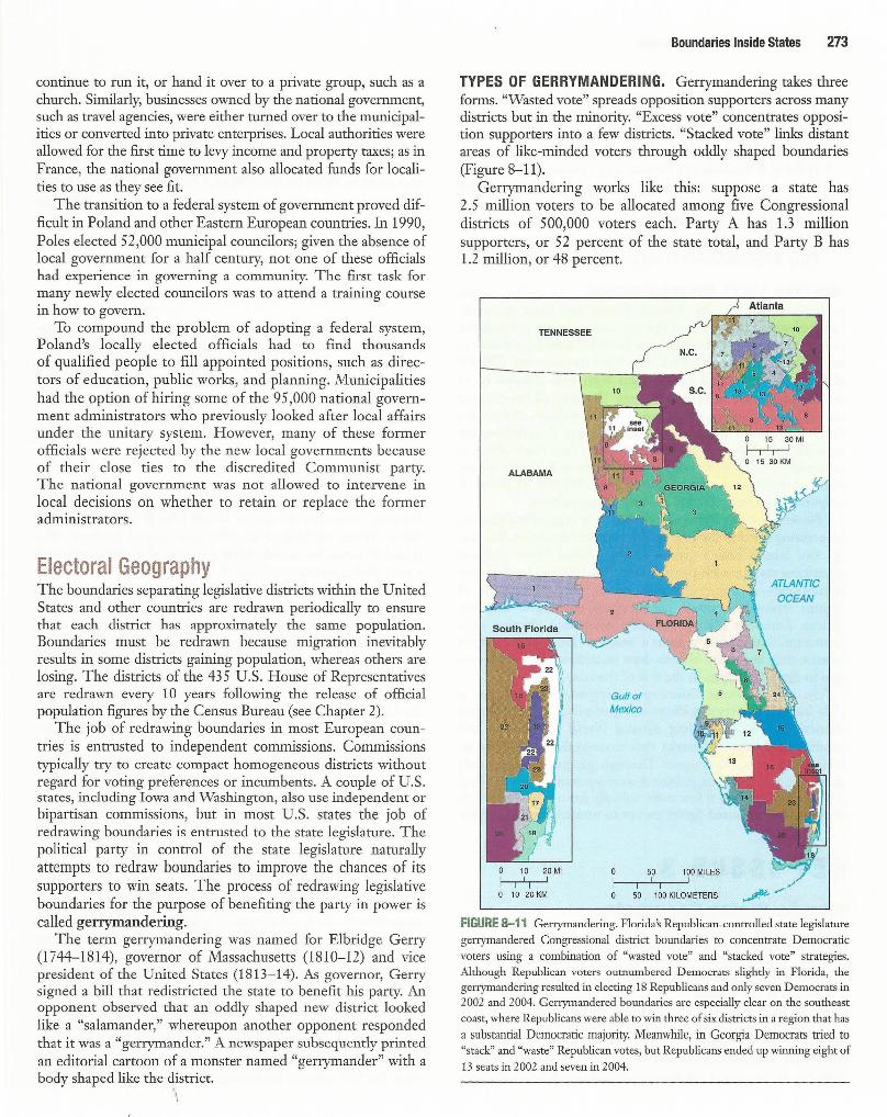
Boundaries Inside States . Within countries, local government boundaries are sometimes drawn to separate different nationalities or ethnicities. They are also drawn sometimes to provide advantage to a political party.
Unitary and Federal States In the face of increasing demands by ethnicities for more selfdetermination, states have restructured their governments to transfer some authority from the national government to local government units. An ethnicity that is not sufficiently numerous to gain control of the national government may be content with control of a regional or local unit of government.
The governments of states are organized according to one of two approaches-the unitary system or the federal system. The unitary state places most power in the hands of central government officials, whereas the federal state allocates strong power to units of local government within the country. A country's cultural and physical characteristics influence the evolution of its governmental system.
In principle, the unitary government system works best in nation-states characterized by few internal cultural differences and a strong sense of national unity. Because the unitary system requires effective communications with all regions of the country, smaller states are more likely to adopt it. Unitary states are especially common in Europe.
In reality, multinational states have often adopted unitary systems, so that the values of one nationality can be imposed on others. In a number of African countries, such as Ghana, Kenya, and Rwanda, for instance, the mechanisms of a unitary state have enabled one ethnic group to extend dominance over weaker groups. When Communist parties controlled the governments, most Eastern European countries had unitary systems so as to promote the diffusion of Communist values.
In a federal state, such as the United States, local governments possess more authority to adopt their own laws. Multinational states may adopt a federal system of government to empower different nationalities, especially if they live in separate regions of the cow1uy. Under a federal system, local government boundaries can be drawn to correspond with regions inhabited by different ethnicities.
The federal system is also more suitable for very large states because the national capital may be too remote to provide effective control over isolated regions. Most of the world's largest states are federal, including Russia (as well as the former Soviet Union), Canada, the United States, Brazil, and India. However, the size of the state is not always an accurate predictor of the
form of government: tiny Belgium is a federal state (to accommodate the two main cultural groups, the Flemish and Waloons, as discussed in Chapter 5), whereas China is a unitary state (to promote Communist values).
Trend Toward Federal Government In recent years there has been a strong global trend toward federal government. Unitary systems have been sharply curtailed in a number of countries and scrapped altogether in others.
FRANCE: CURBING A UNITARY GOVERNMENT. A good example of a nation-state, France has a long tradition of unitary government in which a very strong national government dominates local government decisions. Their basic local government unit is the dipartement (department). Each of the 96 departments has an elected general council, but its administrative head is a powerful prifet appointed by the national government rather than directly elected by the people. Engineers, architects, planners, and other technical experts working in the department are actually employed by national government ministries.
A second tier of local government in France is the commune. Each of the 36,568 communes has a locally elected mayor and council, but the mayor can be a member of the national parliament at the same time. Further, the median size of a commune is 380 inhabitants, too small to govern effectively, with the possible exception of the largest ones, such as those in Paris, Lyon, Lille, and Marseille.
The French government has granted additional legal powers to the departments and communes in recent years. Local governments can borrow money freely to finance new projects without explicit national government approval, formerly required. The national government gives a block of funds to localities with no strings attached. In addition, 22 regional councils that previously held minimal authority have been converted into full-fledged local government units, with elected councils and the power to levy taxes.
POLAND: A NEW FEDERAL GOVERNMENT. Poland switched from a unita1y to a federal system after cono.·ol of the national government was wrested from the Communists. The federal system was adopted to dismantle legal structures by which Communists had maintained unchallenged power for more than 40 years.
Under the Communists' unitary system, local governments held no legal authority. The national government appointed local officials and owned public property. This system led to deteriorated buildings, roads, and water systems, because the national government did not allocate sufficient funds to maintain property, and no one had clear responsibility for keeping property in good condition.
Poland's 1989 constitution called for a peaceful revolutionthe creation of 2,383 new municipalities, to be headed by directly elected officials. To these municipalities, the national government turned over ownership of housing, water supplies, transportation systems, and other publicly owned structures. For existing schools, each local authority decided case by case whether to operate the school, let the national government
continue to run it, or hand it over to a private group, such as a church. Similarly, businesses owned by the national government, such as travel agencies, were either turned over to the municipalities or converted into private enterprises. Local authorities were allowed for the first time to levy income and property taxes; as in France, the national government also allocated funds for localities to use as they see fit.
The transition to a federal system of government proved difficult in Poland and other Eastern European countries. In 1990, Poles elected 52,000 municipal councilors; given the absence of local government for a half century, not one of these officials had experience in governing a community. The first task for many newly elected councilors was to attend a training course in how to govern.
To compound the problem of adopting a federal system, Poland's locally elected officials had to find thousands of qualified people to fill appointed positions, such as directors of education, public works, and planning. Municipalities had the option of hiring some of the 95 ,000 national government administrators who previously looked after local affairs under the unitary system. However, many of these former officials were rejected by the new local governments because of their close ties to the discredited Communist party. The national government was not allowed to intervene in local decisions on whether to retain or replace the former administrators.
Electoral Geography The boundaries separating legislative districts within the United States and other countries are redrawn periodically to ensure that each district has approximately the same population. Boundaries must be redrawn because migration inevitably results in some districts gaining population, whereas others are losing. The districts of the 435 U.S. House of Representatives are redrawn every 10 years following the release of official population figures by the Census Bureau (see Chapter 2).
The job of redrawing boundaries in most European countries is entrusted to independent commissions. Commissions typically try to create compact homogeneous districts without regard for voting preferences or incumbents. A couple of U .S. states, including Iowa and Washington, also use independent or bipartisan commissions, but in most U.S. states the job of redrawing boundaries is entrusted to the state legislature. The political party in control of the state legislature naturally attempts to redraw boundaries to improve the chances of its supporters to win seats. The process of redrawing legislative boundaries for the purpose of benefiting the party in power is called gerrymandering.
The term gerrymandering was named for Elbridge Gerry (1744-1814), governor of Massachusetts (1810-12) and vice president of the United States (1813-14). As governor, Gerry signed a bill that redistricted the state to benefit his party. An opponent observed that an oddly shaped new district looked like a "salamander," whereupon another opponent responded that it was a "gerrymander." A newspaper subsequently printed an editorial cartoon of a monster named "gerrymander" with a body shaped like the district.
~\
Boundaries Inside States 273
TYPES OF GERRYMANDERING. Gerrymandering takes three forms. "Wasted vote" spreads opposition supporters across many districts but in the minority. "Excess vote" concentrates opposition supporters into a few districts. "Stacked vote" links distant areas of like-minded voters through oddly shaped boundaries (Figure 8-11 ).
Gerrymandering works like this: suppose a state has 2.5 million voters to be allocated among five Congressional districts of 500,000 voters each. Party A has 1.3 million supporters, or 52 percent of the state total, and Party B has 1.2 million, or 48 percent.
10 20 Mi 50 100 MILES
I 1
1 1
0 10 20KM 50 100 KILOMETERS
FIGURE 8-11 Gerrymandering. Florida's Republican-controlled state legislature gerrymandered Congressional district boundaries to concentrate Democratic voters using a combination of "wasted vote" and "stacked vote" strategies. Although Republican voters outnumbered Democrats slightly in Florida, the gerrymandering resulted in electing 18 Republicans and only seven Democrats in 2002 and 2004. Gerrymandered boundaries are especially clear on the southeast coast, where Republicans were able to win three of six districts in a region that has a substantial Democratic majority. Meanwhile, in Georgia Democrats tried to "stack" and "waste" Republican votes, but Republicans ended up winning eight of 13 seats in 2002 and seven in 2004.

274 Chapter 8 Political Geography
• If Party A controls the redistricting process it could do a "wasted vote" gerrymander by putting in each of the five districts 260,000 of its voters and 240,000 of Party B voters, thereby giving Party A the opportunity to win all five districts despite holding a statewide edge of only 52--48 percent.
• If Party B controls the redistricting process it could do an "excess vote" gerrymander by putting 260,000 of its voters and 240,000 of Party A voters in four of the five districts and concentrating 340,000 Party A voters and only 160,000 Party B voters in the fifth district, thereby giving Party B the likelihood of winning four of five districts.
"STACKED VOTE" GERRYMANDERING. In reality, recent gerrymandering in the United States has been primarily "stacked vote." If Party A in the previous example controls the redistricting process, the trend has been for state legislatures to create three districts each with 300,000 of its voters and 200,000 of Party B's voters and two districts both with 200,000 of its voters and 300,000 of Party ~s voters. That way, all five districts are safely in possession of one party, with a majority of three for Party A and two for Party B. When Party A members are especially partisan, they have been creating four "safe" districts each with 300,000 of its voters and 200,000 of Party B's voters, while conceding the fifth district with 400,000 of Party B supporters and only 100,000 of Party Ns supporters.
"Stacked vote" gerrymandering has been especially attractive for creating districts inclined to elect ethnic minorities. Because the two largest ethnic groups in the United States (African Americans and most Hispanics other than Cubans) tend to vote Democratic-in some elections more than 90 percent of African Americans voted Democratic-creating a majority African American district virtually guarantees election of a Democrat. Republicans support a "stacked" Democratic district because they are better able to draw boundaries that are favorable to their candidates in the rest of the state.
The U.S. Supreme Court ruled gerrymandering illegal in 1985 but did not require dismantling of existing oddly shaped districts, and a 2001 ruling allowed North Carolina to add another oddly shaped district that ensured the election of an African American Democrat. Through gerrymandering, only about one-tenth of Congressional seats are competitive, making a shift of more than a few seats unlikely from one election to another in the United States except in unusual circumstances.
KEY ISSUE 3 Why Do States Cooperate with Each Other? • Political and military cooperation
Economic cooperation
Chapter 7 illustrated examples of threats to the survival of states from the trend toward local diversity. The principal challenge has been the desire of ethnicities for the right of self-determination as an expression of unique
cultural identity. In a number of cases, especially in Eastern Europe, the
inability to accommodate the diverse aspirations of ethnicities has led to the breakup of states into smaller ones.
The future of the world's current collection of sovereign states is also threatened by the trend toward globalization. All but a handful of states have joined the United Nations, although it has limited authority. But states are willingly transferring authority to regional organizations, established primarily for economic cooperation.
Political and Military Cooperation During the Cold War era (late 1940s until early 1990s) most states joined the United Nations, as well as regional organizations. These international and regional organizations were established primarily to prevent a third world war in the twentieth century and to protect countries from a foreign attack. With the end of the Cold War, some of these organizations have flourished and found new roles, whereas others have withered.
The United Nations The most important international organization is the United Nations, created at the end of World War II by the victorious Allies. When established in 1945, the United Nations comprised 49 states, but membership grew to 192 in 2007, making it a truly global institution (Table 8-1).
The number of countries in the United Nations has increased rapidly on three occasions-195 5, 1960, and the early 1990s. Sixteen countries joined in 195 5, mostly European countries that had been liberated from Nazi Germany during World War II. Seventeen new members were added in 1960, all but one a former African colony of Britain or France. Twenty-six countries were added between 1990 and 1993, primarily from the breakup of the Soviet Union and Yugoslavia. UN membership also increased in the 1990s because of the admission of several microstates.
The United Nations was not the world's first attempt at international peacemaking. The UN replaced an earlier organization known as the League of Nations, which was established after World War I. The League was never an effective peacekeeping organization. The United States did not join, despite the fact that President Woodrow Wilson initiated the idea, because the U.S. Senate refused to ratify the membership treaty. By the 1930s, Germany, Italy, Japan, and the Soviet Union had all withdrawn, and the League could not stop aggression by these states against neighboring countries.
UN members can vote to establish a peacekeeping force and request states to contribute military forces. During the Cold War era, UN peacekeeping efforts were often stymied because any one of the five permanent members of the Security Council-China, France, Russia (formerly the Soviet Union), the United Kingdom, and the United States-could veto the operation. In the past, the United States and the Soviet Union often used the veto to prevent undesired UN intervention. The major exception came in 1950, when the UN voted to send troops to support South Korea, after

the Soviet Union's delegate walked out of a Security Council meeting. More recently, the opposition of China, France, and Russia prevented the United Kingdom and the United States from securing support from the United Nations for the 2003 attack on Iraq to overthrow Saddam Hussein.
The United Nations is playing an important role in trying to separate warring groups in a number of regions, especially in Eastern Europe, the Middle East, and sub-Saharan Africa. Because it must rely on individual countries to supply troops, the UN often lacks enough of them to keep peace effectively. The UN tries to maintain strict neutrality in separating warring factions, but this has proved difficult in places such as Bosnia & Herzegovina, where most of the world sees one ethnicity (Bosnian Serbs) as a stronger aggressor and another (Bosnian Muslims) as a weaker victim. Despite its shortcomings, though, the United Nations represents a forum where, for the first time in history, virtually all states of the world can meet and vote on issues without resorting to war.
Regional Military Alliances In addition to joining the United Nations, many states joined regional military alliances after World War II. The division of the world into military alliances resulted from the emergence of two states as superpowers- the United States and the Soviet Union.
ERA OF TWO SUPERPOWERS. During the Cold War era, the United States and the Soviet Union were the world's two superpowers. Before then, the world typically contained more than two superpowers. For example, during the Napoleonic Wars in the early 1800s, Europe boasted eight major powersAustria, France, Great Britain, Poland, Prussia, Russia, Spain, and Sweden.
Before the outbreak of World War I in the early twentieth century, eight great powers again existed. Germany, Italy, Japan, and the United States replaced Poland, Prussia, Spain, and Sweden on the list. By the late 1940s most of the former great powers were beaten or battered by the two world wars, and only the United States and the Soviet Union remained as superpowers.
When a large number of states ranked as great powers of approximately equal strength, no single state could dominate. Instead, major powers joined together to form temporary alliances. A condition of roughly equal strength between opposing alliances is known as a balance of power.
Historically, the addition of one or two states to an alliance could tip the balance of power. The British in particular entered alliances to restore the balance of power and prevent any other state from becoming too strong. In contrast, the post-World War II balance of power was bipolar between the United States and the Soviet Union. Because the power of these two states was so much greater than all others, the world comprised two camps, each under the influence of one of the superpowers.
Other states lost the ability to tip the scales significantly in favor of one or the other superpower. They were relegated to a new role, that of ally or satellite. The two superpowers collected allies like works of art. The acquisition of one state not only added to the value of one superpower 's collection but also prevented the other superpower from acquiring it.
Political and Military Cooperation 275
An ally could cause trouble for a superpower. Other states could remain in an alliance, either as willing and effective partners in pursuing the objectives of the superpower or as balky and unreliable members with limited usefulness. When the United States attacked Libya by air in 1986, the planes took off from England. The most direct route was over France, but the French refused to give the U.S. aircraft permission to fly through their airspace. Rather than risk a confrontation with an ally, the U.S. planes flew a more circuitous route over the Atlantic Ocean and the Mediterranean Sea, a route that added 1,200 kilometers (800 miles) to the total round-trip mission.
Both superpowers repeatedly demonstrated that they would use military force if necessary to prevent an ally from becoming too independent. The Soviet Union sent its armies into Hungary in 1956, Czechoslovakia in 1968, and Afghanistan in 1979 to install more sympathetic governments. Because these states were clearly within the orbit of the Soviet Union, the United States chose not to intervene militarily. Similarly, the United States sent troops to the Dominican Republic in 1965, Grenada in 1983, and Panama in 1989 to ensure that they would remain allies.
As very large states, both superpowers could quickly deploy armed forces in different regions of the world. To maintain strength in regions that were not contiguous to their own territory, the United States and the Soviet Union established military bases in other countries. From these bases, ground and air support gained proximity to local areas of conflict. Naval fleets patrolled the major bodies of water.
MILITARY COOPERATION IN EUROPE. After World War II, most European states joined one of two military alliances dominated by the superpowers- NATO (North Atlantic Treaty Organization) or the Warsaw Pact (Figure 8- 12, left). NATO was a military alliance among 16 democratic states, including the United States and Canada, plus 14 European states.
Twelve of the 14 European NATO members participated fully-Belgium, Denmark, West Germany, Greece, Iceland, Italy, Luxembourg, the Netherlands, Norway, Portugal, Turkey, and the United Kingdom. France and Spain were members but did not contribute troops. NATO headquarters, originally in France, moved to Belgium when France reduced its involvement.
The Warsaw Pact was a military agreement among Communist Eastern European countries to defend each other in case of attack. Seven members joined the Warsaw Pact when it was founded in 195 5-the Soviet Union, Bulgaria, Czechoslovakia, East Germany, Hungary, Poland, and Romania. Some of Hungary's leaders in 19 5 6 asked for the help of Warsaw Pact troops to crush an uprising that threatened Communist control of the government. Warsaw Pact troops also invaded Czechoslovakia in 1968 to depose a government committed to reforms.
NATO and the Warsaw Pact were designed to maintain a bipolar balance of power in Europe. For NATO allies, the principal objective was to prevent the Soviet Union from overrunning West Germany and other smaller countries. The Warsaw Pact provided the Soviet Union with a buffer of allied states between it and Germany to discourage a third German invasion of the Soviet Union in the twentieth century.

276 Chapter 8 Political Geography
~ CONTEMPORARY GEOGRAPHIC TOOLS W Air Photos in War and Peace
Photographs taken by reconnaissance aircraft and satellites have long been an important tool in guiding military operations during conflicts, such as for pinpointing targets for air strikes and deployment of opposition armies. Air photos have also occasionally played a critical role on the diplomatic front.
A major confrontation during the Cold War between the United States and Soviet Union came in 1962 when the Soviet Union secretly began to construct missile-launching sites in Cuba, less than 150 kilometers (90 miles) from U.S. territory. President Kennedy went on national television to demand that the missiles be removed, and he ordered a naval blockade to prevent additional Soviet material from reaching Cuba. At the United Nations, immediately after Soviet Ambassador Valerian Zorin denied that his country had placed missiles in Cuba, U.S. Ambassador Adlai Stevenson dramatically revealed aerial photographs taken by the U.S. Department of Defense clearly showing them (see examples on page 277.). Faced with irrefutable evidence that the missiles existed, the Soviet Union ended the crisis by dismantling them.
As the United States moved toward war with Iraq in 2003, Secretary of State Colin
F'i Active Chemical r...! Munitions Bunkers
0 Munitions Bunkers
Powell scheduled a speech at the United Nations. The speech was supposed to present irrefutable evidence to the world justifying military action against Iraq. Adding credibility to the presentation, Powell was known to be the senior U.S. diplomat most reluctant to go to war.
Recalling the Cuban missile crisis, Powell displayed a series of air photos designed to prove that Iraq possessed weapons of mass destruction. Powell introduced the air photos with these words: "Let me say a word about satellite images before I show a couple. The photos that I am about to show you are sometimes hard for the average person to interpret, hard for me. The painstaking work of photo analysis takes experts with years and years of experience, pouring for hours and hours over light tables. But as I show you these images, I will try to capture and explain what they mean, what they indicate to our imagery specialists."
Powell first showed an image of fifteen munitions bunkers at Taji, Iraq (Figure 8-1.1 ). "We know that this one has housed chemical munitions," Powell stated. "How do I know that? How can I say that? Let me give you a closer look. Look at the image on the left (Figure 8-1.2). On the left is a close-up of one
of the four chemical bunkers. The two arrows indicate the presence of sure signs that the bunkers are storing chemical munitions. The arrow at the top that says security points to a facility that is the signature item for this kind of bunker. Inside that facility are special guards and special equipment to monitor any leakage that might come out of the bunker. The truck you also see is a signature item. It's a decontamination vehicle in case something goes wrong."
Subsequent close-ups of the bunkers showed them being cleaned immediately before UN inspectors arrived. Powell also showed a ballistic missile facility being cleaned immediately before the arrival of UN inspectors.
Unlike Stevenson in 1962, Powell could not make a convincing case at the United Nations for the U.S. position through air photos. As a result, the United States went to war with Iraq without the support of the United Nations. A subsequent U.S. State Department analysis found many inaccuracies in the interpretation of air photos presented by Powell. For example, the "decontamination vehicle" in Figure 8-1.2 turned out to be a water truck. Two years later, Powell himself said that the 2003 speech had been a "blot" on his record.
FIGURE 8-1 .1 U.S. satellite image purporting to show munitions bunkers in Taji, Iraq.
FIGURE 8-1.2 (Left) Close-up of alleged munitions bunker outlined in red near the bottom of Figure 8-1. l. (Right) Close-up of the two bunkers, outlined in red in the middle of Figure 8-1.1, allegedly sanitized.

Cuban Missile Crisis, 1962. A major confrontation during the Cold War between the United States and Soviet Union came in 1962 when the Soviet Union secretly began to construct missile launching sites in Cuba, less than 150 kilometers (90 miles) from U.S. territory. President Kennedy demanded that the missiles be removed and ordered a naval blockade to prevent further Soviet material from reaching Cuba. The crisis ended when the Soviet Union agreed to dismantle the sites. The U.S. Department of Defense took aerial photographs to show the Soviet buildup in Cuba. (Top) Three Soviet ships with missile equipment are being unloaded at Mariel naval port in Cuba. Within the outline box (enlarged below and rotated 90' clockwise) are Soviet missile transporters, fuel trailers, and oxider trailers (used to support the combustion of missile fuel).
In a Europe no longer dominated by military confrontation between two blocs, the Warsaw Pact and NATO became obsolete. The number of troops under NATO command was sharply reduced, and the Warsaw Pact was disbanded. Rather than disbanding, NATO expanded its membership to include most of the former Warsaw Pact countries, including Czech Republic, Hungary, and Poland in 1997, and Bulgaria, Estonia, Latvia, Lithuania, Romania, Slovakia, and Slovenia in 2003. Membership in NATO offers Eastern European countries an important sense of security against any future Russian threat, no matter how remote that appears at the moment, as well as participation in a common united Europe (Figure 8- 12, right).
The Organization on Security and Cooperation in Europe (OSCE) had 55 members, including the United States, Canada, and Russia, as well as most European countries.
Economic Cooperation 277
When founded in 1975, the Conference on Security and Cooperation was composed primarily of Western European countries and played only a limited role. With the end of the Cold War in the 1990s, the renamed OSCE expanded to include Warsaw Pact countries and became a more active forum for countries concerned with ending conflicts in Europe, especially in the Balkans and Caucasus. Although the OSCE does not directly command armed forces, it can call upon member states to supply troops if necessary.
OTHER REGIONAL ORGANIZATIONS. The Organization of American States (OAS) includes all 3 5 states in the Western Hemisphere. Cuba is a member but was suspended from most OAS activities in 1962. The organization's headquarters, including the permanent council and general assembly, are located in Washington, D.C. The OAS promotes social, cultural, political, and economic links among member states.
A similar organization encompassing 53 countries in Africa is the African Union (AU), established in 2001. The AU replaced an earlier organization called the Organization of African Unity, founded in 1963 primarily to seek an end to colonialism and apartheid in Africa. The new organization has placed more emphasis on promoting economic integration in Africa.
The Commonwealth includes the United Kingdom and 53 other states that were once British colonies, including Australia, Bangladesh, Canada, India, Nigeria, and Pakistan. Most other members are African states or island countries in the Caribbean or Pacific. Commonwealth members seek economic and cultural cooperation.
Economic Cooperation The era of a bipolar balance of power formally ended when the Soviet Union was disbanded in 1992. Instead, the world has returned to the pattern of more than two superpowers that predominated before World War II.
But the contemporary pattern of global power displays two key differences:
1. The most important elements of state power are increasingly economic rather than military; Japan and Germany have joined the ranks of superpowers on their economic success, whereas Russia has slipped in strength because of economic problems.
2. The leading superpower since the 1990s is not a single state, such as the United States or Russia, but an economic union of European states led by Germany.
European Union With the decline in the military-oriented alliances, European states increasingly have turned to economic cooperation. Western Europe's most important economic organization is the European Union (formerly known as the European Economic Community, the Common Market, and the European Community).
When it was established in 1958, the predecessor to the European Union included six countries-Belgium, France,

278 Chapter 8 Political Geography
20' 10° 0°
~ 250 500 MILES
0 250 500 KILOMETERS
1960
ATLANTIC OCEAN
~
Mediterranean Sea
D NATO and European Community
D NATOonly
D European Community only
D Warsaw Pact and COMECON
'
Not original members: * Joined NATO 1952-1982
Joined European * Community 1973-1986
* LeftCOMECON 1961, left Warsaw Pact 1968
10° 0°
0 500 MILES
0 250 500 KILOMETERS
2007
ATLANTIC OCEAN
~
Mediterranean Sea
D NATO and European Union
D NATOonly
D European Union only
0 '
' RUSSIA
FIGURE 8-12 (left) Economic and military alliances in Europe during the Cold War. Western European countries joined the European Union and the North Atlantic Treaty Organization (NATO), whereas Eastern European countries joined COMECON and the Warsaw Pact. (right) Current economic and military alliances in Europe. COMECON and the Warsaw Pact have been disbanded, whereas the European Union and NATO have accepted or plan to accept new members.
Italy, Luxembourg, the Netherlands, and the Federal Republic of Germany (West Germany). The union was designed to heal Western Europe's scars from World War II, which had ended only 13 years earlier, when Nazi Germany, in alliance with Italy, conquered the other four countries.
CHANGES IN GERMANY AND EASTERN EUROPE. Germany did not emerge as a nation-state until 1871, more recently than its neighbors. Prior to that time, the map of the central European area now called Germany was a patchwork of small states-more than 300 during the seventeenth century, for example. Under Frederick the Great (1740- 1786), one of these states-Prussiaemerged as the most powerful.
In 1871, Prussia's prime minister Otto von Bismarck was instrumental in forcing most of the remaining states in the area to join a Prussian-dominated German Empire (refer to Figure 8-13, upper left). Bismarck failed to consolidate all German speakers into the empire, as Austria, Switzerland, and Bohemia were excluded. The German Empire lasted less than 50 years.
Germany lost much of its territory after World War I (Figure 8- 13, upper right). Although the boundaries of states in Southern and Eastern Europe were fixed to conform when possible to those of ethnicities, Germany's new boundaries were arbitrary. Germany became a fragmented state, with East Prussia separated from the rest of the country by the Danzig Corridor, created to give Poland a port on the Baltic Sea. Nazi
takeovers of Austria, Poland, and portions of Czechoslovakia during the 1930s were justified by the Germans as attempts to reconstruct a true German nation-state.
After Germany was defeated in World War II, the victorious Allies carved the country, and its capital city of Berlin, into four zones. Each zone was controlled by one of the victors-the United States, France, the United Kingdom, and the former Soviet Union. When sharp political differences at the start of the Cold War between the Soviet Union and the other three made reestablishment of a single Germany impossible, two new countries were created-East Germany (the German Democratic Republic) in the Soviet zone, and West Germany (the Federal Republic of Germany) in the other three zones (Figure 8-13, lower left). Two Germanys existed from 1949 until 1990. With the end of communism, the German Democratic Republic ceased to exist, and its territory became part of the German Federal Republic (Figure 8-13, lower right).
In 1949, during the Cold War, the seven Eastern European Communist states in the Warsaw Pact formed an organization for economic cooperation, the Council for Mutual Economic Assistance (COMECON). Cuba, Mongolia, and Vietnam were also members of the alliance, which was designed to promote trade and sharing of natural resources. East Germany was a Soviet ally and member of the Warsaw Pact and COMECON, and West Germany was a U.S. ally and member of NATO and the European Union. Like the Warsaw Pact, COMECON

1914 250 500 MILES
0 250 500 KILOMETEfRs
Soo
ATLANTIC OCEAN
20°
1989
F i '
250 500 MILES
o 250 500 KILOM~TEef~s /1
Soo
ATLANTIC OCEAN
Mediterranean Sea
0 '
RUSSIA
1924
0 250
ATLANTIC OCEAN
10°
Mediterranean Sea
- German-speaking territory in 1914
0 '
~
U.S.S.R.
20° 10° oo
2007 ~
250 500 MILES
0 250 500 KILOMEJE~S
ATLANTIC OCEAN
/1 ,.
Mediterranean Sea
FIGURE 8-13 Europe's twentieth-century boundary changes. (upper left) In 1914, at the outbreak of World War I,
Germany extended 1,300 kilometers (800 miles) from east to west. Germany's boundaries at the time coincided fairly closely to the German-speaking area of Europe, although German was also spoken in portions of Switzerland and the AusttiaHungary Empire. (upper right) After losing World War I, Germany was divided into two discontinuous areas, separated by the Danzig Corridor, part of the newly created state of Poland. (lower left) Germany's boundaries changed again after World War II, as eastern portions of the country were taken by Poland and the Soviet Union. (lower right) With the collapse of Communism in Eastern Europe, East Germany and West Germany were united. Because of forced migration of Germans
(as well as other peoples) after World War II, the territory occupied by German speakers today is much farther west than the
location a century ago.
Economic Cooperation 279
0 '
U.S.S.R.
0 '
~ 0 ,RUSSIA
disbanded in the early 1990s after the fall of communism m Eastern Europe (refer to Figure 8-12).
Membership in the European Union had been widened to include Denmark, Ireland, and the United Kingdom in 1973; Greece in 1981; Portugal and Spain in 1986; and Austria, Finland, and Sweden in 199 5. Joining in 2 004 were eight former Communist Eastern European countries that had made the most progress in converting to market economies-the Czech
Republic, Estonia, Hungary, Latvia, Lithuania, Poland, the Slovak Republic, and Slovenia. Also joining in 2004 were the island countries of Cyprus and Malta. Bulgaria and Romania were added in 2007. Thus, the European Union has expanded from six countries during the 1950s and 1960s to 12 countries during the 1980s and 2 7 countries during the first decade of the twenty-first century. Croatia and Turkey also hope to join, but the European Union has not set a timetable.

280 Chapter 8 Political Geography
The main task of the European Union is to promote development within the member states through economic cooperation. At first the European Union played a limited role, providing subsidies to farmers and to depressed regions such as southern Italy. Most of the European Union's budget still goes to these purposes. However, the European Union has taken on more importance in recent years, as member states seek greater economic and political cooperation.
A European Parliament is elected by the people in ~ach of the member states simultaneously. It has removed most barriers to free trade: with a few exceptions, goods, services, capital, and people can move freely through Europe. Trucks can carry goods across borders without stopping, and a bank can open branches in any member country with supervision only by the bank's home country. The introduction of the euro as the common currency in a dozen European countries has eliminated many differences in prices, interest rates, and other economic policies within the region. The effect of these actions has been to turn Europe into the world's wealthiest market.
KEY ISSUE 4
Why Has Terrorism Increased? Terrorism by individuals and organizations
State support for terrorism
Terrorism is the systematic use of violence by a group in order to intimidate a population or coerce a government into granting its demands. Terrorists attempt to achieve their objectives through organized acts such as bombing, kidnapping, hijacking, taking of hostages, and assassination that spread fear and anxiety among the population. Violence is considered necessary by terrorists to bring widespread publicity to goals and grievances that are not being addressed through peaceful means. Belief in the cause is so strong that terrorists do not hesitate to strike despite knowing they will probably die in the act.
The term terror (from the Latin "to frighten") was first applied to the period of the French Revolution between March 1793 and July 1794 known as the Reign of Terror. In the name of protecting the principles of the French Revolution, the Committee of Public Safety, headed by Maximilien Robespierre, guillotined several thousand of its political opponents. In modern times, terrorism has been applied to actions by groups operating
outside government rather than by official government agencies, although some governments provide military and financial support for terrorists.
Terrorism by Individuals and Organizations Violence to foster political aims has long been a part of the world. Four U.S. presidents have been assassinated-Lincoln (1865), Garfield (1881), McKinley (1901), and Kennedy (1963). The Roman Emperor Julius Caesar's assassination 2,000 years
ago has been vividly recreated for future generations through Shakespeare's play. The assassination of the Archduke Franz Ferdinand, heir to the throne of Austria-Hungary, by a Serb in Sarajevo (capital of present-day Bosnia & Herzegovina) June 28, 1914, led directly to the outbreak of World War I.
Terrorism differs from assassinations and other acts of political violence because attacks are aimed at ordinary people rather than at military targets or political leaders. Victims of terrorism are a cross section of citizens who happen to be there at the time. Other types of military action can result in civilian deaths: bombs can go astray, targets can be misidentified, and enemy's military equipment can be hidden in civilian buildings. But average individuals are unintended victims rather than principal targets in most conflicts, whereas a terrorist considers all citizens responsible for the actions being opposed, so therefore equally justified as victims.
Distinguishing terrorism from other acts of political violence can be difficult. For example, if a Palestinian suicide bomber kills several dozen Israeli teenagers in a Jerusalem restaurant, is that an act of terrorism or wartime retaliation against Israeli government policies and army actions? Spokespersons on television make competing claims: Israel's sympathizers denounce the act as a terrorist threat to the country's existence, whereas advocates of the Palestinian cause argue that long-standing injustices and Israeli army attacks on ordinary Palestinian civilians provoked the act. Similarly, Russia claims that Chechen rebels are terrorists (see Chapter 7), and the British have long claimed that Irish Republican Army members are terrorists (see Chapter 6).
American Terrorists The United States suffered several terrorist attacks during the late twentieth century. A terrorist bomb destroyed Pan Am flight 103 over Lockerbie, Scotland, on December 21, 1988, killing all 259 aboard, plus 11 on the ground. A car bomb parked in the underground garage damaged New York's World Trade Center on February 26, 1993, killing six and injuring about 1,000. A car bomb killed 168 people in the Alfred P. Murrah Federal Building in Oklahoma City on April 19, 1995. A truck bomb blew up an apartment complex in Dhahran, Saudi Arabia, on June 25, 1996, killing 19 U .S. soldiers who lived there and injuring more than 100 people. U.S. embassies in Kenya and Tanzania were bombed on August 7, 1998, killing 190 and wounding nearly 5 ,000. The USS Cole was bombed while in the port of Aden, Yemen, on October 12, 2000, killing 17 U.S. service personnel.
With the exception of the Oklahoma City bombing, Americans generally paid little attention to the attacks and had only a vague notion of who had committed them. It took the attack on the World Trade Center and Pentagon on September 11, 2001, for most Americans to feel threatened by terrorism.
Some of the terrorists during the 1990s were American citizens operating alone or with a handful of others. Theodore J. Kaczynski, known as the Unabomber, was convicted of killing three people and injuring 23 others by sending bombs through the mail during a 17-year period. His targets were mainly

academics in technological disciplines and executives in businesses whose actions he considered to be adversely affecting the environment.
Timothy ]. Mc Veigh was convicted and executed for the Oklahoma City Federal Building bombing, and for assisting him Terry I. Nichols was convicted of conspiracy and involuntary manslaughter but not executed. McVeigh claimed his terrorist act was provoked by rage against the U.S. government for such actions as the Federal Bureau of Investigation's 51-day siege of the Branch Davidian religious compound near Waco, Texas, culminating with an attack on April 19, 1993, that resulted in 80 deaths.
September 11, 2001, Attacks The most dramatic terrorist attack against the United States came on September 11, 2001. The tallest buildings in the United States, the 110-story twin towers of the World Trade Center in New York City, were destroyed, and the Pentagon in Washington, D.C., was damaged (Figure 8- 14). The attacks resulted in nearly 3,000 fatalities:
• 93 (5 terrorists, 77 other passengers, an1 11 crew members) on American Airlines flight 11, which rashed into World Trade Center Tower 1 (North Tower)
• 65 (5 terrorists, 51 other passengers, anCI 9 crew members) on United Airlines flight 17 5, which t ashed into World Trade Center Tower 2 (South Tower)
• 2,605 on the ground at the World Trade Center • 64 (5 terrorists, 53 other passengers, and 1 crew members) on
American Airlines flight 77, which crashe into the Pentagon • 125 on the ground at the Pentagon • 44 (4 terrorists, 33 other passengers, an 7 crew members)
on United Airlines flight 93 which crash d near Shanksville, Pennsylvania, after passengers fought with terrorists on board, preventing an attack on another ashington, D.C., target
Terrorism by Individuals and Organizations 281
Al-Qaeda Responsible or implicated in most of the anti-U.S. terrorism during the 1990s, as well as the September 11, 2001, attack, was the al-Qaeda network, founded by Osama bin Laden. His father, Mohammed bin Laden, a native of Yemen, established a construction company in Saudi Arabia and became a billionaire through close connections to the royal family. Osama bin Laden, one of about 50 children fathered by Mohammed with several wives, used his several hundred million dollar inheritance to fund al-Qaeda.
Bin Laden moved to Afghanistan during the mid-1980s to support the fight against the Soviet army and the country's Soviet-installed government. Calling the anti-Soviet fight a holy war or jihad, bin Laden recruited militant Muslims from Arab countries to join the cause. After the Soviet Union withdrew from Afghanistan in 1989, bin Laden returned to Saudi Arabia, but he was expelled in 1991 for opposing the Saudi government's decision permitting the United States to station troops there during the 1991 war against Iraq. Bin Laden moved to Sudan but was expelled in 1994 for instigating attacks against U.S. troops in Yemen and Somalia, so he returned to Afghanistan, where he lived as a "guest" of the Taliban-controlled government.
Bin Laden issued a declaration of war against the United States in 1996, because of U.S. support for Saudi Arabia and Israel. In a 1998 fatwa ("religious decree"), bin Laden argued that Muslims had a duty to wage a holy war against U.S. citizens because the United States was responsible for maintaining the Saud royal family as rulers of Saudi Arabia and a state of Israel dominated by Jews. Destruction of the Saudi monarchy and the Jewish state of Israel would liberate from their control Islam's three holiest sites of Makkah (Mecca), Madinah, and Jerusalem.
Al-Qaeda (an Arabic word meaning "the foundation" or "the base") was created around 1990 to unite jihad fighters in Afghanistan, as well as supporters of bin Laden elsewhere in the Middle East. Membership is estimated at around 20,000, dispersed in as many as 34 countries. Its size has been hard to estimate because the organization consists of a large
FIGURE 8-14 Topographic map using laser technology of World Trade Center on September 19, 2001, 8 days after the
attack. Colors represent elevation above sea level (in green)
or below sea level (in red) of the desrroyed buildings after the attack. Rubble was piled more than 60 feet where the twin towers once stood. The top of the image faces northeast. West St. runs across the foreground, and Liberty St. runs between the bottom center and the upper right. Tower 1
rubble is the square-shaped pile in the middle of the block facing West St. The remains of Tower 2 face Liberty St.

282 Chapter 8 Political Geography
On September 11, 2001, at 9:03 A.M., United Flight 175 approaches World Trade Center Tower 2 (left) and crashes into it (right). Tower 1 is already burning from the crash of American Flight 11 at 8:45 A.M.
number of isolated autonomous cells, whose members have minimal contact with those in other cells or even others in the same cell.
Some al-Qaeda cell members have been responsible for reconnaissance activities, such as identifying targets and collecting maps, drawings, and statistics; some have provided lodging, cash, credit cards, cars, and other logistical support; and some have actually executed attacks. Reconnaissance specialists have reported to a military committee, which in turn has reported to a consultation council known as Majiis al shura. Finance, media, and legal-religious policy committees have also reported to the Majiis, which reported to Osama bin Laden.
Most al-Qaeda cell members have lived in ordinary society, supporting themselves with jobs, burglary, and credit card fraud. They are examples of "sleepers,'' so-called because they await their cell leader's order to "awake" and perform a job for the network. The cell's planners and attackers typically do not have direct contact with each other, whereas the support members encounter both planners and attackers but do not know the target or attack plan. If arrested, members of one cell are not in a position to identify members of other cells.
Al-Qaeda has been implicated in several bombings since 9/11. In Saudi Arabia, 3 5 died (including nine terrorists) in car bomb detonations at two apartment complexes in Riyadh on May 12, 2003, and 22 died in attacks on oil company offices in Khobar on May 29, 2004. In Istanbul, Turkey, truck bombs killed 29 (including two terrorists) at two synagogues
on November 15, 2003, and 32 (including two terrorists) at the British consulate and British-owned HSBC Bank 5 days later. In London, England, 56 died (including four terrorists) when several subway trains and buses were bombed on July 7, 2005. In Sharm-el-Sheikh, Egypt, 88 died in bombings of resort hotels on July 23, 2005. In Amman, Jordan, 60 died in the bombing of three American-owned hotels on November 9, 2005.
Al-Qaeda is not a single unified organization. In addition to the original organization founded by Osama bin Laden responsible for the World Trade Center attack, al-Qaeda also encompasses local franchises concerned with country-specific issues, as well as imitators and emulators ideologically aligned with al-Qaeda but not financially tied to it.
Jemaah Islamiyah is an example of an al-Qaeda franchise with local concerns, specifically to establish fundamentalist Islamic governments in Southeast Asia. J emaah Islamiyah terrorist activities have been concentrated in the world's most populous Muslim country Indonesia. A nightclub in the resort town of Kuta on the island of Bali was bombed on October 12, 2002, killing 202. Attacks on a downtown square in Kuta as well as a food court in Jimbaran, also on Bali, killed 23 (including three terrorists) on October 1, 2005. In the capital Jakarta, car bombs killed 12 at a Marriott hotel on August 5, 2003, and 9 or 11 at the Australian embassy on September 9, 2004.
Other terrorist groups have been loosely associated with al-Qaeda. In Madrid, Spain, a local terrorist group blew up several commuter trains on March 11, 2004, killing 192. In

Mombasa, Kenya, a Somali terrorist group killed ten Kenyan dancers and three Israeli tourists at a resort on November 28, 2002, and fired two missiles at an Israeli airplane taking off from the Mombasa airport.
Al-Qaeda's use of religion to justify attacks has posed challenges to Muslims and non-Muslims alike. For many Muslims, the challenge has been to express disagreement with the policies of governments in the United States and Europe yet disavow the use of terrorism. For many Americans and Europeans, the challenge has been to distinguish between the peaceful but unfamiliar principles and practice of the world's 1.3 billion Muslims and the misuse and abuse of Islam by a handful of terrorists.
State Support for Terrorism Several states in the Middle East have provided support for terrorism in recent years, at three increasing levels of involvement:
• Providing sanctuary for terrorists wanted by other countries • Supplying weapons, money, and intelligence to terrorists • Planning attacks using terrorists
I
The government of Libya was accused of sponsoring a 1986 bombing of a nightclub i~ Berlin, Germany, popular with U.S. military personnel then stf tioned there, killing three (including one U.S. soldier). U.S. relations with Libya had been poor since 1981 when U.S. aircraft sftot down attacking Libyan warplanes while conducting exercise~ over waters that the United States considered international bkt that Libya considered inside its territory. In response to tHe Berlin bombing, U.S. bombers attacked the Libyan cities of\Tripoli and Benghazi in a failed attempt to kill Colonel MuamJr~el-Qaddafi.
Libyan agents were found to B ve planted bombs that killed 270 people on Pan Am Flight 103 v.g Lockerbie, Scotland, in 1988, as well as 170 people on UTA Flight 772 over Niger in 1989. Following 8 years of UN economic sanctions, Col. Qaddafi turned over suspects in the Lockerbie bombing for a trial that was held in the Netherlands under Scottish law. One of the two was convicted and sentenced to life imprisonment, and the other was acquitted. Col. Qaddafi agreed in 2003 to renounce terrorism and provide compensation for victims of Flight 103.
U.S. accusations of state-sponsored terrorism escalated after 9/11. The governments of first Afghanistan, then Iraq, and then Iran were accused of providing at least one of the three levels of state support for terrorists. As part of its war against terrorism, the U.S. government with the cooperation of some other countries attacked Afghanistan in 2001 and Iraq in 2003 to depose those country's government leaders considered supporters of terrorism.
Afghanistan The United States attacked Afghanistan in 2001 when its leaders, known as the Taliban, sheltered Osama bin Laden and other al-Qaeda terrorists. The Taliban (Arabic for "students of Muslim religious schools") had gained power in Afghanistan in 1995, temporarily suppressing a civil war that had lasted for
State Support for Terrorism 283
more than 2 decades and imposing strict Islamic fundamentalist law on the population (see Chapter 6).
Afghanistan's civil war began when the King was overthrown by a military coup in 1973 and was replaced 5 years later in a bloody coup by a government sympathetic to the Soviet Union. The Soviet Union sent 115,000 troops to Afghanistan beginning in 1979 after fundamentalist Muslims, known as mujahedeen, or "holy warriors," started a rebellion against the pro-Soviet government.
Although heavily outnumbered by Soviet troops and possessing much less sophisticated equipment, the mujahedeen offset the Soviet advantage by waging a guerrilla war in the country's rugged mountains, where they were more comfortable than the Soviet troops and where Soviet air superiority was ineffective. Unable to subdue the mujahedeen, the Soviet Union withdrew its troops in 1989, and the Soviet-installed government in Afghanistan collapsed in 1992. After several years of infighting among the factions that had defeated the Soviet Union, the Taliban gained control over most of the country.
Six years of Taliban rule came to an end in 2001 following the U.S. invasion. Destroying the Taliban was necessary in order for the United States to go after al-Qaeda leaders, including Osama bin Laden, who were living in Afghanistan as guests of the Taliban. Removal of the Taliban unleashed a new struggle for control of Afghanistan among the country's many ethnic groups (Figure 8-15). Although removed from power, the Taliban were able to regroup and resume an insurgency against the U.S.-backed Afghanistan government.
Iraq U.S. claims of state-sponsored terrorism proved more controversial in Iraq than in Afghanistan. The United States led an attack against Iraq in 2003 in order to depose the country's longtime President Saddam Hussein. U.S. officials justified removing Hussein, because he had created biological and chemical weapons of mass destruction. These weapons could fall into the hands of terrorists, the U.S. government charged, because close links were said to exist between Iraq's government and al Qaeda. The United Kingdom and a few other countries joined U.S forces, but most countries did not offer support.
U.S. confrontation with Iraq predated the war on terror. From the time he became president of Iraq in 1979, Hussein's behavior had raised concern around the world. War with neighbor Iran, begun in 1980, ended 8 years later in stalemate. A nuclear reactor near Baghdad, where nuclear weapons to attack Israel were allegedly being developed, was destroyed in 1981 by Israeli planes. Hussein ordered the use of poison gas in 1988 against Iraqi Kurds, killing 5 ,000. Iraq's 1990 invasion of neighboring Kuwait, which Hussein claimed was part of Iraq, was opposed by the international community. The 1991 U.S .-led Gulf War known as Operation Desert Storm drove Iraq out of Kuwait, although Hussein remained in power for another dozen years.
Desert Storm was supported by nearly every country in the United Nations, because the purpose was to end one country's unjustified invasion and attempted annexation of another. In contrast, few countries supported the U.S.-led attack in 2003, because they did not agree with the U.S. assessment that Iraq

284 Chapter 8 Political Geography
TURKMENISTAN
CHINA
SAUDI ARABIA
D Ll IN DIA
Azeri Persian Tajik
D Baluchi • Punjabi Turkmen
D Hazara D Shiite Arab Uzbek - Kurd D Sindhi Sparsley OMAN Arabian Sea
D D populated
Pashtun Sunni Arab
60° 65°
FIGURE 8-15 Ethnic groups in Southwest Asia. During the Cold War, the United States and the Soviet Union viewed
conflicts in this region as part of a global struggle in support of or against the spread of communism. More recently, U.S.
officials have regarded conflicts in Southwest Asia as part of the global war on terrorism. As the map shows, boundaries between ethnic groups do not match boundaries between countries in Southwest Asia, especially Iraq, Iran, Afghanistan, and Pakistan. This mismatch plays a critical role in the region's many wars.
still possessed weapons of mass destruction or intended to use them.
Inspectors sent by the United Nations had found the following evidence of weapons of mass destruction in Iraq during the 1980s:
• A nuclear radiation weapon program, including 40 nuclearresearch facilities and three uranium-enrichment programs
• A program for making weapons from the VX nerve agent • A biological weapons program, including production of
botulinum, anthrax, aflatoxin, and clostridium, and bombs to deliver toxic agents
However, UN experts concluded that Iraq had destroyed these weapons in 1991 after its Desert Storm defeat. U.S. officials believed instead that Iraq still had the weapons hidden, though they were never able to find them, and their judgment may have been based on faulty intelligence.
The U.S. assertion that Hussein had close links with al-Qaeda was also challenged by most other countries, as well as ultimately by U.S. intelligence agencies. Hussein's Ba'ath Party, which ruled Iraq between 1968 and 2003, espoused different principles than the al-Qaeda terrorists. The guiding principle of the Ba'ath Party was Pan-Arab nationalism, which was belief that the several hundred million Arabs living in the vast territory between North Africa and Central Asia should be joined together into one powerful nation-state, with financial strength
garnered by sharing the region's extensive oil wealth. Whereas Al-Qaeda terrorists justified their attacks on the basis of their interpretation of Islam, Ba'ath Party leaders were not observant Muslims and did not derive Pan-Arab philosophy from religious principles.
Lacking evidence of weapons of mass destruction and ties to al-Qaeda, the United States argued instead that Iraq needed a "regime change." Hussein's quarter-century record of brutality justified replacing him with a democratically elected government, according to U.S. officials. The U.S. position drew linle international support, because sovereign states are reluctant to invade another sovereign state just because they dislike its leader, no matter how odious.
Having invaded Iraq and removed Hussein from power, the United States expected an enthusiastic welcome from the Iraqi people. Instead, the United States became embroiled in a complex and violent struggle among religious sects and tribes (see Global Forces, Local Impacts box).
The principal ethnic group in the north, the Kurds, welcomed the United States because they gained more security and autonomy than they had under Hussein (see Chapter 7). But Sunni Muslims, the majority in the center, opposed the U.S.-led attack, because they feared loss of power and privilege given to them by Hussein, who was a Sunni. Shiite Muslims also opposed the U.S. presence. Although they had been treated poorly by Hussein and controlled Iraq's

GLOBAL FORCES, LOCAL IMPACTS Global, Local, and Other Scales in Iraq
The U.S.-led war in Iraq has encountered many of the tensions between globalization trends and realities of local diversity. The U .S. experience in Iraq has also demonstrated the importance of understanding conditions at scales that exist between the two extremes of global and local.
Sunnis in the center, and Shiites m the south (see Figure 8-15). A quartercentury of Hussein's dictatorial rule had suppressed long-standing tensions among these groups, but violence erupted among them after his removal.
At the urban scale violence in Iraq has been especially strong. The capital Baghdad, where one-fourth of the Iraqi people live, has some neighborhoods where virtually all residents
State Support for Terrorism 285
the political vacuum, establishing control over their local territories.
And it gets even more complex. A tribe ('ashira) is divided into several clans (fukhdhs), which in turn encompass several houses (beit), which in turn include several extended families (kham). Tribes are grouped into more than a dozen federations (qabila). Most Iraqis have stronger loyalty to a tribe or clan than to a national government.
The global scale was the basis for the initial case made by the United States for going to war with Iraq. Iraq was said to possess weapons of mass destruction that could fall into the hands of terrorists and threaten the security of the entire planet. When weapons of mass destruction and links between Iraq and al Qaeda were not found, the United States turned instead to the national scale to justify the war. Iraq President Saddam Hussein was a brutal dictator who needed to be replaced with a democratically elected government.
are of one ethnicity, but most areas are mixed (Figure 8--2.1). In many of these
AuRK EVl%~ ~
historically mixed rr ": e;upn,.,,1.,.,
neighborhoods, the ,
Strong regional-scale divisions emerged in Iraq after the United States invaded Iraq and deposed Hussein. Iraq's principal ethnic groups were split into regions, with Kurds in the north,
less numerous ethnicity has been forced to move away.
At the local scale, Iraq is divided into around 150 tribes / (Figure 8-2.2). After Hussein was toppled, tribes stepped into
JORDAN
D D
Shiite
Mixed
RELIGIOUS MAJORITY AREAS IN BAGHDAD
D D
Sunni
Christian
D D
Neighborhoods losing Shiites to sectarian strife
Neighborhoods losing Sunnis to sectarian strife
D D D D D D D D ~ D D
SAUDI ARABIA
100 200 MILES
100 200 KILOMETERS
Al·Azza
Al-Bu Mohammed
Al-Dhufair
Al-Duriyeen
Al-Ghalal
Al-Hassan
Al-Ju bur
Al-Khaza'il
Al -Qarraghul
Al-Soudan
Al-Sumaida'
TRIBES OF IRAQ
D Al-Suwamra • Shammar
D Al-Tikarta D Shammar Touga
D Al-Ubayd [] . Tai'
D Al-Umtayr • Zoba'
D Al-Zubayd GROUPS • Anniza CJ Al-Dulaim . Confederation
D Bani Hachim CJ Kurdish Tribes
D ' Bani Lam
ki!'i0.'~H Al-Muntafiq
D Bani Rikab Confederation
D Mi'dan Tribes D Mixed Tribal Groups
D Rubai'a D Sparsely Populated
FIGURE 8-2.1 Ethnic groups in Baghdad. Baghdad contains a mix of Sunnis,
Shiites, and other groups. Many neighborhoods were traditionally mixed, but in recent years the minority group has been forced to migrate.
FIGURE 8-2.2 Major tribes in Iraq. Iraq is home to around 150 distinct tribes. Some of the larger ones are shown on th.is map.

286 Chapter 8 Political Geography
post-Hussein government, Shiites shared a long-standing hostility toward the United States with their neighbors in Shiite-controlled Iran.
Iran Hostility between the United States and Iran dates from 1979, when a revolution forced abdication of Iran's pro-U.S. Shah Mohammad Reza Pahlavi. Iran's majority Shiite population demanded more democratic rule and opposed the Shah's economic modernization program that generated social unrest. Supporters of exiled fundamentalist Shiite Muslim leader Ayatollah Ruholiah Khomeini proclaimed Iran an Islamic republic and rewrote the constitution to place final authority with the Ayatollah. Militant supporters of the Ayatollah seized the U.S. embassy on November 4, 1979, and held 62 Americans hostage until]anuary 20, 1981.
Iran and Iraq fought a war between 1980 and 1988 over control of the Shatt al-Arab waterway, formed by the confluence of
SUMMARY Two political trends dominate the early twenty-first century. First, after a half-century dominated by the Cold War between two superpowers-the United States and the former Soviet Union-the world has entered a period characterized by an unprecedented increase in the number of new states created to satisfy the desire of nationalities for self-determination as an expression of cultural distinctiveness. Turmoil has resulted because in many cases the boundaries of the new states do not precisely match the territories occupied by distinct nationalities.
At the same time, with the end of the Cold War, military alliances have become less important than patterns of global and regional economic cooperation and competition among states. Economic cooperation has increased among neighboring states in Western Europe and North America, and competition among these two blocs, as well as Japan, has increased.
Here is a review of issues raised at the beginning of the chapter:
1. Where are states located? A state is a political unit, with an organized government and sovereignty, whereas a nation is a group of people with a strong sense of cultural unity. Most of Earth's surface is allocated to states, and only a handful of colonies and tracts of unorganized territory remain.
CASE STUDY REVISITED
the Tigris and Euphrates rivers flowing into the Persian Gulf. Forced to cede control of the waterway to Iran in 197 5, Iraq took advantage of Iran's revolution to seize the waterway in 1980, but Iran was not defeated outright, so an 8-year war began that neither side was able to win. Because both Iran and Iraq were major oil producers, the war caused a sharp decline in international oil prices, reducing both gas prices for motorists and revenues for oil-producing countries. An estimated 1.5 million died in the war, until it ended when the two countries accepted a UN peace plan.
As the United States launched its war on terrorism, Iran was a less immediate target than Afghanistan and Iraq. However, the United States accused Iran of harboring al-Qaeda members and of trying to gain influence in Iraq, where like Iran the majority of the people were Shiites. More troubling to the international community was evidence that Iran was developing a nuclear weapons program. Prolonged negotiations were undertaken to dismantle Iran's nuclear capabilities without resorting to yet another war in the Middle East.
2. Why do boundaries between states cause problems? Boundaries between states, where possible, are drawn to coincide either with physical features, such as mountains, deserts, and bodies of water, or with such cultural characteristics as geometry, religion, and language. Boundaries affect the shape of countries and affect the ability of a country to live peacefully with its neighbors. Problems arise when the boundaries of states do not coincide with the boundaries of ethnicities.
3. Why do states cooperate with each other? Following World War II, the United States and the Soviet Union, as the world's two superpowers, formed military alliances with other countries. With the end of the Cold War, nationalities now are cooperating with each other, especially in Western Europe, primarily to promote economic growth rather than to provide military protection.
4. Why has terrorism increased? Terrorism initiated by individuals, organizations, and states has increased, especially against the United States. Terrorists consider all U.S. citizens justified targets because all U.S. citizens are responsible for U.S. government policies and cultural practices.
Future of the Nation-State in Europe The importance of the nation-state has diminished in Western Europe in the twenty-first century, the world region most closely associated with development of the concept during the previous two centuries. Western Europeans carry European Union rather than national passports, even though they don't need to show them when traveling within Western Europe.
More importantly, European nation-states have put aside their centuries-old rivalries to forge the world's most powerful economic union. France's franc, Germany's mark, and Italy's lira-powerful symbols of sovereign nation-states-have disappeared, replaced by a single currency, the euro. European leaders have bet that every country in the region will be stronger economically with national currencies replaced by the euro.
(Conrinued)

CASE STUDY REVISITED (Continued) National identity may still matter to Europeans who are suf
fering economic hardship after introduction of the Euro. Dislike of the euro persists in parts of Europe where inefficient companies have lost business to more efficient competitors based in other countries, but boundaries where hundreds of thousands of soldiers once stood guard now have little more economic significance than boundaries between states inside the United States.
Cultural differences persist across borders. For example, highways in the Netherlands are more likely than those in neighboring Belgium to be flanked by well-manicured vegetation and paths reserved for bicycles. However, the most fundamental obstacle to Western European integration is the multiplicity of languages. Although English has rapidly become the principal language of business in the European Union, much of the European Union's budget is spent translating documents into other languages. Businesses must figure out how to effectively advertise their products in several languages.
KEY TERMS
Thinking Geographically 287
At the same time that residents of Western European countries are displaying increased tolerance for cultural values of their immediate neighbors, opposition has increased to the immigration of people from the south and east, especially those who have darker skin and adhere to Islam. Immigrants from poorer regions of Europe, Africa, and Asia fill low-paying jobs (such as cleaning streets and operating buses) that Western Europeans are not willing to perform. Nonetheless, many Western Europeans fear that large-scale immigration will transform their nation-states into multi-ethnic societies.
Underlying this fear of immigration is recognition that natural increase rates are higher in most African and Asian countries than in Western Europe as a result of higher crude birth rates. Many Western Europeans believe that Africans and Asians who immigrate to their countries will continue to maintain relatively high crude birth rates and consequently will constitute even higher percentages of the population in Western Europe in the future.
Balance of power (p. 275)
Boundary (p. 264)
City-state (p. 260)
Colonialism (p. 261)
Colony (p. 261)
Compact state (p. 264)
Elongated state (p. 265)
Federal state (p. 272) Fragmented state (p. 266)
Frontier (p. 268)
Gerrymandering (p. 273)
Imperialism (p. 262)
Landlocked state (p. 267)
Microstate (p. 260)
Perforated state (p. 267)
Prorupted state (p. 265)
Sovereignty (p. 257)
State (p. 2 57)
Unitary state (p. 272)
THINKING GEOGRAPHICALLY 1. In his book 1984, George Orwell envisioned the division of the
world into three large unified states, held together through technological controls. To what extent has Orwell's vision of a global political arrangement been realized?
2. In the Winter 1992-93 issue of Foreign Policy, Gerald Helman and Steven Ratner identified countries that they called "failed nation-states," including Cambodia, Liberia, Somalia, and Sudan, and others that they predicted would fail. Helman and Ratner argue that the governments of these countries were maintained in power during the Cold War era through massive military and economic aid from the United States or the Soviet Union. With the end of the Cold War, these failed nation-states have sunk into civil wars, fought among groups who share language, religion, and other cultural characteristics. What obligations do other countries have to restore order in failed nation-states?
3. Given the movement toward increased local government autonomy on the one hand and increased authority for international organizations on the other, what is the future of the nation-state? Have
political and economic trends since the 1990s strengthened the concept of nation-state or weakened it?
4. The world has been divided into a collection of countries on the basis of the principle that ethnicities have the right of self-determination. National identity, however, derives from economic interests as well as from such cultural characteristics as language and religion. To what extent should a country's ability to provide its citizens with food, jobs, economic security, and material wealth, rather than the principle of self-determination, become the basis for dividing the world into independent countries?
5. A century ago the British geographer Halford]. Mackinder identified a heartland in the interior of Eurasia (Europe and Asia) that was isolated by mountain ranges and the Arctic Ocean. Surrounding the heartland was a series of fringe areas, which the geographer Nicholas Spykman later called the rim/and, oriented toward the oceans. Mackinder argued that whoever controlled the heartland would control Eurasia and hence the entire world. To what extent has Mackinder's theory been validated during the twentieth century by the creation and then the dismantling of the Soviet Union?

288 Chapter 8 Political Geography
FURTHER READINGS Agnew, John. Making Political Geography. London: Arnold, 2002.
---. "Sovereignty Regimes: Territoriality and State Authority in Contemporary World Politics." Annals of the Association of American Geographers 95 (2005): 43 7-61.
---, Katharyne Mitchell, and Gerard Toal, eds. A Companion to Political Geography. Malden, MA: Blackwell, 2003.
Allen, John. Lost Geographies of Power. Malden, MA: Blackwell, 2003 .
Argenbright, Robert. "The Soviet Agitational Vehicle: State Power on the Social Frontier." Political Geography 17 (1998): 25 3-72.
Arlinghaus, Sandra L., and John D. Nystuen. "Geometry of Boundary Exchanges.'' Geographical Review 80 (1990): 21-31.
Burnett, Alan D., and Peter J. Taylor, eds. Political Studies from Spatial Perspectives. Chichester: John Wiley, 1981.
Busteed, M. A., ed. Developments in Political Geography. London: Academic Press, 1983.
Ching, Frank. "Misreading Hong Kong." Foreign Affairs 76 (1997): 53- 66.
Cohen, Saul B. "Geopolitical Realities and United States Foreign Policy." Political Geography 22 (2003): 1-33.
---. Geopolitics of the World System. Lanham, MD, and Oxford: Rowman and Littlefield, 2003.
---. "Global Political Change in the Post-Cold War Era." Annals of the Association of American Geographers 81 (1991): 551-80.
Cope, Meghan. "Participation, Power, and Policy: Developing a GenderSensitive Political Geography." Journal of Geography 96 (1997): 91-97.
Cutter, Susan L., Douglas B. Richardson, and Thomas J. Wilbanks, eds. The Geographical Dimensions of Terrorism. New York: Routledge, 2003 .
Dale, E. H. "Some Geographical Aspects of African Land-Locked States." Annals of the Association of American Geographers 58 (1968): 485-505.
Davidson, Fiona M. "Integration and Disintegration: A Political Geography of the European Union." Journal of Geography 96 (1997): 69-7 5.
Delaney, David. Territory: A Short Introduction. Malden, MA: Blackwell, 2005.
Demko, George]., and William B. Wood, eds. Reordering the World: Geopolitical Perspectives on the Twenty-First Century. Boulder, CO: Westview Press, 1999.
Dicken, Peter. "Transnational Corporations and Nation-States." International Social Science Journal 151 (1997): 77-90.
Dikshit, R. D., ed. Developments in Political Geography: A Century of Progress. New Delhi and T housand Oaks, CA: Sage, 1997.
---. "Geography and Federalism." Annals of the Association of American Geographers 61 (1971): 97-130.
Drucker, Peter F. "The Global Economy and the Nation-State." Foreign Affairs 72 (1997): 159-71.
Elmhirst, R. "Space, Identity Politics and Resource Control in Indonesia's Transmigration Programme." Political Geography 18 (1999): 813-35.
Falah, Gazi-Walid, Colin Flint, and Virginie Mamadouh. "Just War and Extraterritoriality: The Popular Geopolitics of the United States' War on Iraq as Reflected in Newspapers of the Arab World." Annals of the Association of American Geographers 96 (2006): 142-64.
Flint, C. "Political Geography: Globalization, Metapolitical Geographies and Everyday Life." Progress in Human Geography 26 (2002): 391-400.
Gottmann, Jean, ed. Centre and Periphery: Spatial Variation in Politics. Beverly Hills, CA: Sage, 1980.
Grundy-Warr, Carl, and Richard N. Schofield. "Man-Made Lines That Divide the World." Geographical Magazine 62 (1990): 10-15.
Helman, Gerald B., and Steven R. Ratzner. "Saving Failed States." Foreign Policy 89 (1992): 3-20.
Johnston, R.J. Geography and the State. New York: St. Martin's Press, 1982.
Johnston, R.]., Peter J. Taylor, and Michael J. Watts. Geographies of Global Change, 2d ed. Cambridge, MA: Blackwell, 2002.
Jones, R., and L. Desforges. "Localities and the Reproduction of Welsh Nationalism." Political Geography 22 (2003): 271- 92.
Kliot, N., and Y. Mansfield. "The Political Landscape of Partition: The Case of Cyprus." Political Geography 16 (1997): 495-521.
Kliot, Nurit, and Stanley Waterman, eds. Pluralism and Political Geography-People, Territory and State. New York: St. Martin's Press, 1983.
MacLaughlin,Jim. Reimaging the Nation-State: The Contested Terrains of Nation-Building. London: Pluto Press, 2001.
Mathews, Jessica T. "Power Shift." Foreign Affairs 76 (1977): 50- 66.
Mathieson, R. S. "Nuclear Power in the Soviet Bloc." Annals of the Association of American Geographers 70 (1980): 271-79.
Mellor, Roy E. H. Nation, State and Territory: A Political Geography. London and New York: Routledge, 1989.
Merrett, Christopher D. "Research and Teaching in Political Geography: National Standards and the Resurgence of Geography's 'Wayward Child."' Journal of Geography 96 (1997): 50-54.
Morgenthau, Hans J. Politics Among Nations. 4th ed. New York: Knopf, 1967.
Murphy, Alexander B. "Historical Justifications for Territorial Claims." Annals of the Association of American Geographen 80 (1990): 531-48.
--. "'Living Together Separately': Thoughts on the Relationship Between Political Science and Political Geography." Political Geography 18 (1999): 887- 94.
Neumann, Roderick P. Making Political Ecology. London: Hodder Arnold, 2005.
Newhouse, John. "Europe's Rising Regionalism." Foreign Affairs 76 (1977): 67-84.
Nijman, Jan. "The Limits of Superpower: The United States and the Soviet Union Since World War II." Annals of the Association of American Geographers 82 (1992): 681-95.
N ijman,Jan, "The Political Geography of the Post-Cold War World." Professional Geographer 44 (1992): 1-29.
O'Loughlin,John, and Herman van der Wusten. "Political Geography of Panregions." Geographical Review 80 (1990): 1-20.
O'Sullivan, Patrick. Geopolitics. New York: St. Martin's Press, 1986.
O'Sullivan, Patrick, and Jesse W. Miller. The Geography of Waifare. London: Croom Helm, 1983.
6 Tuathail, Gear6id. "Political Geography II: (Counter) Revolutionary Times." Progress in Human Geography 20 (1996): 404-12.
- --. "The Postmodern Geopolitical Condition: States, Statecraft, and Security at the Millennium." Annals of the Association of American Geographers 90 (2000): 166-78.
---. "Theorizing Practical Geopolitical Reasoning: The Case of the United States' Response to the War in Bosnia." Political Geography 21 (2002): 601-28.
Pacione, Michael, ed. Progress in Political Geography. London: Croom Helm, 1985.
Parker, W. H. Mackinder: Geography as an Aid to Statecraft. Oxford: Clarendon Press, 1982.
Pickles, John, andJeffWoods. "South Africa's Homelands in the Age of Reform: The Case of QwaQwa." Annals of the Association of American Geographers 82 (1992): 629- 52.
Prescott, ]. R. V Political Frontiers and Boundaries. London: Unwin Hyman, 1990.
---. Political Geography. London: Methuen, 1972.
Further Readings 289
Robbins, Paul. Political Ecology: A Critical Introduction. Malden, MA: Blackwell, 2004.
Robillard, Walter G., Curtis M. Brown, and Donald A. Wilson. Brown's Boundary Control and Legal Principles, 5th ed. New York: John Wiley, 2003.
Smith, Dan. The Penguin Atlas of War and Peace, 4th ed. London and New York: Penguin, 2003.
---. Penguin State of the World Atlas: 7th ed. New York: Penguin, 2003.
Taylor, Peter J., ed. Political Geography of the Twentieth Century: A Global Analysis. London: Belhaven, 1993 .
Taylor, Peter J., and Colin Flint. Political Geography: World Economy, Nation-State and Locality, 4th ed. New York: Prentice Hall, 2000.
Van Houturn, Henk, Olivier Kramsch, and Wolfgang Zierhofer, eds. Bordering Space. Burlington, VT: Ashgate, 2005.
Williams, Allan M. The European Community: The Contradictions of Integration, 2d ed. Oxford and Cambridge, MA: Blackwell, 1994.
Zelinsky, Wilbur. Nation into State. Chapel Hill: University of North Carolina Press, 1988.
Also consult the following journals: American Journal of Political Science; American Political Science Review; Foreign Affairs; Foreign Policy; International Affairs; International Journal of Middle East Studies; Political Geography; Post-Soviet Geography.