Piezoelectric Energy Harvesting towards Self-Powered ... - MDPI
Upload
khangminh22Category
view
1download
0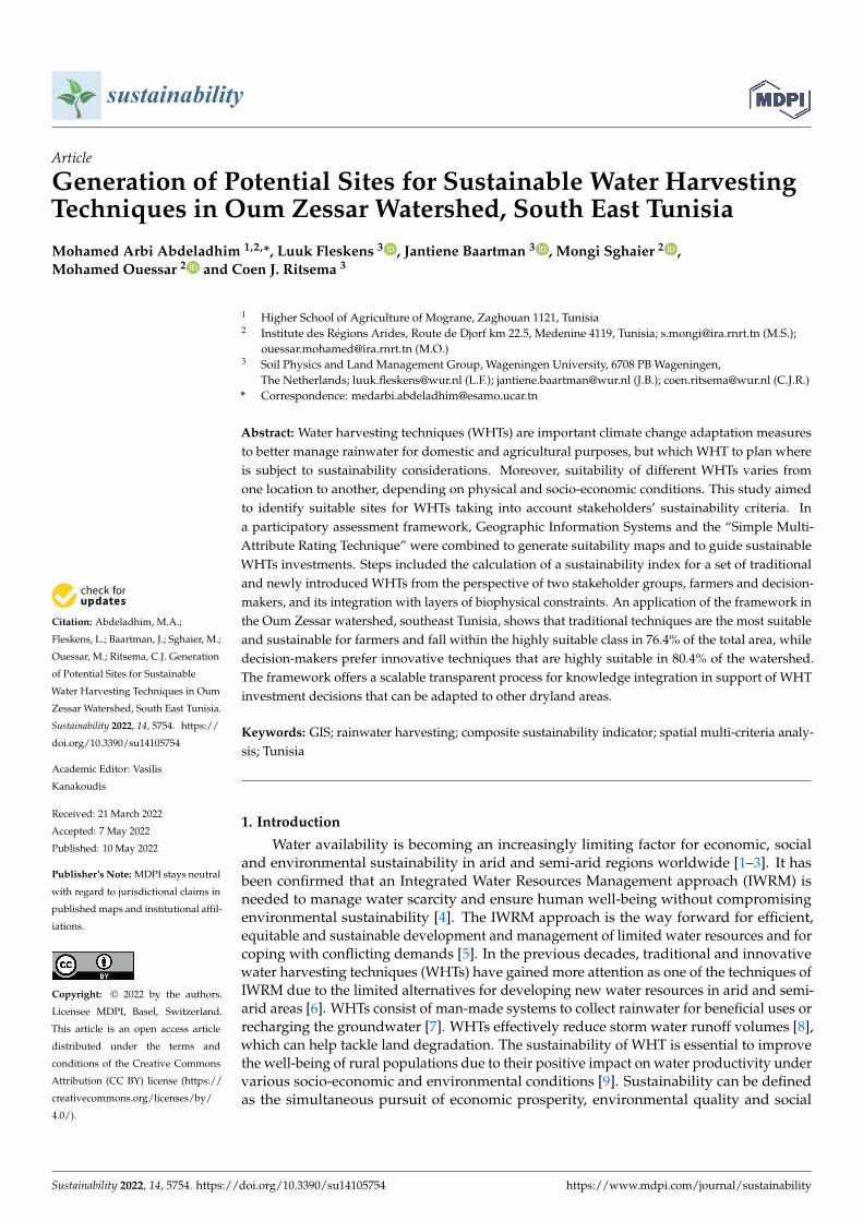
Citation: Abdeladhim, M.A.;
Fleskens, L.; Baartman, J.; Sghaier, M.;
Ouessar, M.; Ritsema, C.J. Generation
of Potential Sites for Sustainable
Water Harvesting Techniques in Oum
Zessar Watershed, South East Tunisia.
Sustainability 2022, 14, 5754. https://
doi.org/10.3390/su14105754
Academic Editor: Vasilis
Kanakoudis
Received: 21 March 2022
Accepted: 7 May 2022
Published: 10 May 2022
Publisher’s Note: MDPI stays neutral
with regard to jurisdictional claims in
published maps and institutional affil-
iations.
Copyright: © 2022 by the authors.
Licensee MDPI, Basel, Switzerland.
This article is an open access article
distributed under the terms and
conditions of the Creative Commons
Attribution (CC BY) license (https://
creativecommons.org/licenses/by/
4.0/).
sustainability
Article
Generation of Potential Sites for Sustainable Water HarvestingTechniques in Oum Zessar Watershed, South East TunisiaMohamed Arbi Abdeladhim 1,2,*, Luuk Fleskens 3 , Jantiene Baartman 3 , Mongi Sghaier 2 ,Mohamed Ouessar 2 and Coen J. Ritsema 3
1 Higher School of Agriculture of Mograne, Zaghouan 1121, Tunisia2 Institute des Régions Arides, Route de Djorf km 22.5, Medenine 4119, Tunisia; [email protected] (M.S.);
[email protected] (M.O.)3 Soil Physics and Land Management Group, Wageningen University, 6708 PB Wageningen,
The Netherlands; [email protected] (L.F.); [email protected] (J.B.); [email protected] (C.J.R.)* Correspondence: [email protected]
Abstract: Water harvesting techniques (WHTs) are important climate change adaptation measuresto better manage rainwater for domestic and agricultural purposes, but which WHT to plan whereis subject to sustainability considerations. Moreover, suitability of different WHTs varies fromone location to another, depending on physical and socio-economic conditions. This study aimedto identify suitable sites for WHTs taking into account stakeholders’ sustainability criteria. Ina participatory assessment framework, Geographic Information Systems and the “Simple Multi-Attribute Rating Technique” were combined to generate suitability maps and to guide sustainableWHTs investments. Steps included the calculation of a sustainability index for a set of traditionaland newly introduced WHTs from the perspective of two stakeholder groups, farmers and decision-makers, and its integration with layers of biophysical constraints. An application of the framework inthe Oum Zessar watershed, southeast Tunisia, shows that traditional techniques are the most suitableand sustainable for farmers and fall within the highly suitable class in 76.4% of the total area, whiledecision-makers prefer innovative techniques that are highly suitable in 80.4% of the watershed.The framework offers a scalable transparent process for knowledge integration in support of WHTinvestment decisions that can be adapted to other dryland areas.
Keywords: GIS; rainwater harvesting; composite sustainability indicator; spatial multi-criteria analy-sis; Tunisia
1. Introduction
Water availability is becoming an increasingly limiting factor for economic, socialand environmental sustainability in arid and semi-arid regions worldwide [1–3]. It hasbeen confirmed that an Integrated Water Resources Management approach (IWRM) isneeded to manage water scarcity and ensure human well-being without compromisingenvironmental sustainability [4]. The IWRM approach is the way forward for efficient,equitable and sustainable development and management of limited water resources and forcoping with conflicting demands [5]. In the previous decades, traditional and innovativewater harvesting techniques (WHTs) have gained more attention as one of the techniques ofIWRM due to the limited alternatives for developing new water resources in arid and semi-arid areas [6]. WHTs consist of man-made systems to collect rainwater for beneficial uses orrecharging the groundwater [7]. WHTs effectively reduce storm water runoff volumes [8],which can help tackle land degradation. The sustainability of WHT is essential to improvethe well-being of rural populations due to their positive impact on water productivity undervarious socio-economic and environmental conditions [9]. Sustainability can be definedas the simultaneous pursuit of economic prosperity, environmental quality and social
Sustainability 2022, 14, 5754. https://doi.org/10.3390/su14105754 https://www.mdpi.com/journal/sustainability

Sustainability 2022, 14, 5754 2 of 20
equity [10,11]. Pachpute et al. [12] define the sustainability of WHTs as the optimal long-term use of natural water resources able to address the concerns of livelihood-generation.Mainly three sets of attributes are used in literature to judge sustainability of WHTs:(i) agriculture productivity and income generation (ii) food security and social capitalstrengthening (iii) environmental conservation [12–16]. Several studies have attempted toevaluate sustainability of water resources systems using a sustainability index (SI) [17–20].Reliability, resilience and vulnerability are the most commonly used criteria for evaluating SI.
Given the crucial role of WHTs for local stakeholders, it is striking that they areoften not involved in the evaluation process. Several authors [21–23] have argued thatstakeholder engagement is needed to guarantee the sustainability of WHTs. In the context ofenhancing participation of stakeholders and dealing with sustainability assessment, multi-criteria analysis can be useful to evaluate a set of decision alternatives by stakeholdersand to deal with conflicting goals [18,19]. On the other hand, an important challenge foroperationalizing decision alternatives, on water management inter alia, is the questionof how to consider spatial decision-making issues. Several studies [9,23–29] used onlybiophysical data to identify suitable areas for on-site and off-site WHT implementation. Themost common input data are slope, rainfall, soil types and land cover [30]. Socio-economicdata are rarely used [31–33]. Biophysical data are essential factors to identify suitable areasfor WHT implementation, but using only biophysical data is not sufficient to performa fully successful and sustainable water harvesting implementation [11,23]. Indeed, theintegration of multi-criteria analysis with geographic information systems (GIS) couldhelp users to spatially evaluate water management alternatives based on feasibility and asustainability index. Considering both biophysical and sustainability criteria is essential forspatial modeling in water resource management, but has received little attention in mostpast studies. The novelty of this research lies in explicitly adding a sustainability index (SI)based on stakeholders’ evaluations in identifying suitable locations for sustainable WHTs.
The Oum Zessar watershed, located in the southeast of Tunisia, is characterized by low,unpredictable and torrential rainfall and a negative water balance almost year round [34–36].Currently Oum Zessar watershed provides blue and green water for rainfed agricultureas well as for both tourism and household needs. Since the mid-1980s, the Tunisiangovernment has engaged in a vast program of soil conservation and water mobilizationbased on traditional knowledge and new techniques [36]. This investment concernedactions related to WHT implementation and maintenance. Two main categories of WHTscan be distinguished in Oum Zessar watershed based on the type of catchment and the sizeof WHT techniques: on-site and off-site WHTs. The on-site WHTs are small-scale practicesusually implemented on privately owned cultivated areas to improve water retention andsoil nutrients, and consequently to increase biomass production. Off-site WHTs are mediumto large structures located in an uncultivated area, mainly for groundwater recharge andrunoff spreading. The off-site WHTs are public property [37]. Currently, officers fromthe Regional Commissary for Agricultural Development (RCAD) are trying out to assessthe effectiveness of the different categories of WHTs in relation to their location in termsof reliability of the water supply, water productivity and natural resource conservation.Evidence from the assessment of the program will serve to orient the planned WHT work tocover new areas of Oum Zessar watershed. Decision-makers demand a comprehensive andreliable ex ante and ex post assessment of WHT on sustainability [36,38]. In the watershed,in spite of the long history and rich traditional knowledge of implementing WHT, affectedstakeholders have rarely been involved in catchment-level decision-making processes.This has led to low rates of adoption or failed adoption processes [34]. Therefore, closecollaboration with stakeholders in the framework of an IWRM approach is needed toincrease water management efficiency and evaluate the sustainability of WHT.
This study aims at identifying suitable sites for sustainable traditional and newlyintroduced WHTs in the Oum Zessar watershed. As stated above, we sought to addressgaps in considering sustainability criteria and the integration of multiple stakeholders’perspectives in siting WHTs. A GIS-based multi-attribute rating technique, which combines
Sustainability 2022, 14, 5754 3 of 20
feasibility criteria and a newly proposed stakeholder-defined sustainability index (SI), wasused. The objective was twofold: (1) to promote stakeholder participation in decision-making concerning water resource management that enhances decision efficiency andimproves acceptance of WHTs; and (2) to integrate sustainability criteria in the suitabilitymaps for traditional and newly introduced WHTs. It is assumed that preferences offarmers and decision-makers in terms of the evaluation of the sustainability of traditionaland innovative WHTs diverge, and that the approach taken can help reach better IWRMdecisions. In the following sections, we first present the study area and our methodologicalapproach (Section 2), with results and discussion following in Sections 3 and 4. Finally,conclusions are drawn in Section 5.
2. Materials and Methods2.1. Study Area
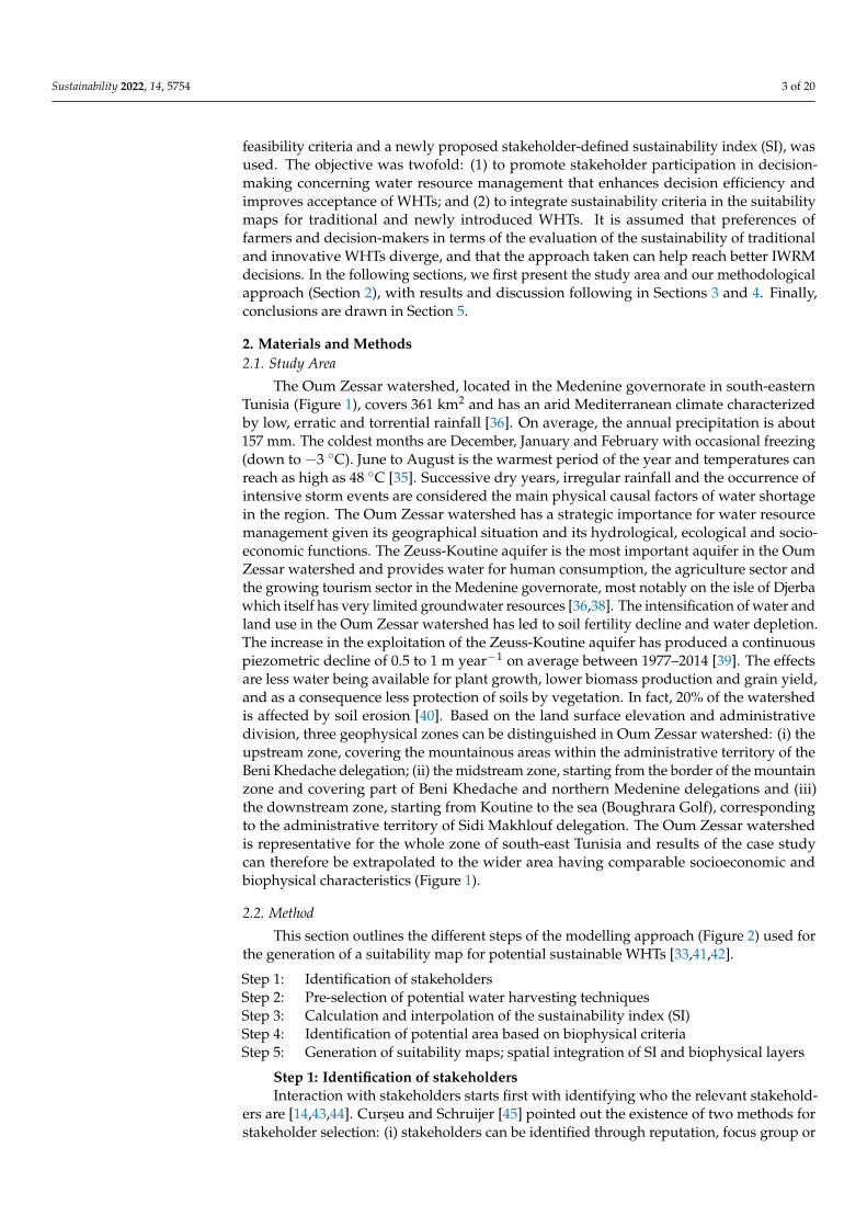
The Oum Zessar watershed, located in the Medenine governorate in south-easternTunisia (Figure 1), covers 361 km2 and has an arid Mediterranean climate characterizedby low, erratic and torrential rainfall [36]. On average, the annual precipitation is about157 mm. The coldest months are December, January and February with occasional freezing(down to −3 ◦C). June to August is the warmest period of the year and temperatures canreach as high as 48 ◦C [35]. Successive dry years, irregular rainfall and the occurrence ofintensive storm events are considered the main physical causal factors of water shortagein the region. The Oum Zessar watershed has a strategic importance for water resourcemanagement given its geographical situation and its hydrological, ecological and socio-economic functions. The Zeuss-Koutine aquifer is the most important aquifer in the OumZessar watershed and provides water for human consumption, the agriculture sector andthe growing tourism sector in the Medenine governorate, most notably on the isle of Djerbawhich itself has very limited groundwater resources [36,38]. The intensification of water andland use in the Oum Zessar watershed has led to soil fertility decline and water depletion.The increase in the exploitation of the Zeuss-Koutine aquifer has produced a continuouspiezometric decline of 0.5 to 1 m year−1 on average between 1977–2014 [39]. The effectsare less water being available for plant growth, lower biomass production and grain yield,and as a consequence less protection of soils by vegetation. In fact, 20% of the watershedis affected by soil erosion [40]. Based on the land surface elevation and administrativedivision, three geophysical zones can be distinguished in Oum Zessar watershed: (i) theupstream zone, covering the mountainous areas within the administrative territory of theBeni Khedache delegation; (ii) the midstream zone, starting from the border of the mountainzone and covering part of Beni Khedache and northern Medenine delegations and (iii)the downstream zone, starting from Koutine to the sea (Boughrara Golf), correspondingto the administrative territory of Sidi Makhlouf delegation. The Oum Zessar watershedis representative for the whole zone of south-east Tunisia and results of the case studycan therefore be extrapolated to the wider area having comparable socioeconomic andbiophysical characteristics (Figure 1).
2.2. Method
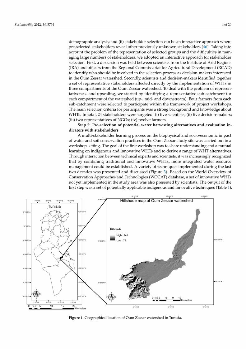
This section outlines the different steps of the modelling approach (Figure 2) used forthe generation of a suitability map for potential sustainable WHTs [33,41,42].
Step 1: Identification of stakeholdersStep 2: Pre-selection of potential water harvesting techniquesStep 3: Calculation and interpolation of the sustainability index (SI)Step 4: Identification of potential area based on biophysical criteriaStep 5: Generation of suitability maps; spatial integration of SI and biophysical layers
Step 1: Identification of stakeholdersInteraction with stakeholders starts first with identifying who the relevant stakehold-
ers are [14,43,44]. Curs, eu and Schruijer [45] pointed out the existence of two methods forstakeholder selection: (i) stakeholders can be identified through reputation, focus group or
Sustainability 2022, 14, 5754 4 of 20
demographic analysis; and (ii) stakeholder selection can be an interactive approach wherepre-selected stakeholders reveal other previously unknown stakeholders [46]. Taking intoaccount the problem of the representation of selected groups and the difficulties in man-aging large numbers of stakeholders, we adopted an interactive approach for stakeholderselection. First, a discussion was held between scientists from the Institute of Arid Regions(IRA) and officers from the Regional Commissariat for Agricultural Development (RCAD)to identify who should be involved in the selection process as decision-makers interestedin the Oum Zessar watershed. Secondly, scientists and decision-makers identified togethera set of representative stakeholders affected directly by the implementation of WHTs inthree compartments of the Oum Zessar watershed. To deal with the problem of represen-tativeness and upscaling, we started by identifying a representative sub-catchment foreach compartment of the watershed (up-, mid- and downstream). Four farmers from eachsub-catchment were selected to participate within the framework of project workshops.The main selection criteria for participants was a strong background and knowledge aboutWHTs. In total, 24 stakeholders were targeted: (i) five scientists; (ii) five decision-makers;(iii) two representatives of NGOs; (iv) twelve farmers.
Step 2: Pre-selection of potential water harvesting alternatives and evaluation in-dicators with stakeholders
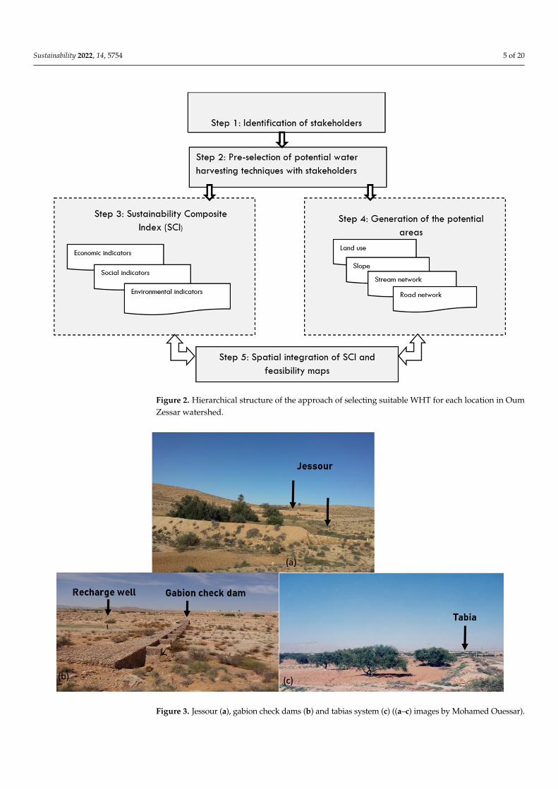
A multi-stakeholder learning process on the biophysical and socio-economic impactof water and soil conservation practices in the Oum Zessar study site was carried out in aworkshop setting. The goal of the first workshop was to share understanding and a mutuallearning on indigenous and innovative WHTs and to derive a range of WHT alternatives.Through interaction between technical experts and scientists, it was increasingly recognizedthat by combining traditional and innovative WHTs, more integrated water resourcemanagement could be established. A variety of techniques implemented during the lasttwo decades was presented and discussed (Figure 3). Based on the World Overview ofConservation Approaches and Technologies (WOCAT) database, a set of innovative WHTsnot yet implemented in the study area was also presented by scientists. The output of thefirst step was a set of potentially applicable indigenous and innovative techniques (Table 1).
Sustainability 2022, 14, x FOR PEER REVIEW 4 of 22
Figure 1. Geographical location of Oum Zessar watershed in Tunisia.
2.2. Method This section outlines the different steps of the modelling approach (Figure 2) used for
the generation of a suitability map for potential sustainable WHTs [33,41,42]. Step 1: Identification of stakeholders Step 2: Pre-selection of potential water harvesting techniques Step 3: Calculation and interpolation of the sustainability index (SI) Step 4: Identification of potential area based on biophysical criteria Step 5: Generation of suitability maps; spatial integration of SI and biophysical layers
.
.
Figure 1. Geographical location of Oum Zessar watershed in Tunisia.
Sustainability 2022, 14, 5754 5 of 20Sustainability 2022, 14, x FOR PEER REVIEW 5 of 22
Figure 2. Hierarchical structure of the approach of selecting suitable WHT for each location in Oum Zessar watershed.
Step 1: Identification of stakeholders Interaction with stakeholders starts first with identifying who the relevant stakehold-
ers are [14,43,44]. Curșeu and Schruijer [45] pointed out the existence of two methods for stakeholder selection: (i) stakeholders can be identified through reputation, focus group or demographic analysis; and (ii) stakeholder selection can be an interactive approach where pre-selected stakeholders reveal other previously unknown stakeholders [46]. Tak-ing into account the problem of the representation of selected groups and the difficulties in managing large numbers of stakeholders, we adopted an interactive approach for stake-holder selection. First, a discussion was held between scientists from the Institute of Arid Regions (IRA) and officers from the Regional Commissariat for Agricultural Development (RCAD) to identify who should be involved in the selection process as decision-makers interested in the Oum Zessar watershed. Secondly, scientists and decision-makers identi-fied together a set of representative stakeholders affected directly by the implementation of WHTs in three compartments of the Oum Zessar watershed. To deal with the problem of representativeness and upscaling, we started by identifying a representative sub-catch-ment for each compartment of the watershed (up-, mid- and downstream). Four farmers from each sub-catchment were selected to participate within the framework of project workshops. The main selection criteria for participants was a strong background and knowledge about WHTs. In total, 24 stakeholders were targeted: (i) five scientists; (ii) five decision-makers; (iii) two representatives of NGOs; (iv) twelve farmers.
Step 2: Pre-selection of potential water harvesting alternatives and evaluation in-dicators with stakeholders
A multi-stakeholder learning process on the biophysical and socio-economic impact of water and soil conservation practices in the Oum Zessar study site was carried out in a workshop setting. The goal of the first workshop was to share understanding and a mu-
Figure 2. Hierarchical structure of the approach of selecting suitable WHT for each location in OumZessar watershed.
Sustainability 2022, 14, x FOR PEER REVIEW 7 of 22
Figure 3. Jessour (a), gabion check dams (b) and tabias system (c) ((a–c) images by Mohamed Oues-sar).
Step 3: Calculation of WHTs Sustainability Index (SI) Sustainability is a complex and multidimensional concept. Numerous indicators and
indices are used to evaluate sustainability [47]. The use of a composite index is useful to enable policy monitoring, public communication and the generation of rankings [10,51,52]. However, even if an index is simple to understand and analyze, it is difficult to formulate. SI represents an aggregate measure of a combination of performance measures, or in other words, an index is a “synthesis of numerous factors into one given factor” [48–50]. Its construction requires “several choices, namely the selection of variables, methods of aggrega-tion, normalization, and weighting to apply” [53].
During a second workshop, a list of balanced indicators for evaluating economic, so-cial and environmental sustainability of each WHT was compiled and discussed in depth together with participants. A common agreement and understanding of indicators was sought in a plenary session. Each sustainability pillar (social, economic and environmen-tal) was translated into three indicators (Figure 4). Afterwards, two breakout groups of stakeholders were formed: famers and decision-makers. The former was composed of 12 farmers and the latter was composed of 8 decision-makers. Stakeholders were asked to score the anticipated impacts of WHTs on each indicator in the three watershed locations (upstream, midstream and downstream) using the following scoring range: 0 = no impact up to 10 = extremely high impact. Furthermore, stakeholders were asked to assign weights to the level of importance of each sustainability pillar and indicators reflecting their indi-vidual preferences. A 0–10 scale was used to weigh sustainability pillars and indicators, where 0 indicates low importance and 10 indicates high importance. The given weights translate into individual preferences for each sustainability pillar. Different weights and scores are subsequently used to quantify the SI of each WHT alternative. The Simple Multi-Attribute Rating Technique (SMART) developed by Edwards (1977) seems to be the most comprehensive and easy to use [53]. The SMART method is preferable to evaluate single alternatives in isolation [51] and to communicate easily with stakeholders [52]. It seeks to validate and quantify the user’s preference, usually on a scale 0–1, 0–10 or 0–100.
Figure 3. Jessour (a), gabion check dams (b) and tabias system (c) ((a–c) images by Mohamed Ouessar).
Sustainability 2022, 14, 5754 6 of 20
Table 1. Pre-selected water harvesting technologies (alternatives).
Techniques Origin Definition/Comments
Jessour Indigenous
Jessour (plural of jesr) is an ancient runoff water harvesting technique widelypracticed in the arid highlands in Tunisia (WOCAT Database). It consists of smalldams built across wadis and gullies to intercept rainwater and sediments. A jesr iscomposed of three main components: a dike in the form of a small earthembankment with a spillway made of stones, a terrace that represents thecropping area and an impluvium [47,48]. (see Figure 3)
Tabias Indigenous
The tabia earthen dyke is a water harvesting technique used in the foothill andpiedmont areas. (WOCAT Database). Tabias (plural of tabia) are hydraulic unitssituated in the middle of a catchment on moderate slopes. A tabia is formed by anembankment along the contour with lateral bunds. It collects water from animpluvium or by the diversion of wadi runoff [48]. (see Figure 3)
Cisterns IndigenousCisterns are reservoirs used for storing rainfall and runoff water for multiplepurposes: drinking, animal watering and supplemental irrigation(WOCAT database).
Recharge wells IndigenousA recharge well comprises a drilled hole up to 30–40 m deep that reaches thewater table, and a surrounding filter used to allow the direct injection offloodwater into the aquifer (WOCAT database). (see Figure 3)
Gabioncheck dams Indigenous
The technology of a check dam is a technique consisting of binding differentgabion cages filled with small stones together to form a complete flexible gabionunit (WOCAT database). (see Figure 3)
Zai planting holes Introduced (BurkinaFaso)
Zai is an ancestral planting pit developed in the Yatenga province, north-westernBurkina Faso, where average rainfall is about 600 mm, with recurrent droughtsand where soils are heavily encrusted [49].
Retention ditches Introduced (Ethiopia) Retention ditches, also called infiltration ditches, are larger ditches designed tocatch and retain all incoming runoff for infiltration into the soil [50].
Step 3: Calculation of WHTs Sustainability Index (SI)Sustainability is a complex and multidimensional concept. Numerous indicators and
indices are used to evaluate sustainability [47]. The use of a composite index is useful toenable policy monitoring, public communication and the generation of rankings [10,51,52].However, even if an index is simple to understand and analyze, it is difficult to formulate.SI represents an aggregate measure of a combination of performance measures, or inother words, an index is a “synthesis of numerous factors into one given factor” [48–50]. Itsconstruction requires “several choices, namely the selection of variables, methods of aggregation,normalization, and weighting to apply” [53].
During a second workshop, a list of balanced indicators for evaluating economic,social and environmental sustainability of each WHT was compiled and discussed in depthtogether with participants. A common agreement and understanding of indicators wassought in a plenary session. Each sustainability pillar (social, economic and environmen-tal) was translated into three indicators (Figure 4). Afterwards, two breakout groups ofstakeholders were formed: famers and decision-makers. The former was composed of12 farmers and the latter was composed of 8 decision-makers. Stakeholders were asked toscore the anticipated impacts of WHTs on each indicator in the three watershed locations(upstream, midstream and downstream) using the following scoring range: 0 = no impactup to 10 = extremely high impact. Furthermore, stakeholders were asked to assign weightsto the level of importance of each sustainability pillar and indicators reflecting their indi-vidual preferences. A 0–10 scale was used to weigh sustainability pillars and indicators,where 0 indicates low importance and 10 indicates high importance. The given weightstranslate into individual preferences for each sustainability pillar. Different weights andscores are subsequently used to quantify the SI of each WHT alternative. The SimpleMulti-Attribute Rating Technique (SMART) developed by Edwards (1977) seems to be themost comprehensive and easy to use [53]. The SMART method is preferable to evaluate
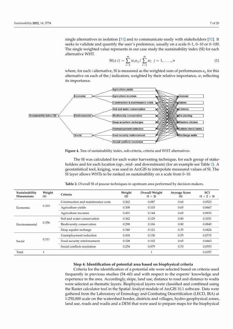
Sustainability 2022, 14, 5754 7 of 20
single alternatives in isolation [51] and to communicate easily with stakeholders [52]. Itseeks to validate and quantify the user’s preference, usually on a scale 0–1, 0–10 or 0–100.The single weighted value represents in our case study the sustainability index (SI) for eachalternative WHT.
SI(a i) =m
∑i=1
wiaij/m
∑i=1
wi j = 1, . . . .., n (1)
where, for each i alternative, SI is measured as the weighted sum of performances aij for thisalternative on each of the j indicators, weighted by their relative importance, wi reflectingits importance.
Sustainability 2022, 14, x FOR PEER REVIEW 8 of 22
The single weighted value represents in our case study the sustainability index (SI) for each alternative WHT.
SI(𝑎 𝑖) = 𝑤 𝑎 / 𝑤 𝑗 = 1, … . . , 𝑛 (1)
where, for each i alternative, SI is measured as the weighted sum of performances aij for this alternative on each of the j indicators, weighted by their relative importance, wi re-flecting its importance.
The SI was calculated for each water harvesting technique, for each group of stake-holders and for each location (up-, mid- and downstream) (for an example see Table 2). A geostatistical tool, kriging, was used in ArcGIS to interpolate measured values of SI. The SI layer allows WHTs to be ranked on sustainability on a scale from 0–10.
Figure 4. Tree of sustainability index, sub-criteria, criteria and WHT alternatives.
Table 2. Overall SI of jessour techniques in upstream area performed by decision-makers.
Sustainability Dimensions
Weight (1) Criteria Weight
(2) Overall Weight
(1 × 2) Average Score
(3) SCI
(1 × 2 × 3)
Economic 0.333 Construction and maintenance costs 0.262 0.087 0.60 0.0523 Agriculture yields 0.308 0.103 0.65 0.0667 Agriculture incomes 0.431 0.144 0.65 0.0933
Environmental 0.356 Soil and water conservation 0.362 0.129 0.80 0.1031 Biodiversity conservation 0.298 0.106 0.80 0.0849 Deep aquifer recharge 0.340 0.121 0.35 0.0424
Social 0.311 Unemployment reduction 0.418 0.130 0.55 0.0715 Food security reinforcement 0.328 0.102 0.65 0.0663 Social conflicts resolution 0.254 0.079 0.70 0.0553
Total 1 1 0.6357
Step 4: Identification of potential area based on biophysical criteria Criteria for the identification of a potential site were selected based on criteria used
frequently in previous studies (54–60) and with respect to the experts‘ knowledge and experience in the area. Accordingly, slope, land use, distance to road and distance to wadis were selected as thematic layers. Biophysical layers were classified and combined using the Raster calculator tool in the Spatial Analyst module of ArcGIS 10.1 software. Data were gathered from the Laboratory of Eremology and Combating Desertification (LECD, IRA) at 1:250,000 scale on the watershed border, districts and villages, hydro-ge-ophysical zones, land use, roads and wadis and a DEM that were used to prepare maps
Figure 4. Tree of sustainability index, sub-criteria, criteria and WHT alternatives.
The SI was calculated for each water harvesting technique, for each group of stake-holders and for each location (up-, mid- and downstream) (for an example see Table 2). Ageostatistical tool, kriging, was used in ArcGIS to interpolate measured values of SI. TheSI layer allows WHTs to be ranked on sustainability on a scale from 0–10.
Table 2. Overall SI of jessour techniques in upstream area performed by decision-makers.
SustainabilityDimensions
Weight(1) Criteria Weight
(2)Overall Weight
(1 × 2)Average Score
(3)SCI
(1 × 2 × 3)
Economic 0.333Construction and maintenance costs 0.262 0.087 0.60 0.0523
Agriculture yields 0.308 0.103 0.65 0.0667
Agriculture incomes 0.431 0.144 0.65 0.0933
Environmental 0.356Soil and water conservation 0.362 0.129 0.80 0.1031
Biodiversity conservation 0.298 0.106 0.80 0.0849
Deep aquifer recharge 0.340 0.121 0.35 0.0424
Social 0.311Unemployment reduction 0.418 0.130 0.55 0.0715
Food security reinforcement 0.328 0.102 0.65 0.0663
Social conflicts resolution 0.254 0.079 0.70 0.0553
Total 1 1 0.6357
Step 4: Identification of potential area based on biophysical criteriaCriteria for the identification of a potential site were selected based on criteria used
frequently in previous studies (54–60) and with respect to the experts‘ knowledge andexperience in the area. Accordingly, slope, land use, distance to road and distance to wadiswere selected as thematic layers. Biophysical layers were classified and combined usingthe Raster calculator tool in the Spatial Analyst module of ArcGIS 10.1 software. Data weregathered from the Laboratory of Eremology and Combating Desertification (LECD, IRA) at1:250,000 scale on the watershed border, districts and villages, hydro-geophysical zones,land use, roads and wadis and a DEM that were used to prepare maps for the biophysical
Sustainability 2022, 14, 5754 8 of 20
criteria (Figure 5). The parameters listed in Table 3 were used to classify pixel values from0 to 10. The scores reported were discussed and adjusted together with technical expertsfrom IRA and CRDA. The most suitable areas were classified as 10, while the least suitablewere classified as 0.
Table 3. Ratings and scoring for each suitability criteria and each WHT.
Parameters Ratings
Score References
Jessour Tabias Cisterns Zai RetentionDitches
RechargeWells
GabionCheck Dams
Slope (%)
<5 4 8 4 8 8 6 6
[54–56]≥5, <15 8 6 6 4 4 8 8
≥15, <20 6 4 8 0 0 2 2
≥20 2 0 6 0 0 0 0
Land use
Cereals 8 10 4 6 4 2 6
[54,55]
Sand 2 2 0 0 0 0 0
Halophytes 2 2 0 0 2 0 0
Olive 10 10 6 4 8 6 8
Rangelands 6 8 8 4 6 6 4
Rocks 0 0 4 0 0 0 0
Bare soil 0 2 0 0 0 0 0
Distanceto wadis (m)
<5000 8 8 8 4 4 10 10
[57,58]≥5000, <10,000 6 6 6 2 6 8 8
≥10,000, <15,000 4 4 4 0 4 6 6
≥15,000 2 2 2 0 2 4 4
Distanceto road (m)
<5000 8 8 0 0 0 8 10
[58–60]≥5000, <10,000 4 4 0 0 0 6 8
≥10,000, <15,000 6 6 0 0 0 4 6
≥15,000 2 2 0 0 0 2 2
Source: Scores are based on face-to-face scoring session together with scientists and stakeholders.
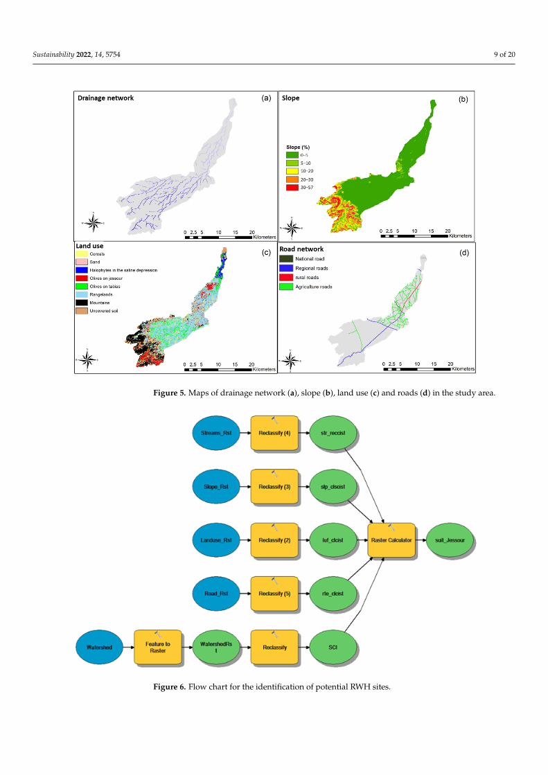
Step 5: Generation of the suitability maps of sustainable WHTSI measures of different WHTs (Step 3) were reclassified and interpolated for each
location in the study site. Consequently, scaled maps between 0 and 10 were obtained sothat pixels with a value 0 represent locations with low sustainability of WHTs, while avalue of 10 represents locations with a high sustainability level. Finally, the biophysical(Step 4) and sustainability index layers were combined using a raster calculator (Figure 6).The suitability values which are obtained are classified into four classes: unsuitable (0–15),marginally suitable (15–25), suitable (25–35) and very suitable (35–50).
Sustainability 2022, 14, 5754 9 of 20Sustainability 2022, 14, x FOR PEER REVIEW 10 of 22
Figure 5. Maps of drainage network (a), slope (b), land use (c) and roads (d) in the study area.
Step 5: Generation of the suitability maps of sustainable WHT SI measures of different WHTs (Step 3) were reclassified and interpolated for each
location in the study site. Consequently, scaled maps between 0 and 10 were obtained so that pixels with a value 0 represent locations with low sustainability of WHTs, while a value of 10 represents locations with a high sustainability level. Finally, the biophysical (Step 4) and sustainability index layers were combined using a raster calculator (Figure 6). The suitability values which are obtained are classified into four classes: unsuitable (0–15), marginally suitable (15–25), suitable (25–35) and very suitable (35–50).
Figure 5. Maps of drainage network (a), slope (b), land use (c) and roads (d) in the study area.
Sustainability 2022, 14, x FOR PEER REVIEW 11 of 22
Figure 6. Flow chart for the identification of potential RWH sites.
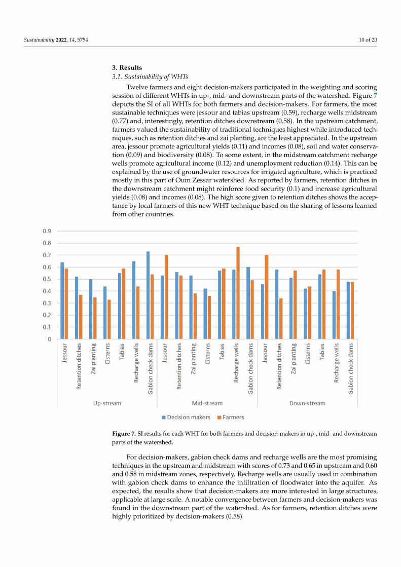
3. Results 3.1. Sustainability of WHTs
Twelve farmers and eight decision-makers participated in the weighting and scoring session of different WHTs in up-, mid- and downstream parts of the watershed. Figure 7 depicts the SI of all WHTs for both farmers and decision-makers. For farmers, the most sustainable techniques were jessour and tabias upstream (0.59), recharge wells midstream (0.77) and, interestingly, retention ditches downstream (0.58). In the upstream catchment, farmers valued the sustainability of traditional techniques highest while introduced tech-niques, such as retention ditches and zai planting, are the least appreciated. In the up-stream area, jessour promote agricultural yields (0.11) and incomes (0.08), soil and water conservation (0.09) and biodiversity (0.08). To some extent, in the midstream catchment recharge wells promote agricultural income (0.12) and unemployment reduction (0.14). This can be explained by the use of groundwater resources for irrigated agriculture, which is practiced mostly in this part of Oum Zessar watershed. As reported by farmers, reten-tion ditches in the downstream catchment might reinforce food security (0.1) and increase agricultural yields (0.08) and incomes (0.08). The high score given to retention ditches shows the acceptance by local farmers of this new WHT technique based on the sharing of lessons learned from other countries.
Figure 6. Flow chart for the identification of potential RWH sites.
Sustainability 2022, 14, 5754 10 of 20
3. Results3.1. Sustainability of WHTs
Twelve farmers and eight decision-makers participated in the weighting and scoringsession of different WHTs in up-, mid- and downstream parts of the watershed. Figure 7depicts the SI of all WHTs for both farmers and decision-makers. For farmers, the mostsustainable techniques were jessour and tabias upstream (0.59), recharge wells midstream(0.77) and, interestingly, retention ditches downstream (0.58). In the upstream catchment,farmers valued the sustainability of traditional techniques highest while introduced tech-niques, such as retention ditches and zai planting, are the least appreciated. In the upstreamarea, jessour promote agricultural yields (0.11) and incomes (0.08), soil and water conserva-tion (0.09) and biodiversity (0.08). To some extent, in the midstream catchment rechargewells promote agricultural income (0.12) and unemployment reduction (0.14). This can beexplained by the use of groundwater resources for irrigated agriculture, which is practicedmostly in this part of Oum Zessar watershed. As reported by farmers, retention ditches inthe downstream catchment might reinforce food security (0.1) and increase agriculturalyields (0.08) and incomes (0.08). The high score given to retention ditches shows the accep-tance by local farmers of this new WHT technique based on the sharing of lessons learnedfrom other countries.
Sustainability 2022, 14, x FOR PEER REVIEW 12 of 22
Figure 7. SI results for each WHT for both farmers and decision-makers in up-, mid- and down-stream parts of the watershed.
For decision-makers, gabion check dams and recharge wells are the most promising techniques in the upstream and midstream with scores of 0.73 and 0.65 in upstream and 0.60 and 0.58 in midstream zones, respectively. Recharge wells are usually used in combi-nation with gabion check dams to enhance the infiltration of floodwater into the aquifer. As expected, the results show that decision-makers are more interested in large structures, applicable at large scale. A notable convergence between farmers and decision-makers was found in the downstream part of the watershed. As for farmers, retention ditches were highly prioritized by decision-makers (0.58).
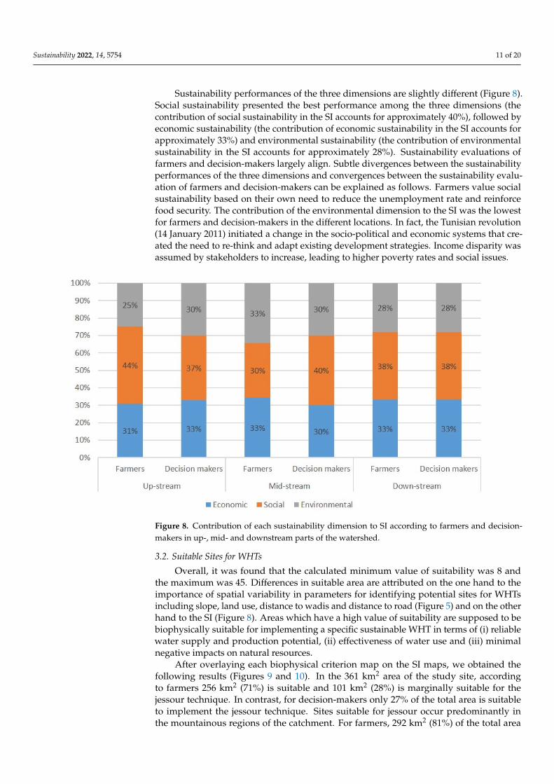
Sustainability performances of the three dimensions are slightly different (Figure 8). Social sustainability presented the best performance among the three dimensions (the con-tribution of social sustainability in the SI accounts for approximately 40%), followed by economic sustainability (the contribution of economic sustainability in the SI accounts for approximately 33%) and environmental sustainability (the contribution of environmental sustainability in the SI accounts for approximately 28%). Sustainability evaluations of farmers and decision-makers largely align. Subtle divergences between the sustainability performances of the three dimensions and convergences between the sustainability eval-uation of farmers and decision-makers can be explained as follows. Farmers value social sustainability based on their own need to reduce the unemployment rate and reinforce food security. The contribution of the environmental dimension to the SI was the lowest for farmers and decision-makers in the different locations. In fact, the Tunisian revolution (14 January 2011) initiated a change in the socio-political and economic systems that cre-ated the need to re-think and adapt existing development strategies. Income disparity was assumed by stakeholders to increase, leading to higher poverty rates and social issues.
Figure 7. SI results for each WHT for both farmers and decision-makers in up-, mid- and downstreamparts of the watershed.
For decision-makers, gabion check dams and recharge wells are the most promisingtechniques in the upstream and midstream with scores of 0.73 and 0.65 in upstream and 0.60and 0.58 in midstream zones, respectively. Recharge wells are usually used in combinationwith gabion check dams to enhance the infiltration of floodwater into the aquifer. Asexpected, the results show that decision-makers are more interested in large structures,applicable at large scale. A notable convergence between farmers and decision-makers wasfound in the downstream part of the watershed. As for farmers, retention ditches werehighly prioritized by decision-makers (0.58).
Sustainability 2022, 14, 5754 11 of 20
Sustainability performances of the three dimensions are slightly different (Figure 8).Social sustainability presented the best performance among the three dimensions (thecontribution of social sustainability in the SI accounts for approximately 40%), followed byeconomic sustainability (the contribution of economic sustainability in the SI accounts forapproximately 33%) and environmental sustainability (the contribution of environmentalsustainability in the SI accounts for approximately 28%). Sustainability evaluations offarmers and decision-makers largely align. Subtle divergences between the sustainabilityperformances of the three dimensions and convergences between the sustainability evalu-ation of farmers and decision-makers can be explained as follows. Farmers value socialsustainability based on their own need to reduce the unemployment rate and reinforcefood security. The contribution of the environmental dimension to the SI was the lowestfor farmers and decision-makers in the different locations. In fact, the Tunisian revolution(14 January 2011) initiated a change in the socio-political and economic systems that cre-ated the need to re-think and adapt existing development strategies. Income disparity wasassumed by stakeholders to increase, leading to higher poverty rates and social issues.
Sustainability 2022, 14, x FOR PEER REVIEW 13 of 22
Figure 8. Contribution of each sustainability dimension to SI according to farmers and decision-makers in up-, mid- and downstream parts of the watershed.
3.2. Suitable Sites for WHTs Overall, it was found that the calculated minimum value of suitability was 8 and the
maximum was 45. Differences in suitable area are attributed on the one hand to the im-portance of spatial variability in parameters for identifying potential sites for WHTs in-cluding slope, land use, distance to wadis and distance to road (Figure 5) and on the other hand to the SI (Figure 8). Areas which have a high value of suitability are supposed to be biophysically suitable for implementing a specific sustainable WHT in terms of (i) reliable water supply and production potential, (ii) effectiveness of water use and (iii) minimal negative impacts on natural resources.
After overlaying each biophysical criterion map on the SI maps, we obtained the fol-lowing results (Figures 9 and 10). In the 361 km2 area of the study site, according to farm-ers 256 km2 (71%) is suitable and 101 km2 (28%) is marginally suitable for the jessour tech-nique. In contrast, for decision-makers only 27% of the total area is suitable to implement the jessour technique. Sites suitable for jessour occur predominantly in the mountainous regions of the catchment. For farmers, 292 km2 (81%) of the total area is very suitable for tabias. For decision-makers, only about 144 km2 (40%) of the total watershed is very suit-able for the tabias technique. Tabias are located mainly on the foothills and piedmont ar-eas of the catchment. Farmers and decision-makers agree that the introduced WHTs such as retention ditches and zai could be a promising technique within the watershed. Respec-tively, around 271 km2 and 293 km2 out of the total area is suitable for retention ditches and zai techniques and both farmers and decision-makers found 5% of the total watershed area to be very suitable for retention ditches. Retention ditches and zai techniques are suitable mainly on the gentle slopes in the midstream and downstream areas. Overall, the most suitable techniques for farmers are tabias and gabion check dams, with a percentage of very suitable area of 81% and 75%, respectively. For decision-makers, gabion check dams seem to be the most suitable technique and can be implemented within 293 km2. The most suitable sites for gabion check dams are located close to the main river and have moderately undulated slopes.
Figure 8. Contribution of each sustainability dimension to SI according to farmers and decision-makers in up-, mid- and downstream parts of the watershed.
3.2. Suitable Sites for WHTs
Overall, it was found that the calculated minimum value of suitability was 8 andthe maximum was 45. Differences in suitable area are attributed on the one hand to theimportance of spatial variability in parameters for identifying potential sites for WHTsincluding slope, land use, distance to wadis and distance to road (Figure 5) and on the otherhand to the SI (Figure 8). Areas which have a high value of suitability are supposed to bebiophysically suitable for implementing a specific sustainable WHT in terms of (i) reliablewater supply and production potential, (ii) effectiveness of water use and (iii) minimalnegative impacts on natural resources.
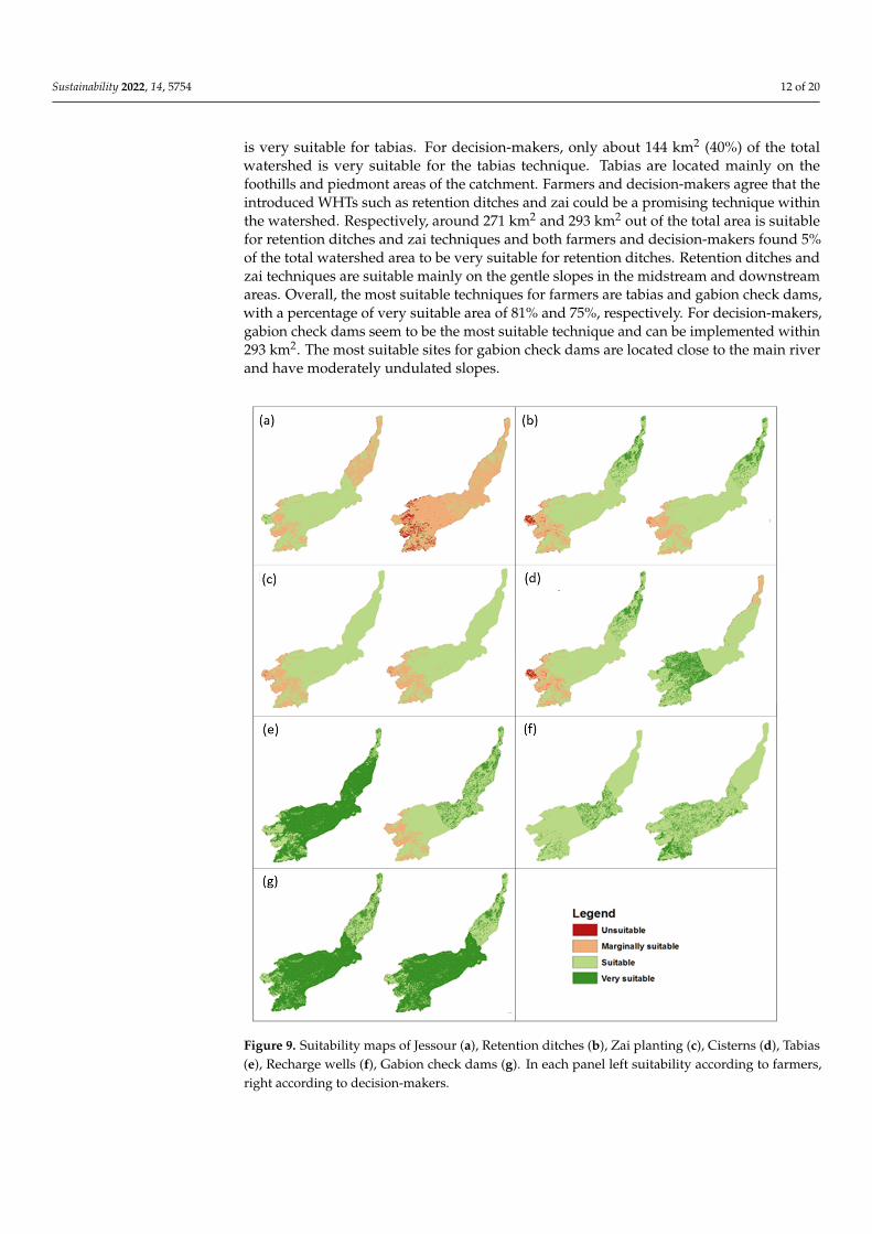
After overlaying each biophysical criterion map on the SI maps, we obtained thefollowing results (Figures 9 and 10). In the 361 km2 area of the study site, accordingto farmers 256 km2 (71%) is suitable and 101 km2 (28%) is marginally suitable for thejessour technique. In contrast, for decision-makers only 27% of the total area is suitableto implement the jessour technique. Sites suitable for jessour occur predominantly inthe mountainous regions of the catchment. For farmers, 292 km2 (81%) of the total area
Sustainability 2022, 14, 5754 12 of 20
is very suitable for tabias. For decision-makers, only about 144 km2 (40%) of the totalwatershed is very suitable for the tabias technique. Tabias are located mainly on thefoothills and piedmont areas of the catchment. Farmers and decision-makers agree that theintroduced WHTs such as retention ditches and zai could be a promising technique withinthe watershed. Respectively, around 271 km2 and 293 km2 out of the total area is suitablefor retention ditches and zai techniques and both farmers and decision-makers found 5%of the total watershed area to be very suitable for retention ditches. Retention ditches andzai techniques are suitable mainly on the gentle slopes in the midstream and downstreamareas. Overall, the most suitable techniques for farmers are tabias and gabion check dams,with a percentage of very suitable area of 81% and 75%, respectively. For decision-makers,gabion check dams seem to be the most suitable technique and can be implemented within293 km2. The most suitable sites for gabion check dams are located close to the main riverand have moderately undulated slopes.Sustainability 2022, 14, x FOR PEER REVIEW 14 of 22
Figure 9. Suitability maps of Jessour (a), Retention ditches (b), Zai planting (c), Cisterns (d), Tabias (e), Recharge wells (f), Gabion check dams (g). In each panel left suitability according to farmers, right according to decision-makers.
Figure 9. Suitability maps of Jessour (a), Retention ditches (b), Zai planting (c), Cisterns (d), Tabias(e), Recharge wells (f), Gabion check dams (g). In each panel left suitability according to farmers,right according to decision-makers.
Sustainability 2022, 14, 5754 13 of 20Sustainability 2022, 14, x FOR PEER REVIEW 15 of 22
Figure 10. Percentage of Oum Zessar catchment area suitable for WHT implementation as rated by (a) farmers and (b) decision-makers.
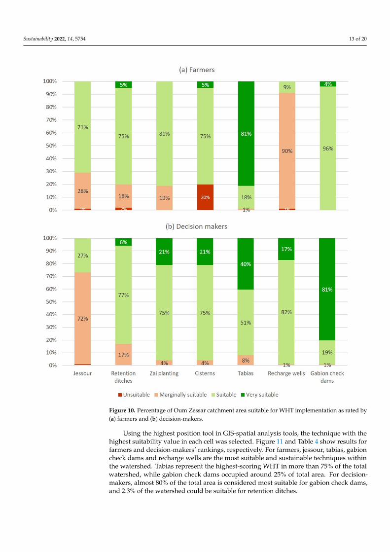
Using the highest position tool in GIS-spatial analysis tools, the technique with the highest suitability value in each cell was selected. Figure 11 and Table 4 show results for farmers and decision-makers’ rankings, respectively. For farmers, jessour, tabias, gabion check dams and recharge wells are the most suitable and sustainable techniques within the watershed. Tabias represent the highest-scoring WHT in more than 75% of the total watershed, while gabion check dams occupied around 25% of total area. For decision-makers, almost 80% of the total area is considered most suitable for gabion check dams, and 2.3% of the watershed could be suitable for retention ditches.
Figure 10. Percentage of Oum Zessar catchment area suitable for WHT implementation as rated by(a) farmers and (b) decision-makers.
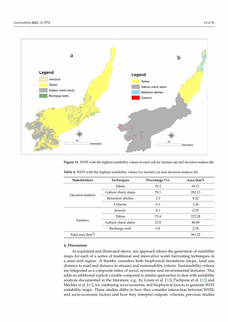
Using the highest position tool in GIS-spatial analysis tools, the technique with thehighest suitability value in each cell was selected. Figure 11 and Table 4 show results forfarmers and decision-makers’ rankings, respectively. For farmers, jessour, tabias, gabioncheck dams and recharge wells are the most suitable and sustainable techniques withinthe watershed. Tabias represent the highest-scoring WHT in more than 75% of the totalwatershed, while gabion check dams occupied around 25% of total area. For decision-makers, almost 80% of the total area is considered most suitable for gabion check dams,and 2.3% of the watershed could be suitable for retention ditches.
Sustainability 2022, 14, 5754 14 of 20Sustainability 2022, 14, x FOR PEER REVIEW 16 of 22
Figure 11. WHT with the highest suitability values in each cell for farmers (a) and decision-makers (b).
Table 4. WHT with the highest suitability values for farmers (a) and decision-makers (b).
Stakeholders Techniques Percentage (%) Area (km2)
Decision-makers
Tabias 19.3 69.71 Gabion check dams 78.1 282.13 Retention ditches 2.3 8.22
Cisterns 0.3 1.26
Farmers
Jessour 0.1 0.25 Tabias 75.4 272.28
Gabion check dams 23.8 86.00 Recharge well 0.8 2.78
Total area (km2) 361.32
4. Discussion As explained and illustrated above, our approach allows the generation of suitability
maps for each of a series of traditional and innovative water harvesting techniques in a semi-arid region. It thereby considers both biophysical limitations (slope, land use, dis-tance to road and distance to stream) and sustainability criteria. Sustainability criteria are integrated as a composite index of social, economic and environmental domains. This adds an additional explicit variable compared to similar approaches to deal with suitabil-ity analysis documented in the literature, e.g., by Grum et al. [33], Pachpute et al. [12] and Mechlia et al. [61], for combining socio-economic and biophysical factors to generate WHT suitability maps. These studies differ in how they consider interaction between WHTs and socio-economic factors and how they interpret outputs: whereas previous studies evalu-ated the impact of a set of biophysical (rainfall variability and runoff quality and quantity)
Figure 11. WHT with the highest suitability values in each cell for farmers (a) and decision-makers (b).
Table 4. WHT with the highest suitability values for farmers (a) and decision-makers (b).
Stakeholders Techniques Percentage (%) Area (km2)
Decision-makers
Tabias 19.3 69.71
Gabion check dams 78.1 282.13
Retention ditches 2.3 8.22
Cisterns 0.3 1.26
Farmers
Jessour 0.1 0.25
Tabias 75.4 272.28
Gabion check dams 23.8 86.00
Recharge well 0.8 2.78
Total area (km2) 361.32
4. Discussion
As explained and illustrated above, our approach allows the generation of suitabilitymaps for each of a series of traditional and innovative water harvesting techniques ina semi-arid region. It thereby considers both biophysical limitations (slope, land use,distance to road and distance to stream) and sustainability criteria. Sustainability criteriaare integrated as a composite index of social, economic and environmental domains. Thisadds an additional explicit variable compared to similar approaches to deal with suitabilityanalysis documented in the literature, e.g., by Grum et al. [33], Pachpute et al. [12] andMechlia et al. [61], for combining socio-economic and biophysical factors to generate WHTsuitability maps. These studies differ in how they consider interaction between WHTsand socio-economic factors and how they interpret outputs: whereas previous studies
Sustainability 2022, 14, 5754 15 of 20
evaluated the impact of a set of biophysical (rainfall variability and runoff quality andquantity) and socio-economic (local skills and investment capacity, labor availability andinstitutional support, etc.) criteria to identify potential sites of water harvesting, ourapproach accommodates both types of assessment approaches, and tries to explicitlyintegrate a sustainability measure, not only to assess WHTs’ impacts but in addition togenerate WHTs’ suitability maps.
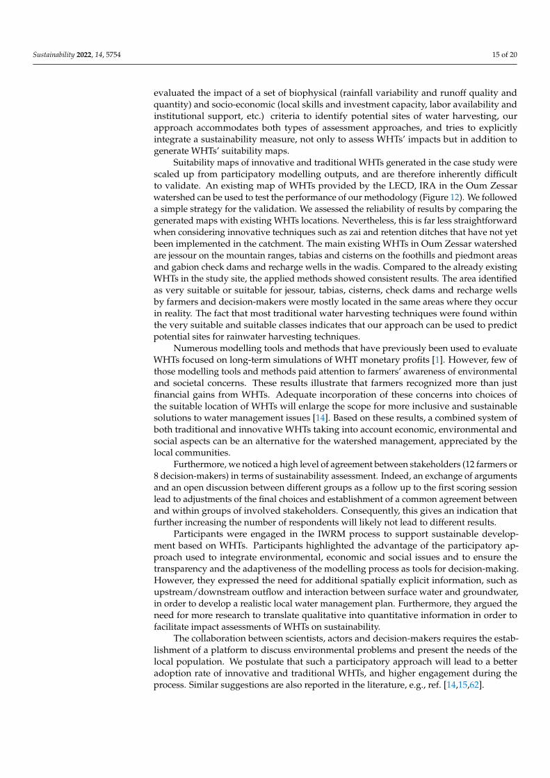
Suitability maps of innovative and traditional WHTs generated in the case study werescaled up from participatory modelling outputs, and are therefore inherently difficultto validate. An existing map of WHTs provided by the LECD, IRA in the Oum Zessarwatershed can be used to test the performance of our methodology (Figure 12). We followeda simple strategy for the validation. We assessed the reliability of results by comparing thegenerated maps with existing WHTs locations. Nevertheless, this is far less straightforwardwhen considering innovative techniques such as zai and retention ditches that have not yetbeen implemented in the catchment. The main existing WHTs in Oum Zessar watershedare jessour on the mountain ranges, tabias and cisterns on the foothills and piedmont areasand gabion check dams and recharge wells in the wadis. Compared to the already existingWHTs in the study site, the applied methods showed consistent results. The area identifiedas very suitable or suitable for jessour, tabias, cisterns, check dams and recharge wellsby farmers and decision-makers were mostly located in the same areas where they occurin reality. The fact that most traditional water harvesting techniques were found withinthe very suitable and suitable classes indicates that our approach can be used to predictpotential sites for rainwater harvesting techniques.
Numerous modelling tools and methods that have previously been used to evaluateWHTs focused on long-term simulations of WHT monetary profits [1]. However, few ofthose modelling tools and methods paid attention to farmers’ awareness of environmentaland societal concerns. These results illustrate that farmers recognized more than justfinancial gains from WHTs. Adequate incorporation of these concerns into choices ofthe suitable location of WHTs will enlarge the scope for more inclusive and sustainablesolutions to water management issues [14]. Based on these results, a combined system ofboth traditional and innovative WHTs taking into account economic, environmental andsocial aspects can be an alternative for the watershed management, appreciated by thelocal communities.
Furthermore, we noticed a high level of agreement between stakeholders (12 farmers or8 decision-makers) in terms of sustainability assessment. Indeed, an exchange of argumentsand an open discussion between different groups as a follow up to the first scoring sessionlead to adjustments of the final choices and establishment of a common agreement betweenand within groups of involved stakeholders. Consequently, this gives an indication thatfurther increasing the number of respondents will likely not lead to different results.
Participants were engaged in the IWRM process to support sustainable develop-ment based on WHTs. Participants highlighted the advantage of the participatory ap-proach used to integrate environmental, economic and social issues and to ensure thetransparency and the adaptiveness of the modelling process as tools for decision-making.However, they expressed the need for additional spatially explicit information, such asupstream/downstream outflow and interaction between surface water and groundwater,in order to develop a realistic local water management plan. Furthermore, they argued theneed for more research to translate qualitative into quantitative information in order tofacilitate impact assessments of WHTs on sustainability.
The collaboration between scientists, actors and decision-makers requires the estab-lishment of a platform to discuss environmental problems and present the needs of thelocal population. We postulate that such a participatory approach will lead to a betteradoption rate of innovative and traditional WHTs, and higher engagement during theprocess. Similar suggestions are also reported in the literature, e.g., ref. [14,15,62].
Sustainability 2022, 14, 5754 16 of 20Sustainability 2022, 14, x FOR PEER REVIEW 18 of 22
Figure 12. Existing water harvesting techniques in the Oum Zessar watershed.
Participants were engaged in the IWRM process to support sustainable development based on WHTs. Participants highlighted the advantage of the participatory approach used to integrate environmental, economic and social issues and to ensure the transpar-ency and the adaptiveness of the modelling process as tools for decision-making. How-ever, they expressed the need for additional spatially explicit information, such as up-stream/downstream outflow and interaction between surface water and groundwater, in
Figure 12. Existing water harvesting techniques in the Oum Zessar watershed.
5. Conclusions
Water harvesting techniques are promising techniques to deal with water scarcity inarid and semi-arid regions. WHTs could be a component of an integrated land and watermanagement strategy to cope with climate change and to promote social, economic andenvironmental sustainability. Nonetheless, engaging stakeholders in the identification ofsuitable areas while integrating a sustainability assessment remains a challenging task. This
Sustainability 2022, 14, 5754 17 of 20
study adds to the existing literature on water resource planning by defining and integratinga sustainability index evaluated by stakeholders to generate WHT suitability maps. Themain findings of this study are as follows:
First, the results showed that farmers are more attached to the traditional small-scaleWHTs and paid little attention to innovative techniques while decision-makers are moreinterested in large structures, applicable at large scale. This requires decision-makers tocarefully reconsider the merits of traditional WHTs and to integrate and disseminate amongfarmers the knowledge and practices derived from trans/interdisciplinary approaches tofacilitate, share and upscale good practice in water harvesting.
Second, the results illustrate that farmers recognized the social and environmental im-portance of WHTs, aside from just financial gains, resembling policy makers’ sustainabilityconsiderations more closely than anticipated. Indeed, future investigation can incorpo-rate such sustainability criteria into modelling approaches to enlarge the scope for moreinclusive and sustainable solutions to water management issues.
Third, conducting a participatory approach that involves farmers and policy makersto identify suitability maps for WHTs is important for enhancing transparency of theplanning process and improving acceptance and fuller implementation of the selectedWHTs. Participatory approaches are deemed essential for enhancing collaboration and canalso lead to the establishment of social networks for water management at the local level.
Overall, this study demonstrated that the combination of a multi-attribute decisionmaking approach and GIS tools offers a powerful tool to identify the most sustainable waterharvesting techniques and the most suitable areas for their implementation. Suitabilitymaps are useful for decision-makers for efficient planning to ensure sustainable watersupply for agricultural uses and to recharge the aquifers used for drinking water and forthe tourism sector. Future improvements could involve an option to include more spatialdata layers on stakeholder-prioritized criteria and monitoring of implemented WHTs,especially innovative ones, to evaluate their sustainability. Since the methodology and theanalyses demonstrated in this study have generic applicability, they are also very useful forother parts of the world, particularly for arid and semi-arid regions.
Author Contributions: Conceptualization, M.A.A. and L.F.; methodology, All authors; formal analy-sis, M.A.A., L.F. and J.B.; data curation, M.A.A. and L.F.; writing—original draft preparation, M.A.A.and L.F.; writing—review and editing, M.A.A., L.F. and J.B.; visualization, M.A.A. and L.F.; super-vision, M.O., M.S. and C.J.R.; funding acquisition, C.J.R. All authors have read and agreed to thepublished version of the manuscript.
Funding: This research received funding from the European Union Seventh Framework Programmeunder grant agreement n◦ 265570 (WAHARA project).
Institutional Review Board Statement: Not applicable.
Informed Consent Statement: Not applicable.
Data Availability Statement: Not applicable.
Acknowledgments: The used participatory approach was a result of several discussions within theframework of WAHARA project. We owe a deep thanks to scientists, decision-makers and farmerswho took part in these. We are indebted to anonymous reviewers who gave valuable comments onearlier versions of this paper.
Conflicts of Interest: The authors declare no conflict of interest.
References1. Ali, S.; Zhang, S.; Yue, T. Environmental and economic assessment of rainwater harvesting systems under five climatic conditions
of Pakistan. J. Clean. Prod. 2020, 259, 120829. [CrossRef]2. Zhang, S.; Zhang, J.; Yue, T.; Jing, X. Impacts of climate change on urban rainwater harvesting systems. Sci. Total Environ. 2019,
665, 262–274. [CrossRef] [PubMed]3. Kahil, M.T.; Dinar, A.; Albiac, J. Modeling water scarcity and droughts for policy adaptation to climate change in arid and
semiarid regions. J. Hydrol. 2015, 522, 95–109. [CrossRef]
Sustainability 2022, 14, 5754 18 of 20
4. Kourtis, I.M.; Kotsifakis, K.G.; Feloni, E.G.; Baltas, E.A. Sustainable water resources management in small greek islands underchanging climate. Water 2019, 11, 1694. [CrossRef]
5. Markowska, J.; Szalinska, W.; Dabrowska, J.; Brzakała, M. The concept of a participatory approach to water management on areservoir in response to wicked problems. J. Environ. Manag. 2020, 259, 109626. [CrossRef] [PubMed]
6. Ruso, M.; Akintug, B.; Kentel, E. Optimum tank size for a rainwater harvesting system: Case study for Northern Cyprus. InProceedings of the IOP Conference Series: Earth and Environmental Science, Helsinki, Finland, 22–24 May 2019.
7. Haider, H.; Ghumman, A.R.; Al-Salamah, I.S.; Ghazaw, Y.; Abdel-Maguid, R.H. Sustainability Evaluation of Rainwater Harvesting-Based Flood Risk Management Strategies: A Multilevel Decision-Making Framework for Arid Environments. Arab. J. Sci. Eng.2019, 44, 8465–8488. [CrossRef]
8. Torres, M.N.; Fontecha, J.E.; Zhu, Z.; Walteros, J.L.; Rodríguez, J.P. A participatory approach based on stochastic optimization forthe spatial allocation of Sustainable Urban Drainage Systems for rainwater harvesting. Environ. Model. Softw. 2020, 123, 104532.[CrossRef]
9. Sayl, K.N.; Mohammed, A.S.; Ahmed, A.D. GIS-based approach for rainwater harvesting site selection. In IOP Conference Series:Materials Science and Engineering; IOP Publishing: Bristol, UK, 2020; Volume 737, p. 012246.
10. Lozano, R. Envisioning sustainability three-dimensionally. J. Clean. Prod. 2008, 16, 1838–1846. [CrossRef]11. Lasage, R.; Verburg, P.H. Evaluation of small scale water harvesting techniques for semi-arid environments. J. Arid Environ. 2015,
118, 48–57. [CrossRef]12. Pachpute, J.S.; Tumbo, S.D.; Sally, H.; Mul, M.L. Sustainability of rainwater harvesting systems in rural catchment of Sub-Saharan
Africa. Water Resour. Manag. 2009, 23, 2815–2839. [CrossRef]13. Díaz-Pereira, E.; Asunción Romero-Díaz, M.; de Vente, J. Environmental and socioeconomic benefits and limitations of water
harvesting techniques in semiarid regions. In Proceedings of the EGU General Assembly Conference Abstracts, Vienna, Austria,17–22 April 2016; p. EPSC2016-13505.
14. Singto, C.; Fleskens, L.; Vos, J.; Quinn, C. Applying Bayesian belief networks (BBNs) with stakeholders to explore and codesignoptions for water resource interventions. Sustain. Water Resour. Manag. 2020, 6, 23. [CrossRef]
15. Vohland, K.; Barry, B. A review of in situ rainwater harvesting (RWH) practices modifying landscape functions in Africandrylands. Agric. Ecosyst. Environ. 2009, 131, 119–127. [CrossRef]
16. Ghimire, S.R.; Johnston, J.M. Sustainability assessment of agricultural rainwater harvesting: Evaluation of alternative crop typesand irrigation practices. PLoS ONE 2019, 14, e0216452. [CrossRef] [PubMed]
17. Moy, W.S.; Cohon, J.L.; ReVelle, C.S. A programming model for analysis of the reliability, resilience, and vulnerability of a watersupply reservoir. Water Resour. Res. 1986, 22, 489–498. [CrossRef]
18. Kundzewicz, Z.W.; Kindler, J. Multiple criteria for evaluation of reliability aspects of water resource systems. IAHS Publ. Ser. Proc.Rep. Intern. Assoc. Hydrol. Sci. 1995, 231, 217–224.
19. Asefa, T.; Adams, A.; Kajtezovic-Blankenship, I. A tale of integrated regional water supply planning: Meshing socio-economic,policy, governance, and sustainability desires together. J. Hydrol. 2014, 519, 2632–2641. [CrossRef]
20. Park, D.; Um, M.-J. Sustainability index evaluation of the rainwater harvesting system in six US urban cities. Sustainability 2018,10, 280. [CrossRef]
21. Biazin, B.; Sterk, G.; Temesgen, M.; Abdulkedir, A.; Stroosnijder, L. Rainwater harvesting and management in rainfed agriculturalsystems in sub-Saharan Africa—A review. Phys. Chem. Earth 2012, 47–48, 139–151. [CrossRef]
22. Boelee, E.; Yohannes, M.; Poda, J.N.; McCartney, M.; Cecchi, P.; Kibret, S.; Hagos, F.; Laamrani, H. Options for water storage andrainwater harvesting to improve health and resilience against climate change in Africa. Reg. Environ. Chang. 2013, 13, 509–519.[CrossRef]
23. Dile, Y.T.; Rockström, J.; Karlberg, L. Suitability of Water Harvesting in the Upper Blue Nile Basin, Ethiopia: A First Step towardsa Mesoscale Hydrological Modeling Framework. Adv. Meteorol. 2016, 2016, 5935430. [CrossRef]
24. Al-Adamat, R.; Diabat, A.; Shatnawi, G. Combining GIS with multicriteria decision making for siting water harvesting ponds inNorthern Jordan. J. Arid Environ. 2010, 74, 1471–1477. [CrossRef]
25. Chenini, I.; Mammou, A.B.; El May, M. Groundwater recharge zone mapping using GIS-based multi-criteria analysis: A casestudy in Central Tunisia (Maknassy Basin). Water Resour. Manag. 2010, 24, 921–939. [CrossRef]
26. Mahmoud, S.H.; Alazba, A.A.; Adamowski, J.; El-Gindy, A.M. GIS methods for sustainable stormwater harvesting and storageusing remote sensing for land cover data—Location assessment. Environ. Monit. Assess. 2015, 187, 598. [CrossRef] [PubMed]
27. Adham, A.; Sayl, K.N.; Abed, R.; Abdeladhim, M.A.; Wesseling, J.G.; Riksen, M.; Fleskens, L.; Karim, U.; Ritsema, C.J. A GIS-basedapproach for identifying potential sites for harvesting rainwater in the Western Desert of Iraq. Int. Soil Water Conserv. Res. 2018, 6,297–304. [CrossRef]
28. Ibrahim, G.R.F.; Rasul, A.; Hamid, A.A.; Ali, Z.F.; Dewana, A.A. Suitable site selection for rainwater harvesting and storage casestudy using Dohuk governorate. Water 2019, 11, 864. [CrossRef]
29. Shadeed, S.; Judeh, T.; Riksen, M. Rainwater harvesting for sustainable agriculture in high water-poor areas in the West Bank,Palestine. Water 2020, 12, 380. [CrossRef]
30. Al-Abadi, A.M.; Shahid, S.; Ghalib, H.B.; Handhal, A.M. A GIS-Based Integrated Fuzzy Logic and Analytic Hierarchy ProcessModel for Assessing Water-Harvesting Zones in Northeastern Maysan Governorate, Iraq. Arab. J. Sci. Eng. 2017, 42, 2487–2499.[CrossRef]

Sustainability 2022, 14, 5754 19 of 20
31. Shadmehri Toosi, A.; Ghasemi Tousi, E.; Ghassemi, S.A.; Cheshomi, A.; Alaghmand, S. A multi-criteria decision analysis approachtowards efficient rainwater harvesting. J. Hydrol. 2020, 582, 124501. [CrossRef]
32. Wu, R.S.; Molina, G.L.L.; Hussain, F. Optimal Sites Identification for Rainwater Harvesting in Northeastern Guatemala byAnalytical Hierarchy Process. Water Resour. Manag. 2018, 32, 4139–4153. [CrossRef]
33. Grum, B.; Hessel, R.; Kessler, A.; Woldearegay, K.; Yazew, E.; Ritsema, C.; Geissen, V. A decision support approach for theselection and implementation of water harvesting techniques in arid and semi-arid regions. Agric. Water Manag. 2016, 173, 35–47.[CrossRef]
34. Adham, A.; Wesseling, J.G.; Riksen, M.; Ouessar, M.; Ritsema, C.J. A water harvesting model for optimizing rainwater harvestingin the wadi Oum Zessar watershed, Tunisia. Agric. Water Manag. 2016, 176, 191–202. [CrossRef]
35. Adham, A.; Wesseling, J.G.; Abed, R.; Riksen, M.; Ouessar, M.; Ritsema, C.J. Assessing the impact of climate change on rainwaterharvesting in the Oum Zessar watershed in Southeastern Tunisia. Agric. Water Manag. 2019, 221, 131–140. [CrossRef]
36. Reinhardt, J.; Liersch, S.; Abdeladhim, M.A.; Diallo, M.; Dickens, C.; Fournet, S.; Hattermann, F.F.; Kabaseke, C.; Muhumuza, M.;Mul, M.L.; et al. Systematic evaluation of scenario assessments supporting sustainable integrated natural resources management:Evidence from four case studies in Africa. Ecol. Soc. 2018, 23, 5. [CrossRef]
37. Ouessar, M. Hydrological Impacts of Rainwater Harvesting in Wadi Oum Zessar Watershed (Southern Tunisia); Ghent University: Ghent,Belgium, 2007.
38. König, H.J.; Sghaier, M.; Schuler, J.; Abdeladhim, M.; Helming, K.; Tonneau, J.P.; Ounalli, N.; Imbernon, J.; Morris, J.; Wiggering, H.Participatory impact assessment of soil and water conservation scenarios in Oum Zessar watershed, Tunisia. Environ. Manag.2012, 50, 153–165. [CrossRef] [PubMed]
39. Jarray, H.; Zammouri, M.; Ouessar, M.; Hamzaoui-Azaza, F.; Barbieri, M.; Zerrim, A.; Soler, A.; Yahyaoui, H. Groundwatervulnerability based on GIS approach: Case study of Zeuss-Koutine aquifer, South-Eastern Tunisia. Geofísica Int. 2017, 56, 157–172.[CrossRef]
40. Sghaier, M.; Arbi, A.M.; Tonneau, J.-P.; Ounalli, N.; Jeder, H.; Bonin, M. Land degradation in the arid Jeffara Region, Tunisia. InLand Use Policies for Sustainable Development; Edward Elgar Publishing: Cheltenham, UK, 2012.
41. Ouessar, M.; Hessel, R.; Kirkby, M.; Sghaier, M.; Ritsema, C. D1.4 Report on the Assessment of Potential of Water Harvesting; WAHARAReport Number 10; Wageningen University: Wageningen, The Netherlands, 2013.
42. Arbi, A.; Ouessar, M.; Sghaier, M. Procedure of Water Harvesting Technologies Evaluation and Selection. Oum Zessar Watershed TunisiaCase Study; WAHARA Report Number 14; Scientific Reports Series; Wageningen University: Wageningen, The Netherlands, 2013.
43. Okpara, U.T.; Fleskens, L.; Stringer, L.C.; Hessel, R.; Bachmann, F.; Daliakopoulos, I.; Berglund, K.; Blanco Velazquez, F.J.;Ferro, N.D.; Keizer, J.; et al. Helping stakeholders select and apply appraisal tools to mitigate soil threats: Researchers’ experiencesfrom across Europe. J. Environ. Manag. 2020, 257, 110005. [CrossRef]
44. Prell, C.; Hubacek, K.; Reed, M. Stakeholder analysis and social network analysis in natural resource management. Soc. Nat.Resour. 2016, 22, 367–383. [CrossRef]
45. Curs, eu, P.L.; Schruijer, S.G. Stakeholder diversity and the comprehensiveness of sustainability decisions: The role of collaborationand conflict. Curr. Opin. Environ. Sustain. 2017, 28, 114–120. [CrossRef]
46. Harrison, S.R.; Qureshi, M.E. Choice of stakeholder groups and members in multicriteria decision models. Nat. Res. Forum 2000,24, 11–19. [CrossRef]
47. Calianno, M.; Fallot, J.-M.; Ben Fraj, T.; Ben Ouezdou, H.; Reynard, E.; Milano, M.; Abbassi, M.; Ghram Messedi, A.; Adatte, T.Benefits of Water-Harvesting Systems (Jessour) on Soil Water Retention in Southeast Tunisia. Water 2020, 12, 295. [CrossRef]
48. Ben Zaied, M.; Jomaa, S.; Ouessar, M. Soil Erosion Estimates in Arid Region: A Case Study of the Koutine Catchment, SoutheasternTunisia. Appl. Sci. 2021, 11, 6763. [CrossRef]
49. Moussa, B.M.; Diouf, A.; Abdourahamane, S.I.; Axelsen, J.A.; Ambouta, K.J.; Mahamane, A. Combined traditional waterharvesting (Zaï) and mulching techniques increase available Soil phosphorus content and millet yield. J. Agric. Sci. 2016, 8, 126.[CrossRef]
50. Critchley, W.; Reij, C.; Willcocks, T. Indigenous soil and water conservation: A review of the state of knowledge and prospects forbuilding on traditions. Land Degrad. Dev. 1994, 5, 293–314. [CrossRef]
51. Konidari, P.; Mavrakis, D. A multi-criteria evaluation method for climate change mitigation policy instruments. Energy Policy2007, 35, 6235–6257. [CrossRef]
52. Danielson, M.; Ekenberg, L. The CAR method for using preference strength in multi-criteria decision making. Group Decis. Negot.2016, 25, 775–797. [CrossRef]
53. Lavik, M.S.; Hardaker, J.B.; Lien, G.; Berge, T.W. A multi-attribute decision analysis of pest management strategies for Norwegiancrop farmers. Agric. Syst. 2020, 178, 102741. [CrossRef]
54. Jafari Shalamzari, M.; Zhang, W.; Gholami, A.; Zhang, Z. Runoff Harvesting Site Suitability Analysis for Wildlife in Sub-DesertRegions. Water 2019, 11, 1944. [CrossRef]
55. Jamali, A.A.; Ghorbani Kalkhajeh, R. Spatial modeling considering valley’s shape and rural satisfaction in check dams siteselection and water harvesting in the watershed. Water Resour. Manag. 2020, 34, 3331–3344. [CrossRef]
56. Balkhair, K.S.; Ur Rahman, K. Development and assessment of rainwater harvesting suitability map using analytical hierarchyprocess, GIS and RS techniques. Geocarto Int. 2021, 36, 421–448. [CrossRef]

Sustainability 2022, 14, 5754 20 of 20
57. Jamali, A.A.; Randhir, T.O.; Nosrati, J. Site suitability analysis for subsurface dams using Boolean and fuzzy logic in aridwatersheds. J. Water Resour. Plan. Manag. 2018, 144, 04018047. [CrossRef]
58. Kahinda, J.M.; Lillie, E.S.B.; Taigbenu, A.E.; Taute, M.; Boroto, R.J. Developing suitability maps for rainwater harvesting in SouthAfrica. Phys. Chem. Earth Parts A/B/C 2008, 33, 788–799. [CrossRef]
59. Arianpour, M.; Jamali, A.A. Locating flood spreading suitable sites for groundwater recharging through multi criteria modelingin GIS (case study: Omidieh-Khuzestan). J. Biodiver. Environ. Sci. 2014, 5, 119–127.
60. Ochir, A.; Boldbaatar, D.; Zorigt, M.; Tsetsgee, S.; van Genderen, J.L. Site selection for water harvesting ponds using spatialmulti-criteria analysis in a region with fluctuating climate. Geocarto Int. 2018, 33, 699–712. [CrossRef]
61. Mechlia, N.B.; Oweis, T.; Masmoudi, M.; Khatteli, H.; Ouessar, M.; Sghaier, N.; Anane, M.; Sghaier, M. Assessment of SupplementalIrrigation and Water Harvesting Potential: Methodologies and Case Studies from Tunisia; ICARDA: Beirut, Lebanon, 2009.
62. Stringer, L.; Fleskens, L.; Reed, M.; de Vente, J.; Zengin, M. Participatory evaluation of monitoring and modeling of sustainableland management technologies in areas prone to land degradation. Environ. Manag. 2014, 54, 1022–1042. [CrossRef]
Copyright © 2022 FDOKUMEN