Environmental Assessment – Eight EPLs in the Omaheke ...
81
Environmental Assessment for Exclusive Prospecting Licenses 7414 and 7415 in the Omaheke Region Draft Scoping Report for First Round Public Consultation 20 May 2021 Resilient Environmental Solutions cc P. O. Box 90709, Windhoek Heyn Ohana Investment cc P. O. Box 21684 Windhoek
-
Upload
khangminh22 -
Category
Documents
-
view
1 -
download
0
Transcript of Environmental Assessment – Eight EPLs in the Omaheke ...

Environmental Assessment for
Exclusive Prospecting Licenses 7414 and 7415 in the
Omaheke Region
Draft Scoping Report for First Round Public Consultation
20 May 2021
Resilient Environmental Solutions cc
P. O. Box 90709, Windhoek
Heyn Ohana Investment cc
P. O. Box 21684
Windhoek

Environmental Assessment – EPLs 7414-5 in Omaheke Region Final Scoping Report – May 2021
ii
Executive Summary
Introduction
Heyn Ohana Investment CC (the Proponent) intends to carry out mineral prospecting
activities on Exclusive Prospecting Licenses (EPLs) 7414 and 7415 (the project).
Geological information within the EPLs is required with respect to base and rare metals,
industrial minerals and precious stones. Furthermore, this project has the potential to
advance two key national priorities – i.e. economic growth and employment creation. It is
therefore desirable and arguably necessary to carry out minerals exploration within these
EPLs.
Public Consultation
The first round of public consultation took place from 5 February 2021 to 15 March 2021. The
main issues that were raised during the first round of public consultation are as follows:
• Impact on farm infrastructure (roads, fences, gates, water infrastructure etc.)
(negative).
• Waste management impacts (open defecation, waste disposal) (negative).
• Impact on water availability (negative).
• Impacts on water quality (negative).
• Impacts on wild animals (poaching and disturbance) (negative).
• Impacts on conservation and commercial tourism activities (hunting and game
viewing) (negative).
• Potential discovery of groundwater from holes drilled by the Proponent (positive).
• Post exploration rehabilitation concerns (negative).
• Impacts associated with wildfires (negative).
The second round of public consultation took place from the 20th of April to the 3rd of May
2021. No comments on the content of the draft scoping report were submitted during the
aforementioned period.
Conclusions and Recommendations
Based on the findings of this impact assessment, the following can be concluded with respect
to the social environment:
• The creation of temporary skilled and unskilled employment for Namibians is a
positive impact of low-medium significance.

Environmental Assessment – EPLs 7414-5 in Omaheke Region Final Scoping Report – May 2021
iii
• The impact associated with an improved geological understanding regarding base and
rare metals in the project area and the potential improved access groundwater are
significant positive impacts.
• Impacts associated with traffic safety, dust, health and safety, archaeology and
potential conflict with tourism and conservation activities are negative impacts of low
or low-medium significance.
Mitigation measures and recommendations have been prescribed in this report (and the EMP
– Appendix B) to reduce the significance of these key impacts (and others) to acceptable
levels.
Based on the findings of the impact assessment, the following can be concluded with respect
to the biophysical environment:
• Potential faunal and floral disturbance, poaching and unnecessary movement of
workers, owing to the relatively small extent of the exploration activities, constitutes
a negative impact of low significance.
• Accidental spreading of wildfire after implementation of mitigation measures
constitutes a negative impact of low significance.
• Impacts associated with pollution of surface and groundwater resources and water
demand, because of the relatively small scale of the proposed activity, constitutes a
negative impact of low significance.
Mitigation measures and recommendations have been prescribed in this report and the EMP
(Appendix B) to reduce the significance of the negative impacts to acceptable levels.
Based on the project information provided by the Proponent and the findings of the impact
assessment conducted, it can be concluded that that the proposed project may be granted
an Environmental Clearance Certificate, provided recommendations and impact mitigation
measures in this report and all the provisions in the EMP are adhered to.
The findings of this scoping phase conclude that no further detailed assessments are
required.
Furthermore, the implementation of the aforementioned recommendations, impact
mitigation measures and EMP provisions should be monitored by the applicable Competent
Authority to ensure that all potential impacts identified in this study and other impacts that
might arise during implementation are properly identified in time and addressed.
It is therefore recommended that an Environmental Clearance Certificate be issued for the
proposed project, subject to the following recommendations:
• All required permits, licenses and approvals for the existing activity should be obtained
as required.

Environmental Assessment – EPLs 7414-5 in Omaheke Region Final Scoping Report – May 2021
iv
• The owners of all farms where minerals exploration work is carried out, should
establish a written agreement with the proponent before any work starts. The
discussions regarding the agreement should address the issues laid out in Section 7.3.1
– Planning Phase Considerations of this report.
• All mitigations listed in Table 7-3 to Table 7-15 and the Environmental Management
Plan (Appendix B) should be implemented as stipulated.
• All the necessary traffic safety and occupational health and safety precautions as laid
out in Chapter 7 – Impact Assessment should be adhered to.
• Where clearing is unavoidable, permits for clearing protected plant species should be
obtained from the nearest forestry office.
• Areas where exploration activities have ceased should be rehabilitated, as far as
practicable, to their original state.

Environmental Assessment – EPLs 7414-5 in Omaheke Region Final Scoping Report – May 2021
v
Table of Contents
Executive Summary .................................................................................................................... ii
List of Figures and Tables ........................................................................................................ viii
Abbreviations and Acronyms ..................................................................................................... x
Appendices ................................................................................................................................ xi
Glossary .................................................................................................................................... xii
1 Introduction ....................................................................................................................... 1
1.1 Project Background ..................................................................................................... 1
1.2 Project Need and Desirability ...................................................................................... 1
1.3 Terms of Reference ..................................................................................................... 1
1.4 Environmental Assessment Process ............................................................................ 2
1.4.1 Registration of Application for Environmental Clearance Certificate ................. 2
1.4.2 The Scoping Phase ............................................................................................... 2
2 Project Team ...................................................................................................................... 4
2.1 John Pallett .................................................................................................................. 4
2.2 Sheldon Husselmann ................................................................................................... 4
3 Project Description ............................................................................................................ 5
3.1 Project Location........................................................................................................... 5
3.2 Project Inputs, Processes and Outputs ....................................................................... 5
3.2.1 Project Inputs ....................................................................................................... 5
3.2.2 Project Processes ................................................................................................. 7
3.2.3 Sequence of Mineral Exploration Activities ......................................................... 7
3.2.4 Project Outputs .................................................................................................... 9
3.3 No-Action Alternative................................................................................................ 10
4 Legislation Relevant to the Project .................................................................................. 11
4.1 National Legislative Requirements ........................................................................... 11
4.2 International Treaties and Conventions.................................................................... 16
5 Description of the Receiving Environment ...................................................................... 17
5.1 Biophysical Environment ........................................................................................... 17

Environmental Assessment – EPLs 7414-5 in Omaheke Region Final Scoping Report – May 2021
vi
5.1.1 Climate ............................................................................................................... 17
5.1.2 Topography ........................................................................................................ 17
5.1.3 Geology and Soil ................................................................................................ 17
5.1.4 Hydrogeology ..................................................................................................... 19
5.1.5 Biodiversity ........................................................................................................ 19
5.2 Socio-Economic Environment ................................................................................... 24
5.2.1 Regional Demographic Overview....................................................................... 24
5.2.2 Okorukambe and Kalahari Constituencies ......................................................... 25
5.2.3 Land Use ............................................................................................................. 27
5.2.4 Archaeology and Heritage Resources ................................................................ 28
6 Public Consultation .......................................................................................................... 29
6.1 First Round of Public Consultation ............................................................................ 29
6.1.1 Public Consultation Activities ............................................................................ 29
6.1.2 Comments Received and Responses Provided .................................................. 30
6.1.3 Outcome of First Round of Public Consultation ................................................ 41
6.2 Second Round of Public Consultation ....................................................................... 41
6.2.1 Public Consultation Activities ............................................................................ 41
6.2.2 Comments Received and Responses Provided .................................................. 42
7 Impact Assessment .......................................................................................................... 43
7.1 Assessment Method .................................................................................................. 43
7.2 Comprehensive Assessment ..................................................................................... 44
7.3 Key Impacts Identified ............................................................................................... 46
7.3.1 Planning Phase Considerations .......................................................................... 46
7.3.2 Operation Phase Impacts ................................................................................... 47
7.3.3 Cumulative Impacts ........................................................................................... 63
8 Conclusions and Recommendations ................................................................................ 64
8.1 Conclusion ................................................................................................................. 64
8.2 Recommendations .................................................................................................... 65
9 References ....................................................................................................................... 67

Environmental Assessment – EPLs 7414-5 in Omaheke Region Final Scoping Report – May 2021
vii

Environmental Assessment – EPLs 7414-5 in Omaheke Region Final Scoping Report – May 2021
viii
List of Figures and Tables
Figure 3-1: Location of EPL 7414 and EPL 7415 in the Omaheke Region .............................. 6
Figure 3-2: Airborne geophysics instruments ........................................................................ 8
Figure 3-3: Example drill rig ................................................................................................... 9
Figure 5-1: Map displaying geology of the project area ...................................................... 18
Figure 5-2: Map displaying water resources in the project area ......................................... 20
Figure 5-3: Population density map of central and southern Omaheke Region (MLR, 2017).
............................................................................................................................ 26
Figure 7-1: Screening process for determining key impacts ................................................ 43
Table 4-1: Legislation applicable to the project.................................................................. 11
Table 4-2: International Treaties and Conventions applicable to the Project .................... 16
Table 5-1: Birds expected to occur in the project area that are conservation priorities. .. 23
Table 5-2: Population statistics for Okorukambe and Kalahari Constituencies in Omahake
Region. ............................................................................................................... 25
Table 6-1: Comments received and responses provided during the first round of public
consultation ....................................................................................................... 31
Table 7-1: Criteria applied to each potential impact .......................................................... 44
Table 7-2: Key potential impacts expected during the operational phase ........................ 47
Table 7-3: Assessment of impact associated with employment creation .......................... 48
Table 7-4: Assessment of impact associated with improved geological understanding .... 49
Table 7-5: Assessment of impact associated with improved access to groundwater ........ 50
Table 7-6: Assessment of potential traffic safety impact ................................................... 51
Table 7-7: Assessment of dust impacts .............................................................................. 52
Table 7-8: Assessment of potential health and safety impacts .......................................... 53
Table 7-9: Impact assessment pertaining to heritage/archaeological remains ................. 54
Table 7-10: Assessment of conflict with tourism and conservation related activities ......... 55
Table 7-11: Assessment of impact associated with disturbance of flora and fauna ............ 57
Table 7-12: Assessment of impacts associated with surface water, groundwater and soil
contamination/pollution .................................................................................. 58

Environmental Assessment – EPLs 7414-5 in Omaheke Region Final Scoping Report – May 2021
ix
Table 7-13: Assessment of impact associated with water demand ..................................... 59
Table 7-14: Assessment of poaching and unnecessary movement of workers ................... 60
Table 7-15: Assessment of impact associated with accidental spreading of wildfire .......... 62
Environmental Assessment – EPLs 7414-5 in Omaheke Region Final Scoping Report – May 2021
x
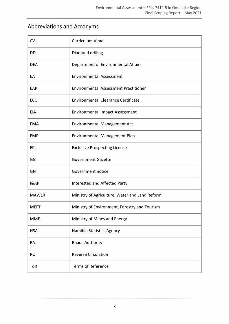
Abbreviations and Acronyms
CV Curriculum Vitae
DD Diamond drilling
DEA Department of Environmental Affairs
EA Environmental Assessment
EAP Environmental Assessment Practitioner
ECC Environmental Clearance Certificate
EIA Environmental Impact Assessment
EMA Environmental Management Act
EMP Environmental Management Plan
EPL Exclusive Prospecting License
GG Government Gazette
GN Government notice
I&AP Interested and Affected Party
MAWLR Ministry of Agriculture, Water and Land Reform
MEFT Ministry of Environment, Forestry and Tourism
MME Ministry of Mines and Energy
NSA Namibia Statistics Agency
RA Roads Authority
RC Reverse Circulation
ToR Terms of Reference
Environmental Assessment – EPLs 7414-5 in Omaheke Region Final Scoping Report – May 2021
xi
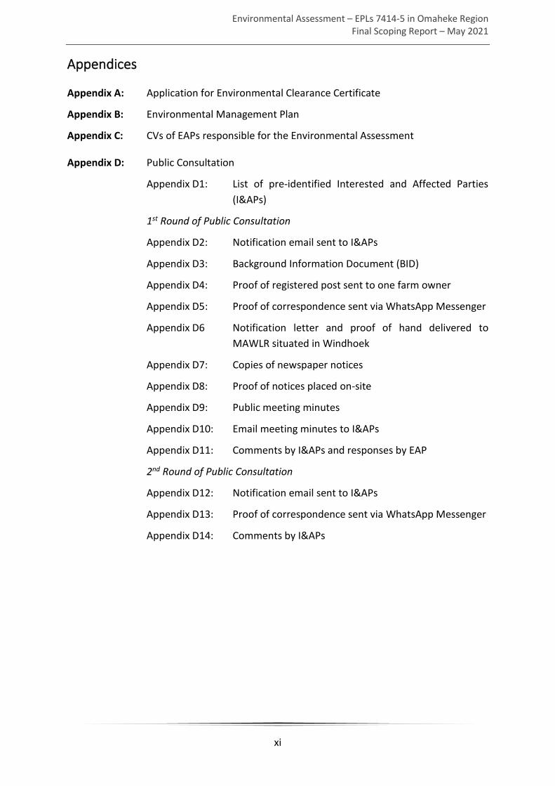
Appendices
Appendix A: Application for Environmental Clearance Certificate
Appendix B: Environmental Management Plan
Appendix C: CVs of EAPs responsible for the Environmental Assessment
Appendix D: Public Consultation
Appendix D1: List of pre-identified Interested and Affected Parties
(I&APs)
1st Round of Public Consultation
Appendix D2: Notification email sent to I&APs
Appendix D3: Background Information Document (BID)
Appendix D4: Proof of registered post sent to one farm owner
Appendix D5: Proof of correspondence sent via WhatsApp Messenger
Appendix D6 Notification letter and proof of hand delivered to
MAWLR situated in Windhoek
Appendix D7: Copies of newspaper notices
Appendix D8: Proof of notices placed on-site
Appendix D9: Public meeting minutes
Appendix D10: Email meeting minutes to I&APs
Appendix D11: Comments by I&APs and responses by EAP
2nd Round of Public Consultation
Appendix D12: Notification email sent to I&APs
Appendix D13: Proof of correspondence sent via WhatsApp Messenger
Appendix D14: Comments by I&APs

Environmental Assessment – EPLs 7414-5 in Omaheke Region Final Scoping Report – May 2021
xii
Glossary
Cumulative Impacts - in relation to an activity, means the impact of an activity that in itself
may not be significant but may become significant when added to the existing and potential
impacts eventuating from similar or diverse activities or undertakings in the area.
Environment - As defined in Environmental Management Act - the complex of natural and
anthropogenic factors and elements that are mutually interrelated and affect the ecological
equilibrium and the quality of life, including – (a) the natural environment that is land, water
and air; all organic and inorganic matter and living organisms and (b) the human environment
that is the landscape and natural, cultural, historical, aesthetic, economic and social heritage
and values.
Environmental Management Plan – as defined in the EIA Regulations, a plan that describes
how activities that may have significant environments effects are to be mitigated, controlled
and monitored.
Interested and Affected Party (I&AP) - in relation to the assessment of a listed activity
includes - (a) any person, group of persons or organisation interested in or affected by an
activity; and (b) any organ of state that may have jurisdiction over any aspect of the activity.
Mitigate - practical measures to reduce adverse impacts.
Proponent – as defined in the Environmental Management Act, a person who proposes to
undertake a listed activity.
Significant impact - means an impact that by its magnitude, duration, intensity or probability
of occurrence may have a notable effect on one or more aspects of the environment.
Environmental Assessment – EPLs 7414-5 in Omaheke Region Final Scoping Report – May 2021
1
1 Introduction
This chapter of the report provides a background and motivation to the project; the study’s
terms of reference; purpose of this report; the assumptions and limitations of the study; and
an outline of the remainder of the report.
1.1 Project Background
Heyn Ohana Investment CC (the Proponent) intends to carry out mineral prospecting activities
on two Exclusive Prospecting Licenses (EPLs) – i.e. EPL 7414 and EPL 7415 (see Figure 3-1
below) located north of Gobabis in the Omaheke Region, Namibia (the project). The
Proponent was issued with the aforementioned EPLs in 2019.
1.2 Project Need and Desirability
Namibia’s Vision 2030 and Namibia’s National Development Plan 5 both recognise a need for,
and place significant value on, economic growth and employment creation. The potential
mining of minerals, in the event of a significant discovery during exploration, within the areas
covered by the two EPLs has the potential to contribute to both of these national priorities.
Exploration activities within the EPLs seek to identify potential economic mineralisation,
which will require feasibility studies, and if proven to be economic, will contribute to mine
planning. Future exploration programmes will utilise this information to enable a more
effective and efficient exploration targeting and potential mining of any identified target
deposits in future.
More geological information within the EPLs is required with respect to mineral deposits.
Geological information collected during the exploration process will be made available to the
Ministry of Mines and Energy.
It is therefore desirable and arguably necessary to carry out minerals exploration on the EPLs
within the Omaheke Region.
1.3 Terms of Reference
In light of the need to undertake the project, Resilient Environmental Solutions cc (hereafter
referred to as RES or the Environmental Assessment Practitioner (EAP)) was appointed by the
Proponent to undertake an environmental assessment (EA) for purpose of applying for an
Environmental Clearance Certificate (ECC) for the project.
No formal Terms of Reference (ToR) were provided by the Proponent. Therefore, the ToR for
conducting this EA were taken to be the requirements of the Environmental Management Act

Environmental Assessment – EPLs 7414-5 in Omaheke Region Final Scoping Report – May 2021
2
(No. 7 of 2007) (EMA) and its Environmental Impact Assessment (EIA) Regulations (GN. No. 30
of 2012) (see Chapter 4 – Legislation Relevant to the Project).
This EA has been conducted with the aim to apply for an ECC only. Any additional permits or
licenses and/or approvals that are required (see Chapter 4) for the operation of the project
should be applied for by the Proponent.
1.4 Environmental Assessment Process
The steps followed as part of this EA process are (i) registration of application for an ECC and
(ii) carry out the scoping phase of the EA process as prescribed by the EIA Regulations.
1.4.1 Registration of Application for Environmental Clearance Certificate
The first step was to identify the listed activities which the proposed project entails, as
stipulated in the ‘List of Activities that may not be undertaken without an Environmental
Clearance Certificate’ (GN. No. 29 of 2012). One listed activity, listed below, was identified.
Mining and Quarrying Activities
3.1 The construction of facilities for any process or activities which requires a licence, right
or other form of authorisation, and the renewal of a licence, right or other form of
authorisation, in terms of the Minerals (Prospecting and Mining Act), 1992.
In accordance with Section 32 of the EMA, applications for an ECC should be submitted to the
relevant Competent Authority. The Competent Authority is defined as that authority having
the jurisdiction to approve or permit a particular listed activity in accordance with the relevant
national legislation. The Ministry of Mines and Energy (MME) was identified as the Competent
Authority. Therefore, the application for an ECC was submitted on 7 December 2020 to the
MME (Appendix A) and a copy of the same application submitted to the Environmental
Commissioner (Appendix A) as prescribed by Regulation 6 (Form 1 of Annexure 1) of the EIA
Regulations (GN. No. 30 of 2012), as provided for under Section 56 of the EMA.
1.4.2 The Scoping Phase
After submitting an application for an ECC the scoping phase commences, culminating in the
production of a draft scoping report, which includes all the findings of the scoping phase. This
report includes the following:
• A description of the proposed project (including need and desirability of the proposed
activity and no-action alternative) (Chapter 3);
• A description of the existing biophysical and social conditions of the receiving
environment (Chapter 5);
• Legislative provisions that have relevance to the proposed project (Chapter 4);

Environmental Assessment – EPLs 7414-5 in Omaheke Region Final Scoping Report – May 2021
3
• A description of the public consultation process followed (as described in Regulations
7 and 21 of the EIA Regulations) (Chapter 6);
• A description and significance assessment of all identified potential impacts (positive
and negative) associated with the proposed project (Chapter 7); and
• Management and mitigation measures required to avoid or minimise the potential
negative impacts as outlined in the Environmental Management Plan (EMP) (Appendix
B).
The purpose of this report is to provide the Environmental Commissioner’s office with
sufficient information on the potential impact of the proposed project to make a decision with
respect to the associated application for an ECC.

Environmental Assessment – EPLs 7414-5 in Omaheke Region Final Scoping Report – May 2021
4
2 Project Team
The project team for this EA consists of John Pallett and Sheldon Husselmann, both of whom
have significant experience conducting EAs (scoping and assessment level) within the
Namibian environmental context.
2.1 John Pallett
John Pallett is a certified Environmental Assessment Practitioner (EAP), with qualifications in
geology (BSc) and zoology (BSc Honours). He specialises in providing environmental advice
and evaluating environmental issues, particularly through Environmental Impact Assessments
(EIAs) and strategic SEAs, for the benefit of managers, decision-makers and the lay public. He
has been affiliated to the Southern African Association for Impact Assessment (SAIEA) since
2008, and the Desert Research Foundation of Namibia – Environmental Evaluation Associates
of Namibia (DRFN-EEAN) for 14 years up to 2008. See CV (Appendix C1).
2.2 Sheldon Husselmann
Sheldon Husselmann is the holder of BSc, BSc (Honours) and MSc in Environmental and
Geographical Science (2010, 2011 and 2016 respectively).
During his 6 years as an EAP with Enviro Dynamics cc, GCS Water Environmental Engineering
(Pty) Ltd and Urban Green cc, he has gained valuable experience in conducting EAs (including
public consultation), both in team set-up as well as individual team leader. Sheldon has also
been affiliated with SAIEA since June 2018. Find attached his CV (see Appendix C2).

Environmental Assessment – EPLs 7414-5 in Omaheke Region Final Scoping Report – May 2021
5
3 Project Description
3.1 Project Location
The project is located approximately 60 km north of Gobabis in the Omaheke Region (Figure
3-1). The two EPLs cover an area measuring approximately 200,000 ha. The Proponent aims
to evaluate and explore across both of its granted EPL areas.
3.2 Project Inputs, Processes and Outputs
The EPLs allow prospecting for base and rare metals, industrial minerals and precious stones.
Base metals are relatively common and inexpensive metals, as opposed to rare metals such
as platinum or gold. In mining terms base metals are specifically non-ferrous (i.e. contain no
iron). Industrial minerals are often used in their natural state and include limestone and clay.
Precious stones according to the Minerals Act (33 of 1992) include diamonds, emeralds, rubies
and sapphires.
3.2.1 Project Inputs
The inputs required for minerals exploration activities in terms of vehicles and equipment
include the following:
• 4x4 vehicles • One compressor
• Truck mounted drill rig and diesel-
powered generator for reverse
circulation and diamond drilling.
• Oils, grease and drilling fluid (stored
in manufacturers approved
containers)
• Diesel bowser (bunded) • Water bowser
Accommodation for all staff utilised for soil/rock sampling and ground geophysics will be
sourced at nearby urban settlements. Only for the geological drilling activities will staff reside
in temporary accommodation near exploration sites. A reverse circulation [RC] drilling team
will consist of up to 6 personnel and the geological team that attends to the sampling will
consist of at least 1 geologist and 4 assistants (i.e. up to a maximum of 11 people at a given
time); a diamond drilling (DD) team consists of about 4 personnel with periodic visits from the
geologist and 1 other to check the drill progress and remove the core boxes to other premises
for logging and sampling. Drilling teams will be temporarily accommodated in tents close to
the rigs. All equipment and vehicles and equipment will be stored at a designated area near
the temporary accommodation.

Environmental Assessment – EPLs 7414-5 in Omaheke Region Final Scoping Report – May 2021
6
Figure 3-1: Location of EPL 7414 and EPL 7415 in the Omaheke Region

Environmental Assessment – EPLs 7414-5 in Omaheke Region Final Scoping Report – May 2021
7
The resource inputs required for the mineral exploration activities include the following:
• Water – Up to 4,000 litres of water per week for domestic use, bought from the
nearest supplier. Reverse Circulation (RC) drilling does not require water for drilling.
Diamond drilling requires 5,000 to 10,000 litres per hole if losses occur, otherwise
2,000 to 3,000 litres per hole depending on subsurface conditions. Water will be
delivered to site by a bowser and be standing by to add water to a sump dug adjacent
to the rig while drilling. In some cases stabilising agents and packing materials may be
used to seal the water loss and minimise water usage. This is uncommon but can
happen if the ground conditions are porous.
• Fuel – Both drilling methods usually supply fuel in 200 litre drums. RC drilling will use
considerably more as it requires a large compressor.
• Electricity – The drilling rigs are normally self-contained and only use electricity to
power welders to cap the holes. RC rigs power their grinders with compressed air.
Hence generators tend to be small and transportable.
• Personnel – Each drill rig has up to 6 personnel, while the geological team consists of
up to 5 personnel. A maximum of 11 people will reside on-site at any given time during
drilling operations.
• Sanitation – temporary pit latrine toilets will be available at the temporary
accommodation near exploration sites. Pit latrines will be covered when exploration
moves on from a given site.
3.2.2 Project Processes
The minerals exploration activities intended can be divided into two categories:
1. Non-invasive techniques: airborne geophysics, ground geophysics and soil sampling
2. Invasive techniques: DD and RC drilling
3.2.3 Sequence of Mineral Exploration Activities
The project will include a variety of exploration techniques, described in the following
sections. The early phase, regional exploration, normally comprises a mixture of non-invasive
techniques such as soil sampling and ground geophysics and invasive drilling techniques.
During these early phases, all the Proponent’s employees and contractors will employ
industry standard best practice techniques and will incorporate the taking of ‘before’ and
‘after’ photographs. This photographic record will be included in annual environmental
monitoring reports to show the minimum impact and environmental best practice that is
adopted by the Proponent and all sub-contractors, as well as provide a record for the
Department of Environmental Affairs (DEA) and Interested and Affected Parties (I&APs).

Environmental Assessment – EPLs 7414-5 in Omaheke Region Final Scoping Report – May 2021
8
Before any work is carried out, all personnel (including fully employed, contracted, and casual)
will be inducted on the Proponent’s environmental health and safety procedures and
processes to follow while conducting the work.
Consultations with all the relevant landowners, users and government stakeholders will
commence to introduce the company, to explain the purpose and stage of the proposed
exploration. The consultations will also be done to determine the current operating
procedures and rules of the farm or area, and to develop land access agreements with each
owner or user.
Due to the iterative, results-driven and phased nature of mineral exploration programmes, it
is not possible at an early stage of exploration to give exact areas for future drilling or an exact
duration of the exploration activities. The duration of soil sampling work depends on the area
covered and sample and line spacing and could take up to a few weeks. RC test drilling of
anomalies (soil or geophysical) of, for example, 3,000m could take 2 to 3 weeks. DD will be
much slower and take approximately 4 to 6 weeks. The Proponent undertakes to work with
all relevant stakeholders to keep them informed of exploration progress and scheduling.
In general, the mineral exploration activities can last in order of several years.
3.2.3.1 Airborne Geophysics
The Proponent will conduct a series of airborne
geophysical surveys.
The airborne geophysical technique seeks to
measure electrical (conductor) and magnetic
variations in the physical parameters of the earth.
Changes up to 600m below the earth’s subsurface
can produce measurable variations, which can be
collected and analysed by highly sophisticated
measuring instruments attached to an aircraft
(see Figure 3-2 for example).
3.2.3.2 Soil Sampling
Soil sampling is the process of collecting and analysing unconsolidated soil in order to locate
geochemical anomalies in the underlying rock and to use these to find mineralisation.
Figure 3-2: Airborne geophysics instruments

Environmental Assessment – EPLs 7414-5 in Omaheke Region Final Scoping Report – May 2021
9
3.2.3.3 Diamond Drilling
Exploration diamond drilling is used in the mining industry to probe the contents of potential
mineralisation. By withdrawing a small diameter core of rock from the geologists can study
and analyse the core and conduct petrologic, structural and mineralogical studies of the rock.
Diamond core drilling uses a diamond-studded
drill bit attached to the end of a hollow drill rod.
Diamond drilling differs from other geological
drilling in that a cylindrical core of solid rock is
extracted during the process. Water is injected
into the drill pipe, which serves the purpose of
cooling and lubricating the drill bit as well as
washing out drill cuttings.
Inside the drill rod, a core tube is attached to a
cable via a latching mechanism. The core tube is
lifted to the surface using the cable, so the solid core can be removed.
3.2.3.4 Reverse Circulation Drilling
Reverse circulation drilling is achieved by blowing compressed air down the annulus of the
drill rod, the differential pressure creates air lift pushing water and cuttings up the inner tube
that is inside each rod.
The drill cuttings travel up the inside of the drill rod and are collected in a sample bag on the
surface. Samples are usually collected every metre and the number of samples is therefore
dictated by the depth of the hole.
Generally, a RC drilling program will see multiple holes drilled at 60-90° inclination and can
range from 60 to 500m in depth.
3.2.4 Project Outputs
The main project outputs are as follows:
• Solid waste – general solid waste (food waste, plastic, paper, etc.) and mining
exploration solid waste (used drill rig components, discard/waste rock samples etc.)
will be generated by the minerals exploration activities.
• Liquid waste – Wastewater will be produced by temporary pit latrine toilets at the
exploration sites. Pit latrines will be covered when exploration moves on from a given
site. Fuels and oils will be used on site and may spill.
• RC samples – Usable rock and/or soil samples. These will be removed from site for
logging and analyses.
Figure 3-3: Example drill rig
Environmental Assessment – EPLs 7414-5 in Omaheke Region Final Scoping Report – May 2021
10
3.3 No-Action Alternative
In the event that the proposed project was denied an Environmental Clearance Certificate
(ECC) no minerals exploration would take place. The default activity taking place within the
area bounded by the EPLs would be a mix of agricultural activities (livestock and game farming
and crop cultivation), wildlife conservation and tourism-related activities (e.g. trophy hunting,
accommodation, wildlife viewing experiences). This would entail the following (among other
consequences):
• Negative:
o The loss of a few potential semi and unskilled jobs and associated income for
a few individuals (and their dependents).
o The loss of potential detailed geological information regarding mineral
deposits in the area bounded by the EPLs.
o Loss of potential groundwater information and potential water-yielding
boreholes.
• Positive:
o No added pressure on existing infrastructure and resources (water, roads,
fences, gates etc.).
o No nuisance/inconvenience (leaving farm gates open etc.).
o No waste generation.
The loss of potential groundwater information and potential water yielding boreholes is
potentially significant and therefore represents a potentially significant opportunity cost in
light of the scarcity of water and high-water demand. The loss of a few potential jobs
represents a small opportunity cost given the current unemployment situation within the
Okarukambe constituency (and the Omaheke Region and Namibia at large).
The use of the land for various agricultural activities will not be significantly influenced by the
exploration activities and therefore these land uses can co-exist.
The proposed exploration activities will conflict somewhat with the existing wildlife
conservation and tourism-related activities. The environmental sensitivity of these activities
will need to be carefully considered and mitigation measures put in place to minimise conflict
between these land uses.
The increase in pressure on existing infrastructure will be relatively small – a few large vehicles
and service vehicles on roads, and small volumes of water for most exploration activities.
Based on the above, the no-action/“no-go” alternative is not recommended.

Environmental Assessment – EPLs 7414-5 in Omaheke Region Final Scoping Report – May 2021
11
4 Legislation Relevant to the Project
Natural resource management within the Namibian context is provided for by legislation
regulating its various social and biophysical sectors.
There are several sectoral laws that fall under the general category of environmental law.
Examples of relevant sectors include forestry, water and mining. Any development, such as
the proposed project, is expected to have certain impacts and would therefore have to
comply with the relevant legislative requirements before being implemented.
This chapter provides an overview to the legislation that is applicable to both the assessment
process and the various project activities. It is accordingly divided into: (i) national legislative
requirements – i.e. the legal framework for environmental management in Namibia and
national sectoral legislative requirements (including required approvals/permits) applicable
to the activities of the proposed project; and (ii) relevant international legislation.
4.1 National Legislative Requirements
The legal framework for EA in Namibia and national sectoral legislation pertaining to various
environmental aspects (including approval and permit requirements) are listed in Table 4-1
below.
Table 4-1: Legislation applicable to the project
Statute Provisions Project Implications
Environmental Assessment Legal Framework
The Namibian
Constitution (1990)
Article 95 (1) states that “the State shall
actively promote and maintain the welfare
of the people by adopting, inter alia,
policies aimed at… maintenance of
ecosystems, essential ecological processes
and biological diversity of Namibia and
utilization of natural resources on a
sustainable basis”
Article 100 stipulates that all natural
resources are vested in the state, unless
otherwise legally owned. The use of such
resources is only allowed within
reasonable limits and beyond such limits,
permission should be obtained from a
The project should support
the provisions of the
Namibian Constitution

Environmental Assessment – EPLs 7414-5 in Omaheke Region Final Scoping Report – May 2021
12
Statute Provisions Project Implications
competent authority responsible for the
use and governance of the concerned
natural resources.
Environmental
Management Act
(No 7 of 2007)
Section 3(2) of the EMA provides a set of
principles that give effect to the provisions
of the Namibian Constitution for
integrated environmental management.
Section 27(3) stipulates that no party,
whether private or governmental, can
conduct a listed activity without an ECC
obtained from the Environmental
Commissioner.
Section 40(1) stipulates that an ECC
remains valid for a period not exceeding
three years, subject to cancellation or
suspension.
The project should adhere
to the principles provided in
the EMA.
An ECC should be obtained
for the proposed project.
The Proponent should
renew the ECC (if granted)
every three years.
Environmental
Impact Assessment
(EIA) Regulations GN
28-30 (GG 4878)
Details requirements for public
consultation within a given environmental
assessment process (Rs21-24).
Details the requirements for what should
be included in a Scoping Report (R8) and
an Assessment Report (R15).
The EIA Regulations should
inform and guide this EA
process.
National Sectoral Legislation (Including Approvals/ Permits)
Minerals
(Prospecting and
Mining) Act (No. 33
of 1992)
Section 52 requires mineral license holders
to enter into a written agreement with
affected land owners before exercising
rights conferred upon the license holder.
Section 52 prohibits the exercise of rights
in a town or village, proclaimed transport
infrastructure, on land under cultivation,
within a 100m of water sources or any
building.
Section 54 requires written notice to be
submitted to the Mining Commissioner in
the event that the holder of a mineral
The Proponent should enter
into a written agreement
with land owners before
carrying out exploration on
their land.
The proponent may not
exercise rights in prohibited
areas.
The Proponent should carry
out an assessment of the
impact on the receiving
environment.

Environmental Assessment – EPLs 7414-5 in Omaheke Region Final Scoping Report – May 2021
13
Statute Provisions Project Implications
license (which includes and EPL) intends to
abandon the mineral license area.
Section 68 stipulates that an application
for an exclusive prospecting license (EPL)
shall contain the particulars of the
condition of, and any existing damage to,
the environment in the area to which the
application relates and an estimate of the
effect which the proposed prospecting
operations may have on the environment
and the proposed steps to be taken in
order to prevent or minimize any such
effect.
Section 91 requires that rehabilitation
measures should be included in an
application for a mineral license.
The Proponent should
include as part of their
application for this EPL
measures by which they will
rehabilitate the areas where
they intend to carry out
minerals exploration
activities.
Mine Health &
Safety Regulations,
10th Draft
Makes provision for the health and safety
of persons employed or otherwise present
in mineral license areas. These deal with
among other matters; clothing and
devices; design, use, operation,
supervision and control of machinery;
fencing and guards; and safety measures
during repairs and maintenance.
The Proponent should
comply with all these
regulations with respect to
their employees.
Petroleum Products
and Energy Act (No.
13 of 1990)
Regulations (2001)
Regulation 3(2)(b) states that “No person
shall posses [sic] or store any fuel except
under authority of a licence or a certificate,
excluding a person who possesses or
stores such fuel in a quantity of 600 litres
or less in any container kept at a place
outside a local authority area”
The Proponent should
obtain the necessary
authorisation from the MME
for the storage of fuel on-
site.
Water Act (No. 54 of
1956)
Makes provision for a number of functions
pertaining to the management, control
and use of water resources, water supply
and the protection of water resources.
The Proponent should
prevent any potential
pollution of groundwater.

Environmental Assessment – EPLs 7414-5 in Omaheke Region Final Scoping Report – May 2021
14
Statute Provisions Project Implications
Water Resources
Management Act
No. 11 of 2013
Provides for the management,
development, protection, conservation,
and use of water resources.
Part XIII of the Act requires that efficient
water management practises be applied by
each and every person or organisation and
organ of state.
This Act has not yet been brought into
force.
Water should be used in a
sustainable way.
Forestry Act (No. 12
of 2001)
Part IV of this Act provides for the general
protection of the environment.
Permits are required for the removal of
protected plants species.
Permits should be obtained
if there will be any removal
of or damage to protected
plant species.
Nature Conservation
Ordinance No. 4 of
1975 (as amended)
Makes provision for the protection of
indigenous flora and fauna.
Permits are required for the removal of
protected plants species.
Soil Conservation Act
No. 76 of 1969
Provides for the prevention and combating
of soil erosion; conservation, improvement
and manner of use of soil and vegetation,
and protection of water sources.
Removal of vegetation cover
and contamination of soil
must be minimised as far as
practicable.
Aviation Act No. 74
of 1962
Namibian Civil
Aviation Regulations,
2001
Regulates various matters pertaining to
the flying of aircraft.
External loads attached to helicopters
need special permission.
The proponent should
obtain the necessary
authorisations before
commissioning aerial
surveys.
Atmospheric
Pollution Prevention
Ordinance No. 11 of
1976 (as amended)
Provides for the prevention of pollution of
the atmosphere. Part IV of the Ordinance
deals with control of dust and provides for
the proclamation of dust control areas.
A general obligation not to
contribute or cause dust
pollution.
Public Health Act No.
36 of 1919 (as
amended)
Provides for the prevention of pollution of
public water supplies.
Section 119 of this Act prohibits the
existence of a ‘nuisance’ on any land
owned or occupied by any person.
A general obligation not to
pollute the water bodies in
the area.
Care should be taken to limit
dust and noise pollution.

Environmental Assessment – EPLs 7414-5 in Omaheke Region Final Scoping Report – May 2021
15
Statute Provisions Project Implications
Labour Act (No. 11 of
2007)
The Labour Act of 1992 (Act 6), the New
Labour Act of 2007 (Act 11) and
Government Notice 156 of 1997: Labour
Act, 1992: Regulations Relating to the
Health and Safety of Employees at Work,
governs working conditions of employees.
These regulations are prescribed for
among others safety relating to hazardous
substances, exposure limits and physical
hazards. Special consideration must be
given to:
Chapter 3: Welfare and Facilities at Work-
Places
Chapter 4: Safety of Machinery
Chapter 5: Hazardous Substances
Chapter 6: Physical Hazards and general
provision
The Proponent should
comply with health and
safety regulations pertaining
to the health and safety of
their employees.
Regulations relating
to the health and
safety of employees
at work (GN
156/1997 (GG 1617))
Details conditions, pertaining to
occupational health and safety applicable
to manual labour.
Work conditions during
exploration should comply
with these regulations.
National Heritage
Act (Act 27 of 2004)
Provides for the protection of cultural and
archaeological sites.
Any protected heritage
resources discovered, need
to be reported immediately
to the National Heritage
Council (NHC) and require a
permit from the NHC before
they may be relocated.
Road Ordinance
1972 (Ordinance 17
of 1972)
Width of proclaimed roads and road
reserve boundaries (S3.1)
Control of traffic on urban trunk and main
roads (S27.1)
Infringements and obstructions on and
interference with proclaimed roads.
(S37.1)
The conditions applicable to
RA proclaimed roads and
road accesses should be
adhered to.

Environmental Assessment – EPLs 7414-5 in Omaheke Region Final Scoping Report – May 2021
16
4.2 International Treaties and Conventions
The international treaties and conventions applicable to the project are listed below in Table
4-2 below.
Table 4-2: International Treaties and Conventions applicable to the Project
STATUTE PROVISIONS PROJECT IMPLICATIONS
The United Nations
Convention to
Combat
Desertification
(UNCCD)
Addresses land degradation in arid regions
with the purpose to contribute to the
conservation and sustainable use of
biodiversity and the mitigation of climate
change.
Activities should not be
such that they contribute
to desertification.
Convention on
Biological Diversity
1992
Regulate or manage biological resources
important for the conservation of biological
diversity whether within or outside
protected areas, with a view to ensuring
their conservation and sustainable use.
Promote the protection of ecosystems,
natural habitats and the maintenance of
viable populations of species in natural
surroundings.
Removal of vegetation
cover and destruction of
natural habitats should be
avoided and where not
possible minimised.
Stockholm
Declaration on the
Human
Environment,
Stockholm (1972)
It recognizes the need for: “a common
outlook and common principles to inspire
and guide the people of the world in the
preservation and enhancement of the
human environment.
Protection of natural
resources and prevention
of any form of pollution.

Environmental Assessment – EPLs 7414-5 in Omaheke Region Final Scoping Report – May 2021
17
5 Description of the Receiving Environment
5.1 Biophysical Environment
5.1.1 Climate
The study area is situated in the eastern part of Namibia in the Omaheke Region which is
characterised by semi-arid climatic conditions – i.e. hot and dry summers and moderate dry
winters.
Rainfall is erratic and unpredictable within the project area, with the highest rainfall months
being January to March. Most rainfall takes place as thunderstorms. The average annual
rainfall for the project area and surroundings is approximately 350 - 400 mm (Mendelsohn,
et al., 2003).
Temperatures are moderate during summer (average maximum 30°C – 32°C) and cold
(average minimum 2°C – 4°C) during winter.
The low average rainfall and high temperatures during the rainy season results in high rates
of evaporation, restricting aquifer recharge. Average annual potential evaporation at Gobabis
is 2,000 mm, more than five times the average rainfall (Mendelsohn & el Obeid, 2002)).
Winds are not a dominant feature in the area; they blow mainly from the north-east (12%)
and north-west (10%) (Mendelsohn, et al., 2003).
5.1.2 Topography
The landscape of the project area is Kalahari Sandveld (Mendelsohn, et al., 2003). The
topography of this landscape is made up of sandy, mostly flat plains with some low
undulations at an altitude ranging from 1,200m to 1,400m above sea level.
The project area is located mainly in the catchment areas of the Epukiro and Eiseb Rivers,
which are ephemeral and drain in an easterly direction. Due to the sandy substrate of the
Kalahari, which creates very little surface runoff, these rivers and their tributaries very rarely
hold water.
5.1.3 Geology and Soil
The geology of the area is largely hidden beneath the relatively thick layer of sand cover
known as the Kalahari Group (Figure 5-1). Smaller portions of the project area are comprised
of Witvlei Group limestones and shales rock types of the Damara Supergroup and Gariep
Complex (Mendelsohn, et al., 2003).

Environmental Assessment – EPLs 7414-5 in Omaheke Region Final Scoping Report – May 2021
18
Figure 5-1: Map displaying geology of the project area

Environmental Assessment – EPLs 7414-5 in Omaheke Region Final Scoping Report – May 2021
19
5.1.4 Hydrogeology
Water resources within the Omaheke Region generally are scarce. Groundwater is the
primary source of water utilised in the project area. The groundwater potential in most of the
project area is classified as moderate, with porous aquifers over most of the area but
fractured aquifers in the south and west (Christelis & Struckmeier, 2001).
5.1.5 Biodiversity
5.1.5.1 Biomes and Vegetation Types
The project area is located within the Central Kalahari vegetation type, which forms part of
the Acacia Tree-and-Shrub Savanna biome (Mendelsohn, et al., 2003). The dominant tree
species within the Central Kalahari are the Acacia erioloba (camelthorn tree) and Terminalia
sericea (silver terminalia). Other common trees and shrubs may include Acacia mellifera
(blackthorn), A. hebeclada (candle-pod acacia), Tarchonanthus camphoratus (camphorbush)
and Grewia flava (raisin-bush). Although several protected plant species (as listed in the
Forest Act (2001) and the Nature Conservation Ordinance (1975)) occur within the project
area, none of these are range-restricted or endemic to the project area, but rather occur
throughout the wider biome area. Bush encroachment is a feature over much of the area. The
reasons for bush encroachment include heavy stocking practices and reduced fire frequency
(O’Connor, et al., 2014; Mendelsohn & el Obeid, 2005).

Environmental Assessment – EPLs 7414-5 in Omaheke Region Final Scoping Report – May 2021
20
Figure 5-2: Map displaying water resources in the project area

Environmental Assessment – EPLs 7414-5 in Omaheke Region Final Scoping Report – May 2021
21
5.1.5.2 Fauna
Faunal species diversity in Omaheke’s Kalahari savanna is less diverse than in other parts of
Namibia because of the relatively lower habitat variety and the lack of surface water. Within
the project area in general, there are no outstanding landforms or unique habitats (such as
specific dune forms, wetlands or rocky outcrops) that host particular endemic species. The
animal life that is expected to occur in the project area is expected to be widely distributed in
similar habitats within the wider are of the biome (SAIEA, 2016).
Mammals
Occurrence and conservation status of mammals described here is drawn from SAIEA 2016.
The small mammal fauna is reasonably diverse and the species are all widespread, with the
exception of one species - Woosnam’s desert rat (Zelotomys woosnami) – which is endemic
to the central Kalahari (Griffin & Coetzee, 2005). All of these species are classified as Secure
in Namibia, or Least Concern internationally i.e. not threatened.
Ground pangolin (Smutsia temminckii) occur in the area. This species is listed as Vulnerable
internationally (Pietersen, et al., 2014), because it is targeted in illegal poaching for trade to
Asia and for traditional ‘muti’.
Approximately ten species of ungulates occur in the region. Species such as oryx, springbok,
kudu, red hartebeest, steenbok and warthog are common, while more unusual are introduced
species such as waterbuck and sable which are kept on game farms in the region. The latter
species were historically absent from the Kalahari due to lack of surface water but this is now
provided on farms and the animals do well in the savanna habitat. Black rhino (Diceros
bicornis) (Critically Endangered) (Emslie, 2019) and white rhino (Ceratotherium simum) (Near-
Threatened) (Emslie, 2012) are found on a few game farms.
There is a fair diversity of mammal predators found in Kalahari savanna:
• Smaller species include four species of mongooses and the suricate, small-spotted
genet and striped polecat, all of which are Secure / Least Concern.
• Honey badger is Secure in Namibia, but Lower Risk internationally.
• Medium-sized predators occurring in the area include small-spotted cat (Felis nigripes)
(Vulnerable) (Sliwa, et al., 2016), which is naturally rare and occupies a relatively small
range in arid to semi-arid habitat in southern Africa.
• African wild cat (Felis sylvestris) (Least Concern) (Yamaguchi, et al., 2015); this species
interbreeds with domestic cats, so the threat against it is hybridisation and loss of the
integrity of the species.
• Caracal cat (Caracal caracal) (Least Concern) (Avgan, et al., 2016), often killed by
farmers because it is accused of killing small livestock.

Environmental Assessment – EPLs 7414-5 in Omaheke Region Final Scoping Report – May 2021
22
• Cape fox (Vulpes chama) and bat-eared fox (Otocyon megalotis) are both classified as
Least Concern internationally (Hoffmann, 2014a) (Hoffmann, 2014b). Although they
eat mainly insects and are very useful for this role, they are often killed in anti-
predator activities by small-stock farmers.
• Aardwolf (Proteles cristata) (Least Concern) (Green, 2015) has teeth that can only
manage to eat ants and other insects, but is often wrongly targeted as a predator that
kills small livestock, or innocently killed as ‘by-catch’ in predator traps.
• Black-backed jackal (Canis mesomelas) (Least Concern) (Hoffmann, 2014c) is
widespread throughout Namibia but anti-predator activities by some farmers such as
electrified fences, setting of gin-traps and shotgun traps, active hunting and poisoning,
create pockets where jackals and other small carnivores are totally eliminated.
Large mammal carnivores that occur or can be expected in the project area include cheetah,
leopard, cheetah and brown hyena.
• Cheetah (Acinonyx jubatus) (Vulnerable (Durant, et al., 2015) but upgraded to
Endangered in Namibia (NCE, in prep.)) are naturally sparse but Namibia is renowned
to have the largest free-range population in the world, i.e. outside of protected areas.
This species is classified as Vulnerable but conservation efforts at encouraging co-
existence of cheetahs with livestock have been successful.
• Leopards (Panthera pardus) (Vulnerable) (Stein, 2016) are relatively common on
freehold farm land, and are less restricted by game fences.
• Brown hyena (Parahyaena brunnea) (Near-Threatened) (Wiesel, 2015) are relatively
scarce; early indications are that numbers are increasing.
Birds
The project area supports birds that are typical of Kalahari savanna: relatively low diversity
(approximately 80 – 90 species), and the species that occur are widely distributed in this
habitat. Wetland species are largely absent or only occasional visitors, as well as birds of
mountain habitats. There are no species that are range-restricted, and no Important Bird
Areas in the region (Simmons, et al., 2015).
Birds of conservation concern are predominantly raptors or birds of prey (e.g. vultures and
eagles) (Table 5-1). The region is well represented by such birds, which rely on food such as
carcasses and small mammals, birds and invertebrates, and undisturbed conditions during
breeding. While these conditions may exist on many large livestock farms, raptor populations
are generally depressed due to the use of poisons against mammal predators (Simmons, et
al., 2015). Other threats to various raptors include drowning in open water reservoirs,
killing/trapping for traditional medicines, human disturbance, and a declining prey base due
to factors such as bush encroachment.

Environmental Assessment – EPLs 7414-5 in Omaheke Region Final Scoping Report – May 2021
23
Table 5-1: Birds expected to occur in the project area that are conservation priorities.
Common English name Species Namibian conservation status
Habitat/Biome
Birds of prey and scavengers
White-backed vulture Gyps africanus Endangered Savanna and open veld
Cape vulture Gyps coprotheres Critically endangered Savanna and open veld
Lappet-faced vulture Torgos tracheliotos Vulnerable Savanna and open veld
White-headed vulture Trigonoceps occipitalis Vulnerable Savanna and open veld
Bateleur Terathopius ecaudatus Endangered Savanna
Tawny eagle Aquila rapax Endangered Savanna
Booted eagle Aquila pennatus Endangered Mountains
Martial eagle Polemaetus bellicosus Endangered Savanna and open veld
Black harrier Circus maurus Endangered Open veld, wetlands
Red-footed falcon Falco vespertinus Near-threatened Savanna and open veld
Secretarybird Sagittarius serpentarius Vulnerable Savanna and open veld
Marabou stork Leptoptilus crumeniferus Near-threatened Wetlands, waste dumps,
abattoirs
Others
European roller Coracias garrulus Near-threatened Open savanna
Kori bustard Ardeotis kori Near-threatened Open veld and savanna
Reptiles
There is a reasonably diverse array of reptiles in the project area (Griffin, 2005), including
interesting species which inhabit loose sand such as blind snakes and legless lizards. Most of
the reptiles are not under threat, with some exceptions. Those which could be influenced by
the proposed activities, include:

Environmental Assessment – EPLs 7414-5 in Omaheke Region Final Scoping Report – May 2021
24
• Two species of tortoise - threatened by humans who pick them up for food, or to keep
as pets, or for the commercial pet trade;
• Among the lizards is veld leguaan, which is commonly captured for the pet trade
especially for the USA;
• Snakes, which are usually killed on sight. The southern African python is classified as
Vulnerable due to persecution and capturing for the pet trade.
5.2 Socio-Economic Environment
5.2.1 Regional Demographic Overview
The 2011 Population and Housing Census shows that the Omaheke Region has a total
population of 71,223, which accounted for approximately 3.4% of Namibia’s estimated total
population at the time. The annual population growth rate for the Omaheke Region was
estimated at 0.5% for the period 2001 to 2011. 70.2% of the population live in rural areas
compared to only 29.8% in urban areas (NSA, 2012) .
The population density of the Omaheke Region was 0.8 people/km² (NSA, 2012), which is
significantly lower than the national average of 2.6 people/km², and the Okorukambe and
Kalahari Constituencies are even lower, at 0.6 people/km2. The project area is therefore
among the most sparsely populated areas in Namibia.
The Omaheke Region has a significant percentage of its population younger than 15 years of
age – 39%, which is 2% higher than the national percentage. Of those 15 years and older (i.e.
the labour force) 65% are actively engaged, with 61% employed and 39% unemployed. The
percentage of those unemployed is higher than the national percentage for the same, which
was 37% in 2011.
Most formal employment opportunities in the region are limited to urban areas. ‘Agriculture,
Forestry and Fisheries’ dominated as the main industry of the workforce (45%), whereas
‘Administrative and Support service activities’ and ’Construction’, employed 8% and 7% of the
regional workforce respectively (NSA, 2015). Private employment provided jobs to the largest
portion of employees (30%) in the region (NSA, 2015).
The majority of people in the Omaheke Region are Herero speaking (41.5% of households),
with Nama/Damara (28.1% of households) and Afrikaans (10% of households) occupying
second and third places respectively (NSA, 2012).

Environmental Assessment – EPLs 7414-5 in Omaheke Region Final Scoping Report – May 2021
25
5.2.2 Okorukambe and Kalahari Constituencies
5.2.2.1 Demographic Profile
The affected constituencies in which the project is located are Okorukambe and Kalahari
Constituencies. Population statistics for the two constituencies are shown in Table 5-2Table
5-2.
Table 5-2: Population statistics for Okorukambe and Kalahari Constituencies in Omahake Region.
Constituency Population figures from national
censuses
Average
annual growth
rate
(2001-2011)
Population 2016
(extrapolated)
Population
density 2016
(estimated)
(people/km2)
2001 2011
Okorukambe 9,600 10,060 0.5 10,298 0.59
Kalahari 9,443 7.661 -2.1 6,833 0.56
The project area and surrounds are very sparsely populated, with concentrations of people at
Drimiopsis, Du Plessis and Epukiro RC (Figure 5-3).

Environmental Assessment – EPLs 7414-5 in Omaheke Region Final Scoping Report – May 2021
26
Figure 5-3: Population density map of central and southern Omaheke Region (MLR, 2017).
5.2.2.2 Main population centres and services
There are no formally proclaimed urban centres (i.e. centres proclaimed as a municipality,
town, village or settlement) in the project area.
The major population centres in the project area and surrounds are Drimiopsis, Farm Du
Plessis and Epukiro RC. Du Plessis and Epukiro RC are (largely informal) settlements that have
established at the government group resettlement farm at Du Plessis and the church-owned
farm at Epukiro RC. There are clinics and primary schools at Du Plessis and Epukiro RC. Du
Plessis is the site of the Okorukambe Constituency Office, and it also has a police station.
Drimiopsis has two primary schools.
The remainder of the area is made up of freehold farms, and commercial livestock farming
and game farming are the dominant land uses (MLR, 2017).

Environmental Assessment – EPLs 7414-5 in Omaheke Region Final Scoping Report – May 2021
27
5.2.2.3 Socio-economic characteristics
The information in this section is drawn from the Omaheke Integrated Regional Land Use Plan
(MLR, 2017).
According to the 2014 Labour Force Survey (NSA, 2015) more than half of all households in
Omaheke Region (55.3%) derive their main income from salaries and wages. For 12.5% of
households, old age pensions form the main income. 11.6% of households derive their main
income from subsistence farming and 10.3% from cash remittances. Commercial animal
rearing was found to be the main source of income for only slightly less than 3% of
households.
In 2014, the employment to population ratio, i.e. the number of (formally or informally)
employed people given as a percentage of the working age population, was 57.9% in
Omaheke Region (NSA, 2015). Of all employed people in Omaheke Region, 27.5% were found
to be informally employed. The unemployment rate, i.e. the number of people who are
available for work but do not have work, given as a percentage of the working age population,
was 26.9% in 2014.
According to the 2014 Labour Force Survey (NSA, 2015), a total of 28,652 people were
employed (formally and informally) in 2014 in Omaheke Region. Forty-one percent of these
were employed in the agriculture, forestry and fishing sector, with livestock agriculture being
by far the most important sub-sector in the region.
In 2011, the literacy rate for the population aged 15 years and above was 73.3% in Omaheke
Region. The 2011 census, however, also found that of the population aged six years and
above, more than one quarter never attended school. For the rural population, this rate is
particularly high with almost 29%, while for the urban population it was 17.4%. Only 42.2% of
the population aged fifteen years and above had completed their primary education before
leaving school and less than a quarter had completed their secondary education. The school
enrolment rate for children between 7 and 13 years of age was between 77%.
5.2.3 Land Use
The dominant land use in the project area is livestock farming, game farming and tourism.
Extensive livestock farming generates the most income for the region. Bush encroachment,
as stated above, as well as water scarcity are two significant concerns for livestock farming in
the project area. Game farming and tourism are closely linked, as many of the game farms
are hunting farms, attracting international and South African clientele. Conservation research
is also undertaken on select farms in the project area.

Environmental Assessment – EPLs 7414-5 in Omaheke Region Final Scoping Report – May 2021
28
5.2.4 Archaeology and Heritage Resources
The Omaheke Region IRLUP identified a few sites of historical/heritage importance (MLR,
2017). Sites linked to the Herero-German War 1902-1904 are east of Epukiro (i.e. outside the
project area), and the route of the historic Dorsland Trekkers (~1875) from Rietfontein
towards Gam also lies east of the project area.

Environmental Assessment – EPLs 7414-5 in Omaheke Region Final Scoping Report – May 2021
29
6 Public Consultation
Public consultation is an important aspect of an Environmental Assessment (EA) process.
During public consultation, potential impacts that the proposed project may have on the
receiving environment, were identified. Consultation with Interested and Affected Parties
(I&APs) (state and non-state) enables transparent decision-making.
This chapter describes the details of the public consultation process that was followed and
the I&APs that were notified of the EA being undertaken. It also includes the main issues and
concerns raised during the public consultation process and comments received on the
Background Information Document (BID) distributed during the first round of public
consultation.
Public consultation was carried out as prescribed by Regulations 21 to 24 of the
Environmental Impact Assessment Regulations (GN. 30 of 2012).
6.1 First Round of Public Consultation
Engagement with I&APs as part of the first round of public consultation commenced on the
5th of February 2021 and concluded on the 15th of March 2021. During the first round of
consultation, I&APs and authorities were given an opportunity to register and submit
comments on the proposed project.
6.1.1 Public Consultation Activities
Activities undertaken to ensure effective and adequate I&AP involvement, are as follows:
• A list of pre-identified I&APs was compiled. Approximately 120 I&APs were identified
and included in the database (Appendix D1).
• A notification email (Appendix D2) with BID (Appendix D3) was distributed to all pre-
identified I&APs who have an email address (Appendix D1) on 5 February 2021.
• A letter was sent via registered post on 11 February 2021 to a landowner who was
unable to receive project information via email or WhatsApp (mobile phone)
(Appendix D4).
• A communication group was created and a notification message was sent on 13
February 2021 via WhatsApp Messenger to all owners and occupiers of land potentially
affected by the proposed project (see Appendix D5 for export of group chat).
• A notification letter was hand delivered on 18 February 2021 (Appendix D6) to the
Ministry of Agriculture Water and Land Reform, situated in Windhoek, which owns
several farms.

Environmental Assessment – EPLs 7414-5 in Omaheke Region Final Scoping Report – May 2021
30
• Public notices announcing the commencement of the EA and an invitation to register
as an I&AP were placed in “Die Republikein” on 8, 9 and 15 February 2021 and “The
Namibian” on 8 and 15 February 2021 (Appendix D7).
• A notice board (with the dimensions 60cm x 42cm) was placed near the intersection
of B6 with the C30 and C22 (Appendix D8).
• A public meeting was held on 18 February 2021, at 15:00 in the meeting hall at Quain
Quaz Camp, located approximately 5 km west of Gobabis on the B6 (see Appendix D9
for meeting minutes).
• The meeting minutes were circulated on 26 February 2021 to all owners and occupiers
of land (Appendix D1) via email (Appendix D10) and WhatsApp Messenger (Appendix
D5).
6.1.2 Comments Received and Responses Provided
All comments and feedback regarding significant issues received from I&APs and Authorities
are summarised in Table 6-1 below, while a copy of all the original written correspondence
(including feedback that does not raise significant issues) is attached as Appendix D11.

Environmental Assessment – EPLs 7414-5 in Omaheke Region Final Scoping Report – May 2021
31
Table 6-1: Comments received and responses provided during the first round of public consultation
No. Name Comment Name Response
1. H. Steinbruck
(Hetaku Safari Lodge
(Pty) Ltd)
6-Feb-21, email
Concerns regarding potentially unpredictable movement
by strangers on the affected farms and the implications
for the operations of Hekatu Safari Lodge (Pty) Ltd
S. Husselmann (RES)
8-Feb-21, email
Regarding the first concern I am sure you are aware
that the proponent needs to secure an access
agreement with land owners before entering their
land. You can specify all your conditions of entry as
part of that agreement.
Furthermore, the Environmental Management Plan,
which forms part of the legally binding Environmental
Clearance Certificate (ECC), will prohibit poaching.
Non-compliance with the EMP can result in the
cancellation of the ECC by the Ministry of Environment
Forestry and Tourism (MEFT).
2. H. Steinbruck
(Hetaku Safari Lodge
(Pty) Ltd)
6-Feb-21, email
Concerns about the changes associated with potential
mining, in the event of a “successful” exploration
programme. These include the effect on the movement of
wildlife and the potential conflicts between mining
operations and eco-tourism.
S. Husselmann (RES)
8-Feb-21, email
Regarding the second point, if the proponent finds a
significant deposit of some mineral, there will be a long
lead-up process (potentially 7-10 years) before any
serious mine planning would begin. There would also
be a mandatory EIA for that process. While every
exploration company has a mine as its long-term
objective, the chances that this is achieved are usually
very small.
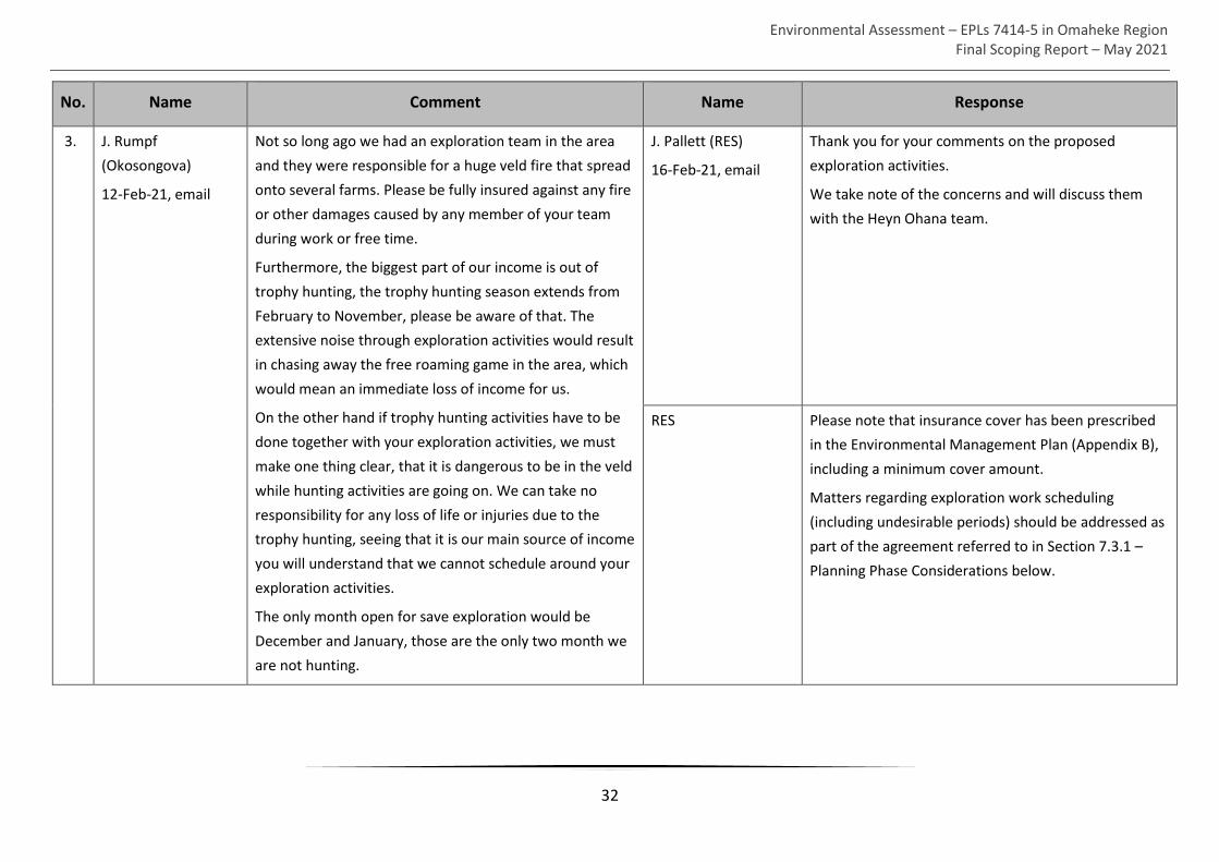
Environmental Assessment – EPLs 7414-5 in Omaheke Region Final Scoping Report – May 2021
32
No. Name Comment Name Response
3. J. Rumpf
(Okosongova)
12-Feb-21, email
Not so long ago we had an exploration team in the area
and they were responsible for a huge veld fire that spread
onto several farms. Please be fully insured against any fire
or other damages caused by any member of your team
during work or free time.
Furthermore, the biggest part of our income is out of
trophy hunting, the trophy hunting season extends from
February to November, please be aware of that. The
extensive noise through exploration activities would result
in chasing away the free roaming game in the area, which
would mean an immediate loss of income for us.
On the other hand if trophy hunting activities have to be
done together with your exploration activities, we must
make one thing clear, that it is dangerous to be in the veld
while hunting activities are going on. We can take no
responsibility for any loss of life or injuries due to the
trophy hunting, seeing that it is our main source of income
you will understand that we cannot schedule around your
exploration activities.
The only month open for save exploration would be
December and January, those are the only two month we
are not hunting.
J. Pallett (RES)
16-Feb-21, email
Thank you for your comments on the proposed
exploration activities.
We take note of the concerns and will discuss them
with the Heyn Ohana team.
RES Please note that insurance cover has been prescribed
in the Environmental Management Plan (Appendix B),
including a minimum cover amount.
Matters regarding exploration work scheduling
(including undesirable periods) should be addressed as
part of the agreement referred to in Section 7.3.1 –
Planning Phase Considerations below.

Environmental Assessment – EPLs 7414-5 in Omaheke Region Final Scoping Report – May 2021
33
No. Name Comment Name Response
4. Meeting attendee
18-Feb-21, public
meeting
There are big problems with water in this area. If you find
water, what then?
T. Smalley (Geologist)
18-Feb-21, public
meeting
The borehole can be left for the farmer to develop
further if he wants to.
5. Meeting attendees
18-Feb-21, public
meeting
Concern over fire hazards: a very serious issue:
- eg workers walk around after hours, look for honey,
smoke out the bees – fire!
- Another example: a large fire that happened about 7
years ago, did severe damage, and then took a very long
time for the farmer to get any compensation.
- Farmers want it to be very clear that for any fire that
starts when the exploration activities are in the area, the
exploration team will immediately be held responsible.
The insurance cover should be not less than N$10 million.
- Any labour camp or drill site should be cleared of all
vegetation for a distance of 150 m around the site.
T. Smalley (Geologist)
18-Feb-21, public
meeting
We will obviously take proper precautions against fires.
Heyn Ohana will be covered by insurance so that there
will be compensation to any farmer who suffers from
fire, where we are proven to be responsible.
J. Pallett (RES)
18-Feb-21, public
meeting
Is there a fire committee or some organisation that can
help to ensure that all risks of fire are minimised, and
to assist if/when a fire occurs?
Farmer
18-Feb-21, public
meeting
Every Farmers Association has their own fire
arrangements. As soon as a fire starts, every farmer in
the area is called and everyone comes to assist.
6. Farmer
18-Feb-21, public
meeting
Each and every farmer should make a contract with Heyn
Ohana, using a template version that he provided in hard
copy. It should be individualised for each farm’s specific
activities and wishes (eg no exploration during hunting
periods, no alcohol, arrangements for using water, etc).
J. Pallett (RES)
18-Feb-21, public
meeting
The Environmental Management Plan can include this
template contract, as a basis for the agreement
between each farmer and Heyn Ohana
T. Smalley (Geologist)
18-Feb-21, public
meeting
All activities on the farms will be done in consultation
with farmers and according to the contract. Heyn
Ohana would like to work in a spirit of cooperation

Environmental Assessment – EPLs 7414-5 in Omaheke Region Final Scoping Report – May 2021
34
No. Name Comment Name Response
with the land-owners. Heyn Ohana will set up such a
contract with each farmer who requires it.
7. Meeting attendee
18-Feb-21, public
meeting
Concern over measles that is carried by many workers,
which can be transmitted to cattle from human faeces.
T. Smalley (Geologist)
18-Feb-21, public
meeting
Workers will be required to take anti-measles pills
when starting their contracts. Toilet facilities will be
available so that workers don’t use the ‘bush toilet’.
8. Meeting attendee
18-Feb-21, public
meeting
Concern over conflict between hunting activities and
exploration teams.
T. Smalley (Geologist)
18-Feb-21, public
meeting
Heyn Ohana will coordinate with the farmers to ensure
such conflicts are avoided. The programme is flexible
and will be adjusted so that exploration activities do
not overlap with hunting activities on a particular farm.
9. Meeting attendee
18-Feb-21, public
meeting
There must be good communications between Heyn
Ohana and the farmers to prevent problems. Any
activities (e.g. clearing a track to the work site, arranging
when the helicopter survey will happen) must be arranged
with full consultation between both parties.
T. Smalley (Geologist)
18-Feb-21, public
meeting 1-Sept-18,
public meeting
Agreed.
10. Owners of Hetaku
Safari Lodge (Pty) Ltd
During hunting time, few months in a year, they do not
want drilling machines / workers / equipment on the farm
S. Husselmann (RES)
15-Mar-21, email
Noted, we will include as a requirement in the
Environmental Management Plan (EMP) that the
Proponent should establish a written agreement with
each affected land owner. A template of such an
agreement will be provided in the EMP. Matters such
as periods when no exploration should take place
should be addressed in this agreement.

Environmental Assessment – EPLs 7414-5 in Omaheke Region Final Scoping Report – May 2021
35
No. Name Comment Name Response
11. Owners of Hetaku
Safari Lodge (Pty) Ltd
No damage caused to any water boreholes, solar pumps,
hunting sites, earth dams and fences etc - any inventory of
farm.
S. Husselmann (RES)
15-Mar-21, email
Noted. It is standard practice to avoid any damage to
existing infrastructure. Heyn Ohana Investment will
have insurance cover so that there will be
compensation to any farmer who suffers from any
damages, where Heyn Ohana is proven to be
responsible.
12. Owners of Hetaku
Safari Lodge (Pty) Ltd
Communication with farm owners / manager, when,
where the drilling teams will start, when will they enter
farm, because our gates are permanently looked.
S. Husselmann (RES)
15-Mar-21, email
Communication procedures should be addressed in the
agreement referred to in comment 1 above.
13. C. Grobbelaar
(Morgan 1048,
Mundsfarm 192,
Hetaku 1035)
7-Mar-21, email
Concern about wildfire risks. S. Husselmann (RES)
24-Mar-21, email
Heyn Ohana Investment (the Proponent) will have
insurance cover. We will find out the value of the
insurance cover and give you feedback. Most insurance
companies will require some form of proof when it
comes to any claims. The Proponent has committed to
providing compensation (via insurance cover) to any
farmer who suffers from any damages, where Heyn
Ohana Investment is proven to be responsible.
14. C. Grobbelaar
7-Mar-21, email
Concern about water availability. S. Husselmann (RES)
24-Mar-21, email
Noted. We will include as a requirement in the
Environmental Management Plan (EMP) that the
Proponent should establish a written agreement with
each affected land owner. A template of such an
agreement will be provided in the EMP. Matters

Environmental Assessment – EPLs 7414-5 in Omaheke Region Final Scoping Report – May 2021
36
No. Name Comment Name Response
regarding water availability and water demand for
exploration should be addressed this agreement.
15. C. Grobbelaar
7-Mar-21, email
Concerns regarding clearing of new roads S. Husselmann (RES)
24-Mar-21, email
Matters such as the clearing of roads for prospecting
purposes should be addressed in the agreement
referred to in the bullet above (second bullet).
16. C. Grobbelaar
7-Mar-21, email
Concerns regarding damage to farm infrastructure. S. Husselmann (RES)
24-Mar-21, email
Yes, Heyn Ohana Investment will have insurance cover
so that there will be compensation to any farm owner
who suffers from any damages, where Heyn Ohana is
proven to be responsible.
17. C. Grobbelaar
7-Mar-21, email
All waste generated as part of exploration activities should
be removed from site (off the farm) for disposal.
S. Husselmann (RES)
24-Mar-21, email
Agreed. This will be prescribed as part of waste
management requirements in the EMP.
18. C. Grobbelaar
7-Mar-21, email
Concerns regarding undesirable movement on farmland. S. Husselmann (RES)
24-Mar-21, email
We will include a requirement in the EMP that no
movement other than that required for the purposes
of prospecting will be allowed. The details regarding
the appearance of the temporary accommodation,
including matters such as fencing off the camp, should
be addressed in the agreement referred to above in
the second bullet.
19. C. Grobbelaar
7-Mar-21, email
Identification documents of all exploration personnel
should be provided to me.
S. Husselmann (RES)
24-Mar-21, email
We will include a requirement in the EMP that all
minerals exploration personnel should carry an official
Namibian identification document at all times while
on-site.

Environmental Assessment – EPLs 7414-5 in Omaheke Region Final Scoping Report – May 2021
37
No. Name Comment Name Response
20. C. Grobbelaar
7-Mar-21, email
All exploration activity should be communicated with me
before commencing.
S. Husselmann (RES)
24-Mar-21, email
We will include a standard communication procedure
as a requirement in the EMP. Any specific
communication matters should be addressed in the
agreement referred to above in the second bullet.
21. C. Grobbelaar
7-Mar-21, email
All workers should take deworming medication, with
evidence of deworming provided.
S. Husselmann (RES)
24-Mar-21, email
We will include a requirement in the EMP that the
proponent should provide evidence of deworming
medication purchased and ensure that all workers take
the medication. The farm owner should be allowed to
attend the dosing.
22. C. Grobbelaar
7-Mar-21, email
Workers should be provided with toilet facilities. S. Husselmann (RES)
24-Mar-21, email
Agreed. This will be prescribed as part of waste
management requirements in the EMP.
23. C. Grobbelaar
7-Mar-21, email
Work sites should be rehabilitated once work at a site has
ceased.
S. Husselmann (RES)
24-Mar-21, email
Agreed. This will be prescribed as part of site
rehabilitation requirements in the EMP.
24. C. Grobbelaar
7-Mar-21, email
No poaching may take place on the farm. All work should
be suspended in the event of a poaching incident.
S. Husselmann (RES)
24-Mar-21, email
Prohibition of poaching will be included as a
requirement in the EMP. Any individuals caught not
complying with the EMP or a provision of the
agreement should be removed from site immediately
25. C. Grobbelaar
7-Mar-21, email
Compensation amounts for various animals (livestock and
game) prescribed.
S. Husselmann (RES)
24-Mar-21, email
This should be addressed in the agreement referred to
above in the second bullet.

Environmental Assessment – EPLs 7414-5 in Omaheke Region Final Scoping Report – May 2021
38
No. Name Comment Name Response
26. C. Grobbelaar
7-Mar-21, email
Daily communication is required. S. Husselmann (RES)
24-Mar-21, email
Communication requirements will be included in the
EMP. The frequency of communication should be
addressed in the agreement referred to above in the
second bullet.
27. C. Grobbelaar
7-Mar-21, email
Aerial surveys should be communicated to all farmers in
advance. Specific swath prescribed.
S. Husselmann (RES)
24-Mar-21, email
Communication requirements will be included in the
EMP. The details regarding the Proponent’s specific
airborne geophysics programme should be addressed
in the agreement referred to above in the second
bullet.
28. C. Grobbelaar
7-Mar-21, email
Aerial surveys should have the required authorisation.. S. Husselmann (RES)
24-Mar-21, email
Agreed. We will specify that all the required
authorisations should be obtained prior to any
prospecting activity.
29. Mr & Mrs Oelkers
(Farm Libyan)
7-Mar-21, email
We would like to know the names/ manufacturers/
suppliers of ALL the drilling fluids (mentioned above) and
an exact description of usage and of the foam used for the
percussion drilling (mentioned to be biodegradable)
S. Husselmann (RES)
29-Mar-21, email
Examples of typical drilling fluids, which are poured
down a borehole to aid drilling efficiency and sample
recovery, used by drilling companies for typical drilling
operations include AMC EZYCORE
(https://amcmud.com/product/amc-ezycore/) and
AMC CAP 21 (https://amcmud.com/product/amc-cap-
21/) (please see safety data sheets for each attached).
We will include as a requirement in the Environmental
Management Plan (EMP) that the Proponent’s
appointed representative should provide safety
information on drilling-related fluids upon request.

Environmental Assessment – EPLs 7414-5 in Omaheke Region Final Scoping Report – May 2021
39
No. Name Comment Name Response
30. Mr & Mrs Oelkers
(Farm Libyan)
7-Mar-21, email
What happens if a farmer can’t provide any water because
his borehole just provides enough for his own demands?
S. Husselmann (RES)
29-Mar-21, email
We will include as a requirement in the EMP that the
Proponent should establish a written agreement with
each affected land owner. A template of such an
agreement will be provided in the EMP. Matters
regarding water availability and water demand for
exploration should be addressed in this agreement.
31. Mr & Mrs Oelkers
(Farm Libyan)
7-Mar-21, email
If the proponent knows that poaching will be one of the
negative impacts, we would like to know his/her
precautionary measures, he/she will be held responsible
for the staff’s wrong decisions and actions!
One suggestion is: Provide enough food (on top of the
grocery list: meat!)
S. Husselmann (RES)
29-Mar-21, email
We will include a requirement in the EMP that no
movement other than that required for the purposes
of prospecting will be allowed.
We will include adequate provision of food to
exploration workers as a requirement in the
Environmental Management Plan.
32. Mr & Mrs Oelkers
(Farm Libyan)
7-Mar-21, email
Not preventing a fire whilst welding a cap onto a pipe is
recklessness. A wind shield easily can be created to
prevent sparks from flying into a grass or bush area.
S. Husselmann (RES)
29-Mar-21, email
Noted, we will include this as a requirement for
welding in the EMP.
33. Mr & Mrs Oelkers
(Farm Libyan)
7-Mar-21, email
So also, the fire to prepare food should be kept in a wind
shield.
S. Husselmann (RES)
29-Mar-21, email
Noted, we will address this issue in the EMP.
34. Mr & Mrs Oelkers
(Farm Libyan)
7-Mar-21, email
The proponent has to realize that he /she will be held
liable if a fire breaks out.
S. Husselmann (RES)
29-Mar-21, email
Heyn Ohana Investment will have insurance cover so
that there will be compensation to any farmer who
suffers from any damages, where Heyn Ohana is
proven to be responsible.

Environmental Assessment – EPLs 7414-5 in Omaheke Region Final Scoping Report – May 2021
40
No. Name Comment Name Response
35. Mr & Mrs Oelkers
(Farm Libyan)
7-Mar-21, email
Knowing that the pit latrines will be spread all over the
place is not very pleasant!
What about groundwater pollution?
S. Husselmann (RES)
29-Mar-21, email
This impact will be addressed and included in the draft
scoping report.

Environmental Assessment – EPLs 7414-5 in Omaheke Region Final Scoping Report – May 2021
41
6.1.3 Outcome of First Round of Public Consultation
No critical issues, with the potential to stop the proposed exploration activities, were raised
during the first round of public consultation.
The following is a summary of the issues raised by I&APs during the first round of public
consultation:
• Impact on farm infrastructure (roads, fences, gates, water infrastructure etc.)
(negative).
• Waste management impacts (open defecation, waste disposal) (negative).
• Impact on water availability (negative).
• Impacts on water quality (negative).
• Impacts on wild animals (poaching and disturbance) (negative).
• Impacts on conservation and commercial tourism activities (hunting and game
viewing) (negative).
• Potential discovery of groundwater from holes drilled by the Proponent (positive).
• Post exploration rehabilitation concerns (negative).
• Impacts associated with wildfires (negative).
Engagement with I&APs as part of the first round of public consultation commenced on the
5th of February 2021 and concluded on the 15th of March 2021. During the first round of
consultation, I&APs and authorities were given an opportunity to register and submit
comments on the proposed project.
6.2 Second Round of Public Consultation
Engagement with I&APs as part of the second round of public consultation commenced on
the 20th of April 2021 and concluded on the 3rd of May 2021. During the second round of
consultation, I&APs (including affected authorities) were given an opportunity to review the
draft scoping report and submit comments.
6.2.1 Public Consultation Activities
Activities undertaken to facilitate adequate I&AP involvement, are as follows:
• A notification email (Appendix D12) with the draft scoping report was distributed to all
I&APs who have an email address (Appendix D1) on 20 April 2021.
• A notification message was sent on 20 April 2021 via WhatsApp Messenger to the
communication group with all owners and occupiers of land potentially affected by the
proposed project (see Appendix D13 for export of group chat for April and May 2021).

Environmental Assessment – EPLs 7414-5 in Omaheke Region Final Scoping Report – May 2021
42
6.2.2 Comments Received and Responses Provided
No comments on the content of the draft scoping report were received (via email or
WhatsApp Messenger) from I&APs (including authorities) during the second round of public
consultation.
Emails received during the second round of consultation (including feedback that does not
raise significant issues) is attached as Appendix D14

Environmental Assessment – EPLs 7414-5 in Omaheke Region Final Scoping Report – May 2021
43
7 Impact Assessment
The proposed project is expected to have varied impacts on the immediate and surrounding
receiving socio-economic and biophysical environment. An understanding of these impacts
together with effective mitigation measures can however minimise such impacts, and even
avoid impacts in certain instances.
The purpose of this chapter is to identify potential impacts that the project is expected to
have on the receiving environment and determine their significance. Some impacts might be
insignificant while others might need special attention or even further investigation.
This chapter provides a description and assessment of potential impacts associated with the
project. Mitigation measures relevant to the operational phase of the project as appropriate
are recommended. These measures are aimed at avoiding, minimising or mitigating negative
impacts or enhancing potential benefits. The significance of potential impacts without and
with mitigation is also provided.
7.1 Assessment Method
Each of the potential impacts identified by Interested and Affected Parties (I&APs) during
public consultation and by the EAP based on professional experience was screened according
to a set of questions (Figure 7-1), which resulted in highlighting the key impacts requiring
further detailed assessment.
Does the issue/impact fall within the scope of this project and the responsibility of the Proponent
No Yes
Refer to relevant authority
Key issue for assessment
Can be addressed without further
investigation
Carried over to EMP
Further investigation
required
Figure 7-1: Screening process for determining key impacts

Environmental Assessment – EPLs 7414-5 in Omaheke Region Final Scoping Report – May 2021
44
This list of impacts that were subjected to a detailed assessment is presented in Table 7-2,
below, as per the evaluation criteria presented in Table 7-1.
7.2 Comprehensive Assessment
The identified impacts are assessed according to a synthesis of criteria required by the
integrated environmental management procedure. This entails the establishment of the
expected impact’s duration (time scale), extent (spatial scale), magnitude (intensity),
probability, and status, in combination providing the expected significance (see Table 7-1).
Table 7-1: Criteria applied to each potential impact
Criteria Category
Impact This is a description of the expected impact.
Nature
Describe the type of
impact.
Positive: The activity will have an environmental (social or
biophysical) benefit.
Neutral: The activity will have no effect.
Negative: The activity will have an environmentally (social or
biophysical) harmful effect.
Extent
The area affected by the
impact.
Site Specific: Expanding only as far as the activity itself (on-site)
Small: Restricted to the site’s immediate environment within 1 km
of the site (limited)
Medium: Within 5 km of the site
Large: Beyond 5 km of the site (regional)
Duration
Predicts the lifetime of the
impact.
Temporary: < 1 year
Short-term: 1 – 5 years
Medium term: 5 – 15 years
Long-term: >15 years (impact will stop after the operational or
running life of the activity, either due to natural causes or by human
interference)
Permanent: Impact will be where mitigation or moderation by
natural causes or by human interference will not occur in a
particular means or in a particular time period that the impact can
be considered temporary.

Environmental Assessment – EPLs 7414-5 in Omaheke Region Final Scoping Report – May 2021
45
Criteria Category
Magnitude
Describe the scale/size of
the Impact.
Very low: Affects the environment in such a way that natural and/or
social functions/processes are not affected.
Low: Natural and/or social functions/processes are slightly altered.
Medium: Natural and/or social functions/processes are notably
altered in a modified way.
High: Natural and/or social functions/processes are severely altered
and may temporarily or permanently cease.
Probability of Occurrence
Describe the probability of
the Impact actually
occurring.
Improbable: Not at all likely.
Probable: Distinctive possibility.
Highly probable: Most likely to happen.
Definite: Impact will occur regardless of any prevention measures.
Degree of Confidence in
Predictions
State the degree of
confidence in predictions
based on availability of
information and specialist
knowledge
Unsure/Low: Little confidence regarding information available.
Probable/Med: Moderate confidence regarding information
available.
Definite/High: High confidence regarding information available.
Significance
The impact on each
component is determined
by a combination of the
above criteria.
No change: A potential concern which was found to have no impact
when evaluated.
Very low: Impacts will be site-specific and temporary with no
mitigation necessary.
Low: The impacts will have a minor influence on the project and/or
environment. These impacts require some thought to adjustment of
the project design where achievable, or alternative mitigation
measures.
Moderate: Impacts will be experienced in the local and surrounding
areas for the life span of the development and may result in long
term changes. The impact can be lessened or improved by an
amendment in the project design or implementation of effective
mitigation measures.
High: Impacts have a high magnitude and will be experienced
regionally for at least the life span of the development, or will be

Environmental Assessment – EPLs 7414-5 in Omaheke Region Final Scoping Report – May 2021
46
Criteria Category
irreversible. The impacts could have the no-go proposition on
portions of the development in spite of any mitigation measures
that could be implemented.
Significance is determined through a synthesis of impact characteristics as described in Table
7-1 above. It provides an indication of the importance of the impact in terms of both tangible
and intangible characteristics. The significance of the impact “without mitigation” is the
prime determinant of the nature and degree of mitigation required. Where the impact is
positive, significance is noted as “positive”. Significance will be rated on the following scale:
• No significance: The impact is not substantial and does not require any mitigation
action;
• Low: The impact is of little importance, but may require limited mitigation;
• Medium: The impact is of importance and is therefore considered to have a negative
impact. Mitigation is required to reduce the negative impacts to acceptable levels;
and
• High: The impact is of major importance. Failure to mitigate, with the objective of
reducing the impact to acceptable levels, could render the entire project proposal
unacceptable. Mitigation is therefore essential.
7.3 Key Impacts Identified
It should be noted that no construction of new infrastructure is envisaged as part of this
project, therefore mitigation measures for the operational phase have been provided below.
Section 7.3.1 gives a broad overview of each potential impact expected during the operational
phase, while a comprehensive assessment outcome with mitigations is presented for each
potential impact.
7.3.1 Planning Phase Considerations
According to Section 52 of the Minerals Act, before the Proponent’s appointed workers (e.g.
geologist, drilling teams etc.) may begin working within privately owned farm land, he/she
must establish a written agreement with the owner(s) of such land (see Chapter 4 –
Legislation relevant to the project).

Environmental Assessment – EPLs 7414-5 in Omaheke Region Final Scoping Report – May 2021
47
The discussions regarding the agreement are a significant operational planning aspect. An
example agreement will be appended to the EMP (Appendix B). The following types of issues
should be addressed as part of the agreement discussions:
• Periods when exploration activities
are undesirable.
• The clearing of new roads for
prospecting purposes.
• Arrangements for access. • Frequency of communication.
• Water availability and water demand
for exploration.
• The appearance of the temporary
accommodation at drill sites.
• Compensation (e.g. value of a cow,
in the event of unintended death).
• Specific details regarding aerial
surveys (e.g. timing etc.)
• Details of actual drilling fluids used. • The location of pit latrines.
• Numbers of workers residing on-site. •
7.3.2 Operation Phase Impacts
The operational activities which have been considered include those activities based on the
information provided by the Proponent.
Details with respect to the potential impacts expected during the operational phase are
discussed below. Detailed mitigation measures are presented in the tables below and
Environmental Management Plan (Appendix B).
Table 7-2 below presents the potential impacts expected to occur during the operational
phase of the project, while Table 7-3 to Table 7-15 present the detailed assessment and
outcome of each of the key impacts listed in Table 7-2.
Table 7-2: Key potential impacts expected during the operational phase
Aspect Potential Impacts
Socio-economic
environment
Employment creation and skills transfer (Positive)
Improved geological understanding (Positive)
Improved Access to groundwater (Positive)
Traffic safety impacts
Dust impacts
Health and safety impacts
Impact on heritage/archaeological resources

Environmental Assessment – EPLs 7414-5 in Omaheke Region Final Scoping Report – May 2021
48
Aspect Potential Impacts
Conflict with tourism and conservation activities
Biophysical
environment
Disturbance of fauna and flora
Soil, ground and surface water pollution
Impact on water availability
Poaching and movement of workers
Accidental spreading of wildfire
7.3.2.1 Employment and Skills Transfer
The exploration mining activity will provide a few temporary skilled employment
opportunities and a few individuals from the project area with temporary semi- and unskilled
jobs. The income generated will benefit the individuals’ households. Furthermore, the
proposed activity will result in the improvement in skills and therefore improved
employability for the staff employed.
Table 7-3 below presents an assessment of the impact associated with employment
maintenance and income generation.
Table 7-3: Assessment of impact associated with employment creation
Criteria Description
Potential impact
Employment creation (a few temporary skilled and unskilled
opportunities)
Potential for tertiary and secondary industrial growth if mining
commences.
Nature
Employment opportunities will be created enabling a potential
reduction, though limited in number and duration, in
unemployment.
Potential tertiary and secondary industrial growth if mining
commences.
Status (+ or -) Positive
Extent Large
Duration Short-term
Magnitude Low

Environmental Assessment – EPLs 7414-5 in Omaheke Region Final Scoping Report – May 2021
49
Criteria Description
Probability Probable
Significance (no mitigation) Low
Mitigation
Namibian citizens from the locally affected area should be
employed for the unskilled labour preferentially to foreigners where
possible.
Equal opportunity should be provided for both men and women.
Significance (with
mitigation)
Low-medium
Confidence level High
7.3.2.2 Improved Geological Understanding
As stated in Section 1.2 – Project Need and Desirability, Insufficient geological information of
the project area has been generated with respect to base and precious metals deposits.
Furthermore, some of the geological information gathered during the exploration process will
be made available to the Ministry of Mines and Energy and thus placed within the public
domain for use in future.
Table 7-4 below presents an assessment of the impact associated with an improved geological
understanding.
Table 7-4: Assessment of impact associated with improved geological understanding
CRITERIA DESCRIPTION
Potential impact Improved geological understanding
Nature
Geological information gathered during the exploration process will
be made available to the Ministry of Mines and Energy and thus
placed within the public domain for use in future.
Status (+ or -) Positive
Extent Large
Duration Long-term
Magnitude Medium
Probability Probable
Significance (no mitigation) Medium

Environmental Assessment – EPLs 7414-5 in Omaheke Region Final Scoping Report – May 2021
50
CRITERIA DESCRIPTION
Mitigation N/A
Significance (with
mitigation)
Medium
Confidence level High
7.3.2.3 Improved Access to Groundwater
Water resources are generally scarce in the project area (see Section 5.1.4 – Hydrogeology)
and essential for one of the main economic activity within the area – i.e. livestock farming.
Minerals exploration reveals valuable information for groundwater investigations. Geological
drilling has the potential to strike groundwater. In the event that the Proponent has no
objection and the relevant authorisations are obtained from the Ministry of Agriculture Water
and Land Reform (MAWLR) access might be provided to local farmers within the project area.
Table 7-5 below presents the detailed assessment of the impact associated with improved
access to groundwater.
Table 7-5: Assessment of impact associated with improved access to groundwater
CRITERIA DESCRIPTION
Potential impact Improved access to groundwater.
Nature of Impact Minerals exploration reveals valuable groundwater information.
Geological drilling might strike groundwater which might be
accessible by local farmers.
Status (+ or -) Positive
Extent Small
Duration Medium-term
Magnitude Medium
Probability Probable
Significance (no mitigation) Low-medium
Mitigation Legal procedures should be adhered to by both the Proponent and
the affected local farmers when abstracting water from potential
water yielding boreholes

Environmental Assessment – EPLs 7414-5 in Omaheke Region Final Scoping Report – May 2021
51
CRITERIA DESCRIPTION
Significance (with
mitigation)
Medium
Confidence level Moderate
7.3.2.4 Traffic Safety
The C30 and C22 is the main transportation routes for all vehicular movement between
Gobabis and the areas due north. Heavy vehicles associated with the project will obtain access
to the C30 and C22 from the B2 (Trans-Kalahari Highway) road connecting the EPLs to minerals
exploration service providers inland.
Operational activities associated with the project increases slow moving heavy vehicular
traffic along the C30 and C22.
Table 7-6 below presents an assessment of the potential traffic safety impact.
Table 7-6: Assessment of potential traffic safety impact
CRITERIA DESCRIPTION
Potential impact Traffic safety impacts
Nature
The road access to the B2 will be utilised by slow moving heavy
vehicles associated with the mining exploration activity. The C30 and
C22 are the main roads between Gobabis and areas due north. The
movement of slow-moving heavy vehicles might negatively impact
road traffic safety along the C22 and C20.
Status (+ or -) Negative
Extent Site-specific
Duration Medium-term
Magnitude Low
Probability Improbable
Significance (no
mitigation)
Low-medium
Mitigation All personnel operating vehicles and all vehicles used should be
appropriately licensed and adhere to road traffic regulations/signs.
Significance (with
mitigation)
Low

Environmental Assessment – EPLs 7414-5 in Omaheke Region Final Scoping Report – May 2021
52
CRITERIA DESCRIPTION
Confidence level High
7.3.2.5 Dust Impacts
Generation of dust from the operation of geological drill rigs could result in the production of
respirable dust (particulate matter smaller than 50 µm or even 10 µm in size), which could
impact the respiratory health of the drill rig operators. The dust produced might also settle
on nearby vegetation and may affect rates of photosynthesis and transpiration.
The main respiratory diseases related to inhaled mineral dusts include, pneumoconiosis
(which includes silicosis, asbestosis and coal miner’s pneumoconiosis), and cancer (including
bronchogenic carcinoma and malignant mesothelioma) (Fubini & Arean, 1999). It should be
noted however that the scale and nature of the operation (i.e. drilling for exploration
purposes only) is such that prolonged and continuous exposure to mineral dust (as
experienced during a full production mining operation) is not expected. Furthermore, the
work environment – i.e. open air, is of such a nature that particulate matter is freely
dispersed, as opposed to mineral dust generation within a confined space.
Considering the scale and nature of the operation (i.e. drilling for exploration purposes only)
the impact on the rates of photosynthesis and transpiration of nearby plants are expected to
be limited in extent and duration and therefore negligible. Furthermore, no range restricted
species plant species are expected within the project area.
Table 7-7 below presents an assessment of dust impacts.
Table 7-7: Assessment of dust impacts
CRITERIA DESCRIPTION
Potential impact Dust impacts
Nature
Respirable dust may be generated during geological drilling and pose
an occupational (i.e. for exploration staff) respiratory health risk.
Dust which settles on nearby vegetation might affect rates of
photosynthesis and transpiration.
Status (+ or -) Negative
Extent Site-specific
Duration Temporary
Magnitude Low

Environmental Assessment – EPLs 7414-5 in Omaheke Region Final Scoping Report – May 2021
53
CRITERIA DESCRIPTION
Probability Improbable
Significance (no
mitigation)
Low
Mitigation
Personnel should be provided with dust masks.
Drill equipment should be regular maintained to ensure drilling
efficiency and so reduce dust generation.
Dry dust suppression methods should be employed, when necessary,
to minimise dust generation.
Significance (with
mitigation)
Low
Confidence level Moderate
7.3.2.6 Health and Safety Impacts
Activities associated with the operational phase have the potential to cause accidental injury,
owing to either minor (i.e. superficial physical injury) or major (i.e. involving heavy machinery
or vehicles) accidents, to the Proponent’s personnel. On-site safety of all personnel is the
responsibility of the Proponent and should be adhered to as per the requirements of the
Labour Act (No 11 of 2007) and the Public Health Act (No. 36 of 1919). The heavy vehicle,
equipment and fuel storage area should be properly secured in order to prevent any harm or
injury to the Proponent’s personnel or animals.
Table 7-8 below presents an assessment of the potential health and safety impacts.
Table 7-8: Assessment of potential health and safety impacts
CRITERIA DESCRIPTION
Potential impact Health and safety impacts
Nature
Injury during operational activities.
Explosion of fuel storage and associated injury to Proponent’s
personnel or animals.
Status (+ or -) Negative
Extent Site specific
Duration Short to long-term
Magnitude Medium

Environmental Assessment – EPLs 7414-5 in Omaheke Region Final Scoping Report – May 2021
54
CRITERIA DESCRIPTION
Probability Improbable
Significance (no mitigation) Medium
Mitigation
The Labour Act’s Health and Safety Regulations should be complied
with.
All personnel should be trained in/sensitised to the potential health
and safety risks associated with their respective jobs.
Provide appropriate personal protective equipment to personnel.
Heavy vehicle, equipment and fuel storage site should be properly
secured and appropriate warning signage placed where visible.
An emergency preparedness plan should be compiled and all
personnel appropriately trained.
Significance (with
mitigation)
Low
Confidence level High
7.3.2.7 Heritage/Archaeological Remains
No known heritage sites or proclaimed national monuments are located within the footprint
of the proposed project. If any heritage or cultural significant artefacts are however found
during mining exploration activities operations must stop and the National Heritage Council
of Namibia immediately notified.
In the event that any archaeological materials/ heritage resources, such as human remains,
burial sites and other artefacts, are uncovered during exploration, works in the area are to be
stopped immediately, and the chance-find immediately reported to the worksite manager
and the National Heritage Council.
Table 7-9 below presents the comprehensive assessment outcome.
Table 7-9: Impact assessment pertaining to heritage/archaeological remains
CRITERIA DESCRIPTION
Risk event Disturbance/destruction of heritage/archaeological remains
Nature Destruction of archaeological remains might occur during
excavations/ exploration site preparation.
Status (+ or -) Negative

Environmental Assessment – EPLs 7414-5 in Omaheke Region Final Scoping Report – May 2021
55
CRITERIA DESCRIPTION
Extent Small
Duration Permanent
Magnitude Medium
Probability Improbable
Significance (no mitigation) Low
Mitigation
Caution should be exercised when carrying out excavations
associated with the exploration activities in the event that
archaeological/heritage remains are discovered.
The worksite manager should receive training by a suitably qualified
archaeologist with respect to the identification of
archaeological/heritage remains and the procedures to follow in the
event that such remains are discovered during construction.
If any archaeological materials are found, the National Heritage
Council’s Chance Find Procedures should be followed. Furthermore,
the worksite manager should be notified and all on-site activities
stopped immediately.
Significance (with
mitigation)
Low-none
Confidence level High
7.3.2.8 Conflict with tourism and conservation related activities
The proposed exploration activities will conflict somewhat with the existing wildlife
conservation and tourism-related activities. The noises and visual impressions (sense of place)
associated with minerals exploration activities are at odds with tourism and wildlife
conservation activities. The timing of minerals exploration activities should be planned
carefully to avoid coinciding with tourism and wildlife conservation activities where possible.
Table 7-10 below presents an assessment of the conflict between minerals exploration
activities and tourism and conservation related activities.
Table 7-10: Assessment of conflict with tourism and conservation related activities
CRITERIA DESCRIPTION
Potential impact Change in sense of place.

Environmental Assessment – EPLs 7414-5 in Omaheke Region Final Scoping Report – May 2021
56
CRITERIA DESCRIPTION
Nature The temporary change in sense of place associated with minerals
exploration activities (particularly drilling and aerial surveys).
Status (+ or -) Negative
Extent Site-specific
Duration Temporary
Magnitude Medium
Probability Probable
Significance (no
mitigation)
Medium
Mitigation
Aerial surveys and invasive minerals exploration activities (e.g. setting
up and operating drilling sites) should be carefully scheduled to avoid
the peak tourism season (i.e. when international tourists are more
likely to visit Namibia) generally considered to be May to October (i.e.
dry season which is best suited for game viewing) where possible.
Discussions regarding the agreement (see Chapter 4 and Section 7.3.1
– Planning phase mitigation measures above) should establish
specific sensitive time periods (whether conservation or tourism
related) when invasive exploration activities and aerial surveys should
be avoided.
Significance (with
mitigation)
Low-medium
Confidence level Moderate
7.3.2.9 Disturbance of Fauna and Flora
Some of the minerals exploration activity (i.e. airborne geophysics, setting up drill rigs and
line cuttings for ground geophysics) will result in the disturbance of plants (in some cases
clearance) and animals. Secondary habitat disturbance effects include the generation of noise
and dust.
It is established that low flying aircraft disturb animal activity (Churchill & Holland, 2003).
Furthermore, drilling generates noise and vibrations. Given the temporary nature of the
impact (in the order of days to weeks at a time for flying and up to a few months for drilling
activity), the significance of this disturbance is expected to be low. However, if the flying

Environmental Assessment – EPLs 7414-5 in Omaheke Region Final Scoping Report – May 2021
57
(which affects large areas) and/or drilling activity coincides with peak tourism season, when
hunting and game viewing takes place, this impact can be considered high.
Table 7-11 below presents a detailed assessment of the impact associated with the
disturbance of fauna and flora.
Table 7-11: Assessment of impact associated with disturbance of flora and fauna
CRITERIA DESCRIPTION
Potential impact Disturbance of fauna and flora
Nature
Minerals exploration activity (i.e. airborne geophysics, setting up
drill rigs and line cuttings for ground geophysics) will disturb plant
and animal habitat.
Status (+ or -) Negative
Extent Site-specific
Duration Temporary
Magnitude Low-medium
Probability Probable
Significance (no mitigation) Low
Mitigation
All owners and occupiers of land where aerial surveys (airborne
geophysics) will be carried out should be notified at least one week
in advance.
All areas of interest to be clearly marked to prevent damage to
areas unintended for exploration.
Where clearing and/or damage is unavoidable, permits for clearing
protected plant species should be obtained from the nearest
forestry office.
Areas where exploration activities have ceased should be
rehabilitated, as far as practicable, to their original state.
Significance (with
mitigation)
Low
Confidence level High
7.3.2.10 Soil, Ground and Surface Water Pollution
The proposed exploration activities are associated with a variety of potential pollution
sources (i.e. lubricants, fuel and wastewater) that may contaminate/pollute groundwater,

Environmental Assessment – EPLs 7414-5 in Omaheke Region Final Scoping Report – May 2021
58
surface water or soil. However, it should be noted that the scale and extent/footprint of the
activities where potential sources of pollution will be handled is relatively small and the
duration of the activities is temporary (in the order of weeks to 2 or 3 months at a time).
Hydrogeology in the project area is characterised by mostly moderate potential. Groundwater
is the only source of water available to farm owners in the surrounding areas.
Human faecal matter might contain parasites or diseases which could be passed on to
livestock. This becomes a concern in the event of open defecation.
Table 7-12 below presents the detailed assessment of impact associated with soil, surface and
groundwater contamination.
Table 7-12: Assessment of impacts associated with surface water, groundwater and soil
contamination/pollution
CRITERIA DESCRIPTION
Potential impact Soil, surface and groundwater contamination/pollution
Nature
Groundwater is the only source of water for farmers in the area.
Hazardous substances stored, handled and utilised on-site might
leach into groundwater sources at sites where spills occur.
Hazardous substances (i.e. wastewater, fuel and lubricants) are
stored, handled and used during the operational phase.
Leakages from heavy vehicles, accidental spills of fuel, wastewater
and lubricants might occur and the associated contamination of soil
and groundwater.
Workers, who might have parasites, might defecate in the open as
opposed to using the toilet provided.
Status (+ or -) Negative
Extent Small
Duration Medium-term
Magnitude Low-medium
Probability Improbable
Significance (no mitigation) Low-medium
Mitigation
Soil contaminated with hydrocarbons must be collected and stored
in appropriate containers for transport waste treatment facility
after work at a given site has ceased.
A toilet should be provided at each work site.

Environmental Assessment – EPLs 7414-5 in Omaheke Region Final Scoping Report – May 2021
59
CRITERIA DESCRIPTION
Workers should be informed that open defecation is prohibited.
The siting of pit latrine toilets should be discussed and agreed on
with each farm owner.
The fuel storage tank should be placed on a bunded and impervious
surface.
Washing of equipment contaminated hydrocarbons, as well as the
washing and servicing of vehicles should take place at a dedicated
area, where contaminants are prevented from contaminating soil or
water resources.
The proponent should provide evidence of deworming medication
purchased and ensure that all workers take the medication. The
farm owner should be allowed to attend the dosing.
Significance (with
mitigation)
Low
Confidence level High
7.3.2.11 Impact on Water Availability
Water resources in the project area are scarce. The minerals exploration activities will utilise
approximately 4000 litres of water per week for domestic purposes. Approximately 5,000 to
10,000 litres are required for diamond drilling per hole if losses occur, otherwise 2,000 to
3,000 litres per hole depending on subsurface conditions. Water for exploration activities will
be sourced/bought from a nearby supplier. It should be noted that reverse circulation drilling
does not require any water for operation.
Table 7-13 below presents the detailed assessment of the impact associated with water
demand.
Table 7-13: Assessment of impact associated with water demand
CRITERIA DESCRIPTION
Potential impact Reduction in availability of water resources
Nature
Farmers in and adjacent to the areas where water will be sourced
from might experience a reduction in the amount of the
groundwater resources available for abstraction owing to water use
for exploration activities.
Status (+ or -) Negative

Environmental Assessment – EPLs 7414-5 in Omaheke Region Final Scoping Report – May 2021
60
CRITERIA DESCRIPTION
Extent Medium
Duration Short-term
Magnitude Low-medium
Probability Improbable
Significance (no mitigation) Low-medium
Mitigation
Water reuse/recycling methods should be implemented as far as
practicable for the diamond drilling. Water used for the cooling of
diamond drill rig components should be captured and used for the
cleaning of equipment if possible.
Water availability and water demand for exploration should be
addressed during the discussions surrounding the written
agreement.
Significance (with
mitigation)
Low
Confidence level Medium
7.3.2.12 Poaching and unnecessary movement of workers
The poaching of wildlife or livestock by the proponent’s appointed workers is a possibility.
This activity is linked with unnecessary (i.e. non exploration related) movement on affected
farms. However, this activity is not primarily associated with minerals exploration and the
activity itself with be temporary. Therefore, the significance of this impact is expected to be
low.
Table 7-14 below presents a detailed assessment of the impact associated with poaching and
unnecessary movement of workers.
Table 7-14: Assessment of poaching and unnecessary movement of workers
CRITERIA DESCRIPTION
Potential impact Poaching and disturbance associated with unnecessary movement
of workers on farm land.
Nature
Poaching of wildlife and livestock will cause loss of income.
Unnecessary movement of workers will disturb animals and affect
their movement, which can affect hunting and game viewing
activities.

Environmental Assessment – EPLs 7414-5 in Omaheke Region Final Scoping Report – May 2021
61
CRITERIA DESCRIPTION
Status (+ or -) Negative
Extent Site-specific
Duration Temporary
Magnitude Low-medium
Probability Improbable
Significance (no mitigation) Low
Mitigation
No movement of workers other than for the purpose of minerals
exploration is allowed. Workers caught moving for purposes other
than that required for exploration activities will be removed from
site immediately.
All minerals exploration personnel should carry an official Namibian
identification document at all times while on-site and produce this
upon request.
An agreement will be established with land owners before the
proponent’s workers access farm land. The number of workers,
timing and locations of exploration activity should be
communicated as part of the agreement discussions.
Poaching is prohibited by law and workers caught poaching will be
removed from site immediately.
Sufficient food should be provided to all workers, including meat.
Significance (with
mitigation)
Low
Confidence level High
7.3.2.13 Accidental spreading of wildfire
Activities associated with the operational phase such as smoking and building of open fires
(for cooking or keeping warm) have the potential to cause unintended spread of wildfire.
Wildfire may result in injury to land owners, their workers or animals as well as loss of grazing.
This will have negative economic effects.
Table 7-15 below presents an assessment of the impact associated with accidental spreading
of wildfire.

Environmental Assessment – EPLs 7414-5 in Omaheke Region Final Scoping Report – May 2021
62
Table 7-15: Assessment of impact associated with accidental spreading of wildfire
CRITERIA DESCRIPTION
Potential impact Economic losses owing to damage caused by wildfire
Nature Injury (of people or animals) owing wildfire.
Loss of grazing owing to wildfire.
Status (+ or -) Negative
Extent Small to medium
Duration Short to long-term
Magnitude Medium
Probability Improbable
Significance (no mitigation) Medium
Mitigation
The proponent should be adequately insured for a wide range of
occupational hazards (including accidental spreading of wildfire) up
to a minimum of N$5 million.
A designated cooking area should be identified and cleared of all
grass and bushes (i.e. large trees excluded) for a radius of 15m.
A smoking area (if necessary) should be designated and cleared of
all grass and bushes (i.e. large trees excluded) for a radius of 15m.
A windshield should be used for all open fires and when operating
machinery which produces sparks (e.g. grinder and welding
machine).
Adequate firefighting equipment should be kept on-site near all
sites where wildfire risk is high (e.g. cooking, smoking, welding area,
etc.).
An emergency preparedness plan should be compiled and all
personnel appropriately trained/made aware of. This plan should
include as a minimum:
• Contact information of the surrounding farmers associations
(who generally coordinate firefighting activity).
• Establish who the designated member of staff trained to
coordinate firefighting efforts.
Significance (with
mitigation)
Low
Confidence level High

Environmental Assessment – EPLs 7414-5 in Omaheke Region Final Scoping Report – May 2021
63
7.3.3 Cumulative Impacts
Cumulative impacts are defined as “those that result from the successive, incremental, and/or
combined effects of an action, project, or activity (collectively referred to in this document as
“developments”) when added to other existing, planned, and/or reasonably anticipated
future ones” (International Finance Corporation, 2013).
One cumulative impact to which proposed project potentially contributes is the impact on
road infrastructure. The proposed exploration activity contributes cumulatively to various
activities such as commuting, farming activities and travelling associated with tourism. The
contribution of the proposed project to this cumulative impact is however not considered
significant given the scale and extent of the minerals exploration activities.

Environmental Assessment – EPLs 7414-5 in Omaheke Region Final Scoping Report – May 2021
64
8 Conclusions and Recommendations
This chapter presents the conclusions of the scoping phase of the EA conducted and the
recommendations for consideration by the Proponent and relevant authorities. The
conclusions and recommendations presented are based on the impact assessment presented
in Chapter 7 above.
8.1 Conclusion
Heyn Ohana Investment cc (the Proponent) has applied for and been granted Exclusive
Prospecting Licenses (EPLs) EPL 7414 and EPL 7415) by the Ministry of Mines and Energy
(MME). These EPLs were issued in respect of base and rare metals, industrial minerals and
precious stones. The Proponent intends to carry out minerals exploration within the EPLs.
More geological information within the two EPLs is required with respect to base and rare
metals, industrial minerals and precious stones. Some of the geological information gathered
during the exploration process will be made available to the Ministry of Mines and Energy.
Furthermore, this project has the potential to advance two key national priorities – i.e.
economic growth and employment creation. It is therefore desirable and arguably necessary
to carry out minerals exploration within these EPLs.
Based on the findings of this impact assessment, the following can be concluded with respect
to the social environment:
• The creation of temporary skilled and unskilled employment for Namibians is a
positive impact of low-medium significance.
• The impact associated with an improved geological understanding regarding base and
rare metals in the project area and the potential improved access groundwater are
significant positive impacts.
• Impacts associated with traffic safety, dust, health and safety, archaeology and
potential conflict with tourism and conservation activities are negative impacts of low
or low-medium significance.
Mitigation measures and recommendations have been prescribed in this report (and the EMP
– Appendix B) to reduce the significance of these key impacts (and others) to acceptable
levels.
Based on the findings of the impact assessment conducted the following can be concluded
with respect to the biophysical environment:
• Potential faunal and floral disturbance, poaching and unnecessary movement of
workers, owing to the relatively small extent of the exploration activities, constitutes
a negative impact of low significance.

Environmental Assessment – EPLs 7414-5 in Omaheke Region Final Scoping Report – May 2021
65
• Accidental spreading of wildfire after implementation of mitigation measures
constitutes a negative impact of low significance.
• Impacts associated with pollution of surface and groundwater resources and water
demand, because of the relatively small scale of the proposed activity, constitutes a
negative impact of low significance.
Mitigation measures and recommendations have been prescribed in this report (and the EMP
– Appendix B) to reduce the significance of these key impacts (and others) to acceptable
levels.
Based on the project information provided by the Proponent and the findings of the impact
assessment conducted, it can be concluded that that the proposed project may be granted
an Environmental Clearance Certificate, provided recommendations and impact mitigation
measures in this report and all the provisions in the EMP are adhered to.
The findings of this scoping phase conclude that no further detailed assessments are
required.
Furthermore, the implementation of the aforementioned recommendations, impact
mitigation measures and EMP provisions should be monitored by the applicable Competent
Authority to ensure that all potential impacts identified in this study and other impacts that
might arise during implementation are properly identified in time and addressed.
8.2 Recommendations
It is therefore recommended that an Environmental Clearance Certificate be issued for the
proposed project, subject to the following recommendations:
• All required permits, licenses and approvals for the existing activity should be obtained
as required.
• The owners of all farms where minerals exploration work is carried out, should
establish a written agreement with the proponent before any work starts. This
discussions regarding the agreement should address the issues laid out in Section 7.3.1
– Planning Phase Considerations.
• All mitigations listed in Table 7-3 to Table 7-15 and the Environmental Management
Plan (Appendix B) should be implemented as stipulated.
• All the necessary traffic safety and occupational health and safety precautions as laid
out in Chapter 7 – Impact Assessment should be adhered to.
• Where clearing is unavoidable, permits for clearing protected plant species should be
obtained from the nearest forestry office.

Environmental Assessment – EPLs 7414-5 in Omaheke Region Final Scoping Report – May 2021
66
• Areas where exploration activities have ceased should be rehabilitated, as far as
practicable, to their original state.

Environmental Assessment – EPLs 7414-5 in Omaheke Region Final Scoping Report – May 2021
67
9 References
Avgan, B., Henschel, P. & Ghoddousi, A., 2016. Caracal caracal. The IUCN Red List of
Threatened Species, s.l.: IUCN (International Union for Conservation of Nature and Natural
Resources).
Christelis, G. & Struckmeier, W., 2001. Groundwater in Namibia: an explanation to the
Hydrogeological Map. Windhoek: John Meinert Printing.
Churchill, B. & Holland, B., 2003. Wildlife and aircraft operation: assessment of impacts,
mitigation and recommendations for best management practices in the Peace Region, Fort St.
John: Ministry of Water, Land and Air Protection.
Durant, S., Mitchell, N., Ivapec, A. & Groom, R., 2015. Acinonyx jubatus. The IUCN Red List
Threatened Species, s.l.: IUCN (International Union for Conservation of Nature and Natural
Resources).
Emslie, R., 2012. Ceratotherium simum. The IUCN Red List of Threatened Species, s.l.: IUCN
(International Union for Conservation of Nature and Natural Resources).
Emslie, R., 2019. Diceros bicornis. The IUCN Red List of Threatened Species, s.l.: IUCN
(International Union for Conservation of Nature and Natural Resources).
Fatima, S., 2018. Prospects good for long term copper price, despite current volatility. [Online]
Available at: http://magazine.cim.org/en/news/2018/prospects-good-for-long-term-copper-
price-despite-current-volatility/
[Accessed September 2018].
Fubini, B. & Arean, C. O., 1999. Chemical Aspects of the Toxicity of Inhaled Mineral Dusts. The
Royal Society of Chemistry, Volume 28, pp. 373-381.
GeoCarta Namibia, 2017. Omaheke Region Integrated Regional Land Use Plan, s.l.: Ministry
of Land Reform.
Green, D., 2015. Proteles cristata. The IUCN Red List of Threatened Species, s.l.: IUCN
(International Union for Conservation of Nature and Natural Resources).
Griffin, M., 2005. Annotated checklist and provisional conservation status of Namibian
reptiles, Windhoek: Unpublished report, Ministry of Environment and Tourism.
Griffin, M. & Coetzee, C. G., 2005. Annotated checklist and provisional national conservation
status of Namibian mammals. Unpublished report, Windhoek: Ministry of Environment and
Tourism.

Environmental Assessment – EPLs 7414-5 in Omaheke Region Final Scoping Report – May 2021
68
Hoffmann, M., 2014. Canis mesomelas. The IUCN Red List of Threatened Species, s.l.: IUCN
(International Union for Conservation of Nature and Natural Resources).
Hoffmann, M., 2014. Otocyon megalotis. The IUCN Red List of Threatened Species, s.l.: IUCN
(International Union for Conservation of Nature and Natural Resources).
Hoffmann, M., 2014. Vulpes chama. The IUCN Red List of Threatened Species, s.l.: IUCN
(International Union for Conservation of Nature and Natural Resources).
International Finance Corporation, 2013. Good Practice Handbook: Cumulative Impact
Assessment and Management. Washington: International Finance Corporation.
Mendelsohn, J. & el Obeid, S., 2002. The communal lands in eastern Namibia. Windhoek:
RAISON.
Mendelsohn, J. & el Obeid, S., 2005. Forests and woodlands of Namibia. 1st ed. Windhoek:
Research and Information Services of Namibia (RAISON).
Mendelsohn, J., Jarvis, A., Roberts, C. & Robertson, T., 2003. Atlas of Namibia - A portrait of
the land and its people. 2nd ed. Cape Town: David Philip Publishers.
MLR, 2017. Omaheke Integrated Regional Land Use Plan, Windhoek: Ministry of Land Reform.
NCE, in prep.. The Red Data assessment of carnivores of Namibia, Windhoek: NCE (Namibian
Chamber for Environment).
NSA, 2012. Namibia 2011 Population & Housing Census Main Report, Windhoek: Namibia
Statistics Agency.
NSA, 2015. Namibia Labour Force Survey 2014 Report, Windhoek: Namibia Statistics Agency.
O’Connor, T. G., Puttick, J. R. & Hoffman, M. T., 2014. Bush encroachment in southern Africa:
changes and causes. African Journal of Range & Forage Science, 31(2), pp. 67-88.
ORC, 2014. Omaheke Regional Development Profile, Gobabis: Unpublished draft.
Pietersen, D. et al., 2014. Smutsia temminckii. The IUCN Red List of Threatened Species.
s.l.:http://dx.doi.org/10.2305/IUCN.UK.2014-2.RLTS.T12765A45222717.en.
SAIEA, 2016. Strategic Environmental Assessment of the Omaheke Integrated Regional Land
Use Plan, Windhoek: Ministry of Land Reform.
Simmons, R., Brown, C. & Kemper, J., 2015. Birds to watch in Namibia:m red, rare and endemic
species, Windhoek: Ministry of Environment and Tourism and Namibia Nature Foundation.
Sliwa, A., Wilson, B., Kusters, M. & Tordiffe, A., 2016. Felis nigripes. The IUCN Red List of
Threatened Species, s.l.: IUCN (International Union for Conservation of Nature and Natural
Resources).

Environmental Assessment – EPLs 7414-5 in Omaheke Region Final Scoping Report – May 2021
69
Stein, A., 2016. Panthera pardus. The IUCN Red List of Threatened Species, s.l.: IUCN
(International Union for Conservation of Nature and Natural Resources).
Wiesel, I., 2015. Parahyaena brunnea. The IUCN Red List of Threatened Species, s.l.: IUCN
(International Union for Conservation of Nature and Natural Resources).
Yamaguchi, N., Kitchener, A., Driscoll, C. & Nussberger, B., 2015. Felis sylvestris. The IUCN Red
List of Threatened Species, s.l.: IUCN (International Union for Conservation of Nature and
Natural Resources).