DISTRIBUTION STATEMENT A - DTIC
408
THIS REPORT HAS BEEN DELIMITED AND CLEARED FOR PUBLIC RELEASE UNDER DOD DIRECTIVE 5200.20 AND NO RESTRICTIONS ARE IMPOSED UPON ITS USE AND DISCLOSURE, / DISTRIBUTION STATEMENT A APPROVED"FOR PUBLIC RELEASE; DISTRIBUTION UNLIMITED,
-
Upload
khangminh22 -
Category
Documents
-
view
0 -
download
0
Transcript of DISTRIBUTION STATEMENT A - DTIC
THIS REPORT HAS BEEN DELIMITED
AND CLEARED FOR PUBLIC RELEASE
UNDER DOD DIRECTIVE 5200.20 AND
NO RESTRICTIONS ARE IMPOSED UPON
ITS USE AND DISCLOSURE,/
DISTRIBUTION STATEMENT A
APPROVED"FOR PUBLIC RELEASE;
DISTRIBUTION UNLIMITED,
4 •+, SSIFIED
A)262_465
*i
""I(AL IN•MATION AGENCYui H AtALL STATION
.00N 12, VIRGIN.
*.. • 7~~.." . _- _
Ces AvaASSIFIED
3,est Available COPY

NOTICE: When government or other drrawings, speci-fications or other data are used for any purposeother than in connection with a definitely related-government procurement operation, the U. S.Government thereby incurs no rcaponsibility, nor anyobligation whatsoever; and the fact that the Govern-ment may have formulated, furnished, or in any waysupplied the said drawings, specifications, or otherdata is not to be regarded by implication or other-wise as in any manner licensing the holder or anyother person or corporation, or conveying any rightsor permission to manufacture, use or sell anypatented invention that may in any way be relatedth c .- to.

'%L' r-.I, A ?,;- . 317,34E ?I- ARCH. INC.
S... I, xq\a~eGg
Ij
.~c''L
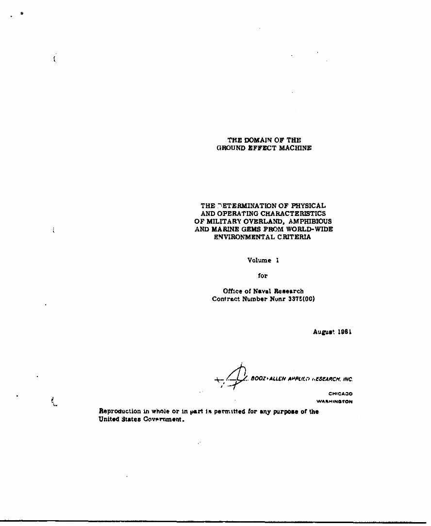
THE DOMAIN OF THEGROUND EFFECT MACHINE
THE -ETERMINATION OF PHYSICALAND OPERATING CHARACTERISTICS
OF MILITARY OVERLAND, AMPHIBIOUSAND MARINE GEMS FROM WORLD-WIDE
ENVIRONMENTAL CRITERIA
Volume I
for
Office of Naval ResearchContract Number Nunr 337'(00)
August 1961
.OOZALLEN APPLI•,I ,,ESEARCH. INC.
"CHICAOO
Reproduction in whole or in ipart ot permitted for any purpose of the
United States Oowvrnment.
TABLE OF CONTENTS
PageNumber
SUMMARY 3
CONCLUSIONS 2
RECOMMENDATIONS 10
INTRODUCTION 13
I. THE WORLD-WIDE ENVIRONMENI AND THE GROUNDEFFECT MACHINE 20
1. Introduction 20
(1) State-of-the-Art Assumptions 20
(2) Introduction to World-W'de Environments 23
2. Climatic and Oceanographic Features 26
(1) Climatic Classification& 26
(2) Climatic Pt" .uros of World Land Areas 39
1. Europe Asia 55
2. Africa 60
3. South Arwica 64
4. North Amerioa 68
5. Australia, Now Zealand aidPacific Island Areas '0Eevr.!0) 7T5
6. Antarctica 79
(3) Cliwatic Features .world Ocean Ar.•.t 83
1. North Atlantic 91
2. North ?.•.ic 93
I

TABLE OF CONTENTS - Continued
PageNumber
3. South Atl intic 97
4. South Pacific 99
5. Indian 100
(4) Summary of Significant ClimaticFeatures 102
3. Continental Environment..w 105
(1) Clasailication of Naturae Features 105
(2) Natural Features of Vo.' Continents 116
1. Eurasia 116
(1) Europe 117
(2) U.S S.R. 124
(3) Asia 130
2. Africa 141
3. S^uth America 147
4. North Amricsa 152
5. Australia, Wee 7%aland andFoolfic Island kreas (Oceania) 160
6. Antarotl. 152
4. Coastal Xnvirorusnts 166
(1) Clasltloation of Natural Yeatures 166
(2) Naturalf atures of Vorld Coastal Areas 176
I. Murope 176
2. Asia 189
3. Afiea 201
4. South America 207
II
TABLE OF C ONTE? TS - Continued
PageNumber
5. Nor.., America 213
6. Australia, New ZealLnd andPacific Island Areas (Oceania) 223
II. CLASSIFICATION OF MILITARY GROUND EFFECTMACHINES 228
1. Introdur tion 228
2. Discussion and Classificatlon of MilitaryGround Effect Machines - Marine 229
(1) Wave Height 229
(2) Sea Ice 231
(3) Wind 234
3. Discussion and Classification of kilitaryOrow-Jn Effect Machines - Overland 2-43
(1) Altitude, Temperature, and Humidity 245
(2) Slope of Surface Terrain 246
(3) Drainage Features 248
(4) Vegetation and &rfacoe Cover 253
(5) Terrain Obstruotions and Discontinultlea 256
4. Discussion and Classification of KiliaGrovun Mteet Machines - Amphibious 270
(1) Coastal Termii Tandfomse en1
(2) Coastal Drainage Peaturas 273
(3) Way' Heights and Surf 975
(4) Sur face .pi•lerin "' Ot1struetlot . 276
(5) Slope ur Beaches and Mear-coaut Terraln 277
(6) Characterastics of Beaches 278
Ill

TABLE OF CONTENTS - Continued
PageNumber
(7) Vegetation and Surface Cover 280
(8) Terrain Obstructicns and Discontinuities 280
III. EFFECTS OF INDUCED AND COMBAT ENVIRONMIETS ONMILITARY GROWm. MrTCT NACHINRS 286
1. Introductioi 286
2. Induced Environments 288
(1) Noise levels 288
(2) Vibrations 292
1. Power Unit Induced 292
2. Lift System Induced 292
3. Shock Induced 294A
4. Acceptable Vibration Data 293
(3) Comonent - Generated Te teratures 294
1. Oas Turbines 294
2. Piston Engines 295
3. Iffeots of Coqonent-0eneratedTeqeratures on Vehicle Operation 296
(4i) Wxhoust Oases 296
(5) Static Electricity Pot*entals 297
(6) Visibility 3AC.
(7) Acceleration and Shock 302
1. AcceleraLion 10.1
2. Shock 30*1
(8) Reingestion ot "jovnwaah Air 306
(9) Salt Vater Ingestion 309
Iv

TABLE OP CONTENT S- Continued
PageNumber
(1O) Sand and Dutt. Ingestion 311
(11) Snow and Ice Accumulation 314
3. Combat Invirornents 317
(1) Noise 317
(2) Dust and Spray 323
(3) Camouflge Techniques 327
(4) Radar RefleetivIty 330
(5) Infrared manation 332
(6) Vulnerability 334
(7) DUMP Protection 337
(8) PFild Repairs 338
(9) r1M Operation in Kine Fields3
(10) Nuclear , xplosions 340
1. Radiation 340
2. Effect of Blast and TmpratureIn a Nuclear Combat Situatlon 341
(11) Loadabllity of GM& in Marine andAW01blous operations 343
4. Sumaar of Induced and Ctpt hvizronments 343
IV. OF ov A ND Q•?Ui•AJXCL UT'" TIM OW'J 3.SUMQON OF A KELITAR? M W M 4 7II
NACDM 355
1. Introduction 355
2. fvelopment of Performance Parweters 355
") Vehicle Oeaweti 356
v
TABLE OF CONTENTS - Continued
PageNumber
(2) Vehicle Lift Syrtem and Aero-dynamic Characcer.'stics 356
(3) Vehicle Power Installation 357
(4) Vehicle Weight Distribution 357
3. Vehicle Evaluation 358
(i) Oveviand Vehicles 364
(2) Amphibious Vehicles 364
(3) Marine Vehicles 364
4. Operaticnal Features of Military GroundEffect Machiaeu 370
(1) Visibility 370
(2) Maneuverability 371
(3) Navigation 372
(4) Accumulation of Surface Naterial,Snow and Ice 373
5. Special Features and Equipment 374
6. Summary of Operational Features 376
BIBLIOGOAPA 379
APt DICIS VOWE XI - (CO.h. ,)'r.I L)
vi
INDEX OF FIGURES
n."LlowingPage
Number
1. Climatic Zones of Europe 27
2. Climatic Zones of Asia 27
3. ClIzatic U-ner of Africa 27
4. Climatic Zones of South America 27
5.. Cllmatic Zones of North Amewica. 27
6. Climatic Zones of Oceania .7
7. Climatic Zones o1 Antarctica 27
8. Mean Extent of Shelf Ice, Super-structure Icing, Pre.eeing A-rTemperatures, and Snow -- Winter 85
9. Frequency of Wind Speed Cate& .es --Winter 85
10. Frequency of Occurrence of High Seas --
Winter
11. Frequency of Wind Speed Categories --
Summer 85
12. Frequency of Occurrence of High Seae ----zmer 85
13. Suitabtlity for Overland OEMOperations 112
14. Su"ta tlity for Amphibious GEMOperations 171
Vertical Projection of Silicon ,._Water Particles 32;
16. Horizontal Projection JC 3iliconParticles 327
vii
INDEX OF F GUP E S -Continued
FollowingPage
Number
17. Horizontal Projection of Water
Particles 327
18. Weight Distribution of GEM Classes 358
19. Power Requirements of GE? Classes 358
20. Speed Capabilities of GEM Classes 358
21. Payload-Range Charauteristics of GEMClasses 358
22. Effectiveness, Vulnerability andUtility of Overland GEM Classes 364
23. Effecti-eness, Vulnerability andUtility of Amphibious GEM Clalses 364
24. Effectiveness, lulnerability andUtility of Marine GEM Cls3ses 367
25. Marine GEM Utility 367
viii
INDEX OY TABLES
FollowingPage
Number
1. Climatic Characteristics Related toCoastal Landscapes (after Bailey) 27
2. Critchfield's Climatic Classifi-cations 36
3. Distribution of Coastal Climateswithin Polltical'Boundaries 40
4. Distribution of Critchfield's Clihiati3Zones within Political Boundaries 40
5. Summary of Continental Environments 112
6. Summary of Coastal Environments 176
7. Environmental --.ctors in MarineOperations 229
8. Summary of Wave ifeight Data 2319. Seasonal Operating Feasibility -
Ocean Areas 231
10. Summary of Wind D•i,. 235
11. Marine GEM Classification 237
12. Environmental Factors in OverlandOperations 243
13. Overland GEM Classif1oation 267
14. Environmental Factove in AmphibiousOperations 27..
15. Amphibious GEM Classification 283
16. Induced Environment 288
ix
INDEX OF TA.3LES Co-ntinued
FollowingPage
Number
17. Combat Environment 288
18. Induced Environments, Summary Data 343
19. Combat Environments, Summary Data 343
20. Summary of Military GEM Characteristics 376
21. Special Features and Equipment 376
x
3UMMARf
The total environmental aspects of Ground Effect
Machines (GEMs) operated on a world-wide basis are examined
in detail. The "natural" environment describing terrain,
beaches, sea states and climate; the "induced" environment
covering noise, spray and vibration; and the "combat"
environment including vulnerability, infrared emanation and
radar reflectivity are investigated sufficiently to de-
termine their influence on the basic design requirements
and operational parameters of the over-all OEM system.
Within the framewo-.k of the tatural environmental
elements a classification of GEMs ib developed. This
classification covers marine, overland, and amphibious GEM
operations. In each of these categories vehicle sizes and
operating height3 and areas of utilization are included.
For all classes of GEMs the speci.fu effects of the
induced and combat environments are discussed. Finally,
typical performance capabilities and equipment requirements
based on the total operating environment are devwloped for
each class of GEMs.
-l -

CONCLUSIONS
1. The elements of natural environment most significant
for marine GEM operatione are wave heights, sea ice, and
wind speeds.
(a) GEM operations will generally be most favor-
able in latitudes below 300. They will probably
be operable from 90 to 100 per cent of the time
in this region.
(b) GEM operations in oceanic areas in latitudes
aoove 400 will be severely limited, and in some
parts rendered impossible b-cause of the preva-
lence of gale-force winds and high seas. In ad-
dition, superstructure icing or hummocked sea
ice will have a significant influence on operations
in some areas during the winter.
2. The elements of natural environment most signifi-
cant for overland GEM operations are slopes of the
surface terrain, widths and bank conditiois of stream
valleys, and heighto of solid terrain obate.aes.
(a) GEMs will have a significant advantage over
other ground vehicles becauo. 'h *eir capability
to utilize stream vall~,s and inland waterwayb
-2-

as access routes. Venicle widths, however, will be
limited to 30 ft.•t fcr operation ,1n 75 per cent of
the world's streams.
(b) A continuous opdrating height of two feet will
be needed for general overland operations, and a
minimum Jump capability of four feet will be needed
to cross walls, dikes, and rail embankments,
(c) Capability to surmount a five-foot vertical
bank will be needed for access to and from stream
valleys.
(d) A slope capability of 30 per .'tnt at low speed,
and 15 per cent at normal speed, will be needed for
most overland operations.
(e) Operating speeds will be limited to about 30 to
40 knots on rivers because of control power require-
ments to traverse bends.
(M) Cross-country speeds will be limited by ob-
stacles. Purther study is required iL. ..hit artk.
(g) About 50 per cent of the over-all land area of
the world is available for overland operations.
The best area usability for a biven 5sie vehiel
based on the present state-of-rait is about 35
per cent of the world la,.4 area.
-3-
'. Tk. elements of nati:rai environment most significant
""'or amphibious GEM upcýations are surf conditions,
characteristics of beaches and coastal stream valleys,
and coastal terrein ovjtrnctions.
(a) Operating heights will be determined privarily
by the requirement to traverse the surf zone.
Work donc to date indicates that an cperating height
of four feet will allow operation on a year-round
basis on 70 per cent of the world's coasts (storm
conditions not included). Full-scale experimental
data are needed Lo justify final design parameters.
(b) Operating heights for clearance of land ob-
staules will be two feet for normal operations
with a four-foot jump capability.
(c) Slopes of beaches are not generally over 15
per cent, bMit beach widths limit lateral dimensions
OL the vehicle to about 50 feet for unloading above
the high water line on the majority of the world's
bosehes.
(d) Coastal- stream valleys provide an important
inland access route for 091 . Vehicleu width& will
be 11 ted to 40 feet for operation on 70 per -:it
of0 noastal strem,
.4-

(e) About 70 per cent of the world's coastline,
k excluding Antarctica, Gree.nland, and che North
American Arctic Islands above 770 North Latitude,
is accessible to OE( amp).bious operations. About
30 per cent of •hc world's near-coastal land areas
are accessible to GOE operations inland via stream
valleys or over the beach. About 30 per cent of
the world's coasts are not suitable for GEM op-
erations.
4. The major limitations imposed on GIR operations by
the induced environments and combat environments are as
follows:
(a) Noise Levels
(1) The noise level anticipated in and around
the ODI is such that conversation will require
raised voices and probably shouting, For con-
tinuous and etfeotive operation, bar protec-
tion and comanications equipment simalar t..
4Aat used in aircraft operations will be
uhliy coesrubl*.
(2) The noise level at appreciable distanoes
from a Om will depeM4 largely on the design
of the vehicla intake and z~use i • •stean.
mmm~mm• m •ram.mmmm. 5

If the low frequency portion of the noise
spectrum can be etoenuated at the vehicle,
detection will be difficult beyond 1000 yards,
If this is not fe sible, detection will probably
start at about 2500 yards.
(b) Visibility
(1) The visib..lity from a OEM will be severely
limited when the vehicle in hovering or operating
at low speed over loose surfaces, such as sand,
gravel, dry soil, snow, and water. This situa-
tion improves rapidly as forward sed is in-
creased, although visibility rearwards my still
be a probl-em.
(2) The cloud of particles surrowuing a GIN
at hover or low speed, or tailing a G0 at high
speed, may serve as a very distinct signature of
its aresence.
(a) Relsto•onf the laoenta 2MtMB Air, and
The mosentum curtun air diboeIM'd under the
velicle periphery reeixdulatos to sam degree
in the hover condition and at low speeds.
this recircul.ting air strama .,rlee with It
-6-
particles of surface materials, that pass
through the lif"t aystem and '.he power unit,
with the following consequences:
(1) Erosion of the engine and lift system
rotors and stators may occur. Erosion is
worst for sand-type materials. Power losses
of approximately 15 per cent have beeft ex-
perienced on helicopters and can be antici-
pated on GEM.
(2) Corrosion of the engines and lift syato=
and the vehicle surface will occur In all
over-water operations. fhis Is most serious
in a salt-waLer envirormnt. Salt encrusta-
tion of rotor and stator blidlg of the eninte
and lift systems will cause loss in power of
up to 20 per cent and increase ,A fuel corsmp-
tion of approximately 1.5 per cent.
(3) Snow &nd lee will accumalate on the vhIlele
year-round in Arctic and Antarctic opeations
and in tb* winter wnnte In the northern two-
thirds of Asia, frompe, and Mortr Aricao
Dhis aoimunalation causee a loss of vehiale
perfozunoe, Wbln sML " 'tig s tair a-
tufas am encountered. the mist enshe'ouIna
-7-
the machine w1ll freeze on contact, forming a
zieavy load of glaze ice.
(4) The recirculation and general distur-
bance of surface material will make servicing•
of the vehicle difficult while it is in opera-
tion. and will require protective clothing and
equipment for ground personnel under some
operational conditions.
5. On the basis of performance capability and utility,
as determined by the wprld-wide natural environmental
factors, and vulnerability in a military combat situation,
a rough assessment of the relative merit of each machine
classified for overland, amphibious Qnd marine operations
indicates the following results:
(a) The GIE having the greatest potential for over-
land operations In a vehicle with a planform of 30
feet by 60 feet, an operating height of three feet,
and a Jump capability of six feet.
(b) Thu.. OIM halirs, the greatest potential far
mphibioU3 operations is a vehicle with a plan-
form of 50 feet by 100 feet, a normal operatinEr
height of three feet, a mauimam operating height
of five feet, and a jump capsaoa.,. W vim feet.
(u) The GEM having the greatest potential for
marina operations in the open ocean is a vehiu!e
with a planform of 50 feet by 100 feet, a normal
operating height of 2 3 feet and a maximw operating
height of four feet.
(d) The OGE having the greatest potential for
marine operations in inland waterways and coastal
waters is a vehicle having a planform of 30 feet
by 60 feet, a normal cperat~ng heJght of 1,5 feet,
and a maxium operating height of 2.5 feet.
6. Special equipment will be required for each environ-
ment in order that missions may be accoWl.shed efficiently,
and maintenance be reduced to a minima. Such equipent
must be determined for the particular environmental condi-
tions of the desired missions for a specific vehicle, and
will demand additional power requirements or a reductior.
in over-all performance.
-9-
RECWYLENDATIONS
1. The environmental framework for Ground Effect
Machines developed in this study should be applied to
all future studies and programs on military OR hard-
ware,
2. Full scale tests should be conducted on OEM op-
erations through the surf zone. .Specific data are
needei on the required relation between surf condi-
tions anrd vehicle size and operating height.
3. Experimental data should be obtained on the maneu-
verability requireme,'ts for OMs In overland cross-
country operations. In addition, studies of OEM maneu-
verability system improvements should be initiated.
4. Further itudy is recoinn4ed In the following areas
assoiiated with th* Induced and combat environments of
OEMS$:
(a) ftlte
DatA are required on tho frequency ipectrum
of 0F4 nruise and the effect of different operating
conditions a&M anvironments on tle rnlse level.
(b) , ,ow eld
eftrher study of the am flou a1ted is re-
quired, partioularly .. the relationship between
-10-
zte aroblezz of -eingr.stion, v'isibillty, and 0i1°a-
t-ure, and, GM misalon :naracter•ist'es. N• addition,
dvelopment of advancr:• lft- systezm ard other de-
va '.es for reducing t-, sffects of the OM4 flow Zield
should be 3tudled.
(c) Dynamic Loada
Accurate and reliable analytical daita should
be developed for the dynamic stresesing of GEKI,
partic.ularly in over-water operations.
(d)
Specific enviroranental data on GEK icing prob-
lems should be obtained, and development of sult-
able de-icing equipment should be initiated.
(e) Corrosion and Erosion
Methods and materials for reducing corrosion
and erosion in GEM power plants and lift systems
should be developed.
(f) N ation Eguipment
Navigation equipment parLit Wxrly sulted to
GEMs sho' ,I be developed. This includes a col-
lision warning or obstacle avoidancne radar, a-d
sim.le courae guidance presentation.
-11-
V9) Kadax' Crc ss-Section
Basic design cr.t-.'rla should be developed
for m4nimizing the radar cross-section of
military GEMs, partlc,' arly for over-water op-
eration
5. Optimization of vehicle performance and design
should be carzxted out within the environmental frame-
work developed for eaih category of operations - over-
land. amphibious, and marine.
"-12-

INTRODUTTION
The silg'iicant developwints of the past few years
relative to the ground effect phenomenon have established
the Ground Effect Machine (GEM) as a practical tzasporta-
tion vehicle when certair operational limitations are
acceptea. It is the purpose of this report to outline the
various operational limitations for military GEMs and to
present features considered essential in military
applilcations.
Sirace military h wlcldd and their components are re-
quired to operate throughout a wide range of environments,
their design must prevent functional, operationaj.:'atd
maintenance difficulties caused by extremes of these
environments. In world-wide operation of GEMs these
vehicles are subjected to the following three types of
environment:
(1) Natural envirorn.ment, such as climate, terrain,
vegetation, sea states, beach slopes and con-
dition, sea approaches to coasts, and natural
and man-made obstacles.
(2) Induced environment, such ar component-
generated high temperatures, static electriiity,
vibration, shook, acceleration, explosive vapors,
sound, dust, spray, and exhaust gases.

(3) Combat environment, including the elements of
detection, vulnerability, protection against
damage, and field repairs.
Determination of the influence of environmental con-
ditions on the engineering design and military utilization
of GE-s is a necessary first step in the determination of
structural and other essential design criteria. An
evaluation of environment is also essential to a realistic
appraisal of the potential of the GEM for military operations.
The natural environment of the OEM includas all the
areas and conditions under which this type of vehicle is
required to be operated. This will encompass not only the
world-wide variety of terrains, but also the full scale of
climate variations, including the specific influences of
temperature, humidity, wiid, and icing conditions.
Average sea-state conditions vary with the seasons and
location. For cbvious reasons, designs for military
applications must consider the worse conditions anticipated.
Depending on the current and ocean arep Involved, sea
conditions usually affect breakers and beaching operations
in direct proportion, and indicate parameterh which must
be considered in the design of marine and amphibious
vehicles.

Overland operating environment includes the nature
"of the terrain and its surface material -- ranging frnu.
snow, sand, and marsh to brush areas, ditches and ravines,
and built-up areas. An iWpe..;ant consideration for military
operations is the terrain slope which has a direct influence
on the power requirements. For some cases, consideration
mast be given to means of quickly clearing wooded areas
and other terrains which offer obstructions to GEM.
operations.
ClimatLc influiences have a strong effect on GEM
vehicles. The effects of temperature and humidity on the
interial flow system and power plant must be known. In the
presence of winds, provision must be made for adequate
control of power to maintain the desired track.
The induced environment of the GEM is the effect
created by the operation of the vehicle, on itself and on
the surrounding area, including personnel within or close
to the vehicle. Two of the more prominent problem areas
under this heading are the total effects of the downwash
disturbance field and noise levels and atzen'atiOn..
FIPrther analysis of the downwash disGuroarace problem
is vital to the development of an oporational military
GEM. This problem assumes critir-I nroportions for ..w-
spee.i ana hovering operation, where the vehicleC? are
enveloped in dust or spray. One manifestation of the
-15-
downwasb disturbance is potential re-ingestion into the
lift/propulsion system, reducing the efficlency of the
system and leading to component damage. At low speeds the
downwash disturbance will siraificantly reduce the visibility
of the driver. Und0•r these circumstances, the OEM must be
operated with considerable caution, or by reference to
instruments if the dust or spray is not controlled.
The noise generated by the military GEM may have
adverse effects on personnel inside the vehicle and in
proximity to the vehicle during hover and cruise flight.
Noise may also contribute to ope.-ator fatigue, early
structural fatigue and malfunction of electronic equipment.
The noise spectixm of the GEM vehicle must be ascert:Ained
and compared with military specifications for acceptable
noise levels in order to determine areas where suppression
is requ'ied, or where operating limitations must be
imposed.
The combat environment envisioned for the GEM is
similar to that for most other combat vehicles. Two im-
portant problems of this environment are avoilance of
detection and protection against enomy fire. Tho sup-
pression of noise and infrared emanation assumes a great
importance in the combat environment. Radar detectic,-
is n-'t a ,rtjor problem since the vehicm.- operated
close to the surface.
-16-
The vulnerability of the GEN to damage by enemy fire
must also be analyzed, part.i.-arly the efrect of damage
to the lift system; in this case, a requirement for armor
plating or use of self sealin,, compo..nents in certain areas
of the vehicle might be a consideration.
Associated with vhe combat environment is the require-
ment for developm~ent of maintenance concepts for thib
vehicle. Particularly, consideration must oe given to
field repair of damage to the lift system. A simplified
"patch kit" may be found suitable for this kind of work.
Posýihly, provision can be made for closing a damaged
section and maintaining operation with an incompieze Jet
"curtain." There is also an obvious problem in lifting
the weigntt ol the vehicle to work on the underside
component s.
The purpose of this report, therefore, is to present
tne total envUronmental picture surrounding the Oround
Effect Machine operated on a world-wide basis and to
nlassify a range of vehicles with operational capabilities
in *hese environmAnts.
The report is assembled in four chaptira, vith three
detailed appendices of data from which I.he chapters were
constructed.
"47T"

Chapter 1 - The-World-wide Environment and the Ground
Erfect, Maehlne, presents a eummary and cj.scusston of the
natural environments of operational Ground Effect Machines
on a world-wide basis. CliMA Pc and physical features of
maritime, continental, and coastal environments are
included.
Chapter II - Classification of Military Ground Effect
Machines, outlines families of vehicles for marine, overland,
and amphibious operations, corresponding to the three realms
of ratural environments discussed in Chapter I. Operational
utilization potentials are tabulated for each class of
vehicles.
Cnapher III- Effects of the Induced and Combat
Environments on Military Ground Effect Machines, describes
the elements of these environments and their influence on
GEN design and equipment requirements.
Chapter IV - Effects of Size and Operational Utilization
on the Selection of a MllitarXVround Effect Machine,
pXeabnt.A % 4.abulat!"a of baslo performance parameters
developed for the vehicles cQassifled in Chapter II, and
a summary of the military operations approprl~te t, each
class. Equipment requirements based on the total operating
environment are included.
-18-.
The Bibliography includes the source materials u3ed
in the preparation of this :eort.i.
The Appendices to this report (bound separately as
Volume lI) include tabulatio.• o.C the background data for
the world-wide naturaL environments. Appendix A includes
Climatic and Oceanographic Data, Appendix B includes Natural
Features of Continental Environnments, and Appendix C in-
cludes Natural Features of Coastal Environaments. Notes on
the sources and use of the tabular materials are included
in the appen4dies.
Because much of the background data have been
assembled from classified sources, Appendix B and Appendix
C are classified CONFIDENTIAL.
-19-
I. THE WO.WD-WILA ENVIRONMENT AND THE
GOT&AD EFFECT MACHINE
1. INTRODUCTION
This chepte,- covers the elements of natural environment
which affect the design and performance parameters of Ground
Effect Machines. Since very little data have previously
been developed for the effects of natural environment on the
OEM, the material of this chapter is based on a review of fun-
damental characteristics of the world-wide natural environ-
ment with consideration primarily of the features which would
have presumed effect on GEM operations.
(1) State-of-the-Art Assumptions
In, order to provide a realistic framework for the
study, generalized limits must be set on the available
and projected state-of-the-art for Ground Effect Machines.
These should not be considered as arbitrarily specific
characteristics of vehicles but rather as general frame
of reference. The Ground Effect Machuijs diacussed in
this report include annular jet %nd plenum type vehicles
likely to be available based ,.. '"^ otate-of-the-art
now existing and includinr. anticipated developments(29, 32, 37-, .ý9)
through 1970. The following characteris-
tics have been assured:
-20-

i. Vehicles may be either full annular Jet or
plenum chambar types or may utilize sidewalls
or skegs.
2. The study is limited to vehicles capa'le of
carrying men and material in off-road opera-
tion over lax.d •nd water and in amphibious
operations. Special-use devices such as pal-
let handling equipment and loaders are not
included.
3. The propulsion and lift air requirements will
be met through fans, compressors, or ejectors,
powered by automotive, aircraft, and marine
type engines.
4. Vehicle sizes, operating heights, and power
requirements, discuessd in Chapters 11 anO
IV, refloat practical applications of the 034
state-of-the art, including anticipated gradual
advances.
5 NMore advanced concepts (anannel 034, OUTOL,
rill ram wing, etc.) are not included.
Areas where 0MM operations based on the .bove state-
of-the-art would be very ditt3-"t are expreased i&
"un-OGs-able". They Inqludem
-21-
.. Areas with steady slopes over 30 per cent.
2. Dense forests of mature timber (8 to 12
inches in diameter and greater) -- brush
wood and young forests may be cleared.
3. Aikeas of large suxface discontinuities;
e.g., networks of ditches over 20 feet
wide and 10 feet deep, congested built-
up area (city centers), canyons in arid
countries over 20 feet deep with wall slopes
greater than 100 per cent (450), waterfalls
over 10 feet in height.
In all other areas, soms kind of OEM is presumed
to havr operational capabtlity. Performance and size
requirements are developed In Chapters II and IV. In
some cases even within the limits of technical suita-
bility, these requirements will be such an to make the
OGI quite unattraotive ,or military operations.
The data on natural envirotent presented herein
are developed for the world on an &rea baxls and are
not intended to Indicate reuiremer.tt f2r um_ ape.0fi
oEerateon n Sven In "un-OGI-uble" aroas, there will be
some f.\*9ible, and perhaps very advantageous, oper-
tions, e.g., a river valley in a . ",*tnous area.
-22-

Conversely, in an area which is mostly sUtable for GEN
operations there may be "'un-OEM-able" features or fea-
tures requiring special design and perforanmnce
characterist cs.
(2) Introduction to World-Wide Environments
Since the GEM has apparent capabilities as an over-
water and amph 4.bious vehicle, and since the diversity of
characteristics between land and marine operations is
significant, world-wide environments have been diviled
inro three ca•egories:
1. Maritime environments for marine operations.
2. Coastal environmants for eu•phiblous operations.
3. Continental environments for overland oper'a-
tions, 1ncluding use of inland waterways.
The world area has been studied in terms of these
threi catcgo:loo or natural environment, and data pre-
sented herein represent the generalized characteristics
of these environments. Inasmuch as the Ortind Effect
Machine has very different capabilities r:ýom other mili-
tary vehicles, It has been necessary to develop the en-
vironmental material on a f-,ndamentally new net of
characte-istics. In each case, the .- evallable
-23-
reference material was reviewed and sIgnificant environ-
mental data derived ann. sum..ar.zed. (References are
listed in the Bibliography.)
In the presentation of environmental data, the fol-
lowing breakdown of the world-wide surface has been
used:
1. Maritime environmento are discussed in terms
of the major ocean areas including adjoining
seas.
2. Coastal environments are discussed in terms of
coasts of continents facing on the various
oceans.
3. Cotitinental environments are discussed in
terms or continental land masses, including
Antarclica. In the discussion of physical
featur3, %,no Surasian land mass has been
divided ror convenience into U.S.S.R.,
Burope excluding U.S.S.R., and Asia exclud-
ing U.S.S.R, following the arrargerent now
being adopted by goographers.
The enviromental material La presented, in this
chapter, in tabulations of nat -,I onvironmental *a-
tires w)ith Illustrative text materi;l. Compaitt
S.. . . ... 4 -
detailed environmental data developed during the study
ai.e included in the App.,olices (Voluine II). Although
comprehensive, these data are not to be considered as
planning materials for OrA operation in a specific
area, but only as illustrative of the general features
in that area.
-25-

2. CLIMATIC AND OCEANOGRAPHIC FEATURES
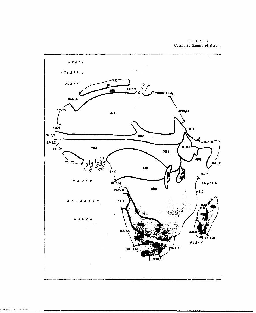
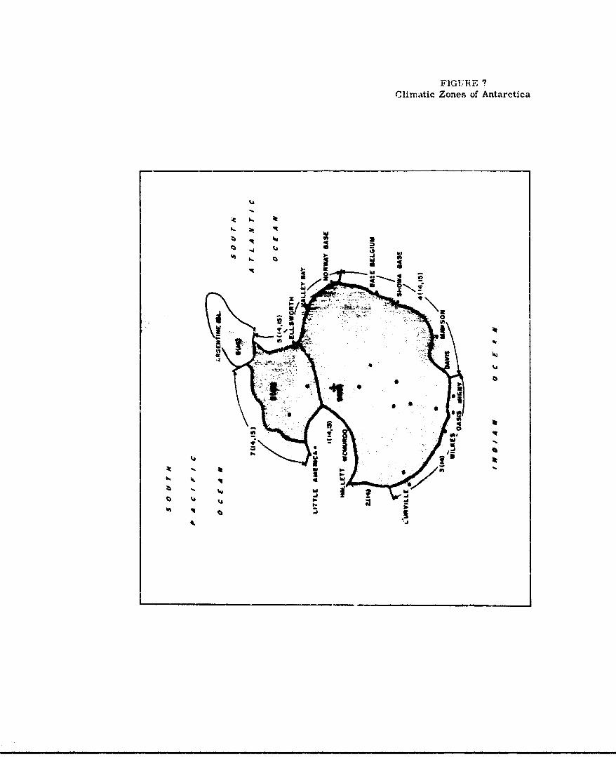
(1) Climatic Classifications
The natural environment that will influence the
design and operation of the Ground Effect Machine may
be divided into three broad categories, maritime,
coastal (or tr-"'ional) and continental. Contained
within each of Dnese categories is a wide variety of
climates and eithar physical or oceanographic
characteristics. This variety makes necessar- a divi-
sion of each category into zones having relatively homo-
geneous characteristics.
The roastal and continental environments may be
diviivU Into regions with homogeneous climatic char-
acteristics, with uniform physical features, or ac-
cording to political boundaries. Political boundaries
usually do not coincide with natural boundaries, hence
tho" 4,'u used only when knowledge of Mistribution of
characteristics within each country becomes important.
There are few areas on the earth where a sharp
boundary between climatic zones can be delineated
Rather. there are transition zones W In .... in a more
-26-

detailed subdiviaion, mignt themselves be classified
as zones. Since too nm~ch detail maskz the essential
broad features, the zone breakdown used in Lhis study
has been chosen so that aoundaries are located along
lines of maximum rate of transition and the number of
zones is held to a reasonable number.
The coastal zone classifications specified by(36)
Bailey meet the requirements of this btudy. Bailey
used vegetation types an the primary basis for determin-
Ing his zone classifications and boundaries. He con-
firmed these by developing statistics on temperature
and precipitation magnitudes and distributions with
the seasons for each classification. These classifi-.
cations and characteristics are listed in Table 1.
Zone boundaries for both coastal and continental zones
are shown in Figures 1 to 7.
(4)The Critchfteid climatic classifiuation for
continental areas appears to be most suitable for
purposes of this study. It is in good agreement with,
and Is largely based upon the classifications developed(t8)by Koeppen , and others. Oeography, lý,!!atures,
and precipitation with their seasonal variation and re-
lated vegetation cover proeided tte besis for
frithfleld's determination of zone uv...darles. His
""27-

UEA IIU
CLg
-000 . ?
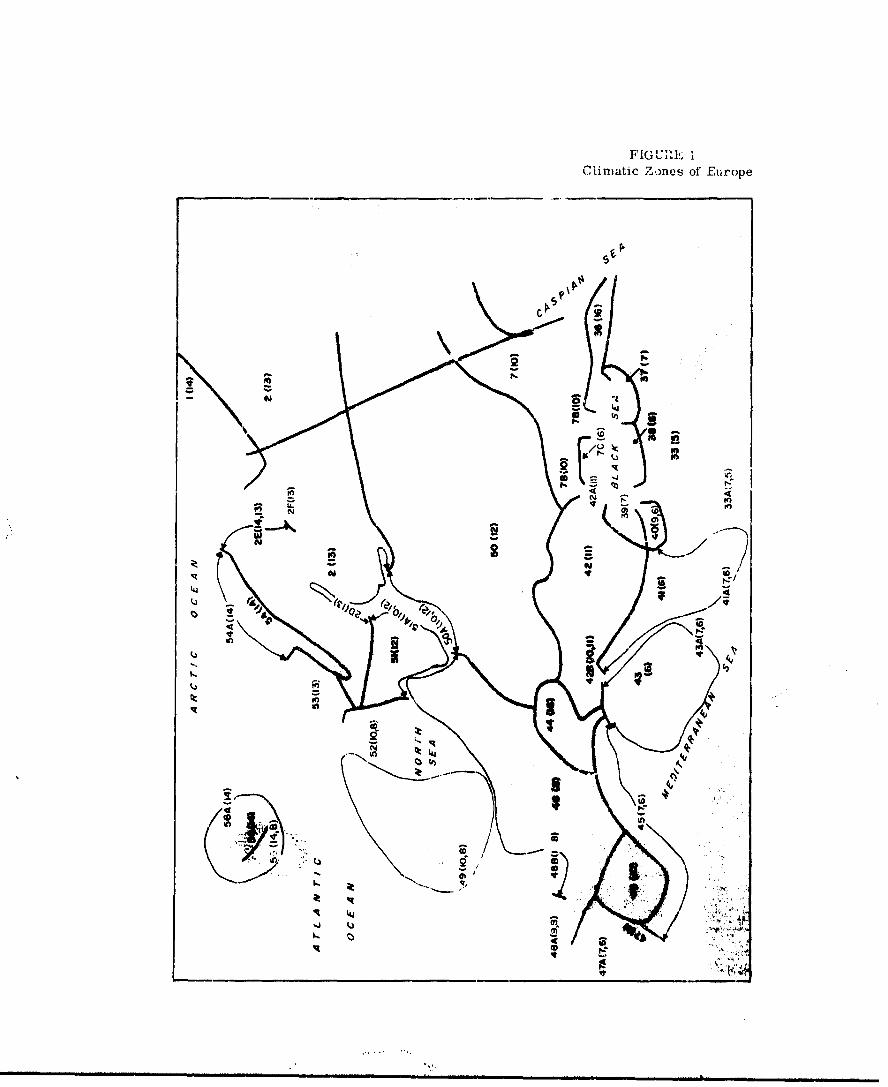
F1GUM71', IClimatic Zones of Eu~rope
aIlk
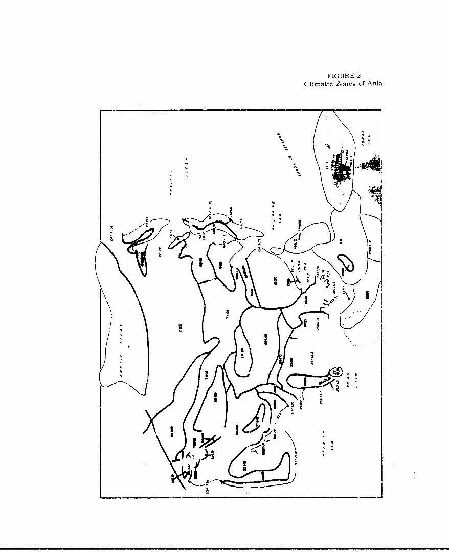
FIGUREI 2Climatic Zones of Asia
-A W
IN I
A! A m n ql
C C
47." J
FI'l UP 1 F 3Climatic Zones of Afric;•
NORTH
A TLANTIC
IA(7.6)OC EAN g
3() 28(7b) "~
2A(12,52
4A(5.4) 40) 4E51
L 44(4)
5A(3,5)
?A(2,3)/ ,S)
76(1,3) 7(M)
S 12 ) 9(4,5)
8 AM
$ 0 U T N IC (2,3 INIA N
12A(3,5) 110(2.3)
A r A N T I C 13A(4) IS.
/'~3
0 C E A N ... ..
OCCEAN
IS(3
1291(215) 14A(6,7)

FIGURE 4Climatic Zones of South America
WEST
INDIES N o R T H
CARIBBEAN SEA
1(3,5) 2A 2 ) A T" .L A N r I C
241.)1 38(1,2)
22(11,3)'
44
\ 4 • 5C(O,3)
19 '4)
S~5D(2,312302$ 0 to, r H 18 (5,4)
• 5E(2,3)
POACEA A F~ ANC
17(12,4) s $O u A H
16 T, •9A (6,7)
0. C N1 A r 4 A N r I cC A 1 5(9,B)M
7 1OA01,IO) 0 C F A N
14(8) IIA(12,9)
, •:2A 111,10)
1304,S)J

FIGURE 5Cdimatic Zones of North America
i~~ ~~ (14F4,)' ••"(3
G(3 HUDSONt2
/ •1803,14)
4 13"ITALY3) !((lll) . R(13)l
A
D(14.

FIG(JRh; 6('lim-atic Zones of Oceania
-JJiO0 IN
W
rwo
FIGURiE 7Climatic Zones of Antarctica
:t
-a It
listing of climatic class5ifJatiocis is giver in Table 2
and his boundaries are inaicated in rigures I to 7. It
will be noted in these figures and in Tables A-1 to A-6
in Appendix A that the agrer..ment between the Balley and
Critchfield classifications and boundaries in the
vicinity of the coasts is remarkably good.
The general climatic characteristiVs specified by
both Bailey and Critchfield, and the stattstics given
by Bailey in Tables I and 2 are mean values determined
on a world-wide basis. However, the parameter values for
individual zones may or may not correupond well with
these world-wide averages. For this reason, observed
rather than world-wide average values for each zone are
listed with the other pertinent oarameters in the tables
In Appendix A. A discussion of the details of acquisi-
tion of the data Is also given in Appendix A.
Of the many attempts to divide the uceans into
climatic zones, none has been successful. Although areas
tw(• to f~vo degrecr on a side are frequently used as
the basis for analysis of climatic data, such arbitrary
designation of boundaries is meatingless In 4it c.i1mattC
zone sense unless the zones are so emall as to make their
numbers unmanageable. Consequent',, it has been fow.ý
-36-

Table 2Crltchfield's Clime4tc Classifications
Climates dominated by equatorial and tropical air masses
1. Rainy tropics2. Monsoon tropics3. Wet-and-dry tropics4. Tropical arid tAimate5. Tropical semi-arid climate
II. Climptes dominated by tropical and polar air masses
C. Dry summer subtropics7. Humid subtropics8. Marine climate9. Mid-latitude arid climate
10. Mid-latitude semi-arid ,-timate11. Humid continental warm summer climate12. Humid contineaital cool summer climate
III. Climates domanated by polar and arctic-type air masses
13. Taiga14. Tundra15. Polar cihmate
IV. Climatea having alfitude as the dominant co.trul
36, Highland climates
Reference 4. p. 174.
most practical to consider each ocear. as a whole and
examine the distributil.u of climatic features over the
ocean.
The only known comprehensive presentation of cli-
mate over the oceans to that contained in the Marine(15-19)
ClMa.ti' Atlee or the World and related docu-
ments preparel by the U. S. Favy Hydrographic Office(V4 22)
and U. S. Weather Bureau. Because these docu-
ments are available to readers of this report, and be-
•ause of the nature and volume of this material, no
attempt is made to reproduce it here. The essentlel
features for a winter month and a summer month are
summarized in the subseczion "Climatic Featu,•s of
World Ocean Areas."
The ultimate Pources of all climatic data used
in this study are the observations of weather made at
thousands or stations and transmitted over regional
and world-wide communications networks. These obser-
vations have been processed into climatological sam-
martes and tables, either by the weather services of
the IndiviJusl ocuntries or by our own seaihr agencies.
The characteristic values tabulated i;n Appendix A are
based mostly on tabulations of n.lmatic data pre. 2l;d
.V Lt. Climatological Section of e ._": Weather
Service, U. 3. Air Force, nj the Naval Weather Service
m m m mm m m• mm* mw e mie im • m • m~a m m ~ m m -in 8-m
and 'Erdrographic Office and by the U. S. Weather Bureau.
The process by which the characteristic values within
each zone were outained is also explained in Appendix A.
(2) Climatic Features Of World Land Arean
(4, page 3)
Critchfield defines climate as "the
aggregate of atmospheric conditions over a long period of
time." Climate is a function of both everage conditions
and extremes. It is a function of the range and temporal
distribution o! temperature, rainfall, humidity, wind,
cloudiness, and many other factors. Climate classifica-
tion must, the-efore, be based on ell of thete factors;
however, temperature, precipitation, and wind speed are
considered to be the most important.
In his efforts to devise a climatic indicator, man
has been unable to improve upon the vetetation cover.
Vegetation in a zone truly reflects the totality of the
climatic influences and is therefore the moat useful
indicator of climatic type. This fact has been utilized
in the developmcnt of all classifiention systems
currentl;y :Ln vogue.
The boundaries and classifications of the climatic
zones used in this study at.* shown on PISureo 1 t..
•' thes figures, arbitrarily nassig ne numbers ai*
-39-

keyed to the numbers that appear in column 1 of Tables
A-1 to A-6 in Appendix A. Me climatic clasifi1cation for
each zone appears in parentheses immediately following the
zone number and in oolumns 2 and 3 of the tables In Appendix
A. Where both the Bailey and Critchfield classifications
apply, and they differ, the first given (in the figures)
is Bailey's and the second is Critchfield's. The clima-
tic characteristics for each classification are given in
Tables 1 and 2 and are discussed In Appendix A.
Table 3 summarizes the distribution of Bailey's cli-
matic classifications by country, continent, and the world.
A similar summarization for the Critchfield classification
is presented in Table 4.
From a stuuy of these tables and figures, a picture
of the etrld-wide distribution of climatic zones emerges.
The most common coastal classification is polar, with
25 per cent of the world's coastlines. EY adding the
sub-polar classification, the total becomes 31 per cent.
The pola, zones extend along the northern rim of North
America, Xurope and Asia, around the Antarctic conti-
nent, and include the tip of South America. Caacter•stic
features are temperatures mostly near or below the freez-
Ing level, persistent snow cover, - .- ice in the adjasent
ocean ureas, and, in the northern hemisphere, the pro.a-
lence of fog during a large portion of the year. A cor-
responding area in Critchrield's classification, that
.u40-
-IS �4 'ISSt J
".4
0
S
5* 000
5* 1-00
II ii.U
I I::, a -. a.4
S. � 'IS
I! A-
"2 - 8-': 888 '� 8 88
I, --- - --. 4
I - I'll! iii.. ill
liii a
i�j
1. 00 00
0
zC CCC fl CC ~ CCO
-> 5~ C Oz~ C C

C4 0 (
go
in
40.
Ifgil flu I
u - * . -- - a'
Ci 0 0in r
go
~ i I
t - I
-
In0 In 4 to
N
!ao
n In
I-n s.-• -ssss
!U In

ta
0
0Cb
0 U• 00
S 41li 94
I Ln * *-I
ID 0In
In0

4n 0 Ono -A 4.L 0 000-~ .- -. 3. --
t o3
99 40 N
V3.
Nw C
I 58 3 3 3 3
4.0
* 1cad
L.c

IL
* ,
C., C ,
RN hg fill A I M
Is
-i• i+ i ii mk 11 I -- 0Nl I i p WT I +
C f
N 4
d Wd 4.4 .4

I- a 1 0 0.
1141
Ill 111: A4 a P fl
16~~ In.
-a..°
eq.o
144 4
ME, Rai Bail 11 l, '21aIIr* IM"a
Itli, ill it 1gu l m mml• ~ •n n~ ~~n.1 ~ n•••• wi.munm~m••k

.4. 0
* 4 .4 1.0f
Z: 2
A'A.4 .lags
it 0 '03
E Fril
4 °
4lo.
olF
dominated by polar or arctic-type air smasses, similarly
covers the largcst single area of the continenst,, Lie.,
about 25 per cent.
The second longest coastline cliL'atic type is rainy
tropical with 20 per cent. Inclusion of the sub-humid
tropical, lIe., monsoon type tropics, raises this figure
to 30 per cent. These tropical coast-lines are found
mainly in southeast Asia, Indonesia, India, the west
coast of equatorial A'rica, and the east t'oast of South
America. Smaller sections are located in Central America
and portions of Mexico and Colombia. The corresponding
Critchfield climatic type covers a somewhat lower propor-
tion of the land area than of the coastline, i.e., 7
per cent. If one includes, as before, the monrioon tropics
and the wet-and-dry tropics, this figure increases to
23 per cent.
The Characteristics of the true rainy tropical area
are dense Junglo up to the water's edge, a profusion of
animal life of all types and sizes, frequent moderate to
heavy rains, relatively low wind speeds, and an oppressively
hot and humid condition. In the monsoro., - '.ropical wet
and dry climatic areas, the Jungle sometimes gives way
to grassland, and the rainy, humie sescons alter. -e with
"ven w:.-=cr and/or drier seasons.
-54-
A third most important segment of the earth's sur-
face is the arid or se-mi-arid group of zones. Approxi-
mately 30 per cent of the land surface and 14 per cent
of the coastline falls .n these classifications. About
one-third of the earth's arid regions are found in
Africa, mostly in the northern half. The remainder oc-
cur in southwestern and central Asia, southwestern North
America, central and western Australia, and in southern
and western South America. Vegetation in these regions
is sparse or non-existent, the soil tends to be sandy
or rocky, and the precipitation is seasonal. These are
the areas in which most of the wor' 4ýs sand and dust
storms occur.
The remainder of the earth's surface, approximately
one-fourth of the coastline and 23 per cent of the sur-
face, is distributed among the various temperate zones,
most of which ere characterized by wet-and-dry seasons
and receive moderate amounts of precipitation. Vegeta-
tion in these zones consists primarily of forest and/or
grasses.
1. Europe - Asia
Thc climate of the Rurablan continent, ½I.ud-
ing the peripheral island h. -.. ranges from the
extreme cold and drynez.3 of the Arctic coast and
-55-
northern Siberla to the extreme heat of the hyper-
arid Arabian Peninsula and the extreme dampness of
the Jungles of Malaya and New Guinea. Mean tempera-
tures increase in t'.e usual manner from north to
south. Mean temperatures also increase slightly
from cast to west, except over southeast China,
because of the warming effect produced over
western Europe by the Gulf Stream and because of
the widespread radiational cooling that occurs over
the great north Asian and northeast European land
mas3. Freezing temperatures and ground snow cover
are common winter pheno.nena north of a line extend-
ing from Shanghai through northern India, Iran, and
Turkey to southern France and thence north-northwest
past northern Great Britain. These phenomena are
relatively infrequent or non-existent to the south
of this zone. The distribution of snow cover is
illustrated in Figure 8, following page 85, which
shows the approximate world-wide locations of
given climatic features during the coldest winter
months of each hemisphcre.
The regions of heaviest precipý.tation are
found, at least part of the year, in the monsoon
belts of India and southp-ýt% Asia, in the viuinity
of the intertropical convergence zone in indonesia
-56-

and New Guinea, and on the southwest edge of the
Pacific high prelruz.e belt in the Philippines.
Little rain Is found in the "rain shadow" of the
mountain ranges sur.i as those in southwest and
central Asia. Precipitation is also slight in
Arabia at the east end of the unique Mediterranean
east-west oriented dry belt. Western Europe,
which is dominated by the subpol'r belt of westerly
wind, has a rainy marine climate. Rainy subtropi-
cal and temperate wet-Rnd-drv climates, characteris-
tic of the western side of oceanic high pressure
cells, are found in eastern China and Joapan.
Relative humidities conform generally to the
descriptive terms of the climatic classifications.
They are very high in the tropical rainy climates,
high in the rainy seasons elsewhere, low in dry
seasons and very low in arid regions, particularly
in portions of the Arabian peninsula.
Thunderstorms occur mostly in the tropical
maritime air masses over India, southeast Asia,
Indonesia. and the Philippines. In cor.e locationb
in these areas, thunderstorms are almost a daily
occurrence during a large portion of the yc x. As
a general rule, they tend-to V.. a short distance
-57-
inland, away from the beaches. The highlands of
New Guinea and Borneo are favored locations for
such stoms.
Data on the occurrence of sand and dust
storms are extremely sparse. The storms are
known to occur almost entirely in arid regions
such as the Arabian Peninsula and the desert
portions of Iran, Afghanistan, northwestern
China, Mongolia, and Manchuria. In these areas
the soil is sandy or lacking In plants or other
binding materials. The most frequent reported
occurrezues are 135 days per year on the east
and south coasts of Saudi Arabia, 183 days per
year at a place in the Sinkiang province of
China, and 110 days per year at a point in the
Oobi Desert of Mongolia. TN sueh place,, ithe
high frequency of sandstorms Is probbably favored
by combinations of terrain and prevailing winda
which must also occur in many other locallties in
the arid region3. Kleewhere in these same regions
frequency of occurrence Is probably much less,
however, soil conditions are fa-or:?.be ror the
creation of local dustatorms by propwabh from
airplanes or downwash fr-,- ODs.
-58-
Very little of a special nature can be said
about wind speed rnd direction over any consider-
able area. Both speed and direction are strongly
influenced by terre..n and surface conditions so that
wide variability within even small regions is not
unconmnon. Wind upeeds tend to be strongest in the
storm belts or ih4 middle and high latitudes, es-
pecially along the coasts in the winter. In the
sunmer they tend to be stronger during certain
hours of the afternoon or early morning in valleys
or canyons or along the drier coasts, especially.
when the gradient is directed parallel to these
features. Speeds are generally low in the lower
latitudes, except In the vicinity of thunderstorms.
Table A-1 of Appendix A Iidleatea specific rcgions
in which stronger winds tend to occur.
The occurrence of fog along the coast is
largely seasonal. It occurs quite commonly along
the Arctic coast fron northern Europe eastward to
diho Pa11i"Lc, along the Pacific coast to Japan and
Korea, and along the tcuth China coast. Those zones
In which fog occurs with the froquw.tity speciried bL.
Bailey In his criteria are indicated ir. Table A-1,
Appendix A. (Bailey's f- criteria include occur-
rence of dense fog (l'miting visiollit.y to i'00
-59-

yards or less) either 20 per cent of the time in
t. a month, or 15 per cent in a three-month period,
or 10 per cent in a year.) No attempt was made
to classify aontinf,,tal zones according to the
occurrence of fog since fog in these areas is
normally limited to interior valleys in the early
morning hours and is usually not of area-wide
significance.
2. A7'rica
Largely because of its position astride the
equator, Africa encompasses the narrowest range of
temperature regimes and the widest range of rain-
fall regimes of any of the continents. The most
atr'King feature of the continent is the arid
Sahara Desert in which daytime temperatures over
1200 F. and relative humidities under 20 per cent
are common.
The average of the mean temperatures over
the entire continent of fr&ca !o undoubtedly
the highest of any of the continents. Mean daily
minimum temperaturos below freezing during the
coldest month occur only along the northcrn rim
and southern tip of the -4"1ent and at a few
places in the Sahara -.,-d in the higher mountains.
-60-

Mean daily maxinmm temperatures during the warmest
month over most of the continent range between 855
F. and 980 F., but are as high as 1170 F. in the
Sahara. In the tripical humid zones, temperatureH
generelly range over the year between 600 F. and
900 F., seldom exceeding 1000 F. or dropping below
500 F.
The northern 1/3 to 2/5 of Africa constitutes
the iargest sing±e ariu region on earmn. It is
the only region fcund for which some climatic sta-
tions report an average annual rainfall of zero.
Many average only a trace and most average less
than one Inch per year. The other 3malle arid
regions, found in southwest Africa at the east end
of tne south Atlantic high-pressure belt and on the
eastern tip of the continent in the rair' shadow of
the Sthiopian mountain range, also receive very
small quantities of rain. In contrast the Congo
Basin, whioh is dominated by the intertropical con-
vergence zone, receives coplc-A;; quantities. As a
rule, the rainfall in Africa is greator in coastal
areas than in the intertor, especially in the more
temperate climates found at tha northern and southern
ends of the continent.
-61
Relative humidities are high in the Congo Basin
and along the cenl;ral west coasG, aznd they are very
low in the Sahara and along the east and the south-
west coasts. They ary seasonally in the usual man-
ner as elsewhere, according to wet or dry season.
Frequency of occurrence of thunderstorms is
very high in the vicinity of the intcrtropical con-
vergence zone, especially in the Congo where they
occu'r as much as 200 days per year. Thunderstorm
activity is also very frequent on Madagascar and on
the southeast coast in the tropical maritime air
flowing around the weat end of the Indian Ocean high
pressure belt. Elsewhere In Africa, thunderstorms
vary in frequenmy from about 25 days per year alcn
'he Mediterranean coast to less than one day per
year along the Red Sea coast. Thunderstorms occur
more frequently a few miles inland than on the
immediate coautllne.
Although the maximum reported frequency of oc-
currence of sand and dust atoms in the Sahara Is
approximately 60 days per year, iL tos ovobable that
they are more prevalent In some areas not covered
by weather observatiens. The sandstorm max* .."
ganerally occurs in the pe.v." "'-m January through
April when wind spepe- above 4S to 25 knots are
4 more prevalent.
-62-

As is the case with moat land areas, only
Sgeneral statement can bs made about wind direc-
tion and speed. Saba and land breezes, scmetimes
quite strong, occu' along most of the coast of
Africa. In addition, there are many local winds,
such as the Sirocco, which are capable of raising
dust and sar.A. On the whole, the strongest winds
are found on the fringe of the temperate or sub-
polar storm belt at the tip of South Africa. An
exception to this is along the Coast of Somalia, on
the eastern tip of Africa, where gale-force winds
and accompanying sandstorms are most Creqi.rntly
reported. Rxcept in the immediate vicinity of
some thunderstorms, wind speeds in the Jungle area
"of central Africa are relatively light.
Pog meeting Bailey's frequency criteria
occurs primarily along the coast of southwest
Africa ou the east end of the south Atlantic sub-
trupical high-pressure belt. Pog also occurs during
night ard early morning hours In many mountain
valleys and some river valleys of south and east
Africa; however, frequency or occurtnce does not
warrant classification of any rones as f'og tones.
-63-

3. South America
Although the balk o0 South America lies within
the troplis, its southern tip extends well into the
prevailing westerlies of the subpolar storm belt.
Thus its climates range from the dominant rairn
tropical and wet-and-dry tropics of the north.to
the polar climate at the southern tip.
The controlling factor in South America's cli-
mates is the Andes Mountain Range that extends dcwn
almost the entire length of the weot side of the
continent. This range restricts the offent of the
Intertropical convergence zone on the west coast
to the region from the equator northward. To the
south the coast is dominated by the east end of
the South Pacific high-pressure belt and the typi-
cal arid climate associated with Its subsiding flow.
The Andes also act as the western barrier to the
flow of the tropical air around the south Atlantic
high-pressure belt. This flow of moist, tropical
air, plus the action of the intervrcpleal corver-
genes zone, produces the dominant !i r J tropical
ollmateo or Brazil and the countries to the north.
Argentina and Chl. -. t0lnd from the euLcroplus,
where they are Influenced by the great hig;i-prertaure
-64-

bets of the two oceans, well into the prevailing
westerlies that rirng the globe north of thA subpolar
low-pressure belt. The climate in Chile thus inges
from arid on the north co rainy marine and very
windy in the south. Because the Andes cru very
high through this belt, a rain shadow is found on
their e•t side. Thus the climate of a large por-
tion of Argentina is arid or semi-arid.
The extreme mean daily maxim temperatures so
comoni in the Sahara in Africa are not found in
South America. Highest temperaturea occur in the
arid subtropical regiont of Argentina where soe
mean daily maxlm'i rf 100$ F. or greater are found.
NaximUm temperatures in the tropical arid regions
of northern Chile and Peru are limited Lao les than
9g) F. by the iow clouds and fog which, along with
the lack of rainfall, characterize the eastern edges
of high-pressure belta c.org ti,. west coasts of
contin'ints. IKat4i&mf tmemeratures in the troploal
belt, east or the Arrles usutlly remain in the
ninetipi because of tht afrecto of pre'pIpItation
and ."ulAioeun,
Xa, tan ýt 'esn iii, Figur •A, he oAtent of
f.rvz n teon~r'atures and snow cover is rol-t-'.v'oy
sml.l on thits Oontinent and t.o confined to the

jouthern-most areas and the higher levels in the
mountains. Mean daily minimum termperatures near
or below 'reezing, as well as individual daily
temperaturer In th. same range, are found only
in the mountains or in the southern quarter of
the continent during the winter months and almost
never in t-he summer months.
The heavy rains of South America occur east
of the Andes in the general equatorial belt where
the intertropical convergence zone and the south-
west and northwest sections of the North Atl~antic
and South AtlantIc high-preasure belts respc,:tively
are the lominatIng influences. Even in this zone
raintall is seaeonax, following as it does the
movement northwarc in the northern hemisphere sum-
oi,: ,-nd southward in the southern hemlophere
sum,••. or the Intertropical convergence zone. A
temperate Mainy belt, In which rainfall In plenti-
to! throughout the year, exists Wlong the southern
portion M Cnhle where It ex~trds Inlo the belt of
writ.srlies known as the "roaring 401S." Precipita-
tion olsewhere on the continent Is ispentially sea-
sonal and relatively liuaht.
Relative hlmiditl2.es get... ""- conform to the
descriptions of HOW...s classflications In that
they are high to very high in the; tropical rainy
belts and in the raliy section of Chile noted above.
They are occasionally high during rainy seasons
elsewhere and are rquite low in the arid regions
the yeafr around.
Thunderstorms have been reported on as many as
190 days p~r year in those equatorial regions domi-
nated by the intertropical convergence zone. Most
thunderstoom activity occurs in or near this zone
and in the tropical air masses flowing into the
Andes Mountains or into higher latitudas. Thunder
storm frequency seldom exceeds 25 to 30 days Per
ycar in tht higher latitudes and is essentl!Q
zero in the arid climates.
There are no quantitative data available on the
oncurrence of sand and dust storms in South Amerin,,.
There is some evidence that tiey occUr occasionally
In the arid regions of Argmntina and along the coast
of northern •hile and southern Peru. Such storms
appear to be cf minor consequenci on the :ontinent
of South America.
Wind Apped and direction are inf.-uinced vory
strongly be terrain on t '* continent as thej are
on others, and a wide 7arldibility exis's o'uL.
relatively small regions. Directions ore generally
easterly 1r the tropics on. the At'antio side of the
-67-

Andes and westerly in the southern half of the
Pacific side. Wind apeeds, as a general rule,
are quite light and calms quite frequent in the
tropical Jungle arias and even along the coast
of most of tropical South America. In contrast,
wind speeds are generally strong along the
southern tip, particularly along the south coastal
region of Chile. In the belt known as the "roaring
401s," frequency of gale winds is sometimes as high
as 22 per cent, and wind speeds of ten knots or
below occur only a very small fraction of the time.
Fog occurs, according to Bailey's criteria,
a1zrng the coast of Peru and northern Ch'le under
the influence of the eastern edge of the subtropi-
cal nign.-pressure belt. It also occurs in connec-
tior with storm activity along the southern ccast
of Chile in the belt of the "roaring 40's." Fog
oc'vurs in some interior valleys during early
morning hours; however, frequency is not suffici-
ent t.o warrant classification oi any continental
zones as fog zones.
4. North America
The climate of NortA. -- 4 ca, like that cf
Asia, ranges from the" i-reme cold and dryness of
the Ariti: coast and islands to the rainy tropics
-68-
of Central America and the arid 9'ibtropics of tte-
Southwest. The pezrentaaes of coastline length
and land area bearing polar and subpolar classi-
fications -re about 57 per cent and 43 per cent,
even higher than in Asia. In contrast, the pro-
portions of coastline and continent classified
eitner as rainy tropical or tropical arid are
relatively small. The rainy and wet-and-dry tropics
are found in Central Americ., part of Mexico, and
the Caribbean islands. The relatively small arid
region ik cinfined to the southwestern. United
States and northwestern Mexico, although iemi-arid
belts extend northward over the Great Salt Lake
Plateau and the western great plaina, which lie
In the rain shadows of the Cascade-Sierra Range
end the Rockies respectively.
The dominant feature responsible for the
North American climatic distribution is the com.*
plex of mountain chains extending from the Aleutians
t.~rough b•,utclern Alaska, western Canada and United
States, and thence through Mexico and Central
America to Colombia where it joins %:ne Andes, As
a consequence of this physical barrier, the coasts
of California and northern Mexico experience, the
low incidence of prectpitation ana the low clouds
-69-

typical of the subsiding eastern edge of high-
pressurt belts .orng west coaste of continents.
In higher latitudes these mountains also act as
barriers to eawf.•.-d movement of storms and re-
sult in a wet climate on the windward side. The
rain shadow effects of the coastal ranges are
pronounced in interior plateaus.
The mountain chains al1c restrict the influ-
ence of the western end of the Atlantic high-
pressure belt to the eastern half of the conti.nent
where humid tropical and subtropical climates pre-
vail in the south and wet-and-dry temperate cli-
mates are found further north.
Mean temperatures over North America in the
winter are somewhat higher along the Atlantic coast
than in the middle of the continent. They are sub-
stantially higher along the Pacific coast under the
influence of the diffuse Japanese Current and of
the bemi-permanent low-pressure area in the Gulf of
AlasKa,
The area of extrene di,.ily mean maximum tempera-
tures in the summer Is founvd in the arid real-nz of
the Southwest. However, -1v a few places, such as
Death Valley, have su:1 -% extremes as do the Sahara
.70-
and Arabian areas of the Asian and African conti-
4 nents. Extreme low temperatures during winter
months recorded in northern Canada and Alaska com-
pare with those recorded in Siberia. These low
temperatures are usually fcund in valleys and
east of the Rocky Mountains over the tundra of
thc Canadian plains. The extreme southward ex-
tent of ground snow cover can be noted in Figure
8. To the south of the snow belt, freezing teni-
peratures are comparatively' rare or non-existent
and snow cover occurs very infrequently. During
the sumrck •o~ths, the line recedes to the ex-
treme north edge of the continent.
The greatst precipitation amounts recordad
in North America, up to 150 inches per year, fall
along the east coast of Central America and the
east coast of the Gulf of Alaska. Moderate quanti-
ties fall in south-eastern United States and eastern
Mexico. Rainfall over most of the continent is
seasonal in nature, although -r'rIpltatlon in the
dry seasons may reach five inches pex month in
the Central American area contrasted to zero in
the southwest arid regions.. Precipitation is the
least in southwestern Un"'ýr States and nort'-
western Mexico, where i. large part of the region
-T1-
is in the rain shadow of mountains and the coastal
portions are influenc.ed by their lc;.a'tirn at the
eastern edge of the Pacific subtropical high-pressure
belt. Showers and ihunderstorms occur here in the
infrequent incursions of Gulf air. The most nearly
uniform precipitation distribution on the continent
occurs along the Atlantic coast where rain or snow
falls from 8 to 16 days per month throughout the
year.
Very high values of mean relative humidity are
found the year around only in the Cent.- .1 American
area. rlsewhere, they occur Intermittently,, being
hi•h along the Pacific coast., California northward.
only during the winter wea seasonand in the south-
east ard eastsrr part of the country during the sum.-
mer deasor. Very low relative humIdities, occ,,r most
of the year in the southwest arid regions., in parts
of whIlh they are almost as low as thosA found in
the Sahara.
Maximum tnunderstorm activity occur.s in the
flow of tropical air around the , side of
the North Atlant!.c high-pressure belt, espe-,Lilly
in the vlcinly of the int.-'rti'opicil converg nce
zo.ne In the Panams to Nicaragua ., ea wier,- they
oniur up to 100 days per year. Considerable
-72-
thunderstorm activity is found in the West Indies
and the southern tip of Florida; and moderate
activity extends throughout the plains states and
the Atlantic coastr-. region of the United States
during the summer months.
Elsewhere 3n the continent, thunderstorm
activity is comparatively infrequent. Ont area
of special note is Just to the east of the Rocky
Mountains ir Kansas, eastern Colorado, eastern
Wyoming and Oklahoma. In this area very strong
thunderstorms with hail and tornadoes have a maxi-
mum frequency of occurrence in April, May, and
June. Most of the thunderstorms observed on the
continent accompany an incursion of tropical air
fi,--m the Gulf of Mexico.
Blowi.ng sand and dust on the North American
continent are confined almost entirely to the
arid regions of the southwest end are not a signifi-
cant feativre. In this region sand or dust storms
may occur as much as 50 days per year, mostly in
the early spring months. During perJ ,un of ex-
tended drought, such as those of the 1930's, blow-
Ing dust may also cover eirteesivw areas of ¾,
western plains section. Crlt•." win4 speel required
to raise the sawd grains over the desert regions ap-
pears to be approximately 25 to 30 Knots.

Although strongly influenced or dominated by
terrain fcatures, there are sone well defined wirnd
patte:ns apparent in the circulation over North
America. Typical ..f these are the southeasterly
and easterly flows along the Gulf and southeast
coasts in the summertime, the westerly flow along
the Paci~ic coast from northern Mexico to southern
Alaska throughout the year, and the northerly flow
over Canada and the United States in winter. Gale
force winds in the warmer months are usually con-
nected with special situations such as Atlantic
hurricanes traveling up the east coabt tn the fall.
In the winter, gale winds aceompanying the major
atorms in the subpolar storm belt affect particu-
larly the Pacific coast from California northward,
the Atlantic 3oatv northward irom the Carolinas,
ind oe-. 4sionally the Midwest northweetward thrcugn
the Great Lakes and St. Lawrence Valley. On a
smallar scale the Chinook or other foehn winds of
the west and the Tehuantepec winds of southern
Mexicc &Iso reach gale force.
A comparatively long stretch ,n the coasslire
meets Bailey's criteria for niassification in a fog
belt. This belt extend- cr.om the Aleutians along
moat of the Arctic oczet, around Newfounalan.1 to
-.74-.
New England, A second fog belt is found in the
summer months along the eastern periphery of the
Pacific high-pressure belt, i.e., along the coast
of California. Vthough there are occasional wide-
spread areas of fog inland• the frequency of occup-
rence does not warr'ant classification as a fog region.
5. Australia, Now Zealand and Pacific IslandAre ad tOceania)
Australia, the smallest of the continents, is
probably the second warmest, extenling as It does
from the south edge of the equatorial belt to the
north ed&6 of the subpolar low-pressure belt. Its
climates range from the rainy tropical of the
northern -eninsulas through the arid oenter and
west to the rainy marine of Tasmania. The islands
ýovered it this di3cussion extend over the 8amw
latitude belt, but their climaten are all raIny.
New Zealnd extends from the center of the South
Pacific nign-pressure belt well into the subpolar
westerlies. The balance: ?a3,• Caledonia, New
Heb.'Ides. and PIJ1, all lie In the tropics
Temperature distribution over this region Is
the most uniform of that of any .-f the con .efnts.
"Aan daily maximum temperatuA.- ".n the wxrm.est
month barely excee. AWO° P. In the warmest portion.
-75 -
the northern part of the arid interiur, although
temperatures to 1200 F are experienoed. Mean daily
minimum temperatures bolow freezing in the coldest
month occur in on.y a few isolated points on South
Island, New Zealand. No case was noted of a daily
minimum temperature below 150 P. Temperatures over
most of the area range from the thirties to sixties
In winter, to sixties to nineties in sumer.
Frequency of occurrence of precipitation in
New Zealand and the southern portions of Australia
is remarkably uniform throughout th% year with rain
falling nine or more days per month. 93sewhere,
precipitation is mostly seasonal with zero to
three inches per month in the arid regions up
to 0.1 to 18 inches per month in the tropical
rainy regions of the north,* The interior and
western arid regions rooelve 4 t., 10 inches per
year, considerably more than the hyperarid Sahara.
Althrcuh the northern portion of Australia,
the New Hebrides, and the Fljis all exwerienc very
high relative humidities a largc Ipýr.Io, of the
year, they do enjoy at least a short period with
comparatively low humidittes during the dr)
easeon. Huawlitles in the sou,.. portion of
Austr'alia and in New tealand vary continually
-76-
between approximstwly 50 per cent between storms
to 95 per cent tn.r periods of utc.m;3 Eleewhere in
the region, humidiltes are generally in the middle
to low ranges e xc .pt during brief humid periods in
the local storm seasons.
The maxiunm thunderstorm activity occurs
charaterierlally in the tropinal Air masses as
they flow over the continent, or in t.he vicinity of
the inte-tropicaL convergence zone. Maximum
rrequency of uccurrence on the northern tips of
Australia is approximately 100 days per year.
However, maximum frequency of occurrence in the
tropical islands of PijI and the New Hebrides ls
only P to 35 days per year. In the southern
ralny areas tWAndersto•ias occur only about 10 to
30 44Yv ner year. and In Ihe central arid reginr
tn,..y ,.,r about. one to .1.5 days per year.
Ne'. dt.a wert available on frequency of
ooeurrence of sand and dust storms. It Is known
LUtL •-.haj du uiouur Jn central and eestont
Austral•.a. It is probable "hat- ;ho tequency uf
accurrenCr ui these areas is not. high stnee the
sparse vegetAtltin acts as Z binAer and cr t. cal
wind speed. are attained u-. -ently. These
storms are probab.v not a serious factor In
Australia.
-77-
Although influenced in the usual miu,,er by
terrain Ieatures, the wind patturns ový.r Au3tralia
and the varous isla&nds are the least complicated
of any of the continenta3 regions. The southern
half of Australia and most of New Zealand le
within the belt of subpolar westerlies and experi-
ence westerly winds most of the time. The northern
half of AusLralia and the other Island groups are
in the subtropical or trade wind belts and
experience winds from the east or southeast the
majority -,c the time.
Wind speeds in Australia are generally quito
lrw In the nsrthern portion. increasing wilh
inrrr5seed latitude to a maximum alonA the southern
rI"v of ,le ,icntinent. Here, gale-force winds
oerur ts mu:h as ).2 per cen' of the time during
wirnter mon.th* %nd occut' at least occasionally In
almcst. every month of the year. New Zealand
similarly P; riences a high percentage of Sale-
force wrinds durlng winter aoa..*u. rrlng summer.
gale winds occur up to five per cent or the time on
South Island. Except during the hurricane season,
the ialand gr•upa of FtJI, iiw Hourides, a&0
Now Caledonia seldom expt. -% gale-force winds.
3ince t1hese islands i.. un tlhe equator side of
the subtropical high-pressure belt, wind speeds
generally ru- ,w tween five and 15 knots.
-78-

Although fog does occur bcth along tha 'oas-
and inland in Australla and New Zeal~id, freqi-,icy
of occurrence is too low to meet Bailey's •A; ..
as a fog zone.
6. Antarctica
Antarctica lies almost entirely within the
Antarctic Circle. For this reason it is almost
totally covered with ice and contains, other than
penguins, only a few of the lowest forms & plant
and animal life. The continent is ringed through-
vut most of nhv yeta Q a" Ice shelf an shown in
Figurie 10 and 12 following page e5. This ice
sheir effec.iv~ly increases the si*e of the
*-ono4nent by providing more reflective an radlative
suztace and by preventing approach by 6ea to moV
0" the annre line. The efact. ^f lc'Wat'on and of
type of surface ts to providc the most unifo.-rm
cllmatl.: listrlbution found on any continent,
Llt.tl•e quantitative climatic .ntoro&ticn about
Antarc.tice is available. Teo or thyde Years nf
records from a few observ:ng ha•ions plus the
records of a few expedition% provioce our r *.re
W.cre of inrormation. Son. ',In Q obtained from
the observations na'r an whaline '-ssels and on
the few subpolar Islands. The Information
-T9-
tabulated in Appendix A summarizes these few data.
The blank spaces in tre table !ndicate the Thek of
any basis whatever for makirg estimates of those
particular paramet ers.
Temperatures over the Antarctic -..ontinent
are below free-ing most of the time, Only in the
'oastal arean do they rise above the freezirg
.evel and then only during the zunmmr months when
t0be mear dally msximum reaches approximately 370 F.
Mean daily maximum temperdture ever portions of
the high Interior plateau probably re-er exceedi
00 F. Tht mean daily minimums vary from rlightty
below 00 at !h& mmn" xiposed coastal poilnts tc as
low as -7CO P in the interior. Ihe lowest
temerat'.re -ver observed is -125° F &t. th,
South Pele.
Meajr•m~ent of precipitat.lon on tte Antarctic
(-cCntJ-ont 1i v5ery dirrLc:ulL be.suse I , a*M;st
alvwys fel-•, as snow, and it u impcsssible to
distinguish between falling snow a-id bli.lnt -iAow
or to measure the differeci~e bet 1-1 '.,'- two.
However. It Is probablt that -,: maxImum Do.'-
cipi.tation any place on t)' ý ),,Lietnt .in -" Ae!.
.s not over three inches, mw.t.u. "'.V '%rT't.
Precipitasion In the drie-t Aontha probably :1
-so-
then 0.4. Inch, 1,--iefenoy or oeoutrenoe ot preolyl-
ts•Aon oi•. f blow.tlrg anow runeo a• h-dh no 31 days
p, +. nmonta Wu4.ng the no-oalJed wet ai.anufl9 d It
aPooom dropp below dIve daya per' month In thone
hroan for '.qhtoh mron'ri tire obtainable.
Few AtAtIA1W108 4,e avallable art relative
humIlI$,es, largely heoeund of the dfficoulty ot
elnt8Bai',ng thene at the low tomperaturep, Absolute
humL.d1a MJW, or oourae, very low mnat ut Whe
Thb aIUAtl U049) Of the Antarotio nontinont
oan "asily be olasult'ed n awindy. T'he oont.Jaent
Is nurroutdod by the subpo~ar low-presaure stoim
belt. andi un Is usually ringed by 4 series or'
or, m o h ,ult Is a hig frequenoy u'
iieciag ren,,.o sil' gale-roroe wlnds. This frequenoy
h&A kiieik tiport.ett as approxlmaLtey 31) per aent
Ii •i nin areas and to setldom lower then three per
6.1iL UVUii 4si th" ,ialmoet or' months. Moro varilatLon
In f',jund In wind speed In the Interior r'egions where
w'ind drops nt'r tu calm a high peui,.,,fdu ot the
time boususe or the formiatlon of strong aaPr'tao
Inversions in winter mortO',3. Ocoselonal aIt.JM
and the oatabatlo winds down tnu disa4u&l al•.,p to
the eaaIt *'rom the puLar plateOaus aCmbilne to
".81-
produce wind speeds over ten knots a high per-
centage of the 1-me during a poition nf the year.
Gale-force wtnds pzvbably occur as high as ten per
cent at some int•Aior areas during these same
months.
Blowing tow is probably the outstanding
plienomenon of the Antarctic continent. One station
reports blowing snow occurring on as mar4 ae 128
days per year. Since wind speeds of 15 knots will
raise fr-estA snow and 25 to 30 knots will raise
older snow, blowing snow is a possibility at
nearly any time ofi year at neerly any place on
the continent.
Bailey has made no attempt to determine the
frequency of occurrance of fog on the Aotarctic
coastline, and so he has made no classification in
this respect. Ice fog can and does occur during
periods of low wind velocity at almost any place
over thc zontinent. The relatively shallow layers
or dense Ice fog reported at McNurdo Scuxd are
probably typical of those that oc... •' eldiewhere.
Since stronger winds tend to dissipate these foe&,
the frequency of ocourre.ee probably Us 1o In the
belts of strong windm.
-82-

(3) Climatic Features Of World Ocean Areas
For all practical purposes the general atmospheric
circulation over tho oceans ionsists of three main
streams, (1) the tropical easterlies and/or trade winds
found between the equator and 30 to 40 latitude,
(2) the mid-latitude westerlies, also known as the
circumpolar zonal flow, found between about 350 and
530 to 700 latitude, and (3) polar easterlies. These
three circulations are a result of the subtropical high-
pressure belt over the oceans, whose mean axis
oscillates between 300 and 400 latitude; of the subpolar
storm or low-pressure belt whose axis varies bet'veen
45 .and 70° lktltude; and to a lesser extent of a
polar high-pressure cell. The tropical easterlies and
trade winds are found on the equator side of the high-
pressure belt, the zonal westerlies between the high-
pressure belt and the low-preasur'e belt, and the polar
easterlies ont the poleward aide of the low-pressure
belt. in the northern hemisphere these pressure systems
are generally located in lower latlt%4,, during th,
winter, when vhe luws are generally moot intense and
highs may te weakest. During th. Mumier they migrate
toward the poles, and the low* weaken aurkedly as tho
highs become stronger. The chang4.. "- not so
pronounced in the southern heml:nheru.

Storms In the northern hemisphere usually move
northeasterly or easterly from thei¶r point of gener-
ation uff the east coasts of continents to their
point of maximum in.-ensity and/or dissipation in the
Gulf of Alaska or the vicinity of Iceland. In the
southern hemisphere storms tend to move southeast-
ward or eastward either to semi-permanent lows in
the Ross or Weddell Seas or to continue on around the
periptiery of the Antarctic continent.
Tropical cyclone generation usually occurs
toward the western side of ocearts in the low latitudes,
particularly heTween 10 and 20 degrees from the
equator. They then utormally muve on westward,
gradually recurving 'Goward higher latitude, fre-
quently along the east coasts of continents, until
they move into the subpolar storm belt.
A feat1 re of individual cells in the hlh-pressure
belts Iq the subsiding., n•n hence very stable, air
found on their east ends. The resulting lack of
precipitatiois is responsible for the arid regions on
the western edge of adjacent cont.,ent7 Since the
flow around the high adjacent to the continent also
results In an upoell-Lg of co.d water along N, coast,
fe:, and low clouds are also ,.. "n't';erxstic of such
regions. As the flo.: ..ontinues on around the
equatorial side of the high, the air acquires heat and
-84-
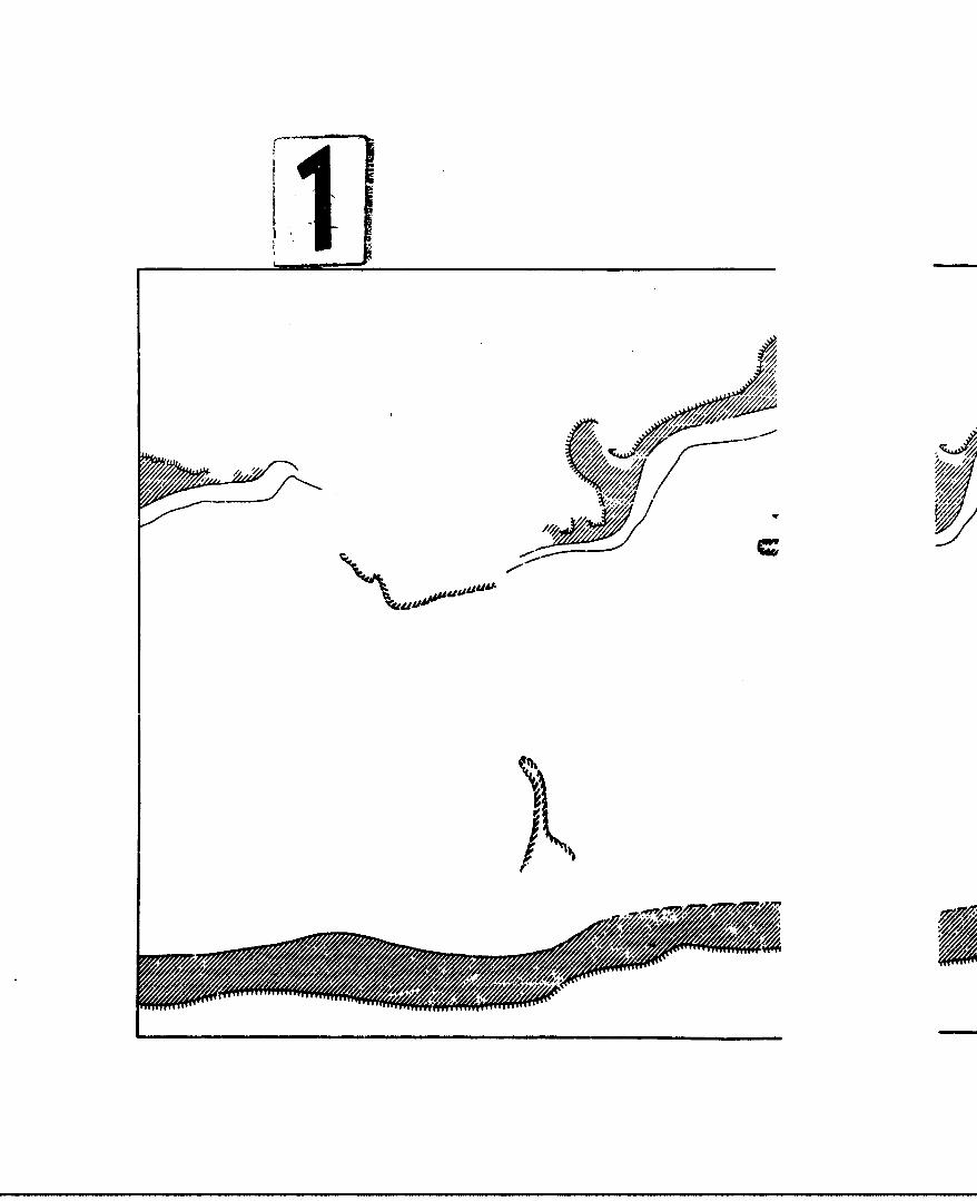
!NO
S•.';i
//.
/1 •u I"

FIGURE PMean Extent of Shelf Ice. Superstructt
Icing, Freezing Air Temperaturesand Snow--Winter
( -', - '.n2.• .~
• ..." > 4-. 4 " -,• w////•//
A..,
N4 -/5
tik

*elff

FIGUrRE 9Frequency of Wind Speet
Categories -- Winter
0r Ile Lam V ~w*0Me on" 10 nM 0 lwv"ur
.............. , , 5
101 al
mm"T

F~ lJL "
lj••==.L
.. .. .. .. .
..... ........ ii
............
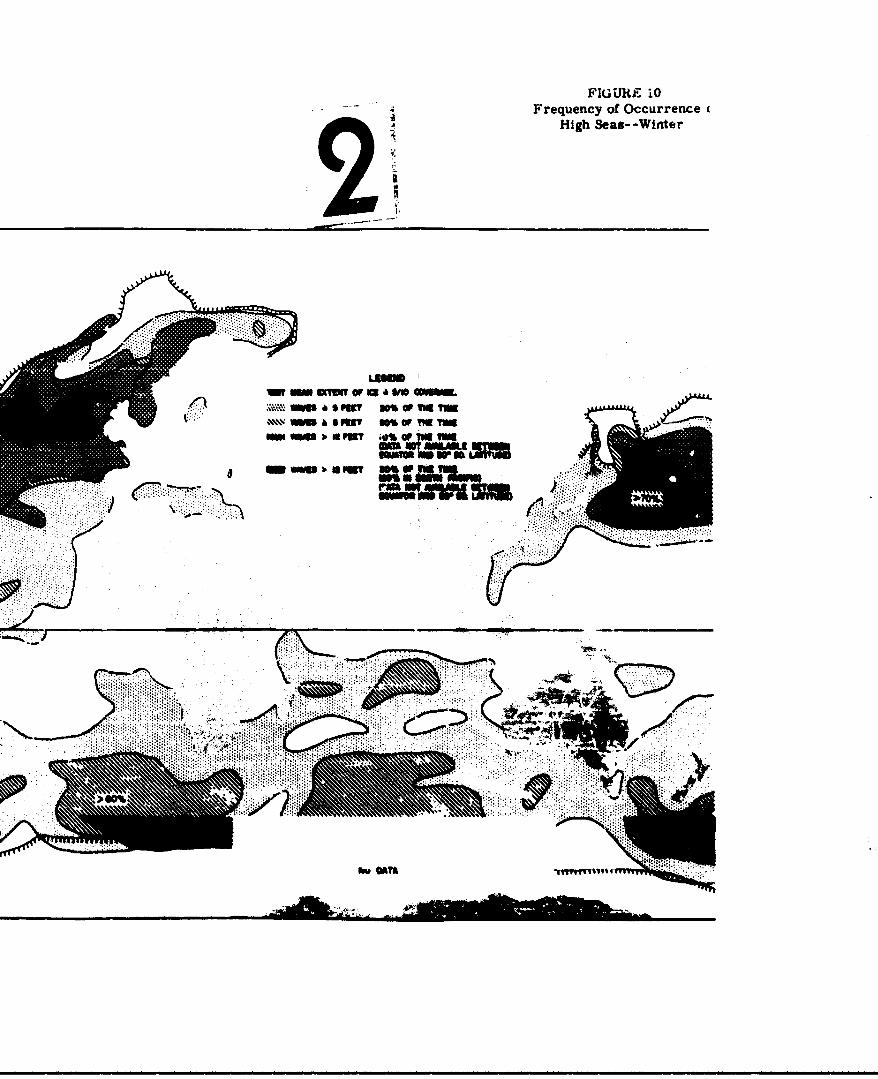
FIGURE i0Frequency of Occurrence
High Seas- -Winter
_ D- on" ;0 ,
- U'
. - :s , t Ow n
, OAT&

oO KQQ0OQO m
S. ....... I.' ]
S% •
'\ \\\l j nll i i i I ii i

FICYTRE 1IFrequency of Wind Speei
.atvguries--Summer129
•'•""•• ....."'" •' .'.• lr•
I 7 " ". ,..••,
APAZ MM.
#a *Ala

Iii�AjJJJ.LL�JY 4", '1
0
)
--
I

Frequency of OccurrenceHigh Seas- -Summer2
* LAT OF MT.
"no eminr , w.e ,6 we
.:I-::Irm 6F9TW%w TugN TM
WSKI' .~wU a 6 MET W% v fig 11W
awn aDPUT? 0% VuIWARU
mm lovw 6EW. IM ONLI 9 t
WwAowo MLMIislow 40___a_______
)f
... ......
FIgures 9 and 11 sho'w the distribution of wind speeds
in the winter and suuuner hemispheres, !ýnd Figures 10
and 1.2 show corresponding wave height information. In
each of these figures t•ie northern and southern
hemispheres are separated by six months, i.e,, the
winter hemisphere may represent conditions in February
In the northern hemisphere and in August in the
southern hemisphere.
1. North Atlantic
The general southwest to ncrtheast orien-
tation of windp, waves and sea ice alvng the
west side of the North Atlantic is an indication
of the strong influence of the warm Gulf Stream.
This stream is responsible for the mild climates
of the more northerly latitudes of western
Europe. It is also largely respnnsible, together
with the contrasting frigid character of the
adjacent polar regions of North America, for
intcnsifl-'ation of the storms which tend to
follow it northeastward. It can be noted in
Figures 9 through 12 that the stn.i u.,-vity
is reflected in the regions olr maximum magnitude
and frequency or occurren'.e or wdves and w.- 4
4peeds.
"-93-

The mer,.n mnxirrm extent of s~a ice conentra-
tion of five-tent's or nore, indtcated on Figure
8, means that Ice in lesser concentrations does
penetrate farther s.,uth, although it melts
rapidly if It enters the edge of the Gulf Stream.
The ice pack reneaes far to the north in the
summer, but icebergs breaking off of glaciers
drift out into the shipping laner along the
Gulf Stream.
The major storm tracks In the Atlantic
extend from the east coast of the South Atlantic
States, northeastward past Newfoundland to the
vicinity of Iceland. The corresponding belts
of maximun .wnda and wave heights extend from
the a•'ea southwest of the New England coast
nortneastward to tho 50th to 60th parallels to
the tip of Greenland and Great Britain. Wind
speeds and wave heights decrease to the south-
eastward to a minimum extending from Gibraltar
westward into the Gulf of Mextco,
In the summer the boundary V,.ri'-efn
temper.turea, along with the toe shelf, recedes
far to the north. F0eezing temperatures th..
n•nur lees than five per cent ^ 'he time at
any point In the No,,s, Atlantic. Because of this
-92-

warming, superstructure icing does not occur in
the summer months. The major storm tracks are
found only slightly to the north of their wirter
positlon, but the itorma themselves are generally
much less intense. The area of high winds and
waves remains nearly stationary, although the
incidence of gale force winds is considerably
lower than in the winter period. Wave heights
greater than twelve feet seldom occur south of
the 40th parallel in the summer, and wave heights
above fMp feet occur along the 30th parallcl onQ
about lC per cpnt of thc time,
2.. Nornt Pacific
The aouthwest to northeast orientations of
the houndsry eween freezing and non-freezinG
temperatures and of the zone of prooaole super-
str4cture Icing fowud in the North Atlantic In
winter, are also observed in the North Pacific.
Whaqa, Teir northward diepla'emmonts there are
not so pronounced. Lack of an oceanic rurrent
In the Pacific: as worm Q nd stwro o4 m Gulf
Stream in the North Atlantic results 1r less
pronounced warming over the norcheast come of
t,,e ocean. Cont'1buting to tnb )servo ort.n-
tation Is the strong outflow of cold air from
the Asiatic mainland.
Unlike The North Atlantic, thl,.rt is no sea
ice in the North racific. The most southerly
advance of the ice shelf is into the southern
Bering Sea, from wt..ch it recedes in the summer
to the Arctic Ocean. Small areas of pack ice
do form in the sea of Okhotsk and portions of
the Japan Sea.
The outflow of polar or arctic air masses
from the continent of Asia is even more pronounced
than from eastern North America. This air con-
tribuLes to th~e genesis of the severe storms
that form along the coast and move east-north-
eastward south of the Aleutian chain into the
Gulf of Alaska. A second major storm track
extends from the central North Pacific
,inrt.hes•stward into the Gulf of Alaska or onto
the ,calss of Canada and northweate-r
United •?.5t.A5.
The venter of the region of heavi Peas and
at.ong winds just east of Japan and south of
Kar'chatk (Fires 9 and IN) crrr'-, o t h,,
first of tise major storm tria's, liHer, saer
greater than 12 feel. ocnui' oser 2* per cent o-
tn,• time. This region exlcrn4. "qiward into
the ouir of Alasku ,4vn a torgue southei,.eward to
-94-sm m
the northeast of Hawaii that reflects the
secondary storm trackS from the ce.trar Pacific.
The magnitude and frequency of occurrence of high
winds and heavy ser.a decreases toward the south-
east and south. Lightest winds seem to occur In
a belt that coincides roughly with the axis of
the belt of hig! pressure across the Pacific,
extending from the lIawalian Isla-ds area westward
almost to Formosa. thence southward through the
Philippines to Join with the eluatorial doldrums.
Similarly, the most frequent occurrence of waves
under five feet In height are found in a low
latitude belt with arns extending northward in
the velr~t.y Af the Pacific coast of North
AMerlca and to the north of tho Caronine dnd
MarKr&Li Le.ande. Wave heights sre alsc generally
i4•w in the 4nfrozen portion of the Bering Sea.
In the summor months temperatures below
freezing ocour onmy in small areas north or 680
North Latitude. Hence, no 66,crstructure Icing
may oe expected during the simmer anywhere in the
Pacific.
Storm tracks in the eu'ar mvnths dillf,'
.. Ltle from those of winter, a. "ugh the so-rms
are much less intense. Storma form off the coast
-95-

of Japan and occasioc:ally in the iellow or
China Seas. Many of these move in through the
Be:ring Sea across to the northern tip of Alaska,
but a few form in t.ie central Pacific to move in
on the coast of Washington and British Columbia.
These less Intense summer storms result in a much
lower frequency of occurren•ce of gale-force
winds, the maximum being reached in the vicinity
of the Aleutians. The Aleutlans also mark tae
center of the region of nost frequent occurrence,
10 per cent of the time, of waves over 12 feet.
This belt extend3 from Japan throueh tue
Aleutians on Into the Gulf of Alaka. A minor
msaxi•i• of t iets. waves is located west. of the
Canal Zone. and they sometimes occur off the
California coast..
The tenter of maximum frequency of occurrence
of waves over live feet in height is located
southwest of Kamchatka and extends eastward
into the Gulf of Alaska and uuw,. the coast to
central California. The central California
maximum is a product of the strong high pressure
:ell that exists to the west during the suwmo
"months. Still another sa 'saximum occurs
along the China noat,
-96-

As In the wintertime, the mid-latitude belt
of the lowest wind speeds, and consequently
lowest seas, corresponds to the axis of the high
pressure system which, in the summer, is found
between 300 and 35° North Latitude. This belt of
low seas and low winds tken dips southwestward
to the minimum Just north of New Guinea where
it Joins with the equatorial doldrums.
3. South Atlantic
The relative pobitions of land and water
In the northern hemisphere are essentially
reversed in the southern hemisphere with a
resulting simpliflcation in the dIseributivn of
the patterns of the climatic elements as shown
in Pigurcs 8 to 12. The Antarotic continent,
centered almost on the South Pole, is surrounded
by an Lee part, which in the winter extends out
to about 650 South Latitude in the Pacific and
1.0 in tbt atlantic, and In the summer recedes
almost to the shoreline.
'rho so-ithern hemisphere helt. of euper-
structure Icing externa outwerd severil hun.", :-d
mi.les from the edge of the - naok. Such icing
can ocur at any tir-, c: the year, but the
probability of occurrence in the summer is muc.h
lower t*.nan In the other seasons. The mean
position of the boundary of the freezing air
corresponds roughly with the cuter edge of the
superstructure icing belt.
In the winter the belt of strong winds and
heavy seas arckes across the South Atlantic from
south of the southern tip of Africa west-
nortnwestward to the center of the ocean and
then southweetward to the tip of South America.
Galc wind! ocour in this belt approximately 20
per cent. of the time and winds less than ten
knots occur less than about 10 per cent of
o'te U•.. Seas In this belt are five feet or
a.eatcr .rcm 50 to 80 percent of the time and are
g'resa,,r th.an twelve feet over 50 per cent of the
"viue. A band of light winds occurring 50 por
cent or more of the time coincides with the axis
of thne South Atlantic high pressure cell between
20c and 30C EoSuth Latitude. Light winds also
occur along much of the coaatr of Africa and
South America and in the doldrums near the
equator.
The summertime axis f r.nigh wnds and .avy
evas is only' slightly further -.h the..n It Qs
in thc wintertime. However, the frequtenoy of
-98-

gale winds dropi off' to about 10 or 12 per cent,
the frequency of aeas five feet oý: greater drops
off to 40 to 70 per cent and the frequency of
seas twelve feet cr greater drops off to 20 to
30 per cent. Winds and seas decrease markedly to
the north, those winds near the South Atlantic
high-pressure cell at 200 to 300 South Latitude
being under ten knots nearly 70 per cent of
the time. Along the equatorial coast of both
Africa and South America they are less than ten
knots as much as 95 per cent of the time. Seas
of greater thai five feet occur less than 10
per cent of the time north of the 25th parallel.
. South Facific
The belt of maxioram winds across the South
Pacific in the wintertime extends approximately
east-west from the coast of Chile to the souther•,
tip of South Island. New Zealand. One maximum of
Ireqtaci of occurrence of gales (over 20 per cent)
is located on the 4Oth parallel and a second Is
located on the 53rd parallel JusG crt the coast
of Chile. The belt of highest frequency of
occurrence of wave heighft five feet or greucpr
coincides with this belt of gaLi t ds. Pw.•
this belt both seas and winds decrease southward

to the ice pack and northward to the equatorial
doldrums. North of 20" South Lailtude, wave-
heights exceed five feet only about five to 20
per cent of the tWe.
In the sumnmertime gale-force winds occur
about 1 per 4Lnt of the time in a band between
about 500 and 550 South latitude, and the axis
of the belt of high seas lies about on the 55th
paralle. Here, seas greater than five feet
occur 70 to 80 per cent of the time and swells
greater than twelve feet between 40 and 70 per
cent of the time. As in the winter, both winds
an! seas moderate both to the south and the
nortA•. The telt in whiwh 4iinde are moat fre-
quently ten knuots or leas extenda across the
PacUlt'c from the 20th parallel on the east side
to the 15th parallel on the wees side. However,
lowest wind speeds occur along the northern half
of the South American coast and in the western
extremittes of the tropical kaclfic
5. • ndlan
The east-west belt of gaae-foroe windr
found in the Atlantic anu . -Ifto continues
across the 3outh Ipnni Ocean at between 400' and
55 south. Gale-force winds In the winter occur
from arsot eight per cent of the t.me south of
Australia to a maximum of 20 per cent of the time
at or near 42 South Latitude, 400 East-Longitude.
In the correspondinS belt of heavy seau, helihts
five feet or greater occur froP 50 to 75 per cent
of the time. There Is the usual sharp dropoff of
winds and seas further north. A belt in which
wind speeds cf ten knots or less occur approxi-
mately half the time extends across the Indian
Ocean at 300 south. However, the most frequent
occurrence of low wind velocities is essentially
riaht on t2he equator.
In the summer the position of the belt of
hign winds and seas anifto slightly southward, but
the freaqi',cy ot gale-force winds decreases
relstively litti.. That the winds decrease In
average intercuity is confirmed by a decrease in
the frequanny & seas five feet or greater to
about 4O rer :ent and ot those over 12 feet to
about 30 per cent.
The seasonal change in winds *"a •etq In the
North Irndian Ocean is reversed from that or the
other oceans. Gale-forot v'nu8 are almost
unrinown In the winter, and high, . ;s, ev'er t.oee
of only five feet or so, occur less than two per
-101-

cent of the time. fi the summer, however, the
frequency of gale-force winds in the Arbian Sea
just east of the east tip of Africa increases
to over 30 per cent and wind speeds of ten knots
or less occur less than 10 per cent of the time.
The.; norrAspondjng seas in this area are five feet
or greater 70 per cent of the time and twelve
feet or greater 10 per cent of the time.
However, these heavy 2=3s and 21trong winds drop
off sharply toward the southern tip of Inidia
and seas of twelve feet "d greater are almost
unknowi trom tdie south cdge of the Arabian Sea
ean.w';td to Sumatre.
(4) SUMnary Of SignifIcant Climttlc fl.tpt
1. AVerage wind speed, frequerty of o~oorrence
!ý cn- 7 f'::- windp. svs~rpgt heights, of soa",and ýrequercy of occurrence of" hieg. seso all
tend to Unrease with latitude to a maximm
tetw-ee 40C and 650, and t^ h. higher in winter
thaý tn sawmer.
2. Sea ice ts an impoW.tant factor in the
winter Ir tho highe," latitudes or the Nort
tlantlic an. the South AtL.. '- Paelf, end
Indisr, Ooems. 1Ro !palficant amounts of sea Lee
-102-

are found in the North Atlantic in the summer.
In the summer in the southern hemisphere sea ice
recedes almost to the Antarctic continent but
doe& not disappear.
3. A belt of probable superstructure icing
several hundred miles wide borders the edge of
the sea ice in both hemispheres in winter.
This belt disappears in summer In the northern
hemisphr.re and decree'ses markedly In the southern
hemisphere.
4. A De.t of nigh pressure is found in all
but the North Indian Ocean at abnut 300 to 350
latitude. The -•gh-pressure cells are usually
str•ngest in summer and weakest in winter in
the northern hemisphere, hut they show little
seasonal ::hangs in the southern, hemisphere.
5. The r•'iate of the west coasts of iontinonts
bordering the eastern periphoi-y of thi high-
,ressure 'elle is either orid or se'..i-arld and
etxperiences a hi •h incidence o1 hg 0 low
6. A belt of low prosre.% exist* aL highe&
latltlid.ý% In 41 ones.'s. Storum in th.Pe. :'1~
ore substantially strongr in winter than in
summer. Strong. but shallow end very cold, high
-1(13-
pressure cells are ikely to be located over land
at the same latirudes in winter.
7. Africa, Austrrlia, most of New Zealand and
the majority of South Amerles arp PiTnn- frPP nr
snoN and freezing temperatures, even in winter.
8. The continent or Antarctica, the island of
Greenland, and portions of the northern rims of
Noith America and Asia are perpctually snow
covered, or nearly so, and are subject to
blowing snow when winds exceed 30 ;unots.
9. The preporiderance of arld and .ypecrarld
illmater are found in the northern half of Africa
ard in soit.heastern and central Asia.
10. In loi.fr latitudes, the areas receiving th-e
most rain and havuwn the Sratest amount of
thundersetorm actilslty le within the area
frequented I.y the intertr'opical convergence son.
11etween the .hI-pias~u" oelts (I the two
•iemiihere-o) or at the iouthweat and wut8, ends
or subtropical hign-prveasure cell :n tht est
side of continents. In hihr latitodel the rol"T
are" are within the sAw.,il•, storm or low-
pressure belt, paxtlc,,larly on s west titer
of -cnt nent,
• - lob-

3. CONTINENTAL ENVIRONMENT3
(1) Classification ol' Na-ral Features
Tl. development of the natural environment for
overland operations of Ground Effect Machines requires
consideration of the wide variety of geographic terrain
and climatic elements prevailing throughout the land
areas of the world. In order to provide a basis for
analysis of these data, some compromise must be made
between the extensiveness of the factors considered
and simplicity of presentation.
Based on the unique performance and operating
carabilities inherent in the GN4 concept, the following
basic geographic elements were considered for overland
operations with Ground Effect Machines:
1. Altitude ranges
2. Slopes of surface terrain
3. Drainage features
a. Coastal stream valleys
b. Liuland stream valleys
c. Other drainage features
4. Vegetation and surface cover
a. Dense forest
b. Brush
c. Graces and meadow
d. Cultivation
-105-
e. Swamp £id marshes
f. Other
5. Evaluation fo.. cross-country operation ofconventional tracked vehicles
6. Special features pertinent to GEM operations
lhe dis't.,`uu6van aclt itudes for the terrain sur-
face was corMldered because of its influence on the
power output of the power plants wrich are anticipated
to be used in most ORK vehicles. The breakdown of
altitude ranges was as follows:
Below sea level
0 - 1000 feet
1000 - 3000 feet
3000 - 5000 feet
5000 - 10,000 feet
Over 10,000 feet
The distribution of the slopes of surface terrain
is an important element of the 03 environment. The
provision of sufficient power for traversing areas of
sloping surface is a signil~cant basP• "-z.tn require-
ment for the Oround Effect Machine, The breakdown of
surface terrain into region! c' slop3 listribut. 'v. was
"is frt.Jows:
0 - 10%
10 - 30%
Over 30%
-106-

At the present stavo-of-the-ar;: of OEM develop-
ment, slopes of less than 10 per cent are not antia.pated
to add appreciably to tlk. installed power requ~.rements
for normal operations. Slopes of 10-30 per cent will re-
quire special consideration in the design of vehicle
power installations and, in some cases, will be marginal
for all operations, since the power required to navigate
slopes of tnis range will be a significant fraction of
the total power requirements. Slopes of 30 per cent and
greater require the expenditure of so much power that
the value of the OEM system is negated. For the present
analysis, therefore, all areas where a large percentage
of the slopes are over 30 per cent in gradient are t~nn-
sidered to be beyond the range of any GIN operations.
Because of the unique capability of the Ground
Effect Machine for operation over both land and water
surfaces, the use of stream valleys as avenues of access
to inland areas and as transport corridors in these
areas is coraolered to be quite important in the over-
all OM operations picture. Data on stream valleys
reaching the coastal areas have been Int-lirated into
the other material being developed for coastal and
amphibious operations. The una O.' iiland stream
,al*i•y afrordc In many areas the .. routes Ir
otherwise Inaccessible terrain. Data relating to
these features Includes th' frequency of stream valleys,
"-107-

the mean width, and a qual ttative not.tion of the steep-
ness of the banks. The frequency data were used to
determine the relative accessibility of areas through
stream valleys. The width data provides information
on possible limitations of vehicle size; and informa-
tion on steep banks indicates areas in which stream
valleys can be used, but. without exits to the surround-
ing terrains (where banks are steep and high, the GEM
cannot climb out. of the valley).
Special drainage features were also considered to
provide additional data for operation in these areas.
Among the features considered were swamps, marshes,
canals, irrigation ditches, rapids and waterfalls,
glaciers and Ice cover, areas of intermittent streams,
fiords, and areas of underground drainage (karat
topography).
Data on surface cover by vegetation provides addi-
tional background for determining necessary operating
heights of the vehicles. Area olacelfted as dense forest
Ra that where growth in too tall to fly over, too closely
spaced to travel betw.en, ane of sufficient density to
require large-scale clearing opurptions (with bulldos~rs
and power equipment). Vegetal.. - nlassified an bruah
does not have the height, t֥aity, or spacirg character-
istics of that indicated as forest. Notations as to the
normal height distribution or spacir4 of such cover was
-108-

added to the per'centage breakdown. Vegetation described
as grass includes areas of savannah with widely scattered
tall trees and other brush.
Cultivated areas include irrigated crops, root
crops, grains, and tree crops, with a notation of the
normal height of the crop during the growlhg season.
Swamp and marsh areas include vegetation appropriate to
such regions (in some cases, mangrove forest and other
dense trees). Other forms of vegetation and ground
cover include barren rock, ice caps and glaciers, lava
flows, and desert and semi-desert vegetation, as well
as areas of dunes and loose sand.
The evaluation of an area for cross-country oera-
tions provides a further check on the significance of
all the preceding features, as well as one standard by
which ORR capabilities could be compxared with those of
other vehicles. For purposes of this study, the
standard unit of comparison for cress-country operations
ia a lull tracked vehicle, exemplified by the mediu
tank type. Areas unsuitable for cross-country opera-
tions with tracked vehicles were speciflad as a percen-
tage of the total land area within the particular
geographic unit, and notatior -P the primary cross-
country obstacles was made" e.g., steep slnpes, dense
forest, rough grounds etc.
-109-

In addition to all the fore~oirc- items, special
features considered to be pertinent bo the operations
of Ground Effect Machirnes have been listed in separate
notations for each of the geographic units in which they
are found. These features are those which will have a
primary influence on operating requirements and design
parameters for OGE vehicles in a given ai*&, Primarily,
they are terrain obaLanles. which may include cultural
features such as road embankments and irrigation ditches.
However, militar-y obstAclen ar. not included in this
breakdown (for which, see discussion under Combat
Environment, Chaptei. III). Complete discussion of
these features Is given in the area swumaries; a few
exaijles, however, are listed below:
Place Feature Useful Number
Malaya Rubber Separation of treesplantations 15-30 feet
Sahara Desert Sand dunes Lei slopes 30-60%TO7-30o0
Arabian Sand dunes I&* slopes to 100%Peninsula (,450)
Bast China Rail and road Height 3-6 feetembankmentn on atove plainflood plain
Thailand Rice paddies Dikes 2 rest high,3 f2et wide, -paoedtbout 100 feet.'eddles are 4ry
during the non-growing season.)
United Kingdom Hedges Height 41-15 feet& Ireland
-110-
U.K. & Ireland Stone walls Height 2-6 feet
Belgium & Irrigatiorn •-4 feet deep byNetherlands ditches I-8 feet wide.
Larger canals 5 feetdeep by 15 feet wide.
Italy Hills"le Terraces 3 feet high,cultivation with wallc 2-5 feet
Finland Eskers Earch ridges withslopes Of 50-70% upto 100 feet highextending for5-15 miles
Numerous other features of similar kind haave been
described, and are contained within the data for the
specific geographic units.
The geographic data for terrain, vegetation, and
the other features listed above are commonly available
in terms of political units, and the data have been
recorded In this manner. In order to facilitate corre-
lation with the climatic and weather data discussed
eu,'ller in the chapter, these political units have been
further broken down into the climatic zones. The data
appendix (Appendix B) lists political unste, climate
zones, and the area of each climate zo-, i' 4.*hLn each
political unit. This breakdown of data units allows a
wider range of applications for tCie dat.a element . so
that Pnalyses and sunnaries can ,. 4*veloped on any
desirhed basis.
-111-
The remainder of this section includes a discxssion
of the world-wide natural enviromrenc for overland opera-
tions of military vehicles, slanted toward the 6round
Effect Machine only to the extent that factors not
significantly affecting GD! operations (e.g., bearing
strength of soils) have been neglected. The discussion
is presented in terms of continental land-mass areas.
A few of the most important data elements from Appendix
B have been sunuarized in Table 5. These elements aro
among those considered in the discussion; the numerical
tabulation merely highlights the over-all geographic
framework for overland openations.
A generalized map of world-wide suitability for
overland OW operations is given in F•gure 13. This map
was derived from the prepared environmental deta of
Appendix B. In a very general manner, it represents
the areas of the world which ane suitable for various
kinds of OM operations. The four cptegories Included
In the figure are:
1. Unrestricted overland operations - flat lands,
few obstacles, barren or grass ccvered.
2. Limited overland operatIons flat and i&tly
hilly lands, many obstaero barren, •ras,
or brush covere4, stream valleys within area
at least partly usable, and banks do not form
major barriers.
-112-
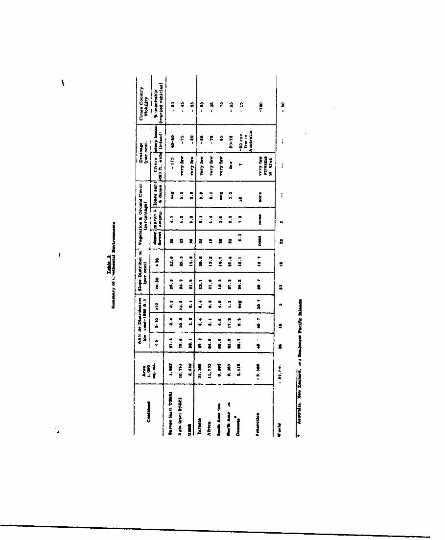
dii
It A' Z
U I i, -N
--] , -
!-. . .-
"• I ! 2e 2I I: I • I 1t I
i ; * so.i
IL
2 a - *1Is N~i i 3 3 u ummmnm ~ ~~u mm mr
- - ut. *mmaum i~ mi• p~im
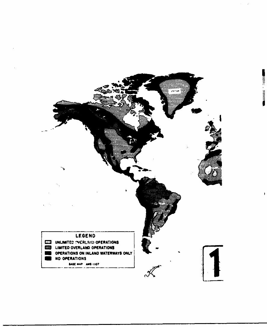
LEGENDD UNUMITED .'VCRL-f),D OPERATIONS
LIMITED OVERLANO OPERATIONSm OPERATIONS ON INLAND WATERWAYS ON4LY I -
NOOPERATIONS
"$IS MAP AMS-IIO7 .
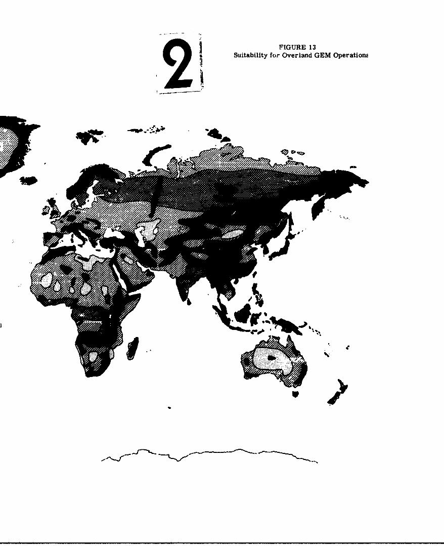
FIGURE 13Suitability for Overland GEM OperationE
Im
3. Inland waterss•.operatior.a only- forested
and rough lands with wide waterways provide
GEN access to nost of area; GE~s will not
generally be able to leave stream valleys, in
some places restricteL to water surface only.
4. No GD! operation - forested and rough lands,
including areas of steep slopes, where G0!s
will be usable only for very limited local
operations.
The Antarctic region is not included in Figure 13,
but in general the interior glacier areas of the Antarctic
Continent will be available for limited operation of
GUIs equipped with snow-removal devices, navigation
equipment, and cold-weather kits. (See Induced
Environment, Chapter I11.)
This map is coordinated with Figure 14 followi-;
page 171 indioating suitability of ooastal areas for GOE
operations. Accordifgly, Fifure 14a hould be referred
to for a generalized assessient of operations in the
coastal regions.
Nnte: Figures 13 and 14 are intended aa gern.eralized
appraisals of suitability for "N operations only, and
should not be used to plan ttecific operaticna in any
given location.
-115-

(2) Natural Features of World Continpnts
1. Eurasia
The Eurasian land mass extends through 2100
of longitude and includes more than one-third of
the total land area of the earth. Climate features
and influences have been treated on a unified
basis in Sedtton 2 or this chapter. In n'dr to
provide additional clarity in the discussicon of
military geography, some further breakdown of
Eurasia is desirable. The old Europe-Asia boundary
at the Ural Moun-tains no lenger has much meaning
because of the eastward development of the Soviet
Union. In fact, the vast land arca cf the U.S.S.R.
(more than 8.6 million square miles), and its
diversities from both European and Asian neighbors
leads to a convenient three-way division. This
chapter, then, discusses ailitary geography as
related to OU operations fort
Narope (without U.S.S.R.)
U.S.S.R., and
Asia (without U.8.t.).
This Is the breakdown now ueing generally ad,,pte
by the geographere.
-116-

(1) Europe
Europe (without r.S.S.R.) is a compact
triangular coy.oinent of Just under 2 million
square miles. Because of the dense urbaniza-
tion and industrial development in Western
Europe, cultural features have a signi'icant
bearing on the over-all military geography.
Even no, the diverst-y u±" terrain and vegeta-
tion throughout Europe remains the major
influence in defining the natural environment
for operation of the Ground Effett Machine.
The physical geography of Europe Includes
an almost equal division of lowlands and high-
lands. The highlands consist of three beltas
the northern highlands extending through most
of the Scandinavian Peninsula anm reappearing
in the DritIsh Isles; the central highlands
of eastern Frxancs, douthen Goermn, and
southern Polandl and the suthern highlands
of the Iberian Peninsula, Switserland, Italy,
Yugoslavia, and Greece. Detween the northern
aid central highlands aet large central low-
lands, the "heart.u -" of Nurope. masller
NeF6terraneman an: eastern lowlandi tiAA out
the continent. The rwSged subarctic island
-17
of Iceland :' i ncluded in the area of Europe.
Its glaciers and lava flows do not allow
any extensive cross-country operations.
In terms of military geography, these
divisions are very significant. The northern
highlands in Norway and Sweden are a rugged
chain of mountains with slcpes almost every-
where greater than 30 per cent. These moun-
tains are extensively cut by fiords on the
western coast, with cliffed walls rising
precipitously from the water's edge.
Eastern slopen of the Scandinavian Peautula
are steps down to a broad forested lowland,
which includes much of Sweden and most of
Finland...
In contrast to the northern highlands,
the central lowlands provide very little
topographic variety. In Deninka, northern
Germany, Poland, the Benelix countries and
western France, the terrain ia almost
everywhere low and gertle, with about 60
per cent of the area having slopes less
than 10 per cent. "le British Islas have
some rough uplan,,s but may ue included in
the central lnw~Anas region.
-118-
The cer.,.-:r1 highland,', in eastern France
and southern Germany are not as rugged as
those in the nor.thern or southern parts of the
continent. In the east they become the
Carpathian Mountains of Poland,
Czechoslov-akia, and Romania. The c.entral
highlands merge with the southern highlands
in the Alps, a formidable mountainýbarrier
extending from southeast France across northern
Italy and into Vugoslavia, and containing
most of Switzerland and Austria. The Alps
reach 15,000 feet in height and are every-
where a severe impediment to military opera-
tions. The extensions of the southern high-
!ands into Spain, Italy, Yugoslavia, and Greece
are not as high, but Just as rugged as the
Alps.
In addition to a narrow coastal plain on
the Mediterranean coasts of turope, there is
a densely developed lowland in the Po Valley
of northern It&ly, and broad, mL.cst
featureless plains in Hungary and Romania.
Numerical datt - European terrain fea-
tures are lncludc-i in Appenprx B, and
summarized in Table 5. Less tmai 3 per cent
-119-

of Europe is Altuated at !Itttudes above 5000
feet, and this is all in mountain areas.
About 90 per cent of the area between 3000
and 5000 feet altitude is also in areas of
steep slopes and rugged terrain. The over-
all division of slopes in Europe is: 0-10
per cent slope, 52 per cent; 10-30 peijacent
slope, 25 per cent; over 30 per cent slope,
23 per cent.
Drainage characteristics of Europe
consist of many small rivers with a frequency
of 15-40 miles. In about two-thirds of the
area, these are over 60 feet wide, but in a
few places they are less than 30 feet wlIe.
Banks of river valleys are not generally
steep except In mountain areas. The banks of
rivers which have been canaliced are nostlU
steer, 30-100 per cent, and up to 10 test
high. In Spain, Portugal, Greece,
Switzerland, and Austria, most rivers ae
narrowl, rocky, and have steooi ban" ts. thus,,
they carnot be used as access routes in these
areas. Vaterfalls and ,pdd3 are cmL. a on
the eastward flowing r. -* o" the Scandinavian
Peninsula, vhillu those on the west are
mostly steep mountain streams eqtying into
numerous fiords.
-120-
Most of tl^e larger r.-vers of Europe have
artificial channels and are connected by
nnuerous canali. This network provides many
water routes through France, 0ermany, Poland,
Hungary, and the Benelux countries. Many of
the canals have widths of 30 feet, with
steep banks.
In western Yugoslavia and Albania is a
large area of karat topography with subsurface
drainage, and almost no streams. The rough
curface of this area has many sinkholes and
rocky areas.
Vegetation in Europe Includes a dense
forest belt in the north and many small
forests scattered throughout the rewt of
tho area. Dense forests cover 35 per cent of
Europe, including 15 per cent in mowitainous
areas. The lowlands of lurope are extensively
cultivated -- croplands cover more than 38
per cent of the continent. Most of the areas
have vegetation cover not exceeding 4 feet
high in growing seasons. Orasslands and
pasture cover about 0 ver cent of Sarops.
Narshes and bogs common imn Finland and
southern Sweden, and also occupy extensive
-121-
areas in Ire.And, Czeehor" vakia, and
Romuania. There are very few desert areas
in Europe, but sand dunes are common on
the coasts of France, Belgium,
Netherlands, and Denmark.
Because of the dense urbanization of
ANurope, cultural features are important in
military geography. Included among these
features are the many Irrigation canals and
ditches of the lowlands in northwmst Europe
and on the eastern plains. Most of these
are 2-4 feet deep and 3-10 'feet wide, but
some are up to 10 feet deep and 30 feet
wide. Earthen banks have slopes of 100
per cent. Dikes and embankments up to
10 foot high are also oomon. Another
cultural feature is the large number of
densely built-up manufacturing cities, where
concentration of buildings along narrow
streets is an obstacle to movemant. In most
areas of western Zurope, the .xl.?ttng rail
and highway networks provide good transporta-
tion routes.
These terral', drainage, vegetation and
cultural features my be tied together by an
-122-

evaluation ol the over-all cross-country
mobility. Using the conventiomal tracked
vehicle as a reference base, cross-country
suitability ranges from 95 per cent in Poland,
down to 25 per cent in Norway and Sweden.
Throughout the continent, about 50 per cent
of the area is suitable for cross-country
operations. The remaining 50 per cent includes
steep and rugged areas -- 30 per cent of the
total; dense forests 12 per cent, wet and
marshy ground about 3 per cent, and other
unsuitabla terrain about 5 per cent.
Throughout Europe are a number of
special features which may be especially
pertinent to GEN operations. These include
the many canals and ditches previously dis-
cussed. In northwest Europe and on the
Mediterranean islands, walls and hedges are
common along roads and bordering most fields.
Stone walls are conlonly 4-6 ftt high and
2 feet wide. Hedges may be tp to 15 feet
high; in Prance sa a"re on earth embank-
ments. In the tastern plainse roads r -ti
railroads an often ..'I#. on earth embank-
ments. Hilsleda-, in Ita.Ly and Greece are
terraced for cultivation, with steps 2-4 feet
-123ý-
high and 10-iOC feet wide. In Finland are
a number of glacial eskers -- steep earth
ridges 3-4 mil-s apa, in the south, with
slopes of 50-70 per cent and extending for
5-15 miles. The surface of Iceland is
covered by rough lava flows. In almost all
cases the islands off the Atlantic and
Arctic coasts of Furore have no areas
suitable for GEN operations except in the
coastal regions.
The ge-,eral military geography of
Europe, with most lowlar4 areas highly
urbanized, does not offer much advantage for
GEN operitions. Because of the existing good
transper.atior network, the GEN is not ex-
peobvd to find a major use for overland
oponations except in limited areas. Dun
th- spring thaw, however, many of the low-
landi areas are soft and wetj and under these
circumtances GAls may be used to advmatage.
(2) U.
The Union of So'viet, Sooallet Bea Alice
ocauples more than one-. -nth of the earth's
land area. The U.S.S.R. stretches aoross
the top of Eurasia fro the Baltic Sea to the
Bering Sea, rie-,rly 7000 nr.Les . Its vast
territory encompasses the East European
Plain, the Ural and Caucasus Mountains,
the frozen Siberian Plain, and rough Siberian
Uplands; along most of the southern
boundary are inhospitable mountainous
regions. Quite apart from political
Implications, the vast and comparatively
isolated land area of the U.S.S.R. is
worthy of separate considcration in respect
to the natural environment for the Ground
Effect Machine.
The U.S.S.R. can be divided Into five
regions for analysis of military geography.
The western part of the U.S.S.R. is a
continuation of the part of the ventral
European plain. Ninety per cent of this
area lies below 1000 feet and has slopes less
than 10 per cent. In the south and east,
there is a mountain fringe. The southern
mountains, the Caucasus, to.-Aa i ,•sd
boundary between the U.S.S.R. and Turkey
and Tran. The centrel gWuuasU barrtn. ,jan
be circmvented by the f -i Sea Ond tv*
Caspian Sea.
-125-
The eouthsrn sectioi. of Sovlet Central
Asia is predominantly an arid lowland, bordered
by mountains en the east and south, and the
Caspian Sea depression on the west. This
region is 25 per cent desert. The northern
section of Soviet Central Asia contains the
Ural Mountains, and most of the Great
Siberian Plain, a vast cold lowland. Almost
90 per cent of this region has slopes of
less than 10 per cent.
The eastern Siberian Uplands area,
bordering on Mon&. !a, China, and Korea, is
the largest physical division of the U.S.S.R.
This region is an area of plateau& and low
mountains, bordered by a frozen Arctic coastal
plain. Except for this coastal plain, the
Eastern Siberian Uplands are TO per cent
hill& and mountainst with slopes exceeding
30 per cent in about one-thirl of the area.
The over-all terrfLin chawar.teristics of
the U.S.S.R. are troad plalne imostly below
1000 feet, divided by the raorth-south 1ml
Kou'tainr, and bor' -xi on the south and east
by rugged highla tis. Of the total a.ea of
8,650,000 square miles, 15 per cent hme
4
-126-
slopes greater than 30 pe' cent, and 22 per
cent has slopes of 10-30 per cent. Two per
cent of the lnnd area lies rbove 5000 feet,
but this is mostly in mountain areas with
steep slopes.
The drainage character~stics of the
U.S.S.R. reflect the diverolaty of climates
and terrain within the region. In the
southern part of Soviet Central Asia most
streams are intermittent arid dissipate in the
desert basins. Throughout the rest of the
U.S.S.R. are distributed a number of large
rivers fr'm 30-100 milea apart. Most of
these flow northward to the Arctic, but the
Volga, Dnepr and Ural Rivers flow south to
the Black Sea and Caspian Sea. Rivers are
generally over 100 feet wide, except in the
mountains. Banks are gradual in the
plains areas, but steep in the mountains and
arid regiajis. The north-south rivers of the
U.S.d.R. are used as momme-"o 1 taterways
during the sueer monthr. Rivers are frozen
solid from Novmber to Nay in the nozx-i,
and from December to ,... -% in the south.
Often the 1ue-ouvered surface Is rouaghl Ice
jams form during the spring thaw.
-117-
The norti,-rn plains rave many marsh
areas, which are quite impassable when thawed.
In addition, there are irrigation ditches
along streams in the arid regions of the
Caucasus and Soviet Central Asia.
Vegetation follows the climatic bands,
with stronger latitudinal Influence than in
other regions of the world. The Arctic
coastal plain is mostly covered with barren
tundra or sparse brush. Adjoining this is
a wide forest belt, with dense foreats in the
western area, and briush woods toward the
eautsrn, repiona of the Siberian Uplands.
Altogether, dense forests cover 20 per cent
of the 1.B.S.R. South of the fnrtst belt
are the grasslands of the Siberian steppe.
In the western region, the steppe is exten.
sively cultivated (50 per cent of
Buropean Russia). Scattered among the
forests and grasslands are nuemrous marshes,
6 per cent of the total aris of *.-e U.S.S.R.
These are predominantly frosen for a few
months during Was virter. *E.rren does. ";j and
sparse desert vegetat:L.. - vers the so,1t~hern
part of Soviet wntral Asia. Twenty per cent
of this region is covered by low sand dunes
(3 per cent of the U.S.S.R.).
-128-
Cultural• Veatures are ver-r limited
except in the western industrial and agri-
cultural areas. Limited irrigation features
are scattered throughout the drier regions.
The over-all evaluation of the U.S.S.R.
in terms of cross-country operations Indicates
that about 45 per cent of the area is suitable
for operation of conventional tracked
vehicles. The dry regions of Soviet Central
Asia are generally suitable for cross-country
operations. In other regions, croos-oountry
capability ranges from 25 per ctnt in the
rough Eastern Siberian Uplands to 60 per cent
in the central plains. Sieary Table 5 showa
that the main factors Influencing cross-
country operations are steep slopes, forests,
and soft ground. The Arctic tundra is
suitable for cross-country operations only
when frozen (6 to 8 months of the year).
91H operations 1n2 the U.S.S.R. would
be generally unlimited in the %)radu plains
regions. Where the plains are dersely rcreste4
In the west, river valleys could be usud.
The desert regias arounA ._e Cauiaý, S-a
wruld not pro uide much obstacle to Q
Because of their low pround p -ss-..,
-129-

could operate ,a the tundia even when it
is thawed, By the use of north-south river
valleys (eithe- frozen or open), OR4s could
reach most areas of western and central
Siberia. For operations in the northern
areas vehicles would need protection against
the effects of cold, and special considera-
tion of the rough ice surfaces likely to
be encountered.
(3) Asia
Asia is the continent of great
diversities% climate, population, economic
development, and military geography.
Determination of the natural environment for
overland operations of the Ground kffect
Machine requires integration of the climatic
and geographic elements. It has been
presumed, in addition, that any detailed
analysis of military operaLlons in Asia maut
consider the significance of the diverse
population distritution and economic
development level wlthl:i thIs veaL co,-1n eL.
Climatlc influence. '" Asia ha,.m been
discussed in Se3tion 2 of this chapter. The
contiast brtween tht arid Interior and wet
e 130-
coastal regions tns a significant influence
on potential GEM operations. Equally si3.ifl-
cnt is the diversity of terrain and vegeta-
tion elements, which are interrelated with the
climatic factors.
Excluding the territory of the U.S.S.R.,
Asia remains a continental land mass of
imense proportions. It stretches from
Turkey to Japan, from Norngolia to Indonesia;
with a total land area of 10.7 million square
miles, including the Island fringe.
The physical geography of Asia is
centered on a high central plateau surrounded
by rugged mountain chaits rediating east,
west, and south to the oceans. Bast and west,
the mountains form most of the boundary
between the U.S.S.R. and the countries of
Asia. On the west these mountains extend
through Afghaznistan, Iran, and Turkey,
dividing the arid Arabian Peninsula frgm the
equally arid central Asian desarts. &ast-
ward the mountains stretc0i across noethvent
China and Nonitolia. A aocond eastward-
extending range, ths Himakla.. isolate
the Gobi Deseit and the Plateau or Tibet
"from thc root Pf the continent; then turn
southward to form the rugged backbone of
Burma, Thailand, and Indochina. Rugged
highlands are prominent throughout the rest
of the continent, particularly in Korea and
the island fringe - Japan, the Philippines,
and Indonesia. Almost everywhere the high-
lainds descend abruptly to coastal plains
which are densely forested or cultivated.
A few broad lowland valleys exist in Iraq,
Paklstan, India, Burma, Thailand, Indochina,
and eastern China. These broad lowlands
are literally filled to overflowing with
humanity and densely cultivated areas.
Asia is the highest of the continents,
except Antarctica, with a mean altitude of
more than 3000 feet. About 11 per oen- of
the land area in between 5000 and 10,000 ftet, 9
per cent between 10,000 and 15,000 feet,
and 4 per cent above 15,000 feet. With the
exception of mall areas on ýhe 1-anian
Plateau and the western parts of Chena, most
of these highlands are in mountainous m.-eas.
The large rough Plate,.. -P Tibet has an
altitude of 10,(0UO to 13,000 !eet, but it in
entirely encircled by rugged mounti.in ranges.
-132-
The rugpe,. backbone c" Asia Is associated
with areas of predomin-vntly steep slope.
Slopes greater than 30 per cent are found
in 25 per cent or the continental land mass,
and slopes of 10-30 per cent make up 25 per
cent or th3 area. In addition, many of the
plateaus of central Asia are isolated
by one or more mounta'n ranges. Appendix
B contains altitude and slope duta for all
the countries of Asia, coordinated through
the climate zonsa.
Drainage characteristics vary greatly
across the breadth of Asia. Asia contains
some of the great river systems of the world:
Yellow, Yangtze, Nekong, Irrawaddy,
Brahmaputra, Ganges, Indus, and Tigris-
Zuphrates. Yet, about one-third of its area
either contributes no surface drainage at
all, or, its drainage is evaporated in Interior
bacins.
Although rvar valleys fom major barriers
to cross-country movement in much of southern
and eastern Asia, , use as potential M
access routes is limited to a few areas.
Zn China, the Yangtze and Yellow River drainage
-13o-
basins have vc~t flood plains which from time
to time are inundated by floods, forming areas
of water and mlid several hundred miles wide.
Other rivers in China are generally over 60
feet wide, and separated by 30 to 100 miles
except in the arid, high, western plateaus.
About half the rivers in China have steep
banks. In Korea and Japan, river valleys
are separated bY 5-50 miles, but some are
not more than 40 feet wide and banks are
predominantly steep. In Indochina, Thailand,
anu Aurm&, the Mekong and Irrawaddy Rivers
are the primary stream valleys. Both have
larget flooded delta areas, exbensively
cultivated. Banks of these, and the many
smaller rivers are predominantly steep. The
rivers of India are mostly wide, many of them
over 750 feet. The Oanres, Brahmaputra and
Indus valleys are much used as Inland water-
ways. In addition, they support huge nvabers
of people. Sxoept in the desert azea of
northwest India, stream valleys are aeparateQ
by 20-100 miles, with banks steep on about
one-half. The rivors on the western .. opes
of the peninsule of Indla ..4# ll. steep and
rocky.
North and west of India, the drainage
characteristics are quite different. Through
western China. Afghanistan, Iran, the eastern
Mediterranean countries, and the Arabian
Peninaula, stream valleys are more widely
scattered. and most streams are intermittent.
Banks of stream valleys are predominantly
steep except in the sandy deserts of Iran7add
Arabia. A notable exception to this arid
drainage is the broad Tigris-Euphrates plain
at the head of the Persian Gulf. These well-
controlled rivers supply a major agric•ultural
region. Steep levees enelrte moot of the
lower courses of the Tigris and lzphrates,
and their delta area is extensively irrigated
for crops. The Jordan rift valley Is more
of a terrain obstacle than an avenue of access,
since its passage between the Sea nof-flilee
and the Dead Sea is entrenched ln a steeD.
rocky gorge. Rivers on the Asian southern
fringe islands -- Taiwan, the Philippines,
Indonesia, and Now Guinea -- are mostly
between 60 and 250 feet wide and have steep
banks.
Many " stream valleys throughout
the coastal regions of Asia could potentially
-135-

be used for G 3. amphibious, operations, as
discussed in the next section.
In addition to stream valleys, important
drainage features in Asia are canals, swamps,
and irrigation areas. Extensive coastal
marshes are comon in the Philippines,
Indonesia, along the Malay Peninsula, and in
the delta areas of the rivers of Indochina
and India. Flood plains of the Yangtze and
Yellow Rivers In eastern China are subject to
inundation by flood waters. Navigation
canals are important in eastern China, India,
and Ceyloia. These are generally over 60 feet
wide, but some narrow to 30 feet at bridges.
In a few areas, the lower courses of rivers
are controlled by dikes and levees.
Because of the pressing need for food,
most of Asia's arable Lowlands are extensively
cultivated In rice and other crops. Irria-
tion features are comon in riost coastal
plains and river deltas. Typical rice paddy
areas are divided into sections about 100
feet square, with -*'"f-s 2 feet high and 3 feet
wide. The padA .-.s are usually drained during
the nongTowing season. In some places, deep

rice cultivation is used Ln flood plains,
with dams 6 to 10 feet high retaining the
flood waters. irrigation ditches are commonly
1 to 2 feet deep and 10 feet wide, with
larger canals 3 to 10 feet deep and 5 to 50
feet wide. In Thailand, canals 10 to 15 feet
deep and 120 feet wide are spaced 3000-6000
feet in the lowlands, with locks at river
Junctions. Irrigation features are not
comnon in the Philippines, New Guinea, and
Indonesia, except on the island of Java.
Vegetation coverage in Asia reflects
the climatic diversity of the region.
Southeast Asia is predominantly densely
forested, while the central Asian plateaus
and mountains are sparsely covered with grass
and brush, or oarren desert. Dense forests
cover 22 per cent of Asia, Inclu4dn&g most of
Indochina, Thailand, Burma, southern India,
Ceylon, and Nalay Peninsula, and Indonesia.
Scattered forest rgions ar•r fo'nu in north-
east China, Korea, J:pan, and Tukey. By
contrast# Afghanistan, Iran, the ArabAbr.
Peninsula, the easterna .' 44terranesn
countrIes, northern India, and western Chir*

arze 75 per cent covered by spax-se grass or
barren desert. Althou*& dune areas and loose
sand are only - small part of the desert
regions, they make u*p about 6 per cent of the
total land area of Asia. Despite the pressures
of a large population throughout southern and
eastern Asia, cultitated areas are restricted
primrily to wet or Irrigated lowlan•ds.
In addition to Irrigation features, the
cultural factors In military geographb are
lmited to the levlax'A plains, with a nmer
of major cities, and nweroua densely built-
up Orwsal" cammulties. In the east China
flood plain, railroads and roads are on on-
bantents 3 to 6 feet high, and sme cities
are protected by dike and lvese up to 4O
feet hiMh. asting tnqotatnm facilities
are liUmted to the prlphanasi arms of Asia.
Japa. and hsdia have well-devolcped rall net-
works. Roads provide access to mon. parts of
tbhea cowtrla also, as wel.l :a toe China
coastal areas, parts nf Korea and YIet U,
and the coastal regcns of Lm eatensa
editerranamn lods - &. -•v, Tabmnon, and
Israel. 3am of th. less developd rog-os
of ASi are entirely wltbot hlgu or
-136-
railroads-- f'or example, 'ibet, southern
Arabia, and New Guinea.
In teris of military operations, all the
above features may be tied together by an
evaluation of suitability for crons-country
operations. Using the cross-country capability
of tank type vehicles as a i.eference base,
about 55 per cent of Asia Is suitable for some
operation. Most of the central Asian highlands
are unsuitable because of steep slopes, and
much of southeast Asia is unsuitable because
of forested slopes and marshy ground. Alto-
gether, abnut 33 per cent of Asia is too steep
for operations with conventional tracked
vehicles, 10 per cent is forested or forested
and rough, and 2 per cent Is too wet., or has
soft ground.
All these features have influence on
potential overland operations of MM . In
addition to the diverse patterns of highlands
and lowlands, marhes and deeerts, forests, and
Irrigated riceftelds, a few other features
peculiar to 031 ope-t one may be mentioned.
Slopes of sand di.erc In the eobi Desert range
up to 60 per cent on the lee side, and llkewist
on the Arablian Desert and In Iran. In
Afghanistan, lee slopes of sand dunes a" up
-139-
to 100 per cent. Rubber p3antations on the Malay
* Peninsula and in ILdonesia ccmmonly nave trees
15 to 30 feet apart, with small ditches between
the rows of t.ees. In some parts of Ceylon,
Indonesia, Japan, :and the Philippines, hill-
sides are terraced for cultivation. In Ar;.bia,
oil pipelines up to 3 feet in diameter are
above ground for long distances. Long escarp-
ments are found a few places on the Arabian
Peninsula and on the Thailand-Indochina border.
And over 1200 miles of the Chinese northern
borders are still guarded by the ruins of the
Great Wall, 12-16 feet high. The numerous
irrigation features, canals, and dikes have
been previously discussed. These may be signi-
ficant obstacles to GIN operations In lowland
areas, Darticularly during the nonarowing
season, when the water level Is low.
The diversity of Asia's physical geography
generally limits overland OUI operations to the
dry Inland plateaus, the Arabian Desert area,
and parts of the last China plaLn. Inland
waterway operations would be advantaWeous in
scattered areas of southeast Asia, and Ln parts
of the Indian peninsula. . ;tion 4 oA" this
Chapter, dealing with amphibious and coastal
operations, presents a more favorable picture
regarding use of OM in Asia.
-140-
2. Africa
The military geography of Africa may be
easily desc;'-ibed J.a terms of" desert and grass-
land plateaus, the equatorial forest belt, and
the eastern highlands and rift valley. The
climatic influences are very strong here, since
topographic features are less pronounced than
"in cthr. ^or .••..n.v.. Nonetheless, Africa pre-
sents a wide variety of terrain, drainage, and
vegetation features. All of those lavc cignifi-
cant influence on military operations, and, in
particular, on the natural environment for the
operation of the Oround Effect Machine.
Much of Africa Is a vast upiand plateau,
tilted slightly up toward the south and east. This
plateau is mostly between 1000 and 5000 feet above
sea level. The plateau is bordered by narrow east
and west coastal lowlands, and a broader Nediter-
rarnean coastal lowland. In tho northwest the
Atlas Mountains rise In bold relief; and in the
southeast, the plateau rises to 10,000 feet in the
Drakensberg Mountains. The eastern edge or the
plateau is marked by tt'- spectacular rift valley,
and extensive fault 'In# *Atenu..% tr,= tte
Nediterranean to the ZaabezI Gorge in Rhodesia.
-141-
This rift valley 13 bordered by the eastern high-
lands of Ethiopia, Kenya, and Tanganyika. The
valley itself contains long steep-iwalled lakes,
and is an effective barrier against east-west
movement. In the south, the plateau terminates
abruptly at tk~e coast, with a steep eucarpment.
The island of Madagascar consists mostly of rough
uplands, with steep eastern slopes, and partly
scarped western slopes descending to a coastal
plain.
The numerical data indicative of t-hepe topo-
graphic features are contained within Appendix R,
and summarized in Table 5, as d-.scussed in pre-
vious paragraphs. Although 5 per cent of the
African land mass has an elevation of 5000 feet und
above, this is predominantly In areas of steep
slopes, which are "un-U3-able in any case.
Only In the high plateau of Ithiopla exists
relatively level terrain above 5000 feet elevation.
Areas of slopes over 30 per cent cover about
13 per cent of the continent. Thus* areas ring
the central plateau except In the north, and are
predcalr~ant features I" •he eastern and southeast
highlands and in Nadinascar. ..-*s ef 10-30 per
cent :lope are almaost evenly distributod through-
cut the continont, covering 22 por cent of the area.
-142-
Drainage featui-es in Africa are relatively
less important to GEM operations than in other
contineuts. Although most rivers are over 60
feet wide except In the mountains, falls and
rapids are comon at the edges of the central
plateau, and steep banks are prevalent on nearly
75 per cent of the streams. In the arid north
where most streams are intermittent, the wide
wadies may sometimes be used as access routes,
although banks are generally steep. Rivers of
primary importance in Africa are the Nile, the
Niger, the Congo, and the Zambesi. These are wide,
but all except the Niger are obstructed by falls
or dams, preventing thoer use for direct access
from the coasts to the* interior. For long
stretches within the central plateau, these rivers
may be used as access ruuLes, oat 1andgng places
must be chocked for slope and vegetation coverage.
Swamps are aoemon in the coastal region of
the equatorial belt from Liberia to the Congo, and
In smaller areas of the east coast. *s are
also preftlent along the lower reaches of the
Congo and the Niger, and make up * la x po'..ton
; southern Budan and centra. "-enda. The steep-
walled lakes of the rut valley provide water
rout*s along the Congo-UgAda-Tan&=Wiks-Rhod*e*a

borders, but landirn places are few, and the
connecting streams are in narrow turbulent
gorges.
Vegetation In Africa ranges from barren
desert dunes in the Sahara to equatorial rain
forests in French Equatorial Africa and the
Congo. Dense forests cover 18 pcr cent of the
total area, mostly in a belt extending from
northern Congo westward through French Equatorial
Africa, Ghana, and the new republics of the
southern part of French West Afriua. Some of
these. areas are accessible by wide rivers spaced
20-100 miles, b'it steep banks are comon. Other
large forested areas are in Tanganyika, Rhodesia,
and Angola. Tropical savannah is a coln
African feature, with short (6 feet) and tall
(15 feet) gases, and scattered tall trees. IX
some areas, such as the eastern Congo and Uganda,
elephant grass up to 15 feet idgh makes a rough
entanglement, stopping most movement. larshes in
this region have rmd and paWrz .10 13 feet high,
and clumps of floating vegetation up to 5 feet
high.
The northern . of Africk Is Qn4y spaisely
covered by vegetation. In particular, the vast
Sahara Desert has oul.y scattered brush, and large
areas of barren sand plain and dunes. Although
dunea and loose san,' are not actually the iost
prevalent ourface in desert areas, they account
for ( per cent of the total African land area.
The large dunes of the Sahara have lee slopes
from 30-60 per cent; some axe as much as P00 feet
high. These dunes are comonly aligned In north-
south ridges, and may be circumvented (but some-
times by long detours).
Cultivated areas make up a very small per-
centage of Africa, and are primarily limited to
the coast plain and the Nile Valley. The island
of Madagascar Is mostly covered with brush and
grass.
The influence of all these features on cross-
country military operations provides an Index to
the over-all milltary geography aspects. The
cross-country capatLlity of tanks an vsimllar
conventional tracked vehicles in Aftera is about
75 per cent of the land mas area. (This includes
areaz where cross-ccnutry caiibil'ty Is quit .,oor,
though possible.) The ax%. *t unaioitabiltty in-
elude the equatoriPl ,1-st belt, the' eastern
hithlands and rOft valley, and the southern ria
.1145-

highlands. The bzrakdown of ireas unsuitable for
cross-country operations in Afzica,as summarized
in Table 5, is: 12 par cent steop and rueged
terrain, 6 per cent forested, 2 per cort soft
and mirshy areas, and 5 per cent for combinations
of these features and others.
A few special features which have relevance
for GIN operations have been included in the data
assembled in Appendix B. There are scattered es-
carpments along the fringes of the Sahara Desert.
The Nile Valley and coastal areas of Ethiopia are
extensively dissected by irrigation ditches and
canials up to 6 feet deep and 16 to 65 feet wide,
with steep banks. These canals are empty in the
low water season. There are some larger canals,
and levee areas on the lower Nile, but banks of
these are omonly not steep.
Other special features include the tough
elephant grass and tall war.lh vegetation, which
have been previously discussed, and sand dunes,
river gorges and falls. Cultural features affect-
ing military operations are very eparse th'.-.•hout
Africa except n, tho cc -t•. nd in the Nile Valley
and Suez Canal areas. There ara almost no rail-
roads except in the Union of South Africa and along
the Mediterranean coast. Most interior roads are
-1J46-

only trails and tracks across the desert and
savannah.
In general, t.Le geographic environment for
GEM operations in the land mass of Africa can be
summed up as broad usable areas separated by the
forested equatorial belt, the rift valley and
eastern highlands, and the southýern highland rim.
In addition, many areas in the sonth will have
limited accessibility because of steep-walled river
gorges. In the north, the effects of operation
In the desert will be the primary environmental
factor. The influence of al. these factors and
features on OEM practicability and basic design
and performance parameters Is further developed
in Chapter II.
3. South America
The military pography of South America is
dominLated by the rugged Andes Range extending the
length of the continent, and the dense rain forest
of the vast Amason Basin. These ea'u'es have had
a significant influence not oinly on military oper-
ations, but on ecoramic devyloemnt as wel.. The
:,road north-south spread •.. qnQth America, from 120
North Latitude to ',Q,4 South lAtitude, is another
factor in the diverse physical geography of the
cont inent.
-14T-

The Andes Range stretches from the Caribbean
to Cape Horn. Rising to 20,000 feet ILn Ecuador
and Peru, It forms an effective barrier to east-
west movement. Its hi!,a valleys and plateaus
support human life only because u£ the more in-
hospitable nature of the humid rain forest to the
east and the arid Pacific plain to the west. Slopes
of the Andes are everywhere steep, and only a few
Lb:,, janca r.; the range.
The broad Amazon Basin is one of the great
wet forest regions of the world. The dense growth
of tall evergreens and the humid climate prevent
almost all military cross-country operations except
those which can use the Amason and its many tribu-
tari6s as access routes. The Ground Effect Machine
will have this capability.
Between the Amazon Basin azid the Caribbean
are tropical highlands and lowlands, mostly forested.
Ear' of the Aaazon Basin are the Brazilian Highlands,
descending abruptly to the South Atlantic. A great
escarpment marks the border eV the higr'Auia ,nrough-
out mach of southeast Brazil. Central southern
South America consists of broad plains, with de.sely
populated and developed e-eas In .. ergenrlrd
Pampas. Further south, .he plains rise and become
neavily dissected in the "tableland' of Patagoria.
-148-

The continent continues even further south to the
frigid hilly land4 of Cape Horn, including a deeply
florded coast of Chile beyond 400 South Latitude.
The numerical data contained in Appendix B
and summarized in Table 5 indicate the primary
featu-res of the terrain bearing on military oper-
ations of Ground Effect Machines. South America
has about 5 per cent of its land between 5,000 an!
10,000 feet altitude and 5 per cent above 10,000
feet. But this high area lies almost entirely
within the Andes, which, because of its ruggedness,
is precluded from OEM operations of any kind. About
19 per cent of South America has slopes greater
tnan 30 per cent, and 18 per cent has slopes of
10-30 per cent. The Andes Range, indicated on the
climate none map, Figure 4. as sone 23, is almost
everywhere steepe., than 30 per cent, and thus be-
comes an impassable barrier tor east-west OEM oper-
ation* of any kind. Other steep slope areas in-
clude the east rim of the Breezii.an Highlands,
and most of the rugged southern coastal areas.
Drainage features are importent in South
America. The broad Amazon and its tributa t-.j
iurm avenues of access to %.. -entral basin area.
Numerous tributaries ove,' 60 test wide connect the
-149-
main channels which are usually well over 250
feet wide. However, tne grassy and fo;,vated
banks of the Amazon network are often steep and
as much as 40 feet high. Other important river
systems include the Parani in Argentina and
Paraguay, and the Orinoco in Venezuela and
Colombia. The Andes are drained by numerous
small swift-flowing streams, but these are rocky
and filled with rapids and falls. Altogether,
about two-thirds of the stream valleys in South
America have steep banks.
Other drainage features include numerous
swamps on the Caribbean coast and in the Amazon
delta. Swamp areas su&rrund the lower course
of the Parana in northeast Argentina and central
Paraguay. The southern portion of the coast of
Chile is cut by extensive fiords, very similar
to those of Norway.
Vegs'ation is one of the most significant
natural environment features of South American
military geography. The continent is covered almost
40 per cent by dense forests, the largest forest
coverage of any continent. Much of this tovest
is within the Ama:on Ilssn, its.. "ted ts onic 4
In Figure 4. Nost of the nonforested area Is
-150-
grasslands, except in the Andes, where mountain
scrjb forest is common. Culuivated areas are
relatively ssall, and concentrated mostly in central
Argentina and sury •unding areas. Desert sparse
v:egetation and barren areas cover the west coast
from Peru through northern Chile, but actual sand
dune areas are very small.
Cultural features are concentrated in very
small areas of South America. These include the
southern coastal region of Brazil and the north-
east Argentina Pampas, which has the only dense
rail network in South Americ&. Other built-up
areas are the central lowlands of Chile between
the coast range and the Andes, and scattered areas
of the Caribbean coastal plain in Venezuela. The
rest of South America in almost devoid of cultural
features affecting milltary operations.
Smuation of the natural envirorment elements
in terms of suitability for allitary cross-country
operations indicates that about 60 per cent of
South America is unsuited for s".4r oj:trtlons.
Using tracked vehicles as the basts for evaluation,
the prlmwa cross-country obstacAca are: t-Ae
:orests - 30 per cent of t... land area utoeep
and ruged areas - wo per cent; wet and marshy
-151-

areas - 5 per cent; and combinations of forested
and rough - 5 per cent.
S-a ! featur .s of the natural envirornment
which are pertinent to overland GEN operations have
been noted in Appendix B. These include the ex-
tensive fencing (up to 5 feet) of most railroads in
the Pampas. In the Oulanas, coastal cultivation
is mostly irrigated. In the vast Amazon Basin,
high humidity and preopltation levels may cause
coisiderable damage to equipment which is not
carefully maintained.
In general, 8outh America is an area where GD4
operations will be limited to coastal areas, the
central and southern plains, and the numcrous
waterways of the Amaon. Basin.
4. North America
The malitary geography of North America may
bl conveniently classified into three broad areas.
Oreenland and the northern-most islands of Canada
are largely covered by Ice, and exzi-bit all the
characteristics of polar tlimate. The central
North American area cmoriaing Alaska, most of
Canada, and the Unitr4 State. " a divera4 ,ogion
of highlands separated by a bfoad central lowland.
-152-
The southern region, from Mexico to Panamaj
and the West Indies, is a continuation of the
highland region, with subtropical and tropical
climates.
Greenland and the noighboring Canadian Arctic
Islands -- Zlls.ere, Devon, and the Sverdrup's --
are polar islands of barren rock and icecap, with
only scatte.ed low tundra and brush. Eighty per
cent of Greenland is covered by the inlIand Icecap,
an empty ice and snow plain, crevassed and rough at
its margins. The ioecap lies between 5,000 and
lOO00 feet above sea level. The barren coastal
area of Greenland Is almost entirely steep and
rugged, and interrupted at 20-uile intervals by
glailers descending to the numerous fiords. The
margin of the Icecap is also out by numerous
rook streams, and small lakes dot the coastal
area. The Canadian Arctic Islands have slailar
features, with the east coats rugged and florded,
and the west coast lower and loss steep.
The broad central region or Wcrt America has
a backone of rugge.owtunalrna *xtendinq through
southern Alaska, western Canad", and the wei '.rn
United $tates. ýn the U.E , •e muntsLn tack-
bone is mpread out .c% contaLn "%igh plateas In the
"-15)-
north, and a desert region in the south. A
second rugged mountain region occupies northern
Alaska, enclosing the interior lowlands. These
lowlands are carried across the Canadian north-
land, with tundra merging Into a broad forest
belt across the continent. A bolt of less rugged
uplands extends down the eastern side of Canada
and the U.S., becoming separated from the Atlantic
by a wide coastal plain in the southern U.S. A
portion of these eastern highlands and plains is
the industrial heartland of North America. The
central lowlando of Canada and the U.S., pre-
dominantly gass covered or cultivated, are brood
plains and low •lateau, mostly level. The western
highlands rise to 20,000 feet In Alaska (Mount
MoKinley), while the eastern highlands are mostly
leas than 6000 feet high. The large central low-
lands are situated almost entirely at altitudes
between sea level and 3000 feet.
The southern part of North Amrica contains
a continuatioa of the western highlands extending
from Mexico to Parama. These hlihlands are arid
ad barm In Mexico, becoming w, tter and f-,rsted
.ftrther south. A narrow .-. tern coastal plain#
and a wider eastern -ý-atal plain, flank the
n ~~ ~ ~~~~-15 .4-m~mp •] mmm m m m mm m mlm~ma L_

mountain ridge throughout the region. The
West Indies are a chain of subt.roptcal islands
mostly with highland cenatral cores except Cuba.
These islands, extanding from Florida to northern
South America, fort- an are across the Caribbean
Sea.
On a continent-wide basis, the distribution
of altitudes and terrain slopes in North America
is given in Table 5. The altitude range includes
17 per cent from 5000 to 10,000 foet and 1 per cent
above 10,000 feet. Most of this is in mountain
regions, but large areas of the intermountain
plateaus in the United States and Mexico are
situated between 5 and 8000 feet. The break4uwn
or terrain slopes throughout North America is 48
per ient of total area with slopes loes than 1t
per cent; 27 per cent with slopes 10-30 per cent;
and 25 per cent with slopes greater than 30
per cent.
Thure is a wide variety of drainage charac-
teristics throughout the continont. The intortor
lowlands and Pastern coastal pla;is of the United
States and Canada are dr•a.ed by a number o. major
rivers including the qlasour. "'*issaVpi ejitem.
These rivers, spaced from 10-30 miles apart through
-1555-

the lowlands, average 100 feet in width, and
hby:ve steep banks in less than one-half of the
area. In Canada, 'he rivers are replaced by
numerous lakes, mosly petter than 5 miles long,
and separated by l6e5 thwi 40 miles. In northern
Canada and the eentral Alaskan lowlands the Yukon
and Mackensie River systems provide access to a
broad nrea, but are frozen 6 to 8 months each
year.
With the exception of a few major rivers --
the Columbia and ColorAdo being two --- most of
the strfam valleys draining into the Pacific Ocean
from the western highltnds of North America are
short and have steep banks. Their widths generally
are from 60 to 250 feet. The rivers draining the
eastern coastal areas of the southern North American
countries mostly have steep banks, as do those or
the West Indies. In the West Indles most of the
rivers are ficm 0 to 120 feet wide, but soa are
less than 60 feet wide.
In addition to stress valltrv, diianage
features i-kolude swumps and Rarshea along the
coasts from southorn Vmxliý to Panama. Sma - and
marsh are" are also seoinn a.. - the eouthLast
coast of the United Stat',.. Subsurface karst
"-156-
drainage is a featur•e of norther: Florida, the
Yucatan Peninsula in Mlexito, and northern
Guatemala, with few streams.
A prominent feature is the chain of Great
Lakes between Canada and the United States, pro-
viding access to a large central area. Other large
lakes are common in central and western Canada,
but the connecting streams are swift and rocky.
Parts of the Alaskan lowland and much of the
northern Canadian lowlands are covered with poorly
drained muskeg, which will support tra.krd axid
wheeled vehicles only when frozen.
There are a number of prominent waterways in
North America inoludlng the Panama Canal (110 feet
wide at the looks), the SBo Canal at Sault Ste.
Marie on the Canadian-US. border, and the intra-
coastal waterway along the Atlantic coast of the
U.S. Waterw•ys in Canada, Alaska, and the U.S.
are extensively used for commerAial transportation
throughout the lowland areas.
Vegetation in North AmerIca varies through
the wide latitudinal rangow. Tu.;ra in nor. : rn
vanada merges with a wide ,. -et belt, extendlng
through part of tne wvstern United States, Other
forests cover much of the eastern hlghlands region.
Dense foreats reappear in the southern par6. uo
Mexico through to Panama. Altogether, about 32
per cent of North America is covered with dense
forests. Brush and Sr•ss cover most of the in-
terior lowlands and the islands of the Weýr Indies.
The western highlands and plateaus in Mexico and
the southwestern United States are covered with
sparse desert shrubs and grass, or are barren.
Only a very small percentage of the arid lands is
actually covered by sand dunes. Swamps and marshes
cover about 3 per cent of the total area of North
America, and an additional 3 per cent in the summer
months when the muskeg in thawed. The central low-
lands are extensively oultlvated in grains. The
eastern lowlands of southern North America and the
West Tndies are cultivated primartly with sugar
cane* banana plantations, and coffee.
Cultural features are prominent in south-
eastern Canada, the eastern part of the United
States, and in small areas in the centr:.l and
western U.S. A dense notwork of roade and rail-
roads also 11n•rd those areas. Throughout the
United States way flel-13 are te.aced by barbed
wire to 4 feet. Idih. Small a, • thrO4h the
entire rogish are IrrigiZ.o prlmarily in the
Pacific Cuast valleys of the U.S.
-158-

Militar7 cross-countr7 travel with conven-
tional tracted vehicles can be carried out in about
45 per cent of the North American continent. Steep
and regge areas preclude cross-country operati ons
in 25 per cent of the continent, mostly in the
western highlands. Forested areas in Canada, the
United States, and in the area from Mexico to
Panama, make 20 per cent unsuitable. Wet and
marshy areas stop movemnt In k per cent, and the
icecap of Greenland and the Canadian Arctic covers
8 per cent.
All these featurps influence potential G4M
operations in the region. Because of the densely
built-up areas and transportation networks in much
Q£ the United States and southern Canada, OVs would
prooably be most useful on inland watermas. The
northern Canada tundra and muskeg area, and the
Greenland ioecap offer some advantage for GIN
operations. Because of the ru&ed and forested
terrain in the Caribbean area, OM would probably
be practical only in coastal arA amphiblous oper-
ations, which are disc••eed in the next section.
ik a continent-wide basis, vnly & few areas !n
North America provide a ,. '-ral envlroraent
advantageous to over t.Ad milltary operationis
of Ground stfeet machines.
5. Oceania (Australia, New Zealand and PacificIsland Are'a)
Oceania, the smallest continental division, has
a land area of just over 3 million square miles.
Moat of this is the island-continent of Australia.
New Zealand and the Pacific Islands fill out the
remainder. Although eastern New Guinea is politi-
cally part of Oceania, It has beei found more con-
venient for purposes of this study to classify the
whole island of New Guinea, and the adjoining
Solomons, li A~ia. The data appendices and
summary tables reflect this class.fication.
Australia and New Zealand are islands of great
contrast. Australia is a large arid plain and
plateau partly fringed by wooded uplands, quite
rugged in the southeast. Only a small percentrage
of the continent is elevated more than 3000 feet
above sea level. Except in the southeast highlands
and Tasmania, onl7 5 per cent of the slopes are
over 30 per cent. Drainage chaiacteristios in-
clude numerous small rivers in the coastal regions
and on Tasmania, with a large central area of un-
coordinated drainage. The riyvere are spaced 10-50
¶il•j apart, but in 75 Pu. -ent of the total area
there are only a few i. termitteni streams. Banks
of streams are not generally steep, A few marshes
cover areas w,, the nortmern coast.
-160-
New Zealand exhibits much more rugged topo-
graphy than that of Australia. A mountain back-
tone, rising to 12,000 feet, slopes unevenly down
to a narrow coastal plain. About 50 per cent of
the region has slopes greater than 30 per cent.
Five per cent of New Zealand is above 5000 feet,
but this is all in mountain areas. There are many
stream valleys in New Zealand, separated by 5-20
miles, and with mean water widths of 60-950 feet.
Most stream banks are steep. Fiords and finger
lakes are common in the mountain region of South
Island.
The remaining areas of Oceania consist of
the thousands of Pacific Islands, only a few of
which are iarge enough for consideration of over-
land operations. These islands may be coral, sand,
or volcanic. Some, such as the Hawaiian Islands,
have many steep slopes. Others are low and quite
level. The volcanic islands have numerous narrow
streams, which are not of wy value is inland
waterways.
Vegetation in Oceania ranges from dense forests
in parts of Nbw Zealand, thb. outlying islanda and
the fringes of Austra.2.a, tb ba. --n deftert In most
of the interior of Australia. Only 6 per cent of
-161-
the entire region if,- densely forested. About 18
per cent is covered by loost sand.
Cultural featuy-3s affecting military geography
are limited to the southern and southeast fringes
of Australia, parts of New Zeal.and, and a few of the
outlying islands. Most of central and western
Australia has been quite untouched by cultural
features.
Oceania is generally well suited for military
cross-country operations. While much of New Zealand
is rugged and furested, nearly 90 per cent of
Australia is unobstructed for movement of tracked
vehiclea, Altogether, about 85 pcr cent of Oceania
is considered suitable for crose-country operations.
The Ground Effect Machine could be used to
advantage in much of Oce-nia, pmrttoularly where
sparse vegetation and gradual slopes allow unimpeded
operation at very low heights for long distances.
6. Antarctica
Antarotioa is usually neglected in studies of
world geography becau3e of it' in•3cessibil' y and
c,. ti emptiness. With inorb.- 4 interest in explor-
ing and studying thia ýast polar continent, and
with the always present possibility of future military
-162-
fr1I uff mumamtd
~r at tff~m bw~t a ma' a at s mw~i 5.5
mmlI+itta elevtl= jar 6ak a 1 2,0M
fte- Tis wtmwtl &Li-I ID ý
,.ttw f -xbam m arwaatm hatmam
toq the ahutapat MM=e&(i
The glacier sur'ace is covered with ice, oi'
snow over ice (firn). Sastrugl. (eBzil ice ridges)
up to 5 feet high and several hundred feet long
are coumnon in all areas. Crevasses are most preva-
lent at the edges of the continental glacier, but
may occur anywhere. These crevasses may bu up to
several hundred feet wide and miles long. Pressure
ridges around the rock outcroppiigs form major
obstacles. Snow dunes on the Icecap may be 40-50
feet aeep and several hundred yards crest to crest.
Antarctica has almost no streamc except sinall
melt areas, which flood in the warm period. Drain-
age is through the slow action of the glaciers.
There is no soil, (only rock) and no vegetation
except mosses and lichens on exposed rock.
In terms of military operations, the bare ice
areas can be crossed by wheeled and tracked vehicles
with proper equipment for locating and bridging
crevasses. On the snow cover, only light tracked
vehicles may be used. The maximum bearing load
on soft firn is about three pounds per square Inch.
The Oround Effect Machine would appea, 'o have
limited capability for cL.. '-country operatios on
-1614-
the Antarctic icep3p. Auxiliar.- equipment must
be installed to handle the problem of ingesting
large quantities of loose snow. The large number
of crevasses and rough areas at the borders of the
icecap will probably severely limit an OEM
,'•teutonf in that area. Capability of the OEM
in an area of crevasses has yet to be analyzed,
but with proper detection equipment, it is believed
that limited overland operations can be carried
out in Antarctica.
-165-
4. COASTAL ENVIRONMENTS
(1) Classiflcation of Natural Features
Improvements in marine technology, coupled with
our world-wide economic and political interests, make
the coastal environwents of the world vitally important.
Their sig•,ltecance to amphibious military operations
is tremendous. The characteristics of the GEM appear
particularly well-suited for operating within these
environments.
The ability to surmount approach obstacles, such
as sand bars and coral reefs; the high-speed performance
(six-to-ten times that of present amphibians); and
direct access inland from the sea without the waterts-
edge unloading operation, make GEls an impressive vehicle
for coastal and amphibious operations, whether military
or commercial.
Generally, throughout the world, near-beach terrain
offers obstructions such as forea~s, large sand dunes,
coastal villages, escarpments, or a combination of these
features. However, exits Lland usually can be found
by flanking these obstacles thrl,4h use or river' ,alleys,
arroyos, cultivated areas, o. -itural depressions in
the terrain. Rivers and ..i.rvams ofzi..' excellent paths
for OEM operations and can be used to advantage for
penetration when -owe coasts are found to be other-
wise impenetrable.
-166-
Sand dune and hill coastal areas make up a rela-
tively small percentage of ýbe ahorel.Lnes of the earth.
With respect to amphibious operations, this small per-
centage is extremely importe it fcr obvious reasons of
accessibility, mobility, and defendability. However,
the contours a.d rtvspible obstructions of such areas
are constantly changing (a) where strong seasonal winds
can be expected to shift the sand, (b) where vegetation
is sparse and the sand is easily moved, and (c) where
waves or currents move abundant supplieb of sand upon
the shore or form bars or spits for additional deposits
to build upon.
Normally t-he ntpepest angle of st.ability (from
s liding) for dry sand is 300. In such a condition of
equilibrium any attempt to traverse the slope on foot
or by vehicle disturbs the stability, and causes a sand-
slide. Naturally, the higher the dune or hill, the more
dangerous the condition. The steepest slope will usually
be on the downwind side of the dunes which are at right
angles 1to the prevailing wind. This type of coastal
terrain is usually backed by marshes, tidal swamps, or
periodically flooded ground. Tkese are difiloult
obstacles to the inland moverent of equipment and
personnel using nurrent facilitie- and techniques.
Delta plains are found un coasts that a,. inter-
sected by sediment-carrying rivers which empty into
-167-
relatively quiet bodies of water. Such areas are
usually fan-shaped, diisented by numerous stzream inter-
ruptions, and offer exceedingly poor support for cross-
country traffic. Such Aiver mouths are a constant
problem to navigation and must be continuously dredged
and charted. This is expensive and may be an untenable
condition in a combat area. Even shallow-draft, lightly
loaded vessels are hampered under such conditions, but
such a stream offers practically unobstructed routes
for vehicles which could skim over che water or over the
flat, sedimcntary plain.
As the delt- plain builds up from sediment deposits
and the flood threat is eliminated, the area takes on
increased comcrcial and military Importance dependent
upon the degree of ease a route to the interior, can be
obtained. Deltas in the tropics are usually fringed
with swamps, cut by streams, and overgrown by tangled
vegetation. The temperate zones support hardwood growth
on the backing terrain while the colder zones support
only low grasses and shrubs which give wry to glarial
cover farther north.
Coral formations are ltmittd to the warm regions
of the earth and are generally round between the 300
:,ortn and south parallels. The c6. I forrLIonA. may
be submerged or exposed. Qenertlly, this depends on

the tidal characteristics in the region. Warm, pro-
tected, shallow appzoaches are excelllrt eoral breed
ing grounds. Re6fs are formed when the coral animal is
exposed to the air anc dlea. The skeletons harden, form-
ing reefs which are abrasive and hazardous. The
Australasia (Oceania), Indian Ocean, and East African
coastal areas represent the predominant areas of coral
concentration in the world.
In addition to the generaii';d coastal lar.d forms,
other features of the coastal environments whicn are
important to potential 034 operations are: vegetation,
stream valleys, charact3ristics of beaches, surface-
piercing obstructions in the offshore appwc-ach area,
surf conditions, tides and currents, and climatic con-
ditJons. These features are discussed in tnia section
on a world-wide basis. Application to 0GA design and
performance requirements is contained in Chapter II,
Section 4. The dotailed Information presented In
Appendix C was made compatible with already established
climatic zones of the world as w.^Il as with politica)
boundaries.
Tidal ranges, as presented in Appendix C, will vary
through the years as well a3 :luring each year. h.orual
minlij..g4 and maximum tidal rea.L.,- are pre'entel
because of the effect on operating condltions In any
one region.
-169-

Surf conditions are not dependent upon tide alone,
but aliac upon wind and cther seasornal •.• l:iences. A
GEN must be able to withstand such an environment.
The gradient of a beach to of considerable Interest
in GEN design and In another factor which is included
in the appendix data. The slope of the beach affects
the performance and operational concepts to be con-
8idired in GME planning. The gradient In the swaah
zone of the beach depends mainly on three variables;
(a) tM~e size of the beach material, (b) the length of
the waves, and (c) thW steepness ratio of the waves.
More than half of the beaches reviewed in this study
have gradients betwmen two and thzre per cent in the
twash sone between low tide and high tide. In the high-
water zone, abive normal tidal action, the slopes are
somewhat steeper, averaging five to seven per cent.
(The beach gradient, in per cent, is the tangent
of the angle of the beach, i.e.,the vertical rise per
unit horizontal distance.)
Beach surface materials are also covered in Appendix
C. Size of the beach materit! ise aci, i..¢usaed bcauro
of its wide range, but the type oC beach surface 14b
given. Ninety per cent of tho accessible coast are
composed of sand, mud, pebbles, - R, or • c€.o.4nation
of two or more of these. The remaining ten per cent
-170-

includes cobblestone, rock, veaweed, shir.le, clay
loam and debris.
In general, the coastal factors limiting GM4
operations are thobe imposed by the shore terrain and
not the near-shore or offshore approaches. GEMs can
traverse most coral formations, submerged rocks, sand
bars, and shoals. They cannot traverse shorelines made
up of steep cliffs, bluffs and escarpments, nor pene-
trate beach Jungles and nipa swamps, dense coastal
settlements or other obstacles associated with civili-
zation along a coast. Penetration usually car: be made
by bypassing such concentrations or by use of streams,
rivers, or baylettes.
For mil.tary operations in a specific area, amphi-
blous operational studies are available which providi
the detailed data required for intelligent planning.
In general, the coastal areas of the world vnere GMW can
te used &rc ir•icated the map shvwUing Suitability
for Anowtqous OEX Oper Ations* (Pig. 14).
The world coastline shown on this map to divided
into three oategories:
Code 1. Suitable for Inland Acc-ess.
Code 2. Suitable for Landinb * Beach. Inland
Atee** Obstnrtc•-.
Code 3. Unsuited for Amphibious Operations.
-171-
I ZOW i Surnfm FOR NOAND ACCE&3S.La ZONEa 2 SUWTAL. FlRt LA"OUMG ON 3(ACM,
LM-NQ AC SS OSlTU.4TfO0J1 ZONE 3 UNSVITED FOR AMPWOUS
OPIR[ATIONM vIuu, **s.uo?,
?F!'3URE 14Suitability for Amphibious GEM Operatior,2.
4.zI

When Antarctipa, Opoenland and th* romainder of
Lhe land mana north oV the (70 parallel arv excluded,
it can be seen that approximately 70 per cent of the
remaining coaAtlinp of the world in available for use
with OEMs. At any one period during the year, winter
icing conditions may alter this figure somewhat. Wet
snow, blowing and drifted 1!e0, And icebergs may pre-
sent obstacles to the opeiration of somi ONMs, but witn
provisions for deicing, and high-haight, low-payload
operations. all but the steep northern coasts will be-
come acoessible. Reference to Seotion 2 of thia chapter
will provide data to indicato coansonal problems which
could nullity the Code 1 physical aspects or a coast and
change it to an inacnesuible area (Code 3) temporarily.
Whlle the scopo or thfse study requires some general-
IzatLun of coastlinev, predominant oharacteristies wero
used to determine operational suitability of the armas.
More detailed analysis of a Cude I coast, for example,
may show numeroum stretches of terrain which are ia-
passable, and surrounding areas which maj be suitable
for crous-country inland movement.
Where coastal accessibility to inland Yerroln la
indivated, individual coastal) avoionl may preseno
different problems. For .retanne, , region or
northern Canada known as the Arctic Arohipelago
-173-

generally cons 8ts of noactal plairns w•ich slope gently
to the Arctic Ocean. Coastal back.ng terrhin is made
up of tundra with scattered low vegetation. Such
features offer no obst.,uction tu operations in the
area. However, climatic ferturee cause changes, such
as hummocked ice, which must ke taken into account
when the details of operation in a specific area are
to be considered. Consoquently, the indications of
acnessibility for Africa would not r0ave the same iW-
plication as for Alaska and other Arctic and Antarctic
regions where surface features change with the seasons.
Tree-lined coasts often present barriers to inland
access. However, such terrain in usually broken by
rivtr oz stre=n valleys and there are often interrup-
Lions in veget.ation wnlch allow exits from the beaches.
Map scale limithtions preclude a detailed Indica-
tion of coastal condItions. The amount, type, and
location of terrain which would support OEM operations
=0c.I1y determines the Code class. Several examples can
be cited as follows:
Some parts of Egland and florthern Ireland are
classed as Code 1 areas, while tWe remainder of n,
Br~tl.in Isles is a Cede 2. Wt-. - Valeo and the terri-
tory south of Bristol C.:-;4I are compoced of hill#' and
mountainous terrain, the area is cris-crossed with
numerous navigable rivers which would cffer no
pkysical obstructions to CUM operations.
Similar consideratf.ns must be given to the south-
east coast of the United States which is classed as
Code 1. Deciduous forests, civilization and other
natural and man-made obstacles would prevent even a
GEM from moving directly inland from the shore. However,
there are exits inland -- networks of coastal and inter-
state highways and numerous rivers. While river bank.s
are lined with many trccs, open spaces exist because of
clearing for cultivation, timber harvesting, pleasure
boating, etc.
The general Impression of India is that of a teeming
population cultivating flat plains and river bottoms with
an ox end a crude wooden plow. This is only part of the
picture. Moot of L'adia is made up of rugged terrain. It
Is traversed by many rivers and a well-developed rail
network. These rivers and rail beds offer routes for
CEM •ravel from the coastal iegions toward the inland
regions.
The last Indian ooa-t is classes as Code i. The
West Coast is predaminant'. a Cod%! 2 roion ainc there
tre m',ly places to support larg. I qndin, but the loca-
tion and character of th'.. ..,atern mountains are obstacles
to Inland movement.
-175-

A summary of the coastal environmental data, in
terms of the GEM suitability code, is given in Table
6. For each major coastal division, the total coast-
line and mainland coastiine lengths are given, as well
as the percentage of total coastline in each code
classification. Complete data on coastal environinents
are contained in Appendix C.
The following subsections discuss coastal features
of the world's coastal areas except the rugged copqt
of Antarctica, which is ice bound throughout the year.
This discussion is the background for the nlassification
of amphibious Ground Effect Machines in Section 4 of
Chapter II.
(2) Natural Features of World Coastal Areas
1. EyoP
With the exception of Australia, Europe is the
smallest of continenLs, but it has a total coast-
line of 4.0,000 miles (considering only minor in-
dentations). This coastline is very Irregular
and encloses the continent on three stdcs ac if
it were a mammouth peninsula extending from the main
body of Asia. Flat and mently undulating lands
begin off the Strait of Gibra. - and (olloiv the
coast northward becoming gradually wider until they
-176-
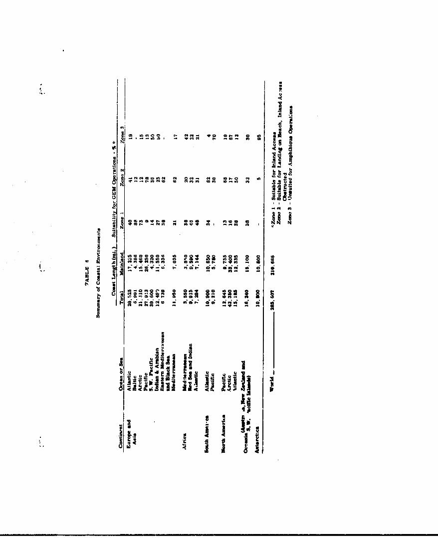
CM InC 00 1-
V- 0I - 0
M tc C* co N a C qo e. a I
t. to
C4 to, In@ 1 ( ~inf
Io
4 Hf~hi~u C Wt. Q- 2 2
M - * ~ ~~ I ~ L ~ Q- ~ utMuC

stretch from the fcothills of Swoden to the Soviet
Urals and south t~o the Caspiar and 13lack Seas.
rhe entire ccastline of European Rupista with-
in the Arctic Circle and 90 per cent of the
Norwegian coast is composed of tundra or heath
which impose serious restrictions on vehicular
movement except when deeply frozen. The north-
west coasts of the British Isles and the North
Sea coast near Hamburg, Germany, are alditional
areas of widespread heath beds. Vegetatinn Ani.d
civilization In these areas, except Hamburg, would
offer no obstructions to amphibious operations.
Weather aunsiderations along the coasts
north of 570 North Latitude would require detailed
study to determine ice and snow conditlnns before
a winter operation could be planned. Rafted close
pack-ice or close drift-ice, stacked up against
even the flattest shore, could be suffi:ient to
obstruct OEM operations. The effect of high-speed
collisions with ice of this nature ant be con-
sidered. New snow covering the ic* or ground will
make navigation difficult (a) because of batnm
blown into the air by the Jet downwash and kb)
because of the orevasses or o.. - disctentnu.Aties
in terrain that it my eaoufiage.
In the Oults of Bothnia arid !n.land and the
Baltic Sea, ferry traffic is restricted from
around December 10 to May 20. Some years it is
completely halted during January through March.
Properly designed 0G.1s could negotiate this area
and provide yemr-round access to these coasts,
heretofore possible only with the airplane. A
more ccmplete discussion on ice, snow and other
climatic influences is contained in sezýtion 2 of
this chapter.
Sweden has many rivers and valleys which
could be used for penetratio', from the coast.
Tn additicn, there are many Inter:onnected lakes
and bays that would serve as suitable access routes.
Good beaches in the area are few in number. Beach
surface consist of sand, silt and scattered rooks.
with backing terrain of rocky and steep banks
except in southern Norway and Sweden where the
lowland* pidominate. While Norway Is 97 • cent
mountainous, it has features providing access inlarA
even though the lsie ef the operrO-,. snuld be
conaiderably liaited by the width of the streaps
and the tributaries where mne lake feeds t.- -nother.
`3ecause of this lted-... "o operational !Spabllity,
a Code 2 classifieation was assigned to the Norwegian
coasts instead of Code 1.) Stream and lake banks
II9
are heavily wooded in most placea and some feader
streams or cana-13 are passable but obstructed by
low bridges at scattered points.
The coasts o.' Scandinavia are clear in the
Baltic and clear-to-channeled on the Atlantic. As
can be expected along the Atlantic, the surf ranges
from negligible to over 12 feet at times, Tides
up to nine feet are experienced along the Atlantic
coast, but are practically non-existent along the
Baltic even though water level is changed up to
bix feet depending upon the strength and direction
of seasonal rnd storm winds.
The Finnish, Russian, German, and Danish
coasts along the Baltic Sea have lowland coastal
terrain with characteristic climatic differences
due to their geographical location. Rivers in
the northwestern region are flooded in spring and
early sumer; during the winter they are frozen and
navigation ceases. In the Finland-Poland area the
predominantly sand beaches have an average slope
of 3 per cent which gradually ince.ealel to around
6 per cent for portions of the Danish coasts.
There are scattered islands obstructing o .-'ore
mproaches, but the near-.. -e area is 85 per cent
clear. The most o .i obstruactions in the southern
-leo-
end of the regio.x, around Ge-rAn 2nd Dermark,
are shoals, sand and mud flats, and scattered
rocks. Backing terrain generally is characterized
by low-level sandy necks and meadow land with
scattered trees, grass, and cultivated fields.
There are only scattered areas of swamps and
marshes, boulders, low cliffs and bluffs on the
coasts. Tidal ranges are negligible toward the
north but become appreciable (6-13 ft.) off the
German North Sea coast. Surf through 70 per cent
of the area from Pinland to Germany ranges to d
feet while the remainder of the coast rarely
experiences surf over 5 feet In height.
The characteristics of the low and fertile
41-uile Belgium and 8O0-mile Netherlands coastal
areas are well known. Except for scattered w"ecks
and shoals In the area, normal approaches are no
problem. For OW operations the wrecks and sea-
walls represent the most formidable obstacles.
Large drainage ditches in the &rea are 4 to 8
feet wide and up to 4i feet deep, bu' 1n places
their banks are approximately level with the
surrounding terral:, thus enabling ON* t rose
In th•ae areas. Stawallis long the coast have
steep (60 per cnt. ramps at varicus Intervals to
-181-

allow traffic to ,rosS from one side of the wall
to the other. The seawall is interrupted at
several points by gates or lock-type doors which
are closed during storms or high water but open
for inland access at other times. Other backing
terrain features are soft dry sand (firm when wet),
sand dunes and cultivation.
Across the Inglish Channel from the continent
are the British Isles. The western portion of the
Islands are composed mainly of low hills; the
east has areas of low plains, plateaus =.nd rolling
plains. The eastern coast of the main island Is
fairly regular; Crga the northern tip of Scotland
to the southern tip of England thre are only five
big embayments. The southern coast has several
protected harbores the west Is marked by indenta-
tions whioh run far inland and form mqa Important
coercial routes. Ireland has coasts Just as
nged and indente4 as the west coat of the larger
Island.
Inland movement vould be a a.: r.aor problem for
OMIS since inland vate.•wys are plentiful. The
%em.., for ezample, Is -aviable 47 miles from
the son& In Scotand th isla.-. -an b o•r•ssed
Completely by followng the Caledonian Canal from
-.b.
the Firth of Lornt to Moray Firth In the north-
h east. Access can be made by numerous other4.
waterways, but general cross-country travel by
OW would be difficult because of mountains in
Scotland and southern Ireland.
Most of the beaches in the British Isles are
gravel and loose cobble backed by firm wet sand
(soft when dry) and scattered rocks; gradients range
from 5 per cent to 10 per cent. Tidal ranges
vary from negligible to 40 feet in the uhMel-
shaped bay*.
The terrain around Calais, fmrace, is similar
to southeaster.n Agland. There are numerous
beaches but they are backed by cliffs and seawalls
ranging from 3 feet to 20 feet high depending on
the tides and surf characteristics of the arv.
In this area where the Atlantic funnels into and
out of the North Sea, the mnixam tides approach
40 feet. P#Arther south in Prance and on the northern
coast of Spain, the tidal ranges eer considerably
lower M the coast becomes mor oten along the
Atlantic. However, while the tides ara dilmni~h-
ing from 4o feet to 1 freet, the maximum swt
aecighte remain about the am. *-I to )2 feet) but
increase In rrequercy cf occurrence during the
-16•

year -- predomin.,'itly during the vinter
I storms.
The total cov ,tline of France, including the
Mediterranean coast, is 1,760 wiles. The north-
west (Channel) and the west (Atlantic Ocean)
coasts are of a widely different physical and
environmental character from tzn southeast
(Nediterranean) coast. Nevertheless, both coasts
are interrupted by accessible rivers and valleys,
and have an abundant share of low, flat, and sandy
coastal terrain bordered with dunes and marshes.
But east of the Rhone Delta, the Alps and their
off'shae a eotend to the sea. With these series
of capes and rooiW promontories, only a narrow
RIvieroe remains between the heights and the
shore. This Is a charactiriatic feature found
In all of the Mediterranean countries. Approa4h*&
to the shores on the Mediterranean aide are wostly
clear wherea approsohes to the northern and
western coasts aee occasionally obstructed by bars,
shoals and breakwaters. Tides ar41 a,,r. on the
southern coast* are akin to the sunn disposition
of the Riviera reeun an ara chlsed an a !;ht-
•,-moderate -r not over -
a.
The Spauls), and Portugusse coast- are inter-rupted by six major rivers, all of wh1ch rise in
3pain. By takinp advantage of these rivers and
their surrounding valleys easiest penetration to
this sector of Eope can be obtained. The
GWadalquivir Liver eamptie Into the Gulf of Cadiz
whe" broad sand deposits have formed a delta.
These deposits have alto out off a large marshy
lagoon, Laes arismas, which cannot be crossed by
normal shipping or wheeled vehicles, but whIch
provides a wide, flat expanse for OEN oporan. •lra
Other lowlands ae smaller and are restrictea
by ourrounding hills and mowtains . The 0aliola
In northwest Spain is made up of a succession of
drowned river mouths which form exoe'lent sheltered
harbors for suall oratt. Such small harbozr alao
offer concealment for MbibiIOU operations aM
oould be even more widely used by shallow -- or
no-dreft marine craft.
T•hWe up to 13 feest a" founm on the Atlantlo
.sde of spain am Portugal whileo ne. fli,1b re-
oordings are foand on t -ftditerraman ate. The
offshore aproaeihs v tht b3.. •s are generally
cloar and uncbetuted. DMeh sl-4es ire generall$

5-8 per cent. Kri't exits frnvr. the shore would be
cross-country by paths and tracks thruugh brush
and seed cultivation to generally 1falr roads.
The remainder of the European Mediterranean
Coast Is predominantly clear offshore with a few
breakwaters and tidal flats fronting firm sand
beaches in Italy and scattered rocks and reefs
off the Yposlav and Greek shores. Italy has
numerous beaches with the terran on the west
side of the peninsula providing the best access
routes SdLland. Stree are n•vlgab.'s Jnlana
from the coast for 20 to 30 miles; mom rivers
arm navigable sach further. In addition, there it
a coastal canal that parallels the marshy coast of
the Oult ot Venie•, and another in the Po Bain which
connects the cities of Tutrin and Milan. Because of
sedimentation,, the o BDsin is continually build-
Ing out Into the Adriatic as mauch as 3WO feet per
year. There ame other canals wich ehtend rivers
and in most cases follow reasonabli flat terrain,
end could be us,,d as GIN hlghwkyw ee,,s. the Tiber
River is navigable as far as Perugia with s.llow-
draft vessels.
Coastal *7eSeta'l.on In &. "v e.6omld im.t obstruct
cross-country movement since It Is prludndntly
-LO6
grass, brush, and cultivation with some areas given
over to olive groves. The actnal coastal terrain
consists of marshes, lagoons, and dunes. A very
small percentage cL the total coastline has sea-
walls, bluffs, and buildings which would form the
only major obstructions. Tides and surf for Italy
are consistent with the rest of the norUtha
Mediterranean coasts.
The coastal plains of Yugoslavia and Greece
are narrow and 50 per cent rocky with cliffs back-
ing the beaches. Most rivers flow unierground
in Yugoslavia since the karat (limestone) formations
are soluble, allowing the water to pass through.
The four rivers in Yugoslavia which are important
and accessible are bordered by cultivated low marshy
lands. Inland from the coast, these usable rivers
are cross-connected by canals which would obstruct
GEN movement perpendicular to their courses.
The rivers of Greece are steep, rapid and
unsuitable for navigation. Except for the upper
part of Ureece, there is no. parc oz the country
which is more thin 40 miles from the sea. Frequent
earthquakes, particularly on the southwest ciaats,
suggest that the land is stii. 'n a state •t trans-
formation. Constant reconnaissance in the area
-187-

is required to determine changes in offshore
approaches and ccv'tal ter&,ain.
Surf In the a' aa is high only when there are
strong offshore winds. Usually it is negligible
and is accompanied by tides of less than 2 feet.
While there are many landing beaches In the
Yugoslavia and Greece areas, the backing coastal
terrain Is rugged enough to make Inland access by
Mas difficult. The beaches are of sand and gravel
composition and the backing terrain is 70 per cent
cliffy or mountaincus. Roads, trail., and tracks
can be found around ridges or up river valleys when
available.
The Berorn.an shorso of the Black Sea are con-
siderLbly different from those of the Oreek Aegean
Sea. The coastline Is gently curving and regular
until It reaches the Romania-Ukraine border whba
It is embayed and marshy. Ice restricts the shore
appraohmes in the southern region occasionally,
but in the north it Is consistent in the winter.
The hilLy terrain In the south Lives way to legoor.a
or steppes in the north around the delta plains
of the Danube. Inland ex•ts over tracks an.. trails
through driftwood, saittero . -'sh and culttivated
plains warrant a Coda 2 classification for much of
-188-

the Bulgarian coast. týwever, the iow, flat, treeless
crea to the north In Ronania would provide easy
Code 1 OEs movement ove'land to the heart of the
country.
2. Asia
Asia comprises about one-third of the earth's
land area and is the home of nearly two-thirds of
the population of the world. ý.!a '.tea wholly
within the Northern Hemisphere and stretches over
5,000 miles from the Malay Peninsula in ttie south
to Cape Chulyuskin witl4n the Arctic Circle in
northern Russia. Its east-wost dimensions are
approximately 7,000 miles. It is bounded on throe
sides by oceans arA4 on the fourth by the Red,
Mediterranean, Black# and Caspian Seas. The coast
of over 100,000 miles represents a wide variety of
types of shore.
The nortnern coasts are most notable for their
toe-bound condition during the winter monthu;
generally, these shores are low and doeply indented
by the many rivers that f.,,v w rjm nooth to north
to the Arctic Ocean. The Rusoian beaches are c iu-
posed of saoid, pebbles, And somse - ',ders. fltrpo-
fourths of the beaches are over 100 feet wide with
the re•minder between 50-100 feet in width. The
-189-
backing terrain is mostly tundra rlain, and marsh with
L- scattered bluffs and steep hills at irregular inter-
vain along the coast. Vegetation in this region
is low grass and mosn with some scrub growth, none
of which should provide obstacles to G0( operations.
Low winter temperatures, extreme isolation
and short seasons when navigation is possible re-
stricts settlewent and InterAst in the area except
for its strategic value. In the winter the many
rivers are ice-bound and as they thaw upstream
(in the south) before their more northerly lower
reaches, gr.'eat floods occur in the middle and lower
basins each spring. In this region of Asia is
approximately 10,500 miles of Code 1 coastline.
Routes skirting patches of hummocked ice will be
neueseary in the winter, but once land is reached
the GOR ýeems to provide the only year-round form
of transporcation. (In the winter the rivers are
frozen end the snow is deep; in the spring the
river basins are flooded; in the summer and the
fall the warshes and timckra have thimo ,r.a the
mire is deep.) whhe" there is surf, it is usually
rough (5-8 ft. hish).
Ln moving fror the -*,rthu'n u - to tu the eastern
and southeastern ian coasts, a. uramatic change
can be seen. Thae r'eIon is char'acterized by
-190-
numerous small and large islands, which wer3 formed
mostly by partly submerged volcanic folds. The
coast from the Bering 1,1trait to the Malay Peninsula
is of a Code 2 classification with the exception of
15 per cent Code 1 and 3 per cent Code 3. This
coast is much indented and broken by a series of
seas and gulfs with pack ice occurring as far south
as the Yellow Sea. Some of the greatest rivers
in the world dissect the Pacific Coast of Asia.
The flow of these rivers is generally at its
maximum in the summer when the interior snows melt
and rainfall is at its greatest. Near the coasts
the rivers are gentle but they are restricted by
levees and, somewhat like the Mississippi, flow
above the level of the surrounding plains. He-
current flooding hampers oommunication in the orea
and would eliminate travel by any conventional
means during the period of flooding. Conditions
are ideal for a craft with GEN qualities -- speed,
flexibility and no restriotlons with draft.
The best landing beaones are ooncentrated in
the northeast portion of the ChJinese coast but ",sse
are backed by villages, terras. and sea walls.
The Grand Canal paralle' •r; the coast from Tientsin
to Hangohow offers another obstacle to inland
movement by convgutional vehioles but would be
-191-

guw'ountable aL varloias p:ot• by Cis - .th a
Jump capabi.Aty of 4 to 5 feet. This canal Is
30 feet wide and has the app arance of a large
open drainage ditch over most of Its length.
Southern China is ruqged and intensely culti-
vated and populated. The coastal terrain Is com-
posed of a broad valley flanked by mountains and
dissected by river valleys. There are few shore
cliffs in the area but there are numerous villages
and coastal roads. Post roads are poor and dis-
cornected since river floods or monsoon rains wash
out the roads and bridges as mwll.
Further south, Indochina lies wholly within
the tropic zone. The southwestern mnsoon comoned
with the heat supports dense tropical Jww4les and
mangrove swan often to the edge of the water "he
1i'dlate shore line Is characterized by feature-
less deltas and swm-s with some mountains to the
sea In the northern region. The 1,700-mall coast-
line contains 119 major beaches which wou]A swmport
large-somit mobious landings. Lateral tommaea-
tion lines with conventlonal :AW veshbles would be
extrawl? .41f'cult sInce most bwtob , cut during
Vkrl4 War II either hew. nnt, b.i.a rebullt or are
periodically destroyed by floods or curent guerrilla
warfare. It Is 411iOUt to travel more tam T5
milee by z-oad uv. r.Lll befoee L-Pa, B stopped by a
missing bridge or rail section. Most roads parallel
the coast and may 0.o inland 20 miles occasionally,
but any traval further inland must negotiate dense
junele and rugged mountains. The best penetra-
tion can be mace by numerous short waterways found
in the area.
Approaches to the coast zrst pass islets,
reefs, rocks, shoals, and some drying band and mud
flats with the tides ranging from one foot to 12
feet around Saigon on the southern tip. Tahe surf
in this area also approaches 12 feet at times.
The beaches are preoaoinantLy wide at low tide and
rematn so at high tide except where tidal ranges
are high. Eighty-seven of the 119 beaches are two
miles or more loni; they are 100 ft. or more wide;
are made up of sand, mud and pebbles- have gradients
of four per cent in the tidal wash zone and 10 per
cent above the high water line. This average maxi-
mum gradient of 10 per cent is consistent throug~iout
the southeast coast of Aaia.
This region hza ezoelXs • landin awes., for U
N;)erationa, but conside\ra. o-f LOlf king terrain,
cultivation, v*Mt•1i, and population crowding
the coast requiLre that a 5liatted Inland access'
I-10
(Code 2) classif!lation be pleý.d on the
(. coast.
The next section uf Asian coast envers same
3,800 miles around the Malay Peninsula and up the
coast of Burma and East Pakistan. The many major
beaches in this area are predominantly less than
two miles long; composed of sand (soft when dry),
mud and coral in places; have tidal ranges from 2
feet to 20 feet, and surf ranging from oite-foot
heights off the Cambodian coast to 20 feet near
Rangoon. The offshore approaches include many
islands, shoals and scatterpd rocks. The vege-
tation of the backing terrain Is indicative of the
climate In the area. There are dense mangrove
stands, rain forests, palms, and dense 3econdary
growth. There are swamps and mud lagoons, and few
all-weather roads. Conventional landing conditions
are beat during the period from November through
March. This would be extended where OEM replaced
conventional vehicles.
The island fringe or southeast Asia Is an area
of significant interest ror GM1D mphlblouis -:JA'-
itions. From the weste,. 'tp of Sumatra to the
eastern tip of New 1i'nea (a a..,_ance of about
3,200 miles) are two parallel chains of islatnds
_194-

,-itki Irregular coas-; .1nes0, mo-A•t•ins, activevolcanos, swamps, thick Jungles, high temperature,
high humidity and 1 eavy rainfall. The islands
were severely damaged during World War II and
vegetation now present is comparatively new
growth. Rubber and coconut trees are ontitlU,
and remaining growth, other than cultivation, is
nips swampe or rain forest.
The Sumatra coast is about 20 per cent Code 1,
all of which is on the northeast side of the island;
fifteen per cent is Code 2 which is scattered
throughout the island; the remainder is essentially
inaccessible for large scale landIngs. Java Is
30 per cent Code 2; the remainder is Code 3.
Borneo, including Sarawak, is 97 per cent access-
ible to Ms. The most inaccessible area is its
northern tip where a 13,455 foot mountain slopes
to the sea.
The other large island in the group is
New Guinea with Code 2 (15 per cent) s',attered in
equal amounts throughout the island. The remainder
of the coast is Code 3 beoause of mountain eox-
l-ending to the sea, coral . ýnnaclcs on shore as
well as offshore, "r.* dense raini forests to the
water's edge in most cases. The s~trf in the Code 1
-195-
southern region roan as high as 8 feet at times and
the tide ranges from 2 to 17 feet depending on
the seaeon of the year. Beaches in the area vary
from a width of 100 feet to some of 45 feet or
less. Gradients range from one per cent in the
south to nearly vertical In the west. In the east
the beaches are preddminantly steep with a six
per cent to vertical gradient.
Most of the islands which are within ten
degrees of the equator are mountainous, are fringed
with nipa swamps or bSach Jungle, are ringed with
coral formations, have moderate to very rough surf
(3-12 feet), and have soft sand, soft mad or coral
beaches. About 60 per cent of the landing beaches
in the area are two miles or more in 1n=L and at
low water 80 per cent are 100 feet or nor* wide.
At high wator, depending on the tides prevalent
in the area and the beach gradients, approximately
50 per cent of the beaohes are less than 50 feet
wide with the remainder varying fron 50 feet to
100 feet or more in width.
Indla and Western Pakistan, with 1,4.30 mles
otf coast line, have 1140 iw 4ir beacheS. ore than
80 per cent are over ;o hadlon .,S and 100 feet
or more wide. The suxbf, depending on the season,
.a96..
runs from 2 feet to 8 feet, ar.! the tides range
from 5 feet to 25 feet. The greatest tidal range
it located jubt north of Bombay in the Gulf of
Cambay, a region of extensive swamps, mud flats,
and fishing stakes. Generally offshore approaches
axe clear except for scattered Islets, rocks,
shoals and bars• Beach gradients in South India
average about 2 per cent while in northern India
and Pakistan they run from flat to over 6 per cent.
Exits from the beaches in the south are cross-
oountry to coastal roads aatd ratlroads which are no
more than 2 miles Inland in most instanems.
Most beaches are backed by s*wms, marshes,
and wasteland for several miles. HlUI are Jungle
covered and dissected by mwa streams. Comnica-
tione in the delta regions are almost nonexistent
and the coasts are embayed with *allow approac•es
to the shore In these msetore. All rivers but
the larg@r, more active ones are dry except in the
rainy season. This does not exclude their use by
O as " avenues of transportatiera r6.n 'oastal
jungle* are impenetrable.
Vest of Pakistan arb: Tv~dIa am the coaut4 of
Iran and Saud Arabli. There k. 5,OCO miles of
every type of coast from intensively cultivated
date groves throvgh sand dunes and beach cusps to
rocky, hillocks 100 feet high. East of the Persian
Oulf entrance and northwest of the Gulf of Aden
the narrow coastal plain is backed by steep mountains
rising to 8,000 ft. in places. In this region are
mangrove forests, 200-300 foot cliffs in spots, ani
numerous streams fed from the mountains.
While nne-half of the terrain Is of this varied
nature, the remainder is generally level, flanked
by rocky promontories, low points of foul ground
and scattered scrub on the beaches. The beaches
In southeaat Saudi Arabia are backed also by crust-,
treacherous salt flats which are 1passable during
the wet season. In the Red Sea area beach exits
are either nonexistent or unknouri and the whole
area Is reported to be relatively unexplored. In-
land movement would be cross-country to unpaved
roads which -At tims ma disappear or become Im-
passable because of shifting sand.
The beaches are wide at low woter, but with
tidal ranges of up to 12 reet the widths are reduced
to between 50 and .00 feet with high water. The
sand, shell, and corml surfs% , have C per "ent
or greater slopes Isn the eastern sectow. and tend
4 toward slopes of less than 1 per oent in the west.
-198-

Be&cah approaches --re restricte, at the north and
south ends of the Red Sea and where the Persian
Gulf flows into the Arabian Sea. Otherwise, they
are generally clear but shallow du* to 511 cing and
corel formations.
The remaining coasts of Asia (Israel, Lebanon,
and Turkey) represent a small portion of the over-all
continent but at the same time are vital areas to
the Western World because of their strategic loca-
tion. The coast line becomes Increasingly rugged
in moving north from Israel to Turkey. In general,
the seaward approaches are clear, but with scattored
reefs, Islets, shoals, and rocky ledges. While land-
ing beaches are available, many man-made obstruc-
tions exist which would slow down amphibious oper-
ations. The most formidable of these are sea walls,
piers, and oil pipelines offshore from storage tank
farms. These obstacles combined with gravel or
ooral bacnes of 3 to 10 per cent slope and a surt
up to eight feet at times could mike larding oper-
ations haza•douas.
IWland movement of veheled vehicles fy. the
"'*aches on the ioast of 1b. al Is restricted to
prepared routes beet-sw of sand •anes, sandstone
ridges, cliffs, or blutfts backing the coastal
-199-
terrain. In Lebanonr. mountains !%aek the entire
coast and cross-country travel is hindered by banks,
rock outcrops, stone walls (3 to 4 feet high),
hedgerows and dunes.
The portion of coast from Turkey through to
the Black Sea is rugged with sand, pebble r.d
cobble beaches. The western coasa line of the
Turkish Peninsula Is probably the most accessible
coast in this sector. It Is cut into many bays
and peninsulas with numerous orfshore Lslanas.
Since central Ta'rkey Is a vast plateau rSaed by
young folded mountains, its Itnterior is not easily
accessible, Thee Ame narrow plains between the
mountains and the shore. Routes to the plateau
would largely be up stream valleys. In the area
of the Dardanelles and the Bosporus landings
could be made, but it would be ditficult for hostile
forces to carry out military operations.
Surf in this area of the Nedttevrenean and
Black Seas to rough (breakers to 8 ft.) even though
the tides are negligible. Beach grafienta are 6
to 10 per uent on the average tor about h&l" .r
t"e 31 beaches. The rema. 'Oer are more gestle.
Abaft half are less th,.. two milet. lo4j about
80 per cent range in width from 30 feet to 100
-200-

feet; týe r-emainde. ziae 100 feet or more wide.
The whols area is generally a Code 2 region.
3. Africa
The At',Ican shore line is generally un-
developed; it is heavily forested in the equatorial
region and the ooast of Mozambique and Tanganyika.
This tropical rain forest gives way to light
forest and grassland over the rest of Africa except
in the desert regions of the north and southwest.
Because u0 its regular coastline, good natural
harbors are scarce in Africa, and much of the coast
is fringed with aand bars laid down by currents
parallel with the shore. Along the equatorial
regions of the coast, mangrove forests border the
shores making the approach from the sea difficult.
However, this area ib classed as Uode 2, since the
beaches are cut by numerous streams which would
'-ilow sonx inland pznetration for discharge of
troops and supplIes, and would provide conceal-
ment from air observation. Normal dI;e eater ship
operctionh are pc,. lible only on the uongo River.
Others have delta deposits at the coasts wh. a
restrilct river traffic to [email protected] draft or no-draft
craft. Many have several navigable sections, but
passage from one section to another is restricted
bicause oi rapids or waterfalls.
-201-
On the whole, :he coastal plaizi 13 wider on
the east coast than on the west. This is also
the section of grertest tidal ranges (10 feet
or more). The south and southeast coastal sectors
cove:, all three GE4 accessibility codes In a well-
defineu manner within less than 3,000 miles of
South Africa and Mozambique. Rivers offer the main
highways Inland but many rapids are present and
detailed rtudy is required before operations can
be plazned with any reliability. At 'Umes of
the year the Orange River, south of the Namib
Desert, dries up; the rugged terrain surrounding
this section of the coast precludes vehicular trave'
at any other point. Other rivers in the area are
Ladly silted and must be dredged constantly to
support any but the lightest traffic into a harbor
or port.
In movinh north tp the east coast, the topography
:hanged from laid rising in terraces as it approaches
the backing mountains to low, sandy areas with many
swamps. This is also an area of hay mangrove
forests baeking the shores. Where landings are
possible, the sand and otcz beaches have sloheb
ranging from 3 to 6 per cent. "nads -:,d iriges
are often washed out in the raW.ny season and the
necessity Of cross-country travel to reach tracks
-202-
and unsurfaced ro.c'0 would preimnt a problem for
foot troops and wheeled or tracked vehicles dur-
ing the rainy seascvi. The coastal plain io 10 to
30 miles wide up through Tanganyika, but is backed
by the steep central African plateau.
The plains flood readily during the season of
heaviest rains between December and March and malaria
and sleeping sickness are epidemic along the coast
and up the Zambezi River Valley. Backing the man-
grove lined coasts and below the mountains, the
vegetetion consists primarily of vast savanna. Many
native villages line the coast, with extensive culti-
vation of sugar, cotton, timber, and coconuts in
and near the many stream valleys.
The remainder of the east coast of Africa Is
rugged except the 1,200-mile coastline of Italian
Somaliland. Here the beach tgradient ranges from
2 per cent to ovur 6 per cent in places. The back-
Ing terrain is progressively steeper with low
escarpment which Is further backed by narrow sandy
strips. The near terrain is unsuitable for wheeled
vehicles because of dry, looCe eared which s' L"ts
Into high dunes. Scanty u. ', and brush growth
In the area would of'.4* no obstruý.Llon to inland
movement. Extensive irrigation is practiced in
-203-

the vicinity of the two main r. vers (Scebeli and
"Juba) in the area. Most exits from beaches are
cross-country to coastal trails and very poor
roads.
The sides of the Red Sea are rugged and
difficult for amphibious landings because of the
mountainous terrain sloping to the sea. The area
between this coast and the Nile River in almost
entirely uninhabited except in the fertile Nile
Valley. The Nile is navigable for over 800 miles
and provides easy Code 1 access to the region.
The flood season begins in July and lasts into
October.
Except for the Mediterranean coast and the
Mile Valley, the northern part of Africa is arid,
sandy and supports little vegetation. There are
many coastal roads paralleling the coast from
Algeria to Egypt with fair cross-country access
from the beaches. In Tunisia, crosq-oountry access
is occasionally impeded by large dunes and so.m
lagoons.
Surf on the Mediterranean coast varies iram a
mUxmam of 3 feet in some art. - to 8 foet ic,
others, with beach gradients running from 1 per cent
In the western regions to ncarly vertical where the
-204 -
Atlas Mountains In Adgeria mee.. the oea. Within
"this 3,800 mile region to the Gibraltar Straits
there are 284 majo: landirg beaches. Thirty per
cent of these are partly obstructed by reefs, coral
and sand bars up to five miles from shore.
Around the horn of the western tip of Africa,
Morocco has a largely impenetrable coast because
or the extension of the mountains in this region.
However, there are several fairly large rivers in
the area by which access can be obtained to the
interior of tho country. These rivers are un-
navigable for ocean vessels because of sand banks
blocking their mouths. The surf in the area
ranges up to 13 feet and the 3 to 6 per cent
gradient beaches are of firm sand (soft when dry).
Approaches from the Atlantic are somewhat obstructed
by reefs, rocks, bars, wrecks, and fish nets.
Scattered on-shore obstructions consist of low wave
bcarp and 10 to 30 foot sand "idgeo and bluffs.
Tidal ranges between 80 and 13° North Latitude
are the greatest anywhere along t~e West African
Coast. In addition to tht equatorial Jungles in the
lower region of the coastal bulge there art. large
rubber plantations with tree% -naced 2.0 loet
apart. There Is a wide variety of bonches in this
section of the sand and mud coast. There are flat
-20r-
beaches and thei'e are those *V:-:h slopes to 10
per cent; there are beaches less than 50 feet wide
and there are those over 100 feet wide; there are
those with clear offshore approaches and there are
those (in Nigeria and the Cameroons) with scattered
shoals and wrecks. The most consistent feature of
the area is the obstruction of near-shore approaches
by shoals, sand bars at river entrances and scattered
rocks, wrecks and reefs. Ninety per cent of the
beach exits are cross-countz-j to coastal tracks and
trails which in turn lead to unsurfaced roads.
While the coastal plains are more narrow than
those on the cast coast they have meny of thc same
characteristics -- low lying, soampy, sand beaches
backed by marshes or lagoons, undulating backing
terrain to the mountains. The entire area is
dissected by numerous rivers and streams. lxc4pt
in the arid "egions of the Sahara and Namib Deserts,
tne entire coast is backed by forest•. of varyin!
density -- decreasing in proportion to their
distance from the equator.
There are few good nalural harborsar, sea
swells which increase c%. Iderably in the south
add to the probles v." shirting ind Geposits,
completely closing off rivers and ports if dredging
-206-
is not emuloyed. Xcre and more jette3e are beirg
constructed to t.L the• 7.oveet of the s&nd, tut
this werely shifts the bar further from the beach,
where the b-illd-up 3tarts to close 'hA entrance
all over again.
4. South America
South Aerica and Africa both are cut by
the equator and consequently both have hot, Moist
Jwugles. Milbe South Ameriea is less than two-
thirds tne size of Africa, it has a much greater
quantity and broader area cf raUfall thewn Africa.
This molsture Ir !.re~ i the ronrther'i hail
of the continent, settiMg the pattorr for the denue
grewtA of vegetation. From the mouth of the San
Prw-a:i3o RI'er, near Recite, down the coast to tho
souther tip of 3rar:l1 are heavy coastal vewetatio
gzow•ia. An Isolated coastal stand of heavy gr"h
Is found Ir. the vicinity Of olpwalsto and ConOpciOD
In Chle. The mmn coastal forest reglon beftn
in Scuador aM follovs the coast noithuma. cross-
Inm the 18thma, then eaumaro W.t the mouth or
the 3Am River. Inland, the tri.. attain great
helght, ftoluir sUC- a dense can0wY that tt -orn :
rtoor ts sparsely vvgetate. wtept uwre lilat can
pmetrate. On t,-.e the trees are low and
stunted, and It is difficult to distUgtuish between
trees an shs L*.
-M2?-

The greatest density of South America's
population is found on the southeast 3oast of the
continent. The center of this concentration is
the metropolitan area of Buenos Aires. This large
city is located on the Parana River Delta at the
southern entrance to the great dentral lowland.
This is an area with great grasislands similar
to that found in the prairies of North America.
There are well-developed forebts along the streams
and grasses on the steppen which cover the southern
end of the lowlands. The beaches in this area are
not recommended for conventional amphibious oper-
ations because of their flatness and lack of con-
cealment. There are many bluffs backing the beaches
but continued inland movement it possible by using
the stream beds which dissect the coast in many
places. About 500 miles south or Buenos Aires the
region it arid, and vegetation and population are
sparce. Once access to this territory is attained
there wuLd be no problem in progressing northward
up the backbone of the continent.
In addition to the Paranat River besin there are
two other large, %Iost ec.atiwnuus lowla associ-
ated with rivers on the .zIntic Coast -- the
Orinoco and the o n The Bzat&lian Amazonia,
-208-

the lowland bordering the Ama.zon River and its
tributaries, makes up about a thIrd of Brazil
and includes all of the northern portions. The
entire region if, one of great uniformity and
exhibits only slight relief. Fifty per cent of the
area is below 500-feet elevation. In the vicinity
of the rivers much of the region is swampy and often
flooded ddring periods of high water.
The coastal plain of Brazil is fairly wide
in the north as it merges with the Amazonian low-
lands and reaches its greatest width at Bahia
where it averages about 50 xiles wide. Prom there
southward it becomes extremely narrow and in rarc '.y
more. than a few miles wide in southern Brazil.
Bven though Brazil has almost 5,000 miles of coast-
line it has few good natural harbors. In the
north and south the low lying, marshy coasts backed
by lagoons have not been developed because of the
threat of flooding and the problem of building up
the land to support settlement. The eastern coasts
are straight and hi&h, offering as protection
for harbors.
The shores are cor.oaed of *and which is firm
when wet. Slopes rpnge fro". '*s thnn one per cent
to greater than &L. per cent. The approaches
-209-
offshore are generally clear except for scattered
shoals extending for soxe distanc3 offshore in
the north and reefs, rocks, shoals and sand bars
in the southern regio'%. Tidal ranges of over 20
feet can be found in the vicinity of Dhe Amazon
River, but generally throughout the rest of the
coast tides are 2-6 feet.
While landings can be made all up and down
the coast, only in the vicinity of the lowlands
of the Parana, Amazon, and Orinoco would the
operation be simplified. In the lowlands where
flooding has occurred, the banks are tapered.
Further upstream where the rivers arc narrow and
the flow is swifter, the banks are eroded at the
tup, leaving steep ridges. In all cases, except
where the influence of civilization has been felt,
the banks are lined with trees. Where the climate
is hot and humid, there is dense under-:'owth C- Ln
the banks in areas whe'e the sun penetrates the
shade.
Rxits from Atlantic coast beaesza by trailt
to fair-to-good roads In the Salvador-San Paulo
area of Brazil. ftrtheL, routh. the roads are .aot
as good. Roads in Argentina P tally, are l.r
capable of withstanding sustained military trafft.c€
-210-

The northern part of the continenW beyond
the Amazon basin is generally a Code 2 area except
where the lowlands of the Orinoco basin influence
the terrain. The arta has some mud flats and clay
but is composed predominantly of sand. The fore-
shore gradient ranges up to 20 per cent in places
on the coast of Surinam but drops to around 5 per
cent in the backshore area. The CWr.ibban coasot
beaches range from an 8 per cent slope to less than
1 per cent.
Offshore approaches require caution for ship-
ping in Lhe arc, north to Colombia because of foul
ground, scattered rocks, reefs, bars and inlets.
On the nearvhore a.proach oil-well derricks, pipe
lines, piers and Jctties are a hazard when coupled
with 8-foot surf foMnd in the area during storms.
The oacking terrai. zonnclts of legoons, barrier
Islands, marsh fnr* :t stream valleys and some
quicksard. Thu area consist or three types of
coastal terrain: (h, steep anu rocky with narrow
sandy shores, (b) ,ow to Lilly with some sand
chore3 and some bluffs and Mliffu, (c) low. flat
sw.vmp wii4 muddy c. spndy aho:es.
In the coastal. arta nrou•n. "he isthiu.- cf
Panara)ovement .anWnd 'a di.fficult if not Impossible
"-211-
because of the aaitalis bac•i•ng the s3.ores and
the dense tropical forest covering their slopes
down to the sea The Pacifi3 coast of Colombia
has one of the highest rainfallz in the world and
the area Is very humid.
Rivers on this coast are short and swift,
unsuitable for travel by GEN. MosL are rocky with
many rapids along their c.urses. Sixty per cent
of the surrounding area is unsuitable for GEN
operations. The Am inder is Cnae 2 ty!w of
toiltor7 vwth steep terrain ba•eing the sh-,ý¢c.
Along the shores of Colombia arc Ecuador. t*e
surf runs above 10 feet at times ard the tides
range from 4 to 1 feeot. 2jdeai a. the souzhern
tip of Chile in the Chonos Archipelago range a•
high as 20 feet In places and tnou s,* Is vo.en-t
(15 :eet or more) along the fbole southwest coast
during vInter and spring.
fost of the roads on the coast are poor, and
not coseete4. They mast be suplemnted 01 trails,
watermwys and reillins. Bechsie of the '•untain-
ous terTain and the ft:-. cost of highu•ys, the most
frequently used ra ,kes &* aj. -v'w t-Lls suitable
for pack animals. In Chile, coastal w•nsd aro
nearly nonexistent. Domatic and internatlonal
-212-
aviation is well developed to col,,bdt the
difficult problems of conmunicaition imposed by
the terrain. The Code 2 classification for the
coastal area surrcunding Concepcion, Chile, is a
borderline classification. Landings could be
made, but penetration of the coast beyond the beach
with GE4s would be in the strear. valley areas only
and would be extremely limited.
5. North America
As in South America, the westerna coxsre of the
continent are the most rugged. It to almc•t a
biiiglo great chain or mountains beginning in
Alaska and extending southward through Canada, the
United States, and Central America. In Central
Americahighland3 extend almost without a break
throughout the lensth or the narrow body of land.
The only extensive area of lev'el land occurs in
the Yucatan Peninsula of Mexico. Elsewhere, plains
The coastal plains are narro*A i,.-.¶ wnh Pacirle,
and slightly wider on the Carlbhea:i olde. Ito
coast i deeply indi•ted and irrgular. T1 -onsts
0 the Gulf of Mexico and .- Carlbbean ar* marked
by large bays and .vne. The ofl*:hore approaches
on both sides of the iathmuo arc generally clear
-213-
wlih scattered islanas aj;d extensive conal forma-
tions obstructing the near-shore apuroaches. As
the line of greatest elevation, is generally nearer
the Pacific than the CeL.ibbean, the rivers draining
to the west are short and swift flowing. Dense
tropical rain forest occurs on the wetter lowlands
with mangrove predominating on the coasts.
Exits inland from beaches in Central America
are poor and in most cases consist of tracks lead-
ing to urban areas. Highwnys are well-developed
only arou•d large cities. Large sections oft he
area are without rords qultabl..... eqctr
traffic anQ s,-.. o uxist are impassable
in wet weati '. f-r and water traffic are both
important in :entral America largely as a result
of the inadeq atc and primi',Ive 1-in'l trannporta-
tion. Rivers and lakes fo" ± mportant rou\e-:
and coastal i.: -igatlon is , Cn used.
"There are lany beach. i ut;itabe o 'or landing
in the Central imerica ar,'. They range from 25
feet to over IC; feet wi,4 . and about half are two
or more miles I., . San.. o the Seneral beach
material and it 'o firm .ion w&,t. Oradients on
Aho Atlantic old, are 4 oent t srly Iiori-
zontal while on % e Pac,0ic side they run from 1
per cent to about 3 pe: -ent.
Best i~avfable CoPY
On the Pacific sl.de off the coast of Guatemala,
the tides are the highest in the area and often
run over 10 feet. On the Atlantic side of Guatemala
(and British Honduras) the surf is the highest --
up to 12 feet at times. Approaches to the shores
are partly obstructed by barrier reefs, shell
ridges, coral heads and sand bars on both oceans.
Backing the beaches are some low scarps, dunes,
mangrove forests and swamps.
The Mexican coastline totals about S,4'[0 riles,
with 2,710 miles on the east and 3,760 on the west.
In addition to the continental portion, Mexico
includes the two large peninsulas of Lower California
on the Pacific side and Yucatan on the Gulf of Mexico
side. The Lower California section extends south-
ward from the main continent about 760 miles,
paraileling the Mexicau mainland. It is rugged
with numerous landing beaches but with few vehicular
exits from the beaches. This area ranges from one
to seven miles inland ard is backed by mountains
with steep-aided valleys and one or norm rwP the
following::. ridges, scarps, strips of sand, dunes,
hills, intermittent streams ana lagoons. Tido, in
the rloraemhoe area in the not ',rn part of the
Gulf of California run :, high as ýv feet with the
remainderof the coast tapering to as low as 3-foot
-215-

ttde6. Surf in the upper Gulf is very mild (one
to two feet) wt..le in tre less prctected waters
it runs as high as 8 feet, depending on the season
and weather.
Gradients on the peninsula as well as the
mainland rangs from 2 per cent to around 9 per
cent with predominantly sand beaches. The approaches
from Lhe west are cle&r on the peninsula but the
approaches to the mainland are channelized and
obstructed by rocks, reefs, islets, and shoals.
The mainland backing terrain is similar to that on
•che peninsula but not as rugged, with easier exits
by tracks to coastal roads and railroads. At the
southern end of Mex1co o )ere Is a narrow plain
across the Isthmus of Tehuantepec which extends to
the east coast. In other sectors of the west coast
there are more narrow corridors or ]owla:,ds whtch
e.xtend to the interikqr from most beaches.
On the east coast the Yucatan Peninsula extendb
to the northward about 280 miles into the Oulf of
Mexico. It is an area of low-lylr4 Lai-shy land
with few lakes or rivers. Waile not as extenaive
as on the peninsula, tav.:e are lowlands tt.^aughout
•he whole eastern coast. -.. - extend somP 30-miles
inland and fcrm a tropical belt which Is heavily
forested. The coast is deeply indented with bays
-216-
and gulf. There a±3 many large islands off t
coast.
Because of shallow lagoons, silted river ýhs,
and shallow water, there are no natural Lzrbox
the east coast. (The west coast, in contrast,
has some of the finest natural harbors in the Ld -
Acapulco being an exa,.ple.) There are five rl 3
on the Atlantic side which are navigable for a
distance from their mouths. A constant check
kept on the delta depths to assure that siltir
does not close the channels. The surf is gene Ly
rough (5-8 feet) but tides are mild, ranging
between 1 and 3 feet during the year. The san id
shell beaches have about a 4 per cent slope in
tidal wash sone, up to about 7 per cent in the is
above high tide.
Cuba and other islands of the West Indies ,e
about the same coastal features as eastern Nex
They are broken, bndy shore lines with numero
bays, inlets, coves, and lagoons. Island itr 'o
are usually heavily wooded with heavily cultiv
sloping plains to the sea. Therp 4.-e many bro
rivers In Cuba •t only one of comercial impo Ice.
The Atlantic and Ouif Coastal Plains of t
United States stretch from Cape Cod to Florida
-217-

and aloig the Gulf of Mlxico. The area is
generally low-lying and cut, by many streams.
is deeply indented and marked by coastal lagoo,
tidal ma..shes, deltas, and spits. The inner b, dary
of the Atlantic Plain is the fall line of the er
Appalachian Highland and the Gulf Coastal Plaii
extends north to the interior highlanar and ce al
lowland.
The eastern coast is generally level and
marked by a lO-mile-wide coastal belt of swamp
land in the southern two-tnirds of thi country
Bordering the :nast is a series nf low sea isl s
built by silt from the rivers and separaf-d tr
the mainland by inlets and salt-water rivers w h
form the greater part of an inland waterway pa
lel.ng the rnast. Ths cenitiral coast rises abo,
3 feet w, m. e 'tv.-, ue- level to about !,00 fe
in the n of Wsbilngt,, U. . The slif
of the beaches Is predominantly sand In the so
and gradually oecomes mori rocky on the nortte
coasts of Maine.
The northern Atlantic coasts of Ncrth Ame a
ar-e -ctak' with, tome salt marches ,,nd narrow, a p
beaches. There are "-pate bark, Afshore iii a
and rme"e•8s wash crevasser, coastal settlemen
-210-
streams, and evergreen forests. Tides a
coast range from 9 feet ;o over 30 feet
Hudson Bay area. The surf along the Nor
is over eight feet during the winter sto
The Gulf of St. Lawrence is particu
cluttered with islands and restricted ch
The beaches in that region are composed
mud, as well as cobblestones. The wIde
valleys of Nova Scotia, New Brunswick an
Lawrence region are highly populated, an
catinns rouites are hW.ghlv concentrated i
east sector. The coastal terrain in sou
is steep and tree-lined with a subrorged
and marsh area near the Bay of Pundy T
Labrador is steep and rocky and densely
The Hudson Bay area has a lowland belt o
backing the shore which In icebound most
year. Almost 50 per cent of Canada drai
Hudson Bay and the many stream valleys V:
even though rockiy, nffer reasonable acce
inland areas by OP14 fros the bay.
The ivland arco within the Arctic C
Archipelawoc) Ambraces a vas. triangular
cf Islands wrL ', are ptrr. -' the coastal
sloping gently to the Arctic Oceanu. The
-219-

streams, and evergreen forests. Tide, along this
coast range from 9 feet to over 30 feet in the
Hudson Bay area. The suT.f along the North Atlantic
is over eight feet dur.ng the winter storm season.
Th,• Gulf of St. Lawrence is particularly
cluttered with islands and restricted channels.
The beaches in that region are composed of silt and
mud, as well as cobblestones. The wide cultivated
valleys of Nova Scotia, New Brunswick and the St.
Lawrence region are highly populated, and coimuni-
catinns routes Pre highly concentrated in the south-
east sector. The coastal terrain in southern Canada
is steep and tree-lined with a submerged forest
and marsh area near the Bay of ]undy The coast of
Labrador is steep and rocky and densely forested.
The Hudson Bay area has a lowland belt of trees
backing the shore which is icebound most o:' the
year. Almost 50 per cent of Canada drains Into
Hudson Bay and the many stream valleys in the area,
even though rocky, offer reasonable accces to the
inland areas by OD•s from the bay.
The ialand area within the Arctic Circle (Arctic
Archipelago) *%mbraces a vast triangular shaped bL'oup
of islands which are part of the #. "%tal pisiuin
sloping gently to the Arctic Ocean. The area is lce
-219-
bound much of the year but the general terrain should
offer no obstacles to inland accesz in ma-y areas.
The only vegetation in t-he area is of the tundra
dwnrf-tree type. The M¶ackenzle Rivei 1a0le7 offers
an easy route inland especially durint the cold,
frozen season.
West of the Mackenzie River are the Richardson
Mountains, blending into the Brooks Range in Alaska.
This is extremely rugged territory with the north
coast of Alaska following the frozen pattern of
northern Cannad. Dur1ing the thawtng season,overland
travel is practically impossble by conventional
means. The coastal backing terrain is fairly ilvel
but the area is covered with innumerable lakes.
The area is usually completely isolated because of
the formidable range or mountains. Air travel is
the only feasible mode eight moniths of the year.
Further westwa-d and southward around the coaast
ip more of ths same rugged terrain. In placee the
mountains extend to the sea and In others the sand,
pebble and ccbb.e beaches are backed ý, lagoons and
intersected by streaw The :onstant freezing and
thawingl .akes the area unsui-able for any wthee- d
venicles larger th.n a Jeep. 'r,. "ery ir:etular
whoreline has limited e-ts along gullies or between
lagoons to the tundra rarther inland. Noot beaches
-220-

are backed by bluffs. Only tracked vehicles
could be used for medum heavy-duty operattons
on land heretofore. GE¶s will offer significant
advancement In this a, :a "n t1e future. Offshore
approaches are cluttered with scattered shoals,
rocks and islets south and east of the Alaskan
Peninsula. North of this area the sea approach is
generally clear. The islands and peninsula are
crossed with many streams on their relatively
level northern side, but on the Pac.fic side all
shores arc stcop and ruled right to the sea.
The Yukon River provides thc chores along the
Bering Sea with a Code 1 classification because of
its access route to the interior. Farther south,
Cook Inlet provides a protected area for landings,
but the primary exit inland through the surrounding
mountains is by the Alaska Railroad.
Farther south along the coast is the highest
41114 moot rug.cd portion of Canada. 'his region
includes the offshore islands and the Coast and
St. Ilias Nountains in the most wes'eo.ry sector.
The coast line is penetrated by many fiordi with
steep shores and backing terrain. Among the
numerous islands frontin.• the shi - are the la-e
Vbncouvar Island and the Queen Charlotte group, all

of which are a part of the complex whtch forms com-
paratively restricted and channelized approacnes to
the mainland. The only place of any size on the
coast lower than 1000 feet is at the mouth of the
Fraser River at Vancouver, B.C. Landings that could
be accomplished in the area would be restricted in
size and inland access by heavy woods and rugged
terrain.
The west coast of the United Statea is a con-
tinuation of the feature8 foxund on the Canadian
coast, but the density of ruggedness de-.reasps to-
ward the south. Forests of pine and fir m'nUle
much of the area with wide belts of redwood along
the coast in the south. Puget Sound area is the
lowest coastal area in the north. It offers water-
way penetration for about 100 miles east plus its
southward branchee--Admlialty Inlet and Hood Canal
(60 miles). The surrounding shares are densely
forested.
The coastal ranges paralleling the shores of
the northern area are interrupted by ceveral
valleys. The shores are predominantly rocky
and steep slopes fore the bapking terrain. Rivers
and river valleys offer ',he beet - 'and mutes,
-222-

e.g., the Columbi- Rive" is navigable with small
ships fcr about 460 nmiles. Besides the wide
mouth of the Columbia, there are severi.l small bays
and harbors, There art many beaches in the area
and several coastal parks. Exits inland are by
scattered roads, tracks, and cross-country to many
coastal highways which parallel the snores.
In general, the coastal plain is extremely
narrow but widens out somewhat in the south. San
Francisco and Monterey bays are the only major in-
dentations in thc zouthcrn setil:- wIth -hn fz¶mar
providing one of the world's greatest natural har-
bors. Tn other regions the beaches are backed by
rocky cliffs, bluffs, wooded areas, or densely
settled regions. While offshore approaches for
OUrs would be generally clear, continued inland
movement would best be accomplished by whzclP4
vehicles except where rivers and suitable adjacent
valleys are available.
6. Australia, New Zealand, and Pacific IslIans Artea
OWeazta was most efftectively brought t,) world
attention during World War I.r. It was this are.A
that really tested tLiph'bious (am,.'-.bious)
strategy, capability, and flexibility.
-223-
Many wrecks still remaining in the, brea re-
sulted from grounding on shoals or severe damage
inflicted by coral r.,efs ant not from enemy action.
The 1250 mile coral reef guarding the northeast
coast of Australia has long been a hazard to marine
navigation in that area. At high tide the reef is
submerged; at low tide it is partially exposed. A
GF14 capable of operating two feet off the surface
should have no problem crossing the area. Surf
in the area is strong and during severe storms
damage to the boLtom of IEM could result in pitch-
Ing weei a noblem and the craft "grounded" on the
coral while moving forward at high speeds.
in the extre~me northeastern section of
Queenalnd Province, eveni aftor crossing the bar-
rier reef successfully, a landing would be dif-
ficult in the region around Musgrave and Cooktown.
This area contains the extrvme northern tip of
the Oreat Dividing Range which extend.. to the sea.
On either side of this area is a Codo 0 region where
landings may be made, but inland movement by
OEN would be Impossible with today's develops ,t.
Th!Fi region Is rugged and tr.. 'cal rain torest
vegetation covers the .. a.
-224-

The southern coasts of Austra-i.a are charac-
terized by rugged cliffs, many bags and irnlets,
and good natural harbors. Eastern Australia and
Tasmania have coasts of rocky headlands and bays
with some wide sandy beaches. Southeastern
Queensland, easetern New South Wales and Victoria
are the most populated areas in Australia. The
southern end of the Great Dividing Range extends
Into the Great Valley of Victoria. The coastal
region of New South Wales and Victoria supports
a thick growth of Eucalyptus trees, some of which
grow 300 feet or more high. The combination of
topography, population, and vegetation causes
this region to be classed as unsuitable fQr
amphibious ORR operations in the region between
Sandy Cape and Sydney and lim.ted-sultable
(Code 2) in the surrounding area.
The northern coasts are low and level around
the shallow Qulf of Carpentaria, but farther west
they become very Indented as the land rises higher,
shores beooae liff•ty and coral reefs rorpesýr
uff the ooast at Cape Londonderry. The surround-
ing area, eastward fto Queors Channel in Not ,h rn
Territory and westward from L.- Sound at Derby,
Western Australia, " al. llow penetration inland
through the shores or through rivers and estu&•.'cý..
-225-

The west coast is more regular and the north-
moving offshore current creates numerous larse
sandbars which protect the coast from the south and
west. The highest t. les in Auetralia are prevalent
in this region ranging from 3 feet up to 31 feet.
From West Cape Howe in thb south to Cape Londonderry
in the north the vegetation is varled and rnllnwm
the general pattern expected in the climate charac-
teristic of the area. Eucalyptus and woodland
growth around Perth in the south give way to
mallee scrub and mulga savannah in the aril cen-
tral coast and temperate mixed forest in Lne ax-
treme northern area.
New Zealand, with a coastline of 3000 miles
and tidal range of 5 feet to 15 feet is a land of
many faces. The rce:ky coast is generally straight
with few good natural har'bors. The shores are
bordered by extensive beds of sand and shingle
which continually block river mouths 4nd harbors.
The islands are 18 per cent frested. This is
predominantly on the vest coast or tbe ecuth Island
and the center of the nor%,h island. The two main
islunds are extremely u'ounta't'is but are cuL oua
rivers and "U"-shaped viAlleya. n'.ch provlde access
to the area at the ext-.*-" nortnern .A* and the
extrae southern tip of the islands.
The remainder' of Oceania represents a rela-
tively small parc of tho over-all laid-mass of the
sector, but its sigrnificance in world-wide politics
must not be overlo.ked or underestimated. It ex-
tends north as far as the Hawaiian Group and west
as far as New Guinea and the Carolines.
In the Hawaiian Islands, for example, OEM&
would offer rapid inter-island transportation to
augment air travel and supplement marine travel
but inland use would be severely restricted. The
islands a-e mostly mountainous with cliffy head-
lands in the northern parts of most islands.
Fifty per cent of the lsllnds have rugged coasts
with sheer, impassable cliffs and deep rivers,
while the other 50 per cent are composed of white
beaches and marginal lowlands. *Th* Islands are
made up of nvi velcanl. mountains and are one of
the few aiees in the world that are still in the
process of formation. Ialand approaches are gen-
erally clear for this reason- -eo'en though the water
and temperature conditions are ideal for large
coras rormations.
-227-

II. CLASSIFICATION OF MILITARY GROUND EFFECT MACHINES
1. INTRODUCTION
The world-wide environmental data summarized in Chapter I
may be used as a basis for classifying military Ground Effict
Machines into families by size and operating height. The dis-
tinction between marine, amphibious, and overland operations
is retained during this clasnification, although a certain
amount of overlapping may easily be anticipated.
The approach to vehicle classification on the basis of
the operational environment is perhaps unique. Such an approach,
however, seems more appropriate than optimization of vehicle
parameters and then searching for potential applications. The
development cf GEM classes within this chapter is carried out
within the broadest boundaries of "practical" GOE( designs.
The classification itself puts very specific limits on how big
the GEM C.Ln be and what it must do. Thq tabulation of vehicle&
in Tables 11, 13 and 15 So, in erfect, an envelope of bAsic
vehicle requirements within the three categories of anticipated
operation. The following ground rules, outlined in the
Introduction to Chapter I, should br Ieept In mind:
(1) The development of t:m URN classitication considers
only vehicles for transport of personnel anM cargo.
Special purpose vehicles are not included.
-228-

(2) No significant breakthroughs in the present state-
or-the-art have been ussined, although itmprovements in
component and system efiiciencies are included.
2. DISCUSSION AND CLASSIfIUATION OF MILITARY GROUND EFFECTNAMCM S - MARINE
Climatic and oceanographic data for the ocean areas of
the world are sularized in Chapter I, Section 2. These
data form the basis for a classification of marine Oround
Iffect Machines. Table 7 shows the environmental factors hav-
ing most specific influence on marine OEM operations.
(1) Wave Height
For the majority of marine operations, the wave
height in the operating area will be the most significant
environmental factor present. Wave height determines 'the
minimum ODM operating height. At high forw•ad speeds,
the venicle will not be able to follow the wave system
wltnout exceeding himan and ut.uctural acceleration
limits. For the same reasons, It should not hit any
wave crests. Experience to date an codel and prototype
OEM vehicles indicates that an operating height equal to
one-half the wave height (trough to crest), is adequate
for cruise operation without hittina wave crests.
Wave height& throughout the . ",an areas of +he world
have pronounced seasonal vmriation. Figures 10 and 12
-229-
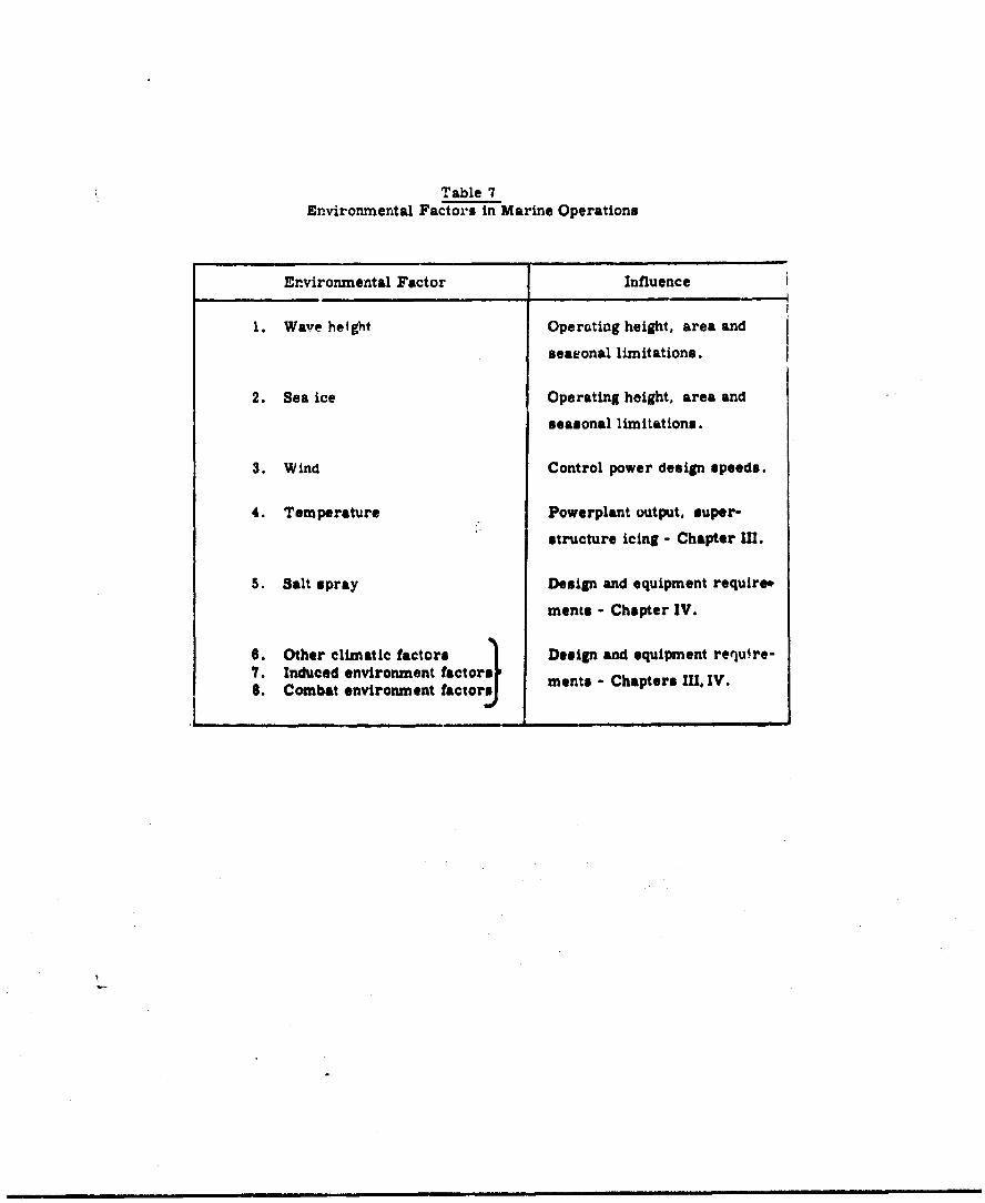
Table 7Environmental Factors in Marine Operations
Environmental Factor Influence
1. Wave height Operating height, area and
seasonal limitations.
2. Sea ice Operating height, area and
seasonal limitations.
3. Wind Control power design speeds.
4. Temperature Powerplant output, super-
structure icing - Chapter IlU.
5. Salt spray Design and equipment require*
mentis - Chapter IV.
8. Other climatic factors Design and equipment require-7. Induced environment factorsr ments - Chapters 1 IV.8. Combat environment factors
I ___________________________________n_____________________________-______

in Chapter 1, foll!,wing page 85, show the frequencics of
five-and 12-foot waves over the oceans of the world, dur-
ing the local w~nter season and the local summer season.
Table 8 summarizeE these data.
From the tabulated wave-height data, a range of sea-
monal operating feasibility can be developed for the major
ocean areas of the world, divided into latitude bands.
These results are tabulated in Table 9. The data in
Table 9 provide a sound basis for classification of marine
Oround Effect Machines, with operating height as the
primary parameter.
(2) Sea Ice
The occurrence and height of solid and floating sea
ice has a significant effect on the operations of marine
0MM.. Figures 8 and 12 in Chapter Is following page U5,.
summarizes the oouurrence of sea lc in the winter and
summer hemispheres. Rererence to these figures and the
accompanying discussion shows that these areas are lim-
ited to above 600 N in the winter and above 800 N In the
swmer, in the North Atlantic Oceans whil.. in the North
Pacific the occurrence of sea ice is very un'omon even
during the wi.,er. In the southern hemispheres the ice
paok around the Antarctic continent extends to 6!. 3 in
the Pp,ý!flo, and 560 S in the At.. ,tic in the winter,
-431-

Table 8Summary of Wave Height Data
(See FigureslO i id 12, Chapter D)
Percentage Occurrence of Waves
Summer Winter
Ocean Latitude > 5 ft. >12 ft. >5 ft. >12 ft.
North Atlantic 0-20° N 10-30 neg ( 5) 10-50 < 5
20-400 N 5-30 neg 20-70 neg-20
40-600 N 20-50 neg-lO 40-80 10-50
North Pacific 0-20° N <10 neg neg-30 neg
20-400 N neg-10 neg-5 10-80 neg- 30
40-60° N neg-20 nag-5 10-80 10-30
South Atlantic 0-200 S <20 neg neg-30 nag
20-400 $ 10-40 nag- 10 neg-60 nei
40-600 S 30-60 10-40 20-80 neg-20
South Pacific 0-200 S <20 nag nag-$0 nag
20-400 S 10-50 neg-10 10-50 neg- 10
40-600 S 40-80 neg-?0 30-70 10-40
Indian 0-200 N nag- 50 neg-10 < 10 neg
0-200 s neg-20 nag neg-60 nag
20-4060 10-40 nag 10-60 nag- 10
40600 8 20-60 5-40 20-6' neg-20
Arctic Above 600 N neg-40 "eg-2C 10-50 5-40
Antarctic Above 600 8 2u-'#O neg-60 10-50 neg-S0
ePartiaUly ice covered - See Figure 6

Ts 9leSeasonal Operating Feasibility - Ocean Areas
Percentage of Time Operations are Feasibic at Given Heights
Summer Winter
GEM Operating Height (ft) j 2.5 6 2.5 6
Ocean Latitude
North Atlantic 00 - 200 N 60-90 95 50-90 95+
200 - 400 N 70-95 95 30-80 80-95
400 - 600 N 50-70 90-95 20-60 50-901
North Pacific 0° - 200 N 90+ 95+ .0-90+ 95
200 - 400 N 90-95 95+ 20-30 ?(-95
"400 - 600 N 80-95 95+ 20-90 70l-90
South Atlantic 00 - 200 S 80+ 95 70-90+
20° - 400 S 60-90 90-05 40-90+ 95
400 - 600 S 40-70 60-90 20-60 80-95
South Pacific 00 - 200 S s0+ 96 70-90+ 95
20 - 40 5 50-90 90-95 50-90 90-95
4C 0 - 60 8 20-60 30-95 30-70 60-90
Indian 0° - t0 N 60-9b 90-95+ o0- 95
00 - 0° S a 80-5 9b *0-040 ss
s0 - 40 8 00-90 95 40-90 90-96
40. -6 0 8 40-90 60.;5 40-L'. 60-95
Arctic Above 600 N 60-96 q0-95 50-93 60-90
Antarctic Above 6005 30-80 40-95 50-90 70-95
es
while receding to near the +cqntlnental limits in the
summer.
Very little quanti'ative data Aottthickness of ice
and surface roughness are presentdy avtilable but, for
example, ice hummocks 20-25 fest i.gh occur in the
Arctic Ocean, north of the U.S.S.3 The fringes of the
ice pack are likely to have rough 6rfaces and large
floating fragnents, and should be 4oided for most GUI
operations. Since ocean-going G3;3will probably have
to be equipped with radar for coll.•ion avoidance,
operation in areas of infrequent itbergs should not be
particularly hazardous.
(3) Wind
Winds are more significant In marine OEM operations
than In overland and amphibious operations. This Is a
result of the higher occurrence of prevailing surface
winds over water areas than over land, as well as the
neqessity to provide fuel reserves for longer-rame oper-
ations.
Since the M operates as a free a.l '- ve•,cle (exocpt
vehicles with sidewalls), the 9ffect of wind Is similar
to that on aircraft. Oroun' steds are reduced .y head-
1rinds and increased by tailwinds. "qponents of wind

normal to the flight oauh require control power for
crabbLin the vehicle into the wind.
Wind data for the ocean areas of the world have
been summarized in Chapter I, Figures 9 and 11, follow-
ing page 85. These maps show the percentage occurrence
of surface winds above 10 knots and above 33 knots
(gule force). The wind data distribution Le:i similar
to those for wave heights, since wave height is largely
a function of wind. Accordingly, the requirements for
operation in frequent high winds us-al~y Aecompanies the
requirement for operation in frequent high waves. Table
10 stUna izing occurrence of winds above 10 knots and
above 33 knoto may be -atched closely with Table 0
showing occurrence of specified wave heights. The dfkt*
of Table 10 may be used to further specify the basic
parameters for marine 0ON vehicles In terms of control
power requirements and in terms of design speeds required
to achieve a given point-to-point speed.
For operation in ooutal waters only, the requirements
for traversing wave systems are often greatly reduced. While
wave heights will be a lees severe llaltatiio; ice, wind, surf,
and width of channels will determine the fetsIbIilty and-re-
quir•ments for 03N operations. Put'.her analysis of a ,ch opera-
tior, is cuntained In the next sectton * this chapter.
-t235-
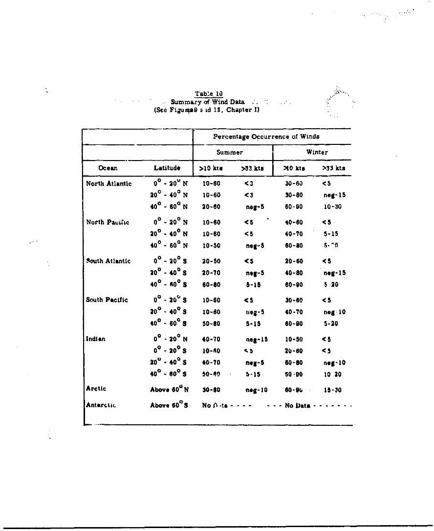
Table 10Summary of Wind Data .
(See Fijuqs9 , id 11, Chapter I)
Percentage Occurrence of Winds
Summer Winter
Ocean Latitude >10 ktu >33 ktMe :0 kts >33 kta
North Atlantic 00 - 20V N 10-60 <3 30-60 <5
200 - 400 N 10-60 <3 30-80 neg-15
400 - 600 N 20-60 neg-5 60-90 10-30
North PauXic 00 - 200 N 10-60 <5 40-60 < 5
200 - 400 N 10-60 <5 40-70 5-15
400 - 600 N 10-50 neg-5 60-80 5-10
'Routh Atlantic 00 - 200 S 20-50 <5 20-60 <5
200 - 400 S 20-70 neg-5 40-80 neg-15
400 - 600 5 60-80 5-15 60-90 5 20
South Pacific 00 - 20 0 S 10-60 <5 30-60 < 5
20 0. 400 S 10-60 neg-5 40-70 neg 10
400 - 60° a 50-80 5-15 60-90 5-20
Indian 00 - 200 N 40-70 neg-15 10-50 < 5
0 0 .200 S 10-60 2 5 20-60 < 5
200 . 400 S 40-70 neg-S 60-o0 neg-10
40° - 60 0S 50-40 5-15 60-90 10 20
Arctic Above 600 N 30-40 neg-10 60-9u 15-30
Antarctic. Above 60a8 No , ta - - - - No Data .......

The suggested classif..Uation of marl.r., GBMs is given in
Table 11. There are two broad groups of vehicles classified
in this table. Classes I to V are marine GM3S with conven-
tional annular Jet or plenum chamber systems. Classes I-A to
V-A are marine slmwal GEMs with solid portions of the vehicle
extinding below the water surface, in the most typical case
along the longitudinal dimensions only.
The' sidewall GIN has been shown to have lower power re-
quirements at low speeds. Its high-speed capability is,
however, severely limited by wave drag. The sidewall GM is
also preoluded from all operations outside water aretas, except
by very special design and construction. For overwate, use
the stability afforded by surface contact may In some cases
outweigh the speed and operating area limitations imposed
on the sidewall Oonfigurations. The effects of operations in
waye systems on sidewall configurations are being Investigated.
Vhtil further teaU r'*sults are avallable# it is considered
A;propriate to clase*.f these with the sae site full MGU
confIgurations.
The clases fliation of marine GS outlined In Table 11
is based on planfom elsees and operating heights appropriate
for mawater operations. Tbe zorrespondin sidewall con-
figurations listed in the right columns of Table 11 art In-
tendec for use on water surfaces only, w.. '1 the 'full 3UE(
-23T-
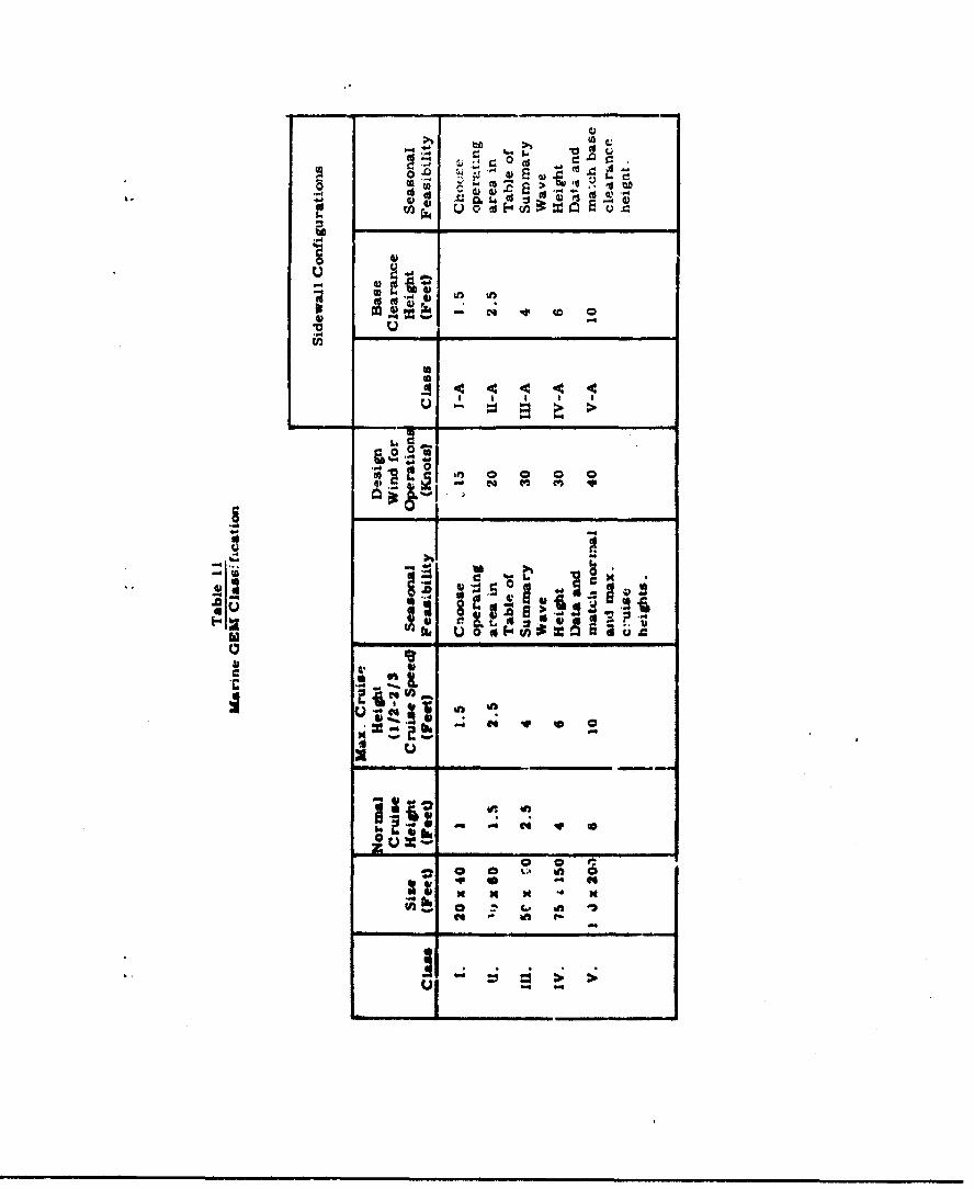
Si n
U44
z•L 0 0d v
od Cs to t ."4) 4) fs W ;Ii
14.ot
C4i
Ig uJU
II I' I IIIII
Ul 0 CA 0 0
ft I -I
j
(full peripheral jet or curt-a&) configuritions may have
!- limited operating capability in cleared land areas adjacent
to waterways.
For each marine vehicle class the normal orulse height is
the operating heigiht above the undisturbed water surface for
the design cruine speed. Because of the depresgion of the
water surface by the air cushion at hover and at low speeds,
the design height for determination of powo- requirements will
be somewhat greater, particularly for high planform loading
GEMs.
The maximum cruise height is the operating height at
cruise power for operating over wave systems at speeds from
one-half to two-thirds of normal cruise speed. The maximum
cruise heicht for marine OEMs has been chosen as approximately
50 per cent above the normal cruise height. Analysis of power
requirements for current state-of-the-art 0OMW shows that
this height can be maintained at about the sam over-all
cruise power, if the speed is reduced to one-half to two.-ttrdg
of normal cruise speed.
With the operating condition of ýhe vciac.i,, 'a ght equo!
to half of the wave height, the seasonal opezating telsiblity
in the open sea oan bt roughly deterod ned by reference to
Table in. spection of FiSures 10 an d" wil, however, give
a asoewhat bet*'-' -cographic picture of operatuW feasibility
in a given area.
-239-
The warning previously G;ven about a.ýp~ll.at ti: of thwo
results should be kept in mind: planning a specific operation
or route requires the applic,-tion of data more detailed than
that presented in this chapter.
The desig.. winds 11sted ".n Table 11 are the raximum winds
likely to be encountered it last 10 per cezi. of the time in
the areas with wave heighte inat'hing tre maximum operating
heights specified for esch Oauas Control power and propulsion
power for each class of vehicle anouid be sufficient to pro-
vide the desired performance in all wi-Os up to the value aiven.
Alternately, a vehicle spdcIfic4$to% sh'w '.indicate acceptable
performcase degradation in the pretarce crf theso winds.
Pending the outcome of current laboratory invcstigations,
the sidewall configurations are classified on the basis of
base clearanoe heights (menaured from the bottom of the
vehicle, not including the sideowalls or skegs) equal to the
maximum cruise heights of the full OI configurations. When
more data become available on stracturso loads and stability
ocs the sidemall configurations in wave system, the classif1-
catIon may be udIf led If necessaxy.
Sfrects of tu.e raitunep salt spray, a&d other cllmatil
eaeWIre, as well a-ts- ee of the lIz,'ed aW eo~at eomba-
ment,, are 4Isoussed in Chapter il. A % *qf di•musaicn of
vehicle performenoe wIthin thu classflication of Table 11 Is
-240-
.rec,.tc," in Chapter 11r. "o..•' ludec the d-vclopmcnt of
powe.r requirements and payloe.d-r-igne capabilities.
, pararneter of particu. ar importance in marine operations
is vehicle cruising range. It is perhaps obvious that the
smaller vehicles cannot operate freely in ocean areas, even
during the calmer periods, becausc their range is 'limited by
the available fuel load. Some further discussion of fuel con-
sumption and range determination is included in Chapter IV.
From the environmental point of view desirable ranges
for marine GEZs are a few mlar -- fn- f-Airpl mptnIqnO
to offshore islands -- to transoceanic stage lengths upwards
of 2,500 nautical miles. Because of the great variety of ar-as
in which military (or commercial) marine GEMs may be oDerated,
two exam'ples of typical numbers in the range problem may be
useful.
Assume marine GEM operations are being carried out on a
general network of routes in two areas: the Mediterranean Sea
and thp qvutheast Asia island fringe. What ra~nges would be
appropriate for these operations? By neglecting, for the
moment, all otheri considerations, Lome typical range numbers
can bm obtained,
The Mediterranean Sea is about 200 miles long, but
mostly less than 350 miles wi&N (all aista...es in nautical
-241 -

miles). Overwater distance, between pairs ot teizainnls,
grouped in convenient •;,age le•! 1..g is are lisied below:
100 miles: Venice-Srieste, Beirut-Cyprus, Malta-
eitaily, Sicily-Tunisia, Tangier-
Gibrr, ltar, qice-Coreica.
100-200 miles: Rome-Sardinia, Marseilles-Corsica,
Athens-Crete, Tripoli-Malta, Palermo-
Naples, Aliers-Coast cf Spain.
200-300 mi41es: R).'m i4arreilleb, Algiers-Barcelona,
Alexandria-Coast cf Turkey, A',.m-
Coasc of Libya, Bizerte-Naples.
4. 300-500 miles: Algieri-Marseillea, Algiers-Gibraltar,
Barce• ,jna-Rome, Alexandria-Athens,
Palermo-Grnoa, Tanis-Genoa.
Marine GEM operations in Southeast Asia W.uld connect a
nwiito• c*ý laliu-ida with each onnr ana witth the mainland. A
representative area would include Inonauia, the Philippines,
Taiwan, the c.0autal area of China, Indociftna, Thailand, Burma,
and the Malay Peninsula. Distancs between islands within the
Philippine group averages less than 50 miles, whilJe im
Indonesia the range is 50-200 miles. Disuanoe between island
groups in this area and the mai). and varin.. from 100 to 600
4,

miles. Some repzearnstatý.ve overwater diszances within this
area ac-.. _lven below (all in nautical miles):
Hong Kong-Taiwan 330
iong Kong-Philippine8 (Lingayen Gulf) 500
S.a;on-Singapore 590
Sagzgn-morneo 620
SLngapore-Djakarta 480
Taiwan-Amoy 13C
Lorneo-MKnila 560
j.ava-Bornen 260
The two examples above are representative of some of the
al%.s of tne world wlth ninerous ovorwater routes. Military
plonncrs will be oble to adaot the range data presented in
Chaptar IV to the particular area of interest. For the pres-
ent, range reqWatrements v,111 not be specified within the marine
3V' ClassfiCaticn
3. DISCUSSION AND CLAN2ICAO OF NMILITARY OROMWD .D .CT
?he world-wide environmental data for overland operation
cif Oround Effect Machines are sumiarized Irn CtApter I, aes-
tnr 3. The background data are oontained within Appendix B.
Based on the available state-of-the-ot data (29, 32, .>T, 39)
for Qa.4 design and performance, -'able 12 . %ws specific In-
fluences of each factor on the Wasic vehicle parameters.

Table 12Environmental Factors in Overland Operations
Environmental Factor Influence
1. Altitude, temperature, humidity Power plant performance
2. Slope of surface terrain Power reqjuirements, area
limitations
3. Drainage features Vehicle size, area limita-
tions, speed limitations
A. Vegetation and surface cover Operating heights, vehicle
size, area limitations
5. Terrain obstructions and Operating heights, power
discontinuities requireeme nts, speed limitations
S Wilmo rontrol power
7. San$ and dust Downwash corn rol - Chapter III
8. O'har climatic factors Design and equipmant9. Indu~ced envir'w-i,-rt.vt factors-I
10. Cnmbat envL:nment factors re'retrements (ihptevs li. IV
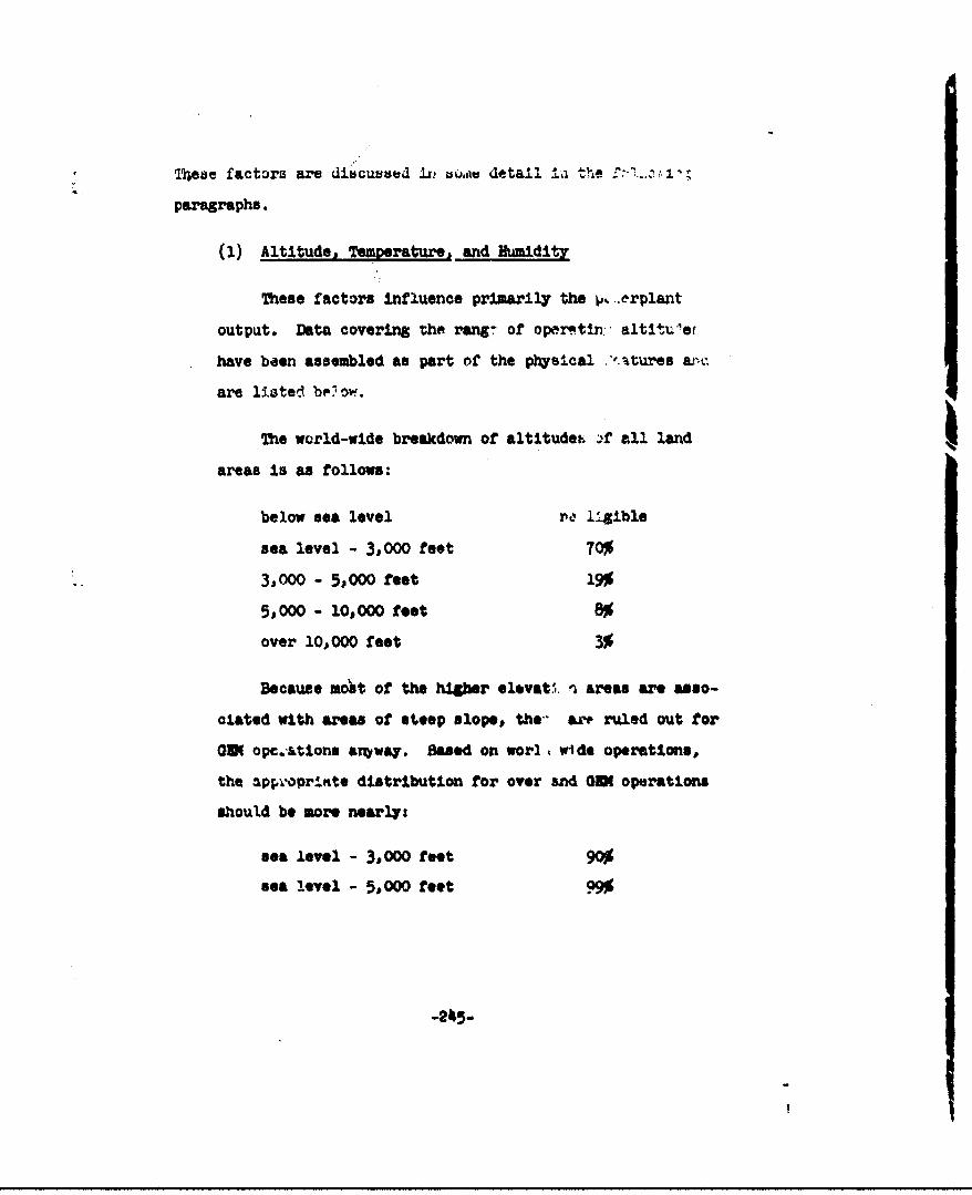
lt•ese factors are dibcuunead in' bou detail ±i the f .-.,
paragraphs.
(1) Altitude, Temperature, and Humidity.
These factors influence primarily the p, .erplant
output. Data covering the rang of operatin: altit4u'et
have been assembled as part of the physical ".'.,tu'es a
are listed below.
The world-wide breakdown of altitudeo )f all land
areas Is as follows:
below sea level ra l•gible
sea level - 3,000 feet 70%
3,000 - 5,000 feet 19%
5,000 - 10,000 feet 8%
over 10,000 feet 3%
Because mot of the higber elevat. i areas are asso-
elated with areas of steep slope, the- ar ruled out for
Om opc.-tions aMway. Based on worl, wide operations,
the aproprinte distribution for over and 001 operations
should be more nearly:
sea level - 3,000 feet 90%
sea level - 5,000 feet 9.

:'-orn the3e numb- can be 8Lat- 2 i. provisi,:.
' high at-4tude c;c' t. -is w211 not b, , serious pror,
.-'i if present-day aJ .,ci. and automoti%,% rehicle type
rower plants are use(.
(2) slope of Surfae Terrt.-n
The bnsic prInctplc ox 'he, .'r'und effect oach!--
a!]. w pow.r reqriviements tc be z -nificantly
.thiose requIted to lift h. ve! cle in f' %e -Ar.
When ., .EM op,,rates on a .ting n -'face, ti.-
component p, -;. el to the sur -_ce must be balancc• •y
direct thrust, .... unaik. '1 by the L. .ound effe,. torby surface frvtion. T.- v ;'rsing ax-,.-s of steep
slopes requixi uneconomica: ir.'s of poir.--.
The die, 'ibution of terraT. slopc. o'. ri3xn4; the
world is as ollows:
slope •radient 0 - 10% 58% of lA & .ea
10 - 30% 23% of lan,. area
greater than 1% 19% of land .-rea
(01. 3Scexpressed in per ceni gradient should be
dir••Xnguished from angles exj "issed in degrees:
• .radient is the tangent o. the angle.)
vision of power for opernu i in areas cf slope
g:-r, than 30% (where direct thru; musat equal .30 x
-2146- CoPe009• Bsest
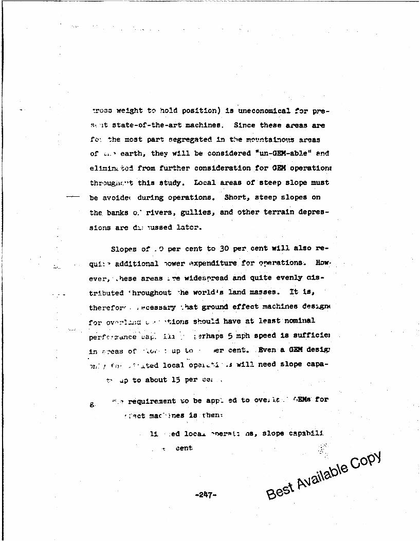
-ross weight to hold position) is uneconomical for pre-
s.., t state-of-the-art machines. Since these areas are
fo: the most part segregated in t.he m.:tntal ots areas
of , earth, they will be considered "un-GEM-able" end
eliminL ted from further consideration for GEM operationt
thrz:ugii.ut this study. Local areas of steep slope must
be avoide( during operations. Short, steep slopes on
the banks o." rivers, gullies, and other terrain depres-
sions are d:.: tussed latcr.
Slopes of -0 per cent to 30 per cent will also re-
quii. additional )ower ,t.xpenditure for operations. Hnow
ever,,.hese areas ire widespread and quite evenly als-
. tributed 4 hroughout '-he world's land masses. It ts,
therefor, ecessary %hat ground effect machines design(
for ov-.--2... . * "ionls should have at least nominal
per .c..xrce . 1 'i rhaps 5 mph speed is sufficiet
in ý:,eas of AX, up to oer cent. Even a GEM desix,
,• t. L- ted local opae±t'L .3 will need slope capa-
i' dp to about 15 per cc
9- requirement vo be app- ed to ove It rEMs for
o.ct mac'"nes Is then:
1i :ed loca.L -ne,"t: ns, slope capabili.
t cent
-24~7- Q
for general overland operations, slope ca
bility to 10 per cent at normal operating
speed, and slope capability to 30 per cen
nominal 4eed in all directions (the GEM.
be controllable on downhill runs and side
slopes, as w-..11 as uphill climbing).
(3 Drllinage Featu.e
The ability of the ground effect machine to ut
Wnt'5rwys for cross-country operation is a signific
feature .. ~"'.: .. ,Nwardli,1.iary applications.
overland GEM should be able tz. opera te, ..... r,
across stream valleys; thus the ability to climb st
banks is important. Many areas of the world are ac
sible only through waterways; and the high-speed ca
bility nf the GEM in these areas will add to milite
unit mobility.
The characteristics of stream valleys and othc
land waterways peculiar to each continental area hi
been discussed in Chapter t. CN a world-wide basit
widths of the majority of inland stream valleys at
mean water level is between 60 and 25,) feet. Alth(
the reliability of a 6,-nific number is poor, it ii
estimated that about three-iourths of the streams
military significance are over 100 feet wide, and
-248-
Best Available Copy

95 per cent are over 60 feet wide. In the i
most of central Africa, European U.S.S.R., L
China, India. and parts of Alaska and Aglat.
most, of the rtvers art over 250 feet wide.
Dth• rest of the world are a numbcr of wide z
viding access to large arcas; many of the tz
of these rivers are, however, less than 250
Expericnce of rhoe .:i i.h with Lae "owv
SR-Nl indicates that GEMs can. be operated el
only where the width of the river is thres 1
that of the vehicle. In closer quarters, wl>
problems are more critical, the GEM cou.ld s.
operated as a displacement vessel.
GEM vehicles with sidewalls extending I
water surface may also be used to advantage
Since these craft cannot operate in land are
classified with the marine GEMs.
In addition to the stream valleys, thez
ber of artificial waterways in riany of the 1
of the wurld. These range in width mostly I
150 feet, but many narrow to 3f, Oeet at brit
waterways wil-. robably be of only limited t
operation*:: becaune ." the width restrictionE
-249-
Operation ,on frozen waterways is als
Und-r.*.he'e coiditions obstructions of" fL.
hummocked ice can be treated as any other
s tea*t: t OnF,.
Most inland waterways, whether natur.
cial, generally have calm surfacen so tha
height of one foot will be suff.-ient. A
ir, nse of waterwayv is access from the ad
areac. In most of the mountain areas of
streams have high steep bank3 which limit
places. Throughout thm world only about
the stream val.leys have generally free ac,
to water and back, so that operatior'. may
planning.
7Tae of stream valleys for GEM operat
impose a restriction on cruiping r'0eea¶" b
high control power needed to traverse sma
bends. With GEM design state-of-the-art
level, latera] accelerat.ons of .I tn .15,
m'-u'mum which can be obtained. (7Ing the,
, ., ~ :g .. urnei.veri of small iadius
out at relatively low saeeds only. For e,
.lg laterai acceleration, a )0° turn at 4-
require a radtL of l,420 feet; at 30 kno
-250..
of turn would be 800 feet ani, ýr' knota it would be 3,200
feet.
The curvature of ri' irs varies greatly from place
to place, but meanurements from several large scale maps
indicates a range of commnonly encountered characteristics.
For large rivers with widths of 200 to 1,500 feet, bends
of radius 1.5 to 6 x widtx ociur aLospacAngs ranging
from 8 to 30 x width. Por the majorit-.y o.f rivers through-
out the world, whicn are between 100 and 250 feet wide,
as noted earlier, appllkJation of these parameters indi-
•n•.• i-~t e-e ¶ons of snall GEM vehicles on waterways
with widths of 100 feet will probably v -±L±mited to
cruising speedd below 30 kInnts, ana e'--tions on water-
ways with widths of 250 feet will probiabjim be limited to
about 40 knots.
Higher speeds could be used on straight stretches,
although ancoleration and deceleration will consume part
of these distances. For example, with typical GEM ac-
celeration and deceleration capabilities of .lg and -.2g,
respectively; the distance to accelerate from 40 knots
to 80 knots, and later to decelerate to 40 knots again,
is nearly 3,200 feet. This is almost half the lop-mst
Sstraight stretch between bends oj. &vpical rivers of 250
•'°-,ot width.
-251-
1 ittq.jlle' l1 i. emse c~ff 4WJ If~ca '1'Pria, apqedlffl-
'1Z3CCUBW emVt& Wcz tn cIto Mrmbi rt o=1 I
Thie- PIltbaut r~wLttm off czl tttt stflVOIYy
.,.uxrAW aame:
WX!T II ~ ~ifR,, = tt.W Tn 2iizlg, UZU1i±, alr
a~~A~~~X Wvt~teM, PJi ~ (be itua ,, ltI' l
q3est AMvailable COPyV
ctroams. The banks will permit access to
and from rivers at limited points ozily.
Power requ.rements for climbing river banks
are d slasted in the paragraph =n tarrain
lisccnt 4nuities;
3. average speeds on inland waterways will be
limited to 40 knote for the majority of
operations.
(4) Vegetation and Surface Cover
The many varieties of vegetation and other surface
cover provide obstacles and hindrance to the passage '2
ground effect machines as well as other vehicles. The
degree of hindrance is closely related to the height,
spacing, and RtIffness of vegetation.
The environmental data of Chupter I auxuarize promi-
nent vegSt&t1*n types by continental areas, and Appendix
B L--caud€c trcac data on a deto8red geographic unit basis.
the most significant vegetation element on a world-wide
basis Is the extent of d~erie roreaos, whiuh cannow ct
traversed by Ob witnWut .- xten82nve clearing c.porations.
These forest &-oas iover aboo-*. 24 per cent of ;he WoL14'O
land surf a;e
-253-
It has been proposad in several GEM analysei that
GINWays could be cleared in forbesed areas without the
expense of dreinage provisions, surface compaction, or
paving. Within the wo.ld's dense forest areas, even this
approach to developing a transportation system would re-
quire use of heavy squipment over a n extended period of
time. Thus, cleared OMWay3s in dense foWest areas will
probably be utilized only for anticioated iong-terr or
peznLanent operations.
At present, consideration of GEN operation in forest
areas should generally be limited to waterwp.y and
cleared roads, railroad rights-of-way and pipeline areas.
The latter cleared areas are generally rather narrow, •
as to hinder free passage cr G034 with widths greater
than 20 feet.
Formas of vegatative cover other than dense furesOa
are considered to ofrer passage for 03s to a greater or
lesser degree. Sparse brush and widely scattered trees
are considered to offer very little hindrance to O03
operations. In contrast, dense low brush cunnot be pene-
trated and must be overflown. Orass anA4 &ad fields of
grain will not be a significant hindrance, even when tall,
as In parts of Kast Africa. ,iut the tough elep ant grass
cf •ne Congo will not allow free -msage. The 3N has a
marked advantage over other vehicles for operation in
_25*1-
swamp and marsh areaE., nut i; will ue limited to open
waterways in mangrove swamps, and somewhat limited in
areas of dense reeds and marsh grass, such as those in
Uganda and southern Suian.
The most convenient method of assessing the influ-
ence of vegetation on GEM size and operating height is
to include this feature among the grouping of terrain
obstructions and diecontinuitieso which is discussed in
detail in the next subsection.
The significant numbers obtained from consideration
of vegetation cover are listed below:
1. Dense forests covering 24% of land area limit
GEMs to wa~erways and other cleared areas, the
latter providing free passage only to vehicles
not itn:h over 20 feet In width (for GEMs sup-
ported by the air cushion, without ground
contact);
2. Other forms of vegetation may be t;raversed by
GEMs with greater or lesser degrees of freedom,
including marsh and swamp area, heretofore ex-
cluded from military vehicle operations;
1. Analysis of vegetatioa. 4nfluence on vehicle
size and operat 1 -4 heignt ib "ncluded in the
-255-
nrxt paragraph, a'av'ig terrain.. ,±structions and
discontinuities..
(5) Terrain Obstructions and Discon.inlti.As
The Ground Effect Machine supported on its air cush-
ion does not have the surface contact which provides
traction for wheeled and tracked vehicles. Its perform-
ance in areas of terrain obstacles and discontinuities ii
limited to opevation above such obstacles, or penetrating
them by utilizing vehicle mnomentir irl•i - •.4,
The classif1cation of, obstac].es is of significant
importance in GEM desIgn for operation in a given area.
For overland operations on a world-wide basis, terrain
obstacles and di.scontinuities can be grouped into three
categories:
Solid
2. Yielding, passab2
3. Yielding, non-passable
Sol.d obstacles include walls, bui-dings,
dikes, and emhbankcments, large tre3z., 1,t:.-hes, rocks
and other objects whzcl contact by the vehicle may
cauae serious structural .'amage or personne Injury.
-256- est :Ijable CoPO-256-

GEM structure mu.-c be designed for very infrequent
contacts of this type. For most operations, how-
ever, the vehicle must cleax* all such obstacles.
Yielding, passable obstacles iilclude grains,
most grasses, light fences, and other obstructions
where contact by the vehicle is not likely to
cause damage or injury, and where vehicle mnr.entum.
and propulsive thrust is sufficient to provide
passage without much loss of speed. For most opera-
tions, GEMs will be able to operate below the maxi-
mian height of such obstacles, although not with
complete ignorance of them.
Yielding, non-passable obstacles include dense
orush, tough grasses and reeds, caise fields, and
thick hedges. Contact with these obstructions is
not likely to cause vehicle damage or personnel
injury, but momentum and pr'opulsive thrust will be
insufficient to penetrate ccntinuous coverage of
these obstacles. Operating h-ights in such areas
must be at least sufficient to just brush the top
of such obstacles except where they are sparse.
The variety and dimezsic•r, or teri.ain obsta: *z and
eItcu'.-Anuities throughout the wcz.. are almost endless.
Significant obstructions piculiar to the continental
-257-

areas are briefly liste-d in Chapter L, and a great many
more are included in the data appendix. On a world-wide
basis, however, these obstacles and discontinuities can
be categorized by a few numbers having iignificance for
overland GEM vehicle classification.
Many of the solid obstacles are associated with
drainage features, natural and artificial. A GEM oper-
ating on an inland waterway is limited if it has no ac-
cess to the adjoining shore. M:'reover, a GEM operating
cross-country must be able to cross ctreams which inter-
sect its route and, consequently, must be able to climb
and descend st.ream banks.
In many areas of the world, streams are steeply en-
trenched in gorges and canyons. These areas must b3
ruled cut for GEM operations, except where an entry and
exit point can be found. Even in the majority of areas
where strewa banis are low or not generally steep, the
necessity of entering and leaving the stream area poses
a fctmidable requirement for the GEM.
Almost everywhere even minor stropeis Yru'ch too small
to use as access roUtes have vertical banks 5 feet high
and steeply aloping banks (30-100 per cent) 10 f, ý high.
The abtity to traverce these baz,." is a necessity for
all but the most limited n',"...land operations. An
-258-
i-mriediate result is tie severe limitat.ion imposed on the
small GEM vehicle, certainly on all GEM vehicles with an
effective base diameter less than about 30 feet.
Artificial embankments, dikes, and levees are also
significant obstructions. These are common in lowland
regions of most of the world's nations. Although slopes
of earth embankments are generally only 30-50 per cent,
heights of 10 feet and over are common, and flood dikes
along eome of the world's major rivers in Europe, Asia,
and Africa are over 20 feet high. Banks of navigation
canals are generally steep, over 300 per cent, but not
over 10 feet high.
Irrigation ditches and canals are important in low-
land areas and the lower parts of river valleys, espe-
cially in southwest !id southeast Asia. Size, shape,
and spacing of these features vary greatly from area to
area. Generally, irrigation ditches are from 2 to 10
feet deep and 4 to 30 feet wide. Some are elevated above
the level of the plain, but many ý,.e incised. These are
partly filled with water during the growing season, but
in the non-growing season they may be empty.
In the plains of northwGoc arid easterAn Ero:., in
rndie., Thailand and Burma, the pro, "tions of -:1 width-
over-height ratio are common for most irrigation features,
-259-

with earthen banks having slopes tr 100 per cent. Exten-
sive areas of rice paddi d z-'L-Ac wet cultivation crops
... southeast Asia are divided into small fields, perhaps
100 feet square, sepa. ated by dikes about 2 feet high and
wide. These paddies are dry in the nongrowing season.
Where irrigation features are most numerous, reconnais-
sance will be necessary before extensive GEM bperations
can take place.
Among the other important solid obstacles ar• -=.hsely
Generally, the dense u.oan areas must be bypassed -In all
GEM operations except those restricted to waterways.
Not only the clearance problems, but also the effects o.'
downwash and noise will necessitate this result.
Even in nonurban areas, grolipo of buildings must be
bypassed. Walls and embankments are more generally com-
mon and must be crossed. In western Europe, walls in
.ruwal areas are usually 2-6 feet high and 2 feet wide.
On ..-any hilllsides. in generally rough areas, terraced cul-
tivation uses steps'of 2 to 5 feet height, with widths of
10-100 feet. If these terraces .are walled, GE4s will
probably be excluded by the comh-nation of slope and
wall.
-260- 2o6o-
In flood plain areas, roads and railpcads are com-
monly situated on embankments 3 to 6 feet high. These
are common, particularly in eastern Europe and in China.
Even in the Arabian Deser , stretches of oil-pipelin
lie above ground, with diameters of 3 fee _
logs, railbeds, and rocky areotesinfct
solid terrain o0-48~, mostly I to 3 feet above
.,.%.un level.
For world-wide operations, a minimum normal operating
-.. . *- - - - - - -- mi ed
areas. For all but local operations, the abi11.ty to
climb and descend a vertical 5-foot bank will be re-
quired. This Jump cappbility can probably be ecccmr-
r•.•s•hd b', aome diversion of propulsion anJ control power
to the lift system, since it will only be required for
very short periods of time.
In addition to the 5-foot vertical bank, a .cross-
country 034 will have to be able to rise over a 4- to
6-foot solid obstacle. Additionally, it should have the
ability to climb a 10-foot bank of 50 per cent to 100 per
cent slope, for many operationn.
It is obvious that the requirement for traver.. r.g
th.-se Esýid obstacles will have a ma, - influence or
operating heights and powe, •.equirements. In particular,
-261 -

thc! ~uF-c LTh~e~s& cz tz4e ~rUsacnt~t c*.r,: t t7,e ?ehlcDl i-s
zer! oiuey d~cubted, e~er~t Ii ~vey 77 'nted-areas.
'The I!1eldlng Cbstx iez, ahkA ivd-
Sare not Talite as severe z, llatlnc GM~ deW..
,-dge-a -c ep b'a'nt gr'az , zand na--sh 'rpe& vze a1- In tabe
1-0- to 25-foot hevh raxzge. JDese brmih zmwes from
lzw gTrwtb t'o 2D~- f ot thornusi In ea'nt and swatti
Afriza-. CultiTatad low trTe~es mid txfl ~gm.ses vueb
as cofe n suigar cane are al-so IL!O tao :15 feet higb.
AgheTre tbeigrowt~h of these tT'ees, grasses, amdb~e
Lre toro tir1~ tao penetate, thmi- wIILIl not be a. c
erncugb tv'jiW @vrer even h" a .19e.7ge mnahim~e.
'Tbe t4aL~er 7- ldIM 4. T oinm~xssable obstaceles in st,
I2±jer'ef cLre_. -be 1bypassei or c~iea~red, vii-ere tb.r7 are
dense. ' The 'cilar~n~g _cTooess is mot as 'dl rfi~cut as
that assoclatoed vltb 6enas~e tro'e5ts. T im addItIon +-o
,all brb ~n=7~ wr~ea si-'7 .niom -o~ less =.eraed b7
d~ense s£bort tbrb and caw IIs 2-3 feet b~b smc that
a ncral, eprx-t1mg beliit of at ~'t2 feet vlU ~be
necoessary Im th~ese locatiens..
the 71elding, passa~ble c~uze suc as ~gzwm5es,
grai=, ~ ~ ~ ~ ~ 'A-~ an002-i'usawý ay ntý7I

to 5 feet high. Orain As normally 4 to 7 feet high in
the growing season, but with dense c,- 1,•ble nt over 2
feet high. Savanrnah tall grass is up to 15 feet tall
In many parts of Afri.a, but most other grasslands are
3 to 5 feet high. A 2-foot operating height is suf-
ficient in most of these areas.
The ex';ent nrn' nature of obstacles will also have
significant influence on operating speeds. Unless
operations and cross-country routes are carefully planned
in advance, it will be necessary for the ORD operator
to discern and traverse terrain obstacles and discon-
tinuities. Where these are numerous, cruise speeds must
not teAced thole which would allow him to Judge the
nature of an obstacle and carry out the necessary maneu-
vers, within the limits of the low control acceleratiom's
common to almost all Oround Effect aqjhknes. Previous
cross-country vehicles have not had the potential for
the high speed performance which can make the problem
of rqrcognizini, Judging, and traversing cross-country
obstacles as serious as it is for the O]D.
The determination of adequate operator-machine
response characteristics to terrain ubstacles 1" 3n
krea requiring further study. "'r the present, some
restraint must be exerclms, on expoc,."ions as to aver-,
ecross-country OGD speeds, as these will probably be
-263-
much less than the 80 %. 100 knot pý.rformance oapa-
a bilities being cons.dered for these machines
The previous paragraphi have covered the environmental fac-
tore having major influence on the size, operating height, and
available oparating areas of overland Qround Effect Machines.
The remaining environmental factors, listed in Table 12, have
influence on GU auxiliary power, dcsign, and equipment re-
quirements, but not so much on size and operating heights.
These include wind, sand, ard dust, other climatic factors,
itiduced :.nvironment factors and combat environment factors.
Discussion of some of1 these areas is Inlc.luded in Chapters III
and IV.
Prom the material in the preceding pages, the classifica-
tion of OW vehicles for overland military operationis can be
developed. Tt must be remembered that this classification 1.
based entirely en the environmental requirements, and that
consideration of vehicle performance is being left to the
discussion of Chapter IV.
The results, in terms of world-wide overland OU opera-
tions, are as follows:
(1) Vehicle Size:
Liitted primarily by lateral loarance for
operation in stream valleys and through
cleared areas in forests;
-264-
20-foot width ucable on ab!ut 95 per cent
"of streams witb adequate clearances;
30-foot wic h usable on about 75 per cent
of streams;
50- to 60-foot width usable on major rivers
only, except throughout most of central
Africa, the Amazon Basin, western U.S.S.R.,
southern China, and India;
20-foot width about maximum for operation
in forest clearing& other th,•. waterways.
(2) Vehicle Ckeratng tie•ht"
1. Continuous Operation
1 foot for litited local operations nn oven
pialns and desert areas;
2 feet ior general operations over plains,
grkae•lard, cultivated areas, and sparse
low brush, with somo detours;
3 feet for general overland operations
with fewer detors.
-265-
2. Jump Capab:.oty
4 feet for limited operation across walli,
rail eabanJqents and low dikes;
6 feet for general operations in open
3. Terrain Discontinuity Capability
5-foot vertical bank up or down for crossing
almost all stream valleys, and Irrigation
ditches when empty.
4. Slope Requirements
15 per cent continuous slope for limited
operat.onse;
30 per cent continuoum elope at low speed
for general operations, with 15 per cent
continuous slope at ormal speed;
50-100 per cent slope 10 feet high for exit
from many rivers and croesing dikee and
levees.
(3) Operatlina Amsoe
1. Inland daterwayz
Y)-40 knots for traversing bonds in rivers;
60 knots suggested design cruise speed.
-266-
.• NTezrrcun ,bs'.atc-.'.-:•j and• l'nc ,"nu l
Average crons-country speeds limited, by
obstacles-, fu, ther study. required-, in this
area..
flTe suggested classni-.catlon for overland aEM. vehi']Les
is given, in Table- L3,..
"Mne family, of vehl-lea classIfIed in Table. 13.. covers, con-
flgrr..atione whi'.h are conaldered: pract3.caj. within. the preoent
ntatc-of-the, art.. Superimposing' these- conftguratione> on the'
environmental factors- summarize&d in the> preceedIng, pages-
gives the> operating, capabiLittes of each. size vehiacle in-
the. overlandl natural envl:r•.nm=nt..
The -hoice of rectangul•aL glanforma: with. length, to. wd.th
"ratios of La is arbItraryi, although, these propart.ons- are
nearly optimum. for- the power/sIze' compronise.. The> operwtnn
heights and: jump capabilities shown represent attalmable
performance. although not necessaa•ril, economWaaI perfmrmanue..
In fact,. it would. be advantageous to, have- the, su-an'!s siz
vehicle,,, 10 x 20 fet,,. with. aL normal ojera•tir heicbht of
three feet *m:,d a Jump capability of six feet. hi£s VerfOr-
mance is, beyond: the avail:able : tate-of;-' ,,'e- art in. rega -I to
stab.--! ttv- cd: also, won1d; require unecL.. !miamt.: amunts of
powe6' .T
-26- est AvaiIable Copy

1w
0 04 m C4 0 U
to W
a wr
Mx
-oo o i 0
Q), •~ .- ~
In .eonri) 0 cipernt'l.hv u4ti.lity Inorg'stoeo with 1noreamend
.. ,tln• ~h.NTiht, but *t. Iiv.1jt, Above 1irh"oc !'out fuL'r normal
rul 'tInlo Anti , ind .difeoat ror .imp 0apab.t11tys tho rats or
reanuo bacorioa voiry wt'Ai. * By mAintaitnina the thromb ixd
*i . .'ooL h8ht~1., * r vllaa would be able to o -erate
,ttaued econoiny. On the other hIand, noreaun in vehicI.A
In tiviq to reJstriot. aperati~nj arean, In rogard to 10."ral
I,-i,',•t,.,i. A1,thnu!•h thIo 4UI x 80 foot; C-Ei •rnd 5o x. 100 foot
'i,-oId operatf 4t lowere. apaoltVto powers than the .!K v 00
r - 'JE at thto aame ftights, thei1r .trna usabilit~y wouldi11ot b• Ad bra,P,~r|
T'1)o 4aoo•sIbAty of streeam vall.eya Ie important. for
bjut~ oi vniniiijtaid tfl1 aIerway qpe, The~ small viihl~oA (Olage 1),
,,,,,itt , low opmrating height, 1to very ueverely "lmi ted In
joi 1.0•tit.u An and uuIt of• mtrPem Vili].lym., ,ven• tho larger,
vtiJ•Ltea w1-L1 bo qui1Ut aut~riotod in this roapeot. 'T'hf4 0l-
'Jrn headed "Per oiiaL Aaooan to Stream Valleys" Indioate* the
* fwl•l Ibli, F ncemn finnr nlnng thm stream valleys rather than
Iho# ntmi~rbsr of cLruwn valleys Wnio to~ At ccannible,
'rnble 13 indloatea clearly th. rangoc,. 4'POPe•.aAUTS til','
*bl llltiae for ground efaeot maoniniee do derived from thoo,
wot Idwlde environmenta;l data, Tro.. optli•m vehiole1 Atom
tLij, iolvi,6 or view or utvlity, in the o e ", whi..h
C,,ri operate At three feet durlng oruile and at sli feetf tor
-arance of obstacles. Ye 30 x 60 foot vehicle fits this
ca.legory. Larger vehicles will be more economical, and will
have perhaps lesu severe stability problems; but will have
a somewhat smaller range o. usability.
4. DISCUS 3ON AND CLASSIFICATION OF MRITPY ROUND EFFECTI MI-NS- AMPHMIOUS
The world-wide environmental data for amphibious op-,
Pr,'tion. of Ground Effect Machines are summarized in
nriapter I, Section 4. The background data are contained In
Appendix C.
Since the amphibious capabilities of the OEM are one
of its primary assets as a transportation system, there is
a inherent overlap of OE amphibious operations and mhat-
which have been designated as marine, and overlyd. Rathar
that rationa~lzing why an operation on inland waterways ic
overland, whIle nnn on coantal waterways is marine; this study
develops vehicle cleoslficatlonp In termi of the most ap,-
propriato operating area, regardless of the fact that over-
lap exiba.s.
In this context the amphibious opera'ion, se*etrum
covers land.-ater cperations in the coootal areau of the
wo:>.. Generally the inland penetrition le cotslder; to
be n, tort than 20 to 3O miles, but 1i, -"eas of stree'
valley approaches this is nor ^ strict limit. The overvater
-270-

L-4.tion is limited to ranger lezs than about 2GO miles; this
mdy be An unloading operation from a ship at sea, a craverse
of a small body of water from onother Jand area, or a land-
bas3ed sea patrol.
The classifAication of amphibious GEMs necessarily con-
tains most of the factors affecting both marine and overland
operations except high altitudes and long ranges. Table 14
Includes the most important environmental factors affecting
the basic performance and design parameters of amphibious
*GFMs, iýgether with the specific influence of each. For- tne
k actc'rs of which the influences a . , o iimilar to those
,1 :;cssod in the preceading sect 4 -i:, referPr*: -
S ornsidered 'sufficient. Where th factors or their inf'l -
are unique for amphibious opera? ons, they are discu- -
low.
(I) Coastal Terrain Land .nms
The generalJ7' ,m.,fors, and their suit-
ability ,- . ). o pira.'r. . have been discu3sed in
Chap t -L fr. Cnap.,. It was c.:ncluded t.at I abut
three. :'.i.rths of the w, Id's coastline (eY.Ifl, the
Arctic %lands, GreenI id, and Antarctica) a,# ac-
cecsib>'. 'ce at least imite$. OM op;ratVcns. Abou' -
per cen, ,r tihe world < eoactltne -4tit e for GE4
access 1 "Ind. The ' .Jity ..f Whe OEM to .,@verse mud
-271-Best Available COPY-
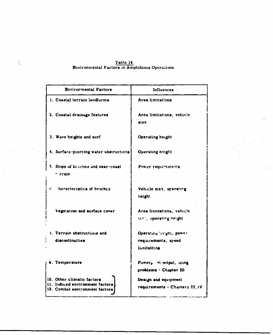
Table 14Environmental Factors in Amphibious OperaLions
Envirornmental Factors Influences
1. Coasta terrain landforms Area limitat~ons
2. Coastal drainage features Area limitations, vehicle
size
3. Wave heights and surf Operating height
4. Surfact-piercing water obstructicns Operating heigh.t
5. Slope of br;chea and near-cout Power requi-ewn.ent
crain
' 'haacteristics of be-chco Veh.cle size, orera'trg
height
Vegetation and surface cover Area litnatationt. vehicle
'a';* . peratirg h•ght
i. Terrain obstructions and Operatitj ".1 'gh•, pow.--
discontinuities req*Airuments. speed
f. Temperature Fowert. 'it ottput. icing
problems - Chapter III
10. Other climatic fa,.tors Design and equipmentI1. Irnduced enviroament factors requirements - Charters M. IV12. Combat environment factor:r
flats, swamp areas, an stream vaY'..eyt Is particularly
significant in increasing the number of usable landing
places. GEMe will not te able to land on rocky shores,
except where penetra-Ld by stream valleys, nor will
they be able to surmount sand and earth bluffs unless
openings are available. The emphasis in amphibious
OEM operations will be away from reliance on a few con-
centrated beach areas to a wider operating area along
a coast. Resupply and coastal lighterage will also
benefit from this broadened operating concept.
(2) Coastal Drainae Features
With consideration of OGE amphibious operations
through coastal streeia valleys, the characteristics o1
thede access routes have a major influence or vihic.1.0
design parameters. The tables in Appendix C contain
data on the coastal stream valleys in eauh vl!j1iC1Ai
unit bordering the coast (these data are distinct from
the data on inland stream valleys in Appendix B).
Comst al stream valley data Include ipacing of major
streams, width of the water surface and associatea
length of thO stream withir this width ran&e, and a
notation on the peroentage or steep banks near to-
coast (les than about 15-20 wles), and farther inland.

The characteristics of strear valleys are generally
less restrictive near the coast than inland, i.e.,
shallower banks, wider streams, weaker current. Many
delta areas of tidal rivers are partly blocked by sand
and mud bars, which would not be obstacles to ON( cpera-
tiones. On a world-wide basis average widths of coastal
stream valleys are over 100 feet on 80 per cent of the
coastline, over 150 feet on 70 per cent, over 250 feet
on '90 per cent, and over 500 feet In large areas of
Central Africa, the Amazon Basin of South America, India,
and many other major rivers. Host of the rivers over
250 feet wide are usable at least 50 miles Inland, a&d
those less than 250 feet wide are usable Lrom 30 to 1C<C
miles Inland. Only about 20 per cent have ,tee banks
noar the coast, but about 40 per oent hs'e st!.ep ban•'*
more than 15-20 miles Inland.
Pollowing the proct ure used ian the elaesielfcion
of mver)nt 0"!*, 4 4 ýAU..r ol, vehicle wd1th to ro
nore the, .Y~fi ton 1/3 of• stream width indicates that 30
feet width vehicles should be usable on about 80 per
cent of the coastal stream valleys, 'A, ,.-. width on
about 70 per cent, and 50-60 foot width on 50 ptr .ent.
Larger Ohcould be As*, In r'ny 3tp.-Ifiu loca ',ns or
a Cc.:eral world-wide basis in di. 'aceuent operetlon.
-2T74-

Steep banks near the coast will limit exits from
stream valleys on about 20 per cent of thc world's
coasts, but coastal vegetation will further restrict
operations, as discvssed in a succeeding paragraph. Op-
erations in the many tropical coastal areas with mangrove
and nipa swamps requires navigation of winding channels.
This will reduce speed appreciably, probably to no more
tnan 30 knots in many tropical coastal areas.
(3) Wave Heights and Surf
The height of waves and surf will have a primary
influence on the minimum vehicle operating height. Al-
though wave heights in coastal areas will b, less than
those in the open oea, the development of extensive surf
and high breakers is a very comon occurrence. The
OEM must be able to navigate the surf sons tn both
directions, with the outward passage into th' break ero
probably mre critical in terms of Impact loads.
Surf Is a functlon not only of tides, offshore an*
nearshor* slopes and the state or the open sea. but
also of local winds and sea states. *lmnV any expsed
beach will have high surf ouring otorms. The 00E cannot
be duslgned for sustainei opratUlons !n stormy .dl-
tiono. On & wnr14.i-vi'e "asis, C. -f ovnr five feet
occurs on 90 per cent ot '..e world's cu.sts, surf over
-275-
8 feet on 30 per cent, and surf over 12 feet on about 5
per cent. With an operatig height *f one-half wave
height, as discussed in the section on marine OGEs, the
requirement foi' operating in the surf zone opecifies
operating heights as follows:
1. For ope:.ations on JO per cent of the world's
coasts, maximum sustained operating height
2.5 feet.
2. For operation on 70 per cent, maximum
sustained height 4 feet.
3. For operation on 95 per cent, ms'imum sus-
tained hoteht 6 feet.
Further speoiriratiun of ^re--,ting heig;,t 1-n ir-ludad In
the paragraph on terrain uostructions and disountinulita.
(4) pirface-p eir.ng water Obstrtactions
For nigh speed operations over water the T1MN must
avoid collioion with solý.d surface piercing obstacles.
On a world-wide basis, these obstacles (pr.marlly rocks
and reefs) are quite evenly bcatterod sn "a.iy coxsrat.'1s.
In very few cases, however, a-. they concentrated ernough
to seriously restrict ON op.•tions, so that &sic
dc•ign specifications can negltc¶. ',Nis factor. Under
water obstructions, which have e#wiys plagued amphibious
-276-
operaiLons, wILI be a 4".zard to a:y (Ues Which are ap.-
erating tn the displacement aonflgwation, whether dae
to Dower loas or othe emxse.
(5) Slulps of Beaches anat hNbr-eaast TLerrain
Smph•b•ous G11lb must have smuffleatt poWe to
traverse the alopes of beaches and. other near-coaat
terrain. Bach slopes depend on tidal ramne, surf ac.-
tion and beach material. As discussed in Chapter I,
Sect_!.n 4, there is usually a difference In slopea ,•t
the beach zone between the normal low t**Id ,•* 4d hish
tide illnv,,, and 1rhe --one above the norm&" hi tI' watr-o
line. )Hesch slopes range from fl&L ta aoou.% U ;.,
cent in the L.%ý.-H.W. zone, and up to 20 per :-.nt i.
the H.W. zone. -ver•tg= ,ý:aixmlts in the 1;wo zones
are about three and. snL per nent rpectively.
Xbout 80 por cent of the world Ze beaches have
maainuza gradLents less then 10 pi'm amnt and abou; 90
pia- .-an•t z.-p max'Ums gad2enta less than 15 per ceni.
Alt•houh mny •oastal are halve SfRr ste.; strercnes;
those which hiave bluffs and cliff's el yj r,"L adi
out Lb' UK operat~ons wiw Generally the tuttvad'v
iga1dnta frw near coast te-dn. e. less than ..: per
car&,4 The proval-sin of' 1 r.. ot
umltd th va m be *=flMent L'ta mat alhibloous
-27T-
m m mm emmmmmm m mlmmmperlum tian a.m mm m _i ma m m n nmm m mmq m mm
(6) Characteristics of Beaches
For amphibious operations carried out over beaches,
the physical characteristics of the beaches are impor-
tant. Slope has al 'eady been discussed. Length of
beaches influences suitability for large scale opera-
tions; width of beaches (including tidal ranges) limits
vehicle size; beach materials may cause operating prob-
lems in terms of dust and damage from gravel thrown up
by the OLJ downwash; and beach exits determine the u•.
fulness for over-the-beach operationa to Inland u•noal-
Ing or tranbfer points.
Although quantitative data on physical character-
i.stics of beaches are not yet available on a comp-Lets
world wide basis, the following paragraphs ar6 based
on analysis of the characteristics of 7000 beaches, in-
cluding almost all the beaches on the coasts of the
Eurasian land mass.
Lengths of beaches are Qsually difterentiated be.-,
L,•en lies than two miles, and 'v-r two miles. About
45 per cent o1 the beache3 for which data are included
In Appendix C are over tw) miles long, representing
are" suitable for arjor besch unloadlng opere%-;. n8.
Width of oea6heu ranges ri.- a few feet to several
miles at low tide, bt.t *.uty beaches aiaappear *I high
-278-
tide. Beach widtho at high tide, i'A the tidal ranges,
are listed in Appendix C. For unJ.oadlng operations on
the beach, the GEM should be able to sit down entirely
beyond normal wave action at high tide. For fore and
aft loading this vnuld limit vehicle width to minimum
beach widths. The data show that more than 70 per cent
of the beauhes studied are over 50 feet wide at high
tide, and over 25 per cent are over 100 feet wide a;
high tide. Thua 50 foot wide GEks could unload our of
the water on 70 per cent of the beaches, and 100 ,'^o
wide M•s on 25 per cent.
Beach materials vary greatly, but sand is pre-
dominant. It Is easily blown about when dry, but quit-
firm when wet. Ninety per cent of the accessible coast*
are composed of sand, mud, pebbles, coral, or a ;Oa.Ia
tion of these. The remaining ten per cent innlude
cobbles, rock, shingle, seaweed, clay losa, and debris.
The effect r ý the Jet downwash on the surface material
is discussed in Chapter II:.
The availability of suitable "earh e*.ts is one
of the differentiating factors bettee, (X,4- I ar.i
Code 2 coaast- as discussed in Chapter I. and 1llu6
trated on Figure 14, followl;• page 171. In Any
case. where the terrain riees stft.. v fro. the teaol.
0OE vehicles cannot penetrate farther inland In rtese
-279-
areas. In some places seawalls and road and railroad
embankments also block exiLa from beaches. Because
of the suitability -f stream valleys for GEN operations,
concepts of operations must be revised tu take advan-
tage of these, while placing less reliance on opera
tions in areas whetre vehicles and supplies cannot be
unloaded inland.
(7) Vegetation and Surface Cover
The influences of these factors are similar to
tnose discussed In the section or nverland operatinns
and will not be repeated herm. Lense vegetation In
tropic coastal zones genorally meens the only inlsnd
access will be via stream valleys. .:e pages 453 'to
256.
(8) Terrain Obstructions and Discontinuitiea
Same as for overland operations. A mlnimum ap-
a a*'; . height of two feet, with .I•m capability of
4-6 feet, Is essential for aloset a11 isaiid penetra-
tion. In addition, abilLty to climb a 10 root bark
of 150 pez cent to 100 per cent. slope wili be nec"-
3arj In mw ais*as. See pap% 26_6 to 264.
The ab.ove enviroment.ý. -act~rs forma ..,w basis for
clasaification of amphibious Kround effect machines similar
to that used for marine ,ud overland OEMi. In moat repetts
-280-

the land obstanlos wil, be more limit~ing than ttose
of the overvRter part of the amphibious baviro.ment.
The important reoults are listed below:
(1) Vehicle Size
Limited by lateral clearance for operation in
stream valleys and by widths of beaches, but not as
severely as In general overland operations.
30 foot width usable on 80-90 per cent c.* ccitt'al
stream valleys,
40 foot width usable on 70 per cent,
50-60 root width usable on 50 per -ent,
50 foot width (for end-loadl.-g OQDs) dstisfactcry
for unloa•lng above high water line on 70 pir
cent of beaches,
100 foot width satisfactory for unloading above
high water line on 25 per cent of beaches,
20 foot width about nxuiaa for opt'rttlon In
forest clsarlngs other than waterws.
it Is important to note "hat vehicle stc smay
also be severely l1tmteV by trara, -tabiatty r-.quLrement%.
-281 o

nhis is an operation?,,, conrideratloi. rather more than
an ervirorantal one, cut it 3hould not La forgotter..
ueA~ertined by the necessity to traverse the surf
zone and overland obstacles.
1. Normal Operating Heloht Overland
1 foot for operations tc beaches only,
2 feet for limited I-land penetration.
2. JupCpblt
4 toot mininma for crossing wa.ls, dikes,
b feet for wider area uaibIltty across
walls, dikes. e-sbaents,
5 ftot vertlesO be* up eAd 6om for access
from streas valelys.
y. & SustaLne Op_ t3 mt Overwatr
2.5 feet for clearance of surf 1n i a
cent or eoent areas,
Sfeet for mc'f aleair =. 1,rI 7" pe. .eant,
6 fet for surt clerarnc* In 95 per cent.
-202-

(3) Slope Capability
10 per cent slope capability for operations over
80 per cent of beaches,
15 per cent slope capability for operations over
90 per cent of beaches, and for most near-coast
terrains,
50-100 per cent slope on 10 foot banks for access
from many stream valleys.
(4) Operating Speeds
Limited to about 30 knots for operations in trop-
ical coastal swamps, also limited by obstacles in the
overland phase; no specific numbers can be determined
without further experimental work.
A suggested classification of amphibious OEMs bases
on these factors in given in Table 15.
The vehicles classified in Table 15 range in size
from 20 x 40 feet to 75 x 150 feet. The -ormal operating
heights given are the cruising heights over land; the
maximum height is the operating height at about half
normal cruise speed, and is intended primarily ftc- opera-
tion through the surf zone. Jump "ipabillty represents the
-283-
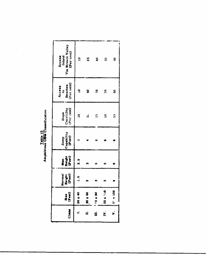
>
-
0.0
0~ .4 -4.40
m w-
-4
tot
4..%
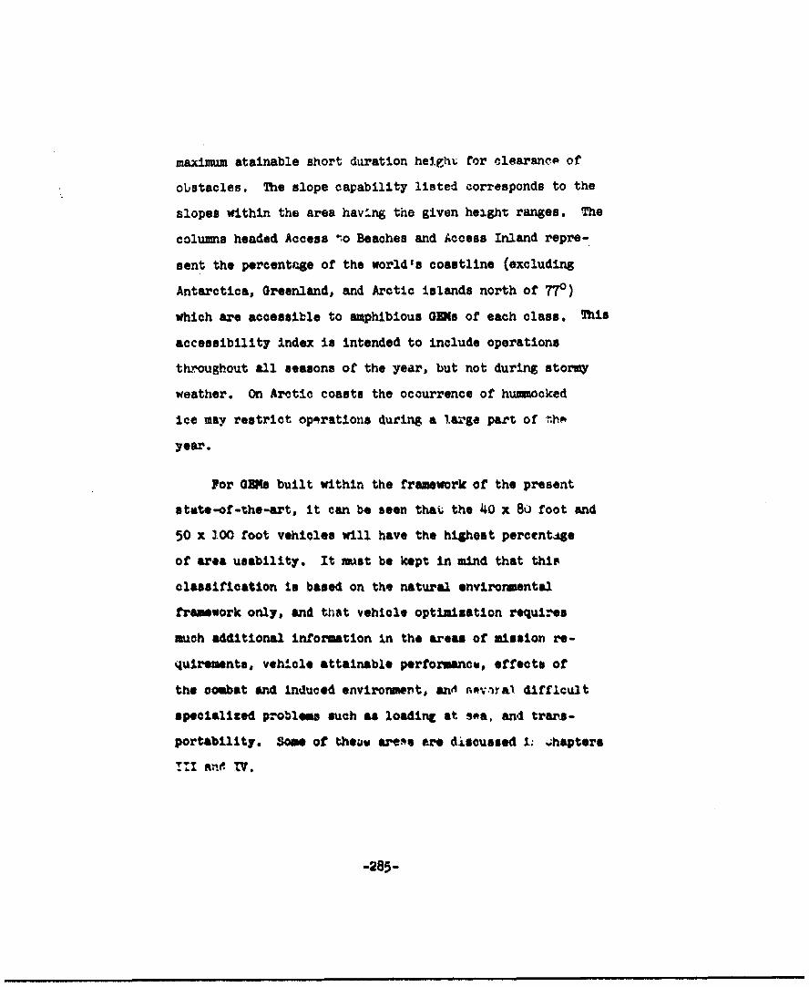
maximum atainable short duration heighi for clearancA of
obstacles. The slope capability listed corresponds to the
slopes within the area havlrng the given height ranges. The
columns headed Access t.o Beaches and Access Inland repre-
sent the percentage of the world's coastline (excluding
Antarctica, Greenland, and Arctic islands north of 77")
which are accessible to amphibious GOms of each class. This
accessibility index is intended to include operations
throughout all seasons of the year, but not during stormy
weather. On Arctic coasts the occurrence of hummocked
ice may restrict opaprations during a 1.a'ge part of fthA
year.
For ORs built within the framework of the present
state-of-the-art, it can be seen that the 40 x 80 foot and
50 x 100 foot vehicles will have the highest percentqge
of area usability. It must be kept in mind that thip
classification to based on the natural envirormental
framework only, and that vehicle optimization requires
much additional information in the areas of mission re-
quirements, vehicle attainable performancw, effects of
the combat and Induced environment, anw d ra• difficult
specialized problems such as loading at sea, and trars-
portability. Some of thea&w are.s are discussed i1 4hapters
T1 a. TV.
-285-

III. EMUS ON INDUCED AND COMBATENVIRONMENTS ON MILITARYGROUND MFMFCT LACHINES
1. INTRODUCTION
The effects of the surrounling environment on a specific trans-
portation device are by far the most important considerations
whei introducing a new vehicle to a military system. A vehicle
that is technologically sound, but ill suited to its normal op-
erational environment, will soon find little support from the using
agency. From the preceding work on topography, oceanography and
climate; sizes of vehicles, clearance heights and speeds have
been dctor-nined, in an attempt to pinpoint the highest degree of
uttlizat' n currently achievable. A*, gains are made In the area3
of recirculation, stability and control, channelled hulls and
mtructur- wekght, clearnnce holghto and speed may well change;
but in general, tWe over-all Piues of vehicles in keeping wit''. :he
envi.onmental criteris developed will remain. These sizes, to-
gether vith what is currently considered stale-of-the-art config-
uratione a the basis for the data outline! in tnis chapter. In
general, the famll- o: OR•s outlined by Ljungstr;m (26) are con-
ldared good example* of these vahiclco and can be taken as rep-
rostwing the Ges**n "know-how" oW today to machineo. Mcurdingly,
powerplart arrangements, fen and p-ope.,"er poritions, cargo load-
ivg and unlostding arrangements, r %%!n preb. -is, duct con-
fiturations and controls, while a mtA. of individual contributors,
-2.8• -
==rndmwIn mz-a tib"- Z~au trimui mnnInt!.. xmtxk2 1 mri tmm lett 1.--
~Inf mrT, 7aZ the miftm me n~u ii - 7 mma3lmv irw rltdla# In±-w~ arm~
((a))'mu lzziudixmutm21mM a =afmntL-
"Thum dtaitwN±~LW Jm TLM -,rw~rD
mt! am ~tti flflfirtKKttm (fr itl ~fle mid-I mWXMumtb~zn t~m tftm antior
jx Tý mm m mm.aa1 fmmit Mhu~m'a&IMTimm W&XWW 2D1MMurputtiu
aindlI~~vqEm~J fD4U vmBuaj w~t1 *. f VA~pIftsii.,
(2) The Combat Environments
These arise only during operation in a combat situation,
and are interrelated with the natural and induced environ-
ments of the situation. '.he main feature of these environ-
mental coniiderations is that they will contribute to a
deterioration of the effectiveness of the system in a combat
cituation, unless preventive measures are considered.
The problem areas, the origins of the problem, and the factors
upon Wilch they depend, are listed for both induced and combat
environments in Tables 16 and 17.
2. MINDCD INVIROMMMNT
(1) Notes Levels
The noise level in the ORD must be controlled in order
to provide a satisfactory working environment for the op-
erating personnel. At the same tim, such treatment will
provide a measure of control over the external noise level,
depending on how the basic problem Is attacked. A reduction
of basic powerplant noise will have the greatest all-around
advantage, and If adequate vibration-absorbing and sound-
proofing methods are utilized, the best over-all charac-
teriatica will have been actieved.
The approximate levels .%f tolerý&. " internal =tise are
listed below for the total audio range of importance:
-288-
q.~
fa4' . 0 V
Id '.4 0.4.0
be - . d
-,- 41 ..w .. I -L: .: 5 .? t: , 4 LU
4) CL a 4 -C
C6 .4.
4' ~' ~ ~ q Id
A A A AL360. 1. O
40 0l 0
.00
c C:v 0 v 4 ) (
03 03 034
~ 0 6
0 so
in U. 0
03 - hi
03 03 . Lid
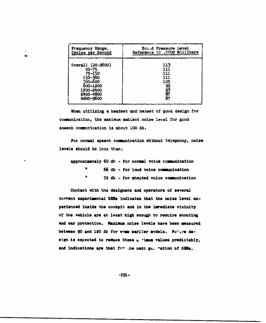
Frequency Range, SoU'Ad Pressure LevelCycles per Second Reference to .0002 Ntllibars
Overall (20-9600) 11320-75 ll.75-150 111150-3001130o-6oo 105600-1200
1200-240024oo-48000S40o-9600 87
When utilizing a headset and helmet of good design for
coninmication, the ulaxinum ambient noise level for good
s~eech coulmcation is about 100 db.
For normal speech coianication without telephony, noise
levels should be Iem than:
approximately 60 db - for normal voice csomication
66 db - for loud voice camanication
72 db - for shouted voice eouonication
Contact with the desioners and operators of several
euzrent experimntal 00s indicates that the noise level ex-
perienced Inside the cockpit and in the iwediate vicinity
of the vehicle are at least high eno~gh to reuire shouting
and ear protection. Kmaim noise levels have been measured
between 90 and 120 db for enin earlier wdels,. F da.@ de-
sign Is expected to reduee these a.. *Lmm values predictably,
and indications are that for he next gt.. -ation of OM,
-291-
cockpit noise levels uf !he order oz' 80 tV 95 db may be ex-
pected, requiring ear protection for continuous use and
telephonyr for adequate operational functionin. It is not ex
pected that external noise levels will be reduced to much
below 90 to 120 db.
(2) Vibrations
Vibration is experlenced in many form and Ord~er* 7he
majority of the induced vibrations result as follows:
1. Power Unit Induced
Vibraticna Induced at the fundamntal frequencies
of the power uwit and as the harmnics of these fre-
quencies may lead to structural damage.
These are transmitted through the atr, cture, aut,
are amplified by structure panels to different ampli-
tudes, if the panels are not adequately supported and
danved.
2. Lift Syste Induced
rerlodic fluctual.ons In the air now through the
%ir-flow ductInso my reona,.a In WUe d*u.caLIa* .der
some operating condiions The frequency of vibra-
tion is a frumtion or 4%.ct •• ob•.. ýy, duct presoure and
duct wall stlrroas.
_292
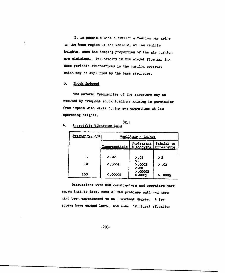
It is possible 'vt. a similay situation may ari3e
in the base region uf the vehicle, at low vehicle
heights, when the damping properties of the air cushion
are minimized. Pei..'dicity in the airjet flow may in-
duce periodic fluctuations in the cushion pressure
which may be amplified by the base structure.
3. Shock Induced-
The natural frequencies of the structure may be
excited by frequent shock loadings arising in particular
from impact with waves during sea operations at low
operating heights.
4. Anceptable V'-bration Da'a
Preouency. cs - Amlitude - inches
Unpleasant Painal toImDerceptible jjAnnoD Unhorablo
1 < .02 >.02 > 2<2
10 <.0002 >.0002 > .<.OM> .00002
100 <.00002 < >.005 > .0005
Discussions with ORR constructors and operators have
shown that, to date, norne of thR problems outlt, ,d here
have been experienced to an ",::rtant degree. A few
*crown have workedd Ion,.-. and umt 6,ru-.tural vibration
"-29>•
has been noticed, but, with carcful redesign of details
utilizing establibhed design practices, these were soon
eliminated.
(3) Coniponent - Generated Temperatures
7.. av*'r6 o: GEN-generated temperatures are:
- power units
- human occupants
- fluid dynamic friction
The only significant sources are the power plunt=. 1.f.e
highest temperatures occur internally in and around the com-
bustion chambers, ani externally close to the exhausts.
The local temperature rise in the 034 due to theoe high
temperatures depends on-
1. Engine cooling
2. Inoulation
3. Conductlon through the structure
4. Radiation 'rom the engine and exhausts
1. OQJ~rbML
Typically, the surrace %emperature on .n outside
or a gas turbine, prior to 'noulation, or external
cooling air, ranvle to :m amb'cn * '. the intake, riltin
-294-

to about 4000 F at 1ih'. combustioý'. chamber, and then
rapidly to about 9000 F at the Jet pipe. With provision
of adequate insulation, these maximum temperatures can
be reduued to abou6 3500 F and, with external cooling
air, to 1200 F. Exhaust gas temperatures are of the
order of 15000 P.
2. Piston Engines
The distinction is made between air-cooled and
water-cooled engines, since appreciably different
surface temperatures are inherent in each type.
For water-cooled engines at sea level, the mainma
likely temperatures to be met are those associated
with boiling water at pressures somewhat higher than
atmospheric, with never-exceed values In the range of
1200 C to 1500 C.
For air-cooled engines, surface temperatures close
to the cylinder vall may be as hip as 2000 C to 2U00 C.
reducing rapidly along ooolIn strfaees, such as the
cooling fins mounted on the eylindtrs,
Idhaust gas temperatuares) In the exha~ot mazdt4,1d,
lie in the range 6000 C to . 0 C, the lovet .empera-
tures be:Un vae appli•able to ,w compraess-n ratio
engines (4:l to 5:1), and high-epeed comprelsion-ignition
-2%-
engines, and the h.:.iner valuen .'re appropriate to high-
"compression high-speed engines of aircraft type.
3. Efjects 2f Component-eaneratd TelAeratures onVehicle Opera ton
In non-combat situations, these resolve into the
effects on the structure, and the effects on the
operating personnel. In both cases, with no more than
the amount of Insulation and isolation currently
provided for aircraft powerplant installations, no
problems will be encountered.
Combat situations as affected by temperature
generation are discussed under "Combat Invironments.*
(4) I&aust Oases
The exhaust gas level Is only of Importance at low
and zero forward speeds, where relngeotion of the cushion
air may trap substantial quantities of ases, and create
a noxious atmosphere in and around the crew compartment.
No experience of adv'-rse effects have been quoted. If
the exhaust stacks or the powerplants are Ineated dia-
metrically opposite the crew compartment and directed
away fro it, the posaib)t reingesation will be a Lilzsed.
Tt way be necessary at low and au forvrd speeds to
provide some form of tor,-,A %entilation .n the crew ara.
which will to quite a simple matter.
-296-
Probable exhaust g&r composition• that may occur in
practice are as follows:
i-- Lc lro catlnz .e iTr=
Engine Wc'k Normal Rich We Normal R
Nitrogen 77 77 77
Oxygen 10 1 o 19.6 17 17
Carbon Dioxide 6 13 6 1.5 3. 1.5
Carbon Monoxide 0 1 12 0 0 .
Inert Gases & Water 7 _8 . 5 1.9 2.6 1.4
(5) Static Electricity 2otentiais
1. Sources of Static Electricity Potential
(1) Aerodxynamic friction
in hover - the lift system,
i.n forward motion - the lift sysiem andflow past the structure
(2) Airborne partic:ss -sand, dust, dirt, noisture,snow, resulting in pre-cipitation static approxi-mtely proportional toV.
(3) Pueling processes -
'"(4) Atmospheric electroutatin l.nd"4tion
from oharged 0-ijuds
-297-

'The question of statl.', electric%'j potential is of some
concern s..nce quite high potentials have been discharged
from helicopters and aircraft on returning to the ground
after operation at altit de. In addition, static elec-
tricity potentials have been developed during fuelling and
defuelling operations, presenting an explosion hazard.
From discussion with Mr. En.ock Durbin at Princeton
University, the following points are pertinent.
The atmospheric charge induced by aerial vehicleR is
a function of the altitude at which they fly; the charge in-
herent in the atmosphere increases with alLitude, Increas-
ing most rapidly in the first 5000 to 10,000 feet. Close
to the grouni, the rate of increase Is approximately 1 volt
per centimeter. A helicopter flying to 5000 'eat will ac-
q' ire a charge of 50,000 volts, which is then discharged on
contact with the Fround.
A 0104 La unlikely to fly muoh higher than 5 to 6 reet,
which corresponds to a charge of approximately 150 to 200
volta, and it is posab.,le that aerodynamio friction may
double these values. The energy store. i?- unj OEM is a
functirn of this charge and the OI-to-grourd oapacitance.
A typical value of this capaciti.pce is approximat; , lWO
mlIro-wicro-farad. Under these co&." *ions, t6e orera
-l4 -2stored Is 2.0 x 10 to 2.0 x 10 millijoltas. The total
electrtal resistance or7 an operator may be auyshere from
-290- •i i llll i ii i iiii l•I
10,000 to 500 ohms, depend.ing on the -roisture content at the
contact point, the type of clothing and the ground condition.
Te Initial value of current discharge through an op-
erator on the ground, in this typical sitaation, varies from
40 milliamps to 0.8 amtps, although 8 to 15 milliamps is
about the maximum steady current discharge through an op-
erator that is acceptable. The time constant of the aEO/
operator el •±ir i 'l uit is such that the discharge cur-
rent drops to less than this within 2 millionths of a
second.
Hence, with the order of resistances, charges )tnd
capacitances involved in typical OM1, the current level ex-
perienced during discharge will not be at a high enough level
for a sufficient period to disable operating personnel.
Prom experiments with a rolling fluid transporter, it
has been stated that an energy level of .2 milliJoules is
necessary to ignite an explosive mixture of JP-4. Since the
energy level cnrlained in a GE( may be of the order of
-4 -22.0 x 10 to 2.0 x 10 milliJoules, it is not anticipated
that atmospheric or aerodynamically induced charges will
constitute a danger.
Avrodynjcally induced char&.. arise hom friction be-
tween the moving fluid ana the vehicle, and between
-299-
particles carried with ti1e fluid and the vehicle. These may
be either negative or positive charges, and so may increase
or reduce the induced charges. It is not expected that these
charges will more than double the induced charges; as in-
dicated above, the problem is still not severe.
A complete and practical solution to this problem exists
since any form of intermittent contact with ground by a coni-
ducting material such as, metal, conducting rubber, etc.,
combined with complete and adequate electrical bonding
throughout the machine, will prevent build-up of the charge,
and hence eliminate the need for c~ncern over the problem
of static eltztricity,
(6) ysiIt
Basic daytime visibility should, first of all, consist
of a complete field of view with the mininum of structural
features obscuaring line of sight. The actual range of
viuibility will depend to some degree on the operaitrng hwLght
of the vehicle. Visibility in rain or heavy mist and spray
can be assisted by direct vision devices, such as are cur-
rently used on ocean-going ships ad were ,'V.L.zed on the
SR.Nl for Rnglish Channel operations. The visibility neces-
sary for nighttlne operationa or operatIons in fu" dill
hPv* tn bo provided as usual by so&. kind of radar terrain
detection device.
-300-

In addition to vehtc.e configurvi:ton limitations, and
natur&1 environment,. visibility may also deteriorate with
OEM when operating at zero or low forward speeds (up to
about 10 knots) over cc-taln types of surface, due to par-
ticles being dislodged and thrown vertically by the air
curtain. It has been the experience of GO operators that
hovering over water, sand, snow, or loose dirt produces
a cloud of particles that completely envelope the vehicle,
thus severely reducing the visibility. This same cloud
makes it difficult for ground pursonnel to operate near
the vehicle without protective clothing.
The cloud of water droplets, sand, or dust is a
fa.il.•i one to helicopter operators and its effects are
well known. For examle, durine takA-nff in a hollcopter
from snow-covered terrain, If any time is spent hoveriM,
a *white-out* occurs, and it becomes extremly difficult
for the pilot to control the helicopter In order to rise
above the snow cloud or set the machine down. Such condi-
tions tend to r'qclude helicopter operations unless ado-
quate basic stability In hover can be provided, to enable
essentially a *hands-off* take-off.
A whit*-out" can also occur with a 0=, but the prob-
is. of stability and control doe- not arise, since the
vehicle can be Inherently sa;:ble in hu. ". As soon as
-)0l -

- ±•wf 't cf-~r.,- 1dnmD.•_ si•.t±• m a•m:', •zm a•zladf., 4Iram -fv-);)
ML.x Im Wb a,-- -waw ._ tt- aL mm•••
irflim~ amiEr laiVt,, atd ftr ~trimti =Ur tz IsM Lai~ ISOM mwJxIe mwt.
W-mwaxe". mai "unm T1mntm~mm %ttzu~tIrT m fuwmu'E cM"btt au
!iltll $tm rm
_Ii Wantffe J. .. a.
dust w x/w cnmwm t .. a-oI Irggymd".am m -F mc-
the vehicle or by the response of the vehicle to operating
conditions and surface conditions, without contact. "Shock"
arises essentially from contact with the surfac- or ob-
stacles, and is of a ve,4 short duration, high-magnitude
character.
1. Acceleration
The "accelerations" on importance are those due
to dynamic response and applied maneuver forces, and
are considered longitudinally, laterally, and ver-
tically, at or near the center of gravity, and at the
vehicl'o extremities.
At center o&Z gravity: VerticalLongitulinalLateral
At nor* and tall: Vertical (pitch)LAteral (yaw)
At sides: Longitudinal (yaw)Vertical (roll)
,1) Center of Oravity AccepleratIMon
Xongitudinal. The maximum will occur during
braking and accelerating.
Kax. effort cpeed increase + .2g
-a.4. effort ,raking .5 .
-00-
Lateral. Maximum dur!,Lg maxd3m effort turns.
Max. effort turn ÷ .lg
Vertical. Maximum when traversing undulating
terrain or smooth swells at seu.
Over waves where-(wave h-ilh ) 0.5,koperating height)
accelerations from=43g to •,g
(2) Other Accelerations
The accelerations at the remaining locations
are not susceptible to generalization since they
are very dependent on vehicle geometry and mast
be evaluated on an individual basis for each con-
figuration.
2. Shock
The magnitudas o: shook loadins depend on the lo-
cation In the vehicle at which measuremnt is made;
positions furthest from the center of gravity are liable
to the met severe shock load.ng4.
Ground Effect Rachines present a -;Aitcally difftrent
problem than an& other vehicle when asessment of
dynaMo response and oonsequent shock loadir. is desired.
M* oombination of low dmpi._ about and along all
"axes, and poor controa.abillty (by uowrison to other
-304-
vehicles), and the luck of basits understanding of the
dynamic nature of the ground effect phenomena make
this assessment difficult.
The only thorough study available to date is that
conducted at Saunders-Roe on the SR.N1 and its devalop-(29)
ments. Pcr the-* vehinles, the design stressing
condition was a 12g impact at the bow. A series of mod1l
tests were conducted to determine, with the Rid of an
analog compuLer, the zoefficients of the equations of
motion for the vebicle series. The resultant motion
analysis showed good agreement with the test results,
and predicted accelerations at the bow on impact with
waves on the ortier of 9g*s within the operational speed
range of the vehicles. Higher speeds, approximately
twice tnose for normal operation, developed bow accoler-
ations with impact of roughly twice this magnitude.
The corresponding accelerations at the vehicle center
of gravity were on the order of 3.0 to 6.0g. Imersion
Cf the bow on impact tend& to reduce these values by
approximately 30 per cent.
These values were evaluated for operation over
a nea with waves of P1nusoidil form, with w.•w heights
oe 1.5 times the vehicle o, ,atirn heieit., RXerlonce
with zhe Sr NI has v! .,,% that opt. tion In random aeas
with wave heights of twice this magnitude is possible
m m mm n m m m m m • • m m m m m n m n m m - 3 0 5 -m m m m
for the same Impdat accelerations.
It is not within the scope of this study to modify
or eXtend these data in a general way to cover all
vehicles. It is bb-'eved that the 'tressing conditions
utiliýzed for the SR.Nl may be applied Judiciously to
many sizes of over-water vehicles, provided the desired
operating conditions are similar.
(8) Re-ingestiorn of Downwash Air
This is one of the more pressing problems asoociated
with OEM operations, creating an it does overhaul and main-
tenance problems and a reduction in performance when
operating in sea, snow, and sand environments, in particu''.r,
and on a loose surface in general.
The re-ingestion of salt spray, snow, or nand has bv.!rn
a prohleir for helic opter oporations for some time, remulttinp
an it does in a loss of engine performance, combined with
erosion of the compressor and stator blades, and the lifting
rotor llades. The mechaniems that result in performance
reductions are:
1. Salt incrustation resulting in reduced mass flow
through the engine and lUt syctems and ic'roslon,
if left unchecked for a .,w hours in tropical
conditions.
2. Icing - with broadly the Sam effect as salt

ap'!edL comrn .Tamr' andi 1=11 ff~m 1bifadks-
Al WlJ"uuzz'i (2.1 aia czmpa t±.v,- Ifehal Qý
GEVE lift,~ atem. may- asust- Im 'h+@M~f:a jz-Sai g-ttcm
~kre ~adiexn ff ffiU vaafttta lliaws cff the =Iknfia 3M
andi t&fr uuLTI wfgkw,, tud±m al_50cr kftk- TikezaUa.
ahxp- vwmadavm fmza3wdU32 tf'igr e - 1ln1Ir fftw= P~~zai=
vef~cewYbufa apsmb~ Me amdhtpcsnt Aviable opy.
airflow than that of tbs hielicopter, and when operating at
- zero or low forward speeds over loose material, snow or
sand, tends to create a depression in the surface, which
redirects the jet into a high trajectory away from the
vehicle. This redirected jet is still much more concen-
trated than a similar helicopter flow field, and in con-
sequence tends to provide a higher concentration of
entrained particles, than the redirected helicopter down-
wash. A much higher proportion of the total entrainment will
ý- recirculated through a GEN rotoz than 4hrough a hell-
copter rotor.
It should be noted that the intake area uf the OM4
lift fan will be considerably less than the disc area of
the comparable size helicopter, and hence the intensity of
entrained particles arriving at the fan intakes may be
ronsidprnably highor than that arriving at the rotor diac
of a helicopter of the same weight and loadings. These
particles will tend to be of the order of desert sand; the
largwe pa'ticles, being too heavy tn he carried by the ro-
circulating veioclties, will return to the grcund.
Since the OW intake velocity wll] be comparable with
the jet exit velocity and aern" appreciably hight ;hsan the
"rlow v-.Locity developed through -'-llcopter rotor, and
since the OEM lift-faa 3p:.. will most .,.kly be higher
than the helicopter rotor speed, it .16 ll'; .that tV.6e
-308-

Tealtie velocity btwe~en fan blades a:rd entrained particles
will be appreciably mor• tiazn that expcr'enced by the
helicopter and rotor blades, except towards the tip. This,
combined with the higher density of entrained particles
wili present an appreciable erosion problem, and a con-
siderable likelihood of ice and salt incrustration under
appropriate operating conditions.
Thene comments have been made primarily with respect to
tne lifting fan system, but the :ame problems exist to no
,as" a degree as far as the main en~ine ingestion is con-
cerned.
(9) Salt Water Ingeatlon
An investigation of sa t water Ingestion by gaz turbine(30)
engines in hellcrpter operations, has shown that in con-
tinuous operatiov close to the wate: an InxLtulw rate in
excess or io cc or salt water pr, minute would have been
experienced for each engine (the power plants were 2 T58
engines). The drop sizes Ingested at the low altitudes
ranged from 2 to 500 microns of which hall are In
the 20 to 80.micron category.
The effect of operation near the water 13 al:o chown
on the engine power available, Lhlch reduced by e..,t 20 to
2- per cent arteor about 4 hours, r,. 'ning cunb~nt from
this time on. These power loases are mainly caused by salt
deposits for'ming on th. compressor blades, beirA retaiiied
there by a very strong ir.ter-molecular mechanical bond,
described as "Van der Wall's forces." These deposits
thicken and roughen the blades creating poor compressor flow
characteristica and reduced mass flow.
An additional long-term effect of this salt incrusta-
tion is the development of ccrrocion pitting due to galvanic
action between the mnined ialt (whinh absorbs moisture
when the engine is not operating) and the conducting metal
surface.
The methods adopted for control of salt deposits com-
prise waohing, inhibiting, and vlade coatings, each of
which adds some very desirable measure of prevention.
The washing procedure comprises a generscus flushinr
With fresh water daily with the engine cool 3nd rotated on
the starter, followed by five minutes minimum at idle
power to dry out the engine.
The Inhibitlng procedure consists o1 spraying a
special ell with additives Into the Irl, 7v 'he anerlne
slows *own after switch off; thls has the effect of dis-
placing any remaining water frc the bladew.
Blade coatings are ut!!e ted ' .o tnlah tho galvanic
action between the salt and the conducting metal. and are
completely effective. The choice of coating ts dependent
-310-
on the engIne temperatu.. :cndition, while all coatings are
susceptible to erosion from sand and dirt, indicating the
need for periodic recoating.
These control methods are successful and may be
applied equally well to the GEM lift fan and duct syst..n,
and to some extent the outside vehicle skin.
(10) Sand and Dust Ingestion
(48)Test results reported on the T53 helicopter gas
turbine indicate the extent to which current engine designs
canJ be developed to withstand the severe sand and dust
environment likely to be experienced by OE4s.
A formal test program wns conducted on a T53, in whicn
50 30-minute consecutive runs were made, simulating 30-
minute m~ssions in a sand and dust environment;. The sand
and dust particles introduued into the engine ranged through
305-210 microns in size, at a concentration of .010 grams
per cu. ft., representing operation in ground effect for
5 houre, and sizes through 0 - 80 microns at a concentra-
tion of .001 grams per cu. ft., represonting operation nut
or ground effect for 20 hour.3.
At the end of the test, it per cent lose ix, ,,orsepower
cad occurred, a 10 per cent loss . speclfic Cue' con-
sumption was evident, and some sand-blaot erosion was
apparent in the compressor section. No blockage of air
-311-
o•ll tng passages had ocv:yred, and tUe air filter aria oU
svtp.m werA free of P-nviation. When the Proded parts
had been replaced, all of which were field replaceable,
the power and consumptin were within 1 oer cent to 2 per
cent of the normal value.
A user test program was also conducted with a Bell
YNuO helicopter at Yuma, Arizona; over a period of 40o.5
hours, 14 hours were spent in ground eifect.
This was a much longer duration teat than the formal
one, Including 3 tlmez as much time "ia ground effect,"
at"d yet no power loss was reported, aid uwly 1.5 per cent
In specific fuel consumption. When the engine was examin-d.
the erosion was voy mild, and confined to the axial com-
pressor cection,
This Indicates that the sand and dust environment au
Yuma, combined with the flow field about the helicopter,
did not create an much ingesti.on as had been utilized In
the ri.mal teS , In which 65 pounds of sand had been run
through the engine. This suggeots that the proportion of
sand particles of the sizes used In the f' .zal test wac
quite small in the desert test, and that the rotor duwnwash
velocities were too low to poraV the more numerons larger
p rticles to be carried to the intt.. by the r*e:1reulating
stream. Hence, the formal test conditions could he
-312-

considered extreme az fax, as simulattng rctor-induced sand
concentrations are concerned, thus showing the capability
of current engine designs ror these operations.
In summary, althougn the mass flow of a 0N4 could be
much less than a similarly loaded helicopter, the Jet
velocity will be considerably more than the rotor downwash
velocities, by a £actor of 2 to 3, thus permiLting entrain-
ment of larger particles than those considered in the heli-
copter test. The entrainment will become more concentrated
due co the action of the Jet on the ground, and will be
directed more towards the vehicle than is the case for the
helicopter. Combined with this are the facts that the 0N4
Intake area is much smaller tUan the helicopter rotor dIL:
area, (and is comparable with the Jet exit area,) and the4.
intake velocities will be much higher than the flow
velocities through the rotor blades. Thus the concentration
of entrained particles will be at least us high as for the
helicopter end probably much higher. Erosion can be
expected to be severe, particularly since the tan blade
linear velocities will be comparable to tnose of the rotor,
in the regions of 0.6 to 0.7 Mach. nurw1 er. As far as
engine designs are concerned, current otate-of-the-art
seem to be quite capable of 1.-nounting for sand •.d dust
t.getton.
_313-
(0. Snow and Ice Accuou.Lation
Experience with ships and aircraft operating In the
Arctic and Antarctic latitudes indicates that very severe
snow accretion and icing conditions can develop that will
build up large quantities of ice on the structure of any
vehicle operating on or near the surface.
Tiree particularly severe conditionn arise:
1. The accuilulation of snow on stationary vehicles,
during snow storms, natural or induced.
2. The ouwuuldý.on of ice on leading edges and
propeller blades at forward speed.
.•. m •ccunmulation of ice on vehicles operating
over water, when the water temperature3 it above
lo• •l freczing, while the air temperature is
below fremzing.
The first problem is a familiar onc in operation of
vehiclep and aircraft in these armab and can be tackled In
the same way as tr uurrt~et vehicles.
The second Item is again a famdliar one In atroreft
operations, except that more eteatinuous developw ." of
,,i*:h IcIng conditiot s ay Wbe expeu "4, when :ompr.rod to
aircraft which can be operated above or below tho icing
-314.,
levei and hence in gentr-,' only havw to contend wc',.n the
problem during part of a mission.
The third item Is of great importance and is parti-
cularly experienced by ships at sea in ihese areas. War-
time experience of convoy operations to Murmansk, and
experience of fishing fleets in the Iceland area, has
3hown now very large quantA.lee of ice can accwnulIte on
•. ship's superstructure under these conditions, leading in
s•me casaee to an unstable condition In roll (a negbýIve
metacentric height, due to the now top-heavy super-
structure) whiah results in capsizing and loss of ships
and crew.
Por ORs, the problem is different and somewhat less
catastrophic, although still severe in terms of cRrrying
out any given mission.
By virtue of the cunrint type of lift-producing
mechanism, Lhe 0IN develops appreciable spray, which in
hover and at low forward speeds envelopes the machine.
Under the severe icing conditions quoted, this spray will
imediately freeze on contact with tht m?',%.n-, except it
areas of higher temperatures near the engines and erhausts,
and will continue to build up to3 long as these t. oJitlonf
tre zIntained. In fact, as th. 'Inkg Duilds up, the
vehicle gross weight increases and the .ushion pressure
increases. If constant; power is maintained, the operating
'-- height will decrease approxinately as the inverse of
(cushion pressure) with very little change in jet velocity
and mass flow. Since %>:e amount of spray generated is a
functior of Jet velocity and mass flow, the same rate of
ice build-up will continue. :f power is increased to
maintain height, however, the Jet velocity and the mass
flow will increase nearly in proportion to the increase in
cushion pressure or gross weight; this in turn means that
more and larger water particles will cnvclope the machine,
and rate of ice growth will accelerate. This implies that
the siaplest way of reducing the severity of icing con-
ditions• in hover Is to reduce power, and hover at the
lowest possible height.4.
When resting on the water, or when operating at an
appreciable forward speed such that the spray generated by
the lift mechanism is essentially left behi,- practically
all c,. the icing will result from the super-cooled water
vap.r present in the atmosphere--this will not be as
severe as the hover condition, but will certainly result in
a "glaze" ice coating on the vehicle at restt and toe
build-up on the forward portions and fans aniv propellers at
forward speed. In addition, If weather cond.1ti as are such
that a sea mist Is encountered at -,bzero air tehiperat".o,
very rapid ice build.up %A1ll aain resu~t.
-316-

Thee• awaemsm afZ' am- u ,a.• cttpwmi ulemr, .Hl.w #*lln -rt:.'af,
UT, m-dtar t. . .caad- wJ~t the- mdfrnmm cti Of
sarh Iffi_-,4 1 IM....
vanio anptwxta tto' Wies-f v~gen~i~ tt 1±f w"latm2, th sumnqtmtflv
- s1nI, d±m•,~
- Pvnnlal .i=yi i,
- L.u r •mantfrn-,,
- wvJ±*i•"•.t .arttm-.
"dMe-. am 11w Un-kv• a ff aM nveffmlrt, 7,- tMr
-Ji~ai'~e •vzmI fr•gHT, 11Fw ... ~~niia eai±b~~.
-- . *. = l'm, f aF ad tw..
Best AvRa2bi CO"Y

p.iant, including that ;.azt of the ovir-all noise level
..'.at is amplified by the structure, can be reducel to
the same level as the aerodynamic noise, a GEM would be
virtually undetectable .,n this score.
The only way that this could be approached currently
(and the power source is still in the experimental stage)
is ty the use of fuel cells powering electric motors to
.rve the lift fan. However, more immediate power plants
will b.i gas turbines and piiton engines. CurrcnL gaz tur-
bines and piston engines require considerable effurt to
silence them, with consequent appreciable power losses
and additional equipment weights.
In order for detection to be possible, the noise
level at the detector due to the OEM must exceed the
random noise level at the detector location (which typi-
^ally would be a coastal strip, where random noise would
be generated by the sea, wind, disturbed vegetation, etc.).
If OM noise can be kept below the average random noles
level, then the chances of detectivn from noise are much
reduced.
Such average random noise level would be below that
for normal conversation, but aW-ve that for a whi iper,
tAF, 4v to 50 db (ref. .0002 mill., "a). Hcmeve,, this
also Is about the noise level of the lilt-system airflow,
ard is well helow the level from engines and fans.
-318-
The variatIon '.f' sound in%,.nsity with distance
has been measured for a wide range of air and ground"(24)
vehicles.
From these data, intensity level as a function
of power has been approximately evaluated, such that
at 500 feet, the noise level in decitels is
dB - 12 log HP + 59.
The rate of change of noise level with distance
has also been derived as app.:oximately
d - 22 to 23 (where S - distance in feet)
for aircraft which gives 6• dB-- (6.5 to 7.0) fuc ýazh
doubling of distance, within a distance range of
100 to 5000 feet. This is very close to the
theoretical for sound Jissipation with no attenua-
tion or reflection or Utmospheric disturbance.
These factors will, however, play a large part
in the value of noise level r.LAcd at any distance
from a sound source.
(143)Prom theoretical noise-level studies can-
ducted on va-lous GM deOMns, the followitib aý'pruvl-
"ýi'e noise levels appear lib.'- for GDMF' leeigned
to the current state-of-the-art.
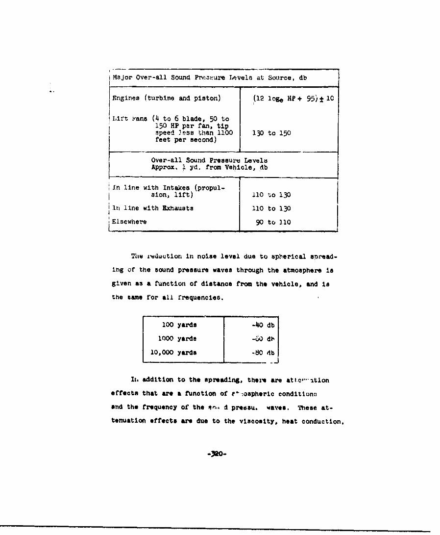
Major Over-all Sound Prte.:ure Levels at Source, db
Engines (turbine and piston) (12 loge H? + 95)± 10
mLit• rans (4 to 6 blade, 50 to150 HP per fan, tipspeed less than 1100 130 to 150feet per second)
Over-all Sound Pressure Levels
Approx. 1 yd. from Vehicle,*db
In line with Intakes (propul-sion, lift) 1O 0o 1i30
in line with Exhausts 110 to 130
Elsewhere 90 to 110
The ruduution in noise level due to spherical e~read-
Ing of the sound pressure waves through the atmosphere is
given as a function of distance from the vehicle, and ls
the same ror all rrequencies.
100 yards -40 db
1000 yards -60 dh
10,000 yards -80 db
-_ J
It, addition to the spreading, ther, are at1t:,,"•tlon
effects that are a function of Pý--ospherlc conditionti
and the frequency of the en, d presau, waves. These at-
tenuation effects are due to the viscosity, heat conduction.
-320-
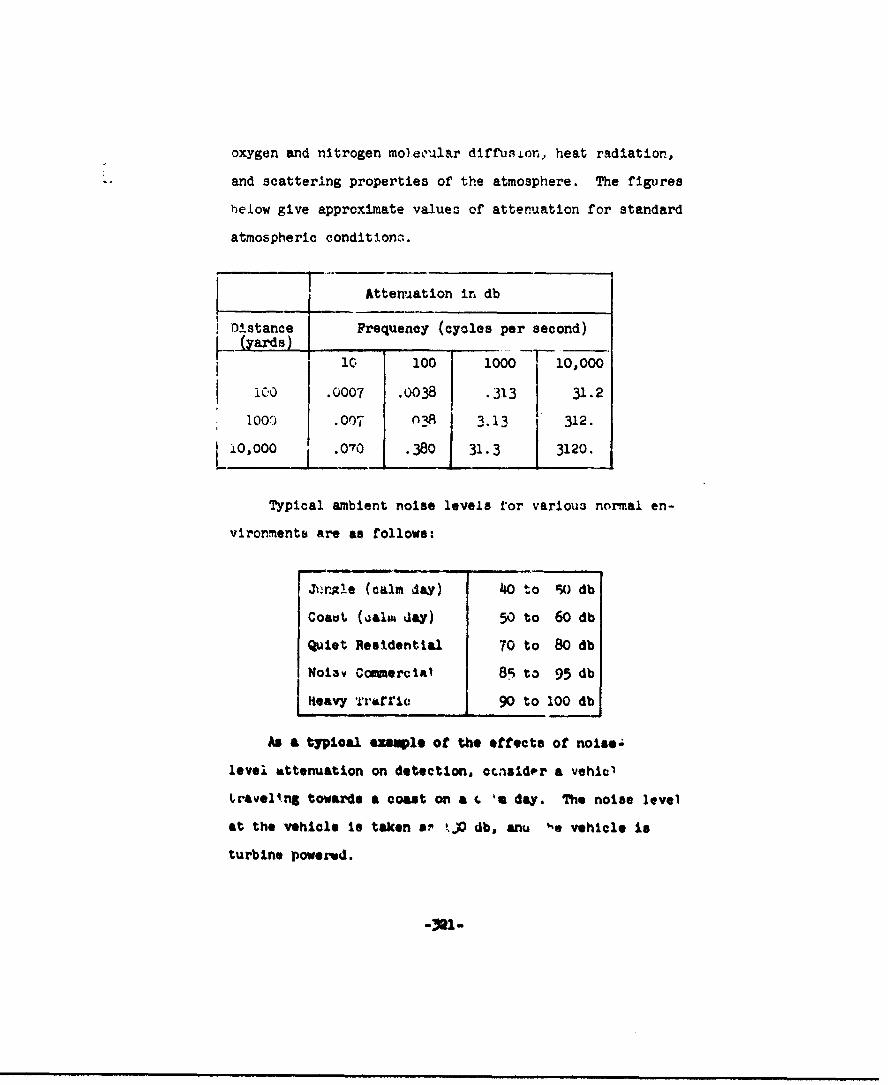
oxygen and nitrogen moleoular diffusion, heat radiation,
and scattering properties of the atmosphere. The figures
below give approximate valueo of attenuation for standard
atmospheric conditions..
I Attenuation in db
Distance Frequency (cycles per second)(yards) ____ ______
1 0 100 1000 10,000
i0o .0007 .0038 •313 31.2
100") .007 0_1 12.
I O,000 .070 .380 31.3 3120.
Typical ambient noise levels ror various normal en-
vironrmentb are as follows:
Jýrx!e (calm day) 4o to 9) db
Coa.t (alim day) 50 to 60 db
Quiet Residential 70 to 80 db
No13v Commercial 85 to 95 db
Keavy Trarric 90 to 100 db
As a typical enql* of the effects of noisel
level attenuation on detection, cacsldpr a vehic'
Lravell.ng towards a coast on a . 'a day. The noise level
at the vehicle is taken s? kjO db, anu '*e vehicle is
turbine powered.
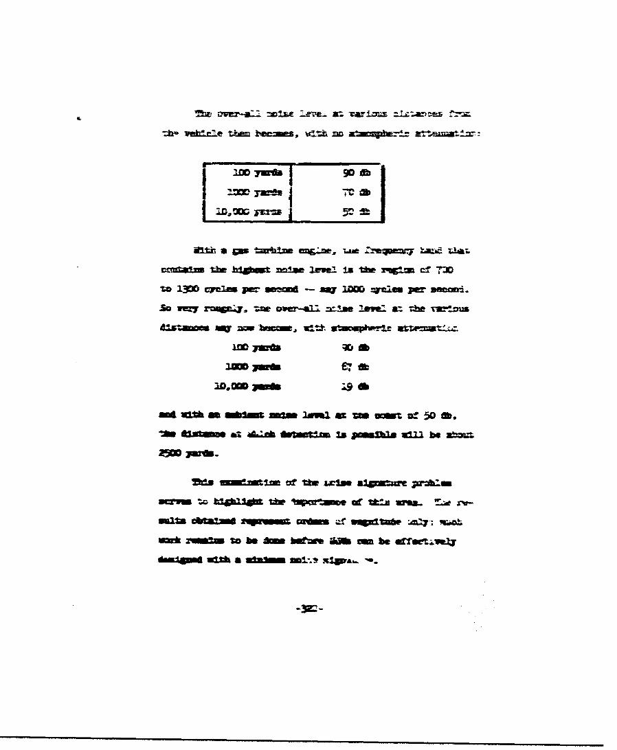
'ftc r2' =ILC :.ere- &- vat : =: o~ iitanD-es jfýý
3.uia 9D0d
crmdam the blabt lev .eLlz Is the t cvV f T30
zo 1~30D eyelas jw m - AV~ " -rrm per W3mi
50 r8=7 ZWL4., -zw ____l =-!n lve a=th rw-ft u
3m 67 ftID.OD 3wft :9 *b
Va t2jumm da Aac dotctm Is poma ~Id be ab=
adsmmimlmof Uw =3m~ a'z ;Wwl
-S= Qm iao * mwmeo k* Ura. -_ r?
A il obe bmtmMO a be offectmoU
M* A nftl .418VA&..
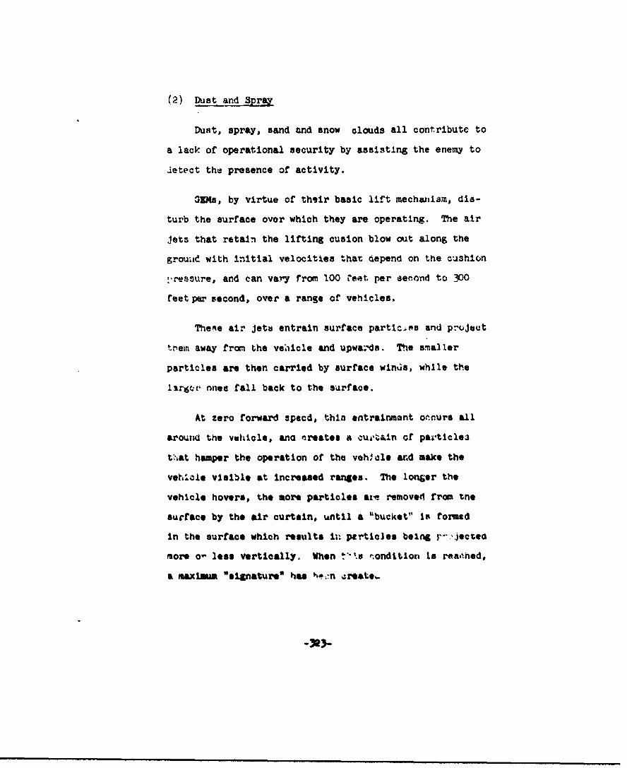
(2) Dust and Spray
Dust, spray, sand and snow olouds all contribute to
a lack of operational security by assisting the enemy to
detect the presence of activity.
31Ms, by virtue of their basic lift mecharlam, dia-
turb the surface over which they are operating. The air
jets that retain the lifting cusion blow out along the
grouad with initial velocities that depend on the cushion
-,ressure, and can var'y from 100 1eet per serond to 300
feet per second, over a range of vehicles.
The.e air jetu entrain surface particiea and project
trein away fron the vehicle and upwa.'da. The smaller
particles are then carried by surface winus, while the
largcr nnee fall back to the surface.
At zero forward specd, thin entrainment occurs all
around the vehicle, ano creates a cua,.in of particlea
tV4at hamper the operation of the vehiloe and make the
vehicle visible at increased ranges. The longer the
vehicle hovers, the more particles axe removed rrom the
surface by the air curtain, until a "buC•kt" Is formed
in the surface which results it, pertia]es being r•--,jected
more o- less vertically. When ý-'•s •ondtLion Is rearned,
a maximunm "signature' has vo'*,n croat*%..
particles are deflected rearwards, and a reduced degree
of entrainment occurs, since the relative velocity be-
tween surface and curtain has been reduc.d. Hence, at
forward speed this spray or dust cloud is appreciably
r;duced in magnitude.
Current experience ,ndicates that spray and dust
can be expected to rise to t.eights approximately 15 to
710 times the opprating height of 'ha vehiule in hover,
and that this will be maintained up to speeds on the
order of 0 knots, although the crest of the cloud will
move rearwards by about one vehicle length. Beyond these
speeds, the cloud may be expected to reduce In size.
.1 very sai:ple form of analysis serves to indicate
the wtxlmum heights and maximum radial distances to
which particles could be carried by tr.e jet .rtain air.
(in the assumption that prolonged hovering will
prooce essentially L vertical prcleztIon or the jet
curtain air, and that particles will only rise in this
air stream as long a the st-eaa velocity is greater
than the tezalna& velocity of the particle, Pgaro 15
Illustrates the orders of mAgnitede that mlght con-
ceivably arise, for sil1cot t)pe jb.i-les and
for water particles (spray). ( 6)
-324-
Pq T1 14,A0 ' 0W O 14 Ml 4,110
w4
PSf
'41
rT4 01 m l..0....-
u4EOI i
I.A..0 H
R S;.I IIIHt
"I t F I
fil
(sllpuI 1ww~c fI )iJf
It is seen that qi.ite appr..labV •1ghts are pre-
dicted for the very small particles, but these are open
to considerable doubt, due in part to the fact that the
deflected air stream will undoubtedly dissipate much
more rapidly than has been assumed, and due also to(46)
the necessary extrapolation of the data on decay
of dynamic pressure in a Jet exiting into f-A n~r.
In addition to this, particle sizes below about 100
microns possess terminal velocities that are comparable
with the random eair currents in the atmosphere and
wculd more than likely be dissipated long before reach-
ing their theoretical zenith.
This diacuesson serves to emphasize the need for
a more thorough Investigation into the flow fields and
w"•,m.d ent mechanisms Involved in the generation of
dust Lnd spray by ONr.
Experience with the Curtis-Wright Air Car provides
an aoproxlmati correlation with part of this analysis.
Spray heights of the order of 10 to 12 feet were ob-
served In hover, at hover heights of t"h opdor cf 6 to
12 Inches giving a ratio of spray height to hover height
of 20 to 10, which from the nhart, for low plan. rm load-
ing viahi1os, corr*esponds to wau - particles-i' t•he
region of .10 to .�0 Uich in Siameter. It is not known
whether this experience ws on the pure plenum Air Car,
-326-

d~i~4i 1j, tid.L .kj2-ftttiLI LUIIdI4JL.L UL- .l.t .LUH1 ±.,, dAIl .ZM i
.c - __ ammr r cm JJZ =01tit .
t U eMM w,,r IM, a, %ftmh = ft= Uw t MMc
rcrftmlil' .nan c UV " 3tre V Mt BW trn
aMttrn=10Ea lltmikm- of tI ffiuea estW =Mail ableC
vrzkrcjtýai P J&%f tftwnmitd W tmw VMUIM W! MM-Mf
LUM=wj~-, am mvz- ta Jld BestW m Aailale op
P-4
14
rAlt
W4
4-,1
C,
cil 0
!k: I h.
0 0 0
-4 04
(99q3u;) Je8m~tUVT DTD1IJV,.T
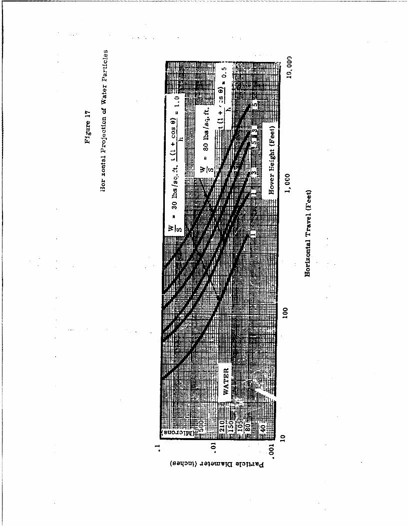
C.C,
-46fl
I-,A 4
44
p 4 A
-44
00
ý00
-4 -4

(4) Radar Reflectivity
The radar equation is
Ri 4K Pt at HR 2 At
PR
R is maximum range.
Pt is transmitter mean power.
1 t is transmitter aerial gain.
GR is receiver aerial gain.
X is wavelength.
a is function of atmospheric attentuation.
At is target echoing area - a measure ofthe fraction or incident radiation thatis refleoted.back to the radar receiver.
PR is the minimum detectable signal.
L K is the constant of proportionality.
The only factor over which a OEM designer has con-
trol, then, is At. The main fautorn that arfect At and
the revuraed v tilal are the amoothnese and angular posi-
tion of the reflecting surface relative to the incident
beam, causing fluctutions of the echo an the target ap-
proaches the radar.
Note that for modern jet aircraft, the air intakes
are a major source of radar echn; interference o. .,rs
'-twee:. the echoes from several .. '%kea or similar por-
tions of the vehicle caasinld its appare... mean position
to change rapidly and inconsistently. This it useful in
-330-
confusing homing weaponi pcos3essing radar homing devices.
However, the presence of strong signals of this type
means that detection is easier, and if the fluctuating
nature of the return is recognized, radar homing de-
vices could be discarded .in selecting a retaliatory
weapon.
It would seem that to minimize radar reflectivity
in the direction of motion, the frontal aspect of a OEM
should be sharp with no planar areas or intersections
located normal to the direction of motion. If this can
be achieved, the radar pulse will be reflected in specu-
lar fashion away, 'rom ltp initiol plith, and no radar
signal will be evident from the OIM. Note, that where
dimensions on the vehicle are of the order of the radar
wavelength, diffraction occurs, which mq give rise to
a return signal. This indicates the necessity to pre-
serve a smooth external contour to the GIM, with the
mInimur of appendages, bolt heads and nuts, lap Joints
pointing forward, and so on. Sevcril rorma of coating
arm under development, that are at least partially ef-
fective in absorbing the radar signal at niormal rada"
frequenojies, and could be oonsidered In thic area.
I -t~ ~ ummn mmm mmq~mmqumm mm• m l m mm m mmqm~ m

ttanEELa avuaai- Qifý thtT- av- orf 5-IQU ac~gum ffba tkD 5P-AOiO
wme .n" Pl - I GR=, aff =a. ard- af•) TAM- tw &
"ar rFttrttfa gmfernw w"I'at~ U.', rhwtp1
g agellaww, rhase- madIe'- the Avdtial- Copy
and2:E may' Pnmdiure ai ah I, bol thm
us&-e a~f dixmtemf a= aktraud~x gzLegV&lerm W=D zthftz th~33
eefbnt), &tumr theim.e-f I br thm-e timm mmmE Mm the
a~~~rg~~ff at' trf mJ2e~~te n~JJ
* aarmtd±arafte axbmitzo fthf t pt-s atrt aff v,"w
0 V, DxThw aý-Wz
nIICM mmi ?=lftaed mdsb5 m that
thm IT lwxfew zmut nut' emmeeftr
Marra-wm~ ffeatb~mW-&
FUest Available Copy
-91. 10 watts per square centimeter at 100 yards
in wavelength ranges from 3.0 to 5.5 microns,
and from 7.0 to 14.0 microns.
-io2. 10 watts per Bquare centimeter at luu yards
in wavelength ranges from 1.8 to 2.7 microns.
From a study of tho temperature distribution of
typical engines likely to be utilized for Ground Effect
Maphines, it would apper that the maxinum IR radiation
at the engines, if completely exposed, will be approzi-
mately 60 watts per square r-ntimeter.
This value will in general be less at source, due
to lower operating tomperatures than the maximum con-sidered, end will aln be insulated by the surrounding
structural material necessary to the vehicles' design.
Further reduction in intesmity occurs rirst as a direct
result of the special spreadfng of the IR radiation,
and secondly as a result of atmospheric absorption.
Since the 0O engines will have operatuW tempera-
tures similar to those for military alrcraft, it is
anticipated that the GUI can be designed to met the
am. ZR requirements, probably viSh pearer eas., a w.
the preoence of the ground and its . ' led obstructtlmns
and atmosphere will inhibit 'ne pasasge oi IR radiatlun
more than for aircraft.
-333-
I...mm m mmmm mm
-'3,-..qm P lmm
(6) Vulnerability
A preliminary assessment of GEN vulnerability can be
made by qualitative compa. '-son with other rehicles per-
forming similar functions under the same conditions of
retaliatory firepower.
Vehicles that will pcrform the same function at
least in part, as a GEM, are landing ships and trucks.
Vulnerability of these vehicles is first related to
size and speed. The larger a vehicle Ia, the more likely
It is that a hit may be scored. The slower it travels,
the more likely it is that a hit may be scored.
SAs qualifier* to this are (1) the degree of damage
or casualties that will be Incurred by a hit (this is a
function of the built-in protection of the vehicle);
(2) the profile of the vehicle in relation to the type
of attacks (3) the maneuverability of the vehicle in
avoidliw attack or degreair4 aiming accuracy.
OGs and ships of equal else (&roew weight) can be
compared.
The OIN profile will be lower- than a correspond.ng
ship, probably shorter but smoift a . "'r. ThIs pruvides
a less deWinitive target for a 2hore-based defender, but
a l arger target for aircraft.
The GIN speed will Do 3 to 5 tUjiaen that of a similar
ship, and it will be capable of faster maneuvers than a
ship. This will make it a narder target ror both ground
and air defending equip..3nt.
It is possible and desirable to configure a GEN such
that the lift cushion pressure can be maintained in the
event of damage to part of the lift structure. Multiple
power plants witn modular construction will go a long way
to providing this capability. With this approach, the 0G
will not be as vulnerable as a similar ship to a direct
hit on a power plant; such a hit on a ship will also re-
sult In severe damage to the hull and may oi:nk the ship,
whereas the GUM can continue. This requires that the
ii. lift system be guarded by some degree oi' arwor, in turn
providing an additional level of protection to the person-
nel and carqo in the event of fan-blade failure.
In the event of failure of the lift system, due to
duut penetration or severe power-plant damage, an
axiliary power eource can still provite u.ater mobility
if adequate flotation capability to deestnoA into th* Q=
structure at the start.
In addition, the 0UM is not vulnerable to torpedo
a ckae.

Similarly, the GBM. and corresponing truck may be
1compared:
The profile of GIN and truck will be about the
same if the GIN has to carry the truck load and
operate on truck routes, so there will be little dif-
ference in vulnerability In this respect.
When operating over areas where a truck opera-
tion is marginal the GIU speed and maneuverability
will be a distinct advantage and will reduce Its
vulnerability. However, when operatlng over truck
routes, the OGU speed will be limited to truck speeds
and no difference in vulnerability will be evident.
* Penetration of a truck tire is a severe dis-
ability, and will create a greater loss of control
than penetration of tho dllm. of a properly Aie.i~nke
OZN.
The power unit and personnel compartments are
equally vulnerable for the two vehio'es and require
the sawm order of protection.
Note that this compar•Lon Is a little different If
the vehicle choice Ii different -- If a lange Mi s
cooen to replace several small or. -% and/or trtuokv,
then although the OW will operate fa•ter thea the ships
Ie . m m . n m m = ~m M m m m m i i ml 4 m m p q m m m m

aru-xue: uIZ V ztt±¶ts. -1. tL-aowrm iSm f
VMnnrtd~tW qa4Vn Moyl W"~ air ftrie-, off
ONma the hoaffm ,mei raat
¶Yk) thm (Tffma1?1 am amu ai
OMM =Ra p-,c."
Best Available*3 Copy
L Of these areas, the -ift-produc;.ng system requires
particular attention. The other areas can D6 designed
with normal military vehicle protection in mind.
As far as the lJtt system is concerned, damage pro-
tection Is needed in particular for the lift fan and
gear ' ng, and for the ducting associated with producing
the sustaining cushion.
(8) Field Relairs
Field repairs for an operational 010 should be as
straightforward as these for the Army's light aircraft
and jeeps, consisting primarily of replaceable parts,
with the mininui of actual repair work to be done.I
XoduAr construction methods in the design of the vehicle
will great~y facilitate this aspect.
(9) GM 0Deration In mne Fields
The range of footprint pressure experienced with
OGUM 4 about 30 lb/sq. ft. to 80 lb/sq. ft.; the likely
acoustic over-all sound pressure levels close to the
machine are In the order of 110 db to db t•&xve u
.0002 dyes/e02; other features of GM my also be f.-
portant for inItlation of mIne e.oplosions, such aL the
"1i+agneti anomally" siniturp (lees. 'Itstortion of -'he
earth's ragnetio field), of the vehle.
-334-
Most sea mines are designed to explode when sub-
Jected to the magnetic, acoustic or pressure fLelds of
"worthwhile" targets, namely vessels of 3O00-tons dis-
placement or greater. It is very unlikely thav Ground
Effect Machines, as they are now envisioned, will be built
approaching this size. In addition to this, the effect
of a mine is dependent largely upon transmission of
pressure waves through the water to reach the hull of
the target ship. When the pressure wave reaches the
surface, most of the energy is diosipated and the ef-
fect lessened appreciably. Since a GEM will operate
clear of the water surface, the most lethal character-
istic of sea mines cannot be utilized and the GEM will
be subject to the secondary characteristic comprising a
column of watqr thrown oult uf' the water. This may
cause some damage on impact with the GEM.
Land mines are tailored to react to specific
vehicles that are worthwhile targets. The snie of
charge and the sensitivity pf the detonating mechanism
are dependent on the desired target. Antipersonnel
mines are small and very sensitive, whereas antitank
mines are large and can be walked on wiV-.out detonation.
These mines are sensitive to footprint pressures a.-
magnetio anomalies associated W",* the desired vehicles.
Since GEN footprint pres !"-• of the c. '-r of 30 to 80
-49
lb/sq. ft. are 1/15 to 1/150 of the f'ot-prifit pressures
Sof conventional land vehiclas, and since the GEM struc-
ture .*s largely aluminum cob4ared to the predominantly
steel construction of a tank or truck, passage of a
GEN would be most unlikely to detonate conventional
mines. If an explosion should occur near a GOD, damage
to the annular Jet and cushion area could result, but
with proper design, the vehicle should still be able to
continue its mission before field repairs are necessary.
(10) Nuclear Exaloslon8
The combat missions thtt require operation in a
nuclear mxplosion environment present a numb3r of' in-
L •tresting and Dotentially hamardous problems, to operat-
ing personnel and vehicle lalke.
1. Radiation
The major result of 00 operation in a radia-
tion environment is the increased local density
of radio-Retive particles urrzoundlng the OEM while
in hover or at low forward speeds, due to the re-
ingestion phenomena. This will cau: A& continual
recirculation of radio-aolve particles, intensi-
fying the radio-active f'tvld surrounding tht "'-
:|.ilv (i '•cal "van Allen" L,.0.) hence afferting
the personnel.
I. . .. e m • •• w m e w m •• m e •
The same Inerease in intensity means that the
components c aprJis-ng the GZ( lift system will be
subjected to a greater radiation intensity than
would normally bt the case with tiher vehicles,
while hovering or at low forward speeds. Those
materials that are subjut to duLerioration in a
radiation environment must be chosen with this in
mind In the design stage, or subjected to more
frequent inspection In operation.
2. Effect of Blast and Temveratures in a NuclearCombat Situation
Effect ef nuclear blast depends obviously on
the magnitude of the explosion and the distance
from the explosion. The first observation Is that
since the OW Is essentially rriotionleas in its
motion over the ourface, the pressure wave of a
nuclear blast will cause an Impulsive force to
act on the 3 which will send It skciminS over
the surface in the direction of travel of the blast
wave. Seoondly, the presence of an approximate
aerodynamic shape to the OM and saoe degree of
directional stability will cause the OGE to face
into the blast wave and d4velop high aerodynoumlc
rorces which will pit.h the -.. 4ole nose up 4.?
down (depending on the basic stabilty and control

of the GIN and the trimmd condition) and prob-
ably contact the ground and become completely
uncontrolled. The initial positive pressure
wave is followed by a negative pressure wave of
similar magritude which produces relative
velocities at the OEM in the opposite direction
to further aggravate the situation.
The positive and negative pressure magnitudes
in the blast wave may also create intolerable con-
ditions for the operating personnel in the
vehicle, unless the rehicle is sealed and stressed
to prevent rapid pressure fluctuations in the
cabin. This Is oosmon to all manned vehicles in
this situation.
Temperature and flash effects on the vehicle
are dependent on the surface finish and surface
m aterial vf the vehicle; the effects on pweonnel
are largely dependent on whether the cabin trans-
parenties would perlit direct railsa. on into the
cabin. Tfransparent materials have reoently been
developed that are sensitive " light intemnaty In
suah a way that they becom q, '•,e to radiation in
the vif-al end infrared frequency ranOes in frao-
tiona of a second. These m•a alleviate the trenB-
lent effects of flash and tmetures.

(11) Loadability of GEMs in Marine and AmphibiousO-erations
There are distinct limitations on the sea conditions
in which a cargo ship can successfully and safely unload
its cargo offshore, arising from the inherent pitch,
heave and roll characteristics of cargo ships in dif-
ferent sea states, and the inertia characteristics of
cargo pallets suspended from unloading hoists and cranes.
Unloading operations are fairly safe up to wave
heights of three to four feet and become hazardous above
sea states of six to eight feet. This means that there
is no advantage In designing GEMs, for this type of oper-
Lftion, that can perform their function in sea states greater
than --1/2 to 6 feat, until the stability characteristics
of cargo ships *an be radically improved. A possible al-
ternative Is to consider a loadLxg and unloading opera-
tion underway et Pia, if this operating condition results
In appreciable damping of the ship motion. This, however,
requires very careful investigation as tc its feasibility
particularly in terms of adequate means tfo station keep-
Ing between ship and 0Q.
4. JMARYM OF. IDCED AND COI43A L'Vi;BLK~y .
The elements of Induce d .. caombat env. - -mincnto discussed
in this chapter are suzmarized in• Tables 18 and 19 following
this page.
-343-.
I
T Mle 18Induced Environments
S ,mm ary Data
Noise
Maximum Overall Noibe Level, Relative to .0002 Millibar
Acceptable I SpecialLocation (Air Force) Experienced Expected Equipment
Needed
InsideVnsice 113 90 to 120 80 to 95 Ear protectionV c for continuous
use. Telephonyfor adequateoperationalfunctioning.
Close toOutslde of 113 90 to 120 90 to 120Vehicle
bee Comba& Environment Summary on Noise(Table 19)
_
S Table 18 (Cont.)
Vibrationa
Acceptable limits, for Crew Stations ftperience to date
Frequency, (cycles/sec.) Amplitude (in.) No indications thatthese vahises will be
I .02< h <2 exceeded. No vibration
10 :000i<hI .02 problems so far.
100 .00002 < h < .0005
Temperatures (maximum values)
Engine Comn-ustlon Chamber Area Exhaust Area
Ptst 2400 C to 2000 C 1000 C to 600 C
Jet 200°C to 150°C - Soo*C to 650°C
Xxhaust OGaes
Engine Inert Toxic Water VW Oxygen
Piston 77 per cent S to I$ per 3e0t 17 to 5 per cent
Jet 77 per cent 1.5 to 1.0 per ce it fl.5 to 18.4 ;.- r cent
. Tabe 18 (Cont.Static Electricity
Typical Accumulated Stored Energy Energy Level for SparkCharge Lqvels Ignition of JP-4(volts) (millijoules) (millijoules)
300 to 400 Z x 10 4 to
ZxO 10 0.2
Uefeit on Personne__l Brid&U•-M-,
Initial current level--lethal
Drops below lethal level within 2 millionths of a eec.
Solution t' all Problems of Static Charm
A trailing &round contracting conductor. and good vehiclebonding throughout.
Viestblity Reduction
Due to: Coommets
Configuration No worse than a ofip. better than araircraft
J~sht and Red Weather Ushal 0nlutiv;a aplicble
Sur'*c. '•llburbamce1. Forward Speed No ;. -blem for,. -d. uwwards, or side.
ways. Some obstruwtiont by ,urtace
material towards rear.
2. Hover Sevelo loss of visibiltty. No majorproblem, as OEM basically stable and-an move from hover location widerfull contact, to regain visibility. __

TAble. L-8. (Codn).Accel1,rataoii and Shclk.
Ii..!M UPtdiTi - St
• -, ,-+
"Swave HmtiJ~±IL , ) (' i
wit& -. a b
Table 18'.Co'.t.)
L Ingestion
"Material Concentrationsind Effect on LiftSy- EngnesMateialParticle Sizes v.!em & Propulsion
O-80P Rotor blade and in6 Compressor blade40-105u, take erosion, with erosion, up to 10
Dirt and 105-200P. lose in efficiency per cent power
Sand 0.01 gms/cu. ft. loss, reduction ofsurg%; wvrimn, highturbine inlet tem-peratu res
From 2001& Blade and intake Nicked, dented,through 1/4 diam. damage, followed twisted compressor
bolt to 4 lb. birds by blade failure blades, damagedLarge inlet screen tacing.Particles Stripped compres-& Objects sor etagem. com-
pleto failure. Sub-sefluent ftl-1,.o A..es
to damage.
I1i" to 3" diam. Intake damage, Damaged intakehailstones. shaved little or no blade screens. No com-
Ice ice damage pressor damage.occasional flamo.out
a to 500 Salt incrustation Slight erosion, Ialt),10 C.. /min. I with lose in power build up. powerengine loss, SVC riseSalt ____ __ ________ __ _ _ _
Water "Solid" or "gr,,en" DestrucUon of fan Flame out, inlet
blading. bending damag•. compree-of prop blading %or damage
4"
I m • m i rmm , • • • m .• ••• •
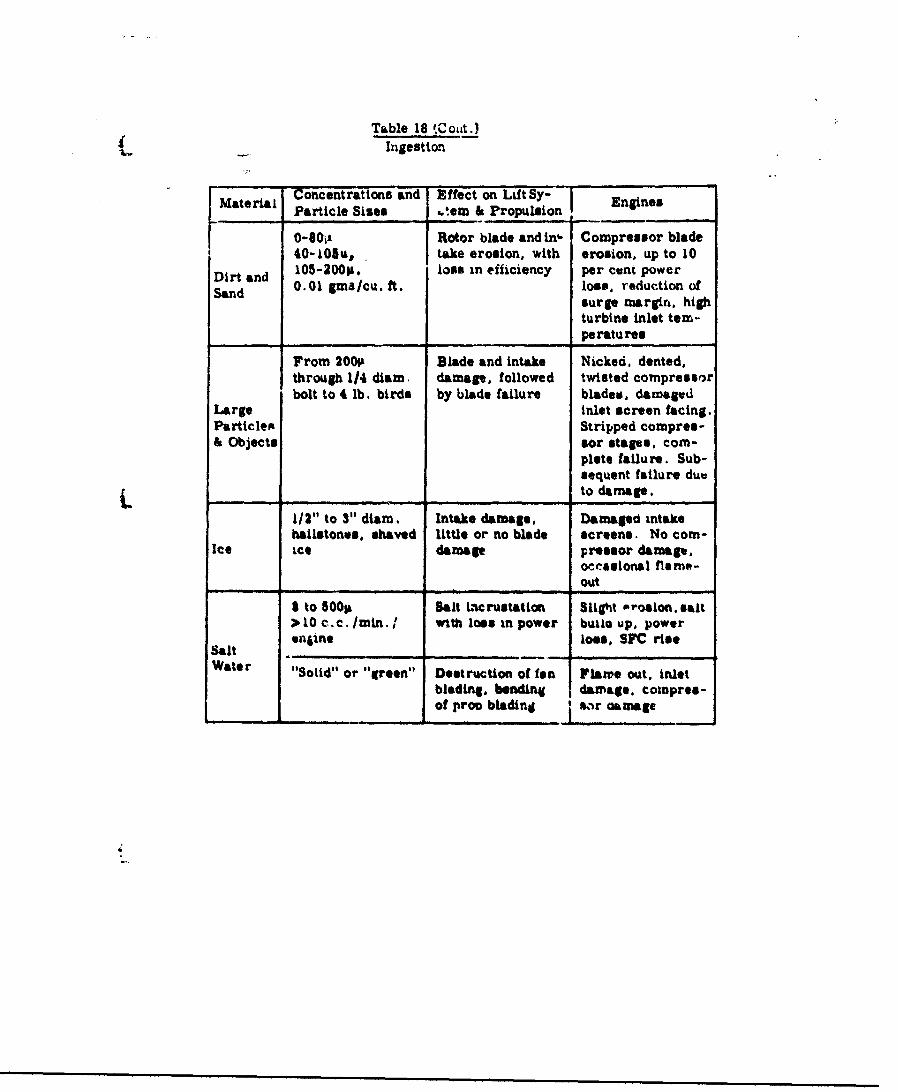
Table 18 t.Cot.)
Ingestion
MaterialConcentrations and Effect on Lift SYEnginesMaterial Particle Sies ,tew &-Propulsion _ngines
0-801-1 Rotor blade and lnh. Compressor blade40-LOAS, take erosion, with erosion, up to 10
Dirt and 105-200P. loss in efficiency per cent power
Sand 0.01 gms /cu. ft. losS, reduction ofsurge margin. highturbine inlet tem-peratures
From 200P Blade and intake Nicked. dented,through 1/4 diam. damage, followed twisted compressorbolt to 4 lb. birds by blade failure blade,. damaged
Large inlet screen facing.Particlex Stripped compres-& Objects sor stages, com-
plete failure. Sub-sequent failure due
_ _ _ _ to damage.
1/2" to 3" diam. Intake damage, Damaged intakehailstones, shaved little or no blade screens. No com-
Ice ice damage pressor damage.
occasional flaee-out
a to 5001 Salt iacrustation Slight Prosion. salt) 10 c.c./min.I with loss in power buAo up, powerSt enne lose, SYC riseSalt_________ _
Water "Solid" or "green" Desltruction of fen Flame out, inlet
blad"ng. bending damage. cowpres-of proo bladin_ s_-r aamage
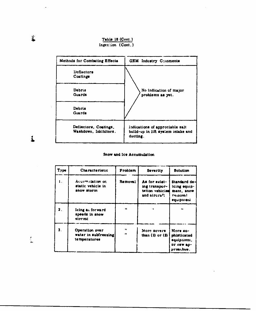
Table 18 (Cont.)Inge&.-ion (Cont.)
Methods for Combating Effects GEM Industry Comments
DoflectorsCoatings
Debris No indication of majorGuards problems as yet.
DebrisGuards
Deflectors. Coatings, ladications of approciable saltWashdown, Inhibitors. build-up in lift system intake and
ducting.
Snow and Ice Accumulation
Type Characteristic Problem Severity Solution
1. Avw,'".aiation or. Removal As for ecist- Standard destatic vehicle in ing transpor- icing equip-snow storm tation vehicl 1 went. snow
and aircroft roanovwlequipizeril
2. Icing at forwardspeeds in snow%tormc
3. Operation over Mj .More severe More #o-water in subfreezing than (1) or (2) phisticatedtemperatures equipment.
or new ap-____________________ __ __ ___ __ _ .... . ..___ __ __ _ ________h__
___________ __ _ _ __5Auate

Tab'le 19Combat Environments
Sumimary Data
Major sound pressure levels at soirce.
Engines (turbine and piston) (12 log' (HP) + 95) ± 10 dbFans 4 to 6 blase, 50 to 150 UPper fan, HP speed < 1100 fps. 130 to 150 db
Ovor-alZ ,ound presoure levels1.approx-iu•itely ' yard from complete vehicle.
hI line with intakes (propulsion,L't. etc.) 110 to 130 dbIn line with exhaust 110 to 130 dbElmewhere 90 to 110 db
Approximate uphe-i¢rtl spreadingett,-7.ti-on with distance from vehicle.
At 1O0 yde. - 40 tblo*Co yds. 0 %b
10, oo0 yds. do
Ambient noise levels
Jungle 4C to &0 rcbCoaet G;C to 40 dbQuiet residential 10 !a. 86 dbNoisy commercial 95 t, 95 d!.Heavy traffic DOA To 100 4b

Table 15 ( Cmat.
Noise
. Preq emy (cyclesi par ae.d•o)
attenuati i with .Intent& 100
100 Vda. LX 03. Rx -31.x ( Ia%X - IT a -Z 2 L -3 1
10. 000 da. bax L v 1 .37W 'A 3,.7TOAL- 3120I----
Uand and Dust
Particle 3i LigWL , lcmlded GEM Heavily loaded GEM(rechoe dianmeter) 310 lbs/eq. foot. 80 lbes q. fo¢t.
lux. Max. Max-. max.LieiIttt distance height distanac
.5300hx 1401k 800ok 31.Cfk" ~. O f0, 3~l 0nm !:!wt%
.050 251 "O-j2h C 41-4tA.
.10 15 1 T -3Uh 35h 34-54h0 4h h*a h 151h 30-60h
Nows hi , Ve11icie, operat.'r height - feet
SprM and MIt
Puarucl Sieze LO1 ItV LtAd Gum Haa--:,Ly 1oaM•l~ ('ftfAOnch*& ~S &aate/eq 401. fbas. of SMeleq. fet"
bla~w &mum@nc disam
,00 am t 150 ,fth 1 60011.050 501 30-31h lo0k Go .8011,10 2 •1 2-Uh Gab1 4.4-6,
Now: h a Vu opweratins WOist - A'e-t
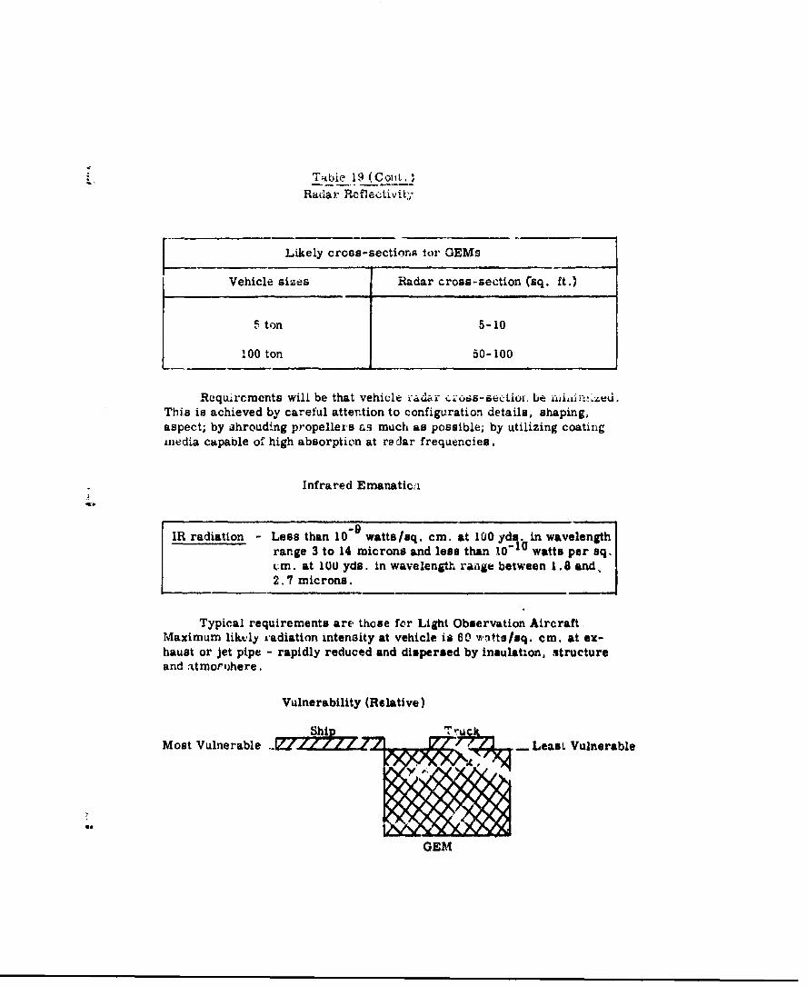
Tibie 19 (Cojt.v
Radar Reflectivity
Likely cross-sections tor GEMs
Vehicle sizes Radar cross-section ('sq. ft.)
5 ton 5-10
100 ton 50-100
Rcquircmcnts will be that vehicle ,-" ur•ius.-sectiof. be ai•iil."ed.This is achieved by careful attention to configuration details, shaping,aspect; by shrouding propellers as much as possible; by utilizing coatingmLedia capable of high absorption at radar frequencies.
Infrared Emanaticii
IR radiation - Less than 10"9 watts/sq. cm. at 1U0 yds. in wavelengthrange 3 to 14 microns and lose than 10-10 watts per sq..:m. at 100 yds. in wavelength raige between 1.8 and,2.7 microns.
Typical requirements are those for Light Observation AircraftMaximum liktly radiation intensity at vehicle is 60 wtts/sq. cm. at ex-haust or jet pipe - rapidly reduced and dispersed by insulation, structureand atmor'ihere.
Vulnerability (Relative)
Most Vulnerable Z7 Least Vulnerable
GEM

Tablc 19 (Cont.)
Dsmage Protection
Normal (aircraft or any vehicle) plus e.dditional for lift system.
Field lepairs
Same as for current Army vehicles, facilitated by modular con-struction.
Mine Field Operations
Mine Type GEM Characteristics Effect of explosion on GEM
If explosion is under centerPressgure 30 lbs/sq. ft.
'to 80 lbs/sq. ft. of vehicle - instantaneous- - increase of cushion pressure,
underside damaged by shrap-
Acoustic 90 db -- 100 db nel - probably OK to continuc.
If wiAplusion near edge - dam-
age to annular jet ducting, re-
Magnetic ductinn in efficient operation,
damag to underside.
9L

Table 19 (Cont .)
Nuclear Enviro.nment
Environment Effect on personnel * Vehicle *
Radiation In hover - In hover -
Intensified radioactive As for personnel--field--more protec- more careful choicetion required. of materials or more
frequent inspections:.
At forward speed .. At forward speed -
As for other vehicles Ad for personnel.of comparable speed.
Blast pressure Severe pressure fluctuations Uncontrollable vehiclewave inside vehicle, unless ade- motions if near explo-
quate sealing and strength bion, ma•ay result indesigned into cabin. complete destruction
of vehicle.
Temperature and Skin burns, blindness, un- Flash--little effect.flash less protected from high Temperatures- -engire
burst intensities, stalling, fuel fires.
* These are predicated on vehicle being near enough to explosion for thequoted effects to occur.
Loadability at Sea
GEM limited to design operating heights of 4..,, t,7 f feet, until safeunloading capabilities of cargo ships arot extended to greater iea states.

IV. EFFECTS OF 3ZIZE AND OPERATIONAL
"W-ITIM GROWND EP•ECT MACHINE
The previous three nhapters have developed in detail
the environmental conditions throughout the world with
which militarily-acceptable (iround Effect Machines will
have to be compatible. Fifteen classes of mauchines have
been selected, five each for overland operations,
amphibious operations, and marine operations, purely on
the basis of che range of environmental conditions to be
encountered. without regard to the practicability of the
resulting machinet.
This chapter will discuss the approximate levels or
performance that would be typical of each class of vehicle,
bearing in mind the environmental conditions. Based on
this information, the discumaton will then Indiea-e which
vehiucles appear t, possess the greatest relative merit,
whea conbidering vhiel', effectiveness as a Aoranozput,
vehicle utility on a world-wide basis, and vihý.ele
vulnerability in a combat situation.
2. DEVELOPMENT OF PLIFORMCHE PARHMTEUI
The vehicle characterist., defined bD lie onvironi-
mental studies are:
* length
. width
. normal operating height at crmise
. maximum hover heig,.t (Jump capability)
. elope capability
. maximum surface wind for hover
These have been developed in Chapter II together with a
determination of percentage ntilization, end are listed
in Tables 11, 13, and 15 following pages 237, 267 and 283,
respectively, for all fifteen classes of vehicles.
The performance capabilities of each vehicle in all
three classes have been assessed, using the following
assumptions:
'l) Vehicle Geometry
"* Rectangular planform
"* Cushion area - 60 per cent of planform area
(2) Vehicle Lift 8,stem and Aerodynamic Characteristics
• Drag coefficient - .06 based cn emehion area
* Operational (Lift/Drag) ratio -
[ ue.on .Te.]1/2 [ nn 1ar je l 1end-%h X-"6a re-U-g-'-'YKT,6"i:,;
Stability requires an au'4tLonal 15 per
cent of lift hornspower
3
-356-
4 . Cushion preseure = 70 pounds per square foot
* Optimum jet dischaz-g angles and nozzle
widths
Over-all efficilency of duct anj. fan
system - 60 per cent
(3) Vehicle Power Installation
-Intalled power can be distributed at
will between lift and propulsion system
Maximum continuous power - 90 per cent
of total installed power
* Over-all propulsion efficiency - 80 per cent
* Specific fuel consumption at maximum
continuous power - 0.7 pounds per hour
per brake horsepower
(4) Veh'.cle Weight Distribution
Structure weigWt - 20 pounds per square
foot of cushion area
"* Installed power plant weight - 1.25 pounds
per brake horsepower
"* Equipment weight inoluding crew - 10 per
.ent of maximum grosp weight
The evaluation of vehicie p.rforaanoa. 'as utilizea
simple thin-jet momentum curtain theory for lift. The
-357-

dctermination of propuleion power has IicjudeA the effects
"of momentum drag. With the abcie assumptions, no attempt
was made to optimize or refine any aspect of the vehicles.
The following performance parameters have been
developed for each class of vehicle:
". Weight breakdown
". Total installed power required
* Speed capaDilities at maximum power
and 90 per cent of maximum power', and at
normal operating helght, and the average of
normal operating height and maximum hover height
Payload-range charaoteristics, with
delivery times
These parameters are given in Figures 18, 19, 20, and
21 following thia pabe.
3. VUXCLI EVALUATIO N
performance analyses it is possible to make an approximate
assessment of the relative merit of each of tl* five
vehicles in the three categories.
"Ihe tLuic merit of each vehicle . 6 izn -its'. t.pabti.ty
as a transportation device. Tia:s may be expx 3sed by its
-1

C,
>
MEMINIS
ON M
LEMEMEMEMEME13 M N
16.
MIR alla"IrlMID
Elj
ILwGlý
dH K*V 10
ItlEMVlD*q/dgP11V ~~
4.6
k0
C6E
A~~. .10 .__._.__._._._.ad__________
0 _ _ _ _ _ _ _ _ _
.g.
flul od
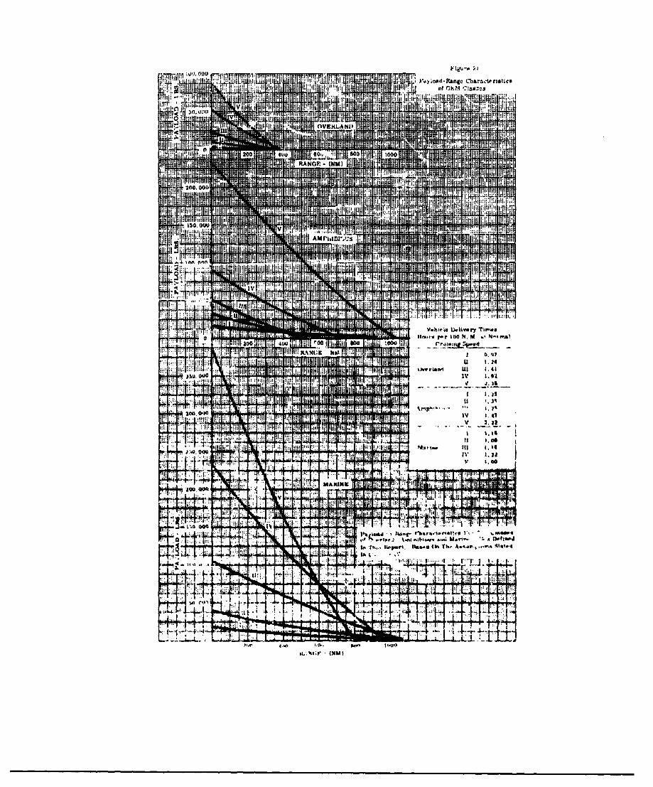
I'l NO Figu-P ý.l
till 'ItaractertaticsI'll) load -RangeAll
of OP04 :!ail"T Jill Ii lilt
:4 lit I tlit ii.
It T Iit I
1000 H ill 43HI If titRANG (NM)
it Mffff T a , Mul fit200, 000
.. ! I11 041,411: fL 1HU
[tit It
tI it
150, ow IMITT
Amrw'"i MRMR.............
lifilil Ail I i it ILill ii qliAN If:11 till !lit it ý1.
..... ..6r,
It:
it
11m.1's litir 100 14. N-tt"Alo41' 100 4ou t
0.97
-.4
P;jswoo 1.
J7 Ill R I 1ý 1;l t 1. 45
It 11 t777
41,19 led It it 1, .1 iili ill w i 1 1.41I +i JIM IIiII;M t lilt t::, till 1;
it'I WWI 9:
it: i!:t lit 1. k41.14
1. ri T-T - .......7:
w F77
1-4
A
too M... Report. Oft Tk, A.44"ý,IIA %.
JI"L
4 1
44.
4-w It-oo
,apac 'ty for the work done by a glv;n Oincome' of fuel. The
4_ -parameter that describes this reature moat adequately is
F ae ued I
and is In *essence a measuue of Ouseful work done per pound
of fuel."
A comparison of all fifteen GOEB using this parameter
would serve to indicate that some vehicles are better than
others as transportation devices in the environment in which
they have boon classified. However, the fact that there are
differences in world-wide usefulness for the different
vehicles means that the transportation effectiveness nsat
be considered together with the world-wide usefulness.
Further, since these are military machines.. helr
vulnerability in a mllitary situation Is of great Impor-
tan*e. If It is assumed that there are no radical
differences in desigo philosophy •om c .) vehicle to tother,
and that the same basic structjral app:•a'h Is used, then
the depee of damage protection must be about the am.
This ellinates the consideration of ad4ditl.al protection
for the more vulnerable craft. An approximate meaure of
vulnerability, satisfactory for relatve purposes, Is to
rank vulnerability proportional 'o since 1lkUo
bigger the vehicle the easier It should be to hit, and the
slower It goes the easier it should be to hit. This
-363-

approach provides a good means ,•v: reasu',Jg Lhe relet.¢e
vulnerability of a group of vt'teiles and ihs been used on
Une following pages.
(1) Overland Veh'.Olet
Figure 22 shows Lho Uhreo paraw-trs of
traisportation effectiveness, world-wide utilJ y,
and vulnerability, for the five classes of overland
OEIM. First, as a result of factoring the effective-
ness by the utility., itA.ppeaTs that Clanna TIT and
IV offer the highest potential on a wc..Li-wide basis.
Then from consideration of vulnerabilitj, Clasc III
would seem to offer the best over-all cepability.
(2) AN~h~bious Vehiles
As in the overland vehlzle case, Fig-Ar 23 Shows
the three parmwt~rs. IMfeativesas and atill'-y
combined Undicate that Clasaes 1V and V offer the
beat potential. With vulnerabilicy thean consldered,
Class IV oinres as the vehicle posaessin( t'e best
over-all military capsoility in ti,o at•.. flell
of operations.
(3) rIne ýVehi~cle.
For th• '-rinv vehic)s, ofteotiven.. a and
r~lnerabilisty ari relat'-•u easy to determne.
_3"

Figure 2'
4 of Overland GEM Clasueu
_ ¾S I J Iz I' IV
V -
kul >
IV0
~I-
FI) R
IV
0 20 60 to 100

ii I' I t
Fit i
*war
Lit
• ~v 'I
,0 ! 4 (
Best Available Copy
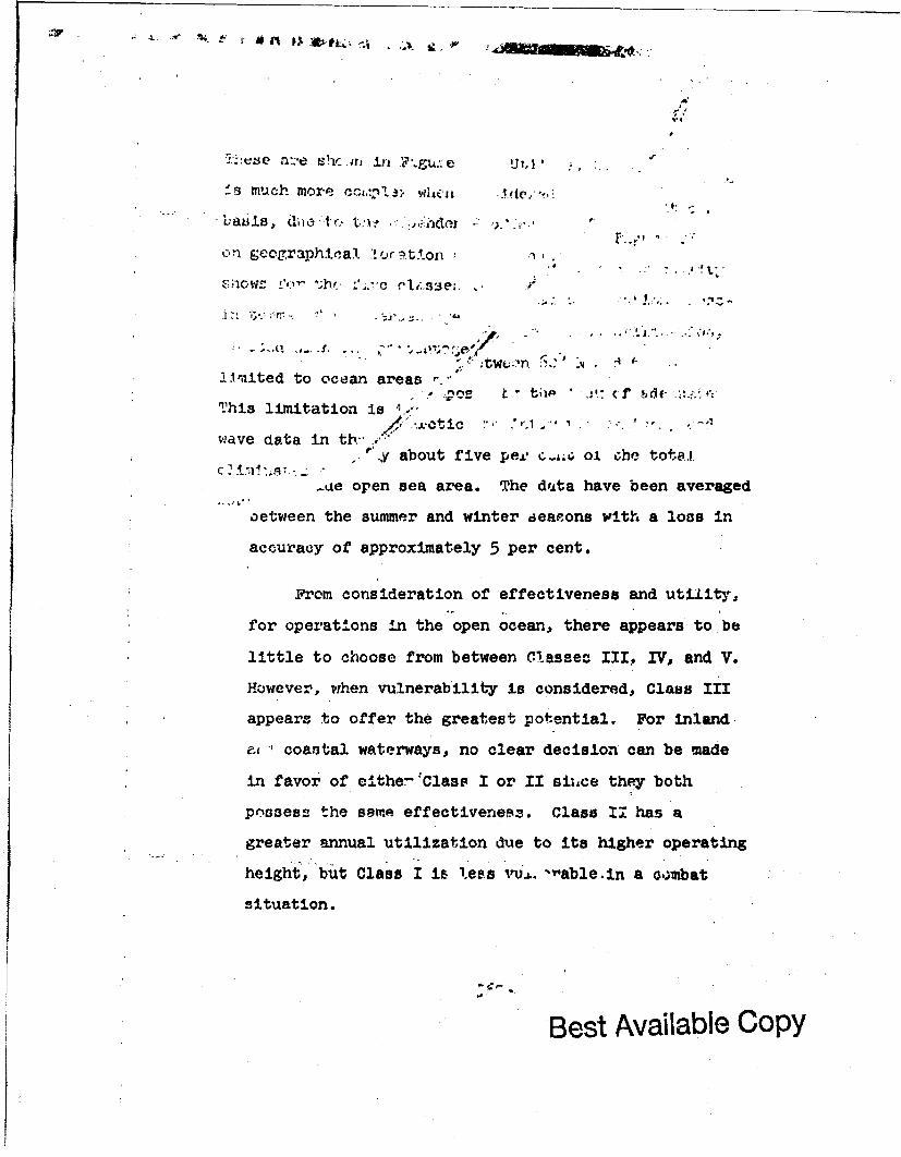
n::e Xhc in in _Le
f- much more c-w,3!. h, .. de,:
bjasis, die t'(, t,,n.- ,: ,,o e •..•..
on geographical l'o:c•,tAon
Lim'ited to ocean areas (f
, tI ~ ~ ( ~if ., ,;+
This limitation is -
wave data in tb /*
..y about five peeL 0. che totei..
-ue open sea area. The d'Ata have been averaged
.aetween the summer and winter aeaeons with a loco in
accuracy of approximately 5 per cent.
From. consideration of effectiveness and utiiity,
for operations in the open ocean, there appears to"be
little to choose from between Cflassec- IXII WV, and V.
However, when vulnerability is considered, Class III
appears to offer the greatest potential. For inland
coastal waterways, no clear decision can be made
in favor of c'ther"" Clasp I or II siixe they both
possess the some effectiveness. Class 1v has a
greater annual utilization due to its higher operating
height, but Class I is less jvU.L. -rable-in a o.ombat
situation.
Best Available Copy
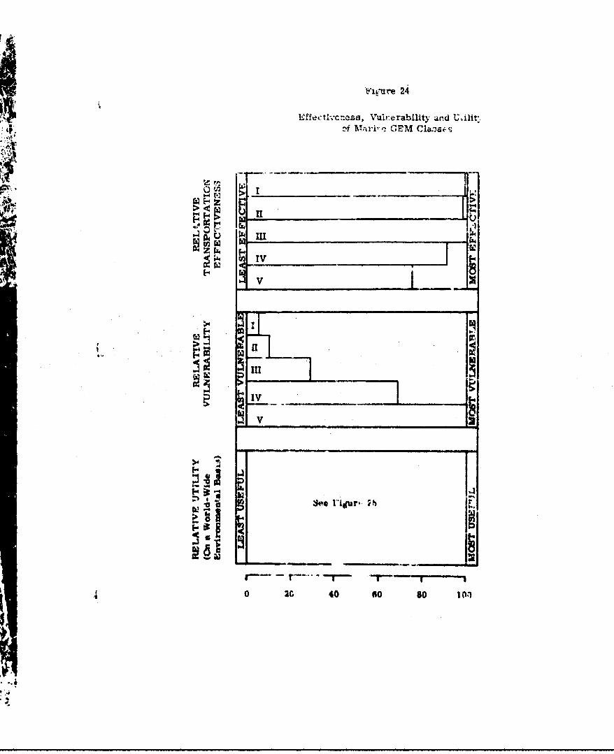
.2ffec t"L'c-cs, Vuirerability and U Ailit.af Wa]ri'q, GEM Clas4 s
*4p,
IV
V III FV
a
S14
S0 2C 40 so so loll'
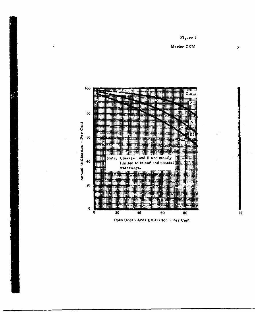
Figure 2
Marine GEMy
100 1
80
I.IV
40Note~. Ciauases I land 11 ar, mostlyhminted to inlinct 3nd coastaltvaterwac VS.
20 t I P
0 20 40 60so )Openi Ocea-i Areai UtIM7atiov kle'r Cwnt
io OPEAoTTONDL FEATURdLS OF MILI.TAFY GRO!:ND EFFE 1ACHIM
(.1:) ¶i.sibility.
As dWsussed in !he Induued and Combat
En-vicznment Sections, vicibility, both from
vehicle, and of the vehicle by the enean, pi 1$s
a significant probltzm. The extent of the pr am
depends mailnv on the t.Arrain over whieh the 1ile
is operating.
In all terrains with loose surfaces, ar ver
water, means are required to ieduce the extc to
which particles picked up by the air curtalr.
projected in a vertical direction. Several
approaahes are wortky of rurther investigati and
development; among these are particle ,deflec so
which may result in some loss of performance -d
the applict.'in of recirculation to the lift stem,
which appears to offer k~reater pro4w v since In-
creases the over-All vehicle effticienoy as as
reducing tho particle projection problem.
For general visibility purposes, windal d
cleanir4i device., di'ect-viuio '4ndow pane; and
other features 'hat arc cowmon practJoe in 9 art
and zh4 .iaellp are w'ectly applicable to C
eTO

DES
Since the worst conditions of both c
defensive aspooti, of v"- •ib1" - 4 .-
cunditlon, sariace treatments can be uti]
provid: " complete solmtton on a lonr-ter
where operational conditions pormit. Har
atabilizati-r. of the terrain by chemical
reans w,',ule. provide essentially a part'c3
for regular operations.
(2) Meneuverability
Maneuverability becomes progrecsiveC
tant as vehicles are ccnsidered for opera
amphibious and overland envlronmente.
For the marine vehicle, operating p)
large expenees of water, maneuverabiity
become a prime consideration until termli
are discussed. Here It would appear that
the marine configuration and design con&-
vide a "dinplacement.- craft" capability,
maneuverability can be attained.
D, the amphibious role, a dogree of
crart" manc:verability would be advantag
more deaimiAl4n condItion arisen wher the
crot u'.- our1.f ".n and s:op on a beach
area. A cartul study of the handling a;
-37i-
Since the worst conditions of both offonsive and
defensive aspectýi o: voizlbILy ..... in t- •. '....r
condition, sariace treatments can be utilized to
provide a complete eolutton on a lorg-term basis
where operational conditions p,=,mit. Hardening and
ztabiilzatiLn of the terrain by cnemleal or mechanical
rean: w.,ul•d provide essentially a particle-free surface
for regular operations.
(2) Meneuverability
Maneuverability becomes progreseively more impor:-
tant as vehicleb are ccnuldered for operation In m4rine,
amphibious and overland environments.
For the marine vehicle, operatin primarily in
large expan'es or water, mane'tverabilli;P does :ot
berome a prime consideration until terminal operations
are discukaed. Hare it would appear that by choosing
t;he marine configuration and design conditions to pro-
vide x,"%'.1jp1ac •,- cratV" capability, the required
maneuverabiity can be attaired.
In the amphitbiou role, a Jegree of "ua iasement-
cra•*t manouverabllity would be adv~ntmgeous, bat a
r'e. 4e*andia• conrJ.1ion arises whe- the craft has to
cross Lh-u burt line and stop ,. a beacn '- a aiited
area. A car•till study of th* .•Andlinfg an control
-371.
characteristics requL:e' for such e maneuver will
probably indicate the desIrability of utilii'ang
skids, wh*eelG, bz? anchors, reversible pitch air
propellers, or a number of other devices in order to
provide this capability for stopping suddenly, In
any event, the craf. must be able to slow down to a
suitable epeed for negotiating land obstealbs&as soon
The overland vehicle presenw>s the most severe
maneuvering problem, since it =wt negotiate areas
which have probably not been cleared with OE
operations in mind. The need to stop rapidly, to
change direction and to accelerate quickly are all
paramount tv a auoceseful overland OGE opeceation.
The approach adopted by one British d•slgV gxup,
that of provi~ll• a basic ORR design with a half-
track system f ? ue part of the time, aey prove to
be the most prcot'.iel for the overland vehicle,
ftrtlrr considration of maneuverability in orerland
operations is required,
The baa principle of oe.'ti-n of a OG= &cep
t pa•sLIcularly vell sulted, by o,. rut to norse1-
su'fac velitlee, for tr~velllng t'r.,. pAnt-to-Mj:iLt
rapidly with comparat' ,'3ly little ;*egard for tne
tetrrcain to be crossed. Since this ltplies that the
GEN can operate . reoaq where routes have not been
previously established or surveyed adequate navigation
faci.lities are essentia] to their operation. In
parLicular, equipmcnt to detect the presence of
obstructions along the intended route, such as trees,
large outcrops of rock, banks, heavy surf conditi-ns,
and so on, will be required.
(4) Accumulation of Surface Material, Snow and Ice
Dtiring operations over surfaces that will permit
the GOEM dowriash to dislodge particles, much material
will be returned towards the machine and may collect
on the machine. Prolonged operation will result In
accumulation in all the crevices, intakes, and re-
entrant contours of the machine, resulting in a
severe servicing problem. If the envirorment is one
of snow, ice or freesing rain and mist, then the
collected material will build-up, addint; to the gross
wsight of the machine, and impeding efrioient opera-
tion of the -lit system an• engines. It 1i, therefore,
essetwtial that the machine be ce'nr1gured to avo' I
locations where sco~mulation I:- pk lace. In
addition, adequate snow -, ice Lstek ". equipment twat
be installed where the operational situation demands It.
-373-

This may consist of e.ec•.•'tcal, mechas.ical, thermal
4 or pneumatis. devices, .ý. weil aw the use of chemical
sprays on the surfaue.
5. SPECIAL FEATURES AND EYU IPMWNT
(1) The following features and cquipmen~t are common
to all vehicles in every class:
Heatlng and air-conditioning for crew and
cargo compartments in Arctic or tropic areas.
Shock and vibration isolation throughout
the structure.
Sand, dust and spray intake sureenr or
deflectors over engine and lift system
intakes.
Engine boost uspability for tropical
conditions.
(2) :Te folloving special Vesature* are coon to
marine wnd smpthlbious vehicles:
Cushion edges around outermost vshlcc-
perimeter, for truotural protection dvr-%-
loaodi end unloading ." wharves or along-
side ship.
_3-74-m mm m wm wm

Anti-corrosmon treataent ror -he strucuzre,
che powerplants, an.d the lift system, to
permit austained operation Ln salt water
areats art tr-;.ical areas.
Kio.atior. ar.ability for water handlinZ,
and fnr safety in the evexAt ,; power
failure.
Wheeled bottom for ground handling.
Strengthcmed bottom to reasit impact with
coral and rocks.
Hyd'ophobi', treatment on beaching surfaces,
ouch as skids, to provide long service
life for these compoents.
(3) The following special features Pre cormon to
mphlblots and overland vehicles:
ftetrart~ble Algs to support vehicle above
rocky ter'ain, when power 1I h•ut drwn.
Bros ion-resIztant 3oatings in the lift and
propulsion system, particasrly in th,-
intake resions and on -he first stag•
blades.
-'N5-
Power boost for jump capaoil.ty rather
than excessive installed power required
for th:!s capability.
(4) The following special features are required by
overltuid vehicles:
Anti-corrosion treatment for tropical
operations.
6. SUNMARY OF OPERATIONAL FYATVRMS
The 15 classes of vehicles, their required operating
contagions, utility, special equipment and other features of
interest, are summorised in Tables 2u and 21 following
this poge.

..I"
i 4 --S0I'
II. " .- _ .E__.
2 14. 4 .
t t
2
. -- .. . . ,•, , . .. 4~
-- - I
I IZ A..F &q•:_.•_ .! • J •.••• ,
vor0

40
V .
WU
-4 4
U4 '
to1
O-S

B I B L I 0 G R A P R Y
1. Berry, F.A., Jr., Bollay, F., Beers, Ncrman R.,Handb(.ok of Meteorology, pp. 994-995, New York,McGraw-Hill, 1945.
2. Bluh, Otto, Principles and Applications of Physics,London, England. Oliver and Boyd, 1955.
3. C_.osmopolitan World Atlas, New York, Rand McNally &Company, 1958.
4. Critchfield, Horard J., General Climatology, pp. 165-244, Edgeworth Cliff's, N.J., Prentice-Hall., Inc.,196o.
5. Eshbach, Handbook of Engineering Fundamentals,John-Wiley and Sons, Inc., April, 1957.
6. Geophysics Research Directorate, I'Handbook ofGeophyeaios for A~r Force Designers," ARDC,U.S.A.F., Air Force Cambridge Research Center,l't Edition, 1957.
7. Schonlaaid, B.F.J., Atmospheric Electricity, Mattmenand Company, Ltd., 1953.
8. Trewartha, Glenn T., An Introduction to Climate, 3rded., pp. 223-395, New York, McGraw-Hill, 1954.
9. Van Rooy, M.P., (ed.), Meteorology of the Antarctic,Weat'ier Bureau, Pretoria, South Africa, 1957.
10. Visher, Stephen S., Climatic Atlas of the UnitedSbates, Cambrid-, Massachusetts, Harvardbn-ivei•ity Press, 1954.
11, World Atlas, Enryclopaedin 'Rnxanioa, Inc...CThicago, 1959.
12. Central Intelligence Agency, Militay Geogrlp•,Chapter II, National Int llehoe Survey trolcountry of InteresT). 'C~ifidentlia)
13. C.S. Department of th, Army, F ielt. anual 30-J0,Terrain Intellig-?nce, O'rthingto.. D.C.,
-379-

14. U.S. Navy Hy-Irograph 01-fce. Ocaý a a c_the Polar Seas. HO. P,',! T0, Paz: I..AntarctIc;- Wahinztcn.. DC.. :957, and Part II,Arctic; WaOhing t*cn, D.C., 1958.
15. U.S. Navy, Marine Climatlc Atlda of the World VolumeI, NoriW.tlantic Oceahn,7"TVA1ER • u-52U,Washington, D.C., 1956o
16. U.S. Navy, Marine Climatic Atlas o-f the World, VolumeII, NortEhPac O-11S'0cean, NAV 50-1c 59,Washington, D.C., 1956.
17. U.S. Navy, Marine Climatic Atlas of the World,Volume III, ndian Ocean, NAV 7'30,Washilngton, D.C., 1957.
18. T1.S. Navy, Marine Climatio At]aa of the World.volume IV, 3a'ou.hAa 2~7rA 5C .c 31Wash_,gton, D.C., 1958.
19. U.S. Navy, Marine Climarlc Atlas of the World,Volume -VSou-h Pacifir Ocear. NAVAER 50- Lc-53?,Washington, D.C., 1959.
20. U.S. Weather Bdurau. Local 'llmatologlcal Data (forVarious CItI1s o? the United States), Washington',D.C., 1960.
21. U.S. W~eather Bureau, Stmnryazrp Hourly 0bcrvations,Climatograpý!y of -?&Uited States, NOs. 30-1through 30-52, Wahkilngton, D.C.. 1956.
22. U.S. Weather Bureau, and U.S. Navy }ydrogreotic 0Of'icc,Climatological and Oceankograghio Atiab forNtar~ner• ' volume r, North Atlantic tOceno
iWshington, D.C., Augast, 1959.
93. Rntrman, F.n.. 84.,ei PrIne1.plo- '" Rads' withParticular Reference to Alrcr•rt and Mites:.leADplications, Journal of thb Ro~ral A "HIE'[ca
Society, October, 1959.
24. Field. R.L.& Edwards, T.M., Kanras, P., and PiF.fanoO.L., External So%-."I Levelb of tircraft, *;Preprint No. 126, New ¥or, N.Y., Inztitute tit1-roapace Sciences, 1956.
25, Fielding, e'.O., An Ar..:.to the O, "q*lonalFe~rsDesral %I ab *EX,
"M i-•er 61-70, Now York, N.Y.. Insetu-e orAerospace Sciences, January. 1961.
_380-
26. Ljurngstrom, OJle. GEM Us4.gr, Ih..i5opr ....r an Over-water, Over- ice _Vebhcee, 9- -aer ,New Yo7., N.Y. instiTute of Aerospace Sciences.JanuaiT, 19C1
27. Lloyd, P., Some Aspects of Engine Noise, Jouwmal ofthe Royal Aeronaut cal Society, September, 1959.
28. Stanfelt, Harry, Jr., and Forchard, J. Everette,"Helicopter Noiie, Its Evaluation and Treatment,"American Helicopter Society, Seventeenth AnnualNational Forum, 1Y.ay, 1961.
29. Stanton-Jones, R., Some Design noblema of Hovercraft,IAS Paper 61-45, New York, Nf.Y -t±e6•Aerospace Sciences. January, 1961.
30. Stlrgw.lt, Ted F., "Salt Water lnzeatiun by GasTurbine Engines," Amerlian Helicopter Socier,-,Seventeenth Annual Forum, May, 1961,
31. U.S.A.F. Aernopace Medical Center (ATC),Aeromedical Reviews--Aircraft Noise, Review 1-60,3chool of Aviation Medicine, Brooks Air ForceBase, Texas, June, 1960.
32. Wosser, J.L., and Van Tuyl. A.J., A GEM forAmphibious Support, SAE Paper-- 7ew Yrk, N.Y.,
celery of Automotive Engineers, Inc.,January, 19061.
3i. Allison Divislon or General Motors Corvoration,Progress Reports 1, 2, 3, and 4, T-56 ForeignObject Damage Program."
34. Atlantic Re-carch Corporation, "Inveatigation toDeterintn Buildup of a Statio Electric FieldChanee lo a &A11"n Flid Tvi'z:,•;orter," Cor0.ri.- .No-. DA-44-177-TC-461, September, 1959.
35. hustai, Kenr--h A., and Votre, Louid' I ':, IDriven Amphiblian- -- The New Tiren• ir. PNi-T-risitCrMf, Lycmiing Divis ion, AwrN~i~6r 1j_1
36. Salley. H.P., "ClImat^ of c'oak,' ; egions,"Netural Coastal Environmens I r the Jh'ridc.IraRX&-U fr--ueu•.bh'-&, • -RF, , •w-FI. 6--f•, ..Research by the Universivy of Cali. ,rtsia atLos Angeles, 1960.

37. Bell Aerosystems Compa-v, Ground Effe MrachinesMorphoiogy Study. "uff?!o, W y. Januxy, .961.
38. Bianohini, G.V., "T-56 Hail Impact and Ice IngestionTests," Allison Division of Ge::,e.- Mtor3Corporation, September, 1956.
39. Booz • Allen Applied Research, Inc., The Ground EffectMachine, Technic0-. As pects-Oerat-io.Characteristics and Evaluation Parameters, Bethesda,Maryland, August, 1960.
40. Coordinating Research Conclil, Inc., ElectrostaticDischarges in Aircraft. Fuel Systems -has--I,New Yo N.7Y. . 71. .,l 96o.
41. Cornell AeronautIcal Laboratory Inc., "Pocket Datafor Human Factor Engineerl•." Repor'3 No.UB-1227-v-3, September, 9r..
ý12. Cornell Aeronautical Laboratory, Inc , Some Fatctorsof Military Geograpy Affectng .Mo~ile ArmyCo__bat _one Transeort !, obil sA--r,Air Transport Study Phase II, Buffalo, N.Y.,May, 1959. (Confident]al)
L'.5. The GOfret uorporation, AiResearcn Manufact.uri:iDivision, "Progress Report of U.S. Navy ContractNo. Nonr 302U(00) OEM Propulsion System Study,"Report Nc. AP-5017-R, June, 1960.
44. H'ller Aircraft "orporotion, VTOt. Dnwnwaah ýtVngementStudy--Vel, ity Su,,ev , TA T' f- ep-6rf--b509d August. •=-.
45. Hiller Aircrnft Ccrpioration, VTOL Downwash ImpinxvmentSt.ud/ -. S',.facC 7:os4n -- ts, TR echni;
it C %r6e01"6,vctober, 1SK,0
46. ruhn, Richard E., "A!, uivei.;i•ation .o Ne'.ermnneCotiltl.oz'u uitier Which~ DoVT'wash !'o' ',*- " VnyAAircraft 411i. ?tsrt Surface Eroscn vrwe VariouaTyr~ea o.. Thrral," NAPF TO D-36, September, 1959.
"47. Logan, Richard Y., The C-.tra.. Nw,.%b Desert, 3o,.'West Atrtce, r t* " 3or Natlonal AcheroN"
N ,ational Rese•b "h Council.Ezeparea for Office (.r Naval •e'te ov t!'Univernity of Cal'lf ,. -.A at .08s ,.. Ilea 1,-,60,
-382-
48, .f; ,. .•:g Divi ioi•AV, • Corporation., F r. .T s
Rosultt.. Lyccming,5 Sand and riat Pr- arifor the T 53 Gas Turbine Engine," Ocfi ber, 1958
49. Mastevu, H.W., ",.?ter and Ice Ingestion I' ;t of T 5tA.-7 Gas Turbine nl•ginos," heport No. 9 F 39,Allison Division rf General'Motor3 C rporation.,August, 1959.
50. Mirabito, LCdr. John .. , Notes on Antarctic Weatherqna s s and Fo-ecusting, NWRF Y-16-26-0
Norfolk, Virginla,', TlS-. Navy Weather ResearchFacility, December, J.960.
51. National Fire Protection A'..'o. "StaticElectricity in Aircraft OperationL: andMaintenance," Boston, Massachusettb, May, _juu.
52. ?egg, R.J., Damage Incurred on a Tilt-Wing _t!L-propeller VTOL/STOL Aircraft Uperating 0ve:.. aLevel, Gravel-Covered Surface, NASA TN D-5'-,December, 190T.
53. Planning Research Corporation, A Classification Systemfor Unprepared Landing Areas, Los Angeles,California, January., 1957.
54. Rayner, J.N., Temperature and Wind Frequency Tablesfor Eurasia, Meteorology Publications ib and 2-.Prepared for Headquarters, Quartermaster Reseavchand Engineering Command by Arctic MeteorologyResearh Group, McGill University, Montreal, 1960.
55. Richards, E.J., Notes on the Noise of Ducted Fan Engines,Aeronautical Research Council Report 20,900,.. reat- Britain, "April, 1959.
56. Som•ners, j., j.r.. aAid Pate, Roger C.. Bird IngestionTests of an Allison T-56 Tur..... Engin , . -.
Tec•nica Vopment Report No. 31, May, 957.
57. Syracuse University Research Institute, T'Vrtm R.'orton Infrared Detections, Physics Repo6Rý_10-5-, --
Febm.u-ay, .,11b.
8 ATunsic, R.J., Model T 5e SAalb andDust ingestion Test,--ng --•ering Department:i.por- No. 1bg Allson D1, "nion of .InneralMlotors Corporation, S..-4_1tember, "n58.
/Sest Available Copy

5 9 1)' B i r k e t a r f ,, M• D , . . p e . ". .Sea Condlitions--Norwh t,, ,WO~R':- . nd.&'h--• an. Unp , I ..' P..2-"-,U.S. y-vdroggF,.,! ', -Oc eano(,r aphy,"' -, .. . ,°
60. Ploetz, LCdr. John Z SN, U N .Han.3book for Nasal Air • -Navy Ws-a-•--r-Ce-ral, ' V( L. "'.,(Mimeographed Internal. r
61. U.S. Navy lydrographic Off i,-,Oceanography, SP;R Cona'."ocean. Unpubl".-Fi~dR' ?e;,* 1.j-.C., Apri~l, ].9-.tO
62. U.S. Navy Hydrographic Off.. .7Oceanography. Unpubli . sof the South Pacific, .. ,.d.Atlantic Oceans,,
63. U.S. Navy Weather Research s ,' C_-Planning Summary fcr , .During Operating" Per;i; 6 ':- F19b0 (Mimeograph_'_ed :Lnt_1- •' . .-:
64. U.S. Navy Weather Rlesearch ? .'. . .I., U.'
Rort on the Meteorol,.,c,: ,' ..1-Xn, ,c"Norfok, Vigii aInternal Document5.
65. Chief of Engincers, U.S. ArmK -. ,Cross-Country Movement, 0 ,.- " (,
66. VtOL Aircraft Downwash Imp . ,, 14 •* 3.um.,A•.Lmy Transportation Rei-.-: . ., .'
67. RPdenour, Louis N., RadarRadiation Labora-f-.. -jBook Company, In- , 9.
Discussiona weze heldIng age'nies. U.S. Navy !T v.Weatber Research. ,.acility..U.S. We"!v!r,-r Bu2.eau, %'. M . , ,
:. .'.:" .'ar.ch of t.o "..v S. 7.
Best Available Copy