Tidal Channel Depositional Complex of the Cretaceous Yolde ...
Upload
independentCategory
view
1download
0
Journal of Petroleum Geology, vol.25 (4), October 2002, pp 373-406 373
DEPOSITIONAL ENVIRONMENTS AND RESERVOIRASSESSMENT OF LATE CRETACEOUS
SANDSTONES IN THE SOUTH CENTRAL KIRTHARFOLDBELT, PAKISTAN
A. S. Khan1,, G. Kelling2, M. Umar1 and A. M. Kassi1
Sandstones of Late Cretaceous (Campanian-Maastrichtian) age constitute much ofthe Pab and Mughal Kot Formations, which are well exposed in western Pakistan. In thesouth central part of the Kirthar foldbelt, these units attain thicknesses ranging up to350m and are dominated by quartzose sandstones with subordinate argillites and marls,all deposited on the western continental margin of the Indo-Pakistan Plate. Sevensedimentologic logs, measured through this sandy sequence along a strike-wise extent ofsome 290 km, provide new data on the palaeoenvironments and dispersal patternsrepresented in these rocks and on their reservoir potential.
The eight main facies were formed by a range of sand-transporting mechanisms thatincludes classical turbidity flows, storm- and river flood-generated underflows, high andlow-energy tractional flows, storm- and fair weather wave reworking, and local slopefailure and remobilisation. The four facies associations comprise a Shoreface Association,a Shelfal Delta Lobe Association, a Deeper Shelf/ Ramp Association (the distal equivalentof the Shelfal Delta Lobe Association), and a deep-water Submarine Fan Lobe Association.
Facies distributions and palaeoflow patterns demonstrate the existence of twodepositional systems in this area during the Late Cretaceous. Sandbodies formed in aNW-prograding submarine fan dominate a southern system, while in the north of the studyarea, storm- and river flood-influenced shelfal sands were conveyed to the west and WNW.Here, sediment-gravity flows evolved from east to west, following a broadly across-shelfpattern from cross-bedded sandstones to graded turbidites. Sandstone petrography suggestssupply from the uplifting Indo-Pakistan Shield to the east, feeding a broad, west-facingshelf or clastic ramp characterised by Mutti-type “shelf-lobes”.
At outcrop, these sandstones possess low porosities but other reservoir characteristics(total sand thickness, percent sand, sand-body geometry, vertical and lateral connectivity,
1 Department of Geology, University of Balochistan, Quetta, Pakistan.2 School of Earth Sciences and Geography, Keele University, Staffordshire,ST5 5BG..* Author for correspondence, [email protected]

Late Cretaceous sandstones, South Central Kirthar Foldbelt, Pakistan374
etc.) are closely linked to dominant facies types and their inferred paleoenvironments.Using these attributes, sandstones formed in the western, mid-shelf, settings of the northernsystem display the most promising reservoir properties.
INTRODUCTION
The Late Cretaceous sandstones of Pakistan (best represented in the Pab and MughalKot Formations) have attracted much interest in recent years because of their reservoirpotential in the gas- and oilfields of the Lower Indus Basin (e.g. Zaigham and Mallick,2000; Hadley et al., 2001). Reconnaissance studies have also suggested that these rocksprovide excellent opportunities to investigate the evolution of sandstone facies in thetransition from shelf or ramp to deepwater settings. These sand-rich formations occur inboth the Sulaiman and Kirthar foldbelts (Fig. 1), but they are best developed in the northernSulaiman foldbelt and southern Kirthar foldbelt, with relatively thinner representativesexposed in intervening regions. The present study is restricted to those parts of the Paband Mughal Kot Formations exposed in the south central part of the Kirthar foldbelt,where these rocks have a lateral outcrop extent of more than 300 km. Our analysis showsthat these formations contain sandbodies formed in diverse marine environments, rangingfrom shoreface to deep-marine conditions. The deep-water deposits appear to be locatedmainly in the south of the investigated area, while those of more shallow-marine originoccur further north.
Sandstones in the northern sequences are of particular interest because they commonlydisplay features such as hummocky cross-stratification (HCS), which in ancient sedimentarysequences have been attributed to transport or reworking by combined flows in shelf settings(Goldring and Bridges, 1973; Scott et al., 1975; Brenchley et al., 1979; Hamblin andWalker, 1979; Dott and Bourgeois, 1982; Snedden et al., 1988; Duke, 1990; Nummedal,1991). However, it has recently been suggested that the transfer of sand from river mouthsby hyperpycnal flow is the main mechanism for generating sand-rich sequences that displaya continuum from shelfal deltaic sands to basinal turbidites (Mulder and Syvitski, 1995;Sparks et al., 1993; Mutti et al., 1996; Skene et al., 1997; Mulder et al., 1998; McLeod etal., 1999; Mutti et al., 2000).
This paper aims to provide a general account of the sedimentological features of theseLate Cretaceous sandstone units in the south central Kirthar foldbelt, focussing on thedescription, distribution and interpretation of each facies in terms of processes andpalaeoenvironments. The evolution of the depositional spectrum from shelfal sandstonesto deep-marine turbidites is also discussed, and brief comments are offered on the regionalcontext of the facies associations observed within the Pab and Mughal Kot Formations.The reservoir attributes of these rocks, as observed at outcrop in the study area, are brieflydescribed.
The first major published study of the geology of the study area, by Hunting SurveyCorporation (1960), provided a general lithological description of the Upper Cretaceoussandstones and interpreted the sequence as fluviatile and marine deltaic. In a brief, mainlypetrographic, account of Pab Formation sediments exposed in the eastern Sulaiman Range,some 500km to the NE, Sultan and Gipson (1995) assigned them to dominantly uppershoreface environments, with subordinate fluvial, lagoonal, estuarine and lower shorefacefacies. Recent accounts of broadly coeval sequences in the southern Kirthar foldbelt haveelucidated their sequence stratigraphy and tectonics, and have demonstrated the existencein this southern area of thick turbiditic sands, formed within a channelised submarinecanyon/fan system in a relatively deep-marine setting, although shelfal sands are knownfrom more eastern areas (Smewing et al., 2001; Smewing et al., in press; Eschard et al.,2002; Eschard and Joseph, 2002).

375A.S.Khan et al.
Fig. 1. Generalised geological map of the south central Kirthar foldbelt (redrawn fromGeological Survey of Pakistan maps), showing the outcrops of the Upper Cretaceous sand-richunits (Pab and Moghul Kot Formations) and the location of the seven main sections measuredin this study. Inset shows location of the study area with respect to the main tectonic units of
western Pakistan.
Uthal
Bela
Khuzdar
N
12
3
4
5
6
7
Karkh
10 km200
Oligocene (Nari Formation)
Recent/Subrecent
Pliocene (Hinglaj Gp)
Miocene (Nal Lst.)
Eocene- Lst and Marls (Brahui Lst./ Jamburo Gr)
Wad FormationThar Formation Paleocene Lst and Marls
(Parh Group)
U. Cretaceous
Jurassic - Lst (Zidi Formation)
Bela Ophiolites (Paleocene emplacement age)
Karkh Gr
L- M Cretaceous
(Pab/Mughal Kot Formations)
BELA
KHUZDAR
ISLAMABAD
KARACHI
MF
HFB
QUETTA
SFB
KFB
Indus R.
P A K
I S
T A
N
I N D I A
I R A N
KFB KIRTHAR FOLDBELTSFB SULAIMAN FOLDBELTHFB HIMALAYAN FOLDBELTMF MAKRAN FLYSCH BELT
BELA-WAZIRISTAN
OPHIOLITE ZONE
AF
GH A N
IS
TA
N
60˚E 65˚E 70˚E 75˚E
35˚N
30˚N
25˚N
15'67'66˚30'
15'67'
45'
26˚00'
27˚0
0'
28˚00'30' 45'
S e aA r a b i a n

Late Cretaceous sandstones, South Central Kirthar Foldbelt, Pakistan376
Materials and Methods
Most of the data presented here have been obtained from detailed sedimentologicallogs measured through the entire exposed thickness of the Pab Formation* (and, locally,sandier parts of the Mughal Kot Formation*) at seven localities in the southern part of thecentral Kirthar foldbelt (Table 1), supplemented by observations made in interveningoutcrops. These localities are indicated on Fig. 1 and further details are provided in Table1.
In addition to recording lithological and sedimentological data, measurements ofpalaeoflow vectors were made wherever possible, mainly from tool-marks (grooves andflutes), ripples and subordinate cross-bedding. Palaeoflow readings have been correctedfor tectonic tilt and fold-plunge, but no allowance has been made in the vectors presentedhere for the more than 700 counter-clockwise rotation of the entire Kirthar foldbelt sincethe Late Cretaceous (Zaigham and Mallick, 2000).
Around 70 sandstone and lutite samples were collected for petrographic andpetrophysical analyses and some 20 samples of fine-grained interbeds also were processedfor microfossils, providing supplementary biostratigraphic and palaeoenvironmentalevidence.
GEOLOGICAL AND STRATIGRAPHICAL SETTING
The Pab and Mughal Kot Formations were deposited on the western continental marginof the Indo-Pakistan Plate during Late Cretaceous times (Hunting Survey Corporation,1960). Open-marine conditions prevailed in this area during the Jurassic-Cretaceous andup to the Late Paleocene (Fig. 2), resulting in successive deposition of the Zidi Formation(Jurassic), Parh Group (Lower to Middle Cretaceous), Mughal Kot Formation (UpperCretaceous), Pab Formation (Maastrichtian), Thar Formation (Upper Cretaceous-Upper
* The terms Pab and Mughal Kot Formations are used here in the sense currently recognisedby the Pakistan Stratigraphic Commission, and adopted on maps published by theGeological Survey of Pakistan. However, it should be noted that significant re-definitionof these terms has recently been proposed (Smewing et al., in press).
No. of Section Name Lat. Long.
1 Karkh Nala 270 41’ 30” N 67o 05’ 00” E
2 Gunga village 270 45’ 30” N 660 31’ 00” E
3 Simon Levy Post 270 37’ 30” N 660 31’ 30” E
4 Chasma Murad Khan 270 37’ 45” N 660 26’ 45” E
5 Pirmal village 270 35’ 00” N 660 22’ 00” E
6 Sonaro village 270 03’ 00” N 660 22’ 00” E
7 Korara Lak Nala 250 20’ 30” N 660 58’ 15” E
Table 1. Location of the seven sections measured and logged through Late Cretaceous sand-richformations in the south central Kirthar foldbelt.

377A.S.Khan et al.
Fig. 2. Generalised stratigraphic succession in the central Kirthar foldbelt, western Pakistan.
Zidi Formation
Jura
ssic
Dark grey, greenish grey, thin to
thick bedded, massive,
fossiliferous, in places oolitic
limestone with subordinate
greenish grey, creamy,
calcareous shales, nodular
marls, minor siltstones and
sandstones.
Sembar
GoruFormation
L-M
.C
reta
ce
ous
Dark greenish grey, olive green
Belemnitic shales with siltstones
Pink, light grey, creamy, thin
bedded pelagic limestones
White, light grey & creamy thin-
bedded, pelagic biomicrites, rich
in Globotruncana foraminifera
Pab Formation
Thar
Formation/
Wad
Formation
Pale
oc
ene Shallow marine limestones and
carbonate storm deposits
interbedded with marls
Jamburo/
Brahui
FormationEocene
Marls, shales and reworked
limestones representing lower
shelf to slope marine conditions
Nari Formation
Olig
oc
ene Sandstone dominated submarine
fan turbidite sequences
Age Thick Lithology Brief description
Formation
Parh
Limestone
Parh
Gro
up
(m)Name ofFormation
Up
pe
r
Cre
tac
eo
us
12
00
-15
00
200
20
0-2
50
25
0-3
00
200
250
30
0-5
00
30
0-5
00
10
00
-12
00
Grey, olive grey calcareous shales
with thin interbeds of marls and
limestones
Fine to coarse grained, medium to
thick bedded quartz rich
sandstones with minor marls and
shales
Mughal KotFormation

Late Cretaceous sandstones, South Central Kirthar Foldbelt, Pakistan378
Paleocene), Karkh Group and Wad Formation (Paleocene), followed by obduction of theBela Ophiolite from the west. Deformation associated with this emplacement (Hedley etal., 2001) led to creation of a flexural foreland basin to the east. This deepened over time,allowing deposition of the marls and resedimented limestones of the Jamburo Formationduring the Eocene, followed by accumulation of siliciclastic turbidites of the Kohan JhalFormation (Smewing et al., in press) in the Oligocene.
During the present study, new biostratigraphic determinations were made (by MillenniaLtd, UK; courtesy of Lasmo Oil, Pakistan, Ltd.), utilising nannofossils and planktonicforaminifera obtained from samples of interbedded shales and marls collected from sections2, 3, 4 and 5 (Figs.1 and 3). In each of these sections the first significant sandstones appearto be late Campanian in age while the upper levels are no younger than early Maastrichtian.These new data suggest that in the NW of the study area, these Late Cretaceous sandysequences are older than the late Maastrichtian age generally assigned to the Pab Formationelsewhere in Pakistan. Indeed, the age-equivalent unit both further south in the Kirtharfoldbelt and to the NE, in the southern Sulaiman foldbelt, is probably the turbiditic MughalKot Formation (J. Smewing, pers. comm, 2001; Kassi et al., 2000). Moreover, field evidencedemonstrates that the basal (late Campanian) sandstones in the central Kirthar foldbelt arecommonly in erosive (channelised) contact with underlying deepwater carbonate units ofthe Parh Formation (see Figs. 3 and 6A).
The Late Cretaceous sediments in the study area underwent considerable tectonicdeformation during the continental collision that commenced in the late Cenozoic. As aresult, these sandstone units, in common with adjacent formations, have been tightly foldedand the strata are now steeply dipping and locally overturned. Moreover, eastward-directedthrusting has resulted in truncation of the original westwards continuation of the Pab faciesbelts, while major transcurrent faulting parallel to the foldbelt trend has facilitated morethan 70o of anti-clockwise rotation of the Kirthar belt, compared to more eastern sectors(Zaigham and Mallick, 2000).
PETROGRAPHY
The coarser units of the Mughal Kot and Pab Formations in the south central Kirtharfoldbelt comprise fine- to coarse-grained, rarely very coarse to pebbly, moderately to poorlysorted, mature quartz arenites. The main constituents are quartz with subordinate feldspargrains and rare rock fragments. Some 25 thin sections were selected for detailed petrographicstudy, 500 points being counted in each thin section.
The petrographic characteristics of samples from all localities are very similar.Framework quartz constitutes 95 to 99% of the total detrital grains and is almost exclusivelymonocrystalline in character, with only a few percent of grains exhibiting strained (undulose)extinction. Grain-shapes are subangular to subrounded, but rounded grains are locallycommon. Optically recognisable feldspar normally constitutes 1 to 4% of the sandstones,but scanning electron imagery demonstrates that potash feldspar is locally more abundant(up to 10%), while the presence of kaolinitic pseudomorphs suggests that diageneticdissolution has reduced the original feldspar content. Rock fragments constitute 0.5 to4.5% of the total grains and are dominated by subrounded chert clasts. Heavy mineralsobserved are almost exclusively zircon, tourmaline and rutile. The cementing and matrixmaterials (mainly carbonates, quartz overgrowths and clay minerals) reveal a complexdiagenetic history, currently the subject of further investigations.
This summary of the composition of the Late Cretaceous arenites from the Kirtharfoldbelt reveals strong similarities with the equivalent sandstones from the Sulaiman Rangeto the NE (Sultan and Gipson, 1995). All compositional features suggest that the sandstonesin both areas had a common, mineralogically mature provenance, probably from a cratonicterrain, most likely the sediment-mantled Indo-Pakistan Shield.

379A.S.Khan et al.
Fig
. 3.
Dia
gram
sho
win
gsi
mpl
ified
sed
imen
tolo
gica
llo
gs fo
r the
Pab
/ Mug
hal K
otsa
nd-r
ich
sequ
ence
s in
the
seve
n lo
gged
sec
tions
in th
eso
uth
cent
ral
Kir
thar
fold
belt
(loca
tions
in F
ig. 1
),an
d th
eir
stra
tigr
aphi
cre
latio
nshi
ps w
ith a
djac
ent
units
. Num
bers
(1 –
8) t
o le
ftof
li
thol
ogic
al
colu
mns
deno
te m
ain
faci
es t
ypes
obse
rved
in
th
e lo
gged
sect
ions
; FA
1–4
den
ote
the
Fac
ies
Ass
ocia
tion
sre
cogn
ised
(se
e te
xt f
orde
finiti
ons)
. S
ee F
ig. 4
A fo
r Key
to sy
mbo
lssh
own
in
lith
olog
ical
colu
mns
. Ast
erix
es (*
) mar
kpo
sitio
n of
sam
ples
use
d to
prov
ide n
ew b
iost
ratig
raph
icda
ta.
N.B
. In
sect
ion
7 (K
orar
a L
akar
ea),
the
basa
l 105
m o
f the
Upp
er C
reta
ceou
s se
quen
ceco
mpr
ises
sha
les
with
thi
nsi
ltsto
ne in
terb
eds,
only
the
top
part
of w
hich
is d
epic
ted
here
.
76
5Mug
hal K
ot
(u. C
retac
eous
)
Car
bona
te
stor
m
depo
sits
Thar F
orm
ation
43
stor
m
depo
sits
Car
bona
teC
arbo
nate
stor
m
depo
sits
2
Car
bona
te
Sec
tion
-1
200 m
150F.A.4
2 1 2 3 23
m180
3 32 32
120 F.A.3
3
1
Sst
100 m
Cl
8 2 23 3 2
0
Sst
Cl
Sst
m
?
2m
3 2 6
120
m
3
F.A.2
stor
m
depo
sits
21
Car
bona
te
3 4
120 m
m50
3
F.A.2
8
0 m
32
Sst
Cl
F.A.3.
0 m
32 30 m
2
Cl
Sst
1
F.A.4.
Cl
depo
sits
100
( Pale
ocen
e )
m
2 4
F.A.2
3
Karkh
Gro
up
( Pale
ocen
e )
60
74m
Sha
llow
mar
ine
carb
onat
e
8 3
Mug
hal K
ot
0 m
Sst
Cl
Sst
( U. C
reta
ceou
s )
Parh
Limes
tone
( San
tonia
n-Cam
pania
n )
6 7 43 7 2
m6
0
Cl
250m thick
3
Pab formation
F.A.1
stor
m
( Pale
ocen
e )
Wad
For
mat
ion
Wad
For
mat
ion
Wad
For
mat
ion
*
**
*
*
** *
* *
**

Late Cretaceous sandstones, South Central Kirthar Foldbelt, Pakistan380
DESCRIPTION OF FACIES
Seven representative sedimentary logs through these sand-rich formations have beenmeasured (Figs. 4a,b, 5a,b, 8, 11, 12). Eight facies are recognised in the study area basedon lithology, bed thickness, internal sedimentary structures and trace fossils. These faciesare: 1) Graded sandstones; 2) Argillites with sandstone interbeds; 3) Massive sandstones;4) Bioturbated sandstones; 5) Hummocky sandstones); 6) Parallel- to cross-laminatedsandstones; 7) Trough cross-bedded sandstones; 8) Slumped units.
Facies 1 (Graded sandstones)
This facies is more common in the southern and westernmost parts of the study areaand is characterised by normal grading with or without Bouma sequences; grooves, flutesand load moulds are common at the base of beds (Fig. 6B). Many individual beds arebroadly lenticular with sharp, even and in some cases undulatory surfaces. Sandstonesoccur either in packets with a high sand percentage (90-95%), that commonly formthickening upward cycles (5-10m thick), or are regularly interbedded with mudstones andmarls. Bed thicknesses range between 5cm and 400cm. Thinner beds are well graded andcommonly display Bouma sequences (Tabc being the most frequent), while the thickerbeds show only subtle grading and in some cases ripple cross-lamination at the top (Tac).Occasional hummocky bedforms are seen on top surfaces of thick sandstones in the topparts of thickening-upwards cycles, where amalgamation is common.
InterpretationThe sandstones of this facies represent deposition from turbidity currents, and the
characteristics of the thick beds suggest that these sediments were deposited from highdensity turbidity currents. The upward-thickening cycles indicate that sheet flows wereprograding progressively towards the basin. The scour structures at the base of thicksandstone beds indicate that the thick and successive flows have more erosive power. Theorigin of the hummocky bedforms is discussed under Facies 5. The thinner beds that areinterbedded with mudstones/ shales and marls were deposited from low density, moreevolved, turbidity currents.
Facies 2 (Argillites with sandstone interbeds)
This facies is best developed in the area of section 6, lying between the southern turbiditesequences and the northern shelfal sandstones (see Figs. 1, 11). It is characterised bymudstones, shales and marls with subordinate thin-bedded, often undulatory, fine sandstonesand siltstones (Fig. 6C). The mudstones and shales are moderately to highly bioturbated,the intensity of bioturbation varying in a vertical section. Specific determination of tracefossil types is difficult, but where recognisable they include Chondrites and Planolites.Body fossils are not present. Sandstone beds are commonly 0.5 to 20cm thick. The thinnerbeds are very fine grained and display parallel and cross-lamination, or simply cross-lamination. The thicker beds are fine- to medium-grained, normally graded and show sharp,scoured bases. Parallel lamination, cross-lamination and even convolute lamination arealso present in some graded units. Sole marks include small load casts, groove and prodmarks. Flutes are common on the bases of thicker beds.
InterpretationIn fully marine environments, the rhythmic alternation of sandstones and shales is
commonly attributed to either deep-water turbidite fans or storm influenced shelves. Thecommon occurrence of trace fossils and bioturbation in the shales, the intercalation of

381A.S.Khan et al.
pelagic marls and the presence of hummocky bedforms in overlying sandstones suggest anenvironment of less than bathyal depth, with well-oxygenated bottom waters that supportedthe infauna responsible for homogenising the sediments. The zones of intense and weakbioturbation probably result from fluctuations in the rates of sedimentation. The fine-grained and thin-bedded sandstones probably represent deposition from waning, storm-generated suspension flows and/or low-velocity and low-density turbidity currents. Suchbeds can only be distinguished from deep-marine fine-grained turbidites through theirassociation with shallow-marine facies or the presence of shallow-marine ichnofacies andbody fossils. Similar normally-graded, thin sandstone beds from the Mesozoic sequencesof Canada and the SW USA have been interpreted as storm-generated deposits, formed ina middle to outer shelf setting. (Hamblin and Walker, 1979; Walker, 1984; Swift, 1987).The thicker, medium-grained interbeds of graded sandstone display attributes typical ofmore concentrated, short-lived suspension flows, again probably storm-generated surges.
Absolute water depth of deposition is difficult to determine but comparision with themodern facies analogues (Nelson, 1982) suggests that Facies 2 was deposited below fair-weather storm-base at depths substantially greater than 50m, probably in an outer shelfsetting.
Facies 3 (Massive sandstones)
This facies is more common in the northern part of the study area (see Figs. 4B, 5A, 9,11) and is characterised by medium- to thick-bedded, medium- to coarse- grained, rarelypebbly, often amalgamated sandstone beds with grooves and less common flutes at thebase (Fig. 7A), together with the casts of trails and horizontal burrows. Some beds showslight normal grading in the topmost part, or very indistinct parallel- or cross-laminationand convolute-lamination. The top surfaces of a few beds display current ripples whileothers are capped by hummocky bedforms. Individual beds, 0.5 m to 8m thick, are broadlylenticular or (rarely) parallel-sided at the outcrop scale. A notable feature of this facies inSection 5 is the presence of stacked large-scale, convex-up bedforms, with slightlyasymmetrical profiles (steeper face to west), amplitudes varying from 3 to 12m andwavelengths ranging from 30m to more than 120m (Fig. 9). Internally, these bedformscomprise several superimposed (amalgamated) units of massive sandstone displayinginverted meniscoid geometries, thickest in the crestal region of the bedform and taperingtowards the flanks, where the individual beds downlap on to the inter-bedform surfaces. Afew massive beds contain angular clasts of marl, up to 10 cm in diameter. The verticaltransition into burrowed/bioturbated sandstones (Facies 4) or hummocky sandstones (Facies5) is gradational.
Interpretation
The sandstones of this facies were deposited, probably in deeper shelf areas, by rapiddumping from high-density gravity flows or by freezing of very concentrated traction flows.Abundant grooves and a few flutes at the base of thicker massive sandstones demonstratethe erosive activity of relatively strong unidirectional currents. The consistent orientationof these unidirectional currents indicate persisting westerly and NW flows (see Fig. 13)that may well have been palaeoslope-controlled. The narrow spread of the palaeocurrentsfurther supports the operation of gradient-driven density flows.
Accumulation of massive sandstones in the deep-marine realm is believed to resultfrom any of the following four depositional mechanisms (Stow et al., 1999; Stow andJohansson, 2000): (i) Freezing of a sandy debris flow, (ii) collapse fall-out from the turbulent

Late Cretaceous sandstones, South Central Kirthar Foldbelt, Pakistan382
Fig. 4A (above). Sedimentological log through theLate Cretaceous sandstones (Pab Formation)exposed in section 1, west of Karkh (see Fig. 1for location). Key for lithological symbols andlegend for sedimentary structures applies to allthe sedimentological logs in this paper.Numbers to left of the lithological columndenote facies types recognised in this study (seetext for definitions).
Fig. 4B (opposite). Sedimentological log throughLate Cretaceous sandstones exposed in section2, west of Khuzdar (see Fig. 1 for location).
Symbols and legend
Mudstone/Shale
Marl
Sandstone
Trough cross - bedding/lamination
Concretions (iron concretions)
Low - angle cross lamination
Parallel lamination
Convolute bedding/lamination
Lenticular bedding
6
4
3
7
6
6
6
4
5
3
5
4
5
5
7
4
7
7
Mughal
Kot
Formation
(250 m)
Mughal
Kot
Formation
(250 m)
Hummocky Cross Stratification (HCS)
Indistinct parallel lamination
Indistinct cross lamination
Bioturbation
Vertical/ subvertical Burrows
Horizontal Burrows
Rip - up clasts
Flutes/grooves
Erosional surface
Load casts
Tabc Bouma Sequence
Asymmetrical ripples
Slumped units
4,7 Facies Type (see text)
F M CSst
Cl
60m
40m
20m
0m

383A.S.Khan et al.
2
1
3
2
4
8
2
20m20m
3
60m60m
3
2
1
3
1
2
4
100m100m
8
3
3 3
2
2
40m40m
80m80m
3
3
6
1
Section 2Section 2
F M CSst
Cl F M CSst
Cl F M CSst
Cl
Late Cretaceous sandstones, South Central Kirthar Foldbelt, Pakistan384
stage of a high density turbidity current, (iii) continuous aggradation beneath a sustainedhigh density turbidity flow: or (iv) continuous traction beneath a sustained high densityflow. Thus, turbidity currents are the most plausible offshore transport mechanism forthick massive sands (Allen, 1982; Walker, 1984).
It is unclear whether sandstones of this type can be deposited from such currents indeeper shelf areas. Recently, Mutti et al. (1996; 2000) have interpreted sand-rich shelfalsandstone lobes in the Tertiary of the central Pyrenees as the result of river-fed hyperpycnalflows. The characteristics of these Late Cretaceous massive sandstones and their intimateassociation with thick bioturbated sandstones (Facies 4) suggest that deposition took placeby gradual aggradation of sediment which was continuously supplied to maintain the quasi-steady state of the flow (Kneller and Branney, 1995). As deposition continued at the baseof the flow, it was replenished by fallout of grains from above. The indistinct laminationand subtle grading in some massive beds may have been caused by temporal variationsand fluctuations in the concentration of sediment in the basal part of the flow. Such variationshindered settling, allowing traction to intervene. The establishment of horizontal burrowsand feeding trails on the upper surface of some beds indicates that depositional episodeswere separated by periods of slow sedimentation, allowing deposition of Facies 2(mudstones/ marls). The rare rippled top surfaces and large-scale asymmetrical bedformsare attributed to (?storm) current reworking, ultimately succeeded by hemipelagic settlingof carbonate mud.
Similar massive sandstones from ancient successions have been reported from a varietyof depositional settings. These include: (1) slope apron gully-lobe systems (Surlyk, 1987);(2) delta-fed turbidite ramp systems (Heller and Dickinson, 1985); and (3) sand-richsubmarine fan systems (Armstrong et al., 1987; Busby-Spera, 1985; Cardman and Young,1981; Link and Nelson, 1980). Other components of a submarine fan system are absentfrom the Upper Cretaceous sequences in which this facies is best developed, while indicatorsof tractional current or wave processes are rare. Thus, we suggest that these massivesandstones probably accumulated in an outer shelf/ clastic ramp or top-of-slope setting.
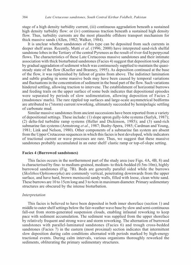
Facies 4 (Burrowed sandstones)
This facies occurs in the northernmost part of the study area (see Figs. 4A, 4B, 8) andis characterised by fine- to medium-grained, medium- to thick-bedded (0.5m-10m), highlyburrowed sandstones (Fig. 7B). Beds are generally parallel sided while the burrows(Skolithos/Ophiomorpha) are commonly vertical, penetrating downwards from the uppersurface, and have hard, brown meniscoid sandy walls, filled with loose, clean white sand.These burrows are 10 to 15cm long and 3 to 6cm in maximum diameter. Primary sedimentarystructures are obscured by the intense bioturbation.
Interpretation
This facies is believed to have been deposited in both inner shoreface (section 1) andmiddle to outer shelf settings below the fair-weather wave base by slow and semi-continuousfall-out from storm-generated suspension clouds, enabling infaunal reworking to keeppace with sediment accumulation. The sediment was supplied from the upper shorefaceby relatively frequent and strong wave and storm reworking. The alternation of burrowedsandstones with parallel-laminated sandstones (Facies 6) and trough cross-beddedsandstones (Facies 7) in the eastern (most proximal) section indicates that intermittentslow deposition during calm conditions alternated with periods marked by high-energytractional events. During calm intervals, various organisms thoroughly reworked thesediments, obliterating the primary sedimentary structures.

385A.S.Khan et al.
Facies 5 (Hummocky sandstones)
This facies has been divided into two subfacies, based on their internal features:
Subfacies 5a (Small-scale hummocky cross-stratified sandstones)
This subfacies frequently occurs in the top parts of thick massive sandstones but someexamples occur as isolated beds within a “background” of pelagic marl (see Figs. 5A, 5B).It comprises fine-grained, thin- to medium-bedded sandstone. Units of subfacies 5a rangefrom 10 to 50cm in thickness and isolated beds normally consist of one to four amalgamatedsets of low-angle to hummocky cross-stratification displaying internal truncation andonlapping laminations. The hummocks are commonly asymmetric and show bedformmigration in the offshore (to the west) direction (Fig. 7C).
Subfacies 5b (Sandstones with hummock-type bedforms)
Morphologically, the sandstones of this subfacies display hummocky bedform surfacesbut lack the matching internal cross stratification. Such beds are common in most of theshelfal sandstone sections encountered in the northern outcrops (Figs. 4B, 5B, 8, 11) andoccasionally are developed in the southern turbidite sequences (Fig. 12). These sandstonesare fine- to medium-grained, thin- to thick-bedded and generally amalgamated, with orwithout bioturbation. They also exhibit low-angle cross- lamination. Beds are 10 to 100cmthick and highly lenticular, conspicuously pinching and swelling over lateral distances ofa few tens of metres. The tops of a few beds display large-scale asymmetrical ripples.Intervening argillites are rare in this sub-facies.
Interpretation
Sandstone beds containing hummocky cross-stratification (HCS) have been widelyrecorded and are considered to represent relatively shallow-marine storm deposits (Harmset al., 1975; Dott and Bourgeois, 1982; Swift et al., 1983; Brenchley, 1985). However, thereliability of this structure as an unequivocal criterion for such an environment is now lesscertain because of its highly variable form and different possible modes of formation (Cheeland Leckie, 1993). HCS-type structures have also been reported from deep-marine turbidites(Prave and Duke, 1990) and from shelfal deltaic sandstone lobes (Mutti et al., 1996; 2000).These examples have been attributed to formation by slope-controlled density currentsand flood-related hyperpycnal flows, respectively.
Based on the external morphology and internal structure of the HCS in these UpperCretaceous sandstones, it is probable that subfacies 5a was deposited from rapidly movingsuspension flows under waning energy conditions. Deposition was probably influencedby frequent high-energy storm episodes but occasionally was modified by oscillatory waveswith superimposed unidirectional flows (Kreisa 1981; Craft and Bridge 1987; Duke, 1990).The amalgamation of hummocky beds demonstrates the frequency of high-energy episodes,inhibiting the settling of fine-grained sediments. Alternatively, any intervening fine-grainedsediments may have been removed through scouring and erosion by subsequent high-energy storm waves (Dott and Bourgeois, 1982). The capping of massive sandstones andburrowed sandstones by hummocky bedforms probably results from progressive shoalingand progradation, leading to increased ambient energy conditions.
Subfacies 5b (external hummocky bedforms), found in the massive sandstones of theshelf delta lobes and, rarely, in the graded sandstone packages of submarine fan lobes, areattributed to remoulding by high energy, high density, strictly unidirectional flows (Praveand Duke, 1990).

Late Cretaceous sandstones, South Central Kirthar Foldbelt, Pakistan386
3
2
3
2
1
3
3
2
3
2
3
2
1
40m40m
20m20m
5
3
6
3
3
2
3
80m80m
60m60m
1
5
2
1
3
2
3
3
4
120m120m
100m100m
3
F M CSst
Cl F M CSst
Cl F M CSst
Cl F M CSst
Cl F M CSst
Cl F M C
SstCl F M C
SstCl

387A.S.Khan et al.
Fig. 5A (p. 386) Sedimentological log through theLate Cretaceous sandstone sequence (PabFormation) exposed in section 3, south of Khuzdar(see Fig. 1 for location and Fig. 4A for key).Numbers to left of the lithological column denotefacies types recognised in this study (see text fordefinitions).
Fig. 5B (this page). Sedimentological log through thePab Formation exposed in section 4, SW ofKhuzdar (see Fig. 1 for location, Fig. 4A for key).Note the prevalence of marls (foraminiferalbiomicrites) in this section.
12
5
2
1
2
1
2
15
2
1
2
1
2
5
5
1
1
1
1
5
5
5
5
1
1
1
1
1
1
5
5
5
5
1
Tac
Tac
Tac
Tac
Tac
Tac
Tac
Cl F M C
Sst
50m
40m
30m
20m
10m
0m

Late Cretaceous sandstones, South Central Kirthar Foldbelt, Pakistan388
Fig. 6A. Field photograph of the irregular erosional contact (arrows) of Late Cretaceous sandstones(Facies 3) with the underlying Parh Formation (creamy pelagic biomicrites) in section 2 (west ofKhuzdar (see Fig. 1 for location). Person (circled) for scale.
B. Close-up photograph of graded fine sandstone turbidites (Tab/Tabc) and interbedded dark shales(Facies 1) from the middle part of the Late Cretaceous sandstone sequence in section 7, KoraraLak Nala, near the southern limit of the study area (see Fig. 1). Note the loaded grooves andangular shale clasts (in lower right corner). Tape-measure (centre) is 7cm across.
C. Laminated and fissile marls (foraminiferal biomicrites) with both thin and thick interbeds offine, sharp-based, poorly graded and parallel-laminated sandstone (Facies 2). From lower partof the Pab Formation in section 2 (see Fig. 1). Hammer (circled) for scale.

389A.S.Khan et al.
Fig. 7A. Field photograph showing grooves and (rarer) flutes (indicating westerly flow) on the baseof a near-vertical bed of massive, coarse sandstone (Facies 3) in the middle part of the LateCretaceous sandstone sequence measured in section 6, around 70km north of Bela (see Fig. 1 forlocation). Field notebook (16cm long) on the right provides scale.
B. Ramifying subhorizontal burrows within fine/medium sandstone (Facies 4), in the upper part ofthe Late Cretaceous sandstones exposed in section 5, SSW of Khuzdar (see Fig. 1 for location).Lens-cap is 6cm in diameter.
C. Sharp-based, medium-fine sandstone of Facies 5 type, displaying multiple hummocky cross-stratified sets, grading up into a parallel-laminated interval. From upper part of the LateCretaceous sandstones (Pab Formation) exposed in section 4 (see Fig. 1 for location). Tape- measure(arrowed) is 7cm across.

Late Cretaceous sandstones, South Central Kirthar Foldbelt, Pakistan390
Facies 6 (Parallel- to cross-laminated sandstones)
This facies is common in the more proximal NE sections (see Figs. 4A, 4B; Fig. 10A)but is locally observed in the distal (NW) sections (see Fig. 5A). It is characterised by thin-bedded sandstones displaying parallel lamination and/or very low-angle, wedge-shapedcross-bedding, with little evidence of bioturbation. In the eastern sections, the sandstonesof this facies are medium- to coarse-grained and have sharp erosive basal contacts withunderlying sandstones, while in the western sections the sandstones are fine-grained andhave gradational contacts with the underlying massive sandstones. The thickness ofindividual laminae ranges from less than 1cm to a few cm. Parting lineation is common,with preferred grain fabric orientation. The parallel lamination commonly grades upwardsinto low-angle cross-lamination.
Interpretation
Similar horizontal to gently undulatory laminated sandstones have been attributed toupper flow regime deposition under oscillatory, unidirectional and/ or combined-flowcurrents (Swift et al., 1983; Arnott and Southard, 1990). Wave ripples and associatedcross-laminations have been observed (especially in sections 2 and 3; see Fig. 10B), butthese features are generally rare in the Mughal Kot and Pab Sandstones in the study area,suggesting that wave action probably was not the main agent involved in the formation oflaminated/ low-angle cross-laminated sandstone facies. We conclude that the parallellaminated intervals gradationally associated with the massive sandstones were depositedunder the influence of energetic traction flows following rapid dumping of sediment toform the massive interval. Combined flows are probably responsible for most plane-bedlamination on storm-dominated shorefaces (Swift and Niedoroda, 1985). We consider thatthe parallel to gently undulatory laminated sandstones present in eastern sections weredeposited from unidirectional and/or combined-flow currents, probably on the lowershoreface (proximal inner shelf).
This interpretation is consistent with the intimate association of this facies withhummocky sandstones, indicative of frequent storm activity. The capping of massivesandstones by low-angle cross-lamination results from further waning of such unidirectionalflows.
Facies 7 (Trough cross-bedded sandstones)
This facies is confined to the NE (proximal) part of the study area (see Fig. 4A) and ischaracterised by fine- to very coarse-grained, thin to thick (10 to 650cm), trough cross-bedded sandstones. The thicker beds, which occur in the upper part of the section, arecoarse-grained, moderately bioturbated and display stacked large-scale trough sets(individual sets up to 50cm; cosets up to 3m) which appear broadly lenticular (over tens ofmetres) and are probably channelised. The thinner beds, found in the lower part of thesection, are also lenticular but fine grained, with small trough sets (5 to 10cm) which insome cases grade upward into low-angle cross-lamination. The bases of the cross-bedcosets are irregular, displaying shallow scouring into underlying sandstones.
Interpretation
This facies was deposited under high energy conditions probably by storm rip currentsor river induced flows. Such currents develop laterally restricted, effectively channelledpaths through the shoreline area to deliver sediments offshore, and are well established onmany modern wave- or storm-dominated shorefaces (Komar, 1976).

391A.S.Khan et al.
Fig. 8. Sedimentological log through the Late Cretaceous sand-rich sequence in section 5,SSW of Khuzdar (see Fig. 1 for location: Fig. 4A for key to symbols).
3
2
3
3
20m20m
40m40m
8
3
5
2
3
60m60m
80m80m
3
6
2
2
6
3
100m100m
120m120m
6
4
3
Section 5
F M CSst
Cl F M CSst
Cl F M C
SstCl F M C
SstCl

Late Cretaceous sandstones, South Central Kirthar Foldbelt, Pakistan392
Facies 8 (Slumped units)
This facies occurs in the lower part of three sections (2, 5 and 6) located in the north,and is characterised by internally contorted beds that include both sandstones andinterbedded argillites. The sandstones are thin to thick (0.5 to 6m), medium- to coarse-grained and they are generally massive. The interbedded slumped marl units show minorsynsedimentary folds and faults, and have been intruded by sandstone dykes and sills (Fig.10C) and contain irregular rounded sand bodies (“pillows”). The maximum thickness ofthe slumped units ranges between 1 to 20m and they are laterally impersistent.
Interpretation
These units apparently were created by localised failure of interbedded massivesandstones and marls on local or more regional slopes. Post-depositional remobilisationand liquefaction of the thick massive sandstones has led to the formation of sandstonedykes and sills in the interbedded marls.
Fig. 9. General view of the greater part of the Late Cretaceous sandstones exposed in section 5 (35km SSW of Khuzdar: see Fig.1 for location). Underlying light-coloured Parh Formation marlsare seen in lower left corner, near the figure (circled) providing scale.
Massive sandstones (Facies 3) form the bulk of this section. Many of these are disposed in overlappingvery large, low-amplitude, broadly asymmetrical bedforms, several of which are picked out bylines on this photograph. Figure (circled) for scale.

393A.S.Khan et al.
Fig. 10A. Parallel-laminated fine sandstones overlying low-angle cross-laminated medium sandstones(Facies 6) in the lower part of the Late Cretaceous sandstone sequence (Pab Formation), section2, 10km west of Khuzdar (see Figs.1, 4B). Lens-cap (6cm across) for scale.
B. Wave-rippled medium-grained sandstones interbedded with a tabular coarse sandstone (Facies6) in the middle part of the Pab Formation in section 3 (SW of Khuzdar: see Figs. 1 and 5A).Pencil for scale.
C. Sandstone dyke and sill (arrowed) transecting sub-horizontal shales and cross-laminatedsandstones adjacent to slumped unit (Facies 8) in the lower part of the Late Cretaceous sandstonesequence in section 2 (see Figs. 1 and 4B). Hammer for scale.

Late Cretaceous sandstones, South Central Kirthar Foldbelt, Pakistan394
Fig. 11. Sedimentological log through the Late Cretaceous sandstones exposed in section 6,around 70km north of Bela (see Fig.1 for location, Fig. 4A for key).
3
20m20m
2
2
3
40m40m
2
2
3
2
60m60m
3
2
3
80m80m
8
3
2
2
3
2100m100m
2
3
3
120m120m
6
2
3
2
2
140m140m3
1
3
2
2
3
2
160m160m 2
3
3
2
3
5
2
2
180m180m
1
2
3
15
2
200m200m
2
2
F M CSst
Cl F M CSst
Cl F M CSst
Cl F M CSst
Cl F M C
SstCl
395A.S.Khan et al.
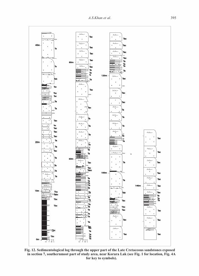
Fig. 12. Sedimentological log through the upper part of the Late Cretaceous sandstones exposedin section 7, southernmost part of study area, near Korara Lak (see Fig. 1 for location, Fig. 4A
for key to symbols).
Cl F M C Cl F M C
10m10m
TabcTabc
TaTa
0m0mTbcTbc
TbcTbc
TbcTbc
TbcTbc
TbcTbc
TaTa
TaTa
TaTa
TacTac
TaTa
TaTa
TacTac
TacTac
TacTacTacTac
TacTac
TaTa
TaTa
TacTac
TacTac
TacTac
TacTac
TacTac
TacTac
TacTac
TaTa
TaTaTaTaTaTa
TacTac
TacTac
TaTa
TaTaTaTa
TaTaTaTaTaTa
TaTaTaTa
TaTa
TaTaTaTaTaTaTaTaTaTa
TabcTabcTacTac
TacTac
TaTa
TaTa
TaTa
TaTa
TaTa
TaTa
TacTac
TaTa
TaTaTaTa
TaTaTacTac
TacTac
TbcTbc
TacTac
TabTab
TaTa
TaTa
80m80m
60m60m
TacTacTbcTbc
TacTac
TabTab
TaTa
TaTa
100m100m
TacTac
TacTac
TaTa
TaTaTaTaTaTa
TaTa
TaTa
TaTa
TaTa
TaTa
TacTac
120m120m
TacTac
TacTac
TacTac
TacTac
TacTac
TacTac
TacTac
TaTaTaTaTaTa
TacTac
TacTac
TacTac
TacTac
TacTac
TacTac
TacTac
140m140m
40m40m
20m20m
Late Cretaceous sandstones, South Central Kirthar Foldbelt, Pakistan396
FACIES ASSOCIATIONS: THEIR NATURE AND DISTRIBUTION
Four facies associations have been defined: (1) a shoreface association; (2) a shelfaldelta lobe association; (3) a deeper shelf or ramp association; and (4) a submarine fan lobeassociation.
(1) Shoreface association
This facies association occurs only in the NE of the investigated area (see Fig. 4A), andconsists dominantly of Facies 7 (trough cross-bedded sandstones), Facies 6 (parallel andlow-angle cross-laminated sandstones), Facies 5 (hummocky cross- stratified sandstones),and Facies 4 (burrowed and bioturbated sandstones). All show abundant evidence ofpersistent to episodic, strong tractional energy conditions that are common in the shorefaceto inner shelf setting. This facies association represents the most proximal environmentalsetting identified in the study area.
(2) Shelfal delta lobe association
This facies association is common in the NW part of the area (sections 2, 3, and 5: seeFigs. 1, 4B, 5A, 8) and is characterised by the clear dominance of Facies 3 (thick massivesandstones), with subordinate Facies 4 (bioturbated sandstones), Facies 5 (hummockysandstones), Facies 2 (argillites with fine, thin sandstone interbeds), Facies 1 (gradedsandstones) and Facies 8 (slumped units). Section 4 lacks Facies 3 and 4 and is dominatedby Facies 2, 1 and 5; in many respects this sequence is transitional between FaciesAssociations 2 and 3. All these facies were deposited below fair-weather wave base andsome below storm-wave base in deeper shelf or ramp areas, probably fed by a major, sand-rich delta. This facies association displays many of the features of the “shelfal delta lobes”and “flood generated delta-front sandstone lobes” of Mutti et al. (1996; 2000). For example,the association is dominated by sharp-based and parallel-sided sandstone beds, eithermassive or with HCS, and forming amalagamated packets (5-25m thick) some of whichrepresent large-scale asymmetrical, low-amplitude, convex-up bedforms (Fig. 9). Thesepackets are separated by thin bioturbated and fossiliferous shales/marls. Palaeocurrents,measured from flutes and grooves on the base of sandstone beds, indicate predominantflow to the present-day NW and west (Fig. 13), which suggests that the sediment wasdelivered from a source area located further SE and east.
(3) Deeper shelf or ramp association
This association occurs in the central part of the study area as represented by section 6(Fig. 11), and separates the northern and southern sequences. It comprises Facies 3 (massivesandstones), Facies 2 (argillites with sandstone interbeds) with subordinate subfacies 5b(sandstones with hummock-type bedforms) and rare Facies 8 (slump units). Subfacies 5boccurs mainly in the upper part of the section and generally caps thick massive sandstones(Fig. 11: 110-160m). This facies association was deposited below storm wave base in adeep shelf or clastic ramp environment, and the massive sandstones are most readilyinterpreted as distal equivalents of the shelf-lobe units, perhaps supplied by flood-eventsfrom a nearby delta-front. Palaeocurrents measured from grooves on the base of six massivesandstone beds show flow towards present-day NW and west, while flutes on the base offive graded sandstone beds indicate westwards flow (to 2600) (see Fig. 13). The abundanceof fine-grained interbeds, occurrence of slump units and absence of bioturbated sands allsuggest that at least part of this asssociation was formed in an upper slope or ramp-to-slope setting.

397A.S.Khan et al.
Fig. 13. Palaeocurrent data from the Upper Cretaceous sandstone sequences in the south centralKirthar foldbelt (derived mainly from grooves and flutes). The outcrop pattern of the MughalKot and Pab Formations is shown. Large arrows are vector means for each section; the shadedroses represent all measurements recorded in each measured section, including bipolar data fromgrooves. The number of palaeocurrent measurements recorded at each locality are as follows:Section 2 – 11; Section 3 – 6; Section 4 – 5; Section 5 – 5; Section 6 – 11; Section 7 – 7.
Uthal
Bela
Khuzdar
N
1
3
4
5
6
7
Karkh
10 km200
2
15'67'66˚30'
15'67'
45'
26˚00'
27˚00'
28˚00'30' 45'

Late Cretaceous sandstones, South Central Kirthar Foldbelt, Pakistan398
(4) Submarine fan lobe association
This facies association is confined to the southern part of the study area (see Fig. 12)and consists exclusively of Facies 1 (graded sandstones and associated argillites). Theprevalence of classical turbidite features in thinner sandstones and the relative paucity of(vertical) bioturbation in the intervening argillites suggest the operation of turbidity flowsin relatively deep waters in which pelagic settling prevailed for much of the time. Thepresence of thickening-up cycles of Ta and Tac turbidites, with more amalgamated andless well graded sandstones at the top, indicates localised progradation of minor lobes ortongues within an organised deep-water fan system. A few (thinner) packages of Ta andTab turbidites, with basal surfaces that are conspicuously erosive down into argilliteinterbeds, are interpreted as the fills of shallow, braided distributary channels. Palaeoflow,measured from flutes on the base of seven sandstone beds, is consistently towards thepresent-day NW (3100) (Fig. 13).
FACIES DISTRIBUTION
Based on sand-body characteristics and facies associations, the Upper Cretaceoussandstones in the central Kirthar foldbelt can be allocated to two different depositionalsystems. Sands displaying some evidence of shallow-marine deposition are located in thenorth; these range from shoreface facies associations (FA 1) in the NE (proximal), to shelfallobe sandstones (FA 2) and storm-surge dominated facies associations of deep shelf character(FA 3) in the NW (distal) (see Fig.3). The hummocky beds in the distal sections are generallymassive and rarely bioturbated; by contrast, the rare hummocky units in the proximalsection are internally cross-laminated, bioturbated at the top and associated with paralleland/ or low-angle cross- lamination.The thick massive sandstones (Facies 3) evidentlypass down-palaeoslope (west and SW) into well-graded turbidite sandstones (Facies1).Similar deep-water deposits occurring further south (section 7) appear to representsubmarine fan lobes but this southern system displays consistent NW flow directions obliqueto the westwards progression of the shelfal facies belts in the north.
VERTICAL FACIES VARIATIONS
No simple and consistent vertical facies trend has been identified as yet in the sand-rich Upper Cretaceous sequences of the study area. However, in almost all of the examinedsequences there is a broad upwards increase in the thickness and grain-size of the sandstonebeds and also an increase in the proportion of hummocky beds. In the proximal (easternmost)section (which is less well constrained biostratigraphically), the muddy Mughal Kotsediments, formed in a muddy shelf environment, grade upwards into storm-influencedshoreface Pab Formation sandstones that are capped by Paleocene shallow-marinecarbonates (Karkh Group). In this section, bed thicknesses and set thicknesses of the troughcross-beds also increase upwards, indicative of shoreline progradation, probably duringsea-level highstand.
Some of the distal sections through the sandy Campanian/Maastrichtian sequences inthe study area show a basal transition upwards from pelagic, thin-bedded marls andlimestones of the underlying Parh Formation, but there is evidence of channellised erosionat the Parh/Pab contacts in sections 2, 3, 4 and 5 (see Figs. 3, 4B, 5A, 5B, 8). The highersandstones in these sections are abruptly (perhaps discordantly) succeeded by distal stormdeposits (carbonate) of the Wad Formation (late Paleocene), and by the similar TharFormation (late Paleocene) in section 6 (Fig.3).

399A.S.Khan et al.
RESERVOIR CHARACTERISTICS
Little information is available on the poroperm properties of the Late Cretaceoussandstones in the study area. Estimation of 2-D porosity (by point-counting) in arepresentative set of 12 thin-sections during the present investigation yielded low values(range from 0 to 12 %; mean of 6.4 %), with the highest values generally in Facies 7, 5 and3 sandstones and the lowest values in Facies 1 and 4. Sultan and Gipson (1995), in theirpetrographic study of broadly coeval rocks in the Sulaiman Range, obtained slightly higherestimates (0 to 16%, mean approx. 9%). They pointed out that primary porosity wasoriginally much higher but has been greatly reduced by successive phases of cementation.The sandstones described here exhibit very similar petrophysical properties to those in theSulaiman Range, and equally complex diagenetic histories.
This brief account of reservoir characterisitics is therefore largely concerned with theregional distribution of other attributes, such as total sand-thickness and percentage sand,together with the geometries, internal architecture and heterogeneity of major sand-bodiesand their constituent facies.
In the sections studied, the highest aggregated sand thicknesses are encountered in thedeepwater fan lobes of the southern system (section 7) and in the shelfal delta-lobe faciesassociation (FA 2) of the northern system (sections 3 and 5). The highest net-to-grossvalues occur in the thinner section 1 shoreface sequence (94% sand), followed by sections2, 3 and 5 (87%, 89%, and 89% sand, respectively). The lowest net sand percentages (46%and 41%) are observed in the deep shelf/upper slope facies associations seen in Sections 4and 6. Sand-body thickness (i.e. thickness of sand or gravel grade sediment withoutintervening argillite or carbonate) is greatest in the proximal shelfal/ramp associations ofsections 2, 3, 5 and 1 (32m, 30m, 22m and 20m, respectively), smallest in the deeper shelf/upper slope sequences seen in sections 4 and 6 (8m and 6m), and intermediate in thedeepwater fan association of section 1 (15m).
However, the nature and geometry of the sandbodies vary greatly among theseassociations. In the shoreface facies of section 1, the thickest sand-bodies are cross-beddded,highly lenticular and mutually erosive units (probably channelised), or strongly bioturbated,semi-tabular packets. In the mid-shelf sequences of sections 2, 3 and 5, the major sandbodiesare stacked, shelf-lobe convex-up bedforms with amplitudes of a few metres and maximumlateral dimensions (scores to hundreds of metres) probably perpendicular to the NWpalaeoflow direction These are likely to offer good vertical and lateral connectivity.However, pervasive bioturbation, especially in section 2, has obscured the originalboundaries of some of these compound bodies (and also has introduced significant texturalheterogeneity). In the deepwater fan sequences of section 1, the dominant sandbodies arelobes, traceable laterally for several hundreds of metres. However, good vertical connectivitycan be anticipated only in the strongly amalgamated upper parts of the thickening-upwardspackages.
In terms of reservoir properties, the thick sand-bodies, composed of massive and HCSsandstones, found in the mid-shelf sequences of the northern system appear to provide themost favourable external geometries, internal architecture and connectivity. Lateral andvertical interleaving of these bodies with finer-grained shelf sediments also offers additionalpotential for fluid trapping and sealing, augmented in the basal parts of these sequences bylocal channelling into the fine-grained substrate.
DISCUSSION
Integration of the foregoing data on the facies associations, their distribution,palaeocurrents and petrography, demonstrates that most of the Late Cretaceous sediments

Late Cretaceous sandstones, South Central Kirthar Foldbelt, Pakistan400
of the Pab and Mughal Kot Formations in the south central Kirthar foldbelt were depositedon a marine shelf, or delta-fed ramp, that faced NW/west (in present-day terms). This wasflanked to the SE/east by a source terrain with moderate relief, presumably the Indo-PakistanShield (Fig. 1).
Fragmentary evidence of fluvial and shoreline Pab Formation facies further to the NE(Sultan and Gipson, 1995) suggests that a similar facies belt existed to the east of theKirthar foldbelt prior to later Cenozoic anticlockwise rotation of this tectonic zone. Basedon the characteristics of the sandstones (supplemented by observations of the interbeddedlutites), a range of depositional environments can be identified. These include shoreface,middle to deep shelf (with shelfal lobe elements) — all episodically influenced by storms— and deep-marine submarine fan lobes. Prior to deposition of the Mughal Kot/PabFormations most of the outer shelf (and probably the upper slope) was blanketed by pelagicmarl (Parh Formation), into which the shelfal Pab sands were locally excavated (see Fig.6A). The prevalence of marl interbeds within the Pab Formation in all the northern (shelfal)sections demonstrates that carbonate mud remained the ambient sediment on this LateCretaceous shelf or ramp. However, the abrupt advent of the Late Cretaceous sands andtheir locally erosive relationship with the underlying units clearly reflects a significantchange in the volume and nature of the sediment being supplied to the Indo-Pakistanpassive margin, and also marks the inception of a regressive phase.
The cause of these events remains uncertain, but it seems likely that the advent of theMughal Kot/Pab sands and the inception of long-term regression are both linked to rapidthermal uplift of the Indo-Pakistan margin as this passed across a major oceanic hot-spot(mantle plume) during the late Campanian to early Maastrichtian (Smewing et al., 2001;Siddiqui et al., 1996; Khan et al., 2000; Powell, 1979). It is noteworthy that seamount-related volcanics and volcaniclastic turbidites of this age have been described recentlyfrom the western Sulaiman foldbelt (Khan et al., 2000).
The evidence furnished by the observed palaeoflow directions (Fig. 13) and their similarpetrography indicates that these Late Cretaceous sands were supplied from the same suiteof source rocks. The mature composition and textural characteristics of these sands andthe paucity of metamorphic or igneous clasts or heavy minerals all suggest that this sourcelay mainly in the thick pile of Vindhyan (Proterozoic) and Gondwanan (Late Palaeozoic/Early Mesozoic) sedimentary rocks that mantled the metamorphic core of the Indo-PakistanShield.
During the Late Cretaceous, sands were supplied to the Kirthar margin through differentroutes and transport mechanisms, and they appear to have accumulated within differentsystems in the northern and southern sectors of the study area. The main control on thedevelopment of different types of deposit, reflecting contrasting styles of sedimentation,appears to have been the morphology of the Late Cretaceous shelf or ramp (Fig. 14).
Northern area
In the northern part of the study area, the Late Cretaceous sandstone sequences comprisea range of facies deposited in shoreface, storm-dominated shelfal delta lobes and deepershelf or upper slope settings, reflecting deposition on a low gradient shelf or clastic ramp.No lower slope or basin plain facies have been identified here, although these may beconcealed to the west by the tectonically overlying Bela Ophiolite, emplaced from thewest later in the Cenozoic.
The nature of the mechanisms responsible for conveying large volumes of sand offshore,down a relatively low gradient shelf or ramp, require further consideration. It is nowrecognised that sand may be transported across the shelf by density currents and that thesecurrents can be generated by storm ebb flows (Goldring and Bridges, 1973; Brenchley etal., 1979; Hamblin and Walker, 1979; Dott and Bourgeois, 1982; Rice, 1984), or off river

401A.S.Khan et al.
Fig. 14. Conceptual palaeoenvironmental model for the Late Cretaceous sandstones in the southcentral Kirthar foldbelt showing the two depositional systems: a northern sand-prone shelf/
ramp and a southern deepwater turbidite fan. The relative positions of the seven loggedsections described in this study are also shown, together with the general palaeoflow directions
(present-day) determined for the two systems (see Fig.13). S.L. is contemporary sea-level.Vertical exaggeration is approximately x 20.
1
3
3
4
2
3
32
120120
0
3
4 4
3
2
6 6
120120
0
3
5
180180
120120
3
3
3
3
3
3
3
3
3
2
21
2
2
2
2
2
2
2
6
N
100100
0
4
3 3
8
3 3
3
2
5050
0
1
2
1
2
2HCSHCS
HCSHCS
HCSHCS
0 0
6060
4
4
6
6
3 3
7
7
5 HCSHCS
1
0
50
100
7
S.L.
Slope
Slope
Storm-Influenced Shelf/Ramp
S.L.
Indo - Pakistan Shield
0km 100
Approx. Horizontal Scale
Deepwater Fan

Late Cretaceous sandstones, South Central Kirthar Foldbelt, Pakistan402
mouths at times of catastrophic flooding (Swift, 1976; Sparks et al., 1993; Mulder andSyvitski, 1995; Mutti et al., 1996; 2000). Similar sediment gravity flows may also begenerated by slumping on high internal slopes (Walker, 1984; 1985).
The general character of the sandstone sequences in the northern area (e.g. the prevalenceof trough cross-stratification, parallel lamination, wave-ripples, bioturbation and somehummocky cross-stratification in the east; and the abundance of coarse, massive sandstoneswith scoured bases and hummocky tops, graded sandstones and rare bioturbated sandstonesfurther west) favours deposition from energetic, very high density unidirectional currents,episodically influenced by storm reworking and suspension.
The overall contribution of storm processes during the deposition of the Late Cretaceoussands in this area was clearly very significant. For example, the thick bioturbated sandstones(Facies 4) and hummocky cross-stratified sandstones associated with parallel laminated/low-angle cross-laminated units are interpreted as the products of storm reworking andsuspension. The thin, lenticular, graded sandstones with parallel and cross-lamination andsole marks may also have resulted from storm reworking followed by suspension andtraction transport in sediment clouds (Reineck and Singh, 1972; Nelson, 1982). However,the thick and locally pebbly, massive sandstones (Facies 3) appear too thick and coarse tohave been generated solely by storm reworking. An alternative sediment supply mechanismseems to be necessary for the deposition of such units, and the most plausible mechanismis river-fed hyperpycnal flow, which can transport sediment directly from the coastlineinto offshore regions (Mulder and Alexander, 2001; Kassem and Imran, 2001).
Discussing ancient sequences, Mutti et al. (1996; 2000) interpreted the sand-richshallow-marine Eocene strata of the south-central Pyrenean foreland basin as “floodgenerated delta-front sandstone lobes”. They invoked hyperpycnal flows, rather than stormreworking, as the transport mechanism for such sequences. We consider that such flows,operating on the Late Cretaceous shelf of the present western margin of the Indian Plate,offer the most plausible mechanism for most of the thick massive sandstones in the PabFormation. The presence of large grooves and flutes at the base of some massive sandstonessuggests that some of these hyperpycnal flows were turbulent, with relatively high densitiesand were initially capable of localised erosion. Moreover, it has been argued that suchflows are capable of transporting sands even on relatively gentle slopes (Kneller andBranney, 1995; Mulder and Alexander, 2001). However, the lack of large channels (apartfrom small chutes in the basal parts of the sandstone sequences) indicates that most of thedensity flows contributing to this northern system were non-erosive, and probably travelledoffshore at relatively low speeds because of the gentle gradient of the shelf. The range inthickness of these massive beds may result from variations in the intensity of the floodevents that provided sediment to the sea. The very thick beds were probably depositedduring catastrophic flood events, which resulted in high sediment discharge at velocitiessufficient to generate hyperpycnal flows and related self-sustained turbidity currents. Thepresence of the mud/marl interbeds records temporary cessation of flood and storm eventsand a return to “normal” marine conditions. The less frequent normally-graded sandstoneinterbeds (Facies 2) suggest deposition from low density hyperpycnal flows or storm-generated turbidity currents. River flooding frequently appears to have been accompaniedby storm waves which produced hummocky bedforms at the top of the beds of massivesandstone and graded sandstone (Mutti et al., 1996; 2000).
Southern area
In the southern part of the study area, the Late Cretaceous sandbodies are characterisedby various combinations of the Bouma sequence and small thickening-upwards cycles.These clearly indicate deeper-water turbidity current deposition and can best be assigned

403A.S.Khan et al.
to a sand-rich submarine fan system. Here, the lack of shallow- marine facies suggests thatthis deep-water sector was bordered by a narrow, geographically restricted and relativelyhigh gradient shelf. Influxes of sediment were provided to the shelf edge during times ofhigh flooding, bypassing the narrow to non-existent shelf. Studies of the Late Cretaceoussequences of the southern Kirthar foldbelt has demonstrated the existence there of majorsubmarine fan-channel complexes and feeder canyons (Eschard et al., 2002; Eschard andJoseph, 2002). These probably represent more proximal sectors of the southern lobate fansystem identified in this study.
CONCLUSIONS
1. Two depositional systems can be identified within the Campanian to Maastrichtiansand-rich formations of the south central Kirthar foldbelt, based on the bed-geometriesand sedimentary structures observed in the sandstones and their facies associations.Relatively shallow-marine deposits are located in the north. These include both shorefacedeposits (in the east) and deeper shelf or ramp facies (to the west) that are dominated bywest-flowing hyperpycnal flows generated at the mouths of rivers during times ofcatastrophic floods, and also influenced by episodic storm waves. This northern shelfdisplays many of the features of a delta-fed clastic ramp (although much of the ambientfine-grained interbedded material is composed of skeletal carbonate). In contrast, thesouthern outcrops are characterised by deeper-marine turbidite sands, probably depositednear the base of a high gradient slope by both low- and high-density turbidity currents thatbypassed a narrow or non-existent shelf and flowed predominantly northwards within thedeep basin. These turbidites were delivered through major canyon-channel complexes anddistally formed coalescing sandy lobes within a sand-rich submarine fan system.
2. The abrupt appearance of these Late Cretaceous sands marks the inception of amajor regressive phase, characterised by overall upward shoaling, but punctuated by minortransgressive events. On a local scale, this regression may be reflected in the overall upwardsincrease in grain size, bed thickness and frequency of hummocky bedforms in the northernshelfal deposits.
3. Stratigraphic relationships, palaeoflow patterns (predominantly to the present-daywest and NW) and sandstone petrography all demonstrate that the sands in the northernsystem were supplied from rapid uplift of the sediment-mantled Indo-Pakistan Shield tothe east. In the northern part of the study area, sediment supplied from this hinterland feda broad, west-sloping, probably delta-fed clastic ramp dominated by Mutti-type “shelf-lobes”. The ultimate cause of this uplift remains uncertain but it is plausibly linked to thepassage of the Indo-Pakistan Plate across an oceanic hotspot during the Late Cretaceous.
4. The lateral facies transitions seen in the northern, shelfal system attest to the efficacyof sand-transporting mechanisms associated both with major flood events emanating froman adjacent shoreline (creating the shelf-lobes) and with powerful storm-surges that werecapable of reworking pre-existing sands and conveying significant volumes further offshore.These observations offer strong support to recent studies identifying such flood events ashighly significant elements in the cross-shelf transportation of sand.
5. Complex cementation has occluded much of the primary porosity in these LateCretaceous sandstones. However, the reservoir potential of these rocks is clearly related tooriginal depositional environment and is significantly enhanced in the northern system bythe generally high net-to-gross ratios observed within Facies Associations 1 and 2 and bythe good vertical connectivity of (amalgamated) mid-shelf sand-bodies. Conversely, goodmeso-scale trapping potential is provided, especially in Facies Associations 1 and 2, bylateral pinchouts and local channels, particularly in the basal parts of the northern system.

Late Cretaceous sandstones, South Central Kirthar Foldbelt, Pakistan404
ACKNOWLEDGEMENTS
The authors acknowledge the financial assistance of the Pakistan Science Foundationfor the fieldwork. Most of the analytical and laboratory work was carried out at KeeleUniversity under the auspices of the Commonwealth Fellowship Scheme. The principalauthor thanks the Association of Commonwealth Universities for financial support andthe School of Earth Sciences and Geography, Keele University, for providing facilities.Special thanks are due to P. Greatbatch, D. Wilde and A. Lawrence (Keele University) fortechnical and drafting assistance. Andrew Brown (ENI-Lasmo, London), John Warburtonand Simon Beswetherick of Lasmo Oil (Pakistan) Ltd. were most helpful and theirsponsorship of new biostratigraphical analyses is also acknowledged. Thanks are due tothe Centre of Excellence in Mineralogy, University of Balochistan for granting leave tothe principal author. We much appreciated helpful discussions with John Smewing (EarthResources Ltd, Swansea, UK) and Stuart Burley (BG Group), whose perceptive commentson an earlier draft of this paper were most valuable.
REFERENCES
ALLEN, J.R.L., 1982. Sedimentary structures, their character and physical basis, 2. New York, Elsevier,663 pp.
ARMSTRONG, L.A., TEN HAVE, A. and JOHNSON, H.D., 1987. The geology of the Gannet Field,central North Sea, UK sector. In: Petroleum Geology of NW Europe. Graham Trotman, London, pp.533-548.
ARNOTT, J.R.L. and SOUTHARD, J.B., 1990. Exploratory flow-duct experiments on combined-flowbed configurations, and some implication for interpreting storm-event stratigraphy. Journ. Sediment.Petrol., 60, 211-219.
BRENCHLEY, P.J., 1985. Storm-influenced sandstone beds. Marine Geol., 9, 369-396.BRENCHLEY, P.J., NEWALL, G. and STANISTREET, I.G., 1979. A storm surge origin for sandstone
beds in an epicontinental platform sequence, Ordovician, Norway. Sediment. Geol., 22, 185-217.BUSBY-SPERA, C.J., 1985. A sand-rich submarine fan in the Lower Mesozoic Mineral King caldera
complex, Sierra Nevada, California. Journ. Sediment. Petrol., 55, 576-391.CARDMAN, G. J. and YOUNG, R., 1981. Reservoir geology of the Forties oilfield. In: Petroleum Geology
of the Continental Shelf of NW Europe. London: Heyden, pp. 371-379.CLEEL, R.J. and LECKIE, D.A., 1993. Hummocky cross stratification. In: V.P.Wright (Ed.),
Sedimentology Review. 1. Blackwell, Oxford, pp. 103-122.CRAFT, R.J. and BRIDGE, J.S., 1987. Shallow marine sedimentary processes in the Late Devonian
Catskill sea, New York State. Geol. Soc. Am. Bull., 98, 338-355.DOTT, R.H., Jr. and BOURGEOIS J., 1982. Hummocky cross stratification: significance of variable
bedding sequences. Geol. Soc. Am. Bull., 64, 43-63.DUKE, W.L., 1990. Geostrophic circulation or shallow marine turbidity currents? The dilemma of
paleoflow pattern in storm-influenced prograding shoreline systems. Journ. Sediment. Petrol., 60,870-883.
ESCHARD, R. and JOSEPH, P., 2002. Comparison of reservoir architecture in a high transport efficiencybasin floor fan (Pab Sandstone, Pakistan) and in a confined basin turbiditic system (Annot Sandstone,France) from outcrop models. AAPG Annual Meeting, Houston, March 2002, Program with Abstracts,pp. A50-A51.
ESCHARD, R, ALBOUY, E., DESCHAMPS, R., GAUMET, F. and EUZEN, T., 2002. Detailed reservoirarchitecture of turbiditic channel complexes in the Pab Sandstone outcrops (Maastrichtian, Pakistan).AAPG Annual Meeting, Houston, March 2002, Program with Abstracts, p. A51.
GOLDRING, R. and BRIDGES, P., 1973. Sublittoral sheet sandstones. Journ. Sediment. Petrol., 43,736-747.
HAMBLIN, A.H. and WALKER, R.G., 1979. Storm dominated shallow marine deposits: the Fernie-Kootenay (Jurassic) transition, southern Rocky Mountains. Canad. Journ. Earth Sci., 16, 1673-1690.
HARMS, J.C., SOUTHARD, J.B., SPEARING, D.R. and WALKER, R.G., 1975. Depositional

405A.S.Khan et al.
environments as interpreted from primary sedimentary structures and stratification sequences. SEPMShort Course, 2, 161 pp.
HELLER, P.L. and DICKINSON, W.R., 1985. Submarine ramp facies model for delta-fed, sand-richturbidity systems. AAPG Bull., 69, 960-976.
HEDLEY, R., WARBURTON, J. and SMEWING, J.D., 2001. Sequence stratigraphy and tectonics in theKirthar foldbelt, Pakistan. Abstracts, SPE/AAPG Meeting, Oct. 2001.
HUNTING SURVEY CORPORATION, Ltd., 1960. Reconnaissance Geology of part of West Pakistan.A Colombo Plan Co-operative Project, Toronto, Canada. 550pp.
KASSI, A., 2000. Lithostratigraphy and structure of the Zharai area southwest of Sor Range, Quettadistrict, Balochistan, Pakistan. Acta Mineralogica Pakistanica, 11, 93-104.
KASSEM, A. and IMRAN, J., 2001. Simulation of turbid underflows generated by the plunging of ariver. Geology, 29, 655-658.
KASSI, A.M, KHAN. A.S. and SARWAR, M., 2000. A new appraisal of the lithostratigraphy of theSpera Ragha – Urghargai region, western Sulaiman fold-belt, Pakistan. Acta Mineralogica Pakistanica,11, 61-82.
KHAN, A.T., KASSI, M.A.and KHAN, A.S., 2000. The Upper Cretaceous Bibai submarine fan (BibaiFormation), Kach Ziatrat Valley, western Suleiman Thrust-Fold Belt, Pakistan. Acta MineralogicaPakistanica 11, 1-24.
KNELLER, B. and BRANNEY, M.J., 1995. Sustained high density turbidity currents and the depositionof thick massive beds. Sedimentology, 42, 607-616.
KOMAR, P.D., 1976. The transport of cohesionless sediments on continental shelves. In: D.J. Stanley,D.J.P. Swift (Eds), Marine Sediment Transport and Environmental Management. John Wiley and Sons,New York, pp. 107-125.
KREISA, R..D., 1981. Storm-generated sedimentary structures in subtidal marine facies with examplesfrom Middle and Upper Ordovician of southwestern Virginia. Journ. Sediment. Petrol., 51, 823-848.
LINK, M.H. and NILSEN, T.H., 1980. The Rocks Sandstone, an Eocene sand-rich deep-sea fan deposit,northern Santa Lucia Range, California. Journ. Sediment. Petrol., 50, 583-601.
McLEOD, P., CAREY, S. and SPARKS, S.J., 1999. Behaviour of the particle-laden flow into the ocean:experimental simulation and geological implications. Sedimentology, 46, 523-536.
MULDER, T. and SYVITSKI, J.P.M., 1995. Turbidity currents generated at the river mouths duringexceptional discharges to the world oceans. Journ. Geol., 103, 285-299.
MULDER, T., SYVITSKI, J.P.M. and SKENE, K.I., 1998. Modeling of erosion and deposition of turbiditycurrents generated at the river mouths. Journ. Sediment. Res., 68, 124-137.
MULDER, T. and ALEXANDER, J., 2001. The physical character of subaqueous sedimentary densityflows and their deposits. Sedimentology, 48, 269-299.
MUTTI, E. and RICCI LUCCHI, F., 1978. Turbidites of the northern Apennines: introduction to thefacies analysis. International Geol. Rev., 11, 20, 125-166.
MUTTI, E., DAVOLI, G., MORA, S. and SAGAVETTI, M., 1996. The importance of fluvio-deltaicsystems dominated by catastrophic flooding in tectonically active basins. Mem. Sci. Geol., 48, 233-291.
MUTTI, E., TINTERRI, R., di BASE, D., FAVA, L., MAVILLA, N., ANGELLA, S. and CALABRESE,L., 2000. Delta-front facies associations of ancient flood-dominated fluvio-deltaic systems. Rev. Soc.Geol. Espana, 13(2), 165-190.
NELSON, C.H., 1982. Shallow -water graded sand layers from storm surges, Bering shelf: a mimic ofBouma sequences and turbidite systems. Journ. Sediment. Petrol., 52, 537-545.
NUMMEDAL, D., 1991. Shallow marine storm sedimentation- the oceanographic perspective. In: G.EINSELE, W. RICKEN and A. SEILACHER (Eds), Cycles and Events in Stratigraphy. Springer-Verlag, Berlin, pp. 227-248.
POWELL, C.M.A., 1979. A speculative tectonic history of Pakistan and surroundings – some constraintsfrom the Indian Ocean. In: FARAH, A. and de JONG, K.A. (Eds) Geodynamics of Pakistan. GeologicalSurvey of Pakistan, Quetta, pp.5-24.
PRAVE, A.R. and DUKE, W.L., 1990. Small-scale hummocky cross stratification in turbidites: a form ofantidune stratification. Sedimentology, 37, 531-540.
REINECK, H.E. and SINGH, I.B., 1972. Genesis of laminated sand and graded rhythmites in storm-sand layers of shelf mud. Sedimentology, 18, 123-128.
RICE, D.D., 1984. Widespread, shallow marine, storm generated sandstone units in the Upper CretaceousMosby sandstone, Central Montana. In: R.W. TILLMAN and C.T. SIEMERS (Eds), Siliciclastic ShelfSediments. SEPM Spec. Publ., 34, 143-162.
SCOTT, R.W., LAALI, H. and FEE, D.W., 1975. Density-current strata in Lower Cretaceous WashitaGroup, north-central Texas. Journ. Sediment. Petrol., 45, 562-575.
SIDDIQUI, R.H., KHAN, I.H. and AZIZ, A., 1996. Geology and petrogenesis of hotspot-related
Late Cretaceous sandstones, South Central Kirthar Foldbelt, Pakistan406
magmatism on the northwestern margin of the Indian continent. Proc. Geosci. Colloq. Geosci. Lab.,Geol Surv. Pakistan, 16, 115-148.
SKENE, K.I., MULDER, T. and SYVITSKI, J.P.M., 1997. A model predicting the behaviour of turbiditycurrents generated at river mouths. Computer Geosci., 23, 975-991.
SMEWING, J., WARBURTON, J. and DALEY, T., 2001. Sequence stratigraphy of the southern KirtharFoldbelt and Middle Indus Basin, Pakistan. Programme and Abstracts, Conference on “Geologic andClimatic Evolution of the Arabian Sea Region”, April, 2001, Geol. Soc. London, p. 5.
SMEWING, J., WARBURTON, J. DALEY, T., COPESTAKE, P. and UL-HAQ, N. (in press). Sequencestratigraphy of the southern Kirthar Fold Belt and Middle Indus Basin, Pakistan. In: Geologic andClimatic Evolution of the Arabian Sea Region. Geol. Soc. London, Spec. Publ. 195.
SNEDDEN, J.W., NUMMEDAL, D. and AMOS, A.F., 1988. Storm and fair-weather combined flow onthe central Texas continental shelf. Journ. Sediment. Petrol., 58, 580-595.
SPARKS, S.J., BONNECAZE, R.T., HUPPERT, H.E., LISTER, J.R., HALLWORTH, M.A., MADER,H. and PHILLIPS, J., 1993. Sediment-laden gravity currents with reversing buoyancy. Earth Planet.Sci. Letters, 114, 243-257.
STOW, D.A.V., JOHANSSON, M., BRAAKENBERG, N.E. and FAUGERES, C., 1999. Deep-watermassive sands: facies, processes and channel geometry in the Numidian flysch, N. Sicily: Reply.Sediment. Geol., 127, 119-123.
STOW, D.A.V. and JOHANSSON, M., 2000. Deep-water massive sands: nature, origin and hydrocarbonimplications. Mar. Petrol. Geol., 17, 145-174.
SULTAN, M. and GIPSON, M. Jr. , 1995. Reservoir Potential of the Maastrichtian Pab Sandstone in theeastern Sulaiman Fold Belt. Journ. Petrol. Geol., 18, 309-328.
SURLYK, F., 1987. Slope and deep shelf gully sandstones, Upper Jurassic, East Greenland. AAPG Bull.,71, 464-475.
SWIFT, D.J.P., 1976. Continental shelf sedimentation. In: D.J. STANLEY and D.J.P. SWIFT (Eds),Marine Sediment Transport and Environmental Management. John Wiley and Sons, New York, pp.311-350.
SWIFT, D.J.P., HUDELSON, P.M., BRENNER, R.L. and THOMPSON, P., 1987. Shelf construction ina foreland basin: storm beds, shelf sandbodies, and shelf-slope depositional sequences in the UpperCretaceous Mesaverde Group, Book Cliffs, Utah. Sedimentology, 34, 423-457.
SWIFT, D.J.P., FIGUERIDO, A.G., FREELAND, G.L. and OERTEL, G.F., 1983. Hummocky crossstratification and megaripples: a geological double standard? Journ. Sediment. Petrol., 53, 1295-1317.
SWIFT, D.J.P. and NIEDORODA, A.W., 1985. Fluid and sediment dynamics on continental shelves. In:R.W. TILLMAN, D.J.W. SWIFT and R.G. WALKER (Eds), Shelf Sand and Sandstone Reservoirs.SEPM Short Course Notes, 13, pp.47-135.
WALKER, R.G., 1978. Deep-water sandstone facies and ancient submarine fans: model for explorationfor stratigraphic traps. AAPG Bull., 62, 932-966.
WALKER, R.G., 1984. Shelf and shallow marine sands. In: R.G. WALKER (Ed.), Facies Models (2nd
ed.). University Press, Cambridge, 260 pp.WALKER, R.G., 1985. Geological evidence for storm transportation and deposition on ancient shelf. In:
R.W. TILLMAN, D.J.W. SWIFT and R.G. WALKER (Eds), Shelf Sand and Sandstone Reservoirs.SEPM Short Course Notes, 13, 243-302.
ZAIGHAM, A. and K.A. MALLICK, 2000. Prospect of hydrocarbon associated with fossil-rift structuresof the southern Indus basin, Pakistan. AAPG Bull., 84, 1833-1848.
Copyright © 2022 FDOKUMEN