Tidal Channel Depositional Complex of the Cretaceous Yolde ...
10
_____________________________________________________________________________________________________ *Corresponding author: E-mail: [email protected], [email protected]; Journal of Geography, Environment and Earth Science International 24(6): 35-44, 2020; Article no.JGEESI.59558 ISSN: 2454-7352 Tidal Channel Depositional Complex of the Cretaceous Yolde Formation of the Gongola Sub- Basin, Northern Benue Trough N. E. Nigeria B. Shettima 1* , M. Bukar 1 , A. Kuku 1 , B. Shettima 1 , B. Shettima 1 , H. I. Kamale 1 and A. O. Umaru 1 1 Department of Geology, University of Maiduguri, Nigeria. Authors’ contributions This work was carried out in collaboration among all authors. All authors read and approved the final manuscript. Article Information DOI: 10.9734/JGEESI/2020/v24i630234 Editor(s): (1) Dr. Wen-Cheng Liu, National United University, Taiwan. Reviewers: (1) Mitsuru Arai, São Paulo State University, Brazil. (2) Narjess Karoui-Yaakoub, University of Carthage, Tunisia. Complete Peer review History: http://www.sdiarticle4.com/review-history/59558 Received 01 June 2020 Accepted 06 August 2020 Published 31 August 2020 ABSTRACT The facies analysis of the Cretaceous Yolde Formation at Gamajigo village in the Gongola Sub- basin of the Northern Benue Trough indicated fining upward a sequence characterized by the assemblages of five lithofacies that comprises of trough crossbeds, planar crossbeds, massive beds, ripple laminations, and mudstone. This fining upward architecture is defined by trough crossbedded sandstone with erosional contact at base overlain by interbedded sandstone and mudstones often displaying bi-direction paleocurrent patterns and growing mudstones content upwards moving into dominantly mudstones unit. This concurrently demonstrates dissipating energy intensity upwards as such reflecting a tide dominated system clearly of tidal channel depositional complex that most commonly develop in estuaries and tide dominated delta. Though on the account of the presences of Skolithos ichnofacies, a stressed hydrodynamic regime and indicating extension of tidal channel into the open sea may be very likely. This is generally indicative of a tide dominated oceanographic system in the advancing and inundating Cenomanian transgressive sea that define the coastal realm of the Gongola Sub-basin. Original Research Article
-
Upload
khangminh22 -
Category
Documents
-
view
4 -
download
0
Transcript of Tidal Channel Depositional Complex of the Cretaceous Yolde ...
_____________________________________________________________________________________________________ *Corresponding author: E-mail: [email protected], [email protected];
Journal of Geography, Environment and Earth Science International 24(6): 35-44, 2020; Article no.JGEESI.59558 ISSN: 2454-7352
Tidal Channel Depositional Complex of the Cretaceous Yolde Formation of the Gongola Sub-
Basin, Northern Benue Trough N. E. Nigeria
B. Shettima1*, M. Bukar1, A. Kuku1, B. Shettima1, B. Shettima1, H. I. Kamale1 and A. O. Umaru1
1Department of Geology, University of Maiduguri, Nigeria.
Authors’ contributions
This work was carried out in collaboration among all authors. All authors read and approved the final
manuscript.
Article Information
DOI: 10.9734/JGEESI/2020/v24i630234 Editor(s):
(1) Dr. Wen-Cheng Liu, National United University, Taiwan. Reviewers:
(1) Mitsuru Arai, São Paulo State University, Brazil. (2) Narjess Karoui-Yaakoub, University of Carthage, Tunisia.
Complete Peer review History: http://www.sdiarticle4.com/review-history/59558
Received 01 June 2020 Accepted 06 August 2020 Published 31 August 2020
ABSTRACT
The facies analysis of the Cretaceous Yolde Formation at Gamajigo village in the Gongola Sub-basin of the Northern Benue Trough indicated fining upward a sequence characterized by the assemblages of five lithofacies that comprises of trough crossbeds, planar crossbeds, massive beds, ripple laminations, and mudstone. This fining upward architecture is defined by trough crossbedded sandstone with erosional contact at base overlain by interbedded sandstone and mudstones often displaying bi-direction paleocurrent patterns and growing mudstones content upwards moving into dominantly mudstones unit. This concurrently demonstrates dissipating energy intensity upwards as such reflecting a tide dominated system clearly of tidal channel depositional complex that most commonly develop in estuaries and tide dominated delta. Though on the account of the presences of Skolithos ichnofacies, a stressed hydrodynamic regime and indicating extension of tidal channel into the open sea may be very likely. This is generally indicative of a tide dominated oceanographic system in the advancing and inundating Cenomanian transgressive sea that define the coastal realm of the Gongola Sub-basin.
Original Research Article

Shettima et al.; JGEESI, 24(6): 35-44, 2020; Article no.JGEESI.59558
36
Keywords: Tidal channel; facies; depositional environment; Gongola Sub-basin; Benue Trough.
1. INTRODUCTION Transgressive controlled sedimentation characterizes much of the mid-Cretaceous globally, because of the inherently continuous rising sea levels covering that time space, synonymously inundating large expanse of the
Cretaceous rift systems, forming epicontinental seaways [1,2]. This activity is recorded in the Gongola Sub-basin, the north-south trending arm of the Northern Benue Trough in the Cenomanian with deposition of the Yolde Formation. The Benue Trough (Fig. 1), developed as a consequence of separation of the

Shettima et al.; JGEESI, 24(6): 35-44, 2020; Article no.JGEESI.59558
37
South American from the African plates during the Late Jurassic to Early Cretaceous times, but whose origination accounts remained highly controversial with two theories prominently adjudged to reflect its evolution. The earliest rift model theory supported to date [3,4,5,6] suggested development through tensional regimes caused by mantle plume convection activities [7]. However, considering the lack of evident boundary faults in this model, the pull-apart model was proposed because the major strike-slip faults of the sub-basin are in same orientation of the major transcurrent fault systems of the Romanche, Chain and Charcot
suture zones [8,9,10]. Thus, a strike-slip tectonic origin the opening of the trough is accompanied by transgressive and regressive sequences in the Aptian-Albian times in which the Northern Benue Trough is characterized by continental depositional regimes. Transgression reached this part of the trough in the Cenomanian, thereby depositing transitional-marine sequences of the Yolde Formation. This researched is aims to evaluate the facies and facies association of this formation at Doma stream that represents one of its major outcrops in the Gongola Sub-basin in order to establish depositional model that characterizes its development at this locality.

Shettima et al.; JGEESI, 24(6): 35-44, 2020; Article no.JGEESI.59558
38
1.1 Geological and Stratigraphic Setting The Nigeria Benue Trough is a rift basin that falls into the Central West Africa and extends in NNE-SSW direction for about 1000 km in length and 50-150 km in width [5,10]. The southern fringes are the northern boundary of the Niger Delta, while the northern end is at the Dumbulwa-Bage High, which marks the southern boundary of the Chad Basin (Fig. 1) [11]. The Benue Trough is geographically subdivided into Northern, Central and Southern Benue Trough (Fig. 1). The Northern Benue Trough is made up of three arms: The N-S striking Gongola Arm, E-W striking Yola Arm and the NE-SW striking Muri-Lau Arm [12] (Fig. 2). The Trough is over 6000 m deep containing Cretaceous to Tertiary sediments of which those predating the mid-Santonian have been tectonically deformed, to form major faults and fold systems across the basin. The Bima Group of the Aptian-Albian represents the oldest sedimentary units in the Gongola Sub-basin, conformably overlying the Basement Complex Rocks (Fig. 2) [13,11,14,15]. The deposition of syn-rift sequences thereof is largely controlled by the horst and graben systems and is represented by the alluvial fan-lacustrine deposits of the Bima I Formation, the lowermost in the group, which is unconformably superposed by the post-rift braided river sequences of the Bima II and III Formations [11,14,15]. The Yolde Formation conformably succeeded in the Cenomanian, marked by the transitional-marine deposits [16], representing the onset of the mid-Cretaceous global marine transgression in the basin [e.g. 2]. This reached its climax in the Turonian and deposited the shallow marine shale and limestone sequences of the Kanawa Member of the Pindiga Formation [11,17]. Regressive Sandy Members of the Dumbulwa, Deba-Fulani and Gulani Sandstones conformably followed in the mid-Turonian with decelerating transgressive conditions (Fig. 2) [11,10]. Renewed rising relative sea levels in the late Turonian transcending into the Coniacian and early Santonian brought about the deposition of the deep marine blue-black shales of the Fika Member, representing the youngest units of the Pindiga Formation [11,18]. This marine transgression is accompanied by compressional tectonics in the mid-Santonian [19], which resulted from changing orientation of the displacement vectors between the African plate and European/Tethys plates [20]. Thus, leading to thrusting of the pre-Maastrichtian sediments towards the western regions of the Gongola Sub-basin, thereby creating an
accommodation for the deposition of the Campano-Maastrichtian regressive deltaic sequences of the Gombe Formation [21,18]. The mid-Maastrichtian is characterized by yet another phase of compressional event and it is followed by the unconformable deposits of the Paleogene fluvio-lacustrine Kerri Kerri Formation [22,23] (Fig. 2). volcanics are evident in the Paleogene-Neogene phase of the sub-basin, commonly align along the eastern margin of the Gongola Sub-basin [24].
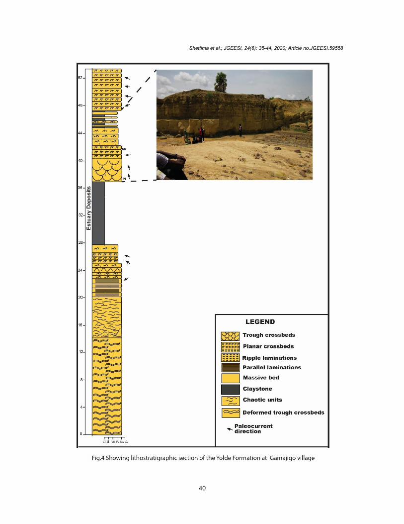
2. MATERIALS AND METHODS Topographic and geological maps of Gombe town and environs that are located within the Gongola Sub-basin were employed in the fieldwork of this research to identify potential areas where the Yolde Formation are well exposed. Along these well exposed outcrops identified, lithostratigraphic sections of this Formation outcropping around Gamajigo village (Fig. 4) were systematically logged to record data on lithologic variations, texture, bed geometry, paleocurrents, sedimentary structures and fossil content. Based on facies concept and application of Walters law in conjunction with facies relation provided by sedimentological studies on ancient and modern environment, these data were utilized in designating lithofacies assemblages representing particular depositional environment. Paleocurrent measurements were also carried out on the abundant planar and trough crossbedded sandstones and the various orientations determined were used to evaluate provenance and hydrodynamic processes [e.g. 25]. The dip and strike as well as the azimuth of the crossbeds were measured using compass clinometers in this analysis, and considering that the regional dip of the beds are generally greater than 10°, tilt correction was also carried out on the values using the procedure adopted by [25]. 3. RESULTS
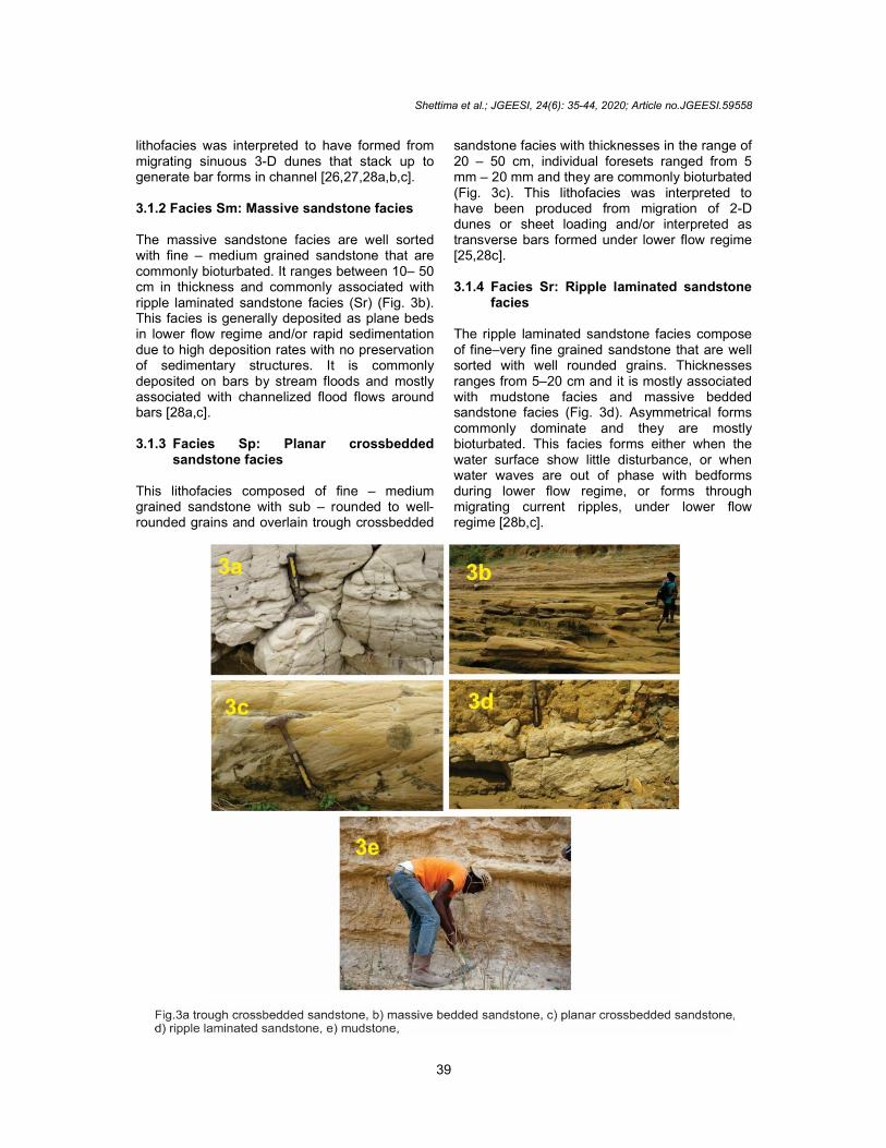
3.1 Facies Analysis 3.1.1 Facies St: Trough crossbedded
sandstone facies This lithofacies composes of medium – very coarse grained sandstone, dominantly moderately sorted with sub – angular to sub – rounded grains, ranging in thickness from 1 – 1.5 m. They commonly compose of erosional basal boundaries typically associated with mudclast and dominantly bioturbated (Fig. 3a). This
Shettima et al.; JGEESI, 24(6): 35-44, 2020; Article no.JGEESI.59558
39
lithofacies was interpreted to have formed from migrating sinuous 3-D dunes that stack up to generate bar forms in channel [26,27,28a,b,c]. 3.1.2 Facies Sm: Massive sandstone facies The massive sandstone facies are well sorted with fine – medium grained sandstone that are commonly bioturbated. It ranges between 10– 50 cm in thickness and commonly associated with ripple laminated sandstone facies (Sr) (Fig. 3b). This facies is generally deposited as plane beds in lower flow regime and/or rapid sedimentation due to high deposition rates with no preservation of sedimentary structures. It is commonly deposited on bars by stream floods and mostly associated with channelized flood flows around bars [28a,c]. 3.1.3 Facies Sp: Planar crossbedded
sandstone facies This lithofacies composed of fine – medium grained sandstone with sub – rounded to well-rounded grains and overlain trough crossbedded
sandstone facies with thicknesses in the range of 20 – 50 cm, individual foresets ranged from 5 mm – 20 mm and they are commonly bioturbated (Fig. 3c). This lithofacies was interpreted to have been produced from migration of 2-D dunes or sheet loading and/or interpreted as transverse bars formed under lower flow regime [25,28c]. 3.1.4 Facies Sr: Ripple laminated sandstone
facies The ripple laminated sandstone facies compose of fine–very fine grained sandstone that are well sorted with well rounded grains. Thicknesses ranges from 5–20 cm and it is mostly associated with mudstone facies and massive bedded sandstone facies (Fig. 3d). Asymmetrical forms commonly dominate and they are mostly bioturbated. This facies forms either when the water surface show little disturbance, or when water waves are out of phase with bedforms during lower flow regime, or forms through migrating current ripples, under lower flow regime [28b,c].
Shettima et al.; JGEESI, 24(6): 35-44, 2020; Article no.JGEESI.59558
40

Shettima et al.; JGEESI, 24(6): 35-44, 2020; Article no.JGEESI.59558
41
3.1.5 Facies Fm: Mudstone facies This lithofacies is dominantly grey and commonly bioturbated with thicknesses ranging from 60 cm – 1 m. It is usually interbedded with ripple laminated sandstone facies (Sr) and massive sandstone facies (Sm) or define the base of trough crossbedded sandstone facies (Fig. 3e). This facies forms under environmental conditions where sediments are abundant and water energy is sufficiently low to allow settling of suspended fine silt and clay. They are characteristic of marine environment where seafloor lies below the storm base, but can form in lakes and quite part of rivers, lagoons, tidal flat and deltaic environment [25,29]. 3.2 Sedimentary Facies Characterization The stratigraphic packages of the tidal channel sequences is composed of amalgamated lenticular sandstone dominated units composed displaying fining upwards cycles of 4-11 m. Sequences are dominantly host cross-stratified sandstones, composed of predominantly fine grained, well sorted with well-rounded grains (Fig. 4). Lowermost contact are generally erosional (Fig. 4), typically superposed by compound cross-stratified sandstones consisting of dominant presences of planar crossbedded facies (Sp) and limited trough crossbedded sandstone facies (St) having successive foreset sets accreting up or down dip at high angles of 23-36° (Fig. 4). Bipolar patterns with often herringbone cross-stratification are very common (Fig. 4), but however unidirectional sets dominate, and are mostly arranged with progressively decreasing thickness upwards. Intermittently, asymmetrical ripples mark the surfaces of these cross-stratification with occasional bidirectional current laminations. Heterolithic assemblages typically succeeds this succession and composes of intercalated to interbedded very fine grained sandstone and mudstone sequences of 3-7 m thick (Fig. 4). The sandstone intervals are 10-30 cm thick and consists dominantly of massive, ripple-parallel laminated facies units (Sm, Sr and Sl) and few planar crossbedded facies (Sp) exhibiting predominantly sharp boundaries that are locally erosional. Mudstone facies (Fm) horizon are usually thin (2-10 cm), thicker units of up to 30-40 cm are common, but laterally impersistent. This grades into densely bioturbated mudstone facies (Fm) 1-1.5 m thick, locally intercalated with siltstone, carbonate concretion, rare traces of
caliche nodules and rootlet structures. Bioturbation varies from moderate-dense and composes of Ichnofacies suites of Diplocraterion, Thalassinoides, Planolites, Ophiomorpha and Skolithos. Paleocurrent directions evaluation from cross-strata and ripple cross-laminations indicated a dominantly strong south-westerly to north-westerly pattern, varying between 260-300°.
4. DISCUSSION This facies architectural stratal consisting of erosional base, fining and thinning upward successive sequences dominated by cross-stratified planar to trough units having locally disseminated mud-drape and bipolar attributes are strong indication of tidal channel deposition [30,31] which develop most commonly in estuaries and tide dominated deltas. These large scale accretion units plus the compound cross-stratifications are product of bar migration or compound dunes [32], in which discrete accretion surface represents earlier barform positions [28b,33]. The dominant basal sandbodies of the compound cross-stratified sandstone are product of a 3-D dune migration on tide influenced bars [32], whereas the less frequent trough cross-stratified units summands from tractional current as a consequence of migration of 3-D dunes [34,28c]. Rarely superimposed ripple cross-laminations with relatively abundant reflect depositional account relating to a phase of weak erosion and poor development of slack-water periods [32]. Bipolar current systems varying in intensities in these lenticular cross-stratified units, display records of approximately equal reversal strength, hosting coexistences of a dominant and subordinate current of opposing trend [e.g. 30]. The overlying interval intermittently inclined heterolithic assemblages of sandstones and mudstones are considered representative of tidal cycles [35] reflective of lateral accretion deposits that are usually synonymous to tidal point bars. This evidently suggests prevalence of highly sinuous tidal channel than low sinuous types because of their common occurrence [e.g.30]. Wide variety and density of trace fossil assemblage are largely function of complex interactions of varying environmental and depositional conditions [36]. The diverse suites mostly fall into Skolithos ichnofacies, presenting a coastal physiography with tidal channel extending into the open sea, where vertical burrows therein reflect a stressed hydrodynamic regime [37].
Shettima et al.; JGEESI, 24(6): 35-44, 2020; Article no.JGEESI.59558
42
5. CONCLUSION The facies assemblage in the stratigraphic architecture of the Yolde Formation at Gamajigo village in Gongola Sub-basin of the Northern Benue Trough indicated the presence of tidal channel complexes. This is depicted by bioturbated fining upward cycle characterized by trough crossbeds with erosional contact at base transitionally grading into sandstone and mudstones interbeds defined by planar crossbeds, massive beds and ripple laminations capped by mudstones. This profile reflects a dissipating energy regime akin to landward trajectory of coastal system. A manifestation vividly reflected in the skolithos ichnofacies assemblage indicating a coastal zone where vertical burrows therein reflect a stressed hydrodynamic regime and indicating extension of tidal channel into the open sea. Therefore, the Yolde Formation at this locality herein presents a coastal physiography where tidal channel are directly connected to the advancing Cenomanian sea through the Gulf of Guinea in the Gongola Sub-basin.
COMPETING INTERESTS
Authors have declared that no competing interests exist.
REFERENCES
1. Shaw DP. Time in stratigraphy. McGraw-Hill, New York. 1964;34.
2. Haq BU, Hardenbol J, Vail PR. Science. 1987;235:1156–1166.
3. King LC. Outline and distribution of Gondwanaland. Geol. Mag. 1950;87:353-359.
4. Wright JB. Review of the origin and evolution of the Benue Trough. In C. A. Kogbe (Eds.); Geology of Nigeria. Jos, Rock View (Nigeria) Ltd. 1989;125–173.
5. Genik GJ. Regional framework, structural and petroleum aspects of rift basin in Niger, Chad and Central African Republic (CAR). In P. A. Zeigler (Eds.); Geodynamics of Rifting, Volume II, Case History Studies on Rift: North and South America and Africa. 1992;213:169–185.
6. Fairhead JD, Green CM, Masterton SM, Guiraud R. The role that plate tectonics, inferred stress changes and stratigraphic unconformities have on the evolution of the West and Central African Rift System and the Atlantic continental margins.
Tectonophysics. 2013;594:118–127. Burke K, Dessauvagie TFG, Whiteman AJ. The opening of Gulf of Guinea and geological history of the Benue depression and Niger delta. Nature Physical Science. 1971;233:51–55.
7. Olade MA. Evolution of Nigerian’s Benue Trough (aulacogen): A tectonic model. 1974;112:575– 583. Benkhelil J. The origin and evolution of the Cretaceous Benue Trough (Nigeria). Journal of African Earth Sciences. 1989;8:251–282.
8. Likkason OK, Ajayi CO, Shemang EM, Dike EFC. Indication of fault expressions from filtered and Werner deconvolution of aeromagnetic data of the Middle Benue Trough, Nigeria. Journal of Mining and Geology. 2005;41(2):205–227.
9. Onyedim GC, Arubayi JB, Ariyibi EA, Awoyemi MO, Afolayan JF. Element of wrench tectonics deduced from SLAR imagery and aeromagnetic data in part of the middle Benue Trough. Journal of Mining and Geology. 2005;41:51–56.
10. Nwajide CS. Geology of Nigeria’s sedimentary basins. Lagos, CCS Bookshop Ltd. 2013;45-89.
11. Zaborski P, Ugodulunwa F, Idornigie A, Nnabo P, Ibe K. Stratigraphy, structure of the Cretaceous Gongola Basin, Northeastern Nigeria. Bulletin Centre Researches Production Elf Aquitatine. 1997;22:153–185.
12. Dike EFC. Sedimentation and tectonic evolution of the Upper Benue Trough and Bornu Basin, Northeastern Nigeria. Nig. Min. Geosci. Soc. 38th Annual and International Confer., Port Harcourt. 2002;45.
13. Guiraud M. Tectono-sedimentary framework of the early cretaceous continental Bima (Upper Benue Trough N.E. Nigeria). Jour. Afr. Earth Sci. 1990;10:341-353.
14. Tukur A, Samaila NK, Grimes ST, Kariya II, Chaanda MS. Two member subdivision of the Bima Sandstone, Upper Benue Trough, Nigeria: Based on sedimentological data. J. Afr. Earth Sci. 2015;104:140-158.
15. Shettima B, Abubakar MB, Kuku A, Haruna AI. Facies analysis, depositional environments and paleoclimate of the cretaceous bima formation in the Gongola Sub - Basin, Northern Benue Trough, NE Nigeria. Journal of African Earth Sciences. 2018;137:193-207.

Shettima et al.; JGEESI, 24(6): 35-44, 2020; Article no.JGEESI.59558
43
16. Shettima B, Dike EFC, Abubakar MB, Kyari AM, Bukar F. Facies and facies architecture and depositional environments of the Cretaceous Yolde Formation in the Gongola Basin of the Upper Benue Trough, Northeastern Nigeria. Global Journal. 2011;10(1):67.
17. Abdulkarim H, Aliyu YD, Mamman MB, Abubakar, Babangida M, Sarki Yandoka, John Shirputda Jitong, Bukar Shettima. Paleodepositional environment and age of Kanawa Member of Pindiga Formation, Gongola Sub-basin, Northern Benue Trough, NE Nigeria: Sedimentological and palynological approach. Journal of African Earth Sciences. 2017;134:345-351.
18. Shettima B. Sedimentology, stratigraphy and reservoir potentials of the cretaceous sequences of the Gongola Sub – basin, Northern Benue Trough, NE Nigeria. PhD Thesis Abubakar Tafawa Balewa University, Bauchi. 2016;267.
19. Genik GJ. Petroleum geology of the cretaceous – tertiary rift basin in Niger, Chad and Central African Republic. American Association of Petroleum Geologists Bulletin. 1993;77(8):1405–1434.
20. Fairhead JD, Binks RM. Differential opening of the Central and South Atlantic Oceans and the opening of the West African rift system. Tectonophysics. 1991;187:181–203.
21. Dike EFC, Onumara IS. Facies and facies architecture and depositional environments of the Gombe Sandstone, Gombe and Environs, NE Nigeria. Science Association of Nigeria Annual Conference, Bauchi. 1999;67.
22. Dike EFC. The stratigraphy and structure of the Kerri-Kerri Basin Northeastern Nigeria. Journal of Mining and Geology. 1993;29(2):77–93.
23. Adegoke OS, Agumanu AE, Benkhelil J, Ajayi PO. New stratigraphic sedimentologic and structural data on the Kerri-Kerri Formation, Bauchi and Borno States, Nigeria. Journal of African Earth Sciences. 1986;5:249–277.
24. Wilson M, Guiraud R. Magmatism and rifting in Western and Central Africa, from Late Jurassic to Recent times. Tectonophysics. 1992;213:203–225.
25. Tucker ME. Sedimentary rocks in the field. West Sussex, John Wiley & Sons Ltd. 2003;83–158.
26. Plint AG. Facies, environment and sedimentary cycles in the Middle Eocene, Bracklesham Formation of Hamshire Basin: Evidence for sea-level change? Sedimentology. 1983;30:625–653.
27. Boggs S, Jr. Principle of sedimentology and stratigraphy. New Jersey, Prentice Hall. 1995;109.
28. [a] Miall AD. In: Fluvial sedimentology. (Eds A. D. Miall) Canadian Society of Petroleum Geologists Publication. 1978;5:597–604. [b] Miall AD. The geology of fluvial deposits. Berlin, Springer-Verlag. 1996;582. [c] Miall AD. Alluvial deposits. In: James, N.P., Dalrymple, R.W. (Eds.), Facies Models 4. Geological Association of Canada, St. John’s, Newfoundland: 2010;105-137.
29. Boggs S, Jr. Principles of sedimentology and stratigraphy. Upper Saddle River, New Jersey, Prentice Hall. 2006;129.
30. Plink-Björklund P. Stacked fluvial and tide-dominated estuarine deposits in high frequency (fourth-order) sequences of the Eocene Central Basin, Spitsbergen. Sedimentology. 2005;52:391–428.
31. Ainsworth RB, Vakarelov BK, Nanson RA. Dynamic spatial and temporal prediction of changes in depositional processes on clastic shorelines: Toward improved subsurface uncertainty reduction and management. AAPG Bulletin. 2011;95(2):267–297.
32. Dalrymple RW, Choi K. Morphologic and facies trends through the fluvial–marine transition in tide-dominated depositional systems: A schematic framework for environmental and sequence-stratigraphic interpretation. Earth Science Reviews. 2007;81:135–174.
33. Dalrymple RW. Tidal depositional systems. In: Facies Models 4 (Eds N. P. James and W. Dalrymple). Geological Association of Canada, St. John’s. 2010;199–208.
34. Els BG, Mayer JJ. Coarse clastic tidal and fluvial sedimentation during a large late Archean sea-level rise: the Turffotein subgroup in the Vredefort structure, South Africa. In: Tidalites: Processes and Products (Eds C. R. Alexander, R. A. Davis and V. J. Henry). 1998;61:155-165.
35. Bridge JS, Leeder MR. A simulation model of alluvial stratigraphy. Sedimentology. 1979;26:617–644.

Shettima et al.; JGEESI, 24(6): 35-44, 2020; Article no.JGEESI.59558
44
36. van Cappelle M, Ravnås R, Gary J, Hampson RJ, Howard D, Johnson HD. Depositional evolution of a progradational to aggradational, mixed influenced deltaic succession: Jurassic Tofte and Ile formations, Southern Halten Terrace, Offshore Norway. Marine and Petroleum Geology. 2017;80:1-22.
37. MacEachern JA, Bann KL. The role of Ichnology in refining shallow marine facies models. In: Recent Advances in Models of Siliciclastic Shallow-Marine Stratigraphy (Eds G. J. Hampson, R. J. Steel, P. M. Burgess and R. W. Dalrymple), SEPM Spec. Publ. 2008;90: 73-116.
_________________________________________________________________________________ © 2020 Shettima et al.; This is an Open Access article distributed under the terms of the Creative Commons Attribution License (http://creativecommons.org/licenses/by/4.0), which permits unrestricted use, distribution, and reproduction in any medium, provided the original work is properly cited.
Peer-review history: The peer review history for this paper can be accessed here:
http://www.sdiarticle4.com/review-history/59558