Cross-Sectional Vs. Time Series Benchmarking in Small Area ...
Upload
khangminh22Category
view
3download
0
Currie Small Area Plan Pender County Department of Planning and Community Development October 15, 2012

Acknowledgements
Board of Commissioners George Brown – Chairman
Jimmy Tate – Vice Chairman F.D. Rivenbark Chester Ward David Williams
County Manager Mickey Duvall
County Attorney Carl “Trey” Thurman III
Planning Board Malcom Boney – Chairman
Hiram Williams – Vice Chairman Sonya Edens Rick Garrett
William P. Marshburn Burt Millett Elaine Nalee
Department of Planning and Community Development Staff Kyle Breuer, Planning Director
Ken Vafier, Senior Planner Dee Turner, Planner II
Ashley Frank, Planner II Ben Andrea, Planner II
Ashley Moncado, Planner I
Currie Small Area Plan Steering Committee Tyrone Brandyburg
Susan Bullers George Brown Brian Martin
Janet Mowery Kent Mowery
Cleveland Simpson Eddie Simpson
Daniel Thompson Hiram Williams
Currie Small Area Plan Adopted October 15, 2012 by the Pender County Board of County Commissioners
Table of Contents
Introduction and Vision .....................................................................................................................................................1
History ..................................................................................................................................................................................3
Small Area Plan Development Process ..............................................................................................................................5
Community Outreach .........................................................................................................................................................6
Existing Conditions .............................................................................................................................................................8
Goals .................................................................................................................................................................................. 14
Future Land Use ............................................................................................................................................................... 20
References ......................................................................................................................................................................... 22
Appendix A – Maps of the Currie Study Area ............................................................................................................... 23
Appendix B – Community Outreach .............................................................................................................................. 31
Appendix C – Goals ......................................................................................................................................................... 56

1 | C u r r i e S m a l l A r e a P l a n
Introduction and Vision Currie is an unincorporated community located in western Pender County, North Carolina, approximately 18 miles from Downtown Wilmington. Though a wide range of opinions exist on the unofficial boundaries of Currie, they are generally considered to be within an area bounded by Atkinson to the north, New Hanover County to the south, the Black River and Moores Creek to the west, and US Highway 421 to the east. A defined study area was agreed upon by the Currie Small Area Plan Steering Committee for the analysis and goals produced in this document. Currie is defined by its’ rural character, unique cultural and historical heritage, and relationship to the surrounding natural landscape. Moores Creek National Battlefield, dedicated to commemorate the 1776 Battle of Moores Creek, serves as a focal point to the community and encompasses these attributes. The study area is predominantly comprised of low density single-family housing, agriculture, timber, or other natural areas with few local retail or service establishments. It is easily accessible by several arterial or major thoroughfares, most notably US Highway 421 and NC Highway 210. With the completion of planned water and wastewater infrastructure along the US Highway 421 corridor, development is anticipated to move north from the industrial and commercial areas of New Hanover County. Thus, it is important to create a vision which preserves and enhances the unique characteristics found in and around the study area. A vision statement was drafted early in the planning process by the Steering Committee to define how Currie functions today as well as to provide a vision for future development.
Currie is a rural community oriented around natural, cultural, and historic resources that seeks to preserve its unique character within Pender County. The vision for the Currie area is a clean, attractive, safe and accessible community which will continue to integrate new growth around the natural and rural landscape. Significant emphasis should be placed on green spaces and recreational opportunities linked by walking, bicycling, hiking, and equestrian facilities. Additional retail, public service, recreational, transportation, and utility opportunities are critical to the sustainability of the Currie area. Future growth should preserve the rural character while incorporating green space and preservation of the natural and historic resources that are held valuable to area residents and visitors.

2 | C u r r i e S m a l l A r e a P l a n
The 2010 Pender County Comprehensive Land Use Plan set goals and policies for three urbanizing areas of Pender County; however, this document is the first comprehensive, stand-alone Small Area Plan for a rural community in the County. This plan will analyze the existing conditions and history in the study area, followed by a set of goals developed to preserve and enhance those topics identified as unique and critical to the future vision of Currie. Goals related to Utilities and Services, Land Use and Economic Development, Housing, Community Heritage and Sense of Place, Recreation, and Transportation were developed and refined using extensive stakeholder input via a community input survey, Steering Committee meetings, public workshops, and public hearings. Upon adoption, this Plan will be used in conjunction with the 2010 Comprehensive Land Use Plan by stakeholders, county staff, appointed and elected officials, and other interested parties to ensure that development requests proceed in accordance with the goals and vision set forth by the Currie community.
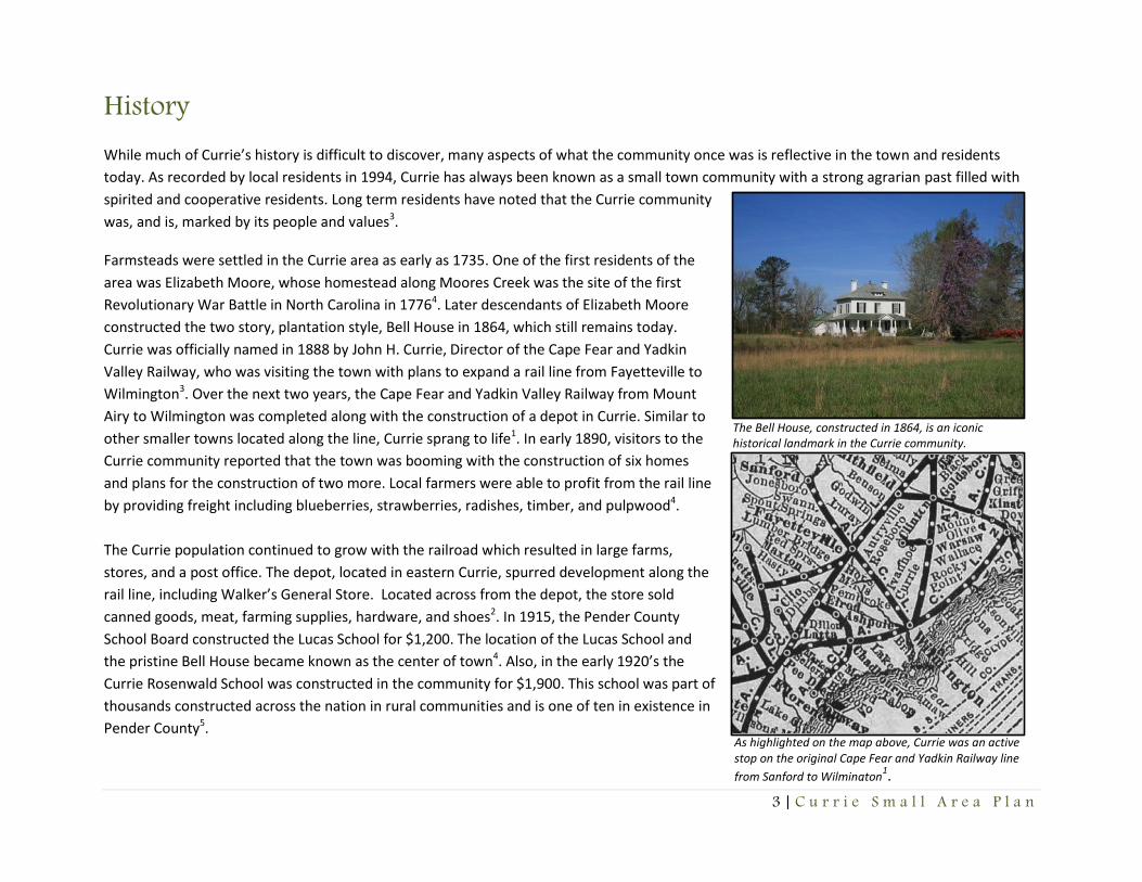
3 | C u r r i e S m a l l A r e a P l a n
As highlighted on the map above, Currie was an active stop on the original Cape Fear and Yadkin Railway line
from Sanford to Wilmington1.
The Bell House, constructed in 1864, is an iconic historical landmark in the Currie community.
History While much of Currie’s history is difficult to discover, many aspects of what the community once was is reflective in the town and residents
today. As recorded by local residents in 1994, Currie has always been known as a small town community with a strong agrarian past filled with
spirited and cooperative residents. Long term residents have noted that the Currie community
was, and is, marked by its people and values3.
Farmsteads were settled in the Currie area as early as 1735. One of the first residents of the
area was Elizabeth Moore, whose homestead along Moores Creek was the site of the first
Revolutionary War Battle in North Carolina in 17764. Later descendants of Elizabeth Moore
constructed the two story, plantation style, Bell House in 1864, which still remains today.
Currie was officially named in 1888 by John H. Currie, Director of the Cape Fear and Yadkin
Valley Railway, who was visiting the town with plans to expand a rail line from Fayetteville to
Wilmington3. Over the next two years, the Cape Fear and Yadkin Valley Railway from Mount
Airy to Wilmington was completed along with the construction of a depot in Currie. Similar to
other smaller towns located along the line, Currie sprang to life1. In early 1890, visitors to the
Currie community reported that the town was booming with the construction of six homes
and plans for the construction of two more. Local farmers were able to profit from the rail line
by providing freight including blueberries, strawberries, radishes, timber, and pulpwood4.
The Currie population continued to grow with the railroad which resulted in large farms,
stores, and a post office. The depot, located in eastern Currie, spurred development along the
rail line, including Walker’s General Store. Located across from the depot, the store sold
canned goods, meat, farming supplies, hardware, and shoes2. In 1915, the Pender County
School Board constructed the Lucas School for $1,200. The location of the Lucas School and
the pristine Bell House became known as the center of town4. Also, in the early 1920’s the
Currie Rosenwald School was constructed in the community for $1,900. This school was part of
thousands constructed across the nation in rural communities and is one of ten in existence in
Pender County5.

4 | C u r r i e S m a l l A r e a P l a n
Currie continued to function as a
successful agrarian community up until
the twentieth century, even with the
financial hardships the railway was facing
due to over expansion. In 1899, faced with
bankruptcy, the Cape Fear and Yadkin
Valley Railway was sold to Atlantic Coast
Line1.
During the mid-twentieth century, with a
struggling rail line and the national Great
Depression, Currie was not able to grow
into a prosperous community. Maps
recorded in the County’s Register of
Deeds office in 1940 showed future plans
for Currie with the creation of 214
buildable lots for homes and businesses. However, efforts to develop these properties never
materialized2. Additionally, in 1949, Atlantic Sea Coast Line successfully petitioned the State Utilities
Commission to close the depot in Currie. Both Currie and Wilmington residents and businesses
provided notice opposing this request. Following the closing of the depot, the rail line was sold to Seaboard Coast Line in 1967. Immediately,
many sections of the rail line, including a section from Roseboro to Wilmington, were abandoned as unprofitable1.
In 1971, against resident’s wishes and support, the Seaboard Coast Line pulled up the remaining rail line. Because the town’s agrarian economy
was based on the rail line, Currie was negatively affected and struggled to develop. Local businesses that once lined Brinson Road, including
Walker’s General Store, closed and fell into a state of decay. Other local operations, including the Black River Sawmill located on
Borough Road and the abandoned train depot, were destroyed along with Currie’s booming past2.
Following the removal of the rail lines in Currie, the town did not see significant population or economic growth and remained as a very rural
community. Still, during this time, Currie residents remained involved with the community and took part in local festivals including the Pender
County Centennial Festival in 1975 at Moores Creek National Battlefield4. Small town values, community involvement, and cooperation are
characteristics that have described the town for decades and are still present today.
Maps recorded with the Pender County Register of Deeds office in
1940 and 1957 reveal the original grid design of the community
centered around the existing train depot.

5 | C u r r i e S m a l l A r e a P l a n
Small Area Plan Development Process The Currie Small Area Plan process was conducted over the course of eleven months. The planning process began with a resolution submitted to
the Board of Commissioners on November 7, 2011. This resolution provided information outlining support for the creation of a small area plan
based on the 2010-2012 Priority Implementation Plan, as well as general policies set out in the County’s adopted Comprehensive Land Use Plan,
which stated the need to develop small area plans for populated communities throughout the County.
Following support from the Board of Commissioners, staff proceeded with a community outreach meeting in January 2012 to begin the planning
process with the Currie community. Following this event, the process continued with the appointment of a ten member Steering Committee at
the end of February. The steering committee met four times throughout the planning process from February to August to provide input and
assistance in regards to the study area, vision statement, and goals. The process also included the development and distribution of a community
survey to collect public input from the study area. The thirty question survey was distributed to 140 households and local churches over the
course of three months. The information and input collected from the community survey was then utilized by the Steering Committee and
Planning Staff to develop goals and policies for the plan along with determining future land use classifications.
In June, Planning staff provided an informational update to the Planning Board and Board of County Commissioners regarding the status of the
plan. Following the first draft of the plan for review by the Steering Committee in July, another community outreach meeting was held in August
to collect input and comments from the Currie community regarding the plan. Once these were received and corrections were made addressing
residents’ concerns, the plan was available for public review and comment. Following the public comment period a final draft was submitted to
the Planning Board for recommendation in September. Following the Board’s review and a public hearing, the Currie Small Area Plan was
submitted to the Pender County Board of Commissioners on October 15, 2012 for public hearing and was formally adopted by the Board.

6 | C u r r i e S m a l l A r e a P l a n
Community Outreach The Currie Small Area Plan process included a variety of public participation opportunities including community outreach meetings, the creation of a steering committee, and a community survey. These opportunities were imperative in creating a successful plan for the Currie community. Community Outreach Meetings Over the course of eleven months, the County held two community outreach meetings at Moore’s Creek National Battlefield. The purpose of these meetings was to collect public input regarding the strengths, weaknesses, needs, and wants of the community. These meetings also provided opportunity for members of the study area to review the plan and provide feedback. A detailed summary of each individual community outreach meeting can be found in Appendix B. Steering Committee Meetings Another means to include public participation throughout the planning process was the creation of a steering committee. The Currie Small Area Plan Steering Committee consisted of ten members who played an active role in the Currie community. The committee played an instrumental role in determining the study area, developing a vision statement, and drafting goals and policies for the plan. Their input assisted staff in gathering a greater knowledge of Currie which was essential in creating a plan that was reflective of the community. Completed minutes from the four meetings held during the planning process can be found in Appendix B.
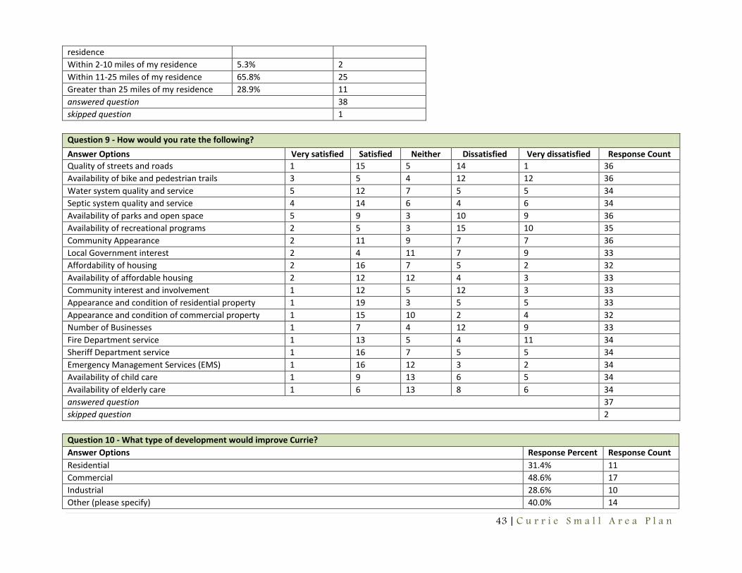
Currie Small Area Plan Survey In addition to the community outreach meetings and formation of a Steering Committee, the County distributed a survey in order to encourage public participation. The survey included thirty questions and assessed the community’s views on the local economy, land use, housing, services, community pride, and future vision of Currie. In total, thirty-nine surveys were completed by the community. Provided below is a summary of survey responses. The entire survey and responses can be found in Appendix B. Based on the results of the survey, the majority of respondents have been residents of Currie for one to ten years. The majority of households consist of two members and do not include any school aged children. In addition, the majority of respondents noted their desire to live within the community due to its rural setting. Overall, the participants highlighted their satisfaction with Currie as a place to live. However, based on information provided throughout the survey, residents from the study area recognize the importance and need for improving Currie in the future.

7 | C u r r i e S m a l l A r e a P l a n
The majority of respondents stated their dissatisfaction with the lack of existing businesses in the area and noted that future commercial development would improve the Currie community. Businesses and land uses that participants wished to see within the vicinity of the study area included general retail, a pharmacy, a hardware store, and a restaurant. Overwhelming support was noted for locating a grocery store within or immediately adjacent to the study area. Participants also stated their lack of support for other businesses or land uses including bars, taverns, or heavy industry. Participants noted the need to increase businesses in the study area in order to provide more services to the community and create more job opportunities for the community. The majority of participants responded that they drive 11 to 25 miles outside of the study area for jobs, goods, and services. Many participants discussed the need for goods and services to be located closer to the community along the US Highway 421 corridor. Information from the community survey showed that 100% of all participants own their home and do not rent. The majority of participants responded that they are satisfied with the affordability of housing in the study area. The survey showed that respondents viewed the quality and availability of affordable housing as adequate. In addition, participants cited the quality and availability of affordable rental housing as inadequate or fair. The majority of respondents stated their support for stick built and affordable housing in the study area. Respondents cited satisfaction with existing water and sewer quality and systems in the study area, but noted their interest in county water and a community sewer system. Residents within the study area stated satisfaction with current services in the study area including fire, sheriff, and emergency management. However, based on comments, participants noted the need to enhance these services in the community. Many participants expressed concern and the need for establishing a volunteer fire department annex in order to improve safety to residents and decrease the cost of Homeowners Insurance. Additionally, responses noted the need to establish a library annex and community center. Participants also stated the need to improve current internet access in the study area to a more reliable, modern service for the community. The need for recreational facilities including bike and pedestrian trails, parks, and a community center were noted numerous times by respondents. Results showed that the majority of participants were dissatisfied with the availability of parks, open space, bike and pedestrian trails, and recreational programs. Respondents noted that the development of accessible parks and recreational facilities including biking, walking, hiking, and horse trails, basketball and tennis courts, baseball and soccer fields, and water access would be very beneficial to the community. Participants also noted the need for establishing a recreation or community center in the area. Many residents stated the need for the county to focus its resources on recreational facilities within the study area. Participants noted concern regarding traffic safety in the study area. Many respondents stated the need for improving traffic safety along Blueberry Road and the intersection of Bell Williams Road and NC Highway 210. Finally, respondents recognized that there is a strong sense of community pride and were satisfied with the level of community involvement throughout Currie. Participants cited many reasons that make the community a great place including its rural landscape, quiet country living, and friendly neighbors. Overall, the survey responses illustrated a strong sense of pride that residents have for their community.

8 | C u r r i e S m a l l A r e a P l a n
Existing Conditions
Land Use The existing land use pattern in the Currie study area includes low density residential and commercial uses within a rural landscape. The land use map shows the study area is comprised of approximately 2,028 acres, including dedicated land in the right of ways and water ways. Agricultural uses account for the vast majority of the land in the study area totaling 700.97 acres. Residential land uses, limited to single family traditional (stick built) and manufactured homes, total 532.11 acres. Commercial uses including two convenience stores and an auto service business total 5.10 acres. Finally, civic and institutional uses, which include the US Federal Post Office, community churches, and Moores Creek National Battlefield, total 100.10 acres. A large portion of the study area is comprised of vacant parcels totaling 1,144 acres, compared to developed parcels which total 840.29 acres. Current zoning in the study area includes mostly Rural Agricultural and Residential Performance, along with a few parcels zoned General Business, Environmental Conservation, and Office and Institutional. The zoning makeup of the study area is intended to accommodate very low density residential and commercial uses. The center core of the Currie study area is where a large portion of the residential and commercial uses are located. Immediately outside of this core, pockets of residential uses, agricultural uses, and the Moores Creek National Battlefield can be found. The remaining outer perimeter of the study area is comprised of low density residential and agricultural land uses. Environmental land features that can be found in the area include Moores Creek, which meanders its way through the northwestern portion of the study area and feeds into the Black River, located approximately two miles from the study area. The entire study area is within the Moores Creek Sub Watershed, which is part of the Black River Watershed. These systems flow into the Cape Fear River Basin.
Land Use Acres Percent Agricultural 700.97 52.73
Residential 532.11 39.35
Civic/Institutional 100.10 7.53
Commercial 5.10 .38
9 | C u r r i e S m a l l A r e a P l a n
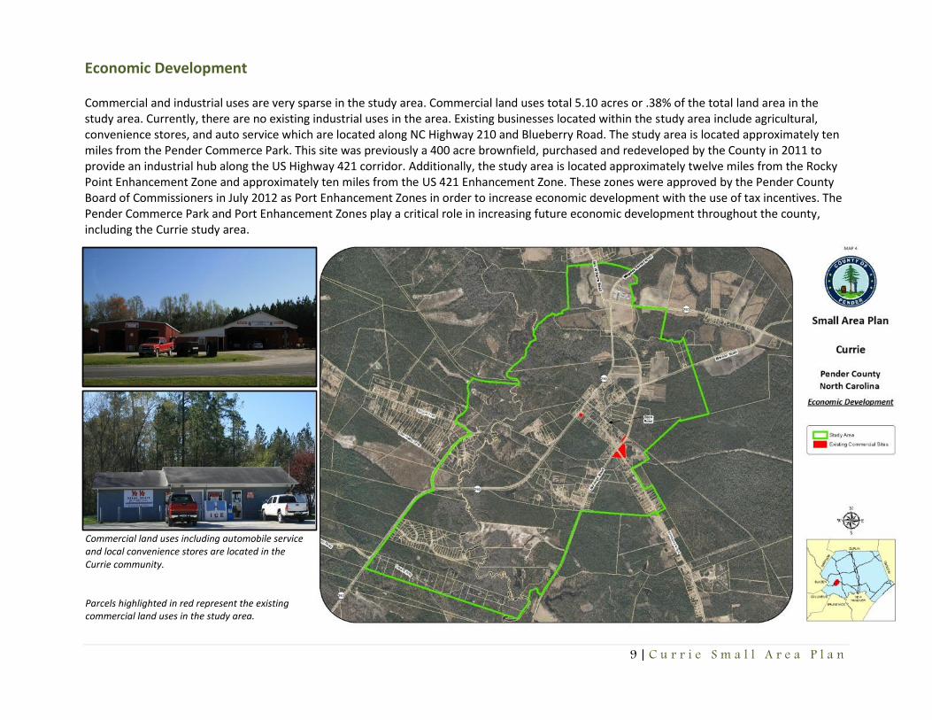
Economic Development Commercial and industrial uses are very sparse in the study area. Commercial land uses total 5.10 acres or .38% of the total land area in the study area. Currently, there are no existing industrial uses in the area. Existing businesses located within the study area include agricultural, convenience stores, and auto service which are located along NC Highway 210 and Blueberry Road. The study area is located approximately ten miles from the Pender Commerce Park. This site was previously a 400 acre brownfield, purchased and redeveloped by the County in 2011 to provide an industrial hub along the US Highway 421 corridor. Additionally, the study area is located approximately twelve miles from the Rocky Point Enhancement Zone and approximately ten miles from the US 421 Enhancement Zone. These zones were approved by the Pender County Board of Commissioners in July 2012 as Port Enhancement Zones in order to increase economic development with the use of tax incentives. The Pender Commerce Park and Port Enhancement Zones play a critical role in increasing future economic development throughout the county, including the Currie study area.
Commercial land uses including automobile service and local convenience stores are located in the Currie community. Parcels highlighted in red represent the existing commercial land uses in the study area.

10 | C u r r i e S m a l l A r e a P l a n
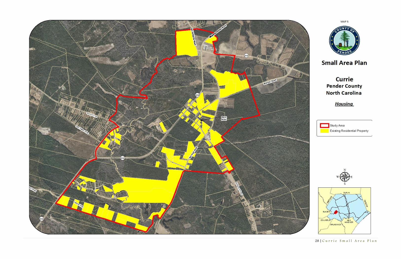
Housing
Residential land uses make up the second largest land use in the study area, totaling 532 acres or 39% of the total land area. Housing within the study area consists of single family stick built and manufactured homes. Currently, no multi-family housing is available in the study area. The total number of existing housing units total 158. Traditional (stick built) comprise 132 total units, while manufactured homes total 26 total units.
Residential land uses within the study area include single family homes. Parcels highlighted in yellow represent the existing residential uses in the study area

11 | C u r r i e S m a l l A r e a P l a n
Transportation Transportation infrastructure in the study area is coordinated and planned by the North Carolina Department of Transportation (NCDOT) and Cape Fear Regional Planning Organization (RPO). All of the public roads in the study area are maintained by NCDOT. Pender County does not maintain any roads within the County. The study area of Currie is centered on NC Highway 210 and Blueberry Road, which are the major thoroughfares of the area. Both of these major corridors connect to US Highway 421, which is located approximately three miles east of the study area. The major thoroughfares located in the study area are primarily paved and classified as public. Minor roads and streets, primarily located in residential subdivisions, include paved and unpaved sections and may be classified as private. Currently, the study area includes the Route 5 North Carolina Department of Transportation Road Trail along Blueberry Road and Highway 210. The segment located within the study area is a portion of a 160 mile route that trail follows the location of the Cape Fear River through southeast North Carolina to the coast. Future plans include the development of the proposed West Pender Rail Trail. This trail network is a recognized segment of the East Coast Greenway, which is a trail system that spans 3,000 miles of the eastern seaboard from Canada to Key West, Florida and is identified in the Pender County Parks and Recreation Plan.
Blueberry Road provides biking opportunities as part of the Route 5 North Carolina Department of Transportation Road Trail.
NC Highway 210 and Blueberry Road act as the major thoroughfares of the study area.

12 | C u r r i e S m a l l A r e a P l a n
Services and Utilities Throughout the study area, existing services and utilities are very limited due to the size of the Currie community. Currently, all existing development functions on private wells and onsite septic systems. Based on the Pender County Utilities Master Plan, following the completion of the Pender County Water Treatment Plant completed in 2011 along US Highway 421, there are future plans to provide a public water system to the Moores Creek District. County plans include a sign up campaign within approximately 24 months to determine the demand for water service in the Currie area. These future plans would be essential in addressing residents’ requests with providing public water to the area. Unfortunately, due to lack of demand and costs, there are no immediate plans for the development of a sewer system within the study area. Currently, solid waste services are provided via the Montague Road Convenience Center, located approximately three miles from the study area. The area is served by the Pender County Sheriff’s Department and Emergency Management. Due to the lack of a district fire station, the study area is served by the Atkinson and Long Creek Grady Volunteer Fire Department. However, the Pender County Comprehensive Land Use Plan references future plans to develop a district fire department immediately southwest of the study area on NC Highway 210. Based on information obtained from the Community Survey, all of these services were ranked adequate. The study area does include a US Federal Post Office branch, however, does not include a Pender County library branch. Currently, due to the size of the study area, internet service is very limited to the area. Most children in the study area attend Malpass Corner Elementary School for kindergarten to fifth grade, which is located approximately three miles from the study area. Children in sixth to eight grades attend West Pender Middle School, which is located approximately four miles from the study area. Following middle school, high school aged children attend Pender High School which is located just outside of Burgaw, approximately seven miles from the study area.
Malpass Middle School is one of three schools that serve the community.
The Long Creek Grady Volunteer Fire Department provides fire service to the study area.

13 | C u r r i e S m a l l A r e a P l a n
Parks and Recreation Currently, there are no County operated or funded parks or greenways provided in the Currie study area. The most accessible park that can be utilized by Currie residents is Pender Memorial Park in Burgaw, located approximately eleven miles from the study area. Within the study area there is only one recognized recreational resource, Moores Creek National Battlefield. Many participants recognized the Battlefield as an important point of interest, but also noted its use to locals as a place to walk, hike, and hold community events. More recent efforts by the local Currie community have assisted with improving recreational opportunities in the area. Organizations such as the Moores Creek Conservation Alliance (MCCA) are working to expand Moores Creek National Battlefield by establishing the Moores Creek Nature Center, which will focus on preserving wooded areas and open space. The nature center will also include recreational options with the development of pedestrian and bike trails, and a community park. The Greater Currie Community Action Group (GCCAG), with the support of the Currie community and Moores Creek National Battlefield, was formed to address the immediate recreational needs of the greater Currie community. The goal of the GCCAP is to provide a variety of recreational and community facilities to the area including basketball and tennis courts, softball and soccer fields, and a community based lifestyle center that may be utilized for afterschool programs and adult education. Both of these organizations recognize the benefits of developing and expanding parks and recreation to the local community.
Future plans to address recreational needs at the County level include the development of Malpass Community Park located at US Highway 421 and Malpass Corner Road, approximately three miles from the study area. This project will serve the study area and help address needs with the development of walking trails, picnic areas, a playground, and basketball and volleyball courts. Other future efforts include the future development of Still Bluff Community Park, located at the intersection of NC Highway 210 and Canetuck Road. Still Bluff Community Park is a proposed 20 to 75 acre park that will provide limited athletic amenities, instead focusing on water access to the adjacent Black River.
Moores Creek National Battlefield provides recreational opportunities within the study area.

14 | C u r r i e S m a l l A r e a P l a n
Community Heritage and Sense of Place The Currie area is recognized as a peaceful, quiet community that attracts residents looking for a rural, country lifestyle. Participants throughout the planning processes identified their fondness for the community due to the rural setting and open space that surrounds the study area. The majority of respondents believed there was a strong sense of pride in the community and noted that they were satisfied or very satisfied with Currie as a place to live. Many respondents noted their lack of support for any change in the Currie community, since many existing residents are pleased with the current condition of the area. Currently, the study area includes a variety of local community groups working to improve the quality of life within the study area creating a strong sense of community and unity. The study area includes Moores Creek National Battlefield. Moores Creek National Battlefield, managed by the National Park Service, is a Revolutionary War site comprised of 88 acres including a visitor center and walking trail. Current community efforts are aimed at augmenting the Battlefield with the development of a nature center to be utilized by the community and visitors. The Battlefield is a local, regional, and national destination that adds to Currie’s sense of place. Unfortunately, Moores Creek National Battlefield is the only local treasure that has been preserved highlighting Currie’s history. Other historical points of interest including Walker’s Grocery Store and Lucas School provide a glimpse into the history of Currie, while other significant points of interest including the Railroad Depot have been destroyed resulting in a significant loss of community heritage. Immediately outside of the study area, located along NC Highway 210, is the location of the Currie Rosenwald School. Constructed in the early 1920s, the school still stands today as one of only ten Rosenwald Schools in the County and plays an important role in the Currie community’s history. The landmark became part of the North Carolina National Register Study list in 2005, which may provide opportunity to preserve the school and community’s history for the future.
Lucas school constructed in 1915 Walker’s General Store Currie Rosenwald school constructed in the early 1920s
15 | C u r r i e S m a l l A r e a P l a n
Goals
Land Use and Economic Development The Steering Committee, participating citizens, and other stakeholders overwhelmingly voiced support for maintaining the existing low density residential, rural land use pattern found within the study area. Several retail, entertainment, and service options were identified as needs for the area, but due to market and access conditions and preservation of the existing study area, a desire was for these land uses to be located on main or major thoroughfares or intersections within 5-10 miles of the immediate study area. Retail services identified include, but may not be limited to, grocery stores, hardware stores, hunting and fishing supplies, drug stores. Other entertainment or service options identified included restaurants, mechanic and auto stores and shops, and movie theaters. It should be noted that there is a desire to have smaller, neighborhood commercial services such as a restaurant, pharmacy, and convenience station to be located within the study area. Emphasis should be placed on creating jobs in the area, however it was noted that larger industrial land uses should be sought outside of the study area. Land Use and Economic Development Goal 1 – Ensure zoning districts within 5-10 miles from study area where identified for retail and services uses are adequate to accommodate desired commercial and service uses. Land Use and Economic Development Goal 2 – Encourage the use of Low Impact Development standards and Best Management Practices to preserve and promote the rural landscape, open space, and natural resources.
Housing The study area contains a large percentage of single family home options, however no multifamily, duplex, or alternate housing options exist within the study area or the general area. Stakeholders have identified the need and desire for a range of different housing options within the area. Housing Goal 1 – The County will seek to accommodate the development and appropriate placement of a variety of housing types, including site built homes, apartments, townhouses, and quality affordable housing.
Walker’s General Store
Currie Rosenwald School constructed in the early 1920s

16 | C u r r i e S m a l l A r e a P l a n
Transportation
Data and information gathered from survey respondents as well as in discussion with committee members and stakeholders showed that the study area is in need of certain improvements to the transportation network. The Pender County Comprehensive Transportation Plan, adopted by the County in July 2012, includes recommendations and maps highlighting improvements and deficiencies of the County’s transportation network. The following goals were coordinated with recommendations from the CTP Steering Committee to ensure consistency between the two plans. Transportation Goal 1 – Explore all opportunities for safety improvements to the intersection of Bell Williams Road and NC Highway 210. Transportation Goal 2 – Coordinate with local law enforcement agencies in efforts to improve speed enforcement in and around study area. Transportation Goal 3 – Coordinate and plan for a future off road bicycle facility adjacent to or near Blueberry Road. Transportation Goal 4 – Coordinate and plan for a future off road bicycle facility adjacent to or near NC Highway 210. Transportation Goal 5 – Coordinate transportation improvements within the study area in accordance with the current Pender County
Comprehensive Transportation Plan.
17 | C u r r i e S m a l l A r e a P l a n
Utilities and Services The study area for the Currie Small Area Plan lies within the Moore’s Creek Water and Sewer District, as delineated in the 2006 Pender County Water and Sewer Master Plan. Approximately 160 residential and 4 commercial uses are within the study area. Pender County Utilities plans to begin initiating a sign-up campaign by Spring 2014 in order to determine if customer demand will warrant extension of water lines to the study area and its outlying areas. Residents have also indicated the desire for public wastewater service, however, at this time there are not enough units to make the installation of wastewater lines to the study area and vicinity cost effective once the Pender County wastewater treatment plant is operational. Stakeholders have identified the need for additional fire protection within and adjacent to the study area; the 2010 Pender County Comprehensive Land Use Plan’s Future Public Facilities Map recommends two additional fire stations within 5 mils of the study area. The need for additional educational, social, and vocational programming has also been identified by project stakeholders. Internet accessibility in and around the study area is limited in both availability and speed. Such a limitation creates a challenge for community residents and business owners to utilize modern technology in order to further educational opportunities, social interactions, and information sharing. Because of the low density in the Currie area, the development of wired internet infrastructure may be cost prohibitive, but advancements in wireless technology creates an opportunity for cost-effective internet accessibility in the Currie area, a concept desired and supported by community stakeholders. Utilities and Services Goal 1 – Pender County Utilities will coordinate closely with Currie area residents as well as other applicable agencies, organizations, and civic groups on a public water sign-up campaign and other infrastructure improvements in accordance with the Pender County Water and Sewer Master Plan. Utilities and Services Goal 2 – Ensure adequate fire and emergency services protection by locating a fire substation in or near the study area as recommended and illustrated in the 2010 Pender County Comprehensive Land Use Plan. Utilities and Services Goal 3 – Coordinate with local educational institutions in efforts to create satellite educational facilities for vocational, social, and recreational education opportunities. Utilities and Services Goal 4 – Actively collaborate with internet service providers and community stakeholders to develop reliable high-speed internet access in the area, utilizing grant funding and innovative technology where possible. Utilities and Services Goal 5 – Actively collaborate with cell phone providers and community stakeholders to develop reliable cell phone service in the area, utilizing grant funding and innovative technology where possible. Utilities and Services Goal 6 – Consider offsite wastewater systems or package wastewater systems to improve future wastewater infrastructure or protect public health when existing on-site septic systems fail or a pattern of failure of on-site septic systems occur within the study area.

18 | C u r r i e S m a l l A r e a P l a n
Parks and Recreation
The need for parks facilities and recreation opportunities in the Currie area was demonstrated in the 2010 Pender County Comprehensive Parks and Recreation Master Plan and supported by Steering Committee members and survey respondents. Existing parks and recreation within the study area is limited to the Moores Creek National Battlefield, which offers limited opportunities for recreation such as walking and picnicking. The consensus of the Steering Committee and survey respondents is to increase and enhance parks and recreational opportunities in and around the study area, and this can be achieved through partnerships supporting community efforts to create facilities, programs, and other opportunities. Parks and Recreation Goal 1 – Support community efforts to create, enhance, and augment parks and recreation opportunities in the Currie area through partnerships, assistance with grant procurement, and utilization of Staff resources as appropriate to build capacity within local organizations. Parks and Recreation Goal 2 – Continue to evaluate parks and recreation needs in the Currie area through future Pender County Comprehensive Parks and Recreation Master Plan updates, with an emphasis on providing improved access to Moore’s Creek. Parks and Recreation Goal 3 – Explore opportunities for funding, development, and progression of parks and recreation facility projects and recreational programs that cater to the needs and demographic composition of the Currie community.

19 | C u r r i e S m a l l A r e a P l a n
Community Heritage and Sense of Place The Currie area has traditionally had a very strong sense of community and sense of place which contributes to the unique characteristics within and around the study area. A strong desire to maintain this community heritage and sense of place was found within the survey results and stakeholder input during the planning process. One of the main themes found within the planning process was to preserve this sense of place and heritage when accommodating new growth and changes to the area. Several different methods can be incorporated in order to help preserve the unique characteristics of the study area. Community Heritage and Sense of Place Goal 1 – When possible, Pender County should serve as a partner for efforts to maintain and improve the Currie area through grant procurement, educational and recreational programs, special events and projects, and tourism opportunities. Community Heritage and Sense of Place Goal 2 – Continue partnerships between Pender County, Moores Creek National Battlefield, Moores Creek Conservation Alliance, West Pender Rail-Trail Alliance, and other organizations and civic groups to maintain and improve the Currie area. Community Heritage and Sense of Place Goal 3 – Ensure that natural resources within the study area are preserved, maintained, and enhanced as future development occurs. Community Heritage and Sense of Place Goal 4– Consider the formation of a formal Historical Society in order to preserve, maintain, and enhance historical resources within the area. Community Heritage and Sense of Place Goal 5 – Explore all opportunities for property acquisition, site planning and design, construction, implementation, and operation of a community center to serve as a focal point for the Currie area.

20 | C u r r i e S m a l l A r e a P l a n
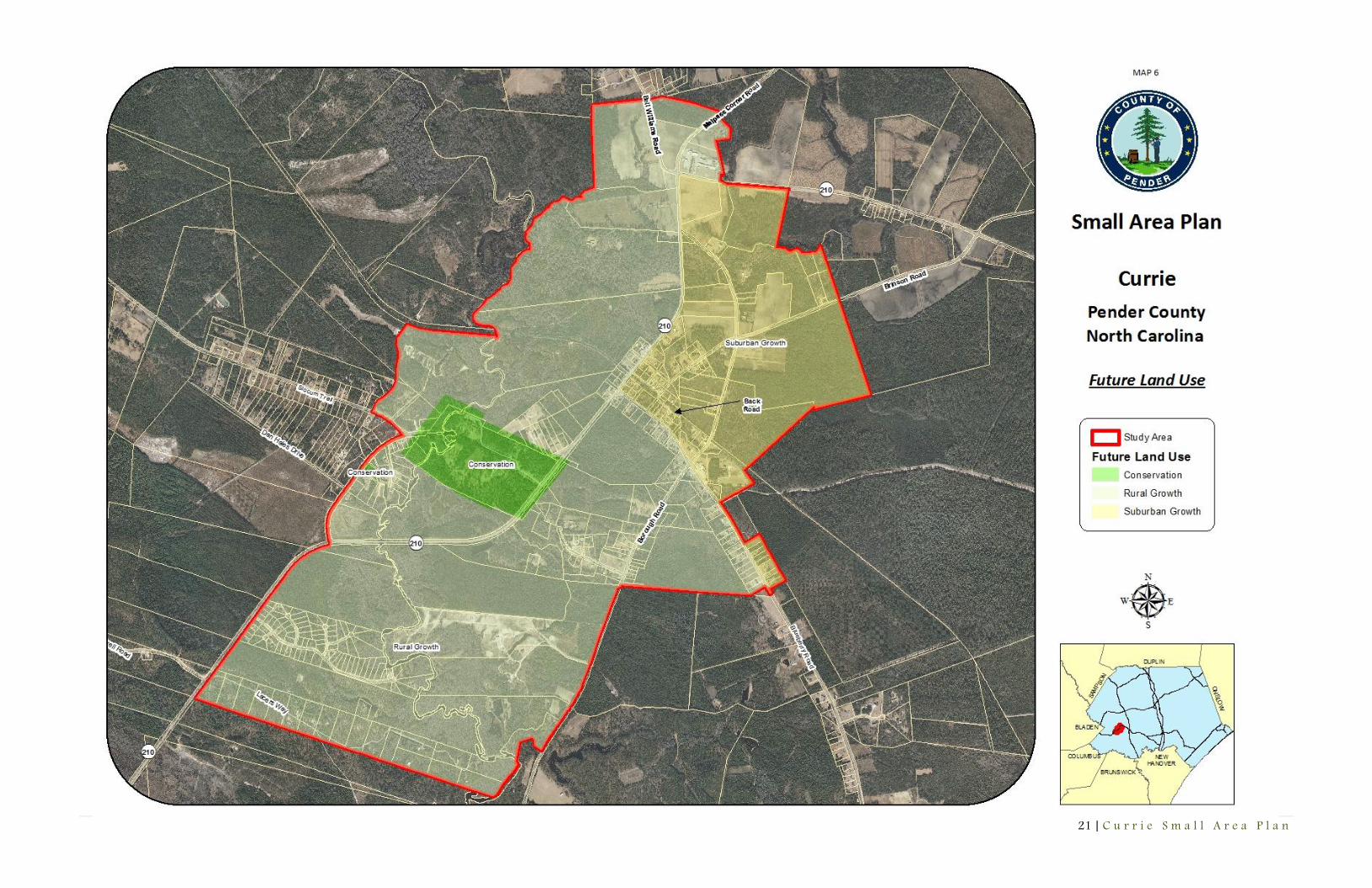
Future Land Use
The future land use map is an integral part of the small area plan. The future land use map is to be utilized as a guide for future development and growth. The map shall be used in conjunction with the plan’s policies and goals in determining future land use decisions. Based on public input and recommendations, the future land use map for the Currie study area is based on the adopted 2010 Comprehensive Land Use Plan (CLUP). The proposed land uses proposed for the Currie study area, referenced in the CLUP, are reflective of the community’s development needs and land use goals. The land use classifications, established in the CLUP, provided on the future land use map, are detailed below. Conservation Conservation areas are areas that are owned in fee simple or have protective easements. These areas represent areas of special significance and unique characteristics that make them worthy of preservation. Current conservation areas are typically owned by Federal or State agencies or private conservation groups and are often designated as Areas of Environmental Concern (AECs). Currently, conservation areas comprise approximately 131,393 acres (24.7%) of the land area within the Pender County zoning jurisdiction. Rural Growth The Rural Growth land use classification defines those areas of Pender County where urban services, i.e., public water and sewer services, are not expected to be extended within the planning horizon. Rural Growth areas are where preservation of agricultural operations is a primary concern and where conflicts between agricultural and non-agricultural uses are to be discouraged. Suburban Growth The Suburban Growth land use classification identifies those areas of Pender County where significant residential growth is expected
to occur within the planning horizon. Areas designated as Suburban Growth are located primarily adjacent to municipal planning jurisdictions and within or near high growth, unincorporated areas of the County, i.e., Hampstead/Scotts Hill, Rocky Point, and portions of US 421 South. Suburban Growth designates areas where public water and public sewer are available or are planned in the near future. Mixed Use The Mixed Use land use classification designates locations where a mixture of higher density/intensity uses is to be encouraged. Mixed Use areas should be characterized by physically and aesthetically unified developments containing a mixture of commercial, office, institutional, and high- and medium-density residential uses, arranged in a walkable, compact, pedestrian and transit friendly manner Office, Institutional, and Commercial Office/Institutional/Commercial (OIC) areas are designated at key locations, typically along major highways and at major intersections, within the County. The purpose of the OIC land use classification is to encourage more efficient and attractive development, integration of commercial uses with other land uses, and to discourage unsightly and inefficient strip commercial development. Strip commercial development (characterized by non-related business development with numerous road-cuts and no interconnectivity) detracts from community appearance and has significant negative impacts on both road capacity and traffic safety. Industrial Economic development is essential to the sustainability of the future economy of Pender County. It is important to designate and encourage business and industrial development within the County to create and maintain jobs for the future.
21 | C u r r i e S m a l l A r e a P l a n
22 | C u r r i e S m a l l A r e a P l a n
References 1. Carriker. "RS&N History." Train Web. Web. 22 Mar. 2012. <http://www.trainweb.org/>.
2. Corbet, Dora. "Looking Back at Currie's Agrarian History." The Pender Post [Burgaw] 25 July 2007. Print. 3+.
3. Daniel, Clifton. "Town Time Forgot." Starnews [Wilmington] 15 May 1994: Print. 1+.
4. Reaves, Bill. Pender County News Clippings from 19th and 20th Century Newspapers. Vol. IV. Print. Canetuck to Northeast Cape Fear River.
5. Rosenwald Database. Fisk University. Web. 30 Mar. 2012. <http://rosenwald.fisk.edu>.

23 | C u r r i e S m a l l A r e a P l a n
Appendix A – Maps of the Currie Study Area

24 | C u r r i e S m a l l A r e a P l a n

25 | C u r r i e S m a l l A r e a P l a n

26 | C u r r i e S m a l l A r e a P l a n

27 | C u r r i e S m a l l A r e a P l a n
28 | C u r r i e S m a l l A r e a P l a n

29 | C u r r i e S m a l l A r e a P l a n

30 | C u r r i e S m a l l A r e a P l a n

31 | C u r r i e S m a l l A r e a P l a n
Appendix B – Community Outreach

32 | C u r r i e S m a l l A r e a P l a n
Community Outreach Meetings Public Meeting #1 – January 28, 2012 Where should the county focus its planning efforts on in the future?
Recreation Jobs Education Health Accessibility for walkers, bicyclists, and boaters (canoe and kayak) Clean up roadways and waterways Slow down traffic Traffic calming on NC Highway 210 and Bell Williams Road
What factors or attributes of other communities would you like to see in Currie?
Upscale grocery store Internet services Recreational facilities (water access and Biking, walking, hiking, and horse trails) Clean up properties Litter free Dress up intersections Fire department annex Community bulletin board at Post Office No big box Drainage Improved public services
What do you hope to see or envision for Currie in 15 years?
Shopping center Recreational center and facilities
Biking, walking, hiking, and horse trails Basketball and tennis courts, baseball and soccer fields Swimming pool
Educational facility Health center Water and sewer systems

33 | C u r r i e S m a l l A r e a P l a n
Internet service Fire department annex
List the reasons why you like to live in Currie:
Country living at its best Rural setting Moores Creek National Battlefield Stars at night, no streetlights Low taxes Community support Live with nature
List some things you would like to change about Currie?
Park improvement Appearance of properties Pave remainder of Borough Road Better internet options Pave remainder of Point Caswell Road Wide Blueberry Road Traffic control (NC Highway 210 and Bell Williams Road)
What do you consider the Currie area to be geographically and why?
NC Highway 53 to southern county line Public Meeting #2 – August 11, 2012 The second community outreach meeting hosted by Planning staff and Moores Creek National Battlefield provided an opportunity for residents to review the vision, goals, and proposed future land use map for the plan. This event also presented the opportunity for participants to review the entire plan and provide comments and feedback to staff. Planning staff and Steering Committee member Cleveland Simpson presented a thirty minute detailed summary of the plan’s objective and goals. Members of the community discussed the need and importance of creating an implementation plan and working as a community to successfully implement the plan throughout Currie. Following the presentation, residents stated support for the goals and development of the plan.
34 | C u r r i e S m a l l A r e a P l a n
Steering Committee Meetings Steering Committee Meeting 1 February 29, 2012 – 3:00 p.m. Pender County Board of County Commissioners Public Meeting Room Committee Members: Tyrone Brandbury, Superintendent of Moores Creek National Battlefield George Brown, Board of County Commissioners Chairman Brian Martin, Citizen
Cleveland Simpson, Currie Community Action Group President Eddie Simpson, Citizen Horace Thompson, Board of Adjustment Member Hiram Williams, Planning Board Member
Planning Staff: Kyle Breuer, Planning Director Ken Vafier, Senior Planner
Ashley Frank, Planner II Ashley Moncado, Planner I
K. Vafier began the meeting at 3:09 and welcomed the committee members. K. Breuer followed with staff introductions and asked each of the members to introduce themselves. K. Vafier proceeded with reviewing the role of the Steering Committee and responsibilities of the members in providing outreach to the community and playing an advisory role to the Planning Board and staff. Committee discussed the purpose of a spokesperson and decided not to elect one at this time. Members also agreed on consensus voting. K. Vafier asked the group when they would prefer to meet in the future and informed them the scope of work for the plan included five meetings over the next seven months. Committee members decided on meeting 6 pm to 8 pm. The group also decided on conducting meetings at Moores Creek National Battlefield in the future. H. Thompson asked staff what the goal and purpose of the plan will be. K. Vafier detailed the purpose of the plan and how it will be used in the future. H. Thompson stated his interest in the creation of a separate zoning ordinance for the Currie area. K. Breuer responded that revising current zoning requirements can be a goal of the plan. At this time, K. Vafier presented the Small Area Plan presentation to the committee. H. Thompson asked staff how this plan will assist in providing funding to Currie in the future. K. Breuer responded that the creation of a plan for the area will help the area qualify for more grant opportunities. At this time the committee members discussed previous and current efforts to develop recreational facilities in the area. Staff presented the proposed study area for the plan. G. Brown suggested basing the study area on the Currie zip code. B. Martin informed the committee of the size and location of the zip code. A. Frank provided a map referencing the zip code. Committee members discussed the need of including Moores Landing in the study area. Staff stated they will provide a study area map at the next meeting including the Moores Landing and Patriots Watch area.

35 | C u r r i e S m a l l A r e a P l a n
Staff encouraged the committee to review the first set of survey results. N. Keith requested information regarding surveys for a March 9 meeting at the Battlefield. C. Simpson recommended sending out survey information to the local churches. Staff stated they will send informational packets out as requested. Next staff reviewed vision statement examples with the Committee. N. Keith stated that she favored the second example. H. Williams noted the importance of including services in the vision statement. B. Martin stated the need to include green space and churches. C. Simpson discussed why he favored the third example stating existing conditions of Currie and providing a vision for the future. N. Keith stated the importance of providing a clean, attractive, safe, and accessible community in the vision statement. K. Vafier responded that staff will draft a vision statement for the committee’s review at the next meeting. K. Vafier reviewed what the next steering committee meeting will include. H. Williams requested a map of the Currie area for the members. The meeting was adjourned at 4:50 pm.
36 | C u r r i e S m a l l A r e a P l a n
Steering Committee Meeting 2 April 12, 2012 – 6:00 p.m. Patriot’s Hall - Moores Creek National Battlefield Committee Members: Tyrone Brandbury, Superintendent of Moores Creek National Battlefield Brian Martin, Citizen Janice Mowery, Citizen
Kent Mowery, Citizen Eddie Simpson, Citizen Horace Thompson, Board of Adjustment Member Hiram Williams, Planning Board Member
Planning Staff: Kyle Breuer, Planning Director Ken Vafier, Senior Planner Ashley Moncado, Planner I Pender County Utilities Staff: Michael Mack, Director K. Vafier began the meeting at 6:05 pm and welcomed the committee members. Due to the large number of attendees and new committee members, he requested everyone to introduce themselves. K. Vafier proceeded with the agenda and presented the revised study area to the committee. He informed the committee why the Moores Landing development was not included in the study area. N. Keith asked if property located outside of the study area will still have the potential to be effected by the plan. K. Vafier responded yes. J. Mowery stated concern without including Blueberry Road and US Highway 421 in the study area, but noted her understanding with keeping the study area small. The committee stated their support for the proposed study area. A. Moncado reviewed the survey results with the committee. She informed the group of the common trends within the survey and information gathered from the respondents. Next, K. Vafier presented the proposed vision statement and read it out loud for the attendees to hear. The committee discussed how the vision statement was inclusive and stated support for proceeding with it. K. Vafier introduced the existing conditions to the committee and asked for any comments or feedback from the committee. K. Breuer thanked H. Thompson for providing a historical map of Currie to staff. The committee members then discussed the history of Currie and historical landmarks throughout the community. K. Vafier proceeded with the next item on the agenda and introduced Michael Mack, Director of Pender County Utilities, to discuss existing and future services in the study area. M. Mack informed the committee of the current status of services provided in Currie and throughout the County. He informed the committee about the new water treatment plant located on US Highway 421 and the Moores Creek water district. He

37 | C u r r i e S m a l l A r e a P l a n
proceeded with explaining the sign up campaign process for future water lines in the study area. J. Mowery asked if those located outside of the circles provided on the handouts would ever have the opportunity to receive public water. M. Mack responded that greater density is imperative and those outside of those areas would be more difficult to reach. K. Vafier asked the committee if they supported the idea of creating policies that would support public water. N. Keith stated opposition to including a policy supporting public water connection since high quality water is available in the area. J. Mowery stated interest in creating policies that would support public water line along US Highway 421. E. Simpson informed the group of the environmental concerns with the existing water supply in the area. He continued that the water table has been decreasing over time. M. Mack agreed and discussed other environmental concerns with the decreasing levels of ground water in the area. B. Martin asked if the new water lines would help with providing hydrants to the area. M. Mack responded that the new water lines would allow for hydrants every 200 feet. K. Vafier asked what other services the committee believed policies should be crafted for. The committee discussed the need for policies supporting the need for internet service in the area. K. Vafier followed up with asking the committee their thoughts about fire and police service. J. Mowery noted concern regarding a lack of police presence in the area and safety concerns. A. Moncado noted those concerns would be discussed at the next meeting with transportation. The committee noted the need to create policies supporting a local fire department in the area. The committee proceeded with discussing existing land uses in the area. K. Vafier asked the committee what future development types they would like to see in the study area. Attendees stated their support for a grocery store, bank, gas station, drug store, and restaurant within a 5 to 6 mile drive of the study area. They noted that they preferred to allow the study area to remain as a rural community, but supported development to occur outside of the study area away from the core. The committee stated support with providing mixed housing including apartments and townhomes within the study area. K. Vafier continued with the last item on the agenda and asked the committee and attendees their thoughts and ideas with promoting community pride and preserving community heritage in the area. Residents noted the need for a community center and local historical society. B. Martin stated the need to promote tourism and the community within the region. K. Vafier asked if the committee supported a partnership with the county and local community groups. The committee supported the idea. N. Keith stated the need to preserve the local waterways. K. Vafier reviewed the topics of discussion for the next meeting with the committee and asked if there were any additional questions or concerns. The meeting was adjourned at 7:40 pm.

38 | C u r r i e S m a l l A r e a P l a n
Steering Committee Meeting 3 May 17, 2012 – 6:00 p.m. Patriot’s Hall - Moores Creek National Battlefield Committee Members: George Brown, Pender County Commissioner Chairman Susan Bullers, Parks and Recreation Advisory Board member Brian Martin, Citizen
Cleveland Simpson, Greater Community Action Group President Eddie Simpson, Citizen
Planning Staff: Ken Vafier, Senior Planner Dee Turner, Parks and Recreation
Ashley Frank, Planner II Benjamin Andrea, Planner II
Ashley Moncado, Planner I
K. Vafier began the meeting at 6:10 pm and welcomed the committee members. He asked the committee if there were any items they would like to discuss regarding the history section. The committee provided comments and noted historical landmarks within the study area. K. Vafier introduced the draft goals to the committee and requested comments regarding Utilities and Services Goal #5. C. Simpson noted issues with the community receiving septic permits. The committee members decided on keeping the goal within the plan. K. Vafier welcomed D. Turner to the committee. D. Turner reviewed the existing programs and facilities that serve the study area. C. Simpson reviewed the Greater Community Action Group’s goals to serve the community’s recreational needs. Committee supported the need for a variety of recreational facilities including bike and pedestrian trails, basketball and tennis courts, and water access B. Andrea reviewed the excerpts from the Pender County Comprehensive Parks and Recreation Master Plan. The committee discussed existing and future projects within the area. Next, K. Vafier reviewed the Comprehensive Transportation Plan (CTP) with the committee. He discussed current conditions and noted future goals of the CTP within the study area. The committee discussed transportation, safety, and access issues. The committee recommended and supported the need for an off road multiuse path along Blueberry Road and NC Highway 210. K. Vafier asked the committee is there were any other goals or items they would like to review or discuss. C. Simpson noted the need for a goal addressing internet service. K. Vafier reviewed the Utilities and Services Goal # 4 with the committee. K. Vafier informed the committee of the next meeting’s tasks and reviewed the plan’s schedule with the group leading up to a final adoption of the plan in November. The meeting was adjourned at 7:45 pm.

39 | C u r r i e S m a l l A r e a P l a n
Steering Committee Meeting 4
July 12, 2012 – 6:00 p.m. Moores Creek Missionary Baptist Church Committee Members: Janice Mowery, Citizen Kent Mowery, Citizen Cleveland Simpson, Greater Community Action Group President
Eddie Simpson, Citizen Hiram Williams, Planning Board Member
Planning Staff: Kyle Breuer, Planning Director Ashley Moncado, Planner I K. Breuer began the meeting at 6:00 pm, and welcomed the committee members. K. Breuer reviewed the introduction and vision statement with the committee. Members stated their support for the vision statement. The steering committee reviewed the transportation goals. K. Breuer recommended adding a goal focusing on road widening which would be in alignment with the Comprehensive Transportation Plan. K. Breuer reviewed the parks and recreation goals. The committee discussed the need to include a goal that encompasses a diversity of recreational uses to a variety of users in the Currie area. H. Williams noted the importance of including a variety of uses for grant opportunities. C. Simpson noted the need to include a goal supporting water access along Moores Creek and the Black River. The steering committee reviewed the future land uses proposed for the study area. Following a brief discussion, the committee stated support for the classifications. C. Simpson stated the importance of developing an implementation plan to be utilized in the future. Staff agreed and noted that an implementation plan would be created following the adoption of the Small Area Plan. Committee discussed possible dates and times for the community outreach meeting. K. Breuer stated that staff would discuss the proposed dates and follow up with the committee members. The meeting was adjourned at 7:00 pm.
40 | C u r r i e S m a l l A r e a P l a n
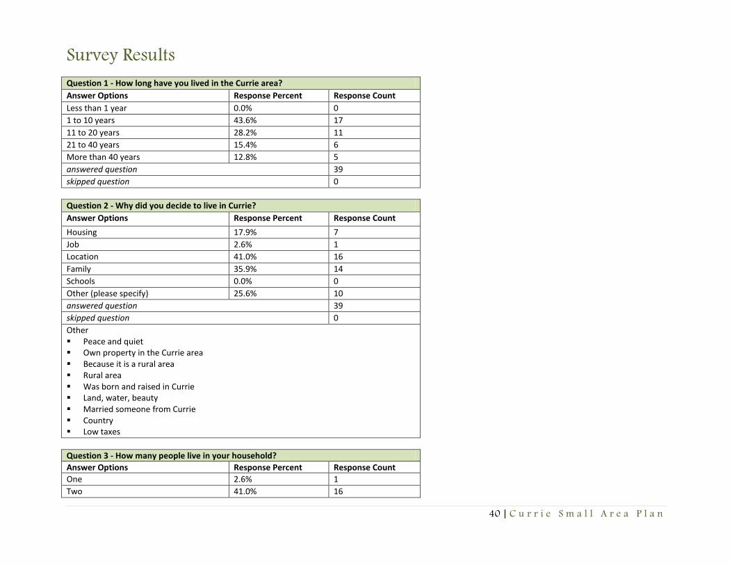
Survey Results
Question 1 - How long have you lived in the Currie area?
Answer Options Response Percent Response Count
Less than 1 year 0.0% 0
1 to 10 years 43.6% 17
11 to 20 years 28.2% 11
21 to 40 years 15.4% 6
More than 40 years 12.8% 5
answered question 39
skipped question 0
Question 2 - Why did you decide to live in Currie?
Answer Options Response Percent Response Count
Housing 17.9% 7
Job 2.6% 1
Location 41.0% 16
Family 35.9% 14
Schools 0.0% 0
Other (please specify) 25.6% 10
answered question 39
skipped question 0
Other Peace and quiet Own property in the Currie area Because it is a rural area Rural area Was born and raised in Currie Land, water, beauty Married someone from Currie Country Low taxes
Question 3 - How many people live in your household?
Answer Options Response Percent Response Count
One 2.6% 1
Two 41.0% 16

41 | C u r r i e S m a l l A r e a P l a n
Three 23.1% 9
Four 20.5% 8
Five 12.8% 5
Six 0.0% 0
Seven 0.0% 0
Eight or more 0.0% 0
answered question 39
skipped question 0
Question 4 - How many school aged children live in your household?
Answer Options Response Percent Response Count
None 57.9% 22
One 15.8% 6
Two 26.3% 10
Three 0.0% 0
Four 0.0% 0
Five 0.0% 0
Six or more 0.0% 0
answered question 38
skipped question 1
Question 5 - What is your primary occupation?
Answer Options Response Percent Response Count
Agricultural 0.0% 0
Management 2.6% 1
Education 7.9% 3
Retail sales 0.0% 0
Manufacturing 0.0% 0
Construction 5.3% 2
Personal services (barber, waitress) 0.0% 0
Clerical 7.9% 3
Real estate 0.0% 0
Finance insurance 0.0% 0
Medical health care 10.5% 4
Government 18.4% 7
Retired 21.1% 8
Unemployed 0.0% 0

42 | C u r r i e S m a l l A r e a P l a n
Other (please specify) 26.3% 10
answered question 38
skipped question 1
Other Certified nurse assistant Management consultants Industrial Industrial Industrial Self-employed travel/hospitality industry Social Worker Marketing and Public Relations Clerical
Question 6 - What is the highest level of education you have completed?
Answer Options Response Percent Response Count
Less than high school 2.6% 1
High school or GED 35.9% 14
Associate Degree (2 years) 28.2% 11
Bachelor’s Degree (4 years) 17.9% 7
Master’s Degree 10.3% 4
Professional Degree 5.1% 2
answered question 39
skipped question 0
Question 7 - Please indicate how far you travel for work:
Answer Options Response Percent Response Count
In Currie or within two miles of my residence
16.7% 5
Within 2-10 miles of my residence 16.7% 5
Within 11-25 miles of my residence 40.0% 12
Greater than 25 miles of my residence 26.7% 8
answered question 30
skipped question 9
Question 8 - Please indicate how far you travel for goods and services:
Answer Options Response Percent Response Count
In Currie or within two miles of my 0.0% 0
43 | C u r r i e S m a l l A r e a P l a n
residence
Within 2-10 miles of my residence 5.3% 2
Within 11-25 miles of my residence 65.8% 25
Greater than 25 miles of my residence 28.9% 11
answered question 38
skipped question 1
Question 9 - How would you rate the following?
Answer Options Very satisfied Satisfied Neither Dissatisfied Very dissatisfied Response Count
Quality of streets and roads 1 15 5 14 1 36
Availability of bike and pedestrian trails 3 5 4 12 12 36
Water system quality and service 5 12 7 5 5 34
Septic system quality and service 4 14 6 4 6 34
Availability of parks and open space 5 9 3 10 9 36
Availability of recreational programs 2 5 3 15 10 35
Community Appearance 2 11 9 7 7 36
Local Government interest 2 4 11 7 9 33
Affordability of housing 2 16 7 5 2 32
Availability of affordable housing 2 12 12 4 3 33
Community interest and involvement 1 12 5 12 3 33
Appearance and condition of residential property 1 19 3 5 5 33
Appearance and condition of commercial property 1 15 10 2 4 32
Number of Businesses 1 7 4 12 9 33
Fire Department service 1 13 5 4 11 34
Sheriff Department service 1 16 7 5 5 34
Emergency Management Services (EMS) 1 16 12 3 2 34
Availability of child care 1 9 13 6 5 34
Availability of elderly care 1 6 13 8 6 34
answered question 37
skipped question 2
Question 10 - What type of development would improve Currie?
Answer Options Response Percent Response Count
Residential 31.4% 11
Commercial 48.6% 17
Industrial 28.6% 10
Other (please specify) 40.0% 14

44 | C u r r i e S m a l l A r e a P l a n
answered question 35
skipped question 4
Other Educational and vocational training site None None A grocery store, even a convenience store that sells gasoline None of the above would change the Currie community; it would be great to have its own fire department. Geographically the Currie area would not
support that type of development. Currie is just a home town community with local family history that does not seem to desire any growth at this time. New housing is more or less local family members moving in the same community on family heir’s property.
None We need a strong mix of residential and commercial - especially retail services Area Fire Department – Cost to homeowners too high, out of district More recreational and green space... bike paths, internet services for all! Septic system Recreational parks, community center, department store, and grocery store Better water system Bike/hiking trails Parks, bike trails, recreational
Question 11 - What type of job opportunities and businesses would you like to see in Currie?
Answer Options Response Percent Response Count
General retail 69.4% 25
Auto repair 19.4% 7
Hardware store 44.4% 16
Specialty retail 19.4% 7
Medical health 33.3% 12
Bar - tavern 8.3% 3
Finance – banks 30.6% 11
Beauty – barber shop 33.3% 12
General industry 13.9% 5
Light industry 33.3% 12
Car sales 5.6% 2
Pharmacy 38.9% 14
Restaurant 66.7% 24
Other (please specify) 38.9% 14
answered question 36
skipped question 3

45 | C u r r i e S m a l l A r e a P l a n
Other None Need jobs closer to home Coffee shop, farmers market, gas station None Grocery store None of the above would ever be successful in the Currie community. Take a look at Atkinson area; the few restaurants that operated 20+ years ago are
closed. No one has had a desire to reopen. The only business that has been around for the past 40 years is the ABC store, even if that still exist. There was one barber shop that did not make it as well. It’s pretty obvious that this small community cannot support any small business, which pretty much sums it all up to this point in time.
Agricultural Grocery store Need area Fire Department. Out of surrounding districts. Maybe an annex of local fire department (long Creek Grady or Atkinson). Some effort on the fire
department to expand would be helpful and save on insurance premiums for home owners. Jobs Grocery Gas station Grocery store, farmers market Assisted living facility
Question 12 - How beneficial are the following to the Currie community?
Answer Options Highly beneficial Somewhat beneficial Not at all beneficial Response Count
Job opportunities 18 9 8 35
New businesses and industries 17 11 6 34
New affordable housing 13 12 9 34
Preserving wooded areas and open space 30 4 2 36
Develop pedestrian and bike trails 22 7 7 36
Develop or expand parks and recreation 23 9 4 36
Consider visual and environmental factors with building design 23 6 6 35
answered question 37
skipped question 2
Question 13: What type of businesses would you not want to see in Currie?
Bars Bars Bars, any adult based businesses Bars, car lots Big industry, factories None

46 | C u r r i e S m a l l A r e a P l a n
Bars Can we do a better job attracting tourism to our National Park here in Currie? Bars-Tavern Currie does not have the population density to support any small business in this economy. Johnson Grocery and Grill has served the communities of
Currie and the surrounding areas. Since I-40 construction, there are numerous of small business along 421 in Pender County and Sampson County. Industrial Heavy industrial. We have enough logging trucks on our small road as it is - no room for more! Any kind of factory that would create a lot of noise or pollution, a hog or poultry farm that would create a lot of odor and damage to the river water due to
run off. Low end Tavern Bars/clubs Big businesses Industry Clubs
Question 14 - Should the County provide additional resources to attract more businesses to the Currie area?
Answer Options Response Percent Response Count
Yes 66.7% 24
No 22.2% 8
No opinion 11.1% 4
answered question 36
skipped question 3
Question 15: What should the County focus its resources on in the future in the Currie area?
Housing and parks Entertainment for children, a shopping center (Food Lion, Dollar General) Bringing retail to the 421 corridor, cleaning up or making the residents of some of the junky yards clean up. Jobs, business, industrial Jobs, better roads, bike paths, internet access Nothing Public access to the Black River, parks and recreation, some resemblance of local, accessible government Police, so they can check speeders on Blueberry Road It’s my opinion that the county should only provide more park and recreation opportunities for the community. That would/could be an opportunity to
bring seasonal business in the area. Business associated with outdoor activity. Possible softball fields soccer fields, basketball courts, and if possible a public swimming pool for all the surrounding communities. At such time this may be known as a regional park that may serve surrounding communities.
Leave it alone Paving of all roads, cleaning up abandoned or unsightly homes, businesses.

47 | C u r r i e S m a l l A r e a P l a n
Help to get a local fire department. Present one we are out of district. We pay fire and rescue taxes too. Why not annex existing fire department? Internet services and a volunteer fire department Sewer A recreation center Internet services, gas station, water There is already a beautiful state park (Moore's Creek National Battlefield), it would be nice to see it built up and perhaps a nice playground put in. Also,
there are beautiful wooded areas, a bike trail and/or walking trail. The Black River runs through Currie - perhaps a few public boat ramps would attract visitors and also be more accessible to current residents.
Recreational parks, Annex library Quality residential, park space for hiking, picnics, and family outings Safety, cleaning up the appearances of homes, water and sewer, safe walking areas, crime Bike/hiking trails Recreational facilities, venue for community events Small businesses, green space Recreational, preservation Internet service Parks and recreation Clean up properties Jobs High speed internet access Community College site Assisted living facility or senior services Trash collection Historical preservation Public Library branch Recreation areas, bike trails, and pedestrian trails More government interest
Question 16 - Do you own or rent?
Answer Options Response Percent Response Count
Own 100.0% 37
Rent 0.0% 0
answered question 37
skipped question 2
Question 17 - Indicate how you feel about the purchase price of housing in the Currie area.
Answer Options Response Percent Response Count
Generally, very good 26.5% 9

48 | C u r r i e S m a l l A r e a P l a n
Overall, about average 32.4% 11
Poor 5.9% 2
No opinion 35.3% 12
answered question 34
skipped question 5
Question 18 - How satisfied are you with the quality of housing choices in the Currie area?
Answer Options Excellent Adequate Average Fair Inadequate Response Count
Quality of affordable housing 2 10 5 6 6 29
Availability of affordable housing 0 10 5 5 7 27
Quality of affordable rental housing 0 5 5 8 9 27
Availability of affordable rental housing 0 4 5 11 7 27
answered question 29
skipped question 10
Question 19 - Please indicate what type of housing is most needed in Currie?
Answer Options Response Percent Response Count
Rental units 21.2% 7
Public housing 9.1% 3
Manufactured housing 9.1% 3
Stick built – single family housing 57.6% 19
Affordable housing 54.5% 18
Higher income housing 27.3% 9
Other (please specify) 12.1% 4
answered question 33
skipped question 6
Other None None None Housing developments Stick house
Question 20: What factors of attributes make Currie a great place to live?
The people Quiet family living Forest, clear night skies, fresh air, few residents

49 | C u r r i e S m a l l A r e a P l a n
It is very rural and naturally beautiful; the Battlefield is a great asset. It’s close to Wilmington and beaches Moores Creek Battlefield Quiet country living Great outdoors Moores Creek Battlefield Natural beauty, good climate, good people No night club or bars There are really no attributes to living in Currie. If you survey the area you would be surprise that most of the resident of that community are local people.
The only new development is on Blueberry Road, and Patriots Watch. Patriots Watch is a community that is priced out of range for the local people. Those properties are primary being purchase by clients from New Hanover County. They are able to afford this property. They loved the area because it isolated, with no close neighbor. The lots are 3 acres or more in size, and have boat access.
Rural Close enough to Wilmington or Burgaw to generally be convenient - you feel like you live in the country, but you're not too far from the city. Quiet, friendly people Wide open space, farmland, nice people Quiet, peaceful Great school systems, Moore's Creek Battleground, river fishing Currie is in the county, people like the county life style, just needs a few stores. The battlefield, the river, the wooded areas. Quietness Quiet, open spaces, proximity to downtown Wilmington Country Life Moores Creek, quiet, peaceful, stars at night, limited traffic, rural area where farm animals are allowed Country Small town Open space, natural environment Rural area Low taxes Family Natural resources such as the beach and rivers Sense of community Affordable living
Question 21 - Is the Currie area growing too fast, too slow, or at the right pace?
Answer Options Response Percent Response Count
Too fast 2.8% 1
Too slow 52.8% 19
Right pace 44.4% 16
answered question 36

50 | C u r r i e S m a l l A r e a P l a n
skipped question 3
Question 22 - Do you feel there is a strong sense of pride in the Currie community?
Answer Options Response Percent Response Count
Yes 62.2% 23
No 24.3% 9
No opinion 13.5% 5
answered question 37
skipped question 2
Question 23 - How satisfied are you with Currie as a place to live?
Answer Options Response Percent Response Count
Very satisfied 41.7% 15
Satisfied 50.0% 18
Neither 5.6% 2
Dissatisfied 2.8% 1
Very dissatisfied 0.0% 0
answered question 36
skipped question 3
Question 24: What is your future vision of Currie?
More housing, jobs, businesses None I would love to see Currie grow with businesses and shopping centers Rural, quiet with no large residential or commercial areas, I can travel to nearby towns for goods and services. Small rural community with a few amenities so we will not have to drive to Burgaw, Rocky Point for groceries Lack of patrolling of Sheriff is leading Currie to drug heaven Small self-sufficient community Stay the same An area that grows, like Rocky Point I feel that The Currie community is fine just as it is. If any improvements are going to change the tax base, for the good of the community that’s great.
However, small communities do not have good tract records that indicate the tax payers are happy with more taxes, and less services. Rural To have all privatized roads paved, negligent homes and businesses cleaned or removed, and new parks and bike/walking paths created for the safety and
health of our residents. More involvement in community benefits to community, no fire department, all around no coverage for the southeast corner 421 area Protection of open space, farmland more recreational opportunities (ballpark, bike paths), internet services for all!!! volunteer fire department More businesses and a nice community center

51 | C u r r i e S m a l l A r e a P l a n
Have a park, library, food store, internet services for the area. A grocery store, hardware store, or retail store CLOSER to the area would be nice. Some of the main roadways need repaved and/or widened. Built up with stores, restaurants, nice community center, and jobs like the other communities in Pender County. Nice housing developments, water and sewer, safe and clean environment Continue as quiet residential area, but with basic services such as post office, gas station, convenience store. Moores Creek Battlefield will continue to
draw day visitors and addition of bike/hiking trails would enhance that Community efforts and facility Outdoor recreation center The streets need to be cleaned up and small business More interactive through trails and bike access. A destination for outdoor types. Clean byways (streets and water) Slow about making progress Small town atmosphere Small incorporated town More businesses and housing High quality of life
Question 25 - In the time that you have lived in Currie, has the area become
Answer Options Response Percent Response Count
More desirable 14.3% 5
Less desirable 11.4% 4
No change 65.7% 23
No opinion 8.6% 3
answered question 35
skipped question 4
Question 26: What do you hope to see or envision for Currie in 15 years?
More housing, Wal-Mart, Dollar General Widen Blueberry Road for safety Growth! Stay the same I would like it to remain quiet and rural, but would like to see grocery, restaurant, something to improve local economy - 421 is a fabulous place for this
Slum city I would like to see more local jobs. but not a large influx of new homes Nothing A stop light in town... more development along Blueberry Road... complete development of Patriot's Watch subdivision... without destroying the
environment To leave it as it is for now!!!!!!!!!!!!!!!!!!!!!!!!!!!!!!!!!!! Nothing
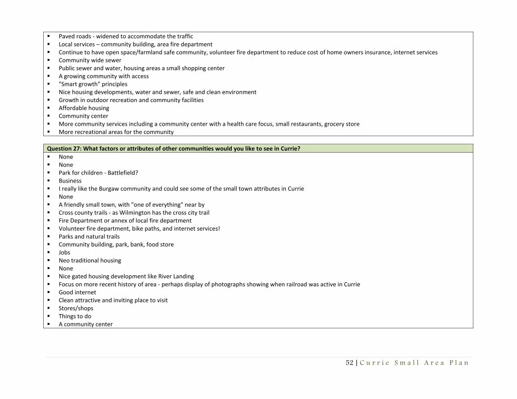
52 | C u r r i e S m a l l A r e a P l a n
Paved roads - widened to accommodate the traffic Local services – community building, area fire department Continue to have open space/farmland safe community, volunteer fire department to reduce cost of home owners insurance, internet services Community wide sewer Public sewer and water, housing areas a small shopping center A growing community with access "Smart growth" principles Nice housing developments, water and sewer, safe and clean environment Growth in outdoor recreation and community facilities Affordable housing Community center More community services including a community center with a health care focus, small restaurants, grocery store More recreational areas for the community
Question 27: What factors or attributes of other communities would you like to see in Currie?
None None Park for children - Battlefield? Business I really like the Burgaw community and could see some of the small town attributes in Currie None A friendly small town, with "one of everything" near by Cross county trails - as Wilmington has the cross city trail Fire Department or annex of local fire department Volunteer fire department, bike paths, and internet services! Parks and natural trails Community building, park, bank, food store Jobs Neo traditional housing None Nice gated housing development like River Landing Focus on more recent history of area - perhaps display of photographs showing when railroad was active in Currie Good internet Clean attractive and inviting place to visit Stores/shops Things to do A community center

53 | C u r r i e S m a l l A r e a P l a n
Question 28: List two reasons why you like to live in Currie?
Peaceful and the people Country living Good schools and very good neighbors Rural, quiet, no large business or housing developments Quiet Park and no home owners association Peace and quiet, very little traffic and stress It is Quiet and no one bothers you Peace and quiet Friendly people Quite and nice people Rural, low population Quiet, no noisy 24 hour industry Mostly convenient to larger cities, but without the taxes and other aggravations Quiet, can enjoy nature, and friendly people Quiet community and green/open space Quiet and easy living, open country farm land, and great family living. Born in Currie Like the county life Nice community Quietness Nature Open spaces Country Life Family Quiet, rural, limited traffic Country Peaceful, no street lights Nature Quiet Born here and like to live here Rural - country living Easy commute to work Close to the beach Affordable housing Family and the area
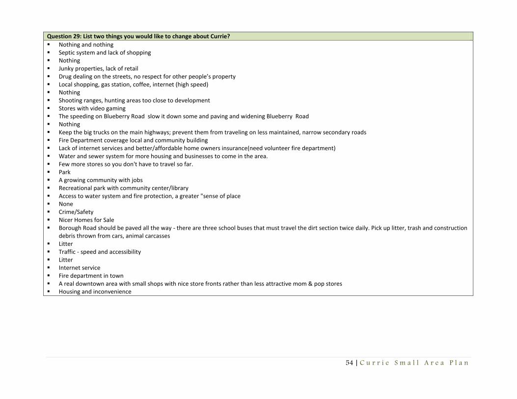
54 | C u r r i e S m a l l A r e a P l a n
Question 29: List two things you would like to change about Currie?
Nothing and nothing Septic system and lack of shopping Nothing Junky properties, lack of retail Drug dealing on the streets, no respect for other people’s property Local shopping, gas station, coffee, internet (high speed) Nothing Shooting ranges, hunting areas too close to development Stores with video gaming The speeding on Blueberry Road slow it down some and paving and widening Blueberry Road Nothing Keep the big trucks on the main highways; prevent them from traveling on less maintained, narrow secondary roads Fire Department coverage local and community building Lack of internet services and better/affordable home owners insurance(need volunteer fire department) Water and sewer system for more housing and businesses to come in the area. Few more stores so you don't have to travel so far. Park A growing community with jobs Recreational park with community center/library Access to water system and fire protection, a greater "sense of place None Crime/Safety Nicer Homes for Sale Borough Road should be paved all the way - there are three school buses that must travel the dirt section twice daily. Pick up litter, trash and construction
debris thrown from cars, animal carcasses Litter Traffic - speed and accessibility Litter Internet service Fire department in town A real downtown area with small shops with nice store fronts rather than less attractive mom & pop stores Housing and inconvenience
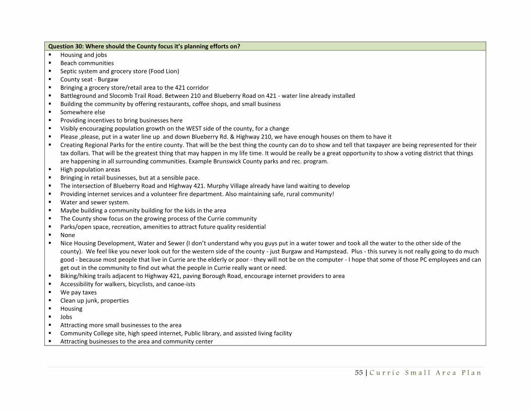
55 | C u r r i e S m a l l A r e a P l a n
Question 30: Where should the County focus it’s planning efforts on?
Housing and jobs Beach communities Septic system and grocery store (Food Lion) County seat - Burgaw Bringing a grocery store/retail area to the 421 corridor Battleground and Slocomb Trail Road. Between 210 and Blueberry Road on 421 - water line already installed Building the community by offering restaurants, coffee shops, and small business Somewhere else Providing incentives to bring businesses here Visibly encouraging population growth on the WEST side of the county, for a change Please ,please, put in a water line up and down Blueberry Rd. & Highway 210, we have enough houses on them to have it Creating Regional Parks for the entire county. That will be the best thing the county can do to show and tell that taxpayer are being represented for their
tax dollars. That will be the greatest thing that may happen in my life time. It would be really be a great opportunity to show a voting district that things are happening in all surrounding communities. Example Brunswick County parks and rec. program.
High population areas Bringing in retail businesses, but at a sensible pace. The intersection of Blueberry Road and Highway 421. Murphy Village already have land waiting to develop Providing internet services and a volunteer fire department. Also maintaining safe, rural community! Water and sewer system. Maybe building a community building for the kids in the area The County show focus on the growing process of the Currie community Parks/open space, recreation, amenities to attract future quality residential None Nice Housing Development, Water and Sewer (I don’t understand why you guys put in a water tower and took all the water to the other side of the
county). We feel like you never look out for the western side of the county - just Burgaw and Hampstead. Plus - this survey is not really going to do much good - because most people that live in Currie are the elderly or poor - they will not be on the computer - I hope that some of those PC employees and can get out in the community to find out what the people in Currie really want or need.
Biking/hiking trails adjacent to Highway 421, paving Borough Road, encourage internet providers to area Accessibility for walkers, bicyclists, and canoe-ists We pay taxes Clean up junk, properties Housing Jobs Attracting more small businesses to the area Community College site, high speed internet, Public library, and assisted living facility Attracting businesses to the area and community center

56 | C u r r i e S m a l l A r e a P l a n
Appendix C – Goals

57 | C u r r i e S m a l l A r e a P l a n
Land Use and Economic Development
Land Use and Economic Development Goal 1 – Ensure zoning districts within 5-10 miles from study area where identified for retail and services uses are adequate to accommodate desired commercial and service uses. Land Use and Economic Development Goal 2 – Encourage the use of Low Impact Development standards and Best Management Practices to preserve and promote the rural landscape, open space, and natural resources. Housing
Housing Goal 1 – The County will seek to accommodate the development and appropriate placement of a variety of housing types, including site built homes, apartments, townhouses, and quality affordable housing. Transportation
Transportation Goal 1 – Explore all opportunities for safety improvements to the intersection of Bell Williams Road and NC Highway 210. Transportation Goal 2 – Coordinate with local law enforcement agencies in efforts to improve speed enforcement in and around study area. Transportation Goal 3 – Coordinate and plan for a future off road bicycle facility adjacent to or near Blueberry Road. Transportation Goal 4 – Coordinate and plan for a future off road bicycle facility adjacent to or near NC Highway 210. Transportation Goal 5 – Coordinate transportation improvements within the study area in accordance with the current Pender County
Comprehensive Transportation Plan.
Utilities and Services
Utilities and Services Goal 1 – Pender County Utilities will coordinate closely with Currie area residents as well as other applicable agencies, organizations, and civic groups on a public water sign-up campaign and other infrastructure improvements in accordance with the Pender County Water and Sewer Master Plan. Utilities and Services Goal 2 – Ensure adequate fire and emergency services protection by locating a fire substation in or near the study area as recommended and illustrated in the 2010 Pender County Comprehensive Land Use Plan. Utilities and Services Goal 3 – Coordinate with local educational institutions in efforts to create satellite educational facilities for vocational, social, and recreational education opportunities.

58 | C u r r i e S m a l l A r e a P l a n
Utilities and Services Goal 4 – Actively collaborate with internet service providers and community stakeholders to develop reliable high-speed internet access in the area, utilizing grant funding and innovative technology where possible. Utilities and Services Goal 5 – Actively collaborate with cell phone providers and community stakeholders to develop reliable cell phone service in the area, utilizing grant funding and innovative technology where possible. Utilities and Services Goal 6 – Consider offsite wastewater systems or package wastewater systems to improve future wastewater infrastructure or protect public health when existing on-site septic systems fail or a pattern of failure of on-site septic systems occur within the study area. Parks and Recreation
Parks and Recreation Goal 1 – Support community efforts to create, enhance, and augment parks and recreation opportunities in the Currie area through partnerships, assistance with grant procurement, and utilization of Staff resources as appropriate to build capacity within local organizations. Parks and Recreation Goal 2 – Continue to evaluate parks and recreation needs in the Currie area through future Pender County Comprehensive Parks and Recreation Master Plan updates, with an emphasis on providing improved access to Moore’s Creek. Parks and Recreation Goal 3 – Explore opportunities for funding, development, and progression of parks and recreation facility projects and recreational programs that cater to the needs and demographic composition of the Currie community. Community Heritage and Sense of Place
Community Heritage and Sense of Place Goal 1 – When possible, Pender County should serve as a partner for efforts to maintain and improve the Currie area through grant procurement, educational and recreational programs, special events and projects, and tourism opportunities. Community Heritage and Sense of Place Goal 2 – Continue partnerships between Pender County, Moores Creek National Battlefield, Moores Creek Conservation Alliance, West Pender Rail-Trail Alliance, and other organizations and civic groups to maintain and improve the Currie area. Community Heritage and Sense of Place Goal 3 – Ensure that natural resources within the study area are preserved, maintained, and enhanced as future development occurs. Community Heritage and Sense of Place Goal 4– Consider the formation of a formal Historical Society in order to preserve, maintain, and enhance historical resources within the area. Community Heritage and Sense of Place Goal 5 – Explore all opportunities for property acquisition, site planning and design, construction, implementation, and operation of a community center to serve as a focal point for the Currie area.
Copyright © 2022 FDOKUMEN