Crustal evolution of the Rhinegraben area. 1. Exploring the lower crust in the Rhinegraben rift by...
15
Tectonophysics, 141 (1987) 261-275 Elsevier Science Publishers B.V., Amsterdam - Printed in The Netherlands 261 Crustal evolution of the Rhinegraben area. 1. Exploring the lower crust in the Rhinegraben rift by unified geophysical experiments K. FUCHS, K.-P. BONJER, D. GAJEWSKI, E. LUSCHEN, C. PRODEHL, K.-J. SANDMEIER, F. WENZEL and H. WILHELM Geophysical Institute, Karlwuhe University, 7500 Karlsruhe (F.R. of Germany) (Received January 6,1986; accepted June 25,1986) Abstract Fuchs, K., Bonjer, K.-P., Gajewski, D., Liischen, E., Prodehl, C., Sandmeier, K.-J., Wenzel, F. and Wilhelm, H., 1987. Crustal evolution of the Rhinegraben area. 1. Exploring the lower crust in the Rhinegraben rift by unified geophysical experiments. In: 2. Ben-Avraham (Editor), Sedimentary Basins within the Dead Sea and Other Rift Zones. Tectonophysics, 141: 261-275. Unified geophysical investigations of the lithosphere in the Rhinegraben rift system have revealed new details of the lower crust and its role in the rifting process. The new findings allow an assessment of the compatibility of four different geophysical notions and properties of the lower crust: (1) the lower crust as the layer beneath the Conrad discontinuity with a P-wave velocity of about 6.5 km/s or greater (refraction seismics); (2) the laminated band of reflections, as seen in the near-vertical reflection seismic experiments in many parts of the continents; (3) the ductile part of the crust below the brittle-ductile transition, devoid of earthquakes in seismically active regions; (4) the electrical conductivity of the lower crust indicative of dry or wet conditions, or still unknown conduction phenomena. In the Rhinegraben area the lamination of the lower crust serves as an outstanding marker of deep tectonic activity during the rifting process, in which the crust of the Rhinegraben rift system has been subjected to three different natural dynamic processes: (1) Uplift by 2 to 3 km with subsequent erosion of the Rhinegraben shoulders (Black Forest and Vosges Mountains) caused decompression possibly leading to the formation of a low-velocity/high-electrical-con- ductivity zone right on top of the laminated lower crust beneath the elevated shoulders of the Black Forest. (2) The brittle crystalline wedge of the graben proper subsided nearly undeformed into the lower crust, which became about 5 to 7 km thinner below the graben than below the shoulders. (3) The deepest hypocentres in the Black Forest (Dinkelberg area), if projected onto the neighbouring reflection profile, would be located 7 to 8 km within the laminated lower crust beneath the southern Black Forest, indicating a discrepancy between the top of the lower crust as defined by the brittle-ductile transition as seen by the deepest earthquakes and by the top of the laminated reflection band. The Rhinegraben rift system reveals the properties and behaviour of the lower crust under a wide variety of tectonic situations. Introduction The continental crust forms the transition zone between processes in the mantle and geological, petrological and geophysical phenomena which are observed near the earth’s surface. Transport of energy, stress and mass influences the properties of the lower crust and governs indirectly in- 0040-1951/87/$03.50 0 1987 Elsevier Science Publishers B.V.
Transcript of Crustal evolution of the Rhinegraben area. 1. Exploring the lower crust in the Rhinegraben rift by...
Tectonophysics, 141 (1987) 261-275
Elsevier Science Publishers B.V., Amsterdam - Printed in The Netherlands
261
Crustal evolution of the Rhinegraben area. 1. Exploring the lower crust in the Rhinegraben rift
by unified geophysical experiments
K. FUCHS, K.-P. BONJER, D. GAJEWSKI, E. LUSCHEN, C. PRODEHL, K.-J. SANDMEIER, F. WENZEL and H. WILHELM
Geophysical Institute, Karlwuhe University, 7500 Karlsruhe (F.R. of Germany)
(Received January 6,1986; accepted June 25,1986)
Abstract
Fuchs, K., Bonjer, K.-P., Gajewski, D., Liischen, E., Prodehl, C., Sandmeier, K.-J., Wenzel, F. and Wilhelm, H., 1987. Crustal evolution of the Rhinegraben area. 1. Exploring the lower crust in the Rhinegraben rift by unified geophysical experiments. In: 2. Ben-Avraham (Editor), Sedimentary Basins within the Dead Sea and Other Rift Zones. Tectonophysics, 141: 261-275.
Unified geophysical investigations of the lithosphere in the Rhinegraben rift system have revealed new details of the lower crust and its role in the rifting process.
The new findings allow an assessment of the compatibility of four different geophysical notions and properties of the lower crust:
(1) the lower crust as the layer beneath the Conrad discontinuity with a P-wave velocity of about 6.5 km/s or greater (refraction seismics);
(2) the laminated band of reflections, as seen in the near-vertical reflection seismic experiments in many parts of the continents;
(3) the ductile part of the crust below the brittle-ductile transition, devoid of earthquakes in seismically active regions;
(4) the electrical conductivity of the lower crust indicative of dry or wet conditions, or still unknown conduction phenomena.
In the Rhinegraben area the lamination of the lower crust serves as an outstanding marker of deep tectonic activity during the rifting process, in which the crust of the Rhinegraben rift system has been subjected to three different natural dynamic processes: (1) Uplift by 2 to 3 km with subsequent erosion of the Rhinegraben shoulders (Black Forest and Vosges Mountains) caused decompression possibly leading to the formation of a low-velocity/high-electrical-con- ductivity zone right on top of the laminated lower crust beneath the elevated shoulders of the Black Forest. (2) The brittle crystalline wedge of the graben proper subsided nearly undeformed into the lower crust, which became about 5 to 7 km thinner below the graben than below the shoulders. (3) The deepest hypocentres in the Black Forest (Dinkelberg area), if projected onto the neighbouring reflection profile, would be located 7 to 8 km within the laminated lower crust beneath the southern Black Forest, indicating a discrepancy between the top of the lower crust as defined by the brittle-ductile transition as seen by the deepest earthquakes and by the top of the laminated reflection
band. The Rhinegraben rift system reveals the properties and behaviour of the lower crust under a wide variety of tectonic situations.
Introduction
The continental crust forms the transition zone between processes in the mantle and geological,
petrological and geophysical phenomena which are observed near the earth’s surface. Transport of energy, stress and mass influences the properties of the lower crust and governs indirectly in-
0040-1951/87/$03.50 0 1987 Elsevier Science Publishers B.V.
262
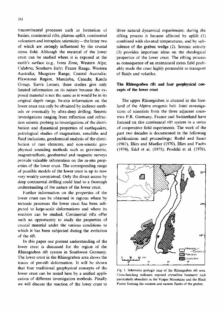
tracontinental processes such as formation of basins, continental rifts, plateau uplift, continental volcanism and intraplate seismicity-the latter two of which are strongly influenced by the crustal stress field. Although the material of the lower crust can be studied where it is exposed at the earth’s surface (e.g., Ivrea Zone, Western Alps; Calabria, Southern Italy; Frazer Range, Western Australia; Musgrave Range, Central Australia; Pikwitonei Region, Manitoba, Canada; Kasila Group, Sierra Leone), these studies give only limited information on its nature because the ex- posed material is not the same as it would be in its original depth range. In-situ information on the lower crust can only be obtained by indirect meth- ods or eventually by ultra-deep drilling. Seismic investigations ranging from reflection and refrac- tion seismic probing to investigations of the distri- bution and dynamical properties of earthquakes, petrological studies of magmatism, xenoliths and fluid inclusions, geochemical analysis of the distri- bution of rare elements, and non-seismic geo- physical sounding methods such as gravimetric, magnetotelluric, geothermal and magnetic surveys provide valuable information on the in-situ prop- erties of the lower crust. The corresponding range of possible models of the lower crust is up to now very weakly constrained. Only the direct access by deep continental drilling could lead to a thorough understanding of the nature of the lower crust.
Further information on the properties of the lower crust can be obtained in regions where by tectonic processes the lower crust has been sub- jected to large-scale deformations and where its reaction can be studied. Continental rifts offer such an opportunity to study the properties of crustal material under the various conditions to which it has been subjected during the evolution of the rift.
In this paper our present understanding of the lower crust is discussed for the region of the Rhinegraben rift system in Southwest Germany. The lower crust in the Rhinegraben area shows the traces of pre-rift deformation. It will be shown that four traditional geophysical concepts of the lower crust can be tested here by a unified appli- cation of different investigation methods. Finally we will discuss the reaction of the lower crust to
three natural dynamical experiments; during the rifting process it became affected by uplift (1) combined with elevated temperatures, and by sub- sidence of the graben wedge (2). Seismic activity (3) provides important ideas on the rheological properties of the lower crust. The rifting process as consequence of an extensional stress field prob- ably made the crust highly permeable to transport of fluids and volatiles.
The Rhinegraben rift and four geophysical con-
cepts of the lower crust
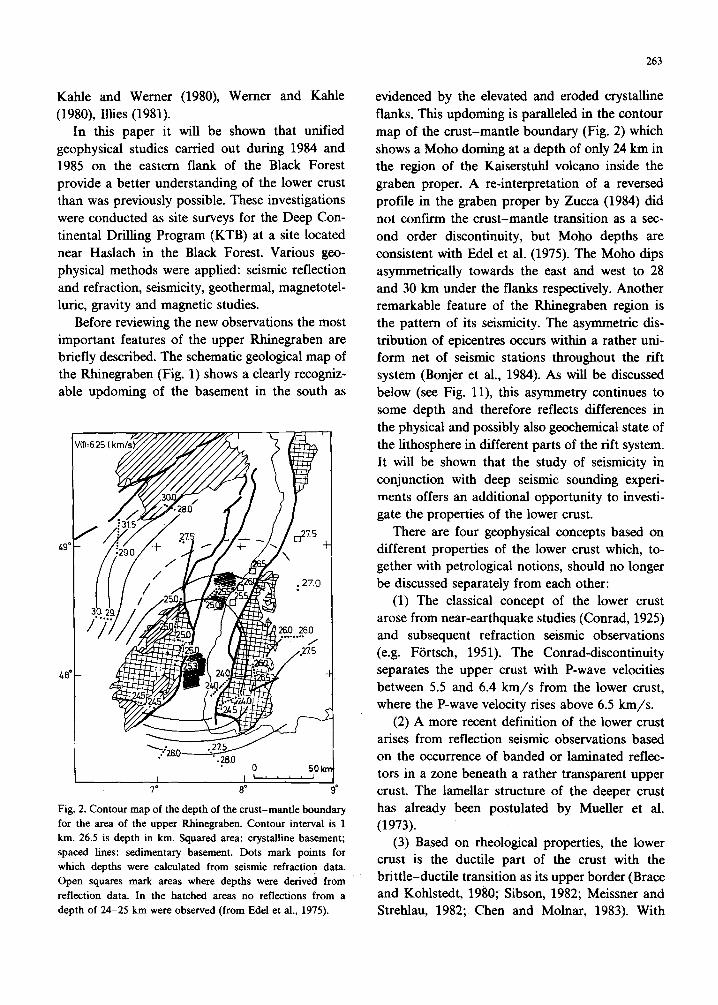
The upper Rhinegraben is situated in the fore- land of the Alpine erogenic belt. Joint investiga- tions of scientists from the three adjacent coun- tries F.R. Germany, France and Switzerland have focused on this continental rift system in a series of cooperative field experiments. The work of the past two decades is documented in the following publications and proceedings: RothC and Sauer (1967) Illies and Mueller (1970) Illies and Fuchs (1974), Edel et al. (1975), Prodehl et al. (1976)
Fig. 1. Schematic geologic map of the Rhinegraben rift area.
Cross-hatching indicates exposed crystalline basement rock
particularly abundant in the Vosges Mountains and the Black
Forest forming the western and eastern flanks of the graben.
Kahle and Werner (1980), Illies (1981).
In this paper it
(1980), Werner and Kahle
will be shown that unified
geophysical studies carried out during 1984 and 1985 on the eastern flank of the Black Forest provide a better understanding of the lower crust than was previously possible. These investigations were conducted as site surveys for the Deep Con- tinental Drilling Program (KTB) at a site located near Haslach in the Black Forest. Various geo- physical methods were applied: seismic reflection and refraction, seismicity, geothermal, magnetotel- luric, gravity and magnetic studies.
Before reviewing the new observations the most important features of the upper Rhinegraben are briefly described. The schematic geological map of the Rhinegraben (Fig. 1) shows a clearly recogniz- able updoming of the basement in the south as
Fig. 2. Contour map of the depth of the crust-mantle boundary
for the area of the upper Rhinegraben. Contour interval is 1
km. 26.5 is depth in km. Squared area: crystalline basement;
spaced lines: sedimentary basement. Dots mark points for
which depths were calculated from seismic refraction data.
Open squares mark areas where depths were derived from
reflection data. In the hatched areas no reflections from a
depth of 24-25 km were observed (from Edel et al., 1975).
263
evidenced by the elevated and eroded crystalline flanks. This updoming is paralleled in the contour map of the crust-mantle boundary (Fig. 2) which shows a Moho doming at a depth of only 24 km in the region of the Kaiserstuhl volcano inside the graben proper. A re-interpretation of a reversed profile in the graben proper by Zucca (1984) did not confirm the crust-mantle transition as a sec- ond order discontinuity, but Moho depths are consistent with Edel et al. (1975). The Moho dips asymmetrically towards the east and west to 28 and 30 km under the flanks respectively. Another remarkable feature of the Rhinegraben region is the pattern of its seismicity. The asymmetric dis- tribution of epicentres occurs within a rather uni- form net of seismic stations throughout the rift system (Bonjer et al., 1984). As will be discussed below (see Fig. ll), this asymmetry continues to some depth and therefore reflects differences in the physical and possibly also geochemical state of the lithosphere in different parts of the rift system. It will be shown that the study of seismicity in conjunction with deep seismic sounding experi- ments offers an additional opportunity to investi- gate the properties of the lower crust.
There are four geophysical concepts based on different properties of the lower crust which, to- gether with petrological notions, should no longer be discussed separately from each other:
(1) The classical concept of the lower crust arose from near-earthquake studies (Conrad, 1925) and subsequent refraction seismic observations (e.g. Fiirtsch, 1951). The Conrad-discontinuity separates the upper crust with P-wave velocities between 5.5 and 6.4 km/s from the lower crust, where the P-wave velocity rises above 6.5 km/s.
(2) A more recent definition of the lower crust arises from reflection seismic observations based on the occurrence of banded or laminated reflec- tors in a zone beneath a rather transparent upper crust. The lamellar structure of the deeper crust has already been postulated by Mueller et al. (1973).
(3) Based on rheological properties, the lower crust is the ductile part of the crust with the brittle-ductile transition as its upper border (Brace and Kohlstedt, 1980; Sibson, 1982; Meissner and Strehlau, 1982; Chen and Molnar, 1983). With
264
this concept the lower crust is the mechanically weak part of the lithosphere (Turcotte et al., 1984).
(4) The electrical conductivity would be indica- tive of dry or wet regions of the lower crust if other conductivity determining effects can be ex- cluded (Jijdicke et al., 1983) and if a sufficiently high spatial resolution could be achieved (Richards et al., 1981; Schmucker, 1985).
The region of the Rhinegraben, where these field experiments have been performed jointly, offers the opportunity to investigate whether these concepts are concordant with each other, e.g., whether we are looking at the same object with different spectacles.
Several models concerning the structure and composition of the lower crust have been estab-
lished. Meissner and Liischen (1983) interprete its high reflectivity as a result of “rhythmically arranged c~stal~sation seams of intruded and solidified magmas from the mantle”. The forma- tion of lamellae is therefore bound to temperature events such as the Variscan orogeny. Smithson et al. (1977) attribute the dis~ntinuous character of lower crustal reflections to complex metamorphic layering, isoclinal folding, disruptions and intru- sions. Consistent reflectors are produced by
mylonite shear zones (Smithson et al., 1986). Phin- ney and Jurdy (1979) explain the layering as due to ductile deformation in the lower crustal zone. Hall (1986) postulates a lower crust consisting of granulites with local patches of free water among amp~bo~te facies. We feel that the region of the Rhinegraben is a key area for testing the various models.
Recent geophysical observations in the Rhinegra- ben area
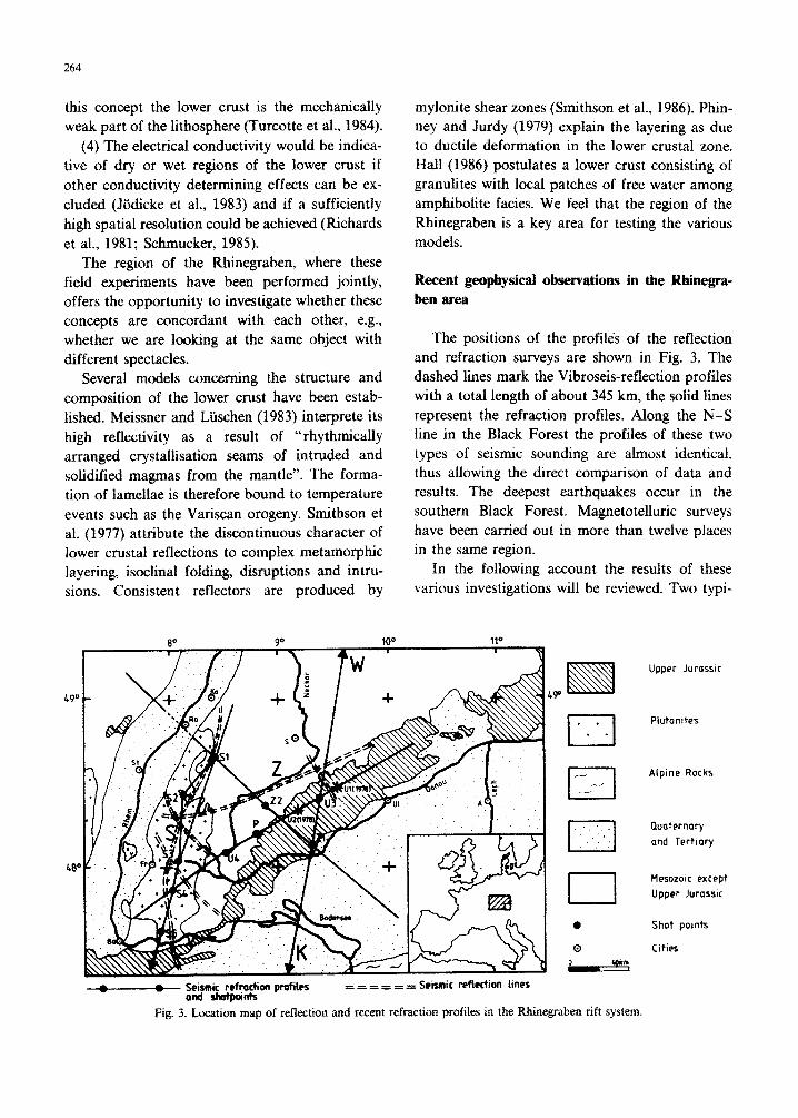
The positions of the profiles of the reflection and refraction surveys are shown in Fig. 3. The dashed lines mark the Vibroseis-reflection profiles with a total length of about 345 km, the solid lines represent the refraction profiles. Along the N-S line in the Black Forest the profiles of these two types of seismic sounding are almost identical, thus allowing the direct comparison of data and results. The deepest earthquakes occur in the southern Black Forest, Magnetotelluric surveys have been carried out in more than twelve places in the same region.
In the following account the results of these various investigations will be reviewed. Two typi-
-L---e-- Se$m~&*bn profiles = = =: = = = Seismic reflection lines
Upper Jurosstc
Ptutonites
Alpine Rocks
~uaternafy
and Tertiary
Mesozoic except
Upper Jurassic
Shot points
Cities
Fig. 3. Location map of reflection and recent refraction profiles in the ~ne~aben rift system.
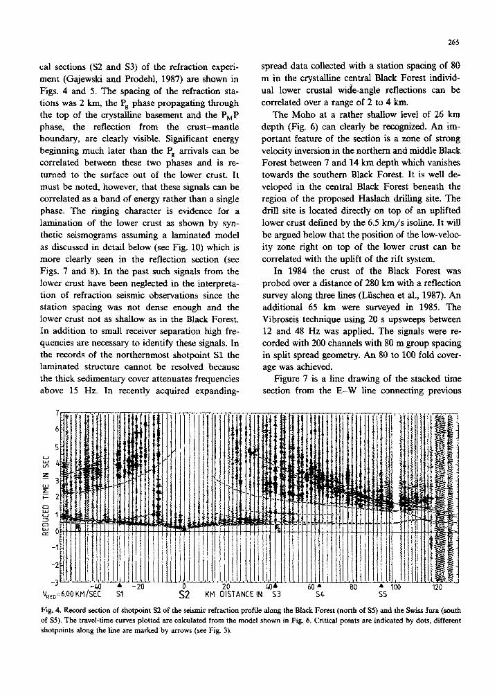
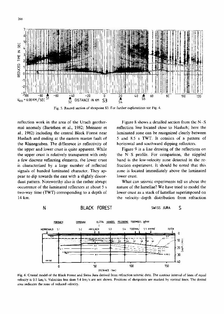
cal sections (S2 and S3) of the refraction experi- ment (Gajewski and Prodehl, 1987) are shown in Figs. 4 and 5. The spacing of the refraction sta- tions was 2 km, the Ps phase propagating through the top of the crystalline basement and the PMP phase, the reflection from the crust-mantle boundary, are clearly visible. Significant energy beginning much later than the Ps arrivals can be correlated between these two phases and is re- turned to the surface out of the lower crust. It must be noted, however, that these signals can be correlated as a band of energy rather than a single phase. The ringing character is evidence for a lamination of the lower crust as shown by syn- thetic seismograms assuming a laminated model as discussed in detail below (see Fig. 10) which is more clearly seen in the reflection section (see Figs. 7 and 8). In the past such signals from the lower crust have been neglected in the interpreta- tion of refraction seismic observations since the station spacing was not dense enough and the lower crust not as shallow as in the Black Forest. In addition to small receiver separation high fre- quencies are necessary to identify these signals. In the records of the northernmost shotpoint Sl the laminated structure cannot be resolved because the thick sedimentary cover attenuates frequencies above 15 Hz. In recently acquired expanding-
265
spread data collected with a station spacing of 80
m in the crystalline central Black Forest individ- ual lower crustal wide-angle reflections can be correlated over a range of 2 to 4 km.
The Moho at a rather shallow level of 26 km depth (Fig. 6) can clearly be recognized. An im- portant feature of the section is a zone of strong velocity inversion in the northern and middle Black Forest between 7 and 14 km depth which vanishes towards the southern Black Forest. It is well de- veloped in the central Black Forest beneath the region of the proposed Haslach drilling site. The drill site is located directly on top of an uplifted lower crust defined by the 6.5 km/s isoline. It will be argued below that the position of the low-veloc- ity zone right on top of the lower crust can be correlated with the uplift of the rift system.
In 1984 the crust of the Black Forest was probed over a distance of 280 km with a reflection survey along three lines (Liischen et al., 1987). An additional 65 km were surveyed in 1985. The Vibroseis technique using 20 s upsweeps between 12 and 48 Hz was applied. The signals were re- corded with 200 channels with 80 m group spacing in split spread geometry. An 80 to 100 fold cover- age was achieved.
Figure 7 is a line drawing of the stacked time section from the E-W line connecting previous
VR,,=6.00KM/Sii Sl --
j
KM il :TANCE IN %3
Fig. 4. Record section of shotpoint S2 of the seismic refraction profile along the Black Forest (north of S5) and the Swiss Jura (south
of SS). The travel-time curves plotted are calculated from the model shown in Fig. 6. Critical points are indicated by dots, different
shotpoints along the line are marked by arrows (see Fig. 3).
266
7
6
V,,, =6.00KM/SEC A1 DISTANCE IN KM S3
Fig. 5. Record section of shotpoint S3. For further explanations see Fig. 4.
reflection work in the area of the Urach geother- mal anomaly (Bartelsen et al., 1982; Meissner et al., 1982) including the central Black Forest near Haslach and ending at the eastern master fault of the Rhinegraben. The difference in reflectivity of the upper and lower crust is quite apparent. While the upper crust is relatively transparent with only a few discrete reflecting elements, the lower crust is characterized by a large number of reflected signals of banded laminated character. They ap- pear to dip towards the east with a slightly discor- dant pattern. Noteworthy also is the rather abrupt occurrence of the laminated reflectors at about 5 s two-way time (TWT) corresponding to a depth of 14 km.
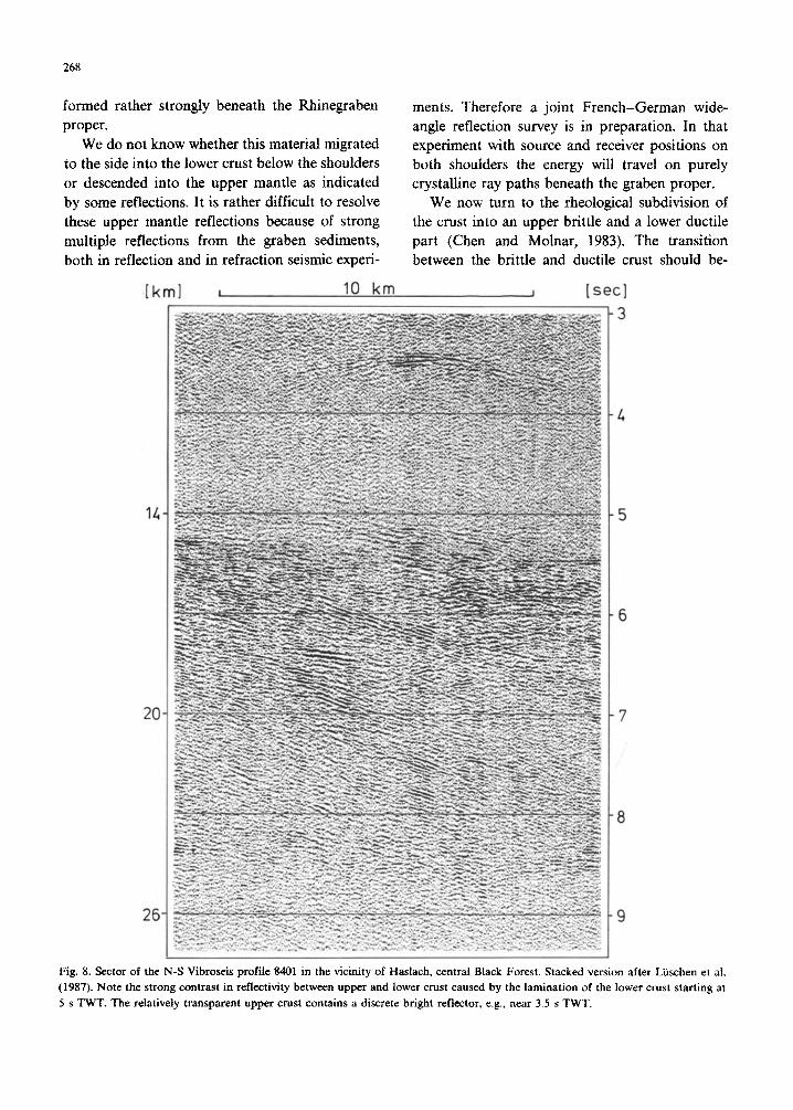
Figure 8 shows a detailed section from the N-S reflection line located close to Haslach; here the laminated zone can be recognized clearly between 5 and 8.5 s TWT. It consists of a pattern of horizontal and southward dipping reflectors.
Figure 9 is a line drawing of the reflections on the N-S profile. For comparison, the stippled band is the low-velocity zone detected in the re- fraction experiment. It should be noted that this zone is located immediately above the laminated lower crust.
What can seismic experiments tell us about the nature of the lamellae? We have tried to model the lower crust as a stack of lamellae superimposed on the velocity-depth distribution from refraction
N BLACK FOREST SWISS JURA s
H)RBaCn_ OPPENAU ELZTAl KANOEL FELOBERG TOLlTpxMS WEHR
I I H
0
40
0 50 100 150 DISTANCE I km)
Fig. 6. Crustal model of the Black Forest and Swiss Jura derived from refraction seismic data. The contour interval of lines of equal
velocity is 0.1 km/s. Velocities less than 5.4 km/s are not shown. Positions of shotpoints are marked by vertical lines. The dotted
area indicates the zone of reduced velocity.

267
w Haslach Sulz o.N. Urach E
0
1
2
3 4
5
6
7
8 9
10
11
I2
0 tkml 50 100 12L
-- ---_-._---- -
A.
/--Z==- z _I --- . -2 I,
-- -
----w- --
----
TWT fS1
Fig. 7. Line drawing of E-W reflection sections from Urach to the Rhinegraben. The western part is derived from profile 8403 (80 to 100 fold Vibroseis data, 80 m group spacing, 16 km split spread geometry (Liischen et al., 1987). The eastern part is based on the Urach profile Ul (8.fold coverage, explosion technique, 160 m goup spacing, 23 km off-line spread, modified from Bartelsen at al., 1982).
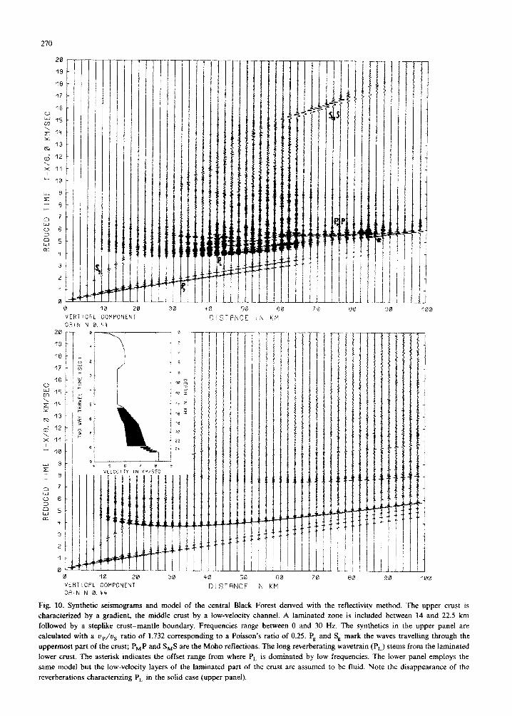
seismic observations (see Fig. 10; Sandmeier and Wenzel, 1986). Synthetic seismo~~s have been computed on a CDC CYBER 205 computer for two cases: (a) solid-solid interbedding of lamellae with fast and slow P-wave velocity, i.e. Poisson’s ratio 0.25, and (b) solid-fluid lamellae with Pois- son’s ratio 0.5 in the low-velocity lamellae (upper and lower panel of Fig. 10). The question was whether either of the two seismic methods can distinguish between the two cases. The range of velocities in the solid-solid case is between 6 and 7 km/s for P-waves. Reverberations (P,J are pro- duced by the stack of lamellae from zero offset to the end of the line at about 100 km. However, in the case of liquid low-velocity lamellae the lower crustal response appears for offsets larger than about 40 km as an impulse of short duration rather than a reverberating wavetrain. For smaller distances and especially for near-vertical incidence the two cases become rather undistinguishable. The reflectivity of the lower crust is enhanced in the case of liquid low-velocity layers. This leads to a di~nution of P-wave as well as of S-wave reflections from the crust-mantle boundary. The rather low frequencies of the crust-mantle phase between 68 and 80 km in the upper panel of Fig. 10 is mainly caused by the fact that the waves have to pass through the lower crust whose lamination acts as a lowpass filter, whereas the lack of high frequencies in the lower crustal reflec-
tions above 84 km must be attributed to the tunnel effect. This synthetic example shows that the joint application of reflection and refraction methods brings more information than a single method on its own.
The situation in the Rhinegraben proper has already been explored in 1968 by Dohr (1970). In a reflection section obtained in the central graben it appears that the difference in TWT between the top of the lamellae at about 7 s and the bottom of the sedimentary fill around 2 s is the same (5 s) as the TWT through the crystalline basement from the surface to the top of the lamellae beneath the adjacent Black Forest. That means that the whole graben wedge of brittle upper crust subsided into the lower crust of the ~ne~aben without an appreciable change in thickness. This result can be confirmed,by comparing wide-angle reflection data across the Rhinegraben conducted during a joint French-German test experiment (Damotte et al., 1987) with expanding-spread data in the Black Forest measured in 1985.
The bottom of the brittle part of the graben wedge now reaches a depth of 18 km instead of 15 km as observed beneath the shoulders. The up- doming of the crust-mantle boundary and the deep-reaching upper crust consequently leave only about 6 to 8 km of lower crust beneath the graben proper compared to 12 km beneath the shoulders. Therefore the lower crust must have been de-
268
formed rather strongly beneath the Rhinegraben ments. Therefore a joint French-~errn~ wide- proper. angle reflection survey is in preparation. In that
We do not know whether this material migrated experiment with source and receiver positions on to the side into the lower crust below the shoulders both shoulders the energy will travel on purely or descended into the upper mantle as indicated crystalline ray paths beneath the graben proper. by some reflections. It is rather difficult to resolve We now turn to the rheological subdivision of these upper mantle reflections because of strong the crust into an upper brittle and a lower ductile multiple reflections from the graben sediments, part (Chen and Molnar, 1983). The tr~sition both in reflection and in refraction seismic experi- between the brittle and ductile crust should be-
[km] I 10 km I bed
14
2c
2E
Fig. 8. Sector of the N-S Vibroseis profile 8401 in the vicinity of Haslach, central Btack Forest. Stacked version after Liischen et al.
(1987). Note the strong contrast in reflectivity between upper and lower crust caused by the lamination of the lower crust starting at
5 s TWT. The relatively transparent upper crust contains a discrete bright reflector, e.g., near 3.5 s TWT.
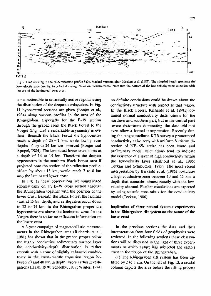
N Haslach 150 100 50 (km) s 0
0
2,5
28
km)
Fig. 9. Line drawing of the N-S reflection profile 8401. Stacked version, after L&&hen et al. (1987). The stippled band represents thee’ low-velocity zone (see fig. 6) detected during refraction measurements. Nate that the bottom of the low-velocity zone coincides with the top of the laminated lower crust.
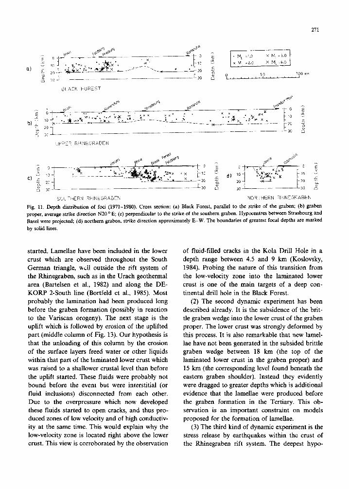
come noticeable in seismically active regions using the distribution of the deepest earthquakes. In Fig. 11 hypocentral sections are given (Bonjer et al., 1984) along various profiles in the area of the Rhinegraben. Especially for the E-W section through the graben from the Black Forest to the Vosges (Fig. llc) a remarkable asymmetry is evi- dent: Beneath the Black Forest the hypocentres reach a depth of 20 f 1 km, while locally even depths of up to 24 km are observed (Bonjer and Apopei, 1984). The laminated lower crust starts at a depth of 14 to 15 km. Therefore the deepest hypocentres in the southern Black Forest area if projected onto the section of the reflection profile, off-set by about 15 km, would reach 7 to 8 km into the laminated lower crust.
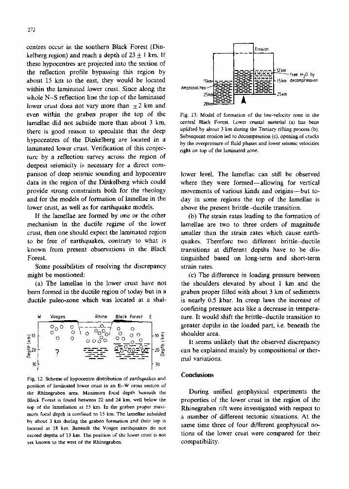
In Fig. 12 these observations are summarized schematically on an E-W cross section through the Rhinegraben together with the position of the lower crust. Beneath the Black Forest the laminae start at 15 km depth, and earthquakes occur down to 22 to 24 km; in the Rhinegraben proper the hypocentres are above the laminated zone. In the Vosges there is so far no reflection info~ation on the lower crust.
A 3-year campaign of magnetotelluric measure- ments in the Rhinegraben area (Richards et al., 1981) has shown that in the graben proper below the highly conductive sedimentary surface layer the conductivity-depth distribution is rather smooth with a zone of slightly enhanced conduc- tivity in the crust-mantle transition region be- tween 20 and 40 km in depth. From earlier investi- gations (Haak, 1970; Scheelke, 1972; Winter, 1974)
no definite conclusions could be drawn about the conductivity structure with respect to that region. In the Black Forest, Richards et al. (1981) ob- tained normal cunductivity dist~butions for the northern and southern part, but in the central part severe distortions dominating the data did not even allow a formal interpretation. Recently dur- ing the magnetotelluric KTB-survey a pronounced conductivity anisotropy with uniform Variscan di- rection of NE-SW strike has been found and preliminary model calculations tend to indicate the existence of a layer of high conductivity within the low-velocity layer (Berktold et al., 1985; Tezkan and Schmucker, 1985). The most recent interpretation by Berktold et al. (1986) postulates a high-conductive zone between 10 and 15 km, a depth that coincides almost exactly with the low- velocity channel. Further conclusions are expected by using seismic constraints for the conductivity model (Tezkan, 1986).
Implication of three natural dynamic experiments in the Rhikgrahen rift system OR the nature of the
lower crust
In the previous sections the data and their interpretation from four fields of geophysics were reviewed. In the following sections these observa- tions will be discussed in the light of three experi- ments to which nature has subjected the earth’s crust in the region of the Rhinegraben.
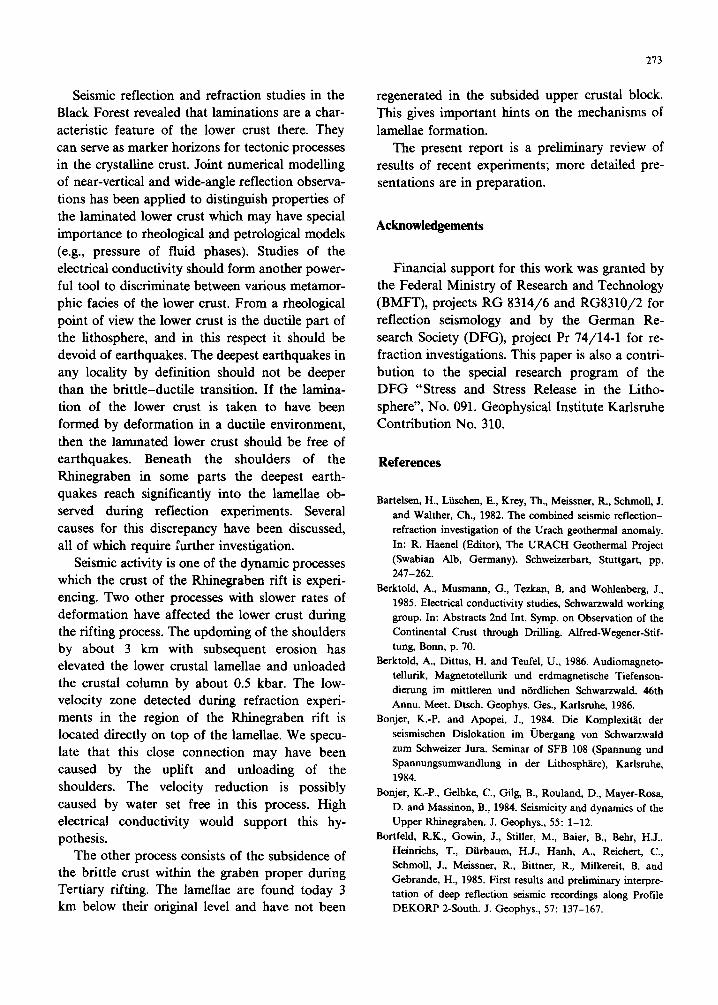
(1) The Rhinegraben rift system has been up- lifted by 2 to 3 km. On the left of Fig. 13, a crustal column depicts the area before the rifting process
30 50 60
D!STRNCE tN KM
18
17
16 -
s _ cn I5
1. 10 20 30 40 50 60
VEATICRL COMPONENT
GAIN N 0.44 DISTRNCE IN KM
Fig. 10. Synthetic seismograms and model of the central Black Forest derived with the reflectivity method. The upper crust is
characterized by a gradient, the middle crust by a low-velocity channel. A laminated zone is included between 14 and 22.5 km
followed by a steplike crust-mantle boundary. Frequencies range between 0 and 30 Hz. The synthetics in the upper panel are
calculated with a up/us ratio of 1.732 corresponding to a Poisson’s ratio of 0.25. Ps and Ss mark the waves travelling through the
uppermost part of the crust; PMP and S,S are the Moho reflections. The Iong reverberating wavetrain (PL) stems from the laminated
lower crust. The asterisk indicates the offset range from where P, is dominated by low frequencies. The lower panel employs the
same model but the low-velocity layers of the laminated part of the crust are assumed to be fluid. Note the disappearance of the
reverberations characterizing P, in the solid case (upper panel).
271
100 km
is 30 jp _ _~----
,BLACK FOREST
lopper RHINEGRABEN
SOUTHERN RHINEGRABEN NORTHERN RtiINEGRABEN
Fig. 11. Depth distribution of foci (1971-1980). Cross section: (a) Black Forest, parallel to the strike of the graben; (b) graben proper, average strike direction N20 ’ E; (c) perpendicular to the strike of the southern graben. Hypocentres between Strasbourg and Base1 were projected; (d) northern graben, strike direction approximatefy E-W. The boundaries of greatest focal depths are marked by solid lines.
started. Lamellae have been included in the lower crust which are observed throughout the South German triangle, ~11 outside the rift system of the Rhinegraben, such as in the Urach geothermal area (Bartelsen et al., 1982) and along the DE- KORP 2South line (Bortfeld et al., 1985). Most probably the lamination had been produced long before the graben formation (possibly in reaction to the Variscan orogeny). The next stage is the uplift which is followed by erosion of the uplifted part (middle column of Fig. 13). Our hypothesis is that the unloading of this column by the erosion of the surface layers freed water or other liquids within that part of the laminated lower crust which was raised to a shallower crustal level than before the uplift started. These fluids were probably not bound before the event but were interstitial (or fluid inclusions) disconnected from each other. Due to the overpressure which now developed these fluids started to open cracks, and thus pro- duced zones of low velocity and of high conductiv- ity at the same time. This would explain why the low-velocity zone is located right above the lower crust. This view is corroborated by the observation
of fluid-filled cracks in the Kola Drill Hole in a depth range between 4.5 and 9 km (Koslovsky, 1984). Probing the nature of this tr~sition from the low-velocity zone into the laminated lower crust is one of the main targets of a deep con- tinental drill hole in the Black Forest.
(2) The second dynamic expe~ment has been described already. It is the subsidence of the brit- tle graben wedge into the lower crust of the graben proper. The lower crust was strongly deformed by this process. It is also remarkable that new lamel- lae have not been generated in the subsided brittle graben wedge between 18 km (the top of the laminated lower crust in the graben proper) and 15 km (the corresponding level found beneath the eastern graben shoulder). Instead they evidently were dragged to greater depths which is additional evidence that the lamellae were produced before the graben formation in the Tertiary. This ob- servation is an important constraint on models proposed for the formation of lamellae.
(3) The third kind of dynamic experiment is the stress release by earthquakes within the crust of the Rhinegraben rift system. The deepest hypo-
272
centres occur in the southern Black Forest (Din- kelberg region) and reach a depth of 23 + 1 km. If these hypocentres are projected into the section of the reflection profile bypassing this region by about 15 km to the east, they would be located within the laminated lower crust. Since along the whole N-S reflection line the top of the laminated lower crust does not vary more than + 2 km and
even within the graben proper the top of the lamellae did not subside more than about 3 km, there is good reason to speculate that the deep hypocentres of the Dinkelberg are located in a laminated lower crust. Verification of this conjec- ture by a reflection survey across the region of deepest seismicity is necessary for a direct com- parison of deep seismic sounding and hypocentre data in the region of the Dinkelberg which could provide strong constraints both for the rheology and for the models of formation of lamellae in the lower crust, as well as for earthquake models.
If the lamellae are formed by one or the other mechanism in the ductile regime of the lower crust, then one should expect the laminated region to be free of earthquakes, contrary to what is known from present observations in the Black
Forest. Some possibilities of resolving the discrepancy
might be mentioned: (a) The lamellae in the lower crust have not
been formed in the ductile region of today but in a ductile paleo-zone which was located at a shal-
W -
ZfO
r $0 c) I
3Ol-
Vosges Rhine Black Forest E > /
OOO 0
0
?
0 \-----a-; o 0 \ 0 oo”ol 0 0 0 000”0 O0 0”
0 - --- -2-o=
_-c_- Q_YIlzjo=~ --azz-rz - .s-2- -_I- ----
SC ---
Fig. 12. Scheme of hypocentre distribution of earthquakes and position of laminated lower CNSt in an E-W cross section of the Bhinegraben area. Maximum focal depth beneath the Black Forest is found between 22 and 24 km, well below the top of the lamellation at I5 km. In the graben proper maxi- mum focal depth is confined to 15 km. The lamellae subsided by about 3 km during the graben formation and their top is located at 18 km. Beneath the Vosges earthquakes do not exceed depths of 13 km. The position of the lower crust is not yet known to the west of the Rhinegraben.
n Emsion
Fig. 13. Model of formation of the low-velocity zone in the central Black Forest. Lower crustal material (a) has been uplifted by about 3 km during the Tertiary rifting process (b). Subsequent erosion led to decompression (c), opening of cracks by the overpressure of fluid phases and lower seismic velocities right on top of the laminated zone.
lower level. The lamellae can still be observed where they were formed-allowing for vertical movements of various kinds and origins-but to- day in some regions the top of the lamellae is above the present brittle-ductile transition.
(b) The strain rates leading to the formation of lamellae are two to three orders of magnitude smaller than the strain rates which cause earth- quakes. Therefore two different brittle-ductile transitions at different depths have to be dis- tinguished based on long-term and short-term strain rates.
(c) The difference in loading pressure between the shoulders elevated by about 1 km and the graben proper filled with about 3 km of sediments is nearly 0.5 kbar. In creep laws the increase of ~onfi~ng pressure acts like a decrease in tempera- ture. It would shift the brittle-ductile transition to greater depths in the loaded part, i.e. beneath the shoulder area.
It seems unlikely thar the observed discrepancy can be explained mainly by compositional or ther- mal variations.
During unified geophysical experiments the properties of the lower crust in the region of the Rhinegraben rift were investigated with respect to a number of different tectonic situations. At the same time three of four different geophysical no- tions of the lower crust were compared for their compatibility.
213
Seismic reflection and refraction studies in the Black Forest revealed that laminations are a char- acteristic feature of the lower crust there. They can serve as marker horizons for tectonic processes in the crystalline crust. Joint numerical modelling of near-vertical and wide-angle reflection observa- tions has been applied to distinguish properties of the laminated lower crust which may have special importance to rheological and petrological models (e.g., pressure of fluid phases). Studies of the electrical conductivity should form another power- ful tool to discriminate between various metamor- phic facies of the lower crust. From a rheological point of view the lower crust is the ductile part of the lithosphere, and in this respect it should be devoid of earthquakes. The deepest earthquakes in any locality by definition should not be deeper than the brittle-ductile transition. If the lamina- tion of the lower crust is taken to have been formed by deformation in a ductile environment, then the lammated lower crust should be free of earthquakes. Beneath the shoulders of the Rhinegraben in some parts the deepest earth- quakes reach significantly into the lamellae ob- served during reflection experiments. Several causes for this discrepancy have been discussed, all of which require further investigation.
Seismic activity is one of the dynamic processes which the crust of the Rhinegraben rift is experi- encing. Two other processes with slower rates of deformation have affected the lower crust during the rifting process. The updoming of the shoulders by about 3 km with subsequent erosion has elevated the lower crustal lamellae and unloaded the crustal column by about 0.5 kbar. The low- velocity zone detected during refraction experi- ments in the region of the Rhinegraben rift is located directly on top of the lamellae. We specu- late that this close connection may have been caused by the uplift and unloading of the shoulders. The velocity reduction is possibly caused by water set free in this process. High electrical conductivity would support this hy- pothesis.
The other process consists of the subsidence of the brittle crust within the graben proper during Tertiary rifting. The lamellae are found today 3 km below their original level and have not been
regenerated in the subsided upper crustal block. This gives important hints on the mechanisms of
lamellae formation. The present report is a preliminary review of
results of recent experiments; more detailed pre- sentations are in preparation.
Acknowledgements
Financial support for this work was granted by the Federal Ministry of Research and Technology (BMFT), projects RG 8314/6 and RG8310/2 for reflection seismology and by the German Re- search Society (DFG), project Pr 74/14-l for re- fraction investigations. This paper is also a contri- bution to the special research program of the DFG “Stress and Stress Release in the Litho- sphere”, No. 091. Geophysical Institute Karlsruhe Contribution No. 310.
References
Bartelsen, H., Liischen, E., Krey, Th., Meissner, R., SchmoB, J. and Walther, Ch., 1982. The combined seismic reflection- refraction investigation of the Urach geothermal anomaly. In: R. Haenel (Editor), The URACH Geothermal Project (Swabian Alb, Germany). Schweizerbart, Stuttgart, pp. 241-262.
Berktold, A., Musmann, G., Tezkan, B. and Wohlenberg, J., 1985. Electrical conductivity studies, Schwarzwald working group. In: Abstracts 2nd Int. Symp. on Observation of the Continental Crust through Drilling. Alfred-Wegener-Stif- tung, Bonn, p. 70.
Berktold, A., Dittus, H. and Teufel, U., 1986. Audiomagneto- tellurik, Magnetotellurik und erdmagnetische Tiefenson- dierung im mittleren und nbrdlichen Schwarzwald. 46th Annu. Meet. Dtsch. Geophys. Ges., Karlsruhe, 1986.
Bonjer, K.-P. and Apopei, J., 1984. Die Komplexitat der seismischen Dislokation im Ubergang von Schwarzwald zum Schweizer Jura. Seminar of SFB 108 (Spammng und Spannungsumwandlung in der Lithosphiire), Karlsruhe, 1984.
Bonjer, K.-P., Gelbke, C., Gilg, B., Rouland, D., Mayer-Rosa, D. and Massinon, B., 1984. Seismicity and dynamics of the Upper Rhinegraben. J. Geophys., 55: l-12.
Bortfeld, R.K., Gowin, J., Stiller, M., Baier, B., Behr, H.J., Heimichs, T., Dtirbaum, H.J., Hanh, A., Reichert, C., Schmoll, J., Meissner, R., Bittner, R., Milkereit, B. and Gebrande, H., 1985. First results and preliminary interpre- tation of deep reflection seismic recordings along Profile DEKORP 2-South. J. Geophys., 57: 137-167.
214
Brace, W.F. and Kohlstedt, D.L., 1980. Limits on lithospheric
stress imposed by laboratory experiments. J. Geophys. Res.,
85: 624886252.
Chen, W.P. and Molnar, P., 1983. Focal depths of in-
tracontinental and intraplate earthquakes and their impli-
cation for the thermal and mechanical properties of the
lithosphere, J. Geophys. Res., 88: 41834214.
Conrad, V., 1925. Laufzeiten des Tauernbebens vom 28.
November 1923. Mitt. Erdbeben-Komm. Wien, 59: l-23.
Damotte, B., Fuchs, K., L&hen, E., Wenzel, F., Schlich, R.
and Toreilles, G., 1987. Wide-angle vibroseis test across the
Rhinegraben. Geophys. J.R. Astron. Sot., 89: 313-318. Dohr, G., 1970. Reflexionsseismische Messungen im Ober-
rheingraben mit digitaler Aufzeichnungstechnik und Bear-
beitung. In: H.J. Illies and S. Mueller (Editors), Graben
Problems. Schweizerbart, Stuttgart, pp. 207-218.
Edel, J.B., Fuchs, K., Gelbke, C. and Prodehl, C., 1975. Deep structure of the Rhinegraben area from seismic refraction
investigation. J. Geophys., 41: 333-356.
Fiirtsch, O., 1951. Analyse der seismischen Registrierungen der
Gross-Sprengung bei Haslach im Schwarzwald am 28. April
1948. Geol. Jahrb., 66: 65-80.
Gajewski, D. and Prodebl, C., 1987. Seismic-refraction investi-
gation of the Black Forest. Tectonophysics, in press.
Haak, V., 1970. Das zeitlich sich andemde erdelektrische Feld,
beobachtet auf einem Profil iiber dem Rheingraben. Diss.
Nat-F& Univ. Miinchen.
Hall, J., 1986. Nature of the lower continental crust: evidence
from BIRPS work on the Caledonides. In: M. Barazangi
and L. Brown (Editors), Reflection Seismology. Geodyn.
Ser., Am. Geophys. Union, 14: 223-231. Illies, J.H., 1981. Mechanisms of graben formation. Tectono-
physics, 13: 249-266.
Illies, J.H. and Fuchs, K. (Editors), 1974. Approaches to
Taphrogenesis. Schweizerbart, Stuttgart, 460 pp. Illies, J.H. and Mueller, S. (Editors), 1970, Graben Problems.
Schweizerbart, Stuttgart, 316 pp.
Jiidicke, H., Untied, J., Olgemann, W., Schulte, L. and
Wage&z, V., 1983. Electrical conductivity structure of the
crust and upper mantle beneath the Rhenish Massif. In: K.
Fuchs et al. (Editors), Plateau Uplift. Springer, Berlin. pp.
288-302.
Kahle, H.-G. and Werner, D., 1980. A geophysical study of the
Rhinegraben, Part II: Gravity anomalies and geothermal
implications. Geophys. J.R. Astron. Sot., 62: 631-647.
Kozlovsky, Ye.A., 1984. The World’s deepest well. Sci. Am.,
December 1984: 98-104.
Ltischen, E., Wenzel, F., Sandmeier, K.-J., Menges, D., Rthl,
Th., Stiller, M., Janoth, W., Keller, F., Siillner, W., Thomas,
R.. Krohe, A., Stenger, R., Fuchs, K., Wilhelm, H. and
Eisbacher, G., 1987. Near-vertical and wide-angle seismic
surveys in the Black Forest, SW-Germany. J. Geophys., in
press.
Meissner, R., Bartelsen, H., Krey, Th. and Schmoll, J., 1982.
Detecting velocity anomalies in the region of the Urach
geothermal anomaly by means of new seismic field arrange-
ments. In: V. Cermak and R. HaeneI (Editors}, Geother-
mics and Geothermal Energy. Schweizerbart, Stuttgart, pp. 285-292, 1982.
Meissner, R. and Ltischen, E., 1983. Seismic near-vertical
reflection studies of the Earth’s crust in the Federal Repub-
lic of Germany. First Break, 1: 19-24.
Meissner, R. and Strehlau, J.. 1982. Limits of stresses in
continental crust and their relation to the depth-frequency
distribution of shallow earthquakes. Tectonics. 1: 73-89.
Mueller, S., Peterschmitt, E., Fuchs, K., Emter, D. and Ansorge.
J., 1973. Crustal structure of the Rhinegraben area.
Tectonophysics, 20: 381-391.
Phinney, R. and Jurdy, D.M., 1979. Seismic imaging of deep
crust. Geophysics, 44: 1637-1660.
Prodehl, C., Ansorge, J., Edel, J.B., Emter, D., Fuchs, K.,
Mueiler, S. and Peterschmitt. E., 1976. Explosion-seismol-
ogy research in the central and southern Rhinegraben-a
case history. In: P. Giese, C. Prodehl and A. Stein (Editors),
Explosion Seismology in Central Europe. Springer, Heidel-
berg, pp. 313-328.
Richards, M.L., Schmucker, U., Steveling, E. and Watermann,
J., 1981. Erdmagnetische und ma~etote~u~sche Sondie-
rungen im Gebiet des mitteleuropaischen Riftsystems. Inst.
Geophys. Univ. Gottingen, Forschungsber., TSl-111.
Roth& J.P. and Sauer, K. (Editors), 1967. The Rhinegraben
Progress Report 1967. Abh. Geol. Landesamt Baden-Wtirt-
temb., 6: 146 pp.; Mem. Serv. Carte Gtol. Alsace Lorraine,
26: 146 pp.
Sandmeier, K.-J. and Wenzel, F., 1986. Synthetic seismograms
for a complex crustal model. Geophys. Res. Lett., 13:
22-25.
Scheeike, I., 1972. Ma~etoteIIu~sche Messungen im Rheingra-
ben und ihre Deutung mit zweidimensionalen Modellen.
Diss. Nat.-Fak. Tech. Univ. Braunschweig.
Schmucker, U., 1985. Magnetic and electric fieids due to
electromagnetic induction by external sources. In: K. Fuchs
and H. Soffel (Editors), Landolt-Blimstein, New Ser.. Vol.
2b. Springer, Berlin, pp. 100-125.
Sibson, R.H., 1982. Fault zone models, heat flow and depth
distribution of earthquakes in the continental crust of the
United States. Bull. Seismoi. Sot. Am., 72: 151-163.
Smithson, S.B., Shive, P.N. and Brown, St.U., 1977. Seismic
velocity, reflections, and structure of the crystalline crust.
In: J.G. Heacock (Editor). The Earth’s crust. Geophys.
Monogr., Am. Geophys. Union. 20: 254-270.
Smithson, S.B., Johnson, R.A. and Hurich, CA., 1986. Crustal
reflections and crustal structure. In: M. Barazangi and L.
Brown (Editors), Reflection Seismology, Geodyn. Ser., Am.
Geophys. Union, 14: 21-32.
Tezkan, B., 1986. Magnetotellurische and erdmagnetische Mes-
sungen zur Untersuchung der Leitf~~eitsst~tu~n der
K~stallingebiete Bayrischer Wald (bei Passau) und
Schwarzwald. Diss. Mat-Nat. Fak., Univ. Gottingen.
Tezkan, B. and Schmucker, U., 1985. Erdmagnetische und
telhnische Untersuchung im Schwarzwald. Bericht zum
215
Unterantrag der Univ. Karlsruhe zum BMFT Fotderungs- vothaben RG 83146, Inst. fti Geophysik, Univ. Gbttingen.
Turcotte, D.L., Liu, J.Y. and Kulhawy, F.H., 1984. The role of
an intracrustal astenosphere on the behaviour of major strike-slip faults. J. Geophys. Res., 89: 5801-5816.
Werner, D. and KahIe, H.-G., 1980. A geophysical study of the Rhinegraben. Part II. Kinematics and geothermics. Geo- phys. J.R. Astron. Sot., 62: 617-629.
Winter, R., 1974. A model for the resistivity distribution from
geomagnetic depth sounding. In: J.H. Blies and K. Fuchs (Editors), Approaches to Taphtogenesis. Schweizerbart,
Stuttgart, pp. 369-375. Zucca, J.J., 1984. The crustal structure of the southern
Rhinegraben from re-interpretation of seismic refraction data. J. Geophys., 55: 13-22.