Grade 7: Earth's Crust and Resources Lesson: Coal Mining
26
Grade 7: Earth’s Crust and Resources Lesson: Coal Mining – Surface Strip Mining Overview This activity allows students to participate in an activity illustrating a simplified version of surface coal mining and follow-up reclamation. Source: The original idea for this lesson comes from a lesson by Society for Mining, Metallurgy, and Exploration. It has been adapted for Saskatchewan schools by the SMA with help from Emily Clauson, Environmental Engineer at Poplar River Mine. Duration: One class Materials: Blocks (see cards): 54 blocks (cubes and rectangles) in 4 colours (12 coal, 24 overburden, 12 soil and vegetation, 6 soil and water ). More blocks can be added if necessary. If using bigger blocks/boxes they must be light enough to carry. For example: empty macaroni boxes spray painted, boxes available at office supply stores, moving companies or used boxes from grocery stores. Velcro tabs Location Cards: Coal Stockpile, Topsoil Stockpile, Power Plant Coal Trestle, Coal Load-out Facility cards (included) Role Cards (included) Instructional Method: Simulation Prior Knowledge: How is coal formed Where coal is located in Saskatchewan Learning Outcomes and Indicators Science EC7.2 Identify locations and processes used to extract Earth’s geological resources and examine the impacts of those locations and processes on society and the environment. Identify locations of Saskatchewan’s primary mineral resources (e.g., coal, potash, gold, diamond, salt, uranium, copper, and graphite) and their primary uses.(EC7.2d) Relate processes used to extract primary mineral resources in Saskatchewan (e.g., open-pit mining, underground mining, and solution mining) to the location, type, and depth of the resource. (EC7.2e) Mathematics N7.2 Expand and demonstrate understanding of the addition, subtraction, multiplication, and division of decimals to greater numbers of decimal places, and the order of operations. f. Solve a problem involving the multiplication or division of decimal numbers with more than a 2-digit multiplier or 1-digit divisor (whole number or decimal), with the use of technology. N7.4 Expand and demonstrate an understanding of percent to include fractional percents between 1% and 100%. c. Solve a problem that involves finding a percent. d. Solve a problem that involves finding percents of a value. Source: Saskatchewan Evergreen Curriculum Other: Gain basic understanding of coal mining and reclamation. Relate the mining of coal to power production and power use in homes.
-
Upload
khangminh22 -
Category
Documents
-
view
2 -
download
0
Transcript of Grade 7: Earth's Crust and Resources Lesson: Coal Mining
Grade 7: Earth’s Crust and Resources Lesson: Coal Mining – Surface Strip Mining
Overview This activity allows students to participate in an activity illustrating a simplified version of surface coal mining and follow-up reclamation.
Source: The original idea for this lesson comes from a
lesson by Society for Mining, Metallurgy, and Exploration. It has been adapted for Saskatchewan schools by the SMA with help from Emily Clauson, Environmental Engineer at Poplar River Mine.
Duration: One class
Materials: Blocks (see cards): 54 blocks (cubes and rectangles) in
4 colours (12 coal, 24 overburden, 12 soil and vegetation, 6 soil and water ). More blocks can be added if necessary. If using bigger blocks/boxes they must be light enough to carry. For example: empty macaroni boxes spray painted, boxes available at office supply stores, moving companies or used boxes from grocery stores.
Velcro tabs
Location Cards: Coal Stockpile, Topsoil Stockpile, Power Plant Coal Trestle, Coal Load-out Facility cards (included)
Role Cards (included)
Instructional Method: Simulation
Prior Knowledge:
How is coal formed
Where coal is located in Saskatchewan
Learning Outcomes and Indicators Science EC7.2 Identify locations and processes used to extract
Earth’s geological resources and examine the impacts of those locations and processes on society and the environment.
Identify locations of Saskatchewan’s primary mineral resources (e.g., coal, potash, gold, diamond, salt, uranium, copper, and graphite) and their primary uses.(EC7.2d)
Relate processes used to extract primary mineral resources in Saskatchewan (e.g., open-pit mining, underground mining, and solution mining) to the location, type, and depth of the resource. (EC7.2e)
Mathematics N7.2 Expand and demonstrate understanding of the
addition, subtraction, multiplication, and division of decimals to greater numbers of decimal places, and the order of operations.
f. Solve a problem involving the multiplication or division of decimal numbers with more than a 2-digit multiplier or 1-digit divisor (whole number or decimal), with the use of technology.
N7.4 Expand and demonstrate an understanding of
percent to include fractional percents between 1% and 100%.
c. Solve a problem that involves finding a percent. d. Solve a problem that involves finding percents of a
value.
Source: Saskatchewan Evergreen Curriculum Other:
Gain basic understanding of coal mining and reclamation.
Relate the mining of coal to power production and power use in homes.

Grade 7: Earth’s Crust and Resources: Coal Mining - Surface Strip Mining continued
Page 2
Saskatchewan Mining Association www.saskmining.ca Saskatchewan Mining Association www.saskmining.ca
Big Picture Questions 1. What method is used to extract coal in Saskatchewan?
Background Information During the Cretaceous Period (144 – 65 million years ago), a shallow sea covered western North America east of the Rocky Mountains from the Arctic Ocean (Mackenzie River delta) to the Gulf of Mexico. Through Cretaceous time, sea level rose and fell several times. When sea level was high, muddy sediments (now shales) containing fossils of marine reptiles (mosasaurs and plesiosaurs), sharks, bony fish and turtles, were deposited over much of Saskatchewan. When sea level fell, rivers flowing from the western mountains deposited sandy sediments (now sandstone) across southern and western Saskatchewan, in which dinosaur fossils have been found. The youngest Cretaceous sedimentary rocks are non-marine sandstones of the Frenchman Formation, in which the famous T. rex fossil, “Scotty”, was found near Eastend (Storer, J. 1989) Overlying the Frenchman sandstone in southern Saskatchewan are 160 – 240 m of coal-bearing non-marine sandstones and shales called the Ravenscrag Formation. The contact between the Frenchman and Ravenscrag formations is the base of the lowest coal seam, the Ferris coal (Saskatchewan Geological Survey, 2007). This contact is the Cretaceous – Tertiary (K-T) boundary, which marks the extinction of the dinosaurs. Periodically during the time of the Ravenscrag deposition, southern Saskatchewan was covered in swamp. As the swamps were buried by overlying sediments the combined pressure and heat gradually transformed the plant material in the swamp into carbon, creating beds of coal (lignite). Plant fossils (horsetails, ginkgo, cypress, elm, walnut and sycamore are commonly found preserved in the coal. Occasionally fish, crocodile, champososaur, turtle, salamander and lizard fossils are discovered (Storer, J. 1989). There are four areas of significant coal deposits in Saskatchewan; Estevan, Willow Bunch, Wood Mountain and Cypress-Shaunavon.
Ravenscrag coalfields of southern Saskatchewan (Ministry of Economy, Saskatchewan Geological Survey, Misc. Rept. 2003-7)
Although there have been hundreds of small coal mines across the province over the past 140 years, today there are only three surface coal mining operations. The Boundary Dam mine near Estevan, Poplar River mine near Coronach and the mine at Bienfait are all operated by Sherritt International. The coal mined in Saskatchewan is lignite the lowest grade of coal. It is used primarily for the production of electrical power contributing approximately 41% of the electricity generated in Saskatchewan (SaskPower). As the coal is close to the surface, the surface or strip mining method (see Figures 1 – 3) is used. The mining company must first remove the topsoil and stockpile it for later reclamation. Then overburden can be removed, and the coal mined. The coal is sent directly to one of the SaskPower electricity generating plants where it is converted to electricity. After the coal is removed, the disturbed area is reclaimed according to government approved reclamation plans. Typically, overlying sediments are set back in place and land is recontoured to improve drainage for farming and create wetland areas. Saskatchewan is Canada’s third-largest coal producer, after British Columbia and Alberta, typically producing around ten million tonnes of coal annually.
Vocabulary bank cubic meter coal seam
dragline hopper
overburden reclamation
strip mining surface mining

Grade 7: Earth’s Crust and Resources: Coal Mining - Surface Strip Mining continued
Page 3
Saskatchewan Mining Association www.saskmining.ca Saskatchewan Mining Association www.saskmining.ca
THE ACTIVITY Surface Strip Coal Mining (Simulation, Inquiry) (45 min) Preparation: Prepare the blocks beforehand. 1. Teachers can either print out the number of required
blocks using the templates included or use Duplo/Lego blocks, or have the students create their
own blocks using boxes. If using boxes do not tape boxes, use Velcro tabs to keep shut. This will allow you to flatten the boxes for storage for the next time they are to be used.
Creating own blocks:
a. Have the students bring in empty macaroni boxes (54 needed in total). b. Spray paint boxes or have students paint/decorate ahead of time.
Coal – dark grey with black fossil plants painted on. Overburden – beige with stones, boulders, sand Topsoil/vegetation – bottom half brown, top half green,
with plants and flowers Water – blue – with fish, frogs etc. Note: to keep this more realistic topsoil and water boxes should be half the height of the coal and overburden boxes. 2. Prior to commencing the simulation go over the roles of the Mine Engineer, Environmental Engineer and the Geologists making sure they know when to talk.
The Activity Introduction 1. Review the location of coal deposits on the
Saskatchewan Geological Survey Mineral Deposits Map.
2. Point out the location of the 3 mine sites, Poplar River, Boundary Dam and Bienfait.
The Simulation 1. Have the students stack the blocks three blocks wide
by 6 blocks long (add more rows if you have the boxes). See sketch below. This area will be the mine
site. The desk/table/floor will act as the bedrock.
2. Assign each student a role
# Students Role
1 Dragline Operator
2 Haul Truck Driver
1 Coal Load-out Operator
1 Power Plant Trestle Operator
1 Environmental Engineer
1 Grader Operator
1 Geologist
1 Shovel Operator
2 Scraper Driver
2 Dozer Operators
6 Rail Cars
1 Mining Engineer
1 Loader Operator
1 Environmental Engineer
If more than 22 students add one as a haul truck driver and the rest as rail cars. Descriptions of the tasks of the equipment are provided for the students to refer to while they are acting as that piece of equipment (see Role cards). 3. Designate four different areas in the classroom/gym:
Coal Stockpile, Coal Load-out Facility (beside the Coal Stockpile); Topsoil Stockpile; Power Plant Terminal Trestle. Arrange the stations so that everyone can see what is happening at each station from their station. (Figure 3. Floor Plan)
4. Explain to the students as each new role steps up,
that the student is to explain what they represent/do (read the information on role cards).
View looking down on
stacked blocks
Topsoil/vegetation Overburden
Coal
Desk/Table/Floor Clay/’Bedrock
View looking at the side of the stacked blocks
Desk/Table/Floor
Clay/bedrock

Grade 7: Earth’s Crust and Resources: Coal Mining - Surface Strip Mining continued
Page 4
Saskatchewan Mining Association www.saskmining.ca Saskatchewan Mining Association www.saskmining.ca
Coal Mining The activity is ready to begin. Refer to Figure 5 to
help explain the movement of the blocks. The Mine Engineer is the over seer. This student will help direct who moves when and where they go, until the mining is finished (see role card).
5. The Scraper Operators will pick up one block of
topsoil at a time and deposit them in the TOPSOIL STOCKPILE. Once all the topsoil has been removed the Dragline Operator will pick up one overburden block at a time and will place it directly across from the cut on the previously mined area (this area will be bare down to the bedrock.) Blocks can be piled on top of each other.
6. Once the dragline has moved ahead by 4 blocks, the
Shovel Operator (Alternate rows with Loader Operator) will pick up a black block representing coal and hand it to the Haul Truck Driver who will carry the block to the COAL STOCKPILE and give it to the Dozer Operator who will place the blocks neatly to create a new stack of blocks. The Haul Truck Operator returns to the shovel to pick up the next load of coal. Meanwhile the dragline will continue to remove the overburden until it reaches the end of the cut. At the end of the cut the Dragline Operator will “walk” his dragline onto the surface behind the cut and will wait until all the coal has been removed before it continues to remove the overburden and place it into the area just cleared of coal. Students will mine the coal until the dragline line cannot move any further backwards. (see Figure 5, teacher may have to step in and help direct the dragline)
The COAL LOAD-OUT FACILITY and Train (explain to the
students that normally the coal mining would continue while this next stage is running but for everyone to see what happens it is best to go one stage at a time.)
7. At this point the Mining Engineer will explain: About
90% of the coal goes directly to the hopper which is connected to the loading terminal. Having the dozer operator and the coal stockpile is good but the dozers are only used to push coal off the pile when the haulers are having a hard time getting to the hopper when there is bad weather or when the trucks or the shovel are broken down.
Once mining has stopped have the Dozer Operator
pass the blocks of coal one at a time to the Coal Load-out Facility Operator who will pass them on to the Rail Cars. When all rail cars are full the train will move to the POWER PLANT TRESTLE, deposit their coal by handing it to the Power Plant Trestle Operator and return to fill up again. The rail cars continue until all the coal has been removed.
8. Once mining is completed have the students stop and
look at the results. Coal has been removed, the overburden has been moved to fill in where the coal was removed, and 2 alternate areas of material (coal stockpile, topsoil stockpile) have been created. Now reclamation begins.
Reclamation: The Environmental Engineer leads the discussion
about what the land is going to look like and will draw up the plan using the Reclamation Diagram, teacher may have to help with the design process) Questions the Environmental Engineer will ask are do we want hills, do we want a pond, how big etc.
As a group the students decide where (if) they would
like hills and or ponds on the reclaimed land. Indicate the location of water features and hills on the diagram so the dozer operators will know where to return the overburden.
The Dozer Operator will contour the overburden into
hills and valleys as shown on the diagram and directed by the Environmental Engineer.
The Scraper Operator picks up a topsoil block at the
topsoil stockpile and hands it to the Grader Operator. The Environmental Engineer shows the Grader Operators where to place the blocks according to the diagram (Again teacher help may be required when reading the plan. Make sure the overburden blocks are piled neatly in three rows, this will help the Environmental Engineer understand where the blocks are to be placed.). The Scraper Operators return to get another load (block).
It is important at this point that when the Grader
Operators place the topsoil blocks that these blocks are put on top of overburden blocks, not on the bedrock blocks. Repeat Step 8 until all the topsoil has been placed in the mine area on top of the overburden blocks. Place the water blocks where designated in the diagram.

Grade 7: Earth’s Crust and Resources: Coal Mining - Surface Strip Mining continued
Page 5
Saskatchewan Mining Association www.saskmining.ca Saskatchewan Mining Association www.saskmining.ca
9. Have all students create a picture of what the reclaimed area would look like and how they would use it. (Leave it a nature area for animals, farm it, create a park, or develop it?)
10. Discussion Questions:
• Do the stacked blocks look any different than at the start of the activity?
• Would there be an alternative to returning the blocks back to the mine area? The discussion should include that reclamation also involves re-vegetation and the possibility that the land could be turned into something other than its previous use.
Assessment Method and Evidence: Introduction and Discussion
Students will identify the locations of Saskatchewan’s coal deposits and mines (Boundary Dam, Poplar River and Bienfait in Southern Saskatchewan) and explain that coal produces 41% of Saskatchewan’s Electricity.
Students will discuss reclamation of the land that has been mined and determine uses for the reclaimed land.
Block Model Activity
Through the simulation students will model and be able to recount the surface mining processes, and machinery used to extract coal in Southern Saskatchewan as well as be able to name several careers in the coal mining business.
Students will be able to explain the reason why the surface mining method is used to mine the coal (the coal is close to the earth’s surface, and can be mined using draglines, shovels and loaders. It does not need to be blasted.)
Students will be able to explain the reclamation process used at Saskatchewan’s coal mines. (Stockpiling the topsoil when first removed, contouring overburden, replacing and contouring the topsoil and planting post mining).
Extension Discussion questions: Through the extension questions students will be
able to relate the mining of coal to power production and power use in their home and school.
By solving a problem involving the multiplication and division of decimal numbers with more than a 2-digit multiplier or 1-digit divisor (whole number or decimal), with the use of technology students will
determine the amount of coal required to power their home/school.
Students will determine the percent of a rail car load of coal used to heat their home.
Extension: 1. Let’s Look at the Math. Students look at how much
energy they require in their home for one year and determine how many train loads of coal it would take to produce that amount of electricity.
Resources Mining Methods in India blog. http://rajikorba.blogspot.ca/2011/06/draglines-are-by-far-most-commonly-used.html Moving a dragline: YouTube video:
http://www.youtube.com/watch?v=_U8pFm06BTo&feature=youtu.be
ORE Magazine Fall/Winter 2013: Coal Powering the Province. Available at: http://www.saskmining.ca/uploads/news_files/67/ore_fallwinter_2013_lr.pdf Saskatchewan Energy and Mines Mineral Resource Map 2013 Available at: http://economy.gov.sk.ca/mineralresourcemap Saskatchewan Geological Survey, (2003): Geology, and Mineral and Petroleum Resources of Saskatchewan; Saskatchewan Industry and Resources, Miscellaneous Report 2003-7, 173p. SaskPower – Power Education: Available at: http://www.saskpower.com/our-power-future/power-education/ Storer, J. (1988). Geological History of Saskatchewan. Saskatchewan Museum of Natural History.

Grade 7: Earth’s Crust and Resources: Coal Mining - Surface Strip Mining continued
Page 6
Saskatchewan Mining Association www.saskmining.ca Saskatchewan Mining Association www.saskmining.ca
Vocabulary Bank cubic meter: A coal mining term. A bank cubic
meter is the amount of a cubic meter of rock in place, before it is drilled and blasted.
Coal seam: A “bed” of coal. The term “seam” is
usually applied to a large deposit of coal. Dragline: A large machine used in the surface mining
process to remove overburden, or layers of earth and rock, covering a coal seam.
Hopper: A bin in the shape of a funnel that is loaded from the top and discharges through a chute in the bottom.
Overburden: Layers of earth and rock covering the
rock being mined. Overburden is removed before surface mining begins and is replaced after the ore has been mined.
Reclamation: Restoring the land to its original
agricultural, forestry, wildlife or recreational use “or better”, by re-contouring the land and restoring topsoil and planting native grasses trees and ground cover.
Strip Mine: An open-cut mine in which the
overburden is removed from above the coal bed before the coal is taken out
Surface Mining: Mining at or near the surface,
usually done where the overburden can be economically removed.

Grade 7: Earth’s Crust and Resources: Coal Mining - Surface Strip Mining continued
Page 7
Saskatchewan Mining Association www.saskmining.ca Saskatchewan Mining Association www.saskmining.ca
LET’S LOOK AT THE MATH In Saskatchewan, coal is used to produce more than 50% of our electricity. Let’s find out how much coal is needed to run your home and school? 1 How much coal was used to run your home this year? An average house uses 920 kWh (kilowatt-
hour) of electrical energy (electricity) per month.
Here’s what you need to know:
The burning of coal creates energy measured as Joules. 1 watt = 1 joule per second
So one kilowatt-hour = 1000 x 60 x 60 = 3,600,000 joules = 3.6 Mega joules (3.6MJ)
a) How many MJ are needed to run your house for a year?
b) How many tons of Poplar River coal does it take to produce (your answer from a) MJ?
Unfortunately power plants do not get all the energy out of a kilogram of coal; most can only get 40%
of that energy. So for every kilogram of lignite coal going into the plant only 13 x 0.4 = 6.4MJ of
power is being produced.
c) So how many kg (tonnes) of coal would you need to power your house?
d) How many rail cars does this represent?
e) Find out how much electricity your school uses in one month and determine how many
rail cars it would take to run your school for a year.
Student Sheet: Coal Mining – Surface Strip Mining
Name: ________________________

Grade 7: Earth’s Crust and Resources: Coal Mining - Surface Strip Mining continued
Page 8
Saskatchewan Mining Association www.saskmining.ca Saskatchewan Mining Association www.saskmining.ca
LET’S LOOK AT THE MATH (Teacher Answer Sheet) In Saskatchewan, coal is used to produce more than 50% of our electricity. Let’s find out how much coal is needed to run your home and school? 1 How much coal was used to run your home this year? An average house uses 920 kWh (kilowatt-
hour) of electrical energy (electricity) per month.
Here’s what you need to know:
The burning of coal creates energy measured as Joules. 1 watt = 1 joule per second
So one kilowatt-hour = 1000 x 60 x 60 = 3,600,000 joules = 3.6 Mega joules (3.6MJ)
a) How many MJ are needed to run your house for a year?
Answer: If an average house uses 920 kwh per month
To produce (920 x12 = 11,040 kwh) of electrical energy
11,040 kwh x 3.6MJ = 39,744 MJ are needed to run your house for a year
b) How many tons of Poplar River coal does it take to produce (your answer from a) MJ?
Answer: One kilogram of Lignite Coal produces 13 MJ
It would take 39,744MJ = 3057 kg of coal 13
Unfortunately power plants do not get all the energy out of a kilogram of coal; most can only get 40%
of that energy. So for every kilogram of lignite coal going into the plant only 13 x 0.4 = 6.4MJ of
power is being produced.
c) So how many kg (tonnes) of coal would you need to power your house?
Answer: You would need 39,744= 6,210 kg of coal or 6.21 tonnes of coal. 6.4
d) How many rail cars does this represent?
Answer: One rail car can hold 90 tonnes; you require 6.21 tonnes which would be 1/14.5 th or 0.07 of a rail car.
e) Find out how much electricity your school uses in one month and determine how many
rail cars it would take to run your school for a year.
Teacher Answer Sheet: Coal Mining – Surface Strip Mining

Figure 1. Strip Mining Explained.
Source: http://www.coal.ca/wp-content/uploads/2012/04/module1_evolution.pdf
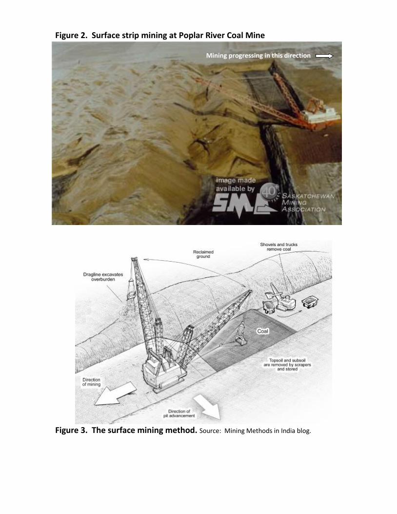
Figure 2. Surface strip mining at Poplar River Coal Mine
Figure 3. The surface mining method. Source: Mining Methods in India blog.
Mining progressing in this direction

Figure 4. Floor Plan

9 10 11 12
8 7 6 5
1 2 3 4
9 10 11 12
8 7 6 5
1 2 3 4
9 10 11 12
8 7 6 5
1 2 3 4
9 10 11 12
8 7 6 5
1 2 3 4
9 10 11 12
8 7 6 5
1 2 3 4
9 10 11 12
8 7 6 5
1 2 3 4
3 When the dragline has
removed the overburden from site 4 the Shovel can start mining the coal.
8 Scrapers return the topsoil to the area starting in the unnumbered blocks. Reclaiming the land. Darker green represents hills with two cubes of topsoil.
2 First cut: dragline removes overburden and places it on top of bedrock.
7 Once all the coal has been removed the team must decide how they are going to reclaim the property. Decide where creeks, hills and lakes will be put.
Figure 5: Mining Stages (Looking from above)
Desk/Table/Floor = Bedrock
5 Once the coal has been removed from block 4 the dragline continues to remove the overburden at #5 placing it into the #4 space and on down the line. The dragline will wait at 9 until the coal has been removed from 8, then it will finish removing the overburden.
Desk/Table/Floor = Bedrock
Desk/Table/Floor
Desk/Table/Floor
6 When all the overburden and coal have been removed from 9 – 12 the bedrock or bare desk/table/floor remains. There should be three rows of overburden lying on the bedrock.
Desk/Table/Floor
1 Scraper starts at 1 and removes the topsoil and vegetation sequentially and deposits it on the TOPSOIL STOCKPILE.
Coal to Coal Stockpile
Now bedrock
Desk/Table/Floor
Now bedrock
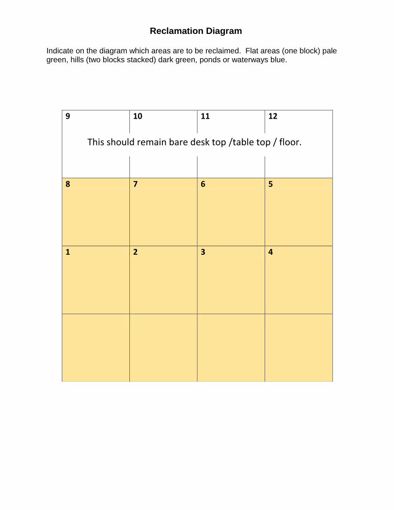
Indicate on the diagram which areas are to be reclaimed. Flat areas (one block) pale green, hills (two blocks stacked) dark green, ponds or waterways blue.
9 10 11 12
8 7 6 5
1 2 3 4
Reclamation Diagram
This should remain bare desk top /table top / floor.

COAL Cubes

OVERBURDEN

SOIL AND VEGETATION

SOIL AND WATER

Haul Truck: Haul trucks can carry 145 – 155 tonnes of coal per load. When loaded they drive at 60 km per hour transporting the coal from the mine site to the Coal Load-out Facility.
Dragline: The dragline is 66 m tall and has a boom 120 meters long (1.2 Canadian football fields). One scoop holds 71 m3 of overburden. The empty bucket weighs 85 tonnes! The dragline clears away all of the overburden lying on top of the coal.
Scraper: Scrapers scrape the topsoil and plant material off of the overburden and transports it to a storage site where it will stay until it is time to reclaim the mine site. It may take several passes of the scraper to get down to the overburden. It can carry 26 BCM (bank cubic meter) of topsoil which it dumps from it’s “belly”. Scrapers are also used to place the topsoil on the land after it is leveled.
Shovel: The bucket on these shovels will hold 15 tonnes of coal. The shovel will dig through the 3 - 5 m deep coal seam depositing it into the Haul Trucks.
ROLE CARDS

Bulldozer: At the Poplar River mine they typically use 4 Dozers for many activities. They help level the land so that the dragline can “walk” up and down the pit, they level the piles of overburden that are left behind by the dragline and re-contour the piles into new landscapes. They also help move coal from the stock pile into the Coal Load-out facility when the haul trucks do not directly dump their coal into the hopper.
Coal Load-out Facility: The Coal Load-out Facility is automated and has one controller. The coal is moved by conveyor belt from the haul trucks or from the coal stockpile and deposited into slowly moving rail cars.
Rail Car: Poplar River Mine has their own rail lines to the SaskPower coal generating station. Usually, the rails cars hold 85 - 90 tonnes of coal. The train at Poplar River Mine has 24 cars making 5 - 6 trips to the coal plant each day.
Power Plant Trestle: When the full rail cars reach the SaskPower Coal Trestle the cars are triggered to open up and dump their coal as they slowly roll over the storage bins. The Trestle Operator runs the computerized system.

Loader: The loader is used to load coal out of the pit when the shovels are unavailable or unable to get to areas in the pits.
Grader: Graders are used throughout the mine operation to provide smooth roads for the coal haulers to drive on. They also smooth out contours created by the dozers and get the leveled areas ready for topsoil.
Mine Engineer: The Mine Engineer is the person who plans the design of the mine’s pits, and haul roads as well as determines the sequence in which the draglines dig. Besides monitoring the day to day mining activities the Mine Engineer also does the production analysis determining grade (quality) and amount of the coal being produced daily, monthly, and annually as well as future production.
Environmental Engineer: The Environmental Engineer designs and monitors the reclamation of the area that has been mined. As part of this they plan the removal and the replacement of the soil covering the mine site. Another role is ensuring that the company complies with the environmental regulations and permits set out by the provincial and federal governments.

Geologist: A geologist conducts exploration for the coal by using drills to determine where it is, how much there is and its quality. Once they have this information they create a geological model. This model will help the Mine Engineer determine where to mine.

Environmental Engineer: 1. Once mining has stopped it is time to reclaim the
land. Using the Reclamation Diagram discuss with the rest of the group/class what the land is going to look like and draw up the plan (see Figure 3). Decide if you want hills, a pond, how big and where.
2. It is important to mark up the map properly so
the dozer operators will know where to put the overburden and the scraper operators know where to put the topsoil. Remember you only have 8 water blocks to use, and topsoil and water cannot go directly on top of bedrock.
3. The dozer operator picks up the overburden
blocks one at a time and places them to form hills and valleys according to the diagram.
4. The scraper operator picks up a topsoil block at
the topsoil stockpile and carries the block back to the mined area and hands the block to the grader operator. The Environmental Engineer shows the grader operators where to place the blocks according to the diagram. The scraper drivers return to get another load (block). Repeat this until the area has been landscaped according to your plan.
Mining Engineer: 1. Before everything begins ask the Geologist
about the topsoil. 2. Scraper operators will pick up one block of
topsoil at a time and deposit them in the topsoil stockpile. When all the topsoil has been removed go to #3.
3. Ask the Geologist about the overburden. Go
to #4. 4. The Dragline operator will pick up one
overburden block at a time and will place it directly across from the cut on the previously mined area (this area will be bare down to the bedrock (the desk/table or floor area.) Once the dragline has moved ahead by 4 blocks go to #5
5. Ask the Geologist about the coal. Go to #6 6. The Shovel operator (blocks 1 – 6 12-13) or
the Loader operator (blocks 7 – 12) will pick up a black block representing coal and hand it to the Haul truck driver who will carry the block to the coal stockpile and give it to the Dozer operator who will place the blocks neatly to create a new stack of blocks. The Haul truck operator returns to the shovel to pick up the next load of coal.
7. When the Dragline reaches the end of the cut
the Dragline operator will wait until all the coal has been removed before it continues to remove the overburden in the next cut. Continue on all the rows until all the overburden and coal has been removed.
8. After all the coal has been removed ask the
Geologist about the bedrock. Go to #9. 9. Explain: Most of the coal (90%) is dumped by
the haul trucks into the hopper which is connected directly to the loading terminal. The dozers are only used to push coal off the pile when the haul trucks are having a hard time getting to the hopper such as in bad weather or the trucks have broken down.
Have the Dozer Operator pass the blocks of
coal one at a time to the Load-out Facility Operator who will pass them on to the Rail Cars. When all the rail cars are full the train will move to the Power Plant Terminal Trestle, hand the coal to the Power Plant Terminal Trestle Operator and return to fill up again. The Power Plant Terminal Trestle Operator will pile up the coal. Transport all the coal to the Power Plant (this may take a few trains).
10. Once all the coal has been sent to the Power
Plant hand over the management to the Environmental Engineer.

Geologist’s Dialogue (The Mining Engineer will ask you for your information)
1. Topsoil developed from the breakdown of rocks and minerals in the overburden as well
as decomposed (dead) plant and animal materials. It has taken over 8,000 years for this topsoil to develop. The soil in the coal mining area ranges from brown in the west to black in the south east of the province.
At one time this area was covered by native prairie grasses and shrubs. Since the time
farming began in this area, much of the native prairie has been replaced by crops such as grain (wheat, durum, barley, etc), pulses (lentils, peas, etc) and oil seeds (Canola, Flax, etc)
2. Overburden is all the material laid down since the deposition of the coal swamps.
This was a time when rivers criss-crossed over the area depositing sands, gravels and boulders. Around 38 million years ago the land started to look much like it does today, covered in woodland and grasses. At 14 million years you could find 3-toed horse, pronghorn and mice but things were getting cooler.
The last glacier sitting on top of Southern Saskatchewan happened about 17,000 years
ago. As the glaciers moved southward across the province it ground up the underlying rocks and carried them in the ice. When the climate started to warm up and the ice began to melt (about 10,000 years ago) all the ground up rock (clay, silt, sand) as well as the boulders and stones were left behind.
3. Coal in Southern Saskatchewan was deposited about 60 million years ago (after the
dinosaurs died out). Saskatchewan was a warmer place and Southern Saskatchewan was covered by swamps. During this time trees and plants died in the swamps and were buried by overburden (sands, gravels and till) for millions of years. The plants deposited in the swamps were under pressure and a little heat. This changed them into carbon – or coal.
The coal bed or seam mined in Southern Saskatchewan is called the Ravenscrag
formation and is a low grade coal called lignite. It hasn’t been put under a lot of pressure and heat; fossil plants can still be seen in it. The coal seam is 3 – 5m thick.
4. Underlying Clay and Bedrock: Underneath the coal seam is a clay unit. Clay is common
at the base of all coal seams. These clays were probably deposited by rivers during times of flooding. They provided the fertile ground for the swamp plants to grow on.
Immediately under the clay floor of the Willow Bunch coal seam (mined seam) are 5 more
coal seams that are within the Ravenscrag Formation. These seams are too deep to be able to mine using the surface mining method.
Below the Ravenscrag Formation is the boundary between the Tertiary and the
Cretaceous or the time of the dinosaurs. It was in the sandstone rocks of the Frenchman Formation that the T.rex fossil “Scotty” was found.

TOPSOIL STOCKPILE

COAL STOCKPILE and LOAD-OUT FACILITY

POWER PLANT COAL TERMINAL TRESTLE