Central Valley Flood Protection Plan Update 2022 Public Draft
288
CENTRAL VALLEY FLOOD PROTECTION PLAN 2022 UPDATE CLIMATE RESILIENCE | PERFORMANCE TRACKING | ALIGNMENT
-
Upload
khangminh22 -
Category
Documents
-
view
0 -
download
0
Transcript of Central Valley Flood Protection Plan Update 2022 Public Draft

CENTRAL VALLEYFLOOD PROTECTION PLAN
2022UPDATE
CLIMATE RESILIENCE | PERFORMANCE TRACKING | ALIGNMENT
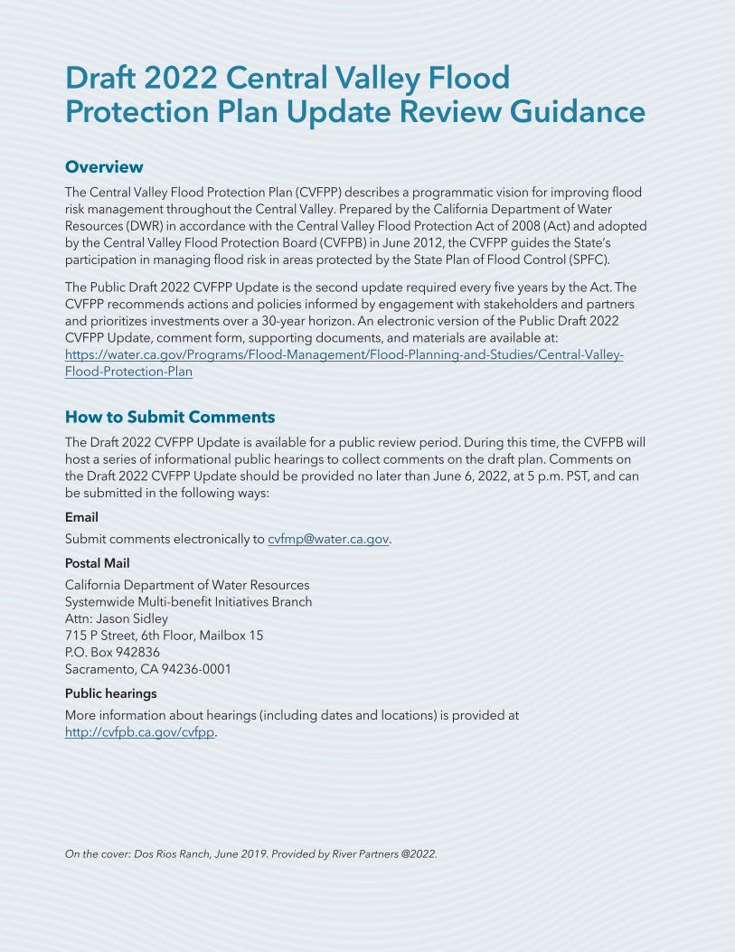
Draft 2022 Central Valley Flood Protection Plan Update Review Guidance
OverviewThe Central Valley Flood Protection Plan (CVFPP) describes a programmatic vision for improving flood risk management throughout the Central Valley. Prepared by the California Department of Water Resources (DWR) in accordance with the Central Valley Flood Protection Act of 2008 (Act) and adopted by the Central Valley Flood Protection Board (CVFPB) in June 2012, the CVFPP guides the State’s participation in managing flood risk in areas protected by the State Plan of Flood Control (SPFC).
The Public Draft 2022 CVFPP Update is the second update required every five years by the Act. The CVFPP recommends actions and policies informed by engagement with stakeholders and partners and prioritizes investments over a 30-year horizon. An electronic version of the Public Draft 2022 CVFPP Update, comment form, supporting documents, and materials are available at: https://water.ca.gov/Programs/Flood-Management/Flood-Planning-and-Studies/Central-Valley-Flood-Protection-Plan
How to Submit CommentsThe Draft 2022 CVFPP Update is available for a public review period. During this time, the CVFPB will host a series of informational public hearings to collect comments on the draft plan. Comments on the Draft 2022 CVFPP Update should be provided no later than June 6, 2022, at 5 p.m. PST, and can be submitted in the following ways:
Submit comments electronically to [email protected].
Postal Mail
California Department of Water Resources Systemwide Multi-benefit Initiatives Branch Attn: Jason Sidley 715 P Street, 6th Floor, Mailbox 15 P.O. Box 942836 Sacramento, CA 94236-0001
Public hearings
More information about hearings (including dates and locations) is provided at http://cvfpb.ca.gov/cvfpp.
On the cover: Dos Rios Ranch, June 2019. Provided by River Partners @2022.

Central Valley Flood Protection Plan
Update 2022
Public Draft
GAVIN NEWSOMGovernor
State of California
WADE CROWFOOTSecretary
Natural Resources Agency
KARLA NEMETHDirector
Department of Water Resources
APRIL 2022
State of California
Natural Resources Agency
Department of Water Resources

ii 2022 CENTRAL VALLEY FLOOD PROTECTION PLAN UPDATE PUBLIC DRAFT APRIL 2022
PLACEHOLDER:
2022 CVFPP Update Call to Action

APRIL 2022 2022 CENTRAL VALLEY FLOOD PROTECTION PLAN UPDATE PUBLIC DRAFT iii
PLACEHOLDER:
2022 CVFPP Update Call to Action
iv 2022 CENTRAL VALLEY FLOOD PROTECTION PLAN UPDATE PUBLIC DRAFT APRIL 2022
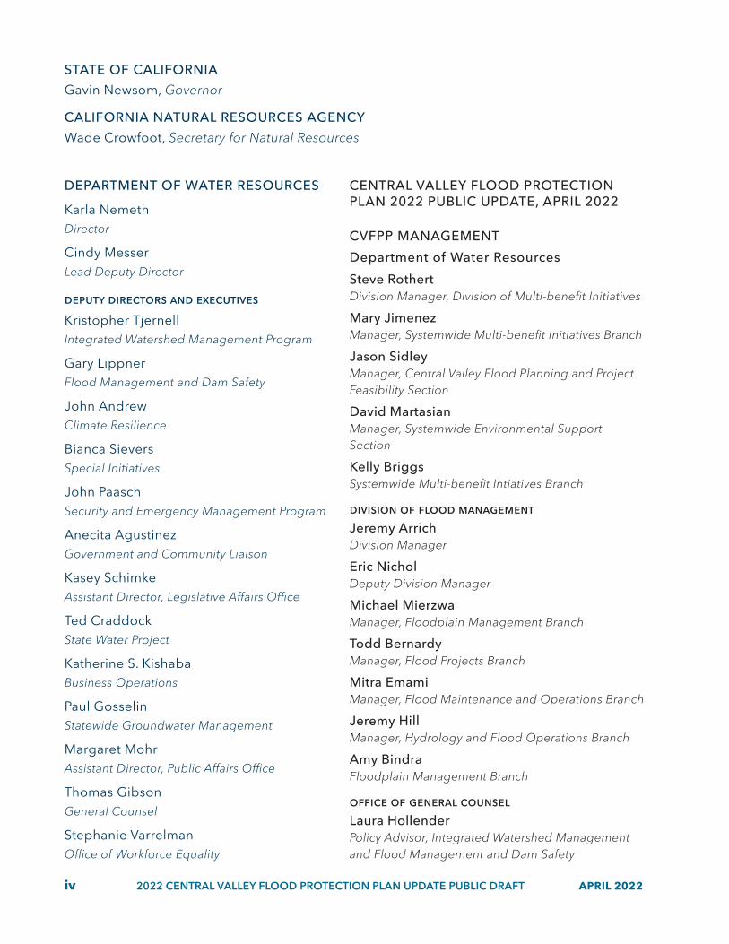
STATE OF CALIFORNIA
Gavin Newsom, Governor
CALIFORNIA NATURAL RESOURCES AGENCY
Wade Crowfoot, Secretary for Natural Resources
DEPARTMENT OF WATER RESOURCES
Karla NemethDirector
Cindy MesserLead Deputy Director
deputy directors and executives
Kristopher TjernellIntegrated Watershed Management Program
Gary LippnerFlood Management and Dam Safety
John AndrewClimate Resilience
Bianca SieversSpecial Initiatives
John PaaschSecurity and Emergency Management Program
Anecita AgustinezGovernment and Community Liaison
Kasey SchimkeAssistant Director, Legislative Affairs Office
Ted CraddockState Water Project
Katherine S. KishabaBusiness Operations
Paul GosselinStatewide Groundwater Management
Margaret MohrAssistant Director, Public Affairs Office
Thomas GibsonGeneral Counsel
Stephanie VarrelmanOffice of Workforce Equality
CENTRAL VALLEY FLOOD PROTECTION PLAN 2022 PUBLIC UPDATE, APRIL 2022
CVFPP MANAGEMENT
Department of Water Resources
Steve RothertDivision Manager, Division of Multi-benefit Initiatives
Mary JimenezManager, Systemwide Multi-benefit Initiatives Branch
Jason SidleyManager, Central Valley Flood Planning and Project Feasibility Section
David MartasianManager, Systemwide Environmental Support Section
Kelly BriggsSystemwide Multi-benefit Intiatives Branch
division of flood managementJeremy ArrichDivision Manager
Eric NicholDeputy Division Manager
Michael MierzwaManager, Floodplain Management Branch
Todd BernardyManager, Flood Projects Branch
Mitra EmamiManager, Flood Maintenance and Operations Branch
Jeremy HillManager, Hydrology and Flood Operations Branch
Amy BindraFloodplain Management Branch
office of general counselLaura HollenderPolicy Advisor, Integrated Watershed Management and Flood Management and Dam Safety

APRIL 2022 2022 CENTRAL VALLEY FLOOD PROTECTION PLAN UPDATE PUBLIC DRAFT v
REPORT LEADS
Jennifer MarrStatewide Infrastructure Investigations Branch
Laura ByrdProject Manager (Jacobs)
Lead EditorRobert StoltzTechnical Publications, Project Services Office
Lead GraphicsScott OllingCreative Services Branch, Public Affairs Office
SUPPORTING EFFORTS
Conservation Strategy 2022 UpdateLead: David Martasian, Manager, Systemwide Environmental Support Section △ Support: Lori Clamurro-Chew, Heidi Hall, Josh Brown, Adam Henderson, Jeremy Thomas (Jacobs), Debra Bishop (Jacobs), John Hunter (ESA)
Flood System Status ReportLead: Wade Wylie, Manager, Flood Project Inspection and Assessment Section △ Support: Zach Jojola, David Julian
State Plan of Flood Control Descriptive DocumentLead: Wade Wylie, Manager, Flood Project Inspection and Assessment Section △ Support: Zach Jojola, David Julian
Technical AnalysisLead: MD Haque, Manager, Risk Assessment and Mapping Section △ Support: Darren Bonfantine, Chong Vang, Romain Maendly, Michael Anderson, Ricky Doung, David Arrate, Shivcharan Sandhu, Jesus Esparza, Steve Cowdin, Satya Gala (GEI), Nathan Pingel (HDR), Joanna Leu (HDR), Kwabena Asante (GEI), Laura Byrd (Jacobs), Tapash Das (Jacobs)
Investment StrategyLead: Christopher Williams, Manager, Flood Planning Section △ Support: Hilary Mann, Aaron Wu, Laura Byrd (Jacobs), Sirisha Nemani (Jacobs), Katie Stone (Jacobs), CJ Porter
(Jacobs), Liz Stryjewski (Jacobs), Bryan Sherrill (Jacobs), Megan Campbell (Jacobs), Fatuma Yusuf (Jacobs), Tom Engler (MBK), Mark Cowan (LWA), Seth Wurzel (LWA)
Communications and EngagementLead: Jason Sidley, Manager, Central Valley Flood Planning and Project Feasibility Section △ Support: Heidi Hall, Karimi Arao, Wendy Wang, Sirisha Nemani (Jacobs), Katie Stone (Jacobs), Laura Byrd (Jacobs), Scott Carter (Jacobs), Carrie Price-Tinklepaugh (Jacobs), Matt Marvin (K&W), Ben Gettleman (K&W), Laura Kaplan (K&W), Christi Black-Davis (Edelman), Matt Notley (Edelman), Christina Burns (Edelman)
Outcome Based Performance TrackingLeads: Jason Sidley, Manager, Central Valley Flood Planning and Project Feasibility Section, Lori Clamurro-Chew, Systemwide Environmental Support Section △ Support: Paul Robinson (Jacobs), Jeremy Thomas (Jacobs), Debra Bishop (Jacobs), Tapash Das (Jacobs), Daniel Souza (Jacobs), Bryan Sherrill (Jacobs), Megan Campbell (Jacobs), Laura Byrd (Jacobs)
Regional Flood Management PlanningLead: Christopher Williams, Manager, Flood Planning Section △ Support: Aaron Wu, Laura Byrd (Jacobs), Sirisha Nemani (Jacobs), Katie Stone (Jacobs), Matt Marvin (K&W), Sharon Hu (K&W), Katy Kennedy (K&W), John Bowie (K&W)
Delta Plan Consistency DeterminationLead: Lori Price, Systemwide Environmental Support Section
California Environment Quality Act DocumentationLead: Lori Price, Systemwide Environmental Support Section

vi 2022 CENTRAL VALLEY FLOOD PROTECTION PLAN UPDATE PUBLIC DRAFT APRIL 2022
Message from the Director
PLACEHOLDER

APRIL 2022 2022 CENTRAL VALLEY FLOOD PROTECTION PLAN UPDATE PUBLIC DRAFT vii
Message from the Board President
PLACEHOLDER

Water is released from Lake Natoma at Nimbus Dam in Rancho Cordova, California, during high water in early 2017. Photo taken January 13, 2017.

APRIL 2022 2022 CENTRAL VALLEY FLOOD PROTECTION PLAN UPDATE PUBLIC DRAFT ix
ContentsChapter 1. Updating the CVFPP .................................................................................................................. 1-1
1.1 Context for the 2022 CVFPP Update .................................................................................... 1-3
1.2 Notable Events Influencing Flood Management in the Central Valley ............................1-4
1.2.1 High-Flow and Hydrologic Events .............................................................................. 1-5
1.2.2 Drought Conditions ...................................................................................................... 1-5
1.2.3 Wildfires .......................................................................................................................... 1-6
1.2.4 Covid-19 Pandemic ....................................................................................................... 1-6
1.2.5 Equity ............................................................................................................................... 1-6
1.3 Themes of the 2022 CVFPP Update ..................................................................................... 1-8
1.3.1 Climate Resilience ......................................................................................................... 1-8
1.3.2 Performance Tracking ................................................................................................. 1-11
1.3.3 Alignment with Other State Efforts ........................................................................... 1-12
1.4 Funding CVFPP Implementation ........................................................................................ 1-13
1.4.1 State Funding Opportunities and Challenges ........................................................ 1-13
1.4.2 Local Funding Challenges .......................................................................................... 1-14
1.4.3 Increased Federal Funding ........................................................................................ 1-14
1.5 Update Content and Supporting Documents .................................................................. 1-15
1.6 Communication and Engagement Conducted for this Update .................................... 1-17
Chapter 2. CVFPP Implementation Progress ............................................................................................ 2-1
2.1 Partnerships and Collaborative Efforts ................................................................................. 2-3
2.2 Flood Risk Reduction Projects ............................................................................................... 2-6
2.2.1 Systemwide Actions ...................................................................................................... 2-8
2.2.2 Urban Actions ............................................................................................................... 2-11
2.2.3 Rural Actions ................................................................................................................. 2-14
2.2.4 Small Community Actions .......................................................................................... 2-15
2.3 Flood Management Planning ............................................................................................. 2-18

x 2022 CENTRAL VALLEY FLOOD PROTECTION PLAN UPDATE PUBLIC DRAFT APRIL 2022
2.3.1 Conservation Strategy 2022 Update ........................................................................ 2-18
2.3.2 State Plan of Flood Control Descriptive Document 2022 Update ....................... 2-20
2.3.3 2022 Flood System Status Report ............................................................................. 2-21
2.3.4 Updated Regional Flood Management Planning .................................................. 2-23
2.4 Improvements in the Climate Change Analysis ............................................................... 2-24
2.4.1 Hydrology ..................................................................................................................... 2-27
2.4.2 Innovative Climate Change Pilot Studies ................................................................. 2-28
2.4.3 Reservoir Vulnerability ................................................................................................ 2-29
2.4.4 Sea Level Rise ............................................................................................................... 2-30
2.4.5 Climate Change Vulnerability and Adaptation ....................................................... 2-30
2.5 Floodplain Risk Management ............................................................................................. 2-34
2.5.1 Federal Floodplain Management Initiatives ............................................................ 2-34
2.5.2 State Floodplain Management Initiatives ................................................................ 2-35
2.5.3 Integrated Floodplain Management State Initiatives ............................................. 2-37
2.6 Flood System Operations and Maintenance .................................................................... 2-38
2.7 Flood Emergency Preparedness and Response .............................................................. 2-40
2.8 Progress on Policy Issue Recommendations .................................................................... 2-41
2.9 Aligning with Other State Efforts ........................................................................................ 2-53
2.9.1 California Water Resilience Portfolio ......................................................................... 2-53
2.9.2 California Water Plan Updates 2018 and 2023 ....................................................... 2-58
2.9.3 Implementation of the SGMA .................................................................................... 2-58
2.9.4 Other Programs ........................................................................................................... 2-60
2.10 Developing CVFPP Performance Tracking and Adaptive Management ................... 2-64
2.10.1 Outcome Measurement Framework ...................................................................... 2-65
2.10.2 Pilot systems for Public Safety, Healthy Economy, and Ecosystem Vitality ....... 2-67
2.10.3 Build-Out of Other Societal Values and Performance Tracking ......................... 2-68
Chapter 3. Risks, Priority Actions, and Intended Outcomes ................................................................... 3-1
3.1 Risk Without Investment in the SSIA ..................................................................................... 3-1
3.2 Priorities ..................................................................................................................................... 3-8
3.2.1 State and Systemwide Priorities .................................................................................. 3-8
3.2.2 Regional Priorities ........................................................................................................ 3-11
3.3 State Systemwide Investment Approach Description and Analysis ............................. 3-12
3.3.1 Systemwide Management Actions ........................................................................... 3-15

APRIL 2022 2022 CENTRAL VALLEY FLOOD PROTECTION PLAN UPDATE PUBLIC DRAFT xi
3.3.2 Urban Management Actions ...................................................................................... 3-24
3.3.3 Rural Management Actions ........................................................................................ 3-28
3.3.4 Small Community Management Action ................................................................... 3-32
3.3.5 Flood Management Policies ...................................................................................... 3-37
3.4 SSIA Outcomes ..................................................................................................................... 3-46
3.4.1 Flood-Related Public Health and Safety Outcomes ............................................... 3-46
3.4.2 Flood-Related Ecosystem Vitality Outcomes .......................................................... 3-49
3.4.3 Flood-Related Healthy Economy Outcomes ........................................................... 3-49
3.4.4 Other Flood-Related Enriching Experiences Outcomes ....................................... 3-52
3.4.5 Flood-Related Equity and Social Justice Outcomes .............................................. 3-53
Chapter 4. Investment Strategy and Imperative to Act ............................................................................ 4-1
4.1 CVFPP Guides Flood Management Investments ............................................................... 4-2
4.2 Investment Costs ..................................................................................................................... 4-4
4.2.1 Estimating Portfolio Costs ............................................................................................ 4-5
4.2.2 Ongoing Investments Costs Over 30 Years ............................................................... 4-6
4.2.3 Capital Investments Costs Over 30 Years ................................................................ 4-10
4.3 Funding Mechanisms and Cost–Shares ............................................................................ 4-13
4.3.1 Summary of 2017 Funding Mechanisms Progress ................................................. 4-13
4.3.2 Summary of 2022 Recommended Funding Mechanisms ..................................... 4-16
4.3.3 Summary of 2022 Recommended Cost–Shares ..................................................... 4-20
4.4 CVFPP Funding Plan and Program Delivery ..................................................................... 4-22
4.4.1 Investment Phasing ..................................................................................................... 4-23
4.4.2 CVFPP Funding Plan ................................................................................................... 4-25
4.4.3 Delivering Results through State Programs ............................................................. 4-28
4.5 Path Forward for Continued Implementation ................................................................... 4-30
Tables 2.1 State Investments from General Obligation Bonds and General Fund for
State Plan of Flood Control Flood Management (2007–2021) ......................................2-2
2.2 CVFPP Climate Change Adaptation Types, Actions, and Measures .............................2-31
2.3 CVFPP Updated Policy Issues Summary ...........................................................................2-41
2.4 Progress on Flood Management Policy Issues ................................................................2-43
2.5 Crosswalk of the Water Resilience Portfolio Goals and 2022 CVFPP Update ............2-54
3.1 Ongoing Management Action Categories for the 2022 SSIA Portfolio ...................... 3-12

xii 2022 CENTRAL VALLEY FLOOD PROTECTION PLAN UPDATE PUBLIC DRAFT APRIL 2022
3.2 Capital Management Action Categories of the 2022 SSIA Portfolio ........................... 3-13
3.3 High-Priority Policy Issue Recommendations for CVFPP and Agency Leads ............. 3-38
3.4 Flood-Related Indicators and Metrics for Public Health and Safety ............................ 3-47
3.5 Flood-Related Indicators and Metrics Outcomes for Ecosystem Vitality .................... 3-49
3.6 Flood-Related Indicators and Metrics for Healthy Economy ......................................... 3-50
3.7 Flood-Related Indicators and Metrics for Enriching Experiences ............................... 3-53
3.8 Example Flood-Related Societal Benefits and Indicators for Equity and Social Justice ....................................................................................................................... 3-54
4.1 Ongoing Investments of the 2022 SSIA Portfolio Per Year ............................................. 4-7
4.2 Capital Investments of the 2022 SSIA Portfolio Over 30 Years ..................................... 4-12
4.3 Overview of Progress Made Towards the 2017 Recommended Funding Mechanisms ..... 4-15
4.4 Recommended Funding Mechanisms and Historical Expenditures ............................ 4-19
4.5 Target Cost-Share Ranges for Ongoing Investments .................................................... 4-21
4.6 Target Cost-Share Ranges for Capital Investments ........................................................ 4-22
4.7 Recommended 2022 CVFPP Funding Plan .................................................................... 4-27
Figures 1.1 Precipitation Patterns and Form will Change Throughout the
Central Valley Watershed .................................................................................................... 1-9
1.2 Atmospheric Rivers are the Primary Source of Major Flood Events in the Central Valley ...................................................................................................................... 1-10
1.3 Conceptual Example of Monitoring and Reporting Trends ......................................... 1-11
1.4 2022 CVFPP Update and Supporting Documents ......................................................... 1-17
1.5 Key Communication and Engagement Activities for the 2022 CVFPP Update ......... 1-19
2.1 Geographic Distribution of Flood Risk Reduction Projects and Actions Completed in the Central Valley since 2016 .................................................................... 2-7
2.2 Small Communities that Received Funding from the Small Communities Flood Risk Reduction Program since 2017 .................................................................... 2-17
2.3 Qualitative Description of Current and Projected Climate Trends in California ........ 2-24
2.4 How the Watershed Responds to Projected Climate Change ..................................... 2-26
2.5 Areas Where the Legal Delta and SPFC Planning Area Overlap ................................. 2-62
2.6 CVFPP Performance Tracking and Adaptive Management Cycle ............................... 2-67
3.1 CVFPP Multidisciplinary Analysis ........................................................................................ 3-2
3.2 Without-SSIA Expected (Average) Annual Life Loss for Central Valley ......................... 3-6
3.3 Without-SSIA Expected (Average) Annual Damage within Central Valley ................... 3-7
3.4 In-Progress and Planned Management Actions within the 2022 SSIA Portfolio Category ........................................................................................... 3-14

APRIL 2022 2022 CENTRAL VALLEY FLOOD PROTECTION PLAN UPDATE PUBLIC DRAFT xiii
3.5 Sacramento River Basin Systemwide Management Actions by Geography .............. 3-17
3.6 Sacramento River Basin Systemwide Actions by 2022 SSIA Portfolio Category ....... 3-17
3.7 San Joaquin River Basin Systemwide Management Actions by Geography ............. 3-21
3.8 San Joaquin River Basin Systemwide Actions by 2022 SSIA Portfolio Category ....... 3-21
3.9 Sacramento River Basin Urban Management Actions by Geography ........................ 3-25
3.10 Sacramento River Basin Urban Actions by 2022 SSIA Portfolio Category .................. 3-25
3.11 San Joaquin River Basin Urban Management Actions by Geography ....................... 3-27
3.12 San Joaquin River Basin Urban Actions by 2022 SSIA Portfolio Category ................. 3-27
3.13 Sacramento River Basin Rural Management Actions by Geography .......................... 3-30
3.14 Sacramento River Basin Rural Actions by 2022 SSIA Portfolio Category .................... 3-30
3.15 San Joaquin River Basin Rural Management Actions by Geography ......................... 3-31
3.16 San Joaquin River Basin Rural Actions by 2022 SSIA Portfolio Category ................... 3-31
3.17 Sacramento River Basin Small Community Management Actions by Geography ...... 3-35
3.18 Sacramento River Basin Small Community Actions by 2022 SSIA Portfolio Category ........................................................................................... 3-35
3.19 San Joaquin River Basin Small Community Management Actions by Geography ....... 3-36
3.20 San Joaquin River Basin Small Community Actions by 2022 SSIA Portfolio Category ........................................................................................... 3-36
3.21 Sacramento River Basin Expected (Average) Annual Life Loss ...................................... 3-48
3.22 San Joaquin River Basin Expected (Average) Annual Life Loss ................................... 3-48
3.23 Sacramento River Basin Expected (Average) Annual Damage .................................... 3-51
3.24 San Joaquin River Basin Expected (Average) Annual Damage ................................... 3-52
4.1 How the CVFPP Guides Funding Development for Programs ....................................... 4-3
4.2 CVFPP Investment Needs .................................................................................................... 4-5
4.3 Trend of Ongoing Investment Expenditures and Recommended Increases ............ 4-10
4.4 2022 CVFPP Update Capital Investment Portfolio Status ............................................. 4-13
4.5 2022 CVFPP Update Recommended Funding Mechanisms ....................................... 4-17
4.6 Summary of State, Federal, and Local Historical Expenditures in the Central Valley by Fiscal Year ............................................................................................. 4-18
4.7 CVFPP Funding Plan Development Overview ................................................................ 4-23
4.8 Trend of Recommended Ongoing Investments Phased Over Time ........................... 4-24
4.9 Trend of Recommended Capital Investments Phased Over Time .............................. 4-25
4.10 Recommended 2022 CVFPP Cost Share for Ongoing Investments ........................... 4-28
4.11 Recommended 2022 CVFPP Cost Share for Capital Investments ............................... 4-28
4.12 DWR Flood Management Programs ................................................................................ 4-29

xiv 2022 CENTRAL VALLEY FLOOD PROTECTION PLAN UPDATE PUBLIC DRAFT APRIL 2022
AB Assembly Bill
Act Central Valley Flood Protection Act of 2008
AR atmospheric river
ARCF American River Common Features
ARSS Aerial Remote Sensing of Snow Program
ASFPM Association of State Floodplain Managers
ASO Airborne Snow Observatory
BRIC Building Resilient and Infrastructure Communities
BWFS basinwide feasibility study
Cal OES California Governor’s Office of Emergency Services
CCORE Capitol Collaborative on Race & Equity
CEP community engagement planning
CEQA California Environmental Quality Act
CDC California Debris Commission
CDFW California Department of Fish and Wildlife
CMP corridor management plan
CNRA California Natural Resources Agency
Conservation Strategy
Central Valley Flood Protection Plan Conservation Strategy
CPA conservation planning area
CVA Central Valley Project
CVFPB Central Valley Flood Protection Board
CVFPP Central Valley Flood Protection Plan
CVP Central Valley Project
CW3E Center for Western Weather and Water Extremes
DAC disadvantaged community
Delta Sacramento-San Joaquin Delta
DFM Division of Flood Management
DMI Division of Multi-benefit Initiatives
DMP deferred maintenance project
DSC Delta Stewardship Council
DWR California Department of Water Resources
Eco Restore California EcoRestore
EDA economically distressed areas
EO executive order
EWN Engineering With Nature
F-CO forecast-coordinated operation
FEMA Federal Emergency Management Agency
FIRO forecast-informed reservoir operation
Flood-MAR floodwater used for managed aquifer recharge
FMAP Flood Maintenance Assistance Program
FPTS Flood Performance Tracking System
Framework outcome-based framework for performance tracking and adaptive management
FSRP flood system repair program
Acronyms and Abbreviations

APRIL 2022 2022 CENTRAL VALLEY FLOOD PROTECTION PLAN UPDATE PUBLIC DRAFT xv
FSSR flood system status report
GCM general circulation model
GO general obligation
GSA groundwater sustainability agency
GSP groundwater sustainability plan
HMGP Hazard Mitigation Grant Program
IWM integrated watershed management
JEDI justice, equity, diversity, and inclusion
LEBLS Lower Elkhorn Basin Levee Setback
LiDAR light detection and ranging
LMA local maintaining agency
Merced Study
Merced River Flood-MAR Reconnaissance Study
MID Merced Irrigation District
MUSR Mid and Upper Sacramento River
NEPA National Environmental Policy Act
NFIP National Flood Insurance Program
NGO nongovernmental organization
NMFS National Marine Fisheries Service
NOAA National Oceanic Atmospheric Agency
NULE non-urban levee evaluation
O&M operations and maintenance
OMRR&R operation, maintenance, repair, replacement, and rehabilitation
OPC Ocean Protection Council
PEIR program environmental impact report
PL Public Law
RCIS regional conservation investment strategy
RD reclamation district
Reclamation U.S. Bureau of Reclamation
RFMP regional flood management plan
SAFCA Sacramento Area Flood Control Agency
SB Senate Bill
SBFCA Sutter Butte Flood Control Agency
SCADA supervisory control and data acquisition
SCFRRP Small Communities Flood Reduction Program
SGMA Sustainable Groundwater Management Act
SJAFCA San Joaquin Area Flood Control Agency
SJRRP San Joaquin River Restoration Program
SPA Systemwide Planning Area
SPFC State Plan of Flood Control
SRFCP Sacramento River Flood Control Project
SSIA State Systemwide Investment Approach
State State of California
State Water Board
California State Water Resources Control Board
SWAP State Wildlife Action Plan
SWIF systemwide information framework
SWP State Water Project
TRLIA Three Rivers Levee Improvement Authority
ULE urban levee evaluation
USACE United States Army Corps of Engineers
USFWS U.S. Fish and Wildlife Service
USGS U.S. Geologic Survey
WRDA Water Resources Development Act
WRP Water Resilience Portfolio
YBCS Yolo Bypass-Cache Slough
YWA Yuba Water Agency
°C degrees Celsius
°F degrees Fahrenheit

An aerial view of waterfowl flying over a flooded field caused by winter storms in the Sacramento-San Joaquin River Delta in San Joaquin County, California. Photo taken March 8, 2019.

APRIL 2022 2022 CENTRAL VALLEY FLOOD PROTECTION PLAN UPDATE PUBLIC DRAFT 1-1
1Updating the CVFPP
The Great Central Valley is a unique place in the landscape of California. The valley defines the interior of the state and drains its two largest watersheds, the Sacramento and San Joaquin river basins. It includes an intensely dynamic and complex hydrologic system, increasingly vulnerable to dramatic swings between drought and flood.
Millions of Californians call the Central Valley home, and the region’s residents are among the most ethnically and culturally diverse in the nation. The Central Valley includes traditional tribal territories of the Konkow, Maidu, Monache, Miwok, Nisenan, Nomlaki, Patwin, Pomo, and Yokut. Urban centers, such as Sacramento, Redding, Chico, Stockton, Modesto, Merced, and Fresno, as well as many small and rural communities such as Wheatland, Grimes, Locke, Grayson, and Firebaugh, dot the valley’s landscape. Many of the urban and rural communities are adjacent to rivers, creeks, and sloughs. The Central Valley is a year-round home to a wide variety of species and hosts a spectacular array of migrating birds each winter. Hundreds of bird species rely on the valley’s wetlands and working landscapes as temporary refuge on their annual Pacific Flyway pilgrimage. In addition, Central Valley floodplains provide juvenile salmon rearing habitat that is rich in food and nutrients, which increase their survival rates once they enter the main stem rivers.
This part of California helps feed the world. The Central Valley is one of the world’s most productive agricultural regions, supporting a $17 billion agricultural economy that is unmatched in its diversity of commodities.
One of the biggest threats to the residents, economy, and environmental resources in the Central Valley is the potential for a catastrophic flood. Although progress has been made during the last two decades to improve flood management, the Central Valley still has among the highest flood risk in the nation. The State-federal flood control system, also known as the State Plan of Flood Control (SPFC), reduces flood risks for 1.3 million Californians and $223 billion in structures and their contents, but it, too, is increasingly vulnerable to our changing climate. The SPFC is also increasingly vulnerable to aging infrastructure, deferred maintenance, and demands of a growing population and economy. Our improving understanding of climate change guides and prioritizes our decisions in preparation for the next flood disaster in the Central Valley.
The Central Valley Flood Protection Plan (CVFPP) is the State of California’s strategic blueprint for Central Valley flood risk management. It guides the State’s policies, investments, and partnerships. And it ensures a climate-driven technical foundation for a flood management system that helps protect our communities, contributes to native species recovery, and integrates fully into broader water management conversations. The CVFPP is part of California’s integrated water resources management strategy and supports both the California Water Resilience Portfolio and the California Water Plan. State law requires the California Department of Water Resources (DWR) to develop and update, and the Central Valley Flood Protection Board (CVFPB)

1-2 2022 CENTRAL VALLEY FLOOD PROTECTION PLAN UPDATE PUBLIC DRAFT APRIL 2022
to adopt, the CVFPP on a five-year cycle. The first CVFPP was adopted in 2012, and the regular update cycle ensures that it reflects best available science and information from the previous five years. The CVFPP is a descriptive document which reflects a systemwide approach to flood management. It describes recommendations to achieve the State’s goals with a diverse portfolio of management actions through DWR’s flood management programs.
The foundation of the CVFPP is the State Systemwide Investment Approach (SSIA). The SSIA guides how the State will invest in flood management in the Central Valley. This strategic approach helps ensure that limited public resources are directed to actions that will deliver the highest value for each investment and align with the intent of the law. The SSIA is an assembly of the most promising, cost-efficient, and implementable elements studied in the 2012 CVFPP. Appendix A provides more information on how the recommended SSIA was developed in 2012 and updated in 2017.
The SSIA includes a broad range of management actions to improve flood management within four areas of interest: systemwide, urban areas, rural-agricultural areas, and small communities. The SSIA includes 200-year level of protection for urban and urbanizing areas, up to 100-year level of protection for small communities, rural-agricultural levee repairs, weir and bypass expansions, flood structure modifications and improvements, and ecosystem restoration. The SSIA also includes floodplain transitory storage, groundwater recharge opportunities, and reservoir operations and management.
Among the most cost-effective components of the SSIA are management actions that reduce the residual flood risk that remains after structural improvements have been made. Residual risk management actions include operation and maintenance activities; emergency preparedness, response, and recovery activities; and floodplain management activities that help promote risk awareness and sound land use decision-making.
Our increasing understanding of flood risks in a changing climate requires us to think more creatively and act more urgently than ever before. This climate change imperative drives a greater focus on watershed-based approaches in the CVFPP and guides important refinements to the SSIA in this 2022 CVFPP Update. Furthering the technical and policy actions of the 2012 CVFPP and the 2017 CVFPP Update, the 2022 CVFPP Update is built around three guiding themes: building flood system climate resiliency; increasing accountability through performance tracking and transparency; and aligning strategically with other State water management planning efforts.
The 2022 CVFPP Update’s three central themes are imperative in a flood system that cannot be viewed in isolation. Climate change brings intensified challenges to all aspects of water resources management. Flood system managers must respond in-kind with innovative solution-sets that span water sectors historically insulated from one another. And we must recognize that among all aspects of modern-day Central Valley water management, how we collectively choose to steward our flood system may be the most determinative factor in this region’s water future.
Strengthening and expanding our flood management infrastructure is paramount to public safety, environmental health, and a strong economy in California. Expanding constrained floodways provides us opportunity to revive the valley’s floodplain, tidal, and riparian ecosystems. Reducing peak flows by allowing flood waters to spread onto suitable agricultural and open space lands can help recharge depleted groundwater aquifers. Improving upper watershed management, precipitation forecasting, and snowpack monitoring opens the door for additional reservoir reoperation and more efficient management of our increasingly uncertain surface water supplies.

APRIL 2022 2022 CENTRAL VALLEY FLOOD PROTECTION PLAN UPDATE PUBLIC DRAFT 1-3
These actions and policies are the types we must transform from anecdotes and pilot projects into standard operating procedures. And we cannot stop there. The 2022 CVFPP Update begins the important conversation about how historic flood management decisions may have contributed to inequities and how we as flood managers can use our decision-making authority to ensure equity and social justice become intrinsic to an effective Central Valley flood management system.
1.1 Context for the 2022 CVFPP Update The 2022 CVFPP Update marks the tenth anniversary of the first CVFPP and the second plan update. Much progress has been made in reducing Central Valley flood risk since the Central Valley Flood Protection Act of 2008 and the release of the first CVFPP. State investments totaling more than $3.5 billion from 2007 to 2021, with another $500 million in recent commitments, have reduced flood risks, improved operations and maintenance (O&M), and enhanced ecosystems throughout the Central Valley.
Still, as evidenced by the impacts of increased extreme weather events caused by climate change, the value of the CVFPP has never been greater as major flood-related risks in the Central Valley grow. These risks include the following.
• Communites throughout the Central Valley are threatened by the current and future effects of climate change on hydrology, such as increases in precipitation falling as rain instead of snow at higher elevations, extreme precipitation events fueled by atmospheric rivers, and runoff events that significantly exceed the State’s flood system design capacity. Extreme events (flood and drought) are anticipated to increase in frequency and intensity.
• Flood risks for Central Valley residents remain high and will increase with projected growth.
▶ As of 2021, 1.32 million people are at risk in SPFC floodplains (an increase of almost 70,000 people since 2017), and the population within these floodplains is expected to increase to 1.7 million by 2072. Without further investments in the SSIA, estimated loss of life as a result of flood events will continue to increase. Over a 50-year period (2022 through 2072), estimates of the annual lives lost more than doubles in the Sacramento River Basin and quadruples in the San Joaquin River Basin. Similar to life risk, without further investments in the SSIA, economic damages from floods will continue to increase. Based on 2021 data, more than $223 billion of structures and their contents are at risk. Over a 50-year period (2022 through 2072), the annual economic damages estimates almost doubles in the Sacramento River Basin and more than quadruples in the San Joaquin River Basin.
▶ Nationally, research shows socially vulnerable populations bear a disproportionate share of adverse impacts of flooding, yet recovery spending underserves those populations that need it most. The “California Poverty Measures” study by the Public Policy Institute of California in 2019 found poverty rates in Central Valley counties ranged from 10 percent to just over 20 percent, with poverty higher among children, seniors, Latinos, and less-educated adults. The limited research available in the Central Valley linking flood risk and demographics suggests socially vulnerable communities face some of the highest flood risks, especially in the San Joaquin Valley. Further, socially vulnerable communities often lack necessary resilience to cope with and recover from flood events without broader assistance, raising questions about how best to improve equity in flood management investments.

1-4 2022 CENTRAL VALLEY FLOOD PROTECTION PLAN UPDATE PUBLIC DRAFT APRIL 2022
▶ Other social vulnerability factors and outcomes related to flood risk and resiliency need to be further evaluated.
• Backlog of deferred maintenance (including maintenance and repair, rehabilitation, and replacement activities) continues to increase, despite significant recent investments for this purpose, resulting in new and more expensive capital improvement needs.
▶ A SPFC operation and maintenance, repair, rehabilitation, and replacement (OMRR&R) funding shortfall was estimated in 2017, and these actions continue to be under-resourced and challenging to permit. Chapter 4 presents updated investments needed for OMRR&R as well as deferred maintenance activities.
• Despite recent progress on implementing projects that improve environmental conditions at specific locations, the historic configuration and management of the flood system and factors, such as infrastructure and land uses adjacent to rivers, continue to inhibit natural processes, fragment riverine habitats, and contribute to the decline of native species.
▶ The projected impacts of climate change on ecological processes, habitats, and species necessitates a focus on building ecosystem resiliency and restoring ecological and geomorphic processes. This effort will require increasing the pace of multi-benefit project implementation, and an emphasis on nature-based solutions, such as widening river corridors and expanding floodplains to allow riverine habitats and species to be resilient and adaptable to projected changes in temperature, precipitation, and hydrology.
• A major flood event would have significant impacts on not only Central Valley residents, but all Californians and people nationwide.
▶ Agriculture-based communities could be significantly impacted and flood events during the growing season could disrupt national and international food supplies.
▶ This underscores the importance of understanding and focusing on the disproportionate impacts of flood risk to socially vulnerable communities.
• Demands on water resources in the Central Valley and the flood system have changed since the system was built over the past century.
▶ Opportunities to modify the flood system to support multiple benefits and contribute to sustainable and resilient water management remain challenged by policy issues affecting formulation, implementation, and long-term O&M of multi-benefit projects.
▶ Local flood managers have noted increasing challenges with post-fire hydrology and related runoff and water quality management, land rights for project improvements, landside levee encroachments, increased populations of people experiencing homelessness living along levees, and inadequate resources to reduce flood risk in rural areas.
1.2 Notable Events Influencing Flood Management in the Central ValleyNotable events have occurred since the publication of the 2017 CVFPP Update that influence flood risk in the Central Valley and how flood managers respond, including high-flow and hydrologic events, drought conditions, catastrophic wildfires, Covid-19 pandemic, and the modern social justice movement.

APRIL 2022 2022 CENTRAL VALLEY FLOOD PROTECTION PLAN UPDATE PUBLIC DRAFT 1-5
1.2.1 High-Flow and Hydrologic Events
The winter preceding release of the 2017 CVFPP Update was one of the wettest years on record in California and provided a reminder of the critical role the Central Valley flood management system plays in limiting flood damages and impacts. In most areas, the winter of 2016–2017 included a series of storm events that caused widespread damage to the flood system, particularly to the levees in the form of erosion, seepage, and compromised stability, including levees that were recently improved by large capital projects. Damages to the flood system required more than $500 million for repair and rehabilitation (excluding direct damages to the Oroville Dam spillway). Flood managers recognized that flood damages could have been much worse without the dedicated and vigilant efforts of local and State responders and levee monitors, as well as recent investments made to SPFC facilities.
A series of heavy storms in January 2017 required spillway releases at Oroville Dam and caused damage to the gated spillway. In early February 2017, a Category 5 atmospheric river (AR5, the highest category) settled over the Feather River Basin. As a result of the reduced use of the damaged gated spillway, runoff from the storm pushed reservoir levels to an elevation of 901 feet, and for the first time water flowed over the dam’s emergency spillway. Because of concerns about downhill erosion threatening the emergency spillway structure, the Butte County Sherriff’s Office issued an evacuation order for Oroville and multiple downstream communities along the Feather River. A coordinated emergency response facilitated the evacuation of almost 200,000 people. Repairs at both spillways have since been completed.
From February 25 through 28, 2019, a series of atmospheric river storms moved across Northern California. Precipitation was heaviest on February 25 and 26 with 2 to 6 inches across most of the region north of the Interstate 80 corridor, and up to 12 inches in foothill areas. At Cache Creek in Yolo County, water levels crested above danger stage, and multiple locations along the Upper and Lower Sacramento River systems reached flood stage. Damages to flood facilities were reported in Glenn County, Sacramento County, and Yolo County.
In late October 2021, a Category 5 atomspheric river produced record-breaking rainfall in areas of central and northern California. Sacramento set an all-time calendar-day rainfall record with 5.44 inches, beating the previous calendar-day record of 5.28 inches set on April 20, 1880.
December 2021 storms brought significant rain and record-breaking snow. The December 30, 2021, snow survey recorded 78.5 inches of snow depth and a snow water equivalent of 20 inches, which was 202 percent of average for the Phillips Station in the Sierra Nevada on this date. Nearly 17 feet of snow fell near Donner Pass in the month of December 2021 breaking a previous record for December snow at the University of California, Berkeley, Central Sierra Snow Laboratory. Statewide, the snowpack was 160 percent of average for the December 30, 2021, snow survey. The October and December 2021 events did not trigger activation of the State Flood Operations Center, and any resulting localized flooding was handled by local agencies.
1.2.2 Drought Conditions
Water Year 2017 was California’s second wettest in terms of statewide precipitation and ended the 2012–2016 drought conditions for most, but not all, of the state. Water Year 2018 reverted to dry conditions that were only briefly relieved by a slightly above-normal Water Year 2019. Water Year 2020 was California’s fifth driest year based on statewide runoff. Water Year 2021 was California’s second driest year based on statewide precipitation. Water Year 2022 began optimistically, with

1-6 2022 CENTRAL VALLEY FLOOD PROTECTION PLAN UPDATE PUBLIC DRAFT APRIL 2022
a significant atmospheric river event in October 2021 and large contributions to snowpack and reservoir levels in December 2021. But, January 2022 set records in various places in California for being the driest on record and dry conditions persisted through February and March.
1.2.3 Wildfires
Since 2017, wildfires have burned more than 11 million acres statewide (including some areas impacted multiple times). Most notable, in 2020, nearly 10,000 fires burned more than 4.2 million acres and in 2021 over 8,000 fires burned more than 3 million acres. Many watersheds that drain into the Central Valley have been affected by wildfires. Wildfires change the landscape, destroying root structure and creating conditions that reduce the soils ability to absorb water and increase rates of erosion and runoff. Landscapes and ground conditions altered by wildfire lead to an increased risk of flooding even with light rains. Factors that increase flooding and debris flows include the amount of precipitation, severity of the fire, steepness of the terrain, amount of time the ground has had to heal itself, and amount of post-fire vegetation recovery. Communities downslope of burn areas are at an increased risk of experiencing flash floods, debris flows, and mudflows. Debris flows and mudflows can occur for up to five years after a wildfire occurs. Historic wildfires continued in 2021 in watersheds that drain to the Central Valley, and increased risk of flooding and debris flows remain a concern near the burn areas. Water quality of runoff from burned areas also remains a concern for many years following a fire because of contamination caused by ash/nutrients, toxins, and sediment.
1.2.4 Covid-19 Pandemic
Beginning in early 2020, the Covid-19 pandemic disrupted the lives of all Californians. In March 2020, Governor Newsom issued a stay-at-home order to help prevent the spread of the virus and that changed the way many people, including flood managers, worked. Most flood management agencies and their contractors were able to quickly adapt to virtual collaboration in progressing flood risk reduction planning and projects. Still, impacts of the global pandemic and related-closures, delayed implementation of projects by several months or more; prevented regulatory staff from agencies such as U.S. Fish and Wildlife Service from conducting site visits, field surveys, and construction monitoring; impacted supply chains and construction material costs; and limited local funding capabilities, such as hindering the ability of local agencies to seek increased funding for flood risk reduction projects through Proposition 218 elections. Local flood managers have also noted more people experiencing homelessness because of economic hardships related to the pandemic, camping on and near levees and floodways. These encampments put already-vulnerable people in harm’s way because of flood risk, and often create delays in maintenance activities because of additional coordination needed with people living in the encampments.
1.2.5 Equity
A renewed spotlight on equity and social justice has accelerated overdue assessments in many public sectors, and the flood sector is no exception. Flood management agencies and organizations nationwide have acknowledged that socially vulnerable populations face disproportionate flood risk because of a variety of social, economic, and political factors, and that flood events exacerbate existing racial and social inequities. For example:
• Low-income and minority communities are often located in areas with higher exposure to flooding.

APRIL 2022 2022 CENTRAL VALLEY FLOOD PROTECTION PLAN UPDATE PUBLIC DRAFT 1-7
• Communities with limited budgets or capacity often lack flood management expertise and/or local staff have reduced ability to mitigate and address flooding.
• Socially vulnerable individuals and communities are:
▶ Less likely to be included in flood and emergency planning processes.
▶ More likely to be exposed to contaminated floodwaters.
▶ More prone to long-term or permanent displacement post flood events.
▶ Less able to leave during a flood event and may lack sufficient services such as transportation options and emergency shelters. (Association of State Floodplain Managers, Inc. 2012)
The broader flood community is beginning to address how to move towards an equitable future. Many State, federal, and local flood agencies and nongovernmental organizations have been investing in diversity, equity, and inclusion initiatives, for example:
• CVFPB Commitment and Resolution - In November 2021, the CVFPB passed Resolution No. 2021–15 declaring the Board’s commitment to diversity, equity, and inclusion. The resolution recognizes that all people of California’s Central Valley deserve equitable flood protection and access to risk reduction, regardless of ability, age, ethnicity, gender, race, religion, sexual orientation, socio–economic status, or any social or cultural identifier. The Board is committed to breaking down systemic barriers to create an inclusive and more equitable flood management system in the Central Valley.
• Justice40 - In his first day in office in 2021, President Biden signed Executive Order 13985 and, several months later, Executive Order 14008. These orders directed federal agencies, including the U.S. Army Corps of Engineers (USACE) and Federal Emergency Management Agency (FEMA) (both key federal food risk management entities), to deliver 40 percent of the benefits of their investments to underserved communities.
• Association of State Floodplain Managers (ASFPM) Social Justice Policy Statement - In December 2021, the ASFPM made a commitment to equity and inclusion in floodplain management by approving a social justice policy statement and committing to efforts that “ensure that all individuals at risk of flooding are treated equitably and have equal opportunity to be aware of, prepare for, respond to, and recover from floods.”
Currently, DWR and the CVFPB are working towards unifying an approach to understanding and addressing equity and social justice through flood management programs. DWR and the CVFPB recognize that a Central Valley focused investigation into how inequity and injustices influence flood management is still needed. DWR and CVFPB will identify available information and gaps and leverage existing tools as much as possible. But, there may be additional tools that will be necessary to develop, particularly those that consider future conditions including climate change. Data on social vulnerability factors, locations of vulnerable communities, and extent of flood hazards will help DWR and the CVFPB better understand a community’s capacity to prepare for, respond to, and cope with flood events and inform targeted, local community actions to advance equity in flood management. For example, income levels and language barriers affect how people perceive flood risks and flood evacuation warnings, vehicle ownership and households with young children, older adults, and people with disabilities may have difficulty evacuating, and chronic health conditions may exacerbate the impacts of exposure to floodwaters, power outages, and the stress of flood events (Delta Stewardship Council 2021).

1-8 2022 CENTRAL VALLEY FLOOD PROTECTION PLAN UPDATE PUBLIC DRAFT APRIL 2022
Existing tools that will be consulted by DWR and the CVFPB will include:
• Delta Social Vulnerability Index - In June 2021, the Delta Stewardship Council released its final Delta Adapts Vulnerability Assessment. As part of the Delta Adapts initiative, the Council created a custom social vulnerability index to identify areas within the Delta that are socially vulnerable to climate change impacts. This effort included development of a Delta Social Vulnerability Index interactive map. The Council also created a flood explorer map that allows users to select various flood scenarios to visualize areas exposed to flooding (Delta Stewardship Council 2022).
• CalEnviroScreen - In October 2021, the California Environmental Protection Agency released an updated version of CalEnviroScreen, a geospatial data tool that identifies California communities with the highest pollution burdens and vulnerabilities. CalEnviroScreen version 4.0 analyzes 21 indicators of environmental, public health, and socioeconomic conditions in California’s 8,000 census tracts. A website mapping tool allows the public to explore CalEnviroScreen results by indicator or by individual census tract (California Office of Environmental Health Hazard Assessment 2022).
• DWR Mapping Tools - DWR has developed two web-based mapping applications to assist local agencies and other interested parties in evaluating disadvantaged communities (DACs) and economically distressed areas (EDAs) status, using definitions provided in Proposition 1 (California Department of Water Resources 2022).
• National Risk Index for Natural Hazards - In 2021, FEMA released the National Risk Index for Natural Hazards. The National Risk Index is an online mapping application that identifies communities most at risk to 18 natural hazards, including riverine flooding. The application visualizes natural hazard risk metrics and includes data about expected annual losses from natural hazards, social vulnerability, and community resilience (Federal Emergency Management Agency 2022).
Chapter 3 provides recommendations for the State, federal, and local flood managers to progress equity and social justice in flood management planning, design, and decision-making within the Central Valley flood protection system.
1.3 Themes of the 2022 CVFPP UpdateClimate resilience, performance tracking, and alignment with other State efforts significantly influence the 2022 CVFPP Update; these themes are introduced in the sections below. This 2022 CVFPP Update also acknowledges how equity considerations are inherent in all three themes, such as community resilience in preparing for, responding to, coping with, recovering from, and adapting to floods and the impacts of climate change; tracking outcomes for vulnerable communities; and aligning with other State programs supporting equity.
1.3.1 Climate Resilience
Climate change is here and is impacting California now. The 2022 CVFPP Update, accordingly, reflects the urgency and resolve with which we must act to adapt to the current threats and prepare for even greater threats in the future.

APRIL 2022 2022 CENTRAL VALLEY FLOOD PROTECTION PLAN UPDATE PUBLIC DRAFT 1-9
The CVFPP climate change analyses are used to produce estimates of flood system performance at future points in time to provide flood managers with important information on potential impacts of climate change. The 2022 CVFPP Update climate change analysis provided in the Technical Analyses Summary Report (available upon completion and request) confirmed the key findings of the 2017 CVFPP Update:
• Projections of increased warming are consistent for the entire planning area.
• Extreme precipitation — the driver for most flood events — is likely to intensify, even with projections of overall drier conditions.
• Changes in flood magnitudes and frequencies of these events are projected to vary from north to south in the Central Valley. Watershed characteristics strongly influence the hydrological response to climate change, with the high-elevation San Joaquin watersheds showing the largest percentage increases in flood volumes because of a reduction in precipitation as snowfall and more rapid snowpack melting. Figure 1.1 illustrates how temperature impacts the snow-level elevation.
Figure 1.1 Precipitation Patterns and Form will Change Throughout the Central Valley Watershed
A temperature increase of 1˚C moves the snow-level elevation 500 feet higher.
TODAY FUTURE
Northern Sierra Central Sierra
SNOW
MIX
RAIN
Southern SierraNorthern Sierra Central Sierra
SNOW
MIX
RAIN
Southern Sierra
22_105
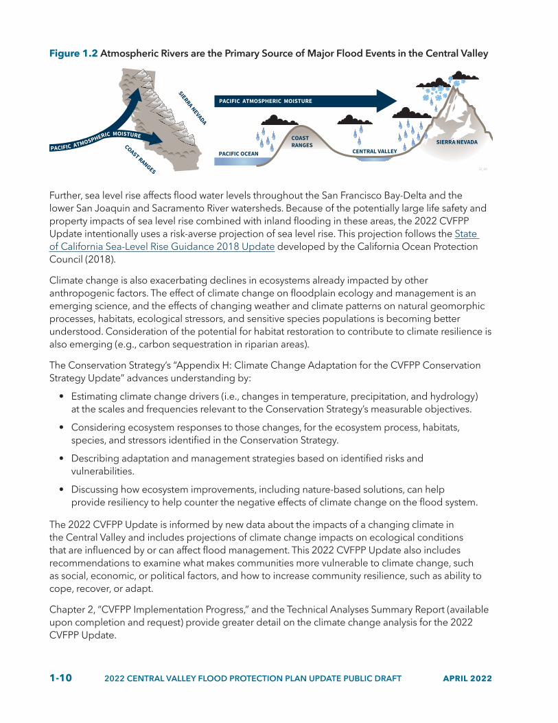
More recently, through investments in atmospheric science and research, atmospheric rivers have been identified as the primary source of major flood events in the Central Valley (Figure 1.2). The strength and quantity of atmospherics rivers significantly influence annual flood risk. Climate change science predicts that atmospheric rivers will become stronger and wetter, increasing their potential to cause catastrophic events that could overwhelm many parts of the current flood system if improvements, such as those in the SSIA, are not implemented. In a warmer climate, extreme atmospheric rivers will become more intense as they become wetter, longer, and wider; there is some indication that this is already happening in association with observed Pacific Ocean warming (Corringham et al. 2019).
1-10 2022 CENTRAL VALLEY FLOOD PROTECTION PLAN UPDATE PUBLIC DRAFT APRIL 2022
Figure 1.2 Atmospheric Rivers are the Primary Source of Major Flood Events in the Central Valley
COAST RANGES
SIERRA NEVADA
SIERRA NEVADACOASTRANGES
CENTRAL VALLEYPACIFIC OCEAN
PACIFIC ATMOSPHERIC MOISTURE
22_301
PACIFIC ATMOSPHERIC MOISTURE
Further, sea level rise affects flood water levels throughout the San Francisco Bay-Delta and the lower San Joaquin and Sacramento River watersheds. Because of the potentially large life safety and property impacts of sea level rise combined with inland flooding in these areas, the 2022 CVFPP Update intentionally uses a risk-averse projection of sea level rise. This projection follows the State of California Sea-Level Rise Guidance 2018 Update developed by the California Ocean Protection Council (2018).
Climate change is also exacerbating declines in ecosystems already impacted by other anthropogenic factors. The effect of climate change on floodplain ecology and management is an emerging science, and the effects of changing weather and climate patterns on natural geomorphic processes, habitats, ecological stressors, and sensitive species populations is becoming better understood. Consideration of the potential for habitat restoration to contribute to climate resilience is also emerging (e.g., carbon sequestration in riparian areas).
The Conservation Strategy’s “Appendix H: Climate Change Adaptation for the CVFPP Conservation Strategy Update” advances understanding by:
• Estimating climate change drivers (i.e., changes in temperature, precipitation, and hydrology) at the scales and frequencies relevant to the Conservation Strategy’s measurable objectives.
• Considering ecosystem responses to those changes, for the ecosystem process, habitats, species, and stressors identified in the Conservation Strategy.
• Describing adaptation and management strategies based on identified risks and vulnerabilities.
• Discussing how ecosystem improvements, including nature-based solutions, can help provide resiliency to help counter the negative effects of climate change on the flood system.
The 2022 CVFPP Update is informed by new data about the impacts of a changing climate in the Central Valley and includes projections of climate change impacts on ecological conditions that are influenced by or can affect flood management. This 2022 CVFPP Update also includes recommendations to examine what makes communities more vulnerable to climate change, such as social, economic, or political factors, and how to increase community resilience, such as ability to cope, recover, or adapt.
Chapter 2, “CVFPP Implementation Progress,” and the Technical Analyses Summary Report (available upon completion and request) provide greater detail on the climate change analysis for the 2022 CVFPP Update.

APRIL 2022 2022 CENTRAL VALLEY FLOOD PROTECTION PLAN UPDATE PUBLIC DRAFT 1-11
1.3.2 Performance Tracking
The 2017 CVFPP Update established an outcome-based planning framework for flood management with outcomes, indicators, and metrics that can be tracked over time. Progress toward achieving the CVFPP goals and performance tracking of outcomes associated with the CVFPP was aligned with the following important societal values: provide public health and safety, support ecosystem vitality, support a healthy economy (“healthy economy” replaces “stable economy” in the 2022 CVFPP Update to be consistent with California Water Plan Update 2018), and provide opportunities for enriching experiences. The 2022 CVFPP Update introduces equity and social justice as a societal value and proposes a preliminary set of indicators to ensure the CVFPP promotes equity. Delivering the specific outcomes that contribute to these societal values will achieve the CVFPP goals. Figure 1.3 provides examples of metrics and outcomes related to each societal value and how performance will be tracked across CVFPP updates and helps discern trends in desired outcomes. Knowing trends allows DWR, the CVFPB, and partner agencies to adaptively manage CVFPP Update priorities every five years.
Figure 1.3 Conceptual Example of Monitoring and Reporting Trends
2022 2027 20372032 2042 2047 2052
CVFPP UPDATE REPORTING
22_106
Number of lives lost or people injured in large flood events (expected annual life loss)
Change in the quality and quantity of ecosystem processes, habitats, and species overtime
Total value of annual economic floodplain activity less floodplain management costs less expected annual damage
Percentage of residentswho feel they have ample opportunities for recreation, cultural enrichment, and education
Public Health and Safety
EcosystemVitality
HealthyEconomy
EnrichingExperiences
Number of vulnerable communities susceptible to damages within 100-year floodplainEquity and
Social Justice
Performance tracking promotes accountability, facilitates improved performance through adaptive management, and demonstrates return on investments. It also helps guide decisions on future investments and the types of actions and policies that are working most effectively to achieve

1-12 2022 CENTRAL VALLEY FLOOD PROTECTION PLAN UPDATE PUBLIC DRAFT APRIL 2022
flood-related outcomes from the CVFPP. In 2017, DWR began developing the performance tracking and adaptative management system for this 2022 CVFPP Update using indicators and metrics introduced in 2017 CVFPP Update, including those from the 2016 CVFPP Conservation Strategy and 2017 Flood System Status Report. But, tracking performance for the CVFPP is only one of the numerous components necessary to successfully implement the CVFPP. Tracking performance of flood management policy recommendations is also necessary to understand if available resources and funding are being used to effectively and equitably support implementation.
Section 2.10, “Developing CVFPP Performance Tracking and Adaptive Management,” describes the performance tracking framework in more detail and the progress made on performance tracking to date.
1.3.3 Alignment with Other State Efforts
The CVFPP is first and foremost a strategic blueprint for reducing Central Valley flood risk. Its foundation includes technical analyses, such as updated flood risk and climate change analysis, and data and information from supporting documents, such as the State Plan of Flood Control Descriptive Document and the Flood System Status Report. And, in an era of climate-driven hydrologic change, the most effective and durable flood planning will also lean on and directly support broader water sector goals and strategies. Local water supply managers are offering the flood management sector inspiration, demonstrating the power of co-management across wastewater, groundwater, water treatment, and distribution systems. These increasingly closed-loop strategies are reducing dependence on imported supplies and providing highly efficient drought resilience.
Similar cross-sector innovations are emerging in the flood sector. Further detailed in Section 2.1, State and local flood managers are partnering with non-governmental organizations and academia to demonstrate the potential for innovative flood management to deliver significant water supply and environmental benefits. For example, watershed-scale climate vulnerability and adaptation studies led by DWR, local/federal reservoir operators, and downstream local flood agencies are revealing some of the most promising benefits of comanagement.
Events highlighting the impacts of climate change present an opportunity to connect flood management and water supply investments. Coordinated management of floodwaters with water supply can support drought preparedness, sustainable groundwater management, and watershed resilience through actions such as reservoir operations, conjunctive management, and using floodwaters for managed aquifer recharge (also known as Flood-MAR). Further, opportunities for landscape-scale floodplain restoration, where land use changes are occurring in response to the Sustainable Groundwater Management Act, can provide wise use of floodplains and recharge overdrafted groundwater basins in some areas. This opportunity is being demonstrated by ongoing pilot studies in the San Joaquin River Basin.
Section 2.9 details the alignment between the 2022 CVFPP Update and specific State natural resource management plans, such as the Governor’s Water Resilience Portfolio and the California Water Plan 2023 Update currently under development. Chapter 2 also details consistency between the 2022 CVFPP Update and various executive orders (EOs) (e.g., EO N-82-20 regarding climate policy and biodiversity goals) and other State Administration policy direction such as expanding nature-based solutions, the Cutting Green Tape initiative, and measuring government accountably.

APRIL 2022 2022 CENTRAL VALLEY FLOOD PROTECTION PLAN UPDATE PUBLIC DRAFT 1-13
1.4 Funding CVFPP ImplementationEven with increased flood risk resulting from climate change and other concerning trends, securing adequate and sustainable funding for flood management remains a challenge. Challenges primarily arise from competing investment priorities for resource management across State agencies and a lack of understanding of flood risk throughout the general public. The benefits of flood management are often recognized only when large, devasting flood events occur. The infrequency of flood events results in the public’s appreciation of flood risk dissolving as years without floods accumulate.
Further, the complexity of large-scale project implementation makes it challenging to secure the proper funding at the appropriate times. Large-scale projects typically span more than 10 years and only approximately 10 to 20 percent of the funding is required in the first few years for planning and design efforts, with the majority of costs required later in project development for real estate acquisition and construction. Accordingly, the timing of available funds must be aligned to project development schedules.
In addition to sufficient and available funding, local partner alignment, political will, and State prioritization are necessary to implement projects and can be difficult to align simultaneously. This is true not only for State-led projects and efforts, but for those led by local and federal partners. A recent successful example is the Lower Elkhorn Basin Levee Setback (LEBLS) project, which was conceptualized by the State and local flood management partners decades ago and became a State priority to implement as funding, political will, and local partner priorities aligned. Chapter 2 provides more information on the LEBLS project.
The following section provides a brief overview of the funding challenges and opportunities for State, local, and federal partners.
1.4.1 State Funding Opportunities and Challenges
Historically, flood management has not been funded by a diverse set of funding mechanisms but instead primarily relied on State general obligation (GO) bonds for large-scale improvements and State general fund for operation, maintenance, and other routine activities. In recent years, implementation of flood system improvements has been enabled by funding from GO bonds, specifically Propositions 1E, (2006), 84 (2006), 1 (2014) and 68 (2018) and by relatively small contributions from the general fund. Although these mechanisms provide funding towards CVFPP implementation, they are subject to political and fiscal changes and competing priorities that affect overall stability and consistency.
In the past, State general fund contributions to flood management have decreased when flood management is slated to receive higher amounts of State GO bond funding. For example, general fund contributions have fluctuated from a low of approximately $33 million in fiscal year 2014 to a high of $52 million in fiscal year 2008. The inconsistency of general fund contributions inhibits the State’s ability to sustain important ongoing activities related to flood management planning and flood system O&M. The 2017 CVFPP Update recognized this challenge and recommended a substantial contribution (approximately doubling the highest year of funding) on a consistent basis for Central Valley flood management from the general fund.
Since 2017, additional general fund has been made available for OMRR&R and deferred maintenance, but total available funding is still insufficient. DWR’s Division of Flood Management (DFM) received a $25 million annual increase in baseline funding for OMRR&R activities in 2019.

1-14 2022 CENTRAL VALLEY FLOOD PROTECTION PLAN UPDATE PUBLIC DRAFT APRIL 2022
DFM also received approximately $437 million in funding for deferred maintenance over the past few years and approximately $170 million in one-time funding to match the USACE cost-share for flood risk reduction projects. Chapter 4 presents the updated costs for capital and ongoing activities needed for the CVFPP and provides an overview of past funding received.
1.4.2 Local Funding Challenges
Local flood managers have also faced challenges in raising consistent and reliable local revenues and funding for flood management (including routine maintenance). This is primarily because of the lack of public awareness, willingness, and ability to pay for flood management. Although some local flood agencies have successfully passed Proposition 218 elections, it is an increasingly difficult challenge for other local agencies to overcome to raise the capital necessary for flood managagement. In recent years, these efforts were either unsuccessful because of a lack of ratepayer willingness to pay higher rates or delays related to the Covid-19 pandemic that began in 2020. Undoubtedly, Proposition 218 limitations have impacted the ability for flood risk reduction projects to move ahead, creating a situation where high flood risk is carried forward instead.
1.4.3 Increased Federal Funding
Federal investment in Central Valley flood management activities has historically been through the USACE, but funding opportunities through FEMA are expanding. In response to growing natural disaster expenses across the nation, Congress passed the Disaster Recovery Reform Act of 2018. In addition to directing FEMA to reinforce its administrative procedures related to natural hazard mitigation planning, the law also established a new Building Resilient Infrastructure and Communities (BRIC) financial assistance program. FEMA data consistently shows that there is a cost savings of six dollars in avoiding disaster recovery costs for every dollar spent in pre-disaster mitigation, and that when investing in nature-based solutions and other community-based designs, this cost savings can dramatically increase.
In 2020, Congress provided $500 million in funding across the United States for hazard mitigation projects. States and territories submitted more than 1,200 projects totaling more than $4 billion for both BRIC and FEMA’s existing Flood Mitigation Assistance (FMA) program, which demonstrated the significant financial need for flood risk reduction projects. Flood management projects represented most of the applications submitted by States and territories. Recognizing this need, in July 2021 Congress doubled BRIC’s available funding to $1 billion for its fiscal year 2021 cycle and has indicated a willingness to continue to increase its role in hazard mitigation.
FEMA, through its BRIC program, is a key partner in helping the State and local communities implement the CVFPP. To act on the new opportunities that the BRIC program provides, the 2022 CVFPP Update has incorporated a larger FEMA contribution to the recommended CVFPP funding plan. But, significant increases of FEMA funding for State programs would require new or expanded staff and budget resources at the State and local levels to deliver the projects that are funded. This change would be a stark contrast from historical FEMA funding patterns, and time would be needed for the expertise to develop in managing these types of projects.
The CVFPP recognizes the constraints and limitations of implementation funding that is experienced by State, federal, and local partners. The 2022 CVFPP Update recommends a diverse portfolio of funding mechanisms to provide the CVFPP with more flexibility, timeliness, and resiliency to funding

APRIL 2022 2022 CENTRAL VALLEY FLOOD PROTECTION PLAN UPDATE PUBLIC DRAFT 1-15
changes over time, including phased expansion of State, federal, and local institutional capacity. Chapter 4 presents the updated investment needed for capital and ongoing management actions, the recommended funding mechanisms, and funding plan to fully implement the CVFPP.
1.5 Update Content and Supporting Documents The 2022 CVFPP Update includes recommendations on investments and policies to support comprehensive flood risk management actions locally, regionally, and systemwide throughout the Central Valley.
The 2022 CVFPP Update describes, estimates, and highlights the investments needed and a funding plan for making needed investments over the next 30 years. The 2022 CVFPP Update provides decision-makers at the State, federal, and local levels information on the investments needed and the resulting benefits to support policy development and administration of grant and direct funding programs that support CVFPP implementation. The 2022 CVFPP Update supports policy and investment decisions by:
• Collect and analyze the best available information on the types of management actions and projects that, as a portfolio, most effectively support the CVFPP-intended outcomes and contribute to societal values.
• Define and quantify opportunities to reduce flood risk, provide ecosystem improvements, and adapt to a changing climate, as well as estimate costs associated with implementing different types of management actions.
• Inform State, federal, local agency partners, public/private partners, and elected officials.
• Support action by the entire Central Valley flood management community and decision-makers to create policy or funding opportunities.
The 2022 CVFPP Update does not:
• Endorse individual projects or programs for funding decisions.
• Directly appropriate funding to individual projects or programs.
• Generate cash flow to grant or direct assistance programs to be administered to individual projects.
This 2022 CVFPP Update is organized as follows.
• Chapter 1, “Updating the CVFPP,” introduces the 2022 CVFPP Update and presents key themes appearing in this CVFPP update.
• Chapter 2, “CVFPP Implementation Progress,” describes flood system accomplishments and performance tracking; explains the implementation progress and what has changed since 2017; describes progress made on policy issues highlighted in the 2017 and introduces new policy issues regarding climate change and building flood system resilience, and equity; and discusses how the 2022 CVFPP Update improves the climate change approach and aligns with other State-led efforts.
• Chapter 3, “Risks, Priority Actions, and Intended Outcomes,” describes updated technical analysis, including flood risk, climate change resilience; updated State priorities and management actions that constitute the SSIA; and expected outcomes from investments.

1-16 2022 CENTRAL VALLEY FLOOD PROTECTION PLAN UPDATE PUBLIC DRAFT APRIL 2022
• Chapter 4, “Investment Strategy and Imperative to Act,” provides a summary of 2022 SSIA portfolio investment costs, funding, and timing of delivery through DWR implementation programs. This chapter also summarizes how DWR will continue implementating the CVFPP.
The 2022 CVFPP Update includes this main document, 2022 SPFC Descriptive Document Update, 2022 Flood System Status Report, and a CEQA Addendum to the 2012 Program Environmental Impact Report to meet the CVFPP content requirements of the Central Valley Flood Protection Act of 2008. In addition, the 2022 CVFPP Conservation Strategy Update has supported development of the 2022 CVFPP Update main document, but remains a separate companion document for more detailed information and analyses. The Conservation Strategy will be further integrated into the CVFPP in the 2027 CVFPP update. These documents, along with others, supported development of the 2022 CVFPP Update, are shown in Figure 1.4. Appendix B, “Legislative Reference and Reader’s Guide,” provides an overview of all the documents and how they help fulfill the legal requirements of the Central Valley Flood Protection Act of 2008.

APRIL 2022 2022 CENTRAL VALLEY FLOOD PROTECTION PLAN UPDATE PUBLIC DRAFT 1-17
Figure 1.4 2022 CVFPP Update and Supporting Documents
2022 CVFPP Update
SPFC Descriptive Document
CALIFORNIA DEPARTMENT OF WATER RESOURCESPUBLIC DRAFTJANUARY 2022
CENTRAL VALLEY FLOOD PROTECTION PLAN
State Plan of Flood Control Descriptive Document
Flood SystemStatus Report
CALIFORNIA DEPARTMENT OF WATER RESOURCESPUBLIC DRAFTJANUARY 2022
CENTRAL VALLEY FLOOD PROTECTION PLAN
Flood System Status Report
ConservationStrategy Update
CEQA
Addendum to PEIR
Supporting Documents:
Delta Plan Consistency Determination (in progress)
CVFPP Technical Analyses Summary Report and Appendices (in progress)
Merced River Basin Flood-MAR Reconnaissance Study Technical Memorandum (in progress)
2022 Outcome-Based Performance Tracking and Adaptive Management Framework Technical Memorandum (in progress)
22_122
1.6 Communication and Engagement Conducted for this UpdateDevelopment of the 2022 CVFPP Update was informed by a robust, multi-year communications and engagement process that involved frequent discussions with State, federal, Tribal, and regional partners. DWR and CVFPB’s approach represents a continuation of previous efforts that involved robust engagement during the development and adoption of the 2017 CVFPP Update, as well as DWR and CVFPB’s commitment to regularly share CVFPP-related information. Continuing these successful engagement strategies has provided partners and other public interests with the familiarity and consistency that fosters shared understanding and effective collaboration.
Central Valley partners and other public interests engaged in the development the 2022 CVFPP Update include:
• Federal partner agencies (the USACE, FEMA, U.S. Bureau of Reclamation)
• Native American Tribes

1-18 2022 CENTRAL VALLEY FLOOD PROTECTION PLAN UPDATE PUBLIC DRAFT APRIL 2022
• Resource agencies (U.S Fish and Wildlife Service, National Marine Fisheries Service, California Department of Fish and Wildlife)
• Other State agencies and initiatives
• Regional flood management planning leads
• Local agencies
• State, federal, and local elected officials
• Agricultural community (including groups such as the California Farm Bureau Federation, county farm bureaus, and landowners)
• Environmental community (including non-governmental organizations such as American Rivers, River Partners, CalTrout, Trout Unlimited, Environmental Defense Fund, and The Nature Conservancy)
• General public
In addition, the CVFPB convened additional engagement venues that are regularly attended by a wide breadth of interests within the Central Valley, including monthly CVFPB Board meetings, CVFPB Coordinating Committee meetings, CVFPB Advisory Committee meetings, and CVFPB-led public workshops. These venues have been critical to soliciting broad feedback on CVFPP content and maintaining ongoing communication.
DWR and CVFPB hosted informational meetings with Tribes as part of the 2022 CVFPP Update process to increase Tribal engagement and contribution to the CVFPP. Future communication and engagement for CVFPP updates will continue to include additional opportunities to more fully integrate Tribes, Tribal cultural resources, Tribal values, and Tribal viewpoints.
Figure 1.5 presents an overview of the type and number of key communications and engagement activities for the 2022 CVFPP Update as of December 2021. Despite the challenges that Covid-19 presented with in-person meetings, key engagement venues (such as CVFPB Coordinating Committee and Advisory Committee) transitioned quickly and successfully to online platforms. Partners were very flexible in their willingness to engage remotely and collaborative discussions continued throughout the 2022 CVFPP Update process without major interruptions.

APRIL 2022 2022 CENTRAL VALLEY FLOOD PROTECTION PLAN UPDATE PUBLIC DRAFT 1-19
Figure 1.5 Key Communication and Engagement Activities for the 2022 CVFPP Update
Presentations to Central Valley Flood Protection Board (CVFPB)
Presentations to Coordinating Committee and CVFPB Advisory Committee
Meetings to gather technical inputon CVFPP supporting documents
Meetings to inform development of Regional Flood Management Plans and actions
Public workshops, open houses, and webinars
Meetings with State and federal agency staff
Additional small group and individual stakeholdermeetings and briefings on CVFPP topics
Tribal meetings on CVFPP topics
2832
1069
22_121
188425
Ongoing discussions have yielded important insights about different perspectives on flood management needs, challenges, and opportunities across the Sacramento River and San Joaquin River river basins. Many of these perspectives are reflected in the 2022 CVFPP Update recommendations highlighted in Chapter 3; others may continue to be discussed among agency partners and others as the CVFPP is implemented and updated next in 2027.

1-20 2022 CENTRAL VALLEY FLOOD PROTECTION PLAN UPDATE PUBLIC DRAFT APRIL 2022An aerial view of the Sacramento River in Sacramento, California. Photo taken March 17, 2010. U.S. Army photo by Michael J. Nevins.

APRIL 2022 2022 CENTRAL VALLEY FLOOD PROTECTION PLAN UPDATE PUBLIC DRAFT 2-1
2 CVFPP Implementation Progress
Since 2012, the Central Valley Flood Protection Plan (CVFPP) has guided State investments to reduce flood risk throughout the region. The CVFPP implementation progress has been steady over the past 10 years. This chapter highlights the many accomplishments achieved over the past decade.
Some flood improvements began in 2007 through an Early Implementation Program, when bond funding provided a down payment toward State Plan of Flood Control (SPFC) improvements and extensive evaluations of SPFC facilities that were later included in the CVFPP. From 2007 through 2012, on-the-ground construction began addressing levee deficiencies, and management of the flood system began to improve. Since adoption of the CVFPP in June 2012, implementation has been enabled by the continued influx of bond funding for capital projects and recent general fund allocations targeted at addressing urban flood risk reduction projects and deferred maintenance. Overall, since 2007, approximately 361 miles of urban and 120 miles of non-urban SPFC levees have been repaired, rehabilitated, or improved, providing primarily public safety and economic outcomes.
Progress towards achieving ecosystem vitality outcomes have been tracked by the Conservation Strategy including the implementation of multi-benefit and restoration projects and one fish passage remediation project that were completed between 2016 and 2021. These projects included the Oroville Wildlife Area Flood Stage Reduction Project; the Three Rivers Levee Improvement Authority (TRLIA) Feather River Conservation Bank; the Southport Setback Levee Project; the Dos Rios Ranch Floodplain Expansion and Ecosystem Restoration Project, Phase I; and the Fremont Weir Adult Fish Passage Modification Project. All or a portion of these projects contributed to the measurable objectives, resulting in a net gain in floodplain inundation and restored riparian habitats, and modified one priority fish passage barrier. Details of how project components counted towards the measurable objectives are included in Appendix F of the 2022 Conservation Strategy Update.
The State has continued investing in multi-benefit projects that are consistent with the State Systemwide Investment Approach (SSIA), to the extent funding has been available. The State’s investments in Central Valley flood management from 2007 through 2016 and 2017 through 2021 by flood management programs is shown in Table 2-1. These investments include funding from Propositions 68, 1, 1E, and 84 (flood management provisions) and from the general fund.

2-2 2022 CENTRAL VALLEY FLOOD PROTECTION PLAN UPDATE PUBLIC DRAFT APRIL 2022
Table 2.1 State Investments from General Obligation Bonds and General Fund for Central Valley Flood Management (2007–2021)
Program Expenditures 2007–2016[1]
Expenditures 2017–2021[2]
Commitments 2017–2021[2]
Flood Management Planning[3] $443 million $103 million $26 million
Floodplain Risk Management $124 million $10 million $1 million
Flood Risk Reduction Projects $1,178 million $730 million $372 million
Flood System Operations and Maintenance
$330 million $315 million $62 million
Flood Emergency Response $187 million $160 million $26 million
Total[4] $2,262 million $1,317 million $489 million
Notes:[1]Investments include expenditures only for the State Plan of Flood Control (SPFC) for 2007 through 2016 as of December
2021 and do not include additional non-SPFC investments. The table reflects State investments only (not federal or local contributions), largely from Propositions 13, 1E, and 84, and the State general fund.
[2]Expenditures and commitments are separated for 2017 through 2021 for the SPFC because, in some cases, funds have been committed but have yet to be spent as of December 2021. The table reflects State investments only (not federal or local contributions) and does not include additional non-SPFC investments, largely from Propositions 13, 1E, 84, 68, and 1, and the State general fund.
[3]Flood management planning includes programmatic and site-specific (project) planning efforts related to the SPFC. Examples include development of the CVFPP and Conservation Strategy, regional flood management planning, levee evaluations (urban levee evaluations and non-urban levee evaluations), channel evaluations, project studies, policy and procedure development, site investigations and evaluations, and applicable Delta Levee System Integrity five-year plans.
[4]Total State investments includes multiple benefit projects, including ecosystem improvements, and floodplain restoration.
Despite recent investments, consistent and sustainable funding for flood management, as recommended in the 2017 CVFPP Update, is still needed. Specifically, approximately $4.4 billion of $17 to $21 billion recommended in the 2017 CVFPP Update has been appropriated from State and federal sources since 2017. Although this is a significant accomplishment, the identified need since 2017 has grown to $25 to $30 billion because of a better understanding of investment needs and ongoing changes in the system, such as climate change, storm damage, deferred maintenance, and subsidence. Flood managers continue to look for ways to leverage other nontradional funding sources, such as funding for Sustainable Groundwater Management Act (SMGA) implementation because sudsidence caused by overpumping groundwater aquifers has resulted in the loss of flood conveyance capacity and modfied floodplains and recognition of the critical role flood management operations have on maximizing use of floodwaters for aquifer recharge.
Additionally, a significant portion of the funds allocated since 2017 come from the federal Bipartisan Budget Act of 2018 and State general obligation bonds. Receiving a similar amount of funding from these sources in the future is not guaranteed and will require a significant amount of advocacy. State, federal, and local partners implementing the CVFPP have made progress in many areas with available funding and through collective accomplishments, but challenges remain to continue and improve progress in implementation over the next five years and beyond.
In addition to on-the-ground implementation progress achieved so far, interagency collaboration has begun to address flood management policy issues highlighted in 2012 and updated in 2017, and the CVFPP planning process has advanced significantly to include new information and innovation and

APRIL 2022 2022 CENTRAL VALLEY FLOOD PROTECTION PLAN UPDATE PUBLIC DRAFT 2-3
strengthen alignment with other State water management efforts (e.g., SGMA). Overall, the CVFPP has contributed to a more robust understanding of the current flood system and further identification of opportunities for flood management physical and policy improvements.
Since 2017, implementation has progressed across several important areas:
• Growing partnerships and collaborative efforts to advance flood risk reduction priorities.
• Advancing and piloting climate change analysis approaches to gain further understanding of system vulnerabilities and potential adaptation strategies.
• Accomplishing flood system improvements and addressing policy issues.
• Aligning the CVFPP and its implementation with other State efforts and societal values.
• Developing and piloting an outcome-based framework to track performance.
Following is a summary of accomplishments for major activities and programs since the 2017 CVFPP Update.
2.1 Partnerships and Collaborative EffortsCollaboration with stakeholders and partner agencies is essential for flood management programs in the Central Valley. Partnerships enable agencies to work collaboratively and with stakeholders to plan and implement projects. The 2017 CVFPP planning process provided a framework for developing an integrated and systemwide plan that builds broad support among State, federal, and local agency partners; Tribal governments; nongovernmental organizations (NGOs); and other key interests in Central Valley flood management. Partnerships are critical to coordinating integrated and regional activities and collaboratively addressing flood management issues. The following are examples of partnerships and collaborative efforts that have progressed Central Valley flood management efforts since 2017.
• Yolo Bypass-Cache (YBCS) Slough Partnership.
• American River Common Features (ARCF) Team.
• The Federal Emergency Management Agency’s (FEMA’s) National Flood Insurance Program implementation.
• Central Valley Flood Protection Board (CVFPB) Advisory and Coordinating committees.
• California Silver Jackets (State, federal, and local flood risk management team).
• Collaboration for updating and refining a San Joaquin regional flood management strategy.
• Partnerships focusing on reservoir operations including forecast-informed reservoir operations (FIRO) and forecast-coordinated operations (F-CO), such as Yuba-Feather FIRO, also discussed in Section 2.7.
Flood management in California is a shared responsibility among State, federal, and local agencies. Effective partnerships are critical to efficiently and effectively managing the flood system for multiple benefits over the long-term future across system, regional, and local scales. For example, system improvements are generally implemented through partnerships among DWR, CVFPB, U.S. Army Corps of Engineers (USACE), local agencies, NGOs, and others. Residual risk management actions also require extensive partnerships with other agencies including the National Weather Service,
2-4 2022 CENTRAL VALLEY FLOOD PROTECTION PLAN UPDATE PUBLIC DRAFT APRIL 2022
FEMA, the California Governor’s Office of Emergency Services (Cal OES), the Office of Planning and Research, the California Department of Conservation’s California Geologic Survey, and the California Department of Insurance. Further, the regional flood management planning effort continues to represent an unprecedented partnership and level of engagement among Central Valley flood management entities and serves as a model as California moves ahead to meet its future flood and water management needs.
Partnership Spotlight: Yolo Bypass-Cache Slough Partnership
The YBCS Partnership formed in 2016 between 15 State, federal, and local agency partners under a memorandum of understanding. The YBCS Partnership is an example of regional collaboration for planning and implementation of an integrated multi-benefit program. The partnership continues to promote its vision for the Yolo Bypass, a major feature of the USACE Sacramento River Flood Control Project.
In addition to flood management, the vision of the partnership supports fisheries and wildlife habitat, water supply, water quality, agricultural sustainability, and recreation for a vibrant future for the region’s residents, businesses, and ecosystems. Challenges and lessons learned from Yolo Bypass efforts since 2016 need continued focus, including increased dedicated resources through all partnership agencies to guide more effective implementation of the CVFPP in this region and realization of the partnership vision. As the vision of the YBCS Partnership matures, the intent is that the improvements made in the Yolo Bypass could significantly contribute to climate resilience, including public safety, ecosystem vitality, and agricultural and economic stability of the region and the State.
Since the 2017 CVFPP Update, the YBCS Partnership has made progress in identifying and advancing policy issues related to implementation of the CVFPP in this region. For example, the YBCS Partnership has initiated several workgroups (such as hydraulic and ecosystem baselines, long-term operations and maintenance [O&M], and water quality work groups) to address these policy issues and are meeting frequently to develop approaches, workplans, and recommendations to move forward. Additionally, an agricultural sustainability workgroup has been established and is working to identify a set of improved tools for addressing impacts and concerns of agricultural interests in the region. The YBCS Partnership continues to pursue a more formal program for the region, as recognized by the federal government in the Water Resources Development Act of 2020, including Water Resource Section 209 for the “Yolo Bypass Comprehensive Study” and State government in Senate Bill (SB) 369 that establishes a YBCS Partnership Multibenefit Program. Still, additional work remains to develop this program with clear agency roles and responsibilities, establish sufficient funding and dedicated resources from all partners, and collectively improve alignment of priorities and implementation of future projects.
More information on continued efforts of the YBCS Partnership and future program is discussed in Chapter 3, “Risks, Priority Actions, and Intended Outcomes.”

APRIL 2022 2022 CENTRAL VALLEY FLOOD PROTECTION PLAN UPDATE PUBLIC DRAFT 2-5
Partnership Spotlight: Collaborating on an updated and refined regional flood management strategy for the San Joaquin River
Climate change-related flood management risks are particularly acute in the San Joaquin River Basin because more precipitation is expected to fall as rain instead of snow at higher elevations, which will increase peak flows and potential damages to vulnerable communities in the floodplain. Without a flood management strategy that incorporates broad water management sectors, such as reservoir reoperation, expanding floodplains, and groundwater recharge, flooding in the basin could become catastrophic. Recognizing this risk, California Water Resilience Portfolio Action 25.4 calls for DWR, CVFPB, and local agencies to “update and refine the regional flood management strategy in the Central Valley Flood Protection Plan to account for the projected impacts of climate change in order to protect vulnerable communities and infrastructure and restore floodplains along the San Joaquin River and its tributaries.” In response to this call for action, DWR and CVFPB staff initiated a stakeholder engagement and planning process in December 2020 bringing together DWR staff representing many programs in the San Joaquin River Basin, CVFPB members and staff, San Joaquin Valley flood managers, NGOs, and other public interests.
From December 2020 through May 2021, stakeholders met to build a shared purpose and identify desired results for the regional flood management strategy, including:
• Advance the regional flood management strategy in a manner that leads to action.
• Establish a collaborative planning forum to:
▶ Link the three San Joaquin regional flood management planning groups to identify cross-regional solutions.
▶ Increase understanding of system changes (e.g., climate change).
▶ Eliminate planning gaps.
▶ Identify flood management needs and opportunities outside of the areas protected by the SPFC and strategies for addressing them.
▶ Identify opportunities to align or integrate other water sector efforts with flood management to achieve multiple benefits.
▶ Increase federal agency collaboration and financial support in the region.
▶ Increase identification of new, innovative, and multi-benefit project opportunities.
▶ Identify and evaluate near-term critical projects and develop a longer-term plan.
• Increase pace and scale of implementation of effective projects.
DWR and CVFPB staff worked with other San Joaquin Valley flood management interests and other interested parties to discuss potential components, priority actions, and develop action plans to progress a collaborative effort. These priority actions and plans are described in Chapter 3, “Risks, Priority Actions, and Intended Outcomes.”
The water resources and land use challenges in the San Joaquin River Basin are substantial and interrelated. Finding solutions requires a complete, holistic systems planning approach from the terminal dams to the Sacramento-San Joaquin Delta (Delta). Although the regional flood

2-6 2022 CENTRAL VALLEY FLOOD PROTECTION PLAN UPDATE PUBLIC DRAFT APRIL 2022
2.2 Flood Risk Reduction ProjectsThe State and its partners are making progress implementing flood risk reduction projects consistent with the CVFPP. Hundreds of miles of levees have been improved, rehabilitated, or repaired; improved habitat areas have been created; and floodplains have been reconnected. Implementation of flood risk reduction and multi-benefit projects will continue as funding is secured and as projects continue to mature from planning to design, permitting, and construction.
The following sections describe the progress of flood risk reduction projects through systemwide, urban, rural, and small community investments since 2017. Systemwide investments include larger-scale, multi-benefit actions that generally provide cross-regional benefits, such as projects that improve and expand system weirs, bypasses, or other flood facilities, with ecosystem and multi-benefit components guided by the Conservation Strategy. Urban actions help achieve protection from the 200-year (0.5 percent annual chance) flood for urban areas. Small community actions help protect communities with populations between 1,000 and 10,000 people from up to the 100-year (1 percent annual chance) flood for small communities. Rural actions reduce flood risk in more sparsely populated areas and provide significant multi-benefit opportunities.
Figure 2-1 shows the locations of completed flood risk reduction actions throughout the Central Valley and is intended to convey general geographic distribution of projects and types, not to identify specific projects. Project-specific information may be obtained through project proponents and completed project-level documentation.
management strategy will be “flood forward” or primarily flood-focused, it will be inclusive of other water sectors where facilities, operations, or beneficiaries overlap, such as conveyance and storage facilities used for water supply, or where floodwaters may be put to beneficial use by other water sectors, such as using floodwater for managed aquifer recharge (also known as Flood-MAR). The longer-term strategy should also consider how Californians, primarily people who live, work, play, or benefit from the San Joaquin Valley, interact and identify with their water resources (e.g., recreation, cultural practices, equity, ways of life) and understand the impacts and benefits of flooding. The relationship of people and water transcends all water management sectors and is a critical consideration for the San Joaquin Valley. For example, agricultural sustainability is of great importance to this region, and many areas will encounter land repurposing in response to SGMA.
As the collaboration continues and the San Joaquin regional flood management strategy is further refined, DWR, CVFPB, local agencies, and other partners and public interests will integrate relevant content into the 2022 CVFPP and future updates.

APRIL 2022 2022 CENTRAL VALLEY FLOOD PROTECTION PLAN UPDATE PUBLIC DRAFT 2-7
Figure 2.1 Geographic Distribution of Flood Risk Reduction Projects and Actions Completed in the Central Valley since 2016
!(
!(
!(
!(
!(
_̂
!(
!(
!(
"U
"U
"U
"U
"U
"U"U
"U
"U"U"U
"U "U"U"U
"U
"U
"U"U
"U
"U"U
"U
"U"U"U"U"U
"U"U
"U
"U
"U
"U
"U"U"U"U
"U
"U
"U"U
"U
"U"U
"U
"U
!S!S
!S!S
!S
!S!S
!S !S
#T#T
#T
#T#T
#T
#T#T
#T #T
#T
#T
#T
#T
#T
#T
#T
XWXWXWXW
XWXW
XWXW
XW
XW
XW
XW
XW
XW
XW
Fresno
San Joaquin Riv e r
Fe
ath
er
Riv
er
Sa
cra
me
nto
Ri v
er
Chico
Marysville
Merced
Modesto
Sacramento
San Francisco
Stockton
Upper Lake
±0 12.5 25
Scale in Miles
S:\SFPO\data\Projects\CVFPP_2022\GIS\Projects\Figures\CVFPP_2022_Completed_Prj_Portfolios.mxd
Completed ActionsPortfolio Type#T Systemwide - 17
!S Urban - 9
"U Rural - 47
XW Small Communities - 15

2-8 2022 CENTRAL VALLEY FLOOD PROTECTION PLAN UPDATE PUBLIC DRAFT APRIL 2022
2.2.1 Systemwide Actions
Systemwide actions include larger-scale, multi-benefit actions that generally provide cross-regional benefits in the Central Valley and enhance climate resilience. Systemwide actions support intended outcomes under public safety, ecosystem vitality, economic stability, and enriching experiences. These large-scale actions greatly bolster overall system resiliency in a way that complements smaller-scale urban, rural, and small community actions.
One of the most notable systemwide actions completed since 2017 was the physical modifications to Folsom Dam and Reservoir, including the new gated auxiliary spillway, concrete-lined approach channel, discharge chute, enlargement of existing stilling basin, and installation of six submerged gates. The project also included an updated flood control manual to reflect operational capabilities created by the Joint Federal Project. This project resulted in 310 acres of new habitat and increased flood protection for 440,000 people, $58 billion in assets, and 55,000 acres of property.
Systemwide multi-benefit projects include projects that improve and expand system weirs, bypasses, or other flood facilities, with ecosystem and multi-benefit components guided by the Conservation Strategy. The following completed projects were funded through DWR’s flood management programs:
• The Oroville Wildlife Area Flood Stage Reduction Project (Feather River Conservation Planning Area [CPA]) reduced flood risk, increased the area of inundated floodplain, and restored riparian habitat by augmenting the existing system of inflow and outflow weirs to safely divert additional floodwaters through the Oroville Wildlife Area and improving drainage to reduce fish stranding.
• The Dos Rios Ranch Floodplain Expansion and Ecosystem Restoration Project, Phase 1 (Lower San Joaquin River CPA) restored additional inundated floodplain by constructing notches in a levee and restoring riparian habitat on most of the reconnected floodplain.
• The Three Rivers Levee Improvement Authority (TRLIA) Feather River Conservation Bank (Feather River CPA) restored 500 acres of a previously created levee setback area to a mosaic of mixed riparian forest and riparian scrub. It has established riparian habitat with the expectation that this habitat may be used in the future as mitigation for other flood management projects and activities.
Through funding of the TRLIA mitigation bank and other similar efforts, DWR has contributed to the improvement of more than 1,700 acres of restored floodplain and riparian habitats since 2016, most of which has not yet been used as mitigation and is supporting efficient implementation of projects and maintenance. By establishing mitigation credits in advance of potential need (“advance mitigation”), the mitigation credits created (in the form of acres of habitat) would be ready to use at the time of a future project’s permitting (where impacts are treated as debits), avoiding project approval delays and the temporary loss of habitat. Present and future mitigation and non-mitigation status of conservation actions may also be tracked as resources allow.
Funded through non-CVFPP State programs (planning grants from the Delta Conservancy), an initial phase of feasibility planning for Paradise Cut Bypass expansion has been completed by American Rivers and South Delta Water Agency. Also funded through non-CVFPP programs (State Water Project [SWP] and Central Valley Project [CVP]), the Fremont Weir Adult Fish Passage Modification Project in the Lower Sacramento River CPA contributed to the Conservation Strategy measurable objectives by modifying a stressor (a high-priority fish passage barrier) as identified in

APRIL 2022 2022 CENTRAL VALLEY FLOOD PROTECTION PLAN UPDATE PUBLIC DRAFT 2-9
Appendix K of the 2016 Conservation Strategy. This project improved fish passage by replacing the existing fish ladder at Fremont Weir with a step pool channel leading up to the weir and gated notch through the weir.
Construction of the Lower Elkhorn Basin Levee Setback Project began in 2020 and is substantially complete. The project increases the size of the Yolo Bypass by approximately 900 acres by setting back a 7-mile stretch of levee 1,500 feet and almost doubles the width of the Sacramento Bypass. The concurrent USACE project to widen the Sacramento Weir will significantly increase the overflow capacity from the Sacramento River into the Yolo Bypass. The project expands inundated floodplain and includes on-site mitigation for environmental impacts and preserves agriculture for the region. The project will increase the level of flood protection for multiple communities in the counties of Sacramento and Yolo, including the cities of Sacramento and West Sacramento, and is a key component to a larger vision for multi-benefit projects in the region. The entire project is anticipated to be completed in 2024.
DWR’s EcoRestore Program and Division of Integrated Science and Engineering are working to progress the Lookout Slough Tidal Restoration and Flood Improvement Project, which will create tidal wetland habitat and increasing flood capacity of the lower Yolo Bypass by expanding the bypass footprint by approximately 3,000 acres. The project is primarily funded by the SWP as partial mitigation for long-term operations. Additionally, multi-benefit funding is being provided by DWR’s flood management programs for the project’s flood risk reduction components. Construction is anticipated to begin in 2022. Other Yolo Bypass projects further support compliance with the biological opinions related to the SWP operations, such as Fremont Weir Adult Fish Passage Modification Project and Wallace Weir Fish Rescue Facility Project that were recently completed. These projects enhance habitat for native fish and fish passage in the Yolo Bypass and improve the water supply reliability of the SWP.
TRLIA Feather River Conservation Bank(Three Rivers Levee Improvement Authority, 2020)

2-10 2022 CENTRAL VALLEY FLOOD PROTECTION PLAN UPDATE PUBLIC DRAFT APRIL 2022
Oroville Wildlife Area Flood Stage Reduction Project
(Sutter Butte Flood Control Agency, 2019)
Project Spotlight: Dos Rios Ranch Floodplain Expansion and Ecosystem Restoration Project, Phase 1
River Partners’ Dos Rios Ranch Project, Phase 1, provides almost 1,000 acres of floodplain reconnection and habitat restoration via a controlled breach of agricultural berms on the site, which increases floodwater storage and reduces flood stages in the San Joaquin River. Dos Rios Ranch also provides extensive habitat for salmonids, migratory birds, and many other native aquatic and terrestrial species, including the endangered riparian brush rabbit. A planned second phase of Dos Rios would breach the federal project levee on the site and reconnect approximately 1,100 additional acres of floodplain habitat to the San Joaquin River, ultimately providing more than 2,100 acres of total floodplain restoration, absorbing approximately 10,000 acre-feet of floodwaters, and increasing flood protection for downstream communities.
Dos Rios Ranch Floodplain Expansion and Ecosystem Restoration Project, Phase 1(River Partners, 2020)

APRIL 2022 2022 CENTRAL VALLEY FLOOD PROTECTION PLAN UPDATE PUBLIC DRAFT 2-11
2.2.2 Urban Actions
Urban actions help achieve protection from the 200-year (0.5 percent annual chance) flood, significantly improve flood risk management, and support intended outcomes related to public safety and economic stability. Although opportunities to improve ecosystem functions can be more limited in urban areas compared to small communities and rural-agricultural areas, urban areas can leverage site-specific opportunities to achieve ecosystem and multiple benefits.
The following sections identify actions that support urban level of protection that have been completed since 2017. These urban projects represent significant progress toward attaining, or exceeding, the urban level of flood protection required by the State for urban areas protected by the SPFC. Progress in implementing urban actions is critical to address the urgent impacts of climate change on the most densely populated areas in the Central Valley in combination with broader systemwide actions in the CVFPP.
Yuba River Basin
Completed urban actions in the Yuba River Basin include:
• TRLIA Urban Levee Improvements — 200-Year Goldfield Project.
• TRLIA Feather River Setback Levee Project for Reclamation District (RD) 784.
• TRLIA Bear River Setback Levee Project.
• Star Bend Improvements.
• Yuba River General Reevaluation Report, including study of Yuba Goldfields.
Sutter River Basin
• Sutter Butte Flood Control Agency (SBFCA), working with State and federal agencies, completed work for 200-year level of protection for the Sutter River Basin urban area protecting more than 95,000 people and $7 billion of damageable assets.
Sacramento Area — Natomas Basin and American River
Since 2007, design and construction of Natomas Levee Improvement Program features have been proceeding in phases and continued through the last five years along the American River levee. This effort included completing the American River Common Features General Reevaluation Report in 2016. It is anticipated that the Natomas Levee Improvement Program will be completed by 2025. South Sacramento County Streams project construction was also completed in 2018 for the Pocket Area and North Area.
Collaborative efforts of the USACE and the Sacramento Area Flood Control Agency (SAFCA) resulted in approval of the supplemental appropriation that provides $1.8 billion for ARCF and Folsom Dam raise projects. This appropriation was a major step in implementing these projects, which started in 2018. These ARCF projects, including Sacramento Weir widening and fish passage, will provide over 200-year level of protection for urban areas along the Sacramento from the American rivers. ARCF projects are in different stages of design and construction and are scheduled to be completed by 2024.

2-12 2022 CENTRAL VALLEY FLOOD PROTECTION PLAN UPDATE PUBLIC DRAFT APRIL 2022
Woodland Area
The Lower Cache Creek Flood Risk Management Project Chief’s Report was signed in June 2021. The Chief’s Report is a necessary step for the USACE to request Congressional authorization. The project, a partnership between the USACE, the Central Valley Flood Protection Board, and the City of Woodland, will improve levees near the City of Woodland and construct new levees north of the city to help prevent Lower Cache Creek from flooding into the developed portions of Woodland. This work will help to protect 6,000 residents, regional business centers, and critical infrastructure such as Interstate 5, schools, and utilities.
SBFCA Feather River West Levee(Forgen, permission requested)
TRLIA Urban Levee Improvements 200-Year Goldfield Project (Three Rivers Levee Improvement Authority, permission requested)
San Joaquin Area Flood Control Agency Smith Canal Gate Project
(Kjeldsen Sinnock Neudeck, 2020)

APRIL 2022 2022 CENTRAL VALLEY FLOOD PROTECTION PLAN UPDATE PUBLIC DRAFT 2-13
West Sacramento
Progress continues on the Southport Levee Setback Project (see project spotlight below) and the West Sacramento Federal Project to achieve 200-year level of protection for West Sacramento.
Project Spotlight: Southport Levee Setback Project
This project involves the construction of approximately 5.6 miles of levees along the Sacramento River south levee in the city of West Sacramento and associated ecosystem restoration features to achieve 200-year level of protection for West Sacramento. In addition to construction of a new setback levee, the project creates 120 acres of restored floodplain between the remnant levee and the Southport setback levee, which is expected to serve as advance mitigation for other projects identified in the USACE’s West Sacramento General Reevaluation Report. The planting of more than 77,000 trees has created a riparian forest, shaded riverine aquatic, and shaded riverine habitat for a wide variety of species.
West Sacramento Flood Control Agency plans to complete levee system improvements and habitat mitigation by 2023. The new floodplain area contains a mix of wetland and riparian habitats designed to support out-migrating juvenile salmonids, delta smelt, and other terrestrial and avian species. The first-ever mitigation credit agreement pursuant to Assembly Bill (AB) 2087 and the Yolo Regional Conservation Investment Strategy is being developed to credit mitigation (i.e., advance mitigation) for future projects. West Sacramento Area Flood Control Agency is leading the effort.
Southport Setback Levee Project(cbec eco engineering, 2019)
Lower San Joaquin
The SJAFCA led efforts to begin construction of the Smith Canal Gate Project. Construction of the RD 17 100-Year Levee Seepage Area Project also continues and is expected to be completed by December 2022.
Other important planning efforts were completed and initiated to support flood risk reduction and 200-year level of protection in the region, including completion of:
• USACE Lower San Joaquin River Flood Risk Management Feasibility Study, with design underway for the first reach.
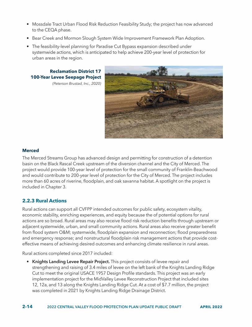
2-14 2022 CENTRAL VALLEY FLOOD PROTECTION PLAN UPDATE PUBLIC DRAFT APRIL 2022
• Mossdale Tract Urban Flood Risk Reduction Feasibility Study; the project has now advanced to the CEQA phase.
• Bear Creek and Mormon Slough System Wide Improvement Framework Plan Adoption.
• The feasibility-level planning for Paradise Cut Bypass expansion described under systemwide actions, which is anticipated to help achieve 200-year level of protection for urban areas in the region.
Reclamation District 17 100-Year Levee Seepage Project
(Peterson Brustad, Inc., 2020)
Merced
The Merced Streams Group has advanced design and permitting for construction of a detention basin on the Black Rascal Creek upstream of the diversion channel and the City of Merced. The project would provide 100-year level of protection for the small community of Franklin-Beachwood and would contribute to 200-year level of protection for the City of Merced. The project includes more than 60 acres of riverine, floodplain, and oak savanna habitat. A spotlight on the project is included in Chapter 3.
2.2.3 Rural Actions
Rural actions can support all CVFPP intended outcomes for public safety, ecosystem vitality, economic stability, enriching experiences, and equity because the of potential options for rural actions are so broad. Rural areas may also receive flood risk reduction benefits through upstream or adjacent systemwide, urban, and small community actions. Rural areas also receive greater benefit from flood system O&M; systemwide, floodplain expansion and reconnection; flood preparedness and emergency response; and nonstructural floodplain risk management actions that provide cost-effective means of achieving desired outcomes and enhancing climate resilience in rural areas.
Rural actions completed since 2017 included:
• Knights Landing Levee Repair Project. This project consists of levee repair and strengthening and raising of 3.4 miles of levee on the left bank of the Knights Landing Ridge Cut to meet the original USACE 1957 Design Profile standards. This project was an early implementation project for the MidValley Levee Reconstruction Project that included sites 12, 12a, and 13 along the Knights Landing Ridge Cut. At a cost of $7.7 million, the project was completed in 2021 by Knights Landing Ridge Drainage District.

APRIL 2022 2022 CENTRAL VALLEY FLOOD PROTECTION PLAN UPDATE PUBLIC DRAFT 2-15
• Cottonwood, Dry, Berenda Creek Arundo Eradication and Sand Removal Project. This project involved reducing the extent of Arundo (giant reed) infestations, a stressor of target species, and increasing conveyance capacity and visibility and access for maintaining channels and levees.
• Modernize Electrical Controls, Level Sensors and Supervisory Control and Data Acquisition (SCADA) for Control Structures Project. Antiquated electrical controls and water level sensors for the primary control structures on the Eastside Bypass, Mariposa Bypass, and Chowchilla Canal Bypass in the Lower San Joaquin Levee District were installed in the 1960s with the original system improvement. Upgrades were made in 2020 to modernize the system for improved reliability and integration with a new SCADA system.
• Levee Patrol Road Repair Projects. Since 2017, more than 80 miles of patrol roads were repaired in the Sacramento and San Joaquin river basins by individual local maintaining agencies (LMAs), primarily funded by the Flood System Repair Program (FSRP).
Repairs and improvements completed in rural-agricultural areas include restoration of levee crown elevations, repairing and resurfacing levee patrol roads, addressing critical levee integrity repairs, conducting flood fights, and performing annual levee inspections. The CVFPP does not include a specific level of protection for rural-agricultural areas, leaving more flexibility to improve the system over time for multiple benefits in a manner that does not induce growth in floodplains, is commensurate with the value of assets at risk, and provides opportunities for ecosystem and other benefits.
2.2.4 Small Community Actions
Many small communities in the Central Valley have largely agricultural-based local economies. Collectively, these communities actions help achieve protection from up to the 100-year (1 percent annual chance) flood, improve flood risk management, and support intended outcomes related to public safety and economic stability. Small community actions also leverage opportunities for ecosystem vitality, equity and social justice, and related multi-benefit outcomes because there is generally more available landscape and space around the small community to develop multi-benefit projects. Small community actions also often support disadvantaged communities (DACs) (i.e., communities with an annual median household income that is less than 80 percent of the statewide annual median household income).
Progress in implementing small community actions is critical to address the urgent impacts of climate change on populated areas in the Central Valley in combination with broader systemwide actions in the CVFPP because these communities often have more limited local capacity and resources and challenges meeting requirements for federal investment. Small community actions that have continued or been initiated since 2017 include Hamilton City Flood Damage Reduction and Ecosystem Restoration Project (see project spotlight below) and completion of 17 individual feasibility studies through the Small Communities Flood Risk Reduction Program.
• Following adoption of the 2012 CVFPP, DWR initiated the Small Communities Flood Risk Reduction Program to help communities with fewer than 10,000 residents protected by the SPFC achieve up to 100-year level of protection, where feasible. Since 2017, 35 small communities (including 14 DACs) received State funding for feasibility studies in their communities (see Figure 2-2). Knights Landing (Lower Sacramento River/Delta North RFMP), Grimes (Mid and Upper Sacramento River RFMP), and Franklin-Beachwood

2-16 2022 CENTRAL VALLEY FLOOD PROTECTION PLAN UPDATE PUBLIC DRAFT APRIL 2022
(Mid-San Joaquin River RFMP) also received additional State funding to advance their projects into the design and construction phases. Upon completion, these projects would help reduce flood insurance policy costs in these communities.
Project Spotlight: Hamilton City Flood Damage Reduction and Ecosystem Restoration
The project includes the construction of a 6.8-mile setback levee along the west bank of the Sacramento River and the restoration of more than 1,400 acres of inundated floodplain and riparian habitat. The Hamilton City Flood Damage Reduction and Ecosystem Restoration Project helps achieve protection up to the 75-year flood and significantly improves flood risk management and support intended outcomes related to public safety, economic stability, and ecosystem vitality in this small community. The CVFPP promotes development of multi-benefit small community projects, such as the improvements led by the USACE in Hamilton City, in partnership with the State and local agencies.
Connecting small community projects to larger funding opportunities and partners is part of CVFPP strategic investment approach. This is especially true in small communities where local cost-sharing capacity is severely limited and where DWR programs can help keep those communities protected from flooding. In this case, the project was made possible by establishing federal interest in the habitat restoration component of the project, which, in turn, garnered financial support for the flood risk reduction component. Placing value on habitat restoration, thereby establishing federal interest, made this project a reality for a DAC that may not have happened otherwise.
Hamilton City Flood Damage Reduction and Ecosystem
Restoration Project(The Nature Conservancy, 2018)

APRIL 2022 2022 CENTRAL VALLEY FLOOD PROTECTION PLAN UPDATE PUBLIC DRAFT 2-17
Figure 2.2 Small Communities that Received Funding from the Small Communities Flood Risk Reduction Program since 2017
!(
!(
!(
!(
!(
!(
_̂
!(
!(
!(")
!(
!(
!(
")
")
!(
!(
!(
!(
")
")
")
")
!(
")
!(
")
!(
!(
")
")
")
!(
!(
!(
!(
")")")
!(
")
!(
")")
Upper Sacramento /Mid-Sacramento River
Lower San Joaquin River / Delta South
Feather River
Mid-San Joaquin River
Lower Sacramento River/ Delta North
Upper San Joaquin River
San Joaquin Riv e r
Fe
ath
er
Riv
erSa
cram
en
t oR
iver
Banta
Butte City
Clarksburg
Colusa
Courtland
Durham
French Camp
Gerber
Grayson
Grimes
Hood
Isleton
Locke
Meridian
Nicolaus
Nord
Princeton
Richvale
Rio Oso
Rio Vista
Robbins
Sutter
Tudor
Vina
Wheatland
Yolo
Morada
Weatherbee IslandStoneridge
Kasson
Franklin Beachwood
Upper Lake
Knights Landing
Walnut Grove West and RydeWalnut Grove East
Chester
Chico
Fresno
Marysville
Merced
Modesto
Sacramento
San Francisco
Stockton
Tracy
±0 12.5 25
Scale in Miles
S:\SFPO\data\Projects\CVFPP_2022\GIS\Projects\Figures\CVFPP_2022_Basins_SmallCommunities.mxd
!(Phase 1: CompletedFeasibility Study
")
Phase 1: Incomplete orIn-progress FeasibilityStudy

2-18 2022 CENTRAL VALLEY FLOOD PROTECTION PLAN UPDATE PUBLIC DRAFT APRIL 2022
2.3 Flood Management Planning Despite limited in-person gatherings related to the COVID-19 pandemic in 2020 and 2021, the 2022 CVFPP Update and its supporting documents continue to reflect the input of many partners, stakeholders, and flood and water management-related efforts in the Central Valley. Brief overviews of many of the supporting planning efforts follow. Further description of how these efforts meet the requirements of the Central Valley Flood Protection Act of 2008 and support and inform development of the CVFPP is included in Appendix B, “Legislative Reference and Reader’s Guide.”
2.3.1 Conservation Strategy 2022 Update
CALIFORNIA DEPARTMENT OF WATER RESOURCES
DEPARTMENT OF WATER RESOURCES 3464 EL CAMINO AVENUE, SUITE 200 SACRAMENTO, CALIFORNIA 95821
MARY JIMENEZ MANAGERSYSTEMWIDE MULTI-BENEFIT INITIATIVES BRANCH [email protected]
GAVIN NEWSOM GOVERNOR STATE OF CALIFORNIA
WADE CROWFOOT SECRETARY NATURAL RESOURCES
KARLA NEMETH DIRECTOR DEPARTMENT OF WATER RESOURCES
PUBLIC DRAFTDECEMBER 2021
CENTRAL VALLEY FLOOD PROTECTION PLAN
CVFPP Conservation Strategy 2022 Update
The 2022 Conservation Strategy Update provides data and information to support 2022 CVFPP Update development by guiding the integration and improvement of ecosystem functions associated with flood risk reduction actions and providing the basis for recommending conservation actions for five CPAs included in the Systemwide Planning Area (SPA) for the CVFPP. The Conservation Strategy’s purpose is to provide actionable and measurable targets to improve riverine, aquatic, wetland, and riparian habitat in the flood system through the integration of ecological principles with flood risk reduction projects, O&M activities, institutional support, and other means (e.g., the removal of fish passage barriers). The Conservation Strategy also provides data, information, and guidance to floodplain managers to assist in the development of multi-benefit flood infrastructure improvement projects by integrating project components and management strategies that benefit native species and their habitats.
The identification, development, and implementation of multi-benefit projects in the Central Valley is the primary mechanism to improve and restore ecosystems, gradually build ecological resilience, and support a more adaptive and resilient flood protection system. Further, the projected impacts of climate change on ecological processes, habitats, and species require an expedited focus on building ecosystem resiliency and restoring ecological and geomorphic processes. This effort will require increased funding for multi-benefit projects and other policy issues to be addressed to increase the pace of implementation with an emphasis on nature-based solutions, such as widening river corridors and expanding floodplains to allow riverine habitats and species to be resilient to projected changes in air and water temperatures, precipitation, and hydrology. In addition to providing more resilient ecological conditions, multi-benefit projects that restore geomorphic processes also support a more resilient, adaptive, and sustainable flood management system, particularly in consideration of climate change challenges.
The 2022 CVFPP Conservation Strategy Update builds on significant science and collaborative work completed since 2012 that provided the basis for the comprehensive 2016 Conservation Strategy. The 2016 Conservation Strategy developed measurable objectives for 17 target species. Since 2017, a system has been developed to track how progress is being made towards achieving the measurable objectives. Appendix F of the 2022 Conservation Strategy Update includes details regarding the measurable objectives tracking system and five-year status update of progress made

APRIL 2022 2022 CENTRAL VALLEY FLOOD PROTECTION PLAN UPDATE PUBLIC DRAFT 2-19
since 2016. The 2022 Conservation Strategy Update adds three new species to the target list — delta smelt, yellow-breasted chat, and tricolored blackbird — and provides comprehensive information regarding new scientific data and listing status.
Delta Smelt(H.T. Harvey and Associates, 2021)
Yellow-breasted Chat(H.T. Harvey and Associates, 2021)
Tricolored Blackbird(H.T. Harvey and Associates, 2021)

2-20 2022 CENTRAL VALLEY FLOOD PROTECTION PLAN UPDATE PUBLIC DRAFT APRIL 2022
The 2022 CVFPP Conservation Strategy guides implementation with five key components, each accompanied by a set of prioritized actions and recommendations.
1. Coordination, Collaboration, and Alignment. Implementation of the CVFPP and Conservation Strategy relies on coordination, collaboration, and alignment among State, federal, and local agency partners and other stakeholders, including landowners, land conservancies, and NGOs. Projects are most successful in being efficiently implemented when a strong collaboration and alignment exists among partners, especially at a landscape scale. To that end, DWR will also continue to increase coordination and alignment among its various divisions and programs to take advantage of opportunities and achieve outcomes that meet the goals of multiple programs.
2. Outreach and Engagement. Outreach and engagement will continue to focus on existing, successful venues, such as the CVFPB Advisory Committee and the RFMP engagements, and increasing the level of engagement and participation with California Native American Tribes.
3. Funding. The funding approach for the Conservation Strategy is included in the CVFPP’s Investment Strategy. Achieving the Conservation Strategy’s measurable objectives through implementing multi-benefit projects and ecological restoration is an integral part of implementing the CVFPP and the 2022 SSIA portfolio of management actions.
4. Regulatory Compliance. Actions to implement the CVFPP and Conservation Strategy generally need to comply with a variety of federal and State environmental laws, such as the National Environmental Policy Act (NEPA), the Rivers and Harbors Act of 1899, the federal Clean Water Act, the federal Endangered Species Act, California Environmental Quality Act (CEQA), and California Endangered Species Act. Typically, required approvals and laws are described in the Conservation Strategy Update, Appendix D, “Updates to 2016 Conservation Strategy Appendix A, Regulatory Setting.”
5. Adaptive Management. Adaptive management uses new information to adjust plans and practices. The CVFPP and Conservation Strategy require a flexible approach to be able to quickly adapt to new information, including new project and program outcomes. Adjustments are made at five-year intervals as part of the CVFPP updates. Conservation Strategy adjustments are based on a reevaluation of the Strategy’s target species, measurable objectives, and implementation approach. The overall CVFPP performance tracking and adaptive management approach, and the integration of the Conservation Strategy goals and objectives into that framework, is described in greater detail in this 2022 CVFPP Update.
Appendix H of the 2022 Conservation Strategy Update provides an analysis of potential climate change risks and vulnerabilities for ecological processes, habitats, and species, as well as recommendations and adaptation approaches for building climate resiliency. See the climate change vulnerability and adaptation description and spotlight in Section 2.4. Finally, as detailed in the Conservation Strategy and its appendices, the pace of implementation of multi-benefit projects must increase to meet the measurable objectives and keep up with the urgent impacts of climate change.
2.3.2 State Plan of Flood Control Descriptive Document 2022 Update
The November 2010 SPFC Descriptive Document (California Department of Water Resources 2010) provided the first inventory and description of the flood management projects and features, lands,

APRIL 2022 2022 CENTRAL VALLEY FLOOD PROTECTION PLAN UPDATE PUBLIC DRAFT 2-21
programs, plans, conditions, and mode of O&M for the State-federal flood management system in the Central Valley. The 2010 Descriptive Document was prepared in response to Proposition 1E (Disaster Preparedness and Flood Prevention Act of 2006), which required that information on the SPFC “…. be updated and compiled into a single document entitled, ‘The State Plan of Flood Control.’” This information is a part of the CVFPP required pursuant to the Central Valley Flood Protection Act of 2008, as updated. The 2010 SPFC Descriptive Document was updated in 2017, in support of the 2017 CVFPP Update. The 2017 SPFC Descriptive Document Update is not a stand-alone document and is meant to be used in conjunction with the 2010 document.
The SPFC Descriptive Document is a reference document and includes narrative descriptions, tables, figures, web links, and maps to help the reader find information for the State-federal flood management system in the Central Valley. Descriptive Document updates are necessary to keep the SPFC description current as projects are initiated and completed. Updates to the SPFC Descriptive Document also reflect additional or new documentation for projects that meet the requirements of the SPFC (such as O&M manuals).
The 2022 SPFC Descriptive Document provides an updated, detailed inventory of the SPFC, in accordance with the requirements of the Central Valley Flood Protection Act of 2008. The 2022 Descriptive Document includes a description for the SPFC as of June 30, 2021. Specifically, the Descriptive Document provides:
• Overview information about updates to the SPFC since the 2017 Descriptive Document Update.
• Updates for ongoing State-federal projects.
• Descriptions of changes to SPFC project works or facilities.
• Descriptions of changes to Sacramento–San Joaquin Drainage District land holdings, types of property rights, agreements for use of easements and properties, lands of designated floodways, and ongoing evaluations.
• Updated information about repair projects, O&M manuals, maintenance, and operations for the SPFC.
The 2022 SPFC Descriptive Document supports the data and analysis of the 2022 CVFPP Update and the 2022 Flood System Status Report (FSSR). The SPFC Descriptive Document is intended as a reference document for the existing SPFC and does not recommend system improvements.
2.3.3 2022 Flood System Status Report
The 2022 FSSR describes the current physical condition of SPFC facilities as of 2021 at a systemwide level as an update to the FSSR developed in 2017, pursuant to requirements of the Central Valley Flood Protection Act of 2008. The information contained in 2022 FSSR supports development of the 2022 CVFPP Update and guides future inspection, evaluation, reconstruction, and improvement of SPFC facilities. A major goal of the 2022 update of the FSSR is to document the multiple levee systems that have been improved within the urban levee evaluation (ULE) and non-urban levee evaluation (NULE) study areas, as well as to incorporate data supplied by ongoing DWR inspections and evaluations.
In addition to meeting legislative requirements and contributing to the 2022 CVFPP Update, information in the 2022 FSSR may be used to support the DWR’s flood management functions and

2-22 2022 CENTRAL VALLEY FLOOD PROTECTION PLAN UPDATE PUBLIC DRAFT APRIL 2022
long-term activities, including emergency response, facility maintenance, and inspections. Periodic updates to the FSSR will help DWR to track progress as ongoing inspections and evaluations are completed and more SPFC facilities are reconstructed or improved to meet current design criteria. Future updates have potential to support monitoring and tracking of additional metrics as they are developed over time (such as ecosystem metrics from the Conservation Strategy).
To evaluate the condition of SPFC facilities, DWR considered a variety of factors that could influence the performance of SPFC levees, channels, and flood control structures. The DWR Levee Evaluations Program, including its ULE project and NULE project, is the primary source of information for evaluating the condition of SPFC levees. DWR concluded ULE and NULE evaluations in December 2015 and have not been updated since. Results of the ULE and NULE evaluations are incorporated in the 2022 FSSR as a baseline. Since the 2017 FSSR, some levee improvement projects within ULE and NULE evaluation areas have been completed. Levee conditions reported in the 2022 FSSR also rely on information from DWR’s annual LMA inspections and other available data that supplement DWR Levee Evaluations Program results.
In general, channel conveyance conditions were determined by using the most recent available hydraulic modeling to evaluate whether the channels can convey design flows presented in O&M manuals and design profiles. Channel conditions reported also include DWR’s annual inspections for vegetation and sedimentation. Reported flood management structure conditions are based on DWR’s annual inspections.
The overall condition of SPFC urban levees, nonurban levees, channels, and flood control structures are be summarized below.
• Urban Levees. Approximately 25 percent (79 miles) of the SPFC urban levees evaluated (317 miles) do not meet current levee freeboard, stability, or seepage design criteria at the design water surface elevation. Of the approximate 97 miles of non-SPFC urban levees evaluated, roughly half (50 miles) do not meet current levee freeboard or underseepage design criteria at the design water surface elevation. These numbers are adjusted from the 2017 FSSR update with the 93 miles of improved levees. However, the improved levees have not been reassessed for freeboard, stability, or seepage under an ULE analysis.
• Nonurban Levees. Approximately 500 miles of about 1,100 miles of SPFC nonurban levees evaluated do not meet acceptable criteria for freeboard and underseepage at the assessment water surface elevation. Of the 187 miles of non-SPFC nonurban levees, approximately 50 miles do not meet acceptable criteria for underseepage at the assessment water surface elevation. A significant number of non-SPFC nonurban levees were not assessed for various criteria.
• Channels. Approximately half of the 1,025 miles of channels evaluated in the SPFC have a potentially inadequate capacity to convey design flows and require additional evaluation to confirm conditions.
• Flood Control Structures. None of the 56 hydraulic structures or 13 pumping plants inspected by DWR for the SPFC were rated “Unacceptable” during theinspections made in 2020. Of the 10 SPFC bridges inspected by DWR in 2020, two needed repairs.
FSSR findings provide important information for the CVFPP as part of an iterative approach to monitoring and tracking flood system conditions over time and for informing flood management actions.

APRIL 2022 2022 CENTRAL VALLEY FLOOD PROTECTION PLAN UPDATE PUBLIC DRAFT 2-23
2.3.4 Updated Regional Flood Management Planning
The RFMPs provide valuable perspectives from regional and local flood managers that help inform, develop, and align State and local and regional priorities to support implementation of the CVFPP. The RFMPs also provide a platform for meaningful engagement among DWR and local and regional flood planners across the Sacramento and San Joaquin River river basins. For the 2022 CVFPP Update, the six regions provided updated information on:
• Progress made in achieving regional goals.
• Regional priorities.
• Challenges with implementation.
• Proposed project lists.
• Flood system O&M costs.
• Input on policy issues and recommendations.
Many of the RFMPs initiated or completed regional planning documents to advance various planning activities that support subsequent implementation. For example, the Mid- and Upper Sacramento River Region initiated development of the Sutter and Tisdale Bypasses Flood and Multi-Benefit Management Plan and a Mid-Sacramento Valley Regional Conservation Investment Strategy.
Other regions have initiated new partnerships and governance. For instance, the San Joaquin Area Flood Control Agency (SJAFCA) Joint Powers Agreement was expanded in 2017 to include the Cities of Lathrop and Manteca along with the original member agencies of San Joaquin County and the City of Stockton.
Region overviews provided at the end of this chapter highlight specific accomplishments for each RFMP.

2-24 2022 CENTRAL VALLEY FLOOD PROTECTION PLAN UPDATE PUBLIC DRAFT APRIL 2022
2.4 Improvements in the Climate Change Analyses The impacts of climate change in California are occurring and will continue to occur. Combatting these impacts will require broad, comprehensive, and innovative flood management solutions. Figure 2-3 presents the climate change components studied in the CVFPP, a qualitative description of the current and projected trends of climate change in California, and the level of confidence in the potential future change. CVFPP climate change analysis was guided by DWR’s Climate Action Plan Phase II: Climate Analysis Guidance and Phase III: Climate Change Vulnerability Assessment, which collectively provide standards for quality, scientific rigor, and consistency of analysis.
Figure 2.3 Qualitative Description of Current and Projected Climate Trends in California
CLIMATE CHANGE COMPONENT
STUDIED IN CVFPP
CURRENT TRENDS
PROJECTED TRENDS
CONFIDENCE FOR FUTURE
CHANGE
Air Temperature 2017 and 2022 Increasing Increasing Very high
Water Temperature
NA Increasing Increasing Medium
Extreme Precipitation
2017 and 2022 Increasing Increasing Medium high
Snowpack 2022 Decreasing Decreasing (less snow and more rain)
Very high
Sea Level Rise 2017 and 2022 Increasing Increasing Very high
Hydrograph Characteristics
2017 Shift in streamflow to the earlier months
Shift in streamflow to the earlier months
Very high
Unregulated Flood Volume
2017 and 2022 N/A Increasing (San Joaquin flood peak doubles)
Very high
Regulated Flow 2017 and 2022 N/A Increasing (varies based on location)
N/A
Regulated Stage 2017 and 2022 N/A Increasing (varies based on location)
N/A
Sources: 2017 Central Valley Flood Protection Plan Update; Statewide Summary Report 2019; California’s Fourth Climate Change
Assessment 2018; 2022 Conversation Strategy Update, Appendix H.
In accordance with State law and technical guidance, the CVFPP draws on the latest climate science and understanding to assess the effects of sea level rise and the hydrological impacts in the Central Valley at a level of detail to support a systemwide plan and its updates. As part of the 2017 CVFPP Update, a median, late-century climate change projection was developed for the Sacramento and San Joaquin river basins that accounted for climate change hydrology and sea level rise. Key findings from the 2017 CVFPP climate change analysis include the following:

APRIL 2022 2022 CENTRAL VALLEY FLOOD PROTECTION PLAN UPDATE PUBLIC DRAFT 2-25
• Projections of increased warming are consistent for the entire planning area.
• Extreme precipitation — the driver for most flood events — likely will intensify, even with projections of overall drier conditions.
• Changes in flood magnitudes and frequencies are projected to vary from north to south in the Central Valley. The high-elevation San Joaquin watersheds show the largest percentage increases in flood volumes caused by a reduction in precipitation falling as snow and more rapid snowpack melting.
• Overall changes in the timing, duration, and magnitude of flows can change river geomorphic functions, floodplain activation, sediment mobilization, and the distribution of riverine habitats and adversely affect specific target species that depend on those processes.
The 2022 CVFPP Update climate change analysis advances the 2017 analysis and confirms findings using a range of climate change scenarios. Updated analyses generally confirmed the 2017 findings and improved the understanding of uncertainty associated with climate change projections for Central Valley watersheds, reservoir vulnerability to climate change, and sea level rise. Figure 2-4 provides an overview of projected changes resulting from climate change that are anticipated to affect a watershed.

2-26 2022 CENTRAL VALLEY FLOOD PROTECTION PLAN UPDATE PUBLIC DRAFT APRIL 2022
Figure 2.4 How the Watershed Responds to Projected Climate Change
22_603
Air temperature and extreme precipitation increasing
Unregulated flood volume increasing
Regulated flow increasing
Streamflow shifts earlier in year
Regulated stage increasing
Ecosystem-based stressors increasing
Sea level rise and water temperature increasing

APRIL 2022 2022 CENTRAL VALLEY FLOOD PROTECTION PLAN UPDATE PUBLIC DRAFT 2-27
2.4.1 Hydrology
Although confidence in future climate change trends is improving, the range of potential future conditions remains large and uncertain. For example, the climate is getting warmer, and by mid-century, experts expect an average rise in California’s temperature of 4.8 degrees Fahrenheit (°F) with a potential range of increase between 1 °F to 10 °F (Pierce et al. 2018).
Recognizing this uncertainty and in response to comments received on the 2017 CVFPP Update climate change analysis, the 2022 CVFPP Update climate change analysis includes a wider range of potential climate change projections. These projections present a range of the uncertainty associated with current climate predictions and are described as a “low,” “medium,” and “high” projections over a planning horizon that extends 50 years post 2022 CVFPP Update release. In other terms, the three conditions (low, medium, and high) represent a sample of the possible climatic future in the Central Valley.
The low climate change scenario is descriptive of a drier, lesser warming condition; the medium climate change scenario is descriptive of a median change in precipitation and temperature conditions; and the high climate change scenario is descriptive of a wetter, more warming condition by year 2072. These three climate change projections were created by using a downscaling ensemble of general circulation models (GCMs) or climate models. GCMs represent physical processes in the atmosphere, ocean, cryosphere, and land surface, and are the most advanced tools available for simulating the response of the global climate system to increasing greenhouse gas concentrations.
It should be noted that both the 2017 and 2022 CVFPP climate change hydrology were developed to inform systemwide planning and were not intended to be used for design-level decisions. The Cal-Adapt website provides peer-reviewed climate change data and potential effects to support local-level project planning.
Key findings from the 2022 CVFPP Update climate change analysis include:
• Confirmation of 2017 CVFPP Update findings.
• More warming projected for all future scenarios, resulting in less watershed below freezing temperatures.
▶ Freezing elevation in Sacramento River Basin will increase from 5,000 feet in no climate change scenario to 8,500 feet in high climate change scenario.
▶ Freezing elevation in San Joaquin River Basin will increase from 8,000 feet in no climate change scenario to 12,000 feet in high climate change scenario.
• Increasing and warmer rainfall and less snow from major storms will result in more runoff above 6,000-foot elevation, thereby increasing peak flows.
• Major storms will bring less snow in the future — large decreases in winter snow accumulation and most snow melts by early spring.
• Precipitation varies — 10 percent decrease in low climate change scenario, no change during medium climate change scenario, and 15 percent increase in high climate change scenario.
• Runoff will increase as areas are converted from snow to rainfall regimes — less precipitation will be stored as snowpack.
• Major storms will generate higher flow peaks — more streamflow in the winter, less in the spring.

2-28 2022 CENTRAL VALLEY FLOOD PROTECTION PLAN UPDATE PUBLIC DRAFT APRIL 2022
2.4.2 Innovative Climate Change Pilot Studies
In the San Joaquin Valley, further investigation on climate change analysis is taking place using an innovative “decision scaling approach.” Decision scaling is a technical approach used to help guide decision-making by understanding the sensitivity of an existing system (e.g., watershed, reservoirs, infrastructure) to potential stressors (e.g., climate change and policy change). Rather than attempting to reduce projected future uncertainty, the approach implicitly accepts and embraces the inherent uncertainty of future conditions. Decision scaling characterizes the uncertainty in terms of its implications on potential decisions regarding a defined system and to further inform decisions considering the range of uncertainty.
This approach is currently used at DWR and is being piloted in the Tuolumne and Merced river watersheds with study partners. These two watersheds were selected as pilots in response to the 2017 CVFPP Update analyses that projected significant climate change effects related to flood management in those watersheds. A third study is being initiated for the Calaveras River watershed, and DWR has received funding to conduct these innovative climate vulnerability and adaptation assessments for the remaining tributary watersheds of the San Joaquin River Basin. In close collaboration with pilot study partners, potential actions to adapt to climate change (adaptation strategies) are identified in each watershed, and watershed-scale analyses inform prioritization of actions to implement based on improved understanding of facilities and operations most vulnerable to climate change and the likelihood of those changes occurring.
The Tuolumne study is distinctively piloting the development of a “weather generator” technology that will more accurately depict increased temperature effects on droughts and floods (especially atmospheric rivers) and the transition effect on water resources management between these two extremes. This new technology, cooperatively developed by a partnership of DWR, USACE’s Engineer Research and Development Center, Turlock Irrigation District, Cornell University and Scripps’ Center for Western Weather and Water Extremes, will be first applied to the Tuolumne River watershed, then to the remaining San Joaquin River Basin tributaries, followed by a statewide tool application.
The climate vulnerability assessment for the Merced River Flood-MAR Reconnaissance Study (Merced Study) represents an advanced application of a “decision scaling” approach. This approach will also be used in future watershed studies, seeking to understand the effects of climate change and recognizing a fuller range of uncertainty associated with those effects. The climate change analysis for this 2022 CVFPP uses a similar approach, but with a more limited exploration of uncertain futures. The California Water Plan climate analyses and other DWR plans and projects are transitioning to a fuller understanding of climate change effects using decision scaling.

APRIL 2022 2022 CENTRAL VALLEY FLOOD PROTECTION PLAN UPDATE PUBLIC DRAFT 2-29
2.4.3 Reservoir Vulnerability
The 2022 CVFPP Update also investigated the vulnerability of Central Valley reservoirs being overwhelmed and requiring emergency operations. During floods, reservoirs normally can release as much water as the downstream channels can safely accommodate. But when inflows to a reservoir greatly exceed the reservoir storage capacity, dam safety concerns necessitate emergency operations in hopes of reducing storage and preserving the reservoir’s structural integrity. These emergency releases may often exceed the downstream capacity.
Storage in reservoirs before a large flood event has a significant impact on reservoir flood releases made during the event. Greater storage and lower reservoir water surface elevations prior to the event typically result in lower peak releases and, consequently, lower flows downstream.
The climate change hydrology analysis indicated that peak flows may increase throughout the system, and the majority of increased runoff comes from portions of the watershed upstream of the
Project Spotlight: Merced Flood-MAR Reconnaissance Study
DWR, in partnership with the Merced Irrigation District (MID), is studying the climate change vulnerability and use of floodwaters for managed aquifer recharge that can support climate change adaptation and reduce flood risk, increase supply reliability, support groundwater sustainability, and enhance ecosystems in the Merced River Basin. The Merced Study is exploring the potential feasibility and effectiveness of Flood-MAR concepts, testing theories, and describing strategies in overcoming challenges to project planning and implementation at a watershed scale.
The Merced Study uses a watershed vulnerability and adaptation assessment approach, first assessing vulnerabilities in flood management, water supply, ecosystems, and groundwater sustainability to climate change. Performance of FloodMAR and related adaptations were then evaluated with potential climate change futures. Preliminary results of the Merced Study indicates that all water sectors in the Merced River Basin are vulnerable to climate change — future flood risks are significantly increased, water demand increases with temperature, water supply becomes less reliable, and groundwater and ecosystems are further stressed by water availability, timing, and temperature. For example, the climate change vulnerability assessment estimates a 600 percent increase in Merced River peak flood flows.
Preliminary study results indicate that even low levels of Flood-MAR implementation achieve benefits in all these sectors, and benefits substantially increase with an increase in the scale (i.e., land area) of implementation, including the addition of reservoir reoperation concepts and new infrastructure. With a combination of FloodMAR and reservoir reoperation, study results show climate change-induced peak flood flows in the Merced River were reduced by 65 to 85 percent.
Further, by prioritizing recharge based on location and benefit objective (rather than by simply maximizing recharge), the Merced Study team was able to show location-specific benefits, such as migratory shorebird habitat, subsidence mitigation, improved local groundwater subbasin retention, improved aquifer to stream accretions, and improved groundwater levels, in and near DACs and associated domestic and public water supply wells.
Final Merced Study results will be released by DWR’s Flood-MAR program through a series of technical memoranda by mid-2022.

2-30 2022 CENTRAL VALLEY FLOOD PROTECTION PLAN UPDATE PUBLIC DRAFT APRIL 2022
flood control reservoirs. Accordingly, opportunities to decrease flood risk, or mitigate future increases in flood risk, exist above the reservoirs, at the reservoirs, and below the reservoirs through headwater/watershed management, improved forecasting, FIRO, expanded storage, modified outlets, increased downstream capacity, and more floodplain storage/recharge.
2.4.4 Sea Level Rise
Future sea-level-rise projections would impact flood water levels throughout the San Francisco Bay-Delta and the lower San Joaquin and Sacramento River watersheds. The 2017 CVFPP Update modeling drew upon the mean-sea-level projection from the National Research Council (2012) adjusted to the year 2067. This projection included a sea-level-rise estimate at the Golden Gate Bridge of approximately 1.3 feet.
For the 2022 CVFPP Update, updated guidance on sea level rise provided by the Ocean Protection Council (OPC) (2018) was used. This OPC guidance predicts an approximately 3.7-foot sea level increase at the Golden Gate Bridge in the year 2072 using their medium-high risk aversion estimate. The medium-high risk aversion has a 1-in-200 chance of being exceeded. Although the likelihood is low that sea level rise will meet or exceed this value, it is recommended to be used for less adaptive, more vulnerable projects or populations that will experience medium-to-high adverse consequences because of underestimating sea level rise.
To evaluate the vulnerability of levees to future sea level rise, the 2022 CVFPP Update also analyzed the effects of a wide range of sea-level-rise projections and quantified the likelihood of increased water surface elevations along Delta levees within the Systemwide Planning Area for a 100-year (1.0 percent chance of occurring every year) and 200-year flood event (0.5 percent chance of occurring every year) with median climate change condition. This analysis complements the work being completed for DSC’s Climate Change Vulnerability Assessment (“Delta Adapts”). Section 2.9.4 contains additional information about alignment between the CVFPP and Delta Adapts.
Key findings of the CVFPP sea-level-rise analysis are summarized below.
• Future floods are expected to have increased peak water surface elevations and cause more damage in tidally-influenced areas of the lower San Joaquin and Sacramento River watersheds because of sea level rise.
• Frequency and magnitude of emergency response actions are expected to increase as a result of sea level rise, even in dry conditions.
2.4.5 Climate Change Vulnerability and Adaptation
A broad suite of climate change adaption measures can address vulnerabilities across flood and related water management sectors, such as ecosystem and groundwater management. Various adaptation measures and strategies can mitigate the risks of climate change and improve resilience of the flood management system and ecosystem processes, habitats, and species identified in the Conservation Strategy. Principles and approaches that enable implementation and decisions to be made even under considerable uncertainty are promoted by the CVFPP.
Potential adaptation strategies and measures that support flood management systems resilience to climate change, and community resilience in the Central Valley, are identified in Table 2-2. These strategies and measures are organized by management action categories and corresponding action types.

APRIL 2022 2022 CENTRAL VALLEY FLOOD PROTECTION PLAN UPDATE PUBLIC DRAFT 2-31
The CVFPP Conservation Strategy Update also includes an enhanced description of climate change adaptation that focuses on species and ecological responses to climate change. More information is available as Appendix H of the CVFPP Conservation Strategy Update.
Table 2.2 CVFPP Climate Change Adaptation Types, Actions, and Measures
Climate Change Adaptation Type Climate Change Adaptation Action Example Climate Change Adaptation
Strategies and Measures Water Management Infrastructure
Levees and Floodwalls
Channels
Retention and Detention Basins
Culverts and Pipes
Debris Mitigation Structures
Hydraulic Structures
Levee Setbacks
Bypasses
Floodplain Storage Infrastructure
Dams and Reservoir Infrastructure
Groundwater and Recharge Infrastructure
Increase operable release capacity at reservoirs, such as through secondary spillways or low-level outlets.
Improve structural integrity of existing levee systems.
Increase operable control of weirs and river diversions.
Increase capacity of existing bypasses.
Build new levee setbacks.
Build new levees or floodwalls.
Enlarge existing transitory floodplain storage.
Implement managed aquifer recharge (Flood-MAR or other).
Reservoir and River System Operations
Reservoir Operations
Floodplain Storage Operations
Diversion and Bypass Operations
Groundwater and Recharge Storage Operation
Implement forecast-informed reservoir operations.
Implement forecast-coordinated operations.
Implement groundwater and recharge storage operations.
Operations, Maintenance, Repair, Replacement, and Rehabilitation
Inspection and Assessment
Annual Maintenance
Repair and Rehabilitation
Replacement
Implement phased repair, rehabilitation, and replacement of flood facilities.
Repair and retrofit existing facilities for climate change.
Conduct annual operation and maintenance of flood facilities.
Watershed and Floodplain Management
Floodplain Mapping
Building Codes and Floodproofing[1]
Flood Insurance[1]
Land Acquisition and Easements
Retreat from the Floodplain[1]
Flood Risk Awareness and Public Information Campaigns[1]
Land Use Planning[1]
Studies and Analyses
Performance Tracking and Technical Support
Increase adaptive storage capacity in floodplains.
Improve sediment and post-fire debris detention.
Coordinate and streamline floodplain mapping to improve consistency of floodplain delineation and assessment of flood risk.
Purchase land or easements for flood flows.
Execute flood risk awareness campaigns.
Enact building codes that allow for flood retreat (e.g., allow escape hatches in attics and second story buildings).
Elevate structures and facilities.
Floodproof mechanical and electrical equipment.
Promote risk-informed land planning (e.g., balance the wise use of floodplains between natural resources and the risks to people and property).

2-32 2022 CENTRAL VALLEY FLOOD PROTECTION PLAN UPDATE PUBLIC DRAFT APRIL 2022
Climate Change Adaptation Type Climate Change Adaptation Action Example Climate Change Adaptation
Strategies and Measures Ecosystem Management
Restoration of Riverine and Floodplain Habitats
Floodplain Reconnection
Reduce Stressors: Invasive Species
Reduce Stressors: Revetment
Reduce Stressors: Barriers to Fish Passage
Actions that restore geomorphic functions, increase the quantity and quality of floodplain habitats, and improve conditions for native species.
Develop more effective tools and processes to evaluate climate change impacts at a watershed or finer scale.
Science and Technology
Climate and Weather Monitoring
Prediction and Forecasting
Measurement and Data
Modeling Tools
Improve regional climate science and prediction.
Improve tracking of performance toward climate resiliency.
Improve climate change analyses that inform ecosystem processes and habitats.
Emergency Management
Emergency Preparedness[1]
Emergency Response[1]
Recovery Programs and Actions[1]
Integrate climate risk with emergency response.
Bridge climate prediction with near-term risk identification.
Integrate climate risk with local hazard mitigation plans.
Create systemwide levee instrumentation for early warning systems.
Programmatic, or Project-Specific Permitting
Project- or Program-Specific Permitting
Regional and Programmatic Permitting
Include principles of dynamic ecosystems in programmatic permitting.
Develop regional and river-corridor conservation plans or expand existing regional conservation plans.
Develop regional advance mitigation strategies, and promote networks of both public and private mitigation banks.
Policy and Regulations
Policy and Regulations Improve coordination between different State, federal, and local agencies.
Develop guidance for incorporating climate. change in planning and design.
Identify and recommend State, federal, and/or local policy changes to support climate adaptation.
Funding and Finance
Finance and Revenue Identify opportunities to create more sustainable funding mechanisms to support resiliency.
Promote resiliency funding.
Create innovative risk finance instruments.
Note:[1] These actions support community resilience to climate change and will include equity and environmental justice considerations
and development of adaptation measures for climate change-vulnerable populations. These adaptation measures will be further developed for future updates.

APRIL 2022 2022 CENTRAL VALLEY FLOOD PROTECTION PLAN UPDATE PUBLIC DRAFT 2-33
Policy Spotlight: Conservation Strategy Climate Adaptation
A key theme of the 2022 Update to the CVFPP and Conservation Strategy is climate change resilience, supported by a body of work to describe and better understand flood and ecosystem management-related risks and vulnerabilities, and to provide a set of recommendations and adaptation strategies related to climate change. Climate change is a critically important issue for ecosystems in the Central Valley, with major ecological consequences leading to changes in the abundance and distribution of native habitats and species as a result of physical changes to the environment.
The Conservation Strategy Update, Appendix H, “Climate Change Adaptation for the CVFPP Conservation Strategy Update,” uses recent climate modeling analyses to estimate climate risks and vulnerabilities to ecosystem processes, habitats, and target species, and proposes adaptation strategies focusing on the Conservation Strategy objectives and target species at the Conservation Planning Area scale, including:
• Building system resiliency by restoring critical landscape-level hydrologic, geomorphic, and ecological processes related to improving river functionality, floodplain activation, and habitat connectivity and complexity.
• Opportunistically incorporating habitat and species-specific adaptation measures into multi-benefit project planning and design.
• Further incentivizing, prioritizing, and removing impediments to multi-benefit project implementation.
• Performing more detailed analyses and developing additional tools and guidance to better evaluate vulnerabilities and risks of physical processes, habitats, and species, as described in the 2016 Conservation Strategy to climate change at regional and project-specific scales.
• Developing better communications and outreach protocols to convey the ecological risks and adaptation opportunities associated with climate change, and forming more effective partnerships with federal, regional, local, and Tribal partners.
The Conservation Strategy provides the guidance to make progress on developing planning processes, strategies, and multi-benefit projects that increase system resilience. The main challenge DWR and its partners face in relation to climate change is primarily one of timing. The pace and scope of multi-benefit project implementation must increase, which will require the resolution of the fundamental policy issues already identified in the CVFPP and Conservation Strategy, including funding, permitting, long-term O&M, and performance accounting.
2-34 2022 CENTRAL VALLEY FLOOD PROTECTION PLAN UPDATE PUBLIC DRAFT APRIL 2022
2.5 Floodplain Risk ManagementThe federal government and State of California recognize that the continued intensification of flood risk associated with existing and future development in floodplains is a complex and important issue. Since the mid-1990s, flood managers have embraced a flood risk management approach, one that promotes non-structural risk reduction measures, as an improvement to the historical flood engineering approach. This risk management approach is the core of floodplain management and augments more traditional structural flood risk reduction actions. For example, flood risk awareness campaigns that are coupled with structural levee repairs can help residents understand their risk and know what do to in the case of an emergency.
The State and federal government have undertaken several efforts, many since 2017, to provide more guidance and support for local communities and individuals to help further reduce their flood risk. These efforts will help manage and plan for future flood risk.
2.5.1 Federal Floodplain Management Initiatives
A key component of floodplain management is the administration of the National Flood Insurance Program (NFIP). Although established in 1968 through the National Flood Insurance Act, it took nearly two decades for FEMA to complete large-scale floodplain maps for the United States. Pre-dating today’s sophisticated computer-based floodplain maps, floodplain management as implemented by FEMA through the NFIP-required extensive local engagement and buy-in. The federal government recognized that need by asking local communities to help create FEMA’s maps. The advantage to this approach was that local governments would be more aware of their existing (and future) flood risks and better prepared to implement both structural and non-structural activities.
Through the end of the twentieth century, the NFIP was successful in helping to: (1) prepare large-scale flood risk assessments through FEMA’s floodplain maps, (2) provide insurance to property owners to promote quick financial recovery following a flood event, (3) encourage a variety of actions to mitigate future flood risks, and (4) promote sound land use decisions that balance the risk-reward of development in floodplains. Since the end of the last century, climate change and increasing population growth and development have stressed the NFIP almost to its breaking point. Most notably, record-breaking flood events such as Hurricane Katrina (2005), Superstorm Sandy (2012), and Hurricanes Harvey, Irma, and Maria (2017) have left the NFIP in debt and called into question both the effectiveness of existing flood risk assessments and capacity of local and state communities to meet future flood challenges.
In response to these challenges, Congress and FEMA have enacted several new initiatives to modernize the NFIP and overall floodplain management, including:
• Transitioning to a new risk-based methodology to calculate annual flood insurance premiums (known as Risk Rating 2.0).
• Holding States accountable as a community, including having States lead by example by taking measures to either insure or protect State-owned properties within floodplains.
• Updating decades-old floodplain maps and developing new “base-level engineering” studies for previously unmapped rural areas, including providing flood elevation data to support the design of mitigation measures.
APRIL 2022 2022 CENTRAL VALLEY FLOOD PROTECTION PLAN UPDATE PUBLIC DRAFT 2-35
• Tasking States with developing more frequent and robust State and local community engagement programs.
• Modernizing FEMA’s Pre-Disaster Mitigation Grant Program into a new Building Resilient Infrastructure and Communities (BRIC) Grant Program, which emphasizes incorporating nature-based solutions and consideration of future climate change for all communities, large and small.
• Preparing a new community engagement planning (CEP) tool to assist States in developing priorities for communities they should engage with more frequently. FEMA’s CEP tool takes into consideration population, social vulnerability (including limited capacity to act alone), numbers of NFIP policies in force, and special training needs.
• Developing a national risk index that provides relative risk index scores and ratings based on data for expected annual loss resulting from natural hazards, social vulnerability, and community resilience.
2.5.2 State Floodplain Management Initiatives
Major State-led floodplain management initivatives have included three notable efforts.
• California Floodplain Management Task Force Recommendations. More than 20 years ago, the California Legislature adopted AB 1147, which called upon the governor to convene a Floodplain Management Task Force. In 2002, under DWR’s leadership, a task force of more than 30 representatives from State, federal, and local entities provided more than 30 recommendations on flood risk reduction for DWR to consider. DWR has prepared a self-assessment of its implementation of these recommendations and is now working with State, federal, and local entities and universities through the FloodHub (a flood-focused partnership sponsored by the University of California, Berkeley) to seek further input on the original recommendations and next steps in shaping floodplain management actions.
• Floodplain Management, Protection, and Risk Awareness Program. In 2020, DWR established a new $50 million statewide floodplain management financial assistance program known as the Floodplain Management, Protection, and Risk Awareness Program. The program supports local agency efforts to prepare for flooding by providing financial assistance for flood risk reduction activities related to stormwater flooding, mudslides, and flash floods. Consistent with guidance from the Unified National Program for Floodplain Management (1994), eligible projects include those that are both structural and nonstructural. Based on lessons learned from DWR’s Small Community Grant Program, Central Valley Tributaries Program, and Coastal Flood Risk Reduction Program, this Proposition 68-funded Floodplain Management, Protection, and Risk Awareness Program incorporated a new concept proposal step in which potential applicants could work with DWR staff to determine if their project idea(s) are consistent with the program guidelines. DWR also set aside 10 percent of the total funding available for planning and monitoring projects. The program timing was designed to align with FEMA’s various Hazard Mitigation Assistance programs (as administered by Cal OES) such that the State award could be used to meet the non-federal cost share for these federal assistance programs.
• Disadvantaged Community Floodplain Management Assistance Workshop. In August 2021, DWR hosted its first annual Disadvantaged Community Floodplain Management Assistance Workshop. Representatives from DWR, Cal OES, California Department of

2-36 2022 CENTRAL VALLEY FLOOD PROTECTION PLAN UPDATE PUBLIC DRAFT APRIL 2022
Conservation, and FEMA discussed their data services and financial assistance programs with an audience of local officials representing economically DACs. An example of data services included the new light detection and ranging (LiDAR) data covering the San Joaquin Valley and how that data can be used in preparing flood risk assessments. The process to apply for FEMA’s Hazard Mitigation Grant Program (HMGP) was provided as an example of a post-disaster financial assistance program. Cal OES and DWR have also continued to provide support to local communities to maintain eligibility for the HMGP by having current local hazard mitigation plans in place.
Since the 2017 CVFPP Update, the State has also advanced many floodplain management initiatives and activities in coordination with FEMA. Some of these efforts are noted below.
• California has prepared new model building ordinances that exceed the minimum standards established by FEMA and the NFIP. The new ordinances require that all new or substantially improved structures within FEMA designated special flood hazard areas (i.e., floodplains) must be elevated such that the first functional floor be at least 1 foot above the projected 100-year floodplain depth. This requirement not only applies to the building structures, but also to all critical electrical and mechanical equipment (such as heating and cooling systems).
• FEMA and DWR have been working with the 530 communities throughout California that participate in the NFIP to ensure that they adopt local regulations that meet or exceed these State standards.
• DWR’s engagements with FEMA include annual community assistance visits or community assistance contacts and specialized training ranging from certified floodplain manager training to insurance agent courses. These engagements leverage the new CEP tool developed by FEMA.
• In the Central Valley, DWR has also arranged for special meetings for local flood risk reduction project sponsors with FEMA and Cal OES Hazard Mitigation Assistance Grant (HMAG) experts to encourage local communities to take full advantage of FEMA’s HMA programs (including the HMGP, Flood Mitigation Assistance Program, and new BRIC Program).
• DWR-funded Small Community Flood Risk Reduction Program projects in the community of Grimes will use State funding to meet the non-federal cost share for the fiscal year 2020 BRIC program, thus leveraging federal resources and minimizing the costs to this economically DAC.
• DWR is working with FEMA to seek permanent NFIP Community Rating System credits for nearby communities. These credits will help reduce the annual NFIP premiums for property owners in these communities.
DWR has also partnered with local agencies and NGOs to purchase riparian property in the Central Valley to support the restoration of critical riparian habitat and provide additional protection to nearby small communities through the Proposition 1-funded Central Valley Tributaries Program.
In addition to facilitating State, federal, and local alignment, DWR’s floodplain management team has also offered ongoing support for two major data collection and risk awareness projects in the Central Valley:
• San Joaquin Valley LiDAR Survey. DWR, the California Department of Conservation, and the U.S. Geologic Survey (USGS) have completed a LiDAR survey for the majority of the San Joaquin Valley. The new updated LiDAR data improves upon the horizontal and vertical

APRIL 2022 2022 CENTRAL VALLEY FLOOD PROTECTION PLAN UPDATE PUBLIC DRAFT 2-37
resolution of the data previously collected by DWR through the Central Valley Floodplain Evaluation and Delineation program used to support the 2012 CVFPP and 2017 CVFPP Update. This data will be used in the ongoing FEMA Risk Map studies for Madera and Fresno counties, which, in turn, will result in improved flood risk maps covering both rural and urbanizing portions of the Central Valley. The data itself will be hosted directly on a permanent USGS website and eliminate the need for local agencies to directly request this data prior to preparing their own flood risk assessments and flood mitigation projects.
• Senate Bill 19 Stream Gaging Project. DWR is leading this project, which focuses on installing new stream gauges in waterhsheds to add both flood forecasting and water supply management. This project also includes representatives from the National Oceanic and Atmospheric Agency (NOAA), USGS, and several NGOs.
DWR also conducted downstream risk assessments for 50 California reservoirs with ungated spillways. These assessments helped to determine if reservoirs would benefit from the installation of real-time gauges downstream of these dams and installation of elevation gauges within the reservoirs to support real-time flood notification programs. Based on the risk assessment results, DWR will work with seven of these dam owners to install the gauges and then assist downstream communities to make use of this new data generated.
Key to all of these successful DWR-led activities has been the participation of local dam owners, the California Department of Conservation’s California Geologic Survey, Cal OES, Office of Planning and Research, NOAA, USGS, FEMA, and USACE. Each agency played a role in helping DWR develop these two Central Valley-focused projects.
2.5.3 Integrated Floodplain Management State Initiatives
Flood managers have also been working to better connect and coordinate flood and groundwater management. These efforts involve DWR flood managers reviewing and commenting on groundwater sustainability plans and studies to identify opportunities to use high flows from, or in anticipation of, rainfall or snowmelt for managed aquifer recharge on agricultural lands, working landscapes, and natural managed lands (i.e., Flood-MAR).
Policy Spotlight: Groundwater Sustainability Agency Coordination
In 2020, DWR and the CVFPB reviewed and provided detailed comments on points of nexus between groundwater and flood management (e.g., subsidence impacts on conveyance) to groundwater sustainability agencies (GSAs) on draft groundwater sustainability plans (GSPs) for critically overdrafted basins. Land subsidence has progressively impacted flood protection facilities in the Central Valley for decades, and rates of subsidence increased dramatically during the recent historic drought because of increased groundwater pumping. Increased groundwater extraction has led to loss of flood system capacity and operational flexibility. It could also lead to decreased structural integrity of some facilities and increased land area subject to inundation, all resulting in increased flood risk. Trends, such as subsidence that increase flood risk to lives and property, may also increase local and State agency exposure to litigation and the cost of insurance premiums offered to property owners by the NFIP.

2-38 2022 CENTRAL VALLEY FLOOD PROTECTION PLAN UPDATE PUBLIC DRAFT APRIL 2022
2.6 Flood System Operations and MaintenanceO&M and repair activities are critical for effective flood management that is sustainable over the long term as the climate changes. A robust and fully funded O&M program is fundamental to the proper function of the SPFC, providing public safety and economic stability and upholding the State’s legal assurances to the federal government to maintain SPFC project features. A robust O&M program includes a constantly improving annual levee inspections program that identifies deficiencies and maintenance issues (refer to program spotlight). Substantial progress has been made over the past five years to expand and improve the flood system O&M program. This progress includes:
• SPFC Flood-damaged Levees. In 2017 and 2018, DWR repaired 38 critical sites, at an approximate cost of $63 million. In 2020 and 2021, DWR invested approximately $40 million to design and construct repairs at 23 serious sites.
• Maintenance Funding Shortfall Support. Beginning in fiscal year 2018–2019, DWR received a $25 million annual increase in baseline funding for operation and maintenance, repair, rehabilitation, and replacement (OMRR&R) activities. These ongoing general fund appropriations supplement and support the funding shortfall identified in the 2017 CVFPP Update.
• Flood Maintenance Assistance Program (FMAP). The 2017 CVFPP Update recognized that O&M of the SPFC facilities has been chronically underfunded. In response to this need, the Budget Act of 2018 appropriated funding to DWR for OMRR&R costs. DWR established the FMAP to supplement funding deficiencies for LMAs to meet or maintain compliance and eligibility with USACE Public Law (PL) 84-99 (rehabilitation assistance) for federally authorized SPFC levees and facilities. FMAP commits approximately $8 to $10 million annually to participating LMAs, as funding is available, from the increased baseline funding of $25 million noted previously.
• American River FIRO. SAFCA initiated a feasibility study process and preliminary design to evaluate the viability and structural modifications of the three reservoirs in the upper American River Watershed.
• Flood System Repairs. DWR implemented the FSRP in 2017 to evaluate, prioritize, and fund repairs to deficiencies in the SPFC. To date, the FSRP has provided approximately $80 million to fund these primarily rural flood protection efforts. Work included patrol road repairs and critical erosion, stability, and critical seepage repairs in both the Sacramento and San Joaquin river basins.
• Deferred Maintenance Pipes and Penetrations Evaluations and Repairs. To address the aging SPFC levee pipe crossings, DWR implemented the Deferred Maintenance Project (DMP) in 2016. So far, the DMP has evaluated 1,075 out of 1,380 of the SPFC high-hazard pipes and rehabilitated 104 of 410 pipes identified as needing rehabilitation.
• Levee Tree Assessment. DWR-developed a levee tree assessment process that evaluates trees and other woody vegetation on State-maintained federal project levees within the Sacramento River Flood Control Project. The levee tree assessment describes criteria where trees on levees (in combination with existing deficiencies) could threaten levee integrity and may, consequently, require management to reduce or eliminate threats. These criteria reflect recent scientific research and decades of on-the-ground experience managing levee vegetation. An assessment of DWR-maintained levees has been completed and trees that met criteria for further evaluation are under review to determine and schedule remedial actions.

APRIL 2022 2022 CENTRAL VALLEY FLOOD PROTECTION PLAN UPDATE PUBLIC DRAFT 2-39
• CVFPB Resolution 2018-06 Acceptable Operation and Maintenance of the State Plan of Flood Control. In 2018, the CVFPB adopted Resolution 2018-06, which confirmed the State’s standards for O&M, repair, replacement, and rehabilitation for SPFC facilities. The Resolution requires that LMAs make every effort to obtain eligibility in the USACE PL 84-99 Rehabilitation Program, or to develop a systemwide improvement framework approval to regain eligibility to the PL 84-99 Program. The State would maintain eligibility in PL84-99 for the State maintenance areas and address non-compliant encroachments systemwide.
Flood system O&M also contributes to ecosystem outcomes consistent with the Conservation Strategy by managing invasive weed populations. Between 2016 and 2021, in the Upper Sacramento River and Lower Sacramento River CPAs, O&M projects along Cache Creek and Elder Creek removed approximately 40 acres of giant reed infestations. Additional in-progress and anticipated O&M projects that will remove infestations of prioritized invasive plants include Upper Cache Creek, Chico Creek areas, and Sycamore Creek in the Upper Sacramento River CPA, and Cherokee Canal and Bear River in the Feather River CPA.
Program Spotlight: Annual Levee Inspections
DWR’s role in performing annual visual inspections is to comply with the USACE inspection and maintenance requirements and to work with LMAs (including levee districts, RDs, cities, counties, and other public agencies and municipalities) to oversee their maintenance of SPFC facilities. Federal Flood Control Regulations (Title 33 of the Code of Federal Regulations, Section 208.10) require that federal flood protection levees and floodwalls be inspected a minimum of four times per year. DWR has implemented a self-inspection program that requires LMAs to inspect their levees in the summer and winter; DWR conducts inspections in the spring and fall. From the inspection information submitted, the USACE may choose to conduct follow-up inspections in certain areas. The USACE uses the State’s inspection findings and its own follow-up inspections to make PL 84-99 eligibility determinations.
Although each levee O&M manual contains specific inspection criteria, examples of items included in inspections are debris, channel vegetation, levee vegetation, encroachments, sedimentation, settlement, erosion, rodent damage, condition of structures, and other conditions specified in each O&M manual.
DWR inspections identify status of features (e.g., encroachments, animal burrows, vegetation, and their types and locations) and document their conditions in the form of ratings. DWR reports the results for individual issues according to the LMA, levee unit, and levee mile. Based on results of these inspections, DWR and other LMAs plan their maintenance activities and work toward improving ratings before the next inspection.
Levee inspections conducted between 2017 and 2021 recorded conditions and ratings that have not significantly changed at a systemwide scale. The largest variation in ratings generally lies within vegetation management. This is evident because of a large fluctuation in observed annual weather, scheduling of vegetation maintenance by the LMAs, and the time inspections are conducted.

2-40 2022 CENTRAL VALLEY FLOOD PROTECTION PLAN UPDATE PUBLIC DRAFT APRIL 2022
2.7 Flood Emergency Preparedness and ResponseAccomplishments under flood emergency preparedness and response include activities that prepare for floods, effectively respond to flood events, and support quick recovery when flooding occurs. With more extreme flood events stressing the system, flood emergency preparedness and response activities are critical and among the most cost-effective to improve climate resilience. Activities that implement flood emergency response enhancements include technical and funding assistance to local agencies to improve local flood emergency response. The following are specific accomplishments since 2017 that support flood emergency preparedness and response.
• F-CO Program. The Hydrology and Flood Operations Branch, the USACE, the National Weather Service California-Nevada River Forecast Center, the SWP, and local water agencies (Yuba Water Agency and those listed below under “San Joaquin F-CO”) came together to form a multi-agency program to coordinate flood operation of reservoirs. Activities included the 2018 F-CO Summit, improvements to the Yuba-Feather decision support system, annual training and exercises, and FCO grants.
• Yuba-Feather FIRO. The Yuba-Feather FIRO project was initiated in 2019 by the USACE, the Yuba Water Agency (YWA), and DWR SWP to evaluate the viability of FIRO to improve flood protection and water supply management to realize urban, agricultural, disadvantaged community, environmental, and potential greenhouse gas reduction benefits for downstream communities along the Yuba and Feather rivers.
• San Joaquin F-CO. Ongoing San Joaquin F-CO coordination includes the USACE, DWR, Turlock Irrigation District, Merced Irrigation District, San Francisco Public Utilities Commission (Hetch Hetchy), U.S. Bureau of Reclamation (Friant Dam), Southern California Edison, Kings River Water Association, Kings River Conservation District, and Kaweah Delta Water Conservation District.
• Aerial Remote Sensing of Snow (ARSS) Program. A coalition of local water agencies and DWR’s Snow Survey Program continued support for the ARSS program’s airborne snow observatory (ASO) data collection and snow hydrology efforts. The initial phases of the program have focused on the Central and Southern Sierra Nevada, but ARSS now includes the Feather River and Yuba River watersheds as well.
• Atmospheric River Impacts. DWR is working with the University of California, San Diego; the Scripps Institution of Oceanography; and the Center for Western Weather and Water Extremes (CW3E) to advance understanding of atmospheric rivers and their impact on California. In 2019, DWR and the YWA also initiated collaboration with the CW3E to focus research on the Yuba and Feather river basins to support the Yuba-Feather F-CO/FIRO program described above.
• Regional Flood Emergency Response Working Groups. DWR leads two regional working groups: the Yuba-Feather Working Group, formed in 2017, and the Delta Working Group, formed in 2012, to improve agency coordination and enhance operational capacity to respond to flood events in each region. Each group meets quarterly.
• Preseason Flood Coordination Meetings. Hosted each fall in partnership with County Offices of Emergency Services, the DWR preseason flood coordination meetings assist local agencies with flood preparedness and provide regional and local updates on annual flood preparedness activities.

APRIL 2022 2022 CENTRAL VALLEY FLOOD PROTECTION PLAN UPDATE PUBLIC DRAFT 2-41
• Flood Emergency Response Training and Exercises. Training, exercises, and preparing for flood events are fundamental elements of emergency preparedness. Through annual training and exercises, DWR builds and maintains relationships with the incident command teams, LMAs, and local emergency response officers to effectively manage floods in coordination with local agencies.
• Flood Emergency Response Information Exchange. This system provides participating agencies online access and exchange of current flood information in real-time through web-based GIS interface.
• DWR Flood Emergency Response Grant Program. To date, approximately $45 million has been awarded to local flood control agencies with primary responsibility for flood emergency response and coordination.
• Delta Facility and Materials Project. DWR established a second emergency material transfer facility in 2018 adjacent to the Port of Stockton.
Emergency preparedness and response actions primarily support intended outcomes under public health and safety, economic stability, and equity and social justice.
2.8 Progress on Policy Issue RecommendationsThe 2017 CVFPP Update documented eight policy issues related to flood management, as well as recommendations to address them. These policy issues were identified primarily through partner agencies and stakeholder engagement on the CVFPP and other supporting efforts. The progress and status of each flood management policy recommendation has been tracked since 2017 and informed by partner agency and stakeholder input. For the 2022 CVFPP Update, the eight policy issues have been updated, and two important policy issues (“Climate Change and Flood System Resilience” and “Equity”) were added for addressing profound and increasing climate change impacts and flood system resilience and for providing equity in relation to flood risk reduction throughout the Central Valley flood management system. A description of all 10 policy issues are included in Table 2-3. Policies are discussed in more detail in Chapter 3.
Table 2.3 CVFPP Updated Policy Issues Summary
Policy Issue Description Issue Summary
Land Use and Floodplain Management
Ongoing and planned development in the floodplain continues to intensify flood risk. Wise uses of floodplains should inform land use changes and repurposing of land being considered in the Central Valley as part of Sustainable Groundwater Management Act implementation and balance needed ecosystem improvements with actions for agricultural sustainability.
Residual Risk Management Flood risk can be reduced, but never eliminated. Widespread public awareness and system resilience continues to fall short in many areas, particularly in vulnerable and disadvantaged communities.
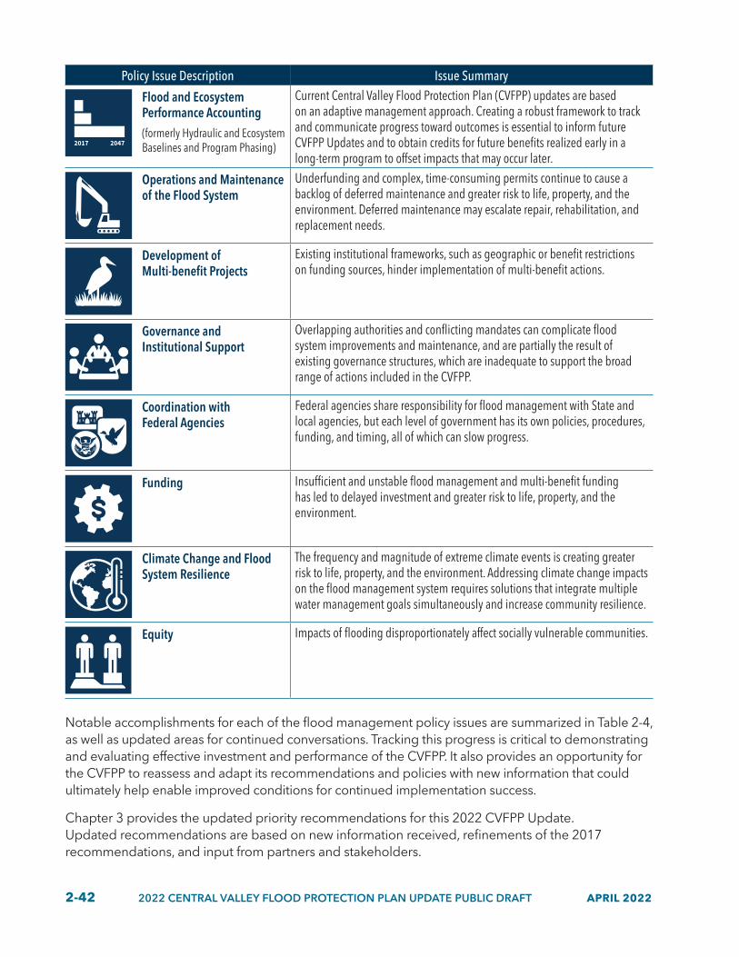
2-42 2022 CENTRAL VALLEY FLOOD PROTECTION PLAN UPDATE PUBLIC DRAFT APRIL 2022
Policy Issue Description Issue Summary
Flood and Ecosystem Performance Accounting(formerly Hydraulic and Ecosystem Baselines and Program Phasing)
Current Central Valley Flood Protection Plan (CVFPP) updates are based on an adaptive management approach. Creating a robust framework to track and communicate progress toward outcomes is essential to inform future CVFPP Updates and to obtain credits for future benefits realized early in a long-term program to offset impacts that may occur later.
Operations and Maintenance of the Flood System
Underfunding and complex, time-consuming permits continue to cause a backlog of deferred maintenance and greater risk to life, property, and the environment. Deferred maintenance may escalate repair, rehabilitation, and replacement needs.
Development of Multi-benefit Projects
Existing institutional frameworks, such as geographic or benefit restrictions on funding sources, hinder implementation of multi-benefit actions.
Governance and Institutional Support
Overlapping authorities and conflicting mandates can complicate flood system improvements and maintenance, and are partially the result of existing governance structures, which are inadequate to support the broad range of actions included in the CVFPP.
Coordination with Federal Agencies
Federal agencies share responsibility for flood management with State and local agencies, but each level of government has its own policies, procedures, funding, and timing, all of which can slow progress.
Funding Insufficient and unstable flood management and multi-benefit funding has led to delayed investment and greater risk to life, property, and the environment.
Climate Change and Flood System Resilience
The frequency and magnitude of extreme climate events is creating greater risk to life, property, and the environment. Addressing climate change impacts on the flood management system requires solutions that integrate multiple water management goals simultaneously and increase community resilience.
Equity Impacts of flooding disproportionately affect socially vulnerable communities.
Notable accomplishments for each of the flood management policy issues are summarized in Table 2-4, as well as updated areas for continued conversations. Tracking this progress is critical to demonstrating and evaluating effective investment and performance of the CVFPP. It also provides an opportunity for the CVFPP to reassess and adapt its recommendations and policies with new information that could ultimately help enable improved conditions for continued implementation success.
Chapter 3 provides the updated priority recommendations for this 2022 CVFPP Update. Updated recommendations are based on new information received, refinements of the 2017 recommendations, and input from partners and stakeholders.

APRIL 2022 2022 CENTRAL VALLEY FLOOD PROTECTION PLAN UPDATE PUBLIC DRAFT 2-43
Table 2.4 Progress on Flood Management Policy Issues
Policy Issue Description Progress Status Highlighted Accomplishments and Areas for Continuing Conversation
Land Use and Floodplain
Management
SOME PROGRESS
WORK EFFORTS GAINING
MOMENTUM
Highlighted Accomplishments
• Established the position of State Floodplain Manager and related California Department of Water Resources (DWR) programmatic changes to provide leadership, integration, and resources to advance floodplain management. The State floodplain manager worked with partners to promote agricultural conservation easements and to implement early environmental conservation projects.
• Established a new California Building Code standard that is consistent with the National Flood Insurance Program.
• Facilitated a series of partnership meetings with external entities that collectively work to develop flood risk awareness and reduction projects.
• Annually provided flood risk notices to more than 380,000 residences in the State Plan of Flood Control (SPFC) floodplains and worked with the Federal Emergency Management Agency (FEMA) to support and implement floodproofing actions.
Areas for Continuing Conversation
• Population growth and development in floodplains that can realize associated economic benefits remains an interest to some stakeholders, but it can be difficult to achieve without intensification of flood risk for some rural areas and disadvantaged communities. Meaningful dialogue, multi-agency cooperation, and engagement with local communities is essential to balance economic growth opportunities with reduced flood risk, especially for vulnerable communities.
• Continued conversations are needed to identify strategies that balance decreased flood risk and enhanced ecosystems in the system with the long-term viability of agriculture in the Central Valley.
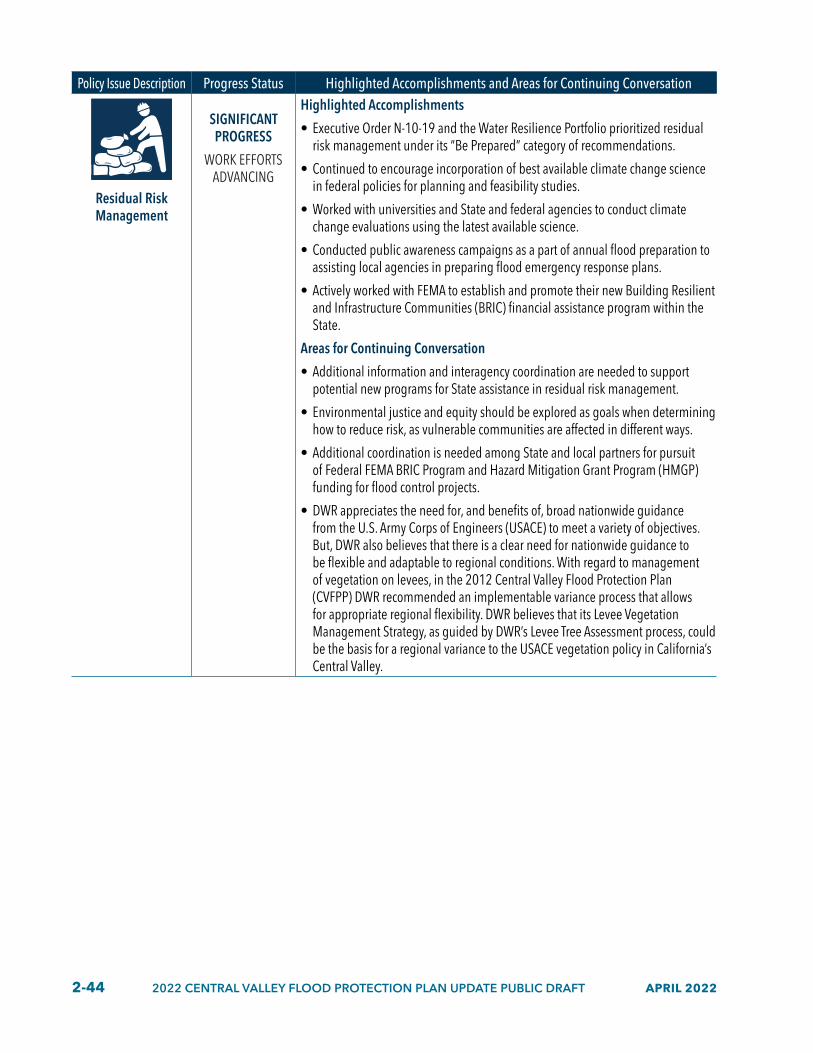
2-44 2022 CENTRAL VALLEY FLOOD PROTECTION PLAN UPDATE PUBLIC DRAFT APRIL 2022
Policy Issue Description Progress Status Highlighted Accomplishments and Areas for Continuing Conversation
Residual Risk Management
SIGNIFICANT PROGRESS
WORK EFFORTS ADVANCING
Highlighted Accomplishments
• Executive Order N-10-19 and the Water Resilience Portfolio prioritized residual risk management under its “Be Prepared” category of recommendations.
• Continued to encourage incorporation of best available climate change science in federal policies for planning and feasibility studies.
• Worked with universities and State and federal agencies to conduct climate change evaluations using the latest available science.
• Conducted public awareness campaigns as a part of annual flood preparation to assisting local agencies in preparing flood emergency response plans.
• Actively worked with FEMA to establish and promote their new Building Resilient and Infrastructure Communities (BRIC) financial assistance program within the State.
Areas for Continuing Conversation
• Additional information and interagency coordination are needed to support potential new programs for State assistance in residual risk management.
• Environmental justice and equity should be explored as goals when determining how to reduce risk, as vulnerable communities are affected in different ways.
• Additional coordination is needed among State and local partners for pursuit of Federal FEMA BRIC Program and Hazard Mitigation Grant Program (HMGP) funding for flood control projects.
• DWR appreciates the need for, and benefits of, broad nationwide guidance from the U.S. Army Corps of Engineers (USACE) to meet a variety of objectives. But, DWR also believes that there is a clear need for nationwide guidance to be flexible and adaptable to regional conditions. With regard to management of vegetation on levees, in the 2012 Central Valley Flood Protection Plan (CVFPP) DWR recommended an implementable variance process that allows for appropriate regional flexibility. DWR believes that its Levee Vegetation Management Strategy, as guided by DWR’s Levee Tree Assessment process, could be the basis for a regional variance to the USACE vegetation policy in California’s Central Valley.

APRIL 2022 2022 CENTRAL VALLEY FLOOD PROTECTION PLAN UPDATE PUBLIC DRAFT 2-45
Policy Issue Description Progress Status Highlighted Accomplishments and Areas for Continuing Conversation
Flood and Ecosystem
Performance Accounting
(formerly Hydraulic and
Ecosystem Baselines and Program
Phasing)
INITIAL PROGRESS
WORK EFFORTS COMMENCING
Highlighted Accomplishments
• DWR and Central Valley Flood Protection Board (CVFPB) are working to develop a Master plan to enable a programmatic approach to multi-benefit improvements in the Yolo Bypass.
• Made early progress toward proposing hydraulic and ecosystem baselines for the Yolo Bypass through the Yolo Bypass-Cache (YBCS) Slough Partnership.
Areas for Continuing Conversation
• Continued conversations are needed between State, federal, and local partners about how to recognize potential value and costs of innovative physical and operational improvements on agricultural lands that may enhance ecological values for fish and wildlife.
• The Conservation Strategy measurable objectives and numerical targets may be revised as part of future updates based on changing conditions and new information regarding climate change and other relevant factors.
• Seeking alignment between State and federal agency determinations regarding hydraulic and ecosystem baseline conditions, objectives, and regulatory requirements.
• Developing ecosystem and hydraulic baselines, including integrating new climate change-related science, could have an impact on projects that are already underway.

2-46 2022 CENTRAL VALLEY FLOOD PROTECTION PLAN UPDATE PUBLIC DRAFT APRIL 2022
Policy Issue Description Progress Status Highlighted Accomplishments and Areas for Continuing Conversation
Operations and Maintenance of the
Flood System
SOME PROGRESS
WORK EFFORTS GAINING
MOMENTUM
Highlighted Accomplishments
• CVFPB prioritized operations and maintenance (O&M) as its top priority and established working groups to address particular issues such as State and federal inspections following adoption of the 2017 CVFPP Update.
• DWR obtained a significant investment from the State general fund, approximately $435 million since 2017 was allocated for operation and maintenance, repair, rehabilitation, and replacement (OMRR&R) activities and deferred maintenance.
• DWR established a new Flood Maintenance Assistance Program to support local management agencies in their annual maintenance activities and regaining Public Law 84-99 program compliance for the USACE disaster relief funding.
• Advanced levee tree and vegetation issue resolution by participating in new research, developing the DWR Levee Tree Assessment guidance for DWR-maintained levees, and beginning assessment of trees that may pose an unacceptable threat to levee integrity.
Areas for Continuing Conversation
• Channel capacity may be increased through dredging and vegetation removal, but this does not address systemwide geomorphic and ecosystem health trends.
• Incorporating maintenance of habitat improvements into flood maintenance requirements could introduce further financial and regulatory burden on maintaining agencies. Implementing standard procedures into flood maintenance activities and permitting with enhanced coordination among local maintainers, regulatory agencies, and the State could help alleviate this burden. Ecosystem improvements could reduce the regulatory burden for flood system maintenance over time.
• Regional programmatic environmental permitting or multiple-objective O&M approaches could result in improved flood system resiliency as well as ecosystem improvements.
• A revised hydraulic baseline is needed for any improvements that increase conveyance capacity to make sure those increases are sustained over the long-term future.

APRIL 2022 2022 CENTRAL VALLEY FLOOD PROTECTION PLAN UPDATE PUBLIC DRAFT 2-47
Policy Issue Description Progress Status Highlighted Accomplishments and Areas for Continuing Conversation
Multi-benefit Projects
SOME PROGRESS
WORK EFFORTS GAINING
MOMENTUM
Highlighted Accomplishments
• Water Resilience Portfolio prioritized multi-benefit projects under its “Protect and Enhance Nature Systems” category of recommendations.
• DWR enacted programmatic changes to enhance support and improve development of multi-benefit projects; consistent with recommendations and priorities in the 2017 CVFPP Update.
• CVFPB continues to convene the Advisory Committee to receive recommendations from committee members on habitat-related issues, Conservation Strategy implementation, and development and implementation of multi-benefit projects, and to provide a forum for engagement.
• California Department of Fish and Wildlife developed mechanisms, including regional conservation investment strategies and mitigation credit agreements, to support implementation of multi-benefit projects.
Areas for Continuing Conversation
• Some stakeholders expressed concern that an emphasis on multi-benefit projects could carry unintended consequences such as increased costs to local flood agencies and landowners and conversion of productive agricultural land to floodplain habitat.
• Although a definition of multi-benefit projects is provided in the CVFPP, the premise is often unclear because many other programs outside of the CVFPP and other entities use “multi-benefit” to mean simply more than one benefit. In the context of the CVFPP, “multi-benefit projects” refers to projects that are designed to reduce flood risk and increase fish and wildlife habitat and may also provide other public benefits (California Department of Water Resources 2017).
• The best approach to integrating and prioritizing the goals of the Central Valley Flood Protection Act of 2008 remain a central point of discussion among DWR, partners, and stakeholders.
• The description of conservation opportunities should be clarified by defining the flood system footprint used to determine these opportunities.
• Some stakeholders are concerned that prioritizing multi-benefit projects will unfairly limit investment in effective single-purpose flood risk management projects.
• New funding sources and mechanisms may be needed to support multi-benefit project components.
• The cost to implement, maintain, and monitor planned habitat restoration should not be the sole responsibility of local maintaining agencies (LMAs), because habitat improvements may provide benefits to the State and nation.
• Achievement of multi-benefit objectives can be challenged by inconsistencies between State, federal, and local agency regulatory mandates. Promoting and participating in early engagement and coordination with regulatory agencies can improve the permitting process and conservation outcomes.
• How environmental justice, equity, and agricultural sustainability can be included as goals for multi-benefit projects is a point of discussion among DWR, partners, and stakeholders.
• Some partners identified a need for more detailed guidance on how to design multi-benefit projects to contribute to the Conservation Strategy measurable objectives.

2-48 2022 CENTRAL VALLEY FLOOD PROTECTION PLAN UPDATE PUBLIC DRAFT APRIL 2022
Policy Issue Description Progress Status Highlighted Accomplishments and Areas for Continuing Conversation
Governance and Institutional
Support
SIGNIFICANT PROGRESS
WORK EFFORTS ADVANCING
Highlighted Accomplishments
• Progressed governance issues related to the complex State, federal, and local laws, policies, regulations, and procedures, most notably through the regional flood management plan (RFMP) planning processes, including consolidation of LMAs to support O&M of new projects.
• In 2016, 15 State, federal, and local agency partners entered a memorandum of understanding (MOU) to collaborate on pursuing a multi-benefit vision for the YBCS Complex.
• In 2017, DWR, CVFPB, and the Delta Stewardship Council (DSC) signed an interagency MOU regarding the Delta Levee Investment Strategy and other topics.
• The San Joaquin Area Flood Control Agency Joint Powers Agreement was expanded in 2017 to include the Cities of Lathrop and Manteca, along with the original member agencies of San Joaquin County and the City of Stockton.
• In 2019, the CVFPB, DWR, and USACE signed an interagency MOU to collaborate on flood management and integrated water resources management within the Central Valley.
• In 2020, federal and State authorizations were received to support development of a YBCS program (Water Resources Development Act 2020 and State Senate Bill 369).
• In 2021, DWR and the USACE Engineering with Nature Program signed an MOU to collaborate on natural-based solutions to flood risk reduction and integrated water management.
Areas for Continuing Conversation
• DWR may fund an additional RFMP phase following adoption of the 2022 CVFPP Update.
• State funding should be provided to regional flood management planners to formulate projects that integrate and reconcile ecological objectives and regional priorities, support public safety and multi-benefit objectives as informed by the CVFPP Conservation Strategy, quantify individual and collective contribution of RFMP projects toward meeting ecological objectives, and support planning and implementation of multi-benefit flood projects in areas protected by the SPFC.
• Many local and regional agencies are not structured or resourced to implement or maintain multi-benefit flood improvements.
• Entities with proper authorities to lead and mechanisms to fund the planning, design, and construction of multi-year capital improvement type projects in rural areas are needed.

APRIL 2022 2022 CENTRAL VALLEY FLOOD PROTECTION PLAN UPDATE PUBLIC DRAFT 2-49
Policy Issue Description Progress Status Highlighted Accomplishments and Areas for Continuing Conversation
Coordination with Federal Agencies
SIGNIFICANT PROGRESS
WORK EFFORTS ADVANCING
Highlighted Accomplishments
• Increased engagement in water resources development acts process that provides federal authorization and federal funding for flood risk reduction projects.
• Continued to engage with the USACE-Headquarters on national levee vegetation policy, including their Congressionally mandated review of national levee vegetation policy per Water Resources Reform Development Act 2014, Section 3013.
• Began working with the USACE Sacramento District on their process and findings incorporating science into tree risk assessments with their “Semi-Quantitative Risk Assessment.”
• Introduced DWR’s levee tree assessment guidance to the USACE-Sacramento District and resource agency partners.
• Formed the multi-agency Headwaters to Floodplain Flood Safety Partnership with FEMA and the California Governor’s Office of Emergency Services (Cal OES) and other partners.
• DWR facilitated meetings between CVFPP-related local agency project applicants and FEMA headquarter staff to discuss potential funding of flood risk reduction projects through FEMA’s BRIC Program and HMGP.
• Participated in the Joint Hazard Mitigation Strategy for DR-4558/DR-4569 with FEMA and Cal OES.
• DWR continues to support FEMA’s Community Assistance Program – State Support Services Element by serving as the State National Flood Insurance Program (NFIP) Coordinating Office. DWR continues to provide technical assistance, education, and outreach to California communities in the NFIP and evaluates community performance in implementing the NFIP floodplain management activities. DWR continues to improve coordination and collaboration to NFIP stakeholders.
• Shared updated LiDAR data for the San Joaquin watershed with FEMA for use federally led flood insurance studies to update the Central Valley’s flood insurance rate maps. These non-regulatory federal maps support land use planning and flood defense system planning throughout the State and will identify areas in the San Joaquin valley where the floodplains have changed.
• In 2017, U.S. Fish and Wildlife Service expanded the boundary of the San Joaquin National Wildlife Refuge to extend up the San Joaquin River mainstem to the confluence with the Merced River, presenting greater opportunities for potential multi-benefit floodplain expansion projects.
Areas for Continuing Conversation
• Although there is generally strong interagency support pursuing programmatic permitting to improve efficiency and reduce costs, additional funding opportunities, and future discussions with State and federal agencies are needed to develop implementable approaches.
• Some local flood managers are supportive of the State having a contingency plan if adequate federal funding is not available to support CVFPP implementation.
continued

2-50 2022 CENTRAL VALLEY FLOOD PROTECTION PLAN UPDATE PUBLIC DRAFT APRIL 2022
Policy Issue Description Progress Status Highlighted Accomplishments and Areas for Continuing Conversation• Continued efforts are required to align changes in the USACE designation of
federal flood project facilities with the SPFC.
• A process or multi-agency task force is needed to resolve policy or mandate discrepancies between State and federal agencies.
• Better understanding of NFIP and how Risk Rating 2.0 may affect local communities and landowners.
• Continuing collaboration is needed between State, federal, and local partners to develop multi-benefit floodplain expansion projects that maximize habitat and flood-related objectives where emerging opportunities may exist with expanded federal wildlife refuges located along the Sacramento and San Joaquin rivers.
• Continued conversations are needed about how to improve early coordination and collaboration amongst State and federal permitting agencies across multiple professional disciplines (e.g., scientists, engineers, attorneys) to ensure projects can be implemented effectively and efficiently. Establishing this clarity will also help to ensure project proponents make efficient use of funding sources with restrictive deadlines.
• Continued conversations are needed between the USACE, the State, and local agencies on future potential options for the Sacramento Bank Protection Program to benefit the modern flood system in the Sacramento Valley.
• Continue conversations with the USACE on climate change policies to incorporate inland climate change in planning, feasibility studies, and project development and to develop a shared vocabulary for climate change evaluations, impacts, and potential adaptation strategies.

APRIL 2022 2022 CENTRAL VALLEY FLOOD PROTECTION PLAN UPDATE PUBLIC DRAFT 2-51
Policy Issue Description Progress Status Highlighted Accomplishments and Areas for Continuing Conversation
Funding
SIGNIFICANT PROGRESS
WORK EFFORTS ADVANCING
Highlighted Accomplishments
• Advocacy by agency partners and stakeholders has resulted in additional State, federal, and local funding for flood management within the Central Valley and educated the broader community about the need for greater investments.
• State general obligation bond appropriations, federal supplemental appropriations, and local contributions are progressing.
• Federal investment in flood risk management has increased in the past five years. For example, the Bipartisan Budget Act of 2018 included $1.8 billion in emergency supplemental funding.
• Increased annual baseline from State general fund received for OMRR&R activities and deferred maintenance funding allocations received.
• CVFPB-led feasibility study regarding Sacramento-San Joaquin Drainage District assessments is progressing.
Areas for Continuing Conversation
• Some stakeholders expressed frustration with perceived imbalances in the State’s focus of flood planning and investments, including prioritizing the Sacramento River Basin over the San Joaquin River Basin, and investing in urban areas more than vulnerable populations in rural areas and small communities. Subsequently, stakeholders feel more funding opportunities designated for vulnerable communities specifically is needed.
• Some rural and agricultural interests support development of a rural levee standard to help ensure that rural interests receive equitable attention and resources.
• Some stakeholders expressed concern that the cost burden on rural local flood management and maintenance entities is too high and, in many cases, cannot be met. In addition, many local rural agencies feel they cannot further raise assessments any higher to secure needed additional funding.
• Some stakeholders expressed concern that it is too difficult to secure federal cost share for projects in non-urban areas.
• To address the varied needs of different communities and respect institutional capacity limitations, some regions prefer implementing many smaller projects instead of fewer large projects. This preference subsequently has implications on the types and amount of funding sought.
• Viability and feasibility of a State flood insurance program.
Climate Change and Flood System
Resilience
INITIAL PROGRESS
WORK EFFORTS COMMENCING
Areas for Continuing Conversation
• Continued conversations are needed about how to further apply and develop decision-scaling for climate change analysis and decision-making for flood management and better understanding ecosystem sensitivities through collaborative efforts.
• Continued conversations are needed between State, federal, and local partners about how to effectively increase the pace, scale, and geographic extent of multi-benefit project implementation, given the ongoing and projected impacts of climate change and the urgent need to build climate resilience in the flood system.
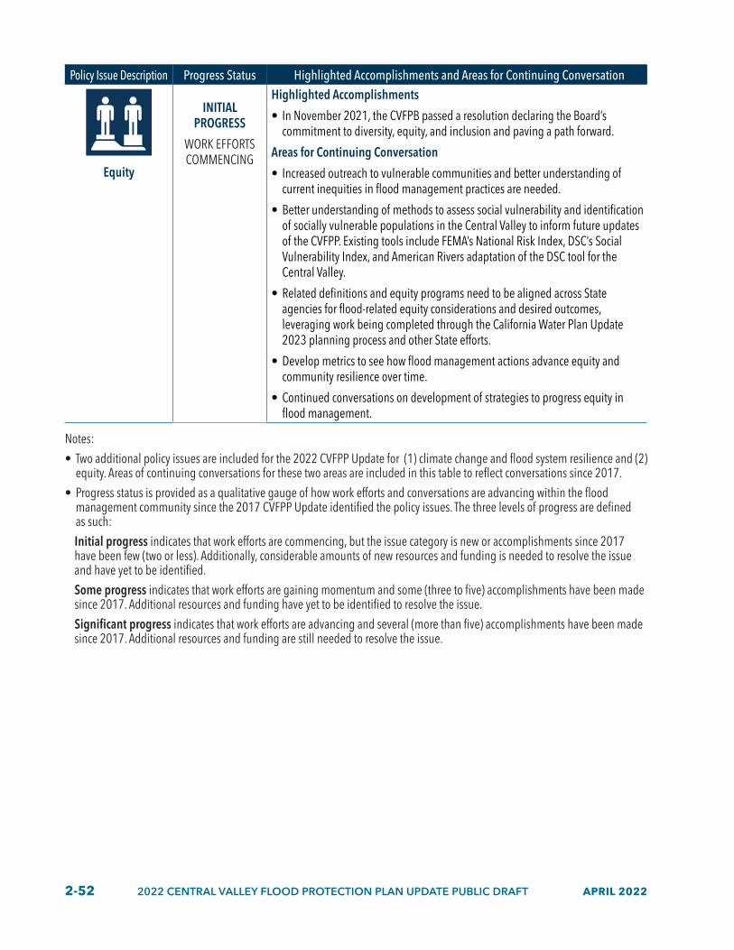
2-52 2022 CENTRAL VALLEY FLOOD PROTECTION PLAN UPDATE PUBLIC DRAFT APRIL 2022
Policy Issue Description Progress Status Highlighted Accomplishments and Areas for Continuing Conversation
Equity
INITIAL PROGRESS
WORK EFFORTS COMMENCING
Highlighted Accomplishments
• In November 2021, the CVFPB passed a resolution declaring the Board’s commitment to diversity, equity, and inclusion and paving a path forward.
Areas for Continuing Conversation
• Increased outreach to vulnerable communities and better understanding of current inequities in flood management practices are needed.
• Better understanding of methods to assess social vulnerability and identification of socially vulnerable populations in the Central Valley to inform future updates of the CVFPP. Existing tools include FEMA’s National Risk Index, DSC’s Social Vulnerability Index, and American Rivers adaptation of the DSC tool for the Central Valley.
• Related definitions and equity programs need to be aligned across State agencies for flood-related equity considerations and desired outcomes, leveraging work being completed through the California Water Plan Update 2023 planning process and other State efforts.
• Develop metrics to see how flood management actions advance equity and community resilience over time.
• Continued conversations on development of strategies to progress equity in flood management.
Notes: • Two additional policy issues are included for the 2022 CVFPP Update for (1) climate change and flood system resilience and (2)
equity. Areas of continuing conversations for these two areas are included in this table to reflect conversations since 2017.• Progress status is provided as a qualitative gauge of how work efforts and conversations are advancing within the flood
management community since the 2017 CVFPP Update identified the policy issues. The three levels of progress are defined as such:Initial progress indicates that work efforts are commencing, but the issue category is new or accomplishments since 2017 have been few (two or less). Additionally, considerable amounts of new resources and funding is needed to resolve the issue and have yet to be identified. Some progress indicates that work efforts are gaining momentum and some (three to five) accomplishments have been made since 2017. Additional resources and funding have yet to be identified to resolve the issue. Significant progress indicates that work efforts are advancing and several (more than five) accomplishments have been made since 2017. Additional resources and funding are still needed to resolve the issue.

APRIL 2022 2022 CENTRAL VALLEY FLOOD PROTECTION PLAN UPDATE PUBLIC DRAFT 2-53
2.9 Aligning with Other State EffortsThe 2022 CVFPP Update is making progress strengthening alignment with other State efforts. It continues a commitment to integrated watershed management (IWM) emphasized in the 2017 CVFPP Update with respect to flood management, and it promotes system flexibility and resiliency to accommodate changing conditions such as climate change impacts, regional priorities, ecosystem needs, flood or drought events, groundwater sustainability, and funding capabilities. Continued efforts to strengthen alignment between the CVFPP and other State efforts results in broader multi-benefit outcomes for the Central Valley.
Further, this 2022 CVFPP Update acknowledges the importance and function of flooding as a natural part of riverine and floodplain ecosystems and the natural and beneficial functions of floodplains as natural infrastructure. This understanding is in alignment with State priorities for nature-based solutions, as well as the opportunity to use floodwaters to support groundwater recharge efforts and greater water sustainability and climate resilience throughout the Central Valley.
IWM, resilience to climate change and other changing conditions, supporting regional needs, and use of natural infrastructure are reinforced with this 2022 CVFPP Update through its alignment with other statewide plans and policy documents released since 2017. State priorities for flood management are articulated in documents, such as the California Water Resilience Portfolio and California Water Plan; in executive orders (EOs), such as EO N-82-20 that supports climate resiliency and biodiversity and establishes a State goal of conserving at least 30 percent of California’s land and coastal waters by 2030 (“30x30”), and in California Natural Resources Agency initiatives, such as expanding nature-based solutions, Cutting Green Tape, and measuring progress.
Although the development of the 2022 CVFPP Update was influenced by many statewide plans and policies, three prominent efforts provided vision and strategic direction for sustainable and resilient water resources management: the California Water Resilience Portfolio, the California Water Plan, and implementation of the SGMA. These efforts and others are described in the sections below.
2.9.1 California Water Resilience Portfolio
Implementation of the CVFPP and Conservation Strategy will support the state in meeting the Water Resilience Portfolio goals, (see Table 2-5). Specific climate change and flood management actions are called out in the Portfolio’s “Be Prepared” goal that will help regions prepare for new flood patterns and are most relevant to the CVFPP and its implementation. These actions include flood insurance programs, tabletop exercises, flood hazard and risk analysis, loss avoidance studies, financial and technical assistance, and expanded partnerships. The CVFPP is also supportive of the goals and actions stated in the Portfolio’s “Protect and Enhance Natural Ecosystems” and “Build Connections” sections. The CVFPP supports the “Protect and Enhance Natural Ecosystems” goals through the implementation of the Conservation Strategy, promotion of multiple-benefit solutions, and the use of green infrastructure (such as wetlands and floodplains), to support biodiversity, attenuate floods, filter water, and recharge groundwater. The CVFPP supports the “Build Connections” goal through integrated use of science and monitoring, data, technology, and partnerships to support multiple-benefit solutions and integrated, regional planning.

2-54 2022 CENTRAL VALLEY FLOOD PROTECTION PLAN UPDATE PUBLIC DRAFT APRIL 2022
Table 2.5 Crosswalk of the Water Resilience Portfolio Goals and 2022 CVFPP Update
WRP Goal WRP Action 2022 CVFPP Update Response to WRP ActionMaintain and Diversify Water Supplies
Actions 3.2 and 3.3 support local planning efforts to identify tools and strategies to address the economic, environmental, and social effects of potential land use changes from SGMA implementation.
The 2022 CVFPP Update recognizes that flood management actions should be a part of land repurposing conversations. For example, flow easements on agricultural land could keep land in production and support groundwater recharge, and floodplain restoration should be considered for land repurposing in flood corridors.
Action 3.4 calls for technical assistance and facilitation of using high flows for aquifer recharge.
The 2022 CVFPP Update includes strategies such as Flood-MAR in the 2022 SSIA portfolio. These strategies could be especially effective in critically overdrafted groundwater basins throughout the San Joaquin Valley.
Protect and Enhance Natural Ecosystems
Action 10.4 calls for the evaluation and planning for environmental stressors resulting from climate change.
The 2022 Conservation Strategy Update includes identification of climate change vulnerabilities of species and climate change adaptation strategies.
Action 10.5 supports urban stream restoration projects.
The Conservation Strategy includes measurable objectives that support actions that restore more natural banks and/or create shaded riverine aquatic or riparian habitats within systemwide planning area/conservation planning areas, including urban areas.
Action 11.3 supports expansion of multi-benefit floodplain projects across the Central Valley.
The CVFPP supports potential multi-benefit floodplain projects in the Sacramento and San Joaquin Valleys, including many being developed through the YBCS Partnership and San Joaquin Valley.
Action 13.4 calls for strategically designed conservation planning and other resource protection and recovery plans for levee modifications and O&M.
The 2022 CVFPP and Conservation Strategy Updates describe needed collaboration with regulatory agencies to develop advance mitigation and programmatic approaches for habitat restoration and improvements, multi-benefit projects, and O&M.
Action 14.1 supports research, monitoring, maintenance, and management of state habitat restoration projects.
The 2022 Conservation Strategy Update describes adaptive management needs for floodplain restoration projects and tracks implementation of project outcomes.

APRIL 2022 2022 CENTRAL VALLEY FLOOD PROTECTION PLAN UPDATE PUBLIC DRAFT 2-55
WRP Goal WRP Action 2022 CVFPP Update Response to WRP ActionBuild Connections
Action 18.3 completes a climate change vulnerability assessment and adaptation strategy for the Delta to protect people, with a particular focus on disadvantaged communities, habitat, water quality, and supply.
DWR staff coordinate with the DSC on the development of the DSC Delta Adapts by ensuring that underlying technical analysis uses consistent data specific to flood risk.
Action 19.2 calls for studies of subsidence effects on State flood facilities and support strategies to minimize damage and rehabilitate infrastructure.
The 2022 Flood System Status Report describes the impacts of subsidence on SPFC facilities.
Action 20.1 builds on regional efforts to align climate scenarios and expand watershed-scale coordination and investments that contribute to water resilience. Emphasizing integrated, multi-sector, and outcome-based planning, action, and monitoring.
The 2022 CVFPP Update includes watershed-scale climate analysis that was coordinated and aligned with other State efforts, including the California Water Plan and Delta Adapts. The CVFPP includes outcome-based performance tracking and recommended actions.
Action 20.3 supports participation of Tribal governments and under-represented communities in regional planning processes.
Development of the 2022 CVFPP Update is including increased participation of Tribal governments through Tribal-specific engagements, document review, and formal consultation.
Actions 22.6 calls for an assessment of the State’s stream gauge network to support regional resilience.
The 2022 CVFPP Update supports improvements in forecasting and warning systems that benefit from the State’s stream gauge information.
Be Prepared Action 25.1 supports implementation of the CVFPP and its “State systemwide investment approach” to protect urban areas, small communities, and rural areas; improve O&M of the flood system; better coordinate reservoir operations; improve flood emergency response system; and integrate natural systems into flood risk reduction projects.
The 2022 CVFPP Update recommends increased State, federal, and local resources and funding to implement the portfolio of actions included in the 2022 SSIA portfolio. Chapter 4 outlines a funding and implementation plan.
Action 25.2 reviews State, federal, and local permitting processes for flood risk reduction projects and O&M and recommend ways to improve permitting processes.
The 2022 Conservation Strategy and CVFPP review the status and recommendations for policy issues related to O&M and permitting. New and innovative ways to support permitting for O&M activities have been and are being developed. This work includes DWR’s Environmental Permitting for Operations and Maintenance effort, including 50 years of O&M regulatory coverage when permitting flood system improvement projects, and programmatic permitting approaches being developed for the YBCS Partnership.
Action 25.3 calls for research and exploration of providing flood insurance beyond the national program.
The 2017 CVFPP Update recommended exploration of a State flood insurance program as a means to fund implementation. The State flood insurance program is carried forward in the 2022 CVFPP Update as a potential funding mechanism to be researched and explored.

2-56 2022 CENTRAL VALLEY FLOOD PROTECTION PLAN UPDATE PUBLIC DRAFT APRIL 2022
WRP Goal WRP Action 2022 CVFPP Update Response to WRP ActionBe Prepared Action 25.4 seeks to update and refine
the regional flood management strategy along the San Joaquin River and its tributaries to account for climate change and protect vulnerable communities and infrastructure and restore floodplains.
DWR and CVFPB initiated an engagement process with San Joaquin River Basin partners and public interests to scope a regional flood management strategy as part of developing the 2022 CVFPP Update. As developed, the regional strategy will inform the 2027 and future CVFPP Updates.
In partnership with urban communities, Action 25.8 seeks to identify new and improve existing flood risk reduction projects to meet or exceed State and federal requirements.
The 2022 CVFPP Update was developed in partnership with RFMP groups to describe urban projects that would provide 200-year level of protection for urban areas, and additional systemwide projects that could help exceed federal and State requirements in some urban areas.
In partnership with federal, Tribal, and local agencies, Action 25.9 supports small community flood risk-reduction projects in vulnerable communities.
The 2022 CVFPP Update was developed in partnership with RFMP groups, federal agencies, and Tribal governments to describe small community projects that would provide up to 100-year level of protection, some of which are vulnerable communities.
Action 27.2 supports California Water Plan planning area-scale analysis of future flood risk for a range of climate and growth scenarios.
The 2022 CVFPP Update was developed in close coordination with the California Water Plan, including alignment of climate change and population growth assumptions.
In cooperation with the USACE and reservoir owners, Action 27.3 calls for the evaluation of the potential for implementing FIRO and improved weather forecasting to improve flood management and water storage.
The 2022 SSIA portfolio includes continued evaluation of improvements to FIRO and forecasting as critical strategies for improving flood and water supply management, in cooperation with the USACE and reservoir owners.
Action 27.4 supports utilization of emerging technologies and partnerships to improve forecasts of precipitation, seasonal snowpack, and runoff, and to estimate the impacts of climate change on future flood conditions.
The 2022 SSIA portfolio includes improvements to forecasting as a critical strategy for improving flood and water supply management. Improved forecasts provide additional time to mitigate the impacts of flood conditions.

APRIL 2022 2022 CENTRAL VALLEY FLOOD PROTECTION PLAN UPDATE PUBLIC DRAFT 2-57
WRP Goal WRP Action 2022 CVFPP Update Response to WRP ActionExecuting the Portfolio
Action 29.1 calls for the establishment of regular dialogue with local and regional water stakeholders to improve how the State and regions work together to improve water resilience.
Development of the 2022 CVFPP Update included regular coordination with RFMP groups and the 2022 SSIA portfolio includes climate adaption strategies to support climate resilience.
Action 30.1 calls for water resources priorities to be coordinated across State agencies and with local agencies and communities to strengthen Congressional and federal agency support.
Development of the 2022 CVFPP Update leveraged strong coordination between State, federal, and local partners, and supports partnerships to strengthen Congressional and federal agency support. One recent example includes ongoing efforts of the Yolo Bypass-Cache Slough Partnership that consists of State, local, and federal partners.
Actions 30.2 and 30.3 pursue federal funding for priority single-purpose and multi-benefit projects and other improvements to California water management.
Significant progress has been made in securing federal funding for flood management projects in urban areas in the Central Valley. But, there is still an outstanding federal funding need to implement the remaining elements of the 2022 SSIA portfolio that have not received federal funding for urban and non-urban areas. As updated in Chapter 4, the recommended funding contribution from federal partners (primarily the USACE and FEMA) is estimated to be approximately $10 to $12 billion over the next 30 years.
Notes: Delta = Sacramento-San Joaquin Delta; DSC = Delta Stewardship Council; DWR = California Department of Water Resources;
CVFPP = Central Valley Flood Protection Plan; FEMA = Federal Emergency Management Act; FIRO = focused-informed reservoir operations; O&M = operations and maintenance ; RFMP = regional flood management plan; SGMA = Sustainable Groundwater Management Act; SSIA = State Systemwide Investment Approach; SPFC = State Plan of Flood Control; USACE = U.S. Army Corps of Engineers; WRP = Water Resilience Portfolio; YBCS = Yolo Bypass-Cache Slough

2-58 2022 CENTRAL VALLEY FLOOD PROTECTION PLAN UPDATE PUBLIC DRAFT APRIL 2022
2.9.2 California Water Plan Updates 2018 and 2023
The California Water Plan Update 2018 provides a vision for greater collaboration among water sectors and communities, and it presents a broad and diverse portfolio of recommended actions that target critical, systemic, and institutional challenges. Three key innovations presented in Update 2018 that provide a roadmap to building a climate-resilient water system in California are:
1. Applying societal values to define intended outcomes.
2. Prioritizing State actions around a shared vision.
3. Tracking progress and investments toward sustainability.
The California Water Plan and CVFPP are aligned around the societal values, vision, and policy issues, such as the addition of equity and social justice as a societal value. Specifically, equity is a theme of California Water Plan Update 2023 and the plan will provide a framework for State agencies to align around water equity that will inform work leading to the 2027 CVFPP Update. Both plans envision a more sustainable and resilient water future for California and more integrated and collaborative planning and management.
All recommendations of the 2017 CVFPP Update were rolled into the California Water Plan Update 2018. Further, the next update of the California Water Plan (Update 2023) will also include the 2022 CVFPP Update actions, recommendations, and costs estimates in the statewide recommendations and funding plan.
The 2022 CVFPP Update builds upon the outcomes and metrics developed and measured for the 2017 CVFPP Update and is consistent with the California Water Plan’s “Sustainability Outlook,” an approach for tracking local, regional, and State actions and investments, measuring progress, and identifying performance gaps.
2.9.3 Implementation of the SGMA
The SGMA of 2014 provided a first-of-its-kind framework for sustainable groundwater management. To achieve sustainable groundwater management, many GSAs are looking to maximize use of flood waters for natural or managed groundwater recharge. Using floodwater for Flood-MAR is a resource management strategy being evaluated by DWR and others, as described in the project spotlight below. The passage of SGMA also spurred renewed interest in watershed-based solutions that account for water supply reliability, flood risk reduction, and ecosystem improvements through multiple-benefit solutions. This CVFPP Update integrates the progress of Flood-MAR efforts and was prepared in close coordination with SGMA implementers.
In the San Joaquin Valley, significant groundwater overdraft has caused land subsidence, impacting flood management facilities and water conveyance infrastructure. For example, land subsidence has significantly reduced the flood conveyance capacity of the Eastside bypass by 25 to 65 percent of the O&M Manual design flow. In 2020, DWR staff reviewed GSPs to further understand how local groundwater management will affect flood management facilities and operations.

APRIL 2022 2022 CENTRAL VALLEY FLOOD PROTECTION PLAN UPDATE PUBLIC DRAFT 2-59
Project Spotlight: Using Floodwaters for Managed Aquifer Recharge
The flood management and groundwater management communities have traditionally worked independently of each other, such as flood agencies working to keep floodwaters off property and local water agencies and landowners coordinating groundwater planning and management goals. With the passage and implementation of the SGMA, combined with extreme events, the logic for these communities to partner and integrate has become clear. New and expanded partnerships between flood management and groundwater management interests are instrumental to reduce the impacts of future swings between wet and dry periods and to meet local community objectives, improve floodplain ecosystems, preserve working landscapes, and engage California’s agricultural community in needed solutions.
Flood-MAR strategies can be implemented at multiple scales, from individual landowners diverting floodwater with existing infrastructure, to using extensive detention and recharge areas and modernizing flood management infrastructure and operations at a district, watershed, or basin scale. Flood-MAR projects can support multiple societal values. For example, Flood-MAR projects can be formulated to target recharges areas that can maximize recharge, increase water supplies for disadvantaged communities, provide temporary habitat, provide wildlife viewing opportunities, and reduce flood risk. Flood-MAR projects can provide broad benefits for Californians and the ecosystems of the state, including water supply reliability, flood risk reduction, drought preparedness, aquifer replenishment, ecosystem improvements, subsidence mitigation, water quality improvement, working landscape preservation and stewardship, climate change adaptation, recreation, and aesthetics.
Flood-MAR strategies help communities adapt to flashier and more intense flood flows and longer and deeper droughts resulting from climate change. In addition, agricultural lands, working landscapes, and managed natural lands are great assets to our water systems as they become effective and essential pathways to storage and recharge. In practice, projects will need to be carefully planned, operated, and designed to achieve these important benefits.
1. Specifically, Flood-MAR strategies can reduce flood risks by removing water from a channel during high-flow events and purposefully delivering water to lands to promote groundwater infiltration. This effort requires access to sufficient land to achieve flood-risk reduction benefits downstream of diversion points.
2. Lowering reservoir storage prior to, during, or after the flood season or discrete events, will vacate reservoir storage before anticipated precipitation or snowmelt, which can reduce flood risks below the reservoir. The vacated water is conveyed to specific areas for managed aquifer recharge.
3. Slowing runoff from properties will encourage groundwater infiltration on public and private lands and reduce runoff to already-swollen channels.
There is strong, and growing, interest across the state in understanding the benefits, limitations, concerns, costs, and funding opportunities for Flood-MAR projects. DWR is working with other State, federal, Tribal, and local entities; academia; and landowners to build on knowledge and lessons from past and current studies and projects, and pursue expanded implementation of Flood-MAR.

2-60 2022 CENTRAL VALLEY FLOOD PROTECTION PLAN UPDATE PUBLIC DRAFT APRIL 2022
2.9.4 Other Programs
Many other State plans, policies, and legislation influence the planning and implementation of the CVFPP. For example, the San Joaquin River Restoration Program and legislation, such as the Delta Reform Act, affect portions of the SPA and SPFC facilities for different water management purposes that require close coordination with the CVFPP and its implementation. CEQA, the State Wildlife Action Plan (SWAP), AB 1755 (Open and Transparent Water Data Act), and integrated regional water management also inform and influence planning and implementation of the CVFPP. The requirements and principles of these are embedded in the formulation, analysis, and implementation of the CVFPP recommendations. For example, the ecosystem-related goals of the CVFPP and Conservation Strategy align with the SWAP’s intent to maintain and enhance the integrity of ecosystems by conserving key natural processes and functions, habitat qualities, and sustainable native species populations. SWAP’s intent is help California’s ecosystems be more resilient to shifting environmental conditions resulting from climate change.
Many State agencies are investing in diversity, equity, and inclusion initiatives. DWR’s Wave of Hope team came together in 2020 as part of the Capitol Collaborative on Race & Equity initiative to learn about, plan for, and implement activities that embed racial equity approaches into institutional culture, policies, and practices. The Wave of Hope Team activities are informing this CVFPP Update to progress conversations and advance equity in flood management. The CVFPP and CWP update teams are also collaborating on how to advance equity in water management, as equity is a major theme of the CWP Update 2023. The CVFPP team is also looking at equity initiatives in other State agencies, such as the California State Water Resources Control Board (State Water Board) and the Delta Stewardship Council to apply their findings and best practices to CVFPP implementation. Notably, the State Water Board has taken on racial equity by adopting a racial equity resolution in November 2021.
The following are other State plans and activities within the CVFPP planning area that have influenced CVFPP update planning and implementation efforts.
• San Joaquin River Restoration Program (SJRRP). The SJRRP is a long-term effort to restore flows to the San Joaquin River from Friant Dam to the confluence of Merced River to restore and maintain a self-sustaining Chinook salmon population and reduce or avoid adverse water supply impacts to CVP Friant Division long-term contractors. The project footprint for the SJRRP spans portions of the Mid- and Upper-San Joaquin regions and overlaps with several SPFC facilities. For example, the Eastside Bypass is used to convey SJRRP restoration flows, and SJRRP-proposed improvements along the bypass could provide flood risk reduction benefits and new floodplain and related riparian habitat.
• Delta Stewardship Council Programs.
▶ The Delta Plan. The Delta Plan and CVFPP share goals and actions that support ecosystems and reduce flood risk in the Delta where the planning areas intersect (Figure 2-5). For example, these plans both recommend the expansion of floodplains and the flood bypass systems, such as at Paradise Cut. DWR and the Delta Stewardship Council (DSC) coordinate closely throughout development of the CVFPP to gather DSC’s input on CVFPP activities, ensure that Delta flood risk issues are considered, and support alignment. Chapter 7 of the Delta Plan, amended in March 2020, describes actions to reduce risk to people, property, and State interests in the Delta. A proposed Ecosystem Amendment to Chapter 4 of the Delta Plan is in progress to address shifts in how conservation is being planned and implemented in the Delta.

APRIL 2022 2022 CENTRAL VALLEY FLOOD PROTECTION PLAN UPDATE PUBLIC DRAFT 2-61
▶ Delta Adapts. Delta Adapts was directed by DSC as a two-phase effort targeting climate change in the Delta and Suisun Marsh. The two phases — a vulnerability assessment and an adaptation plan — form Delta Adapts: Creating a Climate Resilient Future. This initiative is a comprehensive, regional approach to climate resiliency that cuts across regional boundaries and commits to collaboration across State, local, and regional levels. Delta Adapts supports the Delta Reform Act, EO B-30-15, and the Delta Plan. DWR and DSC have collaborated on multiple aspects of the DSC Delta Adapts effort, especially on the vulnerability assessment specific to water supply and flood risk analysis and inclusive of equity considerations, where effort was made to align data application. DWR and DSC are planning to continue this collaboration moving forward.

2-62 2022 CENTRAL VALLEY FLOOD PROTECTION PLAN UPDATE PUBLIC DRAFT APRIL 2022
Figure 2.5 Areas Where the Legal Delta and SPFC Planning Area Overlap
!(
_̂
!(
!(
Lower San JoaquinRiver / Delta South
Lower SacramentoRiver / Delta North
DELTA
Rio Vista
Sacramento
Stockton
Tracy
Bear Creek
Calaveras River
Cosu
mne
s
Rive rStockton Canal
Old River
Paradise Cut
Littlejohns CreekM iddle River
Sta nislaus River
Putah Creek
Yol
oB
ypas
s
San JoaquinR
iver
Sacram entoRiv
e r
M o k e l umne River
ALAMEDACOUNTY
CONTRA COSTACOUNTY
SACRAMENTOCOUNTY
SAN JOAQUINCOUNTY
SOLANOCOUNTY
STANISLAUSCOUNTY
YOLOCOUNTY
S:\SFPO\data\Projects\CVFPP_2022\GIS\Projects\Figures\CVFPP_2022_Overlapping_bndry.mxd
0 3.5 7
Scale in Miles
±
SPFC LeveesSPFC Planning Area BoundaryLegal Delta
APRIL 2022 2022 CENTRAL VALLEY FLOOD PROTECTION PLAN UPDATE PUBLIC DRAFT 2-63
• Voluntary Agreements. The California Natural Resources Agency, DWR, and the California Department of Fish and Wildlife areworking to forge voluntary, stakeholder-based outcomes in the watersheds of the Sacramento River and major San Joaquin River tributaries, known as “voluntary agreements.” Voluntary agreements represent an alternative to the State Water Board’s proposed requirement for unimpaired river flows under the Bay Delta Water Quality Control Plan. The goal is to reach voluntary agreements with water users to improve river flows, restore habitat, and help native fish populations. Voluntary agreements can align with CVFPP activities through multi-benefit, natural infrastructure projects such as improved transitory storage, floodway expansion, wetland inundation, and floodplain restoration.
• EcoRestore. This is a multi-agency initiative launched in 2015 to advance a minimum of 30,000 acres of critical habitat restoration and improvement in the Central Valley including the Delta, Suisun Marsh, and Yolo Bypass regions. Portions of the EcoRestore program area overlap with the CVFPP SPA. EcoRestore and its partners pursue complex habitat restoration projects to support restoration of native habitats, and, where feasible, improve flood protection. DWR is a lead partner on a majority of projects focused on implementing a suite of habitat restoration actions to support the long-term health of the Delta and its native fish and wildlife species. By the end of 2021, EcoRestore is projected to have completed approximately 8,000 acres of restoration, with another 4,500 acres under construction, and more than 20,000 acres in planning.
• Biological Opinions. Updated biological opinions from the National Oceanic Atmospheric Administration National Marine Fisheries Service (NMFS) and the U.S. Fish and Wildlife Service find that long-term operations of the CVP and SWP do not jeopardize salmonid and steelhead species, green sturgeon, delta smelt, or their critical habitats. This 2019 change in finding is because of a new CVP-SWP operations plan that included a suite of flow and habitat restoration and conservation measures to adaptively manage water supply reliability and better protect endangered fish species. To help satisfy the previous NMFS biological opinion (2009), DWR’s Yolo Bypass Habitat Restoration Program develops and implements restoration actions in the Yolo Bypass. Projects include fish passage improvements, fish rescue facilities, and restoration projects.

2-64 2022 CENTRAL VALLEY FLOOD PROTECTION PLAN UPDATE PUBLIC DRAFT APRIL 2022
2.10 Developing CVFPP Performance Tracking and Adaptive Management The previous sections have described the many activities that have occurred over the past five years and CVFPP implementation progress-to-date. The 2017 CVFPP Update recommended a performance tracking system that would organize and measure how well the implementation of the CVFPP achieves its goals and contributes to the societal values. Over the past five years, development of the architecture of such a performance tracking framework and related systems and tools has been undertaken. Although development of the comprehensive CVFPP performance tracking and adaptive management system is ongoing, the groundwork has been laid and preliminary systems and tools have been piloted. This section will describe the current status of the CVFPP performance tracking and adaptive management system including the following:
• Outcome Measurement Framework: A societal value-based architecture of tracking actions and benefits for flood management has been solidified that will further inform water management as a whole.
• Pilot systems and tools for public safety, healthy economy, and ecosystem vitality values: Preliminary systems and tools have been developed to track projects and to start measuring the contributions to ecosystem vitality.
• Build-out of other societal values and performance tracking: Specific needs for continued development of outcomes, indicators, and metrics for other societal values has been identified along with public safety, healthy economy, and ecosystem vitality values.
CVFPP implementation will become more effective with a robust performance tracking system because it will demonstrate what actions work best and what actions do not, which allows for identifying needed adjustments through adaptive management. This will allow the State, and its State, federal, and local partners, to adjust priorities to improve the flood management system towards greater resiliency.

APRIL 2022 2022 CENTRAL VALLEY FLOOD PROTECTION PLAN UPDATE PUBLIC DRAFT 2-65
2.10.1 Outcome Measurement Framework
The 2017 CVFPP Update introduced an outcome-based measurement framework for performance tracking and adaptive management (Framework) and called for greater accountability in program delivery through tracking progress. The progress that has occurred since 2017 includes solidifying components of the Framework and gaining alignment around this approach with other water management programs. The Framework includes intended outcomes that characterize value for State investments and associated regional and local benefits over time. As management actions are implemented within different projects, observable outcomes are tracked, measured, and compared to intended outcomes identified for the following societal values:
Public health and safety
Ecosystem vitality
Healthy economy
Opportunities for enriching experiences
Equity and Social Justice
The Framework has been developed in collaboration with other DWR planning efforts. The California Water Plan’s “Sustainability Outlook” is evaluating multiple water management sectors (e.g., flood, water supply, water quality, groundwater) and geographic scales (e.g., statewide, hydrologic regions, individual watersheds) across California. For the purposes of the CVFPP, the Framework focuses on outcomes in flood management and related ecosystem sectors at a hydrologic region scale for the Sacramento and San Joaquin river basins.
The Framework is based on a hierarchy of outcomes and societal benefits, actions and assets, and enabling conditions that have assigned metrics and indicators that help measure progress. Each of the societal values includes a hierarchical set. The hierarchical sets include the following:
• Societal benefits: Outcomes specific to flood management in the Central Valley, such as enhancing protection by increasing flood system performance.
• Assets and actions: Physical changes, such as projects being constructed, or changes in human behaviors, such as improved emergency management training and techniques.
• Enabling conditions: Circumstances that are needed to support project implementation or improved management such as funding, policies, and permitting.
The CVFPP has a contribution to make to each societal value. For that reason, the CVFPP will be evaluated across the hierarchical sets with respect to flood management. The effectiveness of CVFPP implementation will be evaluated using information gained through monitoring specific indicators and metrics. Indicators and metrics are used to measure observable outcomes, which are achieved

2-66 2022 CENTRAL VALLEY FLOOD PROTECTION PLAN UPDATE PUBLIC DRAFT APRIL 2022
through a diverse array of effective flood management actions taken.
• Outcome: Result of an action taken. Outcomes are distinguished as intended outcomes (intent) and observable outcomes (result). For example, improved public safety.
• Indicator: An observable phenomenon that can be used to monitor progress toward achieving an intended outcome. For example, reduced loss of life caused by flooding.
• Metric: A method of measuring results from a specific and measurable process or action that can be evaluated to assess its effect on a particular indicator. For example, miles of improved levee.
Evaluation of the various indicators over time will help provide a system of accountability and a method for demonstrating return on investment for Californians. Further, as-needed course corrections will be identifiable by the change (positive or negative) in indicators and metrics. This will meaningfully inform the adjustment of priorities over time based on real on-the-ground results. In addition, there are other key supporting components of the Framework that include data resources, performance reporting, and planning adaptation that allow for the cyclical adaptative management process. Figure 2-6 shows the performance tracking and adaptive cycle of the CVFPP and how the components of the Framework nest together.
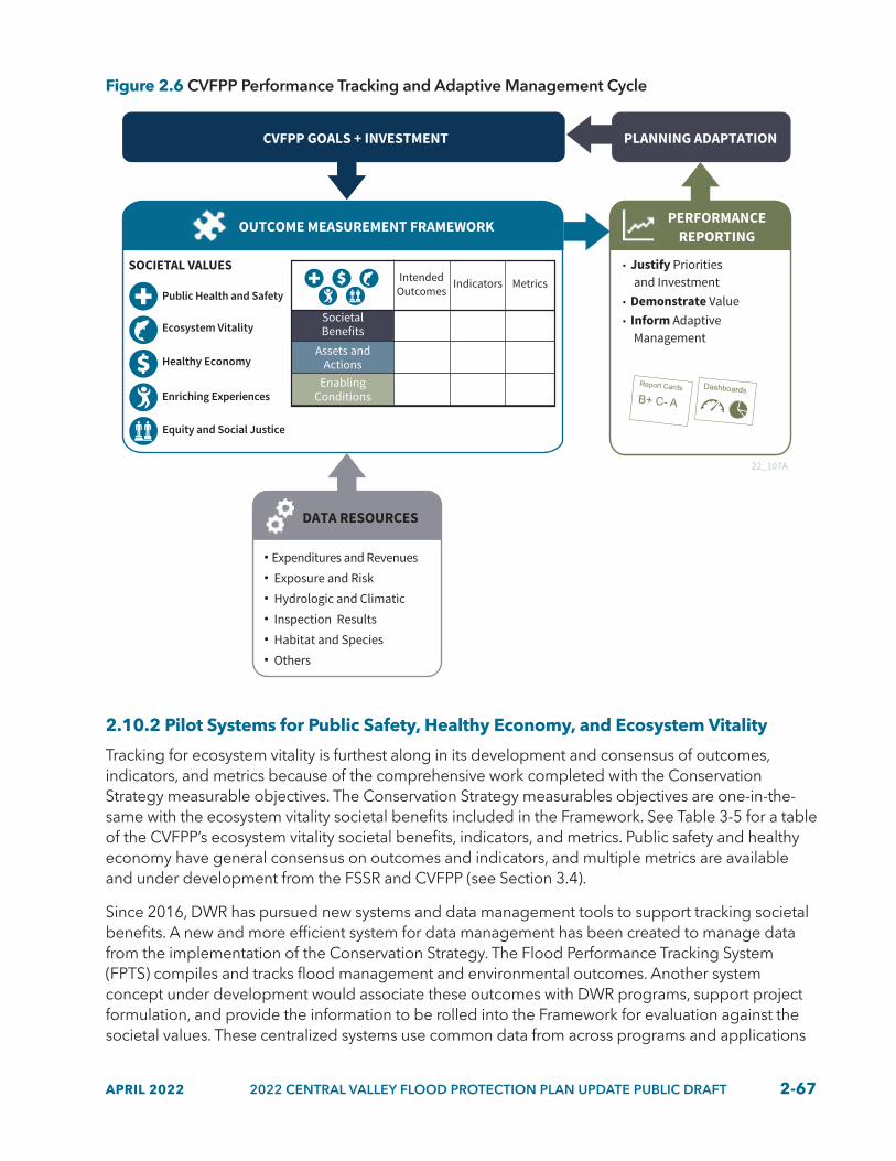
APRIL 2022 2022 CENTRAL VALLEY FLOOD PROTECTION PLAN UPDATE PUBLIC DRAFT 2-67
Figure 2.6 CVFPP Performance Tracking and Adaptive Management Cycle
DATA RESOURCES
Expenditures and Revenues
Exposure and Risk
Hydrologic and Climatic
Inspection Results
Habitat and Species
Others
CVFPP GOALS + INVESTMENT PLANNING ADAPTATION
OUTCOME MEASUREMENT FRAMEWORK PERFORMANCEREPORTING
Justify Priorities and Investment Demonstrate Value Inform Adaptive Management
Intended Outcomes
Indicators
Assets and Actions
Enabling Conditions
MetricsSOCIETAL VALUES
Public Health and Safety
Ecosystem Vitality
Healthy Economy
Enriching Experiences
Equity and Social Justice
Societal Benefits
22_107A
2.10.2 Pilot Systems for Public Safety, Healthy Economy, and Ecosystem Vitality
Tracking for ecosystem vitality is furthest along in its development and consensus of outcomes, indicators, and metrics because of the comprehensive work completed with the Conservation Strategy measurable objectives. The Conservation Strategy measurables objectives are one-in-the-same with the ecosystem vitality societal benefits included in the Framework. See Table 3-5 for a table of the CVFPP’s ecosystem vitality societal benefits, indicators, and metrics. Public safety and healthy economy have general consensus on outcomes and indicators, and multiple metrics are available and under development from the FSSR and CVFPP (see Section 3.4).
Since 2016, DWR has pursued new systems and data management tools to support tracking societal benefits. A new and more efficient system for data management has been created to manage data from the implementation of the Conservation Strategy. The Flood Performance Tracking System (FPTS) compiles and tracks flood management and environmental outcomes. Another system concept under development would associate these outcomes with DWR programs, support project formulation, and provide the information to be rolled into the Framework for evaluation against the societal values. These centralized systems use common data from across programs and applications

2-68 2022 CENTRAL VALLEY FLOOD PROTECTION PLAN UPDATE PUBLIC DRAFT APRIL 2022
and maintain the unique functionality of existing applications. Together, these data systems would manage information about projects, habitat outcomes, and ecosystem vitality metrics, with ongoing efforts to connect to data systems for public safety and healthy economy metrics.
In addition, data management and decision support tools are under development to balance DWR’s compensatory mitigation needs and other habitat obligations, in conjunction with working towards the goal of increasing the quantity and quality of habitats and contributing to species’ recovery over time. In tracking of habitats and compensatory mitigation obligations, these tools would provide the following benefits:
• Track DWR’s past, present, and planned conservation, restoration, and mitigation actions in the flood system.
• Enable identification of future habitat needs and opportunities.
• Align project development timelines and funding with identified needs.
• Document and communicate the completed actions and associated benefits.
These decision support tools complement the FPTS in that they are forward-looking, comparing project data from the FPTS to forecasted needs and objectives for the CVFPP and across other DWR programs.
2.10.3 Build-Out of Other Societal Values and Performance Tracking
As mentioned, the societal benefit outcomes, indicators, and metrics related to the other societal values have not had the same amount of development or consensus as ecosystem vitality, public safety, or healthy economy to date. Societal benefits are outcomes that illustrate ways in which implementing the CVFPP can positively contribute to societal values. Examples of societal benefits include enhanced flood protection for all communities, risk reduction for people living in the floodplain, reduced economic vulnerability when flooding occurs, and greater recreational benefits. Additionally, societal benefits are aligned with the expected outcomes from the 2022 SSIA portfolio for public health and safety and healthy economy based on the technical modeling and analyses performed for the 2022 CVFPP Update. Specifically, the expected annual life loss and annual damage calculations are aligned to the public health and safety indicators and healthy economy indicators, respectively.
The next steps include gaining broader concurrence on outcomes, indicators, and metrics for other societal values (particularly for equity and social justice), linking available data sources (including sources supporting the FSSR and the SPFC Descriptive Document) to each indicator, and developing related systems and tools to compile and report the data. Implementation of the comprehensive CVFPP performance tracking and adaptative management system will be part of the next CVFPP update cycle, pending available resources. Interconnections of the CVFPP’s quantifiable contributions to the societal values and how it supports other water management sectors will also need be further developed through the California Water Plan Update 2023.

APRIL 2022 2022 CENTRAL VALLEY FLOOD PROTECTION PLAN UPDATE PUBLIC DRAFT 2-69

2-70 2022 CENTRAL VALLEY FLOOD PROTECTION PLAN UPDATE PUBLIC DRAFT APRIL 2022The California Department of Water Resources is constructing setback levees along the Sacramento and Yolo bypasses as part of the Lower Elkhorn Basin Levee Setback (LEBLS) project. Photo taken August 31, 2021.

APRIL 2022 2022 CENTRAL VALLEY FLOOD PROTECTION PLAN UPDATE PUBLIC DRAFT R-1APRIL 2022 2022 CENTRAL VALLEY FLOOD PROTECTION PLAN UPDATE PUBLIC DRAFT R-1
REGIONAL OVERVIEW
CVFPP22Overview of Regional Flood Management Planning Areas
The California Department of Water Resources (DWR) funded six regional flood management plans (RFMPs) following the 2012 Central Valley Flood Protection Plan (CVFPP) (2012). The RFMPs identify and describe region-specific priorities and challenges and offer valuable insight from the perspective of local and regional flood management groups. The RFMPs also help to inform and align with the implementation of the CVFPP and its investment strategy by highlighting potential funding needs, identifying areas for improvement, and providing a foundation for regional engagement. The RFMPs are separated into six planning areas throughout the Central Valley’s State Plan of Flood Control (SPFC): Mid and Upper Sacramento River, Feather River, Lower Sacramento River/Delta North, Lower San Joaquin River/Delta South, Mid San Joaquin River, and Upper San Joaquin River.
RFMPs include representatives from flood management and land use agencies, cities and counties, environmental groups, and agricultural interests. The six RFMPs have helped to identify hundreds of management actions and projects related to infrastructure performance; environmental improvements; operations, maintenance, repair, rehabilitation, and replacement (OMRR&R); emergency management; floodplain management; governance; and funding. These actions have helped to inform the refined State Systemwide Investment Approach (SSIA) portfolio for the 2017 and 2022 CVFPP Updates, as well as CVFPP-supporting efforts, such as the 2017 Basinwide Feasibility Studies, 2016 Conservation Strategy (Conservation Strategy), and 2022 Conservation Strategy Update.
Regional OverviewsThe following regional overviews provide a high-level overview for each RFMP planning area. Key accomplishments, challenges, and priorities are also identified for each RFMP, providing insight into the diverse range of flood management projects, needs, and objectives throughout the Central Valley.
• Accomplishments describe projects and other region-specific achievements that have helped to improve flood management capabilities in the region.
• Challenges highlight areas for growth, future needs, and barriers to the implementation of flood management efforts.
• Priorities identify future projects, goals, and objectives that are desired or essential to improving flood management capacity in the region.
The regional overviews provide the priorities and perspectives of the six RFMPs and do not necessarily reflect the priorities of the State.

R-2 2022 CENTRAL VALLEY FLOOD PROTECTION PLAN UPDATE PUBLIC DRAFT APRIL 2022R-2 2022 CENTRAL VALLEY FLOOD PROTECTION PLAN UPDATE PUBLIC DRAFT APRIL 2022
REGIONAL OVERVIEW
CVFPP22Upper San Joaquin River Region
MERCEDSan Joaquin R
iver
55
·|}þ99
Bear Creek
Owens Creek
Ash Slough
STANISLAUS
MERCED
FRESNOSAN BENITO
Merced River
Fresno Rive
r
Berenda C
reek
MADERA
2022_805
Flooding in the community of Franklin/Beachwood in April 2006. Photo provided by Merced County.
OverviewThis region covers approximately 660 square miles of the San Joaquin Valley, including areas protected by SPFC facilities along the San Joaquin River from Gravelly Ford to the confluence of the Merced River. Major tributaries within the region include Ash and Berenda sloughs; Fresno River; and Black Rascal, Owens, and Bear creeks. One-third of the region is native vegetation and riparian habitat with contiguous wetland complexes. Productive agricultural lands account for a large portion of the economy in the San Joaquin Valley.
The San Joaquin River Flood Control Project Agency Joint Powers Agency leads and engages six stakeholder groups in the region. More than 10 communities are considered disadvantaged communities (DACs) based on income level and need significant financial support. The region covers traditional Tribal territories of the Monache, Foothill Yokuts, Northern and
Southern Valley Yokuts, but, currently, there are no Tribal lands or reservations. The City of Merced is the only urban area in the region, with a population of 83,000.
Accomplishments• Black Rascal Creek Flood Control Project.
Merced County secured approximately $9.7 million from the DWR Small Communities Flood Risk Reduction Program and $10 million from Natural Resources Conservation Service to advance the project to 100-percent design, secure permits, and acquire necessary lands.
• Great Valley Grasslands Floodplain Restoration Project. Encroachment Permit 19513 was recently approved by the Central Valley Flood Protection Board (CVFPB). Proposition 1 grant funding was received to advance the project.
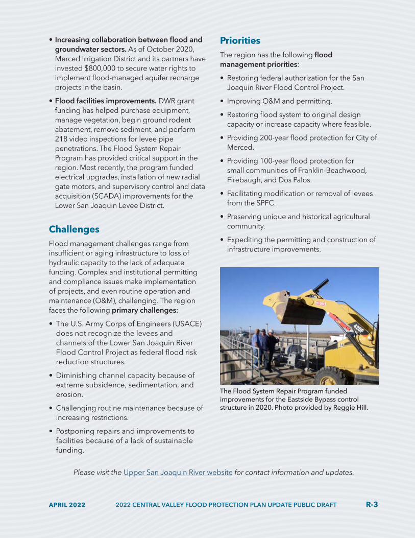
APRIL 2022 2022 CENTRAL VALLEY FLOOD PROTECTION PLAN UPDATE PUBLIC DRAFT R-3APRIL 2022 2022 CENTRAL VALLEY FLOOD PROTECTION PLAN UPDATE PUBLIC DRAFT R-3
REGIONAL OVERVIEW
CVFPP22• Increasing collaboration between flood and
groundwater sectors. As of October 2020, Merced Irrigation District and its partners have invested $800,000 to secure water rights to implement flood-managed aquifer recharge projects in the basin.
• Flood facilities improvements. DWR grant funding has helped purchase equipment, manage vegetation, begin ground rodent abatement, remove sediment, and perform 218 video inspections for levee pipe penetrations. The Flood System Repair Program has provided critical support in the region. Most recently, the program funded electrical upgrades, installation of new radial gate motors, and supervisory control and data acquisition (SCADA) improvements for the Lower San Joaquin Levee District.
ChallengesFlood management challenges range from insufficient or aging infrastructure to loss of hydraulic capacity to the lack of adequate funding. Complex and institutional permitting and compliance issues make implementation of projects, and even routine operation and maintenance (O&M), challenging. The region faces the following primary challenges:
• The U.S. Army Corps of Engineers (USACE) does not recognize the levees and channels of the Lower San Joaquin River Flood Control Project as federal flood risk reduction structures.
• Diminishing channel capacity because of extreme subsidence, sedimentation, and erosion.
• Challenging routine maintenance because of increasing restrictions.
• Postponing repairs and improvements to facilities because of a lack of sustainable funding.
PrioritiesThe region has the following flood management priorities:
• Restoring federal authorization for the San Joaquin River Flood Control Project.
• Improving O&M and permitting.
• Restoring flood system to original design capacity or increase capacity where feasible.
• Providing 200-year flood protection for City of Merced.
• Providing 100-year flood protection for small communities of Franklin-Beachwood, Firebaugh, and Dos Palos.
• Facilitating modification or removal of levees from the SPFC.
• Preserving unique and historical agricultural community.
• Expediting the permitting and construction of infrastructure improvements.
Please visit the Upper San Joaquin River website for contact information and updates.
The Flood System Repair Program funded improvements for the Eastside Bypass control structure in 2020. Photo provided by Reggie Hill.

R-4 2022 CENTRAL VALLEY FLOOD PROTECTION PLAN UPDATE PUBLIC DRAFT APRIL 2022R-4 2022 CENTRAL VALLEY FLOOD PROTECTION PLAN UPDATE PUBLIC DRAFT APRIL 2022
REGIONAL OVERVIEW
CVFPP22Mid San Joaquin River Region
MODESTO
MERCED
San Joaquin River
55
·|}þ99
Merced River
Stanislaus RiverSAN
JOAQUIN
STANISLAUS
MERCEDSANTACLARA
STOCKTON
2022_806
OverviewThis region comprises six non-continuous areas within Stanislaus and Merced counties. It extends along the mainstem San Joaquin River between the Merced and Stanislaus rivers, including tributaries with lower reaches protected by SPFC facilities and adjacent floodplain areas with a nexus to the SPFC. Most of the region is rural and agricultural. A network of connected floodplains and waterways, many managed by non-SPFC facilities, exist within the region and influence the performance of the SPFC facilities. This region is part of the traditional Tribal territories of the Northern Valley Yokuts and Miwok. More than 500,000 people reside within the region; Modesto is the region’s largest city.
The Three Amigos project at the San Joaquin National Wildlife Refuge in 2021. Photo provided by California Department of Water Resources.

APRIL 2022 2022 CENTRAL VALLEY FLOOD PROTECTION PLAN UPDATE PUBLIC DRAFT R-5APRIL 2022 2022 CENTRAL VALLEY FLOOD PROTECTION PLAN UPDATE PUBLIC DRAFT R-5
REGIONAL OVERVIEW
CVFPP22Accomplishments• Funded projects. Thirty-one percent of the
projects identified in the 2014 RFMP have been completed or are underway with funding received.
• Collaboration and social trust. Stakeholders are interested in continuing working relationships in the current RFMP process and are actively coordinating with other water-related planning processes, such as groundwater sustainability plans.
• Multi-benefit project implementation experience. The implementation of multi-benefit projects — particularly River Partners’ Dos Rios Ranch Floodplain Expansion and Ecosystem Restoration and Three Amigos project — has enabled the region to begin accumulating experience in the practical and administrative aspects of multi-benefit floodplain projects. The successes of these projects will contribute to the measurable objectives of the Lower San Joaquin River Conservation Planning Area.
• San Joaquin River National Wildlife Refuge boundary expansion. The expansion was approved in January 2017 to authorize floodplain land and easement acquisitions by the U.S. Fish and Wildlife Service as far upstream as the Merced confluence. The long-term goal is to acquire 10,738 acres in fee or easement holdings within the area.
ChallengesThe region experiences many flood management challenges, from undersized infrastructure to inadequate funding for maintenance. The absence of a regional flood management agency makes regional coordination and funding harder. The region faces the following primary challenges:
• Levee systems cannot convey design flows safely, and climate change will increase high flows significantly.
• Multiple reclamation districts cannot comply with State inspection standards and may not want to remain part of the SPFC.
• Many important components of the flood system remain difficult to fund adequately; local revenues are often insufficient even for cost-shares.
• Non-continuous SPFC and non-SPFC facility improvements require close coordination.
PrioritiesThe region has the following flood management priorities:
• Identifying and implement groundwater recharge opportunities in the flood system.
• Establishing a shared vocabulary with regional stakeholders around climate change impacts and identifying potential adaptation and resilience strategies. A key part of this effort is identifying how management actions outside of the SPFC, such as in Modesto, may help increase adaptation capacity and reduce flood risk for SPFC-protected areas downstream, and also provide benefits to those communities.
• Improving engagement with, and flood protection for, DACs.
• Developing a pilot project for levee reclassification to remove levees from the SPFC.
• Developing a State-federal partnership to acquire land or flowage easements in the San Joaquin River floodplain.
• Developing a regional conservation investment strategy to create a landscape-scale conservation framework. The region has secured a grant from the Wildlife Conservation Board and will commence this work in 2022.
• Demonstrating the benefits of “engineering with nature” approaches and nature-based solutions and develop new cost-benefit assessment methods that capture the full extent of these benefits.

R-6 2022 CENTRAL VALLEY FLOOD PROTECTION PLAN UPDATE PUBLIC DRAFT APRIL 2022R-6 2022 CENTRAL VALLEY FLOOD PROTECTION PLAN UPDATE PUBLIC DRAFT APRIL 2022
REGIONAL OVERVIEW
CVFPP22Lower San Joaquin River-Delta South Region
MODESTO
STOCKTON
55
·|}þ99
DeltaSan Joaquin River
SANJOAQUIN
STANISLAUS
CALAVERAS
MERCED2022_807
OverviewThis region covers 260 square miles and comprises distinct urban and rural-agricultural areas in the downstream area of the San Joaquin River Basin. The region extends along the mainstem of the San Joaquin River from the Stanislaus River to Bear Creek. Approximately 25 percent of the land use acreage in the region is urban, and 75 percent is rural. The San Joaquin Area Flood Control Agency’s (SJAFCA’s) jurisdiction encompasses the entire region. SJAFCA’s mission is to reduce and manage flood risk, primarily in the urban and urbanizing areas of the region for its member agencies: the City of Stockton; City of Lathrop; City of Manteca; and, San Joaquin County (urban areas only). The region has an urban population of approximately 400,000. The remaining area of the region is primarily rural, with flood management facilities maintained by 29 reclamation districts and by the San Joaquin County Flood Control and Water Conservation District. The region covers traditional Tribal territories of the Northern Valley Yokuts and the Miwok.
AccomplishmentsOver the past five years, the region has organized and accomplished a variety of projects and activities to reduce flood risk; accomplishments include:
• SJAFCA’s Joint Powers Agreement. This agreement was expanded in 2017 to include Cities of Lathrop and Manteca.SJAFCA Climate Change Adaptation Policy. This policy was adopted in 2019 to guide formulation of new projects.
• Bear Creek and Mormon Slough Systemwide Improvement Frameworks (SWIF) Plan. This plan was submitted to the USACE in August 2020.
• Smith Canal Gate Project. The design is complete, and construction has begun on this element (a locally led feature) of the USACE Lower San Joaquin River Project.
Construction of the Smith Canal Gate Project in 2020. Photo provided by Kjeldsen Sinnock Neudeck.

APRIL 2022 2022 CENTRAL VALLEY FLOOD PROTECTION PLAN UPDATE PUBLIC DRAFT R-7APRIL 2022 2022 CENTRAL VALLEY FLOOD PROTECTION PLAN UPDATE PUBLIC DRAFT R-7
REGIONAL OVERVIEW
CVFPP22• Reclamation District (RD) 17’s Levee
Seepage Repair Project. Progress of this project continued with DWR funding.
• Mossdale Tract Urban Flood Risk Reduction (UFRR) Feasibility Study. This study has been completed, and the CEQA phase has begun.
• USACE Lower San Joaquin River Project. The design of the first reach of this project has begun.
• Levee maintenance. The annual levee maintenance activities and critical repairs to rural levees has been completed.
ChallengesThere are several challenges that impact future improvements in regional flood management. These could delay, complicate, or prevent flood management progress. The region’s accomplishments have been slowed or otherwise impacted by the following primary challenges:
• Difficulty of raising local revenue to support levee O&M and capital projects.
• Planning for projects that are resilient to future climate predictions that include large degrees of uncertainty.
• Refining the USACE Lower San Joaquin River Project to reduce costs and minimize right-of-way and ecosystem impacts to achieve project feasible.
• Continuing progress towards implementation the preferred alternative of the Mossdale Tract UFRR Study.
• Developing multi-benefit projects, particularly in urban areas, where limited opportunities exist.
• Addressing land rights issues, encroachments, and risk transfers that come with O&M and improvements of levee systems.
• Keeping up with evolving and increasingly strict standards for levee maintenance.
• Increasing O&M challenges related to populations living within the levee systems.
• Providing additional staffing and adequate resources for local maintaining agencies.
PrioritiesOver the next five years, the region has the following near-term priorities:
• Achieving 200-year level of protection for Mossdale Tract.
• Securing local financing needed to fund capital improvement projects and support O&M activities.
• Partnering on implementation of the USACE Lower San Joaquin River Project.
• Continuing Mormon Slough bank repair and channel restoration projects.
• Improving climate change analyses and planning at an integrated systemwide scale.
• Initiating and advancing recommendations from identified feasibility-level studies, including Paradise Cut, to prepare for future project implementation.
• Improving flood emergency preparedness and response.
Weston Ranch community located behind Mossdale Tract levee. Photo provided by Lower San Joaquin/Delta South Region.

R-8 2022 CENTRAL VALLEY FLOOD PROTECTION PLAN UPDATE PUBLIC DRAFT APRIL 2022R-8 2022 CENTRAL VALLEY FLOOD PROTECTION PLAN UPDATE PUBLIC DRAFT APRIL 2022
REGIONAL OVERVIEW
CVFPP22Lower Sacramento River-Delta North Region
·|}þ99
MARYSVILLE
PLACER
YOLO
SACRAMENTO
SOLANOSOLANO
SAN JOAQUIN
Feat
her
Riv
erSa
cram
ento
Riv
erDelta
50
80
SACRAMENTO
80
8080
55
Knights Landing Levee Basin
2022_808
OverviewThe region is approximately 406,000 acres and includes portions of Solano, Yolo, Sacramento and Sutter counties along the Sacramento River, and tributaries and bypasses from the Knights Landing Levee Basin to the Delta near Collinsville. The local agencies that routinely meet as a working group include the West Sacramento Area Flood Control Agency, Yolo County, Solano County, Solano County Water Agency, RD 2068, and Sacramento Area Flood Control Agency. This region contains the largest concentration of developed lands protected by the SPFC, and accounts for the largest share of the flood system’s exposure to property damage and loss of life in case of catastrophic flooding. This region covers the traditional Tribal territories of Miwok, Nisenan, and Patwin.
AccomplishmentsOver the past five years, the region has focused on the following areas:
• Flood risk reduction. Twenty-seven projects have been completed, including Folsom Dam Modification Project and Southport Setback Levee Project.
• Linkage to systemwide improvement. Work includes initiating construction of the Lower Elkhorn Basin Levee Setback Project, conducting the Lower Egbert Tract Multi-benefit Feasibility Study, and updating the Yolo County Infrastructure and Drainage Study.
Completed Folsom Lake Dam Modification Project in 2019. Photo provided by California Department of Water Resources.

APRIL 2022 2022 CENTRAL VALLEY FLOOD PROTECTION PLAN UPDATE PUBLIC DRAFT R-9APRIL 2022 2022 CENTRAL VALLEY FLOOD PROTECTION PLAN UPDATE PUBLIC DRAFT R-9
REGIONAL OVERVIEW
CVFPP22• Governance. This effort included establishing
multi-agency working groups to advance the Yolo Bypass-Cache Slough (YBCS) Partnership, initiating a habitat conservation plan for the Cache Slough Complex and Lower Yolo Bypass, consolidating RDs, initiating of the Knights Landing Levee Basin Governance Study, and forming the Little Egbert Joint Powers Agency.
ChallengesThe region has three major challenges:
• Lack of sustainable funding for flood risk reduction needs.
• Fragmentation of State, federal, and local agency responsibilities and authorities impeding progress in implementing an agreed-upon approach for this region.
• Limitations in existing State and federal policies for the advancement of the YBCS Master Plan and YBCS Partnership.
PrioritiesOver the next five years, the region has the following priorities:
• Completing projects aimed at urban flood risk reduction, such as the Folsom Dam Raise Project, Natomas Levee Improvement Project, substantial completion of improvements as part of American River Common Features project, West Sacramento Project, and the Lower Cache Creek Project.
• Working with the other Sacramento Valley RFMP teams, DWR, the CVFPB, and the USACE to reassess the conclusions in the Sacramento Bank Protection Program Limited Revaluation Report and identify how to restore this program to be a useful mechanism for securing increased federal investments to implement the CVFPP.
• Addressing levee repair projects within small communities throughout Yolo, Solano, and Sacramento counties.
• Securing State, federal, and local funding to complete feasibility-level studies and design to prepare for future project implementation. Additionally, funds are needed to evaluate precipitation pattern changes that affect water supplies available for municipal, industrial, agricultural, and environmental uses.
• Developing an approach to long-term OMRR&R in the Yolo Bypass to address the multi-benefit landscape that is being implemented.
• Developing new regulatory hydraulic profiles, to replace the 1957 profile for the Yolo Bypass, that reflect the increased capacity that will result from widening the weirs and constructing setback levees.
• Advancing systemwide improvements discussed in the CVFPP, including the development of a YBCS Master Plan.
• Promoting increased collaboration and advancing partnerships among State, federal, and local agencies with regulatory and project implementation interests in the YBCS.
Lower Elkhorn Basin Levee Setback Project under construction in 2021. Photo provided by California Department of Water Resources.

R-10 2022 CENTRAL VALLEY FLOOD PROTECTION PLAN UPDATE PUBLIC DRAFT APRIL 2022R-10 2022 CENTRAL VALLEY FLOOD PROTECTION PLAN UPDATE PUBLIC DRAFT APRIL 2022
REGIONAL OVERVIEW
CVFPP22Feather River Region
·|}þ99
BUTTE
YUBAYUBANEVADASUTTER
PLACER
YOLO
SACRAMENTO
Feat
her R
iver
Sacr
amen
to R
iver
Bear River
50
5
CHICO
OROVILLE
SACRAMENTO
MARYSVILLE5
8080
80802022_809
OverviewThis region includes approximately 302,000 acres that encompass Sutter, Butte, Yuba counties, along the main stem of the Feather River, and a small portion of Placer County along the Bear River. The region spans from the Thermalito Afterbay to the confluence of the Feather and Sacramento rivers, and has a population of approximately 160,000. Roughly 76 percent of land use is farmland, 16 percent is native vegetation or grazing land, and 8 percent is urban. It is of great regional importance to promote flood-compatible land uses (such as the floodplain’s agricultural, recreational, and wildlife areas), and reduce the risk of flooding and allowing regional economic prosperity. Multi-benefit projects that create or enhance these land uses are equally as important. This region also provides habitat to various threatened and protected species and covers the traditional Tribal territories of the Patwin and two groups of Maidu — the Konkow and Nisenan.
Accomplishments• 200-year flood protection for urban areas.
Work is in progress for RD 784 and City of Marysville with levee improvement projects and enhanced reservoir operations. Yuba City’s 200-year level of protection improvements are complete.
• 100-year flood protection efforts. Efforts are underway through Feather River West Levee repair projects by the Sutter Butte Flood Control Agency and the USACE.
• Multi-benefit project implementation. Projects include floodplain reconnection,
levee setbacks, stability berm with habitat enhancement, corridor management plans (CMPs), and Yuba River ecosystem improvement project.
• Flood protection for small and rural communities. Work includes completion of small community flood risk reduction feasibility studies, RD 10 levee seepage analysis, SWIFs approval, and completing the Wheatland Governance study.
• Creative funding. Funding developed by Three Rivers Levee Improvement Authority includes acquiring orchards for revenue in levee setbacks areas and additional financial resources for the agency. Regional entities
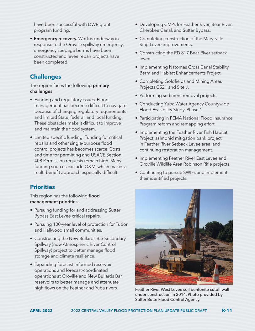
APRIL 2022 2022 CENTRAL VALLEY FLOOD PROTECTION PLAN UPDATE PUBLIC DRAFT R-11APRIL 2022 2022 CENTRAL VALLEY FLOOD PROTECTION PLAN UPDATE PUBLIC DRAFT R-11
REGIONAL OVERVIEW
CVFPP22have been successful with DWR grant program funding.
• Emergency recovery. Work is underway in response to the Oroville spillway emergency; emergency seepage berms have been constructed and levee repair projects have been completed.
ChallengesThe region faces the following primary challenges:
• Funding and regulatory issues. Flood management has become difficult to navigate because of changing regulatory requirements and limited State, federal, and local funding. These obstacles make it difficult to improve and maintain the flood system.
• Limited specific funding. Funding for critical repairs and other single-purpose flood control projects has becomes scarce. Costs and time for permitting and USACE Section 408 Permission requests remain high. Many funding sources exclude O&M, which makes a multi-benefit approach especially difficult.
PrioritiesThis region has the following flood management priorities:
• Pursuing funding for and addressing Sutter Bypass East Levee critical repairs.
• Pursuing 100-year level of protection for Tudor and Hallwood small communities.
• Constructing the New Bullards Bar Secondary Spillway (now Atmospheric River Control Spillway) project to better manage flood storage and climate resilience.
• Expanding forecast-informed reservoir operations and forecast-coordinated operations at Oroville and New Bullards Bar reservoirs to better manage and attenuate high flows on the Feather and Yuba rivers.
• Developing CMPs for Feather River, Bear River, Cherokee Canal, and Sutter Bypass.
• Completing construction of the Marysville Ring Levee improvements.
• Constructing the RD 817 Bear River setback levee.
• Implementing Natomas Cross Canal Stability Berm and Habitat Enhancements Project.
• Completing Goldfields and Mining Areas Projects CS21 and Site J.
• Performing sediment removal projects.
• Conducting Yuba Water Agency Countywide Flood Feasibility Study, Phase 1.
• Participating in FEMA National Flood Insurance Program reform and remapping effort.
• Implementing the Feather River Fish Habitat Project, salmonid mitigation bank project in Feather River Setback Levee area, and continuing restoration management.
• Implementing Feather River East Levee and Oroville Wildlife Area Robinson Rifle projects.
• Continuing to pursue SWIFs and implement their identified projects.
Feather River West Levee soil bentonite cutoff wall under construction in 2014. Photo provided by Sutter Butte Flood Control Agency.

R-12 2022 CENTRAL VALLEY FLOOD PROTECTION PLAN UPDATE PUBLIC DRAFT APRIL 2022R-12 2022 CENTRAL VALLEY FLOOD PROTECTION PLAN UPDATE PUBLIC DRAFT APRIL 2022
REGIONAL OVERVIEW
CVFPP22Mid and Upper Sacramento River Region
·|}þ99
BUTTEGLENN
YUBAYUBA
COLUSA
SUTTER
PLACER
YOLO
TEHAMA
LAKE
Feat
her R
iver
Sacr
amen
to R
iver
5
CHICO
OROVILLE
MARYSVILLE
5
8080
Butte Basin
Elder Creek
UpperLake
2022_810
OverviewThe Mid and Upper Sacramento River (MUSR) region covers roughly 640,000 acres across Tehama, Glenn, Lake, Colusa, Butte, Sutter, and Yolo counties. The Sacramento River and several of its tributaries intersect the region, with multiple National Wildlife Refuges. Key components of the Sacramento River Flood Control Project, such as the Sutter and Tisdale bypasses, are located in the region.
More than 90 percent of the region is non-urban, with almost 70 percent of the region designated as Prime and Statewide Important Farmland. This region covers traditional Tribal territories of the Nomlaki, Pomo, Miwok, Patwin, and two groups of Maidu — the Konkow and Nisenan. Chico, the MUSR’s largest population center north of Sacramento, is an urban area in the region and has a population of approximately 121,000. The region contains a diverse set of stakeholder groups.
Accomplishments• 100-year Level of protection for small
communities. Ongoing or completed feasibility studies for all 12 communities are underway. The community of Grimes was selected for grant funding to advance to implementation. Feasibility studies led to higher-resolution inundation mapping.
• Improved regional flood emergency preparedness. This effort includes developing flood safety plans, new training, and stockpiling flood fighting supplies through the Statewide Emergency Response Grant Program.
• Sutter and Tisdale Bypasses Flood and Multi-benefit Management Plan. This work includes identifying multi-benefit actions
Mitigatory birds land in a flooded rice field near Grimes. Photo provided by Reclamation District 108.

APRIL 2022 2022 CENTRAL VALLEY FLOOD PROTECTION PLAN UPDATE PUBLIC DRAFT R-13APRIL 2022 2022 CENTRAL VALLEY FLOOD PROTECTION PLAN UPDATE PUBLIC DRAFT R-13
REGIONAL OVERVIEW
CVFPP22that integrate flood improvements, habitat restoration, and agricultural sustainability, and support sustainable O&M practices for the weirs and bypasses.
• Systemwide improvement frameworks. This effort regained Public Law (PL) 8499 (rehabilitation assistance) eligibility for six of the 24 federally authorized levee systems in the region. An additional 10 systems have submitted Letters of Intent/SWIFs or are in the process eligibility re-inspections.
• Approved regional conservation investment strategy (RCIS). This strategy provides a framework for integrating conservation actions into flood management systems.
ChallengesThe region faces the following primary challenges:
• 100-year level of protection for small communities. Many MUSR small communities are DACs and frequently lack the resources to implement CVFPP recommendations. DAC designations can be skewed in rural settings because of a census tract data approach.
• Barriers to the implementation of flood risk reduction projects. These include multi-benefit requirements, State maintenance area limitations, environmental review, permitting, mitigation, and funding pursuit costs.
• OMRR&R. MUSR local maintaining agencies and communities lack resources to complete long-term multi-benefit maintenance, complex levee erosion repairs, maintain PL 84-99 eligibility, and address impacts from recent wildfires.
• Capital improvement projects needed in maintenance areas. A significant portion of the region’s levees are maintained by DWR’s Sutter maintenance yard through the Maintenance Area authority of Water Code Section 12878. Maintenance Area authority does not include capital improvements; consequently, these areas do not have a
mechanism to fund and implement needed multi-year improvement projects.
PrioritiesThe region has the following flood management priorities:
• Implementing Sutter and Tisdale Bypasses Flood and Multi-benefit Management Plan.
• Establishing governance frameworks to better support planning and implementation.
• Supporting the implementation of small community flood risk reduction actions.
• Supporting the implementation of urban level of flood protection for Chico.
• Implementing advanced mitigation pilot projects under the approved RCIS.
• Pursuing a regional approach to multi-benefit implementation that would allow the coupling of single-purpose environmental enhance and flood projects to move forward separately but work together to support Conservation Strategy goals and objectives.
• Supporting SWIF implementation including needed funding programs.
• Improving post-fire hydrology understanding and runoff management.
• Maintaining regional flood emergency preparedness.
Tisdale Weir and Bypass flowing in April 2011. Photo provided by California Department of Water Resources.

R-14 2022 CENTRAL VALLEY FLOOD PROTECTION PLAN UPDATE PUBLIC DRAFT APRIL 2022An atmospheric river-drenched California with heavy rain and mountain snow in this February 14, 2019, image from NOAA’s GOES West (GOES-17) satellite.

APRIL 2022 2022 CENTRAL VALLEY FLOOD PROTECTION PLAN UPDATE PUBLIC DRAFT 3-1
3 Risks, Priority Actions, and Intended
Outcomes Without significantly increased investment, many areas within the Central Valley will continue to have unacceptable flood risk, especially as the climate changes, and vulnerable communities will lack the ability to plan for, respond to, and recover from the impacts of flood events. This chapter presents current and future flood risks without additional investment and the State Systemwide Investment Approach (SSIA) to reduce those risks and increase community resilience. The 2022 SSIA portfolio consists of interrelated management actions working together systemwide to achieve Central Valley Flood Protection Plan (CVFPP) intended outcomes and a flood management system more resilient to climate change. To understand current priorities and updated management actions for the CVFPP, the current risks facing the Central Valley need to be understood. Chapter 3 takes a deeper look at updated flood risks, State priorities, and systemwide, urban, small community, and rural actions. Chapter 3 also provides an estimate of the collective effectiveness of actions to manage long-term flood risk and how expected outcomes contribute to societal values.
3.1 Risk Without Investment in the SSIAFlood risk within the Central Valley changes over time because of many complex factors, including climate change effects, projects and policies implemented, population and land use changes, extreme flood and drought events, and physical deterioration of system features resulting from age, deferred maintenance, subsidence, and other factors. Our understanding of these flood risks evolves as new data and information, new models, and innovative and updated assessment methods become available. For the 2022 CVFPP Update, quantifying flood risk for the current condition of the flood system is essential as a basis for understanding how California should respond to the evolving flood risk through the diverse combination of management actions included in the SSIA.
To that end, this section presents the results of risk analyses performed for a condition without investment in the SSIA to demonstrate what the Central Valley may face if investments are not made. The risk analysis for the CVFPP is a watershed-based multidisciplinary analysis as illustrated in Figure 3.1, primarily focused on supporting the societal values of public health and safety and healthy economy.

3-2 2022 CENTRAL VALLEY FLOOD PROTECTION PLAN UPDATE PUBLIC DRAFT APRIL 2022
Figure 3.1 CVFPP Multidisciplinary Analysis
22_602
Reservoir
Levees
Riverine Habitat Complexes
Geomorphic Processes and Floodplain Connectivity
Weir/Bypass
Hydrology to estimate climate, precipitation,
and runoff
Economics to estimate flood damages and
avoided losses
Investment to describe expected
improvements and their needed
funding
Hydraulics to estimate flow and stage in rivers
and streams
Geotechnical Engineering to estimate
levee reliability
Ecosystem to describe expected change in habitat
and species viability

APRIL 2022 2022 CENTRAL VALLEY FLOOD PROTECTION PLAN UPDATE PUBLIC DRAFT 3-3
The quantitative analyses for estimating systemwide life loss and flood damages were updated for the 2022 CVFPP Update using updated tools and information, including:
• New range of climate change scenarios — “low,” ”medium,” and “high.” The low scenario is descriptive of a drier, lesser warming condition; the medium scenario is descriptive of a warming condition with no change in precipitation; and the high scenario is descriptive of a wetter, more warming condition by year 2072. The three climate change scenarios are evaluated to depict a range of uncertainty that could include drier conditions (warming and less rain) or wetter conditions (more warming and more rain). But, each watershed is slightly different. Details about the three climate change scenarios are discussed below.
▶ The low climate change scenario is represented by a 2-degree Celsius (°C) increase in mean annual temperature and 10-percent decrease in mean annual precipitation by 2072. This will be described as “low” (plus 2 °C and minus 10-percent precipitation) later in this chapter.
▶ The medium climate change scenario is represented by a 3 °C increase in mean annual temperature and no change in mean annual precipitation by 2072. This will be described as “medium” (plus 3 °C and no precipitation change) later in this chapter.
▶ The high climate change scenario is represented by a 4 °C increase in mean annual temperature and 10-percent increase in mean annual precipitation by 2072. This will be described as “high” (plus 4 °C and plus 10-percent precipitation) later in this chapter.
▶ It should be noted that regardless of changes in mean annual precipitation, extreme precipitation events are expected to increase in intensity and the amount of rainfall and floodflows are expected to exceed current capacity throughout much of the system.
• Updated sea-level-rise information.
• Updated geotechnical information for levee performance that reflects levee improvements completed since 2017.
• Updated and refined inventory of population, structures, and properties.
• Updated emergency response factors (such as response times).
• Updated projections of population growth and land use changes.
• New U.S. Army Corps of Engineers (USACE) software specifically designed for life-loss estimation (HEC-LifeSim).
• All dollar values updated to Quarter 1 January 2021 dollars.
The analyses for the 2022 CVFPP Update evaluated system performance over a 50-year planning horizon (from 2022 to 2072) to understand how flood risk is expected to change and to assess climate resiliency over the long-term. Although system configurations modeled for the 2022 CVFPP Update were unchanged from the 2017 CVFPP Update, changes were made to account for the effects of completed projects with the best available information at the time of the analyses.
The 2022 without-SSIA condition represents, with best available data, the current condition of the flood management system in the Central Valley. For evaluating the 2072 without-SSIA conditions, three climate change projections were used — low, medium, and high scenario estimates, as described previously — to represent a range of uncertain future hydrologic and hydraulic conditions. The system performance with investment in the SSIA is described in Section 3.4, “SSIA Outcomes.”

3-4 2022 CENTRAL VALLEY FLOOD PROTECTION PLAN UPDATE PUBLIC DRAFT APRIL 2022
Flood risk includes likely adverse consequences from flooding for a given study area with a specified climate condition, land use condition, and flood management system (existing or planned) in place. Flood risk is a function of a multitude of components such as magnitude of hazard, system performance, exposure of people and property, and vulnerability of people and property in the floodplain. “Consequence” refers to the harm that results from flooding. The consequence of flood inundation may be measured in terms of loss of life, economic damage, environmental impact, or other specified measure of flood risk, or a combination of these.
Potential consequences of flooding and updated risk for the Central Valley are evaluated in terms of average annual lives lost and economic damages for a without-SSIA condition. The potential consequences of the without-SSIA condition for 2022 compared to 2072 are provided in Figures 3.2 and 3.3, respectively. Over this 50-year period, the annual lives lost estimate more than doubles in the Sacramento River Basin and more than quadruples in the San Joaquin River Basin because of estimated population growth and the effects of climate change. The range of average lives lost per year for the 2072 without-SSIA condition (with a range of climate change scenarios) is 138 to 243 for the Sacramento River Basin and 132 to 272 for the San Joaquin River Basin. These estimates highlight the significant increased risk and uncertainty under a range of future climate conditions.
Over this 50-year period, the average annual economic damages estimate almost doubles in the Sacramento River Basin and more than quadruples in the San Joaquin River Basin because of estimated population and regional economic growth and the increased flood risk brought on by climate change. The largest increase in economic damages are projected to occur in the San Joaquin River Basin. The range of 2072 without-SSIA conditions (with a range of climate change scenarios) is $674 million to $1.22 billion per year for the Sacramento River Basin and $1.26 billion to $1.96 billion per year for the San Joaquin River Basin, again highlighting the significant increased risk and uncertainty under a range of future climate conditions.
These results are model estimates and not predictive, but they illustrate the potential catastrophic consequences of major flood events in the Central Valley and substantiate the urgency for action. Increased investment in flood management at all levels of government, as well as an increase in the pace and scale of implementation, will be required to meet this threat. Without such investment, the effects of climate change outpace our ability to adapt and respond.
The methods and data used for the life risk and economic risk analyses are provided in the Technical Analyses Summary Report (available upon completion). The 2022 CVFPP Update life risk analysis was enhanced from the 2017 analysis with the use of an updated structure inventory and the USACE’s latest software, HEC-LifeSim, for urban areas and small communities. With the use of new software and data updates, average annual lives lost values are not comparable across past CVFPP updates, and it is not recommended that users of these documents compare results across updates. What is most important is that the trends are consistent, and our understanding of the trends are improving.
Annual life loss and economic damages are averaged over the 50-year period. Although this information provides an estimation of what may be expected, these model results simulate a condition based on the best available information at this time and are not predictive of actual events. Life loss during an actual flood event could range in magnitude based on many factors (e.g., flow, stage, precipitation, evacuation warnings). Because of the location of higher population urban and suburban centers, the downstream areas of the Sacramento and San Joaquin systems have potential to experience higher annual life loss and economic damages than the upstream areas if system capacity is exceeded. Without increased investment in the SSIA, annual life loss and annual damages

APRIL 2022 2022 CENTRAL VALLEY FLOOD PROTECTION PLAN UPDATE PUBLIC DRAFT 3-5
are estimated to increase in the future conditions in both basins under all climate change scenarios, and socially vulnerable populations will continue to face disproportionate flood risk and reduced capacity to be resilient and to cope, recover, or adapt from flood events.
There are other types of risks, associated with the other societal values, that the analyses and tools described previously do not address. For example, risks to native ecosystems, habitats, and species are not quantified but could be in future analyses. Without investment in multi-benefit project implementation with significant ecological restoration and conservation actions to provide overall ecological improvements, potential environmental risks include:
• Continued ecological stress from greatly reduced and degraded habitat along riparian corridors and disconnected rivers and floodplains.
• Future ecological stress resulting from climate change and other anthropogenic factors, which will alter fundamental ecological processes and conditions, and further stress habitats and individual species.

3-6 2022 CENTRAL VALLEY FLOOD PROTECTION PLAN UPDATE PUBLIC DRAFT APRIL 2022
Figure 3.2 Without-SSIA Expected (Average) Annual Life Loss for Central Valley (number of persons)
CHICO
MODESTO
OROVILLE
MADERA
MERCED
STOCKTON
SACRAMENTO
MARYSVILLE
CHICO
MODESTO
OROVILLE
MADERA
MERCED
STOCKTON
SACRAMENTO
MARYSVILLE
2022 Without SSIA 2072 Without SSIA
Legend
Sacramento River Basin
San Joaquin
River Basin
61 165(138-243)
36167
(132-272)
X = Medium Climate Change Scenario(X–XX) = Low to High Climate Change Scenarios
15 30
Scale In Miles
0
2022_802a.1
Change from 2022 to 2072Expected (Average) AnnualLife Loss (number of persons)
Notes:• Mapped results do not imply levee deficiency or exact consequences of flooding. Modeling is used to understand the relative
risk of flooding. • Potential flood evacuation characteristics are highly uncertain.

APRIL 2022 2022 CENTRAL VALLEY FLOOD PROTECTION PLAN UPDATE PUBLIC DRAFT 3-7
Figure 3.3 Without-SSIA Expected (Average) Annual Economic Damage within Central Valley (millions of dollars*)
CHICO
MODESTO
OROVILLE
MADERA
MERCED
STOCKTON
SACRAMENTO
MARYSVILLE
CHICO
MODESTO
OROVILLE
MADERA
MERCED
STOCKTON
SACRAMENTO
MARYSVILLE
2022 Without SSIA 2072 Without SSIA
Legend X = Medium Climate Change Scenario(X–XX) = Low to High Climate Change Scenarios
Sacramento River Basin
San Joaquin
River Basin
429 822(674–1,217)
3331,455
(1,261–1,960)
15 30
Scale In Miles
0
2022_802b.1
Change from 2022 to 2072Expected (Average) Annual Damage (millions of dollars*)
*January 2021 dollars
Notes:• Mapped results do not imply levee deficiency or exact consequences of flooding. Modeling is used to understand the relative
risk of flooding. • Potential flood and evacuation characteristics are highly uncertain.

3-8 2022 CENTRAL VALLEY FLOOD PROTECTION PLAN UPDATE PUBLIC DRAFT APRIL 2022
3.2 PrioritiesAs our understanding of climate change and flood risk continues to improve, investment priorities may be adjusted. These priorities inform the planning, funding, and implementation of recommended actions and their intended outcomes. Priorities are developed from an understanding of the current and future projected status of the flood management system, legislative requirements, State and regional policies, and recognition of long-term goals, such as sustainable and climate-resilient systems. Updated State and regional priorities for the CVFPP for this planning cycle are described in the following subsections. These priorities support effective and urgent action needed in the face of climate change and its associated uncertainty and risks.
3.2.1 State and Systemwide Priorities
The Central Valley Flood Protection Act of 2008 (Act) requires that the CVFPP describe and prioritize structural and nonstructural actions to reduce flood risk in areas protected by the State Plan of Flood Control (SPFC), and meet multiple objectives, such as ecosystem improvements and water supply improvements, where feasible. Specific priorities of the CVFPP, since initial plan development in 2012, have been to reduce flood risk by focusing on the highest risk areas first, improve the level of maintenance being performed for the system, and build climate resilience. The Act also includes adding flood risk considerations into local land use planning and sets a 200-year level of flood protection standard for urban areas in the Sacramento-San Joaquin Valley.
The CVFPP also continues to include and prioritize actions to increase ecological resiliency associated with flood management. Such actions include nature-based solutions, which will require increasing the pace of multi-benefit project implementation, operations and maintenance (O&M) practices that can provide ecological benefits, restoring ecological processes in the flood system, and incorporating broader water management sectors to adapt to the impacts of climate change.
The Act requirements and objectives must be fulfilled within the context of applicable environmental regulations, State policies, executive orders (EOs), and the priorities of the current governor’s administration and State government. The 2022 CVFPP Update also reflects the following additional State priorities since 2017.
• The California Water Resilience Portfolio.
▶ The California Water Resilience Portfolio is Governor Newsom’s blueprint for equipping California to cope with more extreme droughts and floods, rising temperatures, declining fish populations, over-reliance on groundwater and other challenges. The portfolio stresses the importance of building climate change resilience, State agency alignment, planning and aligning at around watersheds, and the need for regional approaches and strengthened partnerships.
▶ The portfolio contains 142 separate actions, including many actions that relate to the CVFPP and Conservation Strategy), as described in Chapter 2.
• California Natural Resources Agency priorities.
▶ Building climate resilience. The California Natural Resources Agency (CNRA) is committed to climate action through policies, programs, and partnerships, such as the Natural and Working Lands Climate Smart Strategy, California’s Climate Adaptation Strategy, and Delta Adapts.

APRIL 2022 2022 CENTRAL VALLEY FLOOD PROTECTION PLAN UPDATE PUBLIC DRAFT 3-9
▶ Protecting biodiversity. The CNRA is committed to using a holistic approach to keep plant and animal communities healthy and resilient to climate change and California’s world-renowned biodiversity intact through collective efforts such as the California Biodiversity Collaborative, the 30x30 initiative, and the Sacramento Valley Salmon Resiliency Strategy.
▶ Expanding nature-based solutions. A core pillar of Governor Newsom’s climate agenda is to find novel approaches to harness California’s vast network of natural and working lands, including floodplains, wetlands, farms, and rangelands, to achieve climate change and biodiversity goals.
▶ Building water resilience. With many partners across and outside of government, the CNRA is working to enable regional water resilience so that communities are better able to withstand drought and flood and secure the water supplies that human and natural systems need to thrive.
▶ Cutting green tape. The CNRA’s “Cutting the Green Tape” is a signature initiative to improve interagency coordination, partnerships, and agency processes and policies to allow ecological restoration and stewardship to occur more quickly, simply, and cost-effectively.
▶ Measuring progress. The CNRA is committed to tracking and assessing the outcomes of natural resources projects using performance-based criteria to inform California’s investments in communities and nature.
• Climate change adaptation guidance and action.
▶ Several reports provide guidance and implementable actions at the local, regional, and global scales and the assessment and development of future climate change scenarios, such as the California Adaptation Planning Guide, which provides guidance for local communities and organizations to develop, implement, and monitor hazard mitigation plans in California (California Governor’s Office of Emergency Services 2020). The State of California Sea-Level Rise Guidance report, developed in 2018, provides guidance to State governing bodies in their development of risk assessments, planning, financing, and permitting associated with addressing the impacts of sea-level rise from climate change (California Ocean Protection Council and California Natural Resources Agency 2018). The Safeguarding California Plan: 2018 Update (California Natural Resources Agency 2018) is the State’s roadmap to protect communities, infrastructure, services, and the natural environment from climate change impacts and includes State programs and policies and work coordinated with local and regional adaptation action and climate science.
• Equity guidance and action. Many State agencies are investing in diversity, equity, and inclusion initiatives that inform this and future CVFPP updates, including:
▶ California For All is Governor Newsom’s vision for the California Dream — the idea that every person can achieve a better life, regardless of where they start out. The Newson Administration has made policy changes and investments to provide greater economic opportunity to low- and middle-income Californians and address health care, housing and homelessness, and early childhood.
▶ The Capitol Collaborative on Race & Equity is a community of California State government entities working together to learn about, plan for, and implement activities that embed racial equity approaches into institutional culture, policies, and practices.

3-10 2022 CENTRAL VALLEY FLOOD PROTECTION PLAN UPDATE PUBLIC DRAFT APRIL 2022
▶ CNRA is committed to incorporating justice, equity, diversity, and inclusion into everything the agency does, including connecting with marginalized communities and giving more voice to different perspectives across the state, committing to eradicate racism and inequity, and developing a clear agenda to confront racism, inequity, and unconscious bias to impact decision-making across the agency at all levels.
▶ The Delta Stewardship Council’s Delta Adapts Vulnerability Assessment evaluated the vulnerability of the Delta and Suisun Marsh to climate impacts through end of century. The suite of documents included an equity technical memorandum that identified the communities and populations most vulnerable to climate hazards in the Delta and developed adaptation strategies to remedy the inequities.
• Executive Orders.
▶ 30x30. The 30x30 initiative, signed into law as EO N82-20 by Governor Newsom on October 7, 2020, is a State goal to conserve at least 30 percent of California’s land and coastal waters by 2030. The EO recognizes that California’s natural and working lands provide an important resource in limiting the impacts of climate change, protecting our communities from floods, and supporting biodiversity. The EO calls for the State to accelerate actions to adapt and become more resilient to the impacts of climate change and prioritize investments in cooperative actions that support conservation outcomes.
Policy Spotlight: Expanding Nature-based Solutions and Engineering with Nature
In October 2020, Governor Newsom called for accelerated use of nature-based solutions to deliver on California’s climate change goals through EO N-82-20. The EO outlined a comprehensive and results-oriented, nature-based solutions agenda for California, including the development of a Natural and Working Lands Climate Smart Strategy. A draft Natural and Working Lands Climate Smart Strategy was released for public comment in October 2021. The purpose of the strategy is to align relevant existing state efforts and identify land management actions that help protect climate-vulnerable communities, protect biodiversity, achieve carbon neutrality, improve public health and safety, and expand economic opportunity.
The strategy describes “nature-based solutions” as actions that work with and enhance nature to help address societal challenges and uses an umbrella concept to describe a range of ecosystem-related approaches that protect and restore nature to deliver multiple outcomes. Further, the strategy indicates that “natural and working lands” are a cornerstone of California’s nature-based climate solution sector and these lands cover approximately 90 percent of the state’s 105 million acres. The CNRA prioritizes the accelerated use of nature-based solutions to achieve California’s climate change goals through various efforts including the Natural and Working Lands Climate Smart Strategy development.
At the federal level, the USACE initiated the Engineering With Nature (EWN) Program in 2010 to advance nature-based solutions and intentionally align natural and engineering processes to efficiently and sustainably deliver economic, environmental, and social benefits through collaboration. EWN aims to reduce the dependency on engineered structures and promote the restoration of natural environments for mitigating flood risk (Bridges et al., U.S. Army Corps of Engineers 2021). As stated in Chapter 2 (Table 2.4), DWR and the USACE EWN signed a

APRIL 2022 2022 CENTRAL VALLEY FLOOD PROTECTION PLAN UPDATE PUBLIC DRAFT 3-11
memorandum of agreement in 2021 to collaborate on natural-based solutions to flood risk reduction and integrated water management.
Examples of nature-based solutions to reduce flood risk include reconnecting floodplains and rivers, and increasing conveyance and storage capacity in the system through secondary channels, floodplain widening, and multiple-benefit transitory storage. These types of management actions are included in the CVFPP. The Conservation Strategy also highlights nature-based solutions aimed at improving ecosystem vitality within the SPFC. Appendix H of Conservation Strategy describes nature-based solutions and adaptation strategies to address flood and ecosystem challenges under the effects of climate change.
3.2.2 Regional Priorities
As part of the 2022 CVFPP Update planning process, the six regional flood management planning (RFMP) regions documented and discussed their priorities through monthly engagements with the DWR and Central Valley Flood Protection Board (CVFPB). RFMPs continue to focus on locally led planning activities to support effective CVFPP implementation in each region. The RFMPs described priorities related to:
• Project-level implementation.
▶ Implementing a regional portfolio of projects and programs that include multiple benefits and, where necessary, single-purpose actions at a regional scale.
▶ Creating systemwide improvement frameworks (or SWIFs), as needed, for the USACE to continue levee rehabilitation assistance.
▶ Continuing urban actions, but also refocusing efforts in small and disadvantaged communities (DACs) and critical repairs in rural areas.
▶ Increasing post-fire hydrology and runoff management.
▶ Improving flood emergency preparedness.
▶ Improving storage and reservoir operations, including forecast-informed reservoir operations (FIRO).
▶ Achieving a sustainable balance among flood risk management, ecosystem vitality, agriculture, recreation, and other benefits important to the regions.
• Feasibility and project-level planning to support implementation.
▶ Completing regional conservation investment strategies.
▶ Improving corridor management planning.
▶ Providing governance to support implementation.
▶ Supporting local project funding.
▶ Increasing RFMP collaboration to develop a regional flood management strategy (San Joaquin RFMPs only in response to California Water Resilience Portfolio Action 25.4).
▶ Improving analysis, planning, and adaptation for climate change resilience.

3-12 2022 CENTRAL VALLEY FLOOD PROTECTION PLAN UPDATE PUBLIC DRAFT APRIL 2022
▶ Integrating flood and groundwater management, such as with managed aquifer recharge (Flood-MAR) projects.
▶ Providing guidance and support for removal or addition of levees or facilities to the SPFC.
• Funding for ongoing and sustained RFMP collaboration and for project development.
• Although these priorities are not the same for all RFMPs, those listed were indicated by two or more RFMPs. The RFMPs provided DWR with more specific priorities in 2021 priority white papers that informed the 2022 CVFPP Update and the RFMP overviews. Many of these priorities are reflected in the 2022 SSIA portfolio discussed in Section 3.3 and helped inform the ongoing and capital investments presented in Chapter 4.
3.3 State Systemwide Investment Approach Description and Analysis Building on the 2017 CVFPP Update, the SSIA refinements for 2022 reflect updated risk and management actions, performance tracking, climate change analysis and resilience, alignment with other State efforts, and new information, tools, and data including components from the Conservation Strategy. The following subsections include an updated description of the SSIA and updated policy issue recommendations.
Sections 3.3.1 through 3.3.4 identify the management actions under four areas of interest (systemwide, urban, rural, and small communities). These management actions are necessary for achieving the CVFPP goals and contributing towards societal values, and they inform State priorities for implementation at the program level. Policy issues that affect implementation of these actions must be addressed if CVFPP intended outcomes are to be achieved. For this reason, Section 3.3.5 includes recommendations for addressing these policy issues.
The management actions are categorized by ongoing and capital investments. Ongoing investments are described in terms of annual levels of investment and cover day-to-day activities such as O&M. Management actions are also categorized by areas of interest (systemwide, urban, rural, and small communities). Capital investments in flood system improvements refers to one-time investment in a project or fixed asset, which often requires years to implement and is described in terms of present value cost. Ongoing management action categories and capital management action categories are shown in Tables 3.1 and 3.2, respectively. The relationship of the four areas of interest to DWR’s flood management programs is described in Chapter 4.
Table 3.1 Ongoing Management Action Categories for the 2022 SSIA Portfolio
Management Action Category Management Actions
Systemwide • State operations, planning, and performance tracking.
• Systemwide risk assessments.
• Emergency management.
• Reservoir operations.
• Annual operation and maintenance.
• Flood management policy actions.Urban • Risk awareness, floodproofing, and local land use planning.
• Studies and analysis.

APRIL 2022 2022 CENTRAL VALLEY FLOOD PROTECTION PLAN UPDATE PUBLIC DRAFT 3-13
Management Action Category Management Actions
Rural • Risk awareness, floodproofing, and local land use planning.
• Studies and analysis.Small Community • Risk awareness, floodproofing, and local land use planning.
• Studies and analysis.
Table 3.2 Capital Management Action Categories of the 2022 SSIA Portfolio
Management Action Category Management Actions
Systemwide • Multi-benefit flood improvement programs.
• Reservoir and floodplain storage.
• Groundwater recharge and flood managed aquifer recharge (Flood-MAR).
• Deferred maintenance.Urban • Levee improvements for 200-year level of protection.
• Other infrastructure and multi-benefit flood improvements.Rural • Levee repair and infrastructure improvements.
• Small-scale levee setbacks and floodplain storage.
• Land acquisitions in fee or easements.
• Habitat restoration/reconnection.Small Community • Levee repair and infrastructure improvements for up to 100-year level of protection.
• Small-scale levee setbacks and floodplain storage.
• Land acquisitions in fee or easements.
• Habitat restoration and reconnection.
Figure 3.4 shows general locations of ongoing and capital management actions included in the 2022 SSIA portfolio in the Sacramento and San Joaquin river basins. These management actions have a status of either in progress or yet to begin. The intent of the figure is to show the geographic distribution of management actions throughout the Central Valley. The figure is based on information collected for the 2022 CVFPP Update from DWR programs and the regional portfolios from six RFMPs as of December 2021. The figure shows management actions of all types, not only physical projects. For example, ongoing management actions, such as planned emergency trainings and feasibility studies, are attributed to the unique location closest to where that management action will take place.

3-14 2022 CENTRAL VALLEY FLOOD PROTECTION PLAN UPDATE PUBLIC DRAFT APRIL 2022
Figure 3.4 In-Progress and Planned Management Actions within the 2022 SSIA Portfolio
!(
!(
!(
!(
!(
_̂
!(
!(
!(
"U
"U
"U
"U
"U
"U"U"U
"U
"U
"U
"U
"U
"U
"U
"U
"U
"U
"U"U
"U"U"U
"U
"U"U
"U
"U
"U
"U
"U
"U"U
"U
"U"U
"U"U
"U
"U
"U"U"U
"U"U"U"U"U
"U"U
"U
"U
"U"U
"U
"U"U
"U
"U
"U
"U
"U
"U
"U"U
"U
"U
"U
"U
"U"U
"U"U
"U "U
"U
"U
"U
"U
"U
"U"U"U
"U
"U
"U
"U
"U
"U
"U
"U
"U
"U"U
"U
"U
"U
"U
"U
"U
"U"U
"U"U
"U
"U
"U
"U
"U
"U
"U
"U
"U
"U
"U"U
"U"U
"U
"U
"U"U
"U
"U
"U
"U"U"U
"U"U
"U"U"U "U
"U
"U
"U
"U
"U
"U "U
"U"U
"U"U
"U
"U"U
"U
"U"U
"U
"U
"U
"U"U
"U
"U
"U
"U"U
"U
"U
"U
"U
"U"U
"U
"U
"U
"U
"U
"U
"U
"U
"U
"U
"U
"U
"U"U
"U
"U
"U
"U
"U
"U
"U
"U
"U
"U
"U
"U
"U
"U
"U
"U
"U"U"U"U
"U
"U
"U
"U
"U
"U
"U
"U"U
"U"U"U
"U
"U"U"U
"U
"U
"U
"U
"U
"U
"U"U
"U
"U
"U
"U
"U
"U
"U
"U
"U
"U
"U
"U
"U"U
"U"U
"U"U
"U
"U
"U
"U
"U
"U"U"U
"U
"U
"U
"U"U
"U
"U
"U
"U"U
"U
"U"U
"U
"U
"U
"U
"U"U
"U
"U
"U
"U "U"U
"U
"U"U"U
"U
"U"U
"U"U
"U
"U
"U
"U
"U
"U
"U"U
"U"U
"U
"U"U
"U"U
"U"U"U
"U"U
"U
"U
!S
!S!S!S!S
!S
!S
!S!S!S
!S
!S
!S
!S!S
!S
!S
!S
!S
!S
!S
!S!S!S
!S
!S
!S
!S!S
!S
!S
!S!S
!S
!S
!S
!S
!S
!S
!S
!S
!S
!S
!S!S!S
!S
!S
!S!S!S!S
!S
!S!S!S!S!S
!S
!S
!S!S
!S
!S
!S!S
!S
!S
!S
!S!S!S
!S
!S!S
!S
!S
!S
!S
!S
!S
!S!S
!S
!S
!S
!S!S
!S!S!S
!S
!S
!S!S
!S
!S!S!S
!S
!S
!S
!S
!S
!S!S!S
!S
!S!S!S
!S
!S
!S
!S!S
!S
!S!S!S!S!S
!S!S!S!S!S!S!S!S!S!S!S!S!S!S!S
!S!S!S!S
!S!S
!S
!S !S
!S
!S!S!S
!S
!S
!S
!S!S!S!S!S!S!S!S!S!S!S!S!S!S
!S
!S
!S!S
!S
!S
!S
!S!S
!S
!S!S
!S
!S
!S
!S
!S
!S
!S
!S!S
!S
!S
!S
!S
!S
!S
!S
!S!S
!S !S
!S
!S
!S
!S
!S
!S
!S
!S
!S
!S
!S
!S !S!S
!S
!S!S
!S
!S
!S
!S
!S
!S!S
!S
!S
!S
!S!S
!S
!S!S
!S
!S
!S
!S
!S
!S!S
!S
!S
!S!S
!S!S
!S!S!S
!S
!S!S
!S!S!S!S
!S!S
!S!S
!S!S
!S!S
!S!S
!S!S
!S!S
!S!S
!S!S
!S
!S
!S
!S!S
!S
!S
!S
!S!S
!S
!S!S!S!S!S!S
!S
!S
!S
!S
!S!S!S
!S!S!S
!S
!S
!S!S!S
!S!S!S
!S!S!S!S!S!S
!S!S!S!S!S!S
!S!S!S!S!S!S
!S!S!S!S!S!S!S!S!S!S!S!S
!S!S!S!S!S!S
!S!S !S
!S!S !S
!S
!S!S
!S!S!S
!S!S!S!S
!S!S
!S
!S!S!S
!S
!S
!S!S
!S
!S
!S
!S
!S
!S
!S
!S
!S
!S
!S
!S
!S
!S
!S
!S
!S!S!S!S!S!S
!S!S!S!S!S!S
!S!S!S!S
!S!S!S
!S
!S
!S
!S
!S
!S
!S
!S
!S
!S
!S
!S
!S
!S
!S!S
!S!S!S
!S!S !S!S!S
!S!S!S!S!S!S!S!S
!S
!S
!S!S!S!S
!S!S!S!S!S!S!S!S!S
!S !S
!S!S!S
!S
!S!S!S
!S
!S!S
!S
!S
!S!S!S!S
!S
!S
!S
!S
!S
!S
!S
!S!S!S
!S!S
!S!S!S
!S!S
!S
!S!S
!S
!S
!S!S!S!S
!S
!S!S!S!S
!S!S!S
!S!S
!S
!S!S
!S!S!S
!S
!S!S
!S!S
!S
!S!S!S
!S!S!S!S
!S
!S
!S
!S
!S
!S
!S
Fresno
San Joaquin Riv e r
Fe
ath
er
Riv
er
Sa
cra
me
nto
Ri v
er
Chico
Marysville
Merced
Modesto
Sacramento
San Francisco
Stockton
Upper Lake
±0 12.5 25
Scale in Miles
S:\SFPO\data\Projects\CVFPP_2022\GIS\Projects\Figures\CVFPP_2022_InProgress_Prj_Portfolios.mxd
Current ActionsProject Status!S In-progress - 532"U Planned - 308

APRIL 2022 2022 CENTRAL VALLEY FLOOD PROTECTION PLAN UPDATE PUBLIC DRAFT 3-15
3.3.1 Systemwide Management Actions
The major components of systemwide management actions have not changed since 2017. The following subsections describe systemwide actions that are unique to each basin. Common to both basins are State operations, planning, and performance tracking, emergency management, systemwide assessments, reservoir operations, and annual O&M. Critical to the systemwide management actions for both basins is continued ongoing investments for annual O&M to sustain the value of capital investments into the long term. Equally critical to the systemwide management actions are the needs to address actions that have been deferred, including repair, rehabilitation, and replacement activities. Examples include fixing or removing pipe penetrations in SPFC levees and giant reed (Arundo donax) removal.
The 2022 SSIA portfolio includes several enhanced emergency flood response actions, including:
• Increased data collection and enhancement of forecasting tools, and expanded use of forecast-based operations to increase reservoir management flexibility and increased forecast lead times.
• Enhancements to emergency preparedness plans and ability to respond in flood emergencies and decreased notification and decision-making times.
3.3.1.1 Sacramento River Basin
Proposed systemwide capital investment actions include Yolo Bypass multi-benefit improvements (see project spotlight below). Many projects being implemented by DWR, the USACE, and other partners are being proposed as part of the Yolo Bypass-Cache Slough (YBCS) Partnership, including Lower Elkhorn Basin levee setback, Sacramento Weir and bypass extension, Lookout Slough, and Little Egbert Tract. These multi-benefit projects would also contribute towards the Conservation Strategy measurable objectives.
Systemwide improvements for the Feather River–Sutter Bypass system are advancing through initial projects and planning efforts with DWR and local and regional partners around the Tisdale and Sutter bypasses. These efforts include the proposed Tisdale Weir Rehabilitation and Fish Passage Project and proposed rehabilitation and improvements to the Butte Slough Outfall Gates, including fish passage, both led by DWR, and the regionally led Tisdale and Sutter Multi-benefit Bypass Management Planning effort. In addition to this work, River Partners, an environmental non-governmental organization (NGO), and others are commencing related multi-benefit planning efforts in the bypass and broader region. Finally, early discussions are underway related to opportunities for floodplain restoration for juvenile salmonid rearing habitat in the Sutter Bypass. These efforts aim to develop and evaluate management actions to improve management of the Tisdale and Sutter bypasses and beyond for flood function, agricultural sustainability, and habitat improvement.
The 2017 CVFPP Update prioritized downstream systemwide improvements to expand flood system capacity, such as the Yolo Bypass multi-benefit improvements, ahead of upstream improvements. Consistent with the 2017 CVFPP Update, the SSIA maintains a range of potential system-scale improvements to the upstream Feather River–Sutter Bypass system that would be further refined through future study to formulate a recommended option in close coordination with local and regional stakeholders. Because of the anticipated lead time to implement potential systemwide improvements in the Feather River—Sutter Bypass system, DWR intends to make those investment decisions on a case-by-case basis and priority based on current information, which would not be hindered by potential long-term systemwide improvements.
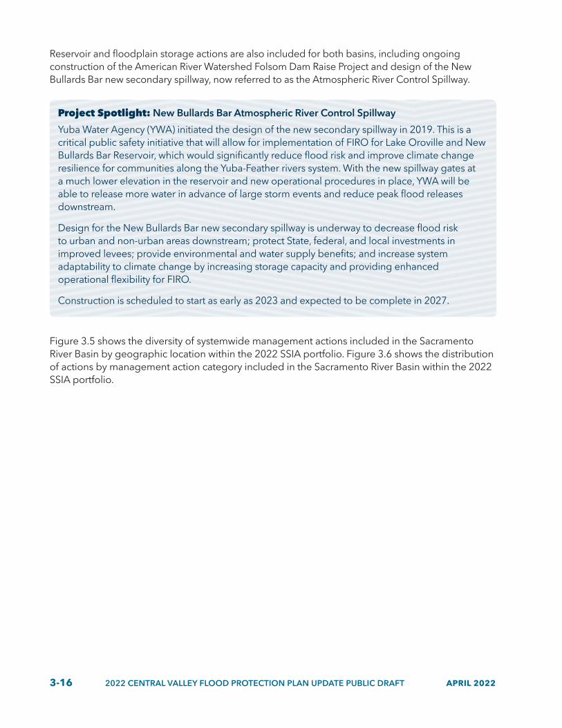
3-16 2022 CENTRAL VALLEY FLOOD PROTECTION PLAN UPDATE PUBLIC DRAFT APRIL 2022
Reservoir and floodplain storage actions are also included for both basins, including ongoing construction of the American River Watershed Folsom Dam Raise Project and design of the New Bullards Bar new secondary spillway, now referred to as the Atmospheric River Control Spillway.
Project Spotlight: New Bullards Bar Atmospheric River Control Spillway
Yuba Water Agency (YWA) initiated the design of the new secondary spillway in 2019. This is a critical public safety initiative that will allow for implementation of FIRO for Lake Oroville and New Bullards Bar Reservoir, which would significantly reduce flood risk and improve climate change resilience for communities along the Yuba-Feather rivers system. With the new spillway gates at a much lower elevation in the reservoir and new operational procedures in place, YWA will be able to release more water in advance of large storm events and reduce peak flood releases downstream.
Design for the New Bullards Bar new secondary spillway is underway to decrease flood risk to urban and non-urban areas downstream; protect State, federal, and local investments in improved levees; provide environmental and water supply benefits; and increase system adaptability to climate change by increasing storage capacity and providing enhanced operational flexibility for FIRO.
Construction is scheduled to start as early as 2023 and expected to be complete in 2027.
Figure 3.5 shows the diversity of systemwide management actions included in the Sacramento River Basin by geographic location within the 2022 SSIA portfolio. Figure 3.6 shows the distribution of actions by management action category included in the Sacramento River Basin within the 2022 SSIA portfolio.

APRIL 2022 2022 CENTRAL VALLEY FLOOD PROTECTION PLAN UPDATE PUBLIC DRAFT 3-17
Figure 3.5 Sacramento River Basin Systemwide Management Actions by Geography
Mapped locations express the geographic diversity of in-progress or planned systemwide actions in the 2022 SSIA portfolio within the Sacramento River Basin.
CHICO
OROVILLE
LowerSacramento/Delta North
Upper Sacramento/Mid-Sacramento River
FeatherRiver
MARYSVILLE
WOODLAND
Map Prepared: February 202215 30
Scale In Miles
0
LegendSystemwide Actions
2022_803e
SACRAMENTO
Figure 3.6 Sacramento River Basin Systemwide Actions by 2022 SSIA Portfolio Category
Percentages express how many individual systemwide actions are distributed among the ongoing and capital management action categories composing the 2022 SSIA portfolio within the Sacramento River Basin.
Annual Operation and Maintenance 13%9% Multi-benefit Flood Improvement Programs
Emergency Management 7%61% Deferred Maintenance
1% Reservoir and Floodplain Storage
0% Groundwater Recharge and Flood Managed Aquifer Recharge
Flood Management Policy Actions 3%
Reservoir Operations 3%
Systemwide Risk Assessments 2%
State Operations, Planning, andPerformance Tracking 1%
2022_803f

3-18 2022 CENTRAL VALLEY FLOOD PROTECTION PLAN UPDATE PUBLIC DRAFT APRIL 2022
Project Spotlight: Yolo Bypass-Cache Slough Program
Development of a YBCS program is needed to advance implementation of multi-benefit projects through the YBCS Partnership pursuant to SB 369, which was recently enacted by the California legislature. Implementing multi-benefit projects through State, federal, and local authorization and appropriations, with collaboration among all partner agencies, will significantly contribute to public health and safety, ecosystem vitality, and the agricultural and economic health of the region. Development and implementation of a program would also include establishment of a governance and funding framework to enable effective, affordable, and sustainable O&M of this part of the flood risk management system in the lower Sacramento River Basin.
A YBCS program could achieve its vision through the development and implementation of an integrated multi-benefit program containing the following elements:
• Expand the flood conveyance capacity of the Yolo Bypass to meet existing and future flood risk management standards.
• Improve habitat quality and quantity to achieve multiple benefits for ecosystems.
• Align ecological improvements and environmental sustainability with agricultural land uses.
• Support actions to sustain floodplain agriculture, recognizing the benefits it provides to the flood system such as drainage improvements, wildlife-friendly agricultural techniques, and other actions developed in coordination with local growers and landowners.
• Establish a regulatory and funding framework to enable effective, affordable, and sustainable O&M of the flood management system.
• Preserve continued access to cost-effective and resilient water supplies in YBCS Complex for local sustainable agriculture and regional municipal users including for the North Bay Aqueduct.
• Establish regulatory protection for existing agricultural irrigation diversions (such as through a habitat conservation plan).
• Improve water quality by minimizing discharge and production of toxic contaminants into the Yolo Bypass, starting with the reduction of methyl mercury.
• Increase opportunities for recreation, outdoor education, outreach, and access in the Yolo Bypass.
A YBCS program would be an integrated effort that includes State, federal, and local agencies’ initiatives and projects as described in the YBCS Partnership, Planning for an Integrated, Resilient Future brochure. Development of this program provides a unique opportunity for interagency collaboration in pursuit of a common plan of activities that would advance the national interest in flood risk reduction, ecosystem improvement, and regional economic development and support implementation of the CVFPP and regional priorities. A master plan is being developed to guide and support near-term and long-term implementation efforts, align partner priorities, support an application for Programmatic Section 408 permission from the USACE, and inform the Yolo Bypass Comprehensive Study

APRIL 2022 2022 CENTRAL VALLEY FLOOD PROTECTION PLAN UPDATE PUBLIC DRAFT 3-19
authorized by the Water Resources Development Act 2020. The master plan will also support processes for programmatic permitting and phased implementation of the suite of projects and policy actions proposed and envisioned in the Yolo Bypass.
3-20 2022 CENTRAL VALLEY FLOOD PROTECTION PLAN UPDATE PUBLIC DRAFT APRIL 2022
3.3.1.2 San Joaquin River Basin
Proposed systemwide capital investments in the San Joaquin River Basin include expansion of Paradise Cut and a broad array of other multi-benefit actions proposed as part of a regional flood management strategy to increase climate resilience. SSIA priorities for the San Joaquin River Basin have been updated to leverage recent successes and address policy issues that have impeded progress. For example, refinements for Paradise Cut multi-benefit improvements in the San Joaquin River Basin have been advanced through partnership with the San Joaquin County Resource Conservation District, American Rivers (an environmental NGO), and others to further evaluate and expand on the work completed in the San Joaquin Basin-Wide Feasibility Study and 2017 CVFPP Update.
The State and USACE are also evaluating the potential for implementing FIRO in California watersheds where improved weather forecasting capabilities would allow reservoir operators to improve flood control and surface and groundwater storage, and improve climate change resilience. Opportunities for reoperating reservoirs (including potential FIRO operations) in the San Joaquin River Basin are being evaluated under the Flood-MAR program. Additionally, the USACE plans to update its Water Control Manual with new information (including content on potential FIRO operations) for some San Joaquin River Basin reservoirs.
The Dos Rios Ranch Floodplain Expansion and Ecosystem Restoration Project, Phase 2, aims to restore approximately 2,100 acres of historic floodplain, restore riparian habitats, and promote river physical processes of scour and deposition along 6 river miles. Upon completion, the project is expected to provide broad benefits to multiple species, including riparian brush rabbit, riparian woodrat, Swainson’s Hawk, Central Valley Chinook salmon, steelhead trout, least Bell’s vireo, and more. Habitat restoration of the Three Amigos project is also underway with more than 3,100 acres of restored historic floodplain.
The systemwide management actions for the San Joaquin River Basin also include actions that use flood flows for groundwater recharge to improve water management, water supply reliability, and system resilience to climate change and extreme events, including work conducted through the Flood-MAR program, such as watershed-scale Flood-MAR opportunities analyses and Flood-MAR pilot projects.
Figure 3.7 shows the diversity of systemwide management actions included in the San Joaquin River Basin by geographic location within the 2022 SSIA portfolio. Figure 3.8 shows the distribution of systemwide actions by management action category included in the San Joaquin River Basin within the 2022 SSIA portfolio.

APRIL 2022 2022 CENTRAL VALLEY FLOOD PROTECTION PLAN UPDATE PUBLIC DRAFT 3-21
Figure 3.7 San Joaquin River Basin Systemwide Management Actions by Geography
Mapped locations express the geographic diversity of in-progress or planned systemwide actions in the 2022 SSIA portfolio within the San Joaquin River Basin.
MODESTO
MADERA
MERCED
SAN FRANCISCO
CHOWCHILLA
Lower San Joaquin
River/Delta South
Mid-San Joaquin River
Upper San Joaquin River
Map Prepared: February 202215 30
Scale In Miles
0
LegendSystemwide Actions
STOCKTON
2022_803m
Figure 3.8 San Joaquin River Basin Systemwide Actions by 2022 SSIA Portfolio Category
Percentages express how many individual systemwide actions are distributed among the ongoing and capital management action categories composing the 2022 SSIA portfolio within the San Joaquin River Basin.
19%Annual Operation and Maintenance
2%Multi-benefit FloodImprovement Programs
10%Emergency Management
28%Deferred Maintenance
9% Reservoir and Floodplain Storage
10%Groundwater Recharge and
Flood Managed Aquifer Recharge
5%Flood Management Policy Actions
10%Reservoir Operations
5%Systemwide Risk Assessments
2%State Operations, Planning, and
Performance Tracking2022_803n

3-22 2022 CENTRAL VALLEY FLOOD PROTECTION PLAN UPDATE PUBLIC DRAFT APRIL 2022
Project Spotlight: Regional Flood Management Strategy for the San Joaquin River Basin
As described in Chapter 2, DWR and the CVFPB initiated a collaborative process in fall 2020 to update and refine a regional flood management strategy for the San Joaquin River Basin. State and local participants identified priority actions that could collectively provide significant flood risk reduction in the San Joaquin Valley and contribute to ecosystem management and groundwater management. It is expected that benefits of the regional flood management strategy will be systemwide, and many proposed actions would have benefits that cross regional boundaries. For example, flood management activities in the Upper and Mid San Joaquin River regional flood management planning areas may yield flood risk reduction benefits to the Lower San Joaquin urban areas.
The initial planning included identification of high-priority, low-regrets actions for early implementation as funding becomes available. Generally, these include actions to address climate change impacts, such as increasing flood storage, reoperating, or revising release objectives at reservoirs; actions on the tributaries that integrate flood and groundwater management for multiple benefits, such as Flood-MAR projects; structural actions that support 200-year level of protection in urban areas and up to 100-year level of protection in small communities; actions that increase conveyance of floodwaters, such as Paradise Cut Bypass; actions that reconnect and restore historic floodplains in the mid-San Joaquin River along the mainstem, such as near the Tuolumne River; actions that modify or maintain structures in rural areas; and actions that resolve ongoing policy issues.
During spring 2021 workshops, participants identified specific actions, shown in the following figure, as priorities to be addressed by the regional flood management strategy collaboration effort:
• Restore floodplains and habitat along the San Joaquin River between the Stanislaus and Merced rivers.
• Expand Paradise Cut for higher flows.
• Formulate, evaluate, and implement floodplain restoration and recharge projects.
• Formulate and implement transitory storage projects for floodwater storage and recharge.
• Improve understanding of reservoir vulnerabilities and implement storage and operations-related actions to achieve resiliency in multiple sectors.
• Increase floodway capacity downstream of the Don Pedro Reservoir to match the maximum-controlled release level.
• Improve processes for adding, removing, and modifying SPFC facilities and find solutions for San Joaquin River Flood Control Project.
• Protect small communities, with focus on the community of Firebaugh and system maintenance issues.
• Understand subsidence impacts on flood facilities and floodplains and collaborate with groundwater sustainability agencies on solutions.
• Achieve urban level of flood protection for Stockton urban area and support multi-benefit feasibility studies for climate resilience.
The above actions were included in concept in the 2017 CVFPP Update, but workshop participants indicated that additional collaboration and effort were needed to move these actions toward implementation. Next steps included developing work plans for these actions to support implementation.

APRIL 2022 2022 CENTRAL VALLEY FLOOD PROTECTION PLAN UPDATE PUBLIC DRAFT 3-23
More formal partnerships of State, federal, and local agencies and stakeholders should be formed to develop and advance implementation of the priority actions and future, longer-term strategies.
Regional Flood Management Strategy Actions Identified in Spring 2021 Workshops
FRESNO
MODESTO
LOSBANOS
MADERA
STOCKTON
VERNALIS
FIREBAUGH
MERCED
Los BanosReservoir
Burns
Stanislaus River
Merced River
Owens Creek
Bear Creek
Fresno River
Ca laveras River
San Joaquin River
Chowchilla River
San Joaquin River
Eastside BypassTuolumne River
Bear Creek
San
Joaquin
River
MariposaBypass
SPFC LeveesImprovement LocationsImprovement AreaPriority Action LocationsPriority Action AreaNational Wildlife Refuge
0 5 10
Scale in Miles
Legend
Map Prepared: December 2021
22_801
Paradise Cut Expansion
Explore transitory storage opportunities and evaluate subsidence impacts of flood facilities
Groundwater bank, transitory storage, floodplain restoration, and recharge
Pursue restoration of floodplains and habitats
Improve Tuolumne River Resilience
Evaluation of Reservoir Storage and Reoperation
Protection of small communities
200-Year LOP
Evaluation of Reservoir Storage and Reoperation
200-Year LOP

3-24 2022 CENTRAL VALLEY FLOOD PROTECTION PLAN UPDATE PUBLIC DRAFT APRIL 2022
3.3.2 Urban Management Actions
The urban management actions for the 2022 CVFPP Update reflect the extent of completion of urban projects since 2017. The urban management actions support improvements to urban (populations of 10,000 or more) levees and structures to achieve protection from 200-year (0.5 percent annual chance) flood events. Urban improvements to levees or floodwalls should continue to follow State Urban Levee Design Criteria, incorporate ecosystem restoration in project designs, be implemented and maintained consistent with the State’s vegetation management approach, and be consistent with the wise use of floodplains. The urban management actions would preserve urban development opportunities within specific boundaries without inducing broader urban development in SPFC floodplains that increases annual life loss and economic damages.
3.3.2.1 Sacramento River Basin
The feasibility studies and construction projects for urban areas in the Sacramento River Basin include continued implementation and completion of ongoing State-federal projects recommended by USACE feasibility studies. A remaining major focus is achieving 200-year level of protection for urban areas that must comply or show adequate progress pursuant to the Central Valley Flood Protection Act of 2008 by 2025. Figure 3.9 provides the diversity of urban management actions included in the Sacramento River Basin by geographic location within the 2022 SSIA portfolio. Figure 3.10 provides the distribution of urban actions by management action category included in the Sacramento River Basin within the 2022 SSIA portfolio. Although levee, other infrastructure, and multi-benefit improvements constitute a majority of actions in urban areas, actions also include risk awareness, floodproofing, and local land use planning, such as promoting wise use of floodplains.

APRIL 2022 2022 CENTRAL VALLEY FLOOD PROTECTION PLAN UPDATE PUBLIC DRAFT 3-25
Figure 3.9 Sacramento River Basin Urban Management Actions by Geography
Mapped locations express the geographic diversity of in-progress or planned urban actions in the 2022 SSIA portfolio within the Sacramento River Basin.
CHICO
OROVILLE
MARYSVILLE
SACRAMENTO
LowerSacramento/Delta North
Upper Sacramento/Mid-Sacramento River
FeatherRiver
WOODLAND
Map Prepared: February 2022
15 30
Scale In Miles
0
LegendUrban Actions
2022_803g
Figure 3.10 Sacramento River Basin Urban Actions by 2022 SSIA Portfolio Category
Percentages express how many individual urban actions are distributed among the ongoing and capital management action categories composing the 2022 SSIA portfolio within the Sacramento River Basin.
6%Risk Awareness, Floodproofing,
and Local Land Use Planning52%Levee Improvements for 200-year Level of Protection
22%Studies and Analysis
20%Other Infrastructure and
Multi-benefit Flood Improvements 2022_803h

3-26 2022 CENTRAL VALLEY FLOOD PROTECTION PLAN UPDATE PUBLIC DRAFT APRIL 2022
As described in Chapter 2, significant progress has been made since 2017 for urban areas working with the USACE and local partners within the Sacramento River Basin. Completion of 200-year level of protection construction and accreditation is expected for the following areas prior to 2027:
• Yuba City in the Sutter River Basin and City of Marysville in the Yuba River Basin. Includes completion of remaining Marysville ring levees by 2023.
• Sacramento River Basin and Natomas Basin within the Sacramento metropolitan area. Includes completion of remaining phased SPFC urban levee improvements along the Sacramento River and American River through the American River Common Features Program.
DWR will continue to evaluate and participate in projects and feasibility studies that contribute to achieving an urban level of flood protection by improving SPFC facilities for the following remaining areas within the Sacramento River Basin. This work is not expected to be completed until after 2027.
• City of Chico. Includes SPFC urban levee improvements bordering the City of Chico to provide protection from flooding along local tributaries.
• City of West Sacramento. Includes projects authorized by the West Sacramento General Reevaluation Report and Water Resources Development Act 2016 fix-in-place levee improvements on the Sacramento River, Yolo Bypass levee, Sacramento Bypass Training Levee, and Sacramento Deep Water Ship Channel by 2028.
• Cities of Woodland and Davis. Project proponents are seeking authorization and funding to implement the preferred alternative in the completed Lower Cache Creek Feasibility Study.
For urban areas protected by non-SPFC levees, the State may evaluate its interest in participating in levee improvements under other State programs (i.e., not under the CVFPP).
Although opportunities to improve ecosystem functions in urban areas are more limited compared to small communities and rural-agricultural areas, urban areas should leverage site-specific opportunities to achieve ecosystem and multiple benefits. Opportunities to benefit urban areas are also included in the systemwide management actions, such as bypass expansions and reservoir and floodplain storage. In addition to these improvements, ongoing management actions are important to manage residual flood risk.
3.3.2.2 San Joaquin River Basin
Urban management actions in the San Joaquin River Basin have also progressed since 2017. The feasibility studies and construction projects for urban areas include continued implementation of ongoing USACE-authorized projects and completion of State-federal projects recommended by ongoing feasibility studies. A major focus remains achieving 200-year level of protection for urban areas.
Figure 3.11 provides the diversity of urban management actions included in the San Joaquin River Basin by geographic location within the 2022 SSIA portfolio. Figure 3.12 provides the distribution of urban actions by management action category included in the San Joaquin River Basin within the 2022 SSIA portfolio.

APRIL 2022 2022 CENTRAL VALLEY FLOOD PROTECTION PLAN UPDATE PUBLIC DRAFT 3-27
Figure 3.11 San Joaquin River Basin Urban Management Actions by Geography
Mapped locations express the geographic diversity of in-progress or planned urban actions in the 2022 SSIA portfolio within the San Joaquin River Basin.
MODESTO
MADERA
MERCED
SAN FRANCISCO
CHOWCHILLA
Lower San Joaquin
River/Delta South
Mid-San Joaquin River
Upper San Joaquin River
Map Prepared: February 202215 30
Scale In Miles
0
LegendUrban Actions
STOCKTON
2022_803o
Figure 3.12 San Joaquin River Basin Urban Actions by 2022 SSIA Portfolio Category
Percentages express how many individual urban actions are distributed among the ongoing and capital management action categories composing the 2022 SSIA portfolio within the San Joaquin River Basin.
17%Risk Awareness, Floodproofing, and
Local Land Use Planning
28%Levee Improvements for 200-year Level of Protection
30%Studies and Analysis
25%Other Infrastructure and Multi-benefit Flood Improvements
2022_803p

3-28 2022 CENTRAL VALLEY FLOOD PROTECTION PLAN UPDATE PUBLIC DRAFT APRIL 2022
Planned and ongoing urban actions include:
• City of Merced. Design and construction of the Black Rascal Creek Flood Control Project that contributes to 200-year level of projection to the City of Merced.
• Stockton metropolitan area. Urban improvements to SPFC and appurtenant non-SPFC levees and structures with the USACE and local partners, through the following:
• Completion of Smith Canal Gate Project construction by 2022.
• Design and construction of the first reach of the USACE Lower San Joaquin River Project.
• Completion of the Stockton-area levee construction, including western front levees.
• Initiation of a New Hogan Reservoir Climate Resilience and Multi-Benefit Feasibility Study.
• Reclamation District 17 and cities of Lathrop and Manteca. Completion of Reclamation District 17 levee seepage repair project by the end of 2022 and completion of the Mossdale Tract Urban Flood Risk Reduction study.
DWR will continue to evaluate and participate in projects and feasibility studies that contribute to achieving an urban level of flood protection by improving SPFC facilities for the following remaining areas within the San Joaquin River Basin. But this work is not expected to be completed by 2027.
• City of Merced. Continued support of the Merced County Streams Group effort to identify full 200-year level of protection and storage actions to provide the City of Merced with protection from flooding. This support may include reinitiating the Merced County Streams General Reevaluation Report to seek federal participation.
• Stockton metropolitan area. Includes design and construction of the remaining five reaches of the USACE Lower San Joaquin River Project, completion of the Mossdale Tract Urban Flood Risk Reduction study and follow-on design and construction of improvements to provide 200-year level of protection for the cities of Lathrop and Manteca.
For urban areas protected by non-SPFC levees, the State may evaluate its interest in participating in levee improvements under other State programs (not under the CVFPP).
3.3.3 Rural Management Actions
The rural management actions for the 2022 CVFPP Update reflect progress since 2017 and new actions identified by DWR and the RFMPs. The rural management actions support critical repairs for rural levees and hydraulic structures, with an emphasis on traditionally nonstructural approaches, such as land acquisitions in fee or easements, wise use of floodplains, and habitat restoration and reconnection actions. The State continues to support maintaining levee crown elevations and providing all-weather access roads to facilitate inspection and flood fighting on rural SPFC levees. Land acquisitions in fee or easements can reduce risk intensification from future population growth and improve the system’s ability to attenuate floods. Also included are repair and rehabilitation of Butte Basin small weir structures, Upper San Joaquin hydraulic structures, and levee repairs and flowage easements to address San Joaquin River Basin subsidence. Further, rural habitat restoration can restore and reconnect historic floodplains, improve water quality, and provide habitat for salmonids, migratory birds, and waterfowl and maintain agricultural production, such as in the Yolo Bypass Wildlife Area and in Flood-MAR project concepts.

APRIL 2022 2022 CENTRAL VALLEY FLOOD PROTECTION PLAN UPDATE PUBLIC DRAFT 3-29
Figure 3.13 provides the diversity of rural management actions included in the Sacramento River Basin by geographic location within the 2022 SSIA portfolio. Figure 3.14 provides the distribution of rural actions by management action category included in the Sacramento River Basin within the 2022 SSIA portfolio.

3-30 2022 CENTRAL VALLEY FLOOD PROTECTION PLAN UPDATE PUBLIC DRAFT APRIL 2022
Figure 3.13 Sacramento River Basin Rural Management Actions by Geography
Mapped locations express the geographic diversity of in-progress or planned rural actions in the 2022 SSIA portfolio within the Sacramento River Basin.
CHICO
OROVILLE
MARYSVILLE
WOODLANDLowerSacramento/Delta North
Upper Sacramento/Mid-Sacramento River
FeatherRiver
SACRAMENTO
Map Prepared: February 202215 30
Scale In Miles
0
LegendRural Actions
Figure 3.14 Sacramento River Basin Rural Actions by 2022 SSIA Portfolio Category
Percentages express how many individual rural actions are distributed among the ongoing and capital management action categories composing the 2022 SSIA portfolio within the Sacramento River Basin.
12%Studies and Analysis
8%Land Acquisitions in Fee or Easements
8%Risk Awareness, Floodproofing,
and Local Land Use Planning
46%Levee Repair and Infrastructure
Improvements
24%Habitat Restoration/Reconnection
2%Small-scale Levee Setbacks and Floodplain Storage
2022_803b

APRIL 2022 2022 CENTRAL VALLEY FLOOD PROTECTION PLAN UPDATE PUBLIC DRAFT 3-31
Figure 3.15 provides the diversity of rural management actions included in the San Joaquin River Basin by geographic location within the 2022 SSIA portfolio. Figure 3.16 provides the distribution of rural actions by management action category included in the San Joaquin River Basin within the 2022 SSIA portfolio.
Figure 3.15 San Joaquin River Basin Rural Management Actions by Geography
Mapped locations express the geographic diversity of in-progress or planned rural actions in the 2022 SSIA portfolio within the San Joaquin River Basin.
MODESTO
MADERA
MERCED
SAN FRANCISCO
CHOWCHILLA
Lower San Joaquin
River/Delta South
Mid-San Joaquin River
Upper San Joaquin River
Map Prepared: February 202215 30
Scale In Miles
0
LegendRural Actions
STOCKTON
2022_803i
Figure 3.16 San Joaquin River Basin Rural Actions by 2022 SSIA Portfolio Category
Percentages express how many individual rural actions are distributed among the ongoing and capital management action categories composing the 2022 SSIA portfolio within the San Joaquin River Basin.
16%Studies and Analysis
7%Land Acquisitions in Fee or Easements
9%Risk Awareness, Floodproofing,
and Local Land Use Planning
51%Levee Repair and Infrastructure Improvements
10%Habitat Restoration/Reconnection
7%Small-scale Levee Setbacks and
Floodplain Storage2022_803j

3-32 2022 CENTRAL VALLEY FLOOD PROTECTION PLAN UPDATE PUBLIC DRAFT APRIL 2022
Compared to the urban and small community areas, rural areas have greater potential to reduce future risk by enhancing rural and agricultural economies and ecosystem functions in the floodplain. Because new or improved levees in rural areas have potential to intensify risk in SPFC floodplains by potentially encouraging development or creating increased river stage in other areas, the 2022 SSIA portfolio emphasizes other actions including critical repairs, promoting wise uses of floodplains including working lands compatible with periodic flooding, pursuing multi-benefit projects, and connecting rural actions to larger regional strategies (e.g., Flood-MAR). Other priority actions with potential to benefit rural areas are included in the systemwide management actions, such as bypass expansions and reservoir and floodplain storage.
3.3.4 Small Community Management Actions
Many small communities in the Central Valley are DACs protected by aging infrastructure and with limited local resources to plan or implement flood management system repairs, rehabilitation, or improvements without greater assistance from the State and other partners. As described in Chapter 2, the Small Communities Flood Reduction Program (SCFRRP)was created to help support small communities lower their flood risk. Since the 2017 CVFPP Update, 35 small communities flood risk reduction feasibility studies have been completed or are ongoing through the SCFRR’s Phase 1 implementation program. Three communities, Franklin-Beachwood, Knights Landing, and Grimes were selected for Phase 2 implementation funding to advance design and construction of their recommended alternatives. The Three Rivers Levee Improvement Authority, Yuba Water Agency, and Yuba County have been working to address flood risk in the community of Hallwood, located between the Yuba Goldfields to the south and Highway 20 to the north.
Like urban areas, small communities located in floodplains have risk to human life, and the density of existing development can limit the types of management actions feasible within the small community boundaries. For example, it may not be feasible to set back a levee where residential neighborhoods and businesses are close to the river. But, unlike urban areas, the smaller scale of development and openness of the surrounding landscape often allows for a more diverse and resilient approach to flood management that holistically addresses the components of risk and offers more multi-benefit opportunities.
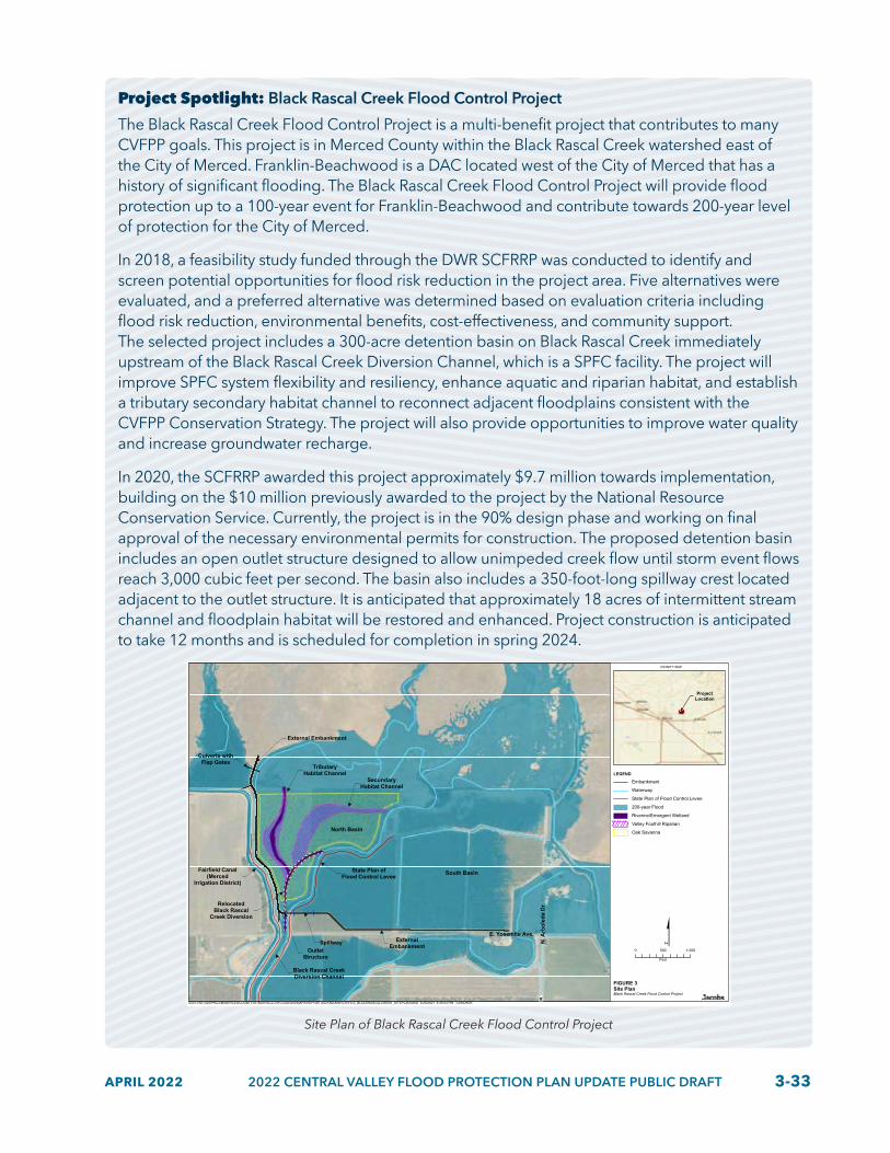
APRIL 2022 2022 CENTRAL VALLEY FLOOD PROTECTION PLAN UPDATE PUBLIC DRAFT 3-33
Project Spotlight: Black Rascal Creek Flood Control Project
The Black Rascal Creek Flood Control Project is a multi-benefit project that contributes to many CVFPP goals. This project is in Merced County within the Black Rascal Creek watershed east of the City of Merced. Franklin-Beachwood is a DAC located west of the City of Merced that has a history of significant flooding. The Black Rascal Creek Flood Control Project will provide flood protection up to a 100-year event for Franklin-Beachwood and contribute towards 200-year level of protection for the City of Merced.
In 2018, a feasibility study funded through the DWR SCFRRP was conducted to identify and screen potential opportunities for flood risk reduction in the project area. Five alternatives were evaluated, and a preferred alternative was determined based on evaluation criteria including flood risk reduction, environmental benefits, cost-effectiveness, and community support. The selected project includes a 300-acre detention basin on Black Rascal Creek immediately upstream of the Black Rascal Creek Diversion Channel, which is a SPFC facility. The project will improve SPFC system flexibility and resiliency, enhance aquatic and riparian habitat, and establish a tributary secondary habitat channel to reconnect adjacent floodplains consistent with the CVFPP Conservation Strategy. The project will also provide opportunities to improve water quality and increase groundwater recharge.
In 2020, the SCFRRP awarded this project approximately $9.7 million towards implementation, building on the $10 million previously awarded to the project by the National Resource Conservation Service. Currently, the project is in the 90% design phase and working on final approval of the necessary environmental permits for construction. The proposed detention basin includes an open outlet structure designed to allow unimpeded creek flow until storm event flows reach 3,000 cubic feet per second. The basin also includes a 350-foot-long spillway crest located adjacent to the outlet structure. It is anticipated that approximately 18 acres of intermittent stream channel and floodplain habitat will be restored and enhanced. Project construction is anticipated to take 12 months and is scheduled for completion in spring 2024.
N. A
RB
OLE
DA
DR
.
North Basin
South Basin
E. Yosemite Ave.
N. A
rbol
eda
Dr.
SecondaryHabitat Channel
TributaryHabitat Channel
ExternalEmbankmentSpillway
OutletStructure
Fairfield Canal(Merced
Irrigation District)
External Embankment
Black Rascal CreekDiversion Channel
RelocatedBlack Rascal
Creek Diversion
Culverts withFlap Gates
State Plan ofFlood Control Levee
\\DC1VS01\GISPROJ\M\MERCEDCOUNTYOF\BLKRSCLCRFLOOD\GIS\MAPS\REPORT\2021\BA\MARCH\FIG3_BLACKRASCALCREEK_SITEPLAN.MXD 3/25/2021 8:35:03 PM CARCHER
LEGEND
Embankment
Waterway
State Plan of Flood Control Levee
200-year Flood
Riverine/Emergent Wetland
Valley Foothill Riparian
Oak Savanna
VICINITY MAP
FIGURE 3Site PlanBlack Rascal Creek Flood Control Project
0 500 1,000
Feet
ProjectLocation
Site Plan of Black Rascal Creek Flood Control Project

3-34 2022 CENTRAL VALLEY FLOOD PROTECTION PLAN UPDATE PUBLIC DRAFT APRIL 2022
Small communities are encouraged to consider a wide variety of actions to reduce flood risk. Nonstructural actions, such as raising or elevating structures and floodproofing, should be considered alongside needed structural improvements. Floodplain management actions, such as floodplain risk awareness campaigns and land use management policies, are particularly effective for reducing flood risks to small communities. The State also supports considering multi-benefit opportunities that integrate other resources needs. Figure 3.17 shows the diversity of small community management actions included in the Sacramento River Basin by geographic location within the 2022 SSIA portfolio. Figure 3.18 shows the distribution of small community actions by management action category included in the Sacramento River Basin within the 2022 SSIA portfolio.
In the context of the overall SSIA portfolio, small community improvements are considered a higher priority investment relative to rural-agricultural areas because of the larger number of human lives at risk. Higher priority will be given to small community actions that provide multiple benefits, such as levee setbacks and floodplain management actions, and reduce flood risk for socially vulnerable or underserved communities. Other actions with potential to benefit small communities are included in the systemwide management actions.

APRIL 2022 2022 CENTRAL VALLEY FLOOD PROTECTION PLAN UPDATE PUBLIC DRAFT 3-35
Figure 3.17 Sacramento River Basin Small Community Management Actions by Geography
Mapped locations express the geographic diversity of in-progress or planned small community actions in the 2022 SSIA portfolio within the Sacramento River Basin.
CHICO
OROVILLE
MARYSVILLE
WOODLAND
SACRAMENTO
LowerSacramento/Delta North
Upper Sacramento/Mid-Sacramento River
FeatherRiver
Map Prepared: February 2022
15 30
Scale In Miles
0
LegendSmall Community Actions
2022_803c
Figure 3.18 Sacramento River Basin Small Community Actions by 2022 SSIA Portfolio Category
Percentages express how many individual small community actions are distributed among the ongoing and capital management action categories composing the 2022 SSIA portfolio within the Sacramento River Basin.
18%Risk Awareness, Floodproofing,and Local Land Use Planning
42%Levee Repair and Infrastructure
Improvements for up to100-year Level of Protection
4%Habitat Restoration/Reconnection
6%Small-scale Levee Setbacks
and Floodplain Storage9%
Land Acquisitions in Fee or Easements
21%Studies and Analysis
2022_803d

3-36 2022 CENTRAL VALLEY FLOOD PROTECTION PLAN UPDATE PUBLIC DRAFT APRIL 2022
Figure 3.19 provides the diversity of small community management actions included in the San Joaquin River Basin by geographic location within the 2022 SSIA portfolio. Figure 3.20 provides the distribution of small community actions by management action category included in the San Joaquin River Basin within the 2022 SSIA portfolio.
Figure 3.19 San Joaquin River Basin Small Community Management Actions by Geography
Mapped locations express the geographic diversity of in-progress or planned small community actions in the 2022 SSIA portfolio within the San Joaquin River Basin.
MODESTO
MADERA
MERCED
SAN FRANCISCO
CHOWCHILLA
Lower San Joaquin
River/Delta South
Mid-San Joaquin River
Upper San Joaquin River
Map Prepared: February 202215 30
Scale In Miles
0
LegendSmall Community Actions
STOCKTON
2022_803k
Figure 3.20 San Joaquin River Basin Small Community Actions by 2022 SSIA Portfolio Category
Percentages express how many individual small community actions are distributed among the ongoing and capital management action categories composing the 2022 SSIA portfolio within the San Joaquin River Basin.
Risk Awareness, Floodproofing,and Local Land Use Planning
31%
11% Levee Repair and InfrastructureImprovements for up to 100-yearLevel of Protection
Habitat Restoration/Reconnection 8%
4% Small-scale Levee Setbacks and Floodplain Storage
27% Land Acquisitions in Fee or Easements
Studies and Analysis 19%2022_803l

APRIL 2022 2022 CENTRAL VALLEY FLOOD PROTECTION PLAN UPDATE PUBLIC DRAFT 3-37
3.3.5 Flood Management Policies
Effective implementation of the SSIA requires necessary policy and financial conditions. The 2017 CVFPP Update first introduced eight flood management policy issues and recommended actions to overcome these issues to fully implement the SSIA. The 2022 CVFPP Update is recommending including two additional policy issues: (1) addressing profound and increasing climate change impacts and flood system resilience, and (2) advancing equity in flood management planning, decision-making, and implementation throughout the entire Central Valley flood system. Flood management policies for the 2022 CVFPP Update and refined recommendations to address them are described in the following subsections. Many policy issues are interrelated, and the successful implementation of the CVFPP requires concurrent progress on these issues.
Policy recommendations not only provide the framework for current structural and non-structural flood management programs, but also define ways in which system management can be improved and adapt to uncertain and changing future conditions. As such, updates of the CVFPP will also include a review and update of the guiding policy framework. A summary of the progress to date on the policy issues included in the 2017 CVFPP Update is provided in Chapter 2. Lessons learned from that progress, interactions with partners and stakeholders, changes in State and federal policies, and the overarching political landscape have informed refinements to the policy recommendations for the 2022 CVFPP Update.
Policy recommendations were formulated for the 2022 CVFPP Update by compiling several sources of recommendations and stakeholder input. These sources included the following:
• 2017 CVFPP Update recommendations.
• 2017 CVFPP Update Section 2.3.2, “Stakeholder and Partner Perspectives and Continuing Conversations on Flood Management Policy Issues.”
• 2016 Conservation Strategy
• 2022 Conservation Strategy, Appendix G.
• Stakeholder surveys and interviews related to the Conservation Strategy.
• RFMP regional priorities white papers.
• CVFPB Advisory Committee subgroup recommendations.
• Water Resilience Portfolio actions.
• DWR and Division of Flood Management strategic plans.
Table 3.3 provides the highest priority policy recommendations for the 2022 CVFPP Update. These high-priority recommendations cut across related policy issues and they address the largest impediments to CVFPP implementation based on engagement and review conducted to date. To reinforce the cross-cutting nature of these high-priority recommendations, they have been mapped to the corresponding flood management policy issues introduced in Chapter 2.
The 2022 CVFPP Update is considering priorities based on:
• Severity of impediment to CVFPP implementation.
• Shared importance with relevant State, federal, local and Tribal partners that may be engaged for effective collaboration and implementation of policies.
• Appropriateness of recommendations for level of detail, ability and practicality to implement.

3-38 2022 CENTRAL VALLEY FLOOD PROTECTION PLAN UPDATE PUBLIC DRAFT APRIL 2022
More specificity and supporting information for the high-priority recommendations (provided in Table 3.3) are included in Appendix C, “CVFPP Supplemental Recommendations.” Appendix C contains supplemental recommendations that build on partner and stakeholder discussions within the CVFPB Advisory and Coordinating Committees.
Table 3.3 High-Priority Policy Issue Recommendations for CVFPP and Agency Leads (State, Federal, Local, Tribes)
No. Draft Recommendation Corresponding Policy Issues
01 Establish basin-specific task forces of high-level decision-makers and staff from State, federal, and local agencies, Tribes, and other partners to further advance implementation of projects and programmatic implementation of the Central Valley Flood Protection Plan (CVFPP) by State/federal/local/Tribes:
• Facilitating interagency coordination and collaboration regarding multi-benefit project funding prior to issuing guidelines, collaborating on funding strategies and priorities, and aligning funding programs to best advance multi-benefit projects.
• Reviewing existing governance and authorities to identify overlapping authorities and propose recommendations for reconciliation between and among State, federal, and local agencies and Tribes to improve implementation of flood projects, particularly in rural and underserved communities.
• Establishing the legal and institutional mechanisms, at the federal level, to support programmatic implementation of the CVFPP over multiple decades. This would include agreed-upon hydraulic and ecosystem baselines for each basin and supporting implementation of single and multi-purpose projects that collectively advance intended outcomes.
• Aligning on strategies to advance equity and community resilience in flood management decision-making.
FLOOD AND ECOSYSTEM
PERFORMANCE
FUNDING
GOVERNANCE AND
INSTITUTIONAL
MULTI-BENEFIT
PROJECTS
02 Work with appropriate resource agencies to create and implement regional-scale and long-term permitting mechanisms, where appropriate, for implementation and operations and maintenance (O&M) of flood management activities, including multi-benefit projects, considering the following (State/federal/local/Tribes):
• Feasibility of initiating a regionally based multiple-objective operation, maintenance, repair, rehabilitation, and replacement (OMRR&R) program, using the Yolo Bypass for a large systemwide magnitude pilot project and the lower Bear River as a smaller-scale pilot project.
• Using mitigation banks or creating mitigation credits through a mitigation credit agreement as appropriate and to streamline costs, explore creating mitigation credits in bulk for use for flood risk reduction projects.
• Initiating memorandums of agreement or memorandums of understanding between the California Department of Water Resources (DWR) and regulatory agencies to standardize and streamline some permitting elements for multi-benefit projects and provide greater transparency of the regulatory process.
• Engagement with Tribes on the impact of O&M on Tribal cultural resources, sacred places, and burial sites.
MULTI-BENEFIT
PROJECTS
O&M OF THE
FLOOD SYSTEM

APRIL 2022 2022 CENTRAL VALLEY FLOOD PROTECTION PLAN UPDATE PUBLIC DRAFT 3-39
No. Draft Recommendation Corresponding Policy Issues
03 Continue State leadership in the wise use of floodplains and promote floodplain best management guidance, supported by the California Strategic Floodplain Management Plan, that outlines (State/federal/Tribes):
• Funding and ties to federal programs.
• Partnership with the Federal Emergency Management Agency (FEMA) to increase investments in non-structural actions and facilitate development of nonstructural alternatives.
• State’s role as liaison between California Office of Emergency Services and local flood risk reduction project proponents.
• Technical assistance and financial support for local partners to improve their regional flood emergency preparedness (e.g., advancing improvements to ALERT (automated local evaluation in real time) stream, rainfall, and reservoir gauge systems, emergency response plans, and notifications and warning system, updating and maintaining dam inundation mapping, developing a pilot annual dam inundation hazard notifications testing program, and exercising and updating dam emergency action plans and downstream community emergency response plans).
• Use of natural and working lands as nature-based solutions.
• Provide additional support to socially vulnerable communities to reduce residual flood risk and increase community resilience.
LAND USE AND FLOODPLAIN
MANAGEMENT
FUNDING
GOVERNANCE AND
INSTITUTIONAL
COORDINATION WITH FEDERAL
AGENCIES
MULTI-BENEFIT
PROJECTS

3-40 2022 CENTRAL VALLEY FLOOD PROTECTION PLAN UPDATE PUBLIC DRAFT APRIL 2022
No. Draft Recommendation Corresponding Policy Issues
04 Collaborate with State, federal, and local partners to develop recommendations to improve existing processes to facilitate modification of federal authorizations for State Plan of Flood Control (SPFC) facilities. For example, the following efforts could be undertaken (State/federal/local):
• Convene a workgroup to advise on SPFC system status modifications and federal authorization modifications, including project purpose changes; adding, removing, and modifying SPFC facilities; and considering United States Army Corps of Engineers (USACE) Section 408 process improvements.
• Continue convening partners in the San Joaquin Valley to formulate and implement short- and long-term strategies to support a regional flood management strategy in the San Joaquin River Basin.
• Communicate and coordinate on development and implementation of federal legislation, such as the biennial Water Resources Development Act (WRDA) that provides federal authorization for potential changes to the SPFC through DWR’s federal advocacy program.
• Convene a working group of federal (USACE), State, and local representatives to scope and explore reassessment of the conclusions in the Sacramento Bank Protection Program Limited Revaluation Report and identify how to leverage the Sacramento Bank Protection Program to provide federal funding for CVFPP implementation. This working group could also inform USACE’s Yolo Bypass system comprehensive study, authorized by WRDA in 2020, with its findings from the reassessment of the Sacramento Bank Protection Program.
LAND USE AND FLOODPLAIN
MANAGEMENT
GOVERNANCE AND
INSTITUTIONAL
FUNDING
MULTI-BENEFIT
PROJECTS
COORDINATION WITH FEDERAL
AGENCIES

APRIL 2022 2022 CENTRAL VALLEY FLOOD PROTECTION PLAN UPDATE PUBLIC DRAFT 3-41
No. Draft Recommendation Corresponding Policy Issues
05 Complete watershed-based climate change vulnerability and adaptation assessments building to a system scale for the Sacramento River and San Joaquin river basins, to understand the anticipated changes in the flood system and investment needs supported by the following (State/federal/local/Tribes):
• Continue to encourage the USACE climate change policies to incorporate inland climate change in planning, feasibility studies, and project development.
• Developing guidance and a shared vocabulary for Central Valley flood management climate change evaluations, impacts, and potential adaptation strategies, including Tribal values and perspectives.
• Develop mechanisms and processes to track the impacts of climate change, including changes in sea level rise and hydrology, and consider these impacts on the flood system and ecosystem vitality as part of future CVFPP updates.
• Further develop watershed evaluations to inform adaptation measure development, including incorporating projected climate change impacts into dam inundation and forecast-informed reservoir operations (FIRO) analyses
• Coordinate with the Governor’s Office of Planning and Research Integrated Climate and Adaptation Program to integrate advancements in understanding vulnerable communities and vulnerability assessments with CVFPP planning efforts.
CLIMATE CHANGE
AND FLOOD SYSTEM RESILIENCE
FLOOD AND ECOSYSTEM
PERFORMANCE
COORDINATION WITH FEDERAL
AGENCIES
06 Obtain increased State and federal stable funding for flood management, including ongoing investments and multi-benefit capital projects in the Central Valley by (State/federal/local):
• Requesting increased appropriations from the State general fund for Central Valley flood management from the current average of $52 million per year (2007 through 2019) to $220 million per year by the end of the 30-year period.
• Increasing local assessments, including Proposition 218 assessments.
• Leverage federal cost-share opportunities and advocate for additional federal appropriations for single-purpose and multi-benefit improvements through congressional appropriations through the WRDA, and FEMA and the USACE.
• Advocate for new general obligation bond funding that promotes flexibility in funding flood management projects with single or multiple societal benefits.
• Increase funding to reduce residual flood risk in socially vulnerable communities and increase community resilience.
FUNDING
MULTI-BENEFIT
PROJECTS
COORDINATION WITH FEDERAL
AGENCIES

3-42 2022 CENTRAL VALLEY FLOOD PROTECTION PLAN UPDATE PUBLIC DRAFT APRIL 2022
No. Draft Recommendation Corresponding Policy Issues
07 Continue to periodically update the best available science, tools, and data to improve understanding of the condition, performance, and response of the flood system for CVFPP updates, Conservation Strategy updates, and related performance tracking systems in collaboration with partners (State/federal/local/Tribes).
For example, the following efforts could be undertaken, as resources allow:
• Track land use changes to assess whether life loss and property damage risks are increasing or decreasing.
• Perform sediment and subsidence studies to assess the loss of flood conveyance capacity in the San Joaquin River Basin.
• Pilot projects and studies (e.g., Flood-MAR, Eco-FIP) to attain broader water management benefits from multi-benefit projects.
• Work with Tribes to promote Tribal engagement and incorporate traditional ecological knowledge and resources into project planning.
• Perform SPFC infrastructure life-cycle analyses.
• Support existing partnerships and initiate new partnerships with reservoir operators to advance forecast-coordinated operations and FIRO strategies to improve flood control and surface and groundwater supply storage. Advance forecasting for atmospheric rivers, runoff forecasting, and real-time flood condition monitoring in partnership with stakeholders and with transparency.
• Continue to lead and manage the CVFPP flood and ecosystem performance accounting and adaptive management system through DWR, in collaboration with CVFPB and other State and local agencies.
• Assist local communities in pursuing funding to conduct post-fire watershed assessment and implement post-burn stabilization treatments and mitigation measures, restore ecological health, and improve communication protocols to share lessons learned.
• Promote agricultural land stewardship and sustainability in multi-benefit project planning by leveraging regional flood management planning groups and partnerships to support the development and standardized use of relevant data and tools.
• Advance nature-based solutions in the Central Valley to reduce flood risk, enhance ecosystems, and increase climate resilience working with the USACE Engineering with Nature Program and local, regional, and Tribal partners.
O&M OF THE
FLOOD SYSTEM
FLOOD AND ECOSYSTEM
PERFORMANCE
MULTI-BENEFIT
PROJECTS

APRIL 2022 2022 CENTRAL VALLEY FLOOD PROTECTION PLAN UPDATE PUBLIC DRAFT 3-43
No. Draft Recommendation Corresponding Policy Issues
08 Secure annual dedicated funding to continue and expand the successful Regional Flood Management Plan Program, which will support the six planning regions and facilitate the following (State/local/Tribes):
• Planning and project formulation of flood and multi-benefit projects and activities in rural, small communities, and disadvantaged communities consistent with the CVFPP.
• Increase involvement and engagement of Tribes.
• Preparation of local grant applications.
• Encourage and support governance studies, development and establishment of centralized governance mechanisms with budgetary resources (such as joint powers authorities), designed to coordinate regional flood management activities, improve regional planning, and support regional implementation of flood and multi-benefit projects.
• Continuation of collaboration and coordination on flood risk reduction projects, including multi-benefit projects within and across regions in each basin.
• Establishment of a collaborative forum for early agency engagement and coordination where project proponents (e.g., State or local partners) can share progress and obtain agency input.
• Establishment of regional technical advisory committees to improve coordination, landscape-scale connectivity, and development of a regional vision for multi-benefit projects.
FUNDING
MULTI-BENEFIT
PROJECTS
GOVERNANCE AND
INSTITUTIONAL
09 Continue to prioritize actions that repair and rehabilitate existing flood system features by (State/federal/local):
• Incorporating long-term O&M considerations and best management practices into planning, design, permitting (including long-term O&M coverage in permits for system improvement projects), and construction phases of flood risk reduction projects, multi-benefit projects, and encourage other project proponents to do the same.
• Continue to provide financial and technical assistance for programs such as the Flood Maintenance Assistance Program (FMAP) to decrease deferred maintenance in the system. Encourage local maintaining agencies to participate in FMAP and consider amendments to FMAP guidelines as appropriate to allow work activities to span multiple funding years, expand list of covered OMRR&R activities, and pursue federal funding opportunities.
• Continue to use FMAP to provide financial and technical assistance to local flood agencies to prepare Systemwide Infrastructure Framework (SWIF) applications, notice of intents, and SWIF implementation to regain Public Law 84-99 program eligibility to maximize federal cost-share.
• Continue to provide financial and technical assistance for programs, such as the Flood System Repair Program, to repair critical damage sites in the system in partnership with local maintaining agencies.
• Establish an interagency workgroup, in conjunction with California Silver Jackets, to investigate solutions for reducing the impact of encampments on levees and the associated O&M challenges that arise from inhabitance on the flood management infrastructure.
• Use Tribal consultation and coordination best practices from DWR’s Environmental Permitting for O&M effort.
• Consult Tribes early during studies to evaluate potential project alternatives, as preliminary project design begins to identify sensitive cultural areas, develop avoidance plans, and alternative maintenance (e.g., nature-based solutions), to the extent feasible.
O&M OF THE
FLOOD SYSTEM
FUNDING
GOVERNANCE AND
INSTITUTIONAL
COORDINATION WITH FEDERAL
AGENCIES

3-44 2022 CENTRAL VALLEY FLOOD PROTECTION PLAN UPDATE PUBLIC DRAFT APRIL 2022
No. Draft Recommendation Corresponding Policy Issues
10 Use action plans developed through collaborative planning efforts to inform planning, design, funding, and implementation of priority near-term and long-term projects to progress a regional flood management strategy for the San Joaquin River Basin, including (State/federal/local):
• Seek increased State, federal, and local funding for ongoing and capital investments in the San Joaquin River Basin to support priority actions.
• Convene a collaborative work group to strategize longer-term, multi-benefit regional flood management strategy and align efforts with watershed resilience planning and watershed studies.
MULTI-BENEFIT
PROJECTS
COORDINATION WITH FEDERAL
AGENCIES
CLIMATE CHANGE
AND FLOOD SYSTEM RESILIENCE
11 Progress equity and environmental justice in flood management planning, design, and decision-making (State/federal/local/Tribes):
• CVFPB staff to develop and present recommendations to the Board for fostering Diversity, Equity, and Inclusion (DEI) in the CVFPB organization and advancing equitable flood protection in the Central Valley through their existing DEI Task Force.
• Work directly with socially vulnerable communities that are disproportionately impacted by floods to better understand inequities experienced in flood management.
• Develop a process and tool for assessing social vulnerability and flood risk in the Central Valley, in collaboration with the Delta Stewardship Council’s Delta Adapts effort and other related vulnerability assessment efforts.
• Formally establish an inclusive multi-organization working group on equity and community resilience to develop strategies that will inform the 2027 CVFPP Update.
• Increase accessibility (e.g., provide additional services at public meetings, such as childcare, transportation, language translation, available public times, media coverage) of flood hazard and preparedness information for socially vulnerable communities.
• Work collaboratively with State and federal partners to develop strategies to include social vulnerability and community resilience in federal and State flood project planning and decision-making (e.g., State funding requirements).
• Develop metrics to track advancements in equity in flood management planning, implementation, and decision-making over time.
• Support the California Water Plan Update 2023 efforts to align State agency programs to advance equity in water management.
EQUITY

APRIL 2022 2022 CENTRAL VALLEY FLOOD PROTECTION PLAN UPDATE PUBLIC DRAFT 3-45
No. Draft Recommendation Corresponding Policy Issues
12 Explore, create, and implement regional-scale and long-term multi-benefit programs for planning, implementation, and long-term management that includes single-purpose projects as needed consistent with, and supportive of, broader, regional actions, to leverage funding sources, and align program priorities, including the following (State/federal/local/Tribes):
• Commit and resource a DWR liaison to each regional, multi-benefit program.
• Develop a governance approach for the Yolo Bypass-Cache Slough Partnership (YBCS) in collaboration with YBCS members to provide State, federal, and local agency alignment and advocate for funding needed to implement a multi-benefit program. This governance approach could serve as a model to develop multi-benefit programs in other areas.
• Develop landscape-scale agricultural sustainability strategies alongside environmental conservation strategies to promote sustainable floodplain land uses that are compatible with periodic flooding and adaptive to climate change.
GOVERNANCE AND
INSTITUTIONAL SUPPORT
MULTI-BENEFIT
PROJECTS

3-46 2022 CENTRAL VALLEY FLOOD PROTECTION PLAN UPDATE PUBLIC DRAFT APRIL 2022
3.4 SSIA OutcomesImplementation of the broad range of management actions included in the SSIA is necessary to achieve CVFPP-intended outcomes and to contribute to the societal values for Central Valley flood management. As described in Chapter 2, “CVFPP Implementation Progress,” flood-specific intended outcomes, called societal benefits, have been formulated for the CVFPP. Outcomes are supported by the diverse blend of management actions within the 2022 SSIA portfolio, each making specific contributions to realize intended outcomes. The intended outcomes are the foundation of the CVFPP’s performance tracking and adaptive management, also described in Chapter 2.
For purposes of the CVFPP, indicators and metrics relating to societal benefits are assessed based on available information and data. At present, not all indicators and metrics can be monitored and tracked. But, information from the 2022 CVFPP Update technical analyses helps quantify the projected societal benefits for the 2022 SSIA portfolio for public health and safety and economic stability. Actual outcomes will be monitored, tracked, and reported over time, as resources allow, as part of the performance tracking and adaptive management system described in Chapter 2. For the 2022 CVFPP Update, several societal benefits are projected using modeling tools (in lieu of actual event data or because of insufficient period of record). Additionally, ecosystem vitality societal benefits and associated indicator and metrics (Conservation Strategy measurable objectives) were developed in the 2016 Conservation Strategy. The tracking of outcomes from five implemented projects has begun as part of the 2022 CVFPP Update. Details of how these projects contributed towards the measurable objectives are included in the 2022 Conservation Strategy Update, Appendix F.
For each of the societal values, a defined set of indicators and metrics is used to track effectiveness of implemented actions for the recurring CVFPP planning cycle. In the following sections, a table for each societal value is provided that outlines the societal benefits, indicators, metrics, and tracking status. The following basic terms are defined to help relay the information provided in Tables 3.4 through 3.7.
• Societal benefit: An outcome (the result of an action taken) specific to flood management in the Central Valley. For example, societal benefits of flood management reduce the impacts of flooding.
• Indicator: An observable phenomenon that can be used to monitor progress toward achieving an intended outcome.
• Metric: A method of measuring results from a specific and measurable process or action that can be evaluated to assess its effect on particular indicator.
• Tracking status: A distinction of whether indicators are currently projected for CVFPP and available for the 2022 CVFPP Update. Indication is made of which indicators are not yet available or may be developed further.
The results of the technical analyses, information provided by the Conservation Strategy, and other related efforts in context with the intended outcomes, key indicators, and specific metrics for each of the societal values are provided in the following subsections.
3.4.1 Flood-Related Public Health and Safety Outcomes
Public health and safety outcomes for the CVFPP include reducing lives lost and disturbed from flooding. Indicators and specific metrics for public health and safety are identified in Table 3.4. These indicators and metrics are informed by analyses performed for the 2022 CVFPP Update and could quantify projected outcomes for a future condition with investment in the SSIA. But other indicators
APRIL 2022 2022 CENTRAL VALLEY FLOOD PROTECTION PLAN UPDATE PUBLIC DRAFT 3-47
and metrics that may be useful to informing CVFPP updates for future planning cycles are not readily available or easily quantified yet.
Table 3.4 Flood-Related Indicators and Metrics for Public Health and Safety
Societal Benefits Indicators Metrics (units) Tracking Status for 2022 CVFPP Update
Risk reduction for people in the floodplain.
Expected (average) annual life loss.
Number of lives lost. Available (see Figures 3.21 and 3.22).
Population within 100-year floodplain.
Number of people. Available (see Technical Analyses Summary Report).
“Danger Stage” frequency. Number of events. Not currently available (to be developed through future efforts).
Ability of people to evacuate or otherwise avoid harm in the case of a flood.
Flood warning times. Lead time (hours). Available (see Technical Analyses Summary Report).
Critical facilities flooded. Number per flood event.
Not currently available (to be developed through future efforts).
Population served by hazard mitigation plans.
Percent of population. Not currently available (to be developed through future efforts).
Population evacuated before flooding.
Number of people. Not currently available (to be developed through future efforts).
Reduction in the probability of dangerous flooding as a result of enhanced flood system performance and robustness.
Total length of levees and channels improved (urban and non-urban).
Total length (miles). Available (see 2022 Flood System Status Report Public Draft).
Probability of flooding. Annual exceedance probability (percent).
Available (see Technical Analyses Summary Report).
Deficient storage facilities in need of repair.
Number of facilities. Not currently available (to be developed through future efforts).
Notes:• Technical Analyses Summary Report available upon completion and request.CVFPP = Central Valley Flood Protection Plan
A primary indicator for risk reduction for people in the floodplain is projected average annual life loss for the Sacramento and San Joaquin river basins. The average annual life loss with and without investment in the SSIA was analyzed for the range of uncertain future climate conditions, for the Sacramento and San Joaquin river basins, are compared in Figure 3.21 and Figure 3.22, respectively. As shown, the San Joaquin River Basin is projected to experience a significant relative improvement through implementation of the SSIA. On average, the SSIA reduces annual life loss by approximately 18 percent for the Sacramento River Basin and approximately 78 percent for the San Joaquin River Basin compared to a future without implementation of the SSIA.
The figure does not illustrate the reductions in annual life loss estimates because of Early Implementation Projects completed or well underway in the Sacramento River Basin since 2007. Because of early progress from those projects, a significant improvement in life risk has already occurred in the Sacramento River Basin and included in the without-SSIA scenario. This improvement means that the projected reduction in estimated life loss in the Sacramento River Basin is estimated to be lower than the San Joaquin River Basin. There are still significant investments needed in the

3-48 2022 CENTRAL VALLEY FLOOD PROTECTION PLAN UPDATE PUBLIC DRAFT APRIL 2022
San Joaquin River Basin, especially in the urban areas, and those assumed investments are driving the reductions in life loss in the San Joaquin River Basin with the SSIA.
Figure 3.21 Sacramento River Basin Expected (Average) Annual Life Loss (number of persons)
0
150
200
250
Expected(Average)
AnnualLife Loss
50
100
2022 2072Year
117 (Low Scenario with SSIA)
6161
197 (High Scenario with SSIA)
243 (High Scenario without SSIA)
135 (Medium Scenario with SSIA)
165 (Medium Scenario without SSIA)
138 (Low Scenario without SSIA)
2022_804b.1
Notes:• Results indicate the change in expected annual life loss over time between 2022 and 2072 for the low, medium, and high
climate change scenarios (with and without SSIA). • The expected annual life loss metric indicates potential life loss in any year across the full range of potential flood events and
their likelihood. • Results provide an informative metric for life risk but do not forecast deaths expected from a single flood event. • Potential flood and evacuation characteristics are highly uncertain.
Figure 3.22 San Joaquin River Basin Expected (Average) Annual Life Loss (number of persons)
0
150
200
250
300
Expected(Average)
AnnualLife Loss
50
100
2022 2072Year
3636
79 (High Scenario with SSIA)
272 (High Scenario without SSIA)
37 (Medium Scenario with SSIA)20(Low Scenario with SSIA)
167 (Medium Scenario without SSIA)
132 (Low Scenario without SSIA)
2022_804d.1
Notes:• Results indicate the change in expected annual life loss over time between 2022 and 2072 for the low, medium, and high
climate change scenarios (with and without SSIA). • The expected annual life loss metric indicates potential life loss in any year across the full range of potential flood events and
their likelihood. • Results provide an informative metric for life risk but do not forecast deaths expected from a single flood event.
• Potential flood and evacuation characteristics are highly uncertain.

APRIL 2022 2022 CENTRAL VALLEY FLOOD PROTECTION PLAN UPDATE PUBLIC DRAFT 3-49
3.4.2 Flood-Related Ecosystem Vitality Outcomes
To effectively support the recovery of native species, the CVFPP Conservation Strategy includes specific metrics to measure contributions to ecological objectives at regional (i.e., Conservation Planning Areas) and system scales (2016 CVFPP Conservation Strategy, Appendix L). These measurable objectives were not modified for the 2022 CVFPP Update. The measurable objectives will be used to support planning, tracking, and reporting of ecosystem vitality outcomes. Example indicators and specific metrics for ecosystem vitality are identified in Table 3.5. These indicators and metrics were selected from several sources synthesized during the Conservation Strategy planning process in accordance with the Central Valley Flood Protection Act of 2008. Appendix F of the CVFPP Conservation Strategy Update tracks the contribution to the measurable objectives and progress towards the Conservation Strategy’s goals resulting from projects implemented in the different Conservation Planning Areas between 2016 and 2021.
Table 3.5 Flood-Related Indicators and Metrics Outcomes for Ecosystem Vitality
Societal Benefits Indicators Metrics (units) Tracking Status for 2022 CVFPP Update
Improve dynamic hydrologic and geomorphic processes.
Inundated floodplain. Total amount (acres). Available (see 2016 Conservation Strategy and 2022 Conservation Strategy, Appendix F)
Natural bank. Total length (miles).River meander potential. Total amount (acres).
Increase and improve quantity, diversity, and connectivity of riverine aquatic and floodplain habitats.
SRA cover, natural bank. Total length (miles).Riparian habitat in floodways. Total amount (acres).Marsh habitat in floodways. Total amount (acres).
Reduce stressors related to the development and operation of the SPFC that negatively affect at-risk species.
Fish passage barriers. Number remediated (barriers).
Invasive plants in channel maintenance acres.
Total area reduced (acres).
Notes:CVFPP = Central Valley Flood Protection Plan; SPFC = State Plan of Flood Control; SRA = Systemwide Planning Area
3.4.3 Flood-Related Healthy Economy Outcomes
Part of improving flood risk management in the Central Valley is to reduce the frequency of damaging flood events (fundamentally economic damage) and amount of damage sustained once flooding has occurred. Indicators and specific metrics for healthy economy are identified in Table 3.6. These indicators and metrics are informed by analyses that were performed and provide projected outcomes based on a future condition that includes the implemented SSIA.

3-50 2022 CENTRAL VALLEY FLOOD PROTECTION PLAN UPDATE PUBLIC DRAFT APRIL 2022
Table 3.6 Flood-Related Indicators and Metrics for Healthy Economy
Societal Benefits Indicators Metrics (units) Tracking Status for 2022 CVFPP Update
Produce or maintain sustainable economic benefits on floodplains.
Acres preserved from residential development for agricultural or industrial productivity.
Total amount (acres). Total value of acres preserved (dollars).
Not currently available (to be developed through future efforts).
Acres preserved as habitat for key commercial species.
Total amount (acres). Not currently available (to be developed through future efforts).
Property taxes. Percentage decrease in property values.
Not currently available (to be developed through future efforts).
Risk reduction for property and assets.
Expected (average) annual damage. Dollars per year (dollars).
Available (see Figures 3.23 and 3.24).
Properties and businesses within 100-year floodplain.
Number of properties and businesses.
Not currently available (to be developed through future efforts).
Property and assets in deep floodplains.
Number and value of structures and contents.
Not currently available (to be developed through future efforts).
“Danger Stage” frequency. Number of events. Not currently available (to be developed through future efforts).
Repetitive loss. Number and value of structures.
Not currently available (to be developed through future efforts).
Ability of property or asset to be floodproofed or otherwise avoid harm in the case of a flood.
Number of properties and assets floodproofed.
Total number (properties and assets).
Not currently available (to be developed through future efforts).
Amount of deferred maintenance and O&M backlog.
Dollars per year (dollars).
Not currently available (to be developed through future efforts).
Relocated critical facilities. Number of facilities. Not currently available (to be developed through future efforts).
Reduction in the probability of flooding as a result of enhanced flood system performance and robustness.
Total length of levees and channels improved (urban and rural).
Total length (miles). Available (see 2022 Flood System Status Report Public Draft).
Probability of flooding. Annual exceedance probability (percent).
Available (see Technical Analyses Summary Report).
Deficient storage facilities in need of repair.
Number of facilities. Not currently available (to be developed through future efforts).
Backlog of routine O&M efforts. Number of deferred maintenance activities.
Not currently available (to be developed through future efforts).
Notes: • Technical Analyses Summary Report available upon completion and request.CVFPP = Central Valley Flood Protection Plan; O&M = operations and maintenance
A primary indicator for risk reduction for property and assets in the floodplains is the average annual damage to the Sacramento and San Joaquin river basins. Similar to public health and safety outcomes, average annual damages with and without investment in the SSIA were analyzed for the range of uncertain future climate conditions for both the Sacramento and San Joaquin river basins; these are compared in Figures 3.23 and 3.24, respectively. Figure 3.23 does not illustrate the reductions in annual economic damages estimates resulting from Early Implementation Projects

APRIL 2022 2022 CENTRAL VALLEY FLOOD PROTECTION PLAN UPDATE PUBLIC DRAFT 3-51
completed or well underway in the Sacramento River Basin since 2007. Because of early progress from those projects, a significant improvement in economic damages has already occurred in the Sacramento River Basin. On average, the SSIA reduces annual damages by approximately 12 percent for the Sacramento River Basin and approximately 82 percent for the San Joaquin River Basin under climate change conditions compared to a future without-SSIA implementation. The reduction in annual economic damages in the Sacramento River Basin is estimated to be lower than the San Joaquin River Basin because significant improvements are already included in the without-SSIA scenario for the Sacramento River Basin. Significant investments are still needed in the San Joaquin River Basin, especially in the urban areas, and those assumed investments are driving the reductions in annual economic damages in the San Joaquin River Basin with the SSIA.
Figure 3.23 Sacramento River Basin Expected (Average) Annual Damage (millions of dollars*)
0
300
400
500
600
Expected(Average)
AnnualDamage
(millions ofdollars*)
100
200
700
800
900
1,100
1,200
1,300
2022 2072Year
426429
1,042 (High Scenario with SSIA)
1,217 (High Scenario without SSIA)
722 (Medium Scenario with SSIA)
596 (Low Scenario with SSIA)
822 (Medium Scenario without SSIA)
674 (Low Scenario without SSIA)
*January 2021 dollars2022_804a.1
Notes:• Results indicate the change in expected annual damage over time between 2022 and 2072 for the low, medium, and high
climate change scenarios (with and without SSIA). • The expected annual damage metric indicates potential damage in any year across the full range of potential flood events and
their likelihood. • Results provide an informative metric for economic damages but do not forecast economic damages expected from a single
flood event. • Potential flood and evacuation characteristics are highly uncertain.

3-52 2022 CENTRAL VALLEY FLOOD PROTECTION PLAN UPDATE PUBLIC DRAFT APRIL 2022
Figure 3.24 San Joaquin River Basin Expected (Average) Annual Damage (millions of dollars*)
0
200
400
600
800
1,000
1,200
1,400
1,600
1,800
2,000
2022 2072Year
Expected(Average)
AnnualDamage
(millions ofdollars*)
333333
452 (High Scenario with SSIA)
1,960 (High Scenario without SSIA)
258 (Medium Scenario with SSIA)
170 (Low Scenario with SSIA)
1,455 (Medium Scenario without SSIA)
1,261 (Low Scenario without SSIA)
*January 2021 dollars2022_804c.1
Notes:• Results indicate the change in expected annual damage over time between 2022 and 2072 for the low, medium, and high
climate change scenarios (with and without SSIA). • The expected annual damage metric indicates potential damage in any year across the full range of potential flood events and
their likelihood. • Results provide an informative metric for economic damages but do not forecast economic damages expected from a single
flood event. • Potential flood and evacuation characteristics are highly uncertain.
3.4.4 Other Flood-Related Enriching Experiences Outcomes Contributions to other multi-benefit outcomes for the CVFPP are generally more difficult to describe and quantify. There are, however, many other benefit types that provide value to the public and the residents of the Central Valley. Indicators and specific metrics for enriching experiences are identified in Table 3.7.

APRIL 2022 2022 CENTRAL VALLEY FLOOD PROTECTION PLAN UPDATE PUBLIC DRAFT 3-53
Table 3.7 Flood-Related Indicators and Metrics for Enriching Experiences
Societal Benefits Indicators Metrics (units) Tracking Status for 2022 CVFPP Update
Provide greater amount of recreational benefits.
Amount of recreational area. Total amount (acres). Not currently available (to be developed through future efforts).
Floodplain access. Number of access points.Support and preserve societal and aesthetic values.
Amount of sustained acreage of wetland, marsh, and natural river channels.
Total amount (acres).
Provide education and public awareness.
Facilities with adequate educational signs/display for public awareness of water ecosystems.
Total number (facilities).
Educational facilities visitation. Number of visitors per year.
Protect societally significant lands.
Tribal land protected from flooding. Total amount (acres).Parks and public lands protected from flooding.
Total amount (acres).
Culturally significant farmland exposed to flood damages.
Total amount (acres).
Note: CVFPP = Central Valley Flood Protection Plan
3.4.5 Flood-Related Equity and Social Justice Outcomes
As described previously, equity and social justice was added as a societal value for the 2022 CVFPP update. With this addition, flood-related equity and social justice societal benefits, indicators, and metrics are needed to track how the CVFPP is supporting progress in relation to the societal value. This work is still developing and is not as far along as indicators and metrics for the other societal values described in the previous sections. More engagement, research, and understanding of the specific issues in the Central Valley is needed. Societal benefits, indicators, and metrics must be identified to ensure that inequities and injustices are being resolved and no new issues develop. For example, more communities have a voice in local flood management decisions, flood investments are more equitable, and communities become more resilient.
Flood management contributions to equity and social justice outcomes help address the needs of vulnerable residents of the Central Valley. Example equity societal benefit outcomes and indicators are included in Table 3.8. Building upon this early work and tracking equity outcomes will continue to support the 2027 CVFPP Update.

3-54 2022 CENTRAL VALLEY FLOOD PROTECTION PLAN UPDATE PUBLIC DRAFT APRIL 2022
Policy Spotlight: Regional Economic Analysis
A regional economic analysis focuses on economic effects (positive and negative) caused by flood events and project construction. The regional economic analysis performed is new for 2022 CVFPP Update, enhancing data and understanding of broad benefits expected from the CVFPP as described in the 2017 CVFPP Update. The 2022 SSIA portfolio is estimated to generate approximately $400 million for the regional economy within the Sacramento River Basin and approximately $180 million for the regional economy within the San Joaquin River Basin. Benefits described from the regional economic analysis contributes to healthy economy-intended outcomes but at a smaller scale and shorter timeframe than anticipated for the broader outcomes, indicators, and metrics presented in Table 3-6.
The regional economic analysis presented in the 2022 CVFPP Update includes these effects:
• Implementation of the 2022 SSIA portfolio will improve flood management, potentially resulting in reduced flood damages including business and crop income losses. Avoided direct business and crop losses may result in avoided indirect losses (ripple effects) on output and employment, both regionally and systemwide.
• Proposed 2022 SSIA portfolio investments will result in secondary industry output and employment effects, which will stimulate regional and statewide economies. For example, construction of a setback levee project could bring new employers and employees into the local areas and generate sales revenue for businesses that supply materials of goods.
Estimated economic stimulus is generated from annual construction expenditures, materials and services, and labor from the 2022 SSIA portfolio. This economic stimulus is measured in terms of annual industry output, which is summarized by basin in the following figure. Additional information and results on the 2022 CVFPP Update’s regional economic analysis are provided in the Technical Analysis Summary Report and accompanying appendices (which are available upon completion).
Table 3.8 Example Flood-Related Societal Benefits and Indicators for Equity and Social Justice
Example Societal Benefits Example Tracking Indicators Reduce disproportionate risk to flooding.
Document vulnerable community populations protected by the SPFC and track how flood risk changes over time.
Provide equitable investment in vulnerable communities.
Commit to total investment in vulnerable communities to reduce flood risks and increase community resilience and track how investment changes over time.
Improve outreach and engagement activities for project planning and siting and to increase community understanding of flood risks and resilience.
Survey vulnerable communities for understanding of flood risks and track responses over time.
Host a number of public meetings in vulnerability communities and track how number of meetings changes over time.
Provide additional services at public meetings, such as childcare, transportation, and language translation, and track how amount of services changes over time.
Increase representation of vulnerable communities in investment decision-making process.
Ensure that membership of flood management agency boards or other decision-making bodies reflect the communities they serve (representation in legislature, boards, and leadership bodies, etc.).
Notes: SPFC = State Plan of Flood Control

APRIL 2022 2022 CENTRAL VALLEY FLOOD PROTECTION PLAN UPDATE PUBLIC DRAFT 3-55
Regional Economic Stimulus Generated by Annual Construction Expenditures, Material and Services, and Labor from the 2022 SSIA Portfolio
CHICO
MODESTO
OROVILLE
MERCED
STOCKTON
SACRAMENTO
MARYSVILLE
2072 With SSIA
Annual Industry Output (millions of dollars*)
Sacramento River Basin
San Joaquin
River Basin
400
180
X = Medium Climate Change Scenario
15 30
Scale In Miles
0
2022_802c.1
MADERA
*January 2021 dollars
Note: • The regional economic analysis estimates positive economic stimulus from SSIA construction expenditures, materials/
services, and labor. This economic stimulus is measured as annual industry output of the 2022 SSIA portfolio that was analyzed.

3-56 2022 CENTRAL VALLEY FLOOD PROTECTION PLAN UPDATE PUBLIC DRAFT APRIL 2022Aerial view looking north of the flooded Yolo Bypass after recent rains. To the far right is the Sacramento River deep Water Ship Channel and West Sacramento in Yolo County, California. Photo taken March 8, 2019.

APRIL 2022 2022 CENTRAL VALLEY FLOOD PROTECTION PLAN UPDATE PUBLIC DRAFT 4-1
4 Investment Strategy and Imperative to Act As described in Chapters 2 and 3, important progress has been made over the past five years in improving public health and safety and contributing to ecosystem vitality and other societal values. As projects underway reach completion in the coming years, progress metrics will increase substantially. But, the pace and scale of implementation must dramatically increase to meet the challenges from accelerating climate change and ongoing decline of native species.
Successful implementation of the Central Valley Flood Protection Plan (CVFPP) over the next 30 years will require clear priorities that are updated every five years based on new information, collaboration with partners and public interests, and improved understanding of evolving flood risk. Each CVFPP update cycle provides an opportunity to assess progress in implementation, take an inventory of broader events, consider improved understanding of climate change impacts and projections on Central Valley watersheds, reevaluate changes in funding needs, and reassess priorities. Each CVFPP update cycle also affords an opportunity to provide refinements to recommendations made in prior cycles that require longer-term efforts to address.
In 2017, a detailed investment strategy was prepared to estimate ongoing and capital investment needs; describe implementation phasing principles and priorities; evaluate funding mechanisms; and anticipate State, federal, and local cost shares. Leveraging the information and general process from 2017, this 2022 CVFPP Update provides updated investment needs derived from refinements of key components of the plan, and improvements that are necessary to address climate resilience needs. Updated policy recommendations are also included based on assessment of past progress and current challenges in implementing the CVFPP.
Although most investment principles and priorities from 2017 have remained unchanged, updated information has been used to refine the ongoing and capital investment needs across the 30–year planning horizon. A 30–year planning horizon was used for the financial analysis to align with the State government bond repayment period, which is usually between 20 and 30 years. For that reason, a 30-year planning horizon is used for the CVFPP recommended funding plan.
This chapter updates the recommended CVFPP funding plan and provides next steps for implementation through the following efforts:
• Describe the CVFPP’s purpose and role with regards to funding.
• Update total investment need for ongoing and capital costs.
• Update funding mechanisms for State, federal, and local sources and justifying cost shares based off historical expenditures.
• Update the recommended CVFPP funding plan for the 2022 State Systemwide Investment Approach (SSIA) portfolio and delivery through California Department of Water Resources (DWR) flood management programs in collaboration with federal, local, and other State partners.

4-2 2022 CENTRAL VALLEY FLOOD PROTECTION PLAN UPDATE PUBLIC DRAFT APRIL 2022
• Identify paths forward for continued implementation that is focused on near–term funding and policy–related priority actions.
4.1 CVFPP Guides Flood Management InvestmentsThe CVFPP describes, estimates, and highlights the investments needed in flood management across the Central Valley, with a focus on the State Plan of Flood Control (SPFC), and supports the societal values of public health and safety, ecosystem vitality, economic stability, opportunities for enriching experiences, and equity and social justice. This chapter presents the 2022 CVFPP funding plan that explains how necessary investments in the Central Valley flood management system can be accomplished over 30 years. The recommended funding plan requires actions and approvals by many entities involved in Central Valley flood management as a shared responsibility. That is why it is critical for the CVFPP to provide accessible information to inform a broad base of policy makers and decision-makers at the State, federal, and local levels about the recommended investments needed and the resulting benefits. A common understanding of investment costs and expected cost-sharing principles is essential for effective implementation of the CVFPP.
Moreover, successful implementation of the CVFPP largely relies on increased support and funding for individual projects. The CVFPP attempts to bridge the information gap between project proponents and State policy. This context can facilitate formulation of projects that are locally supported, consistent with State and federal policies, and more likely to be funded and implemented. The CVFPP’s role can be summarized by the following actions:
• Collect and analyze effective management actions and projects as a portfolio that can support the CVFPP-intended outcomes and contribute to societal values. Varying levels of detail are available for management actions required over the 30-year period, which can create difficulty in the prioritization and phasing of actions. A portfolio approach is key to achieving the CVFPP’s goals and continuing the planning process for actions that are not yet fully developed.
• Define and quantify opportunities to reduce flood risk, provide ecosystem improvements, and adapt to a changing climate, as well as estimate costs associated with implementing different types of management actions. This includes design and construction costs, as well as operational costs to implement non-structural types of actions.
• Inform State, federal, and local agency partners, public and private partners, and elected officials about the anticipated flood, climate change, and ecological risks in the Central Valley flood management system, what is needed to address those risks, and how much the recommended risk reduction is projected to cost.
• Support action by others to create policy and funding opportunities. For example, the CVFPP can provide the information and highlight needs for a general obligation (GO) bond and increased general fund contributions; but action is needed from the State legislature, elected officials, and the public to ultimately support and pass a GO bond that could provide funding opportunities.
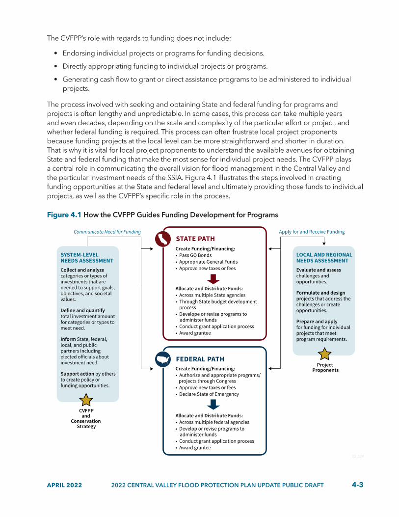
APRIL 2022 2022 CENTRAL VALLEY FLOOD PROTECTION PLAN UPDATE PUBLIC DRAFT 4-3
The CVFPP’s role with regards to funding does not include:
• Endorsing individual projects or programs for funding decisions.
• Directly appropriating funding to individual projects or programs.
• Generating cash flow to grant or direct assistance programs to be administered to individual projects.
The process involved with seeking and obtaining State and federal funding for programs and projects is often lengthy and unpredictable. In some cases, this process can take multiple years and even decades, depending on the scale and complexity of the particular effort or project, and whether federal funding is required. This process can often frustrate local project proponents because funding projects at the local level can be more straightforward and shorter in duration. That is why it is vital for local project proponents to understand the available avenues for obtaining State and federal funding that make the most sense for individual project needs. The CVFPP plays a central role in communicating the overall vision for flood management in the Central Valley and the particular investment needs of the SSIA. Figure 4.1 illustrates the steps involved in creating funding opportunities at the State and federal level and ultimately providing those funds to individual projects, as well as the CVFPP’s specific role in the process.
Figure 4.1 How the CVFPP Guides Funding Development for Programs
SYSTEM-LEVEL NEEDS ASSESSMENT Collect and analyze categories or types of investments that are needed to support goals, objectives, and societal values.
Define and quantify total investment amount for categories or types to meet need.
Inform State, federal, local, and public partners including elected officials about investment need.
Support action by others to create policy or funding opportunities.
LOCAL AND REGIONAL NEEDS ASSESSMENTEvaluate and assess challenges and opportunities.
Formulate and designprojects that address the challenges or create opportunities.
Prepare and apply for funding for individual projects that meet program requirements.
Create Funding/Financing:• Pass GO Bonds• Appropriate General Funds• Approve new taxes or fees
Allocate and Distribute Funds:• Across multiple State agencies• Through State budget development process • Develope or revise programs to administer funds• Conduct grant application process• Award grantee
Create Funding/Financing:• Authorize and appropriate programs/ projects through Congress • Approve new taxes or fees• Declare State of Emergency
Allocate and Distribute Funds:• Across multiple federal agencies• Develop or revise programs to administer funds• Conduct grant application process• Award grantee
CVFPPand
Conservation Strategy
Communicate Need for Funding
Project Proponents
Apply for and Receive Funding
22_124
STATE PATH
FEDERAL PATH

4-4 2022 CENTRAL VALLEY FLOOD PROTECTION PLAN UPDATE PUBLIC DRAFT APRIL 2022
4.2 Investment CostsInvestments in management actions that provide a reasonable and balanced vision of improvements for Central Valley flood management is recommended for the 2022 CVFPP Update. These improvements are intended to be implemented at a systemwide scale for urban, rural, and small communities over a 30–year period after further analysis is complete (e.g., feasibility, environmental, and detailed project–level analyses).
CVFPP investment is divided into two types: ongoing and capital. Many management actions require capital investment, whereas others require ongoing, annual investment sustained over time. Some management actions require both ongoing and capital investments, such as construction of a new weir and operation and maintenance (O&M) of the weir over time. Because funding for these two types of investments is often derived from different sources, they are calculated and discussed separately:
• Ongoing investments are described in terms of annual levels of investment. Examples of ongoing investments are those that reduce residual risk such as annual O&M, annual emergency management, routine reservoir operation coordination, and annual State flood planning and analysis. It is important to note that changes in capital investments may also affect ongoing investments based on the nature of the capital improvement, for example, a new SPFC facility needing additional O&M.
• Capital investment in flood system improvements, which often requires years to implement, are described in terms of present value cost. Examples of capital investments are those that increase flood system resiliency such as bypass expansions, weir and levee improvements, reservoir storage capacity increases, floodplain storage increases, levee setbacks and habitat reconnection actions, and large rehabilitation and replacement projects that are the result of either storm damage, infrequent life–cycle management of facilities, or backlogged deferred maintenance activities.
Acknowledging and separating ongoing investments and capital investments is useful in identifying funding shortfalls, appropriate funding mechanisms, and establishing recommended priorities for funding. Ongoing investments provide the annual baseline funding needed for routine activities, whereas capital investments are one–time investments that generally involve construction or infrastructure expansion.
The total estimated investment need for ongoing investments is approximately $315 to $385 million per year, and the capital investment need is approximately $19 to $23 billion over 30 years. Together, the cost estimates indicate a total present value (2021 dollars) investment need of approximately $25 to $30 billion over the next 30 years (see Figure 4.2). These estimated costs represent the best understanding of costs related to the 2022 SSIA portfolio at this time. To that end, the SSIA is an overall approach to investments and will continue to be updated and refined as the CVFPP progresses in implementation.

APRIL 2022 2022 CENTRAL VALLEY FLOOD PROTECTION PLAN UPDATE PUBLIC DRAFT 4-5
Figure 4.2 CVFPP Investment Needs
ONGOINGINVESTMENTS
CAPITALINVESTMENTS
One-time funding for construction or improvements:
Annual funding forroutine activities:
22_110
$315 to $385 million per year $19 to $23 billion
$25 to $30 Billion CVFPP Investment over 30 years
4.2.1 Estimating Portfolio Costs
Building from the 2017 CVFPP Update, costs were updated from multiple planning and implementation efforts from State, federal, and local sources. These efforts provided a basis for estimating total costs for the broad portfolio of management actions within the SSIA. The primary sources of information for these updates include DWR’s Systemwide Flood Risk Reduction Program, Urban Flood Risk Reduction Program, and the six regional flood management planning regions. Additionally, DWR’s flood emergency response programs and flood system O&M programs provided updated costs. The six regions were engaged in a year–long process with DWR to update their regional portfolios of management actions and their associated costs to support the total cost estimate for the 2022 SSIA portfolio.
Overall, the investment needs from the 2017 CVFPP Update have increased for both ongoing and capital investments. This increase is attributable to additional detail provided for proposed actions from the 2017 refined SSIA portfolio and new actions introduced in this Update cycle, many of which are high priority to address the increasingly urgent impacts of climate change. Investment need increases are also the result of more complete data for deferred maintenance including operation, maintenance, repair, rehabilitation, and replacement (OMRR&R); and the occurrence of storm damages during the winter of 2017–2018. Escalation of previous cost estimates also contributes to an increase in overall investment needs. All costs collected for the 2022 CVFPP Update have been consistently escalated to Quarter 1 2021 dollars. In total, escalation accounts for approximately $650 million since 2017 estimates were made.
The investment needs for the 2022 CVFPP Update do not include life–cycle replacement costs for all SPFC facilities comprehensively, but replacements for some known facilities are included. A full assessment of SPFC facilities and their replacement schedules would need to be conducted for an accurate cost to be estimated across the system. Flood facilities typically have a life cycle of 30 to 50 years; many facilities in the SPFC are older than that. The cost to perform annual maintenance also increases over the life cycle of individual flood facilities, as the facility degrades over time. Additionally, it is common for land use in the floodplain to change over the facility’s life cycle; this change can impact the costs and funding available to operate and maintain it. In locations where continued annual O&M is demonstrated to be economically infeasible, the CVFPP promotes consideration of governance changes coupled with broader multi–benefit solutions, where feasible, to improve systemwide climate resilience.
4-6 2022 CENTRAL VALLEY FLOOD PROTECTION PLAN UPDATE PUBLIC DRAFT APRIL 2022
4.2.2 Ongoing Investments Costs Over 30 Years
Ongoing investments within the 2022 SSIA portfolio are estimated to range in cost from $315 to $385 million annually. Ongoing investments are discussed in annualized dollar values throughout this section. This estimate is informed by the same efforts as described in Section 4.2.1. Cost estimates for each management action category within the four areas of interest are shown in Table 4.1.
Some key updates to the ongoing investments for the 2022 CVFPP Update include changes to the approach for inclusion of OMRR&R costs. In the 2017 CVFPP Update, OMRR&R costs were included in the ongoing investments under the routine maintenance category. With more clarity on deferred maintenance from regional partners and more specificity on repair, rehabilitation, and replacement with the passage of the Central Valley Flood Protection Board’s (CVFPB’s) Resolution No. 2018–06, deferred maintenance costs were shifted to the capital investment. This shift leaves the ongoing investments for annual O&M to include annual routine activities such as channel vegetation management, sediment management, and inspections. Section 4.2.3 describes what deferred maintenance activities are now included in the capital investment. OMRR&R costs, whether included in the ongoing or capital investments, represent activities performed on SPFC facilities by local maintaining agencies (LMAs) or DWR’s Flood Maintenance and Operations Branch (Division of Flood Management) and exclude costs associated with O&M of reservoirs, other non-SPFC facilities, and other State facilities.

APRIL 2022 2022 CENTRAL VALLEY FLOOD PROTECTION PLAN UPDATE PUBLIC DRAFT 4-7
Table 4.1 Ongoing Investments of the 2022 SSIA Portfolio Per Year (shown in 2021 millions of dollars)
Area of Interest Management Action Category
Sacramento Low
Sacramento High
San Joaquin Low
San Joaquin High
Total Low
Total High
Systemwide
State operations, planning, and performance tracking $41 $50 $41 $50 $82 $100
Systemwide risk assessments $22 $28 $27 $33 $49 $61
Emergency management $8 $10 $9 $10 $17 $20
Reservoir operations $4 $4 $19 $23 $23 $27
Annual operations and maintenance $43 $53 $27 $33 $70 $86
Flood management policy actions $15 $18 $18 $22 $33 $40
Subtotal $133 $163 $141 $171 $274 $334
Urban
Risk awareness, floodproofing and land use planning $4 $5 $7 $9 $11 $14
Studies and analysis $1 $1 $1 $2 $2 $3
Subtotal $5 $6 $8 $11 $13 $17
Rural
Risk awareness, floodproofing and land use planning $2 $2 $3 $3 $5 $5
Studies and analysis $1 $1 $1 $1 $2 $2
Subtotal $3 $3 $4 $4 $7 $7
Small Community
Risk awareness, floodproofing and land use planning $14 $17 $6 $8 $20 $25
Studies and analysis $1 $1 $0 $0 $1 $1
Subtotal $15 $18 $6 $8 $21 $26
Ongoing Total $156 $190 $159 $194 $315 $384
Notes:• All estimated dollar values are in Quarter 1 2021 dollars and indicate annual investments made over 30 years. They have not
been discounted to present value nor escalated for inflation. • Cost estimate sources included in this table are regional flood management planning regions, DWR’s flood emergency
response programs, flood system operations and maintenance programs, among other DWR programs. • Cost estimates for flood management policy actions are still under development.• Spent-to-date costs have been removed from actions that are in progress or completed.

4-8 2022 CENTRAL VALLEY FLOOD PROTECTION PLAN UPDATE PUBLIC DRAFT APRIL 2022
Policy Spotlight: Defining Annual Operation and Maintenance and Deferred Maintenance
Compilation of OMRR&R costs and expenditures has progressed since the 2017 CVFPP Update, and the publication of the Long-term Operations, Maintenance, Repair, Rehabilitation, and Replacement Cost Evaluation Technical Memorandum (California Department of Water Resources 2017). Further refinements and clarity have been developed for activities associated with annual O&M and deferred maintenance, including the costs of those activities.
Development of routine (i.e., annual) costs for OMRR&R of the SPFC through updates to unit costs aids in the recognition of the funding limitations and corresponding constraints on these activities. Further, actual OMRR&R spending tends to be significantly less than that required to ensure all facilities are in and remain in good working order. This estimate, however, is separate than deferred maintenance costs because the estimate does not include the cost of the backlog of deferred activities still to be addressed. The deferred activities are the result of funding constraints, increased environmental compliance requirements, and changing regulatory standards. With OMRR&R expenditures falling short of these costs, the backlog of deferred activities continues to grow. As such, the 2022 CVFPP Update defines annual O&M and deferred maintenance in the context of OMRR&R and provides estimates included in the 2022 SSIA portfolio.
Summary of Annual O&M and Deferred Maintenance within the CVFPP Investment Strategy
Parameter Annual Operation and Maintenance Deferred MaintenanceDefinition Routine activities to be performed on an annual basis
and typically paid for by annual budgets. Routine and non-routine activities that are typically beyond the capacity of annual budgets or resource levels and are longer in duration to execute.
Example Actions and Activities
Levee and channel O&M, channel sediment removal, channel vegetation removal, annual inspections, levee crown and access road maintenance, and more.
Note: Reservoir O&M is not included.
Levee stability and bank and erosion repairs, giant reed removal, pipe penetrations repair or removal, major structure repairs (such as pump stations), recent storm damage rehabilitation, and more.
Note: Legacy system and seepage deficiencies are not included.
Average annual expenditures
$48 million per year is the average annual expenditure from FY 2011–2012 through FY 2020–2021 (provided in nominal dollars). Maximum expenditure is $77 million per year in FY 2020–2021. Includes both DWR and LMA expenditures.
$23 million per year is the average annual expenditure from FY 2011–2012 through FY 2020–2021 (provided in nominal dollars). Maximum expenditure is $34 million per year in FY 2019–2020. Includes only DWR expenditures. LMA expenditures have not been quantified.
Investment need included in the 2022 SSIA portfolio
$70 to $86 million per year is the estimated annual investment need over the next 30 years (provided in Q1 2021 dollars). This annual amount is inclusive of DWR and LMA investment needs.
$2.7 to $3.3 billion is the estimated investment need over the next 30 years (provided in Q1 2021 dollars). This amount is inclusive of State and local investment needs.
Investment need development methodology
Primarily based on unit costs and units developed by the 2017 OMRR&R workgroup updated in 2021 by RFMPs and DWR.
Primarily based on the collection of individual projects and actions provided in 2021 by RFMPs and DWR.
Notes: DWR = California Department of Water Resources; FY = fiscal year; LMA = local maintaining agency; O&M = operations and maintenance; OMRR&R = operation, maintenance, repair, rehabilitation, and replacement; Q1 = quarter 1; RFMP = regional flood management plan; SSIA = State Systemwide Investment Approach

APRIL 2022 2022 CENTRAL VALLEY FLOOD PROTECTION PLAN UPDATE PUBLIC DRAFT 4-9
Other key management action categories included in ongoing investments:
• State operations, planning, and performance tracking; systemwide risk assessments; and flood management policy actions. These categories are intended to provide the enabling conditions for effective CVFPP implementation over 30 years. Costs include activities such as State administration of program activities, planning and coordinating with federal and local agencies, development and implementation of a performance tracking system; conducting studies such as flood risk and climate adaptation; and advancement of the high-priority policy recommendations included in Table 3-3. Systemwide risk assessments and flood management policy actions were embedded in the State operations, planning, and performance tracking and emergency management categories in 2017. For 2022, these action policies have been separated and updated with new cost information.
• Emergency Management. Includes refreshing flood fight supplies, updating flood information systems and data, exercising and equipping the State’s flood emergency response teams, and performing emergency levee patrols.
• Reservoir Operations. Includes forecast-coordinated operations, forecast informed reservoir operations, installing new forecast points, and installing gauges at ungated spillways and new upstream gauges.
• Risk awareness, floodproofing, and land use planning. Includes floodplain risk management programs and activities, floodplain mapping, development and support of National Flood Insurance Program (NFIP) agricultural zones, floodproofing of residential and agricultural structures, and restructuring of county building codes and land use practices.
• Studies and analyses. Includes feasibility studies and related modeling or analyses that assist project planning and designs for urban, rural, and small community areas of interest.
In 2017, ongoing investments were ramped up over three 10–year phases of the 30-year planning horizon to allow resource and institutional capacity building for State, federal, and local partners. This investment structure is different than capital investments because ongoing investments are baseline funding needed over time and meant to be sustained throughout the phases of implementation. Additionally, ongoing investments are assumed to be fully ramped up by the end of the planning horizon.
Figure 4.3 tracks the pace of actual expenditures compared to the recommended levels of ongoing investments. With some progress made since 2017, notably a $25 million annual general fund baseline increase for OMRR&R activities, ongoing expenditure levels are meeting recommended levels. But, it is critical that the rate of increase (approximately $7 million per year) be maintained throughout the next 10 years to achieve the recommended level by 2032.
• Actual average expenditures as of December 2021 are approximately $162 million per year for all ongoing management action types. Only State expenditures are included at this time.
• By 2027, the ongoing investment need was estimated (in 2016) to increase to $199 million per year from the baseline expenditures of $116 million per year in 2016.
• By 2032, the recommended investment need is $238 million per year, an increase of approximately $40 million per year since 2017.
The nature of a rolling 30-year planning horizon affords a five-year overlap between the previous and next Update cycle. For example, in the 2022 CVFPP Update, years 2022–2032 overlap with the

4-10 2022 CENTRAL VALLEY FLOOD PROTECTION PLAN UPDATE PUBLIC DRAFT APRIL 2022
previous 2017 CVFPP Update’s years 2017–2027. This overlap is intentional to track progress and project future needs at a smaller timescale than the full 30-year planning horizon.
Figure 4.3 Trend of Ongoing Investment Expenditures and Recommended Increases (shown in nominal millions of dollars)
Millions of Dollars
2016 2021 2027 2032
$117Average Expenditure
$162Average Expenditure
$199Recommended Investment Level
$238Recommended Investment Level
22_202_A
$0
$50
$100
$150
$200
$250
Notes:• 2027 recommended annual investment levels are based off the high end of years 2017–2027 estimate in the 2017 CVFPP
Update. Dollars are shown in 2016 dollars. • 2032 recommended annual investment levels are based off the high end of years 2022–2032 estimates for the 2022 CVFPP
Update. Dollars are shown in 2021 dollars.
4.2.3 Capital Investments Costs Over 30 Years
Capital investments within the 2022 SSIA portfolio are estimated to range in cost from approximately $19 to $23 billion over the next 30 years. This estimate is informed by the efforts described in Section 4.2.1. Cost estimates for each management action category within the four areas of interest are shown in Table 4.2.
The estimated capital investment costs include several large systemwide projects within the Central Valley. These projects include proposed multi-benefit investments in the Yolo Bypass (e.g., Upper Elkhorn levee setback, Fremont Weir expansion), Paradise Cut multi-benefit improvements, Folsom Dam raise project, Atmospheric River Control Spillway project at New Bullard’s Bar, among others.
It is important to note that the 2022 SSIA portfolio contributes to outcomes associated with the ecosystem vitality societal value as guided by the Conservation Strategy and ecosystem improvements are embedded mostly within larger–scale activities such as the systemwide multi–benefit improvement programs. But, further contributions to ecosystem vitality are expected through the rural and small community capital management action categories of small–scale levee setbacks and floodplain storage.
As discussed previously in Section 4.2.2, deferred maintenance and OMRR&R activities were shifted to the capital investments estimate and included under the Deferred Maintenance category for the 2022 CVFPP Update. Specifically, this shift included moving deferred maintenance on facilities described in California Water Code Sections 8361, 12878, and 8370 facilities, and actions associated

APRIL 2022 2022 CENTRAL VALLEY FLOOD PROTECTION PLAN UPDATE PUBLIC DRAFT 4-11
with Systemwide Improvement Frameworks and Letters of Intent for the U.S. Army Corps of Engineers’ (USACE’s) Public Law 84–99 rehabilitation program. Additionally, repair, rehabilitation, and replacement activities such as pipe penetration repairs; levee erosion, stability, freeboard, geometry, and subsidence repairs; channel giant reed (Arundo donax) removal; and recent storm damage rehabilitation are included in the capital investments estimate and included under the Deferred Maintenance category.
Levee projects associated with legacy system deficiency rehabilitation, seepage deficiencies, or improvements that increase the level of protection, where appropriate, are also included in the capital investments estimate. These actions are included in the Levee Improvements category for urban and the levee repair and infrastructure improvements category for rural and small communities, rather than the Deferred Maintenance category. Otherwise, all deferred maintenance activities are included in the systemwide category and not split out among urban, rural, and small community areas of interest.
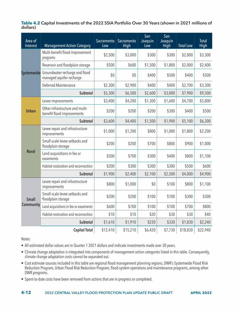
4-12 2022 CENTRAL VALLEY FLOOD PROTECTION PLAN UPDATE PUBLIC DRAFT APRIL 2022
Table 4.2 Capital Investments of the 2022 SSIA Portfolio Over 30 Years (shown in 2021 millions of dollars)
Area of Interest Management Action Category
Sacramento Low
Sacramento High
San Joaquin
Low
San Joaquin
High Total LowTotal High
Systemwide
Multi-benefit flood improvement programs $2,500 $3,000 $300 $300 $2,800 $3,300
Reservoir and floodplain storage $500 $600 $1,500 $1,800 $2,000 $2,400
Groundwater recharge and flood managed aquifer recharge $0 $0 $400 $500 $400 $500
Deferred Maintenance $2,300 $2,900 $400 $400 $2,700 $3,300
Subtotal $5,300 $6,500 $2,600 $3,000 $7,900 $9,500
Urban
Levee improvements $3,400 $4,200 $1,300 $1,600 $4,700 $5,800
Other infrastructure and multi-benefit flood improvements $200 $200 $200 $300 $400 $500
Subtotal $3,600 $4,400 $1,500 $1,900 $5,100 $6,300
Rural
Levee repair and infrastructure improvements $1,000 $1,200 $800 $1,000 $1,800 $2,200
Small-scale levee setbacks and floodplain storage $200 $200 $700 $800 $900 $1,000
Land acquisitions in fee or easements $500 $700 $300 $400 $800 $1,100
Habitat restoration and reconnection $200 $300 $300 $300 $500 $600
Subtotal $1,900 $2,400 $2,100 $2,500 $4,000 $4,900
Small Community
Levee repair and infrastructure improvements $800 $1,000 $0 $100 $800 $1,100
Small-scale levee setbacks and floodplain storage $200 $200 $100 $100 $300 $300
Land acquisitions in fee or easements $600 $700 $100 $100 $700 $800
Habitat restoration and reconnection $10 $10 $20 $30 $30 $40
Subtotal $1,610 $1,910 $220 $330 $1,830 $2,240
Capital Total $12,410 $15,210 $6,420 $7,730 $18,830 $22,940
Notes: • All estimated dollar values are in Quarter 1 2021 dollars and indicate investments made over 30 years.• Climate change adaptation is integrated into components of management action categories listed in this table. Consequently,
climate change adaptation costs cannot be separated out. • Cost estimate sources included in this table are regional flood management planning regions, DWR’s Systemwide Flood Risk
Reduction Program, Urban Flood Risk Reduction Program, flood system operations and maintenance programs, among other DWR programs.
• Spent-to-date costs have been removed from actions that are in progress or completed.

APRIL 2022 2022 CENTRAL VALLEY FLOOD PROTECTION PLAN UPDATE PUBLIC DRAFT 4-13
Figure 4.4 provides a summary of the amount of the capital investment portfolio that has been completed (spent–to–date) and the amount that is in progress or not yet started. The estimated total expenditure on completed capital actions is approximately $2.6 billion. The estimated amount for actions in progress or yet to be started is approximately $19 to $23 billion. These estimates include investments identified in 2017 that remain to be completed, as well as investments newly identified through the 2022 CVFPP Update cycle. Although system configurations analyzed in the technical analyses were unchanged for the 2022 CVFPP Update (see Chapter 3), updates in cost were made to account for the effects of completed projects with the best available information in 2021. All estimates have been escalated to Quarter 1 2021 dollars for summation.
Figure 4.4 2022 CVFPP Update Capital Investment Portfolio Status (shown in 2021 billions of dollars)
22_203_A
$2.6 BillionComplete Capital Actions
$19 – $23 BillionCapital Actions In-progress
or Not Started Yet
4.3 Funding Mechanisms and Cost–SharesContributions from all three levels of government — State, federal, and local — are needed to fund implementation of the CVFPP using existing and new funding mechanisms. In 2017, all cost–sharing partners were asked to contribute significantly more than they had in the past, because historical expenditure amounts (before Propositions 1E and 84) would fund approximately 20 percent of needed investments.
A variety of existing and new funding mechanisms were considered for funding sources in the 2017 CVFPP Update. These new funding mechanisms are now in various stages of development and could play a critical role in securing consistent and ongoing funding when conventional sources are unavailable. For the 2022 CVFPP Update, existing and in-development funding mechanisms were reexamined to consider how well they were meeting the funding needs estimated in the 2017 CVFPP Update’s funding plan and to reconsider their viability for the 2022 CVFPP Update funding plan. Additionally, historical expenditures of State, federal, and local sources are presented as a basis for the recommended cost–shares percentages for the 2022 CVFPP Update funding plan. These historical expenditures have been updated from 2017 to include the last five years of expenditures to better articulate spending trends and inform recommended partner contributions.
4.3.1 Summary of 2017 Funding Mechanisms Progress
An overview of progress to date on contributions from the recommended funding mechanisms from the 2017 CVFPP Update is provided in Table 4.3. Increased funding in the past several years

4-14 2022 CENTRAL VALLEY FLOOD PROTECTION PLAN UPDATE PUBLIC DRAFT APRIL 2022
has been made available to State, federal, and local partners to promote awareness to flood management needs. This additional funding has primarily consisted of new appropriations from the State general fund and Proposition 68. Storm events in water years 2016–2017 and 2017–2018 highlighted the needed investments for deferred maintenance and the importance of O&M and associated funding needs.
Funding contributions made by the recommended mechanisms from the 2017 CVFPP Update have been tracked. Funding trends indicate that the required funding amounts are behind 2017 recommended levels for CVFPP implementation. Consequently, significantly increased investments from all State, federal, and local partners, specifically for capital investments, will have to be expedited to catch up to the near-term implementation pace of expenditures that are recommended by 2032. There is past precedent for State, federal, and local partners to provide more flood management funding as indicated by historical expenditures.
Policy Spotlight: FEMA’s National Flood Insurance Policy changes and Risk Rating 2.0
Risk Rating 2.0 represents the biggest change to calculating NFIP flood insurance premiums since 1968. The Federal Emergency Management Agency (FEMA) initiated a new flood insurance pricing methodology called “Risk Rating 2.0,” effective October 1, 2021, for all new policies and effective April 1, 2022, for existing policies. This new pricing methodology is an effort by FEMA to redesign how a property’s flood risk and flood insurance rates are determined under the NFIP. The goal of Risk Rating 2.0 is to better represent differences in flood risk within special flood hazard areas as well as in various watersheds across the nation. Under Risk Rating 2.0, premiums are calculated to reflect an individual property’s specific flood risk, including the potential for multiple types of risk, contrasted to being placed in a general risk category based on property type and location. Under this new pricing procedure, the initial rates in many areas of the Central Valley are increasing. State and local agencies will work with FEMA to better understand the risk methodology assumptions and data used in Risk Rating 2.0. The goal is to provide more accurate data to FEMA and to reduce long-term insurance costs for Central Valley residents.
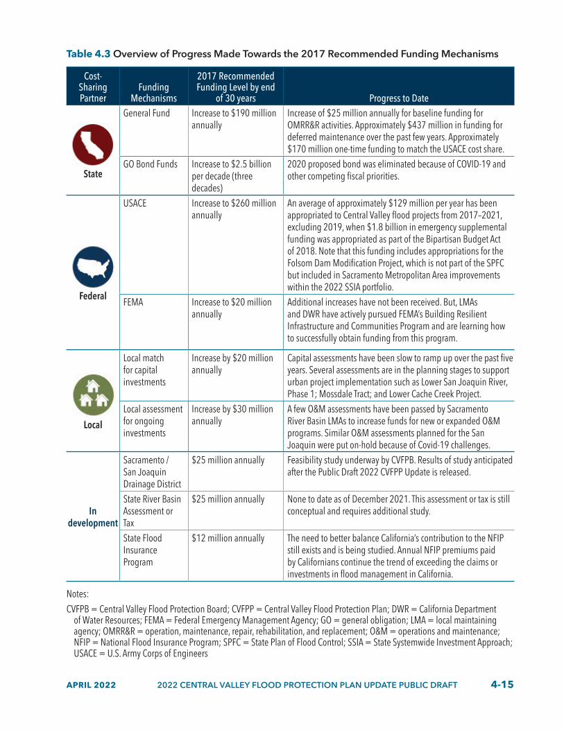
APRIL 2022 2022 CENTRAL VALLEY FLOOD PROTECTION PLAN UPDATE PUBLIC DRAFT 4-15
Table 4.3 Overview of Progress Made Towards the 2017 Recommended Funding Mechanisms
Cost-Sharing Partner
Funding Mechanisms
2017 Recommended Funding Level by end
of 30 years Progress to Date
State
General Fund Increase to $190 million annually
Increase of $25 million annually for baseline funding for OMRR&R activities. Approximately $437 million in funding for deferred maintenance over the past few years. Approximately $170 million one-time funding to match the USACE cost share.
GO Bond Funds Increase to $2.5 billion per decade (three decades)
2020 proposed bond was eliminated because of COVID-19 and other competing fiscal priorities.
Federal
USACE Increase to $260 million annually
An average of approximately $129 million per year has been appropriated to Central Valley flood projects from 2017–2021, excluding 2019, when $1.8 billion in emergency supplemental funding was appropriated as part of the Bipartisan Budget Act of 2018. Note that this funding includes appropriations for the Folsom Dam Modification Project, which is not part of the SPFC but included in Sacramento Metropolitan Area improvements within the 2022 SSIA portfolio.
FEMA Increase to $20 million annually
Additional increases have not been received. But, LMAs and DWR have actively pursued FEMA’s Building Resilient Infrastructure and Communities Program and are learning how to successfully obtain funding from this program.
Local
Local match for capital investments
Increase by $20 million annually
Capital assessments have been slow to ramp up over the past five years. Several assessments are in the planning stages to support urban project implementation such as Lower San Joaquin River, Phase 1; Mossdale Tract; and Lower Cache Creek Project.
Local assessment for ongoing investments
Increase by $30 million annually
A few O&M assessments have been passed by Sacramento River Basin LMAs to increase funds for new or expanded O&M programs. Similar O&M assessments planned for the San Joaquin were put on-hold because of Covid-19 challenges.
In development
Sacramento /San Joaquin Drainage District
$25 million annually Feasibility study underway by CVFPB. Results of study anticipated after the Public Draft 2022 CVFPP Update is released.
State River Basin Assessment or Tax
$25 million annually None to date as of December 2021. This assessment or tax is still conceptual and requires additional study.
State Flood Insurance Program
$12 million annually The need to better balance California’s contribution to the NFIP still exists and is being studied. Annual NFIP premiums paid by Californians continue the trend of exceeding the claims or investments in flood management in California.
Notes: CVFPB = Central Valley Flood Protection Board; CVFPP = Central Valley Flood Protection Plan; DWR = California Department
of Water Resources; FEMA = Federal Emergency Management Agency; GO = general obligation; LMA = local maintaining agency; OMRR&R = operation, maintenance, repair, rehabilitation, and replacement; O&M = operations and maintenance; NFIP = National Flood Insurance Program; SPFC = State Plan of Flood Control; SSIA = State Systemwide Investment Approach; USACE = U.S. Army Corps of Engineers
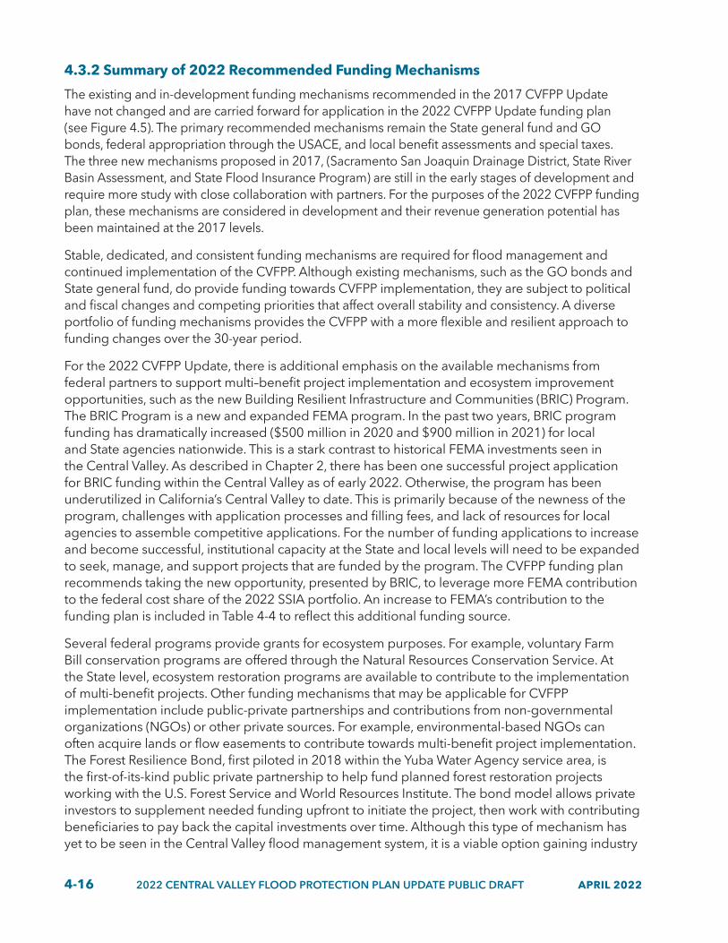
4-16 2022 CENTRAL VALLEY FLOOD PROTECTION PLAN UPDATE PUBLIC DRAFT APRIL 2022
4.3.2 Summary of 2022 Recommended Funding Mechanisms
The existing and in-development funding mechanisms recommended in the 2017 CVFPP Update have not changed and are carried forward for application in the 2022 CVFPP Update funding plan (see Figure 4.5). The primary recommended mechanisms remain the State general fund and GO bonds, federal appropriation through the USACE, and local benefit assessments and special taxes. The three new mechanisms proposed in 2017, (Sacramento San Joaquin Drainage District, State River Basin Assessment, and State Flood Insurance Program) are still in the early stages of development and require more study with close collaboration with partners. For the purposes of the 2022 CVFPP funding plan, these mechanisms are considered in development and their revenue generation potential has been maintained at the 2017 levels.
Stable, dedicated, and consistent funding mechanisms are required for flood management and continued implementation of the CVFPP. Although existing mechanisms, such as the GO bonds and State general fund, do provide funding towards CVFPP implementation, they are subject to political and fiscal changes and competing priorities that affect overall stability and consistency. A diverse portfolio of funding mechanisms provides the CVFPP with a more flexible and resilient approach to funding changes over the 30-year period.
For the 2022 CVFPP Update, there is additional emphasis on the available mechanisms from federal partners to support multi–benefit project implementation and ecosystem improvement opportunities, such as the new Building Resilient Infrastructure and Communities (BRIC) Program. The BRIC Program is a new and expanded FEMA program. In the past two years, BRIC program funding has dramatically increased ($500 million in 2020 and $900 million in 2021) for local and State agencies nationwide. This is a stark contrast to historical FEMA investments seen in the Central Valley. As described in Chapter 2, there has been one successful project application for BRIC funding within the Central Valley as of early 2022. Otherwise, the program has been underutilized in California’s Central Valley to date. This is primarily because of the newness of the program, challenges with application processes and filling fees, and lack of resources for local agencies to assemble competitive applications. For the number of funding applications to increase and become successful, institutional capacity at the State and local levels will need to be expanded to seek, manage, and support projects that are funded by the program. The CVFPP funding plan recommends taking the new opportunity, presented by BRIC, to leverage more FEMA contribution to the federal cost share of the 2022 SSIA portfolio. An increase to FEMA’s contribution to the funding plan is included in Table 4-4 to reflect this additional funding source.
Several federal programs provide grants for ecosystem purposes. For example, voluntary Farm Bill conservation programs are offered through the Natural Resources Conservation Service. At the State level, ecosystem restoration programs are available to contribute to the implementation of multi-benefit projects. Other funding mechanisms that may be applicable for CVFPP implementation include public-private partnerships and contributions from non-governmental organizations (NGOs) or other private sources. For example, environmental-based NGOs can often acquire lands or flow easements to contribute towards multi-benefit project implementation. The Forest Resilience Bond, first piloted in 2018 within the Yuba Water Agency service area, is the first-of-its-kind public private partnership to help fund planned forest restoration projects working with the U.S. Forest Service and World Resources Institute. The bond model allows private investors to supplement needed funding upfront to initiate the project, then work with contributing beneficiaries to pay back the capital investments over time. Although this type of mechanism has yet to be seen in the Central Valley flood management system, it is a viable option gaining industry

APRIL 2022 2022 CENTRAL VALLEY FLOOD PROTECTION PLAN UPDATE PUBLIC DRAFT 4-17
attention and interest. These specific mechanisms are not included in the CVFPP funding plan, but they may be applicable to the individual projects implemented consistent with the CVFPP.
Figure 4.5 2022 CVFPP Update Recommended Funding Mechanisms
22_112
Sacramento/San JoaquinDrainage District
USACE Programs
FEMA Programs
FEDERAL
• Reutilize this district, originally established in 1911.
STATE
General Fund
General Obligation Bond
Benefit Assessments
Special Taxes
LOCAL
• Generate revenue for operations and maintenance and local share of capital improvements.
• Establish river basin specific assessments or taxes across the State.
• Generate and return revenue to individual river basins to be shared across all integrated water management activities in that watershed.
• Augment/replace the National Flood Insurance Program (NFIP) with a State-led program.
• Generate revenue for insurance protection and investment to lower flood risk.
State Flood Insurance Program
River BasinAssessment or Tax
IN-DEVELOPMENT
The following section describes the funding mechanisms that are applied to the 2022 CVFPP Update funding plan for State, federal, and local sources. Additionally, updated average historical expenditures of State, federal, and local sources are presented to establish a basis for the proposed contribution to the CVFPP (see Figure 4.6). Revenue generation potential for each funding mechanism that potentially could be invested in the 2022 SSIA portfolio was estimated based on past expenditures, when applicable. The proposed funding contribution from each level of government for cost sharing over the 30–year timeframe is described in Table 4.4.
• State: State flood management expenditures in the Central Valley are primarily from State appropriations managed by the DWR Division of Flood Management (DFM) and DWR Division of Multi–benefit Initiatives (DMI). DFM and DMI’s main sources of appropriations are the State general fund and GO bonds.
• Federal: Federal flood management expenditures in the Central Valley are primarily from federal appropriations managed by the USACE and historically have provided large contributions to federal–State sponsored projects. Historically, FEMA has provided smaller contributions of overall funds but has recently increased this funding through several new programs.
• Local: Local flood management expenditures in the Central Valley are primarily from Cities, Counties, and special districts with flood management responsibilities. Special districts account for a majority of local contributions through special benefit assessments and taxes.
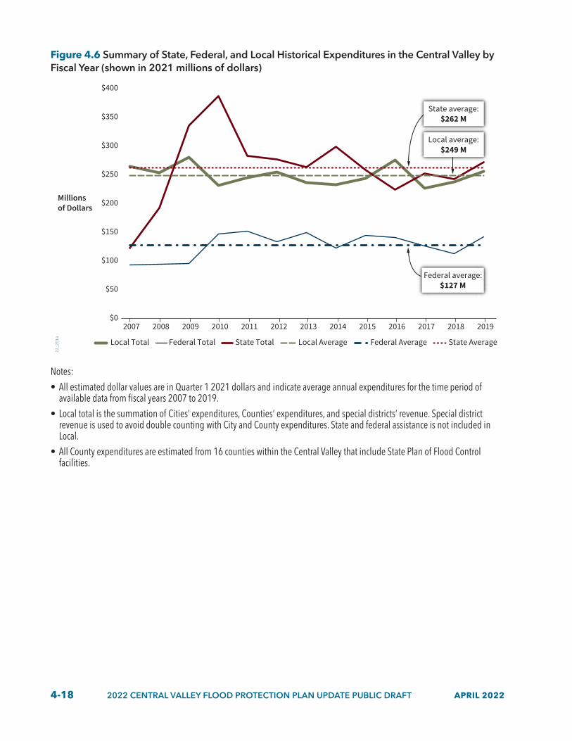
4-18 2022 CENTRAL VALLEY FLOOD PROTECTION PLAN UPDATE PUBLIC DRAFT APRIL 2022
Figure 4.6 Summary of State, Federal, and Local Historical Expenditures in the Central Valley by Fiscal Year (shown in 2021 millions of dollars)
22_2
01a
Local Total Federal Total State Total Local Average Federal Average State Average
$0
$50
$100
$150
$200
$250
$300
$350
$400
2007 2008 2009 2010 2011 2012 2013 2014 2015 2016 2017 2018 2019
Millionsof Dollars
Federal average: $127 M
State average: $262 M
Local average: $249 M
Notes:• All estimated dollar values are in Quarter 1 2021 dollars and indicate average annual expenditures for the time period of
available data from fiscal years 2007 to 2019.• Local total is the summation of Cities’ expenditures, Counties’ expenditures, and special districts’ revenue. Special district
revenue is used to avoid double counting with City and County expenditures. State and federal assistance is not included in Local.
• All County expenditures are estimated from 16 counties within the Central Valley that include State Plan of Flood Control facilities.

APRIL 2022 2022 CENTRAL VALLEY FLOOD PROTECTION PLAN UPDATE PUBLIC DRAFT 4-19
Table 4.4 Recommended Funding Mechanisms and Historical Expenditures
Funding Mechanism Description Historical Expenditures
(2007–2019)
Revenue Generation Potential for 2022
SSIA PortfolioState General
FundTraditionally funded some flood management. Historical expenditures are based on DWR’s General Fund 32-45 Public Safety and Prevention of Damage Program Area. The CVFPP funding plan recommends increasing general fund appropriations.
Average: $52 million per year.
Maximum: $118 million per year (2018).
Minimum: $34 million per year (2013).
$220 million per year.
State General Obligation
Bonds
Traditionally funded flood management. The CVFPP funding plan recommends increasing bond issuance once a decade. This mechanism would require time to prepare language for the bond measure for the statewide vote, as well as a two-year lag before funds would be available after passage.
Average: $210 million per year.
Maximum: $348 million per year (2010).
Minimum: $78 million per year (2007).
$300 million per year.
USACE Programs
The WRDA authorizes the Secretary of the Army to study and implement various projects and programs for improvements and other purposes to rivers and harbors of the United States. In California, the majority of federal flood protection projects are the responsibility of the USACE. Federal authorized funds would require appropriation by Congress.
Average: $108 million per year.
Maximum: $139 million per year (2011).
Minimum: $71 million per year (2018).
$355 million per year.
FEMA Programs
FEMA is the disaster response agency of the federal government. FEMA provides State and local governments with funding for emergency preparedness programs in the form of non–disaster grants.
Average: $20 million per year. Data is unavailable for 2007 and 2008.
Maximum: $44 million per year (2019).
Minimum: $12 million per year (2011).
$100 million per year.
Local Benefit Assessments and Special
Taxes
The typical mechanism for funding local activities. Increases to benefit assessments and special taxes would require a property owner or a registered voter vote (depending upon specific circumstances). Benefit assessments could be limited and not able to fund general benefits such as habitat restoration.
Average: $249 million per year.1
Maximum: $280 million per year (2009).
Minimum: $227 million per year (2017).
$85 million per year.
SSJDD (in
development)
Reutilize the function of the SSJDD to provide another new source of funding. This would require new legislation to amend the SSJDD currently in the California Water Code. This mechanism would need to be coordinated with other potential assessments.
Not applicable. $25 million per year.2

4-20 2022 CENTRAL VALLEY FLOOD PROTECTION PLAN UPDATE PUBLIC DRAFT APRIL 2022
Funding Mechanism Description Historical Expenditures
(2007–2019)
Revenue Generation Potential for 2022
SSIA PortfolioState River
Basin Assessment
or Tax (in
development)
A river basin assessment or tax could be a new funding source. Assessment or tax revenues could be returned to the watershed to be shared across the integrated water management activities. This assessment or tax could cover the whole watershed and be shared by water agencies within the watershed. This assessment or tax is still conceptual and requires additional study.
Not applicable. $25 million per year.
State Flood Insurance Program
(in development)
The State could augment/replace the NFIP program with a State-led program. Beyond providing risk coverage, the program would be set up to invest in infrastructure and other floodplain management activities that reduce flood risk. Another version of this could be a local basinwide insurance program. A local basinwide insurance program potentially could be a companion program with the Statewide Flood Insurance Program. Any new program could also consider insurance for agricultural properties. This insurance program is still conceptual and requires additional study.
Not applicable. $12 million per year.
Notes: 1. To evaluate special district capacity and avoid double counting, annual revenues were used instead of expenditures, and State
and federal assistance were not included. 2. Revenue generation potential may be updated based on the findings of the Sacramento San Joaquin Drainage District
Feasibility Study that is currently underway. Completion of the study is anticipated by summer 2022.CVFPP = Central Valley Flood Protection Plan; DWR = California Department of Water Resources; FEMA = Federal Emergency
Management Agency; NFIP = National Flood Insurance Program; SSIA = State Systemwide Investment Approach; SSJDD = Sacramento San Joaquin Drainage District; USACE = U.S. Army Corps of Engineers; WRDA = Water Resources Development Act
4.3.3 Summary of 2022 Recommended Cost–Shares
The recommended CVFPP funding plan for the 2022 SSIA portfolio requires approximately $25 to $30 billion over the next 30 years, necessitating substantially more funding for flood management in the Central Valley than has been generated in the past. Implementing the recommended CVFPP funding plan will require a combination of significant changes in how the State and its partners fund flood management projects, O&M, as well as increased funding through existing and in-development mechanisms. Recommended cost shares for State, federal, and local partners for the ongoing and capital investments in the 2022 SSIA portfolio are provided in the following section.
Hundreds of flood management projects in California have been delivered by partnerships between State, federal, and local agencies, where costs are shared by all parties. In many cases, the USACE and DWR have existing agreements for cost shares for certain management action types. Additionally, many flood management programs that support implementation of capital projects at the State and federal level have specific cost-share percentages that have been prescribed by federal Water Resources Development Acts (WRDAs).

APRIL 2022 2022 CENTRAL VALLEY FLOOD PROTECTION PLAN UPDATE PUBLIC DRAFT 4-21
It is recognized that many local communities can’t comply with the cost-share requirements for some flood management projects because of the magnitude of costs involved and institutional capacity limitations. To reflect this, the cost-share ranges in this 2022 CVFPP Update consider these financial and institutional capacity limitations. For example, local cost shares by disadvantaged communities have been identified as a barrier to participation in federal programs. But, the State currently includes opportunities within its grant programs to reduce cost-share requirements for disadvantaged communities. Equity issues within cost-share methodologies and calculations are being evaluated as part of the State’s path forward to support a balanced approach to flood risk management.
Tables 4.5 and 4.6 summarizes the future target cost-share ranges for State, federal, and local partners. These cost–share ranges are the result of an aggregate of varied cost–share agreements for a multitude of individual projects within each broader management action category. For example, if about half of the projects within a given category are expected to include a State cost share of 50 percent, but the other half is expected to include a higher State cost share of 75 percent, the target cost-share range likely would then fall between those numbers, from 60 to 70 percent. It is important to note these target cost–share ranges have no bearing on existing, in–progress projects because they already have established cost-sharing agreements.
The future target cost–share ranges are based partially on this historical precedent (often informing the low end of the range) and partially on optimistic assumptions about the State and federal agencies’ changing trend toward a less restrictive assessment of public interest rather than benefit–cost ratios. The target cost–share ranges are used to inform the financial model described in Section 4.4.
Table 4.5 Target Cost-Share Ranges for Ongoing Investments
Area of Interest Management Action Category State Cost Share (%)
Federal Cost Share (%)
Local Cost Share (%)
Systemwide
State operations, planning, and performance tracking 100 0 0Systemwide risk assessments 60 to 80 20 to 40 0Emergency management 80 to 100 0 to 5 0 to 20Reservoir operations 60 to 80 10 to 20 10 to 20Annual operations and maintenance 60 to 90 0 10 to 40Flood management policy actions 60 to 80 0 to 20 10 to 20
UrbanRisk awareness, floodproofing, and land use planning 10 to 75 5 to 25 10 to 75Studies and analysis 10 to 25 50 to 65 10 to 50
RuralRisk awareness, floodproofing, and land use planning 10 to 50 0 to 10 5 to 100Studies and analysis 10 to 50 0 to 10 5 to 65
Small Community
Risk awareness, floodproofing, and land use planning 0 to 100 0 to 25 0 to 50Studies and analysis 0 to 100 0 to 10 0 to 50

4-22 2022 CENTRAL VALLEY FLOOD PROTECTION PLAN UPDATE PUBLIC DRAFT APRIL 2022
Table 4.6 Target Cost-Share Ranges for Capital Investments
Area of Interest Management Action Category State Cost Share (%)
Federal Cost Share (%)
Local Cost Share (%)
Systemwide
Multi-benefit flood improvement programs 40 to 80 30 to 50 0 to 30Reservoir and floodplain storage 10 to 75 50 to 75 0 to 20Groundwater recharge and flood managed aquifer recharge 50 to 75 10 to 30 5 to 30Deferred maintenance 60 to 90 0 to 20 10 to 40
UrbanLevee improvements 10 to 50 55 to 65 10 to 40Other Infrastructure and multi-benefit flood improvements 10 to 75 55 to 75 10 to 30
Rural
Levee repair and infrastructure improvements 50 to 75 0 to 50 20 to 60Small-scale levee setbacks and floodplain storage 25 to 75 0 to 75 10 to 25Land acquisitions in fee or easements 70 to 100 0 to 10 0 to 20Habitat restoration and reconnection 70 to 100 0 to 20 0 to 20
Small Community
Levee repair and infrastructure improvements 10 to 100 0 to 50 0 to 50Small-scale levee setbacks and floodplain storage 10 to 100 0 to 70 0 to 35Land acquisitions in fee or easements 10 to 100 0 to 70 0 to 30Habitat restoration and reconnection 10 to 100 0 to 70 0 to 30
4.4 CVFPP Funding Plan and Program DeliveryThe updated CVFPP funding plan aligns the 2022 SSIA portfolio with appropriate funding mechanisms and cost shares. The CVFPP funding plan also considers other influential factors affecting the timing of investments and provides a recommended approach to fully fund the 2022 SSIA portfolio. Actions needed at the State, federal, and local levels to support the fully funded 2022 SSIA portfolio are included in the recommended CVFPP funding plan. The process used to develop the recommended CVFPP funding plan is presented in Figure 4.7. This process is similar to that conducted for the 2017 CVFPP Update, and the same financial model has been used with minor refinements. The process included the following steps within the financial analysis:
• 2022 SSIA Portfolio. Analyze the categories and costs of ongoing and capital management actions within the portfolio to develop investment priorities.
• Financial Model. Apply existing and in-development funding mechanisms, and adjust other influential factors, such as ability to pay and cost–share requirements. This is the same financial model used in 2017 CVFPP Update with minor refinements.
• Funding Scenarios. The financial model analyzed the fully funded scenario and provided insight on mechanisms required and contributions from cost–share partners.
• Recommended Funding Plan. The timing of investments results from an optimal funding scenario that would fully fund ongoing investments totaling $315 to $385 million per year and capital investments totaling $19 to $23 billion over the next 30 years, divided into three 10–year phases. This recommended funding plan accounts for full compliance with legislative guidance and requirements from the Central Valley Flood Protection Act of 2008.

APRIL 2022 2022 CENTRAL VALLEY FLOOD PROTECTION PLAN UPDATE PUBLIC DRAFT 4-23
Figure 4.7 CVFPP Funding Plan Development Overview
2032 2042 2052
RECOMMENDEDFUNDING PLAN
FUNDINGSCENARIOS
FINANCIALMODEL
2022 SSIAPORTFOLIO
22_111
4.4.1 Investment Phasing
Described below is the recommended phasing of investments for a scenario that would fund the entire 2022 SSIA portfolio. These investments span 30 years and are divided into three 10–year phases. The CVFPP updates represent a rolling 30–year plan, and each five–year update uses a 30–year investment planning horizon. Near–term priorities included in years 2022 through 2032 generally include greater detail than longer–term priorities 2032 and beyond, with future updates expected in each CVFPP cycle as implementation progresses and priorities are reassessed.
• Years 2022–2032. Continue to responsively address the highest levels of risk to lives and assets concentrated in the densely populated areas, and concurrently transition towards more balanced and multi–benefit flood risk management.
• Years 2032–2042. Continue implementation of multi-benefit flood risk management and also focus investments on reducing remaining residual risk.
• Years 2042–2052. Sustainably fund a balanced portfolio of both ongoing and capital activities including actions with previously unresolved funding and policy barriers.
Figure 4.8 provides the ongoing investments of the 2022 SSIA portfolio phased over time, specifically the average recommended investment for each 10-year period is presented. Ongoing investments are meant to ramp up over time to provide implementing agencies time to build capacity to execute large projects as well as transition to more proactive management. Total average annual investments across the 30-year period are $315 to $385 million per year but are reduced in years 2022 through 2042 to allow time for capacity building of staff and resources to occur. All investment amounts
4-24 2022 CENTRAL VALLEY FLOOD PROTECTION PLAN UPDATE PUBLIC DRAFT APRIL 2022
are presented in annualized terms, where years 2042 through 2052 totals are the desired ongoing investments moving into the future.
Figure 4.8 Trend of Recommended Ongoing Investments Phased Over Time (shown in 2021 millions of dollars)
22_204_A
Millions of Dollars
$238Recommended Investment Level
$293Recommended Investment Level
$349Recommended Investment Level
0
$50
$100
$150
$200
$250
$300
$350
$400
$450
$500
2022 to 2032 2032 to 2042 2042 to 2052
Notes: • All estimated dollar values are in 2021 dollars and indicate average annual investments made over 30 years. They have not
been discounted to present value nor escalated for inflation.• Ramping of investments shown represent capacity building of staff and resources and is not intended to account for escalating
costs from inflation.
Figure 4.9 provides the capital investments of the 2022 SSIA portfolio phased over time, specifically the total recommended investment for each 10-year period is presented. Recommended capital investment levels for years 2022 through 2042 are similar, although recommended capital investment levels decrease for years 2042 to 2052. This change is primarily because many of the larger capital investments being completed by the beginning of the last 10-year period. Summarized below are the capital investment priorities for each of the four areas of interest over the 30-year period.
• Systemwide: Increased investments are planned to begin earlier in the 30-year period and ramp down over time as they are completed. Large systemwide projects (such as reservoir modifications, levee setbacks, and weir expansions) are most effective at lowering flood risk for large geographic areas and at building system resilience to climate change. They can also provide broader multi-benefits to address urgent ecosystem and species health needs impacted by climate change. Accordingly, they are prioritized for investments in years 2022 through 2042.
• Urban: Remaining investments in levee infrastructure to meet urban level of protection requirements that have not received extensions past 2025 are planned for years 2022 through 2032 (primarily in the Sacramento River Basin). Many other large urban projects are planned for years 2032 through 2042 in the San Joaquin River Basin. For example, completion of flood risk protection is needed for the cities of Stockton, Lathrop, Manteca, and Merced.

APRIL 2022 2022 CENTRAL VALLEY FLOOD PROTECTION PLAN UPDATE PUBLIC DRAFT 4-25
• Rural: Considerable investments in rural levee repairs are planned for years 2022 through 2032. This is intended to catch up on deferred maintenance that is compromising levee performance. Years 2042 through 2052 are then intended to ramp up with investments in other levee improvements and land acquisition type projects.
• Small Community: Investments are planned to ramp up in years 2022 through 2042 as more small communities complete their feasibility studies and move forward with recommended alternatives. A decreased increasement is planned in years 2042 through 2052 as a majority of these activities will be nearing completion.
Figure 4.9 Trend of Recommended Capital Investments Phased Over Time (shown in 2021 millions of dollars)
$7,620Recommended Investment Level
$7,735 Recommended Investment Level
$5,545 Recommended Investment Level
22_205_A
0
1,000
2,000
3,000
4,000
5,000
6,000
7,000
8,000
9,000
10,000
2022 to 2032 2032 to 2042 2042 to 2052
Millions of Dollars
Note: All estimated dollar values are in 2021 dollars and indicate investments made over 30 years.
4.4.2 CVFPP Funding Plan
To achieve the flood risk reduction goals and societal values articulated in the CVFPP over the next 30 years, much larger contributions are required from all cost-sharing partners. The recommended CVFPP funding would leverage existing funding sources that provide revenues and indicate where increases in revenue generation capacity are needed. Additionally, institutional capacity for State, federal, and local partners will need to expand to support additional programs and project activities. To accommodate this, the CVFPP funding plan ramps up over time allowing for the time to create additional institutional capacity.
For the State, this would include a much larger contribution from the State general fund and successfully passing new State GO bonds. New GO bonds would provide the largest contribution from the State with a significant influx of funding all at once; conversely, the general fund would be a smaller State contribution but more consistently spread over time. Three GO bonds, each totaling $3 billion, are recommended at an estimated 10-year frequency. Passage of these GO bonds would represent a bold commitment to addressing Central Valley flood risk and urgent changing climate impacts.

4-26 2022 CENTRAL VALLEY FLOOD PROTECTION PLAN UPDATE PUBLIC DRAFT APRIL 2022
From the federal government, USACE contributions would need to increase significantly from current levels. This requires the State to effectively seek federal authorizations through the WRDA and annual appropriations from Congress to fund authorized projects consistent with the CVFPP. FEMA contributions would also need to significantly increase from current levels, particularly with the emergence of the BRIC funding opportunities. Local entities would need to generate additional funds to provide the local match for federal and State capital investments. Local entities would also need to generate additional funds for their share of ongoing costs.
Table 4.7 presents information about the recommended timing of the CVFPP investments for each phase by each revenue source for ongoing and capital combined investments. Together, recommended timing of ongoing and capital investments creates the 2022 CVFPP Update funding plan. Figures 4.10 and 4-11 present the estimated cost share between State, federal, and local partners for ongoing and capital investments of the 2022 SSIA portfolio, respectively. These costs shares are the aggregated cost share needed to fund each investment type.

APRIL 2022 2022 CENTRAL VALLEY FLOOD PROTECTION PLAN UPDATE PUBLIC DRAFT 4-27
Table 4.7 Recommended 2022 CVFPP Funding Plan (shown in 2021 millions of dollars per year)
Cost-Sharing Partner Funding Mechanisms 2022 to 2032 2032 to 2042 2042 to 2052
State
General Fund $220 $200 $200
General Obligation Bond $300 $300 $300
Federal
USACE Programs $355 $332 $200
FEMA Programs $40 $80 $100
LocalLocal Benefit Assessments and
Special Taxes $50 $70 $85
In development
Sacramento San Joaquin Drainage District $15 $20 $25
State River Basin Assessment or Tax $0 $15 $25
State Flood Insurance Program $0 $12 $12
Notes: • All estimated dollar values are in 2021 dollars and are annual averages for each 10-year period. • General obligation bonds are issued by the State of California as full faith and credit bonds pledged by the State’s general fund
and require majority of voter approval. • Estimated costs use present value calculations of ongoing management actions. Ramping of investments shown represent
needed increase of staff and resources.FEMA = Federal Emergency Management Act; USACE = U.S. Army Corps of Engineers

4-28 2022 CENTRAL VALLEY FLOOD PROTECTION PLAN UPDATE PUBLIC DRAFT APRIL 2022
Figure 4.10 Recommended 2022 CVFPP Cost Share for Ongoing Investments
22_206_A
13%Federal Share
14%Local Share
73%State Share
Figure 4.11 Recommended 2022 CVFPP Cost Share for Capital Investments
22_207_A
8%Local Share
38%Federal Share
54%State Share
4.4.3 Delivering Results through State Programs
The previous sections described the CVFPP’s funding plan and established role in broadly communicating investment needs in the SPFC. Building on this foundation, program delivery is the next important aspect of CVFPP implementation. Federal and local partners are essential to successful implementation. This section, however, will focus on delivery of the CVFPP through State programs. At the State level, this manifests primarily through coordinated actions of DWR’s flood management programs within DFM and DMI and the CVFPB.
Once funding is secured through various mechanisms, it is then allocated or distributed through corresponding direct-assistance and competitive grant programs within State agencies. Individual programs have criteria, guidelines, or specific requirements that project proponents must comply with to be eligible for funding. Program criteria and guidelines must also comply with general state and federal requirements, in addition to those associated with the specific funding sources, to ensure the intended public benefit is delivered and the distribution of funds complies with all applicable statues and regulations.
A wide range of expertise is required to plan, design, fund, construct, and operate projects that achieve flood management system improvement goals. Within DFM and DMI, this work is organized into five major flood management programs with DWR staff working closely with the CVFPB and other State, federal, and local partner agencies and NGOs. Although each program is responsible for specialized implementation of different types of actions, they collectively cover all work required for implementation of the actions identified in the CVFPP. Each DWR flood management program is divided into subprograms that, in concert with CVFPB authorities and functions, are responsible

APRIL 2022 2022 CENTRAL VALLEY FLOOD PROTECTION PLAN UPDATE PUBLIC DRAFT 4-29
for various aspects of flood management, including grant programs, and other State–funded flood management services and activities. An updated organization of DWR’s flood management programs and subprograms is shown in Figure 4.12.
Figure 4.12 DWR Flood Management Programs
22_102
• Flood Insurance• Flood Easements and Land Acquisitions• Floodplain Mitigation Planning• City and County Local Assistance• Community Assistance and Policy Advisement• Floodplain Management Policies
• Floodplain Risk Assessment and Risk Maps
• Public Education and Awareness• Floodplain Management Protection
and Risk Awareness*
PROACTIVE
ACTI
VE
RESPONSIVE
Flood RiskReduction
Projects
Flood System Operations and
Maintenance
Flood Emergency
Response
Floodplain RiskManagement
• Integrated Regional Watershed Management Program*
• Small Community Risk Reduction*• Delta Special Projects*• Central Valley Tributaries Program*• Urban Flood Risk Reduction*• Urban Streams Restoration*• Statewide Flood Control Subventions*• Systemwide Flood Risk Reduction*
• Yolo Programmatic Permitting Joint
DWR/CVFPB Program• Environmental
Permitting for O&M
• Levee Tree Assessment• Delta Levee Subventions*
• Flood Maintenance Assistance Program*
• Flood System Repair Project*
• Rural Levee Repair*• Channel Operations and
Maintenance
• Reservoir Operations and River Forecasting
• Flood Emergency Preparedness and Operations
• Hydro-Climate Data Collection and Precipitation/ Runoff Forecasting
• Real-Time Flood Conditions, Status, and Warnings
• Emergency Repair Program*
• Central Valley Flood Protection Planning
• Regional Flood Management Planning*
• Delta Planning• Conservation Strategy• Statewide Flood
Management Planning
• FloodMAR• Hazard
Mitigation Planning
* Program provides grant funding opportunities.
FloodManagement
Planning

4-30 2022 CENTRAL VALLEY FLOOD PROTECTION PLAN UPDATE PUBLIC DRAFT APRIL 2022
4.5 Path Forward for Continued ImplementationClimate change is on a one-way trajectory, altering the very foundations of our natural systems and built communities. In the Central Valley, climate change brings an ever-increasing threat of catastrophic flood, driven by the pressures of sea level rise and inland hydrologic change on an ill-prepared, century-old system of levees. Our progress to improve and maintain the flood system must accelerate if we are to match and ultimately outpace these climate impacts. Success relies on many factors, but several are fundamental:
• We must act swiftly to implement innovative cross-sector flood management strategies, valuing a resilient flood system’s contribution to broader policy challenges such as groundwater management and ecosystem stewardship.
• We must invest boldly over the next 30 years, building institutional capacity, moving projects forward, and leveraging each flood system partner’s unique capacity for financing and advocacy.
• We must protect the Central Valley’s most vulnerable communities, acknowledging and correcting historic inequalities in investment and policy.
• We must continue the evolution away from practices that constrain nature and towards strategies that work with nature, recognizing the risk reduction and ecologically regenerative power of a multi-benefit flood system.
• We must continue to invest in partnerships, forging personal and institutional relationships based on mutual understanding and trust.
All levels of government share responsibility for implementing the CVFPP. DWR and the CVFPB are committed to fostering the partnerships necessary to do that work. As such, DWR and the CVFPB look forward to coordinating and collaborating with all our partners:
• Federal agencies, such as USACE, FEMA, the National Weather Service, and federal resource agencies.
• State agencies, such as the California Department of Fish and Wildlife, regional water quality control boards, and the California Office of Emergency Services.
• Local and regional agencies and collaborative groups, such as the regional flood management planning groups, local maintaining agencies, groundwater sustainability agencies, and cities and counties.
• Native American Tribes.
• Nongovernmental organizations such as River Partners, American Rivers, CalTrout, Trout Unlimited, The Nature Conservancy, and the California Farm Bureau.
• Professional associations, such as California Central Valley Flood Control Association and the Floodplain Management Association.
This flood management community has the responsibility and the collective resources necessary to protect Central Valley communities, economies, and its environment. Undoubtedly, a difficult road ahead lies ahead; but, together, we can achieve the CVFPP’s vision. May our collective commitment to partnership, creativity, and new approaches be unwavering in the face of today’s — and tomorrow’s — challenges. This is our call to action.

APRIL 2022 2022 CENTRAL VALLEY FLOOD PROTECTION PLAN UPDATE PUBLIC DRAFT 4-31

4-32 2022 CENTRAL VALLEY FLOOD PROTECTION PLAN UPDATE PUBLIC DRAFT APRIL 2022

APRIL 2022 2022 CENTRAL VALLEY FLOOD PROTECTION PLAN UPDATE PUBLIC DRAFT REF-1
2022 CVFPP Update References
Chapter 1
Association of State Floodplain Managers, Inc. 2012. “ASFPM Policy Statement: Priorities for Social Justice.” Association of State Floodplain Managers, Inc. Madison (WI). 3 pp. [Website.] Viewed online at: https://asfpm-library.s3.us-west2.amazonaws.com/ASFPM_Pubs/ASFPM_Social_Justice_Policy_Approved_2021-12-13.pdf. Accessed: Mar. 23, 2022.
California Department of Water Resources. 2022. “Mapping Tools.” California Department of Water Resources. Sacramento (CA). [Website.] Viewed online at: https://water.ca.gov/Work-With-Us/Grants-And-Loans/Mapping-Tools. Accessed: Mar. 23, 2022.
California Department of Water Resources. 2017. 2017 Flood System Status Report. California Department of Water Resources. Sacramento (CA). 175 pp. [Website.] Viewed online at: https://cawaterlibrary.net/wp-content/uploads/2017/10/2017FSSR-Compiled-Aug2017-Excerpt.pdf. Accessed: Mar. 23, 2022.
California Department of Water Resources. 2016. Central Valley Flood Protection Plan Conservation Strategy. California Department of Water Resources. Sacramento (CA). 208 pp. [Website.] Viewed online at: https://cawaterlibrary.net/wp-content/uploads/2017/10/ConservStrat-Nov2016.pdf. Accessed: Mar. 23, 2022.
California Department of Water Resources. 2011. 2011 Flood Control System Status Report. California Department of Water Resources. Sacramento (CA). 200 pp. [Government Report.]
California Department of Water Resources. 2010. Central Valley Flood Management Planning Program. State Plan of Flood Control Descriptive Document. California Department of Water Resources. Sacramento (CA). 154 pp. [Website.] Viewed online at: https://archive.epa.gov/region9/tribal/web/pdf/spfc-descriptive-document.pdf. Accessed: Mar. 23, 2022.
California Natural Resources Agency. 2002. “Commitment to Justice, Equity, Diversity and Inclusion.” California Natural Resources Agency. Sacramento (CA). [Website.] Viewed online at: https://resources.ca.gov/Initiatives/Justice-Equity-Diversity-and-Inclusion. Accessed: Mar. 23, 2022.
California Ocean Protection Council and California Natural Resources Agency. 2018. State of California Sea-level Rise Guidance 2018 Update. California Natural Resources Agency. Sacramento (CA). Page 18. [Website.] Viewed online at: https://opc.ca.gov/webmaster/ftp/pdf/agenda_items/20180314/Item3_Exhibit-A_OPC_SLR_Guidance-rd3.pdf. Accessed: Mar. 24, 2022.

REF-2 2022 CENTRAL VALLEY FLOOD PROTECTION PLAN UPDATE PUBLIC DRAFT APRIL 2022
California Office of Environmental Health Hazard Assessment. 2022. “Map of CalEnviroScreen 4.0.” California Office of Environmental Health Hazard Assessment. Sacramento (CA). [Website.] Viewed online at: https://oehha.ca.gov/calenviroscreen/report/calenviroscreen-40. Accessed: Mar. 23, 2022.
Corringham T, Ralph FM, Gershunov A, Cayan DR, Talbot CA. 2019. “Atmospheric rivers drive flood damages in the western United States.” Science Advances Volume 5 (Issue 12). [Journal.] Viewed online at: https://www.science.org/doi/10.1126/sciadv.aax4631. Accessed: Mar. 24, 2022.
Delta Stewardship Council. 2022. “Delta Adapts: Creating a Climate Resilient Future.” Delta Stewardship Council. Sacramento (CA). [Website.] Viewed online at: https://deltacouncil.ca.gov/delta-plan/climate-change. Accessed: Mar. 23, 2022.
Delta Stewardship Council. May 2021. “Delta Adapts: Creating a Climate Resilient Future.” Delta Stewardship Council. Sacramento (CA). Technical Memorandum; Water Supply. https://deltacouncil.ca.gov/pdf/delta-plan/2021-06-16-equity-technical-memorandum.pdf
Federal Emergency Management Agency. 2022. “The National Risk Index.” Department of Homeland Security. Washington (D.C.) [Website.] Viewed online at: https://hazards.fema.gov/nri/. Accessed: Mar. 23, 2022.
Chapter 2
California Department of Water Resources. 2022. 2022 Conversation Strategy Update. Appendix H. California Department of Water Resources. Sacramento (CA). 598 pp. [Website.] Viewed online at: https://water.ca.gov/-/media/DWR-Website/Web-Pages/Programs/Flood-Management/Flood-Planning-and-Studies/CVFPP-Conservation-Strategy/Files/2022-CS-Update-and-Appendices/Conservation_Strategy_Update_with-Appendices.pdf. Accessed: Mar. 23, 2022.
California Department of Water Resources. 2017a. 2017 Central Valley Flood Protection Plan Update. 2017 CVFPP Update – Scenario Technical Analyses Summary Report. California Department of Water Resources. Sacramento (CA). 66 pp. [Website.] Viewed online at: https://water.ca.gov/Programs/Flood-Management/Flood-Planning-and-Studies/Central-Valley-Flood-Protection-Plan. Accessed: Mar. 24, 2022.
California Department of Water Resources. 2017b. 2017 Central Valley Flood Protection Plan Update. California Department of Water Resources. Sacramento (CA). page 2-8. [Website.] Viewed online at: https://water.ca.gov/Programs/Flood-Management/Flood-Planning-and-Studies/Central-Valley-Flood-Protection-Plan. Accessed: Mar. 24, 2022.
California Department of Water Resources. 2010. Central Valley Flood Management Planning Program. State Plan of Flood Control Descriptive Document. California Department of Water Resources. Sacramento (CA). 154 pp. [Website.] Viewed online at: https://archive.epa.gov/region9/tribal/web/pdf/spfc-descriptive-document.pdf. Accessed: Mar. 23, 2022.
California Energy Commission. 2019. California’s Fourth Climate Change Assessment. Statewide Summary Report. Sacramento (CA). 133 pp. [Website.] Viewed online at: https://www.energy.ca.gov/sites/default/files/2019-11/Statewide_Reports-SUM-CCCA4-2018-013_Statewide_Summary_Report_ADA.pdf. Accessed: Mar. 23, 2022.

APRIL 2022 2022 CENTRAL VALLEY FLOOD PROTECTION PLAN UPDATE PUBLIC DRAFT REF-3
California Ocean Protection Council and California Natural Resources Agency. 2018. State of California Sea-level Rise Guidance 2018 Update. California Natural Resources Agency. Sacramento (CA). page 28. [Website.] Viewed online at: https://opc.ca.gov/webmaster/ftp/pdf/agenda_items/20180314/Item3_Exhibit-A_OPC_SLR_Guidance-rd3.pdf. Accessed: March 24, 2022.
Federal Emergency Management Agency.1994. Unified National Program for Floodplain Management. The Federal Interagency Floodplain Management Task Force. Washington (D.C.). 47 pp. [Website.] Viewed online at: https://s3-us-west-2.amazonaws.com/asfpm-library/Digital+Coast/unified_floodplain_mgmt_1994.pdf. Accessed: Mar. 23, 2022.
National Marine Fisheries Service. 2009. “Biological Opinion and Conference Opinion on the Long-Term Operations of the Central Valley Project and State Water Project.” National Marine Fisheries Service Southwest Region. Long Beach (CA). 847 pp. [Website.] Viewed online at: https://media.fisheries.noaa.gov/2022-02/nmfs-biological-conference-opinion-long-term-operations-cvp-swp.pdf. Accessed: Mar. 24, 2022.
National Research Council. 2012. Sea-Level Rise for the Coasts of California, Oregon, and Washington: Past, Present, and Future. National Academies Press. Washington (D.C.). 202 pp. [Website.] Viewed online at: https://www.nap.edu/read/13389/chapter/1. Accessed: Mar. 24, 2022.
Pierce D, Kalansky J, Cayan D. Scripps Institution of Oceanography. 2018. “Climate, Drought, and Sea Level Rise Scenarios for the Fourth California Climate Assessment.” California’s Fourth Climate Change Assessment, California Energy Commission. August. Scripps Institution of Oceanography. La Jolla (CA). 78 pp. [Website.] Viewed online at: https://www.energy.ca.gov/sites/default/files/2019-11/Projections_CCCA4-CEC-2018-006_ADA.pdf. Accessed: Mar. 24, 2022.
Chapter 3
California Governor’s Office of Emergency Services. 2020. California Adaptation Planning Guide. California Governor’s Office of Emergency Services. Mather (CA). 282 pp. [Website.] Viewed online at: https://www.caloes.ca.gov/HazardMitigationSite/Documents/CA-Adaptation-Planning-Guide-FINAL-June-2020-Accessible.pdf. Accessed: Mar. 24, 2022.
California Ocean Protection Council and California Natural Resources Agency. 2018. State of California Sea-level Rise Guidance 2018 Update. California Natural Resources Agency. Sacramento (CA). page 28. [Website.] Viewed online at: https://opc.ca.gov/webmaster/ftp/pdf/agenda_items/20180314/Item3_Exhibit-A_OPC_SLR_Guidance-rd3.pdf. Accessed: March 24, 2022.
California Natural Resources Agency. 2018. Safeguarding California Plan: 2018 Update. California Natural Resources Agency. Sacramento (CA). 249 pp. [Website.] Viewed online at: https://resources.ca.gov/CNRALegacyFiles/docs/climate/safeguarding/update2018/safeguarding-california-plan-2018-update.pdf. Accessed: Mar. 24, 2022.
Bridges TS, King JK, Simm, JD, Beck MW, Collins G, Lodder Q, Mohan RK. U.S. Army Corps of Engineers. 2021. International Guidelines on Natural and Nature-Based Features for Flood Risk Management. U.S. Army Engineer Research and Development Center. Vicksburg (MS). 1020 pp. [Website.] Viewed online at: https://erdc-library.erdc.dren.mil/jspui/handle/11681/41946. Accessed: Mar. 24, 2022.
Chapter 4
None.

REF-4 2022 CENTRAL VALLEY FLOOD PROTECTION PLAN UPDATE PUBLIC DRAFT APRIL 2022

APRIL 2022 2022 CENTRAL VALLEY FLOOD PROTECTION PLAN UPDATE PUBLIC DRAFT REF-5
2022 CVFPP Update Useful Web LinksRegional OverviewsMid & Upper Sacramento River Website: musacrfmp.com
Feather River Website: www.trlia.org
Lower Sacramento River & Delta North Website: www.floodprotectplan.com
Lower San Joaquin River & Delta South Website: www.sjafca.org
Mid San Joaquin River Website: midsjrfplive.wpengine.com
Upper San Joaquin River Website: usjrflood.org
Chapter 1Association of State Floodplain Managers, Inc. Social Justice Policy Statement: asfpm-library.s3.us-west-2.amazonaws.com/ASFPM_Pubs/ASFPM_Social_Justice_Policy_Approved_2021-12-13.pdf
CalEnviroScreen 4.0: oehha.ca.gov/calenviroscreen/report/calenviroscreen-40
California Department of Water Resources Mapping Tools: water.ca.gov/Work-With-Us/Grants-And-Loans/Mapping-Tools
Climate Change Flood Scenarios in the Delta deltascience.shinyapps.io/delta_flood_map
Cutting Green Tape: resources.ca.gov/Initiatives/Cutting-Green-Tape
State of California Sea-Level Rise Guidance 2018 Update: opc.ca.gov/webmaster/ftp/pdf/agenda_items/20180314/Item3_Exhibit-A_OPC_SLR_Guidance-rd3.pdf
The National Risk Index: hazards.fema.gov/nri/
Chapter 2Cal-Adapt Website: https://cal-adapt.org/
Cutting Green Tape: resources.ca.gov/Initiatives/Cutting-Green-Tape
California Water Resilience Portfolio: resources.ca.gov/Initiatives/Building-Water-Resilience/portfolio
California Water Plan: water.ca.gov/programs/california-water-plan
Chapter 3State of California Sea-Level Rise Guidance: opc.ca.gov/webmaster/ftp/pdf/agenda_items/20180314/Item3_Exhibit-A_OPC_SLR_Guidance-rd3.pdf
The Safeguarding California Plan: 2018 Update: www.slc.ca.gov/sea-level-rise/safeguarding-california-plan-2018-update/
Yolo Bypass-Cache Slough Partnership: ybcspartnership.org/
Yolo Bypass-Cache Slough Partnership: Planning for an Integrated, Resilient Future: ybcspartnership.org/wp-content/uploads/YB-CS_vision_doc_30mar2021_v53.pdf
Chapter 4None.
Useful TermsAgency for Toxic Substances and Disease Registry: www.atsdr.cdc.gov/placeandhealth/svi/index.html
National Risk Index Technical Documentation: www.fema.gov/sites/default/files/documents/fema_national-risk-index_technical-documentation.pdf
Racial Equity Tools Glossary: www.racialequitytools.org/glossary
Appendices A through CNone.
https://asfpm-library.s3.us-west-2.amazonaws.com/ASFPM_Pubs/ASFPM_Social_Justice_Policy_Approved_202
https://asfpm-library.s3.us-west-2.amazonaws.com/ASFPM_Pubs/ASFPM_Social_Justice_Policy_Approved_202
https://asfpm-library.s3.us-west-2.amazonaws.com/ASFPM_Pubs/ASFPM_Social_Justice_Policy_Approved_202

REF-6 2022 CENTRAL VALLEY FLOOD PROTECTION PLAN UPDATE PUBLIC DRAFT APRIL 2022Aerial view of the Sutter Bypass and southwest Sutter Basin. Photo taken November 7, 2008.

APRIL 2022 2022 CENTRAL VALLEY FLOOD PROTECTION PLAN UPDATE PUBLIC DRAFT A-1
APPENDIX A Background: More than 10 years of
formulating and implementing the State Systemwide Investment Approach
It has been more than 15 years since Hurricane Katrina caused catastrophic damage and significant loss of life in Mississippi and Louisiana in 2005, especially in the levee-protected areas of the city of New Orleans. Hurricane Katrina reminded Californians of the risks related to flooding, especially in the levee-protected, deep floodplains of the Central Valley, and spurred action to reduce local flood risk. That action ultimately resulted in the passage of Central Valley Flood Protection Act of 2008 (Act) and its requirement to develop, and update every five years thereafter, a Central Valley Flood Protection Plan (CVFPP). Through the Act, the State recognized and elevated the need for a system-wide, collaborative plan to reduce flood risk working with the federal government, local flood managers, and other partners.
The 2022 CVFPP Update marks 10 years since the initial release and adoption of the plan by the Central Valley Flood Protection Board (CVFPB) and represents more than 10 years of formulating, refining, and implementing the State Systemwide Investment Approach (SSIA). This appendix describes the need for the CVFPP, how the SSIA was formulated and presented in 2012, and updated in the 2017 CVFPP Update to provide background and context for the 2022 CVFPP Update.
A.1 Need for the CVFPPCatastrophic floods in the Central Valley have been documented in traditional tribal stories and since the mid-1800s by European settlers during the Gold Rush era. Flood events have had devastating effects on life and property in the Central Valley, on the riverine ecosystem because of debris and water quality impacts, and on the economic prosperity of Californians. Flood events have an even greater impact on socially vulnerable communities that may lack the resources to be aware of, prepare for, respond to, cope with, adapt to, and recover from these events.
The current flood management system has evolved through an incremental construction process that began more than 100 years ago when landowners began constructing levees along the mainstem Sacramento and San Joaquin rivers to convert marshy bottomlands in the Central Valley to agriculturally productive land. The original purposes of the levees were to reduce seasonal flooding on rural-agricultural lands, maintain navigable channels for commerce, and promote flushing of gold mining debris.
In the early 1900s, both the U.S. Congress and the California State Legislature adopted a comprehensive plan for flood protection for the Sacramento Valley that included a system of levees along existing streams, supplemented by weirs and bypasses to convey excess flood flows. In 1910,
A-2 2022 CENTRAL VALLEY FLOOD PROTECTION PLAN UPDATE PUBLIC DRAFT APRIL 2022
the California Debris Commission (CDC), historically a regulatory commission of the United States Army Corps of Engineers, produced the Jackson Report (U.S. Army Corps of Engineers 1981). The Jackson Report was a comprehensive plan for controlling the floodwaters of the Sacramento River and its tributaries (California Department of Water Resources 2016). Following this report, the Sacramento River Flood Control Project (SRFCP) was authorized by the California Legislature in the Flood Control Act of 1911. The Flood Control Act also established the State of California Reclamation Board (renamed the CVFPB in 2008), which was empowered to approve plans for the construction of levees along the Sacramento River or its tributaries or within any of the overflow basins.
The federal government became involved in the SRFCP after Congress passed the Flood Control Act of 1917, which authorized $5.6 million ($110 million in 2017 dollars) to specific components of the SRFCP. The Flood Control Act of 1928 fundamentally changed the way construction of project levees were financed. As adopted, this act recognized that local interests had already contributed more that the required one-third of the total $51 million estimated for SRFCP construction and considered their financial obligation to the project fulfilled.
Beginning in the 1940s, upstream reservoirs were built, and segments of levee improvements were constructed largely in urban areas. Between the 1950s and 1970s, the federal and State governments constructed a leveed system along the mainstem San Joaquin River that included bypasses.
Significant flood events in 1997 prompted a renewed focus on the flood management system and planning for modernizing the flood system for new demands, greater populations, and multiple benefits. Collaborative efforts, including the 1997 Flood Emergency Action Team, the 2002 California Floodplain Management Task Force, and the 2007 California Floodplain Management Task Force Independent Panel, made recommendations for taking a systems approach to dealing with Central Valley flood risk, modernizing flood systems, and promoting wise use of floodplains.
Much of the Central Valley flood management system constructed many decades ago is largely the same system that exists today. Although the flood management system has saved thousands of lives and prevented billions of dollars in flood damages since its construction, substantial improvements are required so that the system can continue to meet modern needs and can address the challenges of tomorrow. The flood system was not originally designed to provide a high level of protection to the current urban areas that have since developed over time. Nor was it designed to account for protecting and enhancing native species or adapting to the effects of climate change. Today, the State Plan of Flood Control (SPFC) facilities provide not only flood risk-reduction benefits, but also conveyance, storage, and operational strategies for water supply, ecosystem, recreation, and other benefits. All beneficiaries of the Central Valley’s water and flood management systems are inextricably linked by a shared resource, shared project footprints, and shared societal values for public safety, ecosystem vitality, a healthy economy (“healthy economy” replaces “stable economy” in the 2022 CVFPP Update to be consistent with the California Water Plan Update 2018), and enriching experiences for all Californians.
Despite the protection provided by the current flood management system, the potential flooding and residual flood risk in the Central Valley remains among the highest in the country. Future floods are expected to cause more damage than in previous years because of the consequences of sea level rise, climate change, land subsidence, and population growth and development within floodplains. Although significant progress has been made to reduce flood risks and support multiple benefits, much remains to be done to provide a more sustainable, resilient flood system for the twenty-first century, and protect and enhance habitat and water resources. The purpose of the CVFPP is to

APRIL 2022 2022 CENTRAL VALLEY FLOOD PROTECTION PLAN UPDATE PUBLIC DRAFT A-3
provide a vision and framework for a twenty-first century flood management system that supports multiple benefits and is more resilient to future conditions.
The CVFPP provides recommendations on investments and policies to support comprehensive flood risk management actions locally, regionally, and systemwide in areas protected by SPFC facilities. These investments and policies are intended to achieve the following CVFPP goals:
• Improve flood risk management.
• Improve operations and maintenance (O&M).
• Promote ecosystem functions.
• Improve institutional support.
• Promote multi-benefit projects.
The 2022 CVFPP Update is supported by robust technical analysis and information provided in supporting documents, including 2022 SPFC Descriptive Document Update (California Department of Water Resources 2022a), 2022 Flood System Status Report (California Department of Water Resources 2022b), 2022 CVFPP Conservation Strategy Update (California Department of Water Resources 2022c), technical reports and analyses, and reporting required under the California Environmental Quality Act. Appendix B, “Legislative Reference and Reader’s Guide,” provides an overview of all the supporting documents and how they help fulfill the legal requirements of the Central Valley Flood Protection Act of 2008.
The 2022 CVFPP Update is the second update since the CVFPP’s adoption in 2012. The 2012 CVFPP first introduced the SSIA, which provided a road map for Central Valley flood management.
As described in the following sections, the 2017 CVFPP Update refined the SSIA based on new data and physical changes to the flood management system, and developed policy recommendations to support implementation. The 2012 CVFPP and 2017 CVFPP Update are available on California Department of Water Resources’ (DWR’s) flood management program website.
The SSIA includes a broad range of management actions within four areas of interest (systemwide, urban, rural, and small communities) that make up the SSIA portfolio. The 2022 SSIA portfolio has been updated with new information and costs for the 2022 CVFPP Update. Investments in and implementation of the management actions within the 2022 SSIA portfolio is the path forward to addressing risk across the SPFC.
A.2 Background on Developing the State Systemwide Investment ApproachTo improve flood management throughout the Central Valley, the 2012 CVFPP formulated and proposed an approach known as the SSIA to provide modern, sustainable, integrated flood management in areas protected by SPFC facilities (as defined in California Water Code Section 9110(f)). The SSIA is an assembly of the most promising, cost-efficient, and implementable elements of the three preliminary approaches studied in the 2012 CVFPP. The three preliminary approaches
June 2012
2012 Central Valley Flood Protection PlanA Path for Improving Public Safety, Environmental Stewardship,and Long-Term Economic Stability
AUGUST 2017
Central Valley Flood Protection Plan 2017 Update
CALIFORNIA DEPARTMENT OF WATER RESOURCES

A-4 2022 CENTRAL VALLEY FLOOD PROTECTION PLAN UPDATE PUBLIC DRAFT APRIL 2022
emphasized different means of reducing flood risk and highlighted the following ways to focus future flood management investments and contribute to the CVFPP goals.
• Achieve SPFC design flow capacity. This approach focused on improving existing SPFC facilities so that they can convey design flows with a high degree of reliability based on current engineering criteria. Levee improvements would be made throughout the system to increase conveyance capacity. This approach provided little opportunity to incorporate benefits beyond flood management. In 2012, this approach was estimated to cost approximately $19 to $23 billion dollars.
• Protect high-risk communities. This approach evaluated improvements to levees to protect lives and property for high-risk population centers, including urban and small communities. Levees in rural-agricultural areas remained in their existing configurations. This approach provided minor opportunities to incorporate benefits beyond flood management. In 2012, this approach was estimated to cost approximately $9 to $11 billion dollars.
• Enhance flood system capacity. This approach sought opportunities to achieve multiple benefits through enhanced flood system storage and conveyance capacity to protect high-risk communities and to fix levees in place in rural-agricultural areas. This approach combined features of the above two approaches and provided more room within flood conveyance channels to lower flood stages throughout most of the system, with additional features and functions for ecosystem improvements. In 2012, this approach was estimated to cost approximately $32 to $41 billion dollars.
The 2012 SSIA was formulated as a balance among many competing needs to achieve a plan that was reasonable and cost-effective, as illustrated in Figure A-1. The 2012 SSIA recommended an investment of $14 to $17 billion dollars.
The 2012 SSIA reflected the State’s strategy for modernizing the SPFC by improving levee integrity and expanding flood system capacity through multi-benefit projects that meet the CVFPP goals. The SSIA included portfolios of actions to improve flood protection systemwide, regionally, and specifically for urban areas, small communities, and rural-agricultural areas. The SSIA included 200-year level of protection for urban and urbanizing areas, up to 100-year level of protection for small communities, rural-agricultural levee repairs, weir and bypass expansions, flood structure modifications and improvements, and ecosystem restoration. The SSIA also included floodplain transitory storage, groundwater recharge opportunities, reservoir management, and residual risk management.

APRIL 2022 2022 CENTRAL VALLEY FLOOD PROTECTION PLAN UPDATE PUBLIC DRAFT A-5
Figure A-1 Relative Comparison of 2017 Refined SSIA with 2012 SSIA
STATE SYSTEMWIDE INVESTMENT APPROACH (SSIA) REFINEMENTS:1. Conservation Strategy2. Operation Maintenance Repair
Rehabilitation & Replacement3. State-led Feasibility Studies4. Federal-led Feasability Studies5. Regional Flood Management Plans
2012 release costs for investment approaches in billions of dollars
SSIA$14-17B
PROTECT HIGH RISK
COMMUNITIES
$9-11B
ACHIEVE SPFC DESIGN FLOW
CAPACITY
$19-23B
$17-21B2017 REFINED
SSIA
ENHANCE FLOOD
SYSTEM CAPACITY
$32-41B
SUPPORTING GOALS:
• O&M • Ecosystem
• Institutional• Multi-Benefit
CVFPPPRIMARY GOAL:
Improve Flood Risk
Management
Less Contribution
More Contribution
More Contribution
2022_100
The primary focus of the 2017 CVFPP Update was to refine the 2012 SSIA based on new information, physical changes to the flood system, and policy recommendations. The following section provides more detail on the refinements that were made for the 2017 CVFPP Update.
A.2.1 Refining the SSIA Actions in the 2017 CVFPP Update
Potential management actions originally identified in the 2012 CVFPP were updated and refined in the 2017 CVFPP Update by the following efforts.
• The State refined and updated large-scale management actions in the San Joaquin River and the Sacramento River basinwide feasibility studies (BWFSs), including Yolo Bypass multi-benefit improvements.
• The U.S. Army Corps of Engineers led State-federal feasibility studies for medium- or regional-scale actions in the urban areas protected by the SPFC. For example, this included studies for the Lower San Joaquin River Project and the American River Common Features Project.
• Six regional flood management groups refined and updated small- and medium-scale actions, provided regional perspectives on refinement of large-scale actions, and shared priorities and a regional vision for flood protection through their regional flood management plans (RFMPs).

A-6 2022 CENTRAL VALLEY FLOOD PROTECTION PLAN UPDATE PUBLIC DRAFT APRIL 2022
• The CVFPP Conservation Strategy provided guidance, data, and tools for multi-benefit project planning to promote ecosystem functions associated with flood risk management projects in the CVFPP.
• New and updated information was provided by the 2017 SPFC Descriptive Document (California Department of Water Resources 2017a), the 2017 Flood System Status Report (California Department of Water Resources 2017b), and new technical analyses, such as a climate change analysis.
• The operation, maintenance, repair, replacement, and rehabilitation workgroup informed updated costs and needs for ongoing investments.
The 2017 refined SSIA reflected an integrated approach that included the following actions.
• Systemwide actions, including larger-scale, multi-benefit actions studied in the Sacramento River and San Joaquin River BWFS with application of the CVFPP Conservation Strategy.
• Levee and other infrastructure improvements to provide 200-year level of protection to urban areas to preserve urban development opportunities within specific boundaries, without inducing broader urban development in SPFC floodplains that increases aggregate economic and life-safety risk.
• Levee and other infrastructure improvements to provide up to 100-year level of protection to small communities within specific boundaries and to preserve small community development opportunities within specific boundaries, without providing urban level of protection and encouraging broader urban development in SPFC floodplains.
• Estimated costs to purchase easements within the Federal Emergency Management Act (FEMA) Special Flood Hazard Areas and outside of planned urban community limits to prevent future growth in floodplains and preserve these important areas for agricultural and ecosystem functions.
• Other capital investment actions identified by the six RFMPs and DWR.
• Habitat restoration, habitat reconnection, and multi-benefit improvement actions (that include proposed systemwide improvements to the Yolo Bypass and Paradise Cut), groundwater recharge actions, and additional actions that may be included in the development of projects in urban, rural, and small community areas of interest. The habitat restoration, habitat reconnection, and multi-benefit improvement actions were guided by the CVFPP Conservation Strategy.
Management actions included in the 2017 refined SSIA portfolio were organized in a framework that supports implementation of the CVFPP Investment Strategy; aligns with existing flood management programs; and supports future monitoring and tracking for accountability of investments, outcomes, and achievement of the CVFPP goals. This framework helps guide and facilitate CVFPP implementation over time. Table A-1a and A-1b shows the grouping of management action categories by capital or ongoing investment types, and by areas of interest (systemwide, urban, rural, and small communities). Table A-1a presents capital investments that represent more structural actions, whereas Table A-1b presents ongoing investments that are more nonstructural.

APRIL 2022 2022 CENTRAL VALLEY FLOOD PROTECTION PLAN UPDATE PUBLIC DRAFT A-7
Table A-1a 2017 SSIA Capital Investment Actions
Management Action Category Management Actions
Systemwide • Yolo Bypass multi-benefit improvements.
• Feather River and Sutter Bypass multi-benefit improvements.
• Paradise Cut multi-benefit improvements.
• Reservoir and floodplain storage (including conjunctive use and groundwater recharge).Urban • Levee improvements for 200-year level of protection.
• Other infrastructure and multi-benefit improvements.Rural • Levee repair and infrastructure improvements.
• Small-scale levee setbacks and floodplain storage.
• Land acquisitions and easements.
• Habitat restoration/reconnection.Small Community • Levee repair and infrastructure improvements for up to a 100-year level of protection.
• Levee setbacks, land acquisitions, and habitat restoration.
Note: SSIA = State Systemwide Investment Approach
Table A-1b 2017 SSIA Ongoing Investment Actions
Management Action Category Management Actions
Systemwide • State operations, planning, and performance tracking.
• Emergency management.
• Reservoir operations (including FIRO and F-CO).
• Routine maintenance (as defined by the operation, maintenance, repair, replacement, and rehabilitation workgroup and case studies).
Urban • Risk awareness, floodproofing (e.g., raising and waterproofing structures), and land use planning (including agricultural and conservation easements).
• Studies and analysis.Rural • Risk awareness, floodproofing (e.g., raising and waterproofing structures), and land use planning
(including agricultural and conservation easements).
• Studies and analysis.Small Community • Risk awareness, floodproofing (e.g., raising and waterproofing structures), and land use planning
(including agricultural and conservation easements).
• Studies and analysis.
Notes:
FIRO = focused-informed reservoir operations; F-CO = forecast-coordinated operations; SSIA = State Systemwide Investment Approach
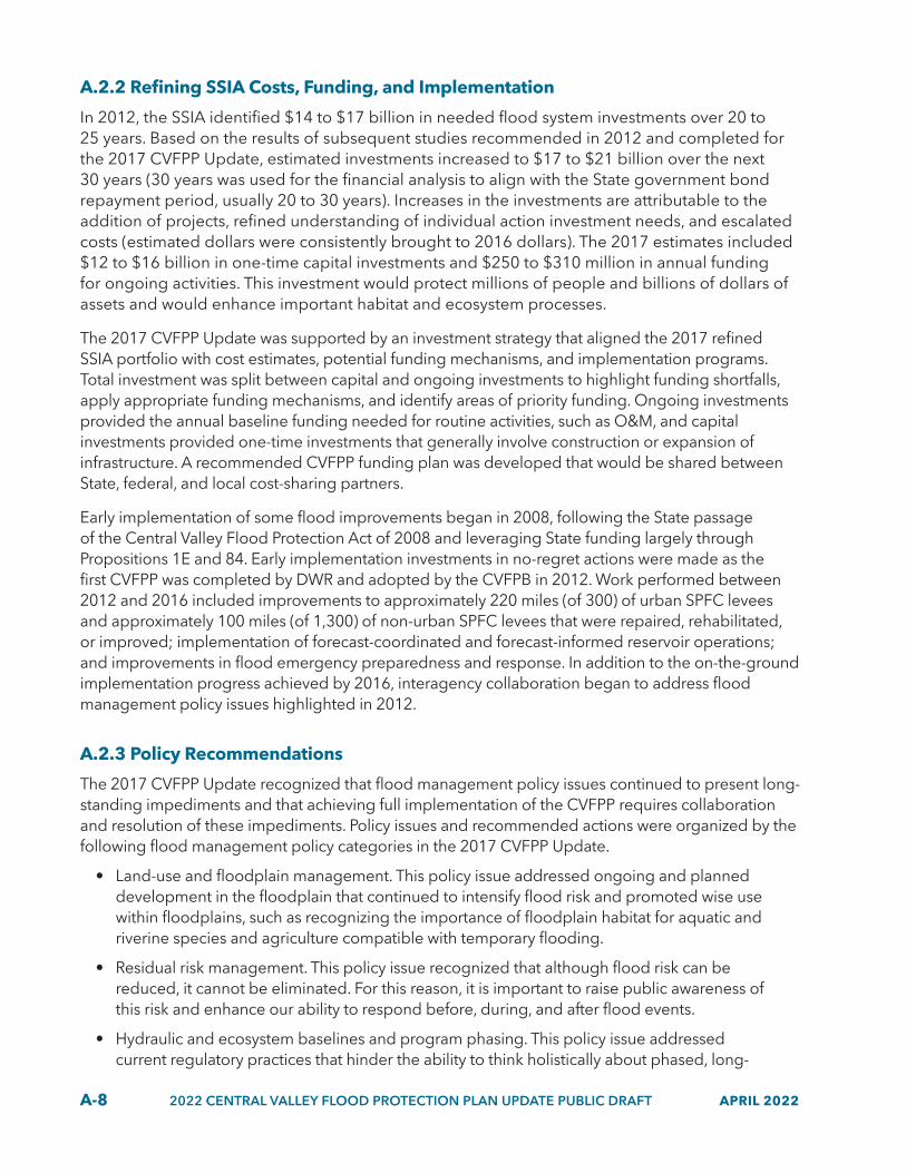
A-8 2022 CENTRAL VALLEY FLOOD PROTECTION PLAN UPDATE PUBLIC DRAFT APRIL 2022
A.2.2 Refining SSIA Costs, Funding, and Implementation
In 2012, the SSIA identified $14 to $17 billion in needed flood system investments over 20 to 25 years. Based on the results of subsequent studies recommended in 2012 and completed for the 2017 CVFPP Update, estimated investments increased to $17 to $21 billion over the next 30 years (30 years was used for the financial analysis to align with the State government bond repayment period, usually 20 to 30 years). Increases in the investments are attributable to the addition of projects, refined understanding of individual action investment needs, and escalated costs (estimated dollars were consistently brought to 2016 dollars). The 2017 estimates included $12 to $16 billion in one-time capital investments and $250 to $310 million in annual funding for ongoing activities. This investment would protect millions of people and billions of dollars of assets and would enhance important habitat and ecosystem processes.
The 2017 CVFPP Update was supported by an investment strategy that aligned the 2017 refined SSIA portfolio with cost estimates, potential funding mechanisms, and implementation programs. Total investment was split between capital and ongoing investments to highlight funding shortfalls, apply appropriate funding mechanisms, and identify areas of priority funding. Ongoing investments provided the annual baseline funding needed for routine activities, such as O&M, and capital investments provided one-time investments that generally involve construction or expansion of infrastructure. A recommended CVFPP funding plan was developed that would be shared between State, federal, and local cost-sharing partners.
Early implementation of some flood improvements began in 2008, following the State passage of the Central Valley Flood Protection Act of 2008 and leveraging State funding largely through Propositions 1E and 84. Early implementation investments in no-regret actions were made as the first CVFPP was completed by DWR and adopted by the CVFPB in 2012. Work performed between 2012 and 2016 included improvements to approximately 220 miles (of 300) of urban SPFC levees and approximately 100 miles (of 1,300) of non-urban SPFC levees that were repaired, rehabilitated, or improved; implementation of forecast-coordinated and forecast-informed reservoir operations; and improvements in flood emergency preparedness and response. In addition to the on-the-ground implementation progress achieved by 2016, interagency collaboration began to address flood management policy issues highlighted in 2012.
A.2.3 Policy Recommendations
The 2017 CVFPP Update recognized that flood management policy issues continued to present long-standing impediments and that achieving full implementation of the CVFPP requires collaboration and resolution of these impediments. Policy issues and recommended actions were organized by the following flood management policy categories in the 2017 CVFPP Update.
• Land-use and floodplain management. This policy issue addressed ongoing and planned development in the floodplain that continued to intensify flood risk and promoted wise use within floodplains, such as recognizing the importance of floodplain habitat for aquatic and riverine species and agriculture compatible with temporary flooding.
• Residual risk management. This policy issue recognized that although flood risk can be reduced, it cannot be eliminated. For this reason, it is important to raise public awareness of this risk and enhance our ability to respond before, during, and after flood events.
• Hydraulic and ecosystem baselines and program phasing. This policy issue addressed current regulatory practices that hinder the ability to think holistically about phased, long-

APRIL 2022 2022 CENTRAL VALLEY FLOOD PROTECTION PLAN UPDATE PUBLIC DRAFT A-9
term implementation of programs instead of as discreet projects, such as with the phased implementation of CVFPP multi-benefit improvements starting at the bottom of a system and working up the watershed.
• O&M of the flood system. This policy issue addressed how lack of funding and resources (e.g., staff) and complex, time-consuming permitting and approval processes can lead to a backlog of deferred maintenance and greater risk to life and property.
• Development of multi-benefit projects. This policy issue addressed obstacles to implementation of multi-benefit actions.
• Effective governance and institutional support. This policy issue addressed overlapping authorities and conflicting mandates that can complicate flood system improvements and maintenance.
• Coordination with federal agencies. This policy issue addressed the complicated coordination, policies, funding, and slow federal approval process.
• Funding. This policy issue addressed insufficient and unstable flood management funding that has led to delayed investment and greater risk to life and property.
Resolution of these policy issues is critical for full implementation of the CVFPP. For the 2022 CVFPP Update, policy issue categories focusing on climate change resilience and equity have been added.
A.2.4 2017 Framework to Track Progress to Societal Values and Intended Outcomes
The 2017 CVFPP Update introduced an outcome-based planning framework with objectives and metrics that can be tracked. Progress toward achieving the CVFPP goals and performance tracking of outcomes associated with the CVFPP was aligned with societal values.
• Public health and safety.
• Ecosystem vitality.
• Stable economy (updated to “healthy economy” for the 2022 CVFPP Update).
• Opportunities for enriching experiences.
An additional societal value, equity and social justice, was added for the 2022 CVFPP Update.
The 2017 CVFPP Update shifted focus away from discrete, disconnected actions toward intended outcomes with strategic and systemwide effect, illustrating greater value for State investments over time. As management actions are implemented, progress toward achieving the CVFPP goals can be measured. Performance tracking of outcomes associated with CVFPP implementation also aligns with the societal values, as illustrated in Figure A-2.
A-10 2022 CENTRAL VALLEY FLOOD PROTECTION PLAN UPDATE PUBLIC DRAFT APRIL 2022
Figure A-2 Societal Values Supported by Each CVFPP Primary and Supporting Goal
CVFPP GOALS CVFPP GOAL DESCRIPTION SOCIETAL VALUES
PRIMARY GOAL: IMPROVE FLOOD RISK MANAGEMENT
Reduce the chance of flooding Public Health and Safety, Healthy Economy, Enriching Experiences
Reduce damages once flooding occurs Healthy Economy
Improve public safety, preparedness, and emergency response
Public Health and Safety
SUPPORTING GOALS
Improve operations and maintenance Public Health and Safety, Healthy Economy, Ecosystem Vitality, Enriching Experiences
Promote ecosystem functions Public Health and Safety, Healthy Economy, Ecosystem Vitality, Enriching Experiences
Promote multi-benefit projects Public Health and Safety, Healthy Economy, Ecosystem Vitality, Enriching Experiences
Improve institutional support Public Health and Safety, Healthy Economy, Ecosystem Vitality, Enriching Experiences
2022-300Public Health and Safety
Ecosystem Vitality
Healthy Economy
Enriching Experiences
A.3 What to Expect from the 2022 CVFPP Update The 2017 CVFPP Update represented significant technical analysis and cooperation of State and local agencies, landowners, and stakeholders to refine the actions of the SSIA and identify policy impediments. The essential development steps of the 2017 CVFPP Update are shown in Figure A-3. The planning process was iterative, with continuous work and engagement among State, federal, and local agency partners and with other stakeholders as the CVFPP is developed and implemented.
Figure A-3 2017 CVFPP Update Development Process
• Central Valley Flood Protection Act of 2008
• Primary and Supporting Goals
CVFPP
• Policy Recommendations
• Management Actions and Societal Values
Investment
UPDATE SSIA PORTFOLIO FUND AND MEASURE
IMPLEMENT AND ADAPT
22_103A
LOADING...
ASSESS SSIA PORTFOLIO
• Collect Potential Actions
• Select Actions
• Develop Portfolio of Actions Performance Tracking
The 2022 CVFPP Update builds on these past efforts and process to support continued implementation of the SSIA and tracking of the outcomes of implementation.
The 2022 CVFPP Update focuses on three key areas.
1. Climate resilience. A warming world has already begun to alter the physical drivers of extreme precipitation events that drive flooding in California. As these changes continue, future flood volume and peak characteristics are expected to become larger, challenging

APRIL 2022 2022 CENTRAL VALLEY FLOOD PROTECTION PLAN UPDATE PUBLIC DRAFT A-11
the existing flood management infrastructure and associated habitat and ecosystems. The 2022 CVFPP Update evaluates how SPFC facilities and recommended SSIA actions handle this changing hydrology. Through the CVFPP Conservation Strategy, the 2022 CVFPP Update also evaluates ecosystem responses to new climate conditions and preliminary adaptation and management strategies.
2. Performance tracking. Measuring progress on how the Central Valley flood management system and implemented SSIA actions are performing over time is fundamental to achieving the CVFPP goals. Tracking performance helps demonstrate return on investment, indicates progress toward achieving desired outcomes, and enables adaptive management of the system. The 2022 CVFPP Update presents progress and pilot studies in tracking CVFPP performance and SSIA implementation.
3. Alignment with other State efforts. State plans and planning efforts since 2017 reflect policies and priorities of the current administration and appointed and elected officials. The 2022 CVFPP Update was developed to support and align with State efforts, plans (such as the California Water Resilience Portfolio), policies, and priorities.

Appendix B Legislative Reference and Reader’s
Guide to the 2022 Central Valley Flood Protection Plan Update

This page left blank intentionally.

DRAFT APRIL 2022 B-i
Contents Acronyms and Abbreviations .......................................................................................................B-iii
B1 Introduction and Background ......................................................................................... B1-1 B1.1 2022 CVFPP Update and Appendices ............................................................................ B1-2 B1.2 California Environmental Quality Act Documentation .................................................. B1-2 B1.3 List of 2022 CVFPP Supporting Documents ................................................................... B1-2
B2 Legislative Reference ...................................................................................................... B2-1
B3 Reader’s Guide to the 2022 Central Valley Flood Protection Plan Update .................... B3-1 B3.1 2022 CVFPP Update Appendices ................................................................................... B3-1
B3.1.1 Appendix A: Background ................................................................................... B3-1 B3.1.2 Appendix B: Legislative Reference and Reader’s Guide to the 2022
Central Valley Flood Protection Update ........................................................... B3-1 B3.1.3 Appendix C: 2022 CVFPP Update Supplemental Recommendations ............... B3-1
B3.2 California Environmental Quality Act Documentation .................................................. B3-2 B3.3 2022 CVFPP Update Supporting Documents ................................................................. B3-2
B3.3.1 2022 State Plan of Flood Control Descriptive Document Update .................... B3-2 B3.3.2 2022 Flood System Status Report ..................................................................... B3-3 B3.3.3 2022 CVFPP Conservation Strategy Update ..................................................... B3-3 B3.3.4 Delta Plan Consistency Determination ............................................................. B3-4 B3.3.5 CVFPP Technical Analyses Summary Report and Appendices .......................... B3-5 B3.3.6 Merced River Basin Flood-MAR Reconnaissance Study Technical
Memorandum ................................................................................................... B3-5 B3.3.7 2022 Outcome-Based Performance Tracking and Adaptive Management
Framework Technical Memorandum ............................................................... B3-6 B3.3.8 CVFPP Engagement Record .............................................................................. B3-6 B3.3.9 Contributing Authors and Workgroup Members List ....................................... B3-7
B4 Document Release Summary ......................................................................................... B4-1
Tables
B2-1 Central Valley Flood Protection Act of 2008 Central Valley Flood Protection Plan Requirements ................................................................................................................. B2-2
B4-1 California Environmental Quality Act Documentation ................................................... B4-1 B4-2 2022 CVFPP Update Supporting Documents .................................................................. B4-1

CVFPP
B-ii DRAFT APRIL 2022
This page left blank intentionally.

DRAFT APRIL 2022 B-iii
Acronyms and Abbreviations Acronym Definition
CEQA California Environmental Quality Act
CVFPB Central Valley Flood Protection Board
CVFPP Central Valley Flood Protection Plan
DWR California Department of Water Resources
Flood-MAR Flood waters for managed aquifer recharge
FSSR Flood System Status Report
PEIR Program Environmental Impact Report
SPFC State Plan of Flood Control
SSIA State Systemwide Investment Approach
TM technical memorandum

CVFPP
B-iv DRAFT APRIL 2022
This page intentionally left blank.

DRAFT APRIL 2022 B1-1
S E C T I O N B 1
Introduction and Background This Legislative Reference and Reader’s Guide to the 2022 Central Valley Flood Protection Plan Update (Guide) has been prepared in support of the 2022 Central Valley Flood Protection Plan Update (2022 CVFPP Update). The purpose of this Guide is to demonstrate how the 2022 CVFPP Update meets the requirements of the Central Valley Flood Protection Act of 2008 and to orient readers with the appendices of the 2022 CVFPP Update and the supporting documents that assisted with guiding and informing the 2022 CVFPP Update.
This Guide provides a legislative reference table and summaries of the following:
• 2022 CVFPP Update: The 2022 CVFPP Update will help improve flood risk management andprioritize and guide the State of California’s (State’s) flood investments within the CentralValley of California. This document includes three appendices to provide more informationregarding the background of the CVFPP, references, and policy recommendations.
• CEQA Documentation: Addendum to the Program Environmental Impact Report(PEIR) created for the 2012 CVFPP, as updated by the 2017 Supplement PEIR, pursuant tothe California Environmental Quality Act (CEQA).
• 2022 CVFPP Update Supporting Documents: There are nine supporting documents to the2022 CVFPP Update, including the State Plan of Flood Control (SPFC) Descriptive DocumentUpdate, Flood System Status Report (FSSR), and Conservation Strategy Update. Thesupporting documents generally present detailed results of various planning, engineering,environmental, and financial studies that have been conducted to assist with thedevelopment of the 2022 CVFPP Update.
The CVFPP planning process has brought together many partners, stakeholders, and flood management-related efforts in preparation of the 2022 CVFPP Update, its appendices, and supporting materials. Some efforts focused on rigorous technical analysis, while others addressed the need for more effective implementation. Regardless, the depth of information is provided to inform the 2022 CVFPP Update and future update cycles of the CVFPP.

CVFPP
B1-2 DRAFT APRIL 2022
B1.1 2022 CVFPP Update and Appendices The 2022 CVFPP Update builds upon the work of the 2017 CVFPP Update to prioritize and guide the State’s investments, policies, and partnerships in flood management. Additionally, it focuses on building flood system climate resiliency, increasing accountability through performance tracking and transparency, and aligning with other State water management planning efforts.
The 2022 CVFPP Update includes three appendices for additional information:
• Appendix A: Background
• Appendix B: Legislative Reference and Reader’s Guide to the 2022 Central Valley Flood Protection Update
• Appendix C: 2022 CVFPP Update Supplemental Recommendations
B1.2 California Environmental Quality Act Documentation The 2022 CVFPP Update is accompanied by a CEQA Addendum. The Addendum updates the PEIR that was previously adopted in 2012; a Supplemental PEIR was adopted in 2017.
B1.3 List of 2022 CVFPP Supporting Documents The following are documents that informed and guided development of the 2022 CVFPP Update; they also provide additional background and information relevant to topics discussed in the 2022 CVFPP Update. The 2022 SPFC Descriptive Document Update, 2022 Flood System Status Report, and a CEQA Addendum to the 2012 PEIR meet the CVFPP content requirements of the Central Valley Flood Protection Act of 2008. In addition, the 2022 CVFPP Conservation Strategy Update has supported development of the 2022 CVFPP Update but remains a separate companion document for more detailed information and analyses.
1. 2022 State Plan of Flood Control Descriptive Document Update 2. 2022 Flood System Status Report 3. 2022 Conservation Strategy Update 4. Delta Plan Consistency Determination (In-Progress) 5. CVFPP Technical Analyses Summary Report and Appendices 6. Merced River Basin Flood-MAR Reconnaissance Study Technical Memorandum (TM)
(In-Progress) 7. 2022 Outcome-Based Performance Tracking and Adaptive Management Framework TM
(In-Progress) 8. CVFPP Engagement Record (In-Progress) 9. Contributing Authors and Workgroup Members List (In-Progress)

DRAFT APRIL 2022 B2-1
S E C T I O N B 2
Legislative Reference Table B2-1 illustrates which documents—the 2022 CVFPP Update and its supporting documents—satisfy the requirements of the Central Valley Flood Protection Act of 2008, and details which documents contain additional information used to guide and inform the 2022 CVFPP Update.

CVFPP
B2-2 DRAFT APRIL 2022
Table B2-1. Central Valley Flood Protection Act of 2008 Central Valley Flood Protection Plan Requirements California Water Code Section 2022 CVFPP Update and
Documents Fulfilling Water Code Section Requirements
Supporting Documents Relevant to Water
Code Section 9603. Requires the Central Valley Flood Protection Plan (Plan) to be a descriptive document reflecting a systemwide approach to protecting the lands covered by the facilities of the SPFC.
• 2022 CVFPP Update Not applicable
9614. Provides that Plan shall include the following: • A description of Sacramento-San Joaquin River Flood Management System and the cities
and counties included in the system. • A description of the performance of the system and the challenges to modifying the
system to provide appropriate levels of flood protection. • A description of the facilities included in the SPFC and uncertainties regarding
performance capability. • A description of each existing dam that is not part of the SPFC that provides either
significant systemwide benefits for managing flood risks within the Sacramento-San Joaquin Valley or protects urban areas within the same area.
• A description of each existing levee and other flood management facility not described in subdivision that is not part of the SPFC and that provides either significant systemwide benefits for managing flood risks within the Sacramento-San Joaquin Valley or protects an urban area.
• A description of the probable impacts of projected climate change, projected land use patterns, and other challenges.
• An evaluation of the structural improvements and repairs necessary to bring the facilities of the SPFC described within its design standard.
• A list of facilities recommended to be removed from the SPFC. • A description of both structural and nonstructural methods for providing an urban level
of flood protection to current urban areas. • A description of structural and nonstructural means for enabling or improving
systemwide riverine ecosystem function, including establishment of riparian habitat and seasonal inundation of available flood plains where feasible.
• 2022 CVFPP Update • 2022 State Plan of Flood
Control Descriptive Document Update
• 2022 Flood System Status Report
• 2022 Conservation Strategy Update
• CVFPP Technical Analyses Summary Report and Appendices

Section B2 | Legislative Reference
DRAFT APRIL 2022 B2-3
California Water Code Section 2022 CVFPP Update and Documents Fulfilling Water Code Section Requirements
Supporting Documents Relevant to Water
Code Section 9616. Provides that the Plan shall include a description of both structural and nonstructural means for improving the performance and elimination of deficiencies of levees, weirs, bypasses, and facilities, including facilities of the SPFC, and, wherever feasible, meet multiple objectives, including each of the following: • Reduce the risk to human life, health, and safety from flooding, including protection of
public safety infrastructure. • Expand the capacity of the flood protection system in the Sacramento-San Joaquin Valley
to either reduce flood flows or convey floodwaters away from urban areas. • Link the flood protection system with the water supply system. • Reduce flood risks in currently non-urbanized areas. • Increase the engagement of local agencies willing to participate in improving
flood protection. • Improve flood protection for urban areas to the urban level of flood protection. • Promote natural dynamic hydrologic and geomorphic processes. • Reduce damage from flooding. • Increase and improve the quantity, diversity, and connectivity of riparian, wetland, flood
plain, and shaded riverine aquatic habitats, including the agricultural and ecological values of these lands.
• Minimize the flood management system operation and maintenance requirements. • Promote the recovery and stability of native species populations and overall biotic
community diversity. • Identify opportunities and incentives for expanding or increasing use of floodway
corridors. • Provide a feasible, comprehensive, and long-term financing plan for implementing
the plan. • Identify opportunities for reservoir reoperation in conjunction with groundwater
flood storage. The Plan shall include a prioritized list of recommended actions to reduce flood risks and meet the objectives described previously.
• 2022 CVFPP Update • Addendum to Supplemental PEIR
• 2022 Conservation Strategy Update
Note: SPFC = State Plan of Flood Control

CVFPP
B2-4 DRAFT APRIL 2022
This page left blank intentionally.

DRAFT APRIL 2022 B3-1
S E C T I O N B 3
Reader’s Guide to the 2022 Central Valley Flood Protection Plan Update This Guide summarizes the three 2022 CVFPP Update appendices, CEQA Addendum, and the nine supporting documents to the 2022 CVFPP Update. The supporting documents generally present detailed results of various planning, engineering, environmental, and financial studies that have been conducted in support of the 2022 CVFPP Update.
B3.1 2022 CVFPP Update Appendices The following is a description of the three appendices included in the 2022 CVFPP Update Public Draft.
B3.1.1 Appendix A: Background The purpose of the Background is to describe the need for the CVFPP and the State Systemwide Investment Approach (SSIA). It also gives more detail of the historical background of Central Valley flood management. Additionally, it describes how the SSIA was formulated and presented in 2012 and updated in the 2017 CVFPP Update to provide context for the 2022 CVFPP Update.
B3.1.2 Appendix B: Legislative Reference and Reader’s Guide to the 2022 Central Valley Flood Protection Update
The purpose of the Legislative Reference portion of this document is to demonstrate how the 2022 CVFPP Update meets the State of California legislative requirements. The purpose of the Reader’s Guide portion of this document is to summarize three appendices, documentation required by CEQA and nine supporting documents, and describe how these documents have been used to inform and guide the 2022 CVFPP Update.
B3.1.3 Appendix C: 2022 CVFPP Update Supplemental Recommendations The purpose of the Supplemental Recommendations is to provide more detail and specificity of the high-priority recommendations included in Chapter 3 of the 2022 CVFPP Update. High-priority recommendations in Chapter 3 cut across the 10 flood management policy issues. Conversely, the supplemental recommendations within Appendix C are organized by flood management policy area and support the cross-cutting nature of the Chapter 3 high-priority

CVFPP
B3-2 DRAFT APRIL 2022
recommendations. Inclusion in the list of supplemental recommendations does not constitute endorsement or commitment by the State but is meant to guide continued conversations around related topics between State, local, federal, and Tribal partners and other public interests.
B3.2 California Environmental Quality Act Documentation Adoption of the 2022 CVFPP Update is a discretionary action subject to CEQA. A PEIR was previously adopted in 2012, and a Supplemental PEIR was adopted in 2017. A review of the updated SSIA and new information gained since 2017 concluded that the 2022 CVFPP Update does not include actions that would result in new significant impacts or a substantial increase in the severity of significant impacts to the environment. This includes impacts that were already considered at a programmatic level in the 2012 PEIR, as updated by the 2017 Supplemental PEIR. In compliance with the CEQA, California Department of Water Resources (DWR) anticipates preparing an addendum to the PEIR to incorporate the updated information.
The following steps and dates summarize the release schedule:
• PEIR available June 2012. • Supplemental PEIR available August 2017. • Final Addendum to PEIR anticipated September 2022. • Recommended to be adopted by the CVFPB.
B3.3 2022 CVFPP Update Supporting Documents This section describes each of the supporting documents to the 2022 CVFPP Update Public Draft.
B3.3.1 2022 State Plan of Flood Control Descriptive Document Update The 2022 SPFC Descriptive Document provides an updated inventory of the SPFC, building off the previous 2010 SPFC Descriptive Document and 2017 SPFC Descriptive Document Update. The SPFC is only a portion of the complex flood protection system in the Central Valley and includes State and federally authorized projects for which the Central Valley Flood Protection Board (CVFPB) or DWR has provided assurances of cooperation to the federal government. The purpose of the SPFC Descriptive Document is to serve as a reference to describe the SPFC. It identifies SPFC components (facilities, lands, programs, plans, conditions, modes of operations and maintenance) in accordance with the requirements of the Central Valley Flood Protection Act of 2008. The CVFPP covers the entire flood system, including the SPFC, and relies on information from this report. The 2022 SPFC Descriptive Document fulfills California Water Code Section 9614.

Section B3 | Reader’s Guide to the 2022 Central Valley Flood Protection Plan Update
DRAFT APRIL 2022 B3-3
The following steps and dates summarize the release schedule:
• Public Draft Available February 2022. • Final Draft anticipated September 2022. • Recommended to be adopted by the CVFPB.
B3.3.2 2022 Flood System Status Report The 2022 FSSR describes the current physical condition of SPFC facilities at a systemwide level as of 2021, building off the 2011 Flood Control System Status Report and the 2017 FSSR Update. The 2022 FSSR and previous iterations were developed pursuant to requirements of the Central Valley Flood Protection Act of 2008. The 2022 FSSR consolidates all available systemwide information from multiple DWR programs regarding SPFC physical conditions, including the current conditions of levees, structures, and channels within the SPFC and finalized project information from DWR’s Levee Evaluations Program. It also includes information about inspecting and evaluating SPFC facilities. In short, the 2022 FSSR describes how well the SPFC is performing. The 2022 FSSR supports development of the 2022 CVFPP Update and guides future inspection, evaluation, reconstruction, and improvement of SPFC facilities. A primary goal of the 2022 FSSR is to document the multiple levee systems that have been improved within the urban levee evaluation/non-urban levee evaluation study areas, as well as incorporate data supplied by ongoing DWR inspections and evaluations.
In addition, information in the 2022 FSSR may be used to support the core functions and long-term activities of DWR’s flood management programs, including emergency response, facility maintenance, and inspections. Periodic updates to the FSSR will help DWR track progress as ongoing inspections and evaluations are completed and more SPFC facilities are reconstructed or improved to meet current design criteria. Future updates have potential to support monitoring and tracking of additional metrics as they are developed over time. The 2022 FSSR fulfills requirements of California Water Code Section 9614 and 9120.
The following steps and dates summarize the release schedule:
• Public Draft Available February 2022. • Final Draft anticipated September 2022. • Recommended to be adopted by the CVFPB.
B3.3.3 2022 CVFPP Conservation Strategy Update The 2022 CVFPP Conservation Strategy Update builds on significant science and collaborative work performed since development of the 2012 Conservation Framework, which provided the basis for the comprehensive 2016 Conservation Strategy. The 2016 Conservation Strategy developed the following four goals to attain the CVFPP’s objectives to promote ecosystem

CVFPP
B3-4 DRAFT APRIL 2022
functions by integrating recovery and restoration of key physical processes, self-sustaining ecological functions, native habitats, and species into flood management activities:
1. Ecosystem Processes. Improve dynamic hydrologic (flow) and geomorphic processes in the SPFC geographic area.
2. Habitats. Increase and improve the quantity, diversity, and connectivity of riverine and floodplain habitats.
3. Species. Contribute to the recovery and sustainability of native species populations and overall biotic community diversity.
4. Stressors. Reduce stressors related to development and operations of the SPFC that negatively affect at-risk species.
The 2016 Conservation Strategy is a non-regulatory document that provides measurable ecological objectives and long-term approaches for improving riverine and floodplain ecosystems through multi-benefit projects that include ecosystem restoration and improvements, and operation, maintenance, repair, rehabilitation, and replacement. The 2022 Conservation Strategy Update adds three new species to the target list of 17 and provides comprehensive information regarding new scientific data and listing status. Details regarding the measurable objectives tracking system are provided as well as a five-year status update of progress made since 2016. The 2022 Conservation Strategy Update provides data and information to support 2022 CVFPP Update development by guiding the integration and improvement of ecosystem functions associated with flood risk reduction actions. It also provides the basis for recommending conservation actions for five Conservation Planning Areas included in the Systemwide Planning Area for the CVFPP. Finally, the 2022 Conservation Strategy Update Appendix H provides an analysis of potential climate change risks and vulnerabilities for ecological processes, habitats, and species, as well as recommendations and adaptation approaches for building resiliency. The 2022 Conservation Strategy Update includes eight technical appendices (Appendix A – H) that provide more detail and technical information that support the findings, results, and recommendations of the 2022 Conservation Strategy Update.
The following steps and dates summarize the release schedule:
• Revised Draft Available May 2021. • Public Draft Available December 2021. • Final Draft anticipated September 2022. • Recommended to be adopted by the CVFPB.
B3.3.4 Delta Plan Consistency Determination The CVFPP is considered a covered action under the Delta Plan. Formally adopted in 2013, the Delta Plan is the Delta Stewardship Council’s (Council) comprehensive, long-term management plan for the Delta. The 2009 Delta Reform Act granted the Council authority to ensure the consistency of State and local public agency actions with the Delta Plan. Water Code section

Section B3 | Reader’s Guide to the 2022 Central Valley Flood Protection Plan Update
DRAFT APRIL 2022 B3-5
85225.30 required the Council to adopt administrative procedures governing appeals, which are exempt from the normal State rulemaking process.
State and local agencies proposing to undertake a project covered by the Delta Plan must prepare and file a “consistency determination” with the Council, meaning they must demonstrate that the project is consistent with requirements in the Delta Plan. Any person may challenge that consistency determination by bringing an appeal to the Council. The Council, in turn, must hold a public hearing on the appeal and issue written findings, either denying the appeal or remanding the matter to the State or local agency for reconsideration of the proposed project based on the finding that the consistency determination is not supported by substantial evidence in the record. A consistency determination is required for the 2022 CVFPP Update.
The following steps and dates summarize the release schedule:
• Filing anticipated September 2022. • This is a 2022 CVFPP Update supporting document; it does not require CVFPB adoption.
B3.3.5 CVFPP Technical Analyses Summary Report and Appendices The Technical Analyses Summary Report explains the technical analysis approach, tools used, and information that supported the development of the 2022 CVFPP Update. It also provides a summary of the scope, extent, processes, and various technical evaluation results along with analyses that were conducted to assess the Central Valley flood system’s performance under a range of evaluation scenarios. Along with the appendices, this report’s purpose is to describe the application of updated tools that leverage DWR investments from other programs; and describe the methodology and results to characterize the SPFC’s performance for current (2022) and future (2072) conditions using the following: climate change analysis, climate change volume-frequency analysis, flood risk analysis (includes life loss and flood damage analyses), reservoir vulnerability analysis, and regional economic analysis. The Technical Analyses Summary Report fulfills the requirements of Water Code Section 9614.
The following steps and dates summarize the release schedule:
• Public Draft anticipated April 2022. • Final Draft anticipated September 2022. • This is a 2022 CVFPP Update supporting document; it does not require CVFPB adoption.
B3.3.6 Merced River Basin Flood-MAR Reconnaissance Study Technical Memorandum DWR, in partnership with the Merced Irrigation District, is studying the use of flood waters for managed aquifer recharge (Flood-MAR) to reduce flood risk, increase supply reliability, support groundwater sustainability, and enhance ecosystems in the Merced River Basin. The Merced River Flood-MAR Reconnaissance Study is exploring the feasibility and effectiveness of Flood-MAR concepts under current conditions and the vulnerability of water management to a range of potential climate change futures. The study will quantify potential flood risk reduction

CVFPP
B3-6 DRAFT APRIL 2022
benefits of conjunctive management of surface and groundwater in the Merced River Basin and Merced Streams Group and the results will inform future CVFPP analyses and recommendations. Further, the study will quantify the benefits of floodplain restoration actions and explore conjunctive-use strategies and infrastructure improvements that provide water supply benefits. The study results will be presented in a series of TMs that will be released through the end of 2022.
The following steps and dates summarize the release schedule:
• Draft TM is anticipated to be available by the end of 2022. • This is a 2022 CVFPP Update supporting document; it does not require CVFPB adoption.
B3.3.7 2022 Outcome-Based Performance Tracking and Adaptive Management Framework Technical Memorandum
The Outcome-Based Performance Tracking and Adaptive Management Framework TM describes an approach and framework for performance tracking and adaptive management that supports the 2022 CVFPP Update. It builds on and advances a performance tracking and adaptive management approach that was initially developed as part of the CVFPP 2017 Update, identifying flood-specific intended outcomes aligned to societal values, indicators, and the metrics and means by which measurements take place. It also considers and identifies the potential to incorporate data from existing databases and systems that track flood system performance and condition, progress on attainment of Conservation Strategy measurable objectives, and implementation of multi-benefit projects.
The following steps and dates summarize the release schedule:
• Final Draft anticipated October 2022. • This is a 2022 CVFPP Update supporting document; it does not require CVFPB adoption.
B3.3.8 CVFPP Engagement Record The CVFPP Engagement Record catalogues and describes the communication and engagement activities to support and complement technical and planning processes implemented through the CVFPP. The CVFPP Engagement Record’s central focus is on the program’s efforts to complete the 2022 CVFPP Update and all the supporting documents for the 2022 CVFPP Update. The CVFPP Engagement Record includes a comprehensive list of all events, meetings, and other activities that supported gaining the input and participation necessary to produce a plan that reflects the needs and desires of those affected by and responsible for managing flood risk in the Sacramento and San Joaquin valleys of California’s Central Valley. Finally, the Draft CVFPP Engagement Record summarizes engagement activities from 2019 through December 2021. The Final Draft CVFPP Engagement Record is anticipated to include additional engagements from January 2022 through CVFPP adoption.

Section B3 | Reader’s Guide to the 2022 Central Valley Flood Protection Plan Update
DRAFT APRIL 2022 B3-7
The following steps and dates summarize the release schedule:
• Final Draft anticipated September 2022. • This is a 2022 CVFPP Update supporting document; it does not require CVFPB adoption.
B3.3.9 Contributing Authors and Workgroup Members List The Contributing Authors and Workgroup Members List documents all the authors that contributed to the 2022 CVFPP Update, including DWR management, legal and staff, and consultant staff. The Contributing Authors and Workgroup Members List also documents the DWR and consultant authors for each appendix and each supporting document. Finally, the Contributing Authors and Workgroup Members List documents all the participants in the various workgroups convened to help inform the development of the 2022 CVFPP Update such as the CVFPB’s Coordinating Committee and Advisory Committee.
The following steps and dates summarize the release schedule:
• Final Draft anticipated September 2022. • This is a 2022 CVFPP Update supporting document; it does not require CVFPB adoption.

CVFPP
B3-8 DRAFT APRIL 2022
This page left blank intentionally.

DRAFT APRIL 2022 B4-1
S E C T I O N B 4
Document Release Summary Tables B4-1 and B4-2 list the current status of each 2022 CVFPP Update supporting documents.
Table B4-1. California Environmental Quality Act Documentation Title Release Summary
CVFPP CEQA Addendum Program Environmental Impact Report
• PEIR available June 2012.• Supplemental PEIR available August 2017.• Final Addendum to PEIR available September 2022.• Recommended to be adopted by the CVFPB.
Table B4-2. 2022 CVFPP Update Supporting Documents Title Release Summary
2022 State Plan of Flood Control Descriptive Document Update
• Public draft available February 2022.• Final draft anticipated September 2022.• Recommended to be adopted by the CVFPB.
2022 Flood System Status Report • Public draft available February 2022.• Final draft anticipated September 2022.• Recommended to be adopted by the CVFPB.
2022 CVFPP Conservation Strategy Update
• Revised draft available May 2021.• Public draft available December 2021.• Final draft anticipated September 2022.• Recommended to be adopted by the CVFPB.
Delta Plan Consistency Determination
• Filing anticipated September 2022.• This is a 2022 CVFPP Update supporting document; it does
not require CVFPB adoption.
CVFPP Technical Analyses Summary Report and Appendices
• Public draft anticipated April 2022.• Final draft anticipated September 2022.• This is a 2022 CVFPP Update supporting document; it does
not require CVFPB adoption.

CVFPP
B4-2 DRAFT APRIL 2022
Title Release Summary
Merced River Basin Flood-MAR Reconnaissance Study Technical Memorandum
• Draft TM is anticipated to be available by the end of 2022. • This is a 2022 CVFPP Update supporting document; it does
not require CVFPB adoption.
2022 Outcome-Based Performance Tracking and Adaptive Management Framework TM
• Final Draft anticipated October 2022. • This is a 2022 CVFPP Update supporting document; it does
not require CVFPB adoption.
CVFPP Engagement Record • Final draft anticipated September 2022. • This is a 2022 CVFPP Update supporting document; it does
not require CVFPB adoption.
Contributing Authors and Workgroup Members List
• Final draft anticipated September 2022. • This is a 2022 CVFPP Update supporting document; it does
not require CVFPB adoption.

Appendix C 2022 Central Valley Flood Protection
Plan Update Supplemental Recommendations

CVFPP
This page left blank intentionally.

APRIL 2022 C-i
Contents Acronyms and Abbreviations .......................................................................................................C-iii
C1 Introduction and Background ......................................................................................... C1-1
C2 Flood Management Policy Issues ................................................................................... C2-1
C3 Development of Flood Management Policy Recommendations .................................... C3-1 C3.1 High-Priority Recommendations .................................................................................... C3-2 C3.2 Supplemental CVFPP Recommendations ...................................................................... C3-2
C4 Supplemental CVFPP Recommendations ....................................................................... C4-1 C4.1 Land Use and Floodplain Management ......................................................................... C4-1 C4.2 Residual Risk Management ............................................................................................ C4-4 C4.3 Flood and Ecosystem Performance Accounting (formerly Hydraulic and
Ecosystem Baselines and Program Phasing) .................................................................. C4-5 C4.4 Operations and Maintenance of the Flood System ....................................................... C4-8 C4.5 Development of Multi-benefit Projects ....................................................................... C4-10 C4.6 Governance and Institutional Support ........................................................................ C4-13 C4.7 Coordination with Federal Agencies ............................................................................ C4-16 C4.8 Funding ........................................................................................................................ C4-20 C4.9 Climate Change and Flood System Resilience ............................................................. C4-23 C4.10 Equity ........................................................................................................................... C4-24
Tables
C-1 CVFPP Updated Policy Issues Summary ...................................................................................... C2-1
C-2 Land Use and Floodplain Management Supplemental Recommendations for 2022 CVFPP Update .................................................................................................................... C4-1
C-3 Residual Risk Draft Supplemental Recommendations for 2022 CVFPP Update ......................... C4-4
C-4 Flood and Ecosystem Performance Accounting Supplemental Recommendations for 2022 CVFPP Update ............................................................................................................... C4-5
C-5 Operations and Maintenance of the Flood System Supplemental Recommendations for 2022 CVFPP Update ............................................................................... C4-8
C-6 Development of Multi-benefit Projects Supplemental Recommendations for 2022 CVFPP Update .................................................................................................................. C4-10
C-7 Governance and Institutional Support Supplemental Recommendations for 2022 CVFPP Update ........................................................................................................................... C4-13

CVFPP
C-ii APRIL 2022
Tables (continued)
C-8 Coordination with Federal Agencies Supplemental Recommendations for 2022 CVFPP Update .................................................................................................................. C4-16
C-9 Funding Supplemental Recommendations for 2022 CVFPP Update ........................................ C4-20
C-10 Climate Change and Flood System Resilience Supplemental Recommendations for 2022 CVFPP Update ............................................................................. C4-23
C-11 Equity Supplemental Recommendations for 2022 CVFPP Update ........................................... C4-24
DRAFT APRIL 2022 C-iii
Acronyms and Abbreviations Acronym Definition
CVFPB Central Valley Flood Protection Board
CVFPP Central Valley Flood Protection Plan
DWR California Department of Water Resources
GIS geographic information system
OMRR&R operations, maintenance, repair, rehabilitation, replacement
RFMP Regional Flood Management Plan
SPFC State Plan of Flood Control
USACE United States Army Corps of Engineers
YBCS Yolo Bypass Cache Slough Partnership

CVFPP
C-iv DRAFT APRIL 2022
This page intentionally left blank.

DRAFT APRIL 2022 C1-1
S E C T I O N C 1
Introduction and Background The Central Valley Flood Protection Plan (CVFPP) has guided the State’s participation in managing flood risk in areas protected by the State Plan of Flood Control (SPFC) since the plan’s adoption pursuant to the Central Valley Flood Protection Act of 2008 (Act) in 2012. A strategic, long-range plan, the CVFPP and its updates describe a programmatic vision for flood system improvements over time in accordance with the requirements of the Act. The 2012 CVFPP was prepared by the Department of Water Resources (DWR) and adopted by the Central Valley Flood Protection Board (CVFPB) through Resolution 2012-25, with the 2017 CVFPP Update prepared by DWR and adopted by CVFPB through Resolution 2017-10. As conceived by the legislature, the CVFPP is updated every five years.
The 2022 CVFPP Update is the second update and furthers the technical and policy actions outlined in the 2012 CVFPP and the 2017 CVFPP Update. The 2022 CVFPP Update is built around three guiding themes: building flood system climate resiliency; increasing accountability through performance tracking and transparency; and aligning strategically with other state water management planning efforts. The 2017 CVFPP Update introduced eight flood management policy issues and recommended actions to facilitate the policy and financial conditions required to implement the State Systemwide Investment Approach. Building on the 2017 CVFPP Update, the 2022 CVFPP Update recommends adding two additional policy issues to address urgent and increasing climate change impacts and flood system resilience; and advance equity in flood management planning, decision-making, and implementation throughout the Central Valley flood system. Flood management policies for the 2022 CVFPP Update and refined recommendations to address them are described in the following subsections.

CVFPP
C1-2 DRAFT APRIL 2022
This page intentionally left blank.
DRAFT APRIL 2022 C2-1
S E C T I O N C 2
Flood Management Policy Issues The 2017 CVFPP Update identified eight policy issues related to flood management, along with recommendations to address the associated challenges. These policy issues were identified primarily through engagement with partner agencies and stakeholders on the CVFPP and other supporting efforts. Building on the 2017 CVFPP Update, the 2022 CVFPP Update includes two additional policy issues:
• Climate Change and Flood System Resilience. • Equity.
A description of all ten policy issues is included in Table C-1. The policy issues are discussed in more detail in Chapters 2 and 3 of the 2022 CVFPP Update.
Table C-1. CVFPP Updated Policy Issues Summary
Policy Issue Description Issue Summary
Land Use and Floodplain Management
Ongoing and planned development in the floodplain continues to intensify flood risk. Wise uses of floodplains should inform land use changes and repurposing of land being considered in the Central Valley as part of Sustainable Groundwater Management Act implementation, and balance needed ecosystem improvements with actions for agricultural sustainability.
Residual Risk Management
Flood risk can be reduced, but never eliminated. Widespread public awareness and system resilience continues to fall short in many areas, particularly in vulnerable and disadvantaged communities.
Flood and Ecosystem Performance Accounting (formerly Hydraulic and Ecosystem Baselines and Program Phasing)
Current CVFPP updates are based on an adaptive management approach. Creating a robust framework to track and communicate progress toward outcomes is essential to inform future CVFPP Updates and to obtain credits for future benefits realized early in a long-term program to offset impacts that may occur later.

CVFPP
C2-2 DRAFT APRIL 2022
Policy Issue Description Issue Summary
Operations and Maintenance of the Flood System
Underfunding and complex, time-consuming permits continue to cause a backlog of deferred maintenance and greater risk to life, property, and the environment. Deferred maintenance may escalate repair, rehabilitation, and replacement needs.
Development of Multi-benefit Projects
Existing institutional frameworks, such as geographic or benefit restrictions on funding sources, hinder implementation of multi-benefit actions.
Governance and Institutional Support
Overlapping authorities and conflicting mandates can complicate flood system improvements and maintenance, and are partially the result of existing governance structures, which are inadequate to support the broad range of actions included in the CVFPP.
Coordination with Federal Agencies
Federal agencies share responsibility for flood management with State and local agencies, but each level of government has its own policies, procedures, funding, and timing, all of which can slow progress.
Funding Insufficient and unstable flood management and multi-benefit funding has led to delayed investment and greater risk to life, property, and the environment.
Climate Change and Flood System Resilience
The frequency and magnitude of extreme climate events is creating greater risk to life, property, and the environment. Addressing climate change impacts on the flood management system requires solutions that integrate multiple water management goals simultaneously and increase community resilience.
Equity Impacts of flooding disproportionately affect socially vulnerable communities.

DRAFT APRIL 2022 C3-1
S E C T I O N C 3
Development of Flood Management Policy Recommendations Over the past five years, the State of California (State), in cooperation with local, regional, and federal partners, has made significant progress advancing the CVFPP goals as a result of on-the-ground project implementation and further planning efforts. A summary of the progress to date on the policy issues included in the 2017 CVFPP Update is provided in Chapter 2 of the 2022 CVFPP Update. Lessons learned from that progress, interactions with stakeholders, changes in State and federal policies, and the overarching political landscape have helped to inform refinements to the policy recommendations for the 2022 CVFPP Update.
As part of the 2022 CVFPP Update, the policy recommendation development process was led by a multi-disciplinary team and included review of multiple sources, including the following:
• 2017 CVFPP Update Recommendations. • 2017 CVFPP Update Chapter 2, “Areas of Agreement/Areas Continuing Conversations.” • 2016 Conservation Strategy. • 2022 Conservation Strategy Update and Appendix G. • RFMP Regional Priorities White Papers (2021). • CVFPB Advisory Committee Subgroup Recommendations (2021). • Water Resilience Portfolio Actions (2020). • DWR and DFM Strategic Plans (2020 and 2021). • Stakeholder surveys and interviews related to the Conservation Strategy (2019 and 2020).
This source review resulted in the preparation of draft recommendations that were aligned to the 10 policy issues identified in Table C-1. These draft recommendations were further refined by and vetted with subject matter experts.
Incorporating DWR and CVFPB Executive review and input, a short-list of the highest priority recommendations was prepared and is included in Table 3-3 of the 2022 CVFPP Update. To support the high-priority recommendations in Table 3-3, a list of supplemental recommendations was compiled and is included in Table C-2. These recommendations are described in more detail in the following subsections.
CVFPP
C3-2 DRAFT APRIL 2022
C3.1 High-Priority Recommendations Table 3-3 in the 2022 CVFPP Update includes the highest priority policy recommendations for the 2022 CVFPP Update. These high-priority recommendations cut across related policy issues and they address the largest impediments to CVFPP implementation based on engagement and review conducted to date. To reinforce the cross-cutting nature of these high-priority recommendations, they have been mapped to the corresponding flood management policy issues described in Table C-1.
The 2022 CVFPP Update considered priority based on:
• Severity of impediment to CVFPP implementation.
• Shared importance with relevant federal, State, local, and Tribal partners that may be engaged for effective collaboration and implementation of policies.
• Appropriateness of recommendations for level of detail, ability, and practicality to implement.
In the next CVFPP planning cycle, concurrent progress across the high-priority recommendations included in Table 3-3 is required to create the enabling conditions for future successful CVFPP implementation.
C3.2 Supplemental CVFPP Recommendations In addition to the high-priority recommendations included in Table 3-3, the policy recommendation development process conducted for the 2022 CVFPP Update culminated in a list of supplementary recommendations. The supplementary recommendations are organized by policy issue in Tables C-2 through C-11. These supplementary recommendations are more narrowly focused by policy issue, allowing for a greater level of detail. As a result, they provide additional specificity and build on partner and stakeholder discussions within the CVFPB Advisory and Coordinating Committees to support the recommendations in Table 3-3. Reflecting this relationship, the supplementary recommendations in Tables C-2 through C-11 have been mapped to the corresponding high-priority, cross-cutting recommendations in Table 3-3. Finally, anticipated timing of implementation of each recommendation is included: near-term (less than five years) and longer-term (five years or more). Inclusion in the list of supplemental recommendations does not constitute endorsement or commitment by the State, but is meant to guide continued conversations around related topics between State, local, federal, and Tribal partners and other public interests.
Policy recommendations not only provide the framework for current structural and non-structural flood management program activities, but also define ways in which system management can be improved and can adapt to uncertain and changing future conditions. As such, tracking progress toward achieving these goals is critical to demonstrating and evaluating effective investment and performance of the CVFPP. It also provides an opportunity

Section C3 | Development of Flood Management Policy Recommendations
DRAFT APRIL 2022 C3-3
to reassess and adapt policy recommendations with new information that could ultimately help enable improved conditions for continued implementation success. Policy recommendations will continue to be updated and refined based on new information received, and input from partners and other public interests.

CVFPP
C3-4 DRAFT APRIL 2022
This page left blank intentionally.

DRAFT APRIL 2022 C4-1
S E C T I O N C 4
Supplemental CVFPP Recommendations C4.1 Land Use and Floodplain Management Issue Summary: Ongoing and planned development in the floodplain continues to intensify flood risk. Wise uses of floodplains should inform land use changes and
repurposing of land being considered in the Central Valley as part of Sustainable Groundwater Management Act implementation, and balance needed ecosystem improvements with actions for agricultural sustainability.
Table C-2. Land Use and Floodplain Management Supplemental Recommendations for 2022 CVFPP Update
Number Supplemental Recommendation Timing Corresponding Public Draft
Recommendation
1 Complete the California Strategic Floodplain Management Plan. This will be a statewide plan and its implementation will be a State responsibility. The strategic plan will include summaries of the current federal and State authorities, as well as programs related to floodplain management in California. The goal is to have a unified flood management plan that is consistent with the Unified National Program for Floodplain Management used by Federal agencies.
Near-term 3

CVFPP
C4-2 DRAFT APRIL 2022
Number Supplemental Recommendation Timing Corresponding Public Draft
Recommendation
2 Update the California NFIP Strategic Plan by 2023 based on current FEMA guidance as outlined in TSF. The California NFIP Strategic Plan should also be consistent with the recommendations outlined in these documents:
• Unified National Program for Floodplain Management.
• 2002 Floodplain Management Taskforce.
• California Strategic Floodplain Management (if completed).
DWR provides updates to FEMA on the California NFIP Strategic Plan on annual basis.
Near-term 3
3 Complete an assessment of State facilities including its office buildings, warehouses, workshops, and powerplants to ensure they are located, designed, and managed in accordance with wise floodplain management policies and regulations. This assessment is driven by FEMA’s modernization of the NFIP and its TSF.
Near-term 3
4 Utilize landowner incentive programs and agricultural easements for flood conveyance with conditions for continued agricultural production.
Near-term 12
5 Continue to lead and support efforts of the YBCS Agricultural Sustainability Working Group to identify an agricultural sustainability program and agricultural stewardship/land planning tool that would improve the agricultural outcome of large-scale multi-benefit projects and allow for locally managed agricultural sustainability funds that would provide for counties to receive fees in-lieu of requiring acquisition of conservation easements for unavoidable losses of agricultural land.
Near-term 12
6 Seek establishment of post-disaster agricultural recovery programs.
Longer-term 3
7 Seek support for post-disaster habitat recovery programs.
Longer-term 3

Section C4 | Supplemental CVFPP Recommendations
DRAFT APRIL 2022 C4-3
Number Supplemental Recommendation Timing Corresponding Public Draft
Recommendation
8 Design an approach to track land use changes and flood management system improvements to assess whether life loss and property damage risks are increasing or decreasing. FEMA’s data on repetitive loss property could be used for a pilot assessment of this change in risk.
Longer-term 7
9 Support local floodplain management and flood risk reduction:
• Design and administer effective local assistance grant programs for construction of flood risk reduction projects for small communities and urban areas outside of the State Plan of Flood Control.
• Prepare best practice guidebooks to promote floodplain management and flood risk reduction. Include building code updates in model floodplain management ordinances.
• Review local general plan flood elements for consistency with Local Hazard Mitigation Plans, the State Hazard Mitigation Plan, and state floodplain management policies.
• Update local floodplain management plans and ordinances.
Near-term 3
Notes: FEMA = Federal Emergency Management Agency NFIP = National Flood Insurance Program TSF = Tiered State Framework YBCS = Yolo Bypass Cache Slough Partnership
CVFPP
C4-4 DRAFT APRIL 2022
C4.2 Residual Risk Management Issue Summary: Flood risk can be reduced, but never eliminated. Widespread public awareness and system resilience continues to fall short in many areas, particularly in vulnerable and disadvantaged communities.
Table C-3. Residual Risk Draft Supplemental Recommendations for 2022 CVFPP Update
Number Supplemental Recommendation Timing Corresponding Public Draft
Recommendation
1 Increase flood risk awareness by promoting public awareness campaigns and broadening flood risk notifications.
Near-term 3

Section C4 | Supplemental CVFPP Recommendations
DRAFT APRIL 2022 C4-5
C4.3 Flood and Ecosystem Performance Accounting (formerly Hydraulic and Ecosystem Baselines and Program Phasing)
Issue Summary: Current CVFPP updates are based on an adaptive management approach. Creating a robust framework to track and communicate progress toward outcomes is essential to inform future CVFPP Updates and to obtain credits for future benefits realized early in a long-term program to offset impacts that may occur later.
Table C-4. Flood and Ecosystem Performance Accounting Supplemental Recommendations for 2022 CVFPP Update
Number Supplemental Recommendation Timing Corresponding Public Draft
Recommendation
1 Use the Yolo Bypass Master Planning process to pilot the development of a flood and ecosystem performance accounting system, including the development of specific indicators and metrics, processes, and tools to track progress over time as a result of project implementation.
Near-term 7
2 Commit to continuing to fund, develop, and implement a flood and ecosystem performance accounting and adaptive management system for the CVFPP. This would include a common framework of indicators, metrics, tool sets, and databases that allow DWR and partners to determine progress towards the societal outcomes, CVFPP goals, and flood performance and ecological measurable objectives identified in the CVFPP; adaptively manage the flood system and inform future plan updates; and communicate progress to stakeholders. Develop an ecological accounting system that allows determination of how ecological benefits attained from multi-benefit projects can be attributed to mitigation or uplift, along with specific examples of how a project or group of projects could be developed to demonstrate functionality. Develop guidance for regions on how to use the accounting system to leverage ecosystem credits to streamline permitting processes, align with grant funding opportunities, and remove impediments to multi-benefit project implementation.
Longer-term 7

CVFPP
C4-6 DRAFT APRIL 2022
Number Supplemental Recommendation Timing Corresponding Public Draft
Recommendation
2 (continued)
Develop a flood performance accounting system that includes indicators and metrics for flood system performance, and processes and tools to track changes in flood risk reduction as a result of project implementation, sea level rise, and climate change.
Longer-term 7
3 Identify existing permitting mechanisms, and/or recommend new policies, that allow mitigation or uplift “credits” attained through multi-benefit project implementation to assist in implementing future flood risk reduction projects, offset environmental impacts, or meet grant funding requirements. This may require using existing permitting mechanisms, such as the Regional Conservation Investment Strategies, developing new mitigation banks, or pioneering new policies that allow programmatic, regional approaches to mitigation crediting.
Near-term 2
4 Finalize the development of the Flood Management Tracking System, utilize it and other tools and databases under development by the State to:
• Track progress on the Conservation Strategy measurable objectives from implemented multi-benefit projects.
• Forecast potential benefits from projects currently in development.
• Track the status of flood system O&M actions.
• efficiently track changes in land cover and ecosystem conditions to measure progress at a larger scale as a result of CVFPP project implementation and O&M actions.
Near-term 7

Section C4 | Supplemental CVFPP Recommendations
DRAFT APRIL 2022 C4-7
Number Supplemental Recommendation Timing Corresponding Public Draft
Recommendation
5 In collaboration with CVFPB and other state and local agencies, lead and manage the CVFPP flood and ecosystem performance accounting and adaptive management system by:
• Managing and administering the tracking database and accounting ledger.
• Advising on potential mitigation needs, ecosystem uplift opportunities, and project statuses.
• Developing and maintaining a data repository kept current with project reports, project permitting requirements, and species occurrence data.
• Facilitating coordination among State and federal agencies and third-party participants as necessary for permit implementation, including organizing and facilitating a technical review committee.
Longer-term 7

CVFPP
C4-8 DRAFT APRIL 2022
C4.4 Operations and Maintenance of the Flood System Issue Summary: Underfunding and complex, time-consuming permits continue to cause a backlog of deferred maintenance and greater risk to life, property, and the
environment. Deferred maintenance may escalate repair, rehabilitation, and replacement needs.
Table C-5. Operations and Maintenance of the Flood System Supplemental Recommendations for 2022 CVFPP Update
Number Supplemental Recommendation Timing Corresponding Public Draft
Recommendation
1 Disseminate and reference improved O&M unit costs and value tracking systems to inform administrative actions by public safety regulatory agencies and local maintaining agencies that improve the overall efficiency of existing O&M activities.
Near-term 9
2 Continue to pursue regionally based, multiple-objective O&M activities in the SPFC to efficiently integrate flood system maintenance practices with ecological uplift and other multi-benefit uses of the landscape.
2
3 Work with the participants in the YBCS’s Operation and Maintenance working group to develop interagency agreements that address long term maintenance responsibilities, regulatory requirements, and funding obligations associated with the projects comprising the Master Plan.
Near-term 12
4 Building on previous OMRR&R working groups, develop a working group that shares Flood Maintenance Office expertise of maintaining SPFC facilities with local agencies and regional stakeholders that can develop sustainable O&M activities, develop best management practices for maintenance activities; and conduct workshops and open houses to better understand deficiencies of SPFC facilities and prioritize them for repair, rehabilitation, or replacement based on available resources.
Longer-term 9
5 Fund and incorporate a SPFC infrastructure life-cycle analysis, in collaboration with regional stakeholders and LMAs, into future CVFPP Updates to fulfill requirements set forth in California Executive Order B-30-15.
Near-term 7
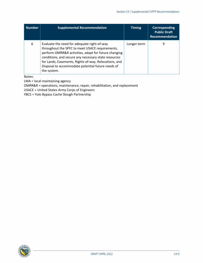
Section C4 | Supplemental CVFPP Recommendations
DRAFT APRIL 2022 C4-9
Number Supplemental Recommendation Timing Corresponding Public Draft
Recommendation
6 Evaluate the need for adequate right-of-way throughout the SPFC to meet USACE requirements, perform OMRR&R activities, adapt for future changing conditions, and secure any necessary state resources for Lands, Easements, Rights-of-way, Relocations, and Disposal to accommodate potential future needs of the system.
Longer-term 9
Notes: LMA = local maintaining agency OMRR&R = operations, maintenance, repair, rehabilitation, and replacement USACE = United States Army Corps of Engineers YBCS = Yolo Bypass Cache Slough Partnership

CVFPP
C4-10 DRAFT APRIL 2022
C4.5 Development of Multi-benefit Projects Issue Summary: Existing institutional frameworks, such as geographic or benefit restrictions on funding sources, hinder implementation of multi-benefit actions.
Table C-6. Development of Multi-benefit Projects Supplemental Recommendations for 2022 CVFPP Update
Number Supplemental Recommendation Timing Corresponding Public Draft
Recommendation
1 Consider advance Safe Harbor agreements (or similar, depending on agency) as appropriate for addressing landowner concerns.
Longer-term 2
2 DWR should work with regulatory agency staff to describe a process for how project proponents should advance projects through the funding and permitting process. Provide clear milestones delineating the end of each project development phase to help project proponents avoid expensive delays.
Longer-term 2
3 Via RFMPs, identify “Multi-Benefit Credit Zones” by which any environmental/habitat enhancement action (including qualifying MBPs) that supports the Conservation Strategy, could be used by locals for ‘credit’ in meeting grant funding multi-benefit objectives.
Longer-term 8
4 Provide RFMPs with clear definitions of MBPs and how to incorporate measurable objectives into the project description. Provide guidance related to MBPs, including improved funding, technical assistance, and incentives. Describe opportunities and methods for improved inter-project coordination and project integration with natural processes (climate change, hydrology, species migration, groundwater recharge and flow patterns, etc.) at a landscape scale.
Near-term 8

Section C4 | Supplemental CVFPP Recommendations
DRAFT APRIL 2022 C4-11
Number Supplemental Recommendation Timing Corresponding Public Draft
Recommendation
5 Ensure regular engagement of local communities throughout project development, design, and construction of projects. Issue funding and guidance to the RFMP areas on engagement and formulation in developing a landscape vision for the Region that includes an integrated portfolio of MBPs to advance the Conservation Strategy measurable objectives while meeting CVFPP goals. Assist each of the RFMPs to map regional opportunities for flood improvement, habitat, water supply, water quality, recreation and recreational access, agriculture sustainability, etc.
Near-term 8
6 Using the Feather River Region CMP as an example, consider implementing CMPs to help frame opportunities for MBPs and help define the vision for the RFMPs. Because there is a need for improved coordination among projects and landscape scale connectivity, establish regional technical advisory committees and working groups for the development of stakeholder-endorsed regional vision.
Near-term 8
7 Implement focused studies as described in the 2022 Conservation Strategy Update data gaps Table (3-6). Determine the highest priority items to be conducted within the next five years and develop a general timeline for the ones that should be implemented on a longer-term basis. For high priority data gaps, the following steps are taken: • Determine opportunities within the CVFPP
program to implement (e.g., revetment mapping). • Look for other programs within DWR with shared
interests to implement (e.g., FROA via Flood-MAR). • Implement via existing contracts with sister
agencies (e.g., rare plant surveys by CDFW). • Coordinate with other agencies that may already
be conducting research (e.g., USGS for giant garter snake). Incorporate as appropriate into the tracking system (i.e., those that result in development of GIS data layers).
Update the table for each subsequent Conservation Strategy Update.
7

CVFPP
C4-12 DRAFT APRIL 2022
Number Supplemental Recommendation Timing Corresponding Public Draft
Recommendation
8 Review and update the CVFPP goals to be reflective of evolving State needs and policy direction, including potentially revisiting State legislation of the Central Valley Flood Protection Act.
Near-term 1 or 12
9 Support innovative pilot efforts for multiple DWR programs (including EcoRestore and Flood-MAR) to inform development of multi-benefit projects that may include flood management, ecosystem restoration, water supply, water quality, groundwater management, recreation, and education components (i.e., “One Landscape Vision”).
Near-term 12
10 Support and/or collaborate on a locally-driven Tisdale Weir and Sutter Bypass regional multi-benefit program that balances flood risk reduction, agricultural sustainability, ecosystem enhancements, recreation, and other multi-benefit interests.
Longer-term 12
Notes: CDFW = California Department of Fish and Wildlife CMP = Corridor Management Plan FROA = Floodplain Restoration Opportunity Analysis Flood-MAR = flood waters for managed aquifer recharge GIS = geographic information system MBP = multi-benefit project RFMP = Regional Flood Management Plan USGS = United States Geological Survey

Section C4 | Supplemental CVFPP Recommendations
DRAFT APRIL 2022 C4-13
C4.6 Governance and Institutional Support Issue Summary: Overlapping authorities and conflicting mandates can complicate flood system improvements and maintenance, and are partially the result of
existing governance structures, which are inadequate to support the broad range of actions included in the CVFPP.
Table C-7. Governance and Institutional Support Supplemental Recommendations for 2022 CVFPP Update
Number Supplemental Recommendation Timing Corresponding Public Draft
Recommendation
1 The State will convene an inter-agency workgroup to conduct a review of federal, State, and local permitting processes and a review of existing governance to identify overlapping authorities and propose meaningful reconciliation between and among local, State, and federal levels of government to improve implementation of flood projects. This effort would result in documentation that includes authorities and institutional challenges, and makes specific recommendations to improve flood management efficiencies across all levels of government.
Near-term 1
2 Explore and determine the most efficient path forward to reclassify levees (e.g., through Feasibility study or WRDA or other means), including funding a pilot project for levee reclassification to demonstrate an orderly process for removal of levees from the SPFC. Based on this effort, create a guidance document/process for other LMAs to pursue this option in coordination with the State because approval for reclassification is ultimately needed from USACE and the CVFPB. This would ensure a shared understanding on the conditions under which levee reclassifications can be approved, and develop a standard approach to obtaining the necessary approvals that can be applied in future cases.
Near-term 4

CVFPP
C4-14 DRAFT APRIL 2022
Number Supplemental Recommendation Timing Corresponding Public Draft
Recommendation
3 Facilitate modification or removal of levees from the SPFC. Consider other actions such as land acquisitions and flowage easements to minimize loss while preserving and/or enhancing flood system capacity. DWR can facilitate this process by conducting an analysis of the risk reduction benefit provided by the existing levee system to LFPZs or similar; providing leadership on adopting and advancing one or more projects that have already attracted substantial state funding that require such a change; more generally working with local stakeholders and the CVFPB to advance efforts to strategically decommission obsolete levees that are no longer needed to protect agricultural and refuge lands at a level appropriate to SPFC facilities by providing technical and procedural assistance. Such strategies would include consideration of the added value of expanded floodplains to groundwater recharge and wildlife habitat improvement.
Longer-term 4
4 Increase coordination/collaboration among State agencies to address fragmentation of State agency authorities and responsibilities with respect to the State’s flood management goals and environmental enhancement objectives to result in more consistent State leadership.
Longer-term 1
5 Provide consistent State leadership of the YBCS to provide local, State, and Federal agency alignment needed to implement the Yolo Multi-benefit Program. Including continued partnership with the USBR’s Yolo Bypass Fish Passage and Improvement Project.
Near-term 12

Section C4 | Supplemental CVFPP Recommendations
DRAFT APRIL 2022 C4-15
Number Supplemental Recommendation Timing Corresponding Public Draft
Recommendation
6 Continue to engage FEMA and Cal OES on emergency response and disaster assistance/recovery. A. Assist local agencies to update their local Hazard
Mitigation Plans, local general plan updates, and other floodplain management actions.
B. Facilitate meetings between local entities and Cal OES to assist local communities to apply for Federal hazard mitigation financial assistance programs, such as FEMA’s BRIC program.
C. Review and update the flood element of the State Hazard Mitigation Plan in coordination with the Cal OES.
Near-term 3
Notes: BRIC = Building Resilient Infrastructure and Communities Cal OES = California Office of Emergency Services CVPFB = Central Valley Flood Protection Board LFPZ = Levee Flood Protection Zone SPFC = State Plan of Flood Control USBR = U.S. Department of the Interior Bureau of Reclamation WRDA = Water Resource Development Act

CVFPP
C4-16 DRAFT APRIL 2022
C4.7 Coordination with Federal Agencies Issue Summary: Federal agencies share responsibility for flood management with State and local agencies, but each level of government has its own policies,
procedures, funding, and timing, all of which can slow progress.
Table C-8. Coordination with Federal Agencies Supplemental Recommendations for 2022 CVFPP Update
Number Supplemental Recommendation Timing Corresponding Public Draft
Recommendation
1 Vegetation management policy strategies – continue to pursue compatibility between State and federal vegetation management policies, emphasizing risk prioritization and the imperative function of levee vegetation relative to the requirements of the Federal Endangered Species Act.
Longer-term 1
2 Establish a FEMA flood zone for agricultural communities: In partnership with the Agricultural Floodplain Ordinance Task Force, identify and implement strategies to allow FEMA to establish a FEMA flood zone for agriculturally based communities, which would allow for replacement or reinvestment in infrastructure needed to sustain existing agricultural use in floodplains.
Longer-term 3
3 DWR and CVFPB to establish a funding and maintenance agreement with the federal San Joaquin River Restoration Program for the maintenance of flood bypass infrastructure and vegetation management under wetted conditions.
Near-term 9
4 Pursue reforms of federal hazard-related programs to ensure adequate federal funding for California water infrastructure repair, maintenance, and improvements.
Near-term 3 and 6

Section C4 | Supplemental CVFPP Recommendations
DRAFT APRIL 2022 C4-17
Number Supplemental Recommendation Timing Corresponding Public Draft
Recommendation
5 Leverage the YBCS to move toward multi-benefit planning approaches and reauthorize federal projects to incorporate multiple benefits, where feasible, as well as maximize Federal interest and Federal investment in the implementation of multi-benefit projects/programs. Additional detail for a potential YBCS-specific rec: DWR and CVFPB should work with USACE, Congress, and the National Academy of Sciences to update USACE regulations on evaluation of Federal Interest. The goal should be to expand the recognized benefits of multi-benefit projects of the sort being included in the Master Plan for the YB/CS. This effort could facilitate development of a Comprehensive Study (USACE, CVFPB, and SAFCA) that would justify USACE support for Master Plan implementation.
Near-term 4 and 12
6 Coordinate with USACE to support development of guidance for multi-benefit or multi-purpose project definitions and creation of pilot projects to test the applicability of the formal guidance before it is issued.
Near-term 4
7 Establish a protocol and funding for future emergency rehabilitation assistance to areas that have been deauthorized and are ineligible for PL 84-99 funding.
Near-term 9

CVFPP
C4-18 DRAFT APRIL 2022
Number Supplemental Recommendation Timing Corresponding Public Draft
Recommendation
8 Provide technical assistance to local communities under the NFIP to promote flood risk awareness and provide community assistance in floodplains. Additional related source recommendations with potential for more detailed recommendations: A. Conduct FEMA NFIP Community Assistance Visits
and provide technical assistance to local floodplain managers.
B. Prepare and mail annual flood risk notification fliers to property owners.
C. Participate in FEMA’s Collaborative Technical Assistance program to promote coordination between dam owners and downstream communities.
D. Work with FEMA to implement DWR’s work activities as identified in the CAP-SSSE agreement, to provide oversight over local agencies and state property to ensure compliance with the NFIP and federal floodplain management policies and regulations.
Near-term 3

Section C4 | Supplemental CVFPP Recommendations
DRAFT APRIL 2022 C4-19
Number Supplemental Recommendation Timing Corresponding Public Draft
Recommendation
9 In cooperation with the USACE and reservoir owners, evaluate the potential of expanding forecast-coordinated and forecast-informed reservoir operations in watersheds where improved weather forecasting capabilities would allow reservoir operators to improve flood control and surface and ground water supply storage. Specific examples from RFMPs: • For the Tuolumne watershed, an assessment
should be done of the potential to introduce forecast-informed reservoir operations at New Don Pedro Reservoir and identification of potential implications of various scenarios for water rights and aquifer water quality. Continued advancements in forecast-informed reservoir operations may enable important improvements in flood management capabilities for the MSJR region, especially for New Don Pedro Reservoir.
• Complete the Folsom Dam Raise Project and adopt a revised forecast informed water control manual for the reservoir that accommodates modifications to the three largest non-Federal reservoirs in the American River Basin designed to provide increased flood protection to the Sacramento area, and facilitates implementation of a managed aquifer recharge program for the South American and Cosumnes Basins that addresses climate-induced changes in precipitation patterns affecting water supplies available for municipal and industrial, agricultural and environmental uses.
Near-term 7
Notes: CAP-SSSE = Community Assistance Program State Support Services Element DWR = California Department of Water Resources MSJR = Mid Sand Joaquin River SAFCA = Sacramento Area Flood Control Agency

CVFPP
C4-20 DRAFT APRIL 2022
C4.8 Funding Issue Summary: Insufficient and unstable flood management and multi-benefit funding has led to delayed investment and greater risk to life, property, and
the environment.
Table C-9. Funding Supplemental Recommendations for 2022 CVFPP Update
Number Supplemental Recommendation Timing Corresponding Public Draft
Recommendation
1 Demonstrate the need, timeliness, and appropriateness to pursue a new $3 billion dollar flood-focused general obligation bonds in the 2022 election cycle. Seek two additional $3 billion dollar bonds in the 2032 election cycle and the 2042 election cycle. Flood-focused bonds would provide flexibility in funding flood management projects with single or multiple societal benefits that reduce flood risk across the Central Valley.
Longer-term 6
2 Develop and initiate an implementation plan for the Sacramento and San Joaquin Drainage District for the specific services identified in the SSJDD feasibility study, that were found feasible – pending completion of study. The CVFPP funding plan assumes this mechanism would be available in years 2022 through 2032 and could potentially generate $25 million per year by the end of the 30-year period.
Near-term 6
3 Evaluate and quantify the capital improvement needs of the SPFC facilities within the State maintenance areas and recommend changes to the State maintenance water code to allow maintenance areas to carry cost reserve over multiple years.
Near-term 6 and 9
4 Evaluate the viability and effectiveness of establishing a State river basin assessment.
Near-term 6
5 Evaluate the viability and effectiveness of establishing a State flood insurance program.
Near-term 6

Section C4 | Supplemental CVFPP Recommendations
DRAFT APRIL 2022 C4-21
Number Supplemental Recommendation Timing Corresponding Public Draft
Recommendation
6 Establish a strategic, integrated flood management approach for the Sacramento River Flood Control Project within the Sacramento Basin and the San Joaquin River Flood Control Project within the San Joaquin Basin with USACE, that establishes federal interest, provides programmatic authorities and funding appropriations.
Longer-term 4 and 6
7 Seek annual federal contribution (mostly through USACE) of approximately $335 million per year (State, federal, and local) to meet the federal cost-share of the 2022 CVFPP Update’s funding plan.
Long-term 6
8 Work with local flood management agencies to increase assessments to meet their local cost-share requirements and provide support to local flood management agencies for education of property owners on the purposes of local assessments.
Near-term 6
9 Develop a policy memo on potential revenue streams and explore potential legislation to identify funding mechanism to allow for long-term O&M of ecosystem restoration projects and components.
Near-term 6
10 Develop a state grant funding program(s) for multi-benefit projects that would provide long-term financial investment for project implementation and maintenance. This program could also include guidelines that incentivize multi-benefit projects by:
• Including endowments and other long-term investment mechanisms that would support restored habitats and ecosystems.
• Including description of how projects meet CVFPP performance tracking indicators and metrics, including the Conservation Strategy measurable objectives.
• Adjusting administrative procedures to follow indirect cost rate agreements, to align with Federal requirements, so that funding distribution and reporting is consistent for multi-benefit projects.
Near-term 6
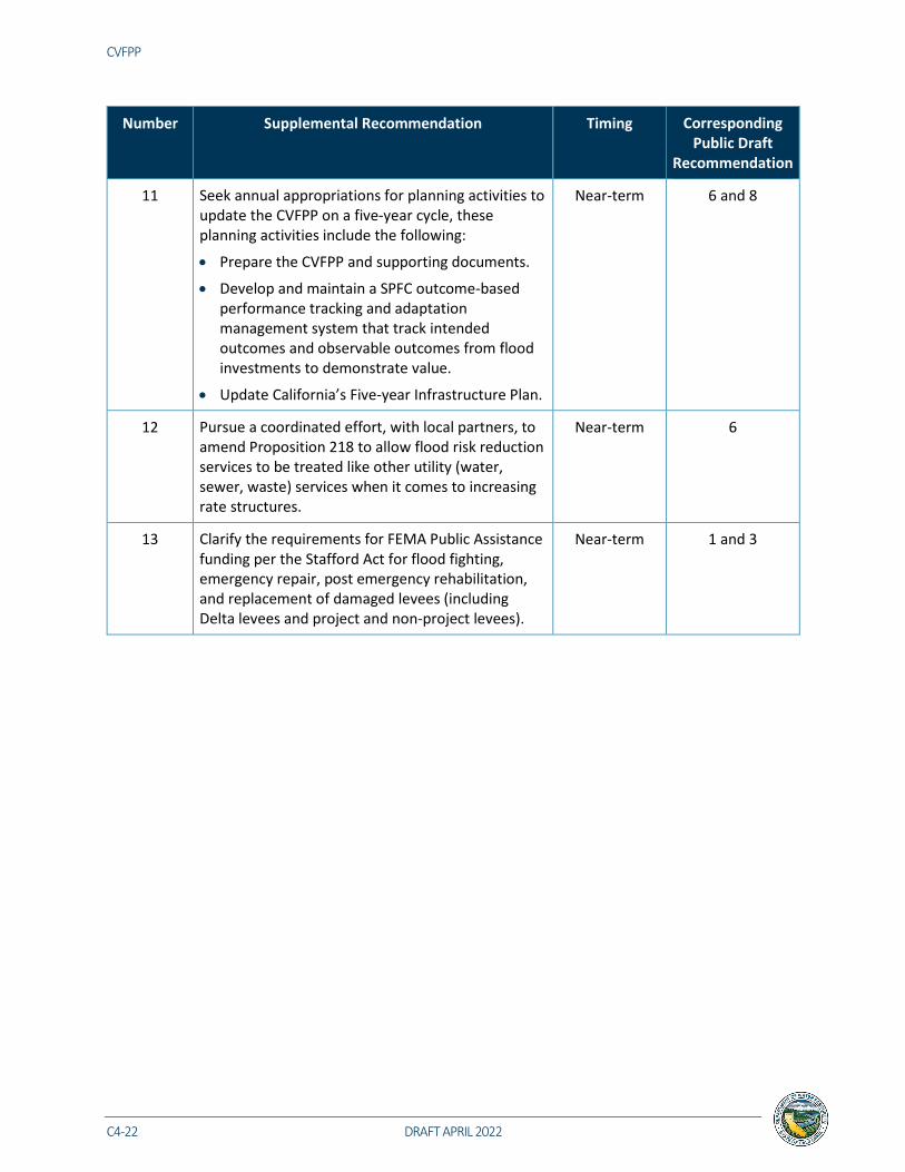
CVFPP
C4-22 DRAFT APRIL 2022
Number Supplemental Recommendation Timing Corresponding Public Draft
Recommendation
11 Seek annual appropriations for planning activities to update the CVFPP on a five-year cycle, these planning activities include the following:
• Prepare the CVFPP and supporting documents.
• Develop and maintain a SPFC outcome-based performance tracking and adaptation management system that track intended outcomes and observable outcomes from flood investments to demonstrate value.
• Update California’s Five-year Infrastructure Plan.
Near-term 6 and 8
12 Pursue a coordinated effort, with local partners, to amend Proposition 218 to allow flood risk reduction services to be treated like other utility (water, sewer, waste) services when it comes to increasing rate structures.
Near-term 6
13 Clarify the requirements for FEMA Public Assistance funding per the Stafford Act for flood fighting, emergency repair, post emergency rehabilitation, and replacement of damaged levees (including Delta levees and project and non-project levees).
Near-term 1 and 3

Section C4 | Supplemental CVFPP Recommendations
DRAFT APRIL 2022 C4-23
C4.9 Climate Change and Flood System Resilience Issue Summary: The frequency and magnitude of extreme climate events is creating greater risk to life, property, and the environment. Addressing climate
change impacts on the flood management system requires solutions that integrate multiple water management goals simultaneously and increase community resilience.
Table C-10. Climate Change and Flood System Resilience Supplemental Recommendations for 2022 CVFPP Update
Number Draft Recommendation Timing Corresponding Public Draft
Recommendation
1 Incorporate recommendations and refinements, provided by the independent climate change review panel, into the climate change analyses for future CVFPP updates. The independent climate change review was performed by a panel of climate experts from the Scripps Institution of Oceanography, UC Davis, and USGS, Desert Research Institute on the 2022 CVFPP Update climate change approaches, analyses, and results. The independent review consisted of three sets of comments that included suggestions for document improvements, recommendations for the present effort, and a technical recommendation for the future. Comments regarding document improvements and recommendations for the present effort were addressed. Technical recommendations for the future will be considered during the future CVFPP Update’s scoping.
Near-term 5
2 Incorporate climate change into dam inundation analyses and initiate a pilot program.
Near-term 5

CVFPP
C4-24 DRAFT APRIL 2022
C4.10 Equity Issue Summary: Impacts of flooding disproportionately affect socially vulnerable communities.
Table C-11. Equity Supplemental Recommendations for 2022 CVFPP Update Number Supplemental Recommendation Timing Corresponding
Public Draft Recommendation
1 Support integration of federal and State floodplain management policies through comment on the Federal Flood Risk Management Standard as outlined in Executive Order (EO) 13690 and EO 13990. Also, consider approaches to addressing equity and climate change within the implementation of the NFIP and hazard mitigation planning and implementation as outlined in EO 14008.
Longer-term 11
2 Explore regional or statewide led solutions and options for assisting disadvantaged communities with permitting of multi-benefit projects.
Near-term 11
3 Improve inclusion, increase engagement and representation of disadvantaged communities by supporting and encouraging participation in RFMPs and future updates of the CVFPP to ensure flood management planning in the region carefully considers the need to improve flood safety in these vulnerable communities.
Near-term 11
4 Fund additional implementation phases of the Small Community Flood Risk Reduction Program.
Longer-term 11
5 Modify existing grant program eligibility requirement to increase the State’s ability to fund the local cost-share, of flood management projects, up to 100 percent for disadvantaged and small communities that qualify.
Near-term 11
6 Provide financial assistance and expand state technical assistance for communities to update their local hazard mitigation plans, emergency response plans, and general plans to meet state adaptation requirements at least once every five years by prioritizing disadvantaged and flood-vulnerable communities.
Near-term 11

GAVIN NEWSOM Governor State of California
WADE CROWFOOT Secretary California Natural Resources Agency
KARLA NEMETH Director California Department of Water Resources
California Department of Water Resources 715 P Street Sacramento, California 95814 water.ca.gov