Areas of rapid forest-cover change in boreal Eurasia
13
Areas of rapid forest-cover change in boreal Eurasia Fre ´de ´ric Achard a, * , Danilo Mollicone a,f , Hans-Ju ¨rgen Stibig a , Dmitry Aksenov b , Lars Laestadius c , Zengyuan Li d , Peter Popatov e , Alexey Yaroshenko e a Joint Research Centre of the European Commission, 21020 Ispra, VA, Italy b Socio Ecological Union, 41 Vavilova St., Moscow 117312, Russia c World Resources Institute, 10 G. St. N.E., Washington, DC 20002, USA d Chinese Academy of Forestry, Wan Shou Shan Hou, Beijing 100091, China e Greenpeace Russia, 6 Novaya Bashilovka St., Moscow 101428, Russia f Max Planck Institute for Biogeochemistry, Jena 07745, Germany Received 13 April 2006; received in revised form 28 July 2006; accepted 28 September 2006 Abstract Changes in forest cover have become recognized as an important global environmental issue. This article presents a synthesis of what is known about areas of rapid forest-cover change in boreal Eurasia from the end of the 1990s, based on data compiled from expert opinion and remote sensing data. The broad geographic patterns of rapid forest-cover change have been mapped at regional scale with the characterization of the main causes and drivers of these changes. Around 40 million ha of rapid change areas with clear-cutting activities and 70 million ha with increased fire frequency are depicted. The main processes of rapid forest-cover changes in boreal Eurasia are logging and increase of fire frequency. Ancillary processes are forest conversion for built over area or dam construction, forest regrowths and conversion of bogs. This study revealed that human influence on the Russian forest landscape has been growing over recent decades, mainly as a consequence of logging activities and human-induced fires, with in particular: (i) clear cuts; (ii) high intensity selective logging; (iii) increased fire frequency. Rapid land-cover change is not randomly or uniformly distributed but is clustered in some locations, e.g., high intensity logging mostly takes place in the European part of Russia (e.g., in the Karelian Isthmus) and along the Southern border of the Taiga. Except for forest regrowths on abandoned agricultural land in the southern Taiga, all other processes lead to the decrease of forest cover or to its degradation. Logging activities are driven by regular timber harvesting and irregular cutting for public revenue or individual profit in response to growing demand in national and international markets, particularly in China and Japan. Forest degradation in Siberia, mostly related to increase of fire frequency and development of logging activities, is extending rapidly. Annual forest-cover change rates in areas identified as rapid change areas may range from 0.26% for diffuse logging activities to around 0.65% for areas affected by intense clear-cutting activities, up to 2.3% for areas affected by fires or a combination of fires and logging. While this approach does not directly lead to quantified estimates of forest-cover changes, it highlights those areas where intensive monitoring would be devised for an improved estimation of the changes at continental scale. # 2006 Elsevier B.V. All rights reserved. Keywords: Forest-cover change; Eurasia; Boreal forest; Remote sensing; Change processes 1. Introduction Changes in forest cover and in the way people use forests have become recognized over the last years as an important global environmental issue in their own right (Rudel et al., 2005). They are also connected with other global environmental issues, such as climate change and carbon cycle (Feddema et al., 2005), loss of biodiversity and sustainability of agriculture (and forestry). The international scientific community has created new interdisciplinary research programs to understand the multiple causes and consequences of land-cover and land-use change (Lambin et al., 2003) when there has been a concomitant rapid expansion in the availability of data and information at global level (Ramankutty et al., 2006). Covering 32% of all forest area, boreal forests are one of the last relatively intact terrestrial biomes and are a critical carbon sink in global climate dynamics. Boreal Eurasia and in www.elsevier.com/locate/foreco Forest Ecology and Management 237 (2006) 322–334 * Corresponding author at: CCR/TP 440, I-21020 Ispra, VA, Italy. Tel.: +39 0332 785545; fax: +39 0332 789073. E-mail address: [email protected] (F. Achard). 0378-1127/$ – see front matter # 2006 Elsevier B.V. All rights reserved. doi:10.1016/j.foreco.2006.09.080
-
Upload
independent -
Category
Documents
-
view
3 -
download
0
Transcript of Areas of rapid forest-cover change in boreal Eurasia

www.elsevier.com/locate/foreco
Forest Ecology and Management 237 (2006) 322–334
Areas of rapid forest-cover change in boreal Eurasia
Frederic Achard a,*, Danilo Mollicone a,f, Hans-Jurgen Stibig a, Dmitry Aksenov b,Lars Laestadius c, Zengyuan Li d, Peter Popatov e, Alexey Yaroshenko e
a Joint Research Centre of the European Commission, 21020 Ispra, VA, Italyb Socio Ecological Union, 41 Vavilova St., Moscow 117312, Russia
c World Resources Institute, 10 G. St. N.E., Washington, DC 20002, USAd Chinese Academy of Forestry, Wan Shou Shan Hou, Beijing 100091, China
e Greenpeace Russia, 6 Novaya Bashilovka St., Moscow 101428, Russiaf Max Planck Institute for Biogeochemistry, Jena 07745, Germany
Received 13 April 2006; received in revised form 28 July 2006; accepted 28 September 2006
Abstract
Changes in forest cover have become recognized as an important global environmental issue. This article presents a synthesis of what is known
about areas of rapid forest-cover change in boreal Eurasia from the end of the 1990s, based on data compiled from expert opinion and remote
sensing data.
The broad geographic patterns of rapid forest-cover change have been mapped at regional scale with the characterization of the main causes and
drivers of these changes. Around 40 million ha of rapid change areas with clear-cutting activities and 70 million ha with increased fire frequency
are depicted.
The main processes of rapid forest-cover changes in boreal Eurasia are logging and increase of fire frequency. Ancillary processes are forest
conversion for built over area or dam construction, forest regrowths and conversion of bogs. This study revealed that human influence on the
Russian forest landscape has been growing over recent decades, mainly as a consequence of logging activities and human-induced fires, with in
particular: (i) clear cuts; (ii) high intensity selective logging; (iii) increased fire frequency. Rapid land-cover change is not randomly or uniformly
distributed but is clustered in some locations, e.g., high intensity logging mostly takes place in the European part of Russia (e.g., in the Karelian
Isthmus) and along the Southern border of the Taiga. Except for forest regrowths on abandoned agricultural land in the southern Taiga, all other
processes lead to the decrease of forest cover or to its degradation. Logging activities are driven by regular timber harvesting and irregular cutting
for public revenue or individual profit in response to growing demand in national and international markets, particularly in China and Japan. Forest
degradation in Siberia, mostly related to increase of fire frequency and development of logging activities, is extending rapidly.
Annual forest-cover change rates in areas identified as rapid change areas may range from 0.26% for diffuse logging activities to around 0.65%
for areas affected by intense clear-cutting activities, up to 2.3% for areas affected by fires or a combination of fires and logging.
While this approach does not directly lead to quantified estimates of forest-cover changes, it highlights those areas where intensive monitoring
would be devised for an improved estimation of the changes at continental scale.
# 2006 Elsevier B.V. All rights reserved.
Keywords: Forest-cover change; Eurasia; Boreal forest; Remote sensing; Change processes
1. Introduction
Changes in forest cover and in the way people use forests have
become recognized over the last years as an important global
environmental issue in their own right (Rudel et al., 2005). They
are also connected with other global environmental issues, such
* Corresponding author at: CCR/TP 440, I-21020 Ispra, VA, Italy.
Tel.: +39 0332 785545; fax: +39 0332 789073.
E-mail address: [email protected] (F. Achard).
0378-1127/$ – see front matter # 2006 Elsevier B.V. All rights reserved.
doi:10.1016/j.foreco.2006.09.080
as climate change and carbon cycle (Feddema et al., 2005), loss
of biodiversity and sustainability of agriculture (and forestry).
The international scientific community has created new
interdisciplinary research programs to understand the multiple
causes and consequences of land-cover and land-use change
(Lambin et al., 2003) when there has been a concomitant rapid
expansion in the availability of data and information at global
level (Ramankutty et al., 2006).
Covering 32% of all forest area, boreal forests are one of the
last relatively intact terrestrial biomes and are a critical carbon
sink in global climate dynamics. Boreal Eurasia and in

F. Achard et al. / Forest Ecology and Management 237 (2006) 322–334 323
particular Russia are endowed with abundant forest resources
(Hytteborn et al., 2005). With 808.8 million ha of ‘forest’ area
and 74.2 of ‘other wooded land’ area in 2005 (FAO, 2006)
Russia alone accounts for over 22% of the world’s forested area
and for 21% of the world’s estimated standing timber volume.
Of the total forested area in Russia, 78% is in Siberia and the
Far East and 22% is in European Russia. From these
809 million ha ‘forest’ area, 77% are designed primarily for
a production function and 11% for a multi-purpose function
(FAO, 2006). However, there has not yet been a systematic
examination using regional observations of the status and trends
in forest-cover change in boreal Eurasia.
There is also an obvious need for good inventory data and
statistics about forest-cover change at sub-national, national,
and international scales. Remote sensing has an important
contribution to make in documenting the actual change in forest
cover on regional and global spatial scales with examples over
the Tropics from the mid 1970s (DeFries et al., 2002; FAO,
2001) and for the humid Tropics from the early 1990s (Achard
et al., 2002). Deforestation ‘‘hot spots’’ in the humid Tropics
were identified with the involvement of around 30 experts
(Achard et al., 1998), this exercise being the first step for the
determination of deforestation rates convening a network of
partners in the tropical countries. There is a need to develop a
similar monitoring system for the boreal ecosystems of the
Eurasian continent. In the long term, we hope to measure
change in forest cover in Eurasia and to understand how this
change impacts on forest sustainability and on climate change
through facilitating carbon emissions. This new monitoring
system should benefit from the latest technological advances in
earth observation. While developing a monitoring method for
boreal forests we followed two steps.
Although information is not complete, several products are
now available that depict the land or forest cover in the last few
years, in particular the forest map of USSR (Isaev, 1990), the
land-cover map for the year of 2000 at a spatial resolution of 1 km
(Bartalev et al., 2003) and the ‘‘Atlas of Russia’s intact forest
landscapes’’ which was generated at 1:500,000 scale (Yar-
oshenko et al., 2001; Aksenov et al., 2002; Greenpeace, 2006).
There are also a number of studies and resultant databases of
ecosystem disturbances in particular in Russia: the Atlas of intact
forest landscapes excludes areas with evidence of significant
human influence (Aksenov et al., 2002) or databases of burned
areas (Sukhinin et al., 2004; Mouillot and Field, 2005).
In addition to the scientific needs for a systematic
documentation of changes in land-cover, there is a need to
integrate such heterogeneous data sources (Lepers et al., 2005).
2. Objectives
The primary objective of this study is to identify areas of
rapid forest-cover change in the boreal forests of Eurasia, i.e.,
areas of significant forest-cover change caused by logging,
fires, mining or other activities, and to get a first indication of
the intensity of these changes.
To reach this objective an expert consultation was held to
collectively identify areas of forest-cover change in the whole
boreal zone of the Eurasian continent. The group of
researchers agreed to produce the best possible current
synthesis of documented change over the last few years (late
1990s to early 2000s). The basic task of the group was to
locate (on a continental map) areas of current or impending
rapid forest-cover change in boreal Eurasia and to character-
ize the main drivers. This consultation was an important step
to produce a reference data set of identified areas of recent and
significant forest-cover change. Keeping in mind the
continental scale of the approach, the expert consultation
was also expected: (i) to agree on characteristics for those
changes that should be measured and (ii) to state whether this
would be possible with present satellite Earth observation
techniques.
Subsequent to the expert consultation, there has been an
extensive review and consultation process throughout the
scientific community, to review the judgments of the
participants. This consultation led to the modification of a
few areas of rapid change, and refinement of the methodology
and terminology. Most importantly, it helped to corroborate and
document reported areas of rapid change. In addition we tried to
validate the results through the interpretation of high-resolution
satellite imagery over six sites and to give an first indication of
the observed rates of changes.
Finally, we have attempted to use this process to bring forth
priorities for future observations and research.
3. Method, concepts and data
3.1. Method
A few main tasks were carried out: identification and
delineation of areas of rapid forest-cover change; description of
change processes; validation of the map through quantification
of the changes in a few validation sites. The first objective was
to locate and delineate areas of recent forest-cover changes on a
map at 1:4 million scale over the whole Eurasian boreal
domain. The second objective was to describe the forest change
processes for each rapid change area, providing the following
information: (i) the main type of change or disturbance (direct
cause), e.g., logging, fire, construction of infrastructure,
mining, clearing for agriculture; (ii) a qualitative estimate of
the rate of change; (iii) the underlying drivers and disturbance
factors (indirect causes) (Geist et al., 2006). A few main
categories of rapid change areas were tentatively identified at
the start of the study:
� T
ype 1. Clear-cutting forest exploitation, followed by naturalregeneration or replanting;
� T
ype 2. Forest exploitation through intense selective logging;� T
ype 3. Forest degradation due to an increase in firefrequency; the fire activity is strongly influenced by four
factors: weather/climate, fuels, ignition agents and humans
(Flannigan et al., 2005);
� T
ype 4. Other processes of conversion to non-forest areas(natural resources exploitation, agriculture or urbanization)
or forest degradation (grazing);

F. Achard et al. / Forest Ecology and Management 237 (2006) 322–334324
� T
ype 5. Conversion of non-forest land to forest land, e.g.,spontaneous forest regeneration after abandonment of
agriculture land.
Information on potential change indicators was also
compiled during the consultation to evaluate if such indicators
would be retrievable from satellite imagery in a future phase.
We did not attempt to address other questions for which data
sources are more limited, including where which locations are
experiencing a severe impact on ecosystem services even
though the extent of land-cover change might be small, or
where ecosystem services are particularly vulnerable to future
change.
3.2. Definitions
For the purposes of this study, areas of rapid forest-cover
change are intended to represent areas where significant forest
change occurs, leading to a process of degradation, i.e., a
temporary or permanent deterioration in the density or structure
of vegetation cover or its species composition, and thus to a
lower productive capacity of the forest. We consider areas of
significant forest change as areas undergoing change in the
forest cover at rates of 1% or more per year for fires and 0.5% or
more per year for logging or other activities. The change rate
thresholds were set by considering the average annual rate of
fires (i.e., burned forest areas) at 0.5% during the period 1996–
2002 in Russia (Sukhinin et al., 2004) and the average annual
rates of removal of growing stock at 0.2% for the Russian
Federation (FAO, 2006). In our study, the actual rates are
considered in relation to total forest area without taking into
account ‘‘productive’’ forests (i.e., excluding protected and non
productive forests). If rates would be estimated in reference to
productive forests, figures will be much higher.
The study focused on ongoing changes within the last 5
years (i.e., between 2000 and 2005). Changes, which are
expected to occur in the coming 3–5 years were also considered
when possible. Areas with diffused forest-cover change (over
the whole territory), such as in Sweden, Finland and parts of
Russia, were usually not considered as areas of rapid forest-
cover change. Deforestation occurs generally on very limited
area extent when forest is converted to another land-cover, e.g.,
converted for mining or urban expansion.
3.3. Data used
The map of the areas of rapid forest-cover change is mainly
based on expert opinion gathered through formal procedures
(Achard et al., 2005). This method does not allow measuring
directly forest-cover changes.
A continental mosaic of satellite imagery was used as
background layer for supporting the delineation of areas of
current or impending rapid forest-cover change. The mosaic
was based on satellite data at 1 km resolution from the
VEGETATION sensor onboard SPOT-4 (Bartalev et al., 2001)
acquired in 1999 and was printed at 1:4 million scale. Omission
errors may occur because some areas that experienced actual
forest-cover change may be too small to be delineated at this
coarse scale (i.e., <1000 km2). Other types of coarse scale data
sources such as remote sensing-based products (Isaev, 1990;
Aksenov et al., 2002; Bartalev et al., 2003) and sub-national
statistics (Zamolodchikov, 2005) were used as complementary
information. The information based on sub-national statistics
provides average annual rates of logging but was only
considered as secondary to the other sources because of their
coarse regional scale, including very large regions (e.g.,
Yakutia Republic or Krasnoyarskiy krai), which are spatially
heterogeneous for forest-cover change patterns (Zamolodchi-
kov, 2005).
For the validation of our results, we use independent change
assessments for a few sites, over a period covering the last few
years (from mid or late 1990s up to early 2000s). Forest-cover
changes were estimated in these sites using fine spatial
resolution satellite imagery at two dates: Landsat TM or ETM+
sensors at 30 m resolution or ASTER sensor onboard the
TERRA platform at 15 m resolution. The number and location
of the sites were selected empirically to represent a range of
logging activities and fire processes within or along rapid
change areas across Russia. Technical issues such as
availability of recent high-resolution data and suitability of
new remote sensing products for forest-cover change detection
had to be tackled in the selection process. Within each site the
total forest area and the forest area change during the period
covered by the satellite imagery were assessed through digital
classification of the images and visual interpretation (labeling)
of the resulting pixel clusters (Bartalev and Kuryatnikova,
2005; Hlasny and Rasi, 2005; Sambale, 2005).
The change measurements made on these six local sites
allow obtaining an indicative appraisal of the consistency of the
map of rapid change areas, although not statistically valid
(Stibig et al., 2004).
4. Results
4.1. Initial automatic map of recent forest-cover changes
We first produced a map based on a comparison between an
pre-1990 forest map of USSR (Isaev, 1990) and the vegetation
map of Eurasia for the year 2000 (Bartalev et al., 2003). The
Isaev map has been compiled from local forestry maps and
information from around the 1980s. Areas of needleleaf forest
that transformed to broadleaf forests were identified. Forest
type changes due to fires were excluded based on the visual
assessment of Landsat TM imagery of the 1990s. The resulting
map (Fig. 1) shows locations where non-natural forest type
changes did probably occurred during the last 10–20 years,
mainly replacing old-stage coniferous forests (green) by
deciduous forests regrowth (red).
4.2. Overview and location of rapid change areas
The results of the delineation of areas of rapid forest-cover
change were stored as a unique digital spatial database (Achard
et al., 2005). The broad geographic patterns of forest-cover

Fig. 1. Map of forest-type change during last 20 years in Russia. This indicative map shows large-scale non-natural forest type changes (in red), which occurred
during the last 10–20 years, mainly replacing coniferous forests by regrowths of deciduous forests. Forests, which did not change type (mainly coniferous) are
displayed in green (For interpretation of the references to colour in this figure legend, the reader is referred to the web version of the article.).
F. Achard et al. / Forest Ecology and Management 237 (2006) 322–334 325
change can be inferred from the resulting map (Fig. 2). The
change processes dominating in each rapid change area are
described with their main descriptors: location name, direct
causes, characteristics, drivers and factors (Annex Table 1).
Forest degradation in Eurasia, mostly related to unsustainable
logging activities or increase in fire frequency, has been
growing over the recent years. In total we depicted around
40 million ha of rapid change areas with clear-cutting
activities and 70 million ha with increased frequency of fires
(Table 1).
A general stratification of the rapid change areas into eight
main groups or strata was agreed by the experts and described
through the geographical zoning, the type and the cause of the
changes:
1. lo
gging in the Taiga;2. in
tensive logging on the Karelian Isthmus;3. lo
gging along the Southern border of the Taiga and in the‘Birch belt’;
4. f
orest conversion for built over area;5. r
egrowth of forests in the southern Taiga zone;6. d
am construction sites;7. c
onversion of bogs by removing peat and by fires;8. in
crease of fire frequency.4.3. Validation
In total for this validation six sites were considered: two in
Western Russia (Northern Karelia and Komi regions), two in
Central Siberia (Southern taiga of the Western Siberian
Lowlands in the Ob river basin and Northern taiga of the
Central Siberian Plateau in the Lena basin) and two in Far East
Siberia (Russian/Chinese border: Heilongjiang region/Pri-
morsky kray; Khabarovsky kray).
The annual change rates in the two sites in Western Russia,
which are covering rapid change areas affected by intense clear-
cutting activities are around 0.65% (Table 2). Two Siberian
sites (sites 3 and 6) are located at the border of rapid change
areas affected by more diffuse logging activities and their
annual change rates are corresponding to lower activity
intensities (around 0.25%). The last two Siberian sites (sites
4 and 6) are affected by fires or a combination of fires and
logging with a much higher annual change rate (at 2.3% for site
5 and 6.1% for site 4). These rates can be compared to the
average annual rates of growing stock removal at 0.2% (FAO,
2006) and to the average annual rate of fires at 0.5% (Sukhinin
et al., 2004) for the Russian Federation during the early 2000s.
These findings confirm that there are different rates of change
for logging activities in different geographical areas (0.65% in
western Russia versus 0.25% in Siberia) and that fires will
result in much higher change rates (>2%).
Considering the spatial resolution of our map of rapid
change areas and the region’s complex forest-cover change
patterns, the change rates obtained in the sites provide an
indicative appraisal of the consistency of the map of rapid
change areas. However, we did not further derive correction
factors for calibrating forest area change estimates from our
map because our validation sites do not statistically represent
the region’s forest-cover change rates as they were selected
empirically, their number is not sufficient and they are
concentrated in the rapid change areas.
5. Discussion
5.1. Processes of change
In the European parts of Russia, logging in the boreal
coniferous forest (Hytteborn et al., 2005) affects mainly

Fig. 2. Location of areas of rapid forest-cover change in Eurasia with location of validation sites. The background image is a mosaic of satellite imagery at 1 km
resolution from the VEGETATION sensor onboard SPOT-4 of the year 1999 (Bartalev et al., 2001). Figure is displayed in Albers conical equal area projection using
the red, near-infrared and short-wave infrared channels of the image mosaic. Magenta squares are displaying the six validation sites. The area numbers are referring to
annex Table 1 (For interpretation of the references to colour in this figure legend, the reader is referred to the web version of the article.).
F. Achard et al. / Forest Ecology and Management 237 (2006) 322–334326
primary forests with clear cuts of high intensity leading to
some loss of forest cover. The Southern border of the Taiga
and the Birch belt are affected by small-scale logging over
large areas with loss of biomass as a cumulative process. The
intensive logging in the Karelian Isthmus (clear cut and
selective logging of northern European type) raises the
questions with regard to forest degradation and sustainability.
Conversion in conjunction with urban sprawl affects mainly
the Moscow and St. Petersburg regions. The conversion of
bogs, mainly located in the southwest, is usually occurring on
Table 1
Area extent per change process type (in 103 ha)
Change process Area extent
Clear cuts 39,300
High fires frequency 67,200
Intensive logging 7,800
Other processes 5,000
dried peat land and with occasional fires. There are a number
of areas where the fire frequency has increased and usually in
the context of mining. Natural forest regrowth is generally
taking place when land remains forest land in particular after
logging or fires, but there is also a phenomena of spontaneous
‘afforestation’ in the southern Taiga zone as a result of
abandoned agriculture. This afforestation is corresponding to
the overall slight increase of forest land in the Russian
federation as reported by FAO (2001) for the 1990s at
135,000 ha per year. However, the young re-growing forests
are mainly deciduous and very different from the old forests
(coniferous) that are harvested further north.
For Siberia three major groups of rapid change areas have
been identified. The first major group mainly includes logging
activities (clear cuts or high intensity selective logging). The
main factors are regular timber harvesting and irregular cutting
for public revenue or individual profit in response to growing
demand in national and international markets, particularly in
China and Japan (Mayer et al., 2005). Degradation is usually a

Table 2
Rates of forest-cover change in test sites
Test site number 1 2 3 4 5 6
Test site region Northern Kareliaa Komia Ob river basinb Lena riverb Khabarovsky krayc Heilongjiang/
Primorskyc
Dominant tree species Scots pine 70% spruce 20%
pine
Fir and spruce Larch Larch (and spruce) Mixed
coniferous
Change process Clear-cut logging Clear-cut logging
and fires
Clear-cut logging Large scale fires Fires and clear-cut
logging
Small-scale
logging
Date of first image 23 June 1990 1 June 1995 9 July 1999 10 July 2000 7 September 2002 13 July 2000
Satellite sensor path/row Landsat TM 174/16 Landsat TM 186/15 Landsat ETM+
147/20
Landsat ETM+
124/16
Landsat ETM+ 111/23 Landsat ETM+
113/28
Date of second image 16 June 2002 6 June 2002 10 March 2005 3 June 2004 5 September 2004 13 June 2004
Satellite sensor Landsat ETM+ Landsat ETM+ ASTER ASTER ASTER ASTER
Forest area (ha) 546,000 703,800 245,000 280,000 131,800 271,000
Annual change rated (%) 0.73 0.61 0.20 6.1 2.34 0.31
a Derived from Bartalev and Kuryatnikova (2005).b From Sambale (2005).c From Hlasny and Rasi (2005).d Only ‘negative’ forest-cover changes are considered here, i.e., forest cover loss due to logging activities, fires or other processes. Forest regrowth are not included.
Change rates are relative to the total forest area in historical image.
F. Achard et al. / Forest Ecology and Management 237 (2006) 322–334 327
slow process over a number of years. The second group includes
large areas affected by fires when their frequency is considered to
increase in time. Another process of degradation is pest
outbreaks, which are the second factor of forest degradation
after fire. The increase of forest cover is resulting from spon-
taneous forest regrowth on abandoned agricultural land. Such
afforestation is usually happening in the southern Taiga zone.
For Sweden and Finland, it is considered that their specific
forestry management practices do not lead to any particular
area of rapid forest-cover change at the country scale, although
their average annual rates of removal of growing stock are quite
high compared to Russia, at 2.4 and 3.0%, respectively (FAO,
2006). Indeed Swedish and Finnish national statistical Forestry
information shows a distributed spreading of forestry activities
over the territories of the two countries (Stahl et al., 2003;
Peltola, 2003). The forest areas have shown little change during
the last 10 years.
Forests of northeast China are considered in this study
although these forests are cool temperate forests (Qian et al.,
2003). Two main areas of rapid forest-cover change have been
delineated although they are characterized by selective logging
of moderate intensity. The total forest cover of this region
shows an overall trend of slight increase through reforestation
in specific zones.
Table 3
Burned area estimates in Russia
Year
1997 1998 1999
Total burned areas (�103 ha) 1540a 11,500a 5400a
Burned forest areas (�103 ha) 800a 6,900a 2500a
a From Sukhinin et al. (2004) for east of the Urals.b From Schiermeier (2005).c From Goldammer et al. (2003).d Extrapolated from Sukhinin et al. (2004) and Karpachevskiy (2004).
5.2. Increase of fire frequency
Since the last Ice Age fire has been the primary disturbance
process, which organizes the physical and biological
attributes of the boreal biome, with particular impact on
the global carbon cycle (Bergeron et al., 2001; Wirth et al.,
2002; Hytteborn et al., 2005). The frequency of fires has
increased in recent years particularly in Siberia. Mouillot and
Field (2005) show that the average level of burned forests
since the 1950s in the boreal part of Russia is less than
4 million ha/year to be compared to 6.9 million ha in 1998,
7.5 million ha in 2002 and 14.5 million ha in 2003 (Table 3).
The sheer amount of forests burnt in these last years cannot be
explained by the natural dynamic of the forest ecosystem, i.e.,
the natural ecosystem fire cycle which can be as high as 520
years in the case of the central Siberian ‘‘dark taiga’’
(Mollicone et al., 2002). The increase in fire frequency is a
combination of climate anomalies and human impacts
(Mollicone et al., 2006), in particular human disturbances
caused by logging or mining (Dienes, 2004) which have a
multiplicative effect on the consequences of climate
anomalies (Achard et al., 2006). The regions most affected
by fires are located in Siberia. In 2002 and 2003, the forests
around the Lena River in the central part of the Saha Republic
2000 2001 2002 2003 2004
9700a 7600a 12,100a 22,000b n.a.
5100a 3500a 7,500a 14,500c 2900d
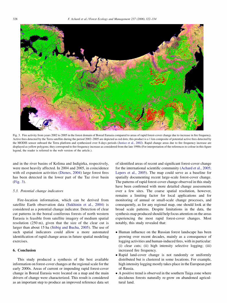
Fig. 3. Fire activity from years 2002 to 2005 in the forest domain of Boreal Eurasia compared to areas of rapid forest-cover change due to increase in fire frequency.
Active fires detected by the Terra satellite during the period 2002–2005 are depicted as red dots; this product is a 1 km composite of potential active fires detected by
the MODIS sensor onboard the Terra platform and synthesized over 8-days periods (Justice et al., 2002). Rapid change areas due to fire frequency increase are
displayed as yellow polygons; they correspond to fire frequency increase as considered from the late 1990s (For interpretation of the references to colour in this figure
legend, the reader is referred to the web version of the article.).
F. Achard et al. / Forest Ecology and Management 237 (2006) 322–334328
and in the river basins of Kolima and Indigirka, respectively,
were most heavily affected. In 2004 and 2005, in coincidence
with oil expansion activities (Dienes, 2004) large forest fires
has been detected in the lower part of the Taz river basin
(Fig. 3).
5.3. Potential change indicators
Fire-location information, which can be derived from
satellite Earth observation data (Sukhinin et al., 2004) is
considered as a potential change indicator. Detection of clear
cut patterns in the boreal coniferous forests of north western
Eurasia is feasible from satellite imagery of medium spatial
resolution (250 m), given that the size of the clear cut is
larger than about 15 ha (Stibig and Bucha, 2005). The use of
such spatial indicators could allow a more automated
identification of rapid change areas in future spatial modeling
exercises.
6. Conclusion
This study produced a synthesis of the best available
information on forest-cover changes at the regional scale for the
early 2000s. Areas of current or impending rapid forest-cover
change in Boreal Eurasia were located on a map and the main
drivers of change were characterized. This result is considered
as an important step to produce an improved reference data set
of identified areas of recent and significant forest-cover change
for the international scientific community (Achard et al., 2005;
Lepers et al., 2005). The map could serve as a baseline for
spatially documenting recent large-scale forest-cover change.
The patterns of rapid forest-cover change observed in this study
have been confirmed with more detailed change assessments
over a few sites. The coarse spatial resolution, however,
remains a limiting factor for local applications and for
monitoring of annual or small-scale change processes, and
consequently, as for any regional map, one should look at the
broad scale patterns. Despite limitations in the data, the
synthesis map produced should help focus attention on the areas
experiencing the most rapid forest-cover changes. Most
notably, this study revealed that:
� H
uman influence on the Russian forest landscape has beengrowing over recent decades, mainly as a consequence of
logging activities and human-induced fires, with in particular:
(i) clear cuts; (ii) high intensity selective logging; (iii)
increased fire frequency.
� R
apid land-cover change is not randomly or uniformlydistributed but is clustered in some locations. For example,
high intensity logging mostly takes place in the European part
of Russia.
� A
positive trend is observed in the southern Taiga zone wheredeciduous forests naturally re-grow on abandoned agricul-
tural land.

�E
xcep
t
pro
cess
deg
rad
ared
riv
pu
blic
dem
an
from
C
�F
orest
fire
fre
exten
d
We
s
forest-co
sho
rtcom
som
eo
f
are:
�A
qu
an
presen
samp
le
measu
r
�T
here
i
measu
r
regio
ns
rapid
c
�T
he
ev
based
regio
n
up
on
w
revisio
Ack
no
w
We
w
follo
win
g
Ru
ss
Karp
Key
Kh
m
So
ci
Un
iv
Co
m
Cen
t
Razn
Yan
i
Zam
cow
.
Olss
pro
v
con
t
revie
man
Ap
pS
eeT
for
the
regro
wth
eslead
toth
ed
ation
(e.g.,in
crease
enb
yreg
ular
timb
e
reven
ue
or
ind
ivid
din
natio
nal
and
hin
aan
dJap
an.
deg
radatio
nin
Sib
qu
ency
and
dev
e
ing
rapid
ly.
ho
uld
ensu
reth
a
ver
chan
ge
info
rm
ing
sid
entifi
edin
the
prio
ritiesfo
r
titative
accuracy
a
tedh
eresh
ou
ldb
e
of
local
sitesw
he
ed.
sa
need
for
system
edp
rocesses
of
fo
that
aren
ot
kn
ow
han
ges
may
stillt
iden
ceo
nw
hich
on
existin
gex
p
alscale,
with
the
u
hich
itis
based
n.
ledg
emen
ts
ou
ldlik
eto
ackn
exp
ertsw
ho
too
k
ia:A
.Isaev,
Ru
ssianA
achev
skiy,
Bio
div
ersit
ko
,B
aikal
Reg
ion
al
elevsk
y,S
ocio
Eco
log
oE
colo
gical
Un
ion
,M
ersity,M
osco
w;
S.
Pa
pan
y,S
yk
tyv
kar,
Ko
m
refo
rV
olg
a-Ural
en
ob
arsky,
Cen
trefo
rF
tskay
a,B
iod
iversity
C
olo
dch
iko
v,F
orest
Ec
T.
Ham
e,V
TT
Info
rm
on
,S
wed
ishU
niv
ersity
ided
info
rmatio
nfo
r
ribu
tedto
the
GIS
pro
wers
for
their
com
me
uscrip
t.
end
ixA
able
A.1
.
i
ecdfi
rhua
iner
lo
tt
atfu
ssp
reatre
nakt
ertndsh
owp
nth
eso
uth
ernT
aiga
a
reaseo
ffo
restco
ver
o
refreq
uen
cy).L
ogg
ing
a
arvestin
gan
dirreg
ular
cu
lp
rofi
tin
respon
seto
ternatio
nal
mark
ets,p
ar
ia,m
ostly
relatedto
inc
pm
ent
of
log
gin
gactiv
he
nex
tattem
pt
tosy
ion
for
bo
realE
urasia
av
the
curren
tex
ercise.F
ture
ob
servatio
ns
and
essmen
to
fth
eco
arse-sc
erform
edw
itha
valid
s
forest
areaco
nv
ersion
sw
ico
bserv
ation
so
nth
esti
st-cov
erch
ang
e,in
clud
asfast
chan
gin
gareas
bu
ep
lace.
he
areasw
ered
esign
a
isean
dav
ailable
dat
erstand
ing
that
the
info
ou
ldb
esu
bject
toco
ledg
eth
ep
articipatio
n
artto
the
exp
ertco
nsu
lt
F.
Ach
ard
eta
l./Fo
res
cadem
yo
fS
ciences,
Mo
s
yC
on
servatio
nC
entre,
Mo
Info
rmatio
nC
entre,
Irku
icalU
nio
n,
Mo
scow
;A
.K
o
osco
w;
A.
Maslo
v,M
osco
uto
v,N
eusid
lerS
yk
tyv
ka
iR
epu
blic;
A.
Pazh
enk
ov,
viro
nm
ental
netw
ork
,S
am
orest
Pro
tection
,K
rasno
y
on
servatio
nC
entre,
Mo
s
olo
gy
&P
rod
uctio
nC
entr
ation
Tech
no
log
y,F
inlan
d
of
Ag
ricultu
ralS
ciences,
Scan
din
avia.
R.
Beu
chl
cessing
.W
eth
ank
two
ano
nts,
wh
ichallo
wed
imp
ro
llo
t
rto
ctivi
tting
grow
ticula
rease
ities,
nth
es
oid
s
or
th
resea
alem
tatisti
ou
ld
llp
oo
ing
o
tw
h
tedw
asets
rmat
ntin
u
of
ation
cstsrSaceSenv tE
colo
her
its
ties
for
ing
rlyofis
ize
the
is,
rchap
cal
be
rly
ver
ereasat
ion
ing
the
for
gy
an
dM
a
ow
;M
.
cow
;T
.
sk;
A.
tiko
va,
wS
tate
Fo
rest
up
po
rt
ara;V
.
rsk;
T.
ow
;D
.
,M
os-
and
H.
wed
en
,JR
C,
ym
ou
s
ing
the
na
g
T
Process characteristics F. Cover change;
patch S
T Impact: strong
or (moderate)
Drivers Economic/
institutional factors
emen
t2
37
able A.1
Description of the change processes for each rapid change area
ID Region/location Main forest type(s) Change process
(20
Pa
h
ctive
ty)
Controlled process affecting
pristine forests
Small FCC;
small patch size
P; O; E Sustainability,
(ecosystem)
Private enterprise Regular harvesting,
sanitary felling,
road construction
h Controlled process affecting
pristine and managed forests
Small FCC;
small patch size
P; O; E Sustainability,
(ecosystem)
Private enterprise Regular harvesting
h natural
eplanting
Controlled process affecting
pristine forests
Medium FCC;
small patch size
P; O; E Sustainability,
ecosystem
Private enterprise Regular harvesting
h natural Controlled process affecting
pristine forests
Medium FCC;
small patch size
P; O; E Sustainability,
ecosystem
Private enterprise Regular harvesting
h natural
eplanting
Controlled process affecting
pristine and managed forests
Medium FCC;
small patch size
P; O; E Sustainability,
(ecosystem)
Private enterprise Regular harvesting,
some sanitary
felling
h natural Controlled and uncontrolled
processes affecting pristine
and managed forests
Medium FCC;
small patch size
P; O; E Sustainability,
ecosystem
Public and private
enterprises, local
population (?)
Regular harvesting,
sanitary felling,
irregular cutting
h natural Controlled process affecting
pristine forests
Large FCC;
small patch size
P; O; E Sustainability,
ecosystem
Private enterprise Regular harvesting
h natural Controlled process affecting
pristine forests
Medium FCC;
small patch size
P; O; E Sustainability,
ecosystem
Private enterprise Regular harvesting
h natural Controlled process affecting
pristine and managed forests
Medium FCC;
small PS
P; O; E Sustainability,
ecosystem
Private enterprise Regular harvesting
06
)3
22
–3
34
32
9
rt 1: western Russia
1-1 Murmansk region: Lotta and
Yauriyoki valleys
Evergreen
coniferous forests
Clear-cut logging wit
natural regrowth; sele
logging (high intensi
1-2 Murmansk region: planned
national park, Alakurtti
Evergreen
coniferous forests
Clear-cut logging wit
natural regrowth
1-3 Karelia republic: Pyaozero area Evergreen
coniferous forests
Clear-cut logging wit
regrowth and some r
1-4 Karelia republic: Kestenga area Evergreen
coniferous forests
Clear-cut logging wit
regrowth
1-5 Karelia republic: North Kalevala
planned national park
Evergreen
coniferous forests
Clear-cut logging wit
regrowth and some r
1-6 Karelia republic: South Kalevala
planned national park
Evergreen
coniferous forests
Clear-cut logging wit
regrowth
1-7 Karelia republic: Muesersky
district
Evergreen
coniferous forests
Clear-cut logging wit
regrowth
1-8 Arkhangelsk region: Onega
peninsular
Evergreen
coniferous forests
Clear-cut logging wit
regrowth
1-9 Arkhangelsk region: north
Vodlozero NP
Mixed coniferous–
broadleaf forests
Clear-cut logging wit
regrowth

Table A.1 (Continued )
ID Region/location Main forest type(s) Change process Process characteristics F. Cover change;
patch S
T Impact: strong
or (moderate)
Drivers Economic/
institutional factors
1-10 Arkhangelsk region: south-east
Vodlozero
Evergreen
coniferous forests
Clear-cut logging with natural
regrowth
Controlled process affecting
pristine and managed forests
Medium FCC;
small patch size
P; O; E Sustainability,
ecosystem
Private enterprise Regular harvesting
1-11 Karelia republic: south of
Vodlozero NP
Evergreen
coniferous forests
Clear-cut logging with natural
regrowth
Controlled processes in pristine
and managed forests
Medium FC change
small patch size
P; O; E Sustainability,
ecosystem
Public and private
enterprises
Regular harvesting,
some sanitary felling
1-12 Karelia/Vologda: Andoma area Evergreen
coniferous forests
Clear-cut logging with natural
regrowth
Controlled process in pristine
forests
Medium FCC
small PS
P; E Sustainability,
ecosystem
Private enterprise Regular harvesting,
sanitary felling
(expected)
1-13 St Petersburg region/Karelia
republic: Karelian Isthmus
Evergreen
coniferous forests
Clear-cut logging or selective
logging (high intensity)
Controlled and uncontrolled
processes in managed forests.
Small FCC;
small patch size
P; O Sustainability,
(species, soils,
ecosystem)
Public (FFS) and
private enterprise
Regular harvesting,
sanitary felling,
urban and road
construction
1-14 Arkhangelsk region: White
Sea-Kulay Upland
Evergreen
coniferous forests
Increased fire frequency,
clear-cut logging diamond
mining
Controlled and uncontrolled
(fire) processes in pristine forests
Medium FCC
large (fire) and
small PS
P; O; E Sustainability,
ecosystem
Private enterprise Industrial construction
natural resource
exploitation road
construction
1-15 Arkhangelsk reg/Komi republic:
N-Dvina and Pinega basins
Evergreen
coniferous forests
Clear-cut logging with natural
regrowth, overlogging
Controlled process in pristine
forests
Large FCC;
small patch size
P; O; E Sustainability,
ecosystem
Private enterprise Regular harvesting
1-16 Komi republic: Timan Range Evergreen
coniferous forests
Increased fire frequency bauxite
mining
Controlled and uncontrolled
processes (fire) in pristine forests
Small FCC;
small patch size
O; E Ecosystem,
(sustainability)
Public and private
enterprises
Industrial
construction natural
resource exploitation
road construction
1-17 Komi republic: west Yugyd-
Va national Park
Evergreen
coniferous forests
Clear-cut logging with natural
regrowth
Controlled process affecting
pristine forests
Medium FCC;
small patch size
P; O Sustainability,
ecosystem
Private enterprise Regular harvesting
1-18 Komi republic: east Pechoro-
Ilychsky Nature Reserve
Evergreen
coniferous forests
Clear-cut logging with natural
regrowth
Controlled process affecting
pristine forests
Large FCC;
small patch size
P; O; E Sustainability,
ecosystem
Private enterprise Regular harvesting
1-19 Perm region: western slopes of
Ural Mountains
Evergreen
coniferous forests
Clear-cut logging with natural
regrowth
Controlled process affecting
pristine forests
Medium FCC;
small PS
P; O; E Sustainability,
ecosystem
Private enterprise Regular harvesting
1-20 Vologda region: Velikiy Ustug
district
Mixed coniferous–
broadleaf forests
Clear-cut logging with natural
regrowth
Controlled processes affecting
managed forests
Medium FCC
small patch size
P; O; E Sustainability,
ecosystem
Private enterprise Regular harvesting
1-21 Kirov region Mixed coniferous–
broadleaf forests
Clear-cut logging with natural
regrowth
Controlled processes in managed
forests
Medium FCC
small patch size
P; O; E Sustainability,
ecosystem
Private enterprise Regular harvesting
1-22 Komi Republic and
Kirov region:
upper Letka river
Evergreen
coniferous forests
Clear-cut logging with natural
regrowth
Controlled process affecting pristine
and managed forests
Small FCC;
small PS
P; O; E Sustainability,
ecosystem
Private enterprise Regular harvesting
1-23 Kirov region Mixed coniferous–
broadleaf forests
Clear-cut logging with natural
regrowth
Controlled processes affecting
managed forests
Medium FCC;
small patch size
P; O; E Sustainability,
ecosystem
Private enterprise Regular harvesting
1-24 Kirov region Mixed coniferous–
broadleaf forests
Clear-cut logging with natural
regrowth
Controlled processes affecting
managed forests
Medium FCC;
small patch size
P; O; E Sustainability,
ecosystem
Private enterprise Regular harvesting
1-25 Kirov region Mixed coniferous–
broadleaf forests
Clear-cut logging with natural
regrowth
Controlled processes affecting
managed forests
Medium FCC;
small patch size
P; O; E Sustainability,
ecosystem
Private enterprise Regular harvesting
1-26 Komi republic:
Ust-Tsilma area
Evergreen
coniferous forests
Increased fire frequency Uncontrolled process affecting
pristine forests
Large FCC;
large patch size
P Species composition,
soils, ecosystem
Occasional fire,
mining companies
Mining (oil, gas)
1-27 Komi republic:
Usinsk area
Evergreen
coniferous forests
Increased fire frequency Uncontrolled process affecting
pristine forests
Large FCC;
large patch size
P Species composition,
soils, ecosystem
Occasional fire,
mining companies,
Mining (oil, gas)
1-28 Bashkortostan republic Evergreen
coniferous forests
Clear-cut logging with natural
regrowth, selective logging
(high intensity)
Controlled process affecting
pristine forests
Large FCC;
small patch size
P; O; E Species, ecosystem,
(soils)
Public and private
enterprises, local
population
Regular harvesting,
sanitary felling,
irregular cutting
1-29 Manty-Mansiysky
autonomous district:
eastern slopes of Urals
Evergreen
coniferous forests
Increased fire frequency Uncontrolled process affecting
pristine forests
Medium FC change
large patch size
P; O Species composition,
soils, ecosystem
Public enterprise Gas pipeline
construction
1-30 Sverdlovsk region: eastern
slopes of Urals
Evergreen
coniferous forests
Clear-cut logging with natural
regrowth, increased fire frequency
Controlled and uncontrolled
processes in pristine and
managed forests
Medium FCC;
medium-small PS
P; O; E Species composition,
soils, ecosystem,
(sustainability)
Public and private
enterprises, local
population
Regular harvesting,
irregular cutting,
road and pipeline
construction
1-31 Bashkortostan republic Deciduous
broadleaf forests
Clear-cut logging with natural
regrowth and replanting, selective
logging (high intensity)
Controlled processes affecting
pristine and managed forests
Small FCC;
small patch size
P; O; E Ecosystem, (species
composition, soils)
Public and private
enterprises, local
population
Regular harvesting,
sanitary felling,
irregular cutting
F.
Ach
ard
eta
l./Fo
restE
colo
gy
an
dM
an
ag
emen
t2
37
(20
06
)3
22
–3
34
33
0

1-32 Moscow city and suburbs Mixed coniferous–
broadleaf forests
Private construction logging
(high intensity)
Controlled and uncontrolled
processes in managed forests
Medium FC change P; O; E Species, soils,
sustainability,
ecosystem
Public and private
enterprises,
individual groups
Urban development
1-33 St. Petersburg city and
suburbs
Evergreen
coniferous forests
Private construction logging
(high intensity)
Controlled and uncontrolled
processes in managed forests
Medium FC change P; O; E Species, soils,
sustainability,
ecosystem
Public and private
enterprises,
individual groups
Urban development
1-34 Nizhniy Novgorod region:
Volga and Oka valleys
Peatland Increased fire frequency (peat fires) Uncontrolled processes affecting
managed forests and dried peatland
Medium-small
FCC; medium PS
P; E Soils, sustainability,
ecosystem,
Natural factors
(climatic), local
population
Peat mining,
agriculture
1-35 St. Petersburg region:
Tikhvinsky district
Peatland Increased fire frequency (peat fires) Uncontrolled processes affecting
managed forests and dried peatland
Medium-small
FCC; medium PS
P; E Soils, sustainability,
ecosystem,
Natural factors
(climatic), local
population
Peat mining,
agriculture
1-36 Novgorod Region: Novgorod
and Malaya Vishera district
Peatland Increased fire frequency (peat fires) Uncontrolled processes affecting
managed forests and dried peatland
Medium-small
FCC; medium PS
P; E soils, sustainability,
ecosystem,
natural factors
(climatic), local
population
peat mining,
agriculture
1-37 Vologda region Peatland Increased fire frequency (peat fires) Uncontrolled processes affecting
managed forests and dried peatland
Medium-small
FCC; medium PS
P; E Soils, sustainability,
ecosystem,
Natural factors
(climatic), local
population
Peat mining,
agriculture
1-38 Tver region: Volga and
Medveditsa rivers
Peatland, mixed
coniferous–
broadleaf forests
Increased fire frequency (peat fires) Uncontrolled processes affecting
managed forests and dried peatland
Medium-small
FCC; medium PS
P; E Soils, sustainability,
ecosystem,
Natural factors
(climatic), local
population
Peat mining,
agriculture
1-39 Moskow, Ryazan and
Vladimir regions: MesFhera
area
Peatland, mixed
coniferous–
broadleaf forests
Increased fire frequency (peat fires) Uncontrolled processes affecting
managed forests and dried peatland
Medium-small
FCC; medium PS
P; E Soils, sustainability,
ecosystem,
Natural factors
(climatic), local
population
Peat mining,
agriculture
1-40 Nizhniy Novgorod region
and Chuvashia republic:
Cheboksarskoye Reservoir
Evergreen
coniferous forests
Conversion (dam construction) Controlled and uncontrolled
processes in managed forests
Small FC change O; E Public Dam construction
1-41 Perm region: Upper Kama
Reservoir
Evergreen
coniferous forests
Conversion (dam construction) Controlled processes affecting
managed forests
Medium FC change O Species composition,
soils, sustainability,
ecosystem
Public Dam construction
1-42 Bashkortostan republic: Y
umagusino Reservoir on
Belaya River
Evergreen
coniferous forests
Conversion (dam construction) Controlled processes affecting
managed forests
Medium FC change O Species composition,
soils, sustainability,
ecosystem
Public Dam construction
1-43 Yekaterinburg city and
suburbs
Evergreen
coniferous forests
Conversion (mining) Controlled processes affecting
pristine and managed forests
P; O; E Soils, ecosystem Private enterprise Natural resource
exploitation
Part 2: Siberia and the far East
2-1 Yamalo-Nenetskiy
autonomous District:
North of Surgut
Spruce and Scots
Pine sparse forests
Clear-cut logging with natural
regrowth; increased fire frequency;
oil extraction
Controlled process affecting
intact/pristine forests
Large FCC;
medium PS
P; O; E Soils; sustainability Public or private
enterprises large-
small FFS
Regular timber
harvesting, natural
resource exploitation,
road/pipeline construct.
2-2 Altai Kray Scots Pine forests Selective logging (moderate
intensity); increased fire
frequency
Large FCC;
medium PS
P; O; E Species composition;
soils; ecosystem
Individual groups
local population
Irregular cutting for
profit conversion
to agricultural
2-3 Altai Kray:
northern Altai
Broadleaf forests Selective logging (high intensity);
increased fire frequency; over
grazing (degradation)
Controlled and uncontrolled
processes affecting pristine and
managed forests
Large FCC;
medium PS
P; O; E Species composition;
soils; (ecosystem)
Public or private
enterprises local
population
Irregular cutting for
profit, industrial
construction, natural
resource exploitation
2-4 Altai Kray: near
Barnaul city
Broadleaf forests;
Scots Pine forests
Clear-cut logging with natural
regrowth, selective logging
(high intensity), increased
fire frequency
Uncontrolled process affecting
managed forests
Large FCC;
medium/small PS
P; O; E Species composition;
(sustainability)
Large-small FFS
local populations
Sanitary felling,
irregular cutting
for profit
2-5 Novosibirsk Oblast: near
Novosibirsk city
Birch forests Selective logging (moderate
intensity), over grazing (degradation),
reforestation
Uncontrolled process affecting
intact/pristine forests
Medium FCC P; O; E Species composition;
(soils); ecosystem
Public or private
enterprises local
populations
Conversion from
agriculture (collective
farm collapse)
2-6 Altai Kray/Kemerovo
Oblast: Salair ridge
Broadleaf forests;
evergreen
coniferous forests
Selective logging (high intensity),
road construction
Controlled and uncontrolled
processes
Medium FCC P; O; E (Species); soils;
sustainability
Public or private
enterprises;
large-small FFS
Regular timber
harvesting, natural
resource exploitation
(gold mining)
F.
Ach
ard
eta
l./Fo
restE
colo
gy
an
dM
an
ag
emen
t2
37
(20
06
)3
22
–3
34
33
1

Table A.1 (Continued )
ID Region/location Main forest type(s) Change process Process characteristics F. Cover change;
patch S
T Impact: strong
or (moderate)
Drivers Economic/
institutional factors
2-7 Kemerovo Oblast: western
slope of Kuznetsky Alatan
Broadleaf forests Selective logging (high intensity),
industrial pollution
Uncontrolled process P; O; E (Species); soils Public or private
enterprises
(prov. development
scheme)
Regular timber
harvesting, industrial
construction, natural
resource exploitation
2-8 Krasnoyarsky Kray:
Jarcevo district
Scots Pine forests Clear-cut logging with natural
regrowth
Controlled process affecting
intact/pristine forests
Large FCC;
large PS
P; O; E Soils; sustainability;
ecosystem
Local enterprises Regular timber
harvesting
2-9 Krasnoyarsk Kray: south of
Jenisey Range
Evergreen
coniferous forests
Clear-cut logging with natural
regrowth, road or pipeline
construction, expected fires
Controlled process affecting
intact/pristine forests
Small FCC;
small PS
P; O Species composition;
sustainability;
ecosystem
Private enterprise Regular timber
harvesting, industrial
construction, natural
resource exploitation
2-10 Krasnoyarsk Kray: near
Angara river
Scots Pine forests;
evergreen
coniferous forests
Degradation due to pest outbreak
(Siberian moss)
Uncontrolled process affecting
intact/pristine forests
Large FCC P; O; E Species composition;
soils; ecosystem
Natural factors:
climate, windfalls,
clear-cuts, burnt
2-11 Krasnoyarsk Kray/Irkutsk
Oblast: Angara
River/Ilimsky district
Scots Pine forests;
evergreen
coniferous forests
Clear-cut logging with natural
regrowth or replanting
Controlled process affecting
managed forests
Large PS Sustainability Public or private
enterprises
Regular timber
harvesting
2-12 Irkutsk region:
Zhitolovskiy district
Evergreen
coniferous forests
Gas-extraction field Controlled process E (Ecosystem) Private enterprise Natural resource
exploitation,
pipeline construction
2-13 Irkutsk Oblast:
near Baykal lake
Scots Pine forests Selective logging (moderate
intensity); increased fire
frequency
Affecting managed forests Small FCC;
medium PS
(Species composition;
ecosystem)
Small FFC local
population
Survival of local
people
2-14 Buryat Republic: near
Baykal lake
Larch forests Clear-cut logging with natural
regrowth, increased fire
frequency
Controlled and uncontrolled
(fire) processes
Medium FCC;
medium PS
P; O Species composition;
(ecosystem)
Small FFS Regular timber
harvesting
2-15 Buryat Republic/Chita
Oblast
Larch forests Increased fire frequency Uncontrolled process affecting
managed forests
Medium PS O (Ecosystem) Natural factors
(climatic), local
population
Lack of control
2-16 Chita Oblast:
Chikoy Upland
Evergreen
coniferous forests;
Scots Pine forests
Clear-cut logging with
natural regrowth
Uncontrolled process affecting
intact/pristine forests
Medium/small
FCC; small PS
P; O; E Species composition;
sustainability;
ecosystem
Private enterprise Regular timber
harvesting
2-17 Amur Oblast: border
with China
Larch forests Increased fire frequency Uncontrolled process Natural factors
(climatic), local
population
Lack of control
2-18 Khabarosvk Kray/
Yevrey Oblast
Mixed coniferous–
broadleaf forests;
evergreen
coniferous forests
Clear-cut logging Uncontrolled process affecting
intact/pristine forests
Large FCC;
large PS
P; O; E Species composition;
sustainability;
ecosystem
Public or private
enterprises,
individual groups,
local population
Regular timber
harvesting irregular
cutting for profit
2-19 Khabarosvk Kray:
southern Sikhote
Alin mountains
Larch forests mixed
coniferous–broadleaf
forests
Increased fire frequency Uncontrolled process affecting
pristine and managed forests
Large FCC;
large PS
Ecosystem Natural factors
(climatic), local
population
Lack of control
2-20 Khabarosvk Kray:
central Sikhote Alin
mountains; Khorsky
leskhoz
Mixed coniferous–
broadleaf forests
Selective logging (high/moderate
intensity)
Controlled and uncontrolled
processes affecting managed forests
Large FCC;
small PS
P; O; E Species composition Public or private
enterprises;
illegal logging
brigades
Regular timber
harvesting irregular
cutting for profit
2-21 Primorski Kray/
Khabarosvk Kray:
central Sikhote Alin;
Samarga river
Evergreen
coniferous forests
(Spruce-fir); larch
forests
Conversion to non-forest Clear-cut
logging Selective logging (high/
moderate intensity)
Controlled process affecting
intact/pristine forests
Large FCC;
small PS
P; O; E (Sustainability);
ecosystem
Large private
timber companies
Regular timber
harvesting irregular
cutting for profit
2-22 Primorski Kray: central
Sikhote Alin mountains;
Svelinsky Leskhoz
Evergreen
coniferous forests
Clear-cut logging Permanent
conversion to non-forest
Controlled process affecting
intact/pristine forests
Large FCC;
small PS
P; O; E (Species composition);
sustainability;
ecosystem
Large timber
companies
Regular timber
harvesting
2-23 Primorski Kray: central
Sikhote Alin mountains;
Ussuri river
Mixed coniferous–
broadleaf forests
(Korean Pine)
Selective logging (high/
moderate intensity)
Controlled and uncontrolled
processes affecting managed
forests
Large FCC;
small PS
P; O; E Species composition Public or private
enterprises;
individual groups
Regular timber
harvesting irregular
cutting for profit
F.
Ach
ard
eta
l./Fo
restE
colo
gy
an
dM
an
ag
emen
t2
37
(20
06
)3
22
–3
34
33
2

2-24 Primorski Kray: border
with China
Dry oak forests; mixed
coniferous–broadleaf
forests
Increased fire frequency
Degradation caused by
frequent ground fires
Uncontrolled process affecting
managed forests
Small FCC;
medium PS
P; O; E Ecosystem;
biodiversity;
(sustainability
Local population Lack of control,
poverty
2-25 Sakhalin Oblast Evergreen
coniferous forests
Clear-cut logging Uncontrolled process affecting
pristine and managed forests
Large FCC;
large PS
Ecosystem Public or private
enterprises,
individual groups,
local population
Regular timber
harvesting
2-26 Yakutia Republic Larch forests Increased fire frequency Uncontrolled process affecting
managed forests
Large FCC;
large PS
P; O Sustainability;
ecosystem
Natural factors
(climatic), local
population
Lack of control
2-27 Yakutia
Republic/Magadan
Oblast: Cherskyi
mountains
Larch forests Increased fire frequency Uncontrolled process affecting
intact/pristine forests
Medium FCC;
large PS
O Ecosystem Natural factors
(climatic)
2-28 Khabarovsky kray Larch and Spruce
forests
Clear-cut logging Increased
fire frequency
Controlled process affecting
intact/pristine forests
Large FCC;
small PS
O; E (Species composition);
sustainability;
ecosystem
Large timber
companies
Regular timber
harvesting
2-29 Taz river basin Larch forests Increased fire frequency Uncontrolled process affecting
intact/pristine forests
Medium FCC;
large PS
O; E Ecosystem Private enterprise Natural resource
exploitation (oil)
Part 3: China
3-1 Heilongjiang province:
Da Hinggan Ling prefec
Larch forests;
pine forests
Selective logging (moderate
intensity)
Controlled process affecting
managed forests
Small FCC;
small PS
P; O; E (Species
composition;
sustainability)
Public enterprises
(national
development plan)
Regular timber
harvesting
3-2 Heilongjiang province:
Xiao Hinggan
Ling prefec
Mixed coniferous–
broadleaf forests
Selective logging (moderate
intensity)
Controlled process affecting
managed forests
Small FCC;
small PS
P; O; E (Species
composition;
sustainability)
Public enterprises
(national
development plan)
Regular timber
harvesting
ID: identification number. Region/location: name of administrative region and local place. Main forest type: main forest cover type inside the rapid change area. Change process: this parameter describes the direct cause
and includes the following possibilities: clear-cut logging (with natural regeneration or replanting); selective logging (high or moderate intensity); increased fire frequency; conversion to non-forest (mining, dam
building. . .); degradation (overgrazing, pest outbreak. . .); afforestation (on abandoned agricultural land). Process characteristics: control or uncontrolled process affecting intact/pristine or managed forests. F Cover
change: forest cover change percentage over last 5 years: large (>10%); medium (5–10%); small (<5%). Patch S: Average patch size (in case of clear-cut or fire): large (>100 ha); medium (50–100 ha); small (<50 ha).
T: time: past (1998–2003); ongoing (2003–2005); expected (next 3 years). Impact: Negative impact [strong or (moderate)] on species composition, soils, sustainability or ecosystem. Drivers: Drivers of the change
process, e.g., public or private enterprises; large-small FFS; individual groups or local population; natural factors (climatic). Economic/institutional factors: Economic/institutional factors of change process including,
regular timber harvesting; irregular cutting for profit; natural resource exploitation; road or pipeline construction; sanitary felling; conversion from agriculture.
F.
Ach
ard
eta
l./Fo
restE
colo
gy
an
dM
an
ag
emen
t2
37
(20
06
)3
22
–3
34
33
3

F. Achard et al. / Forest Ecology and Management 237 (2006) 322–334334
References
Achard, F., Eva, H.D., Glinni, A., Mayaux, P., Richards, T., Stibig, H.-J., 1998.
Identification of Deforestation Hot Spot Areas in the Humid Tropics.
European Commission, Luxembourg, EUR 18079 EN.
Achard, F., Eva, H.D., Stibig, H.J., Mayaux, P., Gallego, J., Richards, T.,
Malingreau, J.P., 2002. Determination of deforestation rates of the world’s
humid tropical forests. Science 297, 999–1002.
Achard, F., Stibig, H.-J., Laestadius, L., Roshchanka, V., Yaroshenko, A., Akse-
nov, D. (Eds.), 2005. Identification of ‘‘Hot Spot Areas’’ of Forest Cover
Changes in Boreal Eurasia. European Communities, Luxembourg, EUR
21684 EN.
Achard, F., Mollicone, D., Eva, H.D., Beuchle, R., 2006. Human role and
climate anomalies effect on wildfires in Russian boreal forests. In prepara-
tion.
Aksenov, D., Dobrynin, D., Dubinin, M., Egorov, A., Isaev, A., Karpachevskiy,
M., Laestadius, L., Potapov, P., Purekhovskiy, A., Turubanova, S., Yar-
oshenko, A., 2002. Atlas of Russia’s Intact Forest Landscapes. Global
Forest Watch Russia, Moscow.
Bartalev, S., Achard, F., Erchov, D., Gond, V., 2001. The potential contribution
of SPOT-4/VEGETATION data for mapping Siberian forest cover at cont.
scale. In: Saint, G. (Ed.), Proceedings of the VEGETATION 2000 Con-
ference, JRC, Ispra, pp. 127–142.
Bartalev, S., Belward, A.S., Erchov, D., Isaev, A.S., 2003. A new SPOT4-
VEGETATION derived land cover map of Northern Eurasia. Int. J. Remote
Sens. 24, 1977–1982.
Bartalev, S., Kuryatnikova, T., 2005. Analysis of Forest Cover Change from
Satellite Images over Sample Sites of the European Part of Russia. IKI
Russian Academy of Sciences, Moscow.
Bergeron, Y., Gauthier, S., Kafka, V., Lefort, P., Lesieur, D., 2001. Natural fire
frequency for the eastern Canadian boreal forest: consequences for sustain-
able forestry. Can. J. For. Res. 31, 384–391.
DeFries, R., Houghton, R.A., Hansen, M., Field, C.B., Skole, D., Townshend, J.,
2002. Carbon emissions from tropical deforestation and regrowth based on
satellite observations from 1980s and 90s. Proc. Natl. Acad. Sci. 99, 14256–
14261.
Dienes, L., 2004. Observations on the problematic potential of Russian oil and
the complexities of Siberia. Eurasian Geography and Economics 45, 319–
345.
FAO, 2001. Global Forest Resources Assessment 2000: Main Report, Food and
Agriculture Organization, Rome, FAO Forestry Paper 140.
FAO, 2006. Global Forest Resources Assessment 2005: Progress towards
sustainable forest management, Food and Agriculture Organization, Rome,
FAO Forestry Paper 147.
Feddema, J.J., Oleson, K.W., Bonan, G.B., Mearns, L.O., Buja, L.E., Meehl,
G.A., Washington, W.M., 2005. The importance of land-cover change in
simulating future climates. Science 310, 1674–1678.
Flannigan, M.D., Logan, K.A., Amiro, B.D., Skinner, W.R., Stocks, B.J., 2005.
Future area burned in Canada. Climat. Change 72, 1–16.
Geist, H., McConnell, W., Lambin, E.F., Moran, E., Alves, D., Rudel, T., 2006.
Causes and trajectories of land-use/cover change. In: Lambin, E.F., Geist,
H. (Eds.), Land-Use and Land-Cover Change. Springer, Berlin, pp. 41–70.
Goldammer, J.G., Sukhinin, A., Csiszar, I., 2003. Russian Federation, Inter-
national Forest Fire News 29.
Greenpeace, 2006. Roadmap to Recovery: The World’s Last Intact Forest
Landscapes. Greenpeace International, Amsterdam.
Hlasny, T., Rasi, R., 2005. Forest Change Maps for Two Selected Test Sites in
Boreal Eurasia Produced from Satellite Imagery. Forest Research Institute,
Zvolen, Slovakia.
Hytteborn, H., Maslov, A.A., Nazimova, D.I., Rysin, L.P., 2005. Boreal forests
of Eurasia. In: Andersson, F.A. (Ed.), Coniferous Forests. Elsevier,
Amsterdam, pp. 23–99.
Isaev, A.S. (Ed.), 1990. Forest Map of USSR. GUGK, Moscow.
Justice, C.O., Giglio, L., Korontzi, S., Owens, J., Morisette, J.T., Roy, D.,
Descloitres, J., Alleaume, S., Petitcolin, F., Kaufman, Y., 2002. The MODIS
fire products. Remote Sens. Environ. 83, 244–262.
Karpachevskiy, M., 2004. Forest Fires in the Russian Taiga: Natural Disaster or
Poor Management? Taiga Rescue Network Factsheet, Jokkmokk, Sweden.
Lambin, E.F., Geist, H., Lepers, E., 2003. Dynamics of land use and cover
change in tropical regions. Annu. Rev. Environ. Resour. 28, 205–241.
Lepers, E., Lambin, E.F., Janetos, A.C., DeFries, R., Achard, F., Ramankutty,
N., Scholes, R.J., 2005. A synthesis of information on rapid land-cover
change for the period 1981–2000. Bioscience 55, 115–124.
Mayer, A.L., Kauppi, P.E., Angelstam, P.K., Zhang, Y., Tikka, P.M., 2005.
Importing timber: exporting ecological impact. Science 308, 359–360.
Mollicone, D., Achard, F., Belelli Marchesini, L., Federici, S., Wirth, C.,
Leipold, M., Rosellini, S., Schulze, E.D., Valentini, R., 2002. A new remote
sensing based approach to determine forest fire cycle: case study of the
central Siberia Abies dominated taiga. Tellus-B 54, 688–695.
Mollicone, D., Eva, H.D., Achard, F., 2006. Human role on Russian wild fires.
Nature 440, 436–437.
Mouillot, F., Field, C.B., 2005. Fire history and the global carbon budget: a
18 � 18 fire history reconstruction for the 20th century. Global Change Biol.
11, 398–420.
Peltola, A. (Ed.), 2003. Finnish Statistical Yearbook of Year 2003. Finnish
Forest Research Institute, Helsinki, Finland.
Qian, H., Yuan, X.-Y., Chou, Y.-L., 2003. Forest vegetation of northeast China.
In: Kolbek, J., Srutek, M., Box, E.O. (Eds.), Forest Vegetation of Northeast
Asia. Kluwer Academic Press, pp. 181–230.
Ramankutty, N., Graumlich, L., Achard, F., Alves, D., Chhabra, A., DeFries,
R.S., Foley, J.A., Gesit, H., Houghton, R.A., Klein Goldewijk, K., Lambin,
E.F., Millington, A., Rasmussen, K., Reid, R.S., Turner, B.L., 2006. Global
land-cover change: recent progress, remaining challenges. In: Lambin,
E.F., Geist, H. (Eds.), Land-Use and Land-Cover Change. Springer,
Berlin, pp. 9–40.
Rudel, T.K., Coomes, O.T., Moran, E., Achard, F., Angelsen, A., Xu, J.,
Lambin, E., 2005. Forest transitions: towards a global understanding of
land use change. Global Environ. Change 15, 23–31.
Sambale, J., 2005. Use of Landsat & ASTER Imagery to Assess Recent Forest
Cover Changes in Siberia. JRC, Ispra, Italy.
Schiermeier, Q., 2005. That sinking feeling. Nature 435, 732–733.
Stahl, G., Andren, O., Klemedtsson, L., et al., 2003. Preparing for Sweden’s
Reporting of Emissions and Removals of Greenhouse Gases in the
LULUCF Sector under the Kyoto Protocol. Naturvardsverket, Stockholm,
Sweden.
Stibig, H.-J., Achard, F., Fritz, S., 2004. A new forest cover map of continental
Southeast Asia derived from SPOT-VEGETATION satellite imagery. Appl.
Veg. Sci. 7, 153–162.
Stibig, H.-J., Bucha, T., 2005. Feasibility Study on the Use of Medium
Resolution Satellite Data for the Detection of Forest Cover Change caused
by Clear Cutting of Coniferous Forests in the Northwest of Eurasia.
European Communities, Luxembourg, EUR 21579 EN.
Sukhinin, A.I., French, N., Kasischke, E., Hewson, J.H., Soja, A.J., Csiszar,
I.A., Hyer, E.J., Loboda, T., Conrad, S.G., Romasko, V.I., Pavlichenko,
E.A., Miskiv, S.I., Slinkina, O.A., 2004. AVHRR-based mapping of fires in
Russia. Remote Sens. Environ. 93, 546–564.
Wirth, C., Czimczik, C.I., Schulze, E.-D., 2002. Beyond annual budgets: carbon
flux at different temporal scales in fire-prone Siberian Scots pine forests.
Tellus-B 54, 611–630.
Yaroshenko, A.Y., Potapov, P.V., Turubanova, S.A., 2001. The Last Intact Forest
Landscapes of Northern European Russia. Greenpeace Russia and Global
Forest Watch, Moscow.
Zamolodchikov, D., 2005. Use of Russian state forest account data to determine
‘‘hot spot regions’’. In: Achard, F., et al. (Eds.), Identification of ‘‘Hot Spot
Areas’’ of Forest Cover Changes in Boreal Eurasia. European Communities,
Luxembourg, pp. 41–44.