Application for Prior Environmental Clearance (Form – 1& Form
42
Application for Prior Environmental Clearance (Form – 1& Form -2) For Proposed Road Metal Mine over an Extent of 0.7486 Hectares in Sy. No. Hill Block No.VII of Nadigadda Village H/o Dupadu Village, Tripuranthakam Mandal, Prakasam District, Andhra Pradesh. ___________________________________________________________ Submitted To State Expert Appraisal Committee (SEAC), State Environmental Impact Assessment Authority, A.P. Submitted By ________________________________________________________________________________ SRI B.VENKATA REDDY H.No.8-75, Nadigadda Village, H/o. Dupadu, Tripuranthakam Mandal, Prakasam District A.P.
-
Upload
khangminh22 -
Category
Documents
-
view
2 -
download
0
Transcript of Application for Prior Environmental Clearance (Form – 1& Form

Application for Prior Environmental Clearance
(Form – 1& Form -2) For
Proposed Road Metal Mine over an Extent of 0.7486 Hectares in Sy. No. Hill Block No.VII
of Nadigadda Village H/o Dupadu Village, Tripuranthakam Mandal,
Prakasam District, Andhra Pradesh. ___________________________________________________________
Submitted To
State Expert Appraisal Committee (SEAC),
State Environmental Impact Assessment Authority, A.P.
Submitted By ________________________________________________________________________________
SRI B.VENKATA REDDY H.No.8-75, Nadigadda Village, H/o. Dupadu, Tripuranthakam
Mandal, Prakasam District A.P.

FORM 1
(I) Basic Information
Sl.No. Item Details
1. Name of the project/s SRI B.VENKATA REDDY
0.7486 Ha. of Road Metal Mine
2. S.No. in the schedule 1 (a)
3. Proposed capacity /area/length/tonnage to be
handled/command area/lease area/number of wells to
be drilled.
0.7486 Ha. of Road Metal Mine with a
proposed production is 30475
Cum/Year of Road Metal
4. New/Expansion/Modernization New
5. Existing Capacity/Area etc. 0.7486 Ha- New Mine
6. Category of Project i.e. ‘A’ or ‘B’ B2
7. Does it attract the general condition? If yes, please
specify.
No
8. Does it attract the specific condition? If yes, please
specify.
No
9. Location
Plot/Survey/Khasra No.
Village
Tehsil
District
State
Sy. No: Hill Block no.VII
Nadigadda village,
H/o. Dupadu village,
Tripuranthakam (M),
Prakasam District,
Andhra Pradesh.
10. Nearest railway station/airport along with distance in
kms.
Donakonda Railway Station is 19 Km
from the ML area
11. Nearest Town, city, district Headquarters along with
distance in kms.
Nadigadda Vilage is located at a
distance of 1.6 km from the applied
area.
12. Village Panchayats, Zilla Parishad, Municipal
Corporation, Local body (complete postal addresses
with telephone nos. to be given)
B.VENKATA REDDY
Lessee
S/o. Kasi Reddy
H.No.8-75,
Nadigadda Village, H/o. Dupadu,
Tripuranthakam Mandal,
Prakasam District
Cell:9959889338
13. Name of the applicant B.VENKATA REDDY
14. Registered Address B.VENKATA REDDY
Lessee
S/o. Kasi Reddy
H.No.8-75,
Nadigadda Village, H/o. Dupadu,
Tripuranthakam Mandal,
Prakasam District
Cell:9959889338

15. Address for correspondence:
Name
Designation (Owner/Partner /CEO)
Pin code
Telephone No.
Fax No.
B.VENKATA REDDY
Lessee
S/o. Kasi Reddy
H.No.8-75,
Nadigadda Village, H/o. Dupadu,
Tripuranthakam Mandal,
Prakasam District
Cell:9959889338
16. Details of Alternative Sites examined, if any.
Location of these sites should be shown on a topo
sheet.
Alternative sites available but lease
granted in applied area.
17. Interlinked Projects Nil
18. Whether separate application of interlinked project
has been submitted?
Not Applicable
19. If yes, date of submission Nil
20. If no, reason This is a mining project and not
having any interlinked projects
21. Whether the proposal involves approval/clearance
under: if yes, details of the same and their status to be
given.
i. The Forest (Conservation) Act, 1980?
ii. The Wildlife (Protection) Act, 1972?
iii. The C.R.Z. Notification, 1991?
Nil
Nil
Nil
22. Whether there is any Government Order/Policy
relevant /relating to the site?
Cluster within 500 mtrs existing.
Cluster order applicable.
23. Forest land involved (hectares)
Nil
24. Whether there is any litigation pending against the
project and/or land in which the project is propose to
be set up?
a) Name of the Court
b) Case No.
c) Orders/directions of the Court, if any and its
relevance with the proposed project.
No litigation about the project

(II) Activity
1. Construction, operation or decommissioning of the Project involving
actions, which will cause physical changes in the locality (topography, land
use, changes in water bodies, etc.)
S.No.
Information/Checklist confirmation
Yes/No
Details thereof (with approximate
quantities /rates, wherever possible)
with source of information data
1.1 Permanent or temporary change in land use,
land cover or topography including increase
in intensity of land use (with respect to
local land use plan)
Yes The Quarry operations envisaged for
the proposed plan period & during the
tenure of the lease period involves
change in land use/topography
covering an extent 0.7486 Ha. The
Quarry lease area is located on a hill
raised 30 M above Ground level with
the quarry lease area with topo relief
in West direction. The lowest RL 210
is and the highest RL is 240M The
relief is 30 M. The proposed
permanent/temporary change in land
use or land cover for the ensuring Plan
period is given in Mining Plan.
1.2 Clearance of existing land, vegetation and
buildings?
Yes There will be clearance of existing
vegetation wherever required. And
further preparatory works to be done.
Around 25-30 medium sized plans will
be cleared and remaining area is bushy
and grassy.
There are no existing buildings in the
lease area and hence no proposal of
clearance of existing buildings is made
1.3 Creation of new land uses?
Yes The proposed Quarry activities will
result in change/creation of new land
use. The waste lands in this part of the
region will be judiciously &
scientifically explored &
systematically worked so as to create a
good Quarry methodology for proper
utilization of the mineral deposits in
view of Mineral Conservation and
Development Rules apart from proper
reclamation of the subject area for
creation of new land use to suit the
local requirement i.e. Afforestation of
the Quarry lease area, development of
infrastructure, roads & pits for storage
of rain water & rain water harvesting
measures.
1.4 Pre-construction investigations e.g. bore Yes The area has been studied for
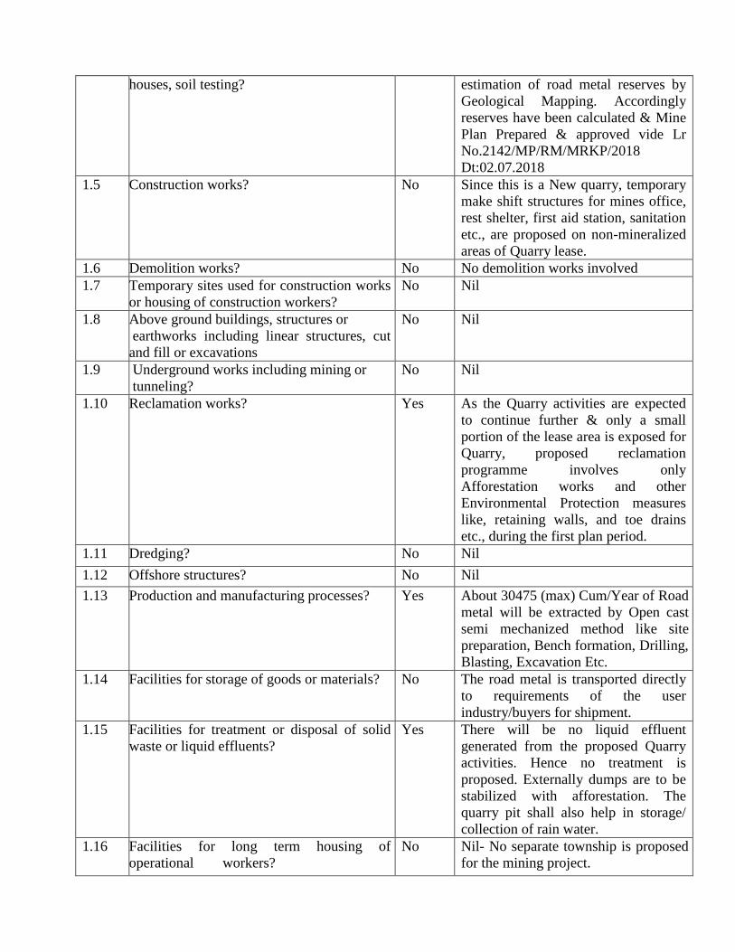
houses, soil testing? estimation of road metal reserves by
Geological Mapping. Accordingly
reserves have been calculated & Mine
Plan Prepared & approved vide Lr
No.2142/MP/RM/MRKP/2018
Dt:02.07.2018
1.5 Construction works?
No Since this is a New quarry, temporary
make shift structures for mines office,
rest shelter, first aid station, sanitation
etc., are proposed on non-mineralized
areas of Quarry lease.
1.6 Demolition works? No No demolition works involved
1.7 Temporary sites used for construction works
or housing of construction workers?
No Nil
1.8 Above ground buildings, structures or
earthworks including linear structures, cut
and fill or excavations
No Nil
1.9 Underground works including mining or
tunneling?
No Nil
1.10 Reclamation works?
Yes As the Quarry activities are expected
to continue further & only a small
portion of the lease area is exposed for
Quarry, proposed reclamation
programme involves only
Afforestation works and other
Environmental Protection measures
like, retaining walls, and toe drains
etc., during the first plan period.
1.11 Dredging? No Nil
1.12 Offshore structures? No Nil
1.13 Production and manufacturing processes?
Yes About 30475 (max) Cum/Year of Road
metal will be extracted by Open cast
semi mechanized method like site
preparation, Bench formation, Drilling,
Blasting, Excavation Etc.
1.14 Facilities for storage of goods or materials?
No The road metal is transported directly
to requirements of the user
industry/buyers for shipment.
1.15 Facilities for treatment or disposal of solid
waste or liquid effluents?
Yes There will be no liquid effluent
generated from the proposed Quarry
activities. Hence no treatment is
proposed. Externally dumps are to be
stabilized with afforestation. The
quarry pit shall also help in storage/
collection of rain water.
1.16 Facilities for long term housing of
operational workers?
No Nil- No separate township is proposed
for the mining project.

1.17 New road, rail or sea traffic during
construction or operation?
Yes Haul roads will be constructed in the
lease area.
No new rail network or sea route is
proposed for the mining project.
1.18 New road, rail, air waterborne or other
transport infrastructure including new or
altered routes and stations, ports, airports
etc?
Yes Approach road for the mine lease from
the foothill will be constructed.
No other major road, rail, air or
waterborne transport network is
envisaged for the mining project.
1.19
Closure or diversion of existing transport
routes or infrastructure leading to changes in
traffic movements?
No No such diversions are envisaged. But
for mineral transportation the existing
transport route will be utilized
additional traffic of 2-3 trucks/hour
will increase
1.20 New or diverted transmission lines or
pipelines?
No No such diversions are envisaged.
1.21 Impoundment, damming, culverting,
realignment or other changes to the
hydrology of watercourses or aquifers?
No --
1.22 Stream crossings? No No streams exist
1.23 Abstraction or transfers of water form
ground or surface waters?
No Part of the water required for the
mining activities will be sourced from
local villages
1.24 Changes in water bodies or the land surface
affecting drainage or run-off?
No The rainwater constitutes the drainage
system of the area. Except this no other
perennial watercourses exist in this
area.
1.25 Transport of personnel or materials for
construction, operation or decommissioning?
Yes The mined out minerals will be
transported to consumers by trucks
directly manually.
1.26 Long-term dismantling or decommissioning
or restoration works?
No No dismantling works are envisaged.
1.27 Ongoing activity during decommissioning
which could have an impact on the
environment?
Yes Temporary change in land use pattern
occurs. The existing scanty vegetative
land will be converted into lush green
cover.
1.28 Influx of people to an area in either
temporarily or permanently?
No No major influx is envisaged due to
the mining project, as the total
manpower required during operational
stage will be only 11 including labour
& will be met from the local area only.
1.29 Introduction of alien species? No Nil
1.30 Loss of native species or genetic diversity? No --
1.31 Any other actions? No ---

2. Use of Natural resources for construction or operation of the Project (such as
land, water, materials or energy, especially any resources which are non-
renewable or in short supply):
S.No.
Information/checklist confirmation
Yes/No
Details thereof (with approximate
quantities /rates, wherever
possible) with source of
information data
2.1 Land especially undeveloped or
agricultural land (ha)
Yes Present lease area is undeveloped
Govt. Land (0.7486 Hect)
2.2 Water (expected source & competing
users) unit: KLD
Yes Total water requirement of the
mining operations including dust
suppression is about 04 KLD and
majority of this is proposed to be met
from the Nearby village.
2.3 Minerals (MT) No Nil
2.4 Construction material – stone, aggregates,
sand / soil (expected source – MT)
No Nil
2.5 Forests and timber (source – MT) No Nil
2.6 Energy including electricity and fuels
(source, competing users) Unit: fuel (MT),
energy (MW)
Yes This is a semi mechanized open cast
mining with by using jackhammer
drilling & low explosive blasting.
Hence, approximately 1.0 KLD of
Diesel is required.
2.7 Any other natural resources (use
appropriate standard units)
No --
3. Use, storage, transport, handling or production of substances or materials, which
could be harmful to human health or the environment or raise concerns about actual
or perceived risks to human health.
S.No.
Information/Checklist confirmation
Yes/No
Details thereof (with approximate
quantities/rates, wherever
possible) with source of
information data
3.1
Use of substances or materials, which are
hazardous (as per MSIHC rules) to human
health or the environment (flora, fauna, and
water supplies)
No No major storage of fuel oils
3.2
Changes in occurrence of disease or affect
disease vectors (e.g. insect or water borne
diseases)
No Not envisaged
3.3 Affect the welfare of people e.g. by
changing living conditions? No
Living standards of the surrounding,
villagers will improved due to
availability of better infrastructure,
health care and educational facilities.
3.4
Vulnerable groups of people who could be
affected by the project e.g. hospital patients,
children, the elderly etc.,
No Not envisaged

3.5 Any other causes No --
4. Production of solid wastes during construction or operation or
decommissioning (MT/month)
S.No.
Information/Checklist confirmation
Yes/No
Details thereof (with approximate
quantities/rates, wherever
possible) with source of
information data
4.1 Spoil, overburden or mine wastes No No waste will be generating from
this mine.
4.2 Municipal waste (domestic and or
commercial wastes)
No No generation of municipal waste is
envisaged
4.3 Hazardous wastes (as per Hazardous Waste
Management Rules)
No No generation of hazardous waste is
envisaged
4.4 Other industrial process wastes
No No other major solid wastes are
envisaged
4.5 Surplus product No Not envisaged
4.6 Sewage sludge or other sludge from
effluent treatment
No --
4.7 Construction or demolition wastes No Not envisaged
4.8 Redundant machinery or equipment No Not envisaged
4.9 Contaminated soils or other materials No Not envisaged
4.10 Agricultural wastes No Not envisaged
4.11 Other solid wastes No Not envisaged
5. Release of pollutants or any hazardous, toxic or noxious substances to air (Kg/hr)
S.No.
Information/Checklist confirmation
Yes/No
Details thereof (with approximate
quantities/rates, wherever possible)
with source of information data
5.1 Emissions from combustion of fossil fuels
from stationary or mobile sources
Yes The only source of emissions from
combustion of fuels is from
excavators, compressors & haulage
vehicles i.e. Tractors/tippers. The
emissions from the same are very
minimum & hence insignificant to
cause any adverse effects.
5.2 Emissions from production processes Yes Fugitive dust will only be generated
from mining activities. Adequate
control measures will be taken to
control fugitive dust.
5.3 Emissions from materials handling
including storage or transport
Yes Fugitive dust will be generated from
material handling activities.
Dust Suppression by water sprinklers
will be provided to prevent the
fugitive dust emissions
5.4 Emissions from construction activities
including plant and equipment
No No major construction activities are
envisaged

5.5 Dust or odours from handling of materials
including construction materials, sewage
and waste
Yes Dust will be generated during
Excavation and transportation of
minerals and it will be controlled.
However, there is no possibility of
any odor generation as there are no
organic solvents / processes involved.
5.6 Emissions from incineration of waste No Not envisaged
5.7 Emissions from burning of waste in open
air (e.g. slash materials, construction debris)
No Not envisaged
5.8 Emissions from any other sources No Not envisaged
6. Generation of Noise and Vibration, and Emissions of Light and Heat:
S.No.
Information/Checklist confirmation
Yes/No Details thereof (with approximate
quantities/rates, wherever
possible) with source of
information data with source of
information data
6.1 From operation of equipment e.g. engines,
ventilation plant, Crushers
Yes The Noise generation at the Mine
site will be due to transportation
vehicles and drilling & occasional
blasting, but the noise levels shall be
within permissible limits.
6.2 From industrial or similar processes No NIL
6.3 From construction or demolition No NIL
6.4 From blasting or piling
Yes Noise (about 80 dB(A) will be
generated during blasting operation,
which will be instantaneous in
nature.
6.5 From construction or operational traffic No Not envisaged
6.6 From lighting or cooling systems No Not envisaged
6.7 From any other sources No Not envisaged
7. Risks of contamination of land or water from releases of pollutants into the
ground or into sewers, surface waters, groundwater, coastal waters or the sea:
S.No.
Information/Checklist confirmation
Yes/No
Details thereof (with approximate
quantities/rates, wherever
possible) with source of
information data
7.1 From handling, storage, use or spillage of
hazardous materials
No No major storages are envisaged and
hence, no risk of contamination of
land or contamination of land or
water is envisaged.
7.2 From discharge of sewage or other
effluents to water or the land (expected
mode and place of
discharge)
No No wastewater generation is
envisaged from mining activities.
There will not be any external
discharge or wastewater.
7.3 By deposition of pollutants emitted to air
into the land or into water
No Not envisaged

7.4 From any other sources No --
7.5 Is there a risk of long term build up of
pollutants in the environment from these
sources?
No --
8. Risk of accidents during construction or operation of the Project, which
could affect human health or the environment
S.No.
Information/Checklist confirmation
Yes/No
Details thereof (with approximate
quantities/rates, wherever possible)
with source of information data
8.1 From explosions, spillages, fires etc from
storage, handling, use or production of
hazardous substances
No No risk of accidents is envisaged as
there will be no major storage of
hazardous substances.
8.2 From any other causes No --
8.3 Could the project be affected by natural
disasters causing environmental damage
(e.g. floods, earthquakes, landslides,
cloudburst etc)?
No The proposed project sits is a hillock
area, hence, there is no possibility of
site get affected by floods, cloud
bursts etc.
9. Factors which should be considered (such as consequential development) which
could lead to environmental effects or the potential for cumulative impacts
with other existing or planned activities in the locality
S. No.
Information/Checklist confirmation
Yes/No
Details thereof (with approximate
quantities/rates, wherever
possible) with source of
information data
9.1 Lead to development of supporting.
utilities, ancillary development or
development stimulated by the project
which could have impact on the
environment e.g.:
• Supporting infrastructure (roads, power
supply, waste or waste water treatment,
etc.)
• housing development
• extractive industries
• supply industries
• other
Yes
No
No
No
No
Supporting and ancillary
development will take place.
No major developments envisaged.
Not envisaged
Not envisaged
Not envisaged
9.2 Lead to after-use of the site, which could
have an impact on the environment
No Not envisaged
9.3 Set a precedent for later developments No Nil
9.4 Have cumulative effects due to proximity
to other existing or planned projects with
similar effects
Yes Addition to existing environmental
load in the form of air pollution and
noise due to cluster mines.
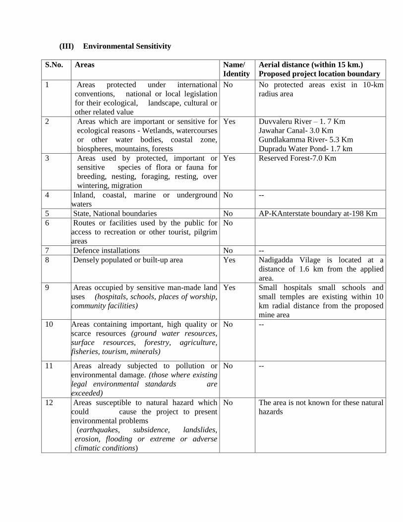
(III) Environmental Sensitivity
S.No. Areas Name/
Identity
Aerial distance (within 15 km.)
Proposed project location boundary
1 Areas protected under international
conventions, national or local legislation
for their ecological, landscape, cultural or
other related value
No No protected areas exist in 10-km
radius area
2 Areas which are important or sensitive for
ecological reasons - Wetlands, watercourses
or other water bodies, coastal zone,
biospheres, mountains, forests
Yes Duvvaleru River – 1. 7 Km
Jawahar Canal- 3.0 Km
Gundlakamma River- 5.3 Km
Dupradu Water Pond- 1.7 km
3 Areas used by protected, important or
sensitive species of flora or fauna for
breeding, nesting, foraging, resting, over
wintering, migration
Yes Reserved Forest-7.0 Km
4 Inland, coastal, marine or underground
waters
No --
5 State, National boundaries No AP-KAnterstate boundary at-198 Km
6 Routes or facilities used by the public for
access to recreation or other tourist, pilgrim
areas
No
7 Defence installations No --
8 Densely populated or built-up area Yes Nadigadda Vilage is located at a
distance of 1.6 km from the applied
area.
9 Areas occupied by sensitive man-made land
uses (hospitals, schools, places of worship,
community facilities)
Yes Small hospitals small schools and
small temples are existing within 10
km radial distance from the proposed
mine area
10 Areas containing important, high quality or
scarce resources (ground water resources,
surface resources, forestry, agriculture,
fisheries, tourism, minerals)
No --
11 Areas already subjected to pollution or
environmental damage. (those where existing
legal environmental standards are
exceeded)
No --
12 Areas susceptible to natural hazard which
could cause the project to present
environmental problems
(earthquakes, subsidence, landslides,
erosion, flooding or extreme or adverse
climatic conditions)
No The area is not known for these natural
hazards


STANDAD TEMPLATE FOR EVALUATION OF ALL PROJECTS / ACTIVITIES:
S. No Information Required Information to be furnished by the
Proponents
1 Name of the project or activity 0.7486 Ha. of Road Metal Mine
2 Name of the organization / owner B.VENKATA REDDY
3 Address for communication B.VENKATA REDDY
Lessee
S/o. Kasi Reddy,
H.No.8-75,
Nadigadda village,H/o. Dupadu
Tripuranthakam (M),
Prakasam District, Andhra Pradesh.
4 Telephone numbers Cell: 9959889338
5 Email ID of the organization or contact person [email protected]
6 Location of the proposed project or activity Sy. No: Hill Block no.VII
Nadigadda village, H/o. Dupadu village,
Tripuranthakam (M),
Prakasam District,
Andhra Pradesh.
7 Appraisal category (B2 or B1) B2
8 Nearest habitation and distance from the project or
activity
Nadigadda Vilage is located at a distance of
1.6 km from the applied area.
9 Installed capacity / production capacities 30475 (max) Cum/Year of Road Metal
10 Specify the fuel (Coal/CNG/Biomass/Others) and
quantity required
Approximately 1.0 KLD of Diesel is
required.
11 Details of land use / land cover The mine lease 0.7486 Hect.of area is a
Government land and proposed area will be
used for mining purpose.
12 Occupancy, ownership of the land in which the
activity is proposed:
(Government land / Private land / Forest land
/Revenue land /Temple land /leased land/ land
belongs to other Department)
Government Land.
13 If it is a Forest land, the following details shall be
furnished:
(Whether it is a Reserved forest / Protected
forest/Demarcated forest/ National
Parks/Sanctuaries/any land in possession of Forest
Department.)
(The village map with Sy. No. indicating nearest
forest boundary line from the site shall be enclosed)
NOT APPLICABLE
14 Total investment of the project / activity 20 Lakhs

a. Funds allocated for EMP Capital Cost:9.69 Lakhs
Recurring Cost:6.12 Lakhs
15 Brief description of the project with special reference
to specific pollution and its control measures
EMP report enclosed
16 Compliance report on the following :
i. Status of compliance of the conditions and
environmental safeguards stipulated in the earlier
clearance letters.
Not Applicable
ii. Details of the court cases, if any, pending in any
Court of Law against the project as well as any
directions passed by the Court relating to the project
directly or indirectly.
No such cases against the project
iii. Details of the notices, if any, given to the project
under Section 5 of the Environmental (Protection)
Act, 1986 and Section 18 of the Air (Prevention &
Control of Pollution) Act, 1981.
NIL
17 Whether the project cataracts the provisions laid
under the OM date 16.11.2010 issued by MoE&F,
GOI,w.r.t. violation of EIA notification,2006 and its
amendments there of ? (Yes/ No)
No
Present stage and status of the project New Mine
18 Name of the consultant T. MURALI KRISHNA
M/s. GLOBAL ENVIRO LABS
2-2-1075/14/A, Tilaknagar ‘X’ Roads,
Baghamberpet, Hyderabad – 13.
pH: 040-65582886, 27407969, 9849039741

FORM-2
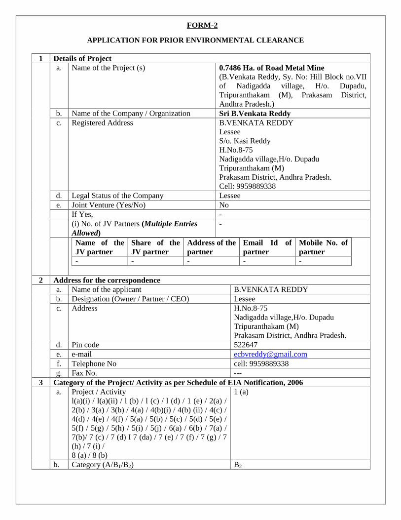
APPLICATION FOR PRIOR ENVIRONMENTAL CLEARANCE
1 Details of Project
a. Name of the Project (s) 0.7486 Ha. of Road Metal Mine
(B.Venkata Reddy, Sy. No: Hill Block no.VII
of Nadigadda village, H/o. Dupadu,
Tripuranthakam (M), Prakasam District,
Andhra Pradesh.)
b. Name of the Company / Organization Sri B.Venkata Reddy
c. Registered Address B.VENKATA REDDY
Lessee
S/o. Kasi Reddy
H.No.8-75
Nadigadda village,H/o. Dupadu
Tripuranthakam (M)
Prakasam District, Andhra Pradesh.
Cell: 9959889338
d. Legal Status of the Company Lessee
e. Joint Venture (Yes/No) No
If Yes, -
(i) No. of JV Partners (Multiple Entries
Allowed)
-
Name of the
JV partner
Share of the
JV partner
Address of the
partner
Email Id of
partner
Mobile No. of
partner
- - - - -
2 Address for the correspondence
a. Name of the applicant B.VENKATA REDDY
b. Designation (Owner / Partner / CEO) Lessee
c. Address H.No.8-75
Nadigadda village,H/o. Dupadu
Tripuranthakam (M)
Prakasam District, Andhra Pradesh.
d. Pin code 522647
e. e-mail [email protected]
f. Telephone No cell: 9959889338
g. Fax No. ---
3 Category of the Project/ Activity as per Schedule of EIA Notification, 2006
a. Project / Activity
l(a)(i) / l(a)(ii) / l (b) / l (c) / l (d) / 1 (e) / 2(a) /
2(b) / 3(a) / 3(b) / 4(a) / 4(b)(i) / 4(b) (ii) / 4(c) /
4(d) / 4(e) / 4(f) / 5(a) / 5(b) / 5(c) / 5(d) / 5(e) /
5(f) / 5(g) / 5(h) / 5(i) / 5(j) / 6(a) / 6(b) / 7(a) /
7(b)/ 7 (c) / 7 (d) I 7 (da) / 7 (e) / 7 (f) / 7 (g) / 7
(h) / 7 (i) /
8 (a) / 8 (b)
1 (a)
b. Category (A/B1/B2) B2

If B1 or B2 -
Reason for application at Central Level / State
level (in case of B2 projects)
Does not qualify for B1 as total area
qualified is less than <100 Ha
If Others -
c. Please Specify -
d. EAC concerned (for category A Projects only)
(Coal Mining / Non-coal Mining / Thermal /
River Valley & Hydro / Industry- I / Industry-II /
Infrastmcture-1 / Infrastructure-II / Nuclear &
Defence / CRZ
-
e. New / Expansion / Modernization / One Time
Capacity expansion (only for Coal Mining) /
Expansion under Para 7(ii) / Modernization
under Para 7(ii) / Change of Product Mix under
Para 7(ii))
New
4 Location of the Project
a. Plot / Survey / Khasra No. Hill Block no.VII
b. Village Nadigadda village, H/o. Dupadu
c. Tehsil Tripuranthakam
d. District Prakasam
e. State Andhra Pradesh
f. Pin Code ---
g. Bounded Latitudes (North) 15o 57’ 7.70” N 79
o 21’ 33.10” E
15o 57’ 9.00” N 79
o 21’ 33.80” E
15o 57’ 8.70” N 79
o 21’ 36.40” E
15o 57’ 4.40” N 79
o 21’ 34.80” E
From
To
h. Bounded Longitudes (East)
From
To
i. Survey of India Topo Sheet No. 57 M/5 and 56 P/8
j. Upload Topo Sheet File ( Upload pdf only) Uploaded in website
k. Maximum Elevation Above Means Sea Level (
AMSL)
30 m
The lowest RL 210 is and the highest RL
is 240M The relief is 30 M
l. Upload (kml) File (Upload kml only) Uploaded in website
m. Distance of Nearest HFL from the project
boundary within the study area
--
n. Seismic Zone (Zone: 1 / 2 / 3 / 4 / 5) Zone II & III
5 Whether project is executed in multiple States (Yes I No)?
If Yes No
a. Number of States in which Project will be
Executed (e.g. 1,2,3,4,5,6)
Not Applicable
b. Main State of the Project Not Applicable
c. Other State (Multiple Entries Allowed)
(If the project to be executed, does not belong to
any state, then state category could be selected
as Other)
Not Applicable

State District Tehsil Village
6 Details of Terms of Reference (ToR)
a. Whether ToR is mandatory for submitting
application (Yes / No)?
No
If Yes Not Applicable
b. Date of issue of ToR / Standard ToR Not Applicable
c. MoEF&CC / SEIAA File No. Not Applicable
d. Upload ToR letter (PDF only) Not Applicable
7 Details of Public Consultation
a. Whether The Project exempted from Public
Hearing (Yes / No)?
Yes
If Yes , Reason It is B2 Category Project
b. Supporting Document ( upload pdf only) Not Applicable
c. Whether details of Public Hearing available
(Yes/No)?
Not Applicable
If No, Not Applicable
d. Reason there of Not Applicable
Supporting Document (upload pdf only) Not Applicable
If Yes, Not Applicable
e. Date of Advertisement of Public Hearing Not Applicable
f. Copy of advertisement in English (Upload PDF
only)
Not Applicable
g. Whether Public hearing was presided over by an
officer of the rank of Additional District
Magistrate or above (Yes/No)?
Not Applicable
If yes Not Applicable
h. Designation of Presiding Officer (District
Magistrate / District Collector / Deputy
Commissioner / others - please specify)
Not Applicable
i. Copy of duly signed Proceedings of Public
Hearing in English (Upload pdf only)
Not Applicable
j. Date of Public Hearing Not Applicable
k. Venue of Public Hearing: Not Applicable
Village Not Applicable
Tehsil Not Applicable
District Not Applicable
State Not Applicable
l. Distance of Public Hearing Venue from the
Proposed Project (km)
Not Applicable
m. No. of people attended Not Applicable
n. If the multiple public hearings conducted Not Applicable
Pl give the details of each PH as per (e) to (o)
above
Not Applicable
8 Details of Project Configuration/ Product (Multiple Entries Allowed)
a. Whether the project is New (Yes/No?) Yes
If yes,
b. Project Configuration

Plant / Equipment/ Facility Configuration Remarks if any
Excavator-01 200 HP-1.2 Cum --
Tippers-03 60 HP --
Drilling Machine -01 3’’ --
Compressor -01 3HP --
Water Tanker-01 1000 Ltrs --
Loaders-02 3 Cum --
c. Product
Product / Activity
(Capacity / Area)
Quantity Unit Mode of Transport/
Transmission of Product
Road Metal 30475 Cum /Year By Road and trucks will
be used for transport
- Unit:- (Tons per Annum(TPA), Mega Watt(MW), Hectares(h a), Kilo Litre per Day(KLD),
Tons Crushed per Day( TCD), Cubic Meter per Day, Kilometers(Km), Million Liters per
Day(MLD), Others) - Mode of Transport/Transmission of Product (Road, Rail, Conveyor Belt, Pipe Conveyor,
Arial Ropeway, combination of two or three modes, Others)
9 If Expansion / Modernization / One Time Capacity expansion ( only for Coal Mining) /
Expansion under Clause 7(ii) / Modernization under Clause 7(ii) / Change of Product Mix
under Clause 7(ii)))
a. Details of environmental clearance granted
earlier
No
(i) Date of issue of environmental clearance -
(ii) MoEFCC / SEIAA File Number -
(iii) Upload EC Letter -
b. Details of certified report on compliance of
earlier environmental clearance conditions
(i) Details of Regional Office of MoEFCC / Zonal
Office of CPCB / SPCB / UTPCC from which
certified report on compliance of earlier
environmental clearance conditions obtained
-
(ii) Letter No -
(iii) Status of Compliance -
(iv) Certified report on compliance of earlier
environmental conditions (Including
Monitoring Report) ( Upload pdf only)
clearance
-
(v) Date of site visit -
c. Details of Consent to Operate -
(i) Whether Consent to operate obtained
(Yes/No)?
No
If yes, -
(ii) Upload Copies of all Consent to operate
obtained since inception (Upload pdf only)
-
(iii) Date of issue -
(iv) Valid up to -
(v) File No. -
(vi) Application No. -

(vii) Upload Copies of all Consent to operate
obtained since inception (Upload pdf only)
-
d. Details of Capacity Expansion (Multiple
Entries Allowed)
Not Applicable
- Unit:- (Tons per Annum(TPA), Mega Watt(MW), Hectares(h a), Kilo Litre per
Day(KLD), Tons Crushed per Day( TCD), Cubic Meter per Day, Kilometers(Km),
Million Liters per Day(MLD), Others) - Mode of Transport/Transmission of Product (Road, Rail, Conveyor Belt, Pipe
Conveyor, Arial Ropeway, combination of two or three modes, Others
Product / Activity
(Capacity / Area)
Quantity
from
Quantity To Unit Mode of Transport /
Transmission of Product
e. Details of Configuration (Multiple Entries Allowed) - Not Applicable
Plant /
Equipment /
Facility
Existing
Configuration
Proposed
Configuration
Final
configuration
after expansion
Remarks
if any
10 Project Cost
a. Total Cost of the Project at current price level
(in Lakhs)
Rs 20 Lakhs
b. Funds Allocated for Environment Management
(Capital) (in Lakhs)
Rs 9.69 Lakhs
c. Funds Allocated Towards ESC (Entrepreneur
Social Responsibility) (in Lakhs)
Rs 1.0 Lakhs
d. Funds Allocated for Environment Management
Plan (EMP) (Recurring per Annum) (in Lakhs)
Rs 6.12 Lakhs
11 Whether project attracts the General Condition
specified in the Schedule of EIA Notification
(Yes/No)? [provide name of WL/CPA/ESA/Inter-
state boundary/ International boundary and
distance from the project
No
If Yes -
a. Protected Area Notified Under the Wild
Life(Protection) Act, 1972
-
b. Critically Polluted Areas as identified by the
Central Pollution Control Board from Time to
Time
-
c. Notified Eco-Sensitive Areas -
d. Inter-State Boundaries and International
Boundaries
-
12 Whether projects attract the Specific Condition
specified in the Schedule of EIA Notification
(Yes/No)?
No
If Yes
a. If any Industrial Estate I Complex I Export processing Zones / Special Economic Zones I
Biotech Parks / Leather Complex with homogeneous type of industries such as Items 4(d),
4(f), 5(e), 5(f), or those Industrial estates with pre-defined set of activities (not necessarily

homogeneous, obtains prior environmental clearance, individual industries including
proposed industrial housing within such estates / complexes will not be required to take
prior environmental clearance, so long as the Terms and Conditions for the industrial
estate/complex are complied with (Such estates/complexes must have a clearly identified
management with the legal responsibility of ensuring adherence to the Terms and
Conditions of prior environmental clearance, who may be held responsible for violation of
the same throughout the life of the complex/estate
-
13 Raw Material/ Fuel Requirement (Multiple Entries Allowed) – Raw Material not required because
of it is a Mining of Road metal Project but for machinery running fuel is required
a. Details of Raw Material / Fuel Requirement Raw
Material/
Fuel
Quantity
per
Annum
Unit Source (in case of
Import, please
specify country
and Name of the
port from which
Raw Material/ Fuel
is received)
Mode of
Transport
Distance of Source
from Project Site
meters ( In case of
import, distance
from the port from
which the raw
material/ fuel is
received
Type of Linkage
(Linkage Fuel
Supply Agreement /
e-auction/ MoU/
LOA/ Captive/ Open
market/ Others)
Diesel 250000
(app) KL -- Road
Near By Petrol
Bunks Open Market
In case of expansion proposals, total requirement of raw material / fuel shall be given - Unit:- (Tons per Annum(TPA), Mega Watt(MW), Hectares( ha), Kilo Lit re per Day
( KLD) Tons Crushed per Day(TCD), Cubic Meter per Day, Kilometers(Km), Million Liters per
Day(MLD), Others).
- Mode of Transport/Transmission of Product (Road, Rail, Conveyor Belt, Pipe Conveyor, Arial
Ropeway, combination of two or three modes, Others).
14 Baseline Data (Air/ Water/ Noise/ Soil/ Ground water table/ Others) - Not Applicable
a. Period of Base Line Data Collection -
From (DD/MM/YYYY) -
To (DD/MM/YYYY) -
b. Season (Sumner / Pre-monsoon I Post-
monsoon / Winter)
-
c. No. of Ambient Air Quality (AAQ)
Monitoring Locations
-
d. Details of AAQ Monitoring (Multiple Entries
Allowed)
-
Criteria Pollutants Unit Maximum
Value
Minimum
Value
98 Percentile
Value
Prescribed
Standard
-- -- -- -- -- --
- Criteria Pollutants: - (PM10, PM2.5, S02, NOx, Others parameters specific to sector) - Unit: - (Micro Gram per Meter Cube, Nano Gram per Meter Cube, Mili Gram per
Meter Cube, NA)
e. No. of Ground Water Monitoring Locations
(Multiple Entries Allowed)
Not Applicable
f. Details of Ground Water Monitoring Not Applicable
Criteria Pollutants Unit Maximum
Value
Minimum
Value
98 Percentile
Value
Prescribed
Standard
-- -- -- -- -- -- - Criteria Pollutants: - (pH, TSS, TDs, Total Hardness, Chlorides, Fluoride, Heavy Metals, other
parameters specific to the sector)

- Unit:- (mg/l, NA)
g. No. of Surface Water Monitoring Locations Not Applicable
h. Details of Ground Water Monitoring (Multiple
Entries Allowed)
Not Applicable
Criteria Pollutants Unit Maximum
Value
Minimum
Value
98 Percentile
Value
Prescribed
Standard
-- -- -- -- -- --
- Parameter :- (pH, DO, BOD, COD, others parameters specific to the sector) - Unit :- (mg/1, NA)
i. No. of Ambient Noise Monitoring Locations Not Applicable
j. Details of Noise Monitoring (Multiple Entries
Allowed)
Not Applicable
Parameter Unit Maximum value Minimum
value
Prescribed
Standard
-- -- -- -- --
- Parameter:- (Leq(Day), Leq(Night)) - Unit:- (A-weighted decibels(dB(A))
k No. of Soil Monitoring Locations (Multiple
Entries Allowed)
Parameter Unit Maximum Value Minimum
Value
98 Percentile Value
-- -- -- -- --
- Parameter:- (pH, N(Nitrogen), P(Phosphorus), K(Potassium), Electric Conductivity) - Unit: - (Millisiemens per Centimeter, Milligram per Litre, Percent, Centimeter per
Second, Milliequivalents per 100 Gram, Milligram per Kilogram, Parts per Million,
Kilogram per hectare, Others)
l Ground Water Table
i Range of Water Table Pre-Monsoon Season (Meters Below Ground Level (m bgl)):
From 20-m
To 30-m
ii Range of Water Table Post-Monsoon Season (Meters Below Ground Level (m bgl)):
From 30 -m
To 40 -m
iii Whether Ground Water Intersection will be there
(Yes / No)?
No
If Yes, -
(i) Upload Copy of Central Ground Water Authority
Letter ( Upload pdf only) -
(ii) Letter No. -
(iii) Date of issue -
15 Details of Water Requirement (During Operation)
(Multiple Entries Allowed)
04 KLD
a. Details
Source Quantity in
KLD
Method of water
withdrawal
Distance
from
Source
Mode of Transport
Water from 04 Tube wells/Others - Water Tanker

nearby villages
- Source: Surface/ Ground Water/ Sea/ Others – Ground Water - Mode of Transportation: Pipeline / canal / Others – Tankers - Method of water withdrawal: Barrage / Weir / Intake well / Jackwell / Tube well / Open
well / Others – Tube Well/Others
b. Upload Copy of Permission from Competent Authority (Upload pdf only)
c. Letter No. -
d. Date of issue -
e. Permitted quantity -
f. Whether Desalination is proposed (Yes/ No) -
If Yes, -
(i) Desalination capacity (KLD) -
(ii) Quality of Brine (KLD) -
(iii) Mode of Disposal of brine -
16 Waste Water Management (During Operation)
Type/
Source
Quantity
of waste
water
generated
(Kilo Litre
per Day)
Treatme
nt
Capacity
(Kilo
Litre per
Day)
Treatmen
t Method
Mode
of
Dispos
al
Quantity of
Treated Water
Used/ in
Recycling/
Reuse (Kilo
Litre per Day)
Quantity of
Discharged
Water (Kilo
Litre per Day
Domestic
wastewater
1.0 - - Septic
tank
followe
d by
Soak
pit
- -
a. Total Waste Water Generation 1.0 KLD
b. Total Discharged Water Nil
c. Total Reused Water Nil
17 Solid Waste Generation Management (Multiple Entries Allowed)
- Item:- (Industrial waste, Municipal Solid waste, Fly ash, Bottom Ash, Hazardous waste
(as per Hazardous and Other Waste Management Rules 2016), E Waste, Bio-Medical
waste, Construction & Demolition waste, Plastic Waste, Others) - Unit:- (Tons, Kiloliter) - Mode of Disposal:- (Treatment, Storage and Disposal Facility(TSDF), Authorized
Recyclers, Landfill, Sanitary Landfills, Others)
Item Quantity
per annum
Unit Distance from site Mode of
Transport
Mode of
Disposal
Rock Mass/
Over Burden Waste -- -- -- -- --
18 Air Quality Impact Prediction (Multiple Entries Allowed) Not Applicable
Criteria
Pollutants
Unit Baseline
Concentration
Minimum
value
Incremental
Concentration
Total GLC Prescribed
Standard
- Parameter:- (PM10, PM, S02, NOx, Others parameters specific to the sector) - Unit:- (Microgram per Meter Cube, NA)
19 Power Requirement – Not Required

a. Quantity (Kilo Volt Amps (KVA)) -
b. Source -
c. Upload Copy of Agreement (Upload pdf only) -
d. Stand by Arrangement (Details of DG Sets) --
e. Stack Height (in m) --
20 Land Ownership Pattern (Prior to the project proposal) in Ha
a. Forest land --
b. Private Land --
c. Government Land 0.7486 Ha
d. Revenue Land --
e. Other Land --
Total land 0.7486 Ha.
21 Present Land Use breakup in Ha
a. Agriculture Are --
b. Waste/Barren Area 0.7486 Ha
c. Grazing / Community Area --
d. Surface Water bodies --
e. Settlements --
f. Industrial --
g. Forest --
h. Mangroves --
i. Marine area --
j. Others (Specify) --
Total 0.7486 Ha
22 Land requirement for various activities (Multiple
entries allowed) in Ha
Description of Activity /
Facility / Plant / Others
Land requirement Remarks
Mined out area 0.3168 -
Road 0.01 -
Unmined area 0.1637 -
Buffer Zone 0.2555 -
Total 0.7460 -
Activity / Facility / Plant / Others include: Main Plant, Township, Greenbelt, Ash pond, Quarry
area, OB dump Area, Safety zone, Tailing pond, Landfill, Water reservoir, Desalination plant,
Area for solid waste management, Built-up area, others
23 Ecological and Environmental Sensitivity (Within 10 Km):- WLS-Wild Life Species; NPA
Notified Protected Area: ESAs-Eco Sensitive Areas: ESZs- Eco Sensitive Zones)
a. Details of Ecological Sensitivity Not Applicable
Details of Ecological
Sensitivity
Name Distance from the
Project (Km)
Remarks
- Details of Ecological Sensitivity: - (Critically Polluted Area, WLS, NPA, ESAs,
ESZs, Corridors, Wildlife Corridors)
b. Whether NBWL recommendation is required
(Yes/No)?
No
If yes -
Upload NBWL recommendation in PDF -

c. Details of Environmental Sensitivity -
Details of
Environmental
Sensitivity
Name Distance from the
Project (Km)
Remarks
Forests Reserved Forest 7.0 km
- Details of Environmental Sensitivity:- (Forest, Archaeological Sites, Defense Installations,
Others)
d. Whether NOC / Permission from the competent
authority is required (Yes/No)?
No
If yes
Upload NoC / Permission from the competent
authority in PDF
-
-
24 Forest Land
1 Whether any Forest Land involved (Yes/No)? No forest land is involved
If yes
a. Forests Clearance Status (ln-Principle(Stage-1)
Approval Obtained / Final (Stage-II) Approval
Obtained / Forest Clearance Under
Process(Stage-1) /
Forest Clearance Under Process(Stage-11) /
Application for Forest Clearance yet to be
Submitted)
-
If In-Principle (Stage-I) Approval Obtained, -
(i) MoEFCC file number -
(ii) Date of In Principle (Stage-I) approval -
(iii) Area diverted -
(iv) Upload FC Letter (Upload pdf only and
attach it as Annexure-FC letter)
-
If Final (Stage-II) Approval Obtained, -
(i) MoEFCC file number -
(ii) Date of Final Approval -
(iii) Date of In-Principle Approval -
(iv) Area diverted -
(v) Upload FC Letter (Upload pd/ only and
attach it as Annexure-FC letter)
-
If Forest Clearance under process (Stage-I), -
(i) MoEFCC file number -
(ii) Area applied -
If Forest Clearance under process (Stage-II), -
(i) MoEFCC file number -
(ii) Area applied -
b. Legal Status of Forest Land (Reserved,
Protected, Private, Village, Others)
-
If Others, -
Please Specify Others -
25 Tree Cutting, if any
a. No. of Trees Cut for the Project (if Forestland
not involved)
No

b. Details of Tree Cutting and Planting of Trees
( Upload pd/ Only)
No
26 Land Acquisition Status Not Applicable
a. Acquired Land -
b. Land yet to be acquired -
c. Status of Land acquisition if not acquired -
27 Rehabilitation and Resettlement (R&R)
a. No. of Villages No
b. No. of Households -
c. No. of PDFs (Project Displaced Families) -
d. No. of PAFs (Project Affected Families) -
e. Funds Allocated for R&R -
f. Status of R&R (Completed / In-progress / Yet to
start)
-
28 Whether there is Presence of Schedule-I Species (Yes/No)?
If yes, No
a. Details of Schedule-I Species -
b. Whether conservation plan for Schedule-I
Species has been prepared (Yes/ No)?
-
If yes, - (i) Upload conservation plan (Upload only PDF) - (ii) Fund Provision made - (iii) Period of Implementation -
c. Whether conservation plan for Schedule-I
Species has been approved by competent
authority (Yes/ No)?
-
(i) Upload copy of approval (Upload PDF Only) - (ii) Letter No. - (iii) Date of issue - (iv) Recommendations if any -
29 Whether there is Presence of Water Bodies in Core Area (Yes/No)?
If yes, No
a. Details of Water Bodies in Core Area -
b. Whether there is Diversion required (Yes/No)? No
If yes, -
c. Details of diversion required -
d. Details of study conducted -
e. Whether permission has been obtained from
competent authority (Yes/No)?
-
(i) Upload copy of permission (Upload PDF
Only)
-
(ii) Letter No. -
(iii) Date of issue -
(iv) Recommendations if any -
30 Whether there is Presence of Water Bodies in Buffer Area (Yes/No)?
If yes, Yes
a. Details of Water Bodies in Buffer Area Duvvaleru River – 1. 7 Km
Jawahar Canal- 3.0 Km

Gundlakamma River- 5.3 Km
Dupradu Water Pond- 1.7 km
b. Direction of Water Bodies in Buffer Area (North
/ South / East / West / North East/ North West/
South East/ South West)
NW & SE
c. Distance of Water Bodies in Buffer Area (kilo
meters) 1.7 km
31 Manpower Requirement
a. Permanent employment during construction -
b. Permanent employment during operation -
c. Temporary employment during construction -
d. Temporary employment during operation -
e. No. of working days 250
f. Total manpower 11
32 Green Belt in Ha
a. In case of new projects -
i. Total Area of Green Belt 0.25 Ha
ii. Percentage of Total Project Area 10 %
iii. No. of Plants to be Planted 500 plants per annum
iv. Funds Allocated for Plantation 2,50,000/-
v. Upload Green Belt Plan (Upload PDF Only) Uploaded in Website (EMP Report)
b. In case of expansion / modernization / change in
product mix etc.
Not Applicable
i. Description Existing Proposed Total
Total Area of Green Belt
Percentage of Total
Project Area
No. of Plants
ii. Upload Green Belt Plan (Upload PDF Only) Attached (EMP Report)
33 Project Benefit (Multiple entry allowed)
Type of Project Benefits Details of Project Benefit
Improvement In Physical Infrastructure This project will improve the overall physical
infrastructure in this area Rain water harvesting
will be done for groundwater recharging that
will improve the ground water table in the area.
Improvement In Social Infrastructure Social Benefits Like Drinking Water, Health
Care Measures and Educational Facilities
Employment Potential The surrounding villagers will get employment
(Project benefits shall include environmental, social and others)
34 Whether the Project/ Activity attract the provisions
of CRZ (Yes/No)?
No
If yes, -
1 Project Details -
a. CRZ Classification: (C RZ I (A), CRZ
I(B), CRZ II, CRZ III , C RZ IV(A), CRZ
IV(B ) )
-
b. Location type : (Non-Eroding Coast, Low
and Medium Eroding Coast, High Eroding
-

Coast)
c. Details of Mangroves Land Involved, if
Any
-
d. Area of Mangroves Land (hectare) -
e. EIA (Terrestrial) Studies: (Carried Out,
Not Carrie d Out)
-
If Carried Out, -
1) Summary Details of EI A
(Terrestrial) Studies
-
2) Upload Recommendation made in
EIAs (Upload pdf only)
-
3) Period of Study from (EIA
Terrestrial)
-
4) Period of Study to (EIA Terrestrial) -
If Not Carried out -
Give Reason -
f. E IA (Marine) Studies : (Carried Out, Not
Carried Out)
-
If carried out -
1) Summary Details of EIA (Marine)
Studies
-
2) Upload Recommendation made in E
IAs
-
3) Period of Study from (EIA Marine) -
4) Period of Study to (EIA Marine) -
If Not Carried out -
Give Reason -
g. Disaster Management Plan/National Oil
Spill Disaster Contingency Plan
(if Applicable)
-
2. Description of the Project Under
Consideration
No
a. Type of Project: (Resort/ Buildings/civic
amenities, Coastal Roads/Roads on Stilt,
Pipelines from Thermal power Blow
Down, Marine Disposal of Treated
Effluent, Facility for Storage of
Goods/Chemicals, Offshore structures,
Desalination Plant, Mining of Rare Earth/
Atomic Minerals, Sewage Treatment
Plants, Lighthouse, Wind Mills, Other)
-
If Resort/Buildings/civic amenities, -
1) Agency Name for Preparing CRZ
Maps
2) Total Area/Built-up Area (hectare )
3) Height of Structure
4) FSI Ratio
5) The governing Town Planning
Rules/Regulations
6) Details of Provision of Car Parking
Area
If Coastal Roads/Roads on stilt, -
1) Agency Name for Preparing CRZ
Maps
2) Area of Land Reclamation
3) Estimated Quantity of Muck/Earth
for Reclamation
4) Carrying Capacity of Traffic
If Pipelines from Thermal Power Blow
Down,
-
1) Agency Name for Preparing CRZ
Maps
2) Length of Pipeline
3) Length Traversing CRZ Area
4) Depth of Excavation
5) Width of Excavation
6) Length of Pipeline from Seashore to
Deep Sea
7) Depth of Outfall Point from Surface
of Sea Water
8) Temperature of effluent above
Ambient at Disposal Point
If Marine Disposal of Treated Effluent,
1) Agency Name for Preparing CRZ
Maps
-
2) Location of Intake/Outfall -
3) Depth of Outfall Point -
4) Length of Pipeline -
5) Length Traversing CRZ Area -
6) Depth of Excavation -
7) Width of Excavation -
8) Length of Pipeline from Seashore to
Deep Sea/Creek
-
9) Depth of Outfall Point from Surface
of Sea Water
-
10) Depth of Water at Disposal Point -
11) Type of Disposal -
If Facility for Storage of Goods/Chemicals,
1) Agency Name for Preparing CRZ
Maps
-
2) Name and Type of Chemical -
3) End us e of the Chemical -
4) No. of Tanks for Storage -
5) Capacity of tanks -
If offshore structures,
1) Agency Name for Preparing CRZ -

Maps
2) Exploration or Development -
3) Depth of Sea Bed -
4) No. of Rigs/Platform -
5) Details of Group Gathering Stations -
If Desalination Plant,
1) Agency Name for Preparing CRZ
Maps
-
2) Capacity of Desalination -
3) Total Brine Generation -
4) Temperature of Effluent above
Ambient at Disposal Point
-
5) Ambient Salinity -
6) Disposal Point -
If Mining of Rare Earth/Atomic Minerals,
1) Agency Name for Preparing CRZ
Maps
-
2) Capacity of Mining -
3) Volume/ Area to be mined -
4) Type of Mineral to be Extracted -
5) End use of the Mineral -
If Sewage Treatment Plants,
1) Agency Name for Preparing CRZ
Maps
-
2) Capacity -
3) Total Area of Construction -
4) Compliance of effluent parameters
as laid down by CPCB /SPCB/other
authorized agency
-
5) Whether discharge is in sea
water/creek? If yes,
-
Distance of Marine Outfall Point
from Shore/from the tidal river bank
-
Depth of Outfall Point from Sea
Water Surface
-
Depth of Sea at Outfall Point -
If Lighthouse,
1) Agency Name for Preparing CRZ
Maps
-
2) Total Area of Construction -
3) Height of the Structure -
If Wind Mills,
1) Agency Name for Preparing CRZ
Maps
-
2) Capacity (MW) -
3) Transmission Lines: (Overhead,
Underground)
-
4) Diameter of Windmill -

5) Length of Blade -
6) Speed of Rotation -
7) Height of the Structure -
If others,
1) Agency Name for Pre paring CRZ
Maps
-
2) Please Specify with salient
features
-
3) Upload relevant Document
(Upload pdf only)
-
3. Distance of Project (In Meters) from
LTL/HTL to be Stated
No
a. Clause of CRZ Notification Under which
the Project is a Permissible/Regulated
Activity
-
b. Whether CRZ Map Indicating HTL, LTL
Demarcation in 1:4000 Scales Prepared?
(Yes/No)
-
If yes, -
1) Distance of Project (in meters)
from HTL to be Stated
-
2) Upload Maps(kml File) -
3) Distance of Project (in meters)
from L TL to be Stated
-
4) Upload Maps (kml File) -
c. Whether Project Layout Superimposed
on CRZ Map 1:4000 Scales?: (Yes/No)
If yes,
1) Upload Maps (kml File)
d. Whether CRZ Map 1:25000 Covering 7
km Radius Around Project Site Prepared?
(Yes/No)
If yes,
1) Upload Maps (kml File)
e. Whether CRZ Map Indicating CRZ-
I,II,III and IV Including Other Notified
ESAs Prepared? : (Yes/No)
-
If yes, -
1) Upload Maps (kml File) -
f. NOC from State Pollution Control
Boards Obtained: (Yes/No)
-
If yes, -
1) Upload Copy of NOC (Upload pdf
only)
-
g. Details of Rain Water Harvesting System -
4. Recommendation of State Coastal Zone
Management Authority
No
a. Upload Copy of CZMA (Upload pdf -

Only)
b. State the Conditions Imposed -
c. Social and Environmental Issues and
Mitigations Measures Suggested
Including but not Limited to R&R,
Water, Air, Hazardous Wastes,
Ecological aspects, etc. (Brief Details to
be Provided)
-
35 Sector Specific Details
I Whether the proposal is mining of minerals (coal /
non-coal) project (Yes/No)?
If yes, Yes
1 No. of Mineral to be Mined (Multiple Entries
Allowed)
Minerals To be Mined Major or Minor Mineral
Road Metal Minor Mineral
2 Mine Capacity in ROM (Run of Mine) 30475 Cum/Annum of Road Metal
3 Upload 500 meters Cluster Certificate from State
Mines and Geology in case of minor minerals
(Upload pdf Only)
Uploaded in Website
4 Mining Plan
a. Approval Letter No. 2142/MP/RM/MRKP/2018
b. Date of Approval 02.07.2018
c. Uploaded in website
Uploaded in website
d. Approved by Deputy Director Mines And
Geology,
Approved by Deputy Director Mines And
Geology.
e. If Others, -
Please specify -
f. Approved Mining Lease Area 0.7486 Ha
g. Approved Capacity 30475 Cum/Annum of Road Metal
5 Technical Details
a. Total Geological Reserves (Million Ton) Road Metal- 367600 Cum (919000 MT) b. Mineable Reserves (Million Ton) Road Metal -153400 Cum (383500 MT) c. Extractable Reserves (Million Ton) Road Metal- 153400 Cum (383500 MT) d. Percent of Extraction (%) Road Metal-100 %
e. Grade of Coal / Ore / Mineral -
f. Stripping Ratio -
g. Category of Gaseousness (Only for Coal
Mining, Others may write Not
applicable)
-
h. Average Gradient(Degree) -
i. Maximum Thickness of Seams(meters)
(Only for Coal Mining, Others may write
Not applicable)
-
j. Mining Method (Opencast / Underground Open Cast Semi Mechanized

/ Mixed (Opencast +
Underground) / Adit
k. Life of Mine (Years) 5.03 or 05 Years
6 Details of beneficiation (including crushing/ screening/others)
a. Whether it is proposed to install Crusher
within the mining lease area (Yes/No)?
No
If yes, -
b. No. of Crusher -
c. Details of Crusher (Multiple entries
allowed)
-
Crusher ID Capacity (in TPH) Remarks
d. Whether it is proposed to install
beneficiation plant / Coal washery
within the mining lease area (Yes/No)?
No
If yes, -
e. Beneficiation / washing Technology -
f. Capacity -
7 Details of Seams if applicable Not Applicable
a. No. of seams -
b. Thickness of seams to be worked on -
c. Maximum Thickness of Seams(meters)
(if not Applicable, may Write NA)
-
8 Details of Mining Lease
a. Details of Mining Lease Road Metal Mine
b. Upload Letter of Intent (Upload pdf only) Uploaded in Website
c. Date of Execution of Mining Lease with
Reference Number
932/Q4/2018 dated 01-05-2018
d. Validity of Mining Lease 10
e. Upload Copy of Executed Lease deed
valid as on Date (Upload pdf only)
-
f. Earlier Renewals (Multiple Entries
Allowed)
Not Applicable
Uploaded Copy of Earlier Lease Date of Renewal
9 OB (Over Burden) Management (Only if
Mining Method: Opencast)
No
a. Details of External Dumps -
i) No. of OB Dumps -
ii) Total Area (in Hectare) -
iii) Height (in meter) -
iv) Quantity (in Million Cubic meter) -
v) No. of year back fill up -
b. Details of Internal Dump
i) No. of lnternal Dumps Nil
ii) Total Area (in Hectare) --
iii) Height (in meter) --
iv) Quantity (in Million Cubic meter) --

10 Details of Topsoil Management No
a. Quantity of Topsoil excavated during the
entire life of the mine (in Million Cubic
meter)
-
b. Quantity of Topsoil proposed for
utilization for reclamation during the
entire life of the mine(in Million Cubic
meter)
-
c. Quantity of Topsoil proposed for
utilization for other activities during the
entire life of the mine (in Million Cubic
meter)
-
11 Detail of Final Mine Void (Only if Mining
Method: Opencast)
-
a. Area (in Hectare) 0.7486 Ha
b. Depth (in meter) 75 m from the top of the hill
c. Volume (in Million Cubic meter) -
12 Details of Quarry (Only if Mining Method:
Opencast)
a. Final Void of (hectare) 0.7486 Ha
b. At a Depth of (meter which is proposed
to be converted into a Water Body.)
-
c. Total Quarry Area (ha) 0.7486 Ha
13 Details of Transportation -
a. In Pit/Underground to Surface -
b. Surface to Siding/Loading The excavated material will be loaded
into the Trucks.
c. Transportation I Conveyor Details Material will be supplied to the customers
through Tippers
14 Details of Land Usage (Pre-Mining) -
Land Use Within ML
Area (Hectare)
Outside ML Area
(Hectare)
Total
Agriculture Land
Forest Land
Waste Land 0.7486 - 0.7486
Grazing Land
Surface Water Bodies
Settlements
Others(Specify)
15 Details of Transportation
a. InPit/Underground to Surface
b. Surface to Siding/Loading The excavated material will be loaded
into the Trucks.
c. Transportation I Conveyor Details Material will be supplied to the customers
through Trucks /tractors
16 Details of Land Usage (Pre-Mining)
Land Use Within ML Area
(Hectare)
Outside ML
Area (Hectare)
Total

Agriculture Land
Forest Land
Waste Land 0.7486 - 0.7486
Grazing Land
Surface Water Bodies
Settlements
Others(Specify)
17 Details of Land Usage (Post-Mining) --
Land Use Plantation Water Body Public Use Others
Excavation I quarry
Top Soil Storage
External OB dumps
Internal OB dumps
Roads
Built Up Area(Colony/Office)
Green Belt
Virgin Area
Other
Total
18 Details of Reclamation (Only if Mining Method:
Opencast) Total Afforestation Plan shall be
Implemented Covering of Mining. This will include:
There is no reclamation process
proposed in this plan period.
a. External OB Dump (in hectare) -
b. Internal Dump (in hectare) Nil
c. Quarry (in hectare) 0.7486
d. Safety Zone (in hectare) 0.15
e. Final Void of (hectare) -
f. At a Depth of (meter which is proposed to
be converted into a Water Body.)
-
g. Density of Tree Plantation per ha (in no.) 500
h. Others in ha (such as Excavation Area along
ML Boundary, along Roads and
Infrastructure, Embankment Area and in
Township Located
-
i. Total afforestation plant (in hectare) 0.25
19 Status of Progressive Mining Closure Plan (For Expansion Projects only) – Not Applicable
a. Implementation of Various Activities as per
Approved Progressive Mine Closure Plan (in
Bar Chart) (pdf) (Upload pdf only)
-
b. Any Deviation from the Approved
Progressive Mine Closure Plan
-
c. Total Area Excavated (in hectare) 0.7486
d. Total Area Backfilled after Excavation (in
hectare)
-
e. Total Area Reclaimed (in hectare) -
20 Actual Coal Ore Production vis-a-vis sanctioned
capacity Since inception (Multiple Entries Allowed).
Not Applicable

Financial
Year
Sanctioned
Capacity as
per
EC (MTPA)
Sanctioned
capacity as
per CTO
Sanctioned
capacity as
per
approved
Mining Plan
Actual
Production
Excess
Production
Beyond the
EC/
CTO /
Mining Plan
Sanctioned
Capacity
(MTPA)
II Whether proposal is for Thermal Project (including captive
power plant and Waste Heat Recovery Plant) (Yes/No)?
No
If Yes,
1 Specifications of the Plant
a. Technology proposed (Supercritical, Sub-
Critical, CFBC, AFBC,PFBC, IGCC,
Incineration, Pyrolysis, Gasification, Bio-
methanation, Others)
b. Plant Load Factor (%)
c. Station Heat Rate (Kcal/Kwh)
d. Steam Rate/Flow Rate
e. Boiler Temperature
f. Boiler Pressure
g. Type of Stack (Single flue /Bi-flue /Tri-Flue)
h. No. of Stacks
Stack ID Stack
height (m)
Stack
Diameter at
exit (m)
Exit velocity
of stack gas
(m/s)
Exit
temperature of
stack gas(Deg.
centigrade)
2 Details of fuel linkage (please specify if multiple
linkages are involved)
Not Applicable
a. Type of linkage (Linkage/ Fuel Supply
Agreement / e-auction / MoU /LOA / Captive /
Open market / Others)
b. Quantity of linkage granted
c. Date of Linkage
d. Duration of linkage
3 Details of Transportation of fuel Not Applicable
Details/Mode Distance (km)) Quantity (TPA)
Rail
Road
Pipeline
Conveyor
Other mode (Please specify)
4 Details of Fuel Characteristics Not Applicable
a. Gross Calorific Value (Kcal/Kg)
b. Ash content (%)

c. Sulphur Content (%)
d. Moisture (%)
e. Mercury (mg/kg)
f. Fixed Carbon (%)
g. Volatile Matter (%)
5 Details of Cooling system Not Applicable
a. Type of cooling system: Air cooled/Water
cooled
b. Type of draft: Natural draft/Forced draft
c. Type of air circulation: Parallel flow/ Counter
flow
d. Cycles of Cooling (COC):
e. Water requirement for cooling (m3/day):
f. Boiler blow down temperature:
Whether proposal is for River Valley & Hydroelectric Project (Yes/No)?
If Yes,
1 Sub Sector: (Multipurpose Project I Hydroelectric
Project I Irrigation project)
-
2 Name of the River -
3 Whether Cumulative Impact Assessment and Carrying
Capacity Study of River Basin Carried Out? (Yes/No)
-
If Yes
a. Status of Cumulative Impact Assessment and
Carrying Capacity Study of River Basin:
(Recommended / Not Recommended,)
If Recommended
b. Details of Cumulative Impact Assessment and
Carrying Capacity Study of River Basin
c. Upload Relevant Document (Upload pdf only)
4 Type of Project: (Construction of Darn Barrage / Run
of the River / Lift Irrigation Scheme)
-
5 Darn Height (meter) if applicable -
6 Darn Length (meter) if applicable -
7 Total Submergence Area (hectare) -
8 Details of Gross Command Area (GCA) (hectare) -
9 Details of lrrigable Command Area (ICA) (hectare) -
10 Details of Culturable Command Area (CCA) (hectare) -
11 Total Command Area (hectare) -
12 Powerhouse Installed Capacity -
a. Type of Powerhouse: (Underground / Surface)
b. Capacity (megawatts)
c. No. of Tunnels
d. No. of Units
e. Bank of River: (Left /Right / Both)
13 Generation of Electricity Annually -
a. Quantity of Generation of Electricity Annually
(in Giga Watt Hours (GWh))
b. Water availability at various percentages

Percentage Water availability
(Cusecs)
Dependable year Remarks
At50%
At75%
At90%
c. Machine Availability (%)
d. Cost of Electricity Generation (in INR)
e. Internal Rate of Return (%)
f. Year of achievement of Internal Rate of
Return
14 Catchment Area Treatment Plan (Upload PDF) -
15 Muck Management Plan -
a. Upload Muck Management Plan in PDF
b. Total Excavation Muck (Cubic Meter)
c. Utilized for Construction (Cubic Meter)
d. No. of Muck Disposal sites
e. Total Muck Disposal Area (Ha)
16 Fishery Development and Management Plan -
a. Upload Fishery Development and
Management Plan in PDF
b. No. of Fingerlings
c. No. of Fish Species
d. Name of the umbrella Fish Species (Scientific
Name)
17 Status of Environmental Flow -
Season Average Inflow (in
Million Cubic Meter)
Percent of Flow
Lean
Non-Lean
Monsoon
Non-Monsoon
18 Free Flow Stretch (km) -
19 Approval of Central Water Commission -
a. Approval Reference No.
b. Date of Approval
c. Upload Copy of Approval (Upload pdf only)
20 Approval of Central Electricity Authority -
a. Approval Reference No.
b. Date of Approval
c. Upload Copy of Approval (Upload pdf only)
21 Details of Coffer Dam ( upstream) if applicable -
a. Quantity of the material (m3)
b. Length of the dam (m)
c. Quantity of muck to be used (m3)
d. Quantity of borrow material to be used (m3)
e. Decommissioning plan (upload in PDF)
22 Details of Coffer Dam ( downstream) if applicable -
a. Quantity of the material (m3)

b. Length of the dam (m)
c. Quantity of muck to be used (m3)
d. Quantity of borrow material to be used (m3)
e. Decommissioning plan (upload in PDF)
IV Whether the proposal is Infrastructure projects (Yes/No) No
If Yes,
1 Details of Building Construction -
a. Maximum Height of the Building (Meters)
b. Total No. of Flats to be Build
c. No. of Buildings
d. Total plot area (sqm)
e. Total built up area (sqm)
2. Foreshore Facilities And/or Marine Disposal -
a. Whether Project Involves Foreshore Activities and/or marine
Disposal (Yes/No)?
-
If Yes,
b. Upload Shoreline Study (Upload pdf only)
c. Type of Cargo
d. Quantity of Cargo
e. Control Measures of Cargo
f. Dust Control Measures
g. Quantum
h. Quantity of Dredging (Cubic meter per day)
i. Type of Dredging (Capital, Maintenance)
j. Disposal of Dredge Material
k. Details of Outfall Diffusers
l. No. of Dilution Expected
m. Distance at which the outlet will Reach Ambient Parameters
n. Details of Monitoring at outfall
o. Copy of NoC from PCB in case of Marine Disposal (Upload
pdf only)
3 Rain Water Harvesting -
a. No. of Storage
b. Capacity
c. No. of Recharge Pits
d. Capacity
4. Parking -
a. Details of 4-Wheeler/ 2-Wheeler Parking
5. Energy Saving Measures -
a. Source/Mode
b. Percentage
c. Quantity
6. Other Details -
a. Details of impact on Water Bodies and Drainage patters of
catchment area, if any
b. Details of Traffic Density Impact Assessment and Modelling
Sh1dy
(Upload pdf Only).

c. In case of Underground Tunnel projects below the Forest Land
-Subsidence Impact Studv report (Upload pdf Only)
7. Type of Industries to be established with Industrial Estate as per their
category A/B
-
S. No Type of lndustry No. of Units Category A/B
8. Length of the alignment in case of highway projects -
9. Details Bridges/ROB/Interchanges, Flyovers, Vehicle Underpass and
Pedestrian Underpass (in case of Highway Projects)
-
a. Total No. of Bridges
b. Total No. of ROB
c. Total No. of Interchanges
d. Total No. of Flyovers
e. Total No. of Vehicle Underpass
f. Total No of Pedestrian Underpass
g. Details of other utilities rail and road corridors
36 Details of Court Cases if any None
a. Whether there is any Court Cases pending against the project and/or land
in which the project is proposed to be set up (Yes/No)?
If Yes,
b. Name of the Court (Districts Court / High Court / NGT / Tribunals /
Supreme Court of India)
If name of Court: (Districts Court, High Court, NGT, Tribunals)
c. Name of the Sub-court
d. d. Case No.
e. e. Orders I Directions of the court, if any and its relevance with the
proposed project
f. Case Details
g. Upload Court Order if any (Upload pdf Only)
37 Details of direction issued under Environment (Protection) Act I Air (Prevention & Control of
Pollution)) Act I Water (Prevention & Control of Pollution) Act – Not Applicable
a. Whether any direction issued under Environment (Protection) Act I Air
(Prevention & Control of Pollution)) Act I Water (Prevention & Control
of Pollution) Act (Yes/No)?
-
If Yes,
b. Details of directions issued under Environment (Protection) Act I Air
(Prevention & Control of Pollution)) Act I Water (Prevention & Control
of Pollution) Act
-
c. Upload copy of directions issued under Environment (Protection) Act I
Air (Prevention & Control of Pollution)) Act I Water (Prevention &
Control of Pollution) Act
-
d. Compliance status of the directions -
38. Details of EIA Consultant
a. Have you hired Consultant for preparing document
(Yes/No)?
Yes
If No, -
(i) Reason for not engaging the Consultant -
If Yes, -

(i) Accreditation No. 76
(ii) Name of the EIA Consultant M/s. Global Enviro Labs
(iii) Address 2-2—1075/14/A/1, Tilaknagar ‘X’
Roads, Baghamberpet, Hyderabad
(iv) Mobile No. 9849039741
(v) Landline No. 040-27407969
(vi) E-mail Id
(vii) Category of Accreditation (Eligible for Category A /
Eligible for Category B)
Category A
(viii) Sector of Accreditation 1(a) (i)
(ix) Validity of Accreditation -
(x) Upload Certificate of Accreditation certified by
QCI/NABET (Upload pdf)
Uploaded in Website.
39. Documents to be attached
I If Project Type is New / Expansion / Modernization / one-time capacity expansion for coal
mine 2:
a. Upload Copy of EIA/EMP Report Uploaded in Website
b. Upload Copy of Risk Assessment Report Uploaded in Website
c. Upload Copy of Feasibility Report/ Detailed Project
Report(DPR) /Detailed Engineering Report /Detailed
Conceptual Plan / Approved Mining Plan (in case
of Mining proposals) ( Upload pd( only)
Uploaded in Website
d. Upload Copy of Final Layout Plan (Upload pdf only) Uploaded in Website
e. Upload Cover Letter (Upload pdf only and attach it as
Annexure-document of cover letter
Uploaded in Website
f. Upload a copy of documents in suppo1t of the
competence/authority of the
person making this application to make application on
behalf of the User Agency (Upload pdf ( only and attach
it as Annexure-authorization)
Uploaded in Website
g. Upload copy of District Survey Repo1t (for mining of
minor minerals only)
Uploaded in Website
h. Upload copy of Replenishment Study Report & Baseline
Survey data (for river sand mining proposals only)
Not Applicable
i. Upload Additional File, if any ( Upload pdf only) -
II If Project Type is other than New / Expansion / Modernization /
one-time capacity expansion for coal mining
Not Applicable
a. Upload Copy of Feasibility Report /Detailed Project
Report(DPR) /Detailed Engineering Report /Detailed
Conceptual Plan (Upload pdF( only)
b. Upload Copy of Final Layout Plan (Upload pdf only)
c. Upload Cover Letter (Upload pdf only and attach it as
Annexure-document of Cover letter)
d. Upload a copy of documents in support of the competence
/authority of the person making this application to make
application on behalf of the User Agency (Upload odf
only and attach it as Annexure-authorization)
e. Upload Additional File, if any (Upload pdf only)
f. Upload Updated Form 1 (Upload pdf only)