An Assessment of Cultural Resources for the Proposed Pima ...
214
An Assessment of Cultural Resources for the Proposed Pima County Justice Courts Complex, Tucson, Arizona By Scott O’Mack with contributions by Simon Herbert, Pamela Asbury-Smith and Amelia Natoli Prepared for the Pima County Administrator’s Office Archaeology and Historic Preservation 201 North Stone Avenue Tucson, AZ 85701-1207 Pima County Contract No. 16-04-S-132910-0703 Work Order HYX937 Technical Report 05-22 Statistical Research, Inc. P.O. Box 31865 Tucson, AZ 85751
-
Upload
khangminh22 -
Category
Documents
-
view
12 -
download
0
Transcript of An Assessment of Cultural Resources for the Proposed Pima ...

An Assessment of Cultural Resources for theProposed Pima County Justice Courts Complex, Tucson, Arizona
By Scott O’Mack
with contributions by Simon Herbert, Pamela Asbury-Smith and Amelia Natoli
Prepared for thePima County Administrator’s OfficeArchaeology and Historic Preservation 201 North Stone AvenueTucson, AZ 85701-1207
Pima County Contract No. 16-04-S-132910-0703Work Order HYX937
Technical Report 05-22Statistical Research, Inc. P.O. Box 31865Tucson, AZ 85751


A Cemetery and What Followed:An Assessment of CulturalResources for the ProposedPima County Justice CourtsComplex, Tucson, Arizona
By Scott O’Mack
with contributions by Simon Herbert, Pamela Asbury-Smith and Amelia Natoli
Prepared for thePima County Administrator’s OfficeArchaeology and Historic Preservation 201 North Stone AvenueTucson, AZ 85701-1207Pima County Contract No. 16-04-S-132910-0703Work Order HYX937
Technical Report 05-22Statistical Research, Inc. P.O. Box 31865Tucson, AZ 85751
2005

iii
CONTENTS
List of Figures . . . . . . . . . . . . . . . . . . . . . . . . . . . . . . . . . . . . . . . . . . . . . . . . . . . . . . . . . . . . . . . . . . . . . . vList of Tables . . . . . . . . . . . . . . . . . . . . . . . . . . . . . . . . . . . . . . . . . . . . . . . . . . . . . . . . . . . . . . . . . . . . . . . ixAcknowledgments . . . . . . . . . . . . . . . . . . . . . . . . . . . . . . . . . . . . . . . . . . . . . . . . . . . . . . . . . . . . . . . . . . . xi
1. Project Background . . . . . . . . . . . . . . . . . . . . . . . . . . . . . . . . . . . . . . . . . . . . . . . . . . . . . . . . . . . . . . . 1Culture and History in Tucson before 1871 . . . . . . . . . . . . . . . . . . . . . . . . . . . . . . . . . . . . . . . . . . . . 1
Native American Culture History in Southern Arizona . . . . . . . . . . . . . . . . . . . . . . . . . . . . . . . . 4Paleoindian Period . . . . . . . . . . . . . . . . . . . . . . . . . . . . . . . . . . . . . . . . . . . . . . . . . . . . . . . . . 4Archaic Period . . . . . . . . . . . . . . . . . . . . . . . . . . . . . . . . . . . . . . . . . . . . . . . . . . . . . . . . . . . . 6
Early Archaic Period . . . . . . . . . . . . . . . . . . . . . . . . . . . . . . . . . . . . . . . . . . . . . . . . . . . . 6Middle Archaic Period . . . . . . . . . . . . . . . . . . . . . . . . . . . . . . . . . . . . . . . . . . . . . . . . . . . 6Late Archaic (Early Agricultural) Period . . . . . . . . . . . . . . . . . . . . . . . . . . . . . . . . . . . . . 7
Formative Period . . . . . . . . . . . . . . . . . . . . . . . . . . . . . . . . . . . . . . . . . . . . . . . . . . . . . . . . . . 8Early Formative Period . . . . . . . . . . . . . . . . . . . . . . . . . . . . . . . . . . . . . . . . . . . . . . . . . . 8Pioneer Period . . . . . . . . . . . . . . . . . . . . . . . . . . . . . . . . . . . . . . . . . . . . . . . . . . . . . . . . . 9Colonial Period . . . . . . . . . . . . . . . . . . . . . . . . . . . . . . . . . . . . . . . . . . . . . . . . . . . . . . . . 9Sedentary Period . . . . . . . . . . . . . . . . . . . . . . . . . . . . . . . . . . . . . . . . . . . . . . . . . . . . . . . 9Classic Period . . . . . . . . . . . . . . . . . . . . . . . . . . . . . . . . . . . . . . . . . . . . . . . . . . . . . . . . 10
Protohistory . . . . . . . . . . . . . . . . . . . . . . . . . . . . . . . . . . . . . . . . . . . . . . . . . . . . . . . . . . . . . 10Native Americans in History and Ethnography . . . . . . . . . . . . . . . . . . . . . . . . . . . . . . . . . . 12
Akimel O’odham . . . . . . . . . . . . . . . . . . . . . . . . . . . . . . . . . . . . . . . . . . . . . . . . . . . . . . 12Tohono O’odham . . . . . . . . . . . . . . . . . . . . . . . . . . . . . . . . . . . . . . . . . . . . . . . . . . . . . . 13Hia C’ed O’odham . . . . . . . . . . . . . . . . . . . . . . . . . . . . . . . . . . . . . . . . . . . . . . . . . . . . . 14Kohatk . . . . . . . . . . . . . . . . . . . . . . . . . . . . . . . . . . . . . . . . . . . . . . . . . . . . . . . . . . . . . . 15Sobaipuri . . . . . . . . . . . . . . . . . . . . . . . . . . . . . . . . . . . . . . . . . . . . . . . . . . . . . . . . . . . . 16Apache . . . . . . . . . . . . . . . . . . . . . . . . . . . . . . . . . . . . . . . . . . . . . . . . . . . . . . . . . . . . . . 17Yaqui . . . . . . . . . . . . . . . . . . . . . . . . . . . . . . . . . . . . . . . . . . . . . . . . . . . . . . . . . . . . . . . 19
Euroamerican Culture History in Southern Arizona . . . . . . . . . . . . . . . . . . . . . . . . . . . . . . . . . . 21Early Spanish Exploration . . . . . . . . . . . . . . . . . . . . . . . . . . . . . . . . . . . . . . . . . . . . . . . . . . 21Jesuit Expansion into Southern Arizona . . . . . . . . . . . . . . . . . . . . . . . . . . . . . . . . . . . . . . . . 22Presidios and Gente de Razón . . . . . . . . . . . . . . . . . . . . . . . . . . . . . . . . . . . . . . . . . . . . . . . 25Decline of the Colonial System under Mexico . . . . . . . . . . . . . . . . . . . . . . . . . . . . . . . . . . . 28The Early U.S. Period . . . . . . . . . . . . . . . . . . . . . . . . . . . . . . . . . . . . . . . . . . . . . . . . . . . . . . 29
2. The National Cemetery and Early Urban Tucson . . . . . . . . . . . . . . . . . . . . . . . . . . . . . . . . . . . . . . 31
Camp Lowell and Its Cemetery . . . . . . . . . . . . . . . . . . . . . . . . . . . . . . . . . . . . . . . . . . . . . . . . . . . . . 31Earlier and Other Cemeteries . . . . . . . . . . . . . . . . . . . . . . . . . . . . . . . . . . . . . . . . . . . . . . . . . . . . . . 35The Railroad and Other Early Intrusions . . . . . . . . . . . . . . . . . . . . . . . . . . . . . . . . . . . . . . . . . . . . . . 40Summary . . . . . . . . . . . . . . . . . . . . . . . . . . . . . . . . . . . . . . . . . . . . . . . . . . . . . . . . . . . . . . . . . . . . . . 48
3. Home and Businesses atop the Old Cemetery, 1900–1960 . . . . . . . . . . . . . . . . . . . . . . . . . . . . . . 49Historical Sources on the Project Area . . . . . . . . . . . . . . . . . . . . . . . . . . . . . . . . . . . . . . . . . . . . . . . 49

iv
Sanborn Insurance Maps . . . . . . . . . . . . . . . . . . . . . . . . . . . . . . . . . . . . . . . . . . . . . . . . . . . . . . . 49Federal Censuses . . . . . . . . . . . . . . . . . . . . . . . . . . . . . . . . . . . . . . . . . . . . . . . . . . . . . . . . . . . . . 50Tucson Directories . . . . . . . . . . . . . . . . . . . . . . . . . . . . . . . . . . . . . . . . . . . . . . . . . . . . . . . . . . . 50Property Ownership Records . . . . . . . . . . . . . . . . . . . . . . . . . . . . . . . . . . . . . . . . . . . . . . . . . . . 58
The Project Area, Every 10 Years or So . . . . . . . . . . . . . . . . . . . . . . . . . . . . . . . . . . . . . . . . . . . . . . 58The Project Area, ca. 1900 . . . . . . . . . . . . . . . . . . . . . . . . . . . . . . . . . . . . . . . . . . . . . . . . . . . . . 59The Project Area, ca. 1910 . . . . . . . . . . . . . . . . . . . . . . . . . . . . . . . . . . . . . . . . . . . . . . . . . . . . . 70The Project Area, ca. 1920 . . . . . . . . . . . . . . . . . . . . . . . . . . . . . . . . . . . . . . . . . . . . . . . . . . . . . 74The Project Area, ca. 1930 . . . . . . . . . . . . . . . . . . . . . . . . . . . . . . . . . . . . . . . . . . . . . . . . . . . . . 74The Project Area, ca. 1946 . . . . . . . . . . . . . . . . . . . . . . . . . . . . . . . . . . . . . . . . . . . . . . . . . . . . . 77The Project Area, ca. 1960 . . . . . . . . . . . . . . . . . . . . . . . . . . . . . . . . . . . . . . . . . . . . . . . . . . . . . 83
4. Historic Properties in the Project Vicinity . . . . . . . . . . . . . . . . . . . . . . . . . . . . . . . . . . . . . . . . . . . . 87Archaeological Sites in and near the Project Area . . . . . . . . . . . . . . . . . . . . . . . . . . . . . . . . . . . . . . 87
AZ BB:13:9 (ASM), Presidio de San Agustín del Tucson . . . . . . . . . . . . . . . . . . . . . . . . . . . . . 88AZ BB:13:37 (ASM), San Agustín Cathedral . . . . . . . . . . . . . . . . . . . . . . . . . . . . . . . . . . . . . . 90AZ BB:13:118 (ASM), Pima County Courthouse . . . . . . . . . . . . . . . . . . . . . . . . . . . . . . . . . . . 90AZ BB:13:160 (ASM), Urban Renewal District . . . . . . . . . . . . . . . . . . . . . . . . . . . . . . . . . . . . . 90AZ BB:13:325 (ASM), Historic Block 193 . . . . . . . . . . . . . . . . . . . . . . . . . . . . . . . . . . . . . . . . 91AZ BB:13:401 (ASM), Historic Block 83 . . . . . . . . . . . . . . . . . . . . . . . . . . . . . . . . . . . . . . . . . 91AZ BB:13:405 (ASM), Historic Block 94 (Hotel Catalina Site) . . . . . . . . . . . . . . . . . . . . . . . . 91AZ BB:13:462 (ASM) . . . . . . . . . . . . . . . . . . . . . . . . . . . . . . . . . . . . . . . . . . . . . . . . . . . . . . . . 91AZ BB:13:494 (ASM) . . . . . . . . . . . . . . . . . . . . . . . . . . . . . . . . . . . . . . . . . . . . . . . . . . . . . . . . 92AZ BB:13:537 (ASM), Historic Block 173 . . . . . . . . . . . . . . . . . . . . . . . . . . . . . . . . . . . . . . . . 92AZ BB:13:624 (ASM), Historic Block 174 . . . . . . . . . . . . . . . . . . . . . . . . . . . . . . . . . . . . . . . . .92AZ BB:13:625 (ASM), Historic Block 177 . . . . . . . . . . . . . . . . . . . . . . . . . . . . . . . . . . . . . . . . 92AZ BB:13:682 (ASM), National Cemetery Site . . . . . . . . . . . . . . . . . . . . . . . . . . . . . . . . . . . . . 92AZ BB:13:700 (ASM), Southern Pacific Railroad Depot . . . . . . . . . . . . . . . . . . . . . . . . . . . . . 93
Historic Districts near the Project Area . . . . . . . . . . . . . . . . . . . . . . . . . . . . . . . . . . . . . . . . . . . . . . . 93El Presidio Historic District . . . . . . . . . . . . . . . . . . . . . . . . . . . . . . . . . . . . . . . . . . . . . . . . . . . . 93Tucson Warehouse Historic District . . . . . . . . . . . . . . . . . . . . . . . . . . . . . . . . . . . . . . . . . . . . . . 95
Extant Architecture in the Project Area . . . . . . . . . . . . . . . . . . . . . . . . . . . . . . . . . . . . . . . . . . . . . . . 96200 North Stone Avenue . . . . . . . . . . . . . . . . . . . . . . . . . . . . . . . . . . . . . . . . . . . . . . . . . . . . . . . 96240 North Stone Avenue . . . . . . . . . . . . . . . . . . . . . . . . . . . . . . . . . . . . . . . . . . . . . . . . . . . . . . 100296 North Stone Avenue . . . . . . . . . . . . . . . . . . . . . . . . . . . . . . . . . . . . . . . . . . . . . . . . . . . . . . 10555 East Council Street . . . . . . . . . . . . . . . . . . . . . . . . . . . . . . . . . . . . . . . . . . . . . . . . . . . . . . . . 107
Archaeological Potential in the Project Area . . . . . . . . . . . . . . . . . . . . . . . . . . . . . . . . . . . . . . . . . 110
5. Summary and Recommendations . . . . . . . . . . . . . . . . . . . . . . . . . . . . . . . . . . . . . . . . . . . . . . . . . 117Recommendations . . . . . . . . . . . . . . . . . . . . . . . . . . . . . . . . . . . . . . . . . . . . . . . . . . . . . . . . . . . . . . 118
AppendixesA. Summary of Building Information on Sanborn Maps of the Project Area . . . . . . . . . . . . . . . . . . . . 121B. Summary of Federal Census Information for Residents in the Project Area . . . . . . . . . . . . . . . . . . 127C. Project Area Residents and Businesses Listed in Selected Tucson City Directories . . . . . . . . . . . . 143D. Summary of Property Ownership in the Project Area, 1889–1930 . . . . . . . . . . . . . . . . . . . . . . . . . . 149E. Arizona Historic Property Inventory Forms . . . . . . . . . . . . . . . . . . . . . . . . . . . . . . . . . . . . . . . . . . . 157
References Cited . . . . . . . . . . . . . . . . . . . . . . . . . . . . . . . . . . . . . . . . . . . . . . . . . . . . . . . . . . . . . . . . . 181

v
LIST OF FIGURES
Figure 1. Modern aerial photograph of the project area (2002) . . . . . . . . . . . . . . . . . . . . . . . . . . . . . . . . . 2
Figure 2. Location of the 1872 Tucson town site within greater modern Tucson. . . . . . . . . . . . . . . . . . . 3
Figure 3. Chronology of Native American culture history in southern Arizona . . . . . . . . . . . . . . . . . . . . 5
Figure 4. The “National” or “Government” Cemetery at Tucson, 1870 . . . . . . . . . . . . . . . . . . . . . . . . . 32
Figure 5. Official map of the 1872 survey of the town site of Tucson by S. W. Foreman . . . . . . . . . . . 34
Figure 6. Portion of a map of Tucson prepared in 1880 showing the “National Cemetery,” route of the recently built Southern Pacific Railroad, newly surveyed Blocks 249, 250 and 251, and Toole Avenue. . . . . . . . . . . . . . . . . . . . . . . . . . . . . . . . . . . . . . . . . . . . . . . . . . . . . . . . . . . . . . . . 42
Figure 7. Last page of the field notes of the 1889 survey of Blocks 252–255 by John Gardiner . . . . . . 43
Figure 8. Official map of the 1889 survey of Blocks 252, 253, 254, and 255 by John Gardiner . . . . . . . . . . . . . . . . . . . . . . . . . . . . . . . . . . . . . . . . . . . . . . . . . . . . . . . . . . . . . . . . 45
Figure 9. Official map of the 1890 survey of Block 254 by George Roskruge . . . . . . . . . . . . . . . . . . . . 46
Figure 10. A portion of downtown Tucson, ca. 1889. . . . . . . . . . . . . . . . . . . . . . . . . . . . . . . . . . . . . . . . 47
Figure 11. Portion of the 1901 Sanborn map of Tucson with the project area overlaid . . . . . . . . . . . . . 51
Figure 12. Portion of the 1909 Sanborn map of Tucson with the project area overlaid . . . . . . . . . . . . . 52
Figure 13. Portion of the 1919 Sanborn map of Tucson with the project area overlaid . . . . . . . . . . . . . 53
Figure 14. Project area in 1930, based on the 1930 Sanborn map of Tucson . . . . . . . . . . . . . . . . . . . . . 54
Figure 15. Portion of the 1947 Sanborn map of Tucson with the project area overlaid . . . . . . . . . . . . . 55
Figure 16. Portion of the 1949 Sanborn map of Tucson with the project area overlaid . . . . . . . . . . . . . 56
Figure 17. The project area in 1960, based on the 1960 Sanborn map of Tucson . . . . . . . . . . . . . . . . . 57
Figure 18. Household heads in the project area, ca. 1900 . . . . . . . . . . . . . . . . . . . . . . . . . . . . . . . . . . . . 60
Figure 19. Household heads and businesses in the project area, ca. 1910 . . . . . . . . . . . . . . . . . . . . . . . . 61
Figure 20. Household heads and businesses in the project area, ca. 1920 . . . . . . . . . . . . . . . . . . . . . . . . 62
Figure 21. Household heads and businesses in the project area, ca. 1930 . . . . . . . . . . . . . . . . . . . . . . . . 63
Figure 22. Household heads and businesses in the project area, ca. 1946 . . . . . . . . . . . . . . . . . . . . . . . . 64
Figure 23. Businesses in the project area, ca. 1960 . . . . . . . . . . . . . . . . . . . . . . . . . . . . . . . . . . . . . . . . . 65
Figure 24. John N. Brown and Dolores Ybarra Brown, a rancher and his wife who lived at 270 North Stone from ca. 1890 until ca. 1915 . . . . . . . . . . . . . . . . . . . . . . . . . . . . . . . . . . . . . . . . . 67
Figure 25. Marcus Aurelius Smith, who lived at 223 North Stone from ca. 1896–1924 . . . . . . . . . . . . . 68

vi
Figure 26. George W. Cheyney, who lived at 186 North Stone for a few years ca. 1900 . . . . . . . . . . . . 69
Figure 27. The John N. and Dolores Brown residence, 270 North Stone, ca. 1910 . . . . . . . . . . . . . . . . 71
Figure 28. The Marcus A. Smith residence, 223 North Stone, in 1928 . . . . . . . . . . . . . . . . . . . . . . . . . . 72
Figure 29. Aerial view of downtown Tucson taken in the late 1930s, camera facing south . . . . . . . . . . 76
Figure 30. The front of the Old Pueblo Bowling and Billiard Parlor at 250 North Stone Avenue,ca. 1930 . . . . . . . . . . . . . . . . . . . . . . . . . . . . . . . . . . . . . . . . . . . . . . . . . . . . . . . . . . . . . . . . . . . . . . . 78
Figure 31. Part of the inviting interior of the Old Pueblo Bowling and Billiard Parlor at 250 North Stone Avenue, ca. 1930 . . . . . . . . . . . . . . . . . . . . . . . . . . . . . . . . . . . . . . . . . . . . . . . . . . 79
Figure 32. The Baum and Adamson Tire and Automotive Company at 296 North Stone Avenue, February 27, 1929 . . . . . . . . . . . . . . . . . . . . . . . . . . . . . . . . . . . . . . . . . . . . . . . . . . . . . . . . . . . . . . . 80
Figure 33. The Baum and Adamson Tire and Automotive Company at 296 North Stone Avenue, ca. 1935 . . . . . . . . . . . . . . . . . . . . . . . . . . . . . . . . . . . . . . . . . . . . . . . . . . . . . . . . . . . . . . . . . . . . . . 81
Figure 34. North Stone Avenue as viewed from just south of its intersection with Toole Avenue, ca. 1935 . . . . . . . . . . . . . . . . . . . . . . . . . . . . . . . . . . . . . . . . . . . . . . . . . . . . . . . . . . . . . . . . . . . . . . 82
Figure 35. The Baum and Adamson Tire and Automotive Company at 296 North Stone Avenue, ca. 1940 . . . . . . . . . . . . . . . . . . . . . . . . . . . . . . . . . . . . . . . . . . . . . . . . . . . . . . . . . . . . . . . . . . . . . . . 84
Figure 36. Aerial view of downtown Tucson during the Rodeo Parade, February 22, 1941 . . . . . . . . . . 85
Figure 37. Locations of archaeological sites in downtown Tucson . . . . . . . . . . . . . . . . . . . . . . . . . . . . . 89
Figure 38. Locations of National Register Historic Districts in downtown Tucson . . . . . . . . . . . . . . . . 94
Figure 39. Locations of extant buildings in the project area . . . . . . . . . . . . . . . . . . . . . . . . . . . . . . . . . . 97
Figure 40. 200 North Stone Avenue, viewed from the intersection of Stone Avenue andAlameda Street . . . . . . . . . . . . . . . . . . . . . . . . . . . . . . . . . . . . . . . . . . . . . . . . . . . . . . . . . . . . . . . . . 98
Figure 41. 200 North Stone Avenue, viewed from Alameda Street . . . . . . . . . . . . . . . . . . . . . . . . . . . . 99
Figure 42. 200 North Stone Avenue, viewed from Stone Avenue . . . . . . . . . . . . . . . . . . . . . . . . . . . . . 101
Figure 43. 200 North Stone Avenue, viewed from Stone Avenue . . . . . . . . . . . . . . . . . . . . . . . . . . . . 101
Figure 44. 240 North Stone Avenue, viewed from Stone Avenue . . . . . . . . . . . . . . . . . . . . . . . . . . . . . 102
Figure 45. Plans for remodeling the front of 250 North Stone Avenue, 1954 . . . . . . . . . . . . . . . . . . . 103
Figure 46. 240 North Stone Avenue, viewed from a parking garage across Stone Avenue . . . . . . . . . 104
Figure 47. 240 North Stone Avenue, viewed from the parking lot of 296 North Stone . . . . . . . . . . . . 106
Figure 48. 296 North Stone Avenue, viewed from its parking lot . . . . . . . . . . . . . . . . . . . . . . . . . . . . . 106
Figure 49. 296 North Stone Avenue, viewed from Toole Avenue . . . . . . . . . . . . . . . . . . . . . . . . . . . . 107
Figure 50. 296 North Stone Avenue, viewed from a parking garage across Stone Avenue . . . . . . . . . 108
Figure 51. 296 North Stone Avenue, viewed from Toole Avenue . . . . . . . . . . . . . . . . . . . . . . . . . . . . 109
Figure 52. 55 East Council Street . . . . . . . . . . . . . . . . . . . . . . . . . . . . . . . . . . . . . . . . . . . . . . . . . . . . . 109
Figure 53. 55 East Council Street . . . . . . . . . . . . . . . . . . . . . . . . . . . . . . . . . . . . . . . . . . . . . . . . . . . . . 110

vii
Figure 54. 55 East Council Street . . . . . . . . . . . . . . . . . . . . . . . . . . . . . . . . . . . . . . . . . . . . . . . . . . . . . 111
Figure 55. Locations of basement excavations and a 2001 discovery of human remainsin the project area . . . . . . . . . . . . . . . . . . . . . . . . . . . . . . . . . . . . . . . . . . . . . . . . . . . . . . . . . . . . . . 112


ix
L I S T O F T A B L E S
Table 1. Discoveries of Human Remains in the Project Area . . . . . . . . . . . . . . . . . . . . . . . . . . . . . . . . 114


xi
A C K N O W L E D G M E N T S
The author would like to thank all the people who helped in one way or another with the preparation ofthis report. To Homer Thiel, thanks for the copy of his unpublished paper on early Tucson cemeteries,and for a number of helpful research suggestions. To Jim Ayres, thanks for the timely comments on theprobable extent of the original presidio cemetery. To Alan Ferg, Rick Karl, John McClelland, and ArtVokes of the Arizona State Museum, thanks for helping to sort out the sometimes contradictoryinformation about early and recent discoveries of human remains in the project area, and for providingcopies of relevant reports and newspaper clippings. To John Gentry, Survey Supervisor, City of TucsonEngineering Division, thanks for access to the 1872 town site survey notes, and for answering questionsabout later survey notes and maps. To the staff at the records desk, Department of Development Services,City of Tucson, thanks for providing access to building plans and other records for the project area. ToGeorge Miles, Ellen Cordes, and Becca Lloyd of the Beinecke Library at Yale University, thanks foranswering questions about, and providing a print of, the 1870 John Vance Lauderdale photograph of theNational Cemetery. And thanks especially to the library staff of the Arizona Historical Society in Tucsonfor their help on numerous aspects of the historical research.
The author would also like to acknowledge the contributions of three SRI staff members. SimonHerbert documented the four buildings that still stand in the project area, wrote the building descriptionsused in the report, and completed the corresponding Arizona Historic Property Inventory forms. PamelaAsbury-Smith helped create the appendix of city directory information. And Amelia Natoli culledproperty ownership information for the project area from the tract books kept at the University of ArizonaLibrary, Special Collections. This report was produced through the many contributions of SRI’s talentedcartography, graphics, and production departments.

1
CHAPTER 1
Project Background
Pima County plans to build a new Justice Courts complex in downtown Tucson. The general location ofthe proposed multistory building is an area bounded by North Stone Avenue on the west, Toole Avenueon the north, East Alameda Street on the south, and the vicinity of Grossetta Avenue on the east (Fig-ure 1). The actual footprint of the construction project has yet to be determined and may occupy only partof the general project location. Statistical Research, Inc. (SRI) was contracted by Pima County to carryout a detailed assessment of known cultural resources within and adjacent to the general project location(hereafter, the project area). This report presents the results of the assessment, which was carried out inJanuary–May 2005.
The research for this report consisted of a review of primary and secondary historical sources at thelibraries of the Arizona Historical Society (AHS) and the University of Arizona, both in Tucson, and ofarchaeological literature and site records at the Arizona State Museum, also in Tucson. For the historicalresearch, we also consulted sources at additional locations in Tucson and via the Internet, as we discuss inmore detail later in the report.
The report has five chapters. This chapter continues with a culture-historical overview of Tucson andits vicinity, establishing a general context for understanding cultural resources in the project area. Chap-ter 2 is a close look at the early history of the project area, when it encompassed, at least partly, a formallyestablished cemetery commonly known as the National Cemetery, abandoned around 1884. Chapter 3 is aclose look at the development of the project area in the period 1900–1960, first as a primarily residentialarea, then as a commercial area. Chapter 4 describes known archaeological sites and other historic prop-erties in and near the project area, presents our documentation of the buildings that still stand there, anddiscusses the project area’s archaeological potential. Chapter 5 summarizes the results of the assessmentand provides recommendations for the treatment of cultural resources in the project area.
Culture and History in Tucson before 1871
Tucson officially became an American town in 1871 when a small group of residents, mostly Anglo-American merchants who had settled there in the preceding decade, decided to request a donation of landsfrom the federal government for a town site. To comply with the provisions of the Congressional TownSite Act of 1867, they organized an election of town officers. Sixty-six residents voted, electing a mayorand four councilmen, and the newly incorporated Village of Tucson soon filed a town site claim with theGeneral Land Office (GLO). A year later, after an initial misstep in determining the size and location ofthe town site, an official survey and map were approved by the mayor and council (Bufkin 1981:68–70;Pederson 1970). The new town site occupied two full sections, or 1,280 acres, just east of the Santa CruzRiver and encompassing the small, ramshackle town that had grown up around the old Spanish presidio.Today, downtown Tucson still corresponds more or less with the original 1872 town site of Tucson but isdwarfed by the surrounding suburban development of the Tucson Basin (Figure 2).

2
Figure 1. Modern aerial photograph of the project area (2002). The L-shaped building in the lower right corner of the project area was razed recently.

3
Figure 2. Location of the 1872 Tucson town site within greater modern Tucson.

4
Sonnichsen (1982:91) wrote that the incorporation of Tucson in 1871 marked the moment that Tuc-son “ceased to be a Mexican town and became an Anglo community.” Mexican-Americans actually rem-ained the majority of Tucson’s population for another thirty years (Sheridan 1986:3), but the formal esta-blishment of a town with a grid of streets and blocks, and ownership regulated by a city council, ensuredthat the steady transfer of lands from Mexican-Americans to Anglo-Americans, underway since the Gad-sden Purchase of 1854, would only quicken. The incorporation of Tucson was also a significant momentin the history of the project area, when its status as an area just beyond the settled portion of town chan-ged to a place delimited by regular streets and reserved by the new municipal government for a particularuse (as a cemetery). The things that happened in the project area after 1871 are well documented in writ-ten sources and are the subject of Chapters 2 and 3 of this report. The things that happened in the projectarea before 1871, with a few late exceptions, are known only in the general terms of what happened inTucson and the wider vicinity, and that is the subject of the paragraphs below.
Native American Culture History in Southern Arizona
The focus of human occupation in the Tucson Basin shifted numerous times in prehistory, but it alwaysincluded at least one section of the Santa Cruz River, and the section that ran just west of modern Tucsonwas among the most heavily used in later prehistoric times. It holds many of the largest and most-signi-ficant Native American archaeological sites in the Tucson Basin and was also home to a large NativeAmerican population when the village that became San Xavier del Bac was first visited by Spaniards atthe end of the seventeenth century. The mountains that surround the Tucson Basin, and the extensivebajada slopes that join the mountains to the narrow Santa Cruz floodplain, were also long used by NativeAmericans. The project area, situated on a low bajada slope less than a mile east of the Santa Cruz, waslikely used by Native Americans throughout the prehistoric cultural sequence (Figure 3).
The following paragraphs are a summary of Native American culture history in the Tucson Basinduring prehistoric times, along with a discussion of selected Native American cultures of the historicalperiod. For a more detailed discussion of Native American culture history in the Tucson Basin, the readeris referred to recent overviews of the subject (O’Mack and Klucas 2004; Whittlesey 2000a, 2000b).
Paleoindian Period
The earliest human occupation of the Americas is generally associated with the Paleoindian period(10,500–8500 B.C.). Paleoindian culture was characterized by a hunting-and-gathering economy andsmall, highly mobile bands adapted to a climate that was cooler and wetter than today. Paleoindian sitesare often associated with the remains of extinct species of mammoths, camels, and giant ground sloths,leading many archaeologists to consider big-game hunting the focus of the Paleoindian economy.
Despite a considerable number of buried Paleoindian sites in southeastern Arizona, most notably al-ong the San Pedro River (Haury 1953; Haury et al. 1959), very little evidence of a Paleoindian presencein the Tucson Basin has been found. The sparse remains that do exist consist of isolated surface finds ofClovis projectile points (Huckell 1982). These isolates include points from the Avra Valley, the Valenciasite (AZ BB:13:15) (Doelle 1985:181), the San Xavier District of the Tohono O’odham Nation, and theTucson Mountains (Huckell 1982). The absence of buried Paleoindian sites in the Tucson Basin and al-ong the Santa Cruz has been variously attributed to a lack of deep excavations in the heavily aggradedSanta Cruz River floodplain (Huckell 1982), a massive erosional event that removed these deposits

5
Figure 3. Chronology of Native American culture history in southern Arizona.

6
(Haynes and Huckell 1986; Waters 1988), and sporadic, low-intensity use of the Tucson Basin by Pale-oindians, resulting in an inherently sparse archaeological presence (Whittlesey et al. 1994:109).
Post-Clovis Paleoindian materials are all but nonexistent in the Tucson Basin. Huckell (1982) desc-ribed two points from two sites just outside the Tucson Basin that resembled Plainview points. One pointcame from the Tortolita Mountains and the other from the lower San Pedro River valley.
Archaic Period
The Archaic period is relatively better known in southern Arizona than the preceding Paleoindian period.This is especially true of the later portion of the period and is largely the result of a recent explosion incontract archaeology related to development in and around the Santa Cruz River floodplain, especially inthe area just west of downtown Tucson. Similar to the Paleoindian period, the Archaic period was charac-terized by an economy based on the gathering of wild plant and animal resources. The Archaic perioddiffers from the Paleoindian period, however, in the greater diversity of plant and animal species thatwere exploited. This more diverse subsistence base undoubtedly lessened the need for a highly mobileway of life.
The Archaic period has traditionally been divided into three periods: the Early Archaic period(8500–4800 B.P.), the Middle Archaic period (4800–1500 B.P.), and the Late Archaic period (1500–200 B.P.) (Huckell 1984:138). Whittlesey (2003:52) has discussed the recent confusion in terminologyrelated to the expanding Archaic database and the terminological dilemmas resulting from the recognitionthat agriculture is considerably older in the southern Southwest than once believed.
Early Archaic PeriodThe Early Archaic period is poorly known in southern Arizona and is especially underrepresented in thearchaeological record of the Tucson Basin. In fact, as Huckell (1984:137) has reported, the Tucson Basinhas yielded no direct evidence for an Early Archaic occupation. Once again, it is probably an investi-gative bias rather than a lack of occupation in the region that has created this gap in knowledge. At pre-sent, the Early Archaic is known in detail only at sites in the Sulphur Springs Valley of southeastern Ari-zona. There, Sayles defined the Sulphur Spring and Cazador stages of the Cochise culture based on thepresence or absence of projectile points at sites along Whitewater Draw (Sayles 1983, based on work firstpublished as Sayles and Antevs 1941). These Early Archaic deposits are characterized by frequent millingstones and flaked stone tools, excluding projectile points in the Sulphur Spring stage but including a vari-ety of point types in the Cazador stage. More recently, Whalen (1971) challenged the validity of the Caz-ador stage, suggesting that it and the Sulphur Spring stage are simply variant expressions of the samecultural phenomenon.
Middle Archaic PeriodIn contrast to the Paleoindian and Early Archaic periods, the Middle Archaic period is relatively well kno-wn in southern Arizona and the Tucson Basin. In southern Arizona, the Middle Archaic period includesthe Chiricahua stage of the Cochise culture, known from sites in the San Pedro River valley and SulphurSprings Valley (Sayles and Antevs 1941), and the Amargosan I and II stages of the Amargosan tradition,known from sites in the Papaguería and the lower Colorado River valley (Rogers 1939).
The economy of the Middle Archaic period was based on the exploitation of a number of environ-mental zones. Small base camps and limited-activity sites associated with resource procurement and pro-cessing are common in upland and bajada environments (Huckell 1984b:139–140). The data are sparse,but Middle Archaic peoples probably practiced a seasonally organized procurement strategy that empha-sized upland environments in the fall and lowland areas during the rest of the year (Whittlesey 2003:54–55). In contrast to the preceding Early Archaic period, projectile points are common at Middle Archaicsites, but the large floodplain villages of the Late Archaic period have not been documented for the

7
Middle Archaic (Huckell 1984b:139), and only recently have excavations of a Middle Archaic site beenundertaken on the Santa Cruz River floodplain (Gregory 1999).
Excavation of the Middle Archaic component at Los Pozos, a site on the Santa Cruz River floodplainseveral miles north of downtown Tucson, has produced a single direct radiocarbon date on maize of4050 B.P. (Gregory 1999:118). This date helps to push back the timing of the introduction of maize in theSouthwest and is consistent with other material recovered from sites in and along the Santa Cruz Riverfloodplain, suggesting that maize agriculture and irrigation had a long history of codevelopment in thisenvironment (see also Ezzo and Deaver 1998). Although no irrigation features were recorded in theMiddle Archaic component at Los Pozos, the presence of maize in an area of such intensive use of thefloodplain suggests that the stage was set early on for the development of subsequent agriculturalstrategies.
Recent excavations by Desert Archaeology for the City of Tucson’s Río Nuevo project have recov-ered possible evidence of Middle Archaic houses arranged in a courtyardlike group at AZ BB:13:6, justwest of downtown Tucson on the west bank of the Santa Cruz. A full analysis of radiocarbon dates andartifacts from these excavations will be necessary to verify this interpretation.
Late Archaic (Early Agricultural) PeriodThe beginning of the Late Archaic period, or of what is now often called the Early Agricultural period, ismarked by an apparent intensification of human occupation of southern Arizona, including the TucsonBasin. Settlements became larger, and a movement toward dependence on agriculture is evident. Becauseof important recent discoveries along the Santa Cruz River floodplain (Ezzo and Deaver 1998; Mabry1998) and in the Cienega Valley (Huckell 1995), substantially more is known about this period than was10 years ago (see Huckell 1984b).
The Late Archaic period is now generally subdivided into two phases. The San Pedro phase, first de-fined by Sayles (1941), is estimated to date from 1500 to 500 B.C. and is characterized by large side- orcorner-notched projectile points, shallow oval to egg-shaped structures with basin floor plans and often asingle large bell-shaped pit, a ground stone assemblage reflecting seed milling, a limited assemblage ofshell artifacts, and some anthropomorphic figurines of fired clay (Huckell 1995:118–119). The succeed-ing Cienega phase dates roughly from 500 B.C. to A.D. 200 and ends with the appearance of pottery.Houses of the Cienega phase are typically round in plan with vertical pit walls and level floors. Manyhouses contain postholes (Huckell 1995; Mabry 1998), and at the Santa Cruz Bend site, many houses hadnumerous bell-shaped and cylindrical pits, suggesting an increased concern with storage. The Cienegaprojectile point is a hallmark of the Cienega phase. Unlike San Pedro projectile points, Cienega pointshave a distinctive corner notch and are often manufactured from siliceous materials. There is also anelaboration of ground stone manufacture in the Cienega phase.
In general, the Late Archaic period was a time of decreasing mobility in which people came to relymore and more on agriculture. This is not to say that previous patterns of land use were abandoned en-tirely. There continues to be evidence for the use of seasonal camps in upland areas. These camps likelycomplemented the more intensively focused settlements of the Santa Cruz River floodplain at sites likeSanta Cruz Bend and Stone Pipe, where hundreds of habitation structures have been uncovered (Mabry1998). This duality of settlement is consistent with a seasonally based system in which upland areas wereused in fall and winter for gathering wild resources, and large settlements like the Santa Cruz Bend sitewere used during the summer, when agriculture on the floodplain and the alluvial fans was most produc-tive (Whittlesey 2003).
Several sites near the Santa Cruz River west of downtown Tucson have evidence of Late Archaic orEarly Formative period occupations, and it is likely that many more contain as-yet-unrecognized comp-onents of similar age. This is especially true for sites located on or near the floodplain of the Santa Cruz.During investigations at the San Xavier Bridge site (AZ BB:13:14), radiocarbon samples obtained from ahearth exposed by the river returned a date of 820 ± 400 B.C. (Ravesloot 1987:65). This feature, cut intothe basal clays, probably represents the earliest preserved occupation of the site. Excavations by ASM on

8
Tumamoc Hill have produced evidence of not only a Late Archaic period occupation but early maize cul-tivation as well (Fish et al. 1986). Radiocarbon dates from maize kernels recovered in levels below thebetter-known Classic period component returned dates with range midpoints of 520 B.C., A.D. 320, andA.D. 620 (Fish et al. 1986:569). Recent explorations by Desert Archaeology in Locus 2 of the Valenciasite (AZ BB:13:15) exposed several Cienega phase houses arranged in a roughly circular pattern aroundan area devoid of architectural features. Farther north along the river, Desert Archaeology exposed aCienega phase component at the Clearwater site, the name given to the prehistoric component of theMission San Agustín site (AZ BB:13:6). Here, Cienega phase canals and several Early Formative periodhouses were investigated (CDA 2001). In addition to these newly acquired data, several houses at nearbyAZ BB:13:74 have recently been reinterpreted as Cienega phase in age (Mabry 1998).
Formative Period
For the purposes of discussing Tucson Basin chronology, the Formative period is usefully divided intofive discrete periods: the Early Formative period, the Pioneer period, the Colonial period, the Sedentaryperiod, and the Classic period.
Early Formative PeriodAs with the Late Archaic period, knowledge of the earliest portion of the Formative period in the TucsonBasin has been greatly enhanced by recent excavations. The Early Formative period began with theadoption of ceramic container technology, an extension of the growing dependence on agriculture notedin the Late Archaic period. Although some very early, crude ceramics were recovered from the CoffeeCamp site dating from 200 B.C. to A.D. 1 (Halbirt and Henderson 1993), the earliest developed ceramicindustry did not appear until around A.D. 200 (Whittlesey 2003). Recently, Deaver and Ciolek-Torrello(1995) developed a chronology for the Early Formative period that they saw as pansouthwestern inapplication. The chronology is based on subdivision into several broad horizons based on changes inmaterial culture as a whole but named for changes in ceramic technology.
The earliest period is the Plain Ware horizon, which extended from A.D. 1 to 425. In the TucsonBasin, the Plain Ware horizon equates with the Agua Caliente phase and is characterized by a thin-walled,sand-tempered, coiled brown plain ware; an expedient lithic technology with remnant Archaic periodbiface technology; a Late Archaic period milling assemblage; and architectural forms similar to EarlyPithouse period Mogollon houses (Ciolek-Torrello 1995, 1998). In addition, subsistence seems to havebeen a mix of agriculture and hunting and gathering, with a continued emphasis on upland resources.Several recently discovered archaeological sites have been assigned to the Agua Caliente phase, includingthe Houghton Road site (Ciolek-Torrello 1995, 1998), El Arbolito (Huckell 1987), and the Square Hearthsite (Mabry and Clark 1994; Mabry et al. 1997).
The Plain Ware horizon was followed by the Red Ware horizon, which Deaver and Ciolek-Torrello(1995:512) have dated to A.D. 425–650. In the Tucson Basin, this horizon is expressed by the Tortolitaphase. In the Tortolita phase, red-slipped pottery was added to the ceramic assemblage, and variouschanges in vessel forms occurred, including the introduction of flare-rimmed bowls. This vessel form mayhave its source in the Phoenix Basin (Whittlesey 2003), whereas other aspects of the Red Ware horizontechnology appear more closely tied to San Francisco Red ware of the Mogollon ceramic tradition(Whittlesey 1995). The flaked stone assemblage continued to be generalized, and the Archaic periodbiface component disappeared from the tool kit (Deaver and Ciolek-Torrello 1995). Changes in architec-ture during this phase included a general increase in house size and the formality of construction, but bothlarge communal structures and small residential houses continued to be constructed. Representative sitesof this period include the Houghton Road site (Ciolek-Torrello 1995, 1998), Rabid Ruin (Slawson 1990),El Arbolito, and the Valencia Road site, Locus 2 (Huckell 1993).

9
The Early Broadline horizon began around A.D. 650 with the introduction of painted ceramics andlasted until around A.D. 700, when what is traditionally called the Snaketown phase of the Hohokamculture first appeared (Deaver and Ciolek-Torrello 1995:512). This horizon is poorly represented in theTucson Basin, and no local phase has been associated with it. The similarity between traditional Mogo-llon ceramics like Dos Cabezas Red-on-brown and Hohokam Estrella Red-on-gray is the impetus fordefining this period as a widespread cultural horizon (Whittlesey 2003:61). The only excavated site in theTucson Basin to be associated with this horizon is the Dairy site (Altschul and Huber 1995).
Pioneer PeriodThe beginning of the Pioneer period in the Tucson Basin, dating to around A.D. 700, is signaled by theappearance of a widespread material culture thought to be intrusive from northern Mexico. According toDeaver and Ciolek-Torrello (1995), Snaketown ceramics are the horizon marker of this period. It is in thisperiod that traditional Hohokam culture emerged throughout much of southern Arizona. Occupation ofthe Tucson Basin appears to have been fairly extensive, but few sites have been excavated that cancontribute information on the Snaketown phase. In general, changes in technology suggest the completeadoption of a sedentary, agricultural way of life. The Pioneer period in the Tucson Basin ended aroundA.D. 800 with the adoption of a new ceramic tradition and with the construction of ball courts at largeprimary villages.
Colonial PeriodIn the Colonial period (A.D. 800–900), the initial Cañada del Oro phase was characterized by the appear-ance of ball courts as public ritual structures and possibly courtyard groups. Dual occupation of the up-lands and lowlands continued as the dominant settlement pattern. It was during the Cañada del Oro phasethat a distinct tradition of Tucson Basin ceramics first emerged (Kelly 1978; Whittlesey et al. 1994:142).
There was an increase in the number of sites recorded for the succeeding Rillito phase (A.D. 900–1000), which some have interpreted as a population expansion (Whittlesey et al. 1994:144). The intensityof use of alluvial fans and floodplain environments increased, but upland areas continued to be importantfor settlement. With the expansion came a new emphasis on large primary villages, which functioned ascommunity centers fulfilling political and social requirements in highly localized social systems. Primaryvillages were large, exhibited a high diversity and density of associated material culture, and often hadone or more public features, namely ball courts. The settlement system focused around the primary vil-lage often consisted of one or more hamlets and any number of small farmsteads or other temporarycamps associated with resource procurement (Doelle et al. 1987:77).
Sedentary PeriodThe beginning of the Sedentary period, which in the Tucson Basin is equivalent to the Rincon phase(A.D. 1000–1150), saw the maximum expansion of population in the Tucson Basin. Primary villagescontinued to be important, but settlements were often located along secondary drainages, and a diversityof settlement types and uses of different environmental zones became the settlement norm. Although Rin-con Red-on-brown ceramics were the hallmark, there was an apparent florescence of ceramic colorschemes that began in the middle portion of the Sedentary period (Deaver 1989:80–81). This fluorescencewas associated with a major settlement shift, which occurred throughout the Tucson Basin. Several largeprimary villages appear to have been abandoned at this time, and settlement generally became moredispersed (Craig and Wallace 1987; Doelle and Wallace 1986; Elson 1986). The causes for this suddensettlement shift are not entirely clear, and both environmental and social factors have been implicated.The diversification of settlement types in the middle and late Rincon phase, however, reflected a newemphasis on resource-procurement and -processing sites as part of the overall adaptation to the TucsonBasin. Despite the shift in settlement patterns, elaboration of village structure continued, and courtyardgroups remained an important organizational form at many communities. At the same time, several

10
Rincon phase sites exhibited a less formal site structure, with some communities lacking courtyard groupsaltogether (Whittlesey 2003:69).
Classic PeriodThe Classic period in the Tucson Basin is divided into two phases, which have traditionally been definedon the basis of associated ceramics. Adequate, independent chronological control for this time period islacking. The Tanque Verde phase (A.D. 1150–1300) was characterized by the presence of Tanque VerdeRed-on-brown ceramics (Greenleaf 1975; Kelly 1978). In the subsequent Tucson phase, Gila Polychromewas added to Tanque Verde Red-on-brown (Whittlesey 2003). This latter phase has been datedA.D. 1300–1450. In addition to the appearance of Tanque Verde Red-on-brown ceramics, the onset of theClassic period has traditionally been defined by widespread changes in material culture, settlement orga-nization, and public architecture. With the Classic period came a new architectural style: rectangular,semisubterranean, adobe-walled rooms became the preferred house form, although pit houses continuedto be used. As in preceding periods, dwellings were often stand-alone structures (Whittlesey et al. 1994:155), although during the Classic period, many were constructed in contiguous groups sharing walledcompound spaces (Fish et al. 1992:20). Platform mounds replaced ball courts as public structures in theClassic period, and there was a marked shift in burial practices from cremation to inhumation.
Initially, the Classic period was thought to have been brought about by the movement of Salado pop-ulations into the Phoenix Basin and points south (Haury 1945). More recently, several investigators haveposited that these changes were a result of in situ cultural change with little external influence (Sires1987; Doyel 1980). As with the rest of the Hohokam area, the situation in the Tucson Basin is not entirelyclear. Evidence for a gradual, in situ shift was found at some sites, such as at Punta de Agua, whereGreenleaf interpreted the transition between late Rincon and early Tanque Verde Red-on-brown ceramicsas a continuum in which changes in vessel shapes and design elements represent a transformation ofRincon Red-on-brown into a new ceramic type (Greenleaf 1975:52). Architectural evidence suggests asimilar type of experimentation at several communities. Several instances of houses-in-pits existingcontemporaneously with aboveground or semisubterranean adobe-walled structures have beendocumented (Jones 1998; Slaughter 1996). By contrast, the sudden appearance of large settlements suchas the Marana Community in the northern Tucson Basin is more in accord with population movement intothe region (Fish et al. 1992). Clearly, further research that targets migration and the material correlates ofethnicity is necessary before the question can be put to rest.
Protohistory
Southern Arizona was the northernmost frontier of New Spain for nearly three centuries, from 1539 to theindependence of Mexico in 1821, or for most of the Spanish colonial presence in the New World. Theremoteness of the region from the center of New Spain meant that the period between initial explorationand actual settlement by Spaniards was unusually long, more than a century and a half. The conventionaldefinition of the beginning of the historical period as the moment when Europeans first arrived appliesless to southern Arizona than perhaps to any other part of New Spain, because the first substantial Euro-pean presence, and thus the first substantial descriptions of the region and its inhabitants, did not comeuntil the late 1600s. That is when the Jesuits, most notably Eusebio Francisco Kino, began a program ofexploration and missionization in what are now Sonora and southern Arizona—the Pimería Alta, or theupper (i.e., northern) region of the Pima.
The protohistoric period in southern Arizona, linking the end of true prehistory and the beginning oftangible history, is inconsistently defined and poorly understood but a convenient way of referring toNative American cultural developments during a time when European influences—crops and livestock,material culture, and especially disease—were undoubtedly present but largely unaccompanied by Euro-peans. The first Spanish explorers to cross the Southwest, and presumably Arizona, were Fray Marcos de

11
Niza in 1539 and Francisco Vásquez de Coronado in 1540. Both journeys were poorly documented, theactual routes they followed are uncertain, and neither prompted any further exploration of southern Ari-zona. The region continued essentially unvisited by Spaniards for the next century and a half. The docu-mentary gap spanning the period between 1539 and the beginning of sustained contact with the Spanish,from approximately 1700, defines the protohistoric period for most archaeologists, although some extendthe end date to the establishment of presidios in southern Arizona, beginning in the 1750s (Majewski andAyres 1997; Ravesloot and Whittlesey 1987; Whittlesey et al. 1994).
There were two major groups of indigenous peoples living in the Pimería Alta at the earliest Spanishcontact, distinguished by language and lifestyle. One group was the O’odham, Piman-speaking peopleswho were agricultural to a greater or lesser degree, depending on the local environment. Several discretegroups of O’odham can be distinguished on the basis of linguistic and cultural differences. The O’odhamas a whole were sometimes referred to by the Spanish as pimas altos, the upper Pima, and were recog-nized as the linguistic brethren of the pimas bajos, Piman speakers of the lower Pimería, living farthersouth in Sonora. The other major group was the Apache, Athapaskan speakers who were primarilyhunter-gatherer-raiders living a highly mobile way of life and farming very little. The Apache livedprimarily in the regions bordering the Pimería on the north and east, making frequent forays into thePimería to raid. South of the Pimería Alta and living adjacent to pimas bajos were the Opata of theSonora River valley and the nearby Sierra Madre. Still farther south were the Yaqui, centered on theYaqui River valley. Sometimes traveling through the Pimería Alta, either to reach sacred places or totrade, were the Zuni, who lived on the high, arid Colorado Plateau of present-day New Mexico. Therewere also two areas adjacent to the Pimería Alta that were apparently uninhabited, described as despo-blados in the records of the Coronado expedition. One extended north from the headwaters of the RíoSonora to the headwaters of the San Pedro River, and a second lay north of the Gila River, encompassingmuch of the central mountains of Arizona (Di Peso 1953; Reid and Whittlesey 1997). Whether these areaswere truly uninhabited or their occupants were simply never seen by early Spanish observers is unknown.
Spicer (1962:119) estimated there may have been as many as 30,000 Piman speakers living in thePimería Alta in the late 1600s. According to Spicer, the Spanish seemed to think of the O’odham in termsof four major subdivisions. The people they called Pimas, without any qualifying adjectives, lived in thesoutheastern part of the region, as far south as the upper Ríos San Miguel and Sonora of modern Sonora.In the southwestern area were the Soba, so called because of their leader’s name. The Soba were amongthe earliest O’odham encountered by the Spanish and lived along the Altar River, a place later regardedby Tohono O’odham as the source of their culture (Underhill et al. 1979). As disease and encroachmenttook their toll, the surviving Soba joined other O’odham groups (Erickson 1994). In the eastern andnortheastern Pimería Alta were the Sobaipuri, who lived along the San Pedro River (then called the RíoQuiburi or the Río de San Joseph de Terrenate) and the Santa Cruz River (then called the Río de SantaMaría), as far north as the Gila River and for some distance along it. They too lost their distinct ethnicidentity in the 1700s, as they were relocated among other peoples and devastated by disease. Occupyingthe desert areas in the western and northwestern portions of the Pimería Alta were the Papago, or Papa-bota, now known as the Tohono O’odham.
The northern limit of Kino’s explorations and missionary efforts was the Gila River. Traveling as farnorth as the Casa Grande—Kino was probably the first European to see it—Kino referred to the peopleliving along the Gila simply as “Pimas” (Bolton 1948). They were subsequently known as the Gileño orGila Pima and today are known by their own name for themselves, Akimel O’odham. Kino also notedthat there were people speaking a different language living to the west of the Pima, as far as the ColoradoRiver. These people, who were on friendly terms with the Pima, he called Opa and Cocomaricopa (Bolton1948). They were undoubtedly the Yuman-speaking Maricopa.
Apache raids and the Spanish policy of reducción, or gathering dispersed ranchería populations intomissionary centers, combined to move O’odham populations away from their traditional territories and toblur ethnic distinctions. The Sobaipuri in particular were devastated by disease and relocation. By the lateeighteenth century, they had ceased to exist except as scattered anonymous elements of other O’odham

12
populations. At the same time, many of the desert-dwelling Tohono O’odham relocated to the Santa CruzRiver valley, encouraged by Spanish missionaries who hoped to find replacements for the disappearingSobaipuri.
By the time professional ethnographers came to record their ways of life, the O’odham people them-selves recognized three major divisions based largely on economy and residential patterns, which mayapproximate much more closely the subdivisions of the protohistoric period than the labels applied tothem by the Spanish. These were the Hia C’ed O’odham, or Sand People, the most mobile and least agri-cultural of the O’odham, living in the western deserts as far south as the Gulf of California; the TohonoO’odham, or Desert People (the Papago to the Spanish, although this term was sometimes also used forthe Hia C’ed O’odham), who shifted between summer farming villages and winter hunting-gatheringencampments; and the Akimel O’odham, or River People, who stayed year-round in permanent villagesalong the Gila River. In the terminology of Fontana (1983a), these groups are, respectively, the No Vil-lagers, the Two Villagers, and the One Villagers.
Native Americans in History and Ethnography
In the historical period proper, or the period after the interaction between Native Americans andEuropeans became more or less constant, seven Native American groups had an important presence in theTucson Basin or nearby. Five of the these groups were O’odham: the Akimel O’odham, the TohonoO’odham, the Hia C’ed O’odham, the Kohatk, and the Sobaipuri; the last two groups no longer exist asdiscrete entities. The other two groups were the Apache—actually a diverse group spread over a largearea but united by language and lifeways—and the Yaqui, relatively recent arrivals to the Tucson area.All seven groups are known from historical documentation; all but the Kohatk and Sobaipuri are knownfrom professional ethnographic research.
Akimel O’odhamKino first encountered the Akimel O’odham when he reached Casa Grande in 1694. He returned severaltimes over the next eight years, but following his death in 1711, the Akimel O’odham had little if anycontact with Europeans until 1736, when another Jesuit, Ignacio Javier Keller, visited the Gila River. Bythis time, the rancherías that Kino had encountered had dispersed. From the mid-eighteenth century to the1840s, contact with Europeans remained limited, with only sporadic trading by Akimel O’odham at thepresidio in Tucson and occasional visits by Spanish traders traveling to the Gila River (Russell 1908).
In the 1840s, most notably during the California gold rush of 1849, the Akimel O’odham proved to befriendly and helpful to Anglo-Americans and others traveling along the Gila Trail, a major route toCalifornia. The Akimel O’odham became an invaluable source of supplies, feed for stock, and even pro-tection. Following the Gadsden Purchase, the U.S. Army also found the Akimel O’odham to be helpful,both as a source of supplies and as scouts against the Apache. In the early 1860s, Mormon towns wereestablished at Tempe and Lehi by settlers from Utah. Often at the mercy of the Apache, the Mormonsrequested assistance from the Akimel O’odham and Maricopa, some of whom moved to Lehi to providesecurity for the settlers. Later in the nineteenth century, European settlement began to displace the AkimelO’odham, just as it had other peoples in the Pimería Alta. By the start of the twentieth century, theAkimel O’odham were reduced to eight villages along the Gila, most on the south bank (Russell 1908).It is ironic that the Akimel O’odham villages, which for several decades served as the breadbasket ofsouthern Arizona, were deprived of water and reduced to poverty as non-Indian farmers in the Phoenixarea diverted the water of the Gila River to their own fields (DeJong 1992).
Prior to Spanish contact, the Akimel O’odham lived in villages or smaller settlements called ranche-rías by the Spanish. Their pole-and-thatch houses were positioned generally within sight but not sound ofeach other. They raised corn, beans, melons, squash, cotton, and gourds. Whether they practiced irrigatedagriculture before the eighteenth century, diverting water from the Gila River by means of ditches, is a

13
topic of controversy. There is no mention of irrigation in the accounts of Kino and Manje, who did men-tion the use of irrigation by the Sobaipuri; the first mention occurs in Spanish accounts of the mid-1700s.It does seem likely that the Akimel O’odham used the Gila River as a source of water for their crops (seethe discussion in Whittlesey [1998]).
Akimel O’odham men cleared, planted, and irrigated the fields that were harvested later by the wom-en. The diet was mixed but predominantly plant based, with saguaro fruit and mesquite pods being themost abundant and available native foods. During water shortages, the Akimel O’odham were forced torely more on wild foods, even seeking plants and animals in Apache territory. Around the turn of thenineteenth century, floods occasionally would destroy the irrigation canals and crops, forcing the AkimelO’odham to rely entirely on wild resources (Rea 1997; Russell 1908). As did other indigenous groups, theAkimel O’odham adopted many plants and animals introduced by the Spanish. Wheat and sorghum wereadded to their indigenous crops. Winter wheat enabled them to grow two crops in a single season. Cattle,horses, burros, mules, and poultry greatly increased their domestic animal population, which hadpreviously been limited to dogs (Russell 1908).
Tohono O’odhamThe Tohono O’odham occupied a large area in the north-central Pimería Alta, also known as the Papa-guería to the Spanish, after the Spanish name for the Tohono O’odham, papagos. Their intermittentlytranshumant way of life, a combination of agriculture, hunting, and gathering, was an adaptation to theseasonal extremes of their desert environment. They spent the hot summers in lowland villages, farmingthe alluvial fans extending from the bases of the mountains, and the mild winters at camps near wells orsprings in the mountains, hunting and gathering. This is the typical “Two Villager” way of life discussedby Fontana (1983a). Tohono O’odham farming was most often of the ak chin variety, which involvedplacing brush dams across washes to better distribute mountain runoff across the cultivated portions ofalluvial fans (Nabhan 1983).
Castetter and Bell (1942:57) estimated that collected plant foods and game constituted 75 percent ofthe Tohono O’odham diet. Saguaro, mesquite, prickly pear, and cholla were the most important plants.Each spring, the Tohono O’odham set up cactus camps to gather saguaro fruit, from which they made avariety of dried foods and wine. The saguaro wine ceremony was performed each year to ensure thearrival of the summer rains. Old men who knew the traditional procedures fermented syrup from thesaguaro fruit while villagers gathered nightly to dance and sing. When it was ready, the wine was servedas a symbol of renewal of life, and participants would drink to the point of intoxication (Underhill et al.1979).
The Tohono O’odham lived in pole-and-brush houses, slept on grass mats, and carried out many oftheir daily activities outdoors under ramadas. The house, or ki, was a dome-shaped structure similar toHohokam pit houses. Although best known for their beautifully detailed baskets made of devil’s claw andgrass, the Tohono O’odham were also excellent potters. In the late nineteenth and early twentiethcenturies, their manure-tempered ollas were used in virtually every household in Tucson, regardless ofethnicity. Several painted pottery types were made, including red-on-brown, white-on-red, and black-on-red (Fontana et al. 1962; Whittlesey 1986). Saguaro syrup in narrow-necked jars was consistently tradedto the Akimel O’odham in exchange for wheat and other goods (Russell 1908).
Tohono O’odham villages consisted of extended patrilineal families. Marriages were arranged withpeople from other villages, and the wife would usually move into her husband’s home, helping hermother-in-law with daily tasks (Underhill 1939). Sometimes the husband would move in with the wife’sfamily, however, if they needed help. Although polygamy was allowed, close relatives could not marry(Erickson 1994). When villages became too large, daughter settlements would split off, retaining closesocial and ceremonial ties to the mother village.
Although the Tohono O’odham were not aggressive, they were accomplished warriors and generallysuccessful at defending themselves from Apache and other attacks. The Tohono O’odham maintainedamicable relations with most of their neighbors, including the Seri to the south, the Lower Pima and

14
Opata to the southeast, the Akimel O’odham to the north, and the Cocopa and Yuma peoples living alongthe lower Gila and Colorado Rivers to the west. The Tohono O’odham traded with most of their neigh-bors, exchanging food items, hides, sleeping mats, pottery, and baskets. Songs, ceremonies, and labor alsowere traded on occasion for food and goods (Erickson 1994).
Because the Tohono O’odham were closely related to the Akimel O’odham in language, culture, andeconomy, there was much trading, sharing, and intermarriage between the two groups, and especiallybetween the northern Tohono O’odham villages and the Akimel O’odham. The Akimel O’odham, dis-tinguished by permanent houses and large, irrigated fields, were wealthy in comparison to the TohonoO’odham. Tohono O’odham sometimes worked in Akimel O’odham fields during times of shortage, andfood was often shared freely between the two groups.
The history of contact between other O’odham groups and Europeans was repeated with the TohonoO’odham. Kino greatly influenced religious and subsistence changes among the Tohono O’odham, just ashe had among the Sobaipuri and Akimel O’odham, although the raising of cattle and rituals regarded ascuring techniques spread more rapidly than formal Christianity (Spicer 1962). Kino’s mission programtook approximately 50 years to spread from Sonora to San Xavier del Bac. Following the Gadsden Pur-chase, the Tohono O’odham developed strong relationships with Mexican and Anglo-Americans based ontheir shared need to defend against raiding Apache. The raids were frequent and fierce into the 1860s butdecreased significantly following a tragic episode at Camp Grant in 1871, discussed below in the sectionon the Apache.
In 1874, a reservation was established by executive order for the Tohono O’odham, consisting of69,200 acres surrounding Mission San Xavier. Eight years later, a second, much smaller reservation wasestablished at Gila Bend for Tohono O’odham who had resettled on the Gila River to the west of theAkimel O’odham villages. Only about 10 percent of the Tohono O’odham population lived on the tworeservations in the early years, but the formal designation of reservations eventually provided the TohonoO’odham, particularly those living at San Xavier, with a certain amount of political clout. Squatting onreservation lands by non–Tohono O’odham, especially Mexican-Americans, was at first common nearSan Xavier, and the lack of a government agency on the reservation (it was at first administered fromSacaton on the Gila River) meant squatting could happen freely. But by 1882, with the help of their fed-eral Indian agent, the Tohono O’odham managed to expel all squatters from the reservation. A singleMexican-American, José María Martínez, retained his pre-Gadsden Mexican land grant near the mission,under special circumstances (Erickson 1994:78, 87).
In 1916, the federal government granted the Tohono O’odham a much larger reservation to the westof San Xavier, extending from the Baboquivari Mountains westward almost to Ajo and from the borderwith Mexico northward almost to Gila Bend, encompassing some 2.75 million acres. With a number ofminor additions and subtractions during its early years, this huge area has survived largely intact as thecurrent Tohono O’odham reservation. In 1934, the federal Indian Reorganization Act, intended as animpetus to Indian self-government, led to the establishment of a centralized Tohono O’odham tribalgovernment and 11 constituent districts (Blaine 1981; Erickson 1994:104–107).
Hia C’ed O’odhamThe traditional lands of the Hia C’ed O’odham extended from the Gila and Colorado Rivers in the norththrough the Sierra Pinacate region of Sonora to the Gulf of California and southward to Seri country. TheHia C’ed O’odham have also been called Sand Papago, Areneros, Areneños, and Pinacateños. OtherO’odham have called them Hiá Tatk Kuá’adam, sand-root eaters, and Otomkal Kuá’adam, desert iguanaeaters. Although this O’odham group was declared extinct in the early 1900s and consequently deniedrights to their traditional lands, approximately 1,300 individuals today identify themselves as Hia C’edO’odham (Rea 1998).
The Hia C’ed O’odham were divided into northern and southern groups, the latter sharing land andcultural similarities with the Seri in Mexico. The northern group interacted with Yuman-speaking peoplesand shared similarities with them. The Hia C’ed O’odham were the most linguistically distinct among the

15
O’odham, speaking faster and having exclusive terms, but were still easily understood by all otherO’odham (Erickson 1994).
The Hia C’ed O’odham lands were the driest and hottest of the Pimería Alta and the least denselysettled. With only a few places suitable for farming, which they carried out using the ak chin system (Rea1998), most of the Hia C’ed O’odham lived as hunters and gatherers ranging over a large area in smallfamily groups. The Hia C’ed O’odham were distinctive for their heavy use of native fish that could beharvested from tidal pools along the Gulf of California. As a consequence of the lack of arable lands andsparse settlement, the Hia C’ed O’odham remained generally isolated from the influences of Spanishculture, as other areas were explored for ranching, farming, and mining. These same characteristics alsokept Apache raiding to a minimum (Erickson 1994).
The Hia C’ed O’odham suffered greatly during the 1850s and 1860s, when disease devastated thepopulation. Miners at Ajo and ranchers at Quitobaquito encroached on some of their most desirable landsduring this time, but the people managed to survive and found employment constructing the railroadthrough the Gila River basin. Today, they remain scattered. Most live among Tohono O’odham but havenever completely assimilated into the main body of O’odham people. In Mexico, the southern Hia C’edO’odham met a similar fate, having been relocated by the government from the western end of O’odhamlands to Quitovac and other inland areas. They too have merged with other O’odham people (Erickson1994).
Another detrimental impact to the Hia C’ed O’odham of Arizona came when what is now known asthe Barry M. Goldwater Air Force Range was established in the 1940s. The Hia C’ed O’odham were pro-hibited from using that enormous part of their traditional area. The establishment of Organ Pipe CactusNational Monument and the Cabeza Prieta Game Range left virtually no traditional lands in the UnitedStates for Hia C’ed O’odham use (Erickson 1994).
KohatkThe Kohatk, also spelled Koahadk and Kwahatdk, were distinguished among Tohono O’odham as a dia-lect group (Erickson 1994), although they were closely related to the Akimel O’odham through intermar-riage and trade (Erickson 1994; Rea 1998). Kohatk settlements extended as far south as an imaginary lineextending between modern Santa Rosa and Tucson (Erickson 1994). They lived mostly in villages locatedbetween the Picacho Mountains and the Gila River villages of the Akimel O’odham, in an area todayknown as the Santa Cruz Flats. Important villages were Kohatk, near the Slate Mountains; Ak Chin, nearPicacho; and Santa Ana de Cuiquiburitac, east of the Santa Rosa Mountains (Fontana 1987; Russell 1908;Whittlesey et al. 1994:250). The Kohatk moved between ak chin fields on the lower Santa Cruz River andadjacent washes to fields along the Gila River as opportunities allowed (Dobyns 1974; Rea 1998). Theyseem to have been neither “desert people” nor “river people,” but O’odham who regularly moved betweenand used both environments (Whittlesey et al. 1994:252).
The documentary history of the Kohatk is confusing, including references to village locations (Whit-tlesey et al. 1994:249–251). What little is known of their cultural ecology parallels the practices of theother O’odham groups (Rea 1998), although they were noted for bringing cattle to the area in the 1820s(Ezell 1961; Rea 1998; Russell 1908; Whittemore 1893). Some desert settlements were sustained byartificial reservoirs, and Dobyns (1974:325) has pointed out that the Kohatk also dug ditches as necessaryto water their fields. Their ethnobiology, however, remains speculative. Little is known about Kohatksocial organization. If, as documentary sources suggest, the Kohatk were intermediate between Akimeland Tohono O’odham in economic organization and settlement practices, it may be appropriate to viewthem as socially intermediate as well (Whittlesey et al. 1994:255).
Kohatk material culture was generally similar to that of other O’odham. Historically, they wereknown as excellent potters (Russell 1908:124). The Akimel O’odham obtained many painted vessels fromthe Kohatk in exchange for Pima wheat and other foodstuffs. Apparently, Kohatk pottery was highlypolished and more often decorated than other O’odham pottery (Fontana et al. 1962:107–109).

16
The Kohatk experienced little influence from the Spanish, although there were early attempts at mis-sionization (Fontana 1987). Increased pressure from Apache raiding after Mexican independence forcedthe Kohatk to abandon their villages along the lower Santa Cruz River and take refuge among the villagesof neighboring O’odham. Fontana (1987) indicated that the remaining Kohatk people settled across theGila River from the Sacaton community, a village that eventually became known as Santan. Othermembers moved to the Salt River reservation. By the early 1900s, the Kohatk had lost identity as anindependent group and had been assimilated into Akimel O’odham and Tohono O’odham communities(Rea 1998).
SobaipuriLittle is known about the Sobaipuri, who were once the most populous O’odham group in the vicinity ofthe Santa Cruz River. Although it was the Sobaipuri who were described in Kino and Manje’s accounts ofthe late 1600s, there is little if any overlap between the documentary and archaeological evidence for theSobaipuri occupation of southern Arizona. There are several reasons for this. Most important, theSobaipuri intermixed early on with Tohono O’odham and other Piman-speaking peoples, such that by the1800s they had lost their social and ethnic identity. The documentary evidence itself is difficult tointerpret and understand. Sobaipuri rancherías were easily moved, and because the Spanish names forvillages, including saints’ appellations, moved along with the villages, maps made at different times mayshow several places with the same names. It is difficult, therefore, to match an archaeological site with thelocation of a named Sobaipuri village.
With this caution, what we know of the Sobaipuri is that they once lived in the well-watered valleysof the Santa Cruz and San Pedro Rivers, farming and producing “plentiful crops” of “calabashes, frijoles,maize, and cotton” (Bolton 1948:I:170–171). Chroniclers of the Coronado expedition noted the Sobai-puri’s use of turquoise and body painting or tattooing of their faces and bodies. They came to be known,consequently, as Rsársavinâ, meaning “spotted.” The Sobaipuri had few interactions with the Spanishuntil the latter part of the seventeenth century. They maintained trade relations, however, with the Spanishin the Río Grande Valley and presumably also with the Spanish of the Pimería Baja. In the early eigh-teenth century, the Spanish enlisted the Sobaipuri for military purposes; they provided an armed bufferagainst raiding Apache (Di Peso 1953). The Sobaipuri were fierce warriors, aggressive and accustomed towar because of their proximity to and frequent encounters with the Apache (Erickson 1994).
From the late 1600s to approximately 1762, the landscape of the Santa Cruz and San Pedro Rivervalleys was characterized by rancherías, larger villages, irrigation canals, wells, and cultivated fields(Griffith 1992). Sobaipuri villages appear to have been occupied briefly, and settlement locations shiftedrapidly. Seymour (1989:215) suggested that the suitability of the floodplain for farming was the majordeterminant in locating villages. Inferred Sobaipuri sites in the San Pedro River valley were located onridges and terraces above the river. There were at least 14 rancherías along the San Pedro River whenKino and Manje visited there in the late 1600s (Whittlesey et al. 1994:237). Approximately 100–500people lived in each of these villages. South of Santa Cruz de Gaybanipitea (Di Peso 1953), more than2,000 people lived in numerous small villages. Although villages had existed between the rancherías ofQuiburi and Cusac, they were abandoned by the 1700s.
The Tucson Basin was densely settled, apparently because of intensive agriculture (Doelle 1984). Thestretch of the Santa Cruz River between San Xavier del Bac and San Clemente (thought to be located nearPoint of the Mountain, at the northern end of the Tucson Mountains) was the center of Upper Pimaculture at the time of Spanish contact, with an estimated 2,000 residents (Doelle 1984:207). Other impor-tant villages were San Agustín de Oaiur (also spelled Oyaur and Oyaut), San Cosme del Tucson, andValle de Correa in the north, and Guevavi, Tumacácori, and Calabazas in the south (Whittlesey et al.1994:234–236).
Sobaipuri living along the Santa Cruz and San Pedro Rivers had a long history of intermarriage andcooperative action when the need arose. When Kino arrived, the Apache were already pushing hardagainst the eastern boundary of Pimería Alta. Recognizing the warlike reputation of the Sobaipuri, the

17
Spanish sought to organize the villages of the San Pedro Valley into a military alliance to defend thenorthern frontier of New Spain. This attempted militarization eventually had disastrous consequences(Fontana 1983b:137). The reducción policy and missionization actually increased Apache raiding, as theconcentrated livestock, weapons, and stored food provided an additional lure (Ezell 1983:149).
Problems with Apache raiding became so great that in 1762 the San Pedro Sobaipuri joined the SantaCruz Sobaipuri at Santa María de Suamca, San Xavier del Bac, and San Agustín del Tucson, significantlychanging the ethnic composition of the valley. This also left the San Pedro Valley—once a Sobaipuribarrier against the Apache—essentially defenseless and unprotected. There is controversy over the rea-sons that the Sobaipuri abandoned the San Pedro River valley. Some authors think that the Sobaipurisimply fled in the face of the hostile Apache (Kessell 1976), whereas others believe that Sobaipuri re-settlement was by order of Spanish reducción policy and carried out by military officers (Dobyns 1976).
The densely settled villages of the Santa Cruz River valley quickly succumbed to epidemics againstwhich the residents had little inherited resistance. By 1773, the population of San Xavier del Bac wasgreatly reduced as a result of epidemics and Apache raids. Tohono O’odham, encouraged to settle at themission beginning around 1800 to replace the Sobaipuri population lost to disease and war, intermarriedwith the remaining Sobaipuri, and the loss of Sobaipuri ethnic identity was inevitable. In 1776, the Tubacpresidio was relocated to Tucson. Within the next quarter century, the Spanish population increased asranchers and miners moved into the Santa Cruz Valley, contact between Spanish and O’odham peoplesincreased, and the native population decreased (Bronitsky and Merritt 1986; Erickson 1994; Ezell 1983;Whittlesey at al. 1994).
ApacheIn sharp contrast to sedentary farmers such as the Akimel O’odham, the Apache were the most mobileof southwestern peoples. Instead of defining their lives with reference to a particular river valley, theApache centered their lives on the mountains of southern and central Arizona. The mountains definedtheir traditional territories, provided them with food and shelter, and embodied their sacred places. Intimes of conflict, the mountains were their refuge. Because of their uniquely close familiarity with themountains, the Apache were able to pursue their way of life long after many other Native Americans hadresigned themselves to reservations.
The Apache were relatively recent migrants to the Southwest, although the timing of their entry hasbeen widely debated. Most scholars agree that the Apache, who are classified linguistically as SouthernAthapaskan speakers, moved southward from an original home in Alaska or southern Canada sometimearound A.D. 1500, if not earlier. Their language, culture, and lifeways reflect this distinctive origin andcomparatively recent history. All Apache peoples were highly mobile and made their living by a combi-nation of hunting, collecting wild plant foods, raiding, and some farming. This way of life brought theminto frequent and often violent contact with sedentary, farming Native Americans and the Euroamericanswho came later.
Ethnographers subdivide the Apache into several hierarchical groupings on the basis of territorial,linguistic, and cultural differences. The largest grouping was the tribe or division, traditionally subdividedinto smaller groups and bands. Two groupings whose traditional territories overlapped are most importantin southern Arizona history. These are the Aravaipa band, part of the San Carlos group of the WesternApache, and the Central Chiricahua band of the Chiricahua Apache.
Bands were composed of 3–12 local groups, which were the fundamental unit of Western Apache andChiricahua Apache society. Chiricahua bands were smaller, consisting of 3–5 local groups, and the localgroup was named after some prominent natural landmark in its range or labeled by the name of its chief.Each local group consisted of 2–10 family clusters, or gota, usually totaling 10–30 households, whoreturned each year to the group’s farming site. Clans, or large kinship groupings, were nonterritorial andserved to regulate marriage, extend kinship beyond the family, and provide economic and social support.Cutting across group and other boundaries, clans served to create an expansive web of kinship bonds. Theminimal residential unit was the gowa, or camp, a term referring to the house, its occupants, and the camp

18
itself. Dwellings were dome-shaped or conical pole-and-brush structures often referred to as wickiups.The largest and most permanent structures were called nesdango’wa (ripe fruits wickiup) and werelocated at the farm sites. Archaeologically, a gowa can often be recognized only by the rock rings thatonce formed the wickiup foundation. The Chiricahua Apache occasionally built tepees or hide-coveredstructures.
The Central Chiricahua band ranged around the present-day towns of Duncan, Willcox, Benson, andElgin in southern Arizona, and they held mountain strongholds in the Dos Cabezas, Chiricahua, Dragoon,Mule, and Huachuca Mountains. Each local group had a “chief” or “leader” who gained prominence be-cause of his bravery, wisdom, eloquence, and ceremonial knowledge. The local group was important inregulating social and economic institutions, including marriage, raiding parties, and ceremonial events.The Chiricahua depended more heavily on wild plant foods, hunting, and raiding, and less on farming,than the Western Apache, who probably were the most farming dependent of the Apache tribes. Mescalwas also the Chiricahua band’s most important food plant. The tender stalk was roasted and the crownwas dug up, trimmed, and baked in an underground pit oven. The baked mescal was sun dried and stored,supplying food for many months.
Raiding was an integral part of Apache culture and was considered lawful and just. The principalethnographer of the Western Apache wrote that “The size of the territory in Sonora over which theWestern Apache raided is extraordinary. The Apache knew it like their own country, and every mountain,town, or spring of consequence had its Apache name” (Goodwin 1969:93). Raiding parties ventured as faras the Gulf of California. Raids brought the Apache horses, mules, cattle, hides, blankets, clothing, metalto fashion knives and arrow points, saddles and bridles, and firearms. O’odham, Mexican, and Americanfarms in southern Arizona and northern Sonora, with their livestock and rich stores of grain, werefrequent targets of Apache raids. Horses and mules were often killed and eaten during raids, providing ahighly transportable food source as well as transportation and enabling the Apache to extend their raidingactivities across considerable distances—as far as the Seri country along the Gulf of California.
When the Spanish first arrived in Arizona, Apache predations on the O’odham were well established.Apache raiding crippled Spanish attempts to establish missions in Pimería Alta in the 1700s and was onereason for the abandonment of the San Pedro River valley by the Sobaipuri (Kessell 1976). The Spanishpresidio of Santa Cruz de Terrenate along the San Pedro River was occupied for only four eventful years,beginning in 1775, before Apache raiding forced its abandonment (Sugnet and Reid 1994; Williams1986). The presidio at Tubac was relocated to Tucson in 1776, and as the Spanish population began togrow, the pace of Apache raiding accelerated. Following an unprecedented Apache attack on the presidioin 1782, commander Don Pedro Allande began a vigorous campaign against them. Four years later, theSpanish viceroy Bernardo de Gálvez instituted a pacification policy combined with aggressive militaryaction. A key point of this policy was the resettlement of friendly Apache, called apaches mansos orapaches de paz (Dobyns 1976; Officer 1987), at the royal presidios. A contingent of more than 100Apaches, primarily Western Apache of the Aravaipa band, was settled at Tucson in 1793. Members of thePinal band settled there in 1819 (Dobyns 1976:98, 102). Few if any traces of this occupation remaintoday.
As Anglo-American miners and settlers spread into Arizona, the Apache found it increasingly diffi-cult to live by their traditional, mobile ways. No reservations had been established for them, and conflictwas rampant. Soldiers and settlers kept the Aravaipa band on the move for many years, destroying theirfarms and camps. Beginning in 1866, several stations were set up to provide the Apache with rations,clothing, and protection from lawless settlers in exchange for their promise of peaceful behavior. CampGrant, a U.S. Army post on the San Pedro River at its junction with Aravaipa Creek, was one such site,and the scene of an infamous massacre in April 1871. Just a month or so before Tucson incorporated, sixAnglos, 48 Mexicans, and 94 Tohono O’odham from San Xavier del Bac attacked the Aravaipa and PinalApache at Camp Grant, mutilating and killing more than 100 of them, mostly women and children, andtaking captive 27 children. The crime went essentially unpunished and left all Apache people wary ofAnglo-American claims of peace (Sheridan 1995:80).

19
Following the massacre, Gen. George Crook was installed as the head of the U.S. Army’s Departmentof Arizona. His campaign against the Apache and Yavapai was based on a sweeping offensive assisted byIndian scouts, coupled with destruction of winter food supplies. Relationships between Western andChiricahua Apache were always somewhat strained, and they worsened after some of the Western Apacheallied with the U.S. Army in its campaign against the Chiricahua. Starvation and weakness took their toll,and by 1872, Crook’s campaign began to succeed. The remaining Apache leaders were ready to discusspeace. Many Apache were forced to move to a newly established reservation at San Carlos in 1875. Afterseveral unsuccessful attempts to relocate the Chiricahua, the Chiricahua continued to raid in Arizona,New Mexico, and Sonora. Peace was not established until Geronimo surrendered in Skeleton Canyon insoutheastern Arizona in 1886, and the Chiricahua were deported to Florida (Faulk 1969; Schmitt 1960;Sonnichsen 1986; Thrapp 1967).
Four Apache reservations were hurriedly established between 1871 and 1872 as part of the federalgovernment’s “peace policy” (Basso 1983:480). The White Mountain Reservation was established in1871, and an executive order in 1872 added the San Carlos Division to the reservation (Kelly 1953:23).The White Mountain and San Carlos Apache Reservations were formally partitioned in 1897 (Majewski1998:323). Many Aravaipa Apache also settled at Bylas on the Gila River in the late 1800s. The exiledChiricahua Apache in Florida were transferred to a reservation at Fort Sill, Oklahoma, in 1894. In 1913,they were given full freedom, and some moved to New Mexico to share a reservation with the MescaleroApache (Opler 1983:409). Today, most Western Apache in Arizona live on the White Mountain and SanCarlos Apache Reservations; the Chiricahua Apache have intermarried and relocated, dispersing the oncedistinct band.
YaquiThe Yaqui are members of the diverse Uto-Aztecan language family, which includes, at some removefrom the Yaqui, the various Piman-speaking O’odham peoples. The Yaqui speak a dialect of Cahita, alanguage once spoken in a large area in what are now the Mexican states of Sonora and Sinaloa. Thetraditional home of the Yaqui is in Sonora, along both banks of the Río Yaqui and in the portions of theSierra Madre drained by its tributaries. Because of persecution by the Mexican government in the latenineteenth century, groups of Yaqui abandoned their traditional territory for locations elsewhere in north-ern Mexico and southern Arizona. In the Tucson area, the Yaqui settled in two locations: Pascua Villageon the near north side and a smaller satellite community in Marana, northwest of Tucson (Spicer 1983).
Traditional Yaqui territory included rich agricultural lands in the Río Yaqui valley and equally impor-tant gathering areas in the adjacent Sierra Madre. The lower elevations of the Río Yaqui valley werevegetated with subtropical, thorn-thicket vegetation and dense cane brakes. The valley’s upper reaches,and the lands bordering the lower valley on the north, had typical Sonoran Desert vegetation: mesquitevaryingly interspersed with cacti, cottonwood, palo verde, and other trees and shrubs (Moisés et al. 1971).At Spanish contact, the Yaqui were primarily horticulturalists and lived in scattered rancherías in the RíoYaqui valley. Initial contact came in 1533, but the interaction was brief and of little consequence to theYaqui. The conquest of Sonora did not begin in earnest until the early seventeenth century, when DiegoMartínez de Hurdaide headed three campaigns against the Yaqui. Although the Yaqui were successful infending off all three attempts at conquest, Jesuits soon entered Yaqui territory and introduced the Yaqui toChristianity (Moisés et al. 1971).
The Yaqui had a social and political system that combined bilateral kinship with a strong sense ofcommunity. They lacked clans and had little in the way of hierarchical social structure. Family groupslived in scattered clearings along perennial watercourses, the typical ranchería settlement pattern notedby the Spanish in much of northern New Spain. The clearings were surrounded by tall, dense vegetationthat gave a distinctly nonurban appearance to Yaqui settlements (Spicer 1980). Yaqui agriculture was tiedto the natural flooding cycle of the river. The Yaqui hunted various wildlife species, with a specialemphasis on deer. Deer also had a particular religious significance. Wild plants, including cane and nativetrees such as mesquite, supplied foods and construction materials (Moisés et al. 1971; Spicer 1980).
20
When Jesuits came to Yaqui country in the seventeenth century, they established churches in eightlocations and in typical Spanish fashion consolidated the scattered rancherías around the missions(Moisés et al. 1971). Relations between the Jesuits and the Yaqui were generally good, and many Yaquiswere quickly converted, at least nominally, to Christianity. Although most converts relocated near themissions, they insisted on retaining their scattered ranchería style of settlement, refusing to accept theSpanish grid as a village plan. With a new focus on the missions as the center of their communities, theYaqui developed highly productive and successful agricultural villages, as they continued to work andfarm for community benefit. Their acceptance of Christianity resulted in a blending of traditional culturewith a belief in Christ, the Virgin Mary, the saints, and the efficacy of Catholic ritual, particularly therituals of Lent and Easter (Spicer 1980).
The Yaqui were incorporated into the Spanish colonial economy when they began using the lands atthe missions to produce crops for market. The Yaqui were soon engaged in wage labor for mining andranching interests that took them away from their home bases. They were generally recognized as hardworkers and skilled miners, but most Yaqui never abandoned their traditional way of life, even whenpressured to do so by Spanish colonial policies that threatened their traditional livelihood. Following theexpulsion of the Jesuits from New Spain in 1767, encroaching Spanish settlement served only to streng-then the resolve of the Yaqui to protect their land and identity. Their intimate knowledge of the SierraMadre and their ability to exploit a variety of environments made it difficult for the Spanish colonialgovernment to impose its will on the Yaqui (Spicer 1980).
The Franciscans who replaced the Jesuits were not as successful with the Yaqui as their predecessors,and relations between the Yaqui and the Spanish became strained. Things grew worse following Mexicanindependence in 1821. In 1825, the Mexican government tried to collect taxes from the Yaqui, but joiningforces with the Mayo, Lower Pima, and Opata, the Yaqui ran the Mexican government out of the region.The show of force, as in earlier events, was not sustained beyond that particular confrontation, andMexican forces gradually returned. In 1853, a period of intermittent warfare began that would continueinto the twentieth century (Moisés et al. 1971; Spicer 1980).
As the struggle for control over land and resources continued, factionalism developed among theYaqui. Some fought against the Mexicans; others fought for them. By the late 1800s, decades of violenceand the devastation of smallpox epidemics had taken their toll. The population of the Yaqui living underMexican control in the eight Yaqui mission villages was approximately 4,000, although many more livedoutside the Yaqui valley. The skirmishes continued, but peace treaties and settlement programs graduallybrought more and more Yaqui under Mexican control (Moisés et al. 1971; Spicer 1980).
Massacres of the Yaqui by the Mexican army at the turn of the nineteenth century led to the emigra-tion of many survivors, including to Arizona. Political turmoil continued into the 1920s, when anotherwave of Yaqui refugees fled to Arizona. Since 1927, the Yaqui have continued their struggle to hold on totheir lands in Sonora, mostly without success, although a reservation of a sort was established by theMexican government that included land north of the Río Yaqui and the Bacatete Mountains (Moisés et al.1971). The Yaqui who sought refuge in southern Arizona brought with them a strong sense of com-munity, many elements of their traditional culture, and their folk Catholicism. They also maintain ties toand communications with the Sonoran Yaqui (Griffith 1992; Moisés et al. 1971; Spicer 1980).
The Yaqui of southern Arizona, best exemplified by the residents of Pascua, retain many traditionalcultural features, but they have undergone much social change in Arizona. In Arizona, they are not thedominant indigenous group they were in their Sonoran homeland, and they do not retain the cohesivenessof their Sonoran kin. They have an unstructured village authority, weak social control, and an economybased on wage labor and welfare. Their ceremonial lives are more individually based and are not coor-dinated with work as they are in Sonora. Despite these changes, such traditional Yaqui institutions asritual coparenthood (compadrazgo) and ceremonial societies (cofradías) are still important in Pascua life(Spicer 1940). As a group, the Yaqui are deeply religious. Modern Yaqui religion is a fusion of aboriginalbeliefs with Spanish and Mexican Catholic systems. The annual religious cycle functions through thecofradías, of which five are men’s and two are women’s. Although ceremonial cycles, feast days, and

21
local patron saints differ from village to village, Easter is the major religious holiday for the Yaqui. Therituals and ceremonial events surrounding this religious season are complex (Moisés et al. 1971).
For the Arizona Yaqui, ethnic status takes precedence over nationality, entitling them to build ahouse, to farm, or to graze cattle on Yaqui territory, and to use the natural resources found in Yaquiterritory, whether in Arizona or Sonora. They are also able to participate in Yaqui farming and fishingsocieties and cattle cooperatives. McGuire (1986) pointed to four characteristics of Yaqui polity andethnicity that support the persistence of the ethnic Yaqui: (1) the Yaqui are a corporate ethnic group ratherthan an ethnic population; (2) recognition of being Yaqui is ascribed through genealogy rather thanachieved; (3) ethnic identity is understated; and (4) the three dimensions of status—wealth, power, andprestige—are not connected.
Today, the Pascua Yaqui number more than 9,000 people. Many live in Pascua Village, which wasannexed by the City of Tucson in 1952. Others reside on the recently established New Pascua reservationsouthwest of Tucson. Following a long and difficult battle, the Pascua Yaqui gained federal recognitionfrom the U.S. government in 1982 and ratified their first constitution in 1988.
Euroamerican Culture History in Southern Arizona
Euroamerican culture history in southern Arizona is usefully divided into three periods, corresponding tothe three governments that have controlled the region: the Spanish Colonial period (1539–1821), theMexican period (1821–1854), and the U.S. period (1854–present). The discussion that follows refers tohistorical developments in each of the three periods but with an emphasis on the Spanish Colonial andMexican periods, or the years before the incorporation of Tucson. For a more detailed discussion ofEuroamerican culture history in the Tucson Basin, the reader is referred to recent overviews of the subject(O’Mack and Klucas 2004; O’Mack and Toupal 2000).
Early Spanish Exploration
The sources consulted for this section are summaries of the early period of Spanish exploration byFontana (1994:19–31), Hartmann (1989:16–35), Officer (1987:25–28), Sheridan (1995:24–28), Weber(1992:35–49), and Whittlesey et al. (1994:228–230).
The first directly documented Spanish entrada into what would become southern Arizona came in1539, when a Franciscan friar named Marcos de Niza led a small expedition northward from the town ofCuliacán, in what was then northernmost New Spain, to the vicinity of the pueblo of Zuni, in what is nowwestern New Mexico. It is uncertain whether Niza himself made it as far north as Zuni, but he likely didpass through southeastern Arizona, traveling along a stretch of the San Pedro River and reaching the GilaRiver before returning to Culiacán. His only non–Native American companion for most of the northwardjourney was a North African called Esteban. Esteban did reach Zuni, where he was shot full of arrows bysuspicious Zuni.
Niza’s expedition was commissioned by the newly appointed viceroy of New Spain, Antonio deMendoza, in an effort to gather knowledge of the northwestern frontier of the colony. Mendoza wasespecially interested in confirming reports that somewhere to the north lay the Seven Cities of Antilia,legendary places of high culture and fabulous wealth believed to rival Tenochtitlan, the Aztec capital incentral Mexico conquered by Fernando Cortés in 1521. Interest in the Seven Cities had recently beenpiqued by the arrival at Culiacán of Alvar Núñez Cabeza de Vaca and his companions, who had spent thepreceding eight years wandering the northern deserts after being shipwrecked on the coast of Texas. Thedoomed Esteban had been among Cabeza de Vaca’s party, which might have passed through southernArizona at some point, although their route is impossible to reconstruct precisely. Esteban was chosen for

22
Niza’s expedition based on his knowledge of the northern deserts and his presumed skills in dealing withthe indigenous peoples, skills that failed him in the end.
The most important product of the first entrada into Arizona was Niza’s subsequent report to Antoniode Mendoza, which, for many people, confirmed the existence of the Seven Cities (thenceforth the SevenCities of Cíbola, the name for Zuni heard by Niza). Because of Niza’s glowing descriptions of Cíbola,Mendoza, in 1540, commissioned a much more substantial entrada, led by Francisco Vásquez de Coro-nado and consisting of some 300 Spaniards, 1,000 Native American guides and porters, and 1,500 head ofcattle, horses, and mules. Niza, one of five friars who accompanied Coronado, served as Coronado’s prin-cipal guide as far as Cíbola, where the hopes of Coronado and his companions were bitterly disappointed.Much of Coronado’s route, which eventually led him as far as the Great Plains, is difficult to reconstruct,but he, too, passed through southeastern Arizona, probably also traveling along a portion of the San PedroRiver. Over the next two years, Coronado’s lieutenants made numerous exploratory side trips, includingat least a dozen into Arizona, but none of these trips included further exploration of the southern portionof the state.
Despite the Coronado expedition’s success in exploring a vast area and collecting a great deal ofpotentially useful information, its failure to find anything remotely like the legendary Seven Cities led toa near hiatus in exploration of Arizona for the next century and a half. During this period, the occasionalSpanish expedition did enter Arizona from northern New Mexico, where a permanent Spanish settlementwas founded at Santa Fe by 1610. These expeditions gathered information and made contacts with in-digenous peoples in various parts of the state, but the only one to go south of the Gila River was Juande Oñate’s expedition to the mouth of the Colorado River in 1604. Intensive exploration of southernArizona did not begin until late in the seventeenth century, corresponding with the efforts of EusebioFrancisco Kino to extend the Jesuit missionary effort northward from established bases in what is nowSonora.
Jesuit Expansion into Southern Arizona
The Spanish missionary effort in northwestern New Spain began in 1591, when two Jesuit fathers weresent from Mexico City to a small Spanish settlement along the Río Sinaloa, in what is now the Mexicanstate of the same name, to begin the conversion of the indigenous people of the region. From this modeststart, the Jesuit order soon expanded northward, founding missions in the succession of river valleys thatdrain the western slopes of the Sierra Madre. Occasionally, the people they encountered staunchly resistedtheir efforts to introduce Catholicism and a Spanish way of life, but more often, the presence of theJesuits was accepted or at least tolerated. By the 1620s, Jesuit missions extended well into the PimeríaBaja, the “lower,” or southern, portion of the territory belonging to the Piman-speaking peoples, in whatis now northern Sinaloa and southern Sonora. The proselytization of the Pimería Baja would occupy theJesuits for the next 65 years, after which the Jesuit order finally expanded into the northern portion ofPiman-speaking territory, the Pimería Alta, an expansion made possible largely by the efforts of Kino(Bannon 1955; Ortega Noriega 1985a).
Born and educated in northern Italy, Kino arrived in Mexico as a Jesuit in 1681. His first assignmentwas to accompany a military expedition to Baja California, where he served both as cartographer and asminister to the Native Americans subdued by the expedition. The attempt to establish a Spanish settle-ment in Baja California was ultimately unsuccessful, and Kino was eventually selected to direct the ex-pansion of the mainland Jesuit frontier into the Pimería Alta. He began by establishing a series of mis-sions that extended up the principal rivers of the region—most notably, Mission Nuestra Señora de losDolores at the headwaters of the Río San Miguel, near the present-day city of Magdalena, Sonora.Founded in 1687, Mission Nuestra Señora de los Dolores served for the next 24 years as Kino’s baseof operations, the starting point of his famous expeditions into the northern Pimería Alta that led to thefounding of missions along the Santa Cruz River (Ortega Noriega 1985b).

23
Kino’s first entry into what is now Arizona was in 1691, when he reached the Sobaipuri settlementat Tumacácori on the Santa Cruz River. Over the next 10 years, he made numerous trips down the sameriver—which he called Santa María—as far north as the ruins of Casa Grande, and he eventually traveleddown the Gila River to its confluence with the Colorado. Kino was interested in finding both new terri-tory to missionize, which he found in abundance in the Sobaipuri villages along the fertile Santa Cruz,and a land route to Baja California, which would ease the transport of supplies and livestock to fledglingmissions there. After a series of arduous trips into the deserts south of the Gila, Kino eventually con-vinced himself that there was a land route to Baja California, but his claimed discovery was viewed withskepticism until years after his death in 1711. It was the opening of a vast new area to Jesuit missionizingand his subsequent direction of that missionizing effort that became Kino’s most enduring contributions(Bolton 1984; Hartmann 1989:36–56; Ortega Noriega 1985b).
In 1731, 20 years after Kino’s death, the first permanent Jesuit missions were established at theSobaipuri villages of Guevavi and Bac along the Santa Cruz. Each of the two missions was intended to bea misión cabecera, a primary mission with a resident Jesuit priest who would minister to the natives bothat the cabecera and at two or three nearby dependent visitas, smaller settlements without resident priests.Earlier attempts to establish missions at both Guevavi and Bac during Kino’s lifetime had failed, but nowthe Jesuits succeeded in instituting essentially the same missionary program that was already in place atthe many Jesuit missions to the south. The basic goal of the Jesuit mission was the conversion of thenatives to Catholicism, but the pursuit of that goal along the Santa Cruz River, like its earlier pursuit else-where in northwestern New Spain, involved fundamentally changing the lives of the natives, convincingthem not only to abandon their religious beliefs but to alter the nature of their association with the land-scape around them.
The keystone of the Jesuit effort to convert Native Americans was the reducción, literally “reduc-tion,” the gathering of Native Americans into permanent communities “for more efficient and effectiveadministration, both spiritual and temporal” (Polzer 1976:7). In the communities formed by reducción,Native Americans were instructed in the faith, encouraged to abandon practices incompatible withCatholicism, monitored as to their genuine acceptance of Catholic doctrine, and put to work in projectsfor the communal good—most notably, the construction and maintenance of irrigation systems. Thesuccess the Jesuits had in convincing the natives of northwestern New Spain to participate in reducciónvaried widely, from violent rejection to peaceful acquiescence, but the Sobaipuri of the Santa Cruz Valleywere generally amenable to the process. The precise reasons for their apparent acceptance of this mostbasic of Jesuit demands were complicated. The constant threat of Apache raids undoubtedly made theJesuits and their Spanish military escorts appealing as potential allies. The agricultural regime introducedto the region by the Jesuits, with its livestock, wide variety of cultivars, and dependable winter crops, alsomust have appealed to people living in a demanding and inconsistently productive environment. Andthere is the real possibility, already noted, that the Sobaipuri way of life at the end of the seventeenthcentury was already so devastated by the impact of European diseases that the Sobaipuri would acceptany change that would bring stability to their lives.
Whatever factors influenced the original decisions of the Sobaipuri, the Jesuit mission settlements atGuevavi and San Xavier del Bac became permanent homes for many of them for much of the remainderof the eighteenth century. They were baptized there, participated in the religious life of the mission (to thedegree that the resident Jesuit saw fit), and farmed mission lands using both indigenous and Spanish cropsand methods. But beyond the adoption of Spanish agriculture and the rudiments of Catholicism, it isimpossible to say how much their new lives actually reflected a conversion to a Spanish way of life, andthis is even more the case for the Sobaipuri settled in or near dependent visitas such as Tucson andArivaca. In addition, almost nothing is known about the impact of the missions on the Sobaipuri’s use ofareas away from the main rivers, the areas once frequented in the Sobaipuri seasonal round. The enthusi-asm with which the Sobaipuri adopted wheat farming and livestock raising at the missions suggests thatthey quickly abandoned the nomadic dimension of their way of life, but Sobaipuri culture consisted ofmore than the routines of subsistence. According to Reff (1990:268–271), native acceptance of Jesuit

24
teachings—religious, social, and economic—throughout northwestern New Spain was at best superficial,and even a century or more after initial contact, Jesuits would complain about the continuing difficultiesin transforming native lives. In the northernmost Pimería Alta, where the Jesuit presence was more tenu-ous than anywhere else in the northern borderlands, the veneer of Catholicism and Spanish culture musthave been especially thin.
The Jesuit missionary effort in northwestern New Spain differed in a number of significant ways fromearlier missionary efforts by other orders elsewhere in the colony, and these differences had their effectsin the northern Pimería Alta. One major difference can be found in the character of the Jesuit order itself.Founded in 1536, the Society of Jesus was the youngest of the major orders to proselytize in New Spain,and it had attracted an especially devoted and well-educated group of young men to its ranks. Jesuitdevotion included a genuine concern for the well-being of the native people placed in their charge, whichfrequently led them to shield the natives from the abuses of ordinary Spaniards eager to exploit theirlabor. “The Jesuits,” wrote Reff (1990:7), “largely were free of the vices that characterized their coun-trymen.” A basically humane approach to their dealings with the natives (there were exceptions, ofcourse), combined with an emphasis on learning native languages and understanding native customs, wasan important factor in the success of the Jesuits in expanding their missions over such a vast area in arelatively short period of time.
Another important difference between the Jesuit enterprise and earlier missionary efforts was thenearly exclusive access to native populations that the Jesuits enjoyed, especially in the northern reaches ofthe Pimería Alta. In central Mexico, by contrast, the first Spanish institution that many native people wereexposed to was the encomienda, which placed the Native American population of a given region at thedisposal of a private Spaniard (usually a former conquistador). In theory, the Native Americans wouldsimply pay tribute to the Spaniard, but in practice, the tribute took the form of labor in the Spaniard’smining or agricultural ventures. The encomienda was responsible for the early deaths of tens of thousandsof Native Americans in central Mexico and elsewhere in the New World and had largely ceased to beroyal policy by the time the Jesuits began their efforts in northwestern New Spain (Weber 1992:124–125). Elsewhere in New Spain, including much of northern Mexico, missionization occurredsimultaneously with the expansion of secular Spanish enterprises, most notably mining. Missionaryorders such as the Franciscans often had to recruit natives in competition with mining operations and tonegotiate for the rights to native labor. But in the Pimería Alta, the Jesuits were almost always the van-guard of Spanish exploration and settlement. Private Spanish interests would eventually arrive to competewith a Jesuit mission for land and labor but usually arrived after the mission had chosen lands for itself,established relations with the local Native Americans, and generally made itself the principal Spanishpresence in the region (Atondo Rodríguez and Ortega Soto 1985).
Following the expulsion of the Jesuits from all Spanish colonies in 1767, the Franciscan order inher-ited the Jesuit system of missions in the Pimería Alta and pursued largely the same policies of reducciónand conversion, except that severely dwindling native populations forced the Franciscans to look else-where for new converts. The Franciscans working at the Santa Cruz River missions found them primarilyamong the Tohono O’odham, the Piman speakers of the vast desert region to the west of the river. Coaxedinto becoming sedentary river farmers, the Tohono O’odham became the largest component of the nativepopulations at Guevavi and Bac beginning in the late eighteenth century. Life at the Franciscan missionswas relatively benign for them, especially compared with the fate of Native Americans living in theFranciscan missions soon established in Alta California. Jackson (1998:78) noted how the Franciscansplaced much heavier demands for labor on the natives in the Alta California missions than they everplaced on the natives in southern Arizona, and the California natives suffered accordingly. The differencein the Santa Cruz Valley was the result of less ambitious Franciscan architectural projects, a more inter-mittent Franciscan presence at the missions, and less reliance on mission production by the local Spanishmilitary.

25
Presidios and Gente de Razón
In addition to the task of converting the Sobaipuri to Catholicism, the Jesuits in the Santa Cruz Valley,like their brethren elsewhere in the Pimería Alta, were charged with transforming the local way of lifeinto a Spanish one, based in permanent, year-round villages and the raising of Spanish crops and live-stock. As discussed above, their efforts met with only limited success. However, from the perspective ofordinary Spanish people on the northern frontier—gente de razón, as they called themselves, “people ofreason”—the presence of the missions and the military protection afforded them suddenly made settle-ment of the region seem feasible. Spanish settlers in search of irrigable fields, grazing lands, and mineralsbegan to drift into the region, often establishing operations near the missions. In the vicinity of the SantaCruz Valley, this pattern of settlement received a boost in 1736 when silver was discovered a few milessouthwest of modern Nogales, at a place called Arizonac (the place-name, slightly modified, now refers toan American state). By the end of the 1730s, a fair number of Spanish families had settled in theimmediate vicinity of Guevavi and Tubac, and there were likely other Spanish families farther northalong the Santa Cruz (Kessell 1970:51–52; Officer 1987:32).
The discovery at Arizonac quickly played out, but the modest influx of Spanish population promptedby the discovery created an increased demand for Spanish military protection of the region. It was cleareven prior to the Arizonac discovery that the most persistent and vexing problem faced by the Jesuit mis-sions, by the Sobaipuri settled at the Santa Cruz missions, and by the few Spaniards bold enough to settlealong the far northern frontier was unrelenting harassment by the Apache, who roamed unrestricted over avast area to the north and east of the Pimería Alta. Each new Spanish arrival in the Santa Cruz Valley andits vicinity represented another tempting target for Apache raids. The Spanish military responded in 1741by establishing a presidio at San Mateo de Terrenate on the headwaters of the San Pedro River, at whatwas presumed to be the front line of the Apache problem, although still some 50 miles southeast ofGuevavi (Kessell 1970:76–78; Officer 1987:33). The new presidio did extend the Spanish military pres-ence to the north and west of the presidio at Fronteras, but the Santa Cruz River missions remained iso-lated and poorly protected from Apache predations. Nonetheless, the number of Spanish settlers in thevicinity of the missions gradually increased.
As Spanish settlement of the Pimería Alta slowly expanded northward, the Upper Pima were increas-ingly obliged to share or relinquish entirely the limited arable lands available along the region’s majorrivers. By the middle of the eighteenth century, following a variety of abuses by both settlers and Jesuitsaround the Pimería Alta, the Upper Pima, including the Sobaipuri of the Santa Cruz Valley, had hadenough. In 1751, under the direction of an Upper Pima leader who had earlier assisted the Spanish mili-tary in pacifying the Seri, they revolted, killing more than 100 settlers and badly damaging missionsthroughout the region, including those at Guevavi and San Xavier del Bac, and their outlying visitas. TheSpanish settlers living along the Santa Cruz retreated as a group to the presidio at Terrenate, abandoningtheir fields, herds, and belongings to the enraged Sobaipuri. The wider uprising, now known as the Pimarevolt, was quelled within four months of the initial violence, but sporadic attacks by groups of disaffect-ed Sobaipuri continued to occur for several years afterward.
In 1752, as a direct response to the Pima revolt, the Spanish military established a presidio at Tubac,about halfway between Guevavi and Bac, in an effort to better protect the Santa Cruz missions. SanIgnacio del Tubac thus became the first permanent, officially sanctioned Spanish settlement in what isnow Arizona. By 1760, Juan Bautista de Anza’s (the younger) first year as comandante of Tubac, theproblems with the Sobaipuri had largely subsided, partly because of Anza’s charismatic presence but alsoin great part because of a steady decline in the Sobaipuri population caused by disease, relocation to avoidthe missions, and flight from Apache depredations (Dobyns 1976:10–17; Ewing 1945; Kessell1970:102–109, 154–156; Officer 1987:35–39).
The Apache threat grew steadily from 1760 onward, abetted early on by the Spanish military in twounintentional ways. In 1762, in an effort to repopulate the dwindling Santa Cruz missions, the colonialgovernment ordered the military to relocate the entire Sobaipuri population of the San Pedro Valley to the

26
settlements of their congeners along the Santa Cruz River. This action removed the last buffer betweenthe Santa Cruz missions and the Apache, whose nearest targets for raids were simply moved one morevalley to the west. Also in the 1760s, the attentions of the military force garrisoned at Tubac were di-verted from the Santa Cruz missions by several extended expeditions to the south to help fight the resur-gent Seri. With a weakened military force at Tubac, raids by Apaches in the Santa Cruz Valley escalatedin frequency and ferocity (Dobyns 1976:19–23; Kessell 1970:161–162; Officer 1987:44–45).
The Jesuit tenure in southern Arizona came to an abrupt end in 1767, when the Jesuit order in itsentirety was expelled from all Spanish territories by royal decree. Control of the northern missions trans-ferred to the Franciscans, who soon sent friars to the Pimería Alta, that “unsolicited inheritance from theJesuits” (Kessell 1976:3). The Franciscan order, founded in 1226, was much older than the Society ofJesus (founded in 1534) and also preceded the Jesuits in the New World by 67 years. The Franciscanswere the first and most active order in the missionization of central Mexico, beginning their work in 1524,just three years after the fall of the Aztec capital of Tenochtitlan. The Franciscan friars assigned to theexisting missions of the Pimería Alta would build on the work of conversion and resettlement begun bythe Jesuits, but they would also bring with them two and a half centuries of experience missionizing else-where in Mexico. They would leave their own distinctive mark on the people and places of the northernfrontier, a mark they would eventually leave on the many Franciscan missions of Alta California(McCarty 1996).
The expulsion of the Jesuits brought chaos to the already unstable missions along the Santa CruzRiver. In the interim year preceding the arrival of the Franciscans, the chaos deepened, as the missionSobaipuri, recently decimated by disease, abandoned many of the river homes and fields they had main-tained under the Jesuits. When the Franciscans arrived, only a few dozen Sobaipuri were still in residenceat Guevavi and Bac, and the visitas were in comparable decline. Almost all of the Spanish living in theregion, a total of about 500 people, were settled at the Tubac presidio, largely as a defense againstcontinuing Apache raids. Shortly after the first Franciscan friar settled at San Xavier, the mission suffereda devastating Apache attack, the first of countless Apache raids witnessed by the Franciscans during the70-odd years of their presence along the Santa Cruz (Kessell 1976:11–25; Officer 1987:45–48).
Apache aggression made all lives difficult in the later eighteenth century and was the chief influenceon the pattern of native as well as Spanish settlement in the Santa Cruz Valley. In 1768, the misión cabe-cera at Soamca was completely destroyed in an Apache attack, never to be reoccupied. In 1770, the So-baipuri who had resettled at Tucson were threatening to abandon the area for the Gila River because ofApache attacks. Fearing that their departure would mean a badly weakened Spanish presence on themiddle Santa Cruz, Anza persuaded them to stay by promising them help in building fortifications and achurch. A large earthen breastwork and a church, presumably of adobe and soon dedicated to San Agus-tín, were completed by 1773, marking the first Spanish attempts at architecture in the immediate vicinityof Tucson (Kessell 1976:56; McCarty 1976:16–18; Officer 1987:48).
Around the same time, farther up the Santa Cruz River, the Franciscans installed at Guevavi decidedthat life at the original misión cabecera had become too dangerous. Prompted by devastating Apacheattacks on the visitas of Calabazas and Sonoita, the Franciscans transferred the cabecera downstream toTumacácori, which was considerably closer to the presidio at Tubac (Kessell 1976:57). The Franciscansat Tumacácori and San Xavier, the two remaining cabeceras on the Santa Cruz, spent the next few yearssuffering further Apache raids, watching their already badly thinned Sobaipuri population continue todwindle from disease and desertion, and making largely unsuccessful attempts to coax the TohonoO’odham into converting and settling along the river (Kessell 1976:78–80; Officer 1987:48–50).
In 1775, the military organization of the entire northern frontier of New Spain underwent a transfor-mation at the hands of Hugo O’Conor, an Irish expatriate and officer in the Spanish army who had beenassigned the task of modernizing and improving the presidial system of frontier defense, from the gulfcoast of Texas to the Pimería Alta (Moorhead 1975:47–74). For the presidio at Tubac, this meant transferdownstream to a site just across the river from the Sobaipuri ranchería at Tucson, a site marked out byO’Conor on August 20, 1775. Like the Native American village that became a visita, the new presidio

27
was christened San Agustín del Tucson. By 1776, the garrison formerly stationed at Tubac was in resi-dence at Tucson, and in 1777, the first fortification of the new site was erected: a wooden palisade witha surrounding ditch. The palisade was eventually replaced by a massive wall of adobe that stood 10–12 feet high, measured 3 feet wide at the base, and enclosed an area 300 yards square. The layout of thefortification followed (at least loosely) the specifications of a royal order for presidio construction(Dobyns 1976:56–61; Officer 1987:50–51; Williams 1988). Also in 1775, just a few days after O’Conorchose the site for the Tucson presidio, he chose a new site for the presidio at San Mateo de Terrenate, alocation farther down the San Pedro River, not far from modern Tombstone. This second new presidio,named Santa Cruz de Terrenate, suffered unrelenting Apache attacks and crippling problems with sup-plies for a little more than four years before being abandoned in early 1780 in favor of its previouslocation (Whittlesey et al. 1994; Williams 1986c).
From the establishment of the presidio to the early 1790s, the Spanish garrison at Tucson devotedalmost all of its time and energy to fighting the Apache. The other Tucson, the visita and Sobaipurivillage across the river, quickly became socially and economically linked with the presidio settlementand, of course, relied on it for its own defense from Apache attacks. A change in policy following thepresidial reforms led the Spanish army to attempt to pacify the Apache through a combination of con-tinuous military harassment and enticements to settle and live peacefully in the vicinity of the presidios.By 1793, the strategy had paid off, and pacified bands of Apaches (apaches mansos) began to settle justdownstream from the presidio, ostensibly to take up the settled Spanish way of life. But the Apache neverbecame the agriculturists that the Sobaipuri villagers across the river were, and their primary associationswere always with the presidio. They depended heavily on the rations of grain, beef, and tobacco that thegarrison supplied to them, provisions that, in the garrison’s view, were well spent. The Spanish armycontinued its policy of alternating harassment and enticement of hostile Apache until the end of thecolonial era (Dobyns 1976:82–105).
The period of relative peace that followed Apache pacification saw a continued decline in the Sobai-puri population, the intermittent settling of Tohono O’odham in Akimel O’odham villages, and a modestbut steady influx of gente de razón into the region. By the start of the nineteenth century, the Sobaipuriwho had been the original impetus for Spanish missionizing in the Santa Cruz Valley had become scarce,largely supplanted by Tohono O’odham. A minor effort to bring the faith directly to the Tohono O’odhamwas made by the Franciscans in 1802, when the friar Juan Bautista Llorens paid a visit to the village ofCuiquiburitac in the Santa Rosa Valley, some 50 miles west and somewhat north of San Xavier. Llorens’svisit led to the construction of a visita church at Cuiquiburitac sometime after 1805, but it was abandonedbefore the end of the colonial period (Fontana and Matson 1987). The mission settlements at Tumacácoriand San Xavier del Bac remained predominantly Native American, but the Spanish were now a con-spicuous presence at Tumacácori, the Tucson presidio, and Tubac, which in 1787 had once again becomea presidio. The total Spanish population was nonetheless very low: an official census taken of the Tucsonpresidio and the surrounding area (including San Xavier) in 1804 counted 1,015 gente de razón. The samecensus listed 88 soldiers and their families, plus 8 civilian households, at Tubac and 88 gente de razón atTumacácori (Dobyns 1976:133–141; Kessell 1976:245–246; Officer 1987:77–82). With the gradualincrease in the Spanish population and the relative security afforded by Apache pacification, theoccasional Spanish family attempted farming, ranching, or mining in outlying areas such as Arivaca andthe San Pedro Valley, but most Spaniards continued to congregate in or near the three Santa Cruz Valleysettlements (Officer 1987:82–83; Sheridan 1995:37–38).
Late in the Spanish Colonial period, despite the decline of the Sobaipuri population and a conse-quently tenuous labor force, the Franciscan missions at Tumacácori and San Xavier del Bac managed toreplace their modest old churches with new ones. Recent Tohono O’odham converts contributed much ofthe labor. Construction of the church at San Xavier, the same church that survives today, began around1781 and was completed by 1797. At San Agustín del Tucson, San Xavier’s dependent settlement located8 miles downstream and across the river from the Tucson presidio, a new church and a large, two-storymission residence (or convento) were constructed sometime between 1797 and 1810. At Tumacácori, a

28
new church was begun in 1802, but because of financial difficulties and a shortage of labor, it was notcompleted until 1828, and only then in a much reduced version of the original plan. The remains of thechurch are now the primary attraction at Tumacacori National Monument (Schuetz-Miller and Fontana1996:86–88, 90–94). Apart from these architectural accomplishments—of which the church at San Xavierwas by far the most striking—the centers of the Spanish presence in southern Arizona at the end of thecolonial era were visually unimpressive. Tucson and Tubac were little more than “flat-roofed adobebuildings clustered beside a ragged patchwork of fields” (Sheridan 1995:38). But whatever itsappearance, a Spanish way of life, albeit a way of life adapted to the harsh conditions of the Santa CruzValley—isolation, Apache predation, and limited water—was now well established on the northernfrontier.
Decline of the Colonial System under Mexico
The Spanish Colonial period ended in 1821, when Mexico won its independence from Spain. The impactof independence on the far northern frontier was not immediate—the presidios accepted the transfer ofpower to the new Mexican government largely without issue—but it was decisive in determining thefuture of the region. Because of the inability of the Mexican government to continue providing support,financial or otherwise, to the northern frontier, independence from Spain brought with it the collapse of“just about every institution that had held the Spanish frontier together” (Sheridan 1995:45). The presidioat Tucson, soon weakened by lack of supplies, arms, and reinforcements, saw its most important weaponfor Apache pacification—rations for the apaches mansos—withdrawn because of a lack of funds. Apacheraiding throughout southern Arizona once again became a major threat and continued unabatedthroughout the Mexican era.
The missions, although they escaped the secularization mandated for the rest of Mexico shortly afterindependence, were dealt a serious blow when all Spaniards were officially expelled from Mexico in1828. The Spanish-born Franciscans at San Xavier and Tumacácori were ordered to leave, and no priestwas ever again in residence at either mission during the Mexican era. Officially, the missions remainedintact and were generally viewed as useful to the government’s purpose of securing the frontier, butthrough a combination of official neglect and local coveting of mission property, the influence of themissions in the Santa Cruz Valley steadily declined. As the missions declined and Hispanics put morepressure on mission lands, the Tohono O’odham who had come to depend on those lands suddenly be-came a problem themselves, although never to the same degree as the Apache (Kessell 1976:275–319;Officer 1987:100–104, 130–133; Sheridan 1995:44–47; Weber 1982:50–53).
During the turbulent decades of the Mexican period, the Hispanic population of southern Arizonaactually declined somewhat. Despite the decline, the period saw a great increase in the number of landgrants petitioned for and granted to Hispanic settlers in the region (the earliest large land grants wereactually petitioned for under the Spanish government and eventually granted under Mexican law). Majorland grants along the Santa Cruz River and in adjacent areas included San Ignacio de la Canoa (along theSanta Cruz, north of Tubac), San Rafael de la Zanja (along the headwaters of the Santa Cruz), Tumacá-cori and Calabazas (former lands of the Tumacácori mission), San Ignacio del Babocómari (in the SanPedro Valley), and San José de Sonoita (along Sonoita Creek, a tributary of the upper Santa Cruz). Insome cases, these grants included lands “abandoned” by the missions (the official status of such lands wasoften not clear) yet still farmed by Tohono O’odham associated with the missions. The granting of land toa Hispanic rancher usually meant an end to its use by mission dependents; this was an important source ofunrest among the Tohono O’odham. Although the land grants consisted of many thousands of acres, theconstant threat of Apache raids meant that they often did not actually get used for ranching. Sheridan(1995:49) has called them “little more than adobe islands in a desert sea—isolated, vulnerable, easilydestroyed.” By the end of the Mexican era, most either had been abandoned or were barely hanging on.The most substantial impact of the granting of these large tracts of land occurred after the tracts were

29
bought by Anglo-American interests later in the century (Mattison 1946; Officer 1987:106–110; Sheridan1995:127–129; Wagoner 1975:159–239).
The settlements along the Santa Cruz River saw little direct evidence of the war waged between theUnited States and Mexico from 1846 to 1848. The sole visit to the Santa Cruz Valley by U.S. troops wasa brief stop in December 1846 by the Mormon Battalion, which was en route to the Pacific coast. Thebattalion entered Tucson unopposed by the presidio troops, who had withdrawn to San Xavier to avoid abattle. The loss of a huge portion of Mexican territory in 1848 following the signing of the Treaty ofGuadalupe-Hidalgo also had no immediate impact on the people living along the Santa Cruz, whosestatus as the northernmost outpost of Sonora remained unchanged and whose hard lives fighting theApache and farming the desert continued as before. The only substantial change in the last years of theMexican era was the increasing number of Anglo-Americans passing through the area, most notably thesudden wave of Anglo-Americans headed to California during the 1849 gold rush. Even after theGadsden Purchase was ratified in 1854, making all of what is now Arizona south of the Gila River a partof the United States, it was two years before the presidio at Tucson was abandoned by its Mexicangarrison (Officer 1987:262–283; Sheridan 1995:49–57; Wagoner 1975:259–297).
The Early U.S. Period
Following the incorporation of southern Arizona into the United States by the Gadsden Purchase, theMexican presence in the region became increasingly centered in Tucson, at the same time that the townwas becoming a hub of Anglo-American settlement and enterprise. The Mexican presence in Tucson afterthe Gadsden Purchase went remarkably unchanged from its pre-Gadsden character. Most of the familieswho had established themselves along the Santa Cruz River and in outlying areas chose to remain there,and even many of the presidio troops, after first abandoning Tucson and Tubac for Sonora, came back tolead civilian lives in U.S. territory. For most Mexicans, Tucson remained an extension of Sonoran cultureand society. The Anglo-American population grew slowly but steadily in the first few decades after theGadsden Purchase, knitting itself, to a degree, into the existing Mexican social structure (intermarriageamong Mexicans and Anglo-Americans was common) and sharing the dangers of life in a region stillunder Apache threat (Sheridan 1986).
Despite their minority status, Anglo-Americans soon dominated the regional economy, in large partbecause of the capital they brought with them into an area that, prior to their arrival, had long been poor.Although the culture of Tucson remained predominantly Mexican, as did its population, Anglo-Americantraditions grew steadily stronger as Anglo-American money entered the region. But not every aspect oflife in Tucson was immediately dominated by Anglo-Americans. Officer (1987:290) noted that by 1862,just eight years after the Gadsden Purchase, Anglo-American newcomers in Tucson had already acquiredconsiderable property in and around the town, but they found it difficult to purchase agricultural landsalong the Santa Cruz River. A map of Tucson’s fields prepared in 1876 shows that even 14 years latermost of the irrigated land on the floodplain just west of town was still owned by Mexican-Americans. Thesituation changed shortly after 1876, as both Anglo-Americans and some Mexican-Americans began toacquire land for agricultural purposes, both by purchase and by claims made under the Homestead Act(Sheridan 1986:63–65).
The first permanent presence of the U.S. government in southern Arizona came in 1856, when U.S.troops finally replaced Mexican troops at the Tucson presidio, establishing a post and supply depot (Faustand Randall 2003). The same year, Fort Buchanan was established south of the Santa Rita Mountains, thefirst in a series of forts in the region intended to offer protection against Apache raids. In 1861, the CivilWar put a temporary end to the expansion of the U.S. military presence in southern Arizona. That year,Confederate troops scored a series of easy victories in New Mexico, which led to a declaration of all ofNew Mexico south of the 34th parallel as the Confederate Territory of Arizona. In response to whatappeared to be an imminent invasion of southern Arizona, the U.S. Army ordered that Forts Breckinridge

30
and Buchanan be destroyed and the troops withdrawn rather than risk losing either place to theConfederates. The Union troops marched eastward to New Mexico to defend forts on the Rio Grande.Soon after, a small group of Anglo-American Tucsonans passed an ordinance of secession from theUnion, and in February 1862, Confederate troops occupied Tucson. For a short time, southern Arizonabecame a part of the Confederacy (Wagoner 1975:443–452).
A counterinvasion by the California Column, a company of Union volunteers based in California andled by Col. James H. Carleton, soon put an end to the Confederate occupation. Carleton’s volunteerscaught up with a small Confederate force at Picacho Pass, about 45 miles north of Tucson, and engaged itin a short but fierce battle now known as the Battle of Picacho Pass. This is generally considered thewesternmost battle fought in the Civil War. Both sides retreated, the rebels to Tucson and Carleton’svolunteers to Fort Breckinridge, which was reestablished as a Union post. In May 1862, Carleton and hismen marched into Tucson, which had been abandoned by the Confederates. Southern Arizona was onceagain a part of the United States, and Union troops moved to secure the rest of the region as theConfederates abandoned the Southwest for Texas (Wagoner 1975:453–458).

31
CHAPTER 2
The National Cemeteryand Early Urban Tucson
The earliest surviving map of Tucson was prepared in 1862, shortly after Carleton’s California Columnended the brief Confederate occupation of the town. Carleton made Major David Fergusson commanderof the Union post at Tucson, and Fergusson soon issued an order to the citizens of the town to registertheir property with the newly appointed registrar, William S. Oury. Fergusson also hired a local miningsurveyor, J. B. Mills, to prepare a map of the town to accompany Oury’s property book (Fergusson 1968).Both Oury’s property book and Mills’s map are accurate records, at different scales, of the size and layoutof Tucson in 1862 (Byars 1966), and both show clearly that Tucson had not, by that year, extendedfarther east than what is now Church Avenue. The project area was still a (modern) block east of thesettled part of town.
Camp Lowell and Its Cemetery
In 1866, a year after the Civil War ended, the U.S. Army established Camp Lowell in Tucson, giving theexisting post a more-permanent status and staking claim to a large rectangular parcel just south and eastof town, a parcel centered approximately on modern Armory Park (Faust and Randall 2003; Weaver1947:17). Around the same time that the Tucson post became Camp Lowell, the project area became partof a cemetery formally designated by the army for the burial of soldiers, officers, and perhaps others.According to a memorandum of the Quartermaster General issued April 9, 1884, the camp cemetery was“built” in 1868–1869 (War Department 1884), but it is not clear whether this is a reference to the actualdesignation of the area as a cemetery or simply to the erection of a wall or fence around an area alreadybeing used as a cemetery by the army. It is also not clear how closely the original camp cemeterycorresponded with the “National” or “government” cemetery depicted on maps prepared in later years aslocated immediately east of Stone Avenue and north of Alameda Street.
Certainly by 1869 the camp cemetery was formally designated, walled, and in use. In his report on anofficial inspection of Camp Lowell, dated April 19, 1869, Lt. Col. Robert Jones noted, “A cemetery hasbeen established, the bodies of deceased soldiers removed to it. It is surrounded by an adobe wall, isneatly laid off, & presents a pleasing appearance” (Jones 1869). Curiously, a detailed and obviously well-informed description of Camp Lowell, made by an army medical officer in 1869 (Smart 1870), fails tomention the camp cemetery. Neither is a cemetery depicted on the known early maps of Camp Lowell(Anonymous 1870, 1871a, 1871b; Silva 1870), although the coverage of these maps does not obviouslyextend beyond the rectangular military reservation established in 1866. Jones’s 1869 description of awalled cemetery is, however, confirmed in a photograph taken the following year by another medicalofficer, John Vance Lauderdale, while he was stationed in Tucson. The photograph, labeled “GovernmentCemetery Tucson A.T.” (Figure 4), is preserved at Yale University along with several other Lauderdalephotographs of Camp Lowell (Altshuler 1985). Apparently taken from a point northeast of the cemetery,
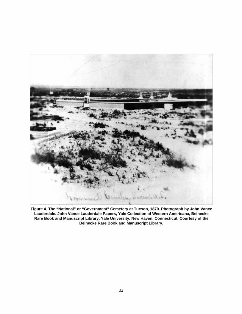
32
Figure 4. The “National” or “Government” Cemetery at Tucson, 1870. Photograph by John VanceLauderdale. John Vance Lauderdale Papers, Yale Collection of Western Americana, BeineckeRare Book and Manuscript Library, Yale University, New Haven, Connecticut. Courtesy of the
Beinecke Rare Book and Manuscript Library.

33
the photograph shows straight adobe walls surrounding a rectangular parcel, with a gate in the center ofthe east wall. In the foreground of the photograph, or just northeast of the walled cemetery, is an area ofundeveloped desert crossed by a few well-beaten paths. The tops of several buildings are visible beyond(southwest of) the enclosure. This was downtown Tucson of the day, although it is hard to say, basedsolely on the photograph, what buildings are depicted.
Despite the lack of information on its location, the walled camp cemetery presumably corresponded,at least in part, with the cemetery depicted on the 1872 map of the original town site of Tucson (Figure 5),prepared just two years after Lauderdale took his photograph. The 1872 map shows the cemetery (labeledsimply “cemetery”) as a rectangular parcel bounded on the north by Seventh Street, on the east by SixthAvenue, on the south by Cemetery Street (later called Alameda Street), and on the west by Stone Avenue.This was the only formally defined cemetery within the town site and it almost certainly correspondedwith the cemetery in Lauderdale’s photograph. Nonetheless, it is not clear how closely the limits of thecemetery depicted on the 1872 map followed the walls of the cemetery in the 1870 photograph.Unfortunately, the field notes of the town site survey (Foreman 1872) do not provide any hint about whythe cemetery parcel was delimited as it was. The land-entry file for the town site (General Land Office[GLO] 1872), which consists of only a few receipts acknowledging payment for the site by Sidney R.DeLong, Tucson’s first mayor, is equally unhelpful. Commenting on the Lauderdale photograph,Altshuler (1985:9) stated that the west wall of the cemetery approximated present-day Stone Avenue, thesouth wall present-day Alameda Street, and the east wall present-day Scott Avenue, but she did notindicate the basis for her statement. Her note that the east wall approximated Scott Avenue (which hasnever extended into the project area) would place the east wall somewhat east of modern GrossettaAvenue and about halfway between Stone and Sixth Avenues. This would mean the walled cemetery wasconsiderably smaller than the cemetery parcel on the 1872 map. The proportions of the cemetery in thephotograph suggest that it was square, or nearly so. If one assumes that no part of the walled cemeterywould have been excluded from the parcel labeled cemetery on the 1872 map, a square cemetery couldonly have been smaller than the unequivocally rectangular cemetery parcel delimited in the town sitesurvey.
Whatever the relative sizes of the original walled cemetery and the official cemetery parcel of 1872,there is no clear evidence that any of the cemetery walls fell along the limits of the cemetery parcel, oreven that the walled cemetery was entirely contained within the parcel. The general alignment of thecemetery walls—north-south and east-west—was apparently the same as that of the 1872 cemeteryparcel, but this can be attributed to the general surveying practice of the day. Without any specificinformation about how and where the walled cemetery was laid out (other than the 1870 photograph), it isimpossible to say how closely the later parcel conformed to it.
The placement of the cemetery parcel on the 1872 town site map actually suggests that the surveyor,S. W. Foreman, was more concerned with delimiting the parcel within the regular grid of the survey thanwith respecting an existing location and alignment. The application for a town site by the newlyincorporated village of Tucson in 1872 was for the 1,280 acres comprised exactly by Sections 12 and 13of Township 14 South, Range 13 East. Foreman’s town site survey consisted of subdividing the twosections into some 240 blocks, preserving the mostly irregular streets and lots of the previously settledportion of Tucson but using a perfectly regular grid for the larger, unsettled portion (Pederson 1970). In1872, the area that became the cemetery parcel was at the northeastern edge of the settled area of Tucson,just beyond the limit of irregular streets and lots. The cemetery parcel fell neatly on the new grid,measuring one and a half blocks north-south by two blocks east-west (see Figure 5). Since both the north-south and east-west streets of the new grid were laid out at regular intervals without reference to existingstreets or lots, it is undoubtedly significant that three sides of the cemetery parcel were exactly in linewith newly defined streets, and the fourth (south) side was parallel to, and equidistant from, two newstreets.

34
Figure 5. Official map of the 1872 survey of the town site of Tucson by S. W. Foreman (certified copy of 1918). Maps and Records Section, Engineering Division, Department of Transportation, City of Tucson.

Xxx

35
It is unlikely that the walled cemetery established by the army at least three years prior to the townsite survey corresponded closely to a regular subdivision of the town site. The earliest official survey ofsouthern Arizona did not take place until 1871, when Foreman first surveyed all of Township 14 South,Range 13 East (Pederson 1970:155–157), tying the area to the baseline and meridian recently establishedby the GLO at the confluence of the Gila and Salt Rivers. Any earlier survey could not have used thesame grid or reference points. (Incidentally, Foreman made no mention of the cemetery in his surveynotes, and it does not appear on his map of the township [Foreman 1871].) The records of the originalsurvey of the Camp Lowell military reservation, which presumably took place in 1866 or soon after, werelost, but a resurvey of the reservation in 1870 was made with reference only to “an oak post” placed at anarbitrary point “on the overland road from Tucson to Santa Fe” (Tyler 1872:7). Whatever the location ofthe cemetery may have been relative to the military reservation, it would not have anticipated the grid ofthe town site survey. This strongly suggests that the cemetery parcel designated in 1872 wholly containedthe walled cemetery, with room to spare on one or more sides of it (or, less likely, the parcel excludedsome portion of the walled cemetery).
Earlier and Other Cemeteries
It was the U.S. Army that formalized the layout and use of a cemetery at the northeastern corner ofTucson, but the vicinity of the cemetery was evidently used for burials for many years before CampLowell was established. Hilario Gallego, born in 1850 to a family living within the Tucson presidio,recalled in his old age that inside the presidio, along its east wall, an old ruined church once stood:
In the very early times there was a cemetery inside the wall near this church, but as farback as I can remember they were burying people outside the wall near what is nowAlameda and Stone Avenue [Gallego 1935:76].
The old church remembered by Gallego was the original presidio chapel dedicated to San Agustínand built shortly after the presidio was established in 1775. Thiel (n.d.) has gathered the scatteredreferences to the cemetery (or cemeteries) associated with the presidio chapel, as well as references todiscoveries of burials within the former limits of the presidio (also see Thiel et al. 1995:38). The areasadjacent to the old chapel and within the presidio wall were last used for burials in the 1860s, though it isimpossible to specify the year. In a conversation with Robert Forbes in 1914, the early pioneer SamuelHughes, who first came to Tucson as an adult in 1858, noted that the gate in the east wall of the presidio(near the chapel) was first created when the “new cemetery was started east of Stone and north ofAlameda” (Lockwood n.d.:8). This suggests that the project area was first used as a cemetery when theeast wall of the presidio was still intact, which, based on the discussion of Thiel et al.(1995:40), wasprobably no later than the early 1860s. It is impossible to be sure, but this suggests that the establishmentof the new cemetery corresponded with (and perhaps was prompted by) the arrival of Union troops inTucson in 1862.
Numerous skeletons have been found in the area that corresponds to the presidio chapel cemetery,within and along modern Alameda Street and between Church and Court Avenues. In 1968–1969, as partof the Tucson Urban Renewal Project, James Ayres excavated a series of burials found below AlamedaStreet during the installation of sewer and gas pipelines; he later recorded other burials at the site of the ElPresidio Parking Garage on North Meyer Avenue as part of the same project (a lack of funding preventedpreparation of a formal report on this work). More recently, Desert Archaeology discovered the remainsof as many as 106 individuals, distributed in five clusters of burials, while monitoring the excavation of a

36
gas pipeline trench along the south side of Alameda (Faught 1992; Thiel et al. 1995:105–118). Thediscovery included what were identified as Caucasian, Mexican-American, and Native American skeletalremains, all of them probably dating to the period when the presidio was in use. The Mexican-Americanremains were turned over to Los Descendientes del Presidio de Tucson, a Spanish-heritage group, whichreburied the remains in the Holy Hope Cemetery in Tucson. The Native American remains wererepatriated to the Tohono O’odham Nation.
In 1989, another notable discovery of burials was made in the area between the former sites of thepresidio and the camp cemetery. During excavations in Block 180 on behalf of Pima County, SRIarchaeologists discovered a burial pit containing the skeletons of two individuals, later identified asMexican-American men, buried around mid-ninteenth century. The two men were evidently buried at thesame time and had suffered violent deaths at another location. They were possibly the victims of anApache attack: one skeleton had a small stone projectile point embedded in its rib cage. The double burialwas found just south of Council Street in the north-central portion of Block 180, about midway betweenthe northeast corner of the former presidio and the current project area (Ciolek-Torrello and Swanson1997:140–147). The two skeletons were turned over to Los Descendientes del Presidio de Tucson forreburial at the same time as the reburial of the remains from the presidio cemetery. SRI trenched Block180 thoroughly but did not discover any other historical-period skeletal remains, which suggests that theburial was not part of a larger area used as a cemetery. Based on his familiarity with archaeological workin the area, Ayres (personal communication, 4 March 2005) believes that the presidio cemetery did notextend north of modern Alameda Street.
Apart from Hilario Gallego’s comment about burials having long been made “near what is nowAlameda and Stone Avenue,” there is no definite evidence that the U. S. Army chose to use and encloseas its official cemetery an area already being used for burials. Surely the location was chosen because ofits proximity to an area long used for burials, but it is entirely possible that burials had not yet been madeeast of what is now Stone Avenue or north of what is now Alameda Street. On the other hand, it is alsopossible that the army post at Tucson, in existence since 1862, had made a practice of burying its dead inthe area that was later enclosed with a wall. But whatever the date of the earliest burials in the army’swalled cemetery, it is certain that the cemetery was in use by the late 1860s. The army continued to useand maintain the cemetery even after 1873, the year Camp Lowell was relocated from downtown Tucsonto a site along Rillito Creek, about 7 miles to the northeast. An 1875 report describing the facilities of therelocated Camp Lowell stated, “The cemetery is located just without the limits of the town of Tucson. Ithas a wall around it, and a considerable amount of care has been taken in preserving it” (Lippincott andGirard 1875:542; note that the “limits” of Tucson as understood here referred not to the limits of the townsite surveyed in 1872 but to the limits of the settled portion of town).
It is not clear when the downtown cemetery ceased to be used by the army. On January 21, 1881,Corporal John Lyon of Company M, 6th Cavalry, died of cancer in the hospital at Fort Lowell (as CampLowell, relocated to the Rillito, was renamed in 1876). He was buried two days later in the “militarycemetery of the city,” with military honors and following a Catholic service (Arizona Weekly Star, 27January 1881a). In a letter to the Arizona Weekly Star, Charles D. Poston, who was living in Tucson at thetime (Sacks 1963:10) and attended Corporal Lyon’s funeral, described the sorry state of the cemetery:
The interment of a non-commissioned officer of the army on Sunday in ourMilitary cemetery was conducted with the grave solemnity due to the last rites ofa comrade and a citizen. It also gave the people a sad opportunity to witness theneglect and desecration which rests upon the mural monuments of the bravedead. It is nearly sad as death to think we live among human beings who wouldbe so degraded as to make targets of tombstones; and yet the ravages of theseiconoclasts was [sic] painfully visible. The other “signs” of beastliness areunmentionable. Cannot something be done by the city government or the War

37
Department to preserve from desecration the graves of the brave and helplessdead? [Poston 1881].
These lofty sentiments were echoed on the editorial page of the same issue of the Star, where it wasalso noted that the walls of the old cemetery were as dilapidated as the graves within. The editors reportedthat plans were already being made to relocate the cemetery and its burials outside the city. Among othersuggestions, they recommended that the reinterred burials be provided with headstones having cut ratherthan painted letters, which implies that headstones with the latter were used in the old cemetery (ArizonaWeekly Star, 27 January 1881b).
The 1884 memorandum of the Quartermaster General (War Department 1884) cited a report fromFebruary 1881 indicating that a cemetery was in existence at Fort Lowell by that year. The same reportindicated that the original camp cemetery was in a dilapidated condition and the walls were “being usedby the inhabitants in the vicinity for privy purposes and as a place of deposit for all sort of filth.” By thatyear, the cemetery contained “some 65 or 70 officers and soldiers and some 30 civilians.” The 1884memorandum indicated that “last year” (i.e., 1883) the city authorities “pulled down the fence [i.e., wall]and threw open the graveyard.” The graveyard itself had fallen into “a wretched and disgracefulcondition.” The memorandum noted several other reports that discussed if, when, and to where themilitary burials in the cemetery should be moved, but the removal had not yet taken place. Given thereported state of the downtown cemetery in 1881, it seems unlikely that the army continued to use it forburials after that year, especially since the army was well aware that the city was intent on closing it and anew military cemetery was in use at Fort Lowell.
By April 1884, the city was contemplating the sale of lots in the old cemetery (Arizona Daily Citizen,13 April 1884). Perhaps in recognition of this intention, that year’s Memorial Day commemoration wasgiven a long, pious description in the Arizona Citizen. The day’s procession included a stop at the “oldmilitary cemetery” on Stone Avenue, “where more than a hundred soldiers are buried” (Arizona Citizen[AC], 7 June 1884).
Two weeks or so after Memorial Day, a notice appeared in the Arizona Daily Star:
Dr. W. J. White will begin moving this morning, the dead bodies of all the Federalsoldiers that are buried in the cemetery on the corner of Alameda Street and StoneAvenue to Fort Lowell. He desires that all persons living in the city who have friends orrelatives buried in this cemetery to go immediately and designate their graves, as he willbe unable to distinguish them [Arizona Daily Star, date uncertain, reprinted in thePhoenix Herald, 23 June 1884].
The Star later reported that Dr. White was able to recover the remains of 74 people, most of whomwere represented by just a few bones, but he also removed at least two complete skeletons: that of alieutenant’s wife and that of a corporal “buried about three years since” (ADS, 24 June 1884); the latterskeleton was perhaps that of Corporal John Lyon. An editorial appeared in the Citizen the day beforedeclaring that White’s work had created a health hazard by releasing the noxious gases of putrefaction(Arizona Weekly Citizen, 23 June 1884), but in a response sent to the Star White noted that, “With but oneor two exceptions, the remains consisted only of a few crumbling bones, and from the more perfectskeletons the flesh had entirely disappeared and they were consequently odorless” (White 1884). Heattributed the malicious Citizen commentary to the influence of people who had tried but failed to get thecontract for removing the burials.
The transfer of the remains exhumed by Dr. White to the new Fort Lowell cemetery turned out to beonly temporary. When Fort Lowell was abandoned in 1891, 80 burials in the fort cemetery (includingsome originally interred at Fort Lowell and not in the original camp cemetery) were removed andtransferred, most to the San Francisco National Cemetery, which had been established on the grounds ofthe historic presidio in 1884. Another 12 burials or so, mostly of unidentified civilians, were left in the

38
Fort Lowell cemetery, the location of which is now uncertain (Callender 1998:112–113; Faust andRandall 2002:93).
Although we have not seen any document indicating exactly why a cemetery was first established atCamp Lowell or why it was walled, both circumstances can probably be attributed to policies developedby the federal government and the army following the end of the Civil War. The large number of fatalitieson both sides of the war, and the haphazard burial of so many soldiers during its course, led to the officialdesignation of government cemeteries, most notably at or near the sites of major battles in the East butalso at many of the frontier outposts in the West occupied by troops during the war. On April 13, 1866, aJoint Resolution of Congress directed the Secretary of War “to take immediate measures to preserve fromdesecration the graves of soldiers of the United States who fell in battle or died of disease in hospitals; tosecure suitable burial places in which they may be properly interred; and to have the graves enclosed sothat the resting places of the honored dead may be kept sacred forever” (National Cemetery Admin-istration 2005). The resolution was soon supplemented by additional resolutions and acts of Congress,resulting eventually in the modern National Cemetery system (Steere 1953).
The small, remote military cemetery at Tucson was apparently never officially designated a “NationalCemetery” in the same sense as, for example, the Santa Fe National Cemetery (established in 1875). Inthe Star editorial from 1881 cited above (Arizona Weekly Star, 27 January 1881b), the editors asked,“[W]hy cannot our military cemetery be made a National one?” and pleaded that someone take the causeto the U.S. Congress. If such an effort was ever made, it evidently failed. Nonetheless, the original campcemetery at Tucson was undoubtedly established in response to an emerging army policy requiringformally designated and maintained (and walled) military cemeteries. If nothing else, this explains thetidy adobe wall around the camp cemetery described admiringly by early observers.
The wall around the camp cemetery undoubtedly served to protect the graves of officers and soldiersfrom disturbance, especially by animals, but one wonders if it was not also intended to discourage burialsunauthorized by the army. Since it is probable that the vicinity of the camp cemetery was already beingused for civilian burials before the army formally designated the cemetery, the wall may have been a wayto prevent encroachment on the area claimed by the army. No formal record of who was buried in thecemetery has survived, and the record of the military graves it once held is limited to the list of namesassociated with the skeletal remains relocated by Dr. White in 1884; at least a third of the burials on thelist are described as “unknown” (Tompkins 1958). We have also not found any reference to regulationsgoverning who was buried in the cemetery. There are a few scattered references to civilian burials in theearly years of the camp cemetery, during the period Camp Lowell was still located downtown, but thepeople may have qualified for burial there either because of a direct association with the army or becauseof another special status. The Weekly Arizonan for October 2, 1869, noted the recent burial of a Mrs.Miles in the “National Cemetery” (Weekly Arizonan [WA], 2 October 1869). Mrs. Miles was undoubtedlyElla Stoutenborough Miles, the wife of Captain Evan Miles, an officer stationed at Camp Lowell in1869–1870. According to Altshuler (1986:6), Mrs. Miles died in Tucson from puerperal fever onSeptember 28, 1869, after giving birth to a baby who also died (Captain Miles appears in two of theLauderdale photographs discussed by Altshuler). Although the Weekly Arizonan did not mention it, Mrs.Miles’s baby was presumably buried with her in the camp cemetery. Perhaps the “wife of a lieutenant”exhumed by Dr. White in 1884 was in fact Mrs. Miles, although her name does not appear among theidentified burials on his list (Tompkins 1958; neither does the name of Corporal Lyon, mentioned above).
Another non-military burial in the first few years of the cemetery was that of Daniel Hodges Stickney,a prominent early settler of Arizona, perennial member of the territorial legislature, and, at the time of hisdeath, president of the Territorial Council, the upper house of the legislature (the legislature was locatedin Tucson in the period 1868–1877). Stickney, who died on February 17, 1871, had no direct associationwith the army but was nevertheless buried in the camp cemetery, perhaps because of his stature in thecommunity and the larger territory. Newspaper notices of his funeral described the accompanyingprocession as the largest ever seen in Tucson (WA, 25 February 1871; Arizona Citizen [AC], 25 February

39
1871; see Hayden [n.d.] and Wagoner [1970:505–510] on Stickney’s life and political career). As withMrs. Miles, Stickney’s name is absent from the list of identified burials moved by Dr. White in 1884.
A thorough search for death and funeral notices in Tucson newspapers from the period 1868–1884would undoubtedly provide a clearer idea of when and how often civilian burials took place in the campcemetery. The limited search we have been able to make suggests that the cemetery was not, in the firstfew years of that period, open to the general public. This is not to say that civilian burials did not takeplace in the immediate vicinity of the camp cemetery or within the limits of the current projectarea—given the comment by Hilario Gallego cited above, they probably did—but the few otherreferences to civilian burials we have seen cannot be dated precisely or are relatively late (see especiallyThiel n.d.). It is therefore possible that the walled camp cemetery was originally reserved for the burial ofsoldiers and officers and was used for only the occasional civilian, someone with either a closeassociation with the army or a special status in the local community.
On the other hand, there is plenty of indirect evidence that, by 1875, two years after Camp Lowellwas moved to the Rillito, civilian burials were common at least in the immediate vicinity of the campcemetery and probably even within it. On April 16, 1875, a notice appeared in the Arizona Citizen that apublic meeting would soon be held to discuss the possibility of closing what could only have been thecamp cemetery and designating a new one farther from the settled part of town:
Almost everyone at some time has an interest in a graveyard. As cities grow, graveyardsbecome nuisances, and difficult as the job is, their abatement becomes necessary. TheTucson graveyards are now unpleasantly near our northeast border and we are requestedto say that a meeting will be held next Monday night for the purpose of considering thesubject of stopping interments in the present yards and laying out and fencing burialgrounds farther to the northeast. All ought to be interested in this movement [ArizonaCitizen (AC), 16 April 1875 (reprinted 16 April 1925)].
At a meeting of the Common Council (as the City Council was then called) on May 18, 1875, it wasresolved that a newly designated cemetery would open on June 1, and no more burials would be allowedin the old cemetery (AC, 29 May 1875). The new cemetery was the Court Street Cemetery, encompassingeight city blocks at the northern edge of the town site (and north, rather than northeast, of the campcemetery). The Court Street Cemetery, so named because Tenth Avenue, the northern extension of CourtStreet, bisected it, was bounded on the east by Eighth (or Stone) Avenue, on the south by Second Street,on the west by Main Avenue, and on the north by what is now Speedway Boulevard. Unlike the old campcemetery, the Court Street Cemetery eventually had separate sections designated for Catholic andProtestant burials as well as for use by various fraternal organizations. The new cemetery was itselfofficially closed in 1907, when the Evergreen and Holy Hope Cemeteries opened, a few miles north of theoriginal town site, but the Court Street Cemetery was still being used as late as 1916 (Callender 1999:29;Roskruge 1893; Wallace n.d. [the discussion by Wallace of the city blocks used for the new Court StreetCemetery seems confused, perhaps by his misreading of the city council meeting minutes for May 18,1875]).
The old camp cemetery, like its Court Street successor, continued to be used for burials even after itofficially closed in 1875, as the burial of Corporal Lyon there in 1881 has already indicated. Three yearsafter the official closing, on October 3, 1878, the Arizona Weekly Star complained that the graves in theold cemetery still needed to be moved to the new cemetery, then recommended that the work ofdisinterment be done by contract. Given that Dr. White’s removal of burials in 1881 was seeminglyrestricted to military burials, it is not clear if the Star’s recommendation was for the removal of civilian ormilitary burials, but since the new city cemetery on Court Street was the intended destination, perhaps thepaper had civilian burials in mind. In any case, it is impossible to say precisely what the Star meant by the“old cemetery”—was it the walled camp cemetery or the larger cemetery parcel containing it? Given thedeteriorated condition of the cemetery walls reported in 1881, did people in 1878 even make a distinction

40
between inside and outside the cemetery walls? It is worth noting here that Altshuler (1985:3) mistakenlybelieved that the old camp cemetery was the subject of a comment by Mayor J. B. (“Pie”) Allen to theCommon Council on February 7, 1877 (printed in the Arizona Citizen, 17 February 1877) that “thepresent cemetery is a drear, bleak, desolate place” and should be closed in favor of a new location. Allenwas clearly referring to the recently opened but apparently already neglected Court Street Cemetery,although the old camp cemetery may have been just as bleak and drear by 1877.
The Railroad and Other Early Intrusions
It is reasonable to wonder why, if some people were determined to continue using the old cemetery evenafter it was officially closed—the Star commentary on Corporal Lyon’s funeral in 1881 even encouragedthe city to fix the place up—other people were just as determined to stop its use. If the city was willing toown and maintain a cemetery at all, why not maintain the one already designated and in common use? Itis not clear how a reasonably well-maintained cemetery could be a “nuisance,” as the Arizona Citizen putit, no matter where it was located.
One factor in the push to close the old cemetery must have been a general assumption that, as Tucsongrew, the land occupied by the cemetery would increase in value. This was undoubtedly the case as theconstruction of a railroad through Tucson became increasingly likely through the 1870s. The possibilitythat the railroad would use land occupied by the camp cemetery was apparently recognized very early on.The Weekly Arizonan of March 4, 1871, reported,
We understand that one of our enterprising merchants—a gentleman who figur[e]sextensively in “dry goods”[—]has received private advices to the effect that the comingrailroad will pass directly through the Tucson “burial ground.” The same foresight thatplaced him far up on the ladder of prosperity has now influenced him to take up somelots in said enclosure [WA, 4 March 1871].
This notice appeared shortly after the U. S. Congress passed a law authorizing the building of arailroad across the Gadsden Purchase, intended as a link between El Paso and San Diego (Devine2004:105). The railroad would not reach Tucson for another nine years, but the move to close the oldcemetery in 1875, as well as any opinion about the “nuisance” of having a cemetery so close to town, wasundoubtedly conditioned by an assumption that the cemetery parcel delimited in the 1872 town sitesurvey would prove valuable to whomever held it when it came time to negotiate with the railroad. OnJanuary 3, 1877, the city donated about 200 acres to the Southern Pacific Railroad for the anticipatedproject, apparently before the eventual route of the railroad was decided. The donation, which includedunoccupied lands in the eastern and northern portions of the town site but not the cemetery parcel, wassimply a placeholder meant to demonstrate the city’s intentions. Eventually, the railroad requested a 100-foot-wide right-of-way running northwest to southeast across the town site, as well as a large rectangularparcel just east of town for a roundhouse and other facilities; the city granted the request contingent onthe return of the earlier donation (Devine 2004:163–164; Village of Tucson 1879). The granted right-of-way, and the railroad finally built within it in 1880, ran diagonally across the northwest quarter of thecemetery parcel.
Provocative as it may be, the 1871 notice of someone acquiring lots in the Tucson cemetery is a littlemystifying. The cited “enclosure” seems to refer to the walled camp cemetery, but it is not clear howanyone could “take up” lots there if it was in fact army property. And no party other than the city seemedto own the cemetery parcel when a portion of it was donated to Southern Pacific in 1879. Since Tucson

41
was not yet legally incorporated when the notice appeared in the 1871 Weekly Arizonan (see Pederson1970), it seems likely that the “enterprising merchant” of the notice was making a presumptive claim onlands that were probably still claimed by the army and would later be claimed by the Village of Tucson aspart of the official town site. We have not seen the notes or original map of the survey of the railroadright-of-way that crossed the cemetery parcel in 1879, but later that year a triangular portion of the parcelcontaining the right-of-way was surveyed by George Roskruge on behalf of the city (Roskruge 1879).Roskruge’s survey marked off three new, irregularly shaped city blocks numbered 249, 250, and 251.Block 249 was located on the north side of the tracks, and Blocks 250 and 251 on the south side; the lattertwo blocks were subdivided into lots. The newly designated Toole Avenue, named for Mayor JamesToole, who had an important role in the acquisition of the overall right-of-way (Devine 2004:165), ranparallel to the railroad on its south side. Together, the right-of-way (including Railroad Avenue along itsnorth side), the three new city blocks, and Toole Avenue took up exactly one triangular half of the 1872cemetery parcel (Block 251 also took up a small portion of original Block 71) (Figure 6).
We have seen nothing to suggest that anyone had a problem with the railroad occupying a substantialportion of the officially designated cemetery parcel, or that the building of the railroad (or the grading ofToole Avenue, or any subsequent construction on Blocks 249–251) disturbed any graves. A lack ofevidence in this respect may reflect a general willingness at the time to overlook such details, especiallyconsidering the enthusiasm that greeted the arrival of the railroad in 1880 (Devine 2004:136–178), but itis also possible that the affected half of the cemetery parcel was either unused for burials or less used thanthe half that had long been immediately adjacent to the settled portion of Tucson. The deed transferringtitle to the railroad right-of-way (Village of Tucson 1879) refers to the cemetery parcel as the “Cemetary[sic] Reservation,” which implies that the overall parcel was simply reserved for use as a cemetery, notnecessarily used in its entirety as one. Perhaps this is also a clue to the location and size of the originalwalled camp cemetery. If the walled cemetery, which was in all likelihood smaller than the overallcemetery parcel, were located hard against Stone Avenue and Cemetery (Alameda) Street, it may havefallen entirely within the triangular southwest half of the parcel, and the city therefore may have had fewqualms about donating and disturbing the northeast half. This is actually suggested by the placement ofthe label “National Cemetery” in the southwest corner of the newly delimited triangular parcel on the1880 map of Tucson, prepared just after the railroad was built (see Figure 6). On the other hand, as notedabove, an army document cited by Weaver (1947:87–88) reported that in 1881 the city had recently torndown the wall around the camp cemetery. If the city was prompted to do so by the coming of the railroad,it would suggest that the wall extended into the parcel donated to Southern Pacific.
Another detail suggests that the original camp cemetery was located mostly or wholly within thesouthwest half of the 1872 cemetery parcel. The field notes and map from Roskruge’s 1879 survey ofBlocks 249–251, or the parcel’s northeast half, made no mention of the cemetery, yet the survey of theparcel’s southwest half by John Gardiner in 1889 explicitly refers to the area as “the Old Cemetery”(Gardiner 1889) (Figure 7).
Between the removal of military burials in 1884 and Gardiner’s survey of 1889, the old cemetery wasapparently unmaintained but still visited by the families and friends of the nonmilitary people buriedthere. In 1953, when skeletons were found during a construction project east of Stone and north ofAlameda (discussed later in this report), Dora Scribner Miller, who was six years old when her familyarrived in Tucson in 1885, commented:
Goodness . . . . How could they miss them? Why, that place was an old cemetery whenwe first came to Tucson. It was one of the first things we saw when we got off thetrain—lots of mesquite and catclaw with little paths through the trees to the graves. Therewere always candles burning and day or night you could see someone there saying arosary. It was about a block wide. Later the more important graves were removed. Theothers were covered over and forgotten [quoted in Stanley 1953].

42
Figure 6. Portion of a map of Tucson prepared in 1880 showing the “National Cemetery,” the route of the recently builtSouthern Pacific Railroad, newly surveyed Blocks 249, 250 and 251, and Toole Avenue. Note that Alameda Street was still
called Cemetery Street in 1880. (Map courtesy of the Arizona Historical Society/Tucson, Tucson (Ariz.) Maps, 1880.)http://arizonahistoricalsociety.org

43
Figure 7. Last page of the field notes of the 1889 survey of Blocks 252–255 by John Gardiner (Gardiner 1889).

44
In addition to the description of an overgrown cemetery, Mrs. Miller’s comments are interesting forthe references to the Catholic practices of saying the rosary and leaving lighted candles at graves. Thissuggests that many of the people buried in the cemetery were Mexican or Mexican-American. Catholicsof other ethnicities also lived and died in early Tucson, but given that Mexican-Americans were themajority in Tucson throughout the second half of the nineteenth century, it would be surprising if themajority of the Catholics buried in the cemetery were not also Mexican-American. The only possibleexception would be the first few years after the army erected a wall around the cemetery, which, asdiscussed above, may have served to restrict who was buried there. Thiel (n.d.) cites an unpublisheddocument indicating that Torivio García and María Morales, the parents of Jesús García, were buried inan unspecified year in the old cemetery. Judging by Mrs. Miller’s comments, it is likely that many otherMexican-Americans were buried there.
If she remembered correctly, Mrs. Miller’s note that the “more important graves were removed” fromthe cemetery in later years would have to refer to graves removed after she came to Tucson and not tothose removed by Dr. White in 1884. Thiel (n.d.) cites a possible instance of three graves of members ofthe same Anglo family being removed in 1888 (the reference may actually be to graves in the Court StreetCemetery), but no formal record exists of how many civilian graves were removed, much less of howmany were “covered over and forgotten.”
In 1889, the Arizona Citizen described the deplorable condition of the old cemetery and noted thecity’s plans for the property:
The old graveyard, which now belongs to the city, is the general dump ground andreceptacle for the offals of the city. A person walking through it finds everything in itfrom a dead rat to a dead horse. There are also tin cans, old shoes and boots, etc., adnauseum, and to cap the climax, the ground has a number of holes which were formerlygraves, and if a pedestrian happens that way after dark he is likely to fall into one of thenumerous pits and get his neck broken. It is gratifying to know that the “PatresConscripta” have taken the matter into hand and will cause the whole property to beimproved and placed on the market [Arizona Daily Star, 27 February 1889].
A few months later, on April 13, 1889, the city recorder, Charles H. Meyer, published a notice thatthe city would sell at auction “a number of lots situated on the north side of Alameda Street and the eastside of Stone Avenue being the ground known as the old cemetery” (Arizona Daily Citizen, 13 April1889). John Gardiner had that same day submitted the field notes and map of his survey of the oldcemetery parcel (Figure 8). Gardiner’s survey marked off four new city blocks, numbered 252 to 255.Blocks 252 and 255 were subdivided into 13 and 15 lots, respectively. Block 253, a small triangularparcel, was left undivided. Block 254, described as “school property” was also left undivided, apparentlywith the intention of building a school there. That plan was short-lived: the following year, the block wassubdivided into seven lots in another survey by Roskruge (Figure 9). Similarly short-lived was an earlierplan, apparently still alive in 1889, to turn the old cemetery into a park. A week before the lots in Blocks252, 253, and 255 were to be sold, the Citizen reported,
The cemetery lots will be sold at auction Monday next at the city hall. As the city councilwill not meet between now and then, the proposition to convert that spot into a park willprobably not be adopted [Arizona Daily Citizen, 8 April 1889].
We have not seen anything indicating that these surveys of the old cemetery parcel and the subsequentsales of lots prompted any concern about the presence of burials. Unfortunately, we have not been able tolocate the field notes of Roskruge’s 1890 survey of Block 254.
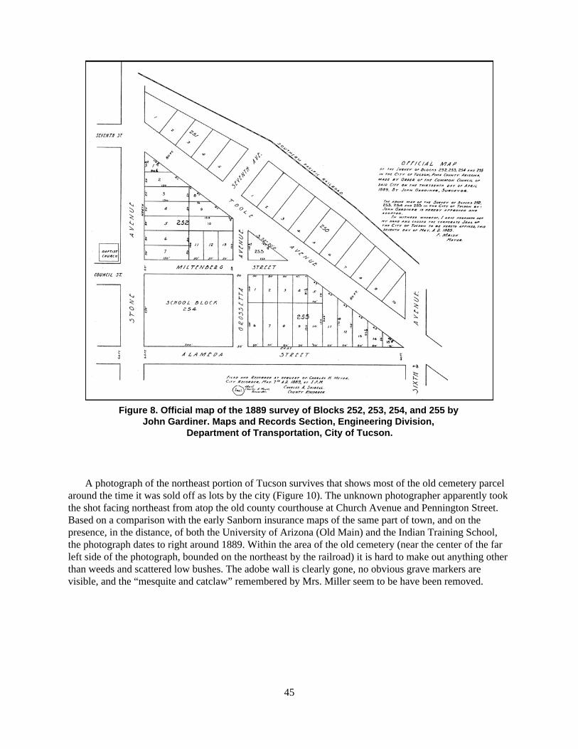
45
Figure 8. Official map of the 1889 survey of Blocks 252, 253, 254, and 255 by John Gardiner. Maps and Records Section, Engineering Division,
Department of Transportation, City of Tucson.
A photograph of the northeast portion of Tucson survives that shows most of the old cemetery parcelaround the time it was sold off as lots by the city (Figure 10). The unknown photographer apparently tookthe shot facing northeast from atop the old county courthouse at Church Avenue and Pennington Street.Based on a comparison with the early Sanborn insurance maps of the same part of town, and on thepresence, in the distance, of both the University of Arizona (Old Main) and the Indian Training School,the photograph dates to right around 1889. Within the area of the old cemetery (near the center of the farleft side of the photograph, bounded on the northeast by the railroad) it is hard to make out anything otherthan weeds and scattered low bushes. The adobe wall is clearly gone, no obvious grave markers arevisible, and the “mesquite and catclaw” remembered by Mrs. Miller seem to be have been removed.

46
Figure 9. Official map of the 1890 survey of Block 254 by George Roskruge. Maps and Records Section, Engineering Division, Department of Transportation, City of Tucson. Note that Roskruge’s survey shaved a narrow wedge off the west
side of the old cemetery parcel, part of a realignment of Stone Avenue that survives today.

47
Figure 10. A portion of downtown Tucson, ca. 1889. This photograph was probably taken fromatop the old county courthouse at Church Avenue and Pennington Street, camera facing
northeast. Stone Avenue runs north-south across the center of the photograph. The project area,still undeveloped but no longer a maintained cemetery, is at the far left side of the photographand southwest of the railroad (photograph courtesy of the Arizona Historical Society/Tucson,
Accession No. 2924). http://arizonahistoricalsociety.org

48
Summary
In 1866, shortly after the Civil War ended, the U.S. Army established Camp Lowell in what is nowdowntown Tucson. In addition to a large reservation centered on what is now Armory Park, Camp Lowellincluded an area formally designated as a cemetery. The cemetery was in existence at least as early as1868; it was surrounded by an adobe wall at least as early as 1870. It was located northeast of the modernintersection of Stone Avenue and Alameda Street and fell at least partly within the current project area,but its exact location is uncertain. This walled cemetery was included within a rectangular parcel set asideas a cemetery in the original 1872 survey of the Tucson town site. The location of the 1872 cemeteryparcel is precisely known, but its relationship with the walled cemetery is uncertain. The 1872 parcel wasprobably substantially larger than the walled cemetery, which was probably located in the southwestquarter of the parcel, adjacent or close to Stone Avenue and Alameda Street.
Tucsonans began burying their dead in the area northeast of Stone and Alameda in the early 1860s, orperhaps even earlier, years before the camp cemetery was formally designated and walled. According toone source, the area began to be used as a cemetery after an entrance was opened in the east wall of theTucson presidio, which probably happened in the early 1860s. From that time until the establishment ofthe walled cemetery, the area was used at least by civilians in Tucson and probably also by the army,which had a permanent presence in Tucson by 1862. There is no definite evidence that the walledcemetery enclosed an area already used for civilian and military burials, but it appears likely. At the veryleast, civilian burials were being made in the immediate vicinity of the walled cemetery, and within thecurrent project area, by the early 1860s.
Camp Lowell was moved to the Rillito, 7 miles northeast of Tucson, in 1873, then renamed FortLowell in 1876. The walled cemetery was officially declared closed by the City Council in 1876. Thecemetery wall itself was badly deteriorated, or perhaps completely down, by 1881. Nevertheless, bothcivilian and military burials continued within or adjacent to the original walled cemetery at least until1884. In that year, the military burials were removed and reburied at Fort Lowell. A survey in 1879subdivided the triangular northeast half of the 1872 parcel, and in 1880 the Southern Pacific Railroad wasbuilt across that half; there is no evidence that either action had any impact on burials in the original campcemetery or any other part of the cemetery parcel. After the military burials were removed in 1884, thetriangular southwest half of the 1872 parcel was subdivided in surveys carried out in 1889 and 1890. Thiswas the effective end of official recognition of what was commonly known as the National Cemetery.

49
CHAPTER 3
Homes and Businessesatop the Old Cemetery, 1900–1960
The City of Tucson began selling lots within newly surveyed Blocks 252, 253, and 255 in 1889, andwithin newly surveyed Block 254 by the following year. By 1900, the old cemetery had become a largelyresidential area similar to the older parts of town immediately to the south and west. Immediately to thenorth and east were the Southern Pacific Railroad and the warehouses and other businesses built after1880. Over the next 60 years, the character of the project area changed gradually from largely residentialto exclusively commercial, an evolution that can be traced through a variety of historical sources.
Historical Sources on the Project Area
The research for this overview was carried out primarily at three locations, all in Tucson: the AHS library,the University of Arizona Library, Special Collections, and the ASM library. We also consulted variousrecords maintained by the City of Tucson Development Services Center and the City of TucsonDepartment of Transportation (Engineering Division, Maps and Records Section) as well as a variety ofsources now available on the Internet. In addition to the books, journal and newspaper articles, andunpublished documents cited in this chapter, four sources of information deserve particular discussion atthe outset: Sanborn insurance maps, federal censuses, Tucson city directories, and property ownershiprecords.
Sanborn Insurance Maps
Probably the most important source for the history of the project area during the period 1900–1960 is theseries of detailed maps of downtown Tucson prepared over the years by the Sanborn Map Company ofNew York. Intended for use by fire insurance underwriters, the Sanborn maps are, in fact, the only mapsfrom the period that consistently and accurately show the size and layout of buildings and other structures in downtown Tucson and the other developed parts of town. The maps include many detailsabout the nature of the buildings they depict, such as function, construction materials, number of stories,and the locations of windows and doors. Sanborn coverage of downtown Tucson began in 1883, just threeyears after the railroad arrived in Tucson, but coverage of the project area did not begin until 1901. On theSanborn maps prepared before 1901 (Sanborn Map Company 1883, 1886, 1889, 1896), there is coverageof the areas immediately west and south of the project area, as well as a limited area to the immediate eastin the vicinity of the Southern Pacific Railroad depot, but the area of the old cemetery is not depicted. Thetotal lack of coverage before 1901, despite the city’s sale of lots within the old cemetery a full decadeearlier, is a little surprising; it suggests that the earliest private landowners in the project area simply didnot build on their lots until after 1896, the year of the last Sanborn map not to show the project area.
50
Although we have information about ownership in the project area going back to 1889 (see below), wehave not found any source that would tell us what buildings stood there before 1901.
To provide an initial sense of the evolution of the project area through the period 1900–1960, weinclude here the corresponding portions of the Sanborn maps of 1901, 1909, 1919, 1930, 1947, 1949, and1960 (Figures 11–17). The maps of 1901, 1909, 1919, 1947, and 1949 are available as digital files on theInternet and we have obtained permission to reproduce them here. However, the 1930 and 1960 maps (aswell as the other post-1900 Sanborn maps not reproduced here but consulted by us: Sanborn MapCompany 1904, 1922, 1951, 1958) are not available on the Internet, and photocopying or otherreproduction of the originals is not permitted. Therefore, we have drafted our own simplified versions ofthe 1930 and 1960 maps (see Figures 14 and 17) to help bridge the gaps between the maps that we canreproduce. A detailed summary of the information about buildings in the project area provided by all butone of the available Sanborn maps is included as Appendix A. We located the 1904 Sanborn map too lateto include it in the appendix but we do cite it once below.
Federal Censuses
Another important source for the history of the project area, particularly its social history, is the federaldecennial censuses, which began including Arizona Territory in 1870. The 1900 federal census is theearliest available census that definitely included people living in the project area. The 1890 federal censusmay also have included the project area, but almost all of that census, including the portion coveringArizona Territory, was destroyed long ago in a fire (Blake 1996). As the absence of Sanborn mapcoverage before 1901 suggests, it is in any case doubtful that anyone was living in the project area in1890. The most recent available federal census is that of 1930; the 1940 federal census will not bereleased to the public until 2012. Thus, we have consulted the federal censuses of 1900, 1910, 1920, and1930 (Bureau of the Census 1900, 1910, 1920, 1930).
Appendix B is a summary of the information about project area residents provided in the 1900, 1910,1920, and 1930 censuses. Several characteristics of these data are worth noting. First, the categories ofinformation collected were somewhat different in each census. For each census, we have included everycategory of potential interest regardless of whether it was collected in every census. Second, we haveexcluded a few categories of information appearing in one or more censuses simply to conserve space andbecause of their minimal interest (e.g., year of marriage). All categories of information appear in theappendix in the same order as in the census schedules without any indication of the excluded categories.Third, we present the information from the censuses as we found it, generally without corrections ofmisspelled names and other mistakes, even when information in other sources made the mistakes obvious.Illegible items or doubtful readings are indicated by question marks in the appendix. We consulted eachcensus in two versions: first, the scanned images of the original documents available online atAncestry.com; and second, the microfilm copies of the original documents available at the AHS library inTucson. Both versions present different problems of legibility and accessibility; the appendix representsour best reading of each item using one or both versions.
Tucson City Directories
Tucson city directories are a third source of information about who lived in the project area following itsinitial development. The city directories, issued annually or biannually by a succession of publishers, alsoinclude the names and addresses of businesses, which are supplied only occasionally on the Sanbornmaps and virtually never in the censuses. Extracting information from the directories is laborious,

51
Figure 11. Portion of the 1901 Sanborn map of Tucson (Sanborn Map Company 1901) with theproject area overlaid.
(Copyright permission has been requested.)

52
Figure 12. Portion of the 1909 Sanborn map of Tucson (Sanborn Map Company 1909) with theproject area overlaid.
(Copyright permission has been requested.)

53
Figure 13. Portion of the 1919 Sanborn map of Tucson (Sanborn Map Company 1919) with theproject area overlaid.
(Copyright permission has been requested.)

54
Figure 14. The project area in 1930, based on the 1930 Sanborn map of Tucson (Sanborn Map Company 1930).
(Copyright permission has been requested.)

55
Figure 15. Portion of the 1947 Sanborn map of Tucson (Sanborn Map Company 1947) with theproject area overlaid.
(Copyright permission has been requested.)

56
Figure 16. Portion of the 1949 Sanborn map of Tucson (Sanborn Map Company 1949) with theproject area overlaid.
(Copyright permission has been requested.)

57
Figure 17. The project area in 1960, based on the 1960 Sanborn map of Tucson (Sanborn Map Company 1960).
(Copyright permission has been requested.)

58
especially for multiple addresses over a span of many years, and especially for the years before 1918 orso, when the directories were strictly an alphabetical list of residents and businesses and lacked crosslistings by address. As discussed further on, we have restricted our use of the city directories largely tothe years corresponding with a selection of the Sanborn maps of the project area. Appendix C is acompilation of the information about residents and businesses in the project area from the city directoriesof 1899–1900, 1910, 1920, 1930, 1946, and 1960. The city directories occasionally contradict thecensuses when it comes to who lived at a particular address in a particular year, which means we havesometimes chosen to disregard one source or the other. Appendix C simply presents the informationfound in the directories without noting the contradictions.
Property Ownership Records
Property ownership records are another useful source on the history of the project area. Currently, theproject area comprises 11 separate ownership parcels, but this is only the most recent configuration in afairly complicated history of lumping, splitting, and redefining parcels that the area has experienced. Aglance at the maps from the original subdivisions of Blocks 252–255 (see Figures 8 and 9) suggests thedegree to which property ownership in the project area has changed since the late nineteenth century: of24 individual lots originally designated and sold within the project area, only one—the single lotencompassed by small, triangular Block 253—survives today as an ownership parcel in its original sizeand shape. Because of this complicated history, compiling a chain of title for every parcel in the projectarea was simply beyond the scope of our project. We are also skeptical that it would have been of muchvalue for an understanding of who actually lived in the project area. However, we did consult the earlytract books of the O’Quinn Title and Abstract Company (O’Quinn Title and Abstract Company n.d.) forinformation on property ownership in the project area before 1930. Our summary of this information,along with a brief discussion of how we extracted it from the O’Quinn tract books, is included here asAppendix D.
The information from the O’Quinn tract books has several limitations: it indicates ownership only,not necessarily who lived on a property; it is only as accurate as the O’Quinn Title and Abstract Companywas able to make it at the time; and it does not extend beyond 1930 or so. Nonetheless, the lists wecompiled do provide a sense of who owned (and sometimes lived) in the project area during the first 40years after it ceased to be part of the old cemetery. After 1930, the configuration of lots in the project areachanged quickly as small lots were consolidated into larger parcels for use in commercial development.As people moved out and businesses moved in after 1930, the specifics of ownership in the project areabecome of less interest than the sequence of demolition and commercial construction reflected in theSanborn maps.
The Project Area, Every 10 Years or So
The 10-year intervals that separate the federal censuses, along with the roughly 10-year intervals thatseparate successive Sanborn maps of Tucson, prompted us to look at the history of the project area as aseries of snapshots taken every 10 years or so across the period 1900–1960. The correspondence betweencensus years and Sanborn map years is not exact, and the censuses reach only to 1930, but discussing thehistory of the project area in terms of its general character every 10 years or so helps to make sense ofwhat is otherwise a disparate aggregate of information.
59
To facilitate the discussion, we have taken the information about residents and businesses in theproject area provided in the federal censuses and city directories and used it to label the individualbuildings depicted on a selection of the Sanborn maps. For the period 1900–1930, we have so labeled the1901, 1909, 1919, and 1930 Sanborn maps, using the 1900, 1910, 1920, and 1930 censuses, respectively,supplemented by the most closely corresponding city directories (the 1899–1900, 1910, 1920, and 1930directories, respectively). For the years after 1930, we have relied solely on the information provided inthe city directories. Since the Sanborn map coverage jumps from 1930 to 1947, we have labeled only twoadditional Sanborn maps, the 1947 and 1960 editions; we labeled these maps using information from the1946 and 1960 city directories (a 1947 directory was not available). Thus, we have created six mapsdepicting residents and businesses in the project area ca. 1900, ca. 1910, ca. 1920, ca. 1930, ca. 1946, andca. 1960 (Figures 18–23).
Provided the information was available, each address depicted in Figures 18–23 is labeled with: thename of the head of household (or the business) at that address; the first name of the head’s spouse (inparentheses); the head’s occupation; and the name and occupation of other working adults in thehousehold. The names and occupations come either from the federal census or the city directory for theindicated year. Occasionally, resident names and occupations in the census conflict with those in the citydirectory. The census information is generally fuller in terms of who lived at an address, but the citydirectory is usually more accurate in terms of spellings, and more specific in terms of occupations. Thus,we generally rely on the census for the residents at an address and on the city directory for name spellingsand occupations. If no occupation is provided in either the city directory or the census, no occupation islisted here unless we know it from another source discussed in the text. A doubtful reading of a name oroccupation provided only in the census is followed by a question mark (?). Occasionally, the census listsan address incorrectly (e.g., “58 Grossetta” for 58 Miltenberg). We were generally able to resolve suchproblems, but we have not indicated where they occurred. Also occasionally, an address in a census orcity directory that evidently falls in the project area is not depicted on the corresponding Sanborn map;the information for such addresses is not included on the figures. Appendixes B and C can be consultedfor the information provided in the censuses and directories, respectively, free of the interpretations wemade to label the maps.
The Project Area, ca. 1900
By 1900, 14 houses stood in the project area; the first commercial building had yet to be erected. Theareas immediately east, south, and west of the project area were also exclusively residential, but acrossToole Avenue, adjacent to the railroad, the Tucson Ice and Cold Storage Company and the Eagle MillingCompany were in operation, both built a few years earlier (see Figure 11).
The residents of the project area in 1900 were almost all Anglo-American and almost all members ofTucson’s middle class: bookkeepers, clerks, grocers, railroad employees, an attorney, a dentist, amachinist, a saloon keeper, a postmaster (see Figure 18). Most of the houses were single-family homes,but the families varied in composition from couples without children to extended families. Severalfamilies had roomers, and at least one house, at 34 East Alameda, seems to have been a rooming house.Postmaster George Cheyney and his wife Anne lived at 186 North Stone with their six daughters and ayoung Native American woman, Nicolasa Antonio, who was their servant. There was also a youngMexican woman, Matilda Sturis (spelling uncertain), working as a servant in the home of George andAdah Whomes, 208 North Stone; and another young woman, Clara Antonio, who was either Mexican orNative American, working as a servant in the home of Philip and Elizabeth Brennan, 294 North Stone.With one other exception (see below), these three young women were the only non–Anglo-Americansliving in the project area, although the Anglo-Americans living there included people born in Canada,England, Germany, and distant parts of the United States.

60
Figure 18. Household heads in the project area, ca. 1900 (based on Bureau of the Census 1900; Sanborn Map Company 1901; Tucson City Directory 1899).

61
Figure 19. Household heads and businesses in the project area, ca. 1910 (based on Bureau of the Census 1910; Sanborn Map Company 1909; Tucson City Directory 1910).

62
Figure 20. Household heads and businesses in the project area, ca. 1920 (based on Bureau of the Census 1920; Sanborn Map Company 1919; Tucson City Directory 1920).

63
Figure 21. Household heads and businesses in the project area, ca. 1930 (based on Bureau of the Census 1930; Sanborn Map Company 1930; Tucson City Directory 1930).

64
Figure 22. Household heads and businesses in the project area, ca. 1946 (based on Sanborn Map Company 1946; Tucson City Directory 1946).

65
Figure 23. Businesses in the project area, ca. 1960 (based on Sanborn Map Company 1960; Tucson City Directory 1960).

66
For most of the residents in the project area, we have not found much information beyond what isprovided in the census and the city directory. However, additional information is available for threeresidents because of their prominence in Tucson before and after 1900. One resident of some prominencewas John N. Brown, a rancher who lived with his wife Dolores at 270 North Stone (Figure 24). Brownwas from Ohio and moved to southern Arizona around 1879. It is not clear when he took up residence inTucson, but it was apparently only after ranching for years along the lower San Pedro River in the vicinityof Mammoth (ADS, 23 June 1914). In 1890, he bought contiguous Lots 3, 4, 5, 8, 9, and 10 of Block 252,which made his family the largest holder of lands within the project area for the next 40 years or so (seeAppendix D and Figure 8). Brown built his house at 270 North Stone sometime after 1890; he is indicatedas resident at that address in 1897, the earliest year of city directory coverage (Tucson City Directory1897). Brown’s wife was the Mexican-born Dolores Ybarra Brown, with whom he had two daughters,Amelia and Sarah. Known as Doña Lola, Mrs. Brown was the only non–Anglo-American, other than thethree young servant women mentioned above, living in the project area in 1900.
Marriages between Anglo men and Mexican women were common in Tucson in the late nineteenthcentury but had become significantly less common by 1900 (Sheridan 1986:145–150). The Browns werethe only interethnic couple in the project area that year, though a few other such couples lived there inlater years. It is not clear what significance the Browns’ interethnic marriage had for their two daughters.Amelia married Fred Steward, a bookkeeper from Ohio. In 1900, the young couple was living in thehouse at 286 North Stone, next door to Amelia’s parents and on one of the lots bought by her father in1890. Fred and Amelia continued to live at the same address until at least 1920 (see below), by whichyear Fred had become president of the Southern Arizona Bank and Trust Company. Amelia’s sister Sarahmarried another banker, Edward Estberg of Waukesha, Wisconsin, where she went to live (ADS, 23 June1914). Both Amelia and Sarah continued to hold different portions of their father’s original property untilat least as late as 1930 (see Appendix D).
Another prominent Tucson citizen residing in the project area was Marcus Aurelius Smith (Figure 25)who owned a large house at 223 North Stone. Smith, a lawyer from Kentucky, made his way to southernArizona in 1880 after a short time practicing law in San Francisco. He settled in Tombstone, where in1881 he became one of the first attorneys admitted to practice in the newly formed Cochise County.Within a few years, he became involved in local, regional, and eventually territorial politics. In 1886, heran as a Democrat for the office of territorial delegate to the U.S. House of Representatives. He won thatelection, was re-elected in 1888, and eventually served several more two-year terms as the sole (andnonvoting) representative of Arizona Territory in Congress. In 1895, Smith was appointed assistant U.S.attorney for Arizona Territory, and in early 1896 he moved permanently to Tucson. On December 12,1911, Smith was elected as one of the two senators from the newly formed state of Arizona. When histerm ended two years later, he was re-elected for a full six-year term and served until 1920. He thenremained in Washington until his death in 1924 (Fazio 1970).
Smith became owner of Lot 1 of Block 254 in 1898 (see Appendix D) and probably built his housethere that year, if not earlier; he was in residence at 223 North Stone at least as early as 1897 (Tucson CityDirectory 1897). Smith had married during the short period he lived in San Francisco and brought hiswife with him to Arizona in 1880. She must also have lived in the house on Stone Avenue, but she diedyoung, in 1899, after years of illness; the couple was childless (Fazio 1970). Smith maintained his housein Tucson for many years even while his duties as an elected official kept him away—his politicalopponents complained that he spent more time in Kentucky than in Arizona—but by 1920, Smith’s lastyear as a senator, the house was rented to a married couple (see Appendix B). Smith sold the property in1921, which probably means he did not intend to return to Tucson after his career as a senator had ended.
A third citizen of some prominence living in the project area in 1900 was George Cheyney (Fig-ure 26), who lived with his wife Anne and their children at 186 North Stone. Cheyney and his wife werefrom Pennsylvania and had arrived in southern Arizona in 1881. The couple settled first in Tombstonewhere Cheyney served for several years as the superintendent of the Tombstone Mining and Milling

67
Figure 24. John N. Brown and Dolores Ybarra Brown, a rancher and his wife who lived at 270North Stone from ca. 1890 until ca. 1915 (photographs courtesy of the Arizona HistoricalSociety/Tucson, Accession Nos. 23833 and 23836, http://arizonahistoricalsociety.org).
Mr. Brown’s portrait was taken in 1895, Mrs. Brown’s in 1897. A note on the back of Mrs. Brown’sportrait indicates that she was known as Doña Lola.
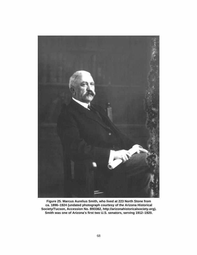
68
Figure 25. Marcus Aurelius Smith, who lived at 223 North Stone fromca. 1896–1924 (undated photograph courtesy of the Arizona Historical
Society/Tucson, Accession No. B93362, http://arizonahistoricalsociety.org).Smith was one of Arizona’s first two U.S. senators, serving 1912–1920.

69
Figure 26. George W. Cheyney, who lived at 186 North Stone for a fewyears ca. 1900; he was Tucson’s postmaster at the time (undatedphotograph courtesy of the Arizona Historical Society/Tucson,
Accession No. 3798, http://arizonahistoricalsociety.org). Cheyney’s name,handwritten on the photograph, is misspelled.

70
Company, the largest mining operation in town. Much like Marcus Smith, Cheyney became involved inlocal and regional politics in Tombstone; he was eventually elected (as a Republican) to the TerritorialCouncil for two terms. He also served as the territory’s superintendent of public instruction for four years,then was appointed postmaster at Tucson in 1898 (Chapman Publishing 1901:113–114). Cheyney wasactually Smith’s opponent in the 1890 election for the office of territorial delegate and lost narrowly to hissoon-to-be neighbor (Fazio 1970:34). Cheyney apparently never owned the house at 186 North Stone.The lot where it stood was the property of Benjamin Fairbanks, a saloon keeper living at 48 East Alamedawho at the time owned several lots in Block 254. By 1910, Cheyney and his family had moved from theproject area, probably to the large house at 252 Main Street that they later owned (Arizona HistoricalSociety [AHS] n.d.a).
The eight houses that lined the east side of Stone Avenue between Alameda and Toole were part of ageneral boom in the construction of large, Eastern-style single-family homes that characterized the northside of downtown at the turn of the twentieth century (Nequette and Jeffery 2002). Based on the Sanbornmap depictions, all eight houses were of wood-frame construction (the first floor of Fred and AmeliaSteward’s house, 286 N. Stone, was of brick, the second floor of wood), a reflection of the Anglo-American disdain at the time for adobe construction. The houses at 34 and 48 East Alameda were also ofwood-frame construction and fairly large, while the other four houses, all on Grossetta Street, were alsoof wood-frame construction but smaller and probably simpler.
From a desolate, neglected cemetery in 1889, the project area was transformed by 1900 into acomfortable middle-class neighborhood. A photograph of 270 North Stone (Figure 27), probably takenaround 1910, shows a brightly painted, well-maintained Victorian house with a spacious front porch andmature landscaping. When the owner John Brown died in 1914, his obituary noted that “the recentpreparation of Stone Avenue for paving” had caused him concern that “his beloved mulberry trees,planted by him many years ago, would have to be rooted up” (ADS, 23 June 1914). As it happened, thetrees were spared uprooting by the paving project—ironically enough, since a decade or so later nary aweed survived on the former site of the Brown house.
Down the block at 223 North Stone, Marcus Smith’s house was similarly shaded by mature trees butwas altogether different architecturally. A photograph of the house taken in 1928 (Figure 28) shows aneclectic Stone Avenue facade with intricate plaster frieze work, egg-shaped porch openings, and severalstyles of columns. The three houses just south of Smith’s, at 186, 196, and 208 North Stone, appear in aphotograph from the 1920s published in a Tucson newspaper in 1957 (AHS n.d.b). These three houseswere each of a more conventional design. Glimpses of the Fred and Amelia Steward house at 286 NorthStone, and of its neighbor at 294 North Stone, can be had in later photographs of the area, as noted below.
The Project Area, ca. 1910
Between 1900 and 1910, the project area remained basically residential in character (see Figure 19). Allbut one of the 14 houses built by 1900 were still standing in 1910; the small house at 37 Grossetta wasgone, replaced by two houses at newly designated 45 and 47 Grossetta. Five new houses now occupiedthe northeast quarter of Block 254, fronting on the south side of Miltenberg and the west side ofGrossetta. All of the new houses were small and probably fairly modest in comparison to the largerhouses along Stone Avenue.
The project area also retained its middle-class character, although with a considerable turnover inresidents. Only three households, all on Stone Avenue, remained basically unchanged: John and DoloresBrown at 270, Fred and Amelia Steward at 294, and the widower Marcus Smith at 223. Mr. Smith’shouse is the only one that underwent a noticeable architectural change: the 1909 Sanborn map shows alarge front porch on the house, probably the elaborate front porch visible in later photographs (see Figure

71
Figure 27. The John N. and Dolores Brown residence, 270 North Stone, ca. 1910 (photograph courtesy of the Arizona Historical Society/Tucson, Accession No. 41590,
http://arizonahistoricalsociety.org). The date of the photograph can be inferred from the lack ofpavement on Stone Avenue and the presence of trolley tracks.

72
Figure 28. The Marcus A. Smith residence, 223 North Stone, in 1928 (photograph courtesy of theArizona Historical Society/Tucson, Accession No. 4227, http://arizonahistoricalsociety.org). This
photograph may have been taken just before (or as) the house was razed; note the damagevisible along the roof above the porch and through the front door. The house does not appear on
the 1930 Sanborn map.

73
28). Once again, almost all of the project area residents were white Anglo-Americans. One of the originalexceptions, Mrs. John Brown, was joined on Stone Avenue by another Mexican-American woman,Guadalupe Blanc, who lived at 208 North Stone with her Switzerland-born husband, Fred Blanc. Aroundthe corner at 57 Miltenberg, Ramón (or Raymond) Brena and his wife Rose, were the only Mexican-American couple in the project area. Mr. Brena was probably related to the family of Rosario Brena, aprominent Mexican-American merchant who lived for many years in a house in Block 83, a few blockssoutheast of the project area (Mabry et al. 1994:45). Rosario Brena owned the Brena CommercialCompany, a wholesale grocery warehouse just across Toole Avenue from the project area (see Figure 12).Ramón Brena, who was not one of Rosario’s sons, worked as a bookkeeper at the warehouse, accordingto the 1910 city directory (see Appendix C).
There were two other foreign-born residents in the project area in 1910, both named Adolph. One wasAdolph J. Wiebe (or Adolph J. Weber, as his name appears in the 1910 census). Mr. Wiebe was aninterpreter of Japanese for the federal immigration office in Tucson. The census indicates that he was allof nine years old (possibly a mistake) and born in Japan to a German father and a Japanese mother. Hewas living as a boarder at 47 Grossetta, apparently unrelated to the head of the household, Leslie Lohse(who, perhaps not coincidentally, had German-born parents). We were unable to find out anything elseabout the unusual Mr. Wiebe, or about how much demand there might have been for a Japaneseinterpreter at the immigration office.
The other Adolph was Adolph Meyer, a German immigrant who lived with his Iowa-born Americanwife Flora (an artist, according to the census) at 77 Miltenberg. Mr. Meyer was a brewer and part ownerof the Henry Till Company bottling works, located just across Miltenberg from his house, on thepreviously vacant Block 253. The origin of the Henry Till Company name is unknown, but the 1910 citydirectory (see Appendix C) indicates that the business was associated with several other names: RainierBeer, Rainier Bottling Works, Bail and Meyer, and the Bail-Heineman Company. In addition, theO’Quinn tract books show that Block 253 was owned 1904–1924 by the Seattle Brewing and MaltingCompany (see Appendix D), which was undoubtedly also related in some way to the Henry TillCompany. Mr. Meyer was a partner, at least for a time, with Adolph (yet another Adolph) Bail, who at theturn of the century lived immediately adjacent to the project area at 82 East Alameda (Tucson CityDirectory 1897). Apparently at the same time as his association with Mr. Meyer, Mr. Bail was partnerswith Simon Heineman in the Bail-Heineman Company, a liquor and cigar wholesaler located just north ofthe project area and across the railroad tracks at 432 North Stone (Dreyfuss Family Papers n.d.; SanbornMap Company 1909; Tucson Citizen [TC], 7 November 1924); Simon Heineman was apparentlyunrelated to Benjamin Heineman, the commercial grocer who lived at 196 North Stone in 1900. We havefound nothing else on the Henry Till Company, except that an employee named Jesús Lastra, presumablyof Mexican descent, lived on the premises (see Appendix C).
The Henry Till Company was gone by 1920, replaced by a laundry operating in the same building(see below). Curiously, the bottling works was also briefly preceded by a laundry, apparently also in thesame building. The 1904 Sanborn map, not reproduced here, shows a building with the same footprint asthe Henry Till Company labeled “Ruins of Fire, Formerly Troy Laundry”; the roof is indicated as missing(Sanborn Map Company 1904). The Troy Laundry was established in September 1902 by the brothersMose and Harry Drachman and another partner (Troy Laundry Company 1902). It must have operated fortwo years or less before it was destroyed by fire. Mose Drachman went on to found the Tucson SteamLaundry, located at Sixth Street and Seventh Avenue (on the other side of the railroad tracks), whichoperated successfully for many years (Mose Drachman Papers n.d.) but was apparently unassociated withthe laundry that took the Henry Till Company’s place sometime after 1910.

74
The Project Area, ca. 1920
In 1920, the project area was still exclusively residential, with the same exception as in 1910. Thebuilding that once held the Henry Till Bottling Works now held the City Laundry Company, whichoccupied Block 253 for over 40 years (see Figure 20). According to an advertisement for the laundrypublished in 1950, the company began business in 1916 (Tucson City Directory 1950:cover); the laundrybuilding is present on the 1958 Sanborn map but missing from the 1960 map (see Appendix A).
There was again an almost complete change in residents in the project area from a decade earlier. Theone continuing household was that of Fred and Amelia Steward at 286 North Stone. Their neighbor, andAmelia’s father, John Brown, died in 1914, and in 1920 the house at 270 North Stone was rented to Johnand Elizabeth Adams. As a sign of things to come for Tucson, John Adams, a Scotsman, was the golfprofessional at the Tucson Golf and Country Club. Fred and Amelia Steward were also, apparently, theonly owner-residents in the project area in 1920. The census is somewhat unreliable on this count in anyyear, but there was a definite shift from several owner households in 1900 and 1910 to apparently onlyone in 1920. There was also an increase in the number of roomers or lodgers living in family houses inthe project area. Both the fairly large house at 208 North Stone and the fairly small house at 45 Grossettahad as many as a dozen residents in 1920; at the latter address, as many as ten of the residents werelodgers (see Appendix B).
The residents of the project area remained mostly a mixture of middle-class people, with the additionof a few less affluent working people, including a laborer, a taxi driver, two cooks, a cashier, and acarpenter. Most of the residents were again white and Anglo-American, but there were now severalMexican-born or Mexican-American residents as well: Fernando and María Gutierrez and their childrenat 58 Miltenberg; Alex and Elvira Bravo at 78 Grossetta; Teresa Perez, a young servant, at 196 NorthStone; and perhaps a few others. Interestingly, two households on Stone Avenue had Syrian backgrounds.John and Mary Joseph, both born in Syria of Syrian parents, lived at 186 North Stone with their twodaughters, several other relatives of Syrian ancestry, and three Syria-born lodgers. At 250 North Stone,the Syria-born Miguel Nehley (or Wehby) lived with his California-born wife Anita. According to thecity directory (see Appendix C), John and Mary Joseph owned, or at least operated, the Yellow FrontStore, a dry goods store at 105 West Congress Street; their son-in-law, Miguel (Mike) Ayup was asalesman at the same store; Miguel Nehley (or Wehby) and his wife owned or operated another dry goodsstore at 27 West Congress. This suggests that there was something of a Syrian community in Tucson in1920, perhaps one specializing in dry goods, but we have been unable to find any other information aboutsuch a community.
Apart from the changes made to the Henry Till Company bottling works when it was converted to alaundry, there were few substantial changes to the architecture in the project area. The house at 48 EastAlameda had one and a half stories in 1909 but two full stories by 1919. The house at 77 Miltenberg wasa single-family dwelling in 1909 but in 1919 held two separate dwellings with the addresses 77 Milten-berg and 49 Grossetta. At 55 Miltenberg, a small outbuilding in the back of the lot was converted to adwelling (55½ Miltenberg) by 1919. Also by 1919, small garages for automobiles were present at thebacks of 180, 250, and 286 North Stone.
The Project Area, ca. 1930
Between 1920 and 1930, the project area underwent a number of changes that marked the beginning of itstransformation from a primarily residential neighborhood to an exclusively commercial one. Althoughmost of the houses present in 1920 remained in place in 1930, the overall residential architecture didchange notably through the removal and replacement of buildings (see Figure 21). Three of the largehouses on Stone Avenue—220 (previously 223), 250, and 294 North Stone—were razed. The house at

75
77 Miltenberg and 49 Grossetta, made into a duplex by 1920, was also razed, then replaced by anotherduplex with the addresses 49 and 51 Grossetta. The house at 59 Miltenberg, a single-family house in1920, was made into a duplex with the addresses 59 Miltenberg and 50 Grossetta. And the two smallhouses at 58 (previously 52) Miltenberg and 78 Grossetta were razed, then replaced by a 12-unitapartment building with the addresses 36–54 Miltenberg and 76–78 Grossetta.
The turnover in residents from 1920 and 1930 was evidently complete. Fred and Amelia Steward, thelast of the residents from 1900, had moved away, though they still owned the property where they hadlived for almost three decades (see Appendix D; note that our ownership information ends about 1930).Judging by the 1930 census, all of the residents in the project area were renters. Many had middle-classoccupations—salesmen and saleswomen, engineers, a real estate agent, a dental technician—but blue-collar workers—laborers, drivers, a glazier, a bricklayer, a cook, a barber, a cosmetologist, and others—were now the majority. The residents were still mostly white and Anglo-American, but there was a slightincrease in the number of Mexican-American residents. Ernest Ewing, an Anglo-American engineer,lived at 186 North Stone with his Mexican-American wife Mary, their three children, and two step-daughters, probably Mary’s children from a previous marriage. Interestingly, the census indicates the raceof Mary and her five children as “Mexican”; in the three preceding censuses their race would have beengiven as “white.” Next door to the Ewings, at 196 North Stone, lived the Mexican-born Rosa McAlpinand her three adult children, all of them also indicated as Mexican in the census. One house farther up thestreet, at 208 North Stone, lived the Anglo-American Thomas Smith, his Mexican-American wife Amelia,and their daughter Margaret, also described as Mexican in the census (see Appendix B).
According to the census, the new apartment building at the corner of Miltenberg and Grossetta wascalled the Brewster Apartments. We know little about this building except that it does not appear on the1922 Sanborn map (see Appendix A) and the property it occupied (Lots 11, 12, and 13 of Block 252) waspurchased by a Dan Brewster in 1923 (see Appendix D). The building was obviously erected sometimebetween 1923 and 1930, but we have not found any other record of its design or construction. The simpleone-story building is clearly visible in an aerial photograph of downtown Tucson taken in the late 1930s(Figure 29).
The commercial development of the project area between 1920 and 1930 was considerable, followinga general pattern of changes to the north side of downtown in the period (Devine 1995, 1996). The CityLaundry Company had expanded its facility by 1930, building an annex on a vacant lot on the other sideof Miltenberg, just outside the project area; parts of the original building were also remodeled (SanbornMap Company 1930). Five entirely new commercial buildings were erected in the project area by 1930.At 40 Toole, or the southwest corner of Toole and Miltenberg, a small triangular building held theCraycroft Plumbing and Heating Company; the shop’s foreman, Jack Ryan, lived nearby at 51 Grossetta.Another small triangular building northwest on Toole held the Gouley-Burcham Company, merchandisebrokers, and the Winchester Coe Company, food brokers (at two addresses, 24 and 26 Toolerespectively). At the north end of the project area, where Stone and Toole Avenues met at a point, theBaum and Adamson Tire and Automotive Company had opened a tire shop, occupying the formerlyvacant Lot 1 of Block 252 and a portion of adjacent Lot 2, where the house at 294 North Stone had stoodin 1920. On the former site of the house at 250 North Stone, two businesses occupied separate butcontiguous buildings: a bowling and billiard parlor at 250 North Stone and a car dealership at 240–244North Stone.
We know nothing else about the businesses that occupied the small triangular buildings on Toole(both of which are visible in Figure 29). The building at 40 Toole is now gone; the building at 24–26Toole was later incorporated into an expanded Baum and Adamson facility and survives today, at least inpart (see Chapter 4). We know only slightly more about the businesses at 240–244 and 250 North Stone;the buildings at both addresses survive today as a single commercial building (see Chapter 4). The OldPueblo Bowling and Billiard Parlor opened at 250 North Stone sometime after 1922, the year of the most

76
Figure 29. Aerial view of downtown Tucson taken in the late 1930s, camera facingsouth (photograph courtesy of the Arizona Historical Society/Tucson, Accession
No. 51962, http://arizonahistoricalsociety.org). Stone Avenue runs at an angle downthe center of the photograph, the Southern Pacific Railroad at an angle across the
foreground. The project area is just south of the warehouses lining the railroadtracks. The Stone Avenue underpass, completed in 1935, is visible at the lower
right corner of the photograph.

77
recent Sanborn map to show a house at that address. The Bowyer Motor Company must have opened at240–244 North Stone shortly after Old Pueblo, since later remodeling plans show that the Bowyerbuilding used the south wall of the bowling alley (see Chapter 4). We have not found any useful imagesof the Bowyer Motor Company, but excellent photographs of the Old Pueblo Bowling and Billiard Parlor,probably taken not long after it opened, are preserved in the Buehman collection of the AHS library inTucson (Figures 30 and 31).
The Baum and Adamson tire shop at 296 Stone Avenue became the most enduring business in theproject area; its history is fairly well documented in news clippings on file at the AHS library in Tucson(ADS, 12 October 1969; TC, 15 February 1963, 23 May 1969, 20 October 1969). The business was begunin 1923 by Clayton Baum and Harold Adamson at a shop located on the future site of the Pioneer Hotel atStone Avenue and Pennington Street; it moved to the corner of Stone and Toole Avenues in 1925. Theoriginal building at 296 North Stone, probably erected in 1925, was small and stood right at the curb,immediately adjacent to the frame house that had stood at 294 North Stone since at least 1900 (Figure32). In 1929, apparently just before the 1930 Sanborn map was made, the house at 294 North Stone wasrazed and the tire shop was expanded by the addition of a storage room to its south side. Then, in 1934,the expanded but still-small building was removed entirely and a new building was erected, a concreteblock structure with service bays, gasoline pumps, and the typical appearance of a 1930s filling station(Figure 33). By the same year, Baum and Adamson had ceased to sell Michelin tires (the icons of whichare obvious in the 1929 photograph of the business; see Figure 32) and had become a B.F. Goodrichdealership, which it remained for the life of the business.
When Baum and Adamson opened their shop at the corner of Stone and Toole, the sharply angled lotcreated by the intersection of the two streets was known locally as “The Point,” a name that wasapparently still in use as late as the 1960s. Adamson later recounted that, in 1925, when he and Baumbought the property, they were “a little hesitant” about the new location because “it seemed a little too farfrom the business section of the city” (TC, 15 February 1963). A dozen years later, it was clear that theyneed not have worried (see Figure 29). The city was transformed in the 1920s and 1930s by theincreasingly common use of automobiles, which created a huge demand for their tire business and madethe new location anything but far from downtown.
One of the most dramatic visual changes to the area around “The Point” in the 1930s was alsoprompted by the rise in automobile traffic: the building of the Stone Avenue underpass under theSouthern Pacific Railroad tracks. Prior to completion of the underpass, the view northward along StoneAvenue was open and unobstructed, and the railroad was not so obviously the border between downtownand the north side that it is today (Figure 34).
The Project Area, ca. 1946
By 1947, the date of the first Sanborn map published after 1930, the residential portion of the project areahad shrunken considerably (see Figure 22). All of the houses that once stood along the east side of StoneAvenue and the north side of Alameda Street were gone, replaced by commercial buildings. Residentialarchitecture was restricted to the houses in the northeast quarter of Block 254, the houses across GrossettaAvenue, and the apartment building at the northwest corner of Grossetta and Miltenberg. According to the1946 city directory, the name of the apartment building was now Melrose Court. In these remainingresidential buildings, there was once again a complete turnover of residents. We have no informationabout any of these residents other than what the city directory provides (see Appendix C), and thedirectory does not list the individual residents of Melrose Court. The information we do have indicatesthat, as in 1930, the residents are a mix of middle-class and blue-collar people.
There were now 11 businesses in the project area. The house at 46 Grossetta had been converted,without any obvious physical change, from a dwelling to a store, the Powder Puff Beauty Salon. The City

78
Figure 30. The front of the Old Pueblo Bowling and Billiard Parlor at 250 North Stone Avenue,ca. 1930 (photograph courtesy of the Arizona Historical Society/Tucson, Accession
No. BN207399, http://arizonahistoricalsociety.org). This building survives today as part of240 North Stone Avenue, but the original facade was entirely altered in the early 1960s.

79
Figure 31. Part of the inviting interior of the Old Pueblo Bowling and Billiard Parlor at 250 NorthStone Avenue, ca. 1930 (photograph courtesy of the Arizona Historical Society/Tucson,
Accession No. BN207396). http://arizonahistoricalsociety.org

80
Figure 32. The Baum and Adamson Tire and Automotive Company at 296 North Stone Avenue,February 27, 1929, camera facing southeast (photograph courtesy of the Arizona Historical
Society/Tucson, Accession No. BN24945, http://arizonahistoricalsociety.org). The houseimmediately adjacent on the south, 294 North Stone, was gone by the time the 1930 Sanborn mapwas prepared. In later years, this photograph was used in newspaper articles about the history of
the dealership but with all indications of the Michelin brand removed: Baum and Adamson hadbecome a B.F. Goodrich dealership by the mid-1930s.

81
Figure 33. The Baum and Adamson Tire and Automotive Company at 296 North Stone Avenue,ca. 1935, camera facing southeast (photograph courtesy of the Arizona Historical
Society/Tucson, Accession No. BN200457, http://arizonahistoricalsociety.org). The houseimmediately adjacent on the south, 286 North Stone, was the former home of
Fred and Amelia Steward.

82
Figure 34. North Stone Avenue as viewed from just south of its intersection with Toole Avenue,ca. 1935, camera facing north (photograph courtesy of the Arizona Historical Society/Tucson,
Accession No. BN200617, http://arizonahistoricalsociety.org). Within a year, construction of theStone Avenue underpass would radically change this view. The Baum and Adamson Tire andAutomotive Company, at 296 North Stone Avenue, is at the right edge of the photograph. The
trolley tracks, first laid in 1898, had ceased to be used by 1930(Haney and Scavone 1971) and did not survive the building of the underpass.

83
Laundry Company continued in the same building, with some expansion to its annex just outside theproject area; it was also using the name City Laundry and Dry Cleaning. The plumbing shop at 40 Toolenow held two small businesses: the Tucson Plumbing and Metal Company and the Keenan Pipe andSupply Company. The Gouley-Burcham Company continued at 24 Toole, now accompanied by the officeof the Maudina Tungsten Mine (with the address 26 Toole). At 46 East Alameda, a new car dealershipwas apparently in place, occupying all of the southeast quarter of the block; we do not know the name oranything else about this business. At 200 North Stone, or the corner of Alameda and Stone, a newcommercial building housed the Western Auto Supply Company; according to plans on file at the City ofTucson Development Services office, this building went up around 1939 (see Chapter 4). The Old PuebloBowling and Billiard Parlor, its name updated to the Old Pueblo Bowling Center, continued in anostensibly unchanged 250 North Stone. Bowyer Motor Company continued unchanged at 240–244 NorthStone but had added a used car lot and repair garage in the space between Old Pueblo and the Baum andAdamson shop. Bowyer had also built a service station on the former site of Marcus Smith’s house,across Miltenberg from its original building.
The Baum and Adamson shop built in 1934 stood immediately adjacent to the old house of Fred andAmelia Steward at 286 North Stone. In fact, when the building was expanded in 1940, the north wall ofthe old Steward house was reportedly used as the south wall of the expanded shop (Figure 35); thatfeature remained in place until a thorough remodeling in 1969 (ADS, 12 October 1969). By the time the1947 Sanborn map was made, every other part of the Steward house was gone.
The most substantial addition to the project area between 1930 and 1946 was the printing andcirculation facility of Tucson Newspapers, Inc., built in 1940 at 208 North Stone, the former site of thehouse once occupied by George and Adah Whomes. The two-story Tucson Newspapers building was thelargest building built to date in the project area, and the first building with a basement. Excavation for thebasement in 1940 uncovered at least one skeleton, the first in a series of such finds that showed that manyof the burials in the old cemetery had never been moved (see Chapter 4). By the time the TucsonNewspapers building went up, the project area and the adjacent parts of downtown had becomethoroughly urban in appearance, with only scattered examples of residential architecture (Figure 36).
Construction of the Tucson Newspapers building was prompted by the 1940 merger of the businessand mechanical operations of Tucson’s two major newspapers, the Arizona Daily Star and the TucsonCitizen. The two papers had been rivals since the 1870s but the owners decided to create a joint agency,Tucson Newspapers, Inc., to produce and distribute the two papers more efficiently. The downtownproduction plants of both papers were closed when the two papers moved into the common plant on NorthStone. The two papers continued to operate separate newsrooms and to maintain complete editorialindependence, an arrangement that continues today (Tucson Newspapers 2005).
The Project Area, ca. 1960
By 1960, the transformation of the project area to an exclusively commercial zone was complete (seeFigure 23). Melrose Court, the apartment building at 36–54 Miltenberg, last appeared on the 1951Sanborn map. The houses that stood on the northeast quarter of Block 254—at 55, 57, and 59 Miltenbergand 46, 48, and 50 Grossetta—also last appeared on the 1951 Sanborn map. On the east side of Grossetta,the houses at 47, 49, and 51 hung on for the 1958 Sanborn map but were crossed out on the 1960 edition(see Appendix A).
The buildings in the project area had become exclusively commercial, but the area had not become adensely built commercial zone. The northeast quarter of Block 254 now held only Durazzo’s Union 76, asmall service station originally built by Tucson Newspapers around 1953 for its company vehicles (seeChapter 4). From the year it was built, this building was surrounded by a large, otherwise empty lot, asituation that continues today. Across Miltenberg Street, which by 1960 was sometimes referred to as

84
Figure 35. The Baum and Adamson Tire and Automotive Company at 296 North Stone Avenue,ca. 1940, camera facing east (photograph courtesy of the Arizona Historical Society/Tucson,
Accession No. BN26957, http://arizonahistoricalsociety.org). The south wall of the large servicebay was reportedly the north wall of the house next door, Fred and Amelia Steward’s former
residence at 286 North Stone.

85
Figure 36. Aerial view of downtown Tucson during the Rodeo Parade, February 22,1941, camera facing southwest (photograph by George Chambers courtesy of the
Arizona Historical Society/Tucson, Accession No. 148869,http://arizonahistoricalsociety.org). Stone Avenue angles across the center of thephotograph; the Pioneer Hotel stands just left of center. The project area is in the
immediate foreground; the City Laundry Company is at the lowermost left, BowyerMotor Company and the Old Pueblo Bowling and Billard Parlor are at the lowermost
right. The recently completed Tucson Newspapers building stands just south ofBowyer Motor Company.

86
East Council Street, the large lot where the Melrose Court apartment building had stood was nowaltogether vacant, serving as a parking lot for Durazzo’s Union 76; today this lot continues to serve solelyfor parking. East of Grossetta, the City Laundry Company and its annex were gone, having made theirlast appearance on the 1958 Sanborn map; those lots have remained empty ever since, as have the formerhouse lots at 47, 49, and 51 Grossetta.
By 1958, the Old Pueblo Bowling Center and the Bowyer Motor Company had closed and the twobuildings they had occupied were being used for furniture storage. A few years later, the two buildingswould be merged into a new banking facility which, after several changes in occupants and interiorfinishing, remains more or less intact today (see Chapter 4). At the north end of the project area, Baumand Adamson had expanded its facility eastward to Toole Avenue to abut the building at 24 Toole andsouthward to abut the former Old Pueblo Bowling Center; this expansion took place after 1949 and before1958 (see Appendix A). Baum and Adamson would continue to expand into the late 1960s, with athorough remodeling taking place in 1969 (ADS, 12 October 1969; TC, 23 May 1969, 20 October 1969).The tire company went out of business in 1979, but the building remains, now used as a night club (seeChapter 4).
The Tucson Newspapers building at 208 North Stone underwent several additions and changes afterits original construction in 1940. In 1955, a promotional booklet for Tucson Newspapers boasted that thenewly remodeled building was “a single, compact, fire-resistant structure of concrete and steel with twofloors below street level and three above”; the building now had more than 66,000 square feet of floorspace (Tucson Newspapers 1955). On the 1958 Sanborn map, the expanded building takes up almost allof the northwest quarter of Block 254, abutting the sidewalks on both Stone and Miltenberg. On the 1960Sanborn map, the building takes up the entire quarter: another small addition in 1959 extended theoriginal footprint of 208 North Stone eastward to the alley.
By 1962, Tucson Newspapers owned or controlled all of Block 254, including the parking lot andgarage on the block’s southeast quarter and the commercial building at the corner of Stone and Alameda.The company was obviously interested in keeping its expansion options open, but that year the companyalso purchased a large tract of land southeast of downtown (at South Third Avenue and East SixteenthStreet) with an eye to eventually building a new plant. In a newspaper interview, the Tucson Newspapersbusiness manager explained the decision to buy the new property, noting that downtown property hadbecome too valuable for a production plant, and downtown traffic was becoming “too congested forefficient distribution of newspapers” (TC, 29 December 1962). In 1973, Tucson Newspapers did finallymove to a new building but even farther from downtown: 4850 South Park Avenue, its current location(Tucson Newspapers 2005). The building at 208–220 North Stone was eventually torn down and nothinghas replaced it.
By 1949, the store building at 200 North Stone had been divided into six small stores. The 1960 citydirectory provides names only for the businesses occupying the three stores fronting Stone Avenue:Rubitom’s Record Revue at 200, Producers Financial Company at 202, and two businesses, MurpheyRealty and Mortgage Company and National Bankers Life Insurance Company, at 204. By 1965, thisbuilding had been razed and replaced by the downtown branch of the First National Bank of Arizona,only the second building in the project area to have a basement and the one that still stands at the cornerof Stone and Alameda (see Chapter 4).
The only other commercial buildings in the project area in 1960 were the small triangular buildingsfronting Toole Avenue. The building at 40 Toole was vacant; the west half of the other building (24Toole) was also vacant, but the east half (now 28 Toole) held Larry’s Coffee Cup, a small restaurant. Wedo not know when the building at 40 Toole was razed, but it is now gone. The building at 24–28 Toole,which the expanded Baum and Adamson building abutted in 1960, is now a part of the nightclub thatoccupies the old Baum and Adamson building (see Chapter 4).

87
CHAPTER 4
Historic Properties in the Project Vicinity
The appearance of the project area changed radically between the late 1890s, when it was a newly con-structed residential neighborhood, and the late 1950s, when the last houses were torn down. Not only wasall of the residential architecture in the project area gone by 1960, but the earliest examples of commercialarchitecture had also been razed and replaced, or drastically altered. Today just four commercial buildingsstand in the project area; the rest of the area is used for parking or is simply vacant. The project area is,however, adjacent to other parts of downtown Tucson that have retained much more of their historiccharacter. And judging by archaeological research carried out in adjacent areas, as well as the historicalresearch presented here, the project area may preserve significant archaeological deposits below itsmostly vacant surface.
In order to help evaluate the extant buildings in the project area and its archaeological potential, thischapter summarizes the available information about historic properties (architecture and archaeologicalsites) in and around the project area. The first section provides brief descriptions of archaeological sitesrecorded to date in downtown Tucson. The second section briefly describes formally designated historicdistricts near the project area. The third section presents our documentation of the four extant buildings inthe project area. In the fourth and last section we discuss incidental discoveries of burials made over theyears in the project area and the area’s general archaeological potential.
Archaeological Sites in and near the Project Area
Serious local interest in the history of Tucson began, coincidentally, around the same year that the oldcamp cemetery fell out of use. In January 1884, the Society of Arizona Pioneers was formed in Tucson bythe earliest Anglo-American settlers of southern Arizona, along with the most influential of the Mexican-American residents who had arrived even earlier. Prompted by fears that the frontier character of Tucsonwas fading away, the Society of Arizona Pioneers (forerunner of the modern Arizona Historical Society)strove to preserve the memories of the earliest settlers and at least some sense of what Arizona had beenbefore the many changes wrought by the coming of the railroad (Sonnichsen 1982:106–107).
An interest in the actual physical traces of Tucson’s history was slower to emerge. When it did, thefocus was the old Spanish presidio, which had been reduced to a few remnants of its adobe walls by 1900.Acting on his own such interest, Robert Forbes—a professor of chemistry in the Agricultural School atthe University of Arizona and a one-time boarder with the Whomes family at 208 North Stone (TucsonCity Directory 1897)— created one of the few known maps of the presidio in 1914 based on his interviewof the early pioneer Sam Hughes (Lockwood n.d.; the map is a small, very simple sketch). The laststanding segment of the presidio wall was destroyed four years later. In 1929, during construction of thethird and current Pima County Courthouse, a portion of the destroyed south wall of the presidio wasdiscovered. Out of appreciation for the significance of the find, some of the adobe bricks were used topartially reconstruct a section of the presidio wall in a garden area along the south side of the courthouse.

88
When an addition to the south side of the courthouse took place in 1955, the reconstructed wall wasmoved to the courthouse interior (Thiel et al. 1995:40, 53–54).
The remains of the presidio became the first archaeological site in downtown Tucson to be assignedan ASM number. In 1954, Emil Haury and Edward Danson, archaeologists with the University ofArizona, excavated a small area near the presumed northeast corner of the presidio; the project wasprompted by the demolition of a building to make way for a parking lot (Chambers 1955; Haury andFathauer 1974; Olson 1985). In addition to remnants of the presidio wall, Haury and Danson documentedthe remains of a U.S. period house that had stood on the site, and, below the level of the presidio, aHohokam pit house. The site was designated AZ BB:13:9 (ASM), a number that now applies to thepresumed former extent of the presidio as well as other archaeological finds made in the immediatevicinity.
Since Haury and Danson’s excavations, many other sites have been recorded in the downtown area(Figure 37). Only one site, AZ BB:13:682 (ASM), has been recorded within the current project area. Thefollowing paragraphs briefly describe the sites recorded in and near the current project area and thecircumstances of their discovery.
AZ BB:13:9 (ASM), Presidio de San Agustín del Tucson
AZ BB:13:9 (ASM) currently applies to two large, rectangular areas (see Figure 37). The first is the areacorresponding to the presumed former extent of the Presidio de San Agustín del Tucson, first erected ca.1776 and documented archaeologically in only a few limited places. The second area corresponds toBlock 180 of the original 1872 Tucson town site (hereafter Historic Block 180, following localarchaeological usage). Historic Block 180 is located immediately east of the former presidio and hasyielded a similar combination of prehistoric and historical-period features (though no significant SpanishColonial period features).
Since Haury and Danson’s limited excavations, the most substantial work on the former site of thepresidio has been that of Desert Archaeology, Inc. of Tucson, carried out within and around the currentPima County Courthouse in Historic Block 192 and the adjacent intersection of Church Avenue andAlameda Street (Faught 1992; Thiel et al. 1995). The work by Desert Archaeology fell in the immediatevicinity of the east wall of the presidio and resulted in the documentation of additional intact remnants ofthe wall as well as numerous burials dating to the Spanish Colonial or Mexican periods. The mostlyfragmentary burials, found in five clusters and representing as many as 106 individuals, were foundwithin Alameda Street just west of Church Avenue, in an area that was once part of the presidio chapelcemetery. This area had yielded numerous other burials during salvage excavations by ASMarchaeologists in 1968–1969 for the Tucson Urban Renewal project (Thiel et al. 1995:105–118; also seeChapter 2 of the present report). Building on earlier historical research into Spanish Colonial Tucson(Barnes 1983, 1984; Williams 1988, 1991), Thiel and his colleagues also pulled together and evaluatedthe many scattered references to the presidio, its architecture, and the lives of its inhabitants.
In addition to presidio-era remains, Desert Archaeology also recorded prehistoric (Hohokam) andU.S. period features. The prehistoric features included several poorly preserved pit features and a possiblepit house; artifacts from the prehistoric features included a wide variety of red-on-brown and red-on-buff(or redware) sherds, covering the Pioneer through Classic periods in the Hohokam sequence. The U.S.period features included foundations and other structural remains from former municipal buildings thatonce stood near the courthouse (e.g., the 1881 county jail) plus foundations, privy pits, trash deposits, andstructural debris from late-nineteenth- and early-twentieth-century residential architecture. The fieldworkwas accompanied by in-depth historical study of the former inhabitants and uses of Historic Block 192.Desert Archaeology’s investigation of AZ BB:13:9 (ASM) has continued intermittently over the lastdecade, in particular efforts by Thiel (1998a, 1998b) to find and record additional remnants of thepresidio wall.

89
Figure 37. Locations of archaeological sites in downtown Tucson (all site numbers are ASM numbers).

90
The other substantial archaeological project focusing on AZ BB:13:9 (ASM) was the work by SRIwithin Historic Block 180 prior to construction of the current YMCA and Pima County Public Worksbuildings (Ciolek-Torrello and Swanson 1997). Extensive trenching throughout the block identified bothprehistoric and historical-period features, including four Hohokam pit houses, two burials from the lateMexican or early U.S. period, and a wide variety of U.S. period features associated with the earlyresidential development of the block (foundations, privy pits, borrow pits, trash deposits, well shafts, andso on). As in the case of Desert Archaeology’s work in Historic Block 192, SRI’s fieldwork wasaccompanied by in-depth historical study of the block and its inhabitants. One of the most interesting fielddiscoveries was the pair of burials found at the north end of the block and dating to the middle of thenineteenth century. The two skeletons, adult males of Mexican ancestry, had apparently died violently atanother location and were buried later in Tucson; one skeleton had a stone projectile point embedded inits rib cage, suggesting that the two men died in an Apache attack. As discussed in Chapter 2 of thepresent report, the two burials were apparently unassociated with either the presidio cemetery just to thewest or the National Cemetery just to the east.
The historical-period component of AZ BB:13:9 (ASM) was for a time referred to as AZ BB:13:13(ASM), but that designation has been dropped by ASM in favor of referring to all components as AZBB:13:9 (ASM). The AZ BB:13:9 (ASM) designation also encompasses other designations that fallwithin the former presidio limits. AZ BB:13:28, or “Governor’s Corner,” is a historical-period site located“on the north side of Alameda, between Court and Church Streets”; the ASM site record lacks anexplanation for the site name and has no other information about the site. Similarly, a discovery ofadditional Hohokam features just west of the intersection of Church and Washington (Mazany 1981), anapparent extension of Haury and Danson’s 1954 finds, was designated AZ BB:13:141 (ASM).
AZ BB:13:37 (ASM), San Agustín Cathedral
This site designation refers to the current site of the San Agustín Cathedral, located on the west side ofStone Avenue south of Broadway (apparently the entire parcel bounded by Stone and Church Avenuesand Ochoa and McCormick Streets). As the ASM site record indicates, the original San Agustín chapelwas located within the presidio walls near Church and Alameda; it was relocated in 1866 to the corner ofChurch and Broadway. There has been no archaeological work at the two later locations; the first locationis a part of AZ BB:13:9 (ASM).
AZ BB:13:118 (ASM), Pima County Courthouse
The current Pima County Courthouse, built in 1929, is located mostly within the former walls of thepresidio; its predecessors of 1868 and 1881 were located on more or less the same site. Features assoc-iated with the earlier courthouses and other early municipal buildings have been uncovered in excava-tions in and around the current courthouse (Thiel et al. 1995), but these discoveries have been describedas part of AZ BB:13:13 (ASM), a now-defunct designation for the historical-period component of AZBB:13:9 (ASM) (see the discussion above). A recent monitoring project at the courthouse referred to theAZ BB:13:118 (ASM) designation, but the project did not result in any discoveries (Zaglauer 2001).
AZ BB:13:160 (ASM), Urban Renewal District
AZ BB:13:160 (ASM) is a site designation intended to encompass various prehistoric and historical-period sites identified in the downtown area during the Tucson Urban Renewal project of the late 1960s

91
and early 1970s. The designation does not seem to have been used consistently, which is probably areflection of the general lack of reporting on the archaeological work carried out for the Tucson UrbanRenewal project. According to the ASM site record, AZ BB:13:160 (ASM) includes all or part of thefollowing sites: AZ BB:13:9, 24–28, 31, 33, 36–38, 79, 80, 81, and 118 (ASM). With the exception of AZ BB:13:9 (ASM), the specific locations of these sites within AZ BB:13:160 (ASM) are difficult todetermine, particularly the many sites destroyed during construction of the Tucson Convention Center.
The archaeological work carried out for the Tucson Urban Renewal project focused heavily on thehistorical period, including the old Mexican and Chinese neighborhoods razed for the Tucson ConventionCenter. No comprehensive report was ever prepared on the project, but various papers, articles, and otheritems have appeared over the years (Anderson 1968, 1970; Ayres 1968, 1979, 1980, 1990; Lister andLister 1989; Olsen 1978, 1983).
AZ BB:13:325 (ASM), Historic Block 193
This site was designated during the Library Site Salvage Project, which monitored the removal oftwentieth-century buildings on the current site of the main branch of the Tucson-Pima Public Library.Under a parking lot at the northwest corner of the block, eighteenth-century building foundations and aneighteenth-century trash deposit were noted, along with foundations and trash from ca. 1880, andadditional trash from 1900–1920. No report was prepared on this project; the artifacts and possibly thefield notes were deposited at ASM. The ASM site record currently refers to the site as the “NationalCemetery at Stone and Alameda,” a name apparently provided by the excavator, who did not realize thatthe reference to “Stone and Alameda” was to the area northeast of that intersection. No human remainswere found at the site, and we have advised ASM to delete the “National Cemetery” designation from thesite record.
AZ BB:13:401 (ASM), Historic Block 83
In 1990, Block 83 and an adjacent portion of Block 92 were excavated intensively by Desert Archaeologyafter the area was cleared of buildings to make way for the new Ronstadt Transit Center (Mabry et al.1994). The excavations, complemented by in-depth historical research, uncovered foundations, privy pits,trash deposits, and other features dating to the late nineteenth and early twentieth centuries.
AZ BB:13:405 (ASM), Historic Block 94 (Hotel Catalina Site)
In 1991, Lots 2 and 3 of Block 94 were excavated intensively following the razing of the Hotel Catalinaand prior to construction of new low-income housing. The excavations and accompanying historicalresearch focused on the early-twentieth-century residential development of the area and the residents ofthe Hotel Catalina, which opened in 1929 (Thiel 1993).
AZ BB:13:462 (ASM)
AZ BB:13:462 (ASM) consists of a single, historical-period trash-filled feature discovered by accidentwhen a city work crew was digging beneath an existing sidewalk at the southwest corner of Sixth Avenueand Pennington Street. The archaeological investigation was limited to an examination of some of the

92
artifacts removed from the feature by the work crew (Thiel 1994). The artifacts were from the latenineteenth and early twentieth centuries and probably associated with houses that once stood nearby.
AZ BB:13:494 (ASM)
AZ BB:13:494 (ASM) consists of two historical-period features and a trash deposit found in 1995 duringarchaeological monitoring of a 120-foot utility trench along the west side of Scott Avenue near AlamedaStreet. The two features were a wooden post remnant and a privy pit, both of uncertain date; the trashdeposit yielded glass, ceramic, and metal artifacts dating to 1880–1910. The only documentation of thissite that we have found is the ASM site record.
AZ BB:13:537 (ASM), Historic Block 173
AZ BB:13:537 (ASM) consists of three historical-period features and two areas of sheet trash found in1996 during archaeological testing in the northwest portion of Historic Block 173. The remainder of the block has not been investigated. The only documentation of this site that we have found is the ASMsite record.
AZ BB:13:624 (ASM), Historic Block 174
AZ BB:13:624 (ASM), or Historic Block 174, has seen only limited archaeological investigation as a partof monitoring for rehabilitation of a water main (Diehl 1999). Several historical-period trash featureswere found along an alley; another trash feature was found at the northwest corner of the block.
AZ BB:13:625 (ASM), Historic Block 177
AZ BB:13:625 (ASM), or Historic Block 177, has seen only limited archaeological investigation as a partof monitoring for rehabilitation of a water main (Diehl 1999). Several historical-period trash featureswere found along the north end of the block.
AZ BB:13:682 (ASM), National Cemetery Site
This site number and name were first applied by Zaglauer and Doak (2003) to the entire area of thecemetery parcel delimited in the 1872 Tucson town site survey (see Figure 5). They assigned the ASMnumber following their discovery of a burial with a complete skeleton during monitoring of a fiber opticcable installation in Block 254, or the southwestern portion of the current project area. The burial wasfirst encountered at 77 cm below the surface in a pit excavated along the south side of Council Street,about a half block east of Stone Avenue. As discussed later in this chapter, several other accidental findsof human remains have been made near this location, also within the current project area. All of thesediscoveries clearly relate to the former status of the area as part of the National Cemetery.
Because our historical research has shown that the limits of the National Cemetery were probably notthe same as the limits of the 1872 cemetery parcel (see Chapter 2), we feel that a more accurate siteboundary for AZ BB:13:682 (ASM) corresponds with the triangular parcel labeled “National Cemetery”on the map of Tucson made in 1880, just after the Southern Pacific Railroad was completed (see Figure

93
6). In addition to honoring the only map depiction that actually uses the label “National Cemetery,” thisboundary reflects the likelihood that the cemetery never extended into the portion of the 1872 cemeteryparcel crossed by the railroad (see Figure 37).
AZ BB:13:700 (ASM), Southern Pacific Railroad Depot
The Southern Pacific Railroad Depot was open by 1881, a year or so after the railroad reached Tucson.The depot complex included the passenger depot itself and a number of smaller outbuildings. The currentdepot, recently restored, was erected in 1907 and remodeled in the 1940s. Archaeology at the depot sitehas been limited to the monitoring of nearby trenches during recent construction projects of limited scope(Diehl 2003; Thiel and Diehl 2002).
Historic Districts near the Project Area
The project area is located immediately adjacent to two National Register Historic Districts and fourblocks north of a third (Figure 38). The El Presidio Historic District, which was listed on the NationalRegister in 1976, is immediately west of the project area and encompasses about 32 acres. The TucsonWarehouse Historic District, listed in 1997, is immediately north of the project area and encompassesabout 50 acres. The Armory Park Residential Historic District, listed in 1976 and expanded in 1996,extends south from near Broadway Boulevard and includes more than 190 residential buildings. Becauseof its relative distance from the project area, we do not discuss the Armory Park district further here.
The El Presidio Historic District is also a City of Tucson Historic District, having received the citydesignation in 1975 (City of Tucson 1996). The city district is somewhat smaller than its NationalRegister counterpart and has slightly different boundaries. The most notable difference is in the easternboundary, which in the city version lacks the small, irregular arm extending from Church Avenue toStone Avenue (see Figure 38). The city district is thus a full block from the current project area.
El Presidio Historic District
The El Presidio Historic District is primarily a residential district and includes more than 80 one- andtwo-story houses built over the approximate period 1860–1912 (City of Tucson 1996; Stewart 1975). Thedistrict includes a portion of the former location of the late eighteenth-century Tucson presidio, where anunderlying Hohokam village site has also been documented archaeologically. El Presidio was one of thefirst neighborhoods in Tucson to develop after the Gadsden Purchase, and much of the oldest core ofhistorical-period Tucson is included in the district. Many of the houses were built or owned by prominentearly citizens of Tucson. Mostly of brick or adobe, the architecture is an eclectic mix of Spanish,Mexican, and Anglo-American styles. The district is also listed for its archaeological significance, areference to the Hohokam features, presidio remains, and other historical-period features recorded asAZ BB:13:9 (ASM) (see the discussion earlier in this chapter).
In architectural terms, the El Presidio Historic District is notable for its “compatible blending”(Stewart 1976) of diverse Mexican and Anglo-American building forms, which range from Spanish-styleSonoran row houses to detached Mexican-Anglo adobes to wood-frame Victorian residences to turn-of-the-century California bungalows. There is a corresponding mix of site layouts, ranging from rowhouses

94
Figure 38. Locations of National Register Historic Districts in downtown Tucson.

95
built at the front property line and backed by an open block interior to Anglo-American residences setback from the street with landscaped front and side yards (City of Tucson 1996:23).
Tucson Warehouse Historic District
The Tucson Warehouse Historic District holds 56 contributing historic buildings, 2 contributing structures (railroad underpasses), and 17 noncontributing buildings (Rieder n.d.). In contrast with the res-idential El Presidio district, the Warehouse district is significant for its architecture associated with trans-portation, commerce, and industry in Tucson during the period 1900–1949. The Southern Pacific RailroadDepot, on the south side of the railroad tracks at Toole and Fourth Avenues, is one of the outstandingbuildings of the district. Other important contributing buildings, all of which once held railroad-relatedbusinesses, are the warehouses located along both sides of the tracks, including the line of warehousesdirectly across Toole Avenue from the current project area. Building materials in the Warehouse districtinclude wood, brick, and reinforced concrete. Architecturally, a wide range of styles is represented inbuilding facades and ornamentation, including Art Deco, Beaux Arts, Italianate, Mission, and SpanishColonial Revival. There are also examples of unornamented brick and concrete design.
The history and architecture of the Tucson Warehouse Historic District reflect the primary role of therailroad in the growth and economic development of Tucson during the last few years of the nineteenthcentury and the first half of the twentieth century. Unfortunately, virtually nothing remains in the districtof the initial burst of building activity that came in the period 1880–1884, or the first years following thearrival of the railroad, and construction in the district did not begin again in earnest until 1896 (Riedern.d.). In this sense, the Warehouse district was very much the contemporary of the current project area,where construction similarly did not begin until the last few years of the nineteenth century (see Chap-ter 4).
Several circumstances conspired to keep the project area from becoming part of either immediatelyadjacent historic district. First, in contrast with the areas encompassed by the El Presidio and Warehousedistricts, the old cemetery parcel was not subdivided and developed until relatively late, and once it wassubdivided it became an almost exclusively residential area. Thus, it lacked both the early residences ofthe old presidio neighborhood and, for the most part, the early commercial architecture of the warehousedistrict. Second, like most of the rest of Stone Avenue south of the railroad, the Stone Avenue frontage inthe project area changed from completely residential to completely commercial by 1940 or so, whichmeant that the oldest, most substantial houses in the project area were long gone before people began toconceive of historic districts in Tucson. Finally, the commercial architecture in the project area changedshape and function quickly after 1940, as businesses came and went or required larger, reconfiguredspaces.
It is worth noting that the project area falls within the City of Tucson’s Downtown Heritage IncentiveDistrict, which essentially includes any part of downtown Tucson not already included in a designatedCity of Tucson Historic District. Established in 1990, the purpose of the Downtown Heritage IncentiveDistrict is “to stimulate preservation efforts in the downtown area,” including the “investigation,interpretation, and commemoration of . . . significant archaeological resources” (City of Tucson 1996:33).Although the surviving architecture of the project area has not warranted inclusion in a historic district,the archaeological potential of the project area certainly deserves investigation and interpretation (andperhaps even commemoration), as we discuss in the final chapter of this report.

96
Extant Architecture in the Project Area
The residential architecture that once stood in the project area is entirely gone, but four commercialbuildings still stand there, at four addresses: 200, 240, and 296 North Stone Avenue and 55 East CouncilStreet. All four buildings still serve one or another commercial purpose, but only one still houses abusiness similar to the one for which it was built: 55 East Council Street, built as a service station in the1950s, currently holds an automotive repair business, one of the few remaining in downtown Tucson(Figure 39).
As part of our evaluation of cultural resources in the project area, we researched the history of thefour buildings and documented their current condition. The paragraphs below describe each of the fourbuildings in turn, with notes on how each has been modified over the years. We have also prepared anArizona Historic Property Inventory Form for each building; the forms are included as Appendix E of thisreport and will also be submitted separately to the Arizona SHPO. All four buildings were included in a1982 survey of commercial architecture in downtown Tucson carried out on behalf of the Tucson–PimaCounty Historical Commission (Property Development Resources 1984). The report of that surveyincludes an Arizona Historic Property Inventory Form for each of the four buildings, but the forms haveonly minimal (and now dated) information. A fifth building in the project area, the L-shaped garage-and-office combination at 46 East Alameda built sometime before 1947 (see Appendix A), was also includedin the 1982 survey but was torn down in 2003 (see Figure 39).
Our sources for the history of the four buildings include some of the same sources consulted for theother historical portions of the report (see especially Chapter 3): Sanborn insurance maps of the projectarea, business listings in the Tucson city directories, newspaper articles, and early photographs on file atthe AHS library in Tucson. In addition, we have reviewed the building and remodeling plans submitted tothe City of Tucson over the years by the owners of the buildings (on file at the City of Tucson Develop-ment Services Center, 201 North Stone Avenue).
200 North Stone Avenue
A three-story brick building currently stands at 200 North Stone Avenue, at the northeast corner of theintersection of Stone Avenue and Alameda Street (Figures 40 and 41). The building occupies essentiallyall of Parcel 117160220 and abuts the sidewalks on its west and south sides. The current owner andoccupant is Chicanos por la Causa, Inc., a community development corporation. Building plans on filewith the City of Tucson, prepared by Cain Nelson Wares Architects, Tucson, date to June 1965. Thebuilding was built as the main downtown office of the First National Bank of Arizona, and it served thatpurpose from 1965 until around 1975. It was later used as offices for a succession of businesses as well asPima Community College. The current building replaced a store designed in 1939 by architect JamesMacmillan for the owners, Mathews and Ellinwood. The earlier building was of one-story, stucco-on-brick construction, with a plate-glass front and entry doors on Stone Avenue.
The form of the current building is long and rectangular, with the narrow front facing Stone Avenue.The building has a full basement and a four-story penthouse on its east end that holds stairs, elevators,and mechanical equipment. The principal exterior material is red brick, which was also used decorativelyin corbelled (stepped-out) designs, especially at the intersection of the second and third levels on the westand south sides. The south side of the building, facing Alameda Street, has a two-story arcade of shallowarches that provide support and shade for the main portion of the building, which is set back from thesidewalk. Above each arch, the bricks are corbelled outward to the exterior façade of the building (seeFigure 40). The narrower façade on Stone Avenue has a single-bay, two-story opening leading to themain entrance, which is also set back and provides shade to the glass wall.

97
Figure 39. Locations of extant buildings in the project area.

98
Figure 40. 200 North Stone Avenue, viewed from the intersection of Stone Avenue and Alameda Street, camera facing northeast (2005).

99
Figure 41. 200 North Stone Avenue, viewed from Alameda Street,camera facing northwest (2005).

100
In contrast to the main building, the stairway and elevator penthouse consist of a simple brick boxwith few decorative elements. It is visually separated by a narrow, full-height glazed indent on the northand south sides (Figures 42 and 43).
Although it was designed 40 years ago, the building at 200 North Stone has a surprisingly modernappearance and is well maintained. It appears in the recent A Guide to Tucson Architecture (Nequette andJeffery 2002:81), where the authors comment, “In an authentic acknowledgment of the importance of thepedestrian experience in the city, this former bank building is both civic in scale and articulated withenough detail to be engaging to the pedestrian.”
240 North Stone Avenue
A one-story commercial building currently stands at 240 North Stone Avenue, at the northeast corner ofthe intersection of Stone Avenue and Council (formerly Miltenberg) Street (Figure 44). The buildingoccupies essentially all of Parcel 117160150 and abuts the sidewalks on its west and south sides. It iscurrently owned by the State of Arizona and is used for offices by JES, Inc.
The building at 240 North Stone combines two brick buildings that were first erected around 1930.The two buildings stood side by side at 240 and 250 North Stone; at the first address was the BowyerMotor Company, an automobile dealership, and at the second was the Old Pueblo Bowling and BilliardParlor (see Figure 30 and the discussion in Chapter 3). The earliest Sanborn map showing the twobuildings dates to 1930; the preceding 1922 Sanborn map shows only a house at 250 North Stone, anaddress that encompassed what later became 240 and 250 North Stone (see Appendix A). In 1961, bothbuildings were remodeled to serve as a branch of the First National Bank of Arizona. In 1976, thebuilding was converted to offices for the law firm of Deconcini, McDonald, Bramer and Yetwin. Sincethe 1980s, the building has served as offices for several other businesses and organizations.
In 1954, the well-known Tucson architect Josias Joesler prepared plans to remodel the front of 250North Stone for the owners, Dr. Meade Clyne and John W. Murphey. Joesler’s plans show the “presentelevation” as having Spanish Colonial Revival motifs, including a small tower or penthouse with a low-pitched roof and Spanish tile coping (Figure 45). It is unclear whether the remodeling proposed by Joesleractually took place, but it would have been a fairly minor change to the building. The following year(1955), plans were submitted for alterations to 240 North Stone by the Bowyer Motor Company. We wereunable to locate drawings or photographs that would illustrate what the façade of 250 North Stone lookedlike, before or after the 1955 alterations, but the plans include similar references to Spanish tile coping.Thus, it is likely that the two buildings had similar or even matching façades.
Our review of both Joesler’s 1954 floor plans and the plans for the 1961 bank remodeling suggeststhat the northern of the two buildings, 250 North Stone, was constructed first. The building has interiorsupporting buttresses on both the north and south walls, which means both walls were built withoutreliance on an adjacent structure. Such construction also suggests a lack of reliance on interior walls forstructural support, which is consistent with the building’s original use as a bowling alley and pool hall.
Sometime before 1930, 240 North Stone was constructed using the south wall of 250 North Stone asits own north wall. Only the south wall of 240 North Stone has interior buttresses similar to those of 250North Stone, but the locations of the buttresses do not correspond with those of the latter building. Thetwo buildings also have slightly different roof systems and the roof of 240 North Stone is slightly higher.Both roofs held skylights until 1961. The roof pitches are hidden by a post-1961 parapet wall on the frontof the building, but both roofs can be viewed from the top of a parking garage across Stone Avenue(Figure 46).
By 1958, the Bowyer Motor Company and the Old Pueblo Bowling Center (its later name) hadvacated 240 and 250 North Stone and the two buildings were being used for furniture storage (see Appendix A). In 1961, the two buildings were substantially remodeled into a single building for use

101
Figure 42. 200 North Stone Avenue, viewed from Stone Avenue, camera facing southwest (2005).
Figure 43. 200 North Stone Avenue, viewed from Stone Avenue, camera facing southwest (2005).

102
Figure 44. 240 North Stone Avenue, viewed from Stone Avenue, camera facing northeast (2005).

103
Figure 45. Plans for remodeling the front of 250 North Stone Avenue, 1954 (Department of Development Services, City of Tucson).

104
Fig
ure
46.
240
No
rth
Sto
ne
Ave
nu
e, v
iew
ed f
rom
a p
arki
ng
gar
age
acro
ss S
ton
e A
ven
ue,
cam
era
faci
ng
no
rth
east
(20
05).

105
as a branch of the First National Bank of Arizona. The Stone Avenue and Miltenberg Street façades weredrastically altered, including the removal of the penthouse on 250 North Stone and all elements ofSpanish Colonial Revival architecture. The large plate glass windows were removed or changed tosmaller units, and the skylights were also removed. To create a single unifying appearance, the exteriorwas covered with cement stucco walls, and a “headband” of stucco-covered panels, accented with a thinband of ceramic tile, was added to the front or Stone Avenue side; the latter feature advertised the bank’sname. Another large sign was constructed above a low central tower on the Stone Avenue side, orientedto be read from the north or south.
The interior of the remodeled building was subdivided into offices. Large portions of the east andwest walls of 250 North Stone were opened up for construction of a drive-through banking facility;customers were served from two drive-up windows. Cars entered the facility from the rear (east) side ofthe building and exited through its west side onto Stone Avenue. The former location of the drive-throughexit is still evident in the dip of the sidewalk and curb.
During the bank remodeling, the roof structures of both buildings remained entirely in place. Theremainder of 250 North Stone and all of 240 North Stone were redesigned for banking, including theconstruction of a large vault in the northwest corner of what had been 240 North Stone. The two separateaddresses became the single address of 240 North Stone. When the building was remodeled as law officesin 1976, the banking signage was removed. By 1983, the drive-through facility had been filled in andconverted to offices and the building had received various cosmetic alterations.
The current building at 240 North Stone strongly reflects the 1961 conversion into a banking facility.The only visible feature that survives from the original ca.-1930 construction is the brick exterior northwall of the former 250 North Stone. The wall shows several filled-in, arch-top openings where windowsonce faced to the north (Figure 47).
296 North Stone Avenue
The building that currently stands at 296 North Stone Avenue occupies approximately half of Parcel117160140 and is an amalgam of several commercial buildings of different vintages. The current buildingis owned by Stone-Toole, LLC, and operated as the Coconuts Night Club (Figure 48).
The earliest portion of 296 North Stone consists of a small, two-story brick building occupying atriangular parcel along the south side of Toole Avenue (Figure 49). The exact year this building waserected is uncertain, but it was in the period 1922–1930; the building is absent on the 1922 Sanborn mapbut appears on the 1930 Sanborn map, where the address is apparently 24 Toole (see Appendix A).According to the 1930 city directory (Tucson City Directory 1930), two merchandise brokers occupiedthe building in that year: the Gouley-Burcham Company (at 24 Toole) and the Winchester Coe Company(at 26 Toole). Property ownership records (see Appendix D) show that Gouley N. Burcham purchased allor part of Lot 2 of Block 252, which included the location of this building, in 1929; perhaps the buildingwas erected that year. By 1951, this building was in use as a restaurant; the 1960 city directory (TucsonCity Directory 1960) indicates that Larry’s Coffee Cup was located at 28 Toole, which was probably thesame building. Recent (2002) plans for the Coconuts Night Club show that the first floor of this formerlyseparate building is now used as the women’s bathrooms. The same plans show the men’s bathroomsoccupying the adjacent, later portion of the current building that also fronts on Toole (see Figure 49).
Most of the rest of the current building is made up of a succession of buildings constructed by theBaum and Adamson Tire and Automotive Company in the approximate period 1947–1952. Baum andAdamson’s first building, erected around 1925, was quite small and occupied the sharply angled southeastcorner of the Stone and Toole intersection (see Figure 32). This building was replaced in the early 1930swith a completely new, modern-looking filling station (see Figure 33). By 1947, a large service facilitywas added to the south side of the filling station (see Figure 35). Then, between 1949 and 1952, theservice area was extended eastward to Toole Avenue, incorporating the 1930s filling station and

106
Figure 47. 240 North Stone Avenue, viewed from the parking lot of 296 North Stone,camera facing south (2005).
Figure 48. 296 North Stone Avenue, viewed from its parking lot, camera facing northeast (2005).
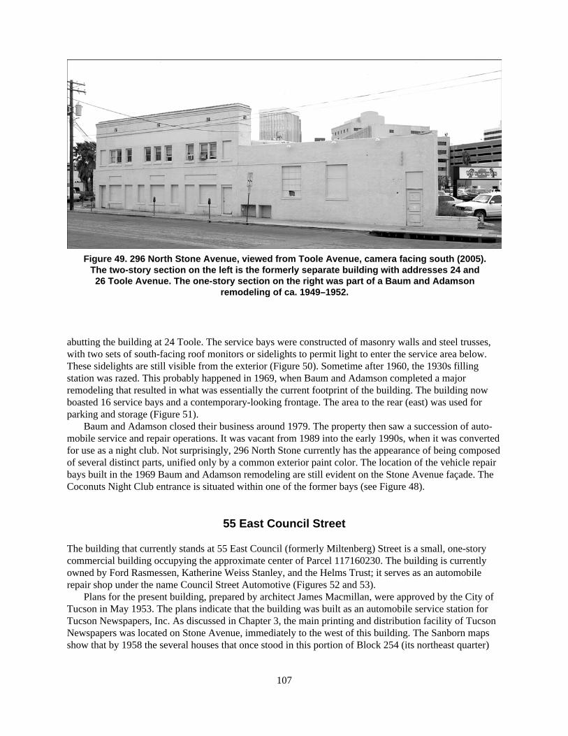
107
Figure 49. 296 North Stone Avenue, viewed from Toole Avenue, camera facing south (2005).The two-story section on the left is the formerly separate building with addresses 24 and26 Toole Avenue. The one-story section on the right was part of a Baum and Adamson
remodeling of ca. 1949–1952.
abutting the building at 24 Toole. The service bays were constructed of masonry walls and steel trusses,with two sets of south-facing roof monitors or sidelights to permit light to enter the service area below.These sidelights are still visible from the exterior (Figure 50). Sometime after 1960, the 1930s fillingstation was razed. This probably happened in 1969, when Baum and Adamson completed a majorremodeling that resulted in what was essentially the current footprint of the building. The building nowboasted 16 service bays and a contemporary-looking frontage. The area to the rear (east) was used forparking and storage (Figure 51).
Baum and Adamson closed their business around 1979. The property then saw a succession of auto-mobile service and repair operations. It was vacant from 1989 into the early 1990s, when it was convertedfor use as a night club. Not surprisingly, 296 North Stone currently has the appearance of being composedof several distinct parts, unified only by a common exterior paint color. The location of the vehicle repairbays built in the 1969 Baum and Adamson remodeling are still evident on the Stone Avenue façade. TheCoconuts Night Club entrance is situated within one of the former bays (see Figure 48).
55 East Council Street
The building that currently stands at 55 East Council (formerly Miltenberg) Street is a small, one-storycommercial building occupying the approximate center of Parcel 117160230. The building is currentlyowned by Ford Rasmessen, Katherine Weiss Stanley, and the Helms Trust; it serves as an automobilerepair shop under the name Council Street Automotive (Figures 52 and 53).
Plans for the present building, prepared by architect James Macmillan, were approved by the City ofTucson in May 1953. The plans indicate that the building was built as an automobile service station forTucson Newspapers, Inc. As discussed in Chapter 3, the main printing and distribution facility of TucsonNewspapers was located on Stone Avenue, immediately to the west of this building. The Sanborn mapsshow that by 1958 the several houses that once stood in this portion of Block 254 (its northeast quarter)

108
Fig
ure
50.
296
No
rth
Sto
ne
Ave
nu
e, v
iew
ed f
rom
a p
arki
ng
gar
age
acro
ss S
ton
e A
ven
ue,
cam
era
faci
ng
no
rth
east
(20
05).
Ju
st a
bo
ve t
he
“Co
con
uts
” si
gn
dis
pla
yin
g t
he
wo
rd is
on
e o
f tw
o r
oo
f m
on
ito
rs o
f th
e fo
rmer
Bau
m a
nd
Ad
amso
n s
ervi
ce b
ay (
2005
).

109
Figure 51. 296 North Stone Avenue, viewed from Toole Avenue, camera facing west (2005).
Figure 52. 55 East Council Street, camera facing southwest (2005).

110
Figure 53. 55 East Council Street, camera facing southeast (2005).
were gone and the service station (at 59 Miltenberg on the 1958 and 1960 maps) stood by itself in a large,otherwise empty lot, just as it does today.
The service station was designed as a three-bay facility facing north onto Miltenberg Street, with acentral pump island covered by a flat roof. The central bay contained an office with an entrance on thenorth, and two bathrooms with entrances on the south. The east bay contained a lift and served as a lubecenter. The west bay was used for washing vehicles and had a pit in the floor, connected to the city sewer,for collecting wastewater. Both side bays had three large windows in the south wall. Two 1,000-gallongasoline tanks were located to the west of the building. The walls of the building were of concrete andconcrete block; the flat roof was of wood-frame construction.
Although the gas pumps have been removed, 55 East Council has retained its original form and basicfunction. The front office windows appear to be original. The rear fenestration has been changedsomewhat by blocking the bathroom doors and one bathroom window and by changing one large windowinto a door (Figure 54).
Archaeological Potential in the Project Area
Two circumstances suggest that the archaeological potential of the project area is high. First is theproximity of the project area to other documented archaeological sites, most notably AZ BB:13:9 (ASM),where discoveries have included Hohokam pit houses, remnants of the adobe wall of the Spanish Colonialpresidio, numerous graves associated with the presidio during both the Spanish Colonial and Mexicanperiods, and a variety of U.S. period features. It is only reasonable to assume that the project area, in anyperiod, saw many of the same activities associated with the archaeological features found immediately to
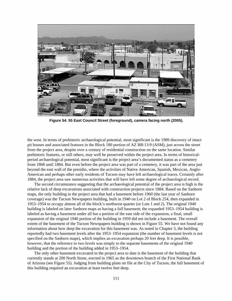
111
Figure 54. 55 East Council Street (foreground), camera facing north (2005).
the west. In terms of prehistoric archaeological potential, most significant is the 1989 discovery of intactpit houses and associated features in the Block 180 portion of AZ BB:13:9 (ASM), just across the streetfrom the project area, despite over a century of residential construction on the same location. Similarprehistoric features, or still others, may well be preserved within the project area. In terms of historical-period archaeological potential, most significant is the project area’s documented status as a cemeteryfrom 1868 until 1884. But even before the project area was part of a cemetery, it was part of the area justbeyond the east wall of the presidio, where the activities of Native American, Spanish, Mexican, Anglo-American and perhaps other early residents of Tucson may have left archaeological traces. Certainly after1884, the project area saw numerous activities that will have left some degree of archaeological record.
The second circumstance suggesting that the archaeological potential of the project area is high is therelative lack of deep excavations associated with construction projects since 1884. Based on the Sanbornmaps, the only building in the project area that had a basement before 1960 (the last year of Sanborncoverage) was the Tucson Newspapers building, built in 1940 on Lot 2 of Block 254, then expanded in1953–1954 to occupy almost all of the block’s northwest quarter (or Lots 1 and 2). The original 1940building is labeled on later Sanborn maps as having a full basement; the expanded 1953–1954 building islabeled as having a basement under all but a portion of the east side of the expansion; a final, smallexpansion of the original 1940 portion of the building in 1959 did not include a basement. The overallextent of the basement of the Tucson Newspapers building is shown in Figure 55. We have not found anyinformation about how deep the excavation for this basement was. As noted in Chapter 3, the buildingreportedly had two basement levels after the 1953–1954 expansion (the number of basement levels is notspecified on the Sanborn maps), which implies an excavation perhaps 20 feet deep. It is possible,however, that the reference to two levels was simply to the separate basements of the original 1940building and the portion of the building added in 1953–1954.
The only other basement excavated in the project area to date is the basement of the building thatcurrently stands at 200 North Stone, erected in 1965 as the downtown branch of the First National Bankof Arizona (see Figure 55). Judging from building plans on file at the City of Tucson, the full basement ofthis building required an excavation at least twelve feet deep.

112
Figure 55. Locations of basement excavations and a 2001 discovery of human remainsin the project area.

113
Every other building erected in the project area over the years must have required at least someexcavation for footings and other features, but the impact of such excavations on buried archaeologicalfeatures, especially abandoned graves in the old cemetery, was probably minimal. This is suggestedespecially by the accidental discovery of graves when the two basements in the project area wereexcavated, both in locations where large houses once stood, as well as by other accidental discoveries ofgraves during less-substantial disturbances. Table 1 summarizes the known discoveries of human remainswithin the project area and lists the sources for the discussion in the following paragraphs.
The earliest reported accidental discovery of a grave in the project area took place in January 1940during excavations for the Tucson Newspapers building. The only documentation of the discovery that weknow of is a catalog card for a set of human remains preserved at the ASM osteology laboratory. The cardreads “White woman found January 1940 Stone & Alameda St. Tucson, Ariz. Old burying ground.Excavating for new Star [sic] building.” Despite the size of the 1940 excavation, no other skeletal remainswere reported.
The next reported discovery of human remains in the project area took place in December 1950 whenworkers were excavating a tank pit for a new service station near the southeast corner of Stone Avenueand Miltenberg Street. This short-lived service station is depicted on the 1951 Sanborn map at 210 NorthStone (see Appendix A) but was apparently removed entirely during the 1953–1954 northward expansionof the Tucson Newspapers building. The excavation for the tank pit resulted in the discovery of at leastfive wooden coffins and an unspecified number of human bones; one newspaper account refers to “averitable bone pile” (ADS, 29 December 1950). Bertram Kraus, assistant professor of anthropology at theUniversity of Arizona at the time, examined some of the bones, most of which were in poor condition; thewood of the coffins and some clothing remnants were fairly well preserved. Kraus noted the bones camefrom the “nine-foot level,”where the high moisture content may have helped preserve the coffins andartifacts; the skeletal remains were “taken to the university for study by anthropology students” (ADS , 29December 1950).
The 1953–1954 northward expansion of the Tucson Newspapers building led to the next knowndiscovery of human remains in the project area, and the most substantial one. Workers excavating the newbasement discovered portions of around 80 human skeletons, 36 of which were sufficiently intact to allowosteological study by University of Arizona anthropology students, supervised by Bertram Kraus. Thestudents identified several skeletons with pathologies; 15 individuals were identified as Caucasoid, 20 asNative American, and one as African American. At least one wooden coffin and miscellaneous associatedartifacts were also recovered. We have not found a formal report of the circumstances of the discovery, soit is impossible to say precisely where the skeletons were found within the basement excavation. Judgingby one newspaper account, the first skeletons were apparently discovered only after some of the soilremoved from the site was dumped as fill at another location and local residents noticed bones on the pile(TC, 9 July 1953). A later newspaper account of the continuing study of the human remains by Universityof Arizona students (ADS, 24 February 1955) reported that “more than 150 human skeletons wereremoved from the site”; this number would be a revision upward of the original estimate and may not bereliable. According to the ASM Osteology Laboratory manager, John McClelland, there are only 58records for individual skeletons from the National Cemetery site at ASM; the remains of eight skeletonsare described in the records as missing (personal communication, John McClelland, 16 February 2005).
The next known discovery of human remains in the project area took place during excavation of thebasement for the First National Bank building at 200 North Stone in August 1965. A contemporarynewspaper account (which does not in fact mention the name of the building) is once again the onlydocumentation we have seen of the discovery (Kincaid 1965). Workers for the W. F. ConellyConstruction Company found human bones and wooden coffin remnants, apparently from a single burial,while scraping the “east side of the north wall” of the excavation. The materials were turned over toSidney Brinckerhoff of the Arizona Pioneers Historical Society (as the Arizona Historical Society wasknown at the time), but the subsequent disposition of the remains is unknown. Brinckerhoff noted that the

114
Tab
le 1
. Dis
cove
ries
of
Hu
man
Rem
ain
s in
th
e P
roje
ct A
rea
Dat
eR
epo
rted
Lo
cati
on
Des
crip
tio
nS
ou
rces
Janu
ary
1940
near
Sto
ne A
venu
e an
dA
lam
eda
Stre
etT
he s
kele
tal r
emai
ns o
f a
Cau
casi
an w
oman
wer
e fo
und
duri
ng e
xcav
atio
n fo
r th
e ne
w T
ucso
n N
ewsp
aper
sbu
ildin
g at
208
Nor
th S
tone
(B
lock
254
, Lot
2).
ASM
Ost
eolo
gy L
abor
ator
yca
talo
g ca
rd (
pers
onal
com
mun
icat
ion,
Joh
nM
cCle
lland
, Ari
zona
Sta
teM
useu
m, 1
1 Fe
brua
ry 2
005)
Dec
embe
r 19
50so
uthe
ast c
orne
r of
Sto
neA
venu
e an
d M
ilten
berg
Stre
et
Wor
kers
exc
avat
ing
a ta
nk p
it fo
r a
new
ser
vice
sta
tion
foun
d hu
man
bon
es a
nd a
t lea
st f
ive
woo
den
coff
ins
nine
feet
bel
ow th
e su
rfac
e.
AD
S, 2
8 D
ecem
ber
1950
AD
S, 2
9 D
ecem
ber
1950
July
195
3so
uthe
ast c
orne
r of
Sto
neA
venu
e an
d M
ilten
berg
Stre
et
Wor
kers
exc
avat
ing
for
an e
xpan
sion
of
the
Tuc
son
New
spap
ers
build
ing
unco
vere
d po
rtio
ns o
f ar
ound
80
hum
an s
kele
tons
, at l
east
one
woo
den
coff
in, a
ndm
isce
llane
ous
asso
ciat
ed a
rtif
acts
.
TC
, 9 J
uly
1953
AD
S, 2
4 Fe
brua
ry 1
955
Aug
ust 1
965
nort
heas
t cor
ner
of S
tone
Ave
nue
and
Ala
med
aSt
reet
Wor
kers
exc
avat
ing
the
base
men
t of
the
Firs
t Nat
iona
lB
ank
of A
rizo
na b
uild
ing
at 2
00 N
orth
Sto
ne f
ound
hum
an b
ones
and
woo
den
coff
in r
emna
nts,
app
aren
tlyfr
om a
sin
gle
buri
al.
Kin
caid
196
5
Nov
embe
r 20
01ha
lf b
lock
eas
t of
Ston
eA
venu
e, a
t sou
thea
stco
rner
of
Cou
ncil
(for
mer
ly M
ilten
berg
)St
reet
and
the
alle
yco
nnec
ting
Cou
ncil
and
Ala
med
a St
reet
s
A c
ompl
ete
skel
eton
and
trac
es o
f a
woo
den
coff
in w
ere
foun
d du
ring
inst
alla
tion
of a
bur
ied
fibe
r op
tic c
able
. The
skel
eton
was
exc
avat
ed b
y ar
chae
olog
ists
fro
m T
ierr
aR
ight
of
Way
Ser
vice
s, w
ho w
ere
mon
itori
ng th
e w
ork;
ASM
ost
eolo
gist
s la
ter
exam
ined
the
rem
ains
. The
site
of
the
disc
over
y w
as d
esig
nate
d A
Z B
B:1
3:68
2 (A
SM),
anu
mbe
r m
eant
to a
pply
to th
e en
tire
Nat
iona
l Cem
eter
ysi
te.
Alle
n 20
01Z
agla
uer
and
Doa
k 20
03
Not
e: T
he n
ewsp
aper
art
icle
s ci
ted
in th
is ta
ble
do n
ot r
epre
sent
an
exha
ustiv
e se
arch
of
Tuc
son
new
spap
ers,
onl
y a
sear
ch o
f th
e cl
ippi
ngs
file
s at
the
Ari
zona
His
tori
cal S
ocie
ty (
Tuc
son)
plu
s ot
her
refe
renc
es to
art
icle
s in
var
ious
sou
rces
.K
ey:
AD
S =
Ari
zona
Dai
ly S
tar;
TC
= T
ucso
n C
itize
n

115
remains were of an adult, but the sex, age, and race of the person were “wide open.” Based on theappearance of the simple pine coffin remnants, he suggested that the burial dated to the 1850s or 1860s.
The last known discovery of human remains in the project area took place in November 2001.Workers installing a buried fiber optic cable on behalf of Cox Communications encountered human bonein a small excavation a half block east of Stone Avenue, at the southeast corner of Council Street and thealley that runs between Council and Alameda Streets (see Figure 55). Archaeologists from Tierra Right ofWay Services were monitoring the work when the discovery was made; they later excavated a completeskeleton (Zaglauer and Doak 2003). Traces of a wooden coffin were visible in the soil around theskeleton, which was determined by ASM osteologists to be that of a female, 35 to 45 years of age. Theskeleton and accompanying artifacts were turned over to ASM for repatriation by the Spanish-heritagegroup, Los Descendientes del Presidio de Tucson; the group has not yet taken possession of these items.The discovery was assigned site number AZ BB:13:682 (ASM), the first formal designation of the formersite of the National Cemetery as an archaeological site. Although the discovery was limited to a singleburial exposed in a small excavation, the site number was intended to refer to the National Cemetery siteas a whole, which the excavators assumed was the same as the 1872 town site cemetery parcel (see thediscussion of the site boundary earlier in this chapter).
Given the large number of skeletons found simply by accident during the excavation of the basementfor the 1953–1954 Tucson Newspapers expansion, it seems likely that additional skeletons were removedduring the excavations for the original Tucson Newspapers building in 1940 and the First National Bankbuilding in 1965. The apparent discovery of only one skeleton in each of the latter cases is as easilyattributed to the failure of work crews to notice or report skeletons as to any real absence of skeletons.The manner in which the discovery of 1953 was first made—on a fill pile, after the soil was removedfrom the original site—emphasizes how easy it is to overlook even well-preserved skeletal remains duringmechanical excavation.
More importantly, all of the discoveries described here strongly suggest that any portion of the project area not fully destroyed by basement excavations may also preserve graves. If we assume that theoriginal Camp Lowell cemetery of 1868 was located immediately adjacent to Stone Avenue and AlamedaStreets (see the discussion in Chapter 2), the Tucson Newspapers and First National Bank buildingstogether may have destroyed a large portion of the oldest part of the cemetery. However, the rest of theproject area, including more than half of Block 254, is still undisturbed by deep excavation. As the 2001discovery of a skeleton just east of the former footprint of the Tucson Newspapers building most stronglysuggests, many more burials associated with the National Cemetery may still be preserved in the projectarea.
For the purposes of future archaeological work in the project area, it is unfortunate that there are onlytwo explicit references to the depth of the burials already found there. One reference is to the severalburials found in the northwest corner of Block 254 in December 1950; according to a contemporarynewspaper account, the burials were found nine feet below the modern ground surface (see Table 1) . Thisis surprisingly deep, even assuming some accumulation of soil during the preceding 70 years or so. Sinceit is not from a formal report on the discovery, the reference to nine feet may not be reliable. The secondreference is to the 2001 excavation of a skeleton by Tierra Right of Way Services. That skeleton was firstencountered just 77 cm (about 2½ feet) below the surface and was fully exposed at 101 cm (about 3 feet 4inches) (Zaglauer and Doak 2003:15). Interestingly, this is almost precisely the depth at which twoHispanic male skeletons were found during the excavations in Block 180, just west of the project area(Ciolek-Torrello and Swanson 1997:143). Also like the two Hispanic burials, the female (and probablyHispanic) skeleton found in 2001 was found with the cranium to the east (Zaglauer and Doak 2003:17). Itis probably safe to assume that there was considerable variability in the depth of burials (at least civilianburials) in the National Cemetery; a range of 2½ to 9 feet below the surface is probably the best estimatepossible of where other burials may be found.
In addition to historical-period burials, the project area likely also preserves a variety of featuresrelated to its residential and commercial development after 1890, such as house foundations, other

116
structural remains, and trash deposits. As several historical-archaeological projects in the downtown areahave shown, such features can provide important information about everyday life in early Tucson(Ciolek-Torrello and Swanson 1997; Mabry et al. 1994; Thiel 1993; Thiel et al. 1995). One aspect ofarchitecture in the project area that we have not addressed in this report is the minor architecture oftenassociated with houses. The Sanborn maps show that, even as late as the 1940s, most houses in the projectarea had one or more associated outbuildings. A few outbuildings are labeled as stables or garages, butmany are unlabeled, quite small, and located at the back corners of lots. At least some of these small,unlabeled outbuildings must have been privies. The privy structures are long gone, but the pits that wentwith them may still be intact below the modern surface, representing an important potential source ofartifacts for the study of everyday life in the project area.

117
CHAPTER 5
Summary and Recommendations
The project area, or the proposed location of the Pima County Justice Courts complex, has been an in-tegral part of the Tucson landscape since at least the early 1860s, when it was first used as a cemetery byMexican-American and Anglo-American residents. Before it became a cemetery, it was a part of the openland just east of the Tucson presidio, which was established by the Spanish colonial government in 1776and maintained as a Mexican military post until 1856. And before the presidio was built, the project areawas part of the larger environment along the east bank of the Santa Cruz River, used for centuries byNative Americans.
From around 1868 until 1884, the project area at least partly encompassed a cemetery formally estab-lished by the U.S. Army and commonly known as the National Cemetery. Used both by the army and bycivilians, the cemetery was officially closed by the city in 1876, but it continued to be used at least until1884, when the military burials were removed; it is uncertain how many civilian burials were removed,but many were not. By 1900, the project area had experienced the same primarily residential developmentseen in neighborhoods adjacent on the south and west; the warehouse district that developed along therailroad immediately to the north never extended into the project area. By 1930, the project area held amixture of residential and commercial development. By 1960, it was an exclusively commercial area.
Almost no systematic archaeological work has been carried out within the project area, but there havebeen several accidental discoveries of human skeletal remains over the years, most confirmed by archae-ologists. The most substantial discovery came in 1953, when at least 80 skeletons were found duringexcavation of a basement for an expansion of the Tucson Newspapers building. Because only a smallpercentage of the overall project area has been disturbed by deep excavation, other burials from the oldNational Cemetery are probably still in place. The lack of disturbance also suggests that the project areamay have archaeological deposits both earlier and more recent than the cemetery. The proximity ofAZ BB:13:9 (ASM), which includes an important (if underdocumented) Hohokam site and the site of theTucson presidio, means that significant prehistoric (Hohokam or earlier) and historical-period (SpanishColonial or Mexican) features may exist in the project area. The project area almost certainly hassignificant archaeological features from the first half of the twentieth century: by 1900, numerousexamples of residential architecture had been built in the project area, most of which stood for at least30 years.
Only four buildings now stand in the project area. The three-story building at 200 North Stone waserected in 1965 as the First National Bank of Arizona. It no longer serves as a bank but retains its originalexterior appearance. The one-story building at 240 North Stone is a combination of two buildings fromthe 1930s that once held the Bowyer Motor Company and the Old Pueblo Bowling and Billiard Parlor.The two buildings were merged in the 1960s and extensively remodeled to serve as a bank; the singlebuilding has since been remodeled to serve as office space. The rambling one-story building at 296 NorthStone is the former home of the Baum and Adamson Tire and Automotive Company, which opened atthat address in the 1920s in a building that was later razed. The current building includes at least part ofanother small building from the 1920s, but it is otherwise the product of several episodes of remodelingand expansion by Baum and Adamson during the period 1947–1952. Baum and Adamson closed in 1979;the building currently serves as a nightclub. The small one-story building at 55 East Council was built in

118
the 1950s as a service station for the vehicles of Tucson Newspapers, Inc. It now serves as an automobilerepair shop and largely retains its original appearance.
Recommendations
As discussed in Chapter 4 of this report, we recommend that the boundary of the archaeological siteknown as the National Cemetery site, or AZ BB:13:682 (ASM), be revised to correspond with thetriangular parcel labeled “National Cemetery” on the 1880 Pattiani map of Tucson (see Figure 6). Thisrevised boundary more accurately reflects the probable maximum extent of the cemetery over the periodof its use, or ca. 1868–1884. Based on our research for this report, we also recommend thatAZ BB:13:682 (ASM) be considered eligible for listing in the National Register of Historic Places underCriterion d, for its potential to yield information important in the study of the prehistory and history ofTucson and southern Arizona.
Because the current project area falls wholly within AZ BB:13:682 (ASM), we recommend thatconstruction of the proposed Justice Courts complex be preceded by an intensive archaeological testingprogram in all parts of the project area that will be subject to subsurface disturbance. The results of testingshould be used to prepare an archaeological data recovery plan for the project area as a whole. The datarecovery plan should include explicit provisions for the excavation and treatment of human remains.Although there is no formal record of civilian burials in the National Cemetery, our research has shownthat the cemetery was used for the burial of Anglo-American, Mexican-American, Native American,African-American, and perhaps other late-nineteenth-century residents of Tucson. The project area mayalso hold earlier burials, including prehistoric Native American burials. We recommend that agreementsregarding the treatment of human remains be reached among Pima County, the Arizona State Museum,and the appropriate descendant communities before archaeological testing and data recovery begin.
A local Spanish-heritage group, Los Descendientes del Presidio de Tucson, has claimed affiliationwith burials identified as Mexican-American in excavations at AZ BB:13:9 (ASM) and AZ BB:13:682(ASM); the group should be included in any burial agreement reached for the current project area. TheTohono O’odham Nation has claimed cultural affiliation with historical-period burials identified asNative American in excavations at AZ BB:13:9 (ASM) and generally claims affiliation with anyprehistoric Native American burial found in the Tucson area; any burial agreement reached for the projectarea should also include the Tohono O’odham Nation. The other modern O’odham communities based inArizona may also claim affiliation to Native American burials in the project area and should be contactedfor their possible concerns about the project. These communities are the Ak-Chin Indian Community, theGila River Indian Community, the Hia C’ed O’odham Alliance, and the Salt River Pima-Maricopa IndianCommunity. It is also possible that Apache, Yavapai, and other Native American communities in Arizonamay claim affiliation with late-nineteenth-century or other Native American burials in the project area.These communities include the Pascua Yaqui Tribe, the San Carlos Apache Tribe, the Tonto ApacheTribe, the White Mountain Apache Tribe, the Fort McDowell Yavapai Nation, the Yavapai-ApacheNation, and the Yavapai Prescott Indian Tribe.
Appendix E of this report consists of completed Arizona Historic Property Inventory Forms for thefour buildings in the project area. Based on our study of the four buildings, we recommend that none ofthem be considered eligible for listing in the National Register of Historic Places under any criterion. Thebuildings at 240 and 296 North Stone have been remodeled and reconfigured several times and do notretain enough integrity to convey their original (or any early) function. The building at 55 East Council isan unremarkable example of a common, simple design and is no longer accompanied by the largerbuilding with which it was originally associated. The building at 200 North Stone has some virtue as an

119
example of urban architecture that incorporates pedestrian space, but it is less than 50 years old, lacks anassociation with an important person, event, or style, and is not the work of a recognized master.Construction of the proposed Justice Courts complex, and the archaeological data recovery that mustprecede construction, may require the demolition of all four buildings. We recommend that no furtherhistorical or architectural research be required for any of the buildings before demolition.
The project area is immediately adjacent to portions of two National Register Historic Districts, the ElPresidio Historic District and the Tucson Warehouse Historic District; the El Presidio Historic District isalso a City of Tucson Historic District, with a slightly different boundary from its National Registercounterpart. Because both the El Presidio and Warehouse Districts derive their significance from theirarchitectural resources, it is possible that construction of a modern, multistory building in the projectarea—just across the street from buildings included in both districts—will have an adverse visual impacton either or both districts. The nature of the impact potentially includes: an undesirable juxtaposition ofhistoric and modern architecture; an obstruction of existing views of buildings in either district; thecreation of new shadows that fall on buildings in either district at different times of day; and a generaloverwhelming of the relatively small-scale residential and commercial architecture of the two districts bya large building. The vicinity of the proposed Justice Courts complex already holds several examples ofmodern, multistory architecture, which means that construction of the proposed Justice Courts complexwill not be a radical intrusion on the area. Nevertheless, the design of the proposed Justice Courtscomplex should include an effort to minimize visual impacts on the adjacent historic districts.


121
A P P E N D I X A
Summary of Building Information on Sanborn Maps ofthe Project Area


123
1901 1909 1919 1922 1930 1947 1949 1951 1958 1960
Block 252 (721)
240 N. Stone — — — — auto sales & service auto sales & service auto sales & service auto sales & service furniture storage furniture storage(with 250 & 252) (with 250 & 252)
250 N. Stone dwelling dwelling dwelling dwelling pool & bowling pool & bowling pool & bowling pool & bowling furniture storage furniture storage(front now has (front has (with 240 & 252) (with 240 & 252)
restaurant, plus 252) restaurant, plus 252)
250½ N. Stone — — garage garage — — — — — —
252 N. Stone — — — — — — store store furniture storage furniture storage(part of 250 front) (part of 250 front) (with 250 & 252) (with 250 & 252)
260 N. Stone — — — — — used auto sales & repair used auto sales used auto sales used auto sales used auto sales & auto repair & auto repair & auto repair & auto repair
(part of 294 & 296) (part of 294 & 296)
270 N. Stone dwelling dwelling dwelling dwelling dwelling — — — — —
270½ N. Stone — — garage garage garage — — — — —
286 N. Stone dwelling dwelling dwelling dwelling dwelling — — — — —
294 N. Stone dwelling dwelling dwelling dwelling (new building, auto & tire service auto & tire service auto & tire service auto & tire service auto & tire servicepart of 296) (with 296) (with 296) (with 296) (with 296) (with 296)
296 N. Stone — — — — tire store auto & tire service auto & tire service auto & tire service auto & tire service auto & tire service(new building, (with 294) (with 294) (with 294) (with 294) (with 294)includes 294)
24 & 26 Toole — — — — offices store store restaurant restaurant restaurant(not numbered; same as 24 &26 in 1947; 28 is indicated as
old address)
40 Toole — — — — plumbing shop plumbing & tin shop plumbing & tin shop plumbing & tin shop plumbing & tin shop plumbing & tin shop(same as 84 Grossetta) (same as 84 Grossetta) (same as 84 Grossetta) (same as 84 Grossetta) (same as 84 Grossetta) (same as 84 Grossetta)
36–54 Miltenberg — — — — 12-unit apartment building 12-unit apartment 12-unit apartment 12-unit apartment building — —(even numbers only, with building (even numbers building (even numbers (even numbers only, with
76 & 78 Grossetta; only, with only, with 76 & 78 Grossetta;two garages at rear) 76 & 78 Grossetta; 76 & 78 Grossetta; two garages at rear)
two garages at rear) two garages at rear)
52 Miltenberg dwelling dwelling — — (original dwelling gone; see (see 36–54 Miltenberg) — — — —(now 58) (now 58) 36–54 Miltenberg)
58 Miltenberg — — dwelling — — — — — — —(formerly 52)
76 & 78 Grossetta — — — — 12-unit apartment building 12-unit apartment 12-unit apartment 12-unit apartment building — —(with building (with building (with (with
36–54 Miltenberg) 36–54 Miltenberg) 36–54 Miltenberg) 36–54 Miltenberg)
78 Grossetta dwelling dwelling dwelling dwelling (original building now two — — — — —(unnumbered) (possibly 76) dwellings, 80 & 82; 78 is now
one of 12 numbers inapartment building)
80 Grossetta stable stable — — dwelling (with 82, — — — — —(unnumbered) part of old 78)
continued on next page
Note: See the discussion in Chapter 3 for more information about the data in this table. Column headings refer to the publication years of the Sanborn insurance maps. Original block numbers are followed by later designations in parentheses. Small, unnumbered, unlabeled outbuildings are notincluded. An em dash (—) means a building number does not appear on the given map or has been reassigned to another location on the same block. Only the portion of Block 255 (724) falling within the project area is included here.

1901 1909 1919 1922 1930 1947 1949 1951 1958 1960
124
82 Grossetta — — — — dwelling (with 80, part of old — — — — —78)
84 Grossetta — — — — (see 40 Toole) (see 40 Toole) (see 40 Toole) (see 40 Toole) (see 40 Toole) (see 40 Toole)
Block 253 (722)
72 Miltenberg — office — — — — — — — —(part of Henry Till (now 76 & 79) (now 76 & 79)
Company bottling works)
76 Miltenberg — — City Laundry City Laundry — — City Laundry City Laundry City Laundry —Company Company (now 78) Company Company Company
(formerly 79)
78 Miltenberg — — — — City Laundry City Laundry City Laundry City Laundry City Laundry —Company Company Company Company Company
(formerly 76)
79 Miltenberg — — City Laundry City Laundry City Laundry — — — — —Company Company Company (now 76)
80 Miltenberg — — — — City Laundry City Laundry City Laundry City Laundry City Laundry —Company Company Company Company Company
85 Miltenberg — stable — — — — — — — —(part of Henry Till (now 94) (now 94)
Company bottling works)
86 Miltenberg — — City Laundry City Laundry City Laundry City Laundry City Laundry City Laundry City Laundry —Company Company Company Company Company Company Company
94 Miltenberg — — stable stable City Laundry City Laundry City Laundry City Laundry City Laundry —(part of City Laundry (part of City Laundry Company Company Company Company Company
Company) Company)
100 Miltenberg — — — — City Laundry City Laundry City Laundry City Laundry City Laundry —Company Company Company Company Company
71 Grossetta — — City Laundry City Laundry City Laundry City Laundry City Laundry City Laundry City Laundry —Company Company Company Company Company Company Company
75 Grossetta — — City Laundry City Laundry City Laundry City Laundry City Laundry City Laundry City Laundry —Company Company Company Company Company Company Company
79 Grossetta — — — — City Laundry City Laundry City Laundry City Laundry City Laundry — Company Company Company Company Company
Block 254 (723)
185½ N. Stone — — garage garage garage — — — — —(at rear of 186) (at rear of 186) (at rear of 186)
186 N. Stone dwelling dwelling dwelling dwelling dwelling unlabeled commercial — — — —building (now 200, 202, 204 N.
Stone & 20, 22, 24 E.Alameda)
196 N. Stone dwelling dwelling dwelling dwelling dwelling — — — — —
200 N. Stone — — — — — — store (6-store building, store (6-store building, store (6-store building, store (6-store building,200–204 N. Stone and 200–204 N. Stone and 200–204 N. Stone and 200–204 N. Stone and
20–24 E. Alameda) 20–24 E. Alameda) 20–24 E. Alameda) 20–24 E. Alameda)
Note: See the discussion in Chapter 3 for more information about the data in this table. Column headings refer to the publication years of the Sanborn insurance maps. Original block numbers are followed by later designations in parentheses. Small, unnumbered, unlabeled outbuildings are notincluded. An em dash (—) means a building number does not appear on the given map or has been reassigned to another location on the same block. Only the portion of Block 255 (724) falling within the project area is included here.

1901 1909 1919 1922 1930 1947 1949 1951 1958 1960
125
202 N. Stone — — — — — — store (6-store building, store (6-store building, store (6-store building, store (6-store building,200–204 N. Stone and 200–204 N. Stone and 200–204 N. Stone and 200–204 N. Stone and
20–24 E. Alameda) 20–24 E. Alameda) 20–24 E. Alameda) 20–24 E. Alameda)
204 N. Stone — — — — — — store (6-store building, store (6-store building, store (6-store building, store (6-store building,200–204 N. Stone and 200–204 N. Stone and 200–204 N. Stone and 200–204 N. Stone and
20–24 E. Alameda) 20–24 E. Alameda) 20–24 E. Alameda) 20–24 E. Alameda)
208 N. Stone dwelling dwelling dwelling dwelling dwelling newspaper printing newspaper printing newspaper printing newspaper printing newspaper printing(built 1940) (with 210) (with 210; 208 has
expanded east to alley)
210 N. Stone — — — — — — — gas & oil station newspaper printing newspaper printing(not the same as earlier (with 208) (with 208)
station at 220)
220 N. Stone — — dwelling dwelling — gas & oil station (no building; lot labeled truck repair — —(formerly 221& 223) (formerly 221& 223) auto parking) (at rear of lot, with 220½)
220½ N. Stone — — room room room truck repair truck repair truck repair — —(at rear of 220) (at rear of 220) (at rear of 220) (with 220½)
221 N. Stone dwelling dwelling — — — — — — — —(same building (same building
as 223) as 223)
223 N. Stone dwelling dwelling — — — — — — — —(same building (same building
as 221) as 221)
20 E. Alameda — — — — — — store (6-store building, store (6-store building, store (6-store building, store (6-store building,200–204 N. Stone and 200–204 N. Stone and 200–204 N. Stone and 200–204 N. Stone and
20–24 E. Alameda) 20–24 E. Alameda) 20–24 E. Alameda) 20–24 E. Alameda)
22 E. Alameda — — — — — — store (6-store building, store (6-store building, store (6-store building, store (6-store building,200–204 N. Stone and 200–204 N. Stone and 200–204 N. Stone and 200–204 N. Stone and
20–24 E. Alameda) 20–24 E. Alameda) 20–24 E. Alameda) 20–24 E. Alameda)
24 E. Alameda — — — — — — store (6-store building, store (6-store building, store (6-store building, store (6-store building,200–204 N. Stone and 200–204 N. Stone and 200–204 N. Stone and 200–204 N. Stone and
20–24 E. Alameda) 20–24 E. Alameda) 20–24 E. Alameda) 20–24 E. Alameda)
34 E. Alameda dwelling dwelling dwelling dwelling dwelling — — — — —
46 E. Alameda — — — — — auto sales & service auto sales & service auto sales & service office & private garage office & private garage
48 E. Alameda dwelling dwelling dwelling dwelling dwelling — — — — —
48½ E. Alameda buggy house — — — — — — — — —(at rear of 48)
48a E. Alameda stable — — — — — — — — —(at rear of 48)
55 Miltenberg — — dwelling dwelling dwelling dwelling dwelling dwelling — —
55½ Miltenberg — — dwelling dwelling dwelling dwelling dwelling dwelling — —(at rear of 55) (at rear of 55) (at rear of 55) (at rear of 55, (at rear of 55, (at rear of 55,
now with garage) with garage) with garage)
continued on next page
Note: See the discussion in Chapter 3 for more information about the data in this table. Column headings refer to the publication years of the Sanborn insurance maps. Original block numbers are followed by later designations in parentheses. Small, unnumbered, unlabeled outbuildings are notincluded. An em dash (—) means a building number does not appear on the given map or has been reassigned to another location on the same block. Only the portion of Block 255 (724) falling within the project area is included here.

1901 1909 1919 1922 1930 1947 1949 1951 1958 1960
126
57 Miltenberg — dwelling dwelling dwelling dwelling dwelling dwelling dwelling — —(garage at rear may be (garage at rear may be (garage at rear may be
associated) associated) associated)
59 Miltenberg — dwelling dwelling dwelling dwelling dwelling dwelling dwelling gas & oil station gas & oil station(shares building with (shares building with (shares building with (shares building with
50 Grossetta) 50 Grossetta) 50 Grossetta) 50 Grossetta)
46 Grossetta — dwelling dwelling dwelling dwelling store store store — —(same building as
before)
48 Grossetta — dwelling dwelling dwelling dwelling dwelling dwelling dwelling — —
50 Grossetta — — — — dwelling dwelling dwelling dwelling — —(shares building with (shares building with (shares building with (shares building with
59 Miltenberg) 59 Miltenberg) 59 Miltenberg) 59 Miltenberg)
Block 255 (724)
37 Grossetta dwelling — — — — — — — — —(now 47)
45 Grossetta dwelling dwelling dwelling dwelling dwelling dwelling dwelling dwelling dwelling —(former outbuilding of (former outbuilding (outbuilding, now (garage now gone or
70 Alameda, now of 70 Alameda, now labeled garage) joined to dwelling)associated) associated)
47 Grossetta — dwelling dwelling dwelling dwelling dwelling dwelling dwelling dwelling —(new building at former
37)
49 Grossetta — — dwelling dwelling dwelling dwelling dwelling dwelling dwelling —(contiguous with (contiguous with (new building, (contiguous with 51) (contiguous with 51) (contiguous with 51) (contiguous with 51)77 Miltenberg) 77 Miltenberg) contiguous with 51)
51 Grossetta — — — — dwelling dwelling dwelling dwelling dwelling —(new building, (contiguous with 49) (contiguous with 49) (contiguous with 49) (contiguous with 49)
contiguous with 49)
77 Miltenberg — dwelling dwelling dwelling — — — — — —(shares building with (shares building with
49 Grossetta) 49 Grossetta)
Note: See the discussion in Chapter 3 for more information about the data in this table. Column headings refer to the publication years of the Sanborn insurance maps. Original block numbers are followed by later designations in parentheses. Small, unnumbered, unlabeled outbuildings are notincluded. An em dash (—) means a building number does not appear on the given map or has been reassigned to another location on the same block. Only the portion of Block 255 (724) falling within the project area is included here.

127
A P P E N D I X B
Summary of Federal Census Information for Residents in the Project Area


129
Table B.1. 1900 Census Data
No. Street Name Relation Race Sex Age Place of Birth Father’s Mother’s Occupation Read? Write?Marital Speak Own/Status English? Rent
48 East Alameda Benjamin [?] Fairbanks head white male 61 married Michigan New York New York saloon keeper yes yes yes own
Grace Fairbanks wife white female 26 married Illinois Pennsylvania New York yes yes yes
Sarah J. Tarbox mother-in-law white female 49 widowed New York Ireland Scotland yes yes yes
Birtie E. Tarbox sister-in-law white female 19 divorced Colorado Pennsylvania New York yes yes yes
37 Grossetta Alice Y. Hayes head white female 44 widowed Illinois Illinois Illinois yes yes yes rent
Arvan L. Hayes son white male 20 single Illinois Connecticut Illinois printer [?] machinist yes yes yes
Wilbur O. Hayes son white male 27 single Illinois Connecticut Illinois stenographer yes yes yes
Elwyn Hayes son white male 17 single Kansas Connecticut Illinois bank [?] yes yes yes
Dearest A. Hayes daughter white female 14 single Kansas Connecticut Illinois at school yes yes yes
Ernest F. Wyman roomer white male 23 single Kansas New York Vermont fruit clerk yes yes yes
45 Grossetta Benjamin Z. [?] Bush head white male 46 married Maryland Maryland Maryland grocery merchant yes yes yes rent
Maggie D. Bush wife white female 50 married Illinois Ohio Kentucky yes yes yes
Harris M. [?] Bush son white male 22 single Illinois Maryland Illinois at school yes yes yes
52 Grossetta Peter F. Rivers head white male 38 married Massachusetts Massachusetts Canada s...tt... [illegible] yes yes yes rent
Agnes S. Rivers wife white female 30 married California Ohio [illegible] yes yes yes
Cyril C. Rivers son white male 10 single California Massachusetts California at school yes yes yes
Lilian T. Rivers daughter white female 8 single California Massachusetts California at school yes yes yes
Roy Rivers son white male 5 single California Massachusetts California
78 Grossetta Daniel Lucid head white male 37 married Canada Ireland Canada grocer yes yes yes rent
Lelia Lucid wife white female 33 married Missouri Germany New Jersey yes yes yes
Catherine Lucid daughter white female 1 single California Canada Missouri
Charles D. Lucid son white male 3 mos. single Arizona Canada Missouri
186 North Stone Georg Cheney head white male 45 married Pennsylvania Pennsylvania Pennsylvania postmaster yes yes yes rent
Anne M. Cheney wife white female 38 married Kansas Pennsylvania Ohio yes yes yesa
Bernice Cheney daughter white female 16 single Arizona Pennsylvania Pennsylvania at school yes yes yes
Frances Cheney daughter white female 14 single Arizona Pennsylvania Pennsylvania at school yes yes yes
Mary N. Cheney daughter white female 12 single Arizona Pennsylvania Pennsylvania at school yes yes yes
continued on next page

No. Street Name Relation Race Sex Age Place of Birth Father’s Mother’s Occupation Read? Write?Marital Speak Own/Status English? Rent
130
Ruth S. Cheney daughter white female 6 single Arizona Pennsylvania Pennsylvania at school yes yes yes
Edith G. Cheney daughter white female 2 single Arizona Pennsylvania Pennsylvania
Eleanor A. Cheney daughter white female 4 mos. single Arizona Pennsylvania Pennsylvania
Nicolasa Antonio servant Indian female 18 single Arizona Arizona Arizona house servant yes yes yes
196 North Stone Benjamin Heineman head white male 33 married Maryland Germany Germany commercial grocer [?] yes yes yes rentb
Lucille Heineman wife white female 27 married Indiana Pennsylvania New York yes yes yes
208 North Stone George Whomes head white male 32 married Illinois England England dentist yes yes yes own
Adah Whomes wife white female 32 married Ohio New York Ohio yes yes yes
Matilda Sturis [?] servant white female 20 single Mexico Mexico Mexico house servant yes yes yes
William Klug roomer white male 54 single Germany Germany Germany quartz miner yes yes yes
223 North Stone Marcus Smith head white male 48 widowed Kentucky Kentucky Kentucky lawyer yes yes yes own
Erskine Bathbun roomer white male 75 widowed Ohio New Jersey New Jersey yes yes yes
250 North Stone Joseph Corbett head white male 26 single California Massachusetts Massachusetts railroad engineer yes yes yes rent
Elizabeth Corbett sister white female 27 single California Massachusetts Massachusetts yes yes yes
Emma Corbett sister white female 24 single California Massachusetts Massachusetts yes yes yes
260 North Stone John N. Brown head white male 55 married Ohio Ohio Ohio stock raiser yes yes yes ownc
Dolores Brown wife white female 50 married Mexico Mexico Mexico yes yes yes
286 North Stone Fred Steward head white male 26 married Ohio England England bookkeeper yes yes yes own
Amelia Steward wife white female 23 married Arizona Ohio Mexico yes yes yes
John Minier roomer white male 36 single Kansas Ohio Kansas bookkeeper yes yes yes
294 North Stone Philip Brennan head white male 34 married Canada Ireland Ireland clothing clerk yes yes yes rent
Elizabeth Brennan wife white female 27 married Canada Ireland Ireland yes yes yes
Dorothy Brennan daughter white female 2 single Arizona Canada Canada
Anna Barry sister-in-law white female 29 single Canada Ireland Ireland yes yes yes
William Kirkland roomer white male 30 single England England England dry goods clerk yes yes yes
Clara Antonio servant white female 17 single Arizona Arizona Arizona yes yes yes
Note: See the discussion in Chapter 3 for more information about the census data in these tables.Ms. Cheney is apparently the mother of the Cheney children, but her place of birth conflicts with the place of birth given for her children's mother.a
Benjamin Heineman was apparently unrelated to Simon Heineman, the part owner of the Bail-Heineman Company, which around 1900 operated the Rainier Beer Bottling Works (also known as the Henry Till Company Bottling Works and the Bail-Meyer Company), located at theb
northeast corner of Grossetta and Miltenberg and within the project area; see the text for a brief discussion of the bottling works.The census shows that Mr. Brown also owns a farm (i.e., a ranch).c

131
Table B.2. 1910 Census Data
No. Street Name Relation Sex Race Age Place of Birth Father’s Mother’s Occupation Industry Read? Write?Marital Speaks Own/Status English? Rent
34 East Alameda William Moore head male white 50 married Michigan Michigan Michigan yes merchant railroad yes yes rent
Daisy Moore wife female white 36 married Kansas Pennsylvania Pennsylvania yes none yes yes
Gladys Moore daughter female white 16 single California Michigan Kansas yes none yes yes
Marguerit Moore daughter female white 14 single California Michigan Kansas yes none yes yes
Fern Moore daughter female white 9 single California Michigan Kansas yes none yes yes
William Moore son male white 3 single Arizona Michigan Kansas yes none
48 East Alameda Daniel Mohoney head male white 47 married Massachusetts Ireland Ireland yes conductor railroad yes yes rent
Marguerit Mohoney wife female white 43 married Canada Ireland Ireland yes none yes yes
John Barrett boarder male white 60 single California Connecticut Connecticut yes conductor railroad yes yes
70 East Alameda Arthur G. Forman head male white 27 married Kentucky Kentucky Kentucky yes brakeman S. P. Railroad yes yes rent
Minnie L. Forman wife female white 26 married Kentucky Virginia Kentucky yes none yes yes
Lilian Forman daughter female white 5 single Kentucky Kentucky Kentucky yes none
Louise Forman daughter female white 1 single Kentucky Kentucky Kentucky yes
45 Grossetta Hebert S. Hunter head male white 23 married Illinois Illinois Illinois yes newspaper city yes yes rent
Willa F. Hunter wife female white 23 married West Virginia Pennsylvania Ohio yes none yes yes rent
47 Grossetta Leslie Lohse head male white 24 married Missouri Germany Germany yes salesman wholesale yes yesgroceries
Jessie Lohse wife female white 24 married Wisconsin Scotland Scotland yes none yes yes
Fred C. Miller cousin male white 26 single Missouri Germany Germany yes driver ice wagon yes yes
Harry Cadieu [?] boarder male white 30 single California Massachusetts Massachusetts yes teacher [?] business college yes yes[?]
Adolph J. Weber boarder male white 9 Japan Germany Japan yes ch. [child?] immigration yes yesa
interpreter office
77 Grossetta Adolph Meyer head male white 47 married Germany Germany Germany yes proprietor brewery yes yes rent
Flora Meyer wife female white 47 married Iowa Pennsylvania Ohio yes artist yes yes
Paul Meyer son male white 17 single California Iowa Germany yes none yes yesb
Archie Meyer son male white 15 single California Iowa Germany yes none yes yesb
Dick Meyer son male white 14 single California Iowa Germany yes none yes yesb
continued on next page

No. Street Name Relation Sex Race Age Place of Birth Father’s Mother’s Occupation Industry Read? Write?Marital Speaks Own/Status English? Rent
132
Helen Meyer daughter female white 12 single California Iowa Germany yes none yes yesb
Margarita [?] Meyer daughter female white 8 single California Iowa Germany yes none yes yesb
47 Miltenberg Jesus Lester head male white 27 single Arizona California California yes odd jobs liquid [?] store yes yes rent
55 Miltenberg Peter Cosgray head male white 76 married Pennsylvania Ireland Maryland yes own income yes yes rent
Swann Cosgray wife female white 66 married Missouri Massachusetts Tennessee yes yes yes
Oliver H. Medensis [?] head male white 33 married Nebraska Illinois Illinois yes brakeman S. P. Railroad yes yes
Clemmie L. Medensis wife female white 28 married Nebraska Maine Illinois yes none yes yes[?]
Mildrid D. Medensis [?] daughter female white 3 Nebraska Nebraska Nebraska yes none
57 Miltenberg Raymond Brena head male white 29 married Mexico Mexico Mexico yes bookkeeper wholesale grocery yes yes rent
Rose Brena wife female white 26 married Arizona Mexico Mexico yes none yes yes
Hortenze Brena daughter female white 2 single Arizona Mexico Arizona yes none
59 Miltenberg Norman Perry head male white 27 married Ohio Ohio Ohio yes horse dealer livery stable yes yes rent
Clara M. Perry wife female white 28 married Arizona Wisconsin Ohio yes none yes yes
Dorothy Perry daughter female white 1 single Arizona Ohio Arizona yes none
William Perry son male white 4 single Arizona Ohio Wisconsin yes nonec
186 North Stone Charles E. Harty head male white 47 married Virginia Virginia Virginia yes conductor S. P. Railroad yes yes rent
Minnie B. Harty wife female white 43 married Kentucky Kentucky Kentucky yes none yes yes
Lessley [?] C. Harty son male white 24 single Kentucky Virginia Kentucky yes lawyer general practice yes yes
Charles L. Harty son male white 21 single Kentucky Virginia Kentucky yes lawyer general practice yes yes
196 North Stone Malis A. Martin head male white 31 single Kentucky Kentucky Kentucky yes assistant government yes yes rentpostmaster
Mary Martin mother female white 50 widowed Kentucky Kentucky Ohio yes none yes yes
Eva Parett cousin female white 24 single Kentucky Kentucky Kentucky yes sales lady curio store yes yes
Edd Rassemussen boarder male white 21 single Illinois Sweden Sweden yes salesman curio store yes yes
208 North Stone Fred S. Blank head male white 49 married Switzerland Switzerland Switzerland yes own income yes yes rent
Guadalupe Blank wife female white 37 married Arizona Switzerland Mexico yes none yes yes
Olivia Blank daughter female white 16 single Arizona Switzerland Arizona yes none yes yes
Hedwig Blank daughter female white 11 single Arizona Switzerland Arizona yes none yes yes

No. Street Name Relation Sex Race Age Place of Birth Father’s Mother’s Occupation Industry Read? Write?Marital Speaks Own/Status English? Rent
133
Fred Blank son male white 8 single Arizona Switzerland Arizona yes none
Elsie Cover boarder female white 23 single Michigan France Ireland yes trained nurse private family yes yes
223 North Stone Marcus Smith head male white 58 widowed Kentucky Kentucky Kentucky yes ex[?]- delegate to yes yes rentCongressman Congress
250 North Stone William S. Henry head male white 36 married Iowa Scotland Pennsylvania yes chief engineer ice plant yes yes rent
Sadie Henry wife female white 33 married Missouri Ohio Iowa yes none yes yes
James W. Henry son male white 15 single Oklahoma Iowa Missouri yes none yes yes
Annie Henry daughter female white 13 single Mexico Iowa Missouri yes none yes yes
Kenneth Henry son male white 3 Arizona Iowa Missouri yes
Nina Haugen [?] boarder female white 52 widowed Illinois Norway Norway yes none yes yes
Olive Haugen [?] boarder female white 23 single Illinois Norway Illinois yes secretary railroad office yes yes
Adia Hynes boarder female white 20 single Illinois Massachusetts Massachusetts yes bookkeeper telephone office yes yes
270 North Stone John M. Brown head male white 64 married Ohio Maryland Maryland yes own income yes yes own
Laura B. Brown wife female white 57 married Arizona Mexico Mexico yes yes yes
286 North Stone Fred Stewart head male white 36 married Ohio England England yes treasurer [?] So. Ariz. Transfer yes yes own[?] Co.
Amelia Stewart wife female white 33 married Arizona Ohio Arizona yes none yes yes
Henry Stewart son male white 8 Arizona Ohio Arizona yes none
Mildred Stewart daughter female white 3 Arizona Ohio Arizona yes none
This age (9) is probably right, given that marital status is not indicated. The figure given is definitely only one digit.a
The census has apparently reversed the birthplaces of the parents of the Meyer children.b
The mother’s birthplace should probably be Wisconsin.c


135
Table B.3. 1920 Census Data
No. Street Name Relation Sex Race Age Place of Birth Father’s Mother’s Read? Write? Occupation IndustryMarital SpeaksStatus English? Own/Rent
186 North Stone John Joseph head male white 48 married Syria Syria Syria yes yes yes salesman dry goods rent
Mary Joseph wife female white 37 married Syria Syria Syria yes yes yes saleslady dry goods
Margaret Joseph daughter female white 19 single Pennsylvania Syria Syria yes yes yes saleslady dry goods
Adela Ayup daughter female white 20 married Pennsylvania Syria Syria yes yes yes none
Mike Ayup son-in-law male white 22 married Mexico Syria Mexico yes yes yes salesman dry goods
Joe Ayup grandson male white 4 single Arizona Mexico Arizona yes none
John Mabarka nephew male white 21 married Syria Syria Syria yes yes yes merchant pool room
Celia Mabarka niece female white 19 married Pennsylvania Syria Syria yes yes yes none
Joe Mabarka grandnephew male white 10 mos. single Pennsylvania Syria Pennsylvania none
Mary Mabarka lodger female white 17 married Syria Syria Syria yes yes yes none
Taft Mabarka lodger male white 24 married Syria Syria Syria yes yes yes salesman fruit store
Charles Mabarka lodger male white 20 single Syria Syria Syria yes yes yes salesman fruit store
196 North Stone Ralph G. Giraud [?] head male white 36 married Texas Texas Texas yes yes yes salesman auto supplies unknown
Beatrice Giraud [?] wife female white 29 married Arizona Arizona Arizona yes yes yes U.S. enumerator U.S. census
Ralph Giraud [?] son male white 5 single Arizona Texas Arizona yes none
Beatrice Giraud [?] daughter female white 2 single Arizona Texas Arizona yes none
Bernice Giraud [?] daughter female white 1 single Arizona Texas Arizona none
Willa Julp [?] lodger female white 46 widowed Pennsylvania Pennsylvania Pennsylvania yes yes yes none
John A. Freiber [?] lodger male white 22 single Kansas Kansas Kansas yes yes yes fireman railroad
Teresa Perez servant female white 18 married Mexico Mexico Mexico yes yes no servant private family
208 North Stone Anna Bryan head female white 47 divorced Mississippi Ireland North Carolina yes yes yes none renta
Leo M. Bryan son male white 17 single Texas Mississippi Mississippi yes yes yes boilermaker railroad
Edna O. Bryan daughter female white 14 single Texas Mississippi Mississippi yes yes yes none
Daisy H. Bryan daughter female white 11 single Texas Mississippi Mississippi yes yes yes none
Jack G. Bryan son male white 6 single Texas Mississippi Mississippi yes none
Irene Raymond daughter female white 23 divorced Illinois Mississippi Mississippi yes yes yes noned
Mary V. Raymond granddaughter female white 6 single Texas Michigan Texas yes noned
James C. Smith head male white 24 single Texas Tennessee Tennessee yes yes yes salesman new business rent
Edwin M. Smith brother male white 20 single Texas Tennessee Tennessee yes yes yes salesman new business
John P. Hall lodger male white 46 single Louisiana Louisiana Louisiana yes yes yes salesman new business
Minnie Kraft lodger female white 30 single Georgia Georgia Georgia yes yes yes waitress confectionery
Laura Shea lodger female white 17 single Kansas Washington, D.C. Illinois yes yes yes saleslady departmentstore
continued on next page

No. Street Name Relation Sex Race Age Place of Birth Father’s Mother’s Read? Write? Occupation IndustryMarital SpeaksStatus English? Own/Rent
136
220 North Stone Edgar M. Colglazier head male white 50 married Indiana Indiana Indiana yes yes yes manager cold storage rentcompany
Clair B. Colglazier wife female white 39 married Georgia Georgia Georgia yes yes yes none
250A North Stone Miguel Nehley [?] head male white 43 married Syria Syria Syria yes yes yes merchant dry goods unknown
Anita S. Nehley [?] wife female white 24 married California Germany California yes yes yes none
250B North Stone William S. West head male white 31 married New Mexico New Mexico New Mexico yes yes yes salesman wholesale rentgrocery
Margaret West wife female white 34 married Indiana Indiana Indiana yes yes yes none
270 North Stone John Adams head male white 48 married Scotland Scotland Scotland yes yes yes golf professor [?] golf links rent
Elizabeth Adams wife female white 42 married Scotland Scotland Scotland yes yes yes none
286 North Stone Fred J. Steward head male white 46 married Ohio England England yes yes yes banker bank own
Amelia B. Steward wife female white 43 married Arizona Ohio Mexico yes yes yes none
Henry B. Steward son male white 18 single Arizona Ohio Arizona yes yes yes none
Mildred L. Steward daughter female white 13 single Arizona Ohio Arizona yes yes yes none
294 North Stone Madge [?] Harrison head female white 45 married Ohio Ohio Ohio yes yes yes dressmaker [in] own home rent
Thelma Harrison daughter female white 16 single Ohio Ohio Ohio yes yes yes none
55 Miltenberg James G. [?] Trammell head male white 36 married Missouri Missouri Missouri yes yes yes car [?] foreman railroad rent
Hope Trammell wife female white 31 married Arizona Arizona Arizona yes yes yes none
Margaret Trammell daughter female white 11 single Arizona Missouri Arizona yes yes yes none
Glenn Trammell son male white 9 single Arizona Missouri Arizona yes yes yes none
Virginia Trammell daughter female white 2 single Arizona Missouri Arizona none
57 Miltenberg George R. Halloway head male white 38 married Missouri Missouri Missouri yes yes yes deputy sheriff county unknown
Lucile Halloway wife female white 32 married Missouri Missouri Missouri yes yes yes none
Margaret Halloway daughter female white 14 single Missouri Missouri Missouri yes yes yes none
58 Miltenberg Fernando Gutierrez head male white 38 widowed Mexico Mexico Mexico yes yes no carpenter general rent
Francisca Gutierrez mother female white 70 widowed Mexico Mexico Mexico yes yes no none
Cleotilda Gutierrez sister female white 28 single Mexico Mexico Mexico yes yes no none
Josephina Gutierrez niece female white 20 single Mexico Mexico Mexico yes yes yes none
Arnoldo Gutierrez cousin male white 17 single Mexico Mexico Mexico yes yes yes salesman grocery store

No. Street Name Relation Sex Race Age Place of Birth Father’s Mother’s Read? Write? Occupation IndustryMarital SpeaksStatus English? Own/Rent
137
59 Miltenberg James C. Hammond head male white 42 married Ohio Ohio New York yes yes yes civil engineer railroad rent
Agnes Hammond wife female white 33 married California Australia Massachusetts yes yes yes none
Helen Hammond daughter female white 5 single Arizona Ohio California none
Victoria Austen [?] lodger female white 85 widowed Wisconsin Poland Poland yes yes yes dressmaking at own home
48 East Alameda Millie E. Sease head female white 22 married Colorado Missouri Colorado yes yes yes cashier cafe rentb
Francis M. Sease son male white 3 single Colorado Florida Colorado yes none
45 Grossetta Andrew D. Rowe head male white 40 married Texas Georgia Georgia yes yes yes civil engineer railroad rentc
Sarah A. Rowe wife female white 28 married New York New York New York yes yes yes none
Llewelan Fahnestock lodger male white 30 single Illinois Pennsylvania Pennsylvania yes yes yes teller bank
Arnold Smith lodger male white 35 divorced Kentucky Kentucky [illegible] yes yes yes stenographer public office
Edward Reinhardt head male white 49 divorced Illinois Illinois Illinois yes yes yes cook cafe unknown
Clara M. Carroll head female white 30 single Illinois New York England yes yes yes clerk railroad rent
Rhynard Keenen [?] head male white 21 married Ohio Ohio Ohio yes yes yes chauffeur taxi company rent
Eliot F. Lee head male white 36 single Texas Texas Texas yes yes yes carpenter house rent
Victor P. Baker lodger male white 32 single Illinois Ohio Illinois yes yes yes electrical engineer electrical [?]
Clark M. Foote, Jr. lodger male white 22 single California New York Michigan yes yes yes cashier packing plant
Frank L. Dempsey [?] lodger male white 38 [?] single Pennsylvania Pennsylvania Pennsylvania yes yes yes federal board [?] university
Mark A. Bennett lodger male white 49 single California Pennsylvania Arkansas yes yes yes cook cafe
49 Grossetta Walter F. Coldwell head male white 45 unknown Colorado Missouri Missouri yes yes yes none rent
Timothy [?] White lodger male white 40 unknown Tennessee Tennessee Tennessee yes yes yes none
George L. Bowen lodger male white 56 divorced Missouri Missouri Ireland yes yes yes transfer truck
Reese Bowen lodger male white 13 single Texas Missouri Texas yes yes yes none
For the North Stone addresses, there is some uncertainty in the association of households with addresses. The following house numbers (addresses) appear in sequence on sheets 12B and 13A: 286, 270, 220, 208, 196, and 186. However, the street associated with thesea
numbers is not indicated. Because of where they appear in the census relative to other street names and house numbers, it is almost certain that they are numbers on North Stone. House numbers 250A, 250B, and 294 also appear on sheet 12B, separately from numbers186–286 but unambiguously labeled North Stone. None of this is really problematical, except that a household unambiguously labeled 208 North Stone (James C. Smith, head) also appears on sheet 14B, unaccompanied by other North Stone addresses. It is possiblethat two separate households were present at 208 North Stone and were recorded by the enumerator on different days, but the house that appears on the 1919 Sanborn map at that address does not seem large enough to hold two families totaling 12 people. But younever know. Both households appear at the same address here.A thorough search revealed no other Alameda addresses (e.g., 34) in the project area.b
The address 45 Grossetta appears twice on sheet 14B, separated by addresses on other streets. On the 1919 Sanborn map, there is only one house at 45 Grossetta, but the houses were apparently renumbered in earlier years. The 1909 Sanborn shows two houses labeledc
45 on Grossetta, one of which became 49 Grossetta by 1919. One of the two households labeled 45 Grossetta in the census may be the house labeled 47 Grossetta on the 1909, 1919, and later Sanborn maps. Here I list both households as part of 45 Grossetta.Irene is presumably the mother of Mary V. Raymond, but Irene’s birthplace contradicts the birthplace of Mary V.’s mother.d


139
Table B.4. 1930 Census Data
No. Street Name Relation Radio Sex Race Age Place of Birth Father's Mother's Occupation IndustryOwn/ Value/ Marital Read/ SpeaksRent Rent Status Write? English?
46 Grossetta Charles E. Eaton head rent 37 yes male white 42 married yes Mississippi Mississippi Mississippi yes civil engineer highwaya
department
Lena G. Eaton wife female white 39 married yes California Germany Germany yes none
Virginia C. Eaton stepdaughter female white 14 single yes Oregon California California yes none
Dudley P. Eaton stepson male white 13 single yes California California California yes none
48 Grossetta Gillian M. Smith head rent 35 yes male white 33 married yes Alabama Alabama Alabama yes barber barber shop
Lula B. Smith wife female white 31 married yes Arkansas Missouri Missouri yes none
Charles E. Cheek stepson male white 10 single yes Arizona Mississippi Arkansas yes none
50 Grossetta James R. Maples head rent 30 yes male white 42 married yes Tennessee Tennessee Tennessee yes recruiting armysergeant
Mary F. Maples wife female white 37 married yes New Mexico England France yes none
Elaine Maples daughter female white 6 single California Tennessee New Mexico none
Patricia Yonkers lodger female white 26 married yes Oklahoma Oklahoma Oklahoma yes cosmetologist beauty parlor
76 Grossetta H. S. Shafer head rent 37 no male white 19 married yes Illinois Germany Hungary yes bookkeeper bank
Jean Shafer wife female white 20 married yes Illinois USA USA yes stenographer insurance office
36 East Miltenberg E. E. Jackson head rent 37 no male white 49 married yes Texas North Carolina North Carolina yes noneb
Margarite Jackson wife female white 46 married yes Arkansas Illinois Illinois yes none
Hazel F. Teeter head rent 35 no female white 29 single yes Nebraska Pennsylvania England yes none
R. D. Hayes head rent 45 yes male white 21 married yes California Irish Free State Irish Free State yes installer telephonecompany
Virginia Hayes wife female white 18 married yes Arizona England Texas yes none
Frances I. Hayes daughter female white 1 single Arizona California Arizona none
Arthur G. Ingram father-in-law male white 67 widowed yes England England England yes none
Marvin C. Griffith head rent 45 no male white 42 married yes Arkansas Arkansas Arkansas yes manager recreation room
Kathryn Griffith wife female white 47 married yes Wisconsin Illinois Illinois yes none
Margaret Brayton stepdaughter female white 18 married yes Wisconsin Wisconsin Wisconsin yes waitress restaurant
continued on next page

No. Street Name Relation Radio Sex Race Age Place of Birth Father's Mother's Occupation IndustryOwn/ Value/ Marital Read/ SpeaksRent Rent Status Write? English?
140
B. E. Miller head rent 45 yes male white 37 married yes Ohio Ohio New York yes auditor auto salescompany
Rosa J. Miller wife female white 40 married yes Missouri Illinois Iowa yes none
L. B. Whelden lodger male white 53 single yes Minnesota New York Minnesota yes laborer copper mine
Glen Rash head rent 45 yes male white 42 married yes Montana Oregon Canada yes driller copper mine
Clara Rash wife female white 37 married yes Canada Canada Canada yes none
Glenna Rash daughter female white 12 single yes Alaska Montana Canada yes none
John Rash father male white 76 widowed yes Oregon Utah Utah yes none
Ida M. Sines head rent 40 yes female white 50 married yes Illinois Wales Wales yes landlady furnishedapartments
Mary J. Guist daughter female white 19 single yes Washington Pennsylvania Illinois yes stenographer bank
61 East Miltenberg Michael J. Ryan head rent 45 no male white 54 married yes Illinois Irish Free State Irish Free State yes plumber plumbing shop
Maud P. Ryan wife female white 53 married yes Nevada Missouri Sweden yes none
Maud L. French stepdaughter female white 30 divorced yes Arizona Arizona Nevada yes cosmetologist beauty parlor
Walter L. Scott stepson male white 25 married yes Arizona Arizona Nevada yes painter buildingcontractor
Doris Scott stepdaughter female white 25 married yes England England England yes nonec
Jack L. Scott stepgrandson male white 4 mos. single Arizona Arizona England none
186 North Stone Ernest J. Ewing head rent 55 yes male white 52 married yes Vermont Vermont Vermont yes engineer
Mary C. Ewing wife female Mexican 46 married yes Arizona Mexico Mexico yes none
Mary D. Ewing daughter female Mexican 12 single yes Arizona Arizona Arizona yes noned
Walter P. Ewing son male Mexican 9 single Arizona Arizona Arizona none
Dora Monguia stepdaughter female Mexican 25 [?] single yes Arizona Arizona Arizona yes postal clerk U.S. Post Office
Brenda Amariel [?] stepdaughter female Mexican 24 married yes Arizona Arizona Arizona yes saleslady dry goods store
196 North Stone Rosa M. McAlpin head rent 40 no female Mexican 39 divorced yes Mexico Mexico Mexico yes none
Richard McAlpin son male Mexican 25 single yes Arizona Mexico Mexico yes salesman furniture store
Gilbert McAlpin son male Mexican 23 married yes Arizona Mexico Mexico yes salesman shoe store
Julia McAlpin daughter female Mexican 21 single yes Arizona Mexico Mexico yes saleslady department store

No. Street Name Relation Radio Sex Race Age Place of Birth Father's Mother's Occupation IndustryOwn/ Value/ Marital Read/ SpeaksRent Rent Status Write? English?
141
208 North Stone Thomas M. Smith head rent 40 no male white 71 married yes Maryland Maryland Maryland yes mine operator copper mine
Amelia P. Smith wife female Mexican 46 married yes Arizona Texas Mexico yes none
Margaret M. Smith daughter female Mexican 9 single Arizona Maryland Arizona none
Fred S. Thomas lodger male white 45 divorced yes U.S.A. U.S.A. U.S.A. yes brakeman railroad
270 North Stone Lorenzo A. Gatts head rent 50 no male white 48 married yes Tennessee Tennessee Tennessee yes auto driver city laundry
Enice B. Gatts wife female white 38 married yes Tennessee Tennessee Tennessee yes landlady rooming house
Helen E. Gatts daughter female white 22 single yes Tennessee Tennessee Tennessee yes none
Fannie Tanner sister-in-law female white 65 widowed yes Tennessee Tennessee Tennessee yes none
Ola F. Garbo sister-in-law female white 40 widowed yes Tennessee Tennessee Tennessee yes demonstrator perfume company
Lawrence S. Miller lodger male white 36 widowed yes Texas Georgia Michigan yes bricklayer buildingcontractor
Mayhwin A. Miller lodger male white 22 single yes Texas Texas Georgia yes laborer buildingcontractor
Follis E. Miller lodger male white 23 single yes Arkansas Arkansas Arkansas yes bookkeeper transfer company
David Tatum lodger male white 47 single yes Iowa Indiana Missouri yes cook restaurant
Grossetta is spelled “Rosetta” in the census.a
The seven households at 36 Miltenberg are labeled the Brewster Apartments.b
The intended status is presumably daughter-in-law.c
The father’s birthplace should probably be Vermont.d

Xxx

143
A P P E N D I X C
Project Area Residents and Businesses Listed in Selected Tucson City Directories

145
Address 1899–1900 1910 1920 1930 1946 1960
32 E. Alameda F.W. Bugbee, brakeman, SPRR* — — — — —
34 E. Alameda G.B. Acton, conductor, SPRRC.J. Acton, brakeman, SPRRC.L. Browne, brakeman, SPRRJ.D. Matthews, brakeman, SPRR
W. J. Glanville, machinist, SPRRWm. S. Moon, machinist, SPRR
Dan R. (Margaret) Mahoney,conductor, SPRR
Thomas N. (Elizabeth) Wills,cattleman
— —
48 E. Alameda B.D. Fairbanks, proprietor, Fashion SaloonMiss Eva Tarbox
John Barrett, passenger conductor,SPRR
Mrs. Millie E. Jones vacant — —
33 Grossetta J. Bernstein* — — — — —
45 Grossetta Harry Bush, employee with Wheeler & PerryBen F. Bush, employee withWheeler & Perry
Richard R. Gross, Crescent Cigar Co.E. L. Hollingsworth, electrician,Russell Electric & Machine Co.Joseph Klein, employee, Crescent Cigar Co.
Andrew D. (Sarah) Rowe, assistant engineer, SPRR
J. Swain (Mary E.) Ayers, real estate Ollie (Emily) Nelson, bus driver —
46 Grossetta — — William (Pearl) Leggott, cattleman
Charles (Lena) Eaton, Santa RitaGarage
Powder Puff Beauty Salon (Mr. and Mrs. Elton Davis)
—
47 Grossetta — L. A. Lohse, grocery dept., A. Steinfeld & Co.Fred C. Miller, driver, Tucson Ice &Cold Storage Co. [also shown at 54Grossetta, probably a mistake]A. J. Wiebe, Japanese interpreter,immigration service
Thomas H. (Lillian) Cooper,salesman. Van Noy Interstate Co.
William C. (Ruby) McKinnon, driver, Eagle Milling, Co.
Thomas (Mary) Briggs —
48 Grossetta — Miss Anna Ruth Barker, student,University of Arizona
Oliver (Clemmie) Medearis,conductor, SPRR
Gillian B. (Lula) Smith, barber,Sunshine Barber Shop
Theodore (Marian) Wallace, printer,Tucson Newspapers, Inc.
—
49 Grossetta — — transients Mrs. Katherine Kelly Cordelia Pipkin, bookkeeper, Gregory Electric Co.
—
50 Grossetta — — — James (Frances) Maples, recruiting sergeant, U.S. Army
Albert (Florence) Eaton, meatcutter —
51 Grossetta — — M. Jack (Maude) Ryan, shop foreman, Craycroft Plumbing & Heating Co.
Irma Tracy, receiving clerk, Levy Bros. Department Store
—
76 Grossetta — — — — Harold Ryan, life insurance* —
78 Grossetta J.S. Clark, brakeman, SPRR — Alex (Elvira) Bravo, laborer John M. (Frances) Walker Kelly (Gertrude) Longshore, SPRR —
80 Grossetta — — — Mrs. Elinor E. Galloway, saleslady — —
82 Grossetta — — — transients — —
continued on next page
Note: See the discussion in Chapter 3 for more information about the data in this table. An em dash (—) means that no information appeared in the given directory for this address. An asterisk (*) following an entry means that the address for the entry does not appear onthe corresponding Sanborn map.
Address 1899–1900 1910 1920 1930 1946 1960
146
36–54 Miltenberg — — — (36) Mrs. Ida Sines; (38) Glenn (Clara B.) Rash; (40) Earl (Marie)Bryan, glazier; (42) B.E. (Rosa J.)Miller, auditor, Bowyer Motor Co.;(44) Marvin W. (Marybelle) Stevens,salesman; (46) Ernest E. (Marguerite)Jackson; (48) Fred (Nora) Longmore,car foreman, SPRR; (50) Robert(Virginia) Hayes, comb. [?] man,Mountain States Tel. and Tel. Co.;(52) Hazel F. Teeter; (54) Walter(Viola) Jaus
Melrose Court [apartments], Mrs. Henry Mills, manager [she lived in 38; no other residentslisted]
Union 76 parking lot (A.F. Durazzo) (address given as 36–54 E.Council)
55 Miltenberg — Peter CosgrayHerbert Shaule, accountant
transients John D. Farley, chief installer,Mountain States Tel. and Tel. Co.
Henry (Lorraine) Valles, carpenter Durazzo’s Union 76 servicestation (A.F. Durazzo)
57 Miltenberg — Ramon R. Brena, bookkeeper, Brena Commercial Co.
George R. (Lucile) Holloway,deputy sheriff
(front) Mrs. Ann Lathrop, clerk,Broadway Cigar & News Co.(rear) Frank Foster
Ford (Frances) Rasmessen,Rasmessen’s Curio Store
—
58 Miltenberg — — Fernando (Maria) Gutierrez,carpenter
— — —
59 Miltenberg — — James C. (Agnes) Hammond, civil engineer, SPRR
Charles (Aileen) Lathrop, dentaltechnician
Florence Shoffner, employee —
76 Miltenberg — [several entries, address sometimes“Miltenberg and Grossetta”:]Rainier Beer (Bail & Meyer) bottling works (Adolf Bail, AdolfMeyer)Bail-Heineman Co. [also listed as“brewing agents” at 424 N. Stone]Jesus Lastra, employee, Henry Till Co.Rainier Bottling Works
City Laundry Co. [address given as corner of Tooleand Miltenberg], J.H. Plunkett, president
— — —
76–100 Miltenberg — — — — City Laundry & Dry Cleaners(address given as corner of Toole andMiltenberg; also listed at 79 Toole)
—
77 Miltenberg — — transients — — —
186 N. Stone George W. Cheyney, postmasterMiss Berenice CheyneyMrs. C.J. Neal
Orville Daniel, freight conductor,SPRRCharles E. Hardy, passengerconductor, SPRRL.C. Hardy, attorneyEdward B. Peel, freight conductor,SPRR
John (Mary) Joseph, Yellow Front StoreMiguel (Adele) Ayup, salesman,Yellow Front Store
Ernest (Mary) Ewing, miner — —
Note: See the discussion in Chapter 3 for more information about the data in this table. An em dash (—) means that no information appeared in the given directory for this address. An asterisk (*) following an entry means that the address for the entry does not appear onthe corresponding Sanborn map.

Address 1899–1900 1910 1920 1930 1946 1960
147
196 N. Stone S. Heinman, employee, L. Zeckendorf and Co.
M.A. Martin, assistant postmasterMrs. Mary MartinMiss Eva Parret, clerk, Rasmessen’s Curio Store
Ralph G. (Beatrice) Giraud,manager, Boss Tire Shop & Service Station
Mrs. Rosa McAlpinRichard McAlpin, junior manager,S.W. Home Supply Co.
— —
200 N. Stone — — — — Western Auto Supply Co., A.R. Kober, manager
Rubitom’s Record Revue
202 N. Stone — — — — — Producer’s Financial Co.
204 N. Stone — — — — — Murphey Realty &Mortgage Co.National Bankers LifeInsurance Co.
208 N. Stone George Whomes, dentist F. L. Blanc, furniture repairerMrs. F. Blanc
Mrs. Annie Bryan Mrs. Maria Martinez Tucson Newspapers, Inc. William. R. Mathews, president
—
208–220 N. Stone — — — — — Tucson Newspapers, Inc.
220 N. Stone — — Edgar M. (Clara) Colglazier — Bowyer Motor Co. Service Station,Charles Singer, manager
—
223 N. Stone Marcus A. Smith, attorney Marcus A. Smith, attorney [directory gives 323 S. Stone, amistake]
— — — —
240–244 N. Stone — — — Bowyer Motor Co. (S.H. Bowyerand R. B. Savage), Packard and Nash Automobiles
Bowyer Motor Co. (S.J. Rutherford,general manager), Packard Autos. &International Trucks
—
240–250 N. Stone — — — — — vacant
250 N. Stone J. B. Corbett, engineer, SPRRMiss Emma CorbettMiss Lizzie Corbett
Miss Ada Hynes, operator,Consolidated Tel., Tel., & Electric Co.W.S. Hendry, chief engineer, Tucson Ice and Cold Storage Co.
Miguel (Anita) Wehby, dry goods Old Pueblo Bowling and BilliardParlor (W.H. Rowe and T.Eisinminger)
Old Pueblo Bowling Center (Ed Manley)
—
260 N. Stone Francisco SalcidoMiss Anita Salcido
— — — Bowyer Motor Co. (used cars)[directory has 280 N. Stone, a mistake]
—
270 N. Stone John N. Brown, cattleman John N. Brown John L. (Elizabeth) Adams,instructor, Tucson Golf and Country Club
Mrs. Ola Garbo, rooming house — —
286 N. Stone — Fred J. Steward, cashier, Southern Arizona Bank and Trust Co.
Fred J. (Amelia) Steward, president, Southern Arizona Bankand Trust Co.
vacant — —
294 N. Stone Miss A. Barry H.L. Frost, superintendent, Tucson Pressed Brick Co.
Mrs. Madge Harrison, dressmaker — — —
continued on next page
Note: See the discussion in Chapter 3 for more information about the data in this table. An em dash (—) means that no information appeared in the given directory for this address. An asterisk (*) following an entry means that the address for the entry does not appear onthe corresponding Sanborn map.

Address 1899–1900 1910 1920 1930 1946 1960
148
296 N. Stone — — — Baum & Adamson Service Station,Goodrich distributors
Baum & Adamson Service Station (J. Clayton Baum and HaroldAdamson), Goodrich distributors
Baum & Adamson Tire &Automotive Co., mainoffice
24 Toole — — — Gouley Burcham Co., merchandisebrokers [also listed as BurchamGouley Co. in business index]
Gouley Burcham Co. (food brokers) vacant
26 Toole — — — Winchester Coe Co., merchandisebrokers
Maudina Tungsten Mine (office),Edward Molson, operator
—
28 Toole — — — — vacant Larry’s Coffee Cup
40 Toole — — — Frank Craycroft, Craycroft Plumbing and Heating, Inc.
Tucson Plumbing and Metal Co. (Emil Bien)Keenan Pipe and Supply Co. (John Meyers, representative)
vacant
79 Toole — — — — City Laundry & Dry Cleaners (address given as corner of Toole and Miltenberg; also listed at 76–100Miltenberg)
—
Note: See the discussion in Chapter 3 for more information about the data in this table. An em dash (—) means that no information appeared in the given directory for this address. An asterisk (*) following an entry means that the address for the entry does not appear onthe corresponding Sanborn map.

149
A P P E N D I X D
Summary of Property Ownership in the Project Area,1889–1930
The following table of property ownership is based on the tract books of the O’Quinn Title and AbstractCompany, on file at Special Collections, University of Arizona Library, Tucson (O’Quinn Title andAbstract Company n.d.). The O’Quinn tract books were compiled during the period 1923–1931 andconsist of lists of real estate transactions within the city of Tucson beginning in 1872 (the year of theoriginal survey of the Tucson town site) and ending around 1930. The tract books consist of separate listsof transactions for each block number, arranged more or less chronologically. Our table presentstransactions by lot number within each block, which required us to sort through the O’Quinn lists,rearranging the information by lot number.
We took various editorial liberties to simplify the information provided in the O’Quinn tract books,and to make this table a useful general reference on land ownership in the project area. For example,multiple transactions on a single lot sometimes took place within the same year, or even the same day,often involving trust companies or banks that served as intermediaries between individual buyers.Although this information is potentially of interest to an intensive study of a particular property, wegenerally skip over these transactions and most others that endured for less than a year. Occasionally, atract book entry implies a transaction that took place within a family but was not included in the book.For example, a property purchased by someone in one entry is sold by the buyer’s wife in the next entry.In such cases, we indicate the original owner’s first name with the later owner’s first name in parentheses;e.g., John N. (Dolores) Brown. For the most part, we have not attempted to resolve the occasional gap ordiscrepancy found in the tract books and present the information as we were best able to interpret it,sometimes adding question marks. Also, unless a name is obviously misspelled, we preserve the spellingsused in the tract books. If we were not sure about an intended spelling, we add a question mark inparentheses.
The O’Quinn tract books do not always include the very earliest transactions for lots in the projectarea, namely the original sale of lots by the city. A list of the original lot sales kept at the AHS library inTucson (Anonymous n.d.) suggests that many lots were purchased from the city only to be sold the sameyear to the earliest owners appearing in the O’Quinn tract books. We do not include these earliest, short-lived transactions here.


151
Lot Owner Period of Ownership
Block 252
1 Eleanor Geist 1889–1891
Pima County Board of Supervisors 1891–1897
Benjamin D. Fairbanks 1897–1899
John Crowder 1899–1901
Nicolas (James) Reilly 1901–1906
Martin (Mary) Costello 1906–1920
F. E. Talmage 1920–1925
Harold Adamson 1925–
2 William (Sophia) Siewert 1889–1910
J. P. Hohusen (?) 1910–?
Elsie S. Brown ?–1927
W. L. Bowen 1927–1928
J. C. Baum 1928–1929
Gouley N. Burcham 1929–
3 Theo G. Fitch 1890
John N. Brown 1890–1900
Amelia Brown (Fred and Amelia Brown Steward) 1900–
4 José M. (Refugio) Mariscal 1890–?
4 (N ½) John N. Brown ?–1900
Amelia Brown (Fred and Amelia Brown Steward) 1900–
4 (S ½) John N. (Dolores) Brown ?–1915
Sarah Estberg 1915–
4 (S 25 feet) Meade Clyne 1922–1928
Gerald Jones 1928–1929
Archie R. Conner 1929–
5 Rosario Brena 1889–1890
John N. (Dolores) Brown 1890–1915
Sarah Estberg 1915–1920
Amelia Brown Steward 1920–1922
Meade Clyne 1922–1928
Gerald Jones 1928–1929
Archie R. Conner 1929–
6 L. Young 1889
M. S. (A. J.) Snyder 1890–1893continued on next page

Lot Owner Period of Ownership
152
James (Charles G., William, Ellen) Finley 1893–1909
Annie F. Paul 1909–1926
Meade Clyne 1926–
Gerald Jones ?–1928
John W. Murphey (½ interest) 1928–
7 L. Young 1889
A. J. Snyder 1890–1893
James (Charles G., William, Ellen) Finley 1893–1909
Annie F. Paul 1909–1926
Meade Clyne 1926–
Gerald Jones ?–1928
John W. Murphey (½ interest) 1928–
8 Theo G. Fitch 1890
John N. Brown 1890–1900
Amelia Brown (Fred and Amelia Brown Steward) 1900–
9 F. Fleishman 1889–1897
John N. Brown 1897–1900
9 (N ½) Amelia Brown (Fred and Amelia Brown Steward) 1914–
9 (S ½) Dolores Brown 1900–1915
Sarah Estberg 1915–1920
Amelia Brown (Fred and Amelia Brown Steward) 1920–
10 Rosario Brena 1889–1890
José M. (Refugio) Mariscal 1890
John N. (Dolores) Brown 1890
Sarah Estberg 1915–1920
Amelia Brown (Fred and Amelia Brown Steward) 1920–
11 Julius (Janine A.) Goldbaum 1891–1892
Charles Rasmessen 1892–1902
A. M. (Olga, William) Walsh 1902–1923
Dan N. Brewster 1923–
12 Julius (Janine A.) Goldbaum 1891–1892
Charles Rasmessen 1892–1902
A. M. (Olga, William) Walsh 1902–1923
Dan N. Brewster 1923–
13 Julius (Janine A.) Goldbaum 1891–1892
Charles Rasmessen 1892–1902
A. M. (Olga, William) Walsh 1902–1923
Dan N. Brewster 1923–

Lot Owner Period of Ownership
153
Block 253
(undivided) Eleanor Geist 1889–1891
Pima County Board of Supervisors 1891–1897
Eleanor (A. A.) Geist 1897–1901
Benjamin D. Fairbanks 1901
Julius Goldbaum 1901
Levi H. Manning 1901
Edna G. Morgan ?–1902
Mose Drachman 1902–1903
R. E. Stephens 1903–1904
Seattle Brewing & Malting Co. 1904–1924
Tucson Laundry Co. 1924–
Block 254
1 J. S. Mansfeld 1890
John H. Martin 1891
José (Refugio Corrales) M. Mariscal 1891–1898
Marcus A. Smith 1898–1921
R. J. Johnson 1921–?
John H. Campbell (trustee) ?–1927
Pythian Castle Hall Building Assoc. 1927–
2 J. S. Mansfeld 1890
Herbert Brown 1890–1894
Herbert Terrney 1894
George Whomes 1894–1901
H. D. Underwood 1901
Annie Sullivan (Wiley) 1901–1926
Union Construction Co. 1926–1930
State Consolidated Publishing Co. 1930–
3 J. S. Mansfeld 1890
John H. Martin 1890–?
John Zellweger ?–1896
Annie Sullivan 1896–1926
Union Construction Co. 1926–1930
State Consolidated Publishing Co. 1930–
4a J. S. Mansfeld 1890
H. H. Pilling 1890–1903
José M. Mariscal ?–1894
Benjamin D. Fairbanks 1894–1901
continued on next page

Lot Owner Period of Ownership
154
4 (partial) Edna G. (A. H.) Morgan 1903–1905
David. S. Cochran 1903–1927
Mary Rasmessen 1927–
4 (E ½) Lattie F. Cochran 1904–?
5 J. S. Mansfeld 1890
H. H. Pilling 1890–1903
José M. Mariscal ?–1894
Benjamin D. Fairbanks 1894–1901
Edna G. (A. H.) Morgan 1903–1905
David. S. Cochran 1905–1927
Mary Rasmessen 1927–
6 J. S. Mansfeld 1890
Ada E. Johnson 1890–1891
Benjamin D. Fairbanks 1891
Lizzie Blinkcorn 1891–1894
Benjamin D. Fairbanks 1894–1901
Edna G. (A. H.) Morgan (Edna G. White) 1902(?)–1911
Rembler Paul 1911–1915
Alice A. (G. A.) Hoff 1915–1920
D. R. (Margaret) Mahoney 1920
E. C. (T. N.) Wills 1920–1929
Gouley N. Burcham 1929–
7 J. S. Mansfeld 1890
J. Hart 1890
Benjamin D. Fairbanks 1890–1901
Edna G. (A. H.) Morgan (Edna G. White) 1901–1911
Rembler Paul 1911–1914
Margaret (D. H.) Mahoney 1914–1920
Alice A. (G. A.) Hoff 1920–1929
Fred W. Ficket & William R. Misbaugh 1929
Celestino Sánchez 1929
Gouley N. Burcham 1929–
Block 255
1 Charles A. Shibell 1889–1890
B. McMurriam 1890–?
Charles Rasmessen ?–1902
A. M. (Olga M.) Walsh 1902–
6 Michael Baumorr (?) 1889
Patrick J. McCoy 1889–1894

Lot Owner Period of Ownership
155
A. E. Carne 1894
Acme Printing Co. ?–1930
M. H. Starkweather 1930–
6 (partial) Charles Rasmessen 1894–1902
A. M. (Olga M.) Walsh 1902–?
James A. Martin 1895–1899
Mary B. Thomas 1895–1899
Bessie Miner 1899–?
aThe tract book entries for Block 254, lot 4, are difficult to interpret and seem to include contradictory information.


157
A P P E N D I X E
Arizona Historic Property Inventory Forms


STATE OF ARIZONA HISTORIC PROPERTY INVENTORY FORM
Please type or print clearly. Fill out each applicable space accurately and with as much information as is known about the property.Use continuation sheets where necessary. Send completed form to: State Historic Preservation Office, 1300 W. Washington,Phoenix, AZ 85007
PROPERTY IDENTIFICATIONFor properties identified through survey: Site No: n/a Survey Area: n/a
Historic Name(s): Tucson Newspapers, Inc., Service Station (Enter the name(s), if any, that best reflects the property’s historic importance.)
Address: 55 East Council Street
City or Town: Tucson vicinity County: Pima Tax Parcel No. 117160230
Township: T14S Range: R13E Section: 12 Quarter Section: SW¼ Acreage: 0.39
Block: 254 Lot(s): 4 & 5 Plat (Addition): City of Tucson Year of plat (addition): 1890
UTM reference (NAD 27): Zone 12 Easting 502814 Northing 3565180 USGS 7.5’ quad map: Tucson 1992
Architect: James MacMillan not determined known (source: City of Tucson )
Builder: X not determined known (source: )
Construction Dates: ca. 1953 known X estimated (source: City of Tucson )
STRUCTURAL CONDITION Good (well maintained, no serious problems apparent)
X Fair (some problems apparent) Describe: Some areas indicate a lack of regular maintenance to exterior fabric, including doors, windows, paint etc.
Poor (major problems; imminent threat) Describe:
Ruin/Uninhabitable
USES/FUNCTIONSDescribe how the property has been usedover time, beginning with the original use.Building was originally a service station For Tucson Newspapers, Inc.; now an Independent auto repair (see Continuation Sheet No. 1). Sources: Sanborn maps, city directories, city records.
PHOTO INFORMATIONDate of photo: 2005
SRI Digital Photo No.:55 E. COUNCIL #1 55 East Council Street, camera facing southwest, 2005.

SIGNIFICANCETo be eligible for the National Register of Historic Places, a property must represent an important part of the history or architectureof an area. Note: a property need only be significant under one of the areas below to be eligible for the National Register.
A. HISTORIC EVENTS/TRENDS (On a continuation sheet describe how the property is associated either with a significanthistoric event, or with a trend or pattern of events important to the history of the nation, the state, or a local community.)
B. PERSON (On a continuation sheet describe how the property is associated with the life of a person significant in the past.)
C. ARCHITECTURE (On a continuation sheet describe how the property embodies the distinctive characteristics of a type,period, or method of construction, or that represents the work or a master, or possesses high artistic values.)
Outbuildings: (Describe any other buildings or structures on the property and whether they may be considered historic.)
INTEGRITYTo be eligible for the National Register, a property must have integrity, that is, it must be able to visually convey its importance.Provide detailed information below about the property’s integrity. Use continuation sheets if necessary.
1. LOCATION X Original Site Moved (date: ) Original Site:
2. DESIGN (Describe alterations from the original design, including dates—known or estimated—when alterations were made)See Continuation Sheet No. 2.
3. SETTING (Describe the natural and/or built environment around the property) The building stands at the intersectionof Council Street and Grossetta Avenue; the front faces East Council Street. The building is surrounded byparking lots and empty lots.
Describe how the setting has changed since the property’s period of significance: The Tucson Newspapers building, with which this building was originally associated, was demolished in the 1970s.
4. MATERIALS (Describe the materials used in the following elements of the property)Walls (structure): concrete block Foundation: concrete Roof: flat (wood frame)Windows: some windows blocked in, others look original If the windows have been altered, what were they originally? See Continuation Sheet No. 2. Wall Sheathing:
5. WORKMANSHIP (Describe the distinctive elements, if any, of craftsmanship or method of construction)
NATIONAL REGISTER STATUS (if listed, check the appropriate box)Individually listed Contributor Noncontributor to Historic District
Date Listed: Determined eligible by Keeper of National Register (date: )
RECOMMENDATIONS OF ELIGIBILITY (opinion of SHPO staff or survey consultant)Property is X is not eligible individually.Property is X is not eligible as a contributor to a potential historic district.
More information needed to evaluate.If not considered eligible, state reason: Nondistinctive design; loss of integrity by blocking of windows; settingcompromised by removal of main Tucson Newspapers building in 1970s.
FORM COMPLETED BY: Simon Herbert, Statistical Research, Inc. Date: 29 April 2005Mailing Address: 6099 E. Speedway Blvd./ P.O. Box 31865 Tucson, AZ 85751-1865Phone No.: 520-721-4309

STATE OF ARIZONA
HISTORIC PROPERTY INVENTORY FORMCONTINUATION SHEET
Name of property: 55 East Council Street Continuation Sheet No. 1
=========================================================================================DESCRIPTION:
The building that currently stands at 55 East Council (formerly Miltenberg) Street is a small, one-story commercialbuilding occupying the approximate center of Parcel 117160230. The building is currently owned by Ford Rasmessen,Katherine Weiss Stanley, and the Helms Trust and serves as an automobile repair shop under the name Council StreetAutomotive.
Plans for the present building, prepared by architect James Macmillan, were approved by the City of Tucson inMay 1953. The plans indicate that the building was built as an automobile service station for Tucson Newspapers, Inc.The main printing and distribution facility of Tucson Newspapers, Inc., was located on Stone Avenue, immediately to thewest of this building, from 1940 to 1973. The Sanborn maps show that by 1958 the several houses that once stood in thisportion of Block 254 (its northeast quarter) were gone, and the service station (at 59 Miltenberg on the 1958 and 1960maps) stood by itself in a large, otherwise empty lot, just as it does today.
The service station was designed as a three-bay facility facing north onto Miltenberg (now Council) Street, with acentral pump island covered by a flat roof. The central bay contained an office with an entrance on the north and men’sand women’s bathrooms with entrances on the south. The east bay contained a lift and served as a lube center. The westbay was used for washing vehicles and had a pit in the floor, connected to the city sewer, for collecting wastewater. Bothside bays had three large windows in the south wall. Two 1,000-gallon gasoline tanks were located to the west of thebuilding. The walls of the building were of concrete and concrete block; the flat roof was of wood-frame construction.
Although the gas pumps have been removed, 55 East Council has retained its original form and basic function. Thefront office windows appear to be original. The rear fenestration is intact, except for the blocking up of the bathroomdoors and one bathroom window and the replacement of one large window with a door.
=========================================================================================PHOTOGRAPH:
55 East Council Street (lower center), camera facing north, 2005(SRI Digital Photo No. 55 E. COUNCIL #2).

STATE OF ARIZONA
HISTORIC PROPERTY INVENTORY FORMCONTINUATION SHEET
Name of property: 55 East Council Street Continuation Sheet No. 2
=========================================================================================

STATE OF ARIZONA HISTORIC PROPERTY INVENTORY FORM
Please type or print clearly. Fill out each applicable space accurately and with as much information as is known about the property.Use continuation sheets where necessary. Send completed form to: State Historic Preservation Office, 1300 W. Washington,Phoenix, AZ 85007
PROPERTY IDENTIFICATIONFor properties identified through survey: Site No: n/a Survey Area: n/a
Historic Name(s): First National Bank of Arizona (Enter the name(s), if any, that best reflects the property’s historic importance.)
Address: 200 North Stone Avenue
City or Town: Tucson County: Pima Tax Parcel No. 117160220
Township: T14S Range: R13E Section: 12 Quarter Section: SW¼ Acreage: 0.17
Block: 254 Lot(s): south part of 3 Plat (Addition): City of Tucson Year of plat (addition): 1890
UTM reference (NAD 27): Zone 12 Easting 502763 Northing 3565122 USGS 7.5’ quad map: Tucson 1992
Architect: Cain Nelson Wares, Architects not determined X known (source: City of Tucson )
Builder: X not determined known (source: )
Construction Date: ca. 1965 known X estimated (source: City of Tucson)
STRUCTURAL CONDITION X Good (well maintained, no serious problems apparent)
Fair (some problems apparent) Describe:
Poor (major problems; imminent threat) Describe:
Ruin/Uninhabitable
USES/FUNCTIONSDescribe how the property has been usedover time, beginning with the original use.First National Bank of Arizona, Pima Community College, Chicanos Por La Causa, Inc. Sources: City directories.
PHOTO INFORMATIONDate of photo: 2005
SRI Digital Photo No.:200 N. STONE #1
200 North Stone Avenue, camera facing northeast, 2005.

SIGNIFICANCETo be eligible for the National Register of Historic Places, a property must represent an important part of the history or architectureof an area. Note: a property need only be significant under one of the areas below to be eligible for the National Register.
A. HISTORIC EVENTS/TRENDS (On a continuation sheet describe how the property is associated either with a significanthistoric event, or with a trend or pattern of events important to the history of the nation, the state, or a local community.)
B. PERSON (On a continuation sheet describe how the property is associated with the life of a person significant in the past.)
C. ARCHITECTURE (On a continuation sheet describe how the property embodies the distinctive characteristics of a type,period, or method of construction, or that represents the work or a master, or possesses high artistic values.)
Outbuildings: (Describe any other buildings or structures on the property and whether they may be considered historic.)
INTEGRITYTo be eligible for the National Register, a property must have integrity, that is, it must be able to visually convey its importance.Provide detailed information below about the property’s integrity. Use continuation sheets if necessary.
1. LOCATION X Original Site Moved (date: ) Original Site:
2. DESIGN (Describe alterations from the original design, including dates—known or estimated—when alterations were made)
3. SETTING (Describe the natural and/or built environment around the property) This three-story brick building is atthe northeast corner of the intersection of Stone Avenue and Alameda Street. It abuts the sidewalks on itswest and south sides.
Describe how the setting has changed since the property’s period of significance:
4. MATERIALS (Describe the materials used in the following elements of the property)Walls (structure): brick on steel frame Foundation: concrete Roof: steel trussWindows: large areas of glass in metal frames Wall Sheathing: brick.
5. WORKMANSHIP (Describe the distinctive elements, if any, of craftsmanship or method of construction) Extensive use of corbelled brick on south and west sides
NATIONAL REGISTER STATUS (if listed, check the appropriate box)Individually listed Contributor Noncontributor to Historic District
Date Listed: Determined eligible by Keeper of National Register (date: )
RECOMMENDATIONS OF ELIGIBILITY (opinion of SHPO staff or survey consultant)Property is X is not eligible individually.Property is X is not eligible as a contributor to a potential historic district.
More information needed to evaluate.If not considered eligible, state reason: less than 50 years old
FORM COMPLETED BY:Name and Affiliation: Simon Herbert, Statistical Research, Inc. Date: 29 April 2005Mailing Address: 6099 E. Speedway Blvd./P.O. Box 31865 Tucson, AZ 85751-1865Phone No.: 520-721-4309

STATE OF ARIZONA
HISTORIC PROPERTY INVENTORY FORMCONTINUATION SHEET
Name of property: 200 North Stone Avenue Continuation Sheet No. 1
=========================================================================================DESCRIPTION:
The building was built as the main downtown office of the First National Bank of Arizona and served in thatrole from 1965 until approximately 1975. It was later used as offices for a succession of businesses as well asPima Community College.
The form of the current building is long and rectangular, with the narrow front facing Stone Avenue. Thebuilding has a full basement and a four-story penthouse on its east end that holds stairs, elevators, andmechanical equipment. The principal exterior material is red brick, which was also used decoratively incorbelled (stepped-out) designs, especially at the intersection of the second and third levels on the west andsouth sides. The south side of the building, which faces Alameda Street, has a two-story arcade of shallowarches that provide support and shade for the main portion of the building, which is set back from the sidewalk.Above each arch, the bricks are corbelled outward to the exterior facade of the building. The narrower facadeon Stone Avenue has a single-bay, two-story opening leading to the main entrance, which is also set back andprovides shade to the glass wall. In contrast to the main building, the stairway and elevator penthouse consistof a simple brick box with few decorative elements. It is visually separated by a narrow, full-height, glazedindent on the north and south sides.
Although it was built 40 years ago, the building at 200 North Stone has a surprisingly modernappearance and is well maintained. The building appears in the recent A Guide to Tucson Architecture(Nequette and Jeffery 2002:81), in which the authors comment, “In an authentic acknowledgement of theimportance of the pedestrian experience in the city, this former bank building is both civic in scale andarticulated with enough detail to be engaging to the pedestrian.”

STATE OF ARIZONA
HISTORIC PROPERTY INVENTORY FORMCONTINUATION SHEET
Name of property: 200 North Stone Avenue Continuation Sheet No. 2
=========================================================================================PHOTOGRAPHS
200 North Stone Avenue, camera facing southeast, 2005 (SRI Digital Photo No. 200 N. STONE #3).
200 North Stone Avenue, camera facing northwest, 2005 (SRI Digital Photo No. 200 N. STONE #2).

STATE OF ARIZONA
HISTORIC PROPERTY INVENTORY FORMCONTINUATION SHEET
Name of property: 200 North Stone Avenue Continuation Sheet No. 3
=========================================================================================


STATE OF ARIZONA HISTORIC PROPERTY INVENTORY FORM
Please type or print clearly. Fill out each applicable space accurately and with as much information as is known about the property.Use continuation sheets where necessary. Send completed form to: State Historic Preservation Office, 1300 W. Washington,Phoenix, AZ 85007
PROPERTY IDENTIFICATIONFor properties identified through survey: Site No: n/a Survey Area: n/a
Historic Name(s): (Enter the name(s), if any, that best reflects the property’s historic importance.)
Address: 240 North Stone Avenue
City or Town: Tucson vicinity County: Pima Tax Parcel No. 117160150
Township: T14S Range: R13E Section: 12 Quarter Section: SW¼ Acreage: 0.33
Block: 252 Lot(s): 6 & 7 Plat (Addition): City of Tucson Year of plat (addition): 1889
UTM reference (NAD 27): Zone 12 Easting 502760 Northing 3565222 USGS 7.5’ quad map: Tucson 1992
Architect: X not determined known (source: )
Builder: X not determined known (source: )
Construction Date: ca. 1922–1930 known X estimated (source: Sanborn maps, citydirectories)
STRUCTURAL CONDITION X Good (well maintained, no serious problems apparent)
Fair (some problems apparent) Describe:
Poor (major problems; imminent threat) Describe:
Ruin/Uninhabitable
USES/FUNCTIONSDescribe how the property has been usedover time, beginning with the original use.250 N. Stone, bowling and billiard parlor; 240 N. Stone Ave., auto showroom and service. Combined buildings served as bank and a succession of offices. (see Continuation Sheet No. 2.) Sources: Sanborn maps, city directories, early photographs, city records.
PHOTO INFORMATIONDate of photo: 2005
SRI Digital Photo No.:240 N. STONE #1
240 North Stone Avenue, camera facing northeast, 2005.

SIGNIFICANCETo be eligible for the National Register of Historic Places, a property must represent an important part of the history or architectureof an area. Note: a property need only be significant under one of the areas below to be eligible for the National Register.
A. HISTORIC EVENTS/TRENDS (On a continuation sheet describe how the property is associated either with a significanthistoric event, or with a trend or pattern of events important to the history of the nation, the state, or a local community.)
B. PERSON (On a continuation sheet describe how the property is associated with the life of a person significant in the past.)
C. ARCHITECTURE (On a continuation sheet describe how the property embodies the distinctive characteristics of a type,period, or method of construction, or that represents the work or a master, or possesses high artistic values.)
Outbuildings: (Describe any other buildings or structures on the property and whether they may be considered historic.)
INTEGRITYTo be eligible for the National Register, a property must have integrity, that is, it must be able to visually convey its importance.Provide detailed information below about the property’s integrity. Use continuation sheets if necessary.
1. LOCATION X Original Site Moved (date: ) Original Site:
2. DESIGN (Describe alterations from the original design, including dates—known or estimated—when alterations were made)See Continuation Sheet No. 2.
3. SETTING (Describe the natural and/or built environment around the property) The building stands at the northeast corner of the intersection of Stone Avenue and Council Street. The front of the building faces North Stone.
Describe how the setting has changed since the property’s period of significance:
4. MATERIALS (Describe the materials used in the following elements of the property)Walls (structure): stucco on brick Foundation: unknown Roof: wood gable trussWindows: See Continuation Sheet No. 2.
If the windows have been altered, what were they originally? See Continuation Sheet No. 2. Wall Sheathing: See Continuation Sheet No. 2.
If the sheathing has been altered, what was it originally?
5. WORKMANSHIP (Describe the distinctive elements, if any, of craftsmanship or method of construction)Building strongly reflects major rehabilitation of the early 1960s; see Continuation Sheet No. 2.
NATIONAL REGISTER STATUS (if listed, check the appropriate box)Individually listed Contributor Noncontributor to Historic District
Date Listed: Determined eligible by Keeper of National Register (date: )
RECOMMENDATIONS OF ELIGIBILITY (opinion of SHPO staff or survey consultant)Property is X is not eligible individually.Property is X is not eligible as a contributor to a potential historic district.
More information needed to evaluate.If not considered eligible, state reason: Original exteriors and interiors have been substantially changed, andintegrity has been lost.
FORM COMPLETED BY: Simon Herbert, Statistical Research, Inc. Date: 29 April 2005Mailing Address: 6099 E. Speedway Blvd./P.O. Box 31865 Tucson, AZ 85751-1865Phone No.: 520-721-4309

STATE OF ARIZONA
HISTORIC PROPERTY INVENTORY FORMCONTINUATION SHEET
Name of property: 240 North Stone Avenue Continuation Sheet No. 1
=========================================================================================DESCRIPTION:
This one-story commercial building stands at the northeast corner of the intersection of Stone Avenue and Council(formerly Miltenberg) Street. The building occupies essentially all of Parcel 117160150 and abuts the sidewalks on itswest and south sides. It is currently owned by the State of Arizona and is used for offices by JES, Inc.
The building combines two brick buildings that were first erected around 1930. The two buildings stood side by sideat 240 and 250 North Stone; the first address housed the Bowyer Motor Company, an automobile dealership, and thesecond was the location of the Old Pueblo Bowling and Billiard Parlor. The earliest Sanborn map showing the twobuildings dates to 1930; the preceding 1922 Sanborn map shows only a house at 250 North Stone, an address thatencompassed what later became 240 and 250 North Stone. In 1961, both buildings were remodeled to serve as a branchof the First National Bank of Arizona. In 1976, the building was converted to offices for the law firm of Deconcini,McDonald, Bramer, and Yetwin. Since the 1980s, the building has served as offices for several other businesses andorganizations.
In 1954, the well-known Tucson architect Josias Joesler prepared plans to remodel the front of 250 North Stone forthe owners, Dr. Meade Clyne and John W. Murphey. Joesler’s plans show the “present elevation” as having SpanishRevival motifs, including a small tower or penthouse with a low-pitched roof and Spanish tile coping. It is unclearwhether the remodeling proposed by Joesler actually took place, but it would have been a fairly minor change to thebuilding. The following year (1955), plans were submitted for alterations to 240 North Stone for the Bowyer MotorCompany. We were unable to locate drawings or photographs that would illustrate what the facade of 250 North Stonelooked like before or after the 1955 alterations, but the plans include similar references to Spanish tile coping. Thus, it islikely that the two buildings had similar or even matching facades.
Our review of Joesler’s 1954 floor plans and the plans for the 1961 bank remodeling suggests that the northern of thetwo buildings, 250 North Stone, was constructed first. The building has interior supporting buttresses on both the northand south walls, which means both walls were built without reliance on an adjacent structure. Such construction alsosuggests a lack of reliance on interior walls for structural support, which is consistent with the building’s original use as abowling alley and pool hall.
Sometime before 1930, 240 North Stone was constructed using the south wall of 250 North Stone as its own northwall. Only the south wall of 240 North Stone has interior buttresses similar to those of 250 North Stone, but the locationsof the buttresses do not correspond with those of the latter building. The two buildings also have slightly different roofsystems and the roof of 240 North Stone is slightly higher. Both roofs held skylights until 1961. The roof pitches arehidden by a post-1961 parapet wall on the front of the building, but both roofs can be viewed from the top of a parkinggarage across Stone Avenue.
By 1958, the Bowyer Motor Company and the Old Pueblo Bowling Center (its later name) had vacated 240 and 250North Stone and the two buildings were being used for furniture storage. In 1961, the two buildings were substantiallyremodeled into a single building for use as a branch of the First National Bank of Arizona. The Stone Avenue andMiltenberg Street facades were drastically altered, including the removal of the penthouse on 250 North Stone and allelements of Spanish Revival architecture. The large plate glass windows were removed or changed to smaller units, andthe skylights were also removed. To create a single unifying appearance, the exterior was covered with cement stuccowalls, and a “headband” of stucco-covered panels accented with a thin band of ceramic tile was added to the front orStone Avenue side; the latter feature advertised the bank’s name. Another large sign was constructed above a low centraltower on the Stone Avenue side, oriented to be read from the north or south.
The interior of the remodeled building was subdivided into offices. Large portions of the east and west walls of 250North Stone were opened up for construction of a drive-through banking facility; customers were served from two drive-up windows. Cars entered the facility from the rear (east) side of the building and exited through its west side onto StoneAvenue. The former location of the drive-through exit is still evident in the dip of the sidewalk and curb.
During the bank remodeling, the roof structures of both buildings remained entirely in place. The remainder of 250North Stone and all of 240 North Stone were redesigned for banking, including the construction of a large vault in

STATE OF ARIZONA
HISTORIC PROPERTY INVENTORY FORMCONTINUATION SHEET
Name of property: 240 North Stone Avenue Continuation Sheet No. 2
=========================================================================================DESCRIPTION (continued from Continuation Sheet No.1):
the northwest corner of what had been 240 North Stone. The two separate addresses became the single address of 240North Stone. When the building was remodeled as law offices in 1976, the banking signage was removed. By 1983, thedrive-through facility had been filled in and converted to offices and the building had received various cosmeticalterations.
The current building at 240 North Stone strongly reflects the 1961 conversion into a banking facility. The only visiblefeature that survives from the original construction ca. 1930 is the brick exterior north wall of the former 250 NorthStone. The wall shows several filled-in, arch-top openings where windows once faced to the north.
=========================================================================================PHOTOGRAPHS:
240 North Stone Avenue, camera facing northeast, 2005.The separate roof structures may be seen behind the parapet and façade of the current building
(SRI Digital Photo No. 240 N. STONE # 3).

STATE OF ARIZONA
HISTORIC PROPERTY INVENTORY FORMCONTINUATION SHEET
Name of property: 240 North Stone Avenue Continuation Sheet No. 3
=========================================================================================PHOTOGRAPHS (continued from Continuation Sheet No. 2):
240 North Stone Avenue, camera facing south, 2005. This brick wall reveals older arched openings thathave since been filled in (SRI Digital Photo No. 240 N. STONE # 2).
_____________________________________________________

STATE OF ARIZONA
HISTORIC PROPERTY INVENTORY FORMCONTINUATION SHEET
Name of property: 240 North Stone Avenue Continuation Sheet No. 4
=========================================================================================

STATE OF ARIZONA HISTORIC PROPERTY INVENTORY FORM
Please type or print clearly. Fill out each applicable space accurately and with as much information as is known about the property.Use continuation sheets where necessary. Send completed form to: State Historic Preservation Office, 1300 W. Washington,Phoenix, AZ 85007
PROPERTY IDENTIFICATIONFor properties identified through survey: Site No: n/a Survey Area: n/a
Historic Name(s): Baum and Adamson Tire and Automotive Company (Enter the name(s), if any, that best reflects the property’s historic importance.)
Address: 296 North Stone Avenue
City or Town: Tucson vicinity County: Pima Tax Parcel No. 117160140
Township: T14S Range: R13E Section: 12 Quarter Section: SW¼ Acreage: 1.06
Block: 252 Lot(s): 1–5 & 8–10 Plat (Addition): City of Tucson Year of plat (addition): 1889
UTM reference (NAD 27): Zone 12 Easting 502773 Northing 3565263 USGS 7.5’ quad map: Tucson 1992
Architect: X not determined known (source: )
Builder: X not determined known (source: )
Construction Dates: ca. 1922–1969 known X estimated (source: Sanborn maps, citydirectories)
STRUCTURAL CONDITION Good (well maintained, no serious problems apparent)
X Fair (some problems apparent) Describe: Some areas indicate a lack of regular maintenance to roofs,windows, etc.
Poor (major problems; imminent threat) Describe:
Ruin/Uninhabitable
USES/FUNCTIONSDescribe how the property has been usedover time, beginning with the original use.Tire and service station, auto sales and repair,nightclub (current use) (see Continuation Sheet No. 2.) Sources: Sanborn maps, city directories, early photographs, city records.
PHOTO INFORMATIONDate of photo: 2005
SRI Digital Photo No.:296 N. STONE #1
296 North Stone Avenue, camera facing northeast, 2005.

SIGNIFICANCETo be eligible for the National Register of Historic Places, a property must represent an important part of the history or architectureof an area. Note: a property need only be significant under one of the areas below to be eligible for the National Register.
A. HISTORIC EVENTS/TRENDS (On a continuation sheet describe how the property is associated either with a significanthistoric event, or with a trend or pattern of events important to the history of the nation, the state, or a local community.)
B. PERSON (On a continuation sheet describe how the property is associated with the life of a person significant in the past.)
C. ARCHITECTURE (On a continuation sheet describe how the property embodies the distinctive characteristics of a type,period, or method of construction, or that represents the work or a master, or possesses high artistic values.)
Outbuildings: (Describe any other buildings or structures on the property and whether they may be considered historic.)
INTEGRITYTo be eligible for the National Register, a property must have integrity, that is, it must be able to visually convey its importance.Provide detailed information below about the property’s integrity. Use continuation sheets if necessary.
1. LOCATION X Original Site Moved (date: ) Original Site:
2. DESIGN (Describe alterations from the original design, including dates—known or estimated—when alterations were made)See Continuation Sheet No. 2.
3. SETTING (Describe the natural and/or built environment around the property) The building stands at the southeastcorner of the intersection of Stone and Toole Avenues; the front faces North Stone. Immediately north, onthe opposite side of Toole, is a railroad and warehouse district.
Describe how the setting has changed since the property’s period of significance: The setting has changed little.
4. MATERIALS (Describe the materials used in the following elements of the property)Walls (structure): stucco on brick Foundation: unknown Roof: wood and steel gable trussWindows: Most of the windows have been blocked in, with a few surviving on the section of building thatfaces Toole Avenue. If the windows have been altered, what were they originally? See continuation sheets. Wall Sheathing: brick and stucco.
5. WORKMANSHIP (Describe the distinctive elements, if any, of craftsmanship or method of construction)Building strongly reflects major rehabilitation of the late 1960s. The eastern, two-story portion of the TooleAvenue façade retains some of its original commercial character.
NATIONAL REGISTER STATUS (if listed, check the appropriate box)Individually listed Contributor Noncontributor to Historic District
Date Listed: Determined eligible by Keeper of National Register (date: )
RECOMMENDATIONS OF ELIGIBILITY (opinion of SHPO staff or survey consultant)Property is X is not eligible individually.Property is X is not eligible as a contributor to a potential historic district.
More information needed to evaluate.If not considered eligible, state reason: Almost all of the original exterior and interior have been substantially
changed and integrity has been lost.
FORM COMPLETED BY: Simon Herbert, Statistical Research, Inc. Date: 29 April 2005Mailing Address: 6099 E. Speedway Blvd. P.O. Box 31865 Tucson, AZ 85751-1865Phone No.: 520-721-4309

STATE OF ARIZONA
HISTORIC PROPERTY INVENTORY FORMCONTINUATION SHEET
Name of property: 296 North Stone Avenue Continuation Sheet No. 1
=========================================================================================DESCRIPTION:
The building that stands at 296 North Stone Avenue occupies approximately half of Parcel 117160140 and isan amalgam of several commercial buildings of different vintages. The building is currently owned by Stone-Toole, LLC, and is operated as the Coconuts Night Club.
The earliest portion of 296 North Stone consists of a small, two-story brick building occupying a triangularparcel along the south side of Toole Avenue. The exact year in which this building was erected is uncertain,although it did take place between 1922 and 1930; the building is absent on the 1922 Sanborn map but appearson the 1930 Sanborn map, where the address is apparently 24 Toole. According to the 1930 city directory, twomerchandise brokers occupied the building in that year: the Gouley-Burcham Company (at 24 Toole) and theWinchester Coe Company (at 26 Toole). Property ownership records show that Gouley N. Burcham purchasedall or part of Lot 2 of Block 252, which included the location of this building in 1929; perhaps the building waserected that year. By 1951, this building was in use as a restaurant; the 1960 city directory indicates thatLarry’s Coffee Cup was located at 28 Toole, which was probably the same building. Recent (2002) plans forthe Coconuts Night Club show that the first floor of this formerly separate building is now used to house thewomen’s bathrooms. The same plans show the men’s bathrooms occupying the adjacent, later portion of thecurrent building that also fronts on Toole.
Most of the rest of the current building is made up of a succession of buildings constructed for the Baumand Adamson Tire and Automotive Company in the period between 1947 and 1952. Baum and Adamson’sfirst building, erected around 1925, was quite small and occupied the sharply angled southeast corner of theStone and Toole intersection. This building was replaced in the early 1930s with a completely new, modern-looking filling station. By 1947, a large service facility was added to the south side of the filling station. Then,between 1949 and 1952, the service area was extended eastward to Toole Avenue, incorporating the 1930sfilling station and abutting the building at 24 Toole. The service bays were constructed of masonry walls andsteel trusses, with two sets of south-facing roof monitors or sidelights to permit light to enter the service areabelow. These sidelights are still visible from the exterior. Sometime after 1960, the 1930s filling station wasrazed. This probably happened in 1969, when Baum and Adamson completed a major remodeling that resultedin what was essentially the current footprint of the building. The remodeled building boasted 16 service baysand a contemporary-looking frontage. The area to the rear (east) was used for parking and storage.
Baum and Adamson closed their business around 1979. The property then housed a succession ofautomobile service and repair operations. It was vacant from 1989 into the early 1990s, when it was convertedfor use as a nightclub. Not surprisingly, 296 North Stone currently has the appearance of being composed ofseveral distinct parts, unified only by a common exterior paint color. The location of the vehicle repair baysbuilt in the 1969 Baum and Adamson remodeling are still evident on the Stone Avenue facade. The CoconutsNight Club entrance is situated within one of the former bays.

STATE OF ARIZONA
HISTORIC PROPERTY INVENTORY FORMCONTINUATION SHEET
Name of property: 296 North Stone Avenue Continuation Sheet No. 2
=========================================================================================PHOTOGRAPHS:
296 North Stone Avenue, camera facing south, 2005. The older addresses of 24 and 26 Toole Avenue were located in thesection of the building to the left. The one-story section of infill to the right was part of the Baum and Adamson
remodeling ca. 1949–1952 (SRI Digital Photo No.: 296 N. STONE # 3).
296 North Stone Avenue (center), camera facing northeast, 2005. One of the two roof monitors of the former Baum andAdamson business is visible just above the current nightclub entrance (SRI Digital Photo No.: 296 N. STONE # 5).

STATE OF ARIZONA
HISTORIC PROPERTY INVENTORY FORMCONTINUATION SHEET
Name of property: 296 North Stone Avenue Continuation Sheet No. 3
=========================================================================================

181
R E F E R E N C E S C I T E D
Allen, Paul L.2001 Remains Unearthed. Tucson Citizen 15 December:B1. Tucson.
Altschul, Jeffrey H., and Edgar K. Huber1995 Archaeological Testing Report and Treatment Plan for the Dairy Site (AZ AA:12:285
[ASM]). Technical Report 95-8. Statistical Research, Tucson.
Altshuler, Constance Wynn1985 Fort Yuma and Camp Lowell: Early Views. Journal of Arizona History 26(1):1–10.
Anderson, Adrienne1968 The Archaeology of Mass-Produced Footwear. Historical Archaeology 2:56–65.
1970 From Family Home to Slum Apartment: Archaeological Analysis within the Urban RenewalArea, Tucson, Arizona. Unpublished Master’s thesis, Department of Anthropology, Uni-versity of Arizona, Tucson.
Anonymousn.d. Original Sale of Lots by City in City of Tucson Townsite, 1872 and after. Compiled from the
records of the Pima County Assessor. Photocopy of typescript. On file, Arizona HistoricalSociety, Tucson.
1870 Projected Plan of Camp Lowell, A. T. Copy of unpublished map in the National Archivesprepared for the U. S. Army (?). On file, Arizona Historical Society, Tucson.
1871a Sketch of the U. S. Military Reservation of Camp Lowell, A. T. Copy of unpublished map inthe National Archives prepared for the U. S. Army (?). On file, Arizona Historical Society,Tucson.
1871b Buildings, Camp Lowell, A. T. Copy of unpublished map in the National Archives preparedfor the U. S. Army (?). On file, Arizona Historical Society, Tucson.
Arizona Citizen (AC) [Tucson, Arizona]1875 Notice of a public meeting to discuss fate of cemetery. 16 April (page number unknown).
Reprinted in Arizona Daily Citizen, 16 April 1925 (page number unknown). Newspaperclipping on file, Arizona Historical Society, Tucson.
1875 Notice of Common Council decision that new cemetery will open. 29 May:4. Tucson.
1877 Municipal Affairs (address by Mayor J. B. Allen to the city council, February 7, 1871).17 February:3. Tucson.

182
1884 Description of Memorial Day procession in Tucson. 7 June:1. Tucson.
Arizona Daily Citizen (ADC) [Tucson, Arizona]1884 Note that City Council will consider selling lots in the old cemetery. 13 April (page number
unknown). Tucson. Newspaper clipping on file, Arizona Historical Society, Tucson.
1889 Notice of auction of lots in the old cemetery, with comment on plan for a park. 8 April (pagenumber unknown). Tucson. Newspaper clipping on file, Arizona Historical Society, Tucson.
1889 Notice of auction of lots in the old cemetery. 13 April:4. Tucson.
Arizona Daily Star (ADS) [Tucson, Arizona]1884 Note on removal of soldier burials from old military cemetery to new cemetery at Fort
Lowell. 24 June:4. Tucson.
1889 Description of old cemetery and notice of city plans for its disposal. 27 February:4. Tucson.
1914 John N. Brown, Aged Pioneer, Passes Away. 23 June (page number unknown). Tucson.Newspaper clipping on file, Arizona Historical Society, Tucson.
1950 Graveyard of Last Century Startles Tucson Workman. 28 December (page number un-known). Tucson. Newspaper clipping on file, Arizona Historical Society, Tucson.
1950 Workers Uncover More Bones at Old Tucson Burial Ground. 29 December (page number un-known). Tucson. Newspaper clipping on file, Arizona Historical Society, Tucson.
1955 Ancient Cemetery Found in Basement Excavation. 24 February:28. Tucson.
1969 46th Year Marked by B & A. 12 October (page number unknown). Tucson. Newspaper clip-ping on file, Arizona Historical Society, Tucson.
Arizona Historical Society (AHS)n.d.a Ephemera file, Places–Arizona–Tucson–Homes–Cheyney. Arizona Historical Society, Tuc-
son.
n.d.b Newspaper clipping without provenance. Ephemera file, Tucson–Streets–Corners–Alamedaand Stone. Arizona Historical Society, Tucson.
Arizona Weekly Citizen (AWC) [Tucson, Arizona]1884 Danger Ahead! 23 June:3. Tucson.
Arizona Weekly Star (AWS) [Tucson, Arizona]1878 Sanitary Affairs. 3 October:3. Tucson.
1881a Military Funeral. 27 January:3. Tucson.
1881b The Military Cemetery. 27 January:2. Tucson.

183
Atondo Rodríguez, Ana María, and Martha Ortega Soto1985 Entrada de colonos españoles en Sonora durante el siglo XVII. In Historia general de Son-
ora, vol. 2, edited by Sergio Ortega Noriega and Ignacio del Río, pp. 77–110. Gobierno delEstado de Sonora, Hermosillo, Mexico.
Ayres, James E.1968 Urban Renewal Salvage Archaeology in Tucson, Arizona. Paper presented at the 33rd Annual
Meeting of the Society for American Archaeology, Santa Fe. Manuscript on file, ArizonaState Museum Library, University of Arizona, Tucson.
1979 Archaeological Excavations in the Art Center Block: A Brief Summary. In Master Plan forthe Tucson Museum of Art, Appendix 2. James Gresham and Associates, Tucson.
1980 Analysis of Historic Artifacts from Tucson, Arizona’s Urban Renewal Area. Final report tothe National Endowment for the Humanities, Grant RO-21419-75-217. Manuscript on file,Arizona State Museum Library, University of Arizona, Tucson.
1990 Historic Archaeology at the Tucson Community Center. Archaeological Series No. 181.Arizona State Museum, University of Arizona, Tucson.
Bannon, John Francis1955 The Mission Frontier in Sonora, 1620–1687. U.S. Catholic Historical Society, New York.
Barnes, Mark R.1983 Tucson: Development of a Community. Unpublished Ph.D. dissertation, School of Arts and
Sciences, Catholic University of America, Washington, D.C.
1984 Hispanic Period Archaeology in the Tucson Basin: An Overview. The Kiva 49:213–223.
Basso, Keith H.1983 Western Apache. In Southwest, edited by Alfonso Ortiz, pp. 462–488. Handbook of North
American Indians, vol. 10, William C. Sturtevant, general editor, Smithsonian Institution,Washington, D.C.
Blaine, Peter, Sr. (with Michael S. Adams)1981 Papagos and Politics. Arizona Historical Society, Tucson.
Blake, Kellee1996 “First in the Path of the Firemen”: The Fate of the 1890 Population Census. Prologue: A
Quarterly Publication of the National Archives and Records Administration 28(1). Electronicdocument, http://www.archives.gov/publications/prologue/spring_1996_1890_census_1.html, accessed April 1, 2005.
Bolton, Herbert E.1948 Kino’s Historical Memoir of Pimeria Alta. University of California Press, Berkeley.
1984 Rim of Christendom: A Biography of Eusebio Francisco Kino, Pacific Coast Pioneer. Re-printed. University of Arizona Press, Tucson. Originally published 1936, Macmillan, NewYork.

184
Bronitsky, Gordon R., and James D. Merritt1986 The Archaeology of Southeast Arizona: A Class I Cultural Resources Inventory. Cultural Re-
source Series No. 2. Arizona State Office, USDI Bureau of Land Management, Phoenix.
Bufkin, Don1981 From Mud Village to Modern Metropolis: The Urbanization of Tucson. Journal of Arizona
History 22(1):63–98.
Bureau of the Census1900 Twelfth Census of the United States, 1900: Population Schedule. Arizona Territory, Pima
County, City of Tucson, Enumeration District 49. U.S. Department of Commerce, Bureau ofthe Census, Washington, D.C. Microfilm on file, Arizona Historical Society, Tucson.
1910 Thirteenth Census of the United States, 1910: Population Schedule. Arizona Territory, PimaCounty, City of Tucson, Enumeration District 100. U.S. Department of Commerce, Bureau ofthe Census, Washington, D.C. Microfilm on file, Arizona Historical Society, Tucson.
1920 Fourteenth Census of the United States, 1920: Population Schedule. Arizona, Pima County,City of Tucson, Enumeration District 93. U.S. Department of Commerce, Bureau of theCensus, Washington, D.C. Microfilm on file, Arizona Historical Society, Tucson.
1930 Fifteenth Census of the United States, 1930: Population Schedule. Arizona, Pima County,City of Tucson, Enumeration District 10-65. U.S. Department of Commerce, Bureau of theCensus, Washington, D.C. Microfilm on file, Arizona Historical Society, Tucson.
Byars, Charles1966 Documents of Arizona History: The First Map of Tucson. Journal of Arizona History 7
(Winter):188–195.
Callender, Joanne1998 Tucson’s Military Cemeteries. Copper State Journal 33(3):111–113.
1999 Tucson’s Early Cemeteries. Copper State Journal 34(1):29–30.
Castetter, Edward F., and Willis H. Bell1942 Pima and Papago Indian Agriculture. University of New Mexico Press, Albuquerque.
Center for Desert Archaeology2001 Tucson Origins: Archaeology and History for the Río Nuevo Project. Electronic document,
http://www.rio-nuevo.org/rionuevo/index.html, accessed November 1, 2001.
Chambers, George W.1955 The Old Presidio of Tucson. The Kiva 20(2–3):15–16.
Chapman Publishing1901 Portrait and Biographical Record of Arizona. Chapman Publishing, Chicago.
Ciolek-Torrello, Richard S.1995 The Houghton Road Site, the Agua Caliente Phase, and the Early Formative Period in the
Tucson Basin. Kiva 60:531–574.

185
Ciolek-Torrello, Richard S. (editor)1998 Early Farmers of the Sonoran Desert: Archaeological Investigations at the Houghton Road
Site, Tucson, Arizona. Technical Series 72. Statistical Research, Tucson.
Ciolek-Torrello, Richard S., and Mark T. Swanson (editors)1997 Pit House, Presidio, and Privy: 1,400 Years of Archaeology and History on Block 180,
Tucson, Arizona. Technical Series 63. Statistical Research, Tucson.
City of Tucson1996 Celebrating Tucson’s Heritage. Prepared by the Tucson–Pima County Historical Commis-
sion. City of Tucson, Tucson.
Craig, Douglas B., and Henry D. Wallace1987 Prehistoric Settlement in the Cañada del Oro Valley, Arizona: The Rancho Vistoso Survey
Project. Anthropological Papers No. 8. Institute for American Research, Tucson.
Deaver, William L.1989 Pottery and Other Ceramic Artifacts. In The 1979–1983 Testing at Los Morteros
(AZ AA:12:57 ASM), a Large Hohokam Village Site in the Tucson Basin, by Richard C. Lan-ge and William L. Deaver, pp. 27–81. Archaeological Series No. 177. Cultural ResourceManagement Division, Arizona State Museum, University of Arizona, Tucson.
Deaver, William L., and Richard S. Ciolek-Torrello1995 Early Formative Period Chronology for the Tucson Basin. Kiva 60:481–529.
DeJong, David H.1992 “See the New Country”: The Removal Controversy and Pima-Maricopa Water Rights,
1869–1879. Journal of Arizona History 33:367–396.
Devine, David1995 From Railroad to Warehouse: The Story of the North Side of Tucson’s Downtown. Paper
presented at the 1995 Arizona Historical Convention. On file, Arizona Historical Society,Tucson.
1996 From Warehouse to Re-Use: The Story of the North Side of Tucson’s Downtown, Part 2:1940–1995. Paper presented at the 1996 Arizona Historical Convention. On file, ArizonaHistorical Society, Tucson.
2004 Slavery, Scandal, and Steel Rails: The 1854 Gadsden Purchase and the Building of the Sec-ond Transcontinental Railroad Across Arizona and New Mexico Twenty-Five Years Later.iUniverse, New York.
Diehl, Allison Cohen1999 Archaeological Monitoring of the Broadway/Sixth Avenue Cast-Iron Main Rehabilitation
Project, Tucson, Arizona. Project Report 98-193. Desert Archaeology, Tucson.
2003 Cultural Resources Monitoring at the Historic Southern Pacific Depot, Tucson, PimaCounty, Arizona. Project Report 03-121. Desert Archaeology, Tucson.

186
Di Peso, Charles C.1953 The Sobaipuri Indians of the Upper San Pedro River Valley, Southeastern Arizona. Public-
ation No. 6. Amerind Foundation, Dragoon, Arizona.
Dobyns, Henry F.1974 The Kohatk: Oasis and Akchin Horticulturalists. Ethnohistory 21:317–327.
1976 Spanish Colonial Tucson: A Demographic History. University of Arizona Press, Tucson.
Doelle, William H.1984 The Tucson Basin during the Protohistoric Period. The Kiva 49:195–211.
1985 Excavations at the Valencia Site: A Preclassic Hohokam Village in the Southern TucsonBasin. Anthropological Papers No. 3. Institute for American Research, Tucson.
Doelle, William H., Frederick W. Huntington, and Henry D. Wallace1987 Rincon Phase Reorganization in the Tucson Basin. In The Hohokam Village: Site Structure
and Organization, edited by David E. Doyel, pp. 71–96. Southwestern and Rocky MountainDivision, American Association for the Advancement of Science, Glenwood Springs,Colorado.
Doelle, William H., and Henry D. Wallace1986 Hohokam Settlement Patterns in the San Xavier Project Area, Southern Tucson Basin. Tech-
nical Report No. 84-6. Institute for American Research, Tucson.
Doyel, David E.1980 Hohokam Social Organization and the Sedentary to Classic Transition. In Current Issues in
Hohokam Prehistory: Proceedings of a Symposium, edited by D. E. Doyel and F. Plog,pp. 23–40. Anthropological Research Papers No. 23. Arizona State University, Tempe.
Dreyfuss Family Papersn.d. Biographical Notes. Dreyfuss Family Papers, Ms. 229. On file, Arizona Historical Society,
Tucson.
Elson, Mark D.1986 Archaeological Investigations at the Tanque Verde Wash Site, a Middle Rincon Settlement in
the Eastern Tucson Basin. Anthropological Papers No. 7. Institute for American Research,Tucson.
Erickson, Winston P.1994 Sharing the Desert: The Tohono O’odham in History. University of Arizona Press, Tucson.
Ewing, Russell Charles1945 The Pima Uprising of 1751: A Study of Spanish-Indian Relations on the Frontier of New
Spain. In Greater America: Essays in Honor of Herbert Eugene Bolton, pp. 259–280.University of California Press, Berkeley.

187
Ezell, Paul H.1961 The Hispanic Acculturation of the Gila River Pima. American Anthropological Association,
Menasha, Wisconsin.
1983 History of the Pima. In Southwest, edited by Alfonso Ortiz, pp. 149–160. Handbook of NorthAmerican Indians, vol. 10, William C. Sturtevant, general editor, Smithsonian Institution,Washington, D.C.
Ezzo, Joseph A., and William L. Deaver1998 Watering the Desert: Late Archaic Farming at the Costello-King Site. Technical Series 68.
Statistical Research, Tucson.
Faught, Michael K.1992 Old Presidio Cemetery Encountered Downtown. Archaeology in Tucson 6(2):1–3.
Faulk, Odie B.1969 The Geronimo Campaign. Oxford University Press, New York.
Faust, David T., and Kenneth A. Randall2002 Life at Post: Fort Lowell, Arizona Territory, 1873–1891. The Smoke Signal 74 (Spring).
2003 Camp Lowell, and Tucson’s Military Outpost, 1853–1873. The Smoke Signal 76 (Fall).
Fazio, Steven A.1970 Marcus Aurelius Smith: Arizona Delegate and Senator. Arizona and the West 12(1):23–62.
Fergusson, David1968 Map of Tucson, A.T. Surveyed by order of Major David Fergusson. J. B. Mills, Jr., surveyor.
Arizona Pioneers Historical Society, Tucson
Fish, Paul R., Suzanne K. Fish, Austin Long, and Charles Miksicek1986 Early Corn Remains from Tumamoc Hill, Southern Arizona. American Antiquity 51:563–
572.
Fish, Suzanne K., Paul R. Fish, and John H. Madsen1992 Evolution and Structure of the Classic Period Marana Community. In The Marana Coum-
munity in the Hohokam World, edited by Suzanne K. Fish, Paul R. Fish, and John H. Madsen,pp. 20–40. Anthropological Papers No. 56. University of Arizona Press, Tucson.
Fontana, Bernard L.1983a History of the Papago. In Southwest, edited by Alfonso Ortiz, pp. 137–148. Handbook of
North American Indians, vol. 10, William C. Sturtevant, general editor, SmithsonianInstitution, Washington, D.C.
1983b Pima and Papago: An Introduction. In Southwest, edited by Alfonso Ortiz, pp. 125–136.Handbook of North American Indians, vol. 10, William C. Sturtevant, general editor,Smithsonian Institution, Washington, D.C.
1987 Santa Ana de Cuiquiburitac: Pimería Alta’s Northernmost Mission. Journal of the Southwest29:133–159.

188
1994 Entrada: The Legacy of Spain and Mexico in the United States. Southwest Parks and Monu-ments Association, Tucson.
Fontana, Bernard L., and Daniel S. Matson1987 Santa Ana de Cuiquiburitac: Pimería Alta’s Northernmost Mission. Journal of the Southwest
29:133–159.
Fontana, Bernard L., William J. Robinson, Charles W. Cormack, and Ernest E. Leavitt, Jr.1962 Papago Indian Pottery. University of Washington Press, Seattle.
Foreman, S. W.1871 Field Notes of the Survey of Township 14 South, Range 13 East, Pima County, Arizona.
Microfiche copy on file, Arizona State Office of the Bureau of Land Management, Phoenix.
1872 Field Notes of the Survey of the City of Tucson, Pima County, Arizona. Manuscript on file,Maps and Records Section, Engineering Division, Department of Transportation, City ofTucson. Tucson, Arizona.
Gallego, Hilario1935 Reminiscences of an Arizona Pioneer. Arizona Historical Review 6(1):75–81.
Gardiner, John1889 Field Notes of the Survey of Blocks 252, 253, 254, and 255 in the City of Tucson, Pima
County, Arizona. Bound with Field Notes of the Survey of the City of Tucson, Pima County,Arizona, by S. W. Foreman, 1872. Manuscript on file, Maps and Records Section, En-gineering Division, Department of Transportation, City of Tucson. Tucson, Arizona.
General Land Office (GLO)1872 Patent for Cash Entry No. 9, Sections 12 and 13, Township 14 South, Range 13 East, Pima
County, Arizona, granted to Sidney R. DeLong, Mayor of the Incorporated Village ofTucson. On file, National Archives and Records Administration, Washington, D.C.
Goodwin, Grenville1969 The Social Organization of the Western Apache. Reprinted. University of Arizona Press, Tuc-
son. Originally published 1942, University of Chicago Press, Chicago.
Greenleaf, J. Cameron1975 Excavations at Punta de Agua in the Santa Cruz River Basin, Southeastern Arizona.
Anthropological Paper No. 26. University of Arizona Press, Tucson.
Gregory, David A.1999 Excavations in the Santa Cruz River Floodplain: The Middle Archaic Component at Los
Pozos. Anthropological Papers No. 20. Center for Desert Archaeology, Tucson.
Griffith, James S.1992 Beliefs and Holy Places: A Spiritual Geography of the Pimería Alta. University of Arizona
Press, Tucson.

189
Halbirt, Carl D., and T. Kathleen Henderson (editors)1993 Archaic Occupation of the Santa Cruz Flats: The Tator Hills Archaeological Project.
Northland Research, Flagstaff.
Haney, John A., and Cirino G. Scavone1971 Cars Stop Here: A Brief History of Street Railways in Tucson, Arizona. The Smoke Signal 23
(Spring).
Hartmann, William K.1989 Desert Heart: Chronicles of the Sonoran Desert. Fisher Books, Tucson.
Haury, Emil W.1945 The Excavation of Los Muertos and Neighboring Ruins in the Salt River Valley, Southern
Arizona. Papers of the Peabody Museum of American Archaeology and Ethnology Vol. 24,No. 1. Harvard University, Cambridge.
1953 Discovery of the Naco Mammoth and the Associated Projectile Points. American Antiquity19:1–14.
Haury, Emil W., and Isabel Fathauer1974 Tucson from Pithouse to Skyscraper. Tucson Historical Committee, Tucson.
Haury, Emil W., E. B. Sayles, and William W. Wasley1959 The Lehner Mammoth Site, Southeastern Arizona. American Antiquity 25:2–42.
Hayden, Carln.d. Stickney, Daniel Hodges. Hayden Arizona Pioneer Biographies Collection, Arizona State
University Library, Tempe. Consulted online at http://www.asu.edu/lib/archives/azbio,10 March 2005.
Haynes, C. Vance, and Bruce B. Huckell1986 Sedimentary Successions of the Prehistoric Santa Cruz River, Tucson, Arizona. Manuscript
on file, Arizona Bureau of Geology and Mineral Technology Geological Survey Branch,Tucson.
Huckell, Bruce B.1982 The Distribution of Fluted Points in Arizona: A Review and an Update. Archaeological
Series No. 145. Cultural Resource Management Division, Arizona State Museum, Universityof Arizona, Tucson.
1984 The Paleoindian and Archaic Occupation of the Tucson Basin: An Overview. The Kiva49:133–145.
1987 Summary and Conclusions. In The Corona de Tucson Project: Prehistoric Use of a BajadaEnvironment, by Bruce B. Huckell, Martyn D. Tagg, and Lisa W. Huckell, pp. 261–296.Archaeological Series No. 147. Cultural Resource Management Division, Arizona StateMuseum, University of Arizona, Tucson.
1993 Archaeological Testing of the Pima Community College Desert Vista Campus Property: TheValencia North Project. Technical Report No. 92-13. Center for Desert Archaeology, Tucson.
190
1995 Of Marshes and Maize: Prehistoric Agricultural Settlements in the Cienega Valley, South-eastern Arizona. Anthropological Paper No. 59. University of Arizona Press, Tucson.
Jackson, Robert H.1998 Northwestern New Spain: The Pimería Alta and the Californias. In New Views of Border-
lands History, edited by Robert H. Jackson, pp. 73–97. University of New Mexico Press,Albuquerque.
Jones, Jeffrey T.1998 Hohokam of the Southern Frontier: Excavations at the Continental Site, a Classic Period
Village South of Tucson, Arizona. Kiva 63:197–216.
Jones, Lt. Col. Roger1869 Report to Brevet Major General James B. Fry, Adjutant General, Military Division of the
Pacific, San Francisco, from Lieutenant Colonel Roger Jones, Assistant Inspector General, onhis inspection of Camp Lowell, Tucson, Arizona. 19 April, Tucson. Photocopy of manu-script. Ephemera file, Military Posts–Arizona–Lowell–History, Arizona Historical Society,Tucson.
Kelly, Isabel T.1978 The Hodges Ruin: A Hohokam Community in the Tucson Basin. Anthropological Paper
No. 30. University of Arizona Press, Tucson.
Kelly, William H.1953 Indians of the Southwest: A Survey of Indian Tribes and Indian Administration in Arizona.
First Annual Report of the Bureau of Ethnic Research, University of Arizona, Tucson.
Kessell, John L.1970 Mission of Sorrows: Jesuit Guevavi and the Pimas, 1691–1767. University of Arizona Press,
Tucson.
1976 Friars, Soldiers, and Reformers: Hispanic Arizona and the Sonora Mission Frontier,1769–1856. University of Arizona Press, Tucson.
Kincaid, Tam1965 Human Bones Uncovered at Stone and Alameda. Arizona Daily Star 23 August (page number
unknown). Tucson. Newspaper clipping on file, Arizona Historical Society, Tucson.
Lippincott, Henry, and J. B. Girard1875 Camp Lowell, Arizona Territory. In A Report on the Hygiene of the United States Army, with
Descriptions of Military Posts, compiled by John S. Billings, pp. 539–543. Circular No. 8.Surgeon-General’s Office, War Department, Washington, D.C.
Lister, Florence C., and Robert H. Lister1989 The Chinese of Early Tucson: Historic Archaeology from the Tucson Urban Renewal Project.
University of Arizona Press, Tucson.
Lockwood, Frank C.n.d. Transcripts Made from a Notebook of Dr. Robert H. Forbes. Ms. 261, box 5, folder 8. On
file, Arizona Historical Society, Tucson.

191
Mabry, Jonathan B. (editor)1998 Archaeological Investigations of Early Village Sites in the Middle Santa Cruz Valley:
Analysis and Synthesis. Anthropological Papers No. 19. Center for Desert Archaeology,Tucson.
Mabry, Jonathan B., James E. Ayres, and Regina L. Chapin-Pyritz1994 Tucson at the Turn of the Century: The Archaeology of a City Block. Center for Desert
Archaeology, Tucson.
Mabry, Jonathan B., and Jeffery J. Clark1994 Early Village Life on the Santa Cruz River. Archaeology in Tucson 8(1)1–5.
Mabry, Jonathan B., Deborah L. Swartz, Helga Wöcherl, Jeffrey J. Clark, Gavin H. Archer, andMichael W. Lindeman
1997 Archaeological Investigations of Early Village Sites in the Middle Santa Cruz Valley:Descriptions of the Santa Cruz Bend, Square Hearth, Stone Pipe, and Canal Sites.Anthropological Papers No. 18. Center for Desert Archaeology, Tucson.
Majewski, Teresita1998 Historical Profiles of the Apache and Yavapai Reservations in Arizona. In Overview, Syn-
thesis, and Conclusions, edited by Stephanie M. Whittlesey, Richard Ciolek-Torrello, andJeffrey H. Altschul, pp. 319–336. Vanishing River: Landscapes and Lives of the LowerVerde Valley: The Lower Verde Archaeological Project. SRI Press, Tucson.
Majewski, Teresita, and James E. Ayres1997 Toward an Archaeology of Colonialism in the Greater Southwest. Revista de arqueología
americana 12:55–86.
Mattison, Ray H.1946 Early Spanish and Mexican Settlements in Arizona. New Mexico Historical Review
21:273–327.
Mazany, Terry1981 Archaeological Test Excavations at the Lee Site, Downtown Tucson, Arizona. Manuscript
file, Arizona State Museum Library, University of Arizona, Tucson.
McCarty, Kieran R., O.F.M.1996 Jesuits and Franciscans. In The Pimería Alta: Missions and More, edited by James E. Officer,
Mardith Schuetz-Miller, and Bernard L. Fontana, pp. 35–45. Southwestern Mission ResearchCenter, Tucson.
McGuire, Thomas R.1986 Politics and Ethnicity on the Río Yaqui: Potam Revisited. University of Arizona Press, Tuc-
son.
Moisés, Rosalio, Jane H. Kelley, and William Curry Holden1971 A Yaqui Life: The Personal Chronicle of a Yaqui Indian. University of Nebraska Press,
Lincoln.

192
Moorhead, Max L.1975 The Presidio: Bastion of the Spanish Borderlands. University of Oklahoma Press, Norman.
Mose Drachman Papersn.d. Mose Drachman Papers, Ms. 226, box 35, folder 439. On file, Arizona Historical Society,
Tucson.
Nabhan, Gary P.1983 Papago Fields: Arid Lands Ethnobotany and Agricultural Ecology. Unpublished Ph.D.
dissertation, Department of Arid Lands Resource Sciences, University of Arizona, Tucson.
National Cemetery Administration2005 History and Development of the National Cemetery Administration. National Cemetery
Administration, Veterans Affairs Administration, Washington, D. C. Electronic document,http://www.cem.va.gov/ncahistfact.htm, accessed 10 March 2005.
Nequette, Anne M., and R. Brooks Jeffery2002 A Guide to Tucson Architecture. University of Arizona Press, Tucson.
Officer, James E.1987 Hispanic Arizona, 1536–1856. University of Arizona Press, Tucson.
Olsen, John W.1978 A Study of Chinese Ceramics Excavated in Tucson. The Kiva 44:1–50.
1983 An Analysis of East Asian Coins Excavated in Tucson, Arizona. Historical Archaeology17(2):41–55.
Olson, Alan P.1985 Archaeology at the Presidio of Tucson. The Kiva 50:251–270.
O’Mack, Scott, and Eric Eugene Klucas2004 San Xavier to San Agustín: An Overview of Cultural Resources for the Paseo de las Iglesias
Feasibility Study, Pima County, Arizona. Technical Series 81. Statistical Research, Tucson.
O’Mack, Scott, and Rebecca S. Toupal2000 Cultural Landscapes of History in Southern Arizona. Regional Synthesis of Cultural and
Historical Resources, Sonoran Desert Conservation Plan, Pima County, Arizona. StatisticalResearch, Tucson.
Opler, Morris E.1983 Chiricahua Apache. In Southwest, edited by Alfonso Ortiz, pp. 401–418. Handbook of North
American Indians, vol. 10, William C. Sturtevant, general editor, Smithsonian Institution,Washington, D.C.
O’Quinn Title and Abstract Companyn.d. Records of the O’Quinn Title and Abstract Company, 1923–1931. Ms. 310, books 1 and 5.
On file, Special Collections, University of Arizona Library, Tucson.

193
Ortega Noriega, Sergio1985a El sistema de misiones jesuíticas: 1591–1699. In Historia general de Sonora, vol. 2, edited
by Sergio Ortega Noriega and Ignacio del Río, pp.35–75. Gobierno del Estado de Sonora,Hermosillo.
1985b Crecimiento y crisis del sistema misional: 1686–1767. In Historia general de Sonora, vol. 2,edited by Sergio Ortega Noriega and Ignacio del Río, pp. 111–150. Gobierno del Estado deSonora, Hermosillo.
Pattiani, A. W.1880 Map of the City of Tucson. Compiled from the most reliable public and private surveys.
Published by A. W. Pattiani, draughtsman for the U.S. Surveyor General. W. T. Galloway,Lithographer, San Francisco. On file, Arizona Historical Society, Tucson.
Pedersen, Gilbert J.1970 “The Townsite Is Now Secure”: Tucson Incorporates, 1871. Journal of Arizona History
11:151–174.
Phoenix Herald (PH) [Phoenix, Arizona]1884 Notice of pending removal of graves from old cemetery at Alameda and Stone. Reprinted
from the Arizona Daily Star (date uncertain). 23 June:2. Phoenix.
Polzer, Charles W.1976 Rules and Precepts of the Jesuit Missions of Northwestern New Spain. University of Arizona
Press, Tucson.
Poston, Charles D.1881 The Military Cemetery. Arizona Weekly Star 27 January:3. Tucson.
Property Development Resources1984 Historical Survey of Downtown Tucson, Arizona. Prepared for the Tucson–Pima County
Historical Commission, the City of Tucson, the Downtown Executive Association, and theState Historic Preservation Office. Property Development Resources, Tucson.
Ravesloot, John C.1987 Chronological Relationships of Features. In The Archaeology of the San Xavier Bridge Site
(AZ BB:13:14), Tucson Basin, Southern Arizona, edited by John C. Ravesloot, pp. 61–69.Archaeological Series No. 171. Cultural Resource Management Division, Arizona StateMuseum, University of Arizona, Tucson.
Ravesloot, John C., and Stephanie M. Whittlesey1987 Interpreting the Protohistoric Period in Southern Arizona. In The Archaeology of the San
Xavier Bridge Site (AZ BB:13:14), Tucson Basin, Southern Arizona, pts. 1 and 2. Archaeo-logical Series 171. Cultural Resource Management Division, Arizona State Museum, Uni-versity of Arizona, Tucson.
Rea, Amadeo M.1997 At the Desert’s Green Edge: An Ethnobotany of the Gila River Pima. University of Arizona
Press, Tucson.

194
1998 Folk Mammalogy of the Northern Pimans. University of Arizona Press, Tucson.
Reff, Daniel T.1990 Disease, Depopulation, and Culture Change in Northwestern New Spain, 1518–1764.
University of Utah Press, Salt Lake City.
Reid, Jefferson, and Stephanie Whittlesey1997 The Archaeology of Ancient Arizona. University of Arizona Press, Tucson.
Rieder, Morgann.d. Tucson Warehouse Historic District, Tucson, Arizona. National Register of Historic Places
Nomination Form. Draft[?]. On file, Archaeology and Historic Preservation Office, PimaCounty Administration, Tucson.
Rogers, Malcolm J.1939 Early Lithic Industries of the Lower Basin of the Colorado River and Adjacent Desert Areas.
Museum Papers No. 3. San Diego Museum of Man, San Diego.
Roskruge, George J.1879 Field Notes of the Survey of Blocks 249, 250, and 251 in the City of Tucson, Pima County,
Arizona. Bound with Field Notes of the Survey of the City of Tucson, Pima County, Arizona,by S. W. Foreman, 1872. Manuscript on file, Maps and Records Section, Engineering Div-ision, Department of Transportation, City of Tucson. Tucson, Arizona.
1893 Map of the City of Tucson. Revised and drawn by George J. Roskruge, City Engineer.Heffron and Phelps, Lithographers, New York. On file, Arizona Historical Society, Tucson.
Russell, Frank1908 The Pima Indians. In Twenty-Sixth Annual Report of the Bureau of American Ethnology to
the Secretary of the Smithsonian Institution 1904–1905, pp. 3–389. Bureau of AmericanEthnology, Smithsonian Institution, Washington, D.C.
Sacks, B.1963 Charles DeBrille Poston: Prince of Arizona Pioneers. The Smoke Signal 7 (Spring).
Sanborn Map Company1883 Tucson, Pima County, Arizona. Sanborn Map and Publishing Company, New York.
1886 Tucson, Pima County, Arizona. Sanborn Map and Publishing Company, New York.
1889 Tucson, Pima County, Arizona. Sanborn Map and Publishing Company, New York.
1896 Tucson, Pima County, Arizona. Sanborn-Perris Map Company, New York.
1901 Tucson, Pima County, Arizona. Sanborn-Perris Map Company, New York.
1904 Tucson, Pima County, Arizona. Revision of 1901 edition. Sanborn-Perris Map Company,New York.
1909 Tucson, Pima County, Arizona. Sanborn Map Company, New York.

195
1919 Tucson, Pima County, Arizona. Sanborn Map Company, New York.
1922 Tucson, Pima County, Arizona. Revision of 1919 edition. Sanborn Map Company, NewYork.
1930 Tucson, Pima County, Arizona. Revision of 1919 edition. Sanborn Map Company, NewYork.
1947 Tucson, Pima County, Arizona. Revision of 1919 edition. Sanborn Map Company, NewYork.
1949 Tucson, Pima County, Arizona. Revision of 1919 edition. Sanborn Map Company, NewYork.
1951 Tucson, Pima County, Arizona. Revision of 1919 edition. Sanborn Map Company, NewYork.
1958 Tucson, Pima County, Arizona. Revision of 1919 edition. Sanborn Map Company, NewYork.
1960 Tucson, Pima County, Arizona. Revision of 1919 edition. Sanborn Map Company, NewYork.
Sayles, E. B.1941 Archaeology of the Cochise Culture. In The Cochise Culture, by E. B. Sayles and Ernst
Antevs, pp. 1–30. Medallion Papers No. 29. Gila Pueblo, Globe, Arizona.
1983 The Cochise Cultural Sequence in Southeastern Arizona. Anthropological Paper No. 42.University of Arizona Press, Tucson.
Sayles, E. B., and Ernst Antevs1941 The Cochise Culture. Medallion Papers No. 29. Gila Pueblo, Globe, Arizona.
Schmitt, Martin F. (editor)1960 General George Crook: His Autobiography. University of Oklahoma Press, Norman.
Schuetz-Miller, Mardith, and Bernard L. Fontana1996 Mission Churches of Northern Sonora. In The Pimería Alta: Missions and More, edited by
James E. Officer, Mardith Schuetz-Miller, and Bernard L. Fontana, pp. 61–95. SouthwesternMission Research Center, Tucson.
Seymour, Deni J.1989 The Dynamics of Sobaipuri Settlement in the Eastern Pimeria Alta. Journal of the Southwest
31:205–222.
Sheridan, Thomas E.1986 Los Tucsonenses: The Mexican Community in Tucson, 1854–1941. University of Arizona
Press, Tucson.
1995 Arizona: A History. University of Arizona Press, Tucson.

196
Silva, V. M. C.1870 U. S. Military Reservation, Camp Lowell, A. T., Surveyed by Lieutenant V. M. C. Silva.
Unpublished map prepared for the U. S. Army. On file, Arizona Historical Society, Tucson.
Sires, Earl W., Jr.1987 Hohokam Architectural Variability and Site Structure during the Sedentary-Classic Transi-
tion. In The Hohokam Village: Site Structure and Organization, edited by David E. Doyel,pp. 171–182. Southwestern and Rocky Mountain Division, American Association for theAdvancement of Science, Glenwood Springs, Colorado.
Slaughter, Mark C.1996 Architectural Features. In Excavation of the Gibbon Springs Site, a Classic Period Village in
the Northeastern Tucson Basin, edited by Mark C. Slaughter and Heidi Roberts, pp. 69–140.Archaeological Report No. 94-87. SWCA, Tucson.
Slawson, Laurie V.1990 The Terminal Classic Period in the Tucson Basin: Rabid Ruin, a Late Tucson Phase Hoho-
kam Settlement. Southwest Cultural Series No. 10. Cultural and Environmental Systems,Tucson.
Smart, Charles1870 Camp Lowell, Tucson, Arizona Territory. In A Report on Barracks and Hospitals with
Descriptions of Military Posts, compiled by John S. Billings, pp. 462–465. Circular No. 4.Surgeon-General’s Office, War Department, Washington, D.C.
Sonnichsen, C. L.1982 Tucson: The Life and Times of an American City. University of Oklahoma Press, Norman.
Spicer, Edward H.1940 Pascua: A Yaqui Village in Arizona. University of Chicago Press, Chicago.
1962 Cycles of Conquest: The Impacts of Spain, Mexico, and the United States on the Indians ofthe Southwest, 1533–1960. University of Arizona Press, Tucson.
1980 The Yaquis: A Cultural History. University of Arizona Press, Tucson.
1983 Yaqui. In Southwest, edited by Alfonso Ortiz, pp. 250–263. Handbook of North AmericanIndians, vol. 10, William C. Sturtevant, general editor, Smithsonian Institution, Washington,D.C.
Stanley, Byrd1953 Dora Miller Recalls Gold at Tucson Roulette Tables. Tucson Citizen 4 July:18. Tucson.
Steere, Edward1953 Evolution of the National Cemetery System 1865–1880. The Quartermaster Review
May–June. Electronic document, http://www.qmfound.com, accessed June 14, 2005.
Stewart, Janet Ann1975 El Presidio Historic District, Tucson, Arizona. National Register of Historic Places Nom-
ination Form. On file, Arizona Historical Society, Tucson.

197
Sugnet, C. L., and J. Jefferson Reid (editors)1994 The Surface of Presidio Santa Cruz de Terrenate. Bureau of Land Management, Tucson.
Thiel, J. Homern.d. Historic Burials in the City of Tucson. Manuscript on file, Desert Archaeology, Tucson.
Electronic copy provided to Statistical Research by the author.
1993 Archaeological Investigations of Tucson Block 94: The Boarding House Residents of theHotel Catalina Site. Technical Report No. 93-5. Center for Desert Archaeology, Tucson.
1994 Archaeological Remains at the Southwest Corner of Sixth Avenue and East PenningtonStreet. Letter Report 94-128. Desert Archaeology, Tucson.
1998a Uncovering Tucson’s Past: Test Excavations in Search of the Presidio Wall. Technical Re-port No. 98-1. Center for Desert Archaeology, Tucson.
1998b In Search of El Presidio de Tucson. Archaeology in Tucson 12(3):1–4.
Thiel, J. Homer, and Allison Cohen Diehl2002 Results of Monitoring at the Southern Pacific Railroad Depot, Tucson, Pima County,
Arizona. Project Report 02-102. Desert Archaeology, Tucson.
Thiel, J. Homer, Michael K. Faught, and James M. Bayman 1995 Beneath the Streets: Prehistoric, Spanish, and American Period Archaeology in Downtown
Tucson. Technical Report No. 94-11.
Thrapp, Dan L.1967 The Conquest of Apacheria. University of Oklahoma Press, Norman.
Tompkins, Edith1958 Transcript of a record of the remains of deceased soldiers and others removed from the
cemetery at Tucson to the cemetery at Fort Lowell, June 24–27, 1884. Office of theQuartermaster General, War Department, Washington, D.C. Edith Tompkins Papers, Ms.790. On file, Arizona Historical Society, Tucson.
Troy Laundry Company1902 Statement of Financial Condition of the Troy Laundry Company at Its Incorporation. Mose
Drachman Papers, Ms. 226, box 35, folder 438. On file, Arizona Historical Society, Tucson.
Tucson Citizen (TC) [Tucson, Arizona]1924 Simon Heineman Dies Early Today Following Attack of Acute Indigestion at Home.
7 November (page number unknown). Tucson. Newspaper clipping on file, ArizonaHistorical Society, Tucson.
1953 Cemetery Bones Aid Study; Newspaper Building Diggings Boon to UA Anthropologists.9 July (page number unknown). Tucson. Newspaper clipping on file, Arizona HistoricalSociety, Tucson.
1962 Tucson Newspapers Inc. Acquires Building Site. 29 December (page number unknown).Tucson. Newspaper clipping on file, Arizona Historical Society, Tucson.

198
1963 Baum and Adamson Mark 40th Anniversary in Tucson. 15 February (page number un-known). Tucson. Newspaper clipping on file, Arizona Historical Society, Tucson.
1969 Baum, Adamson Remodels Stone Avenue Location. 23 May (page number unknown).Tucson. Newspaper clipping on file, Arizona Historical Society, Tucson.
1969 Expanded Auto Center Opens Wednesday. 20 October (page number unknown). Tucson.Newspaper clipping on file, Arizona Historical Society, Tucson.
Tucson City Directory1897 City of Tucson General and Business Directory for 1897–98. Citizen Printing and Publishing
Company, [Tucson?].
1899 City of Tucson General and Business Directory for ‘99–1900. Charles T. Connell, [Tucson?].
1910 Tucson City Directory 1910–11. F.E.A. Kimball, Tucson.
1920 Tucson City Directory 1920. Western Directory Company, Tucson.
1930 Tucson City Directory 1930. Houston L. Walsh, Tucson.
1946 Tucson City Directory 1946. Arizona Directory Company, Tucson.
1950 Tucson Arizona ConSurvey City Directory Supplement. Baldwin ConSurvey Company,Columbus, Ohio.
1960 The Mullin-Kille Tucson Arizona ConSurvey City Directory 1960. Mullin-Kille Company ofArizona, Tucson.
Tucson Newspapers1955 Welcome, Amigos, to the New Arizona Daily Star–Tucson Daily Citizen Tucson Newspapers
Inc. Newspaper Plant. Tucson Newspapers, Inc., Tucson. On file, Special Collections,University of Arizona Library, Tucson.
2005 Tucson Newspapers History. Tucson Newspapers, Inc., Electronic document,http://www.tucson-newspapers.com/history/tni-history.htm, accessed 17 March 2005.
Tyler, Lt. Col. R. O.1872 Revised Outline Descriptions of the Posts and Stations of Troops in the Military Division of
the Pacific, Commanded by Major-General John M. Schofield. Headquarters of the MilitaryDivision of the Pacific, U. S. Army, San Francsico, California.
Underhill, Ruth M.1939 The Social Organization of the Papago Indians. Contributions to Anthropology No. 30.
Columbia University, New York.
Underhill, Ruth M., Donald M. Bahr, Baptisto Lopez, Jose Pancho, and David Lopez1979 Rainhouse and Ocean: Speeches for the Papago Year. University of Arizona Press, Tucson.

199
Village of Tucson1879 Copy of deed conveying land for a railroad right of way from the Village of Tucson to the
Southern Pacific Company. Southern Pacific Railroad Papers, Ms. 749, folder 3. On file,Arizona Historical Society, Tucson.
Wagoner, Jay J.1970 Arizona Territory, 1863–1912: A Political History. University of Arizona Press, Tucson.
1975 Early Arizona: Prehistory to Civil War. University of Arizona Press, Tucson.
Wallace, George W.n.d. Cemeteries and Burial Grounds of Tucson and Surrounding Area before 1900. Photocopy of
typescript. Ephemera file, Cemeteries–Arizona–Tucson–General. Arizona Historical Society,Tucson.
War Department1884 Memorandum dated 9 April 1884 regarding neglected graves of soldiers at Tucson. Office of
the Quartermaster General, War Department, Washington, D.C. Typed transcription of micro-film of the original. Fort Lowell Records, 1869–1907, Ms. 266, folder 3. On file, ArizonaHistorical Society, Tucson.
Waters, Michael R.1988 Holocene Alluvial Geology and Geoarchaeology of the San Xavier Reach of the Santa Cruz
River, Arizona. Geological Society of America Bulletin 100:479–491.
Weaver, John M.1947 The History of Fort Lowell. Unpublished Master’s thesis, Department of History, University
of Arizona, Tucson.
Weber, David J.1982 The Mexican Frontier, 1821–1846: The American Southwest Under Mexico. University of
New Mexico Press, Albuquerque.
1992 The Spanish Frontier in North America. Yale University Press, New Haven, Connecticut.
Weekly Arizonan (WA) [Tucson, Arizona]1869 Local Matters (notice of death of Mrs. Miles). 2 October:3. Tucson.
1871 Local Matters (obituary of D. H. Stickney). 25 February:3. Tucson.
1871 Local Matters (note on burial ground and coming of railroad). 4 March:3. Tucson.
Whalen, Norman M.1971 Cochise Culture Sites in the Central San Pedro Drainage, Arizona. Unpublished Ph.D.
dissertation, Department of Anthropology, University of Arizona, Tucson.
White, W. J.1884 A Denial. Arizona Daily Star 25 June:4. Tucson.

200
Whittemore, Isaac T.1893 The Pima Indians, Their Manners and Customs. In Among the Pimas; or the Mission to the
Pima and Maricopa Indians, edited by C. H. Cook, pp. 51–96. Printed for the Ladies’ UnionMission School Association, Albany, New York.
Whittlesey, Stephanie M.1986 Restorable and Partial Vessels. In Archaeological Investigations at AZ U:14:75 (ASM): A
Turn-of-the-Century Pima Homestead, edited by R. W. Layhe, pp. 74–102. ArchaeologicalSeries No. 172. Arizona State Museum, University of Arizona, Tucson.
1995 Mogollon, Hohokam, and Ootam: Rethinking the Early Formative Period in SouthernArizona. Kiva 60:465–480.
1998 The Vanished River: Historical-Period Impacts to Desert Landscapes and ArchaeologicalImplications. In Overview, Synthesis, and Conclusions, edited by Stephanie M. Whittlesey,Richard Ciolek-Torrello, and Jeffrey H. Altschul, pp. 29–57. Vanishing River: Landscapesand Lives of the Lower Verde Valley: The Lower Verde Archaeological Project. SRI Press,Tucson.
2000a Ancient Cultural Landscapes of Southern Arizona: The Preclassic Hohokam. RegionalSynthesis of Cultural and Historical Resources, Sonoran Desert Conservation Plan, PimaCounty, Arizona. Statistical Research, Tucson.
2000b Ancient Cultural Landscapes of Southern Arizona: The Classic Period Landscape. RegionalSynthesis of Cultural and Historical Resources, Sonoran Desert Conservation Plan, PimaCounty, Arizona. Statistical Research, Tucson.
2003 Culture History: Prehistoric Narratives for Southern Arizona. In Background and ResearchDesign for Archaeological Resources, edited by Carla R. Van West and Stephanie M. Whitt-lesey, pp. 51–89. Prehistoric Archaeological Resources on Canoa Ranch, Pima County,Arizona, vol. 1. Technical Report 03-35. Statistical Research.
Whittlesey, Stephanie M., Richard S. Ciolek-Torello, and Matthew A. Sterner1994 Southern Arizona the Last 12,000 Years: A Cultural-Historic Overview for the Western Army
National Guard Aviation Training Site. Technical Series 48. Statistical Research, Tucson.
Williams, Jack S.1986 The Presidio of Santa Cruz de Terrenate: A Forgotten Fortress of Southern Arizona. The
Smoke Signal 47–48:129–148.
1988 Fortress Tucson: Architecture and the Art of War (1775–1856). The Smoke Signal49–50:168–188.
1991 Architecture and Defense on the Military Frontier of Arizona, 1752–1856. UnpublishedPh.D. dissertation, Department of Anthropology, University of Arizona, Tucson.
Zaglauer, Brian2001 Results of Archaeological Monitoring at the Pima County Courthouse in Downtown Tucson,
Pima County, Arizona. Tierra Archaeological Report No. 2001-97A. Tierra Right of WayServices, Tucson.

201
Zaglauer, Brian, and Dave Doak2003 Results of Archaeological Monitoring at the National Cemetery Site, AZ BB:13:682 (ASM),
in Downtown Tucson, Pima County, Arizona. Tierra Archaeological Report No. 2001-84A.Tierra Right of Way Services, Tucson.