Appendix B: PAG 208 Planning Background - Pima ...
137
PAG 208 Plan - 2020 Appendix B: 208 Planning Background 1 Appendix B: PAG 208 Planning Background Table of Contents Chapter 1: Record of Changes – 2020 Update................................................................................ 5 Changes Reflected in the 2020 208 Plan Update .................................................................................... 5 New Supportive Resources ...........................................................................................................................5 Adopted Procedures Flow Charts ..........................................................................................................5 Modernized Access through an Interactive Online 208 Portal .........................................................5 Additional Resources Appendix .............................................................................................................5 Changes to Adopted Procedures ................................................................................................................6 Plan Updates..............................................................................................................................................6 Processing Fees ..........................................................................................................................................6 Procedure Triggers ...................................................................................................................................6 Procedure Steps .............................................................................................................................................8 Organizational Changes and Reduction of Text......................................................................................9 Reduction and Automation .......................................................................................................................9 Data Source Links ......................................................................................................................................9 Consolidation..............................................................................................................................................9 Strategic Action Plan Format................................................................................................................ 13 Terminology Updates ............................................................................................................................ 13 Data Updates .............................................................................................................................................. 13 Water Quality Conclusions ................................................................................................................... 13 DMA and Facility Descriptions ............................................................................................................. 13 Projections ................................................................................................................................................ 13 Service Area Maps ................................................................................................................................ 13 Integrated into this Update ....................................................................................................................... 13 Chapter 2: History, Regulations and Authorities ............................................................................. 18 Regulatory Requirements For 208 Planning .............................................................................................. 18 Federally Required Elements in a 208 Plan .......................................................................................... 18 State Responsibilities and Plan Requirements ........................................................................................ 19 Statewide Coordination ........................................................................................................................ 19 DPA Funding ............................................................................................................................................ 19 Local Coordination ................................................................................................................................. 20 DPA Designation ..................................................................................................................................... 21 DPA Plan Requirements .............................................................................................................................. 21 Requirements to Update 208 Plans ......................................................................................................... 22 Related Regulations ....................................................................................................................................... 22 Groundwater ............................................................................................................................................... 22 Resource Conservation and Recovery Act .............................................................................................. 23 CERCLA ......................................................................................................................................................... 23 WQARF......................................................................................................................................................... 24 History of Regulations and Changes ........................................................................................................... 24 Clean Water Act ......................................................................................................................................... 24 Federal and State Changes Reflected in Previous 208 Plan Updates ........................................ 24
-
Upload
khangminh22 -
Category
Documents
-
view
0 -
download
0
Transcript of Appendix B: PAG 208 Planning Background - Pima ...

PAG 208 Plan - 2020
Appendix B: 208 Planning Background 1
Appendix B: PAG 208 Planning Background
Table of Contents
Chapter 1: Record of Changes – 2020 Update................................................................................ 5
Changes Reflected in the 2020 208 Plan Update .................................................................................... 5 New Supportive Resources ...........................................................................................................................5
Adopted Procedures Flow Charts ..........................................................................................................5 Modernized Access through an Interactive Online 208 Portal .........................................................5 Additional Resources Appendix .............................................................................................................5
Changes to Adopted Procedures ................................................................................................................6 Plan Updates ..............................................................................................................................................6 Processing Fees ..........................................................................................................................................6 Procedure Triggers ...................................................................................................................................6
Procedure Steps .............................................................................................................................................8 Organizational Changes and Reduction of Text......................................................................................9
Reduction and Automation .......................................................................................................................9 Data Source Links ......................................................................................................................................9 Consolidation ..............................................................................................................................................9 Strategic Action Plan Format................................................................................................................ 13 Terminology Updates ............................................................................................................................ 13
Data Updates .............................................................................................................................................. 13 Water Quality Conclusions ................................................................................................................... 13 DMA and Facility Descriptions ............................................................................................................. 13 Projections ................................................................................................................................................ 13 Service Area Maps ................................................................................................................................ 13
Integrated into this Update ....................................................................................................................... 13
Chapter 2: History, Regulations and Authorities ............................................................................. 18
Regulatory Requirements For 208 Planning .............................................................................................. 18 Federally Required Elements in a 208 Plan .......................................................................................... 18 State Responsibilities and Plan Requirements ........................................................................................ 19
Statewide Coordination ........................................................................................................................ 19 DPA Funding ............................................................................................................................................ 19 Local Coordination ................................................................................................................................. 20 DPA Designation ..................................................................................................................................... 21
DPA Plan Requirements .............................................................................................................................. 21 Requirements to Update 208 Plans ......................................................................................................... 22
Related Regulations ....................................................................................................................................... 22 Groundwater ............................................................................................................................................... 22 Resource Conservation and Recovery Act .............................................................................................. 23 CERCLA ......................................................................................................................................................... 23 WQARF ......................................................................................................................................................... 24
History of Regulations and Changes ........................................................................................................... 24 Clean Water Act ......................................................................................................................................... 24
Federal and State Changes Reflected in Previous 208 Plan Updates ........................................ 24

PAG 208 Plan - 2020
Appendix B: 208 Planning Background 2
Federal and State Changes Since the 2006 PAG 208 Plan Update .......................................... 25 History of Wastewater Treatment and Management in Pima County .............................................. 26
Management Agency Designation Phases in Pima County ............................................................. 26 Previous 208 Plans, Amendments, and Policy Updates ....................................................................... 27
Overview of the Original 208 Plan ................................................................................................... 27 Amendments and Point Source Updates to the 208 Plan ............................................................... 28
Chapter 3: Setting of Planning Area .................................................................................................... 32
Planning Area Description ............................................................................................................................. 32 Natural Setting ............................................................................................................................................ 34 Watersheds .................................................................................................................................................. 34
Boundaries ............................................................................................................................................... 34 Watershed Approach............................................................................................................................ 35
Climate .......................................................................................................................................................... 36 Geology ........................................................................................................................................................ 37 Hydrology .................................................................................................................................................... 37
Groundwater Hydrology ...................................................................................................................... 37 Surface Water Hydrology ................................................................................................................... 39
Biology .......................................................................................................................................................... 40 Vegetative Communities and Habitat ................................................................................................ 40 Wildlife .................................................................................................................................................... 42 Aquatic Species ...................................................................................................................................... 43
Population ..................................................................................................................................................... 44 Local Governments ...................................................................................................................................... 45 Land Use/Ownership .................................................................................................................................. 46
Water Resources............................................................................................................................................. 48 Shallow Groundwater and Riparian Areas ........................................................................................... 48
Shallow Groundwater Areas ............................................................................................................... 49 Conservation Effluent Pool ......................................................................................................................... 53 Central Arizona Project Water ................................................................................................................ 53 Reclaimed Water ........................................................................................................................................ 54
City of Tucson Reclaimed Water ......................................................................................................... 54 Pima County Reclaimed Water ........................................................................................................... 55
Recycled Water .......................................................................................................................................... 56 Recharge ....................................................................................................................................................... 56 Effluent Rights .............................................................................................................................................. 60 Surface Water............................................................................................................................................. 61 Stormwater Runoff ...................................................................................................................................... 67
Chapter 4: Public Participation Records – 2020 Update ........................................................... 68
Requirements and Process ............................................................................................................................. 68
Documentation of Activities ........................................................................................................................... 69 A. Records of Advisory Group Compliance ........................................................................................... 70
208 Advisory Group Requirement Documentation .......................................................................... 70 EPAC/WPS Meeting Management ..................................................................................................... 70 Advisory Group Composition ............................................................................................................... 80

PAG 208 Plan - 2020
Appendix B: 208 Planning Background 3
B. Summary of Developmental Input ....................................................................................................... 81 Meeting Schedule ................................................................................................................................... 82 Summary of WPS, EPAC and Interested Party Feedback.............................................................. 83
C: Record of WPS/EPAC Meeting to forward the 208 Plan to Public Hearing ............................. 87 D: Records of Public Hearing and Comment Period ............................................................................. 93 E: Records of Recommendation for Plan Approval by PAG Management Committee ................107 F: Records of Plan Adoption by PAG Regional Council .....................................................................116 G: Summary of Submission to and Approval by ADEQ ....................................................................127 H: Summary of Submission to and Approval by EPA .........................................................................135
List of Figures
Figure 1. Diagram of Simplified 208 Plan Process Steps......................................................................... 9 Figure 2. Map of PAG 208 Planning Area: Political and Watershed Boundaries ............................ 33
Figure 3. Map of Groundwater Basins in Eastern Pima County ............................................................ 39 Figure 4. Photo of 1900s Vegetation along a flowing Santa Cruz River from Sentinel Peak (AZ
Historical Society) ................................................................................................................................... 40
Figure 5. Diagram of Major Vegetation Types ........................................................................................ 41 Figure 6. Pie Chart of Land Ownership in Pima County, 2017 ............................................................. 46
Figure 7. Pie Chart of Government Land Ownership in Pima County, 2017 ...................................... 46 Figure 8. Bar Chart of Land Use in Eastern Pima County, 2017 ........................................................... 47
Figure 9. Diagram of Shallow Groundwater-Dependent Ecosystem .................................................... 50 Figure 10. Map of Shallow Groundwater Areas of Eastern Pima County (PAG SGWA Report
2012) ........................................................................................................................................................ 51 Figure 11. Map of Exempt and Non-Exempt Water Production Wells in Eastern Pima County
(2012) ...................................................................................................................................................... 52
Figure 12. Map of Tucson AMA Permitted Groundwater Savings Facilities ....................................... 57 Figure 13. Map of Tucson AMA Underground Storage Facilities.......................................................... 58
Figure 14. Map of Surface Watercourses in Pima County* ................................................................... 64 Figure 15. Photo of an Intermittent Stream in Eastern Pima County ..................................................... 65
Figure 16. Photo of 1910’s Santa Cruz River at El Convento (AZ Historical Society) ....................... 66 Figure 17. Agenda for the October 18, 2019 Joint Meeting of EPAC and WPS ............................. 88
Figure 18. Meeting Summary for the October 18, 2019 Joint Meeting of EPAC and WPS........... 90 Figure 19. October 2018 Screenshot of the Posting of the Draft 208 Plan to the WPS Webpage
................................................................................................................................................................... 93
Figure 20. Screenshot of Notice Sent to PAG Email List.......................................................................... 94 Figure 21. December 2019 Screenshot of PAG Website ...................................................................... 96
Figure 22. Copy of the Public Notice of the Public Hearing .................................................................. 97 Figure 23. Official Affidavit of Publication for Public Notice of Public Hearing ............................... 98
Figure 24. Agenda for the January 15, 2020 PAG Management Committee Meeting ............... 108 Figure 25. Memo for the January 15, 2020 PAG Management Committee Meeting ................... 110 Figure 26. Legal Action Report January 15, 2020 PAG Management Committee Meeting ....... 114
Figure 27. Agenda for the January 30, 2020 PAG Regional Council Meeting ............................. 117 Figure 28. Memo for the January 30, 2020 PAG Regional Council Meeting ................................. 120
Figure 29. Legal Action Report for the January 30, 2020 PAG Regional Council Meeting ........ 124 Figure 30. Agenda for the February 18, 2020 Statewide WQMWG Meeting ............................ 128
Figure 31. Minutes for the February 19, 2020 Statewide WQMWG Meeting ............................. 130 Figure 32. February 25, 2020 PAG Cover Memo to ADEQ .............................................................. 132

PAG 208 Plan - 2020
Appendix B: 208 Planning Background 4
Figure 33. April 30, 2021 ADEQ Certification Letter .......................................................................... 136 Figure 34. June 8, 2021 EPA Approval Letter ...................................................................................... 137
List of Tables
Table 1. Cross-Reference of 208 Plan Chapters - 2006 and 2020 Plan Updates ......................10 Table 2. Comparison of 208 Plan Processes - Private Facilities ........................................................... 15 Table 3. Comparison of 208 Plan Processes – Public Facilities ............................................................. 16
Table 4. Amendments and Updates to the 208 Plan and Other Related Regional Council Actions, 1978–2019*........................................................................................................................................... 29
Table 5. Population Growth in Pima County – 1980 to 2017 .............................................................. 45 Table 6. Water Resources in Eastern Pima County .................................................................................. 48
Table 7. Central Arizona Project Subcontracts in the Tucson AMA (CAP 2017) ................................ 53 Table 8. Recharge Information for the Tucson AMA ................................................................................ 59
Table 9. List of Recharge Facilities in Pima County.................................................................................. 60 Table 10. Entities Generating and/or Utilizing Effluent in Pima County (PCRWRD 2018).............. 61 Table 11. Perennial Streams in Pima County ............................................................................................ 61
Table 12. Intermittent Streams in Pima County ......................................................................................... 62 Table 13. List of EPAC and WPS Members .............................................................................................. 70
Table 14. List of Interested Parties ............................................................................................................. 72 Table 15. PAG WPS/EPAC Membership Composition ........................................................................... 81
Table 16. Private Facility Contacts and Results of Request for Feedback .......................................... 84 Table 17. Responses to EPAC, WPS and Interested Party Feedback, February 2019 .................... 85 Table 18. Public Comments and PAG Responses (“Responsiveness Summary”) ................................. 99

PAG 208 Plan - 2020
Appendix B: 208 Planning Background 5
Chapter 1: Record of Changes – 2020 Update This chapter describes changes made to the 208 Plan during the most recent 208 Plan updates.
Changes Reflected in the 2020 208 Plan Update
According to federal regulations, Areawide Water Quality Management Plans (208 Plans) must
be updated “as needed.” An up-to-date 208 Plan is necessary to ensure efficient permitting decisions that rely on 208 Plan consistency. The previous 208 Plan update was completed in
2006. Changes in the 2020 comprehensive update were made to update data for required components and/or to streamline the plan, including efficiency of procedures. Designated
Planning Agencies (DPAs) are required to maintain a minimum of a 20-year planning horizon and keep water quality conditions up to date. Multiple amendments since the adoption of the 2006
Plan regarding Designated Management Agencies (DMAs) and wastewater facilities also warranted a comprehensive update.
Streamlining was the guiding principle for the 208 Plan update. PAG’s goal in streamlining the
2020 update was to create efficiency in the permit consistency review and regional coordination processes, modernize access to information, reduce redundant text, organize for ease of
navigation through the plan and clarify strategies to direct funding and efforts where they are most valuable. The objective was to make the plan more efficient and effective at maintaining the
purpose of regional coordination and water quality benefits. Other than the changes listed below, no other policies or procedures were changed with this update,
With adoption of the 2020 PAG 208 Plan Update, the following changes will go into effect.
New Supportive Resources
Adopted Procedures Flow Charts
New diagrams simplify navigation for wastewater permit applicants through 208 consistency
processes.
Modernized Access through an Interactive Online 208 Portal
A new, interactive and online geodatabase that includes a detailed inventory of facility
descriptions, allows faster data updates and generates printable facility reports. Data searches are made simpler and facilities can be sorted by DMA or watershed, depending on management
needs. A facility application interface of the portal will ease the Consistency Review processes by guiding the applicant through the necessary procedures.
Additional Resources Appendix
Checklists, template letters, guides to using the 208 Portal and forms will be available in application packets to support consistency processes and submission of data updates.

PAG 208 Plan - 2020
Appendix B: 208 Planning Background 6
Changes to Adopted Procedures
Plan Updates
The revised 208 Plan Update procedures allow policies and procedures to remain under PAG
Regional Council purview and data updates to be made as needed.
• The Adopted Policies and Procedures will continue to require PAG Regional Council
approval (minor changes are exempt, such as typos and edits that do not change the
meaning of the text).
• The appendices can be updated administratively after 2020 208 Plan approval. These
sections include water quality conditions, facility maps and descriptions, projections, projection methodology, public participation records, application materials and supplemental resources. Amendment and 208 Coordination Processes must be followed
prior to updates of content that require those processes, such as DMA maps and facility descriptions. The Appendices will be updated administratively thereafter, reducing the
need for a full plan update approval.
• Every 5 years, or as needed, the Arizona Department of Environmental Quality (ADEQ)
and Environmental Protection Agency (EPA) will be provided notification of updates with a compilation of the revised document.
Processing Fees
An increase to fees and details of what is covered with the fees is described in the Plan Implementation section. Fees had not been increased since 1984 when it was $3,500 for an
Amendment. Fees were increased using an inflation calculation for equivalent buying power and compared to other DPA rates. These new fees allow true cost recovery.
• Proposed rates are now $8,000 for significant Amendments for public and private
facilities.
• To encourage regionalization, a simpler process for public facilities is warranted in certain
scenarios, named the Public Facility Coordination Process (Process B), where the $3,500
fee will remain.
• Clarification is provided for additional fees of $1,000 per repeated step that extends the
208 process.
• Previously unfunded Consistency Reviews or data updates that require GIS processing by
PAG will now require a fee of $1,000, which will count toward the Amendment or Public
Facility Coordination Process if those processes are required.
• Provided clarification that in the event PAG must use its attorneys or retain special counsel
due to unusual circumstances, PAG will bill applicant for attorney’s fees at the attorney’s current rate. The applicant will be notified in advance if an action may require legal
counsel and associated attorney’s fees.
Procedure Triggers
The criteria that trigger PAG 208 processes have not changed since the 2006 208 Plan.
However, the steps of each process may have been changed in order to clarify and streamline, as

PAG 208 Plan - 2020
Appendix B: 208 Planning Background 7
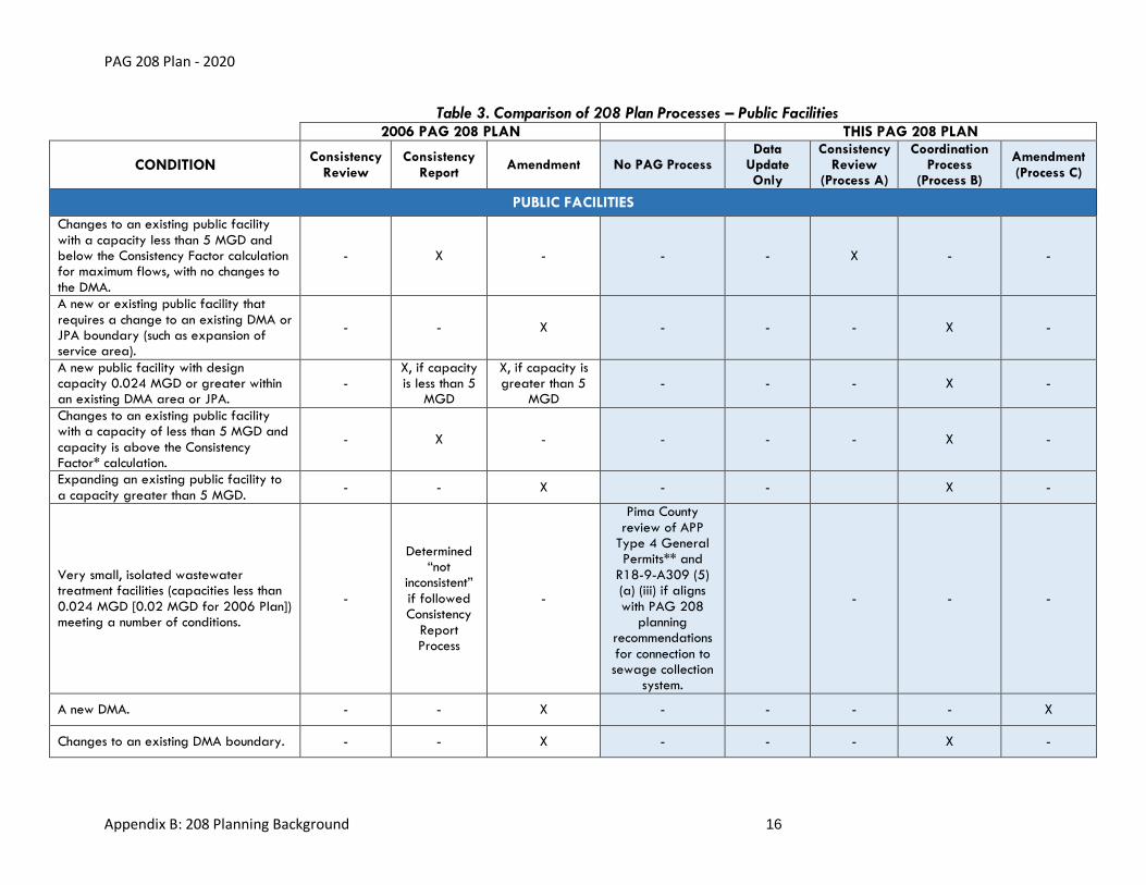
described below. See Table 2 and Table 3 below for a comparison of each trigger in this 208 Plan update to the 2006 Plan.
• The 208 Plan no longer requires a 208 Amendment process for new or expanding public
Water Reclamation Facilities (WRFs) with capacities greater than 5 million gallons per day (MGD). Facilities with those criteria may now participate in a streamlined
Coordination Process (Process B). The 5 MGD threshold was used to align with ADEQ’s pretreatment requirement for wastewater treatment facilities (WWTFs) with capacities 5
MGD or greater which ADEQ can ensure through their permitting process. PAG’s change meets the intention of 208 planning to encourage public regional facilities by easing their 208 process and allows DMAs to follow through with their capability to manage
responsibilities within their areas.
• The “Consistency Report” process will no longer exist. Existing and new public facilities
each with capacities less than 5 MGD and with capacities below the Consistency Factor calculation previously required a PAG Consistency Report process. Existing facilities with
these criteria now only require a shorter Consistency Review and Data Update (Process A). All new public facilities will be required to participate in a streamlined Coordination
Process (Process B).
• To align with state regulations regarding systems with capacities less than 0.024 MGD
under Individual Aquifer Protection Permit (APP), PAG has changed this threshold for PAG
Amendments for small private facilities to 0.024 MGD, instead of 0.020 MGD listed in the 2006 Plan.
• Consistency Reports was the process required in the 2006 Plan (Section 9.3) for very
small, isolated WWTFs (capacities less than 0.02 MGD) meeting a number of conditions.
This requirement was removed and a PAG process is no longer required. On-site systems in all DMAs with capacities less than 0.024 MGD under a Type 4 Aquifer Protection Permit and septic systems with capacities less than 0.003 MGD (3000 gallons per day)
which apply under APP 4.23 General Permit are reviewed by Pima County Department of Environmental Quality (PDEQ), which has been delegated review authority by ADEQ.
For APP Type 4.01 General Permits for sewage collection systems, if the facility to be constructed will be owned by the PCRWRD, the Discharge Authorization will be issued by
the Tucson Office of ADEQ. A description of the approval process and application materials are available on PDEQ’s website1.
• The Consistency Factor has been updated to 25 percent, from the 20 percent to 80
percent used in the 2006 Plan. The Consistency Factor allows determinations of consistency for public facilities if expanded flows are no more than 25 percent above projected
flows.
• Procedures also have been clarified if a municipality desires to gain DMA responsibilities
or would like to modify an existing DMA. New DMAs must undergo a 208 Amendment process (Process C). DMA modifications must undergo a Coordination Process (Process B).
• Following the example of other DPA plans in the state, private facilities may now become
wastewater management utilities (WMUs). WMU status allows private entities to gain responsibilities similar to those of DMAs. This status did not previously exist in PAG 208
Planning. Procedures for new or modified WMUs were created following the DMA and
1https://webcms.pima.gov/cms/one.aspx?portalId=169&pageId=63828

PAG 208 Plan - 2020
Appendix B: 208 Planning Background 8
private facilities models. If a private entity desires to gain WMU responsibilities or modify an existing WMU, the applicant must undergo a 208 Amendment Process (Process C).
• The 208 procedures no longer require PAG Regional Council approval to initiate a 208
process nor to collect fees. DMA agreement letters help ensure agreement by key nearby
stakeholders.
Procedure Steps
The following changes to steps in the procedures are intended to streamline and clarify.
Simplified process steps are illustrated in Figure 1.
• DMAs’ “decline-to-serve” and jurisdictional “sponsorship” letters may be merged when it is
the same entity.
• For Process B, if a DMA is within 3 miles of a proposed project, DMAs write letters to
support or agree to participate prior to initiating 208 procedures. This reduces the
number of stakeholder meetings, while PAG can demonstrate consensus to ADEQ, and creates a regional coordination point where relevant.
• Clarification was provided for coordination within Joint Planning Areas (JPAs) and with
other DPAs where relevant.
• A task force is not required for PAG 208 processes. Instead, relevant stakeholders,
including DMAs, are to be invited to the Watershed Planning Subcommittee (WPS)/Environmental Planning Advisory Committee (EPAC) meeting which can be held
jointly. DMA support letters fulfill the objective of prior coordination.
• Summarized regulations regarding advisory group formation and composition and
described how PAG complies with these regulations.
• The Statewide Water Quality Management Working Group (WQMWG), EPAC and WPS
meetings are now on flexible schedules and may now each be scheduled at a timely date,
rather than requiring action items to wait until quarterly meetings.
• Clarification is provided about how and which committees can deny an application, which
decisions allow PAG Executive Director discretion, and how an applicant can proceed with the new PAG 208 Appeal Process.
• PAG, the DMAs and the Joint Committee reserve the right to require a Coordination
Process (Process B) or a PAG 208 Amendment (Process C) for any facility should conditions dictate.
• Process B and C can be streamlined as needed by holding the public hearing with other
committee meetings.
• The Coordination Process for existing public facilities (Process B) offers more streamlined
procedures when compared to both Amendments for private facilities and the previous (2006) 208 Plan’s Consistency Report process for public facilities. The 208 Plan no longer
requires a public hearing or mailings to residents for existing public facilities, unless the application is for a change of public facility ownership. However, public hearings and
mailings still may be utilized as needed or if recommended. The Coordination Process maintains the 2006 requirements for mailings and hearings for new public facilities.
• In comparison to the 2006 PAG 208 Plan and to private facilities, public facilities
undergoing the Coordination Process are no longer required to receive review by PAG

PAG 208 Plan - 2020
Appendix B: 208 Planning Background 9
Management Committee or Regional Council unless recommended. PAG staff will instead provide an informational memo to PAG Management Committee and Regional Council at
the conclusion of the Coordination Process.
• Provided clarification that permit applicants will be responsible for conducting and
covering the costs of mailings and public hearings.
Figure 1. Diagram of Simplified 208 Plan Process Steps
Organizational Changes and Reduction of Text
The primary components of the 208 Plan have not changed except for the changes discussed
below. See Table 1 for a cross-reference of 208 Plan chapters between 2006 and 2020.
Reduction and Automation
The Watershed Approach section (Section 8 of the 2006 Plan) was briefly summarized since this
is not currently a required element of 208 planning and primarily consisted of 208 Plan contents organized per watershed. A function was created in the online Facility Inventory Portal to sort
facilities by watershed and allow this management perspective.
Data Source Links
Water quality data tables that can quickly become outdated were replaced with links to online
databases to maintain current information from best available sources.
Consolidation
Background information was consolidated for concise reading with current policies and regulations
up-front and goals and history of past changes available in appendices.

PAG 208 Plan - 2020
Appendix B: 208 Planning Background 10
Table 1. Cross-Reference of 208 Plan Chapters - 2006 and 2020 Plan Updates
2020 DOCUMENT 2020 PLAN CHAPTER COMPARABLE 2006 PLAN CHAPTER
CONTENT CARRIED OVER TO 2020
Adopted Policies and Procedures
• Introduction
• Responsibilities
Introduction (1) 208 plan contents and purpose, need to update the plan, required elements in a 208 Plan, purpose and scope of update
Throughout the Policy chapters
Summary of Original 208 Plan, Amendments and Policies (2)
Policies from the original 1978 208 Plan or amendments
• Procedures for Water Reclamation Facilities
• Process Details for all Procedures
• Detailed Policies and Procedures per Entity Type
Plan Descriptions and Policies (9)
Policies and procedures on regionalization, private WWTFs, facilities constructed despite lack of compliance with the 208 Plan, on-site systems, conversion of on-site facilities, priority water bodies and reuse of wastewater, AZPDES permitting
• Introduction
• Procedures for Water Reclamation Facilities
• Process Details for all Procedures
• Policies and Procedures for Multiple Facility Types
• Conformity by other Regulated Programs
Plan Implementation and Procedures (10)
Policies and procedures for DMA designation and updates, integrated planning, groundwater, biosolids, public participation, Title VI and environmental justice, consistency determinations, PAG 208 planning processes, processing fees, 208 Plan updates, 208 Plan Amendments, Consistency Review triggers, contents of Consistency Reviews, conformity by other federal, state and local regulatory and non-regulatory water quality protection programs, and economic, social and environmental impacts of the 208 Plan update.
Appendix A: Water Quality Management
Water Quality and Management Efforts
Summary of Original 208 Plan, Amendments and Policies (2)
Recommendations/goals from the original 1978 208 Plan and amendments

PAG 208 Plan - 2020
Appendix B: 208 Planning Background 11
Table 1. Cross-Reference of 208 Plan Chapters - 2006 and 2020 Plan Updates
2020 DOCUMENT 2020 PLAN CHAPTER COMPARABLE 2006 PLAN CHAPTER
CONTENT CARRIED OVER TO 2020
Planning Area Description (3)
Water quality conditions and data sources (updated for 2020)
Existing Solid Waste Management (6)
Regulations and definitions, disposal options and emerging issues
Wastewater Facilities Planning
Existing Wastewater Treatment Facilities and Other Point Source NPDES Discharges (5)
Methodology for delineating service areas and population projections, discharges and wastewater facilities that are not consistent with the 208 Plan, existing on-site wastewater treatment systems and effluent discharge sites
Future Conditions (7) Land use, population projections, wastewater flow projections, maximum flows for 208 consistency, potential future facilities
• Wastewater Facilities Planning
• Facility Inventory Report
Summary of Original 208 Plan, Amendments and Policies (2)
Point sources identified in Amendments and updates to the PAG 208 Plan since 1978
Facility Inventory Report
Agency and Area Designations (4)
Non-DMA (non-municipal) facility maps and descriptions
• Existing Wastewater Treatment Facilities and Other Point Source NPDES Discharges (5)
• Appendix F
Maps and descriptions of public and non-municipal wastewater facilities in the PAG DPA area
• Water Quality and Management Efforts
• Facility Inventory Portal2
Watershed Approach to Water Quality Management Planning (8)
Surface water quality conditions and facilities sortable by watershed
Application Resources • Appendix C
• Appendix G
Checklists for Procedures
Appendix B: PAG 208 Record of Changes Introduction Purposes for the Plan update and reasons for changes
2http://gismaps.pagnet.org/pag208plan/

PAG 208 Plan - 2020
Appendix B: 208 Planning Background 12
Table 1. Cross-Reference of 208 Plan Chapters - 2006 and 2020 Plan Updates
2020 DOCUMENT 2020 PLAN CHAPTER COMPARABLE 2006 PLAN CHAPTER
CONTENT CARRIED OVER TO 2020
Planning Background
History, Regulations and Authorities
• Introduction (1)
• Appendix A
• Appendix B
• Appendix E
History, Federal and State requirements
Summary of Original 208 Plan, Amendments and Policies (2)
Overview of the original 1978 208 Plan, table of past 208 Plan Amendments
Agency and Area Designations (4)
DPA and DMA designation history
Setting of Planning Area
Planning Area Description (3)
Natural setting, population, local governments, land use/ownership, water resources
Watershed Approach to Water Quality Management Planning (8)
Description of watershed-based approach to water quality management planning
Public Participation Records – 2020 Update
(detached records) Documentation of public involvement during update
Appendix C: Glossary and References
Glossary of Terms and Acronyms
List of Acronyms Commonly used terms and definitions
References References Cited publications and data sources

PAG 208 Plan - 2020
Appendix B: 208 Planning Background 13
Strategic Action Plan Format
Water quality issues are now associated with their related descriptions of past progress and
future recommendations. Organized strategies help to clarify PAG staff and committees’ roles in regional coordination, such as updating EPAC’s Top Issues list and directing funding sources to
areas of importance.
Terminology Updates
Where needed, terminology was updated to match regulatory language and reflect
contemporary usage.
Data Updates
Water Quality Conclusions
Summaries of water quality issues were updated to reflect the most current information.
DMA and Facility Descriptions
Descriptions were updated with current information using data available in Consistency Reviews and Amendments since 2006 and were reviewed by the DMAs for accuracy.
Projections
Population and flow projections were updated for planned service areas. The 208 Plan is
required to maintain a minimum 20-year planning horizon. The previous PAG 208 Plan in 2006 projected through 2030. This update to the 208 Plan includes projections of future wastewater volumes, using PAG Regional Council approved population projections in the last PAG Regional
Mobility and Accessibility Plan, through 2045.
Service Area Maps
Boundaries were updated to reflect where there is current infrastructure and were reduced where
no current infrastructure exists and to be consistent with local ordinances. PAG is not responsible for the accuracy of facility boundaries; datasets shown on PAG 208 maps and in the regionwide
inventory are as reported by DMAs.
Integrated into this Update
Additional changes that were made which may have triggered a Consistency Review, Consistency
Report or Amendment during the update of this PAG 208 Plan were limited to the following actions:
• The Marana DMA boundary was extended to include Saguaro Bloom and the Pima
County DMA boundary was updated to exclude Saguaro Bloom, by joint request of
Marana and Pima County on the signed DMA maps. The maps in the 208 Plan reflect this change to the Marana DMA and Pima County DMA boundaries.
• A formalized process was developed for coordination with other DPAs where wastewater
service crosses county boundaries. A Consistency Review for Pima County to serve a

PAG 208 Plan - 2020
Appendix B: 208 Planning Background 14
development at Eagle Crest created a need to extend the Pima County DMA into Pinal County.
• Updates to the Future Conditions section for facilities in the 208 Plan can ease future
consistency reviews if a new facility is proposed in the future that was already anticipated
and described in the approved 208 Plan.
The required public notice and approval by PAG Management Committee and PAG Regional
Council for these actions have been folded in as part of this PAG 208 Plan Update process for approval.

PAG 208 Plan - 2020
Appendix B: 208 Planning Background 15
Table 2. Comparison of 208 Plan Processes - Private Facilities
2006 PAG 208 PLAN 2020 PAG 208 PLAN
CONDITION Consistency
Review Consistency
Report Amendment No PAG Process
Consistency Review
(Process A)
Coordination Process
(Process B)
Amendment (Process C)
PRIVATE FACILITIES
A new private facility (including septic or on-site private facilities) with a capacity 0.024 MGD or greater (0.02 MGD for 2006 Plan).
- - X - - - X
Expansion of a private facility service area with a capacity 0.024 MGD or greater (0.02 MGD for 2006 Plan)
- - X - - - X
Expansion of a private facility service area that crosses a DMA, DPA or JPA boundary.
- - X - - - X
Very small, isolated wastewater treatment facilities (capacities less than 0.024 MGD [0.02 MGD for 2006 Plan]) meeting a number of conditions including: no commercial or industrial waste, no public service available within 10 years, will connect when DMA becomes available, no discharge to waters of the US, financial and technical capacity demonstrated, no jurisdiction or water provider objects, no odor or water quality impact, all property owners within one half mile notified.
-
Determined “not
inconsistent” if followed Consistency
Report Process
-
Pima County review of APP
Type 4 General Permits and R18-9-A309 (5) (a)
(iii) if aligns with PAG 208 planning
recommendations for connection to sewage collection
system.
- - -
A new or changing WMU (new category in 2020).
- - - - - - X
Other changes to an existing private facility currently in the PAG 208 Plan.
- - X - - - X*
*See the “Determining Appropriate 208 Process” section of the Adopted Policies and Procedures document for exceptions that might not trigger an Amendment and/or Consistency Review.
PAG 208 Plan - 2020
Appendix B: 208 Planning Background 16
Table 3. Comparison of 208 Plan Processes – Public Facilities 2006 PAG 208 PLAN THIS PAG 208 PLAN
CONDITION Consistency
Review Consistency
Report Amendment No PAG Process
Data Update Only
Consistency Review
(Process A)
Coordination Process
(Process B)
Amendment (Process C)
PUBLIC FACILITIES
Changes to an existing public facility with a capacity less than 5 MGD and below the Consistency Factor calculation for maximum flows, with no changes to the DMA.
- X - - - X - -
A new or existing public facility that requires a change to an existing DMA or JPA boundary (such as expansion of service area).
- - X - - - X -
A new public facility with design capacity 0.024 MGD or greater within an existing DMA area or JPA.
- X, if capacity is less than 5
MGD
X, if capacity is greater than 5
MGD - - - X -
Changes to an existing public facility with a capacity of less than 5 MGD and capacity is above the Consistency Factor* calculation.
- X - - - - X -
Expanding an existing public facility to a capacity greater than 5 MGD.
- - X - - X -
Very small, isolated wastewater treatment facilities (capacities less than 0.024 MGD [0.02 MGD for 2006 Plan]) meeting a number of conditions.
-
Determined “not
inconsistent” if followed Consistency
Report Process
-
Pima County review of APP
Type 4 General Permits** and
R18-9-A309 (5) (a) (iii) if aligns with PAG 208
planning recommendations for connection to sewage collection
system.
- - -
A new DMA. - - X - - - - X
Changes to an existing DMA boundary. - - X - - - X -

PAG 208 Plan - 2020
Appendix B: 208 Planning Background 17
Table 3. Comparison of 208 Plan Processes – Public Facilities 2006 PAG 208 PLAN THIS PAG 208 PLAN
CONDITION Consistency
Review Consistency
Report Amendment No PAG Process
Data Update Only
Consistency Review
(Process A)
Coordination Process
(Process B)
Amendment (Process C)
PUBLIC FACILITIES
Expansion of a public facility’s service area within an existing DMA or JPA.
X, if in DMA***
X, if in JPA***
- - X, if over 3 miles from other DMA
X, if less than 3 miles from other
DMA
- -
A new JPA or joint public facility. - X*** - - - - X -
*Consistency Factor is a term for PAG’s assigned factor that allows a 25 percent variation above the future flow projections.
**For APP Type 4.01 General Permits for sewage collection systems, if the facility to be constructed will be owned by the PCRWRD, the Discharge Authorization will be issued by the Tucson Office of ADEQ.
***Process needed clarification.

PAG 208 Plan - 2020
Appendix B: 208 Planning Background 18
Chapter 2: History, Regulations and Authorities This chapter includes regulatory requirements for 208 Plans, the history of regulatory changes that impacted the 208 Plan, history of wastewater in Pima County and a summary of previous
208 Plans, amendments and policies.
Regulatory Requirements For 208 Planning
The following section includes current federal and state regulations related to water quality
management planning under Section 208 of the Clean Water Act (CWA).
Federal laws regarding the CWA may be found in the Code of Federal Regulations3.
Federally Required Elements in a 208 Plan
Federal regulations state that the following elements must be included in Water Quality Management (WQM) Plans or referenced as part of the plan if they are contained in separate
documents:
• Total maximum daily loads
• Effluent limitations
• Identification of anticipated municipal and industrial waste treatment works
• Nonpoint source management and control
• Identification of agencies necessary to carry out the plan
• Identification of implementation measures necessary to carry out the plan
• Identification and development of programs for the control of dredge or fill material
• Identification of any relationship to applicable basin plans developed under Section 209
of the CWA [Basin Plans]
• Identification and development of programs for control of groundwater pollution,
including the provisions of Section 208(b)(2)(K) of the CWA
In Arizona, these required elements are divided between the state WQM Plan and the DPAs’
Areawide Water Quality Management Plans (208 Plans).
Federal regulations preclude the issuance of National Pollutant Discharge Elimination System
(NPDES) permits to facilities that are not consistent with the applicable 208 Plan Section 208(e);
3 https://www.gpo.gov/fdsys/pkg/CFR-2016-title40-vol24/xml/CFR-2016-title40-vol24-part130.xml
PAG 208 Plan - 2020
Appendix B: 208 Planning Background 19
40 Code of Federal Regulations (CFR) § 130.6(f) (see Code of Federal Regulations below). The complete text of the relevant federal regulations is included in 40 CFR § 130.64.
State Responsibilities and Plan Requirements
Federal regulations require each state to have its own WQM Plan, and the regulations provide
the process for updating, maintaining, and implementing the WQM Plan. The State WQM should be updated each time a newly adopted state plan component, rule, agreement or strategy is enacted.
Federal regulations require each state to establish and maintain a Continuing Planning Process (CPP) per Section 303(e)(3) of the CWA. The most recent document describing Arizona’s CPP
includes a checklist5 for 208 Plan Amendment content requirements. The state requirements generally mirror the federal requirements and are subject to review by the EPA to ensure they
are consistent with the CWA. CPP updates are required to incorporate the elements of the applicable 208 Plans in the state.
Statewide Coordination
The federal regulations lay out a process for “assuring adequate authority for intergovernmental cooperation in the implementation of the State WQM program” (40 CFR § 130.5). Per federal
requirements, the water quality programs must be developed with local, regional and other planning agencies. Under the Arizona CPP, the Statewide WQMWG was established. It is a voluntary group that assists in the review and updates to the state WQM programs, for example,
by participating in comments regarding state updates to water quality standards or by providing updates through DPA 208 Plans. The WQMWG includes staff representatives from the state
DPAs.
The WQMWG assists ADEQ in ensuring that the program addresses both regional and statewide
water quality needs. ADEQ’s 1993 CPP Appendix IV, Page IV-2 states: “The Water Quality Management Working Group is a voluntary advisory body that meets quarterly, or as necessary,
to consider and make recommendations to ADEQ regarding matters of statewide WQM policy and program implementation. The WQMWG is instrumental in the review and revision of state WQM programs, as it assists the Department in developing an integrated WQM program, from
both a regional and statewide perspective.”
DPA Funding
Federal regulations require planning funding be directed to and prioritized for DPAs for purposes of developing and operating a continuing areawide waste treatment management planning processes. CWA Section 208 [33 U.S.C. § 1288] Areawide Waste Treatment
Management, Section 208(f)(1) requires the administrator to make grants to any agency designated under Section 208, subsection (a) for payment of the reasonable costs of developing
and operating a continuing areawide waste treatment management planning process. ADEQ distributes federal funding to the DPAs for water quality programs.
4 https://www.gpo.gov/fdsys/pkg/CFR-2013-title40-vol23/pdf/CFR-2013-title40-vol23-sec130-6.pdf 5 https://legacy.azdeq.gov/function/forms/download/list/Continuing_Planning_Process_4_93.PDF

PAG 208 Plan - 2020
Appendix B: 208 Planning Background 20
CWA Section 205 [33 U.S.C. § 1285] Allotment, Section 205(j)(3) requires states to give funding priority to DPAs for purposes of carrying out WQM planning and requires an allocation of 40
percent of the total available funding each year. If it has been determined that the 40 percent allocation to regional public comprehensive planning organizations will not result in significant
participation by such organizations in water quality management planning, will not significantly assist in development and implementation of the WQM plan, and will not aid in achieving the
goals of the CWA, then after consultation with the regional public comprehensive planning organizations and with the approval of the EPA Administrator less than 40 percent can be
allocated to DPAs.
40 CFR § 130.1, Program management, Section 130.11(a) establishes that local or regional planning organizations may request CWA Section 205(j) funds from a state for planning and
management activities. Federal funding for 208 planning and plan updates in Arizona is primarily available through Section 604(b) grants. Current information regarding state funding
can be found on the ADEQ Statewide WQMWG Agenda and Meeting Minutes webpage6.
Local Coordination
Federal regulations require ADEQ to consult with DPAs in the joint development, review and
revision of state work program and WQM planning activities. In 40 CFR § 130.11, the Program Management Section 130.11(e) establishes the EPA, states, areawide agencies, and local and
regional governments as joint participants in the water pollution control program. CWA Section 205 [33 U.S.C. § 1285] Allotment, Section 205(j)(3) also requires states to develop jointly with
local, regional, and interstate entities, a plan for carrying out the WQM program. DPAs and their regional WQM plans are integral to updating and maintaining the state’s CPP and WQM plan under CWA Section 303(e)(3)(B) which requires each state’s CPP to include the incorporation of
all elements of any applicable areawide waste management plans under Section 208. In Arizona Administrative Code (A.A.C.) § R18-5-301 Definitions, Paragraph 7 defines “State water quality
management plan” to mean a planning document that includes (a) Certified Areawide Water Quality Management Plans and amendments, and (e) intergovernmental agreements (IGAs)
between the Department and a designated water quality planning agency or a DMA as elements. State work programs are required to be developed jointly with regional and other
comprehensive planning organizations.
DPAs have a very strong nexus with local elected officials and play key roles in assuring intergovernmental cooperation in WQM planning and implementation required under 40 CFR §
130.5(b)(5) and CWA Section 303(e)(3)(E). ADEQ’s CPP further outlines this in ADEQ’s 1993 CPP Appendix III, Page III-8: “The COGs and ADEQ have a unique and very valuable relationship in
WQM planning, starting with the WQM planning partnership role established by CWA Section 208 (see Appendix V [of the CPP]). The COGs provide a vehicle through which local governments
may participate in the WQM planning process. They provide technical assistance to local entities in the preparation, amendment and update of Areawide WQM Plans, including promoting and
ensuring adequate public participation in plan development and adequacy of plan amendments. The COGs assist the local/state agency information exchange and public participation processes and help elevate local needs and priorities to ADEQ's attention for consideration in its statewide
WQM program efforts. All major regional policy decisions are reviewed and approved by the COG decision making bodies, or regional boards, which are comprised of local elected officials.”
6 http://www.azdeq.gov/statewide-water-quality-management-working-group-agenda-minutes

PAG 208 Plan - 2020
Appendix B: 208 Planning Background 21
State laws regarding the CWA may be found in Arizona Revised Statutes (A.R.S.) § R18-57 and A.R.S. § R18-98.
Please see the Adopted Policies and Procedures section on DPA Responsibilities for the list of PAG’s designated responsibilities delegated by the state.
DPA Designation
Section 208 of the 1972 amendments to the CWA required the governor of each state to identify areas having water quality control problems, delineate the boundaries of these areas, and
designate for each area “a single representative organization, including elected officials from local governments or their designees, capable of developing effective areawide waste treatment
management plans” (CWA Section 208 [33 U.S.C. § 1288] Areawide Waste Treatment Management. Section 208(a)(2)). The law required each organization designated by the
governor to develop a plan for areawide waste treatment management. The “single representative organization, including elected officials from local governments or their designees, capable of developing effective areawide waste treatment management plans” designated by
the governor to develop a plan for its respective area is commonly referred to as the “Designated Planning Agency” or “DPA.” The plan itself is known as the “Certified Areawide
Water Quality Management Plan” or “208 Plan.” These terms are defined in Arizona rule under A.R.S § R18-5-3019.
On July 8, 1970, Arizona Governor Jack Williams signed Executive Order 70-210, which divided Arizona into six initial planning districts, and directed that all planning functions conducted on a
district-, regional-, or areawide basis conform to the prescribed planning areas. Per the law, existing regional agencies could be designated as the DPA. In 1974, PAG was designated as the DPA for Pima County, one of eight DPAs in Arizona (Williams 1974). As the region’s DPA, PAG
applied for a grant to develop the 208 Plan in 1975. The 208 Plan was completed and approved in 1978. The first region-wide, comprehensive update to the 1978 plan was approved
in 2006.
PAG’s DPA area aligns with the Pima County boundary but PAG does not have DPA authority
over Native American lands within the county. When PAG’s original 208 Plan was drafted, the boundary was delineated to reflect that the Tohono O’odham Nation is not within the PAG DPA.
The Pascua Yaqui Tribe received federal recognition as a sovereign government in 1978, and the PAG DPA is updated to reflect this. The Pascua Yaqui Tribe is provided wastewater service through the Pima County DMA and PAG coordinates with the Native American nations and invites
them to be part of the 208 process, as desired.
DPA Plan Requirements
DPA 208 Plans identify regional priority point and nonpoint water quality problems, consider alternative solutions and recommend control measures. Control measures can include the financial and institutional measures necessary for implementing recommended solutions. In addition, 208
Plans identify existing and anticipated municipal and industrial WWTFs, as well as DMAs. The
7 http://apps.azsos.gov/public_services/Title_18/18-05.pdf 8 http://apps.azsos.gov/public_services/Title_18/18-09.pdf 9 http://apps.azsos.gov/public_services/Title_18/18-05.pdf 10 https://pagregion.com/wp-content/docs/pag/2021/05/Water-Gov-EO-and-Ltr-208-Designation-19701.pdf

PAG 208 Plan - 2020
Appendix B: 208 Planning Background 22
DMAs are responsible for ensuring that adequate wastewater service is provided in their management areas.
Requirements to Update 208 Plans
An up-to-date 208 Plan is necessary to ensure efficient permitting decisions with regard to
determining 208 consistency. Comprehensive revisions to facility, DMA or policy descriptions should occur when there have been multiple amendments to the 208 Plan or consistency reviews that provide facility updates. Population growth projections need to be updated to maintain the
required 20-year planning horizon, updates to applicable local, state and federal water quality regulations should be adequately integrated, and local water quality conditions and program
progress reported.
Federal regulations do not require any specific frequency for plan updates. Under 40 CFR §
130.6(e)11 it states: “WQM plans shall be updated as needed to reflect changing water quality conditions, results of implementation actions, new requirements or to remove conditions in prior
conditional or partial plan approvals… State CPPs shall specify the process and schedule used to revise WQM plans.”
The CPP12 for Arizona states: “If any WQM plan becomes so outdated as to be inconsistent with
state rules or policies, the director (of ADEQ) will encourage and may require the amendment of such plan, or the creation of a new plan, as appropriate.” References in the 208 Plan to state
rules will be updated when applicable.
By 2020, all the changes mentioned above had occurred and warranted a comprehensive
update. Additionally, PAG’s goals for the 2020 update were to 1) streamline policies and procedures, 2) modernize the facility inventory and 3) consolidate background information for
concise reading.
Related Regulations
The following regulations should be considered when conducting 208 planning.
Groundwater
Protection of groundwater quality from the disposal of pollutants on land or in subsurface excavations is a required element of 208 Plans [Section 208(b)(2)(K)] and has been a principal
goal of PAG’s 208 Planning program since its inception. In Arizona, the APP program is the major regulatory program aimed at protecting groundwater quality. PAG’s 208 Plan helps ensure the
success of the APP program by limiting the proliferation of potential pollutant sources and thus minimizing the strain that numerous small or non-compliant facilities would otherwise place on the
monitoring and enforcement resources available for the APP program. State regulations preclude the construction of sewage treatment facilities that are not consistent with the applicable 208 Plan (A.A.C. § R18-5-303) or the issuance of an APP to sewage treatment facilities that are not
consistent with the 208 Plan (A.A.C. § R18-9-A201B).
11 https://www.gpo.gov/fdsys/pkg/CFR-2016-title40-vol24/xml/CFR-2016-title40-vol24-part130.xml 12 https://legacy.azdeq.gov/function/forms/download/list/Continuing_Planning_Process_4_93.PDF

PAG 208 Plan - 2020
Appendix B: 208 Planning Background 23
PAG will continue to ensure that WWTFs are sited, planned and managed in a way that ensures the protection of groundwater quality. PAG will also continue to work with local governments to
inventory land uses and identify potential impacts to groundwater quality from various land uses and potential pollution sources.
Resource Conservation and Recovery Act
According to the EPA (2018b), the goals of the Resource Conservation and Recovery Act (RCRA), enacted in 1976, are to:
• Protect us from the hazards of waste disposal
• Conserve energy and natural resources through recycling and recovery
• Reduce or eliminate waste
• Clean up waste that may have been spilled, leaked or improperly disposed of
In Arizona, RCRA is implemented by ADEQ’s Waste Programs Division, which is responsible for permitting facilities that treat, store, or dispose of hazardous waste and for approving solid
waste facility plans. According to ADEQ (2016a), the following types of facilities are subject to solid waste facility plan approval or will be once the appropriate rules are promulgated:
• Biosolids processing facilities
• Composting facilities
• Medical waste facilities
• Municipal solid waste landfills
• Recycling facilities
• Non-municipal solid waste landfills
• Solid waste storage facilities
• Special waste facilities
• Transfer stations
• Waste tire collection sites
CERCLA
The Comprehensive Environmental Response, Compensation, and Liability Act (CERCLA), also known as Superfund, was enacted by Congress in 1980. CERCLA provides broad federal
authority to respond to releases or threatened releases of hazardous substances that may endanger public health or the environment. The EPA maintains the National Priorities List, which is a list of national priorities among the known or threatened hazardous releases. The list guides the
EPA in determining which sites warrant further investigation. Long-term remedial actions may only be taken at sites on the National Priorities List. Listed in 1983, the Tucson International Airport
Area is the only site in Pima County on the National Priorities List.

PAG 208 Plan - 2020
Appendix B: 208 Planning Background 24
WQARF
Arizona’s Water Quality Assurance Revolving Fund (WQARF) supports the cleanup of hazardous
substance releases in Arizona. It is funded by legislative appropriations, cost recovery from responsible parties, taxes and fees. ADEQ maintains the “WQARF” registry, which is a list of the
sites most in need of cleanup. WQARF sites in Pima County are discussed in Appendix A.
History of Regulations and Changes
The following section includes historical federal and state regulation development as well as local
wastewater management related to 208 planning.
Clean Water Act
The CWA began as the Federal Water Pollution Control Act of 1948. Growing concern over
water pollution led to major amendments in 1972. The amendments include a prohibition on the discharge of any pollutant to waters of the United States from a point source unless the discharge
is authorized by a permit issued pursuant to the NPDES. With additional amendments in 1977, the law became commonly known as the CWA. The objective of the CWA is to restore and maintain
the biological, chemical, and physical integrity of the nation’s waters.
Federal and State Changes Reflected in Previous 208 Plan Updates
Several key changes had occurred in state government since the original 208 Plan was adopted;
these were incorporated into the previous PAG 208 Plan updates. Foremost was the creation of the ADEQ by passage of the Environmental Quality Act in 1986 (A.R.S. § 49-102). Whereas the
original 1978 PAG 208 Plan identified the Arizona Department of Health Services – Bureau of Water Quality Control as the state water pollution control agency, the Environmental Quality Act established ADEQ as the agency responsible for all major federal water quality legislation.
The 1986 Environmental Quality Act also established the aquifer protection program to protect the quality of the state’s aquifers. All discharging facilities (including WWTFs) must obtain APPs.
In 1987, Congress amended the CWA, Section 402(p), to require implementation of the stormwater program in two phases to address stormwater discharges. In 1990, the EPA issued
regulations authorizing the creation of an NPDES permitting system for stormwater discharges from certain industrial activities. The NPDES program is designed to track point sources and
requires the implementation of the control measures necessary to minimize or eliminate the discharge of pollutants to waters of the United States. The first phase of the program, commonly referred to as ‘‘Phase I,’’ was promulgated on November 16, 1990 (55 FR 47990). Phase I
requires NPDES permits for stormwater discharge from priority sources, including municipal separate storm sewer systems (MS4s) generally serving populations of 100,000 or more. On
August 7, 1995, the EPA promulgated a final rule that required facilities to be regulated under Phase II to apply for an NPDES permit. In 1999, the EPA published rules to expand Phase II
permit coverage to include small municipalities and construction sites that disturb between 1 and 5 acres. ADEQ was delegated authority from the EPA to implement the NPDES stormwater
program in Arizona (except on Native American lands) on December 5, 2002, also known as the Arizona Pollutant Discharge Elimination System (AZPDES). Arizona obtained primacy for the

PAG 208 Plan - 2020
Appendix B: 208 Planning Background 25
NPDES in 2002. With state primacy, ADEQ issues AZPDES permits as well as APPs. ADEQ also regulates the reuse of treated effluent and enforces reclaimed water quality standards.
A groundwater-related change at the state level was the passage of the Arizona Groundwater Management Act (GMA) in 1980. The purpose of the GMA is to address the issue of groundwater
overdraft in several critical areas of the state. The GMA requires the Arizona Department of Water Resources (ADWR) to develop and promulgate a series of management plans that
promote regulatory conservation programs for the Industrial, Municipal, and Agricultural water use sectors. The Tucson Active Management Area (AMA) is one of five in the State of Arizona and
has a safe-yield goal to be achieved by the year 2025. The AMAs are areas in the state that have experienced severe groundwater overdraft. The safe-yield goal and assured water supply requirements have led to increased emphasis on the use of Central Arizona Project (CAP) water
and reclaimed water supplies. The GMA is incorporated into A.R.S. Title 45.
At the federal level, changes related to the CWA have also occurred since 1978. One change is
the level of funding available for 208 Planning and 208 Plan implementation. In the 1970s and early 1980s, funding authorized by Section 208 of the CWA for developing and operating the
208 Plans was approximately $100 million per year. Today, federal funding for 208 Planning in Arizona is primarily available through Section 604(b) grants, which in Arizona are limited to a
total of $40,000 for the entire state plus any remaining budget from the previous year. Current information regarding state funding can be found on the ADEQ Statewide WQMWG Agenda and Meeting Minutes webpage13.
Other changes include the establishment of the Clean Water State Revolving Fund in 1987, recently amended in 2014, which provides states with funds for water quality infrastructure
projects.
Federal and State Changes Since the 2006 PAG 208 Plan Update
In October 2011, EPA’s Office of Water and Office of Enforcement and Compliance Assurance
issued a joint memo encouraging EPA Regions to assist their state and local partners in pursuing an integrated planning approach to CWA waste and stormwater obligations. The memo identifies
green infrastructure (GI) as one comprehensive solution that can improve water quality and provide other benefits that enhance the vitality of communities.
In a 2012 evaluation of ADEQ’s AZPDES process, the EPA required that ADEQ reissue MS4 permits to local jurisdictions and that they include measurable and enforceable standards for low impact development (LID).
In 2017, ADEQ revised the A.A.C. to allow the use of advanced treatment of recycled water for potable use (A.A.C. Title 18, Chapter 9, Article 7). ADEQ now regulates the use of recycled water
and enforces recycled water quality standards.
The federal Water Infrastructure Improvement Act (Public Law 115-436), signed by the president
in January 2019, provides flexibility to municipalities wishing to prioritize investments in wastewater and stormwater projects needed for CWA compliance and requires the EPA to
promote the option of GI, which allows communities to use natural processes to infiltrate or reuse stormwater runoff beneficially on-site where it is generated. This helps communities use GI to meet
13 http://www.azdeq.gov/statewide-water-quality-management-working-group-agenda-minutes

PAG 208 Plan - 2020
Appendix B: 208 Planning Background 26
critical water management goals, while protecting the health, safety and well-being of their residents by authorizing the incorporation of GI practices into plan permits under the integrated
municipal stormwater and wastewater planning approach framework issued by the EPA. The Act amended 33 U.S.C. § 1342 to add the opportunity for integrated plans and 33 U.S.C. § 1362 to
add and promote GI.
Arizona’s intrastate Drought Contingency Plan in 2019 included approval of state legislation
granting an increase from 50 percent to 95 percent credit for six managed recharge projects in the state, among them the two Santa Cruz River in-channel projects. One is downstream of Tucson
and the second is at the Heritage Project near downtown. This legislation incentivizes recharging effluent in riverbeds at these six locations, as opposed to recharging the effluent in constructed basins elsewhere.
History of Wastewater Treatment and Management in Pima County
Prior to the CWA, the first public sanitary sewers in Pima County were installed in Tucson in 1900
and the first WWTF was constructed in 1928. Prior to construction of the treatment facility, wastewater was used directly for agricultural irrigation. In 1951, Phase 1 of the City of Tucson’s Roger Road WWTF began operation, and in 1961 the Pima County Sanitary District #1 installed
the first wastewater treatment lagoon at the Ina Road site. This sanitary district was dissolved in 1968 and replaced by the Pima County Department of Sanitation.
In 1974, the City of Tucson and Pima County formed the Metropolitan Utilities Management Agency, through an IGA. This agency was created to operate water and sewerage systems within
the Tucson city limits and in the unincorporated areas of Pima County (PAG 1975). However, the City of Tucson and Pima County continued to operate their respective sewerage systems. The joint
agency was dissolved in 1976.
In 1978, the County’s sanitation department was renamed the Pima County Wastewater Management Department and has since been renamed the Pima County Regional Wastewater
Reclamation Department.
Management Agency Designation Phases in Pima County
PAG, as the region’s DPA, initially identified both Pima County and the City of Tucson as DMAs
responsible for sewerage facilities. However, based on input from the EPA that preferred a single management agency, the 1978 208 Plan recommended consolidation of sewage treatment
programs in the metropolitan area (PAG 1978).
In 1979, ownership and all responsibilities for the construction, operation, and maintenance of the
City of Tucson’s sewerage systems were transferred to Pima County through an IGA. In recognition of the pending consolidation of facilities, the PAG Regional Council passed resolution 78-12-07 in
December 1978 requesting that the Governor designate Pima County as the single 208 DMA for municipal wastewater treatment and sewer system operations. This designation is noted in a 1980 amendment14 to the 1978 208 Plan and was considered a success for the 208 regionalization
principle.
14 https://pagregion.com/wp-content/docs/pag/2021/05/Water-PAG-1980-Amendment-to-208-Areawide-WW-
Mgmt-Plan-1981.pdf

PAG 208 Plan - 2020
Appendix B: 208 Planning Background 27
The 1979 IGA transferring the sewerage system stipulated that the City of Tucson would own and have unilateral control over the use and disposition of effluent discharged from metropolitan
WWTFs. The IGA stated that Pima County was entitled to up to 10 percent of the effluent for use at the consolidated metropolitan facilities, including County parks, golf courses, and recreational
facilities. A supplemental IGA was negotiated in 2000 that addressed control of effluent from non-metropolitan (sub-regional) Pima County facilities, access by other water providers to effluent
derived from their water supplies, and establishment of a conservation pool of up to 10,000 acre-feet per year for use of effluent in habitat conservation plans and other approved
projects. This Conservation Effluent Pool (CEP), Pima County, Tucson and other municipal use takes second priority to the Tohono O’odham Nation’s Southern Arizona Water Rights Settlement Act (SAWRSA) entitlement. SAWRSA, passed in 1982 and subsequent related Acts in 2004 and
resolved and executed in 2006 requires the first 28,200 acre-feet of effluent generated each year to be allocated to the Tohono O’odham Nation. Bureau of Reclamation assists in the
implementation of the SAWRSA settlement.
Pima County remained the only DMA in the PAG planning area until March 1999, when the PAG
Regional Council approved a 208 Plan Amendment designating the Town of Sahuarita as a DMA. The 2006 208 Plan identified a JPA outside the Sahuarita DMA boundaries that could be served
by either the Sahuarita DMA or the Pima County DMA in the future. These areas are considered a part of both DMAs.
On March 27, 2014, an amendment to the 208 Plan15 established the Town of Marana as a DMA
to provide wastewater collection and treatment services in a boundary area agreed to by the Town of Marana and Pima County. No additional DMAs have been proposed.
Previous 208 Plans, Amendments, and Policy Updates
Development of the 208 Plan since the original plan in 1978 is described in the section below.
Overview of the Original 208 Plan
The PAG Regional Council approved the 208 Plan for Pima County on June 22, 1978. The 208 Plan identified the roles of federal, state, regional, and local governments in water pollution control and addressed both point and nonpoint sources of pollution. The 208 Plan identified the
City of Tucson and Pima County as DMAs for their respective parts of the Tucson metropolitan area sewerage system. Pima County was identified as the DMA for rural parts of Pima County.
The final 1978 208 Plan (PAG 1978), which was essentially a summary report based on numerous supporting documents, noted that facility needs in the Tucson metropolitan area would
be addressed in a parallel 201 facilities planning program under Section 201 of the CWA; the 201 Facility Plan, once adopted, would become part of the 208 Plan. The 208 Plan stated that
201 facilities planning and best management practices planning would be the prime responsibility of the City and County sewerage management agencies and that all 201 planning would be consistent with the recommendations for wastewater treatment contained in the approved 208
Plan.
15 https://mk0pagrtahost21swg12.kinstacdn.com/wp-content/docs/pag/2020/09/Water-PAG-208-Plan-Marana-
Amendment-2013-1.pdf

PAG 208 Plan - 2020
Appendix B: 208 Planning Background 28
The adopted 201 Facility Plan, Metropolitan Tucson Regional Wastewater Management System (Brown and Caldwell 1978), consisted of five documents: a summary/background report and four
supplements. The four supplements were:
1. Regional Wastewater Treatment System
2. Regional Interceptor System
3. Environmental Impact Assessment
4. Outlying Facility Plans
The Facility Plan provided a much more detailed description of the WWTFs identified in the PAG
Areawide Wastewater Management Plan. However, it did not identify any additional facilities, with the exception of a replacement facility for the Catalina Wastewater Treatment Plant, proposed to be located 2 miles south of the existing (at that time) facility.
Amendments and Point Source Updates to the 208 Plan
The 1978 208 Plan listed numerous point sources, including public WWTFs in the metropolitan area, public WWTFs outside the metropolitan area, and point sources from private WWTFs.
Various 208 Plan Amendments and minor updates approved since 1978 have identified additional point sources, including facilities that existed at the time and facilities that were
proposed for the future.
In June 1998, the PAG Regional Council adopted criteria for a 208 Plan Amendment to change
the status of a DMA and to create a new DMA. At the time that these criteria were adopted, Pima County was the only DMA in the PAG region.
The 2006 208 Plan consolidated the original 1978 208 Plan and the various individual amendments and updates into one document. Updates included changes to municipal and industrial WWTFs and other point sources identified in the current plan and integration of policies
that have been adopted through amendments. Changes that were incorporated into the 2006 update included the designation of the Town of Sahuarita as a DMA in 1999, negotiation of a
supplemental IGA between the City of Tucson and Pima County in 2000 regarding treated wastewater effluent, additional IGAs between the City of Tucson, the Metro Water District, and
Oro Valley, and passage of SAWRSA in 1982 and a subsequent settlement in 2004. The 2006 208 Plan also updated the list of WWTFs that had been constructed, updated, expanded or
closed from the original 1978 208 Plan.
Parts of PAG’s original 1978 208 Plan, particularly the nonpoint source elements, were developed on a watershed basis to a limited extent. The 2006 208 Plan included an analysis of
what it would take to realign 208 planning on a watershed scale, to be consistent with the EPA’s and ADEQ’s growing emphasis on multi-disciplinary, multi-stakeholder watershed planning (PAG
2006) and to prepare for any future related regulations. The Watershed approach section of the 2006 208 Plan repeated and resorted much of the 208 Plan per watershed. At the time, it was
expected that future regulations would require greater use of the watershed approach in water quality planning, but as of the date of this 208 Plan update there are no additional requirements.
Since the 2006 208 Plan, the Town of Marana was designated as a DMA in 2014 and several WWTFs have been constructed or upgraded, a number of existing facilities have been expanded, and some facilities have been closed. New procedures were included in the 2020 208
PAG 208 Plan - 2020
Appendix B: 208 Planning Background 29
Plan update to clarify the process to establish a new DMA for a public entity or a WMU for a private entity. The PAG region does not have any WMUs as of December 2019. Additional
changes included in the 2020 208 Plan update have been documented in the Record of Changes - 2020 Update chapter for clarity during the approval process and can be incorporated here
after adoption.
Error! Reference source not found. contains all 208 Plan amendments and updates along with
other Regional Council actions significantly affecting the 208 Plan from 1978 through 2018. The point sources identified since the creation of the 1978 208 Plan and each amendment and
update since then are available online in the PAG Facility Web Portal16. Additionally, maps showing the locations of all public and non-municipal point sources (existing, closed, proposed and no longer planned) previously identified in the 208 Plan and up to date as of December 2019
are available in the Wastewater Facilities Planning chapter.
Table 4. Amendments and Updates to the 208 Plan and Other Related Regional Council Actions, 1978–2019*
# Title Author Year
1 PAG Areawide Wastewater Management Plan 1980 Amendment
PAG 1980
2 El Conquistador Wastewater Reclamation Facility and Service Area
PAG 1981
3 Amendment to PAG 208 Plan Point Source Element: Mt. Lemmon
PAG 1981
4 Domestic Point Source Water Quality Planning Update Report for Areas A1 & A2
PRC Toups for PAG 1982
5 Domestic Point Source Water Quality Planning Update Report for the Upper Canada del Oro Area
PRC Toups for PAG 1982
6
Metropolitan Tucson Regional Wastewater Management System Facility Plan: Sludge Management and Disposal Program for the Roger Road Wastewater Treatment Facility
Pima County Wastewater Management Department
1983
7 Regional Council Implementation of Processing Fee of $3500 for administration of 208 Plan Amendments
PAG 1984
8 Facility Plan Report Proposed 208 Point Source Element Amendment for MSP Companies WWTF
Greiner Engineering 1984
9 Foothill Utility Wastewater Reclamation Facility Broadmoor Golf Course
Dooley-Jones & Associates
1984
10 Green Valley Cortaro Area Management Plans PAG 1984
11 Areawide Wastewater Management Plan Point Source Update
PAG 1985
16 https://gismaps.pagnet.org/PAG208Plan/Default.aspx

PAG 208 Plan - 2020
Appendix B: 208 Planning Background 30
# Title Author Year
12 Continental Ranch 208 Consistency Report – Continental Ranch Pump Station
WLB Group 1986
13 Catalina 208 Consistency Report and Plan Amendment (one document 1985 and 1987)
Pima County Wastewater Management Department
1987
14 208 Plan Amendment for Canada Hills Development Company L.P.
Arthur Beard Eng 1987
15 Marana Study Area 208 Consistency Report
Pima County Wastewater Management Department
1988
16
Regional Council statement that the Target Area concept may be acceptable for the 208-planning process only when the plan amendment or consistency analysis is initiated by a public jurisdiction which is subject to land acquisition regulation
PAG 1988
17 Guide to Areawide Water Quality Management Planning as Required Under Section 208 of the Clean Water Act
PAG 1990
18 208 Consistency Report for MSP Companies WWTF WLB Group 1992
19 208 Plan Amendment for Management & Training Corporation – Marana Treatment Facility, Wastewater Reclamation Facility
Moore and Associates, Inc.
1993
20 208 Plan Amendment for La Mirage Estates WWTF ICON Consultants 1995
21 Criteria for Establishing New DMAs in Pima County (Regional Council policy)
PAG 1998
22 The Wastewater Management Plan for Sahuarita – An Amendment to the PAG Areawide 208 Plan
Town of Sahuarita 1999
23 Ajo Improvement Company 208 Plan Amendment Ajo Improvement Company
1999
24 Standard Outline guidance document for private wastewater facilities pursuing a 208 Plan Amendment (Regional Council policy)
PAG 1999
25 Marana 208 Areawide Water Quality Management Plan Update
Malcolm Pirnie 2000
26 Corona de Tucson WWTF Expansion Consistency Report Pima County Wastewater and PAG
2004
27 Areawide Water Quality Management Plan 2006 Update PAG 2006
28 Miraval Resort, LLC. 208 Plan Amendment
WestLand Resources, Inc., for Miraval Resort Tucson and PAG
2007

PAG 208 Plan - 2020
Appendix B: 208 Planning Background 31
# Title Author Year
29 Ina Road Wastewater Reclamation Facility and New Water Reclamation Campus at Roger Road (Regional Optimization Master Plan – ROMP)
Greeley & Hansen for Pima County Regional Wastewater Reclamation Department
2009
30 Areawide Water Quality Management Plan Amendment for Town of Marana Facilities and DMA
WestLand Resources, Inc., for Town of Marana and PAG
2013
*While the time period reflected in this table spans 1978-2019, no amendments or updates occurred prior to 1980 and as of December 2019, no amendments or updates have occurred since 2013.

PAG 208 Plan - 2020
Appendix B: 208 Planning Background 32
Chapter 3: Setting of Planning Area This chapter provides a watershed settings overview and describes water resources in the PAG
region. The purpose of this chapter is to support an integrated planning approach to water quality management.
Integrated, watershed-based planning and management of water resources are necessary because water sources are not always physically isolated from one another. For example,
groundwater originates from perennial and intermittent natural surface water sources in Pima County as well as discharged and recharged effluent. Groundwater is also replenished by CAP water that is directly recharged or incidentally recharged through agricultural use. Thus, in many
instances, the quality and quantity of one water source can affect the quality and quantity of another. Further, it is valuable to evaluate and coordinate water quality planning on a watershed
basis since water crosses political boundaries.
Equally, water quantity and reliability have direct ties to water quality. Geology, hydrology and
biology relate to pollutant sources, distribution, impacts and management. Drought conditions have been shown to significantly impact water quality (Mosley 2015). Population and land use
also play an important role in how groundwater resources are managed. Groundwater depletion can lead to deterioration of water quality (U.S. Geological Survey 2019).
Planning Area Description
PAG’s DPA designation legally encompasses all of Pima County, excluding Native American lands, Tohono O’odham Nation and the Pascua Yaqui Tribe, which have their own authority.
However, PAG coordinates with the Native American nations and invites them to be part of the 208 process, as desired. The Pascua Yaqui Tribe is provided wastewater service through the Pima
County DMA. The 208 Plan applies to all remaining areas within Pima County, including the City of Tucson, the Town of Oro Valley, the Town of Marana, the City of South Tucson, the Town of Sahuarita, and unincorporated Pima County, which includes Green Valley, Ajo and Summerhaven
(Figure 2).
Because the majority of PAG’s DPA planning area falls within eastern Pima County (as do the
majority of the population, water resources, and wastewater treatment plants), this area receives greater geographic focus in this chapter than western Pima County.

PAG 208 Plan - 2020
Appendix B: 208 Planning Background 33
Figure 2. Map of PAG 208 Planning Area: Political and Watershed Boundaries

PAG 208 Plan - 2020
Appendix B: 208 Planning Background 34
Natural Setting
The natural setting of Pima County is diverse in many ways, especially with respect to elevation.
Pima County is approximately 9,200 square miles in area, with land surface elevations ranging from 1,200 feet to more than 9,000 feet above mean sea level (PAG 2003). The lower
elevations of Pima County lie within the Sonoran Desert, which covers approximately 100,000 square miles in southern Arizona, southeastern California, most of the Baja Peninsula, and the Mexican state of Sonora (Arizona-Sonora Desert Museum 2019). Near Tucson, the Santa
Catalina, Rincon, and Santa Rita Mountains are the highest mountain ranges in the county, with deciduous woodlands, coniferous forests, and perennial streams. The wide elevation span leads to
diverse climate regimes and ecosystems.
Watersheds
Boundaries
Watersheds in Pima County include large alluvial basins separated by mountain ranges. The Santa Cruz River watershed encompasses most of eastern Pima County, whereas a portion of the
Lower Gila River watershed covers the western third of Pima County (Figure 2). The eastern Pima County drainage network generally flows north to northwest, while the central Pima County drainage network generally flows north to south into Mexico. The western Pima County drainage
network generally flows north to northwest toward the Gila River. A portion of the Lower San Pedro River watershed is in the northeast corner of Pima County. All natural drainages in Pima
County ultimately connect to the Colorado River, although the actual flows may not perennially reach the river. The majority of the watercourses in Pima County are ephemeral, with some
intermittent and perennial watercourses located in eastern Pima County.
Pima County intersects the ADEQ-defined Colorado-Lower Gila, Santa Cruz-Magdalena-Rio Sonoyta, and San Pedro-Wilcox Playa-Rio Yaqui watersheds. The following bulleted list and
Figure 2 indicate which Hydrologic Unit Code (HUC) watersheds intersect Pima County.
Colorado-Lower Gila
• San Cristobal Wash
• Tenmile Wash
Santa Cruz-Magdalena-Rio Sonoyta
• Aguirre Valley
• Brawley Wash
• Rillito
• Lower Santa Cruz
• Rio de la Concepcion
• Rio Sonoyta
• San Simon Wash
• Santa Rosa Wash

PAG 208 Plan - 2020
Appendix B: 208 Planning Background 35
• Tule Desert
• Upper Santa Cruz River
San Pedro-Wilcox Playa-Rio Yaqui
• Lower San Pedro River
• Upper San Pedro River
The United States Geological Survey (USGS) provides maps and lists of watersheds according to
their HUC here: USGS Maps17.
Watershed Approach
Watershed planning can occur at various scales. Scales of watersheds using the U.S. Geological
Survey’s HUC are classified with higher numbers for more subdivided units and lower numbers for the more encompassing regions. Arizona fits almost entirely within a HUC 2 scale watershed (Lower Colorado Region). HUC 4 aligns fairly well with DPA scale planning (PAG’s metro area is
mostly contained by the Middle Gila Watershed). As a Council of Governments, PAG is a beneficial entity to conduct watershed planning because it assists with the challenge of planning
across political boundaries on a regional level with the legal authority to develop and implement plans and ensure compliance with environmental regulations. At the regional (i.e., DPA) level, it is
useful to conduct watershed planning at the HUC 6 or 8 scale because these individual watersheds are distinct from one another. For example, the Upper Santa Cruz and Rillito
watersheds encompass much of the Tucson metropolitan area and include an Outstanding Arizona Water (OAW), several perennial streams flowing down the slopes of high mountains, and an effluent-dependent water, whereas the Brawley Wash watershed is predominantly rural in
nature, consisting of low-elevation desert rangeland. The San Simon Wash watershed is within the low-elevation desert of the Tohono O’odham Nation. PAG recommends that as issues arise, to
consider watershed planning at a scale that takes into account the specific challenges and needs associated with the individual waterbodies (PAG 2006).
Watersheds with the highest population, variety of land uses, economic development, and water resources in the PAG area are the Upper Santa Cruz, Rillito and Brawley Wash watersheds.
Planning for the Upper Santa Cruz watershed as a whole, however, including the southern and northern limits, requires coordination with Central Arizona Governments (CAG) and South-Eastern Arizona Governments Organization (SEAGO) through the statewide Water Quality Management
Working Group and with individual planning efforts or Memoranda of Understanding (MOUs), as needed.
EPA guidelines promote the use of Section 319 (Federal Register 2003) funding for developing and implementing watershed-based plans. The 2006 208 Plan, Chapter 8 (Watershed Approach
to Water Quality Management Planning) contained three of the nine key elements recommended by the EPA for watershed-based water quality plans and can be used in combination with other
planning efforts. In the PAG region, Nonpoint Education for Municipal Officials (NEMO) Watershed-Based Plans serve the purpose of Watershed Improvement Plans (WIPs) required to receive implementation funds. PAG created a Green Stormwater Infrastructure Plan to
17https://viewer.nationalmap.gov/advanced-viewer/

PAG 208 Plan - 2020
Appendix B: 208 Planning Background 36
supplement the NEMO Plan for the Santa Cruz Watershed18 with new information about the effectiveness of and priority locations for GI as a recommended best practice for stormwater
quality management.
To align with the watershed approach, watershed information has been integrated into various
sections of the current 208 Plan, including the Future Conditions and Solid Waste Management sections of the Water Quality Management appendix and the Surface Water section of this
chapter. The PAG Facilities Web Portal allows the end-user to sort point sources by watershed.
Past 208 Plans serve as a valuable reference for additional watershed information. Parts of
PAG’s original 1978 208 Plan, particularly the nonpoint source elements, were developed on a watershed basis to a limited extent. Please see the 1978 208 Plan for information on soil losses calculated on a watershed basis. The Watershed Approach section of the 2006 208 Plan
provides additional water quality management information sorted by watershed.
Climate
Southeastern Arizona is known for its low annual precipitation, clear skies, and year-round warm weather; however, climate variability is very pronounced in the U.S. Southwest. Relatively dry, wet, cool and warm periods fluctuate on time scales from seasons to centuries due to changes in
oceanic and atmospheric circulatory patterns (Sheppard et al. 1999). For example, droughts in Arizona are often associated with atmospheric changes due to the El Niño-Southern Oscillation
(Garfin et al. 2013). According to paleoclimatology records, such large-scale shifts have led to droughts in the Colorado River Basin around once or twice a century over the past 1,000 years,
with some droughts spanning multiple decades (Garfin et al. 2013). Notably, the region experienced dry periods during the 1890s and the 1950s (Sheppard et al. 1999). Arizona has
experienced continuous drought conditions since 1994 (ADWR 2019). Reservoir levels and stream flows have declined, and some climatologists suggest that the U.S. Southwest has entered an abnormally dry period.
Current drought status information is available at the following links.
ADWR Drought Program19
EPA Climate Change Indicators - A Closer look: Temperature and Drought in the Southwest20
University of Arizona Climate Assessment for the Southwest (CLIMAS)21
Arizona State Climate Office22
Seasonal precipitation patterns are evident in Pima County. Summer precipitation is primarily due to intense, localized convective thunderstorms associated with the North American monsoon.
Winter precipitation is due to the remnants of tropical storms from the south or frontal storms that occasionally track more southerly to reach Arizona. In both cases, winter precipitation tends to be
in the form of widespread, soaking rains, with snow in the upper elevations. Tucson and statewide
18https://legacy.azdeq.gov/environ/water/watershed/download/nemo-santa_cruz-wp.pdf 19https://new.azwater.gov/drought 20https://www.epa.gov/climate-indicators/southwest 21http://www.climas.arizona.edu/sw-climate/drought 22https://azclimate.asu.edu/drought/

PAG 208 Plan - 2020
Appendix B: 208 Planning Background 37
historical and current seasonal climate data can be explored at National Weather Service Forecast for Tucson, Arizona23.
Geology
Pima County is in the Basin and Range physiographic province, which extends from eastern
California to central Utah and from southern Idaho to the Mexican state of Sonora. Characterized by northwest-trending mountain ranges separated by alluvial valleys, the basin and range physiography was created by volcanic activity and normal faulting in areas where the earth’s
crust underwent lateral extension. Along the north/south-trending faults, mountains uplifted and valleys down-dropped. Vertical relief between the valley floors and mountain peaks regularly
exceeds 6,000 feet. Rock types in Pima County span from acidic volcanic and intrusive rocks to limestone, basalt, andesite, and metamorphic schists (USGS 2001).
Eroded sediments from the mountains created deep basins in the valleys. Basin units consist of (from oldest to youngest) mountain bedrock, moderately to highly consolidated pre-basin and
range sediments, consolidated lower basin fill, less consolidated upper basin fill, and unconsolidated stream alluvium (USGS 1990).
Detailed information regarding the surficial geologic conditions in Pima County and the Tucson
Metropolitan Area is included at Pima County GIS Geology Metadata24 and Arizona Geological Survey Surficial Geologic Maps of the Tucson Metropolitan Area25.
Hydrology
The Tucson AMA is one of five AMAs created under the Groundwater Management Act of 1980 to stop groundwater depletion. The Tucson AMA encompasses 3,866 square miles largely within
eastern Pima County but including portions of Pinal and Santa Cruz counties. The goal of the Tucson AMA is to achieve Safe Yield, a long-term balance between groundwater withdrawals
and recharge, by 2025.
The following ADWR websites provide information about the Tucson AMA and statewide maps
related to water resources.
Arizona Water Atlas, Volume 826
ADWRGIS GIS Data and Maps27
Groundwater Hydrology
Most aquifers in Pima County have historically existed in the unconsolidated units such as the
Pleistocene Fort Lowell Formation in the Tucson basin and the upper Tinaja Beds in the Avra Valley basin. Although large aquifers are laterally separated from each other by mountain piedmonts (Anderson et al. 1990), faults and fractures create vertical conduits between saturated
23http://www.weather.gov/twc/# 24http://gis.pima.gov/data/contents/metadet.cfm?name=geology 25http://repository.azgs.az.gov/uri_gin/azgs/dlio/346 26http://infoshare.azwater.gov/docushare/dsweb/Get/Document-10433/Volume_8_final.pdf 27https://new.azwater.gov/gis

PAG 208 Plan - 2020
Appendix B: 208 Planning Background 38
units. Perched aquifers exist in some areas where a clayey layer acts as an aquitard between the main aquifer and the perched aquifer.
Most groundwater in Tucson basin is within a single regional aquifer, largely unconfined, hosted in
basin‐fill alluvium and spanning most of the basin. The regional aquifer of the Tucson basin is
approximately 10,000 feet below the surface (Estoe 2016).
From youngest to oldest, the three sedimentary units in the Tucson basin are the Pleistocene Fort Lowell Formation, the Tertiary Tinaja Beds, and the Tertiary Pantano Formation (Davidson 1973).
The saturated portion of the Fort Lowell Formation and the upper Tinaja beds historically composed the most productive part of the aquifer (CH2M Hill 1988). The Fort Lowell Formation
unconformably overlies the Tinaja Beds, which consist of upper, middle and lower units. The Tinaja Beds range from a few feet thick near the edge of the basins to more than 5,000 feet thick near
the center of the Tucson basin (Davidson 1973). The Tinaja Beds unconformably overlie the Pantano Formation. The thickness of the Pantano Formation is unknown but may be thousands of feet thick in the Tucson basin (USGS 1987). Quaternary alluvial deposits can be found in alluvial
fans, terrace deposits and stream channels. Groundwater generally flows in a north-to-northwest-trending direction and exits the Tucson basin at the Rillito narrows (Davidson 1973). The
groundwater basins in eastern Pima County are shown in Figure 3.
Primary inputs and outputs to the aquifer include recharge and groundwater withdrawal,
respectively. Precipitation naturally recharges the aquifers through infiltration of streamflow, mountain front recharge, and underflow. Recharge also occurs via anthropogenic projects. In the
Tucson basin, groundwater pumpage since the mid-20th century has dewatered much of the Fort Lowell Formation, leaving the Tinaja Beds as the principal groundwater supply for the Tucson AMA (ADWR 2014a). Information specific to the groundwater conditions in the Tucson AMA can
be viewed at ADWR Tucson AMA Groundwater Authorities28, City of Tucson Groundwater Maps29 and Shallow Groundwater Areas in Eastern Pima County, Arizona, prepared by PAG, October
201230.
28http://infoshare.azwater.gov/docushare/dsweb/View/Collection-90 29https://www.tucsonaz.gov/water/groundwater-maps 30https://mk0pagrtahost21swg12.kinstacdn.com/wp-content/docs/pag/2020/09/SGWAReport2012.pdf
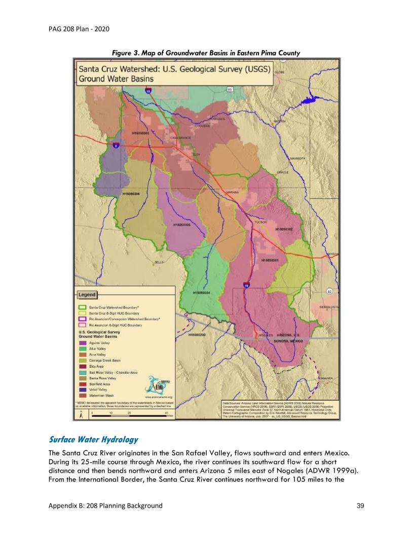
PAG 208 Plan - 2020
Appendix B: 208 Planning Background 39
Figure 3. Map of Groundwater Basins in Eastern Pima County
Surface Water Hydrology
The Santa Cruz River originates in the San Rafael Valley, flows southward and enters Mexico.
During its 25-mile course through Mexico, the river continues its southward flow for a short distance and then bends northward and enters Arizona 5 miles east of Nogales (ADWR 1999a). From the International Border, the Santa Cruz River continues northward for 105 miles to the

PAG 208 Plan - 2020
Appendix B: 208 Planning Background 40
confluence of the Gila River (ADWR 1999, 1999a). Mostly ephemeral, there are two effluent-dependent reaches downstream of Nogales, Arizona, and Tucson, Arizona. Significant tributaries
of the Santa Cruz River include Cienega Creek, Pantano Wash, Rillito Creek also known as the Rillito River, Julian Wash, Rincon Creek, Tanque Verde Wash, Sabino Creek and Cañada del Oro
Wash. Brawley Wash is a tributary of the Lower Santa Cruz River.
The majority of the surface watercourses in Pima County are currently ephemeral, flowing only in
response to runoff events. Figure 4 shows the Santa Cruz River flowing in the 1900s. In a 2000 report, 32 perennial streams were identified in Pima County (PAG 2000). Surface water sources
are discussed in more detail later in this appendix.
Figure 4. Photo of 1900s Vegetation along a flowing Santa Cruz River from Sentinel Peak (AZ Historical Society)
Biology
Vegetative Communities and Habitat
There are six native vegetative communities in Pima County, categorized based on elevation
ranges (Figure 5). Sonoran Desert scrub and desert grasslands exist between 2,000 and 4,000 feet above mean sea level. Creosote bush, saltbush, palo verde trees, saguaro, and other
succulents are present at this elevation range. Lower temperatures and increased precipitation in the mountains support mid-elevation oak and juniper woodlands, and at the highest elevations, coniferous forests (PAG 2003).

PAG 208 Plan - 2020
Appendix B: 208 Planning Background 41
Along riparian reaches, native cottonwood, willow, and velvet mesquite can be found. However, non-native species such as Lehmann lovegrass, salt cedar (tamarisk), Johnson grass, and giant
reed are displacing native vegetation in riparian areas (PAG 2003a) as well as in desert areas. Escaped landscape plants have been identified in wild areas (Pima County 2002).
Figure 5. Diagram of Major Vegetation Types
Source: https://uanews.arizona.edu/story/ua-college-science-produces-mount-lemmon-audio-tour
In addition to the proliferation of non-native vegetative species, habitat destruction stemming
from other causes is also occurring. Urban growth in eastern Pima County, upper elevation fires, and drought conditions have displaced animal and plant species. Over the last two decades, fires
of differing magnitudes have burned in the mountains surrounding Tucson and other Pima County locations: the 2003 Aspen Fire31 and 2002 Bullock Fire32 (Santa Catalinas), 2012 Montezuma
Fire33 (Baboquivari Peak Wilderness), and 2017 Burro Fire34 (Santa Catalinas). Fires can lead to increased sediment discharge, flood potential, and water quality changes in associated valleys
(Meixner et al. 2004, Woodhouse 2004).
The Pima County Sonoran Desert Conservation Plan (SDCP) was developed in the early 2000s to help mitigate habitat loss. It designates priority habitat areas for identified vulnerable species
and general biodiversity purposes and directs urban growth into other areas. Priority habitat areas include the Altar Valley, Baboquivari Mountains, Cienega Creek, Eastern Tucson Riparian
Complex, Organ Pipe/Goldwater Complex, Sabino Canyon, San Pedro River, Santa Rita Mountains, Silverbell Mountains, Tortolita Mountains and Tucson Mountains (Pima County 2004). As
part of the SDCP, Pima County developed the Multi-Species Conservation Plan (MSCP) to address endangered species compliance under the Endangered Species Act (ESA) Section 10 Permit. The
MSCP was approved by the U.S. Fish and Wildlife Service in 2016 and will be in effect for 30 years. This plan details what development activities are covered by the permit, how to mitigate
31http://www.tucsonfirefoundation.com/wp-content/uploads/2012/07/2003-Aspen-Fire-MLFD.pdf 32http://www.tucsonfirefoundation.com/wp-content/uploads/2012/07/2002-Bullock-Fire-MLFD.pdf 33https://web.archive.org/web/20120616031705/http://inciweb.org/incident/2897/ 34http://ktar.com/story/1642291/burro-fire-tucson-26000-51-percent/
PAG 208 Plan - 2020
Appendix B: 208 Planning Background 42
any impacts, and how to manage covered species encountered during development. In addition, Pima County has developed a Habitat Conservation Plan as part of the SDCP to mitigate
incidental takes of listed species.
Local conservation plans that have been adopted or are under development are available at the
following website links.
Pima County Sonoran Desert Conservation Plan35
City of Tucson Habitat Conservation Plan36
Town of Marana Draft Habitat Conservation Plan37
PAG coordinates 208 planning with conservation land use planning. The local governments’ habitat conservation efforts tend to focus on areas that serve as wildlife corridors to publicly protected lands such as national parks or forests and cover several aquatic and riparian-based
ecosystems. The diverse vegetative communities present on mountain ranges support a variety of vulnerable species and habitats, especially for animals with large ranges. In addition, some of the
last remaining perennial streams are located in the upper elevations. It is therefore important to maintain connections between these areas for wildlife.
The Regional Transportation Authority’s (RTA) Wildlife Linkages38 program aims to incorporate wildlife crossing improvements into new roadway projects and retrofit existing roadways with
improved crossings. The RTA has worked with the Arizona Department of Transportation to incorporate wildlife crossings into the State Route 77 widening project north of Tucson. As of 2018, an overpass and underpass for wildlife have been completed, along with fences to help to
funnel wildlife to these crossings. As of June 2018, camera surveillance by the Arizona Game and Fish Department had recorded a total of 4,418 wildlife crossings at these locations (Arizona
Game and Fish Department 2018).
Wildlife
The extensive elevation range in Pima County yields a diversity of animals and plants in the
Sonoran Desert and surrounding mountains. Most of the wildlife in Arizona depends on watercourses for at least one critical life stage for their survival, either through shelter, crossings
and connectivity, or ephemeral or perennial water sources (Arizona Riparian Council, 2004). Common year-round mammals include bobcats, javelinas, and coyotes. Most native amphibians,
reptiles (including many rattlesnakes) and rodents hibernate over the winter and emerge in the spring. Common Sonoran Desert reptile species include the Gila monster, desert iguana, gopher snake and banded gecko. Native avian species include the cactus wren, Gila woodpecker,
Gambel’s quail, roadrunner and Harris’s hawk. Many species of butterflies, bats and birds migrate through the desert washes, riparian woodlands and pine forests between their wintering
areas in the subtropics to their nesting areas. Non-native aquatic species such as bullfrogs, mosquitofish, green sunfish, and crayfish have displaced native species such as leopard frogs,
Gila topminnow and Gila chub in much of the region (Pima County 2002).
35http://webcms.pima.gov/government/sustainability_and_conservation/conservation_science/the_sonoran_desert_conservation_plan/ 36https://www.tucsonaz.gov/pdsd/city-tucson-habitat-conservation-plan-hcp 37https://www.fws.gov/southwest/es/arizona/Documents/HCPs/Marana/09_TOM_dHCP.PDF 38http://www.rtamobility.com/RTAProjects/WildlifeLinkages/tabid/102/Default.aspx

PAG 208 Plan - 2020
Appendix B: 208 Planning Background 43
In 2013, the only fish species found in the Santa Cruz River in Pima County was the non-native western mosquitofish. Water quality improvements for discharged effluent, however, have made
it possible for native fish to return to the river. In 2017, the endangered Gila topminnow was one of six species found in the effluent-dependent stretch of the Santa Cruz River in Pima County
(Sonoran Institute 2018b).
The U.S. Fish and Wildlife Service (FWS) maintains a current Endangered Species List39 for plant
and animal species along with critical habitats located in Pima County.
Aquatic Species
Arizona’s native fish have managed to survive drought and flash floods while inhabiting all forms
of waterways, from small springs, ponds, and lakes to the Colorado River; however, the native fish species have been in sharp decline. This decline has been attributed to the introduction of non-
native fish and loss or alteration of habitat. In Pima County, the decline in native aquatic species has been due to the introduction of nonnative species such as the mosquitofish and bullfrog and the decrease in perennial surface waters, most notably the Santa Cruz River and Rillito Creek.
There are several native aquatic species in the Santa Cruz River watershed. Native species include, but are not limited to, the Chiricahua leopard frog, Sonoran Desert toad, Great Plains
toad, Mazatlan narrow-mouthed toad (Tucson Herpetological Society 2019) Southwestern Woodhouse’s toad, narrow-mouthed toad, canyon tree frog, lowland leopard frog (PAG 2001),
longfin dace, desert sucker, Sonora sucker, desert pupfish, Gila chub, Gila topminnow, Quitobaquito pupfish, Sonoyta mud turtle, Tarahumara frog and speckled dace
(Pima County 1999).
Historically, these species would be found all along the Santa Cruz River. However, many species disappeared from Pima County by 1940, while some can still be found in tributaries such as
Cienega Creek. The Chiracahua leopard frog is a threatened species and has limited natural habitat in Pima County. The Sonora sucker and desert pupfish can no longer be found in Pima
County, whereas the Gila topminnow and Gila Chub can still be found in limited areas and are federally listed as endangered. The Gila topminnow was federally listed as endangered in 1967
and the Gila Chub was listed in 2002.
In 2002, Pima County began developing the MSCP as part of the SDCP to “avoid, minimize, and
mitigate impacts to both listed and unlisted species and their habitats” due to private development, construction, and maintenance activities in the region. Many native aquatic species were identified in 2002 as vulnerable40, threatened or endangered41. The Final 2018 MSCP42
covers 44 species, including five species of native fish and two species of native frogs. Two of the fish species are federally listed as endangered and one of the native frogs is listed as
threatened.
Native fish conservation efforts have been undertaken by the Arizona Game and Fish Department
and other governmental agencies with the goal to “manage and conserve the state’s native fish species through on-the-ground conservation projects; threatened and endangered species
39https://ecos.fws.gov/ipac/location/JK5QY5MNV5HC3GKUDARXGRDLSQ/resources 40http://www.pima.gov/cmo/sdcp/reports/d25/131PRIOR.PDF 41http://www.pima.gov/cmo/sdcp/reports/d25/135THREA.PDF 42http://webcms.pima.gov/cms/one.aspx?portalId=169&pageId=52674

PAG 208 Plan - 2020
Appendix B: 208 Planning Background 44
recovery; statewide population monitoring; creation and implementation of conservation agreements; provision of research grants; and, public education and outreach” (Arizona Game
and Fish Department 2019).
Population
In Tucson, Arizona, the population was just a few thousand in the 1870s. Urban population growth
in the semi‐arid southwestern region of North America occurred primarily after the end of World
War II (Plummer et al. 2004). In the time since the original 208 Plan was adopted in 1978, the
population and the geographic extent of the metropolitan area have grown rapidly. At the time PAG submitted the grant application in 1975 for developing the original 208 Plan, Pima County’s population was estimated at 435,000 (PAG 1975). The 2017 Arizona Office of Economic
Opportunity (OEO) population estimates43 showed a Pima County population of roughly one million. The metropolitan area depended on groundwater and the protection of that groundwater
quality until a major engineering project brought Colorado River water to the city by canal in 1992 (Gelt et al. 1999). Population growth is associated with increases in nonpoint source
pollutants and in the demand for sewage treatment. This Plan looks at the water quality conditions of each of these water sources.
All incorporated jurisdictions in Pima County and unincorporated areas increased in population between 2010 and 2017 (Table 5). Over those years, the population of Arizona and Pima County has grown by 8.98 percent and 4.68 percent, respectively, making Arizona the sixth
fastest growing state in the nation. Pima County contains about 15 percent of Arizona’s population (U.S. Census Bureau 2017). Based on 2017 census estimates, Tucson, the largest
incorporated city in the county, contains slightly more than half the county’s total population. Unincorporated Pima County is somewhat unique, composing about 35 percent of the metro-area
population.
From 2000 to 2017, cities and towns within the PAG region have annexed a total of 73,711
acres. Over that period, Marana, Tucson, Sahuarita and Oro Valley annexed 30,080, 27,605, 10,678, and 4,560 acres, respectively. Eighty-one percent of the annexation occurred from 2000 to 2002 (Pima County 2018).
The towns of Marana and Oro Valley were the fastest and second-fastest growing towns in Arizona in the 1990s. Sahuarita was incorporated in 1994. Since 2000, Sahuarita and Marana
have been the incorporated areas with the fastest population growth rates in the PAG region but with some slowing of the population growth rate since the downturn in the economy in the first
decade of the 2000s. For example, Marana increased 158 percent from 2000–2010 and 30 percent from 2010–2017. Unincorporated Pima County and the City of Tucson have gained
the most people since 2000.
The Pascua Yaqui population living on reservations was 3,315 in 2000 (PAG 2003) and in 2017 it was estimated at 3,761 (Eastern Pima County Adjusted Arizona OEO Sub-County Population
Forecast). The population on the Tohono O’odham Nation was estimated to be 2,181 in 2017 by OEO.
43https://population.az.gov/population-estimates

PAG 208 Plan - 2020
Appendix B: 208 Planning Background 45
Table 5. Population Growth in Pima County – 1980 to 2017
Year Arizona Pima
County Unincorporated Pima County
Tucson South
Tucson Marana
Oro Valley
Sahuarita
1980 2,716,546 531,443 191,179 330,537 6,554 1,674 1,489 *
1990 3,665,228 666,880 247,540 405,390 5,093 2,187 6,670 1,629*
2000 5,130,632 843,746 305,059 486,699 5,490 13,556 29,700 3,242
2010 6,392,017 980,263 353,264 520,116 5,652 34,961 41,011 25,259
2017 6,965,897 1,026,099 363,857 537,634 5,664 45,378 44,517 29,049
Change 2000–2010
1,261,385 136,517 48,205 33,417 162 21,405 11,311 22,017
Percent Change 2000–2010
24.59% 16.18% 15.80% 6.87% 2.95% 157.90% 38.08% 679.12%
Change 2010–2017
573,880 45,836 10,593 17,518 12 10,417 3,506 3,790
Percent Change 2010–2017
8.98% 4.68% 3.00% 3.37% 0.21% 29.80% 8.55% 15.00%
* Sahuarita incorporated in 1994. 1990 population estimated from census tracts approximate to the incorporation
limits of the town.
U.S. census numbers are used for 1980–2010. The population estimates from 2011 to 2015 were
produced under the Arizona Department of Administration (ADOA). The state demographer’s office was transferred to OEO in August 2016. Newer estimates are under OEO.
For future projections of population see the Water Quality Management chapter.
Local Governments
PAG’s membership when the original 208 Plan was adopted in 1978 included only Tucson, Pima
County, and South Tucson (PAG 1975). Over time, PAG’s membership has grown to include Tucson, Pima County, South Tucson, Oro Valley, Marana, Sahuarita, the Tohono O’odham Nation, the Pascua Yaqui Tribe and the Arizona Department of Transportation. Each jurisdiction is
governed by an elected board (i.e., Mayor and Council, Native American council, board of supervisors), and the cities and towns also directly elect a mayor and appoint management staff.
Department staff members for publicly provided services (i.e., transportation, human resources, planning, police) are appointed in each jurisdiction. One elected official from each jurisdiction
serves on the PAG Regional Council, which acts on regional transportation, environmental, and planning issues.
In August 2004, legislation was passed to allow a Regional Transportation Authority (RTA) governed by the PAG Regional Council to plan and fund regional transportation projects in eastern Pima County. In 2006, an excise tax was approved by voters to use the generated
income to fund projects, as part of a voter-approved plan.

PAG 208 Plan - 2020
Appendix B: 208 Planning Background 46
Land Use/Ownership
Approximately 87 percent of Pima County consists of land owned by the federal and state
governments and Native American nations. Native American nations account for 43 percent of the total land area, primarily in central Pima County. The State of Arizona owns 14 percent, and the
U.S. Government owns 30 percent, which consist of national parks, monuments, forests, wildlife refuges, and an Air Force base. Local government and private and corporate ownership account for the remaining 13 percent. Overall land ownership in Pima County is shown in Figure 6, and
government land ownership in Pima County is shown in Figure 7.
Figure 6. Pie Chart of Land Ownership in Pima County, 2017
Figure 7. Pie Chart of Government Land Ownership in Pima County, 2017
Data Source: Arizona Department of Revenue Property Use Code Manual
Land uses in Pima County are diverse, with sometimes quite disparate land uses occurring in the same geographic area. In western Pima County, small, unincorporated communities and open
space cover the landscape. Public preserves are parcels and land units that are managed for the preservation of biological values and environmental and cultural resources. They are owned by a

PAG 208 Plan - 2020
Appendix B: 208 Planning Background 47
variety of public and private entities, and in some cases, the owner and manager are not the same. Open space includes vacant, undeveloped land parcels. Central Pima County contains 97
percent of all county Native American lands and is mostly undeveloped vacant land and open space. In contrast, eastern Pima County consists of urbanized areas, especially around the Tucson
metropolitan area. Agricultural use is most prevalent along the I-10 corridor in Marana in the downstream part of our watershed, and vacant ranchlands and open space make up the
southeastern, northeastern and eastern corners of the county (the southern and eastern portions of which are in the upper portions of our watershed). Also, upstream, heavy industrial use parallels
the I-10 and I-19 corridors including the operational mines near Sahuarita. Incorporated areas in eastern Pima County continue to expand as open space and developed areas are annexed. Figure 8 shows the land uses in eastern Pima County in 2017.
Figure 8. Bar Chart of Land Use in Eastern Pima County, 2017
The data sources for PAG’s analysis for land uses consisted of the Arizona Department of Revenue Property Use Code Manual and these Pima County GIS files:
• paregion (July 12, 2018) – contains parcel data and property use codes
• preserve (June 27, 2018) – identifies protected public lands
• golf (March 12, 2015) – identifies golf courses in Pima County
• park_rec (May 16, 2018) – identifies public parks in Pima County

PAG 208 Plan - 2020
Appendix B: 208 Planning Background 48
Water Resources
Five principal water resource categories are present in Pima County (Table 6).
Table 6. Water Resources in Eastern Pima County
Resource
Groundwater
CAP water
Reclaimed water (treated effluent)
Surface water
Stormwater runoff
Although these resources can be hydrologically linked, they are not necessarily managed as such.
For example, surface water and groundwater use are regulated separately by the state through an assigned water rights system (Water Education Foundation et al. 2007). In addition, water
management criteria consider groundwater, CAP water and effluent as regulated water resources, whereas harvested stormwater is not, unless it becomes subject to surface water rights,
per Arizona Revised Statutes. § 45-141.
The following links provide the best available water resources data for the Tucson AMA.
ADWR Tucson AMA Home Page44
Arizona Water Atlas Volume 8: Active Management Areas Atlas45
ADWR Groundwater Authorities in AMAs46
Shallow Groundwater and Riparian Areas
Historically, groundwater has been the most extensively used water resource in Pima County. Most
of the groundwater demand has occurred in eastern Pima County, in the Upper Santa Cruz and Avra Valley subbasins. Groundwater in these areas is used for public drinking water supplies,
landscape irrigation, agricultural irrigation, and industrial uses (including mining). Throughout most of the county, groundwater is withdrawn from wells that tap deep aquifers found in the alluvial basins. Elsewhere, groundwater is drawn from shallow wells tapping comparatively localized
sources, such as fractured bedrock, floodplain aquifers or perched aquifers.
According to the Tucson AMA Fourth Management Plan prepared by ADWR, groundwater
withdrawal in the Tucson AMA has been declining since 2002 as reliance on renewable supplies has increased. Groundwater demand in 2002 was 287,745 acre-feet, dropping to 193,349
acre-feet in 2013. From 2010–2013, the annual aquifer gains (i.e., groundwater inflow and recharge) exceeded the annual aquifer losses (i.e., groundwater outflow, pumping, riparian
evapotranspiration) within the Tucson AMA resulting in a safe-yield condition. However, the ADWR management goal of safe-yield is defined as achieving a “long-term balance” between
44https://new.azwater.gov/ama/tucson 45http://infoshare.azwater.gov/docushare/dsweb/Get/Document-10433/Volume_8_final.pdf 46http://infoshare.azwater.gov/docushare/dsweb/View/Collection-90

PAG 208 Plan - 2020
Appendix B: 208 Planning Background 49
withdrawals and recharge. Increasing use of renewable water sources and continuing to conserve water are necessary for the Tucson AMA to achieve and maintain safe-yield.
Current groundwater conditions in the Tucson AMA can be reviewed at the following links.
ADWR Fourth Management Plan for the Tucson AMA47
ADWR Hydrology Division Tucson Regional Model48
NEMO Watershed-Based Plan Santa Cruz Watershed49
Shallow Groundwater Areas
As our region’s population expands and groundwater pumping continues, it becomes increasingly
important to understand pumping trends for sensitive areas (e.g., shallow groundwater areas
[SGWAs]) so that riparian habitats and private well owners are not compromised. SGWAs have water tables that lie less than 50 feet below the ground surface, and they are often demarcated
by indicator vegetation, such as mesquite and cottonwood trees. Figure 9 provides a diagram illustrating shallow groundwater-dependent aquifers. Because riparian trees depend on groundwater, they become vulnerable if groundwater levels decline. While habitat supported in
SGWAs is critical to the region’s wildlife, the water resources in these basins also provide water to numerous private well owners and public water systems. With continued warming and drought,
there will undoubtedly be increased competition for water resources in these delicately balanced systems.
PAG released the updated and expanded report, Shallow Groundwater Areas in Eastern Pima County, Water Well Inventory and Pumping Trend Analysis, in 2012. The study identifies 32
SGWAs, grouped into 10 regions (Figure 10), and uses ADWR and PAG well data to describe water level changes, water use trends, well densities and drilling histories. The report includes a series of trend analyses on pumping data from non-exempt wells, but it also provides a general
summary of data collected from the exempt wells. Exempt wells are permitted to withdraw up to 35 gallons per minute (GPM), but no pumping data are available for these wells. Non-exempt
wells may pump more than 35 GPM and are required to monitor pumping using approved measuring devices, report pumping volumes to the state and pay fees associated with pumpage.
In addition, withdrawing groundwater from a non-exempt well requires a groundwater right or permit and the use of that water is pursuant the use(s) specified in that right or permit
(correspondence with ADWR contact, January 2020). The trend analysis helps identify those areas that have experienced increased or decreased groundwater withdrawals from non-exempt wells over the last two decades. Overall, as of 2012, the total number of exempt wells drilled in
the buffered areas has steadily increased since 1990 (PAG 2012).
47http://infoshare.azwater.gov/docushare/dsweb/Get/Document-10038/TAMA_4MP_Complete.pdf 48https://new.azwater.gov/hydrology/groundwater-modeling/tucson 49https://legacy.azdeq.gov/environ/water/watershed/download/nemo-santa_cruz-wp.pdf

PAG 208 Plan - 2020
Appendix B: 208 Planning Background 50
Figure 9. Diagram of Shallow Groundwater-Dependent Ecosystem
PAG’s efforts to inventory wells and monitor riparian health in the region have revealed that increasing numbers of active wells on the region’s urban periphery impact remaining perennial
creek flows that are dependent on SGWAs (Figure 11). This has resulted in a growing number of model groundwater management strategies, projects, outreach, and partnerships. Monitoring
water levels and improving education to private well owners are essential to ensure that riparian corridors associated with SGWAs are not adversely impacted in the future. More information
about these efforts is available on the PAG Water Resources webpage50.

PAG 208 Plan - 2020
Appendix B: 208 Planning Background 51
Figure 10. Map of Shallow Groundwater Areas of Eastern Pima County (PAG SGWA Report 2012)

PAG 208 Plan - 2020
Appendix B: 208 Planning Background 52
Figure 11. Map of Exempt and Non-Exempt Water Production Wells in Eastern Pima County (2012)

PAG 208 Plan - 2020
Appendix B: 208 Planning Background 53
Conservation Effluent Pool
Pima County and the City of Tucson have set aside 10,000 acre-feet per year of effluent for use
in riparian restoration projects. This effluent is designated as the CEP. The CEP was established in 2000 to provide water for future riparian projects. Program progress was made through an
implementation IGA in 2011, and later through identification of potential priority sites by a Task Force in 2013 and the appointment of administrators in 2014 (Pima County Regional Wastewater Reclamation Department 2018).
No CEP water has been allocated at this time; however, many logistical barriers have been removed and applications are now available online for use by qualified jurisdictions. The CEP
administrative procedures have established the process for considering CEP requests, addressed how allocations and apportionments will be made, required an accounting of quantities used,
addressed how CEP water will be delivered and scheduled, and require project status reporting. Contributors to the CEP, plus the Pima County Regional Flood Control District (RFCD), are qualified
to apply for CEP water for riparian projects under the IGA. Community organizations can work with qualified applicants to use the CEP. The largest barrier to implementation may be costs associated with implementing a riparian project.
Prospective sites have been identified for use of CEP water, including the Tucson Water’s Santa Cruz River Heritage Project51. As of June 2019, Tucson Water discharges reclaimed water into
the Santa Cruz River near downtown Tucson to restore the habitat and vegetation along this reach and provide new economic and recreational opportunities.
Another potential use of the effluent pool under consideration is for riparian mitigation projects under Section 7 or Section 10 of the ESA. Projects that impact endangered fish, such as the Gila
topminnow, will require a Section 7 or Section 10 permit per the ESA. The CEP is available to assist with mitigating these impacts by maintaining a minimum flow in the river to support the Gila topminnow population. Additional potential uses for the effluent pool are being pursued. More
information can be found in the 2014 Conservation Effluent Pool Task Force Report52.
Central Arizona Project Water
Construction of the CAP aqueduct began in 1973 and was completed 20 years later south of Tucson. The
CAP aqueduct is 336 miles long and transports Colorado River water from Lake Havasu to cities, towns,
and farms in central and southern Arizona, including Tucson. Some of the CAP water is stored in and
released from Lake Pleasant, which is impounded by the New Waddell Dam on the Agua Fria River
northwest of Phoenix. CAP water allocations in Pima County are shown in Table 7.
Table 7. Central Arizona Project Subcontracts in the Tucson AMA (CAP 2017)
A. Non-Indian Municipal and Industrial Subcontracts
Entity Annual Entitlement
(acre-feet)
Tucson Water 144,191
Metropolitan Domestic Water Improvement District 13,460
51https://www.tucsonaz.gov/water/SCRHP 52https://webcms.pima.gov/UserFiles/Servers/Server_6/File/Government/Administration/CHHmemosFor%20Web/August%202014/august%207,%202014%20-%20Conservation%20Effluent%20Pool%20Taskforce.pdf

PAG 208 Plan - 2020
Appendix B: 208 Planning Background 54
Entity Annual Entitlement
(acre-feet)
Town of Oro Valley 10,305
Spanish Trail Water Co. 3,037
Community Water Company of Green Valley 2,858
Flowing Wells Irrigation District 2,854
Town of Marana 2,336
Green Valley Domestic Water Improvement District 1,900
Vail Water Co. 1,857
TOTAL 182,798
B. CAP Indian Contracts
Entity Annual Entitlement
(acre-feet)
San Xavier (Tohono O’odham Nation) 50,000
Schuk Toak (Tohono O’odham Nation) 16,000
Pascua Yaqui 500
TOTAL 66,500
This link provides access to the Current Status of CAP Subcontracts53.
The Tohono O’odham Nation San Xavier District was originally allocated 27,000 acre-feet and received an additional 23,000 acre-feet of non-Indian agricultural priority water relinquished
pursuant to the Arizona Water Settlement Agreement. See the Southern Arizona Water Rights Settlement Amendments Act of 2004 §§ 304(a)(1) and 306(a)(1). The Schuk Toak District was
originally allocated 10,800 acre-feet and received an additional 5,200 acre-feet of non-Indian agricultural priority water relinquished pursuant to the Arizona Water Settlement Agreement54.
See Id. § 304(a)(2) and 306(a)(2).
CAP water recharge is discussed in the Recharge section.
Reclaimed Water
Reclaimed water is effluent generated from a WRF that has been treated to a reclaimed water quality standard established by ADEQ. See ADEQ Standards for WRF55 for more information.
Reclaimed water can be used directly for irrigation or other non-potable uses. It offsets the use of groundwater that would otherwise be used to irrigate landscaping, golf courses, parks, school yards and road medians. Reclaimed water in our region is also recharged to the aquifer,
typically by constructed recharge basins or natural stream channels.
City of Tucson Reclaimed Water
The City of Tucson is the largest user and provider of reclaimed water for irrigation uses in Pima
County. The City of Tucson also provides reclaimed water to other water providers in the metropolitan area. In 2017, the Pima County Regional Wastewater Reclamation Department
(PCRWRD) WRFs generated 19,966 acre-feet of reclaimed water for the City of Tucson
53https://www.cap-az.com/departments/water-operations/allocations 54https://www.congress.gov/108/plaws/publ451/PLAW-108publ451.pdf 55http://legacy.azdeq.gov/environ/water/standards/
PAG 208 Plan - 2020
Appendix B: 208 Planning Background 55
Reclaimed Water System (PCRWRD 2018). Information regarding the use of reclaimed water by the City of Tucson and other entities can be accessed through the City of Tucson Technical Library
at City of Tucson Reclaimed Water56.
The City utilizes most of its effluent from the Agua Nueva WRF at Tucson Water’s Sweetwater
Recharge Facilities (SRF), which include a Reclaimed Water Treatment Plant (RWTP), several constructed recharge basins and the Sweetwater Wetlands. Effluent is directed to the RWTP for
chloramination prior to being discharged to the Reclaimed Water System for delivery to customers. In the winter when demand is low, the effluent is directed to the recharge basins, where
it infiltrates through the subsurface and helps replenish the aquifer. In the summer when demand is high, the recharged effluent is pumped out and delivered to the RWTP before being discharged to the Reclaimed Water System for delivery to customers. The SRF is permitted to recharge up to
13,000 acre-feet per year of effluent.
One of the most well-known features at the SRF is the Sweetwater Wetlands. Effluent is directed
to the wetlands area, where it supports wildlife vegetation and habitat. The Sweetwater Wetlands is operated like a park, where visitors can observe birds and other wildlife and learn
about the site’s archaeological history, ecology, and water resources. More information may be obtained from the Tucson Water website57.
Tucson Water has completed one additional effluent recharge project and is constructing a second. The source water for both projects is reclaimed water delivered from the City’s RWTP through the Reclaimed Water System to the project sites.
The Santa Cruz River Heritage Project is permitted to recharge up to 3,150 acre-feet per year. It began operating in June 2019 and discharges effluent into the Santa Cruz River near downtown.
The aim is to restore surface water flows in a low-flow channel, support the establishment of wildlife habitat and promote economic development and restoration of a cultural heritage site.
The Southeast Houghton Area Recharge Project (SHARP) is permitted to recharge up to 4,000 acre-feet per year. It is expected to be completed in 2020 and will recharge reclaimed water
into constructed recharge basins near Houghton and Drexel Roads. It will include recreational and educational components, and like the Sweetwater Wetlands, will be operated like a park.
Tucson Water also participates in two managed effluent recharge projects along the Santa Cruz
River. The Santa Cruz River Managed Underground Storage Facility and the Lower Santa Cruz River Managed Recharge Project are in-channel recharge projects located downstream of the
Agua Nueva and Tres Rios WRFs, respectively. See additional details in the Recharge section below.
Pima County Reclaimed Water
Section IV of the 2017 Effluent Generation and Utilization Report prepared by PCRWRD provides information specific to reclaimed water use. More information can be accessed at Pima
County Reclaimed Water58.
56https://www.tucsonaz.gov/water/technical-library 57https://www.tucsonaz.gov/water/about-sweetwater-wetlands-and-access and sweetwater guide 58https://webcms.pima.gov/UserFiles/Servers/Server_6/File/Government/Administration/CHHmemosFor%20Web/2018/June/2017%20Effluent%20Generation%20and%20Utilization%20Report.pdf

PAG 208 Plan - 2020
Appendix B: 208 Planning Background 56
The following links provide reclaimed water information for other utilities in Pima County.
Metropolitan Domestic Water Improvement District Reclaimed Water59
Oro Valley Water Utility Reclaimed Water60
Marana Water Utility Reclaimed Water61
Recycled Water
Under A.A.C. Title 18, Chapter 9, Article 7, since 2018 the State of Arizona has allowed the production of recycled water for potable uses. Advanced reclaimed water treatment facilities
may be constructed to treat, purify, and recycle Class A+ or Class B+ reclaimed water to produce potable water that is suitable for distribution for human consumption. Recycled water is
treated to meet designated water quality specifications for potable use. More information is available on the ADEQ Recycled Water Rulemaking62 webpage.
In 2016, Pima County won the Water Innovation Challenge63 with a proposal to build a mobile potable reuse treatment facility to travel around the state and change public perception about
the use of recycled water. The prize funded Pima County’s award-winning Pure Water Brew Challenge64.
Recharge
The CAP water in Pima County is delivered to recharge basins or farms. In the recharge basins, the CAP water is either recharged and recovered annually or recharged for long term storage
for future use. Some farms use the CAP water to offset groundwater pumping. The CAP delivery locations in Pima County are shown in Figure 12 and Figure 13.
https://www.congress.gov/108/plaws/publ451/PLAW-108publ451.pdf
Most CAP subcontractors in the Tucson AMA store or use their CAP allocations in Underground
Storage Facilities (USFs) or Groundwater Savings Facilities (GSFs) permitted by ADWR. Effluent is considered another renewable water supply that is used for aquifer recharge.
59https://metrowater.com/index.php?pg=32 60https://www.orovalleyaz.gov/town/departments/water-utility/potable-and-reclaim-water 61http://www.maranaaz.gov/water-reclamation/ 62https://azdeq.gov/recycled-water-rulemaking 63http://webcms.pima.gov/cms/One.aspx?portalId=169&pageId=311478 64http://www.azpurewaterbrew.org/

PAG 208 Plan - 2020
Appendix B: 208 Planning Background 57
Figure 12. Map of Tucson AMA Permitted Groundwater Savings Facilities
This image is a preview. For a full resolution map, visit: http://infoshare.azwater.gov/docushare/dsweb/Get/Document-10279/Tucson_GSF_21705.pdf

PAG 208 Plan - 2020
Appendix B: 208 Planning Background 58
Figure 13. Map of Tucson AMA Underground Storage Facilities
This image is a preview. For a full resolution map, visit: https://new.azwater.gov/sites/default/files/media/Tuscon_AMA_USFs_2016_0.pdf

PAG 208 Plan - 2020
Appendix B: 208 Planning Background 59
USFs are constructed recharge basins or managed facilities using natural streambeds where a renewable water supply is allowed to percolate into the aquifer for the accumulation of annual or
long-term storage credits. Credits can be recovered (pumped) under a Recovery Well permit and the water recovered retains the legal definition of the original source water recharged (e.g., CAP
water, effluent). GSFs are agreements between agricultural irrigation grandfathered right holders and CAP subcontractors to use CAP water for irrigation in lieu of pumping groundwater.
GSFs can also be established using effluent.
Permitted recharge facilities located in the Tucson AMA are developed for the accumulation of
water credits that can be stored and/or recovered to meet the state’s Assured Water Supply (AWS) program requirements. For example, Tucson Water recovers a blend of CAP water and groundwater from its Avra Valley recharge facilities and delivers that water to customers for
potable use.
Effluent recharge credits within the PAG region have trended upwards due to increased
infiltration and dramatically reduced flow out of the Tucson AMA, which is likely due to improved water quality from upgraded treatment plants and concurrent clearing of organic matter that was
plugging sediment in the channel bottom. Additionally, new rules in 2019 allowing increased recharge credit for managed in-channel projects will allow greater accrual of credits in the
region. See additional details on reclaimed recharge projects in the Reclaimed Water section above.
Table 8 provides links to current recharge information within the Tucson AMA, including facility
names, locations, operators, permittees, permit number and permitted volume. More information on the USFs and GSFs in the Tucson AMA can be found on the ADWR website65. Maps of existing
USFs and GSFs in the Tucson AMA are shown in Figure 12 and Figure 13. Table 9 provides a list of the current recharge facilities in the Tucson AMA.
Table 8. Recharge Information for the Tucson AMA
Data Source Web Link
ADWR Recharge Program https://new.azwater.gov/recharge
Assured and Adequate Water Supply Program https://new.azwater.gov/aaws
ADWR Permitted Recharge Facilities https://new.azwater.gov/recharge/permitted-facilities
ADWR Permitted Active USFs
http://www.azwater.gov/querycenter/query.aspx?qrysessionid=4BF6C620A82B9838E0534C00000A47B1
ADWR USF Projects and Locations
https://new.azwater.gov/sites/default/files/media/Tuscon_AMA_USFs_2016_0.pdf
ADWR Permitted Active GSFs
http://www.azwater.gov/querycenter/query.aspx?qrysessionid=4C8820B502DD32F9E0534C00000A01DC
City of Tucson Recharge
https://www.tucsonaz.gov/water/recharged-water
https://www.tucsonaz.gov/water/cavsarp
https://www.tucsonaz.gov/water/savsarp
CAP Recharge
http://www.cap-az.com/departments/recharge-program
http://www.cap-az.com/departments/recharge-program/pima-mine-road
http://www.cap-az.com/departments/recharge-program/lower-santa-cruz
65https://new.azwater.gov/recharge

PAG 208 Plan - 2020
Appendix B: 208 Planning Background 60
Table 8. Recharge Information for the Tucson AMA
Data Source Web Link
Town of Marana Recharge http://www.maranaaz.gov/news/water/recharge17
Pima County Recharge http://webcms.pima.gov/UserFiles/Servers/Server_6/File/Government/Wastewater%20Reclamation/Publibations/Effluent_gen_2016.pdf
Metro Water Recharge http://www.metrowater.com/index.php?pg=32
Table 9. List of Recharge Facilities in Pima County
USF/GSF Facility Name
GSF ASARCO Facility
GSF Cortaro Marana Irrigation District
GSF BKW Farms
GSF Kai Farms Red Rock
GSF BKW Milewide
GSF Fico Sahuarita Farm
USF Southern Avra Valley Storage and Recovery Project (SAVSARP)
USF PCRWRD Corona de Tucson Recharge Facility
USF Project Renews
USF Black Wash
USF Marana WRF Recharge Project
USF Tucson Water SHARP
USF Sweetwater Recharge Facilities
USF Santa Cruz Managed
USF Lower Santa Cruz Replenishment Project
USF Marana High Plains Effluent Recharge Project
USF Avra Valley Recharge Project Full Scale
USF Pima Mine Road Full Scale
USF Central Avra Valley Storage and Recovery Project (CAVSARP)
USF Robson Ranch Quail Creek
USF Lower Santa Cruz River Managed
USF Town of Sahuarita
USF Santa Cruz River Heritage Project
Effluent Rights
Effluent water rights (entitlements) are typically associated with the entity that owns a WRF. This is the case for public WRFs located in the Marana and Sahuarita DMAs. In most cases, private
WRFs have the legal right to the effluent produced at their facility. Effluent entitlements in the Pima County DMA were established from an effluent water rights agreement between Pima County, the Secretary of the Interior and the City of Tucson based on an IGA that is described in
Section V of the 2017 PCRWRD Effluent Generation and Utilization Report66.
66http://webcms.pima.gov/UserFiles/Servers/Server_6/File/Government/Wastewater%20Reclamation/Publibations/Effluent_gen_2017.pdf

PAG 208 Plan - 2020
Appendix B: 208 Planning Background 61
In 1982, SAWRSA was passed to settle water rights claims by the Tohono O’odham Nation affected by groundwater pumping in the Tucson area. Under SAWRSA, 66,000 acre-feet of
water were to be delivered to the Tohono O’odham Nation each year, with 37,000 acre-feet provided through Indian Priority CAP water and 28,200 acre-feet of effluent provided by the
City of Tucson. Subsequent settlements in 2004 and 2006 confirmed funding for operation, maintenance and delivery of the water and allowed allocation of the water to move forward.
Today, SAWRSA effluent allocations are given priority over other entitlements. The effluent is received by the Bureau of Reclamation on behalf of the Tohono O’odham Nation and is
recharged in the Santa Cruz River.
Entities with effluent entitlements utilize their effluent though direct reuse, off channel recharge, constructed USFs or GSFs, in-channel recharge (i.e. managed recharge), and the recovery of these
credits (Table 10). The City of Tucson has an agreement with metro water providers whereby the water providers receive their share effluent based on the proportion of water they contribute to
the County's sewer system. Several entities partner in a managed effluent recharge project in the Santa Cruz River from the Tres Rios WRF outfall (north of Ina Road) to Trico Road. In accordance
with an IGA, effluent credits associated with the Lower Santa Cruz River Managed Recharge Project are assigned to the various partners as part of the annual ADWR reporting process.
Table 10. Entities Generating and/or Utilizing Effluent in Pima County (PCRWRD 2018)
Metropolitan Non-Metropolitan Other Facilities
Secretary of the Interior* Arivaca Junction WRF Marana WRF
Conservation Effluent Pool Avra Valley WRF Milagro
Pima County Corona de Tucson WRF Marana - Rillito Vista
City of Tucson Green Valley WRF Marana High School
Town of Marana Mt. Lemmon WRF Robson Ranch Quail Creek
Town of Oro Valley Pima County Fairgrounds WRF Saddlebrooke/Saddlebrooke
Ranch
Metro Water Sahuarita WRF
Flowing Wells U of A Tech Park
Spanish Trail
* SAWRSA entitlement
Surface Water
Currently there is limited perennial surface water in Pima County (Table 11). The vast majority of the watercourses in Pima County are ephemeral, where flows consist solely of stormwater runoff
events. In contrast, the number of perennial and intermittent watercourses is relatively small, but the surface water sources are very important habitat for terrestrial and aquatic species.
Table 11. Perennial Streams in Pima County
Reach Name HUC 8 Watershed Reach Name HUC 8 Watershed
Apache Spring Rillito Montosa Canyon Rillito
Arivaca Creek Brawley Wash Nogales Spring Rillito
Bingham Cienega Lower San Pedro Posta Quemada Rillito
Buehman Canyon (3 reaches) Lower San Pedro Quitobaquito Spring Rio Sonoyta
Bullock Canyon Lower San Pedro Romero Canyon Upper Santa Cruz
Cañada del Oro Upper Santa Cruz Ruelas Canyon Upper Santa Cruz
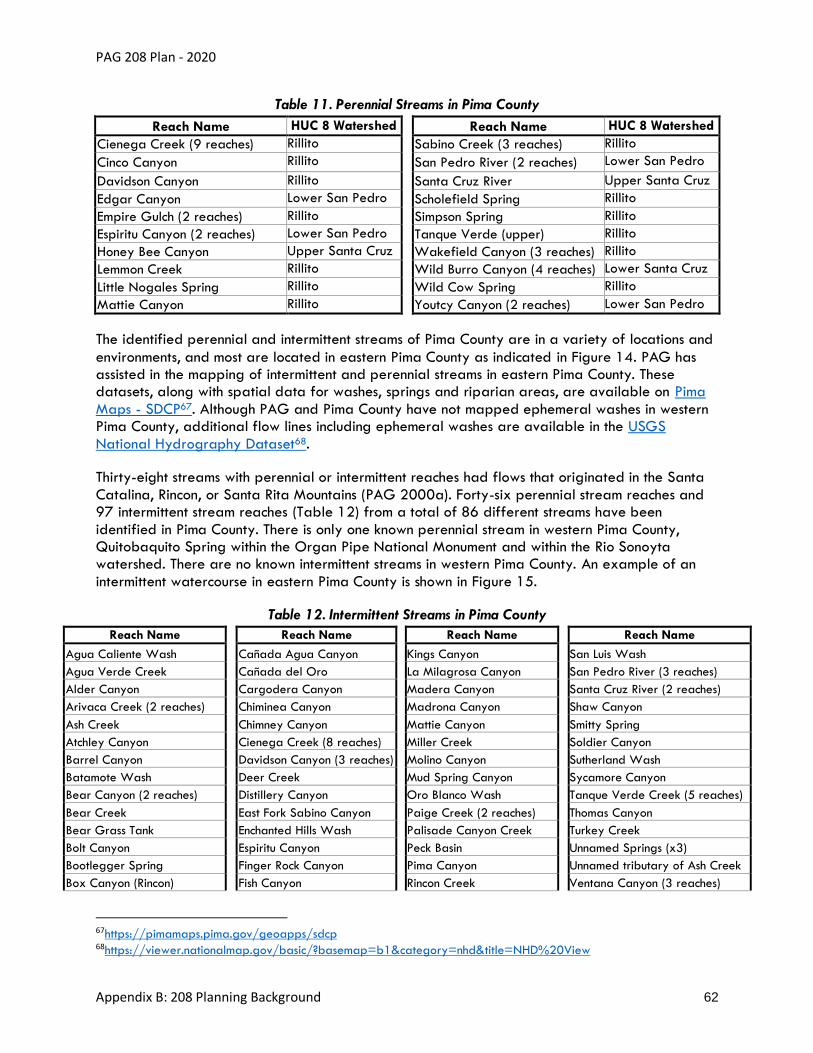
PAG 208 Plan - 2020
Appendix B: 208 Planning Background 62
Table 11. Perennial Streams in Pima County
Reach Name HUC 8 Watershed Reach Name HUC 8 Watershed
Cienega Creek (9 reaches) Rillito Sabino Creek (3 reaches) Rillito
Cinco Canyon Rillito San Pedro River (2 reaches) Lower San Pedro
Davidson Canyon Rillito Santa Cruz River Upper Santa Cruz
Edgar Canyon Lower San Pedro Scholefield Spring Rillito
Empire Gulch (2 reaches) Rillito Simpson Spring Rillito
Espiritu Canyon (2 reaches) Lower San Pedro Tanque Verde (upper) Rillito
Honey Bee Canyon Upper Santa Cruz Wakefield Canyon (3 reaches) Rillito
Lemmon Creek Rillito Wild Burro Canyon (4 reaches) Lower Santa Cruz
Little Nogales Spring Rillito Wild Cow Spring Rillito
Mattie Canyon Rillito Youtcy Canyon (2 reaches) Lower San Pedro
The identified perennial and intermittent streams of Pima County are in a variety of locations and
environments, and most are located in eastern Pima County as indicated in Figure 14. PAG has assisted in the mapping of intermittent and perennial streams in eastern Pima County. These datasets, along with spatial data for washes, springs and riparian areas, are available on Pima
Maps - SDCP67. Although PAG and Pima County have not mapped ephemeral washes in western Pima County, additional flow lines including ephemeral washes are available in the USGS
National Hydrography Dataset68.
Thirty-eight streams with perennial or intermittent reaches had flows that originated in the Santa
Catalina, Rincon, or Santa Rita Mountains (PAG 2000a). Forty-six perennial stream reaches and 97 intermittent stream reaches (Table 12) from a total of 86 different streams have been
identified in Pima County. There is only one known perennial stream in western Pima County, Quitobaquito Spring within the Organ Pipe National Monument and within the Rio Sonoyta watershed. There are no known intermittent streams in western Pima County. An example of an
intermittent watercourse in eastern Pima County is shown in Figure 15.
Table 12. Intermittent Streams in Pima County
Reach Name Reach Name Reach Name Reach Name
Agua Caliente Wash Cañada Agua Canyon Kings Canyon San Luis Wash
Agua Verde Creek Cañada del Oro La Milagrosa Canyon San Pedro River (3 reaches)
Alder Canyon Cargodera Canyon Madera Canyon Santa Cruz River (2 reaches)
Arivaca Creek (2 reaches) Chiminea Canyon Madrona Canyon Shaw Canyon
Ash Creek Chimney Canyon Mattie Canyon Smitty Spring
Atchley Canyon Cienega Creek (8 reaches) Miller Creek Soldier Canyon
Barrel Canyon Davidson Canyon (3 reaches) Molino Canyon Sutherland Wash
Batamote Wash Deer Creek Mud Spring Canyon Sycamore Canyon
Bear Canyon (2 reaches) Distillery Canyon Oro Blanco Wash Tanque Verde Creek (5 reaches)
Bear Creek East Fork Sabino Canyon Paige Creek (2 reaches) Thomas Canyon
Bear Grass Tank Enchanted Hills Wash Palisade Canyon Creek Turkey Creek
Bolt Canyon Espiritu Canyon Peck Basin Unnamed Springs (x3)
Bootlegger Spring Finger Rock Canyon Pima Canyon Unnamed tributary of Ash Creek
Box Canyon (Rincon) Fish Canyon Rincon Creek Ventana Canyon (3 reaches)
67https://pimamaps.pima.gov/geoapps/sdcp 68https://viewer.nationalmap.gov/basic/?basemap=b1&category=nhd&title=NHD%20View

PAG 208 Plan - 2020
Appendix B: 208 Planning Background 63
Reach Name Reach Name Reach Name Reach Name
Brown Canyon Florida Canyon Romero Canyon (2 reaches) Wakefield Canyon (2 reaches)
Buehman Canyon (2 reaches) Gardner Canyon Rose Canyon Creek West Fork Sabino Creek
Bullock Canyon (3 reaches) Geesaman Wash Sabino Canyon Youtcy Canyon (2 reaches)

PAG 208 Plan - 2020
Appendix B: 208 Planning Background 64
Figure 14. Map of Surface Watercourses in Pima County*
*Major washes (10,000 cubic feet per second or greater) that are not overlaid by perennial or intermittent streams are considered ephemeral reaches. There is only one known perennial stream in western Pima County – Quitobaquito Spring (see inset). There are no known intermittent streams in western Pima County, and neither
PAG nor Pima County have mapped major washes for that area.

PAG 208 Plan - 2020
Appendix B: 208 Planning Background 65
Figure 15. Photo of an Intermittent Stream in Eastern Pima County
Three of the perennial stream reaches, Davidson Canyon, Cienega Creek (from I-10 to the USGS gauge station at Pantano Wash), and Buehman Canyon (from headwaters, 9.8 miles
downstream), are classified as OAWs by ADEQ, which means that they are exceptional state resource waters and subject to stricter water quality regulations. All three OAWs are located in
eastern Pima County. OAWs were previously known as “Unique Waters.” See the Adopted Policies and Procedures for a map of OAWs. OAWs also may be viewed on ADEQ eMaps69. Downstream of the OAW reach of Cienega Creek, water is currently diverted for golf course turf
irrigation pursuant to an active surface water right.
The primary surface water drainage in eastern Pima County is the Santa Cruz River. The river,
which is approximately 60 miles long within Pima County, flows north through the Upper Santa Cruz Valley Subbasin and then northwest into the Avra Valley Subbasin. The river is mostly
ephemeral in Pima County (ADWR 1999), except for where effluent-dominated reaches downstream from WRFs currently flow year-round, bringing back perennial waters to this river.
Irrigation canals dating from 1,000 BC to 1873 demonstrate that Tucson had permanent
69http://gisweb.azdeq.gov/arcgis/emaps/

PAG 208 Plan - 2020
Appendix B: 208 Planning Background 66
settlements in the valley founded on the historic perennial flows and making it one of the oldest settlements in America. An example of one such settlement is shown in Figure 16.
Figure 16. Photo of 1910’s Santa Cruz River at El Convento (AZ Historical Society)
The Convento, built in 1770 and abandoned by the late 1800s, was a fortified mission complex used to protect the west side of the flowing Santa Cruz River. The Convento was completely gone by the 1950s,
covered by a landfill.
Major tributaries of the Santa Cruz River in the Upper Santa Cruz Valley Subbasin include the Cañada del Oro, which drains the northern part of the Upper Santa Cruz Valley Subbasin, and Rillito Creek and its tributaries, which drain the area north and east of Tucson. Tributaries of Rillito
Creek include Pantano Wash and Tanque Verde Creek. Pantano Wash receives flow from Rincon Creek and Cienega Creek. Tanque Verde Creek receives flow from Sabino Creek. In the Avra
Valley Subbasin, Altar Wash originates in the southern part of the valley and flows north to become Brawley Wash. Brawley Wash flows to the north and northwest through Avra Valley to
its confluence with the Santa Cruz River southwest of Red Rock.
The San Pedro River is a tributary of the Gila River and drains 4,485 square miles of Arizona
and Mexico. The San Pedro River enters the northeastern corner of Pima County in what is considered the Lower San Pedro Basin. The river is fed by flow from the northeast side of the Santa Catalina Mountains and by two significant drainages from the Galiuro Mountains. Most of
the stream reaches on the San Pedro are intermittent, but in the area around Bingham Cienega there is perennial flow (Royayne and Maddock III 1996).

PAG 208 Plan - 2020
Appendix B: 208 Planning Background 67
Tributaries of the Lower Gila River flow south to north to drain the western third of Pima County. These include Alamo Wash, Cherioni Wash, Chico Shunie Arroyo, Cuerda de Lena, Daniels
Arroyo, Darby Arroyo, Gibson Arroyo, Growler Wash, Gunsight Wash, Kuakatch Wash, Rio Cornez, San Cristobal Wash, Sikort Chuapo Wash and Tenmile Wash.
The San Simon Wash watershed drains the Tohono O’odham Nation and runs northeast to southwest.
Stormwater Runoff
Overland flow from precipitation events is an important source of recharge for the aquifers in Pima County. Groundwater conditions can be greatly affected by occasionally large overland
flow events in the Santa Cruz River and its tributaries. Surface water flows recharge the shallow groundwater system as water infiltrates through stream channel sediments to the underlying
aquifer. According to the Tucson AMA Fourth Management Plan70, stream channel recharge in the Tucson AMA, including effluent discharge, varied from approximately 48,000 to 171,000 acre-
feet per year between 2000 and 2013 (an average of 96,000 acre-feet per year). Between 2000 and 2013, an average of 52,240 acre-feet per year of effluent was discharged into the Santa Cruz River.
In addition to aquifer recharge, stormwater supports riparian vegetation along washes and can support aquatic habitats in retention basins.
70http://infoshare.azwater.gov/docushare/dsweb/Get/Document-10038/TAMA_4MP_Complete.pdf

PAG 208 Plan - 2020
Appendix B: 208 Planning Background 68
Chapter 4: Public Participation Records – 2020 Update
This chapter describes the process used to inform and involve interested parties and the public in the development of the 2020 update to PAG’s Section 208 Areawide Water Quality
Management Plan (208 Plan), followed by documentation of activities, in compliance with all applicable federal, state and PAG requirements.
Policies and procedures for public participation and stakeholder involvement in 208 planning,
including EPA-required advisory groups and public hearings for Amendments, are found in the Policies and Procedures section of the PAG 208 Plan.
Requirements and Process
Relevant federal requirements concerning public participation are described in 40 CFR § 25, and
in state statutes, ADEQ’s Continuing Planning Process71, A.A.C. §§ R18-1-401 and R18-1-402, and PAG’s Public Involvement Policy72.
In accordance with the above stated federal and state regulations, the following public
participation elements were followed:
• Hold Public Hearings on all plan revisions
• Maintain at least one set of appropriate documents in a location accessible to the public
• Develop, maintain, and utilize a notification list of persons or organizations interested in,
or significantly affected by, the 208 planning process
• Publish public notices 45 days before public hearings
• Make relevant documents available at least 30 days before hearings
• Keep records of public hearings
• Develop a responsiveness summary for each public hearing
• Summarize technical documents for public and media uses
• Public meetings and consultations are recommended to be conducted early in the 208-
planning process so that public views can be incorporated into 208 Plan development
As required, the procedures and policies in PAG’s 2006 208 Plan were followed for the 2020
Plan update. The triggers for 208 Plan updates and the procedures were found in section 10.18 of the 2006 208 Plan and PAG’s public participation requirements were listed in section 10.8.
This includes some additional detail to specify how the PAG committee and work plan structure align with the state and federal requirements as follows:
71https://legacy.azdeq.gov/function/forms/download/list/Continuing_Planning_Process_4_93.PDF 72https://pagregion.com/get-involved/public-policies/

PAG 208 Plan - 2020
Appendix B: 208 Planning Background 69
• Five-year updates or sooner if prompted by significant changes or Amendments
• Using a thorough review and approval process to include a public hearing
• Prominently posting information on PAG’s website
• Notification of interested parties and potentially affected property owners
• Action by EPAC and WPS prior to submittal to PAG Regional Council
We relied on the 2006 Plan, section 10.14 (Procedures for Consistency Reports) for guidance regarding the information to include in public notices. Applicable practices named in 10.14 included that the notice must:
• Identify the project location
• Include a description of the project
• Discuss possible impacts to residents
• Explain where to obtain more information
• Explain where and when a decision will be made
• Explain how to provide input
Documentation of Activities
In accordance with the above listed requirements, PAG had undertaken the following activities to
support the development of the 208 Plan. This section serves as PAG’s responsiveness report for public participation in the 2020 PAG 208 Plan update and includes a record of relevant
documents concerning public meetings, consultation, and comments that assisted with the development of the 208 Plan.
These records can be found in the following pages. (We will update this section as we complete and
record these tasks)
Contents:
A. Records of Advisory Group Compliance
B. Summary of Developmental Input
C. Record of WPS/EPAC Meeting to Forward Plan to Public Hearing
D. Records of Public Hearing and Comment Period
E. Records of Recommendation for Plan Approval by PAG Management Committee
F. Records of Plan Adoption by PAG Regional Council
G. Summary of Submission to and Approval by ADEQ
H. Summary of Submission to and Approval by EPA

PAG 208 Plan - 2020
Appendix B: 208 Planning Background 70
A. Records of Advisory Group Compliance
208 Advisory Group Requirement Documentation
To document compliance with regulatory requirements, lists of 208 advisory group membership
and interested parties are included in this section. In addition, a table detailing how the required advisory group categories are fulfilled is included.
Regulations: Advisory Group requirements are described in 25.7 of 40 CFR in the EPA’s CWA. ADEQ requirements are described on page 22 of the October 1984 State Water Quality
Management Plan. The EPA and ADEQ require PAG to maintain ongoing meetings to facilitate 208 planning and to help build consensus. It is also required to post the updated membership,
respond to their information requests, and transmit their recommendations.
EPAC/WPS Meeting Management
Meets at a frequency that ensures ongoing coordination (minimum of once per year). PAG
merged meetings between WPS and EPAC to improve efficiency. Membership gaps are filled and posted annually. Lists of WPS/EPAC members and interested parties who were invited to attend meetings and review the draft 208 Plan are shown in Table 13 and Table 14.
PAG Committee Fact Sheets73
Table 13. List of EPAC and WPS Members
First name Last name Organization
Amanda Smith Sonoran Institute
Andy Bemis City of Tucson DOT
Asia Philbin Town of Marana
Bayer Vella Town of Oro Valley
Beth Abramavitz Town of Sahuarita
Beth Gorman Pima County DEQ
Catherine Schladweiler Tucson Electric Power
Christina McVie Tucson Audubon
Christopher Scott Ortiz y Pino University of Arizona
Claire Zugmeyer Sonoran Institute
Corin Marron Carollo Engineers
Dave Pfordt Town of Sahuarita
David Barnes Freeport McMoRan
David Caskey Freeport McMoRan
David Godlewski Southern Arizona Home Builders Association (SAHBA)
Dee Korich Tucson Water
Eder Delgadillo Tucson Int'l Airport
Edna Mendoza ADEQ
73https://pagregion.com/who-we-are/committees/

PAG 208 Plan - 2020
Appendix B: 208 Planning Background 71
Table 13. List of EPAC and WPS Members
First name Last name Organization
Edward Galda University of Arizona
Eric Roudebush Tucson Int'l Airport
Frank Bonillas City of Tucson
Georgia Pennington University of Arizona
Grace Evans Citizen
Greg Hitt Pima County RWRD
Hannah Oden Town of Oro Valley
Heidi Kocsis Arizona State Land Department
Heidi Lasham Town of Sahuarita
Howard Myers Southern Arizona Home Builders Association (SAHBA)
Ian Geitner Pascua Yaqui Tribe
Jaimie Galayda Tucson Water
Jeff Yockey Tucson Electric Power
Jennifer Christleman Town of Marana
Jim Dubois Pima County RWRD
John Hillman Davis-Monthan Air Force Base
Julie Robinson Pima County OSC
Kim Franklin Arizona-Sonora Desert Museum
Kris LaFleur City of Tucson
Krishna Viswanathan U.S. EPA
Leah Proffitt Davis-Monthan Air Force Base
Lori Cason Arizona Water Co.
Manish Patel Arizona State Land Department
Marie Light Pima County DEQ
Mark Novak University of Arizona
Melissa Mauzy City of Tucson
Melodee Loyer City of Tucson, Tucson Water
Mick Jensen City of South Tucson
Mike Smejkal Tucson Int'l Airport
Mike Todnem Town of Oro Valley
Mirela Hromatka Pima County RWRD
Nicole Gillett Tucson Audubon
Orlanthia Henderson Town of Sahuarita
Patti Caldwell Tucson Audubon
Paula Bluemer Town of Marana
Richard Byrd City of Tucson
Robert Medler Tucson Metro Chamber
Roxanne Linsley ADEQ

PAG 208 Plan - 2020
Appendix B: 208 Planning Background 72
Table 13. List of EPAC and WPS Members
First name Last name Organization
Sarah Reitmeyer Pima County DEQ
Scott Bennett Town of Oro Valley
Stephen Dean Town of Marana
Sue Morman Pima County
Tom Klempel ASARCO
Table 14. List of Interested Parties
First name Last name Organization
Adriana Marinez Tucson Electric Power
Adam Springer National Park Service
Adriana Zuniga University of Arizona
Akitsu Kimoto Stantec
Al Wylie Pima County
Alan Urban Central Arizona Governments
Alan Forrest HDR Engineering
Aleix Serrat-Capdevila University of Arizona
Alex Yiannakakis AMEC Earth & Environmental
Alex Dely Raytheon
Alison Jones AZ Hydrological Society, Clear Creek Associates
Amy McCoy AMP Insights
Amy Markstein Bureau of Land Management
Ana Martin Pima County
Andrew Greenhill Tucson Water
Angie Brown University of Arizona
Ann Steiner City of Tucson
Ann Youberg Arizona Geological Society
Ann Moynihan Pima County RFCD
Annamarie Schaecher Cienega Watershed Partnership
Anne Warner Comcast
Arturo Gabaldon Community Water Co. of Green Valley
Ashley Hullinger University of Arizona
Austin Carey Town of Oro Valley
Axhel Munoz Pima County
Bailey Kennett AZ Land & Water Trust
Beth Scully Tucson Water
Betsy Bolding Citizen
Bill Ball Citizen

PAG 208 Plan - 2020
Appendix B: 208 Planning Background 73
Table 14. List of Interested Parties
First name Last name Organization
Bill Coughlin EPS Group Inc.
Bill O'Brien Next Gen Engineering
Bill Savary Tucson Herpetological Society
Bob Hedden Green Valley Domestic Water Imp. District
Brad Tatham Flatwater Group
Brad Lancaster Rainwater Harvesting for Drylands & Beyond
Brandon House U.S. Bureau of Reclamation
Brian Varney Town of Marana
Brian Billy University of Arizona
Brian Wong BKW Farms
Brian Jones Pima County
Brian Powell Pima County
Brian Richter The Nature Conservancy
Bryce Cooke Freeport McMoRan
Cameron Becker AZ Land & Water Trust
Candice Rupprecht Tucson Water
Carianne Funicelli Campbell Sky Island Alliance
Carla Bitter UA/Lunar & Planetary Laboratory
Carmen Ryan Town of Oro Valley
Carolyn Campbell Coalition for Sonoran Desert Protection
Cat Crawford U.S. Fish & Wildlife Service
Catalina Ross Sierra Club
Catherine Evilsizor Arizona Dept of Education
Catlow Shipek Watershed Management Group
Chad Lapora City of Tucson
Channah Rock UA Agricultural Extension
Charles E. Ester III Salt River Project, power and water
Charlotte Cook Cienega Watershed Partnership
Chris In-Albon Empire High School
Chris Cawein Pima County
Chris Kirkpatrick UA/AZ Coop. Fish & Wildlife Research Unit
Chris Castro UA/Hydrology & Atmospheric Science
Chris Magirl USGS
Chris (Kip) Volpe Vail Water Company
Christie O'Day Arizona Hydrological Society
Christopher Avery City Attorney's Office, City of Tucson
Christopher Cokinos University of Arizona
Chuck Komadina Tucson Electric Power

PAG 208 Plan - 2020
Appendix B: 208 Planning Background 74
Table 14. List of Interested Parties
First name Last name Organization
Chuck Graf ADEQ
Chuck Freitas Tucson Regional Water Coalition (TRWC)
Claire Kaufman City of Tucson
Claire Zucker WRRC, University of Arizona
Clark Bryner Tucson Electric Power
Colby Bowser Pima County
Craig Cannizzaro Westland Resources Inc.
Crystal Thompson Central Arizona Project
Damian Gosch UA Senior Hydrology
Dan Quintanar City of Tucson
Dan Guido Montgomery & Associates
Daniel Moore Bureau of Land Management
Daniel Morgan Citizen
Darla Sidles National Park Service
Dave Murray Bureau of Land Management
Dave Crockett Flowing Wells Irrigation District
David Bateman Cortaro Water Users' Association
David Hall Frog Conservation Project
David Scalero Pima County RFCD
Debbie Gevirtzman Environmental Education Exchange
Dennis Caldwell Caldwell Design
Diane Luber Pima County
Dick Thompson City of Tucson
Don Carter Pima County NRPR
Don Mounce Rancho Sahuarita
Dona Sue Laschiava Citizen
Doug Siegel Pima County NRPR
Doug Duncan U.S. Fish & Wildlife Service
Dr. Shane Snyder UA/Snyder Research Group
Ed Curley Citizen, retired
Edwina Vogan ADEQ
Einave Hennenson Arizona Dept. of Water Resources
Elizabeth Boettcher ADEQ
Elyon Shamir Hydrologic Research Center
Elzbieta Wisniewski University of Arizona
Eric Shepp Pima County RFCD
Eric Magrane Geographer
Eric Wieduwilt Pima County
Eric Holler Retired, Bureau of Reclamation, Community Water Coalition
Erik Anderson University of Arizona

PAG 208 Plan - 2020
Appendix B: 208 Planning Background 75
Table 14. List of Interested Parties
First name Last name Organization
Erin Boyle National Oceanic & Atmospheric Admin.
Erin Louise Gray UA Dept. of Hydrology & Atmospheric Sciences
Ernesto Velarde City of Tucson
Evan Canfield Pima County
Eve Halper Bureau of Reclamation
Fermin Samorano Augusta Resource
Frank Cassidy Town of Marana
Fred Felix City of Tucson
Gail Cordy U.S. Geological Survey
Gary Woodard Montgomery and Associates
Gita Bodner The Nature Conservancy
Glen Peterson Pima County
Glenn Schrader University of Arizona
Grant McCormick University of Arizona
Greg Hess Clear Creek Associates
Greg Saxe Pima County RFCD
Hans Huth ADEQ
Herb Kai Kai Farms
Hoshin Gupta UA Hydrology & Atmospheric Sciences
Howard Ward Terrasystems Southwest
Hsin-I Chang UA Hydrology & Atmospheric Sciences
Ian Murray Pima County
Ian Thomlinson Vera Earl Ranch
Ian Pepper WET/University of Arizona
Irene Ogata Tucson Water
Iris Rodden Pima County NRPR
James MacAdam Tucson Water
Jamsheed Mehta Town of Marana
Janice Hughes Pima County
Janick Artiola UA/Dept. of Soil, Water & Env. Science
Janine Spencer-Glasson Retired
Jean McClain University of Arizona
Jeanmarie Haney The Nature Conservancy, Retired
Jeff Odefey American Rivers
Jeff Simms Bureau of Land Management
Jeff Trembly Mogollon Environmental Services LLC
Jeff Gicklhorn Pima County OSC
Jeff Prevatt Pima County RWRD
Jennifer Mangialardi Town of Marana
Jennifer Lynch Pima County DEQ

PAG 208 Plan - 2020
Appendix B: 208 Planning Background 76
Table 14. List of Interested Parties
First name Last name Organization
Jennifer Becker Pima County RFCD
Jennifer McIntosh UA/Dept. of Hydrology & Water Resources
Jessica Rodriguez City of Tucson
Jim Hatton AECOM
Jim Heffelfinger Arizona Game and Fish Department
Jim Leenhout U.S. Geological Survey
Jim Washburn UA/Institute of the Environment
Joanne Hershenhorn Tucson Water
Joaquin Murrieta-Saldivar Watershed Management Group
Joe Olsen Metro Water
Joe Cook Research Scientist/UA
Joel Diamond AZ Game and Fish Department
Joel Gastelum City of South Tucson
Johanna Hernandez City of Tucson
Johanna O'Dell Pima County, Environmental Health and Safety
John Maisch DM AFB
John Mawhinney Arizona Water Banking Authority
John Mckinney FICO
John Neunuebel PZE Services, Sahuarita
John Kmiec Town of Marana Water Department
Jonathan Lutz Tucson Audubon
Jonathan Horst Tucson Audubon
Josefina Cardenas Barrio Kroeger Lane Neighborhood
Josh Schachter Josh Schachter Photography
Julia Fonseca Pima County OSC
Julie Stromberg Arizona State University
Juliet Mckenna Montgomery & Associates
K. Brandt University of Arizona
Karen Simms Pima County NRPR
Karen Howe Tohono O'odham Nation
Karn Boyce Town of Oro Valley
Kathryn Hahne University of Arizona
Kathy Chavez Pima County OSC
Kathy Jacobs University of Arizona, Climate Adaptation Center
Katie Bolger City of Tucson, Ward 2
Katie Banister University of Arizona, WRRC
Ken Seasholes CAP
Ken Taylor Community Water Co. of Green Valley
Ken Marcus UA/Tech Park
Kerry Schwartz Arizona Project WET
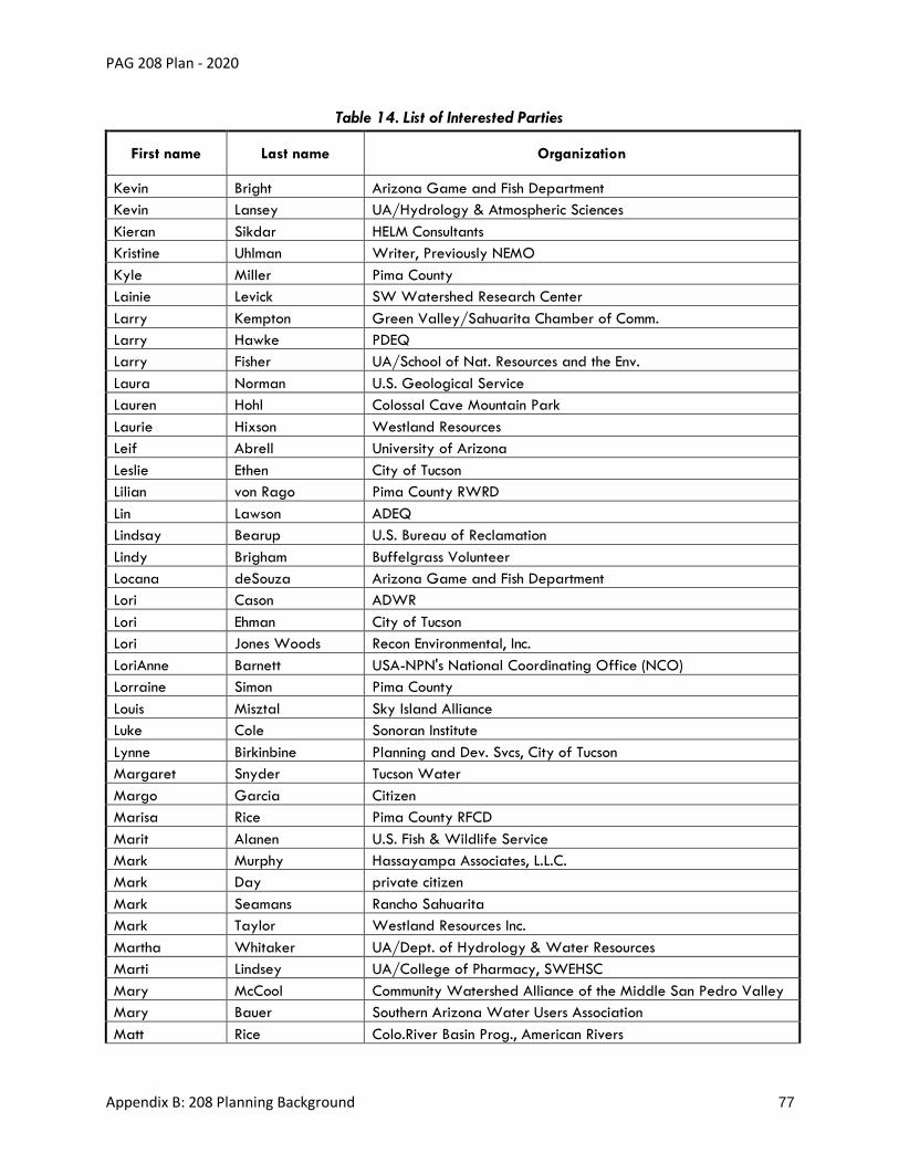
PAG 208 Plan - 2020
Appendix B: 208 Planning Background 77
Table 14. List of Interested Parties
First name Last name Organization
Kevin Bright Arizona Game and Fish Department
Kevin Lansey UA/Hydrology & Atmospheric Sciences
Kieran Sikdar HELM Consultants
Kristine Uhlman Writer, Previously NEMO
Kyle Miller Pima County
Lainie Levick SW Watershed Research Center
Larry Kempton Green Valley/Sahuarita Chamber of Comm.
Larry Hawke PDEQ
Larry Fisher UA/School of Nat. Resources and the Env.
Laura Norman U.S. Geological Service
Lauren Hohl Colossal Cave Mountain Park
Laurie Hixson Westland Resources
Leif Abrell University of Arizona
Leslie Ethen City of Tucson
Lilian von Rago Pima County RWRD
Lin Lawson ADEQ
Lindsay Bearup U.S. Bureau of Reclamation
Lindy Brigham Buffelgrass Volunteer
Locana deSouza Arizona Game and Fish Department
Lori Cason ADWR
Lori Ehman City of Tucson
Lori Jones Woods Recon Environmental, Inc.
LoriAnne Barnett USA-NPN's National Coordinating Office (NCO)
Lorraine Simon Pima County
Louis Misztal Sky Island Alliance
Luke Cole Sonoran Institute
Lynne Birkinbine Planning and Dev. Svcs, City of Tucson
Margaret Snyder Tucson Water
Margo Garcia Citizen
Marisa Rice Pima County RFCD
Marit Alanen U.S. Fish & Wildlife Service
Mark Murphy Hassayampa Associates, L.L.C.
Mark Day private citizen
Mark Seamans Rancho Sahuarita
Mark Taylor Westland Resources Inc.
Martha Whitaker UA/Dept. of Hydrology & Water Resources
Marti Lindsey UA/College of Pharmacy, SWEHSC
Mary McCool Community Watershed Alliance of the Middle San Pedro Valley
Mary Bauer Southern Arizona Water Users Association
Matt Rice Colo.River Basin Prog., American Rivers

PAG 208 Plan - 2020
Appendix B: 208 Planning Background 78
Table 14. List of Interested Parties
First name Last name Organization
Matt Bailey FICO
Matt Weber U.S. Environmental Protection Agency
Matthew Grabau U.S. Fish & Wildlife Service
Maya Teyechea City of Tucson
Melissa Reuter ADOT
Melissa Hayes ADEQ
Melvin Glotfelty Clear Creek Associates
Michael Catanzaro City of Tucson
Michael Guymon Tucson Metro Chamber
Michael Alter Clear Creek Associates
Mindy Cox Pima County RFCD
Mitch Basefsky CAP
Molly Collins City of Tucson
Muniram Budhu University of Arizona
Natalie Wilson USGS
Nathan Lehman U.S. Bureau of Reclamation
Netsin Steklis UA/Biomedical Sciences+ Wild Minds Org.
Niccole Radhe Nature Writer, Zoo Outreach
Nicole Weber UA/Dept. of Hydrology & Water Resources
Pablo Garcia-Chevesich UA/Dept. of Hydrology & Water Resources
Pat Tapia City of Tucson
Pat and Kim Jacobs Citizens
Patricia Grimm Green Valley Pecan Co.
Patricia Gilbert Pima County RFCD
Patti Spindler ADEQ
Paul Bennett Pima County
Paul Marsh ASU-School of Life Sciences
Paul Brown Bureau of Land Management
Peter Abraham Oro Valley Water Utility
Phil Rosen UA/School of Nat. Resources and the Env.
Prabhu Dayal EUEC
Priscilla Storm Diamond Ventures
Rachel Loubeau Pima County
Rachel Tucci University of Arizona
Ralph Ware U.S. Dept. of Agriculture
Randy Heiss SEAGO/Southeastern AZ Council of Govts
Remy Sawyer City of Tucson
Richard Callahan Citizen
Richard Grimaldi Pima County DEQ
Richard Salaz Citizen
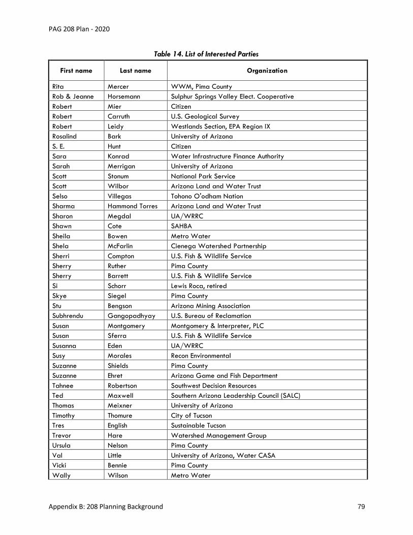
PAG 208 Plan - 2020
Appendix B: 208 Planning Background 79
Table 14. List of Interested Parties
First name Last name Organization
Rita Mercer WWM, Pima County
Rob & Jeanne Horsemann Sulphur Springs Valley Elect. Cooperative
Robert Mier Citizen
Robert Carruth U.S. Geological Survey
Robert Leidy Westlands Section, EPA Region IX
Rosalind Bark University of Arizona
S. E. Hunt Citizen
Sara Konrad Water Infrastructure Finance Authority
Sarah Merrigan University of Arizona
Scott Stonum National Park Service
Scott Wilbor Arizona Land and Water Trust
Selso Villegas Tohono O'odham Nation
Sharma Hammond Torres Arizona Land and Water Trust
Sharon Megdal UA/WRRC
Shawn Cote SAHBA
Sheila Bowen Metro Water
Shela McFarlin Cienega Watershed Partnership
Sherri Compton U.S. Fish & Wildlife Service
Sherry Ruther Pima County
Sherry Barrett U.S. Fish & Wildlife Service
Si Schorr Lewis Roca, retired
Skye Siegel Pima County
Stu Bengson Arizona Mining Association
Subhrendu Gangopadhyay U.S. Bureau of Reclamation
Susan Montgomery Montgomery & Interpreter, PLC
Susan Sferra U.S. Fish & Wildlife Service
Susanna Eden UA/WRRC
Susy Morales Recon Environmental
Suzanne Shields Pima County
Suzanne Ehret Arizona Game and Fish Department
Tahnee Robertson Southwest Decision Resources
Ted Maxwell Southern Arizona Leadership Council (SALC)
Thomas Meixner University of Arizona
Timothy Thomure City of Tucson
Tres English Sustainable Tucson
Trevor Hare Watershed Management Group
Ursula Nelson Pima County
Val Little University of Arizona, Water CASA
Vicki Bennie Pima County
Wally Wilson Metro Water
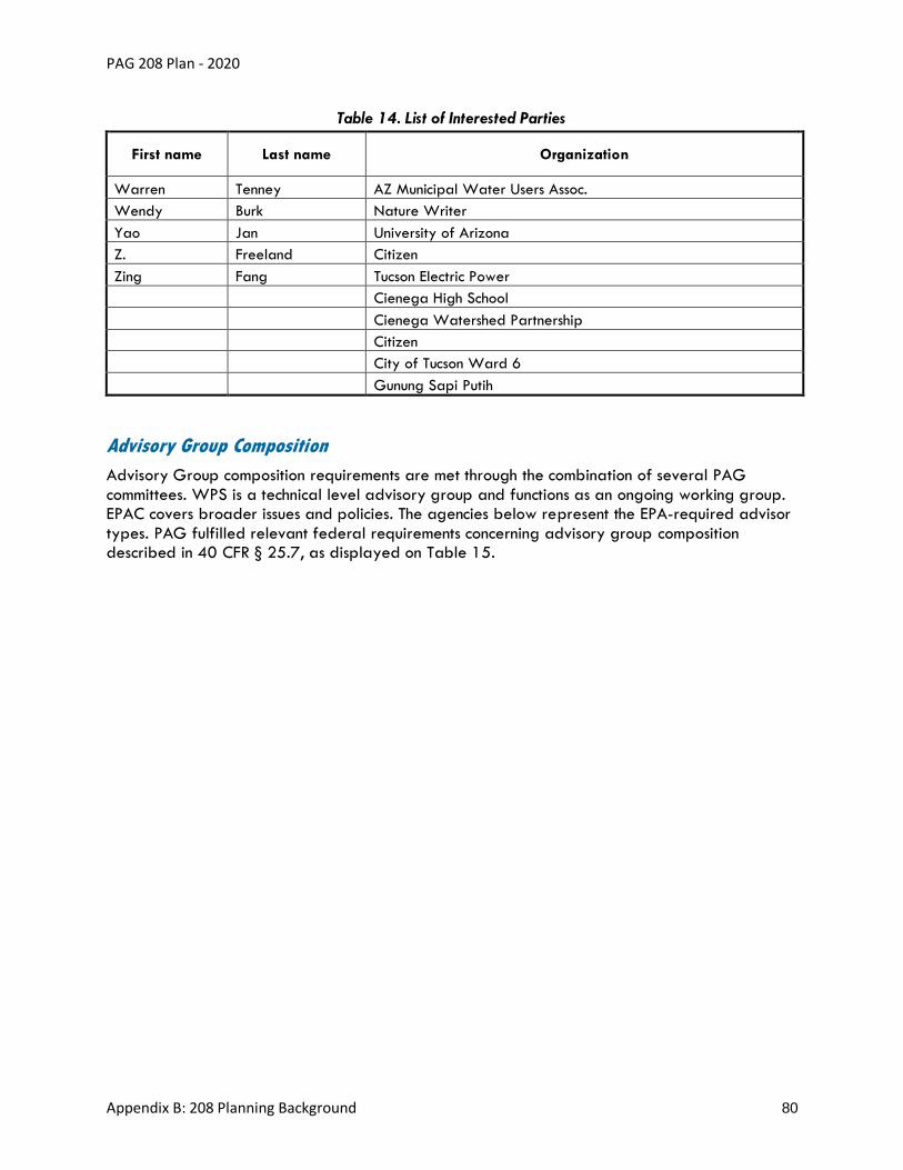
PAG 208 Plan - 2020
Appendix B: 208 Planning Background 80
Table 14. List of Interested Parties
First name Last name Organization
Warren Tenney AZ Municipal Water Users Assoc.
Wendy Burk Nature Writer
Yao Jan University of Arizona
Z. Freeland Citizen
Zing Fang Tucson Electric Power
Cienega High School
Cienega Watershed Partnership
Citizen
City of Tucson Ward 6
Gunung Sapi Putih
Advisory Group Composition
Advisory Group composition requirements are met through the combination of several PAG
committees. WPS is a technical level advisory group and functions as an ongoing working group. EPAC covers broader issues and policies. The agencies below represent the EPA-required advisor
types. PAG fulfilled relevant federal requirements concerning advisory group composition described in 40 CFR § 25.7, as displayed on Table 15.

PAG 208 Plan - 2020
Appendix B: 208 Planning Background 81
Table 15. PAG WPS/EPAC Membership Composition
EPA 208 Requirement
Committee Involved
Applicable Interest Area/
Disciplines Agency Attending
Type of Participation
Public officials Regional Council
Jurisdictions All jurisdictions covered: Native Nation/Tribe Chairmen, Mayor and Board of Supervisor levels covered
Member
EPAC ex-officio
State Agencies
ADWR Member
State Lands Member
ADEQ – 208 contact Invited by email
Federal Agencies EPA (represents Air) Member
Bureau of Reclamation (also has economic interests due to effluent rights)
Invited by email
Residents of the geographic area of activity; Private citizens
EPAC Jurisdictions Positions in place for each jurisdiction plus Davis-Monthan Air Force Base
Members, challenge filling vacancies
WPS Relevant DPAs, as needed
CAG (as needed, per MOU) Invited by email, Decisions are contigent of each 208 Plan applicable
Balance of interests in the affected area
EPAC currently has reps in jurisdiction positions
Contamination Environmental and General Services Member
Riparian/ Land Management/ Natural Resources
Sonoran Institute or Arizona Sonora Desert Museum
Member
Solid Wastes Environmental Services Member
WPS members covered
Wastewater DMAs are currently covered as priority representatives for jurisdictional positions, one position for Pima County Regional Wastewater Advisory Committee member
Members
WPS and EPAC
Stormwater MS4 contacts Invited by email
Flooding RFCD (has safety interests in river effluent management)
Invited by email
Septic PDEQ Invited by email
Public interest groups with no economic interests
EPAC Education UA Member
WPS Public Community Water Coalition Invited by email
Representatives with economic interests
EPAC Environment Tucson Audubon Member
Construction SAHBA Member
Industry Mining Member
Energy TEP Member
Local Business Chamber Member
WPS Agriculture Kai Farms, BKW, or FICO Invited by email
Water Providers (Private and Public, Reclaimed systems)
Southern Arizona Water Users Association, Tucson Water
Invited by email
B. Summary of Developmental Input
In 2017, Regional Council initiated the 208 Plan update. WestLand Resources provided data, research and a consultant perspective on Consistency Reviews. PAG’s WPS, EPAC, Management
Committee, PAG Regional Council and the statewide Water Quality Management Working Group were updated on the development of the 208 Plan at their regular public meetings. The local DMAs were consulted to review and confirm data throughout the development process.
Other DPAs and ADEQ were also consulted throughout the process. Presentations were provided to EPAC and WPS to cover water quality updates in the region that contributed to the 208 Plan
update. The first draft of the 2020 208 Plan was distributed to WPS, EPAC and interested

PAG 208 Plan - 2020
Appendix B: 208 Planning Background 82
parties with a six-week feedback period. Contacts who could assist with key data gap were provided with questions. A study session was held mid-way through the feedback period to
review the first draft.
Meeting Schedule
Regional Council and Management Committee
• 03-23-2017: Initiation of the 208 Plan update and consultant contract approved
• 05-08-19: A verbal summary and first Draft Plan was provided to Management
Committee
• 05-23-19: Memo with progress update and a link to the first Draft Plan was provided to
Regional Council
• 12-05-19: Presentation to Regional Council to provide a process update and reading
opportunity
WPS
• 05-22-2017: Presented an initiation of the 208 Plan update and posted
Questions/Answers
• Invited WPS to all EPAC meetings
EPAC
• 10-06-2017: Presented a 208 Progress Update
• 12-07-2018: Water quality issues added to Top Environmental Issues List for 2019
• 03-01-2019: Invited presentations about Brownfields, groundwater quality, and Santa
Cruz River Heritage Project progress
WPS/EPAC Joint Meetings
• 06-01-2018: Presented the 208 Portal Inventory, E. coli research, Green Stormwater
Infrastructure Plan and non-point source outreach to address Impaired Waters. Invited
presentations about pharmaceuticals as emerging contaminants and recycled water regulatory updates
• 02-22-19 to 04-10-19: WPS, EPAC and Interested Parties formal feedback period
• 03-28-19: Draft Plan Review Study Session
• 10-18-19: Presented draft 208 Plan for approval to move forward to Public Hearing
Statewide WQMWG
• 08-2017: Presented PAG’s streamlined and modernized approach and provided DPA
interview questions
• 06-2018: Presented the 208 Facility Portal and the stormwater planning components
funded by the ADEQ 604(b) grant

PAG 208 Plan - 2020
Appendix B: 208 Planning Background 83
• 03-2019: Presented the results of DPA lessons, major changes reviewed
Summary of WPS, EPAC and Interested Party Feedback
The following is a summary of the feedback and changes made to the February 2019 draft Plan
which are reflected in the 2020 208 Plan.
The draft 208 Plan update was provided to the Watershed Planning Subcommittee (WPS) and Environmental Planning Advisory Committee (EPAC) mailing lists on Feb 22, 2019, along with an
invitation to the review session on March 28, 2019, and a deadline of April 10, 2019 to provide feedback. The mailing lists are comprised of WPS and EPAC membership, which includes the
Designated Management Agency (DMA) contacts and contacts from each PAG member jurisdiction, as well as interested parties who have requested to be involved in the discussions. In
addition, experts and agencies were contacted who could assist in filling key data-gaps. DMAs were contacted to verify public wastewater reclamation facility data in 2018. On May 8, 2019
a verbal summary and link to the first draft Plan was provided to Management Committee. On May 23, 2019, a memo with progress update and a link to the first draft Plan was provided to Regional Council. Private facilities were contacted to verify data in August 2019. Results are
shown in Table 16.
The reviewers could comment on any page and were also asked to provide feedback on the
following:
• The streamlined procedures for a facility to achieve 208 consistency.
• The completeness of the updates to the water quality conditions inventory;
• Corresponding accomplishments in managing water quality issues across the region;
• Alignment of the Strategic Action Plan with the goals of local programs in the region that
may benefit from related water quality funding.
Together, the EPAC and WPS meeting notification mailing lists consist of over 350 recipients. Approximately 70 comments were received from 24 advisors representing 17 entities, 12 of
which are EPAC or WPS members. All DMAs were supportive. In general, positive responses were that the Plan was well-written and organized, contained meaningful goals supported by local
initiatives, had valuable streamlining to the process but maintains local involvement, showed good data provision, and reviewers expressed support for the action items. Feedback is summarized in Table 17. All feedback was utilized to modified to the best of our ability within the scope of
work. Additionally, the 208 Plan was reorganized for a more intuitive flow and to ensure that all content that may need future administrative updates is contained in the appendices.

PAG 208 Plan - 2020
Appendix B: 208 Planning Background 84
Table 16. Private Facility Contacts and Results of Request for Feedback
Facility DMA Area Contact Results
Ajo Improvement Company WWTF
Pima County Roy Archer
No response
Arizona-Sonora Desert Museum WWTP
Pima County Troy Wilcox
No response
Gilbert Ray Campground Pima County Mark Brosseau, Park Manager Karen Simms, NR Division Manager Chris Cawein, NRPR Director
Provided updated facility data
Lukeville Pima County No contact found Not applicable
Management & Training Corp. (MTC) Marana Treatment Facility
Marana Used online contact form No response
Marana High School Marana Chris Hill, Contract Operator Russ Frederico, Marana USD Executive Director of Operational Support
No response
Milagro Subdivision Pima County Used online contact form No response
Miraval Resort Tucson, LLC Pima County Contract Operator, Bob Hanus Western Environmental Technologies, Inc.
No response
Organ Pipe Cactus National Monument
Pima County Bob Bryant, Chief of Facilities)
Provided updated facility text and confirmation
University of Arizona Science and Technology Park
Pima County Emailed the info line. No known contact. No response
U.S. Forest Service – Palisades Ranger Station
Pima County Used online contact form and emailed the info line
No response
ASARCO JPA T. Aldrich and info line No response
Oracle Ridge Mine Pima County M. S. Vogle with U.S. Forest Service No response
Wildcat Canyon at Saguaro Ranch
Pima County/ Marana
No known contact Not applicable

PAG 208 Plan - 2020
Appendix B: 208 Planning Background 85
Table 17. Responses to EPAC, WPS and Interested Party Feedback, February 2019
2020 Document 2020 Plan Chapter Content Changes since Feb. 2019
Adopted Policies and Procedures
Various policy and procedures sections
Internal reorganization of chapters within this document; Strategic Action Plan moved out. No new policies were added since 2006. Rather than make the public hearing optional for new facilities, as was proposed for the process for public facilities in the Feb. draft Plan, that procedure was added back in, as it was in the 2006 Plan. This ensures a point of local coordination and neighborhood involvement through notification to residents, businesses and property owners within a ½ mile. Since these costs were not covered in our fee proposal, the costs and effort will be covered by the applicant. Clarification was provided regarding how the ADEQ works with DPA appeal processes. Local policies on reuse and ownership of effluent were referenced to inform the PAG 208 Consistency Review process. Relevancy of mining permits was clarified. Conditions in which only a data update is required for facilities was clarified. Methods for assessing Title VI compliance was clarified. The process for establishing new JPAs and joint-DMA facilities was clarified.
Appendix A: Water Quality Management
Chapter 1: Strategic Action Plan
During reorganization of chapters, Strategic Action Plan section moved here. Explained the PAG process for selecting goals. Goals were developed as a result of public participation and carried over from past 208 Plans or other DPA Plan templates. Under the Goals, optional actions were added for integrated planning, water in river habitat, upland restoration, and green infrastructure planning, in alignment with 208/604(b) funding sources or with the 208 Plan’s past guiding principles and policies. Climate variability was added as an issue. Drywell investigations as well as cultural heritage perspective and sensitivities were added to actions. Septic goals were updated based on local progress. The Impacts of the 208 Plan section was updated to reflect research on community values for the clean, flowing river. Corrected PDEQ purview over onsite wastewater facilities under 3,000 gallons per day.
Chapter 2: Water Quality and Management Efforts
During reorganization of chapters, Water Quality and Past 208 Management Actions moved here. Water quality conditions, accomplishment metrics, topical projects, and terminology updates were provided for each of these topics: solid wastes, the Water Quality Assurance Revolving Fund Registry, perched aquifers, the Central Arizona Project, Dispose-a-Med, climate projections, Grecycle, CEP process, biosolids, treated effluent classes for local facilities, Mount Lemmon septic issues, Sweetwater Wetlands management, toxic release summaries, SHARP, legacy microorganisms in water systems, trichloroethylene (TCE), perchloroethylene, 1,4 – dioxane, PFAs and other emerging contaminants or unregulated compounds, creek monitoring, reclaimed and recovery programs, non-point source pollution (including low impact development) and PAG resolutions. It was clarified that cultural resources are a part of an integrated planning process. A summary of APP and AZPDES permits was added.
During reorganization of chapters, solid Waste Management and Toxics Releases moved here.
Chapter 3: Wastewater Facilities Planning
During reorganization of chapters, all content remained except for Solid Waste Management and Toxics Releases. Map disclaimers were modified to ensure that locations of sewer service areas do not imply sewer service is available due to costs or other impediments

PAG 208 Plan - 2020
Appendix B: 208 Planning Background 86
Table 17. Responses to EPAC, WPS and Interested Party Feedback, February 2019
2020 Document 2020 Plan Chapter Content Changes since Feb. 2019
Chapter 4: Facility Inventory Report
Facilities now sorted by DMA. Non-municipal and private wastewater facilities were contacted to review the facilities inventory and updates were provided for Adonis, ASARCO and Organ Pipe. Map formatting, symbology and legends were improved. DMAs verified that no new potential public facilities are anticipated at this time. Amendments were cited for each applicable facility.
Chapter 5: Application Resources
Placeholder for future resources.
Appendix B: PAG 208 Planning Background
Chapter 1: Record of Changes - 2019 Update
List of Changes was updated to reflect feedback since February. A table was added to aid cross-reference between the 2006 Plan chapters and the 2019 draft Plan chapters. A simplified flow diagram of 208 processes as added.
Chapter 2: History, Regulations and Authorities
Confirmation was provided for regulation updates.
Chapter 3: Setting of Planning Area
During reorganization of chapters, Water Quality and Past 208 Management Actions moved out. Updated summary of endangered species to local dataset. Added climate variability to the background section.
Chapter 4: Public Participation Records - 2019 Update
Records of public participation to date, were added.
Appendix C: Glossary and References
Chapter 1: Glossary of Terms and Acronyms
A new Consistency Status category added to the Glossary to ease understanding.
Chapter 2: References
Updated to reflect any new data sources.

PAG 208 Plan - 2020
Appendix B: 208 Planning Background 87
Advisors who provided data and developmental feedback:
• Amanda Smith, Sonoran Institute
• Bob Bryant, Chief of facilities, Organ Pipe Cactus National Monument
• Claire Zucker, University of Arizona, Water Resources Research Center
• David Barnes, Freeport McMoRan
• David Scalero, Principal Hydrologist, Pima County Regional Flood Control District
• Edwina Vogan, 208 Program Coordinator, ADEQ
• Evan Canfield, Pima County Regional Flood Control District
• Frank Eric Holler, Community Water Coalition
• Greg Hitt, Pima County Regional Wastewater Reclamation Department
• Heidi Lasham, Town of Sahuarita
• James DuBois, Permit & Regulatory Compliance Officer, Pima County Pima County
Regional Wastewater Reclamation Department
• Jamie Ekholm, Environmental Manager, Asarco LLC
• Joanne Hershenhorn, Hydrologist, Tucson Water (compiled feedback from multiple
program areas at Tucson Water)
• Julia Fonseca, Environmental Planning Manager, Pima County Office of Sustainability and
Conservation
• Julie Robinson, PhD, Pima County Office of Sustainability
• Lauren Hixon, Westland Resources
• Marie Light, PDEQ
• Mark Brosseau, Pima County Parks and Natural Resources, Park Manager for Tucson
Mountain Park
• Mirela Hromatka, Pima County Pima County Regional Wastewater Reclamation
Department
• Nicole Gillett, Tucson Audubon Society
• Richard Grimaldi, Deputy Director, Pima County Department of Environmental Quality
• Sarah Reitmeyer, Pima County Department of Environmental Quality
• Scott Schladweiler, Interim Director, Town of Marana, Marana Water Department
• Stephen Dean, Marana Water Department, Water Reclamation Division
C: Record of WPS/EPAC Meeting to forward the 208 Plan to Public Hearing
Records of the October 18, 2019 meeting of EPAC and WPS to forward the 208 Plan to Public Hearing
are shown in Figure 17, Figure 18 and Figure 19.

PAG 208 Plan - 2020
Appendix B: 208 Planning Background 88
Figure 17. Agenda for the October 18, 2019 Joint Meeting of EPAC and WPS

PAG 208 Plan - 2020
Appendix B: 208 Planning Background 89
Figure 17. Agenda for the October 18, 2019 Joint Meeting of EPAC and WPS (cont’d)

PAG 208 Plan - 2020
Appendix B: 208 Planning Background 90
Figure 18. Meeting Summary for the October 18, 2019 Joint Meeting of EPAC and WPS

PAG 208 Plan - 2020
Appendix B: 208 Planning Background 91
Figure 18. Meeting Summary for the October 18, 2019 Joint Meeting of EPAC and WPS (cont’d)

PAG 208 Plan - 2020
Appendix B: 208 Planning Background 92
Figure 18. Meeting Summary for the October 18, 2019 Joint Meeting of EPAC and WPS (cont’d)

PAG 208 Plan - 2020
Appendix B: 208 Planning Background 93
Figure 19. October 2018 Screenshot of the Posting of the Draft 208 Plan to the WPS Webpage
Presentation74
D: Records of Public Hearing and Comment Period
(to be added)
In Alignment with 40 CFR, Chapter 1, Part 25.5:
The email list used to notify the public of the public hearing on the 208 Plan update includes
media, PAG Committees, local and regional elected officials; civic, business, education and environmental organizations; neighborhoods; and underserved communities. An example email
notice is shown in Figure 20.
74https://pagregion.com/wp-content/docs/pag/2021/05/Presentation-PAG-Areawide-Water-Quality-Management-Plan.pdf

PAG 208 Plan - 2020
Appendix B: 208 Planning Background 94
Figure 20. Screenshot of Notice Sent to PAG Email List

PAG 208 Plan - 2020
Appendix B: 208 Planning Background 95
Figure 20. Screenshot of Notice Sent to PAG Email List (cont’d)

PAG 208 Plan - 2020
Appendix B: 208 Planning Background 96
The documents were available for review, as required, at least 30 days before public hearing, posted on December 13, 2019. The locations included the WPS webpage (page since removed)
and a physical copy at the front of the PAG offices at 1 E Broadway, Suite 401, Tucson AZ, 85701.
The public notice was featured prominently on the PAG Website homepage (Figure 21) with details on the WPS Page (page since removed).
Figure 21. December 2019 Screenshot of PAG Website
http://www.pagregion.com
The public notice for the public hearing was printed on December 13, 2019 in the Arizona Daily
Star (Figure 22 and Figure 23).

PAG 208 Plan - 2020
Appendix B: 208 Planning Background 97
Figure 22. Copy of the Public Notice of the Public Hearing

PAG 208 Plan - 2020
Appendix B: 208 Planning Background 98
Figure 23. Official Affidavit of Publication for Public Notice of Public Hearing
Public Hearing Summary

PAG 208 Plan - 2020
Appendix B: 208 Planning Background 99
Public comments received during the public comment period and PAG’s responses are detailed in Table 18.
Table 18. Public Comments and PAG Responses (“Responsiveness Summary”)
Name, Title, Membership Document Name and Page No. Public Comments PAG Response
Joanne Hershenhorn, City of Tucson, Tucson Water
Appendix A: Water Quality Management, page 15
Suggested wording, Federal Superfund/CERCLA Sites, under Management Strategies, third paragraph, second sentence: Treatment is anticipated to continue until at least 2025 (EPA 2019b) sufficient remediation has been accomplished per EPA.
Thank you for the review. We will correct this statement.
Joanne Hershenhorn, City of Tucson, Tucson Water
Appendix B: PAG 208 Planning Background, page 55
New comment, suggested wording, City of Tucson Reclaimed Water: After the last paragraph in the section, add new paragraph: Tucson Water also participates in two managed effluent recharge projects along the Santa Cruz River. The Santa Cruz River Managed Underground Storage Facility and the Lower Santa Cruz River Managed Recharge Project are in-channel recharge projects located downstream of the Agua Nueva and Tres Rios WRFs, respectively.
We will add this information. Thank you for this additional data.
C. J. Cole, American Museum of Natural History
General I just looked through the PAG 208 Plan Update DRAFT, looking for plans to reduce or eliminate PFAS in reclaimed water. Perhaps I missed it, but I found no discussion of this. I also followed the link to the City of Tucson reclaimed water quality issues, and also found no listing. I’m certain I don’t need to tell you about how toxic PFAS are, how they are becoming increasingly widespread throughout the environment, how resistant they are to breakdown (and thus prone to accumulation), and how governmental agencies at the state
PFAS information is in the Emerging Contaminants section including results of sampling effluent (Appendix A). While local proactive actions are mentioned regarding drinking water treatment, you are correct that it does not mention efforts for reductions in reclaimed water. While Health Advisories are available for PFAS in drinking water and the PAG 208 Plan commends local efforts going beyond drinking water regulations, similar federal guidelines and PAG goals are not

PAG 208 Plan - 2020
Appendix B: 208 Planning Background 100
Table 18. Public Comments and PAG Responses (“Responsiveness Summary”)
Name, Title, Membership Document Name and Page No. Public Comments PAG Response
level and above are avoiding dealing properly with the health issues.
So, it appears that local agencies may need to step forward if the public is to be protected. Is anybody planning to reduce PFAS in general to no more than 10 or maybe even 1 ppt in reclaimed water? It seems that of such toxic contaminants warrant discussion about protecting the health of the public, rather than having agencies fall back on saying that since PFAS are not regulated by the EPA, we are compliant if we ignore them.
available for wastewater. An action will be added to the Strategic Action Plan to encourage treatment of industrial wastes and emerging contaminants to meet health advisory guidelines, when available, for effluent discharges and reclaimed water.
Catlow Shipek, Watershed Management Group
General One comment I would like to provide for the 208 Plan: Based on ideas that have come out of conversations with Pima County Wastewater and in the Basin Study perhaps the plan should also consider using distributed wastewater treatment systems to balance recharge and groundwater demands in critical shallow groundwater supported riparian areas across the greater Tucson Basin. Currently, with a centralized wastewater treatment system we are de-watering critical basin areas by not providing for return flows to help
replenish the aquifer.
Thanks for your consideration and the opportunity to comment.
This action will be added to the Strategic Action Plan as it addresses top issues and complements current goals. It was not within the scope of this update to change policies, but this can be discussed potentially during a future update or Amendment process.
Edwina Vogan, Arizona Department of Environmental Quality
Adopted Policies and Procedures, page 16
PG 16 – Please clarify if it PAG's intention to have the consistency
Yes, we will clarify.

PAG 208 Plan - 2020
Appendix B: 208 Planning Background 101
Table 18. Public Comments and PAG Responses (“Responsiveness Summary”)
Name, Title, Membership Document Name and Page No. Public Comments PAG Response
Adopted Policies and Procedures, page 17
review come to PAG first. That would
be fine with WQD at ADEQ.
The PAG Consistency Letter is a result of the process of the consistency review form and procedure - PAG's determination of conformance?
Yes, we will clarify.
Edwina Vogan, Arizona Department of Environmental Quality
Appendix B, page 84, Table 17 Adopted Policies and Procedures, Figure 3
Appendix C, Glossary
In Figure 3 - PAG 208 Plan Decision Diagram for Permit Applicants - One of the diamonds - "Is the application for a facility w/design capacity greater than 0.024 MG - the step where the applicant will apply for Pima County APP Type 4 General Permit? Since Pima County is a DMA - when they receive and review the application, does Pima County look for other facilities to coordinate on hook-up, or dry sewer if possible?
Related, P.5 in Appendix C - Definition of septic system. Last sentence of that definition – “Septic systems 0.024 or less do not require application to Pima County for APP Type 4 General Permit (no PAG process required).” Yes, the applicants must submit to Pima County for the Type 4 General Permit up to 24,000 gpd. 24,000 gpd APPs and above are submitted
to DEQ.
The text descriptions of Type 4 Permits clarifies that Pima County will coordinate with the applicable DMAs. PAG will assist where necessary. We will remove this sentence from the septic definition since it is accurately stated in the description of the Type 4 Permits.
Edwina Vogan, Arizona Department of Environmental Quality
Adopted Policies and Procedures, page 3
On page 3 under Required Elements in an Areawide WQMP - the third paragraph - PAG cannot designate a DMA. EPA designates; approves the DMA. PAG
Thank you. We will clarify.
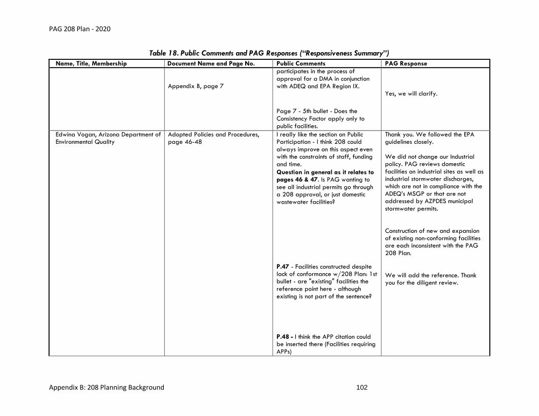
PAG 208 Plan - 2020
Appendix B: 208 Planning Background 102
Table 18. Public Comments and PAG Responses (“Responsiveness Summary”)
Name, Title, Membership Document Name and Page No. Public Comments PAG Response
Appendix B, page 7
participates in the process of approval for a DMA in conjunction with ADEQ and EPA Region IX.
Page 7 - 5th bullet - Does the Consistency Factor apply only to public facilities.
Yes, we will clarify.
Edwina Vogan, Arizona Department of Environmental Quality
Adopted Policies and Procedures, page 46-48
I really like the section on Public Participation - I think 208 could always improve on this aspect even with the constraints of staff, funding and time.
Question in general as it relates to pages 46 & 47. Is PAG wanting to see all industrial permits go through a 208 approval, or just domestic wastewater facilities?
P.47 - Facilities constructed despite lack of conformance w/208 Plan: 1st bullet - are "existing" facilities the reference point here - although existing is not part of the sentence?
P.48 - I think the APP citation could be inserted there (Facilities requiring APPs)
Thank you. We followed the EPA guidelines closely. We did not change our Industrial policy. PAG reviews domestic facilities on industrial sites as well as industrial stormwater discharges, which are not in compliance with the ADEQ’s MSGP or that are not addressed by AZPDES municipal stormwater permits. Construction of new and expansion of existing non-conforming facilities are each inconsistent with the PAG 208 Plan. We will add the reference. Thank you for the diligent review.

PAG 208 Plan - 2020
Appendix B: 208 Planning Background 103
Table 18. Public Comments and PAG Responses (“Responsiveness Summary”)
Name, Title, Membership Document Name and Page No. Public Comments PAG Response
also on page 48 - 1st paragraph after the bullet points – “ADEQ will not issue an APP unless the facility is consistent with the appropriate 208 Plan” - a citation or regulatory reference would be good here as
well.
Greg Hitt, PC RWRD, DMA contact
Appendix A I’ve attached Pima County’s comments (shown in red) on the proposed additions. In Action 5 we wanted to clarify the distinction between sewage discharged by the community into the sewer system, and treated wastewater effluent that is used for recharge and reclaimed water. In Action 6, by singling out PFAS and 1,4 Dioxane, we are inferring that these are the main contaminates of concern. We’d prefer to have the flexibility to monitor any emerging concerns, and remove the focus on current areas of study. Goal 1 (page 5): Action 5: “Continue to monitor contaminants and emerging concerns in sewage, wastewater effluent, discharge and biosolids and strive to follow health advisories and voluntary effluent guidelines when available, feasible and cost-effective to keep regional reclaimed water safe for reuse, including wildlife, body contact and recharge.”
We will make these updates during the next administrative update, so that the PAG 208 Plan stays more up to date with terminology and the latest emerging contaminants.
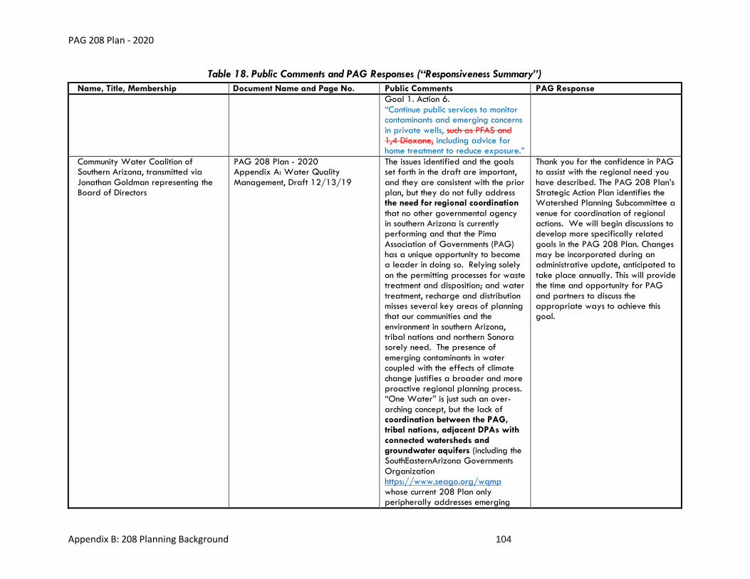
PAG 208 Plan - 2020
Appendix B: 208 Planning Background 104
Table 18. Public Comments and PAG Responses (“Responsiveness Summary”)
Name, Title, Membership Document Name and Page No. Public Comments PAG Response
Goal 1. Action 6. “Continue public services to monitor contaminants and emerging concerns in private wells, such as PFAS and 1,4 Dioxane, including advice for home treatment to reduce exposure.”
Community Water Coalition of Southern Arizona, transmitted via Jonathan Goldman representing the Board of Directors
PAG 208 Plan - 2020 Appendix A: Water Quality Management, Draft 12/13/19
The issues identified and the goals set forth in the draft are important, and they are consistent with the prior plan, but they do not fully address the need for regional coordination that no other governmental agency in southern Arizona is currently performing and that the Pima Association of Governments (PAG) has a unique opportunity to become a leader in doing so. Relying solely on the permitting processes for waste treatment and disposition; and water treatment, recharge and distribution misses several key areas of planning that our communities and the environment in southern Arizona, tribal nations and northern Sonora sorely need. The presence of emerging contaminants in water coupled with the effects of climate change justifies a broader and more proactive regional planning process. “One Water” is just such an over-arching concept, but the lack of coordination between the PAG, tribal nations, adjacent DPAs with connected watersheds and groundwater aquifers (including the SouthEasternArizona Governments Organization https://www.seago.org/wqmp whose current 208 Plan only peripherally addresses emerging
Thank you for the confidence in PAG to assist with the regional need you have described. The PAG 208 Plan’s Strategic Action Plan identifies the Watershed Planning Subcommittee a venue for coordination of regional actions. We will begin discussions to develop more specifically related goals in the PAG 208 Plan. Changes may be incorporated during an administrative update, anticipated to take place annually. This will provide the time and opportunity for PAG and partners to discuss the appropriate ways to achieve this goal.

PAG 208 Plan - 2020
Appendix B: 208 Planning Background 105
Table 18. Public Comments and PAG Responses (“Responsiveness Summary”)
Name, Title, Membership Document Name and Page No. Public Comments PAG Response
contaminants), as well as the International Boundary and Water Commission (IBWC) and both the Arizona State Land Department and the federal Department of the Interior is not likely to result in uniformly good public water policy for our communities and environment into the future. As an example, the IBWC’s 2016 Binational Study of the Transboundary San Pedro Aquifer (Callegary, J.B., Minjárez Sosa, I., Tapia Villaseñor, E.M., dos Santos, P., Monreal Saavedra, R., Grijalva Noriega, F.J., Huth, A.K., Gray, F., Scott, C.A., Megdal, S.B., Oroz Ramos, L.A., Rangel Medina, M., Leenhouts, J.M., 2016,: International Boundary and Water Commission ) (https://www.ibwc.gov/Files/San_Pedro_Binational_Report_En_01122017.pdf ) specifically recommended: “(m)onitoring of groundwater quality on a binational level using uniform standards and methods is important for several scientific and practical reasons. The historical data and studies of this type improve understanding and explain mixing and trends in water from different sources such as sources of baseflow in the San Pedro River (Gungle et al., In Review). A more extensive database would be especially useful in areas such as the San Pedro Basin, where changes in land uses or human activities, for example mining, can alter the quality of water in the

PAG 208 Plan - 2020
Appendix B: 208 Planning Background 106
Table 18. Public Comments and PAG Responses (“Responsiveness Summary”)
Name, Title, Membership Document Name and Page No. Public Comments PAG Response
region. Studies using stable isotopes in conjunction with other water quality parameters would be very useful for achieving a better understanding of aquifer recharge, groundwater flow directions, the mixture of water from different sources, and long term water availability.” (p. 135); and “(c)urrently binational data standards do not exist for the review and storage of all the different data types noted in this report. Lack of standards is also the case within each country for certain data types. The development of binational data standards related to the review and storage of data would help with ease of data searching, integration, and comparison.” (p. 137). Similar standardization and groundwater and surface water monitoring across the entirety of the San Pedro and Santa Cruz watersheds, including the Altar and Avra Valley subwatersheds and the portions of both watersheds in Mexico would provide a much more powerful means of accomplishing our collective objectives in managing water resources into the future. I recommend that the PAG adopt the goal of taking a leadership position in furthering these One Water objectives well beyond the jurisdictional limits of Pima County.

PAG 208 Plan - 2020
Appendix B: 208 Planning Background 107
E: Records of Recommendation for Plan Approval by PAG Management Committee
Records of the recommendation made by PAG Management Committee on January 15, 2020 to
approve the draft 208 Plan are shown in Figure 24, Figure 25 and Figure 26.

PAG 208 Plan - 2020
Appendix B: 208 Planning Background 108
Figure 24. Agenda for the January 15, 2020 PAG Management Committee Meeting

PAG 208 Plan - 2020
Appendix B: 208 Planning Background 109
Figure 24. Agenda for the January 15, 2020 PAG Management Committee Meeting (cont’d)

PAG 208 Plan - 2020
Appendix B: 208 Planning Background 110
Figure 25. Memo for the January 15, 2020 PAG Management Committee Meeting

PAG 208 Plan - 2020
Appendix B: 208 Planning Background 111
Figure 25. Memo for the January 15, 2020 PAG Management Committee Meeting (cont’d)

PAG 208 Plan - 2020
Appendix B: 208 Planning Background 112
Figure 25. Memo for the January 15, 2020 PAG Management Committee Meeting (cont’d)

PAG 208 Plan - 2020
Appendix B: 208 Planning Background 113
Figure 25. Memo for the January 15, 2020 PAG Management Committee Meeting (cont’d)

PAG 208 Plan - 2020
Appendix B: 208 Planning Background 114
Figure 26. Legal Action Report January 15, 2020 PAG Management Committee Meeting
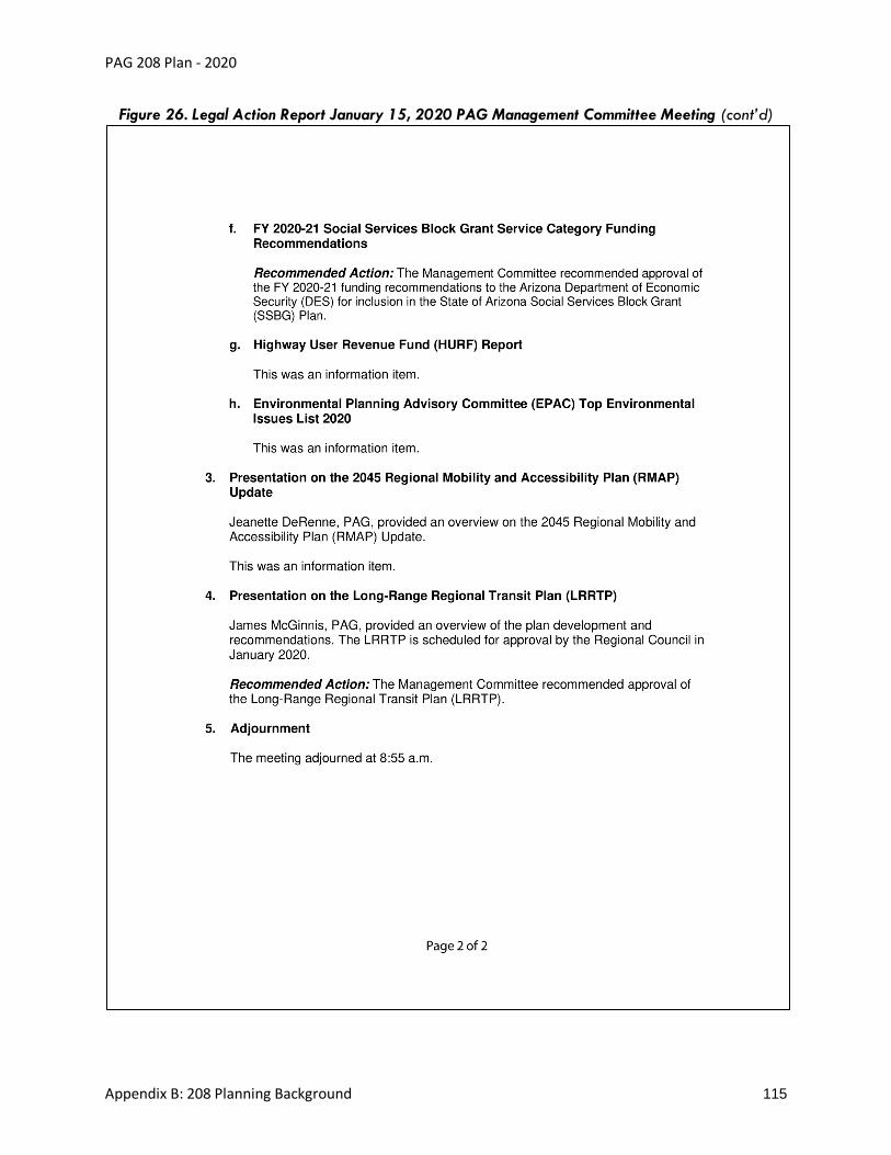
PAG 208 Plan - 2020
Appendix B: 208 Planning Background 115
Figure 26. Legal Action Report January 15, 2020 PAG Management Committee Meeting (cont’d)

PAG 208 Plan - 2020
Appendix B: 208 Planning Background 116
F: Records of Plan Adoption by PAG Regional Council
Records of 208 Plan approval by PAG Regional Council on January 30, 2020 are shown in
Figure 27, Figure 28 and Figure 29.

PAG 208 Plan - 2020
Appendix B: 208 Planning Background 117
Figure 27. Agenda for the January 30, 2020 PAG Regional Council Meeting

PAG 208 Plan - 2020
Appendix B: 208 Planning Background 118
Figure 27. Agenda for the January 30, 2020 PAG Regional Council Meeting (cont’d)

PAG 208 Plan - 2020
Appendix B: 208 Planning Background 119
Figure 27. Agenda for the January 30, 2020 PAG Regional Council Meeting (cont’d)

PAG 208 Plan - 2020
Appendix B: 208 Planning Background 120
Figure 28. Memo for the January 30, 2020 PAG Regional Council Meeting

PAG 208 Plan - 2020
Appendix B: 208 Planning Background 121
Figure 28. Memo for the January 30, 2020 PAG Regional Council Meeting (cont’d)

PAG 208 Plan - 2020
Appendix B: 208 Planning Background 122
Figure 28. Memo for the January 30, 2020 PAG Regional Council Meeting (cont’d)

PAG 208 Plan - 2020
Appendix B: 208 Planning Background 123
Figure 28. Memo for the January 30, 2020 PAG Regional Council Meeting (cont’d)

PAG 208 Plan - 2020
Appendix B: 208 Planning Background 124
Figure 29. Legal Action Report for the January 30, 2020 PAG Regional Council Meeting
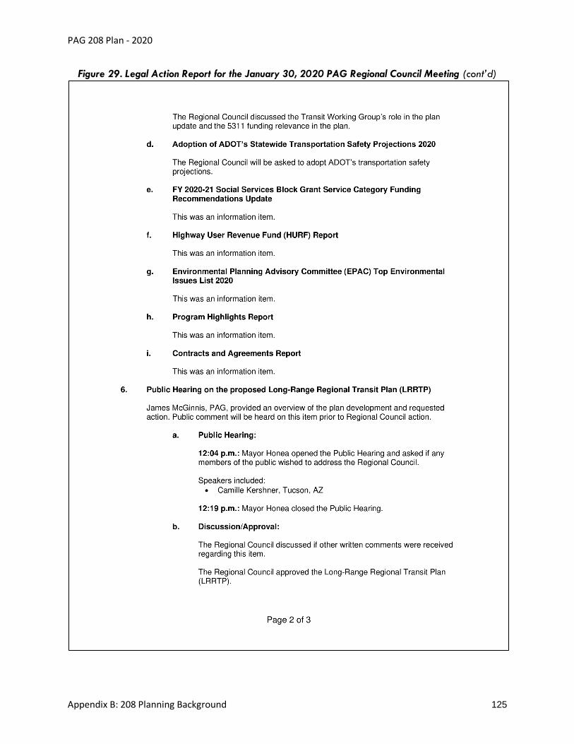
PAG 208 Plan - 2020
Appendix B: 208 Planning Background 125
Figure 29. Legal Action Report for the January 30, 2020 PAG Regional Council Meeting (cont’d)

PAG 208 Plan - 2020
Appendix B: 208 Planning Background 126
Figure 29. Legal Action Report for the January 30, 2020 PAG Regional Council Meeting (cont’d)

PAG 208 Plan - 2020
Appendix B: 208 Planning Background 127
G: Summary of Submission to and Approval by ADEQ
Records of 208 Plan approval by the Statewide WQMQG on February 18, 2020 are shown in
Figure 30 and Figure 31.
PAG’s cover memo to ADEQ requesting approval of the draft 208 Plan is shown in Figure 32.

PAG 208 Plan - 2020
Appendix B: 208 Planning Background 128
Figure 30. Agenda for the February 18, 2020 Statewide WQMWG Meeting

PAG 208 Plan - 2020
Appendix B: 208 Planning Background 129
Figure 30. Agenda for the February 18, 2020 Statewide WQMWG Meeting (cont’d)

PAG 208 Plan - 2020
Appendix B: 208 Planning Background 130
Figure 31. Minutes for the February 19, 2020 Statewide WQMWG Meeting
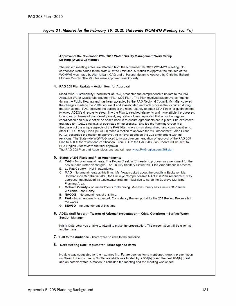
PAG 208 Plan - 2020
Appendix B: 208 Planning Background 131
Figure 31. Minutes for the February 19, 2020 Statewide WQMWG Meeting (cont’d)

PAG 208 Plan - 2020
Appendix B: 208 Planning Background 132
Figure 32. February 25, 2020 PAG Cover Memo to ADEQ

PAG 208 Plan - 2020
Appendix B: 208 Planning Background 133
Figure 32. February 25, 2020 PAG Cover Memo to ADEQ (cont’d)

PAG 208 Plan - 2020
Appendix B: 208 Planning Background 134
Figure 32. February 25, 2020 PAG Cover Memo to ADEQ (cont’d)

PAG 208 Plan - 2020
Appendix B: 208 Planning Background 135
H: Summary of Submission to and Approval by EPA
ADEQ’s Certification Letter to the EPA is shown in Figure 33. The EPA’s Approval Letter is shown in
Figure 34.

PAG 208 Plan - 2020
Appendix B: 208 Planning Background 136
Figure 33. April 30, 2021 ADEQ Certification Letter

PAG 208 Plan - 2020
Appendix B: 208 Planning Background 137
Figure 34. June 8, 2021 EPA Approval Letter