PROPOSED 200MW NDEBELE PHOTOVOLTAIC PLANT ...
175
REPORT PROPOSED 200MW NDEBELE AND XHOSA PHOTOVOLTAIC PLANT DEVELOPMENTS AND ASSOCIATED BATTERY ENERGY STORAGE SYSTEM ON THE REMAINING EXTENT OF THE FARM BOKPOORT 390 NEAR GROBLERSHOOP WITHIN THE !KHEIS LOCAL MUNICIPALITY IN THE NORTHERN CAPE PROVINCE Final Basic Assessment Report Client: ACWA Power Energy Africa Pty (Ltd) DEFF Reference 14-12-16-3-3-1-2148 14-12-16-3-3-1-2149 Reference: MD4195-RHD-ZZ-XX-RP-YE-0001 Status: S0/P01.01 Date: 07 July 2020
-
Upload
khangminh22 -
Category
Documents
-
view
1 -
download
0
Transcript of PROPOSED 200MW NDEBELE PHOTOVOLTAIC PLANT ...

REPORT
PROPOSED 200MW NDEBELE AND
XHOSA PHOTOVOLTAIC PLANT
DEVELOPMENTS AND ASSOCIATED
BATTERY ENERGY STORAGE
SYSTEM ON THE REMAINING
EXTENT OF THE FARM BOKPOORT
390 NEAR GROBLERSHOOP WITHIN
THE !KHEIS LOCAL MUNICIPALITY IN
THE NORTHERN CAPE PROVINCE
Final Basic Assessment Report
Client: ACWA Power Energy Africa Pty (Ltd)
DEFF Reference 14-12-16-3-3-1-2148
14-12-16-3-3-1-2149
Reference: MD4195-RHD-ZZ-XX-RP-YE-0001
Status: S0/P01.01
Date: 07 July 2020

P r o j e c t r e l a t e d
07 July 2020 MD4195-RHD-ZZ-XX-RP-YE-0001 i
ROYAL HASKONINGDHV (PTY) LTD
21 Woodlands Drive
Building 5
Country Club Estate
Woodmead
Johannesburg
2191
Southern Africa
Reg No. 1966/001916/07
+27 87 352 1500
+27 11 798 6005
royalhaskoningdhv.com
T
F
E
W
Document title: PROPOSED 200MW NDEBELE AND XHOSA PHOTOVOLTAIC PLANT
DEVELOPMENTS AND ASSOCIATED BATTERY ENERGY STORAGE
SYSTEM ON THE REMAINING EXTENT OF THE FARM BOKPOORT 390 NEAR
GROBLERSHOOP WITHIN THE !KHEIS LOCAL MUNICIPALITY IN THE
NORTHERN CAPE PROVINCE
Document short title:
Reference: MD4195-RHD-ZZ-XX-RP-YE-0001
Status: P01.01/S0
Date: 07 July 2020
Project name: PV Plants
Project number: MD4195
Author(s): Seshni Govender
Drafted by: Prashika Reddy and Seshni Govender
Checked by: Malcolm Roods
Date / initials: 07/07/2020 MR
Approved by: Malcolm Roods
Date / initials: 07/07/2020 MR
Classification
Project related
Disclaimer
No part of these specifications/printed matter may be reproduced and/or published by print, photocopy, microfilm or by
any other means, without the prior written permission of Royal HaskoningDHV (Pty) Ltd; nor may they be used,
without such permission, for any purposes other than that for which they were produced. Royal HaskoningDHV (Pty)
Ltd accepts no responsibility or liability for these specifications/printed matter to any party other than the persons by
whom it was commissioned and as concluded under that Appointment. The integrated QHSE management system of
Royal HaskoningDHV (Pty) Ltd has been certified in accordance with ISO 9001:2015, ISO 14001:2015 and ISO
45001:2018.

P r o j e c t r e l a t e d
07 July 2020 MD4195-RHD-ZZ-XX-RP-YE-0001
ii
Table of Contents
1 Introduction 1
1.1 Approach to the Study 3
1.1.1 Previous EIA Studies 3
1.1.2 Applications for Environmental Authorisation 3
1.1.3 Basic Assessment Study 3
1.2 Structure of the Basic Assessment Report (BAR) 4
1.3 Specialist Assessment 7
1.4 Details of the Project Developer 8
1.5 Details of the Environmental Assessment Practitioner 8
2 Project Description 10
2.1 Property Description 10
2.2 Project Location and Co-ordinates 10
2.3 Technical Description 10
2.3.1 Battery Energy Storage System 12
2.4 Project Motivation 12
2.5 Integrated Resource Plan (IRP 2019) 13
2.5.1 Need & Desirability 14
2.5.2 Socio-economic Value 19
3 ENVIRONMENTAL LEGISLATIVE CONTEXT 20
3.1 Other Relevant Acts, Guidelines, Department Policies and Environmental Management
Instruments 22
3.2 International Conventions and Agreements 24
3.3 International Standards 25
3.3.1 International Finance Corporation Performance Standards 25
3.4 Equator Principles 28
3.4.1 The World Bank Group Environmental Health and Safety (EHS) Guidelines 28
3.5 Sustainable Development Goals 28
4 Project alternatives 30
4.1 Site Alternatives 30
4.2 Technology Alternatives 33
4.2.1 PV Plants 33
4.2.2 Battery Energy Storage System 33
4.2.2.1 Lithium Ion BESS 33
4.2.2.2 Lithium Polymer BESS 34
4.2.2.3 Lead Acid BESS 34

P r o j e c t r e l a t e d
07 July 2020 MD4195-RHD-ZZ-XX-RP-YE-0001
iii
4.2.3 Technology Comparison: Li-ion vs Lead Acid BESS 36
4.3 Layout Alternatives 36
4.4 No-Go Alternatives 39
5 Description of the baseline environment 40
5.1 Geology 40
5.2 Climate 41
5.2.1 Rainfall and Water Availability 41
5.2.2 Temperature 42
5.2.3 Evaporation 43
5.2.4 Site-Specific Dispersion Potential 44
5.2.5 Atmospheric Stability 47
5.3 Air Quality 48
5.3.1 Sensitive Receptor 48
5.3.2 Existing Source of Air Pollution 48
5.3.2.1 Agriculture 49
5.3.2.2 Domestic Fuel Burning 49
5.3.2.3 Veld Fires 49
5.4 Topography 49
5.5 Soils 50
5.6 Agriculture Capability 51
5.7 Ecology 51
5.7.1 Regional Vegetation types 51
5.7.2 Alpha Diversity of the Study Area 52
5.7.3 Declared Invasive Species and Common Weeds 53
5.7.4 Plants with Traditional Medicinal Uses 53
5.7.5 Broad-scale Habitat types 54
5.7.6 Calcerous Low Shrub Plains 55
5.7.7 Open Shrub Duneveld 56
5.7.8 Open Shrub Plains 57
5.8 Faunal Attributes of the Study Area 57
5.8.1 Invertebrates 57
5.8.2 Amphibians 58
5.8.3 Reptiles 58
5.8.4 Mammals 58
5.9 Avifauna 59
5.9.1 Bird Microhabitats 59
5.9.2 Avifaunal Community 59
5.9.3 Avifaunal Sensitivity Zones 62
5.9.3.1 High Sensitivity Zones 62
5.9.3.2 Medium Sensitivity Zones 62
5.9.3.3 Undetermined Sensitivity Zones 62

P r o j e c t r e l a t e d
07 July 2020 MD4195-RHD-ZZ-XX-RP-YE-0001
iv
5.10 Bats 62
5.11 Surface Water 64
5.11.1 Water Quality 65
5.11.2 Aquatic Ecosystems 66
5.12 Groundwater 67
5.12.1 Geology and Hydrogeological Setting 67
5.12.2 Hydrocensus 67
5.12.3 Groundwater Level and Flow 69
5.12.4 National Groundwater Archives and National Register of Water Use Databases 69
5.12.5 Groundwater Quality 69
5.12.6 Hydrogeological Characterisation 70
5.12.7 Groundwater Quality Compared to Water Criteria Guidelines/ Standards 70
5.13 Heritage 72
5.13.1 Stone Age 72
5.13.2 Iron Age 73
5.13.3 Historic period 73
5.14 Palaeontology 73
5.15 Traffic 74
5.15.1 Access to Site 74
5.15.2 Road Network and Intersections 74
5.15.3 Non-Motorized Transport 76
5.15.4 Accident Hotspots 76
5.15.5 Railway Lines 76
5.15.6 Proposed Refuse Sites 76
5.15.7 Haul Routes 76
5.15.8 Traffic Counts 77
5.15.9 Road Hierarchy 78
5.15.10 Public Transport Infrastructure 78
5.15.11 Dust 78
5.16 Visual 78
5.16.1 Landscape Physical Characteristics and Land Use 78
5.16.2 Visual Receptors 79
5.17 Social 81
5.17.1 Administrative Setting 81
5.17.2 Population Demographics 81
5.17.3 Levels of Education 82
5.17.4 Economic Activities 82
5.17.5 Employment Levels 84
6 PUBLIC PARTICIPATION PROCESS 85
6.1 Authority Consultation 86
6.2 Consultation with Other Relevant Stakeholders 86
6.3 Site Notification 86
6.4 Identification of Interested and Affected Parties 87

P r o j e c t r e l a t e d
07 July 2020 MD4195-RHD-ZZ-XX-RP-YE-0001
v
6.5 Briefing Paper 87
6.6 Public Meeting 87
6.7 Advertising 87
6.8 Issues Trail 87
6.8.1 Key Issues Raised by the Public 87
6.9 Public Review of the draft Consultation BAR 88
6.10 Final BAR 88
6.11 PPP Summary 88
7 SPECIALIST FINDINGS AND IMPACT ASSESSMENT 90
7.1 Introduction 90
7.2 Impact Assessment Methodology 90
7.3 Potential Impacts and Significance 92
7.3.1 Geology 92
7.3.1.1 Construction 92
7.3.1.2 Operations 92
7.3.1.3 Closure and Rehabilitation 92
7.3.2 Topography 92
7.3.2.1 Construction 92
7.3.2.2 Operation 92
7.3.2.3 Closure and rehabilitation 93
7.3.3 Air Quality 93
7.3.3.1 Construction 93
7.3.3.2 Operation 93
7.3.3.3 Closure and rehabilitation 95
7.3.4 Agricultural Potential, Soil, Land Capability and Land Use 95
7.3.4.1 Construction 95
7.3.4.2 Operation 96
7.3.4.3 Closure and Rehabilitation 96
7.3.4.4 Cumulative Impacts 97
7.3.5 Ecology 97
7.3.5.1 Construction 97
7.3.5.2 Operation 100
7.3.5.3 Closure and Rehabilitation 102
7.3.5.4 Cumulative Impacts 102
7.3.6 Avifauna 103
7.3.6.1 Construction 103
7.3.6.2 Disturbance and Displacement 104
7.3.6.3 Operation 105

P r o j e c t r e l a t e d
07 July 2020 MD4195-RHD-ZZ-XX-RP-YE-0001
vi
7.3.6.4 Closure and Rehabilitation 107
7.3.6.5 Cumulative Impacts 107
7.3.7 Bat 107
7.3.7.1 Construction 107
7.3.7.2 Operation 108
7.3.7.3 Closure and Rehabilitation 108
7.3.7.4 Cumulative Impacts 108
7.3.8 Surface Water 109
7.3.8.1 Construction 109
7.3.8.2 Operation 109
7.3.8.3 Closure and Rehabilitation 110
7.3.9 Groundwater 110
7.3.9.1 Construction 110
7.3.9.2 Operation 111
7.3.9.3 Closure and Rehabilitation 111
7.3.10 Visual 111
7.3.10.1 Construction 117
7.3.10.2 Operation 118
7.3.10.3 Closure and Rehabilitation 118
7.3.10.4 Cumulative Impacts 118
7.3.11 Heritage 119
7.3.11.1 Construction 119
7.3.11.2 Operation 119
7.3.11.3 Closure and Rehabilitation 119
7.3.11.4 Cumulative Impacts 119
7.3.12 Palaeontology 120
7.3.12.1 Construction 120
7.3.12.2 Operation 120
7.3.12.3 Closure and Rehabilitation 120
7.3.12.4 Cumulative Impacts 121
7.3.13 Traffic 121
7.3.13.1 Construction 121
7.3.13.2 Operation 122
7.3.13.3 Closure and Rehabilitation 122
7.3.14 Socio-Economic 122
7.3.14.1 Construction 122
7.3.14.2 Operation 123
7.3.14.3 Closure and Rehabilitation 124
P r o j e c t r e l a t e d
07 July 2020 MD4195-RHD-ZZ-XX-RP-YE-0001
vii
7.3.14.4 Cumulative 124
7.4 Summary of the Impact Assessment 126
7.4.1 Construction Phase 126
7.4.2 Operational Phase 132
7.4.3 Closure and Rehabilitation Phase 138
7.4.4 Summary of the Cumulative Impacts 141
8 Impact statement 145
8.1 Key Findings 145
8.1.1 Geology and Topography 145
8.1.2 Air Quality 145
8.1.3 Agricultural Potential, Soil, Land Capability and Land Use 145
8.1.4 Ecology 145
8.1.5 Avifauna 146
8.1.6 Bat 146
8.1.7 Surface Water 146
8.1.8 Groundwater 147
8.1.9 Visual 147
8.1.10 Heritage and Palaeontology 147
8.1.11 Traffic 148
8.1.12 Socio-Economic 148
8.2 Sensitivity Map 149
8.3 Conclusion and Recommendations 151
8.4 Assumptions, Uncertainties or Gaps in Knowledge 151
8.4.1 Agriculture Assessment 151
8.4.2 Ecological Assessment 151
8.4.3 Avifaunal Assessment 152
8.4.4 Visual Assessment 152
8.4.5 Heritage Assessment 152
8.4.6 Palaeontological Assessment 153
8.5 Recommendations 154
8.5.1 Recommendations to the CA 154
8.5.2 Recommendations to the Applicant 155
8.6 Declaration by the EAP 155
Table of Tables
Table 1: Structure of the Report 4
Table 2: Specialist assessments conducted for the project 7
Table 3: Applicant details 8
Table 4: EAP details 9
Table 5: Property details 10

P r o j e c t r e l a t e d
07 July 2020 MD4195-RHD-ZZ-XX-RP-YE-0001
viii
Table 6: PV Plant Project co-ordinates 10
Table 7: Technical details of the proposed PV plant/s 11
Table 8: Project need, desirability and benefits 14
Table 9: Socio-economic details 19
Table 10: Key legislation considered 20
Table 11: Other relevant acts, guidelines, policies and environmental management instruments
22
Table 12: Relevant international conventions to which South Africa is a party 24
Table 13: IFC Performance Standards 25
Table 14: Site selection criteria 30
Table 15: Comparison between Lithium Ion and Lead Acid BESS 36
Table 16: Average monthly evaporation values for station D7E001 44
Table 17: Atmospheric Stability Classes 47
Table 18: Details of the 2017 Land Capability classification for South Africa 51
Table 19: List of common weeds and declared alien and invasive plant species within the study
area 53
Table 20: List of traditional and medicinal uses within the study area 53
Table 21: Extent of habitat types within the study area 54
Table 22: Butterfly species of conservation concern recorded in the region of the study area 58
Table 23: Confirmed mammal taxa in the region 59
Table 24: Bat species confirmed and potentially occurring within the project area 64
Table 25: Water quality in the Orange River at DHSW&S monitoring points compared against
the interim RWQOs 65
Table 26: Hydrocensus data collected during November 2019 68
Table 27: Livestock watering use compliance and risk status 71
Table 28: Drinking/ domestic use compliance and risk status 71
Table 29: Overview of road network 74
Table 30: LOS classifications 75
Table 31: Overview of Gariep Road/ Transnet Service Road intersection 76
Table 32: Haul distance from Gauteng 77
Table 33: Traffic volumes 2016 (peak hour) 77
Table 34: Traffic volumes 2019 (peak hour) 78
Table 35: Road hierarchy 78
Table 36: Static sensitive receptor locations located within a 10 km radius of the proposed
development site 79
Table 37: Contribution to GVA (2010) 82
Table 38: Summary of Public participation process 88

P r o j e c t r e l a t e d
07 July 2020 MD4195-RHD-ZZ-XX-RP-YE-0001
ix
Table 39: Criteria for the ranking of impacts 91
Table 40: Impact significance 91
Table 41: Existing and planned alternative energy generation facilities in the larger region 119
Table 42: Summary of Construction Phase Impacts 126
Table 43: Summary of Operational Phase Impacts 132
Table 44: Summary of the Closure and Rehabilitation Phase 138
Table 45: Summary of Cumulative Impacts 141
Table of Figures
Figure 1: Locality Map 2
Figure 2: Annual incoming short-wave radiation for South Africa 13
Figure 3: Sustainable Development Goals 29
Figure 4: REDZ 7 Upington (project area indicated by yellow area) 31
Figure 5: Sensitivity map of Farm Bokpoort 390 RE 32
Figure 6: Comparison of lead acid and Li-ion as starter battery. 35
Figure 7: Previously approved PV 1, PV 2 and CSP plants 37
Figure 8: Proposed layout including all 10 PV Plants 38
Figure 9: Geology Map 41
Figure 10: Monthly rainfall distribution for rainfall stations in the surrounding area. 42
Figure 11: Annual Rainfall recorded at the D7E001 (Boegoeberg Dam) station 42
Figure 12: Average Temperature (°C) Graph for Groblershoop (World Weather Online, 2016) 43
Figure 13: Monthly mean, minimum and maximum evaporation for station D7E001 (Boegoeberg
Dam) 44
Figure 14: Period wind rose for study site, 2005 – 2009 MM5 45
Figure 15: Diurnal wind rose for the study site, 2005 - 2009 MM5 46
Figure 16: Seasonal wind rose, 2005 - 2009 MM5 47
Figure 17: Stability class frequency distribution, 2005 – 2009 MM5 48
Figure 18: Land types 50
Figure 19: Regional ecological types in spatial relation to the study area 52
Figure 20: Broad-scale habitat types of the study area 55
Figure 21: Locations of three Verreaux’s Eagle and one Martial Eagle nests 61
Figure 22: Lower Orange Main Stem catchment area 64
Figure 23: Local Drainage Context 66
Figure 24: Borehole locality map 68
Figure 25: Topography and groundwater head correlation 69
Figure 26: Piper diagram 70

P r o j e c t r e l a t e d
07 July 2020 MD4195-RHD-ZZ-XX-RP-YE-0001
x
Figure 27: Haul routes 77
Figure 28: Location of sensitive receptor locations within a 10km radius of the proposed
development 80
Figure 29: Percentage of agricultural households in each particular activity within the !Kheis LM
83
Figure 30: Steps in the public participation process 85
Figure 31: Proposed and authorised solar developments that may contribute to cumulative
impacts 103
Figure 32: Viewshed Analysis undertaken as part of the original Visual Impact Assessment for
the original PV1 component – representative of the southern part of the development site 112
Figure 33: Viewshed Analysis undertaken as part of the original Visual Impact Assessment for
the original PV2 component – representative of the northern part of the development site 113
Figure 34: Map indicating the location of alternative energy generation facilities in the larger
region 120
Figure 35: Overall Sensitivity Map 149
Figure 36: Annotated Listing Notice Map 150
Photograph Log
Photograph 1: Example of Calcerous Low shrub plains 56
Photograph 2: Examples of open shrub duneveld habitat 56
Photograph 3: Examples of open shrub plains 57
Photograph 4: Some identified tools and flakes 73
Photograph 5: The Bokpoort Farmstead viewed from the Sanddraai Property to the west. Note
the elevated position of the farmstead in relation to the surrounding terrain. 114
Photograph 6: View in the direction of the development site from the raised portion of the Gariep
District Road that crosses the Transnet Railway; neither the Bokpoort 1 Solar Plant or the
proposed development area would be visible. 115
Appendices
Appendix A: Maps and Key plans
Appendix B: Specialist Studies
Appendix C: EAP CVs
Appendix D: Environmental Management Programme
Appendix E: Public Participation Documents
Appendix F: EAP Oath

P r o j e c t r e l a t e d
07 July 2020 MD4195-RHD-ZZ-XX-RP-YE-0001
xi
Executive Summary
Background
The environmental team of Royal HaskoningDHV have been appointed as an Environmental Assessment
Practitioner (EAP) by ACWA Power Energy Africa (Pty) Ltd (hereafter referred to as ACWA Power) to
conduct a Basic Assessment (BA) Study for the project in terms of the Environmental Impact Assessment
(EIA) Regulations 2014 (as amended in 2017), as promulgated under the National Environmental
Management Act (NEMA) (Act No. 107 of 1998) (as amended).
ACWA Power is proposing to construct a solar energy facility consisting of ten (10) photovoltaic (PV) plants
on the north-eastern portion of the Remaining Extent (RE) of the Farm Bokpoort 390, located 20 km north-
west of the town of Groblershoop within the !Kheis Local Municipality in the ZF Mgcawu District Municipality,
Northern Cape Province.
On 21 October 2016, 150 MW Concentrating Solar Power (CSP) plant a 900 ha, was authorised by the
Department of Environmental Affairs (DEA) – Ref 14/12/16/3/3/2/879. Due to the changes in the Integrated
Resource Plan (IRP) published in October 2019, ACWA Power intend replacing the authorised CSP site
with eight (8) new PV plants. The updated layout has been revised to incorporate the 8 new PV plants of
200 MW each, covering a total of 1200 ha (i.e. 150 ha for each plant).
Two (2) 75 MW PV plants including ancillary infrastructure (Ref 14/12/16/3/3/2/880 and 14/12/16/3/3/2/881),
were also authorised by the DEA on 24 October 2016. The intention to replace the CSP with 8 PV plants
will result in development footprint changes of the overall project. As such PV 1 (Ndebele) and PV 2 (Xhosa)
plants will undergo an amendment to better cater for the overall project development and ancillary
infrastructure.
This Basic Assessment process will occur concurrently to these processes mentioned above to
accommodate:
1. The Battery Energy Storage System (BESS) that will be associated with the Ndebele PV Plant
(formerly PV 1) and the Xhosa PV Plant (formerly PV2). This activity was applied for in the original
environmental process but was not approved due to lack of information with regards to the type of
technology to be used. The BESS footprint is approximately 16ha and will store 4500m3 of
hazardous substances with a battery power capacity of 150 MW.
2. The electricity generation capacity of the PV 1 & 2 Plants will be 200 MW [75 MW was originally
approved in the EAs dated 24/10/2016 (Ref: 14/12/16/3/3/2/881 & Ref 14/12/16/3/3/2/880). It was
confirmed in the IQ/20/0004 correspondence from the Environment, Forestry and Fisheries (DEFF)
that the electricity generation of more than 20MW from a Renewable Resource listed activity is now
triggered and must be applied for due to the increase in capacity]
Process
This Basic Assessment (BA) follows the legislative process prescribed in the Environmental Impact
Assessment (EIA) Regulations 2014 (as amended in 2017). This report constitutes the final Basic
Assessment Report (fBAR) which details the environmental outcomes, impacts and residual risks of the
proposed activities. The report aims to assess the key environmental issues and impacts associated with
the development, and to document Interested and Affected Parties’ (I&APs) issues and concerns.
Furthermore, it provides background information of the proposed project, a motivation and details of the
proposed project, and describes the public participation undertaken to date.

P r o j e c t r e l a t e d
07 July 2020 MD4195-RHD-ZZ-XX-RP-YE-0001
xii
In order to protect the environment and ensure that the development is undertaken in an environmentally
responsible manner, there are a number of significant environmental legislation that were taken into
consideration during this study and are elaborated on in this report.
The Department of Environment, Forestry and Fisheries (DEFF) is the lead/ Competent Authority for this
BA study and the project needs to be authorised by this Department.
This final Basic Assessment Report (fBAR) provides an assessment of both the benefits and potential
negative impacts anticipated as a result of the proposed project. Having duly considered the project, in the
Environmental Assessment Practitioner’s (EAP’s) opinion, the project (installation of a BESS and increase
in capacity using improved technology) does not pose a detrimental impact on the receiving environment
and it inhabitants and can be mitigated significantly. The Applicant should be bound to stringent conditions
to maintain compliance and a responsible execution of the project.
The impacts identified and assessed by way of risk ratings, have been extensively reported herein.
Key Findings
Geology and Topography:
Excavations for foundations for the PV panels and associated infrastructure will have a highly localised and
negligible effect on the geology and topography of the site.
Air Quality:
The facility does not require an Atmospheric Emissions Licence as no listed activities are triggered under
section 21 of the NEM:AQA (Act 39 of 2004). The key pollutant from the proposed site during the
construction and decommissions phases would be Particulate Matter (PM). Strict BESS management and
maintenance procedures will ensure containment and prevent any significant air quality impacts. On
decommissioning, the BESS should be promptly removed offsite in line with manufacturer guidance and
taken to the nearest appropriate recycling facility. While there are recycling options for lead-acid batteries
in South Africa, opportunities for the recycling of lithium ion batteries needs further investigation.
Agricultural Potential, Soil, Land Capability and Land Use:
The proposed development is on land zoned as ‘Special’. South Africa has very limited arable land and it is
therefore critical to ensure that development does not lead to an inappropriate loss of land that may be
valuable for cultivation. The specialist assessment has found that the investigated site is on land which is of
low agricultural potential and is not suitable for cultivation.
Ecology:
The various assessments of the ecological receiving environment that were accessed to compile the
specialist report revealed a moderate, at best, ecological sensitivity of remaining and untransformed portions
of the site. The photovoltaic plant development will potentially affect biodiversity in three main ways; loss in
extent of vegetation communities and loss and associated disturbance of species of conservation concern
during construction; effects on fauna species of conservation concern as a result of site lighting, security
fencing and increased road traffic during operation, and the spread of invasive species and potential
contamination of remaining natural (surrounding) ecosystems during closure.
A review of the anticipated impacts associated with the proposed development on the ecological
environment indicates that none of the anticipated impacts can be highlighted or construed to represent an
unacceptable or severe threat to sensitive biological or biodiversity components within the study area and
wider region. Ecological attributes and characteristics and biological components that were recorded on the

P r o j e c t r e l a t e d
07 July 2020 MD4195-RHD-ZZ-XX-RP-YE-0001
xiii
site during the brief survey period are regarded common and typical of the larger region and are not
restricted to the site, i.e. no plant or animal species or habitat type will be affected in such a manner that the
conservation status (local, regional, global) will be affected adversely.
Although several species of conservation concern have been recorded within the study area, no species
were recorded that would trigger ‘Critical Habitat’ as defined by IFC. As with any type of anthropogenic
development, the decimation of natural habitat is an unfortunate result and the reduction in the local
abundance of animals and plants represent natural and anticipated consequences.
Avifauna:
The PV plant which was already authorised but the additional activities of the increase in capacity and the
battery energy storage system will allow for additional bird flight deterrent devices to be investigated to
reduce the potential impact of collisions with overhead power lines as well as reduced habitat fragmentation
and disruption of bird movements across the project site for a number of ground dwelling species.
If temperatures rise in the medium to long term, some species will be living closer to the limits of their thermal
tolerances, with species in arid environments expected to be among the first to reach the limits of their
thermoregulatory capacities1. It is anticipated that much of the Kalahari’s avian biodiversity will be lost by
the end of the century due to loss of body condition, delayed fledging, reduced fledging size, and outright
breeding failure as a result of increased exposure to higher temperatures2. PV panels may provide more
shaded environments (thermal refugia) for ground dwelling and ground nesting birds near their thermal limits
and also offer a certain amount of protection to more open habitat species against bush encroachment3.
The PV plant, if mitigation such as the rehabilitation of natural vegetation under solar panels is implemented,
could potentially therefore even provide an improvement of the habitat for certain important bird species
such as coursers, francolins and other open-country birds by offering shade and grassland in the face of
potentially rising temperatures and bush encroachment.
Bat:
The PV plants should have fewer negative impacts on bats. The impact assessment ratings of the PV plants
are all reduced to a low significance impact rating after application of mitigation measures listed in Section
7.3.7 of this report.
Surface Water:
A Stormwater Management Plan (SWMP) must be implemented during the construction phase of the
project. Spillage of fuels, lubricants and other chemicals must be cleaned up immediately and disposed of
at an appropriately licenced landfill site. Mitigation for spillage or leakages must include bunded areas to
store chemicals and/ or fuel and containerisation of the BESS.
The change in water demand which will be affected positively with the total demand changing to 0.22 million
cubic metres per annum (Mm3/a) (10 x 0.022 Mm3/a) for the 10 PV solar facilities instead of the 0.3 Mm3/a
(0.25 + 2 x 0.025 Mm3/a) for the CSP and two (2) PV solar facilities.
1 van de Ven, T.M.F.N. 2017. Implications of climate change on the reproductive success of the Southern Yellow-billed Hornbill, Tockus leucomelas. PhD Thesis. Percy FitzPatrick Institute of African Ornithology, DST-NRF Centre of Excellence, Department of Biological Sciences, Faculty of Science, University of Cape Town. 2 Conradie, S.R., Woodborne, S.M., Cunningham, S.J. and McKechnie, A.E. 2019. Chronic, sublethal effects of high temperatures will cause severe declines in southern African arid-zone birds during the 21st century. 3 Towards a policy on indigenous bush encroachment in South Africa (2019), Department of Environmental Affairs, Pretoria, South Africa.

P r o j e c t r e l a t e d
07 July 2020 MD4195-RHD-ZZ-XX-RP-YE-0001
xiv
Groundwater:
Overall the accumulative risk associated with the project (when operational) is of low environmental
significance from a groundwater perspective. With proper mitigations in place the significance of the impact
is likely to be low.
Visual:
The visual impact from the solar installation will be cumulative to the existing visual transformation of
anthropological origin (Bokpoort I installation, farm buildings, power lines, railway line, roads) and will be
present for the operational life of the facility (estimated at 30 years). The impact will be totally reversible
upon decommissioning and closure of the solar facility.
Heritage:
From a heritage point of view, it is recommended that the proposed development be allowed to continue on
acceptance of the proposed mitigation measures and the conditions proposed for inclusion in the
environmental authorisation:
▪ Should archaeological sites or graves be exposed in other areas during construction work, it must
immediately be reported to a heritage practitioner so that an investigation and evaluation of the finds
can be made.
Palaeontology:
No significant fossil heritage resources have been recorded within the Bokpoort II solar power facility study
area. The area is inferred to be of low sensitivity in terms of palaeontological heritage and no sensitive or
no-go areas have been identified within it during the present desktop assessment.
Traffic:
Travel to and from the facility by personnel, deliveries and visitors will add to the existing traffic on the
approach roads, affecting road safety, create dust from unpaved roads and road surface quality as
experienced by existing road users. The cumulative impact due to the solar facility will be completely
reversible upon decommissioning and closure.
Socio-Economic:
The proposed increase in capacity from 75 to 200MW will be a positive impact as this will provide further
support to the national grid therefore aiding in provide electricity security to the region and the country. The
potential job creation at the construction phase of the project will be a positive for the local and regional
economy as unemployment in the country is increasing. An assured and diversified electricity generation
mix is a key step in attracting investors into South Africa and is key for the growth and development.
Recommendations
The project, in the EAP’s opinion, does not pose a detrimental impact on the receiving environment and its
inhabitants and can be mitigated significantly. The main activities associated with PV1 and PV2 have already
been granted an Environmental Authorisation and the new project components (i.e. Battery Energy Storage
System and increase in capacity) emanates from the technology optimisation and engineering design.
Considering the opportunities that have been granted in the IRP 2019, the new project components (i.e.
capacity increase and BESS) cannot be viewed in isolation to the previous authorisations as well as to the
proposed 8 other PV Plants on the site. The project is critical in terms of the current energy crisis that has
impacted our country and makes an important addition to sustainability goals by increasing investment and
development in the renewable energy sector.
Changes to the BAR has been underlined for ease of reference

P r o j e c t r e l a t e d
07 July 2020 MD4195-RHD-ZZ-XX-RP-YE-0001
xv
Acronyms
AC Alternating Current
BA Basic Assessment
BAR Basic Assessment Report
BESS Battery Energy Storage System
BID Background Information Document
CA Competent Authority
CBA Critical Biodiversity Area
CBAR Consultation Basic Assessment Report
CSP Concentrating Solar Power
CV Curriculum Vitae
DC Direct Current
DEFF Department of Environment, Fisheries and Forestry
DHSW&S Department of Human Settlements, Water and Sanitation
EA Environmental Authorisation
EAP Environmental Assessment Practitioner
EAPASA Environmental Assessment Practitioner Association of South Africa
ECO Environmental Control Officer
EHS Environmental, Health and Safety
EIA Environmental Impact Assessment
EMPr Environmental Management Programme
EP Equator Principles
EPFI Equator Principles Financial Institutions
FBAR Final Basic Assessment Report
GA General Authorisation
GIS Geographic Information System
GNR Government Notice Regulation
I&AP Interested and Affected Party
IFC International Finance Corporation
IDP Integrated Development Plan
IRP Integrated Resources Plan
IEM Integrated Environmental Management
MW Megawatt
NCDENC Northern Cape Department of Environment and Nature Conservation
NEMA National Environmental Management Act (Act No. 107 of 1998)
NEM:AQA National Environmental Management Air Quality Act (Act No. 39 of 2004)
NEM:BA National Environmental Management Biodiversity Act (Act No. 10 of 2004)
NEM:PAA National Environmental Management Protected Areas Act (Act No. 57 of 2003)
NEM:WA National Environmental Management – Waste Act (Act No. 59 of 2008)
NFA National Forests Act (Act No. 84 of 1998)
NGO Non-Governmental Organisation
NHRA National Heritage Resources Act (Act No. 25 of 1999)
NWA National Water Act (Act No. 36 of 1998)
OHSA Occupational Health and Safety Act (Act No 85 of 1993)
PES Present Ecological State
PP Public Participation
PS Performance Standards

P r o j e c t r e l a t e d
07 July 2020 MD4195-RHD-ZZ-XX-RP-YE-0001
xvi
PV Photovoltaic
REC Recommended Ecological Category
REDZ Renewable Energy Development Zone
SACNASP South African Council of Natural Science Professionals
SDG Sustainable Development Goals
SWMP Stormwater Management Plan
UNFCC United Nations Framework Convention on Climate Change
WUA Water Use Authorisation

P r o j e c t r e l a t e d
07 July 2020 MD4195-RHD-ZZ-XX-RP-YE-0001
xvii
Glossary
Activity (Development)
An action either planned or existing that may result in environmental impacts through pollution or resource use. For the purpose of this report, the terms ‘activity’ and ‘development’ are freely interchanged.
Alternatives Different means of meeting the general purpose and requirements of the activity, which may include site or location alternatives; alternatives to the type of activity being undertaken; the design or layout of the activity; the technology to be used in the activity and the operational aspects of the activity.
Applicant The project proponent or developer responsible for submitting an environmental application to the relevant environmental authority for environmental authorisation.
Biodiversity The diversity of animals, plants and other organisms found within and between ecosystems, habitats, and the ecological complexes.
Buffer A buffer is seen as an area that protects adjacent communities from unfavourable conditions. A buffer is usually an artificially imposed zone included in a management plan.
Construction The building, erection or establishment of a facility, structure or infrastructure that is necessary for the undertaking of a listed or specified activity but excludes any modification, alteration or expansion of such a facility, structure or infrastructure and excluding the reconstruction of the same facility in the same location, with the same capacity and footprint.
Cumulative Impact The impact of an activity that in itself may not be significant but may become significant when added to the existing and potential impacts eventuating from similar or diverse activities or undertakings in the area.
Decommissioning The demolition of a building, facility, structure or infrastructure. Direct Impact Impacts that are caused directly by the activity and generally occur at the same
time and at the same place of the activity. These impacts are usually associated with the construction, operation or maintenance of an activity and are generally quantifiable.
Ecosystem A dynamic system of plant, animal (including humans) and micro-organism communities and their non-living physical environment interacting as a functional unit. The basic structural unit of the biosphere, ecosystems are characterised by interdependent interaction between the component species and their physical surroundings. Each ecosystem occupies a space in which macro-scale conditions and interactions are relatively homogenous.
Environment In terms of the National Environmental Management Act (NEMA) (Act No 107 of 1998) (as amended), “Environment” means the surroundings within which humans exist and that are made up of:
i. the land, water and atmosphere of the earth; ii. micro-organisms, plants and animal life; iii. any part or combination of (i) and (ii), and the interrelationships among
and between them; and iv. the physical, chemical, aesthetic and cultural properties and conditions
of the foregoing that influence human health and wellbeing.
Environmental Assessment
The generic term for all forms of environmental assessment for projects, plans, programmes or policies and includes methodologies or tools such as environmental impact assessments, strategic environmental assessments and risk assessments.
Environmental Authorisation
An authorisation issued by the competent authority in respect of a listed activity, or an activity which takes place within a sensitive environment.
Environmental Assessment Practitioner (EAP)
The individual responsible for planning, management and coordination of environmental impact assessments, strategic environmental assessments, environmental management programmes or any other appropriate environmental instrument introduced through the EIA Regulations.

P r o j e c t r e l a t e d
07 July 2020 MD4195-RHD-ZZ-XX-RP-YE-0001
xviii
Environmental Control Officer (ECO)
An individual nominated through the Client to be present on site to act on behalf of the Client in matters concerning the implementation and day to day monitoring of the EMPr and conditions stipulated by the authorities.
Environmental Impact
Change to the environment (biophysical, social and/ or economic), whether adverse or beneficial, wholly or partially, resulting from an organisation’s activities, products or services.
Environmental Management
Ensuring that environmental concerns are included in all stages of development, so that development is sustainable and does not exceed the carrying capacity of the environment.
Environmental Management Programme (EMPr)
A detailed plan of action prepared to ensure that recommendations for enhancing or ensuring positive impacts and limiting or preventing negative environmental impacts are implemented during the life cycle of a project. This EMPr focuses on the construction phase, operation (maintenance) phase and decommissioning phase of the proposed project.
Fatal Flaw An event or condition that could cause an unanticipated problem and/or conflict which will could result in a development being rejected or stopped.
Groundwater Water in the ground that is in the zone of saturation from which wells, springs, and groundwater runoff are supplied.
Hazardous Waste Any waste that contains organic or inorganic elements or compounds that may, owing to the inherent physical, chemical or toxicological characteristics of that waste, have a detrimental impact on health and the environment and includes hazardous substances, materials or objects within business waste, residue deposits and residue stockpiles as outlined in the National Environmental Management: Waste Amendment Act (No 26 of 2014).Schedule 3: Category A – Hazardous Waste.
Hydrology The science encompassing the behaviour of water as it occurs in the atmosphere, on the surface of the ground, and underground.
Indirect Impacts Indirect or induced changes that may occur as a result of the activity. These types if impacts include all of the potential impacts that do not manifest immediately when the activity is undertaken or which occur at a different place as a result of the activity
Integrated Environmental Management
A philosophy that prescribes a code of practice for ensuring that environmental considerations are fully integrated into all stages of the development and decision-making process. The IEM philosophy (and principles) is interpreted as applying to the planning, assessment, implementation and management of any proposal (project, plan, programme or policy) or activity - at local, national and international level – that has a potentially significant effect on the environment. Implementation of this philosophy relies on the selection and application of appropriate tools for a particular proposal or activity. These may include environmental assessment tools (such as strategic environmental assessment and risk assessment), environmental management tools (such as monitoring, auditing and reporting) and decision-making tools (such as multi-criteria decision support systems or advisory councils).
Interested and Affected Party (I&AP)
Any person, group of persons or organisation interested in or affected by an activity; and any organ of state that may have jurisdiction over any aspect of the activity.
Method Statement A method statement is a written submission by the Contractor to the Engineer in response to the specification or a request by the Engineer, setting out the plant, materials, labour and method the Contractor proposes using to carry out an activity, identified by the relevant specification or the Engineer when requesting a Method Statement. It contains sufficient detail to enable the Engineer to assess whether the Contractor’s proposal is in accordance with the Specifications and/or will produce results in accordance with the Specifications.
Mitigate The implementation of practical measures designed to avoid, reduce or remedy adverse impacts or enhance beneficial impacts of an action.

P r o j e c t r e l a t e d
07 July 2020 MD4195-RHD-ZZ-XX-RP-YE-0001
xix
No-Go Option In this instance the proposed activity would not take place, and the resulting environmental effects from taking no action are compared with the effects of permitting the proposed activity to go forward.
Pollution The National Environmental Management Act, No. 107 of 1998 defines pollution to mean any change in the environment caused by – substances; radioactive or other waves; or noise, odours, dust or heat emitted from any activity, including the storage or treatment of waste or substances, construction and the provision of services, whether engaged in by any person or an organ of state, where that change has an adverse effect on human health or well-being or on the composition, resilience and productivity of natural or managed ecosystems, or on materials useful to people, or will have such an effect in the future.
Public Participation Process
A process in which potential interested and affected parties are given an opportunity to comment on, or raise issues relevant to, specific matters.
Re-use To utilise articles from the waste stream again for a similar or a different purpose without changing the form of properties of the articles.
Rehabilitation A measure aimed at reinstating an ecosystem to its original function and state (or as close as possible to its original function and state) following activities that have disrupted those functions.
Sensitive Environments
Any environment identified as being sensitive to the impacts of the development.
Significance Significance can be differentiated into impact magnitude and impact significance. Impact magnitude is the measurable change (i.e. magnitude, intensity, duration and likelihood). Impact significance is the value placed on the change by different affected parties (i.e. level of significance and acceptability). It is an anthropocentric concept, which makes use of value judgements and science-based criteria (i.e. biophysical, social and economic).
Stakeholder Engagement
The process of engagement between stakeholders (the proponent, authorities and I&APs) during the planning, assessment, implementation and/or management of proposals or activities.
Sustainable Development
Development which meets the needs of current generations without hindering future generations from meeting their own needs.
Visual Contrast The degree to which the development would be congruent with the surrounding environment. It is based on whether or not the development would conform with the land use, settlement density, forms and patterns of elements that define the structure of the surrounding landscape.
Watercourse Defined as: i. a river or spring; ii. a natural channel or depression in which water flows regularly or
intermittently; iii. a wetland, lake or dam into which, or from which, water flows; and iv. any collection of water which the Minister may, by notice in the Gazette,
declare to be a watercourse as defined in the National Water Act, 1998 (Act No. 36 of 1998) and a reference to a watercourse includes, where relevant, its bed and banks.
Water Pollution The National Water Act, 36 of 1998 defined water pollution to be the direct or indirect alteration of the physical, chemical or biological properties of a water resource so as to make it – less fit for any beneficial purpose for which it may reasonably be expected to be used; or harmful or potentially harmful (aa) to the welfare, health or safety of human beings; (bb) to any aquatic or non-aquatic organisms; (cc) to the resource quality; or (dd) to property”.
Wetland Land which is transitional between terrestrial and aquatic systems where the water table is usually at or near the surface, or the land is periodically covered with shallow water, and which land in normal circumstances supports or would support vegetation typically adapted to life in saturated soil.

P r o j e c t r e l a t e d
07 July 2020 MD4195-RHD-ZZ-XX-RP-YE-0001 1
1 INTRODUCTION
ACWA Power Energy Africa (Pty) Ltd (hereafter referred to as ACWA Power) is proposing to construct a
solar energy facility consisting of ten (10) photovoltaic (PV) plants on the north-eastern portion of the
Remaining Extent (RE) of the Farm Bokpoort 390, located 20 km north-west of the town of Groblershoop
within the !Kheis Local Municipality in the ZF Mgcawu District Municipality, Northern Cape Province.
On 21 October 2016, 150 MW Concentrating Solar Power (CSP) plant in a 900 ha, was authorised by the
Department of Environmental Affairs (DEA) – Ref 14/12/16/3/3/2/879. Due to the changes in the Integrated
Resource Plan (IRP) published in October 2019, ACWA Power intend replacing the authorised CSP site
with eight (8) new PV plants. The updated layout has been revised to incorporate the 8 new PV plants of
200 MW each, covering a total of 1200 ha (i.e. 150 ha for each plant).
Two (2) 75 MW PV plants including ancillary infrastructure (Ref 14/12/16/3/3/2/880 and 14/12/16/3/3/2/881),
were also authorised by the DEA on 24 October 2016. The intention to replace the CSP with 8 PV plants
will result in development footprint changes of the overall project. As such PV 1 (Ndebele) and PV 2 (Xhosa)
plants will undergo an amendment to better cater for the overall project development and ancillary
infrastructure.
This Basic Assessment process will occur concurrently to these processes mentioned above to
accommodate:
a) The Battery Energy Storage System (BESS) that will be associated with the Ndebele PV Plant (formerly
PV 1) and the Xhosa PV Plant (formerly PV2). This activity was applied for in the original environmental
process but was not approved due to lack of information with regards to the type of technology to be
used. The BESS footprint is approximately 16ha and will store 4500m3 of hazardous substances with
a battery power capacity of 150 MW.
b) The electricity generation capacity of the PV 1 & 2 Plants will be 200 MW [75 MW was originally
approved in the EAs dated 24/10/2016 (Ref: 14/12/16/3/3/2/881 & Ref 14/12/16/3/3/2/880). It was
confirmed in the IQ/20/0004 correspondence from the Environment, Forestry and Fisheries (DEFF) that
the electricity generation of more than 20MW from a Renewable Resource listed activity is now triggered
and must be applied for due to the increase in capacity]
ACWA Power has indicated that the development will be funded from local and international sources and
hence the EIA for the proposed development would need to comply with the International Finance
Corporation Performance Standards (IFC) 2012 and the Equator Principles.
The locality map including the layout of the new PV plants and ancillary infrastructure is provided in
Figure 1 and Appendix A.

P r o j e c t r e l a t e d
07 July 2020 MD4195-RHD-ZZ-XX-RP-YE-0001 2
Figure 1: Locality Map

P r o j e c t r e l a t e d
07 July 2020 MD4195-RHD-ZZ-XX-RP-YE-0001 3
1.1 Approach to the Study
Since the project will take place in a Renewable Energy Development Zone (REDZ)(GNR113 of 16 February
2018) and Activity 1 and 4 (Listing Notice 2) of the EIA Regulations 2014 (as amended in 2017) is triggered,
a BA procedure as contemplated in Regulation 19 and 20 of the EIA Regulations 2014 (as amended in
2017), must be followed in order to obtain environmental authorisation (EA). The aforementioned was also
confirmed in pre-applications with the Department and in an interpretation, query lodged with DEFF.
1.1.1 Previous EIA Studies
This BA study relies on the previous EIA studies including specialist assessments listed below:
▪ Proposed 75 MW Concentrating Solar Thermal Power Plant and Associated Infrastructure in the
Siyanda District, Northern undertaken by Bohlweki SSI Environmental, 20114.
▪ Proposed 150 MW CSP Tower Development on the Remaining Extent of the Farm Bokpoort 390,
Northern Cape undertaken by Golder Associates Africa, 20165.
▪ Proposed 75 MW Photovoltaic (PV 1) Solar Development on the Remaining Extent of the Farm
Bokpoort 390, Northern Cape undertaken by Golder Associates Africa, 20166.
▪ Proposed 75 MW Photovoltaic (PV 2) Solar Development on the Remaining Extent of the Farm
Bokpoort 390, Northern Cape undertaken by Golder Associates Africa, 20167.
1.1.2 Applications for Environmental Authorisation
Two separate applications for authorisation will be submitted to the Competent Authority- the Department
of Environment, Forestry and Fisheries (DEFF):
▪ Proposed 200MW Ndebele Photovoltaic Plant and Associated Battery Energy Storage System on the
Remaining Extent of the Farm Bokpoort 390 near Groblershoop within the !Kheis Local Municipality in
the Northern Cape Province (DEFF Reference: 14/12/16/3/3/1/2149)
▪ Proposed 200MW Xhosa Photovoltaic Plant and Associated Battery Energy Storage System on the
Remaining Extent of the Farm Bokpoort 390 near Groblershoop within the !Kheis Local Municipality in
the Northern Cape Province (DEFF Reference: 14/12/16/3/3/1/2148)
1.1.3 Basic Assessment Study
A Basic Assessment (BA) is the level of environmental assessment applicable to activities listed in Listing
Notices 1 and 3. A BA is applied to activities that are considered less likely to have significant environmental
impacts and, therefore, unlikely to require a detailed Environmental Impact Assessment (EIA).
The BA aims to achieve the following:
▪ Determine the policy and legislative context within which the proposed activity is undertaken and how
the activity complies with and responds to the policy and legislative context;
▪ Describe the need and desirability of the proposed project;
▪ Identify the alternatives considered, including the activity, location, and technology alternatives;
4 Benedek, F; Roods, M. 2011. Environmental Impact Assessment for a Proposed 75MW Concentrating Solar Thermal Power Plant
and Associated Infrastructure in the Siyanda District, Northern Cape. Bohlweki SSI Environmental. DEA Reference number: 12/12/20/1920.
5 Schlechter, M., & Baxter, B. 2016. Final EIA Report: Proposed 150MW CSP Tower Development on the Remaining Extent of Farm Bokpoort 390, Northern Cape. Golder Associates. Ref 14/12/16/3/3/2/879.
6 Schlechter, M., & Baxter, B. 2016. Final EIA Report: Proposed 75MW Photovoltaic (PV1) Solar Development on the Remaining Extent of the Farm Bokpoort 390, Northern Cape. Golder Associates. Ref 14/12/16/3/3/2/881.
7 Schlechter, M., & Baxter, B. 2016. Final EIA Report: Proposed 75MW Photovoltaic (PV2) Solar Development on the Remaining Extent of the Farm Bokpoort 390, Northern Cape. Golder Associates. Ref 14/12/16/3/3/2/880.

P r o j e c t r e l a t e d
07 July 2020 MD4195-RHD-ZZ-XX-RP-YE-0001 4
▪ Undertake an impact and risk assessment process inclusive of reasonably foreseeable cumulative
impacts (where applicable). The focus being; determining the geographical, physical, biological, social,
economic, heritage and cultural sensitivity of the project and the risk of impact of the proposed activity
on these aspects to determine the nature, significance, consequence, extent, duration, and probability
of the impacts occurring to; and the degree to which these impacts:
- can be reversed;
- may cause irreplaceable loss of resources; and
- can be avoided, managed or mitigated.
This final Basic Assessment Report (fBAR) has been compiled in accordance with the stipulated
requirements in GNR 326, Appendix 1 of the EIA Regulations, 2014 (as amended in 2017), which outlines
the legislative BA process and requirements for assessment of outcomes, impacts and residual risks of the
proposed development. The fBAR further incorporates the findings and recommendations of the specialist
studies conducted for the project.
An Environmental Management Programme (EMPr) has been compiled according to Appendix 4 of GNR
326 of the EIA Regulations, 2014 (as amended in 2017) for the construction and rehabilitation phases of the
project. The EMPr has been compiled as a stand-alone document from the fBAR and is submitted to the
DEFF along with the fBAR. The EMPr provides the actions for the management of identified environmental
impacts emanating from the project and a detailed outline of the implementation programme to minimise
and/ or eliminate any anticipated negative environmental impacts and to enhance positive impacts. The
EMPr provides strategies to be used to address the roles and responsibilities of environmental management
personnel on site, and a framework for environmental compliance and monitoring.
1.2 Structure of the Basic Assessment Report (BAR)
The BAR is Structured as follows:
Table 1: Structure of the Report
Appendix 1: Content of Basic Assessment Reports Chapter / Section
(a) details of
i) the EAP who prepared the report; and
ii) the expertise of the EAP to carry out an environmental impact
assessment
Section 1.5
(b) The location of the activity (21-digit Surveyor General code, physical
address and farm name where available, coordinates of the
boundary of the property)
Section 2.1 & 2.2
(c) A plan which locates the proposed activity or activities applied for as
well as associated structures and infrastructure at an appropriate
scale or, if it is – a linear activity, a description of the route of the
activity.
Figure 1
(d) A description of the scope of the proposed activity, including –
i) all listed and specified activities triggered and being applied for;
and
ii) a description of the activities to be undertaken including
associated structures and infrastructure.
Chapter 2&3
(e) A description of the policy and legislative context within which the
development is proposed including – Chapter 3

P r o j e c t r e l a t e d
07 July 2020 MD4195-RHD-ZZ-XX-RP-YE-0001 5
Appendix 1: Content of Basic Assessment Reports Chapter / Section
i) an identification of all legislation, policies, plans, guidelines,
spatial tools, municipal development planning frameworks, and
instruments that are applicable to this activity and have been
considered in the preparation of the report; and
ii) how the proposed activity complies with and responds to the
legislation and policy context, plans, guidelines, tools
frameworks, and instruments.
(f) A motivation for the need and desirability for the proposed
development including the need and desirability of the activity in the
context of the preferred location.
Section 2.4 & 2.5
(g) A motivation for the preferred site, activity and technology alternative. Section 2.4 & Chapter 4
(h) A full description of the process followed to reach the proposed preferred alternative within the site. i) details of all the alternatives considered;
ii) details of the public participation process undertaken in terms
of regulation 41 of the Regulations, including copies of the
supporting documents and inputs;
iii) a summary of the issues raised by interested and affected
parties, and an indication of the manner in which the issues
were incorporated, or the reasons for not including them;
iv) the environmental attributes associated with the alternatives
focusing on the geographical, physical, biological, social,
economic, heritage and cultural aspects;
v) the impacts and risks identified for each alternative, including
the nature, significance, consequence, extent, duration and
probability of the impacts, including the degree to which these
impacts –
(aa) can be reversed;
(bb) may cause irreplaceable loss of resources; and
(cc) can be avoided, managed or mitigated.
vi) the methodology used in determining and ranking the nature,
significance, consequences, extent, duration and probability of
potential environmental impacts and risks associated with the
alternatives.
Chapter 4
(i) A full description of the process undertaken to identify, assess and rank the impacts the activity will impose on the preferred location through the life of the activity including – i) a description of all environmental issues and risks that were
identified during the environmental impact assessment
process; and
ii) an assessment of the significance of each issue and risk and
an indication of the extent to which the issue and risk could be
avoided or addressed by the adoption of mitigation measures.
Chapter 7
(j) An assessment of each identified potentially significant impact and risk including – a) cumulative impacts;
b) the nature, significance and consequences of the impact and
risk;
c) the extent and duration of the impact and risk;
d) the probability of the impact and risk occurring;
e) the degree to which the impact and risk can be reversed;
Chapter 7

P r o j e c t r e l a t e d
07 July 2020 MD4195-RHD-ZZ-XX-RP-YE-0001 6
Appendix 1: Content of Basic Assessment Reports Chapter / Section
f) the degree to which the impact and risk may cause
irreplaceable loss of resources; and
g) the degree to which the impact and risk can be avoided,
managed or mitigated.
(k) Where applicable, a summary of the findings and impact management measures identified in any specialist report complying with Appendix 6 to these Regulations and an indication as to how these findings and recommendations have been included in the final report.
Chapter 7 & 8
(l) An environmental impact statement which contains- i) a summary of the key findings of the environmental impact
assessment;
ii) a map at an appropriate scale which superimposes the
proposed activity and its associated structures and
infrastructure on the environmental sensitivities of the preferred
site indicating any areas that should be avoided, including
buffers; and
iii) a summary of the positive and negative impacts and risks of the
proposed activity and identified alternatives.
Chapter 8
(m) Based on the assessment, and where applicable, impact
management measures from specialist reports, the recording of the
proposed impact management objectives, and the impact
management outcomes for the development for inclusion in the
EMPr.
Chapter 7
(n) Any aspects which were conditional to the findings of the
assessment either by the EAP or specialist which are to be included
as conditions of authorisation.
Section 8.5.1
(o) A description of any assumptions, uncertainties, and gaps in
knowledge which relate to the assessment and mitigation measures
proposed.
Section 8.4
(p) A reasoned opinion as to whether the proposed activity should or
should not be authorised, and if the opinion is that it should be
authorised, any conditions that should be made in respect of that
authorisation.
Section 8.5
(q) Where the proposed activity does not include operational aspects,
the period for which the environmental authorisation is required, the
date on which the activity will be concluded, and the post
construction monitoring requirements finalised.
Section 8.5
(r) An undertaking under oath or affirmation by the EAP in relation to:
i) the correctness of the information provided in the reports;
ii) the inclusion of comments and inputs from stakeholders and
l&APs;
iii) the inclusion of inputs and recommendations from the specialist
reports where relevant; and any information provided by the
EAP to interested and affected parties and any responses by
the EAP to comments or inputs made by interested and
affected parties.
Section 8.6

P r o j e c t r e l a t e d
07 July 2020 MD4195-RHD-ZZ-XX-RP-YE-0001 7
Appendix 1: Content of Basic Assessment Reports Chapter / Section
(s) Where applicable, details of any financial provisions for the
rehabilitation, closure, and on-going post decommissioning
management of negative environmental impacts.
N/A
(t) Any specific information that may be required by the competent
authority (i.e. comments from DEFF on the draft BAR):.
1. Surface Water (Wetlands), Site Traffic Assessment and Visual
Impact Study were conducted by specialists from Royal
HaskoningDHV, the same company as the EAP. The
specialists that conducted the respective specialist studies
have not complied with regulation 13(2) of the NEMA EIA
Regulations of 2014 (as amended), therefore, external
specialists must be appointed by the applicant to review these
studies.
2. Official declaration of interest forms for all the specialists are
completed and provided in the final BAR.
3. Name of the newspaper that the advertisement for the draft
BAR has been advertised
4. Comments from all relevant stakeholders are submitted to the
Department with the final BAR.
5. All issues raised and comments received during the circulation
of the draft BAR from registered l&APs and organs of state
which have jurisdiction in respect of the proposed activity are
adequately addressed in the final BAR.
6. Proof of correspondence with the various stakeholders has
been included in the final BAR. This indicated that the draft
BAR was subjected to 30 days public participation process,
stating the start and end date of the PPP. When unable to
obtain comments, proof has been submitted to the Department
of the attempts that were made to obtain comments.
1. Peer review reports are attached to
the Surface Water (Wetlands) Study
(Appendix B4); Visual Assessment
(Appendix B12) and Traffic
Assessment (Appendix B11).
2. Attached in Appendix B1 – B12.
3. Section 6.7
4.-6. Included in this final BAR.
(u) Any other matters required in terms of section 24(4)(a) and (b) of
the Act. N/A
1.3 Specialist Assessment
To ensure the scientific rigour of the BA study, as well as a robust assessment of impacts, Royal
HaskoningDHV commissioned a number of studies including the review and where applicable update of
previously conducted and approved studies prepared by Mssrs Golder Associates Africa Pty Ltd in order to
comprehensively identify both potentially positive and negative environmental impacts (social and
biophysical), associated with the proposed project, and where possible to provide mitigation measures to
reduce the potentially negative impacts and enhance the positive impacts (Table 2). The specialist studies
can be found in Appendix B.
Table 2: Specialist assessments conducted for the project
Specialist Study Organisation Appendix
Soils and Agricultural Potential Johann Lanz (private) Appendix B1
Hydrogeology GCS Appendix B2
Surface Water (Hydrology) Golder Associates
Review - GCS Appendix B3

P r o j e c t r e l a t e d
07 July 2020 MD4195-RHD-ZZ-XX-RP-YE-0001 8
Specialist Study Organisation Appendix
Surface Water (Wetlands) Royal HaskoningDHV
Peer review - SAS Appendix B4
Ecology Bathusi Environmental Consultants Appendix B5
Avifauna Arcus Consulting Services Appendix B6
Bats Arcus Consulting Services Appendix B7
Air Quality WSP Appendix B8
Heritage Johnny van Schalkwyk (private) Appendix B9
Palaeontology Natura Viva Appendix B10
Traffic Royal HaskoningDHV
Peer review - SMEC Appendix B11
Visual Royal HaskoningDHV
Peer review - LOGIS Appendix B12
1.4 Details of the Project Developer
The Developer is ACWA Power and the details of the responsible person are listed in
Table 3 below.
Table 3: Applicant details
Applicant ACWA Power Energy Africa (Pty) Ltd
Representative Prabashen Govender
Physical Address
7th Floor 90 Grayston Drive Sandton 2196
Telephone (011) 722 4100
E-mail [email protected]
1.5 Details of the Environmental Assessment Practitioner
The environmental team of Royal HaskoningDHV have been appointed as an Environmental Assessment
Practitioners (EAP) by ACWA Power to undertake the appropriate environmental studies for this proposed
project.
The professional team of Royal HaskoningDHV has considerable experience in the environmental
management field. Royal HaskoningDHV been involved in and/ or managed several of the largest EIAs
undertaken in South Africa to date. A specialist area of focus is on the assessment of multi-faceted projects,
including the establishment of linear developments (national and provincial roads, and powerlines), mixed-
use developments, bulk infrastructure and supply (e.g. wastewater treatment works, pipelines, landfills),
electricity generation and transmission, urban, rural and township developments, environmental aspects of
Local Integrated Development Plans, as well as general environmental planning, development and
management.
Details of the EAPs are provided in Table 4 below.

P r o j e c t r e l a t e d
07 July 2020 MD4195-RHD-ZZ-XX-RP-YE-0001 9
Table 4: EAP details
Consultant Royal HaskoningDHV
Contact Persons Malcolm Roods Seshni Govender
Postal Address PO Box 867, Gallo Manor, 2191 PO Box 867, Gallo Manor, 2191
Telephone 087 352 1528 087 352 1592
E-mail [email protected] [email protected]
Qualification BA (Hons) Environmental Management
LLB Bsc (Hons) Environmental Science
Expertise
Malcolm Roods is a Principal with RHDHV
specialising in Environmental Impact
Assessments (EIA) for electricity supply
(generation, transmission and distribution), road
infrastructure, residential developments as well
as water management projects. This builds on a
broad government background, which has made
him particularly flexible. His past experience
includes 6 years public service which included
policy development, environmental law reform
and EIA reviews. His experience also includes
more than 12 years of environmental consulting
in the field of Impact Assessment and
Authorisation Applications, with a focus on
legislative requirements and business
management.
Since joining the company he has been involved
with major EIA projects such as the Transnet
New Multi Product Pipeline (NMPP), various
Rand Water Pipeline projects, numerous Eskom
Research, Generation, Transmission and
Distribution projects, SANRAL road
developments, Waste Water Treatment & Re-
use projects as well as undertook Independent
Reviews of the EIA process for the National
Department of Environmental Affairs, etc to
name but a few.
Seshni is an Environmental Consultant working
on strategic environmental planning and water
related projects. Seshni has been involved in
numerous Water Use Licence projects, including
complex integrated licencing that requires
understanding cumulative environmental
impacts. She also has been involved in the
development of the Gauteng Environment
Outlook, the N11-13X Mokpane Ring Road
Environmental Authorisation Processes and
Open Space plans for the City of Joburg.
Seshni has drafted applications for complex
integrated licences that include components of
National Environmental Management Act and
National Water Act on behalf of Eskom and
private companies. This has exposed me to
complex matters of trying to integrate
environmental impacts with mitigations
measures that will be in line with the sustainable
development principles.
As an Environmental Scientist Seshni
contributes to projects through; report writing,
data management and analysis, environmental
impact analysis, policy review and public
engagement/consultation.
The Curriculum Vitae (CV) of the respective consultants can be found in Appendix C.
P r o j e c t r e l a t e d
07 July 2020 MD4195-RHD-ZZ-XX-RP-YE-0001 10
2 PROJECT DESCRIPTION
2.1 Property Description
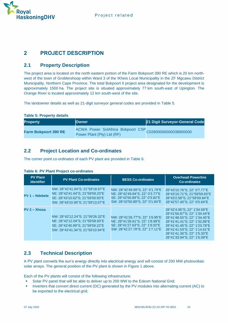
The project area is located on the north eastern portion of the Farm Bokpoort 390 RE which is 20 km north-
west of the town of Groblershoop within Ward 3 of the !Kheis Local Municipality in the ZF Mgcawu District
Municipality, Northern Cape Province. The total Bokpoort II project area designated for the development is
approximately 1500 ha. The project site is situated approximately 77 km south-east of Upington. The
Orange River is located approximately 12 km south-west of the site.
The landowner details as well as 21-digit surveyor general codes are provided in Table 5.
Table 5: Property details
Property Owner 21 Digit Surveyor-General Code
Farm Bokpoort 390 RE ACWA Power SolAfrica Bokpoort CSP
Power Plant (Pty) Ltd (RF) C02800000000038900000
2.2 Project Location and Co-ordinates
The corner point co-ordinates of each PV plant are provided in Table 6.
Table 6: PV Plant Project co-ordinates
PV Plant
Identifier PV Plant Co-ordinates BESS Co-ordinates
Overhead Powerline
Co-ordinates
PV 1 – Ndebele
NW: 28°42'41.94"S; 21°59'18.97"E
NE: 28°42'41.64"S; 21°59'59.23"E
SE: 28°43'10.62"S; 21°59'59.50"E
SW: 28°43'10.95"S; 21°59'13.07"E
NW: 28°42'49.99"S; 22° 0'1.79"E NE: 28°42'49.84"S; 22° 0'3.77"E SE: 28°42'50.89"S; 22° 0'3.82"E SW: 28°42'50.89"S; 22° 0'1.84"E
28°43'10.76"S; 22° 0'7.77"E 28°43'10.71"S; 21°59'59.93"E 28°43'2.58"S; 21°59'59.84"E 28°42'57.40"S; 22° 0'0.64"E
PV 2 – Xhosa
NW: 28°42'12.24"S; 21°59'26.32"E
NE: 28°42'12.04"S; 21°59'58.93"E
SE: 28°42'40.99"S; 21°59'59.22"E
SW: 28°42'41.34"S; 21°59'10.94"E
NW: 28°41'26.77"S; 22° 1'6.95"E NE: 28°41'26.61"S; 22° 1'8.99"E SE: 28°41'27.63"S; 22° 1'9.02"E SW: 28°41'27.79"S; 22° 1'7.11"E
28°42'4.95"S; 22° 1'34.59"E 28°41'56.87"S; 22° 1'34.44"E 28°41'48.55"S; 22° 1'34.45"E 28°41'41.41"S; 22° 1'32.89"E 28°41'41.45"S; 22° 1'23.78"E 28°41'41.53"S; 22° 1'14.61"E 28°41'41.36"S; 22° 1'5.33"E 28°41'33.94"S; 22° 1'6.09"E
2.3 Technical Description
A PV plant converts the sun’s energy directly into electrical energy and will consist of 200 MW photovoltaic
solar arrays. The general position of the PV plant is shown in Figure 1 above.
Each of the PV plants will consist of the following infrastructure:
▪ Solar PV panel that will be able to deliver up to 200 MW to the Eskom National Grid;
▪ Inverters that convert direct current (DC) generated by the PV modules into alternating current (AC) to
be exported to the electrical grid;

P r o j e c t r e l a t e d
07 July 2020 MD4195-RHD-ZZ-XX-RP-YE-0001 11
▪ A transformer that raises the system AC low voltage to medium voltage. The transformer converts the
voltage of the electricity generated by the PV panels to the correct voltage for delivery to Eskom;
▪ Transformer substation; and
▪ Instrumentation and Control consisting of hardware and software for remote plant monitoring and
operation of the facility.
Associated infrastructure includes:
▪ Mounting structures for the solar panels;
▪ Cabling between the structures, to be lain underground where practical;
▪ A new 132 kV overhead powerline (servitude spanning 15.5 m on both sides with towers that will be
35 m high) which was already approved as part of the previous EIA process and will connect the facility
to the National Grid via Eskom’s existing Garona Substation;
▪ Battery Energy Storage System (BESS);
▪ Internal access roads (4 – 6 m wide roads will be constructed but existing roads will be used as far as
possible) and fencing (approximately 3 m in height); and
▪ Shared infrastructure consisting of buildings, including a workshop area for maintenance, storage (i.e.
fuel tanks, etc.), laydown area, parking, warehouse, and offices (previously approved).
Table 7 summarises the main technical details for a PV plant and associated infrastructure.
Table 7: Technical details of the proposed PV plant/s
Facility Component Description/ Dimensions
Height of PV panels 4.5 m
Area of PV Array 150 ha
Area occupied by inverter/ transformer stations/ substations
150 m x 150 m
Capacity of on-site substation 11 kV/132 kV on site substation
Area occupied by both permanent and construction laydown areas
5 ha
Area occupied by buildings
Length of internal roads Approximately 5 ha (temporary facilities used during the construction and operational phase will be less than as PV does not require a lot of operational staff)
Width of internal roads 4 m
Proximity to grid connection Approximately 5 km
Height of fencing 3 m
Type of fencing Security Fencing
Overhead powerline length Varies in length
Overhead powerline servitude 15.5 m on each side
Overhead powerline tower height 35 m
BESS (either lead-acid or lithium-ion)
Battery power at point of connection: 150 MW
Area required: 400 m x 400 m
Quantity of hazardous substance: 4500 m3

P r o j e c t r e l a t e d
07 July 2020 MD4195-RHD-ZZ-XX-RP-YE-0001 12
Facility Component Description/ Dimensions
Construction/ labour camp Construction camp to be constructed for up to 200 people
2.3.1 Battery Energy Storage System
Battery Storage is one of the energy storage technologies that can provide flexibility and services in
managing the electricity system in order to create a more resilient energy infrastructure. There are various
types of energy storage technologies available at the current time, including the following:
▪ Batteries: Devices that store energy electrochemically in a way that allows for direct conversion to
electricity
▪ Flow Batteries: Batteries in which the electrodes are in liquid form, allowing increased flexibility in
design
▪ Flywheels: Devices that store energy in a rotating mass, convertible to and from electricity through a
motor/generator
▪ Compressed Air: Systems that store energy in compressed air, which can be run through expanders
to regenerate electricity
▪ Thermal Storage: Systems that capture heat or cold and allows them to be released as required to
serve customer loads
▪ Pumped Storage: Systems that store energy in large reservoirs of water held at a height
Battery storage technology is an emerging global technology and recent world trends suggest it is best used
to support national electricity grids. It is only recently that battery storage has become sufficiently
economically viable to start playing a significant energy storage role in the power system. In South Africa,
as a result of the Renewable Energy Independent Power Producer Procurement, the variable energy
sources, specifically solar (photovoltaic (PV)) and wind have multiplied. Solar without storage predominantly
provides the predictable component of energy generation, whilst wind provides the far less predictable
component; as a result, power must be generated at short notice in order to sustain the supply/demand
balance. Battery storage provides this flexibility and deploying the batteries in areas where there are a lot
of renewable energy power plants will allow energy generators to take advantage of the surplus energy
generation capacity provided by this increased renewable technology.
There is no perfect energy storage solution and with the variety of technologies available, it is both difficult
and important to have quantifiable ways in which to compare them. Selecting the ‘best’ storage technology
will depend on the application and system requirements.
The following technology options have been considered by ACWA Power:
▪ Lithium Ion and Lithium Polymer Batteries
▪ Lead Acid Battery
2.4 Project Motivation
South Africa experiences some of the highest levels of solar radiation in the world. The average daily solar
radiation in South Africa varies between 4.5 and 6.5 kWh/m2 (16 and 23 MJ/m2), compared to about
3.6 kWh/m2 for parts of the United States and about 2.5 kWh/m2 for Europe and the United Kingdom. Figure
2 below shows the annual solar radiation (direct and diffuse) for South Africa, which reveals considerable
solar resource potential for solar water heating applications, solar photovoltaic and solar thermal power
generation. The Northern Cape Province is one of the best places in South Africa to harness solar radiation.

P r o j e c t r e l a t e d
07 July 2020 MD4195-RHD-ZZ-XX-RP-YE-0001 13
Figure 2: Annual incoming short-wave radiation for South Africa8
2.5 Integrated Resource Plan (IRP 2019)
The IRP is an electricity infrastructure development plan based on least-cost electricity supply and demand
balance, taking into account security of supply and the environment (minimize negative emissions and water
usage). The promulgated IRP 2010–2030 identified the preferred generation technology required to meet
expected demand growth up to 2030. It incorporated government objectives such as affordable electricity,
reduced greenhouse gas (GHG) emissions, reduced water consumption, diversified electricity generation
sources, localisation and regional development.
Besides capacity additions, a number of assumptions have changed since the promulgation of IRP 2010–
2030. Key assumptions that changed include the electricity demand projection, Eskom’s existing plant
performance, as well as new technology costs. These changes necessitated the review and update of the
IRP which resulted in the draft IRP 2018 and the promulgation of the IRP 2019.
The IRP recognises that whilst South Africa relies heavily on coal to meet its energy needs, the country is
well endowed with renewable energy resources that offer sustainable alternatives to fossil fuels and
therefore the country continues to pursue a diversified energy mix that reduces reliance on a single or a few
8 www.solargis.info

P r o j e c t r e l a t e d
07 July 2020 MD4195-RHD-ZZ-XX-RP-YE-0001 14
primary energy sources. The extent of decommissioning of the existing coal fleet due to end of design life,
could provide space for a completely different energy mix relative to the current mix. Solar PV, wind and
CSP with storage present an opportunity to diversify the electricity mix, to produce distributed generation
and to provide off-grid electricity. Renewable technologies also present huge potential for the creation of
new industries, job creation and localisation across the value chain9.
During the State of the Nation Address 2020, it was indicated that a “section 34 Ministerial Determination
will be issued “shortly” to give effect to the country’s Integrated Resource Plan 2019, enabling the
development of additional grid capacity from renewable energy, natural gas, hydropower, battery storage
and coal. This includes starting to procure emergency power from projects that can deliver electricity into
the grid within 3 to 12 months from approval.” ACWA Power has noted the urgency of these projects and
has taken all the necessary steps to provide solutions to one of South Africa’s greatest threats to
development.
2.5.1 Need & Desirability
Table 8: Project need, desirability and benefits
(i) Is the activity permitted in terms of the property’s existing land use rights?
YES NO Please explain
ACWA Power Solafrica Bokpoort CSP Power Plant (Pty) Ltd is the landowner of the Farm Bokpoort 390 RE and
in 11 January 2017 obtained approval for the rezoning of farm for Agriculture Zone 1 to a Special Zone (Solar
Energy Facility). The activity is therefore permitted in terms of the property’s existing land use rights.
(ii) Will the activity be in line with the following?
(a) Provincial Spatial Development Framework (PSDF) YES NO Please explain
The proposed activity is in line with the Northern Cape PSDF (2012) Energy Policy, which states that “renewable
energy sources (e.g. wind, solar thermal, biomass, and domestic hydroelectricity generation) are to comprise
25% of the province's energy generation capacity by 2020” and the PSDF Objectives which include “to promote
the development of renewable energy supply schemes. Large-scale renewable energy supply schemes are
strategically important for increasing the diversity of domestic energy supplies and avoiding energy imports while
minimizing detrimental environmental impacts”.
Recognising the suitability of the province to optimise the use of solar power, the Northern Cape Provincial
Spatial Development Framework (PSDF) has set the following energy objectives for the province:
▪ to promote the development of renewable energy supply schemes;
▪ to reinforce the existing transmission network and to ensure a reliable electricity supply in the Northern
Cape;
▪ to develop and institute innovative new energy technologies to improve access to reliable, sustainable and
affordable energy services with the objective to realise sustainable economic growth and development;
and
▪ to develop and institute energy supply schemes with the aim to contribute to the achievement of the targets
set by IRP 2010 – 2030.
(b) Urban edge / Edge of Built environment for the area YES NO Please explain
The project is located outside of the urban edge. The proposed development site is in a remote, rural area and
so it will neither contribute to, nor compromise urban growth.
9 Department of Energy. 2019. Integrated Resources Plan.

P r o j e c t r e l a t e d
07 July 2020 MD4195-RHD-ZZ-XX-RP-YE-0001 15
(c) Integrated Development Plan (IDP) and Spatial Development
Framework (SDF) of the Local Municipality (e.g. would the approval
of this application compromise the integrity of the existing
approved and credible municipal IDP and SDF?).
YES NO Please explain
According to the !Kheis Local Municipality IDP 2017-2022: “The Municipality is in the middle of the Presidential
Infrastructure Coordinating Committee (PICC), Strategic Infrastructure Program (SIP) and is therefore part of the
Special Economic Development Zone of the Solar Corridor. !Kheis Municipal area could benefit from a number
of programs that are not available to other Municipalities, and must be incorporated in the approach in the IDP.
Solar energy is a natural resource like water, mining, iron and copper. A lot of macro solar projects is happening
around the Municipality. Micro solar opportunities can assist sustainability of the Municipality by attracting new
businesses and in the provision of basic services to residents. The Municipal area has a high solar radiation
which can open enormous potential of green technology and innovation such as powering solar vehicles to render
basic services. This resource can be a major advantage to assist the poor rural communities in the creation of
jobs and providing electricity to under privilege families and business opportunities.”
Therefore, this project is in line for the vision for the Municipality and will assist the Municipality in developing
solar projects in the future.
(d) Approved Structure Plan of the Municipality YES NO Please explain
As stated above a key opportunity for the Municipality is to develop green technologies due to the unique position
that the municipality is located in, therefore this project will assist the municipality in developing this vision.
(e) An Environmental Management Framework (EMF) adopted by the
Department (e.g. Would the approval of this application
compromise the integrity of the existing environmental
management priorities for the area and if so, can it be justified in
terms of sustainability considerations?)
YES NO Please explain
The ZF Mgcawu District Municipality (formerly known as the Siyanda District) EMF within the !Kheis Municipality
IDP (2014 - 2015) states that due to the climate of the area there is huge potential to utilise solar energy more
widely, especially in the remote areas of the district. The proposed activity is a solar plant which is a sustainable
and renewable operation that provides an additional economic resource to the area.
Furthermore, this Basic Assessment study is a mechanism of a management intervention that considers the
principles of the National Environmental Management Act which includes sustainability.
(f) Any other Plans (e.g. Guide Plan) YES NO Please explain
The IRP 2019 stated that the “Solar PV, wind and CSP with storage present an opportunity to diversify the
electricity mix, to produce distributed generation and to provide off-grid electricity. Renewable technologies also
present huge potential for the creation of new industries, job creation and localisation across the value chain.”

P r o j e c t r e l a t e d
07 July 2020 MD4195-RHD-ZZ-XX-RP-YE-0001 16
(iii) Is the land use (associated with the activity being applied for) considered within the timeframe intended by the existing approved SDF agreed to by the relevant environmental authority (i.e. is the proposed development in line with the projects and programmes identified as priorities within the credible IDP)?
YES NO Please explain
The project poses no threat to the land uses, the location of the project is in a strategically important area known
as renewable energy development zones (REDZ). REDZ are gazetted geographical areas:
▪ In which clusters (several projects) of wind and PV solar development will have the lowest negative impact
on the environment while yielding the highest possible social and economic benefit to the country;
▪ That are widely agreed to have strategic importance for wind and PV solar development;
▪ Where the environmental and other authorisation processes have been aligned and streamlined based on
scoping level pre-assessment and clear development requirements;
▪ Where pro-active and socialised investment can be made to provide time efficient infrastructure access
The study area falls within the REDZ 7 which is earmarked for large scale solar energy facilities and is within the
Northern Corridor Strategic Transmission Corridor.
As stated above, it is one of the initiatives of the Municipality to use this opportunity for the improvement of the
community by ensuing that these solar plants will directly benefit the Municipality through the creation of jobs as
well as creating self-sufficient cities.
(iv) Does the community / area need the activity and the associated land use concerned (is it a societal priority)? (This refers to the strategic as well as local level (e.g. development is a national priority, but within a specific local context it could be inappropriate.)
YES NO Please explain
The recent power cuts or load shedding by Eskom have emphasised the need for additional power generation
capacity in South Africa. There is a focus on moving towards increased generation from renewable energy
sources. The Department of Energy’s Renewable Energy Independent Power Producer Procurement (REIPPP)
Programme is designed to stimulate more independent power producers to meet the country’s ever-growing
electricity demand. The IRP 2019 being implemented by the Department of Energy, highlights the electricity
demand forecasts and Government’s plan to meet this demand through a variety of approaches and
technologies, one of which is to implement more renewable energy projects.
Due to South Africa’s electricity generation and supply system being overloaded, the demand for an increased
and stable electricity supply is a priority not only in the Northern Cape, but in all the other South African provinces.
Solar energy plants are important for reducing the country’s overall environmental footprint from power
generation and for directing a pathway towards sustainability. Thus, the proposed project addresses a national/
strategic priority.
(v) Are the necessary services with adequate capacity currently available (at the time of application), or must additional capacity be created to cater for the development?
YES NO Please explain
There are no services at the site and none will be required from the municipality. The construction of a new water
supply pipeline, access roads, a powerline from the PV installation to Eskom’s Garona substation and installation
of a package plant (sewage treatment) has already been authorised. Domestic and office waste will be removed
by a Contractor.
(vi) Is this development provided for in the infrastructure planning of the municipality, and if not what will the implication be on the infrastructure planning of the municipality (priority and placement of services and opportunity costs)?
NO NO Please explain
The infrastructure required for the proposed development is to be provided and maintained by both the Developer
and the end user which in this case is Eskom, and it will not conflict with municipal infrastructure planning or
priorities. In addition, the proposed development is to be constructed on overgrazed agricultural land outside of
an urban area, with little or no existing or planned infrastructure.

P r o j e c t r e l a t e d
07 July 2020 MD4195-RHD-ZZ-XX-RP-YE-0001 17
(vii) Is this project part of a national programme to address an issue of national concern or importance?
YES NO Please explain
The project aims at meeting the National Development Plan objectives. The National Development Plan states
the following as a priority objective: Procuring at least 20 000 MW of renewable electricity by 2030, importing
electricity from the region, decommissioning 11 000 MW of ageing coal-fired power stations and stepping up
investments in energy-efficiency.
(viii) Do location factors favour this land use (associated with the activity applied for) at this place? (This relates to the contextualisation of the proposed land use on this site within its broader context.)
YES NO Please explain
The Northern Cape has been recognised as having the highest solar resource in the country and so is ideally
suited to solar power generation. Further this is in keeping with the Bokpoort I plant recently constructed close
to the proposed site. The proposed site is well located in terms of proximity to Eskom’s Garona Substation, road
access (Transnet Service Road) and access to water (Orange River).
(ix) Is the development the best practicable environmental option for this land/site?
YES NO Please explain
The site is within one of South Africa's eight REDZs i.e. REDZ 7 Upington, applicable to Large scale solar PV
facilities and has therefore been identified as one of the most suitable areas in the country for renewable energy
development, in terms of several environmental impacts, economic and infrastructural factors. Renewable energy
development is therefore a very suitable land use option for the site. The property is already partly development
for renewable power generation. The current development (Bokpoort I) comprises a CSP parabolic trough facility
generating 50 MW of electricity. The property is well located in terms of connection to power infrastructure and
water availability.
(x) Will the benefits of the proposed land use/development outweigh the negative impacts of it?
YES NO Please explain
The proposed activity will supply renewable energy to Eskom and will consequently increase the amount of
electricity available to users. The site is well positioned for production of renewable energy given its proximity to
a key grid substation and Eskom transmission lines together with access to water (Orange River). The site is
already partly developed for renewable power production. These are positive factors in motivation of extending
renewable energy production at the site.
Potential negative impacts are anticipated however these can be mitigated.
(xi) Will the proposed land use/development set a precedent for similar activities in the area (local municipality)?
YES NO Please explain
The existing Bokpoort I project has already set a precedent and the extension of renewable energy production
at the site will be in line with the REDZ for large scale solar PV facilities.
(xii) Will any person’s rights be negatively affected by the proposed activity/ies?
YES NO Please explain
The public participation process will allow I&AP’s an opportunity to raise any concerns with the proposed project.
(xiii) Will the proposed activity/ies compromise the “urban edge” as defined by the local municipality?
YES NO Please explain
It is not foreseen that the proposed project and associated activities will compromise the “urban edge” as the
project components fall outside the urban edge.
The proposed development site is located a short distance outside the rural town of Groblershoop and
approximately 110 km by road from Upington. Infrastructure within these towns is under pressure from a variety
of solar development projects which are currently under construction in the area. The introduction of a large
construction workforce, as is typical of this type of development, will place further strain on the municipal
infrastructure, but the relatively small workforce associated with the operation of the proposed PV plants is
unlikely to require an expansion of the urban edge of any town.

P r o j e c t r e l a t e d
07 July 2020 MD4195-RHD-ZZ-XX-RP-YE-0001 18
(xiv) Will the proposed activity/ies contribute to any of the 17 Strategic
Integrated Projects (SIPS)? YES NO Please explain
The proposed development is in line with Strategic Integrated Projects (SIPs) in that it relates to social and
economic infrastructure across all nine provinces and include catalytic projects that can fast-track development
and growth but the process of being a SIP project has not been initiated. SIP 9: Electricity generation aims at
supporting socio- economic development (Accelerate the construction of new electricity generation capacity in
accordance with the IRP to meet the needs of the economy and address historical imbalances).
(xv) What will the benefits be to society in general and to the local communities? Please explain
The access to adequate electricity is a basic human right, which will also ensure the growth and development of
the area is maintained as the project area is an important economic area within the municipality.
The project is also in line with Sustainable Development Goal 7 (SDG 7) which stipulates Affordable and Clean
Energy for all. Investing in solar, wind and thermal power, improving energy productivity, and ensuring energy
for all is vital if we are to achieve SDG 7 by 2030. Expanding infrastructure and upgrading technology to provide
clean and more efficient energy in all countries will encourage growth and help the environment.
(xvi) Any other need and desirability considerations related to the proposed activity? Please explain
Society:
The operations will contribute electricity to the National Grid, thereby improving Eskom’s ability to meet the
growing demands of the country. Additional power on the National Grid will in turn mean a lesser likelihood of
power outages and an increased amount of power for the Nation’s industrial sector to operate more efficiently,
which is of critical importance to the national economy.
The PV plants also fits into the country’s national goals to reduce greenhouse gas emissions and impacts on
climate change, which on an international and global scale is aligned with the International Conventions and
Agreements (Section 3.2).
Communities:
The project will have a positive socio-economic impact with an increase in job opportunities and indirect economic
spin offs. Among those employed for the project, skills will be developed through training thus bringing about
empowerment for both permanent and temporary employees. The jobs generated would benefit households by
uplifting their socio-economic standards through an increase in income. Secondary jobs and income
sustainability will also be created in terms of repair and supply of the solar panels.
The circulation of additional money within the micro-economy will also benefit those who are not directly affiliated
with the project. As people will receive an increased income, they will have more money to spend on amenities
for both themselves and their families, thus uplifting the local and national economy via the energy saved and
jobs created from this initiative.
(xvii) How does the project fit into the National Development Plan for 2030? Please explain
The National Development Plan for 2030 seeks to promote economic growth and development through the
provision of quality energy services that are competitively priced, reliable and efficient. The National Development
Plan also seeks to promote social equity through the expansion of access to energy services.
The National Development Plan states the following as a priority objective: Procuring at least 20 000 MW of
renewable electricity by 2030, importing electricity from the region, decommissioning 11 000MW of ageing coal-
fired power stations and stepping up investments in energy-efficiency.
This project provides an opportunity to meet these goals.
(xviii) Please describe how the general objectives of Integrated Environmental Management as set out in section 23 of NEMA have been taken into account.
The impacts associated with the proposed project will be identified, predicted and evaluated to minimise negative
impacts, maximise benefits and promote compliance with the principles of environmental management set out
in Section 2 of NEMA (Section D). Mitigation and management measures to minimize negative impacts and
maximize benefits from the proposed project have been included in the EMPr attached as Appendix D to this
Report.

P r o j e c t r e l a t e d
07 July 2020 MD4195-RHD-ZZ-XX-RP-YE-0001 19
(xix) Please describe how the principles of environmental management as set out in section 2 of NEMA have been taken into account.
The proposed project will be sustainable in terms of the following:
▪ Social: Local communities will benefit from the project in terms of receiving adequate electrical supply that
serve to meet basic human needs. The local community and society in general will also benefit from the
project in terms of direct and indirect job creation.
▪ Economic: Provision of adequate electrical supply is a major contributor to the economic development.
Society in general will benefit from the project in terms of indirect job creation as it will contribute to
improving service delivery.
▪ Environmentally: the proposed project will avoid as far as practically possible any environmentally and
socially sensitive areas such as human settlements and where this is not possible, mitigation measures
have been proposed to minimise the impact.
▪ An EMPr (Appendix D) has been compiled that provides the actions for the management of identified
environmental impacts emanating from the project and a detailed outline of the implementation programme
to minimise and /or eliminate the anticipated negative environmental impacts.
2.5.2 Socio-economic Value
The socio-economic details for the project are provided in Table 9.
Table 9: Socio-economic details
Description Details
What is the expected capital value of the activity on
completion? R 1.2 billion
What is the expected yearly income that will be
generated by or as a result of the activity? R 180 million
Will the activity contribute to service infrastructure? Yes
Is the activity a public amenity? No
How many new employment opportunities will be
created in the construction phase of the activity?
100 to 250 construction jobs and 20 to 40 permanent
operations and maintenance positions during its
lifespan
What is the expected value of the employment
opportunities during the construction phase? R 350 million
What percentage of this will accrue to previously
disadvantaged individuals?
This will be in-line with the economic obligations
under the implementation agreement which will be
between IPP and the DMRE
How many permanent new employment
opportunities will be created during the operational
phase of the activity?
20 - 40 jobs
What is the expected current value of the
employment opportunities during the first 10 years? R 20 million/ annum
What percentage of this will accrue to previously
disadvantaged individuals?
This will be in-line with the economic obligations
under the implementation agreement which will be
between IPP and the DMRE

P r o j e c t r e l a t e d
07 July 2020 MD4195-RHD-ZZ-XX-RP-YE-0001 20
3 ENVIRONMENTAL LEGISLATIVE CONTEXT
In order to protect the environment and ensure that the development is undertaken in an environmentally
responsible manner, there are a number of significant environmental legislation (Table 10) that need to be
considered during this study.
This section outlines the legislation that is applicable to the proposed project and has been considered in
the preparation of this report.
Table 10: Key legislation considered
Acts Objectives, important aspects, associated notices and regulations
National Environmental
Management Act, 1998 (Act
No. 107 of 1998)(as
amended)
Objectives:
To provide for co-operative environmental governance by establishing principles for
decision-making on matters affecting the environment, institutions that will promote co-
operative governance and procedures for co-ordinating environmental functions
exercised by organs of state.
Relevant Notices and Regulations:
▪ Environmental Impact Assessment Regulations, 2014 (GNR 326 in GG 40772
as amended on 04 April 2017)
▪ Listing Notice 1 (GNR 327) as amended in 2017
▪ Listing Notice 2 (GNR 325) as amended in 2017
▪ Listing Notice 3 (GNR 324) as amended in 2017
Relevance to the proposed project:
▪ Development must be socially, environmentally and economically
sustainable.
▪ Environmental management must be integrated, acknowledging that all
elements of the environment are linked and interrelated; the social, economic
and environmental impacts of activities including disadvantages and benefits,
must be considered, assessed and evaluated and decisions must be
appropriate in the light of such consideration.
▪ ‘Polluter Pays’ principle.
▪ Any activity that is proposed and which is listed in the NEMA EIA Regulations,
requires environmental authorisation.
Listed Activity/ ies & Applicability:
Listing Notice 1
None - all the relevant LN1 activities have been authorised in EA dated 24/10/2016
(Ref: 14/12/16/3/3/2/880 & 14/12/16/3/3/2/881)
Listing Notice 2
▪ Activity 1 - The development of facilities or infrastructure for the generation of
electricity from a renewable resource where the electricity output is 20 MW or
more.
Applicability: Increasing the capacity of the already authorised PV 1 and PV2
facilities (EA dated 24/10/2016 (Ref: 14/12/16/3/3/2/880 &
14/12/16/3/3/2/881)) by 125 MW (i.e. from 75 MW to 200MW).
▪ Activity 4 - The development and related operation of facilities or
infrastructure, for the storage, or storage and handling of a dangerous good,
where such storage occurs in containers with a combined capacity of more
than 500 m3.

P r o j e c t r e l a t e d
07 July 2020 MD4195-RHD-ZZ-XX-RP-YE-0001 21
Acts Objectives, important aspects, associated notices and regulations
Applicability: Development of the BESS (either lead-acid or lithium-ion) that
will have a storage capacity of 4500m3 of hazardous / dangerous substance.
Listing Notice 3
None as the study area /site is not affected by any sensitive geographical areas.
National Water Act (Act No.
36 of 1998) (as amended)
Objectives:
The National Water Act (NWA) is a legal framework for the effective and sustainable
management of water resources in South Africa. Central to the NWA is recognition that
water is a scarce resource in the country which belongs to all the people of South Africa
and needs to be managed in a sustainable manner to benefit all members of society.
The NWA places a strong emphasis on the protection of water resources in South
Africa, especially against its exploitation, and the insurance that there is water for social
and economic development in the country for present and future generations.
Relevance to the proposed project:
▪ Sustainable protection, use, development and conservation of water
resources – including aquatic ecosystems.
▪ Defines 11 water uses and provides licencing procedures.
Notices and Regulations:
▪ General Authorisation in terms of Section 39 of the National Water Act (Act
No. 36 of 1998, Water Uses Section 21 (a) and (b) (GN in GG 40243 of 02
September 2016).
▪ General Authorisation in terms of Section 39 of the National Water Act (Act
No. 36 of 1998, Water Uses Section 21 (c) and (i) (GN in GG 40229 of
26 August 2016).

P r o j e c t r e l a t e d
07 July 2020 MD4195-RHD-ZZ-XX-RP-YE-0001 22
3.1 Other Relevant Acts, Guidelines, Department Policies and
Environmental Management Instruments
Table 11: Other relevant acts, guidelines, policies and environmental management instruments
Acts/Guideline/Policies/Environmental
Management Instruments Considerations
The Constitution (No. 108 of 1996) Chapter 2 – Bill of Right
Section 24 – Environmental Rights
National Environmental Management
Biodiversity Act (Act No. 10 of 2004) and
Regulations:
▪ Threatened or protected species
(GN 388)
▪ Lists of species that are threatened
or protected (GN 389)
▪ Alien and invasive species
regulations (GNR 506)
▪ Publication of exempted alien
species (GNR 509)
▪ Publication of National list of
invasive species (GNR 507)
▪ Publication of prohibited alien
species (GNR 508)
Provide for the protection of species and ecosystems that warrant
national protection and the sustainable use of indigenous biological
resources.
World Heritage Convention Act (Act No. 49 of
1999)
South Africa is home to eight of the world's official heritage sites,
as determined by UNESCO's World Heritage Committee. The Cape
Floral Region has been recognised as one of the most special
places for plants in the world in terms of diversity, density and
number of endemic species.
National Environmental Management: Waste
Act (Act No. 59 of 2008) as amended
Section 17 - Every attempt must be made to reduce, recycle or re-
use all waste before it is disposed.
Section 25 - All waste (general and hazardous) generated during
construction may only be disposed of at appropriately licenced
waste disposal sites.
All waste management activities (e.g. recycling, treatment) meeting
the relevant thresholds should be authorised under the National
Environmental Management: Waste Act (Act No. 59 of 2008)
[NEM:WA] (as amended) and Government Notice (GN) 921 of 29
November 2013 (as amended in 2015 and 2017). No person may
commence, undertake or conduct a waste management activity
listed GN 921 (as amended) unless a licence is issued in respect
of that activity.
National Environmental Management: Air
Quality Act (Act No 39 of 2004)
Section 32 - Control of dust.
Section 34 - Control of noise.
Section 35 - Control of offensive odours.
National Heritage Resources Act (Act No. 25
of 1999)
Section 34 - No person may alter or demolish any structure or part
of a structure which is older than 60 years without a permit issued
by the relevant provincial heritage resources authority.
Section 35 - No person may, without a permit issued by the
responsible heritage resources authority destroy, damage,

P r o j e c t r e l a t e d
07 July 2020 MD4195-RHD-ZZ-XX-RP-YE-0001 23
Acts/Guideline/Policies/Environmental
Management Instruments Considerations
excavate, alter, deface or otherwise disturb any archaeological or
palaeontological site.
Section 36 - No person may, without a permit issued by the South
African Heritage Resource Agency (SAHRA) or a provincial
heritage resources authority destroy, damage, alter, exhume,
remove from its original position or otherwise disturb any grave or
burial ground older than 60 years which is situated outside a formal
cemetery administered by a local authority. “Grave” is widely
defined in the Act to include the contents, headstone or other
marker of such a place, and any other structure on or associated
with such place.
Section 38 - The construction of a bridge or similar structure
exceeding 50 m in length.
Electricity Regulation Act No. 4 of 2006 as
amended by the Electricity Regulation
Amendment Act No. 28 of 2007
These regulations regulate the use and generation of electricity.
Occupational Health and Safety Act (Act No. 85
of 1993)
Section 8 - General duties of employers to their employees.
Section 9 - General duties of employers and self-employed persons
to persons other than their employees.
Construction Regulations (2014) Contractors must comply with the Construction Regulations which
lay out the framework for construction related activities.
Other:
• Hazardous Substance Act (Act No. 15 of 1973) and Regulations
• Conservation of Agricultural Resources Act (Act No. 43 of 1983)
• Civil Aviation Act (Act No. 13 of 2009) and Civil Aviation Regulations (CAR) of 1997
• Electricity Act (Act No. 41 of 1987)
• Civil Aviation Authority Act (Act No. 40 of 1998)
• White Paper on Renewable Energy (2003)
• Integrated Resource Plan for South Africa (2019)
• Environmental Impact Assessment Guidelines for Renewable Energy Projects, GNR 989 of 2015 in terms of
NEMA (Act No. 107 of 1998)
• Land Use Planning Ordinance (Ordinance 15 of 1985)
• National Road Traffic Act (Act No. 93 of 1996)
• Procedure to be followed in Applying for Environmental Authorisation for Large Scale Wind and Solar
Photovoltaic Energy Development Activities in terms of Section 24(2)a of NEMA, 1998 when occurring in
Geographical Areas of Strategic Importance (GG No. 114, 16 February 2018)
• ZF Mgcawu District Municipality Integrated Development Plan 2017-2022
• Northern Cape PSDF (2012) Energy Policy
• !Kheis Local Municipality By-laws

P r o j e c t r e l a t e d
07 July 2020 MD4195-RHD-ZZ-XX-RP-YE-0001 24
3.2 International Conventions and Agreements
Relevant environmental and social international conventions and agreements to which South Africa is a
party that is applicable to this project are presented in Table 12.
Table 12: Relevant international conventions to which South Africa is a party10 11
Convention Summary of objectives or relevant conditions South African Status
Convention on Biological
Diversity
(29 December 1993)
Develop strategies, plans or programs for conservation and
sustainable use of biological diversity or adapt for this purpose
existing strategies, plans or programs which shall reflect, inter alia,
the measures set out in this Convention.
Party to
United Nations Framework
Convention on Climate
Change
- Kyoto Protocol (23
February 2005)
To further reduce greenhouse gas emissions by enhancing the
national programs of developed countries aimed at this goal and
by establishing percentage reduction targets for the developed
countries and through the clean development mechanism (CDM)
(where developed countries can invest in developing country
clean technology to offset emissions).
Party to
Montreal Protocol on
Substances That Deplete
the Ozone Layer
(1 January 1989)
Calculated levels of consumption and production of CFCs must
not exceed the stipulated thresholds. Party to
United Nations Convention
to Combat Desertification
(26 December 1996)
To combat desertification and mitigate the effects of drought
through national action programs. Party to
United Nations Framework
Convention on Climate
Change (21 March 1994)
Protection of the climate system: Operations must protect the
climate system by controlling greenhouse gases not controlled by
the Montreal Protocol, which cause climate change through
anthropogenic interference with the climate system.
Party to
Stockholm Convention on
Persistent Organic
Pollutants (POPs)
(17 May 2004)
This convention seeks to ban the production and use of persistent
organic chemicals but allow the use of some of these banned
substances, such as DDT, for vector control.
Party to
The Fourth ACP-EEC
Convention 15 December
1989 (Lome)
Control of hazardous and radioactive waste: the operation must
be aware that international law emphasizes strict control of
hazardous waste and compliance with domestic legislation in this
regard. It also seeks to prohibit imports and exports of such
substances.
Party to
Convention concerning the
Protection of the World
Cultural and Natural
Heritage 1972 (Paris)
Ensuring the identification, protection, conservation, presentation
and transmission to future generations of the cultural and natural
heritage
Ratification
Rotterdam Convention on
the Prior Informed Consent
Procedure for Certain
Hazardous Chemicals and
Promote shared responsibility and cooperative efforts among
Parties in the international trade of certain hazardous chemicals
in order to protect human health and the environment from
potential harm
Party to
10 Sources: United States Central Intelligence Agency World Fact book (www.cia.gov/library/publications/the-world-
factbook/index.html) 11 Schlechter, M., & Baxter, B. 2016. Final EIA Report: Proposed 75MW Photovoltaic (PV2) Solar Development on the Remaining
Extent of the Farm Bokpoort 390, Northern Cape. Golder Associates. Ref 14/12/16/3/3/2/880.

P r o j e c t r e l a t e d
07 July 2020 MD4195-RHD-ZZ-XX-RP-YE-0001 25
Convention Summary of objectives or relevant conditions South African Status
Pesticides in International
Trade
(24 February 2004)
Paris Agreement adopted
on 12 December 2015 at the
21st session of the
Conference of the Parties to
the United Nations
Framework Convention on
Climate Change (UNFCCC
CoP21)
The Agreement is a comprehensive framework which will guide
international efforts to limit greenhouse gas emissions and to
meet all the associated challenges posed by climate change.
The main objective of the Agreement is to limit the global
temperature increase to well below 2 degrees Celsius, while
pursuing efforts to limit the increase to 1.5 degrees.
Ratified
3.3 International Standards
3.3.1 International Finance Corporation Performance Standards
ACWA Power is committed to complying with the IFC Performance Standards (PS) on social and
environmental sustainability. These were developed by the IFC and were last updated on 1st January 2012.
The PS comprise of eight performance standards as described in Table 13.
Table 13: IFC Performance Standards
Objective Applicability
PS 1: Assessment and Management of
Environmental and Social Risks and Impacts
Guidance note on the categorisation of projects
during project screening, requirements for
institutional capacity and requirements for public
consultation and disclosure.
This Basic Assessment Study supported by comprehensive
specialist assessments (Appendix B1 – B12) has identified
environmental and social risks and impact of the project and
provided mitigation measures to enhance positive impacts and
minimise negative impacts.
The impact assessment is consistent with Good International
Industry Practices (GIIP) and takes into account the nature,
extent, duration, intensity, probability and significance of the
identified impacts both before and after mitigation measures
(Chapter 7). Cumulative impacts that result from the
incremental impacts on areas or resources directly impacted by
the project have also been identified and noted in the study
(Chapter 7).
The EMPr (Appendix D) provides the actions for the
management of identified environmental impacts and a detailed
outline of the implementation programme. The EMPr provides
strategies to be used to address the roles and responsibilities of
environmental management personnel on site, and a framework
for environmental compliance and monitoring.
Extensive engagement has taken place with project affected
people for the previously authorised 2 PV plants and CSP plant
and will continue for the development of the PV plants
(Chapter 6).
PS 2: Labour and Working Conditions
Recognises that the pursuit of economic growth
through employment creation and income
generation should be accompanied by protection of
The project will provide employment opportunities for 100 – 250
people during the construction phase and 20 – 40 people during
the operations phase.

P r o j e c t r e l a t e d
07 July 2020 MD4195-RHD-ZZ-XX-RP-YE-0001 26
Objective Applicability
the fundamental rights of workers, including health
and safety. Failure to establish and foster a sound
worker-management relationship can undermine
worker commitment and retention and can
jeopardise a project.
Prior to development, human resource policies and procedures,
working conditions and terms of employment, equal opportunity,
retrenchment policy and a formal grievance mechanism must be
established to promote the fair treatment, non-discrimination
and equal opportunity of workers in line with national
employment and labour laws.
Further to this, the Developer also has an obligation to provide
a safe and healthy work environment for its employees in terms
of the Occupational Health and Safety Act (Act No. 85 of 1993).
PS 3: Resource Efficiency and Pollution
Prevention
Recognises that increased economic activity and
urbanisation often generate increased levels of
pollution to air, water, and land, and consume finite
resources in a manner that may threaten people and
the environment at the local, regional, and global
levels. More efficient and effective resource use and
pollution prevention and greenhouse gas emission
avoidance and mitigation technologies enhance the
efficiency and sustainability of the project.
South Africa’s reliance on fossil fuels as a primary energy source
is well known and coal combustion is the main contributor to
carbon dioxide emissions, a greenhouse gas that has been
linked to climate change. The proposed renewable energy
project utilising PV technology offers a sustainable alternative to
fossil fuels and in line with the South Africa’s IRP (2019) which
ensures that a more diversified energy mix is sought that
reduces reliance on a single or a few primary energy sources.
The change from CSP technology to PV technology further
decreases the demand for water consumption from
0.3 million cubic metres per annum (Mm3/ a) to 0.22 Mm3/ a.
Pollution prevention measures contained in the Basic
Assessment report and EMPr (Appendix D) are in line with GIIP
and contain comprehensive management outcomes and impact
management actions for waste generation during the different
project phases as well as the storage and use of hazardous
substances that may have a potential to have a detrimental
impact on the environment.
PS 4: Community Health, Safety and Security
Recognises that project activities, equipment, and
infrastructure can increase community exposure to
risks and impacts. This Performance Standard
addresses the Promotor’ responsibility to avoid or
minimise the risks and impacts to community health,
safety, and security.
The proposed project will be designed, constructed, operated
and decommissioned in accordance with GIIP. Mitigation
measures and controls are provided in the EMPr (Appendix D)
for spills, incidents and pollution control as well as for
containment losses of hazardous substances particularly the
BESS. An Emergency Preparedness and Response Plan must
be compiled by the Developer for the project prior to
implementation.
Traffic and dust impacts have been assessed as being moderate
prior to the implementation of mitigation measures and have to
be carefully managed as these impacts have been documented
during the stakeholder engagement process as being major
safety and nuisance factors.
An adequate resolution needs to be obtained regarding the
upgrading (re-gravelling, surfacing etc.) of existing roads and
intersections in the study area separate to this environmental
assessment process.
PS 5: Land Acquisition and Involuntary
Resettlement
Recognises that project-related land acquisition and
restrictions on land use can have adverse impacts
on communities and persons that use this land.
Involuntary resettlement refers both to physical
No physical displacement and resettlement of people will take
place. In terms of land acquisition, the study area is owned by
ACWA Power SolAfrica Bokpoort CSP Power Plant (Pty) Ltd
(RF).

P r o j e c t r e l a t e d
07 July 2020 MD4195-RHD-ZZ-XX-RP-YE-0001 27
Objective Applicability
displacement (relocation or loss of shelter) and to
economic displacement (loss of assets or access to
assets that leads to loss of income sources or other
means of livelihood) as a result of project-related
land acquisition and/or restrictions on land use, while
temporary or permanent.
PS 6: Biodiversity Conservation and Sustainable
Management of Living Natural Resources
Recognises that protecting and conserving
biodiversity, maintaining ecosystem services, and
sustainably managing living natural resources are
fundamental to sustainable development.
The project will not impact any proclaimed protected biodiversity
area.
As assessment of the critical habitats (Appendix B5) have
shown that apart from the rocky outcrop to the north of the study
area associated with the Koranna-Langeberg Mountain
Bushveld Vegetation type which is classified as a Natural
Habitat, the calcareous low shrub plains, open shrub plains,
open shrub duneveld and transformed areas are classified as
Modified Habitats. A 250 m buffer has been applied to the rocky
outcrop and no development is allowed to encroach this area.
The Biodiversity Assessment (Appendix B5) was compiled with
impacts managed in line with the mitigation hierarchy. No
impacts were identified that could not be mitigated to an
acceptable level. Mitigation measures associated with the
protection of fauna and flora and management of alien invasive
species have been included in the EMPr (Appendix D).
PS 7: Indigenous Peoples
Recognises that Indigenous Peoples, as social
groups with identities that are distinct from
mainstream groups in national societies, are often
among the most marginalised and vulnerable
segments of the population. In many cases, their
economic, social, and legal status limits their
capacity to defend their rights to, and interests in,
lands and natural and cultural resources, and may
restrict their ability to participate in and benefit from
development.
The Socio-economic study confirmed that there is no evidence
of the presence of any indigenous people residing or utilising the
project area and immediate surrounds.
PS 8: Cultural Heritage
Recognises the importance of cultural heritage for
current and future generations. Consistent with the
Convention Concerning the Protection of the World
Cultural and Natural Heritage, this Performance
Standard aims to ensure that protect cultural
heritage in the course of their project activities.
A comprehensive Heritage Impact Assessment (Appendix B9)
and Desktop Palaeontology Impact Assessment (PIA) together
with Chance Find Protocol (Appendix B10) were conducted for
the project.
No sites, features or objects of cultural significance are known
to exist in the development area, there would be no impact as a
result of the proposed development. Should archaeological sites
or graves be exposed in other areas during construction work,
measures and controls have been stipulated in this report and
EMPr (Appendix D) for the management of the site/ graves.
No significant fossil heritage resources have been recorded
within the study area. The area is inferred to be of low sensitivity
in terms of palaeontological heritage and no sensitive or no-go
areas have been identified within it during the desktop PIA. In
the case of any significant chance fossil finds during
construction (e.g. vertebrate teeth, bones, burrows, petrified
wood, shells), these must be safeguarded - preferably in situ -

P r o j e c t r e l a t e d
07 July 2020 MD4195-RHD-ZZ-XX-RP-YE-0001 28
Objective Applicability
and reported as soon as possible to the South African Heritage
Resources Agency (SAHRA).
3.4 Equator Principles
The Equator Principles (EPs) is a risk management framework, adopted by financial institutions, for
determining, assessing and managing environmental and social risk in projects and is primarily intended to
provide a minimum standard for due diligence and monitoring to support responsible risk decision-making.
Project finance is often used to fund the development and construction of major infrastructure and industrial
projects.
The EPs are adopted by financial institutions and are applied where total project capital costs exceed
US$10 million. The EPs are primarily intended to provide a minimum standard for due diligence to support
responsible risk decision-making. The EPs are based on the IFC PS 2012 and on the World Bank Group
Environmental, Health and Safety Guidelines (EHS Guidelines).
The Equator Principles Financial Institutions (EPFIs) have consequently adopted these Principles in order
to ensure that the projects they finance are developed in a manner that is socially responsible and reflect
sound environmental management practices.
EPFIs will only provide loans to projects that conform to the following principles:
▪ Principle 1: Review and Categorisation;
▪ Principle 2: Social and Environmental Assessment;
▪ Principle 3: Applicable Social and Environmental Standards;
▪ Principle 4: Action plan and Management;
▪ Principle 5: Consultation and Disclosure;
▪ Principle 6: Grievance Mechanism;
▪ Principle 7: Independent review;
▪ Principle 8: Covenants;
▪ Principle 9: Independent Monitoring and Reporting; and
▪ Principle 10: EPFI Reporting.
3.4.1 The World Bank Group Environmental Health and Safety (EHS) Guidelines
The EHS Guidelines (World Bank Group, 2007) are technical reference documents with general and industry
specific examples of Good International Industry Practice (GIIP). Reference to the EHS guidelines is
required under IFC PS 3.
The EHS Guidelines contain the performance levels and measures normally acceptable to the IFC and are
generally considered to be achievable in new facilities at reasonable cost. When host country regulations
differ from the levels and measures presented in the EHS Guidelines, projects are expected to achieve
whichever standard is more stringent.
3.5 Sustainable Development Goals
The Sustainable Development Goals (SDGs), also known as the Global Goals, were adopted by all United
Nations Member States in 2015 as a universal call to action to end poverty, protect the planet and ensure
that all people enjoy peace and prosperity by 2030. South Africa has embraced sustainable development
as its development approach and is fully committed to the 2030 Agenda for Sustainable Development, its
principles, goals, targets and indicators.

P r o j e c t r e l a t e d
07 July 2020 MD4195-RHD-ZZ-XX-RP-YE-0001 29
The 17 SDGs recognise that action in one area will affect outcomes in others, and that development must
balance social, economic and environmental sustainability.
Figure 3: Sustainable Development Goals
SDG 7 requires Affordable and Clean Energy for all. Investing in solar, wind and thermal power, improving
energy productivity, and ensuring energy for all is vital if we are to achieve SDG 7 by 2030. Expanding
infrastructure and upgrading technology to provide clean and more efficient energy in all countries will
encourage growth and help the environment12.
SDG 13 advocates taking urgent action to combat climate change and its impacts. The Paris Agreement is
universally regarded as a seminal point in the development of the international climate change regime under
the UNFCCC. The main objective of the Agreement is to limit the global temperature increase to well below
2 degrees Celsius, while pursuing efforts to limit the increase to 1.5 degrees. The recognition of the
1.5 degree target is of central importance to South Africa as an African and developing country that is highly
vulnerable to climate change.
12 https://sustainabledevelopment.un.org/sdg7

P r o j e c t r e l a t e d
07 July 2020 MD4195-RHD-ZZ-XX-RP-YE-0001 30
4 PROJECT ALTERNATIVES
In terms of the EIA Regulations 2014 (as amended in 2017) feasible alternatives are required to be
considered as part of the environmental investigations. In addition, the obligation that alternatives are
investigated is also a requirement of Section 24(4) of the NEMA (Act No. 107 of 1998) (as amended).
An alternative in relation to a proposed activity refers to the different means of meeting the general purpose
and requirements of the activity which may include alternatives to:
▪ the property on which or location where it is proposed to undertake the activity;
▪ the type of activity to be undertaken;
▪ the design or layout of the activity;
▪ the technology to be used in the activity;
▪ the operational aspects of the activity; and
▪ the option of not implementing the activity.
4.1 Site Alternatives
No site alternative has been considered for the project as this application is for supporting infrastructure and
a generation capacity increase for the already authorised Ndebele (formerly PV1) and Xhosa (formerly PV2)
PV Plants (EA dated 24/10/2016 – Ref: 14/12/16/3/3/2/880 and 14/12/16/3/3/2/881). This decision is based
on site selection and sensitivity assessments conducted during the previous EIA studies and the criteria for
the decision is summarised in Table 14.
Table 14: Site selection criteria13
Criteria Description
Site Extent
The PV plants will require 150 ha for the construction of the solar panels and
associated infrastructure. The proposed site, which is approximately 1500 ha in
extent will therefore be sufficient for the construction of the proposed plants
including the already authorised PV plants (PV 1 & PV 2).
Site Availability ACWA Power acquired the project site during the development of the Bokpoort I
CSP Trough facility. The site is therefore available for development.
Site Access
The project site is most easily accessed from the N8 via the Gariep Road and
then via the Transnet Service Road. Alternatively, the site can be accessed from
the N14 via the Gariep Road/ Loop16 and Transnet Service Road.
Grid connection
The project site is located in close proximity to the Garona Substation, which is
located directly adjacent to the Bokpoort I CSP Trough facility. A new 132 kV
overhead powerline from each PV plant will connect the facility to the national
grid via the substation.
Site Gradient
The slope of the project site is considered to be acceptable for the development
of the PV plants. This reduces the need for any extensive earthworks or levelling
activities.
Availability of water
The PV facility will require 0.22 Mm3/ annum of water that will be used during the
construction of the facility as well as for human consumption and panel washing
during the operational phase. The Orange River is located approximately 20 km
from the project site. It is proposed that water will be abstracted and transferred
to the facility via an underground pipeline. There is an established water pipeline
servitude currently being utilised by the Bokpoort I CSP Trough facility. A water
pipeline has also been approved as part of the PV1 and PV2 authorisations
13 Schlechter, M., & Baxter, B. 2016. Final EIA Report: Proposed 75MW Photovoltaic (PV2) Solar Development on the Remaining
Extent of the Farm Bokpoort 390, Northern Cape. Golder Associates. Ref 14/12/16/3/3/2/880.

P r o j e c t r e l a t e d
07 July 2020 MD4195-RHD-ZZ-XX-RP-YE-0001 31
Criteria Description
Availability of environmental
baseline and sensitivity
information
The project site for the proposed Bokpoort II project falls within the area
previously assessed in the Phase 1 EIA for the Bokpoort I 75 MW CSP project
facility. During the EIA process for the already constructed Bokpoort I project, site
zoning sensitivity maps were produced which have added value to the process
of site selection and considering placement of infrastructure for the current
project. The Bokpoort I EIA study’s sensitivity zoning map indicates that the
project footprint for the Bokpoort II project does not contain features on the site
footprint itself which would limit disturbance of and development on the site
(Figure 4).
Further to the above site selection process, the site is within one of South Africa's eight renewable energy
development zones (REDZ) i.e. REDZ 7 Upington, applicable to Large scale solar PV facilities (Figure 4),
and has therefore been identified as one of the most suitable areas in the country for renewable energy
development, in terms of a number of environmental impact, economic and infrastructural factors.
Renewable energy development is therefore a very suitable land use option for the site.
In order for South Africa to achieve its renewable energy generation goals, agriculturally-zoned land will
need to be used for renewable energy generation. It is far more preferable to incur a cumulative loss of
agricultural land in a region such as the one being assessed, which has no cultivation potential, and low
grazing capacity, than to lose agricultural land that has a higher potential, and that is much scarcer, to
renewable energy development elsewhere in the country.
It is also preferable, from an impact point of view as well as from practical considerations, to rather have a
concentrated node of renewable energy development within one area, as is the case around this project,
than to spread out the same number of developments over a larger area.
Figure 4: REDZ 7 Upington (project area indicated by yellow area)

P r o j e c t r e l a t e d
07 July 2020 MD4195-RHD-ZZ-XX-RP-YE-0001 32
Figure 5: Sensitivity map of Farm Bokpoort 390 RE14
14 Schlechter, M., & Baxter, B. 2016. Final EIA Report: Proposed 75MW Photovoltaic (PV2) Solar Development on the Remaining Extent of the Farm Bokpoort 390, Northern Cape. Golder Associates.
Ref 14/12/16/3/3/2/880.

P r o j e c t r e l a t e d
07 July 2020 MD4195-RHD-ZZ-XX-RP-YE-0001 33
4.2 Technology Alternatives
4.2.1 PV Plants
ACWA Power submitted applications for Environmental Authorisation to the DEA for three different
technologies, by means of six different applications, namely PV solar power technology, CSP Parabolic
Trough and CSP Towers. These applications were undertaken by Golder Associates between 2014 – 2016.
Subsequent to consultation with the DEA at the time, ACWA Power performed an in-depth analysis of the
proposed project which resulted in the optimisation of the project development to include only three
applications. ACWA Power applied for the development of PV and CSP Tower technologies by means of
three different applications. Two of these applications were for the construction of a 75 MW PV plant (PV1
and PV2) and a third application was for a 150 MW CSP Tower.
There are no technology alternatives for the PV Plants as the Ndebele and Xhosa PV Plants have already
been approved as mentioned above and this technology option is further backed by the IRP 2019.
4.2.2 Battery Energy Storage System15
As mentioned previously ACWA Power has considered two alternatives namely: Lithium Ion and Lead Acid
Batteries, the merits of both these options will be discussed below. The Lithium Polymer option has been
included as an alternative but as it is relatively less reliable than the Lithium Ion and Lead Acid option, this
is the least preferred option and the main analysis will be based on Lithium Ion and Lead Acid BESS.
4.2.2.1 Lithium Ion BESS
The use of lithium as a battery source began in 1912 under G.N. Lewis, but the first commercially available
non-rechargeable battery was released in the 1970s. Lithium is the lightest of all metals, has the greatest
electrochemical potential and provides the largest energy density for weight. Initial attempts to create a
rechargeable version of the battery failed due to the instability of the lithium metal. Further research resulted
in the conclusion that the use of lithium ions (Li-ion) instead of the metal form yielded a viable rechargeable
battery option. Although slightly lower in energy density than lithium metal, lithium-ion is safe, provided
certain precautions are met when charging and discharging. The Sony Corporation in 1991 was the first
manufacturers to utilise the lithium ion batteries in products.
The energy density of lithium-ion is typically twice that of the standard nickel-cadmium. There is potential
for higher energy densities. The load characteristics are reasonably good and behave similarly to nickel-
cadmium in terms of discharge. Lithium-ion is a low maintenance battery, an advantage that most other
chemistries cannot claim. There is no memory and no scheduled cycling is required to prolong the battery's
life. In addition, the self-discharge is less than half compared to nickel-cadmium, making lithium-ion well
suited for modern fuel gauge applications. Lithium-ion cells cause little harm when disposed.
The disadvantages of Lithium ion are that it is fragile and requires a protection circuit to maintain safe
operation. Built into each pack, the protection circuit limits the peak voltage of each cell during charge and
prevents the cell voltage from dropping too low on discharge. In addition, the cell temperature is monitored
to prevent temperature extremes. The maximum charge and discharge current on most packs are is limited
to between 1C and 2C. With these precautions in place, the possibility of metallic lithium plating occurring
due to overcharge is virtually eliminated.
Aging is a concern with most lithium-ion batteries and many manufacturers remain silent about this issue.
Some capacity deterioration is noticeable after one year, whether the battery is in use or not. The battery
frequently fails after two or three years. It should be noted that other chemistries also have age-related
15 https://batteryuniversity.com

P r o j e c t r e l a t e d
07 July 2020 MD4195-RHD-ZZ-XX-RP-YE-0001 34
degenerative effects. This is especially true for nickel-metal-hydride if exposed to high ambient
temperatures. At the same time, lithium-ion packs are known to have served for five years in some
applications.
Manufacturers are constantly improving lithium-ion. New and enhanced chemical combinations are
introduced every six months or so. With such rapid progress, it is difficult to assess how well the revised
battery will age. Storage in a cool place slows the aging process of lithium-ion (and other chemistries).
Manufacturers recommend storage temperatures of 15°C (59°F). In addition, the battery should be partially
charged during storage.
4.2.2.2 Lithium Polymer BESS
The lithium-polymer differentiates itself from conventional battery systems in the type of electrolyte used.
The original design, dating back to the 1970s, uses a dry solid polymer electrolyte. This electrolyte
resembles a plastic-like film that does not conduct electricity but allows ions exchange (electrically charged
atoms or groups of atoms). The polymer electrolyte replaces the traditional porous separator, which is
soaked with electrolyte.
The dry polymer design offers simplifications with respect to fabrication, ruggedness, safety and thin-profile
geometry. With a cell thickness measuring as little as one millimetre (0.039 inches), equipment designers
are left to their own imagination in terms of form, shape and size.
Unfortunately, the dry lithium-polymer suffers from poor conductivity. The internal resistance is too high and
cannot deliver the current bursts needed to power modern communication devices and spin up the hard
drives of mobile computing equipment. Heating the cell to 60°C (140°F) and higher increases the
conductivity, a requirement that is unsuitable for portable applications.
To compromise, some gelled electrolyte has been added. The commercial cells use a separator/ electrolyte
membrane prepared from the same traditional porous polyethylene or polypropylene separator filled with a
polymer, which gels upon filling with the liquid electrolyte. Thus, the commercial lithium-ion polymer cells
are very similar in chemistry and materials to their liquid electrolyte counter parts.
Lithium-ion-polymer has not caught on as quickly as some analysts had expected. Its superiority to other
systems and low manufacturing costs has not been realized. No improvements in capacity gains are
achieved - in fact, the capacity is slightly less than that of the standard lithium-ion battery. Lithium-ion-
polymer finds its market niche in wafer-thin geometries, such as batteries for credit cards and other such
applications.
4.2.2.3 Lead Acid BESS
Invented by the French physician Gaston Planté in 1859, lead acid was the first rechargeable battery for
commercial use. Despite its advanced age, the lead chemistry continues to be in wide use today. There are
good reasons for its popularity; lead acid is dependable and inexpensive on a cost-per-watt base. There are
few other batteries that deliver bulk power as cheaply as lead acid, and this makes the battery cost-effective
for automobiles, golf cars, forklifts, marine and uninterruptible power supplies (UPS).
The grid structure of the lead acid battery is made from a lead alloy. Pure lead is too soft and would not
support itself, so small quantities of other metals are added to get the mechanical strength and improve
electrical properties.
Lead acid is heavy and is less durable than nickel- and lithium-based systems when deep cycled. A full
discharge causes strain and each discharge/charge cycle permanently robs the battery of a small amount
of capacity. This loss is small while the battery is in good operating condition, but the fading increases once
the performance drops to half the nominal capacity. This wear-down characteristic applies to all batteries in
various degrees.

P r o j e c t r e l a t e d
07 July 2020 MD4195-RHD-ZZ-XX-RP-YE-0001 35
Depending on the depth of discharge, lead acid for deep-cycle applications provides 200 to 300
discharge/charge cycles. The primary reasons for its relatively short cycle life are grid corrosion on the
positive electrode, depletion of the active material and expansion of the positive plates. This aging
phenomenon is accelerated at elevated operating temperatures and when drawing high discharge currents.
Ever since Cadillac introduced the starter motor in 1912, lead acid batteries served well as battery of choice.
Thomas Edison tried to replace lead acid with nickel-iron (NiFe), but lead acid prevailed because of its
rugged and forgiving nature, as well as low cost. Now the lead acid serving as starter battery in vehicles is
being challenged by Li-ion.
Figure 6 illustrates the characteristics of lead acid and Li-ion. Both chemistries perform similarly in cold
cranking. Lead acid is slightly better in W/kg, but Li-ion delivers large improvements in cycle life, better
specific energy in Watt Hours Per Kilogram (Wh/kg) and good dynamic charge acceptance. Where Li-ion
falls short is high cost per kWh, complex recycling and less stellar safety record than lead acid.
Figure 6: Comparison of lead acid and Li-ion as starter battery.
Lead acid maintains a strong lead in starter battery. Credit goes to good cold temperature performance, low
cost, good safety record and ease of recycling. Lead is toxic and environmentalists would like to replace the
lead acid battery with an alternative chemistry. Europe succeeded in keeping Nickel-Cadmium out of
consumer products, and similar efforts are being made with the starter battery. The choices are nickel metal
hydride and Li-ion, but the price is too high and low temperature performance is poor. With a 99 percent
recycling rate, the lead acid battery poses little environmental hazard and will likely continue to be the battery
of choice.

P r o j e c t r e l a t e d
07 July 2020 MD4195-RHD-ZZ-XX-RP-YE-0001 36
4.2.3 Technology Comparison: Li-ion vs Lead Acid BESS
Table 15 provides a breakdown of the different proposed BESS technologies for the PV Plants.
Table 15: Comparison between Lithium Ion and Lead Acid BESS
Parameter Lead Acid Battery Li-Ion Battery
Capacity De-rating
▪ Rated at 10hr discharge rate
▪ For faster discharge, capacity degrades/reduces
▪ Utilised at 50% Depth of Discharge
▪ Capable for faster discharge without any
capacity de-rating
▪ Utilized at 80-90% Depth of Discharge
Space Requirement ▪ Requires at least 2X the space for Li-ion battery
as energy density is low
▪ Compact Solution with very less space
requirement
Regular Maintenance
▪ Electrolyte filling is needed
▪ Even in advance Valve Regulated Lead Acid,
Boost Charging up to 12hrs is needed every
month
▪ No electrolyte filling
▪ No regular boost charging or any other
maintenance activity needed other than for
regular electrical systems
Life Cycles ▪ Life impacted by partial state of charge operation
▪ Low Cycle life (900 to 200 cycles)
▪ No impact of partial state of charge operation
on life
▪ Cycle life over 5000 cycles
Environmentally Friendly ▪ Lead is toxic in nature
▪ Restriction of Hazardous Substances
Compliant-No use of certain hazardous
substances in electric and electronic
equipment
Efficiency ▪ Watt-hour efficiency ~80% ▪ Watt-hour efficiency >93%
Self-discharge ▪ High self-discharge
▪ Lower Self life of 5-10 years
▪ Negligible self-discharge
▪ Higher self-life of 15 years
Performance Monitoring
and Self-protection ▪ No data monitoring or recording system
▪ In built data monitoring and logging systems
for important parameters
State of Health (SOH)
Monitoring ▪ Not Available
▪ In built system to monitor battery SOH &
monitoring through Supervisory Control and
Data Acquisition (SCADA) system possible
Lithium-ion battery has significant advantages over lead-acid battery in every aspect and therefore
is the preferred option for ACWA Power. However, ACWA Power requires flexibility to install the
technology that best suits the site from a technical perspective, integration with the existing
substation network and the space limitations at each site.
4.3 Layout Alternatives
Previously, two 75 MW PV plants (250 ha each) and one 150 MW CSP plant (900 ha) were approved on
the Farm Bokpoort 390 RE. In terms of the site layout, the two alternatives that have been provided are the
previous approved layout (Figure 7) and the proposed layout that includes all 10 PV Plants (Figure 8). Figure
8 is the preferred alternative as this option caters for the new hectarage of the approved PV plants which
will now be reduced from 250 ha to 150 ha to accommodate the other 8 new PV plants of 150 ha each and
to ensure that there is no overlapping of applications. The CSP technology is no longer part of the approved
energy mix for South Africa according to the IRP (2019) and therefore not feasible.
Ancillary infrastructure e.g. water pipeline, main access road, and shared infrastructure including buildings,
including a workshop area for maintenance, storage (i.e. fuel tanks, etc.), laydown area, parking, warehouse,
and offices have been approved in the previous EIA studies.

P r o j e c t r e l a t e d
07 July 2020 MD4195-RHD-ZZ-XX-RP-YE-0001 37
Figure 7: Previously approved PV 1, PV 2 and CSP plants16
16 Schlechter, M., & Baxter, B. 2016. Final EIA Report: Proposed 75MW Photovoltaic (PV2) Solar Development on the Remaining Extent of the Farm Bokpoort 390, Northern Cape. Golder Associates. Ref 14/12/16/3/3/2/880.

P r o j e c t r e l a t e d
07 July 2020 MD4195-RHD-ZZ-XX-RP-YE-0001 38
Figure 8: Proposed layout including all 10 PV Plants

P r o j e c t r e l a t e d
07 July 2020 MD4195-RHD-ZZ-XX-RP-YE-0001
39
4.4 No-Go Alternatives
The No-Go alternative is the option of not establishing new PV plants and associated BESS at the identified
site in the Northern Cape Province. South Africa currently relies almost completely on fossil fuels as a
primary energy source with coal providing 75% of the fossil fuel-based energy supply17. Coal combustion in
South Africa is the main contributor to carbon dioxide emissions, which is the main greenhouse gas that has
been linked to climate change.
Solar without storage predominantly provides the predictable component of energy generation, as a result,
power must be generated at short notice in order to sustain the supply/demand balance. Battery storage
provides this flexibility and deploying the batteries in areas where there are a lot of renewable energy power
plants will allow energy generators to take advantage of the surplus energy generation capacity provided by
this increased renewable technology. The No-go option of not utilising BESS technology will result in the
PV plants not being able to take advantage of the surplus energy produced and therefore ensuring that the
energy generation remains unstable.
An emphasis has therefore been placed on securing South Africa's future power supply through the
diversification of power generation sources. Furthermore, South Africa would have to invest in a power
generation mix, and not solely rely on coal-fired power generation, to honour its commitment made under
the Copenhagen Accord and Paris Agreement to mitigate climate change challenges. Under the Accord,
the country committed to reduce its carbon dioxide emissions by 34% below the "business as usual" level
by 2020. Under the Paris Agreement, the country is committed to limiting the global temperature increase
to well below 2 degrees Celsius.
With an increasing demand in energy predicted and growing environmental concerns about fossil fuel-based
energy systems, the development of large-scale renewable energy supply schemes such as PV is
strategically important for increasing the diversity of domestic energy supplies and avoiding energy imports
in the country.
Without the implementation of this project, the use of renewable options for power supply will be
compromised in the future. This has potentially significant negative impacts on environmental and social
well-being. Therefore, the No-Go option is not considered as a feasible option on this proposed project.
17 Department of Minerals and Energy. 1999. Digest of South African Energy Statistics, compiled by CJ Cooper.

P r o j e c t r e l a t e d
07 July 2020 MD4195-RHD-ZZ-XX-RP-YE-0001
40
5 DESCRIPTION OF THE BASELINE ENVIRONMENT
The following section describes the biophysical and socio-economic environment that may be affected by
the proposed developments. The baseline studies for the authorised PV1 (Ndebele)18 and PV2 (Xhosa)19
solar development plants focussing on significant environmental aspects of the proposed development were
consulted to describe the baseline conditions.
5.1 Geology
The geology of the area is generally characterised by metamorphosed sediments and volcanics intruded by
granites and is known as the Namaqualand Metamorphic Province.
Groblershoop is located on the Kalahari Group. The Kalahari Group is divided into four formations. At the
base is a soft, clay gravel of fluvial origin (the Wessels Formation). Upon this follows calcareous claystone
with interlayered gravel (the Budin Formation). This is in turn overlain by clay-containing, calcareous
sandstone (the Eden Formation). Upon the Eden Formation follows the aeolian surface which is
characteristic of the group (the Gordonia Formation) (Council for Geoscience , 2016)20. The proposed solar
development project site is situated on red-brown windblown sands of the Gordonia Formation, Kalahari
Group.
The general geology of the site mainly comprises red-brown, coarse-grained granite gneiss; and quartz-
muscovite schists, quartzite, quartz-amphibole schists and greenstones of the Groblershoop formation,
Brulpan group. Calcrete is also found especially on the south eastern part of the area. The geology map is
shown Figure 9.
Dune ridges occur in the northern portions of the site and are characterised by NNW-SSE orientation.
Calcrete outcrops occur approximately 2km west and southwest from the Garona Substation. An anticlinal
structure (upward pointing fold) causes the Groblersdal formation to be elevated in the area to the east of
the site where it forms a range of hills known as the Skurweberge.
18 Schlechter, M., & Baxter, B. 2016. Final EIA Report: Proposed 75MW Photovoltaic (PV1) Solar Development on the Remaining Extent of the Farm Bokpoort 390, Northern Cape. Golder Associates. Ref 14/12/16/3/3/2/881. 19 Schlechter, M., & Baxter, B. 2016. Final EIA Report: Proposed 75MW Photovoltaic (PV2) Solar Development on the Remaining Extent of the Farm Bokpoort 390, Northern Cape. Golder Associates. Ref 14/12/16/3/3/2/880. 20 Council for Geoscience. 2016. Simplified Geology of the Northern Cape Province. Retrieved January 26, 2016, from Council for Geoscience: www.geoscience.org.za

P r o j e c t r e l a t e d
07 July 2020 MD4195-RHD-ZZ-XX-RP-YE-0001
41
Figure 9: Geology Map
5.2 Climate21 22
5.2.1 Rainfall and Water Availability
Rainfall in the project area is scarce and generally occurs in late summer and early autumn between January
and April (Figure 10). Average rainfall in the area varies between 170 and 240mm per annum (Figure 11),
while evaporation is extremely high, due to the high temperatures, which can reach 35º - 40o C in summer.
21 Schlechter, M., & Baxter, B. 2016. Final EIA Report: Proposed 75MW Photovoltaic (PV1) Solar Development on the Remaining Extent of the Farm Bokpoort 390, Northern Cape. Golder Associates. Ref 14/12/16/3/3/2/881. 22 Schlechter, M., & Baxter, B. 2016. Final EIA Report: Proposed 75MW Photovoltaic (PV2) Solar Development on the Remaining Extent of the Farm Bokpoort 390, Northern Cape. Golder Associates. Ref 14/12/16/3/3/2/880.

P r o j e c t r e l a t e d
07 July 2020 MD4195-RHD-ZZ-XX-RP-YE-0001
42
Figure 10: Monthly rainfall distribution for rainfall stations in the surrounding area.
Figure 11: Annual Rainfall recorded at the D7E001 (Boegoeberg Dam) station
5.2.2 Temperature
Daily average summer temperatures range between 230 C and 370 C with winter temperatures ranging
between 4° C and 20° C.

P r o j e c t r e l a t e d
07 July 2020 MD4195-RHD-ZZ-XX-RP-YE-0001
43
Figure 12: Average Temperature (°C) Graph for Groblershoop (World Weather Online, 2016)23
5.2.3 Evaporation
Monthly evaporation data was available for the Department of Human Settlement, water and Sanitation
(previously Department of Water and Sanitation) station D7E001, located approximately 40km south east
of the project site. The station has an approximate Mean Annual Evaporation (MAE) of 2 166.3mm
calculated over a period of 1931-2008. Monthly mean, minimum and maximum evaporation depths are
shown in Figure 13.
As illustrated in Figure 13, the highest evaporation occurs in the summer months of September to March.
The average monthly evaporation values are shown in Table 16.
23 World Weather Online. (2016, January). Groblershoop Monthly Climate Average, South Africa. Retrieved January 2016 18, 2016, from World Weather Online: www.worldweatheronline.com
37 37
34
30
26
23 2325
29
3234
37
20 2018
14
8
4 46
9
1416
19
0
5
10
15
20
25
30
35
40
Average High Temp (⁰C)
Average Low Temp (⁰C)

P r o j e c t r e l a t e d
07 July 2020 MD4195-RHD-ZZ-XX-RP-YE-0001
44
Figure 13: Monthly mean, minimum and maximum evaporation for station D7E001 (Boegoeberg
Dam)
Table 16: Average monthly evaporation values for station D7E001
Month Monthly Evaporation
October 216
November 255
December 290
January 290
February 223
March 197
June 139
July 103
August 77
September 87
Year 1 877
5.2.4 Site-Specific Dispersion Potential
Given the remote location of the proposed site, local meteorological measurements were not available.
RHDHV (2010)24 made use of site-specific modelled MM5 meteorological data for the period January 2005
24 SSI (2010). Air Quality Impact Assessment for a Proposed Concentration Solar Plant in the Norther Cape. Project Number: EO2.JNB.000674, 33 pp.

P r o j e c t r e l a t e d
07 July 2020 MD4195-RHD-ZZ-XX-RP-YE-0001
45
– December 2009 from Lakes Environmental. Wind roses comprise of 16 spokes that represent the
directions from which winds blew during the reference period.
The colours reflect the different categories of wind speeds. The dotted circles provide information regarding
the frequency of occurrence of wind speed and direction categories. Based on an evaluation of the
meteorological data provided, winds originated predominantly from the north-northeast (10.5% of the time)
and north (9% of the time) (Figure 14). Gentle to moderate breezes prevailed over the monitoring period.
Calm wind speeds, which are designated as wind speeds less than 0.5 m/s, occur infrequently (<4 % of the
time).
Figure 14: Period wind rose for study site, 2005 – 2009 MM5
A diurnal trend in the wind field is recorded at the proposed site (Figure 15). During the morning (06:00 –
12:00), moderate to fresh breezes prevail from the north-northeast to the north-north-west. During the
afternoon (12:00 –18:00), on average gentler breezes blow from the north-westerly sector. The evening
(18:00 -00:00) shows a more varied wind rose, but with gentle westerlies prevailing. During the night-time
(00:00 – 06:00), average wind speeds increase, with winds prevailing form the north-north-east to east-
north-east.
The seasonal variability in the wind field at the proposed site is shown in Figure 16. During the summer
months (Dec, Jan and Feb), winds originate predominantly from the west. During autumn (Mar, Apr and
May), a shift is observed with winds originating predominantly from the north-north-east and north-east. A
similar pattern to the autumn months is observed during the winter months (Jun, Jul and Aug) but with a
northerly shift and higher average wind speeds. During spring (Sep, Oct and Nov), winds originate from all
sectors, with the highest frequency recorded from the westerly sector. Lowest average wind speeds occur
during spring. Based on the prevailing meteorological conditions for the area, emissions released from the

P r o j e c t r e l a t e d
07 July 2020 MD4195-RHD-ZZ-XX-RP-YE-0001
46
proposed site will be transported predominantly in a south-south-westerly and southerly direction from the
proposed site.
Figure 15: Diurnal wind rose for the study site, 2005 - 2009 MM5

P r o j e c t r e l a t e d
07 July 2020 MD4195-RHD-ZZ-XX-RP-YE-0001
47
Figure 16: Seasonal wind rose, 2005 - 2009 MM5
5.2.5 Atmospheric Stability
Atmospheric stability is categorised into six classes (Table 17). The atmospheric boundary layer is generally
most unstable during the day due to turbulence caused by the sun's heating effect on the earth's surface.
The depth of this mixing layer depends mainly on the amount of solar radiation, increasing in size gradually
from sunrise to reach a maximum at about 5 - 6 hours after sunrise, dependent on cloud cover. The degree
of thermal turbulence is increased on clear warm days with light winds. During the night-time a stable layer,
with limited vertical mixing, exists. During windy and cloudy conditions, the atmosphere is normally neutral.
Table 17: Atmospheric Stability Classes
Category Classification Typical Conditions
A Very Unstable Calm Wind, clear skies, hot daytime conditions
B Moderately Unstable Clear skies, daytime conditions
C Unstable Moderate wind, slightly overcast daytime conditions
D Neutral High winds or cloudy days and nights
E Stable Moderate wind, slightly overcast night-time conditions
F Very Stable Low winds, clear skies, cold night-time conditions
In general, the proposed site experiences neutral (Class D) to stable (Class E) atmospheric conditions
(Figure 17). This is expected given the predominance of a high-pressure anticyclone over the interior of
South Africa, which produces stable, clear conditions.

P r o j e c t r e l a t e d
07 July 2020 MD4195-RHD-ZZ-XX-RP-YE-0001
48
Figure 17: Stability class frequency distribution, 2005 – 2009 MM5
5.3 Air Quality
5.3.1 Sensitive Receptor
A sensitive receptor is a person or place where involuntary exposure to pollutants released by the proposed
project could take place (e.g. residences, schools, medical facilities, etc.). Receptors surrounding the
proposed site were identified by RHDHV (2010)25 from satellite images of the area. The closest sensitive
receptor is a neighbouring farmhouse, approximately 2 km south-west of the proposed site. Residential
areas identified include:
▪ Wegdraai (17 km south-west of the site);
▪ Groblershoop (18 km south of the site);
▪ Sutterheim (19 km south of the site);
▪ Brandboom (24 km south-south-east of the site);
▪ Boegoberg (34 km south-south-east of the site); and
▪ Upington (80 km west-north-west of the site).
5.3.2 Existing Source of Air Pollution
RHDHV (2010) used satellite imagery to identify the following sources of air pollution in the area:
▪ Agriculture;
▪ Domestic fuel burning; and
▪ Veld fires.
The following sections, providing a qualitative description of the identified sources, were extracted from the
RHDHV (2010) AQIA report.
25 SSI (2010). Air Quality Impact Assessment for a Proposed Concentration Solar Plant in the Norther Cape. Project Number: EO2.JNB.000674, 33 pp.

P r o j e c t r e l a t e d
07 July 2020 MD4195-RHD-ZZ-XX-RP-YE-0001
49
5.3.2.1 Agriculture
Land-use along the Orange River is predominantly agricultural with crops such as grapes grown on the flood
plains. The activities responsible for the release of particulate matter (PM) and gases to atmosphere include:
▪ Particulate emissions generated due to wind erosion from exposed areas;
▪ Particulate emissions generated due to the mechanical action of equipment used for tilling and
harvesting operations
o Tilling, harvesting and other activities associated with field preparation are seasonally based;
▪ Vehicle entrained dust on paved and unpaved road surfaces;
▪ Gaseous and particulate emissions due to fertilizer treatment; and
▪ Gaseous emissions due to the application of herbicides and pesticides.
5.3.2.2 Domestic Fuel Burning
It is anticipated that low income households in the area are likely to use coal and wood for space heating
and cooking purpose. Biomass and coal smoke contain a large number of pollutants, including PM, carbon
monoxide (CO), nitrogen oxides (NOx), sulphur oxides (SO3), formaldehyde, and polycyclic organic matter,
including carcinogens such as benzo[a]pyrene26.
Exposure to indoor air pollution (IAP) from the combustion of solid fuels has implications for acute respiratory
infections (ARI) and otitis media (middle ear infection), chronic obstructive pulmonary disease (COPD), lung
cancer (from coal smoke), asthma, cancer of the nasopharynx and larynx, tuberculosis, perinatal conditions
and low birth weight, and diseases of the eye such as cataract and blindness27.
Monitoring of pollution and personal exposures in biomass-burning households has shown concentrations
are many times higher than those in industrialized countries. A typical 24-hr average concentration of PM10
in homes using biofuels may range from 200 to 5 000 μg/m3, depending on the type of fuel, stove, and
housing. Significant temporal and spatial variations may occur within a house. Field measurements, for
example, recorded peak concentrations of > 50 000 μg/m3 in the immediate vicinity of the fire, with
concentrations falling significantly with increasing distance from the fire. Overall, it has been estimated that
approximately 80% of total global exposure to airborne particulate matter occurs indoors in developing
nations. Levels of CO and other pollutants also often exceed international guidelines28.
5.3.2.3 Veld Fires
A veld fire is a large-scale natural combustion process. The size and intensity of a veld fire depends variables
such as meteorological conditions, vegetation variables, particularly moisture content, and the density of
consumable fuel per hectare (available fuel loading). The major pollutants from veld burning are PM, CO
and volatile organics. NOx is emitted at rates of from 1 to 4 g/kg burned, depending on combustion
temperatures. Emissions of SOx are negligible29.
5.4 Topography
The proposed development is located on a terrain unit of plains with open low hills or ridges, changing to
rolling or irregular plains with low hills or ridges in the extreme north of the site. It is at an altitude of around
1,000 meters. Slope is less than 2% across the site.
26 Ibid footnote 22 27 Ibid Footnote 22 28 Ibid footnote 22 29 U.S Environmental Protection Agency, (1996). Compilation of Air Pollution Emission Factors (AP-42), 6th Edition, Volume 1, Available at URL: http://www.epa.gov/ttn/chief/ap42/

P r o j e c t r e l a t e d
07 July 2020 MD4195-RHD-ZZ-XX-RP-YE-0001
50
5.5 Soils
The land type classification is a nationwide survey that groups areas of similar soil, terrain and climate
conditions into different land types. There is predominantly one land type across most of the site, namely
Ae4. A small part of the site in the extreme north east is on land type Af7. The soils of Ae4 are shallow to
moderately deep, red, sandy soils overlying hard pan carbonate and sometimes rock. These soils fall into
the Calcic and Lithic soil groups according to the classification of Fey (2010)30. Land type Af7 comprises
deeper red sands and includes dunes. Soils are predominantly of the Coega soil form, with lesser coverage
of shallow Plooysburg form. It should be noted that the land type classification presented in report as
Appendix B1 made use of the older South African soil classification system, which did not include the
Coega and Plooysburg forms. These forms would have been classified, according to the older system, as
Mispah and Hutton respectively.
The soils are classified as having low to moderate susceptibility to water erosion (class 5), and as highly
susceptible to wind erosion (Ae4 = class 1b; Af7 = class 1a).
Figure 18: Land types31
30 Fey, M. 2010. Soils of South Africa. Cambridge University Press, Cape Town. 31 Schlechter, M., & Baxter, B. 2016. Final EIA Report: Proposed 75MW Photovoltaic (PV2) Solar Development on the Remaining Extent of the Farm Bokpoort 390, Northern Cape. Golder Associates. Ref 14/12/16/3/3/2/880.

P r o j e c t r e l a t e d
07 July 2020 MD4195-RHD-ZZ-XX-RP-YE-0001
51
5.6 Agriculture Capability
Land capability is defined as the combination of soil, climate and terrain suitability factors for supporting
rainfed agricultural production. It is an indication of what level and type of agricultural production can
sustainably be achieved on any land. The higher land capability classes are suitable as arable land for the
production of cultivated crops, while the lower suitability classes are only suitable as non-arable grazing
land, or at the lowest extreme, not even suitable for grazing.
The new land capability mapping divides land capability into 15 different categories with 1 being the lowest
and 15 being the highest. Values below 8 are generally not suitable for production of any cultivated crop.
Detail of this land capability scale is shown in Table 18.
The project area is classified with a predominant land capability evaluation value of 5, although it varies
from 3 to 5 across the site. Agricultural limitations that result in the low land capability classification are
predominantly due to the very limited climatic moisture availability. The very sandy soils, with very limited
water holding capacity are a further limitation. These factors render the site unsuitable for any kind of
mainstream cultivation without irrigation and limit it to low density grazing only. The long-term grazing
capacity of the site is fairly low at 22 hectares per large stock unit.
Table 18: Details of the 2017 Land Capability classification for South Africa
Land capability evaluation value Description
1 Very Low
2
3 Very Low to Low
4
5 Low
6 Low to Moderate
7
8 Moderate
9 Moderate to High
10
11 High
12 High to Very High
13
14 Very High
15
5.7 Ecology
5.7.1 Regional Vegetation types
The study area is located in a transitional area that includes elements of both the Savanna Biome and the
Nama Karoo Biome. Two principal natural vegetation types are predicted for the study area (Mucina &
Rutherford 2018) 32 , namely Kalahari Karroid Shrubland comprising the largest extent of the site and
Gordonia Duneveld that is situated in the northern part of the site (refer Figure 30).
The Kalahari Karroid Shrubland vegetation type occurs in the Northern Cape Province, forming part of the
Nama Karoo Biome (Bushmanland Bioregion). The vegetation and landscape features are typically low
karroid shrubland on flat, gravel plains. The conservation status is Least Threatened.
32 MUCINA, L. & RUTHERFORD, M.C. (eds.). 2006. The vegetation of South Africa, Lesotho and Swaziland. Strelitzia 19. South African National Biodiversity Institute, Pretoria.

P r o j e c t r e l a t e d
07 July 2020 MD4195-RHD-ZZ-XX-RP-YE-0001
52
Gordonia Duneveld is part of the Savanna Biome (Kalahari Duneveld Bioregion), with vegetation and
landscape features comprising characteristically parallel dunes about 3 – 8 m above the plains. The
conservation status of this unit is regarded Least Threatened.
Figure 19: Regional ecological types in spatial relation to the study area
5.7.2 Alpha Diversity of the Study Area
A total of 112 plant species were identified during the site investigations (Appendix 1 of the Biodiversity
Report included as Appendix B5 of this report). The regional setting dictates the physiognomic dominance
of the herbaceous component with 47 forb species (41.9 %) and 24 grass species (21.4 %). Trees and
shrubs occur extensively throughout most of the study area (26 species 28.6 %) and apart from Acacia
erioloba individuals are not particularly physically significant.
Taking the setting of the study area into consideration, the species composition of untransformed vegetation
types is regarded representative of the regional vegetation. A total of 35 plant families are represented in
the study area, dominated by Poaceae (grass family, 24 species, 21.4 %), Fabaceae (16 species, 14.3 %)
and Asteraceae (daisy family, 12 species, 10.7 %).

P r o j e c t r e l a t e d
07 July 2020 MD4195-RHD-ZZ-XX-RP-YE-0001
53
5.7.3 Declared Invasive Species and Common Weeds
Table 19 denotes a list of declared alien and invasive species and common weeds that were recorded on
the study site during the 2010 site investigation.
Table 19: List of common weeds and declared alien and invasive plant species within the study area
Species Name Status/ Uses Common Name
Acacia mellifera Declared indicator of encroachment, medicinal uses, poison
source Black Thorn
Berkheya species Weed --
Flaveria bidentis Declared Invader - Category 1B (NEM:BA, 2004. AIP, 2016) Smelter's bush
Gomphocarpus fruticosus Medicinal uses, common weed Milkweed
Prosopis glandulosa Declared Invader - Category 1B in EC, FS, NE, WC.
Category 3 in NC (NEM:BA, 2004. AIP, 2014) Honey Mesquite
Rhigozum trichotomum Declared indicator of encroachment Three Thorn
5.7.4 Plants with Traditional Medicinal Uses
Table 20 denotes plant species with traditional medicinal and traditional uses that were recorded within the
study site.
Table 20: List of traditional and medicinal uses within the study area
Species Name Status/ Uses Common Name
Acacia erioloba Declining Status, Protected Tree (National Forest Act,
1998), edible parts, medicinal uses, firewood Camel Thorn
Acacia mellifera Declared indicator of encroachment, medicinal uses,
poison source Black Thorn
Adenium oleifolium Poisonous parts Sand Quick
Aptosimum procumbens Medicinal uses (sheep)
Boscia albitrunca Protected Tree (National Forest Act, 1998), important
fodder, traditional uses, traditional medicinal uses Sheperd's Tree
Cadaba aphylla Medicinal properties, potentially poisonous Desert Spray
Ceratotheca triloba Medicinal properties Wild Foxglove
Croton gratissimus Medicinal uses, larval food for Charaxes candiope
candiope Lavender fever-berry
Dicoma capensis Medicinal uses Koorsbossie
Gomphocarpus fruticosus Medicinal uses, common weed Milkweed
Grewia flava Edible parts, weaving, traditional uses, declared indicator
of encroachment Velvet Raisin
Kleinia longiflora Traditional uses Sjambokbos
Momordica balsamina Edible parts, medicinal uses Balsam Pear
Monechma genistifolium Medicinal uses Medicinal uses, traditional
uses

P r o j e c t r e l a t e d
07 July 2020 MD4195-RHD-ZZ-XX-RP-YE-0001
54
Species Name Status/ Uses Common Name
Pergularia daemia Medicinal uses Bobbejaankambro
Plinthus sericeus None --
Senna italica Medicinal uses Wild senna
Solanum supinum Medicinal uses
Tribulus terrestris Medicinal uses Common Dubbeltjie
Tribulus zeyheri Medicinal uses, grazed but potentially poisonous Devil-thorn Weed
Ziziphus mucronata Edible parts, traditional medicinal uses, traditional uses Buffalo-thorn
5.7.5 Broad-scale Habitat types
In spite of a relative homogenous appearance and high correlation to the regional types, with the exception
of extensive mountain ranges to the north, a relative obvious physiognomic variability is noted in the study
area with plains alternating with parallel dunes in the northern parts. It is highly likely that various smaller
phytosociological differences are present within each of the identified habitat types, but for the purpose of
this assessment, the observed ecological units are considered similar in major phytosociological,
physiognomic and biophysical attributes. Many plant species occur across all of the habitat types, but many
of the differences between units are ascribed purely on the basis of terrain morphology, soil characteristics
or changes in the dominance and structure of the plant species. Surface water and rainfall in this part of
the Kalahari is scarce and, together with substrate, is a major driving force of vegetation development.
Results of the photo analysis and site investigations revealed the presence of the following habitat types
within the development footprint (Figure 20):
▪ Calcareous Low Shrub Plains;
▪ Open Shrub Duneveld; and
▪ Open Shrub Plains.
The extent and coverage of habitat types within the study area is presented in Table 21.
Table 21: Extent of habitat types within the study area
Habitat Type Extent (ha)
Calcareous Low Shrub Plains 494.8 ha
Open Shrub Duneveld 288.0 ha
Open Shrub Plains 664.6 ha

P r o j e c t r e l a t e d
07 July 2020 MD4195-RHD-ZZ-XX-RP-YE-0001
55
Figure 20: Broad-scale habitat types of the study area
5.7.6 Calcerous Low Shrub Plains
The topography of these areas are characterised by relative flat or slightly undulating plains where the
substrate comprises whitish calcareous and compact sandy soils (grey to brown, not red) - Photograph 1.
The vegetation is characterised by low shrubs and grasses; tall shrubs and trees are generally absent from
this unit, or occur at extremely low intervals. Prominent species include the grasses Enneapogon desvauxii,
Eragrostis obtusa, Eragrostis truncata, Fingerhuthia africana, Stipagrostis ciliata, the shrub Salsola
etoshensis and the forbs Pentzia calcarea, Eriocephalus spinescens, Monechma genistifolium subsp.
australe, Geigeria species. The shrubs Rhigozum trichotomum and Lycium horridum were observed in this
unit.
The status of these areas appears to be relative degraded due to grazing pressure from sheep and other
livestock; a moderate ecological integrity status is therefore ascribed.

P r o j e c t r e l a t e d
07 July 2020 MD4195-RHD-ZZ-XX-RP-YE-0001
56
Photograph 1: Example of Calcerous Low shrub plains
5.7.7 Open Shrub Duneveld
The major physiognomic attribute of this unit is the presence of low dunes with characteristic crests, slopes
and streets with a floristic composition that largely conforms to an open tree savanna. Each of these units
could be described as a variation of this unit on the basis of distinctive habitat attributes and species
composition, but for the purpose of this investigation, they are considered holistically as they always occur
in association with each other.
The physiognomy conforms to an open tree savanna (Photograph 2). Dominant species include the tree
Acacia mellifera and the grass Schmidtia kalahariensis. Other prominent woody species are Acacia
haematoxylon, Parkinsonia africana, Rhigozum trichotomum, Boscia albitrunca and Acacia erioloba and
occasionally Lycium bosciifolium. Besides Schmidtia kalahariensis, the grass layer is characterised by
Eragrostis lehmanniana, Centropodia glauca, Stipagrostis amabilis, Brachiaria glomerata Stipagrostis
obtusa and S. ciliata. Herbs that are found in this unit include Hermannia tomentosa, Hermbstaedtia fleckii,
Requienia sphaerosperma, Dicoma capensis, Momordica balsamina and the climber Pergularia daemia.
The presence of the grass species Schmidtia kalihariensis is generally accepted as an indicator of high
utilisation pressure. This habitat type is representative of the Gordonia Duneveld vegetation type and is in
a relatively good condition. During subsequent visits, it appeared to be moderately degraded due to
livestock grazing pressure. A moderate ecological integrity status and moderate-high sensitivity is therefore
ascribed to this unit due to the association with dune habitat.
Photograph 2: Examples of open shrub duneveld habitat

P r o j e c t r e l a t e d
07 July 2020 MD4195-RHD-ZZ-XX-RP-YE-0001
57
5.7.8 Open Shrub Plains
This habitat type comprises the largest part of the study area. Biophysical attributes include open plains
(flat or slightly undulating) with high shrubs and scattered trees on deep sandy, red soils or gravel plains
and a well-developed herbaceous layer (Photograph 3).
The species diversity is relative low; only 24 species were observed during the survey period. Prominent
tall woody species in this undulating landscape are Acacia erioloba, A. mellifera, Parkinsonia africana,
Grewia flava and Boscia albitrunca. Low shrubs include Lebeckia linearifolia, Lycium bosciifolium,
Rhigozum trichotomum and Salsola etoshensis. Conspicuous grass species include Schmidtia
kalahariensis, Eragrostis lehmanniana and Stipagrostis ciliata. Prominent forb species include Monechma
genistifolium subsp. genistifolium and Indigofera species.
This habitat type is representative of the regional vegetation type Kalahari Karroid Shrubland which typically
forms bands alternating with bands of Gordonia Duneveld. Due to similar grazing pressures in this
vegetation community, a moderate floristic status is ascribed to this unit.
Photograph 3: Examples of open shrub plains
5.8 Faunal Attributes of the Study Area
5.8.1 Invertebrates
Invertebrate species previously recorded within the study area in 2010 were restricted to butterflies only
(refer to Table 11 in the Biodiversity Assessment – Appendix B5). All species are common and ubiquitous
species of the region, nevertheless the butterfly species richness is likely a factor of the largely
untransformed and non-fragmented nature of the Study Area.
The invertebrates observed in the study area during the field investigation attested to a healthy, functioning
ecosystem on the microhabitat as well as source-sink population dynamics scales. A total of 12 butterflies
were observed in the study area; most of these species are common and widespread; if not in Southern
Africa then in the drier western regions of the subcontinent. It is highly likely that many other species will
complement the observed assemblage of butterflies should the study be repeated in early summer (the only
flight time of some Lepidoptera groups, notably Lycaenidae). The drier western regions of South Africa
have significantly fewer butterflies than the wetter east; consequently, the number of species observed
during the field survey (given timing of the survey as well geographic location of the study area) confirms
the untransformed and unfragmented nature of the study area.

P r o j e c t r e l a t e d
07 July 2020 MD4195-RHD-ZZ-XX-RP-YE-0001
58
Two invertebrate species of conservation concern (that have not yet been observed) could potentially occur
within the study area, these and their likelihood of presence based on habitat suitability are summarised in
Table 22 below.
Table 22: Butterfly species of conservation concern recorded in the region of the study area33
Species Common name Conservation
Status (IUCN)
Comment, PoO
Alfredectes browni Brown’s Shieldback DD
Possible – This katydid species is understudied, being known only from three specimens, but occurs in a wide range of habitats from grasses along highly disturbed roadsides, to low trees, to high elevation fynbos vegetation so could occur within the study area
Lepidochrysops penningtoni
Pennington’s Blue DD Unlikely – Considerable uncertainty exists around this species’ taxonomy and distribution and it is likely that the species will fall into the category of Least Concern with further information as it occupies remote habitats and does not face any major threats. Its strongly seasonal appearance has probably led to it being under-recorded It is thought to be endemic to the Northern Cape; however, it prefers vegetation consisting of Mesembryanthemum species and other low shrubs (succulent Karoo) which has not been recorded within the study area
5.8.2 Amphibians
No amphibian species have been recorded within the study area or in the immediate surrounds of the study
site. Taking cognisance of the absence of surface water within the proposed development footprint, it is
regarded unlikely that any of these species will occur on site; however, some frog species are expected to
occur in the vicinity of the abstraction point in the Orange River.
5.8.3 Reptiles
Seven reptile species were observed during the previous baseline fieldwork in 2010, confirmed species
(Southern Rock Agama, Cape Cobra, Common Barking Gecko, Spotted Sand Lizard, Striped Skink,
Serrated-tent Tortoise and Puff Adder) as well as other species whose distributions overlap with the study
area and therefore could potentially occur.
5.8.4 Mammals
A total of fifty-one (51) mammal species are considered potentially occupants of the study area. Fourteen
(14) of these have been confirmed during field studies. These and details of their conservation status/ level
of protection afforded to them are listed in Table 15 of the Biodiversity Assessment – Appendix B5; species
that have been confirmed present during fieldwork are provided in Table 23 below.
33 Bathusi Environmental Consulting. 2010. Biodiversity Impact Assessment for the proposed Concentrated Solar Thermal Power Plant
(Siyanda District, Northern Cape Province) on a portion of the Farm Bokpoort 390.

P r o j e c t r e l a t e d
07 July 2020 MD4195-RHD-ZZ-XX-RP-YE-0001
59
Table 23: Confirmed mammal taxa in the region
Scientific Name Common Name
Conservation Status
IUCN - Regional
status NEMBA TOPS List Northern Cape NCA
Canis mesomelas Black-backed Jackal
Otocyon megalotis Bat-eared Fox Protected Specially Protected
Caracal caracal Caracal
Atilax paludinosus Water Mongoose Protected
Cynictis penicillata Yellow Mongoose Protected
Galerella sanguinea Slender Mongoose Protected
Hystrix africaeaustralis Porcupine
Lepus capensis Cape Hare Protected
Lepus saxatilis Scrub Hare Protected
Ictonyx striatus Striped Polecat Data Deficient Specially Protected
Mellivora capensis Honey Badger Near Threatened Specially Protected
Orycteropus afer Aardvark Protected
Pedetes capensis Springhare
5.9 Avifauna
5.9.1 Bird Microhabitats
The site visit in December 2019 confirmed that the main vegetation types and avifaunal micro-habitats that
were originally identified in the initial avifaunal impact assessment report34 remain largely unchanged. The
micro-habitats include scattered kraals, reservoirs and associated water troughs for livestock farming,
thornveld/scrubland, open grassy scrubland, gravel plains, and duneveld.
5.9.2 Avifaunal Community
The initial Bird Impact Assessment Report35 detailed the locations of three Verreaux’s Eagle and one Martial
Eagle nests (Figure 21). These sites were revisited by the avifaunal specialist in December 2019 to confirm
their status. The three Verreaux’s Eagle nests are close together and located approximately 4 km to the
east of the project site and represent a primary nest and two alternative nests from a pair of Verreaux’s
Eagle. The pair of Verreaux’s Eagle were observed perched next to the identified nesting site and these
nests can be considered to still be active.
The Martial Eagle nest located approximately 1.55 km from the project site appeared to no longer be active
during the December 2019 site visit. In 2015, the nest consisted of a stick structure placed on top of a
sociable weaver nest in a transmission line tower with a lot of white-wash below. During the December 2019
site visit almost no stick structure remained, no new sticks had been added and significantly less white-
wash was present below, therefore it appeared as if the nest had not been re-used for a few seasons. Martial
34 Pearson, A. 2016. Avifaunal Impact Assessment Report: Bokpoort II Solar Farm. 35 Ibid 34

P r o j e c t r e l a t e d
07 July 2020 MD4195-RHD-ZZ-XX-RP-YE-0001
60
Eagles exhibit strong fidelity to nesting sites36 but a breeding pair may alternate breeding attempts between
multiple nests in their breeding territory37, which range in size from 100 – 800 km2 in South Africa38. Martial
Eagle was not recorded in the project area over three months of monitoring by Jeal39, nor has it been
recorded in the project area or immediate surrounds by the SABAP2 project. The project area therefore
many not constitute an important foraging area for these birds.
36 Herholdt, J.J., Mendelsohn J.M. 1995. Survival and nest-site fidelity in the Martial Eagle in the Kalahari Gemsbok National Park,
South Africa. J. Afr. Raptor Biol. 10:33-34. 37 Machange, R.W., A.R. Jenkins, and Navarro, R.A. 2005. Eagles as indicators of ecosystem health: is the distribution of Martial Eagle
nests in the Karoo, South Africa, influenced by variations in land-use and rangeland quality? Journal of Arid Environments 63(1): 223 – 243.
38 Hockey, P.A.R., Dean, W.R.J. and Ryan, P.G. (eds). 2005. Roberts - Birds of southern Africa, VIIth ed. The Trustees of the John Voelcker Bird Book Fund, Cape Town.
39 Jeal, C. 2017. The impact of a ‘trough’ Concentrated Solar Power facility on birds and other animals in the Northern Cape, South Africa. Percy FitzPatrick Institute of African Ornithology, University of Cape Town. MSc. Thesis.

P r o j e c t r e l a t e d
07 July 2020 MD4195-RHD-ZZ-XX-RP-YE-0001
61
Figure 21: Locations of three Verreaux’s Eagle and one Martial Eagle nests

P r o j e c t r e l a t e d
07 July 2020 MD4195-RHD-ZZ-XX-RP-YE-0001
62
5.9.3 Avifaunal Sensitivity Zones
5.9.3.1 High Sensitivity Zones
High sensitivity zones were related to the identified eagle nest sites in the broader study area. These include
a 3 km circular area around the Verreaux’s Eagle primary and alternative nest sites and a 1.5 km circular
area around the previously used, but currently inactive Martial Eagle nest site. As some areas within these
buffers are already altered and disturbed (e.g. by existing transmission lines, roads and a major railway
line), other project infrastructure (e.g. PV panels, battery storage, pipelines and power lines) are allowed
within the buffer areas if all the mitigations recommended are implemented.
5.9.3.2 Medium Sensitivity Zones
Medium Sensitivity Zones are areas identified on the project site that are currently important for avifauna,
and/ or support important species and/or support high abundances of birds at certain times. Two such types
of zones were identified associated with gravel plains (which support important species such as coursers
and bustards) and artificial water points. These areas are not sufficiently sensitive so as to preclude
development and it is understood that should the project proceed these areas within the project site will be
completely destroyed/removed. This has been taken into account when conducting the impact assessment
for habitat destruction and disturbance.
5.9.3.3 Undetermined Sensitivity Zones
Undetermined Sensitivity Zones are all the remaining areas of the project site not buffered in Figure 21 or
related to the features discussed above. These areas show no obvious avifaunal features, patterns or
sensitivities and are preferred for infrastructure placement. However, considering the general avifauna of
the area and broader project area, it is likely that these zones are in fact of moderate sensitivity.
5.10 Bats
To date, there is little empirical data and very few peer reviewed experimental studies that have investigated
the impacts of solar facilities on bats. Studies concerning landscape-scale impacts are also not available.
Under laboratory conditions, bats demonstrated drinking behaviour over smooth artificial plates as they
confused these surfaces with water sources40. This raised the concern of a risk of bats colliding with smooth
PV panels as they may confuse it with water, possibly causing injuries and/ or fatalities. Greif et al.41
investigated how bats interact with smooth vertical and horizontal surfaces. They confirmed the drinking
behaviour over smooth horizontal surfaces and found bats mistake smooth vertical surfaces for open flight
paths resulting in collision. The risk of injury or fatality by collision was thus with vertical surfaces rather than
horizontal. Collision of bats with solar panels has not been investigated and is not confirmed. Given that PV
arrays are typically tilted and not oriented vertically, risk of collision with PV panels cannot be inferred from
these studies and is typically assumed to be low42.
Additionally, a field experiment recorded bats leaving an area with artificial surfaces when they learnt after
a few attempts that drinking from the surfaces was not possible43. If there in fact is a risk of collision, over
time bats should learn that PV panels are not water sources and search elsewhere for water. With enough
time, collision risk should then be reduced to zero.
40 Greif, S. & Siemers, B. M. (2010). Innate recognition of water bodies in echolocating bats. Nature Communications, 2(1), 107. 41 Greif, S., Zsebok, S., Schmieder, D., & Siemers, B. M. (2017). Acoustic mirrors as sensory traps for bats. Science, 357, 1045-1047. 42 Taylor, R., Conway, J., Gabb, O., & Gillespie, J. (2019). Potential impacts of ground-mounted photovoltaic solar panels. BSG
Ecology. Accessed from https://www.bsg-ecology.com/potential-ecological-impacts-ground-mounted-photovoltaic-solar-panels-uk/
43 Russo, D., Cistrone, L., & Jones, G. (2012). Sensory ecology of water detection by bats: a field experiment. PLoS ONE, 7(10), e48144.

P r o j e c t r e l a t e d
07 July 2020 MD4195-RHD-ZZ-XX-RP-YE-0001
63
PV panels reflect horizontally polarized light and attract polarotactic insects (insects attracted to polarized
light) as they perceive the panels to be water sources used for breeding purposes44. It may be assumed
that the attraction of insects to PV panels would in turn attract insectivorous bats to forage around the panels
(Harrison et al. 2017). However, there is no evidence to confirm the attraction of bats to the panels or
collision by bats while foraging in the area of a PV facility.
PV panels are also more absorptive than reflective of sunlight, therefore, there is a risk of heat related
injuries or fatalities associated with CSP technology that is less applicable to PV panels45. The South African
Bat Assessment Association (SABAA) website notes that bat fatalities have occurred at CSP facilities in
South Africa (no further information of cause or location is provided) and mentions there to be no evidence
that PV farms constructed on the ground in fields pose a direct fatality risk to bats.
Drewitt and Langston46 identified habitat loss/ fragmentation, disturbance, displacement and barrier effect
as negative impacts of both CSP and PV developments on avifauna. These impacts are also applicable to
bats. The development footprint of the proposed amendment remains the same as was previously approved.
Thus, the impact of habitat loss, disturbance, displacement and barrier effect remain the same, irrespective
of the technology, as when the development was granted authorisation.
Three bat species were confirmed via active monitoring conducted in 201547 48 and some unidentified
species were also detected. The confirmed species and those expected to occur within the region are listed
in Table 24. The African straw-coloured fruit bat (Eidolon helvum) was not included in the table of bat species
potentially occurring within the study area of the previous BA reports. According to the Bat Study (Appendix
B7) it has been recorded within the central plateaus of South Africa and the site is located within this species
modelled distribution range as per Monadjem et al. (2010)49. This omission does not influence the impact
assessment as a result of the additional scope of this BA.
44 Horvath, G., Blaho, M., Egri, A., Kriska, G., Seres, I., & Robertson, B. (2010). Reducing the maladaptive attractiveness of solar
panels to polarotactic insects. Conservation Biology, 24(6), 1644-1653. 45 Pimentel, D., Rodrigues, G., Wang, T., Abrams, R., Goldberg, K., Staeker, H., Ma, E… Boerke, S. (1994). Renewable energy:
economic and environmental issues. BioScience, 44, 536-547. 46 Drewitt, A. L. & Langston, R. H.W. (2006). Assessing the impacts of wind farms on birds. Ibis, 148, 29-42. 47 Schlechter, M., & Baxter, B. 2016. Final EIA Report: Proposed 75MW Photovoltaic (PV1) Solar Development on the Remaining Extent of the Farm Bokpoort 390, Northern Cape. Golder Associates. Ref 14/12/16/3/3/2/881. 48 Schlechter, M., & Baxter, B. 2016. Final EIA Report: Proposed 75MW Photovoltaic (PV2) Solar Development on the Remaining Extent of the Farm Bokpoort 390, Northern Cape. Golder Associates. Ref 14/12/16/3/3/2/880. 49 Monadjem, A., Taylor, P. J., Cotterill, F. P. D., & Schoeman, M. C. (2010). Bats of southern and central Africa: a biogeographic and taxonomic synthesis. Johannesburg, SA: Wits University Press.

P r o j e c t r e l a t e d
07 July 2020 MD4195-RHD-ZZ-XX-RP-YE-0001
64
Table 24: Bat species confirmed and potentially occurring within the project area
Species Common
Name
Likelihood of
occurrence
Conservation
Status Possible roosting habitat on site
Sauromys
petrophilus
Roberts's
flat-headed
bat
Confirmed Least Concern
Roosts in narrow cracks and under slabs of
exfoliating rock. Closely associated with rocky
habitats. May be roosting in the Koranna-
Langeberg Mountain Bushveld
Tadarida
aegyptiaca
Egyptian
free-tailed
bat
Confirmed Least Concern
Roosts during the day in rock crevices, under
exfoliating rocks. May be roosting in the
Koranna-Langeberg Mountain Bushveld
Cistugo
seabrae
Angolan
wing-gland
bat
Possible Near
Threatened
It is restricted to the arid western parts of
southern Africa, typically in desert and semi-
desert conditions. Not a common bat
Eptesicus
hottentotus
Long-tailed
serotine Possible Least Concern
It is a crevice dweller roosting in rock crevices,
expansion joints in bridges and road culverts
Neoromicia
capensis
Cape
serotine Confirmed Least Concern
Roosts under the bark of trees, and inside the
roofs of buildings. The Olifantshoek Plains
Thornveld may offer such roosting space.
5.11 Surface Water50 51
The PV Development projects is situated in the Lower Orange Main Stem Catchment (116539) (Figure 22),
the largest river in a South African Context. The site is thus located in the Orange River Water Management
Area (WMA).
Figure 22: Lower Orange Main Stem catchment area
50 Dateling, J; Boyd, L. 2016. Surface Water Baseline and Impact Assessment Report for the Proposed 75 MW PV1 Solar Facility (Proposed Bokpoort II Solar Development) near Groblershoop, Northern Cape. Golder Associates, Report No.: 1400951-300592-9 51 Dateling, J; Boyd, L. 2016. Surface Water Baseline and Impact Assessment Report for the Proposed 75 MW PV2 Solar Facility (Proposed Bokpoort II Solar Development) near Groblershoop, Northern Cape. Golder Associates, Report No.: 1400951-300593-10

P r o j e c t r e l a t e d
07 July 2020 MD4195-RHD-ZZ-XX-RP-YE-0001
65
5.11.1 Water Quality
There are two Department of Water and Sanitation (now Department of Human Settlements, Water and
Sanitation) monitoring points in the Orange River: D7H8, upstream of the site and D7H5, downstream of the
site at Upington. The water quality at both points is good when compared against the interim Resource
Water Quality Objectives (RWQOs) developed as part of the Water Resources Planning project for the
Upper and Lower Orange River in 2009. The water is however slightly alkaline, and nitrate and
orthophosphate exceed the limits set which would lead to eutrophication in the river. The water quality
requirement for the proposed project may however be stricter than that abstracted so that some kind of
treatment may still be needed.
Table 25: Water quality in the Orange River at DHSW&S monitoring points compared against the
interim RWQOs
Parameter Units Interim
RWQO*
Upstream (D7H8) Downstream (D7H5)
5 50 95 5 50 95
pH 7.1-8.4 7.26 8.13 8.55 7.19 8.14 8.45
Electrical
Conductivity mS/m 70 18.47 26.40 47.64 21.10 32.30 55.83
Total Dissolved
Solids mg/L 400 145.00 197.22 317.46 151.95 228.00 374.19
Calcium mg/L 80 18.50 23.70 33.75 19.24 25.71 35.69
Chloride mg/L 100 5.00 13.49 40.93 7.68 17.85 48.09
Fluoride mg/L 0.7 0.12 0.20 0.34 0.16 0.23 0.41
Potassium mg/L 15 1.26 1.92 4.26 1.40 2.24 4.29
Magnesium mg/L 30 6.87 9.70 16.89 7.26 11.40 20.67
Sodium mg/L 70 7.20 13.50 33.44 9.44 18.10 44.14
Ammonia mg/L 0.015 0.02 0.04 0.12 0.02 0.03 0.11
Nitrate mg/L 0.2 0.02 0.24 0.67 0.02 0.18 0.81
Orthophosphate mg/L 0.02 0.01 0.02 0.06 0.01 0.02 0.08
Silica mg/L 20 3.22 6.80 8.55 2.60 6.71 8.63
Sulphate mg/L 80 7.21 20.10 59.61 8.60 23.90 64.65
Total Alkalinity mg/L 300 73.70 92.20 113.76 70.47 104.70 139.27
*the stricter of the RWQOs set at the two points has been chosen
The Orange River’s water quality is categorised as Moderately Transformed (Class C) due to existing
agricultural activities along the river banks. The Orange River’s major inflow of water is from the Vaal River
which has high nutrient levels which sometimes result in algal blooms. Slow water flow rates also cause
siltation and turbidity of the water which leads to water quality degradation within the river.

P r o j e c t r e l a t e d
07 July 2020 MD4195-RHD-ZZ-XX-RP-YE-0001
66
5.11.2 Aquatic Ecosystems
The site is located within the D73D quarternary catchment. This catchment is comprised of a reach of the
lower Orange River from Kheis (near Groblershoop) at its upstream end to Lambrechtsdrift (located between
Groblershoop and Upington) at its downstream end, as well as a number of ephemeral / episodic
watercourses that form tributaries of the Orange. The DHSWS WRiall500 rivers database shows no
significant drainage in the vicinity of the development site, with only one watercourse to the east of the
Orange River.
When the study area drainage context is examined, a large-scale absence of drainage features in parts of
the wider study area is present. Apart from the Orange which is a large regional river, drainage is largely
limited to the wider Orange River valley, especially in the areas to the north and east of the river (in which
the study area is located). Drainage only occurs within an area of about 4.5km of the river channel, an area
which is largely characterised by rugged, incised topography, beyond this corridor no or very limited
drainage occurs. Limited surface water drainage occurs in areas characterised by higher-lying, rockier
terrain, such as the mountainous terrain (Skurweberg Hills) located to the east and north-east of the site.
Figure 23: Local Drainage Context
The 1:50,000 scale topo-cadastral maps indicate that there are no drainage or surface water features on
the development site. A site visit confirmed that no surface water features are located on the site of the
proposed development. Of the two primary landforms located on the development site, the calcrete gravel
plains are extremely flat, with no linear surface water drainage features present. Pans can occur in such
very flat terrain where no linear drainage occurs, but there are no pans that occur on the site.

P r o j e c t r e l a t e d
07 July 2020 MD4195-RHD-ZZ-XX-RP-YE-0001
67
The closest surface water features to the development site are located 900 m – 1 km to the east and north-
east of the development site’s north-eastern boundary where the underlying geology changes and a
concomitant change in topography from Duneveld to rocky hills is encountered.
5.12 Groundwater
5.12.1 Geology and Hydrogeological Setting
The general geology of the site mainly comprises red-brown, coarse-grained granite gneiss; and quartz-
muscovite schists, quartzite, quartz-amphibole schists and greenstones of the Groblershoop formation,
Brulpan group. Calcrete is also found especially on the south eastern part of the area.
The aquifer vulnerability and classification maps of South Africa classifies this area as underlain by a least
vulnerability, this means that this aquifer is only vulnerable to conservative pollutants in the long term when
continuously discharged or leached 52 . The metamorphic rocks represent fracted aquifer types with a
moderately-yielding aquifer system of variable water quality.
5.12.2 Hydrocensus
Previously, during April 2010, GCS conducted a hydrocensus. The aim of this hydrocensus survey was to
establish the extent of groundwater usage in the area. During this hydrocensus seven (7) boreholes were
located. From the hydrocensus survey conducted in April 2010 it was established that the communities living
on the farms rely on municipal water for domestic water supply and the farms located in proximity to the
Orange River use water from the Orange River for water supply. Groundwater is utilised in farms located
further away from the Orange River. Groundwater abstraction on the farms are mainly used for domestic
purpose and animal (cattle and sheep) farming. Most of the boreholes were equipped with windmills and
therefore no water level measurements could be taken. The water quality indicated pH ranging from 7.36 to
8.06; and the total dissolved solids (TDS) ranging from 420 to 490 mg/l.
During the hydrocensus conducted in November 2019, five (5) boreholes were identified within a ~4 km
radius of the study area and an additional borehole was located approximately 10 km from the study area
and was included in the hydrocensus. Therefore, in total six (6) hydrocensus boreholes were identified, of
which three (3) were accessible for groundwater level measurements. The results of the hydrocensus is
summarised in Table 26 and the spatial distribution with respect to the study area is shown in Figure 24.
Borehole Bok BH3 previously had a submersible pump installed and was utilized for domestic water supply
for farm owner’s house and farm village workers but this borehole is now dry. Similarly, borehole Bok BH6
previously had a windmill installed and was utilized for livestock watering but this borehole is now dry.
Boreholes Bok BH1 and Bok BH2 are used for monitoring purposes around the evaporation ponds of the
operational CSP.
52 Department of Water and Sanitation (DWS) (2013). Aquifer Vulnerability Map of South Africa.

P r o j e c t r e l a t e d
07 July 2020 MD4195-RHD-ZZ-XX-RP-YE-0001
68
Table 26: Hydrocensus data collected during November 2019
Locality
ID Latitude Longitude
Surface
Elevation
Borehole
Status
Pump
Type
Water Use
Application
Collar
Height
Groundwater
Level
(mbch)
Groundwater
Elevation
(m amsl)
Bok BH1 -28.73413 21.98887
960 Monitoring
Borehole - Other 0.65 27.9 931.45
Bok BH2 -28.73262 21.98705 953 Monitoring
Borehole - Other 0 25.65 927.35
Bok BH3 -28.73661 21.97039
944 Not
Operational - - Dry
Bok BH4 -28.71334 22.00186
953 Not
Equipped - - 0.15 38.55 914.3
Bok BH5 -28.71084 21.99989 958 Operational Windmill Stock Not measured
Bok BH6 -28.76924 21.93739
890 Not
Operational - - Dry
Figure 24: Borehole locality map
Similar to the hydrocensus conducted during April 2010, the November 2019 hydrocensus survey indicated
that groundwater is mainly used for small-scale livestock watering purposes (goat and sheep farming).

P r o j e c t r e l a t e d
07 July 2020 MD4195-RHD-ZZ-XX-RP-YE-0001
69
5.12.3 Groundwater Level and Flow
Groundwater elevation recorded during the 2019 hydrocensus survey range between ~914 and ~931 m
above mean sea level (m amsl), with depth to water varying from ~25 m below ground level (m bgl) and
~38 m bgl.
From the hydrocensus survey measured water level data, a correlation of ~ 68% exists between the
topography and groundwater elevation (Figure 25). The relatively poor correlation is likely depictive of two
(2) distinctive aquifer systems (the upper weathered aquifer and the deeper fractured aquifer).
Figure 25: Topography and groundwater head correlation
5.12.4 National Groundwater Archives and National Register of Water Use
Databases
The National Groundwater Archive (NGA) and National Register of Water Use (WARMS) was accessed to
obtain any existing groundwater data. Within a 5 km radius of the study area two (2) boreholes within the
NGA were found, however, no registered boreholes on the WARMS database were found. Limited
information for the two (2) NGA boreholes is available.
5.12.5 Groundwater Quality
Summary of the groundwater quality results are presented in Table 6-1 of Appendix B2; while the laboratory
certificates of analyses are presented in Appendix B2. Boreholes Bok BH1 and Bok BH2 indicate water
with neutral pH, electrical conductivity (EC) ranging from ~67 to ~105 mS/m, total hardness ranging from
hard to very hard and low manganese concertation were recorded. Borehole Bok BH3 indicate very hard
water with neutral pH, elevated EC and total dissolved solids (TDS), elevated nitrate concentration and low
chromium concentration was recorded.

P r o j e c t r e l a t e d
07 July 2020 MD4195-RHD-ZZ-XX-RP-YE-0001
70
5.12.6 Hydrogeological Characterisation
The following water types are observed in and surrounding study area (Figure 26):
▪ Sample sites Bok BH1 and BH2 indicate predominantly Ca-Mg-HCO3 type water; and
▪ Sample site Bok BH3 indicate predominantly Ca-Mg-Cl type water.
Figure 26: Piper diagram
5.12.7 Groundwater Quality Compared to Water Criteria Guidelines/ Standards
Groundwater in the area is mostly used for livestock watering and is therefore compared to the Department
of Water Affairs (DWA) South African Water Quality Guidelines Volume 5 for Livestock Watering Use53.
Additionally, the water quality will also be compared to the Department of Water Affairs (DWA) South African
Water Quality Guidelines Volume 1 for Domestic Use54 and South African Bureau of Standards (SABS)
SANS 241-1:2011 Drinking Water Standards.
Comparison of the groundwater quality to the relevant guidelines is summarized in Table 27 (Livestock
Watering Use) and Table 28 (Drinking/ Domestic Use).
53 Department of Water Affairs and Forestry. 1996. South African Water Quality Guidelines (second edition). Volume 4: Agricultural
Use: Irrigation. 54 Department of Water Affairs and Forestry. 1996. South African Water Quality Guidelines: Domestic Uses.

P r o j e c t r e l a t e d
07 July 2020 MD4195-RHD-ZZ-XX-RP-YE-0001
71
Table 27: Livestock watering use compliance and risk status
Sample ID
Compliance Status
Livestock Health Risk Status General
Parameters Anions
Nitrogen-
species
Cations and
metals
Bok BH1 Yes Yes Yes Yes None: based on all parameters
analysed, the water adheres to
SAWQG Target Values for Livestock
watering
Bok BH2 Yes Yes Yes Yes
Bok BH3 Yes Yes Yes Yes
Note: Red indicates an exceedance of the DWA SAWQG Target Value for Livestock Watering use
Table 28: Drinking/ domestic use compliance and risk status
Sample ID
Compliance Status Risk Status
General
Parameters Anions
Nitrogen-
species
Cations
and
metals
Health Aesthetic
Bok BH1 No
(TDS, turbidity)
Yes Yes No
(Ca and Mn)
TDS, Ca and Mn: No health effects are likely Turbidity: Water carries an associated risk of disease due to infectious disease agents and chemicals adsorbed onto particulate matter
TDS: Water has a noticeable salty taste but is well tolerated No effects on plumbing or appliances Turbidity: Severe aesthetic effects (appearance, taste and odour) Ca: No health effects. Increased scaling problems Lathering of soap impaired Mn: Threshold for significant staining and taste problems
Bok BH2 No
(turbidity) Yes Yes
No (Mn)
Mn: No health effects are likely. Turbidity: Water carries an associated risk of disease due to infectious disease agents and chemicals adsorbed onto particulate matter.
Mn: Increasingly severe staining and taste problems. Turbidity: Severe aesthetic effects (appearance, taste and odour).
Bok BH3 No
(EC, TDS and turbidity)
No (Cl)
No (Nitrate as N and as
NO3)
No (Ca and total Cr)
TDS/EC: Consumption of water does not appear to produce adverse health effects in the short term Turbidity: Water carries an associated risk of disease due to infectious disease agents and chemicals adsorbed onto particulate matter Cl and Ca: No health effects Nitrate as N: Methaemoglobinaemia occurs in infants. Occurrence
TDS/EC: Water has a marked, salty taste and some effects on plumbing and appliances, such as Increased corrosion or scaling, may be Expected Turbidity: Severe aesthetic effects (appearance, taste and odour) Cl: Water has a distinctly salty taste Likelihood of noticeable increase in corrosion rates in domestic appliances

P r o j e c t r e l a t e d
07 July 2020 MD4195-RHD-ZZ-XX-RP-YE-0001
72
Sample ID
Compliance Status Risk Status
General
Parameters Anions
Nitrogen-
species
Cations
and
metals
Health Aesthetic
of mucous membrane irritation in adults Cr: Danger of kidney damage with long-term exposure. Brief exposure, for less than one week should not cause any noticeable damage. Exposure should not exceed one week
Ca: Severe scaling problems Lathering of soap severely impaired
Note: Red indicates an exceedance of the SANS 241:2011 and/ or DWA SAWQG Target Value for Domestic Use
5.13 Heritage
5.13.1 Stone Age
Stone Age lithics dating to the Middle Stone Age are found only as low-density surface scatters, which is
confirmed by similar findings in the larger region by other researchers55 56 57 58 59. They are commonly found
on the pebble plains where source material is readily available. The density of artefacts is less than 1/50 m2.
The tools are mostly made from banded iron stone (jaspelite), although some quartzite and hardened shale
flakes were also noted. Cores, flakes and tools are found. The tools are very rough and informal and only a
few that can be described as typical, i.e. blades and scrapers, were identified.
The low density of the lithic scatters is, on archaeological grounds, viewed to be of low significance and
require no further action.
55 Dreyer, C. 2014. First phase archaeological and heritage investigation of the proposed PV energy developments at the farm
Sanddraai 391 near Groblershoop, Northern Cape Province. Bloemfontein: Unpublished report. 56 Dreyer, C. 2015. First phase archaeological and heritage impact assessment of the proposed Bokpoort II 300MW combined 2 x 75
PV and 150 MW CSP Tower Solar development on the remainder of the farm Bokpoort 390, Groblershoop, Northern Cape Province. Bloemfontein: Unpublished report.
57 Morris, D. 2014b. Proposed Kheis Solar Park Phases 1-3 on Portions 7 and 9 of the Farm Namakwari 656 and east of Grootdrink in Northern Cape: Heritage Impact Assessment. Kimberley: Unpublished report.
58 Van der Walt, J. 2015. Archaeological impact assessment for the proposed Grootsrink Solar PV facility east of Upington, Northern Cape Province. Unpublished report.
59 Van Schalkwyk, J.A. 2019. Phase 1 Cultural Heritage Impact Assessment: prospecting right application with bulk sampling on various portions of the farms Zonderhuis 402, Onder Plaats 401 and Namakwari 656, Siyanda District Municipality, Northern Cape Province. Pretoria: Unpublished report 2019/JvS/102.

P r o j e c t r e l a t e d
07 July 2020 MD4195-RHD-ZZ-XX-RP-YE-0001
73
Photograph 4: Some identified tools and flakes
5.13.2 Iron Age
No sites, features or objects of cultural significance dating to the Iron Age were identified in the study area.
5.13.3 Historic period
Apart from current farming related features such as water troughs, no sites, features or objects of cultural
significance dating to the historic period were identified in the study area.
5.14 Palaeontology
The Precambrian metamorphic and igneous basement rocks of the Namaqua-Natal Metamorphic Province
in the study area are entirely unfossiliferous60and therefore not assessed further.
Late Caenozoic calcretes of the Kalahari Group may contain trace fossils such as rhizoliths, termite and
other insect burrows, or even mammalian trackways. Mammalian bones, teeth and horn cores (also tortoise
remains, and fish, amphibian or even crocodiles in wetter depositional settings) may be occasionally
expected within Kalahari Group sediments and calcretes, notably those associated with ancient alluvial
gravels and pans61. However, these fossil assemblages are generally sparse, low in diversity, and occur
over a wide geographic area, so the palaeontological sensitivity of the calcretes within the study region is
rated as low. This applies equally to the thin veneer of other surface deposits (rocky scree, stream alluvium
etc) within this highly-arid region.
Alluvial gravels of the Orange River of Miocene and younger age are locally highly fossiliferous62 63 64 65 and
extensive references therein) but, these are not mapped within the study area. Younger silty alluvial deposits
may contain a range of terrestrial and freshwater fossils and subfossils. Freshwater snails are mentioned in
60 Almond, J.E. and Pether, J. 2008. Palaeontological heritage of the Northern Cape. Interim SAHRA technical report, 124 pp. Natura
Viva cc, Cape Town. 61 Almond, J.E. 2008. Fossil record of the Loeriesfontein sheet area (1: 250 000 geological sheet 3018). Unpublished report for the
Council for Geoscience, Pretoria, 32 pp. Natura Viva cc, Cape Town. 62 Hendey, Q.B. 1984. Southern African late Tertiary vertebrates. In: Klein, R.G. (Ed.) Southern African prehistory and
paleoenvironments, pp 81-106. Balkema, Rotterdam. 63 Schneider, G. & Marais, C. 2004. Passage through time – the fossils of Namibia. 159 pp. Gamsberg MacMillan, Windhoek. 64 Ibid Footnote 61 65 Almond, J.E. 2009. Contributions to the palaeontology and stratigraphy of the Alexander Bay sheet area (1: 250 000 geological sheet
2816), 117 pp. Unpublished report for the Council for Geoscience. Natura Viva cc, Cape Town.

P r o j e c t r e l a t e d
07 July 2020 MD4195-RHD-ZZ-XX-RP-YE-0001
74
particular by Moen66 (2007). Stream gravels close to the west bank of the Orange River in the Groblershoop
area were examined without success for palaeontological remains by Almond (2012)67.
5.15 Traffic
5.15.1 Access to Site
Access to the proposed site is via a private Transnet Service Road (gravel), running adjacent to the Sishen-
Saldanha railway line. The Transnet Service Road is accessed via the Gariep Road, currently a gravel road,
from either the N8 or N14. The road also provides access to farms located further north. This road was
upgraded (widened to 8m and gravelled) during the construction of Bokpoort I and meet the requirements
for the proposed PV facilities. Permission for use of the road was obtained during the application for
construction for Bokpoort I, however, permission will have to obtained once again for the construction of the
PV solar facilities.
5.15.2 Road Network and Intersections
The N14, N10 and N8 are the National roads in the region and are the main link between the economic
centers of Gauteng and Namibia. Access to the site is via the Gariep Road the Transnet Service Road.
Details of the road network are given in Table 2968.
Table 29: Overview of road network
Road Ownership Geometry Discussion Layout
Gariep
Road
(MR874)
Northern
Cape
Department
of Transport
Gravel road
2 lanes (one per
direction)
10m wide
Speed 60km/ hr
Longitudinal
profile: Flat
The road runs parallel
and to the east of the
Orange River serving
as access to the farms
along the Orange River.
The road links the N14
with the N8. Major dust
issues have been noted
by farmers due to the
increase of construction
vehicles during the
construction of
Bokpoort I. The road is
aligned through the
southern sections of the
farm Bokpoort
Condition: Fair
66 Moen, H.F.G. 2007. The geology of the Upington area. Explanation to 1: 250 000 geology Sheet 2820 Upington, 160 pp. Council for
Geoscience, Pretoria. 67 Almond, J.E. 2012. Proposed upgrading of four road bridges along the N10 between Groblershoop & Lambrechtsdrift, Northern
Cape. Recommended exemption from further palaeontological studies & mitigation, 10 pp. Natura Viva cc, Cape Town. 68 Van Wyk, L; Reutener, I. 2016. Bokpoort II Solar Farm: Photovoltaic Facility 1 Site Traffic Assessment Groblershoop.

P r o j e c t r e l a t e d
07 July 2020 MD4195-RHD-ZZ-XX-RP-YE-0001
75
Road Ownership Geometry Discussion Layout
Transnet
Service
Road
(Loop 16
Access
Road)
Transnet
Gravel road
2 lanes (one per
direction)
10m wide
Speed 60km/hr
Longitudinal
profile: Flat
Private Transnet
Service Road to serve
the Sishen-Saldanha
Railway line. The road
is the main access to
the Bokpoort Farm
Condition: Fair
Road was regravelled
during the construction
of Bokpoort I
The intersections are currently all unsignalized intersections and operating at a good Level of Service (LOS)
with sufficient spare capacity69.
Details of the LOS classifications are provided in Table 30.
Table 30: LOS classifications
LOS Category Description
A Free flow
B Reasonably free flow
C Stable flow, at or near free flow
D Approaching unstable flow
E Unstable flow, operating at capacity
F Forced or breakdown flow
Details of the LOS expected at the Gariep Road and Transnet Service Road intersection are provided in
Table 31. A Sidra Intersection analysis was done for the Gariep/ Transnet Service Road intersection before
construction, during construction and during operation (refer to Appendix A: Traffic Data of the Traffic Report
– Appendix B11).
69 Van Wyk, L; Reutener, I. 2016. Bokpoort II Solar Farm: Photovoltaic Facility 1 Site Traffic Assessment Groblershoop.

P r o j e c t r e l a t e d
07 July 2020 MD4195-RHD-ZZ-XX-RP-YE-0001
76
Table 31: Overview of Gariep Road/ Transnet Service Road intersection
Intersection LOS Discussion Layout
Gariep
Road/Transnet
Service Road
Existing A
During Construction
(Phased
Construction): A
Southern approach:
A
During Construction
(Simultaneous
Construction): A
Southern approach:
D
During Operation: A
Sight distance: Fair, after
bridge over rail
Dedicated right turning lanes:
None
Safety: Poor
Very little traffic currently on
road
The approach to the
intersection is poor, with poor
visibility and geometry
5.15.3 Non-Motorized Transport
No pedestrians or cyclists were noted on any of these roads (Gariep Road, N14, N10, N8) during the site
visit (19 November 2019). No cyclists or pedestrians are allowed on the National roads (N14, N10, N8).
Workers and staff working on the farms along the Gariep Road, mostly live on the farms. This is similarly
the case with the Transnet Service Road. There are no towns or settlements along these two roads, apart
from the farms along the Gariep Road. No dedicated non-motorized transport facilities are provided or
required.
5.15.4 Accident Hotspots
As per the original 2016 investigation, the Gariep Road is an accident hotspot and has seen a number of
fatal accidents due to speeding, overtaking and poor visibility caused by dust generated by the vehicles
using the road.
5.15.5 Railway Lines
The Sishen-Saldanha railway line runs adjacent to the farm Bokpoort 390 RE. The railway line could
potentially be used for transport of materials to site, but it is highly doubtful if a special train will be scheduled
to this site due to lack of rolling stock from Transnet’s side. Rail was not used during the construction of
Bokpoort I, and therefore it is assumed that it is highly unlikely that the Sishen-Saldanha railway line will be
used during the construction of the proposed PV plants
5.15.6 Proposed Refuse Sites
The proposed refuse sites and haul distance include:
▪ Holfontein (hazardous waste) (814 km via N8); and
▪ Local Municipality (general waste) at Groblershoop (35 km).
5.15.7 Haul Routes
The shortest haul route from Gauteng is via the N8 as shown in Table 32 (Figure 27).

P r o j e c t r e l a t e d
07 July 2020 MD4195-RHD-ZZ-XX-RP-YE-0001
77
Table 32: Haul distance from Gauteng
Road Distances from Gauteng Length
(km)
Johannesburg CBD to Bokpoort via N8 and R59 794
Johannesburg CBD to Bokpoort via N8 and N12 795
Johannesburg CBD to Bokpoort via N14 via Upington and then N10 908
Johannesburg CBD to Bokpoort N14 (Gariep Road) – not allowed 811
The Gariep Road from the N14 is not recommended as a haul route due to the road safety and dust issues.
This route is however 97 km shorter than the alternative via the N10 when travelling from Upington. This
should be noted in the construction tender.
Figure 27: Haul routes
5.15.8 Traffic Counts
The major intersections were counted on 9 - 10 March 2016 as well as on 19 November 2019. The traffic
volumes are summarized in Table 33 and Table 34 below.
Table 33: Traffic volumes 2016 (peak hour)
Intersection Morning peak hour
Volumes
Afternoon peak hour
volumes
Daily volumes
N14/ Gariep 168 157 16800
Gariep/ Transnet 36 46 265
N8/ Gariep 257 274 1340

P r o j e c t r e l a t e d
07 July 2020 MD4195-RHD-ZZ-XX-RP-YE-0001
78
Table 34: Traffic volumes 2019 (peak hour)
Intersection Morning peak hour
Volumes
Gariep/ Transnet 13
5.15.9 Road Hierarchy
The road hierarchy is shown in Table 35 below. Traffic calming and parking is typically not allowed along
the Mobility Corridors (Class 1, 2, 3), but is allowed along the Access Routes (Class 4, 5).
Table 35: Road hierarchy
Road Class Speed (km/ hr)
N14, N10, N8 Class 1, National Road 120
Gariep Road Class 3, Minor arterial 80
Transnet Service Road Class 5, Local access road 60
5.15.10 Public Transport Infrastructure
There are no dedicated public transport loading/ pick-up bays along the Gariep Road and the Transnet
Service Road. There are no scheduled public transport routes along these two roads. Minibus-taxis transport
construction staff to Bokpoort I from the adjacent residential areas. The developer will have to provide
transport to site for the construction staff.
5.15.11 Dust
Due to the nature of the Gariep Road (calcrete) and the speed at which vehicles travel, a large amount of
dust is generated by vehicles travelling on the road. The dust generated has an impact on the farming
production rates. This is especially evident for farms where the Gariep Road is close to vineyards (within
1 km). Various complaints were received during the construction of Bokpoort I from farmers regarding dust
generated by construction vehicles. The dust generation is a factor at the Gariep/ Transnet Service Road
intersection as it affects the decision time for vehicles turning toward the proposed PV plants.
5.16 Visual
5.16.1 Landscape Physical Characteristics and Land Use
The visual assessment investigates any changes to the visual baseline in the area that may have occurred
since the undertaking of the original visual studies (in 2016), which if affected, could affect the experiencing
of visual impacts associated with the proposed development.
The land use in the study area has changed little in the four year-period since the original visual reports
were compiled. Away from the Orange River corridor the predominant land use in the wider study area and
including the majority of the Bokpoort Farm remains livestock rearing, predominately sheep. The Orange
River valley/ corridor is predominated by the presence of irrigated agriculture, with the establishment of
grape (sultana) vineyards evidently becoming more common. Game farming and hunting still occur in the
Kalahari Oryx Game Farm located to the north and north-west of the Bokpoort Farm. The Bokpoort (1) CSP
plant remains the only energy generation-industrial facility in the wider area with no other solar or wind
power generation facilities having been constructed to date. There appears to have been little to no growth

P r o j e c t r e l a t e d
07 July 2020 MD4195-RHD-ZZ-XX-RP-YE-0001
79
in settlements in the study area, with Groblershoop remaining a small rural town along with a handful of
smaller settlements located close to the Orange River corridor.
5.16.2 Visual Receptors
The original visual reports listed the number of structures within a 10 km radius of the site. As the area
beyond 10 km of the development site would be very unlikely to be subject to any form of visual exposure
to the development (Figure 28), the focus is on a 10 km radius of the development site. All sensitive receptor
locations in the 10 km radial area are presented in Table 36.
Table 36: Static sensitive receptor locations located within a 10 km radius of the proposed
development site
Distance (radius
around infrastructure) Receptor Type Receptor Name
Closest Distance to
Proposed
Development
Receptor located
Within Viewshed
0 - 5 km
Farmstead (main
homestead and smaller
household)
Bokpoort Farmstead 1,97km Yes
5 - 10 km
Two Farmsteads Eben Haeser
Farmstead 7.71km No
Farmstead (main
homestead and smaller
household)
La Gratitude
Farmstead 6.25km No
Farmstead (main
homestead and 3
smaller households)
Tities Poort Farmstead 7.9km No
Farmstead (main
homestead and 2
smaller households)
Dinas Rus Farmstead 9.34km No
Farmstead (2
households) Bloubos Farmstead 10.38km No
Farmstead (3
households) Hoekvalkte Farmstead 10.58km No
The original reports listed seven (7) structures as being located within a 5 km radius around the site, all of
which were listed as households. However only two are non-industrial or non-power generation-related,
being the Bokpoort Farmstead and an associated farmworker’s dwelling. The remainder are located either
at the Bokpoort CSP Plant or at the Eskom Garona Substation. As such these other structures and the
people working within them are unlikely to display any degree of visual sensitivity and accordingly only one
sensitive receptor location exists within a 5 km radius of the development footprint.

P r o j e c t r e l a t e d
07 July 2020 MD4195-RHD-ZZ-XX-RP-YE-0001
80
Figure 28: Location of sensitive receptor locations within a 10km radius of the proposed
development
Within a 5 – 10 km radius, the original report identified a further fifteen (15) structures. The assessment
completed for this addendum report identified six (6) sensitive receptor locations within the 5 – 10 km
radius70. All of these are farmsteads, with each farmstead typically consisting of a number of households.
There are no public access transient receptor locations (i.e. roads or rail) located within the 0 - 5km radial
area of the development site. The Transnet Service Road is located within the radial area however this is a
non-public access road and access is limited to employees of Transnet, and for the stretch of the road from
the Gariep Road to the Bokpoort CSP Plant, to people working at the solar power plant. This road is thus
not considered as a route on which potential sensitive receptors could travel. The Transnet Railway is not
a passenger railway, only transporting iron ore (raw materials) from Sishen to Saldanha. As such the railway
can also not be considered to be a transient receptor location.
Only a short stretch of the Gariep Road enters the 10 km radial area. This is the primary and only public
access road located on the eastern side of the Orange River corridor in the area and which is located within
the area surrounding the proposed development. The road runs from the N8 east of Groblershoop north-
westwards, running largely parallel to the course of the river, in the direction of the small settlement of Gariep
and eventually linking to the N14 National Road and Olifantshoek to the north. The road also provides
access to the only other road bridge across the Orange River between Groblershoop and Upington. As such
70 The Hoekvalkte and Bloubos Farmsteads are located just outside of the 10km radial area but have been included in this assessment.

P r o j e c t r e l a t e d
07 July 2020 MD4195-RHD-ZZ-XX-RP-YE-0001
81
the Gariep Road is an important public route that carries local traffic in the area to the north-east of
Groblershoop.
5.17 Social
A socio-economic impact assessment was undertaken during November 2015 to February 2016 in support
of the 75 MW Photovoltaic PV 1 and PV 2 solar facilities by Smith and de Waal71.
5.17.1 Administrative Setting
The proposed project area is located in Ward 3 of the !Kheis Local Municipality (LM), ZF Mgcawu District
Municipality (DM), Northern Cape Province. The ZF Mgcawu DM, which is classified as a category C
municipality forms the mid-northern section of the province on the frontier with Botswana. It covers an area
of more than 100 000 square kilometres (almost 30% of the entire province). The DM comprises six local
municipalities namely: Mire; Kai! Garb; Kara Hails; Tsantsabane, !Kheis and Kgatelopele. Upington is the
district municipal capital.
The !Kheis Local Municipality, formerly the Groblershoop Municipality, includes the settlements of
Boegoeberg, Gariep, Grootdrink, Kleinbegin, Opwag, Topline and Wegdraai, was established from the.
These settlements were previously part of the Siyanda and Karoo District Municipalities, who administrated
these settlements and provided them with services up until the demarcation in November 2000. From
December 2000, the !Kheis Municipality took over services and personnel and total service provision
commenced on 1 July 200172.
The IFCs Performance Standard 7 provides criteria for the identification of indigenous people and requires
that project proponents implement culturally appropriate measures to mitigate the impacts of a project on
indigenous people.
The South African government has acknowledged the Khoi and San as the original indigenous people of
South Africa. The presence of Khoisan people in the municipality triggered further investigation into the
presence of an indigenous population in the Bokpoort II project area. socio-economic impact assessment
confirmed that there is no evidence of the presence of any indigenous people residing or utilising the project
area and immediate surrounds.
5.17.2 Population Demographics
According to available socio-economic baseline information, the total population of the !Kheis LM increased
from 14 950 in 1996 to 16 539 in 2001 and 16 637 in 2011. The Census of 2011 indicated 60.3% of the
population to be of working age, 4.7% to be older than 65 and 35% to be younger than 16. The average
population density in the Municipality is one person per square kilometre.
In 2011, Ward 3 of the !Kheis LM had a population of 2 510 and the population of ZF Mgcawu DM was
157 318. Groblershoop, 22 km to the south, is the closest town to the proposed project area and it had a
total population of 4 938 in 2011.
There were 4 146 households in the LM of which 1 209 were defined as agricultural households in the 2011
Census. The average household size was nearly four people per household and 33% of the households
were headed by females.
71 Smith, T; de Waal, D. 2016. Socio-economic Impact Assessment for the proposed 75 MW Photovoltaic (PV1) Solar Facility (Bokpoort
II Solar Development). 72 ZF Mgcawu District Municipality Integrated Development Plan (IDP) 2016 - 2017.

P r o j e c t r e l a t e d
07 July 2020 MD4195-RHD-ZZ-XX-RP-YE-0001
82
Formal dwellings (66.3%) dominated the types of dwellings found in the municipality, but only 16.7% had
piped water inside their dwellings, 64% used electricity for lighting and 27% had flush toilets connected to a
reticulated sewerage system. The next most available sanitation system was flush toilets with a septic tank.
A quarter (25%) of the population of the LM and 7% of Ward 3 did not have access to any sanitation system.
The sanitation and sewerage systems in Ward 3 and the !Kheis LM are still inadequate.
There is a strong reliance on wood for cooking fuel, which is not sustainable and can lead to the
overexploitation of especially camel thorn (Acacia Erioloba) trees in the area.
There was an influx of people and heavy equipment during the construction of the Bokpoort I facility on the
Remaining Extent of the Farm Bokpoort 390 to the south of the Bokpoort II project area. Construction has
been completed and the Bokpoort I facility is currently being commissioned.
5.17.3 Levels of Education
There is a school in Groblershoop and several farm schools in the regional area. Education levels are
relatively low - 13.5% of the municipal population above the age of 20 has no formal schooling. Only 4.5%
of the population over the age of 20 received a high school education and only 14% of this group achieved
Matric qualifications. The dominant language spoken in the Municipality is Afrikaans (93%).
5.17.4 Economic Activities
The regional Gross Value Added (GVA) for 2010 is depicted in Table 37. The GVA consists of mainly mining
and quarrying (18%), Agriculture, forestry and fishing (15%) in ZF Mgcawu DM and Agriculture, forestry and
fishing (33%) and Wholesale and retail trade, catering and accommodation (19%) in the !Kheis LM.
Table 37: Contribution to GVA (2010)73
Industry Northern Cape ZF Mgcawu DM !Kheis LM
Agriculture, forestry and fishing 7% 15% 33%
Mining and quarrying 24% 18% 0%
Manufacturing 4% 6% 5%
Electricity, gas and water 2% 3% 3%
Construction 2% 2% 1%
Wholesale and retail trade, catering and accommodation 11% 13% 19%
Transport, storage and communication 10% 12% 7%
Finance, insurance, real estate and business services 15% 11% 12%
Community, social and personal services 10% 8% 10%
General government 15% 12% 11%
73 Quantec Data (2010) as contained in Smith, T; de Waal, D. 2016. Socio-economic Impact Assessment for the proposed 75 MW
Photovoltaic (PV1) Solar Facility (Bokpoort II Solar Development).

P r o j e c t r e l a t e d
07 July 2020 MD4195-RHD-ZZ-XX-RP-YE-0001
83
The major established economic growth centres are located in the Kimberley and Upington sub-regions.
These are likely to remain the main economic driving forces for the future and will continue to attract rural
and urban migrants. The agriculture sector is the main economic sector in the region. The majority of
households within the Municipality are involved in poultry production followed by livestock production (Figure
29).
Figure 29: Percentage of agricultural households in each particular activity within the !Kheis LM74
The Orange River plays a crucial economic role in the ZF Mgcawu DM, with most of the economic activities
linked to or located along the river. The Orange River area delivers a major part of South Africa’s table grape
production. The Orange River Producers Alliance is a table grape industry that is renowned in as supplier
of fresh table grapes to Europe with an output of more than 20 million cartons75.
More than 90% of Africa's total dried vine fruit production is produced through 1 250 sultana grape growers
in the Northern Cape who produced more than 50 000 tons in 2010. The sultanas produced here comprise
more than 80% of that which is exported primarily to Europe and other eastern countries76. SAD Vine Fruit
Pty (Ltd) is located in Upington and owns the largest dried vine fruit processing and packaging plant in South
Africa, employing more than 350 persons. It has intakes at Groblershoop, Mylpaal, Louisvaleweg, Keimoes,
Kakamas and Vredendal77.
The Orange River Wine Cellars Co-Op, also based in Upington, is the second largest winemaking
cooperative in the world and has wine cellars at Groblershoop, Grootdrink, Upington, Keimoes and
Kakamas. This Co-Op has more than 740 members who produce wine grapes and 445 farmers who produce
grape juice78.
In the ZF Mgcawu DM, there are approximately 1 600 farm land units, which belong to 890 owners. Because
of the difference in the carrying capacity of the field, there are relatively large differences in the sizes of the
farms. The carrying capacity of the field in this area can differ considerably between (for instance) a 10 ha
stock unit and 65 ha stock unit further westwards79.
74 Statistics South Africa. 2011. National Census. 75 !Kheis LM Integrated Development Plan (IDP) 2014 - 2015. 76 ZF Mgcawu District Municipality Integrated Development Plan (IDP) 2016 - 2017. 77 Ibid Footnote 76 78 Ibid Footnote 76 79 ZF Mgcawu District Municipality Integrated Development Plan (IDP) 2016 - 2017.

P r o j e c t r e l a t e d
07 July 2020 MD4195-RHD-ZZ-XX-RP-YE-0001
84
The central parts of the region consist mainly of semi-desert areas and are, therefore, with a few exceptions,
mainly suitable for extensive livestock farming. Livestock farming occurs mainly on large farms where
farming is extensive. The larger majority of these farms are privately owned.
The renewable energy sector is also recognised as a key developing sector. There has been an increase in
these types of projects in South Africa. There is currently an application to construct a Hydropower project
at the Boegoeberg Dam in the Orange River. This project also falls within the local Municipality and would
contribute to the local economy.
5.17.5 Employment Levels
The local Municipality unemployment rate is high at 28% in the 2011 Census indicating that there are limited
formal job opportunities in the municipality. Youth, or persons 35 years or younger, comprise 34.3% of the
municipal unemployment rate.

P r o j e c t r e l a t e d
07 July 2020 MD4195-RHD-ZZ-XX-RP-YE-0001
85
6 PUBLIC PARTICIPATION PROCESS
Public participation is a process that is designed to enable all interested and affected parties (I&APs) to
voice their opinion and/ or concerns which enables the practitioner to evaluate all aspects of the proposed
development, with the objective of improving the project by maximising its benefits while minimising its
adverse effects.
I&APs include all interested stakeholders, technical specialists, and the various relevant organs of state who
work together to produce better decisions.
The primary aims of the public participation (PP) process are:
▪ to inform I&APs and key stakeholders of the proposed application and environmental studies;
▪ to initiate meaningful and timeous participation of I&APs;
▪ to identify issues and concerns of key stakeholders and I&APs with regards to the application for the
development (i.e. focus on important issues);
▪ to promote transparency and an understanding of the project and its potential environmental (social and
biophysical) impacts (both positive and negative);
▪ to provide information used for decision-making;
▪ to provide a structure for liaison and communication with I&APs and key stakeholders;
▪ to ensure inclusivity (the needs, interests and values of I&APs must be considered in the decision-
making process);
▪ to focus on issues relevant to the project, and issues considered important by I&APs and key
stakeholders; and
▪ to provide responses to I&AP queries.
The PP process must adhere to the requirements of Regulations 41 and 42 (GNR 326 as amended in 2017).
Further, a Public Participation guideline in terms of NEMA was issued by the DEFF in 2017, of which
provisions will also be implemented.
The PP process for proposed project will be undertaken according to the steps outlined in Figure 30 below.
Figure 30: Steps in the public participation process
In order to achieve a higher level of engagement, a number of key activities have taken place and will
continue to take place. These included the following:
Ste
p 1
Create awareness & notification –adverts, BIDs, site notices
Ste
p 2
Register I&APs & stakeholders on the database (on-going)
Ste
p 3
Consultation with & transfer of information through consultation and stakeholder engagement S
tep
4
Invite I&AP to review & comment on the consultation BA report (30 day comment period)
Ste
p 5
Record all comments, issues & concerns raised by I&APs within an issues trail, which will form an integral part of the BAR

P r o j e c t r e l a t e d
07 July 2020 MD4195-RHD-ZZ-XX-RP-YE-0001
86
▪ The identification of stakeholders is a key deliverable at the outset, and it is noted that there are
different categories of stakeholders that must be engaged, from the different levels and categories of
government, to relevant structures in the non-governmental organisation (NGO) sector, to the
communities of wards of residential dwellings which surround the study area;
▪ The development of a living and dynamic database that captures details of stakeholders from all
sectors;
▪ The fielding of queries from I&APs and others, and providing appropriate information;
▪ The convening of specific stakeholder groupings/ forums as the need arises;
▪ The preparation of reports based on information gathered throughout the BA study via the PP process
and feeding that into the relevant decision-makers;
▪ The PP process includes distribution of pamphlets or Background Information Documents (BIDs); and
▪ Where appropriate site visits may be organised, as well as targeted coverage by the media.
The proposed project PP process has entailed the following activities.
6.1 Authority Consultation
The Competent Authority, the DEFF, is required to provide an Environmental Authorisation (whether positive
or negative) for the project. The DEFF was consulted from the outset of this study and has been engaged
throughout the project process. The Northern Cape Department of Environment and Nature Conservation
(NCDENC) will be the commenting authority.
Authority consultation included the following activities:
▪ Pre-application meeting held on 25 September 2019; and
▪ Submission of 2 applications for environmental authorisations in terms of Section 26 of the EIA
Regulations 2014 (as amended in 2017) to DEFF on 5 March 2020.
▪ Meeting with Case Officers Mr T Booi and Ms M Yeni on 06 April 2020 to discuss peer review of
specialist reports as well as public participation requirements in light of COVID-19.
6.2 Consultation with Other Relevant Stakeholders
Consultation with other relevant key stakeholders will be undertaken through telephone calls and written
correspondence in order to actively engage these stakeholders from the outset and to provide background
information about the project during the BA process.
All relevant stakeholders were allowed an opportunity to comment on the draft consultation BA Report
(cBAR).
6.3 Site Notification
The EIA Regulations 2014 (as amended in 2017) require that a site notice be fixed at a place conspicuous
to the public at the boundary or on the fence of the site where the activity to which the application relates
and at points of access or high through traffic. The purpose of this is to draw people’s attention to the project
and make them aware that they are able to play a role in the project.
I&APs were identified primarily from responses received from the notices that were placed, notifying the
public of the project and the invitation for the public to register as stakeholders and inform them of the PP
process.
Royal HaskoningDHV erected a number of notices at various noticeable locations (Bokpoort I entrance,
Eskom Garona Substation; N8 Gariep Road Interchange, Gariep Road/ N10 link road, !Kheis Local

P r o j e c t r e l a t e d
07 July 2020 MD4195-RHD-ZZ-XX-RP-YE-0001
87
Municipality and Transnet/ Gariep Road interchange) in the study area on 21 November 2019 (Appendix
E).
6.4 Identification of Interested and Affected Parties
I&APs were identified through the previous EIA studies and is being updated on an on-going basis. E-mails
were sent to key stakeholders and other known I&APs on 26 November 2019, informing them of the
application for the project and indicating how they could become involved in the project.
The contact details of all identified I&APs are updated on the project database, which is included in
Appendix E.
6.5 Briefing Paper
A Background Information Document (BID) for the proposed project was compiled in English and Afrikaans
(Appendix E) and distributed to key stakeholders and registered I&APs.
The aim of this document is to provide a brief outline of the application and the nature of the development.
It is also aimed at providing preliminary details regarding the BA study and explains how I&APs could
become involved in the project.
The BID was distributed to all identified I&APs and stakeholders, together with a registration/ comment sheet
inviting I&APs to submit details of any issues, concerns or inputs they might have with regards to the project.
6.6 Public Meeting
A Focus Group Meeting was held during the review and commenting period of the draft cBAR. Details of
the meeting and minutes will be included in the final cBAR (Appendix E).
6.7 Advertising
In compliance with the EIA Regulations 2014 (as amended in 2017), notification of the commencement of
the BA study and review of the draft cBAR for the project was advertised in a local newspaper as follows:
▪ Volksblad on 04 March 2020 and 04 June 2020 (Appendix E).
The primary aim of this advertisement was to ensure that the widest group of I&APs possible was informed
and invited to provide input and questions and comments on the project.
6.8 Issues Trail
Issues and concerns raised thus far in the PP process have been compiled into an Issues Trail. The final
Issues Trail will be included in the fBAR.
6.8.1 Key Issues Raised by the Public
The key issues raised by the I&APs included the following:
▪ Commitment that at least 4MW (negotiable) will be for the direct benefit of the municipality for current
and future developments.
▪ Possible glare from PV cells.
▪ Impacts on Transnet Freight Rail Service Road, property, blasting and excavations, equipment or
heavy plant crossing of the tracks and applications for 50kV OHTE permits.

P r o j e c t r e l a t e d
07 July 2020 MD4195-RHD-ZZ-XX-RP-YE-0001
88
▪ The proponent must take cognisance of Eskom requirements for works at or near Eskom
infrastructure.
▪ Bird/ avifaunal collision with powerlines.
▪ The requirement in terms of section 3(4) of the NEMA Regulations and section 38(8) of the NHRA
in the format provided in section 38(4) of the NHRA.
▪ Cancellation of the public meeting noting comments raised.
▪ Concerns around the upgrading of the roads and safety issues;
▪ Status of the EIA process which was undertaken for the road upgrading.
6.9 Public Review of the draft Consultation BAR
The consultation Basic Assessment Reports (cBARs) review and comment period was proposed from 06
March – 06 April 2020 (30 days), however due to the current COVID- 19 crisis that had resulted in a National
State of Disaster being declared and a lockdown (Level 5) instituted between midnight 26 March to 31 May
2020, I&APs were therefore only afforded 21 days out of the mandatory 30-day review and commenting
period at the time when the lockdown commenced.
Correspondence was subsequently sent to I&APs indicating that the commenting period was an additional
9 days from 02 June-12 June 2020 when the lockdown was lifted, but further guidance from the Department
of Environment, Forestry and Fisheries (DEFF), indicated that the cBAR review and comment period has to
be amended based on Gazette No. 43412 GN. R 650: Disaster Management Act (57/2002): Directions
Regarding Measures to Address, Prevent and Combat the Spread of COVID-19 Relating to National
Environmental Management Permits and Licences, from 06 June – 06 July 2020. This additional
commenting period of 30 days has been granted to I&APs
The report was made available at the following public locations within the study area, which are all readily
accessible to I&APs:
▪ !Kheis Local Municipality- Groblershoop;
▪ !Kheis Municipal Public Library - Groblershoop;
▪ Electronically on the Royal HaskoningDHV Website: https://www.royalhaskoningdhv.com/en/south-
africa/projects/environmental-reports
6.10 Final BAR
The final stage in the BA study entails the capturing of responses and comments from I&APs on the fBAR
in order to refine the BAR and ensure that all issues of significance are addressed. An electronic copy of
the fBAR (this report) will be sent to all registered I&APs.
6.11 PPP Summary
A summary of the PPP is provided in Table 38 below, with the documents provided in Appendix E.
Table 38: Summary of Public participation process
Activity Description
Identifying stakeholders Stakeholders were identified and a database of all I&APs were compiled.
Publishing newspaper adverts Volksblad Newspaper
Distribution of a BID BIDs were distributed electronically to registered I&APs.
Erection of site notices A number of A2 site notices were erected.

P r o j e c t r e l a t e d
07 July 2020 MD4195-RHD-ZZ-XX-RP-YE-0001
89
Activity Description
Preparation of an on-going Issues Trail
Comments, issues of concern and suggestions received from stakeholders thus far have been captured in an Issues Trail.
Release of Draft Report
The draft cBAR was advertised and made available for a period of 51 days for public review and comment. Taking into account the guidelines as per the GN. R 650 The cBAR was available for review until 06 July 2020
Public Meeting A Focus Group meeting will however be undertaken during the 30-day review period.
Release of final BAR The final BAR is the product of all comments and studies, before being submitted to DEFF for review and decision-making.

P r o j e c t r e l a t e d
07 July 2020 MD4195-RHD-ZZ-XX-RP-YE-0001 90
7 SPECIALIST FINDINGS AND IMPACT ASSESSMENT
7.1 Introduction
Impact assessments must take account of the nature, scale and duration of effects on the environment,
whether such effects are positive (beneficial) or negative (detrimental). Each issue/ impact is also assessed
according to the project stages from planning, through construction and operation to the decommissioning
phase. Where necessary, the proposal for mitigation or optimisation of an impact is noted. A brief discussion
of the impact and the rationale behind the assessment of its significance is provided in this Section.
The EIA of the project activities is determined by identifying the environmental aspects and then undertaking
an environmental risk assessment to determine the significant environmental aspects. The environmental
impact assessment is focussed on the following phases of the project namely:
▪ Pre-Construction Phase;
▪ Construction Phase; and
▪ Operational Phase.
Decommissioning is not foreseen in the next 20-30 years.
As this project is linked to the already DEFF authorised Ndebele and Xhosa PV Plants (Previously PV 1 and
PV 2), the project components emanating from the design optimisation and strategic plans by the
Department of Energy for the energy mix of the country as detailed in the IRP 2019 and the proposed
activities which are now applied for( i.e. increase of capacity from 75 to 200MW and the inclusion of a BESS)
are intrinsically linked to the main project and cannot be viewed in isolation. The BESS is also the best
technically feasible option as motivated in Section 4.2.2. The impact assessment is also informed by the
previous studies compiled by Golder Associates (refer to Section 1.1.1) as well as input from specialists
during 2019/2020 as part of this Basic Assessment process taking into account the changes to the scope
of what was previously authorised versus what is now proposed. This is to provide a holistic view of the
impacts on the environment and to ensure that these are adequately mitigated to pose as minimal risk as
possible.
7.2 Impact Assessment Methodology
The potential environmental impacts associated with the project will be evaluated according to its nature,
extent, duration, intensity, probability and significance of the impacts, whereby:
▪ Nature: A brief written statement of the environmental aspect being impacted upon by a particular action
or activity;
▪ Extent: The area over which the impact will be expressed. Typically, the severity and significance of an
impact have different scales. This is often useful during the detailed assessment phase of a project in
terms of further defining the determined significance or intensity of an impact. For example, high at a
local scale, but low at a regional scale;
▪ Duration: Indicates what the lifetime of the impact will be;
▪ Intensity: Describes whether an impact is destructive or benign;
▪ Probability: Describes the likelihood of an impact actually occurring; and
▪ Cumulative: In relation to an activity, means the impact of an activity that in itself may not be significant
but may become significant when added to the existing and potential impacts eventuating from similar
or diverse activities or undertakings in the area.

P r o j e c t r e l a t e d
07 July 2020 MD4195-RHD-ZZ-XX-RP-YE-0001 91
The identified impacts are assessed in accordance with the approach outlined below extracted from the
Final EIR compiled by Golder Associates80 (terminology from the Department of Environmental Affairs and
Tourism Guideline document on EIA Regulations, April 1998). This approach incorporates two aspects for
assessing the potential significance of impacts, namely occurrence and severity, which are further sub-
divided as follows:
Occurrence Severity
Probability of occurrence Duration of occurrence Scale/extent of impact Magnitude (severity) of
impact
To assess each of these factors for each impact, the following four ranking scales are used:
Table 39: Criteria for the ranking of impacts
Probability Duration
5 - Definite/ don’t know 5 - Permanent
4 - Highly probable 4 - Long-term
3 - Medium probability 3 - Medium-term (8 - 15 years)
2 - Low probability 2 - Short-term (0 - 7 years) (impact ceases after the
operational life of the activity)
1 - Improbable 1 – Immediate
0 – None 0 - None
Scale Magnitude
5 - International 10 - Very high/ don’t know
4 - National 8 - High
3 - Regional 6 - Moderate
2 - Local 4 - Low
1 - Site only 2 - Minor
0 - None 0 - None
Once these factors have been ranked for each impact, the significance of the two aspects, occurrence and
severity, must be assessed using the following formula:
SP (significance points) = (magnitude + duration + scale) x probability
The maximum value is 100 significance points (SP). The impact significance is then rated as follows:
Table 40: Impact significance
SP >75 Indicates high environmental
significance
An impact which could influence the decision about
whether or not to proceed with the project regardless of
any possible mitigation.
SP 30 – 75 Indicates moderate
Environmental significance
An impact or benefit which is sufficiently important to
require management and which could have an influence
on the decision unless it is mitigated.
SP <30 Indicates low environmental
significance
Impacts with little real effect and which should not have an
influence on or require modification of the project design.
+ Positive impact An impact that constitutes an improvement over pre-
project conditions
80 Schlechter, M., & Baxter, B. 2016. Final EIA Report: Proposed 75MW Photovoltaic (PV2) Solar Development on the Remaining
Extent of the Farm Bokpoort 390, Northern Cape. Golder Associates. Ref 14/12/16/3/3/2/880.

P r o j e c t r e l a t e d
07 July 2020 MD4195-RHD-ZZ-XX-RP-YE-0001 92
The suitability and feasibility of all proposed mitigation measures will be included in the assessment of
significant impacts. This will be achieved through the comparison of the significance of the impact before
and after the proposed mitigation measure is implemented. Mitigation measures identified as necessary will
be included in an EMPr.
7.3 Potential Impacts and Significance
The following sections will provide a description of the potential impacts as identified in:
a) the previous EIA studies for the site;81 & 82
b) the 2019/2020specialist assessments;
c) the PPP undertaken; and
d) the assessment according to the criteria described in Table 39 and Table 40.
The environmental impacts of the project were assessed for the:
▪ Construction phase;
▪ Operational phase; and
▪ Closure and rehabilitation phase.
Potential cumulative impacts were also identified and assessed for each component, where applicable.
7.3.1 Geology
7.3.1.1 Construction
Excavations for foundations for the PV plants and associated structures will permanently disturb the near-
surface geology over parts of the site, resulting in an impact of moderate (SP = 40) significance, which
cannot be mitigated, with regard to the project area only. Within the context of the land falling within the
jurisdiction of the !Kheis Local Municipality, the impact will be negligible.
7.3.1.2 Operations
No impacts envisaged (SP = 0).
7.3.1.3 Closure and Rehabilitation
No impacts envisaged (SP = 0).
7.3.2 Topography
7.3.2.1 Construction
Excavating for building foundations and landscaping to position the PV panels and create runoff
management berms will result in minor changes to the existing topography of the site. The changes will be
reversible during closure and rehabilitation.
The impact is assessed as being of low (SP = 21) significance. No mitigation is necessary.
7.3.2.2 Operation
The activities undertaken during the operational phase will not have any effect on the topography of the site
(SP = 0).
81 Schlechter, M., & Baxter, B. 2016. Final EIA Report: Proposed 75MW Photovoltaic (PV2) Solar Development on the Remaining
Extent of the Farm Bokpoort 390, Northern Cape. Golder Associates. Ref 14/12/16/3/3/2/880. 82 Schlechter, M., & Baxter, B. 2016. Final EIA Report: Proposed 75MW Photovoltaic (PV1) Solar Development on the Remaining Extent of the Farm Bokpoort 390, Northern Cape. Golder Associates. Ref 14/12/16/3/3/2/881.

P r o j e c t r e l a t e d
07 July 2020 MD4195-RHD-ZZ-XX-RP-YE-0001 93
7.3.2.3 Closure and rehabilitation
Due to the low rainfall and the sandy soils, the site is naturally not very prone to erosion, but inappropriate
closure and rehabilitation could increase the erosion potential, leading to a topographical impact of low (SP
= 22) significance. The site will be largely restored to its original topography. If it is shaped to be free draining,
but resistant to erosion, it will result in a positive impact of low (SP = +21) significance.
7.3.3 Air Quality
7.3.3.1 Construction
The PM emissions associated with the construction will be of a temporary nature. Emission will vary from
day to day depending on the phase of construction, the level of activity, and the prevailing meteorological
conditions (USEPA, 1996).
The following possible sources of PM emissions have been identified for the construction phase:
▪ Vehicle activities associated with the transport of equipment to the site;
▪ Preparation of the surface area prior to development; and
▪ The removal of construction equipment from site after the set-up of new infrastructure.
Vehicles travelling to and from the site will emit PM and gases, such as NOx. Expected vehicle volumes,
however, will not result in any significant impact on local air quality beyond the direct vicinity of key transport
routes.
The impact is assessed as being moderate (SP = 30) significance for both without mitigation and with
mitigation, control measures have been suggested below:
▪ Control techniques for fugitive PM sources during the construction phase include watering, chemical
stabilisation or reduction of surface wind speed with windbreaks or source enclosures. Watering is the
most common and least expensive method, although it only provides temporary dust control. Wet
suppression of unpaved areas can achieve dust emission reductions of approximately 70% or more,
which can be increased by up to 95% through the use of chemical stabilisation. The use of chemicals
provides for longer dust suppression but is more costly and may have adverse environmental effects.
It is unlikely that such methods will be required at the proposed site. Windbreaks and source enclosures
are often impractical because of the size of the construction area, but key areas of current activity can
be closed off to limit impacts.
7.3.3.2 Operation
Potential Emissions
If areas exposed during the construction phases are promptly revegetated, emissions during the operational
phase of the facility are expected to be insignificant. Two sources of potential emissions are presented
below:
▪ Areas left exposed after construction can results in emissions of PM particularly during periods of high
wind speeds, or due to wheel entrainment of PM if vehicles travel over these areas.
▪ Vehicles travelling to and from the site will emit PM and gases. Expected vehicle volumes, however,
will not result in any significant impact on local air quality beyond the direct vicinity of the main access
road and access gate.
The impact assessed as being low (SP = 16) significance with and without mitigation for fugitive PM
emissions, mitigation measures include:
▪ Revegetation of areas exposed for long-term dust and water erosion control is the most cost-effective
option. Plant roots bind the soil, and vegetation cover breaks the impact of falling raindrops, thus
preventing wind and water erosion. Plants used for revegetation should be indigenous to the area,
hardy, fast-growing, nitrogen-fixing, provide high plant cover, be adapted to growing on exposed and
disturbed soil (pioneer plants) and should easily be propagated by seed or cuttings.

P r o j e c t r e l a t e d
07 July 2020 MD4195-RHD-ZZ-XX-RP-YE-0001 94
The impact assessed for wheel entrained and Vehicular emissions has been assessed as being moderate
(SP = 40) significance for both mitigation and without mitigation.
While motor vehicles emit gaseous pollutants such as NOx, the expected traffic levels to and from the site
indicate that there will not be significant ambient air quality impacts beyond the access routes. Wheel
entrained dust can supplement the PM load. Various measures are available to limit emissions by vehicles
accessing and travelling onsite:
▪ Clear, signposted roads with no off-road driving permitted;
▪ Limit unnecessary travel onsite:
▪ Planned, efficient check and maintenance routines;
▪ Controlled access; and
▪ Clear signage.
▪ Signposted speed limits onsite and the use of speed humps if necessary, to enforce onsite speed limit;
and
▪ Prevent idling of vehicles at the access gate.
Battery Energy Storage System
Loss of containment due to corrosion or fires, or during maintenance procedures poses risks to ambient air
quality.
▪ In the case of lithium ion batteries, the following emissions are of concern:
o When exposed to water (including humidity) due to a containment breach, lithium emits flammable
gases;
o Most lithium-ion batteries contain organic electrolytes (e.g. lithium perchlorate, acetonitrile), that
are
o combustible, with associated emissions;
o Additional heavy metals (such a cobalt and manganese) within the battery can be emitted to
atmosphere under upset conditions (e.g. thermal runaway fire conditions)
▪ In the case of lead-acid batteries, the following considerations are relevant:
o When overcharged the battery can produce H2, which poses an explosion risk, and H2S, which has
an odour nuisance (rather than health risk) at expected ambient concentrations.
The impact assessed as being low (SP = 16) significance for both with and without mitigation measures as
the batteries are installed on site with mitigations, control measures include:
▪ Strict BESS management and monitoring systems:
o Temperature monitoring to ensure the system does not overheat; and
o Prevent overcharging as this poses an explosion risk.
▪ Containment loss is the greatest concern in relation to the storage of hazardous chemicals onsite, and
is a particular concern with the lead-acid BESS since sulphuric acid is highly corrosive:
o Acute exposure to sulphuric acid fumes (an occupational rather than ambient air quality risk)
can cause irritation to eyes and the mucus membranes of the respiratory system;
▪ Toxic fumes of molten lead:
o Ambient lead is regulated under the NAAQS (Table 1) due to well established health
implications of chronic exposure;
o Fugitive emissions of other gases (e.g. H2S and SOx) pose further risks; and
o Depending on the metal alloy composition in lead-acid batteries, AsH3 and SbH3 can also be
emitted.
Impacts has been assessed as being low (SP = 17) significance for both with and without mitigation as
batteries are installed on site already in containment and therefore is assessed with mitigation, mitigation
measures include:
▪ Checks and maintenance in line with manufacturer specifications to prevent containment breaches;
and
▪ Secondary containment areas to prevent ambient air quality impacts in the case of a breach.

P r o j e c t r e l a t e d
07 July 2020 MD4195-RHD-ZZ-XX-RP-YE-0001 95
7.3.3.3 Closure and rehabilitation
The following activities are associated with the decommissioning phase:
▪ Existing structures demolished, rubble removed, and the area levelled;
▪ Remaining exposed excavated areas filled and levelled;
▪ Topsoil replaced; and
▪ Land and permanent waste piles prepared for revegetation.
Possible sources of particulate emissions during the closure and post-closure phase include:
▪ Smoothing of areas by bulldozer;
▪ Grading of sites;
▪ Transport and dumping of material for void filling;
▪ Infrastructure demolition;
▪ Infrastructure rubble piles;
▪ Transport and dumping of building rubble;
▪ Transport and dumping of topsoil; and
▪ Preparation of soil for revegetation – ploughing and addition of fertiliser, compost etc.
The impact associated with the Fugitive PM has been as being moderate (SP = 30) significance for both
with and without mitigation measures, measures include:
▪ Windbreaks and source enclosures can be used during demolition, rubble removal, infilling, levelling
and topsoil covering. Rubble piles can be covered and transported away from the site in covered
trucks. It is key that all exposed areas are vegetated as soon as possible during the
decommissioning process. Plants used for revegetation should be indigenous to the area, hardy,
fast-growing, nitrogen-fixing, provide high plant cover, be adapted to growing on exposed and
disturbed soil (pioneer plants) and should easily be propagated by seed or cuttings.
Decommissioning of BESS can also result in emissions to atmosphere due to containment issues (refer to
7.3.3.2. Operational Phase). As such, the decommissioned components should be removed from site as
soon as possible and transferred to an appropriate recycling facility. While there are recycling options for
lead-acid batteries in South Africa, opportunities for the recycling of lithium ion batteries needs further
investigation.
The impact has been assessed as low (SP = 17) significance for both with and without mitigation, the
following mitigation measures has been recommended:
▪ BESS must be decommissioned by trained personnel in line with manufacturer specifications.
Decommissioned BESS must be removed offsite promptly and taken to the nearest appropriate
recycling facility. While there are recycling options for lead-acid batteries in South Africa,
opportunities for the recycling of lithium ion batteries needs further investigation.
7.3.4 Agricultural Potential, Soil, Land Capability and Land Use
7.3.4.1 Construction
The significance of all potential agricultural impacts is kept low by the fact that the proposed site is on land
of extremely limited agricultural potential that is only viable for low intensity grazing.
The following two potential impacts of the developments on agricultural resources and productivity are
described below:
Loss of Agricultural Land Use
Agricultural grazing land directly occupied by the development infrastructure, which includes all associated
infrastructure, will become unavailable for agricultural use. The impact is rated as being potentially of

P r o j e c t r e l a t e d
07 July 2020 MD4195-RHD-ZZ-XX-RP-YE-0001 96
moderate (SP = 35) significance for both without mitigation and with mitigation as there are mitigations
possible and because of the low value of the agricultural resource, which is not scarce.
Soil degradation
Soil degradation can result from erosion, topsoil loss and contamination. Erosion can occur as a result of
the alteration of the land surface run-off characteristics, which can be caused by construction related land
surface disturbance, vegetation removal, and the establishment of hard surface areas including roads. Loss
of topsoil can result from poor topsoil management during construction related excavations. Hydrocarbon
spillages from construction activities can contaminate soil. Soil degradation will reduce the ability of the soil
to support vegetation growth. The water erosion risk is low due to the low slope gradients and low to
moderate erodibility of the soils, but wind erosion risk is high. The impact is rated as being potentially of
Low (SP = 18) significance and can be mitigated to low (SP = 12) significance by:
▪ Implementation of an effective system of storm water run-off control, where it is required - that is at all
points of disturbance where water accumulation might occur.
▪ If an activity will mechanically disturb the soil profile below surface, then any available topsoil should
first be stripped from the entire surface to be disturbed and stockpiled for re-spreading during
rehabilitation, which may be after construction or only at decommissioning.
▪ If levelling requires significant cutting, topsoil should be temporarily stockpiled and then re-spread
after cutting, so that there is a covering of topsoil over the entire surface before the panels are
mounted.
▪ Topsoil stockpiles must be conserved against losses through erosion by establishing vegetation cover
on them.
▪ Dispose of all subsurface spoils from excavations where they will not impact on undisturbed land.
▪ Establish an effective record keeping system for each area where soil is disturbed for constructional
purposes. These records should be included in environmental performance reports, and should
include all the records below:
o Record the GPS coordinates of each area.
o Record the date of topsoil stripping.
o Record the GPS coordinates of where the topsoil is stockpiled.
o Record the date of cessation of constructional (or operational) activities at the particular site.
o Photograph the area on cessation of constructional activities.
o Record date and depth of re-spreading of topsoil.
o Photograph the area on completion of rehabilitation and on an annual basis thereafter to show
vegetation establishment and evaluate progress of restoration over time.
7.3.4.2 Operation
Loss of agricultural land use and soil degradation occur at the start of the construction phase and are
therefore not listed under operational phase impacts. There is no further loss of land that occurs in
subsequent phases.
7.3.4.3 Closure and Rehabilitation
Only one impact is foreseen for the closure or rehabilitation phase:
Soil Degradation
Soil degradation can result from erosion, topsoil loss and contamination. Erosion can occur as a result of
the alteration of the land surface run-off characteristics, which can be caused by decommissioning related
land surface disturbance. Loss of topsoil can result from poor topsoil management during decommissioning
related excavations. Hydrocarbon spillages from decommissioning activities can contaminate soil. Soil
degradation will reduce the ability of the soil to support vegetation growth. The impact is rated as being
potentially of Low (SP = 18) significance and can be mitigated to low (SP = 12) significance by:
▪ If an activity will mechanically disturb the soil profile below surface, then any available topsoil should
first be stripped from the entire surface to be disturbed and stockpiled for re-spreading during
rehabilitation, which may be after construction or only at decommissioning.

P r o j e c t r e l a t e d
07 July 2020 MD4195-RHD-ZZ-XX-RP-YE-0001 97
▪ The depth of topsoil stripping is dependent on the specific field conditions. The maximum depth should
be 30cm.
▪ Topsoil should be retained in the area below the panels (or mirrors). It is not desirable to strip and
stockpile this topsoil for the whole of the operational phase. It will be much more effective for
rehabilitation, to retain the topsoil in place.
▪ It is only in areas where topsoil cannot be retained on the surface during the operational phase, and
where the area will be rehabilitated back to veld after decommissioning, that it should be stripped and
stockpiled for the duration of the operational phase for re-spreading during de-commissioning.
▪ Topsoil stockpiles must be conserved against losses through erosion by establishing vegetation cover
on them.
▪ Dispose of all subsurface spoils from excavations where they will not impact on undisturbed land.
▪ The monitoring protocol recommended in the construction phase should be continued to the
operational phase if removal of topsoil is required.
7.3.4.4 Cumulative Impacts
The potential cumulative agricultural impact of importance is a regional loss or degradation of agricultural
land, with a consequent decrease in agricultural production. The defining question for assessing the
cumulative agricultural impact is this:
What level of loss of agricultural land is acceptable in the area, and will the loss associated with
the proposed Bokpoort PV development, cause that level in the area to be exceeded?
The loss of agricultural land in the area is highly likely to be within an acceptable limit in terms of loss of low
potential agricultural land, of which there is no scarcity in the country. This is particularly so when considered
within the context of the following two points:
▪ In order for South Africa to achieve its renewable energy generation goals, agriculturally zoned land will
need to be used for renewable energy generation. It is far more preferable to incur a cumulative loss of
agricultural land in a region such as the one being assessed, which has no cultivation potential, and low
grazing capacity, than to lose agricultural land that has a higher potential, and that is much scarcer, to
renewable energy development elsewhere in the country. The limits of acceptable agricultural land loss
are therefore far higher in this region than in regions with higher agricultural potential.
▪ It is also preferable, from an impact point of view as well as from practical considerations, to rather have
a concentrated node of renewable energy development within one area, as is the case around this
project, than to spread out the same number of developments over a larger area.
Acceptable levels of change in terms of other areas of impact such as visual impact would be exceeded
long before agricultural levels of change came anywhere near to being exceeded.
It should also be noted that there are few land uses, other than renewable energy, that are competing for
agricultural land use in this area. The cumulative impact from developments, other than renewable energy,
is therefore low.
7.3.5 Ecology
7.3.5.1 Construction
The main impact on biodiversity during the construction phase arises from changes in land cover due to the
proposed construction of the Project and all associated infrastructure, resulting in direct impacts on the
extent and composition of vegetation communities and associated faunal groups. Specific project impacts
that could occur include:
▪ Reduction in extent of habitats within the Project footprint;
▪ Introduction and exacerbation of declared and invasive plant species;
▪ Loss/disturbance of flora and fauna species of conservation concern;

P r o j e c t r e l a t e d
07 July 2020 MD4195-RHD-ZZ-XX-RP-YE-0001 98
▪ Loss/disturbance of other fauna species;
▪ Reduction in extent of Natural Habitat; and
▪ Reduction in extent of Critical Habitat; and
▪ Soil erosion and sediment loading of surface water runoff.
Predicted impacts on biodiversity during the construction phase of the Project relate to vegetation clearance
within the photovoltaic plant development footprint, resulting in direct effects on species and ecosystems of
conservation concern, indirect effects on ecosystem integrity due to dust and sediment generation causing
contamination of surface water systems.
Loss of extent of modified habitats within the Project footprint
Site clearance within the footprint of the photovoltaic plant and associated panels will result in a combined
loss of approximately 1 500 ha (150ha per PV Plant) of existing vegetation within the study area, including
calcareous low shrub plains, open shrub plains and open shrub duneveld. These vegetation communities
(although largely natural) were considered to be comparatively deteriorated as a result of persistent livestock
grazing pressure and were ascribed a moderate ecological integrity status.
The magnitude of loss of these habitats is considered low in the context of the expansive area covered by
the regional Kalahari Karroid shrubland vegetation type which supports similar habitat types and vegetation
communities. The loss will be for the duration of the Project until such a time as the photovoltaic plant is
decommissioned and the site rehabilitated, so will be long-term in duration. This impact is largely restricted
to the development footprint (areas subjected to surface clearance); the overall impact significance is
therefore considered moderate, notably as a result of the spatial restriction t moderate ecological sensitivity
areas.
The anticipated magnitude of impacts, despite being largely irremediable, could be reduced to minor, and
the overall impact significance to low, through the application of the recommended mitigation measures that
restrict the exacerbation of this impact to surrounding areas. The impact is rated as being potentially of
Moderate (SP = 50) significance and can be mitigated to Moderate (SP = 35) significance by:
▪ An Environmental Officer (EO) shall be appointed prior to construction. The appointed Environmental
Officer for the project should have an appropriate, not necessarily detailed, knowledge of ecological
and biodiversity aspects of the site, surrounds and the general region.
▪ The Project shall ensure that valid permits are obtained for the removal, destruction and/or transplant
of protected and conservation important plant species from the development site:
o Prior to site clearance, conduct a detailed ‘walkthrough’ of the proposed site to ascertain the
number, abundance and physical conditions of all protected (NFA, 1998) tree species to assist
with permit application (DAFF); and
o Prior to site clearance, conduct a detailed ‘walkthrough’ of the proposed site to ascertain the
number, abundance and physical conditions of all protected plant species (NCNCA, 2009) to
assist with permit application (NCDENC).
o Prior to site clearance, conduct targeted searches for less mobile animal species of conservation
concern with high probability of occurring within the Project footprint (i.e. small mammals,
medium mammals that may have dens/resting places/ roosts, burrows, etc. within the footprint)
to allow relocation to take place where necessary, and avoid mortalities of these species;
▪ Under no circumstances shall any natural area on neighbouring properties (outside the approved
development footprint) be impacted, degraded, cleared, or affected in any manner. The construction
of a semi-permanent fence, which will prevent vehicle and personnel access to adjacent areas) shall
be constructed.
▪ Cleared vegetation and debris that has not been utilised must be collected and disposed of at a suitable
waste disposal site. Under no circumstances may it be burned on site.
▪ No painting or marking of rocks or vegetation to identify locality or other information shall be allowed,
as it will disfigure the natural setting. Marking shall be done by steel stakes with tags, if required. All
temporary markings will be removed upon completion of the construction.

P r o j e c t r e l a t e d
07 July 2020 MD4195-RHD-ZZ-XX-RP-YE-0001 99
Introduction/Spread of exotic invasive species
Exotic invasive species have been recorded within the Study Area; vegetation clearance works in advance
of construction may create conditions that are favourable for the establishment and spread of these species
to neighbouring areas, and even further afield if earth movements take place. The impact magnitude could
be high as exotic species are capable of rapidly spreading throughout a locality; and the duration is
considered permanent as many exotic species are costly and difficult to eradicate, particularly when these
species have become established in an area.
The probability of this occurring is considered medium, given that some (few) declared invasive species
have already been recorded within the Study Area. The overall impact significance is considered moderate
prior to mitigation. The application of the recommended mitigation measures reduces the potential
magnitude and extent of effects, leaving an impact of low significance post- mitigation. The impact is rated
as being potentially of Moderate (SP = 52) significance and can be mitigated to Low (SP = 15) significance
by:
▪ Development and implementation of an Alien and Invasive Management Programme (flora and fauna).
The aim of this programme should include (inter alia) the identification, control and eradication of
invasive and exotic animals and plants from the site and immediate surrounds. The Environmental
Officer shall compile relevant action plans to deal with the presence of alien and invasive species.
Loss/disturbance of flora and fauna species of conservation concern
Vegetation clearance for construction of the proposed PV solar facilities will result in the loss/disturbance of
habitat for species of conservation concern, notably so for flora species, but also for fauna species such as
Bat-Eared Fox and Cape Fox, whose prey species inhabit the vegetation within the Study Area for foraging
and shelter. Construction activities could cause fatalities to individuals of slow-moving or burrowing species
of conservation concern which may not be able to escape oncoming machinery e.g. Suricate, Karoo Round-
eared Sengi, Cape Short-tailed Gerbil, and Highveld Gerbil. In addition, indirect effects due to the presence
of people and heavy machinery may impact faunal species of conservation concern in the wider landscape.
High fatality figures are typical for Bat-eared fox and Cape fox that are particularly susceptible as they are
nocturnal species that frequent and utilise roads during the night.
The potential impact of loss/disturbance of species of conservation concern is assessed as high, due to the
confirmed presence of several species of conservation concern, and the predicted presence of several
others. Anticipated impacts can be reduced to low significance, provided that the recommended mitigation
measures are applied; specifically the appointment of an Environmental Control Officer for the duration of
construction, and additional targeted surveys in for resting areas/dens of mammal species of conservation
concern that are known to be present within the Study Area, such as Honey Badger, Aardvark, Striped
Polecat, and Bat-eared Fox, directly in advance of clearance works. Strict control of vehicle movement,
notably during nocturnal periods, in addition to reduced speeds, will assist in limiting accidental fatalities.
The impact is rated as being potentially of Moderate (SP = 56) significance and can be mitigated to
Moderate (SP = 36) significance by:
▪ Where possible, collection of propagules, including seeds, cuttings and seedlings of floral species of
conservation concern, should be conducted to preserve genetic diversity and retain these species for
specific conservation efforts. Where possible, these species should be replanted in areas of the study
area that are proposed for rehabilitation. Specific plans for this should be outlined in a Biodiversity
Management/Action Plan for the Project.
▪ Due to the type of development, the type and nature of fencing/ demarcation should not attempt to
facilitate free movement of smaller/ medium-sized animals as this could lead to unwanted presence
(and accidental killing) of animals within the development site.
▪ The use of electric fences (particularly on ground level) is discouraged. Top wire strands should be
grounded to avoid electrocution of perching birds.
▪ Prevent contamination of surrounding, natural habitat from any source of pollution, notably from
hydrocarbon spillages, runoff end contamination from transformed areas. Ducts that facilitate water

P r o j e c t r e l a t e d
07 July 2020 MD4195-RHD-ZZ-XX-RP-YE-0001 100
flow underneath roads shall be kept clear of litter, debris and shall not be used to dispose of chemicals,
unwanted effluent, etc
Loss/disturbance of other fauna species
Vegetation clearance could result in direct impacts including mortality and injury of other fauna. This is
considered to be an impact of moderate significance – although species may not be of specific conservation
concern, they contribute to the overall regional biodiversity and ecological integrity of the Study Area.
Provided that the recommended mitigation measures are put in place, the predicted impact can be reduced
to one of low significance. The impact is rated as being potentially of Moderate (SP = 55) significance and
can be mitigated to Low (SP = 27).
Reduction in extent of natural habitats
Natural habitat within the Study Area consists of the rocky outcrop to the north of the Study Area. The
magnitude of predicted effects on this habitat are considered to potentially be of moderate significance, as
although only a small area of habitat would be affected in the context of the total area of those habitat types,
the good-pristine ecological integrity assigned to these areas and its classification as Natural Habitat (IFC,
2012) increases the biodiversity value of these habitats. The IFC requires no net loss of Natural Habitats,
therefore provided that the application of the recommended mitigation measures is adhered to, i.e.
avoidance of any construction works or vegetation clearance in this habitat, the predicted effects can be
reduced to low significance. The impact is rated as being potentially of Moderate (SP = 42) significance and
can be mitigated to Low (SP = 18) significance by:
▪ No surface disturbance or vegetation clearance should occur in the rocky outcrop that consists of
Natural Habitat as defined by IFC. This habitat, plus a 250 m buffer, should be demarcated and no
construction activity should occur within the demarcated zone;
Soil erosion and sediment loading of surface water runoff
Dust is expected to be generated during construction activities and earthworks; dust can suppress
photosynthesis and affect the growth rates of some plant species. This can have knock-on effects on the
ability of vegetation communities to support wildlife. In addition, the clearance of the vegetation on site is
expected to create conditions more conducive to soil erosion as a result of wind and storm water runoff,
which can also contribute to sedimentation of surface water systems. The impact significance is predicted
to be medium prior to mitigation, due to the limited extent and duration of predicted effects which would be
greatest during seasonal rains.
With the application of recommended mitigation measures, the duration, extent and probability of impact
can all be reduced; reducing the resulting impact to one of low environmental significance post-mitigation.
The impact is rated as being potentially of Moderate (SP = 40) significance and can be mitigated to Low
(SP = 12) significance by:
▪ Prevent contamination of surrounding, natural habitat from any source of pollution, notably from
hydrocarbon spillages, runoff end contamination from transformed areas. Ducts that facilitate water
flow underneath roads shall be kept clear of litter, debris and shall not be used to dispose of chemicals,
unwanted effluent, etc
7.3.5.2 Operation
Predicted operational phase impacts relate to disturbance to resident fauna species as a result of the
presence of the photovoltaic plant, and contamination risks for the Orange River.
Spread of invasive plant species
The spread of invasive species, particularly invasive plant propagules by heavy machinery and earth works
could cause an impact of high environmental significance, depending on the invasive plant species that
occur in the area. The application of effective mitigation measures is critical in ensuring an impact of low

P r o j e c t r e l a t e d
07 July 2020 MD4195-RHD-ZZ-XX-RP-YE-0001 101
environmental significance post-mitigation. The impact is rated as being potentially of Moderate (SP = 52)
significance and can be mitigated to Low (SP = 15) significance by:
▪ Continue the Alien and Invasive Management Programme of declared and invasive plant species. The
Environmental Manager shall compile relevant action plans to deal with the presence of alien and
invasive species.
Direct loss (injury/mortality) of fauna species via roadkill
Increased vehicular traffic in the study area during the operation of the photovoltaic plant is likely to result
in increased incidences of road kill, particularly at night. Magnitude in this case refers to the number of
wildlife road deaths, which is considered to be potentially high. The impact would be long-term and would
affect wildlife on a local scale with an estimated high probability of occurrence, resulting in an impact of
moderate significance.
Although the application of mitigation measures would reduce the number of road kill deaths (magnitude)
and the probability of vehicle-animal collisions happening, the impact remains one of moderate significance
post-mitigation. The impact is rated as being potentially of Moderate (SP = 70) significance and can be
mitigated to Moderate (SP = 40) significance by:
▪ Traffic speed limits of a maximum of 40 km/h should be imposed for all construction vehicles on all site
rods and site access roads to reduce accidental animal road fatalities.
▪ Information signs regarding animals that may crossroads, notably during nocturnal periods, should be
erected at selected localities. Monitoring of road conditions will inform of sites where burrows are
observed.
Disturbance of faunal species of conservation concern – site lighting
Based on observations of the Bokpoort I facility made during the field work conducted in September 2015,
the Bokpoort II facility will be well-lit at night. In addition, frequent security patrols of the boundary throughout
the day were observed. These, together with on-going operation and maintenance activities at the facility,
are expected to cause disturbance to faunal species of conservation concern in surrounding areas,
particularly at night time. The magnitude of the effects is expected to be moderate given the extent of
lighting observed at the existing facility. The predicted impact is thus considered to be of moderate
significance prior to mitigation.
Once the recommended mitigation measures are applied, the magnitude of effects on bats and the
probability of effects on other faunal species (some of the more adaptable fauna species e.g. foxes may
become accustomed to a certain level of disturbance over time) can be reduced, reducing the significance
of the overall impact to low. The impact is rated as being potentially of Moderate (SP = 60) significance and
can be mitigated to Low (SP = 20) significance by:
▪ Minimize the use of floodlight and high intensity lighting during the night. Where unavoidable, lights
should be mounted as low as possible and fully shielded where possible. Beams should be directed
only to areas where it is needed (avoid peripheral light).
▪ Use light bulbs that produces long wavelengths (ambers and reds).
Disturbance of faunal species of conservation concern – barrier to movement
Security fencing on the perimeter of the development compound will present a barrier to movement for
mammal species of conservation concern such as Aardvark, Bat-eared Fox and Honey Badger, as well as
larger reptiles. This may reduce mammal movement capability through the landscape, forcing affected
species to make longer, more energetically-expensive journeys to get around the fenced areas. The
magnitude of potential effects is considered moderate, as no direct mortality or injury to species of
conservation concern is anticipated. The effects would be long-term, occur at a local scale and have a
moderate likelihood of occurrence, given the relatively sparse mammal population within the study area.
The overall significance of impact is considered to be moderate. It is difficult to mitigate the presence of the
security fence during the lifetime of the Project; effects would only be reduced following closure and

P r o j e c t r e l a t e d
07 July 2020 MD4195-RHD-ZZ-XX-RP-YE-0001 102
decommissioning. The impact is rated as being potentially of Moderate (SP = 48) significance and can be
mitigated to Moderate (SP = 36) significance by:
▪ The persistence of opportunistic animal species within the development footprint and appurtenant
infrastructure should be monitored and discouraged.
7.3.5.3 Closure and Rehabilitation
Predicted impacts on biodiversity during the decommissioning and closure phase of the project relate to the
spread of invasive species as a result of large-scale ground works, and contamination of surface water
systems.
Spread of invasive plant species
The spread of invasive species, particularly invasive plant propagules by heavy machinery and earth works
could cause an impact of high environmental significance, depending on the invasive plant species that
occur in the area. The application of effective mitigation measures is critical in ensuring an impact of low
environmental significance post-mitigation. The impact is rated as being potentially of Moderate (SP = 65)
significance and can be mitigated to Low (SP = 21) significance by:
▪ The use of locally indigenous plant species for landscaping and rehabilitation purposes is strongly
recommended. In particular, the retention of trees (notably protected trees) should be assessed as part
of the rehabilitation aspect
▪ Under no circumstances shall exotic and invasive plants be used for landscaping purposes.
▪ An invasive species management plan for rehabilitation works should be developed. This will include
the identification of target areas for invasive species control, and species-specific eradication methods
and measures that will need to be enacted
▪ Restoration/rehabilitation of the Project footprint must include consideration of compatible measures
for biodiversity enhancement. Such measures should include planting of native species vegetation
using the plants/propagules maintained since construction phase and demarcation of rehabilitated
areas as conservation areas only i.e. no livestock grazing should take place in these areas
Soil erosion and sediment loading of surface water runoff
Relics of the operational and decommissioning phases of the project could potentially cause unintended
changes in surface water run-off that might cause and contribute to conditions that are conducive for soil
erosion. Similarly, poorly vegetated areas might be subjected to wind, which will contribute to surface
erosion. The impact significance is predicted to be medium prior to mitigation, due to the limited extent and
duration of predicted effects which would be greatest during seasonal rains.
With the application of recommended mitigation measures, the duration, extent and probability of impact
can all be reduced; reducing the resulting impact to one of low environmental significance post-mitigation.
The impact is rated as being potentially of Moderate (SP = 39) significance and can be mitigated to Low
(SP = 14) significance by:
▪ Prevent contamination of surrounding, natural habitat from any source of pollution, notably from
hydrocarbon spillages, runoff end contamination from transformed areas. Ducts that facilitate water
flow underneath roads shall be kept clear of litter, debris and shall not be used to dispose of chemicals,
unwanted effluent, etc
7.3.5.4 Cumulative Impacts
The Project is located adjacent to the existing Bokpoort I development. In addition, the proposed SolAfrica
Sanddraai 75 MW PV Project in !Kheis LM is situated on the farm directly adjacent to the Project, and the
proposed Kheis Solar Park 1 PV project is located in similar habitat approximately 20 km north of the Project
(refer to Figure 31).
Potential residual (post-mitigation) impacts of the Bokpoort II PV Project that may contribute to the
cumulative effects of other proposed and permitted solar developments in the region relate to potential
indirect impacts on fauna and exacerbation of the loss of remaining areas of natural habitat. The Project

P r o j e c t r e l a t e d
07 July 2020 MD4195-RHD-ZZ-XX-RP-YE-0001 103
may contribute to cumulative impacts on fauna through increased incidences of road kill as a result of
increased vehicular traffic and the creation of a barrier to normal movement of medium-large mammals and
reptiles due to the physical barrier that will be created by the site security fencing. Incremental losses of
remaining areas of natural (untransformed) habitat is anticipated due to the continual increase of human/
industrial related activities on a regional scale.
Figure 31: Proposed and authorised solar developments that may contribute to cumulative impacts
7.3.6 Avifauna
Considering all the bird baseline data, resulted in the identification of a set of focal species. The focal species
for the impact assessment were determined to be: Verreaux’s Eagle, Lappet-faced Vulture, Cape Eagle-
Owl, Lanner Falcon, Martial Eagle, Pygmy Falcon, Palechanting Goshawk, Greater Kestrel, Kori Bustard,
Ludwig’s Bustard, Northern Black Korhaan, Burchell’s Courser, Eastern Clapper Lark, Fawn-coloured Lark,
Black-eared Sparrow-Lark, Black-headed Canary, Sociable Weaver, Namaqua Sandgrouse, Rock Martin,
Barn Swallow, and Namaqua Dove. By considering focal species we are not ignoring other birds, as in most
cases these focal species serve as surrogates for other species, examples being Martial Eagle for Booted
Eagle and Northern Black Korhaan for Karoo Korhaan.
7.3.6.1 Construction
Habitat Destruction
The removal and/or destruction and/or alteration of habitat used by birds, may impact on the foraging and/or
breeding success of certain species, and will lead to numerous birds being displaced from the projects site,
and needing to find suitable available habitat elsewhere. Habitat loss may affect and be more significant for
important terrestrial species such as coursers, korhaans and bustards. Raptors (e.g. Martial Eagle, Black-

P r o j e c t r e l a t e d
07 July 2020 MD4195-RHD-ZZ-XX-RP-YE-0001 104
chested Snake-Eagle and Pale Chanting Goshawk) may also be affected to a lesser degree, through the
loss of potential hunting habitat. The proposed amendment may reduce the duration of total habitat loss
compared to the original authorisation if rehabilitation of natural vegetation underneath the solar panels is
implemented. This would provide habitat, albeit modified, for at least some important bird species such as
coursers and francolins.
This impact has been assessed as being moderate (SP = 70) without mitigation and moderate (SP = 60)
significance with mitigation by:
▪ A site-specific environmental management programme (EMPr) must be implemented, which gives
appropriate and detailed description of how construction activities must be conducted to reduce
unnecessary destruction of habitat;
▪ All contractors are to adhere to the EMPr and should apply good environmental practice during
▪ construction;
▪ High traffic areas and buildings such as offices, batching plants, storage areas etc. should, where
▪ possible be situated in areas that are already disturbed;
▪ Existing roads and farm tracks must be used where possible;
▪ The minimum footprint areas of infrastructure should be used wherever possible, including road widths
and lengths;
▪ No off-road driving;
▪ Environmental Control Officer (ECO) to oversee activities and ensure that the EMPr is implemented
and enforced; and
▪ Following construction, rehabilitation of areas underneath the solar panels and those disturbed by the
temporary contractor’s facility must be undertaken and to this end a habitat restoration plan is to be
developed by a specialist and included within the EMPr.
7.3.6.2 Disturbance and Displacement
Birds are disturbed and displaced from the project site and surrounding areas due to construction activities
and associated noise etc. Particularly at risk are sensitive species breeding on and around the site or
regularly utilizing the project site for foraging/hunting e.g. eagles, korhaans, coursers and bustards.
The impact has been assessed as being moderate (SP = 48) with mitigation this impact can be moderate
(SP = 30) significance by:
▪ All contractors are to adhere to the EMPr and should apply good environmental practice during
construction;
▪ ECO to oversee activities and ensure that the site specific EMPr is implemented and enforced;
▪ The appointed ECO must be trained by an avifaunal specialist to identify the potential Red Data
species as well as the signs that indicate possible breeding by these species;
▪ The ECO must then, during audits/site visits, make a concerted effort to look out for such breeding
activities of Red Data species, and such efforts may include the training of construction staff (e.g. in
Toolbox talks) to identify Red Data species, followed by regular questioning of staff as to the regular
whereabouts on site of these species; If any of the Red Data species are confirmed to be breeding
(e.g. if a nest site is found), construction activities within 500 m of the breeding site must cease, and
an avifaunal specialist is to be contacted immediately for further assessment of the situation and
instruction on how to proceed;
▪ Prior to construction, an avifaunal specialist should conduct a site walkthrough, covering the final road,
pipeline and power line routes as well as the temporary contractors facility, to identify any
nests/breeding/roosting activity of sensitive species, as well as any additional sensitive habitats;
▪ The results of which may inform the final construction schedule in close proximity to that specific area,
including abbreviating construction time, scheduling activities around avian breeding and/or
movement schedules, and lowering levels of associated noise;
▪ No construction activities or staff are permitted within 1.5 km of the identified Martial Eagle nest buffer;
and

P r o j e c t r e l a t e d
07 July 2020 MD4195-RHD-ZZ-XX-RP-YE-0001 105
▪ A construction phase bird monitoring programme must be implemented by a bird specialist, to
document potential impacts on key species such as korhaans, bustards and eagles, and must include
the ongoing monitoring of the active Verreaux’s Eagle and Martial eagle nest sites.
7.3.6.3 Operation
Disturbance and Displacement
Birds are disturbed and displaced from the project site and surrounding areas, or from the grid connection
servitude and surrounding areas, due ongoing operational and maintenance activities. Particularly at risk
are sensitive species breeding or foraging/hunting in close proximity to the activities, for example raptors
that may nest on the new powerline tower being disturbed by power line and servitude maintenance.
This impact has been assessed as being moderate (SP = 56) without mitigation which can be low (SP =
24) significance when the mitigation measures below are applied:
▪ A site specific operational EMPr must be implemented, which gives appropriate and detailed
description of how operational and maintenance activities must be conducted to reduce unnecessary
disturbance.
▪ All contractors are to adhere to the environmental management programme and should apply good
environmental practice during all operations.
▪ The on-site operational facilities manager (or a suitably appointed Environmental Manager) must be
trained by an avifaunal specialist to identify the potential Red Data species as well as the signs that
indicate possibly breeding by these species.
▪ If a priority species or Red Data species is found to be breeding (e.g. a nest site is located) on or
within 2 km of the operational facility (or the grid connection servitude), the nest/breeding site must
not be disturbed, and the avifaunal specialist must be contacted for further instruction.
▪ The on-site operational facilities manager (or a suitably appointed Environmental Manager) must
conduct inspections every two months of the grid connection line, and all existing transmission line
pylons within 2 km of the project site boundary to locate possible nesting raptors.
▪ Any such nests must not be disturbed and should be reported to the avifaunal specialist for further
instruction.
▪ Operational phase bird monitoring, in line with the solar guidelines, must be implemented.
▪ No operational activities or staff are permitted within 1.5 km of the identified Martial Eagle nest.
Collisions with Infrastructure (excluding Powerlines)
The proposed amendment may impose an increased risk of collision for small birds due to an increased
area of panels associated with PV and a potentially increased ‘lake effect’. The risk of collision for small and
medium sized birds may also increase from the proposed amendment if the recommended rehabilitation
and regrowth of natural vegetation is implemented underneath the solar panels due to increased use of the
area by birds. Birds collide with heliostats and/or the PV panels and/or the central receiver tower. Birds may
be attracted to the reflective surfaces which may be mistaken for large water bodies and can cause
disorientation of flying birds, resulting in injury and/or death.
The impact has been assessed as being moderate (SP = 55) before mitigation and low (SP = 27)
significance with mitigation measures recommended:
▪ All artificial water points (e.g. livestock water points and wind pumps) on the project site and within
500 m from the boundary of the project site, must be moved or shut down (if not already removed
from the project site during construction) so that birds are not attracted to the project site and
immediate surrounding areas.
▪ All water related infrastructure (e.g. pipes, pumps, reservoirs, toilets, taps etc.) must be regularly
(twice weekly) checked for leaks, and repaired immediately.
▪ Lighting should be kept to a minimum to avoid attracting insects and birds and light sensors/switches
should be utilised to keep lights off when not required.
▪ Lighting fixtures should be hooded and directed downward where possible, to minimize the skyward
and horizontal illumination, lighting should be motion activated where possible.

P r o j e c t r e l a t e d
07 July 2020 MD4195-RHD-ZZ-XX-RP-YE-0001 106
▪ Careful selection of and modifications to solar facility equipment should be made where possible e.g.
white borders could be applied to PV panels to reduce the resemblance of solar arrays to waterbodies.
▪ Develop and implement an operational monitoring programme for birds in line with applicable solar
guidelines, which must include searching for mortalities.
▪ Frequent and regular review of operational phase monitoring data and results by an avifaunal
specialist.
▪ If unacceptable impacts are observed (in the opinion of the bird specialist and independent review),
the specialist should conduct a literature review specific to the impact and provide updated and
relevant mitigation options to be implemented.
▪ As a starting point for the review of possible mitigations, the following may need to be considered:
o Assess the suitability of using deterrent devices to reduce collision risk, which may include the
use of rotating/flashing mirrors, or sound deterrents.
Water Pollution
The utilisation of dust suppression or cleaning chemicals used on solar panels imposes a risk of
contamination of pollution of water resources.
The impact has been assessed as being moderate (SP = 30) before mitigation and low (SP = 16)
significance with mitigation measures recommended:
▪ Ensure that birds do not get in contact with any evaporation ponds that may be required i.e. ponds
should be covered with wire mesh or netting to reduce the possibilities of, attracting, drowning, or
poisoning birds.
▪ All cleaning products used on the site should be environmentally friendly and bio-degradable.
▪ The operational environmental management programme must include site specific measures for the
effective management and treatment of any wastewater to be produced.
Excessive Use of Water
Using large amounts of water, may drain/deplete local reserves used by birds in naturally dry habitats.
The impact has been assessed as being moderate (SP = 33) before mitigation and low (SP = 18)
significance with mitigation measures recommended:
▪ Utilise water from sources other than ground-water to clean solar panels as to not deplete local
groundwater levels.
Disruption of Bird Movement Patterns
Utility scale solar energy facilities may form a physical barrier to movement of birds across the landscape,
and this may alter migration routes and increase distances travelled and energy expenditure or block
movement to important areas such as hunting and foraging areas. This potential impact is not yet well
understood, is likely to be more significant as a cumulative impact with surrounding developments, is difficult
to measure and assess, and therefore mitigation measures are difficult to identify. The ‘lake effect’ could
potentially increase with the proposed amendment, evidence supporting this impact is not strong, however.
The impact has been assessed as being moderate (SP = 39) before mitigation and low (SP = 20)
significance with mitigation measures recommended:
▪ Where not prescribed by technical or local and international requirements, external lighting to be of
an intermittent and coloured nature rather than constant white light to reduce the potential impact on
the movement patterns of nocturnal species. Habitat rehabilitation and promoting the regrowth of
natural vegetation below the solar panels would reduce the barrier effect to some bird species
reluctant to cross unsuitable habitat or cleared vegetation, such as francolins.
▪ Perimeter fencing must be designed to prevent entrapment of large bodied species such as korhaans
between fence rows, giving them sufficient space for take-off, i.e. if a double-layer of parallel fencing
is used, the gap between the fences should be large enough to allow for large birds to take-off and
leave the area. Where this would result in unacceptable compromises to the security of the site, large-

P r o j e c t r e l a t e d
07 July 2020 MD4195-RHD-ZZ-XX-RP-YE-0001 107
bodied birds should be prevented from entering the gaps between parallel fence rows. Perimeter
fence design to be done in consultation with an avifaunal specialist.
▪ Markers or panel gaps on solar panels to break-up reflections and reduce the ‘lake effect’.
7.3.6.4 Closure and Rehabilitation
No impacts assessed.
7.3.6.5 Cumulative Impacts
Approximately 16 solar energy projects in various stages of the EIA application process fall within this 50
km radius of the project site (Table 1 in appendix B4). Should 50% or more of these projects be constructed
the cumulative impact of the residual impacts may have a significance rating of 85 (High). Depending on
the type of solar technology employed and the level of mitigation implemented at each of the developments
the cumulative impacts may have had a significance rating of 65 (Moderate) after mitigation.
It is difficult to say with high confidence at this stage what the cumulative impact of all the proposed
developments will be on birds as the specifics of the final technologies to be utilised at each site, and levels
of habitat rehabilitation within the project sites, is unknown.
7.3.7 Bat
7.3.7.1 Construction
Reduction in foraging habitat due to vegetation clearance
Negative impacts during the construction phase pertain to the clearance of indigenous vegetation from the
development area. The vegetation clearing will cause habitat loss and fragmentation, reducing the foraging
habitat available to bats in this area. The natural functioning of the ecosystem of the development footprint
will be permanently altered.
The impact has been assessed as being moderate (SP = 55) before mitigation and low (SP = 28)
significance with mitigation measures recommended:
▪ Vegetation clearance and disturbance of topsoil should be limited to developable areas and minimized
as much as possible. Areas to be cleared should be clearly delineated and movement of vehicles
should be limited to these areas;
▪ Upon completion of construction, vegetation rehabilitation should be carried out in areas that were
disturbed during construction if the ground surface is no longer in use for the operation of the plants;
Disturbance and displacement due to construction noise and lighting
Construction activities and lighting of the site may cause disturbance and displacement whereby bats will
no longer utilize the area and the bat community in the greater area may be altered. If bats have taken to
roosting within the more recently built houses/buildings on site, traffic and construction noise may be a
disturbance to them.
The impact has been assessed as being moderate (SP = 36) before mitigation and low (SP = 24)
significance with mitigation measures recommended:
▪ Construction activities should be reduced as much as possible during the night to limit noise and light
disturbance to bats;
▪ If nocturnal lighting is required during construction, it should be directed and limited to work areas to
prevent light spillage; and
▪ If feasible, warm LED bulbs should be used for site lighting to limit the attraction of insects to the light
and in turn prevent a shift in the bat community present in the area.

P r o j e c t r e l a t e d
07 July 2020 MD4195-RHD-ZZ-XX-RP-YE-0001 108
7.3.7.2 Operation
Barrier effect of PV plants to normal foraging and commuting behaviours
Operation of ten plants will impact the foraging and commuting of bats within and around the development
area as the plants have a barrier effect to their normal behaviour and use of the area.
The impact has been assessed as being moderate (SP = 52) before mitigation and low (SP = 27)
significance with mitigation.
Change of bat community utilizing development area due to security lighting
Security lighting of the plants at night will alter the natural bat community in the area as some species
actively forage on insects attracted to light, while other species are deterred from the area by the light.
The impact has been assessed as being moderate (SP = 44) before mitigation and low (SP = 28)
significance with mitigation.
Collision of bats with PV panels
Collision of bats with PV panels has been assessed as having a low pre-mitigation significance rating as
bats are not likely to mistake panels as water sources and will typically utilize their established drinking
sources. Additionally, bats should quickly learn that the panels are not water sources and leave the area to
search for water elsewhere.
The impact has been assessed as being low (SP = 12) before mitigation and low (SP = 6) significance with
mitigation.
Recommended mitigation measured for the operational phase:
▪ Lighting of the site during operation should also be directional and limited to only the necessary areas
to prevent light spillage, and warm LED bulbs should be used; and
▪ Searches for bat carcasses on the ground around and beneath the PV panels should be conducted in
tandem with searches for bird carcasses. The Environmental Control Officer must freeze bat carcasses
and keep a record of the location, date and time of when it was found.
7.3.7.3 Closure and Rehabilitation
Disturbance and displacement due to decommission noise and lighting
The negative impact of disturbance and displacement may result from decommissioning activities due to
noise, vehicles moving through the site and additional lighting of the area.
The impact has been assessed as being moderate (SP = 36) before mitigation and low (SP = 24)
significance with mitigation measures recommended:
▪ Decommission activities should be reduced as much as possible during the night to limit noise and
light disturbance to bats;
▪ If nocturnal lighting is required during decommission, it should be directed and limited to work areas to
prevent light spillage and warm LED bulbs should be used; and
▪ Upon completion of decommission, vegetation rehabilitation should be carried out over the site to re-
establish the natural ecosystem functioning of the development footprint and restore the use of the
area by bats.
7.3.7.4 Cumulative Impacts
The renewable energy EIA application database map for the second quarter of 2019 (distributed by
Department of Environmental Affairs) was used to identify all renewable energy developments within a 50
km radius of the proposed site. The applications listed as ‘approved’ or ‘in process’ are:
▪ Inyanga solar energy project (75 MW) on Farm O’poort 384
▪ Three 75 MW Arriesfontein photovoltaic solar power plants on the farm Arriesfontein

P r o j e c t r e l a t e d
07 July 2020 MD4195-RHD-ZZ-XX-RP-YE-0001 109
▪ Hydropower station at Boegoeberg dam on the Orange River
▪ Prieska solar power plant within the Siyathemba Municipality (19 MW)
▪ Marang solar project on the Blauwbospan No. 113
▪ PV solar energy facility on the farm Kleinbegin (50 MW)
▪ 150 MW Ilanga CSP facility
▪ Karoshoek CSP facility in the Khara Hais municipality (100 MW)
▪ Kheis solar park 1 and 2 PV project on a site south east of Upington
▪ Tew Isitha solar 1 and solar 2 facilities (75 MW) in the David Kruiper local municipality
▪ 86 MW PV solar facility on the farm Rooilyf No. 389
▪ The operational Bokpoort I PV solar plant
The proposed Bokpoort solar facility amendment and above-mentioned developments will primarily
negatively impact bats by reducing foraging areas and roosting resources within the greater area. However,
the Orange River and its riparian vegetation is a more important source of drinking water and prime foraging
grounds for bats than the surrounding areas that the Bokpoort development is located within. It is essential
for each facility to apply site specific mitigation measures recommended by relevant specialists to mitigate
the cumulative impacts of renewable energy developments in the region. Thus, the proposed Bokpoort solar
facility must adhere to the outlined mitigation measures listed above to reduce cumulative impacts of
development in the greater area.
7.3.8 Surface Water
7.3.8.1 Construction
The construction activities could lead to erosion from de-vegetated areas and runoff carrying a high silt load
and contaminants such as fuel, hydraulic fluids, degreasing and other chemicals and cement. Due to the
very gentle slope, the sandy nature of the soil and the low rainfall in the area, only limited runoff is likely to
occur under all but exceptionally high rainfall conditions. The potential surface water impacts during the
construction phase have been assessed as being of moderate (SP = 40) significance. The following
measures are recommended to reduce the potential impacts further to a low (SP = 21) significance:
▪ Construct pollution control systems such as bunded areas, and runoff control systems such as
diversion berms and water collection areas such as the process water/evaporation dam first, before
undertaking any other activities;
▪ Construct berms down-gradient of construction areas to collect dirty runoff. Allow silt to settle, examine
for contamination with oil and/or hydraulic fluids. Remove contaminated material monthly for
remediation or appropriate disposal in accordance with prevailing legislation. Clean silt can be used
during re-vegetation of bare areas;
▪ Place drip trays under vehicles when parked;
▪ Service vehicles in a workshop, not in the field;
▪ If in-field refuelling is done from a tanker, it should be done in a designated dirty area and a spill kit and
clean-up team must be available on site;
▪ Spillages should be cleaned up immediately and contaminated soil must either be remediated in situ
or disposed of at an appropriately licensed landfill site;
▪ Potentially contaminating wastes (empty containers for paint, solvents, chemicals, etc.) and cement
should be stored in bunded areas until removed by a reputable contractor for disposal at an
appropriately licensed site;
▪ Provision of adequate sanitation facilities in the form of chemical toilets that are serviced regularly; and
▪ Providing environmental awareness training for workers on site.
7.3.8.2 Operation
Once operational, the 200MW Ndebele and Xhosa PV Plant installation will require a slight change in water
demand which will be affected positively with the total demand changing to 0.22 million cubic metres per
annum (Mm3/a) (10 x 0.022 Mm3/a) for the 10 PV solar facilities instead of the 0.3 Mm3/a (0.25 + 2 x 0.025
Mm3/a) for the CSP and two (2) PV solar facilities. During the operational phase there is a possibility of

P r o j e c t r e l a t e d
07 July 2020 MD4195-RHD-ZZ-XX-RP-YE-0001 110
increased Spillage of fuels, lubricants and other chemicals from the BESS. The installation and operation of
the PV plants will result in the creation of some relatively small impervious areas (e.g. buildings, roads and
the surfaces of the PV panels). Such areas will not have a large enough footprint to affect the overall
infiltration rate on site significantly. Vehicular movement between the solar panels will disturb the sandy soil
surface, but it will not reduce the infiltration rate significantly, because sand is resistant to compaction,
Cyanobacteria are known to cause biological crusting in the arid Kalahari Basin. Such crusts provide
nutrients to desert plants. They are constantly disturbed by the movement of game and livestock, but they
re-establish rapidly and there is no evidence that they interfere with infiltration. It is thus unlikely that
localised runoff from such small footprints, with spaces in between large enough for vehicular access for
cleaning and maintenance purposes, will result in an accumulation of runoff that would cause erosion and
migrate off site.
The potential surface water impact during the construction phase has been assessed as being of moderate
(SP = 45) significance. The following measures are recommended to reduce the potential impact to one of
low (SP = 27) significance:
▪ Remove settled silt from runoff control berms regularly, examine for contamination with oil and/or
hydraulic fluids. Subject contaminated material to remediation or appropriate disposal in accordance
with prevailing legislation. Clean silt can be used during re-vegetation of bare areas.
▪ Place drip trays under vehicles when parked.
▪ Service vehicles in a workshop, not in the field.
▪ Spillages should be cleaned up immediately and contaminated soil must either be remediated in situ
or disposed of at an appropriately licensed landfill site.
▪ Potentially contaminating wastes (empty containers for paint, solvents, chemicals, etc.) and cement
should be stored in bunded areas until removed by a reputable contractor for disposal at an
appropriately licensed site.
▪ Provide environmental awareness training for workers on site.
▪ Clean-up of spills as soon as they occur.
▪ Maintenance of the abstraction pumps to prevent spills.
▪ Maintenance of the BESS to ensure optimal functionality and prevent fire risks.
▪ Maintenance and quality control of firefighting equipment and systems.
▪ Mitigations for spillage or leakages will include bunded areas to store chemicals and/or fuel,
containerisation of the BESS and cleaning up spills as soon as they occur.
7.3.8.3 Closure and Rehabilitation
The closure and rehabilitation phase will be of shorter duration than the construction phase. The potential
impacts will be similar and similar remediation measures are recommended to reduce the assessed impacts
from a moderate (SP = 40) to a low (SP = 21) significance. Demolition of containment systems such as the
bunded areas should take place after all other structures have been removed.
7.3.9 Groundwater
7.3.9.1 Construction
The groundwater quality can be impacted by spillage of fuels, lubricants, chemicals from construction
equipment, vehicles and temporary workshop during the construction phase or from leakage from the BESS.
Mitigations for spillage or leakages will include bunded areas to store chemicals and/or fuel, containerisation
of the BESS and cleaning up spills as soon as they occur. With proper mitigations in place the significance
of the impact is likely to be low. Increased runoff due to vegetation removal will cause a decrease in
infiltration into soil and consequently decrease recharge to the underling aquifer. Based on the Groundwater
Resource Directed Measures (GRDM) the recharge within the D73D quaternary catchment is low (3.6
mm/a). The extended project area is relatively small (~1500 hectares for the total site and 150 hectares per
PV Plant) and increased runoff is expected to be low and sustainable drainage systems (SuDS) can also
be implemented to manage the storm water thus lower the impact of increased runoff.The potential impact

P r o j e c t r e l a t e d
07 July 2020 MD4195-RHD-ZZ-XX-RP-YE-0001 111
is assessed as being of moderate (SP = 40) significance. It can be reduced to one of low (SP = 24)
significance by:
▪ Clean-up of spills as soon as they occur.
▪ Mitigations for spillage or leakages will include bunded areas to store chemicals and/or fuel,
containerisation of the BESS and cleaning up spills as soon as they occur.
7.3.9.2 Operation
If leakage from the BESS reach the groundwater, contamination can be expected. unsatisfactory water
quality (containing elevated counts of microbiological determinants or metal concentrations for example) is
used to clean the solar cells this could infiltrate into the subsurface and possibly pollute the groundwater. It
is expected that without mitigation a moderate (SP = 65) and which can be reduced to low (SP = 16)
significance by:
▪ Clean-up of spills as soon as they occur.
▪ Maintenance of the Battery Energy Storage System to ensure optimal functionality and prevent fire
risks
▪ Maintenance and quality control of firefighting equipment and systems.
▪ Mitigations for spillage or leakages will include bunded areas to store chemicals and/or fuel,
containerisation of the BESS and cleaning up spills as soon as they occur.
7.3.9.3 Closure and Rehabilitation
Following the hydrocensus and data obtained from the GRDM the groundwater level ranges from ~25 m bgl
to ~ 45 m bgl. Infiltration potential/ aquifer vulnerability is classified as having low environmental significance
due to deeper groundwater level conditions which allow for a large unsaturated zone above the groundwater
level which can naturally attenuate any infiltering leakage or spills. Unsaturated flow conditions within the
upper weather zone/ unsaturated zone also involves slower movement of moisture allowing for longer
periods of time for natural attenuation to occur. Remediation measures are recommended to reduce the
assessed impacts from a moderate (SP = 40) to a low (SP = 15) significance. Demolition of containment
systems such as the PCD and bunded areas should take place last, after all other structures have been
removed.
7.3.10 Visual
The vast majority of receptor locations are located greater than 10km distant from the facility and are
predominantly located along the Orange River (within the Orange River corridor). Accordingly, a potentially
significant distance between the solar facility components and the majority of the receptor locations is
present. In this addendum report distance banding from the proposed facility footprint has been used to
determine the zone of likely visual exposure to the facilities into which the respective receptor locations
would fall. Increasing distance from the proposed facility footprint has been used to give an indication of the
likely visibility or potential degree of visual exposure to the solar plant developments from different parts of
the study area. The following zones (distance bandings) have been utilised:
▪ <2km – zone of high potential visual exposure
▪ 2km-5km – zone of moderate potential visual exposure
▪ 5km-10km – zone of low potential visual exposure
▪ >10km – zone of marginal / negligible visual exposure
It is very important to note that all but one of the (sensitive) receptor locations located within a distance of
10km of the proposed development fall into the zone of low potential visual exposure. The Bokpoort
Farmstead is the only receptor location that is situated within the zone of moderate to high visual exposure.
This receptor location is located within the viewshed of the development (Figure 32 & Figure 33); it is located
on an isolated hillside (Photograph 5) with an aspect that faces in a northwards arc towards the development
site. The raised position of the farmstead in relation to the surrounding plains entails that it is exposed to a
clear view of much of the terrain (refer to Photograph 6).

P r o j e c t r e l a t e d
07 July 2020 MD4195-RHD-ZZ-XX-RP-YE-0001 112
Figure 32: Viewshed Analysis undertaken as part of the original Visual Impact Assessment for the original PV1 component – representative of the
southern part of the development site

P r o j e c t r e l a t e d
07 July 2020 MD4195-RHD-ZZ-XX-RP-YE-0001 113
Figure 33: Viewshed Analysis undertaken as part of the original Visual Impact Assessment for the original PV2 component – representative of the
northern part of the development site

P r o j e c t r e l a t e d
07 July 2020 MD4195-RHD-ZZ-XX-RP-YE-0001 114
Photograph 5: The Bokpoort Farmstead viewed from the Sanddraai Property to the west. Note the
elevated position of the farmstead in relation to the surrounding terrain.
Of the six other sensitive receptor locations located within a distance of 10km of the development site, none
are located within the viewshed of either the northern or southern part of the development (Figure 32 and
Figure 33), thus meaning that none of these 6 receptor locations will be exposed to any views of the
proposed development. Parts of the 5-10km radial area around the proposed development are located
within the viewsheds of the development, in particular the viewshed of the northern part of the development
which covers a greater area as the northern part of the development is located on higher-lying ground than
the southern part of the development footprint. However significant parts of the radial area fall outside of the
viewshed of the proposed development (Figure 32 and Figure 33). This is largely due to the presence of
hilly / mountainous terrain located within the north-eastern and eastern parts of the 10km radial area. This
higher-lying terrain screens much of the 10km radial area in which the receptors are located, blocking views
towards the site footprint.
Beyond the 10km radial area the visual exposure factor associated with the proposed plant would be minimal
and twinned with the absence of visibility of the plant in large areas where receptor locations are clustered,
in particular along the Orange River corridor would result in a negligible visual impact. Most of the Orange
River corridor lies outside of the viewshed of the development, and accordingly will not be visually affected
by the proposed development.
When non-static receptor locations are considered, the visual intrusion factor of the development will be
very low to negligible. The only public access located in the 10km radial area is a short section of the Gariep
District Road. This, and the other stretches of the road are located outside of the viewsheds of the
development (Figure 32 and Figure 33), and thus will be exposed to no visual exposure to the proposed
development.

P r o j e c t r e l a t e d
07 July 2020 MD4195-RHD-ZZ-XX-RP-YE-0001 115
Photograph 6: View in the direction of the development site from the raised portion of the Gariep
District Road that crosses the Transnet Railway; neither the Bokpoort 1 Solar Plant or the
proposed development area would be visible.
Overall, the degree of visual intrusion associated with the proposed development components is likely to be
low at worst, with the distance between most of the receptor locations and the development site being the
greatest contributing factor, twinned with the non-visibility of the development in large parts of the study
area. The proposed development is thus very unlikely to result in the creation of a visual impact, or
perceptions of visual impact by people inhabiting the sensitive receptor locations in the 10km radial area or
moving transiently within the area. Twinned with the presence of the Bokpoort 1 CSP Plant and the Eskom
Garona Substation the proposed solar development will add to the presence of large-scale power generation
infrastructure in the study area, but which due to its remote location and the low density of human settlement
will not generate any degree of visual exposure beyond that which is very low, thus being unlikely to generate
any visual impacts. PV arrays are not typically associated with glint or glare as the PV surfaces are non-
reflective, and only the metal supports could potentially cause glare, thus greatly reducing the potential for
glint or glare-related impacts. Thus, glint and glare associated with the proposed development is unlikely to
be a visual impact-related issue.
In order to assess the impact of lighting at the proposed solar power station facility, it is necessary to explore
the nature of the night-time environment in the study area. Most parts of the study area are highly rural in
nature with a very low density of human settlement. Accordingly, the night-time environment within the wider
area is thus characterised by few sources of artificial lighting. Where these occur, these are highly localised.
The location of the viewer is important as viewers located in low-lying terrain settings (such as in the Orange
River valley) would not be able to view the lights in the surrounding area. However, viewers in higher lying
settings, such as certain of the receptor locations on higher-lying ground closer to the N10 national road

P r o j e c t r e l a t e d
07 July 2020 MD4195-RHD-ZZ-XX-RP-YE-0001 116
west of the Orange River valley would be able to view a greater area, and thus see the light sources in this
wider area (including the ground to the east of the river).
The primary sources of lighting are floodlights that illuminate on a permanent (nightly) basis in a number of
the small settlements located along the N10 including Wegdraai, Saalskop and Grootdrink to the north as
well as in certain parts of Groblershoop and the settlement of Boegoeberg to the south. A number of these
very tall floodlights provide general illumination for these respective settlements in the absence of (lower)
street lighting. The height of these lights makes them highly visible in an otherwise dark night-time context.
When viewed from a high point the effect is of ‘islands of light’ in an otherwise very dark, unlit night-time
context.
The Bokpoort 1 CSP Plant has introduced a further set of lights into this dark environment and is the only
really visible source of light on the eastern side of the Orange River (when viewed from afar). The Bokpoort
1 CSP Plant is located relatively far from the Orange River and cannot be discerned from the higher points
on the western side of the Orange River during the day. However, a set of lights at the power plant is visible
from higher-lying terrain to the west of the river. A collection of lights is visible at the plant’s location. These
lights are likely to be tall, floodlight-type lights in order to be viewed from the higher lying areas to the west
of the river. This set of lights adds to the few sources of lighting visible in the wider area.
It should be noted that it is not known what type of lighting is planned at the proposed facility. However, if
similar type of lighting was developed at the proposed facility, the relative proximity of the proposed facility
to the Bokpoort 1 CSP Plant when viewed from the area to the west would effectively add to the cluster of
lighting that is already visible in this part of the study area. The number of lights as visible could more than
double. The degree of visibility of lighting would depend on the height of the lights, the degree of illumination
(strength) and their orientation. It is important to note that lighting at the proposed plant may not become a
permanent feature of the light time environment if it is not operated on a permanent (nightly) basis, and only
used in case of emergency maintenance requirements.
The generation of dust plumes could constitute a visual impact, although it would only be a transient impact
that is dependent on atmospheric factors such as wind. Dust plumes associated with the proposed
development that could become problematic in a visual context could be generated in two ways:
▪ By the clearing of vegetation on the development site during construction, leaving the underlying soils
exposed, and through the subsequent movement of construction vehicles or through bulk earth moving
activities.
▪ By construction traffic along the access roads to the development site, which would likely be the Gariep
District Road and the Transnet Access road, both of which are not tarred and from which dust would
be generated.
The study area is located in an arid environment, and thus the generation of dust is not necessarily
incongruent in this setting. The risk of excessive dust creation relates to the potential vegetation clearing
across the entire development footprint, rather than the phased clearing of vegetation. It is accepted that
vegetation across most of the development footprint will need to be cleared but should the entire
development footprint be cleared of vegetation at the start of the construction period, this will leave the
underlying soils exposed over a very large area for a relatively long period of time. In particular in the
northern parts of the site where sandier soils as opposed to gravelly substrate is encountered, the risk of
mobilisation of this substrate by wind would be high.
The visual impacts associated with such increased dust plume creation would be ameliorated by the same
factors that will ameliorate the degree of visual impact associated with the proposed PV plant infrastructure
– i.e. the remote location of the site twinned with the topographical characteristics of the area that entail that
the development site would not be visible from large parts of its surrounds and the distance of sensitive
receptors from the site. In this regard dust plumes generated on the development site are unlikely to be

P r o j e c t r e l a t e d
07 July 2020 MD4195-RHD-ZZ-XX-RP-YE-0001 117
perceived as a source of visual impact, nonetheless mitigation needs to be applied to prevent this impact
from occurring.
The Gariep District Road is an unsurfaced (untarred) road and accordingly dust is typically generated by
vehicles travelling along it. Dust generation on the road, however has in the past proved to be a contentious
issue in the context of the construction of the Bokpoort Solar Power Plant and the large number of
construction vehicles that travelled along the road and which generated large volumes of dust. The
objections from local farmers and land owners were centred on the adverse impacts of the depositing of
large volumes of fine dust on the vegetation surrounding the road that allegedly greatly reduced the
palatability of the vegetation and the overall grazing capacity of the veld. The transport of components of
the proposed PV plant developments by road would result in a highly significant daily increase in the volume
of heavy vehicle traffic along the road, which would last for much of the duration of the construction period.
In this context the generation of dust plumes by a large increased volume of heavy vehicle traffic may be
perceived as a negative visual intrusion in conjunction with negative perceptions regarding dust-related
grazing impacts, as well as road safety concerns.
A different set of receptors to those potentially affected by the development footprint would potentially be
exposed to the dust plumes generated by construction traffic along the Gariep District Road. If construction
traffic approached the development site from the south-east – i.e. from the N8 National Road – a number of
farmsteads, including three farmsteads located close to the road, and a greater number along the opposite
side of the Orange River – would be exposed to the regular dust plumes generated by construction vehicles.
Though not necessarily significant as an impact on its own, the visual intrusion of the dust plumes could be
perceived to have significant nuisance value in combination with negative perceptions of adverse effects on
vegetation and concerns relating to road safety. It is important that mitigation be implemented to reduce the
impact and extent of dust generated by the large numbers of construction vehicles that will need to use this
road to access the site.
Dust plumes generated along the Transnet Rail access road could have a similar visual effect, but apart
from a short stretch of the road located close to the Gariep District Road. This road is remote from any areas
of public access and dust plume-related impacts will be mitigated by the distance factor in a similar manner
to dust plumes generated on the development site.
7.3.10.1 Construction
Local residents and travellers along local roads will initially see vehicles transporting personnel, equipment
and materials to the Bokpoort II site. Dust plumes resulting from travel along unpaved roads and
earthmoving activities on the site would be visible from distances of several kilometres.
The solar panels are expected to be 4.5 metres. Although it will be theoretically visible from as far as 40 km,
it will not be prominent to the naked eye from distances in excess of 10km. The construction site would not
be visible to the vast majority of the receptor locations in the study area, and thus would not cause any
visual impact for the majority of the study area. No lighting impacts are anticipated in the construction phase
as all construction is expected to occur during daylight hours. The construction site would not be visible to
the vast majority of the receptor locations in the study area, and thus dust plumes generated at the
construction site would be unlikely to cause any visual impact for the majority of the study area. Large
numbers of heavy construction vehicles will need to access the site along public access routes to transport
infrastructure components to the site. Such a large number of vehicles will greatly increase the volumes of
traffic compared to the ambient traffic volumes on the Gariep District Road. Each vehicle could create a dust
plume that could constitute visual intrusion or nuisance factor that could be negatively perceived by adjacent
landowners in addition to concerns regarding vegetation impacts and road safety.
The visual impact is assessed as being of moderate (SP = 30) significance. The following mitigation
measures are recommended to reduce the impact to one of low (SP = 15) significance:

P r o j e c t r e l a t e d
07 July 2020 MD4195-RHD-ZZ-XX-RP-YE-0001 118
▪ clearing of vegetation only be undertaken in a phased manner, so as to prevent the large-scale
exposure of soils and substrate that could result in a large visual contrast compared to the surrounding
vegetation. so as to also prevent the large-scale exposure of soils and substrate that could result in
large-scale mobilisation of unconsolidated substrate by wind.
▪ Dust suppression measures must be implemented on the construction site and especially on road
stretches located within 500m of households / farmsteads located close to the access route.
▪ Bulk earthworks must not occur on (forecast) very windy days.
7.3.10.2 Operation
The PV arrays would not be visible to the vast majority of the receptor locations in the study area, and thus
would not cause any visual impact for the majority of the study area. Lighting at the Solar Power Plant could
create a visual impact on the night-time environment by introducing new sources of lighting to a relatively
unlit night-time environment. This impact would be more pronounced if lighting sources were permanently
lit at night and if floodlight-type lighting was used. The visual impact of the installation during the operational
phase is assessed as being of moderate (SP = 56) significance. The following mitigation measures are
recommended to reduce the impact to one of moderate (SP = 36) significance:
▪ Within linear servitudes and on the development site, all cleared areas during the construction phase
that will not form part of the plant footprint, including power line and pipeline servitudes should be
rehabilitated and replanted with grass or low shrubs with non-invasive root systems, in order to avoid
the creation of areas devoid of vegetation that may be visible from receptor locations.
▪ Lighting of the plant at night should be limited to security lighting (where this is necessary), and
emergency operational lighting must only be lit when required.
▪ The height of any lights should be limited; more lights of lower height should be installed rather than
fewer floodlights that would be visible from a wider area.
▪ All lighting should be downward, and inward facing (towards the plant), to avoid light spill into
surrounding areas.
7.3.10.3 Closure and Rehabilitation
The site would not be visible to the vast majority of the receptor locations in the study area, and thus dust
plumes generated at the closure site would be unlikely to cause any visual impact for the majority of the
study area. The visual impact is assessed as being of moderate (SP = 18) significance. The following
mitigation measures are recommended to reduce the impact to one of low (SP = 16) significance:
▪ Wet suppression of dust generation, especially on dry, windy days;
▪ Continued monitoring of dust fall;
▪ Re-vegetating bare areas with locally indigenous grasses and forbs as soon as possible;
▪ Using motion activated security lighting, where practical, to avoid unnecessary constant illumination;
and
▪ Avoid unnecessary vehicle trips at night.
7.3.10.4 Cumulative Impacts
▪ The proposed development will be located immediately adjacent to the Bokpoort Solar Power Facility,
so when viewed from the surrounds it will form part of a visual environment that is already transformed
from a natural context. The proposed development will add to the transformation of the landscape in
the local area, thus increasing the cumulative visual effect on the landscape. However, the remoteness
of the location lowers the overall cumulative visual impact in a wider study area context.
▪ The proposed development will be located immediately adjacent to the Bokpoort Solar Power Facility
and lighting at the new plant would increase the number of lighting sources able to be viewed from this
area. Permanent lighting at the new plant would thus increase the number of light sources, albeit in a
cluster rather than adding diffuse lighting sources to the landscape, further altering the overall dark
night time environment to a more lit one.

P r o j e c t r e l a t e d
07 July 2020 MD4195-RHD-ZZ-XX-RP-YE-0001 119
▪ Generation of dust plumes is not incongruous to this hot arid environment, but the area surrounding
the development site is not characterised by the large-scale generation of large dust plumes on a
regular basis. Such an impact would not further an existing impact.
7.3.11 Heritage
7.3.11.1 Construction
As no sites, features or objects of cultural significance are known to exist in the development area, there
would be no impact as a result of the proposed development. Should any heritage artefacts be exposed
during excavation, work on the area where the artefacts were discovered, shall cease immediately and the
Environmental Control Officer shall be notified as soon as possible. All discoveries shall be reported
immediately to a heritage practitioner so that an investigation and evaluation of the finds can be made.
Acting upon advice from these specialists, the Environmental Control Officer will advise the necessary
actions to be taken. Under no circumstances shall any artefacts be removed, destroyed or interfered with
by anyone on the site; and contractors and workers shall be advised of the penalties associated with the
unlawful removal of cultural, historical, archaeological or palaeontological artefacts, as set out in the National
Heritage Resources Act (Act No. 25 of 1999), Section 51.(1).
7.3.11.2 Operation
the assessment has determined that no sites, features or objects of heritage significance occur in the study
area. Therefore, no impacts are foreseen during this phase.
7.3.11.3 Closure and Rehabilitation
There is almost no possibility of finding any previously undiscovered resources on the previously disturbed
areas during the closure and rehabilitation phase.
7.3.11.4 Cumulative Impacts
The cumulative impact of the proposed Bokpoort project is assessed by adding impacts from this proposed
development to existing and other proposed developments with similar impacts within a 60 km radius. The
existing and proposed developments that were taken into consideration for cumulative impacts include a
total of six other plants and are listed in Table 41. From the map ‘South African Generation Projects’ (Figure
34) below, it can be seen that the Bokpoort project is located in an area where little such development has
taken place, with the implication that the cumulative impact would be very low.
Table 41: Existing and planned alternative energy generation facilities in the larger region
Name Nearest Town Technology Capacity Status
Bokpoort Groblershoop Concentrated Solar Thermal 50MW Fully operational
Eskom Upington Concentrated Solar Thermal 100MW Awaiting
construction
Grootdrink Upington Solar PV ? Proposed
Karoshoek Upington
Concentrated Solar Thermal 100MW Awaiting
construction
Tewa Isitha Upington Solar PV ? Proposed
Upington Upington Solar PV 8.9MW Fully operational

P r o j e c t r e l a t e d
07 July 2020 MD4195-RHD-ZZ-XX-RP-YE-0001 120
Figure 34: Map indicating the location of alternative energy generation facilities in the larger
region83
The cultural heritage profile of the larger region is very limited. Most frequently found are stone artefacts,
mostly dating to the Middle Stone Age. Sites containing such material are usually located along the margins
of water features (pans, drainage lines), small hills and rocky outcrops. Such surface scatters or ‘background
scatter’ is usually viewed to be of limited significance (Orton 2016)84. In addition to the Stone Age profile,
there is also the colonial element. This manifests largely as individual farmsteads, in all its complexity, burial
sites and infrastructure features such as roads, railways and power lines, which occurs only in limited
numbers. This again has the implication that the cumulative impact would be very low.
7.3.12 Palaeontology
7.3.12.1 Construction
The Precambrian metamorphic bedrocks underling the study area at depth are unfossiliferous while the
overlying Late Caenozoic superficial sediments are generally fossil-poor. As a consequence of the paucity
of irreplaceable, unique or rare fossil remains within the development footprint the overall impact significance
of the construction phase of the proposed solar energy project is assessed as low (SP = 16) without
mitigation, and very low (SP = 8) after mitigation:
▪ Monitoring of all substantial bedrock excavations for fossil remains by Environmental Control Officer
on an ongoing basis during construction phase, with reporting of any substantial new palaeontological
finds (notably fossil vertebrate bones & teeth) to SAHRA for possible specialist mitigation.
7.3.12.2 Operation
No significant further impacts on fossil heritage are anticipated operational phase of the solar power facility.
7.3.12.3 Closure and Rehabilitation
No significant further impacts on fossil heritage are anticipated closure phase of the solar power facility.
83 https://www.energy.org.za/map-south-african-generation-projects-accessed 27/01/2020 84 Orton, J. 2016. Prehistoric cultural landscapes in South Africa: a typology and discussion. South African Archaeological Bulletin 71:119-129

P r o j e c t r e l a t e d
07 July 2020 MD4195-RHD-ZZ-XX-RP-YE-0001 121
7.3.12.4 Cumulative Impacts
Given the low impact significance assessed for all solar energy developments concerned which are all
underlain by very similar geology, it is likely that cumulative impacts associated with the development are
low. Very few palaeontological impact assessments for other developments in the wider project area near
Groblershoop have been undertaken (SAHRIS website); one exception - for solar projects on the farm Sand
Draai by Bamford (2016)85 - also concluded that the palaeontological sensitivity of the region is low.
7.3.13 Traffic
7.3.13.1 Construction
The envisioned impact of the PV facilities during the construction phase on the surrounding road network includes: a) Deterioration of road network condition
The increase in traffic, and especially of vehicles carrying heavy loads will cause an increase in deterioration
of the road network. The heavy vehicles are unlikely to have a significant impact on the National roads (N10,
N14 and N8) as these roads have been built to high standard to carry heavy loads over a long design period.
The surrounding gravel road network (Gariep and Transnet Service Roads) have not been designed to carry
many repetitions of heavy loads as they cater specifically for local farmers and for the maintenance access
to the Sishen-Saldanha railway line. There is a high possibility that the gravel roads will sustain damage
during the construction period. The significance of the impact is reduced from a moderate impact (SP = 50)
before mitigation to a low impact (SP = 24) with the following mitigation:
▪ The Transnet Service Road must be re-gravelled (150 mm thick over width) before construction
commences of the PV facilities. The prevention of dust, maintenance of the gravel road and re-
gravelling of the road to be coordinated with Transnet. Once re-gravelled, the road should be regraded
on a monthly basis to prevent the deterioration of the road condition.
b) Increase in dust
This impact is only applicable to the gravel roads. Dust is generated due to heavy vehicles and high speeds;
therefore, the impact is more significant during the construction phase than during the operational phase.
Farmers in the area are concerned about potential dust generated due to the increase in vehicles on the
nearby roads. Transnet is also concerned regarding dust on their railway lines.
Dust impacts will be reduced from a moderate (SP = 50) to a low (SP = 18) significance by regularly (at
least daily, depending on the wind intensity and direction as well as rain conditions) suppressing the dust
especially in the road section adjacent to the Bokpoort I Plant and proposed PV facilities.
c) Increase in traffic volumes impacting on LOS
The increase of traffic during the peak hour of 90 vehicles for simultaneous construction i.e. a maximum of
3 PV facilities being constructed at one time, will have a significant impact on the LOS of the roads or
intersections during the construction period, with the LOS being maintained at a LOS D for the southern
approach (Gariep Road) at the Gariep/ Transnet Service Road intersection. The entire intersection,
however, will maintain a LOS A for the simultaneous construction of the PV facilities.
The intersection was analysed for different scenarios for the construction period with the worst case being
the simultaneous construction of the PV facilities as well as the Sanddraai Solar Plant. Regarding the worst-
case scenario, the southern approach of the intersection will operate at a LOS E for the duration of the
construction period due to high volume of vehicles as well as the dust generated.
85 BAMFORD, M. 2016. Palaeontological Impact Assessment for the proposed CSP and PV plants on the farm Sand Draai, near Groblershoop, Northern Cape Province, 5 pp.

P r o j e c t r e l a t e d
07 July 2020 MD4195-RHD-ZZ-XX-RP-YE-0001 122
The impact significance before mitigation is moderate (SP = 60) and of a low significance (SP = 16) with
mitigation, provided the following measures are implemented:
▪ The delivery of materials and equipment by trucks can be phased through the day to the reduce the
impact the trucks have on traffic congestion and dust generation. The delivery of materials/ equipment
by abnormal vehicles, must be scheduled during off-peak periods in order to have the least impact on
traffic conditions.
▪ As far as possible, construction traffic should follow the route via Upington and Gariep Road
northbound and avoid using the northern section of the Gariep Road between the N14 and the Transnet
Service Road.
▪ On-site accommodation may be provided, and transport arranged for the labourers on site, to reduce
the traffic volumes using the gravel roads (Gariep Road and Transnet Service Road).
d) Deterioration of road safety conditions
Road safety deterioration is due to dust and speeding, causing drivers to lose control on the gravel roads.
As a result of the upgrade of the Gariep Road for the construction of Bokpoort I Plant, drivers are able to
reach high speeds exceeding the recommended 80 km/ hr speed limit. High speed accidents and fatalities
has occurred, including some of the construction staff.
The speed limit must be managed by the local Traffic Police on the Gariep Road, this will increase the road
safety and minimize the dust impact on the farms along this section of the road and will reduce the
significance of the impact from moderate (SP = 32) to low (SP = 18).
7.3.13.2 Operation
The operational phase will not generate heavy vehicle volumes when compared to the construction phase
and the impact will be of a low significance (SP = 16) before and after mitigation.
7.3.13.3 Closure and Rehabilitation
The traffic activities will be similar to those of the construction phase, but by the time of closure, it is highly
likely that the local access roads will have been paved and the traffic will have an impact of moderate (SP
= 40) significance, which can be mitigated to one of low (SP = 16) significance by implementing the following
recommended mitigation measures:
▪ Using only vehicles that are in good working condition;
▪ Ensuring that loaded vehicles are not too heavy for the road surfaces; and
▪ Appropriate speed limits are enforced by the local Traffic Police.
7.3.14 Socio-Economic86 87
7.3.14.1 Construction
▪ Employment opportunities - construction of the PV plants will take about 12 - 18 months and provide
about 100 to 250 employment opportunities, which has been assessed as a positive moderate impact
(SP = +30) without mitigation and a positive moderate impact (SP = +40).
▪ Population influx - as news regarding the proposed project spreads, expectations regarding possible
employment opportunities may take root. Consequently, the area surrounding the site may experience
an influx of job seekers. On the Remaining Extent of the Farm Bokpoort 390, construction of the
Bokpoort I facility has recently been completed and there has been an influx of people and heavy
equipment to the south of the project area. The proposed project would similarly result in the influx of
potential job seekers to this area. Population influx is rated as a moderate impact (SP = 52) before
mitigation and moderate (SP = 30) with mitigation.
86 Schlechter, M., & Baxter, B. 2016. Final EIA Report: Proposed 75MW Photovoltaic (PV1) Solar Development on the Remaining Extent of the Farm Bokpoort 390, Northern Cape. Golder Associates. Ref 14/12/16/3/3/2/881. 87 Smith, T; de Waal, D. 2016. Socio-economic Impact Assessment for the proposed 75 MW Photovoltaic (PV2) Solar Facility (Bokpoort II Solar Development). Golder Associates Africa (Pty) Ltd.

P r o j e c t r e l a t e d
07 July 2020 MD4195-RHD-ZZ-XX-RP-YE-0001 123
▪ Economic benefits - as this is a small-scale operation, the economic benefits associated with the
proposed project are expected to be somewhat limited but nevertheless positive. Agriculture, forestry
and fishing (33%) and Wholesale and retail trade, catering and accommodation (19%) are the highest
GVA in the !Kheis LM as of 2010. Renewable solar activities will enhance this contribution and is likely
to have multiplier effects at regional and national level. This impact is rated as a positive moderate
impact (SP = +39) before mitigation and positive moderate (SP = +64) with mitigation.
▪ Change in land use - should the project be commissioned, the land use will change from grazing land
to solar energy production. The site will be cleared of all vegetation during the construction phase and
top soil will be subjected to wind erosion, possibly resulting in displacement for other land uses during
the project’s construction and operational phases. This impact is rated as moderate (SP = 52) before
mitigation and moderate (SP = 30) with mitigation.
The following mitigation measures are proposed:
▪ Appointing one or more community liaison officers to manage the interaction with the neighbouring
residents, other members of the public and the authorities.
▪ Source local labour as far as possible with an emphasis on employing youth and women.
▪ If specific skilled positions cannot be sourced within the local municipality, they should be sourced at
district, province or national level first before looking at international workers.
▪ Development of recruitment and procurement policies for ACWA Power and all Contractors, which
include maximising the usage of local service providers and utilisation of local labour should be a key
requirement in the tender documentation.
▪ Launch an awareness/ educational campaign in conjunction with the local municipality and health
authority to address the social and health issues in the local communities associated with the influx of
foreign workers.
▪ Communicating information regarding the transport routes, peak operational times, associated hazards
and precautionary measures to the Ward councillor as well as any relevant community organisations;
▪ Ensuring that project information is communicated formally, consistently and responsibly to avoid
misunderstandings and the creation of unrealistic expectations.
▪ Setting up a formal grievance mechanism for the public to lodge issues. All complaints must be
recorded, followed up and resolved as expeditiously as possible.
▪ Preventing the development of ad-hoc roadside dwellings, shops and so forth on or adjacent to the
project site.
▪ The Contractor, in line with the relevant socio-economic focus of the !Kheis LM and ACWA Power’s
personnel policies, must develop an appropriate exit strategy for temporary employees.
▪ Construction traffic past community infrastructures such as schools, crèches, sporting facilities, etc.
must be properly managed and the rules of the road should be strictly enforced.
▪ Limiting construction-related road use to daylight hours and avoiding the movement of heavy vehicles
during peak traffic hours as far as practicable.
▪ Developing a database of local job seekers, with skills levels and employment history, before
commencing with personnel recruitment for the operational phase.
7.3.14.2 Operation
The operational phase will require about 20 - 40 employees. Job creation in the medium to long-term during
the operational phase is generated by operational components including security, drivers, administration,
and operator’s positions. This means that local communities can potentially take maximum advantage of
any potential employment opportunities to be created by the proposed activities. It should be noted that
some positions may require scarce skills, which may not be readily available in the labour sending area.
Therefore, a certain percentage of the workforce will potentially be recruited from elsewhere in the district
or province. At this stage of the project, the number of foreign employment opportunities is uncertain. The
increase in generation capacity from 75 to 200 MW contribution to the country’s power generation capacity
will contribute towards the overall stability of the national grid and a reduction in the greenhouse gas output
per MWH generated. The resultant socio-economic benefits will depend on the country’s effective
generation capacity, which will vary over time.

P r o j e c t r e l a t e d
07 July 2020 MD4195-RHD-ZZ-XX-RP-YE-0001 124
The project will be of economic benefit to some local businesses, but the environmental impacts described
in the preceding sections of this report, will be experienced or perceived as negative socio-economic impacts
by some local residents. The project will also attract job seekers, which may result in the formation of one
or more informal settlements associated with social pathologies such as crime, prostitution, communicable
disease and substance abuse.
The nett socio-economic impact has been assessed as positive, but of low (SP = +8) significance. The
following measures are recommended to enhance the impact to one of High (SP = +80) significance:
▪ Recruiting personnel from the local labour pool to the extent practicable;
▪ Preferentially procuring goods and services from local suppliers wherever practicable;
▪ Establishing a skills development programme to increase employees’ value to ACWA Power and their
employability in the broader labour market;
▪ Implementing effective traffic management measures to minimise the impact of project-related traffic
on other road users;
▪ Prioritising safety for employees and visitors;
▪ Maintaining the grievance management system;
▪ Developing a retrenchment plan and procedures in consultation with employees;
▪ Keeping employees, including service providers under contract, informed about the general financial
health of Bokpoort II and the remaining life of the project; and
▪ Developing a post-closure land use plan in consultation with local authorities and members of the
public.
7.3.14.3 Closure and Rehabilitation
The activities undertaken during this phase will be similar to those of the construction phase, but the duration
will be shorter. Most of the negative environmental impacts experienced during the construction and
operational phases will be reversed over time, but the positive socio-economic impacts of job creation and
cash injection into the local economy will fall away upon closure of the operation.
A reduction in employment is rated as a moderate impact (SP = 56) before mitigation and a low impact (SP
= 20) with mitigation. The change in economic benefits from energy generation to agriculture is rated as a
high impact (SP = 80) before mitigation and a moderate impact (SP = 52) with mitigation. The dependency
on the project sustaining the local economy would be moderate impact (SP = 48) before mitigation and a
low impact (SP = 22) provided that alternative funding is sourced.
The following mitigation measures are recommended:
▪ Proactive skills development and training of employees to enhance their value in the labour market
and thereby their chances of finding employment after project closure.
▪ Development of a retrenchment plan in consultation with employees, starting at least five years before
closure.
▪ Assisting redundant employees to find alternative employment as far as practicable.
▪ Providing training and start-up assistance to employees who want to start their own businesses.
▪ Leaving intact such infrastructure as can be used by the subsequent landowner(s).
7.3.14.4 Cumulative
▪ Employment opportunities - the combined project indicates employment opportunities for
approximately 400 local unskilled workers during construction peak. Although it is uncertain at this
stage, what the duration of the construction peak will be, 400 local employment opportunities will
contribute significantly to livelihoods and the local economy. This conclusion is based on the
assumption that by far the majority (if not all) of the 400 opportunities will be sourced from the local
communities, focused on Groblershoop and Wegdraai, and other communities within a radius of 20
to 30 km from the site. Using local employees must be a key focus area, if the positive impacts are

P r o j e c t r e l a t e d
07 July 2020 MD4195-RHD-ZZ-XX-RP-YE-0001 125
to be maximised. The use of local employees also minimise the range of potential adverse social
impacts, such as cultural disparity between local people and large numbers of newcomers, social
mobilisation to protect local jobs and health, safety and security concerns. Even though the number
of direct job opportunities will be temporary, there is the potential for increased indirect employment
through the supply chain vendors and service providers and associated increased local spend as a
result of the project activities.
▪ Population influx - the influx of temporary workers in search of jobs is a reality in the Northern Cape.
It has significant impacts to the existing communities based on limited available resources to service
a larger population in a stark and arid landscape. An impact directly linked to foreign workers, is
related to social and intimate relations between the foreigners, who are here for only a short
duration, and the local population. This often results in family stress, health impacts, and the socio-
economic load on households to look after children, whose fathers have departed and make little
contribution to their emotional and financial upkeep. Although any influx of workers into the area
may result in such impacts, experience has shown that this is most prominent in the case of foreign
workers.
▪ Continued economic benefits - The use of renewable energy resources like solar power contributes
to diversifying the fuel sources used for energy production which improves electricity production
efficiency. The proposed project can add an additional 1600 MW into the Eskom grid. The
development will generate electricity from a renewable energy resource which has nearly zero
carbon dioxide emissions, unlike coal fired power plants.

P r o j e c t r e l a t e d
07 July 2020 MD4195-RHD-ZZ-XX-RP-YE-0001 126
7.4 Summary of the Impact Assessment
7.4.1 Construction Phase
Table 42 below summarises those impacts directly related to the construction phase of the proposed project and provides a significance rating for each impact
before and after mitigation. The construction period will be approximately 12-18 months.
Table 42: Summary of Construction Phase Impacts
Aspect Impact Mitigation Magnitude (M) Duration (D) Scale (S) Probability (P) Significance Point
(M+D+S) x P
Geology
Excavations for foundations for the PV plants and associated structures will permanently disturb the near-surface
geology over parts of the site
Without 2 5 1 5 40 Moderate
With 2 5 1 5 40 Moderate
Aspect Impact Mitigation Magnitude (M) Duration (D) Scale (S) Probability (P) Significance Point
(M+D+S) x P
Topography
Excavating for building foundations and landscaping to position the PV panels and create runoff management berms will result in minor changes to the
existing topography of the site
Without 2 4 1 3 21 Low
With 2 4 1 3 21 Low
Aspect Impact Mitigation Magnitude (M) Duration (D) Scale (S) Probability (P) Significance Point
(M+D+S) x P
Air Quality The following possible sources of PM emissions have been identified for the construction phase:
Without 5 2 2 2 30 Moderate

P r o j e c t r e l a t e d
07 July 2020 MD4195-RHD-ZZ-XX-RP-YE-0001 127
Aspect Impact Mitigation Magnitude (M) Duration (D) Scale (S) Probability (P) Significance Point
(M+D+S) x P
▪ Vehicle activities associated with the transport of equipment to the site;
▪ Preparation of the surface area prior to development; and
▪ The removal of construction equipment from site after the set-up of new infrastructure
With 5 2 2 2 30 Moderate
Aspect Impact Mitigation Magnitude (M) Duration (D) Scale (S) Probability (P) Significance Point
(M+D+S) x P
Agricultural
Potential, Soil,
Land Capability
and Land Use
Loss of Agricultural Land Use
Without 2 4 1 5 35 Moderate
With 2 4 1 5 35 Moderate
Soil Degradation
Without 2 3 1 3 18 Low
With 2 3 1 2 32 Low
Aspect Impact Mitigation Magnitude (M) Duration (D) Scale (S) Probability (P) Significance Point
(M+D+S) x P
Ecology
Loss of extent of modified habitats within the Project footprint
Without 4 5 1 5 50 Moderate
With 2 4 1 5 35 Moderate
Introduction/Spread of exotic invasive species
Without 6 5 2 4 52 Moderate
With 2 2 1 3 15 Low

P r o j e c t r e l a t e d
07 July 2020 MD4195-RHD-ZZ-XX-RP-YE-0001 128
Aspect Impact Mitigation Magnitude (M) Duration (D) Scale (S) Probability (P) Significance Point
(M+D+S) x P
Loss/disturbance of flora and fauna species of conservation concern
Without 8 4 2 4 56 Moderate
With 4 4 1 4 36 Moderate
Loss/disturbance of other fauna species
Without 6 4 1 5 55 Moderate
With 4 4 1 3 27 Low
Ecology
Reduction in extent of natural habitats
Without 8 5 1 3 42 Moderate
With 4 5 0 4 18 Low
Soil erosion and sediment loading of surface water runoff
Without 4 4 2 4 40 Moderate
With 2 2 2 2 12 Low
Aspect Impact Mitigation Magnitude (M) Duration (D) Scale (S) Probability (P) Significance Point
(M+D+S) x P
Avifauna
Habitat Destruction
Without 8 4 2 5 70 Moderate
With 8 3 1 5 60 Moderate
Without 8 2 2 4 48 Moderate

P r o j e c t r e l a t e d
07 July 2020 MD4195-RHD-ZZ-XX-RP-YE-0001 129
Aspect Impact Mitigation Magnitude (M) Duration (D) Scale (S) Probability (P) Significance Point
(M+D+S) x P
Disturbance and Displacement With 6 2 2 3 30 Moderate
Aspect Impact Mitigation Magnitude (M) Duration (D) Scale (S) Probability (P) Significance Point
(M+D+S) x P
Bat
Reduction in foraging habitat due to vegetation clearance
Without 6 4 1 5 55 Moderate
With 2 4 1 4 28 Low
Disturbance and displacement due to construction noise and lighting
Without 6 2 1 4 36 Moderate
With 4 1 1 4 24 Low
Aspect Impact Mitigation Magnitude (M) Duration (D) Scale (S) Probability (P) Significance Point
(M+D+S) x P
Surface Water
The construction activities could lead to erosion from de-vegetated areas and runoff carrying a high silt load and contaminants such as fuel, hydraulic fluids, degreasing and other chemicals and cement.
Without 6 2 2 4 40 Moderate
With 4 2 1 3 21 Low
Aspect Impact Mitigation Magnitude (M) Duration (D) Scale (S) Probability (P) Significance Point
(M+D+S) x P
Groundwater
The groundwater quality can be impacted by spillage of fuels, lubricants, chemicals from construction equipment, vehicles and temporary workshop during the construction phase or from leakage from the BESS.
Without 6 3 1 4 40 Moderate
With 4 2 2 3 24 Low
Aspect Impact Mitigation Magnitude (M) Duration (D) Scale (S) Probability (P) Significance Point
(M+D+S) x P
Visual Local residents and travellers along local roads will initially see vehicles
Without 6 2 2 3 30 Moderate

P r o j e c t r e l a t e d
07 July 2020 MD4195-RHD-ZZ-XX-RP-YE-0001 130
Aspect Impact Mitigation Magnitude (M) Duration (D) Scale (S) Probability (P) Significance Point
(M+D+S) x P
transporting personnel, equipment and materials to the Bokpoort II site. Dust plumes resulting from travel along unpaved roads and earthmoving activities on the site would be visible from distances of several kilometres.
With 2 2 1 3 15 Low
Aspect Impact Mitigation Magnitude (M) Duration (D) Scale (S) Probability (P) Significance Point
(M+D+S) x P
Heritage
As no sites, features or objects of cultural significance are known to exist in the development area, there would be no impact as a result of the proposed development.
Without n/a n/a n/a n/a n/a n/a
With n/a n/a n/a n/a n/a n/a
Aspect Impact Mitigation Magnitude (M) Duration (D) Scale (S) Probability (P) Significance Point
(M+D+S) x P
Palaeontology
The Precambrian metamorphic bedrocks underling the study area at depth are unfossiliferous while the overlying Late Caenozoic superficial sediments are generally fossil-poor.
Without 2 5 1 2 16 Low
With 2 5 1 1 8 Low
Aspect Impact Mitigation Magnitude (M) Duration (D) Scale (S) Probability (P) Significance Point
(M+D+S) x P
Traffic
Deterioration of road network condition
Without 6 2 2 5 50 Moderate
With 4 2 2 3 24 Low
Increase in dust
Without 6 2 2 5 50 Moderate
With 2 2 2 3 18 Low

P r o j e c t r e l a t e d
07 July 2020 MD4195-RHD-ZZ-XX-RP-YE-0001 131
Aspect Impact Mitigation Magnitude (M) Duration (D) Scale (S) Probability (P) Significance Point
(M+D+S) x P
Increase in traffic volumes
Without 8 2 2 5 60 Moderate
With 2 4 2 2 16 Low
Deterioration of road safety conditions
Without 2 4 2 4 32 Moderate
With 2 2 2 3 18 Low
Aspect Impact Mitigation Magnitude (M) Duration (D) Scale (S) Probability (P) Significance Point
(M+D+S) x P
Socio-Economic
Employment opportunities
Without 6 2 2 3 +30 Moderate
With 6 2 2 4 +40 Moderate
Population influx
Without 8 3 2 4 52 Moderate
With 6 2 2 3 30 Moderate
Economic benefits
Without 6 4 3 3 +39 Moderate
With 8 4 4 4 +64 Moderate
Change in land use
Without 6 4 3 4 52 Moderate
With 4 4 2 3 30 Moderate

P r o j e c t r e l a t e d
07 July 2020 MD4195-RHD-ZZ-XX-RP-YE-0001 132
7.4.2 Operational Phase
Table 43 below summarises those impacts directly related to the operations phase of the proposed project and provides a significance rating for each impact
before and after mitigation. The operational period of individual plant will be in accordance with the power purchase agreement i.e. 20 years but the design of
the plant will be for 30 plus years.
Table 43: Summary of Operational Phase Impacts
Aspect Impact Mitigation Magnitude (M) Duration (D) Scale (S) Probability (P) Significance Point
(M+D+S) x P
Geology No Impacts
Without n/a n/a n/a n/a n/a n/a
With n/a n/a n/a n/a n/a n/a
Aspect Impact Mitigation Magnitude (M) Duration (D) Scale (S) Probability (P) Significance Point
(M+D+S) x P
Topography No Impacts
Without n/a n/a n/a n/a n/a n/a
With n/a n/a n/a n/a n/a n/a
Aspect Impact Mitigation Magnitude (M) Duration (D) Scale (S) Probability (P) Significance Point
(M+D+S) x P
Air Quality
▪ If areas exposed during the construction phases are promptly revegetated, emissions during the operational phase of the facility are expected to be insignificant.
▪ Loss of containment of BESS due to corrosion or fires, or during maintenance procedures poses risks to ambient air quality
Without 2 4 2 2 16 Low
With 2 4 2 2 16 Low
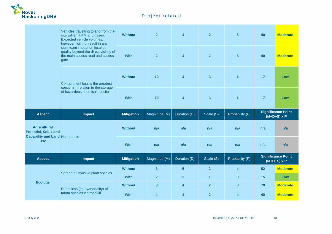
P r o j e c t r e l a t e d
07 July 2020 MD4195-RHD-ZZ-XX-RP-YE-0001 133
Vehicles travelling to and from the site will emit PM and gases. Expected vehicle volumes, however, will not result in any significant impact on local air quality beyond the direct vicinity of the main access road and access
gate
Without 2 4 2 5 40 Moderate
With 2 4 2 5 40 Moderate
Containment loss is the greatest concern in relation to the storage of hazardous chemicals onsite
Without 10 4 3 1 17 Low
With 10 4 3 1 17 Low
Aspect Impact Mitigation Magnitude (M) Duration (D) Scale (S) Probability (P) Significance Point
(M+D+S) x P
Agricultural
Potential, Soil, Land
Capability and Land
Use
No Impacts
Without n/a n/a n/a n/a n/a n/a
With n/a n/a n/a n/a n/a n/a
Aspect Impact Mitigation Magnitude (M) Duration (D) Scale (S) Probability (P) Significance Point
(M+D+S) x P
Ecology
Spread of invasive plant species
Without 6 5 2 4 52 Moderate
With 2 2 1 3 15 Low
Direct loss (injury/mortality) of fauna species via roadkill
Without 8 4 2 8 70 Moderate
With 4 4 2 4 40 Moderate

P r o j e c t r e l a t e d
07 July 2020 MD4195-RHD-ZZ-XX-RP-YE-0001 134
Disturbance of faunal species of conservation concern – site lighting
Without 6 4 2 5 60 Moderate
With 4 4 2 2 20 Low
Disturbance of faunal species of conservation concern – barrier to movement
Without 6 4 2 4 48 Moderate
With 6 4 2 3 36 Moderate
Aspect Impact Mitigation Magnitude (M) Duration (D) Scale (S) Probability (P) Significance Point
(M+D+S) x P
Avifauna
Disturbance and Displacement
Without 8 4 2 4 56 Moderate
With 6 4 2 2 24 Low
Collision with Infrastructure (Excluding Power Lines)
Without 6 4 1 5 55 Moderate
With 4 4 1 3 27 Low
Water Pollution
Without 4 4 2 3 30 Moderate
With 2 4 2 2 16 Low
Excessive Use of Water
Without 4 4 3 3 33 Moderate
With 2 4 3 2 18 Low
Without 6 4 3 3 39 Moderate
With 4 4 2 2 20 Low
Aspect Impact Mitigation Magnitude (M) Duration (D) Scale (S) Probability (P) Significance Point
(M+D+S) x P
Bat Barrier effect of PV plants to normal foraging and commuting behaviours
Without 8 4 1 4 52 Moderate
With 4 4 1 3 27 Low
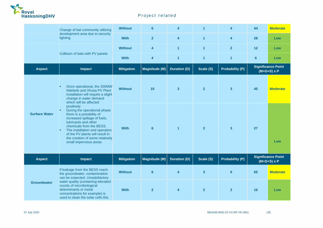
P r o j e c t r e l a t e d
07 July 2020 MD4195-RHD-ZZ-XX-RP-YE-0001 135
Change of bat community utilizing development area due to security lighting
Without 6 4 1 4 44 Moderate
With 2 4 1 4 28 Low
Collision of bats with PV panels
Without 4 1 1 2 12 Low
With 4 1 1 1 6 Low
Aspect Impact Mitigation Magnitude (M) Duration (D) Scale (S) Probability (P) Significance Point
(M+D+S) x P
Surface Water
▪ Once operational, the 200MW Ndebele and Xhosa PV Plant installation will require a slight change in water demand which will be affected positively
▪ During the operational phase there is a possibility of increased spillage of fuels, lubricants and other chemicals from the BESS.
▪ The installation and operation of the PV plants will result in the creation of some relatively small impervious areas
Without 10 3 2 3 45 Moderate
With 6 1 2 3 27
Low
Aspect Impact Mitigation Magnitude (M) Duration (D) Scale (S) Probability (P) Significance Point
(M+D+S) x P
Groundwater
If leakage from the BESS reach the groundwater, contamination can be expected. Unsatisfactory water quality (containing elevated counts of microbiological determinants or metal concentrations for example) is used to clean the solar cells this
Without 6 4 3 6 65 Moderate
With 2 4 2 2 16 Low

P r o j e c t r e l a t e d
07 July 2020 MD4195-RHD-ZZ-XX-RP-YE-0001 136
could infiltrate into the subsurface and possibly pollute the groundwater.
Aspect Impact Mitigation Magnitude (M) Duration (D) Scale (S) Probability (P) Significance Point
(M+D+S) x P
Visual
The PV arrays would not be visible to the vast majority of the receptor locations in the study area, and thus would not cause any visual impact for the majority of the study area. Lighting at the Solar Power Plant could create a visual impact on the night-time environment by introducing new sources of lighting to a relatively unlit night-time environment.
Without 8 4 2 4 56 Moderate
With 6 4 22 3 36 Moderate
Aspect Impact Mitigation Magnitude (M) Duration (D) Scale (S) Probability (P) Significance Point
(M+D+S) x P
Heritage
As no sites, features or objects of cultural significance are known to exist in the development area, there would be no impact as a result of the proposed
development.
Without n/a n/a n/a n/a n/a n/a
With n/a n/a n/a n/a n/a n/a
Aspect Impact Mitigation Magnitude (M) Duration (D) Scale (S) Probability (P) Significance Point
(M+D+S) x P
Palaeontology
No significant further impacts on fossil heritage are anticipated operational phase of the solar power facility.
Without n/a n/a n/a n/a n/a n/a
With n/a n/a n/a n/a n/a n/a
Aspect Impact Mitigation Magnitude (M) Duration (D) Scale (S) Probability (P) Significance Point
(M+D+S) x P
Traffic
The operational phase will not generate heavy vehicle volumes
Without 2 4 2 2 16 Low
With 2 4 2 2 16 Low

P r o j e c t r e l a t e d
07 July 2020 MD4195-RHD-ZZ-XX-RP-YE-0001 137
when compared to the construction phase
Aspect Impact Mitigation Magnitude (M) Duration (D) Scale (S) Probability (P) Significance Point
(M+D+S) x P
Socio-Economic
The increase in generation capacity from 75 to 200MW contribution to the country’s power generation capacity will contribute towards the overall stability of the national grid and a reduction in the greenhouse gas output per MWH generated.
Without 1 4 3 1 +8 Low
With 8 4 4 5 +80 High

P r o j e c t r e l a t e d
07 July 2020 MD4195-RHD-ZZ-XX-RP-YE-0001 138
7.4.3 Closure and Rehabilitation Phase
Table 44 below summarises those impacts directly related to the closure and rehabilitation phase of the proposed project and provides a significance rating for
each impact before and after mitigation. The closure and demolition of the infrastructure will take approximately 3 - 6 months. The rehabilitation period to
restore the area to grazing will be approximately 6 - 12 months.
Table 44: Summary of the Closure and Rehabilitation Phase
Aspect Impact Mitigation Magnitude (M) Duration (D) Scale (S) Probability (P) Significance Point
(M+D+S) x P
Geology No Impacts Without n/a n/a n/a n/a n/a n/a
With n/a n/a n/a n/a n/a n/a
Aspect Impact Mitigation Magnitude (M) Duration (D) Scale (S) Probability (P) Significance Point
(M+D+S) x P
Topography
Due to the low rainfall and the sandy soils, the site is naturally not very prone to erosion, but inappropriate closure and rehabilitation could increase the erosion potential, leading to a topographical impact
Without 6 4 1 2 22 Low
With 2 4 1 3 +21 Low
Aspect Impact Mitigation Magnitude (M) Duration (D) Scale (S) Probability (P) Significance Point
(M+D+S) x P
Air Quality
Particulate emissions during the closure
and post-closure phase
Without 2 2 2 5 30 Moderate
With 2 2 2 5 30 Moderate
Decommissioning of BESS can also result in emissions to atmosphere due to containment issues
Without 10 4 3 1 17 Moderate
With 10 4 3 1 17 Moderate
Aspect Impact Mitigation Magnitude (M) Duration (D) Scale (S) Probability (P) Significance Point
(M+D+S) x P
Agricultural
Soil Degradation
Without 2 3 1 3 18 Low
With 2 3 1 2 12 Low
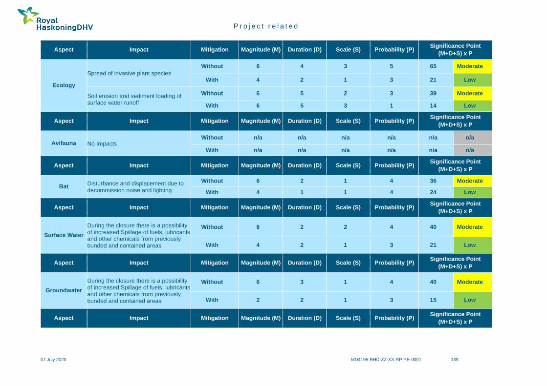
P r o j e c t r e l a t e d
07 July 2020 MD4195-RHD-ZZ-XX-RP-YE-0001 139
Aspect Impact Mitigation Magnitude (M) Duration (D) Scale (S) Probability (P) Significance Point
(M+D+S) x P
Ecology
Spread of invasive plant species
Without 6 4 3 5 65 Moderate
With 4 2 1 3 21 Low
Soil erosion and sediment loading of surface water runoff
Without 6 5 2 3 39 Moderate
With 6 5 3 1 14 Low
Aspect Impact Mitigation Magnitude (M) Duration (D) Scale (S) Probability (P) Significance Point
(M+D+S) x P
Avifauna No Impacts Without n/a n/a n/a n/a n/a n/a
With n/a n/a n/a n/a n/a n/a
Aspect Impact Mitigation Magnitude (M) Duration (D) Scale (S) Probability (P) Significance Point
(M+D+S) x P
Bat Disturbance and displacement due to decommission noise and lighting
Without 6 2 1 4 36 Moderate
With 4 1 1 4 24 Low
Aspect Impact Mitigation Magnitude (M) Duration (D) Scale (S) Probability (P) Significance Point
(M+D+S) x P
Surface Water
During the closure there is a possibility of increased Spillage of fuels, lubricants and other chemicals from previously bunded and contained areas
Without 6 2 2 4 40 Moderate
With 4 2 1 3 21 Low
Aspect Impact Mitigation Magnitude (M) Duration (D) Scale (S) Probability (P) Significance Point
(M+D+S) x P
Groundwater
During the closure there is a possibility of increased Spillage of fuels, lubricants and other chemicals from previously bunded and contained areas
Without 6 3 1 4 40 Moderate
With 2 2 1 3 15 Low
Aspect Impact Mitigation Magnitude (M) Duration (D) Scale (S) Probability (P) Significance Point
(M+D+S) x P

P r o j e c t r e l a t e d
07 July 2020 MD4195-RHD-ZZ-XX-RP-YE-0001 140
Visual
The site would not be visible to the vast majority of the receptor locations in the study area, and thus dust plumes generated at the closure site would be unlikely to cause any visual impact for the majority of the study area.
Without 6 2 2 4 40 Moderate
With 4 2 2 3 24 Low
Aspect Impact Mitigation Magnitude (M) Duration (D) Scale (S) Probability (P) Significance Point
(M+D+S) x P
Heritage
As no sites, features or objects of cultural significance are known to exist in the development area, there would be no impact as a result of the proposed development.
Without n/a n/a n/a n/a n/a n/a
With n/a n/a n/a n/a n/a n/a
Aspect Impact Mitigation Magnitude (M) Duration (D) Scale (S) Probability (P) Significance Point
(M+D+S) x P
Palaeontology No significant further impacts on fossil heritage are anticipated operational phase of the solar power facility.
Without n/a n/a n/a n/a n/a n/a
With n/a n/a n/a n/a n/a n/a
Aspect Impact Mitigation Magnitude (M) Duration (D) Scale (S) Probability (P) Significance Point
(M+D+S) x P
Traffic
The traffic activities will be similar to those of the construction phase, but by the time of closure, it is highly likely that the local access roads will have been
paved
Without 4 2 2 5 40 Moderate
With 4 2 2 2 16 Low
Aspect Impact Mitigation Magnitude (M) Duration (D) Scale (S) Probability (P) Significance Point
(M+D+S) x P
Socio-Economic Reduced employment
Without 8 4 2 4 56 Moderate
With 6 2 2 2 20 Low

P r o j e c t r e l a t e d
07 July 2020 MD4195-RHD-ZZ-XX-RP-YE-0001 141
Socio-Economic Reduced economic benefit
Without 8 5 3 5 80 High
With 6 5 2 4 52 Moderate
Socio-Economic Dependency on project sustaining local economy
Without 8 5 3 3 48 Moderate
With 6 3 2 2 22 Low
7.4.4 Summary of the Cumulative Impacts
Table 45 provides a summary of the summary of the cumulative impacts.
Table 45: Summary of Cumulative Impacts
Aspect Impact
Agricultural Potential, Soil, Land Capability and Land
Use
▪ In order for South Africa to achieve its renewable energy generation goals, agriculturally zoned
land will need to be used for renewable energy generation. It is far more preferable to incur a
cumulative loss of agricultural land in a region such as the one being assessed, which has no
cultivation potential, and low grazing capacity, than to lose agricultural land that has a higher
potential, and that is much scarcer, to renewable energy development elsewhere in the country.
The limits of acceptable agricultural land loss are therefore far higher in this region than in
regions with higher agricultural potential.
▪ It is also preferable, from an impact point of view as well as from practical considerations, to
rather have a concentrated node of renewable energy development within one area, as is the
case around this project, than to spread out the same number of developments over a larger
area.
Ecology
The Project is located adjacent to the existing Bokpoort I development. In addition, the proposed
SolAfrica Sanddraai 75 MW PV Project in !Kheis LM is situated on the farm directly adjacent to the
Project, and the proposed Kheis Solar Park 1 PV project is located in similar habitat approximately
20 km north of the Project (refer to Figure 31).

P r o j e c t r e l a t e d
07 July 2020 MD4195-RHD-ZZ-XX-RP-YE-0001 142
Aspect Impact
Potential residual (post-mitigation) impacts of the Bokpoort II PV Project that may contribute to the
cumulative effects of other proposed and permitted solar developments in the region relate to
potential indirect impacts on fauna and exacerbation of the loss of remaining areas of natural habitat.
The Project may contribute to cumulative impacts on fauna through increased incidences of road kill
as a result of increased vehicular traffic and the creation of a barrier to normal movement of medium-
large mammals and reptiles due to the physical barrier that will be created by the site security fencing.
Incremental losses of remaining areas of natural (untransformed) habitat is anticipated due to the
continual increase of human/ industrial related activities on a regional scale.
Avifauna
Approximately 16 solar energy projects in various stages of the EIA application process fall within
this 50 km radius of the project site (Table 1 in appendix B4). Should 50% or more of these projects
be constructed the cumulative impact of the residual impacts may have a significance rating of 85
(High). Depending on the type of solar technology employed and the level of mitigation implemented
at each of the developments the cumulative impacts may have had a significance rating of 65
(Moderate) after mitigation.
It is difficult to say with high confidence at this stage what the cumulative impact of all the proposed
developments will be on birds as the specifics of the final technologies to be utilised at each site, and
levels of habitat rehabilitation within the project sites, is unknown.
Bats
The proposed Bokpoort solar facility amendment and the other solar developments will primarily
negatively impact bats by reducing foraging areas and roosting resources within the greater area.
However, the Orange River and its riparian vegetation is a more important source of drinking water
and prime foraging grounds for bats than the surrounding areas that the Bokpoort development is
located within. It is essential for each facility to apply site specific mitigation measures recommended
by relevant specialists to mitigate the cumulative impacts of renewable energy developments in the
region. Thus, the proposed Bokpoort solar facility must adhere to the outlined mitigation measures
listed above to reduce cumulative impacts of development in the greater area.
Visual
▪ The proposed development will be located immediately adjacent to the Bokpoort Solar Power
Facility, so when viewed from the surrounds it will form part of a visual environment that is
already transformed from a natural context. The proposed development will add to the
transformation of the landscape in the local area, thus increasing the cumulative visual effect

P r o j e c t r e l a t e d
07 July 2020 MD4195-RHD-ZZ-XX-RP-YE-0001 143
Aspect Impact
on the landscape. However, the remoteness of the location lowers the overall cumulative
visual impact in a wider study area context.
▪ The proposed development will be located immediately adjacent to the Bokpoort Solar Power
Facility and lighting at the new plant would increase the number of lighting sources able to
be viewed from this area. Permanent lighting at the new plant would thus increase the
number of light sources, albeit in a cluster rather than adding diffuse lighting sources to the
landscape, further altering the overall dark night time environment to a more lit one.
▪ Generation of dust plumes is not incongruous to this hot arid environment, but the area
surrounding the development site is not characterised by the large-scale generation of large
dust plumes on a regular basis. Such an impact would not further an existing impact.
Heritage
The cumulative impact of the proposed Bokpoort project is assessed by adding impacts from this
proposed development to existing and other proposed developments with similar impacts within a 60
km radius. The existing and proposed developments that were taken into consideration for
cumulative impacts include a total of six other plants and are listed in Table 41. From the map ‘South
African Generation Projects’ (Figure 34), it can be seen that the Bokpoort project is located in an
area where little such development has taken place, with the implication that the cumulative impact
would be very low.
Palaeontology
Given the low impact significance assessed for all solar energy developments concerned which are
all underlain by very similar geology, it is likely that cumulative impacts associated with the
development are low. Very few palaeontological impact assessments for other developments in the
wider project area near Groblershoop have been undertaken (SAHRIS website); one exception - for
solar projects on the farm Sand Draai by Bamford (2016)88 - also concluded that the palaeontological
sensitivity of the region is low.
88 BAMFORD, M. 2016. Palaeontological Impact Assessment for the proposed CSP and PV plants on the farm Sand Draai, near Groblershoop, Northern Cape Province, 5 pp.

P r o j e c t r e l a t e d
07 July 2020 MD4195-RHD-ZZ-XX-RP-YE-0001 144
Aspect Impact
Socio-Economic
▪ Employment opportunities - the combined project indicates employment opportunities for
approximately 400 local unskilled workers during construction peak. Although it is uncertain
at this stage, what the duration of the construction peak will be, 400 local employment
opportunities will contribute significantly to livelihoods and the local economy. This conclusion
is based on the assumption that by far the majority (if not all) of the 400 opportunities will be
sourced from the local communities, focused on Groblershoop and Wegdraai, and other
communities within a radius of 20 to 30 km from the site. Using local employees must be a
key focus area, if the positive impacts are to be maximised. The use of local employees also
minimise the range of potential adverse social impacts, such as cultural disparity between
local people and large numbers of newcomers, social mobilisation to protect local jobs and
health, safety and security concerns. Even though the number of direct job opportunities will
be temporary, there is the potential for increased indirect employment through the supply
chain vendors and service providers and associated increased local spend as a result of the
project activities.
▪ Population influx - the influx of temporary workers in search of jobs is a reality in the Northern
Cape. It has significant impacts to the existing communities based on limited available
resources to service a larger population in a stark and arid landscape. An impact directly linked
to foreign workers, is related to social and intimate relations between the foreigners, who are
here for only a short duration, and the local population. This often results in family stress,
health impacts, and the socio-economic load on households to look after children, whose
fathers have departed and make little contribution to their emotional and financial upkeep.
Although any influx of workers into the area may result in such impacts, experience has shown
that this is most prominent in the case of foreign workers.
▪ Continued economic benefits - The use of renewable energy resources like solar power
contributes to diversifying the fuel sources used for energy production which improves
electricity production efficiency. The proposed project can add an additional 1600 MW into the
Eskom grid. The development will generate electricity from a renewable energy resource
which has nearly zero carbon dioxide emissions, unlike coal fired power plants.

P r o j e c t r e l a t e d
07 July 2020 MD4195-RHD-ZZ-XX-RP-YE-0001 145
8 IMPACT STATEMENT
8.1 Key Findings
8.1.1 Geology and Topography
Excavations for foundations for the PV panels and associated infrastructure will have a highly localised and
negligible effect on the geology and topography of the site.
8.1.2 Air Quality
The facility does not require an Atmospheric Emissions Licence as no listed activities are triggered under
section 21 of the NEM:AQA (Act 39 of 2004). The closest sensitive receptor identified is a farmhouse,
approximately 2 km south-west of the proposed site. Surrounding towns are at least 17 km away from the
site. Local existing air pollution sources include agricultural activities, domestic fuel burning and veld fires.
The key pollutant from the proposed site during the construction and decommissions phases would be PM.
Various PM control measures for the construction phase are presented, the key being wet suppression.
During the operational phase, there should be very limited air quality impacts, if any, beyond exhaust
emissions and wheel entrainment of dust by traffic to and from the site. Strict BESS management and
maintenance procedures will ensure containment and prevent any significant air quality impacts. On
decommissioning, the BESS should be promptly removed offsite in line with manufacturer guidance and
taken to the nearest appropriate recycling facility. While there are recycling options for lead-acid batteries
in South Africa, opportunities for the recycling of lithium ion batteries needs further investigation.
8.1.3 Agricultural Potential, Soil, Land Capability and Land Use
The proposed development is on land zoned as ‘Special’. South Africa has very limited arable land and it is
therefore critical to ensure that development does not lead to an inappropriate loss of land that may be
valuable for cultivation. This assessment has found that the investigated site is on land which is of low
agricultural potential and is not suitable for cultivation.
It is preferable to incur a loss of agricultural land on such a site, without cultivation potential, than to lose
agricultural land that has a higher potential, to renewable energy development elsewhere in the country. No
agriculturally sensitive areas occur within the proposed site and no part of it is therefore required to be set
aside from the development.
8.1.4 Ecology
The various assessments of the ecological receiving environment that were accessed revealed a moderate,
at best, ecological sensitivity of remaining and untransformed portions of the site. The photovoltaic plant
development will potentially affect biodiversity in three main ways; loss in extent of vegetation communities
and loss and associated disturbance of species of conservation concern during construction; effects on
fauna species of conservation concern as a result of site lighting, security fencing and increased road traffic
during operation, and the spread of invasive species and potential contamination of remaining natural
(surrounding) ecosystems during closure. Biological attributes of the site exhibit typical diversity and status
of natural spaces in the region of the site, which is ultimately characterised by limited and low intensity,
albeit long-term, anthropogenic impacts that have caused a moderate decline in the status and natural
diversity. Despite a moderate to high correlation with regional ecological types, only a moderate diversity
was recorded on the site, which provides an indication of the relentless nature of existing impacts, and
surrounding developments.

P r o j e c t r e l a t e d
07 July 2020 MD4195-RHD-ZZ-XX-RP-YE-0001 146
A review of the anticipated impacts associated with the development on the ecological environment indicates
that none of the anticipated impacts can be highlighted or construed to represent an unacceptable or severe
threat to sensitive biological or biodiversity components within the study area and wider region. Ecological
attributes and characteristics and biological components that were recorded on the site during the brief
survey period are regarded common and typical of the larger region and are not restricted to the site, i.e. no
plant or animal species or habitat type will be affected in such a manner that the conservation status (local,
regional, global) will be affected adversely.
Although several species of conservation concern have been recorded within the study area, no species
were recorded that would trigger ‘Critical Habitat’ as defined by IFC. As with any type of anthropogenic
development, the decimation of natural habitat is an unfortunate result and the reduction in the local
abundance of animals and plants represent natural and anticipated consequences.
8.1.5 Avifauna
The proposed PV development would also allow for additional bird flight deterrent devices to be investigated
to reduce the potential impact of collisions with overhead power lines as well as reduced habitat
fragmentation and disruption of bird movements across the project site for a number of ground dwelling
species.
If temperatures rise in the medium to long term, some species will be living closer to the limits of their thermal
tolerances, with species in arid environments expected to be among the first to reach the limits of their
thermoregulatory capacities89. It is anticipated that much of the Kalahari’s avian biodiversity will be lost by
the end of the century due to loss of body condition, delayed fledging, reduced fledging size, and outright
breeding failure as a result of increased exposure to higher temperatures90. PV panels may provide more
shaded environments (thermal refugia) for ground dwelling and ground nesting birds near their thermal limits
and also offer a certain amount of protection to more open habitat species against bush encroachment91.
The proposed PV development, if mitigation such as the rehabilitation of natural vegetation under solar
panels is implemented, could potentially therefore even provide an improvement of the habitat for certain
important bird species such as coursers, francolins and other open-country birds by offering shade and
grassland in the face of potentially rising temperatures and bush encroachment.
8.1.6 Bat
The PV plants should have fewer negative impacts on bats. The impact assessment ratings of ten PV plants
for the development are all reduced to a low significance impact rating after application of mitigation
measures listed in Section 7.3.7 of this report. Surface Water
8.1.7 Surface Water
The change in water demand which will be affected positively with the total demand changing to 0.22 million
cubic metres per annum (Mm3/a) (10 x 0.022 Mm3/a) for the 10 PV solar facilities (of which PV 1 and 2 forms
part of) instead of the 0.3 Mm3/a (0.25 + 2 x 0.025 Mm3/a) for the CSP and two (2) PV solar facilities.
89 van de Ven, T.M.F.N. 2017. Implications of climate change on the reproductive success of the Southern Yellow-billed Hornbill, Tockus leucomelas. PhD Thesis. Percy FitzPatrick Institute of African Ornithology, DST-NRF Centre of Excellence, Department of Biological Sciences, Faculty of Science, University of Cape Town. 90 Conradie, S.R., Woodborne, S.M., Cunningham, S.J. and McKechnie, A.E. 2019. Chronic, sublethal effects of high temperatures will cause severe declines in southern African arid-zone birds during the 21st century. 91 Towards a policy on indigenous bush encroachment in South Africa (2019), Department of Environmental Affairs, Pretoria, South Africa.

P r o j e c t r e l a t e d
07 July 2020 MD4195-RHD-ZZ-XX-RP-YE-0001 147
8.1.8 Groundwater
Overall the accumulative risk associated with the project (when operational) is of low environmental
significance from a groundwater perspective. With proper mitigations in place the significance of the impact
is likely to be low.
8.1.9 Visual
The visual impact from the solar installation will be cumulative to the existing visual transformation of
anthropological origin (Bokpoort I installation, farm buildings, power lines, railway line, roads) and will be
present for the operational life of the facility (estimated at 30 years). The impact will be totally reversible
upon decommissioning and closure of the solar facility.
8.1.10 Heritage and Palaeontology
From a heritage point of view, it is recommended that the proposed development be allowed to continue on
acceptance of the proposed mitigation measures and the conditions proposed for inclusion in the
environmental authorisation:
▪ Should archaeological sites or graves be exposed in other areas during construction work, it must
immediately be reported to a heritage practitioner so that an investigation and evaluation of the finds
can be made
No significant fossil heritage resources have been recorded within the Bokpoort II solar power facility study
area. The area is inferred to be of low sensitivity in terms of palaeontological heritage and no sensitive or
no-go areas have been identified within it during the present desktop assessment. The proposed solar power
facility is of LOW (negative) impact significance before mitigation with respect to palaeontological heritage
resources. This assessment applies to all the planned infrastructure within the project area – including the
water pipeline to the Orange River (already authorised) as well as the 132kV overhead line connection to
the Eskom Garona Substation - and applies equally to all PV plants under consideration for the Bokpoort II
Solar Power Facility. Cumulative impacts associated with the ten PV solar energy developments are
probably low, given the similar regional geology, and there are no fatal flaws in the development proposal
as far as fossil heritage is concerned. The no-go alternative is of neutral significance for palaeontology.
Providing that the recommendations outlined below for palaeontological monitoring and mitigation are
followed through, there are no objections on palaeontological heritage grounds to authorisation of this
alternative energy project.
Pending the potential discovery of significant new fossil remains during development - notably fossil
vertebrate bones & teeth - no further specialist palaeontological studies or mitigation are considered
necessary for this project.
The following comments are made by SAHRA as a requirement in terms of section 3(4) of the NEMA
Regulations and
section 38(8) of the NHRA in the format provided in section 38(4) of the NHRA:
▪ 38(4)a – The SAHRA Archaeology, Palaeontology and Meteorites (APM) Unit no objections to the
proposed development;
▪ 38(4)b – The recommendations of the specialists are supported and must be adhered to. No further
additional specific conditions are provided for the development;
▪ 38(4)c(i) – If any evidence of archaeological sites or remains (e.g. remnants of stone-made
structures, indigenous ceramics, bones, stone artefacts, ostrich eggshell fragments, charcoal and
ash concentrations), fossils or other categories of heritage resources are found during the proposed
development, SAHRA APM Unit (Natasha Higgitt/ Phillip Hine 021 462 5402) must be alerted as
per section 35(3) of the NHRA. Non-compliance with section of the NHRA is an offense in terms of
section 51(1)e of the NHRA and item 5 of the Schedule;

P r o j e c t r e l a t e d
07 July 2020 MD4195-RHD-ZZ-XX-RP-YE-0001 148
▪ 38(4)c(ii) – If unmarked human burials are uncovered, the SAHRA Burial Grounds and Graves
(BGG) Unit (Thingahangwi Tshivhase/ Mimi Seetelo 012 320 8490), must be alerted immediately
as per section 36(6) of the NHRA. Non-compliance with section of the NHRA is an offense in terms
of section 51(1)e of the NHRA and item 5 of the Schedule;
▪ 38(4)d – as per section 51(1) of the NHRA;
▪ 38(4)e – The following conditions apply with regards to the appointment of specialists: i) If heritage
resources are uncovered during the course of the development, a professional archaeologist or
palaeontologist, depending on the nature of the finds, must be contracted as soon as possible to
inspect the heritage resource. If the newly discovered heritage resources prove to be of
archaeological or palaeontological significance, a Phase 2 rescue operation may be required
subject to permits issued by SAHRA.
8.1.11 Traffic
Travel to and from the facility by personnel, deliveries and visitors will add to the existing traffic on the
approach roads, affecting road safety, create dust from unpaved roads and road surface quality as
experienced by existing road users. The cumulative impact due to the solar facility will be completely
reversible upon decommissioning and closure.
8.1.12 Socio-Economic
The proposed increase in capacity from 75 to 200MW will be a positive impact as this will provide further
support to the national grid therefore aiding in provide electricity security to the region and the country. The
potential job creation at the construction phase of the project will be a positive for the local and regional
economy as unemployment in the country is increasing. An assured and diversified electricity generation
mix is a key step in attracting investors into South Africa and is key for the growth and development.

P r o j e c t r e l a t e d
07 July 2020 MD4195-RHD-ZZ-XX-RP-YE-0001 149
8.2 Sensitivity Map
Figure 35: Overall Sensitivity Map

P r o j e c t r e l a t e d
07 July 2020 MD4195-RHD-ZZ-XX-RP-YE-0001 150
Figure 36: Annotated Listing Notice Map

P r o j e c t r e l a t e d
07 July 2020 MD4195-RHD-ZZ-XX-RP-YE-0001 151
8.3 Conclusion and Recommendations
The BA Study has been undertaken in accordance with the EIA Regulations 2014 (as amended in 2017) in
terms of Section 24(5) of the National Environmental Management Act (Act No. 107 of 1998) (as amended).
In order to protect the environment and ensure that the proposed project is undertaken in an environmentally
responsible manner, there are a number of significant environmental legislation that have been taken into
account during this study. These include:
LEGISLATION
The Constitution of South Africa (No. 108 of 1996)
National Environmental Management Act (Act No. 107 of 1998) (as amended) and EIA Regulations 2014 (as amended in 2017)
National Environmental Management: Waste Act (Act No. 59 of 2008) (as amended)
National Environmental Management Biodiversity Act (Act No. 10 of 2004)
National Environmental Management: Protected Areas Act (Act No. 57 of 2003)
National Water Act (Act No. 36 of 1998) (as amended)
National Forests Act (Act No. 84 of 1998)
National Heritage Resources Act (Act No. 25 of 1999)
Minerals and Petroleum Resources Development Act (Act No. 28 of 2002)
Hazardous Substance Act (Act No. 15 of 1973) and Regulations
Occupational Health and Safety Act (Act No. 85 of 1993)
This relevant legislation has informed the identification and development of appropriate management and
mitigation measures that should be implemented in order to minimise potentially significant impacts
associated with the project.
8.4 Assumptions, Uncertainties or Gaps in Knowledge
8.4.1 Agriculture Assessment
The assessment rating of impacts is not an absolute measure. It is based on the subjective considerations
and experience of the specialist but is done with due regard and as accurately as possible within these
constraints. The study makes the assumption that water for irrigation is not available across the site. This is
based on the assumption that a long history of farming experience in an area will result in the exploitation
of viable water sources if they exist, and none have been exploited in this area. There are no other specific
constraints, uncertainties and gaps in knowledge for this study.
8.4.2 Ecological Assessment
It is assumed that:
▪ all observations, identifications, calculations and opinions, as presented in the principal ecological
reports (refer Section 4.4 of Appendix B1) are accurate and correct.
▪ all drawings, illustrations and documentation presented to the specialist are correct and accurate.
▪ all information that were sourced for this project are accurate and comprehensive at the time of
extraction.
▪ no field surveys were conducted for this particular report and it comprises a desktop evaluation of
existing

P r o j e c t r e l a t e d
07 July 2020 MD4195-RHD-ZZ-XX-RP-YE-0001 152
▪ information that included previous baseline reports for the larger study area. (DHV, 2014a; DHV,
2014b; BEC, 2010) and supplementary studies that were conducted to address identified gaps in
the baseline dataset for the project.
8.4.3 Avifaunal Assessment
The SABAP1 data covers the period 1986-1997. Bird distribution patterns can change regularly according
to availability of food and nesting substrate. (For a full discussion of potential limitations in the SABAP1 data,
see Harrison et al. 199792).
The two post-construction studies on impacts of solar energy facilities in the Northern Cape, South Africa
have increased the confidence of impact assessments for birds in the area, but these studies were limited
in that they only covered a period of three-months each. The overall environmental impacts of solar energy
facilities remain relatively poorly understood as do the specific impacts of these facilities on habitat
destruction and fragmentation particularly with reference to birds.
While sampling effort was as recommended in the solar guidelines, to achieve statistically powerful results
it would need to be increased beyond practical possibilities. The data was therefore analysed at a relatively
basic level and interpreted using a precautionary approach. Relatively dry, drought conditions were
experienced during the year of monitoring, and the study was therefore not able to consider the effects of
inter-annual variation in avifauna, for example following a good rain season.
8.4.4 Visual Assessment
The addendum report is not a stand-alone visual impact report and has been prepared to update the two
(2) visual impact reports prepared by Golder Associates for the original basic assessment processes
completed in 2016. As such this report assumes that the original two visual impact assessment reports
adequately and accurately described the baseline visual environment of the study area and accurately
undertook the assessment of viewsheds associated with the proposed development.
This addendum report has utilised the original reports’ assessment of viewsheds associated with the original
northern and southern PV plants. These viewsheds were generated for the northern and southern PV plants
respectively. As the overall footprint of the development has not changed, and as the design (height) of the
PV components has not changed markedly these viewsheds represent the northern and southern extents
of the current development. Accordingly, the viewsheds are an accurate representation of the southern and
northern extents of the ten proposed PV facilities.
It should be noted that the ‘experiencing’ of visual impacts is subjective and largely based on the perception
of the viewer or receptor. The presence of a receptor in an area potentially affected by the proposed solar
power development does not thus necessarily mean that a visual impact would be experienced.
It has been assumed that households and farmsteads located within the study area are sensitive receptors
– i.e. receptor locations at which a perception of visual impact could be generated. Existing Power
Generation / power transmission infrastructure and the people that work at such locations in the study area
have not been classified as being sensitive receptors in a visual impact context.
8.4.5 Heritage Assessment
The investigation has been influenced by the following factors:
▪ It is assumed that the description of the proposed project, provided by the client, is accurate.
▪ The unpredictability of buried archaeological remains.
92 Harrison, J.A., Allan, D.G., Underhill, L.G., Herremans, M., Tree, A.J., Parker, V & Brown, C.J. (eds). 1997. The atlas of southern African birds. Vol. 1&2. BirdLife South Africa: Johannesburg.

P r o j e c t r e l a t e d
07 July 2020 MD4195-RHD-ZZ-XX-RP-YE-0001 153
▪ No subsurface investigation (i.e. excavations or sampling) were undertaken, since a permit from
SAHRA is required for such activities.
▪ It is assumed that the public consultation process undertaken as part of the Environmental Impact
Assessment (EIA) is sufficient and that it does not have to be repeated as part of the heritage impact
assessment.
8.4.6 Palaeontological Assessment
▪ The accuracy and reliability of palaeontological specialist studies as components of heritage impact
assessments are generally limited by the following constraints:
▪ Inadequate database for fossil heritage for much of the RSA, given the large size of the country and
the small number of professional palaeontologists carrying out fieldwork here. Most development study
areas have never been surveyed by a palaeontologist.
▪ Variable accuracy of geological maps which underpin these desktop studies. For large areas of terrain
these maps are largely based on aerial photographs alone, without ground-truthing. The maps
generally depict only significant (“mappable”) bedrock units as well as major areas of superficial “drift”
deposits (alluvium, colluvium) but for most regions give little or no idea of the level of bedrock outcrop,
depth of superficial cover (soil etc), degree of bedrock weathering or levels of small-scale tectonic
deformation, such as cleavage. All of these factors may have a major influence on the impact
significance of a given development on fossil heritage and can only be reliably assessed in the field.
▪ Inadequate sheet explanations for geological maps, with little or no attention paid to palaeontological
issues in many cases, including poor locality information.
▪ The extensive relevant palaeontological “grey literature” - in the form of unpublished university theses,
impact studies and other reports (e.g. of commercial mining companies) - that is not readily available
for desktop studies.
▪ Absence of a comprehensive computerized database of fossil collections in major RSA institutions
which can be consulted for impact studies. A Karoo fossil vertebrate database is now accessible for
impact study work.
▪ In the case of palaeontological desktop studies without supporting Phase 1 field assessments these
limitations may variously lead to either:
o underestimation of the palaeontological significance of a given study area due to ignorance of
significant recorded or unrecorded fossils preserved there, or
o overestimation of the palaeontological sensitivity of a study area, for example when originally rich
fossil assemblages inferred from geological maps have in fact been destroyed by tectonism or
weathering or are buried beneath a thick mantle of unfossiliferous “drift” (soil, alluvium etc).
▪ Since most areas of the RSA have not been studied palaeontologically, a palaeontological desktop
study usually entails inferring the presence of buried fossil heritage within the study area from relevant
fossil data collected from similar or the same rock units elsewhere, sometimes at localities far away.
Where substantial exposures of bedrocks or potentially fossiliferous superficial sediments are present
in the study area, the reliability of a palaeontological impact assessment may be significantly enhanced
through field assessment by a professional palaeontologist.
▪ In the case of the present study area near Groblershoop in the Northern Cape preservation of
potentially fossiliferous bedrocks is favoured by the arid climate but bedrock exposure is very limited
indeed due to cover by extensive superficial deposits (e.g. alluvium, sandy soils, surface gravels),
especially in areas of low relief, as well as by Kalahari vegetation. Very few previous palaeontological
heritage assessments have been carried out in the study region

P r o j e c t r e l a t e d
07 July 2020 MD4195-RHD-ZZ-XX-RP-YE-0001 154
8.5 Recommendations
8.5.1 Recommendations to the CA
The project, in the EAP’s opinion, does not pose a detrimental impact on the receiving environment and its
inhabitants and can be mitigated significantly. The main activities associated with PV1 and PV2 have already
been granted an Environmental Authorisation and the new project components (i.e. Battery Energy Storage
System and increase in capacity) emanates from the technology optimisation and engineering design. In
light of the opportunities that have been granted in the IRP 2019, the new project components (i.e. capacity
increase and BESS) cannot be viewed in isolation to the previous authorisations as well as to the proposed
8 other PV Plants on the site. The project is critical in terms of the current energy crisis that has impacted
our country and makes an important addition to sustainability goals by increasing investment and
development in the renewable energy sector.
The Applicant should be bound to stringent conditions to maintain compliance and a responsible execution
of the project. The actual date of construction is not available as this will depend on the DMRE. Construction
is expected to commence before August 2020 and last 36 months. An EA with a validity of 5 years is
recommended.
In order to achieve appropriate environmental management standards and ensure that the findings of the
environmental studies are implemented through practical measures, the recommendations and mitigation
measures emanating from this BA study are included within an EMPr (Appendix G). The EMPr must be
used to ensure compliance with environmental specifications and management measures.
The implementation of this EMPr for the construction phase of the project is considered to be vital in
achieving the appropriate environmental management standards as detailed for this project.
In addition, the following key conditions should be included as part of the authorisation:
a) The Developer is not negated from complying with any other statutory requirements that is applicable
to the undertaking of the activity. Relevant key legislation that must be complied with by the proponent
includes inter alia:
i. Provisions of the National Environmental Management Waste Act (Act No. 59 of 2008) (as
amended);
ii. Provisions of the National Water Act, 1998 (Act No. 36 of 1998) (as amended);
iii. Provisions of the National Forests Act (Act No. 84 of 1998); and
iv. National Heritage Resources Act (Act No. 25 of 1999).
b) The Developer must appoint a suitably experienced (independent) Environmental Control Officer
(ECO) for the construction phase of the development that will have the responsibility to ensure that
the mitigation / rehabilitation measures and recommendations are implemented and to ensure
compliance with the provisions of the EMPr.
c) All other necessary permits, licences and approvals must be obtained prior to the commencement
of construction.
d) Should archaeological sites or graves be exposed in other areas during construction work, it must
immediately be reported to a heritage practitioner so that an investigation and evaluation of the finds
can be made.
e) A cooperative agreement with respect to the maintenance and usage of the Gariep and Grootdrink
roads providing access to the proposed Bokpoort II PV sites must be drafted and signed by all
Parties prior to the commencement of construction. The Parties in this instance would represent the
Farmers and the Holder of the Environmental Authorisation.

P r o j e c t r e l a t e d
07 July 2020 MD4195-RHD-ZZ-XX-RP-YE-0001 155
8.5.2 Recommendations to the Applicant
The Applicant must adhere to the recommendations provided by the specialists and the EAP. The EMPr
summarises these recommendations. The Applicant must take full responsibility for the execution of the
project in a manner which does not negatively impact on the environment by ensuring that responsible
decisions are made.
8.6 Declaration by the EAP
The following is hereby affirmed by the EAP to be included in this report:
▪ the correctness of the information provided in the reports;
▪ the inclusion of all comments and inputs from stakeholders and l&APs;
▪ the inclusion of all inputs and recommendations from the specialist reports where relevant; and
▪ any information provided by the EAP to I&APs and any responses by the EAP to comments or
inputs made by interested and affected parties.
_______________________________
Signed: Malcolm Roods EAPASA