AIRPORT DIAGRAM AIRPORT DIAGRAM - FlightAware
79
S 4 HOLDING INSTRUCTIONS IS REQUIRED. READBACK OF ALL RUNWAY R RUNWAY CROSSING CLEARANCES. CAUTION: BE ALERT TO FIELD ELEV 5885 35 L 35 R HOLD ILS A18 A16 A14 A12 A A A A10 10 5824 ELEV 4800X75 0 . 6 %U P 28 B B12 B14 B16 B17 B 7001 X 75 0 . 9 % UP 349 . 9 ° 350 . 0 ° 0 . 8 % DOW N RAMP HOTEL 39°34'N AIRPORT DIAGRAM DENVER, COLORADO 5794 ELEV A11 A13 PARKING AVIATION GENERAL HANGARS x x A8 B8 C5 D1 A9 AREA RUNUP SOUTH CENTENNIAL (APA) AREA RUNUP A DELTA RAMP 17 L 5793 ELEV 170 . 0 ° RAMP ALPHA PARKING GENERAL AVIATION 1 7 R 5804 ELEV 169 . 9 ° 1 . 0 % UP B TERMINAL AVIATION GENERAL PARKING GENERAL AVIATION TERMINALS GENERAL AVIATION 104°51'W 104°50'W 39°35'N AIRPORT DIAGRAM DENVER, COLORADO (APA) CENTENNIAL AL-5715 (FAA) A 128.6 CLNC DEL 121.8 GND CON 118.9 CENTENNIAL TOWER 120.3 ATIS ADMINISTRATION CUSTOMS A 4 A 2 A 1 B4 A6 A 3 A5 HS 1 HS 2 5993 TWR RUNUP AREA NORTH 103 . 0 ° D2 D4 S 2 S 1 D D TERMINAL AVIATION GENERAL A 15 21280 21280 5869 ELEV C2 C3 C4 C1 10001 X 100 C C C C W 1 HS 4 HS 3 0.1° W ANNUAL RATE OF CHANGE JANUARY 2020 S-30 23 F/C/X/T RWY 17R-35L S-56, D-75 26 F/C/X/T RWY 17L-35R S-12.5 17 F/A/Y/T RWY 10-28 2 8 3 . 0 ° VAR 8 . 0 ° E H SW-1, 08 SEP 2022 to 06 OCT 2022 SW-1, 08 SEP 2022 to 06 OCT 2022
-
Upload
khangminh22 -
Category
Documents
-
view
1 -
download
0
Transcript of AIRPORT DIAGRAM AIRPORT DIAGRAM - FlightAware

S4
HOLDING INSTRUCTIONS IS REQUIRED.READBACK OF ALL RUNWAY RRUNWAY CROSSING CLEARANCES.CAUTION: BE ALERT TO
FIELDELEV5885
35L
35R
HOLD
ILS
A18
A16
A14
A12
AA
A
A10
10
5824
ELEV
4800 X 75
0.6% UP28
B
B12
B14
B16
B17
B
7001 X 7
50.9
% U
P
349.9°
350.0°
0.8
% D
OW
NRAMPHOTEL
39°34'N
AIRPORT DIAGRAMDENVER, COLORADO
5794
ELEV
A11
A13
PARKINGAVIATION GENERAL
HANGARS
xx
A8B8
C5
D1
A9
AREA
RUNUP
SOUTH
CENTENNIAL(APA)
AREA
RUNUP
A
DELTA RAMP
17L
5793ELEV
170.0°
RAMPALPHA PARKING
GENERAL AVIATION
17R
5804ELEV
169.9°
1.0
% U
PB
TERMINALAVIATIONGENERAL
PARKINGGENERAL AVIATION
TERMINALSGENERAL AVIATION
104°51'W 104°50'W
39°35'N
AIRPORT DIAGRAM DENVER, COLORADO
(APA)CENTENNIALAL-5715 (FAA)
A
128.6
CLNC DEL
121.8
GND CON
118.9
CENTENNIAL TOWER
120.3
ATIS
ADMINISTRATION
CUSTOMS
A4
A2
A1
B4
A6
A3
A5
HS 1
HS 25993TWR
RUNUP AREANORTH
103.0°
D2
D4
S2
S1
D
D
TERMINAL
AVIATION
GENERAL
A15
21280
21280
5869ELEV
C2
C3
C4
C1
10001 X 1
00
C
C
C
C
W1
HS 4
HS 3
0.1° W
ANNUAL RATE OF CHANGE
JANUARY 2020
S-30
23 F/C/X/T
RWY 17R-35L
S-56, D-75
26 F/C/X/T
RWY 17L-35R
S-12.5
17 F/A/Y/T
RWY 10-28
283.0°
VA
R 8.0° E
HSW-1, 08 SEP 2022 to 06 O
CT 2022 SW
-1,
08 S
EP 2
022
to 0
6 O
CT
2022

DE
NV
ER
, CO
LO
RA
DO
(AP
A)
(AP
A)
CE
NT
EN
NIA
L
CE
NT
EN
NIA
L
N
JNC
CS
K
113.8 RLG
Chan 85
113.1 CYS
Chan 78SIDNEY
115.9 SNY
Chan 106
114.7 DVV
Chan 94
Chan 89
FALCON
116.3 FQF
Chan 110
112.9 TXC
Chan 76
KREMM LING
GILL
CHEYENNE SNY
MILE HIGH
THURM AN
HBU
EKR
LAR
RLG DVV AKO
HCT
GLD
HGOPUB
CYS
FQF
TXC
BRK
EDN
GLL114.2 GLL
6600
100°
DE
NV
ER
, CO
LO
RA
DO
132.75 269.3
DENVER DEP CON
128.6
CLNC DEL
ATIS 120.3
W 106°26.55'
N40°00.16'
W 104°33.18'
N40°30.23'
W 104°46.37'
N41°12.66'
W 102°58.98'
N41°05.80'
W 104°37.46'
N39°53.68'
W 104°37.26'
N39°41.41'
W 103°12.90'
N39°41.90'
TOP ALTITUDE: ASSIGNED BY ATC
(NARRATIVE ON FOLLOWING PAGE)NOTE: Chart not to scale.
AL
-57
15
(FA
A)
20
03
0
DE
NV
ER
TW
O D
EP
AR
TU
RE
30
JA
N2
0
DE
NV
ER
TW
O D
EP
AR
TU
RE
of 300' per NM to 8000.
Rwy 28: Standard with minimum climb
of 370' per NM to 8000.
Rwy 17R: Standard with minimum climb
of 255' per NM to 8000.
Rwy 17L: Standard with minimum climb
Rwys 10, 35L/R: Standard.
TAKEOFF MINIM UMS:
NOTE: RADAR required.
116.0 OCS
Chan 107
115.2 EKR
Chan 99
MEEKER
112.4 JNC
Chan 71
117.6 LAR
Chan 123
114.9 HBU
Chan 96 116.7 PUB
Chan 114
PUEBLO
112.1 HGO
Chan 58
115.1 GLD
Chan 98
113.3 GCK
Chan 80
117.7 HCT
Chan 124
114.4 AKO
Chan 91
AKRON
GRAND JUNCTION
ROCK SPRINGSO
LARAMIE
BLUE MESA
HUGO
GARDEN CITYGC
GOODLAND
HAYES CENTERL-10, H-3-5
L-9-11, H-3-5
L-12, H-3-5
L-10, H-5
L-10-12, H-5
L-10, H-5
117.9 DEN
Chan 126
DENVER
112.5 BRK
Chan 72
BLACK FOREST
N39°48.75' W 104°39.64'
L-10, H-3-5
L-10, H-3-5
L-9-11, H-3
N40°04.05'-W 107°55.50'
L-9, H-3
N39°03.57'-W 108°47.55'
L-10, H-5
N40°27.24'-W 100°55.41'
L-11, H-3
N41°35.41'-W 109°00.92'
L-9-12, H-3-5
N41°20.27'-W 105°43.26'
L-10, H-5
N38°17.66'-W 104°25.77'
L-10, H-5
N40°09.33'-W 103°10.78'
L-10, H-5
N39°23.27'-W 101°41.54'
L-10, H-5
N38°49.05'-W 103°37.28'
L-10-15, H-5
N37°55.14'-W 100°43.50'
L-10, H-3-5
N38°56.67'-W 104°38.01'
L-9, H-3
N38°27.13'-W 107°02.38'
SW-1, 08 SEP 2022 to 06 OCT 2022SW-1, 08 SEP 2022 to 06 OCT 2022

DENVER, COLORADO
DENVER, COLORADO
(APA)
(APA)
CENTENNIAL
CENTENNIAL
T
DEPARTURE ROUTE DESCRIPTION
cross DEN VOR/DME at or above 11000 feet.
direct DEN VOR/DME, thence via assigned route. If filed altitude is above 10000 feet,
departure, maintain assigned heading until 7000 feet, then climb to filed altitude via
LOST COMMUNICATIONS: If no transmissions are received within one minute after
AL-5715 (FAA)
20030
DENVER TWO DEPARTURE
30JAN20
DENVER TWO DEPARTURE
RUNWAY 10: Climb heading 100° to 6600 before turning right.
to assigned route. Expect filed altitude 10 minutes after departure.
TAKEOFF ALL RUNWAYS: Fly assigned heading and altitude for RADAR vectors
SW-1, 08 SEP 2022 to 06 O
CT 2022 SW
-1,
08 S
EP 2
022
to 0
6 O
CT
2022

NOTE: Chart not to scale.
FL230
TOP ALTITUDE:
DE
NV
ER
, CO
LO
RA
DO
DE
NV
ER
, CO
LO
RA
DO
AL
-57
15
(FA
A)
(EC
HO
O1
.EC
HO
O)
EC
HO
O O
NE
DE
PA
RT
UR
E (RN
AV
)
(EC
HO
O1
.EC
HO
O)
EC
HO
O O
NE
DE
PA
RT
UR
E (RN
AV
)
(AP
A)
(AP
A)
restrictions advise CLNC DEL prior to taxi.
If slower speed is required to meet crossing
NOTE: Accelerate to 250K or greater upon reaching 10000.
NOTE: RADAR required.
NOTE: Turbojets only.
NOTE: RNAV 1.
NOTE: DME/DME/IRU or GPS required.132.75 269.3
DENVER DEP CON
128.6
CLNC DEL
120.3
ATIS
N
CE
NT
EN
NIA
L
CE
NT
EN
NIA
L
(NARRATIVE ON FOLLOWING PAGE)
TAKEOFF MINIMUMS
Rwys 35L/R: Standard.
Rwy 17R: Standard with minimum climb of 370' per NM to 8000.
Rwy 17L: Standard with minimum climb of 255' per NM to 8000.
Rwys 10, 28: NA.
ECHOO
EEONS
EMMYS
EXTAN
EPKEE
POIZN
COTNN
DUUZE
SHAYK
WYNDM
050°
075°
125°
100°
1500
0
*900
0
(20)15000
*9000
15000*750015000
*7700
(19)
(19)(22)
070°
073°
087°
(110)
15000
*7100
(110)
(109)
15000*7400
102°
15000*8100
(42)
109°
15000*6100
(28)
109°
15000*6000
(38)
087°(12)
15000
*7000
8000
BAPME
ZIRKL
350°
170°
6385
6385170°
350°
20
08
6
26
MA
R2
0
SW-1, 08 SEP 2022 to 06 OCT 2022SW-1, 08 SEP 2022 to 06 OCT 2022

DENVER, COLORADO
DENVER, COLORADO(RNAV)
(ECHOO1.ECHOO)
(RNAV)
(ECHOO1.ECHOO)
AL-5715 (FAA)ECHOO ONE DEPARTURE
ECHOO ONE DEPARTURE
DEPARTURE ROUTE DESCRIPTION
T
(APA)
(APA)
CENTENNIAL
CENTENNIAL
or as assigned by ATC. Thence. . . .
TAKEOFF RUNWAYS 35L/R: Climb on heading 350° to 6385, then on heading 350°
or as assigned by ATC. Thence. . . .
TAKEOFF RUNWAYS 17L/R: Climb on heading 170° to 6385, then on heading 170°
altitude ten minutes after departure.
then on (transition) maintain FL230 or filed lower altitude. Expect higher filed
. . . .expect RADAR vectors to cross BAPME at 8000 then on track 087° to ECHOO,
ZIRKL TRANSITION (ECHOO1.ZIRKL)
WYNDM TRANSITION (ECHOO1.WYNDM)
SHAYK TRANSITION (ECHOO1.SHAYK)
DUUZE TRANSITION (ECHOO1.DUUZE)
20086
26MAR20
SW-1, 08 SEP 2022 to 06 O
CT 2022 SW
-1,
08 S
EP 2
022
to 0
6 O
CT
2022

NOTE: Chart not to scale.
FL230
TOP ALTITUDE:
DENVER, COLORADO
DENVER, COLORADO
AL-5715 (FAA)
(MRSHH2.MRSHH)
MRSHH TWO DEPARTURE(RNAV)
(MRSHH2.MRSHH)
MRSHH TWO DEPARTURE(RNAV)
(APA)
(APA)
132.75 269.3
DENVER DEP CON
128.6
CLNC DEL
120.3
ATIS
CENTENNIAL
CENTENNIAL
(NARRATIVE ON FOLLOWING PAGE)
MRSHH
YOKES
LNGWD
CHUWY
TIMEH
RIKKK
BRYCC
HHOTH
JOBBA
SAABR
KRTMN
054°
039°
040°
314°
314°
300°334°
322°
027°
018°
032°
004°
(23)730015
000
*
(58)
7800
17000
*
(26)
6000
17000
*15000
8100
(20)
*
17000
8300(8)
*
1700013500
(68)
*
*
16000
10800
(47)
15000
8000
(25)
*
(20)7500
15000
*
(29)
7700
16000
*
17000
7700
(42)*
17000
7900
(43)
*
YAMMI
DDRTH
XXWNG
8000
013°
(12)
NOTE: RADAR required.
NOTE: Turbojets only.
NOTE: RNAV 1.
NOTE: DME/DME/IRU or GPS required.
350°
170°
6385
6385170°
350°
21224
31DEC20
TAKEOFF MINIMUMS
Rwys 35L/R: Standard.
372' per NM to 8000.
Rwy 17R: Standard with minimum climb of
257' per NM to 8000.
Rwy 17L: Standard with minimum climb of
Rwys 10, 28: NA.
SW-1, 08 SEP 2022 to 06 O
CT 2022 SW
-1,
08 S
EP 2
022
to 0
6 O
CT
2022

DEPARTURE ROUTE DESCRIPTION
T
or as assigned by ATC. Thence. . . .
TAKEOFF RUNWAYS 35L/R: Climb on heading 350° to 6385, then on heading 350°
or as assigned by ATC. Thence. . . .
TAKEOFF RUNWAYS 17L/R: Climb on heading 170° to 6385, then on heading 170°
DENVER, COLORADOAL-5715 (FAA)
(MRSHH2.MRSHH)
MRSHH TWO DEPARTURE(RNAV)(APA)CENTENNIAL
DENVER, COLORADO
(MRSHH2.MRSHH)
MRSHH TWO DEPARTURE(RNAV)(APA)CENTENNIAL
altitude ten minutes after departure.
then on (transition) maintain FL230 or filed lower altitude. Expect higher filed
. . . .expect RADAR vectors to cross KRTMN at 8000 then on track 013° to MRSHH,
XXWNG TRANSITION (MRSHH2.XXWNG)
SAABR TRANSITION (MRSHH2.SAABR)
JOBBA TRANSITION (MRSHH2.JOBBA)
DDRTH TRANSITION (MRSHH2.DDRTH)
CHUWY TRANSITION (MRSHH2.CHUWY)
20366
31DEC20
SW-1, 08 SEP 2022 to 06 O
CT 2022 SW
-1,
08 S
EP 2
022
to 0
6 O
CT
2022
DENVER, COLORADO
DENVER, COLORADO
(APA)
(APA)
CENTENNIAL
CENTENNIAL
NOTE: Chart not to scale.
TAKEOFF MINIMUMS
6600
37
112.1 HGO
Chan 58
HUGO
(38)
R-0
02
W104°23.94'
N38°54.95'
SOLARADANE
112.5 BRK
Chan 72
BLACK FOREST
TEHEV
BINKE
W105°35.56'
N38°00.43'
(41)
82
197°
182°
DRAKE
W104°24.85'
N38°36.40'
H-3-5
(3
5)
NOTE: RADAR required.
132.75 269.3
DENVER DEP CON
128.6
CLNC DEL
120.3
ATISFL2
30
Rwy 28:
Rwy 17R:
Rwy 17L:
Rwys 10, 35L/R:
Standard with minimum climb of 300' per NM to 8000.
Standard with minimum climb of 370' per NM to 8000.
Standard with minimum climb of 255' per NM to 8000.
Standard.
V83-3
89
100°
7800
(19)
159°
(55)
9700
11000
*
174°
R-3
54
R-091
R-245
R-245
R-282
R-145
ASSIGNED BY ATC
TOP ALTITUDE:
V-3
89
J13-4
4
(44)
1430
0
FL230
*
(19)
9000
AL-5715 (FAA)
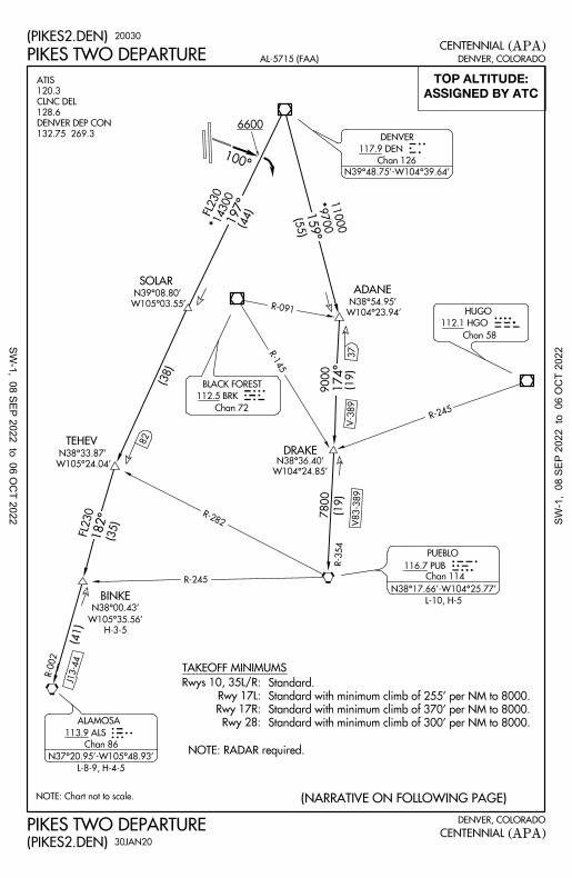
(PIKES2.DEN)20030
PIKES TWO DEPARTURE
(PIKES2.DEN)30JAN20
PIKES TWO DEPARTURE
W105°24.04'
N38°33.87'
W105°03.55'
N39°08.80'
(NARRATIVE ON FOLLOWING PAGE)
117.9 DEN
Chan 126
DENVER
N39°48.75'-W104°39.64'
113.9 ALS
Chan 86
ALAMOSA
116.7 PUB
Chan 114
PUEBLO
L-10, H-5
N38°17.66'-W104°25.77'
L-8-9, H-4-5
N37°20.95'-W105°48.93'
SW-1, 08 SEP 2022 to 06 O
CT 2022 SW
-1,
08 S
EP 2
022
to 0
6 O
CT
2022

DEPARTURE ROUTE DESCRIPTION
T
DENVER, COLORADO
(APA)CENTENNIAL
DENVER, COLORADO
(APA)CENTENNIAL
R-197 to TEHEV, then on ALS R-002 to ALS VORTAC.
ALAMOSA TRANSITION (PIKES2.ALS): From over DEN VOR/DME on DEN
to TEHEV, then on ALS R-002 to BINKE.
BINKE TRANSITION (PIKES2.BINKE): From over DEN VOR/DME on DEN R-197
to ADANE, then on PUB R-354 to PUB VORTAC.
PUEBLO TRANSITION (PIKES2.PUB): From over DEN VOR/DME on DEN R-159
assigned route. Expect filed altitude 10 minutes after departure.
TAKEOFF ALL RUNWAYS: Fly assigned heading and altitude for RADAR vectors to
AL-5715 (FAA)
(PIKES2.DEN)20030
PIKES TWO DEPARTURE
(PIKES2.DEN)30JAN20
PIKES TWO DEPARTURE
10000 feet, cross DEN VOR/DME at or above 11000 feet.
direct DEN VOR/DME, thence via assigned transition. If filed altitude is above
departure, maintain assigned heading until 7000 feet, then climb to filed altitude via
LOST COMMUNICATIONS: If no transmissions are received within one minute after
TAKEOFF RUNWAY 10: Climb on heading 100° to 6600 before turning right.
SW-1, 08 SEP 2022 to 06 O
CT 2022 SW
-1,
08 S
EP 2
022
to 0
6 O
CT
2022

DE
NV
ER
, CO
LO
RA
DO
DE
NV
ER
, CO
LO
RA
DO
(AP
A)
(AP
A)
CE
NT
EN
NIA
L
CE
NT
EN
NIA
L
TAKEOFF MINIMUMS
NOTE: Chart not to scale. (NARRATIVE ON FOLLOWING PAGE)
132.75 269.3
DENVER DEP CON
128.6
CLNC DEL
120.3
ATIS
N
EEONS
EXTAN
EPKEE
W103°46.18'
N40°01.29'
W103.47.97'
N39°35.57'
W102°21.21'
N39°58.57'
W102°00.78'
N39°06.72'
WEEDS
HCTAKO
TXC
MCK
GLD
ASHBY
W102°00.09'
N40°19.03'
TEKMY
W103°45.43'N39°44.60'
065°
9000
(43)
076°
(43)
087°(42)
8000
100°
FL230
065°
(28)
066°6500
(55)
(50)
W103°44.09'
N39°53.03'
EMMYS
076°
(64)
9000
073°
(66)
066°6500
(25)084°(56)
092°
7000
(73)
100°(88)
129°(94)
R-309
R-241
R-250
107
R-298
130
R-253
R-264
R-273
V8
V8
V4
8100
FL230
6300
FL230
*
*
*
*
*
7000
18000
9000FL210
9000FL210
ASSIGNED BY ATC
TOP ALTITUDE:
8100
*
FL210
9000*
100°
6600
DEN
AL
-57
15
(FA
A)
21
22
4(P
LA
IN1
.DE
N)
(PL
AIN
1.D
EN
)3
0JA
N2
0
Rwy 28: Standard with minimum climb of 300' per NM to 8000.
Rwy 17R: Standard with minimum climb of 370' per NM to 8000.
Rwy 17L: Standard with minimum climb of 255' per NM to 8000.
Rwys 10, 35L/R: Standard.
NOTE: RADAR required.
CABET
W102°00.65'
N39°35.65'
BELKE
W102°00.51'
N40°01.38'
073°
(16)
9000*
transition only.
MOCA for MC COOK
FL210
PL
AIN
S O
NE
DE
PA
RT
UR
E
PL
AIN
S O
NE
DE
PA
RT
UR
E
GCK
117.7 HCT
Chan 124
HAYES CENTER
115.3 MCK
Chan 100
115.1 GLD
Chan 98
112.9 TXC
Chan 76
114.4 AKO
Chan 91
113.3 GCK
Chan 80
GARDEN CITY
AKRON
THURMAN
MC COOK
GOODLAND
L-10, H-5
N40°12.23'-W100°35.65'
L-10, H-5
N39°41.90'-W103°12.90'
L-10, H-5
N40°27.24'-W100°55.41'L-10, H-5
N40°09.33'-W103°10.78'L-10,H-5
L-10, H-5
N39°23.27'-W101°41.54'
N37°55.14'-W100°43.50'
L-10-15, H-5
117.9 DEN
Chan 126
DENVER
N39°48.75'-W104°39.64'
L-10, H-5
H-5
SW-1, 08 SEP 2022 to 06 OCT 2022SW-1, 08 SEP 2022 to 06 OCT 2022

DENVER, COLORADO
DENVER, COLORADO
(APA)
(APA)CENTENNIAL
CENTENNIAL
DEPARTURE ROUTE DESCRIPTION
T
feet, cross DEN VOR/DME at or above 11000 feet.
direct DEN VOR/DME, thence via assigned transition. If filed altitude is above 10000
departure, maintain assigned heading until 7000 feet, then climb to filed altitude via
LOST COMMUNICATIONS: If no transmissions are received within one minute after
AL-5715 (FAA)
and TXC R-264 to TXC VORTAC, then on TXC R-092 and GLD R-273 to GLD VORTAC.
GOODLAND TRANSITION (PLAIN1.GLD): From over DEN VOR/DME on DEN R-087
and TXC R-264 to TXC VORTAC.
THURMAN TRANSITION (PLAIN1.TXC): From over DEN VOR/DME on DEN R-087
DEN R-100 and GCK R-309 to GCK VORTAC.
GARDEN CITY TRANSITION (PLAIN1.GCK): From over DEN VOR/DME on
and MCK R-253 to BELKE INT.
BELKE TRANSITION (PLAIN1.BELKE): From over DEN VOR/DME on DEN R-076
and AKO R-241 to AKO VOR/DME.
AKRON TRANSITION (PLAIN1.AKO): From over DEN VOR/DME on DEN R-065
HCT VORTAC.
and AKO R-241 to AKO VOR/DME, then on AKO R-066 and HCT R-250 to
HAYES CENTER TRANSITION (PLAIN1.HCT): From over DEN VOR/DME on DEN R-065
ASHBY.
and AKO R-241 to AKO VOR/DME, then on AKO R-066 and HCT R-250 to
ASHBY TRANSITION (PLAIN1.ASHBY): From over DEN VOR/DME on DEN R-065
and TXC R-264 to TXC VORTAC, then on TXC R-084 to CABET.
CABET TRANSITION (PLAIN1.CABET): From over DEN VOR/DME on DEN R-087
to TEKMY, then on MCK R-253 to MCK VOR/DME.
MCCOOK TRANSITION (PLAIN1.MCK): From over DEN VOR/DME on DEN R-076
to WEEDS.
WEEDS TRANSITION (PLAIN1.WEEDS): From over DEN VOR/DME on DEN R-100
20030(PLAIN1.DEN)
(PLAIN1.DEN)30JAN20
PLAINS ONE DEPARTURE
PLAINS ONE DEPARTURE
RUNWAY 10: Climb on heading 100° to 6600 before turning right.
assigned route. Expect filed altitude 10 minutes after departure.
TAKEOFF ALL RUNWAYS: Fly assigned heading and altitude for RADAR vectors to
SW-1, 08 SEP 2022 to 06 O
CT 2022 SW
-1,
08 S
EP 2
022
to 0
6 O
CT
2022

DE
NV
ER
, CO
LO
RA
DO
DE
NV
ER
, CO
LO
RA
DO
(AP
A)
(AP
A)
CE
NT
EN
NIA
L
CE
NT
EN
NIA
L
NOTE: Chart not to scale.
N
DEN
NOTE: RADAR required.
6600
100°
218°
219°
243°
201°
260°
R-035
R-03
9
R-021
R-078
(64)
(71)
(69)
(27)
(47)
(59)
(36)(68)
16000
16300CONNR
BOBBA
RLG
HBUMTJ
DVC
EKR
DBL
R-344
R-148
TEHRU
R-134
102
16500
1600016000
(NARRATIVE ON FOLLOWING PAGE)
243°
(47)
BAYLR
W105°37.10'
N39°33.20'24
3°
(28)
75
164°
344°
080°
260°
LIR
FL200
FL280
FL200
FL28
0
FL28
0
132.75 269.3
DENVER DEP CON
128.6
CLNC DEL
120.3
ATIS TOP ALTITUDE: ASSIGNED BY ATC
W106°11.17'
N39°23.70'
W106°43.25'
N39°14.56'
V200
1650
0FL200
AL
-57
15
(FA
A)
(RO
CK
I5.D
EN
) 20
08
6
RO
CK
IES
FIV
E D
EP
AR
TU
RE
(RO
CK
I5.D
EN
) 26
MA
R2
0
RO
CK
IES
FIV
E D
EP
AR
TU
RE
Rwy 28: Standard with minimum climb of 300' per NM to 8000.
Rwy 17R: Standard with minimum climb of 370' per NM to 8000.
Rwy 17L: Standard with minimum climb of 255' per NM to 8000.
Rwys 10, 35L/R: Standard.
TAKEOFF MINIMUMS
*
274°(47)
259°R-079
ZIMMR
W105°39.64'
N39°58.41'
W105°39.86'
N39°41.33'
253°
243°
R-063
N39°48.75'-W104°39.64'
N40°00.16'-W106°26.55'
N38°30.39'-W107°53.96'
N37°48.52'-W108°55.88'
N39°26.36'-W106°53.68'
MONTROSE
117.1 MTJ
Chan 118
L-9, H-3
L-9, H-3
L-9-11, H-3
L-9, H-3
L-9-11, H-3-5
L-9, H-3
Chan 43
110.6 RIL
RIFLE
N40°04.05'-W107°55.50'
Chan 126
117.9 DEN
DENVER Chan 85
113.8 RLG
KREMMLING
Chan 93
114.6 DVC
DOVE CREEK
Chan 77
113.0 DBL
RED TABLE
Chan 96
114.9 HBU
BLUE MESA
Chan 99
115.2 EKR
MEEKER
N38°27.13'-W107°02.38'
N39°31.70'-W107°43.18'
SW-1, 08 SEP 2022 to 06 OCT 2022SW-1, 08 SEP 2022 to 06 OCT 2022

DENVER, COLORADO
DENVER, COLORADO
(APA)
(APA)CENTENNIAL
CENTENNIAL
DEPARTURE ROUTE DESCRIPTION
T
RUNWAY 10: Climb heading 100° to 6600 before turning right.
to assigned route. Expect filed altitude 10 minutes after departure.
TAKEOFF ALL RUNWAYS: Fly assigned heading and altitude for RADAR vectors
AL-5715 (FAA)
R-243 and HBU R-021 to HBU VOR/DME.
to DVC VORTAC.
VOR/DME.
DOVE CREEK TRANSITION (ROCKI5.DVC): From over DEN VOR/DME on
MONTROSE TRANSITION (ROCKI5.MTJ): From over DEN VOR/DME on
MEEKER TRANSITION (ROCKI5.EKR): From over DEN VOR/DME on DEN R-274
BLUE MESA TRANSITION (ROCKI5.HBU): From over DEN VOR/DME on DEN
DEN R-243 and MTJ R-039 to MTJ VOR/DME, then on MTJ R-218 and DVC R-035
KREMMLING TRANSITION (ROCKI5.RLG): From over DEN VOR/DME on DEN
and RLG R-079 to RLG VOR/DME, then on RLG R-260 and EKR R-078 to EKR
DEN R-243 and MTJ R-039 to MTJ VOR/DME.
RED TABLE TRANSITION (ROCKI5.DBL): From over DEN VOR/DME on DEN
10000 feet, cross DEN VOR/DME at or above 11000 feet.
direct DEN VOR/DME, then on assigned transition. If filed altitude is above
departure, maintain assigned heading until 7000 feet, then climb to filed altitude
LOST COMMUNICATIONS: If no transmissions are received within one minute after
(ROCKI5.DEN)20086
ROCKIES FIVE DEPARTURE
(ROCKI5.DEN)26MAR20
ROCKIES FIVE DEPARTURE
R-274 and RLG R-079 to RLG VOR/DME.
R-253 and DBL R-063 to DBL VOR/DME.
SW-1, 08 SEP 2022 to 06 O
CT 2022 SW
-1,
08 S
EP 2
022
to 0
6 O
CT
2022

NOTE: Chart not to scale.
FL230
TOP ALTITUDE:
DENVER, COLORADO
DENVER, COLORADO
AL-5715 (FAA)
(SKYEE1.SKYEE)
SKYEE ONE DEPARTURE(RNAV)
(SKYEE1.SKYEE)
SKYEE ONE DEPARTURE(RNAV)
(APA)
(APA)
132.75 269.3
DENVER DEP CON
128.6
CLNC DEL
120.3
ATIS
CENTENNIAL
CENTENNIAL
(NARRATIVE ON FOLLOWING PAGE)
TAKEOFF MINIMUMS
Rwys 35L/R: Standard.
Rwy 17R: Standard with minimum climb of 370' per NM to 8000.
Rwy 17L: Standard with minimum climb of 255' per NM to 8000.
Rwys 10, 28: NA.
NOTE: RADAR required.
NOTE: Turbojets only.
NOTE: RNAV 1.
NOTE: DME/DME/IRU or GPS required.
8000
SATLE
191°
199°
198°
149°
165°
160°
139°
135°
158°
132°
17
2°
189°
14200
11300
(31)
17000
12300
(48)
(28)
16000
17000
*
*
*
FL1
80
9800
(34)
FL1
80
9900
(39)
FL180
7800(84)
FL1
80
9900
(65)
*
*
*
*
FL180
9500(37)
(39)
9500
FL1
80
(35)
7700
FL180
*
*
*
14
20
01
04
00
(31
)
(24)
15800
FL2
30
*
*
160°
(12)
189°
(52)
14300
FL2
30
*
350°
170°
6385
6385170°
350°
20086
26MAR20
SHOJO
STAKR
DAAYE
SUDDZ
SABTH
JOPLN
VRONI
FRNKE
FL230
14200
SCAGS14200
SOLAR
SMMUR
17000AZARO
SLEEK
SKYEE
SW-1, 08 SEP 2022 to 06 O
CT 2022 SW
-1,
08 S
EP 2
022
to 0
6 O
CT
2022

DEPARTURE ROUTE DESCRIPTION
T
or as assigned by ATC. Thence. . . .
TAKEOFF RUNWAYS 35L/R: Climb on heading 350° to 6385, then on heading 350°
or as assigned by ATC. Thence. . . .
TAKEOFF RUNWAYS 17L/R: Climb on heading 170° to 6385, then on heading 170°
DENVER, COLORADOAL-5715 (FAA)
(APA)CENTENNIAL
DENVER, COLORADO
(APA)CENTENNIAL
VRONI TRANSITION (SKYEE1.VRONI)
SUDDZ TRANSITION (SKYEE1.SUDDZ)
SLEEK TRANSITION (SKYEE1.SLEEK)
JOPLN TRANSITION (SKYEE1.JOPLN)
DAAYE TRANSITION (SKYEE1.DAAYE)
(SKYEE1.SKYEE)
SKYEE ONE DEPARTURE(RNAV)
(SKYEE1.SKYEE)
SKYEE ONE DEPARTURE(RNAV)
20086
26MAR20
altitude ten minutes after departure.
then on (transition) maintain FL230 or filed lower altitude. Expect higher filed
. . . .expect RADAR vectors to cross SATLE at 8000 then on track 160° to SKYEE
SW-1, 08 SEP 2022 to 06 O
CT 2022 SW
-1,
08 S
EP 2
022
to 0
6 O
CT
2022

NOTE: Chart not to scale.
FL230
TOP ALTITUDE:
DE
NV
ER
, CO
LO
RA
DO
DE
NV
ER
, CO
LO
RA
DO
AL
-57
15
(FA
A)
(WN
GS
S1
.WN
GS
S)
WN
GS
S O
NE
DE
PA
RT
UR
E (RN
AV
)
(WN
GS
S1
.WN
GS
S)
WN
GS
S O
NE
DE
PA
RT
UR
E (RN
AV
)
(AP
A)
(AP
A)
restrictions advise CLNC DEL prior to taxi.
If slower speed is required to meet crossing
NOTE: Accelerate to 250K or greater upon reaching 10000.
NOTE: RADAR required.
NOTE: Turbojets only.
NOTE: RNAV 1.
NOTE: DME/DME/IRU or GPS required.
132.75 269.3
DENVER DEP CON
128.6
CLNC DEL
120.3
ATIS
NC
EN
TE
NN
IAL
CE
NT
EN
NIA
L
(NARRATIVE ON FOLLOWING PAGE)
TAKEOFF MINIMUMS
Rwys 35L/R: Standard.
Rwy 17R: Standard with minimum climb of 370' per NM to 8000.
Rwy 17L: Standard with minimum climb of 255' per NM to 8000.
Rwys 10, 28: NA.TEHRU
BOBBA
WERNR
VOAXA
CHNGY
291°
266°
246°
252°
224°
224°
242°
208°
1700014800(13)
1700015200
(37) *
*
ZENLO
15000
ZIMMR
17000
COUSN
15000
CONNR
17000
12000WNGSS
17000
13800
(11)
*
17000
16500
(47)
*
BUBLS
15000
BRANF
16000
BAYLR
17000
1600
0
1310
0
(6)
1700
0
1650
0
(7)
1700
0
1650
0
(28)
*
*
*
KINLE
15000
COORZ
17000
* *
17000
16700
(69)*
244°
(12)
292°
*1400012300
(10)
*
246°
14000
11400
(10)
*
224°
(10)
1500
0
1200
0
*
HBU
BLUE MESA
FL230
20
08
6
26
MA
R2
0
350°
170°
6385
6385170°
350°
BUMPZ
8000
*
242°
273°256°
1700
0
1650
0
(27)
1700015600
(13)
17000
15800
(38)273°
1400011800
(10)
SW-1, 08 SEP 2022 to 06 OCT 2022SW-1, 08 SEP 2022 to 06 OCT 2022

DEPARTURE ROUTE DESCRIPTION
T
or as assigned by ATC. Thence. . . .
TAKEOFF RUNWAYS 35L/R: Climb on heading 350° to 6385, then on heading 350°
or as assigned by ATC. Thence. . . .
TAKEOFF RUNWAYS 17L/R: Climb on heading 170° to 6385, then on heading 170°
DENVER, COLORADO
(WNGSS1.WNGSS)
WNGSS ONE DEPARTURE(RNAV)(APA)CENTENNIAL
DENVER, COLORADOAL-5715 (FAA)
(WNGSS1.WNGSS)
WNGSS ONE DEPARTURE(RNAV)(APA)CENTENNIAL
Expect higher filed altitude ten minutes after departure.
WNGSS at or above 12000 then on (transition) maintain FL230 or filed lower altitude.
. . . .expect RADAR vectors to cross BUMPZ at 8000 then on track 244° to cross
20086
26MAR20
WERNR TRANSITION (WNGSS1.WERNR)
VOAXA TRANSITION (WNGSS1.VOAXA)
TEHRU TRANSITION (WNGSS1.TEHRU)
CHNGY TRANSITION (WNGSS1.CHNGY)
BLUE MESA TRANSITION (WNGSS1.HBU)
SW-1, 08 SEP 2022 to 06 O
CT 2022 SW
-1,
08 S
EP 2
022
to 0
6 O
CT
2022
6600
100°
DE
NV
ER
, CO
LO
RA
DO
DE
NV
ER
, CO
LO
RA
DO
(AP
A)
(AP
A)
CE
NT
EN
NIA
L
CE
NT
EN
NIA
L
NOTE: RADAR required.
L-11
NOTE: Chart not to scale.
HANKI
H-5
W102°55.81'
N41°37.92'
W104°05.76'N40°49.67'
W104°14.24'
N40°34.62'
YOKES
YALES
W104°44.34'
N40°47.66'
313°
12000
(77)
R-133
R-163
R-194
R-125 305°
(45) 343°
(25)
(60)
(59)
349°
11000
10000334°
(16)
R-034
R-060 R-191
034°
011°
9000
(70)
N
COPLA
66
NATTI
W106°29.02'
N41°30.81'
R-213
273°(36)
L-9-12, H-3-5
L-12, H-3-5
L-12, H-3-5
L-12, H-5
359°
9000
(42)
N40°30.23'-W104°33.18'
R-174
015°
(50)
R-186
L-12, H-2
005°
(219)
10000
Chan 89
GILL
114.2 GLL
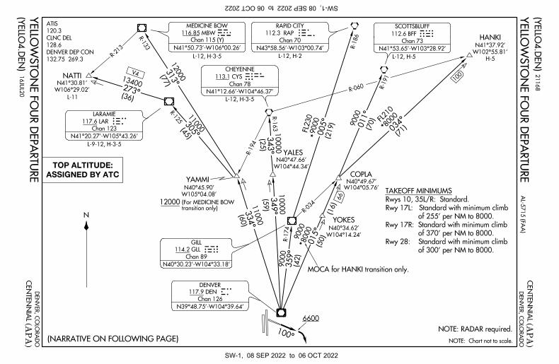
(NARRATIVE ON FOLLOWING PAGE)
132.75 269.3
DENVER DEP CON
128.6
CLNC DEL
120.3
ATIS
13400
V4
(71) 8
000
FL210
*
8000
9000
*
9000
FL230
*
11000
ASSIGNED BY ATC
TOP ALTITUDE:
W105°04.08'
N40°45.90'
YAMMI
12000transition only)(For MEDICINE BOW
AL
-57
15
(FA
A)
(YE
LL
O4
.DE
N) 2
11
68
(YE
LL
O4
.DE
N) 1
6JU
L2
0
of 300' per NM to 8000.
Rwy 28: Standard with minimum climb
of 370' per NM to 8000.
Rwy 17R: Standard with minimum climb
of 255' per NM to 8000.
Rwy 17L: Standard with minimum climb
Rwys 10, 35L/R: Standard.
TAKEOFF MINIMUMS
YE
LL
OW
ST
ON
E F
OU
R D
EP
AR
TU
RE
YE
LL
OW
ST
ON
E F
OU
R D
EP
AR
TU
RE
N43°58.56'-W103°00.74'
RAPID CITY
Chan 70
N41°50.73'-W106°00.26'
N41°12.66'-W104°46.37'
Chan 78
CHEYENNE
113.1 CYS
Chan 73
SCOTTSBLUFF
112.6 BFF
N39°48.75'-W104°39.64'
Chan 126
DENVER
117.9 DEN
N41°20.27'-W105°43.26'
LARAMIE
Chan 123
117.6 LAR
MEDICINE BOW
116.85 MBW 112.3 RAP
100
N41°53.65'-W103°28.92'
Chan 115 (Y)
MOCA for HANKI transition only.
SW-1, 08 SEP 2022 to 06 OCT 2022SW-1, 08 SEP 2022 to 06 OCT 2022

DENVER, COLORADO
DENVER, COLORADO
(APA)
(APA)
CENTENNIAL
CENTENNIAL
T
DEPARTURE ROUTE DESCRIPTION
T
AL-5715 (FAA)
R-349 and CYS R-163 to CYS VORTAC.
DEN R-334 and MBW R-133 to MBW VOR/DME.
and LAR R-125 to LAR VOR/DME.
CHEYENNE TRANSITION (YELLO4.CYS): From over DEN VOR/DME on DEN
MEDICINE BOW TRANSITION (YELLO4.MBW): From over DEN VOR/DME on
RAPID CITY TRANSITION (YELLO4.RAP): From over DEN VOR/DME on DEN R-359
HANKI TRANSITION (YELLO4.HANKI): From over DEN VOR/DME on DEN R-015
LARAMIE TRANSITION (YELLO4.LAR): From over DEN VOR/DME on DEN R-334
NATTI TRANSITION (YELLO4.NATTI): From over DEN VOR/DME on DEN R-334
and GLL R-174 to GLL VOR/DME, then on GLL R-005 and RAP R-186 to RAP VORTAC.
SCOTTSBLUFF TRANSITION (YELLO4.BFF): From over DEN VOR/DME on DEN
10000 feet, cross DEN VOR/DME at or above 11000 feet.
direct DEN VOR/DME, then on assigned transition. If filed altitude is above
departure, maintain assigned heading until 7000 feet, then climb to filed altitude
LOST COMMUNICATIONS: If no transmissions are received within one minute after
and GLL R-034 to HANKI.
and LAR R-125 to LAR VOR/DME, then on LAR R-273 to NATTI.
(YELLO4.DEN)20198
(YELLO4.DEN)16JUL20
R-015 and BFF R-191 to BFF VORTAC.
YELLOWSTONE FOUR DEPARTURE
YELLOWSTONE FOUR DEPARTURE
RUNWAY 10: Climb heading 100° to 6600 before turning right.
assigned transition. Expect filed altitude 10 minutes after departure.
TAKEOFF ALL RUNWAYS: Fly assigned heading and altitude for RADAR vectors to
SW-1, 08 SEP 2022 to 06 O
CT 2022 SW
-1,
08 S
EP 2
022
to 0
6 O
CT
2022

HOT SPOTS
An "airport surface hot spot" is a location on an aerodrome movement area with a history or potential risk of collision or runway incursion, and where heightened attention by pilots/drivers is necessary.
A "hot spot" is a runway safety related problem area on an airport that presents increased risk during surface opera-tions. Typically it is a complex or confusing taxiway/taxiway or taxiway/runway intersection. The area of increased risk has either a history of or potential for runway incursions or surface incidents, due to a variety of causes, such as but not limited to: airport layout, traffic flow, airport marking, signage and lighting, situational awareness, and training. Hot spots are depicted on airport diagrams as open circles or polygons designated as "HS 1", "HS 2", etc. and tabulated in the list below with a brief description of each hot spot. Hot spots will remain charted on airport diagrams until such time the increased risk has been reduced or eliminated.
CITY/AIRPORT HOT SPOT DESCRIPTION*
(SEE CONTINUATION PAGE FOR MORE LISTINGS)
21224
21224
ALAMOGORDO, NM HOLLOMAN AFB (HMN) HS1 Twy R, Twy G, and Twy L have multiple hold lines for Rwy 07-25 and Rwy 04-22. Contact tower if confused or lost. HS2 Hold line on Twy /EOR A and Twy/EOR H have multiple POV access roads, possibility of high vehicle traffic. HS3 Hold line on Twy /EOR B and Twy C for Rwy 07-25 have multiple POV access roads, possibility of high vehicle traffic. HS4 Multiple hold lines at intersecting rwys. Landing/departing aircraft disregard hold lines, taxiing aircraft contact tower prior to crossing hold lines. HS5 Multiple hold lines where rwys intersect. Hold line also at Twy D. Contact tower if confused or lost. HS6 POV crossing controlled by tower. Hold line located on each side of Rwy 07-25. Possibility of high vehicular traffic. ALBUQUERQUE, NM ALBUQUERQUE INTL SUNPORT (ABQ) HS 1 Hold Position Marking on Twy E1 for Rwy 08. HS 2 Twy G1 from Cutter Aviation ramp and Rwy 12-30. HS 3 Complex int at Twy F, Twy C, Twy G. Twy G and Rwy 03-21 HS 4 Twy E5 permanently closed. Twy E int with Rwy 03-21, Twy H, and Hot Pad 2. ASPEN, CO ASPEN-PITKIN COUNTY/ SARDY FLD (ASE) HS 1 Twy A2. Short taxi distance from ramp to rwy. HS 2 Twy A4. Short taxi distance from ramp to rwy. HS 3 Rwy 33 and Twy A9. Non-typical location for rwy holding position marking. COLORADO SPRINGS, CO CITY OF COLORADO SPRINGS (COS) HS 1 The apch ends of Rwy 13 and Rwy 17R; and Twy A1. HS 2 Twy A4 and Twy G at Rwy 17R-35L. HS 3 Int of Twy E4, Twy G, Twy H and Twy E. HS 4 Apch ends of Rwy 35R and Rwy 35L. DENVER, CO CENTENNIAL (APA) HS 1 Rwy 17L at Twy A1. HS 2 Twy A, Twy A8, Twy A9 and Twy C1 congested INT. HS 3 Rwy 10 hold line on Twy C1 is located 30 ft from edge of ramp. HS 4 Hold Short Line for Rwy 17L-35R on Twy B8. DENVER, CO DENVER INTL (DEN) HS 1 Twy ED at Twy M. Close proximity to Rwy 17R apch.
08 SEP 2022 to 06 OC
T 2022 08 S
EP 2
022
to 0
6 O
CT
2022

HOT SPOTS
(CONTINUED)
*See appropriate Chart Supplement HOT SPOT table for additional information.
CITY/AIRPORT HOT SPOT DESCRIPTION*
22139
22139
DENVER, CO ROCKY MOUNTAIN METRO (BJC) HS 1 Frequent helicopter operations. HS 2 Multiple hold lines in close proximity. Hold line on Twy B south of Rwy 12R-30L is prior to Twy D. HS 3 Pilots taxiing south on Twy D and instructed to cross Rwy 3 mistakenly turn onto Rwy 3. Pilots taxiing on Rwy 3 and instructed to hold short of Rwy 12R/32L fail to hold short. Hold line immediately after turn onto Rwy 3. EAGLE, CO EAGLE COUNTY RGNL (EGE) HS 1 High density parking area. GRAND JUNCTION, CO GRAND JUNCTION RGNL (GJT) HS 1 Rwy 22 and Rwy 29 close proximity, wrong rwy departure risk. ROSWELL, NM ROSWELL AIR CENTER (ROW) HS 1 Twy A, Twy B, and Twy D form a complex int in close proximity to Rwy 03-21.
08 SEP 2022 to 06 OC
T 2022 08 S
EP 2
022
to 0
6 O
CT
2022

0.6% UP
0.9
% U
P
5993
TWR
1.0
% U
P0.8
% D
OW
N
P
A5
P
P
P
P
P
MALSR
A5
35R
28
10
17L
17R
35L
X
7001 X 7
5
4800 X 75
1000
1 X 1
00
350°
8000
(6.4)
I-APA 4.1
LECET
197°
017°
(APA)39°34'N-104°51'W
DENVER, COLORADO CENTENNIAL
CATEGORY B C DA
S-ILS 35R
S-LOC 35R
SIDESTEP 35L
CIRCLING
7400 9200
160°
hdg R-197
FQF
TCH 51
GS 3.10°
12
6740-212
200 (200- )126085-12
126460- 575 (600- )1
2
6460-1 591 (600-1)
6700
8000
6.4 NM2.9 NM0.6
9000
from FAF
350° 6.3 NM
REIL Rwys 17R, 28, and 35L
MIRL all Rwys
TDZE 35L
TDZE 35R58855869
5885ELEV
118.9
CENTENNIAL TOWER GND CON
121.8132.75 269.3
DENVER APP CON
128.6
CLNC DEL
120.3
ATIS
AL-5715 (FAA)
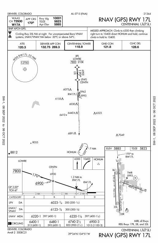
TDZE
Rwy Idg
5885
35R
5869700135L
DENVER, COLORADO
350°
APP CRS111.3
LOC/DME I-APA
58855885Apt Elev (APA)CENTENNIAL
FQF 22.5
HOHUM
HOHUM
6460-1
8000
170°
855 (900-2 )
575 (600-1 )
R-1
97
116.3 FQ
FChan 110
I-APA 8.1
JIDOG
10001 ILS or LOC RWY 35R
ILS or LOC RWY 35R
(IF)
FIRPI
I-APA 14.5
RADAR
MN
52 FQF ASM
180°
8400
360°
9600
RADAR
I-APA 14.5
FIRPI
1.8
I-APA
I-APA 4.1
LECET
I-APA 8.1
JIDOG
50Chan
350°
115.4 BJC
Chan 1
01
R-1
47
FQF
6296
3.5
I-APA
6205
14
14
6760-2 34
875 (900-2 )34
I-APA 5.2
YAGUG
7060
1.1 NM
I-APA 5.2
YAGUG
58
9748
6460-1575 (600-1)
6540-1655 (700-1)
1.7 NM
12591 (600-1 )
126460-1 6460-2
591 (600-2)
Circling Rwy 35L NA at night.
increase S-LOC 35R Cat C/D visibility to 1 SM. Sidestep and
Rwy 35L helicopter visibility reduction below 1 SM NA. For inop ALS,
21280
INT/FQF 22.5 DME and hold.
160° and FQF VORTAC R-197 to HOHUM
climbing right turn to 9200 on heading
MISSED APPROACH: Climb to 7400 then
6440(4)
350°
9000
9000
RADAR
I-APA 18.5
XBEEE
(IAF)
70496891
6523
6155
6075
6030
5993
8055
7760
7481
6410
9000
DME required for LOC only. RADAR required for procedure entry.
Amdt 11A 07OCT21
H
C
T
A
LOCALIZER 111.3
Chan 50
I-APAPIAA
SW-1, 08 SEP 2022 to 06 O
CT 2022 SW
-1,
08 S
EP 2
022
to 0
6 O
CT
2022
0.6% UP
0.9
% U
P
5993
TWR
1.0
% U
P0.8
% D
OW
N
P
A5
P
P
P
P
P
CATEGORY B C DA
35R
28
10
17L
17R
35L
X
7001 X 7
5
4800 X 75
10001 X 1
00
DENVER, COLORADO
DENVER, COLORADO
(APA)
(APA)
CENTENNIAL
CENTENNIAL
AL-5715 (FAA)
39°34'N-104°51'W
5885ELEV
APP CRS
5885170°
7800
TCH 47
CIRCLING
CENTN
RW17L
RNAV (GPS) RWY 17L
RNAV (GPS) RWY 17L
12
12
LPV DA
VNAV
LNAV/DA
34
34
W17A
WAAS
CH 72930
M
SA RW17L 25 N
M
12700
TDZE
LOWRE
170°
7 NM
GND CON
118.9 121.8120.3 128.6
ATIS CLNC DELDENVER APP CON
132.75 269.3
CENTENNIAL TOWER
170°
1.2 NM
LNAV MDA
6023-
5823
Apt Elev
TDZE
Rwy Idg
5823
CENTN
(FAF)
T
A
HOHUM6300 10400
C
6220-1
6400-1515 (600-1)
6480-1595 (600-1)
6740-2 6900-3
1015 (1100-3)
6900
6900
2.1 NM
HOHUM
6900
RW17L
1.2 NM to
RW17L
170° to
REIL Rwys 17R, 28, and 35L
MIRL all Rwys
200°
020°
GP 3.00°
81
816220-1 397 (400-1 )397 (400-1)
RW17L
200 (200- )
855 (900-2 )
10001
7800 210K
LOWRE
(IF)
8812
5962
70496891
65236440
6155
6075
6030
5993
8055
6410
6123- 300 (300- )78
78
3 NM
(3)
RNP APCH-GPS.
systems, LNAV/VNAV NA below -20°C or above 54°C.
Circling Rwy 35L NA at night. For uncompensated Baro-VNAV
climb-in-hold to 10400.
right turn to 10400 direct HOHUM and hold, continue
MISSED APPROACH: Climb to 6300 then climbing
21364
Amdt 2 30DEC21
H
SW-1, 08 SEP 2022 to 06 O
CT 2022 SW
-1,
08 S
EP 2
022
to 0
6 O
CT
2022

0.6% UP
0.9
% U
P
5993
TWR
1.0
% U
P0.8
% D
OW
N
P
A5
P
P
P
P
P
35R
28
10
17L
17R
35L
X
7001 X 7
5
4800 X 75
1000
1 X 1
00
REIL Rwys 17R, 28, and 35L
MIRL all Rwys
DENVER, COLORADO
DENVER, COLORADO
(APA)
(APA)
CENTENNIAL
CENTENNIAL
AL-5715 (FAA)
39°34'N-104°51'W
5885ELEV
GND CON
118.9 121.8
APP CRS 4800
5885
120.3 128.6
ATIS CLNC DELDENVER APP CON
132.75 269.3
CENTENNIAL TOWER
283°
6400
8100
6940RW28
TCH 41
DOCKY
CIRCLING
RNAV (GPS) RWY 28
RNAV (GPS) RWY 28W28A
WAAS
CH 82107
VNAV
LNAV/DA
LPV DA 266 (200- )
MSA
RW28 25 NM
12000
*
*
3 NM 3.2 NM
RW28
3.5 NM to
FEGIB
*
NIDLY
1.7 NM
MESME
7500
7600
283°
EZBEL
(IAF)
DILVE
(IAF)
283°
7600
(3.2)
RW28
TDZE
78
306 (300-1)
1212
7500
9000 EZBEL
7 NM
238°
058°
LNAV MDA
78
(5) 23
8°8100
(5)
283°
8100
DOCKY
(IF)
MESME
21280
T
Amdt 1C 08NOV18
Apt Elev
TDZE
Rwy Idg
5813
5813
6079-
6119-1
447 (400-1) 447 (400-1 )
DCBACATEGORY
LNAV only.
GP 3.00°
7500(3)
NIDLY
(FAF)
RW28
3.5 NM to
FEGIB
EZBEL and hold.
then climbing right turn to 9000 direct
MISSED APPROACH: Climb to 6400
5859
5919
7049
6260-1 6260-1 38
38
6400-1
515 (600-1)
6540-1 655 (700-1)
6740-2 855 (900-2 )
6900-3
1015 (1100-3)C
RW281.3 NM to
1.3 2.2 NM
NA at night.
49°C. Rwy 28 helicopter visibility reduction below SM NA. Circling Rwy 35L
For uncompensated Baro-VNAV systems, LNAV/VNAV NA below -26°C or above 34
RNP APCH.
RW28
283° to
6891
6523
6440
6155
6075
6030
5993
6410
H
SW-1, 08 SEP 2022 to 06 O
CT 2022 SW
-1,
08 S
EP 2
022
to 0
6 O
CT
2022

0.6% UP
0.9
% U
P
5993
TWR
1.0
% U
P0.8
% D
OW
N
P
A5
P
P
P
P
P
A5
35R
28
10
17L
17R
35L
X
7001 X 7
5
4800 X 75
10001 X 1
00
DENVER, COLORADO
DENVER, COLORADO
(APA)
(APA)
CENTENNIAL
CENTENNIAL
AL-5715 (FAA)
39°34'N-104°51'W
350°
8000
350°
7 NM
17
2°
35
2°
8000
GND CON
118.9 121.8120.3 128.6
ATIS CLNC DELCENTENNIAL TOWER
RW35R
3.4 NM to
YAGUG
7060
2.9 NM
GP 3.10°
TCH 51
6.4 NM
T
A
8200 9600
58855885
RW35R
2.3 NM to
LECET
RNAV (GPS) RWY 35R
RNAV (GPS) RWY 35R
WAASAPP CRS
10001
Apt Elev
TDZE
Rwy Idg
58855885CH 40339
W35A
MALSR
DENVER APP CON
132.75 269.3
ELEV TDZE
REIL Rwys 17R, 28, and 35L
MIRL all Rwys
VNAV
LNAV/
LNAV MDA
DA
LPV DA
CIRCLINGC
12495 (500- )1
26380-
M
N 52
R53WR AS
M
12700
RW35R
BPUTN
JIDOG
(FAF)
(6.4)
8000
BPUTN
9000
FIRPI
JIDOG
RW35R
350°
0.9 NM1.4 NM
RW35R
350° to
CATEGORY B C DA
6129
9748
38
RNP APCH.
12200 (200- )1
26085-
34
346324- 439 (500- )
6380-1495 (500-1)
515 (600-1)
6400-1655 (700-1)
6540-1 126740-212855 (900-2 )
6760-234
875 (900-2 )34
RW35R
2.3 NM to
LECET
6700
1.1 NM
(4)
350°
9000
RW35R
3.4 NM to
YAGUG
6205
RW35R
1.4 NM to
FIRPI
(IF)
XBEEE
(IAF)
BPUTN and hold.
then climbing left turn to 9600 direct
240K until BPUTN) Climb to 8200
MISSED APPROACH: (Do not exceed
22111
Amdt 1A 07OCT21
LNAV Cats C/D visibility to 1 SM.
LNAV/VNAV NA below -21°C or above 54°C. For inop ALS, increase
Circling Rwy 35L NA at night. For uncompensated Baro-VNAV systems,
70496891
6523
6440
6155
6075
6030
5993
8812
8055
7760
7481
6410
9000
9000 240K
H
SW-1, 08 SEP 2022 to 06 O
CT 2022 SW
-1,
08 S
EP 2
022
to 0
6 O
CT
2022

ALTERNATE MINS
22251
M1
SW-1
22251 M1
A A
ALTERNATE MINS A A
NAME ALTERNATE MINIMUMS NAME ALTERNATE MINIMUMS
AKRON, CO COLORADO PLAINS RGNL (AKO).…………………RNAV (GPS) Rwy 11
RNAV (GPS) Rwy 29 Category D 800-2¼.
ALAMOGORDO, NM ALAMOGORDO-WHITE SANDS RGNL (ALM)……………………RNAV (GPS) Rwy 4 NA when local weather not available. Category C, 800-2¼; Category D, 800-2½.
ALBUQUERQUE, NM ALBUQUERQUE INTL SUNPORT (ABQ).………………ILS or LOC Rwy 3
1
RADAR-12
RNAV (GPS) Y Rwy 33
RNAV (GPS) Y Rwy 83
VOR Rwy 84
1ILS, LOC, Category D, 1200-3.
2Categories D, E, 1200-3.
3Category D, 1200-3.
4Categories A, B, 1100-2; Category C, 1100-3; Category D, 1200-3; Category E, 2200-3.
DOUBLE EAGLE II (AEG)..……..…….…RNAV (GPS) Rwy 4
RNAV (GPS) Rwy 22
NA when local weather not available. Category D, 900-2½.
A
INSTRUMENT APPROACH PROCEDURE CHARTS
IFR ALTERNATE AIRPORT MINIMUMS
Pilots must review the IFR Alternate Minimums Notes to determine alternate airport suitability. designation on the approach chart means that pilots may not use that approach as an alternate due to unmonitored facility, absence of weather reporting service, or lack of adequate navigation coverage. Approaches with the designation are not listed in this section. designation on the approach chart indicates that the approach procedure has non-standard minimums (for aircraft other than helicopters) or restrictions (for all users) for its use as an alternate.
Alternate Minima (ref: 14 CFR 91.169)
Note: For alternate airport flight planning purposes, precision approach operations include: ILS, PAR, and GLS, and Non-Precision approach operations include: NDB, VOR, LOC, TACAN, LDA, SDF, ASR, RNAV (GPS) and RNAV (RNP).
ARTESIA, NM ARTESIA MUNI (ATS)………………………….…NDB Rwy 13
1
NDB Rwy 312
RNAV (GPS) Rwy 132
RNAV (GPS) Rwy 222
RNAV (GPS) Rwy 312
1Categories C, D, 800-2½.
2Category D, 800-2¼.
ASPEN, CO ASPEN-PITKIN COUNTY/ SARDY FLD (ASE)……………….…RNAV (GPS)-F Categories A, B, 2400-2; Category C, 3200-3.
BURLINGTON, CO KIT CARSON COUNTY (ITR)…...……………………NDB Rwy 15
1
RNAV (GPS) Rwy 332
1Category D, 800-2¼.
2NA when local weather not available.
Precision Approach Non-Precision Approach
Standard 600-2 800-2
Non-Standard or restrictions As indicated below As indicated below
Helicopters For the selected approach: Ceiling: 200’ above published ceiling Visibility: the greater of 1 SM visibility or the published visibility
US Military (USA/USN/USAF)
See Service Regulations
08 SEP 2022 to 06 OC
T 2022 08 S
EP 2
022
to 0
6 O
CT
2022

ALTERNATE MINS
22251
M2
SW-1
22251 M2
A A
ALTERNATE MINS A A
NAME ALTERNATE MINIMUMS NAME ALTERNATE MINIMUMS
CARLSBAD, NM CAVERN CITY AIR TRML (CNM)…………………………ILS Rwy 3
4
RNAV (GPS) Rwy 31
RNAV (GPS) Rwy 14R2
RNAV (GPS) Rwy 212
RNAV (GPS) Rwy 32L23
VOR Rwy 32L23
1Categories A, B, 900-2; Category C, 900-2½;
Category D, 1000-3. 2Category D, 1000-3.
3NA when local weather not available.
4ILS, Categories A, B, C, 700-2; Category D,
1000-3; LOC, Category D, 1000-3.
CLAYTON, NM CLAYTON MUNI AIRPARK (CAO)………………RNAV (GPS) Rwy 2
RNAV (GPS) Rwy 20 NA when local weather not available.
CLOVIS, NM CLOVIS RGNL (CVN)..……................…RNAV (GPS) Rwy 4
RNAV (GPS) Rwy 22
VOR Rwy 22 NA when local weather not available.
COLORADO SPRINGS, CO CITY OF COLORADO SPRINGS
MUNI (COS).………………ILS or LOC Rwy 17L46
ILS or LOC Rwy 35L7
ILS or LOC Rwy 35R2
NDB Rwy 35L8
RNAV (GPS) Rwy 311
RNAV (GPS) Y Rwy 17L5
RNAV (GPS) Y Rwy 17R1
RNAV (GPS) Y Rwy 35L1
RNAV (GPS) Y Rwy 35R1
RNAV (RNP) Z Rwy 17R3
VOR Rwy 17L9
1Category C, 900-2½; Category D, 1100-3.
2ILS, Category B, 700-2; Category C, 900-2½; Category D, 1100-3; LOC, Category C,
900-2 ½; Category D, 1100-3. 3Categories A, B, C, D, 800-2½.
4LOC, Categories A, B, 1400-2;
Categories C, D, 1400-3. 5Categories A, B, 900-2; Category C, 900-2½; Category D, 1100-3.
6NA when local weather not available.
7LOC, Category C, 800-2¼; Category D, 1100-3.
8Category C, 800-2¼; Category D, 1100-3.
9Categories A, B, 1300-2; Categories C, D, 1300-3.
CORTEZ, CO CORTEZ MUNI (CEZ).………...........…..RNAV (GPS) Rwy 3
12
RNAV (GPS) Y Rwy 213
RNAV (GPS) Z Rwy 214
VOR Rwy 213
1NA when local weather not available.
2Category D, 900-3.
3Category C, 900-2¾; Category D, 1200-3.
4Categories A, B, 1300-2; Categories C, D, 1300-3.
CRAIG, CO CRAIG-MOFFAT (CAG)...……RNAV (GPS) Rwy 7
1
RNAV (GPS) Rwy 252
VOR Rwy 253
1Category A, 1000-2; Category B, 1200-2; Categories C, D, 1600-3.
2Category A, 1100-2; Category B, 1200-2; Categories C, D, 1600-3.
3Categories A, B, 1700-2; Categories C, D, 1700-3.
DEL NORTE, CO ASTRONAUT KENT ROMINGER (RCV)..…………RNAV (GPS) Rwy 24 Category B, 900-2.
DELTA, CO BLAKE FLD (AJZ)……………...RNAV (GPS) Rwy 3 Category B, 1200-2; Category C, 1500-3.
DEMING, NM
DEMING MUNI (DMN)..……………RNAV (GPS)-A1
RNAV (GPS) Rwy 42
RNAV (GPS) Rwy 81
RNAV (GPS) Rwy 221
VOR Rwy 26 NA when local weather not available. 1Category D, 800-2¼.
2Categories A, B, C, D, 800-2¼.
DENVER, CO CENTENNIAL (APA)…………………………ILS or LOC Rwy 35R
1
RNAV (GPS) Rwy 17L2
RNAV (GPS) Rwy 35R3
1LOC, Category C, 900-2½; Category D, 900-2¾.
2Category C, 900-2½; Category D, 1100-3.
3Category C, 900-2½; Category D, 900-2¾.
COLORADO AIR AND SPACE PORT (CFO).…......…….......ILS or LOC Rwy 17
123
ILS or LOC Rwy 2613
ILS or LOC Rwy 3512
RNAV (GPS) Rwy 17
14
RNAV (GPS) Rwy 2614
RNAV (GPS) Rwy 3514
1NA when local weather not available.
2NA when control tower closed.
3LOC, Category D, 800-2½.
4Category D, 800-2½.
08 SEP 2022 to 06 OC
T 2022 08 S
EP 2
022
to 0
6 O
CT
2022

ALTERNATE MINS
22251
M3
SW-1
22251 M3
A A
ALTERNATE MINS A A
NAME ALTERNATE MINIMUMS NAME ALTERNATE MINIMUMS
DENVER, CO (CON’T) ROCKY MOUNTAIN METRO (BJC)...................…RNAV (GPS) Rwy 12L NA when local weather not available. Category D, 800-2¼.
DURANGO, CO DURANGO-LA PLATA COUNTY (DRO).………………RNAV (GPS) Rwy 3
RNAV (GPS) Rwy 21 Category C, 900-2½; Category D, 1500-3.
EAGLE, CO EAGLE COUNTY RGNL (EGE)..……………...................LDA Rwy 25
1
RNAV (GPS)-D2
1LDA/GS, 1800-3; LDA, 2100-2½.
2Categories A, B, 2700-2; Categories C, D, 2700-3.
ERIE, CO ERIE MUNI (EIK).…………...........…RNAV (GPS)-B
VOR-A
NA when local weather not available Category C, 800-2¼.
FARMINGTON, NM FOUR CORNERS RGNL (FMN).…………………ILS or LOC Rwy 25
12
RNAV (GPS) Rwy 53
RNAV (GPS) Rwy 73
RNAV (GPS) Rwy 234
RNAV (GPS) Rwy 254
VOR/DME Rwy 53
VOR/DME Rwy 73
NA when local weather not available. 1NA when control tower closed.
2LOC, Category C, 900-2½; Category D, 900-3.
3Category C, 900-2½; Category D, 1000-3.
4Category C, 900-2½; Category D, 900-3.
FORT COLLINS/LOVELAND, CO NORTHERN COLORADO RGNL (FNL).…….…………..…ILS or LOC Rwy 33
1
RNAV (GPS) Rwy 15 RNAV (GPS) Rwy 33
2
VOR-A NA when local weather not available. 1LOC, Category D, 800-2¼.
2Category D, 800-2¼.
FORT MORGAN, CO FORT MORGAN MUNI (FMM).…………………RNAV (GPS) Rwy 14
1
RNAV (GPS) Rwy 3212
1Category D, 800-2½.
2NA when local weather not available.
GALLUP, NM GALLUP MUNI (GUP).…………….……RNAV (GPS) Rwy 6
1
RNAV (GPS) Rwy 241
VOR Rwy 62
NA when local weather not available. 1Categories A, B, 900-2; Category C, 1000-3;
Category D, 1300-3. 2Categories A, B, 1000-2; Category C, 1000-3;
Category D, 1300-3.
GRANBY, CO GRANDBY-GRAND COUNTY (GNB)……………………..RNAV (GPS)-C
NA when local weather not available. Categories A, B, 2000-2; Category C, 2000-3.
GRAND JUNCTION, CO GRAND JUNCTION RGNL (GJT)..…………………ILS or LOC Rwy 11
12
LDA/DME Rwy 293
RNAV (GPS) Rwy 294
RNAV (GPS) Y Rwy 113
1NA when control tower closed.
2LOC, Category D, 800-2¼.
3Category D, 800-2¼.
4Category D, 800-2½.
GREELEY, CO GREELEY-WELD COUNTY (GXY).………………ILS or LOC Rwy 35
1
RNAV (GPS) Rwy 102
RNAV (GPS) Rwy 172
RNAV (GPS) Rwy 282
RNAV (GPS) Rwy 352
VOR-A2
NA when local weather not available. 1ILS, Category D, 700-2¼; LOC Category D,
800-2¼. 2Category D, 800-2¼.
GUNNISON, CO GUNNISON-CRESTED BUTTE RGNL (GUC)...……..…ILS or LOC Rwy 6
1
RNAV (RNP) Rwy 6, 800-2¼ VOR or GPS-A
23
1ILS, Categories A, B, C, 1000-3;
LOC, Categories A, B, 1600-3; Category C, 1900-3; Category D, 2400-3. 2Categories A, B, 1700-3;
Category C, 1900-3; Category D, 2400-3. 3NA when local altimeter setting not available except for operators with approved weather reporting service.
08 SEP 2022 to 06 OC
T 2022 08 S
EP 2
022
to 0
6 O
CT
2022

ALTERNATE MINS
22251
M4
SW-1
22251 M4
A A
ALTERNATE MINS A A
NAME ALTERNATE MINIMUMS NAME ALTERNATE MINIMUMS
HAYDEN, CO YAMPA VALLEY (HDN)……….......…RNAV (GPS) Rwy 28
1
RNAV (GPS) Y Rwy 1023
RNAV (RNP) Z Rwy 10
24
VOR/DME-B25
1Category C, 1100-3; Category D, 1600-3.
2NA when local weather not available.
3Categories A, B, C, 1400-5; Category D, 1600-5.
4Categories A, B, C, D, 1400-5.
5Categories A, B, 1300-2; Category C, 1300-3; Category D, 1600-3.
HOLYOKE, CO
HOLYOKE (HEQ)….…………RNAV (GPS) Rwy 32
NA when local weather not available.
HOBBS, NM LEA COUNTY RGNL (HOB)..…………………ILS or LOC Rwy 3
123
RNAV (GPS) Rwy 324
RNAV (GPS) Rwy 2124
RNAV (GPS) Rwy 3024
VOR or TACAN Rwy 214
1NA when control tower closed.
2NA when local weather not available.
3ILS, LOC, Category C, 800-2¼;
Category D, 800-2½. 4Category C, 800-2¼; Category D, 800-2½.
KREMMLING, CO MC ELROY AIRFIELD (20V).……………………RNAV (GPS)-B
1
RNAV (GPS) Rwy 272
VOR/DME-A3
1Categories A, B, 2100-2; Category C, 2100-3.
2Categories A, B, 1700-6; Category C, 1900-6.
3Categories A, B, 1800-2; Category C, 1900-3.
LA JUNTA, CO LA JUNTA MUNI (LHX).……………………RNAV (GPS) Rwy 8
RNAV (GPS) Rwy 26 NA when local weather not available.
LAMAR, CO SOUTHEAST COLORADO RGNL (LAA)..….............………RNAV (GPS) Rwy 8
RNAV (GPS) Rwy 18 RNAV (GPS) Rwy 26
RNAV (GPS) Rwy 361
VOR Rwy 182
VOR Rwy 361
NA when local weather not available. 1Category D, 800-2¼.
2Categories A, B, 900-2; Category C, 900-2½, Category D, 900-2¾.
LAS CRUCES, NM LAS CRUCES INTL (LRU)……………………RNAV (GPS) Rwy 12
RNAV (GPS) Rwy 30 NA when local weather not available. Category C, 900-2½; Category D, 900-2¾.
LAS VEGAS, NM
LAS VEGAS MUNI (LVS)……..RNAV (GPS) Rwy 2 RNAV (GPS) Rwy 20 RNAV (GPS) Rwy 32
VOR Rwy 20 NA when local weather not available.
LEADVILLE, CO
LAKE COUNTY (LXV).………RNAV (GPS) Rwy 16
Category A, 900-2; Category B, 1200-2; Category C, 2100-3.
LIMON, CO LIMON MUNI (LIC)…………...RNAV (GPS) Rwy 16
RNAV (GPS) Rwy 34 NA when local weather not available. Category C, 900-2½.
LONGMONT, CO
VANCE BRAND (LMO)...…...RNAV (GPS) Rwy 291
RNAV (GPS)-B2
VOR/DME-A2
NA when local weather not available. 1Category C, 900-2¼; Category D, 1500-3.
2Category C, 900-2½; Category D, 1500-3.
LOS ALAMOS, NM
LOS ALAMOS (LAM)………RNAV (GPS) Y Rwy 27 RNAV (GPS) Z Rwy 27
NA when local weather not available. Category C, 800-2½.
MEEKER, CO MEEKER COULTER FLD (EEO)....................................…RNAV (GPS)-B
1
RNAV (GPS) Rwy 32
1Categories A, B, 1600-2; Category C, 2100-3.
2Categories A, B, 1800-2; Category C, 1800-3.
MONTROSE, CO MONTROSE RGNL (MTJ)...……...….........RNAV (GPS) Rwy 13
1
RNAV (GPS) Rwy 171
RNAV (GPS) Rwy 3523
VOR Rwy 1323
1Category D, 1100-3.
2Category C, 900-2¾; Category D, 1100-3.
3NA when local weather not available.
08 SEP 2022 to 06 OC
T 2022 08 S
EP 2
022
to 0
6 O
CT
2022

ALTERNATE MINS
22251
M5
SW-1
22251 M5
A A
ALTERNATE MINS A A
NAME ALTERNATE MINIMUMS NAME ALTERNATE
NUCLA, CO HOPKINS FLD (AIB)………….……..RNAV (GPS)-A Category C, 900-2½.
PAGOSA SPRINGS, CO STEVENS FLD (PSO).……..…RNAV (GPS) Rwy 1
Category B, 900-2; Category C, 1300-3.
PORTALES, NM PORTALES MUNI (PRZ)…..….RNAV (GPS) Rwy 1 NA when local weather not available.
PUEBLO, CO PUEBLO MEML (PUB)………........……ILS or LOC Rwy 8R
12
ILS or LOC Rwy 26L23
RNAV (GPS) Rwy 8R4
RNAV (GPS) Rwy 175
RNAV (GPS) Rwy 26L4
RNAV (GPS) Rwy 354
1LOC, Category C, 900-2½; Categories D, E,
1100-3. 2NA when control tower closed.
3LOC, Category C, 900-2½; Category D, 1100-3.
4Category C, 900-2½; Category D, 1100-3.
5Categories A, B, 1000-2, Category C, 1000-2¾; Category D, 1000-3.
RANGELY, CO RANGELY (4V0).…………...…RNAV (GPS) Rwy 7
1
RNAV (GPS) Rwy 252
1Categories A, B, 2000-2; Category C, 2000-3.
2Categories A, B, 1700-2; Category C, 1800-3.
RATON, NM RATON MUNI/CREWS FLD (RTN)………………….…RNAV (GPS) Rwy 25
NA when local weather not available. Category D, 1300-3.
RIFLE, CO RIFLE GARFIELD COUNTY (RIL)…………………………LOC/DME-A
1
ILS Rwy 262
RNAV (GPS) Y Rwy 83
RNAV (GPS) W Rwy 264
RNAV (RNP) Y Rwy 265
RNAV (RNP) Z Rwy 86
RNAV (RNP) Z Rwy 265
VOR/DME-C3
1Categories A, B, 2300-2; Category C, 2300-3.
2ILS, Categories A, B, C, 1300-4.
3Categories A, B, 1900-2; Category C, 1900-3.
4Categories A, B, 1700-2; Category C, 1700-3.
5Categories A, B, C, 900-2½.
6Categories A, B, C, 900-3.
ROSWELL, NM ROSWELL AIR CENTER (ROW)……………………LOC BC Rwy 3
1
RNAV (GPS) Rwy 32
RNAV (GPS) Rwy 172
RNAV (GPS) Rwy 212
RNAV (GPS) Rwy 352
1NA when control tower closed.
2NA when local weather not available.
SALIDA, CO SALIDA/HARRIETT ALEXANDER FLD (ANK)………...…………...……RNAV (GPS)-A Categories A, B, 2200-2.
SANTA FE, NM
SANTA FE MUNI (SAF)……….ILS or LOC Rwy 212
RNAV (GPS) Rwy 25
RNAV (GPS) Rwy 155
RNAV (GPS) Rwy 205
RNAV (GPS) Rwy 285
RNAV (GPS) Rwy 335
VOR/DME-A34
VOR Rwy 33
34
1NA when control tower closed.
2ILS, LOC, Category C, 1000-3; Category D,
1400-3. 3Category D, 800-2¼.
4NA when control tower closed except for operators with approved weather reporting service.
5Category C, 1000-3; Category D, 1400-3.
SILVER CITY, NM GRANT COUNTY (SVC)....................…RNAV (GPS) Rwy 8
RNAV (GPS) Rwy 261
VOR-A1
NA when local weather not available. 1Category D, 1300-3.
STEAMBOAT SPRINGS, CO STEAMBOAT SPRINGS/BOB ADAMS FLD (SBS).…....................................…VOR/DME-C NA when local weather not available. Categories A, B, 1300-2.
STERLING, CO STERLING MUNI (STK)….....................…RNAV (GPS) Rwy 15
RNAV (GPS) Rwy 33 NA when local weather not available. Category D, 800-2¼.
08 SEP 2022 to 06 OC
T 2022 08 S
EP 2
022
to 0
6 O
CT
2022

ALTERNATE MINS
22251
M6
SW-1
22251 M6
A A
ALTERNATE MINS A A
NAME ALTERNATE MINIMUMS NAME ALTERNATE
TAOS, NM TAOS REGIONAL (SKX)..….RNAV (GPS) Rwy 13
1
VOR/DME-B2
1Category C, 900-2½; Category D, 1000-3.
2Categories A, B, 1000-2; Category C, 1000-2¾; Category D, 1000-3.
TELLURIDE, CO TELLURIDE RGNL (TEX)...……...….....LOC Rwy 9
1
RNAV (GPS) Y Rwy 92
RNAV (GPS) Z Rwy 94
VOR/DME-A3
1Categories A, B, 2300-2.
2Categories A, B, 3100-2.
3Categories A, B, 3400-6.
4Categories A, B, 2600-2; Category C, 2600-3.
TRINIDAD, CO PERRY STOKES (TAD)...……..……….RNAV (GPS) Rwy 3
1
RNAV (GPS) Rwy 2123
1Category D, 800-2½.
2Category D, 900-2¾.
3NA when local weather not available.
TRUTH OR CONSEQUENCES, NM TRUTH OR CONSEQUENCES MUNI (TCS)...…………………………………VOR-A NA when local weather not available. Category D, 1200-3.
WRAY, CO WRAY MUNI (2V5).……......................RNAV (GPS) Rwy 17
RNAV (GPS) Rwy 35
NA when local weather not available. Category C, 900-2½; Category D, 900-2¾.
08 SEP 2022 to 06 OC
T 2022 08 S
EP 2
022
to 0
6 O
CT
2022

22223
L1
22223 L1
T T
T T
TAKEOFF MINIMUMS, (OBSTACLE) DEPARTURE PROCEDURES, AND DIVERSE VECTOR AREA (RADAR VECTORS)
TAKEOFF MINIMUMS, (OBSTACLE) DEPARTURE PROCEDURES, AND DIVERSE VECTOR AREA (RADAR VECTORS)
SW-1
AKRON, CO COLORADO PLAINS RGNL (AKO) TAKEOFF MINIMUMS AND (OBSTACLE) DEPARTURE PROCEDURES ORIG 07MAY09 (09127) (FAA)
TAKEOFF OBSTACLE NOTES: Rwy 11, rod on obstruction light on anemometer 314' from DER, 525' left of centerline, 26' AGL/4695' MSL. Lights on hangers 412' from DER, 301' left of centerline, 18' AGL/4687' MSL. Rwy 29, vehicles on roadway beginning 971' from DER, 315' left of centerline, 15' AGL/4741' MSL. Trees beginning 1651' from DER, 528' left of centerline, up to 100' AGL/4839' MSL.
ALAMOGORDO, NM ALAMOGORDO-WHITE SANDS RGNL (ALM) TAKEOFF MINIMUMS AND (OBSTACLE) DEPARTURE PROCEDURES AMDT 2 22APR21 (21112) (FAA)
TAKEOFF MINIMUMS: Rwys 17, 35, NA - Environmental.
Rwy 22, NA - Airspace. DEPARTURE PROCEDURE:
Rwy 4, use CORONA DEPARTURE.
ALAMOSA, CO SAN LUIS VALLEY RGNL/BERGMAN FLD (ALS) TAKEOFF MINIMUMS AND (OBSTACLE) DEPARTURE PROCEDURES AMDT 4C 05NOV20 (21168) (FAA)
DEPARTURE PROCEDURE: Rwy 2, climbing right turn, thence...
Rwy 20, climbing left turn, thence... ...direct ALS VORTAC. Continue climb in ALS VORTAC holding pattern (SE, right turns, 301° inbound) to depart ALS VORTAC
at airway MEA/MCA, all others climb to 16000. TAKEOFF OBSTACLE NOTES:
Rwy 2, trees beginning 1070’ to 2560’ from DER, 197’ to 702’ left of centerline, 42’ up to 72’ AGL/7577’ up to 7607’ MSL
INSTRUMENT APPROACH PROCEDURE CHARTS
IFR TAKEOFF MINIMUMS AND (OBSTACLE) DEPARTURE PROCEDURES
Civil Airports and Selected Military Airports
ALL USERS: Airports that have Departure Procedures (DPs) designed specifically to assist pilots in avoiding obstacles during the climb to the minimum enroute altitude, and/or airports that have civil IFR takeoff minimums other than standard, are listed below. Takeoff Minimums and Departure Procedures apply to all runways unless otherwise specified. An entry may also be listed that contains only Takeoff Obstacle Notes. Altitudes, unless otherwise indicated, are minimum altitudes in MSL.
DPs specifically designed for obstacle avoidance are referred to as Obstacle Departure Procedures (ODPs) and are textually described below, or published separately as a graphic procedure. If the ODP is published as a graphic procedure, its name will be listed below, and it can be found in either this volume (civil), or the applicable military volume, as appropriate. Users will recognize graphic obstacle DPs by the term "(OBSTACLE)" included in the procedure title; e.g., TETON TWO (OBSTACLE). If not specifically assigned an ODP, SID, or RADAR vector as part of an IFR clearance, an ODP may be required to be flown for obstacle clearance, even though not specifically stated in the IFR clearance. When doing so in this manner, ATC should be informed when the ODP being used contains a specified route to be flown, restrictions before turning, and/or altitude restrictions.
Some ODPs, which are established solely for obstacle avoidance, require a climb in visual conditions to cross the airport, a fix, or a NAVAID in a specified direction, at or above a specified altitude. These procedures are called Visual Climb Over Airport (VCOA). To ensure safe and efficient operations, the pilot must verbally request approval from ATC to fly the VCOA when requesting their IFR clearance.
At some locations where an ODP has been established, a diverse vector area (DVA) may be created to allow RADAR vectors to be used in lieu of an ODP. DVA information will state that headings will be as assigned by ATC and climb gradients, when applicable, will be published immediately following the specified departure procedure.
Graphic DPs designed by ATC to standardize traffic flows, ensure aircraft separation and enhance capacity are referred to as "Standard Instrument Departures (SIDs)". SIDs also provide obstacle clearance and are published under the appropriate airport section. ATC clearance must be received prior to flying a SID.
CIVIL USERS NOTE: Title 14 Code of Federal Regulations Part 91 prescribes standard takeoff rules and establishes takeoff minimums for certain operators as follows: (1) For aircraft, other than helicopters, having two engines or less – one statute mile visibility. (2) For aircraft having more than two engines – one-half statute mile visibility. (3) For helicopters – one-half statute mile visibility. These standard minima apply in the absence of any different minima listed below.
MILITARY USERS NOTE: Civil (nonstandard) takeoff minima are published below. For military takeoff minima, refer to appropriate service directives.
T
08 SEP 2022 to 06 OC
T 2022 08 S
EP 2
022
to 0
6 O
CT
2022

22223
L2
22223 L2
T T
T T
TAKEOFF MINIMUMS, (OBSTACLE) DEPARTURE PROCEDURES, AND DIVERSE VECTOR AREA (RADAR VECTORS)
TAKEOFF MINIMUMS, (OBSTACLE) DEPARTURE PROCEDURES, AND DIVERSE VECTOR AREA (RADAR VECTORS)
SW-1
ALBUQUERQUE, NM ALBUQUERQUE INTL SUNPORT (ABQ) TAKEOFF MINIMUMS AND (OBSTACLE) DEPARTURE PROCEDURES AMDT 7 29MAY14 (14149) (FAA)
TAKEOFF MINIMUMS: Rwy 8, std. w/min. climb of 515' per NM to 7800.
DEPARTURE PROCEDURE: Rwys 3, 30, climbing left turn direct ABQ VORTAC. If required, continue climb in ABQ VORTAC holding pattern (hold W, left turns, 077° inbound) to cross ABQ VORTAC at or above MEA/MCA for route of flight. Rwy 8, climbing right turn direct ABQ VORTAC. If required, continue climb in ABQ VORTAC holding pattern (hold W, left turns, 077° inbound) to cross ABQ VORTAC at or above MEA/MCA for route of flight. (Do not exceed 250 KTS until ABQ VORTAC). Rwys 12, 21, climbing right turn direct ABQ VORTAC. If required, continue climb in ABQ VORTAC holding pattern (hold W, left turns, 077° inbound) to cross ABQ VORTAC at or above MEA/MCA for route of flight. Rwy 26, climb direct ABQ VORTAC. If required, continue climb in ABQ VORTAC holding pattern. (Hold W, left turns, 077° inbound) to cross ABQ VORTAC at or above MEA/MCA for route of flight.
TAKEOFF OBSTACLE NOTES: Rwy 3, tank 4961’ from DER, 1708’ left of centerline, 150’ AGL/5466’ MSL. Water tower 4984’ from DER, 1713’ left of centerline, 156’ AGL/5468’ MSL. Rwy 12, electrical equipment 36’ from DER, 214’ right of centerline, 16’ AGL/5315’ MSL. Rwy 21, terrain beginning 159’ from DER, 77’ right of centerline, up to 5315’ MSL. Terrain beginning 199’ from DER, 100’ left of centerline, up to 5311’ MSL. Rwy 26, sign 38’ from DER, 431’ left of centerline, 14’ AGL/5314’ MSL. Rwy 30, sign 48’ from DER, 178’ right of centerline, 15’ AGL/5315’ MSL. Vehicle on road 229’ from DER, 546’ left of centerline, 19’ AGL/5319’ MSL. Poles and tower beginning 876’ from DER, 480’ right of centerline, up to 93’ AGL/5393’ MSL.
DIVERSE VECTOR AREA (RADAR VECTORS) ORIG 21JUL16 (16203) (FAA)
Rwy 3, 12, 21, 26, 30, Heading as assigned by ATC. Rwy 8, Heading as assigned by ATC; requires minimum climb of 470’ per NM to 7600. Do not exceed 240Kts until
established on assigned heading.
DOUBLE EAGLE II (AEG) TAKEOFF MINIMUMS AND (OBSTACLE) DEPARTURE PROCEDURES AMDT 1 14FEB08 (08045) (FAA)
DEPARTURE PROCEDURE: Rwy 4 , climb heading 035° to 11700 before turning right, all others turn left on course. Rwy 17, climb heading 169° to 9400 before turning left, all others turn right on course. Rwy 22, climb heading 215° to 9100 before turning left, all others turn right on course. Rwy 35 , climb heading 349° to 11000 before turning right, all others turn left on course.
TAKEOFF OBSTACLE NOTES: Rwy 17, antenna 64' from DER, 395' left of centerline, 8' AGL/ 5807' MSL. Tree 3482' from DER, 1409' right of centerline, 100' AGL/ 5919' MSL. Rwy 35, antenna 53' from DER, 405' right of centerline, 9' AGL/ 5808' MSL.
ANGEL FIRE, NM ANGEL FIRE (AXX) TAKEOFF MINIMUMS AND (OBSTACLE) DEPARTURE PROCEDURES AMDT 1 31JUL08 (08213) (FAA)
TAKEOFF MINIMUMS: Rwy 35, NA-obstacles.
DEPARTURE PROCEDURE: Rwy 17, use ANEKE RNAV DEPARTURE.
ARTESIA, NM ARTESIA MUNI (ATS) TAKEOFF MINIMUMS AND (OBSTACLE) DEPARTURE PROCEDURES AMDT 1A 15AUG19 (19227) (FAA)
TAKEOFF OBSTACLE NOTES: Rwy 4, vegetation 88’ from DER, 189’ right of centerline, 7’ AGL/3524’ MSL. Vehicles on road beginning 385’ from DER, 407’ right of centerline crossing runway extended centerline, up to 15’ AGL/3534’ MSL. Rwy 22, aircraft on tarmac beginning at DER, 147’ right of centerline, up to 42’ AGL/3591’ MSL. Vehicles on road beginning 541’ from DER, 638’ left of centerline, crossing runway extended centerline, up to 15’ AGL/3564’ MSL. Rwy 31, taxiing aircraft beginning at DER, 114’ left of centerline, crossing runway extended centerline, up to 42’ AGL/3551’ MSL. Vegetation 62’ from DER, 493’ left of centerline, 8’ AGL/3542’ MSL. Towers beginning 2596’ from DER, 1109’ right of centerline, up to 88’ AGL/3619’ MSL.
08 SEP 2022 to 06 OC
T 2022 08 S
EP 2
022
to 0
6 O
CT
2022

22223
L3
22223 L3
T T
T T
TAKEOFF MINIMUMS, (OBSTACLE) DEPARTURE PROCEDURES, AND DIVERSE VECTOR AREA (RADAR VECTORS)
TAKEOFF MINIMUMS, (OBSTACLE) DEPARTURE PROCEDURES, AND DIVERSE VECTOR AREA (RADAR VECTORS)
SW-1
ASPEN, CO ASPEN-PITKIN COUNTY/SARDY FLD (ASE) TAKEOFF MINIMUMS AND (OBSTACLE) DEPARTURE PROCEDURES AMDT 8 25SEP08 (21168) (FAA)
TAKEOFF MINIMUMS: Rwy 15, NA-Terrain.
DEPARTURE PROCEDURE: Rwy 33, use SARDD DEPARTURE.
BELEN, NM BELEN RGNL (BRG) TAKEOFF MINIMUMS AND (OBSTACLE) DEPARTURE PROCEDURES AMDT 1B 13SEP18 (18256) (FAA)
TAKEOFF MINIMUMS: Rwys 13, 31, NA - Environmental. Rwy 3, std. w/min. climb of 350’ per NM to 12000, or 3300-3 for VCOA. Rwy 21, std. w/min. climb of 325’ per NM to 11900, or 3300-3 for VCOA.
VCOA: Rwys 3, 21, obtain ATC approval for VCOA when requesting IFR clearance. Climb in visual conditions to cross Belen Regional Airport at or above 8400 before proceeding on course.
TAKEOFF OBSTACLE NOTES: Rwy 21, power poles beginning 1150’ from DER, 275’ left of centerline, up to 34’ AGL/5236’ MSL.
BUCKLEY SFB (KBKF) AURORA, CO TAKEOFF MINIMUMS AND (OBSTACLE) DEPARTURE PROCEDURES 02DEC21 (21336) (USAF)
Diverse departure NA. Use published departure procedures for obstacle avoidance.
BUENA VISTA, CO CENTRAL COLORADO RGNL (AEJ) TAKEOFF MINIMUMS AND (OBSTACLE) DEPARTURE PROCEDURES AMDT 1 04SEP03 (03247) (FAA)
TAKEOFF MINIMUMS: Rwy 15, std. with a min. climb of 400' per NM to 8200 then 340' per NM to 15500. Rwy 33, NA-due to terrain.
DEPARTURE PROCEDURE: Rwy 15, use PUEBLO RNAV DEPARTURE. Rwy 33, NA-due to terrain.
TAKEOFF OBSTACLE NOTES: Rwy 15, tree 4468' from DER, 659' right of centerline, 60' AGL/8159' MSL.
BURLINGTON, CO KIT CARSON COUNTY (ITR) TAKEOFF MINIMUMS AND (OBSTACLE) DEPARTURE PROCEDURES ORIG-A 01FEB18 (18032) (FAA)
TAKEOFF OBSTACLE NOTES: Rwy 15, terrain beginning 32’ from DER, 321’ right of centerline, up to 4213’ MSL.
CANNON AFB (KCVS), CLOVIS, NM TAKEOFF MINIMUMS AND (OBSTACLE) DEPARTURE PROCEDURES AMDT 1 13SEP18 (18256)
Diverse departure authorized all runways. TAKEOFF OBSTACLE NOTES:
Rwy 4, terrain 0’ from DER, 500’ left of cntrln, 4305’ MSL. Terrain 1061’ from DER, 784’ left of cntrln, 4329’ MSL. Terrain 1064’ from DER, 772’ left of cntrln, 4327’ MSL. Terrain 1187’ from DER, 818’ left of cntrln, 4327’ MSL. Terrain 267’ from DER, 567’ left of cntrln, 4304’ MSL. Rwy 13, terrain 0’ from DER, 500’ left of cntrln, 4280’ MSL. Terrain 276’ from DER, 532’ left of cntrln, 4281’ MSL. Rwy 22, terrain 0’ from DER, 500’ right of cntrln, 4283’ MSL. Terrain 537’ from DER, 640’ left of cntrln, 4295’ MSL. Terrain 554’ from DER, 648’ left of cntrln, 4292’ MSL. Rwy 31, terrain 0’ from DER, 500’ left of cntrln, 4294’ MSL. Terrain 190’ from DER, 551’ right of cntrln, 4309’ MSL. Terrain 277’ from DER, 505’ right of cntrln, 4311’ MSL.
08 SEP 2022 to 06 OC
T 2022 08 S
EP 2
022
to 0
6 O
CT
2022

22223
L4
22223 L4
T T
T T
TAKEOFF MINIMUMS, (OBSTACLE) DEPARTURE PROCEDURES, AND DIVERSE VECTOR AREA (RADAR VECTORS)
TAKEOFF MINIMUMS, (OBSTACLE) DEPARTURE PROCEDURES, AND DIVERSE VECTOR AREA (RADAR VECTORS)
SW-1
CANON CITY, CO FREMONT COUNTY (1V6) TAKEOFF MINIMUMS AND (OBSTACLE) DEPARTURE PROCEDURES AMDT 3 08NOV18 (18312) (FAA)
TAKEOFF MINIMUMS: Rwys 17, 35, NA-ATC
DEPARTURE PROCEDURE: Rwy 11, climb on heading 113° and PUB R-274 to PUB VORTAC before proceeding on course. Rwy 29, climbing left turn to intercept PUB R-274 to PUB VORTAC before proceeding on course. Do not exceed 210 KIAS until established on PUB R-274 eastbound.
TAKEOFF OBSTACLE NOTES: Rwy 11, tree and pole beginning 4’ from DER, 20’ left of centerline, up to 5383’ MSL. Pole 9’ from DER, 19’ right of centerline, 5383’ MSL. Tree 28’ from DER, 213’ left of centerline, 5384’ MSL. Rwy 29, fence, NAVAID beginning 8’ from DER, 112’ right of centerline, up to 17’ AGL/5450’ MSL. Vehicles on road beginning 57’ from DER, 290’ left of centerline, up to 5450’ MSL. Vehicles on road 349’ from DER, 541’ right of centerline, 5454’ MSL.
CARLSBAD, NM CAVERN CITY AIR TRML (CNM) TAKEOFF MINIMUMS AND (OBSTACLE) DEPARTURE PROCEDURES ORIG 13JAN11 (21112) (FAA)
TAKEOFF MINIMUMS: Rwy 21, std. w/min. climb of 206' per NM to 4300, or 1200-3 for climb in visual conditions. Rwy 26, std. w/min. climb of 241' per NM to 4500, or 1300-3 for climb in visual conditions. Rwy 32L, std. w/min. climb of 208' per NM to 4100.
DEPARTURE PROCEDURE: Rwy 21, for climb in visual conditions, cross Cavern City Air Trml at or above 4300 before proceeding on course. Rwys 26, 32L, for climb in visual conditions, cross Cavern City Air Trml at or above 4400 before proceeding on course. Rwy 32R, Climb heading 341° to 4100 before turning left.
TAKEOFF OBSTACLE NOTES: Rwy 3, bushes beginning 65' from DER, 344' right of centerline, up to 6' AGL/3254' MSL. Vehicle on road 388' from DER, 514' right of centerline, 15' AGL/3260' MSL. Rwy 8, pole 604' from DER, 192' right of centerline, 26' AGL/3264' MSL. Rwy 14L, bush 110' from DER, 216' left of centerline, 4' AGL/3246' MSL. Localizer 164' from DER, 458' right of centerline, 8' AGL/3250' MSL. Vehicle on road 398' from DER, 121' left of centerline, 15' AGL/3257' MSL. Pole 398' from DER, 129' left of centerline, 20' AGL/3265' MSL. Pole 520' from DER, 27' right of centerline, 24' AGL/3269' MSL. Vehicle on road 720' from DER, 462' right of centerline, 15' AGL/3260' MSL. Pole 837' from DER. 444' right of centerline, 26' AGL/3299' MSL. Rwy 26, bush 107' from DER, 193' left of centerline, 6' AGL/3276' MSL. Rwy 32R, fence 43' from DER, 333' left of centerline, 4' AGL/3273' MSL.
CLAYTON, NM CLAYTON MUNI AIRPARK (CAO) TAKEOFF MINIMUMS AND (OBSTACLE) DEPARTURE PROCEDURES AMDT 1A 31JAN19 (19031) (FAA)
TAKEOFF MINIMUMS: Rwy 2, std. w/min. climb of 220' per NM to 6700. Rwy 30, std. w/min. climb of 257' per NM to 6700.
DEPARTURE PROCEDURE: Rwy 20, climb heading 201° to 5500 before turning right. Rwy 30, climb heading 301° to 6700 before turning left.
TAKEOFF OBSTACLE NOTES: Rwy 2, sign 2’ from DER, 201’ left of centerline, 4’ AGL/4971’ MSL. Fence 5’ from DER, 418’ left of centerline, 4’ AGL/4972’ MSL. Fence 183’ from DER, 513’ left of centerline, 7’ AGL/4975’ MSL. Rwy 12, vegetation 15’ from DER, on centerline, 4948’ MSL. Rwy 20, general utility 9’ from DER, 123’ right of centerline, 4’ AGL/4967’ MSL. Fence 33’ from DER, 484’ right of centerline, 6’ AGL/4971’ MSL. Rwy 30, terrain 5’ from DER, 242’ left of centerline, 4968’ MSL. Electrical system, sign beginning 21’ from DER, 123’ left of centerline, up to 4’ AGL/4971’ MSL. Vegetation 88’ from DER, 172’ right of centerline, 4969’ MSL. Vegetation beginning 102’ from DER, 365’ right of centerline, up to 4970’ MSL. Vegetation 181’ from DER, 153’ right of centerline, 4972’ MSL. Vegetation 183’ from DER, 283’ right of centerline, 4973’ MSL. Vegetation 194’ from DER, 323’ left of centerline, 4972’ MSL.
08 SEP 2022 to 06 OC
T 2022 08 S
EP 2
022
to 0
6 O
CT
2022

22223
L5
22223 L5
T T
T T
TAKEOFF MINIMUMS, (OBSTACLE) DEPARTURE PROCEDURES, AND DIVERSE VECTOR AREA (RADAR VECTORS)
TAKEOFF MINIMUMS, (OBSTACLE) DEPARTURE PROCEDURES, AND DIVERSE VECTOR AREA (RADAR VECTORS)
SW-1
CLOVIS, NM CLOVIS RGNL (CVN) TAKEOFF MINIMUMS AND (OBSTACLE) DEPARTURE PROCEDURES ORIG-A 19SEP13 (21112) (FAA)
TAKEOFF MINIMUMS: Rwys 8, 26, NA - Environmental. Rwy 4, NA - Air traffic.
TAKEOFF OBSTACLE NOTES: Rwy 12, pole 436' from DER, 500' left of centerline, 33' AGL/4217' MSL. Rwy 22, vehicle on road 267' from DER, 507' left of centerline, 15' AGL/4209' MSL. Poles beginning 1323' from DER, 268' right of centerline, up to 31' AGL/4240' MSL.
COLORADO SPRINGS, CO CITY OF COLORADO SPRINGS MUNI (COS) TAKEOFF MINIMUMS AND (OBSTACLE) DEPARTURE PROCEDURES AMDT 12A 14SEP17 (17257) (FAA)
TAKEOFF MINIMUMS: Rwy 13, std. w/min. climb of 250’ per NM to 6400, or alternatively with standard takeoff minimums and a normal 200’ per NM climb gradient, takeoff must occur no later than 2000’ prior to DER. Rwy 31, std. w/min. climb of 220’ per NM to 7000. Rwy 35L, std. w/min. climb of 250’ per NM to 7000. Rwy 35R, std. w/min. climb of 220’ per NM to 7000.
DEPARTURE PROCEDURE: Rwys 13, 17L/R, climbing left turn direct BRK VOR/DME, thence... Rwy 31, climb heading 307° to 7000, then climbing right turn direct BRK VOR/DME, thence... Rwy 35R, climb heading 352° to 7000, then climbing right turn direct BRK VOR/DME, thence... Rwy 35L, climbing right turn direct BRK VOR/DME, thence...
…continue climb in holding pattern (hold NW, LT, 159° inbound) to cross BRK VOR/DME at or above MEA/MCA for route of flight.
TAKEOFF OBSTACLE NOTES: Rwy 13, RADAR antenna 4979’ from DER, 1640’ left of centerline, 107’ AGL/6292’ MSL. Rwy 17L, runway edge light (REIL) 25’ from DER, 115’ left and right of centerline, 3’ AGL/6104’ MSL. Rwy 35L, runway edge light (REIL) 39’ from DER, 115’ right of centerline, 2’ AGL/6178’ MSL. Tree 5898’ from DER, 1773’ right of centerline, 50’ AGL/6338’ MSL.
DIVERSE VECTOR AREA (RADAR VECTORS) AMDT 2 17AUG17 (17229) (FAA)
Rwy 13, heading as assigned by ATC; requires minimum climb of 250’ per nm to 7400. Rwy 17L, heading as assigned by ATC. Rwy 17R, heading as assigned by ATC. Rwy 31, heading as assigned by ATC; requires minimum climb of 260’ per nm to 7200. Rwy 35L, heading as assigned by ATC; requires minimum climb of 265’ per nm to 7200. Rwy 35R, heading as assigned by ATC; requires minimum climb of 240’ per nm to 7000.
CORTEZ, CO CORTEZ MUNI (CEZ) TAKEOFF MINIMUMS AND (OBSTACLE) DEPARTURE PROCEDURES AMDT 3 08APR10 (10098) (FAA)
DEPARTURE PROCEDURE: use LEDVE DEPARTURE.
CRAIG, CO CRAIG-MOFFAT (CAG) TAKEOFF MINIMUMS AND (OBSTACLE) DEPARTURE PROCEDURES AMDT 4 05APR12 (12096) (FAA)
TAKEOFF MINIMUMS: Rwy 7, std. w/min. climb of 510' per NM to 7200, or 2400-3 for climb in visual conditions. Rwy 25, std. w/min. climb of 350' per NM to 8200, or 2400-3 for climb in visual conditions.
DEPARTURE PROCEDURE: Rwy 7, climb direct to CHE VOR/DME, or for climb in visual conditions, cross Craig-Moffat Airport at or above 8500 then proceed on CHE R-247 to CHE VOR/DME, thence .... Rwy 25, climbing right turn to intercept CHE VOR/DME radial 265 to CHE VOR/DME, or for climb in visual conditions, Cross Craig-Moffat Airport at or above 8500 then proceed on CHE R-247 to CHE VOR/DME, thence ....
.... Aircraft departing CHE VOR/DME on radials 214° CW 296° climb on course. All other aircraft climb in holding pattern (hold NW, right turns, 108° inbound) to cross CHE VOR/DME at or above; radials 297° CW 076° 11500, radials 077° CW 114° 10200, radials 115° CW 213° 11600. When executing VCOA, notify ATC prior to departure.
TAKEOFF OBSTACLE NOTES: Rwy 7, vertical structure 108' from DER, 288' left of centerline, 18' AGL/6202' MSL. Multiple trees beginning 450' from DER, 211' left and right of centerline, up to 100' AGL/6276' MSL. Vehicles on road 104' from DER, 513' right to left of centerline, up to 15' AGL/6214' MSL. CON’T
08 SEP 2022 to 06 OC
T 2022 08 S
EP 2
022
to 0
6 O
CT
2022

22223
L6
22223 L6
T T
T T
TAKEOFF MINIMUMS, (OBSTACLE) DEPARTURE PROCEDURES, AND DIVERSE VECTOR AREA (RADAR VECTORS)
TAKEOFF MINIMUMS, (OBSTACLE) DEPARTURE PROCEDURES, AND DIVERSE VECTOR AREA (RADAR VECTORS)
SW-1
CRAIG, CO (CON’T) CRAIG-MOFFAT (CAG) (CON’T)
Rwy 25, vehicles on multiple roads beginning 5' from DER, 118' left and right of centerline, up to 15' AGL/6333' MSL. Fence 14' from DER, 499' right of centerline, 5' AGL/6190' MSL. Navigation aid 39' from DER, 93' right of centerline, 4' AGL/6189' MSL. Tree 362' from DER, 435' right of centerline, 100' AGL/6203' MSL. Multiple trees beginning 1457' from DER, 450' left of centerline, up to 100' AGL/6338' MSL. Multiple poles 796' from DER, 625' left of centerline, up to 40' AGL/6285' MSL. Terrain beginning 1941' from DER, 927' left of centerline, up to 6337' MSL. Multiple buildings beginning 5509' from DER, 552' left of centerline, up to 15' AGL/6338' MSL.
DEL NORTE, CO ASTRONAUT KENT ROMINGER (RCV) TAKEOFF MINIMUMS AND (OBSTACLE) DEPARTURE PROCEDURES ORIG 12OCT17 (17285) (FAA)
TAKEOFF MINIMUMS: Rwy 3, 21, NA - turf/dirt runway.
DEPARTURE PROCEDURE: Rwy 6, 24, use HOMME DEPARTURE.
DELTA, CO BLAKE FLD (AJZ) TAKEOFF MINIMUMS AND (OBSTACLE) DEPARTURE PROCEDURES ORIG-A 20JUN19 (21112) (FAA)
TAKEOFF MINIMUMS: Rwy 3, std. w/min. climb of 412 to 10200 or 3300-3 for climb in visual conditions. Rwys 14, 32, NA - Environmental. Rwy 21, std. w/min. climb of 452 to 10200 or 3300-3 for climb in visual conditions.
DEPARTURE PROCEDURE: Rwy 3, DME required, climbing right turn heading 212° to intercept MTJ VOR/DME R-297 to BRICK/MTJ 23.44 DME. . . Rwy 21, DME required, climbing heading 212° to intercept MTJ VOR/DME R-297 to BRICK/MTJ 23.44 DME. . . . . .climb-in-hold (hold NW, RT, 117° inbound) to cross BRICK at or above 11300.
VCOA: Obtain ATC approval for climb in visual conditions when requesting IFR clearance. DME required, climb in visual conditions to cross Blake Fld airport at or above 8300, fly heading 248° and MTJ VOR/DME R-279 to BRICK/MTJ 23.44 DME, climb-in-hold (hold NW, RT, 117° inbound) to cross BRICK at or above 11300.
TAKEOFF OBSTACLE NOTES: Rwy 3, ground beginning 56’ from DER, 103’ left of centerline up to 5296’ MSL. Bush 69’ from DER, 224’ left of centerline 6’ AGL/5197 MSL. Bush 101’ from DER, 103’ left of centerline 5’ AGL/5196’ MSL. Rwy 21, road beginning 6’ from DER, 348’ right of centerline 5124’ MSL. Bush 29’ from DER, 253’ right of centerline 2’ AGL/5113’ MSL.
DEMING, NM DEMING MUNI (DMN) TAKEOFF MINIMUMS AND (OBSTACLE) DEPARTURE PROCEDURES AMDT 2A 13JAN11 (11013) (FAA)
TAKEOFF MINIMUMS: Rwy 4, NA.
DEPARTURE PROCEDURE: WESTBOUND:
Rwy 8, climbing left turn heading 214°; Rwy 22, climbing right turn heading 302°; Rwy 26, climbing right turn heading 275°; intercept DMN VORTAC R-258 then via V94 on course.
EASTBOUND: Rwy 8, climb direct DMN VORTAC; Rwys 22, 26, climbing right turn direct DMN VORTAC; then via V94 on course.
NORTHBOUND: Rwy 8, climb direct DMN VORTAC; Rwys 22, 26, climbing right turn direct DMN VORTAC; then via V110 on course.
TAKEOFF OBSTACLE NOTES: Rwy 22, multiple trees and pole beginning 991' from DER, 139' right of centerline, up to 100' AGL/4380' MSL. Rwy 26, multiple trees beginning 35' from DER, 88' right of centerline, up to 100' AGL/4365' MSL. Multiple trees beginning 5' from DER, 37' left of centerline, up to 100' AGL/4355' MSL.
08 SEP 2022 to 06 OC
T 2022 08 S
EP 2
022
to 0
6 O
CT
2022

22223
L7
22223 L7
T T
T T
TAKEOFF MINIMUMS, (OBSTACLE) DEPARTURE PROCEDURES, AND DIVERSE VECTOR AREA (RADAR VECTORS)
TAKEOFF MINIMUMS, (OBSTACLE) DEPARTURE PROCEDURES, AND DIVERSE VECTOR AREA (RADAR VECTORS)
SW-1
DENVER, CO CENTENNIAL (APA) TAKEOFF MINIMUMS AND (OBSTACLE) DEPARTURE PROCEDURES AMDT 5A 25FEB21 (21056) (FAA)
TAKEOFF MINIMUMS: Rwy 17L, std. w/ min. climb of 257’ per NM to 6800.
Rwy 17R, std. w/ min. climb of 372’ per NM to 6800. DEPARTURE PROCEDURE:
Rwy 10, when departing on courses between 333° CW to 162° from DER climb on heading 103° to 6600 before turning right. All other courses, climbing left turn to intercept DEN VOR/DME R-194 to DEN VOR/DME, thence…
Rwys 17L/R, climb on a heading between 350° CW to 162° from DER. All other courses: climbing left turn to intercept DEN VOR/DME R-199 to DEN VOR/DME, thence…
Rwy 28, climb on a heading between 333° CW to 103° from DER. All other courses: climbing right turn to intercept DEN VOR/DME R-210 to DEN VOR/DME, thence…
Rwys 35L/R, climb on a heading between 333° CW to 162° from DER. All other courses: climb on heading 350° to intercept DEN VOR/DME R-211 to DEN VOR/DME, thence…
…climb in DEN VOR/DME holding pattern (hold south, right turns, 343° inbound) to 16500 before proceeding on course. TAKEOFF OBSTACLE NOTES:
Rwy 10, vehicle on road 196’ from DER, 408’ left of centerline, 5799’ MSL. Vehicle on road 283’ from DER, 402’ left of centerline, 5804’ MSL. Vehicle on road 389’ from DER, 396’ left of centerline, 5809’ MSL. Vehicle on road 483’ from DER, 618’ right of centerline, 5815’ MSL. Vehicle on road 521’ from DER, 393’ left of centerline, 5815’ MSL. Vehicle on road 611’ from DER, 569’ right of centerline, 5817’ MSL. Vehicle on road 644’ from DER, 401’ left of centerline, 5818’ MSL. Vehicle on road 719’ from DER, 528’ right of centerline, 5818’ MSL. Vehicle on road 781’ from DER, 425’ left of centerline, 5823’ MSL. Tree, vehicle on road beginning 835’ from DER, 458’ right of centerline, up to 20’ AGL/5828’ MSL. Vehicle on road 927’ from DER, 464’ left of centerline, 5827’ MSL. Terrain 958’ from DER, 624’ right of centerline, 5835’ MSL. Terrain, vehicle on road beginning 1013’ from DER, 254’ right of centerline, up to 5836’ MSL. Terrain, vehicle on road beginning 1113’ from DER, 119’ right of centerline, up to 5839’ MSL. Vehicle on road beginning 1138’ from DER, 535’ left of centerline, up to 5833’ MSL. Fence, vehicle on road, terrain beginning 1210’ from DER, 3’ right of centerline, up to 5841’ MSL. Vehicle on road beginning 1237’ from DER, 31’ left of centerline, up to 5834’ MSL. Terrain beginning 1282’ from DER, 229’ right of centerline, up to 5843’ MSL. Building, vehicle on road, pole beginning 1384’ from DER, 71’ left of centerline, up to 33’ AGL/5854’ MSL. Pole, vehicle on road, terrain beginning 1470’ from DER, 204’ right of centerline, up to 5862’ MSL. Building, pole, vehicle on road, fence beginning 1562’ from DER, 194’ right of centerline, up to 40’ AGL/5877’ MSL. Building, fence, pole, vertical structure beginning 1600’ from DER, 229’ right of centerline, up to 41’ AGL/5879’ MSL. Building, tree beginning 1680’ from DER, 306’ right of centerline, up to 46’ AGL/5882’ MSL. Building, fence, vehicle on road, pole, tree, terrain beginning 1685’ from DER, 31’ right of centerline, up to 5885’ MSL. Building, pole, terrain, vehicle on road beginning 2056’ from DER, 34’ right of centerline, up to 5889’ MSL. Building, pole beginning 2270’ from DER, 662’ right of centerline, up to 38’ AGL/5892’ MSL. Rwy 17L, lighting 10’ from DER, 9’ right of centerline, 2’ AGL/5886’ MSL. Pole 1755’ from DER, 882’ left of centerline, 31’ AGL/5929’ MSL. Tree 2533’ from DER, 342’ left of centerline, 26’ AGL/5949’ MSL. Tree 2579’ from DER, 342’ left of centerline, 27’ AGL/5950’ MSL. Tree 2867’ from DER, 455’ right of centerline, 44’ AGL/5959’ MSL. Tree 2973’ from DER, 1211’ right of centerline, 35’ AGL/5963’ MSL. Tree 2974’ from DER, 948’ right of centerline, 42’ AGL/5964’ MSL. Trees beginning 2997’ from DER, 748’ right of centerline, up to 50’ AGL/5967’ MSL. Tree, lighting beginning 3025’ from DER, 769’ right of centerline, up to 56’ AGL/5970’ MSL. Tree 3309’ from DER, 747’ left of centerline, 35’ AGL/5970’ MSL. Tree 3344’ from DER, 756’ left of centerline, 36’ AGL/5974’ MSL. Trees beginning 3444’ from DER, 1225’ right of centerline, up to 50’ AGL/5981’ MSL. Building beginning 3849’ from DER, 1479’ left of centerline, up to 59’ AGL/5988’ MSL. Tree 4767’ from DER, 893’ right of centerline, 49’ AGL/6007’ MSL
Rwy 17R, terrain 9’ from DER, 96’ left of centerline, 5869’ MSL. Terrain 10’ from DER, 273’ right of centerline, 5872’ MSL. Vehicle on road, terrain beginning 75’ from DER, 302’ right of centerline, up to 5885’ MSL. General utility 103’ from DER, 253’ left of centerline, 7’ AGL/5875’ MSL. Wind indicator, terrain beginning 118’ from DER, 443’ left of centerline, up to 5883’ MSL. Vehicle on road, terrain beginning 190’ from DER, 353’ right of centerline, up to 5887’ MSL. Pole, fence, terrain beginning 525’ from DER, 196’ right of centerline, up to 5918’ MSL. Pole 2190’ from DER, 1029’ right of centerline, 31’ AGL/5928’ MSL. Pole 2289’ from DER, 863’ right of centerline, 30’ AGL/5935’ MSL. Pole beginning 2361’ from DER, 255’ right of centerline, up to 32’ AGL/5942’ MSL. Pole 2738’ from DER, 1069’ right of centerline, 42’ AGL/5947’ MSL. Pole 2824’ from DER, 904’ right of centerline, 43’ AGL/5948’ MSL. Pole 3108’ from DER, 1151’ right of centerline, 27’ AGL/5949’ MSL. Tree 3163’ from DER, 568’ right of centerline, 66’ AGL/5975’ MSL. Building 3226’ from DER, 888’ right of centerline, 73’ AGL/5996’ MSL. CON’T
08 SEP 2022 to 06 OC
T 2022 08 S
EP 2
022
to 0
6 O
CT
2022

22223
L8
22223 L8
T T
T T
TAKEOFF MINIMUMS, (OBSTACLE) DEPARTURE PROCEDURES, AND DIVERSE VECTOR AREA (RADAR VECTORS)
TAKEOFF MINIMUMS, (OBSTACLE) DEPARTURE PROCEDURES, AND DIVERSE VECTOR AREA (RADAR VECTORS)
SW-1
DENVER, CO (CON’T) CENTENNIAL (APA) (CON’T)
Rwy 17R (CON’T) building beginning 3261’ from DER, 820’ right of centerline, up to 87’ AGL/6010’ MSL. Building, tree, pole beginning 3281’ from DER, 492’ right of centerline, up to 88’ AGL/6021’ MSL. Building beginning 5084’ from DER, 1038’ right of centerline, up to 79’ AGL/6023’ MSL.
Building 1 NM from DER, 1861’ right of centerline, 64’ AGL/6030’ MSL. Rwy 28, building 57’ from DER, 495’ right of centerline, 34’ AGL/5858’ MSL. Pole, wind indicator, terrain beginning 99’ from DER, 183’ left of centerline, up to 5832’ MSL. Terrain 473’ from DER, 578’ left of centerline, 5836’ MSL. Rwy 35L, terrain 36’ from DER, 163’ right of centerline, 5805’ MSL. Trees beginning 158’ from DER, 448’ left of centerline, up to 35’ AGL/5820’ MSL. Rwy 35R, lighting 8’ from DER, 30’ right of centerline, 2’ AGL/5795’ MSL. Lighting 8’ from DER, 30’ left of centerline, 2’ AGL/5794’ MSL
DIVERSE VECTOR AREA (RADAR VECTORS) ORIG 30JAN20 (20030) (FAA)
Rwy 10, headings as assigned by ATC; requires min. climb gradient of 203’ per NM to 6800. Rwy 17L, headings as assigned by ATC; requires min. climb gradient of 287’ per NM to 8000. Rwy 17R, headings as assigned by ATC; requires min. climb gradient of 372’ per NM to 7400. Rwys 28, 35L, 35R, headings as assigned by ATC.
COLORADO AIR AND SPACE PORT (CFO) TAKEOFF MINIMUMS AND (OBSTACLE) DEPARTURE PROCEDURES AMDT 3B 11AUG22 (22223) (FAA)
DEPARTURE PROCEDURE: Rwy 8, climb on a heading between 312° CW to 228° from DER, all other courses climbing left turn direct DEN VOR/DME. Continue climb in DEN VOR/DME holding pattern (hold south, right turn, 343° inbound) to 16500 before proceeding on course. Rwy 17, climb on a heading between 352° CW to 229° from DER, all other courses climbing right turn direct DEN VOR/DME. Continue climb in DEN VOR/DME holding pattern (hold south, right turn, 343° inbound) to 16500 before proceeding on course. Rwy 26, climb on a heading between 315° CW to 083° or between 226° CCW to 083° from DER, all other courses climbing right turn direct DEN VOR/DME. Continue climb in DEN VOR/DME holding pattern (hold south, right turn, 343° inbound) to 16500 before proceeding on course. Rwy 35, climb on a heading between 313° CW to 172° from DER, all other courses climbing left turn direct DEN VOR/DME. Continue climb in DEN VOR/DME holding pattern (hold south, right turn, 343° inbound) to 16500 before proceeding on course.
TAKEOFF OBSTACLE NOTES: Rwy 17, pole 3618’ from DER, 516’ left of centerline, 43’ AGL/5603’ MSL. Rwy 26, trees beginning 98’ from DER, 456’ right of centerline, up to 50’ AGL/5489’ MSL.
DENVER INTL (DEN) TAKEOFF MINIMUMS AND (OBSTACLE) DEPARTURE PROCEDURES AMDT 3 15NOV12 (12320) (FAA)
DEPARTURE PROCEDURE: Rwy 7, climb on a heading between 315° CW to 218° from DER. All other courses: climbing right turn, thence ...
Rwy 8, climb on a heading between 310° CW to 220° from DER. All other courses: climbing right turn, thence … Rwys 16L, 16R, climb on a heading between 213° CCW to 353° from DER. All other courses: climbing left turn,
thence... Rwys 17L, 17R, climb on a heading between 222° CCW to 353° from DER. All other courses: climbing right turn,
thence ... Rwy 25, climb on a heading between 317° CW to 083° or 206° CCW to 083° from DER. All other courses: climbing left
turn, thence ... Rwy 26, climb on a heading between 313° CW to 083° or 219° CCW to 083° from DER. All other courses: climbing left
turn, thence ... Rwys 34L, 34R, climb on a heading between 313° CW to 172° from DER. All other courses: climbing right turn,
thence ... Rwys 35L, 35R, climb on a heading between 313° CW to 172° from DER. All other courses: climbing right turn,
thence ... . . .direct DEN VOR/DME, climb in DEN VOR/DME holding pattern (hold South, right turns, 343° inbound) to 16500 before
proceeding on course. TAKEOFF OBSTACLE NOTES:
Rwy 7, sign 21’ from DER, 337’ left of centerline, 5’ AGL/5357’ MSL. Rwy 16L, multiple signs beginning 126’ from DER, 490’ left of centerline, up to 7’ AGL/5359’ MSL. Communication tower 4749’ from DER, 1358’ left of centerline, 107’ AGL/5478’ MSL. Rwy 25, sign 48’ from DER, 450’ right of centerline, 6’ AGL/5354’ MSL. Rwy 26, sign 50’ from DER, 339’ left of centerline, 5’ AGL/5356’ MSL.
DIVERSE VECTOR AREA (RADAR VECTORS) ORIG 26MAR20 (20086) (FAA)
Rwys 7, 8, 16L, 16R, 17L, 17R, 25, 26, 34L, 34R, 35L, 35R, heading as assigned by ATC.
08 SEP 2022 to 06 OC
T 2022 08 S
EP 2
022
to 0
6 O
CT
2022
22223
L9
22223 L9
T T
T T
TAKEOFF MINIMUMS, (OBSTACLE) DEPARTURE PROCEDURES, AND DIVERSE VECTOR AREA (RADAR VECTORS)
TAKEOFF MINIMUMS, (OBSTACLE) DEPARTURE PROCEDURES, AND DIVERSE VECTOR AREA (RADAR VECTORS)
SW-1
DENVER, CO (CON’T) ROCKY MOUNTAIN METRO (BJC) TAKEOFF MINIMUMS AND (OBSTACLE) DEPARTURE PROCEDURES AMDT 7 26MAR20 (21168) (FAA)
DEPARTURE PROCEDURE: Rwy 3, climb on a heading between 350° CW to 160° from DER. All other courses, climbing right turn heading 147° to intercept DEN VOR/DME R-284 to DEN VOR/DME, thence... Rwys 12L/R, climb on a heading between 160° CCW to 350° from DER. All other courses, climb heading 115° to intercept DEN VOR/DME R-275 to DEN VOR/DME, thence... Rwy 21, climb on a heading between 160° CCW to 026° from DER. All other courses, climbing left turn heading 044° to intercept DEN VOR/DME R-272 to DEN VOR/DME, thence... Rwy 30R, climb on a heading between 350° CW to 113° from DER. All other courses, climbing right turn heading 142° to intercept DEN VOR/DME R-280 to DEN VOR/DME, thence... Rwy 30L, climb on a heading between 350° CW to 113° from DER. All other courses, climbing right turn heading 142° to intercept DEN VOR/DME R-279 to DEN VOR/DME, thence...
...climb in DEN VOR/DME holding pattern (hold south, right turn, 343° inbound) to 16500 before proceeding on course. TAKEOFF OBSTACLE NOTES:
Rwy 3, pole 431’ from DER, 369’ right of centerline, 49’ AGL/5622’ MSL. Rwy 12L, multiple poles beginning 10’ from DER, 395’ left of centerline, up to 2’ AGL/5567’ MSL. Rwy 12R, multiple poles and lighting beginning 8’ from DER, 52’ right of centerline, up to 2’ AGL/5596’ MSL. Rwy 21, wind indicator 117’ from DER, 209’ left of centerline, 10’ AGL/5622’ MSL. Rwy 30L, lighting 40’ from DER, 76’ right of centerline, 2’ AGL/5676’ MSL. Lighting 40’ from DER, 76’ left of centerline, 2’ AGL/5676’ MSL. Building 42’ from DER, 499’ left of centerline, 28’ AGL/5703’ MSL. Building, vehicles on road, terrain and fence beginning 245’ from DER, 147’ left of centerline, up to 33’ AGL/5708’ MSL. Fence, terrain and pole beginning 993’ from DER, 92’ left of centerline, up to 19’ AGL/5734’ MSL. Pole, vehicle on road, tree and terrain beginning 1413’ from DER, 715’ left of centerline, up to 5736’ MSL. Tree and vehicle on road beginning 2761’ from DER, 1094’ left of centerline, up to 32’ AGL/5754’ MSL. Rwy 30R, pole 10’ from DER, 60’ left of centerline, 2’ AGL/5661’ MSL. Pole 11’ from DER, 245’ right of centerline, 2’ AGL/5661’ MSL. Lighting 39’ from DER, 126’ right of centerline, 2’ AGL/5662’ MSL. Pole 154’ from DER, 496’ left of centerline, 2’ AGL/5667’ MSL. Pole 1606’ from DER, 917’ left of centerline, 44’ AGL/5702’ MSL.
DIVERSE VECTOR AREA (RADAR VECTORS) AMDT 1 10NOV16 (16315) (FAA)
Rwys 3, 12L/R, 21, 30 L/R, heading as assigned by ATC.
DURANGO, CO DURANGO-LA PLATA COUNTY (DRO) TAKEOFF MINIMUMS AND (OBSTACLE) DEPARTURE PROCEDURES AMDT 6A 15JAN09 (09015) (FAA)
TAKEOFF MINIMUMS: Rwy 3, std. w/ a min. climb of 215' per NM to 7600, or 1700-3 for climb in visual conditions.
DEPARTURE PROCEDURE: Rwy 3, climbing right turn to 9000 heading 160° and DRO VOR/DME R-125 to RESER INT, or for climb in visual conditions: Cross Durango-La Plata County Airport Southeast bound at or above 8200 MSL, then proceed on DRO VOR/DME R-125 to RESER INT. Rwy 21, climbing right turn to 9500 heading 280° and DRO VOR/DME R-235 to MARKE INT.
TAKEOFF OBSTACLE NOTES: Rwy 3, trees beginning 1223' from DER, 794' left of centerline, up to 42' AGL/6741' MSL. Trees beginning 488' from DER, 431' right of centerline, up to 42' AGL/6698' MSL. Vehicles on road beginning 8' from DER, right and left of centerline, up to 15' AGL/6706' MSL.
EAGLE, CO EAGLE COUNTY RGNL (EGE) TAKEOFF MINIMUMS AND (OBSTACLE) DEPARTURE PROCEDURES AMDT 8 12DEC13 (13346) (FAA)
TAKEOFF MINIMUMS: Rwys 7, 25, 4200-3 for climb in visual conditions.
DEPARTURE PROCEDURE: For climb in visual conditions cross Eagle County RGNL airport northeast bound at or above 10600 MSL then proceed on RLG R-212 to RLG VOR/DME. When executing VCOA, notify ATC prior to departure.
TAKEOFF OBSTACLE NOTES: Rwy 7, runway lights 10’ from DER, 33’ right and left of centerline, 1’ AGL/6549’ MSL. Vehicle on roadway 243’ from DER, 28’ right of centerline, 15’ AGL/6562’ MSL. Tree 5041’ from DER, 1689’ right of centerline, up to 55’ AGL/6695’ MSL. Rwy 25, runway lights 10’ from DER, 55’ right and left of centerline, up to 2’ AGL/6462’ MSL.
08 SEP 2022 to 06 OC
T 2022 08 S
EP 2
022
to 0
6 O
CT
2022

22223
L10
22223 L10
T T
T T
TAKEOFF MINIMUMS, (OBSTACLE) DEPARTURE PROCEDURES, AND DIVERSE VECTOR AREA (RADAR VECTORS)
TAKEOFF MINIMUMS, (OBSTACLE) DEPARTURE PROCEDURES, AND DIVERSE VECTOR AREA (RADAR VECTORS)
SW-1
ERIE, CO ERIE MUNI (EIK) TAKEOFF MINIMUMS AND (OBSTACLE) DEPARTURE PROCEDURES AMDT 2A 21OCT10 (10294) (FAA)
TAKEOFF MINIMUMS: Rwy 15, 500-2 or std. with a min. climb gradient of 270' per NM to 5700.
DEPARTURE PROCEDURE: Rwy 15, turn right;
Rwy 33, turn left; climb direct BJC VOR/DME. Departures on BJC R-340 CW R-150 climb on course. All others climb in BJC holding pattern (NE, left turns 203° inbound) to cross BJC VOR/DME at or above 13300, or comply with RADAR vectors.
FARMINGTON, NM FOUR CORNERS RGNL (FMN) TAKEOFF MINIMUMS AND (OBSTACLE) DEPARTURE PROCEDURES AMDT 1 29JUL10 (10210) (FAA)
DEPARTURE PROCEDURE: Rwys 5, 23, 25, climbing right turn direct RSK VORTAC. Continue climb in RSK VORTAC holding pattern (hold East, left turn, 252° inbound) to cross RSK VORTAC at or above MEA for route of flight. Rwy 7, climb direct RSK VORTAC. Continue climb in RSK VORTAC holding pattern (hold East, left turn, 252° inbound) to cross RSK VORTAC at or above MEA for route of flight.
TAKEOFF OBSTACLE NOTES: Rwy 5, sign 27' from DER, 464' right of centerline, 13' AGL/5513' MSL. Building 4005' from DER, 654' right of centerline, 96' AGL/5608' MSL.
Rwy 25, sign 37' from DER, 218' left of centerline, 10' AGL/5479' MSL. Obstruction light on DME 200' from DER, 442' left of centerline, 24' AGL/5493' MSL. Sign 37' from DER, 218' left of centerline, 10' AGL/5479' MSL.
FORT COLLINS, CO NORTHERN COLORADO RGNL (FNL) TAKEOFF MINIMUMS AND (OBSTACLE) DEPARTURE PROCEDURES AMDT 5A 26APR18 (18116) (FAA)
TAKEOFF MINIMUMS: Rwys 6, 24, NA-VFR runway.
DEPARTURE PROCEDURE: Rwy 15, climb on a heading between 177° CCW to 329° from DER. All other courses: climbing left turn heading 017° to intercept GLL VOR/DME R-242 to GLL VOR/DME, thence… Rwy 33, climb on a heading between 323° CW to 148° from DER. All other courses: climbing right turn heading 122° to intercept GLL VOR/DME R-257 to GLL VOR/DME, thence...
...climb in GLL VOR/DME holding pattern (hold NE, right turns, 205° inbound) to 16500 before proceeding on course. TAKEOFF OBSTACLE NOTES:
Rwy 33, multiple trees beginning 833' from DER, 516' right of centerline, up to 66' AGL/5025' MSL. Multiple poles beginning 567' from DER, 540' left of centerline, up to 26' AGL/4995' MSL.
DIVERSE VECTOR AREA (RADAR VECTORS) AMDT 1 13SEP18 (18256) (FAA)
Rwys 15, 33 headings as assigned by ATC.
FORT MORGAN, CO FORT MORGAN MUNI (FMM) TAKEOFF MINIMUMS AND (OBSTACLE) DEPARTURE PROCEDURES AMDT 1 04FEB16 (16035) (FAA)
TAKEOFF MINIMUMS: Rwys 17, 35, 8, 26, NA-Environmental.
TAKEOFF OBSTACLE NOTES: Rwy 14, ground and vehicle on road beginning 36’ from DER, 157’ left of centerline, up to 15’ AGL/4528’ MSL. Buildings beginning 329’ from DER, 577’ right of centerline, up to 25’ AGL/4527’ MSL. Rwy 32, ground beginning 13’ from DER, 271’ right of centerline, up to 4600’ MSL.
GALLUP, NM GALLUP MUNI (GUP) TAKEOFF MINIMUMS AND (OBSTACLE) DEPARTURE PROCEDURES AMDT 2 18AUG94 (94230) (FAA)
TAKEOFF MINIMUMS: Rwy 6, CAT A,B 1300-2 or std. with a min. climb of 300' per NM until passing 8000. CAT C,D 1600-3 or std. with a min. climb of 320' per NM until passing 8500. Rwy 24, 700-2 or std. with a min. climb of 370' per NM until passing 8000.
DEPARTURE PROCEDURE: Rwy 6,turn left. All aircraft climb direct GUP VORTAC. Departures via GUP R-190 CW R-242 climb on course. Departures via GUP R-243 CW R-189 climb in GUP holding pattern (SW, right turns, 047° inbound) to cross GUP at or above 9000.
08 SEP 2022 to 06 OC
T 2022 08 S
EP 2
022
to 0
6 O
CT
2022

22223
L11
22223 L11
T T
T T
TAKEOFF MINIMUMS, (OBSTACLE) DEPARTURE PROCEDURES, AND DIVERSE VECTOR AREA (RADAR VECTORS)
TAKEOFF MINIMUMS, (OBSTACLE) DEPARTURE PROCEDURES, AND DIVERSE VECTOR AREA (RADAR VECTORS)
SW-1
GRAND JUNCTION, CO GRAND JUNCTION RGNL (GJT) TAKEOFF MINIMUMS AND (OBSTACLE) DEPARTURE PROCEDURES AMDT 11 25SEP08 (08269) (FAA)
TAKEOFF MINIMUMS: Rwy 4, NA-obstacles. Rwy 22, NA-obstacles, facility reception (JNC VOR/DME).
DEPARTURE PROCEDURE: Rwys 11, 29, use MONUMENT DEPARTURE.
GRANTS, NM GRANTS-MILAN MUNI (GNT) TAKEOFF MINIMUMS AND (OBSTACLE) DEPARTURE PROCEDURES ORIG 11SEP97 (97254) (FAA)
TAKEOFF MINIMUMS: Rwy 13, 2400-2 or std. with a min. climb of 420' per NM to 11000. Rwy 31, NA.
DEPARTURE PROCEDURE: Rwy 13, climb runway heading to join V12 at or above 11000 before proceeding on course.
GREELEY, CO GREELEY-WELD COUNTY (GXY) TAKEOFF MINIMUMS AND (OBSTACLE) DEPARTURE PROCEDURES AMDT 4 18SEP14 (14261) (FAA)
DEPARTURE PROCEDURE: Rwy 10, climb on a heading between 292° CW to 214° from DER. All other headings: climbing left turn, thence…
Rwy 17, climb on a heading between 212° CCW to 350° from DER. All other headings: climbing left turn, thence… Rwy 28, climb on a heading between 294° CW to 097° or 209° CCW to 097° from DER. All other headings: climbing right turn, thence…
Rwy 35, climb on a heading between 293° CW to 169° from DER. All other headings: climbing right turn, thence... ...direct GLL VOR/DME, climb in GLL VOR/DME holding pattern ( hold NE, right turns, 205° inbound) to 16500 before
proceeding on course. TAKEOFF OBSTACLE NOTES:
Rwy 28, tree 1634’ from DER, 836’ left of centerline, 56’ AGL/4717’ MSL. Fence 237’ from DER, 422’ right of centerline, 11’ AGL/4670’ MSL. Fence 99’ from DER, 423’ left of centerline, 10’ AGL/4665’ MSL. Rwy 35, multiple trees beginning 1860’ from DER, 595’ right of centerline, up to 67’ AGL/4785’ MSL. Tree 2854’ from DER, 524’ left of centerline, 73’ AGL/4770’ MSL.
DIVERSE VECTOR AREA (RADAR VECTORS) ORIG 07DEC17 (17341) (FAA)
Rwys 10, 17, 28, 35, heading as assigned by ATC.
GUNNISON, CO GUNNISON-CRESTED BUTTE RGNL (GUC) TAKEOFF MINIMUMS AND (OBSTACLE) DEPARTURE PROCEDURES AMDT 8 21JUL16 (16203) (FAA)
TAKEOFF MINIMUMS: Rwy 6, std. w/ min. climb of 500' per NM to 9500, or 2500-3 for climb in VCOA. Rwy 24, std. w/ min. climb of 420' per NM to 9300, or 2500-3 for climb in VCOA. Rwy 17,35, NA - Obstacles.
DEPARTURE PROCEDURE: Rwy 6, climb heading 077° to 9500 then climbing right turn direct HBU VOR/DME, thence... Rwy 24, climb heading 242° to 9300 then climbing left turn direct HBU VOR/DME, thence... ...continue climb in HBU VOR/DME holding pattern (hold SW, LT, 031° inbound) to depart HBU VOR/DME at or above MEA/MCA for route of flight.
VCOA: Rwy 6, 24, obtain ATC approval for climb in visual conditions when requesting IFR clearance. Climb in visual conditions to cross Gunnison-Crested Butte Rgnl airport at or above 10000, then on HBU R-31 to HBU VOR/DME, thence... ...continue climb in HBU VOR/DME holding pattern (hold SW, LT, 031° inbound) to depart HBU VOR/DME at or above MEA/MCA for route of flight.
TAKEOFF OBSTACLE NOTES: Rwy 6, trees beginning 123’ from DER, 478’ right of centerline, up to 18’ AGL/7697’ MSL. Vehicles on road 137’ from DER, 529’ left of centerline, 15’ AGL/7693’ MSL. Trees beginning 1761’ from DER, 109’ left of centerline, up to 7745’ MSL. Trees beginning 4899’ from DER, 792’ left of centerline, up to 7821’ MSL. Poles beginning 1 NM from DER, 1906’ left of centerline, up to 38’ AGL/7850’ MSL. Grd and trees beginning 1.4 NM from DER, 1520’ left of centerline, up to 8034’ MSL. Pole 1.5 NM from DER, 359’ right of centerline, 26’ AGL/7933’ MSL. Power transmission line, vehicles on road, grd, beginning 1.7 NM from DER, 1200’ left of centerline, up to 8105’ MSL. Vehicles on road 1.9 NM from DER, 2288’ left of centerline, 15’ AGL/8070’ MSL.
CON’T
08 SEP 2022 to 06 OC
T 2022 08 S
EP 2
022
to 0
6 O
CT
2022

22223
L12
22223 L12
T T
T T
TAKEOFF MINIMUMS, (OBSTACLE) DEPARTURE PROCEDURES, AND DIVERSE VECTOR AREA (RADAR VECTORS)
TAKEOFF MINIMUMS, (OBSTACLE) DEPARTURE PROCEDURES, AND DIVERSE VECTOR AREA (RADAR VECTORS)
SW-1
GUNNISON, CO (CON’T) GUNNISON-CRESTED BUTTE RGNL (GUC) (CON’T)
Rwy 24, vehicles on road 570’ from DER, 537’ right of centerline, 15’ AGL/7674’ MSL. Trees beginning 757’ from DER, 603’ left of centerline, up to 54’ AGL/7704’ MSL. Pole 1126’ from DER, 789’ right of centerline, 7688’ MSL. Trees beginning 1155’ from DER, crossing centerline, up to 52’ AGL/7721’ MSL. Grd 1961’ from DER, 1012’ right of centerline, 7711’ MSL. Trees beginning 1991’ from DER, crossing centerline, up to 68’ AGL/7717’ MSL. Pole, grd, trees, beginning 2039’ from DER, 191’ right of centerline, up to 29’ AGL/7726’ MSL. Poles and bldgs beginning 2471’ from DER, 1072’ right of centerline, up to 7732’ MSL. Tree 2614’ from DER, 1033’ right of centerline, 7734’ MSL. Bldgs beginning 2656’ from DER, 731’ right of centerline, up to 34’ AGL/7737’ MSL. Pole, bldg, grd, beginning 2812‘ from DER, 902’ right of centerline, up to 7754’ MSL. Grd beginning 3114’ from DER, 1153’ right of centerline, up to 7761’ MSL. Vehicles on road beginning 3439’ from DER, 1229’ right of centerline, 15’ AGL/7771’ MSL. Poles beginning 4262’ from DER, 1459’ right of centerline, up to 7800’ MSL. Vehicles on road and poles beginning 4476’ from DER, 1541’ right of centerline, up to 7796’ MSL.
HAYDEN, CO YAMPA VALLEY (HDN) TAKEOFF MINIMUMS AND (OBSTACLE) DEPARTURE PROCEDURES AMDT 3 02JUL09 (09183) (FAA)
TAKEOFF MINIMUMS: Rwy 10, std. w/ min. climb of 400' per NM to 12200, or 3200-3 for climb in visual conditions. Rwy 28, std. w/ min. climb of 245' per NM to 9500, or 3200-3 for climb in visual conditions.
DEPARTURE PROCEDURE: Rwy 10, climb on heading 147° to 12200 before proceeding on course. Rwy 28, climb on heading 238° to 9500 before proceeding on course. Rwys 10, 28, for climb in visual conditions: cross Yampa Valley airport at or above 9700 before proceeding on course.
TAKEOFF OBSTACLE NOTES: Rwy 10, tree 241' from DER, 420' right of centerline, 100' AGL/6699' MSL. Tree 644' from DER, 340' left of centerline, 100' AGL/6699' MSL. Multiple transmission towers, beginning 3606' from DER, left to right of centerline, up to 145' AGL/6745' MSL. Terrain beginning 1714' from DER, 707' right of centerline, up to 6676' MSL.
HOBBS, NM LEA COUNTY RGNL (HOB) TAKEOFF MINIMUMS AND (OBSTACLE) DEPARTURE PROCEDURES ORIG-A 18OCT12 (12292) (FAA)
TAKEOFF OBSTACLE NOTES: Rwy 3, multiple trees beginning 546' from DER, 811' right of centerline, up to 40' AGL/3700' MSL. Sign 822' from DER, 694' left of centerline, 38' AGL/3676' MSL. Rwy 12, road at DER, 112' right of centerline, 15' AGL/3654' MSL. Rwy 17, obstruction light on glideslope, 1014' from DER, 486' right of centerline, 37' AGL/3687' MSL. Rwy 21, tree 1304' from DER, 726' right of centerline, 46' AGL/3690' MSL. Rwy 30, wind sock 103' from DER, 280' left of centerline, 16' AGL/3675' MSL. Pole 1035' from DER, 540' right of centerline, 25' AGL/3689' MSL. Rwy 35, multiple fences, roads and poles beginning 103' from DER, across centerline, up to 37' AGL/3696' MSL. Pole 299' from DER, 495' left of centerline, 25' AGL/ 3689' MSL. Pole 293' from DER, 94' right of centerline, 25' AGL/3682' MSL.
HOLLOMAN AFB (KHMN)
ALAMOGORDO, NM TAKEOFF MINIMUMS AND (OBSTACLE) DEPARTURE PROCEDURES
AMDT 2 07OCT21 (21280) (USAF) Rwy 4, terrain 16’ from DER, 420’ right of cntrln, 4084’ MSL.
Aircraft tail 60’ from DER, 546’ right of cntrln, 20’ AGL/4101’ MSL. Tree 1.2 NM from DER, 2504’ right of cntrln, 180’ AGL/4301’ MSL. Tree 1.3 NM from DER, 2488’ right of cntrln, 180’ AGL/4301’ MSL. Rwy 16, tree 3326’ from DER, 925’ left of cntrln, 60’ AGL/4113’ MSL. Bldg 62’ from DER, 270’ right of cntrln, 10’ AGL/4059’ MSL. Bldg 57’ from DER, 270’ left of cntrln, 10’ AGL/4060’ MSL. Tree 3084’ from DER, 1216’ left of cntrln, 60’ AGL/4110’ MSL. Terrain 8’ from DER, 320’ left of cntrln, 4052’ MSL. Terrain 0’ from DER, 500’ left of cntrln, 4052’ MSL. Bldg 124’ from DER, 90’ left of cntrln, 9’ AGL/4059’ MSL. Tree 1.1 NM from DER, 980’ left of cntrln, 180’ AGL/4219’ MSL. Tree 5877’ from DER, 2075’ left of cntrln, 180’ AGL/4223’ MSL. CON’T
08 SEP 2022 to 06 OC
T 2022 08 S
EP 2
022
to 0
6 O
CT
2022

22223
L13
22223 L13
T T
T T
TAKEOFF MINIMUMS, (OBSTACLE) DEPARTURE PROCEDURES, AND DIVERSE VECTOR AREA (RADAR VECTORS)
TAKEOFF MINIMUMS, (OBSTACLE) DEPARTURE PROCEDURES, AND DIVERSE VECTOR AREA (RADAR VECTORS)
SW-1
HOLLOMAN AFB (KHMN) (CON’T)
ALAMOGORDO, NM (CON’T) Rwy 22, terrain 0’ from DER, 500’ left of cntrln, 4058’ MSL. Terrain 14’ from DER, 327’ left of cntrln, 4058’ MSL.
Terrain 0’ from DER, 28’ right of cntrln, 4058’ MSL. Terrain 53’ from DER, 391’ right of cntrln, 4058’ MSL. Terrain 0’ from DER, 353’ right of cntrln, 4058’ MSL. Terrain 0’ from DER, 500’ right of cntrln, 4059’ MSL. Aircraft tail 26’ inward of DER, 414’ left of cntrln, 20’ AGL/4069’ MSL. Tree 1.2 NM from DER, 13’ right of cntrln, 180’ AGL/4252’ MSL. Tree 5894’ from DER, 2081’ right of cntrln, 180’ AGL/4258’ MSL. Rwy 25, vehicle 1090’ from DER, 591’ left of cntrln, 12’ AGL/4064’ MSL. Aircraft tail 121’ from DER, 232’ left of cntrln, 20’ AGL/4069’ MSL. Terrain 0’ from DER, 500’ left of cntrln, 4054’ MSL. Terrain 17’ from DER, 450’ left of cntrln, 4055’ MSL. Terrain 18’ from DER, 475’ right of cntrln, 4055’ MSL. Terrain 0’ from DER, 500’ right of cntrln, 4055’ MSL. Terrain 63’ from DER, 517’ right of cntrln, 4055’ MSL. Tree 1.3 NM from DER, 205’ left of cntrln, 180’ AGL/4258’ MSL. Tree 6029’ from DER, 1287’ right of cntrln, 180’ AGL/4252’ MSL. Rwy 34, tree 1.1 NM from DER, 1408’ left of cntrln, 180’ AGL/4268’ MSL. Tree 5950’ from DER, 1781’ right of cntrln, 180’ AGL/4278’ MSL. Terrain 8’ from DER, 290’ right of cntrln, 4083’ MSL.
DIVERSE VECTOR AREA (RADAR VECTORS) AMDT 1 19MAY22 (22139) (USAF)
Rwy 4, hdg as assigned by ATC; required min. climb of 278’ per NM to 12,000. Rwy 16, hdg as assigned by ATC; required min. climb of 229’ per NM to 12,000. Rwy 22, hdg as assigned by ATC; required min. climb of 266’ per NM to 12,000. Rwy 25, hdg as assigned by ATC; required min. climb of 264’ per NM to 12,000. Rwy 34, hdg as assigned by ATC; required min. climb of 257’ per NM to 12,000.
HOLYOKE, CO HOLYOKE (HEQ) TAKEOFF MINIMUMS AND (OBSTACLE) DEPARTURE PROCEDURES AMDT 1 15DEC11 (11349) (FAA)
TAKEOFF MINIMUMS: Rwy 32, 300-1 or std. w/min. climb of 280' per NM to 4000.
TAKEOFF OBSTACLE NOTES: Rwy 14, trees 2011' from DER, 29' left of centerline, 100' AGL/3829' MSL. Rwy 32, trees 1009' from DER, 697' left of centerline, 100' AGL/3839' MSL. Tower 4448' from DER, 1036' left of centerline, 165' AGL/3886' MSL.
KREMMLING, CO MC ELROY AIRFIELD (20V) AMDT 1 21JAN98 (22111) (FAA) TAKEOFF MINIMUMS AND (OBSTACLE) DEPARTURE PROCEDURES
TAKEOFF MINIMUMS: Rwy 9, 2600-2 or std. with a min. climb of 370' per NM to 12700. Rwy 27, 3200-2 or std. with a min. climb of 500' per NM to 12700.
DEPARTURE PROCEDURE: Rwy 9, climb runway heading to 10000, then climbing right turn. Rwy 27, climb runway heading to 10900, then climbing left turn. All aircraft proceed direct RLG VOR/DME. Continue climb to 13,000 in RLG holding pattern (hold SW, left turns, 051° inbound).
LA JUNTA, CO LA JUNTA MUNI (LHX) TAKEOFF MINIMUMS AND (OBSTACLE) DEPARTURE PROCEDURES AMDT 3A 31MAR16 (16091) (FAA)
DEPARTURE PROCEDURE: Rwy 8, climb via heading 080°. Rwy 12, climb via heading 120°. Rwy 26, turn left heading 160°. Rwy 30, turn left heading 140°. All aircraft, intercept LAA R-238 (V210) to LAA VOR/DME. When at or above 8000 proceed on course.
TAKEOFF OBSTACLE NOTES: Rwy 26, rod 196’ from DER, 445’ left of centerline, 10’ AGL/4241’ MSL. Fence 224’ from DER, 198’ right of centerline, 7’ AGL/4235’ MSL.
08 SEP 2022 to 06 OC
T 2022 08 S
EP 2
022
to 0
6 O
CT
2022

22223
L14
22223 L14
T T
T T
TAKEOFF MINIMUMS, (OBSTACLE) DEPARTURE PROCEDURES, AND DIVERSE VECTOR AREA (RADAR VECTORS)
TAKEOFF MINIMUMS, (OBSTACLE) DEPARTURE PROCEDURES, AND DIVERSE VECTOR AREA (RADAR VECTORS)
SW-1
LAMAR, CO SOUTHEAST COLORADO RGNL (LAA) TAKEOFF MINIMUMS AND (OBSTACLE) DEPARTURE PROCEDURES ORIG-B 21MAY20 (20142) (FAA)
DEPARTURE PROCEDURE: Rwys 8, 36, climbing left turn direct LAA VOR/DME, thence... Rwy 18, climbing left/right turn direct LAA VOR/DME, thence... Rwy 26, climbing right turn direct LAA VOR/DME, thence... Aircraft departing LAA R-048 CW R-118 climb on course. All others continue climb in LAA holding pattern (north, right turns, 169° inbound) to 6000 before proceeding on course.
TAKEOFF OBSTACLE NOTES: Rwy 8, tree 977’ from DER, 415’ left of centerline, 3725’ MSL. Rwy 18, fence, terrain beginning 130’ from DER, 341’ left of centerline, up to 3724’ MSL. Terrain beginning 433’ from DER, 498’ left of centerline, up to 3729’ MSL. Fence 552’ from DER, 398’ left of centerline, 9’ AGL/3733’ MSL. Terrain 1309’ from DER, 247’ left of centerline, 3739’ MSL.
LAS CRUCES, NM LAS CRUCES INTL (LRU) TAKEOFF MINIMUMS AND (OBSTACLE) DEPARTURE PROCEDURES AMDT 2 18AUG16 (16231) (FAA)
TAKEOFF MINIMUMS: Rwys 4, 8, 12, 22, 26, 30, 2500-3 for climb in visual conditions.
VCOA: All runways, obtain ATC approval for climb in visual conditions when requesting IFR clearance. Climb in visual conditions to cross Las Cruces Intl southwest bound at or above 6500 on CUS VOR/DME R-038 to ZAXOX INT/DMN 27 DME. Continue climb in ZAXOX holding pattern (hold W, right turns, 094° inbound) to cross ZAXOX at or above MEA or assigned altitude for route of flight.
TAKEOFF OBSTACLE NOTES: Rwy 4, bush beginning 67’ from DER, 169’ right of centerline, up to 8’ AGL/4458’ MSL. Tree, bush, vegetation beginning 122’ from DER, 180’ right of centerline, up to 10’ AGL/4460’ MSL. Tree, bush, pole, lt support structure beginning 8’ from DER, 29’ left of centerline, up to 4459’ MSL. Bush beginning 187’ from DER, 372’ left of centerline, up to 4462’ MSL. Tree, bush, vegetation beginning 192‘ from DER, 331’ left of centerline, up to 4462’ MSL. Bush, tree beginning 347’ from DER, 219’ left of centerline, up to 4463’ MSL. Tree 463’ from DER, 427’ left of centerline, 4464’ MSL. Tree 480’ from DER, 254’ left of centerline, 4465’ MSL. Tree 520’ from DER, 251’ left of centerline, 4467’ MSL. Rwy 8, pole, lt support structure, bush beginning 12’ from DER, 29’ left of centerline, up to 9’ AGL/4437’ MSL. Bush beginning 46’ from DER, 428’ left of centerline, up to 4439’ MSL. Bush 87’ from DER, 487’ left of centerline, 4440’ MSL. Bush beginning 188’ from DER, 371’ left of centerline, up to 5’ AGL/4443’ MSL. Bush 240’ from DER, 359’ left of centerline, 4444’ MSL. Trees beginning 360‘ from DER, 504’ left of centerline, up to 4448’ MSL. Tree 542’ from DER, 643’ left of centerline, 4451’ MSL. Rwy 12, bush beginning 106’ from DER, 351’ right of centerline, up to 4443’ MSL. Rwy 22, bush 30’ from DER, 489’ right of centerline, 4440’ MSL. Bush 5’ from DER, 365’ left of centerline, 4439’ MSL. Pole, lt support structure beginning 11’ from DER, 30’ right of centerline, up to 3’ AGL/4437’ MSL. Tree, bush beginning 31’ from DER, 352’ left of centerline, up to 4441’ MSL. Tree, bush beginning 126’ from DER, 221’ left of centerline, up to 9’ AGL/4444’ MSL. Rwy 26, vegetation, lt support structure, pole beginning 4’ from DER, 30’ right of centerline, up to 5‘ AGL/4440’ MSL. Bush beginning 24’ from DER, 358’ right of centerline, up to 4444’ MSL. Tree, bush beginning 38’ from DER, 245’ right of centerline, up to 4445’ MSL. Tree, bush beginning 43’ from DER, 173’ right of centerline, up to 8’ AGL/4446’ MSL. Tree, bush, vegetation beginning 147’ from DER, 260‘ right of centerline, up to 11’ AGL/4449’ MSL. Bush 27’ from DER, 451’ left of centerline, 4439‘ MSL.
Rwy 30, tree 12’ from DER, 276’ right of centerline, 4463’ MSL. Tree, bush beginning 15’ from DER, 290’ right of centerline, up to 10’ AGL/4465’ MSL. Tree 52’ from DER, 429’ right of centerline, 11’ AGL/4466’ MSL. Trees beginning 135’ from DER, 279’ right of centerline, up to 13’ AGL/4468’ MSL. Trees beginning 97’ from DER, 318’ left of centerline, up to 4466’ MSL. Trees beginning 230’ from DER, 316’ left of centerline, up to 4467’ MSL. Tree 420’ from DER, 544’ left of centerline, 4468’ MSL.
08 SEP 2022 to 06 OC
T 2022 08 S
EP 2
022
to 0
6 O
CT
2022

22223
L15
22223 L15
T T
T T
TAKEOFF MINIMUMS, (OBSTACLE) DEPARTURE PROCEDURES, AND DIVERSE VECTOR AREA (RADAR VECTORS)
TAKEOFF MINIMUMS, (OBSTACLE) DEPARTURE PROCEDURES, AND DIVERSE VECTOR AREA (RADAR VECTORS)
SW-1
LAS VEGAS, NM LAS VEGAS MUNI (LVS) TAKEOFF MINIMUMS AND (OBSTACLE) DEPARTURE PROCEDURES AMDT 1 13APR06 (06103) (FAA)
DEPARTURE PROCEDURE: Rwys 2, 14 turn left/right. Rwy 20, turn left (except via FTI R-215). Rwy 32, turn right.
Departures via FTI VORTAC R-001 CW R-215 climb on course. Departures via FTI VORTAC R-216 CW R-360 proceed direct FTI VORTAC. Climb in FTI VORTAC holding pattern (hold north, left turn, 192° inbound) to cross FTI at airway MEA/MCA. (NOTE: climb in hold not authorized for turbojet aircraft).
LEADVILLE, CO LAKE COUNTY (LXV) TAKEOFF MINIMUMS AND (OBSTACLE) DEPARTURE PROCEDURES AMDT 2A 28FEB19 (19059) (FAA)
DEPARTURE PROCEDURE: Rwy 16, use LOZUL (RNAV) DEPARTURE. Rwy 34, use DAVVY (RNAV) DEPARTURE.
TAKEOFF OBSTACLE NOTES: Rwy 16, poles, signs beginning 9’ from DER, 17’ left of centerline, up to 2’ AGL/9926’ MSL. Pole 10’ from DER, 17’ right of centerline, 2’ AGL/9926’ MSL. Trees beginning 180’ from DER, 516’ left of centerline, up to 9948’ MSL. Transmission line, poles beginning 499’ from DER, 632’ left of centerline, up to 101’ AGL/9989’ MSL. Rwy 34, pole 10’ from DER, 26’ left of centerline, 2’ AGL/9932’ MSL. Trees beginning 18’ from DER, 462’ right of centerline, up to 9949’ MSL.
LIMON, CO LIMON MUNI (LIC) TAKEOFF MINIMUMS AND (OBSTACLE) DEPARTURE PROCEDURES ORIG 14JUL22 (22195) (FAA)
TAKEOFF MINIMUMS: Rwy 34, std., w/min. climb of 240’ per NM to 6200 or 1300-3 for VCOA.
DEPARTURE PROCEDURE: Rwy 34, climb on heading 343° to 6200 before proceeding on course. VCOA: Rwy 34, obtain ATC approval for VCOA when requesting IFR clearance. Climb in visual conditions to cross Limon
Muni airport at or above 6500 before proceeding on course. TAKEOFF OBSTACLE NOTES:
Rwy 16, terrain 1’ from DER, 388’ left of centerline, 5349’ MSL. Pole, antenna beginning 48’ from DER, 432’ right of centerline, up to 26’ AGL/5374’ MSL. Pole 692’ from DER, 595’ right of centerline, 5380’ MSL. Trees, pole beginning 790’ from DER, 411’ right of centerline, up to 5390’ MSL. Tree 852’ from DER, 630’ left of centerline, 59’ AGL/5392’ MSL. Tower, pole, trees, antenna beginning 900’ from DER, 315’ left of centerline, up to 57’ AGL/5400’ MSL. Trees, pole, vehicles on road, and elevator beginning 1020’ from DER, 208’ right and 348’ left of centerline, up to 61’ AGL/5407’ MSL. Poles, vehicles on road beginning 1746’ from DER, 464’ right of centerline, up to 75’ AGL/5417’ MSL. Rwy 34, terrain 7’ from DER, 369’ right of centerline, 5375’ MSL. Sign 13’ from DER, 124’ left of centerline, 3’ AGL/5376’ MSL. Fence 44’ from DER, 255’ right of centerline, 5377’ MSL. Tree, building beginning 151’ from DER, 463’ right and 495’ left of centerline, up to 30’ AGL/5398’ MSL. Trees beginning 398’ from DER, 420’ right of centerline, up to 46’ AGL/5415’ MSL.
08 SEP 2022 to 06 OC
T 2022 08 S
EP 2
022
to 0
6 O
CT
2022
22223
L16
22223 L16
T T
T T
TAKEOFF MINIMUMS, (OBSTACLE) DEPARTURE PROCEDURES, AND DIVERSE VECTOR AREA (RADAR VECTORS)
TAKEOFF MINIMUMS, (OBSTACLE) DEPARTURE PROCEDURES, AND DIVERSE VECTOR AREA (RADAR VECTORS)
SW-1
LONGMONT, CO VANCE BRAND (LMO) TAKEOFF MINIMUMS AND (OBSTACLE) DEPARTURE PROCEDURES AMDT 2 03DEC20 (20338) (FAA)
TAKEOFF MINIMUMS: Rwy 29, std. w/min. climb of 370’ per NM to 7000 or 7300 and 3 for VCOA. DEPARTURE PROCEDURE:
Rwy 11, climbing left turn heading 022° to intercept GLL VOR/DME R-221 to 7000… Rwy 29, climbing right turn heading 063° to intercept GLL VOR/DME r-221 to 7000… …All aircraft proceed on GLL VOR/DME R-221 to GLL VOR/DME. Cross GLL VOR/DME at or above the MEA/MCA for the
route of flight. TAKEOFF OBSTACLE NOTES:
Rwy 11, sign 21’ from DER, 204’ left of centerline, 2’ AGL/5032’ MSL. Traverse way 203’ from DER, 470’ left of centerline, 5041’ MSL. Tree 311’ from DER, 518’ left of centerline, 5042’ MSL. Tree, building beginning 674’ from DER, 528’ right of centerline, up to 5059’ MSL. Tree, pole beginning 842’ from DER, 577’ right of centerline, up to 5062’ MSL. Tree 1812’ from DER, 683’ left of centerline, 5077’ MSL. Rwy 29, terrain 12’ from DER, 227’ left of centerline, 5056’ MSL. Tree 54’ from DER, 320’ right of centerline, 5058’ MSL. Tree 82’ from DER, 154’ left of centerline, 5071’ MSL. Trees beginning 92’ from DER, 112’ left of centerline, up to 23’ AGL/5082’ MSL. Tree 1056’ from DER, 248’ right of centerline, 5093’ MSL. Trees beginning 1088’ from DER, 371’ right of centerline, up to 77’ AGL/5139’ MSL. Trees beginning 1203’ from DER, 20’ right of centerline, up to 80’ AGL/5144’ MSL. Tree 1633’ from DER, 612’ left of centerline, 5102’ MSL. Trees beginning 1757’ from DER, 554’ left of centerline, up to 5126’ MSL. Tree 2095’ from DER, 176’ left of centerline, 5127’ MSL. Tree 2518’ from DER, 773’ right of centerline, 5149’ MSL. Trees beginning 2571’ from DER, 931’ right of centerline, up to 5152’ MSL. Tree 3783’ from DER, 1316’ right of centerline, 5168’ MSL. Tree 3823’ from DER, 1519’ right of centerline, 5176’ MSL. Trees beginning 4106’ from DER, 979’ right of centerline, up to 5177’ MSL. Trees beginning 4465’ from DER, 1120’ right of centerline, up to 5196’ MSL. Trees beginning 4519’ from DER, 714’ right of centerline, up to 93’ AGL/5198’ MSL. Tree 5482’ from DER, 276’ left of centerline, 5198’ MSL.
DIVERSE VECTOR AREA (RADAR VECTORS) ORIG 21JUL16 (20198) (FAA)
Rwy 11, headings as assigned by ATC. Rwy 29, headings as assigned by ATC; requires min. climb of 370’ per NM to 6500.
LOS ALAMOS, NM LOS ALAMOS (LAM) TAKEOFF MINIMUMS AND (OBSTACLE) DEPARTURE PROCEDURES AMDT 1 31MAY12 (12152) (FAA)
TAKEOFF MINIMUMS: Rwy 27, NA-obstacles and airport restriction.
DEPARTURE PROCEDURE: Rwy 9, climb heading 092° to intercept SAF R-354. Northbound climbing to 11000 on V83. Southbound climbing to 9000 on V83.
TAKEOFF OBSTACLE NOTES: Rwy 9, terrain and trees beginning 101' from DER, 178' left and right of centerline, up to 60' AGL/7139' MSL.
LOVINGTON, NM LEA COUNTY/ZIP FRANKLIN MEML (E06) TAKEOFF MINIMUMS AND (OBSTACLE) DEPARTURE PROCEDURES AMDT 1 30DEC99 (22027) (FAA)
DEPARTURE PROCEDURE: Rwy 3, climb runway heading to 4700 before turning on course.
TAKEOFF OBSTACLE NOTES: Rwy 12, 35' AGL power line 1250' from DER 150' right of centerline. Rwy 21, 40' AGL tower 936' from DER 273' right of centerline. Rwy 30, 50' AGL windmill 1800' from DER 50' right of centerline.
08 SEP 2022 to 06 OC
T 2022 08 S
EP 2
022
to 0
6 O
CT
2022
22223
L17
22223 L17
T T
T T
TAKEOFF MINIMUMS, (OBSTACLE) DEPARTURE PROCEDURES, AND DIVERSE VECTOR AREA (RADAR VECTORS)
TAKEOFF MINIMUMS, (OBSTACLE) DEPARTURE PROCEDURES, AND DIVERSE VECTOR AREA (RADAR VECTORS)
SW-1
MEEKER, CO MEEKER COULTER FLD (EEO) TAKEOFF MINIMUMS AND (OBSTACLE) DEPARTURE PROCEDURES AMDT 1 05JUN08 (21196) (FAA)
TAKEOFF MINIMUMS: Rwys 3, 21, 4100-3 for climb in visual conditions.
DEPARTURE PROCEDURE: Rwys 3, 21, for climb in visual conditions: cross Meeker Coulter Fld airport at or above 10500 before proceeding on course.
TAKEOFF OBSTACLE NOTES: Rwy 21, multiple trees beginning 843' from DER, 20' left of centerline, up to 100' AGL/7190' MSL. Multiple trees beginning 227' from DER, 187' right of centerline, up to 100' AGL/6862' MSL.
MONTE VISTA, CO MONTE VISTA MUNI (MVI) TAKEOFF MINIMUMS AND (OBSTACLE) DEPARTURE PROCEDURES AMDT 4 07DEC17 (17341) (FAA)
TAKEOFF MINIMUMS: Rwys 10, 16, 28, 34, NA - Rwy surfaces.
DEPARTURE PROCEDURE: Rwy 2, climbing right turn direct ALS VORTAC, thence . . . Rwy 20, climbing left turn direct ALS VORTAC, thence . . .
. . .climb-in-holding pattern (SE, right turn, 301° inbound) to cross ALS VORTAC at or above MEA for route of flight. TAKEOFF OBSTACLE NOTES:
Rwy 2, NAVAID 10’ from DER, 9’ left of centerline, 2’ AGL/7611’ MSL. Tree 14’ from DER, 203’ right of centerline, 7612’ MSL. Tree 111’ from DER, 464’ right of centerline, 8’ AGL/7614’ MSL. Tank 313’ from DER, 444’ left of centerline, 18’ AGL/7626’ MSL. Traverse way beginning 317’ from DER, 383’ right of centerline, up to 7621’ MSL. Tower, poles beginning 401’ from DER, 396’ left of centerline, up to 48’ AGL/7658’ MSL.
Rwy 2 , trees, poles beginning 910’ from DER, 411’ right of centerline, up to 57’ AGL/7665’ MSL. Tree 2558’ from DER, 126’ left of centerline, 7674’ MSL. Rwy 20, NAVAID 11’ from DER, 9’ left of centerline, 7613’ MSL. Fence 67’ from DER, 283’ left of centerline, 9’ AGL/7615’ MSL.
MONTROSE, CO MONTROSE RGNL (MTJ) TAKEOFF MINIMUMS AND (OBSTACLE) DEPARTURE PROCEDURES AMDT 4 07MAY09 (09127) (FAA)
DEPARTURE PROCEDURE: Use MONTROSE DEPARTURE.
MORIARTY, NM MORIARTY MUNI (0E0) TAKEOFF MINIMUMS AND (OBSTACLE) DEPARTURE PROCEDURES ORIG-A 19JUL18 (18200) (FAA)
DEPARTURE PROCEDURE: Rwy 8, climb heading 079° to 7100 before proceeding on course. Rwy 18, climb heading 169° to 6900 before proceeding on course. Rwys 26, 36, climbing right turn direct OTO VOR, continue climb in OTO VOR holding pattern (hold east, RT, 254° inbound) to cross OTO VOR at or above MEA for route of flight.
TAKEOFF OBSTACLE NOTES: Rwy 8, fence 86’ from DER, 393’ right of centerline, 4’ AGL/6189’ MSL. Rwy 26, bush 4’ from DER, 462’ right of centerline, 6207’ MSL. Bush 67’ from DER, 9’ left of centerline, 6206’ MSL. Tree 1689’ from DER, 395’ right of centerline, 6248’ MSL. Tree 1851’ from DER, 248‘ right of centerline, 49’ AGL/6256’ MSL. Rwy 36, windsock 63’ from DER, 323’ right of centerline, 11’ AGL/6193’ MSL. AWOS antenna 778’ from DER, 605’ left of centerline, 31’ AGL/6218’ MSL. Power transmission line 1323’ from DER, 389’ left of centerline, 6222’ MSL.
08 SEP 2022 to 06 OC
T 2022 08 S
EP 2
022
to 0
6 O
CT
2022

22223
L18
22223 L18
T T
T T
TAKEOFF MINIMUMS, (OBSTACLE) DEPARTURE PROCEDURES, AND DIVERSE VECTOR AREA (RADAR VECTORS)
TAKEOFF MINIMUMS, (OBSTACLE) DEPARTURE PROCEDURES, AND DIVERSE VECTOR AREA (RADAR VECTORS)
SW-1
NUCLA, CO HOPKINS FLD (AIB) TAKEOFF MINIMUMS AND (OBSTACLE) DEPARTURE PROCEDURES ORIG-A 24MAR22 (22083) (FAA)
TAKEOFF MINIMUMS: Rwys 11, 29, NA-Environmental.
DEPARTURE PROCEDURE: Rwy 5, 23, use NUCLA (RNAV) DEPARTURE.
TAKEOFF OBSTACLE NOTES: Rwy 5, tree 5’ from DER, 187’ left of centerline, 5950’ MSL.
Vehicle on road and vegetation beginning 10’ from DER, 175’ right of centerline, up to 5964’ MSL. Vehicle on road and trees beginning 49’ from DER, 87’ left of centerline, up to 5955’ MSL. Vehicle on road, 167’ from DER, 102’ left of centerline, 5959’ MSL. Vehicle on road and trees beginning 230’ from DER, 8’ right of centerline, up to 5965’ MSL. Vehicle on road 269’ from DER, 42’ left of centerline, 5960’ MSL. Rwy 23, vehicle on road and trees beginning 9’ from DER, 27’ right of centerline, up to 5910’ MSL. Pole 11’ from DER, 27’ left of centerline, 5900’ MSL. Vehicle on road 19’ from DER, 329’ left of centerline, 5906’ MSL.
Vehicle on road and trees beginning 30’ from DER, 82’ left of centerline, up to 5913’ MSL.
PAGOSA SPRINGS, CO STEVENS FLD (PSO) TAKEOFF MINIMUMS AND (OBSTACLE) DEPARTURE PROCEDURES ORIG 14FEB08 (21280) (FAA)
TAKEOFF MINIMUMS: Rwy 1, std. w/min. climb of 437’ per NM to 9600, or 1900-3 for climb in visual conditions. Rwy 19, std. w/min. climb of 296’ per NM to 9300, or 1900-3 for climb in visual conditions.
DEPARTURE PROCEDURE: Rwy 1, climbing right turn via heading 216° to intercept DRO VOR/DME R-066 to DRO VOR/DME .... for climb in visual conditions cross Stevens Fld airport south bound at or above 9400 MSL, then via DRO VOR/DME R-066 to DRO VOR/DME ....
Rwy 19, climb via heading 194° to intercept DRO VOR/DME R-075 to DRO VOR/DME .... for climb in visual conditions cross Stevens Fld airport south bound at or above 9400 MSL, then via DRO VOR/DME R-066 to DRO VOR/DME ....
... thence cross DRO VOR/DME at MEA/MCA for direction of flight before proceeding on course. TAKEOFF OBSTACLE NOTES:
Rwy 1, terrain beginning 30' from DER, 53' left of centerline, up to 7697' MSL. Terrain beginning 127' from DER, 69' right of centerline, up to 7681' MSL. Multiple trees beginning 940' from DER, left and right of centerline, up to 100' AGL/7739' MSL. Rwy 19, multiple trees beginning 664' from DER, 156' left of centerline, up to 100' AGL/7693' MSL. Multiple trees beginning 1625' from DER, 5' right of centerline, up to 100' AGL/7698' MSL.
PORTALES, NM PORTALES MUNI (PRZ) TAKEOFF MINIMUMS AND (OBSTACLE) DEPARTURE PROCEDURES ORIG 31MAY12 (12152) (FAA)
TAKEOFF OBSTACLE NOTES: Rwy 8, train on tracks, 624' from DER, left and right of centerline, up to 23' AGL/4087' MSL. Terrain beginning 35' from DER, left and right of centerline, 4064' MSL. Vehicles on road, 794' from DER, left and right of centerline, up to 17' AGL/4081' MSL. Rwy 19, terrain beginning 13' from DER, left and right of centerline, 4080' MSL. Rwy 26, terrain beginning 15' from DER, left and right of centerline, 4074' MSL.
PUEBLO, CO PUEBLO MEML (PUB) TAKEOFF MINIMUMS AND (OBSTACLE) DEPARTURE PROCEDURES AMDT 7 26MAY16 (21056) (FAA)
TAKEOFF MINIMUMS: Rwys 8L, 26R, NA, Environmental. Rwy 35, 400-2¼ or std. w/min. climb of 343' per NM to 5200.
DEPARTURE PROCEDURE: Rwy 8R, climb heading 080° to 5500, then climbing left turn to intercept PUB R-045 to PUB VORTAC, thence ...
Rwy 17, climb heading 170° to 5800, then climbing left turn on heading 050° and PUB R-185 to PUB VORTAC, thence ...
Rwy 26L, climb heading 260° to 5700, then climbing left turn on heading 070° and PUB R-225 to PUB VORTAC, thence ...
Rwy 35, climb heading 350° to 5200, then climbing right turn on heading 150° and PUB R-005 to PUB VORTAC, thence ...
... Continue climb in PUB VORTAC holding pattern (hold E, right turns, 249° inbound) to cross PUB VORTAC at or above MEA for route of flight.
CON’T
08 SEP 2022 to 06 OC
T 2022 08 S
EP 2
022
to 0
6 O
CT
2022

22223
L19
22223 L19
T T
T T
TAKEOFF MINIMUMS, (OBSTACLE) DEPARTURE PROCEDURES, AND DIVERSE VECTOR AREA (RADAR VECTORS)
TAKEOFF MINIMUMS, (OBSTACLE) DEPARTURE PROCEDURES, AND DIVERSE VECTOR AREA (RADAR VECTORS)
SW-1
PUEBLO, CO (CON’T) PUEBLO MEML (PUB) (CON’T)
TAKEOFF OBSTACLE NOTES: Rwy 8R, rising terrain 378’ from DER, 594’ left of centerline, up to 4859’ MSL.
Rwy 17, pole 666’ from DER, 661’ right of centerline, 46’ AGL/4876’ MSL. Rwy 26L, rising terrain 26’ from DER, 497’ right of centerline, up to 4679’ MSL. Rwy 35, rising terrain 178’ from DER, left and right of centerline, up to 4769’ MSL. Bushes beginning 23‘ from DER, left and right of centerline, up to 13’ AGL/4750’ MSL. Transmission line towers beginning 1.1 NM from DER, left and right of centerline, up to 57’ AGL/4950’ MSL. Radar reflector 995’ from DER, on centerline, 4’ AGL/4757’ MSL. Tree 3604’ from DER, 1452’ right of centerline, 4889’ MSL. Tree 1.5 NM from DER, 1854’ right of centerline, 5069’ MSL. Terrain 1.8 NM from DER, 3169’ right of centerline, 5020’ MSL.
RANGELY, CO RANGELY (4V0) TAKEOFF MINIMUMS AND (OBSTACLE) DEPARTURE PROCEDURES ORIG 19JUL18 (18200) (FAA)
DEPARTURE PROCEDURE: Rwys 7, 25, use ELIZZ (RNAV) DEPARTURE.
RATON, NM RATON MUNI/CREWS FLD (RTN) TAKEOFF MINIMUMS AND (OBSTACLE) DEPARTURE PROCEDURES AMDT 1 07APR11 (21224) (FAA)
TAKEOFF MINIMUMS: Rwy 2, std. w/min. climb of 251' per NM to 9600 or 2100-3 for climb in visual conditions.
Rwy 7, std. w/min. climb of 367' per NM to 9300 or 2100-3 for climb in visual conditions. DEPARTURE PROCEDURE:
Rwy 2, climbing right turn heading 090° and CIM VORTAC R-040 northeast bound to airway MEA, then on course to assigned altitude, or for climb in visual conditions, cross Raton Muni/Crews Fld at or above 8400 before proceeding on course.
Rwy 7, for climb in visual conditions, cross Raton Muni/Crews Fld at or above 8400 before proceeding on course. Rwy 20, climb on CIM VORTAC R-040 southwest bound to airway MEA, if not at MEA by CIM VORTAC, turn south on V263-611 until reaching MEA, then on course to assigned altitude. Rwy 25, climbing left turn heading 227° and CIM VORTAC R-040 southwest bound to airway MEA, if not at MEA by CIM VORTAC, turn south on V263-611 until reaching MEA, then on course to assigned altitude.
RIFLE, CO RIFLE GARFIELD COUNTY (RIL) TAKEOFF MINIMUMS AND (OBSTACLE) DEPARTURE PROCEDURES AMDT 11 01FEB18 (18032) (FAA)
TAKEOFF MINIMUMS: Rwy 8, std. w/ min. climb of 400’ per NM to 11900 or 5400 - 5 for VCOA.
DEPARTURE PROCEDURE: Rwy 8, DME required. Climb on RIL VOR/DME R-083 to ZOBAK/7.41 DME, then climbing left turn direct RIL VOR/DME. Climb in RIL VOR/DME holding pattern (hold E, right turn, 263° inbound) to cross RIL VOR/DME at or above MEA/MCA before proceeding enroute. Rwy 26, use SQUAT DEPARTURE.
VCOA: Rwy 8, obtain ATC approval for VCOA when requesting IFR clearance. Climb in visual conditions to cross Rifle Garfield County Airport at or above 10800 before proceeding on course.
TAKEOFF OBSTACLE NOTES: Rwy 8, terrain beginning 155’ from DER, 380’ right of centerline, up to 5551’ MSL. Pole 4049’ from DER, 1379’ right of centerline, 42’ AGL/5642’ MSL. Obstruction light on NDB tower, 41’ from DER, 300’ left of centerline, 46’ AGL/5586’ MSL.
ROSWELL, NM ROSWELL AIR CENTER (ROW) TAKEOFF MINIMUMS AND (OBSTACLE) DEPARTURE PROCEDURES ORIG-B 26MAR20 (20086) (FAA)
DEPARTURE PROCEDURE: Rwy 35, climbing left turn to 6000 on heading 277° to intercept CME R-323, upon reaching 6000 proceed on course.
TAKEOFF OBSTACLE NOTES: Rwy 35, tower 1970’ from DER 926’ left of centerline, 93’ AGL/3755’ MSL
08 SEP 2022 to 06 OC
T 2022 08 S
EP 2
022
to 0
6 O
CT
2022

22223
L20
22223 L20
T T
T T
TAKEOFF MINIMUMS, (OBSTACLE) DEPARTURE PROCEDURES, AND DIVERSE VECTOR AREA (RADAR VECTORS)
TAKEOFF MINIMUMS, (OBSTACLE) DEPARTURE PROCEDURES, AND DIVERSE VECTOR AREA (RADAR VECTORS)
SW-1
RUIDOSO, NM SIERRA BLANCA RGNL (SRR) TAKEOFF MINIMUMS AND (OBSTACLE) DEPARTURE PROCEDURES ORIG-A 25FEB21 (21056) (FAA)
DEPARTURE PROCEDURE: Use CAPITAN DEPARTURE.
TAKEOFF OBSTACLE NOTES: Rwy 12, terrain, 9’ from DER, 5’ right of centerline, 6722’ MSL.
Trees, beginning 61’ from DER, 146’ left of centerline, up to 6727’ MSL. Tree, 99’ from DER, 125’ right of centerline, 6725’ MSL. Rwy 24, tree, 648’ from DER, 264’ right of centerline, 11’ AGL/6832’ MSL. Trees, beginning 747’ from DER, 300’ left of centerline, up to 15’ AGL/6835’ MSL. Vehicle on road, 940’ from DER, 39’ left of centerline, up to 15’ AGL/6854’ MSL. Pole, 4427’ from DER, 942’ left of centerline, 45’ AGL/6925’ MSL. Rwy 30, sign, 47’ from DER, 60’ right of centerline, 6774’ MSL. Sign, 72’ from DER, 197’ left of centerline, up to 2’ AGL/6779’ MSL. Vehicle on road, 436’ from DER, 253’ right of centerline, 15’ AGL/6787’ MSL. Tree, 692’ from DER, 179’ left of centerline, 6796’ MSL. Building, tree, beginning 753’ from DER, 308’ left of centerline, up to 30’ AGL/6808’ MSL. Pole, 1092’ from DER, 433’ left of centerline, 76’ AGL/6845’ MSL. Pole, 1201’ from DER, 633’ left of centerline, 67’ AGL/6847’ MSL. Pole, 1693’ from DER, 908’ left of centerline, 69’ AGL/6853’ MSL.
SALIDA, CO SALIDA/HARRIET ALEXANDER FLD (ANK) TAKEOFF MINIMUMS AND (OBSTACLE) DEPARTURE PROCEDURES AMDT 1A 15AUG19 (21280) (FAA)
TAKEOFF MINIMUMS: Rwys 6, 24, 6800-5 for VCOA. VCOA NA at night.
VCOA: Obtain ATC approval for VCOA when requesting IFR clearance. Climb in visual conditions to cross Salida/Harriet Alexander Fld at or above 14200. For westbound V-95, climb on heading 263° to 17000 and proceed on course. For eastbound V-95, climb on heading 062° to 17000 and proceed on course.
TAKEOFF OBSTACLE NOTES: Rwy 6, NAVAID, lighting beginning 5’ from DER, 27’ right of centerline, up to 3’ AGL/7387’ MSL. Fence, NAVAID, lighting beginning 6’ from DER, 27’ left of centerline, up to 8’ AGL/7391’ MSL. Trees beginning 22’ from DER, 410’ right of centerline, up to 7396’ MSL. Tree 61’ from DER, 287’ left of centerline, 7392’ MSL. Vehicle on road 2.4 NM from DER, 2608’ right of centerline, 7778’ MSL. Trees beginning 2.5 NM from DER, 1053’ right of centerline, up to 7939’ MSL. Trees beginning 2.5 NM from DER, 1345’ right of centerline, up to 7961’ MSL. Rwy 24, lighting 9’ from DER, 28’ right of centerline, 3’ AGL/7525’ MSL. Pole, lighting, NAVAID beginning 9’ from DER, 27’ left of centerline, up to 2’ AGL/7525’ MSL. Tree, NAVAID beginning 21’ from DER, 77’ right of centerline, up to 7539’ MSL. Trees beginning 52’ from DER, 299’ right of centerline, up to 7547’ MSL. Vehicle on road 196’ from DER, 402’ left of centerline, 7541’ MSL. Tree, fence beginning 340’ from DER, 2’ right of centerline, up to 7548’ MSL. Pole, tree, fence beginning 373’ from DER, 71’ left of centerline, up to 16’ AGL/7545’ MSL. Tree, vehicle on road beginning 637’ from DER, 66’ left of centerline, up to 7565’ MSL. Transmission line, pole, vehicle on road, tree beginning 666’ from DER, 97’ right of centerline, up to 65’ AGL/7595’ MSL. Tree 1031’ from DER, 294’ left of centerline, 7571’ MSL. Tree, fence beginning 1045’ from DER, 53’ left of centerline, up to 7573’ MSL. Trees beginning 1264’ from DER, 228’ left of centerline, up to 7596’ MSL. Catenary 1295’ from DER, 352’ right of centerline, 57’ AGL/7605’ MSL.
Rwy 24, pole, tree, vehicle on road beginning 1364’ from DER, 343’ right of centerline, up to 57’ AGL/7606’ MSL. Trees beginning 1414’ from DER, 211’ left of centerline, up to 7603’ MSL. Tree, vehicle on road beginning 1557’ from DER, 67’ left of centerline, up to 7604’ MSL. Trees beginning 1729’ from DER, 50’ left of centerline, up to 7619’ MSL. Tree, pole beginning 1963’ from DER, 42’ right of centerline, up to 7642’ MSL. Pole, tree beginning 2831’ from DER, 82’ right of centerline, up to 66’ AGL/7644’ MSL.
Pole 3575’ from DER, 309’ right of centerline, 59’ AGL/7652’ MSL. Transmission line, pole, tree beginning 3576’ from DER, 64’ right of centerline, up to 70’ AGL/7664’ MSL.
CON’T
08 SEP 2022 to 06 OC
T 2022 08 S
EP 2
022
to 0
6 O
CT
2022

22223
L21
22223 L21
T T
T T
TAKEOFF MINIMUMS, (OBSTACLE) DEPARTURE PROCEDURES, AND DIVERSE VECTOR AREA (RADAR VECTORS)
TAKEOFF MINIMUMS, (OBSTACLE) DEPARTURE PROCEDURES, AND DIVERSE VECTOR AREA (RADAR VECTORS)
SW-1
SALIDA, CO (CON’T) SALIDA/HARRIET ALEXANDER FLD (ANK) (CON’T)
Rwy 24 (CON’T), transmission line, pole, tree beginning 4197’ from DER, 86’ right of centerline, up to 74’ AGL/7666’ MSL. Pole beginning 5110’ from DER, 1319’ right of centerline, up to 37’ AGL/7667’ MSL. Building, pole beginning 5235’ from DER, 553’ right of centerline, up to 42’ AGL/7675’ MSL. Pole, tree beginning 5455’ from DER, 394’ right of centerline, up to 38’ AGL/7676’ MSL. Pole, tree beginning 5575’ from DER, 714’ right of centerline, up to 36’ AGL/7678’ MSL. Trees beginning 5849’ from DER, 904’ right of centerline, up to 7679’ MSL. Tree, pole beginning 1.2 NM from DER, 2180’ right of centerline, up to 7741’ MSL. Pole, tree beginning 1.2 NM from DER, 2210’ right of centerline, up to 39’ AGL/7742’ MSL. Trees beginning 1.3 NM from DER, 2557’ right of centerline, up to 7746’ MSL. Tree 1.4 NM from DER, 2760’ right of centerline, 7749’ MSL. Tree 1.4 NM from DER, 2837’ right of centerline, 7752’ MSL. Trees beginning 1.5 NM from DER, 2162’ right of centerline, up to 7764’ MSL. Pole, tree beginning 1.5 NM from DER, 965’ right of centerline, up to 54’ AGL/7769’ MSL. Trees beginning 1.5 NM from DER, 2207’ right of centerline, up to 7775’ MSL. Pole 1.6 NM from DER, 1980’ right of centerline, 36’ AGL/7776’ MSL. Pole, tree beginning 1.6 NM from DER, 1760’ right of centerline, up to 37’ AGL/7779’ MSL. Pole 1.6 NM from DER, 1545’ right of centerline, 36’ AGL/7781’ MSL. Pole, tree beginning 1.6 NM from DER, 1323’ right of centerline, up to 38’ AGL/7784’ MSL. Pole, tree beginning 1.6 NM from DER, 1168’ right of centerline, up to 50’ AGL/7791 ‘ MSL. Pole, tree beginning 1.6 NM from DER, 2193’ right of centerline, up to 33’ AGL/7792’ MSL. Pole 1.7 NM from DER, 2599’ right of centerline, 35’ AGL/7801’ MSL. Poles beginning 1.7 NM from DER, 1370’ right of centerline, up to 34’ AGL/7803’ MSL. Pole 1.7 NM from DER, 2741’ right of centerline, 33’ AGL/7805’ MSL. Pole 1.8 NM from DER, 2828’ right of centerline, 37’ AGL/7812’ MSL. Poles beginning 1.8 NM from DER, 1582’ right of centerline, up to 51’ AGL/7817’ MSL. Pole 1.9 NM from DER, 2968’ right of centerline, 36’ AGL/7819’ MSL. Pole 1.9 NM from DER, 2372’ right of centerline, 38’ AGL/7823’ MSL. Pole 1.9 NM from DER, 1791’ right of centerline, 56’ AGL/7831’ MSL. Pole 2 NM from DER, 2750’ right of centerline, 41’ AGL/7832’ MSL. Tree 2.1 NM from DER, 4041’ right of centerline, 100’ AGL/7825’ MSL. Tree 2.3 NM from DER, 4034’ left of centerline, 100’ AGL/7783’ MSL. Trees beginning 2.3 NM from DER, 4023’ right of centerline, up to 100’ AGL/7832’ MSL. Tree 2.3 NM from DER, 4242’ left of centerline, 100’ AGL/7825’ MSL. Tree 2.4 NM from DER, 4163’ left of centerline, 100’ AGL/7832’ MSL. Tree 2.4 NM from DER, 4083’ left of centerline, 100’ AGL/7852’ MSL.
Trees beginning 2.4 NM from DER, 4004’ left of centerline, up to 100’ AGL/7891’ MSL. Trees beginning 2.4 NM from DER, 4102’ right of centerline, up to 100’ AGL/7835’ MSL.
Trees beginning 2.4 NM from DER, 3959’ left of centerline, up to 100’ AGL/7920’ MSL.
SANTA FE, NM SANTA FE MUNI (SAF) TAKEOFF MINIMUMS AND (OBSTACLE) DEPARTURE PROCEDURES AMDT 4A 24MAY18 (18144) (FAA)
TAKEOFF MINIMUMS: Rwy 2, std. w/min. climb of 295’ per NM to 9000. Rwy 28, std. w/min. climb of 280’ per NM to 7800.
DEPARTURE PROCEDURE: Rwy 2, 10, 33, Climbing right turn direct SAF VORTAC, thence… Rwy 15, Climb direct SAF VORTAC, thence… Rwy 20, 28, Climbing left turn direct SAF VORTAC, thence… ...continue climb in SAF VORTAC holding pattern (hold se, right turns, 332° inbound) to cross SAF VORTAC at or above airway MEA/MCA for direction of flight. Pilots shall notify SAF air traffic control tower or Albuquerque Air Route Traffic Control Center prior to flying this departure procedure.
TAKEOFF OBSTACLE NOTES: Rwy 10, vehicle on road beginning 7’ from DER, on centerline, up to 15’ AGL/6308’ MSL. Vehicle on road beginning 172’ from DER, 340’ left of centerline, up to 15’ AGL/6319’ MSL. Rwy 15, vegetation 75’ from DER, 212’ left of centerline, 15’ AGL/6279’ MSL. Rwy 20, tree 85’ from DER, 354’ left of centerline, 13’ AGL/6276’ MSL. Rising terrain 231’ from DER, 471’ right of centerline, 6282’ MSL. Rwy 28, bush 77’ from DER, 479’ right of centerline, 6290’ MSL. Pole 1.3 NM from DER, 1166’ right of centerline, up to 98’ AGL/6496’ MSL. Pole 1.6 NM from DER, 2549’ left of centerline, 78’ AGL/6561’ MSL.
08 SEP 2022 to 06 OC
T 2022 08 S
EP 2
022
to 0
6 O
CT
2022

22223
L22
22223 L22
T T
T T
TAKEOFF MINIMUMS, (OBSTACLE) DEPARTURE PROCEDURES, AND DIVERSE VECTOR AREA (RADAR VECTORS)
TAKEOFF MINIMUMS, (OBSTACLE) DEPARTURE PROCEDURES, AND DIVERSE VECTOR AREA (RADAR VECTORS)
SW-1
SANTA TERESA, NM DONA ANA COUNTY INTL JETPORT (DNA) TAKEOFF MINIMUMS AND (OBSTACLE) DEPARTURE PROCEDURES ORIG-B 22JUN17 (17173) (FAA)
TAKEOFF MINIMUMS: Rwy 10, std. with a min. climb of 430' per NM to 8500, or 2800-3 for VCOA. Rwy 28, std. with a min. climb of 365' per NM to 8300, or 2800-3 for VCOA.
VCOA: Rwys 10, 28, obtain ATC approval for VCOA when requesting IFR clearance. Climb in visual conditions to cross Dona Ana County Intl Jetport at or above 6800 before proceeding on course.
TAKEOFF OBSTACLE NOTES: Rwy 10, bushes and light support structure beginning 6’ from DER, 29’ left of centerline, up to 7’ AGL/4115’ MSL. Light support structure 9’ from DER, 30’ right of centerline, 1’ AGL/4111’ MSL. Bush 159’ from DER, 518’ right of centerline, 4115’ MSL. Rwy 28, light support structure 9’ from DER, 29’ right of centerline, 4112’ MSL. Sign 31’ from DER, 250’ left of centerline, 4113’ MSL. Railroad 1335’ from DER, 837’ left of centerline, 23’ AGL/4148’ MSL.
SILVER CITY, NM GRANT COUNTY (SVC) TAKEOFF MINIMUMS AND (OBSTACLE) DEPARTURE PROCEDURES AMDT 2 29MAY14 (14149) (FAA)
TAKEOFF MINIMUMS: Rwys 3,12,17,21,30,35, NA-Environmental.
DEPARTURE PROCEDURE: Rwys 8, 26, use SILVER CITY DEPARTURE.
SOCORRO, NM SOCORRO MUNI (ONM) TAKEOFF MINIMUMS AND (OBSTACLE) DEPARTURE PROCEDURES AMDT 3 27AUG09 (09239) (FAA)
TAKEOFF MINIMUMS: Rwys 6,15,24, NA-terrain.
Rwy 33, 200-1¼ or std. w/ min. climb of 216' per NM to 5100, or alternatively, with standard TAKEOFF minimums and a normal 200'/NM climb gradient, TAKEOFF must occur no later than 1500' prior to DER.
DEPARTURE PROCEDURE: Rwy 33, climbing right turn via heading 030° and ONM VORTAC R-179 to ONM VORTAC, continue climb-in-hold (hold North, right turns, 182° inbound) to cross ONM VORTAC at or above MEA/MCA for direction of flight.
TAKEOFF OBSTACLE NOTES: Rwy 33, trees beginning 67' from DER, 66' left of centerline, up to 15' AGL/4814' MSL. Trees beginning 436' from DER, 438' right of centerline, up to 15' AGL/4814' MSL. Tower 4996' from DER, 1161' left of centerline, 147' AGL/4947' MSL. Tower 5851' from DER, 584' right of centerline, 200' AGL/4956' MSL.
SPRINGFIELD, CO SPRINGFIELD MUNI (8V7) TAKEOFF MINIMUMS AND (OBSTACLE) DEPARTURE PROCEDURES ORIG-A 24MAY18 (18144) (FAA)
TAKEOFF MINIMUMS: Rwy 17, 500-3 or std. w/ min. climb of 220’ per NM to 5000.
TAKEOFF OBSTACLE NOTES: Rwy 17, terrain 2’ from DER, 148’ right of centerline, 4388’ MSL. Pole, vertical point beginning 9’ from DER, 9’ left of centerline, up to 4390’ MSL. Fence 17’ from DER, 445’ right of centerline, 3’ AGL/4396’ MSL. Vehicle on road, terrain beginning 134’ from DER, 494’ right of centerline, up to 4410’ MSL. Poles, tank beginning 403’ from DER, 581’ right of centerline, up to 30’ AGL/4425’ MSL. Antenna 2.5 NM from DER, 2924’ right of centerline, up to 30’ AGL/4425’ MSL. Tower 2.5 NM from DER, 2923’ right of centerline, 417’ AGL/4802’ MSL. Rwy 35, pole 9’ from DER, 10’ right of centerline, 3’ AGL/4392’ MSL. Fence 117’ from DER, 446’ left of centerline, 3’ AGL/4394’ MSL. Vehicle on road 222’ from DER, 546’ left of centerline, 4408’ MSL. Poles beginning 539’ from DER, 622’ left of centerline, up to 28’ AGL/4420’ MSL. Pole 1195’ from DER, 623’ left of centerline, 29’ AGL/4421‘ MSL.
08 SEP 2022 to 06 OC
T 2022 08 S
EP 2
022
to 0
6 O
CT
2022

22223
L23
22223 L23
T T
T T
TAKEOFF MINIMUMS, (OBSTACLE) DEPARTURE PROCEDURES, AND DIVERSE VECTOR AREA (RADAR VECTORS)
TAKEOFF MINIMUMS, (OBSTACLE) DEPARTURE PROCEDURES, AND DIVERSE VECTOR AREA (RADAR VECTORS)
SW-1
STEAMBOAT SPRINGS, CO STEAMBOAT SPRINGS/BOB ADAMS FLD (SBS) TAKEOFF MINIMUMS AND (OBSTACLE) DEPARTURE PROCEDURES AMDT 2 30JAN20 (21112) (FAA)
TAKEOFF MINIMUMS: Rwy 14, std. w/min. climb of 657’ per NM to 8900 or 3700-3 for VCOA. Rwy 32, std. w/min. climb of 519’ per NM to 9600 or 3700-3 for VCOA.
DEPARTURE PROCEDURE: Rwy 14, climbing right turn to 14000 on heading 220°, thence. . . Rwy 32, climb on heading 323° to 7500, then climbing left turn to 14000 direct BQZ VOR/DME, thence. . .
. . .on BQZ R-172 to SBURG and hold, continue climb-in-hold to 14000 (hold south right turns, 352° inbound). VCOA:
All Rwys, obtain ATC approval for VCOA when requesting IFR clearance. Climb in visual conditions to cross BQZ VOR/DME at or above 10400, continue climb to 14000 on BQZ R-172 to SBURG INT/BQZ 11.35 DME and hold, continue climb-in-hold to 14000 (hold south, right turns, 352° inbound).
TAKEOFF OBSTACLE NOTES: Rwy 14, tree 171’ from DER, 144’ left of centerline, 6887’ MSL. Rwy 32, tree 1.6 NM from DER, 3107’ right of centerline, 100’ AGL/7169’ MSL. Trees beginning 1.7 NM from DER, 2988’ right of centerline, up to 30’ AGL/7219’ MSL.
STERLING, CO STERLING MUNI (STK) TAKEOFF MINIMUMS AND (OBSTACLE) DEPARTURE PROCEDURES AMDT 1 20SEP12 (12264) (FAA)
TAKEOFF MINIMUMS: Rwys 4, 22, NA-Environmental.
TAKEOFF OBSTACLE NOTES: Rwy 15, pole 548’ from DER, 441’ right of centerline, 30’ AGL/4040’ MSL. Rwy 33, multiple buildings, signs beginning 10’ from DER, left and right of centerline, up to 16’ AGL/4065’ MSL. Wall 192’ from DER, 511’ left of centerline, 6’ AGL/4052’ MSL. Multiple trees beginning 573’ from DER, 339’ left of centerline, up to 41’ AGL/4090’ MSL.
TAOS, NM TAOS RGNL (SKX) TAKEOFF MINIMUMS AND (OBSTACLE) DEPARTURE PROCEDURES AMDT 2 07DEC17 (17341) (FAA)
TAKEOFF MINIMUMS: Rwy 31, std. w/ min. climb of 225’ per NM to 8500 or 1100 - 3 for VCOA.
DEPARTURE PROCEDURE: Rwy 4, climbing left turn to intercept TAS VORTAC R-100 to TAS VORTAC. Do not exceed 240 K until TAS VORTAC. thence . . . Rwy 13, climbing right turn to intercept TAS VORTAC R-150 to TAS VORTAC. Do not exceed 240 K until TAS VORTAC. thence . . . Rwy 22, climbing right turn to intercept TAS VORTAC R-150 to TAS VORTAC. Do not exceed 240 K until TAS VORTAC. thence . . . Rwy 31, climbing left turn to intercept TAS VORTAC R-125 to TAS VORTAC. Do not exceed 240 K until TAS VORTAC. thence . . .
. . .climb in TAS VORTAC holding pattern (hold S, right turn, 353° inbound) expect further clearance to 11700 before proceeding enroute.
VCOA: Rwy 31, obtain ATC approval for VCOA when requesting IFR clearance. Climb in visual conditions to cross TAOS RGNL Airport at or above 8000, then on TAS R-117 to TAS VORTAC, thence climb in TAS VORTAC holding pattern (hold S, right turn, 353° inbound) to 11700 before proceeding enroute.
TAKEOFF OBSTACLE NOTES: Rwy 4, wind indicator, pole beginning 122’ from DER, 139’ right of centerline, up to 15’ AGL/7108’ MSL. Road 163‘ from DER, 512’ left of centerline, 7107’ MSL. Road 276’ from DER, 512’ left of centerline, 7108’ MSL. Pole 387’ from DER, 547’ left of centerline, 38’ AGL/7127’ MSL. Pole, road, building, tree beginning 409’ from DER, 307’ left of centerline, up to 39’ AGL/7131’ MSL. Tree 969’ from DER, 358’ left of centerline, 29’ AGL/7134’ MSL. Pole beginning 1275’ from DER, 626’ right of centerline, up to 7134’ MSL. Pole 1429’ from DER, 486’ right of centerline, 31’ AGL/7138‘ MSL. Pole 1603’ from DER, 801’ left of centerline, 7141’ MSL. Rwy 22, traverse way 36’ from DER, 353’ left of centerline, 7062’ MSL. Traverse way 173’ from DER, 354’ left of centerline, 7061’ MSL.
08 SEP 2022 to 06 OC
T 2022 08 S
EP 2
022
to 0
6 O
CT
2022

22223
L24
22223 L24
T T
T T
TAKEOFF MINIMUMS, (OBSTACLE) DEPARTURE PROCEDURES, AND DIVERSE VECTOR AREA (RADAR VECTORS)
TAKEOFF MINIMUMS, (OBSTACLE) DEPARTURE PROCEDURES, AND DIVERSE VECTOR AREA (RADAR VECTORS)
SW-1
TELLURIDE, CO TELLURIDE RGNL (TEX) TAKEOFF MINIMUMS AND (OBSTACLE) DEPARTURE PROCEDURES AMDT 3 15OCT15 (15288) (FAA)
TAKEOFF MINIMUMS: Rwy 9, NA-obstacles.
Rwy 27, std. w/min. climb of 265' per NM to 10000, or 5400-3 for climb in visual conditions. DEPARTURE PROCEDURE:
Rwy 27, climb to 12000 on heading 276° and the ETL R-096 to ETL VOR/DME. For aircraft departing V-382 southeast bound, continue climb-in-hold to 14200.
VCOA: Rwy 27, obtain ATC approval for climb in visual conditions when requesting IFR clearance. Climb in visual conditions to cross Telluride RGNL airport westbound or above 14300 then proceed on ETL R-096 to ETL VOR/DME.
TAKEOFF OBSTACLE NOTES: Rwy 27, terrain 174’ from DER, 335’ left of centerline, 9090’ MSL. Terrain 286’ from DER, 288’ left of centerline, 9076’ MSL. Fence 32’ from DER, 430’ left of centerline, 10’ AGL/9106’ MSL. Fence 154’ from DER, 423’ right of centerline, 15’ AGL/9068’ MSL. Fence 292’ from DER, 422’ right of centerline, 18’ AGL/9065’ MSL. Tree 32’ from DER, 420’ left of centerline, 72’ AGL/9111’ MSL. Tree 67’ from DER, 495’ left of centerline, 88’ AGL/9126’ MSL. Tree 70’ from DER, 498’ left of centerline, 86’ AGL/9124’ MSL. Tree 77’ from DER, 415’ left of centerline, 73’ AGL/9111’ MSL. Tree 173’ from DER, 530’ right of centerline, 41’ AGL/9079’ MSL. Tree 234‘ from DER, 385’ left of centerline, 55’ AGL/9093’ MSL. Tree 385’ from DER, 380’ right of centerline, 56’ AGL/9094’ MSL. Tree 431’ from DER, 266’ right of centerline, 50’ AGL/9088’ MSL.
TRINIDAD, CO PERRY STOKES (TAD) TAKEOFF MINIMUMS AND (OBSTACLE) DEPARTURE PROCEDURES AMDT 5 15SEP16 (16259) (FAA)
DEPARTURE PROCEDURE: Use TRINIDAD RNAV DEPARTURE.
TRUTH OR CONSEQUENCES, NM TRUTH OR CONSEQUENCES MUNI (TCS) TAKEOFF MINIMUMS AND (OBSTACLE) DEPARTURE PROCEDURES AMDT 2 25APR19 (19115) (FAA)
TAKEOFF MINIMUMS: Rwys 1, 7, 11, 13, 15, 19, 25, 29, 31, 33, std. w/min. climb of 370’ per NM to 13000 or 3700-3 for VCOA.
VCOA: Rwys 1, 7, 11, 13, 15, 19, 25, 29, 31, 33, obtain ATC approval for VCOA when requesting IFR clearance. Climb in visual conditions to cross Truth or Consequences Muni airport at or above 8400 before proceeding on course.
TAKEOFF OBSTACLE NOTES: Rwy 7, tree 196’ from DER, 47’ left of centerline, 4823’ MSL. Rwy 13, fence 39’ from DER, 342’ left of centerline, 7’ AGL/4796’ MSL. Vegetation 65’ from DER, 115’ left of centerline, 4809’ MSL. Rwy 31, vegetation 57’ from DER, 399’ left of centerline, 4861’ MSL. Vegetation 170’ from DER, 519’ left of centerline, 4866’ MSL. Rwy 33, tower 527’ from DER, 553’ left of centerline, 66’ AGL/4895’ MSL.
TUCUMCARI, NM TUCUMCARI MUNI (TCC) TAKEOFF MINIMUMS AND (OBSTACLE) DEPARTURE PROCEDURES AMDT 2B 08NOV18 (18312) (FAA)
DEPARTURE PROCEDURE: Rwy 21, climb on heading 208° until 5500 before turning right. Rwy 26, climb on heading 258° until 5500 before turning left.
TAKEOFF OBSTACLE NOTES: Rwy 3, tree 98’ from DER, 486’ left of centerline, 4067’ MSL. Tree 308’ from DER, 499’ left of centerline, 4072’ MSL. Tree 354’ from DER, 569’ left of centerline, 4073’ MSL. Tree 371’ from DER, 485’ left of centerline, 4087’ MSL. Rwy 8, terrain 24’ from DER, 331’ left of centerline, 4040’ MSL. Rwy 21, electrical system 7’ from DER, 60’ right of centerline, 3’ AGL/4041’ MSL. Vehicles on road 425’ from DER, crossing centerline, 15’ AGL/4055’ MSL. Transmission line, pole beginning 494’ from DER, 469’ left of centerline, up to 34’ AGL/4067’ MSL. Rwy 26, vehicles on road 558’ from DER, crossing centerline, 15’ AGL/4079’ MSL. Tree 595’ from DER, 344’ right of centerline, 4102’ MSL. Tree 847’ from DER, 578’ right of centerline, 4114’ MSL.
08 SEP 2022 to 06 OC
T 2022 08 S
EP 2
022
to 0
6 O
CT
2022

22223
L25
22223 L25
T T
T T
TAKEOFF MINIMUMS, (OBSTACLE) DEPARTURE PROCEDURES, AND DIVERSE VECTOR AREA (RADAR VECTORS)
TAKEOFF MINIMUMS, (OBSTACLE) DEPARTURE PROCEDURES, AND DIVERSE VECTOR AREA (RADAR VECTORS)
SW-1
WALDEN, CO WALDEN-JACKSON COUNTY (33V) TAKEOFF MINIMUMS AND (OBSTACLE) DEPARTURE PROCEDURES ORIG 05JUN08 (08157) (FAA)
TAKEOFF MINIMUMS: Rwys 17, 35, NA-ATC.
DEPARTURE PROCEDURE: Rwys 4, 22, Use WALRU RNAV DEPARTURE.
WALSENBURG, CO SPANISH PEAKS AIRFIELD (4V1) TAKEOFF MINIMUMS AND (OBSTACLE) DEPARTURE PROCEDURES ORIG 07MAR13 (13066) (FAA)
DEPARTURE PROCEDURE: Use GOSIP RNAV DEPARTURE.
WRAY, CO WRAY MUNI (2V5) TAKEOFF MINIMUMS AND (OBSTACLE) DEPARTURE PROCEDURES ORIG 20MAR03 (03079) (FAA)
TAKEOFF MINIMUMS: Rwy 17, 500-2 or std. with a min. climb of 280' per NM to 4400.
DEPARTURE PROCEDURE: Rwy 17, climbing right turn via AKO VOR/DME R-084 to 7000 before proceeding on course. Rwy 35, climbing left turn via AKO VOR/DME R-077 to 7000 before proceeding on course.
TAKEOFF OBSTACLE NOTES: Rwy 35, trees 2175' left of DER, 100' AGL/3778' MSL.
YUMA, CO YUMA MUNI (2V6) TAKEOFF MINIMUMS AND (OBSTACLE) DEPARTURE PROCEDURES ORIG 24MAY18 (18144) (FAA)
TAKEOFF MINIMUMS: Rwys 12, 30, NA - airport. Rwy 34, 200-1 1/8 or std. w/ min. climb of 240’ per NM to 4400.
TAKEOFF OBSTACLE NOTES: Rwy 16, terrain and lighting beginning 15’ from DER, 111’ right of centerline, up to 4134’ MSL. Rwy 34, terrain and sign beginning 13’ from DER, 199’ left of centerline, up to 4132’ MSL. Trees beginning 845’ from DER, 525’ left of centerline, up to 4172’ MSL. Grain elevator 2298’ from DER, 821’ right of centerline, 87’ AGL/4216’ MSL. Tree 2871’ from DER, 1198’ left of centerline, 4205’ MSL. Building 5750’ from DER, 830’ left of centerline, 172’ AGL/4302’ MSL.
08 SEP 2022 to 06 OC
T 2022 08 S
EP 2
022
to 0
6 O
CT
2022

(CONTINUED ON FOLLOWING PAGE)
NOTE: Chart not to scale.
NOTE: Turbojet aircraft only.
NOTE: GPS required.
NOTE: RNAV 1.
NOTE: RADAR required.
SHRPE
PYTNN
ELWAY
BRNKO
240°
240°
238°
(52)
14000
16000
(53)
FL180
(38)
FL180
1400
0
SHRPE TRANSITION (SHRPE.BRNKO2)
(RN
AV
)
(BR
NK
O.B
RN
KO
2)
BR
NK
O T
WO
AR
RIV
AL
AL
-57
15
(FA
A)
(RN
AV
)
(BR
NK
O.B
RN
KO
2)
BR
NK
O T
WO
AR
RIV
AL
for arrival routes
See following page
ND
EN
VE
R, C
OL
OR
AD
O
DE
NV
ER
, CO
LO
RA
DO
Tra
nsitio
n R
ou
tes
Tra
nsitio
n R
ou
tes
118.6 233.7
METRO TOWER
118.9
CENTENNIAL TOWER
126.25
BJC ATIS
120.3
APA ATIS
127.05 363.25
DENVER APP CON2
12
24
31
DE
C2
0
SW-1, 08 SEP 2022 to 06 OCT 2022SW-1, 08 SEP 2022 to 06 OCT 2022

(RNAV)
(BRNKO.BRNKO2)
BRNKO TWO ARRIVAL
(RNAV)
(BRNKO.BRNKO2)
BRNKO TWO ARRIVALAL-5715 (FAA)
GLLGILL
BRAND
VANCE
BRNKO
14000
16000
247°
(4)
PICKK
14000
247°
(9)
BLTZZ
ORRNG
9000
GREELEY-WELD COUNTY
247°
247°
(26)
BWLIN
10000
RGNL
COLORADO
NORTHERN
189°
(14)
REDZN
176°
(5)
176°
(5)
HBALL
AAYES
PYDRT
9000
9000
176°
9000150°
Ldg KAPA
Ldg KBJC
Ldg KLMO
CENTENNIAL
LOWRE
(25)
KAYOO
WOLTS
(12)
247°
NOTE: Turbojet aircraft only.
NOTE: GPS required.
NOTE: RNAV 1.
NOTE: RADAR required.
(NARRATIVE ON FOLLOWING PAGE)NOTE: Chart not to scale.
DENVER, COLORADO
Ldg KFNL and KGXY
176°
DENVER, COLORADO
Arrival Routes
Arrival Routes
118.6 233.7
METRO TOWER
118.9
CENTENNIAL TOWER
126.25
BJC ATIS
120.3
APA ATIS
127.05 363.25
DENVER APP CON
12000 250K
10000
31DEC20
21168
METRO
MOUNTAIN
ROCKY
SW-1, 08 SEP 2022 to 06 O
CT 2022 SW
-1,
08 S
EP 2
022
to 0
6 O
CT
2022

ARRIVAL ROUTE DESCRIPTION
LOST COMMUNICATIONS
LANDING KFNL/KGXY: Proceed to GLL VOR/DME, execute approach.
RNAV (GPS) RWY 29 approach.
LANDING KLMO: From HBALL direct KAYOO direct WOLTS and execute
LANDING KBJC: From PYDRT execute RNAV (GPS) RWY 12L approach.
LANDING KAPA: From AAYES direct LOWRE and execute RNAV (GPS) RWY 17L approach.
(RNAV)
(BRNKO.BRNKO2)
BRNKO TWO ARRIVAL AL-5715 (FAA)
(RNAV)
(BRNKO.BRNKO2)
BRNKO TWO ARRIVAL
DENVER, COLORADO
DENVER, COLORADO
cross HBALL at 9000, then on track 176°. Expect RADAR vectors to final approach course.
BWLIN at 10000, then on track 189° to cross REDZN at 10000, then on track 176° to
track 247° to cross BLTZZ at 12000 and at or below 250K, then on track 247° to cross
LANDING KLMO: From BRNKO on track 247° to cross PICKK at or below 14000, then on
course.
to cross ORRNG at 9000, then on track 247°. Expect RADAR vectors to final approach
then on track 247° to cross BLTZZ at 12000 and at or below 250K , then on track 247°
LANDING KFNL/KGXY: From BRNKO on track 247° to cross PICKK at or below 14000,
assigned by ATC.
cross PYDRT at 9000. Expect RNAV (GPS) RWY 12L approach or visual approach as
BWLIN at 10000, then on track 189° to cross REDZN at 10000, then on track 176° to
track 247° to cross BLTZZ at 12000 and at or below 250K, then on track 247° to cross
LANDING KBJC: From BRNKO on track 247° to cross PICKK at or below 14000, then on
Expect RADAR vectors to final approach course.
cross PYDRT at 9000, then on track 176° to cross AAYES at 9000, then on track 150°.
BWLIN at 10000, then on track 189° to cross REDZN at 10000, then on track 176° to
track 247° to cross BLTZZ at 12000 and at or below 250K, then on track 247° to cross
LANDING KAPA: From BRNKO on track 247° to cross PICKK at or below 14000, then on
31DEC20
20366
SW-1, 08 SEP 2022 to 06 O
CT 2022 SW
-1,
08 S
EP 2
022
to 0
6 O
CT
2022

(RN
AV
)
(DU
NN
N.D
UN
NN
5)
(RN
AV
)
(DU
NN
N.D
UN
NN
5)
NOTE: Chart not to scale.
AL
-57
15
(FA
A)
CAARS TRANSITION (CAARS.DUNNN5)
FRAAY TRANSITION (FRAAY.DUNNN5)
(CONTINUED ON FOLLOWING PAGE)
Tra
nsitio
n R
ou
tes
Tra
nsitio
n R
ou
tes
319°
LAYLA
(24)
8100
14000
CAARS
306°(4
5)
8100
17000
DUNNN
FL220
FL190
MORSN
FL300
302°
8100
14000
(24)
259°810017000
(24)
260°8100FL190
(61) FRAAY
XPAIN
for Arrival Routes
See following pageD
EN
VE
R, C
OL
OR
AD
O
DE
NV
ER
, CO
LO
RA
DO
NOTE: Expect runway assignment from DENVER TRACON upon initial contact.
NOTE: Jet aircraft only.
N
DU
NN
N F
IVE
AR
RIV
AL
DU
NN
N F
IVE
AR
RIV
AL
22
19
5
14
JU
L2
2 118.6 233.7
METRO TOWER
118.9
CENTENNIAL TOWER
126.25
BJC ATIS
120.3
APA ATIS
128.45 251.075
DENVER APP CON
124.0 257.875
SPRINGS APP CON
133.4 377.175
DENVER CENTER
*
* *
*
*
RNAV 1 - DME/DME/IRU or GPS.
RADAR required.
139°
4 NM
SW-1, 08 SEP 2022 to 06 OCT 2022SW-1, 08 SEP 2022 to 06 OCT 2022

(RNAV)
(DUNNN.DUNNN5)
(RNAV)
(DUNNN.DUNNN5) AL-5715 (FAA)
DENVER, COLORADO
DENVER, COLORADO
CENTENNIAL
XYOUU
353°
XMAAK
XWILL
XHOME
10000
9000
11000
9000
353°
(2)
323°
(8)
323°
(6)
327°
(5)
288°(5) 279°(3)
278°(14)
278°(15)
319°
(12)
XLENT
12000 XBGIN
13000
14000BYEBI
IMAGN
16000
DUNNN
FL190
FL220
(NARRATIVE ON FOLLOWING PAGE)NOTE: Chart not to scale.
LOWRE
NOTE: Expect runway assignment from DENVER TRACON upon initial contact.
NOTE: Jet aircraft only.
and KBJC
Ldg KAPA Rwy 17L
Arrival Routes
14000 250K
Arrival Routes
DUNNN FIVE ARRIVAL
DUNNN FIVE ARRIVAL
11000 240K
XPATH
9000 240K
XBEEE
Ldg KAPA Rwy 35R
NSPYR
350°
(4)
METRO
ROCKY MOUNTAIN
22195
14JUL22
118.6 233.7
METRO TOWER
118.9
CENTENNIAL TOWER
126.25
BJC ATIS
120.3
APA ATIS
128.45 251.075
DENVER APP CON
124.0 257.875
SPRINGS APP CON
133.4 377.175
DENVER CENTER
RAPHO
RNAV 1 - DME/DME/IRU or GPS.
8000
RADAR required.
4 NM
139°
319°
SW-1, 08 SEP 2022 to 06 O
CT 2022 SW
-1,
08 S
EP 2
022
to 0
6 O
CT
2022
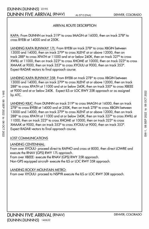
ARRIVAL ROUTE DESCRIPTION
(RNAV)
(DUNNN.DUNNN5)
AL-5715 (FAA) DENVER, COLORADO
(RNAV)
(DUNNN.DUNNN5)
DENVER, COLORADO
LOST COMMUNICATIONS
DUNNN FIVE ARRIVAL
DUNNN FIVE ARRIVAL
From over XYOUU- proceed to NSPYR execute the ILS or LOC RWY 30R approach.
LANDING ROCKY MOUNTAIN METRO:
Non-GPS equipped aircraft- execute the ILS or LOC RWY 35R approach.
From over XBEEE- execute the RNAV (GPS) RWY 35R approach.
execute the RNAV (GPS) RWY 17L approach.
From over XYOUU- proceed direct to RAPHO and cross at 8000, then direct LOWRE and
LANDING CENTENNIAL:
22195
14JUL22
Expect RADAR vectors to final approach course.
XMAAK at 9000, then on track 353° to cross XYOUU at 9000, then on track 353°.
11000, then on track 323° to cross XHOME at 10000, then on track 323° to cross
288° to cross XPATH at 11000 and at or below 240K, then on track 327° to cross XWILL at
13000 and 14000, then on track 279° to cross XLENT at or above 12000, then on track
278° to cross BYEBI at 14000 and at 250K, then on track 278° to cross XBGIN between
LANDING KBJC: From DUNNN on track 319° to cross IMAGN at 16000, then on track
by ATC.
at 9000 and at or below 240K. Expect ILS or LOC RWY 35R approach or as assigned
288° to cross XPATH at 11000 and at or below 240K, then on track 350° to cross XBEEE
13000 and 14000, then on track 279° to cross XLENT at or above 12000, then on track
LANDING KAPA RUNWAY 35R: From BYEBI on track 278° to cross XBGIN between
Expect RADAR vectors to final approach course.
XMAAK at 9000, then on track 353° to cross XYOUU at 9000, then on track 353°.
XWILL at 11000, then on track 323° to cross XHOME at 10000, then on track 323° to cross
track 288° to cross XPATH at 11000 and at or below 240K, then on track 327° to cross
13000 and 14000, then on track 279° to cross XLENT at or above 12000, then on
LANDING KAPA RUNWAY 17L: From BYEBI on track 278° to cross XBGIN between
cross BYEBI at 14000 and at 250K.
KAPA: From DUNNN on track 319° to cross IMAGN at 16000, then on track 278° to
SW-1, 08 SEP 2022 to 06 O
CT 2022 SW
-1,
08 S
EP 2
022
to 0
6 O
CT
2022

AAYES
PYDRT
REDZN
WHOAA
BDOWN
TINGE
112°
9000
9000
176°
176°
171°
176°
(4)
(7)
(5)
(5)
(25)
COUNTY
GREELEY-WELD
VANCE BRAND
AND SPACE PORT
COLORADO AIR
LOWRE
SKIPI
KAYOO
WOLTS
and KFNL
Ldg KCFO, KGXY
Ldg KBJC
Ldg KAPA
Ldg KLMO
150°
10000
9000
112°
12000
17000
FL270
112°
112°
112°
112°
(31)
17000
(15)
14000
(8)
12000
BANNA
CHOTS
PINNR
(10) 10000
11000
171°
(13)
RGNL
COLORADO
NORTHERN
HBALL
9000
176°
CENTENNIAL
(RNAV)
(PINNR.PINNR3)
AL-5715 (FAA)
(RNAV)
(PINNR.PINNR3)
(NARRATIVE ON FOLLOWING PAGE)NOTE: Chart not to scale.
NOTE: Turbojet aircraft only.
NOTE: DME/DME/IRU or GPS required.
NOTE: RNAV 1.
NOTE: RADAR required.
DENVER, COLORADO
DENVER, COLORADO
FFEST
14000 250K
PINNR THREE ARRIVAL
PINNR THREE ARRIVAL
10000
120.2
SPACE PORT TOWER
118.6 233.7
METRO TOWER
118.9
CENTENNIAL TOWER
119.025
CFO ATIS
126.25
BJC ATIS
120.3
APA ATIS
127.05 363.25
DENVER APP CON
21168
31DEC20
METRO
ROCKY MOUNTAIN
SW-1, 08 SEP 2022 to 06 O
CT 2022 SW
-1,
08 S
EP 2
022
to 0
6 O
CT
2022

ARRIVAL ROUTE DESCRIPTION
LOST COMMUNICATIONS
AL-5715 (FAA)
RNAV (GPS) RWY 29 approach.
LANDING KLMO: From HBALL direct KAYOO direct WOLTS and execute
LANDING KCFO: From BDOWN direct SKIPI and execute ILS or LOC RWY 26 approach.
LANDING KBJC: From PYDRT execute RNAV (GPS) RWY 12L approach.
LANDING KAPA: From AAYES direct LOWRE and execute RNAV (GPS) RWY 17L approach.
BANNA TRANSITION (BANNA.PINNR3)
DENVER, COLORADO
DENVER, COLORADO
(RNAV)
(PINNR.PINNR3)
(RNAV)
(PINNR.PINNR3)
PINNR THREE ARRIVAL
PINNR THREE ARRIVAL31DEC20
20366
vectors to final approach course.
10000, then on track 176° to cross HBALL at 9000, then on track 176°. Expect RADAR
then on track 171° to cross WHOAA at 10000, then on track 171° to cross REDZN at
LANDING KLMO: From PINNR on track 112° to cross TINGE between 10000 and 11000,
RADAR vectors to final approach course.
and 11000, then on track 112° to cross BDOWN at 9000, then on track 112°. Expect
LANDING KFNL/KCFO/KGXY: From PINNR on track 112° to cross TINGE between 10000
approach or visual approach as assigned by ATC.
10000, then on track 176° to cross PYDRT at 9000. Expect RNAV (GPS) RWY 12L
then on track 171° to cross WHOAA at 10000, then on track 171° to cross REDZN at
LANDING KBJC: From PINNR on track 112° to cross TINGE between 10000 and 11000,
at 9000, then on track 150°. Expect RADAR vectors to final approach course.
10000, then on track 176° to cross PYDRT at 9000, then on track 176° to cross AAYES
then on track 171° to cross WHOAA at 10000, then on track 171° to cross REDZN at
LANDING KAPA: From PINNR on track 112° to cross TINGE between 10000 and 11000,
SW-1, 08 SEP 2022 to 06 O
CT 2022 SW
-1,
08 S
EP 2
022
to 0
6 O
CT
2022

081°
094° 060°
XJOIN
12000
XPATH
11000 240K
(6) (5)
(5)
XBOXX
14000
13000
ZOMBZ
15000 250K
021°
(14)
036°
(12)
16000
CRWLR
LAMOE
DRAGR
STIFS
12800
15000
*
036°
13800
16000
*
(23)
13800
16000
*
021°
(14)15200
17000
*
216°
10 NM
CENTENNIAL
AND SPACE PORT
COLORADO AIR
350°(R
NA
V)
(ZO
MB
Z.Z
OM
BZ
5)
DE
NV
ER
, CO
LO
RA
DO
(RN
AV
)A
L-5
71
5 (F
AA
)
(ZO
MB
Z.Z
OM
BZ
5)
DE
NV
ER
, CO
LO
RA
DONOTE: Chart not to scale.
N
120.2
SPACE PORT TOWER
118.9
CENTENNIAL TOWER
119.025
CFO ATIS
120.3
APA ATIS
128.45 251.075
DENVER APP CON
ZO
MB
Z F
IVE
AR
RIV
AL
ZO
MB
Z F
IVE
AR
RIV
AL
XBEEE
9000 240K
(4)
(5)
(6)
(5)
082°
041°
(6)
070°
350°
XNICE
12000
ZHORN
11000 210K
SEESU
11000 210K
DORLE
12000
KAPA Ldg R17L
KAPA Ldg R35R
with Denver TRACON.
NOTE: Expect runway assignment on initial contact
NOTE: Turbojet aircraft only.
070°
SKIPILOWRE
350°
Ldg KCFO
21
30
8
07
OC
T2
1
RNAV 1 - DME/DME IRU or GPS.
RADAR required.
SW-1, 08 SEP 2022 to 06 OCT 2022SW-1, 08 SEP 2022 to 06 OCT 2022

(RNAV)
(ZOMBZ.ZOMBZ5)
DENVER, COLORADO
(RNAV) AL-5715 (FAA)
(ZOMBZ.ZOMBZ5)
DENVER, COLORADO
ARRIVAL ROUTE DESCRIPTION
LOST COMMUNICATIONS
STIFS TRANSITION (STIFS.ZOMBZ5)
ZOMBZ FIVE ARRIVAL
ZOMBZ FIVE ARRIVAL
vectors to final approach course.
to cross SEESU at 11000 and at 210K, then on track 070° . Expect RADAR
and 14000, then on track 082° to cross DORLE at 12000, then on track 070°
LANDING KCFO: From ZOMBZ on track 081° to cross XBOXX between 13000
21308
07OCT21
Expect RADAR vectors to final approach course.
then on track 350° to cross ZHORN at 11000 and at 210K, then on track 350°.
between 13000 and 14000, then on track 041° to cross XNICE at 12000,
LANDING KAPA RUNWAY 17L: From ZOMBZ on track 081° to cross XBOXX
approach or as assigned by ATC.
to cross XBEEE at 9000 and at or below 240K. Expect ILS or LOC RWY 35R
then on track 060° to cross XPATH at 11000 and at 240K, then on track 350°
between 13000 and 14000, then on track 094° to cross XJOIN at 12000,
LANDING KAPA RUNWAY 35R: From ZOMBZ on track 081° to cross XBOXX
landing south, execute the RNAV (GPS) RWY 17L via LOWRE.
KAPA is landing north, execute the ILS RWY 35R approach, when KAPA is
In the event of lost communications prior to runway transition assignment, when
LANDING CFO: execute the ILS RWY 26 approach via SKIPI.
SW-1, 08 SEP 2022 to 06 O
CT 2022 SW
-1,
08 S
EP 2
022
to 0
6 O
CT
2022

DE
NV
ER
, CO
LO
RA
DO
DE
NV
ER
, CO
LO
RA
DO
N
(NARRATIVE ON FOLLOWING PAGE)NOTE: Chart not to scale.
R-172
R-187
R-125
(6)
(5)
72
93
305°
*
(24)
*
(13)
(8)
305°
*
238°*
CENTENNIAL
PEEDE
DANDD
N39°23.83'-W103°56.35'
CLEVE
KIPPY
PRAGG
DEN DVV
GLD
HYS
TXC27
GOAVS
(21)
R-174
R-261
R-066
21
*
285°
RYLIE
HG
LAAGCK
GLD
SELLS
FL1807500
(65)
OATHE
O
305°
17000
8300
R-230
(16)
R-018
FQF
NOTE: Adjacent STAR is QUAIL ARRIVAL.
285°(58)
FL210
MAA FL450
MAA FL450
MAA FL45
0M AA FL450
MAA FL45
0
L-10, H-5
L-10-15, H-5
TURBOJETS: Expect FL190 250K
or as assigned by ATC.
NOTE: DME required.
44
125°
48
125°
305°
081°
261°
(DA
ND
D.D
AN
DD
1)
(DA
ND
D.D
AN
DD
1)
21
33
6
COUNTYWELD
GREELEY-
30
JA
N2
0
(70)
FL210
R-081
R-062
NOTE: RADAR required.
W103°17.49'
N38°54.98'
H-5
W101°47.66'
N38°50.98'
W103°29.84'
N39°04.21'
125°
261°
AL
-90
77
(FA
A)
DA
ND
D O
NE
AR
RIV
AL
DA
ND
D O
NE
AR
RIV
AL
RGNLCOLORADONORTHERN
AND SPACE PORT
COLORADO AIR
Chan 110
116.3 FQF
FALCON
PLANNING INFORMATION
VERTICAL NAVIGATION
GLL
PUB
JEFFCO
115.4 BJC
Chan 101
W105°08.34'
N39°54.78'
BJC
8300
10000
750
0
FL180
(80)
51
0017
000
INTLDENVER
W103°51.99'
N39°20.62'
W104°31.57'
N39°49.45'
W104°11.54'
N39°34.93'
W103°10.42'
N38°49.68'
W101°49.65'
N38°20.24'
FL450
MAA
119.675 259.3
KBKF ATIS
125.6 379.9
DEN D-ATIS ARR
119.025
CFO ATIS
126.25
BJC ATIS
120.3
APA ATIS
120.35 379.3
DENVER APP CON
METRO
MOUNTAIN
ROCKY
FORCE BASEBUCKLEY SPACE
85
Chan 126
N39°48.75'-W104°39.64'
DENVER 114.7 DVV
Chan 94
N39°53.68'-W104°37.46'
115.1 GLD
Chan 98
N39°23.27'-W101°41.54'
MILE HIGH
GOODLAND
HAYS
110.4 HYS
Chan 41
128 80 GARDEN CITY
113.3 GCK
Chan 80
LAMAR
Chan 116
116.9 LAA
124
118
THURMAN
112.9 TXC
Chan 76
N37°55.14'-W100°43.50'
117.9 DEN
Chan 89
N40°30.23'-W104°33.18'
GILL
114.2 GLL
116.7 PUB
Chan 114
N38°17.66'-W104°25.77'
PUEBLO
Chan 58
112.1 HGO
HUGO
SW-1, 08 SEP 2022 to 06 OCT 2022SW-1, 08 SEP 2022 to 06 OCT 2022

DENVER, COLORADO
DENVER, COLORADO
(DANDD.DANDD1)
(DANDD.DANDD1)20030
GARDEN CITY TRANSITION (GCK.DANDD1): From over GCK VORTAC on GCK
30JAN20
GOODLAND TRANSITION (GLD.DANDD1): From over GLD VORTAC on GLD
AL-9077 (FAA)
ARRIVAL ROUTE DESCRIPTION
DANDD ONE ARRIVAL
DANDD ONE ARRIVAL
R-285 and DVV R-125 to DANDD. Thence. . . .
R-238 and DVV R-125 to DANDD. Thence. . . .
OATHE TRANSITION (OATHE.DANDD1): From over OATHE on HYS R-261
and HGO R-081 to SELLS, then on DVV R-125 to DANDD. Thence. . . .
to the final approach course at or before DVV VORTAC.
. . . .from over DANDD on DVV R-125 to DVV VORTAC. Expect RADAR vectors
SW-1, 08 SEP 2022 to 06 O
CT 2022 SW
-1,
08 S
EP 2
022
to 0
6 O
CT
2022

173°
099°
214°
173°
R-307
114.4 AKO
AKRON
Chan 91
AKO
NOTE: Chart not to scale.
*
**
*
40
218°
R-038
PHLATLANDR
N40°21.45'-W104°00.18'
CENTENNIAL
DENVER INTL
DVV
114.2 GLL
Chan 89
GILL
(7)
218°
YONDR
(25)
32
R-275
OBHLIBIE
GLIMR
FQFEDN
SCY
BFF SNY YANKI
ELJAY
FONTO
117.7 HCT
Chan 124
MAA FL450
MAA FL45
0
MAA FL450
242°*
240°*
214°
GLL
R-164
R-113
(13)
H-5
H-5
R-060
52
158
113.9 O
NL
Chan 86
R-22
9
HAYES CENTERTHC
R-357
N
(NARRATIVE ON FOLLOWING PAGE)
DE
NV
ER
, CO
LO
RA
DO
DE
NV
ER
, CO
LO
RA
DO
R-062
43
MAA FL450
MAA FL450
038°
R-333
R-327
R-074
R-030
78
TURBOJETS: Expect 17000 250K
or as assigned by ATC.
7500
(21)
7500
(8)
030°
210°
10500
7500
(63)
10500
7500 (15)
074°
254°
034°
21
33
6
17
JU
N2
1
(LA
ND
R.L
AN
DR
2)
(LA
ND
R.L
AN
DR
2)
(56)
8500
10500
W103°38.10'
N40°51.00'
W103°40.24'
N40°36.07'
W104°31.32'
N39°58.30'
PLANNING INFORMATION
VERTICAL NAVIGATION
WELD COUNTY
GREELEY-
W104°07.56'
N40°16.00'
W100°44.08'
N41°31.65'
W101°13.29'
N41°13.51'
W103°27.77'
N40°45.13'
(30) 60007500
(105)
5200FL230
(106)
590
0FL2
50
W104°37.46'
N39°53.68'
R-071
SNY
Chan 95
114.8 OBH
WOLBACH
W98°21.22'
N41°22.54'
AL
-90
77
(FA
A)
LA
ND
R T
WO
AR
RIV
AL
LA
ND
R T
WO
AR
RIV
AL
RGNL
COLORADO
NORTHERN
AND SPACE PORT
COLORADO AIR
119.675 259.3
KBKF ATIS
125.6 379.9
DEN D-ATIS ARR
119.025
CFO ATIS
126.25
BJC ATIS
120.3
APA ATIS
124.95 346.4
DENVER APP CON
7500
METRO
ROCKY MOUNTAIN
FORCE BASE
BUCKLEY SPACE
115.9 SNY
Chan 106
SIDNEY
113.1 CYS
Chan 78
CHEYENNE
112.6 BFF
Chan 73
SCOTTSBLUFF
117.9 DEN
Chan 126
DENVER
Chan 110
FALCON
116.3 FQF
N39°41.41'-W104°37.26'
114.7 DVV
Chan 94
MILE HIGH
N39°48.75'-W104°39.64'
L-12, H-3-5
N41°12.66'-W104°46.37'
L-12, H-5
N41°53.65'-W103°28.92'N41°05.80'-W102°58.98'
L-10-12, H-5
SW-1, 08 SEP 2022 to 06 OCT 2022SW-1, 08 SEP 2022 to 06 OCT 2022

ARRIVAL ROUTE DESCRIPTION
DENVER, COLORADO
DENVER, COLORADO
21168(LANDR.LANDR2)
(LANDR.LANDR2)
AL-9077 (FAA)LANDR TWO ARRIVAL
LANDR TWO ARRIVAL
FONTO, then on SNY R-214 and DVV R-038 to LANDR. Thence. . . .
ELJAY TRANSITION (ELJAY.LANDR2): From over ELJAY on GLL R-060 to
SNY VOR/DME, then on SNY R-214 and DVV R-038 to LANDR. Thence. . . .
YANKI TRANSITION (YANKI.LANDR2): From over YANKI on SNY R-062 to
R-099 and BFF R-173 to LIBIE, then on DVV R-038 to LANDR. Thence. . . .
CHEYENNE TRANSITION (CYS.LANDR2): From over CYS VORTAC on CYS
R-173 to LIBIE, then on DVV R-038 to LANDR. Thence. . . .
SCOTTSBLUFF TRANSITION (BFF.LANDR2): From over BFF VORTAC on BFF
to FONTO, then on SNY R-214 and DVV R-038 to LANDR. Thence. . . .
SIDNEY TRANSITION (SNY.LANDR2): From over SNY VOR/DME on SNY R-214
vectors to the final approach course at or before DVV VORTAC.
. . . .from over LANDR on DVV R-038 to DVV VORTAC. Expect RADAR
17JUN21
SW-1, 08 SEP 2022 to 06 O
CT 2022 SW
-1,
08 S
EP 2
022
to 0
6 O
CT
2022
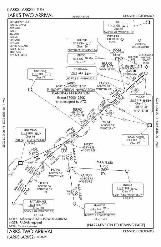
WELD COUNTYGREELEY-
CENTENNIAL
R-112
R-22
0
(11)
R-131
040°
*
75
(23)
* (11)
040°
*
14400
15000
TERRO
MURFE
HUUGE
LARKSN39°15.44'-W105°18.31'
Chan 77
FALCON
Chan 110
FQF
Chan 72
BLACK FOREST
112.5 BRK
RED TABLE
113.0 DBLDBL
BRK
DEN
Chan 101
JEFFCO
115.4 BJC
116.3 FQF86
R-071
022°
040°
339°
339°
(23)
KANON
W105°59.51'
N38°23.75'
PAPPA
HICKY
W106°03.38'
N38°46.28'
PUB
17000
(11)
FL280
(26)
R-1
64
PAYDD
(16)
14400
13800
(14)
MAA FL450
MA
A F
L450
LOPEC
W106°51.55'
N38°05.56'
H-3
(30)022° 130
DENVER, COLORADO
NOTE: Chart not to scale. (NARRATIVE ON FOLLOWING PAGE)
DENVER, COLORADO
ASLSRK
GLL
BJC
or as assigned by ATC.
053°
(50)
*165
00 1700
0
Chan 96
BLUE MESA
114.9 HBU
MAA FL450
FL310
(100)
MA
A F
L450
MAA FL4
50
031°
211°
R-211
21336
30JAN20
(LARKS.LARKS2)
(LARKS.LARKS2)
R-293
R-278
NOTE: RADAR required.
NOTE: Adjacent STAR is POWDR ARRIVAL.
FL310
FL450
MAA
(63)
FL2
00
FL2
00
(74)
FL200
267°
W104°37.26'
N39°41.41'
W105°04.73'
N39°24.10'
W104°47.91'
N39°34.72'
INTLDENVER
W106°28.74'
N38°29.56'
Expect 17000 250K
PLANNING INFORMATION
TURBOJET VERTICAL NAVIGATION
AL-9077 (FAA)
RGNLCOLORADONORTHERN
LARKS TWO ARRIVAL
LARKS TWO ARRIVAL
15600
108.2 APA
CENTENNIAL
W105°52.38'
N38°53.47'
W105°29.47'
N39°08.29'
PORT SPACE
AIR ANDCOLORADO
14800
16200
*
APA
119.675 259.3
KBKF ATIS
125.6 379.9
DEN D-ATIS ARR
119.025
CFO ATIS
126.25
BJC ATIS
120.3
APA ATIS
120.35 379.3
DENVER APP CON
METROMOUNTAIN
ROCKY
BASESPACE FORCE
BUCKLEY
52
41
Chan 126
N39°48.75'-W104°39.64'
DENVER
115.3 RSK
Chan 100 113.9 ALS
Chan 86
116.7 PUB
Chan 114
ALAMOSA
PUEBLO
N36°44.90'-W108°05.93'
L-8, H-4 N37°20.95'-W105°48.93'
N38°17.66'-W104°25.77'
27
RATTLESNAKE
114.2 GLL
Chan 89
N40°30.23'-W104°33.18'
GILL
L-8-9, H-4-5
L-10, H-5
87L-9, H-3
220°
220°
220°
N38°27.13'-W107°02.38'
117.9 DEN
N39°34.51'-W104°50.71'
220°
SW-1, 08 SEP 2022 to 06 O
CT 2022 SW
-1,
08 S
EP 2
022
to 0
6 O
CT
2022

DENVER, COLORADO
DENVER, COLORADO
ARRIVAL ROUTE DESCRIPTION
20030
30JAN20
(LARKS.LARKS2)
(LARKS.LARKS2)
AL-9077 (FAA)LARKS TWO ARRIVAL
LARKS TWO ARRIVAL
and FQF R-220 to LARKS. Thence. . . .
ALAMOSA TRANSITION (ALS.LARKS2): From over ALS VORTAC on ALS R-339
R-053 and FQF R-220 to LARKS. Thence. . . .
BLUE MESA TRANSITION (HBU.LARKS2): From over HBU VOR/DME on HBU
FQF R-220 to LARKS. Thence. . . .
LOPEC TRANSITION (LOPEC.LARKS2): From over LOPEC on RSK R-022 and
R-022 and FQF R-220 to LARKS. Thence. . . .
RATTLESNAKE TRANSITION (RSK.LARKS2): From over RSK VORTAC on RSK
RADAR vectors to the final approach course at or before FALCON (FQF) VORTAC.
. . . .from over LARKS on FQF R-220 to FALCON (FQF) VORTAC. Expect
to KANON; then on ALS R-339 and FQF R-220 to LARKS. Thence. . . .
PUEBLO TRANSITION (PUB.LARKS2): From over PUB VORTAC on PUB R-267
SW-1, 08 SEP 2022 to 06 O
CT 2022 SW
-1,
08 S
EP 2
022
to 0
6 O
CT
2022
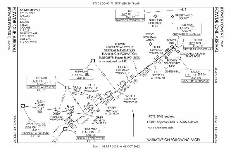
082°
R-125
R-139
R-212
031°
038°
045°
045°
038°
045°
(10)
(39) 16
400
FL20
0
(35) 16
400
FL20
0
FL27013000
(60)
*
*
* *
77
65
68
(5) 50
COUNTY
GREELEY-WELD
SLOPE
INTL
DENVER
CENTENNIAL
POWDRN39°23.71'-W105°28.89'
COLAS
SKEED
BASEE
GRIPP
DIRDY
W104°47.86'
N39°47.69'
W105°34.19'
N39°20.58'
W105°39.44'
N39°17.47'
W105°48.00'
N39°12.37'
W106°27.29'
N38°48.70'W107°30.91'
N38°55.80'
(NARRATIVE ON FOLLOWING PAGE)
N
JNC
113.8 RLG
Chan 85
KREMMLINGRLG
GLL
FQF
DVVDEN
NOTE: Chart not to scale.
DE
NV
ER
, CO
LO
RA
DO
DE
NV
ER
, CO
LO
RA
DO
DBL
BLUE MESA
Chan 96
HBU
31
W105°09.60'
N39°35.05'
114.9 HBU
1650
0
(8)
HLLIE
(21)
NOTE: Adjacent STAR is LARKS ARRIVAL.
(5) 15
600
NOTE: DME required.
(20)
16500093
JNETT
W106°28.77'
N39°21.14'
FL27016400 (50)
R-22
5
(33)
53
(19)
PLANNING INFORMATION
VERTICAL NAVIGATION
TURBOJETS: Expect FL190 250K
or as assigned by ATC.
211°
225°
21
33
6
N38°27.13'-W107°02.38'
218°
30
JA
N2
0
AL
-90
77
(FA
A)
(PO
WD
R.P
OW
DR
1)
PO
WD
R O
NE
AR
RIV
AL
(PO
WD
R.P
OW
DR
1)
RGNL
COLORADO
NORTHERN
SPACE PORT
COLORADO AIR AND
PO
WD
R O
NE
AR
RIV
AL
119.675 259.3
KBKF ATIS
125.6 379.9
DEN D-ATIS ARR
119.025
CFO ATIS
126.25
BJC ATIS
120.3
APA ATIS
120.35 379.3
DENVER APP CON
METRO
MOUNTAIN
ROCKY
BASE
SPACE FORCE
BUCKLEY
R-211
60
55
112.4 JNC
Chan 71
GRAND JUNCTION
L-9, H-3
N39°03.57' W108°47.55'
113.0 DBL
Chan 77
RED TABLE
114.2 GLL
Chan 89
N40°30.23' W104°33.18'
GILL
114.7 DVV
Chan 94
N39°53.68' W104°37.46'
117.9 DEN
Chan 126
N39°48.75' W104°39.64'
116.3 FQF
Chan 110
N39°41.41' W104°37.26'
MILE HIGH
DENVER
FALCON
L-9, H-3
N39°26.36' W106°53.68'
L-9, H-3
SW-1, 08 SEP 2022 to 06 OCT 2022SW-1, 08 SEP 2022 to 06 OCT 2022

DENVER, COLORADO
DENVER, COLORADO
20030
30JAN20
AL-9077 (FAA)
ARRIVAL ROUTE DESCRIPTION
(POWDR.POWDR1)
POWDR ONE ARRIVAL
POWDR ONE ARRIVAL
(POWDR.POWDR1)
final approach course at or before DVV VORTAC.
R-225 to SLOPE, then on DVV VORTAC R-225 to DVV. Expect RADAR vectors to the
. . . .from over POWDR on the DVV VORTAC R-225 to HLLIE, then on DVV VORTAC
and DVV R-225 to POWDR. Thence. . . .
RED TABLE TRANSITION (DBL.POWDR1): From over DBL VOR/DME on DBL R-093
to POWDR. Thence. . . .
R-038 to GRIPP then on HBU R-038 and DVV R-225 to BASEE then on DVV R-225
BLUE MESA TRANSITION (HBU.POWDR1): From over HBU VOR/DME on HBU
to POWDR. Thence. . . .
JNC R-082 to GRIPP; then on HBU R-038 and DVV R-225 to BASEE then on DVV R-225
GRAND JUNCTION TRANSITION (JNC.POWDR1): From over JNC VOR/DME on
SW-1, 08 SEP 2022 to 06 O
CT 2022 SW
-1,
08 S
EP 2
022
to 0
6 O
CT
2022

299°
BRK
NOTE: Chart not to scale.
TODDE
W103°12.84'
N38°32.95'
HYMNS
CONAL
W103°58.01'
N39°07.36'
CENTENNIAL
CELMI
N39°15.65'-W104°07.49'
QUAIL
COUNTY
GREELEY-WELD
PLANNING INFORMATION
VERTICAL NAVIGATIONR-1
27
(8)
(11)
(24)
10500
(25)
(33)
10500
10500
(34)
TXC
PUB
LAA
GLL
8000
6900
*
*
8500
*
35
DENVER, COLORADO
DENVER, COLORADO
(7)
W104°31.20'
N39°36.20'
W104°14.60'
N39°21.84'
JEFEL
26
BLACK FOREST
112.5 BRK
Chan 72
PUEBLO
116.7 PUB
Chan 114
JEFFCO
115.4 BJC
Chan 101
W105°08.34'
N39°54.78'
BJC
MAA FL4
50
MA
A F
L450
MAA FL4
50
L-10, H-5HGOL-10, H-5
*8500
10500
MAA FL4
50
10500
6900
*
MAA FL4
50
NOTE: DME required.
W104°38.01'
N38°56.67'
FQFFALCON
116.3 FQF
Chan 110
DVVEDN
Chan 76
112.9 TXC
THURMAN
21336
30JAN20
(QUAIL.QUAIL1)
(QUAIL.QUAIL1)
NOTE: RADAR required.
NOTE: Adjacent STAR is DANDD ARRIVAL.
R-086
R-1
73
353°
312°
R-123
303°
307°
132°
303°
123°
INTLDENVER
307°
312°
312°
132°
L-10, H-5
W103°36.99'
N38°15.13'
ARRIVAL ROUTE DESCRIPTION
LAMAR TRANSITION (LAA.QUAIL1): From over LAA VOR/DME on LAA R-299 and
127°
TURBOJETS: Expect 17000 250K
or as assigned by ATC.
AL-9077 (FAA)
HGO R-123 to HGO VOR/DME, then on HGO R-312 to QUAIL. Thence. . . .
TODDE TRANSITION (TODDE.QUAIL1): From over TODDE on HGO R-173 to HGO
VOR/DME, then on HGO R-312 to QUAIL. Thence. . . .
. . . .from over QUAIL on HGO R-312 and FQF R-127 to FQF VORTAC. Expect
QUAIL ONE ARRIVAL
QUAIL ONE ARRIVAL
RGNL
COLORADO
NORTHERN
RADAR vectors to the final approach course at or before FQF VORTAC.
AND SPACE PORTCOLORADO AIR
(19)
QUAIL. Thence. . . .
HUGO TRANSITION (HGO.QUAIL1): From over HGO VOR/DME on HGO R-312 to
119.675 259.3
KBKF ATIS
125.6 379.9
DEN D-ATIS ARR
119.025
CFO ATIS
126.25
BJC ATIS
120.3
APA ATIS
120.35 379.3
DENVER APP CON
METROMOUNTAIN
ROCKY
BASESPACE FORCE
BUCKLEY
36
LAMAR
116.9 LAA
Chan 116
N38°11.83'-W102°41.25'
GILL
114.2 GLL
Chan 89
N40°30.23'-W104°33.18'
HUGO
112.1 HGO
Chan 58
N38°49.05'-W103°37.28'
N39°41.41'-W104°37.26'
MILE HIGH
114.7 DVV
N39°53.68'-W104°37.46'
Chan 94
DENVER
117.9 DEN
Chan 126
N39°48.75'-W104°39.64'
N39°41.90'-W103°12.90'
SW-1, 08 SEP 2022 to 06 O
CT 2022 SW
-1,
08 S
EP 2
022
to 0
6 O
CT
2022

NOTE: Chart not to scale.
NOTE: Adjacent STAR is TOMSN ARRIVAL.
(14)
R-314
(14)
11300
134°
(18)
(8)
12700
14500
134°
(12)
MBW
CYS
DEN
ALPOE
AUTIM
ELKEE
NIWOT
PRONG
RAMMSN40°29.61'-W105°14.33'
CENTENNIAL
FALCON
116.3 FQF
Chan 110
MILE HIGH
114.7 DVV
Chan 9428
46
54
66
1700014500096°(39)
85
*
R-276
15000
12700
203°
(45)
R-218
14500
147°
(69)
*
DVV
ARL
SOC 105
108
FFQ
GLL
R-256
096°
093°
FL21014500
MAA FL450*
151°
(36)
14500
MAA FL450
MAA FL450
MAA FL450
N
(NARRATIVE ON FOLLOWING PAGE)
(128)
DE
NV
ER
, CO
LO
RA
DO
DE
NV
ER
, CO
LO
RA
DO
134°
L-11, H-3
L-12, H-3-5L-9-12, H-3-5
L-12, H-3-5
TURBOJETS: Expect 17000 250K
or as assigned by ATC.
276°
276°
314°
21
33
6
30
JA
N2
0
AL
-90
77
(FA
A)
(RA
MM
S.R
AM
MS
8)
RA
MM
S E
IGH
T A
RR
IVA
L
RA
MM
S E
IGH
T A
RR
IVA
L
(RA
MM
S.R
AM
MS
8)
RGNL
COLORADO
NORTHERN
INTL
DENVER
AND SPACE PORT
COLORADO AIR
W104 37.26'
N39 41.41'
N41°12.66'-W104°46.37'
Chan 78
113.1 CYS
CHEYENNE
N39°48.75'-W104°39.64'
Chan 126
117.9 DEN
DENVER
W105°30.69'
N40°45.29'
W105°21.11'
N40°36.13'
W104°48.53'
N40°04.56'
W104°59.68'
N40°15.43'PLANNING INFORMATION
VERTICAL NAVIGATION
W104 37.46'
N39 53.68'
COUNTY
GREELEY-WELD
R-142
LAR
Chan 89
114.2 GLL
GILL
N41°20.27'-W105°43.26'
Chan 123
117.6 LAR
LARAMIE
N41°35.41'-W109°00.92'
Chan 107
116.0 OCS
ROCK SPRINGS
W106°18.95'
N40°57.48'
R-322
DEN
119.675 259.3
KBKF ATIS
125.6 379.9
DEN D-ATIS ARR
119.025
CFO ATIS
126.25
BJC ATIS
120.3
APA ATIS
119.3 307.3
DENVER APP CON
METRO
MOUNTAIN
ROCKY
N41°50.73'-W106°00.26'
Chan 115 (Y)
116.85 MBW
MEDICINE BOW
BASE
SPACE FORCE
BUCKLEY
46
SW-1, 08 SEP 2022 to 06 OCT 2022SW-1, 08 SEP 2022 to 06 OCT 2022

DENVER, COLORADO
DENVER, COLORADO
ARRIVAL ROUTE DESCRIPTION
20030
30JAN20
AL-9077 (FAA)
(RAMMS.RAMMS8)
RAMMS EIGHT ARRIVAL
RAMMS EIGHT ARRIVAL(RAMMS.RAMMS8)
R-203 and DVV R-314 to RAMMS. Thence. . . .
CHEYENNE TRANSITION (CYS.RAMMS8): From over CYS VORTAC on CYS
and DVV R-314 to RAMMS. Thence. . . .
LARAMIE TRANSITION (LAR.RAMMS8): From over LAR VOR/DME on LAR R-151
MBW R-147 and DVV R-314 to RAMMS. Thence. . . .
MEDICINE BOW TRANSITION (MBW.RAMMS8): From over MBW VOR/DME on
to the final approach course at or before DVV VORTAC.
. . . .from over RAMMS on DVV R-314 to DVV VORTAC. Expect RADAR vectors
RAMMS. Thence. . . .
OCS R-093 and GLL R-276 to ALPOE then on GLL R-276 and DVV R-314 to
ROCK SPRINGS TRANSITION (OCS.RAMMS8): From over OCS VOR/DME on
SW-1, 08 SEP 2022 to 06 O
CT 2022 SW
-1,
08 S
EP 2
022
to 0
6 O
CT
2022

R-306
(12)
R-258
R-288
108°
55
71
13500
12600
(5)
60
126°
126°
55
68
50
61
076°
058°
025°
FROGS
RIDJE
ALLAN
TOMSNN40°21.40'-W105°26.22'
CENTENNIAL
NOTE: Chart not to scale. (NARRATIVE ON FOLLOWING PAGE)
*
*
114.2 GLL
Chan 89
CHE
RLG
BJC FQF
GILLGLL
DE
NV
ER
, CO
LO
RA
DO
DE
NV
ER
, CO
LO
RA
DO
EKR HYGEN 38
(17)
(26)
DENVER
117.9 DEN
Chan 126
DEN
MILE HIGHDVVChan 94
114.7 DVV
N39°48.75'
W104°39.64'
SHAFT
R-239
16000
(8) R-251
R-245
R-22
1
DENVER INTL
GLL
N
GOULL
078°(31)
078°(12)
R-045
117.6 LAR
Chan 123
LARAMIE
R-175 R
-162
113.1 CYS
Chan 78
CHEYENNE
R-203
LARCYS
M AA FL450 M AA FL45016000
288°
256°
N40°31.33-W106°33.71'
258°
306°
21
33
6
30
JA
N2
0
AL
-90
77
(FA
A)
(TO
MS
N.T
OM
SN
8)
(TO
MS
N.T
OM
SN
8)
TO
MS
N E
IGH
T A
RR
IVA
L
TO
MS
N E
IGH
T A
RR
IVA
L
COLORADO RGNL
NORTHERN
(97)
FL270MAA FL45
0
NOTE: Adjacent STAR is RAMMS ARRIVAL.
NOTE: RADAR required.
W104°47.88'
N39°50.18'
W105°53.69'
N40°31.20'
W105°31.16'
N40°25.38'
PLANNING INFORMATION
VERTICAL NAVIGATION
COUNTY
GREELEY-WELD
12600
13500
W105°10.97'
N40°09.06'
(34)
16000 16000
M AA FL450
(40) 16000
MAA FL450
W105°38.29'
N40°31.09'holding pattern.
DME required for GOULL
Turbojets landing DEN:
Expect FL190 250K
or as assigned by ATC.
Turbojets landing APA/BJC:
Expect 17000 250K
or as assigned by ATC. AND SPACE PORT
COLORADO AIR
119.675 259.3
KBKF ATIS
125.6 379.9
DEN D-ATIS ARR
119.025
CFO ATIS
126.25
BJC ATIS
120.3
APA ATIS
119.3 307.3
DENVER APP CON
METROMOUNTAIN
ROCKY
BASE
SPACE FORCE
BUCKLEY
115.6 CHE
Chan 103
HAYDEN
115.2 EKR
Chan 99
MEEKER
113.8 RLG
Chan 85
115.4 BJC
Chan 101
JEFFCO
116.3 FQF
Chan 110
FALCON
KREMMLING
N39°54.78' W105°08.34'N39°41.41'-W104°37.26'
L-9-11, H-3
W107°18.29'
N40°31.20'
L-9-11, H-3
N40°04.05' W107°55.50'
L-9-11, H-3-5
N40°00.16'-W106°26.55'
SW-1, 08 SEP 2022 to 06 OCT 2022SW-1, 08 SEP 2022 to 06 OCT 2022

DENVER, COLORADO
DENVER, COLORADO
ARRIVAL ROUTE DESCRIPTION
20366
30JAN20
AL-9077 (FAA)
(TOMSN.TOMSN8)
TOMSN EIGHT ARRIVAL
TOMSN EIGHT ARRIVAL
(TOMSN.TOMSN8)
the final approach course at or before FQF VORTAC.
. . . .from over TOMSN on FQF R-306 to FQF VORTAC. Expect RADAR vectors to
and GLL R-258 to RIDJE, then on FQF R-306 to TOMSN. Thence. . . .
MEEKER TRANSITION (EKR.TOMSN8): From over EKR VOR/DME on EKR R-058
and GLL R-258 to RIDJE, then on FQF R-306 to TOMSN. Thence. . . .
KREMMLING TRANSITION (RLG.TOMSN8): From over RLG VOR/DME on RLG R-025
GLL R-258 to RIDJE, then on FQF R-306 to TOMSN. Thence. . . .
HAYDEN TRANSITION (CHE.TOMSN8): From over CHE VOR/DME on CHE R-076 and
SW-1, 08 SEP 2022 to 06 O
CT 2022 SW
-1,
08 S
EP 2
022
to 0
6 O
CT
2022