Preparing Writing Teachers to Teach Vocab & Gr of Academic Prose- Averil Coxhead & Pat Byrd
Upload
independentCategory
view
2download
0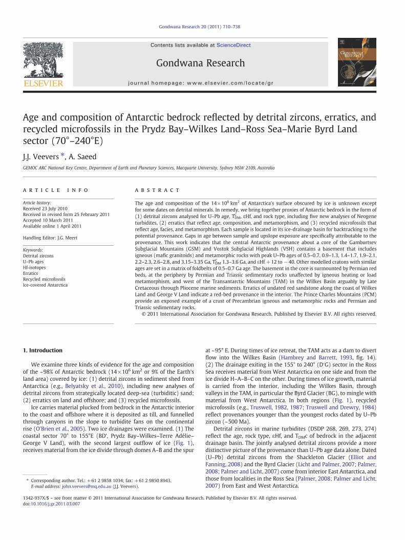
Gondwana Research 20 (2011) 710–738
Contents lists available at ScienceDirect
Gondwana Research
j ourna l homepage: www.e lsev ie r.com/ locate /gr
Age and composition of Antarctic bedrock reflected by detrital zircons, erratics, andrecycled microfossils in the Prydz Bay–Wilkes Land–Ross Sea–Marie Byrd Landsector (70°–240°E)
J.J. Veevers ⁎, A. SaeedGEMOC ARC National Key Centre, Department of Earth and Planetary Sciences, Macquarie University, Sydney NSW 2109, Australia
⁎ Corresponding author. Tel.: +61 2 9858 1034; fax:E-mail address: [email protected] (J.J. Veever
1342-937X/$ – see front matter © 2011 International Adoi:10.1016/j.gr.2011.03.007
a b s t r a c t
a r t i c l e i n f oArticle history:Received 23 July 2010Received in revised form 25 February 2011Accepted 10 March 2011Available online 1 April 2011
Handling Editor: J.G. Meert
Keywords:Detrital zirconsU–Pb agesHf-isotopesErraticsRecycled microfossilsIce-covered Antarctica
The age and composition of the 14×106 km2 of Antarctica's surface obscured by ice is unknown exceptfor some dates on detrital minerals. In remedy, we bring together proxies of Antarctic bedrock in the form of(1) detrital zircons analysed for U–Pb age, TDMC , εHf, and rock type, including five new analyses of Neogeneturbidites, (2) erratics that reflect age, composition, and metamorphism, and (3) recycled microfossils thatreflect age, facies, and metamorphism. Each sample is located in its ice-drainage basin for backtracking to thepotential provenance. Gaps in age between sample and upslope exposure are specifically attributable to theprovenance. This work indicates that the central Antarctic provenance about a core of the GamburtsevSubglacial Mountains (GSM) and Vostok Subglacial Highlands (VSH) contains a basement that includesigneous (mafic granitoids) and metamorphic rocks with peak U–Pb ages of 0.5–0.7, 0.9–1.3, 1.4–1.7, 1.9–2.1,2.2–2.3, 2.6–2.8, and 3.15–3.35 Ga, TDM
C 1.3–3.6 Ga, and εHf +12 to−40. Other modelled cratons with similarages are set in a matrix of foldbelts of 0.5–0.7 Ga age. The basement in the core is surmounted by Permian redbeds, at the periphery by Permian and Triassic sedimentary rocks unaffected by igneous heating or loadmetamorphism, and west of the Transantarctic Mountains (TAM) in the Wilkes Basin arguably by LateCretaceous through Pliocene marine sediments. Erratics of undated red sandstone along the coast of WilkesLand and George V Land indicate a red-bed provenance in the interior. The Prince Charles Mountains (PCM)provide an exposed example of a crust of Precambrian igneous and metamorphic rocks and Permian andTriassic sedimentary rocks.
© 2011 International Association for Gondwana Research. Published by Elsevier B.V. All rights reserved.
1. Introduction
We examine three kinds of evidence for the age and compositionof the ~98% of Antarctic bedrock (14×106 km2 or 9% of the Earth'sland area) covered by ice: (1) detrital zircons in sediment shed fromAntarctica (e.g., Belyatsky et al., 2010), including new analyses ofdetrital zircons from strategically located deep-sea (turbiditic) sand;(2) erratics on land and offshore; and (3) recycled microfossils.
Ice carries material plucked from bedrock in the Antarctic interiorto the coast and offshore where it is deposited as till, and funnelledthrough canyons in the slope to turbidite fans on the continentalrise (O'Brien et al., 2005). Two ice drainages were examined. (1) Thecoastal sector 70° to 155°E (BD’, Prydz Bay–Wilkes–Terre Adélie–George V Land), with the second largest outflow of ice (Fig. 1),receives material from the ice divide through domes A–B and the spur
+61 2 9850 8943.s).
ssociation for Gondwana Research.
at ~95° E. During times of ice retreat, the TAM acts as a dam to divertflow into the Wilkes Basin (Hambrey and Barrett, 1993, fig. 14).(2) The drainage exiting in the 155° to 240° (D′G) sector in the RossSea receives material from West Antarctica on one side and from theice divide H–A–B–C on the other. During times of ice growth, materialis carried from the interior, including the Wilkes Basin, throughvalleys in the TAM, in particular the Byrd Glacier (BG), to mingle withmaterial from West Antarctica. In both regions (Fig. 1), recycledmicrofossils (e.g., Truswell, 1982, 1987; Truswell and Drewry, 1984)reflect provenances younger than the youngest rocks dated by U–Pbzircon (~500 Ma).
Detrital zircons in marine turbidites (DSDP 268, 269, 273, 274)reflect the age, rock type, εHf, and TDMc of bedrock in the adjacentdrainage basin. The jointly analysed detrital zircons provide a moredistinctive picture of the provenance than U–Pb age data alone. Dated(U–Pb) detrital zircons from the Shackleton Glacier (Elliot andFanning, 2008) and the Byrd Glacier (Licht and Palmer, 2007; Palmer,2008; Palmer and Licht, 2007) come from interior East Antarctica, andthose from localities in the Ross Sea (Palmer, 2008; Palmer and Licht,2007) from East and West Antarctica.
Published by Elsevier B.V. All rights reserved.
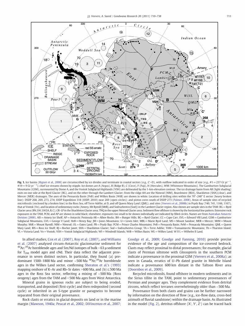
Fig. 1. Ice basins (Rignot et al., 2008) are circumscribed by ice divides and terminate in coastal sectors (e.g., C′–D), with outflow indicated in order of size (e.g., #1=237 Gt yr−1,#19=9 Gt yr−1); chief ice streams shown by stipple. Ice domes are A (Argus), B (Ridge B), C (Circe), F (Fuji), H (Hercules), WM (Whitmore Mountains). The Gamburtsev SubglacialMountains (GSM), surmounted by Dome A, and the Vostok Subglacial Highlands (VSH) are delineated by the 1-km-elevation contour. The ice drainage basin from AB (light shading)exits on one side at the Byrd Glacier (BG), and on the other through the Lambert Glacier; from the ridge AH are the Nimrod (NIM), Beardmore (BEA), Shackleton (SHA)(clear), andMercer (MER) drainages. The axes of the Pensacola Basin (PeB) and Wilkes Basin (WiB) are shown in white. Location of drilling sites within the 70°–240° E sector (heavy brokenline): DSDP 268, 269, 273, 274; IODP Expedition 318 (IODP, 2010) near 269 (open circles); and piston cores south of DSDP 273 (Palmer, 2008). Areas of sample sites of recycledmicrofossils (enclosed by a broken line) in the Ross Sea, off Terre Adélie, at D, and off Queen Mary Land (QML); and sites (Veevers et al., 2008b) in Prydz Bay (740, 741, 1166, 1167),that at Vostok (Vo), and location of sedimentary rocks (Amery, Mt Rymill [MtR], and Sodruzhestvo [Sod]) in the Lambert Glacier region. Also shown are sample sites in the TAM: BG=ByrdGlacier area (BN, LW, LW2A, B, C); CR–LP in theShackletonGlacier area; TNQ in theupperNimrodGlacier area. Sedimentflowoffshore is shownby thehorizontal linepattern. Extensive rockexposures in the TAM, PCM, and AP are shown in solid black; elsewhere, exposures too small to be shown individually are indicated by filled circles. Names are from Australian AntarcticDivision (2000). AIS=Amery Ice Shelf; AP=Antarctic Peninsula AR=Albov Rocks; BH=Bunger Hills; BG=Byrd Glacier; CC=Cape Carr; EVL=Edward VIII Land; GSM=GamburtsevSubglacial Mountains, GVL=George V Land; HeB=Henry Bay; JM=Jones Mountains; LI=Lewis Islet; MBL=Marie Byrd Land; MS=Mount Sandow; MER=Mercer; MtM=MountMurphy; MtR=Mount Rymill; NIM=Nimrod; OL=Oates Land; PB=Prydz Bay; PCM=Prince Charles Mountains; PeB=Pensacola Basin; PeM=Pensacola Mountains; QML=QueenMary Land; RIS=Ross Ice Shelf; RJ=Rocher Janet; SHA=Shackleton Glacier; Sod=Sodruzhestvo Group; TA=Terre Adélie; TAM=Transantarctic Mountains; Th=Thurston Island;VL=Victoria Land; Vo=Vostok; VSH=Vostok Subglacial Highlands; WI=Windmill Islands; WiB=Wilkes Basin; WL=Wilkes Land; W II L=Wilhelm II Land.
711J.J. Veevers, A. Saeed / Gondwana Research 20 (2011) 710–738
In allied studies, Cox et al. (2007), Roy et al. (2007), andWilliamset al. (2007) analysed circum-Antarctic glaciomarine sediment for40Ar/39Ar hornblende ages and Sm/Nd isotopes of bulk b63 μ sedimentfor TDM model ages and εNd. Their data reflect the adjacent prov-enance in seven distinct sectors. In particular, they found (a) pre-dominant 1500–1800 Ma and minor ~500 Ma 40Ar/39Ar hornblendeages in the Wilkes Land sector, confirming Sheraton et al.'s (1993)mapping onshore of K–Ar and Rb–Sr dates N600 Ma, and (b)≤500 Maages in the Ross Sea sector, reflecting a mixing of ~500 Ma (Rossorogeny) ages from the TAM and b500 Ma ages from West Antarctica.
Mineral grains in igneous rocks are subject to being eroded,transported, and deposited (first-cycle) and then redeposited (secondcycle) or inherited in an S-type granite or paragneiss to becomeseparated from their original provenance.
Rock clasts or erratics in glacial deposits on land or in the marinemargin (Mawson, 1940a; Peucat et al., 2002; DiVincenzo et al., 2007;
Goodge et al., 2009; Goodge and Fanning, 2010) provide preciseevidence of the age and composition of the ice-covered bedrock.Clasts may reflect proximal to distal provenances; for example, glacialclasts of Permian siltstone with Glossopteris in the southern PCMindicate a provenance in the proximal GSM (Veevers et al., 2008a); asseen in Canada, erratics of U–Pb dated granite in Melville Islandindicate a provenance 600 km distant in the Taltson River area(Doornbos et al., 2009).
Recycled microfossils, found offshore in modern sediments and inthe Sirius tillite in the TAM, point to sedimentary provenances ofPermian and younger ages. They complement evidence from detritalzircons, which reflect terranes overwhelmingly older than ~500 Ma.
Provenance from both clasts and grains can be further narrowedby information on the direction of flow (e.g., ice-flow data, cross-bedazimuth of fluvial sandstone) within the drainage basin. As illustratedin the model (Fig. 2), detritus offshore (X′, Y′, Z′) can be traced back
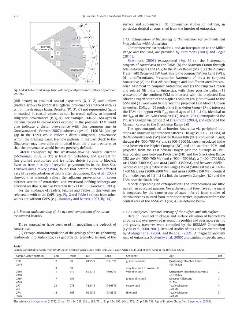
Fig. 2.Model of an ice-drainage basin with subglacial provenances reflected by offshoredetritus.
712 J.J. Veevers, A. Saeed / Gondwana Research 20 (2011) 710–738
(full arrow) to proximal coastal exposures (X, Y, Z) and upflow(broken arrow) to potential subglacial provenances (marked with ?)within the drainage basin. Detritus (P′, Q′, R′) not represented (gapsor exotics) in coastal exposures can be traced upflow to imputedsubglacial provenances (P, Q, R). For example, 500–550 Ma ages indetritus traced to coeval rocks exposed in the proximal TAM couldalso indicate a distal provenance with this common age inGondwanaland (Veevers, 2007); whereas ages of ~1100 Ma (an agegap in the TAM) would reflect a distal (subglacial) provenancewithin the drainage basin. Ice-flow patterns in the past (back to theOligocene) may have differed in detail from the present pattern, sothat the provenance would be less precisely defined.
Lateral transport by the westward-flowing coastal current(McGonigal, 2008, p. 37) is least for turbidites, and greatest forfine-grained contourites and ice-rafted debris (grains to blocks).Even so, from a study of recycled palynomorphs in the Ross Sea,Truswell and Drewry (1984) found that bottom currents effectedvery little redistribution of debris after deposition; Roy et al. (2007)showed that minerals reflect the adjacent provenance in sevendistinct sectors of Antarctica; and westward-drifting icebergs arearrested on shoals, such as Petersen Bank (110° E) (Goodwin, 1993).
For the guidance of readers, Figures and Tables in this work arereferred to with initial CAPS (e.g., Fig. 2 and Table 1), those from otherworks are without CAPS (e.g., Hambrey and Barrett, 1993, fig. 14).
1.1. Present understanding of the age and composition of Antarcticice-covered bedrock
Three approaches have been used in modelling the bedrock ofAntarctica:
(1) extrapolation/interpolation of the geology of the neighbouringcontinents into Antarctica; (2) geophysical (remote) sensing of the
Table 1Samples of turbiditic sands from DSDP Leg 28 offshore Wilkes Land (sites 268, 269), Cape A
Sample water depth m Core mbsf Lat. Long.
268 2 30 63.95°S 105.16°E3544
3 58269B 1 6–9 61.67°S 140.07°E4170269A 7 6564170273 21 271 74.54°S 174.63°E491274 18 163 69.00°S 173.43°E3326
The reference is Hayes et al. (1975): (1) p. 163, 164, 728; (2) p. 189, 731; (3) p. 194, 196;
surface and sub-surface; (3) provenance studies of detritus, inparticular detrital zircons, shed from the interior of Antarctica.
1.1.1. Extrapolation of the geology of the neighbouring continents andinterpolation within Antarctica
Comprehensive extrapolations, and an interpolation to the MillerRange and the TAM, are provided by Fitzsimons (2003) and Boger(2011).
Fitzsimons (2003) extrapolated (Fig. 3) (a) the Phanerozoicorogens of Australasia to the TAM; (b) the Mawson Craton throughAdélie–George V Land (AG) to the Miller Range (MR); (c) the Albany-Fraser (AF) Orogen of SW Australia to the conjunctWilkes Land (WL);(d) undifferentiated Precambrian basement of India to conjunctAntarctica; (e) the East African Orogen and undifferentiated Precam-brian basement to conjunct Antarctica; and (f) the Pinjarra Orogenand related NE India to Antarctica, with three possible paths: (1)westward of the southern PCM to intersect with the projected EastAfrican Orogen south of the Napier Complex (NC); southward to theGSM and (2) westward to intersect the projected East African Orogeninwestern DML; or (3) south of the Shackleton Range (SR) to intersectthe TAM in a region with TDM model ages of 1.5–1.1 Ga, identical tothe TDM of the Leeuwin Complex (LC). Boger (2011) extrapolated thePinjarra Orogen via option 2 of Fitzsimons (2003), and extended theMawson Craton to the Shackleton Range (SR).
The ages extrapolated to interior Antarctica via peripheral out-crops are shown in lighter toned patterns. The age c (900–1300 Ma) oftheWindmill Islands (WI) and theBungerHills (BH) is projected inland;theagesd+ (500–700 Ma)and c (900–1300Ma) are interpolated in thearea between the Napier Complex (NC) and the southern PCM, andprojected from the East African Orogen past the outcrops in DML.Interpolated ages between Prydz Bay (PB) and the Shackleton Range(SR) are d+ (500–700 Ma) and c (900–1300 Ma), a (1400–1700 Ma),aa′ (2200–2300 Ma), and aaaa (3000–3350 Ma), and between Adélie –GeorgeV Land (AG) to theMiller Range (MR)d (500–600 Ma), a (1400–1700 Ma), aaa (2600–2800 Ma), and aaaa (3000–3350Ma). IdenticalTDM model ages of 1.5–1.1 Ga link the Leeuwin Complex (LC) and theTAM near the South Pole.
Models depending on extrapolations and interpolations are littlemore than educated guesses. Nevertheless, that they have some meritis suggested by the same group of ages inferred from studies ofdetrital zircons sourced from interior Antarctica, in particular from thecentral area of the GSM–VSH (Fig. 4), as detailed below.
1.1.2. Geophysical (remote) sensing of the surface and sub-surfaceData on ice-sheet thickness and surface elevation of bedrock by
airborne and oversnow radar-sounding profiles and oversnow seismicand gravity traverses were compiled by the BEDMAP Consortium(Lythe et al., 2000, 2001). Detailed studies of this kind are exemplifiedby Studinger et al. (2004) and Bo et al. (2009). A magnetic anomalymap of Antarctica (Golynsky et al., 2006) and studies of specific areas
dare (274), and of shelf sand in the Ross Sea (273).
Sediment Age Ref.
graded sand-silt Quaternary: Brunhes Chron 1b0.776 Ma
very fine sand to coarse siltvery fine sand Quaternary: Brunhes/Matuyama 2
~0.776 Magraded fine sand Miocene-Oligocene 3
23 Macoarse sand ?early Miocene 4
~20 Mafine sand ?early Miocene 5
~20 Ma
(4) p. 352; (5) p. 389, 738. Age of Brunhes Chron from Singer et al. (2008).
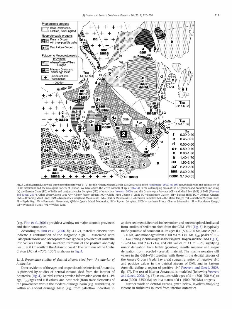
Fig. 3. Gondwanaland, showing three potential pathways (1–3) for the Pinjarra Orogen across East Antarctica. From Fitzsimons (2003, fig. 10), republished with the permission ofI.C.W. Fitzsimons and the Geological Society of London. We have added the letter symbols of ages (Table 4) in the outcropping areas of the neighbours and Antarctica, including(a) the Eastern Ghats (EG) of India and conjunct Napier Complex (NC) of Antarctica (Veevers, 2009), and the Grunehogna Province (GP) and Maud Belt (MB) of DML (Veeversand Saeed, 2007). Other abbreviations are: AF=Albany-Fraser orogen; AG=Adélie–King George V Land; BG=Beardmore Glacier; BH=Bunger Hills; DG=Denman Glacier;DML=Dronning Maud Land; GSM=Gamburtsev Subglacial Mountains; HM=Horlick Mountains; LC=Leeuwin Complex; MR=the Miller Range; NVL=northern Victoria Land;PB=Prydz Bay; PM=Pensacola Mountains; QMM=Queen Maud Mountains; RC=Rayner Complex; SPCM=southern Prince Charles Mountains; SR=Shackleton Range;WI=Windmill Islands; WL=Wilkes Land.
713J.J. Veevers, A. Saeed / Gondwana Research 20 (2011) 710–738
(e.g., Finn et al., 2006) provide a window on major tectonic provincesand their boundaries.
According to Finn et al. (2006, fig. 4.1-2), “satellite observationsindicate a continuation of the magnetic high … associated withPaleoproterozoic and Mesoproterozoic igneous provinces of Australiainto Wilkes Land … The southern terminus of the positive anomalylies… 800 km south of the Antarctic coast.” The terminus of the AdélieCraton (AC) at ~73°S, 135°E is shown in Fig. 4.
1.1.3. Provenance studies of detrital zircons shed from the interior ofAntarctica
Direct evidence of theages andproperties of the interior of Antarcticais provided by studies of detrital zircons shed from the interior ofAntarctica (Fig. 4). Detrital zircons provide information about the U–Pbage, TDM ages and εHf values, and host rock (from trace elements) ofthe provenance within the modern drainage basin (e.g., turbidites), orwithin an ancient drainage basin (e.g., from paleoflow indicators in
ancient sediment). Bedrock in themodern andancient upland, indicatedfrom studies of sediment shed from the GSM–VSH (Fig. 5), is typicallymafic granitoid of dominant U–Pb ages d+ (500–700 Ma) and c (900–1300 Ma) and minor ages from 1900 Ma to 3350 Ma, TDM peaks of 1.0–1.6 Ga (linking identical ages in thePinjarraOrogen and the TAM, Fig. 3),1.6–2.4 Ga, and 2.4–3.7 Ga, and εHf values of 11 to −28, signifyingminor derivation from fertile (positive) mantle material and majorderivation from recycled (crustal) material. The mainly negative εHfvalues in the GSM–VSH together with those in the detrital zircons ofthe Amery Group (Prydz Bay area) suggest a region of negative εHf,and positive values in the detrital zircons of DML and in EasternAustralia define a region of positive εHf (Veevers and Saeed, 2008,fig. 17). The rest of interior Antarctica is modelled (following Veeversand Saeed, 2008, fig. 17) as cratons with ages of d+ (500–700 Ma) toaaaa (3000–3350 Ma) set in a matrix of d+ (500–700 Ma) orogens.
Further work on detrital zircons, given below, involves analysingzircons in turbidites sourced from interior Antarctica.
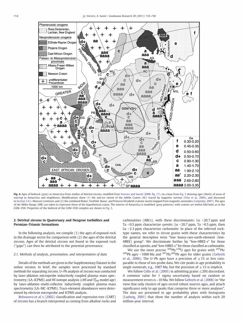
Fig. 4. Ages of bedrock (grey) in Antarctica from studies of detrital zircons, modified from Veevers and Saeed (2008, fig. 17), on a base from Fig. 3 showing ages (black) of areas ofoutcrop in Antarctica and neighbours. Modifications show (1) the sub-ice extent of the Adélie Craton (AC) traced by magnetic surveys (Finn et al., 2006), and discussedin Section 3.4.1.Mawson Continent, and (2) the combined Ruker, Vestfold–Rauer, and Princess Elizabeth cratonic nuclei mapped frommagnetic anomalies (Golynsky, 2007). The agesof the Miller Range (MR) are taken to represent those of the hypothetical craton. The interior of Antarctica is modelled (grey patterns) with cratons set within fold belts as in theGSM–VSH. Properties of the bedrock of the GSM–VSH complex are shown in Fig. 5.
714 J.J. Veevers, A. Saeed / Gondwana Research 20 (2011) 710–738
2. Detrital zircons in Quaternary and Neogene turbidites andPermian–Triassic formations
In the following analysis, we compile (1) the ages of exposed rockin the drainage sector for comparison with (2) the ages of the detritalzircons. Ages of the detrital zircons not found in the exposed rock(“gaps”) can then be attributed to the potential provenance.
2.1. Methods of analysis, presentation, and interpretation of data
Details of themethods are given in the SupplementaryDataset in theonline version. In brief, the samples were processed by standardmethods for separating zircons. U–Pb analysis of zirconswas conductedby laser-ablation microprobe inductively coupled plasma–mass spec-trometry (LA–ICPMS) and Hf-isotope analysis (εHf and TDMC model age)by laser-ablation–multi-collector inductively coupled plasma–massspectrometry (LA–MC–ICPMS). Trace-element abundances were deter-mined by electron microprobe and ICPMS analysis.
Belousova et al.'s (2002) classification and regression tree (CART)of zircons has a branch interpreted as coming from alkaline rocks and
carbonatites (ARCs), with these discriminants: Lu b20.7 ppm andTa b0.5 ppm characterize syenite; Lu b20.7 ppm, Ta N0.5 ppm, thenLu N2.3 ppm characterize carbonatite. In place of the inferred rock-type names, we refer to zircon grains with these characteristics bythe general descriptive term “low heavy-rare-earth-element (low-HREE) group”. We discriminate further by “low-HREE-s” for thoseclassified as syenite, and “low-HREE-c” for those classified as carbonatite.
We use the more precise 206Pb/238U ages for grains with 207Pb/206Pb ages b1000 Ma and 207Pb/206Pb ages for older grains (Gehrelset al., 2006). The U–Pb ages have a precision of ±1% or less com-parable to those of ion-probe data. We cite peaks in age probability insingle numerals, e.g., 1007 Ma, but the precision of ±1% is implicit.
We follow Gillis et al. (2005) in admitting grains≤20% discordant.A common value for 1 sigma uncertainty based on random ormeasurement errors is ~10 Ma.We follow Gehrels et al. (2006) in “theview that only clusters of ages record robust sources ages, and attachsignificance only to age peaks that comprise three or more analyses”.The data are presented in age probability plots with histograms(Ludwig, 2001) that show the number of analysis within each 20million-year interval.
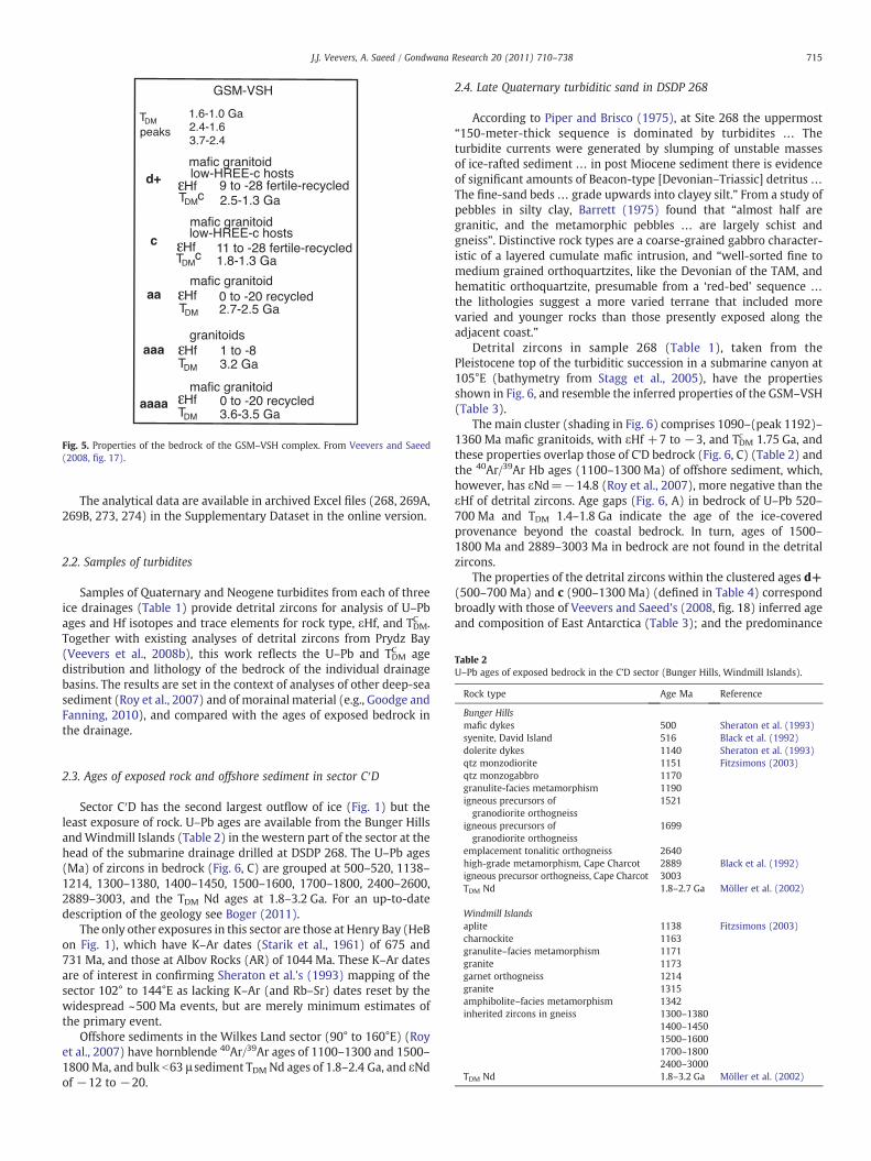
Fig. 5. Properties of the bedrock of the GSM–VSH complex. From Veevers and Saeed(2008, fig. 17).
715J.J. Veevers, A. Saeed / Gondwana Research 20 (2011) 710–738
The analytical data are available in archived Excel files (268, 269A,269B, 273, 274) in the Supplementary Dataset in the online version.
Table 2U–Pb ages of exposed bedrock in the C'D sector (Bunger Hills, Windmill Islands).
Rock type Age Ma Reference
Bunger Hillsmafic dykes 500 Sheraton et al. (1993)syenite, David Island 516 Black et al. (1992)
2.2. Samples of turbidites
Samples of Quaternary and Neogene turbidites from each of threeice drainages (Table 1) provide detrital zircons for analysis of U–Pbages and Hf isotopes and trace elements for rock type, εHf, and TDMC .Together with existing analyses of detrital zircons from Prydz Bay(Veevers et al., 2008b), this work reflects the U–Pb and TDMC agedistribution and lithology of the bedrock of the individual drainagebasins. The results are set in the context of analyses of other deep-seasediment (Roy et al., 2007) and of morainal material (e.g., Goodge andFanning, 2010), and compared with the ages of exposed bedrock inthe drainage.
dolerite dykes 1140 Sheraton et al. (1993)qtz monzodiorite 1151 Fitzsimons (2003)qtz monzogabbro 1170granulite-facies metamorphism 1190igneous precursors ofgranodiorite orthogneiss
1521
igneous precursors ofgranodiorite orthogneiss
1699
emplacement tonalitic orthogneiss 2640high-grade metamorphism, Cape Charcot 2889 Black et al. (1992)igneous precursor orthogneiss, Cape Charcot 3003TDM Nd 1.8–2.7 Ga Möller et al. (2002)
Windmill Islandsaplite 1138 Fitzsimons (2003)charnockite 1163granulite–facies metamorphism 1171granite 1173garnet orthogneiss 1214granite 1315amphibolite–facies metamorphism 1342inherited zircons in gneiss 1300–1380
1400–14501500–16001700–18002400–3000
TDM Nd 1.8–3.2 Ga Möller et al. (2002)
2.3. Ages of exposed rock and offshore sediment in sector C′D
Sector C′D has the second largest outflow of ice (Fig. 1) but theleast exposure of rock. U–Pb ages are available from the Bunger HillsandWindmill Islands (Table 2) in the western part of the sector at thehead of the submarine drainage drilled at DSDP 268. The U–Pb ages(Ma) of zircons in bedrock (Fig. 6, C) are grouped at 500–520, 1138–1214, 1300–1380, 1400–1450, 1500–1600, 1700–1800, 2400–2600,2889–3003, and the TDM Nd ages at 1.8–3.2 Ga. For an up-to-datedescription of the geology see Boger (2011).
The only other exposures in this sector are those at Henry Bay (HeBon Fig. 1), which have K–Ar dates (Starik et al., 1961) of 675 and731 Ma, and those at Albov Rocks (AR) of 1044 Ma. These K–Ar datesare of interest in confirming Sheraton et al.'s (1993) mapping of thesector 102° to 144°E as lacking K–Ar (and Rb–Sr) dates reset by thewidespread ~500 Ma events, but are merely minimum estimates ofthe primary event.
Offshore sediments in the Wilkes Land sector (90° to 160°E) (Royet al., 2007) have hornblende 40Ar/39Ar ages of 1100–1300 and 1500–1800 Ma, and bulk b63 μ sediment TDM Nd ages of 1.8–2.4 Ga, and εNdof −12 to −20.
2.4. Late Quaternary turbiditic sand in DSDP 268
According to Piper and Brisco (1975), at Site 268 the uppermost“150-meter-thick sequence is dominated by turbidites … Theturbidite currents were generated by slumping of unstable massesof ice-rafted sediment … in post Miocene sediment there is evidenceof significant amounts of Beacon-type [Devonian–Triassic] detritus …The fine-sand beds… grade upwards into clayey silt.” From a study ofpebbles in silty clay, Barrett (1975) found that “almost half aregranitic, and the metamorphic pebbles … are largely schist andgneiss”. Distinctive rock types are a coarse-grained gabbro character-istic of a layered cumulate mafic intrusion, and “well-sorted fine tomedium grained orthoquartzites, like the Devonian of the TAM, andhematitic orthoquartzite, presumable from a ‘red-bed’ sequence …
the lithologies suggest a more varied terrane that included morevaried and younger rocks than those presently exposed along theadjacent coast.”
Detrital zircons in sample 268 (Table 1), taken from thePleistocene top of the turbiditic succession in a submarine canyon at105°E (bathymetry from Stagg et al., 2005), have the propertiesshown in Fig. 6, and resemble the inferred properties of the GSM–VSH(Table 3).
The main cluster (shading in Fig. 6) comprises 1090–(peak 1192)–1360 Ma mafic granitoids, with εHf +7 to −3, and TDMc 1.75 Ga, andthese properties overlap those of C'D bedrock (Fig. 6, C) (Table 2) andthe 40Ar/39Ar Hb ages (1100–1300 Ma) of offshore sediment, which,however, has εNd=−14.8 (Roy et al., 2007), more negative than theεHf of detrital zircons. Age gaps (Fig. 6, A) in bedrock of U–Pb 520–700 Ma and TDM 1.4–1.8 Ga indicate the age of the ice-coveredprovenance beyond the coastal bedrock. In turn, ages of 1500–1800 Ma and 2889–3003 Ma in bedrock are not found in the detritalzircons.
The properties of the detrital zircons within the clustered ages d+(500–700 Ma) and c (900–1300 Ma) (defined in Table 4) correspondbroadly with those of Veevers and Saeed's (2008, fig. 18) inferred ageand composition of East Antarctica (Table 3); and the predominance
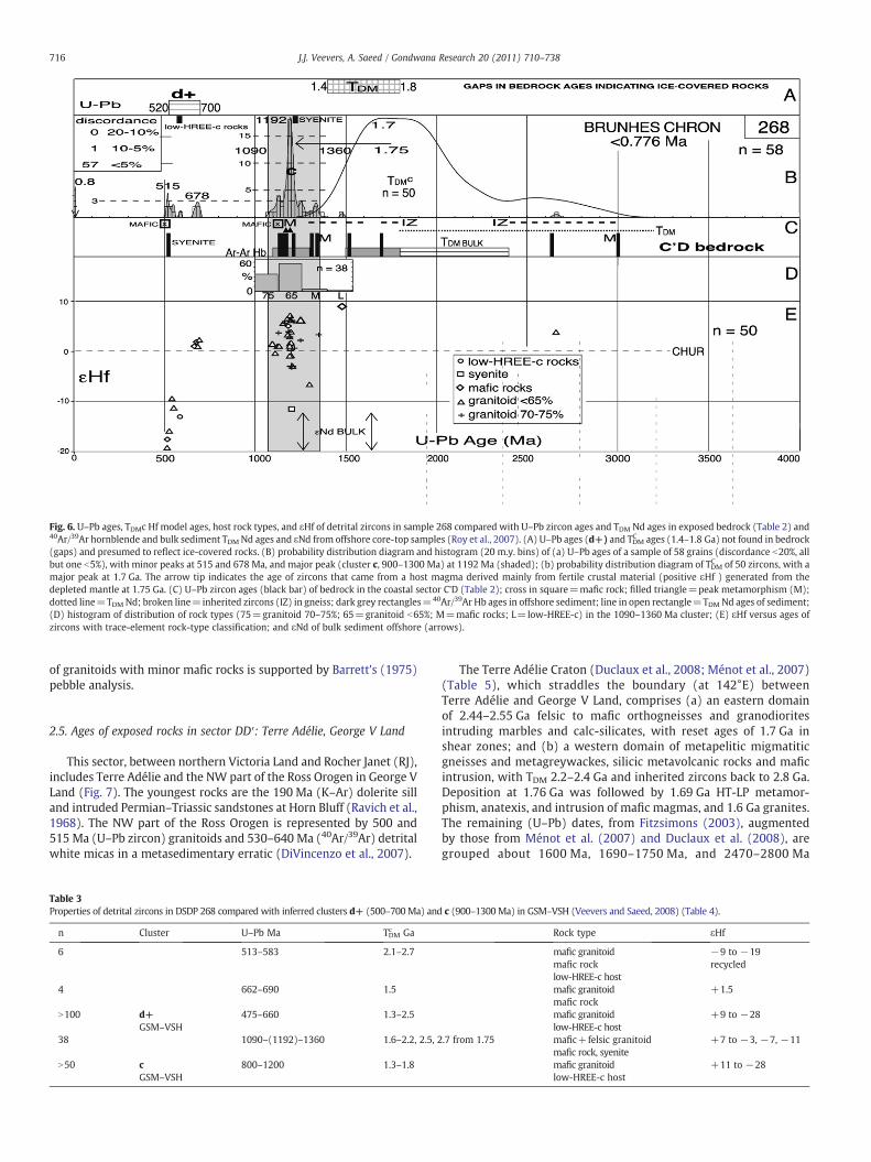
Fig. 6. U–Pb ages, TDMc Hf model ages, host rock types, and εHf of detrital zircons in sample 268 compared with U–Pb zircon ages and TDM Nd ages in exposed bedrock (Table 2) and40Ar/39Ar hornblende and bulk sediment TDM Nd ages and εNd from offshore core-top samples (Roy et al., 2007). (A) U–Pb ages (d+) and TDMC ages (1.4–1.8 Ga) not found in bedrock(gaps) and presumed to reflect ice-covered rocks. (B) probability distribution diagram and histogram (20 m.y. bins) of (a) U–Pb ages of a sample of 58 grains (discordance b20%, allbut one b5%), with minor peaks at 515 and 678 Ma, and major peak (cluster c, 900–1300 Ma) at 1192 Ma (shaded); (b) probability distribution diagram of TDMC of 50 zircons, with amajor peak at 1.7 Ga. The arrow tip indicates the age of zircons that came from a host magma derived mainly from fertile crustal material (positive εHf ) generated from thedepleted mantle at 1.75 Ga. (C) U–Pb zircon ages (black bar) of bedrock in the coastal sector C'D (Table 2); cross in square=mafic rock; filled triangle=peak metamorphism (M);dotted line=TDMNd; broken line=inherited zircons (IZ) in gneiss; dark grey rectangles=40Ar/39Ar Hb ages in offshore sediment; line in open rectangle=TDMNd ages of sediment;(D) histogram of distribution of rock types (75=granitoid 70–75%; 65=granitoid b65%; M=mafic rocks; L=low-HREE-c) in the 1090–1360 Ma cluster; (E) εHf versus ages ofzircons with trace-element rock-type classification; and εNd of bulk sediment offshore (arrows).
716 J.J. Veevers, A. Saeed / Gondwana Research 20 (2011) 710–738
of granitoids with minor mafic rocks is supported by Barrett's (1975)pebble analysis.
2.5. Ages of exposed rocks in sector DD′: Terre Adélie, George V Land
This sector, between northern Victoria Land and Rocher Janet (RJ),includes Terre Adélie and the NW part of the Ross Orogen in George VLand (Fig. 7). The youngest rocks are the 190 Ma (K–Ar) dolerite silland intruded Permian–Triassic sandstones at Horn Bluff (Ravich et al.,1968). The NW part of the Ross Orogen is represented by 500 and515 Ma (U–Pb zircon) granitoids and 530–640 Ma (40Ar/39Ar) detritalwhite micas in a metasedimentary erratic (DiVincenzo et al., 2007).
Table 3Properties of detrital zircons in DSDP 268 compared with inferred clusters d+ (500–700Ma) and
n Cluster U–Pb Ma TDMc Ga
6 513–583 2.1–2.7
4 662–690 1.5
N100 d+ 475–660 1.3–2.5GSM–VSH
38 1090–(1192)–1360 1.6–2.2, 2.5, 2
N50 c 800–1200 1.3–1.8GSM–VSH
The Terre Adélie Craton (Duclaux et al., 2008; Ménot et al., 2007)(Table 5), which straddles the boundary (at 142°E) betweenTerre Adélie and George V Land, comprises (a) an eastern domainof 2.44–2.55 Ga felsic to mafic orthogneisses and granodioritesintruding marbles and calc-silicates, with reset ages of 1.7 Ga inshear zones; and (b) a western domain of metapelitic migmatiticgneisses and metagreywackes, silicic metavolcanic rocks and maficintrusion, with TDM 2.2–2.4 Ga and inherited zircons back to 2.8 Ga.Deposition at 1.76 Ga was followed by 1.69 Ga HT-LP metamor-phism, anatexis, and intrusion of mafic magmas, and 1.6 Ga granites.The remaining (U–Pb) dates, from Fitzsimons (2003), augmentedby those from Ménot et al. (2007) and Duclaux et al. (2008), aregrouped about 1600 Ma, 1690–1750 Ma, and 2470–2800 Ma
c (900–1300Ma) in GSM–VSH (Veevers and Saeed, 2008) (Table 4).
Rock type εHf
mafic granitoid −9 to −19mafic rock recycledlow-HREE-c hostmafic granitoid +1.5mafic rockmafic granitoid +9 to −28low-HREE-c host
.7 from 1.75 mafic+felsic granitoid +7 to −3, −7, −11mafic rock, syenitemafic granitoid +11 to −28low-HREE-c host
Table 5U–Pb ages of exposed bedrock in the DD′ sector (Fig. 7).
Rock type Age Ma Reference
dolerite sill 190 (K–Ar) Ravich et al. (1968)granitoids of Ross Orogen 500, 515 DiVincenzo et al. (2007)granites 1600 Ménot et al. (2007)metamorphic rims on zircon 1688 Fitzsimons (2003)monazite melting (peakmetamorphism during basin closure)
1694 Duclaux et al. (2008)
reset ages in granodiorites 1700 Ménot et al. (2007)paragneiss 1709 Fitzsimons (2003)volcanic rocks 1730–1740 Fitzsimons (2003)youngest detrital-zircon corein phyllite and migmatite
1720, 1760 Duclaux et al. (2008)
volcanosedimentary succession atCape Hunter and Pointe Géologie
1766 Fitzsimons (2003)
granulite–facies metamorphism, orthogneiss(major tectono-metamorphic event)
2470 Duclaux et al. (2008)
orthogneiss 2350–2700 Fitzsimons (2003)detrital zircon in gneiss enclaves 2400–2800 Fitzsimons (2003)felsic to mafic orthogneissesand granodiorites
2440–2550 Ménot et al. (2007)
juvenile continental crust 2600–2800 Duclaux et al. (2008)Pointe Géologie migmatite 1.9–2.4,
2.8–3.2 GaDuclaux et al. (2008)
Table 4Clusters of zircon ages of bedrock in southwesternAustralia and East Antarctica (Veevers, 2000,p. 110; Veevers et al., 2006, table 1, fig. 36; Veeversand Saeed, 2008).
Code Ga
g 0.125–0.90f 0.30–0.20e 0.45–0.35d 0.50–0.60d+ 0.50–0.70dd 0.65–0.725ddd 0.80–1.00c 0.90–1.30bb 1.30–1.40b 1.30–1.50a 1.40–1.70aa 1.90–2.10aa’ 2.20–2.30aaa 2.60–2.80aaaa 3.00–3.35
717J.J. Veevers, A. Saeed / Gondwana Research 20 (2011) 710–738
(Table 5). For an up-to-date description of the geology see Boger(2011).
Offshore sediments in the Wilkes Land sector (Roy et al., 2007)have hornblende 40Ar/39Ar ages of 1100–1300 and 1500–1800 Ma,and bulk b63 μ sediment TDM Nd ages of 1.8–2.4 Ga, and εNd of −12to −20.
2.6. Miocene–Oligocene turbiditic sand — DSDP 269A
The sample (Table 1) was taken from “graded beds of veryfine sand to coarse silt” of Miocene–Oligocene age (Hayes et al., 1975,p. 194).
As noted above, during times of ice retreat, the TAM acts as a damto divert flow into the Wilkes Basin (Hambrey and Barrett, 1993,fig. 14). The flanking TAM had the potential to supply zircons from the184 Ma Ferrar tholeiite (Elliot and Fleming, 2000), the 490–544 MaRoss Orogen (Black and Sheraton, 1990; Foden et al., 2006) (Table 6),the 668 Ma gabbro in the Beardmore Group (Goodge et al., 2002), andages of 530 Ma, 1720 Ma, and ~3000 Ma in the Miller Range (Goodgeand Fanning, 1999). TDM Nd from the Miller Range is 2.5–3.1 Ga, andfrom the rest of the TAM 1.6–2.3 Ga (Mikhalsky, 2008a,b), except the
Fig. 7. Location of northern Victoria Land, Oates Land, George V Land, and Terre Adélie(DD′ drainage outlet) showing the distribution of the 0–48 Ma McMurdo Volcanics,179 Ma sills and flows of Jurassic tholeiite (Elliot and Foland, 1986; Elliot et al., 1986),Permian–Triassic (Collinson et al., 1986) –Early Jurassic (Goodge and Fanning, 2010)sediment, 360–390 Ma intrusives and volcanics, limits of the 490–544 Ma Ross Orogen,location of DF79-38 core with in situ Aptian siltstone (Domack et al., 1980), 500 and515 Ma ages of granite near Penguin Point (cross), and the ages of the Terre AdélieCraton (Table 5). The dotted line encloses the dredged area (Goodge and Fanning,2010). The triangle locates erratics of red sandstone (R). CD=Cape Denison; CJ=CapJules; MG=Mertz Glacier; MO=Mount Obruchev; NG=Ninniss Glacier; PG=PointeGéologie; PM=Port Martin; PP=Penguin Point; RJ=Rocher Janet.
Ohio Range and northern Victoria Land, which have TDM Nd 1.0–1.5 Ga (Borg and DePaolo, 1994).
The main clusters (shading in Fig. 8) are (1) 480–(peak 600)–680 Mamafic granitoids, with εHf+10 to−40, and TDMc 2.0 Ga, whichleaves a gap in bedrock ages of d+ 544–680 Ma; and (2) 1000–(1166)–1260 Ma felsic granitoids with εHf +10 to −2, and over-lapping offshore 40Ar/39Ar Hb ages with εNd −20 (Roy et al., 2007),which leaves a gap in bedrock ages of c 1000–1260 Ma. The detritalzircons dated 1540–1760 Ma (lacking in 268) match ages in bedrockand sediment. The only gap in bedrock TDM is 3.2–3.7 Ga.
We conclude that the detrital zircons with gaps in U–Pb ages of544–680 Ma and 1000–1260 Ma, and TDM ages of 3.2–3.7 Ga comefrom a provenance in the drainage basin. This confirms Veevers andSaeed's (2008, fig. 18) inferred age of GSM–VSH (Table 7). Inparticular, all four characters (U–Pb age, TDM age, rock type, andεHf) of cluster d+ (500–700 Ma) are essentially the same.
2.7. Late Quaternary turbiditic sand — DSDP 269B
The column in ODP 269 “is dominantly a silt-clay turbiditicsequence… very fine sands are common in Core 1” (Piper and Brisco,1975), which was sampled for 269B (Table 1).
The U–Pb ages in 269B (Fig. 9), unlike those in 269A, aredistributed fairly evenly between 500 and 2800 Ma, with main
Table 6Ages in the TAM.
Age Ma Rock type Reference
0–48 McMurdo+Meander Volcanics Kyle (1990)Rocchi et al. (2006)
184 Ferrar tholeiite Elliot+Fleming (2000)190a silicic ash Hanson Formation Elliot (1996)240–290a tuffs from magmatic arc Collinson et al. (1994)351–365 Admiralty Intrusives, Gallipoli Volcanics Fioretti et al. (2001)490–544 Ross Orogen Black+Sheraton (1990)
Foden et al. (2006)668 Beardmore Gabbro Goodge et al. (2002)530, 1720, 3000 plutonic+metamorphic rocks Miller
RangeGoodge+Fanning(1999)
1.0–2.3 TDM Nd Borg+DePaulo (1994)2.5–3.1 Ga Mikhalsky (2008a,b)
a Ages from biostratigraphy.
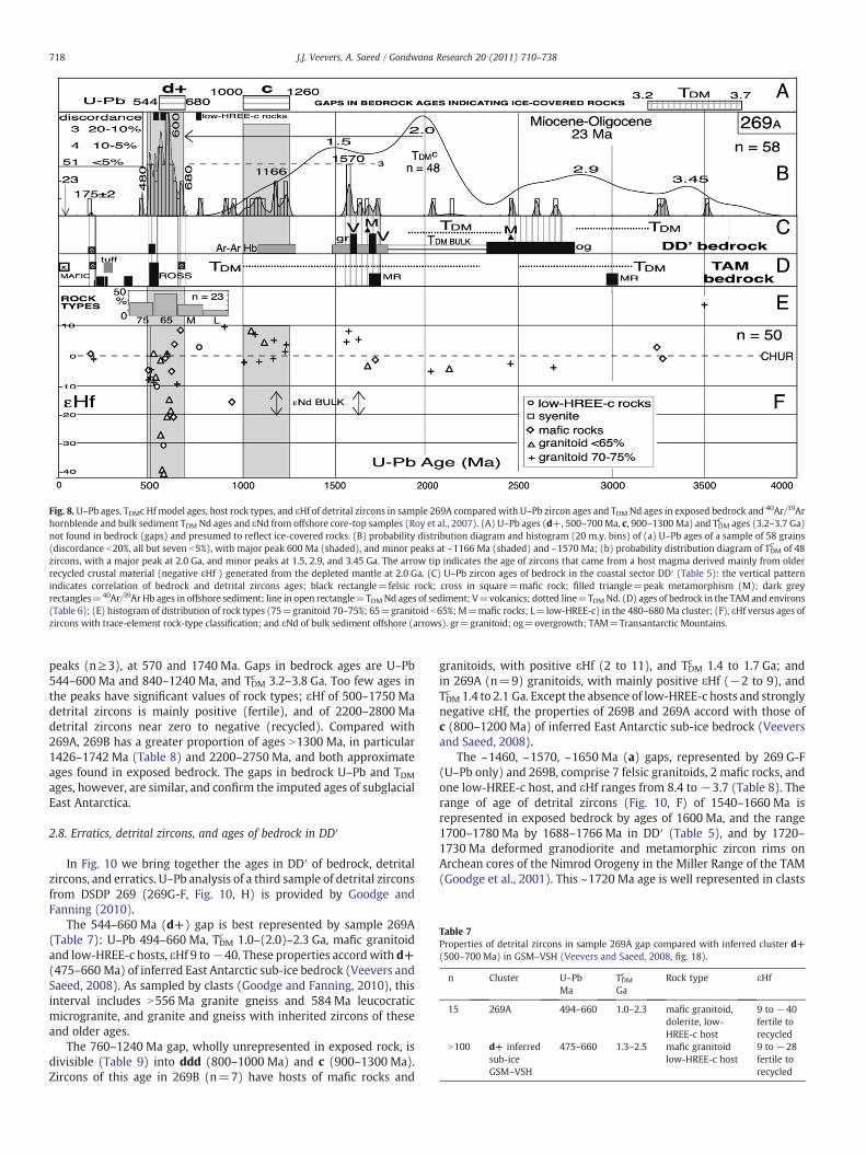
Fig. 8.U–Pb ages, TDMc Hf model ages, host rock types, and εHf of detrital zircons in sample 269A compared with U–Pb zircon ages and TDM Nd ages in exposed bedrock and 40Ar/39Arhornblende and bulk sediment TDM Nd ages and εNd from offshore core-top samples (Roy et al., 2007). (A) U–Pb ages (d+, 500–700Ma, c, 900–1300 Ma) and TDMC ages (3.2–3.7 Ga)not found in bedrock (gaps) and presumed to reflect ice-covered rocks. (B) probability distribution diagram and histogram (20 m.y. bins) of (a) U–Pb ages of a sample of 58 grains(discordance b20%, all but seven b5%), with major peak 600 Ma (shaded), and minor peaks at ~1166 Ma (shaded) and ~1570 Ma; (b) probability distribution diagram of TDMC of 48zircons, with a major peak at 2.0 Ga, and minor peaks at 1.5, 2.9, and 3.45 Ga. The arrow tip indicates the age of zircons that came from a host magma derived mainly from olderrecycled crustal material (negative εHf ) generated from the depleted mantle at 2.0 Ga. (C) U–Pb zircon ages of bedrock in the coastal sector DD′ (Table 5): the vertical patternindicates correlation of bedrock and detrital zircons ages; black rectangle=felsic rock; cross in square=mafic rock; filled triangle=peak metamorphism (M); dark greyrectangles=40Ar/39Ar Hb ages in offshore sediment; line in open rectangle=TDMNd ages of sediment; V=volcanics; dotted line=TDMNd. (D) ages of bedrock in the TAM and environs(Table 6); (E) histogram of distribution of rock types (75=granitoid 70–75%; 65=granitoid b65%; M=mafic rocks; L=low-HREE-c) in the 480–680 Ma cluster; (F), εHf versus ages ofzircons with trace-element rock-type classification; and εNd of bulk sediment offshore (arrows). gr=granitoid; og=overgrowth; TAM=Transantarctic Mountains.
Table 7Properties of detrital zircons in sample 269A gap compared with inferred cluster d+(500–700 Ma) in GSM–VSH (Veevers and Saeed, 2008, fig. 18).
n Cluster U–Pb TDMc Rock type εHfMa Ga
15 269A 494–660 1.0–2.3 mafic granitoid,dolerite, low-HREE-c host
9 to −40fertile torecycled
N100 d+ inferredsub-iceGSM–VSH
475–660 1.3–2.5 mafic granitoid 9 to −28low-HREE-c host fertile to
recycled
718 J.J. Veevers, A. Saeed / Gondwana Research 20 (2011) 710–738
peaks (n≥3), at 570 and 1740 Ma. Gaps in bedrock ages are U–Pb544–600 Ma and 840–1240 Ma, and TDMc 3.2–3.8 Ga. Too few ages inthe peaks have significant values of rock types; εHf of 500–1750 Madetrital zircons is mainly positive (fertile), and of 2200–2800 Madetrital zircons near zero to negative (recycled). Compared with269A, 269B has a greater proportion of ages N1300 Ma, in particular1426–1742 Ma (Table 8) and 2200–2750 Ma, and both approximateages found in exposed bedrock. The gaps in bedrock U–Pb and TDMages, however, are similar, and confirm the imputed ages of subglacialEast Antarctica.
2.8. Erratics, detrital zircons, and ages of bedrock in DD′
In Fig. 10 we bring together the ages in DD′ of bedrock, detritalzircons, and erratics. U–Pb analysis of a third sample of detrital zirconsfrom DSDP 269 (269G-F, Fig. 10, H) is provided by Goodge andFanning (2010).
The 544–660 Ma (d+) gap is best represented by sample 269A(Table 7): U–Pb 494–660 Ma, TDMc 1.0–(2.0)–2.3 Ga, mafic granitoidand low-HREE-c hosts, εHf 9 to−40. These properties accordwith d+(475–660 Ma) of inferred East Antarctic sub-ice bedrock (Veevers andSaeed, 2008). As sampled by clasts (Goodge and Fanning, 2010), thisinterval includes N556 Ma granite gneiss and 584 Ma leucocraticmicrogranite, and granite and gneiss with inherited zircons of theseand older ages.
The 760–1240 Ma gap, wholly unrepresented in exposed rock, isdivisible (Table 9) into ddd (800–1000 Ma) and c (900–1300 Ma).Zircons of this age in 269B (n=7) have hosts of mafic rocks and
granitoids, with positive εHf (2 to 11), and TDMc 1.4 to 1.7 Ga; andin 269A (n=9) granitoids, with mainly positive εHf (−2 to 9), andTDMc 1.4 to 2.1 Ga. Except the absence of low-HREE-c hosts and stronglynegative εHf, the properties of 269B and 269A accord with those ofc (800–1200 Ma) of inferred East Antarctic sub-ice bedrock (Veeversand Saeed, 2008).
The ~1460, ~1570, ~1650 Ma (a) gaps, represented by 269 G-F(U–Pb only) and 269B, comprise 7 felsic granitoids, 2 mafic rocks, andone low-HREE-c host, and εHf ranges from 8.4 to −3.7 (Table 8). Therange of age of detrital zircons (Fig. 10, F) of 1540–1660 Ma isrepresented in exposed bedrock by ages of 1600 Ma, and the range1700–1780 Ma by 1688–1766 Ma in DD′ (Table 5), and by 1720–1730 Ma deformed granodiorite and metamorphic zircon rims onArchean cores of the Nimrod Orogeny in the Miller Range of the TAM(Goodge et al., 2001). This ~1720 Ma age is well represented in clasts
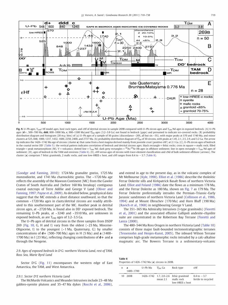
Fig. 9. U–Pb ages, TDMc Hf model ages, host rock types, and εHf of detrital zircons in sample 269B compared with U–Pb zircon ages and TDM Nd ages in exposed bedrock. (A) U–Pbages (d+, 500–700 Ma, ddd, 800–1000 Ma, c, 900–1300 Ma)and TDMC ages (3.2–3.8 Ga) not found in bedrock (gaps) and presumed to indicate ice-covered rocks. (B) probabilitydistribution diagram and histogram (20 m.y. bins) of (a) U–Pb ages of a sample of 50 grains (discordance b20%, all but six b5%), with major peaks at 570 and 1740 Ma, and minorclusters at 525, 848, 1000, 1237, 1432, 1600, 2250, 2400, and 2737 Ma. (b) probability distribution diagram of TDMC of 30 zircons, with peaks at 1.45, 2.1, 2.5, 2.9, and 3.2 Ga. The arrowtip indicates the 1426–1742 Ma age of zircons (cluster a) that came from a host magma derived mainly from juvenile crust (positive εHf ) at 2.1 Ga. (C), U–Pb zircon ages of bedrockin the coastal sector DD′ (Table 5): the vertical pattern indicates correlation of bedrock and detrital zircons ages; black rectangle=felsic rocks; cross in square=mafic rock; filledtriangle=peak metamorphism (M), V=volcanics; dotted line=TDM Nd; dark grey rectangles=40Ar/39Ar Hb ages in offshore sediment; line in open rectangle=TDM Nd ages ofsediment; (D), ages of bedrock in the TAM and environs (Table 6). (E), εHf versus ages of zircons with trace-element classification and εNd of bulk sediment offshore (arrows). Thecluster (a) comprises 7 felsic granitoids, 2 mafic rocks, and one low-HREE-c host, and εHf ranges from 8.4 to −3.7 (Table 8).
Table 8Properties of 1426–1742 Ma (a) zircons in 269B.
n a1400–1700
U–Pb Ma TDMc Ga Rock type εHf
10 269B 1426–1742 1.7, 2.0–2.6 felsic granitoid 8.4 to −3.7mean 2.1 mafic rock fertile to recycled
low-HREE-c host
719J.J. Veevers, A. Saeed / Gondwana Research 20 (2011) 710–738
(Goodge and Fanning, 2010): 1724 Ma granulite gneiss, 1725 Mamonzodiorite, and 1741 Ma charnockitic gneiss. The ~1720 Ma agereflects the assembly of the Mawson Continent (MC) from the GawlerCraton of South Australia and (before 160 Ma breakup) contiguouscoastal outcrops of Terre Adélie and George V Land (Oliver andFanning, 1997; Payne et al., 2009). As detailed below, geophysical datasuggest that the MC extends a short distance southward, so that thecommon ~1720 Ma ages in clasts/detrital zircons are readily attrib-uted to this southernmost part of the MC. Another peak in detritalzircon ages, at ~2720 Ma, is found also in DD′ exposed bedrock. Theremaining U–Pb peaks, at ~3240 and ~3510 Ma, are unknown inexposed bedrock, as are TDM ages of 3.2–3.5 Ga.
The U–Pb ages of detrital zircons in the three samples from DSDP269 (Fig. 10, G, H and I) vary from the oldest (~23 Ma, Miocene-Oligocene, I) to the youngest (~1 Ma, Quaternary, G) by smallerconcentrations of d+ (500–700 Ma) ages in H (5 Ma) and a (1400–1700 Ma) in I (23 Ma), reflecting changing contributions of d+ and athrough the Neogene.
2.9. Ages of exposed bedrock in D′G: northern Victoria Land, rest of TAM,Ross Sea, Marie Byrd Land
Sector D′G (Fig. 11) encompasses the western edge of EastAntarctica, the TAM, and West Antarctica.
2.9.1. Sector D′E northern Victoria LandTheMcMurdo Volcanics andMeander Intrusives include 23–48 Ma
gabbro-syenite plutons and 35–47 Ma dykes (Rocchi et al., 2006),
and extend in age to the present day, as in the volcanic complex ofMt Melbourne (Kyle, 1990). Elliot et al. (1986) describe the tholeiiticFerrar Dolerite sills and Kirkpatrick Basalt flows of northern VictoriaLand. Elliot and Foland (1986) date the flows as a minimum 178 Ma,and the Ferrar Dolerite as 180 Ma, shown on Fig. 7 as 179 Ma. TheFerrar Dolerite preferentially intrudes the Permian–Triassic–EarlyJurassic sandstones of northern Victoria Land (Collinson et al., 1986,1994) and at Mount Obruchev (170 Ma) and Horn Bluff (190 Ma)(Ravich et al., 1968) in neighbouring George V Land.
The 351–365 Ma Admiralty Intrusives (I-type granitoids) (Fiorettiet al., 2001) and the associated effusive Gallipoli andesite–rhyolitesuite are concentrated in the Robertson Bay Terrane (Fioretti andLanza (2000).
The 480–544 Ma Ross Orogen in northern Victoria Land (Table 10)consists of three major fault-bounded tectonostratigraphic terranes(Tessensohn and Henjes-Kunst, 2005). The inboard Wilson Terranecomprises high-grade metamorphic rocks intruded by a calc-alkalinemagmatic arc. The Bowers Terrane is a sedimentary-volcanic
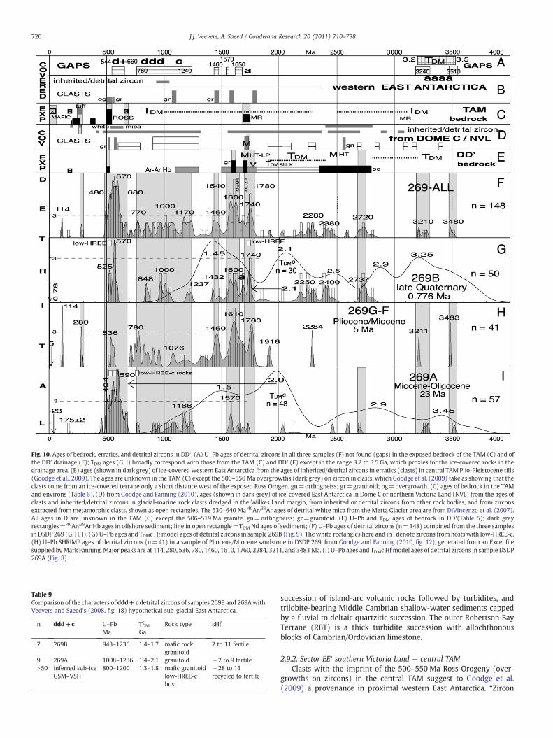
Fig. 10. Ages of bedrock, erratics, and detrital zircons in DD′. (A) U–Pb ages of detrital zircons in all three samples (F) not found (gaps) in the exposed bedrock of the TAM (C) and ofthe DD′ drainage (E); TDM ages (G, I) broadly correspond with those from the TAM (C) and DD′ (E) except in the range 3.2 to 3.5 Ga, which proxies for the ice-covered rocks in thedrainage area. (B) ages (shown in dark grey) of ice-covered western East Antarctica from the ages of inherited/detrital zircons in erratics (clasts) in central TAM Plio-Pleistocene tills(Goodge et al., 2009). The ages are unknown in the TAM (C) except the 500–550 Ma overgrowths (dark grey) on zircon in clasts, which Goodge et al. (2009) take as showing that theclasts come from an ice-covered terrane only a short distance west of the exposed Ross Orogen. gn=orthogneiss; gr=granitoid; og=overgrowth. (C) ages of bedrock in the TAMand environs (Table 6). (D) from Goodge and Fanning (2010), ages (shown in dark grey) of ice-covered East Antarctica in Dome C or northern Victoria Land (NVL) from the ages ofclasts and inherited/detrital zircons in glacial-marine rock clasts dredged in the Wilkes Land margin, from inherited or detrital zircons from other rock bodies, and from zirconsextracted from metamorphic clasts, shown as open rectangles. The 530–640 Ma 40Ar/39Ar ages of detrital white mica from the Mertz Glacier area are from DiVincenzo et al. (2007).All ages in D are unknown in the TAM (C) except the 506–519 Ma granite. gn=orthogneiss; gr=granitoid. (E) U–Pb and TDM ages of bedrock in DD′(Table 5); dark greyrectangles=40Ar/39Ar Hb ages in offshore sediment; line in open rectangle=TDM Nd ages of sediment; (F) U–Pb ages of detrital zircons (n=148) combined from the three samplesin DSDP 269 (G, H, I). (G) U–Pb ages and TDMc Hfmodel ages of detrital zircons in sample 269B (Fig. 9). Thewhite rectangles here and in I denote zircons from hosts with low-HREE-c.(H) U–Pb SHRIMP ages of detrital zircons (n=41) in a sample of Pliocene/Miocene sandstone in DSDP 269, from Goodge and Fanning (2010, fig. 12), generated from an Excel filesupplied byMark Fanning. Major peaks are at 114, 280, 536, 780, 1460, 1610, 1760, 2284, 3211, and 3483 Ma. (I) U–Pb ages and TDMc Hfmodel ages of detrital zircons in sample DSDP269A (Fig. 8).
Table 9Comparison of the characters of ddd+c detrital zircons of samples 269B and 269AwithVeevers and Saeed's (2008, fig. 18) hypothetical sub-glacial East Antarctica.
n ddd+c U–PbMa
TDMc
GaRock type εHf
7 269B 843–1236 1.4–1.7 mafic rock,granitoid
2 to 11 fertile
9 269A 1008–1236 1.4–2.1 granitoid −2 to 9 fertileN50 inferred sub-ice
GSM–VSH800–1200 1.3–1.8 mafic granitoid −28 to 11
low-HREE-chost
recycled to fertile
720 J.J. Veevers, A. Saeed / Gondwana Research 20 (2011) 710–738
succession of island-arc volcanic rocks followed by turbidites, andtrilobite-bearing Middle Cambrian shallow-water sediments cappedby a fluvial to deltaic quartzitic succession. The outer Robertson BayTerrane (RBT) is a thick turbidite succession with allochthonousblocks of Cambrian/Ordovician limestone.
2.9.2. Sector EE′ southern Victoria Land — central TAMClasts with the imprint of the 500–550 Ma Ross Orogeny (over-
growths on zircons) in the central TAM suggest to Goodge et al.(2009) a provenance in proximal western East Antarctica. “Zircon
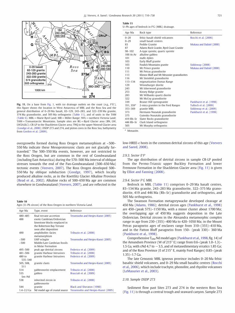
Fig. 11. On a base from Fig. 1, with ice drainage outlets on the coast (e.g., F′E′),this figure shows the location in West Antarctica of MBL and the Ross Sea and thegeneral distribution of 0–29 Ma basalt, 83–129, 243–283, and 322–339 Ma granite,374 Ma granodiorite, and 505 Ma orthogneiss (Table 11), and of units in the TAM(Table 6). MBL=Marie Byrd Land; MR=Miller Range; NVL=northern Victoria Land;TAM=Transantarctic Mountains. Sample sites are BG=Byrd Glacier area (BN, LW,LW2A,B,C); CR-LP in the Shackleton Glacier area; TNQ in the upper Nimrod Glacier area(Goodge et al., 2008); DSDP 273 and 274, and piston cores in the Ross Sea, bathymetryfrom Gordon et al. (2009).
Table 11U–Pb ages of bedrock in F'G (MBL) drainage.
Age Ma Rock type Reference
0–20 felsic-basalt shield volcanoes Rocchi et al. (2006)0–29 small basalt centres83 Peddie Granite Mukasa and Dalziel (2000)87 Adams Rock Granite, Byrd Coast Granite98–102 A-type syenite, quartz syenite100 Ar/Ar alkaline gabbro101 mafic dykes103 Early Bluff granite103 Fosdick Mountains granite Siddoway (2008)110 Mt Prince granite Mukasa and Dalziel (2000)111 Mt Petras granodiorite113 Klimov Bluff and Mt Meusnier granodiorites116 Mt Steinfeld granodiorite113–134 migmatization Dumas Range129 Winneburger diorite243 Mt Isherwood granodiorite253 Kinsey Ridge granite283 Mt Wilbanks quartz diorite322 Mt McCoy granodiorite339 Bruner Hill syenogranite Pankhurst et al. (1998)351, 359a 2-mica granites in the Ford Ranges Tulloch et al. (2009)353–369 granite MBL Siddoway et al. (2009)373 Hermann Nunatak granodiorite Pankhurst et al. (1998)375 Gutenko Nunataks granodiorite419 Rb–Sr Slater Rocks granodiorite446 Rb–Sr Clark Island orthogneiss505 Mt Murphy orthogneiss
a Monazite.
721J.J. Veevers, A. Saeed / Gondwana Research 20 (2011) 710–738
overgrowths formed during Ross Orogen metamorphism at ~500–550 Ma indicate these Mesoproterozoic clasts are not glacially far-traveled.” The 500–550 Ma events, however, are not restricted tothe Ross Orogen, but are common in the rest of Gondwanaland(including East Antarctica) during the 570–500 Ma interval of obliquestresses towards the end of the Pan-Gondwanaland (500–650 Ma)tectonic events (Veevers, 2007). The Ross Orogen developed 500–550 Ma by oblique subduction (Goodge, 1997), which locallyproduced alkaline rocks, as in the Koettlitz Glacier Alkaline Province(Read et al., 2002). Alkaline rocks of 500–650 Ma age are commonelsewhere in Gondwanaland (Veevers, 2007), and are reflected in the
Table 10Ages (U–Pb zircon) of the Ross Orogen in northern Victoria Land.
Age Ma Type, event Reference
480–485 final terrane accretion Tessensohn and Henjes-Kunst (2005)488 exotic Cambrian/Ordovician
limestone blocks emplaced inthe Robertson Bay Terranesoon after deposition
490 amphibolite–faciesmetamorphism
Tribuzio et al. (2008)
~500 UHP eclogite Tessensohn and Henjes-Kunst (2005)~500 Middle/Late Cambrian fossils
in Molar Formation495–500 peak age detrital zircons Federico et al. (2009)481–506 granite Harbour Intrusives Tribuzio et al. (2008)480 to535–540
granite Harbour Intrusives Federico et al. (2009)
505, 508,511
granite clasts Tessensohn and Henjes-Kunst (2005)
514 gabbronorite emplacement Tribuzio et al. (2008)535Sm–Nd
gabbro Bracciali et al. (2009)
538 inherited zircon ingabbronorite
Tribuzio et al. (2008)
544 granite Black and Sheraton (1990)1.4–2.2 Ga Nd model age of crustal source Tessensohn and Henjes-Kunst (2005)
low-HREE-c hosts in the common detrital zircons of this age (Veeversand Saeed, 2008).
2.9.3. Sector E′F′The age distribution of detrital zircons in sample CR-LP pooled
from the Permo-Triassic upper Buckley Formation and lowerFremouw Formation in the Shackleton Glacier area (Fig. 11) is givenby Elliot and Fanning (2008).
2.9.4. Sector F′G MBLBedrock in MBL (Table 11) comprises 0–29 Ma basalt centres,
83–134 Ma granite, 243–283 Ma granodiorite, 322–375 Ma grano-diorite, 419 and 446 Ma (Rb–Sr) granodiorite and orthogneiss, and505 Ma orthogneiss.
The Swanson Formation metagreywacke developed cleavage at450 Ma (Adams, 1986); detrital zircon ages (Pankhurst et al., 1998)are 450–(peak 575)–1150 Ma, with a minor cluster about 1700 Ma;the overlapping age of 450 Ma suggests deposition in the LateOrdovician. Detrital zircons in the Alexandra metamorphic complexrange in age from 230–(355)–400 Ma to 420–1050 Ma; in the MountPetras paragneiss ages of enclaves range from 310–(355)–410 Ma,and in the Patton Bluff paragneiss from 150– (peak 330)– 360 Ma(Pankhurst et al., 1998).
Comprehensive TDMNdmodel ages (Pankhurst et al., 1998,fig. 14) ofthe Amundsen Province (W of 215° E) range from 0.6–(peak 1.0–1.3)–1.5 Ga, with εNd 4.7 to−3.5, and of metasedimentary erratics 1.85 Ga;and of the Ross Province (E of 215° E, mainly Ford Ranges) 0.85–(peak1.35)–1.7 Ga.
The late Cenozoic MBL igneous province includes 0–20 Ma felsicbasaltic shield volcanoes, and 0–29 Ma small basaltic centres (Rocchiet al., 2006), which include trachyte, phonolite, and rhyolite volcanoes(LeMasurier et al., 2003).
2.10. Sample DSDP 273
Sediment flow past Sites 273 and 274 in the western Ross Sea(Fig. 11) is through a central trough and seaward canyon. Sample 273
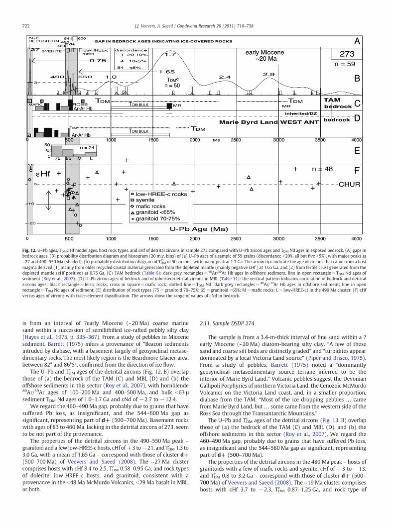
Fig. 12. U–Pb ages, TDMc Hf model ages, host rock types, and εHf of detrital zircons in sample 273 compared with U–Pb zircon ages and TDM Nd ages in exposed bedrock. (A) gaps inbedrock ages. (B) probability distribution diagram and histogram (20 m.y. bins) of (a) U–Pb ages of a sample of 59 grains (discordance b20%, all but five b5%), with major peaks at~27 and 490–550 Ma (shaded). (b) probability distribution diagram of TDMC of 50 zircons, with major peak at 1.7 Ga. The arrow tips indicate the age of zircons that came from a hostmagma derived (1) mainly from older recycled crustal material generated from the depleted mantle (mainly negative εHf ) at 1.65 Ga, and (2) from fertile crust generated from thedepleted mantle (εHf positive) at 0.75 Ga. (C) TAM bedrock (Table 6); dark grey rectangles=40Ar/39Ar Hb ages in offshore sediment, line in open rectangle=TDM Nd ages ofsediment (Roy et al., 2007). (D) U–Pb zircon ages of bedrock and of inherited/detrital zircons in MBL (Table 11): the vertical pattern indicates correlation of bedrock and detritalzircons ages; black rectangle=felsic rocks; cross in square=mafic rock; dotted line=TDM Nd; dark grey rectangles=40Ar/39Ar Hb ages in offshore sediment; line in openrectangle=TDM Nd ages of sediment. (E) distribution of rock types (75=granitoid 70–75%; 65=granitoid b65%; M=mafic rocks; L=low-HREE-c) in the 490 Ma cluster. (F) εHfversus ages of zircons with trace-element classification. The arrows show the range of values of εNd in bedrock.
722 J.J. Veevers, A. Saeed / Gondwana Research 20 (2011) 710–738
is from an interval of ?early Miocene (~20 Ma) coarse marinesand within a succession of semilithified ice-rafted pebbly silty clay(Hayes et al., 1975, p. 335–367). From a study of pebbles in Miocenesediment, Barrett (1975) infers a provenance of “Beacon sedimentsintruded by diabase, with a basement largely of geosynclinal metase-dimentary rocks. The most likely region is the Beardmore Glacier area,between 82° and 86°S″, confirmed from the direction of ice flow.
The U–Pb and TDMc ages of the detrital zircons (Fig. 12, B) overlapthose of (a) the bedrock of the TAM (C) and MBL (D) and (b) theoffshore sediments in this sector (Roy et al., 2007), with hornblende40Ar/39Ar ages of 100–200 Ma and 400–500 Ma, and bulk b63 μsediment TDM Nd ages of 1.0–1.7 Ga and εNd of −2.7 to −12.4.
We regard the 460–490 Ma gap, probably due to grains that havesuffered Pb loss, as insignificant, and the 544–600 Ma gap assignificant, representing part of d+ (500–700 Ma). Basement rockswith ages of 83 to 460 Ma, lacking in the detrital zircons of 273, seemto be not part of the provenance.
The properties of the detrital zircons in the 490–550 Ma peak –
granitoid and a few low-HREE-c hosts, εHf of+3 to−21, and TDMc 1.3 to3.0 Ga, with a mean of 1.65 Ga – correspond with those of cluster d+(500–700 Ma) of Veevers and Saeed (2008). The ~27 Ma clustercomprises hosts with εHf 8.4 to 2.5, TDMc 0.58–0.95 Ga, and rock typesof dolerite, low-HREE-c hosts, and granitoid, consistent with aprovenance in the b48 Ma McMurdo Volcanics, b29 Ma basalt in MBL,or both.
2.11. Sample DSDP 274
The sample is from a 3.4-m-thick interval of fine sand within a ?early Miocene (~20 Ma) diatom-bearing silty clay. “A few of thesesand and coarse silt beds are distinctly graded” and “turbidites appeardominated by a local Victoria Land source” (Piper and Brisco, 1975).From a study of pebbles, Barrett (1975) noted a “dominantlygeosynclinal metasedimentary source terrane inferred to be theinterior of Marie Byrd Land.” Volcanic pebbles suggest the DevonianGallipoli Porphyries of northern Victoria Land, the Cenozoic McMurdoVolcanics on the Victoria Land coast, and, in a smaller proportion,diabase from the TAM. “Most of the ice dropping pebbles … camefromMarie Byrd Land, but… some came from the western side of theRoss Sea through the Transantarctic Mountains.”
The U–Pb and TDMc ages of the detrital zircons (Fig. 13, B) overlapthose of (a) the bedrock of the TAM (C) and MBL (D), and (b) theoffshore sediments in this sector (Roy et al., 2007). We regard the460–490 Ma gap, probably due to grains that have suffered Pb loss,as insignificant and the 544–580 Ma gap as significant, representingpart of d+ (500–700 Ma).
The properties of the detrital zircons in the 480 Ma peak – hosts ofgranitoids with a few of mafic rocks and syenite, εHf of +3 to −13,and TDMc 0.8 to 3.2 Ga – correspond with those of cluster d+ (500–700 Ma) of Veevers and Saeed (2008). The ~19 Ma cluster compriseshosts with εHf 3.7 to −2.3, TDMc 0.87–1.25 Ga, and rock type of

Fig. 13. U–Pb ages, TDMc Hf model ages, host rock types, and εHf of detrital zircons in sample 274 compared with U–Pb zircon ages and TDM Nd ages in exposed bedrock. (A) gaps inbedrock ages. (B) probability distribution diagram and histogram (20 m.y. bins) of (a) U–Pb ages of a sample of 56 grains (discordance b20%, all but eight b5%), with major peaks at19 and 480 Ma (shaded). (b) probability distribution diagram of TDMC of 34 zircons, withmajor peaks at 1.2 and 1.7 Ga. The arrow tips indicate the age of zircons that came from a hostmagma derived (1) mainly from older recycled crustal material generated from the depleted mantle (mainly negative εHf ) at 1.75 Ga, and (2) frommixed recycled and fertile crustgenerated from the depleted mantle (εHf around zero) at 1.0 Ga. (C) TAM bedrock (Table 6); dark grey rectangles=40Ar/39Ar Hb ages in offshore sediment; line in openrectangle=TDM Nd ages of sediment (Roy et al., 2007). (D) U–Pb zircon ages of bedrock and of inherited/detrital zircons in MBL (Table 11): the vertical pattern indicates correlationof bedrock and detrital zircons ages; black rectangle=felsic rocks; cross in square=mafic rock; dotted line=TDMNd; dark grey rectangles=40Ar/39Ar Hb ages in offshore sediment;line in open rectangle=TDM Nd ages of sediment. (E) distribution of rock types (75=granitoid 70–75%; 65=granitoid b65%; M=mafic rocks; L=low-HREE-c) in the 480 Macluster. (F) εHf versus ages of zircons with trace-element classification. The arrows show the range of values of εNd in bedrock.
723J.J. Veevers, A. Saeed / Gondwana Research 20 (2011) 710–738
dolerite, consistent with a provenance in the b48 Ma McMurdoVolcanics, b29 Ma basalt in MBL, or both.
2.12. Ages of detrital zircons in Permian–Triassic formations in theShackleton Glacier area and Quaternary glacial till in the Byrd Glacierand Ross Sea areas
Samples CR-LP come from the Late Permian–Early Triassic Buckleyand Fremouw Formations (Elliot and Fanning, 2008), shown bypaleocurrents and petrography to have been sourced from the WestAntarctic magmatic arc (Collinson et al., 1994, figs. 18 and 19). Theages of detrital zircons (Fig. 14, D) are clustered: (1) 237–(260)–297 Ma; (2)–372 Ma; (3) 462–(570)–600 Ma. The oldest significantage is 590 Ma, and older ages (? from East Antarctica) are lacking. Themajor peak at 260 Ma (Late Permian) correlates with the age oftuffaceous volcaniclastic sandstone in this part of the TAM (Collinsonet al., 1994, fig. 7) and the 253 MaMBL Kinsey Ridge granite (Table 11).The minor peak of 372 Ma correlates with the 373–375 Ma ages ofthe Hermann and Gutenko Nunataks (Ford) granodiorite and 353–369 Ma granite ofMBL (Table 11); the 351–365 Ma granites of northernVictoria Land, 1500 km distant to the north, are out of range. Elliot andFanning (2008) interpret the 462–(570)–600 Ma (d+) zircons as“reworked from sandstones … exposed in the Permian-TriassicGondwanide orogen as a result of the uplift of a fold and thrust beltby late Permian time.”
Palmer and Licht (2007) and Palmer (2008) dated zircons fromQuaternary glacial till in the proximal Byrd Glacier alone (Fig. 14, E)and in the combined Byrd Glacier and distal Ross Sea (F). Except~100 Ma ages in the Ross Sea (Fig. 14, F), the age profiles of E and F are
essentially the same. The Bates Nunatak (BN) of the BeaconSupergroup and the Lonewolf Nunatak (LW) of the Ferrar Group arethe last vestiges of exposed bedrock at the head of the Byrd Glacier(BG) (Palmer and Licht, 2007), so that morainal till from theselocalities indicates bedrock west of the TAM in the ice drainagebasin that heads in ice dome A and ridge B, and includes the VSHand a flank of the GSM (Fig. 1, light grey). The ages of detrital zirconsin the pooled sample (n=302 of ages with standard deviationbb50 Ma) of the morainal till (Fig. 14, E) are clustered: (1) majorcluster 520–(590 peak)–660 Ma, part of d+ 475–(540)–680 Ma of theGSM–VSH region (Veevers and Saeed, 2008); (2) 970–(1100)–1150 Ma, part of c 800–1200 Ma; (3) 1480–1600 Ma, part of a(1400–1700 Ma); (4) ~1940 Ma, aa; (5) 2200–(2240) –2300 Ma, aa′;(6) 2600–(2720)–2900 Ma, aaa. These peaks are the clearest proxiesfor ages in the East Antarctic drainage.
The combined sample from the Byrd Glacier and the central andwestern Ross Sea (Palmer, 2008) (Fig. 14, F) and those from DSDP 273and 274 (Fig. 14, G, H) have potential provenances in both East andWest Antarctic drainages. The biggest sample (n=995), in F,comprises clusters similar to those in E except for additional peaksat ~100 Ma and 340 Ma. The N500 Ma U–Pb ages, lacking in MBL,reflect those in the ice drainage basin that heads in ice dome A andridge B, and includes the VSH and a flank of the GSM, and reinforce theproxies found in E. The b500 Ma peaks at 340 Ma and 100 Maprobably reflect events in West Antarctica (Fig. 14, I), and the 240 Maages in either East or West Antarctica, or both.
From the data in Fig. 14, B (Tables 12, 13 and 14) and C (Table 6),we find the gaps (Table 15) shown in Fig. 14, A. In samples 273 and274 (Fig. 14, G and H), only the 544–634 Ma zircons (n=13)
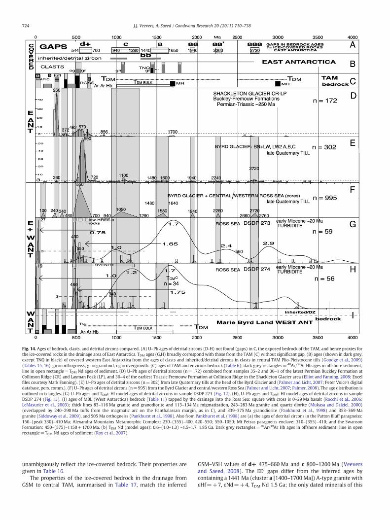
Fig. 14. Ages of bedrock, clasts, and detrital zircons compared. (A) U–Pb ages of detrital zircons (D-H) not found (gaps) in C, the exposed bedrock of the TAM, and hence proxies forthe ice-covered rocks in the drainage area of East Antarctica. TDM ages (G,H) broadly correspond with those from the TAM (C) without significant gap. (B) ages (shown in dark grey,except TNQ in black) of covered western East Antarctica from the ages of clasts and inherited/detrital zircons in clasts in central TAM Plio-Pleistocene tills (Goodge et al., 2009)(Tables 15, 16). gn=orthogneiss; gr=granitoid; og=overgrowth. (C) ages of TAM and environs bedrock (Table 6); dark grey rectangles=40Ar/39Ar Hb ages in offshore sediment;line in open rectangle=TDM Nd ages of sediment. (D) U–Pb ages of detrital zircons (n=172) combined from samples 35–2 and 36–1 of the latest Permian Buckley Formation atCollinson Ridge (CR) and Layman Peak (LP), and 36–4 of the earliest Triassic Fremouw Formation at Collinson Ridge in the Shackleton Glacier area (Elliot and Fanning, 2008; Excelfiles courtesy Mark Fanning). (E) U–Pb ages of detrital zircons (n=302) from late Quaternary tills at the head of the Byrd Glacier and (Palmer and Licht, 2007; Peter Voice's digitaldatabase, pers. comm.). (F) U–Pb ages of detrital zircons (n=995) from the Byrd Glacier and central/western Ross Sea (Palmer and Licht, 2007; Palmer, 2008). The age distribution isoutlined in triangles. (G) U–Pb ages and TDMc Hf model ages of detrital zircons in sample DSDP 273 (Fig. 12). (H), U–Pb ages and TDMc Hf model ages of detrital zircons in sampleDSDP 274 (Fig. 13). (I) ages of MBL (West Antarctica) bedrock (Table 11) tapped by the drainage into the Ross Sea: square with cross is 0–29 Ma basalt (Rocchi et al., 2006;LeMasurier et al., 2003); thick lines 83–116 Ma granite and granodiorite and 113–134 Ma migmatization, 243–283 Ma granite and quartz diorite (Mukasa and Dalziel, 2000)(overlapped by 240–290 Ma tuffs from the magmatic arc on the Panthalassan margin, as in C), and 339–375 Ma granodiorite (Pankhurst et al., 1998) and 353–369 Magranite (Siddoway et al., 2009), and 505 Ma orthogneiss (Pankhurst et al., 1998). Also from Pankhurst et al. (1998) are (a) the ages of detrital zircons in the Patton Bluff paragneiss:150–(peak 330)–410 Ma; Alexandra Mountains Metamorphic Complex: 230–(355)–400, 420–550; 550–1050; Mt Petras paragneiss enclave: 310–(355)–410; and the SwansonFormation: 450–(575)–1150+1700 Ma. (b) TDM Nd (model ages): 0.6–(1.0–1.3) –1.5–1.7, 1.85 Ga. Dark grey rectangles=40Ar/39Ar Hb ages in offshore sediment; line in openrectangle=TDM Nd ages of sediment (Roy et al., 2007).
724 J.J. Veevers, A. Saeed / Gondwana Research 20 (2011) 710–738
unambiguously reflect the ice-covered bedrock. Their properties aregiven in Table 16.
The properties of the ice-covered bedrock in the drainage fromGSM to central TAM, summarised in Table 17, match the inferred
GSM–VSH values of d+ 475–660 Ma and c 800–1200 Ma (Veeversand Saeed, 2008). The EE′ gaps differ from the inferred ages bycontaining a 1441 Ma (cluster a [1400–1700 Ma]) A-type granite withεHf=+7, εNd=+4, TDM Nd 1.5 Ga; the only dated minerals of this
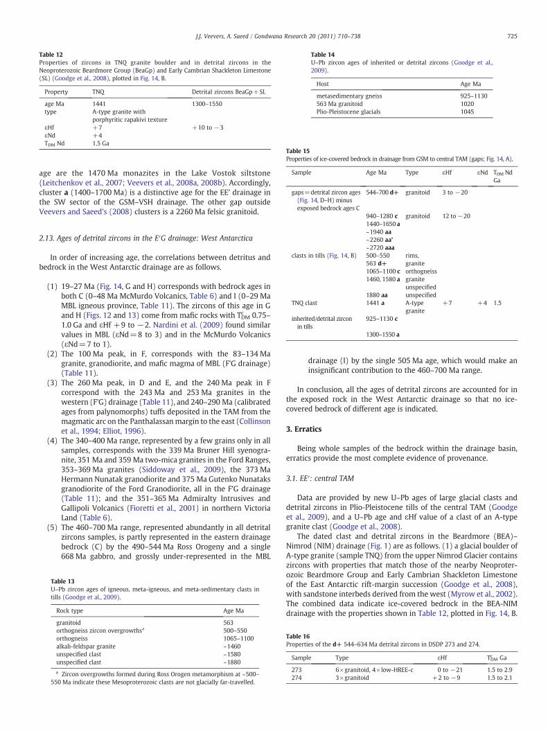
Table 12Properties of zircons in TNQ granite boulder and in detrital zircons in theNeoproterozoic Beardmore Group (BeaGp) and Early Cambrian Shackleton Limestone(SL) (Goodge et al., 2008), plotted in Fig. 14, B.
Property TNQ Detrital zircons BeaGp+SL
age Ma 1441 1300–1550type A-type granite with
porphyritic rapakivi textureεHf +7 +10 to −3εNd +4TDM Nd 1.5 Ga
Table 14U–Pb zircon ages of inherited or detrital zircons (Goodge et al.,2009).
Host Age Ma
metasedimentary gneiss 925–1130563 Ma granitoid 1020Plio-Pleistocene glacials 1045
Table 15Properties of ice-covered bedrock in drainage from GSM to central TAM (gaps; Fig. 14, A).
Sample Age Ma Type εHf εNd TDM NdGa
gaps=detrital zircon ages(Fig. 14, D–H) minusexposed bedrock ages C
544–700 d+ granitoid 3 to −20
940–1280 c granitoid 12 to−20
725J.J. Veevers, A. Saeed / Gondwana Research 20 (2011) 710–738
age are the 1470 Ma monazites in the Lake Vostok siltstone(Leitchenkov et al., 2007; Veevers et al., 2008a, 2008b). Accordingly,cluster a (1400–1700 Ma) is a distinctive age for the EE’ drainage inthe SW sector of the GSM–VSH drainage. The other gap outsideVeevers and Saeed's (2008) clusters is a 2260 Ma felsic granitoid.
1440–1650 a~1940 aa~2260 aa’~2720 aaa
clasts in tills (Fig. 14, B) 500–550563 d+
rims,granite
1065–1100 c orthogneiss1460, 1580 a granite
unspecified1880 aa unspecified
TNQ clast 1441 a A-typegranite
+7 +4 1.5
inherited/detrital zirconin tills
925–1130 c
1300–1550 a
2.13. Ages of detrital zircons in the E′G drainage: West Antarctica
In order of increasing age, the correlations between detritus andbedrock in the West Antarctic drainage are as follows.
(1) 19–27 Ma (Fig. 14, G and H) corresponds with bedrock ages inboth C (0–48 Ma McMurdo Volcanics, Table 6) and I (0–29 MaMBL igneous province, Table 11). The zircons of this age in Gand H (Figs. 12 and 13) come from mafic rocks with TDMc 0.75–1.0 Ga and εHf +9 to −2. Nardini et al. (2009) found similarvalues in MBL (εNd=8 to 3) and in the McMurdo Volcanics(εNd=7 to 1).
(2) The 100 Ma peak, in F, corresponds with the 83–134 Magranite, granodiorite, and mafic magma of MBL (F'G drainage)(Table 11).
(3) The 260 Ma peak, in D and E, and the 240 Ma peak in Fcorrespond with the 243 Ma and 253 Ma granites in thewestern (F'G) drainage (Table 11), and 240–290 Ma (calibratedages from palynomorphs) tuffs deposited in the TAM from themagmatic arc on the Panthalassanmargin to the east (Collinsonet al., 1994; Elliot, 1996).
(4) The 340–400 Ma range, represented by a few grains only in allsamples, corresponds with the 339 Ma Bruner Hill syenogra-nite, 351 Ma and 359 Ma two-mica granites in the Ford Ranges,353–369 Ma granites (Siddoway et al., 2009), the 373 MaHermann Nunatak granodiorite and 375 Ma Gutenko Nunataksgranodiorite of the Ford Granodiorite, all in the F'G drainage(Table 11); and the 351–365 Ma Admiralty Intrusives andGallipoli Volcanics (Fioretti et al., 2001) in northern VictoriaLand (Table 6).
(5) The 460–700 Ma range, represented abundantly in all detritalzircons samples, is partly represented in the eastern drainagebedrock (C) by the 490–544 Ma Ross Orogeny and a single668 Ma gabbro, and grossly under-represented in the MBL
Table 13U–Pb zircon ages of igneous, meta-igneous, and meta-sedimentary clasts intills (Goodge et al., 2009).
Rock type Age Ma
granitoid 563orthogneiss zircon overgrowthsa 500–550orthogneiss 1065–1100alkali-feldspar granite ~1460unspecified clast ~1580unspecified clast ~1880
a Zircon overgrowths formed during Ross Orogen metamorphism at ~500–550 Ma indicate these Mesoproterozoic clasts are not glacially far-travelled.
drainage (I) by the single 505 Ma age, which would make aninsignificant contribution to the 460–700 Ma range.
In conclusion, all the ages of detrital zircons are accounted for inthe exposed rock in the West Antarctic drainage so that no ice-covered bedrock of different age is indicated.
3. Erratics
Being whole samples of the bedrock within the drainage basin,erratics provide the most complete evidence of provenance.
3.1. EE′: central TAM
Data are provided by new U–Pb ages of large glacial clasts anddetrital zircons in Plio-Pleistocene tills of the central TAM (Goodgeet al., 2009), and a U–Pb age and εHf value of a clast of an A-typegranite clast (Goodge et al., 2008).
The dated clast and detrital zircons in the Beardmore (BEA)–Nimrod (NIM) drainage (Fig. 1) are as follows. (1) a glacial boulder ofA-type granite (sample TNQ) from the upper Nimrod Glacier containszircons with properties that match those of the nearby Neoproter-ozoic Beardmore Group and Early Cambrian Shackleton Limestoneof the East Antarctic rift-margin succession (Goodge et al., 2008),with sandstone interbeds derived from the west (Myrow et al., 2002).The combined data indicate ice-covered bedrock in the BEA-NIMdrainage with the properties shown in Table 12, plotted in Fig. 14, B.
Table 16Properties of the d+ 544–634 Ma detrital zircons in DSDP 273 and 274.
Sample Type εHf TDMc Ga
273 6×granitoid, 4×low-HREE-c 0 to −21 1.5 to 2.9274 3×granitoid +2 to −9 1.5 to 2.1
Table 17Properties of ice-covered bedrock (from clasts and detrital zircons) in drainage from GSM to central TAM compared with coeval clusters in Veevers and Saeed (2008).
Sample Age Ma Type εHf εNd TDMc HfGa
TDM NdGa
drainage EE′ gap (1) 544–634 granitoids, low-HREE-c hosts +2 to −21 1.5 to 2.9GSM–VSH d+ 475–660 mafic granitoid, low-HREE-c hosts +9 to −28 1.3 to 2.5drainage EE′ gap (2) 925–1280 orthogneiss, paragneiss felsic granitoid +13 to −8 1.2 to 2.4GSM–VSH c 800–1200 mafic granitoid, low-HREE-c hosts +11 to –28 1.3 to 1.8drainage EE′ gap (3) 1441, 1480–1650 A-type granite with Rapakivi texture +7 +4 1.5GSM–VSH a 1470 monazites Lake Vostok siltstonedrainage EE′ gap (4) ~1880 ~1940 clast –3.5 2.8
felsic granitoidGSM–VSH aa 1700–2200 mafic granitoid 0 to −20 2.7 to 3.1drainage EE′ gap (5) ~2260 felsic granitoidGSM–VSH not knowndrainage EE′ gap (6) ~2720 mafic granitoid +3.8, –2.3 2.9, 3.8GSM–VSH aaa 2600–2900
726 J.J. Veevers, A. Saeed / Gondwana Research 20 (2011) 710–738
(2) igneous, meta-igneous, and meta-sedimentary clasts in tills(Goodge et al., 2009), with ages of 563, 1065, 1460, 1580, 1880 Ma(Table 13 and Fig. 14, B). These ages are unknown in the TAM(Fig. 14, C)except the 500–550 Ma overgrowths (dark grey) on zircon in clasts. Byregarding the 500–550 Ma ages as confined to the Ross Orogen, Goodgeet al. (2009) imply that the clasts come froman ice-covered terraneonlya short distance west of the exposed Ross Orogen. We question thisidea by showing (below) that 500–550 Ma ages are widespread inEast Antarctica, and not confined to the Ross Orogen. (3) inherited ordetrital zircons in tills (Goodge et al., 2009), with ages ~1000 Ma(Table 14).
Table 19U–Pb ages of inherited or detrital zircons (from Goodge and Fanning, 2010, p. 1135,figs. 8B, 13A, B).
Source of zircons Age Ma
metamorphic rockswith inherited zircons
600–800900–1300~1750
3.2. Rock clasts in dredge hauls in DE off the Mertz Glacier and detritalzircons in Oligocene–Pleistocene sediment and Permian and EarlyJurassic sandstone
Goodge and Fanning (2010) classified 1359 individual pebble- tocobble-sized clasts in the NBP 01–01 collection from the Wilkes Landmargin as 81%metamorphic (42% phyllite, 33% psammite, 4% gneiss, 2%schist, granulite gneiss, charnockite gneiss, quartzite), 14% igneous (13%granite, 1%diabase), and5%sedimentary (arenite). “Low-grade siliceousmetasedimentary rocks, coupled with a heterogeneous mixture ofigneous and high-grade meta-igneous rock types, dominate the glacialprovenance”. Fourteen igneousandmetamorphic rock clastsweredated(Table 18): five between 506 Ma and 519 Ma, N556 Ma, 584 Ma, and
Table 18U–Pb zircon ages of rock clasts in dredge hauls off George V Land, fromGoodge and Fanning (2010, table 1).
Rock type Age Ma
Ms-Bt gneiss 481–2860a
Ms-Bt granite 484–2996 a
Ms-Bt granite 506±6Ms-Bt granite 508±5Bt granite 510±5Ms-Bt granite 516±6Ms-Bt granite gneiss 519±6Ms-Bt gneiss 558–1293a
Ms-Bt granite gneiss N556Ms-Bt gneiss 582–2018a
leucocratic Ms-Bt microgranite 584±13Grt-Hbl-Cpx granulite gneiss 1722±10Bt-Hbl monzodiorite 1725±9Bt-Grt-Opx charnockitic gneiss 1741±8
Bt=biotite; Cpx=clinopyroxene; Grt=garnet; Hbl=hornblende;Ms=muscovite; Opx=orthopyroxene.
a Range of xenocrystic or relict detrital zircons. Ages of other recycledzircons are given in Table 19.
three between 1722 Ma and 1741 Ma; the remaining four had a rangeof inherited ages going back to ~3000 Ma.
Ages of inherited zircons in metamorphic rocks (600 to 3400 Ma)and of detrital zircons in Oligocene–Pleistocene glaciomarine sedi-ment (400 to 2605 Ma), and Permian (420 [560] [1000] to 3070 Ma)and Early Jurassic sandstone (191 [560] [1000] to 2900 Ma) innorthern Victoria Land, are given in Table 19.
3.3. George V–Adelie continental shelf
In a study of glacial and marine glacial deposits on the George V–Adelie continental shelf, Domack (1982) found diamictons containingN20% pink garnet, reflecting high-grade metamorphic hosts, andothers with abundant grains of dolerite and clinopyroxene, reflectingthe Ferrar dolerite.
1900–21002250–2320~2700~2850~3170~3400
glaciomarine sedimentdetrital zircons
460–6601045–13151545–18152420–2605
Early Jurassic SectionPeak Formation
191265450(560)(635)700800(1000)1150160027002900
Permian Takrouna Formation 420(434)(472)(560)570610800860980(1000)109012002140(2150)(2275)23602640(2650)27003070
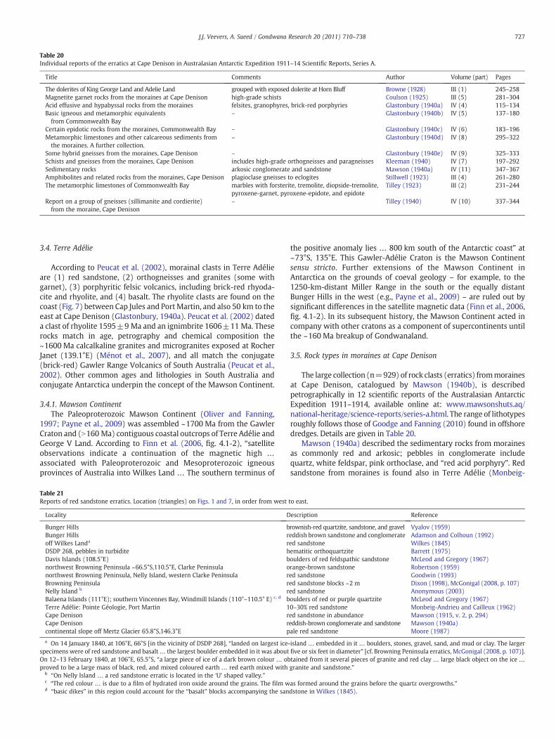
Table 20Individual reports of the erratics at Cape Denison in Australasian Antarctic Expedition 1911–14 Scientific Reports, Series A.
Title Comments Author Volume (part) Pages
The dolerites of King George Land and Adelie Land grouped with exposed dolerite at Horn Bluff Browne (1928) III (1) 245–258Magnetite garnet rocks from the moraines at Cape Denison high-grade schists Coulson (1925) III (5) 281–304Acid effusive and hypabyssal rocks from the moraines felsites, granophyres, brick-red porphyries Glastonbury (1940a) IV (4) 115–134Basic igneous and metamorphic equivalentsfrom Commonwealth Bay
– Glastonbury (1940b) IV (5) 137–180
Certain epidotic rocks from the moraines, Commonwealth Bay – Glastonbury (1940c) IV (6) 183–196Metamorphic limestones and other calcareous sediments fromthe moraines. A further collection.
– Glastonbury (1940d) IV (8) 295–322
Some hybrid gneisses from the moraines, Cape Denison – Glastonbury (1940e) IV (9) 325–333Schists and gneisses from the moraines, Cape Denison includes high-grade orthogneisses and paragneisses Kleeman (1940) IV (7) 197–292Sedimentary rocks arkosic conglomerate and sandstone Mawson (1940a) IV (11) 347–367Amphibolites and related rocks from the moraines, Cape Denison plagioclase gneisses to eclogites Stillwell (1923) III (4) 261–280The metamorphic limestones of Commonwealth Bay marbles with forsterite, tremolite, diopside-tremolite,
pyroxene-garnet, pyroxene-epidote, and epidoteTilley (1923) III (2) 231–244
Report on a group of gneisses (sillimanite and cordierite)from the moraine, Cape Denison
– Tilley (1940) IV (10) 337–344
727J.J. Veevers, A. Saeed / Gondwana Research 20 (2011) 710–738
3.4. Terre Adélie
According to Peucat et al. (2002), morainal clasts in Terre Adélieare (1) red sandstone, (2) orthogneisses and granites (some withgarnet), (3) porphyritic felsic volcanics, including brick-red rhyoda-cite and rhyolite, and (4) basalt. The rhyolite clasts are found on thecoast (Fig. 7) between Cap Jules and Port Martin, and also 50 km to theeast at Cape Denison (Glastonbury, 1940a). Peucat et al. (2002) dateda clast of rhyolite 1595±9 Ma and an ignimbrite 1606±11 Ma. Theserocks match in age, petrography and chemical composition the~1600 Ma calcalkaline granites and microgranites exposed at RocherJanet (139.1°E) (Ménot et al., 2007), and all match the conjugate(brick-red) Gawler Range Volcanics of South Australia (Peucat et al.,2002). Other common ages and lithologies in South Australia andconjugate Antarctica underpin the concept of the Mawson Continent.
3.4.1. Mawson ContinentThe Paleoproterozoic Mawson Continent (Oliver and Fanning,
1997; Payne et al., 2009) was assembled ~1700 Ma from the GawlerCraton and (N160 Ma) contiguous coastal outcrops of Terre Adélie andGeorge V Land. According to Finn et al. (2006, fig. 4.1-2), “satelliteobservations indicate a continuation of the magnetic high …
associated with Paleoproterozoic and Mesoproterozoic igneousprovinces of Australia into Wilkes Land … The southern terminus of
Table 21Reports of red sandstone erratics. Location (triangles) on Figs. 1 and 7, in order from west
Locality D
Bunger Hills bBunger Hills roff Wilkes Landa rDSDP 268, pebbles in turbidite hDavis Islands (108.5°E) bnorthwest Browning Peninsula ~66.5°S,110.5°E, Clarke Peninsula onorthwest Browning Peninsula, Nelly Island, western Clarke Peninsula rBrowning Peninsula rNelly Island b rBalaena Islands (111°E); southern Vincennes Bay, Windmill Islands (110°–110.5° E) c, d bTerre Adélie: Pointe Géologie, Port Martin 1Cape Denison rCape Denison rcontinental slope off Mertz Glacier 65.8°S,146.3°E p
a On 14 January 1840, at 106°E, 66°S [in the vicinity of DSDP 268], “landed on largest ice-specimens were of red sandstone and basalt… the largest boulder embedded in it was aboutOn 12–13 February 1840, at 106°E, 65.5°S, “a large piece of ice of a dark brown colour … obproved to be a large mass of black, red, and mixed coloured earth … red earth mixed with
b “On Nelly Island … a red sandstone erratic is located in the ‘U’ shaped valley.”c “The red colour … is due to a film of hydrated iron oxide around the grains. The film wd “basic dikes” in this region could account for the “basalt” blocks accompanying the san
the positive anomaly lies … 800 km south of the Antarctic coast” at~73°S, 135°E. This Gawler-Adélie Craton is the Mawson Continentsensu stricto. Further extensions of the Mawson Continent inAntarctica on the grounds of coeval geology – for example, to the1250-km-distant Miller Range in the south or the equally distantBunger Hills in the west (e.g., Payne et al., 2009) – are ruled out bysignificant differences in the satellite magnetic data (Finn et al., 2006,fig. 4.1-2). In its subsequent history, the Mawson Continent acted incompany with other cratons as a component of supercontinents untilthe ~160 Ma breakup of Gondwanaland.
3.5. Rock types in moraines at Cape Denison
The large collection (n=929) of rock clasts (erratics) frommorainesat Cape Denison, catalogued by Mawson (1940b), is describedpetrographically in 12 scientific reports of the Australasian AntarcticExpedition 1911–1914, available online at: www.mawsonshuts.aq/national-heritage/science-reports/series-a.html. The range of lithotypesroughly follows those of Goodge and Fanning (2010) found in offshoredredges. Details are given in Table 20.
Mawson (1940a) described the sedimentary rocks from morainesas commonly red and arkosic; pebbles in conglomerate includequartz, white feldspar, pink orthoclase, and “red acid porphyry”. Redsandstone from moraines is found also in Terre Adélie (Monbeig-
to east.
escription Reference
rownish-red quartzite, sandstone, and gravel Vyalov (1959)eddish brown sandstone and conglomerate Adamson and Colhoun (1992)ed sandstone Wilkes (1845)ematitic orthoquartzite Barrett (1975)oulders of red feldspathic sandstone McLeod and Gregory (1967)range-brown sandstone Robertson (1959)ed sandstone Goodwin (1993)ed sandstone blocks ~2 m Dixon (1998), McGonigal (2008, p. 107)ed sandstone Anonymous (2003)oulders of red or purple quartzite McLeod and Gregory (1967)0–30% red sandstone Monbeig-Andrieu and Cailleux (1962)ed sandstone in abundance Mawson (1915, v. 2, p. 294)eddish-brown conglomerate and sandstone Mawson (1940a)ale red sandstone Moore (1987)
island … embedded in it … boulders, stones, gravel, sand, and mud or clay. The largerfive or six feet in diameter” [cf. Browning Peninsula erratics, McGonigal (2008, p. 107)].tained from it several pieces of granite and red clay … large black object on the ice …
granite and sandstone.”
as formed around the grains before the quartz overgrowths.”dstone in Wilkes (1845).
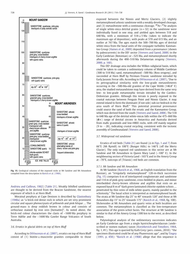
Fig. 15. Geological columns of the exposed rocks at Mt Sandow and Mt Amundsencompiled from the description in Ravich et al. (1968).
728 J.J. Veevers, A. Saeed / Gondwana Research 20 (2011) 710–738
Andrieu and Cailleux, 1962) (Table 21). Weakly lithified sandstonesare thought to be derived from the Beacon Sandstone, the nearestexposure of which is at Horn Bluff.
Morainal porphyry at Cape Denison is described by Glastonbury(1940a) as “a brick-red dense rock in which are set very prominentcircular and square phenocryusts of yellowish and pink felspar… Theground-mass is deep reddish brown in colour and consists oforthoclase stained by iron ores [hematite]”. As noted above, thebrick-red colour characterizes the clasts of ~1600 Ma porphyry inTerre Adélie and the ~1600 Ma Gawler Range Volcanics of SouthAustralia.
3.6. Erratics in glacial debris on top of Horn Bluff
According to DiVincenzo et al. (2007), erratics on top of Horn Bluffconsist of (1) biotite±muscovite granites comparable to those
exposed between the Ninnis and Mertz Glaciers, (2) slightlymetamorphosed arkosic sandstonewith a weakly developed cleavage,and (3) metasiltstone with a continuous cleavage. 40Ar–39Ar analysisof single white-mica detrital grains (n=32) in the sandstone wereindividually fused in one step, and yielded ages between 518 and640 Ma, with a minimum of 518±5 Ma (taken to indicate themaximum age of deposition), with peaks at 570 and 615 Ma, and anoutlier at 767 Ma. The ages match the 500–700 Ma ages of detritalwhite-mica from the basal units of the conjugate turbiditic Kanman-too Group (Haines et al., 2009) deposited from a provenance (shownby paleocurrents) in the DD′ sector (Veevers and Saeed, 2008) in theEarly Cambrian (Botomian) or ~525 Ma, and metamorphosed shortlyafterwards during the 490–510 Ma Delamerian orogeny (Veevers,2000, p. 160).
This DD′ drainage area includes the Wilkes subglacial basin, whichcould be taken to contain a sedimentary column of Middle Cambrian(500 to 518 Ma) sand, metamorphosed ~500 Ma (Ross orogeny), andsucceeded at Horn Bluff by Permian–Triassic sandstone intruded byEarly Jurassic Ferrar sills. According to DiVincenzo et al. (2007), “Due toits petrographical similarity with the low-grade metasedimentsoccurring in the ~500-Ma-old granites of the Cape Webb (146.8° E)area, the studied metasandstone may have derived from the same verylow- to low-grade metamorphic terrain intruded by the Cambro-Ordovician granites. Although this terrain is poorly exposed in thecoastal outcrops between Penguin Point and Ninnis Glacier, it mayextend inland to form the dominant (if not sole) sub-ice bedrock in thearea south of Horn Bluff.” This potential proximal provenancecould source the sand of both the erratic and the Kanmantoo Group,which was derived from the south (Veevers and Saeed, 2008). The 518to 640 Ma age of the detrital white-micas falls within the 475–660 Ma(d+) range of detrital zircons in Antarctica and Australia derivedfrom mafic granitoids and low-HREE rocks, with εHf mainly negative(9 to −28), indicating crustal recycling, consistent with the tectonicassembly of Gondwanaland (Veevers and Saeed, 2008).
3.7. Widespread red sandstone
Erratics of red beds (Table 21) are found (Δ in Figs. 1 and 7) from66°E (Mt Rymill) to 100°E (Bunger Hills) to 146°E (off the MertzGlacier). The only exposed red sandstones in this sector are at MtSandow and Mt Amundsen in Queen Mary Land (~100° E). In theneighbouring sectors of Victoria Land ~165°E and in the Amery Groupat ~70°E, outcrops of (Triassic) red beds are common.
3.7.1. Mt Sandow and Mt AmundsenAt Mt Sandow (Ravich et al., 1968, an English translation from the
Russian), an “irregularly metamorphosed” 120-m-thick succession(Fig. 15) comprises 6 m of interlayered conglomerate and sandstoneand 114 m of pink-grey sandstone, cross-bedded in places, and minorinterbedded cherry-brown siltstone and argillite that rests on anexposed basal 8 m of “dark green laminated chlorite-epidote schists…penetrated by thin veins of milk-white quartz, mainly parallel to theschistosity.” The basal schist is interpreted as metamorphosed basalt.The strata at Mt Sandow dip 25° to 40° towards 120° and those at MtAmundsen dip 15° to 25° towards 175° (Ravich et al., 1968, fig. 100).Slickensides at Mt Amundsen and quartz veins at both localities arecommon. The metamorphism is classified as the low-temperatureassociation of the green-schist facies. The structure at Mt Sandow issimilar to that of the Amery Group 1300 km to the west, as describedbelow.
Palynological analysis of the sedimentary succession indicatesan Early Cambrian age from a single hystrichospheridacean (unde-scribed or nomen nudum) taxon (Korotkevich and Timofeev, 1964,fig. 1, #1). This age is queried by Kath Grey (pers. comm., 2010): “thespecimen illustrated could be of any Phanerozoic age”, and by Tingey(1991, p. 458): “Ravich et al. (1968) allege that this sequence is
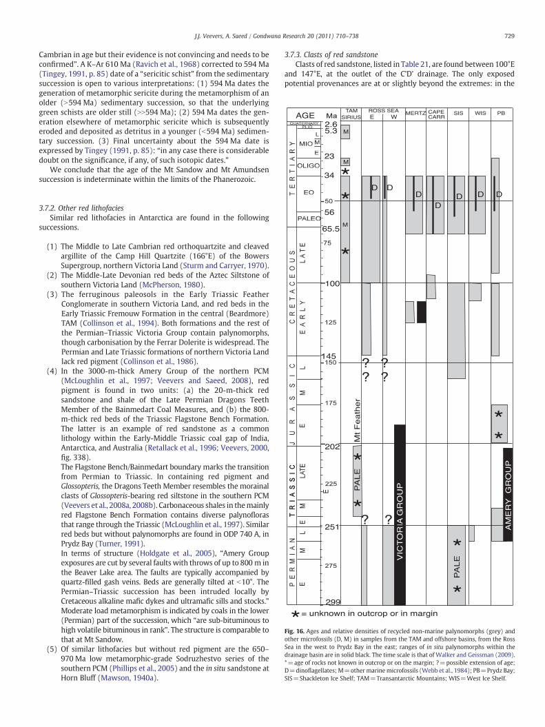
729J.J. Veevers, A. Saeed / Gondwana Research 20 (2011) 710–738
Cambrian in age but their evidence is not convincing and needs to beconfirmed”. A K–Ar 610 Ma (Ravich et al., 1968) corrected to 594 Ma(Tingey, 1991, p. 85) date of a “sericitic schist” from the sedimentarysuccession is open to various interpretations: (1) 594 Ma dates thegeneration of metamorphic sericite during the metamorphism of anolder (N594 Ma) sedimentary succession, so that the underlyinggreen schists are older still (NN594 Ma); (2) 594 Ma dates the gen-eration elsewhere of metamorphic sericite which is subsequentlyeroded and deposited as detritus in a younger (b594 Ma) sedimen-tary succession. (3) Final uncertainty about the 594 Ma date isexpressed by Tingey (1991, p. 85): “in any case there is considerabledoubt on the significance, if any, of such isotopic dates.”
We conclude that the age of the Mt Sandow and Mt Amundsensuccession is indeterminate within the limits of the Phanerozoic.
Fig. 16. Ages and relative densities of recycled non-marine palynomorphs (grey) andother microfossils (D, M) in samples from the TAM and offshore basins, from the RossSea in the west to Prydz Bay in the east; ranges of in situ palynomorphs within thedrainage basin are in solid black. The time scale is that of Walker and Geissman (2009).*=age of rocks not known in outcrop or on the margin; ?=possible extension of age;D=dinoflagellates; M=other marinemicrofossils (Webb et al., 1984); PB=Prydz Bay;SIS=Shackleton Ice Shelf; TAM=Transantarctic Mountains; WIS=West Ice Shelf.
3.7.2. Other red lithofaciesSimilar red lithofacies in Antarctica are found in the following
successions.
(1) The Middle to Late Cambrian red orthoquartzite and cleavedargillite of the Camp Hill Quartzite (166°E) of the BowersSupergroup, northern Victoria Land (Sturm and Carryer, 1970).
(2) The Middle-Late Devonian red beds of the Aztec Siltstone ofsouthern Victoria Land (McPherson, 1980).
(3) The ferruginous paleosols in the Early Triassic FeatherConglomerate in southern Victoria Land, and red beds in theEarly Triassic Fremouw Formation in the central (Beardmore)TAM (Collinson et al., 1994). Both formations and the rest ofthe Permian–Triassic Victoria Group contain palynomorphs,though carbonisation by the Ferrar Dolerite is widespread. ThePermian and Late Triassic formations of northern Victoria Landlack red pigment (Collinson et al., 1986).
(4) In the 3000-m-thick Amery Group of the northern PCM(McLoughlin et al., 1997; Veevers and Saeed, 2008), redpigment is found in two units: (a) the 20-m-thick redsandstone and shale of the Late Permian Dragons TeethMember of the Bainmedart Coal Measures, and (b) the 800-m-thick red beds of the Triassic Flagstone Bench Formation.The latter is an example of red sandstone as a commonlithology within the Early-Middle Triassic coal gap of India,Antarctica, and Australia (Retallack et al., 1996; Veevers, 2000,fig. 338).The Flagstone Bench/Bainmedart boundary marks the transitionfrom Permian to Triassic. In containing red pigment andGlossopteris, the Dragons Teeth Member resembles the morainalclasts of Glossopteris-bearing red siltstone in the southern PCM(Veevers et al., 2008a, 2008b). Carbonaceous shales in themainlyred Flagstone Bench Formation contains diverse palynoflorasthat range through the Triassic (McLoughlin et al., 1997). Similarred beds but without palynomorphs are found in ODP 740 A, inPrydz Bay (Turner, 1991).In terms of structure (Holdgate et al., 2005), “Amery Groupexposures are cut by several faults with throws of up to 800 m inthe Beaver Lake area. The faults are typically accompanied byquartz-filled gash veins. Beds are generally tilted at b10°. ThePermian–Triassic succession has been intruded locally byCretaceous alkaline mafic dykes and ultramafic sills and stocks.”Moderate load metamorphism is indicated by coals in the lower(Permian) part of the succession, which “are sub-bituminous tohigh volatile bituminous in rank”. The structure is comparable tothat at Mt Sandow.
(5) Of similar lithofacies but without red pigment are the 650–970 Ma low metamorphic-grade Sodruzhestvo series of thesouthern PCM (Phillips et al., 2005) and the in situ sandstone atHorn Bluff (Mawson, 1940a).
3.7.3. Clasts of red sandstoneClasts of red sandstone, listed in Table 21, are found between 100°E
and 147°E, at the outlet of the C'D’ drainage. The only exposedpotential provenances are at or slightly beyond the extremes: in the

730 J.J. Veevers, A. Saeed / Gondwana Research 20 (2011) 710–738
west at Mt Sandow and Mt Amundsen (100°E), and in the east insouthern Victoria Land (166°E) and southward in the TAM to 180°E.This leaves the central part of the C′D′ drainage that radiates fromDome C as the most likely provenance of the red sandstone.
4. Recycled palynomorphs and other microfossils
Recycled microfossils, found offshore and in the Sirius tillite in theTAM, point to sedimentary provenances of Permian and younger ages.They complement evidence from detrital zircons, which reflectterranes overwhelmingly older than ~450 Ma.
4.1. Transantarctic Mountains
According to Webb et al. (1984), Webb and Harwood (1991), andMoriwaki et al. (1992), recycled Late Cretaceous, Paleocene, Eocene,late Oligocene, late Miocene, and Pliocene marine microfossils in theSirius tillite in the Reedy, Beardmore, and Ferrar Glacier areas (Fig. 16)were derived from the intermittently marine Wilkes Basin in thewest (Fig. 17). Fossil groups represented are diatoms, foraminifera,calcareous nannoplankton, silicoflagellates, radiolarians, sponge spic-ules, ostracodes, and (unspecified) palynomorphs. Evidence in theSirius tillite on Mount Feather (in the Ferrar Glacier area) of aprovenance west of the TAM (Hicock et al., 2003) is provided by(1) rare basement-derived metasedimentary clasts, and (2) recycledMiddle-Late Triassic palynomorphs (Fig. 16) that are much lighter incolour (“pale”) (less affected by the heat of dolerite intrusion) thanpalynomorphs fromBeacon strata in the area. Their source is inferred tobe intrusion-free strata some distance inland in or beyond the WilkesBasin (broad arrow, Fig. 17).
The derivation of Pliocene marine microfossils from a marineWilkes Basin is controversial (e.g., Gersonde et al., 1997; Ashworthet al., 2007) so that the presumed source is tentative.
4.2. Ross Sea
Truswell and Drewry (1984) found assemblages of palynomorphsin sediments of the eastern and western parts of the Ross Sea (Figs. 1and 16). Permian spores and pollen, closest taxonomically to those insouthern Victoria Land, can be traced via ice streams in the Ross IceShelf to the TAM between the Nimrod and Byrd Glaciers, and havetheir greatest concentration in the west. Triassic formations of theTAM contain diverse (60 species) spores and pollen but only onespecies (that ranges through the Late Permian and Triassic, shownby ? in Fig. 16) has been identified in the Ross Sea. Equally rare is thesingle Devonian spore found in the eastern Ross Sea but widelydistributed in the TAM. In the McMurdo Sound area, erratics ofEocene–Pliocene sandstone and mudstone with marine fossils arederived from the Victoria Land Basin beneath the Ross Ice Shelf(Stilwell and Feldmann, 2000).
The eastern Ross Sea contains the highest density of palyno-morphs, and they range from Late Cretaceous through Eocene, with alower density of Early Cretaceous (and possibly Jurassic) palyno-morphs. All these ages are seen in the west, but in much lowerdensity. The preservation of the Late Cretaceous through Eocenepalynomorphs is excellent, and their yellow colouration indicatesburial b1.5 km in a provenance that can be backtracked via icestreams to MBL. Middle to late Eocene dinoflagellates indicate marinestrata of this age within the provenance.
Truswell and Drewry (1984) conclude that the recycled palyno-morphs were deposited from a formerly expanded Ross Ice Shelf. “Themaintenance on the Ross Sea floor of distinct areas representing inputfrom ice drainage basins of East and West Antarctica indicates thatbottom currents have effected very little redistribution of debris afterdeposition.” The Cretaceous and younger forms are derived from localsources underneath the Ross Ice Shelf (middle Eocene and younger
known from drillholes, Fielding et al., 2008) or in West Antarctica, oralong the margin, and the Permian forms from the TAM. All of theseare proximal.
West of the Ross Sea, recycled palynomorphs are found in modernoffshore muds and sands off the Shackleton Ice Shelf (95°E), Cape Carr(131°E), and Mertz Glacier (146°E) (Fig. 1) (Truswell, 1982). In eachplace, the high density of palynomorphs suggests that “palynomorph-rich tills are probably not far distant, perhaps not more than 50 kmaway”, and currents have not transported the recycled material far.
4.3. Mertz Glacier Tongue
Besides “a single grain of Permian derivation” (Truswell, 1982), theoldest recycled palynomorphs resemble those in the nearby in situEarly Cretaceous (Aptian) organic-rich siltstone (marked by a blacksquare in Fig. 7, by A in a black square in Fig. 17, and a black bar inFig. 16) cored at a water depth of 1407 m in the George V Basin at67.75°S, 146.8°E (DF79-38) (Domack et al., 1980). The otherassemblage is latest Cretaceous through Eocene, and includes Eocenedinoflagellates, all likewise derivable from the margin. Similar resultswere found by Truswell (1987).
4.4. Offshore Cape Carr
The recycled palynomorphs off Cape Carr are nonmarine Albian–Cenomanian and marine latest Cretaceous–Eocene, including di-noflagellates. Truswell (1982) suggests that the recycled microfossilsare being eroded from strata exposed on the margin, and that theolder Cretaceous forms may have been originally incorporated intothe latest Cretaceous-Eocene deposits, and then re-eroded into themodern deposits.
4.5. Shackleton Ice Shelf
The samples off the Shackleton Ice Shelf are the most productive(1500–2000 grains per gram) (Truswell, 1982). The Permian sporesand pollen are excellently preserved (“pale”) in contrast with Permianpalynomorphs in the Amery Group (“fair”) and in the BeaconSupergroup of the TAM (“intense carbonisation during intrusion ofthe Jurassic Ferrar dolerites”). “This suggests that the Permian sourcebeds supplying this material have been neither deeply buried norsubjected to thermal metamorphism associated with igneous intru-sion”. The pale forms are postulated to have come from within thedrainage basin that widens north of Ridge B, marked “P pale” inFig. 17. Late Jurassic and Early Cretaceous spores and pollen are mostdiverse (30 species), and include 4 species found in the in situ EarlyCretaceous (Aptian) organic-rich siltstone in the George V Basin. Theprovenance of the reworked palynomorphs is probably a coast-parallel trough eroded out of Early Cretaceous (pre-breakup, N83 Ma)nonmarine sediment of the divergent margin (O'Brien and Stagg,2007; O'Brien et al., 2005; Stagg et al., 2004, 2005). The youngest ageof recycled spores and pollen (latest Cretaceous through Eocene) andof (marine) dinoflagellates (late Paleocene and Eocene) could have asimilar provenance in the post-breakup succession of the margin,including the late Paleocene and Eocene sediments deposited duringthe initial entry of oceanic waters.
4.6. West Ice Shelf
Kemp (1972) found reworkedmicrofossils in the bottom sedimentof the West Ice Shelf (77.5°E, 66.5°S) with ages of Late Permian (solidblack in Fig. 16), as in the exposed Amery Group, Albian (EarlyCretaceous), and latest Cretaceous through Eocene, including Eocenemarine dinoflagellates. As off the Shackleton Ice Shelf, the latestCretaceous through Eocene group could have a similar provenance in
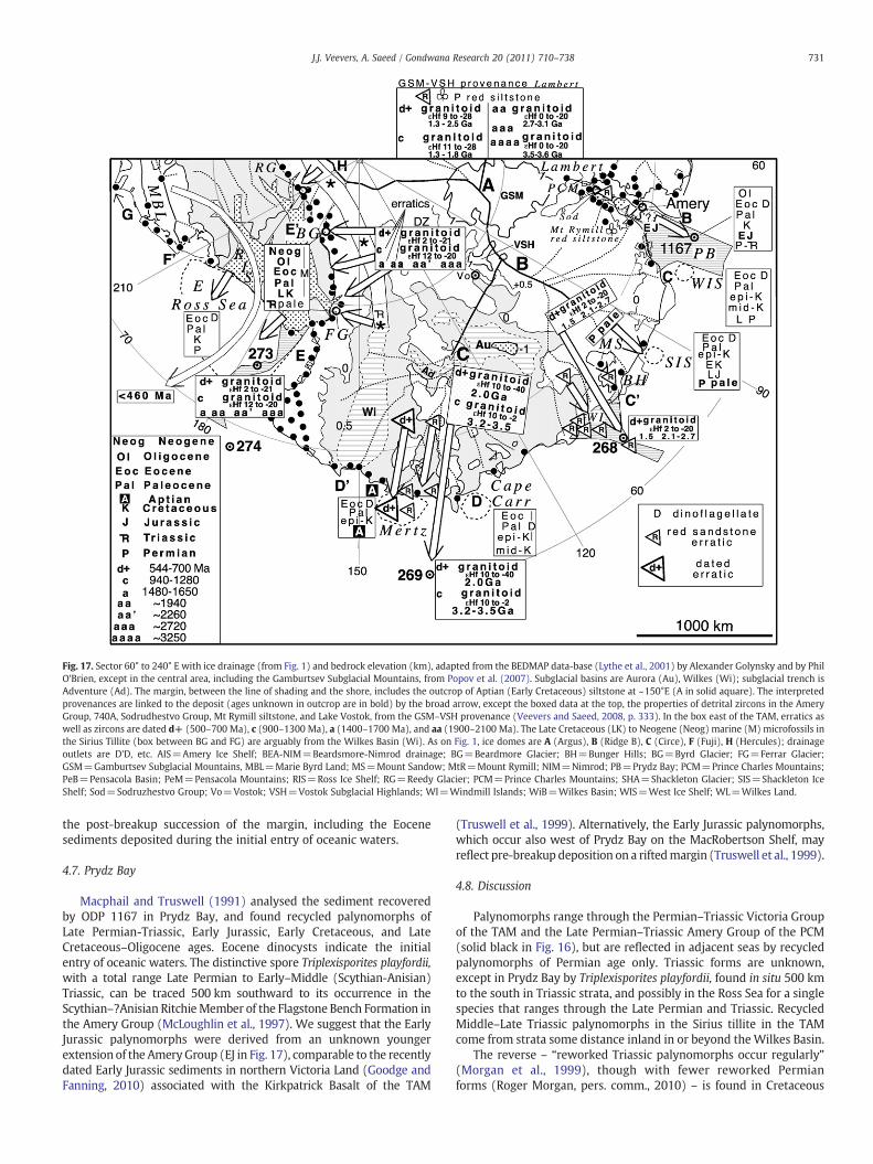
Fig. 17. Sector 60° to 240° E with ice drainage (from Fig. 1) and bedrock elevation (km), adapted from the BEDMAP data-base (Lythe et al., 2001) by Alexander Golynsky and by PhilO'Brien, except in the central area, including the Gamburtsev Subglacial Mountains, from Popov et al. (2007). Subglacial basins are Aurora (Au), Wilkes (Wi); subglacial trench isAdventure (Ad). The margin, between the line of shading and the shore, includes the outcrop of Aptian (Early Cretaceous) siltstone at ~150°E (A in solid aquare). The interpretedprovenances are linked to the deposit (ages unknown in outcrop are in bold) by the broad arrow, except the boxed data at the top, the properties of detrital zircons in the AmeryGroup, 740A, Sodrudhestvo Group, Mt Rymill siltstone, and Lake Vostok, from the GSM–VSH provenance (Veevers and Saeed, 2008, p. 333). In the box east of the TAM, erratics aswell as zircons are dated d+ (500–700 Ma), c (900–1300 Ma), a (1400–1700 Ma), and aa (1900–2100 Ma). The Late Cretaceous (LK) to Neogene (Neog) marine (M) microfossils inthe Sirius Tillite (box between BG and FG) are arguably from the Wilkes Basin (Wi). As on Fig. 1, ice domes are A (Argus), B (Ridge B), C (Circe), F (Fuji), H (Hercules); drainageoutlets are D'D, etc. AIS=Amery Ice Shelf; BEA-NIM=Beardsmore-Nimrod drainage; BG=Beardmore Glacier; BH=Bunger Hills; BG=Byrd Glacier; FG=Ferrar Glacier;GSM=Gamburtsev Subglacial Mountains, MBL=Marie Byrd Land; MS=Mount Sandow; MtR=Mount Rymill; NIM=Nimrod; PB=Prydz Bay; PCM=Prince Charles Mountains;PeB=Pensacola Basin; PeM=Pensacola Mountains; RIS=Ross Ice Shelf; RG=Reedy Glacier; PCM=Prince Charles Mountains; SHA=Shackleton Glacier; SIS=Shackleton IceShelf; Sod=Sodruzhestvo Group; Vo=Vostok; VSH=Vostok Subglacial Highlands; WI=Windmill Islands; WiB=Wilkes Basin; WIS=West Ice Shelf; WL=Wilkes Land.
731J.J. Veevers, A. Saeed / Gondwana Research 20 (2011) 710–738
the post-breakup succession of the margin, including the Eocenesediments deposited during the initial entry of oceanic waters.
4.7. Prydz Bay
Macphail and Truswell (1991) analysed the sediment recoveredby ODP 1167 in Prydz Bay, and found recycled palynomorphs ofLate Permian-Triassic, Early Jurassic, Early Cretaceous, and LateCretaceous–Oligocene ages. Eocene dinocysts indicate the initialentry of oceanic waters. The distinctive spore Triplexisporites playfordii,with a total range Late Permian to Early–Middle (Scythian-Anisian)Triassic, can be traced 500 km southward to its occurrence in theScythian–?Anisian RitchieMember of the Flagstone Bench Formation inthe Amery Group (McLoughlin et al., 1997). We suggest that the EarlyJurassic palynomorphs were derived from an unknown youngerextension of the AmeryGroup (EJ in Fig. 17), comparable to the recentlydated Early Jurassic sediments in northern Victoria Land (Goodge andFanning, 2010) associated with the Kirkpatrick Basalt of the TAM
(Truswell et al., 1999). Alternatively, the Early Jurassic palynomorphs,which occur also west of Prydz Bay on the MacRobertson Shelf, mayreflect pre-breakup deposition on a riftedmargin (Truswell et al., 1999).
4.8. Discussion
Palynomorphs range through the Permian–Triassic Victoria Groupof the TAM and the Late Permian–Triassic Amery Group of the PCM(solid black in Fig. 16), but are reflected in adjacent seas by recycledpalynomorphs of Permian age only. Triassic forms are unknown,except in Prydz Bay by Triplexisporites playfordii, found in situ 500 kmto the south in Triassic strata, and possibly in the Ross Sea for a singlespecies that ranges through the Late Permian and Triassic. RecycledMiddle–Late Triassic palynomorphs in the Sirius tillite in the TAMcome from strata some distance inland in or beyond theWilkes Basin.
The reverse – “reworked Triassic palynomorphs occur regularly”(Morgan et al., 1999), though with fewer reworked Permianforms (Roger Morgan, pers. comm., 2010) – is found in Cretaceous
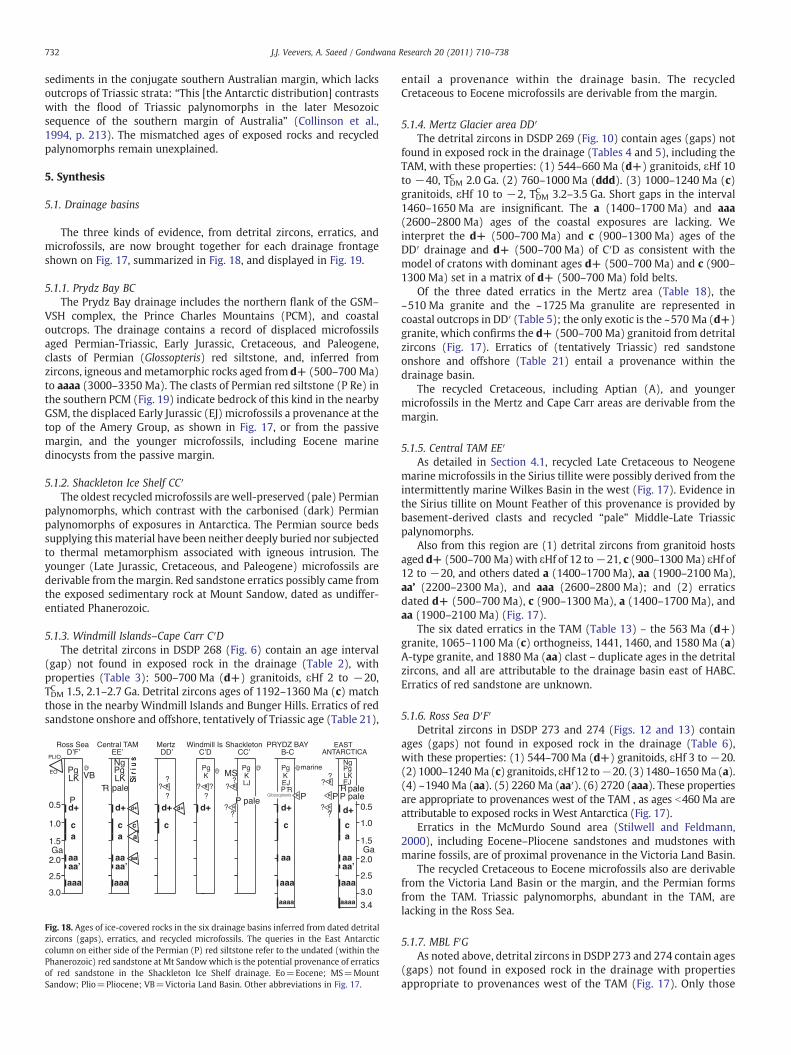
732 J.J. Veevers, A. Saeed / Gondwana Research 20 (2011) 710–738
sediments in the conjugate southern Australian margin, which lacksoutcrops of Triassic strata: “This [the Antarctic distribution] contrastswith the flood of Triassic palynomorphs in the later Mesozoicsequence of the southern margin of Australia” (Collinson et al.,1994, p. 213). The mismatched ages of exposed rocks and recycledpalynomorphs remain unexplained.
5. Synthesis
5.1. Drainage basins
The three kinds of evidence, from detrital zircons, erratics, andmicrofossils, are now brought together for each drainage frontageshown on Fig. 17, summarized in Fig. 18, and displayed in Fig. 19.
5.1.1. Prydz Bay BCThe Prydz Bay drainage includes the northern flank of the GSM–
VSH complex, the Prince Charles Mountains (PCM), and coastaloutcrops. The drainage contains a record of displaced microfossilsaged Permian-Triassic, Early Jurassic, Cretaceous, and Paleogene,clasts of Permian (Glossopteris) red siltstone, and, inferred fromzircons, igneous andmetamorphic rocks aged from d+ (500–700 Ma)to aaaa (3000–3350 Ma). The clasts of Permian red siltstone (P Re) inthe southern PCM (Fig. 19) indicate bedrock of this kind in the nearbyGSM, the displaced Early Jurassic (EJ) microfossils a provenance at thetop of the Amery Group, as shown in Fig. 17, or from the passivemargin, and the younger microfossils, including Eocene marinedinocysts from the passive margin.
5.1.2. Shackleton Ice Shelf CC′The oldest recycledmicrofossils are well-preserved (pale) Permian
palynomorphs, which contrast with the carbonised (dark) Permianpalynomorphs of exposures in Antarctica. The Permian source bedssupplying this material have been neither deeply buried nor subjectedto thermal metamorphism associated with igneous intrusion. Theyounger (Late Jurassic, Cretaceous, and Paleogene) microfossils arederivable from the margin. Red sandstone erratics possibly came fromthe exposed sedimentary rock at Mount Sandow, dated as undiffer-entiated Phanerozoic.
5.1.3. Windmill Islands–Cape Carr C′DThe detrital zircons in DSDP 268 (Fig. 6) contain an age interval
(gap) not found in exposed rock in the drainage (Table 2), withproperties (Table 3): 500–700 Ma (d+) granitoids, εHf 2 to −20,TDMC 1.5, 2.1–2.7 Ga. Detrital zircons ages of 1192–1360 Ma (c) matchthose in the nearby Windmill Islands and Bunger Hills. Erratics of redsandstone onshore and offshore, tentatively of Triassic age (Table 21),
Fig. 18. Ages of ice-covered rocks in the six drainage basins inferred from dated detritalzircons (gaps), erratics, and recycled microfossils. The queries in the East Antarcticcolumn on either side of the Permian (P) red siltstone refer to the undated (within thePhanerozoic) red sandstone at Mt Sandowwhich is the potential provenance of erraticsof red sandstone in the Shackleton Ice Shelf drainage. Eo=Eocene; MS=MountSandow; Plio=Pliocene; VB=Victoria Land Basin. Other abbreviations in Fig. 17.
entail a provenance within the drainage basin. The recycledCretaceous to Eocene microfossils are derivable from the margin.
5.1.4. Mertz Glacier area DD′The detrital zircons in DSDP 269 (Fig. 10) contain ages (gaps) not
found in exposed rock in the drainage (Tables 4 and 5), including theTAM, with these properties: (1) 544–660 Ma (d+) granitoids, εHf 10to −40, TDMC 2.0 Ga. (2) 760–1000 Ma (ddd). (3) 1000–1240 Ma (c)granitoids, εHf 10 to −2, TDMC 3.2–3.5 Ga. Short gaps in the interval1460–1650 Ma are insignificant. The a (1400–1700 Ma) and aaa(2600–2800 Ma) ages of the coastal exposures are lacking. Weinterpret the d+ (500–700 Ma) and c (900–1300 Ma) ages of theDD′ drainage and d+ (500–700 Ma) of C′D as consistent with themodel of cratons with dominant ages d+ (500–700 Ma) and c (900–1300 Ma) set in a matrix of d+ (500–700 Ma) fold belts.
Of the three dated erratics in the Mertz area (Table 18), the~510 Ma granite and the ~1725 Ma granulite are represented incoastal outcrops in DD′ (Table 5); the only exotic is the ~570 Ma (d+)granite, which confirms the d+ (500–700 Ma) granitoid from detritalzircons (Fig. 17). Erratics of (tentatively Triassic) red sandstoneonshore and offshore (Table 21) entail a provenance within thedrainage basin.
The recycled Cretaceous, including Aptian (A), and youngermicrofossils in the Mertz and Cape Carr areas are derivable from themargin.
5.1.5. Central TAM EE′As detailed in Section 4.1, recycled Late Cretaceous to Neogene
marine microfossils in the Sirius tillite were possibly derived from theintermittently marine Wilkes Basin in the west (Fig. 17). Evidence inthe Sirius tillite on Mount Feather of this provenance is provided bybasement-derived clasts and recycled “pale” Middle-Late Triassicpalynomorphs.
Also from this region are (1) detrital zircons from granitoid hostsaged d+ (500–700 Ma)with εHf of 12 to−21, c (900–1300 Ma) εHf of12 to −20, and others dated a (1400–1700 Ma), aa (1900–2100 Ma),aa’ (2200–2300 Ma), and aaa (2600–2800 Ma); and (2) erraticsdated d+ (500–700 Ma), c (900–1300 Ma), a (1400–1700 Ma), andaa (1900–2100 Ma) (Fig. 17).
The six dated erratics in the TAM (Table 13) – the 563 Ma (d+)granite, 1065–1100 Ma (c) orthogneiss, 1441, 1460, and 1580 Ma (a)A-type granite, and 1880 Ma (aa) clast – duplicate ages in the detritalzircons, and all are attributable to the drainage basin east of HABC.Erratics of red sandstone are unknown.
5.1.6. Ross Sea D′F′Detrital zircons in DSDP 273 and 274 (Figs. 12 and 13) contain
ages (gaps) not found in exposed rock in the drainage (Table 6),with these properties: (1) 544–700Ma (d+) granitoids, εHf 3 to −20.(2) 1000–1240 Ma (c) granitoids, εHf12 to−20. (3) 1480–1650 Ma (a).(4) ~1940 Ma (aa). (5) 2260 Ma (aa′). (6) 2720 (aaa). These propertiesare appropriate to provenances west of the TAM , as ages b460 Ma areattributable to exposed rocks in West Antarctica (Fig. 17).
Erratics in the McMurdo Sound area (Stilwell and Feldmann,2000), including Eocene–Pliocene sandstones and mudstones withmarine fossils, are of proximal provenance in the Victoria Land Basin.
The recycled Cretaceous to Eocene microfossils also are derivablefrom the Victoria Land Basin or the margin, and the Permian formsfrom the TAM. Triassic palynomorphs, abundant in the TAM, arelacking in the Ross Sea.
5.1.7. MBL F′GAs noted above, detrital zircons in DSDP 273 and 274 contain ages
(gaps) not found in exposed rock in the drainage with propertiesappropriate to provenances west of the TAM (Fig. 17). Only those
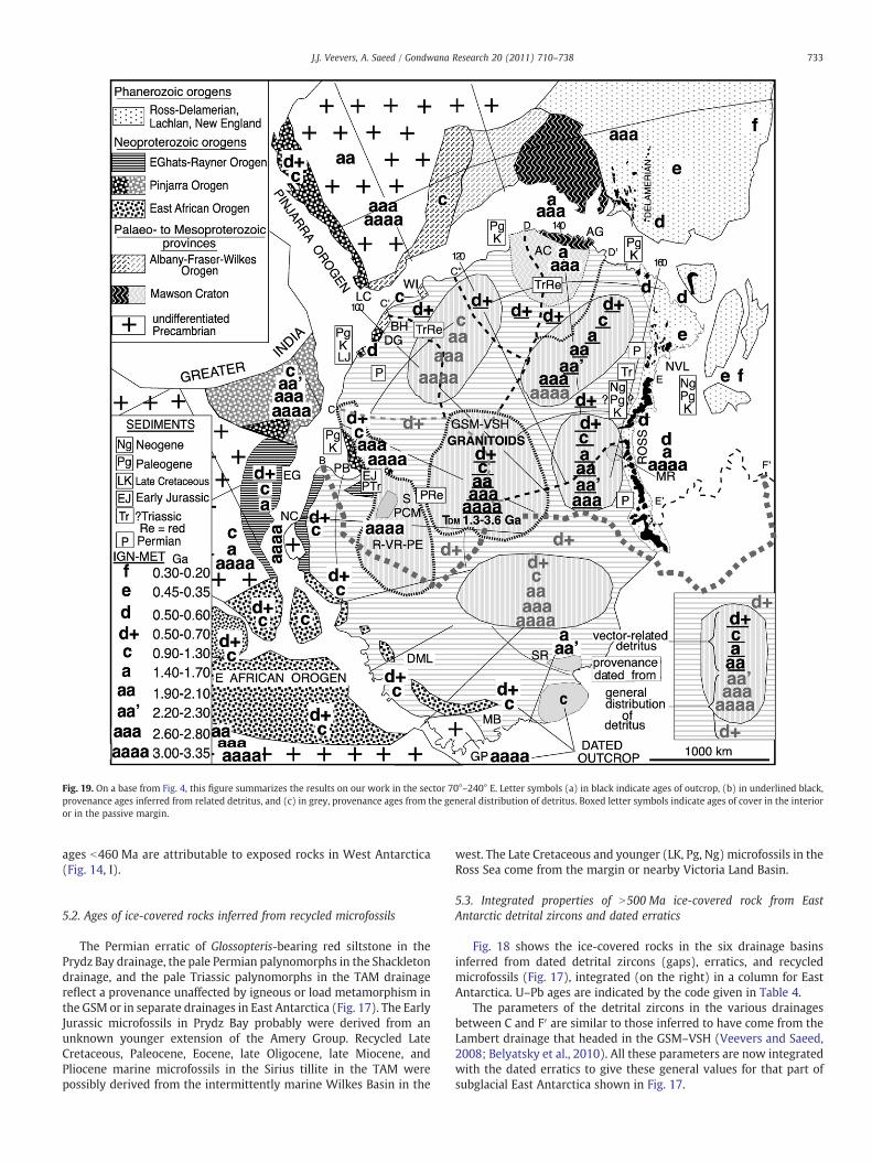
Fig. 19. On a base from Fig. 4, this figure summarizes the results on our work in the sector 70°–240° E. Letter symbols (a) in black indicate ages of outcrop, (b) in underlined black,provenance ages inferred from related detritus, and (c) in grey, provenance ages from the general distribution of detritus. Boxed letter symbols indicate ages of cover in the interioror in the passive margin.
733J.J. Veevers, A. Saeed / Gondwana Research 20 (2011) 710–738
ages b460 Ma are attributable to exposed rocks in West Antarctica(Fig. 14, I).
5.2. Ages of ice-covered rocks inferred from recycled microfossils
The Permian erratic of Glossopteris-bearing red siltstone in thePrydz Bay drainage, the pale Permian palynomorphs in the Shackletondrainage, and the pale Triassic palynomorphs in the TAM drainagereflect a provenance unaffected by igneous or load metamorphism inthe GSM or in separate drainages in East Antarctica (Fig. 17). The EarlyJurassic microfossils in Prydz Bay probably were derived from anunknown younger extension of the Amery Group. Recycled LateCretaceous, Paleocene, Eocene, late Oligocene, late Miocene, andPliocene marine microfossils in the Sirius tillite in the TAM werepossibly derived from the intermittently marine Wilkes Basin in the
west. The Late Cretaceous and younger (LK, Pg, Ng) microfossils in theRoss Sea come from the margin or nearby Victoria Land Basin.
5.3. Integrated properties of N500 Ma ice-covered rock from EastAntarctic detrital zircons and dated erratics
Fig. 18 shows the ice-covered rocks in the six drainage basinsinferred from dated detrital zircons (gaps), erratics, and recycledmicrofossils (Fig. 17), integrated (on the right) in a column for EastAntarctica. U–Pb ages are indicated by the code given in Table 4.
The parameters of the detrital zircons in the various drainagesbetween C and F′ are similar to those inferred to have come from theLambert drainage that headed in the GSM–VSH (Veevers and Saeed,2008; Belyatsky et al., 2010). All these parameters are now integratedwith the dated erratics to give these general values for that part ofsubglacial East Antarctica shown in Fig. 17.
734 J.J. Veevers, A. Saeed / Gondwana Research 20 (2011) 710–738
5.3.1. d+ 500–700 MaDetrital zircons: mafic granitoid and low-HREE-c hosts, εHf +10
to −40, TDMC 1.3 to 2.7 Ga. Erratics: 506, 508, 516 Ma muscovite–biotite granite, 519 and N556 Ma muscovite–biotite granite gneiss,510 Ma biotite granite, 584 Ma leucocratic muscovite-biotite micro-granite (Table 18); 563 Ma granitoid (Table 13). Erratics of low-grademetasedimentary rocks were possibly deposited ~505 Ma andmetamorphosed ~500 Ma.
5.3.2. c 900–1300 MaDetrital zircons: mafic granitoid and low-HREE-c hosts, εHf +12
to −20, TDMC 1.3 to 1.8 Ga. Erratic: 1065–1100 Ma orthogneiss(Table 13).
5.3.3. a 1440–1650 MaDetrital zircons: from sample 269B (Table 8), felsic granitoid, mafic
rock, and low-HREE-c hosts, εHf 8 to −4, TDMC 1.7, 2.0–2.6 Ga, mean2.1 Ga; from samples BeaGp and SL (Table 12): εHf 10 to −3. Erratic:TNQ (Table 12), a 1441 Ma A-type granite, εHf 7, TDMNd 1.5 Ga.
This is a well-characterized cluster of felsic granitoid and A-typegranite (low-HREE-c host), εHf 10 to −4, TDMC 1.5–1.7, 2.0–2.6 Ga.Dated minerals of this age in interior Antarctica are the 1470 Madetrital monazites in the Lake Vostok siltstone (Table 17). Exposureswithin this range are the 1600 Ma granite of Terre Adélie (Table 5)and gneiss in the Windmill Islands with 1400–1450 Ma and 1500–1600 Ma inherited zircons (Table 2).
5.3.4. aa ~1940 MaDetrital zircons define a gap ~1940 Ma. Detrital zircons of this age
(1700–2200 Ma) in the GSM–VSH provenance (Veevers and Saeed,2008) have these properties: mafic granitoid, εHf 0 to−20, TDMC 2.7 to3.1 Ga.
5.3.5. aaa (2600–2800 Ma)Detrital zircons define a gap ~2720 Ma.
5.3.6. aaaa (3000–3350 Ma)Detrital zircons define a gap at ~3240 Ma. Detrital zircons of this
age (3150–3350 Ma) in the GSM–VSH provenance (Veevers andSaeed, 2008) have these properties: mafic granitoid, εHf 0 to −20,TDMC 3.5 to 3.6 Ga.
5.3.7. SummaryThe dominant identified rock type is mafic granitoid in all age
clusters, added to in d+ (500–700 Ma) and c (900–1300 Ma) and a(1440–1650 Ma) by low-HREE-c hosts. Ages range from d+ (500–700 Ma) to aaaa (~3240 Ma). εHf is uniformly negative except in d+(500–700 Ma), locally as high as +10, in c (900–1300 Ma), locallyto +12, and a to +10. TDMC ranges from 1.3–3.6 Ga, and is older inolder sets except in c (1.3 to 1.8 Ga), which has TDMC younger than d+(1.3 to 2.7 Ga).
Continental crust with these ages in bedrock and detrital zircons(d+, 500–700 Ma) to aaaa (3000–3350 Ma) is exposed in the PCM(Veevers, 2007; Veevers and Saeed, 2008), and provides an exampleof the imputed mix of ages in ice-covered rock.
5.4. Ice-covered sedimentary rocks from erratics and recycled microfossils
Erratics and recycled microfossils reflect local provenances:
(1) Permian Glossopteris-bearing red siltstone clasts from the GSM.(2) Pale Permian palynomorphs from the CC′ drainage.(3) Red sandstone erratics of uncertain age within the Phanerozoic,
common in the C′D′ drainage.(4) Early Jurassic palynomorphs from the nearby Amery Group.
(5) Pale Triassic palynomorphs and Late Cretaceous to Pliocenemarine microfossils in the TAM from the Wilkes Basin.
The pale palynomorphs indicate deposits unaffected by igneousheating or load metamorphism, and contrast with the dark forms inexposed Permian and Triassic rocks.
5.5. Sediment beneath (and in front of) the Ross Ice Shelf
Recycled Cretaceous to Eocene microfossils in the Ross Sea anderratics in the McMurdo Sound area, including Eocene–Pliocenesandstone and mudstone with marine fossils, come from the VictoriaLand Basin.
5.6. Recycled microfossils from the marginal succession
Late Jurassic through Oligocene microfossils in offshore sediment(Fig. 16) have been recycled from the marginal succession.
5.7. Dominant erratics of undated low-grade metasedimentary rocks inthe Mertz (DD′) drainage
As noted above (in Section 3.6.), in the Mertz (DD′) drainage,“Low-grade siliceous metasedimentary rocks, coupled with a hetero-geneous mixture of igneous and high-grade meta-igneous rock types,dominate the glacial provenance” (Goodge and Fanning, 2010). Thelow-grade rocks are undated except possibly those erratics atHorn Bluff (DiVincenzo et al., 2007), which include arkosic sandstoneand metasiltstone with a continuous cleavage. 40Ar–39Ar analysisof single white-mica detrital grains yielded ages between 518 Ma and640 Ma, with peaks at 570 and 615 Ma. The sandstone was probablydeposited in the Middle Cambrian or ~505 Ma, and metamor-phosed shortly afterwards during the ~500 Ma terminal Ross orogeny.DiVincenzo et al. (2007) regard the low-grade metamorphic terrainintruded by the ~500 Ma granites in this area as extending inland toform the dominant sub-ice bedrock of the southern provenance.
The DD′ drainage area includes the Wilkes (subglacial) Basin,which could be taken to contain a sedimentary column of ~505 Masand metamorphosed ~500 Ma succeeded by Permian–Triassic non-marine sandstone and Late Cretaceous to Neogene (mainly) marinesediment. This potential proximal provenance could source the sandof the erratic (DiVincenzo et al., 2007) and of the conjugate(Australian) Kanmantoo Group, which was derived from the south(Veevers and Saeed, 2008).
The 518 to 640 Ma age of the detrital white-micas (DiVincenzoet al., 2007) falls within the 475–660 Ma (d+) range of detritalzircons in the GSM–VSH derived frommafic granitoids and low-HREEhosts, with εHf +9 to −28, indicating crustal recycling, consistentwith the final stage of tectonic assembly of Gondwanaland (Veeversand Saeed, 2008).
6. Discussion and conclusions
The results of our work in the sector 70°–240° E are summarized inFig. 19. (a) Ages of outcrop (from Fig. 4) are designated by lettersymbols in black; (b) ages of basement provenances inferred fromvector-related detrital zircons and erratics are shown in underlinedblack; and (c) ages of basement provenances from the generaldistribution of detritus are shown in grey. Ages from the Permianerratic and recycled microfossils are shown in boxes.
6.1. Cover
Erratics of red sandstone in Antarctica are undated. In outcrop, redsandstone is found in the Triassic Flagstone Bench Formation of theAmery Group, at the head of Prydz Bay, in the Triassic Feather
735J.J. Veevers, A. Saeed / Gondwana Research 20 (2011) 710–738
Conglomerate of northern Victoria Land, and in the poorly dated(probably Phanerozoic— see Section 3.7.1.) succession at Mt Sandow.Except at Mt Sandow, the erratics are regarded tentatively as Triassic.
As indicated by erratics, the Adélie Craton (and the craton tothe west) have a cover of red sandstone of tentative Triassic age(TrRe). The GSM–VSH craton has a cover of Permian red siltstone(PRe), from the clasts (small erratics) of red siltstone with thePermian Glossopteris at Mt Rymill and Mt Maguire in the southernPCM (Veevers et al., 2008a).
In the Prydz Bay drainage, recycled Permian-Triassic and EarlyJurassic microfossils probably indicate an extension in age (to EarlyJurassic) of the exposed Amery Group, and recycled microfossils ofCretaceous and Paleogene ages probably reflect these ages in thepassive margin.
Elsewhere, Late Jurassic and younger displaced microfossils alsoprobably reflect these ages in the passive margin. The conjugatemargin of India developed by rifting at about the Jurassic-Cretaceousboundary (~147 Ma) and by drifting (seafloor spreading) that startedin the Early Cretaceous (~130 Ma) (Veevers, 2009); a marinetransgression flooded the margin in the Eocene (Alam, 1989). Theconjugate margin of Australia developed by rifting that started inthe Middle Jurassic (~167 Ma) (Veevers, 2000) and by drifting byseafloor spreading that started in the Late Cretaceous (83 Ma)(Whittaker et al. (2007); a narrow seaway entered the zone ofbreakup in the Early Cretaceous, and widened to a maximum duringan Eocene marine transgression in the Great Australian Bight(Veevers, 2000, p. 35–36). The Indian and Australian transgressionsare reflected in Antarctica by abundant and widespread recycledEocene dinocysts (Fig. 16).
Pale (unmetamorphosed) palynomorphs of Triassic age point tosedimentary rocks of this age in the Wilkes Basin or beyond, and LateCretaceous and younger microfossils, including marine forms, in theSirius Tillite possibly indicate sediments of these ages in the WilkesBasin.
Recycled pale (unmetamorphosed) palynomorphs of Permian agepoint to rocks of this age ~90°E, and dark palynomorphs of Permianage in the Ross Sea point to rocks of this age in the TAM.
6.2. Cratons and foldbelts
The combined Ruker, Vestfold–Rauer, and Princess Elizabeth(R–VR–PE) Craton and the Adélie Craton (AC) are delineated bygeophysical mapping, and the GSM–VSH complex is outlined byVeevers and Saeed (2008). From the data in Fig. 17, we model afurther three cratons, all set in a matrix of d+ (500–700 Ma) foldbelts(Fig. 19).
The modelled craton behind the coastal Bunger Hills andWindmill Islands contains besides the imputed c (900–1300 Ma) toaaaa (3000–3350 Ma)agesonly a single indicated (underlined) age,d+(500–700 Ma), of granitoids, with εHf 2 to −20, and TDMC of 1.5, 2.1–2.7 Ga. The imputed foldbelt, probably of d+ (500–700 Ma) age, has acover of strata that (unusually in Antarctica) escaped load metamor-phism or igneous intrusion, as indicated by displaced pale palyno-morphs of Permian age.
The modelled craton between the Adélie Craton and the TAMcontains all indicated ages, from d+ (500–700 Ma) to aaa (2600–2800 Ma) and the imputed aaaa (3000–3350 Ma). The d+ (500–700 Ma) granitoids have εHf 2 to −21, and the c (900–1300 Ma)granitoids εHf 12 to−20. The imputed foldbelt, probably of d+ (500–700 Ma) age, has a cover of Triassic strata that escaped loadmetamorphism or igneous intrusion, as indicated by displaced palepalynomorphs of this age, as well as (normally dark) Permian, andarguably Cretaceous, Paleogene, and Neogene ages.
The third modelled craton, between the GSM–VSH and the TAM,incorporates the d (500–600 Ma), a (1400–1700Ma), and aaaa (3000–3350 Ma) ages of theMiller Range (MR), and additionally the indicated
ages of d+ (500–700 Ma) (granitoids with εHf 2 to −21), c (900–1300 Ma) (granitoids with εHf 12 to −20), and a (1400–1700 Ma) toaaa (2600–2800 Ma). The imputed foldbelt, probably of d+ (500–700 Ma) age, has a cover of Permian strata.
The Prince Charles Mountains (PCM) provide an exposed exampleof a crust of Precambrian igneous and metamorphic rocks and Permianand Triassic sedimentary rocks.
Acknowledgements
We thank Alexander Golynsky, Phil O'Brien, and J.J. Peucat for helpwith references, Alexander Golynsky and Phil O'Brien for bedrockelevation data, Kath Grey, Robin Helby, and Roger Morgan forinformation on palynomorphs, Ian Goodwin for information onglaciological features in the Windmill Islands area, Peter Voice fordigitized datasets, John Goodge for supplying a copy of Goodge andFanning (2010) before publication, and Mark Fanning for Excel files ofzircon ages in DSDP 269 and in sample CR-LP in the Shackleton Glacierarea. Samples of DSDP cores were provided from the repositories ofthe IODP. We are particularly grateful to Steven Boger and GermanLeitchenkov for valuable reviews. This work is supported by ARCDP0344841 and grants fromMacquarie University. The analytical datawere obtained used instrumentation funded by ARC LIEF and DESTSystemic Infrastructure Grants, industry partners, and MacquarieUniversity. This is contribution 668 from the Australian ResearchCouncil National Key Centre for the Geochemical Evolution andMetallogeny of Continents (http://www.gemoc.mq.edu.au).
Appendix A. Supplementary data
Supplementary data associated with this article can be found inonline at doi:10.1016/j.gr.2011.03.007. The contents are: (1) Detailedmethods of analysis; (2) Excel files of the analyses of sample 268,269A, 269B, 273, 274.
References
Adams, C.J., 1986. Geochronological studies of the Swanson Formation of Marie ByrdLand, West Antarctica, and correlation with northern Victoria Land, East Antarctica,and South Island, New Zealand. New Zealand Journal of Geology and Geophysics 29,345–358.
Adamson, D.A., Colhoun, E.A., 1992. Late Quaternary glaciation and deglaciation of theBunger Hills, Antarctica. Antarctic Science 4, 435–446.
Alam, M., 1989. Geology and depositional history of Cenozoic sediment of the BengalBasin of Bangladesh. Palaeogeography, Palaeoclimatology, Palaeoecology 69,125–139.
Anonymous, 2003. Management plan for Antarctic Specially Protected Area no. 160.www.scar.org/publications/bulletins/153/aspa160.
Ashworth, A.C., Lewis, A.R., Marchant, D.R., Askin, R.A., Cantrill, D.J., Francis, J.E., Leng, M.J.,Newton, A.E., Raine, J.I., Williams, M., Wolfe, A.P., 2007. The Neogene biota ofthe Transantarctic Mountains. In: Cooper, A.K., Raymond, C.R. (Eds.), OnlineProceedings of the 10th ISAES: USGS Open-file Report 2007–1047. Extended Abstract07. 4 pages.
Australian Antarctic Division, 2000. Antarctica and the Southern Ocean. 1:20,000,000map, Polar stereographic Projection, Hobart.
Barrett, P.J., 1975. Characteristics of pebbles from Cenozoic marine glacial sediments inthe Ross Sea (DSDP Sites 270–274) and the south Indian Ocean (Site 268). In:Hayes, D.E., Frakes, L.A., et al. (Eds.), Initial Reports of the Deep Sea Drilling Project,28. US Government Printing Office, Washington D.C, pp. 769–773.
Belousova, E.A., Griffin, W.L., O'Reilly, S.Y., Fisher, N.I., 2002. Igneous zircon: traceelement composition as an indicator of source rock type. Contributions toMineralogy and Petrology 143, 602–622.
Belyatsky, B., Leitchenkov, G., Rodionov, N., Antonov, A., Sergeev, S., Savva, H., 2010.Detrital zircons — the unique source of information on tectonics, paleogeographyand denudation processes of East Antarctica (subglacial challenge). GeophysicalResearch Abstracts, 12. EGU2010-11895-1, 2 pages.
Black, L.P., Sheraton, J.W., 1990. The influence of Precambrian source components onthe U–Pb zircon age of a Palaeozoic granite from northern Victoria Land, Antarctica.Precambrian Research 46, 275–293.
Black, L.P., Sheraton, J.W., Tingey, R.J., McCulloch, M.T., 1992. New U–Pb zircon agesfrom the Denman Glacier area, East Antarctica, and their significance for Gondwanareconstruction. Antarctic Science 4, 447–460.
Bo, S., Siegert, M.J., Mudd, S.M., Sugden, D., Fujita, S., Xiangbin, C., Yunyun, J., Xueyman,T., Yuansheng, L., 2009. The Gamburtsev mountains and the origin and earlyevolution of the Antarctic Ice Sheet. Nature 459, 690–693.
736 J.J. Veevers, A. Saeed / Gondwana Research 20 (2011) 710–738
Boger, S.D., 2011. Antarctica – Before and after Gondwana. Gondwana Research 19,335–371.
Borg, S.G., DePaolo, D.J., 1994. Laurentia, Australia, and Antarctica as a Late Proterozoicsupercontinent: constraints from isotopic mapping. Geology 22, 307–310.
Bracciali, L., DiVincenzo, G., Rocchi, S., Ghezzo, C., 2009. The Tiger Gabbro fromnorthern Victoria Land, Antarctica: the roots of an island arc within the earlyPalaeozoic margin of Gondwana. Journal of the Geological Society of London 166,711–724.
Browne, W.R., 1928. The dolerites of King George Land and Adelie Land. AustralasianAntarctic Expedition 1911–14 Scientific Reports, Series A, volume III (Geology),part 1, pp. 244–258. http://www.mawsonshuts.aq/national-heritage/science-reports/series-a.html. 2 plates.
Collinson, J.W., Pennington, D.C., Kemp, N.R., 1986. Stratigraphy and petrology ofPermian and Triassic deposits in northern Victoria Land, Antarctica. AmericanGeophysical Union Antarctic Research series, 46, pp. 211–242.
Collinson, J.W., Isbell, J.L., Elliot, D.H., Miller, M.F., Miller, J.M.G., 1994. Permian-TriassicTransantarctic basin. In: Veevers, J.J., Powell, C.McA (Eds.), Permian-Triassic basinsand foldbelts along the Panthalassan margin of Gondwanaland: Geological Societyof America Memoir, 184, pp. 173–222.
Coulson, A.L., 1925. Magnetite garnet rocks from the moraines at Cape Denison, AdelieLand. Australasian Antarctic Expedition 1911–14 Scientific Reports, Series A,volume III (Geology), part 5, pp. 281–304. 2 plates.
Cox, S.E., Hemming, S.R., Reiners, P.W., Nicolescu, S., Thomson, S.N., Gehrels, G.E., van deFlierdt, T., Goldstein, S.L., Brachfeld, S.A., 2007. Detrital apatite and zircon U–Th/Heevidence for the early formation and slow erosion of the Gamburtsev Mountains,East Antarctica. In: Cooper, A.K., Raymond, C.R., et al. (Eds.), Online Proceedingsof the 10th ISAES X: USGS Open-File Report 2007–1047. Extended Abstract 193,4 pages.
DiVincenzo, G., Talarico, F., Kleinschmidt, G., 2007. An 40Ar–39Ar investigation of theMertz Glacier area (George V Land, Antarctica): implications for the Ross Orogen–East Antarctic Craton relationship and Gondwana reconstructions. PrecambrianResearch 152, 93–118.
Dixon, G., 1998. Browning erratics 1, Wilkes Land, Antarctica. [colour photograph].www.GrantDixonPhotography.com.au.
Domack, E.W., 1982. Sedimentology of glacial and glacial marine deposits on theGeorge V – Adelie continental shelf, East Antarctica. Boreas 11, 79–97.
Domack, E.W., Fairchild, W.W., Anderson, J.B., 1980. Lower Cretaceous sediment fromthe East Antarctic continental shelf. Nature 287, 625–626.
Doornbos, C., Heaman, L.M., Doupé, J.P., England, J., Simonetti, A., Lajeunesse, P., 2009.The first integrated use of in situ U–Pb geochronology and geochemical analyses todetermine long-distance transport of glacial erratics from mainland Canada intothe western Arctic Archipelago. Canadian Journal of Earth Sciences 46, 101–122.
Duclaux, G., Rolland, Y., Ruffet, G., Ménot, R.P., Guillot, S., Peucat, J.J., Fanning, M., Rey, P.,Pêcher, A., 2008. Superimposed Neoarchaean and Paleoproterozoic tectonics in theTerre Adélie Craton (East Antarctica): evidence from the Th-U–Pb ages onmonaziteand 40Ar/39Ar ages. Precambrian Research 167, 316–338.
Elliot, D.H., 1996. The Hanson Formation: a new stratigraphical unit in theTransantarctic Mountains, Antarctica. Antarctic Science 8, 389–394.
Elliot, D.H., Fanning, C.M., 2008. Detrital zircons from upper Permian and lower TriassicVictoria Group sandstones, Shackleton Glacier region, Antarctica: evidencefor multiple sources along the Gondwana plate margin. Gondwana Research 13,259–274.
Elliot, D.H., Fleming, T.H., 2000. Weddell triple junction: the principal focus of Ferrarand Karoo magmatism during initial breakup of Gondwana. Geology 28, 539–542.
Elliot, D.H., Foland, K.A., 1986. Potassium-argon age determinations of the KirkpatrickBasalt, Mesa Range. American Geophysical Union Antarctic Research series, 46,pp. 279–288.
Elliot, D.H., Siders, M.A., Haban, M.A., 1986. Jurassic tholeiites in the region of the upperRennick Glacier, north Victoria Land. American Geophysical Union AntarcticResearch series, 46, pp. 249–265.
Federico, L., Crispini, L., Capponi, G., Bradshaw, J.D., 2009. The Cambrian Ross Orogeny innorthern Victoria Land (Antarctica) and New Zealand: a synthesis. GondwanaResearch 15, 188–196.
Fielding, C.R., Whittaker, J., Henrys, S.A., Wilson, T.J., Naish, T.R., 2008. Seismic facies andstratigraphy of the Cenozoic succession in McMurdo Sound, Antarctica: Implica-tions for tectonic, climatic and glacial history. Palaeogeography, Palaeoclimatology,Palaeoecology 260, 8–29.
Finn, C.A., Goodge, J.W., Damaske, D., Fanning, C.M., 2006. Scouting craton's edge inPaleo-Pacific Gondwana. In: Fütterer, D.K., Damaske, D., Kleinschmidt, G., Miller, H.,Tessensohn, F. (Eds.), Antarctica: contributions to global earth sciences. Springer,Berlin, pp. 165–174.
Fioretti, A.M., Lanza, R., 2000. Preliminary palaeomagnetic results from the Devono-Carboniferous Admiralty Intrusives (Northern Victoria Land, Antarctica). TerraAntartica 7, 657–664.
Fioretti, A.M., Black, L.P., Varne, R., Visona, D., 2001. U–Pb zircon SHRIMP dating ofPalaeozoic magmatism in northern Victoria Land and the South Tasman Rise;inferences for the correlation with Tasmania. The Geological Framework ofTasmania, Abstracts Volume. Australian Geological Survey Organisation, Canberraand Mineral Resources Tasmania, p. 16.
Fitzsimons, I.C.W., 2003. Proterozoic basement provinces of southern and southwesternAustralia, and their correlation with Antarctica. In: Yoshida, M., Windley, B.F.,Dasgupta, S. (Eds.), Proterozoic East Gondwana: supercontinent assembly andbreakup: Geological Society of London Special Publication, 206, pp. 93–130.
Foden, J., Elburg, M.A., Dougherty-Page, J., Burtt, A., 2006. The timing and duration of theDelamerian Orogeny: correlation with the Ross Orogen and implications forGondwana assembly. Journal of Geology 114, 189–210.
Gehrels, G.E., Ruiz, J., Valencia, V.A., Pullen, A., Baker, M., 2006. Detrital zircon U–Th–Pbgeochronology by LA–MC–ICPMS at the Arizona LaserChron Center. GeologicalSociety of America Abstracts with Programs, 38 (7), p. 408.
Gersonde, R., Kyte, F.T., Bleil, V., Diekman, B., Flores, J.A., Geyl, K., Grahl, G., Hagen, R.,Kohn, G., Sierro, F.J., Volker, D., Abelmann, A., Bostwick, J.A., 1997. Geological recordand reconstruction of the late Pliocene impact of the Eltanin asteroid in theSouthern Ocean. Nature 390, 357–363.
Gillis, R.J., Gehrels, G.E., Ruiz, J., de Dios, Flores, Gonzaléz, L.A., 2005. Detrital zirconprovenance of Cambrian–Ordovician and Carboniferous strata of the Oaxacaterrane, southern Mexico. Sedimentary Geology 182, 87–100.
Glastonbury, J.O.G., 1940a. Acid effusive and hypabyssal rocks from the moraines.Australasian Antarctic Expedition 1911–14 Scientific Reports, Series A, volume IV,part 4, pp. 115–134. 1 plate.
Glastonbury, J.O.G., 1940b. Basic igneous and metamorphic equivalents fromCommonwealth Bay. Australasian Antarctic Expedition 1911–14 Scientific Reports,Series A, volume IV, part 5, pp. 137–180. 1 plate.
Glastonbury, J.O.G., 1940c. Certain epidotic rocks from the moraines, CommonwealthBay. Australasian Antarctic Expedition 1911–14 Scientific Reports, Series A, volumeIV, part 6, pp. 183–196. 1 plate.
Glastonbury, J.O.G., 1940d. Metamorphic limestones and other calcareous sedimentsfrom the moraines. A further collection: Australasian Antarctic Expedition 1911–14Scientific Reports, Series A, volume IV, part 8, pp. 295–322. 1 plate.
Glastonbury, J.O.G., 1940e. Some hybrid gneisses from the moraines, Cape Denison.Australasian Antarctic Expedition 1911–14 Scientific Reports, Series A, volume IV,part 9, pp. 325–333.
Golynsky, A.V., 2007. Magnetic anomalies in East Antarctica: a window on majortectonic provinces and their boundaries. In: Cooper, A.K., Raymond, C.R. (Eds.),Online Proceedings of the 10th ISAES: USGS Open-file Report 2007–1047, Shortresearch Paper 006. 4 pages.
Golynsky, A., Chiappini, M., Damaske, D., Ferraccioli, F., Finn, C., Ghidella, M., Ishihara, T.,Kim, H.R., Kovacs, L., Masolov, V., Morris, P., Nogi, Y., von Frese, R., 2006. ADMAP— adigital magnetic anomaly map. In: Fütterer, D.K., Damaske, D., Kleinschmidt, G.,Miller, H., Tessensohn, F. (Eds.), Antarctica: Contributions to Global Earth Sciences.Springer, Berlin, pp. 109–116.
Goodge, J.W., 1997. Latest Neoproterozoic basin inversion of the Beardmore Group,central Transantarctic Mountains, Antarctica. Tectonics 16, 682–701.
Goodge, J.W., Fanning, C.M., 1999. 2.5 billion years of punctuated Earth history asrecorded in a single rock. Geology 27, 1007–1010.
Goodge, J.W., Fanning, C.M., 2010. Composition and age of the East Antarctic Shield ineastern Wilkes Land determined by proxy from Oligocene–Pleistocene glaciomar-ine sediment and Beacon Supergroup sandstones, Antarctica. Geological Society ofAmerica Bulletin 122, 1135–1159.
Goodge, J.W., Fanning, C.M., Bennett, V.C., 2001. U–Pb evidence of 1.7 Ga crustaltectonism during the Nimrod Orogeny in the Transantarctic Mountains, Antarctica:implications for Proterozoic plate reconstructions. Precambrian Research 112,261–288.
Goodge, J.W., Myrow, P., Williams, I.S., Bowring, S.A., 2002. Age and provenance of theBeardmore Group, Antarctica: constraints on Rodinia supercontinent breakup.Journal of Geology 110, 393–406.
Goodge, J.W., Verwoort, J.D., Fanning, C.M., Brecke, D.M., Farmer, G.L., Williams, I.S.,Myrow, P.M., DePaulo, D.J., 2008. A positive test of East Antarctica–Laurentiajuxtaposition within the Rodinia supercontinent. Science 321, 235–240.
Goodge, J.W., Fanning, C.M., Brecke, D.M., Licht, K., Palmer, E., 2009. Continuation of theLaurentian Grenville Province in western East Antarctica. Geological Society ofAmerica Abstracts with Programs 41 (7), 688.
Goodwin, I.D., 1993. Holocene deglaciation, sea-level change, and the emergence of theWindmill Islands, Budd Coast, Antarctica. Quaternary Research 40, 70–80.
Gordon, A.L., Orsi, A.H., Muench, R., Huber, B.A., Zambianchi, E., Visbeck, M., 2009.Western Ross Sea continental slope gravity currents. Deep-Sea Research II 56,796–817.
Haines, P.W., Turner, S.P., Foden, J.D., Jago, J.B., 2009. Isotopic and geochemicalcharacterisation of the Cambrian Kanmantoo Group, South Australia: implicationsfor stratigraphy and provenance. Australian Journal of Earth Sciences 56,1095–1110.
Hambrey, M., Barrett, P.J., 1993. Cenozoic sedimentary and climatic record, Ross Searegion, Antarctica. In: Kennett, J.P., Warnke, D.A. (Eds.), The Antarctic environment:a perspective on global change: AGU Antarctic Research Series, 60, pp. 91–124.
Hayes, D.E., Frakes, L.A., et al., 1975. Initial Reports of the Deep Sea Drilling Project, 28.US Government Printing Office, Washington D.C. doi:10.2973/dsdp.proc.28.1975.1017 pages. On-line.
Hicock, S.R., Barrett, P.J., Holme, P.J., 2003. Fragment of an ancient outlet of glaciersystem near the top of the Transantarctic Mountains. Geology 31, 821–824.
Holdgate, G.R., McLoughlin, S., Drinnan, A.N., Finkelman, R.B., Willett, J.C., Chichowsky,L.A., 2005. Inorganic chemistry, petrography and palaeobotany of Permian coals inthe Prince Charles Mountains, East Antarctica. International Journal of Coal Geology63, 156–177.
Kemp, E.M., 1972. Reworked palynomorphs from the West Ice Shelf area, EastAntarctica, and their possible geological and palaeoclimatological significance.Marine Geology 13, 145–157.
Kleeman, A.W., 1940. Schists and gneisses from the moraines, Cape Denison, AdelieLand. Australasian Antarctic Expedition 1911–14 Scientific Reports: Series A,volume IV (Geology), part 7, pp. 197–292. 5 plates.
Korotkevich, E.S., Timofeev, B.V., 1964. The age of the rocks of East Antarctica fromspore analysis. Soviet Antarctic Expedition Information Bulletin 2 (12), 63–69.
Kyle, P.R., 1990. McMurdo Volcanic Group, West Ross Embayment. AGU AntarcticResearch Series, 48, pp. 19–25.
737J.J. Veevers, A. Saeed / Gondwana Research 20 (2011) 710–738
Leitchenkov, G.L., Belyatsky, B.V., Rodionov, N.V., Sergeev, S.A., 2007. Insight into thegeology of the East Antarctic hinterland: a study of mineral inclusions from icecores of the Lake Vostok borehole. In: Cooper, A.K., Raymond, C.R. (Eds.), OnlineProceedings of the 10th ISAES: USGS Open-file Report 2007–1047, Short researchPaper 014. 4 pages.
LeMasurier, W.E., Futa, K., Hole, M., Kawachi, Y., 2003. Polybaric evolution ofphonolite, trachyte, and rhyolite volcanoes in eastern Marie Byrd Land, Antarctica:controls on peralkalinity and silica saturation. International Geology Review 45,1055–1099.
Licht, K.J., Palmer, E.F., 2007. Characteristics of till transported by the Byrd and NimrodGlaciers, Antarctica. In: Cooper, A.K., Raymond, C.R., et al. (Eds.), Online Pro-ceedings of the 10th ISAES X: USGS Open-File Report 2007–1047, ExtendedAbstract 114. 3 pages.
Ludwig, K.R., 2001. Isoplot/Ex rev. 2.49, vol. 4. Berkeley Geochronology Center SpecialPublication.
Lythe,M.B., Vaughan,D.G., and theBEDMAPConsortium, 2000. BEDMAP–bed topographyof the Antarctic, 1:10 000 000 scale map. BAS (misc.) 9. Cambridge, U.K., BritishAntarctic Survey.
Lythe, M.B., Vaughan, D.G., The BEDMAP Consortium, 2001. BEDMAP: a new icethickness and subglacial topographic model of Antarctica. Journal of GeophysicalResearch 106, 11335–11351.
Macphail, M.K., Truswell, E.M., 1991. Palynology of Neogene slope and rise depositsfrom ODP Sites 1165 and 1167, East Antarctica. In: Cooper, A.K., O'Brien, P.E.,Richter, C. (Eds.), Proceedings of the Ocean Drilling Program, Scientific Results, 188,pp. 1–20. [online]. www-odp.tamu.edu/publications/188_SR/VOLUME/CHAPTERS/012.PDF. cited 3 June 2010.
Mawson, D., 1915. The home of the blizzard, 2 volumes. William Heinemann, London.Mawson, D., 1940a. Sedimentary rocks. Australasian Antarctic Expedition 1911–14
Scientific Reports: Series A, volume IV (Geology), part 11, pp. 351–367. http://www.mawsonshuts.aq/national-heritage/science-reports/series-a.html. 5 plates.
Mawson, D., 1940b. Catalogue of rocks and minerals collected in Antarctic lands.Australasian Antarctic Expedition 1911–14 Scientific Reports: Series A, volume IV(Geology), part 13, pp. 406–429http://www.mawsonshuts.aq/national-heritage/science-reports/series-a.html.
McGonigal, D., 2008. Antarctica: Secrets of the Southern Continent. Firefly Books,Buffalo, N.Y. 800 pages.
McLeod, I.R., Gregory, C.M., 1967. Geological investigations along the Antarctic Coastbetween longitudes 108° and 166°E. Bureau of Mineral Resources, Canberra,Report 78.
McLoughlin, S., Lindström, S., Drinnan, A.N., 1997. Gondwanan floristic and sedimen-tological trends during the Permian–Triassic transition: new evidence from theAmery Group, northern Prince Charles Mountains, East Antarctica. AntarcticScience 9, 281–298.
McPherson, J.G., 1980. Genesis of variegated redbeds in the fluvial Aztec Siltstone (LateDevonian), southern Victoria Land, Antarctica. Sedimentary Geology 27, 119–142.
Ménot, R.P., Duclaux, G., Peucat, J.J., Rolland, Y., Guillot, S., Fanning, M., Bascou, J., Gapais,D., Pêcher, A., 2007. Geology of the Terre Adélie Craton (135–146° E). In: Cooper, A.K., Raymond, C.R., et al. (Eds.), Online Proceedings of the 10th ISAES X: USGS Open-File Report 2007–1047, Short Research Paper 048. 5 pages.
Mikhalsky, E.V., 2008a. Main stages and geodynamic regimes of the Earth's crustformation in East Antarctica in the Proterozoic and Early Paleozoic. Geotectonics42, 413–430.
Mikhalsky, E.V., 2008b. Sm–Nd crustal provinces in Antarctica. Doklady Earth Sciences419A (3), 388–391.
Möller, A., Post, N.J., Hensen, B.J., 2002. Crustal residence history and garnet Sm–Nd agesof high-grade metamorphic rocks from the Windmill Islands area, East Antarctica.International Journal of Earth Sciences 91, 993–1004.
Monbeig-Andrieu, M., Cailleux, A., 1962. Grains éolisés, dans les grès erratiques de TerreAdélie (Antarctique) (Wind-worked grains of sand in sandstone erratics in AdelieLand (Antarctica)). Compte rendu sommaire des Séances de la Société géologiquede France, 5, p. 151.
Moore, G.W., 1987. Provenance of glacial stones dredged off Wilkes Land, Antarctica. In:Eittreim, S.L., Hampton, M.A. (Eds.), The Antarctic continental margin: geology andgeophysics of offshore Wilkes Land: Circum-Pacific Council for Energy and MineralResources Earth Sciences Series, Volume 5A, pp. 219–221.
Morgan, R., Rowell, A.L., White, M.R., 1999. Biostratigraphy. In: Morton, J.G.G., Drexel, J.F.(Eds.), Petroleum Geology of South Australia, volume 5. Department ofPrimary Industries and Resources of South Australia, Great Australian Bight, Adelaide.37 pages.
Moriwaki, K., Yoshida, Y., Harwood, D.M., 1992. Cenozoic glacial history of Antarctica —
a correlative synthesis. In: Yoshida, Y., Kaninuma, K., Shiraishi, K. (Eds.), Recentprogress in Antarctic Earth Science. Terra Scientific Publishing Company (TERRA-PUB), Tokyo, pp. 773–780.
Mukasa, S.B., Dalziel, I.W.D., 2000. Marie Byrd Land, West Antarctica: evolution ofGondwana's Pacific margin constrained by zircon U–Pb geochronology and feldsparcommon-Pb isotopic compositions. Geological Society of America Bulletin 112,611–627.
Myrow, P.M., Pope, M.C., Goodge, J.W., Fischer, W., Palmer, A.R., 2002. Depositionalhistory of pre-Devonian strata and timing of Ross orogenic tectonism in the centralTransantarctic Mountains, Antarctica. Geological Society of America Bulletin 114,1070–1088.
Nardini, I., Armienti, P., Rocchi, S., Dallai, L., Harrison, D., 2009. Sr–Nd–Pb–He–O isotopeand geochemical constraints on the genesis of Cenozoic magmas from the WestAntarctic Rift. Journal of Petrology 50, 1359–1375.
O'Brien, P.E., Stagg, H.M.J., 2007. Tectonic elements of the continental margin of EastAntarctica, 38–164°E. In: Cooper, A.K., Raymond, C.R., et al. (Eds.), Online
Proceedings of the 10th ISAES X: USGS Open-File Report 2007–1047, ShortResearch Paper 085. 4 pages.
O'Brien, P.E., Stanley, S., Parums, R., 2005. Post-rift continental slope and rise sedimentsfrom 38°E to 164°E, East Antarctica. In: Fütterer, D.K., Damaske, D., Kleinschmidt, G.,Miller, H., Tessensohn, F. (Eds.), Antarctica: Contributions to global earth sciences.Springer, Berlin, pp. 341–347.
Oliver, R.L., Fanning, C.M., 1997. Australia and Antarctica. Precise correlation ofPalaeoproterozoic terrains. In: Ricci, C.A. (Ed.), Antarctic Region: Geologicalevolution and processes. Terra Antartica Publishers, Siena, pp. 163–172.
Palmer, E.F., 2008. Rock, till, and ice: a provenance study of the Byrd Glacier and thecentral and western Ross Sea, Antarctica. M.S. thesis, Indianopolis, IndianaUniversity, 191 pages (online: scholarworks.iupui.edu).
Palmer, E.F., Licht, K., 2007. Sand petrography and U/Pb detrital zircon geochronology oflate Quaternary tills from the Byrd Glacier and central/western Ross Sea, Antarctica.In: Cooper, A.K., Raymond, C.R., et al. (Eds.), Online Proceedings of the 10th ISAES X:USGS Open-File Report 2007–1047, Extended Abstract 134. 4 pages.
Pankhurst, R.J., Weaver, S.D., Bradshaw, J.D., Storey, B.C., Ireland, T.R., 1998.Geochronology and geochemistry of pre-Jurassic superterranes in Marie ByrdLand, Antarctica. Journal of Geophysical Research 103, 2529–2547.
Payne, J.L., Hand, M., Barovich, K.M., Reid, A., Evans, D.A.D., 2009. A global context for thePalaeoproterozoic evolution of theMawson Continent. In: Reddy, S.M., Mazumder, R.,Evans, D.A.D., Collins, A.S. (Eds.), Palaeoproterozoic supercontinents and globalevolution: Geological Society, London, Special Publications, 323, pp. 319–356.
Peucat, J.J., Capdevila, R., Fanning, C.M., Ménot, R.P., Pécora, L., Testut, L., 2002. 1.60 Gafelsic volcanic blocks in the moraines of the Terre Adélie Craton, Antarctica:comparisons with the Gawler Range Volcanics, South Australia. Australian Journalof Earth Sciences 49, 831–845.
Phillips, G., Wilson, C.J.L., Fitzsimons, I.C.W., 2005. Stratigraphy and structure of thesouthern Prince Charles Mountains, East Antarctica. Terra Antartica 12, 69–86.
Piper, D.J.W., Brisco, C.D., 1975. Deep-water continental-margin sedimentation, DSDPLeg 28, Antarctica. In: Hayes, D.E., Frakes, L.A., et al. (Eds.), Initial Reports ofthe Deep Sea Drilling Project, 28. US Government Printing Office,Washington D.C,pp. 727–755.
Popov, S.V., Leitchenkov, G.L., Moskalevsky, M.Y., Kharitonov, V.V., Masolov, V.N., BEDMAPConsortium, 2007. ABRIS project: new bedrock topography and map for centralAntarctica. In: Cooper, A.K., Raymond, C.R., et al. (Eds.), Online Proceedings of the 10thISAES X: USGS Open-File Report 2007–1047, Extended Abstract 026. 4 pages.
Ravich, M.G., Klimov, L.V., Soloviev, D.S., 1968. The Pre-Cambrian of East Antarctica. IsraelProgram for Scientific Translations, Jerusalem. [English translation from the Russian].
Read, S.E., Cooper, A.F., Walker, A.W., 2002. Geochemistry and U–Pb geochronology of theNeoproterozoic–Cambrian Koettlitz Glacier Alkaline Province, Royal Society Range,TransantarcticMountains, Antarctica. In: Gamble, J.A., Skinner, D.N.B., Henrys, S. (Eds.),Antarctica at theClose of aMillenium: 8th International SymposiumonAntarctic EarthSciences. Royal Society of New Zealand Bulletin, vol. 35, pp. 1143–1151.
Retallack, G.J., Veevers, J.J., Morante, R., 1996. Global coal gap between Permian–Triassicextinction and Middle Triassic recovery of peat-forming plants. Geological Societyof America Bulletin 108, 195–207.
Rignot, E., Bamber, J.L., van den Broeke, M.R., Davis, C., Li, Y., van de Berg, W.J., vanMeijgaard, E., 2008. Recent Antarctic ice mass loss from radar interferometry andregional climate modelling. Nature Geoscience 1, 106–110.
Robertson, R., 1959. Preliminary report on the bedrock geology of theWindmill Islands.Ohio State University Research Foundation Report 825-2, Part 6.
Rocchi, S., LeMasurier, W.E., Di Vincenzo, G., 2006. Oligocene to Holocene erosion andglacial history in Marie Byrd Land, West Antarctica, inferred from exhumation ofthe Dorrel Rock intrusive complex and from volcano morphologies. Bulletin of theGeological Society of America 118, 991–1005.
Roy, M., van de Flierdt, T., Hemming, S.R., Goldstein, S.L., 2007. 40Ar/39Ar ages ofhornblende grains and bulk Sm/Nd isotopes of circum-Antarctic glacio-marinesediments: Implications for sediment provenance in the southern ocean. ChemicalGeology 244, 507–519.
Sheraton, J.W., Tingey, R.J., Black, L.P., Oliver, R.L., 1993. Geology of the Bunger Hills area,Antarctica: implications for Gondwana correlations. Antarctic Science 5, 85–102.
Siddoway, C.S., 2008. Tectonics of the West Antarctic Rift System: new light on thehistory and dynamics of distributed intracontinental extension. In: Cooper, A.K., et al.(Ed.), Antarctica: Keystone in a changing World. The National Academies Press,Washingtopn, DC, pp. 91–110.
Siddoway, C.S., Fanning, C.M., McFadden, R., 2009. The record of East Gondwana margincycles in West Antarctica: evidence from Marie Bird Land. Geological Society ofAmerica Abstracts with Programs 41 (7), 224.
Singer, B.S., Hoffman, K.A., Schnepp, E., Guillou, H., 2008. Multiple Brunhes Chronexcursions recorded in the West Eifel (Germany) volcanics: support for long-heldmantle control over the non-axial dipole field. Physics of the Earth and PlanetaryInteriors 169, 28–40.
Stagg, H.M.J., Colwell, J.B., Direen, N.G., O'Brien, P.E., Brown, B.J., Bernardel, G., Borissova,I., Brown, B.J., Ishirara, T., 2004. Geology of the continental margin of Enderby andMacRobertson Lands, East Antarctica: insights from a regional data set. MarineGeophysical Researches 25, 183–219.
Stagg, H.M.J., Colwell, J.B., Direen, N.G., O'Brien, P.E., Brown, B.J., Bernardel, G., Borissova,I., Carson, L., Close, D.B., 2005. Geological framework of the continental margin inthe region of the Australian Antarctic Territory. Geoscience Australia Record 2004/25. 356 pages, CD-ROM.
Starik, I.Y., Krylov, A.Y., Ravich, M.G., Silin, Y.I., 1961. The absolute ages of East Antarcticrocks. Annals of the New York Academy of Sciences 91 (2), 576–582.
Stillwell, F.L., 1923. Amphibolites and related rocks from the moraines, Cape Denison.Australasian Antarctic Expedition 1911–14 Scientific Reports: Series A, volume III(Geology), part 4, pp. 261–280. 2 plates.
738 J.J. Veevers, A. Saeed / Gondwana Research 20 (2011) 710–738
Paleobiology and paleoenvironments of Eocene rocks, McMurdo Sound, East Antarctica.In: Stilwell, J.D., Feldmann, R.M. (Eds.), American Geophysical Union AntarcticResearch series, 76. 372 pages.
Studinger, M., Bell, R.E., Buck, W.R., Garner, G.D., Blankenship, D.D., 2004. Sub-icegeology inland of the Transantarctic Mountains in light of new aerogeophysicaldata. Earth and Planetary Science Letters 220, 391–408.
Sturm, A., Carryer, S.J., 1970. Geology of the region between the Matusevich and TuckerGlaciers, north Victoria Land, Antarctica. New Zealand Journal of Geology andGeophysics 13, 408–435.
Tessensohn, F., Henjes-Kunst, F., 2005. Northern Victoria Land terranes, Antarctica: far-travelled or local products? Geological Society of London Special Publications 246,275–291.
Tilley, C.E., 1923. The metamorphic limestones of Commonwealth Bay, Adelie Land.Australasian Antarctic Expedition 1911–14 Scientific Reports: Series A, volume III(Geology), part 2, pp. 231–244. 2 plates.
Tilley, C.E., 1940. A group of gneisses (sillimanitic and cordieritic) from the moraines atCape Denison, Antarctica. Australasian Antarctic Expedition 1911–14 ScientificReports: Series A, volume IV (Geology), part 10, pp. 337–344. 1 plate.
Tingey, R.J. (Ed.), 1991. The geology of Antarctica. Clarendon, Oxford. 680 pages.Tribuzio, R., Tiepolo, M., Fiameni, S., 2008. A mafic-ultramafic cumulate sequence
derived from boninite-type melts (Niagara Icefalls, northern Victoria Land,Antarctica). Contributions to Mineralogy and Petrology 155, 619–633.
Truswell, E.M., 1982. Palynology of seafloor samples collected by the 1911–14Australasian Antarctic Expedition: implications for the geology of coastal EastAntarctica. Journal of the Geological Society of Australia 29, 343–356.
Truswell, E.M., 1987. The palynology of core samples from the S.P. Lee Wilkes Landcruise. In: Eittreim, S.L., Hampton, M.A. (Eds.), The Antarctic continental margin:geology and geophysics of offshore Wilkes Land: Circum-Pacific Council for Energyand Mineral Resources Earth Sciences Series, Volume 5A, pp. 215–218.
Truswell, E.M., Drewry, D.J., 1984. Distribution and provenance of recycled palynomorphsin surficial sediments of the Ross Sea, Antarctica. Marine Geology 59, 187–214.
Truswell, E.M., Dettmann, M.E., O'Brien, P.E., 1999. Mesozoic palynofloras from theMacRobertson shelf, East Antarctica: geological and phytographic implications.Antarctic Science 11, 239–255.
Tulloch, A.J., Ramezani, J., Kimbrough, D.L., Faure, K., Allibone, A.H., 2009. U–Pbgeochronology of mid-Paleozoic plutonism in western New Zealand: Implicationsfor S-type graniute generation and growth of the east Gondwana margin. Bulletinof the Geological Society of America 121, 1236–1261.
Turner, B.R., 1991. Depositional environment and petrography of preglacialcontinental sediments from Hole 740A, Prydz Bay, East Antarctica. In: Barron, J.,Larsen, B., et al. (Eds.), Proceedings of the Ocean Drilling Program Scientific Results,119, pp. 45–56.
Veevers, J.J. (Ed.), 2000. Billion-year earth history of Australia & neighbours inGondwanaland. GEMOC Press, Sydney. 400 pages.
Veevers, J.J., 2007. Pan-Gondwanaland post-collisional extension marked by 650–500 Maalkaline rocks and carbonatites and related detrital zircons: a review. Earth-ScienceReviews 83, 1–47.
Veevers, J.J., 2009. Palinspastic (pre-rift and -drift) fit of India and conjugate Antarcticaand geological connections across the suture. Gondwana Research 16, 90–108.
Veevers, J.J., Saeed, A., 2007. Central Antarctic provenance of Permian sandstones inDronning Maud Land and the Karoo Basin: integration of U–Pb and TDM ages andhost-rock affinity from detrital zircons. Sedimentary Geology 202, 653–676.
Veevers, J.J., Saeed, A., 2008. Gamburtsev Subglacial Mountains provenance of Permian–Triassic sandstones in the Prince Charles Mountains and offshore Prydz Bay:integrated U–Pb and TDM ages and host-rock affinity from detrital zircons.Gondwana Research 14, 316–342.
Veevers, J.J., Belousova, E.A., Saeed, A., Sircombe, K., Cooper, A.F., Read, S.E., 2006. Pan-Gondwanaland detrital zircons from Australia analysed for Hf-isotopes and traceelements reflect an ice-covered Antarctic provenance of 700–500 Ma age, TDM of2.0–1.0 Ga, and alkaline affinity. Earth-Science Reviews 76, 135–174.
Veevers, J.J., Saeed, A., Pearson, N., Belousova, P., Kinny, P., 2008a. Zircons and clay frommorainal Permian siltstone at Mt Rymill (73°S, 66°E), Prince Charles Mountains,Antarctica, reflect the ancestral Gamburtsev Subglacial Mountains–Vostok Subgla-cial Highlands complex. Gondwana Research 14, 343–354.
Veevers, J.J., Saeed, A., O'Brien, P.E., 2008b. Provenance of the Gamburtsev SubglacialMountains from U–Pb and Hf analysis of detrital zircons in Cretaceous toQuaternary sediments in Prydz Bay and beneath the Amery Ice Shelf. SedimentaryGeology 211, 12–32.
Vyalov, O.S., 1959. Preliminary data on the geology of the Antarctic coast betweenlongitudes 89° and 107° E. International Geology Review 1 (5), 24–28 May.
Walker, J.D., Geissman, J.W., compilers, 2009. Geologic Time Scale. Geological Society ofAmerica, doi:10.1130/2009.CTS004R2C.
Webb, P.N., Harwood, D.M., 1991. Late Cenozoic glacial history of the Ross Embayment,Antarctica. Quaternary Science Reviews 10, 215–223.
Webb, P.N., Harwood, D.M., McKelvey, B.C., Mercer, J.H., Stott, L.D., 1984. Cenozoicmarine sedimentation and ice-volume variation on the East Antarctic craton.Geology 12, 287–291.
Whittaker, J.M., Müller, R.D., Leitchenkov, G., Stagg, H., Sdrolias, M., Gaina, C.,Goncharov, A., 2007. Major Australian–Antarctic plate reorganization at Hawaiian-Emperor bend time. Science 318, 83–86.
Wilkes, C., 1845. Narrative of the United States exploring expedition during the years1838, 1840, 1841, 1842. Philadelphia, Sherman, volume II, p. 324, 325, 326, 349.online: books.google.com.au [New York Public Library]
Williams, T., van de Flierdt, T., Chung, E., Roy, M., Hemming, S.R., Goldstein, S.L.,Abrahamowicz, M., 2007. Insights into the East Antarctic Ice Sheet, 3.5 to 19 Ma,inferred from iceberg provenance. In: Cooper, A.K., Raymond, C.R., et al. (Eds.),Online Proceedings of the 10th ISAES X: USGS Open-File Report 2007–1047,Extended Abstract 037. 4 pages.
Copyright © 2022 FDOKUMEN