Ice-Rafted Erratics and Bergmounds from Pleistocene Outburst Floods, Rattlesnake Mountain,...
16
44 E&G / Vol. 63 / No. 1 / 2014 / 44–59 / DOI 10.3285/eg.62.2.03 / © Authors / Creative Commons Attribution License E & G Quaternary Science Journal Volume 63 / Number 1 / 2014 / 44-59 / DOI 10.3285/eg.63.1.03 www.quaternary-science.net GEOZON SCIENCE MEDIA ISSN 0424-7116 Ice-Rafted Erratics and Bergmounds from Pleistocene Outburst Floods, Rattlesnake Mountain, Washington, USA Bruce N. Bjornstad How to cite: Bjornstad, B. N. (2014): Ice-Raſted Erratics and Bergmounds from Pleistocene Outburst Floods, Ralesnake Mountain, Washing- ton, USA. – E&G aternary Science Journal, 63 (1): 44–59. DOI: 10.3285/eg.63.1.03 Abstract: Exotic ice-raſted debris from the breakup of ice-dammed glacial lakes Missoula and Columbia is common in slawater areas along the 1,100-km route for outburst floods in the northwestern US. A detailed analysis was performed at Ralesnake Mountain, whi lay beyond the limit of the former ice sheet, where an exceptionally high concentration of ice-raſted debris exists midway along the floods’ path. Here floodwaters temporarily rose to 380 m elevation (forming short-lived Lake Lewis) behind the first substantial hydraulic constriction for the outburst floods near Wallula Gap. Within the 60 km 2 study area more than 2,100 erratic isolates and clusters, as well as bergmounds were recorded. ree quarters of erratic boulders are of an exotic granitic composition, whi stand in stark contrast to dark Columbia River basalt, the sole bedro in the region. Other exotics include Proterozoic quartzite and argillite as well as gneiss, diorite, sist and gabbro, all once in direct contact with the Cordilleran Ice Sheet to the north. Most ice-raſted debris is concentrated between 200 and 300 m elevation. Far fewer erratics and bergmounds lie above 300 m elevation because of the preponderance of less-than-maximum floods. Plus, larger deep-rooted icebergs were forced to ground farther away from the ancient shorelines of transient Lake Lewis. As floodwaters moved across the uneven surface of Ralesnake Mountain, many erratic-bearing icebergs congregated into pre-existing gullies that trend crosswise to flood flow. Eisverfrachtete Findlinge und Bergmounds aus Ausbruchsflutwellen im Pleistozän, Rattlesnake Mountain, Washington, USA Kurzfassung: Eisverfrateter Su findet si häufig im Stauwasserberei der 1.100 km weit reienden gigantisen Ausbrusflutwellen aus den eiszeitlien Missoula- und Columbia-Seen im Nordwesten der USA. Eine detaillierte Analyse erfolgte am Ralesnake Moun- tain. Dort ist eine außergewöhnli hohe Konzentration dieses Sus in der Mie des Gerinnebebodens zu finden. Zeitweilig bildete der Flasenhals des Wallula Gap die erste wesentlie hydraulise Verengung und ließ die Gletserflut vorübergehend auf 380 m Seehöhe ansteigen, wodur kurzzeitig der Lewis See gebildet wurde. Auf einer Fläe von 60 km 2 wurden mehr als 2.100 Findlinge, Ansammlungen von erratisen Felsbroen und Bergmounds registriert. Im Gegensatz zum lokal vorkommenden dunklen Columbia River Basalt bestehen drei Viertel der Findlinge aus granitartigem Material. Au Su von dem ehemals im Norden verlaufenden Eisgebirgszug wie sedimentärer arzit aus dem Proterozoikum, Tonsiefer, Gneisgestein, Diorit, Siefer und Paulitfels wurden hier gefunden. Ein Großteil des eis-verfrateten Sus befindet si auf 200–300 m Seehöhe. Weit weniger Findlinge und Bergmounds sind über 300 m Seehöhe anzutreffen, da es überwiegend Fluten von sub-maximalen Ausmaßen gab. Außerdem liefen größere Eisberge aufgrund ihres Tiefgangs weit von der Küstenlinie des vorübergehend bestehenden Lake Lewis auf Grund. Bei der Flutbewegung über den unebenen Untergrund des Ralesnake Mountain blieben viele Findlinge in bereits vorhandenen, quer zur Flutritung verlaufenden Wasserrinnen hängen. Keywords: ice-raſted debris, erratic, bergmound, Missoula floods, Wallula Gap, Lake Lewis, glacial Lake Missoula, Wisconsin Glaciation, Columbia River basalt Address of author: Bruce N. Bjornstad, P.O. Box 999, MSIN K6-81, Pacific Northwest National Laboratory, Riland, Washington 99354. E-Mail: [email protected] 1 Introduction and Background Characteristics and distribution paerns of ice-raſted de- bris (erratics and bergmounds) can provide insight into the flow dynamics as well as possible source(s), timing, and fre- quency of Ice Age flood events. Erratics in the Pacific North- west have long been recognized in areas downstream of the maximum extent of glacial ice (Bretz 1919, 1923a, 1923b, 1930, 1969; Allison 1933, 1935; Bretz et al. 1956; Fecht & Tallman 1978; Minervini et al. 2003). Multiple cataclysmic outburst floods, mostly from ice-dammed glacial Lake Mis- soula (Figure 1), are now generally accepted as the source for erratics beyond the limits of the Cordilleran Ice Sheet (Bretz et al. 1956; Bretz 1969; Baker 1978; Baker & Bun- ker 1985; Allen et al. 2009; Smith 1993; Waitt 1980, 1985). Other sources for Ice Age floods in the area include at least one flood from ice-dammed glacial Lake Columbia (Atwa- ter 1987; Waitt 1994; Waitt et al. 2009), Lake Bonneville (O’Connor 1993) and possibly from one or more subgla- cial outbursts from beneath the Cordilleran Ice Sheet itself (Shaw et al. 1999). e Cordilleran Ice Sheet never advanced south into the mid-Columbia Basin where mu ice-raſted debris came to rest. erefore, the only plausible explanation for high-elevation erratic debris beyond the ice front is from floating icebergs carried during outburst-flood events. Although the largest Missoula floods drained within sev-
-
Upload
independent -
Category
Documents
-
view
0 -
download
0
Transcript of Ice-Rafted Erratics and Bergmounds from Pleistocene Outburst Floods, Rattlesnake Mountain,...

44 E&G / Vol. 63 / No. 1 / 2014 / 44–59 / DOI 10.3285/eg.62.2.03 / © Authors / Creative Commons Attribution License
E&G Quaternary Science Journal Volume 63 / Number 1 / 2014 / 44-59 / DOI 10.3285/eg.63.1.03
www.quaternary-science.net
GEOZON SCIENCE MEDIA
ISSN 0424-7116
Ice-Rafted Erratics and Bergmounds from Pleistocene Outburst Floods, Rattlesnake Mountain, Washington, USA
Bruce N. Bjornstad
How to cite: Bjornstad, B. N. (2014): Ice-Rafted Erratics and Bergmounds from Pleistocene Outburst Floods, Rattlesnake Mountain, Washing-ton, USA. – E&G Quaternary Science Journal, 63 (1): 44–59. DOI: 10.3285/eg.63.1.03
Abstract: Exotic ice-rafted debris from the breakup of ice-dammed glacial lakes Missoula and Columbia is common in slackwater areas along the 1,100-km route for outburst floods in the northwestern US. A detailed analysis was performed at Rattlesnake Mountain, which lay beyond the limit of the former ice sheet, where an exceptionally high concentration of ice-rafted debris exists midway along the floods’ path. Here floodwaters temporarily rose to 380 m elevation (forming short-lived Lake Lewis) behind the first substantial hydraulic constriction for the outburst floods near Wallula Gap. Within the 60 km2 study area more than 2,100 erratic isolates and clusters, as well as bergmounds were recorded. Three quarters of erratic boulders are of an exotic granitic composition, which stand in stark contrast to dark Columbia River basalt, the sole bedrock in the region. Other exotics include Proterozoic quartzite and argillite as well as gneiss, diorite, schist and gabbro, all once in direct contact with the Cordilleran Ice Sheet to the north. Most ice-rafted debris is concentrated between 200 and 300 m elevation. Far fewer erratics and bergmounds lie above 300 m elevation because of the preponderance of less-than-maximum floods. Plus, larger deep-rooted icebergs were forced to ground farther away from the ancient shorelines of transient Lake Lewis. As floodwaters moved across the uneven surface of Rattlesnake Mountain, many erratic-bearing icebergs congregated into pre-existing gullies that trend crosswise to flood flow.
Eisverfrachtete Findlinge und Bergmounds aus Ausbruchsflutwellen im Pleistozän, Rattlesnake Mountain, Washington, USA
Kurzfassung: Eisverfrachteter Schutt findet sich häufig im Stauwasserbereich der 1.100 km weit reichenden gigantischen Ausbruchsflutwellen aus den eiszeitlichen Missoula- und Columbia-Seen im Nordwesten der USA. Eine detaillierte Analyse erfolgte am Rattlesnake Moun-tain. Dort ist eine außergewöhnlich hohe Konzentration dieses Schutts in der Mitte des Gerinnebettbodens zu finden. Zeitweilig bildete der Flaschenhals des Wallula Gap die erste wesentliche hydraulische Verengung und ließ die Gletscherflut vorübergehend auf 380 m Seehöhe ansteigen, wodurch kurzzeitig der Lewis See gebildet wurde. Auf einer Fläche von 60 km2 wurden mehr als 2.100 Findlinge, Ansammlungen von erratischen Felsbrocken und Bergmounds registriert. Im Gegensatz zum lokal vorkommenden dunklen Columbia River Basalt bestehen drei Viertel der Findlinge aus granitartigem Material. Auch Schutt von dem ehemals im Norden verlaufenden Eisgebirgszug wie sedimentärer Quarzit aus dem Proterozoikum, Tonschiefer, Gneisgestein, Diorit, Schiefer und Paulitfels wurden hier gefunden. Ein Großteil des eis-verfrachteten Schutts befindet sich auf 200–300 m Seehöhe. Weit weniger Findlinge und Bergmounds sind über 300 m Seehöhe anzutreffen, da es überwiegend Fluten von sub-maximalen Ausmaßen gab. Außerdem liefen größere Eisberge aufgrund ihres Tiefgangs weit von der Küstenlinie des vorübergehend bestehenden Lake Lewis auf Grund. Bei der Flutbewegung über den unebenen Untergrund des Rattlesnake Mountain blieben viele Findlinge in bereits vorhandenen, quer zur Flutrichtung verlaufenden Wasserrinnen hängen.
Keywords: ice-rafted debris, erratic, bergmound, Missoula floods, Wallula Gap, Lake Lewis, glacial Lake Missoula, Wisconsin Glaciation, Columbia River basalt
Address of author: Bruce N. Bjornstad, P.O. Box 999, MSIN K6-81, Pacific Northwest National Laboratory, Richland, Washington 99354. E-Mail: [email protected]
1 Introduction and Background
Characteristics and distribution patterns of ice-rafted de-bris (erratics and bergmounds) can provide insight into the flow dynamics as well as possible source(s), timing, and fre-quency of Ice Age flood events. Erratics in the Pacific North-west have long been recognized in areas downstream of the maximum extent of glacial ice (Bretz 1919, 1923a, 1923b, 1930, 1969; Allison 1933, 1935; Bretz et al. 1956; Fecht & Tallman 1978; Minervini et al. 2003). Multiple cataclysmic outburst floods, mostly from ice-dammed glacial Lake Mis-soula (Figure 1), are now generally accepted as the source for erratics beyond the limits of the Cordilleran Ice Sheet
(Bretz et al. 1956; Bretz 1969; Baker 1978; Baker & Bun-ker 1985; Allen et al. 2009; Smith 1993; Waitt 1980, 1985). Other sources for Ice Age floods in the area include at least one flood from ice-dammed glacial Lake Columbia (Atwa-ter 1987; Waitt 1994; Waitt et al. 2009), Lake Bonneville (O’Connor 1993) and possibly from one or more subgla-cial outbursts from beneath the Cordilleran Ice Sheet itself (Shaw et al. 1999). The Cordilleran Ice Sheet never advanced south into the mid-Columbia Basin where much ice-rafted debris came to rest. Therefore, the only plausible explanation for high-elevation erratic debris beyond the ice front is from floating icebergs carried during outburst-flood events.
Although the largest Missoula floods drained within sev-

45E&G / Vol. 63 / No. 1 / 2014 / 44–59 / DOI 10.3285/eg.62.2.03 / © Authors / Creative Commons Attribution License
eral days, up to three weeks were required for the flood-waters to completely pass through several hydraulic con-strictions along route (Waitt et al. 2009; Denlinger & O’Connell 2010). The first major constriction for the out-burst floods was at Wallula Gap where, after spreading out across a 160 km-wide tract of the Channeled Scabland, flood-waters were forced through a single, narrow opening only 3 km wide (Bjornstad et al. 2007). During the largest floods Wallula Gap and the Columbia River Gorge downstream could transmit only a portion (10 +/– 2.5 million m3/sec) of all the floodwater entering the Pasco Basin (O’Connor & Baker 1992; Benito & O’Connor 2003). Subsequently, a huge temporary lake (Lake Lewis shown in Figure 2) backed up to a maximum elevation of ~380 m (1,250 feet) behind this bedrock constriction (Bretz 1923a). Ice-rafted debris float-ing in Lake Lewis was sequestered in slackwater areas along basin margins and backflooded valleys (Figures 2 and 3). The stranded icebergs eventually melted, forever leaving behind their payloads of exotic detritus (Figures 4 and 5).
Maximum heights for the floods are indicated by strand-lines, scarped hills, ice-rafted erratics, and divide crossings (Baker 1978). The upper limit of the ice-rafted debris de-scends downstream in a stair-step fashion as floodwaters passed through a series of constrictions en route (Baker 1978; Benito & O’Connor 2003). Water-surface profiles of floods were relatively flat within basins but steepened in
bedrock-constrained reaches between basins like Wallula Gap and the Columbia River Gorge (Figure 1).
The earliest floods occurred during one of many previ-ous glacial cycles >780,000 yr ago in the early Pleistocene (Patton & Baker 1978; Bjornstad et al. 2001; Pluhar et al. 2006; Bjornstad 2006). The last period of flooding occurred during the Late Wisconsin Glaciation between 20,000–15,000 cal years BP (O’Connor & Benito 2009) when as many as 100 discrete flood events may have occurred (Atwater 1986; Waitt et al. 2009). Many of these floods were proportionally small (a few million m3/sec) relative to discharge for the larg-est (>17.5 million m3/sec) Late Wisconsin outburst flood(s) from glacial Lake Missoula (O’Connor & Baker 1992).
The majority of erratics, which consist of light-colored plutonic and metamorphic rocks, stand out in sharp con-trast to the dark, Miocene, Columbia River Basalt Group – the only bedrock native to southeastern Washington State (Figure 6). Most ice-rafted debris appears derived from the breakup of the Purcell Trench Lobe of the Cordilleran Ice Sheet that temporarily dammed glacial Lake Missoula (Fig-ure 1). Ice-rafted debris may also be associated with the final breakup of the Okanogan Lobe that blocked glacial Lake Co-lumbia until the end of the Wisconsin Glaciation.
The detailed study of the nature and distribution of ice-rafted erratics and bergmounds provides valuable data sets to test various hypotheses regarding the history and rela-
Slackwater Flood Deposits
Higher-Energy Flood Deposits
GlacialLakeMissoula
Ca
sc
ad
eM
ou
nt a
i ns
Ro c k y
Mo u n t a i n s
B l ue
0 100 mi.
0 100 km
OkanoganLobe
Cordil leran Ice Sheet
Palouse loess (>1m thick)
Pleistocene lake
WAOR
ID MT
Wenatchee
Missoula
ID
GlacialLake Columbia
Yakima
Mo u n t a
i ns
NWallulaGap
ColumbiaLobe
StudyArea
IceDam
Columbia R. Gorge
Spokane
120o
46o
116o114o118o
47o
48o
49o
Fig. 2
ColvilleLobe
Vantage
Fig. 1: Ice Age glacial and flood features over a portion of the northwestern United States.
Abb. 1: Eigenschaften von Gletschern und Gletscherlaeufen im Nordwesten der USA. Kennzeichen eiszeitlicher Gletscher und Überflutungen im Nordwesten der USA
46 E&G / Vol. 63 / No. 1 / 2014 / 44–59 / DOI 10.3285/eg.62.2.03 / © Authors / Creative Commons Attribution License
tive sizes of Ice Age floods. Only a few previous studies ex-ist for erratics emplaced by outburst floods. These include a study by Allison (1935) within the Portland Basin and later expanded upon by Minervini et al. (2003). Another study by Karlson (2006) was performed in the Ginkgo Petrified Forest State Park, located 80 km northwest of Rattlesnake Mountain near Vantage. The present study gathered an ex-haustive set of data including lithology, size, roundness, shape, and weathering characteristics of more than 2,000 in-dividual erratics, along with their locations and elevations (Bjornstad et al. 2007).
2 Study Area
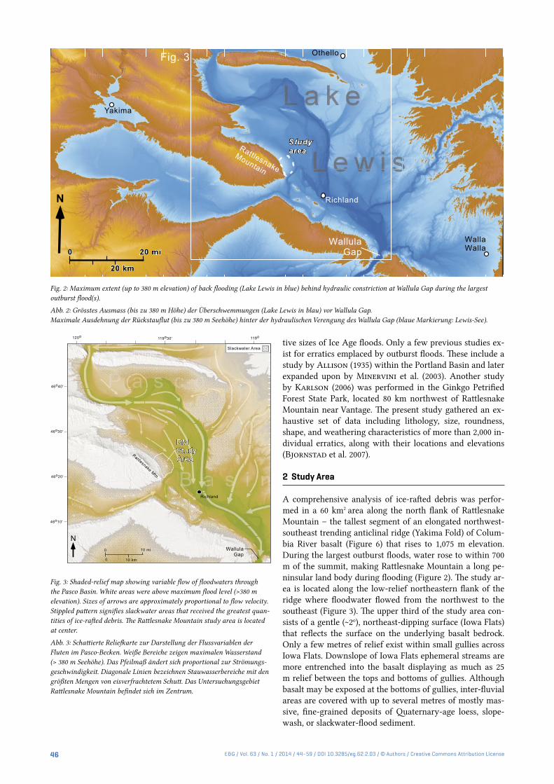
A comprehensive analysis of ice-rafted debris was perfor-med in a 60 km2 area along the north flank of Rattlesnake Mountain – the tallest segment of an elongated northwest-southeast trending anticlinal ridge (Yakima Fold) of Colum-bia River basalt (Figure 6) that rises to 1,075 m elevation. During the largest outburst floods, water rose to within 700 m of the summit, making Rattlesnake Mountain a long pe-ninsular land body during flooding (Figure 2). The study ar-ea is located along the low-relief northeastern flank of the ridge where floodwater flowed from the northwest to the southeast (Figure 3). The upper third of the study area con-sists of a gentle (~2o), northeast-dipping surface (Iowa Flats) that reflects the surface on the underlying basalt bedrock. Only a few metres of relief exist within small gullies across Iowa Flats. Downslope of Iowa Flats ephemeral streams are more entrenched into the basalt displaying as much as 25 m relief between the tops and bottoms of gullies. Although basalt may be exposed at the bottoms of gullies, inter-fluvial areas are covered with up to several metres of mostly mas-sive, fine-grained deposits of Quaternary-age loess, slope-wash, or slackwater-flood sediment.
N
WallaWalla
Richland
Othello
Yakima
WallulaGap
Fig. 3
RattlesnakeMountain
WallulaGap
Rattlesnake Mtn.
N0 10 mi
0 10 km
Richland
Slackwater Area
119o30' 119o120o
46o40'
46o30'
46o20'
46o10'
Fig. 2: Maximum extent (up to 380 m elevation) of back flooding (Lake Lewis in blue) behind hydraulic constriction at Wallula Gap during the largest outburst flood(s).
Abb. 2: Grösstes Ausmass (bis zu 380 m Höhe) der Überschwemmungen (Lake Lewis in blau) vor Wallula Gap. Maximale Ausdehnung der Rückstauflut (bis zu 380 m Seehöhe) hinter der hydraulischen Verengung des Wallula Gap (blaue Markierung: Lewis-See).
Fig. 3: Shaded-relief map showing variable flow of floodwaters through the Pasco Basin. White areas were above maximum flood level (>380 m elevation). Sizes of arrows are approximately proportional to flow velocity. Stippled pattern signifies slackwater areas that received the greatest quan-tities of ice-rafted debris. The Rattlesnake Mountain study area is located at center.
Abb. 3: Schattierte Reliefkarte zur Darstellung der Flussvariablen der Fluten im Pasco-Becken. Weiße Bereiche zeigen maximalen Wasserstand (> 380 m Seehöhe). Das Pfeilmaß ändert sich proportional zur Strömungs-geschwindigkeit. Diagonale Linien bezeichnen Stauwasserbereiche mit den größten Mengen von eisverfrachtetem Schutt. Das Untersuchungsgebiet Rattlesnake Mountain befindet sich im Zentrum.

47E&G / Vol. 63 / No. 1 / 2014 / 44–59 / DOI 10.3285/eg.62.2.03 / © Authors / Creative Commons Attribution License
Most of the study area lies within a long-protected ecol-ogy preserve, now part of the Hanford Reach National Monument managed by the United States Fish and Wildlife Service (Bjornstad 2006; Bjornstad et al. 2007). Closed to the public for the last 60 yr, this area is ideally suited to the study of ice-rafted debris because it has escaped widespread anthropogenic disturbances common to other parts of the region. Furthermore, light-colored erratic boulders stand out in stark contrast to indigenous black Columbia River basalt and the pale-brown blanket of fine-grained Quaternary sedi-ments. These attributes, along with the low, sparse, shrub-steppe vegetation facilitate the identification and mapping of ice-rafted debris. Last, the gentle yet uneven slopes provide an opportunity to examine subtle changes in flood-flow dy-namics reflected in the distribution of ice-rafted debris.
3 Ice-Rafted Debris
Bretz (1923a: 605) accurately noted: “A widespread sub-mergence of the lower Columbia Valley is known to have occurred during the Wisconsin glaciation. It is recorded by berg-floated erratic boulders, some of great size, scattered widely in the Columbia Valley below the present altitude of
about 1,250 feet [380 m] above tide.” Bretz and others, how-ever, categorized ice-rafted debris into two classes: erratics or bergmounds. The present study distinguishes an impor-tant third category of ice-rafted debris – erratic clusters. Ex-amples of the three types of ice-rafted debris are shown in Figure 4. Isolated erratics (Figure 4A) generally consist of a solitary boulder while clusters (Figure 4B and 5) represent a close grouping of several or more erratics. Bergmounds (Fig-ure 4C) consist of distinct, low-relief mounds covered with ice-rafted debris, up to 30 m or more in diameter and several meters tall (Bretz 1930; Allison 1933; Fecht & Tallman 1978; Chamness 1993). In general, bergmounds are distin-guished from erratic clusters by the presence of a conical mound displaying recognizable topographic relief. Individu-al clusters and bergmounds may contain a single rock type, but more are represented by multiple lithologies (Allison 1935; Fecht & Tallman 1978). The areal distribution for all three different types of ice-rafted debris is shown over a por-tion of Rattlesnake Mountain on Figure 7.
4 Methods
The 60-km2 Rattlesnake Mountain study area was field map-
Fig. 4: Types of ice-rafted debris on Rattlesnake Mountain. (A) Isolated granodiorite erratic boulder at (183 m elevation) in basalt-floored gully. (B) Cluster of granodiorite erratics at 335 m elevation. (C) Pair of bergmounds (~245 m elevation); notice granitic erratic atop left bergmound (encircled). Looking north into the expansive Pasco Basin.
Abb. 4: Typen von eisverfrachtetem Schutt am Rattlesnake Mountain. (A) Vereinzelte erratische Gesteinsblöcke aus Granodiorit in basaltgrundiger Schlucht-rinne (auf 183 m Seehöhe) . (B) Anhäufung von erratischen Gesteinsblöcken aus Granodiorit Findlingen (auf 335 m Seehöhe). (C) Pärchen von Bergmounds (cirka~ 245 m Seehöhe). ; man beachte den Granitfindling (eingekreist) oben auf dem linken Hügel. Blick nach Norden in das weitläufige Pasco-Becken.

48 E&G / Vol. 63 / No. 1 / 2014 / 44–59 / DOI 10.3285/eg.62.2.03 / © Authors / Creative Commons Attribution License
ped in a series of roughly parallel to diagonal, up-down transects. The transects traversed gullies as well as the inter-fluvial areas, usually spaced 100 m or more apart. All ob-served ice-rafted debris >0.093 m2 maximum exposed cross sectional area was located using a hand-held GPS receiver unit. An arbitrary cut-off value of 0.093 m2 was chosen be-cause that was near the minimum size readily observed in the field. Depending on location, erratics can be partially to almost totally buried by Quaternary-age fine-grained loess, slopewash, or slackwater flood deposits. For this reason it was not possible to determine the true volume of most er-ratics and the size reported here represents only the maxi-mum exposed cross-sectional area observed in the field. For data manageability, because many erratic clusters and berg-mounds contain dozens or more individual erratics, specific information was recorded only for the largest erratic in each cluster or bergmound grouping.
Horizontal accuracy of handheld GPS units is generally within 3 m while the measured vertical accuracy is much less precise. For this reason, instead of the elevation record-ed by the GPS, elevations were obtained from a topographic map after location coordinates were entered into National Geographic’s TOPO!© program. Because there is wide spac-ing of contour lines in the generally low relief of the study area, recorded elevations are believed to be accurate to with-in at least half of the contour interval (12.2 m), or about 6 m vertical distance.
In addition to location and elevation, data were collected on lithology, roundness, shape, and surface characteristics, such as degree of weathering, wind polish, and striations. Because rates of weathering and roundness vary with lithol-ogy, these parameters were compared for only the dominant rock type (i.e., granitic). Granitic erratics classified as un-
Metasedimentary(Belt!Supergroup)!
Columbia!River!Basalt!Group!(volcanic)Cenozoic
Mesozoic
Paleozoic
Proterozoic
Sedim
entary!and!volcanic High-grade
metamorphic
Plutonic
Ultramafic
49o
48o
47o
46o
120o 118o 116o
Yakima!Fold!anticline
Cordilleran!Ice!Sheet
66
250
550
Ma
Rock!UnitsTime
Study!area*IDWA
Ice!dam!forGlacial!Lake
Missoula
Fig. 5: Cluster of moderately weathered, banded argillite boulders at 244 m elevation on Iowa Flats along the north flank of Rattlesnake Mountain. The largest erratic boulder is about three metres long. Argillite is derived from the Proterozoic Belt Supergroup once in contact with the ice dam for gla-cial Lake Missoula in northern Idaho ~650 km to the northeast. Note that the erratics in this cluster are partially buried in an unknown quantity of Quaternary loess, slopewash and slackwater flood deposits.
Abb. 5: Haufen von mäßig verwitterten Gesteinsbrocken aus gestreiftem Argilit (auf 244 m Seehöhe) auf den Iowa-Untiefen entlang der Nord-Flanke des Rattlesnake Mountain. Der größte Findling links der Bildmitte ist etwa drei Meter lang. Argilit (Tonschiefer) entstammt dem Gürtel der Übergruppe aus dem Proterozoikum, der einst mit dem Eisdamm des ca. 650 km nordöstlich entfernten Gletschers von Lake Missoula in Nord-Idaho in Verbindung stand. Man beachte, dass die Findlingsblöcke dieser Gruppe teilweise unter unbestimmten Mengen von Löss-, Ausspülungs- und Stau-wasser-Ablagerungen aus dem Quartär begraben sind.
Fig. 6: Distribution of major rock units in eastern Washington and northern Idaho. Most ice-rafted erratics found on Rattlesnake Mountain can be traced to granitic (plutonic) and Belt Supergroup metasedimentary rocks once in contact with the Cordilleran Ice Sheet north and east of the Columbia Plateau. To the south, Yakima Folds strongly influenced the flow of floodwater into and out of the Pasco Basin.
Abb. 6: Verteilung größerer Felseinheiten im östlichen Washington und Nord-Idaho. Der Ursprung der meisten eisverfrachteten Findlingen auf Rattle-snake Mountain kann zu den granitartigen (plutonischen) und metasedimentären Felsen des Gürtels der Übergruppe zurückverfolgt werden, die einst in Verbindung mit dem Cordillerischen Eisschild nördlich und östlich des Columbia Plateau standen. Im Süden hatten die Falten der Yakima Senke starken Einfluß auf den Fluss der Flutwasser in das Pasco-Becken hinein und hinaus.

49E&G / Vol. 63 / No. 1 / 2014 / 44–59 / DOI 10.3285/eg.62.2.03 / © Authors / Creative Commons Attribution License
weathered are bright white and show no surficial oxidation or mineral decomposition. In contrast, strongly weathered granitic erratics displayed advanced stages of mineral de-composition and surface roughness, often with deep red-dish brown or dark varnished surfaces. Slightly weathered to moderately weathered erratics displayed intermediate stages of roughness, oxidation and mineral decomposition (Figure 8).
Cosmogenic 36Cl exposure-age dates were obtained from three large, dispersed, ice-rafted erratics reported in Kesz-thelyi et al. (2009) and represented in Figure 7 and Table 1. Two of the analyses were performed on granitic boulders; the third was performed on an ice-rafted boulder of basalt. Because basalt is the only indigenous rock type and com-pletely underlies the study area and crops out in the steep slopes of Rattlesnake Mountain to the southwest, special care is needed to positively identify basalt erratics. Some might argue that basalt does not qualify as a true “erratic” since it makes up the underlying bedrock at Rattlesnake Mountain, however, in this paper basalt is included as an erratic when it clearly has an ice-rafted origin. Accordingly, only basalt
boulders that were: 1) well beyond the limits where rocks could have rolled or moved down from higher elevations via mass movement, and (2) had several metres or more of fine-textured post-basalt sediment between basalt boulders and underlying bedrock were classified as erratics.
5 Results and Observations
On Rattlesnake Mountain, isolated erratics (52% of all ice-rafted debris) far outnumber erratic clusters (29%), which exceed bergmounds (19%). However, because many errat-ics smaller than a metre may be concealed beneath a cover of vegetation, the true proportions of isolated erratics and clusters may be greater than that indicated above. The high-est concentration of ice-rafted debris lies near 210 m with a general decrease above and below this elevation (Figure 9). As previously noted by Bretz (1930) bergmounds are mostly concentrated below 260 m elevation, and generally absent above 300 m (Figures 7 and 9).
As discussed above, mapping of erratics on Rattlesnake Mountain was limited to only those with an exposed cross-
R a t t l e s n a k e R i d g e
Yakim
a
River
NF i r in g R
a n ge
Ice-Rafted DebrisBergmoundErratic clusterIsolated erratic
Above maximum flood(>380 m elev.)
Cosmogenic-exposure age date
Fig. 7: Distribution of the three different types of ice-rafted debris across the study area. Details on the three erratics sampled for cosmogenic-nuclide exposure dating are listed in Table 1.
Abb. 7: Drei verschiedene Typen von eis-verfrachteten Schutt sind ungleichmäßig im Untersuchungsgebiet verteilt. Einzelin-formationen zu drei Findlingen, die für die Radionuklidmessung des Betrahlung-salters ausgewählt wurden in Tabelle 1 aufgelistet.

50 E&G / Vol. 63 / No. 1 / 2014 / 44–59 / DOI 10.3285/eg.62.2.03 / © Authors / Creative Commons Attribution License
sectional area >0.093 m2. The majority (60%) were <0.37 m2, while less than 1% were larger than 6.0 m2 (Figure 10A). The largest erratic (12.5 m2) found in the study area occurred as an isolate at a relatively high elevation (310 m).
The distribution of erratics by lithology is shown in Fig-ure 11. More than 95% of erratics consist of rocks that are very different from indigenous, dark-colored basalt (Figure
12). The majority (~75%) are light-colored granitic, crystal-line rocks (Figures 10B) like those shown in Figures 4A, 4B, and 8. However, the number of mapped erratics may be bi-ased in favor of light-colored granitic rocks because they are more visible in the field. Most granitic erratics consist of granodiorite but also include true granites. Granitic rocks are 10 times more abundant than the next most common
Erratics
Erratic clusters
Bergmounds
Number
Elevation
ft
600
500
700
800
900
1000
1100
1200
m
350
300
250
200
150
n = 2112
Fig. 8: Stages of weathering generally indicated by degree of surface roughness and amount of iron oxidation. All erratics are granitic except for the dior-ite boulder at upper left (A). Note advanced stage of surface roughness in photo E whereby the more-stable feldspar phenocrysts stand out in relief due to differential weathering of mineral grains.
Abb. 8: Verwitterungsphasen werden im Allgemeinen durch den Grad der Oberflächenrauhheit und den Umfang der Eisen-Oxidation gekennzeichnet. Alle Findlinge sind Granite – mit Ausnahme des Diorit-Findlingsbrockens oben links (A). Man beachte das fortgeschrittene Stadium der Oberflächenrauhheit in Foto E, Aufgrund unterschiedlichen Witterungsverhaltens der Mineralbestandteile treten die stabileren Feldspat-Phänokristalle reliefartig hervor.
Fig 9: Concentration of ice-rafted debris vs. elevation.
Abb. 9: Konzentration von eisverfrachtetem Schutts in Bezug zur Höhenlage.

51E&G / Vol. 63 / No. 1 / 2014 / 44–59 / DOI 10.3285/eg.62.2.03 / © Authors / Creative Commons Attribution License
rock type within the study area – quartzite. Quartzites oc-cur in a wide variety of colors, including pastel shades of blue, green, yellow, pink, and orange as well as white and gray. Diorite, an intrusive igneous rock containing about equal amounts of speckled light and dark minerals, is the third most common rock type. Next most abundant is argil-lite, an extremely hard, siliceous, dull gray to reddish brown rock that weathers and parts evenly along distinctive bed-ding planes (Figures 5 and 12). The fifth most common errat-ic type is Columbia River basalt. Other, less-common erratic lithologies include gneiss, schist, and gabbro.
The most notable surface characteristic on erratics is de-gree of weathering, which includes wind polish, mineral
decomposition, and oxidation rinds. Many strongly weath-ered granitic erratics show either a reddish-brown oxidative coating or occasionally a spalled, high-relief surface (Fig-ure 8E). Because different lithologies weather at different rates, a comparison of weathering reported here was only performed on only the most common rock type (granitic), which makes up three quarters of all erratics (Figure 10B). More than 80% of the granitic erratics appear moderately to strongly weathered (Figure 10C). Striations and grooves, presumably derived from glacial abrasion at their places of origin, were also occasionally observed on surfaces of ice-rafted boulders.
The surface roundedness of erratic clasts varies from an-
0
20
40
%
angular
angular to
subangular
rounded
689
196
649
301
824
subangular to
subrounded
A
C
B
D
%
0
10
30
20
Size Class(maximum cross-sectional area)
1-2 2-4 4-8 8-16 16-32 32-64 > 64 ft2
682
584
441
255
76
248
0.09-0.19 0.19-0.37 0.37-0.74 0.74-1.49 1.49-3.00 3.00-5.95 >5.95 m2
0
20
40
60
80
%
Lithology
1636
155112 89 73
25 21 7 14
granitic
quartzite
diorite
argillite
basalt
gneiss
schist
gabbro
other
0
20
40
60
%
unweathered
slight to
moderate
moderate to
strong
strong
7
282
57
353
Weathering Roundness
882
Field ID Sam pleNo.*
Cl-36Age*
Latitude(north)
Longitude(west)
Elevationin m (ft)
M axim umExposed Areain m 2 (ft2)
Roundness Lithology Shape W eathering
E-223 M F-6 16,930 46.37878 -119.50037 310 (1,016) 12.5 (135) subrounded granite elongate strong
E-276 M F-7 16,170 46.38400 -119.46353 209 (686) 5.1 (55) rounded granite equant strong
M ERYK1 M F-8 16,740 46.38093 -119.46473 214 (702) 1.1 (12) subrounded basalt irregular m oderate
* from Keszthelyi et al. (2009)
Fig. 10: Frequency distributions of Rattlesnake Mountain erratics by: (A) size, (B) lithology, (C) weathering, and (D) roundness. Weathering and roundness pertain only to erratics of granitic composition for reasons explained in the text.
Abb. 10: Dichte der Findlingsverteilung am Rattlesnake Mountain unterteilt in: (A) Größe, (B) Lithologie, (C) Verwitterung und (D) Rundheit Verwitte-rungsgrad und Rundheit beziehen sich ausschließlich auf granitartige Findlinge, (Begründung im Text).
Table 1: Characteristics and 36Cl-exposure ages for three, scattered, ice-rafted erratics on Rattlesnake Mountain. See Figure 7 for relative locations within the study area.
Tabelle 1: Charakteristika und Ergebnisse der 36 Cl- Altersbestimmung von drei verstreut liegenden, eisverfrachteten Findlingen am Rattlesnake Moun-tain. Jeweilige Position im Untersuchungsgebiet: siehe Abbildung 7.

52 E&G / Vol. 63 / No. 1 / 2014 / 44–59 / DOI 10.3285/eg.62.2.03 / © Authors / Creative Commons Attribution License
gular to rounded (Figure 10D). However, the majority of er-ratics were classified as subangular to subrounded. Shapes of angular to subangular boulders, argillites for example, often part along parallel bedding planes, leaving them flat to tabu-lar, or rectangular. Plutonic crystalline rocks, on the other hand, are overall more equi-dimensional to elongate, often forming a pyramid shape. In general, the shape of over one-third of all the erratics is irregular.
Cosmogenic-exposure ages on three Rattlesnake Moun-tain erratics (Table 1) fall into a relatively narrow range be-tween 16,000 to 17,000 cal yrs BP (Keszthelyi et al. 2009). These ages fall within the range (15,000 to 20,000 calendar years) for Late Wisconsin Missoula floods reported else-where (O’Connor & Benito 2009).
The distribution patterns of ice-rafted debris offer impor-tant clues to the way the debris was deposited. Summarized here:
1.) The highest observed erratic found within the study area lies at an elevation of ~362 m.
2.) Most ice-rafted debris within the study area is distributed
along a broad band at the base of Rattlesnake Mountain
that lies between 200 to 300 m elevation (Figures 7 and 9). Fewer erratics and very few bergmounds lie above 300 m, despite the fact that the largest floods rose up to 80 m higher.
3.) Many isolated erratics and erratic clusters are aligned with gullies (Figure 7). At higher elevations erratics lie at the bottoms of low-relief gullies. In contrast, at lower elevations erratics are usually perched onto the north (up-current) sides of the higher-relief gullies.
4.) A higher concentration of erratics lies along roadways.
5.) Lithology of erratics versus elevation appears random (Figure 11), as does the distribution of erratic size (Figure 13).
6 Discussion
Concentrations of Ice-Rafted DebrisDifferent processes are likely responsible for erratics, erratic clusters and bergmounds. Isolated erratic boulders repre-sent either dropstones from free-floating icebergs, or from
N
Ra t t l e s n a k e R
i d g e
Rock TypeGraniticQuartziteDioriteArgillite
BasaltGneissSchist
X Gabbro
1
1 mi
2 3 km0
0
RattlesnakeMountainStudy Area
Fi r i n
g R
an
ge
Yakima
River
Above maximumflood (>380 melev.)
119o30'119o32' 119o28'
46o22'
46o26'
46o24'
46o20'
119o26'
Fig. 11: Distribution of erratics by lithology.
Abb. 11: Verteilung von Findlingen gemäss Lithologie.

53E&G / Vol. 63 / No. 1 / 2014 / 44–59 / DOI 10.3285/eg.62.2.03 / © Authors / Creative Commons Attribution License
smaller, relatively “clean”, grounded icebergs. Erratic clus-ters likely melted out of small to moderate-sized, grounded icebergs, while bergmounds are probably associated with especially large, sediment-ladened and grounded icebergs (Bretz 1930).
The results of this study support Bretz et al. (1956) who believed the north flank of Rattlesnake Mountain displayed the greatest concentration of berg-rafted debris anywhere within the area impacted by outburst floods. This appears to apply to both erratics as well as bergmounds, which are rare-ly reported outside the Pasco Basin (Allison 1933). More bergmounds and erratics accumulated here due to floodwa-ters that backflooded and pooled behind Wallula Gap, the first major constriction along the route of the floods beyond the Channeled Scabland. In the Pasco Basin, flow expansion and rising floodwaters behind Wallula Gap caused a tempo-rary slowing of floodwaters (Bjornstad 2006). The slowing currents naturally directed icebergs to the quieter margins of
the basin like Rattlesnake Mountain and backflooded valleys such as the Yakima and Walla Walla valleys (Figures 1 and 2), especially during the waxing stages of flooding (Baker et al. 1991). Far fewer erratics occur in unrestricted, higher-gradient reaches of the floods, like Wallula Gap, because of higher flow velocities that kept icebergs moving through the system.
Iceberg-deposited erratics occur downstream of Wallula Gap but are much less concentrated than on Rattlesnake Mountain. In the backflooded Willamette Valley (south of Portland, Oregon), for example, only about 1.9 erratics/km2 were identified by Minervini et al. (2003), compared to al-most 38.6 erratics+bergmounds/km2 within the Rattlesnake Mountain study area. However, it is acknowledged that the concentration of erratics may be somewhat biased in favor of Rattlesnake Mountain because rafted debris is more vis-ible in the semi-arid, low shrub-steppe of eastern Washing-ton, compared to the more humid and densely vegetated
Fig. 12: Erratic lithologies on Rattlesnake Mountain.
Abb. 12: Lithologie der Findlinge vom Rattlesnake Mountain.

54 E&G / Vol. 63 / No. 1 / 2014 / 44–59 / DOI 10.3285/eg.62.2.03 / © Authors / Creative Commons Attribution License
Willamette Valley. Although many erratics of the Willamette Valley could be buried within or beneath a cover of Quater-nary sediments so too are many of the erratics on Rattle-snake Mountain.
As illustrated in Figures 7 and 9 the highest concentrations of erratic debris lies partway up the slopes of Rattlesnake Mountain between 200- and 300 m elevation. The decrease in erratic debris at lower elevations may be explained by in-creased flow velocity that developed across the lower slopes as the last of the floodwaters in Lake Lewis drained from the basin. Accordingly, the faster flows were sufficient enough to prevent iceberg stagnation. Another possibility is more erratics lie buried beneath a cover of Holocene-age eolian, slopewash or fluvial sediment at lower elevations. The de-crease in erratic debris above 300 m is consistent with what is known about the sizes of the many dozens or more out-burst floods, only a limited number of which were extremely large (Benito & O’Connor 2003). The peak discharges for many of the floods were relatively small (<1 million m3/sec) compared to the largest flood(s) estimated at 17.5 million m3/sec (O’Connor & Baker 1992). Naturally, smaller outburst floods would not pond as deep behind hydraulic constric-tions at Wallula Gap and the Columbia River Gorge.
Erratic debris was observed up to an elevation of 362 m on Rattlesnake Mountain. Elsewhere in the Pasco Basin the author has observed erratics up to an elevation of 366 m on Red Mountain (N46.301, W119.448). This height is close to 372 m – the base elevation of a high flood-spillover chan-nel along the east side of Wallula Gap (N46.0327, W118.9186) that is incised to an elevation of 378 m. Thus, two independ-ent lines of evidence appear to place the highest level for outburst flooding in the Pasco Basin and upper Wallula Gap to at least 366 m and perhaps as high as 380 m shown in Figures 2 and 3. Highest floodwater indicators downstream of Wallula Gap are only about 335 m elevation, therefore it appears that some hydraulic gradient still existed between the upper and lower ends of Wallula Gap during the larg-est floods, although the flow was later impeded by ponding that shifted downstream into the constricted reaches of the Columbia River Gorge (Benito & O’Connor 2003). These constrictions facilitated the high water levels observed in Wallula Gap – especially during waning stages of flooding.
Size of ErraticsThe size of erratics appears to be random with respect to elevation (Figure 13) (i.e., erratics of variable size exist up
N
Size Class>64 ft232-6416-328-164-82-41-2Above maximumflood (>380 melev.)
Ra t t l e s n a k e R
i d g e
1
1 mi
2 3 km0
0
RattlesnakeMountainStudy Area
Fi r i n
g R
an
ge
Yakima
River
119o30'119o32' 119o28'
46o22'
46o26'
46o24'
119o26'
(>5.95 m2)(3.00-5.95)(1.49-3.00)(0.74-1.49)
(0.37-0.74)(0.19-0.37)(0.09-0.19)
Fig. 13: Distribution of erratics by size.
Abb. 13: Verteilung von Findlingen gemäss Größe.

55E&G / Vol. 63 / No. 1 / 2014 / 44–59 / DOI 10.3285/eg.62.2.03 / © Authors / Creative Commons Attribution License
to 362 m elevation). The number of erratics, distributed over seven different size classes, is shown in Figures 10A and 14. The log-log trend of smaller erratics appears to drop off around <0.75 m2, which may be due to sampling bias. Errat-ics larger than 0.7 m2 are more likely to extend above the low shrub-steppe vegetation rendering them more visible and mappable. Smaller erratics, on the other hand, are less conspicuous and more likely to be overlooked, especially if located between survey transects.
In general, considerable amounts of erratic debris smaller than 0.09 m2 were observed to litter the surface, often mul-tiple clasts per square metre, especially below 300 m eleva-tion within the study area. Even though it was not practical to map debris of this size, it might be possible to estimate the abundance of the <0.09 m2 size class based on the log-log plot illustrated in Figure 14. Accordingly, the number of larger erratics (0.7 m2 to 6 m2) appear to plot along a gener-ally straight-line, log-log function for the number of erratics versus size expressed as:
N = 152 A–1.67
where N = number of erratics, and A = maximum exposed cross-sectional area in m2.
Assuming erratics <0.75 m2 follow a similar straight-line log function, the actual number of erratics in the 0.1–0.2 m2) size range might be on the order of several thousand, which is considerably more than the 682 actually observed within the study area (Figure 10A). Accordingly, the total number of even less-visible erratic clasts down to the next smaller size class (0.01 m2) may exceed 300,000 based on the above equation. However, while it is possible the above equation
10
102
103
104
105
Log
Num
ber o
f Err
atic
s
10 101 102 m210-21
Log Size (maximum cross-sectional area)
y = 152 (x )-1.67
10-1 0
R = 0.992
380 m
RattlesnakeMtn.
SW
NE
1000
500
300 m
Elev
atio
n
1500ft m
300
400
200
Fig. 14: Log-log plot of size vs. number of erratics measured on Rattlesnake Mountain. A linear log-log distribution may exist for erratics larger than 0.75 m2 in area. The straight-line equation and correlation coefficient (R2 = 0.99) are based on the number of erratics mapped between the 0.75 m2 and 6 m2 size classes.
Abb. 14: Log-Log plot (Anmerkung: zweidimensionale grafische Darstellung von Daten auf Logarithmenbasis): Größe vs. Anzahl ausgemessener Find-linge auf Rattlesnake Mountain. Eine lineare Log-Log Verteilung existiert möglicherweise für Findlinge größer als 0,75 m2 im Untersuchungsgebiet. Die Geradengleichung und der Korrelationskoeffizient (R2 = 0,98) beruhen auf der Zahl der Findlinge in den Größenklassen von 0,75 m2 sowie 6 m2.
Fig. 15: A diagram to illustrate elevation-limited distribution of bergmounds on Rattlesnake Mountain. The largest icebergs were grounded on the gently sloping lake bottom, further from the ancient shores of short-lived Lake Lewis. Few well-developed bergmounds are observed above ~300 m elevation, even though floodwaters extended up to 380 m. Apparently, during the largest flood(s) all bergmound-producing icebergs became grounded below 75 vertical metres of maximum lake level because of their greater size.
Abb. 15: Diagramm zur höhenbegrenzten Verteilung von Bergmounds auf Rattlesnake Mountain. Die größten Eisberge liefen weit entfernt von der alten Uferlinie von Lake Lewis auf der sanft abfallenden Seesohle auf Grund. Obwohl der See bis auf 380 m Seehöhe anstieg wurden nur wenige gut entwickelte Bergmounds oberhalb von 300 m Seehöhe gefunden, Während der größten Fluten liefen offenbar alle Bergmound erzeugenden Eisberge aufgrund ihrer Größe unterhalb von 75 Höhenmeter unter dem maximalen Seespiegel auf Grund.
56 E&G / Vol. 63 / No. 1 / 2014 / 44–59 / DOI 10.3285/eg.62.2.03 / © Authors / Creative Commons Attribution License
may not accurately reflect the true number of erratics for different size classes, the known bias introduced in size ver-sus visibility suggests a log-log distribution may in fact rep-resent a reasonable estimate.
Sources of Erratic DebrisThe lithology of erratics is consistent with an origin from ar-eas once in contact with the Cordilleran Ice Sheet. Argillite is closely associated with quartzite; both are meta-sedimentary rocks derived from the Proterozoic Belt Supergroup (Orr & Orr 1996). These rocks crop out along the eastern side of the Purcell Trench at the site of the ice dam for glacial Lake Mis-soula (Miller et al. 1999; Bjornstad & Kiver, 2012). Other erratics include Cretaceous and Eocene plutonic rocks such as granite and granodiorite and high-grade metamorphics (i.e., gneiss, schist), which crop out along the western side of the Purcell Trench and in northern Washington (Stoffel et al. 1991) (Figure 6).
Some basalt, while indigenous to the area, was also en-trapped in glacial ice and carried along with outburst flood-waters. Although Columbia River basalt did not come in di-rect contact with the ice dam for Lake Missoula, there are other places downstream where the ice sheet overrode ba-salt: 1) Okanogan lobe where it extended across Waterville
Plateau (Figure 1), and 2) the Colville Valley (Figures 1 and 6). Thus, ice-rafted basalt may be derived from: 1) icebergs that calved off the Okanogan Lobe (and possibly the Colville Lobe) into glacial Lake Columbia, or 2) a final flood associ-ated with the breakup of Lake Columbia several centuries after the last Missoula flood (Atwater 1987; Waitt 1994; Waitt et al. 2009).
Surficial Weathering and Roundness of ErraticsThe majority of erratics (especially granitic) on the surface show some degree of roundness and weathering (Figure 8). Yet the spatial distribution of surface weathering and round-ing appeared random with respect to elevation and location within the study area. Because ice-rafted erratics undergo little or no abrasion during ice transport, the rounding must have occurred either before or after melting out of icebergs. Like erratics on Rattlesnake Mountain, many glacial erratics observed today near the former Cordilleran Ice Sheet show some degree of rounding, either inherited from their place of origin prior to ice transport, or due to in-situ weathering since the end of the Pleistocene.
Although it may be tempting to attribute weathering and roundness to in-situ weathering (via exfoliation and spalling) since iceberg emplacement, this does not appear to
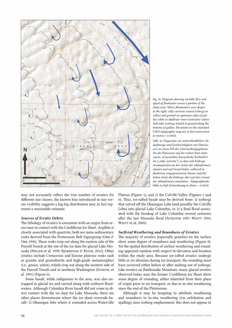
Fig. 16: Diagram showing variable flow and speed of floodwater across a portion of the study area. Where floodwaters were deeper to the right, eddy currents caused icebergs to collect and ground on upstream sides of gul-lies while in shallower more-restrictive waters (left side) icebergs tended to ground along the bottoms of gullies. Elevations in this standard USGS topographic map are in feet (conversion to metres = 0.3048).
Abb. 16: Diagramm zur unterschiedlichen Ab-laufmenge und Geschwindigkeit von Flutwas-sers in einem Teil des Untersuchungsgebietes. Wo die Flutwasser auf der rechen Seite tiefer waren, verursachten foucaultsche Wirbelströ-me („eddy currents“), so dass sich Eisberge stromaufwärts an den Seiten der Ablaufrinnen stauten und auf Grund liefen, während in flacherem, eingegrenzterem Wasser (auf der linken Seite) die Eisberge eher auf dem Grund der Ablaufrinnen strandeten. Topographische Höhe in Fuß (Umrechnung in Meter = 0.3048).

57E&G / Vol. 63 / No. 1 / 2014 / 44–59 / DOI 10.3285/eg.62.2.03 / © Authors / Creative Commons Attribution License
be the case based on a limited number of cosmogenic-expo-sure ages on erratics (Keszthelyi et al. 2009). Three dated erratics shown in Table 1 are variably weathered (two of the three strongly weathered), yet their exposure ages fall into a narrow range of time. All three erratics are associated with the last cycle (Late Wisconsin) glaciation between 16 and 17 thousand years. This amount of time appears insufficient to produce a strongly weathered erratic surface especially considering some granitic erratics on Rattlesnake Mountain show little or no weathering. Therefore, the degree of weath-ering and rounding of granitic erratics does not appear to be a reliable indicator of age since grounding of erratics and suggests at least some weathering and roundness of errat-ics is inherited from their place of origin, prior to being ice rafted to Rattlesnake Mountain.
Because of the extremely limited number of dated errat-ics, however, the possibility still exists that other, undated er-ratics could have undergone strong weathering in situ. Out-burst floods from previous glacial cycles going back to Early Pleistocene (>780 ka) are known to have occurred in east-ern Washington (Patton and Baker 1978; Bjornstad et al. 2001; Pluhar et al. 2006). Erratics associated with these ear-lier flood events would be expected to display strong weath-ering if continuously exposed at the ground surface. On the other hand, those erratics derived from pre-Wisconsin floods that lie buried beneath an aggrading mantle of post-basalt Pleistocene sediments may have escaped surficial weather-ing.
Origin of BergmoundsAlthough it seems logical to ascribe bergmounds (Figure 4C) entirely to the buildup of ice-rafted debris from large, sediment-laden icebergs, the model for bergmound devel-opment may be more complicated. Not all topographic re-lief observed on bergmounds is necessarily constructional. Some of the relief may also be the result of increased erosion around the flanks of the bergmound, which occurred during or since flooding. This is suggested from trenching studies of bergmounds, which reveal at least some of the interiors are composed of mostly fine-grained sediments, which are not necessarily derived from ice-rafted debris (Fecht & Tall-man 1978; Chamness 1993, 1994). Thus, coarser ice-rafted debris may merely blanket bergmounds creating a lag-grav-el cap that acts to armor and protect the underlying finer-grained sediments. Areas between bergmounds, lacking a coarse, armored cap, then were more susceptible to erosion by either: 1) receding floodwaters, or 2) post-flood eolian de-flation. However, problematic is the almost perfectly sym-metrical and conical shape of bergmounds that show little or no sign of streamlining, which might be expected if subse-quently eroded by either moving floodwater or wind.
Distribution of Ice-Rafted DebrisBretz et al. (1956) noted two populations of ice-rafted de-bris along Rattlesnake Mountain. They reported bergmounds up to an elevation of 260 m; while single erratics or groups of erratics extended up to 335 m elevation they speculated the two populations were the result of two separate flood events. However, knowing there were at least dozens (Waitt 1980) to perhaps hundreds of separate flood events (Bjorns-tad 2006) of various magnitudes, a different explanation for
the distribution of ice-rafted debris shown in Figure 7 seems warranted.
Based on Archimedes’ principle the minimum size of an iceberg needed to float a boulder of granite composition (av-erage density ~2.70 g/cm3) is estimated at about 20 times the volume of the erratic boulder. In marine waters only the up-per one-eighth of icebergs rise above water level (Bruneau 2004). However, due to higher sediment loads and densities of continental floodwaters, it is likely icebergs were even more buoyant and floated higher when compared to marine water containing little or no suspended sediment. Nevertheless, the bulk of floating icebergs lie underwater and protrude well below the waterline. Essentially, the larger the iceberg the deeper it extended into temporary Lake Lewis (Figure 15). It follows then that larger icebergs would become grounded well away from the ancient shores of Lake Lewis. This would explain why far fewer bergmounds lie above 300 m eleva-tion. Furthermore, the greater concentration of ice-rafted de-bris at lower elevations (Figure 7) is consistent with evidence to indicate there were many more smaller floods versus large floods toward the end of the Wisconsin Glaciation (Waitt 1980; Benito & O’Connor 2003).
Flow Dynamics A notable pattern, illustrated in Figure 7, is the alignment of many erratics and erratic clusters along gullies. At lower elevations, erratics are concentrated along the south-facing (upstream) slopes of gullies. At higher elevations, erratics lie mostly along the bases of these same gullies. The pattern of concentration for erratics along gullies is attributed to eddy currents set up by floodwaters flowing at slightly different velocities across the uneven surface of Rattlesnake Moun-tain. It is envisioned that, as floodwater levels rapidly low-ered, icebergs were trapped in eddies that circulated in the deep and slower moving water within the gullies. At higher elevations where the lake was shallower, deep-rooted ice-bergs migrated to the deeper water overlying the bottoms of gullies. At lower elevations icebergs were less constrained because of deeper water and therefore more likely to become grounded on the high margins to the upstream side of gullies where eddy circulation concentrated their movement (Fig-ure 16).
Erratics are also more concentrated along roadways with-in the study area; this concentration suggests exhumation during road construction from fine-textured, post-basalt sediments. Furthermore, cisterns dug by early 20th century settlers in this older loose, fine sediment often produced er-ratic boulders. These observations indicate: 1) many errat-ics from older floods lie buried within the post-basalt sedi-ment cover, and 2) there are far more erratic boulders on Rattlesnake Mountain than those currently exposed at the surface. Some of these buried boulders could be associated with older, pre-Wisconsin (>120 ka) outburst floods (Patton & Baker 1978; Bjornstad et al. 2001).
7 Conclusions
Ice-rafted debris accumulated in slackwater areas up to an elevation of ~365 m within south-central Washington during repeated Pleistocene cataclysmic floods. Erosion by floods along the basin outlet at Wallula Gap indicates maximum

58 E&G / Vol. 63 / No. 1 / 2014 / 44–59 / DOI 10.3285/eg.62.2.03 / © Authors / Creative Commons Attribution License
flood depths approached 380 m. Floodwaters impounded be-hind Wallula Gap temporarily created Lake Lewis and de-posited ice-rafted erratics and bergmounds along the gentle slopes of Rattlesnake Mountain. Ice-rafted debris is of three types: 1) isolated erratics, 2) erratic clusters, and 3) berg-mounds. Unlike erratics and clusters, bergmounds display topographic relief in the form of scattered, low-relief, conical mounds.
The present study of ice-rafted debris was performed in a long-protected, sparsely vegetated, 60 km2 area on the north-eastern flank of Rattlesnake Mountain. More than 2,100 lo-cations of erratics >0.09 m2 and bergmounds were recorded with a GPS unit. Additional information was gathered on 1) elevation, 2) lithology, 3) size, 4) roundness, 5) shape, and 6) surface characteristics of erratics. All but a few percent of erratics consist of rocks other than indigenous basalt; ap-proximately 75% are of granitic composition. Other litholo-gies, in order of decreasing abundance, are quartzite, diorite, argillite, basalt, gneiss, schist, and gabbro.
36Cl-exposure ages on three, widely dispersed erratics were 16-17 ka, suggesting all were emplaced during the last glacial cycle (i.e., Late Wisconsin). Most erratics are either subrounded or rounded, followed by subangular; angu-lar clasts are least common. Greater than three quarters of erratics are moderately to strongly weathered, but a wide range of weathering and roundness was observed on the cosmogenically-dated erratics suggesting these features are likely inherited from their place of origin.
The distribution of ice-rafted debris is non-uniform; max-imum concentration is around 200 m elevation. Bergmounds are mostly restricted to a band between 200- and 300 m el-evation; especially large icebergs that produced bergmounds could not approach the shores of the ancient shoaling lake, which extended up to 80 m higher. As floodwaters moved across an uneven surface backwater eddies concentrated icebergs and their entrapped erratics along the upstream sides of northeast-trending gullies within the study area. This study affirms that the north slope of Rattlesnake Moun-tain likely contains the most prolific erratic and bergmound population of anywhere along the route for glacial-outburst floods in the northwestern US.
Acknowledgements
Special thanks go to Elysia Jennet, Bronwyn Ryan, and Rick Edwards who each spent a summer diligently collecting field data. Jenna Gaston of the U.S. Fish and Wildlife Service as-sisted with the special-use permit to access the restricted Fitzner/Eberhardt Arid Lands Ecology Reserve Unit of the Hanford Reach National Monument. Also appreciated is the support of Gary Kleinknecht and Ivar Husa and helpful re-views of earlier drafts of the manuscript by Jim O’Connor and Jim Knox. Reviews by colleagues at the Pacific North-west National Laboratory, including Mickie Chamness, George Last and Christopher Murray, further improved the manuscript. Appreciated is an editorial review by Andrea Currie and translations by Nik Foster. Vic Baker and Marek Zreda provided 36Cl-exposure age dates for Rattlesnake Mountain erratics. Lastly, helpful reviews by Leszek Marks and Jim Rose greatly improved the quality of the manuscript.
References
Allen, J.E., Burns, M. & Burns, S. (2009): Cataclysms on the Columbia. – 205 p.; Second Edition, Portland, Oregon (Ooligan Press).
Allison, I.S. (1933): New version of the Spokane flood. – Bulletin of the Geological Society of America, 44: 675–722.
Allison, I.S. (1935): Glacial erratics in the Willamette Valley. – Bulletin of the Geological Society of America, 46: 605–632.
Atwater, B.F. (1986): Pleistocene glacial-lake deposits of the Sanpoil River valley, northeastern Washington. – USGS Bulletin 1661, U.S. Geologi-cal Survey.
Atwater, B.F. (1987): Status of glacial Lake Columbia during the last floods from glacial Lake Missoula. – Quaternary Research, 27: 182–201.
Baker, V.R. (1978): Paleohydraulics and hydrodynamics of the Scabland Floods. – In: Baker, V.R., Nummedal, D. (eds.): The Channeled Scabland. – Washington D.C. (National Aeronautics and Space Admin-istration), 59–79.
Baker, V.R. & Bunker, R.C. (1985): Cataclysmic Late Pleistocene flooding from glacial Lake Missoula: A review. – Quaternary Science Reviews, 4: 1–41.
Baker, V.R., Bjornstad, B.N., Busacca, A.J., Fecht, K.R., Kiver, E.P., Moody, U.L., Rigby, J.G., Stradling, D.F. & Tallman, A.M. (1991): Quaternary geology of the Columbia Plateau. – In: Morrison, R.B. (ed.), Quaternary Nonglacial Geology, Conterminous U.S., DNAG [Decade of North American Geology], Geology of North America, Boulder, Colorado (Geological Society of America), v. K-2, 215–250.
Benito, G. & O’Connor, J.E. (2003): Number and size of last-glacial Mis-soula floods in the Columbia River valley between Pasco Basin, Wash-ington, and Portland, Oregon. – Bulletin of the Geological Society of America, 115: 624–638.
Bjornstad, B. N., Fecht, K.R. & Pluhar, C.J. (2001): Long history of pre-Wisconsin, Ice-Age floods: Evidence from southeastern Washington State. – Journal of Geology, 109: 695–713.
Bjornstad, B.N. (2006): On the Trail of the Ice-Age Floods: Guide to the Mid-Columbia Basin. – 307 p.; Sandpoint, Idaho (Keokee).
Bjornstad, B.N., & E.P. Kiver (2012): On the Trail of the Ice Age Floods: The Northern Reaches. – 432 p.; Sandpoint, Idaho (Keokee).
Bjornstad, B.N., Babcock, R.S. & Last, G.V. (2007): Flood basalts and Ice age floods: Repeated late Cenozoic cataclysms of southeastern Wash-ington. – In: Stelling, P. & Tucker, D.S., (eds.), Floods, Faults and Fire: Geological Field Trips in Washington State and Southwest British Columbia. – Geological Society of America Field Guide 9, 209–255, doi: 10.1130/2007.fld009 (10).
Bretz, J H. (1919): The late Pleistocene submergence in the Columbia valley of Oregon and Washington. – Journal of Geology, 27: 489–506.
Bretz, J H. (1923a): Glacial drainage on the Columbia Plateau. – Bulletin of the Geological Society of America, 34: 573–608.
Bretz, J H. (1923b): The Channeled Scabland of the Columbia Plateau. – Journal of Geology, 31: 617–649.
Bretz, J H. (1930): Valley deposits immediately west of the Channeled Scabland. – Journal of Geology, 38: 385–422.
Bretz, J H., Smith, H.T.U. & Neff, G.E. (1956): Channeled Scabland of Washington: New data and interpretations. – Bulletin of the Geological Society of America, 67: 957–1049.
Bretz, J H. (1969): The Lake Missoula floods and the Channeled Scabland. – Journal of Geology, 77: 505–543.
Bruneau, S.E. (2004): Icebergs of Newfoundland and Labrador. – 64 p.; St.Johns, Newfoundland, (Flanker Press).
Chamness, M.A. (1993): An investigation of bergmounds as analogs to ero-sion control factors on protective barriers. PNL-8841, Pacific Northwest Laboratory, Richland, Washington.
Chamness, M.A. (1994): Bergmounds: A depositional or erosional feature? – Geological Society of America, Abstracts with Programs 26: A–307.
Denlinger, R.P. & O’Connell, D.R.H. (2010): Simulation of cataclysmic outburst floods from Pleistocene glacial Lake Missoula. – Bulletin of the Geological Society of America, 122: 678–689. DOI: 10.1130/B26454.1.
Fecht, K.R. & Tallman, A.M. (1978): Bergmounds along the western mar-gin of the Channeled Scablands, south-central Washington. – RHO-BWI-SA-11, Rockwell Hanford Operations, Richland, Washington.
Karlson, R.C. (2006): Investigation of Ice Age flood geomorphology and stratigraphy in Ginkgo Petrified Forest State Park, Washington: Im-plications for park interpretation. – Master of Science Thesis, Central Washington University, Ellensburg, Washington, 146 p.
Keszthelyi, L.P., Baker, V.R., Jaeger, W.L., Gaylord, D.R., Bjornstad, B.N., Greenbaum, N., Self, S., Thordarson, T., Porat, N. & Zreda,

59E&G / Vol. 63 / No. 1 / 2014 / 44–59 / DOI 10.3285/eg.62.2.03 / © Authors / Creative Commons Attribution License
M.G. (2009): Floods of water and lava in the Columbia River Basin: Analogs for Mars. – In: O’Connor, J.E., Dorsey, R.J. & Madin, I.P., (eds.), Volcanoes to Vineyards: Geologic Field Trips Through the Dy-namic Landscape of the Pacific Northwest. – Geological Society of America Field Guide 15, 845–874, doi: 10.1130/2009.fld015 (34).
Miller, F.K., Burmester, R.F., Miller, D.M., Powell, R.E. & Derkey, P.M. (1999): Digital geologic map of the Sandpoint 1- by 2-degree quadran-gle, Washington, Idaho, and Montana. – Open-File Report 99–144, U.S. Geological Survey, Menlo Park, California.
Minervini, J., O’Connor, J.E. & Wells, R.E. (2003): Inundation map, ice-rafted erratics, and deposits of Late Pleistocene Missoula floods in the Portland Basin and Willamette Valley, Oregon and Washington. – Geo-logical Society of America, Abstracts with Programs, 34: 335.
O’Connor, J.E. (1993): Hydrology, hydraulics, and geomorphology of the Bonneville Flood. – GSA Special Paper 274, Geological Society of America, Boulder, Colorado, 83 p.
O‘Connor, J.E. & Baker, V.R. (1992): Magnitudes and implications of peak discharges from glacial Lake Missoula. – Bulletin of the Geological So-ciety of America, 104: 267–279.
O’Connor, J.E. & Benito, G. (2009): Late Pleistocene Missoula floods – 15,000–20,000 calendar years before present from radiocarbon dating. – Geological Society of America, Abstracts with Programs, 41: 169.
Orr, E.L & Orr, W.N. (1996): Geology of the Pacific Northwest. – 409 p.; New York (McGraw-Hill).
Patton, P.C. & Baker, V.R. (1978): New evidence of pre-Wisconsin flood-ing in the channeled scabland of eastern Washington. – Geology, 6: 567–571.
Pluhar, C.J., Bjornstad, B.N., Reidel, S.P., Coe, R.S. & Nelson, P.B. (2006): Magnetostratigraphic evidence from the Cold Creek bar for
onset of ice-age cataclysmic floods in eastern Washington during the Early Pleistocene. – Quaternary Research, 65: 123–135.
Shaw, J., Munro-Stasuik, M., Sawyer, B., Beaney, C., Lesemann, J.-E., Musacchio, A., Rains, B. & Young, R.R. (1999): The Channeled Scabland: Back to Bretz. – Geology, 27: 605–608.
Smith, G.A. (1993): Missoula flood dynamics and magnitudes inferred from sedimentology of slack-water deposits on the Columbia Plateau. – Bul-letin of the Geological Society of America, 195: 77–100.
Stoffel, K.L., Joseph, N.L., Waggoner, S.Z., Gulick, C.W., Korosec, M.A. & Bunning, B.B. (1991): Geologic Map of Washington – Northeast Quadrant. – Geologic Map GM-39, Washington Division of Geology and Earth Resources, Olympia, Washington.
Waitt, R.B. (1980): About forty last-glacial Lake Missoula jökulhlaups through southern Washington. – Journal of Geology, 88: 653–679.
Waitt, R.B. (1985): Case for periodic, colossal jökulhlaups from Pleistocene glacial Lake Missoula. – Bulletin of the Geological Society of America, 96: 1271–1286.
Waitt, R.B. (1994): Scores of gigantic, successively smaller Lake Missoula floods through Channeled Scabland and Columbia Valley. – In: Swan-son D.A. & Haugerud, R.A. (eds.): Geologic Field Trips in the Pacif-ic Northwest, Chapter 1K. – Geological Society of America, Boulder, Colorado, pp. 1K-1 to 1K-88.
Waitt, R.B., Denlinger, R.P. & O’Connor, J.E. (2009): Many Monstrous Missoula floods down Channeled Scabland and Columbia Valley. – In: O’Connor, J.E, Dorsey, R.J., & Madin, I.P. (eds.): Volcanoes to Vine-yards: Geologic Field Trips through Dynamic Landscape of the Pacific Northwest. – Geological Society of America Field Guide 15: 775–844, doi: 10.1130/2009.ftd015(33).