A harbour–canal at Portus: a geoarchaeological approach to the Canale Romano: Tiber delta, Italy
19
A harbour–canal at Portus: a geoarchaeological approach to the Canale Romano: Tiber delta, Italy Ferre ´ol Salomon • Jean-Philippe Goiran • Jean-Paul Bravard • Pascal Arnaud • Hatem Djerbi • Stephen Kay • Simon Keay Received: 15 May 2013 / Accepted: 5 February 2014 / Published online: 5 March 2014 Ó Springer Science+Business Media Dordrecht 2014 Abstract This paper presents a detailed description of the sediments trapped by the Canale Romano in the Imperial harbour complex of Portus (Rome). The study confirms the hypothesis of a Roman canal (active during the early 2nd century AD and the 3rd/5th century AD) with a maximum water-depth between 4.36 and 7.37 m. The function of this canal as a harbour seems to particularly fit with the data available. This study follows a multidisciplinary approach. It combines all previous data available on the Canale Romano F. Salomon (&) Á S. Keay School of Humanities, Archaeology, University of Southampton, Avenue Campus, Southampton SO 17 1 BF, UK e-mail: [email protected] S. Keay e-mail: [email protected] J.-P. Goiran CNRS UMR 5133 – Ache ´orient, Maison de l’Orient et de la Mediterranee, 7, Rue Raulin, 69007 Lyon, France e-mail: [email protected] J.-P. Bravard UMR 5600 – EVS, Universite ´ Lumie `re Lyon 2, 5, Avenue Pierre Mendes-France, 69676 Bron Cedex, France e-mail: [email protected] P. Arnaud UMR 5189 - HiSoMA, Universite ´ Lumie `re Lyon 2, 5, Avenue Pierre Mendes-France, 69676 Bron Cedex, France e-mail: [email protected] H. Djerbi E ´ veha, 87 rue des bruye `res, 69 150 De ´cines-Charpieu, France e-mail: [email protected] S. Kay British School at Rome, Via Gramsci 61, 00197 Rome, Italy e-mail: [email protected] 123 Water Hist (2014) 6:31–49 DOI 10.1007/s12685-014-0099-1
Transcript of A harbour–canal at Portus: a geoarchaeological approach to the Canale Romano: Tiber delta, Italy

A harbour–canal at Portus: a geoarchaeologicalapproach to the Canale Romano: Tiber delta, Italy
Ferreol Salomon • Jean-Philippe Goiran • Jean-Paul Bravard •
Pascal Arnaud • Hatem Djerbi • Stephen Kay • Simon Keay
Received: 15 May 2013 / Accepted: 5 February 2014 / Published online: 5 March 2014� Springer Science+Business Media Dordrecht 2014
Abstract This paper presents a detailed description of the sediments trapped by the
Canale Romano in the Imperial harbour complex of Portus (Rome). The study confirms the
hypothesis of a Roman canal (active during the early 2nd century AD and the 3rd/5th
century AD) with a maximum water-depth between 4.36 and 7.37 m. The function of this
canal as a harbour seems to particularly fit with the data available. This study follows a
multidisciplinary approach. It combines all previous data available on the Canale Romano
F. Salomon (&) � S. KeaySchool of Humanities, Archaeology, University of Southampton, Avenue Campus,Southampton SO 17 1 BF, UKe-mail: [email protected]
S. Keaye-mail: [email protected]
J.-P. GoiranCNRS UMR 5133 – Acheorient, Maison de l’Orient et de la Mediterranee,7, Rue Raulin, 69007 Lyon, Francee-mail: [email protected]
J.-P. BravardUMR 5600 – EVS, Universite Lumiere Lyon 2,5, Avenue Pierre Mendes-France, 69676 Bron Cedex, Francee-mail: [email protected]
P. ArnaudUMR 5189 - HiSoMA, Universite Lumiere Lyon 2,5, Avenue Pierre Mendes-France, 69676 Bron Cedex, Francee-mail: [email protected]
H. DjerbiEveha, 87 rue des bruyeres, 69 150 Decines-Charpieu, Francee-mail: [email protected]
S. KayBritish School at Rome, Via Gramsci 61, 00197 Rome, Italye-mail: [email protected]
123
Water Hist (2014) 6:31–49DOI 10.1007/s12685-014-0099-1

(geophysical surveys, archaeological and historical data) and provides a new palaeoenvi-
ronmental dataset in order to draw a more complete overview about its history. Three cores
drilled in the Canale Romano are analyzed using sedimentological data, CM diagram and
bioindicators, 14C and archaeological data. Four main sedimentation phases were identi-
fied: (1) Pre-canal deposits; (2) relatively quiet fluvial environment deposits; (3) flood
sediments inputs; and (4) fine sediment infill after the cut-off of the canal. In the discus-
sion, the paper attempts to put this stratigraphic sequence into context of the reorganization
of the harbour of Imperial Rome during the reign of Trajan (early 2nd century AD) and its
subsequent evolution.
Keywords Geoarchaeology � Portus � Roman canal � Roman harbour � CM
diagram � Tiber delta � Rome
Introduction
In the Roman Imperial period, Portus was an essential node in the economic system
intended to supply commodities to Rome. By the time that Portus was first established in
the middle of the 1st century AD, the population of Rome had already grown to circa one
million inhabitants (Lo Cascio 1997, 2004; Storey 1997; Corvisier 2001) and the City
controlled an Empire extending across the Mediterranean and temperate Europe. In this
context, Portus acted as a central hub for the maritime, fluvial and road transport in and out
of Rome (Fig. 1).
The maritime harbour basins have been intensely studied over the past 10 years. A
significant amount of data has been accumulated about its chronology, with particular
reference to the Claudian, Neronian and Trajanic periods (Keay et al. 2005; Keay and
Paroli 2011; Boetto et al. 2010; Bukowiecki et al. 2011). Furthermore, geophysical survey
has been used extensively around the area of Portus (Keay et al. 2005, 2011). Geoar-
chaeological and palaeoenvironmental research about the harbour basin sediments has
been conducted through the analysis of cores. This research has revived discussions about
the Claudian harbour entrances and enabled a new reconstruction of how the harbour
basins were configured and used (Morelli 2005; Arnoldus-Huyzendveld 2005; Giraudi
et al. 2009; Bellotti et al. 2009; Goiran et al. 2008, 2010).
The role of the river Tiber within the port system of Portus has not received much
academic attention. The discovery of Claudian (CIL XIV 85 = ILS 207) and Trajanic
inscriptions (CIL XIV 88 = CIL VI 964 = ILS 5797a) in the 19th century provided infor-
mation about the construction of several canals. Today one Roman canal survives, the
Canale di Fiumicino. It is still used for river and maritime traffic and has been a component
of the progradation of the Tiber delta for the past 2,000 years. It was identified as a Roman
canal (Fossa Traiana) by Fea (1824a, b) on the basis of descriptions of the Tiber mouths by
Roman authors. At the end of the 19th century/beginning of the 20th century AD, definitive
evidence for its Roman origin were discovered during the enlargement of the canal and the
excavation of the remains of a Roman wharf (Testaguzza 1970).
Analysis of aerial photographs taken during the Second World War, together with other
more recent photographies, allowed the identification of other canals that are today com-
pletely filled in by sediment: one lies to the north of the harbour complex whilst another one
has been identified between the river Tiber and the Fossa Traiana and is known as the
Canale Romano (Testaguzza 1970) (Fig. 1). The location of these canals has also been
32 F. Salomon et al.
123

confirmed by geophysical survey (Keay et al. 2005). Furthermore, a unknown canal has also
been hypothesised by the geophysical survey in the area of Isola Sacra (Keay and Paroli
2011).
This paper will focus upon the so-called Canale Romano. The gradiometer surveys
recorded a linear feature 1,400 m in length crossing all the ancient beach ridges present in this
area (Keay et al. 2005) (Fig. 2). The feature is 35 m in width, making it highly unlikely that it
might have been a road, and it has been identified as a canal although this had yet to be
confirmed through excavation. The aim of this paper is to confirm its interpretation as a canal
through sedimentological analysis. The validation of this hypothesis will lead to further
questions. Is the canal ancient or was it dug in more recent times (for example during the 19th
century with the reclamation of the deltaic area)? The geophysical survey implemented in the
2000s was complemented by a surface survey collection. Combining archaeological and
gradiometer data, the canal has been dated to after the 1st century AD, because it cuts through
more ancient structures dating back to this period (Keay et al. 2005). Finally, this paper will
deal with the singular history of the canal as given by sediment analysis: different phases of
use and hydrosedimentary activity. The paper concludes with a re-interpretation of the data
available for this canal to offer a history of the canal.
Regional setting
Geology and geography
The River Tiber drains the most important watershed of the Italian Peninsula (17 375 km2).
Flowing for 405 km, it rises in the Apennine Mountains (at 1,268 m) to join the Tyrrhenian
Fig. 1 General location
A harbour–canal at Portus 33
123

Sea. The river discharges at an annual average rate of 240 m3/s at the Ripetta gauging
station (Rome). During the 30 year prior to 1963 (1934–1963), the river transported an
estimated mean of 4.3–7.2 million tons of suspended sediment per year at Ripetta (Iadanza
and Napolitano 2006). Over the last 50 years this mean number was only 1.1–1.4 million
tons per year. The reduction in suspended sediment load at Ripetta station is the result of
alterations to the sediment budget by dams (Iadanza and Napolitano 2006). This reduction
in the sediment flux impacts on coastal erosion (Bellotti and De Luca 1979).
The Tiber delta plain can be divided into two different geomorphological units. The
inner delta located in the eastern part, is characterized by low topography and palaeo-
lagoonal formations. The outer delta, located in the western part of the Tiber delta, is
composed by a system of beach-ridges and dune-ridges (Bellotti et al. 1989, 1995; Amorosi
and Milli 2001; Bellotti et al. 2007; Milli et al. 2013). During the Roman period, Portus and
its canals were dug in this strand plain which is composed principally by progradational
sands. The velocity of the sea level rise decreased significantly circa 7,000–6,500 BP.
These conditions allowed more easily the formation of a deltaic plain at the Mediterranean
river mouth. Several periods of coastal progradation have been identified in the Tiber delta
strand plain (Giraudi 2004; Bicket et al. 2009).
The dynamics of the river Tiber have been the subject of few studies (Arnoldus-
Huyzendveld and Paroli 1995; Arnoldus-Huyzendveld 2005). Nevertheless, studies of the
Tiber canals make it possible to define a preliminary hypothesis about fluvial dynamics in
antiquity (Canale Traverso in Salomon et al. 2012).
Fig. 2 Cartography of the Canale Romano—archaeological and geophysical synthesis
34 F. Salomon et al.
123

From maritime to fluvial harbour: archaeology and geoarchaeology
The only buried canal to have been studied by archaeologists and geoarcheologists at
Portus to date is the Canale Traverso. After Testaguzza (1970), brick bonds are quite
similar if one considers the Fiumicino embankment and the Portus’ Darsena wharf. It is the
only canal identified so far that permits a waterborne connection between the harbour
basins and the River Tiber system. This canal has a sand–silt facies representative of a
quiet harbour basin environment (Salomon et al. 2012). Nevertheless, the Canale Traverso
deposit is distinct since it displays sediment layers that may be related to episodic high
energy spates of activity driven from the Tiber through the Fossa Traiana (Salomon et al.
2012). Evidence for fluvial inputs from the River Tiber is also provided by pollen indi-
cators (Sadori et al. 2010), ostracods (Goiran et al. 2010; Mazzini et al. 2011) and by
macro-remains (Pepe et al. 2013). Comparatively, the Canal Romano considered in this
study is directly connected upstream to the river Tiber channel and downstream to the
Fossa Traiana (Figs. 1, 2).
Methods
Three cores were drilled into the Canale Romano in 2010, a canal that is usually regarded
by archaeologists as dating to the Roman period. The Canale Romano was hypothesized
for the first time by Testaguzza (1970) and precisely identified by geomagnetic survey
(Keay et al. 2005). The three 10 m deep cores were located between the current river Tiber
channel, the Trajanic harbour basin and the Fossa Traiana canal (Figs. 1, 2). The drilling
method involved the use of a mechanical rotary core barrel 10 cm in diameter. The
methods adopted in this research are the same as those used in the Canale Traverso in a
previous publication (Salomon et al. 2012).
The cores were described and analyzed in the OMEAA laboratory at Lyon in France
(CNRS-UMR-5600 and UMR-5133). Preliminary stratigraphic units were described using
simple features (texture, colour) and magnetic susceptibility analysis. Magnetic suscepti-
bility provides a non-destructive analysis that makes it easier to define units. It is a complex
indicator that primarily integrates mineral characteristic of the sediment (linked to the
watershed lithologies and theirs layouts), but also grain size, organic matter content,
transport and depositional processes, sorting index and pedogenesis. Magnetic susceptibility
was measured every centimeter with a Bartington MS2E1 in CGS (Dearing 1999).
Particular attention was subsequently paid to grain size analysis, by using sieving for the
coarsest particles and a Malvern Mastersizer 2000 for sediment fractions smaller than
1.6 mm. Current indicators were used to determine general grain size characteristics (Folk
and Ward 1957; Riviere 1977). We also engaged systematic research using the C/M diagram
proposed by Passega (Passega 1957, 1964; Bravard 1983; Arnaud-Fassetta 1998; Bravard
and Peiry 1999). This diagram uses the median (D50) and the coarsest percentile (D99) to
determine depositional and transport processes. Previous applications of CM image to the
Tiber delta were very conclusive, and provide clues for identifying coarse fluvial inputs,
probably driven by floods, in a harbour deposit environment (Goiran et al. 2012; Salomon
et al. 2012) (Fig. 4). In this paper, we complemented the usual CM method with a statistical
approach to predetermine different functional units, which were then interpreted using their
position on the C/M diagram. We used the statistical tools proposed by Peiry (1994) and
Tronchere (2010): namely, the principal component analysis and the hierarchical clustering.
Further details on the methodology will soon be published (Salomon, in preparation). Some
A harbour–canal at Portus 35
123

palaeoenvironmental indicators were also taken into consideration. Rare shell fragments
were identified and provided us with significant informations about the types of water (fresh
water vs salt water); ostracods, however, could not be found, probably as a result of high
energy flow.
Radiocarbon dates given in Table 1 were calibrated using ‘‘Calib 6’’ by Reimer et al.
(2009). Finally, all the ceramics discovered in the cores were identified by Sabrina Zampini
(ceramic specialist in the Portus Project). Only recognizable ceramics are reported here.
All altimetric levels are expressed in reference to the biological sea level of Portus. This
Roman sea level (r.s.l.) at Portus during the 3rd–5th centuries AD has been fixed 80 cm
below the current sea level (IGM, Genova), by using as indicators barnacle shells fixed on
the northern Claudian moles (Goiran et al. 2009). We can extend this height of the sea level
back to the early Imperial period with a limited margin of error. This marine level may be
considered as the base level used to locate the water level of the deltaicTiber characterized
by a very low gradient.
Results
The results of the core analysis are described in detail in the following paragraphs. Special
attention will be paid to cores CN-1 and CN-3, which display different stratigraphic
sequences (Fig. 3). For reasons of clarity, the third core (CN-2) has not been described in
detail. This core displays stratigraphic units which are similar to the upstream (CN-1) and
downstream (CN-3) (Fig. 4) cores.
Analysis of core CN-1: the upstream stretch of the Canale Romano
CN-1 coring was located approximately 150 m away from the current Tiber River channel.
The core presents 5 main units (Figs. 3, 4):
– Unit A (-7.50 to -4.36 m r.s.l.) This unit is composed of medium to fine grey sands
with poor organic matter content (\2 %). The deposits were divided into two sub-units.
The first sub-unit (A1) is laminated, with an alternation of sand and layers of scattered
small flat pebbles. A thin silty–clay layer has been identified. A fragment of marine
bivalve has been observed with some others indeterminable pieces of shell. The second
sub-unit (A2) does not display laminations. Its sand content rises from 70 to 80 %.
Sediment of sub-unit A2 is better sorted than sediment of unit A1 (Trask index:
respectively 1.7 and 2.7).
– Unit B (-4.36 to -4.03 m r.s.l.) The sandy fraction of this yellow–brown sandy facies
contains some micro-ceramics. The sediment is poorly sorted (Trask index: 3.1) with
74 % of sands, 24 % of silt and clay and 4 % of coarse fraction. The organic content
rises up to 2.4 %.
– Unit C (-4.03 to -2.51 m r.s.l.) Hydrodynamic activity changes abruptly in this unit.
The energy of flow allows the transfer and settling of particles with a D99 up to
7.7 mm. Units A and B have a D99 of 1,500 lm. It is possible to distinguish three
subunits. Sub-unit (C1) is mostly composed of well sorted coarse to very coarse sand
(Trask index: 1.9). About 30 sherds of pottery were discovered in this unit. Some of
these ceramics have been identified as terra sigillata and African amphorae. On the
base of these identifications, S. Zampini proposes a period between 90 and 250 AD
(pers. comm.). Ceramics and coarse sediments are poorly rounded. Chronology
36 F. Salomon et al.
123

proposed by the archaeological data is supported by the radiocarbon date obtained from
a bone fragment. It is older, but confirms a date in the early Imperial period
(25–130 cal. AD, Lyon-6866). Finally the influence of the Tiber River is confirmed by
the identification of very well preserved shells of Theodoxus fluviatilis and Bithynia
tentaculata living in freshwater. The overlying sub-unit (C2) is a succession of coarse
sand and artefacts (bricks fragments, pieces of wood and travertine etc.) which are
strongly compacted. Finally the upper part of this unit (C3) includes finer fraction
(42 % of silt and clay) in balance with the sand fraction (42 %). The median grain size
drops from 625 lm in sub-unit (C2), to 41 lm in sub-unit (C3). We can also observe
some scarce rounded pebbles. The diversity of grain sizes evidently negatively affects
the grain size sorting (Trask index: 7.2).
– Unit D (-2.51 to ?0.69 m r.s.l.) Silt and clay (70–75 %) replaces sand fraction, which
was predominant in the lower part of the stratigraphic sequence. The sediments are
assigned to two sub-units: the basal unit (D1) is made up by sterile grey silty sand;
progressively sediment gets finer and it consists of a sequence of sterile yellow sandy
silt (D2). The 14C age of sub-unit D1 spans from 265 to 530 AD (Lyon-8073).
– Unit E (?0.69 to ?2.48 m r.s.l.) Unit E is the upper unit. It shows root pieces in a
yellow laminated sandy silt (E1) underlying a reworked brown sandy silt layer. The
organic content rises up to 6 %.
Analysis of core CN-3: the downstream stretch of the Canale romano
This core is the most downstream stratigraphical sequence drilled into the Canale Romano.
It comprises four main units (Figs. 3, 4).
– Unit A (-7.35 to -6.95 m r.s.l.) Laminated very fine sand and fine sand form basal unit
A. Sediments are composed of 66 % of sand and 34 % of silt and clay (Poor Trask
sorting index: 3.6). Macrofauna is scarce and microfauna is absent. Shell remains were
determined as marine bivalves fragments.
Table 1 Radiocarbon and archaeological datings results. Only identified ceramics are reported here
Samples Laboratory
samples
Sample
description
Activity (in %) Radiocarbon
dating
Age calibrated
(Reimer et al.
2009)—2r
Radiocarbon datings—ARTEMIS program—Lyon
CN-1/475–477 Lyon-8073 Charcoal 81.446 ± 0.258 1650 ± 25 BP 265–530 AD
CN-1/600–650 Lyon-6866 Bone 78.800 ± 0.270 1915 ± 30 BP 25–130 AD
CN-1/820 Lyon-6867 Organic matter 53.080 ± 0.220 5085 ± 35 3965–3790 BC
CN-2/324–327 Lyon-8075 Charcoal 82.366 ± 0.276 1560 ± 25 BP 425–560 AD
CN-2/715 Lyon-6891 Bone 78.820 ± 0.250 1910 ± 30 BP 30–130 AD
CN-3/674–677 Lyon-8077 Charcoal 79.287 ± 0.245 1865 ± 25 BP 80–225 AD
Samples Identification Age (AD)
Archaeological datings—Sabrina Zampini
CN1—600/-650 1 Sherd African sigillata ceramic A; 1 sherd of african sigillata ceramic A 90–250
CN1—640 1 African sigillata ceramic A sherd; 2 pieces of common ceramic 100–700
CN2—174/177 2 African anforae side 100–700
CN2—706/709 1 Fragments laterizio; ceramic sigillata italica: 1 cup side type Conspectus 34 30–100
A harbour–canal at Portus 37
123

– Unit B (-6.95 to -4.76 m r.s.l.) The underlying deposits of sub-unit (B1) are mostly
medium to coarse sands (81 %) with a high proportion of micro-sherds of pottery in the
sandy fraction. The organic matter rises from 0.6 % in unit A to 1.4 % in unit B. Sub-
unit (B2) corresponds to a thick layer (1 m) composed of 74 % of silt and 25 % of clay.
No microfauna have been found nor any macrofauna. The organic content increases up
to 5.6 %. The upper part of sub-unit (B3) consists of silty clay (88 %) with frequent
intercalated sandy levels. Coarser fraction ([2 mm) is characterized by ceramics
content. The age of this deposit is attributed to the Imperial Roman times by
radiocarbon dating (wood—1,865 ± 25 BP, cal. at 80–225 AD, Lyon-8077).
Fig. 3 CN-1 core and CN3 core analysis
38 F. Salomon et al.
123

– Unit C (-4.76 to -3.30 m r.s.l.) This deposit results from a higher hydrodynamic
activity. Coarse to very coarse sand is dominant with a high density of ceramic sherds.
Layer C1 is composed by very coarse sand, and it is overlaid by sub-unit C2 in which the
density of artefacts increases. We can observe very poorly rounded ceramic sherds.
Fragments of brick, wood and mortar were sampled. A large (6 9 3 cm) horizontal
piece of wood and scattered very fine fragments of wood (2 mm) were found in this unit,
amongst other artefacts. Shells observed in this unit belong to the species Theodoxus
fluviatilis and Bithynia tentaculata. Rounded material (ceramics and pebbles) have a
higher density in sub-unit (C3). This sub-unit ends with a large sherd of pottery which
was broken by the mechanical coring (diameter 10 cm).
– Unit D (-3.30 to ?1.64 m r.s.l.) Two sub-units are composed of grey silty sand (D1)
and yellow bedded sandy silt (D2). The deposit is composed of 95 % of silt and of 5 %
of sand. Organic content, low above unit B2, increases up to 4.6 % of the total weight
of the sediment.
Fig. 4 CM pattern of the Canale Romano
A harbour–canal at Portus 39
123

Discussion
The Roman canal hypothesis: a valid assumption
The results obtained from the analysis of the cores samples confirm the presence of a canal
dated to the Roman Imperial period. All the palaeoenvironmental indicators coincide with
the Roman canal hypothesis: (1) hydrodynamic environment with high energy; (2) a
channel cutoff-type stratigraphy corresponding to a coarse sediment at the bottom and
suddenly fine sediments deposits; (3) molluscan shells corresponding to freshwater envi-
ronment; (4) archaeological dates; (5) radiocarbon dates.
Three major phases of sediment deposition were observed in the three cores (Figs. 3, 5).
The base of each core (units A) consists of sand which may be related to coastal pro-
gradation dynamics. Upper beach ridge deposits have been truncated during the Roman
Imperial period by the digging of the canal (-4.36 m r.s.l. in CN1; -7.37 m r.s.l. in CN2;
-6.95 r.s.l. in CN3). The second depositional phase corresponds to a period of activity of
the Roman canal (CN-1, units B and C; CN-2 CN-3 units B, C and D). Sedimentation is
quite complex, including coarse sand to clayey texture. Finally, the third and final phase, at
the top of the three cores (from -2.50 m r.s.l. in CN-1 or -3.30 m r.s.l. in CN2, to top), is
the end of the period of canal activity. This deposit is characterized by fine sediment.
The CM pattern of the Canale romano
The CM diagram provides us a very useful synthesis to describe precisely the different
depositional processes involved in the sediment sequences. The analysis of CN cores
displays a wide diversity of sedimentary environments (Fig. 4 and C/M logs in the Fig. 3).
The CM pattern describes pure processes (rolling, rolling and graded suspension, graded
suspension and rolling, uniform suspension, decantation). When mixing occurred, particles
were deposited in quiet environments (decantation or uniform suspension) susceptible to be
reached by coarser particles issued from graded suspensions or rolled on the channel
bottom. Such inclusion of coarse particles may be interpreted as the result of flood events,
as they are frequently recorded in secondary channels or cutoff channels.
As previously proposed, the early geomorphological context of Portus corresponds to a
progradational beach ridge (Bellotti et al. 2007). Beach ridges are mainly composed of well
sorted sand. This type of deposit has been observed at the base of all the cores drilled in
Portus’ basins (Goiran et al. 2010; Salomon et al. 2012). It corresponds to very well sorted
graded suspension with some rolled particles moving as bedload (Fig. 4). All the basal
units A of CN cores are mainly composed of coastal sand.
The CM units related to fluvial processes operating in the former canal (units B–C–D of
each core) are more complex (Fig. 4 and C/M logs in the Fig. 3). They include several
types of processes ranging from decantation to rolling. The bottom of CN-1 canal strati-
graphic sequence shows medium sand (CN-1 unit B) but most importantly very coarse
sandy sediments transported as bedload (CN-1 unit C). The upper canal sequence consists
of silty sand to sandy silts particles with a high coarsest percentile (D99) (CN-1 unit D and
E). This canal infill is mainly composed of deposits originating from uniform suspension,
with frequent inputs of particles which were transported as graded suspension or as bedload
during flood events.
Units CN3-C and CN3-D may be correlated to units CN1-C and CN-1-D, respectively.
Below these stratigraphical series, CN3 offers quieter depositional environments (CN3-B).
Unit CN3-B is composed of very fine sediment issued from the decantation or from
40 F. Salomon et al.
123

uniform suspension; they are interrupted by layers deriving from graded suspension and
bedload-rolling, or are composed of mixed deposits.
Statistical tools were the principal component analysis and the hierarchical clustering.
They provide a good delineation of lower limit of the coarsest suspended particles issued
from pure graded suspension (Cs). These particles are estimated finer than 400 lm in the
Canale Romano. The grain size histograms of samples located above Cs value display a
complementary mode in the coarse particles domain. The Cs limit is exceeded when
coarser sand from rolling is injected into the deposit composed of graded suspension.
In the context of the Canale Romano, more attention is paid to the Cr line which is both
the upper value of particles transported as graded suspension and the lower limit of transport
as bedload (rolling) (Fig. 4). This secondary channel is concerned by high energy, in the
continuity of the Tiber River. The coarsest particles transported as graded suspension peak at
1,569 lm (Cr) in the Canale Romano. This limit is observed at the entrance of the Canale
Romano (CN1-520, Fig. 4). This maximum limit is very close to the Cs limit observed in the
Republican harbour basin at Ostia, directly connected to the Tiber River (Goiran et al. 2012,
2014). The Cr limit decreases downstream along the Canale Traverso and in the access
channel to the Trajan’s basin (Salomon et al. 2012; Fig. 4).
Stratigraphic interpretation
Initially, the Canale Romano was excavated into the sandy beach ridge system of the Tiber
delta. The bottom of the canal was situated between -4.36 m (CN-1) and -7.37 (CN-2)
below the biological Roman sea level (r.s.l.) (Fig. 5). Its irregular bottom topography can
be interpreted as either man-made or natural if floods allowed bed erosion. Unlike the
studies of harbour basins with recognized man-made bottoms, the mobility of the canal
bottom over time has to be taken into account. The Canale Romano forms part of the Tiber
Fig. 5 Cross-section from upstream to downstream of the Canale Romano (CN-1, CN-2 and CN-3)
A harbour–canal at Portus 41
123
channel system that is controlled by water discharge and sediment transport. Consequently,
erosion or sediment accumulation in the canal alternately modified the topography of the
excavated alluvial bottom of the canal. The low level of the deepest fluvial sediment in
CN2 core (Fig. 5) can be interpreted as a natural excavated pool, related to the response of
the channel bottom to the imposed curvature of the canal, which in turn influenced
direction of flow, turbulence and local over-deepening (Fig. 2).
In each core, canal sediments begin with medium sand issued from graded suspension
(units B in CN1, CN2 and CN3) above the upper boundary of progradational coastal sands.
These units can be interpreted as a mix of sandy river sediments and reworked coastal
sand. Unfortunately, radiocarbon and ceramic dating do not allow the excavation of the
canal to be ascribed to the reign of Claudius or Trajan. Instead dating evidence suggests a
chronological range lying between 25 and 130 AD (Lyon-6891; Lyon-6866; ceramics
CN2—706/709). We thus support the Trajanic chronology for the excavation of the canal
proposed by Keay et al. 2005 (see above). Subsequent to this, there is a very fine sedi-
mentation, mainly in core CN3. One metre of grey silty clay was deposited primarily
through decantation processes (CN3-D1). These fine deposits were later inter-bedded with
sediments derived from graded suspension (CN3-D2). They are also observed in the CN2
core (CN2-C) but are entirely lacking in core CN1. How can this be interpreted? Did it
derive from an upstream or a downstream depositional control?
In the case of upstream control, we may imagine there might have been a lock across the
canal. Decantation processes would occur in the ‘locked’ reach and graded suspension
would have been deposited when the canal was opened with higher energy of flow. A canal
lock was previously hypothesized at Portus by Testaguzza (1970) for the Canale Traverso
and by Danti for the Fossa Traiana (1582). Nevertheless there is no archaeological evi-
dence to confirm whether or not such a device existed at Portus or elsewhere in the
Mediterranean area in antiquity. Nevertheless, three texts suggest that there is a strong
likelihood that did exist in the Roman period (Moore 1950).
Most probably, fine sediment deposition was partly controlled by flocculation, as usually
observed in river mouths. Today, the salt-water wedge can extend upstream of the bifur-
cation of the Fossa Traiana and the Fiumara (Mikhailova et al. 1999; Capelli and Mazza
2008), known today as the Capo Due Rami; today this is located 7 km upstream of the Tiber
mouth and 5 km from the mouth of the Fiumicino. The inland extent of the salt-water wedge
is especially important during summer time. On the contrary, graded suspension occurs
principally during the period of Tiber flooding from autumn to spring (Frosini 1977). It must
be noted that the core CN3 was located no more than 1,000–1,500 m from the mouth of the
Fossa Traiana River mouth during the Roman Imperial period. These two hypotheses of
decantation downstream by means of a lock or flocculation are not mutually exclusive. All
the core stratigraphic sequences record high energy deposits as demonstrated by the
occurrence of bedload (CN1-C, CN2-D and CN3-C). This coarse layer is mixed with or
interrupted by anthropogenic elements (CN1-C2 and CN3-C2). This facies succession,
which is mostly composed by unrounded particles, reveals infrequent high energy flood
events.
The connection between the Tiber and the Canale Romano stopped abruptly. Before this
cut-off, silty sand and sandy silt deposits infilled the canal. We can observe a gradient of
upstream—downstream grain size decrease. Furthermore, the grain size median (D50)
progressively got finer in the upper part of all the canal infills (see sediment texture Fig. 5).
Apart from the sediment texture, magnetic susceptibility allows us to precisely correlate
the three infill sequences (CN1-D, CN2-E and CN3-E). The origin of this abrupt cut-off is
42 F. Salomon et al.
123

probably related to the formation of a sediment plug. This event occurred between the mid
3rd century and the mid. 5th century AD.
The Canale Romano was thus active for a minimum of 250 and a maximum of
450 years. The short activity hypothesis is deduced from the radiocarbon dating of a piece
of wood calibrated at 2r between 80 and 225 AD (Lyon-8077) in the CN-3 core, unit B3. It
remains difficult to establish a chronological correlation between the phases of activity as
described in the three cores. During the 16th century, the Portus landscape did not reveal
any evidence of the former Canale Romano (Danti 1582).
Canal operation and subsequent use
The Canale Romano: a harbour–canal
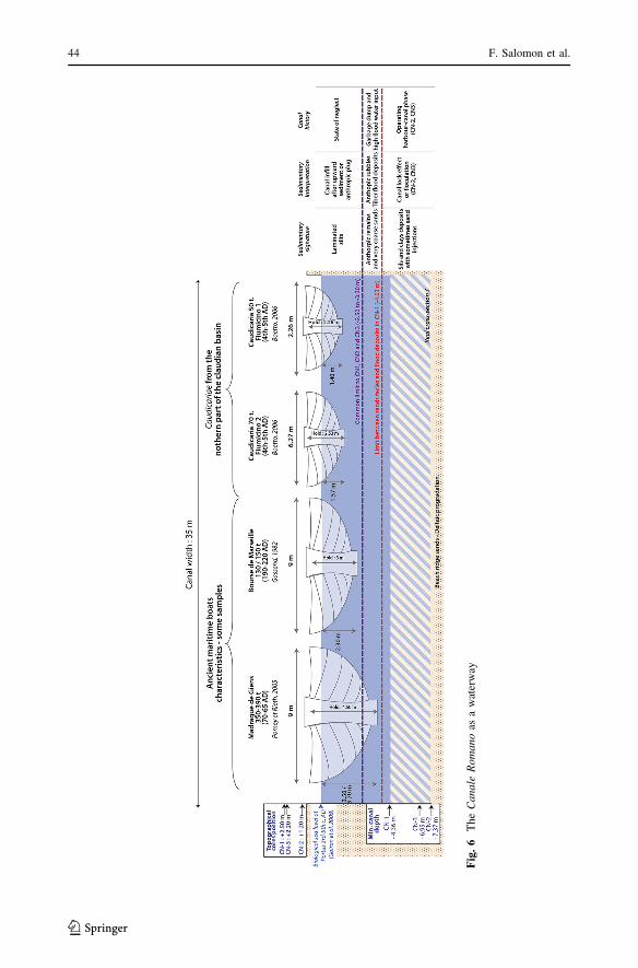
The right hand side of Fig. 6 presents the defining elements from the cores for the history
of the canal, notably the characteristics of the sedimentary facies and their interpretation.
This data makes it possible to define the bottom of the canal (-4.35 in CN-1 to -7.35 in
CN-2) and its cut-off limit (-2.50 to -3.30 m). Since no cross profile of this canal is
available, the minimal observed depth is used, i.e. around 4.35 m obtained from the core
CN-1. We delineate the ancient water level in accordance with the biological sea level
observed at Portus (Goiran et al. 2009). Indeed, in this deltaic plain area, the sea level can
be used as the minimal fluvial water surface. Finally this figure provides representations of
some of the known ancient ships and boats that could have navigated the Canale Romano.
The Canale Romano was clearly used as a waterway. Connected upstream to the Tiber
and downstream to the Fiumicino canal [called Fossa Traiana during the Roman times—
Fea (1824a, b)], the Canale Romano was used for navigation (Fig. 6). The canal offered a
minimal draught of around 4.35 m (CN-1), which is enough to carry maritime vessels up to
350–390 tons (Gassend 1982; Pomey and Rieth 2005; Boetto 2006, 2010). Others vessels
called caudicariae, were designed for navigation along inland waterways and transported
food upstream to Rome; these could potentially transport cargoes of up to 200 tons (Boetto
2010) and could also have used this canal. However, the canal was more than a mere
waterway; it was more of a harbour–canal. The canal ran alongside the ancient warehouses
of Portus on one side of the hexagonal Trajanic basin and probably had a quay side (Keay
et al. 2005; Fig. 2). This archaeological area between the Trajanic basin and the Canale
Romano was interpreted as a transhipment area between sea and river transport (Keay et al.
2005). The Canale Romano was thus undoubtedly constructed to ensure improved tran-
shipment of cargoes between maritime and inland waterways, and was part of the new
harbour system created by the emperor Trajan.
The Canale Romano: a flood relief canal?
A Trajanic inscription discovered at Portus does not specifically allude to either a water-
way or a harbour–canal dug by the Emperor, but to a flood relief canal (CIL XIV 88 = CIL
VI 964 = ILS 5797a). Was the secondary function of the Canale Romano a flood relief
canal? Firstly, particular attention should be paid to the better-preserved Claudian
inscription which concerns the canals at Portus (CIL XIV 85 = ILS 207). Basically, this
inscription informs us that the first canals were excavated to facilitate the construction of
the Claudian harbour and to help alleviate the risk of flooding at Rome. It is unknown
whether the Claudian port was conceived with definitive waterways or only dug to facil-
itate the construction of Portus. The Fiumicino was probably one of these canals (Keay
A harbour–canal at Portus 43
123
Fig
.6
Th
eC
an
ale
Ro
man
oas
aw
ater
way
44 F. Salomon et al.
123

et al. 2005). According to the Claudian inscription during the construction of Portus, floods
entered the canals. The Claudian inscription establishes a cause and effect relationship
between the digging of the canals and the preservation against inundations Nonetheless,
today it is unknown whether these canals were really efficient against floods. No major
flood is recorded during Claudius’ reign in the ancient texts (Le Gall 1953). Perhaps, floods
mentioned by the Claudian inscription existed, but caused probably less damage in the
lower Tiber valley than previous floods of the 1st century BC and beginning of the 1st
century AD recorded by ancient authors. Furthermore, despite these canals, catastrophic
floods occurred at Rome in AD 69 (Tacitus, Histories, I, 86; Suetonius, Otho, 8; Plutarch,
Otho, 4) and during Nerva’s reign (Aurelius Victor, Epitome de Caesaribus, 13). Never-
theless, it is important to emphasize the experimental aspect of flood control by these
Claudian canals.
Taking into account the problems of the Claudian basin (unprotected basin against big
storms in Tacitus, Annals, 15, 18), Trajan excavated a second basin totally protected from
the swell passing through the Claudian basin, as well as restructuring the inland harbour
system. Under Trajan the Canale Romano was constructed (Keay et al. 2005) and the
Fossa Traiana was modified (Fea 1824a, b; Testaguzza 1970; Keay et al. 2005). The
Trajanic inscription (CIL XIV 88 = CIL VI 964 = ILS 5797a) could refer to either of these
canals or to a third one.
The Canale Romano does not seem to have been designed to receive floods. Its width
(35 m) is narrower than that of the Fossa Traiana (50 m) and it is curved rather than
straight. Furthermore, the Claudian inscription indicates that flood relief canals clearly
connected the Tiber channel with the sea (CIL XIV 85 = ILS 207). The Canale Romano is
directly connected to the Tiber, but also has secondary bifurcations to the sea by means of
the downstream section of the Fossa Traiana and by the hypothetical Portus–Ostia canal
(Keay and Paroli 2011). If the Canale Romano was not a flood relief canal, how did the
Roman engineers prevent floodwaters entering into it from upstream? As argued before,
there is no definitive sedimentological evidence to support the existence of a lock, but the
existence of one can surely be considered on hypothetical grounds; archaeological exca-
vation of the canal is the only way to resolve the question definitively. It is thus con-
ceivable that the Canale Romano was not designed as a flood-relief canal, but that floods
unavoidably entered into it and deposited coarse flood sediments within it (bedload; units
CN1-C, CN1-D and CN3-D). Initial use of the Canale Romano as a canal alongside which
river-boats could be moored would have been compromised by strong flood energy during
the flood season, but would have served well for the rest of the season. Further analysis of
the so called ‘Portus–Ostia canal’ will shed light on the question as to whether it was a
canal designed to evacuate flood waters from the Canale Romano.
Major floods were already occurring during the reign of Trajan, and the system of flood
protection became rapidly obsolete. According to Pliny the Younger, the maximum
capacity of Trajan’s canal near Portus was soon reached and its banks overflowed (Pliny
the Younger, Letters, VIII, 17). The Claudian harbour basin experienced a storm surge that
resulted in the destruction of 200 vessels in AD 62 (Tacitus, Annals, XV, 18). It is possible
that the indirect connection between the Canale Romano and the sea by way of the Fossa
Traiana and the possible Portus–Ostia canal, helped to isolate the Canale from eventual
inland storm surges.
When considering a hydroclimatical crisis during the Imperial period (Bravard et al.
1992; Bruneton et al. 2001; Arnaud-Fassetta 2002; Benvenuti et al. 2006), the stratigraphic
sequence in the Canale Romano alone does not provide enough evidence. While we can
A harbour–canal at Portus 45
123
highlight the importance of floods for the units CN1-C, CN2-D and CN3-D, we cannot
establish flood frequency series.
Subsequent functions and uses
There is no evidence for the dredging of the Canale Romano, but this possibility should be
considered during the period of its construction under Trajan to its abandonment between
the 3rd/5th century AD. Dredging clearly occurred in the Canale Traverso (Sadori et al.
2010; Salomon et al. 2012). Just before the cut-off of the Canale Romano, it could still be
navigated by small vessels (caudicariae) with draughts up to 2.50 m and larger maritime
vessel of century 130–150 tons (Fig. 6). The latest dated use of the Canale Romano may
have been connected indirectly to the defensive system of Portus, as a ditch in front of the
surrounding wall built in the late 5th century AD. At that time, the Canale Romano had
already been cut-off upstream.
Conclusion
It is clear from the result of this study that the Canale Romano can be definitively inter-
preted as a Roman canal. The sedimentary infill of this structure provides clear clues of
fluvial influence during the Roman Imperial period. Geophysical data, Roman textual
sources and inscriptions, archaeological discoveries understood in the context of palaeo-
environmental analysis, allow us to reconstruct its history. The canal was probably created
under Trajan, it seems to form an integral part of the broader scheme of the wider harbour.
The Canale Romano reveals the Trajanic perspectives at Portus. Indeed, the hexagonal
basin offers a secure anchorage for maritime boats and in the same way, the Canale
Romano was designed as an operating harbour canal initially devoted to transhipment
linked to the Trajanic basin. In the absence of archaeological evidence, it is difficult to
conclude whether or not a lock was initially built upstream from the canal. It is likely that
the canal was not designed as a flood relief canal, but floods naturally entered into the canal
some time later after its excavation. The function of harbour canal could nevertheless
continue seasonally until the cut-off in late Antiquity (3rd/5th century AD). Geoarchaeo-
logical studies are currently being conducted on the Northern canal and the Portus–Ostia
canal in order to complete our understanding of the Roman canal system at Portus.
Acknowledgments We are particularly grateful to the Sforza Ceserini family for kindly Granting access tothe land. We are grateful to A. Pellegrino, the Soprintendenza Speciale per I Beni Archeologici di Roma forautorizations to work on the Tiber delta. We thank Daniele d’Ottavio and Marco Gizzi and the roman teamof UNIGEO for the cores. We thank also M. Millet for his valuable help in the field. This research wasfunded by the British School at Rome, the Ecole Francaise de Rome, the University of Southampton and theANR POLTEVERE (ANR-11-JSH3-0002). We Thank the Artemis project for the radiocarbon datings andQ. Devers for his help in the translation.
References
Amorosi A, Milli S (2001) Late quaternary depositional architecture of Po and Tevere river deltas (Italy) andworldwide comparison with coeval deltaic successions. Sed Geol 144(3–4):357–375
Arnaud-Fassetta G (1998) Dynamiques fluviales holocenes dans le delta du Rhone. Dissertation, Universityof Aix-Marseille 1. Presses Universitaires du Septentrion, Lille
46 F. Salomon et al.
123

Arnaud-Fassetta G (2002) Geomorphological records of a ‘flood-dominated regime’ in the Rhone delta(France) between the 1st century BC and the 2nd century AD. What correlations with the catchmentpaleohydrology? Geodin Acta 15(1):79–92
Arnoldus-Huyzendveld A (2005) The natural environment of the agro portuense. In: Keay S, Millett M,Paroli L, Strutt K (eds) Portus, an archaeological survey of the port of imperial Rome. BSRArchaeological Monographs, London, pp 14–30
Arnoldus-Huyzendveld A, Paroli L (1995) Alcune considerazioni sullo sviluppo storico dell’ansa dellTevere presso Ostia e sul Porto-Canale. Archeologia Laziale, pp 383–392
Bellotti P, De Luca G (1979) Erosione del litorale del Lido di Roma: Cause ed effetti. Universo59:1169–1182
Bellotti P, Carboni MG, Milli S, Tortora P, Valeri P (1989) La piana deltizia del fiume Tevere: analisi difacies ed ipotesi evolutiva dell’ultimo ‘low stand’ glaciale all’attuale. Giorn Geol 51(1):71–91
Bellotti P, Milli S, Tortora P, Valeri P (1995) Physical stratigraphy and sedimentology of the late pleis-tocene–holocene Tiber delta depositional sequence. Sedimentology 42(4):617–634
Bellotti P, Calderoni G, Carboni MG, Di Bella L, Tortora P, Valeri P, Zernitskaya V (2007) Late quaternarylandscape evolution of the Tiber river delta plain (Central Italy): new evidence from pollen data,biostratigraphy and 14C dating. Z Fur Geomorphol 51(4):505–534
Bellotti P, Mattei M, Tortora P, Valeri P (2009) Geoarchaeological investigations in the area of the imperialharbours of Rome. Mediterranee 112:51–58
Benvenuti M, Mariotti-Lippi M, Pallecchi P, Sagri M (2006) Late-holocene catastrophic floods in theterminal Arno river (Pisa, Central Italy) from the story of a Roman riverine harbour. Holocene16(6):863–876. doi:10.1191/0959683606hl978rp
Bicket AR, Rendell HM, Claridge A, Rose P, Andrews J, Brown FSJ (2009) A multiscale geoarchaeologicalapproach from the Laurentine Shore (Castelporziano, Lazio, Italy). Geomorphologie 4:257–270
Boetto G (2006) Les Navires de Fiumicino (Italie): Architecture, Materiaux, Types et Fonctions. Contri-bution a L’etude Du Systeme Portuaire de Rome a L’epoque Imperiale. Dissertation, University ofAix-Marseille 1
Boetto G (2010) Le port vu de la mer: l’apport de l’archeologie navale a l’etude des ports antiques. FastiOnline: Bolletino Di Archeologia Online Special issue: XVII International Congress of ClassicalArchaeology. Accessed 25 Jan 2013. http://www.bollettinodiarcheologiaonline.beniculturali.it/bao_document/articoli/9_Boetto_paper.pdf
Boetto G, Bukowiecki E, Monteix N, Rousse C (2010) Portus. Les entrepots de Trajan. MEFRA: Chronique1:301–308
Bravard JP (1983) Les sediments fins des plaines d’inondation dans la vallee du Haut-Rhone. Rev Geogr Alp71(4):363–379
Bravard JP, Peiry JL (1999) The CM pattern as a tool for the classification of alluvial suites and floodplainsalong the river continuum. Geol Soc, London, Spec Publ 163(1):259–268
Bravard JP, Verot-Bourrely A, Salvador PG (1992) Le climat d’apres les informations fournies par lesenregistrements sedimentaires fluviatiles etudies sur des sites archeologiques. Les Nouv Archeol50:7–13
Bruneton H, Arnaud-Fassetta G, Provansal M, Sistach D (2001) Geomorphological evidence for fluvialchange during the Roman period in the lower Rhone valley (southern France). Catena 45(4):287–312
Bukowiecki E, Panzieri C, Zugmeyer S (2011) Portus, Les entrepots de Trajan. MEFRA: Chronique123(1):351–359
Capelli G, Mazza R (2008) Intrusione salina nel delta del fiume Tevere. Evoluzione del fenomeno nei primianni del terzo millennio. Memorie Descrittive Della Carta Geologica d’Italia. La geologia di Roma: dalcentro storico alla periferia - Seconda Parte. Firenze: S.EL.C.A. 80:237–260. http://www.isprambiente.gov.it/contentfiles/00002600/2687-mem-des-80-capelli-mazza.zip/at_download/file
Corvisier JN (2001) L’etat present de la demographie historique antique: tentative de bilan. Ann DemogrHist 102(2):101–140
Dearing JA (1999) Environmental magnetic susceptibility. Using the Bartington MS2 system, vol 32, p 54Fea C (1824a) Alcune osservazioni sopra gli antichi porti di Ostia ora Fiumicino. L. Contedini, RomeFea C (1824b) La Fossa Traiana confermata al Sig. Cav. Ludovico Linotte. L. Contedini, RomeFolk RL, Ward WC (1957) Brazos river bar [Texas]; a study in the significance of grain size parameters.
J Sediment Res 27(1):3–26Frosini P (1977) Il Tevere: le inondazioni di Roma e i provvedimenti presi dal governo italiano per evitarle.
Accademia Nazionale Dei Lincei, RomaGassend JM (1982) Le navire antique du Lacydon. Musee d’Histoire de MarseilleGiraudi C (2004) Evoluzione tardo-olocenica del delta del Tevere. Il Quaternario 17(2/2):477–492
A harbour–canal at Portus 47
123

Giraudi C, Tata C, Paroli L (2009) Late holocene evolution of Tiber river delta and geoarchaeology ofClaudius and Trajan harbor, Rome. Geoarchaeology 24(3):371–382. doi:10.1002/gea.20270
Goiran JP, Tronchere H, Carbonel P, Salomon F, Djerbi H, Ognard C, Lucas G, Colalelli U (2008) Portus, laquestion de la localisation des ouvertures du port de Claude: approche geomorphologique. Melanges del’Ecole Francaise de Rome: Chronique 121, 1:217–228
Goiran JP, Tronchere H, Collalelli U, Salomon F, Djerbi H (2009) Decouverte d’un niveau marin biologiquesur les quais de Portus: le port antique de Rome. Mediterranee 112:59–67
Goiran JP, Tronchere H, Salomon F, Carbonel P, Djerbi H, Ognard C (2010) Palaeoenvironmental recon-struction of the ancient harbors of Rome: Claudius and Trajan’s marine harbors on the Tiber delta.Quat Int 216(1–2):3–13
Goiran JP, Salomon F, Pleuger E, Vittori C, Mazzini I, Boetto G, Arnaud P, Pellegrino A (2012) Resultatspreliminaires de la premiere campagne de carottages dans le port antique d’Ostie. Melanges de l’EcoleFrancaise de Rome: Chronique 123, 2. http://cefr.revues.org/299
Goiran JP, Salomon F, Mazzini I, Bravard JP, Pleuger E, Vittori C, Boetto G, Christiansen J, Arnaud P,Pellegrino A, Pepe C, Sadori L (2014) Geoarchaeology confirms location of the ancient harbour basinof Ostia (Italy). J Archaeol Sci 41: 389–398. doi:10.1016/j.jas.2013.08.019
Iadanza C, Napolitano F (2006) Sediment transport time series in the Tiber river. Phys Chem Earth PartsA/B/C 31(18):1212–1227. doi:10.1016/j.pce.2006.05.005
Keay S, Paroli L (2011) Portus and its hinterland: recent archaeological research. Archaeological Mono-graphs of the British School at Rome, 18, London
Keay S, Millett M, Paroli L, Strutt K (2005) Portus: an archaeological survey of the Portus of imperialRome. Archaeological Monographs of the British School at Rome, 15, London
Le Gall J (1953) Le Tibre, fleuve de Rome dans l’Antiquite. Presses Universitaires de France, ParisLo Cascio E (1997) Le procedure di recensus dalla tarda repubblica al tardo antico e il calcolo della
popolazione di Roma. In: La Rome Imperiale: Demographie et Logistique. Coll. De l’Ecole Francaisede Rome 230, Roma, pp 1–76
Lo Cascio E (2004) Peuplement et surpeuplement: leur rapport avec les ressources naturelles. Espacesintegres et ressources naturelles dans l’Empire romain. Presses Universitaires de Franche-Comte,Besancon, pp 135–152
Mazzini I, Faranda C, Giardini M, Giraudi C, Sadori L (2011) Late holocene palaeoenvironmental evolutionof the Roman harbour of Portus, Italy. J Paleolimnol 46(2):243–256. doi:10.1007/s10933-011-9536-7
Mikhailova MV, Bellotti P, Tortora P, Valieri P (1999) Intrusion of seawater into the river part of the Tibermouth. Water Resour 26(6):679–686
Milli S, D’Ambrogi C, Bellotti P, Calderoni G, Carboni MG, Celant A, Di Bella L, Di Rita F, Frezza V,Magri D, Pichezzi RM, Ricci V (2013) The transition from wave-dominated estuary to wave-domi-nated delta: the late quaternary stratigraphic architecture of Tiber river deltaic succession (Italy). SedGeol 284–285:159–180. doi:10.1016/j.sedgeo.2012.12.003
Moore FG (1950) Three canal projects, Roman and Byzantine. Am J Archaeol 54(2):97–111Morelli C (2005) The claudian harbour in the light of new investigations. In: Keay S, Millett M, Paroli L,
Strutt K (eds) Portus, an archaeological survey of the port of imperial Rome. BSR ArchaeologicalMonographs, London, pp 241–248
Passega R (1957) Texture as characteristic of clastic deposition. American Association of PetroleumGeologists
Passega R (1964) Grain size representation by CM patterns as a geologic tool. J Sediment Res 34(4):830Peiry JL (1994) Application de l’analyse statistique multivariee et de l’image CM des depots fluviatiles a la
reconstitution des paleoenvironnements fluviaux. L’exemple d’un bras mort du Rhone en amont deLyon. Quaternaire 5(2):59–67. doi:10.3406/quate 1994.2015
Pepe C, Giardini M, Giraudi C, Masi A, Mazzini I, Sadori L (2013) Plant landscape and environmentalchanges recorded in marginal marine environments: the ancient Roman harbour of Portus (Rome,Italy). Quat Int 303:73–81
Pomey P, Rieth E (2005) L’archeologie navale. Collection ‘‘Archeologiques’’. Errance, ParisReimer PJ, Baillie MGL, Bard E, Bayliss A, Beck JW, Blackwell PG, Ramsey CB, Buck CE, Burr GS,
Edwards RL, Friedrich M, Grootes PM, Guilderson TP, Hajas I, Heaton TJ, Hogg AG, Hughen KA,Kaiser KF, Kromer B, McCormac FG, Manning SW, Reimer RW, Richards DA, Southon JR, TalamoS, Turney CSM, van der Plicht J, Weyhenmeyer CE (2009) IntCal09 and Marine09 radiocarbon agecalibration curves, 0–50,000 Years Cal BP’’. Radiocarbon 51(4):1111–1150
Riviere A (1977) Methode granulometrique: techniques et interpretations. Masson, ParisSadori L, Giardini M, Giraudi C, Mazzini I (2010) The plant landscape of the imperial harbour of Rome.
J Archaeol Sci 37(12):3294–3305
48 F. Salomon et al.
123
Salomon F, Delile H, Goiran JP, Bravard JP, Keay S (2012) The Canale Di Comunicazione Traverso inPortus: the Roman sea harbour under river influence (Tiber Delta, Italy). Geomorphologie 1:75–90.doi:10.4000/geomorphologie.9754
Storey GR (1997) The population of ancient Rome. Antiquity 71:966–978Testaguzza O (1970) Portus: illustrazione dei porti di Claudio e Traiano. Julia Editrice, RomeTronchere H (2010) Approche paleoenvironnementale de deux sites archeologiques dans le delta du Nil:
Avaris et la branche Pelusiaque - Taposiris et le lac Mariout. Dissertation, University Lyon 2
A harbour–canal at Portus 49
123