Interaction between regional and local tectonic forcing along a complex Quaternary extensional...
22
Interaction between regional and local tectonic forcing along a complex Quaternary extensional basin: Upper Tiber Valley, Northern Apennines, Italy S. Pucci a, * , F. Mirabella b, c , F. Pazzaglia d , M.R. Barchi b , L. Melelli b , P. Tuccimei e , M. Soligo e , L. Saccucci b a Istituto Nazionale di Geofisica e Vulcanologia, Via di Vigna Murata 605, 00143 Rome, Italy b Dipartimento di Fisica e Geologia, Universit a di Perugia, Piazza dell'Universit a, 00123 Perugia, Italy c Istituto di Ricerca per protezione idrogeologica, Consiglio Nazionale delle Ricerche, via Madonna Alta 126, 06128 Perugia, Italy d IntGeoMod s.r.l., Via Innamorati 7/a, 06123 Perugia, Italy e Science Department, Section of Earth Science, University Roma 3, Largo San L. Murialdo, 00146 Rome, Italy article info Article history: Received 3 March 2014 Received in revised form 29 July 2014 Accepted 15 August 2014 Available online Keywords: Quaternary basin Seismic reflection profiles River terraces Low-angle normal fault abstract In extending areas undergoing regional tectonic uplift, the persistence of subsidence at a normal-fault hanging-wall depends on the competition between regional and local tectonic effects. When regional uplift exceeds the subsidence of the hanging-wall block, denudation prevails at both the hanging-wall and the foot-wall. When local tectonic subsidence exceeds regional uplift, sedimentation occurs over the hanging-wall block, supplied by foot-wall erosion. We analyzed a PlioceneeQuaternary continental basin, currently crossed by the Tiber River in Italy. The tectono-sedimentary evolution of the basin developed at the hanging-wall of a regional low-angle extensional detachment, the Alto Tiberina Fault, in the axial region of the Northern Apennines of Italy. This area is affected by regional uplift on the order of 0.5e1.0 mm/yr. The present-day activity of the fault is revealed by both microseismicity and geodetic (GPS) data. We investigated the mid- (10e100 ka) and long-term (0.5e3.0 Ma) evolution of the three depocenters by studying the continental Pleistocene succession infilling the basin as well as fluvial terraces and higher paleosurfaces carved into the Pleistocene deposits. By using surficial geologic data and an interpretation of a set of seismic reflection profiles, we show that the three depocenters experienced a fairly similar evolution during the PlioceneeEarly Pleistocene, when a 1000-m-thick continental succession was deposited. On the contrary, geomorphological obser- vations indicate that, at the beginning of the Middle Pleistocene, a switch occurred in the evolution of the three depocenters. In the northernmost Sansepolcro sub-basin, bounding normal faults are active and hanging-wall subsidence outpaces regional uplift. Concurrently, in the Umbertide and Ponte Pattoli sub- basins uplift dominates over the hanging-wall subsidence, promoting river incision and exhumation of the Pleistocene deposits. For these two depocenters, by means of terrace-river correlations, we estimate that the incision rate is ~0.3e0.35 mm/yr, suggesting a maximum tectonic subsidence of 0.2 mm/yr. The identification of a heterogeneous uplift pattern along the hanging-wall of the Alto Tiberina Fault, driven by different displacement rates of its fault splays, allowed us to characterize fault segments with different activities and, possibly, different seismic behaviors. © 2014 Elsevier Ltd. All rights reserved. 1. Introduction The combined effect of erosion and tectonic activity produces characteristic landscapes which are dominated by erosion and/or deposition of sediments (e.g. Willett et al., 2001, 2006). In extensional domains, characterized by dominant vertical move- ments and commonly by steep active faults (in the order of 50 e70 ), fault activity is particularly efficient in promoting both uplift and subsidence at the fault foot-wall and hanging-wall respectively (e.g. Whipple and Tucker, 1999; Allen and Densmore, 2000; Whipple, 2004; Densmore et al., 2005; Whittaker et al., 2008). The investigation of both the tectono-sedimentary evolution of the normal fault-bounded basins and of the geomorphic expression * Corresponding author. E-mail address: [email protected] (S. Pucci). Contents lists available at ScienceDirect Quaternary Science Reviews journal homepage: www.elsevier.com/locate/quascirev http://dx.doi.org/10.1016/j.quascirev.2014.08.009 0277-3791/© 2014 Elsevier Ltd. All rights reserved. Quaternary Science Reviews 102 (2014) 111e132
-
Upload
vegajournal -
Category
Documents
-
view
0 -
download
0
Transcript of Interaction between regional and local tectonic forcing along a complex Quaternary extensional...
lable at ScienceDirect
Quaternary Science Reviews 102 (2014) 111e132
Contents lists avai
Quaternary Science Reviews
journal homepage: www.elsevier .com/locate/quascirev
Interaction between regional and local tectonic forcing along acomplex Quaternary extensional basin: Upper Tiber Valley, NorthernApennines, Italy
S. Pucci a, *, F. Mirabella b, c, F. Pazzaglia d, M.R. Barchi b, L. Melelli b, P. Tuccimei e,M. Soligo e, L. Saccucci b
a Istituto Nazionale di Geofisica e Vulcanologia, Via di Vigna Murata 605, 00143 Rome, Italyb Dipartimento di Fisica e Geologia, Universit�a di Perugia, Piazza dell'Universit�a, 00123 Perugia, Italyc Istituto di Ricerca per protezione idrogeologica, Consiglio Nazionale delle Ricerche, via Madonna Alta 126, 06128 Perugia, Italyd IntGeoMod s.r.l., Via Innamorati 7/a, 06123 Perugia, Italye Science Department, Section of Earth Science, University Roma 3, Largo San L. Murialdo, 00146 Rome, Italy
a r t i c l e i n f o
Article history:Received 3 March 2014Received in revised form29 July 2014Accepted 15 August 2014Available online
Keywords:Quaternary basinSeismic reflection profilesRiver terracesLow-angle normal fault
* Corresponding author.E-mail address: [email protected] (S. Pucci).
http://dx.doi.org/10.1016/j.quascirev.2014.08.0090277-3791/© 2014 Elsevier Ltd. All rights reserved.
a b s t r a c t
In extending areas undergoing regional tectonic uplift, the persistence of subsidence at a normal-faulthanging-wall depends on the competition between regional and local tectonic effects. When regionaluplift exceeds the subsidence of the hanging-wall block, denudation prevails at both the hanging-walland the foot-wall. When local tectonic subsidence exceeds regional uplift, sedimentation occurs overthe hanging-wall block, supplied by foot-wall erosion. We analyzed a PlioceneeQuaternary continentalbasin, currently crossed by the Tiber River in Italy. The tectono-sedimentary evolution of the basindeveloped at the hanging-wall of a regional low-angle extensional detachment, the Alto Tiberina Fault, inthe axial region of the Northern Apennines of Italy. This area is affected by regional uplift on the order of0.5e1.0 mm/yr. The present-day activity of the fault is revealed by both microseismicity and geodetic(GPS) data. We investigated the mid- (10e100 ka) and long-term (0.5e3.0 Ma) evolution of the threedepocenters by studying the continental Pleistocene succession infilling the basin as well as fluvialterraces and higher paleosurfaces carved into the Pleistocene deposits.
By using surficial geologic data and an interpretation of a set of seismic reflection profiles, we showthat the three depocenters experienced a fairly similar evolution during the PlioceneeEarly Pleistocene,when a 1000-m-thick continental succession was deposited. On the contrary, geomorphological obser-vations indicate that, at the beginning of the Middle Pleistocene, a switch occurred in the evolution of thethree depocenters. In the northernmost Sansepolcro sub-basin, bounding normal faults are active andhanging-wall subsidence outpaces regional uplift. Concurrently, in the Umbertide and Ponte Pattoli sub-basins uplift dominates over the hanging-wall subsidence, promoting river incision and exhumation ofthe Pleistocene deposits. For these two depocenters, by means of terrace-river correlations, we estimatethat the incision rate is ~0.3e0.35 mm/yr, suggesting a maximum tectonic subsidence of 0.2 mm/yr.
The identification of a heterogeneous uplift pattern along the hanging-wall of the Alto Tiberina Fault,driven by different displacement rates of its fault splays, allowed us to characterize fault segments withdifferent activities and, possibly, different seismic behaviors.
© 2014 Elsevier Ltd. All rights reserved.
1. Introduction
The combined effect of erosion and tectonic activity producescharacteristic landscapes which are dominated by erosion and/ordeposition of sediments (e.g. Willett et al., 2001, 2006). In
extensional domains, characterized by dominant vertical move-ments and commonly by steep active faults (in the order of50�e70�), fault activity is particularly efficient in promoting bothuplift and subsidence at the fault foot-wall and hanging-wallrespectively (e.g. Whipple and Tucker, 1999; Allen and Densmore,2000;Whipple, 2004;Densmore et al., 2005;Whittakeret al., 2008).
The investigation of both the tectono-sedimentary evolution ofthe normal fault-bounded basins and of the geomorphic expression
S. Pucci et al. / Quaternary Science Reviews 102 (2014) 111e132112
of the fault activity in terms of both the landscape response and therivers network anomalies is a key to the understanding of the de-gree of activity of the faults and of their seismic behavior (e.g.Burbank and Pinter, 1999; Allen and Densmore, 2000; Burbank andAnderson, 2001; Allen and Allen, 2005).
Several studies have been focused on the investigation of thebasin response to extensional tectonics in terms of sedimentaryfacies (e.g. Leeder and Gawthorpe, 1987; Gawthorpe and Leeder,2000). Other studies have concentrated on the geomorphicresponse to active extension and/or on the drainage response tofaulting (e.g. Schumm, 1993; Goldsworthy and Jackson, 2000;Peters and Van Balen, 2007; Troiani and Della Seta, 2008). Insome cases, the detailed observations of rivers crossing activenormal faults, compared with constraints on the temporal andspatial history of fault movement have led to the identification offault slip-rate variations through time (Whittaker et al., 2008;Boulton and Whittaker, 2009; Di Naccio et a., 2013).
However, though the main factors affecting the development oferosion or sedimentation are tectonics and climate, in somegeological settings, the regional vertical movement (regional uplift)plays a crucial role. In extensional tectonic settings, the netobserved erosion or subsidence at the normal faults hanging-walland foot-wall is the result of the competition between theregional uplift and normal faults rates of activity (Doglioni et al.,1998). Whenever the hanging-wall subsidence rate exceeds theregional-scale uplift, the accommodation space can be infilled bysediment discharge supplied by catchments eroding the upliftingfoot-wall. On the contrary, when the regional-scale uplift rate ex-ceeds the normal faults hanging-wall subsidence rate, both faultblocks can be affected by denudation due to erosional processes.
To neglect the interference between the two competing factors(regional uplift vs local tectonic forcing) in active settings can resultin the incorrect assumption that incised normal fault hanging-wallsindicate inactive or poorly active normal faults segments. This canhinder an assessment of the slip rate on active normal faults andmay lead to an underestimation of their seismotectonicsignificance.
Moreover, in complex, segmented normal fault systems, also thealong-strike variation of the hanging-wall subsidence can helpunraveling the efficiency on the different fault segments in pro-moting subsidence and hence provide clues to an array of activenormal faults in the Northern Apennines of Italy (e.g. Densmoreet al., 2005; Frankel and Pazzaglia, 2006; Whittaker et al., 2007a).
We tackle this issue along an active normal faults alignment inthe Northern Apennines of Italy (Fig. 1). This is an ideal naturallaboratory where a large wavelength regional uplift in the order of0.5e1.0 mm/yr active since about 1.5 Ma (e.g. D'Agostino et al.,2001) competes with the local uplift/subsidence generated bynormal faults active since the Quaternary (e.g. Barchi et al., 1999;Boncio and Lavecchia, 2000). In this area, the availability ofseveral different data-sources like seismic reflection profiles, fielddata of exposed Quaternary successions infilling the extensionalbasins and flights of river terraces allow us to unravel the deposi-tional/erosional history at the normal faults hanging-wall and thesegmentation pattern of the normal faults over the Quaternary.
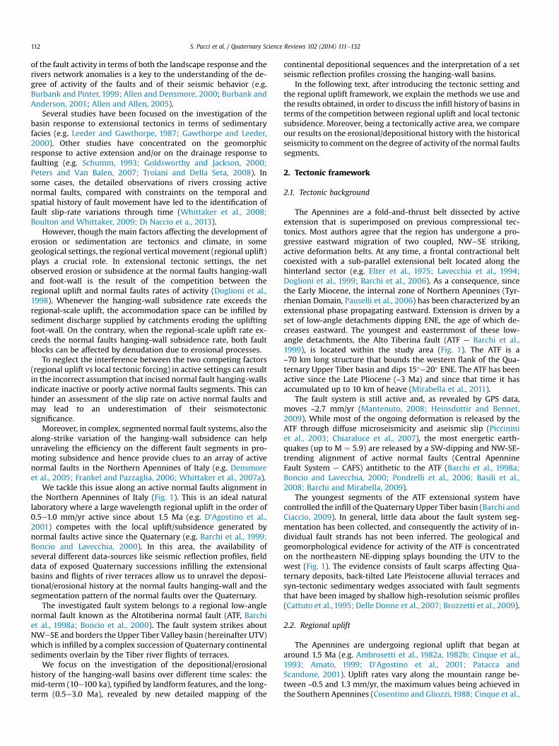
The investigated fault system belongs to a regional low-anglenormal fault known as the Altotiberina normal fault (ATF, Barchiet al., 1998a; Boncio et al., 2000). The fault system strikes aboutNWeSE and borders the Upper Tiber Valley basin (hereinafter UTV)which is infilled by a complex succession of Quaternary continentalsediments overlain by the Tiber river flights of terraces.
We focus on the investigation of the depositional/erosionalhistory of the hanging-wall basins over different time scales: themid-term (10e100 ka), typified by landform features, and the long-term (0.5e3.0 Ma), revealed by new detailed mapping of the
continental depositional sequences and the interpretation of a setseismic reflection profiles crossing the hanging-wall basins.
In the following text, after introducing the tectonic setting andthe regional uplift framework, we explain the methods we use andthe results obtained, in order to discuss the infill history of basins interms of the competition between regional uplift and local tectonicsubsidence. Moreover, being a tectonically active area, we compareour results on the erosional/depositional history with the historicalseismicity to comment on the degree of activity of the normal faultssegments.
2. Tectonic framework
2.1. Tectonic background
The Apennines are a fold-and-thrust belt dissected by activeextension that is superimposed on previous compressional tec-tonics. Most authors agree that the region has undergone a pro-gressive eastward migration of two coupled, NWeSE striking,active deformation belts. At any time, a frontal contractional beltcoexisted with a sub-parallel extensional belt located along thehinterland sector (e.g. Elter et al., 1975; Lavecchia et al., 1994;Doglioni et al., 1999; Barchi et al., 2006). As a consequence, sincethe Early Miocene, the internal zone of Northern Apennines (Tyr-rhenian Domain, Pauselli et al., 2006) has been characterized by anextensional phase propagating eastward. Extension is driven by aset of low-angle detachments dipping ENE, the age of which de-creases eastward. The youngest and easternmost of these low-angle detachments, the Alto Tiberina fault (ATF e Barchi et al.,1999), is located within the study area (Fig. 1). The ATF is a~70 km long structure that bounds the western flank of the Qua-ternary Upper Tiber basin and dips 15�e20� ENE. The ATF has beenactive since the Late Pliocene (~3 Ma) and since that time it hasaccumulated up to 10 km of heave (Mirabella et al., 2011).
The fault system is still active and, as revealed by GPS data,moves ~2.7 mm/yr (Mantenuto, 2008; Heinsdottir and Bennet,2009). While most of the ongoing deformation is released by theATF through diffuse microseismicity and aseismic slip (Piccininiet al., 2003; Chiaraluce et al., 2007), the most energetic earth-quakes (up to M ¼ 5.9) are released by a SW-dipping and NW-SE-trending alignment of active normal faults (Central ApennineFault System e CAFS) antithetic to the ATF (Barchi et al., 1998a;Boncio and Lavecchia, 2000; Pondrelli et al., 2006; Basili et al.,2008; Barchi and Mirabella, 2009).
The youngest segments of the ATF extensional system havecontrolled the infill of the Quaternary Upper Tiber basin (Barchi andCiaccio, 2009). In general, little data about the fault system seg-mentation has been collected, and consequently the activity of in-dividual fault strands has not been inferred. The geological andgeomorphological evidence for activity of the ATF is concentratedon the northeastern NE-dipping splays bounding the UTV to thewest (Fig. 1). The evidence consists of fault scarps affecting Qua-ternary deposits, back-tilted Late Pleistocene alluvial terraces andsyn-tectonic sedimentary wedges associated with fault segmentsthat have been imaged by shallow high-resolution seismic profiles(Cattuto et al., 1995; Delle Donne et al., 2007; Brozzetti et al., 2009).
2.2. Regional uplift
The Apennines are undergoing regional uplift that began ataround 1.5 Ma (e.g. Ambrosetti et al., 1982a, 1982b; Cinque et al.,1993; Amato, 1999; D'Agostino et al., 2001; Patacca andScandone, 2001). Uplift rates vary along the mountain range be-tween ~0.5 and 1.3 mm/yr, the maximum values being achieved inthe Southern Apennines (Cosentino and Gliozzi, 1988; Cinque et al.,
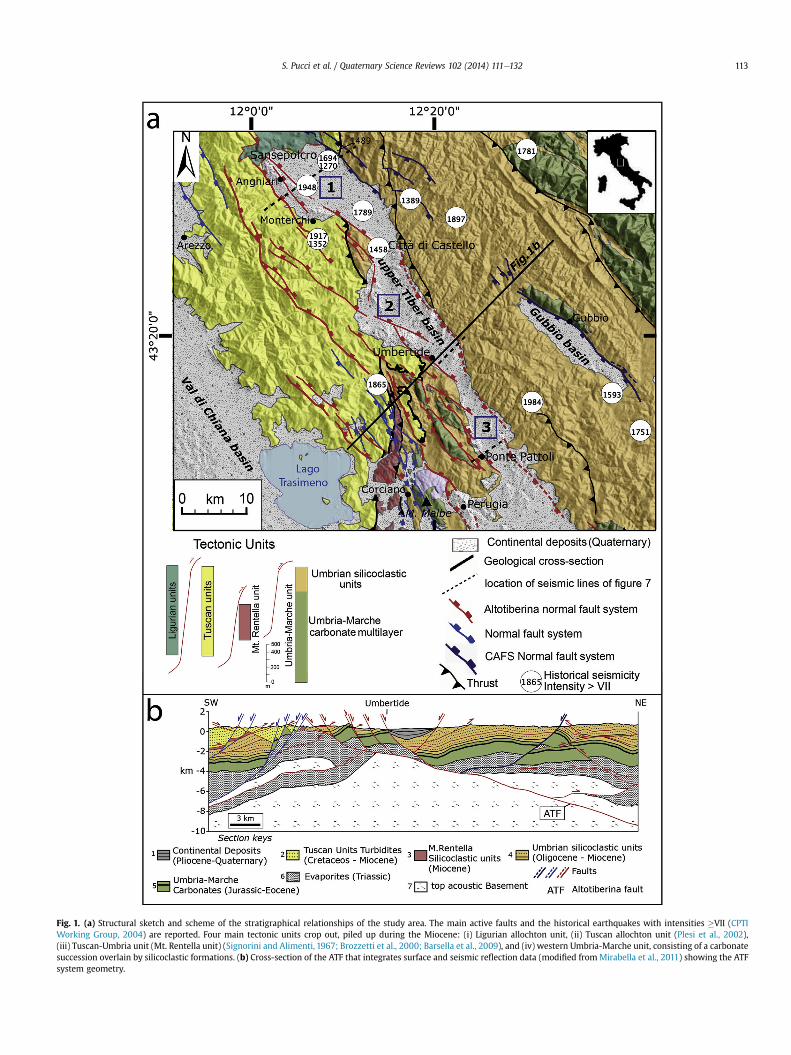
Fig. 1. (a) Structural sketch and scheme of the stratigraphical relationships of the study area. The main active faults and the historical earthquakes with intensities �VII (CPTIWorking Group, 2004) are reported. Four main tectonic units crop out, piled up during the Miocene: (i) Ligurian allochton unit, (ii) Tuscan allochton unit (Plesi et al., 2002),(iii) Tuscan-Umbria unit (Mt. Rentella unit) (Signorini and Alimenti, 1967; Brozzetti et al., 2000; Barsella et al., 2009), and (iv) western Umbria-Marche unit, consisting of a carbonatesuccession overlain by silicoclastic formations. (b) Cross-section of the ATF that integrates surface and seismic reflection data (modified fromMirabella et al., 2011) showing the ATFsystem geometry.
S. Pucci et al. / Quaternary Science Reviews 102 (2014) 111e132 113
S. Pucci et al. / Quaternary Science Reviews 102 (2014) 111e132114
1993; Bordoni and Valensise,1998; Amato and Cinque,1999; Amatoet al., 2003; Schiattarella et al., 2006).
The overall shape and the long wavelength of the uplift trend(~200 km) suggest that uplift is driven by a deep-seatedmechanism(e.g. subducting slab detachment and active subduction end;mantle upwelling). An open issue is whether a cause-and-effectrelationship between extension and regional uplift exists or thetwo tectonic forcings are independent (e.g. Westaway, 1993;D'Agostino et al., 2001; Di Bucci and Mazzoli, 2002; Ghisetti andVezzani, 2002; Bartolini et al., 2003). Uplift, possibly along withclimatic change at the Middle Pleistocene Transition (Clark et al.,2006), forced the western Italian coastline to relatively fallthrough time towards the southwest and to reach its present po-sition about 0.6 Ma (Cavinato et al., 2000; Karner et al., 2001;Mancini and Cavinato, 2005). The relative base-level fall initiateda long-term trend of incision which triggered headward erosion ofthe main rivers. In the Northern and Central Apennines, the pro-gressive lowering of the base level is evidenced by deep fluvialincision, producing an inset of terrace flights (e.g. D'Agostino et al.,2001), old erosional landscapes and marine deposits cropping outat elevations greater than sea level high stands (e.g. Galadini et al.,2003; Mancini et al., 2007). Aware that uplift constrains might, insome cases, also conflate the fault signal, in the Central Apennines,Pliocene paleosurfaces have been uplifted at rates of ~0.5 mm/yr(Galadini et al., 2003). In the northern sector, elevated 800,000year-old paleosurfaces imply uplift rates between 0.5 and 1.0 mm/yr (Bartolini, 1980). Along the axial culmination of the NorthernApennines, speleological records suggest a Holocene mean upliftrate of 0.6 mm/yr (Mariani et al., 2007). Along the Adriatic sector ofthe Northern Apennines mountain front, fluvial terraces correlatedwith the terracemarine isotope stage (MIS) 5e suggest an uplift rateof 0.3 mm/yr (Vannoli et al., 2004), while the long-term ratederived from elevations of 1.0 Ma marine deposits reaches 0.5 mm/yr (Dramis, 1992). Extrapolation of these rates from the coastalsectors to the chain axis, where rates are expected to be higher,gives a value of 0.5e1 mm/y. Similarly, along the Tyrrhenian sectorof the Northern Apennines, an uplifted Plio-Pleistocene shorelinehas been recognized, providing an estimated maximum uplift rateof 0.4 mm/yr (e.g. Ambrosetti et al., 1987; Girotti and Piccardi, 1994;Mancini and Cavinato, 2005; Mancini et al., 2007). D'anastasio et al.(2006) estimated comparable present-day maximum uplift rates of1.0 ± 0.2 mm/yr using geodetic re-leveling along transects crossingthe Apennines north of our study area.
Denudation rates of 0.4e0.5 mm/yr during the Pleistocene andthe Holocene have been estimated for the Northern and CentralApennines using the volumes of sedimentary basin fills (Bartoliniet al., 1996). With few exceptions, erosion, incision, sedimentyield and uplift rates determined for the past ~1Ma are constrainedwithin a narrow range of 0.2e1.0 mm/yr. Although the Central andNorthern Apennines are mostly still responding transiently toactive normal faulting and/or drainage capture events, in someplaces a steady-state topography (i.e. dynamic equilibrium) hasbeen reached based due to the response time to tectonic forcings ofchannels and hillslopes to uplift being less than 1 My (Whittakeret al., 2007a, 2007b, 2008; Cyr and Granger, 2008).
In summary, although the uncertainty in the regional upliftestimate could reflect the problem of separating the faultdisplacement components from the regional signal, the hugeamount of data show that the uplift of the Northern Apenninesreaches a maximum in the axial part of the chain (on the order of0.5e1.0 mm/yr) and a minimum along both the Tyrrhenian andthe Adriatic coasts, ~100 km away. Considering the distance fromthe axial part of the chain (~20e30 km) is reasonable to assume amaximum of 0.5 mm/yr of regional uplift affecting the studyarea.
3. Methods
New field and subsurface data allowed us to reconstruct thedeformations affecting the Upper Tiber Valley (UTV), the north-ernmost part of a larger Pliocene-Quaternary continental basindeveloped in Umbria (“Lago Tiberino” basin; Lotti, 1917, 1926)(Fig. 1).
We make use of: (i) an extensive 1:10,000 scale geological field-work along the UTV, focused on the continental deposits infillingthe Tiber Basin; (ii) integration of the surface geological data withseismic reflection profiles that image basin infill geometry; (iii)Geomorphological mapping; (iv) dating of continental carbonates.
3.1. Field mapping, stratigraphy and sedimentological analysis
To gain complementary information about recent tectonic ac-tivity, fieldwork was aimed at producing an integrated and ho-mogeneous stratigraphic scheme of the continental deposits and acharacterization of these deposits from a sedimentological andstructural point of view. We described the outcropping continentalunits principally based on lithological characteristics (lithostrati-graphic units, Salvador, 1994), and secondarily according to sedi-mentary characteristics of the deposits (sedimentologicalcriterion). The use of a sedimentological analysis is necessarybecause some units have very similar lithologies, with gravel bodiesthat have analogous lithological and morphological characteristics.However, the genesis of these bodies is different, as well as thedepositional system of these units. In this case only the sedimen-tological analyses allow distinguishing the different units.
In a first stage, we measured several vertical stratigraphic sec-tions in the studied area. They have been selected mainly on thebasis of the outcrop conditions, i.e., greater vertical and horizontalextension.
On each stratigraphic section we carried out a sedimentologicalanalysis (facies analysis method; Miall, 1984; Reading, 1986; Allenand Allen, 2005). We applied a one-dimensional criterion,emphasizing the vertical variation of sedimentary characters,where the different lithofacies had laterally uniform characteristics.The two-dimensional characteristics of the facies were examined incase of lateral changes.
Regarding the continental carbonates present in the study areawe followed the nomenclature introduced by Ford and Pedley(1996). “Travertines” are continental carbonates deposited inhydrothermal springs (usually compact, well-bedded, with crys-talline fabrics and rare animal and plant remains), while “calcar-eous tufas” are deposited in temperate fluvio-lacustrine andfluvio-palustrine environments (highly porous, poorly bedded,rich in fossils). Facies nomenclature, facies associations anddepositional models used in the present paper are derived fromArenas-Abad et al. (2010) and V�asquez-Urbez et al. (2011). Thisclassification, based on texture and geometry of deposits, de-scribes several facies associated to different environmentalcontext (see Table 1 in Arenas-Abad et al., 2010 and Table 2 inV�asquez-Urbez et al., 2011 for a detailed description and inter-pretation of all facies).
It was not possible to make direct correlations between thedifferent stratigraphic sections because outcrops have a limitedlateral continuity (some tens or few hundred meters) and becausethere are no guide-levels. Correlations, however, were made on thebasis of the sedimentary facies.
A geological survey at scale of 1:10,000 and the drawing ofseveral geological cross sections allowed us to better understand ofthe distribution of the different units and their spatial relationships.A further control was possible by the analysis of a large number ofwater well logs.
S. Pucci et al. / Quaternary Science Reviews 102 (2014) 111e132 115
The name of each lithostratigraphic unit refers to a geographicallocality, where it has all its major characteristics.
3.2. Subsurface data
The basins infill is imaged by a set of three commercial seismiclines crossing the UTV (Fig. 1). These lines were acquired by Eni oilcompany in the '80 for oil exploration purposes. The quality ofthese seismic lines is variable because of the acquisition methodsand data processing which were aimed at exploring depths ofaround 3 km, however they provide very good images of thecontinental basins infill geometry and are a unique data to esti-mate both basins thickness and geometry since no deep wellsexist which drilled the continental sequence. The mapping of theoutcropping, incised continental sequence was used to constrainthe interpretation of the subsurface data and to extrapolate thesurface sedimentary units at depth. According to published data,the interval velocity of the continental deposits is ~2.0 km/s (Ballyet al., 1986; Buonasorte et al., 1988), so we make use of these in-terval velocities to estimate the depth and thickness of the sedi-mentary infill of the basins.
Concerning the thickness of the recent alluvial deposition (LatePleistoceneeHolocene), these were provided by a dataset of water-well logs from a regional authority, ARPA Umbria (Fig. 2a).
3.3. Geomorphological data
We performed geomorphological survey and aerial photographinterpretation of the Quaternary deposits and landforms with ob-servations derived from 1:33,000 scale aerial photographs (GAI eItalian Aeronautic Group). Particular attention was paid to thedistribution and the setting of significant geomorphic features,such as paleosurfaces and river terraces.
The survey was focused on the recognition of broad remnants ofmature landscapes as relics of older topographic surfaces (i.e. flat
Fig. 2. (a) Detailed geological map of the Quaternary deposits of the study area. Thicknelongitudinal cross sections of the Tiber River at the Quaternary Basin edges (see Fig. 2a for
land surfaces). In this work, we describe the “flat surfaces” restingon continental deposits, excluding surfaces that can be mapped onthe adjacent Pre-Pliocene bedrock. We analyzed the altimetricdistribution of the relic surfaces beside the two flanks of the UTV(Fig. 2a).
Particular attention was paid to the reconstruction of a flight ofriver terraces by means of a morphostratigraphical approach. Weanalyzed the altimetric distribution of the river terraces above theTiber River alluvial plain along the two flanks of the UTV by meansof 1:5000 and 1:10,000 scale topographic maps (Technical RegionalCartography e Umbria Region) and 10 m resolution TIN DEM(Triangular Irregular Network Digital Elevation Model), whichpresents RMSE in elevation of ca 2.0 m for the study area (Tarquiniet al., 2007).
The present-day fluvial dynamic of the Tiber River is deeplyaffected by human activities, inducing local incision and sedi-mentation unrelated to natural forcing. Consequently, the longi-tudinal profile of the thalweg is not a good reference forcomparing the elevation of landforms suspended on the presentvalley floor. For these reasons, we used the youngest alluvial plain,which was flooded often in historical times, as a reference; i.e. theelevation (m) above the alluvial plain, hereinafter referred as “ma.a.p.”. Elevations of river terrace features have been projectedalong a longitudinal profile that uses the smoothed trace of theTiber River alluvial plain as a baseline. The elevation valuesassigned to each terrace feature represent the key elevation (i.e.dominant elevation of each tread), the inner edge (i.e. the junctionbetween the terrace tread and the valley slope), and the outeredge (i.e. the junction between the terrace tread and the thalwegriser). Weathering processes and mass wasting deposits canmodify the tread slope angle and the original elevations of theinner and outer edges. Where the slope deposits do not yield aconcave profile, the inner edge of the old river terrace can be thegeomorphological feature that best approximates the originalheight of the terrace treads.
ss of Late PleistoceneeHolocene alluvial deposits from water-well logs; (b) Projectedthe trace of the profiles).
S. Pucci et al. / Quaternary Science Reviews 102 (2014) 111e132116
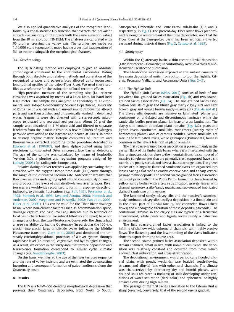
We also applied quantitative analyses of the recognized land-forms by a zonal-statistic GIS function that extracts the prevalentaltitude (i.e. majority of the pixels with the same elevation value)from the 10m resolution TIN DEM. The analyses are calibrated with65 profiles crossing the valley axis. The profiles are made on1:10,000 scale topographic maps having a vertical exaggeration of5:1 to better distinguish the morphological features.
3.4. Geochronology
The U/Th dating method was employed to give an absolutechronological constraint to the continental carbonates. Datingthrough both absolute and relative methods and correlation of therecognized terraces and paleosurfaces allowed us to reconstructlongitudinal profiles of the paleo-Tiber River. We used these pro-files as a reference for the estimation of local tectonic effects.
High-precision measure of the sampling site (i.e. relativeelevation) was acquired by means of a Leica Disto D8 hand-heldlaser meter. The sample was analyzed at Laboratory of Environ-mental and Isotopic Geochemistry, Science Department, Universityof Roma Tre. It was cut with a diamond saw to remove the alteredparts and was then crushed and ultrasonically washed in deionizedwater. Fragments were also checked with a stereoscopic micro-scope to discard any recrystallized portions. About 20 g of thesample were dissolved in 1 M nitric acid and filtered to separateleachates from the insoluble residue. A few milliliters of hydrogenperoxide were added to the leachate and heated at 100 �C in orderto destroy organic matter. Isotopic complexes of uranium andthorium were extracted, according to the procedure described inEdwards et al. (1986/87), and then alpha-counted using high-resolution ion-implanted Ortec silicon-surface barrier detectors.The age of the sample was calculated by means of Isoplot/Ex(version 3.0), a plotting and regression program designed byLudwig (2003) for radiogenic-isotope data.
Relative dating of river terraces was applied by correlating theirelevation with the oxygen isotope time scale (OIT) curve throughthe range of the estimated incision rate. Antecedent streams thatflow over an area undergoing uplift should continuously downcutand produce inset levels of climatically-driven river terraces. Riverterraces are worldwide recognized to form in response, directly orindirectly, to climatic fluctuations (e.g. Bull, 1991; Personius et al.,1993; Burbank et al., 1996; Lave and Avuouc, 2000; Hancock andAnderson, 2002; Wegmann and Pazzaglia, 2002; Pan et al., 2003;Fuller et al., 2009). This can be valid for the Tiber River drainagebasin, where non-climatic factors (such as accommodation space,drainage capture and base level adjustments due to tectonics orlocal basin characteristics like subsoil lithology and relief) have notchanged a lot from the Late Pleistocene. Conversely, the climate hada large variability during the Quaternary (in particular the 100-k.y.glacialeinterglacial large-amplitude cycles following the MiddlePleistocene transition; Clark et al., 2006) and dominated the un-steady erosion/depositional processes of a river system throughrapid base level (i.e. eustatic), vegetative, and hydrological changes.As a result, we expect in the study area that terrace deposition andterrace-riser formation correspond to similar cyclic climaticchanges (e.g. Vandenberghe, 2003).
On this basis, we inferred the age of the river terraces sequenceand the rate of valley incision, and we estimated the downcuttinginception and consequent formation of paleo-landforms along theQuaternary basin.
4. Results
The UTV is a NNWeSSE-trending morphological depression thatpresents three Quaternary depocenter, from North to South:
Sansepolcro, Umbertide, and Ponte Pattoli sub-basins (1, 2, and 3,respectively, in Fig. 1). The present-day Tiber River flows predomi-nantly along thewestern flank of the three depocenter; note that theTiber River at the Sansepolcro basin has been artificially divertedeastward during historical times (Fig. 2; Cattuto et al., 1995).
4.1. Stratigraphy
Within the Quaternary basin, a thin recent alluvial deposition(Late PleistoceneeHolocene) unconformably overlies a thick fluvio-lacustrine Pleistocene succession.
The Pleistocene succession exposed at the surface consists offive main depositional units, from bottom to top: the Fighille, Cit-erna, Promano, Valliano, and Ascagnano Units (Figs. 2e5).
4.1.1. The Fighille UnitThe Fighille Unit (sensu ISPRA, 2011) consists of beds of one
prevalent fine-grained facies association (Fig. 3b) and two coarse-grained facies associations (Fig. 3a). The fine-grained facies asso-ciation consists of gray and bluish gray marly clayey silts and lightbrown, gray and orange brown sandyeclayey silts (Fig. 4a and 41).The clayey silts deposits are massive or laminated (planar andcontinuous or undulated and discontinuous laminae), while thesandy silts bodies present planar laminae or cross lamination. Theclayey silts contain abundant plant remains (Fig. 4a2), peats andlignite levels, continental mollusks, root traces (mainly roots ofherbaceous plants) and calcareous nodules. Water mollusks arerare in the laminated levels, while gastropods (Pulmonata) fauna iscommon in the levels less rich in plant remains.
The first coarse-grained facies association is presentmainly in theeasternflank of the Umbertide basin,where it is intercalatedwith thefine-grained association close to themountain front. It is composed ofmassive conglomerates that are generally clast-supported, have a siltmatrix, are poorly sorted, and have a chaotic arrangement. The gravelbodies of sub-angular, flattened sandstone clasts are organized intolenses having a flat roof, an erosive concave base, and a sharp verticalpassage to fine deposits. The second coarse-grained facies associationcrops out principally in the Ponte Pattoli basin. It is characterized byyellow sandy bodies with a cross stratification, gravels lenses withchannel geometry, a silty/sandymatrix, and sub-rounded imbricatedclasts of sandstone or limestone.
The laminated sandyeclayey silts and the massive/discontinu-ously laminated clayey silts testify a deposition in a floodplain andin the distal part of alluvial fans by not channeled flows (sheetflows) and a pedogenic alteration of these deposits (paleosols). Thecontinuous laminae in the clayey silts are typical of a lacustrineenvironment, while peats and lignite levels testify a palustrineenvironment.
The first coarse-grained facies association is linked to theinfilling of shallow wide ephemeral channels, with highly erosiveflows, The flattening and the low rounding of the clasts indicate ashort transport from the source area.
The second coarse-grained facies association deposited withinstream channels, small in size, with non-sinuous trend. The depo-sition was relatively constant and occurred from flows whichallowed clast imbrication and cross-stratification.
The depositional environment was a periodically flooded allu-vial plain, with ponds, wetlands, rare braided south-flowingstreams, and alluvial fans with ephemeral channels. The climatewas characterized by alternating dry and humid phases, withdrained soils (calcareous nodules) or soils developing under con-ditions of water saturation (dark color) and ephemeral or highlyerosive flows during high rainfall.
The passage of the first facies association to the Citerna Unit issharp (erosive), conversely, that of the second one is gradual.
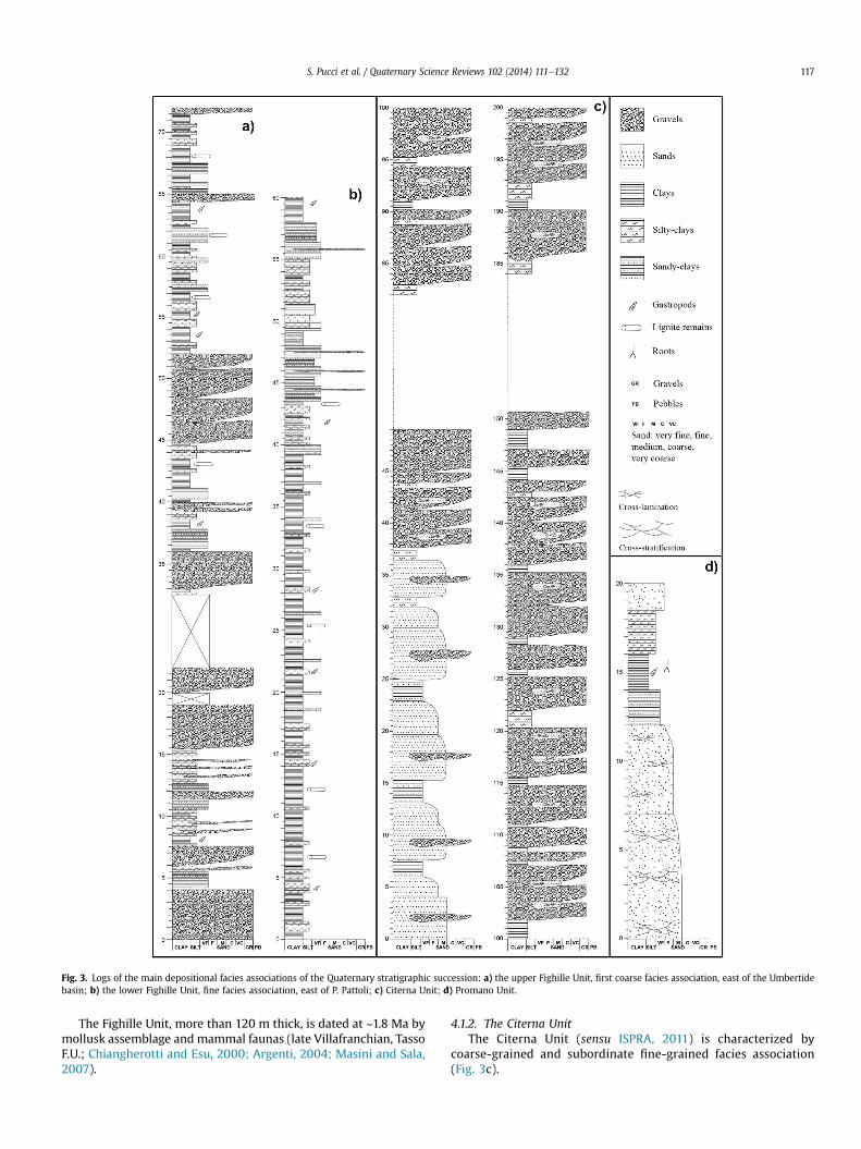
Fig. 3. Logs of the main depositional facies associations of the Quaternary stratigraphic succession: a) the upper Fighille Unit, first coarse facies association, east of the Umbertidebasin; b) the lower Fighille Unit, fine facies association, east of P. Pattoli; c) Citerna Unit; d) Promano Unit.
S. Pucci et al. / Quaternary Science Reviews 102 (2014) 111e132 117
The Fighille Unit, more than 120 m thick, is dated at ~1.8 Ma bymollusk assemblage and mammal faunas (late Villafranchian, TassoF.U.; Chiangherotti and Esu, 2000; Argenti, 2004; Masini and Sala,2007).
4.1.2. The Citerna UnitThe Citerna Unit (sensu ISPRA, 2011) is characterized by
coarse-grained and subordinate fine-grained facies association(Fig. 3c).
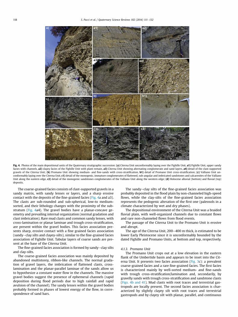
Fig. 4. Photos of the main depositional units of the Quaternary stratigraphic succession: (a) Citerna Unit unconformably laying over the Fighille Unit, a1) Fighille Unit, upper sandyfacies with channels, a2) clayey facies of the Fighille Unit with plant remain, a3) Citerna Unit showing alternating conglomerate and sand layers, a4) detail of the clast-supportedgravels of the Citerna Unit; (b) Promano Unit showing medium- and fine-sands with cross-stratification, b1) detail of Promano Unit cross-stratification; (c) Valliano Unit un-conformably laying over the Citerna Unit, c1) detail of the monogenic, immature conglomerates of flattened, sub-angular and imbricated sandstones and calcarenites of the VallianoUnit along the eastern edge, c2) detail of the monogenic sandstones conglomerates of the Valliano Unit along the western edge; (d) Holocene alluvial (bottom) and fluvial (top)deposits.
S. Pucci et al. / Quaternary Science Reviews 102 (2014) 111e132118
The coarse-grained facies consists of clast-supported gravels in asandy matrix, with sandy lenses or layers, and a sharp erosivecontact with the deposits of the fine-grained facies (Fig. 4a and a3).The clasts are sub-rounded and sub-spherical, low-to medium-sorted, and their lithology changes with the proximity of the sub-stratum (Fig. 4a4). The gravel bodies have a planar-concave ge-ometry and prevailing internal organization (normal gradation andclast imbrication). Rare mud clasts and common sandy lenses, withcross-lamination or planar laminae and trough cross-stratification,are present within the gravel bodies. This facies association pre-sents sharp, erosive contact with a fine grained facies association(sandyeclay silts and clayey-silts), similar to the fine-grained faciesassociation of Fighille Unit. Tabular layers of coarse sands are pre-sent at the base of the Citerna Unit.
The fine-grained facies association is formed by sandyeclay siltsand clay-silts.
The coarse-grained facies association was mainly deposited byabandoned multistorey, ribbon-like channels. The normal grada-tion of gravel layers, the imbrication of flattened clasts, cross-lamination and the planar-parallel laminae of the sands allow usto hypothesize a constant water flow in the channels. The massivegravel bodies suggest the presence of ephemeral channels (rapiddeposition during flood periods due to high rainfall and rapidavulsion of the channel). The sandy lenses within the gravel bodiesprobably formed in phases of lowest energy of the flow, in corre-spondence of sand bars.
The sandyeclay silts of the fine-grained facies association wasprobably deposited in the flood plain by non-channeled high-speedflows, while the clay-silts of the fine-grained facies associationrepresents the pedogenic alteration of the first one (paleosols in aclimate characterized by wet and dry phases).
The depositional environment of the Citerna Unit was a braidedfluvial plain, with well-organized channels due to constant flowsand rare non-channeled flows from flood events.
The passage of the Citerna Unit to the Promano Unit is erosiveand abrupt.
The age of the Citerna Unit, 200e400 m thick, is estimated to belower Early Pleistocene since it is unconformably bounded by thedated Fighille and Promano Units, at bottom and top, respectively.
4.1.3. Promano UnitThe Promano Unit crops out at a low elevation in the eastern
flank of the Umbertide basin and appears to be inset into the Cit-erna Unit. It presents two facies association (Fig. 3c): a prevalentcoarse-grained facies and a rare fine-grained facies. The first faciesis characterized mainly by well-sorted medium- and fine-sandswith trough cross-stratification/lamination and, secondarily, bygravelly sands with trough cross-stratification and sandstone clasts(Figs. 4b and 41). Mud clasts with root traces and terrestrial gas-tropods are locally present. The second facies association is char-acterized by slightly clayey silt with root traces and terrestrialgastropods and by clayey silt with planar, parallel, and continuous
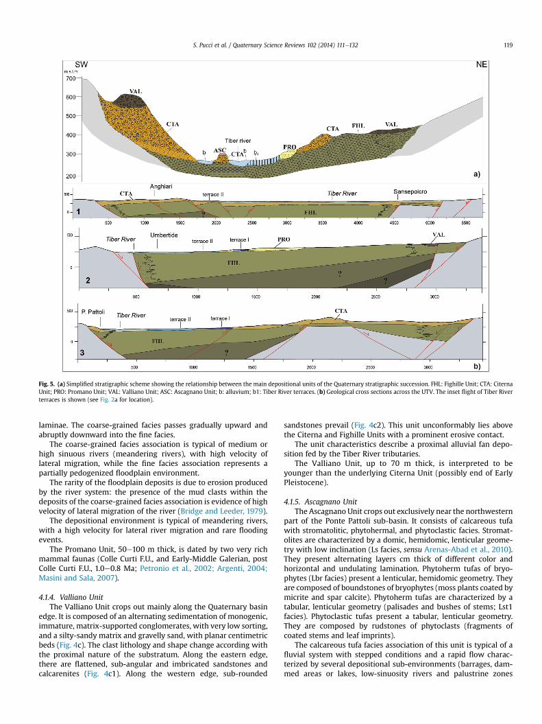
Fig. 5. (a) Simplified stratigraphic scheme showing the relationship between the main depositional units of the Quaternary stratigraphic succession. FHL: Fighille Unit; CTA: CiternaUnit; PRO: Promano Unit; VAL: Valliano Unit; ASC: Ascagnano Unit; b: alluvium; b1: Tiber River terraces. (b) Geological cross sections across the UTV. The inset flight of Tiber Riverterraces is shown (see Fig. 2a for location).
S. Pucci et al. / Quaternary Science Reviews 102 (2014) 111e132 119
laminae. The coarse-grained facies passes gradually upward andabruptly downward into the fine facies.
The coarse-grained facies association is typical of medium orhigh sinuous rivers (meandering rivers), with high velocity oflateral migration, while the fine facies association represents apartially pedogenized floodplain environment.
The rarity of the floodplain deposits is due to erosion producedby the river system: the presence of the mud clasts within thedeposits of the coarse-grained facies association is evidence of highvelocity of lateral migration of the river (Bridge and Leeder, 1979).
The depositional environment is typical of meandering rivers,with a high velocity for lateral river migration and rare floodingevents.
The Promano Unit, 50e100 m thick, is dated by two very richmammal faunas (Colle Curti F.U., and Early-Middle Galerian, postColle Curti F.U., 1.0e0.8 Ma; Petronio et al., 2002; Argenti, 2004;Masini and Sala, 2007).
4.1.4. Valliano UnitThe Valliano Unit crops out mainly along the Quaternary basin
edge. It is composed of an alternating sedimentation of monogenic,immature, matrix-supported conglomerates, with very low sorting,and a silty-sandy matrix and gravelly sand, with planar centimetricbeds (Fig. 4c). The clast lithology and shape change according withthe proximal nature of the substratum. Along the eastern edge,there are flattened, sub-angular and imbricated sandstones andcalcarenites (Fig. 4c1). Along the western edge, sub-rounded
sandstones prevail (Fig. 4c2). This unit unconformably lies abovethe Citerna and Fighille Units with a prominent erosive contact.
The unit characteristics describe a proximal alluvial fan depo-sition fed by the Tiber River tributaries.
The Valliano Unit, up to 70 m thick, is interpreted to beyounger than the underlying Citerna Unit (possibly end of EarlyPleistocene).
4.1.5. Ascagnano UnitThe Ascagnano Unit crops out exclusively near the northwestern
part of the Ponte Pattoli sub-basin. It consists of calcareous tufawith stromatolitic, phytohermal, and phytoclastic facies. Stromat-olites are characterized by a domic, hemidomic, lenticular geome-try with low inclination (Ls facies, sensu Arenas-Abad et al., 2010).They present alternating layers cm thick of different color andhorizontal and undulating lamination. Phytoherm tufas of bryo-phytes (Lbr facies) present a lenticular, hemidomic geometry. Theyare composed of boundstones of bryophytes (moss plants coated bymicrite and spar calcite). Phytoherm tufas are characterized by atabular, lenticular geometry (palisades and bushes of stems; Lst1facies). Phytoclastic tufas present a tabular, lenticular geometry.They are composed by rudstones of phytoclasts (fragments ofcoated stems and leaf imprints).
The calcareous tufa facies association of this unit is typical of afluvial system with stepped conditions and a rapid flow charac-terized by several depositional sub-environments (barrages, dam-med areas or lakes, low-sinuosity rivers and palustrine zones
S. Pucci et al. / Quaternary Science Reviews 102 (2014) 111e132120
(Arenas-Abad et al., 2010)). It is up to 20 m thick and dated LatePleistocene (this work).
4.1.6. Holocene unitThese deposits are composed by two main facies association: a)
polycyclic layers of sand and clast-supported gravels in a sandymatrix. The clasts are angular to sub-rounded, well sorted, and tendto be polygenic at the larger depositional bodies; b) silt and sandwith gravel bodies of planar-concave geometry. Gravel bodiespresent internal organization (normal gradation and clast imbri-cation) with sandy lenses and trough cross-stratification (Fig. 4d).
The facies associations indicate alluvial fan and an alluvial plaindepositional environments, respectively.
These depositions appear to thin from 140 m at the Sansepolcrobasin to less than 5 m at the Umbertide and Ponte Pattoli basins(Fig. 2a).
In summary, the outcropping units are laterally discontinuous interms of thickness and facies. For most of the facies, changes aredue to different depositional environments, depending on distancefrom the feeding area. The Fighille Unit crops out extensively alongthe present-day UTV (Fig. 2). Overlying conglomerate facies ofFighille Citerna Units are less homogeneously distributed andstrongly heterotopic partly due to the contribution of several trib-utaries to the ancient Tiber River valley that drained mainly fromthe east. Along the Umbertide and Ponte Pattoli Basins, the distri-bution and stratigraphic relationships of the continental depositstestify to the occurrence of basin closure: the marsh/braided plaindeposits (Fighille Unit) have inset fluvial deposits (Citerna andPromano Units), and are unconformably overlain by the progradingproximal fans (Valliano Unit) that are exclusively fed by paleo-TiberRiver tributaries (Fig. 5a). This feature suggests that a verticalincision and strong down-cutting of the Tiber River occurred duringthe Quaternary. Conversely, along the Sansepolcro Basin, thedepositional system shows a lower vertical incision and elevatedaggradation.
The outcropping Pleistocene sediments described above are notuniformly distributed along the present-day Tiber valley. Thenorthern Sansepolcro sub-basin consists mainly of present-daylarge alluvial plain material, with sparse outcrops of Early Pleisto-cene deposits found mainly along its western side (Figs. 2a and 5b,cross section 1). Conversely, at the other two sub-basins, south ofCitt�a di Castello, all of the Pleistocene depositional sequences cropout at the hanging-wall of the ATF, showing large outcrops of SW-dipping Early Pleistocene deposits unconformably overlain by Cit-erna and Promano Units along the eastern side (Fig. 5b, cross sec-tion 2 and 3). Near the two sides of the UTV, we evaluated thealtimetric distribution of the Quaternary deposits at the basinedges using two longitudinal geological sections projected alongthe baseline of a smoothed trace of the Tiber River (PW and PE,Fig. 2b). The PE section, along the eastern side of the basin, shows:(1) the maximum elevation of the unconformity between the Fig-hille and Valliano Units along the Umbertide Basin (up to480 m a.s.l. and up to 230 m above Tiber River); (2) the low ele-vations of the early Quaternary deposit along the Sansepolcro Basin(below 330 m a.s.l.); and (3) along the Umbertide Basin, the un-conformity at the top of the Fighille Unit, which slopes northwardin proximity to the morphological threshold with the SansepolcroBasin. The PW section, along the western side of the basin, shows:(1) themaximum elevation of the Fighille Unit along the UmbertideBasin (up to 440 m a.s.l. and up to 160 m above Tiber River); (2) themaximum elevation of the base of the Valliano Unit (up to550 m a.s.l. and up to 290 m above Tiber River); (3) a largerthickness of the Citerna Unit, with respect to the eastern side of theTiber River; and (4) a general southward slope of the basins un-conformity at the top of the Fighille Unit. As a whole, the greatest
elevations of the Quaternary deposits are located on both sides ofthe Umbertide Basin.
In summary, the Pleistocene deposits distribution shows: largerdenudation at the Umbertide Basin, coupled with elevation in-crease (along-valley bow-shaped) of the unconformities boundingthe formations; the Citerna Unit depocenter asymmetricallylocated to the west.
4.2. Quaternary faulting
The three depocenter are controlled on both flanks by a systemof NWeSE-trending normal faults that are detached onto the ATFextensional fault system (Fig. 1). The bounding faults of the basinsjuxtapose the Quaternary continental deposits with the pre-Pliocene bedrock of the Tuscan and Umbria-Marche tectonic units.
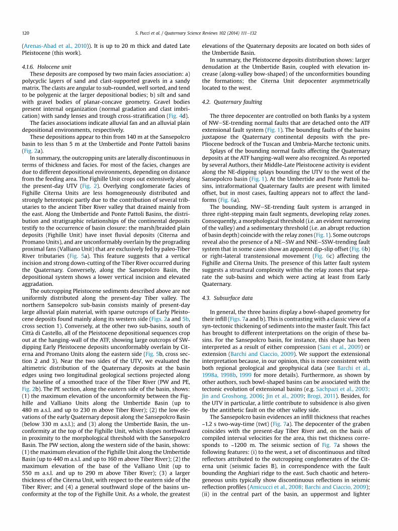
Splays of the bounding normal faults affecting the Quaternarydeposits at the ATF hanging-wall were also recognized. As reportedby several Authors, their Middle-Late Pleistocene activity is evidentalong the NE-dipping splays bounding the UTV to the west of theSansepolcro basin (Fig. 1). At the Umbertide and Ponte Pattoli ba-sins, intraformational Quaternary faults are present with limitedoffset, but in most cases, faulting appears not to affect the land-forms (Fig. 6a).
The bounding, NWeSE-trending fault system is arranged inthree right-stepping main fault segments, developing relay zones.Consequently, a morphological threshold (i.e. an evident narrowingof the valley) and a sedimentary threshold (i.e. an abrupt reductionof basin depth) coincidewith the relay zones (Fig.1). Some outcropsreveal also the presence of a NEeSW and NNEeSSW-trending faultsystem that in some cases show an apparent dip-slip offset (Fig. 6b)or right-lateral transtensional movement (Fig. 6c) affecting theFighille and Citerna Units. The presence of this latter fault systemsuggests a structural complexity within the relay zones that sepa-rate the sub-basins and which were acting at least from EarlyQuaternary.
4.3. Subsurface data
In general, the three basins display a bowl-shaped geometry fortheir infill (Figs. 7a and b). This is contrasting with a classic viewof asyn-tectonic thickening of sediments into the master fault. This facthas brought to different interpretations on the origin of these ba-sins. For the Sansepolcro basin, for instance, this shape has beeninterpreted as a result of either compression (Sani et al., 2009) orextension (Barchi and Ciaccio, 2009). We support the extensionalinterpretation because, in our opinion, this is more consistent withboth regional geological and geophysical data (see Barchi et al.,1998a, 1998b, 1999 for more details). Furthermore, as shown byother authors, such bowl-shaped basins can be associated with thetectonic evolution of extensional basins (e.g. Sachpazi et al., 2003;Jin and Groshong, 2006; Jin et al., 2009; Brogi, 2011). Besides, forthe UTV in particular, a little contribute to subsidence is also givenby the antithetic fault on the other valley side.
The Sansepolcro basin evidences an infill thickness that reaches~1.2 s two-way-time (twt) (Fig. 7a). The depocenter of the grabencoincides with the present-day Tiber River and, on the basis ofcompiled interval velocities for the area, this twt thickness corre-sponds to ~1200 m. The seismic section of Fig. 7a shows thefollowing features: (i) to the west, a set of discontinuous and tiltedreflectors attributed to the outcropping conglomerates of the Cit-erna unit (seismic facies B), in correspondence with the faultbounding the Anghiari ridge to the east. Such chaotic and hetero-geneous units typically show discontinuous reflections in seismicreflection profiles (Amicucci et al., 2008; Barchi and Ciaccio, 2009);(ii) in the central part of the basin, an uppermost and lighter
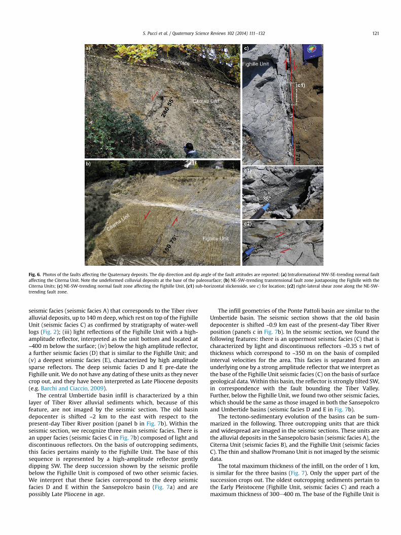
Fig. 6. Photos of the faults affecting the Quaternary deposits. The dip direction and dip angle of the fault attitudes are reported: (a) Intraformational NW-SE-trending normal faultaffecting the Citerna Unit. Note the undeformed colluvial deposits at the base of the paleosurface; (b) NE-SW-trending transtensional fault zone juxtaposing the Fighille with theCiterna Units; (c) NE-SW-trending normal fault zone affecting the Fighille Unit, (c1) sub-horizontal slickenside, see c) for location; (c2) right-lateral shear zone along the NE-SW-trending fault zone.
S. Pucci et al. / Quaternary Science Reviews 102 (2014) 111e132 121
seismic facies (seismic facies A) that corresponds to the Tiber riveralluvial deposits, up to 140 m deep, which rest on top of the FighilleUnit (seismic facies C) as confirmed by stratigraphy of water-welllogs (Fig. 2); (iii) light reflections of the Fighille Unit with a high-amplitude reflector, interpreted as the unit bottom and located at~400 m below the surface; (iv) below the high amplitude reflector,a further seismic facies (D) that is similar to the Fighille Unit; and(v) a deepest seismic facies (E), characterized by high amplitudesparse reflectors. The deep seismic facies D and E pre-date theFighille unit. We do not have any dating of these units as they nevercrop out, and they have been interpreted as Late Pliocene deposits(e.g. Barchi and Ciaccio, 2009).
The central Umbertide basin infill is characterized by a thinlayer of Tiber River alluvial sediments which, because of thisfeature, are not imaged by the seismic section. The old basindepocenter is shifted ~2 km to the east with respect to thepresent-day Tiber River position (panel b in Fig. 7b). Within theseismic section, we recognize three main seismic facies. There isan upper facies (seismic facies C in Fig. 7b) composed of light anddiscontinuous reflectors. On the basis of outcropping sediments,this facies pertains mainly to the Fighille Unit. The base of thissequence is represented by a high-amplitude reflector gentlydipping SW. The deep succession shown by the seismic profilebelow the Fighille Unit is composed of two other seismic facies.We interpret that these facies correspond to the deep seismicfacies D and E within the Sansepolcro basin (Fig. 7a) and arepossibly Late Pliocene in age.
The infill geometries of the Ponte Pattoli basin are similar to theUmbertide basin. The seismic section shows that the old basindepocenter is shifted ~0.9 km east of the present-day Tiber Riverposition (panels c in Fig. 7b). In the seismic section, we found thefollowing features: there is an uppermost seismic facies (C) that ischaracterized by light and discontinuous reflectors ~0.35 s twt ofthickness which correspond to ~350 m on the basis of compiledinterval velocities for the area. This facies is separated from anunderlying one by a strong amplitude reflector that we interpret asthe base of the Fighille Unit seismic facies (C) on the basis of surfacegeological data.Within this basin, the reflector is strongly tilted SW,in correspondence with the fault bounding the Tiber Valley.Further, below the Fighille Unit, we found two other seismic facies,which should be the same as those imaged in both the Sansepolcroand Umbertide basins (seismic facies D and E in Fig. 7b).
The tectono-sedimentary evolution of the basins can be sum-marized in the following. Three outcropping units that are thickand widespread are imaged in the seismic sections. These units arethe alluvial deposits in the Sansepolcro basin (seismic facies A), theCiterna Unit (seismic facies B), and the Fighille Unit (seismic faciesC). The thin and shallow Promano Unit is not imaged by the seismicdata.
The total maximum thickness of the infill, on the order of 1 km,is similar for the three basins (Fig. 7). Only the upper part of thesuccession crops out. The oldest outcropping sediments pertain tothe Early Pleistocene (Fighille Unit, seismic facies C) and reach amaximum thickness of 300e400 m. The base of the Fighille Unit is
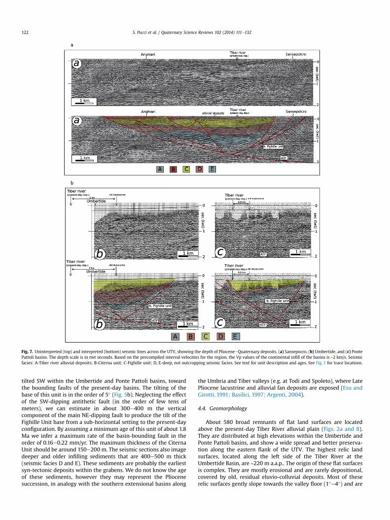
Fig. 7. Uninterpreted (top) and interpreted (bottom) seismic lines across the UTV, showing the depth of PlioceneeQuaternary deposits. (a) Sansepocro, (b) Umbertide, and (c) PontePattoli basins. The depth scale is in twt seconds. Based on the precompiled interval velocities for the region, the Vp values of the continental infill of the basins is ~2 km/s. Seismicfacies: A-Tiber river alluvial deposits; B-Citerna unit; C-Fighille unit; D, E-deep, not outcropping seismic facies. See text for unit description and ages. See Fig. 1 for trace locations.
S. Pucci et al. / Quaternary Science Reviews 102 (2014) 111e132122
tilted SW within the Umbertide and Ponte Pattoli basins, towardthe bounding faults of the present-day basins. The tilting of thebase of this unit is in the order of 5� (Fig. 5b). Neglecting the effectof the SW-dipping antithetic fault (in the order of few tens ofmeters), we can estimate in about 300e400 m the verticalcomponent of the main NE-dipping fault to produce the tilt of theFighille Unit base from a sub-horizontal setting to the present-dayconfiguration. By assuming a minimum age of this unit of about 1.8Ma we infer a maximum rate of the basin-bounding fault in theorder of 0.16e0.22 mm/yr. The maximum thickness of the CiternaUnit should be around 150e200 m. The seismic sections also imagedeeper and older infilling sediments that are 400e500 m thick(seismic facies D and E). These sediments are probably the earliestsyn-tectonic deposits within the grabens. We do not know the ageof these sediments, however they may represent the Pliocenesuccession, in analogy with the southern extensional basins along
the Umbria and Tiber valleys (e.g. at Todi and Spoleto), where LatePliocene lacustrine and alluvial fan deposits are exposed (Esu andGirotti, 1991; Basilici, 1997; Argenti, 2004).
4.4. Geomorphology
About 580 broad remnants of flat land surfaces are locatedabove the present-day Tiber River alluvial plain (Figs. 2a and 8).They are distributed at high elevations within the Umbertide andPonte Pattoli basins, and show a wide spread and better preserva-tion along the eastern flank of the UTV. The highest relic landsurfaces, located along the left side of the Tiber River at theUmbertide Basin, are ~220 m a.a.p.. The origin of these flat surfacesis complex. They are mostly erosional and are rarely depositional,covered by old, residual eluvio-colluvial deposits. Most of theserelic surfaces gently slope towards the valley floor (1�e4�) and are
Fig. 8. (a) Landscape view of the eastern edge of the Umbertide Basin. The upper paleosurface unconformably overlaying the Valliano Unit is reported. The stratigraphic limits andthe bedding dips are evidenced. Note the larger dip of the Fighille Unit; (b) View of the lower paleosurfaces of the Umbertide Basin; (c) Landscape view of the NW-tilted Citt�a diCastello land surface. View direction is toward the east (see Fig. 2a for locations).
S. Pucci et al. / Quaternary Science Reviews 102 (2014) 111e132 123
unconformably superimposed on different units of the Pleistocenesuccession (Fig. 8a). These low-relief and gently-sloping uplandsare not offset or controlled by faulting, but they unconformably cutacross the dipping strata of the Pleistocene deposits (bedding dipsfrom 2� to 21�).
Conversely, in the study area, we clearly detected two orders ofriver terraces that show substitution and a tendency to obliterationof the upper order by the lower one (Fig. 9). We mapped about 400surfaces whose spatial extension and continuity allowed a confi-dent correlation of these two orders. Terrace deposits consist offluvial deposits composed of coarse gravels that are thickly beddedand imbricated. The fluvial deposits include minor amounts of sandand awell-defined sub-horizontal erosional base laying on bedrock
or Quaternary sediments. Apart from a few cases, most of the fluvialterraces are strath terraces, since their thickness is reduced relativeto the size of the drainage basin (<3e5m, typical for the Tiber basinarea which is ~17,000 km2; Pazzaglia, 2012) (Fig. 10b). Along theeastern flank, the river terraces are widely spread and well-characterized. In contrast, along the western flank of the valley,the terraces are scarce and do not extend across large areas.
We recognized two orders of terraces above the Tiber River al-luvial plain along the two flanks of the UTV (Fig. 9). The longitu-dinal profile of the two orders of fluvial terraces shows that thenorthern Sansepolcro Basin is characterized by an overall scarcity offluvial terraces. Here, as revealed by a thickening of Late Pleisto-ceneeHolocene alluvial deposits, the lack of fluvial terraces is

Fig. 9. Projected longitudinal profiles of the elevations of river terraces along the two banks of the Tiber River (see Fig. 2a for the baseline location). The vertical side of the graphed boxes describes the difference in elevations betweeninner and outer edges. The horizontal side reports the lateral extent of each detected terrace. The most represented elevation of the terrace area (i.e. major distributed heights) has been reported as “key elevation”. Elevations are relativeto the present-day alluvial plain.
S.Pucciet
al./Quaternary
ScienceReview
s102
(2014)111
e132
124
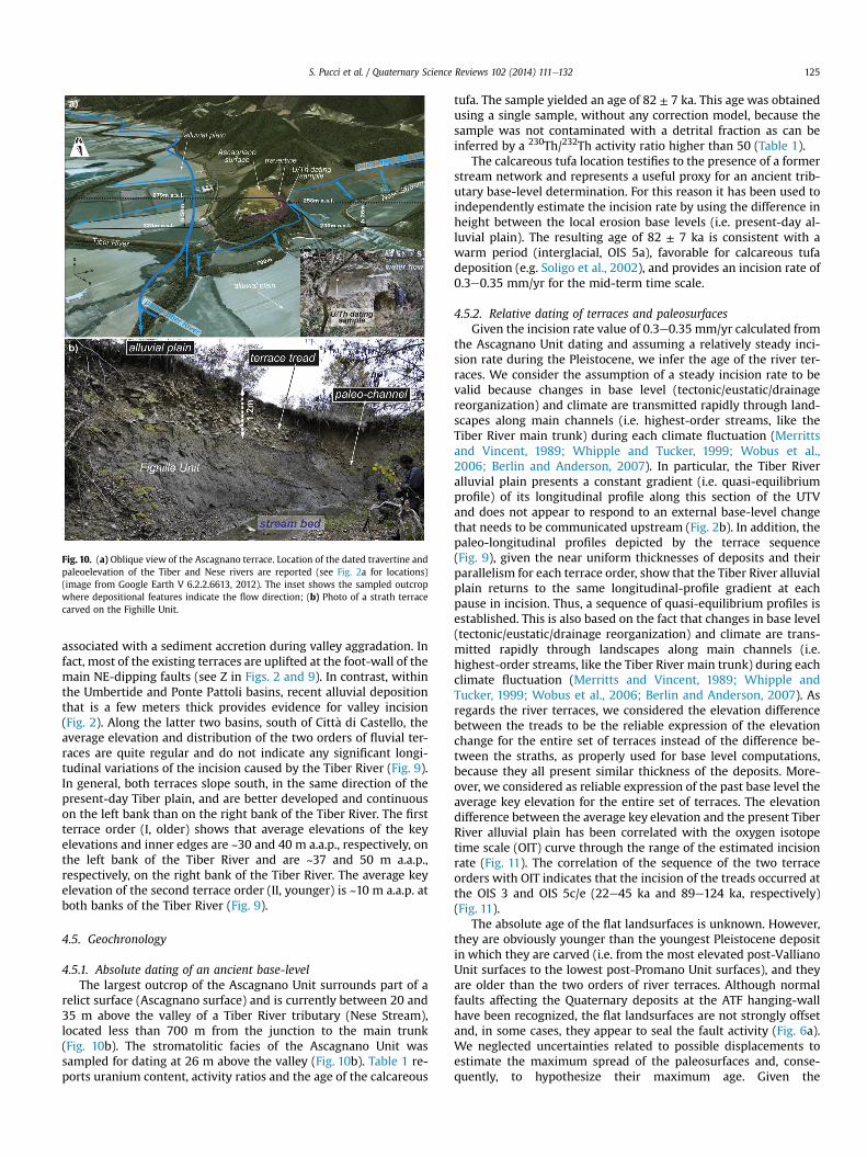
Fig. 10. (a) Oblique view of the Ascagnano terrace. Location of the dated travertine andpaleoelevation of the Tiber and Nese rivers are reported (see Fig. 2a for locations)(image from Google Earth V 6.2.2.6613, 2012). The inset shows the sampled outcropwhere depositional features indicate the flow direction; (b) Photo of a strath terracecarved on the Fighille Unit.
S. Pucci et al. / Quaternary Science Reviews 102 (2014) 111e132 125
associated with a sediment accretion during valley aggradation. Infact, most of the existing terraces are uplifted at the foot-wall of themain NE-dipping faults (see Z in Figs. 2 and 9). In contrast, withinthe Umbertide and Ponte Pattoli basins, recent alluvial depositionthat is a few meters thick provides evidence for valley incision(Fig. 2). Along the latter two basins, south of Citt�a di Castello, theaverage elevation and distribution of the two orders of fluvial ter-races are quite regular and do not indicate any significant longi-tudinal variations of the incision caused by the Tiber River (Fig. 9).In general, both terraces slope south, in the same direction of thepresent-day Tiber plain, and are better developed and continuouson the left bank than on the right bank of the Tiber River. The firstterrace order (I, older) shows that average elevations of the keyelevations and inner edges are ~30 and 40 m a.a.p., respectively, onthe left bank of the Tiber River and are ~37 and 50 m a.a.p.,respectively, on the right bank of the Tiber River. The average keyelevation of the second terrace order (II, younger) is ~10 m a.a.p. atboth banks of the Tiber River (Fig. 9).
4.5. Geochronology
4.5.1. Absolute dating of an ancient base-levelThe largest outcrop of the Ascagnano Unit surrounds part of a
relict surface (Ascagnano surface) and is currently between 20 and35 m above the valley of a Tiber River tributary (Nese Stream),located less than 700 m from the junction to the main trunk(Fig. 10b). The stromatolitic facies of the Ascagnano Unit wassampled for dating at 26 m above the valley (Fig. 10b). Table 1 re-ports uranium content, activity ratios and the age of the calcareous
tufa. The sample yielded an age of 82 ± 7 ka. This age was obtainedusing a single sample, without any correction model, because thesample was not contaminated with a detrital fraction as can beinferred by a 230Th/232Th activity ratio higher than 50 (Table 1).
The calcareous tufa location testifies to the presence of a formerstream network and represents a useful proxy for an ancient trib-utary base-level determination. For this reason it has been used toindependently estimate the incision rate by using the difference inheight between the local erosion base levels (i.e. present-day al-luvial plain). The resulting age of 82 ± 7 ka is consistent with awarm period (interglacial, OIS 5a), favorable for calcareous tufadeposition (e.g. Soligo et al., 2002), and provides an incision rate of0.3e0.35 mm/yr for the mid-term time scale.
4.5.2. Relative dating of terraces and paleosurfacesGiven the incision rate value of 0.3e0.35 mm/yr calculated from
the Ascagnano Unit dating and assuming a relatively steady inci-sion rate during the Pleistocene, we infer the age of the river ter-races. We consider the assumption of a steady incision rate to bevalid because changes in base level (tectonic/eustatic/drainagereorganization) and climate are transmitted rapidly through land-scapes along main channels (i.e. highest-order streams, like theTiber River main trunk) during each climate fluctuation (Merrittsand Vincent, 1989; Whipple and Tucker, 1999; Wobus et al.,2006; Berlin and Anderson, 2007). In particular, the Tiber Riveralluvial plain presents a constant gradient (i.e. quasi-equilibriumprofile) of its longitudinal profile along this section of the UTVand does not appear to respond to an external base-level changethat needs to be communicated upstream (Fig. 2b). In addition, thepaleo-longitudinal profiles depicted by the terrace sequence(Fig. 9), given the near uniform thicknesses of deposits and theirparallelism for each terrace order, show that the Tiber River alluvialplain returns to the same longitudinal-profile gradient at eachpause in incision. Thus, a sequence of quasi-equilibrium profiles isestablished. This is also based on the fact that changes in base level(tectonic/eustatic/drainage reorganization) and climate are trans-mitted rapidly through landscapes along main channels (i.e.highest-order streams, like the Tiber River main trunk) during eachclimate fluctuation (Merritts and Vincent, 1989; Whipple andTucker, 1999; Wobus et al., 2006; Berlin and Anderson, 2007). Asregards the river terraces, we considered the elevation differencebetween the treads to be the reliable expression of the elevationchange for the entire set of terraces instead of the difference be-tween the straths, as properly used for base level computations,because they all present similar thickness of the deposits. More-over, we considered as reliable expression of the past base level theaverage key elevation for the entire set of terraces. The elevationdifference between the average key elevation and the present TiberRiver alluvial plain has been correlated with the oxygen isotopetime scale (OIT) curve through the range of the estimated incisionrate (Fig. 11). The correlation of the sequence of the two terraceorders with OIT indicates that the incision of the treads occurred atthe OIS 3 and OIS 5c/e (22e45 ka and 89e124 ka, respectively)(Fig. 11).
The absolute age of the flat landsurfaces is unknown. However,they are obviously younger than the youngest Pleistocene depositin which they are carved (i.e. from the most elevated post-VallianoUnit surfaces to the lowest post-Promano Unit surfaces), and theyare older than the two orders of river terraces. Although normalfaults affecting the Quaternary deposits at the ATF hanging-wallhave been recognized, the flat landsurfaces are not strongly offsetand, in some cases, they appear to seal the fault activity (Fig. 6a).We neglected uncertainties related to possible displacements toestimate the maximum spread of the paleosurfaces and, conse-quently, to hypothesize their maximum age. Given the
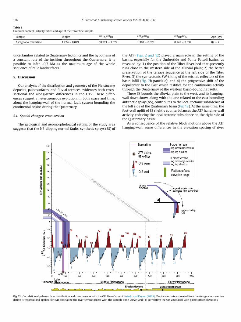
Table 1Uranium content, activity ratios and age of the travertine sample.
Sample U ppm 230Th/232Th 234U/238U 230Th/234U Age (ky)
Ascagnano travertine 1.224 ± 0.049 58.971 ± 7.672 1.367 ± 0.029 0.545 ± 0.034 82 ± 7
S. Pucci et al. / Quaternary Science Reviews 102 (2014) 111e132126
uncertainties related to Quaternary tectonics and the hypothesis ofa constant rate of the incision throughout the Quaternary, it ispossible to infer ~0.7 Ma as the maximum age of the wholesequence of relic landsurfaces.
5. Discussion
Our analysis of the distribution and geometry of the Pleistocenedeposits, paleosurfaces, and fluvial terraces evidences both cross-sectional and along-strike differences in the UTV. These differ-ences suggest a heterogeneous evolution, in both space and time,along the hanging-wall of the normal fault system bounding thecontinental basins during the Quaternary.
5.1. Spatial changes: cross-section
The geological and geomorphological setting of the study areasuggests that the NE-dipping normal faults, synthetic splays (SS) of
Fig. 11. Correlation of paleosurfaces distribution and river terraces with the OIS Time Curve odating is reported and applied for: (a) correlating the river terrace orders with the isotopic
the ATF (Figs. 2 and 12) played a main role in the setting of thebasins, especially for the Umbertide and Ponte Pattoli basins, asrevealed by: 1) the position of the Tiber River bed that presentlyruns close to the western side of the alluvial plain; 2) the betterpreservation of the terrace sequence at the left side of the TiberRiver; 3) the syn-tectonic SW-tilting of the seismic reflectors of thebasin infill (Fig. 7b panels c); and 4) the progressive shift of thedepocenter to the East which testifies for the continuous activitythrough the Quaternary of the western basin-bounding faults.
These SS bounds the alluvial plain to the west, and its hanging-wall downthrow, along with the one related to the east boundingantithetic splay (AS), contributes to the local tectonic subsidence ofthe left side of the Quaternary basin (Fig. 12). At the same time, thefoot-wall uplift of SS slightly counterbalances the ATF hanging-wallactivity, reducing the local tectonic subsidence on the right side ofthe Quaternary basin.
As a consequence of the relative block motions above the ATFhanging-wall, some differences in the elevation spacing of river
f Lisiecki and Raymo (2005). The incision rate estimated from the Ascagnano travertineTime Curve; and (b) correlating the OIS anaglacial with paleosurface elevations.
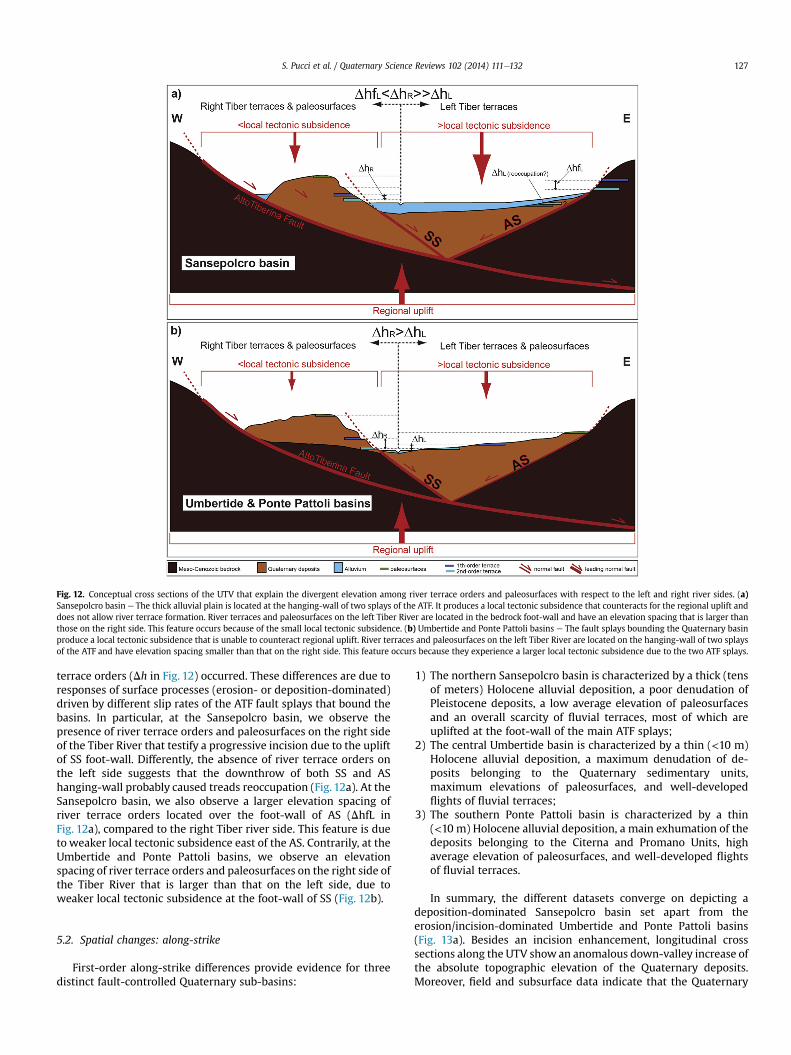
Fig. 12. Conceptual cross sections of the UTV that explain the divergent elevation among river terrace orders and paleosurfaces with respect to the left and right river sides. (a)Sansepolcro basin e The thick alluvial plain is located at the hanging-wall of two splays of the ATF. It produces a local tectonic subsidence that counteracts for the regional uplift anddoes not allow river terrace formation. River terraces and paleosurfaces on the left Tiber River are located in the bedrock foot-wall and have an elevation spacing that is larger thanthose on the right side. This feature occurs because of the small local tectonic subsidence. (b) Umbertide and Ponte Pattoli basins e The fault splays bounding the Quaternary basinproduce a local tectonic subsidence that is unable to counteract regional uplift. River terraces and paleosurfaces on the left Tiber River are located on the hanging-wall of two splaysof the ATF and have elevation spacing smaller than that on the right side. This feature occurs because they experience a larger local tectonic subsidence due to the two ATF splays.
S. Pucci et al. / Quaternary Science Reviews 102 (2014) 111e132 127
terrace orders (Dh in Fig. 12) occurred. These differences are due toresponses of surface processes (erosion- or deposition-dominated)driven by different slip rates of the ATF fault splays that bound thebasins. In particular, at the Sansepolcro basin, we observe thepresence of river terrace orders and paleosurfaces on the right sideof the Tiber River that testify a progressive incision due to the upliftof SS foot-wall. Differently, the absence of river terrace orders onthe left side suggests that the downthrow of both SS and AShanging-wall probably caused treads reoccupation (Fig. 12a). At theSansepolcro basin, we also observe a larger elevation spacing ofriver terrace orders located over the foot-wall of AS (DhfL inFig. 12a), compared to the right Tiber river side. This feature is dueto weaker local tectonic subsidence east of the AS. Contrarily, at theUmbertide and Ponte Pattoli basins, we observe an elevationspacing of river terrace orders and paleosurfaces on the right side ofthe Tiber River that is larger than that on the left side, due toweaker local tectonic subsidence at the foot-wall of SS (Fig. 12b).
5.2. Spatial changes: along-strike
First-order along-strike differences provide evidence for threedistinct fault-controlled Quaternary sub-basins:
1) The northern Sansepolcro basin is characterized by a thick (tensof meters) Holocene alluvial deposition, a poor denudation ofPleistocene deposits, a low average elevation of paleosurfacesand an overall scarcity of fluvial terraces, most of which areuplifted at the foot-wall of the main ATF splays;
2) The central Umbertide basin is characterized by a thin (<10 m)Holocene alluvial deposition, a maximum denudation of de-posits belonging to the Quaternary sedimentary units,maximum elevations of paleosurfaces, and well-developedflights of fluvial terraces;
3) The southern Ponte Pattoli basin is characterized by a thin(<10 m) Holocene alluvial deposition, a main exhumation of thedeposits belonging to the Citerna and Promano Units, highaverage elevation of paleosurfaces, and well-developed flightsof fluvial terraces.
In summary, the different datasets converge on depicting adeposition-dominated Sansepolcro basin set apart from theerosion/incision-dominated Umbertide and Ponte Pattoli basins(Fig. 13a). Besides an incision enhancement, longitudinal crosssections along the UTV show an anomalous down-valley increase ofthe absolute topographic elevation of the Quaternary deposits.Moreover, field and subsurface data indicate that the Quaternary
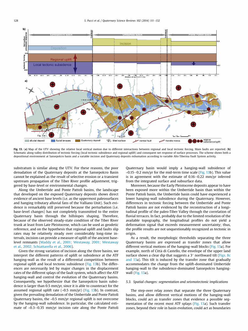
Fig. 13. (a) Map of the UTV showing the relative local vertical motion due to different interactions between regional and local tectonic forcing. Main faults are reported. (b)Schematic along-valley distribution of tectonic forcing (local tectonic subsidence and regional uplift) and consequent net response of surface processes. The scheme shows both adepositional environment at Sansepolcro basin and a variable incision and Quaternary deposits exhumation according to variable Alto Tiberina Fault System activity.
S. Pucci et al. / Quaternary Science Reviews 102 (2014) 111e132128
substratum is similar along the UTV. For these reasons, the poordenudation of the Quaternary deposits at the Sansepolcro Basincannot be explained as the result of selective erosion or a transientupstream propagation of the Tiber River profile adjustment, trig-gered by base-level or environmental changes.
Along the Umbertide and Ponte Pattoli basins, the landscapethat developed on the exposed Quaternary deposits shows directevidence of ancient base levels (i.e. as the uppermost paleosurfacesand hanging tributary alluvial fans of the Valliano Unit). Such evi-dence is remarkably still preserved because the perturbation (i.e.base-level changes) has not completely transmitted to the entireQuaternary basin through the hillslopes shaping. Therefore,because of the observed steady-state condition of the Tiber Rivertrunk at least from Late Pleistocene, which can be used as geodeticreference, and on the hypothesis that regional uplift and faults sliprates may be relatively steady over considerably long-time in-tervals, incision can provide a measure of uplift of the ancient base-level remnants (Maddy et al., 2001; Westaway, 2001; Westawayet al., 2002; Schiattarella et al., 2006).
Given the strong variation of incision along the three basins, weinterpret the different patterns of uplift or subsidence at the ATFhanging-wall as the result of a differential competition betweenregional uplift and local tectonic subsidence (Fig. 13b). The differ-ences are necessarily led by major changes in the displacementrates of the different splays of the fault system, which affect the ATFhanging-wall and control the evolution of the Quaternary basins.Consequently, we hypothesize that the Sansepolcro basin subsi-dence is larger than 0.5 mm/yr, since it is able to counteract for theassumed regional uplift rate (~0.5 mm/yr) (Fig. 13b). In contrast,given the prevailing denudation of the Umbertide and Ponte PattoliQuaternary basins, the ~0.5 mm/yr regional uplift is not overcomeby the hanging-wall subsidence. In particular, the calculated esti-mate of ~0.3e0.35 mm/yr incision rate along the Ponte Pattoli
Quaternary basin would imply a hanging-wall subsidence of~0.15e0.2 mm/yr for the mid-term time scale (Fig. 13b). This valueis in agreement with the estimate of 0.16e0.22 mm/yr inferredfrom the integrated surface and subsurface data.
Moreover, because the Early Pleistocene deposits appear to havebeen exposed more within the Umbertide basin than within thePonte Pattoli basin, the Umbertide basin could have experienced alower hanging-wall subsidence during the Quaternary. However,differences in tectonic forcing between the Umbertide and PontePattoli basins are not evidenced by the reconstruction of a longi-tudinal profile of the paleo-Tiber Valley through the correlation offluvial terraces. In fact, probably due to the limited resolution of theavailable topography, the longitudinal profiles do not yield adeformation signal that exceeds measurement uncertainty; thus,the profile results are not unquestionably recognized as tectonic inorigin.
As a result, the morphologic thresholds separating the threeQuaternary basins are expressed as transfer zones that allowdifferent vertical motions of the hanging-wall blocks (Fig. 13a). Forexample, north of Citt�a di Castello, the envelope of the upper landsurface shows a clear dip that suggests a 3� northward tilt (Figs. 8cand 13a). This tilt is induced by the transfer zone that graduallyaccommodates the change from the uplift-dominated Umbertidehanging-wall to the subsidence-dominated Sansepolcro hanging-wall (Fig. 13a).
5.3. Spatial changes: segmentation and seismotectonic implications
The step-over relay zones that separate the three Quaternarybasins, and allow different vertical motions of the hanging-wallblocks, could act as transfer zones that evidence a possible seg-mentation of the recent most ATF splays (Fig. 13a). Such transferzones, beyond their role in basin evolution, could act as boundaries
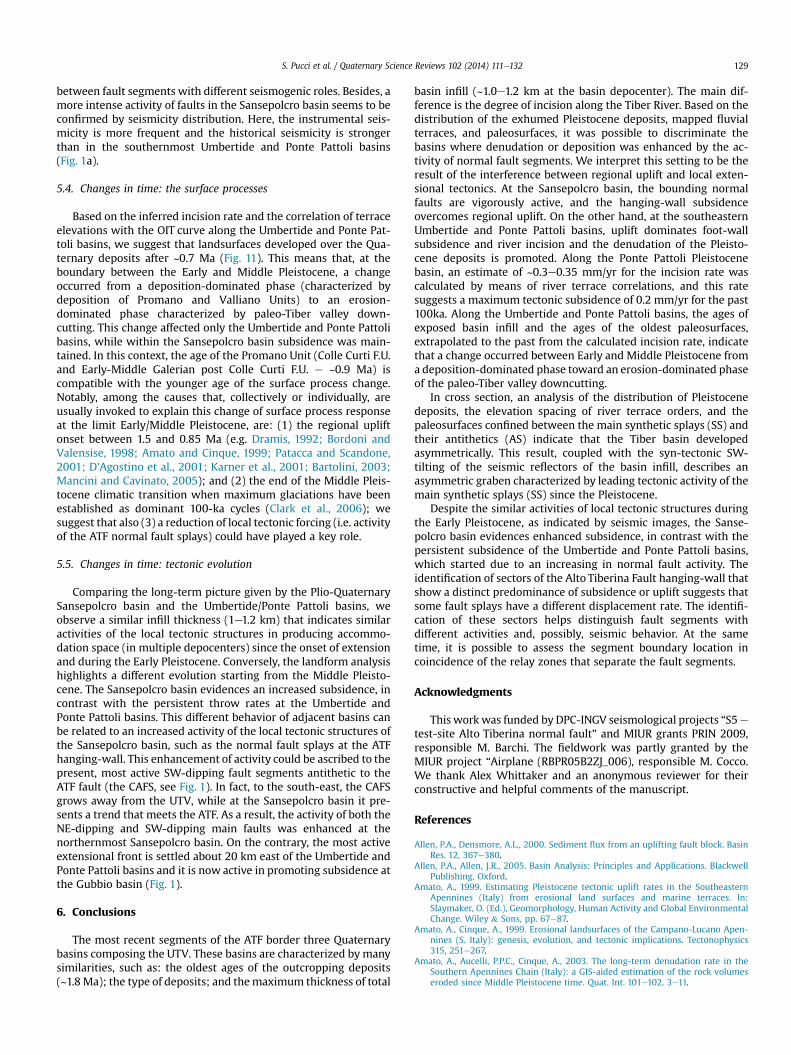
S. Pucci et al. / Quaternary Science Reviews 102 (2014) 111e132 129
between fault segments with different seismogenic roles. Besides, amore intense activity of faults in the Sansepolcro basin seems to beconfirmed by seismicity distribution. Here, the instrumental seis-micity is more frequent and the historical seismicity is strongerthan in the southernmost Umbertide and Ponte Pattoli basins(Fig. 1a).
5.4. Changes in time: the surface processes
Based on the inferred incision rate and the correlation of terraceelevations with the OIT curve along the Umbertide and Ponte Pat-toli basins, we suggest that landsurfaces developed over the Qua-ternary deposits after ~0.7 Ma (Fig. 11). This means that, at theboundary between the Early and Middle Pleistocene, a changeoccurred from a deposition-dominated phase (characterized bydeposition of Promano and Valliano Units) to an erosion-dominated phase characterized by paleo-Tiber valley down-cutting. This change affected only the Umbertide and Ponte Pattolibasins, while within the Sansepolcro basin subsidence was main-tained. In this context, the age of the Promano Unit (Colle Curti F.U.and Early-Middle Galerian post Colle Curti F.U. e ~0.9 Ma) iscompatible with the younger age of the surface process change.Notably, among the causes that, collectively or individually, areusually invoked to explain this change of surface process responseat the limit Early/Middle Pleistocene, are: (1) the regional upliftonset between 1.5 and 0.85 Ma (e.g. Dramis, 1992; Bordoni andValensise, 1998; Amato and Cinque, 1999; Patacca and Scandone,2001; D'Agostino et al., 2001; Karner et al., 2001; Bartolini, 2003;Mancini and Cavinato, 2005); and (2) the end of the Middle Pleis-tocene climatic transition when maximum glaciations have beenestablished as dominant 100-ka cycles (Clark et al., 2006); wesuggest that also (3) a reduction of local tectonic forcing (i.e. activityof the ATF normal fault splays) could have played a key role.
5.5. Changes in time: tectonic evolution
Comparing the long-term picture given by the Plio-QuaternarySansepolcro basin and the Umbertide/Ponte Pattoli basins, weobserve a similar infill thickness (1e1.2 km) that indicates similaractivities of the local tectonic structures in producing accommo-dation space (in multiple depocenters) since the onset of extensionand during the Early Pleistocene. Conversely, the landform analysishighlights a different evolution starting from the Middle Pleisto-cene. The Sansepolcro basin evidences an increased subsidence, incontrast with the persistent throw rates at the Umbertide andPonte Pattoli basins. This different behavior of adjacent basins canbe related to an increased activity of the local tectonic structures ofthe Sansepolcro basin, such as the normal fault splays at the ATFhanging-wall. This enhancement of activity could be ascribed to thepresent, most active SW-dipping fault segments antithetic to theATF fault (the CAFS, see Fig. 1). In fact, to the south-east, the CAFSgrows away from the UTV, while at the Sansepolcro basin it pre-sents a trend that meets the ATF. As a result, the activity of both theNE-dipping and SW-dipping main faults was enhanced at thenorthernmost Sansepolcro basin. On the contrary, the most activeextensional front is settled about 20 km east of the Umbertide andPonte Pattoli basins and it is now active in promoting subsidence atthe Gubbio basin (Fig. 1).
6. Conclusions
The most recent segments of the ATF border three Quaternarybasins composing the UTV. These basins are characterized by manysimilarities, such as: the oldest ages of the outcropping deposits(~1.8 Ma); the type of deposits; and themaximum thickness of total
basin infill (~1.0e1.2 km at the basin depocenter). The main dif-ference is the degree of incision along the Tiber River. Based on thedistribution of the exhumed Pleistocene deposits, mapped fluvialterraces, and paleosurfaces, it was possible to discriminate thebasins where denudation or deposition was enhanced by the ac-tivity of normal fault segments. We interpret this setting to be theresult of the interference between regional uplift and local exten-sional tectonics. At the Sansepolcro basin, the bounding normalfaults are vigorously active, and the hanging-wall subsidenceovercomes regional uplift. On the other hand, at the southeasternUmbertide and Ponte Pattoli basins, uplift dominates foot-wallsubsidence and river incision and the denudation of the Pleisto-cene deposits is promoted. Along the Ponte Pattoli Pleistocenebasin, an estimate of ~0.3e0.35 mm/yr for the incision rate wascalculated by means of river terrace correlations, and this ratesuggests a maximum tectonic subsidence of 0.2 mm/yr for the past100ka. Along the Umbertide and Ponte Pattoli basins, the ages ofexposed basin infill and the ages of the oldest paleosurfaces,extrapolated to the past from the calculated incision rate, indicatethat a change occurred between Early and Middle Pleistocene froma deposition-dominated phase toward an erosion-dominated phaseof the paleo-Tiber valley downcutting.
In cross section, an analysis of the distribution of Pleistocenedeposits, the elevation spacing of river terrace orders, and thepaleosurfaces confined between the main synthetic splays (SS) andtheir antithetics (AS) indicate that the Tiber basin developedasymmetrically. This result, coupled with the syn-tectonic SW-tilting of the seismic reflectors of the basin infill, describes anasymmetric graben characterized by leading tectonic activity of themain synthetic splays (SS) since the Pleistocene.
Despite the similar activities of local tectonic structures duringthe Early Pleistocene, as indicated by seismic images, the Sanse-polcro basin evidences enhanced subsidence, in contrast with thepersistent subsidence of the Umbertide and Ponte Pattoli basins,which started due to an increasing in normal fault activity. Theidentification of sectors of the Alto Tiberina Fault hanging-wall thatshow a distinct predominance of subsidence or uplift suggests thatsome fault splays have a different displacement rate. The identifi-cation of these sectors helps distinguish fault segments withdifferent activities and, possibly, seismic behavior. At the sametime, it is possible to assess the segment boundary location incoincidence of the relay zones that separate the fault segments.
Acknowledgments
This workwas funded by DPC-INGV seismological projects “S5e
test-site Alto Tiberina normal fault” and MIUR grants PRIN 2009,responsible M. Barchi. The fieldwork was partly granted by theMIUR project “Airplane (RBPR05B2ZJ_006), responsible M. Cocco.We thank Alex Whittaker and an anonymous reviewer for theirconstructive and helpful comments of the manuscript.
References
Allen, P.A., Densmore, A.L., 2000. Sediment flux from an uplifting fault block. BasinRes. 12, 367e380.
Allen, P.A., Allen, J.R., 2005. Basin Analysis: Principles and Applications. BlackwellPublishing, Oxford.
Amato, A., 1999. Estimating Pleistocene tectonic uplift rates in the SoutheasternApennines (Italy) from erosional land surfaces and marine terraces. In:Slaymaker, O. (Ed.), Geomorphology, Human Activity and Global EnvironmentalChange. Wiley & Sons, pp. 67e87.
Amato, A., Cinque, A., 1999. Erosional landsurfaces of the Campano-Lucano Apen-nines (S. Italy): genesis, evolution, and tectonic implications. Tectonophysics315, 251e267.
Amato, A., Aucelli, P.P.C., Cinque, A., 2003. The long-term denudation rate in theSouthern Apennines Chain (Italy): a GIS-aided estimation of the rock volumeseroded since Middle Pleistocene time. Quat. Int. 101e102, 3e11.
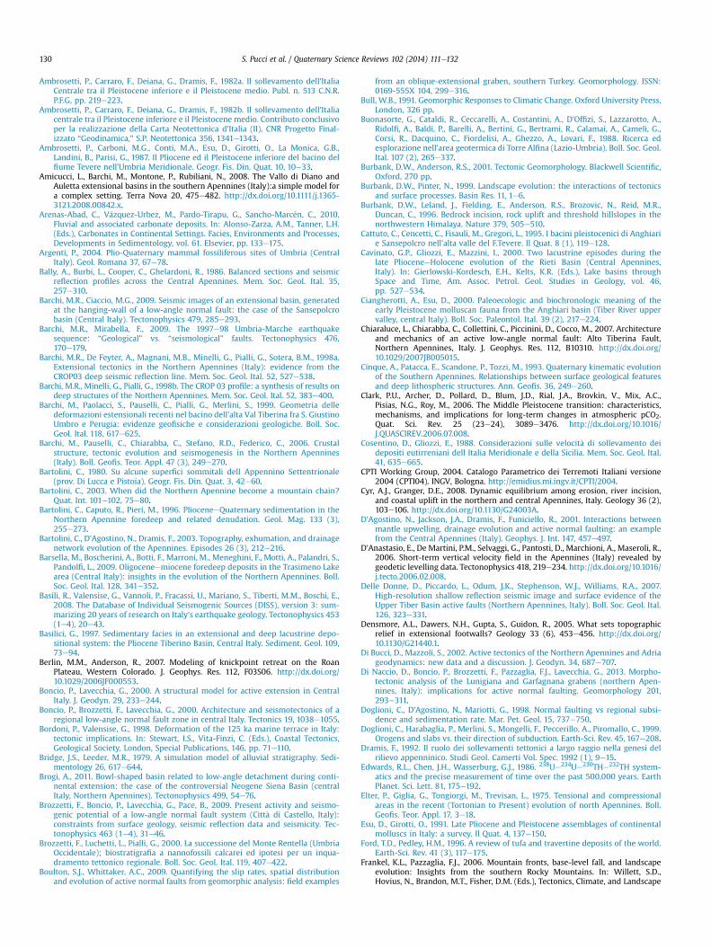
S. Pucci et al. / Quaternary Science Reviews 102 (2014) 111e132130
Ambrosetti, P., Carraro, F., Deiana, G., Dramis, F., 1982a. Il sollevamento dell'ItaliaCentrale tra il Pleistocene inferiore e il Pleistocene medio. Publ. n. 513 C.N.R.P.F.G, pp. 219e223.
Ambrosetti, P., Carraro, F., Deiana, G., Dramis, F., 1982b. Il sollevamento dell'Italiacentrale tra il Pleistocene inferiore e il Pleistocene medio. Contributo conclusivoper la realizzazione della Carta Neotettonica d'Italia (II), CNR Progetto Final-izzato “Geodinamica,” S.P. Neotettonica 356, 1341e1343.
Ambrosetti, P., Carboni, M.G., Conti, M.A., Esu, D., Girotti, O., La Monica, G.B.,Landini, B., Parisi, G., 1987. Il Pliocene ed il Pleistocene inferiore del bacino delfiume Tevere nell'Umbria Meridionale. Geogr. Fis. Din. Quat. 10, 10e33.
Amicucci, L., Barchi, M., Montone, P., Rubiliani, N., 2008. The Vallo di Diano andAuletta extensional basins in the southern Apennines (Italy):a simple model fora complex setting. Terra Nova 20, 475e482. http://dx.doi.org/10.1111/j.1365-3121.2008.00842.x.
Arenas-Abad, C., V�azquez-Urbez, M., Pardo-Tirapu, G., Sancho-Marc�en, C., 2010.Fluvial and associated carbonate deposits. In: Alonso-Zarza, A.M., Tanner, L.H.(Eds.), Carbonates in Continental Settings. Facies, Environments and Processes,Developments in Sedimentology, vol. 61. Elsevier, pp. 133e175.
Argenti, P., 2004. Plio-Quaternary mammal fossiliferous sites of Umbria (CentralItaly). Geol. Romana 37, 67e78.
Bally, A., Burbi, L., Cooper, C., Ghelardoni, R., 1986. Balanced sections and seismicreflection profiles across the Central Apennines. Mem. Soc. Geol. Ital. 35,257e310.
Barchi, M.R., Ciaccio, M.G., 2009. Seismic images of an extensional basin, generatedat the hanging-wall of a low-angle normal fault: the case of the Sansepolcrobasin (Central Italy). Tectonophysics 479, 285e293.
Barchi, M.R., Mirabella, F., 2009. The 1997e98 Umbria-Marche earthquakesequence: “Geological” vs. “seismological” faults. Tectonophysics 476,170e179.
Barchi, M.R., De Feyter, A., Magnani, M.B., Minelli, G., Pialli, G., Sotera, B.M., 1998a.Extensional tectonics in the Northern Apennines (Italy): evidence from theCROP03 deep seismic reflection line. Mem. Soc. Geol. Ital. 52, 527e538.
Barchi, M.R., Minelli, G., Pialli, G., 1998b. The CROP 03 profile: a synthesis of results ondeep structures of the Northern Apennines. Mem. Soc. Geol. Ital. 52, 383e400.
Barchi, M., Paolacci, S., Pauselli, C., Pialli, G., Merlini, S., 1999. Geometria delledeformazioni estensionali recenti nel bacino dell'alta Val Tiberina fra S. GiustinoUmbro e Perugia: evidenze geofisiche e considerazioni geologiche. Boll. Soc.Geol. Ital. 118, 617e625.
Barchi, M., Pauselli, C., Chiarabba, C., Stefano, R.D., Federico, C., 2006. Crustalstructure, tectonic evolution and seismogenesis in the Northern Apennines(Italy). Boll. Geofis. Teor. Appl. 47 (3), 249e270.
Bartolini, C., 1980. Su alcune superfici sommitali dell Appennino Settentrionale(prov. Di Lucca e Pistoia). Geogr. Fis. Din. Quat. 3, 42e60.
Bartolini, C., 2003. When did the Northern Apennine become a mountain chain?Quat. Int. 101e102, 75e80.
Bartolini, C., Caputo, R., Pieri, M., 1996. PlioceneeQuaternary sedimentation in theNorthern Apennine foredeep and related denudation. Geol. Mag. 133 (3),255e273.
Bartolini, C., D'Agostino, N., Dramis, F., 2003. Topography, exhumation, and drainagenetwork evolution of the Apennines. Episodes 26 (3), 212e216.
Barsella, M., Boscherini, A., Botti, F., Marroni, M., Meneghini, F., Motti, A., Palandri, S.,Pandolfi, L., 2009. Oligoceneemiocene foredeep deposits in the Trasimeno Lakearea (Central Italy): insights in the evolution of the Northern Apennines. Boll.Soc. Geol. Ital. 128, 341e352.
Basili, R., Valensise, G., Vannoli, P., Fracassi, U., Mariano, S., Tiberti, M.M., Boschi, E.,2008. The Database of Individual Seismogenic Sources (DISS), version 3: sum-marizing 20 years of research on Italy's earthquake geology. Tectonophysics 453(1e4), 20e43.
Basilici, G., 1997. Sedimentary facies in an extensional and deep lacustrine depo-sitional system: the Pliocene Tiberino Basin, Central Italy. Sediment. Geol. 109,73e94.
Berlin, M.M., Anderson, R., 2007. Modeling of knickpoint retreat on the RoanPlateau, Western Colorado. J. Geophys. Res. 112, F03S06. http://dx.doi.org/10.1029/2006JF000553.
Boncio, P., Lavecchia, G., 2000. A structural model for active extension in CentralItaly. J. Geodyn. 29, 233e244.
Boncio, P., Brozzetti, F., Lavecchia, G., 2000. Architecture and seismotectonics of aregional low-angle normal fault zone in central Italy. Tectonics 19, 1038e1055.
Bordoni, P., Valensise, G., 1998. Deformation of the 125 ka marine terrace in Italy:tectonic implications. In: Stewart, I.S., Vita-Finzi, C. (Eds.), Coastal Tectonics,Geological Society, London, Special Publications, 146, pp. 71e110.
Bridge, J.S., Leeder, M.R., 1979. A simulation model of alluvial stratigraphy. Sedi-mentology 26, 617e644.
Brogi, A., 2011. Bowl-shaped basin related to low-angle detachment during conti-nental extension: the case of the controversial Neogene Siena Basin (centralItaly, Northern Apennines). Tectonophysics 499, 54e76.
Brozzetti, F., Boncio, P., Lavecchia, G., Pace, B., 2009. Present activity and seismo-genic potential of a low-angle normal fault system (Citt�a di Castello, Italy):constraints from surface geology, seismic reflection data and seismicity. Tec-tonophysics 463 (1e4), 31e46.
Brozzetti, F., Luchetti, L., Pialli, G., 2000. La successione del Monte Rentella (UmbriaOccidentale); biostratigrafia a nannofossili calcarei ed ipotesi per un inqua-dramento tettonico regionale. Boll. Soc. Geol. Ital. 119, 407e422.
Boulton, S.J., Whittaker, A.C., 2009. Quantifying the slip rates, spatial distributionand evolution of active normal faults from geomorphic analysis: field examples
from an oblique-extensional graben, southern Turkey. Geomorphology. ISSN:0169-555X 104, 299e316.
Bull, W.B., 1991. Geomorphic Responses to Climatic Change. Oxford University Press,London, 326 pp.
Buonasorte, G., Cataldi, R., Ceccarelli, A., Costantini, A., D'Offizi, S., Lazzarotto, A.,Ridolfi, A., Baldi, P., Barelli, A., Bertini, G., Bertrami, R., Calamai, A., Cameli, G.,Corsi, R., Dacquino, C., Fiordelisi, A., Ghezzo, A., Lovari, F., 1988. Ricerca edesplorazione nell'area geotermica di Torre Alfina (Lazio-Umbria). Boll. Soc. Geol.Ital. 107 (2), 265e337.
Burbank, D.W., Anderson, R.S., 2001. Tectonic Geomorphology. Blackwell Scientific,Oxford, 270 pp.
Burbank, D.W., Pinter, N., 1999. Landscape evolution: the interactions of tectonicsand surface processes. Basin Res. 11, 1e6.
Burbank, D.W., Leland, J., Fielding, E., Anderson, R.S., Brozovic, N., Reid, M.R.,Duncan, C., 1996. Bedrock incision, rock uplift and threshold hillslopes in thenorthwestern Himalaya. Nature 379, 505e510.
Cattuto, C., Cencetti, C., Fisauli, M., Gregori, L., 1995. I bacini pleistocenici di Anghiarie Sansepolcro nell'alta valle del F.Tevere. Il Quat. 8 (1), 119e128.
Cavinato, G.P., Gliozzi, E., Mazzini, I., 2000. Two lacustrine episodes during thelate PlioceneeHolocene evolution of the Rieti Basin (Central Apennines,Italy). In: Gierlowski-Kordesch, E.H., Kelts, K.R. (Eds.), Lake basins throughSpace and Time, Am. Assoc. Petrol. Geol. Studies in Geology, vol. 46,pp. 527e534.
Ciangherotti, A., Esu, D., 2000. Paleoecologic and biochronologic meaning of theearly Pleistocene molluscan fauna from the Anghiari basin (Tiber River uppervalley, central Italy). Boll. Soc. Paleontol. Ital. 39 (2), 217e224.
Chiaraluce, L., Chiarabba, C., Collettini, C., Piccinini, D., Cocco, M., 2007. Architectureand mechanics of an active low-angle normal fault: Alto Tiberina Fault,Northern Apennines, Italy. J. Geophys. Res. 112, B10310. http://dx.doi.org/10.1029/2007JB005015.
Cinque, A., Patacca, E., Scandone, P., Tozzi, M., 1993. Quaternary kinematic evolutionof the Southern Apennines. Relationships between surface geological featuresand deep lithospheric structures. Ann. Geofis. 36, 249e260.
Clark, P.U., Archer, D., Pollard, D., Blum, J.D., Rial, J.A., Brovkin, V., Mix, A.C.,Pisias, N.G., Roy, M., 2006. The Middle Pleistocene transition: characteristics,mechanisms, and implications for long-term changes in atmospheric pCO2.Quat. Sci. Rev. 25 (23e24), 3089e3476. http://dx.doi.org/10.1016/J.QUASCIREV.2006.07.008.
Cosentino, D., Gliozzi, E., 1988. Considerazioni sulle velocit�a di sollevamento deidepositi eutirreniani dell Italia Meridionale e della Sicilia. Mem. Soc. Geol. Ital.41, 635e665.
CPTI Working Group, 2004. Catalogo Parametrico dei Terremoti Italiani versione2004 (CPTI04). INGV, Bologna. http://emidius.mi.ingv.it/CPTI/2004.
Cyr, A.J., Granger, D.E., 2008. Dynamic equilibrium among erosion, river incision,and coastal uplift in the northern and central Apennines, Italy. Geology 36 (2),103e106. http://dx.doi.org/10.1130/G24003A.
D'Agostino, N., Jackson, J.A., Dramis, F., Funiciello, R., 2001. Interactions betweenmantle upwelling, drainage evolution and active normal faulting: an examplefrom the Central Apennines (Italy). Geophys. J. Int. 147, 457e497.
D'Anastasio, E., De Martini, P.M., Selvaggi, G., Pantosti, D., Marchioni, A., Maseroli, R.,2006. Short-term vertical velocity field in the Apennines (Italy) revealed bygeodetic levelling data. Tectonophysics 418, 219e234. http://dx.doi.org/10.1016/j.tecto.2006.02.008.
Delle Donne, D., Piccardo, L., Odum, J.K., Stephenson, W.J., Williams, R.A., 2007.High-resolution shallow reflection seismic image and surface evidence of theUpper Tiber Basin active faults (Northern Apennines, Italy). Boll. Soc. Geol. Ital.126, 323e331.
Densmore, A.L., Dawers, N.H., Gupta, S., Guidon, R., 2005. What sets topographicrelief in extensional footwalls? Geology 33 (6), 453e456. http://dx.doi.org/10.1130/G21440.1.
Di Bucci, D., Mazzoli, S., 2002. Active tectonics of the Northern Apennines and Adriageodynamics: new data and a discussion. J. Geodyn. 34, 687e707.
Di Naccio, D., Boncio, P., Brozzetti, F., Pazzaglia, F.J., Lavecchia, G., 2013. Morpho-tectonic analysis of the Lunigiana and Garfagnana grabens (northern Apen-nines, Italy): implications for active normal faulting. Geomorphology 201,293e311.
Doglioni, C., D'Agostino, N., Mariotti, G., 1998. Normal faulting vs regional subsi-dence and sedimentation rate. Mar. Pet. Geol. 15, 737e750.
Doglioni, C., Harabaglia, P., Merlini, S., Mongelli, F., Peccerillo, A., Piromallo, C., 1999.Orogens and slabs vs. their direction of subduction. Earth-Sci. Rev. 45, 167e208.
Dramis, F., 1992. Il ruolo dei sollevamenti tettonici a largo raggio nella genesi delrilievo appenninico. Studi Geol. Camerti Vol. Spec. 1992 (1), 9e15.
Edwards, R.L., Chen, J.H., Wasserburg, G.J., 1986. 238Ue234Ue230THe232TH system-atics and the precise measurement of time over the past 500,000 years. EarthPlanet. Sci. Lett. 81, 175e192.
Elter, P., Giglia, G., Tongiorgi, M., Trevisan, L., 1975. Tensional and compressionalareas in the recent (Tortonian to Present) evolution of north Apennines. Boll.Geofis. Teor. Appl. 17, 3e18.
Esu, D., Girotti, O., 1991. Late Pliocene and Pleistocene assemblages of continentalmolluscs in Italy: a survey. Il Quat. 4, 137e150.
Ford, T.D., Pedley, H.M., 1996. A review of tufa and travertine deposits of the world.Earth-Sci. Rev. 41 (3), 117e175.
Frankel, K.L., Pazzaglia, F.J., 2006. Mountain fronts, base-level fall, and landscapeevolution: Insights from the southern Rocky Mountains. In: Willett, S.D.,Hovius, N., Brandon, M.T., Fisher, D.M. (Eds.), Tectonics, Climate, and Landscape
S. Pucci et al. / Quaternary Science Reviews 102 (2014) 111e132 131
Evolution, Geological Society of America Special Paper 398, Penrose ConferenceSeries, pp. 419e434. http://dx.doi.org/10.1130/2006.2398(26).
Fuller, T.K., Perg, L.A., Willenbring, J.K., Lepper, K., 2009. Field evidence for climate-driven changes in sediment supply leading to strath terrace formation. Geology37, 467e470. http://dx.doi.org/10.1130/G25487A.1.
Galadini, F., Messina, P., Giaccio, B., Sposato, A., 2003. Early uplift history of theAbruzzi Apennines (central Italy): available geomorphological constraints.Quat. Int. 101e102, 125e135.
Gawthorpe, R.L., Leeder, M.R., 2000. Tectono-sedimentary evolution of activeextensional basins. Basin Res. 12 (3e4), 195e218. http://dx.doi.org/10.1111/J.1365-2117.2000.00121.X.
Ghisetti, F., Vezzani, L., 2002. Normal faulting, extension and uplift in the outerthrust belt of the central Apennines (Italy): role of the Caramanico fault. BasinRes. 14, 225e236.
Girotti, O., Piccardi, E., 1994. Linee di riva del Pleistocene Inferiore sul versantesinistro della Media Valle del Fiume Tevere. Il Quat. 7, 525e536.
Goldsworthy, M., Jackson, J., 2000. Active normal fault evolution in Greece revealedby geomorphology and drainage patterns. J. Geol. Soc. Lond. 157, 967e981.
Hancock, G.S., Anderson, R.S., 2002. Numerical modeling of fluvial strath terraceformation in response to oscillating climate. Geol. Soc. Am. Bull. 114, 1131e1142.http://dx.doi.org/10.1130/0016-7606(2002)114<1131:NMOFST>2.0.CO;2.
Hreinsd�ottir, S., Bennett, R.A., 2009. Active aseismic creep on the Alto Tiberina low-angle normal fault, Italy. Geology 37, 683e686. http://dx.doi.org/10.1130/G30194A.1.
ISPRA, 2011. Citt�a Di Castello, Sheet 289. In: Carta Geologica d'Italia, 1:50,000 scale,Roma.
Jin, G., Groshong Jr., R.G., 2006. Trishear kinematic modeling of extensional fault-propagation folding. J. Struct. Geol. 28, 170e183.
Jin, G., Groshong Jr., R.G., Pashin, J., 2009. Growth trishear model and its applicationto the Gilbertown graben system, southwest Alabama. J. Struct. Geol. 31 (9),926e940. http://dx.doi.org/10.1016/j.jsg.2008.09.006.
Karner, D.B., Marra, F., Florindo, F., Boschi, E., 2001. Pulsed uplift estimated fromterrace elevations in the coast of Rome: evidence for a new phase of volcanicactivity? Earth Planet. Sci. Lett. 188, 135e148.
Lave, J., Avouac, J.P., 2000. Active folding of fluvial terraces across the Siwaliks hills,Himalayas of central Nepal. J. Geophys. Res. 105, 5735e5770.
Lavecchia, G., Brozzetti, F., Barchi, M.R., Keller, J.V.A., Menichetti, M., 1994. Seis-motectonic zoning in east-central Italy deduced from the analysis of theNeogene to present deformations and related stress fields. Geol. Soc. Am. Bull.106, 1107e1120.
Leeder, M.R., Gawthorpe, R.L., 1987. Sedimentary models for extensional tilt-block/half-graben basins. In: Coward, M.P., Dewey, J.F., Hancock, P.L. (Eds.), Conti-nental Extensional Tectonics, Geological Society of London, Special Publication,28, pp. 139e152.
Lisiecki, L.E., Raymo, M.E., 2005. A PlioceneePleistocene stack of 57 globallydistributed benthic d18O records. Paleoceanography 20, PA1003. http://dx.doi.org/10.1029/2004PA001071.
Lotti, B., 1917. L'antico Lago Tiberino e le ligniti dell'Umbria. Miniera Ital. 7, 1e8.Lotti, B., 1926. Descrizione geologica dell'Umbria. Mem. Descr. Carta Geol. Italia 21,
320.Ludwig, K.R., 2003. Using Isoplot/Ex, Version 3. A Geochronological Toolkit for
Microsoft Excel. Berkeley Geochronology Ctr. Spec. Pub. 4.Maddy, D., Bridgland, D.R., Westaway, R., 2001. Uplift-driven valley incision and
climate-controlled river terrace development in the Thames valley, UK. Quat.Int. 79, 23e36.
Mancini, M., Cavinato, G.P., 2005. The Middle Valley of the Tiber River, central Italy:Plio-Pleistocene fluvial and coastal sedimentation, extensional tectonics andvolcanism. Spec. Publ. Int. Assoc. Sedimentol. 35, 373e396.
Mancini, M., D'Anastasio, E., Barbieri, M., De Martini, P.M., 2007. Geomorphological,paleontological and 87Sr/86Sr isotope analyses of Early Pleistocene paleo-shorelines to define the uplift of Central Apennines (Italy). Quat. Res. 67,487e501. http://dx.doi.org/10.1016/j.yqres.2007.01.005.
Mantenuto, S., 2008. The Active Deformation in the Central-Northern Apennines(Abruzzo and Umbria-Marche Region, Italy) Through the Analysis of GPS Data(PhD thesis). University of Perugia, 156 pp.
Mariani, S., Mainiero, M., Barchi, M., Van Der Borg, K., Vonhof, H., Montanari, A.,2007. The use of speleologic data to evaluate Holocene uplifting rates andtilting: an example form the Frasassi anticline (northeastern Apennines, Italy).Earth Planet. Sci. Lett. 257, 313e328.
Masini, F., Sala, B., 2007. Large- and small-mammal distribution patterns andchronostratigraphic boundaries from the Late Pliocene to the Middle Pleisto-cene of the Italian peninsula. Quat. Int. 160, 43e56.
Merritts, D.J., Vincent, K.R., 1989. Geomorphic response of coastal streams to low,intermediate, and high rates of uplift, Mendocino triple junction, regionnorthern California. Geol. Soc. Am. Bull. 101, 1373e1388.
Miall, A.D., 1984. Principles of Sedimentary Basin Analysis. Springer-Verlag, New-York, 490 pp.
Mirabella, F., Brozzetti, F., Lupattelli, A., Barchi, M.R., 2011. Tectonic evolution of alow-angle extensional fault system from restored cross-sections in the North-ern Apennines (Italy). Tectonics 30, TC6002. http://dx.doi.org/10.1029/2011TC002890.
Pan, B., Burbank, D., Wang, Y., Wu, G., Li, J., Guan, Q., 2003. A 900 k.y. record of strathterrace formation during glacialeinterglacial transitions in Northwest China.Geology 31, 957e960.
Patacca, E., Scandone, P., 2001. Late thrust propagation and sedimentary response inthe thrust-belt-foredeep system of the Southern Apennines (PlioceneePleis-tocene). In: Vai, G.B., Martini, I.P. (Eds.), Anatomy of an Orogen: the Apenninesand Adjacent Mediterranean Basins. Kluwer Academic Publishers, pp. 401e440.
Pauselli, C., Barchi, M.R., Federico, C., Magnani, M.B., Minelli, G., 2006. The crustalstructure of the Northern Apennines (Central Italy): an insight by the CROP03seismic line. Am. J. Sci. 306, 428e450.
Pazzaglia, F.J., 2012. Fluvial terraces. In: Schroder, J. (Ed.), Treatise in Geo-morphology. Elsevier.
Personius, S.F., Kelsey, H.M., Grabau, P.C., 1993. Evidence for regional streamaggradation in the central Oregon Coast Range during the Pleistoce-neeHolocene transition. Quat. Res. 40, 297e308. http://dx.doi.org/10.1006/qres.1993.1083.
Peters, G., Van Balen, R.T., 2007. Pleistocene tectonics inferred from fluvial terracesof the northern Upper Rhine Graben, Germany. Tectonophysics 430, 41e65.
Petronio, C., Argenti, P., Caloi, L., Esu, D., Girotti, O., Sardella, R., 2002. Updatingvillafranchian mollusc and mammal faunas of Umbria and Latium (CentralItaly). Geol. Romana 36, 1e24.
Piccinini, D., Cattaneo, M., Chiarabba, C., Chiaraluce, L., De Martin, M., Di Bona, M.,Moretti, M., Selvaggi, G., Augliera, P., Spallarossa, D., Ferretti, G., Michelini, A.,Govoni, A., Di Bartolomeo, P., Romanelli, M., Fabbri, J., 2003. A microseismicstudy in a low seismicity area of Italy: the Citt�a di Castello 2000e2001 exper-iment. Ann. Geophys. 46 (6), 1315e1324.
Plesi, G., Luchetti, L., Boscherini, A., Botti, F., Brozzetti, F., Palliani, R.B., Daniele, G.,Motti, A., Nocchi, M., Rettori, R., 2002. The Tuscan succession of high TiberValley (F.289 Citt�a di Castello): biostratigraphic, petrographic and structuralfeatures, regional correlations. Boll. Soc. Geol. Ital. 121/1, 425e436.
Pondrelli, S., Salimbeni, S., Ekstroem, G., Morelli, A., Gasperini, P., Vannucci, G., 2006.The Italian CMT dataset from 1977 to the present. Phys. Earth Planet. Inter. 159(3e4), 286e303.
Reading, H.G., 1986. Sedimentary Environments and Facies. Blackwell ScientificPublications, Oxford, 614 pp.
Sachpazi, M., Cl�ement, C., Laigle, M., Hirn, A., Roussos, N., 2003. Rift structure,evolution, and earthquakes in the Gulf of Corinth, from reflection seismic im-ages. Earth Planet. Sci. Lett. 216, 243e257.
Salvador, A., 1994. International Stratigraphic Guide, second ed. Geological Societyof America, Boulder, CO. 214 pp.
Sani, F., Bonini, M., Piccardi, L., Vannucci, G., Delle Donne, D., Benvenuti, M.,Moratti, G., Corti, G., Montanari, D., Sedda, L., Tanini, C., 2009. Late PlioceneQuaternary evolution of outermost hinterland basins of the Northern Apen-nines (Italy), and their relevance to active tectonics. Tectonophysics 476,336e356. http://dx.doi.org/10.1016/j.tecto.2008.12.012.
Schiattarella, M., Di Leo, P., Beneduce, P., Giano, S.I., Martino, C., 2006. Tectonicallydriven exhumation of a young orogen: an example from the Southern Apen-nines, Italy. In: Geological Society of America, Special Paper 398, pp. 371e385.
Schumm, S.A., 1993. River response to base-level change: Implications for sequencestratigraphy. J. Geol. 101, 279e294.
Signorini, R., Alimenti, M., 1967. La serie stratigrafica del M. Rentella fra il LagoTrasimeno e Perugia. Geol. Romana 6 (8), 75e94.
Soligo, M., Tuccimei, P., Barberi, R., Delitala, M.C., Miccadei, E., Taddeucci, A., 2002.U/Th dating of freshwater travertine from Middle Velino Valley (Central Italy):paleoclimatic and geological implications. Palaeogeogr. Palaeoclimatol. Palae-oecol. 184, 147e161.
Tarquini, S., Isola, I., Favalli, M., Mazzarini, F., Bisson, M., Pareschi, M.T., Boschi, E.,2007. TINITALY/01: a new triangular irregular network of Italy. Ann. Geophys.50 (3), 407e425.
Troiani, F., Della Seta, M., 2008. The use of the stream length-gradient index inmorphotectonic analysis of small catchments: a case study from Central Italy.Geomorphology 102 (1), 159e168.
Vannoli, P., Basili, R., Valensise, G., 2004. New geomorphic evidence for anticlinalgrowth driven by blind-thrust faulting along the northern Marche coastal belt(central Italy). J. Seismol. 8 (3), 297e312.
Vandenberghe, J., 2003. Climate forcing of fluvial system development: an evolu-tion of ideas. Quat. Sci. Rev. 22, 2053e2060.
V�asquez-Urbez, M., Arenas, C., Pardo, G., 2011. A sedimentary facies model forstepped, fluvial tufa systems in the Iberian Range (Spain): the QuaternaryPiedra and Nesa valleys. Sedimentology 59, 502e526. http://dx.doi.org/10.1111/j.1365-3091.2011.01262.x.
Wegmann, K.W., Pazzaglia, F.J., 2002. Holocene strath terraces, climate change, andactive tectonics; the Clearwater River basin, Olympic Peninsula, WashingtonState. Geol. Soc. Am. Bull. 114, 731e744. http://dx.doi.org/10.1130/0016-7606(2002)114<0731:HSTCCA>2.0.CO;2.
Westaway, R., 1993. Quaternary uplift of Southern Italy. J. Geophys. Res. 98 (B12),21741e21772.
Westaway, R., 2001. Flow in the lower continental crust as a mechanism for thequaternary uplift of the Rhenish Massif, Northwest Europe. In: Maddy, D.,Macklin, M.G., Woodward, J.C. (Eds.), River Basin Sediment Systems: Archives ofEnvironmental Change. Balkema, Abingdon, England, pp. 87e167.
Westaway, R., Maddy, D., Bridgland, D.R., 2002. Flow in the lower continental crustas a mechanism for the Quaternary uplift of Southeast England: constraintsfrom the Thames terrace record. Quat. Sci. Rev. 21, 559e603.
Whipple, K.X., 2004. Bedrock rivers and the geomorphology of active orogens.Annu. Rev. Earth Planet. Sci. 32, 151e185. http://dx.doi.org/10.1146/annurev.earth.32.101802.120356.

S. Pucci et al. / Quaternary Science Reviews 102 (2014) 111e132132
Whipple, K.X., Tucker, G.E., 1999. Dynamics of the stream-power river incisionmodel: implications for height limits of mountain ranges, landscape responsetimescales, and research needs. J. Geophys. Res. 104 (b8), 17661e17674.
Whittaker, A.C., Cowie, P.A., Attal, M., Tucker, G.E., Roberts, G.P., 2007a. Contrastingtransient and steady-state rivers crossing active normal faults: new field ob-servations from the Central Apennines, Italy. Basin Res. 19 (4), 529e556. http://dx.doi.org/10.1111/j.1365-2117.2007.00337.x.
Whittaker, A.C., Cowie, P.A., Attal, M., Tucker, G.E., Roberts, G.P., 2007b. Bedrockchannel adjustment to tectonic forcing: implications for predicting river inci-sion rates. Geology. ISSN: 0091-7613 35, 103e106.
Whittaker, A.C., Attal, M., Cowie, P.A., Tucker, G.E., Roberts, G.P., 2008. Decodingtemporal and spatial patterns of fault uplift using transient river long profiles.Geomorphology. ISSN: 0169-555X 100, 506e526.
Willett, S.D., Slingerland, R., Hovius, N., 2001. Uplift, shortening and steady statetopography in active mountain belts. Am. J. Sci. 301, 455e485.
Willett, S.D., Hovius, N., Brandon, M.T., Fisher, D.M., 2006. Introduction. In:Willett, S.D., Hovius, N., Brandon, M.T., Fisher, D.M. (Eds.), Tectonics, Climateand Landscape Evolution, Geological Society of America, Special Paper, 398,pp. viiexi.
Wobus, C.W., Whipple, K.X., Kirby, E., Snyder, N., Johnson, J., Spyropolou, K.,Crosby, B.T., Sheehan, D., 2006. Tectonics from topography: procedures,promise, and pitfalls. In: Willett, S.D., et al. (Eds.), Tectonics, Climate, andLandscape Evolution, Special Paper of the Geological Society of America, 398,pp. 55e74.