Geological map of the Chianti Mts (Northern Apennines, Italy)
12
This article was downloaded by: [Universita degli Studi di Siena] On: 17 June 2013, At: 07:32 Publisher: Taylor & Francis Informa Ltd Registered in England and Wales Registered Number: 1072954 Registered office: Mortimer House, 37-41 Mortimer Street, London W1T 3JH, UK Journal of Maps Publication details, including instructions for authors and subscription information: http://www.tandfonline.com/loi/tjom20 Geological map of the Chianti Mts (Northern Apennines, Italy) Gianluca Cornamusini a b , Alessandro Ielpi a , Filippo Bonciani b , Ivan Callegari b & Paolo Conti a b a Earth Sciences Department, University of Siena, Via Laterina, Siena, Italy b Centre for Geotechnologies, University of Siena, Via Vetri Vecchi, San Giovanni Valdarno, Italy Published online: 20 Mar 2012. To cite this article: Gianluca Cornamusini , Alessandro Ielpi , Filippo Bonciani , Ivan Callegari & Paolo Conti (2012): Geological map of the Chianti Mts (Northern Apennines, Italy), Journal of Maps, 8:1, 22-32 To link to this article: http://dx.doi.org/10.1080/17445647.2012.668423 PLEASE SCROLL DOWN FOR ARTICLE Full terms and conditions of use: http://www.tandfonline.com/page/terms-and-conditions This article may be used for research, teaching, and private study purposes. Any substantial or systematic reproduction, redistribution, reselling, loan, sub-licensing, systematic supply, or distribution in any form to anyone is expressly forbidden. The publisher does not give any warranty express or implied or make any representation that the contents will be complete or accurate or up to date. The accuracy of any instructions, formulae, and drug doses should be independently verified with primary sources. The publisher shall not be liable for any loss, actions, claims, proceedings, demand, or costs or damages whatsoever or howsoever caused arising directly or indirectly in connection with or arising out of the use of this material.
Transcript of Geological map of the Chianti Mts (Northern Apennines, Italy)
This article was downloaded by: [Universita degli Studi di Siena]On: 17 June 2013, At: 07:32Publisher: Taylor & FrancisInforma Ltd Registered in England and Wales Registered Number: 1072954 Registered office: MortimerHouse, 37-41 Mortimer Street, London W1T 3JH, UK
Journal of MapsPublication details, including instructions for authors and subscription information:http://www.tandfonline.com/loi/tjom20
Geological map of the Chianti Mts (NorthernApennines, Italy)Gianluca Cornamusini a b , Alessandro Ielpi a , Filippo Bonciani b , Ivan Callegari b & PaoloConti a ba Earth Sciences Department, University of Siena, Via Laterina, Siena, Italyb Centre for Geotechnologies, University of Siena, Via Vetri Vecchi, San GiovanniValdarno, ItalyPublished online: 20 Mar 2012.
To cite this article: Gianluca Cornamusini , Alessandro Ielpi , Filippo Bonciani , Ivan Callegari & Paolo Conti (2012):Geological map of the Chianti Mts (Northern Apennines, Italy), Journal of Maps, 8:1, 22-32
To link to this article: http://dx.doi.org/10.1080/17445647.2012.668423
PLEASE SCROLL DOWN FOR ARTICLE
Full terms and conditions of use: http://www.tandfonline.com/page/terms-and-conditions
This article may be used for research, teaching, and private study purposes. Any substantial or systematicreproduction, redistribution, reselling, loan, sub-licensing, systematic supply, or distribution in any form toanyone is expressly forbidden.
The publisher does not give any warranty express or implied or make any representation that the contentswill be complete or accurate or up to date. The accuracy of any instructions, formulae, and drug dosesshould be independently verified with primary sources. The publisher shall not be liable for any loss, actions,claims, proceedings, demand, or costs or damages whatsoever or howsoever caused arising directly orindirectly in connection with or arising out of the use of this material.
SCIENCE
Geological map of the Chianti Mts (Northern Apennines, Italy)
Gianluca Cornamusinia,b∗, Alessandro Ielpia, Filippo Boncianib, Ivan Callegarib and Paolo Contia,b
aEarth Sciences Department, University of Siena, Via Laterina, Siena, Italy; bCentre for Geotechnologies, University ofSiena, Via Vetri Vecchi, San Giovanni Valdarno, Italy
(Received 27 May 2011; Resubmitted 4 January 2012; Accepted 8 January 2012)
A detailed stratigraphical-structural survey combined with classical geological mapping has been performed in thenorthern Chianti Mts, part of the Northern Apennines Orogen (central Italy). The study area can be subdivided indifferent tectonic and depositional units: (i) the widely outcropping Tuscan Nappe (middle/late Lias–earliestMiocene), thrusted to the west by (ii) Ligurian units (Cretaceous–Eocene) and unconformably covered by (iii)post-nappe deposits (Pliocene–Pleistocene). The Chianti Mts are structured as a mega-antiformal fold,dissected by WSW-ENE transversal lines and by NNW-SSE normal faults linked with the exhumation of theNorthern Apennines Range, developing a basin/ridge structure. As results, (i) a new improved stratigraphicframe is here proposed; (ii) several tectonic and stratigraphic domains have been newly recognised; (iii) a largearea characterised by severe internal deformation has been recognised and mapped as an imbricate fan thrustsystem, linked with transversal lines.
Keywords: stratigraphic architecture; fold-thrust belt; transversal; Jurassic-Paleogene; Chianti; NorthernApennines; Italy
1. Introduction
The Chianti Mts are located in the central part of the Northern Apennines, between Florence and Siena and arelaterally bounded by the Valdarno Basin (ENE) and the Val d’Elsa and Siena basins (WSW). The Northern Apen-nine orogen is a classical fold-and-thrust belt (Barchi et al., 1998) consisting of a stack of several detached nappes(Figure 1a). A Cretaceous-Tertiary convergence linked with the Alpine Orogenesis led to eastward thrusting of theinner units (Ligurian and Sub-Ligurian units) onto the outer nappes (Tuscan and Umbria–Marchean units) andcaused a final Eocene–Oligocene continental collision (Carmignani et al., 2001). The following collapse of theorogen, linked with the Tyrrhenian rifting, has been related with the development of a post-nappe Miocene to Pleis-tocene basin complex (Martini & Sagri, 1993). The Chianti Mts are part of an articulated 200 km long NNW-SSEmorpho-structural element, the ‘Abetone-Cetona’ Ridge Auctt. (Figure 1a), one of three Tuscan ridges first intro-duced by Merla (1951), which separates two different tectonic portions of the Northern Apennine orogen: an innerthin-skinned domain to the west by an outer thick-skinned eastern one (Carmignani et al., 2001).
In this paper we present a new geological map (1:25,000 scale) of the northern sector of the Chianti Mountains,which represents a crucial and debated sector of the Northern Apennines. The paper focuses both on stratigraphicaland structural settings, providing new data collected during field work. These have allowed: (i) to better improvethe stratigraphical/architectural framework, especially for the Cretaceous-Oligocene succession of the TuscanNappe; (ii) to point out a new structural setting characterised by fold-thrust-belt systems laterally limited by trans-versal tectonic lineaments and normal faults.
The geological map covers an area of about 300 km2. Five non-metamorphic tectono-sedimentary units, cropout in the study area (Figure 1b). The most widely outcropping tectonic element and main subject of this study isthe Tuscan Nappe, a tectonic unit belonging to the Tuscan Domain. The Tuscan Nappe is covered in the westernstudy area by the strongly allochthonous Ophiolitic, Morello (Ligurian Domain) and ‘Argille e Calcari’ (Sub-Ligurian Domain) units and to the east by autochthonous post-nappe clastic deposits (Upper Valdarno Basin
ISSN 1744-5647 online# 2012 Gianluca Cornamusini, Alessandro Ielpi, Filippo Bonciani, Ivan Callegari and Paolo Conti
http://dx.doi.org/10.1080/17445647.2012.668423
http://www.tandfonline.com
∗Corresponding author. Email: [email protected]
Journal of MapsVol. 8, No. 1, March 2012, 22–32
Dow
nloa
ded
by [
Uni
vers
ita d
egli
Stud
i di S
iena
] at
07:
32 1
7 Ju
ne 2
013
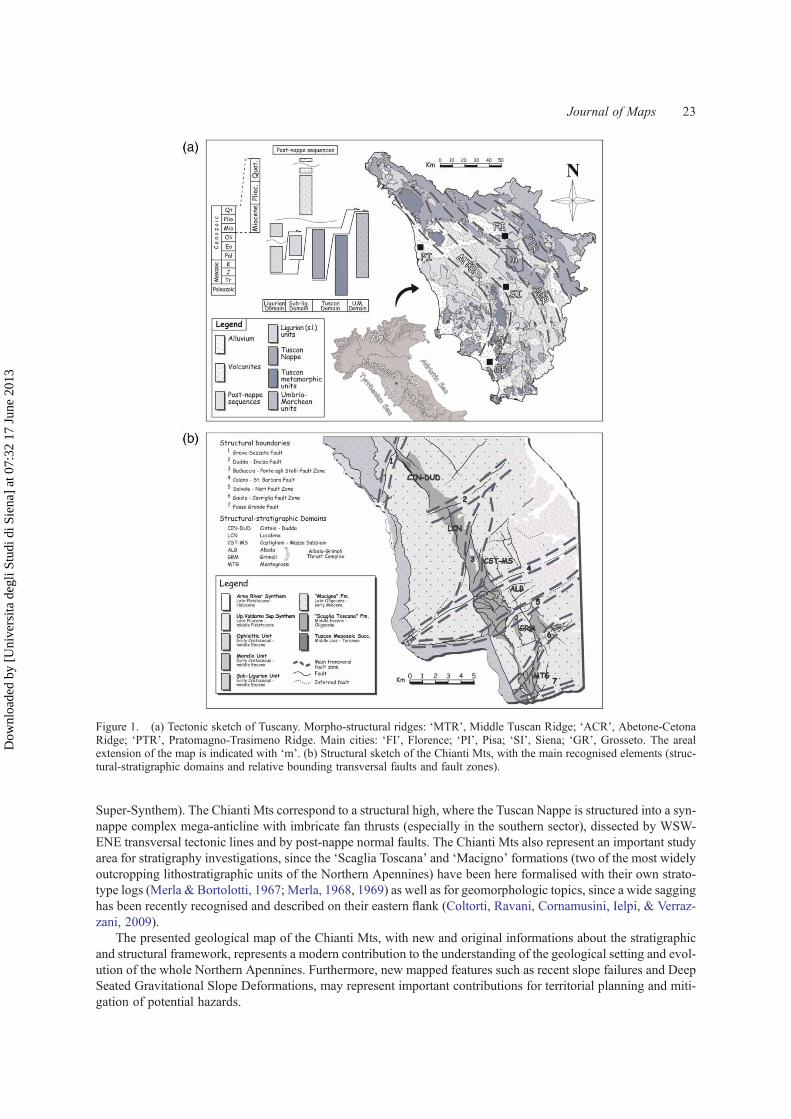
Super-Synthem). The Chianti Mts correspond to a structural high, where the Tuscan Nappe is structured into a syn-nappe complex mega-anticline with imbricate fan thrusts (especially in the southern sector), dissected by WSW-ENE transversal tectonic lines and by post-nappe normal faults. The Chianti Mts also represent an important studyarea for stratigraphy investigations, since the ‘Scaglia Toscana’ and ‘Macigno’ formations (two of the most widelyoutcropping lithostratigraphic units of the Northern Apennines) have been here formalised with their own strato-type logs (Merla & Bortolotti, 1967; Merla, 1968, 1969) as well as for geomorphologic topics, since a wide sagginghas been recently recognised and described on their eastern flank (Coltorti, Ravani, Cornamusini, Ielpi, & Verraz-zani, 2009).
The presented geological map of the Chianti Mts, with new and original informations about the stratigraphicand structural framework, represents a modern contribution to the understanding of the geological setting and evol-ution of the whole Northern Apennines. Furthermore, new mapped features such as recent slope failures and DeepSeated Gravitational Slope Deformations, may represent important contributions for territorial planning and miti-gation of potential hazards.
Figure 1. (a) Tectonic sketch of Tuscany. Morpho-structural ridges: ‘MTR’, Middle Tuscan Ridge; ‘ACR’, Abetone-CetonaRidge; ‘PTR’, Pratomagno-Trasimeno Ridge. Main cities: ‘FI’, Florence; ‘PI’, Pisa; ‘SI’, Siena; ‘GR’, Grosseto. The arealextension of the map is indicated with ‘m’. (b) Structural sketch of the Chianti Mts, with the main recognised elements (struc-tural-stratigraphic domains and relative bounding transversal faults and fault zones).
Journal of Maps 23
Dow
nloa
ded
by [
Uni
vers
ita d
egli
Stud
i di S
iena
] at
07:
32 1
7 Ju
ne 2
013

2. Methodology
This paper is the final result of geologic, stratigraphic and structural field work performed by the authors between2006 and 2010. Mapping was performed using topographic maps: (i) 1:10’000 scale ‘Carta Tecnica Regionale’ and(ii) 1:25,000 scale ‘Carta Topografica d’Italia, Serie 25’. Areas of particular complexity or interest have beenmapped with a 1:5000 scale detail (from the north: Cintoia, Lucolena, Santa Barbara, Albola, Grimoli, Monte-grossi) for a total area of ca. 90 km2. Outcrops showing peculiar or widespread tectonic structures have beenselected as ‘structural stations’ and grouped in seven structural domains. A total number of ca. 900 axial surfaces,lineations and fault planes and about 1300 bedding attitudes have been measured. In order to represent the struc-tural features of different domains, these data have been plotted using the Schimdt net (in the lower hemisphere)and four cross sections have been drawn with an orthogonal trend to the main fold-and-thrust structure. The formerCretaceous – Tertiary stratigraphic frame, variously interpreted in the previous literature, has been partiallyreviewed, to propose in the regional stratigraphic context a new improved scheme.
3. Stratigraphy
The Tuscan Nappe consists in the study area of an allochthonous carbonatic-siliceous and terrigenous successionspanning from the middle/late Lias to the Aquitanian (Fazzuoli, Pandeli, & Sandrelli, 2004, and referencestherein). The lowermost and oldest portions crop out narrowly only in two northern localities (Cintoia and Luco-lena), and are made of a Mesozoic pelagic succession including (from the bottom): dark-gray cherty limestones(Cherty Limestone Fm., Figure 2a; middle-late Lias); pink marly limestones, shales and cherts (Posidonomya
Figure 2. Features of the stratigraphic units of the study area. (a) Cherty limestones of the lower carbonatic-siliceous succes-sion (Cherty Limestone Fm.). (b) Dark-gray Mn-rich shales interlaid with Fe-rich cherts, belonging to the Brolio Shales Fm. (c)Pink-reddish marls and calcareous marls of the Sugame Marls Mb. (‘Scaglia Toscana’ Fm). (d) Heavily foliated reddish shalesof the Cintoia Shales Mb. (‘Scaglia Toscana’ Fm.). (e) Thick-bedded coarse turbidite calcarenites (Montegrossi CalcarenitesMb., ‘Scaglia Toscana’ Fm.) with normal grading and plane-parallel laminations, interlaid with thin fine limestone beds. (f)Regular alternation of reddish shales and fine limestones, Dudda Shales and Limestones Mb. (‘Scaglia Toscana’ Fm.). (g) Tur-bidite massive or slightly normally graded siliciclastic sandstone beds of the ‘Macigno’ Fm. (h) Alternating limestone beds anddark gray shales, typical of the Ligurian Ophiolitic and Morello units, often with chaotic setting. (i) Poorly cemented sandstoneswith clays and silts interlays (San Donato Sands) belonging to the Castelnuovo Synthem, Upper Valdarno Super-Synthem.
24 G. Cornamusini et al.
Dow
nloa
ded
by [
Uni
vers
ita d
egli
Stud
i di S
iena
] at
07:
32 1
7 Ju
ne 2
013

Limestones and Marls Fm.; Toarcian–Callovian); reddish cherts (Tuscan Cherts Fm.; middle/late Bathonian–Tithonian); white cherty and marly limestones (‘Maiolica’ Fm.; late Tithonian–early Cretaceous) and finally bythe Brolio Shales Fm. (Aptian–Cenomanian/Turonian; Figure 2b).
The lowermost Mesozoic succession of the Tuscan Nappe reflects the sedimentary evolution of a pelagic basinaffected by mixed carbonatic/siliceous deposition, where the facies distribution is mainly controlled by tectonicsand calcite lysocline fluctuations, these latter likely forced by global scale climate shifts (Carmignani et al., 2010).
The Brolio Shales Fm., made up of a succession of Mn-rich shales and top Fe-rich cherts, has been previouslyconsidered as (Figure 3a): (i) the basal formation of the ‘Scisti Policromi’ Group (Canuti, Focardi, & Sestini, 1965),
Figure 3. Stratigraphic features of the Chianti Mts. (a) Synoptic table showing the stratigraphic frames proposed in literatureand in this paper. (b) Lithostratigraphic architecture of the middle Jurassic – Oligocene Tuscan succession in the study area. Thefive logs cover a ca. 30-km long transect. The logs are referred to structural-stratigraphic domains: CIN-DUD Cintoia-Dudda;LCN Lucolena; ALB-GRM Albola-Grimoli; MTG Montegrossi; the Brolio log is located out of the study area, 10 km to thesouth-west of Montegrossi (Figure 1b). (c) Physical stratigraphy of the Brolio Shales Fm. outcropping in three selectedlocations: (i) Cintoia: Mirandola Creek; (ii) Lucolena: Acqua Calda Creek (proposed as type-locality); (iii) Rapolano (fewtens km south of the study area): Cetinaia and Le Rossole localities (this last after Bambini et al., 2009).
Journal of Maps 25
Dow
nloa
ded
by [
Uni
vers
ita d
egli
Stud
i di S
iena
] at
07:
32 1
7 Ju
ne 2
013

or (ii) as the basal member of the ‘Scaglia Toscana’ Fm. (Fazzuoli, Pandeli, & Sandrelli, 1996). Here we suggest toconsider the unit as a separate formation, apart from the rest of the ‘Scaglia Toscana’ Fm. subdivided in somemembers, for two main reasons: (i) the Brolio Shales, differently from the others ‘Scaglia Toscana’ members,are not characterised by lateral interlays or heteropies; (ii) the Brolio Shales are separated by the above unitsthrough a wide gap spanning from the Cenomanian/Turonian to the early-middle Eocene (Bambini, Brogi,Cornamusini, Costantini, & Lazzarotto, 2009; Canuti et al., 1965; Canuti & Marcucci, 1967; Fazzuoli, Sartori,& Vannucci, 2002). A strato-type log (Lucolena Log, Figure 3c) has been here reported and compared with twoother successions, in order to first introduce our proposal in the literature. For the above statements, in our opinion,this new lithostratigraphic frame is much more coherent with the paleogeographic and basinal architecture settings.
The upward following ‘Scaglia Toscana’ Fm. (early/middle Eocene–Oligocene), also known as ‘Scisti Poli-cromi’ Group (Canuti et al., 1965; Fazzuoli et al., 1996), crops out in the axial zone of the Chianti Ridge andnearby Grimoli. It is made by four laterally heteropic litho-stratigraphic units (defined as members) and reflectsthe inter-fingering of a SSE-dipping basinal ramp with a turbidite floor-fan complex (Cornamusini, Ielpi, Bonciani,& Callegari, 2011), as the architecture and the depositional evolution mark the gradual southward shift from thinhemipelagic to thick turbidite successions (Figures 3b and 4). The stratigraphic succession is, from the bottom:Sugame Marls Member (‘Sugame Mb.’, pink and gray marls and calcareous marls with very rare coarse polygenicbreccias of Tuscan Mesozoic-belonging elements; thickness varying from 0 to 120 metres; Figure 2c); Cintoia ShalesMember (‘Cintoia Mb.’, gray-reddish shales, with a peculiar pyrite interlaid key-bed; thickness varying from ca. 20to 60 metres; Figure 2d); Montegrossi Calcarenites Member (‘Montegrossi Mb.’, medium and coarse to very coarsenummulites-rich turbidite calcarenites; in the middle portion, up to 7 metres thick mega-turbidites key-beds occur;thickness varying from 0 to ca. 100 metres; Figure 2e); Dudda Shales and Limestones Member (‘Dudda Mb.’, regularalternation of reddish shales and distal turbidite limestones with polygenic debris- to grain-flow deposits in the lowerportion; thickness varying from 0 to 50 metres; Figure 2f). The stratigraphic architecture of the ‘Scaglia Toscana’ Fm.is rather articulated: in the northern sector the basal Sugame Mb. is overlaid by the Cintoia Mb. (CIN-DUD structural-stratigraphic domain of Figure 1b). Southwards, this latter is in turn overlaid by the Dudda Mb. (close to the Duddavillage) and the Sugame Mb. pinches out (between Lucolena and Badiaccia; LCN structural-stratigraphic domain ofFigure 1b). Finally, in the southern area (ALB, GRM and MTG structural-stratigraphic domains of Figure 1b), theMontegrossi Mb. is interlaid between the Cintoia and Dudda members (Figure 3b).
The ‘Macigno’ Sandstones Fm. (‘Macigno’ Fm.; Chattian-Aquitanian) caps the ‘Scaglia Toscana’ Fm. andconstitutes the uppermost unit of the Tuscan Nappe. It is a thick (up to 1500/2000 metres according to Merla,1969) succession (Figure 2g) of siliciclastic turbidite sandstones and siltstones (characterised by both massiveand Bouma-structured beds). Furthermore, the ‘Macigno’ Fm. hosts interbeddings of (from the bottom): (i) upto 15 metres-thick chaotic and proximal debris-flow key-beds, made of recurrent crystalline and rare limestonepebbles (Cornamusini, Elter, & Sandrelli, 2002; Cornamusini, 2009; Ferrini & Pandeli, 1983; Ielpi, 2009); (ii)
Figure 4. Synthetic panel showing the stratigraphic architecture and lateral relationships within the ‘Scaglia Toscana’ Fm. inthe Chianti Mts. The labels of the logs are named in Figure 3b.
26 G. Cornamusini et al.
Dow
nloa
ded
by [
Uni
vers
ita d
egli
Stud
i di S
iena
] at
07:
32 1
7 Ju
ne 2
013
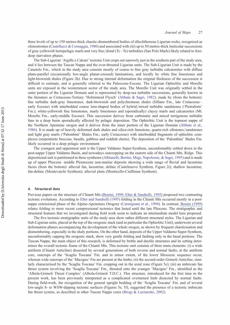
three levels of up to 150 metres-thick chaotic-dismembered bodies of allochthonous Ligurian rocks, recognised asolistostromes (Castellucci & Cornaggia, 1980) and associated with (iii) up to 50 metres-thick lenticular successionsof gray-yellowish hemipelagic marls and very fine/distal (Tc–Te) turbidites (San Polo Marls) likely related to fore-deep starvation phases.
The Sub-Ligurian ‘Argille e Calcari’ tectonic Unit crops out narrowly just in the southern part of the study area,and it lies between the Tuscan Nappe and the over-thrusted Ligurian units. The Sub-Ligurian Unit is made by theCanetolo Fm., which in the study area consists mostly of coarse to fine gray turbidite calcarenites with diffuseplane-parallel (occasionally low-angle planar-crossed) laminations, and locally by white fine limestones andlight-brownish shales (Figure 2h). Due to strong internal deformation the original thickness of the succession isdifficult to estimate, and is generally referred to the Paleocene-Eocene. The Ligurian Ophiolitic and Morellounits are exposed in the westernmost sector of the study area. The Morello Unit was originally settled in theouter portion of the Ligurian Domain and is represented by deep-sea turbidite successions, generally known inthe literature as Cretaceous-Tertiary ‘Helmintoid Flysch’ (Abbate & Sagri, 1982), made by (from the bottom):fine turbidite dark-gray limestones, dark-brownish and polychromous shales (Sillano Fm., late Cretaceous–early Eocene) with interbedded coarse lens-shaped bodies of hybrid/mixed turbidite sandstones (‘Pietraforte’Fm.); white-yellowish fine limestones, marly limestones and (sporadically) clayey marls and calcarenites (Mt.Morello Fm., early-middle Eocene). This succession derives from carbonatic and mixed terrigenous turbiditefans in a deep basin sporadically affected by pelagic deposition. The Ophiolitic Unit is the topmost nappe ofthe Northern Apennine orogen and it derives from the inner portion of the Ligurian Domain (Abbate et al.,1986). It is made up of heavily deformed dark shales and silica-rich limestone, quartz-rich siltstones/sandstonesand light gray marls (‘Palombini’ Shales Fm.; early Cretaceous) with interbedded fragments of ophiolitic com-plexes (serpentinite breccias, basalts, gabbros and reddish cherts). The deposition of the ‘Palombini’ Shales Fm.likely occurred in a deep pelagic environment.
The youngest and uppermost unit is the Upper Valdarno Super-Synthem, unconformably settled down in thepost-nappe Upper Valdarno Basin, and nowadays outcropping on the eastern side of the Chianti Mts. Ridge. Thisdepositional unit is partitioned in three synthems (Albianelli, Bertini, Magi, Napoleone, & Sagri, 1995) and is madeup of upper Pliocene–middle Pleistocene non-marine deposits showing a wide range of fluvial and lacustrinefacies (from the bottom): alluvial fan, lacustrine, deltaic (Castelnuovo Synthem, Figure 2i); shallow lacustrine,fan-deltaic (Montevarchi Synthem); alluvial plain (Monticello-Ciuffenna Synthem).
4. Structural data
Previous papers on the structure of Chianti Mts (Bonini, 1999; Elter & Sandrelli, 1995) proposed two contrastingtectonic evolutions. According to Elter and Sandrelli (1995) folding in the Chianti Mts occurred mostly in a post-nappe extensional phase of the Alpine-Apennines Orogeny (Carmignani et al., 1994). In contrast, Bonini (1999)relates folding to more recent compressional tectonics that lasted until the late Pliocene. The stratigraphic andstructural features that we investigated during field work seem to indicate an intermediate model here proposed.
The five tectonic-stratigraphic units of the study area show rather different structural styles. The Ligurian andSub-Ligurian units, placed at the top of the orogenic stack (and in particular the Ophiolitic Unit), underwent severaldeformation phases accompanying the development of the whole orogen, as shown by frequent chaoticisation anddismembering, especially in the shaly portions. On the other hand, deposits of the Upper Valdarno Super-Synthem,unconformably capping the orogenic stack, show very gentle folding and faulting only in the basal portions. TheTuscan Nappe, the main object of this research, is deformed by brittle and ductile structures and its setting deter-mines the overall tectonic frame of the Chianti Mts. This tectonic unit consists of three main elements: (i) a wideantiform (Chianti Anticline) dissected by several generations of both reverse and normal faults; at the antiformcore, outcrops of the ‘Scaglia Toscana’ Fm. and in minor extent, of the lower Mesozoic sequence occur,whereas wide outcrops of the ‘Macigno’ Fm are present at the limbs; (ii) the second-order Grimoli Anticline, simi-larly characterised by the ‘Scaglia Toscana’ Fm. cropping out in the axial zone (Figure 5c); (iii) an imbricate fanthrust system involving the ‘Scaglia Toscana’ Fm., thrusted onto the younger ‘Macigno’ Fm., identified as the‘Albola-Grimoli Thrust Complex’ (Albola-Grimoli T.D.C.). This structure, introduced for the first time in thepresent work, has been previously interpreted as a complicated overturned limb dissected by normal faults.During field-work, the recognition of the general upright bedding of the ‘Scaglia Toscana’ Fm. and of severallow-angle S- to WSW-dipping tectonic surfaces (Figures 5e, 5f), suggested the presence of a tectonic imbricatefan thrust system, as described in other Tuscan Nappe cores (Brogi & Lazzarotto, 2002).
Journal of Maps 27
Dow
nloa
ded
by [
Uni
vers
ita d
egli
Stud
i di S
iena
] at
07:
32 1
7 Ju
ne 2
013
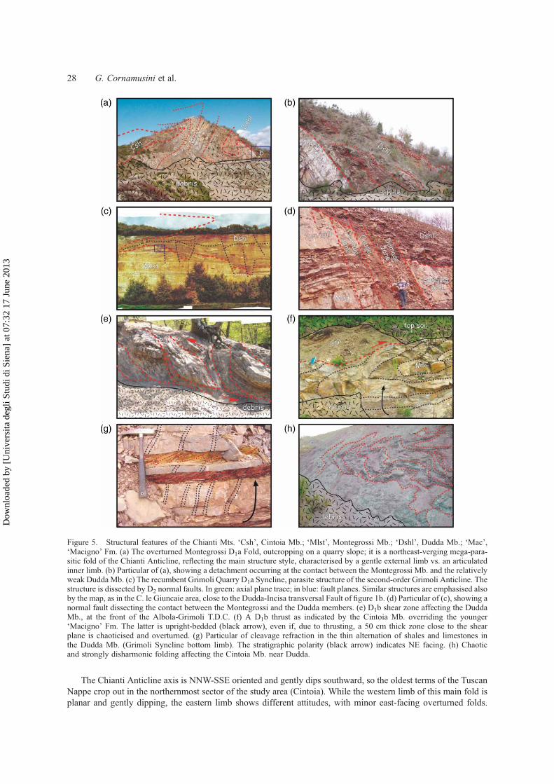
The Chianti Anticline axis is NNW-SSE oriented and gently dips southward, so the oldest terms of the TuscanNappe crop out in the northernmost sector of the study area (Cintoia). While the western limb of this main fold isplanar and gently dipping, the eastern limb shows different attitudes, with minor east-facing overturned folds.
Figure 5. Structural features of the Chianti Mts. ‘Csh’, Cintoia Mb.; ‘Mlst’, Montegrossi Mb.; ‘Dshl’, Dudda Mb.; ‘Mac’,‘Macigno’ Fm. (a) The overturned Montegrossi D1a Fold, outcropping on a quarry slope; it is a northeast-verging mega-para-sitic fold of the Chianti Anticline, reflecting the main structure style, characterised by a gentle external limb vs. an articulatedinner limb. (b) Particular of (a), showing a detachment occurring at the contact between the Montegrossi Mb. and the relativelyweak Dudda Mb. (c) The recumbent Grimoli Quarry D1a Syncline, parasite structure of the second-order Grimoli Anticline. Thestructure is dissected by D2 normal faults. In green: axial plane trace; in blue: fault planes. Similar structures are emphasised alsoby the map, as in the C. le Giuncaie area, close to the Dudda-Incisa transversal Fault of figure 1b. (d) Particular of (c), showing anormal fault dissecting the contact between the Montegrossi and the Dudda members. (e) D1b shear zone affecting the DuddaMb., at the front of the Albola-Grimoli T.D.C. (f) A D1b thrust as indicated by the Cintoia Mb. overriding the younger‘Macigno’ Fm. The latter is upright-bedded (black arrow), even if, due to thrusting, a 50 cm thick zone close to the shearplane is chaoticised and overturned. (g) Particular of cleavage refraction in the thin alternation of shales and limestones inthe Dudda Mb. (Grimoli Syncline bottom limb). The stratigraphic polarity (black arrow) indicates NE facing. (h) Chaoticand strongly disharmonic folding affecting the Cintoia Mb. near Dudda.
28 G. Cornamusini et al.
Dow
nloa
ded
by [
Uni
vers
ita d
egli
Stud
i di S
iena
] at
07:
32 1
7 Ju
ne 2
013

Taking into account different structural styles and stratigraphic architectures, the study area has been divided inseveral tectonic/stratigraphic domains (Figure 1b), bounded by transversal faults and fault zones. These lastseem to be parallel with the main tectonic transversal alignments of the Northern Apennines (see Pascucci,Martini, Sagri, & Sandrelli, 2007, and references therein). They are from the north (Figure 1b): the Cintoia-Dudda Domain (CIN-DUD Dm.), where the eastern limb of the Chianti Anticline is overturned and then vertical;the Lucolena Domain (LCN Dm.), where the general structure is upright and almost horizontal; the Castiglioni–Massa Sabbioni Domain (CST-MS Dm.), where closely spaced recumbent parasitic folds occur; the Albola(ALB Dm.) and Grimoli (GRM Dm.) domains, where the Chianti Anticline is dissected by reverse faults of theAlbola-Grimoli T.D.C. (Figures 5e, 5f) and finally the Montegrossi Domain (MTG Dm.), where, similarly tothe CIN-DUD Dm., the eastern limb of the main fold is vertical or slightly overturned. The main anticline is gen-erally associated with almost cylindrical second-order parasitic folds (as the Montegrossi Fold, Figure 5a, or theGrimoli Quarry Syncline, Figure 5c). Nonetheless, peculiar disharmonic responses of both ductile and brittle defor-mation may be observed especially in the ‘Scaglia Toscana’ Fm., where strong rheological contrasts are significant.Detachments may be frequent between the competent calcarenites of the Montegrossi Mb. and the plastic carbo-natic/shaly Dudda Mb. (Figure 5b); thick shale sequences (Cintoia Mb.) may be frequently involved in chaotic andnon-cylindrical folding (Figure 5h); cleavage refraction and cataclastic faulting occur at any scale (Figures 5d, 5g).
In this frame, a relevant interplay between faulting, folding and even with the depositional architecture occurs.As mentioned, a series of WSW–ENE or SSW–NNE tectonic alignments bound the structural and stratigraphicaldomains (Figure 1b). Due to their correspondence with significant changes in stratigraphic architecture, theseelements allow us to suppose a close inheritance (Butler, Tavarnelli, & Grasso, 2006) between the pre-collisionalnormal faults that controlled the facies distribution during deposition of the ‘Scaglia Toscana’ Fm. and the syn-col-lisional transversal tear faults close to the developing Chianti Anticline.
Moreover, stereonet with bedding attitudes, fold axis/axial plane attitudes and rose diagrams of total high-angle and low-angle fault directions and DGSD transport directions are reported in the geological map.Bedding attitudes are grouped for areas or structural-stratigraphic domains, in the Tuscan Nappe tectonic unit,where ‘Cintoia’ belongs to the CIN-DUD Dm., ‘Lucolena’ to the LCN Dm., ‘Badiaccia M.ro’ close to theCST-MS Dm., ‘Mt. Maione’, ‘Grimoli’ and ‘Radda’ to the GRM Dm., ‘Montegrossi’ to the MTG Dm.,whereas ‘S. Barbara Basin’ regards the post-nappe deposits. Fold axis and axial plane attitudes are grouped forstructural stations distributed in the structural-stratigraphic domains and in the main fault zones.
These evidences of ductile and brittle structures can be referred to different tectonic phases, related with thepre-, syn-, and post-nappe evolution of the Alpine-Apenninic Orogeny (Carmignani et al., 2001). During thiswork, mapped tectonic structures allowed us to identify two main tectonic phases (D1 and D2) for the northernChianti Mts, whereas an older synsedimentary Ds phase, due to the lack of clear outcropping tectonic structures,may only be supposed through the sharp stratigraphic lateral changes in the ‘Scaglia Toscana’ Fm. (they are fromthe oldest):
(1) Pre-nappe Ds Phase. During this phase the gradual foreland basinal deepening and syn-sedimentary block-faulting that forced the ‘Scaglia Toscana’ Fm. facies distribution occur. Even if now no Ds faults may beclearly recognised in the study area, some abrupt facies transitions and the occurrence of proximal chaoticgravity-flow deposits in the ‘Scaglia Toscana’ Fm. suggest that the transversal WSW-ENE lines acted for-merly as strike-slip normal faults. The main Ds element in the ‘Scaglia Toscana’ Fm. basin was likely thecurrent Badiaccia-Ponte agli Stolli Belt (Figure 1b), which bounded hemipelagic ramp facies to the northfrom turbidite basinal facies to the south. Considering the age of the coeval deposits, the Ds event can bethen dated to the Eocene–early Oligocene. Most of the Ligurian units have been stacked and stronglydeformed at this time (Bertini, Cornamusini, Lazzarotto, & Maccantelli, 2000).
(2) Syn-nappe D1/D1a/D1b phase events. These events produced: the early development of the NorthernApennines foredeep that hosted the ‘Macigno’ Fm. dated to the late Oligocene-earliest Miocene,during the stacking of the Ligurian units (D1); the overthrusting of the Ligurian units onto theTuscan Domain, the consequent detachment and development of the Tuscan Nappe and the foldingof the Chianti Anticline (D1a); the subsequent (partly coeval?) thrusting of the Albola-Grimoli areain the late compressional stages (D1b). Fold axis and axial plane attitudes shown by stereonets inthe map, are linked to these phases. Furthermore, during these events, faults probably initially devel-oped in the Ds phase, transversally to the chain belt, reactivated as tear faults, accompanying and con-ditioning the enucleation and advancing of thrusts. There are no elements allowing a precise dating ofthe D1a/b events in the study area. Considering the age of the last syn-nappe vs. the first post-nappe
Journal of Maps 29
Dow
nloa
ded
by [
Uni
vers
ita d
egli
Stud
i di S
iena
] at
07:
32 1
7 Ju
ne 2
013

deposits in the Tuscan area, a late Aquitanian–early Langhian age can be proposed (Carmignani et al.,1995; Bossio et al., 1998).
(3) Post-nappe D2/D2a/D2b phase events. During this phase, the post-collisional extensional deformation andcollapse of the Northern Apennines Orogen occurred (Carmignani & Kligfield, 1990). Moreover, the syn-nappe tear faults activated as transcurrent faults, as demonstrated by their influence on the structuring ofthe close Pliocene Upper Valdarno Basin (Lazzarotto & Liotta, 1991; Brogi, Fidolini, & Liotta, in press;Ielpi, 2011). Considering the ages and the structural features of the tectono-stratigraphical units in the post-collisional basins on the sides of the Chianti Ridge (and in particular on the adjoining Upper ValdarnoBasin), three events can be recognised. A first D2 extension, spanning from the late Miocene to the latePliocene (Carmignani et al., 1994); a D2a early Pleistocene dextral strike-slip tectonics (Lazzarotto &Liotta, 1991); a late D2b uplifting, dated to the middle-late Pleistocene (Albianelli et al., 1995).
5. Conclusions
A detailed field survey, including geological mapping, stratigraphic logging and systematic structural analysesallowed the depiction of a new tectono-stratigraphic frame for the Chianti Mts. In agreement with the previousliterature (Fazzuoli et al., 1996), five tectono-stratigraphic units, part of the Northern Apennines Orogeniccomplex, have been recognised: the Ligurian Ophiolitic (early Cretaceous) and Morello (late Cretaceous –Eocene) units, the Sub-Ligurian ‘Argille e Calcari’ Unit (Paleocene-Eocene), over-thrusted onto the TuscanNappe (middle/late Lias – early Miocene), in turn unconformably covered by younger deposits of the post-colli-sional Upper Valdarno Basin (late Pliocene–middle Pleistocene). A partially reviewed stratigraphic frame for theTuscan Nappe has been proposed: in particular, a new architectural frame of the ‘Scaglia Toscana’ Fm. issuggested. Furthermore, the upgrade of the Brolio Shales Unit, formerly classified as the basal member of the‘Scaglia Toscana’ Fm., to a formational rank is here proposed.
Three main tectonic phases, subdivided in events, have been recognised: a Ds pre-nappe Eocene-early Oligo-cene phase, a D1 syn-nappe compressional and transpressional phase (Oligocene-earliest Miocene) and a final lateMiocene—late Pleistocene post-nappe D2 extensional phase. In partial divergence with the previous literature, themain folding event has been related to the D1 phase. Several stratigraphic-structural domains have been describedand as a result a wide area of thrusting has been firstly recognised in the Albola-Grimoli area.
Software
The geological map has been firstly digitalised using the ArcGIS 9.2 Suite and then drawn and assembled withMacromedia Freehand MX. This latter has also been used for the drawing of the geological sections and for thearrangement of the illustrations in this paper. Structural data have been processed and drawn using Stereonet 3.
AcknowledgementsThe authors are indebted with D. Berg and G. Prosser for their text reviews, with J. Stoll for his cartographic review. The editorM.J. Smith is also thanked. The Authors wish also to thank the Istituto Geografico Militare (Italian Military Geographic Insti-tute) for the topographic support. Research financed with University of Siena PAR 2006 grants (G. Cornamusini).
ReferencesAbbate, E., Bortolotti, V., Conti, M., Marcucci, M., Principi, P., & Treves, B. (1986). Apennines and Alps ophiolites and the
evolution of the Western Tethys. Memorie della Societa Geologica Italiana, 31, 23–44.Abbate, E., & Sagri, M. (1982). Le unita torbiditiche cretacee dell’Appennino Settentrionale ed i margini continentali della
Tetide [The Cretaceous turbidite units of the Northern Apennines and the Tethyan continental margins]. Memorie dellaSocieta Geologica Italiana, 24, 115–126.
Albianelli, A., Bertini, A., Magi, M., Napoleone, G., & Sagri, M. (1995). Il bacino plio-pleistocenico del Valdarno Superiore:eventi deposizionali, paleomagnetici e paleoclimatici [The Upper Valdarno plio-pleistocenic basin: depositional, palaeo-magnetic and palaeoclimatic events]. Il Quaternario, 8(1), 11–18.
Bambini, A.M., Brogi, A., Cornamusini, G., Costantini, A., & Lazzarotto, A. (2009). Nuovi dati litostratigrafici e biostratigraficisulla Scaglia Toscana nella Toscana Meridionale (area di Rapolano Terme) [New lithostratigraphic and biostratigraphic dataof the Scaglia Toscana of southern Tuscany (Rapolano Terme, Northern Apennines)]. Italian Journal of Geosciences,128(3), 669–693.
30 G. Cornamusini et al.
Dow
nloa
ded
by [
Uni
vers
ita d
egli
Stud
i di S
iena
] at
07:
32 1
7 Ju
ne 2
013

Barchi, M.R., De Feyter, A., Magnani, M.B., Minelli, G., Pialli, G., & Sotera, B.M. (1998). The structural style of the fold andthrust belt. Memorie della Societa Geologica Italiana, 52, 557–558.
Bertini, G., Cornamusini, G., Lazzarotto, A., & Maccantelli, M. (2000). Stratigraphic and tectonic framework of the Ligurianunits in the Castellina M.ma Hills (southern Tuscany, Italy). Bollettino della Societa Geologica Italiana, 119, 687–701.
Bonini, M. (1999). Basement-controlled Neogene post collisional polyphase cover thrusting and basin development along theChianti Mountains ridge (Northern Apennines, Italy). Geological Magazine, 136, 133–152.
Bossio, A., Costantini, A., Foresi, L.M., Lazzarotto, A., Mazzanti, R., Mazzei, R., et al. (1998). Neogene-Quaternary evolutionin the western side of the Northern Apennines (Italy). Memorie della Societa Geologica Italiana, 52, 513–525.
Brogi, A., Fidolini, F., & Liotta, D. (in press). The Santa Barbara Basin: Insights for the tectonic and sedimentary evolution ofthe larger Valdarno Basin (Northern Apennines, Italy). Italian Journal of Geosciences.
Brogi, A., & Lazzarotto, A. (2002). Deformazioni sin-collisionali nella Falda Toscana a sudovest del Monte Amiata (Toscanameridionale): il sovrascorrimento di Monte Aquilaia [Syn-collisional deformation in the Tuscan Nappe SW of Mt. Amiata(Southern Tuscany): the Mt. Aquilaia thrust]. Bollettino della Societa Geologica Italiana, 121, 299–312.
Butler, R.W.H., Tavarnelli, E., & Grasso, M. (2006). Structural inheritance in mountain belts: An Alpine-Apennine perspective.Journal of Structural Geology, 28, 1893–1908.
Canuti, P., Focardi, P., & Sestini, G. (1965). Stratigrafia, correlazione e genesi degli scisti policromi dei Monti del Chianti(Toscana) [Stratigraphy, correlation and genesis of the Scisti Policromi of the Chianti Mountains (Tuscany)]. Bollettinodella Societa Geologica Italiana, 84(6), 93–166.
Canuti, P., & Marcucci, M. (1967). Lacune della Serie Toscana, IV. Osservazioni sui rapporti stratigrafici tra Maiolica e ScistiPolicromi nella Toscana centro-meridionale (Area di Rapolano) [Hiatus in the Tuscan Serie, IV. Observations about thestratigraphic relationships between Maiolica and Scisti Policromi in the central-southern Tuscany (Rapolano area)].Bollettino della Societa Geologica Italiana, 86, 809–818.
Carmignani, L., Decandia, F.A., Disperati, L., Fantozzi, P.L., Kligfield, R., Lazzarotto, A., et al. (2001). Inner NorthernApennines. In G.B. Vai & I.P. Martini (Eds.), Anatomy of an Orogen: The Apennines and Adjacent MediterraneanBasins (pp. 197–214). Bodmin: Kluwer Ac. Pubs.
Carmignani, L., Decandia, F.A., Disperati, L., Fantozzi, P.L., Lazzarotto, A., Liotta, D., et al. (1995). Relationships betweenTertiary structural evolution of the Sardinia-Corsica-Provencal Domain and the Northern Apennines. Terra Nova, 7,128–137.
Carmignani, L., Decandia, F.A., Fantozzi, P.L., Lazzarotto, A., Liotta, D., & Meccheri, M. (1994). Tertiary extensional tectonicsin Tuscany (Northern Apennines, Italy). Tectonophysics, 238, 295–315.
Carmignani, L., & Kligfield, R. (1990). Crustal extension in the Northern Apennines: The transition from compression to exten-sion in the Alpi Apuane Core Complex. Tectonics, 9, 1275–1303.
Carmignani, L., Meccheri, M., Conti, P., Massa, G., Patacca, E., & Scandone, P. (2010). Note illustrative della Carta Geologicad’Italia alla scala 1:50’000, Sheet “Massa – Carrara” #249 [Sheet “Massa-Carrara” - 249, ISPRA, Italian GeologicalSurvey, Rome].
Castellucci, P., & Cornaggia, F. (1980). Gli olistostromi nel Macigno dei Monti del Chianti: analisi stratigrafico-strutturale [Theolistostromes in the Macigno of the Chianti Mountains: stratigraphic-structural analysis]. Memorie della Societa GeologicaItaliana, 21, 171–180.
Coltorti, M., Ravani, S., Cornamusini, G., Ielpi, A., & Verrazzani, F. (2009). A sagging along the eastern Chianti Mts., Italy.Geomorphology, 112, 15–26.
Cornamusini, G. (2009). Significance of the coarse-disorganised deposits within the Late Oligocene deep-sea turbidite systemsof the southern Tuscany, Northern Apennines. Book of Abstracts, 27th IAS Meeting, Alghero, September 20–23, 475.
Cornamusini, G., Elter, F.M., & Sandrelli, F. (2002). The Corsica-Sardinia Massif as source area for the early northernApennines foredeep system: Evidence from debris flows in the “Macigno costiero” (Late Oligocene, Italy).International Journal of Earth Science, 91, 280–290.
Cornamusini, G., Ielpi, A., Bonciani, F., & Callegari, I. (2011). Stratigraphic architecture of an outer ramp/basinal turbidite fancarbonate system in a foreland basin (“Scaglia Toscana” Fm., Chianti Mts, Northern Apennines, Italy). Rendiconti OnlineSocieta Geologica Italiana, 17, 71–76.
Elter, F.M., & Sandrelli, F. (1995). Inquadramento strutturale dei Monti del Chianti [Structural framework of the ‘Monti delChianti’]. Bollettino della Societa Geologica Italiana, 114, 537–547.
Fazzuoli, M., Pandeli, E., & Sandrelli, F. (1996). Nuovi dati litostratigrafici sulla Scaglia Toscana (Scisti Policromi) deiMonti del Chianti (Appennino Settentrionale) [New lithostratigraphic data on the Scaglia toscana (Scisti Policromi) inthe Monti del Chianti (Northern Apennines)]. Atti della Societa Toscana di Scienze Naturali, Memorie Serie A, 103,95–104.
Fazzuoli, M., Pandeli, E., & Sandrelli, F. (2004). The Mesozoic to Tertiary succession of the northern Monti del Chianti: Recentstratigraphic and tectonic advances. In D. Morini & P. Bruni (Eds.), The Regione Toscana Project of Geological Mapping(pp. 187–198). Florence: Tipografia Martinelli.
Fazzuoli, M., Sartori, R., & Vannucci, S. (2002). Lithostratigraphy, mineralogy and geochemistry of the Late Cretaceous (?) toEocene Marne del Sugame, Cintoia section, Northern Monti del Chianti, Northern Apennines. Bollettino della SocietaGeologica Italiana, 1, 551–560.
Ferrini, G., & Pandeli, E. (1983). Le associazioni di facies torbiditiche nel Macigno dei Monti del Chianti [The turbidite faciesassociations of the Macigno of the Chianti Mountains]. Bollettino della Societa Geologica Italiana, 102, 223–240.
Ielpi, A. (2009). Assetto stratigrafico-strutturale e relazioni con i fenomeni di dissesto gravitativo profondo della parte setten-trionale dei Monti del Chianti. [Stratigraphic-structural setting and relationships with the deep-seated gravitational pro-cesses in the northern Chianti Mts] Unpublished master degree thesis, University of Siena.
Journal of Maps 31
Dow
nloa
ded
by [
Uni
vers
ita d
egli
Stud
i di S
iena
] at
07:
32 1
7 Ju
ne 2
013

Ielpi, A. (2011). Geological Map of the Santa Barbara Basin (Northern Apennines, Italy). Journal of Maps, 7, 614–625.Lazzarotto, A., & Liotta, D. (1991). Structural features of the lignitiferous basin of Santa Barbara, upper Valdarno area.
Bollettino della Societa Geologica Italiana, 110, 459–467.Martini, I.P., & Sagri, M. (1993). Tectono-sedimentary characteristics of Late Miocene-Quaternary extensional basins of the
Northern Apennines, Italy. Earth Sciences Reviews, 34, 197–233.Merla, G. (1951). Geologia dell’Appennino Settentrionale [Geology of the Northern Apennines]. Bollettino della Societa
Geologica Italiana, 70, 95–382.Merla, G. (1968). Scaglia Toscana. In Studi illustrativi della Carta Geologica d’Italia [Scaglia Toscana. In Report Studies of the
Geological Map of Italy. Geological Formations. Editor Istituto Poligrafico e Zecca dello Stato, Rome]. Formazioni geo-logiche, 1, 145–150.
Merla, G. (1969). Macigno del Chianti: Macigno del Mugello. In Studi illustrativi della Carta Geologica d’Italia [Macigno delChianti: Macigno del Mugello. In Report Studies of the Geological Map of Italy. Geological Formations. Editor IstitutoPoligrafico e Zecca dello Stato, Rome]. Formazioni geologiche, 2, 65–67.
Merla, G., & Bortolotti, V. (1967). Note illustrative della Carta Geologica d’Italia alla scala 1:100’000, Sheet “Castelfiorentino”#113 [Explanatory Notes of the Geological Map of Italy at the 1:100 000 scale, Sheet “Castelfiorentino” – 113. GeologicalService of Italy, Ed. Nuova Tecnica Grafica, Rome, 62 pp].
Nocchi, M. (1960). Osservazioni sulla stratigrafia e cenni sulla tettonica della parte meridionale dei Monti del Chianti. Bollettinodella Societa Geologica Italiana, 79, 217–254.
Pascucci, V., Martini, I.P., Sagri, M., & Sandrelli, F. (2007). Effects of transverse structural lineaments on the Neogene-Quaternary basins of Tuscany (inner Northern Apennines, Italy). In G. Nichols, C. Paola, & E.A. Williams (Eds.),Sedimentary processes, environments and basins - A tribute to Peter Friend. IAS Special Publication., 37, 155–183.
Valduga, A. (1952). Cenni sulla stratigrafia e osservazioni sulla tettonica della parte centrale dei Monti del Chianti [Introductionto the stratigraphy and observations about the tectonic of the central part of the Chianti Mountains]. Bollettino della SocietaGeologica Italiana, 71, 3–41.
32 G. Cornamusini et al.
Dow
nloa
ded
by [
Uni
vers
ita d
egli
Stud
i di S
iena
] at
07:
32 1
7 Ju
ne 2
013