RICHARDSON GEOLOGICAL CONSULTING LTD. - Search ...
34
RICHARDSON GEOLOGICAL CONSULTING LTD. 4569-WEST 13TH AVENUE, VANCOUVER. B.C. V6R ZV5 TELEPHONE: 1604) 224-4272 GEOCHEMICAL SURVEY ON PART OF THE WHIPSAW PROPERTY SIMILKAMEEN MINING DIVISION, BRITISH COLUMBIA NTS 92H / 7 FOR WORLD WIDE MINERALS LTD. f BY PAUL W. RICHARDSON, Ph.D.,P.Eng. Vancouver, B.C. $#
-
Upload
khangminh22 -
Category
Documents
-
view
1 -
download
0
Transcript of RICHARDSON GEOLOGICAL CONSULTING LTD. - Search ...
RICHARDSON GEOLOGICAL CONSULTING LTD. 4569-WEST 13TH AVENUE, VANCOUVER. B.C. V6R ZV5
TELEPHONE: 1604) 224-4272
GEOCHEMICAL SURVEY
ON PART OF
THE WHIPSAW PROPERTY
SIMILKAMEEN MINING DIVISION, BRITISH COLUMBIA
NTS 92H / 7
FOR
WORLD WIDE MINERALS LTD. f
BY
PAUL W. RICHARDSON, Ph.D.,P.Eng.
Vancouver, B.C.
$#

JABLE 0 F CONTEN TS
SUMMARY.. . . . . . . . . . . . . . . . . . . . . . . . . . . . . . . . . , . . . . . . . . . . . . . . . . . i INTRODUCTION . . . . . . , . . . . . . . . . . . . . . . . . . . . . . . . , . . . . . . . . . . . . . . . 1 LOCATION AND ACCESS . . . . . . . . . . . . . . . . . . . . . . . . . . . . . . . . . . . . . . 3
CLAIMS . . . . . . . . . . . . . . . . . . . . . . . . . . . . . . . . . . . . . . . . . . . . . . . . . . . . . . 4
HISTORY.. . . . . . . . . . . . . . . . . . . . . . . . . . , . . . . . . . . . . . . . . . . . . . . . . . . .6 GEOLOGY.. . . . . . . . . . . . . . . . . . . . . . . . . . . . . . . . . . . . . . . . . . . . . . . . . . I 0
GEOPHYSICS . . . . . . . . . . . . . . . . . . . . . . . . . . . . . . . . . . . . . . . . . . . . . . .ll THE 1992 PROGRAMME . . . . . . . . . . . . . . . . . . . . . . . . . . . . . . . . . . . . . . 12
CONCLUSIONS.. . . . . . . . . . . . . . .. . .. . . . . . . . . . . . . . . . . . . . . . . . . . .16
RECOMMENDATIONS . . . . . . . . . . . . . . . . . . . . . , . . . . . . . . . . . . . . . . . . .16 STATEMENT OF EXPENSES . . . . . . . . . , . . . . . . . . . . . . . . . . . . . . . . . . I 7
REFERENCES . . . . . . . . . . . . . . . . . . . . . . . . . . . . . . . . . . . . . . . . . . . . . . . .18 STATEMENT OF QUALIFICATIONS . . . . . . . . . . . . . . . . . . . . . . . . . . . . .22
APPENDIX I - GEOCHEMICAL ANALYSIS CERTIFICATES
LIST OF ILLUSTRATIONS FOLLO WING
PAGE 3
1 :250,000 3
FIGURE 1 - LOCATION MAP
FIGURE 2 - ACCESS MAP AND REGIONAL GEOLOGY
FIGURE 3 - CLAIM MAP 1:50,000 4
FIGURE 4 - METESTOFFER AND SILVERTIP ZONES 1 :1,0oO In Pocket
FIGURE 5 - SOUTH PORPHYRY AREA 1 :2.500 In Pocket

i
SUMMARY
The Whipsaw Property contains mineralization which includes copper,
gold, silver, molybdenum and zinc and which is related to the Whipsaw
Porphyry Stock. The stock intrudes the regionally mineralized contact between
the Nicola Group Volcanics and the Eagle Granodiorite. Copper, molybdenum
and gold mineralization is related spatially to the perimeter of the Whipsaw
Porphyry. Gold, silver and zinc mineralization in quartz-pyrite veins and as
replacements in wallrock adjacent to the veins lies to the south of the porphyry
mineralization.
Intense copper-zinc stream sediment anomalies were discovered in 43,
45 and 47 Mile creeks in 1959, and were traced upstream to the contacts of the
Whipsaw Porphyry. Over the years since 1959, the area of interest was covered
by several separate properties. In 1987, for the first time, all the various
properties were consolidated by World Wide Minerals Ltd., and it was possible
to plan an exploration programme covering the entire area of interest. In
addition to the above metals, within the Property there are two potential sources
of the platinum found in placer deposits in Whipsaw Creek east of the Property.
In the spring of 1990, a small programme of six diamond drill holes was
done to test part of one of the 14 targets in the Porphyry Copper Area and one
of the targets, the Silvertip Zone, in the Gold-Silver-Zinc Area. These were not
the best targets on the Property, but were accessible at that time of year. In
September 1990, a beginning was made on the investigation of several intense
soil geochemical anomalies found by the 1987 reconnaissance geochemical
survey in the southern part of the Property. The locations of the reconnaissance

ii
samples were mapped using a compass and tape survey, and additional detail
samples were collected.
In 1991 and early 1992, Phelps Dodge did diamond and percussion
drilling programmes on the Property with inconclusive results.
The 1992 Programme continued the above detail investigation of the
reconnaissance geochemical results. Surveying and soil sampling were done
in the area of the series of soil anomalies lying south of and uphill from the
Silvertip Adit. In addition, some panning near the mouth of Whipsaw Creek was
done to investigate the presence of platinum reported in the literature.
The presently-described 1993 Programme consisted of two main parts:
continuation of the detail soil and sediment sampling uphill from the Silvertip
Adit and some stream sediment sampling in 45 Mile Creek. Also, panning was
done in Whipsaw Creek to continue the investigation of the distribution of gold
and platinum in the stream system.

1
The Whipsaw Property, which is in the Similkameen District of British
Columbia, contains copper, gold, silver, molybdenum and zinc mineralization in
several zones related to the Whipsaw Porphyry Intrusion and extending over a
large area north and south of Whipsaw Creek. Placer deposits containing gold
and platinum were mined in Whipsaw Creek downstream to the east of the
Property. Within the Property, there are several old adits driven on gold- and
silver-bearing deposits in veins and adjacent wall rock. Major geochemical
stream sediment and soil anomalies of Cu, Mo and Zn have been known since
1959. After the original staking of quartz-sulfide vein deposits in 1908, the
ground has always been fragmented with several owners. Recently, for the first
time, the ground was consolidated by World Wide Minerals Ltd., and it has been
possible to plan exploration projects without property line constraints.
In 1987, the writer was commissioned by Mr. Charles R. Martin, President
of World Wide Minerals Ltd., to review all the available data, including historical
data, those data derived from a recently completed, major soil sampling
programme, an airborne geophysical survey by World Wide Minerals Ltd. and a
diamond drilling programme then in progress. The writer was to organize and
summarize the data and to recommend a future course of action for the
Company on the Property. This was to include, if reasonable, specific
recommendations for further exploration.
The Whipsaw Property is very large and contains at least two styles of
mineralization: predominantly porphyry copper, molybdenum and gold
mineralization occurs around and in the Whipsaw Porphyry Intrusion and, south
2
of the Porphyry Area, gold-, silver-, zinc-bearing veins and related replacement
mineralization occur in several showings.
The above-mentioned, major soil sampling programme done by World
Wide Minerals Ltd. in 1987 revealed several strong, significant anomalous soil
areas south of Whipsaw Creek. The writer's 1991 and 1993 reports and this
second 1993 Report describe the results of compass and tape surveying and
detail soil sampling programmes in several anomalous areas, and are a start in
carrying out the Recommendations contained in one of the writer's earlier
reports ( Richardson, 1990b ).

3
LOCATION AND ACCESS
The Whipsaw Property is in the Similkameen Mining Division, British
Columbia, at latitude 49O16' N , longitude 120°45' W on NTS Map 92H I7
(Figure 1). The Property is 170 km east of Vancouver, and is 26 km SW of
Princeton. The major Similkameen copper-gold mine lies 15 km ENE of the
Property (Figure 2 ).
Access from Vancouver is by paved road via Highway 401 to Hope and
Highway 3 to Princeton. Thirteen km S of Princeton, a good logging road
leaves Highway 3 and goes westward up the north bank of Whipsaw Creek
through the Property, a distance of 20 km to the camp (Figure 2). Numerous
logging and mining roads give good access to most parts of the Property.
Whipsaw Creek flows eastward through the middle of the Property
(Figure 3). The topography within the Property is generally moderate, but there
are some deeply incised valleys. Elevations range from 1385 m to 1660 m.
The Property is covered with large stands of commercial evergreen trees with
little undergrowth, but thick, dense brush does occur locally. Extensive logging
is currently being done, and there are increasing areas of clearcut. Outcrop is
sparse, but in many areas the overburden is not more than one metre thick.
The Princeton Area has a long tradition of mining, and all the necessary
infrastructure is in place. The Whipsaw Property is within easy commuting
distance of Princeton where an experienced labour force lives. There is good
transportation to the Port of Vancouver. All these factors are very favourable to
the economics of a new mine in the area.


6 45' 7 1 DEC., 199e P W R

4
The Whipsaw Property consists of one Group of mineral claims plus
twenty ungrouped claims totaling 207 units. The pertinent claim data are as
follows: WHIPSAW GROUP (45 units; grouping date July 23,1993)
Mineral Lease
NORTH HILL #1 SOUTH HILL #2 MJ3 MET3 MET4
#336
Name
OK#3 Fr. OK#4 Fr. OK#5 Fr. MET8 MET 9 MET 10 MET 12 MET 1 MET 2 PORPH 1 Silvertip No.1 Silvertip No. 2 OK#l OK#2 OK#6 Fr. OK#7 Fr
Title No, Record Date
250 1 38 1 Jan 13/64
302359 9 July 19/91 302360 9 July 22/91 24861 1 6 July 26/77 249277 12 Nov 24/87 249278 _B Nov 24/87
!ms
(lots 172 & 1549-1556)
45
YNGROU PFD C LAIMS
!,&& Title No. Record Date
250237 1 Mar 18/66 250238 1 Mar 18/66 250239 1 Mar 18/66 249294 8 Apr 26/88 249295 20 Apr 26/88 249296 20 Apr 26/88 249298 8 Apr 26/88 249225 20 May 13/87 249226 20 May 13/87 301 858 12 June 21/91 250241 1 June 28/66 250242 1 June 28/66 2501 80 1 June 29/64 250181 1 June 29/64 250326 1 June 25/71 250327 1 June 25/71
Exoirv Date
Jan 13/94
July 19/96 July 22/94 July 26/94" Nov 24/94. Nov 24/94'
JExoirv Date
Mar 18/94 Mar 18/94 Mar 18/94 Apr 26/95 Apr 26/95 Apr 26/95 Apr 26/94 May 13/94 May 13194 June 21/95 June 28195 June 28/95 June 29/95 June 29/95 June 25/95 June 25/95
* Expiry date when the work applied for, supported by the present report, has been approved.


5
Title No. m f Record Date Exoirv Date U!l&
OK#8 250328 1 July 09/71 July 09/95 MET 5 249279 15 Nov 24/87 Nov 24/95 MET6 249280 9 Nov 24/87 Nov 24/95 MET 7 249281 20 Nov 24/87 Nov 24/95
The above data conform with the records in the Princeton and Vancouver
recording offices of the British Columbia Ministry of Energy, Mines and
Petroleum Resources.
All claims are owned by World Wide Minerals Ltd.
The areas of the groups exist to distribute assessment work, which can
be spread over a maximum of 100 units from work done on any one unit within
the group. One unit equals approximately one claim of most other jurisdictions.
These groups are only indirectly related to the "Porphyry Area" or the "Gold-
Silver-Zinc Area", and the claims can be regrouped when convenient.

6
HISTORY
Although placer deposits in the Tulameen and Sirnilkameen rivers and
their tributaries have been known since the 1860's. it was not until 1885 that
rich placer showings of gold and platinum were discovered near the town of
Tulameen, especially in Granite Creek (Figure 2). The bonanza period of
placer mining lasted for a decade. During this period, gold and platinum placer
deposits were discovered in Whipsaw Creek downstream to the east of the
present Whipsaw Property. Prospecting for bedrock deposits led to the staking
of gold- and silver-bearing veins in the central part of the Property in 1908
(Figure 3). These veins were explored at the time by trenching and
underground work. Additional adits were driien in the period from 1927 to
1930.
In 1959, reconnaissance stream sediment sampling by Texas Gulf
Sulphur led to the discovery of major stream sediment Cu-Zn anomalies in 43,
45 and 47 Mile creeks, tributaries of Whipsaw Creek (Bacon, 1960). Follow-up
work outlined soil geochemical, electromagnetic and induced polarization
anomalies near the headwaters of 47 Mile Creek (Figure 3). The geochemical
anomalies originated from the weathering of porphyry copper-molybdenum-
gold mineralization in the northern part of the present Property. This anomalous
area was worked on by Texas Gulf; by a syndicate composed of Dome
Exploration (Canada) Ltd., Moneta Porcupine Mines Limited and Tennessee
Corporation; by Amax Exploration and by Newmont Mining Corp. of Canada
Ltd. Large tonnages of 0.1-0.3% Cu with accompanying Mo were outlined by
the geochemical and geophysical surveys and by diamond drilling (Heim,
1987).

7
Although the first mineral claims were staked in 1908. the various claim
groups covering different parts of the mineralized area have had separate
ownerships since that time. From 1961, Whipsaw Mines Ltd. controlled the part
of the ground near the valley bottom where the early prospects were located,
and did several limited geochemical and drilling programmes, including, in
1968, two diamond drill holes under the Metestoffer Showing.
From 1970 to 1973, geological and geochemical surveying was done by
Stokes Exploration Management Co. Ltd. for Whipsaw Mines Ltd. and for Skaist
Minerals. In an extensive 1970 soil sampling programme, the samples were
analyzed for copper only. This survey obtained anomalies over areas of known
mineralization and, in addition, led to the discovery of the BZ Zone, which lies in
the southern part of the Porphyry Copper Area. However, Au and Ag analyses
were not done.
In 1974, Newconex Canadian Exploration Ltd. took 45 soil and rock
samples near the known showings and near anomalies discovered by the 1970
survey. In addition, Newconex stream sediment sampling showed an increase
in Au and Ag in Whipsaw Creek stream sediments where the showings occur.
In 1982 and 1983, R. R. Culbert and J. R. Poloni compiled available older
data on part of the present property, and did trenching and drilling programmes
at the Metestoffer and EZ showings. The programmes met with some success,
and additional work was recommended, but not done.
In 1985, Or. Robert Heim, on behalf of World Wide Minerals Ltd., did soil
sampling in the area of the BZ Trenches to test the area for precious as well as

8
base metals. He found that the entire area of the BZ Trenches was within a
large Cu-Zn soil anomaly accompanied by anomalous Au, Ag and As values. In
1986, he extended the trenches and cut rock samples assaying as high as
0.339 oz I ton Au and 5.40 oz I ton Ag across 0.61 m.
Also in 1985, Lone Jack Resources did a soil sampling programme on
their claims, which are now in the western part of the Whipsaw Property. They
collected 412 samples along a grid and along road cuts (Mitchell, 1985). That
winter, Lone Jack drilled eight diamond drill holes from roads near the Spencer
Showing, which is 800m NE across Whipsaw Creek from the Metestoffer
Showing, and on a geochemical anomaly in the NW part of the Property ( the
last drill hole has not yet been relocated). The holes intersected an area of
breccia at the Spencer Zone with several narrow widths of values. The drilling
was confined to being done from available roads because of deep winter snow.
In 1987, World Wide Minerals Ltd. did a soil sampling programme over
the central part of the Property, collecting a total of 5580 samples which were
analyzed for gold and, separately, for 31 elements using the ICP method. The
Company also carried out a combined magnetometer and very low frequency-
electromagnetometer (VLF-EM) helicopter-borne survey over the southern part
of the Property (Walker, 1987). In late 1987 and January 1988, the Company
diamond drilled 30 holes totaling 3040.1 m (10,000 ft). In August 1988,
additional soil sampling was done on claims staked to protect the NW and SE
extensions of anomalies outlined by the 1987 soil sampling programme
(Richardson, 1988~).
9
In 1991, the Whipsaw Property was optioned to Phelps Dodge
Corporation of Canada, Limited. They confined their work to the part of the
Property in the porphyry environment surrounding the Whipsaw Porphyry Stock.
They conducted a diamond drilling and a percussion drilling programme in
1991 and a second, small diamond drilling programme in 1992 ( Fox and
Goodall, 1992 ; Fox, 1992). Our understanding is that the second diamond
drilling programme was prematurely terminated and they dropped the Property
not for lack of results but as a result of a corporate decision by the parent
company to forgo further exploration of porphyry copper deposits in British
Columbia at this time.
In 1990 and 1992 the Company began a programme of detail
geochemical surveying to follow up the results of the extensive 1987
reconnaissance geochemical survey.

10
GEOLOGY
The Whipsaw Property covers 10 km of the regionally mineralized
contact zone between the Upper Triassic Nicola Group and the Eagle
Granodiorite (Figure 2). In the north-central part of the Property, the contact
zone is intruded by the Whipsaw Porphyry. Dykes of feldspar porphyry extend
north and south of the stock near and parallel to the Nicola-Eagle Granodiorite
contact.
The Whipsaw Porphyry is the source of a large hydrothermal system with
which at least two types of mineral deposits are related. Porphyry copper-
molybdenum-gold mineralization occurs disseminated and in veinlets within the
perimeter of the Whipsaw Porphyry and in Nicola rocks bordering the porphyry.
To the south, the porphyry Cu-Mo-Au mineralization decreases and Au-Ag-Cu-
Zn mineralization occurs in pyrite-bearing quartz veins and associated
disseminated deposits. An area with Scarn zones occurs just north of Whipsaw
Creek near the Nicola-Eagle contact. This scarn area coincides with the area of
the best soil gold geochemical anomalies on the Property, except for the not yet
fully explained gold stream sediment anomaly which was detected in 45 Mile
Creek where it crosses the Whipsaw Road (Figure 4).
An intense magnetic anomaly in the eastern part of the Property is
probably caused by a body of ultrabasic rocks. If so, this is one of the possible
sources of the platinum in the placer deposits in Whipsaw Creek downstream
east of the Property. A second possible source of the platinum group elements
(PGEs) is the mineralization associated with the Whipsaw Porphyry. At nearby
Copper Mountain and elsewhere on the perimeter of the Copper Mountain
Stock, PGEs have been reported as being associated with copper-gold
mineralization.

11
Several geophysical surveys have been done on various areas of the
present Property by the owners of the smaller properties that have now been
consolidated. The Property lies within a region covered by an airborne
magnetometer survey which was done jointly by the Geological Survey of
Canada and the British Columbia Ministry of Energy, Mines and Petroleum
Resources. The survey was flown with a helicopter, and was published on a
scale of 1 : 50,000 in 1973. This survey showed an intense magnetic anomaly
just east of the area described in the present report.
In 1987, World Wide Minerals Ltd. did a combined magnetometer and
very low frequency electromagnetometer (VLF I EM) helicopter-borne survey
over the southern part of the Property (Walker, 1987). The intense magnetic
anomaly in the eastern part of the Property on Claim MET 3 found by the
government survey was mapped in more detail, and, in addition, a combined
magnetometer-VLF I EM anomaly was found southwest of the intense magnetic
anomaly. The latter anomaly has not been examined on the ground as yet.
Several other VLFlEM anomalies occur south of Whipsaw Creek.

12
THE 1993 PROGRAMME
The 1993 Programme continued the investigation of the soil anomalies
which lie south of Whipsaw Creek (Richardson, 1990b, 1991, 1993). These
soils contain anomalous amounts of various combinations of Au, Ag, Cu, Zn and
Pb. In 1992. compass and tape surveying showed that the 1987
reconnaissance soil sampling lines vary from the planned 50m spacing
because of the distance from the baseline and local thick brush on the hillside.
In the 1993 programme, additional soil and stream sediment samples were
collected on auxiliary lines in the anomalous area in order to define the
anomaly in more detail (Figure 4 ; Appendix I). All the above data are plotted on
Figure 4, which also shows additional topography and the location of the
Metestoffer and Silvertip showings as well as diamond drill locations near each
showing. There is a measuring error on Line 3+00 S which has not been
resolved as yet. The detail sampling was done at 25 m intervals and extra
samples were collected where drainage channels crossed the lines (Sample
93-31, etc.). The 1987 Reconnaissance Survey data east and west of the
present area of detail work are plotted on the extensions of the now precisely
located lines in order to add to the picture.
The anomalies directly south of the Silvertip Adit are intense in
places, and lead up to obscure, very old trenches on Line 4+00S at 11 +OOW,
but continue up the hill from there. It can be concluded that the anomalies at the
base of the hill are of transported as well as of local provenance, as is the case
at the Metestoffer and EZ zones. Additional lines will have to be run uphill from
the area already detailed in order to define targets more precisely because,

13
although the anomalies are quite intense, the data are still too indefinite to plan
a backhoe trenching programme.
The forest in the area south of Line 5iOOS has been clear cut, and the
control lines have been lost. East of the area dealt with in this report there is an
anomalous area between 7+00W and 9+OOW that should be sampled in detail.
This area lies south of the Metestoffer Zone, and may be related to the
postulated N-S structure trending through the Metestoffer and BZ zones.
Although there are large areas of the Property in which outcrop is sparse
or absent, the 1992 work demonstrated the presence of areas of outcrop at the
bottom and near the top of the slope south of the Silvertip Zone. During the
1993 Programme, a beginning was made in mapping the location of the areas
of outcrop.
The second major part of the 1993 Programme was sediment sampling
along part of 45 Mile Creek in order to define the contained anomaly in more
detail( Figure %Appendix I). Some years ago, a puzzling dropoff in the values
of copper and zinc in 45 Mile Creek(Seraphim, 1963) was finally explained by
the discovery of the BZ Zone( Anderson, 1973a). It was hoped that the 1990
gold-bearing sediment sample collected where 45 Mile Creek crosses the main
road(Richardson, 1991) indicated a gold anomaly that could be traced
upstream and be related to the gold-bearing BZ Zone. However, the 1993
samples did not contain regular, anomalous amounts of gold. Consequently,
the positive result of the 1990 sample may be spurious, or a result of the much
overused 'particle effect', or seasonal. The last can be tested by resampling in
September .

14
Of great immediate importance is the better definition of the anomalous
branch entering 45 Mile Creek from the north at Sample 93-21. This intense
sediment anomaly containing approximately 1% Cu plus anomalous Mo was
poorly defined in the past. The emergent area pf the anomaly is in a place near
the south end of oneof the dykes lying south of the Whipsaw Porphyry. The
combination of favourable geology, a very localized, intense geochemical
anomaly and the presence of an IP anomaly along strike to the NNW has made
it possible to propose Diamond Drill Hole 93T at 10,890N ; 9,175E.
The geochemical traverse along 45 Mile Creek was continued west to
Sample 93-20 near the south end of the electromagnetic anomaly (vertical
loop) found by Texas Gulf Sulphur (Bacon,l960). The geochemical stream
anomaly continues west beyond Sample 93-20, and further work should be
done to search for the source, which could be associated with inliers of Nicola
rocks within the Eagle Granodiorite which were mapped by Amax( Mustard,
1 969).
One sample, 93-26, was taken from a small, rusty spring emerging uphill
from the BZ Zone and the drilling that partially tested the zone. In addition to
containing anomalous copper and gold, the sample contained anomalous zinc,
cadmium and arsenic (Appendix I). In the Phelps Dodge DDH 91-10, and
elsewhere on the Property, anomalous gold was accompanied by anomalous
arsenic.
In 1992, in order to test the reported presence of platinum in the placer
deposits in Whipsaw Creek downstream to the east of the Whipsaw Property, a
traverse was made down Whipsaw Creek east of where it crosses under the
Hope-Princeton Highway bridge (Figure 2). Both along the creek and at an old
placer working, panned concentrates were made and platinum particles were
found with the gold, thus confirming the presence of platinum in Whipsaw

15
Creek. Micromounts were made of the gold and platinum particles for
examination under the binocular microscope. The platinum particles are finer-
grained than specimens from Granite Creek, but are similar in colour and
texture (Figure 2).
In 1993, additional panning was done in Whipsaw Creek to continue the
investigation of the distribution of gold and platinum. One sample from the
mouth of the creek where it enters the Sirnilkameen River yielded several
particles of platinum. One sample from Whipsaw Creek near the mouth of 47
Mile Creek yielded several fairly rough particles of gold, possibly from the
Metestoffer and Silvertip veins(Figures 3 & 4). Additional detail work will have
to be done to sort out these metal distributions.

16
CONCLUSIONS
(1) The soil geochemical anomalies lying south of and upslope from the
Silvertip Prospect contain anomalous Au, Ag, Cu and Zn, and are probably
derived from mineralization similar to that intersected by the Silvertip drill holes.
(2) Additional geochemical anomalies lying east of the area investigated
in 1992 have not been confirmed and detailed.
(3) There is sufficient outcrop in the area investigated in 1992 and 1993
for a reasonably detailed geological map to be made.
(4) Sediment sampling in 45 Mile Creek located precisely an intense
copper-molybdenum emergent area 100m south of the Texas Gulf Trench.
(5) Sediments from a spring uphill from the BZ Zone contain anomalous
Cu, Au, Zn, Cd and As.
(6) The distribution of gold and platinum in the sediments of W h i m
,k+o ~ g y ,
/'i Essro,& "t Creek is complex and will require detail sampling to sort out. '?Qrn&
:i ENDAT IONS u 'L
Y
i: RECOMM P.W. RICUARDSON f
* Q*j BRITISH
% e . (1) Additional detail geochemical sampling lines should be a&
**.ms9m7
uphill from the lines sampled in 1993.
(2) The area of detail sampling should be extended eastward to cover the
anomaly uphill from the Metestoffer Zone.
(3) The geology of the area covered by the detail soil sampling should be
mapped.
(4) A diamond drill hole should be drilled at site 93-T(1OX890N; 9,175E).
(5) A diamond drill hole should be drilled at site 93-V(10,345N; 91 15E).
17
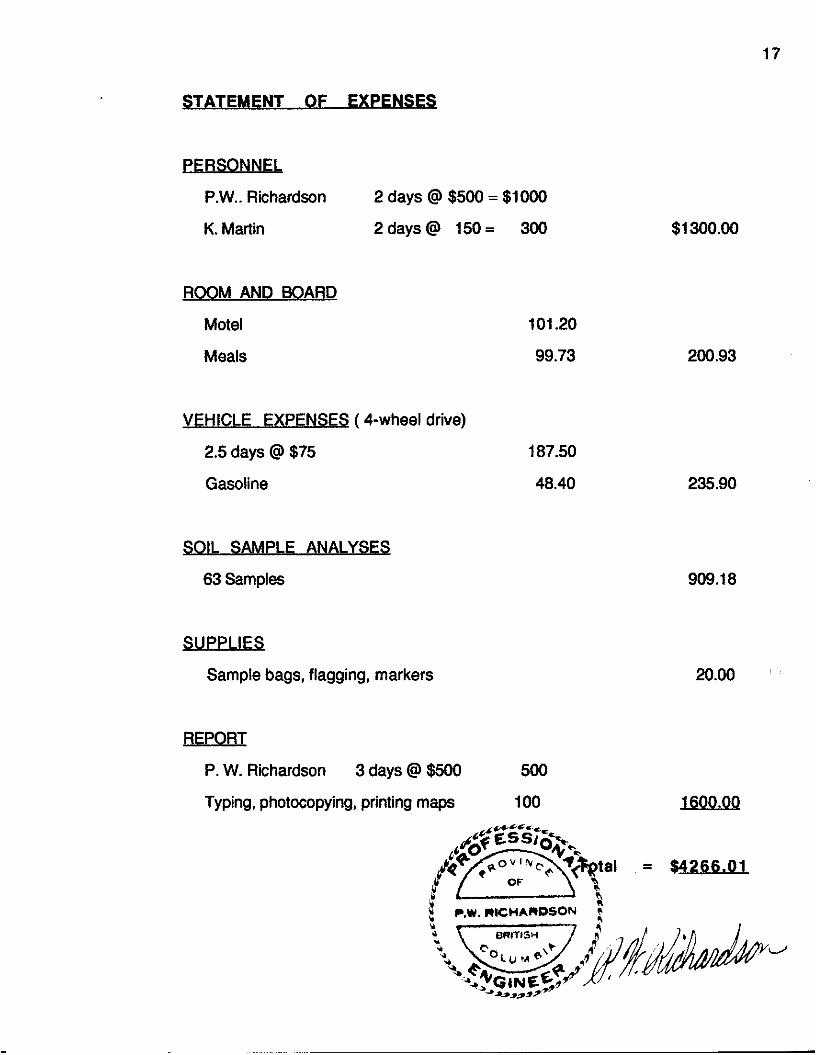
STAT EMENT OF E XPENSES
PERSONNEL
P.W.. Richardson 2 days @ $500 = $lo00
K. Martin 2days@ 150= 300
ROOM AND 80 ARD
Motel
Meals
VEHICLE EXPENSES (4-wheel drive)
2.5 days @ $75
Gasoline
SOIL SAMPLE ANALYSES
63 Samples
SUPPLIES
Sample bags, flagging, markers
101.20
99.73
187.50
48.40
$1 300.00
200.93
235.90
909.18
20.00 ’
REPORT
P. W. Richardson 3 days @ $500 500
Typing, photocopying, printing maps 100 1600.00
I P.W.RICWARDSON c

18
REFERENCFS
Copies of these reports and maps are available to be studied in the
World Wide Minerals Ltd. office.
(1) Anderson, Philip (1971 a) "Sulfide Mineralization, Zoning and Paragensis at Whipsaw Creek" Mineralogy 409 Report at the University of B.C.
(2) Anderson, Philip (1971 b) "Geology, Petrology, Origin and Metamorphic History of the Eagle "Granodiofiie" and Nicola Group at Whipsaw Creek" B.&. Thesis, The University of B.C.
Mines Ltd.
Property" Private Report to Whipsaw Mines Ltd.
Geological Report on the Property of Whipsaw Mines (NPL)" Private Report to Whipsaw Mines Ltd.
(6) Bacon, William R. (1960) "Geological, Geophysical and Geochemical Report on the Whip and Saw Groups" Assessment Report #314.
(7) Bacon, William R. (1961) "Geophysical Report on the Whip and Saw Groups" Assessment Report #362.
(8) Ballantyne, E.J. (1 971) 'Geophysical Report, Whipsaw Creek Property" Assessment Report #3707.
(9) Bell, Robert A. and Hallof, Philip G. (1967) "Report on the Geophysical lnvestiaations of the WhiDsaw Prooertv" Private ReDort to Texas Gulf
(3) Anderson, Philip (1973a) Data on discovery of BZ Zone. Letter to Whipsaw
(4) Anderson, Philip (1973b) "Geological Report - Whipsaw Mines Ltd. (NPL)
(5) Anderson, Philip and Stokes, Ronald 8. (1970) "Summary Geochemical and
. - Sulphs Co. Ltd.
(10) Cairns. C.E. 11 923) "Geoloaical Emlorations in Yale and Similkameen , , Mining Dihsion' Geological SuNey of Canada, Sum. Rept. 1922, pt.A.
Geological Survey of Canada, Sum. Rept. 191 1, p.123.
Report to Whipsaw Mines.
Property" Private Report to Whipsaw Mines Ltd.
(11) Camsell, Charles (1911) "Geology of Skagit Valley, Yale District, B.C."
(12) Clarke, Walter E. (1968) "Report on Whipsaw Creek Property" Private
(13) Clarke, Walter E. (1970) "Supplementary Report on Whipsaw Creek

19
(14) Cohen, Harvey H. (1966) "Report on Whipsaw Creek Mines Ltd. Property" Private Report to Whipsaw Mines Ltd.
(15) Crooker, Grant F. (1986) "Diamond Drilling Report on the Whipsaw Property" Private Report to Lone Jack Resources Ltd.
(16) Culburt, Richard R. (1984) "Report on a Drilling and Trenching Program at Whipsaw Creek Property" Private Report to World Wide Minerals Ltd.
(17) Fox, Peter E. and Goodall, Geoffrey N. (1992) "1991 Whipsaw Project Report" Private report to Phelps Dodge Corporation of Canada, Limited.
(18) Fox, Peter E. (1992) "1992 Whipsaw Project Report - Vendor Report" Report to Phelps Dodge Corporation of Canada Ltd.
(19) Gambardella, Aldo (1975) Geochemical Map for Newconex Canadian Exploration Ltd.
(20) Hallof, Philip G. (1963) "Induced Polarization and Resistivity Survey on the Whipsaw Claim Group" Private Report to Dome Exploration (Canada) Ltd.
(21) Heim, Robert C. (1985) "Geochemical Survey, Whipsaw Creek Property"
(22) Heim, Robert C. (1986) "Progress Report and Exploration Proposal,
(23) Heim, Robert C. (1987) "Report on the Whipsaw Creek Property" Private
(24) Holyk, Walter (1962) "Geological and Geochemical Report on the Whip and
(25) Hunter, Stanley J. (1966) "Mae Group of Mineral Claims" Private Report to
(26) Hunter, Stanley J. (1967) "Report on the Whipsaw Creek Mines Ltd.
(27) Leighton, Douglas G. (1973) "Report on a Drilling and Trenching Program
(28) Macauley, T.N. and Paulus G.E. (1971) "Geological, Geochemical, and
(29) Mitchell, Marvin A. (1985) "Progress Report, Whipsaw Mineral Claim
Private Report to World Wide Minerals Ltd.
Whipsaw JV Property" Private Report to World Wide Minerals Ltd.
Report to World Wide Minerals Ltd.
Saw Groups, Whipsaw Creek" Assessment Report #409.
Whipsaw Mines Ltd.
Property" Private Report to Whipsaw Mines Ltd.
at Whipsaw Creek Property" Private Report to World Wide Minerals Ltd.
Geophysical Progress Report, Whipsaw Creek Property" Private Report to Newmont Mining Corporation of Canada Limited.
Group" Private Report to Lone Jack Resources Ltd.

20
(30) Montgomery, Joseph H. and Giroux, Gary H. (1974) "Report on Geophysical Surveys and Trenching on Whipsaw Creek" Assessment Report #5024.
Mae, Kerry, Pat and Mike Groups" Private Report to Amax Exploration Inc.
(32) Mustard, Donald K. (1969) "1968 Property Examination, Whipsaw Creek Property" Private Report to Amax Exploration Inc.
(33) Paulus, B.C. (1972) "Trenching and Diamond Drilling Report, Whipsaw Creek Project" Private Report to Newmont Mining Corporation of Canada Limited.
(34) Poloni, John R. (1982) "Report on the Whipsaw Creek Property" Private Report to World Wide Minerals Ltd.
(35) Poloni, John R. (1983) "Whipsaw Project - Trenching and Sampling" Private Report to World Wide Minerals Ltd.
(36) Rice, H.M.A. (1947) "Geology and Mineral Deposits of the Princeton Map Area, B.C." Geological Survey of Canada Memoir 243.
(37) Richardson, Paul W. (1988a) "Report to Date and Proposed Exploration Programme on the Whipsaw Property" Private Report to World Wide Minerals Ltd.
Whipsaw Property" Assessment Report to the B.C. Ministry of Energy, Mines and Petroleum Resources.
Whipsaw Property" Assessment Report to the B.C. Ministry of Energy, Mines and Petroleum Resources.
(40) Richardson, Paul W. (1990a) "The Whipsaw Porphyry Area within the Whipsaw Property" Private Report to World Wide Minerals Ltd.
(41) Richardson, Paul W. (199Ob) "The Whipsaw GoM-Silver-Zinc Area within the Whipsaw Property" Private Report to World Wide Minerals Ltd.
(42) Richardson, Paul W. (199012) "Diamond Drilling Report on the Whipsaw Property" Assessment Report to the B.C. Ministry of Energy, Mines and Petroleum Resources.
(43) Richardson, Paul W. (1991) "Geochemical Survey on Part of the Whipsaw Property" Assessment Report to the B.C. Ministry of Energy, Mines and Petroleum Resources.
(31) Mustard, Donald K. (1967) "Geological and Geochemical Report on the
(38) Richardson, Paul W. (1988b) "Diamond Drilling Assessment Report on the
(39) Richardson, Paul W. (1988~) "Geochemical Assessment Report on the

21
(44) Richardson, Paul W. (1993) "Geochemical Survey on Part of the Whipsaw Property" Assessment Report to the B.C. Ministry of Energy, Mines and Petroleum Resources.
(45) Seigel, Harold 0. (1964) "Induced Polarization Survey, Whipsaw Claim Group' Private Report to Dome Exploration (Canada) Ltd.
(46) Seraphim, Robert H. (1963) "Geophysics, Geochemistry and Diamond Drilling on Whipsaw Creek Group" Private Report to Moneta Porcupine Mines Limited.
Report on the "M.J." Claim Group at Princeton, B.C." Private Report to Michael E. Jorgensen.
Claim Group" Private Report to Skaist Mines Ltd. (N.P.L.)
Property" Private Report to World Wide Minerals Ltd.
Private Report to Lone Jack Resources Ltd.
1927,1928,1929,1930,1931,1968,1969.
(47) Stokes, Ronald B. and Leighton, Douglas G. (1969a) "A Geochemical
(48) Stokes, Ronald B. and LeigMon, Douglas G. (1969b) "Report on the "M.J."
(49) Walker, J.T. (1987) "Airborne Geophysical Survey on the Whipsaw Creek
(50) Weymark, W.J. (1985) "Whipsaw Mineral Claims Group, Princeton Area"
(51) Various authors in B.C. Minister of Mines Annual Reports 1915, 1920,
(52) G.S.C. & B.C.M.E.M.P.R. (1973) Magnetic Maps 8530G and 8531G.
22
RICHARDSON GEOLOGICAL CONSULTING LTD. 4569 WEST 13TH AVENUE, VANCOUVER, B.C. VSR 2V5
TELEPHONE: (6041 224-4272
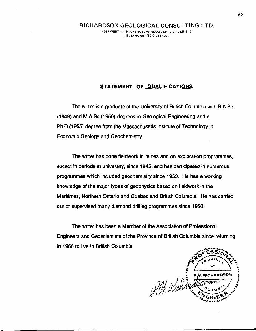
STATEMENT OF QU ALlFlCATlONS
The writer is a graduate of the University of British Columbia with B.A.Sc.
(1949) and M.A.Sc.(l950) degrees in Geological Engineering and a
Ph.D.(1955) degree from the Massachusetts Institute of Technology in
Economic Geology and Geochemistry.
The writer has done fieldwork in mines and on exploration programmes,
except in periods at university, since 1945, and has participated in numerous
programmes which included geochemistry since 1953. He has a working
knowledge of the major types of geophysics based on fieldwork in the
Maritimes, Northern Ontario and Quebec and British Columbia. He has carried
out or supervised many diamond drilling programmes since 1950.
The writer has been a Member of the Association of Professional
Engineers and Geoscientists of the Province of British Columbia since returning
in 1966 to live in British Columbia

APPENDIX I
GEOCHEMICAL ANALYSIS CERTIFICATES
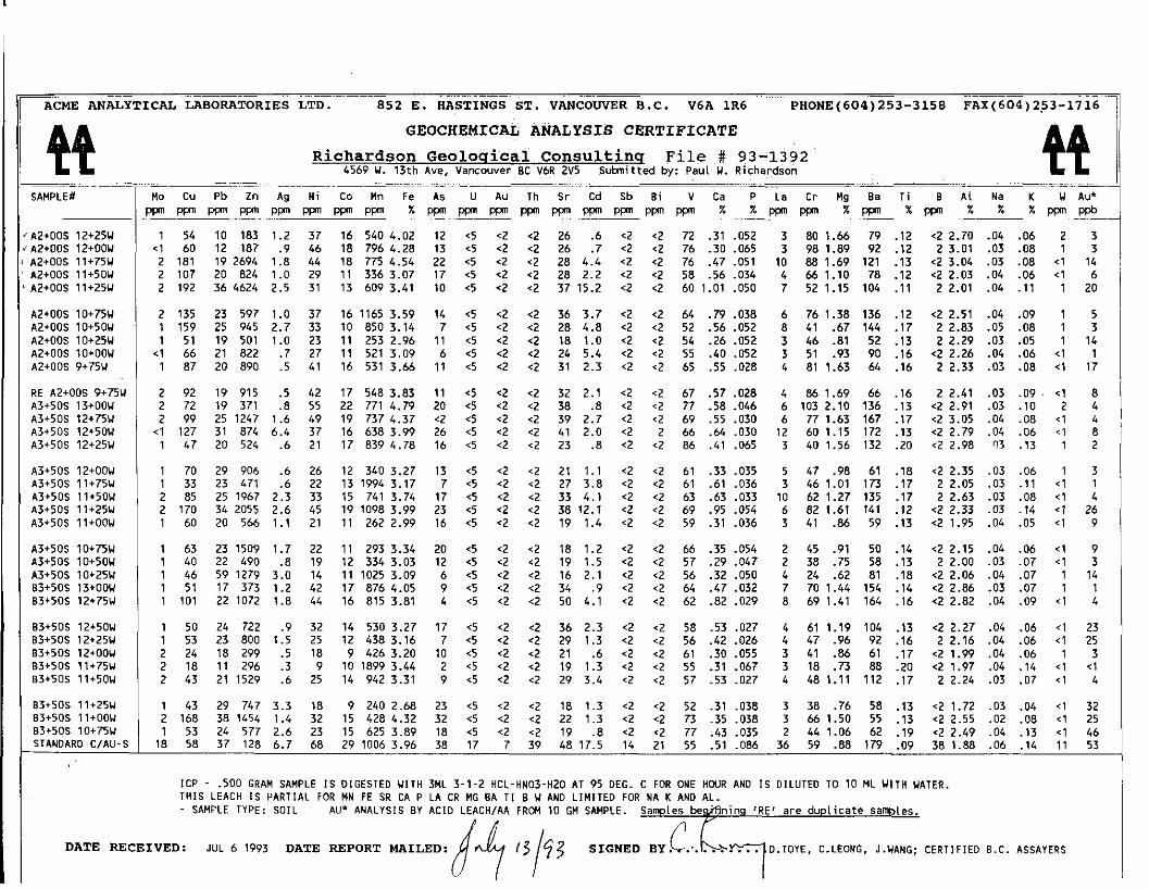
A3+50S 12+00U A3+50S llt75U A3+50S 11+50U A3+50S 11+25U
1 70 29 906 .6 26 12 340 3.27 13 <5 <2 <2 21 1.1 <2 <2 61 .33 .035 5 47 .98 61 .18 <2 2.35 .03 .06 1 3 1 33 23 471 .6 22 13 1994 3.17 7 ~5 <2 <2 27 3.8 ~2 <2 61 .61 .036 3 46 1.01 173 .17 2 2.05 .03 . l l < 1 1 2 85 25 1967 2.3 33 15 741 3.74 17 4 <2 <2 33 4.1 <2 <2 63 .63 .033 10 62 1.27 135 .17 2 2.63 .03 .08 < 1 4 2 170 34 2055 2.6 45 19 1098 3.99 23 <5 <2 ‘2 38 12.1 <2 <2 69 .95 ,054 6 82 1.61 141 .12 <2 2.33 .03 .14 <1 26
.- ~~ ~- ACME ANALYTICAL LABORATORIES LTD. 852 E. BASTINGS ST. VANCOWER B.C. V6A 1R6 PHONE(604) 253-3158 FAX (604) 253-17 16 11
GEOCHEMICAL ANALYSIS CERTIFICATE QQ Richardson Geoloqical Consultinq File # 93-1392 4569 U. 13th Ave, Vancouver BC V6R 2V5 Submitted by: Paul U. Richardson
_ _ _ _ ~ - ~ - .- ~~~~ ~~~
~~ . Mo Cu Pb Zn Ag N i t o Mn Fe AS U AU T h Sr Cd Sb Bi V Ca P La Cr Mg B E Ti B Al Na K U Au*
‘A2+00S 12+25U 1 54 10 183 1.2 37 16 540 4.02 12 ~5 <2 <2 26 .6 <2 <2 72 .31 .052 3 80 1.66 79 .12 <2 2.70 .04 .06 2 3 * A2IOOS 12+OOU ~1 60 12 187 .9 46 18 796 4.28 13 <5 <2 <2 26 .7 <2 <2 76 .30 ,065 3 98 1.89 92 .12 2 3.01 .03 .08 1 3
p p ” p p ” p p ” P p n P P n P P n P p ” P p ” . . % P P n ~ ~ p p n P P n p p ” P P n P P n P P n . ~ % % W p p n - x p p n % p p n % - % % W _ P p b
I A2+OOS 11+75U 2 181 19 2694 1.8 44 18 775 4.54 22 <5 <2 <2 28 4.4 <2 <2 76 .47 .051 10 88 1.69 121 .13 <2 3.04 .03 .08 <1 14 A2iOOS 11+50W 2 107 20 824 1.0 29 1 1 336 3.07 17 <5 ~2 <2 28 2.2 <2 <2 58 .56 .034 4 66 1.10 78 .12 <2 2.03 .04 .06 4 6
’ A2+OOS 11+25U 2 192 36 4624 2.5 31 13 609 3.41 10 4 <2 <2 37 15.2 <2 <2 60 1.01 .050 7 52 1.15 104 .ll 2 2.01 .04 .ll 1 20
A2tOOS 10+75U A2+OOS 10+50U A2+00S 10+25U A2+OOS lO+OOU A2tOOS 9+75W
2 135 23 597 1.0 37 16 1165 3.59 14 <5 <2 <2 36 3.7 <2 <2 64 .79 ,038 1 159 25 945 2.7 33 10 850 3.14 7 <5 <2 <2 28 4.8 <2 <2 52 .56 ,052 1 51 19 501 1.0 23 1 1 253 2.96 1 1 ~5 <2 <2 18 1.0 <2 <2 54 .26 .052
<1 66 21 822 .7 27 1 1 521 3.09 6 <5 <2 <2 24 5.4 <2 <2 55 .40 ,052 1 87 20 890 .5 41 16 531 3.66 1 1 <5 ‘2 <2 31 2.3 <2 <2 65 .55 ,028
2 92 19 915 .5 42 17 548 3.83 1 1 <5 <2 <2 32 2.1 <2 <2 67 .57 ,028 2 72 19 371 .8 55 22 771 4.79 20 <5 <2 <2 38 .8 <2 <2 77 .58 .046 2 99 25 1247 1.6 49 19 A 7 4.37 <2 <5 <2 <2 39 2.7 <2 <2 69 .55 .030
<1 127 31 874 6.4 37 16 638 3.99 26 ‘5 <2 <2 41 2.0 <2 2 66 .& .030 1 47 20 524 .6 21 17 839 4.78 16 <5 <2 ~2 23 .8 <2 <2 86 .41 ,065
6 8
76 1.38 136 .12 41 .67 144 .17
‘2 2.51 2 2.83 2 2.29
<2 2.26 2 2.33
2 2.41 <2 2.91 <2 3.05 <2 2.79 <2 2.98
.04 .09
.05 .08
.03 .05
.04 .06
.03 .08
.03 .09 .
.03 .10
.04 .08
.04 .06 03 .13
1 5 1 3 1 14
<1 1 <1 17
<1 8 2 4
<1 4 < l 8 1 2
3 3
46 .81 52 .13 51 .93 90 .16 81 1.63 64 .16
RE A2+OOS 9+75W A3+50S 13+00U A3+50S 12i75U A3+50S l2+50W A3+50S 12+25U
86 1.69 66 .16 103 2.10 136 .13 77 1.63 167 .17 60 1.15 172 .13 40 1.56 132 .20
12 3
I I A3+50S ll+OOW 1 1 60 20 566 1.1 21 1 1 262 2.99 16 <5 <2 <2 19 1.4 ~2 <2 59 .31 ,036 3 41 .86 59 .13 <2 1.95 .04 .05 <1
A3+50S 10+75U A3+50S 10+5OU
63 40
23 1509 22 L90
1.7 .8
3.0 1.2 1.8
22 19 14 42 44
32 25 18
9 25
18 32 23 68
1 1 12 1 1 17 16
14 12 9 10 14
9 15 15 29
293 3.34 334 3.03 1025 3.09 876 4.05 815 3.81
20 4 <2 <2 18 1.2 ~2 <2 66 .35 .054 2 45 .P1 50 .14 <2 2.15 .04 .06 <1 9 12 <5 <2 <2 19 1.5 <2 <2 57 .29.047 2 38 .75 58 .13 7 7 . 0 0 -03 -07 <1 3
A <q <7 <> i~ 7 i <> c7 5~ 77 n w I >L A> ~i i n . . ~ . . A3+50S 10+25U B3*50S 13+00k 83*50S 12.75h
46 51 101
59 1279 17 373 22 1072
. .. .~ . - - - - .- - - _ _ .___ . _. .__ _. <2 2.06 .04 .07 1 14 9 <5 ‘2 ~2 34 .9 <2 <2 64 .47 ,032 7 70 1.44 154 .14 <2 2.86 .03 .07 1 1 4 4 <2 <2 50 4.1 <2 <2 62 .82 .029 8 69 1.41 164 .16 <2 2.82 .04 .09 < 1 4
B3+50S 12+50U B3+50S l2+25U B3+50S 12tOOW B3+50S 11+75U 83+50S 11+50w
B3+50s 11+25u 83+50S ll+OOU B3+50S 10+75U STANOARO CIAU-S
50 53 24 18 43
24 722 23 800 18 299 1 1 296 21 1529
29 747 38 1454 24 577 37 128
530 3.27 438 3.16 426 3.20 1899 3.44 942 3.31
240 2.68 428 4.32 625 3.89 1006 3.96
17 <5 <2 <2 36 2.3 <2 <2 58 .53 ,027 4 61 1.19 104 .13 <2 2.27 .04 .06 <1 23 7 4 <2 <2 29 1.3 <2 <? 56 -42 .026 4 47 .96 92 -16 2 2.16 .04 .06 < 1 25
.9 1.5
2 2 2
.5
.3
~~ ~~ ... ~ . ~~ ~~ ~ . .. ~ ~ ~~~~
10 <5 <2 ~2 21 .6 <2 <2 61 .30.055 3 41 .86 61 .17 <21.99 .04 .06 1 3 2 <5 <2 ~2 19 1.3 <2 <2 55 .31 .067 3 18 .A 88 .20 <2 1.97 .04 .14 <1 <1 9 <5 <2 <2 29 3.4 <2 <2 57 .53.027 4 481.11 112 .17 22.24 .03 .07 < 1 4 .6
3.3 1.4 2.6 6.7
43 168
1 2 1 18
23 ~5 <2 <2 18 1.3 <2 ~2 52 .31 ,038 3 38 .76 58 .13 <2 1.72 .03 .04 <1 32 32 <5 <2 <2 22 1.3 <2 <2 A .35.038 3 661.50 55 .13 <22.55 .02 .08 < 1 25 18 <5 <2 <2 19 .8 <2 ~2 77 .43 .035 2 44 1.06 62 .19 ~2 2.49 .04 .13 <1 46 38 17 7 39 48 17.5 14 21 55 .51 .086 36 59 .88 179 .09 38 1.88 .06 .14 1 1 53
53 58
I / ICP - .500 GRAM SAMPLE IS DIGESTED W I T H 3ML 3-1-2 HCL-HNO3-H2O AT 95 OEG. C FOR ONE HWR AND IS DILUTED TO 10 ML WITH WATER. THIS LEACH IS PARTIAL FOR MN FE SR CA P LA CR MG BA TI 8 W AN0 LlMlTEO FOR N A K AND AL. - SAMPLE TYPE: SOIL AU’ ANALYSIS BY ACID LEACHIAA FROM 10 GM SAMPLE. Samples b e d i n i n g ‘RE’ are duplicate samles.
1 . Y
DATE RECEIVED: JUL 6 1993 DATE REPORT MAILED: D . T O Y E , C.LEONG, J.UANG; CERTIFIED B.C. ASSAYERS I

93- 1 4 93-2 93-3 93-4 93-5
93-6 93-7 93-8 93-9 93- 10
93-11 93- 12 93- 13 93- 14 93-15
. .,\\ I
93-16 . . \ ' 93-17 ,(,, 3 ;,#.
93-19 .I ( J ! '
93-21 93 - 22 93 - 23 93-24 I 93-25
93-18 ,I' ,
93-20 . ( j
6 727 19 530 .5 51 51 1277 3.29 14 <5 *2 <2 31 1.3 <2 <2 58 .51 .047 3 66 1.41 82 .09 3 1.80 .04 .13 4 1 <3 3 1 1 1758 145 4229 1.6 74 80 2023 3.86 22 <5 <2 <2 52 30.7 <2 <2 60 1.00 .060 5 74 1.47 120 .09 4 2.65 .04 .14 el 3 3 <3 19 1885 20 580 1.5 62 82 2418 4.52 23 *5 *2 <2 42 2.1 <2 <2 71 .55 .053 4 83 1.53 114 .lo 3 2.46 .05 .21 4 11 6 9 27 2057 24 659 .8 71 196 7208 4.77 16 <5 <2 3 50 4.9 <2 2 61 .60 .064 6 66 1.08 189 .08 3 3.56 .05 .13 el 1 <3 *3 23 1872 23 1006 .7 88 241 2263 5.16 15 <5 <2 <2 48 7.8 <2 <2 61 .59 .081 7 63 1.04 341 .07 4 2.75 .05 .ll 4 6 <3 5
31 1730 10 538 .7 74 231 2144 4.14 10 <5 <2 <2 53 3.8 <2 2 52 .69 .067 7 58 .85 107 .06 4 2.33 .03 .10 4 2 4 7 14 650 6 212 .5 37 40 798 3.51 10 <5 <2 <2 34 .6 <2 <2 59 .43 .045 3 65 1.24 101 .lo 3 1.97 .03 .15 el ~1 4 7 15 701 11 195 .7 44 41 1910 4.54 14 <5 <2 <2 33 .8 *2 2 75 .36 .046 3 85 1.49 114 .12 4 2.10 .03 .20 ~1 2 12 6 17 660 8 156 .8 40 17 451 4.79 18 <5 <2 <2 32 s.2 <2 2 79 .31 .047 3 93 1.76 119 -14 3 2.52 .03 .24 4 3 3 <3 9 628 5 173 .3 30 52 1685 3.05 7 <5 <2 <2 43 .9 *2 <2 46 .46 .050 3 49 .86 148 .Of 5 1.90 .03 .10 <1 30 *3 4
9 519 6 160 .3 26 50 1294 3.40 6 *5 <2 <2 45 .5 <2 <2 50 .49 .055 4 50 .88 128 .07 3 1.80 .03 .12 4 <1 4 4 12 928 8 170 .5 38 139 4228 4.71 9 <5 <2 ~2 56 1.4 <2 <2 58 .59 .076 5 51 .83 168 .06 3 2.01 .03 -12 <1 2 <3 <3 10 509 6 121 .4 33 112 1882 3.12 9 <5 <2 <2 37 .7 <2 <2 50 .48 .055 3 59 1.15 85 .07 3 1.71 .04 .ll <1 4 3 4 14 859 8 166 .7 35 74 1497 4.96 9 <5 <2 <2 40 .7 <2 <2 62 .44 .059 4 54 1.05 1 1 1 .07 4 2.12 .04 .16 <1 6 <3 <3
10 561 7 147 .2 28 47 1176 2.98 5 <5 <2 <2 41 q.2 <2 <2 49 .42 .046 3 51 1.02 151 -07 2 1.97 .03 .12 <I 1 3 3
14 793 8 159 .6 28 203 2847 3.75 10 <5 <2 <2 49 .9 <2 <2 56 .48 .057 5 54 .97 134 .07 3 2.21 .03 .12 <1 1 <3 *3 8 870 9 152 .7 25 36 788 3.84 7 <5 <2 <2 54 .3 <2 <2 51 .60 .096 6 45 .91 153 .06 3 2.81 .03 .13 4 6 <3 <3 14 667 11 137 .7 21 58 1031 3.35 12 <5 <2 *2 37 e.2 <2 2 59 .40 .048 4 39 .78 100 .07 2 2.10 .03 .12 4 13 <3 3 14 952 10 133 .7 19 42 710 3.16 10 <5 <2 <2 31 .3 <2 <2 56 .31 .055 5 35 .76 92 .Of 3 2.57 .02 .10 el 1 8 <3 13 907 8 140 .9 19 36 770 3.32 10 <5 <2 c2 37 .3 <2 <2 58 .37 .054 6 37 .79 94 .07 2 2.44 .03 .ll 1 2 *3 <3
8 10948 <2 370 .5 58 15 154 .51 2 <5 <2 <2 63 3.9 <2 7 8 1.07 .050 8 2 .08 62 .01 3 .61 .05 .ll 1 <1 <3 4 58 14722 5 90 3.8 27 277 2783 .43 6 <5 <2 <2 72 1.1 *2 <2 6 1.15 .lo7 51 15 .06 69 .01 6 2.11 .01 .03 1 4 <3 <3 12 996 6 227 .3 29 53 579 2.41 7 <5 <2 <2 28 .5 <2 *2 44 .32 .040 2 31 .44 37 .13 3 1.73 .05 .04 *1 4 *3 4 8 1068 4 91 1.2 12 27 406 2.25 5 <5 *2 <2 23 .3 *2 <2 45 .28 .040 6 21 .21 14 .ll 3 1.58 .06 .02 <1 <l <3 <3 87 11539 <2 66 9.5 20 452 3926 .37 4 <5 <2 <2 49 .8 <2 9 6 .77 .124 81 23 .04 39 .01 5 1.60 .01 .03 1 2 <3 - 4
1 1
6 1405 262 5290 1.4 82 86 3923 8.74 623 <5 <2 2 25 31.3 <2 4 46 .53 .Of2 9 63 .83 87 .07 2 2.36 .02 .06 <1 107' 6 9
1 1 1 1 21 386 1.1 25 13 360 3.20 25 <5 <2 2 19 1.4 <2 *2 57 .25 .045 3 46 1.07 76 .10 4 2.23 .03 .04 <1 <1 <3 4 1356 266 5249 1.3 82 80 3883 8.74 624 <5 <2 2 25 30.9 <2 -2 4 6 .52 .OYJ 7 63_-._83__ 87 .?I 3 2.34 .Cl2 .Q6 el 103' 3 8
2 228 38 3335 2.4 24 13 754 2.91 33 <5 <2 <2 35 9.5 <2 *2 49 .89 .045 6 34 1.02 110 .08 3 1.74 .03 .09 el 16 3 5 1 290 23 1686 1.2 29 1 1 590 2.34 14 <5 <2 <2 39 7.0 <2 <2 42 1.08 ,058 6 52 1.08 112 .06 3 1.35 .03 .15 <1 5 3 6
93 - 26 93-27
93-30 v' 93 - 31
STANDARD C/FA- ioE 2 97 41 1536 1.4 23 12 500 3.10 21 <5 <2 <2 24 2.7 <2 <2 56 .48 .034 3 39 1.02 77 .11 3 1.89 .03 .06 <1 7 <3 3 1 172 50 2375 1.8 22 14 657 3.09 25 <5 <2 <2 27 2.7 2 <2 56 .63 .049 3 37 1.11 77 .09 2 1.63 .03 .09 <1 15 <3 <3 18 59 39 124 6.8 66 30 1106 3.96 43 22 7 37 52 19.0 14 19 56 .49 .086 37 55 .88 182 .08 34 1.88 .06 .14 12 47 51 51
ICP - .SO0 GRAM SAMPLE IS DIGESTED WITH 3ML 3-1-2 HCL-HN03-H20 AT 95 DEG. C FOR ONE HOUR AND I S DILUTED TO 10 ML WITH WATER. THIS LEACH IS PARTIAL FOR MN FE SR CA P LA CR MG BA T I B W AND LIMITED FOR NA K AND AL. - SAMPLE TYPE: SILT AU** PT** PD** BY FIRE ASSAY 8t ANALYSIS BY ICP/GRAPHITE FURNACE. Samples beginning 'RE' are duplicate samples.
. - 4to ## "pb7jPd
.D.TOYE, C-LEONG, J.WANG; CERTIFIED B.C. ASSAYERS DATE RECEIVED: JUL 6 1993 DATE REPORT MAILED:
3