utah geological survey
81
GUIDE FOR THE PREPARATION OF REPORTS o FOR THE UTAH GEOLOGICAL SURVEY By William R. Lund CIRCULAR 85 1992 UTAH GEOLOGICAL SURVEY a division of UTAH DEPARTMENT OF NATURAL RESOURCES
-
Upload
khangminh22 -
Category
Documents
-
view
0 -
download
0
Transcript of utah geological survey

GUIDE FOR THE PREPARATION OF REPORTS
o
FOR THE
UTAH GEOLOGICAL SURVEY By
William R. Lund
CIRCULAR 85 1992
UTAH GEOLOGICAL SURVEY a division of UTAH DEPARTMENT OF NATURAL RESOURCES

Member
STATE OF UTAH Norman H. Bangerter, Governor
DEPARTMENT OF NATURAL RESOURCES Dee C. Hansen, Executive Director
UTAH GEOLOGICAL SURVEY M. Lee Allison, Director
BOARD
Kenneth R. Poulson, Chairman Representing
Mineral Industry Lawrence Reaveley ............................................................... Civil Engineering Jo Brandt ........................................................................ Public-at-Large Samuel C. Quigley ............................................................... Mineral Industry Russell C. Babcock, Jr. ........................................................... Mineral Industry Jerry Golden .................................................................... Mineral Industry Milton E. Wadsworth .................................................. Economics-Business/ Scientific Richard J. Mitchell, Director, Division of State Lands and Forestry .................... Ex officio member
UGS EDITORIAL STAFF J. Stringfellow ............................................................................ Editor Patti F. MaGann, Sharon Hamre ...................................................... Editorial Staff Patricia H. Speranza, James W. Parker, Lori Douglas .................................... Cartographers
UTAH GEOLOGICAL SURVEY 2363 South Foothill Drive
Salt Lake City, Utah 84109-1491
THE UTAH GEOLOGICAL SURVEY is organized into three geologic programs with Administration, Editorial, and Computer Resources providing necessary support to the programs. The ECONOMIC GEOLOGY PROGRA~ undertakes studies to identify coal, geothermal, uranium, hydrocarbon, and industrial and metallic mineral resources; to initiate detailed studies of the above resources including mining district and field studies; to develop computerized resource data bases; to answer state, federal, and industry requests for information; and to encourage the prudent development of Utah's geologic resources. The APPLIED GEOLOGY PROGRAM responds to requests from local and state governmental entities for engineering geologic investigations; and identiftes, documents, and interprets Utah's geologic hazards. The GEOLOGIC MAPPING PROG RAM maps the bedrock and surficial geology of the state at a regional scale by county and at a more detailed scale by quadrangle. Information Geologists answer inquiries from the public and provide information about Utah's geology in a non-technical format.
THE UGS manages a library which is open to the public and contains many reference works on Utah geology and many unpublished documents on aspects of Utah geology by UGS staff and others. The UGS has begun several computer data bases with information on mineral and energy resources, geologic hazards, stratigraphic sections, and bibliographic references. Most files may be viewed by using the UGS Library. The UGS also manages a sample library which contains core, cuttings, and soil samples from mineral and petroleum drill holes and engineering geology investigations. Samples may be viewed at the Sample Library or requested as a loan for outside study.
The UGS publishes the results of its investigations in the form of maps, reports, and compilations of data that are accessible to the public. For information on UGS publications, contact the UGS Sales Office, 2363 South Foothill Drive, Salt Lake City, Utah 84109-1491, (801) 4fJ7-7970.
The Utah DepartrntJnt 01 Natural Resources rec9iv6s federal aid and prohibits discriminaIion on the basis 01 rae_, color. sex, age, national origin, or handicap. For inIormation or complaints regwding discrirmn.tion, contact ExecutivtJ DirecIor. lbh ~ 01 Nahlrai ~8S, 1636 West North Temple 11316, Salt Lake ely, UT 84116-3193 or Office 01 E~ ~ u.s. ()eptlrtrnerloI~ Interior, Wa.shKlgI\?n, DC 20240.

GUIDE FOR THE PREPARATION OF REPORTS
FOR THE
UTAH GEOLOGICAL SURVEY
by William R. Lund Utah Geological Survey
FOREWORD
The Utah Geological Survey is mandated to gather, interpret, and distribute information on Utah's geology, geologic hazards, topography, and geologic resources. Such information is essential to the public, industry, resource managers, scientists, and decision makers of all kinds. We as scientists and as public servants have not adequately fulfilled our assigned task until the results of UGS studies are communicated effectively to our intended audiences in a clear, concise, and understandable manner. To that end, the UGS is committed to producing geologic reports of the greatest accuracy and highest quality, regardless of whether the report is a lengthy monograph or a one-page memorandum.
This Guide for the Preparation of Reports for the Utah Geological Survey will assist UGS authors in producing geologic reports of the required clarity and quality. The Guide presents the policies governing the writing, review, and publication of UGS reports, and provides consistent editorial standards to help authors with the "nuts and bolts" of report preparation. Although extensive, the Guide is neither exhaustive nor dogmatic. Utah Geological Survey authors are expected to be as diligent and creative in writing their reports as they are in planning and conducting their geologic studies. This Guide is intended to allow authors the flexibility to be creative, while ensuring that all UGS reports share the basic elements of our publication style in common. How quickly a report moves through the UGS review and publication process will, in some measure, depend on how well authors incorporate these style elements in their manuscripts.
I strongly encourage all authors writing for the UGS to familiarize themselves with the contents of this Guide and to refer to it often as they prepare their own reports or review the work of their colleagues.
M. Lee Allison, Director February,1992

GUIDE FOR THE PREPARATION OF REPORTS
o
FOR THE
UTAH GEOLOGICAL SURVEY By
William R. Lund
CIRCULAR 85 1992
UTAH GEOLOGICAL SURVEY a division of UTAH DEPARTMENT OF NATURAL RESOURCES

CONTENTS
ABSTRACT ................................................................................................................................................................. 1
IN"lRODUCTION ........................................................................................................................................................... 1
THE UGS PUBLICATION PROCESS ........................................................................................................................... 2 Autllor ......................................................................................................... " ........................................... 2
Senior Geologist ..................................................................................................................................... 3 Peer Review ............................................................................................................................................ 3 Deputy Director ...................................................................................................................................... 4
Director ................................................................................................................................................... 4 Editor ....................................................................................................................................................... 5
ETI-IICAL CONSIDERATIONS ..................................................................................................................................... 5 THE P AR'fS OF A REPORT ......................................................................................... , .................................................. 5
Text .......................................................................................................................................................... 5 Title Page ............................................................................................................................................. 5 Foreword and Preface ........................................................................................................................ 6
Table of Contents ................................................................................................................................ 6
Abstract ............................................................................................................................................... 6 Body of tile Report .............................................................................................................................. 7 AckIlowledgrnents ............................................................................................................................. 7 References ........................................................................................................................................... 7
References cited in tile text ............................................................................................................. 7 References for illustrations ............................................................................................................. 8 The reference list ............................................................................................................................. 8
Glossary ...... ..... ....... ..... ....... ........ ....... ..... .... ..... ..... ....... ....... ..... ....... ..... ..... ....... ....... ..... ....... ..... ....... ... 10
Appendix ........................................................................................................................................... 10
Index .................................................................................................................................................. 10
illustrations .. .... ..... ... .... ..... .......... ..... ....... .............................................................................................. 11
Line Drawings .................................................................................................................................. 11
Color illustrations ............................................................................................................................. 12
Photographs.............. ..................... ....... ..... ....... ..... ....... ............................. ... .................................... 12
Captions and Titles ........................................................................................................................... 13
Tables .................................................................................................................................................... 14
Equations and Fonnulas ...................................................................................................................... 16
THE MANUSCRIPT Manuscript Preparation ....................................................................................................................... 16
Page Fonnat ...................................................................................................................................... 17
Section Headings .............................................................................................................................. 17
First-level headings ....................................................................................................................... 17 Second-level headings .................................................................................................................. 17
Third-level headings ......................................................................................................... ~ ........... 17 Fourth-level headings ................................................................................................................... 17
Pagination ............................................................................................................................................. 18
Digital Fonnat ....................................................................................................................................... 18
Copyrighted and Proprietary Material ............................................................................................... 18
MA TIERS OF STILE
Abbreviations and Symbols ................................................................................................................ 19
General Rules .................................................................................................................................... 19

Degree Mark ..................................................................................................................................... 20 Land Tract Designations .................................................................................................................. 20 Latin Abbreviations .......................................................................................................................... 20 Lifuologic and Time-Stratigraphic Terms ...................................................................................... 20 Number ............................................................................................................................................. 21
Time ................................................................................................................................................... 21
Age estimates ................................................................................................................................ 21
Geologic time ................................................................................................................................ 21
Calendar dates ............................................................................................................................... 22 Clock time ....................................................................................................................................... 22
Capitalization ........................................................................................................................................ 22
Geographic Names ............................................................................................................................... 25 Geologic Names .................................................................................................................................... 25
Rock-Stratigraphic Units ................................................................................................................... 25
Structural Geologic Features ............................................................................................................ 25 Divisions of Geologic Time ............................................................................................................... 26
Italics ..................................................................................................................................................... 26 Lists ....................................................................................................................................................... 26
Sentence Lists .................................................................................................................................... 26 Vertical Lists ...................................................................................................................................... 28
Numbers ............................................................................................................................................... 29 General Rules .................................................................................................................................... 29 Decimals and Fractions .................................................................................................................... 30
Significant Figures ............................................................................................................................ 30
Punctuation ........................................................................................................................................... 31
Periods, Question Marks, and Exclamation Points ........................................................................ 32
Commas ............................................................................................................................................ 32
Semicolons ........................................................................................................................................ 34 Colons ................................................................................................................................................ 34
Parentheses and Brackets ................................................................................................................. 35 Parenfueses .................................................................................................................................... 35 Brackets .......................................................................................................................................... 35
Dashes ............................................................................................................................................... 35 Hyphens ............................................................................................................................................ 35
Quotation Marks ............................................................................................................................... 36 Ellipsis Marks ..................................................................................................................................... 37
Apostrophes ...................................................................................................................................... 37
Quotations ......................................................................................................................................... 37
Units of Measurement ....................................................................................................................... 38
WRITING TIPS .............................................................................................................................................................. 38
Sentences and Paragraphs ................................................................................................................... 38
Active and Passive Voice ..................................................................................................................... 39
False Subjects ........................................................................................................................................ 39
Strong Verbs ......................................................................................................................................... 39
Gender Bias ........................................................................................................................................... 40
Jargon .................................................................................................................................................... 40
Personal Pronouns ............................................................................................................................... 40
Problem Words .................................................................................................................................... 40
A and An ....................................................................................................................................... 40
Affect and Effect ............................................................................................................................ 41
Age and Date ................................................................................................................................. 41
Data ................................................................................................................................................ 41
Debris Flow and Mudflow ........................................................................................................... 41
Geologic, Geological, Geographic, Geographical ....................................................................... 41
Ground Water ............................................................................................................................... 41 Historic and Historical ................................................................................................................. 41
UGS PUBLICA nONS .................................................................................................................................................. 42
Publication Series ................................................................................................................................. 42 Monographs ...................................................................................................................................... 42 Bulletins ............................................................................................................................................. 42 Water-Resources Bulletins ............................................................................................................... 42
Special Studies .................................................................................................................................. 42
Map Series ......................................................................................................................................... 42 Circulars ............................................................................................................................................ 42
Survey Notes ..................................................................................................................................... 43
Miscellaneous Publication Series .................................................................................................... 43
Public Information Series ................................................................................................................. 43
Reports of Investigation ................................................................................................................... 43 Open-File Reports ............................................................................................................................. 43 Contract Reports ........................................................... '" ................................................................. 43 Technical Reports ............................................................................................................................. 43
Selecting a Publication Series .............................................................................................................. 44 Outside Publications ............................................................................................................................ 44
ACKN"OWLEDGMENTS ............................................................................................................................................. 44
SELECTED BIBLIOGRAPHY ...................................................................................................................................... 44
APPENDICES
Appendix A: Additional Reading and Resources ............................................................................ 47
Appendix B: UGS Document Routing and Review Fonns .............................................................. 48
Appendix C: Abbreviations ................................................................................................................ 52 Appendix D: Problem Words and Phrases ....................................................................................... 63 Appendix E: United States Customary and International System of Units .................................... 66
ILLUSTRATIONS
Figure 1. Utah Geological Survey publication flow chart .................................................................. 2
Figure 2. White Point Member of the Summerville (?) Formation below Triangle Point near Cat Pasture in Kane County ................................................................... 12
Figure 3. Geologic time scale .............................................................................................................. 27
TABLES
Table 1. Radiocarbon and thermoluminescence ages from the Mapleton trench sites ................. 14 Table 2. Univariate statistics from the Bullion Canyon data set ...................................................... 15 Table 3. Principal organisms found in Great Salt Lake, and their tolerance to salinity .................. 15

UTAH GEOLOGICAL SURVEY STYLE GlUDE 1
ABSTRACT
Reports on the geology of Utah are the principal product of the Utah Geological Survey (UGS). Utah Geological Survey reports are expected to be of the highest technical and editorial quality. This guide establishes policies governing the publication of UGS reports and provides editorial standards necessary for preparing publications of the desired quality.
Infonnation in this guide includes: (1) a description of the UGS publication process and the responsbilities of the individuals (author, senior geologist, peer reviewers, deputy director, director,and editor) involved in the publication of UGS reports, (2) a list of standard reference works used in the preparation of UGS reports, (3) a discussion of ethical considerations associated with the publication process, (4) a general description of the parts of a UGS report, (5) rules for preparing manuscripts, (6) style requirements forUGSreports, (7)writingti ps,(8)adescriptionofUGSpublication series fonnats, and (9) appendices that present resources and information useful in the report preparation process.
Policy statements in this guide establish criteria for report authorship, direct authors to avoid plagiarisim and give proper credit for the work of others, define the required steps and individual responsibilities in the UGS publication process, establish requirements for obtaining and documenting permission to use copyrighted or proprietary material, and identify the procedures authors must follow when publishing outside of the Utah Geological Survey.
INTRODUCTION
The Utah Geological Survey (UGS) publishes reports on the geology of Utah. The reports range from brief technical reports of limited distribution to monographs intended to stand as the definitive work on a geologic topic for many years. Regardless of the length or purpose of the report, the UGS' reputation as a scientific organization depends on the technical and editorial quality of its publications. This guide sets forth policies governing the publication of UGS reports and presents a consistent set of editorial standards that will assist authors in producing publications of the desired quality.
No single set of editorial standards can meet the requirements of all scientificorganizations(Mathewson, 1981; Cochran and others, 1984; Geological Society of America, 1985; Bates, 1988; Day, 1988; New Mexico Bureau of Mines and Mineral Resources, 1988; Beavers, 1990; Freeman and Bacon, 1990). Each organization that publishes reports on a regular basis has its own specialized editorial needs and must establish standards to meet those needs. This Guide for the Preparation of Reports for the Utah Geological Suroey is to help UGS authors achieve consistency and clarity of expression and logical organization in their writing and to facilitate the manuscript review and publication process.
Suggestions to Authors of the Reports of the United States Geological Suroey (seventh edition) (Hansen, 1991) was the principal source of infonnation used in compiling this guide. Utah Geological Survey authors are referred to that publication if additional information about preparing geologic reports is required. However, be advised that this guide is not everywhere consistent with Suggestions to Authors Seven, and, where differences exist, this guide takes precedence when preparing UGS reports. Other primary sources of information used in compiling this guide include the United States Government Printing Office Style Manual 1984; The Chicago Manual of Style (thirteenth edition); Shipley Associates Technical Writing Manual; and Shipley Associates Style Guide. The Selected Bibliography lists secondary sources of information. Appendix A provides additional resources and a suggested reading list.
In addition to the references listed above, the UGS uses three other publications as standard references in the report publication process. They are Webster's Third New International Dictionary of the English Language (unabridged seventh edition); the American Geological Institute Glossary of Geology (third edition); and the North American Stratigraphic Code (1983). Authors should consult these references, or their subsequent editions and revisions, concerning matters of spelling, geologic terminology, and the naming of rock-stratigraphic units.

2 UTAH GEOLOGICAL SURVEY CIRCULAR 85
THE UGS PUBLICATION PROCESS
The goal of the UGS publication process is to produce reports of the highest technical and editorial quality on the geology of Utah. The publication process is a team effort that normally involves the author, the author's senior geologist, peer reviewers, the deputy director, director, and editor (figure 1). Each team member has specific duties and responsibilities to fulfill if the UGS is to produce the best possible publications.
This guide provides a consistent set of editorial standards and policies for the preparation ofUGS reports. Issues of technical adequacy and completeness are resolved through the publication review process. The publication review process consists of author-initiated informal peer reviews, a thorough technical and editorial review by the senior geologist and, for formal UGS publications, a minimum of one formal peer review by a technical expert (see Senior Geologist and Peer Review sections, figure 1, and appendix B) .
.. ------~l~------~
1. Author Initiates Informal peer-review process during/after manuscript preparation.
2. Author submits manuscript to Senior Geologist to begin formal review process.
3a.Senlor Geologist makes technical/editorial review and returns manuscript to author for revision, H neceaaary.
3b. Senior Geologist Initiates formal peer-review process for "formal" UGS publications. Author revise. manuscript and returns It to the Senior Geologist for final review.
¢ I I I I
(fonnalreView)
® I I
FORMAL PEER REVI~W(S)
7
4. Senior Geologist approve. manuscript and send. It to Deput¥ Director for policy review. Deputy Director return. manuscript to Senior Geologist for rev(slon, H necessary.
5. Deputy Director sends manuscript to Director for approval. to publish.
'--~CD~----·L--~~~--~------------------" ea. Director send. approved manuscript to
Editor. ab. Director approves manuscript for outside
publishing, with copy to Editor. 7. Editor and Author work together to resolve any
problem. during production process. Author revlewa proofa.
e. Editor send. final proofa to Deputy Director for approval to print.
e. editor send. manuscript to printer.
Author
--- required _ _ _ _ optional
Figure 1. UGS' Publication Flow Chart
It ~s UGS ~licy ~at ~e person in principal charge of an investigation and preparation of the subsequent repor! re~Ives credIt ~s'pnnclpal author of the resulting publication. Seniority, grade, or similar considerations are not c~te~a for detenm~? ~uthorship or co-authorship of UGS reports. In cases of multiple authors, it is the level of contribution by each IndIVIdual that determines authorship or co-authorship. When two or more researchers

UTAH GEOLOGICAL SURVEY STYLE GUIDE 3 .... '.',',', ' ... '.',',',',',',',',',',',',',', ..•. ',',', ' ... '. '. ' ... ':::::::~:::::::::::::::::::::::'.'." '. ' .... ;:;:;:;:;:;:;:;:;:;:;: ;:;:;:;:;:;:;:.'.',',',', ..•. ',', .... ', ',' ..... ', ...... ',',',',',',', .... ' ... '. ';:;:;:;:;:;:;:;:;:;:;:;:;:;:;:;:;:;:;:;:;:;:;:;:.' ...•...•. ', ..•.•.•... ',',',', ..•. ',. ;:;:;:;:;:;:;:;:;:;:;:;:;:;:;:;:. ','.',',',',',. ;:;:;:;:;:;:;:;:;:;:;:;:;:;:;:;',', .... ',',',',', ';:;:;:;:;:;:;:;:;:;'.', ' ... ', ..•. ',',', .. '.',',',', ',' ;:;:;:;'.',', ......•...•... ',', .... ', ' .....•. ',',',',
contribute equally, they will be listed as authors in alphabetical order according to their last names unless they agree in advance to some other mutually satisfactory arrangement. Credit for co-authorship is given to individuals who make a significant contribution to an investigation even though they may not take an active part in writing the report. Usually, the designation of principal and co-authors is a straightforward matter. Clear assignment of duties and responsibilities among investigators early in the study normally resolves potential questions or disagreement on this sometimes sensitive subject. When disagreement occurs, the senior geologist will make the final decision regarding authorship. If the disagreement involves the senior geologist, the deputy director will make the decision.
The author receives credit for the publication and bears final responsibility for the technical and editorial quality of the report. If either is inadequate, it is the author's competence and reputation that are questioned. Regardless of the scope of the study, publication format, or intended audience, UGS publications are expected to conform to the highest standards of scientific literature. Every manuscript submitted for publication should represent the author's best professional effort. Therefore, it is in every author's best interest to make extensive use of the informal review process (figure 1, path 1) when writing and revising their reports (see Peer Review section).
When satisfied with the report (including illustrations, tables, and format), the author attaches a signed UGS Document Routing Form (appendix B) to the manuscript and submits the report to the senior geologist to begin the formal review process (figure 1, path 2). At various points in the formal review process the manuscript may be returned to the author for revision. Authors must consider all review comments and incorporate those that improve the report. The author will have an opportunity to review the manuscript proofs before the report goes to the printer (figure 1, path 7), but only limited revisions will be allowed at that time.
Senior Geologist
A senior geologist is in charge of each of the UGS technical programs (Applied Geology, Economic Geology, and Geologic Mapping) and the Information Geology section. Senior geologists have oversight responsibility for the technical and editorial quality of the reports produced by their programs. The formal review process begins when the author submits a manuscript to the senior geologist (figure 1, path 2). The senior geologist makes a thorough technical and editorial review of the manuscript and, if necessary, returns it to the author for revision (figure 1, path 3a). If additional technical review is warranted, the senior geologist (normally in consultation with the author) selects a qualified individual(s) to perform a formal peer review(s) of the report (figure 1, path 3b). Following formal peer review(s), the author revises the manuscript and returns it to the senior geologist. When satisfied with the technical and editorial quality of the report, the senior geologist signs the UGS Document Routing Form and gives the manuscript to the deputy director (figure 1, path 4) for policy review.
Peer Review
Rigorous peer review insures the usefulness of a scientific report to its intended audience. The peer review process is the best way to identify and correct technical and editorial problems with a manuscript. A thorough peer review by geologists or others familiar with the subject of the report is an essential part of the UGS publication process. The purpose of a peer review is not to stifle the author scientifically or to force acceptance of ideas held by the reviewers, but to help bring out the best in the author's work. Appendix B contains a UGS Document Technical Review Form that authors and senior geologists may use to facilitate the peer-review process.
Informal peer review(s) (figure 1, path 1) takes place during or immediately after the report-writing phase of the publication process but before submitting the manuscriptto the senior geologist for formal review (figure 1, paths 2 and 3a if necessary). An informal peer review(s) is done at the request of the author, who is responsible for selecting the reviewer(s). Informal peer review(s) of a draft manuscript can help identify deficiencies in report organization, content, and editorial style and may provide authors with new insights regarding their study as a whole.
For informal reports of limited distribution (see Publication Series section), informal peer review(s) followed by the senior geologist's formal review is normally sufficient to insure the adequacy of the report. However, most manuscripts can benefit from additional formal peer review (figure 1, path 3b) regardless of their final publication format. Reports in the formal UGS publication series (see Publication Series section) require a minimum of one

4 UTAH GEOLOGICAL SURVEY CIRCULAR 85 ............................................................................................................................................................................................................................................................ .. :.;.:.;.;.:.;.;.;.;.;.;.;.:.:.;.:-:.;.;.;.;.;.:-:.;.;.:.;.;.;.;.;.;.;.;.;.;.;.;.;.;.;.;.;.;.:-:.;.;.;.;.;.;.:.:.;.;.;.:.; .•........... ;.;.;.;.;.;.;.;.;.; ... ;.;.; ... ; .........•.......................................•..................................................................................•...•.•...•...................................................................•...................................................................................................
formal peer review by an individual with technical expertise on the topic of the study. No upper limit is placed on the number of fonnal peer reviews that may be sought, and multiple reviews are recommended. Formal peer reviewers are selected for their technical understanding of the topic, for their ability as scientific writers, and for their willingness to complete the review in a thorough and timely manner. The senior geologist normally chooses formal peer reviewers in consultation with the author. In cases of dispute, final selection of formal peer reviewers resides with the senior geologist The number of fonnal peer reviewers and whether they come from within or outside of the UGS, is a matter of judgement by the senior geologist. Their selection depends on the scope, technical complexity, intended audience, and proposed publication series of the report.
Because peer review of manuscripts is an essential part of the UGS publication process, all UGS authors have an obligation to do their fair share of the reviewing. However, individuals who do not believe themselves qualified, who lack the time to do a thorough review, or who have a conflict of interest should decline the reviewer's role. Appendix A contains several publications that provide specifics of the review process. The following guidelines apply to all manuscript reviews whether informal or formal:
• Reviewers are obligated to treat manuscripts as confidential documents and must not show, disclose, appropriate, use, or publish infonnation in a manuscript without the author's consent.
• Reviewers should be alert to the failure of the author to ate relevant work by other scientists.
• Reviewers should explain and support their comments so that the author can understand the basis on which they were made. Vague or cryptic comments are of no use to the author.
• Reviewers should carefully check all mathematics and chemical formulas for accuracy.
• Reviewers may find it necessary to criticize a manuscript but should do so in a friendly and constructive manner. Personal criticism of an author is never justified.
Authors owe a responsibility to their peer reviewers. A comprehensive technical and editorial review is a painstaking and time-consuming task. Reviewers take considerable time away from their own projects to improve someone else's report and ultimately to safeguard the author's reputation. Therefore, the author must provide reviewers with a manuscript that is complete, well organized, and legible. A reviewer who must spend time tracking down parts of a report (an illustration or reference for instance), or has difficulty deciphering the report because of poor writing or organization, is unlikely to agree to serve as a peer reviewer for the author in the future.
Deputy Director
The deputy director has overall responsibility for implementing UGS publication policies. The deputy director reviews all manuscripts to insure compliance with State, Department of Natural Resources, and UGS policies. Critical components in the deputy director's review are the rigor of the infonnal/formal peer review process, compliance with UGS editorial standards, and the appropriateness of the publication series proposed for the report. The deputy director evaluates each manuscript and, if technical questions arise, editorial deficiencies exist, or policy issues are raised, returns the manuscript to the senior geologist for further revision (figure 1, path 4).
When all remaining issues are resolved, the deputy director approves the report by signing the UGS Document Routing Form and sends the manuscript to the director (figure 1, path 5) for final approval.
Director
The director gives final approval for all UGS publications and must approve all manuscripts prepared by UGS authors for publication outside of the UGS. After signing the UGS Document Routing Form, the director sends approved manuscripts to the editor for publication (figure 1, path6a). Rejected manuscripts are returned to the deputy director. Manuscripts approved for outside publication are signed by the director and sent to the editor of the publishing organization (figure 1, path 6b) with a copy to the UGS editor for the permanent file. These functions are normally performed by the author after receiving the director's approval of the manuscript.

UTAH GEOLOGICAL SURVEY STYLE GUIDE 5
Editor
The editor reviews the manuscript for compliance with UGS editorial standards and supervises preparation of the report for publication. The editor works with the author to resolve questions or problems that may arise during this phase of the publication production process. Proofs are sent to the author for review (figure 1, path 7). After the author's revisions are incorporated, the editor sends the corrected proofs to the deputy director for final review (figure 1, path 8). Once approved by the deputy director, the report is sent to the printer (figure 1, path 9).
ETHICAL CONSIDERATIONS
The publication process places ethical constraints on all members of the UGS publication team, particularly on the author. Utah Geological Survey authors must credit the ideas and work of others used in UGS reports (see References section), and they have an absolute responsibility to avoid plagiarism in their work. Authors also are responsible for completing their reports in a timely manner. Authors who leave UGS employment should finish all reports in progress or, if that is not possible, they should arrange through their senior geologist for another geologist to take over responsibility for their projects. Authors have the responsibility to acknowledge individuals and organizations that contribute to their success (see Acknowledgments section) and to extend the honor of coauthorship to individuals who make major, original contributions to a report. All UGS authors have the obligation to serve as a peer reviewer. If a UGS study results in the reinterpretation of the geology of an area or some other aspect of a previous investigator's work, UGS authors must take care to present their findings in a scientific and objective manner and to avoid undue criticism of others. Authors are never to use UGS publications to vilify other investigators with whom they disagree.
The author and the UGS rely on the peer review process to provide the technical and editorial quality control necessary for good publications. Once a commitment to do a review is made, peer reviewers have a responsibility to complete the review in a thorough and timely manner. Peer reviewers have a strict responsibility to hold all review materials in confidence (see Peer Review section).
Other members of the UGS publication team (see The UGS Publication Process section) have a responsibility similar to that of peer reviewers with regard to manuscript confidentiality. In addition, they owe the author their best efforts to produce the highest quality publication possible. Senior geologists bear a special responsibility to the authors they supervise. The senior geologist's role is as much that of teacher as it is supervisor, especially for inexperienced authors or those who lack report-writing skills. To a large extent, the success ofUGS authors depends on the time and effort spent by their senior geologist helping them learn how to write geologic reports.
THE PARTS OF A REPORT
Utah Geological Survey authors write on a wide range of geologic topics at different levels of detail and have a variety of publication series formats available to them (see Publication Series section). For these reasons, there is no "standard" UGS report. The organization of a report and the format selected for its publication depend on several factors including the subject of the report, the scope and complexity of the study, the intended audience, and the judgement of the publication team. Nevertheless, most scientific reports have broad characteristics in common. The following general discussion of the parts of a "typical" geologic report will assist authors in deciding what to include and what they can safely omit from their reports.
Text
Title Page
A title page is required for all UGS reports. The title page presents the full title of the report, the name(s) of the author(s), the author(s) affiliation if other than the UGS, a statement of cooperation with other agencies if
6 UTAH GEOLOGICAL SURVEY CIRCULAR 85 X::::;:;:;:::;:;:;:;:;:;:::X::;".:.:.::::.:.:.:.::.:: ••....•.•..•.••.. :.:.:.:.:.:.:.:: •. :.:.:.:.:.:.:.:.:.:.:.:.:.:.:.:.:.:.:.:.:.:.::"'::::.:.:.::.:.:.:.:.:.:: ...•............• :.:.:.:.:: .. :.::.::.:.:.:.:.:.:.:.:.:.:.:.:.:.:.:.:.:.:.:.:.:::.:.:.:.:.:.:.:.:.:.:.:.: .....••...•......................•...•.......•..•..... :;.:: ...............................................•..........
applicable, and the month and year that the report was printed (for draft manuscripts the month and year that the report was submitted to the senior geologist for formal review).
The author should select the report title with care. It must reflect the subject and scope of the report and the geographic location of the study if applicable. Brief titles that avoid needless or unusual words, jargon, and abbreviations are the most effective. Key wording, selecting important (key) words from a report title for inclusion in a library reference list, is a widespread practice; authors should keep that process in mind when preparing titles.
From time to time, the UGS enters into cooperative programs and projects with state and federal agencies, educational institutions, and private industry. Where those efforts result in a UGS publication, the affiliation and address of the non-UGS authors should appear on the title page along with a statement of cooperation among the agencies.
Foreword and Preface
The foreword and preface are brief introductory statements about the report A carefully prepared abstract and the introductory section of the report make a foreword or preface unnecessary in most instances. However, if the report is particularly important, the product of a cooperative project, one of a series, or in some other way significant, a foreword or preface (or both) may be desirable. A foreword is written by someone other than the author; a preface is a statement by the author. They appear prior to the table of contents. In reports that contain both, the foreword comes first.
Table of Contents
- A table of contents is required for all formal UGS publications (see Publication Series section). The decision to include a table of contents in an informal publication depends on the length and complexity of the report. A complete table of contents for a scientific report consists of the "Contents," which lists the section headings exactly as they appear in the text; 11llustrations," which lists all figures and plates (see lliustrations section); and IPfables," which lists all the tables in the report. Heading rank in the "Contents" is indicated by indenting subordinate headings under the preceding related heading. Illustrations incorporated in the text of the report are called "figures." Oversize illustrations placed in a pocket in the back of the report are called "plates." Unlike the headings in the Contents section, captions for illustrations and tables can be shortened in the table of contents to save space, provided they still convey the essence of what the illustrations or tables are about.
Abstract
The purpose of an abstract is to convey in condensed form the essential information of a scientific report. An abstract is required for all but the briefest UGS reports. Many readers scan the abstract to decide whether or not to read the report. Additionally, abstracts are often reproduced in abstractjoumals and commonly are key worded for library catalogs and computerized bibliographies. An abstract is not replaced by, nor is it a replacement for, the report introduction (see Body of the Report section).
Abstracts are of two general types: descriptive and informative. Descriptive abstracts indicate the subject and contents of the report but do not discuss results and conclusions. Descriptive abstracts are appropriate for review papers, conference reports, edited collections of papers, and other kinds of summary documents. The abstract accompanying this guide is a descriptive abstract. Informative abstracts are required for scientific reports. They summarize the purpose of the study, the methods used, the study results, and any conclusions drawn.
The abstract is by nature short (usually a page or two at most), but it is not an outline, nor is it a list of topic sentences. An abstract is independent of the main report and cannot refer to illustrations, tables, or references in the report. ~n abstra~ sho~d never include information or conclusions that are not in the report. Authors should write a~stracts m the active vOIce whenever possible and avoid phrases such as "is discussed" "was investigated II or "are gIven." , ,

UTAH GEOLOGICAL SURVEY STYLE GUIDE 7
Body of the Report
Each UGS report is a unique product that reflects the subject and scope of the study, the needs of the intended audience, and the author's creativity. However, all but the most specialized reports will have some or all of the following major subdivisions: introduction, study description and results, and conclusions.
The introduction should explain the purpose and scope of the study. It may present a brief history of previous work, describe cooperative agreements between agencies, acknowledge help (if a separate Acknowledgments section is not planned), and in some cases, summarize the study results and conclusions.
The study description and results section is usually the largest and most complex part of a report. It may consist of several main and numerous minor headings. Typical main headings include study methods, materials, analytical procedures, setting and physiography, geology (both regional and site specific), structure, stratigraphy, mineral and energy resources, geochemistry, hydrology, geologic hazards, results, or any of numerous other possible topics. This part of the report discusses the data collected and observations made during the study and presents the study results.
The conclusions section sets forth the author's interpretation of the study results and presents any recommendations warranted by the study.
Acknowledgments
Authors are commonly indebted to others who provided them with assistance during their study. The assistance may include financial support, data provided, analyses performed, help with office or field activities, equipment loaned, or review of the draft report. Courteous authors thank those who contribute to their success.
Acknowledgments are simple and direct; effusive expressions of gratitude are not appropriate. A simple: ''1 thank Joe Kessel for the use of his backhoe." is preferable to: ''Joe Kessel is gratefully acknowledged for unselfishly providing a backhoe, without which this study could not have been accomplished." Extending thanks for assistance is mandatory but placing a colleague in the awkward position of defending the report because of careless wording in the Acknowledgments section is an extreme discourtesy. Avoid giving the impression that those who provided assistance with the study also endorse the report's conclusions, particularly if the report is controversial.
Individuals or organizations that are paid for their services need not be acknowledged. 1banking individuals for moral support, while appropriate in a thesis or dissertation, is not a basis for acknowledgment in a UGS report.
An additional and important advantage of a well-prepared Acknowledgments section is that it tells the deputy director and editor who reviewed the report prior to their receiving it. Careful selection of qualified reviewers by the author and the senior geologist can save much time and effort in the publication process.
References
References in UGS reports are used to acknowledge the work and ideas of others and to tell the reader where to look for additional information. Citing references is a critical part of the report-writing process and one that is often subject to error. It is necessary to confirm the spelling of the author's name(s); the title of the reference; the date of publication; the name of the journal or other publication in which the reference appears; and such things as journal volume and number, page numbers, and map scales. A common error is citing a reference in the text but omitting it from the reference list at the end of the report With minor exceptions (see below), the UGS follows USGS reference style (see Suggestions to Autlwrs Seven, p. 234-241).
References cited in the text: In the text, reference to a single author takes the form: "Cairnes (1987) reports ... " or " . . . six active segments of the fault zone (Mack, 1989)." A reference with two authors uses both names: ''Lutgens and Tarbuck (1990) discovered ... ," or " . .. a total of 57 wells were drilled (Oaibome and Fowler, 1988)." A reference with three or more authors appears as: ''Jackson and others (1984) employed multiple ... ," or " . .. an estimated ore reserve

8 UTAH GEOLOGICAL SURVEY CIRCULAR 85
of 26 million tons (Zimmer and others, in press)." Multiple author references with the same senior author but different co-authors that are published in the same year appear as: (Martin, Blye, and others, 1984; Martin, Smith, and others, 1984). When multiple references are required, they are listed in chronologic-alphabetic order. Examples include: UStringham (1963),Reidand others (1970a),BillsandWalters(1981),Burger andS mith (1981),andNelsonand others (1984) provide information on ... ," or " . .. applicable geophysical techniques (Edgers and Harwood, 1968; Reid and others, 1970b;Crammer, 1973; Steed, 1982; Dillon and others, 1986)." Personal communications cited in the text should follow the form: uC.J. Andrews (verbal communication, 1990) stated ... ," or u . .. consisted of red arkosic sandstone (R.B. Klausen, written communication, 1957)." Credit is also extended for the use of unpublished information. This is done by inserting U( unpublished information)" at the appropriate place in the report text. Except in tab les,footnotes are not permitted in UGS publications.
References for illustrations: If an illustration from another publication is used in a UGS report, it must be properly referenced. The reference is incorporated in the caption (see below). If the borrowed material is used in its original form, the reference is preceded by the word "from."
Figure 4. Plot of maximum scarp-angle versus log of scarp height for selected scarps in the Cedar City quadrangle (from Anderson and Christenson, 1989).
If the illustration is somewhat modified from the original (15 percent maximum), the reference is preceded by the word "after."
Figure 9. Gold anomaly map for Bullion Canyon and adjacent area (after Shubat and McIntosh, 1988).
When an illustration is extensively modified (more than 15 percent), the reference is preceded by the words umodified from."
Figure 20. Geologic map of the Goslin Mountain landslide (modified from Hansen, 1961).
Illustration references are included in the reference list at the end of the report. If the borrowed illustration comes from a copyrighted publication, the author must obtain written permission for its use and credit the permission in the Acknowledgments section or, at the publishers request, at some other location in the report (usually in the illustration caption or title; see Copyrighted and Proprietary Material section).
The reference list A complete list of references cited in the text appears in the report immediately after the Acknowledgments section or at the end of the report text if there are no acknowledgments. If only the references cited in the report are included in the list, the heading "References" is used. If the list is more extensive it is called a uSelected Bibliography," or IIBibliography" if the list is exhaustive.
Entries are in alphabetical-chronologic order according to the senior (first) author's last name. Unlike the USGS, the UGS does not use "and others" for references with three or more authors in the reference list. Entries with multiple authors give the names of all the authors. Initials are used for first and middle names. If only a first name is available, it is spelled out Multiple references with the same first author but different second or third authors are listed alphabetically by the second, or if necessary, the third author's last name. If the same date is given for more than one reference by the same author or authors, they are differentiated by appending an ua," lib," u C," and so on to the date of the reference. The references are appended sequentially according to their order in the reference list, not the order in which they appear in the text. Three short dashes are used in place of the author's name if the name is exactly the same as in the preceding reference. This rule holds true for references with multiple authors if all the names are identical. The dashes are not separated from the date by a comma or a space.
~eferences accepted for publication, but not yet published, are lIin press" and are referenced as such. The Phrase IIln preSs" I th d . th . . U' • " rep aces e ate In e CItation. Personal communications, unpublished information, and reports m p~ati.on nOrmally are not placed in the reference list, but they may be included if the author feels there is a
benefit m domg so.
Colons within titles are shown with a dash to avoid confusion with the colon that marks the end of the title.

UTAH GEOLOGICAL SURVEY STYLE GUIDE 9 .;.; ............. ;:;:;:;:;:;:;:;:;:;:;:;:;:;:;:;:;:; ... ;:;:;:;:;:;:;:;:;:;:;:;:;:;:;:;: .•.......... ;: .•.....•.•.......•.•..... :;.; ............................•................ ;.;.;.;.;.;.;.; ................................................. ;.;.;.; •............ ;:;:;:;: .................................•............ ;:; ........... ;:;:;:;:;:;:;:;: ...................................... ;:;:;:;:;:; ................. ; •.....•...................•.... ; ..................... ;.; ....................................... .
Avoid using abbreviations in a reference list except for the following: (1) abbreviations or acronyms used in a title, (2) no., v., pt., and p., (3) Inc., (4) MS. and Ph.D., (5) U.S. and D.C., and (6) No. if used as part of a title.
The following sample reference list contains examples of references commonly encountered in geologic reports. Consult Suggestions to Authors Seven if a reference does not fall into one these categories. Remember that some references, especially in the "gray literature," do not fit a "standard" format. In those cases, authors should do the best they can and remember that it is better to give too much information rather than too little.
REFERENCES
Arabasz, W.J., Pechmann, J.C., and Brown, E.D., 1989, Evaluation of seismicity relevant to the proposed siting of a SuperconductingSupercollider (SSC) in Tooele County, Utah: Utah Geological and Mineral Survey Miscellaneous Publication 89-1, 107 p.
Arabasz, W.J., Smith, R.B., and Richins, W.D., editors, 1979, Earthquake studies in Utah 1850 to 1978: Salt Lake City, University of Utah Seismograph Stations, Deparbnent of Geology and Geophysics, 552 p.
Davis, F.D., compiler, 1983a, Geologic map of the central Wasatch Front, Utah: Utah Geological and Mineral Survey Map 54-A, 2 sheets, scale 1:100,000.
---<ompiler, 1983b, Geologic map of the southern Wasatch Front, Utah: Utah Geological and Mineral Survey Map 55-A,2 sheets, scale 1:100,000.
E.W. Allen and Associates, 1990, Seismic evaluation and feasibility study, Cathedral of the Madeleine, Salt Lake City, Utah: Unpublished consultant's report for the Catholic Diocese of Salt Lake City, 10 p., 2 appendices.
Epstein, S.S., Brown, L.O., and Pope, Carl, 1982, Hazardous waste in America: San Francisco, Sierra Club Books, 593 p.
Gwynn, J .W., 1988, Great Salt Lake brine sampling program: Utah Geological and Mineral Survey Open-File Report 117,30 p.
Hobbs, Warren, Griggs, A.B., Wallace, R.E., and Campbell, A.B., 1965, Geology of the Coeur d'Alene district, Shoshone County, Idaho: U.S. Geological Survey Professional Paper 478, 139 p., 10 plates, various scales.
Izacks, W.F., 1987, Ground-water geochemistry near a hazardous waste site in Horton County, Georgia, in Conference on Hazardous Waste Disposal in the Southeastern United States, 3rd., Charleston, South Carolina, June 5-7, 1987, Proceedings: Charleston, Southeastern Association for Safe Disposal of Hazardous Waste, p. 34-42.
Jackson, M.E., 1988, Thermoluminescence dating of Holocene paleo seismic events on the Nephi and Levan segments, Wasatch fault zone, Utah: Boulder, University of Colorado, M.S. thesis, 149 p.
Leslie, S.A., 1990, Preliminary stratigraphy, age, and greenstone chemistry of the upper plate Snow Canyon Formation, Independence Range, Nevada [abs.]: Geological Society of America Abstracts with Programs, v. 22, no. 6, p. 19.
Machette, MN., 1988, American Fork Canyon, Utah - Holocene faulting, the Bonneville fan-delta complex, and evidence for the Keg Mountain oscillation, in Machette, MN., editor, In the footsteps of G.K. Gilbert - Lake Bonneville and neotectonics of the eastern Basin and Range Province, Geological Society of America Guidebook for Field TripTwelve, The Geological Society of America 100th annual meeting, Denver, Colorado: Utah Geological and Mineral Survey Miscellaneous Publication 88-1, p. 89-95.
-1989, Preliminary surficial geologic map of the Wasatch fault zone, eastern part of Utah Valley, Utah County and parts of Salt Lake and Juab Counties, Utah: U.S. Geological Survey Miscellaneous Field Studies Map MF-21 09 ,30 p. pamphlet, scale 1:50,000.

10 UTAH GEOLOGICAL SURVEY CIRCULAR 85
Machette, M.N., Personius, S.F., and Nelson, A.R., 1986, late Quaternary segmentation and slip rate history of the Wasatch fault zone [abs.]: EOS (Transactions of the American Geophysical Union), v. 7, no. 44, p. 1107.
Martinsen, R.S., and Marrs, R.W., 1985, Comparison of major lineament trends to sedimentary rock thicknesses and facies distribution, Powder River Basin, Wyoming, in Cook, J.J., editor, Remote sensing for exploration geology, Proceedings of the International Symposium on Remote Sensing of Environments, Fourth Thematic Conference, San Francisco, California: Ann Arbor, Environmental Research Institute of Michigan, v. 1, p. 9-20.
Petersen, J.F., 1981, Topographic profile analysis of piedmont scarps, northern Wasatch Front, Utah: Salt Lake City, University of Utah, Ph.D. dissertation, 125 p.
Schweickert, N.L., Bogen, G.H., Girty, G.H., Hanson, R.E., and Merguerian, Charles, 1984, Timing and structural expression of the Nevadan orogeny, Sierra Nevada, California: Geological Society of America Bulletin, v. 95, no. 8, p. 967-979.
Stuiver, Minzie, and Reimer, P.J., 1987, CAllB & DISPLAY; a computer program for calendar calibrating 14C dates: Seattle, University of Washington, Department of Geological Sciences and Quaternary Research Center, revision 2.1,20 p. users guide.
Tooker,E.W., 1983, Variations in structural style and correlation of thrust plates in the Sevier foreland thrust belt, Great Salt Lake area, Utah, in Miller, D.M., Todd, V.R., and Howard, K.A., editors, Tectonic and stratigraphic studies in the eastern Great Basin: Geological Society of America Memoir 157, p. 61-74.
U.S. Bureau of Reclamation, no date [1989?], Engineering geology field manual: U.S. Bureau of Reclamation [Denver],598 p.
U.s. Soil Conservation Service, 1975, Soil taxonomy - A basic system of soil classification for making and interpreting soil surveys: U.S. Soil Conservation Service Agriculture Handbook No. 436, 754 p.
West, M.W., in press, Seismotectonics of north-central Utah and southwestern Wyoming: Utah Geological Survey Paleo seismology of Utah Special Studies Series.
Glossary
A glossary of terms is necessary if a report contains a large number of technical words that are not familiar to the intenq.ed audience. The glossary comes after the Reference or Bibliography section. Entries in a glossary are arranged in alphabetical order, each on a separate line. A period is not required unless the definition consists of more than one complete sentence. The author may choose to bold the words contained in the glossary where they appear in the text.
Appendix
An appendix provides a convenient place to present basic data, well logs, stratigraphic sections, foldout maps, source codes for computer programs, or other information that is too voluminous or cumbersome to include in the report text. Alternately, the author may wish to present the data on which the report's conclusions are based, but realizes that only a few readers are interested in all of the details. In reports intended for a general audience, an appendix is a good place for explanatory technical material that will help the nontechnical reader make the best possible use of the report. .
Multi~le appendices are designated sequentially by capital letters (appendix A, appendix B, and so on) for easy reference In the text They are paginated separately, and the page numbers are proceeded by the letter of the alphabet that corresponds to each appendix (AI, A2, A3, C22, C23, and so on).

UTAH GEOLOGICAL SURVEY STYLE GlUDE 11 ~::::;:::::::;:;:;:::::::;:::::::;:::;:;::: ::;:;:::;:;:::;:;:;:::::::::;:;:::::::::::;:;:::;:::::::::::;:::;:::;:::::::::::::;:;:::;:::;:::;:;:::::;:;:::;:;:;:::::::;:;: ::::::::::::;:::::;:;:;:;:;:::::::;:::::::;:;:::::;:::;:::;:;:;:;:::;:;:::;:::::::;:;:::::;:::::;:::::::::;:;:::;:;:;:;::::::: ;:::::;:;:::::;:;:;:::;:::;:::::;:;:::;:;:;:::;:::::;:::;:;:;:;:;:::::::::;:;:;:;:;:::;:;:;:;:::;:;:::;:::::::::;:::::::;:;:;: ;:;:::;:;:;:;:;:::::::::;:::;:;:::::::::::;:;:::;:;:;:;:;:::;:::::;:::::;:::::;:;::::
Index
An index is seldom required for UGS reports. Indexing is an editorial function and is done from the final proof of the report text Authors should consult with the editor if they wish a report to have an index.
Illustrations
illustrations supplement and enhance the text and are an important part of most UGS reports. They deserve particular care in their preparation and handling. Many poor reports have been salvaged by good illustrations. However, poorly prepared or ineffective illustrations can seriously reduce the utility and acceptance of good scientific research. Critically review illustrations of all kinds according to the following criteria:
• Do the proposed illustrations make a significant contribution to the report?
• Are the illustrations clear and complete? Can they stand alone without reference to the text or other illustrations?
• Are the illustrations "in phase" with the text, neither cluttered with unnecessary or redundant information, nor omitting important locations referred to in the text?
illustrations in UGS reports are either black and white line drawings, various types of color illustrations, or photographs. illustrations bound into the report (including Ilxl7 inch foldout pages) are referred to as "figures." illustrations that require a separate sheet in a pocket at the end of the report are termed "plates."
Properly reference illustrations borrowed from other sources that are used in UGS reports (see References for illustrations section). Written permission is required for the use of copyrighted or proprietary material (see Copyrighted and Proprietary Material section).
Line Drawings
Line drawings are illustrations without color or fine screens, technically anything less than 40-line-per-inch screen or the equivalent dot pattern. Line drawings may be produced with pen and ink, scribing and photo transfer, or by one of several computer-assisted methods. Prepare them with care since poor originals result in even poorer printed illustrations. Dot-matrix or equivalent printers do not produce quality line drawings and are not acceptable except for informal reports (see Publication Series section). Photographically reducing the image size sometimes can enhance illustrations of marginal quality. Nevertheless, authors should anticipate the final image size and produce an original that avoids unreadable lettering and the loss of fine distinctions between patterns when printed. If uncertain about the proper illustration size, authors should seek the editor's advice.
The following general rules apply to line drawings prepared for UGS reports.
• Oversize (larger than the report format, usually 8 ~ xlI inches) illustrations present a variety of production problems and increased publication costs. Authors should consult with the editor if oversize illustrations are planned for a report Options include one illustration covering two facing pages, or a one-page foldout plus the facing page.
• Figures should fit upright on a page whenever possible. The editor will reduce or enlarge figures as necessary when preparing publications for printing. Authors with a preference for a particular figure size in the final report should consult with the editor early in the publication production process.
• Draft line drawings, including graphs and charts, in black ink on a good-quality medium such as bond, vellum, or mylar.
• Copies of original illustrations are acceptable only when the line quality of the copy is equal to that of the original. Photostatic reproductions are not acceptable as original illustrations, and photocopies are only

12 UTAH GEOLOGICAL SURVEY QRCULAR 85 .......... ..................................... .. ... ...... ................................................................................................................ .............................................................................. ..... ..................................... ..............................•. , .... ,., ....... , .•.•.•... ,................... .......................................... ............................................................................. ......................................................................................... ..................................... . ................ .
rarely acceptable. Photomechanical transfers are acceptable if they match the quality of the original illustration.
• Make all lettering clear, precise, and consistent; unusual lettering styles are discouraged. Authors should use one lettering style for all illustrations whenever possible.
• Select patterns used on a line drawing with care. Fme dot or line patterns are frequently lost or blurred when an illustration is photographically reduced.
• A bar scale should acrompanyall scaled drawings. All maps require a north arrow and should include township and range and latitude and longitude when appropriate.
• illustrations drafted onto an pre-existing base map must give credit for the base.
• Figures in the report text are numbered consecutively; plates at the back of a report are also numbered consecutively but independently of the figures.
• Write the name of the report, name(s) of the authors, and the figure/plate number on the back of all illustrations submitted with manuscripts for review and production.
Oversize maps represent a special category of illustrations published by the ues. In addition to their large size, these maps are often printed in color. Authors should consult ues publication Guide to Authors of Geologic Maps and Text Booklets of the Utah Geological Suroey for infonnation and requirements concerning the preparation of maps.
Color Illustrations
Color illustrations require time'-'Onsumingand expensive methods of production and are more costly to print than line drawings. Any use of color in a UGS report requires pre-approval (preferably early in the planning stage of a project) by the editor and deputy director. This requirement applies to maps, figures, photographs, charts, or any other color work
Photographs
Carefully selected photographs make excellent illustrations in geologic reports. A photograph often can show a particular feature or relationship more clearly than a line drawing (figure 2) or a text description. Photographs are considered figures and are numbered accordingly.
Figure 2. White Point member of the Summeroille (?) Formation (Tsw) below Triangle Point near Cat Pasture in Kane County. The earthy weathering White Point Member at the base of the clifty Morrison Formation (Tm) is about 40 feet (12 m) thick, and includes the two dark bands and the white horizon between them (after Doelling and Davis, 1989).
Submit good quality, black-and-white glossy photographs (so duplicate review copies may be easily made) with review copies of the manuscript. Color prints, slides, and negatives are acceptable for the production phase of the publication process, provided the author has obtained prior approval for all colored illustrations. Sharp, wellfocused photographs with proper contrast are vital for a good printed image. Framing your shot is vital as well- the object of interest should occupy more than three-fourths of the total image (slide or print).
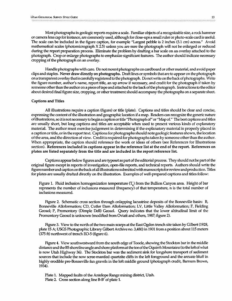
UTAH GEOLOGICAL SURVEY STYLE GlHDE 13
Most photographs in geologic reports require a scale. Familiar objects of a recognizable size, a rock hammer or camera lens cap for instance, are commonly used, although for close-ups a small ruler or photo-scale card is useful. The scale can be included in the figure caption, for example "Largest pebble is 2 inches (5.1 cm) across." Avoid mathematical scales (photomicrograph X 2.5) unless you are sure the photograph will not be enlarged or reduced during the report preparation process. Eliminate the problem by drafting a bar scale on an overlay attached to the photograph. Crop or enlarge photographs to emphasize significant features. The author should indicate necessary cropping of the photograph on an overlay.
Handle photographs with care. Do not mount photographs on cardboard or other material, and avoid paper clips and staples. Never draw directly on photographs. Draft lines or symbols that are to appear on the photograph ona transparent overlay that is carefully registered to the photograph. Do not write on the back of photographs. Write the figure number, author's name, report title, an up arrow if necessary, and credit for the photograph if taken by someone other than the author on a piece of tape and attached to the back of the photograph. Instructions to the editor about desired final figure size, cropping, or other treatment should accompany the photographs on a separate sheet.
Captions and Titles
All illustrations require a caption (figure) or title (plate). Captions and titles should be clear and concise, expressing the content of the illustration and geographic location if a map. Readers can recognize the generic nature of illustrations, so itis not necessary to begin a caption or title "Thotographof" or "Map of." The best captions and titles are usually short, but long captions and titles are acceptable when used to present various kinds of explanatory material. The author must exercise judgement in determining if the explanatory material is properly placed in a caption or title, or in the report text. Captions for photographs should note geologic features shown, the location ofthearea, and the direction of view. Credit is required for photographs taken by someone other than thea uthor. When appropriate, the caption should reference the work or ideas of others (see References for Illustrations section). References included in captions appear in the reference list at the end of the report. References on plates are listed separately from the title and are included in the report reference list
Captions appear below figures and are typeset as part of the editorial process. They should not be part of the original figure except in reports of investigation, open-file reports, and technical reports. Authors should write the figure number and caption on the back of all illustrations submitted with manuscripts for review and production. Titles for plates are usually drafted directly on the illustration. Examples of well-prepared captions and titles follow:
Figure 1. Fluid inclusion homogenization temperature (Th) from the Bullion Canyon area. Height of bar represents the number of inclusions measured (frequency) of that temperature, n is the total number of inclusions measured.
Figure 2. Schematic cross section through onlapping lacustrine deposits of the Bonneville basin: B, Bonneville Alloformation; CD, Cutler Dam Alloformation; LV, Little Valley Alloformation; F, Fielding Geosol; P, Promontory (Dimple Dell) Geosol. Query indicates that the lower altitudinal limit of the Promontory Geosol is unknown (modified from Oviatt and others, 1987; figure 2).
Figure 3. View to the north of the two main scarps at the East Ogden trench site taken by Gilbert (1928, plate 15 A; USGS Photographic Library Gilbert Archive no. 3,480) in 1901 from a position about 115 meters (375 ft) northwest of trench E0-5 (figure 6).
Figure 4. View southwestward from the south edge of Tooele, showing the Stockton bar in the middle distance and the B5 shoreline angle and shore platform at the toe of the Oquirrh Mountains (to the left of what is now Utah Highway 36). The Stockton bar was the sediment sink for longshore transport of sediment sources that include the now scree-mantled quartzite cliffs in the left foreground and the arcuate bluff in highly erodible pre-Bonneville fan gravels in the left middle ground (photograph credit, Barnum Brown, 1934).
Plate 1. Mapped faults of the Antelope Range mining district, Utah. Plate 2. Cross section along line B-B' of plate 1.

14 UTAH GEOLOGICAL SURVEY CIRCULAR 85 ::::: .................. :.:.:.:.:.:.::.::::::;:::::;:;:::::::::::::::::::::::: ....................................................................... :;:.::.:.:.:.:.:.:.:.:.:.:.:.:.:.:.:.:.:.:.:.:::.:.:.: .............................................................................................................................................................. .
Tables
Tables present difficult-to-display information (usually numerical data) in an orderly and concise manner. A well-thought-out table can replace several paragraphs of text. Tables should contain only information that is essential to the reader's understanding of the report and should not be duplicated in the text. Background information of secondary importance that the author wishes to include in a report for completeness is best placed in an appendix.
Simple tables are best. Complicated or long tables often are difficult to understand and may be ignored. Authors should consult Suggestions to Authors Seven, which contains detailed instructions for preparing tables, when a complex table is necessary. A table requires at least two columns and should fit upright on a single page whenever possible. Tables are numbered sequentially in the order of their appearance in the report. Unlike figures, table captions precede the body of the table. Abbreviations are acceptable in tables to save space. If abbreviations are used, their meaning must be clear to the reader. Footnotes are acceptable in tables. Footnote reference numbers are indicated in the table by superscripted numerals (123 ••• ), and are in numerical order from left to right across the table. Save additional space by placing units of measurement and orders of magnitude in column headings rather than carrying them through the table. Use the same primary system of measurement (English or International) in both the text and tables. It is not necessary to include unit conversions in tables. Do not leave blank spaces in a table. If a test or measurement was made without result, enter "D." I f no data are available, record "n.d." or "n.a." and explain with a footnote. If no entry is made, use a line. The following are examples of effective tables:
Trench·
MN-I
MN-I
MN-I
MN-2
MN-2
MN-2
MS-I
MS-I
MS-I
MS-l
Table 1. Radiocarbon ages and thermoluminescence (TL) age estimates from the
Mapleton North (MN) and Mapleton South (MS) trench sites.
Field Sample Laboratory Material Type Radiocarbon Calibrated I TL age Remarks Number Identification and Geologic age (I4C B.P.) Charcoal and estimate
Numbers Unit AMRTages (1 a error)l
MNI-RCI 3Beta-21306 Charcoal from 4454 5104 Post-MRE burn layer (±70) (+120, -190)
MNI-RC2 5Pitt-0188 Charcoal from 490 520 Post-MRE burn layer (± 65) (+120, -60)
MNI-RC3 Pitt-0189 Charcoal from 730 680 Pre-MRE unit 4s soil (± 40) (+40, -20)
MN2-RCI Pitt-OI91 Charcoal at 330 430, 360, 330 Charcoal at same stratigraphic unit 6/8 (± 50) (+70, -40) position as burn layer in trench MN-l. contact
MN2-RC2 Beta-21733 Charcoal from 770 690 2s soil in trench MN-2 correlates unit 2s soil (± 100) (+230, -140) with 4s soil in trench MN-l.
MN2-RC3 Pitt-I092 Charcoal from 850 740 Detrital charcoal stratigraphically unit IIA (± 35) (+160, -50) out of place.
MS-RCI Beta-23528 Charcoal from 1350 1290 Accelerator Mass Spectrometry ETH-3544 unit 4F (± 100) (+130, -230) (AMS) date.
MS-RC2 Beta-23527 Charcoal from 2810 2930, 2900, 2890 AMS date ETH-3543 unit 2s soil (± 95) (+280, -130)
MS-AMRTl Beta-26 I 17 Organics from 2890 2820 200 years subtracted from GRL-787-O unit 2s soil (± 80) (+150, -130) radiocarbon age prior to calendar
calibration to account for mean residence time of buried soil.
MS-TLl 6ITL-70 Unit 2s soil 3300 Collected at same location as (± 300) sample MS-AMRT I
I Calibration procedure after Stuiver and Reimer (1986); CALIB & DISPLAY software distributed by Quaternary Isotope Laboratory, Quaternary Research Center, University of Washington. 2~hdiocarbon age calibrated with CALIB software: 20-year atmospheric record, lab error multiplier of 2, method A used to calculate In~ercept~ and age range, age span of 0 except for MS-AMRTl for which an age span of 250 years was assigned to the organic SOIl fractIOn: See text for a discussion of AMRT-dating considerations. All calendar-corrected dates rounded to the nearest decade.
3Beta AnalytiC Inc., Coral Gables, FL 33124. 4All radiocarbon ages are report d· b f .. . sUni.. . e In years e ore present (yr B.P.); by conventIOn, present IS conSidered A.D. 1950. 6 .vers~ty of Pittsburgh, Apphed Research Center Radiocarbon Laboratory, Pittsburgh, PA 15238. Umverslty of Colorado, Center for Geochronological Research, Boulder, CO 80309.

UTAH GEOLOGICAL SURVEY STYLE GUIDE 15
Table 2. Univariate statistics for the Bullion Canyon data set, Antelope Range mining district. All values in parts per million:
Threshold for Ele- Max- Mini- Standard 90th Per- highly anomalous
Subset ment n* Mean imum mum** Deviation centile samples
Au 199 .23 7.19 .001 .85 .3 1.6
Ag 199 5.7 88.4 .1 Il.l 16 45.0 Vein Cu 199 368 6700 854 1050 2000
Samples Pb 199 1491 27,000 I 3599 4830 8000 Zn 199 1321 26,000 5 3086 3871 8000 As 199 112 3100 269 208 510
Au 51 .06 .82 .001 .13 .16
Ag 51 1.9 37.3 .1 5.3 3.1 Non- Cu 49 95 2600 380 150
Vein Pb 51 119 1800 227 201
Samples Zn 51 214 3800 359 254
As 51 69 380 91 228
Anomalous thresholds,
outliers removed
Au 195 .12 1.50 .001 .24 .32 .48 Vein Ag 195 4.7 40.1 .1 7.1 14.8 15.0
Samples eu 188 194 1900 356 647 800 with Pb 189 802 7800 I 1545 2627 3400
Outliers Zn 191 825 7700 5 1401 3083 3100 Removed As 195 81 500 92 182 225
*n = Number of samples
** = Minimum values or lower limit of detection
Table 3. Principal organisms found in Great Salt Lake, in general decreasing order of their tolerance to salinity
Common name
Red bacteria
Red brine algae
Biostrome blue-green algae
Green brine algae
Brine fly (two species)
Brine shrimp
Blue-green algae (several species)
Diatoms (four species)
Water boatman
Scientific name
Halobacterium sp. Halococcus sp. Dunaliella salina
Coccochloris elebens
Dunaliella viridis
Ephydra cinerea Ephydra hians
Artemia salina
Nodularia spumigena
Amphora coffeiformis Navicula graci/oides Navicula tripunctata Rhopalodia musculus Trichocorixa verticalis
Principal habitat (dates of occurrence)
Water and sediment of the northern part (1960-83)
Water of the northern part (1960-83)
Biostromes of the southern part (unknown-1983)
Water of the southern part (unknown-1983)
Water of the northern part (1983-86)
Sediment and biostromes of the southern part ( unknown-1986)
Water of the southern part ( unknown-1986)
Water of the northern part (unknown-1986)
Water of the southern part (1983-86)
Do. Do. Do. Do. Shallow surface water of the
southern part (1973-86)

16 UTAH GEOLOGICAL SURVEY CIRCULAR 85
Equations and Formulas
Type mathematical equations and chemical formulas in the line of text whenever possible. This is especially true if they are short and contain no special symbols, for example: FeC03, y = 5.7x + IS, or pH + pOH = 14. Set complex equations or formulas and those that require more than one line out of the text as follows:
& = 12.76 + P(L + [L + (Z2 + R2) ~ - ([z + L]2 + R2) ~])
where: & = Gravity anomaly (in microgals) at the radius where the average drawdown (L) occurs.
P = Change in water density (in g/ cm3), use specific yield for P because the density of most
shallow water is 1 g/ cm3 and therefore S = P. y
L = Thickness of the layer (in feet) in which the density changed. Use a value equal to the averagedrawdown within thedrawdownconeto a radius where the drawdown is roughly 2 percent of the drawdown at the well bore for L.
z = Depth to water table before drawdown (in feet).
R = Radius used to calculate L (in feet).
Number related equations or formulas in the report in the order which they appear in thetextfor easy reference by the author and ease of understanding by the reader.
Eq.l y(h) = 2.0 + 8.5[(1.5hP) - (0.5h3/27)], h < 3
Eq.2 y(h) = 2.0 + 8.5 = 105, h ~ 3
Rules for formulas and equations in the report text are as follows:
1. A space precedes and follows plus, minus, multiplication, greater than,less than, and equal signs. The slash symbol (/) when used to indicate division is not set off with spaces.
2. If unavailable in typewritten or digital format, carefully write Greek letters, other special symbols, and superscripts and subscripts on draft manuscripts.
3. Use parentheses () and square brackets [] whenever possible; brackets {} are difficult to print.
4. Use fractional exponents (5 112), not square roots.
5. Show the valence of ions as Ca2+ not Ca++.
6. Isotope numbers precede the element (14C).
THE MANUSCRIPT
~anusorlptPreparation
The a~thor must prepare a properly formatted manuscript before submitting a report to the senior geologist ~or forrn:u reVIew. A complete manuscript is one that is well organized, legible, includes review copies of all Illustrations and tables, and incorporates the elements of UGS editorial style. Oear photostatic or blue-line copies

UTAH GEOLOGICAL SURVEY STYLE GUIDE 17
are adequate for most illustrations; however, it may be necessary to provide prints of photographs if they do not reproduce well on a copy machine. Manuscripts submitted to the senior geologist for formal review must include a UGS Document Routing Form (Appendix B).
Page Format
The following rules apply to UGS manuscripts submitted for review:
1. Type the manuscript double spaced on good quality white paper. The double-spacing requirement applies to all copy without exception including the title page, abstract, captions, quoted matter, and references.
2. Use 10-point or larger type and avoid condensed-face type styles (for example, Helvica 10-point condensed).
3. Leave margins of at least 1 inch (2.5 em) on both sides and at the top and bottom of each page.
4. Do not right justify the text.
5. Place page numbers at the bottom center of each page beginning with the abstract.
6. Indent the first line of each paragraph five spaces, and leave a blank line between paragraphs.
7. Type tables separately and place them behind the page on which they are first mentioned in the text
8. Place review copies of text figures behind the page on which they are first mentioned in the text. Review copies of figures and plates should include the complete caption and the figure/plate number. Original illustrations submitted to the editor for production should have the name of the report, name(s) of the authors, caption, up arrow if necessary, and figure/plate number written on the back (use tape to protect photographs).
9. Do not break words at the end of the line; during typesetting the hyphen might be mistaken for part of the spelling.
10. Underline words to be printed in italics.
Section Headings
For most reports, no more than four levels of section headings are necessary. If more than four levels are needed, consider reorganizing the report.
First-level headings: First-level headings are main section titles. Headings such as ABSTRACT, INTRODUCTION, STUDY METHODS, and REFERENCES are in this group. Two blank lines separate a first-level heading from the preceding text. Center first-level headings and type in all CAPITAL LEITERS.
Second-level headings: Second-level headings are subdivisions of each major section. Subdivision of a main section requires at least two second-level headings. A single blank line separates second-level headings and all subsequent headings from the preceding text. Center second-level headings and type in Upper and Lowercase Letters.
Third-level headings: Third-level headings are subdivisions of second-level headings. At least two third-level headings are required if a second-level heading is subdivided. Left justify third-level headings and type in Upper and Lowercase Letters.

18 UTAH GEOLOGICAL SURVEY CIRCULAR 85
Fourth-level headings: Fourth-level headings are usually the smallest division in a report. They subdivide third-level headings into two or more parts. Left justify fourth-level headings and capitalize only the first letter of the heading (plus proper names); the heading should end ina colon and is underlined. The text continues two spaces after the colon.
Pagination
Review manuscripts are paginated consecutively at the center bottom of each page beginning with the abstract. If the report includes a glossary or a single appendix, they are paginated consecutively with the report text. If the report contains more than one appendix, each appendix is assigned a letter designation (appendix A, appendix B, and so on) and is paginated separately. Page numbers within appendices are proceeded by the letter of the alphabet that corresponds to each appendix (AI,A2, A3, BIO, BII,C22, C23). Page numbers in printed publications are assigned by the editor during the publication production process.
Digital Format
Most authors compose UGS reports on desk-top computers using word-processing software to create an electronic manuscript. System compatibility may become a problem if an author uses a word-processing program other than the one used by the UGS. In those instances, the author should submit both a paper (hard) copy of the manuscript and a 5.25 inch (13.3 cm) diskette with the manuscript and any digital data files in MS-DOS ASCII format. Authors requiring assistance with format conversion should consult with UGS data processing personnel. Graphics files must be compatible with currentUGS graphics software. Check with the editor for current software specifications.
Copyrighted and Proprietary Material
It is the author's responsibility to obtain permission to use copyrighted or proprietary material in their reports. Written permission must accompany the manuscript when it is submitted to the senior geologist for formal review. Manuscripts not accompanied by permission will be returned to the author. The author should credit the use of copyrighted and proprietary material in the Acknowledgments section of the report, unless a fee is paid for the use of the material. Some publishers may request credit in the text or in an illustration or table caption. Authors should comply with the publishers request Although government-produced reports and maps are not subject to copyright, authors should give credit for their use as a courtesy.
Utah Geological Survey publications are in the public domain and are not copyrighted. Scientific journals and other outside publications may not claim a copyright on material prepared by UGS employees as part of their official duties. Utah Geological Survey authors must include the following copyright transfer form with manuscripts submitted for publication outside of the UGS.
COPYRIGHT TRANSFER FOR UTAH GEOLOGICAL SURVEY AUTHORS
Date: __________________________________________________________ __
Title of manuscript: ________________________________________________ _
Th~ ~nusc~pt named above was prepared as part of my (our) official duties as an employee of the state of Utah. The manuscnpt lS thus m the public domain and neither it nor any article prepared from it can be copyrighted.
Signatures of UGS author(s) : -------------------------------------------
Authors who receive a request to reprint one of their UGS reports or outside articles should grant permission and request that the UGS be properly acknowledged.

UTAH GEOLOGICAL SURVEY STYLE GWDE 19 ...... :.: ... :.:.: ... : ........... : ...•...•.•.•...........•.....•...•.........•.....• ;.;.:.;.; •.....•.........•.......................................................• ; ..................................•.. ;: ...............•................ ;.; ........................•........................................................... ';:;:;:;:;:;:;:;:;:;:;:;:;:;:;:;:::;:;:;:;:;:;:;:;:;:::;:; ......•...............................•...........•.•...........•...........................•...•...............•...........
MAlTERS OF STYLE Abbreviations and Symbols
Abbreviations and symbols constitute a form of shorthand used in scientific writing to avoid repetition of long, awkward, or frequently used words and phrases. They are particularly useful in illustrations and tables where space is limited. As a general rule, abbreviations are used sparingly in the text of UGS reports. Abbreviations standardized through common use need not be defined when used; for example, "a.m." for ante meridiem and "$" for dollars. Place less well-known abbreviations and those that are unique to a report in parentheses following the spelled-out form the first time they are used; for example, "net vertical tectonic displacement (NVTD)," and NVTD thereafter.
Appendix C is a compilation of abbreviations used in UGS reports. Lists of abbreviations are also available in Suggestions to Authors Seven; the U.S. Government Printing Office Style Manual, 1984; The Chicago Manual of Style (thirteenth edition); and Webster's Third New International Dictionary (unabridged seventh edition).
General Rules
Rules for the use of abbreviations and symbols in UGS publications include:
• Do not use an abbreviation unless you plan to use it more than once.
• H abbreviations or symbols are used in a report, use them consistently throughout the document.
• Spell out abbreviations that begin sentences, except for commonly abbreviated words that are never spelled out (for example Mr., Ms., ASTM).
• Use a single period when an abbreviation ends a sentence. H the sentence ends with a question mark or an exclamation point, place them after the period used with the abbreviation. The same rule applies to colons, semicolons, and commas within a sentence.
• Spell out abbreviated words that are connected to other words by hyphens (3-meter displace ment, not 3-m displacement).
• Do not abbreviate the names of months and days in the report text. Their abbreviation is acceptable in illustrations and tables to save space.
• Do not abbreviate geographic names or geologic terms (for example, VB for Uinta Basin or WFZ for Wasatch fault zone) in the report text no matter how frequently they are used.
• Eliminate periods after abbreviations except where required by convention (see appendix C). Spaces are not needed between joined abbreviations (U.S. Geological Survey, Washington D.C.)
• Do not use the symbol fonn of an abbreviation (38.1 percent, not 38.1 %) except in illustrations, formulas, and tables to save space. Exceptions are the dollar sign "$" ($156,730,769 in annual sales), the degree mark "0" (63°F, N. 34° E.), and chemical symbols (K-Ar dating methods).
• Use parentheses and brackets when necessary in mathematical expressions for clarity ([7yl x 36 = [15z] x 12).
• A void using abbreviations in a reference list except for the following: (1) abbreviations or acronyms used in a title, (2) no., v., pt., and p., 3) Inc., (4) M.S. and Ph.D., (5) U.S. and D.C., and (6) No. if used as part of a title.
• When in doubt, spell it out.

20 UTAH GEOLOGICAL SURVEY CIRCULAR 85
Degree Mark
The degree mark "0" is used with numerals in statements of temperature, strike, dip, bearing, azimuth, latitude, and longitude. The word "degree" is generally written out when reporting angles and slope (except in tables or where space is otherwise limited). No spacing is used with the degree mark when reporting temperature. Do not use a degree mark when reporting Kelvin temperature. A space follows the degree mark in terms of direction.
32°F equates to O°C and 273.15 K strike N. 66° E., dip 46° E. a bearing of S. 35° W. equates to an azimuth of 215° latitude 400 4S'IS'N. or 40045.25'N. longitude 112°33'30'W. or 112°33.5'W. the ground surface slopes 33 degrees to the north a right angle equates to 90 degrees
Land Tract Designations
Report descriptions of tracts of public land as follows:
NWl/4SEl/4 section 16, T. 17N., R. 11 W., of the Salt Lake Base Line sections 12 and 16, T. 42 5., R. 3 E., Uinta Base Line
Latin Abbreviations
The use of Latin abbreviations is discouraged in UGS reports, the written-out English equivalent is preferred.
Latin Abbreviation
ca. (circa) d. (confer) e.g. (exempli gratia) etc. (et cetera) et al. (et alli) i.e. (id est)
Lithologic and Time-Stratigraphic Terms
Preferred UGS Usage
about a given date compare or see for example and so forth and others that is
Do not abbreviate lithologic and time-stratigraphic terms in the report text. Abbreviations are acceptable in illustrations and tables when necessary to save space. Capitalize lithologic abbreviations when they follow a formal rock-unit name (for example, Navajo Ss.). When used informally to refer to a general rock type, the lithologic abbreviation is lowercase (sandstone, ss.). Always capitalize time-stratigraphic abbreviations.
Term or Litholo~ Abbreviation Formal Informal
Group Gp. Formation Fm. Member Mbr. mbr. Sandstone SSe SSe Siltstone Sits. sits. Shale She she Mudstone Mdst. mdst. Claystone Oyst. dyst. Limestone Ls. Is. Dolomite Dol. dol. Conglomerate Cgl. cgl. Quartzite Qzt. qtz. Granite Gr. gr.

UTAH GEOLOGICAL SURVEY STYLE GUIDE 21
Gneiss Gn. gn. Rhyolite Rhy. rhy. Volcanics Volc. vole.
System, Period, Era Abbreviation S~bol Quaternary Quat. Q Tertiary Tert. T Cretaceous Cret. K Jurassic Jur. J Triassic Tri. R Penman Perm. P Pennsylvanian Penn. P Mississippian Miss. M Devonian Dev. D Silurian Silo S Ordovician Ord. a Cambrian Camb. {:
Cenozoic Cen. Cz Mesozoic Mes. Mz Paleozoic Pal. pz Precambrian Prec. p€
Number
The abbreviations "no." and "No." for number often lead to confusion. The lowercase no. refers to serial numbers (no. 14558-789-D) and the number in a publication citation (v. 6, no. 12). The uppercase No. identifies individual data points in a series or collection (specimen No. 567).
Time
Age estimates: The abbreviations ka for kilo-annum (thousand years), Ma for mega-annum (million years), and Ga for giga-annum (billion years) are reserved for reporting geologic ages (North American Stratigraphic Code, 1983). Time measured from the present is implicit in ka, Ma, and Ga; therefore, neither "before present" nor "ago" are added to these abbreviations (Colman and others, 1987). Radiocarbon dating has established the use of yr B.P. (years before present) to indicate 14(: ages measured from A.D. 1950. To avoid confusion, restrict the use of yr B.P. to radiocarbon ages (Colman and others, 1987). Calendar-calibrated radiocarbon ages are reported as cal B.P. (calendar years before present) (Stuiver and Pearson, 1986).
When calendar-calibrated, a 14(: age of 590 ± 60 yr B.P. on charcoal from a pre-event burn layer exposed in trench TR-6 indicates that the most recent event (MRE) on the middle segment of the Red Rock fault occurred after 540 cal B.P.
A 40 Ar f39 Ar age of 986 ka and a K-Ar age of 1.22 Ma identify the age of the tuff unit as early Pleistocene, and nearly 10 million years younger than previously suspected.
Geologic time; The abbreviations ''ky'' for thousands of years and "m1' for millions of years are acceptable in illustrations, tables, and where space is otherwise limited. A void using abbreViations for intervals of geologic time in the report text.
The beginning and the end of the Cretaceous Period are calibrated at 138 million years ago and 66 million years ago respectively (Hansen, 1991); the interval of time represented by the Cretaceous is 72 million years.
The phrase "years B.P." (notyr B.P.) may be used to indicate an interval of time extending from the present into the past.
Approximately 14,500 years B.P., Lake Bonneville breached its outlet at Red Rock Pass near Zenda, Idaho and

22 UTAH GEOLOGICAL SURVEY CIRCI.1LAR 85
rapidly drained to the level of the Provo shoreline (elevation 1,445 meters [4,740 ft]; estimated age 14,000 to 14,500 years old).
Calendar dates: The two epochs of the Gregorian calendar are abbreviated "A.D." for "anno Domini" (in the year of our Lord), and I'B.C." (before Christ). Note the order in which the abbreviations are used:
621 B.C. A.D. 1950
Use numerals for all dates.
February 1950 February 14, 1950 14 February 1950 the 14th of February, 1950 March 21, 1949, to February 14, 1950 1981-82, but 1998-2001
Clock time: Use "a.m." (ante meridiem) and "p.m." (post meridiem) with numerals to denote clock time (3 a.m. or 7:15 p.m.). Time zones in the conterminous United States are abbreviated e.s.t., c.s.t., m.s.t., and P.s.t. For daylight saving time, use e.d.t., c.d.t., m.d.t., and P.d.t. Other time zones are spelled out the first time used.
Capitalization
Rules governing capitalization are numerous and subject to many exceptions. The following rules are those commonly applied in UGS reports.
• Capitalize the first letter of the first word of sentences.
• Capitalize the first letter of all proper names. Do not capitalize conjunctions, short prepositions, and articles (for example: a, an, and, of, and the) in long proper names unless they are the first word in the name. Personal titles are capitalized only when they appear before a proper name.
•
•
Professor Richard Lewis Dr. Richard Lewis is a professor of geology Marriott library Rich County Daggett and Uintah Counties Weber and Provo Rivers Utah Geological Association
Capitalize all important words in the titles of books, articles, and reports that appear in the report text (for example, Geology of Utah by William Lee Stokes). Note that titles in a reference list are an exception (see The Reference List section and Suggestions to Authors 7, p. 239).
Capitalize hyphenated words in titles and headings except for conjunctions, short prepositions, and articles unless they appear as the first word.
Open-File Report 88-546 Water-Supply Paper 16 State-of-the-Art Geophysical Techniques
• Capitalize political divisions when they follow a proper name and form a part of it. Political divisions are lowercase when they precede a proper name or refer to a general group.

UTAH GEOLOGICAL SURVEY STYLE GlUDE 23
Utah State state of Utah Sandy City city of Sandy the state the Federal Government federal agencies federal and state employees
• "State" and "federal" are lowercase when they refer to a geographic area rather than a political (legislative) entity.
largest mountain range in the state federal land in the state of Utah
• The full names of legislative, administrative, and judicial bodies, departments, bureaus, and offices are capitalized. The nouns derived from them are capitalized when they pertain to a specific organization, but are lowercase when they refer to a general group.
Utah Geological Survey the Survey [UGS] [Utah] State Legislature the several state legislatures Department of Natural Resources Department of Natural Resource divisions
• Capitalize the name of biological phylum, class, order, family, or genus, but not species, subspecies, or variety.
Foraminifera Bathymyonia Spiriferina (Punctospiri/er) pulcher
• Capitalize the names of geologic eras, periods, systems, series, epochs, and ages
Precambrian Triassic Period Ordovician System Eocene Late Jurassic Epoch Keweenawan Age Wisconsin Glaciation
• The names of formal rock-stratigraphic units are proper nouns and are capitalized.
Navajo Sandstone Morrison Formation Belt Supergroup Sinbad Limestone Member
A sequence of formation names such as the Navajo Sandstone, Moenkopi Formation, Twin Creek Limestone, and Mancos Shale can for convenience be written as the Navajo, Moenkopi, Twin Creek, and Mancos Formations. Note that ''Formations'' is capitalized.

24 UTAH GEOLOGICAL SURVEY CIRCI.lLAR 85
• Do not capitalize unitterms (lithology or formation) in the names of informal rock-stratigraphic units (North American Stratigraphic Code, 1983).
formation of Aurora Huckleberry Ridge ash bed Left Creek quartzite
• Proper geographic names are capitalized, but areas of indefinite extent are lowercase.
Monument Valley Wasatch Range Great Salt Lake Island in the Sky Salt Lake City area
• By convention, mining district, oil field, gas field, field, mine, smelter, and other terms related to mineral or hydrocarbon extraction and processing are not capitalized when included as part of a proper name.
City Creek mining district Grassy Trail Creek oil field Bingham Canyon mine Black Rock smelter
• The terms "province" and llsection" are generally considered common nouns, and as such are not capitalized. However, long usage when referring to particular physiographic regions has resulted in their being considered part of the proper name for those regions, and as such they are capitalized. Examples include:
Basin and Range Province Lower California Province Blue Mountain Section
but Colorado Plateau province Great Plains province Middle Rocky Mountains section
Suggestions to Authors Seven (page 88) presents additional information on this topic.
• Structural geologic terms such as caldera, anticline, syncline, fault, arch, and so on are not capitalized when included as part of a geologic name.
White Springs caldera Sulphur Creek anticline Wasatch fault zone Paradox basin (a geologic feature)
Note that some geologic names through long association with a geographic area are now capitalizedbyconvention. Refer to the U.S. Geological Survey (1988) l:500,OOOscale topographic map of the State of Utah to determine which geologic terms fall into this category. Examples include:
San Rafael Swell Upheaval Dome Waterpocket Fold

UTAH GEOLOGICAL SURVEY STYLE GlUDE
• The geochronologic terms "early, middle, and late" and the chronostratigraphic terms "lower, middle, and upper" are capitalized when used as part of a fonnal geologic time or rock series name, but are lowercase when used informally (see Divisions of Geologic Time section).
• "Quadrangle" is not capitalized when used as part of a proper name, for instance, the Park City East quadrangle, but is capitalized when citing a USGS geologic quadrangle map (a publishing series) - USGS Quadrangle Map GQ-126.
• Do not capitalize the words "figure," "table," and "appendix" when they are used in the report text unless they appear as the first word in a sentence.
Geographic Names
25
Formal names proposed for geographic (geomorphic) features must comply with naming requirements established by the U.S. Board on Geographic Names. Formal names currently accepted are listed in the USGS Geographic Names Information System computer database. Authors proposing new fonnal geographic names in UGSreports should consult with the editor, who is the UGSrepresentativeon the Utah Geographic Names Committee (an affiliate of the U.S. Board of Geographic Names). Authors should clearly identify all informal geographic names used in UGS reports.
Geologic Names
Geologic names are assigned to formal and informal rock-stratigraphic units, structural features, and divisions of geologic time. Rules applying to the use of geologic names are summarized below. A detailed discussion of the issues associated with the use of geologic names is contained in Suggestions to Authors Seven and the North American Stratigraphic Code (1983).
Rock-Stratigraphic Units
In order to make a geologic map, geologists must subdivide the rocks comprising the earth's crust into recognizable units based on their physical characteristics and, when possible, geologic age. Formal rock-stratigraphic units are defined in accordance with the current or previously accepted versions of the North American Stratigraphic Code (1933, 1961, 1970, 1983), or they have achieved acceptance through long usage prior to adoption of the codes. Informal rock-stratigraphic units are sometimes usefulloca1ly but, for whatever reasons, they do not comply with the requirements of the current stratigraphic code. Use informal rock-stratigraphic units in UGS reports with care, and in all cases, clearly identify them as informal units.
The first time a fonnal rock-stratigraphic unit name is used in a report, write out the complete name (both geographic name and rank). Thereafter, authors may, at their discretion, refer to the unit by its geographic name only. For example, use "Chinle Formation" initially and "Chinle" in subsequent reference to the rock unit.
If an author wishes to establish a new formal rock-stratigraphic unit in a UGS publication, the proposed unit must meet all the requirements of the North American Stratigraphic Code (1983). The USGS Geologic Names Committee maintains a record of all formal rock-stratigraphic unit names of the United States as they are used in publications. The committee's records are available for reference to all geologists. Utah Geological Survey authors should consult with the USGS Geologic Names Committee before proposing a new rock-unit name.
Structural Geologic .Features
There are no rules equivalent to the North American Stratigraphic Code (1983) for naming geologiC structural features. Authors may choose names as they see fit, provided that the feature has not been named previously in the literature. Common sense, good taste, and close adherence to the rule of precedence serve as the guides for authors proposing to name structural features in UGS publications.

26 UTAH GEOLOGICAL SURVEY CIRCULAR 85
Divisions of Geologic Time
The major divisions of geologic time (Eons, Eras, Periods, and Epochs) have been established through long use and careful study. Nevertheless, disagreement exists regarding the exact ages of the boundaries between some time divisions (Palmer, 1983; Snelling, 1985; Hansen, 1991). The UGS accepts the geologic time scale proposed by the USGS Geologic Names Committee in 1980 and published in Suggestions to Authors Seven (figure 3). Authors choosing to use an alternative time scale must clearly state which scale they are using and why it is better sui ted to their purpose.
A clear distinction exists between divisions of geologic time (geochronologic divisions) and divisions of stratigraphic position (chronostratigraphic divisions). Figure 3 shows the major series and provincial series terms used in the United States. Provincial series terms used in UGS reports should conform to those in common use in North America. However, European stage terms are used for divisions of the Upper and Lower Cretaceous in most of the United States, including Utah. Note that in figure 3 ''Early,'' "Middle," and "Late" denote relative position in time, while the terms ''Lower,'' "Middle," and "Upper" denote similar distinctions of stratigraphic position. Where shown infigure3, these terms are part of the formal time and series names and are capitalized accordingly (LatePe rmiantime, Middle Triassic red beds). Where not shown in figure 3, these terms are informal and are not capitalized (early Holocene age, lower Tertiary rocks).
Italics
Italicized words are underlined in the draft manuscript. The following rules apply to the use of italics in UGS reports.
• Use italics for titles of works that are individually published or produced such as books, maps, magazines, newspapers, plays, and movies. Enclose titles of individual papers in a scientific journal, chapters in a book, and newspaper articles and editorials in quotation marks. Do not italicize them (see Quotation Marks section).
• Italicize formal names of genera, species, subspecies, and varieties of plants and animals. Do not italicize the names of phyla, classes, orders, and families.
• Use italics for the names of vessels, aircraft, and spacecraft; for example, the research vessel Glomar Challenger, and the Voyager spacecraft.
• Italicize the preposition "in" when citing a reference contained in another document.
Todd V.R., 1983, Late Miocene displacement of pre-Tertiary and Tertiary rocks in the Matlin Mountains, northwestern Utah, in Miller, D.M., Todd, V.R., and Howard, K.A., editors, Tectonic and stratigraphic studies in the eastern Great Basin: Geological Society of America Memoir 157, p. 61-74.
• Italicize the names of legal cases, for example, Jones v. Entwhistle et al. Note that the legal profession has a set of standard abbreviations all its own.
• Italics are not used in UGS publications for emphasis or for foreign words.
Lists
It is often necessary to display or organize a group of related items in a report. For large volumes of material or data that are related in some systematic way, a graph or table is often the best method of presenting the information. However, in many cases, a simple list will suffice. Authors may incorporate lists within a sentence or display them vertically.
Sentence Lists
If a list ~s sh~rt and s~ple, incorporate it directly into a sentence. Numerals or letters enclosed in parentheses may be used to Identify each Item in a sentence list. Lists incorporated in a sentence are not preceded by a colon if the list follows a preposition or a verb.

UTAH GEOLOGICAL SURVEY STYLE GWVE .................................................... ................
Subdivisions (and their symbols) Eon or Era or Period, System,
Eonothem Erathem Sub period, Subsystem Epoch or Series
Quaternary 2 Holocene (Q) Pleistocene
Neogene 2 Pliocene Cenozoic 2 Subperiod or
(Cz) Subsystem Miocene Tertiary
(T) Paleogene 2 Oligocene Subperiod or Eocene
Subsystem Paleocene
Cretaceous Late Upper (K) Early Lower
Late Upper
Mesozoic 2 Jurassic
Middle Middle (Mz) (J)
Early Lower
Triassic Late Upper
('R) Middle Middle Early Lower
Permian Late Upper (P) Early Lower
Phanerozoic 2 Late Upper
Pennsylvanian Middle Middle
(11) Early Lower
Mississi ppian Late Upper (M) Early Lower
Late Upper Devonian Middle Middle
Paleozoic 2 (D) Early Lower
(pz) Late Upper Silurian Middle Middle
(S) Early Lower
Late Upper Ordovician
Middle Middle (0)
Early Lower
Late Upper Cambrian
(C) Middle Middle
Early Lower Late None defined Proterozoic (Z)
Proterozoic Middle None defined (E)
Proterozoic (Y)
Prot~~iC (X) None defined Late None defined
Archean Archean (W)
A~~~~e(V) None defined (A)
Arc~~I.r (U) None defined
pre-Archean (pA) •
Age estimates of boundaries in
mega-annum (Ma) 1
0.D10
1.6 (1.6 - 1.9)
5 (4.9 - 5.3)
24 (23 - 26)
38 (34 - 38)
55 (54 - 56)
66 (63 - 66)
96 (95 - 97) 138 (135 - 141)
205 (200 - 215)
-240
290 (290 - 305)
-330
360 (360 - 365)
410 (405 - 415)
435 (435 - 440)
500 (495 - 510)
-570 3
900 1600 2500
3000 3400 3800 ?
lRanges reflect uncertainties of isotopic and biostratigrapic age assignments. Age boundaries not closely bracketed by existing date shown by -. Decay constants and isotopic ratios are cited in Steiger and Jager (1977). Designation m.y. used for an interval of time.
2Modifiers (lower, middle, upper or early, middle, late) when used with these items are informal divisions of the larger units; the first letter of the modifier is lowercase.
3Rocks older than 570 Ma also called Precambrian (pO, a time term without specific rank. 'lnformal term without specific rank. 5From Palmer (1983) uncertainty in parentheses. 6Cretaceous from Palmer (1983); Mississippian, Pennsylvanian, and Permian from Cosuna Chart (Hintze, 1985).
Figure 3. Geologic time scale (after Hansen, 1991).
27
Other age Age and stage
estimates names commonly used in Utah
1,5 1,6
0.01
1.6
5.3 r--- 66.4
Maastrichtian 74.5 (4) 23.7
36.6 Campanian 84.0 (4.5) Santonian
87.5 (4.5) 57.8 Coniacian
88.5 (2.5) 66.4 - Turonian
91 (2.5)
~:anian 97.5 (2.5) 97.5 -144 -
~~ 113 (4) 119 (9)
163 (15) Neocomian 144 (5)
187 (34)
208 (18)
230 (22)
240 (22) ~oan 250
245 (20~ - 255 Guadalupian
258 - ~nardian 270 275 286 (12)- Wolfcampian
fugilian 290
Missourian Desmoinesian 310
320 - Atokan Morrowan
L...- 330 360 (10)- Chesterian
340 374 (18) Meramecian
Osagean 387 (28) Kinderhookian 408 (12)
L....-- 365
421 (12)
438 (12)
458 (16)
478 (16)
505 (32)
523 (36)
540 (28)
570
900 1600 2500
3000
3400
3800 ?

28 UTAH GEOLOGICAL SURVEY CIRCULAR 85
Descriptions of samples collected by the authors accompany analytical data for Au, Ag, Cu, Pb, Zn,andAs.
Selection of anomalous thresholds involved the application and comparison of three standard statistical techniques: (1) the mean plus two standard deviations, (2) the 90th percentile, and (3) prominent gaps in histograms.
Commas normally separate items in a sentence list. If the items include commas, and numerals or letters are not used to identify each item, separate the items with semicolons.
Vertical Lists
The board members present included: Mr. James Berry, Chairman; Mr. Ralph Huges, SecretaryTreasurer; Mr. L.E. Smith, Chief Financial Officer; and Mr. Robert Kinley, Ex officio member.
A list that is long, contains complete sentences, or merits special emphasis should be indented and displayed vertically. Numerals, letters, bullets, or dashes can be used to identify the items in a vertically displayed list. Numbers or letters mayor may not imply a particular hierarchy of items in the list, but in either case are useful if the items are referred to in the text. The use of bullets or dashes implies that there is no particular order to the items in the list.
Normally a colon at the end of an introductory sentence introduces a vertically displayed list. However, if the introductory sentence is long and the anticipatory word or phrase occurs early in the sentence, or if another sentence comes between the introductory sentence and the list, the introductory sentence ends with a period. Use at least one blank line to separate items in a vertical list.
A genetic model of mineralization in the Antelope Range mining district is presented below. Elements discussed in the model are depicted in figure 18.
1. Northwest-striking, extension-related faulting (middle to late Miocene) in the area largely preceded mineralization and alteration. Faults produced during this deformation host all known occurrences of mineralized veins.
2. Eruption of rhyolitic flows and intrnsionof possible subvolcanic rocks occurred 8.5 to 8.4 million years ago.
3. Heat derived from emplacement of rhyolitic magmas induced a hydrothermal system in the surrounding host rocks. Extensional structures served as conduits for rising, dominantly meteoric, hydrothermal solutions.
If a vertical list consists of a series of complete sentences, capitalize the first letter of the first word of each item and end the items with a period. If the items in a vertical list complete the introductory sentence a colon is still required, the items are not capitalized, each intermediate item is followed by a comma, and the last item in the list ends with a period.
The investigation of the Red Rock fault zor~~ proceeded by:
1.
2.
3.
4.
mapping the surficial geology along the fault zone at 1:12,000 scale,
excavating trenches across single- and multiple-event scarps identified during the mapping,
logging the trench walls to determine the number and size of paleoearthquakes, and
collecting samples of organic material (charcoal and bulk soil organics) for radiocarbon dating.
All lists, whether in a sentence or displayed vertically, must maintain parallel structurebybeginnin geachitem with the same part of speech (noun, adjective, verb).

UTAH GEOLOGICAL SURVEY STYLE GUIDE
Numbers
General Rules
The following rules apply to the use of numbers in UGS reports.
1. Use numerals in the text for numbers of 10 or larger. Numbers smaller than 10 are spelled out except for serial numbers and expressions of time, measurement, money, and percent.
8:00a.m. 3 meters $20.00 7 percent 24 samples,
but eight people three wells
2. Use a comma to separate groups of three digits to the left of a decimal point in numbers of 1,000 or larger except for page and serial numbers and dates. Do not use commas to the right of a decimal point.
5,271 14,629
12.4269 no. E-462591-15-326A p.1148 February 14, 1950
3. Use a combination of numerals and words for round numbers larger than 1 million.
$37.5 million 4 billion years,
but 425,000
$13,256,630.56
4. Write out numbers that begin a sentence. Try to avoid beginning a sentence with a very large number.
5. Form the plural of a number expressed as a numeral by adding a lowercase "s." Note that this usage does not conform to USGS style which uses an apostrophe with the "s." Form the plurals of numbers that are written out in the same way as the plurals of other words.
The organization doubled in size during the 1980s. Temperatures will reach the high 90s today. The values are all in the low thirties.
6. Write out indefinite expressions or exaggerations, but use numerals for approximations based on experience or fact.
We must have received a thousand inquiries today.
The conclusions are based on about 2,000 analyses.
29

30 UTAH GEOLOGICAL SURVEY CiRClU..AR 85
7. Use numerals when two or more related numerical expressions are grouped together in a sentence, even if the numbers are less than 10.
The inventory consisted of 6 lengths of drill pipe, 2 drill bits, 14 bags of cement, and 3 core boxes.
Decimals and Fractions
Rules for the use of decimals in UGS reports are as follows:
1. Use decimals rather than fractions whenever possible.
2. Always represent decimals with numerals; do not write them out.
3. If a decimal is not associated with a whole number, insert a zero before the decimal point (0.56 not .56).
4. Retain zeros after a decimal point only if they are significant figures (3.208 but not 3.200 unless both zeros are significant).
Rules for using fractions include:
1. Replace fractions with decimals whenever possible.
2. Use numerals when fractions express a measurement.
~-inchpipe 6 ~-inch 0.0. well casing
3. Spell out and hyphenate fractions that stand alone in the text.
The project is two-thirds complete.
Significant Figures
When presenting numerical data, report only digits that legitimately convey actual information. A significant figure is any digit that is necessary to define the accuracy of a specific value or quantity resulting from a measurement or an arithmetic computation. The concept of significant figures does not apply to whole numbers thatreprese ntexact counts such as the number of ore samples submitted to a laboratory, or to defined constants such as pi that consist of an infinite number of significant digits. Two definitions are important when considering significant figures:
Accuracy: The error-free level or degree of confonnity to which a calculated value corresponds or approaches a true or specified value. The smaller the error, the greater the accuracy.
Precision: The extent to which a measured value can be reproduced or repeated, or the degree of mutual agreement between individual measurements.
Some values exhibit the characteristics of both accuracy and precision. For example, radiocarbon age estimates are accurate to the degree that they correctly estimate the true age of the material, and precise to the extent that the results of the dating process are reproducible in the laboratory.
Because a result cannot be more accurate or precise than the data from which it was obtained, the significant figures reported for a result cannot exceed the significant figures of the least accurate piece of data used to obtain the result. Numbers used in making calculations or obtained from a series of observations should be rounded to conform to the significant figures of the least accurate value involved. Guidelines for determining significant figures are presented below.

UTAH GEOLOGICAL SURVEY STYLE GWDE
1. The digits 1 through 9 are always significant regardless of their position in a number.
2. The digit 0 is significant only if it occurs between other significant digits. A 0 is not significant when placed to the right or left of a number to fix a decimal place. For example, the number 0.00057 has two significant figures, but 703.01 has five significant figures.
3. Zeros that appear at the end of an umber may or maynotbe significant When they are, it should be clearly stated. Writing the number in scientific notation can remove any uncertainty. For example, write 572,000 as 5.72000x1OS if the zeros are significant, and 5.72x1OS if they are not significant.
4. When rounding numbers to !1 significant figures, all digits to the right of the nth digit are dropped. Rules for rounding are as follows:
• If the first discarded digit is greater than 5, add 1 to the nth digit (45.7882 rounded to four significant figures is 45.79).
• If the first discarded digit is less than 5, leave the nth digit unchanged (rounded to four significant figures 45.7832 is 45.78).
• If the first discarded digit is 5 and all following digits are zeros, round the nth digit to the nearest even number (342.65 rounds to 342.6, and 68.35 rounds to 68.4).
• If the first digit discarded is a 5 and is followed by any digit 1 through 9, add 1 to the nth digit (3.44538 rounded to three significant figures is 3.45).
31
Carefully consider significant figures when converting from one measurement system to another. Determining the correct number of significant figures to retain in the converted value is often difficult without prior knowledge of the precision and accuracy of the original quantity. For example, if the stratigraphic thickness of a sandstone interval is 100 feet, the exact conversion to the International System is 32.808 meters. However, the reported thickness might be rounded to the nearest foot or the nearest 5 feet depending on how the original measurement was taken. In the first instance, it is correct to present the metric conversion to the nearest 0.1 meter (32.8 m). In the second case, rounding to the nearest whole meter is more appropriate (33 m). When converting quantities for which the accuracy or precision are unknown, do not retain more significant figures than are reasonably justified.
Punctuation
Punctuation consists of a system of standardized marks or signs inserted in written material to clarify and enhance its meaning. For instance, consider the distinction created by the addition of a hyphen in these otherwise identical sentences.
He carried the 18 gallon jugs to the top of the mountain.
He carried the 18-gallon jugs to the top of the mountain.
Although some punctuation rules are more or less universally accepted (for example, the comma in February 14, 1950), many others are subject to interpretation and seemingly endless debate. Two broad categories of punctuation style exist in the English language: formal and informal. Formal punctuation style requires a greater number of punctuation marks than does informal punctuation style. For the sake of precision and clarity, scientific writing normally uses formal punctuation style and inserts punctuation marks that might otherwise be omitted in nontechnical publications. However, the role of punctuation in any kind of writing is to clarify the author's meaning; if a punctuation mark does not contribute to that end, omit it.
The following sections discuss the most common punctuation marks used in UGS reports. For a more complete presentation on the intricacies of punctuation in geologic reports see Suggestions to Authors Seven (p. 130-140).

32 UTAH GEOLOGICAL SURVEY CIRCULAR 85
Periods, Question Marks, and Exclamation Points
The period (.), question mark (?), and exclamation point (!) are used mainly as marks of tennination. Every complete sentence must end with one of these three punctuation marks. Periods end sentences that are direct statements. Question marks terminate questions, and exclamation points end emphatic or exclamatory statements.
The Emma mine is 16 miles (26 km) from town.
How far is it from town to the Emma mine?
It is still miles to the Emma mine!
Some abbreviations require periods and periods are used with numerals to represent a decimal point. yrB.P. 1.05
A question mark enclosed in parentheses can be used to indicate uncertainty with regard to information in the text or with numerical or graphical information.
Commas
Rocks in the quadrangle include Miocene lava flows and ash-flow tuffs, as well as an assortment of sedimentary basin-fill deposits of Miocene to Pliocene(?) age.
Formation contacts are querie? (?) where uncertain.
Exclamation points follow emphatic interjections.
Help!
A comma (,) indicates a slight separation between grammatical units. It is similar to a brief pause in speech. Commas are critical to both the meaning and movement of writing and, for that reason, are the most commonly used punctuation mark. However, when used incorrectly, commas can interrupt the smooth flow of words and confuse the reader.
Commas separate complete thoughts (coordinate clauses) joined by and, but, or, for, nor, so, and yet. The comma is omitted if the coordinate clauses are short.
We used a simplified gas-liquid chromatography method to perform the analyses, and then we recorded the results in the statewide mineral database.
We performed the analyses and we recorded the results.
Commas separate a long introductory phrase or clause from the main body of the sentence.
Following the most recent surface-rupturing earthquake, a series of debris-flow and fluvial units were deposited on the alluvial-fan surface.
Commas separate nonrestrictive (nonessential) clauses and phrases from the sentence, especially those beginning with who, which, and that. Commas are not required if the clause or phrase is essential to the meaning of the sentence.
The eastemfault scarp, whichisS meters (17 ft) high, was trenched during the 1987 field season.
Units 3 throughS were then locally eroded by a stream that subsequently deposited units 6A and 6B.

UTAH GEOLOGICAL SURVEY STYLE GlHDE
Commas set off interrupting or parenthetical elements within a sentence.
These ash-flow tuffs, along with a series of later basalt flows, were emplaced in the Oligocene and early Miocene.
The upper sandstone unit, ranging in color from red to light tan, is laterally continuous throughout the map area.
Commas separate items in a series consisting of three or more words, phrases, or clauses.
From 1870 to 1946, the Emma mine produced large amounts of gold, silver, and lead.
The soil A horizon is correlated with unit 4s on the basis of stratigraphic position, relation to surface faulting, and a radiocarbon age on charcoal from the A horizon of 690 cal B.P.
33
Commas separate two or more adjectives that equally modify the same noun. Note that if two adjectives proceed a noun and the first adjective modifies the second, a hyphen is required.
The steep-dipping, overturned limb of the anticline strikes N. 300 E.
The host rock consists of awell-cemented, brown, quartz sandstone throughout the lower levels of the mine.
The alluvial-fan surface is crisscrossed by active stream channels.
Commas set off the following transitional words and expressions when they are used to introduce a sentence: accordingly, consequently, for example, for instance, further, furthermore, however, indeed, nevertheless, nonethe less, on the contrary, on the other hand, then, thus.
Accordingly, a new drift was started on a bearing of N. 550 W. and continued for a distance of 1,200 feet (375 m).
Commas follow adverbial conjunctions (accordingly, besides, consequently, furthermore, hence, however, moreover, nevertheless, still, therefore, thus) that join independent clauses.
The name of a suite of related rocks combines a geographic term, the term "suite," and an adjective denoting the fundamental character of the suite; thus, we have names such as the North Mountain Metamorphic Suite, Beaver Flats Intrusive Suite, and Cassandra Volcanic Suite.
Commas are used in conventional places with dates, addresses, titles and degrees, references, and correspondence.
The test well was completed on June 6, 1988,butthefinalreportwasnotreleased until July 1990.
For further information about the deep-drillingproject, contact HydrojetInc., Salt Lake City, UT 84070. .
M. Lee Allison, Ph.D., was appointed director of the Utah Geological Survey by Governor Bangerter in October 1989.
Shubat, M.A., and McIntosh, W.S., 1988, Geology and mineral potential of the Antelope Range mining district, Iron County, Utah: Utah Geological and Mineral Survey Bulletin 125, 26 p.
Sincerely,

34 UTAH GEOLOGICAL SURVEY CIRCI.ILAR 85
Semicolons
A semicolon (;) indicates a pronounced separation between grammatical units. It is stronger than a comma and almost as full as a period. The principal use for the semicolon is to separate two or more complete thoughts (independent clauses) within a single sentence. The use of a semicolon instead of a period implies a closer relationship between the thoughts than does a period. Semicolons used to link complete thoughts do not require a conjunction; however, a semicolon is necessary when an adverbial conjunction (accordingly, besides, consequently, furthermore, hence, however, instead, moreover, nevertheless, otherwise, still, therefore, thus) connects the thoughts. Do not use a semicolon with simple coordinating conjunctions (and, or, for, nor, yet, so, and but).
Colons
Estimates of the timing of the most recent ground-rupturing earthquake from the two trench sites are within 40 years of each other; this close correlation in time indicates that the same event is recorded at both sites.
The full extent of the Escalante silver vein was known only after extensive exploration; consequently, a number of smaller ore deposits in the district were overlooked for many years.
A second use for semicolons is to separate items in a series when one or more of the items require a comma.
Both volcanic members are dark colored; sparsely porphyritic consisting of plagioclase, minor clinopyroxene, and magnetite; flow banded; and densely welded.
A colon (:) is a mark of anticipation, it directs the reader's attention to what follows. The principal uses for colons are to link related thoughts and to introduce lists. When linking thoughts, the colon shifts the emphasis toward the second thought, making it the most important part of the sentence.
The zinc anomaly was less elusive: sediment samples from several streams showed high values for zinc.
One task remained before finalizing the mine plan: blocking out the limits of the ore body.
Depending on the characteristics of the list, the items following a colon are either included as part of a sentence or indented separately (see Lists section).
Metals produced from the mining district over the years include: gold, silver, lead, zinc, and copper.
The objectives of the exploration program are:
1. identification of a major gold/ silver ore body within the Delmar-Iron Springs mineral belt,
2. completion of the exploration project on schedule (18 months) and withinbudget($1.25 million), and
3. compliance, within the parameters of the project time schedule and budget, with all applicable environmental rules and regulations affecting exploration activities.
Colons are also used after salutations in a formal letter (Dear Mr. Halfton:), to separate hours from minutes (3:45 p.m.), to separate the two halves of a ratio (3/4:1), and to separate the author and title of a reference from the publisher.

UTAH GEOLOGICAL SURVEY SrnE GUIDE
Lawton, T.F., and Willis, G.C., 1987, The geology of Salina Canyon, in Beus, S.S., editor, Rocky Mountain Section of the Geological Society of America Centennial Field Guide Volume 2: Boulder, Colorado, Geological Society of America, p. 265-268.
Parentheses and Brackets
35
Parentheses: Parentheses [0] enclose incidental information or explanatory material, and are the most common type of punctuation found in scientific reports after commas and periods. Parentheses come in pairs, and commonly denote:
• abbreviations the first time they appear in the report text,
• references to the work of others that are inserted in the report text,
• alternative units of measurement,
• references to figures and tables in the report text, and
• subordinate information that clarifies or explains what is being presented in the text.
For example:
Differences in the timing of the most recent event (MRE) along a fault zone are used to define fault segments (Schwartz, 1988) (table 4).
The deposition rate was rapid during the Pennsylvanian and Permian, resulting in a total accumulation of 25,000 to 30,000 feet (7,620-9,145 m) of marine sediments (figure 3).
The Emery high (or Piute platform as it is now called) and the Kaibab uplift (a poorly defined band of uplifts) have been identified by the thinning or absence of Pennsylvanian formations.
Parentheses are also used with letters of the alphabet or numerals to enumerate points in a list.
Brackets: Brackets ([]) serve the same function as parentheses; however, brackets are usually restricted to situations where it is necessary to enclose information within an existing set of parentheses.
Kings Peak (elevation 13,528 feet [4,123.4 m]) is the highest point in Utah.
Brackets are also used in equations and formulas, and to insert brief editorial comments or corrections into quoted material (see Equations and Formulas, and Quotations sections).
Dashes
A dash (-) sets off parenthetical expressions and abrupt changes in thought. Dashes are more emphatic than either commas or parentheses, and in a manner similar to colons, shift emphasis to the thought following the dash. Dashes are seldom used in scientific writing.
The Emma mine was a small but steady producer-50 tons (45 MT) per year-through the 1940s and 50s.
Hyphens
A hyphen (-) connects two or more words used as a single expression, and keeps parts of other words distinct. The rules governing hyphenation are many, varied, and frequently subject to debate. General rules for the use of hyphens are presented below, but the most important rule to remember, as with any punctuation mark, is to maintain consistency within a report.

36 UTAH GEOLOGICAL SURVEY CIRCULAR 85
Hyphens may connect words that are used as compound modifiers (adjectives): pale-green shale ground-water reservoir surface-water study 6O-meter-wide graben fine-grained sandstone ~-inch crystals
Compound modifiers are not hyphenated if the first word ends in ''Iy,'' the first modifier is a comparative, or if they follow the word being modified.
moderately indurated sandstone finer grained sandstone The sandstone is fine grained.
However, when describing rock units in stratigraphic sections, well logs, and other lists, compound modifiers following a noun (rock name) are traditionally hyphenated in the geologic literature.
Sandstone: blue-gray, thinly bedded, coarse-grained, * * *. Welded tuff: reddish-brown, flow-banded,'" * *.
Because this practice can be confusing, it is optional in ues reports. Authors may omit hyphens in this instance if they so choose, but must be consistent throughout the report whichever convention they choose to follow.
A number of compound nouns exist in the geologic vocabulary. Some are hyphenated (acre-foot, cross-bed, cross-stratification, meta-arkose), and others are not (cross section, dip angle, dike swarm, solution banding). Authors should consult appendix D, the AGI Glossary of Geology (third edition), and Suggestions to Authors Seven, if questions arise concerning the proper form of a compound geologic noun.
Compound numbers between twenty-one and ninety-nine and fractions are hyphenated when written out.
thirty-three four-fifths
Use a hyphen with the prefixes "ex," "self," and "quasi"; most other prefixes and suffixes do not require a hyphen when added to a word. A hyphen is required if a prefix is added to a capitalized word (non-UeS) and to prevent the doubling of a vowel (re-evaluate). When in doubt about the use of a hyphen with a prefix, consult Webster's Third New International Dictionary (unabridged seventh edition).
Hyphens are not used to substitute for the word "to" in the report text when indicating a range of values. A hyphen is used with the equivalent measurement shown in parentheses.
The thickness of the unit was 300 to 400 feet (91-122 m). The age of the charcoal was 390 to 485 years (not 390-485 years).
Quotation Marks
Quotation marks (" ") set off direct speech and material quoted verbatim from other sources that are included in the text (see Quotations section). Quotation marks enclose the titles of individual papers published in scientific journals, chapters in a book, and newspaper articles and editorials when those titles appear in the text. However, titles of individually published or produced works such as books, maps, magazines, and newspapers are typeset in italics in ues publications and are underlined in draft manuscripts (see Italics section). Quotation marks also enclose words used in a special way.
''The HouseRange,WestemUtah-CambrianMecca" by Hintze and Robison (1987) in RockyMounta in Section

UTAH GEOLOGICAL SURVEY STYLE GUIDE 37
of the Geological Society of America Centennial Field Guide, Volume 2 provides a succinct description of an important fossil locality in Utah.
"Caliche" usually refers to an indurated layer of calcium carbonate accumulation in a soil; "hardpan" is a more general term that refers to any indurated soil layer resulting from thep recipitationofsolublematerials in the soil profile.
When quotation marks are required, place any associated commas and periods inside the quotation marks. Place other punctuation marks inside quotation marks only if they are part of the quoted material.
Ellipsis Marks
Ellipsis marks show that nonpertinent material is omitted from quoted matter. Ellipsis marks consist of three periods ( ... ) or three asterisks (* * *) separated by spaces (see Quotations section). Indicate the omission of a complete paragraph by a line of several ellipsis marks ( ....... ) or (* * * * * * *).
Apostrophes
An apostrophe (') indicates possession, some plurals, and omitted letters. The following rules govern the use of apostrophes in UGS reports.
• Form possessives of singular words by adding an IllS" (the prospector's mule, Kennecott's Bingham Canyon mine, Bob's compass).
• Form possessives of plural words that end in liS" or lies" by adding an apostrophe only (General Dynamics', the Joneses' house).
• In cases of joint possession, use an apostrophe only with the last owner (Mike and Susan's truck).
• Do not use an apostrophe in the plural of proper names (all the Jims in the office, the two Koreas).
• Apostrophes indicate omitted letters or words in a contraction (don't, you're, won't, who's).
Remember that "it's" is the contraction for "it is" and that "its" is the possessive form of "it."
Quotations
Direct quotations contain the original words of a speaker or written material taken verbatim from another document. When quoting directly, especially copyrighted material, clearly identify the quoted matter with quotation marks (see Quotation Marks section), and give full credit to the speaker or original author. Indicate omissions in quoted matter by ellipsis marks (see Ellipsis Marks section). Short quotations are incorporated directly into the report text. Dr. Jones stated "* * * when fully grown, the Tyrannsaurus rex stood more than 20 feet (6 m) tall." Indent and single space long quotations (usually more than one sentence), but do not enclose them with quotation marks.
It is useless to ask when this disaster [an earthquake] will occur. Our occupation of the country has been too brief to learn how fast the Wasatch grows; indeed, it is only by such disasters that we can learn. By the time experience has taught us this, Salt Lake City will have been shaken down.
G.K. Gilbert, Salt Lake Tribune, 1883 (Gilbert, 1884)
When quoting directly, there is no obligation to reproduce incorrect spelling, punctuation, or grammar

38 UTAH GEOLOGICAL SURVEY CIRCULAR 85
contained in the original material. Reproduce titles and references exactly as written in the original except for obvious typographical errors. Reproduce other words in error exactly and then follow them by H[sic]" to indicate that the erroneous word or passage is exactly reproduced. If necessary, use brackets to insert other comments or corrections into quoted material (see example above).
Units of Measurement
Authors may use either United States customary (English) or International System (51 metric) units in UGS publications (appendix E). As a general rule, the metric system is used in reports intended for a scientific audience and English units are used in nontechnical reports. The equivalent measurement in the alternative system should follow in parentheses. A problem may arise in reports that combine data from a variety of sources. If the combined data set contains both English and metric units, attempt to convert all of the data to one system or the other. However, if this results in long or awkward numbers, it is preferable to leave the data in its original form and include an appropriate explanation in the text.
Units of measure are unabbreviated except for ratios that are otherwise unwieldy and for equivalent measurements that follow in parentheses. Do not use hyphens with measurements outside of parentheses; measurements inside parentheses are hyphenated as necessary. Do not abbreviate units of measurement that are not used with a number.
The alluvial-fan surface was displaced 2.8 meters (9.2 ft) down to the east along the main antithetic fault, creating a graben approximately 25 to 30 meters (82-98 ft) wide.
A displacement of 3.0 meters (9.8 ft) and a recurrence interval of 2,000 years gives a maximum slip rate of 1.5 mm/yr (0.06 in/yr).
Several hundred pounds of zinc ore from the Blackjack mining district were shipped to a smelter in Arizona during 1925.
Equivalent measurements are not required for numerical data presented in illustrations and tables.
WRITING TIPS
The principal rule for effective writing is to know your audience and to communicate your ideas to them in an organized and clear manner. In practical terms that means arranging the fewest number of precise, simple words possible into straightforward sentences and paragraphs. A few comments on the writing process are included here for the benefit of UGS authors. Several references in the Selected Bibliography and in appendix A contain additional information on writing in general and scientific writing in particular.
Sentence~ and Paragraphs '\
The sentence is the basic buildingJ>lock ot"lwriting. The purpose of a sentence is to present one clear, complete thought. A sentence consists of bne or ~ore words combined and punctuated in a way that says something meaningful. A characteristic of good sciet\tific writing is the ability to produce lean, concise sentences. Few sentences are so well written the first time that they require no revision. Authors should revise each sentence until it communicates exactly what they wish to say. Identify key words and concepts and join them together in a logical sequence. Eliminate unnecessary words and phrases and scrutinize long or multi-syllable words, ~eplacing them with shorter, simpler words whenever possible. A void jargon unless no other word will do the Job. Then repeat the process as many times as necessary until the final sentence is as clear and concise as possible.
After the sentence, the paragraph is the most basic structural element of writing. A paragraph combines closelr related information in a meaningful way. A paragraph may consist of one sentence but more commonly con talns several related sentences. Grouping paragraphs together allows related ideas to be organized in a logical

UTAH GEOLOGICAL SURVEY STYLE GWDE 39
and effective manner. A paragraph begins with a topic sentence. A topic sentence presents the main idea of a paragraph, and it is the sentence to which all other statements in the paragraph are related. Craft topic sentences with care. Strong topic sentences produce strong, effective paragraphs. Weak, confused, or improperly placed topic sentences produce poor paragraphs and ultimately poor reports. Paragraphs should receive the same rigorous scrutiny and revision as the sentences from which they are constructed.
Active and Passive Voice
Sentence constructions are either active or passive and, as a consequence, sentences are said to have voice. In the active voice, the subject of the sentence does the action. In the passive voice, the subject of the sentence is acted upon. Active sentences are usually shorter and more concise than passive sentences.
Active Voice: Meandering streams deposited several hundred feet of unconsolidated sediment in the valley. (I2 words)
Passive Voice: Several hundred feet of unconsolidated sediment were deposited in the valley by meandering streams. (14 words)
Authors can recognize the passive voice by its use of the verb lito be" (is, are, was, we re,being,been),combine with verbs that often end in lied" or lien." Additionally, in passive sentences the reader commonly arrives at the ver' and still does not know who is doing the action. In everyday speech about 75 percent of our sentences are phrased il the active voice and 25 percent in the passive voice (Kurt Weiland, Shipley Associates, verbal communication, 1991 Conversely, most scientific writing uses about 75 percent passive voice and 25 percent active voice. This overuse 0
the passive voice adds unnecessary words to scientific reports and masks responsibility for whatever action occurred
. Use the active voice whenever possible. Restrict use of the passive voice to instances when the subject (doe! of the action) is unknown, the receiver of the action is more important than the doer, or the passive voice provides a smoother transition between sentences.
False Subjects
A false subject is created when a pronoun (there and it are the most common) is used as the subject of a sentence without a clearly identified antecedent. False subjects add extra words to a sentence; eliminate them whenever possible.
There is a large increase (to 6,200 feet [1,890 m] per second) in the compressional wave velocity at the water table. (18 words)
Th~ compressional wave velocity increases to 6,200 feet (1,890 m) per second at the water table. (13 words)
It is anticipated that the life of the mine may be extended by as much as 20 years if the exploratory drilling program is successful. (24 words)
The life of the mine may be extended by as much as 20 years if the exploration drilling program is successful. (20 words)
Strong Verbs
Strong verbs are forceful and efficient; weak verbs are wordy and wishy-washy. Strong verbs convey the action in a sentence with fewer words and greater impact than weak verbs. Weak verbs commonly include a form of the verb lito be" (am, is, are, was, were, being, been), and a simple verb such as have, had, did, done, came, and make, usually in combination with an "_ion" word.
This schedule is arranged to facilitate a timely, cost-effective completion of the research program. (I5 words)
This schedule facilitates the timely, cost-effective completion of the research project. (12 words)

40 UTAH GEOLOGICAL SURVEY CIRCULAR 85
We made a decision to terminate the boring at the Orinle-Moenkopi contact (13 words)
We tenninated the boring at the Chinle-Moenkopi contact (9 words)
Gender Bias
Language that expresses or assumes a gender bias when none is warranted is inappropriate. Authors should avoid using masculine pronouns such as he, him, or his when referring to a group that could include both men and women. Do not use hybrid pronouns like he/she or his/her; they are awkward and add unnecessary words to a sentence.
Someone left his rock hammer on the outcrop.
Someone left a rock hammer on the outcrop.
When an author has completed his/her first draft he/ she should initiate the peer-review process.
When the first draft is complete, the author should initiate the peer-review process.
Similarly, terms like manmade, foreman, and layman are best replaced with nongender-specific words such as engineered, supervisor, and general public.
Jargon
Most branches of science, and geology is no exception, have their own specialized terminology. 1bis special vocabulary, or jargon, is useful within the science because it pennits the communication of wordy phrases or complex concepts in a more efficient manner. However, to the general public jargon is obscure at best and pretentious at worst. The extent to which jargon is appropriate ina report depends on the intended audi ence. For a technically sophisticated audience, the use of jargon may be justified. For a general audience, jargon is best used sparingly. In cases where specialized vocabulary words are necessary even though the report will have a general audience, a glossary of terms will assist nontechnical readers.
Personal Pronouns
The use of personal pronouns (I, we, you, he, she, it, and they) was long considered unacceptable in scientific writing. However, times change, and UGS authors are encouraged to include personal pronouns when appropriate in their reports. Personal pronouns allow the author to take direct responsibility for the contents of the report. In this age of increasingly impersonal technology, I believe this represents an encouraging trend.
The word "author," when used in phrases such as "it is the opinion of the author" or "the author believes," is a poor substitute for a personal pronoun. Such phrases are wordy and, in my opinion, sound trite and pompous. Replacing "author" with 11" or #lwe" results in a more concise sentence. The use of personal pronouns also leads naturally to active voice sentence constructions.
Problem Words
Appendix D contains lists of words and phrases that are commonly misused or overused in scientific writing. Authors should familiarize themselves with the contents of those lists. A few words are misused so regularly that they merit special attention and are discussed here.
A and An
I?eciding whether to use #la" or "an" depends on the sound of the word that follows rather than the initial letter. A IS used before words that begin with a sounded h or a consonant sound. An is used before words that

UTAH GEOLOGICAL SURVEY STYLE GUIDE 41
begin with a silent h and all vowels except "u" as in visual and "0" pronounced as in one.
a cleat a hogback a eutrophic lake a uranium anomaly an anticline an alluvial fan an effect a historical event
Affect and Effect
Affect and effect are similar in both appearance and sound, but they are not synonyms. Either word can be used as a verb or as a noun. As a verb, affect means to influence or to have an effector bearing on. Effect as a verb means to bring about, to accomplish, or to produce. Of the two words, effect is the one most commonly used as a noun, and means something that inevitably follows an antecedent action, or an outward sign. The use of affect as a noun is limited to a narrowly defined meaning within the psychological sciences.
The new discovery will affect gold prices worldwide.
He hopes to effect the change before the new mill begins operation.
The effect of a large earthquake on unreinforced masonry structures is often catastrophic.
Age and Date
For geologic purposes, Colman and others (1987) define "date" as a specific point in time, and "age" as an interval of time measured back from the present. As a noun, "date" connotes calendar years and, therefore, a degree of accuracy that is seldom justified in reporting the age of geologic features, materials, or events. Most geologic "dates" are better described as "age estimates" or simply "ages" (see Age Estimates section). Exceptions include dates from historical records and some dates obtained from tree rings and varves. Use of "date" as a verb or adjective to describe the production of age estimates (for example radiocarbon dating, K -Ar dating, dating methods) is generally accepted. Abandon the phrase "age dating," which is redundant and meaningless.
Data
Data is plural and datum is singular; choose the appropriate verb tense when using these words.
Debris Flow and Mudflow
For reasons that are entirely obscure, debris flow is two words and mudflow is one word (AGI Glossary of Geology, third edition) despite similar physical characteristics and genesis.
Geologic, Geological, Geographic, Geographical
Geologic and geological are adjectives and are synonymous. The same holds true for geographic and geographical.
Ground Water
Depending on the organization or reference consulted, "ground water" is written as one word, two words, or hyphenated. The USGS uses ground water as two words. The UGS follows that convention. Ground water is hyphenated when used as an adjective (ground-water resources).
Historic and Historical
A distinction is drawn between things or events that are historic and those that are historical. Historic refers to something that is important in history. The gold rush of 1849 is a historic event. Things that are historical pertain to history or are based on history, but are not individually important in the historical record.

42 UTAH GEOLOGICAL SURVEY CIRCULAR 85
UGS PUBLICATIONS
The UGS has several publication series available for both staff and non-UGS authors. The uformal" UGS publication series consists of monographs, bulletins, water-resource bulletins, special studies, a map series, and circulars. Formal publications receive extensive technical and editorial review, are typeset for printing, and are reproduced in multiple copies. uInformal" publication series include Survey Notes, the miscellaneous publication series, the public information series, reports of investigation, open-file reports, contract reports, and technical reports. These publication categories receive varying levels of review and mayor may not be typeset and printed. In general, authorship of formal publications is restricted to UGS employees; however, non-UGS authors can serve as co-authors. The principal publication formats available to non-UGS authors are Survey Notes, the miscellaneous publication series, and contract reports.
Publication Series
Monographs
Monographs represent the highest level of publication at the UGS. A monograph is a comprehensive work or compilation of wide scientific interest and importance. Topics may be specific or general, but a monograph is expected to contain significant new data and interpretations. The technical value of a monograph should last for at least 15 years. 11onographs are considered a standard work and are hardbound, may use color, and may have accompanying plates.
Bulletins
Bulletins represent a work or compilation of significant scientific worth, but they are generally more limited in scope or geographic coverage than a monograph. A bulletin is expected to retain its technical value for 10 or more years. The topic of a bulletin may be specific or general. A bulletin may consist of several papers on a related subject. Bulletins are softbound and may use color and plates.
Water-Resources Bulletins
Water-resources bulletins have identical criteria to a bulletin, but on a water-related subject.
Special Studies
Special Studies represent a work on a scientific topic of interest to a limited or specialized audience. The information in a special study is expected to retain its technical value for up to 5 years. Special studies may consist of several papers ona related topic. The use of color and plates is determined on a case-by-case basis in consultation with the deputy director and editor.
Map Series
The UGS has a legislative mandate to publish geologic quadrangle maps at a scale of 1:24,000. These maps are usually published in color with an accompanying text booklet. Utah Geological Survey staff and contractors may prepare these maps for publication. The map series includes other kinds of maps (geologic, economic, and applied among others) at various scales and in color or black and white. Guidelines for the preparation of maps are available in UGS publication Guide to Authors of Geologic Maps and Text Booklets of the Utah Geological Survey.
Circulars
Circulars address timely subjects with lirnited long-term value (for example, Utah Coal Production 1991). The information in a circular is expected to retain its value for 1 to 3 years. Some circulars are updated periodically. The use of color is detennined on a case-by-case basis. Plates are discouraged in a circular.

UTAH GEOLOGICAL SURVEY STYLE GUIDE 43
Survey Notes
Survey Notes is published quarterly and is the official newsletter of the UGS. It is nontechnical in nature, and normally contains a lead article or several related articles on a UGS activity or program, UGS history, or some aspect of Utah geology. It also contains shorter articles on topics of geologic interest, progress reports, UGS news, and meeting notices. Survey Notes is typeset, makes extensive use of photographs, and may use color in its cover. All figures are restricted to an 8 ~ x 11 inch (21.6x27.9 an) format or smaller. Non-UGS authors may publish in Survey Notes.
Miscellaneous Publication Series
The Miscellaneous Publication Series is the principal publication format available to non-UGS authors. It is used to publish the results of Mineral Lease Special Projects, the results of other contract studies, or the work of other agencies or private industry that is of value to the geologic community or the public. Publications in this category require author-arranged formal review but otherwise are released as received with no additional UGS editing. The use of color and plates is discouraged in the Miscellaneous Publications Series, but may be considered on a case-bycase basis.
Public Information Series
The public information series consists of brief, topical reports designed to make translated (nontechnical) geologic information available to the general public. The public information series may make use of color.
Reports of Investigation
Reports of investigation present the results of site-specific or shortproject-specifi cinvestigationsforwhichthe anticipated audience is small and the technical value is constrained by project requirements. A report of investigation may consist of several technical reports on related topics. Reports of investigation are generally short and are typically reproduced in limited quantities by photocopying and binding with a cover. They may make use of photographs and llxl7-inch (27.9x43.2-cm) foldouts, but the use of color and plates is not an option in this publication format.
Open-File Reports
Any report by a UGS author that is intended to stand either temporarily or permanently without formal technical review and editing is open filed. Open-file reports are a convenient way to release timely information to the public and to temporarily release information during the review and production phases of the publication process. Digital-format data reports are typically released as open-file reports. Adisclaimerstatingthatthematerialintheopen file has not received UGS review and editing accompanies all open-file reports.
Contract Reports
Contract reports are prepared by non-UGS authors under contract to the UGS. They provide a means of making the results of Mineral Lease Special Projects and other contract studies quickly available to the public. The UGS does not require formal peer review of contract reports (see Miscellaneous Publication Series section for comparison). All contract reports are released as received and are not subject to UGS technical review or editing. Adisc1aimerstating that the material in the report has not received UGS review and editing accompanies all contract reports.
Technical Reports
Technical reports typically present the results of site-specific investigations or reconnaissance investigations. The anticipated audience is small and distribution is limited. Some UGSprograms combine all of their technical reports into a single report of investigation on an annual basis. Technical reports commonly take the form of a memorandum and are reproduced by photocopying.

44 UTAH GEOLOGICAL SURVEY CIRCULAR 85 ............................................................................................................................................................................................................................................................. ....... :.;.;.:.;.;.:.;.:.:.;.;.;.;.;.;.;.:.:.;.;.;.:.:.:.:.:.;.;.;.;.;.;.;.;.;.;.;.;.;.;.;.; ..... :.;.:.:-: ... ;.: ..........•..... . ....... ;.:-:.;.;.;.:.:.:.;.:-:.;.;.;.;.;.;.;.;.:.:.;.;.;.:.;.;.;.;.: :.;,:.;.;.;.;.;.;.;.;.:':-'.:-:.;.;.;. . ..................... , .............•.................................
Selecting a Publication Series
Study size and scope, scientific merit, intended audience, geographic coverage, and cost are significant considerations when selecting the publication series in which to publish a report. In most instances, the study characteristics will naturally point toward one of the available UGS publication series. For example, an in-depth study of a timely geologic subject that is of wide interest may justify publication as a bulletin or, if a study is of particular scientific importance and long-term value, publication as a monograph would be appropriate. Conversely, a brief site investigation is best released as a report of investigation or as a technical report
The appropriate publication series should be established as early as possible in the planning phase of a study. Ideally, the publication series is determined jointly by the author and the senior geologist Senior geologists retain the right to change the proposed publication series after reviewing the study results. If, after reviewing the publication formats described above, a question remains concerning the proper publication series for a report, consult with the editor and deputy director for guidance. The publication series selected for all formal UGS publications must be approved by the deputy director.
Outside Publications
Although most UGS activities result in UGS publications, UGS authors may on occasion find it desirable to publish in a guidebook, technical journal, USGS series, or other outside publication. Any activity of a UGS employee on matters relating to earth science is a concern of the UGS. Therefore, any project that will result in an outside publication credited to a UGS employee, either as author or co-author, must receive prior supervisory approval. With approval and subject to availability of facilities, UGS resources and capabilities may be used in preparing outside publications. If a charge to the UGS is involved, the director's approval is required. A manuscript intended for outside publication must undergo the same technical and editorial review as an in-house publication. The director's approval is required before the final manuscript leaves the UGS, and a copy of the manuscript must be placed on file with the UGS editor (see Director section). All manuscripts submitted for outside publication must be accompanied by the standard UGS copyright transfer form (see Copyrighted and Proprietary Materials section).
ACKNOWLEDGMENTS
Although I take full responsibility for the contents of this Guide, I wish to acknowledge those individuals who gave freely of their time and talents to assist me in its preparation. Dr. John Hubert, Professor of Geology at the University of Massachusetts reviewed an early draft of the manuscript and made many suggestions for its improvement. Jim Stringfellow, UGS Editor, provided information and advice on the more arcane points of editorial policy and standards. He also reviewed the manuscript. Colleagues at the UGS who reviewed the manuscript include Gary Christenson and Kimm Harty of the Applied Geology Program, Hellmut Doelling of the Geologic Mapping Program, Mike Shu bat and Bryce Tripp of the Economic Geology Program, and Doug Sprinkel of the Infonnation Geology section. Fran CraigIe, Department of Natural Resources Public Affairs Office, reviewed the manuscript for conformity with DNR publication standards. To those individuals, I extend my sincerest thanks.
SELECTED BIBliOGRAPHY
American Commission on Stratigraphic Nomenclature, 1961, Code of stratigraphic nomenclature: American Association of Petroleum Geologists Bulletin, v. 45, no. 5, p. 645-665.
-1970, Code of stratigraphic nomenclature (2nd edition): Tulsa, American Association of Petroleum Geologists, 45p.
IAmerican G~physical Union, 1990, AGU handbook (published as a supplement to EOS, November 27, 1990): EOS (Transactions of the ~merican Geophysical Union), v. 71, no. 48, 45 p.
\ Anderson, R.E., and Christenson, G.E., 1989, Quaternary faults, folds, and selected volcanic features in the Cedar aty

UTAH GEOLOGICAL SURVEY SrnE GlUDE 45
1°x2° quadrangle, Utah: Utah Geological and Mineral Survey Miscellaneous Publication 89-6, 29 p., 1 plate, scale 1:250,000.
Arnow, Ted, and Stephens, D.W., 1990, Hydrologic characteristics of the Great Salt Lake: U.S. Geological Survey Water-Supply Paper 2332, 32 p.
Ashley, G.H., Cheney, M.G., Galloway, J.J., Gould, C.N., Hares, C.J., Howell, B.F., Levorsen, A.I., Miser, H.D., Moore, R.C., Reeside, J.B., Jr., Rubey, T.W., Stanton, G.W., Stose, G.W., and Twenhofel, W.H., 1933, Classification and nomenclature of rock units: Geological Society of America Bulletin, v. 44, pt. 2, p. 423-459.
Bates, R.L., 1988, Writing in earth science: Alexandria, Virginia, American Geological Institute, 50 p.
Bates, R.L., and Jackson, J.A., editors, 1987, Glossary of geology (3rd edition): Alexandria, Virginia, American Geological Institute, 788 p.
Beavers J.E., editor, 1990, Earthquake Spectra - Instructions to authors: EI Cerrito, California, Earthquake Engineering Research Institute, 8 p.
Berry, W.B.N., and Boucot, A.J., editors, 1970, Correlation of North American Silurian rocks: Geological Society of America Special Paper 102, 289 p.
Cairnes, C.E., 1948, Guide for the preparation of geological maps and reports: Ottawa, Geological Survey of Canada, 64p.
California Division of Mines and Geology, no date, Guidelines for California Geology authors: Sacramento, California Department of Conservation, 8 p.
Chicago manual of style, 1982, (13th revised edition): Chicago, University of Chicago Press, 738 p.
Cochran, Wendell, Fenner, Peter, and Hill, Mary, editors, 1984, Geowriting - A guide to writing, editing, and printing in earth science (4th edition): Alexandria, Virginia, American Geological Institute, 80 p.
Colman, S.M., Pierce, K.L., and Birkeland, P.W., 1987, Suggested terminology for Quaternary dating methpds: Quaternary Research, v. 28, p. 314-319.
Compton, R.R., 1962, Manual of field geology: New York, John Wiley, 378 p.
Day, R.A., 1988, How to write and publish a scientific report (3rd edition): New York, Oryx Press, 211 p.
Doelling, H.H., and Davis, F.D., 1989, The geology of Kane County, Utah - Geology, mineral resources, geologic hazards, with sections on petroleum and carbon dioxide by C.J. Brandt: Utah Geological and Mineral Survey Bulletin 124, 192 p.
Freeman, L.H., and Bacon, T.R., 1990, Shipley Associates style guide - Writing in the world of work: Bountiful, Utah, Shipley Associates, variously paginated.
Geological Society of America, 1985, Information to contributors to publications of the Geological Society of America: Boulder, Colorado, 4 p.
Gilbert, G.K., 1884, A theory of earthquakes of the Great Basin, with a practical application (from the Salt Lake City Tribune, September 20, 1883): American Journal of Science, third series, v. 27, no. 157, article XI, p. 49-53.
-1928, Studies of Basin and Range structure: U.S. Geological Survey Professional Paper 153, 89 p.
Gordon, Mackenzie, Jr., 1976, Correlation chart of Carboniferous rocks in Arkansas and Oklahoma, in Cohee, G.V., and Wright, W.B., Changes in stratigraphic nomenclature by the U.S. Geological Survey, 1975: U.S. Geological Survey Bulletin 1422-A, p. A54, A56-A57.
Grove, P.B., editor, 1977, Webster's third new international dictionary of the English languageunabridged(7thedition): Springfield, lllinois, G. & C. Merriam Company, 2662 p.
Hansen, W.R., 1961, Geologic map of the Dutch John Mountain and Goslin Mountain quadrangles, Utah and Wyoming: U.S. Geological Survey Miscellaneous Geologic Investigation Map 1-324, scale 1:24,000.
-1991, Suggestions to authors of reports of the United States Geological Survey (7th edition): Washington, D.C., U.S. Geological Survey, 289 p.
Hintze, L.F., and Robison, R.A., 1987, The House Range, western Utah - CambrianMecca, in Beus, S.S., editor, Decade of North American geology centennial field guide volume 2, Rocky Mountain Section of the Geological Society of America: Boulder, Colorado, Geological Society of America, p. 257-260.
Imlay, R.W., 1980, Jurassic paleobiogeography of the conterminous United States in its continental setting: U.S. Geological Survey Professional Paper 1062, 134 p.
Kruse, Curtis, coordinator, 1976, A dictionary of petroleum terms: Austin, University of Texas, Petroleum Extension Service, 145 p.

46 UTAH GEOLOGICAL SURVEY CIRCULAR. 85
Landes, K.K., 1966, A scrutiny of the abstract: Association of Petroleum Geologists Bulletin, v. 50, no. 9, p. 1992.
Lund, W.R., Schwartz, D.P., Mulvey, W.E., Budding, K.E., and Black, B.D., 1991, Fault behavior and earthquake recurrence on the Provo segment of the Wasatch fault zone, at Mapleton, Utah County, Utah: Utah Geological and Mineral Survey Special Studies 75, Paleoseismology of Utah Volume 1,41 p.
Malde, H.E., 1986, Guidelines for reviewers of geological manuscripts: Alexandria, Virginia, American Geological Institute, 28 p.
Mathewson, C.C., 1981, Writing for the Bulletin of the Association of Engineering Geologists: Bulletin of the Association of Engineering Geologists, v. XVIII, no. 1, p. 109-126.
New Mexico Bureau of Mines and Mineral Resources, 1988, Style manual: Socorro, 8 p.
North American Commission on Stratigraphic Nomenclature, 1983, North Americanstratigraphic code: American Association of Petroleum Geologists Bulletin, v. 67, no. 5, p. 841-875.
Oriel, S.S., 1967, Base of the Permian System, in McKee, E.D., and Oriel, S.S., Paleotectonic maps of the Permian System: U.S. Geological Survey Miscellaneous Investigation Series Map 1-450, text p. 26-33.
Oviatt, C.G., McCoy, W.D., and Reider, R.G., 1987, Evidence for a shallow early or middle Wisconsin lake in the Bonneville basin: Quaternary Research, v. 27, p. 248-262.
Palmer, A.R., 1983, The decade of North American geology 1983 geologic time scale: Geology, v. 11, no. 9, p. 503-504.
Perrin, P.G., Smith, G.H., and Corder, J.W., 1968, Handbook of current English (3rd edition): Glenview, Illinois, Scott, Foresman, and Company, 551 p.
Ransom, R.C., editor, 1975, Glossary of terms and expressions used in well lOgging: Society of Professional Well Log Analyst, 74 p.
Ross, R.J.,Jr., and Bergstrom, S.M., 1982, The Ordovician System in the UnitedS tates:lnternationalUnionofGeological Sciences Publication 12, 73 p.
Schw~tz, D.P., 1988, Geologic characterization of seismic sources - Moving into the 1990s, in Von Thun, J.L., editor, Earthquake engineering and soil dynamics II - recent advances in ground-motion evaluation: Geotechnical Engineering Division of the American Society of Civil Engineers Geotechnical Special Publication No. 20, p. 1-42.
Shubat, M.A., and McIntosh, W.S., 1988, Geology and mineral potential of the Antelope Range mining district, Iron County, Utah: Utah Geological and Mineral Survey Bulletin 125, 26 p., 2 plates, scale 1:24,000.
Snelling, N.J., editor, 1985, The chronology of the geologic record: Geological Society of London, p. 261-266.
Steiger, R.H., and Jager, Emilie, compilers, 1977, Subcommission on geochronology - Convention on the use of decay constants in geo- and cosmochronology: Earth and Planetary Sciences Letters, v. 36, no. 3, p. 359-362
Stuiver, Minze, and Pearson, G.W., 1986, High-precision calibration of the radiocarbon time scale, AD 1950-500 BC: Radiocarbon, v. 28, no. 2B, p. 805-838.
U.S. Bureau of Reclamation, 1978, Metric manual: Washington, D.C., U.s. Government Printing Office, 278 p.
U.S. Geological Survey, 1988, State of Utah (topographic map): U.S. Government Printing Office, Washington D.C., scale 1:500,000.
U. S. Government Printing Office, 1984, Style manual: Washington, D.C., 479 p.
Utah Department of Natural Resources Public Affairs Office, 1990, A short guide for writers and editors: Salt Lake City,S p.
Wardlaw, B.R., Collinson, J.W., and Maughan, E.K., 1979, The Murdock Mountain Formation - a new unit of the Permian Park City Group: U.S. Geological Survey Professional Paper 1163-B, p. BS-B8.

UTAH GEOLOGICAL SURVEY STYLE GUIDE 47 .... , ..................................................................•........ ;.::;.; ... ;:;:;:;:;:;:;:;:;:;:;: .......•........ ;:::; •.... ;:;:;:;:;:;:;:;:;:;:;:;:;:;:;:;:;:;:;:;:;:;:::; •.•.....•.......... , ............. ;:;:;:;:;:;:;:;:;.;.;:;:;.;: .....•.............. ::;:::::;:::;:;:;:;:;:;:;:;:;:;:;:;:;:;:;:;: .................... ;:;:;: .........•.....................................•................ ;:;:;:;:;:;:;:;:;:;:;:;: .....•.....•.......... ;:;:;:;:;:;:;:;: ...................... ; ................... .
APPENDIX A
ADDITIONAL READING AND RESOURCES
Bernstein, T.M., 1965, The careful writer - A modem guide to English usage: New York, Atheneum, 487 p.
Bishop, E.E., Eckel, E.B., and others, 1978, Suggestions to authors of reports of the United States Geological Survey (6th edition): Washington, D.C., U.S. Geological Survey, 273 p. (Note that the "and others" in this reference faithfully reproduces the authors of record from the title page of this publication.)
Chapman, R.L., editor and revisor, 1977, Roget's international thesaurus: New York, Harper and Row, 1317 p.
Claiborne, Robert, 1986, Saying what you mean- A commonsense guide to American usage: New York, W.W.Norton and Company, 269 p.
Cook, C.K., 1985, Line by line - How to improve your own writing: Boston, Houghton Mifflin Company, 219 p.
Dutro, J.T., Jr., Dietrich, R.V., and Foose, R.M., compilers, 1989, AGI data sheets - for geology in the field, laboratory, and office (3rd edition): Alexandria, Virginia, American Geological Institute, variously paginated.
Fowler,H.W., 1985, A dictionary of modem English usage (2nd edition, revised and edited by Sir Erne stGowers): New York, Oxford University Press, 725 p.
Grover, R.D., editor, 1990, U.S. News & World Report stylebook for writers and editors (6th edition): Washington, D.C., U.s. News & World Report, Inc., 159 p.
Sherman, T.A., 1966, Modem technical writing (2nd edition): Englewood Oiffs, New Jersey, Prentice-Hall, 418 p.
Shipley Associates, 1989, Technical writing: Bountiful, Utah, variously paginated.
-1989, Proofreading, editing, and writing: Bountiful, Utah, variously paginated.
Strunk, William, Jr., and White, E.B., 1979, The elements of style (3rd edition): New York, Macmillan, 85 p.
Van Cott, J.W., 1990, Utah place names: Salt lake Gty, University of Utah Press, 453 p.
Zinsser, William, 1985, On writing well- An informal guide to writing nonfiction (3rd edition, revised and enlarged): New York, Harper and Row, 246 p.

48 UTAH GEOUX;ICAL SURVEY CIRCULAR 85
APPENDIXB
UGSDOCUMffiNTROUTINGANDRE~EWFOruMS

UTAH GEOLOGICAL SURVEY STYLE GWDE 49
UTAH GEOLOGICAL SURVEY DOCUMENT ROUTING FOruM
Program: __________________________________________________________________ __
Title: ______________________________________________________________________ __
Author(s): ________________________________ _
Recommended Publication Series: ________________________________________________ _
This document has been through the UGS document review process. The individuals who have reviewed the document are listed below. All review comments have been addressed by the author.
Inside Reviewers: ____________________________________________________________ _
Outside Reviewers and Organization: ______________________________________________ _
We believe this document is now ready for publication.
Author Date __________________ _
Project Manager / ________________________________ _ Date _________________ _
Section Chief Date _________________ _ Document Review Coordinator ____________________________________ _ Date ____________ _
Senior Geologist Date __________ _ Please review this document and, if you concur with our recommendation, sign below and forward to the
Editor.
Deputy Director ______________________________ _ Date __________________ _
Director ___________________________________ _ Date ________________ _
Location of Document Materials:
Paper copy of rext: _____________________________________________________ _
Computer copy of text: _______________________________________________ _
illustration originals: ______________________________________________ _
Mylar copy map/cross sections: ________________________ _
Colored copy map/ cross sections: _____________________________ _
Plate II materials: _______________________________________________ _
Other: _____________________________________________________________ _

50 UTAH GEOLOGICAL SURVEY CIRCULAR 85
UTAH GEOLOGICAL SURVEY - TECHNICAL REVIEW FORM Page 1 of 2
Author(s): ______________________________ _
Title: __________________________________ _
Proposed form of Publication: _____________________________ _
Re~ewer(s): _____________________________________ _
Main purpose and point of paper: ___________________________ _
MANUSCRIPT
(Check appropriate box) No Minor MoJor Did Not Comments Desirable Revision Revision Evaluate Change Needed Needed
Accuracy of data
Validity of conclusions
References (sutncient and accurate)
Organization
Clarity and Readability
Length
lUustratioDll (number and clarity)
Mathematics and arithmetic
Overall evaluation
PlATES (MAPS AND CROSS SECTIONS)
(Check appropriate box) No Minor MoJor Did Not Comments Desirable Revision Revision Evaluate Change Needed Needed
Symbols
Contacts
Cross sections
Columnar section
Description of map units
Correlation of map units
Structure contours
Overall evaluation
B-3

UTAH GEOLOGICAL SURVEY STYLE GWVE
UTAH GEOLOGICAL SURVEY - TECHNICAL REVIEW FORM
GENERAL COMMENTS
(Circle appropriate range)
Originality of material presented Thoroughness of treatment Appropriateness of proposed form of publication Readiness for publication
High Low
xxxxxxxxxx XXXXXXXXXX XXXXXXXXXX XXXXXXXXXX
COMMENTS (summarize major strengths and weakness - use additional sheets as needed):
B-4
51
Page 2 of 2

52
4-Arm High Resolution Dipmeter abandoned absolute (temperature and gravity) absolute value of absorbance absorptivity abstract abundant academy acicular acmite acre-foot aggregate agricultural Agricultural Stabilization and Conservation Service albite alternating current altitude American American Association of Petroleum Geologists American Geological Institute American Geophysical Union American Petroleum Institute American Society for Testing and Materials amorphous amount ampere analytic( al) andesite angle angstrom angular anhedral anhydrite anno Domini, in the year of our Lord annual anorthite ante meridiem, before noon antilogarithm apatite apothecary pound appendix applied approaches approximate(ly) approximately (nearly) equal to approximately identical with aqueous arenaceous argillaceous arkosic asphaltic association astronomical unite (in English) Atlantic standard time Atlantic time atmosphere
UTAH GEOLOGICAL SURVEY CIRCULAR 85 ..•.•.•.•.•...•.•.........•.•.•.•.•.....• , •.•.•.•.•.•.•.•.•.•...• .:.:.:.:.:.:.: .•.• .: .•.• -:.:.:.:.:.:-:.:< .•.
APPENDIXC ABBREVIATIONS
HDT abnd abs
I I A a abs. abnt acado acic Acm acre-ft aggr agr. ASCS Ab ac alt, h Am. AAPG AGI AGU API ASTM amor amt a anal. and 11. A ang anhed Anh AD. ann. An a.m. antilog Ap Ib ap app. appl.
~ approx
aq aren arg ark asph assoc AU As.t. At. atm
C-l
atmosphere (infrequently, As) atmosphere, technical atomic mass atomic number atomic weight auxiliary avenue Avenue (in addresses only) average Avogadro's number avoirdupois avoirdupois pound azimuth bachelor of science
bachelor or arts
barometer barrels barrels of oil barrels of oil per day barrels of water barrels of water per day barrels per day bedded bedding before Christ before present bench mark (in illustrations) bench mark (in text) bentonite Bernoulli number BHC Acoustilog BHC Sonic Log bibliographic( al) biennial billion cubic feet of gas billion cubic feet (billion = 10~ billion years billion years ago (age dates only) biologic( al) biotite bituminous boiling point bottom-hole pressure bottom-hole temperature boulder Boulevard (in addresses only) brachiopod Brinell hardness number British thermal unit building( s) Bureau of Indian Affairs Bureau of Land Management calcareous calcite calculated
atm at
ma orm at. no., Z at. wt. aux. ave Ave. ave NofNa avdp Ib, avdp az B.S., S.B. or B.Sc. B.A orAB. bar. bbls BO BOPD BW BWPD BPD or bpd bdd bdg B.C. B.P. BM B.M. bent B BHC BHC bibliog. bienn. BCFG/D per day Bcf byr Ga bioI. Bt bit bp BHP BHT bldr BlVd. brach Bhn Btu bldg(s). BIA BLM calc Cal calc
UTAH GEOLOGICAL SURVEY STYLE GWOE 53
calendar-calibrated cal B.P. coulomb C Caliper CAL counts per minute c/min calorie cal Cretaceous Cret or K Cambrian Camb. or C cross-bedded xbdd carat kt cross-bedding xbdg carbonaceous carb cross-laminated xlam Cartesian coordinates x, y, z crystal xl casing csg crystalline xln cast-iron bridge plug CIBP crystalline, crystallographic cryst cavernous cav crystallographic axes a, b,c Celsius C cubic feet of gas per day CFGP/D Celsius degree °C cubic foot (cu ft is obsolete) ft3
cemented cmt cubic inch (cu in. is obsolete) in3
Cenozoic Cen. or Cz cubic millimeter mm3
centi (prefIX) c curie Ci centigram cg darcy D centiliter CI day d centimeter cm deci (prefIX, one-tenth) d centimeter, cubed cm3 decigram dg centimeter, square cm2 deciliter dL centimeter-gram-second (unit) cgs decimeter dm centipoise cp decimeter, cubic dm3
central daylight time c.d.t. decimeter, square dm2
central standard time c.s.t. degree deg. central time c.t. degree (symbol) chalcedony chal degrees of freedom dJ. chapter chap. deka (prefIX, 10) da chemical oxygen demand cod dekagram dag chi-square statistic X2 dekaliter daL choke ck dekameter dam chromite Chr dekameter, cubic dam3
circulated circ dekameter, square dam2
class cl. density (relative) d classification classn. depth h claystone clst. derrick floor DF cobble cbl development devel. coefficient coef Devonian Dev. or D cologarithm colog diameter diam. or d column col. different diff communication( s) commun. dilute dil Company (commercial) Co. diopside Di compensated neutron log (hybrid) CNL direct current dc completed, completion comp direct-current (unit modifier) d-c concentrate conc discharge; rate of discharge; recharge Q concentrated coned disseminated dissem conductivity cond or 'Y dissertation dissert. conference conf. dissociation constant K conglomerate Cgl. or cgl. dissolved oxygen do constant const dissolved solids ds contact ctc distribution distrib. conventional inch of mercury inhg district dist cooperation, cooperative coop. ditto (the same) do. cored crd divided by Corporation (commercial) Corp. doctor of philosophy Ph.D. corrected cor document doc. correlation coefficient r dollar dol corundum Crn dolomite Dol cosecant esc dozen doz cosecant, hyperbolic csch dram dr cosine cos drilling drlg cosine, hyperbolic cosh drillstem test DST cotangent, hyperbolic coth dry and abandoned D&A
C-2

54 UTAH GEOLOGICAL SURVEY CiRCULAR 85
dry basis db foraminifera foram. dual induction-Iaterolog DIL force F dual laterolog DLL formation Fm. or fm. dyne dyn formation density log (compensated) FDC east E Formation Tester FT eastern daylight time e.d.t. forsterite Fo eastern standard time e.s.t. fracture frac eastern time e.t. fractured frac economic(al) econ(s). fragmental frag edition(s) ed(s). freezing point fp editor(s) ed(s). frequency f ofv educational educ. friction, coefficient of JL or f efficiency eff gallon gal electric( al) elec gallons per minute gal/min electron e gallons per second gal/s elevation elev gamma ray log GRL elevation of kelly bushing EKB gas and oil cut water G&OCW energy E gas cut GC engineering eng. gas cut mud GCM enstatite En gas cut water GCW Environmental Protection Agency EPA gas to oil ratio GOR equal to gas to surface GTS
not equal to =1= gas- and oil-cut mud G&OCM equilibrium constant K gas-cut mud GCM equivalent equiv. gas-oil ratio GOR equivalent weight equiv wt gauss G erg erg geochemical geochem. estimated est geodetic geod. evaporitic evap geographic( al) geog. examination exam. geologic( al) geol. experiment expt Geological Society of America GSA experimental exptl geophysical geophys. exposure exp giga (prefIX, 1 billion) G extremely high frequency EHF glauconitic glanc faculty fac government govt. Fahrenheit, degree of graded elevation gr fayalite Fa gradient '1
feldspar F grain gr feldspathic feld gram g ferrosilite (FeSi03) Fs gram per cubic centimeter g/cm3
figure(s) fig(s). granite gr final flowing pressure FF granodiorite grd final shut-in pressure FSIP granular gran flowed FLWD graptolite grap flowing pressure FP gravitational acceleration, acceleration of free fall, fluorescence fluor local acceleration due to gravity g fluorite Fl gravitational constant G foliated fol gray (unit of measure for absorbed dose) Gy foot ft graywacke gwke foot, cubic ft3 greater than > foot, feet ft not greater 'i-foot per minute ft/min much greater than ~ foot per minute, cubic ft3/min ft greater than approximately equal to ~ foot per minute, square ft2/min greater than or equal to :a: or ~ foot per second, squared ft/s2 greenstone grnst foot per second, square ft2/s Greenwich civil time G.c.t. foot per second ft/s Greenwich mean astronomical time G.m.a.t. foot per second, cubic ft3/s Greenwich mean time G.m.t. footpersecond,cubed ft/s3 gross gr foot pound force fHbf gross weight grwt foot, square ft2 ground level, graded level GL foot-pound ft-Ib group Gp.
C-3

UTAH GEOLOGICAL SURVEY STYLE GWDE
gypsiferous half-life halite (NaCl) heavily oil-cut mud hectare hecto (prefix, 100) hectogram hectoliter hectometer hectometer, cubic hectometer, square height hematite hematitic hemic henry hertz (cycles per second) high frequency highly gas and oil cut mud highly oil and gas cut water historic( al) horizontal hornblende hornfels horsepower horsepower-hour hour hydrogen ion activity hydrogen-ion concentration hydrologic( al) hydrostatic pressure hypersthene hypersthene identical with
not identical with
gyp
;nz HOCM ha h hg HI hm hm3
hm2
h Hem hem H H hz HF HG&OCM HO&GCW hist. horiz Hbl hfls hp hph h Ph Ph hydro1. HP hy P
• igneous ign ilmenite 11m inch (when used with ft, lb, exponents, omit period) in. inch, cubic in3
inch per hour in/h inch per second in/s inch, square in2
inch-pound in-lb inclusion incl Incorporated (commercial Inc. index of refraction n indices of refraction for biaxial crystals n! n..t. and n~ indices of refraction for uniaxial crystals n
2 and nE
infinity , 00
infrared ir initial flowing pressure IFP initial potential IP initial potential flowing IPF initial potential pumping IPP initial production IP initial shut-in pressure ISIP inside diameter id insoluble inso1. institute, institution interbedded international interval of time extending from the present
inst. intbdd internat.
C-4
into the past intrusion investigation( s) iron (metallic) irregular joint joule junior Jurassic kaliophilite kelly bushing Kelvin Kelvin (degree symbol improper) kilo (prefIX, 1,000) kilogram kiloliter kilometer kilometer, cubic kilometer per hour kilometer, square knot (speed) laboratory laminated latitude (abbreviated only when used with
illustrations) lenad length less than
much less than not much less than
less than approximately equal to less than or equal to leucite library Library of Congress limestone limit liquid liter liter per second local standard time local time location logarithm logarithm (common) logarithm (natural) longitude (when used with lat, omit period;
abbreviated only when used with figures; use "long." if may be confused with adjective
longitudinal velocity; P-wave velocity low frequency magnetite mass mass number Master of Arts
Master of Science
maximum mean, a statistic to estimate the mean of
lognormally distributed observations mean sea level
55
years B.P. intr inv. ir ireg jnt j jr Jur. or J KP kb K K k kg Kl km km3
km/h km2
kn lab. lam
lat. L
< ~
*~
< or < Let -libr . LC Ls. or Is. lim liq L Us 1.s.t. 1.t. loc log log loge or In
long. vp If Mag m A M.A or AM. M.S. or S.M. max
m m.s.1.

56
mean square error medium frequency mega (prefIX, 1 million) melting point member memoir memorandum Mesozoic metamorphic meter meter, cubic meter, square micro (prefix, one-millionth) micro-Iaterolog microbar microgram microlog micrometer micrometer, cubic micrometer, square micromicron (obsolete, use picometer, pm) micron (obsolete, use micrometer, p.m) microsecond mile mile per hour mile, square mile( s) per gallon milli (prefIX, one-thousandth) millibar millidarcy, millidarcies milliequivalent milligram milliliter million (as per oil industry) million cubic feet of gas million cubic feet per day
million cubic feet (million = 10~ million gallons per day million years ago (age dates only) millions of years (intelVals of geologic time) millisecond mineralogical minimum minus minus or plus minute(s) (time) miscellaneous Mississippian mitic modified Mercalli molarity, molar (concentration) mole (unit of substance) molecular weight month mountain daylight time mountain, mountains mountain standard time mountain time moving in rig mud cake
M.S.E. mf M mp Mbr. or mbr. memo memo Mes.orMz met m m3
m2
p. MLL p.bar p.g ML p.m p.m3
p.m2
p.p. p. p.s mi mi/h mi2
mi/gal m mbar md meq mg mm MM MMCFG MMcf/d, MMcf/D, MMCFGD MMcf MMgal/d Ma myr ms mineralog. min
± min misc. Miss. or M M MM M mol mol.wt mo. m.d.t. mtn. mts. m.s.t. m.t. MIR MC
C-5
UTAH GEOLOGICAL SURVEY CIRCULAR 85
mud cut water mud filtrate mud log mud weight mudstone multiplied by muscovite nano (prefix, one-billionth) nanometer (millimicron, obsolete) nanosecond national National Oceanic and Atmospheric Administration National Science Foundation natural log or logarithm nautical mile nepheline neutron new genus new series new species new variety newton no data no record, not reported nodular none available normality, normal (concentration) not available, not applicable not determined number of obselVations (sample size) number of obselVations in a population number(s) oil and gas oil and salt water oil cut oil-cut mud oil-cut water oil, gas and mud cut water oil gravity in AOI degrees oil- and gas-cut mud olivine olivine oolitic Ordovician orthoclase ounce (avoirdupois) outcrop outside diameter oxidation-reduction potential Pacific daylight time Pacific standard time Pacific time packer page(s) paleogeographic( al) paleontologic( al) Paleozoic paragraph partes) partes) per billion parte s) per million particle-size diameter
MCW MF ML MW mdst. x Ms n nm os natl. NOAA NSF nJ. nmi Ne n n. gen. new ser. n. sp. n. var. N n.d. n.r. nod n.a. N NA n.d. n N noes) O&G O&SW OC OCM OCW OG&MCW GTY O&GCM 01 o 001 Ord. or 0 Or oz otcp od Eh P.d.t. P.s.t. P.t. pkr p. paleogeog. paleont. Pal. or pz par. pt(s). ppb ppm
•

UTAH GEOLOGICAL SURVEY STYLE GWDE 57
pascal pa quart qt pebble pbl quarterly quart. Pennsylvanian Penn.orlP quartz Otz percent pet quartzite Otz. or qtz. percent water saturation in flushed zone SlID Quaternary Quat. or Q percent water saturation in uninvaded zone Sw radian rad perforated perf radiocarbon 14C
perforations perfs radius I' orR peridotite perid railroad RR. permeability perm railway Ry. Permian Perm. or P range( s) (legal land term) R(s). perovskite Prv rankine R petrographic( al) petrog. rankine, degree OR
petrologic( al) petrol. ratio; is to phenocryst phen reaming rmg phosphatic phos reaumur, degree oR
physiographic( al) physiog. reconnaissance reconn. pi (mathematical constant) s recovered rec picosecond ps recrystallized recryst pint pt regular reg plagioclase PI report(s) rept(s). plugged and abandoned P&A resistivity of the mud cake RMC plugged back PB resistivity of the mud filtrate RMF plus + resistivity of the mud (drilling) RM plus or minus ± resistivity of the flushed zone ~ point pt resistivity of the fm water Rw Poisson ration v or p. review(s) rev. population coefficient of variation y revolutions per minute r/min population mean Po revolutions per second rls population standard deviation lJ Reynolds number R porphyritic porph rhyolite rhy post meridiem (afternoon) p.m. Road (in address only) Rd. potassium metasilicate ks rocks IX
pound Ib root mean square rms pound apothecary Ib ap rounded md pound avoirdupois Ib avdp rutile Rt pound per cubic foot Ib/ft3 Saint, Sainte, Saints St. Ste., SS. pound per foot lb/ft salt water SW pound per square foot Ib/ft2 sample coefficient of variation C pound-force foot lbf/ft sample mean 11 pound-force per cubic foot Ibf/ft3 sample mean of logarithms tI pound-force per square foot Ibf/ft2 sample standard deviation s pound-force per square inch Ibf/in2 sample variance ~ pounds per square inch psi sample variance of logarithms s2 Precambrian Prec. or Pc
u
sampling variability ~R preliminary prelim. sandstone Ss. or ss. pressure Porp saturated, saturation sat primary wave P-wave science(s), scientific sci. probable prob secant sec proceedings proc. secant, hyperbolic secj producing gas well PGW second (time) s producing oil well POW second-foot s{t production drillstem test PDST secondary sec productivity index PI secondary wave S-wave Professor (used in a title) Prof. section(s) (subdivision of township) sec(s). project proj sedimentary sed publication( s) pubes). seismographic seismog. pyrite Py seismologic(al) seismol. ~pyritized py self-potential SP pyroxene P series ser. quadrangle quad. serpentine Srp quadrillion (lOIS) quad session sess.
C-6

58
shale shear velocity; S -wave velocity shut in shut-in bottom-hole pressure shut-in gas well shut-in pressure Sidewall Neutron Log (n-e) siliceous siltstone
Silurian sine sine, hyperbolic slightly gas and water cut mud slightly gas cut mud slightly oil, gas and mud cut water slug society, societies sodium carbonate (Na2C03) sodium metasilicate soluble solution species (singular)
(plural) specific gravity specific heat specific heat capacity specific volume speleological Spherically Focused Log spinel square square millimeter Square (in address or as part of the
place name) standard standard deviation standard temperature and pressure station station(s) (used only with numbers) stock-tank barrel strain, shear stratigraphic( al) Street (in addresses only) stress, normal stress, shear structure Student's I-statistic sum sum of squares summary superhigh frequency Superintendent swabbed tabular tangent tangent, hyperbolic temperature temporarily abandoned tera (prefix, 1 trillion) Terrace (in addresses only) Territory, Territories, Territorial
Sh. or sh. Vs
SI SIBHP SIGW SIP SNP sil Sts., sts. or sltst Silo or S sin sinh SG&WCM SGCM SOG&MCW slug soc., socs. nc ns sol soln sp. spp. sp gr sp ht c spvol speleol SFL Spl sq mm2
Sq. std II
STP sta sta(s). STB y strat. St. II
r struc I
E SS summ. SHF Supt. swbd tab tan tanh temp TA T Ter. Terr.
C-7
UTAH GEOLOGICAL SURVEY CIRCULAR 85
Tertiary Tert. or T testing tstg thenardite, (Na2S04) th therefore .. thickness lor d thousand (7k = 7,000) k thousand (as per oil industry) M thousand cubic feet gas MCFG thousand cubic feet Mcf, MCF thousand cubic feet per day Mcf/d,
McflO, MCFD
thousand years ago (age dates only) ka thousands of years (interval of
geologic time) kyr tilic (shene) T time ton ton ton, metric t, m tonne (metric ton) t, m too small to measure tstm topographic( al) topog. total depth ill Township(s) (legal land division) T. trace tr. Triassic Tri. or Tr trillion cubic feet of gas TCFG trillion cubic feet (trillion = 1012) Tcf trillion cubic ft Tft3
true resistivity Rt true vertical depth 1VD tubing pressure TP U.S. Army USA U.S. Department of Agriculture USDA U.S. No. 40, U.S. Highway No. 40 U.S. 40 ultrahigh frequency UHF ultraviolet uv unconformity unconf undetermined undet. United States (adjective) U.S. United States of America U.S.A universal time U.t. unknown quantity x vacuum vac vapor pressure vp variegated vrgt vegetation veg velocity v oru velocity, P-wave vp versus, against VS.
vertebrate vrtb very high frequency VHF very low frequency VLF very slightly gas cut mud VSGCM very slightly oil cut mud VSOCM volcanic( s) Vol., vole.
or vol. volt V volume V.
water wtr water cushion WC water cut mud WCM

UTAH GEOLOGICAL SURVEY STYLE GUIDE 59
water injection well WIW yard, cubic yd3
watt W yard, square yd2
wavelength 1 year yr weight wt years before present weight per volume w/v e4e age dates only) yrB.P. weight per weight w/w yields wildcat we Young's modulus of elasticity E wollastonite Wo zircon Zrn xenolith xen zoologic( al) zool. yard yd
C-8

UTAH GEOLOGICAL SURVEY CIRCULAR 85
UNITED STATES
Postal Postal Customary Service Customary Service
State and abbre- abbre- State and abbre- abbre-possessions viations viations possessions viations viations
Alabama Ala. AL New Hampshire N.H. NH Alaska Alaska AK New Jersey N.J. NJ Arizona Ariz. AZ New Mexico N.M. NM Arkansas Ark. AR New York N.Y. NY California Calif. CA North Carolina N.C. NC Colorado Colo. CO North Dakota N.Dak. ND Connecticut Conn. CT Ohio Ohio OR Delaware Del. DE Oklahoma Okla. OK Florida Fla. FL Oregon Oreg. OR Georgia Ga. GA Pennsylvania Pa. PA Hawaii Hawaii HI Rhode Island R.I. RI Idaho Idaho ID South Carolina S.C. SC Illinois Ill. IL South Dakota S. Dak. SD Indiana Ind. IN Tennessee Tenn. TN Iowa Iowa IA Texas Tex. TX Kansas Kans. KS Utah Utah UT Kentucky Ky. KY Vermont Vt. VT Louisiana La. LA Virginia Va. VA Maine Maine ME Washington Wash. WA Maryland Md. MD West Virginia W.Va. WV Massachusetts Mass. MA Wisconsin Wis. WI Michigan Mich. MI Wyoming Wyo. WY Minnesota Minn. MN Canal Zone C.Z. CZ Mississippi Miss. MS District of Missouri Mo. MO Columbia D.C. DC Montana Mont. MT Guam Guam GU Nebraska Nebr. NE Puerto Rico P.R. PR Nevada Nev. NV Virgin Island V.1. VI
C-9

UTAH GEOLOGICAL SURVEY STYLE GWDE 61
CHEMICAL ELEMENTS
actinium Ac germanium Ge aluminum AI gold Au americium Am hafnium Hf antimony Sb helium He argon Ar holmium Ho arsenic As hydrogen H astatine At indium In barium Ba iodine I berkelium Bk iridium Ir beryllium Be iron Fe bismuth Bi krypton Kr boron B lanthanum La bromine Br lawrencium Lr cadmium Cd lead Pb calcium Ca lithium Li californium Cf lutetium Lu carbon C magnesium Mg cerium Ce manganese Mn cesium Cs mendelevium Md chlorine CI mercury Hg chromium Cr molybdenum Mo cobalt Co neodymium Nd columbium Cb neon Ne copper Cu neptunium Np curium Cm nickel Ni deuterium D niobium Nb dysprosium Dy nitrogen N einsteinium Es nobelium No erbium Er osmium Os europium Eu oxygen 0 fermium Fm palladium Pd fluorine F phosphorus P francium Fr platinum Pt gadolinium Gd plutonium Pu gallium Ga polonium Po
C-IO

62 UTAH GEOLOGICAL SURVEY CiRCULAR 85
potassium K praseodymium Pr promethium Pm protactinium Pa radium Ra radon Rn rhenium Re rubidium Rb ruthenium Ru samarium Sm scandium Sc selenium Se silicon Si silver Ag sodium Na strontium Sr sulfur S tantalum Ta technetium Tc tellurium Te terbium Tb thallium Tl thorium Th thulium Tm tin Sn titanium Ti tritium T tungsten W uranium U vanadium V xenon Xe ytterbium Yb yttrium Y zinc Z zirconium Zr
C-ll

UTAH GEOLOGICAL SURVEY STYLE GWDE 63
APPENDIX D
PROBLEM WORDS AND PHRASES
WORDS THAT ARE COMMONLY MISUSED OR CONFUSED
a/an compose/comprise/consist personal/personnel accept/except continual(ly)/continuous(ly) principal/principle affect/effect course/coarse regardless/irregardless all ready/already data/datum rela tion/rela tionshi p all right/alright each/either shall/should all together/altogether farther/further shear/sheer al terna te(ly )/alternative(ly) good/well set/sit altitude/elevation historic/historical some time/sometime amonglbetween in/into s ta tionary /s ta tionery assure/ensure/insure its/it's than/then average/mean/median lay/lie that/which because/since like/such as their/there/they're bench mark/benchmark manner/manor these/this beside/besides method/methodology to/too/two can/may on t%nto weather/whether capital/capitol oral/verbal who( ever)/whom( ever) ci te/sigh t/si te past/last who's/whose ci ty's/ci ties
COMPOUND WORDS
aftershock headwall photointerpretation backfill headwater photomap backhoe highland postdate backset hillslope radiocarbon backshore highstand rimrock backwater hillwash roadbed badlands horsetail rockslide coalbed lakebed shoreline coalfield lakeshore sinkhole downdip lakeside snowline downsl,ope landform snowmelt downstream midslope southernmost downthrown mudflow streamflood easternmost mudslide streamflow fieldwork nearshore streamhead floodplain (or flood plain) northernmost timberline floodwater offshore toolpusher footwall orebody topset foreset outcrop topsoil foreshock outwash townShip groundmass overthrust updip guidebook photogeologic upslope
D-l

64
sheetflood streamflood upstream upthrown upwarp
alluvial fan ash flow base level base line bench mark (survey) borrow pit cable tool cap rock cell wall center line chill zone cross section cut and fill debris flood debris flow
acre-foot cross-bed cross-bedding cross-grading cross-stratification
accomplished/did, done accordingly/so additional/more additionally/also analogous to/similar to, like approximately/about circumvent/avoid commence/start component/part concur/agree configuration/shape consequently/so constrained/limited
upwelling watercourse waterfall watershed
TWO WORDS (Hyphenated When Used As Adjectives)
debris slide dip angle fall line field trip flash flood flood plain (or floodplain) fly ash ground water hard rock head wall hinge line lake bed lake plain mud pump rill wash
WORDS THAT ARE ALWAYS HYPHENATED
cul-de-sac double-serrate foot-pound half-life kilowatt-hour
SIMPLIFICATION OF WORDS
construct/build delineate/outline, depict disseminate/spread employ/use encounter/meet exemplify/show exhibit/show feasible/likely, possible fracture/break furthermore/besides hence/so imminent/near impacted/affected
D-2
UTAH GEOLOGICAL SURVEY CIRCULAR 85
wastewater westernmost wetlands
road cut road log road metal rock fall sea level slope wash snow course snow cover soft rock stream bank stream bed stream channel strike slip surface water wall rock water table
terra-cotta time-correlation twenty-one through ninety-nine two-thirds (and all fractions)
implement/begin initiate/s tart likewise/also manifest/show moreover/besides nevertheless/but periphery/edge, boundary principal/chief, main prioritized/ranked, ordered ramification/result subsequently/later substantially/mainly substantiate!verify terminate/end utilize/use

UTAH GEOLOGICAL SURVEY STYLE GWDE
a great number of times/often a greater number of/more a large number of/many a little less than/most a majority of/most a small number of/few a sufficient number of/enough absolutely essential/essential actual experience/experience all of a sudden/suddenly along the lines of/like as a general rule/usually as a matter of fact/in fact as early as possible/soon as regards/about at a later date/later at present/now at that time/then at the present time/now at this point in time/now at regular intervals/regularly at the conclusion of/after a t the rear of /behind at which time/when basic fundamentals/fundamentals beyond a doubt/doubtless by the time that/when by way of illustration/for example call attention to the fact/remind completely destroyed/destroyed despite the fact that/although detailed information/details draw to a close/end due to the fact that/because during the course of/during during the time that/when during which time/while empty cavity/cavity estimated at about/about
SIMPLIFICATION OF PHRASES
estimated roughly at/estimated alike/identical few in number/few filled to capacity/full finally ended/ended for the purpose of/for for the reason that/because for this reason/so from time to time/occasionally heat up/heat if that were the case/if important essentials/essentials in accordance with/by, under in addition to/also, besides inasmuch as/because, since in a logical fashion/logically in connection with/with in consideration of /because in excess of/more, greater in favor of/for in few instances/seldom in many cases/often in most cases/usually in order to/to in other words/or in reference to/about in regard to/about in the event of/if in the event that/should in the first place/first in the matter of/about in the nature of/like in the near future/soon involve the necessity of/require is representative of/typifies it is anticipated that/it is expected it is apparent that/apparently it is clear that/clearly it is evident that/evidently
D-3
it is obvious that/obviously it is plain that/plainly it is recommended that/
we recommend large-siZed bucket/large bucket last of all/last lift up/lift
65
make an investigation of/investigate make contact with/meet major portion of/most merged together/merged of the opinion that/believe off of/off on a daily basis/daily on account of /because on behalf of/for on two different occasions/twice outside of/except past experience/experience period of time/period, interval pertaining to/about prior to/before pursuant to/following qualified expert/expert red in color/red revise downward/lower specific example/example subsequent to/after, following there is no doubt that/doubtless through the use of /by ultimately resulted in/resulted in until such time as/until up to now/formerly with reference to/about with regard to/about, regarding with respect to/about, respecting with the exception of/except

66 UTAH GEOLOGICAL SURVEY CiRCULAR 85
APPENDIX E UNITED STATES CUSTOMARY AND INTERNATIONAL SYSTEM OF UNITS
U.S. CUSTOMARY UNITS
Length
approximate unit abbreviation metric measurement
mile, nautical (nmi) 6,076.115 ft (2,025.372 yd) 1.852 Ion mile, statute (mi) 5,280 ft (1,760 yd) 1.609 m rod (rd) 16.50 ft (5.50 yd) 5.029 m yard (yd) 3 ft (36 in) 0.9144 m foot (ft) 12 in (0.333 yd) 0.3048 m inch (in) 0.083 ft (0.027 yd) 2.54 cm
Area
square mile (mi2) 640 acres (3,097,600 yd2) 259 ha acre 43,560 ft2 (4,840 yd2) 0.4047 ha
4047 m2
square rod (rd2) 272.25 ft2 (30.25 yd2) 25.293 m2
square yard (yd2) 9 ft2 (1,296 in2) 0.836 m2
square foot (fti 144 in2 (0.111 yd2) 0.0929 m2
square inch (in) 0.007 ft2 (0.00077 yd2)7 6.452 cm2
Mass (avoirdupois)
ton, long 2,2401b 1.016 MT ton, short 2,0001b 0.907 MT pound (lb) 16 oz (7,000 gr) 0.454 kg ounce (oz) 16 dr (437.5 gr) 28.349 g dram (dr) 27.343 gr (0.0625 oz) 1.771 g grain (gr) 0.36 dr (0.002285 oz) 0.0648 g
E-l

UTAH GEOLOGiCAL SURVEY STYLE GWDE 67
u.s. CUSTOMARY UNITS--continued
Mass (troy)
apprOximate unit abbreviation metric measurement
pound (lb t) 12 oz (5,760 gr) 0.373 kg ounce (oz t) 480 gr 31.103 g grain (gr t) 0.0020830z 0.0648 g
Volume
cubic yard (yd3) 27 ft3 (46,656 in3) 0.765 m3
cubic foot (ft? 1,728 in3 ~0.0370 yd3) 0.028 m3
cubic inch (in ) 0.00058 ft (0.000021 yd3) 16.387 cm3
Capacity (U.S. Liquid Measure)
acre-foot (acre-ft) 43,560 ft3 0.001233 hm3
1,233 m3
barrel, petroleum (bbl) 42 gal (5.615 ft3) 0.159 m3
gallon (gal) 4 qt (231 in3) 3.785 L quart (qt) 2 pt (57.75 in3) 0.9463 L pint (pt) 16 fl oz (28.875 in3) 0.463 L fluid ounce (fl oz) 1.804 in3 29.573 cm3
E-2
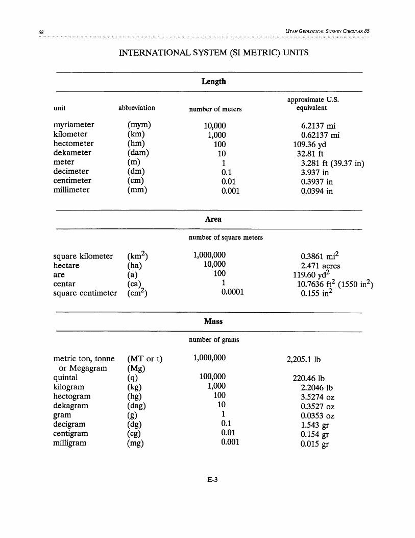
68 UTAH GEOLOGICAL SURVEY CIRCULAR 85
INTERNATIONAL SYSTEM (SI METRIC) UNITS
Length
approximate U.S. unit abbreviation number of meters equivalent
myriameter (mym) 10,000 6.2137 mi kilometer (kIn) 1,000 0.62137 mi hectometer (hm) 100 109.36 yd dekameter (dam) 10 32.81 ft meter (m) 1 3.281 ft (39.37 in) decimeter (dm) 0.1 3.937 in centimeter (cm) 0.01 0.3937 in millimeter (mm) 0.001 0.0394 in
Area
number of square meters
square kilometer (kIn2) 1,000,000 0.3861 mi2
hectare (ha) 10,000 2.471 acres are (a) 100 119.60 yd2
centar (ca) 1 10.7636 ft2 (1550 in2) square centimeter (cm2) 0.0001 0.155 in2
Mass
number of grams
metric ton, tonne (MT or t) 1,000,000 2,205.1Ib or Megagram (Mg)
quintal (q) 100,000 220.461b kilogram (kg) 1,000 2.20461b hectogram (hg) 100 3.5274oz dekagram (dag) 10 0.3527oz gram (g) 1 0.03530z decigram (dg) 0.1 1.543 gr centigram (cg) 0.01 0.154 gr milligram (mg) 0.001 0.015 gr
E-3

UTAH GEOLOGICAL SURVEY STYLE GUIDE 69
INTERNATIONAL SYSTEM (SI METRIC) UNITS--continued
Volume
approximate u.s. unit abbreviation number of meters cubed equivalent
dekastere (das) 10 13.10 yd3
stere (s) 1 1.31 yd3
decistere (ds) 0.1 3.53 ft3
cubic centimeter (cm3) 0.000001 0.061 in3
Capacity
number of liters
kiloliter (kl) 1,000 (1 m3) 1.31 yd3 (264.17 gal) hectoliter (hI) 100 (0.1 m3i 3.53 ft3 (26.41 gal) dekaliter (dal) 10 (10 dm ) 0.353 ft3 (2.64 gal) liter (L) 1 (1 dm3) 61.02 in3 (1.057 qt) deciliter (dl) 0.1 (0.1 dm3) 6.1 in3 (0.21 pt) centiliter (el) 0.001 (10 cm3) 0.61 in3 (0.338 fl oz) milliliter (ml) 0.001 (1 cm3) 0.06 in3 (0.034 fl oz)
E-4

UTAH GEOLOGICAL SURVEY CIRCULAR 85
Conversion factors for SI metric and U.S. customary units of measurement
A. Factors for converting SI metric units to U.S. customary units
To convert from
millimeter (mm) meter (m)
kilometer (km)
hectare (ha) hectometer2 qtm2)
kilometer2 (km )
centimeter3 ( cm3) liter (L)
Length
To
inch (in) foot (ft) yard (yd) mile (mi) mile, nautical (nmi)
Area
acre acre
Volume
inch3 (in3) inch3 (in3) pint (pt) quart (qt) gallon (~al) foot3 (ft ) foot3 (ft31 yard3 (yd ) gallon (gal) barrel (bbl), petroleum,
(1 bbl = 42 gal) acre-foot (acre-ft ) acre-foot (acre-ft )
E-5
Multiply by
0.03927 3.281 1.094 0.6214 0.5400
10.76 1.196 0.0002471 2.471
0.3861
0.016102 61.02 2.113 1.057 0.2642 0.03531
35.31 1.308
264.2 6.290
0.0008107 810.7

UTAH GEOLOGICAL SURVEY STYLE GWDE
Conversion factors for SI metric and U.S. customary units of measurement--continued
A. Factors for converting SI metric units to U.S. customary units--continued
Volume per unit time (includes flow)
To convert from
decimeter3 per second (dm3/s)
meter3 per second (m3 Is)
gram (g) kilogram (kg) megagram (Mg)
kilopascal (Kpa)
kelvin (K) degree Celsius COC)
3Temp °F= 1.8 temp K-459.67
To
foot3 per second (ft3 Is) gallon per minute (gal/min) barrel per day (bbl/d),
(p.etroleum) foot3 per second (ft3 Is) gallon per minute (gal/min)
Mass
ounce avoirdupois (oz avdp) pound avoirdupois (lb avdp) ton, short (2,000 lb) ton, long (2,240 lb)
Pressure
pound-force per inch2 (lbf/in2) atmosphere, standard (atm) bar inch of mercury at 60°F
(in. Hg)
Temperature
degree Fahrenheit COF) degree Fahrenheit COF)
Multiply by
0.03531 15.85
543.4 35.31
15,850
3 4
0.03527 2.205 1.102 0.9842
0.1450 0.0009869 0.01 0.2961
4rremp °F=1.8 temp °C+32
E-6
71

72 UTAH GEOLOGICAL SURVEY CIRCULAR 85
Conversion factors for SI metric and U.S. customary units of measurement--continued
B. Factors for converting U.S. customary units to SI metric units
To convert from inch (in) foot (ft) yard (yd) mile (mi) mile, nautical (nmi)
foot2 (ft2~ yard2 (yd ) acre
mile2 (mi2)
inch3 (in3)
foot3 (ft3)
yard3 (yd3) pint (pt) quart (qt) gallon (gal)
barrel (bbl), petroleum, 1 bbl = 42 gal)
acre-foot (acre-ft )
Length
To millimeter (mm) meter (m) meter (m) kilometer (Ion) kilometer (Ion)
Area
meter2 (m2) meter2 (m2) meter2 (m21 hectometer (hm2) kilometer2 (Ion2)
Volume
centimete~ (cm3) decimete~ (dm3) decimete~ (dm3) mete~ (m3) mete~ (m3) decimeter3 (dm3) decimeter3 (dm3) decimeter3 (dm3) meter3 (m3) meter3 (m3)
mete~ (m3~ hectometer (hm3)
E-7
Multiply by
25.4 0.3048 0.9144 1.609 1.852
0.09290 0.8361
4,047 0.4047 2.590
16.39 0.01639
28.32 0.02832 0.7646 0.4732 0.9464 3.785 0.003785 0.1590
1,233 0.001233

UTAH GEOLOGICAL SURVEY STYLE G!11DE
Conversion factors for SI metric and U.S. customary units of measurement--continued
B. Factors for converting U.S. customary units to SI metric units--continued
Volume per unit time (includes flow)
To convert from
foot3 per second (ft3 /s)
gallon per minute (gal/min)
barrel per day (bbl/d), petroleum
ounce avoirdupois (oz avdp) pound avoirdupois (lb avdp) ton, short (2,000 lb) ton, long (2,240 lb)
pound-force per inch2 (lbf/in2) atmosphere, standard (atm) bar inch of mercury at 60°F
(in. Hg)
degree Fahrenheit COF) degree Fahrenheit COF)
3Temp K=(temp OF + 459.67/1.8
To
decimete~ per second (dm3 /s) meter3 per second (m3 /s) decimete~ per second (dm3 /s) mete~ per second (m3 /s) decimete~ per second (dm3 /s)
Mass
gram (g) kilogram (kg) megagram (Mg) megagram (Mg)
Pressure
kilopascal (kpa) kilopascal (kpa) kilopascal (kpa) kilopascal (kpa)
Temperature
kelvin (K) degree Celsius COC)
Multiply by
28.32 0.02832 0.06309 0.00006309 0.001840
28.35 0.4536 0.9072 1.016
6.895 101.3 100
3.377
3 4
4rremp °C=(temp °F-32)/1.8
E-8
73

74 UTAH GEOLOGICAL SURVEY CIRCULAR 85
Prefixes and their symbols for SI units
Multiplying factors PrefIX Symbol
1 000 000 000 000 000 000 = 1018 exa E 1 000 000 000 000 000 = 1015 peta P
1 000 000 000 000 = 1012 tera T 1 000 000 000 = 109 giga G
1 000 000 = 106 mega M 1 000 = 103 kilo k
100 = 102 hecto h 10 = 101 deca da
0.1 = 10-1 deci d 0.01 = 10-2 centi c
0.001 = 10-3 milli m 0.000 001 = 10-6 micro ~
0.000 000 001 = 10-9 nano n 0.000 000 000 001 = 10-12 pi co P
0.000 000 000 000 001 . - 10-15 femto f 0.000 000 000 000 000 001 = 10-18 atto a
Non-SI units permissible within SI
Quantity Name Symbol Definition
area hectare ha 1 ha = 1 hm2 = 10,000 m2
mass ton, tonne t 1 t = 1,000 kg = 1 Mg plane angle degree ° 1 ° = (11:/180) rad
minute l' = (11:/10,800) rad second " 1" = (11:/648,000) rad
temperature degree °C DoC = 273.15 K Celsius However, for temperature
intervals 41°C = 4 1 K
time minute min 1 min = 60 s hour h 1 h = 3,600 s day d 1 d = 86,400 s year a
volume liter L 1 L = 1 dm3
E-9