Geological Survey of Denmark and Greenland Bulletin 40
242
Lithostratigraphy, geology and geochemistry of the volcanic rocks of the Maligât Formation and associated intrusions on Disko and Nuussuaq, Paleocene of West Greenland Asger Ken Pedersen, Lotte Melchior Larsen & Gunver Krarup Pedersen GEOLOGICAL SURVEY OF DENMARK AND GREENLAND BULLETIN 40 COPENHAGEN • 2018
-
Upload
khangminh22 -
Category
Documents
-
view
2 -
download
0
Transcript of Geological Survey of Denmark and Greenland Bulletin 40

De Nationale Geologiske Undersøgelserfor Danmark og Grønland (GEUS)Geological Survey of Denmark and Greenland
Geological Survey of D
enmark and G
reenland Bulletin 40 • 2018
Volcanic rocks of the Paleocene Maligât Form
ation, West G
reenland
Øster Voldgade 10DK-1350 Copenhagen KDenmark
Lithostratigraphy, geology and geochemistry of the volcanic rocks of the Maligât Formation and associated intrusions on Disko and Nuussuaq, Paleocene of West Greenland
The upper Cretaceous–Tertiary Nuussuaq Basin in West Greenland contains a many kilometres thick succession of siliciclastic sediments and overlying volcanic rocks. The first studies in the early 19th century were centred on the coal and fossils in the sediments and the minerals in the volcanic rocks, including famous occurrences of native iron. The present focus of interest includes modern stratigraphic and volcanological studies to decipher the basin evolution and support hydrocarbon and mineral exploration.
This bulletin presents the lithostratigraphy, geology and geochemistry of the Paleocene volcanic rocks of the Maligât Formation and its related intrusions on Disko and the Nuussuaq peninsula; it concludes with a detailed discus-sion of the effects of crustal contamination processes. The Maligât Forma-tion is up to 2000 m thick and comprises four formally defined members and 15 chemically defined informal units. It is mainly composed of basalt lavas but also includes basaltic andesite, andesite and dacite flows and rhyolite tuffs. The silicic rocks and intrusions were produced by contamina-tion in high-level magma chambers and commonly contain native iron.The comprehensive descriptions and analyses of each member and unit represent a synthesis of many years of work and are intended to serve as a guide for future studies, including exploration for mineral deposits associated with some units of the formation.
A companion bulletin (volume 39) on the volcanic rocks of the picritic Vaigat Formation that underlies the Maligât Formation was published in 2017.
lithostratigraphy
Lithostratigraphy, geology and geochemistry of thevolcanic rocks of the Maligât Formation and
associated intrusions on Disko andNuussuaq, Paleocene of
West Greenland
Asger Ken Pedersen, Lotte Melchior Larsen& Gunver Krarup Pedersen
G E O L O G I C A L S U R V E Y O F D E N M A R K A N D G R E E N L A N D B U L L E T I N 4 0
C O P E N H A G E N • 2 0 1 8
Printed 2018ISSN 1604-8156
ISBN 978-87-7871-498-5
GEUS is a research and advisory institution in the Danish Ministry of Energy, Utilities and Climate
D E N M A R K
Geocenter Denmark is a formalised cooperation betweenGeological Survey of Denmark and Greenland (GEUS),
Department of Geoscience at Aarhus Universityand the Geological Museum and Department ofGeosciences and Natural Resource Management
at the University of Copenhagen.
9 788778 714985


1
Lithostratigraphy, geology and geochemistry of the volcanic rocks of the Maligât Formation and associated intrusions on Disko and Nuussuaq, Paleocene of West Greenland
Asger Ken Pedersen, Lotte Melchior Larsen and Gunver Krarup Pedersen
GEOLOGICAL SURVEY OF DENMARK AND GREENLANDMINISTRY OF ENERGY, UTILITIES AND CLIMATE
GEOLOGICAL SURVEY OF DENMARK AND GREENLAND BULLETIN 40 • 2018

22
Geological Survey of Denmark and Greenland Bulletin 40
KeywordsMaligât Formation, basalt, lithostratigraphy, intrusions, crustal contamination, native iron, graphite, Nuussuaq Basin, Paleocene
Cover illustrationUppalluk/Giesecke Monument, a landmark peak reaching 1574 m a.s.l. on the south coast of Nuussuaq. Subaerial lava flows of the upper Rinks Dal Member of the Maligât Formation constitute the major part of the peak, which is topped by a remnant of a Nordfjord Member basalt flow. The exposed section is 550 m thick. Photo: Erik Vest Sørensen.
Frontispiece: facing pageThe north-east coast of Disko in midnight sun. A wall of subaerial lava flows of the Rinks Dal Member of the Maligât Formation rises above a slope dominated by numerous landslides. The slides are caused by an unstable configuration of basalts overlying poorly consolidated Cretaceous to Paleocene sediments. The ice-capped peak to the left is the 1366 m high Qinngusaq mountain. In the foreground, the cutter Porsild of the Arctic Station in Qeqertarsuaq is anchored in the bay at Tartunaq, Nuussuaq, 1986.
Chief editor of this series: Adam A. GardeEditorial board of this series: John A. Korstgård, Department of Geoscience, Aarhus University; Minik Rosing, Geological Museum, University of Copenhagen; Finn Surlyk, Department of Geosciences and Natural Resource Management, University of CopenhagenScientific editor: Adam A. GardeEditorial secretary: Jane HolstReferees: C.H. Emeleus and R. WilsonIllustrations: Jette Halskov, Willy L. Weng, Benny M. Schark, Jacob Lind Bendtsen and Allan Lindy.Photographs: All photographs were taken by the authors except where otherwise stated.Layout and graphic production: Henrik Klinge Pedersen and Jacob Lind BendtsenPrinters: Rosendahls-Schultz Grafisk A/S, Albertslund, DenmarkManuscript received: 9 June 2017Final version approved: 15 May 2018Printed: September 2018
ISSN (print) 1604-8156ISSN (online) 1904-4666ISBN (print) 978-87-7871-498-5ISBN (online) 978-87-7871-499-2
Citation of the name of this seriesIt is recommended that the name of this series is cited in full, viz. Geological Survey of Denmark and Greenland Bulletin.If abbreviation of this volume is necessary, the following form is suggested: Geol. Surv. Den. Green. Bull. 40, 239 pp.
Available from Geological Survey of Denmark and Greenland (GEUS) Øster Voldgade 10, DK-1350 Copenhagen K, Denmark To buy bulletin in printed form please contact [email protected] and at www.geus.dk/bulletin40 (open access)
© De Nationale Geologiske Undersøgelser for Danmark og Grønland (GEUS), 2018For the full text of the GEUS copyright clause, please refer to www.geus.dk/bulletin

3

44

5
Dedicated to the memory of Finn Ulff-Møller

66
Contents
Abstract .................................................................................................................................................................................................................................................................................................................. 9Introduction ................................................................................................................................................................................................................................................................................................... 10Geological setting ................................................................................................................................................................................................................................................................................. 14 The sedimentary substrate ....................................................................................................................................................................................................................................................... 16 Deposition of the volcanic succession and equivalent sediments ......................................................................................................................................... 16Methods .............................................................................................................................................................................................................................................................................................................. 20Stratigraphic subdivision and numerical coding system ......................................................................................................................................................................... 20 Nomenclature ........................................................................................................................................................................................................................................................................................... 20 Geological sections and profiles .............................................................................................................................................................................................................................. 20West Greenland Basalt Group ............................................................................................................................................................................................................................................. 22 Summary of the petrology of the Vaigat and Maligât formations ........................................................................................................................................ 22Maligât Formation ................................................................................................................................................................................................................................................................................ 23 Revision of the Maligât Formation ................................................................................................................................................................................................................... 23 Lithostratigraphy of the Maligât Formation .................................................................................................................................................................................................... 23 General features of the Maligât Formation ........................................................................................................................................................................................................ 24 Subdivision ........................................................................................................................................................................................................................................................................................... 24 Lithological variations and the filling of the Assoq Lake ......................................................................................................................................................... 25 Boundaries ............................................................................................................................................................................................................................................................................................. 39 Lower boundary ...................................................................................................................................................................................................................................................................... 39 Upper boundary ....................................................................................................................................................................................................................................................................... 42Rinks Dal Member ................................................................................................................................................................................................................................................................................ 43 Lithostratigraphy of the Rinks Dal Member ................................................................................................................................................................................................... 43 Subdivision of the Rinks Dal Member .................................................................................................................................................................................................................... 44 Lower Rinks Dal Member ....................................................................................................................................................................................................................................................... 45 Summary of the main features of the lower Rinks Dal Member .................................................................................................................................... 45 Unit 505 (lowest flows) ....................................................................................................................................................................................................................................................... 46 Unit 506 ................................................................................................................................................................................................................................................................................................... 46 Unit 507 (low-Ti flows) ...................................................................................................................................................................................................................................................... 47 Unit 509 ................................................................................................................................................................................................................................................................................................... 55 South coast of Disko: Infilling of the southern part of the Assoq Lake .................................................................................................................... 56 The northern basin in the Kuugannguaq–Qullissat area .................................................................................................................................................... 61 Unit 511 (Skarvefjeld unit) ............................................................................................................................................................................................................................................ 65 South coast of Disko around Skarvefjeld .................................................................................................................................................................................................... 70 East Disko around Kvandalen .............................................................................................................................................................................................................................. 71 Northt coast of Disko around Qullissat ....................................................................................................................................................................................................... 75 Unit 512 (lower transition flows) ........................................................................................................................................................................................................................... 76 Invasive lava flows on eastern Disko ............................................................................................................................................................................................................... 77 Invasive lava flows on southern Nuussuaq .............................................................................................................................................................................................. 77 Middle Rinks Dal Member .................................................................................................................................................................................................................................................... 80 Summary of the main features of the middle Rinks Dal Member .............................................................................................................................. 80 Unit 513 (Akuarut unit) ..................................................................................................................................................................................................................................................... 80 South coast of Disko between Marraat Qaqqaat and Tuapaat Qaqqaat ........................................................................................................... 83 South coast of Nuussuaq ................................................................................................................................................................................................................................................ 85 Upper Rinks Dal Member ....................................................................................................................................................................................................................................................... 88 Summary of the main features of the upper Rinks Dal Member ................................................................................................................................. 88 Unit 514 (upper transition flows) .......................................................................................................................................................................................................................... 88 Units 515, 516 and 517 (the main upper Rinks Dal Member) ........................................................................................................................................ 89

7
Unit 518 (uppermost flows) ........................................................................................................................................................................................................................................... 91 Lithologies of the upper Rinks Dal Member ............................................................................................................................................................................................ 91 Eruption sites on western Disko ............................................................................................................................................................................................................................. 92 Lithologies on Disko ............................................................................................................................................................................................................................................................. 92 Lithologies on Nuussuaq ................................................................................................................................................................................................................................................ 99 Lava volumes in the upper Rinks Dal Member .................................................................................................................................................................................. 101 Chemical compositions of the Rinks Dal Member ............................................................................................................................................................................. 104 Major elements ....................................................................................................................................................................................................................................................................... 104 Trace elements ......................................................................................................................................................................................................................................................................... 104 Eruption sites for the Rinks Dal Member ........................................................................................................................................................................................................ 113 Uncontaminated basalt dykes and sills ......................................................................................................................................................................................................... 113 Feeder systems for the Rinks Dal Member .............................................................................................................................................................................................. 114Nordfjord and Niaqussat members ........................................................................................................................................................................................................................... 115 Revision of the boundary between the Nordfjord and Niaqussat members .................................................................................................. 115Nordfjord Member ............................................................................................................................................................................................................................................................................ 116 Summary of the main features of the Nordfjord Member .................................................................................................................................................. 116 Lithostratigraphy of the Nordfjord Member ............................................................................................................................................................................................... 116 Internal structure of the Nordfjord Member ............................................................................................................................................................................................... 117 Igneous rock types ........................................................................................................................................................................................................................................................................... 119 Basalt ......................................................................................................................................................................................................................................................................................................... 119 Basaltic andesite .......................................................................................................................................................................................................................................................................... 122 Andesite ................................................................................................................................................................................................................................................................................................. 123 Dacite ........................................................................................................................................................................................................................................................................................................ 124 Rhyolite .................................................................................................................................................................................................................................................................................................. 128 Geological themes and locality descriptions ................................................................................................................................................................................................. 131 Sediment horizons at the base of the Nordfjord Member ................................................................................................................................................... 131 The West Disko Graphite Rhyolite (WDGR) volcano ......................................................................................................................................................... 134 Tuff successions ........................................................................................................................................................................................................................................................................ 136 Conglomerates and volcaniclastic sandstones ..................................................................................................................................................................................... 138 Sediments with clasts from the WDGR volcano ............................................................................................................................................................................ 141 Sediments without clasts from the WDGR volcano .................................................................................................................................................................. 144 Simple dacite lava flows between Hammer Dal and Jamma .............................................................................................................................................. 144 Composite lava flows ........................................................................................................................................................................................................................................................... 146 Crater site lithologies ........................................................................................................................................................................................................................................................... 153 Chemical compositions of the Nordfjord Member ............................................................................................................................................................................. 156 Major elements ....................................................................................................................................................................................................................................................................... 156 Trace elements ......................................................................................................................................................................................................................................................................... 161 Composite lava flows ....................................................................................................................................................................................................................................................... 162Niaqussat Member .............................................................................................................................................................................................................................................................................. 169 Summary of the main features of the Niaqussat Member .......................................................................................................................................................... 169 Lithostratigraphy of the Niaqussat Member ................................................................................................................................................................................................ 169 Lower Niaqussat Member (unit 530) .................................................................................................................................................................................................................... 170 Western Disko .......................................................................................................................................................................................................................................................................... 171 Eastern Disko ........................................................................................................................................................................................................................................................................... 174 Eastern Nuussuaq .............................................................................................................................................................................................................................................................. 175 Middle Niaqussat Member (unit 531) ................................................................................................................................................................................................................. 176 Upper Niaqussat Member (unit 532) .................................................................................................................................................................................................................... 177 Disko ................................................................................................................................................................................................................................................................................................... 178 Eastern Nuussuaq .............................................................................................................................................................................................................................................................. 179 Chemical compositions of the Niaqussat Member .............................................................................................................................................................................. 182 Major elements ...................................................................................................................................................................................................................................................................... 183

88
Trace elements ........................................................................................................................................................................................................................................................................ 183Sapernuvik Member ........................................................................................................................................................................................................................................................................ 192 Summary of the main features of the Sapernuvik Member ............................................................................................................................................. 192 Lithostratigraphy of the Sapernuvik Member .......................................................................................................................................................................................... 192 Geology and geochemistry of the Sapernuvik Member ............................................................................................................................................................... 193Dyke systems of the Nordfjord and Niaqussat members .......................................................................................................................................................... 195 Summary of the main features of the contaminated dyke systems ............................................................................................................................ 195 Weakly contaminated dykes .............................................................................................................................................................................................................................................. 195 Main dyke systems of the strongly contaminated magmas ........................................................................................................................................................ 195 Intrusions in dyke system A .................................................................................................................................................................................................................................... 197 Intrusions in dyke system B ..................................................................................................................................................................................................................................... 207 Intrusions in dyke system C .................................................................................................................................................................................................................................... 208 Other dyke intrusions .................................................................................................................................................................................................................................................... 209 Concluding remarks on the strongly contaminated dyke systems .............................................................................................................................. 210 Chemical compositions of the Nordfjord and Niaqussat Member dykes and feeder systems .................................................... 210Volume relations of the Maligât Formation .................................................................................................................................................................................................. 215 Thickness of the removed succession .............................................................................................................................................................................................................. 216Crustal contamination of the volcanic rocks .............................................................................................................................................................................................. 217 Summary of the main features of the crustal contamination processes ............................................................................................................... 217 Possible contaminants ........................................................................................................................................................................................................................................................ 217 Basement ...................................................................................................................................................................................................................................................................................... 217 Sediments ..................................................................................................................................................................................................................................................................................... 217 Distinction between contaminants ................................................................................................................................................................................................................ 223 Degrees of contamination ............................................................................................................................................................................................................................................. 224 Contamination processes and geochemical changes during contamination .............................................................................................. 225 Mixing and AFC processes ...................................................................................................................................................................................................................................... 225 Reduction processes ........................................................................................................................................................................................................................................................... 226 Exchange of elements ..................................................................................................................................................................................................................................................... 228Concluding remarks ....................................................................................................................................................................................................................................................................... 230 Acknowledgements ....................................................................................................................................................................................................................................................................... 230References ...................................................................................................................................................................................................................................................................................................... 231 List of geological map sheets and sections ...................................................................................................................................................................................................... 236Appendix: Place names .............................................................................................................................................................................................................................................................. 238

9
Abstract
Pedersen, A.K., Larsen, L.M. & Pedersen, G.K. 2018: Lithostratigraphy, geology and geochemistry of the volcanic rocks of the Maligât Formation and associated intrusions on Disko and Nuussuaq, Paleocene of West Greenland.Geological Survey of Denmark and Greenland Bulletin 40, 239 pp.
The Paleocene volcanic rocks in the Nuussuaq Basin on Disko and Nuussuaq comprise the picritic Vaigat Formation (c. 62–61 Ma) and the overlying basaltic Maligât Formation (c. 60 Ma). The Maligât Formation is up to 2000 m thick on western Disko where the top of the formation is least eroded. The formation is divided into four members, the Rinks Dal, Nordfjord, Niaqussat and Sapernuvik members, which are formally defined here. On central and eastern Disko and Nuussuaq the Maligât Formation lavas are interbedded with fluvial and lacustrine sandstones and mudstones of the Atanikerluk Formation. The Rinks Dal Member is the lowest member and originally constituted around 61% by volume of the formation. It is divided into 12 informal units based on chemically recognisable oscillations in the fractionation state of the basalts. The oldest units are present on central and south Disko close to the Disko Gneiss Ridge. The younger lavas spread farther to the east, north and west, filled the Assoq Lake basin east of the ridge and gradually onlapped the shield of the earlier Vaigat Formation that rose to the north. Only the lavas of the upper Rinks Dal Member reached far into Nuussuaq. The lavas are generally not crustally contaminated and comprise evolved basalts with 4.4–9.2 wt% MgO and a few picrites. The most evolved basalts with 3.2–4.8 wt% TiO2 occur in the middle part of the member where they form the Akuarut unit. The Nordfjord Member originally constituted around 6% by volume of the formation. It is not subdivided because the lithological variability is local. The member is widespread but has its depocentre on north-western Disko where thicknesses reach 350 m and eruption sites, intermediate lavas and acid tuffs are present. Over most of the area the member consists of just a few lava flows with combined thicknesses of 30−100 m. The member has a very diverse lithology with rock types ranging from silicic basalt with 5.3–10.0 wt% MgO through magnesian basaltic andesite and andesite with 2.4–10.6 wt% MgO to dacite with 1.2–2.2 wt% MgO. Rhyolite with 0.2–1.2 wt% MgO and up to 77 wt% SiO2 occur in tuffs and conglomerate clasts. All rocks are crustally contaminated and some are native-iron-bearing. The Niaqussat Member originally constituted around 33% by volume of the formation. It is subdivided into three informal units. The member is widespread, but much of it has been removed by erosion. Lithologies in the lower unit range from silicic picrite with up to 15 wt% MgO to basalt with 6–12 wt% MgO and a few basaltic andesite flows. The middle and upper parts of the Niaqussat Member comprise more evolved basalts with respectively 6.1–7.2 wt% MgO and 4.9–6.4 wt% MgO. All rocks are crustally contaminated and a few lava flows are native-iron-bearing. The Sapernuvik Member comprises three uncontaminated basalt flows with 7.5–10.7 wt% MgO. It is only preserved in a small area on western Disko. Dyke systems with up to 80 km long dykes and subvolcanic intrusions associated with the Nordfjord and Niaqussat members occur on western and north-eastern Disko. The rocks are crustally contaminated and range from silicic basalt with 4–13 wt% MgO to magnesian andesite with 3–10 wt% MgO. They commonly form composite intrusions, some of which contain accumulations of native iron and sulfides. The contaminants are carbon- and sulfur-bearing sediments of the Nuussuaq Group. Major contamination mechanisms were mixing with partial melts from the sediment sidewall and xenoliths and selective exchange of some elements, including carbon and sulfur, between magma and sediment. Degrees of contamination vary from 2−5% in the basalts to 10−50% in the more silicic rocks. No rocks more evolved than basalt were produced by ordinary fractional crystallisation.
A.K.P., Natural History Museum of Denmark, University of Copenhagen, Øster Voldgade 5-7, DK-1350 Copenhagen K, Denmark, and Geological Survey of Denmark and Greenland, Øster Voldgade 10, DK-1350 Copenhagen K, Denmark. E-mail: [email protected]., Geological Survey of Denmark and Greenland, Øster Voldgade 10, DK-1350 Copenhagen K, Denmark. E-mail: [email protected]., Geological Survey of Denmark and Greenland, Øster Voldgade 10, DK-1350 Copenhagen K, Denmark. E-mail: [email protected]

1010
Introduction
The Nuussuaq Basin is one of a series of linked basins that extend along the entire western continental margin of Greenland with a basin fill comprising Mesozoic to Tertiary sediments and Tertiary volcanic rocks (Chalm-ers & Pulvertaft 2001). The basins are partly situated in the offshore areas, but between 69° and 73°N the rocks of the Nuussuaq Basin are exposed on Disko, Nuus-suaq, Ubekendt Ejland and Svartenhuk Halvø (Fig. 1). The Nuussuaq Basin contains a Cretaceous to Paleocene
sedimentary succession overlain by a Paleocene to Eo-cene volcanic succession. The rocks have been studied since the mid-1850s with an academic focus on the well-preserved fossils and the occurrence of native iron in the volcanic rocks. The economic interest has been focused on the coal beds and, in later years, on the presence of hy-drocarbons. The lithostratigraphy of the sediments (the Nuussuaq Group) was defined and described by Dam et
nN
Nuussuaq
71°N
72°N 72°N
51°W53°W
71°N
70°N
69°N
55°W 51°W
Svartenhuk Halvø
UbekendtEjland
Greenlandice sheet
Uummannaq
Innerit
Hareøen
Itilli
Fault Vaigat
Disko
Disko Bugt IlulissatQeqertarsuaq
Aasiaat
EBF
EBF
50 km
GREENLAND
Neogene sediment coveroffshoreSaqqaata Qaqqaa centralcomplex
Paleocene picrites(Vaigat Formation)
Undifferentiated basaltsoffshore
Naqerloq Formation
Svartenhuk Formation
Maligât Formation
Maastrichtian–Paleocene sedimentsAlbian–Campaniansediments
Extensional fault
Precambrian basement
Fault with lateral oralternating displacements
GB01_02_019_03_LML.eps
Fig. 1. Simplified map of the pre-Quaternary geology of the Nuussuaq Basin. Light col-ours denote sea-covered areas. EBF: Eastern boundary fault system.

11
al. (2009). The present work on the volcanic rocks may be considered a sequel to this work. The volcanic rocks in the Nuussuaq Basin crop out over c. 20 000 km2 within a basinal area of c. 120 km × 400 km (c. 50 000 km2); however, volcanic rocks ex-tend over a total area of c. 200 km × 550 km (c. 110 000 km2), much of which is below sea level (Chalmers et al. 1999; Oakey & Chalmers 2012). The rocks in the Nuus-suaq Basin were erupted at highly variable rates into a
tectonically very active environment, and there was a complex interplay between the volcanic, sedimentary and tectonic evolution of the basin, which resulted in a highly complex architecture of the volcanic succession. Moreover, the range of magma compositions was large. West Greenland contains an unusually high proportion of primitive, Mg-rich picritic rocks that represent almost unmodified mantle melts (Drever 1953, 1956; Clarke 1970; Clarke & Upton 1971; Clarke & Pedersen 1976;
? ?
?
Nûluk Mb
Ordlingassoq Mb
B e l o w e x p o s u r e l e v e l
Ordlingassoq Mb
Qeqertalik Mb
Tuperssuartâtakûa Mb
Nunavik MbNerutusoq MbKakilisaat Mb
60.2 ± 0.5Niaqussat Mb
Dykes57.49 ± 1.40 58.34 ± 0.40
Dykes57.49 ± 1.40 58.34 ± 0.40
Nordfjord Mb
Rinks Dal Mb61.2 ± 0.4
Ordlingassoq Mb61.3 ± 0.5
Naujánguit Mb61.2 ± 0.5
Anaanaa Mb62 (C27n)
58.66 ± 0.34
54.03 ± 0.33
48.02 ± 2.76
56.15 ± 0.41
58.31 ± 0.30
54.86 ± 0.32
Alkaline sill54.52 ± 0.67
Dykes54.3 ± 0.355.5 ± 0.456.8 ± 0.8
Alkaline sill54.52 ± 0.67
Dykes54.3 ± 0.355.5 ± 0.456.8 ± 0.8
gabbro sill58.96 ± 0.51gabbro sill58.96 ± 0.51
Avatarpaat plug27.8 ± 0.6
Har
eøen
Form
atio
nN
aqer
loq
Form
atio
nS
varte
nhuk
Form
atio
nM
alig
âtFo
rmat
ion
Vaig
atFo
rmat
ion
Erq
uaFm
39–3
856
–54
60–5
861
–60
Eoc
ene
Pal
eoce
ne
62–6
154
–53
Talerua Mb38.74 ± 0.23
Aumarûtigssâ Mb
Dykes
Dykes34.5 ± 0.2
Ubekendt EjlandDiskoNuussuaq
Ma Hareøenand west Nuussuaq
Westof
Itilli fault
Eastof
Itilli faultSvartenhuk Halvø
Erqua Fm53.47 ± 0.52
Naqerloq Fm
55.91 ± 0.60
54.86 ± 0.44
Arf. trachyte 57.51 ± 0.24Skalø Mb
57.98 ± 0.59
Nuuit Mb58.05 ± 0.59
Tunuarsuk Mb59.41 ± 0.61
Sediments
55.94 ± 0.20
u.
m.
l.
u.
m.
l. S.Q.
GV02_02_047_LML
57.25 ± 0.9556.99 ± 0.4955.21 ± 0.30
59.50 ± 1.71
59.97 ± 0.89 60.31 ± 1.39
Kanísut Mb
Nûktakisôq Mb
Ifsorisok Mb
C27
nC
26r
C27
rC
26r
C26
rC
24r
C24
r
C18
nC
17r
Fig. 2. Stratigraphic scheme for the volcanic rocks in the Nuussuaq Basin, based on Hald & Pedersen (1975) for Disko and Nuussuaq, Hald (1976) for Hareøen and western Nuussuaq, J.G. Larsen (1977) for Ubekendt Ejland, and J.G. Larsen & Grocott (1991) and J.G. Larsen & Pulvertaft (2000) for Svartenhuk Halvø. Radiometric ages (Ma) with one digit after the decimal point are from Storey et al. (1998) and Larsen et al. (2009); ages with two digits after the decimal point are from Larsen et al. (2016). The age for the Anaanaa Member is not radiometric but based on its normally magnetised character. Note that the vertical ‘age scale’ is not equidistant. S.Q.: Saqqaata Qaqqaa central complex. l., m. and u. denote lower, middle and upper. Arf: Arfertuarsuk trachyte. Sediments with a quartzo-feldspathic component are yellow; purely volcaniclastic sediments are brown. Wavy lines indicate unconformities. Palaeomagnetic directions with magnetochrons are indicated at the right side of some lithological units, from Riisager & Abrahamsen (1999), Riisager et al. (1999, 2003), Schmidt et al. (2005) and unpublished data by P. Riisager, 2006). Modified from Larsen et al. (2016).

1212
Holm et al. 1993; Larsen & Pedersen 2000, 2009). How-ever, repeated episodes of assimilation of crustal material, including organic-rich sediments, led to formation of units of silica-enriched rocks, including native-iron- and graphite-bearing basalts, andesites and dacites as well as graphite-bearing rhyolites (e.g. Törnebohm 1878; Steen-strup 1883; Pedersen 1977a, 1981, 1985; Pedersen & Larsen 2006; Larsen & Pedersen 2009).
The volcanic succession is divided into two major parts. The lower part is dominated by picrites and has been formalised as the Vaigat Formation, which is present from Disko and northwards to Svartenhuk Halvø (Hald & Pedersen 1975; Clarke & Pedersen 1976). The upper part is dominated by basalts and has previously been re-ferred to different formations in different areas; based on 40Ar–39Ar age determinations Larsen et al. (2016) con-cluded that the basalts on Disko and Nuussuaq east of the Itilli fault belong to the Maligât Formation which is not present in other areas (Figs 1, 2). This bulletin on the Maligât Formation and its com-panion on the Vaigat Formation (Pedersen et al. 2017) describe the lithostratigraphy, geology and geochemistry of the volcanic succession on Disko and Nuussuaq east of the Itilli fault. They represent a synthesis of work that has been going on since 1968 and from which many results have been published. The two bulletins may be viewed as a comprehensive map description covering the Paleocene volcanic rocks in all the geological maps of the area, which is covered by seven geological maps on a scale of 1:100 000, two geological maps on scales of 1:50 000 and 1:20 000 covering different parts of Nuussuaq, and five vertical geological sections on a scale of 1:20 000 across Disko and Nuussuaq (Fig. 3). An important task for the two bulletins has been the definition and documentation of the several volcanic units that appear on the published maps and sections but have not been described before. The documentation includes geochemical data because chemostratigraphy is important in both formations and crucial for the Maligât Formation. Emphasis is placed on descriptions with pictures of the variable lithologies in selected key areas and on geochemical descriptions and plots of the stratigraphic units, facilitated by a numerical coding system, data tables and a comprehensive electron-ic appendix with analytical data. In short, the bulletins are intended to serve as guides for future field, geochemi-cal and petrological studies. The companion bulletin on the Vaigat Formation (Pedersen et al. 2017) contains detailed introductory chapters on previous investigations, geological setting and methods that also cover the Maligât Formation; however short chapters on the geological setting and methods are also included here because they are necessary for the in-dependent use of the present bulletin. Petrogenetic con-siderations have been published by Larsen & Pedersen (2000, 2009) and Larsen et al. (2003), and the two bulle-
GV01_02_160_01_LML
70°N
69°30'N
55°W 53°W
55°W 53°W
25 km
70°30'N
70 V.1 Nord Agatdal
70 V.1 Syd Qutdligssat
69 V.2 Nord Pingu
69 V.1 Syd Uiffaq
69 V.1 Nord Mellemfjord
70 V.2 NordAgpat
Special mapPaatuut
Fig. 103
Fig. 173
Ice cap
West Greenland Basalt Group
Nuussuaq Group
Precambrian basement
Map sheets 1:100 000
Special map 1:50 000
Sections and map 1:20 000
Maps in this volume
Fig. 3. Index map of published geological maps and photogram- metric sections covering Disko and Nuussuaq. Also shown are the local geological maps that appear as figures in this bulletin. A list of all published maps and sections is found at the end of the reference list.

13
tins therefore only give short summaries of the petrology of the rocks. On the other hand, the present bulletin con-tains a final chapter on crustal contamination of the vol-canic rocks, with descriptions of possible contaminants and discussion of contamination processes, that covers both the Vaigat and Maligât Formations. Our late friend and colleague Finn Ulff-Møller stud-ied the native-iron-bearing intrusions on western Disko
extensively, but at his death in 2009, much of his knowl-edge was left unpublished. In this bulletin, the chapter on dyke systems of the Nordfjord and Niaqussat members includes much information extracted from his PhD the-sis, field notes, sketches, photographs and samples.

1414
Geological setting
The Tertiary volcanic rocks in West Greenland form part of the North Atlantic Igneous Province. The vol-canism was associated with the breakup of the North Atlantic Craton, as described by Noe-Nygaard (1974), Upton (1988), Saunders et al. (1997) and Pedersen et al. (2017). The c. 20 000 km2 of exposed volcanic rocks in West Greenland make it the second largest exposed vol-canic succession on the continental margins of the North Atlantic, surpassed only by the plateau basalts in central East Greenland. The exposed rocks in the Nuussuaq Basin consist of Cretaceous to Palaeogene sediments and Palaeogene volcanic rocks. The three most important structural el-ements of the Nuussuaq Basin on Disko and Nuussuaq are the eastern boundary fault system (EBF), the Kuu-gannguaq−Qunnilik (K−Q) fault system and the Itilli fault system (Figs 1, 4). These fault systems divide the basin into a central−eastern part where the volcanic rocks are close to flat-lying and their substrate is well exposed, a western part where the substrate is rarely exposed and the volcanic succession is faulted and commonly tilted, and a westernmost part west of the Itilli fault system where, due to kilometre-scale downthrow to the north-west, a very different and mainly younger succession is preserved. The eastern boundary fault system delimits the basin towards the elevated Precambrian basement in the east. The system consists of a number of fault segments with orientations from N−S to NW−SE. Within the basin, im-portant faults run mainly N−S. The Disko Gneiss Ridge is a pre-basaltic fault block that is down-tilted towards the east, whereas to the west it is delimited by a N−S-running fault system that is an extension of the K–Q fault system. The surface of the gneiss ridge is shaped by prevolcanic erosion (Bonow 2005); the later lavas have lapped onto the hilly landscape of the ridge and eventually covered it. The ridge stands up to c. 700 m a.s.l. on central Disko, lowers to c. 300 m a.s.l. on southern Disko and extends southward, mainly below sea level, across Disko Bugt to the low-lying gneiss areas in the Aasiaat area. The ridge is not exposed at the north coast of Disko; this has been at-tributed to a NW−SE-trending fault on northern Disko (Chalmers et al. 1999). The K−Q fault system runs S−N across both Disko and Nuussuaq, and pre-, syn- and postvolcanic move-ments have taken place along the faults. A clustering of volcanic eruption sites along the fault system demon-
strates its deep-seated nature as a preferred pathway for magmas. West of the K–Q fault system no prevolcanic sediments are exposed on Disko, but sediment-contam-inated volcanic rock units and sandstone and mudstone xenoliths in these attest to the presence of sediments at depth (e.g. Pedersen 1977a). Thick sedimentary succes-sions are known from Nuussuaq west of the K–Q fault system (Dam et al. 2009). Western Disko, west of the K–Q fault system, is cut by several N−S-oriented post-Paleocene faults with steeply E-dipping fault planes. They divide the volcanic succes-sion into a number of antithetic fault blocks in which the lavas dip 2−22° W, thus exposing the youngest parts of the succession in the westernmost blocks. The anti-thetic fault system does not continue offshore but rather has given rise to a monocline of limited width (Skaarup 2002; Skaarup & Pulvertaft 2007; Gregersen & Bidstrup 2008). According to refraction seismic data, Paleocene oceanic crust is situated 120 km west of Disko (Funck et al. 2012; Oakey & Chalmers 2012). The Itilli fault system is a major structural boundary (Fig. 1; Chalmers & Pulvertaft 2001). Downthrow is to the NW, with net displacements of more than 1 km on Hareøen and Nuussuaq. As a result, the volcanic succes-sions on the two sides of the Itilli fault system are funda-mentally different (Fig. 2). Some relatively young (latest Paleocene to Eocene) volcanic formations occur west of the fault system but not east of it; these have not been included in this work.
Facing page:Fig. 4. Simplified geological map of Disko and Nuussuaq with loca-tions of the major profiles used for the mapping of the Maligât For-mation (blue dots) and also shown in the stratigraphic panels of Figs 7–14. A few profiles are not shown. Profiles in the Vaigat Formation (red dots) are shown for completeness. Some localities are measured points with altitudes as given on the 1: 250 000 scale topographic maps. Abbreviated names: Ak: Akuliarusersuaq. DJ Dal: Daugaard-Jensen Dal. EQ: Eqalunnguaqqat Qaqqaat. FL Dal: Frederik Lange Dal. GD: Giesecke Dal. Iko: Ikorfarsuit. IQ: Ivissussat Qaqqaat. Kin: Kingittuusaq. Or: Orlingasoq. Qas.: Qasigissat. SI: Saqqa-rliit Ilorliit. EBF: Eastern boundary fault system. K–Q fault: Kuu-gannguaq–Qunnilik fault. Additional localities are shown in Fig. 6 and for north-west Disko in Fig. 103. Note that on this map glaciers are not shown; the extent of the Nordfjord Member on central east-ern Disko, which is largely covered by the Sermersuaq ice cap, is inter-polated between many small exposures at the margin of the ice cap.

15
Eocene lavas and intrusions
Nordfjord and Niaqussat mbs
Rinks Dal Member
MaligâtFormation
Nordfjord
Vaigat
Qeqertarsuaq / GodhavnInnarsuaq / Skarvefjeld
Vaigat Formation
Stor
dal
Cretaceous–Tertiary sedimentsPrecambrian basement
GV01_02_136_01_LML_03
Fault
Profile in the Vaigat (red) and Maligât (blue) formations
25 km
Sapernuvik Member
Kuugannguaq
Maligaat
Marraat Anaanaa
SikillingiNuusaq
Hareøen
Niaqussat
Di s
ko
Gn
ei s
s R
i dg
e
Asuk
Asuutaa
NuukKilleq
AtaataKuua
Mellemfjord
Sapernuvik
Qas.
Aaffarsuaq
Ikorfat
Saqqaq
Niuluut
Killiit / Fortunebay
Uiffaq
Tunup Qaqqaa
Eqaluit
PerlertutQaqqaat
Pyramiden
Assoq
SkansenTuapaat Qaqqaat
Marraat Qaqqaat
Pingu
Skorstens-fjeld
AqajaruataQaqqaa
QullissatInussuk
Paatuut
Niiortuut
Nunavik
Eqi
IQ
OrGD
Eqip QaqqaaGiesecke Monument
Umiusat
AtanikerlukTartunaq
Narsap QaqqaaQinngusaq
SorteHak
D. J. Dal
Ak
EQ
SI
Iko
Kin
OrpiitQaqqaat
KvandalenFL
Dal
UummannaqKuuk
Point 2080 m1640 m
Point 1530 m
Point 1510 m
1578 m
1012 m
1300 m
Inngigissoq
1123 m
1014 m
1888 m
Qaarsut
K-Q
faul
t
K-Q
faul
t
Itillifault
69°30’N
70°30’N
70°N
55°W 53°W 52°W
Nuussuaq
Disko
Kangerluk / Disko Fjord
EBF
Nûluk Member
Nordfjord
Laksedalen
Brededal
Blåbærdalen
Rink Dal
Hammer Dal
VesterdalenSortebær-
dalen

1616
The sedimentary substrateThe Nuussuaq Basin was a depositional area for clas-tic sediments for at least 40 Ma from the Albian to the Paleocene (Dam et al. 2009). Geophysical investigations have shown sediment thicknesses of at least 6 km and possibly up to 10 km in the western part of the basin (Christiansen et al. 1995; Chalmers et al. 1999); in the eastern part the sediments are only 1−2 km thick. Most of the exposed sediments were deposited in a large delta complex which fanned out from south-east of Disko to-wards the west and north-west; thus fluvial to deltaic en-vironments predominate on Disko and southern Nuus-suaq, while marine deep-water environments are found on north-western Nuussuaq and on Svartenhuk Halvø (G.K. Pedersen & Pulvertaft 1992). The Albian to Cam-panian non-marine and marginally marine sediments are referred to the Kome, Slibestensfjeldet, Upernivik Næs and Atane formations (Dam et al. 2009) and comprise yellowish quartzo-feldspathic sandstones interbedded with mudstones and coal layers (Midtgaard 1996; G.K. Pedersen et al. 2006). Dark marine mudstones of the Itilli and Kangilia formations are exposed on north-western Nuussuaq. On western Nuussuaq, the Itilli Formation is more than 2 km thick in the GRO#3 well. The Itilli Formation comprises Upper Cretaceous turbiditic sand-stones and mudstones deposited on a submarine slope west of the Kuugannguaq−Qunnilik fault (Dam & Søn-derholm 1994; Dam et al. 2009). An early Campanian angular unconformity is ob-served on Central Nuussuaq (Dam et al. 2000) and inter-preted as representing a regional event (Gregersen et al. 2013). During the Maastrichtian and early Paleocene, the basin was affected by faulting and changes in relative sea level. At least three phases of uplift during the Late Creta-ceous and early Paleocene are interpreted from deeply in-cised submarine canyons with conglomerates, turbidites and mudstones, as well as an incised fluvial valley with pebbly sandstones as the dominant lithology (Dam & Sønderholm 1994, 1998; Dam 2002; Dam et al. 2009).
Deposition of the volcanic succession and equivalent sedimentsAt the onset of the volcanism, a marine embayment stretched from the open sea in the north-west (western Nuussuaq and beyond this) towards south and south-east where it was bounded by the Disko Gneiss Ridge in the west, an active delta depositing sediments in the south and south-east, and the gneiss highland in the east and north-east (Dam et al. 2009, fig. 12). Detailed studies of
VOLCANIC ROCKS SEDIMENTS
MAL
IGÂT
FO
RMAT
ION
VAIG
AT F
ORM
ATIO
N
Tunoqqu Mb Qo. Mb
Asuk Mb
Manîtdlat Mb
Skarvefjeld unit
Akuarut unit
Lower Rinks Dal Member
Upper Rinks Dal Member
Rink
s Dal
Mem
ber
Niaq
ussa
tM
embe
rAn
aana
aM
embe
r
Abraham Mb
Pingu Mb
Umius-sat Mb
Assoq Mb
Tuffs
?
?
Sapernuvik Member
UpperMiddle
Lower
Nordfjord Member
St Uk
Ni
He
Tb
TaNuuk Killeq Mb
Nus. Qa. Mb
Marraat unitNiaqornaq unit
Picrites and basalts, 5 units
Kûgánguaq Mb
ATA
NIK
ERLU
K F
ORM
ATIO
N
EQA
LULI
K F
ORM
ATIO
N
ap cbs
GV02_02_039_LML
NaujánguitMember
OrdlingassoqMember
Akun-neqMb
Nau
jât M
bFig. 5. Stratigraphic subdivision of the Paleocene volcanic rocks and sediments on Disko and Nuussuaq. The ‘thicknesses’ of the volcanic units in the diagram are intended to approximately reflect their vol-umes, although this is not always possible. The units with elliptical outlines do not extend laterally throughout the contemporaneous succession, and the small ones are distinctly local. Crustally contam-inated units are shown in red, alkaline units in purple (with a red outline if crustally contaminated), and geochemically enriched units have dashed outlines. Abbreviations (in stratigraphic order): Nus. Qa. Mb: Nuusap Qaqqarsua Member. He: Henderson unit. Ta: Tunorsuaq-a unit. Ni: Niiortuut unit. Tb: Tunorsuaq-b unit. Uk: Ukallit unit. St: Stordal alkaline unit. Qo. Mb: Qordlortorssuaq Member. cbs: contaminated basalts in Stordal. ap: alkali picrites as-sociated with the Manîtdlat Member. The lower and upper Rinks Dal Member are further subdivided into a number of chemostrati-graphic units not shown here (but see Fig. 21). Sediment members from Dam et al. (2009): Marine mudstones are grey, non-marine mudstones are brownish-grey, sandstones are yellow and coal lay-ers are black. The tuffs correlated with the Nordfjord Member were found in 2016.

17
volcanic facies transitions have documented very high subsidence rates in excess of 20 m/ka during the deposi-tion of the early part of the Vaigat Formation (Pedersen et al. 2002b), making regional palaeogeographical recon-structions difficult. Deposition of the volcanic rocks be-gan in the north-west and took place concomitantly with continued deposition of sediments in other parts of the basin, leading to a complex interplay between volcanic and sedimentary members. A lithostratigraphic scheme for both volcanic rocks and sediments is shown in Fig. 5. Lateral basin fill from west to east, shifting eruption sites with time and frequent facies changes between subaerial and subaqueous facies within most volcanic units result-ed in an unusually complex stratigraphy of the volcanic succession, as described in Pedersen et al. (2017). In the volcanic succession, the Vaigat Formation is dominated by primitive, olivine-rich picritic rocks, which in subaerial facies form thin, grey, crumbly lava flows. The overlying Maligât Formation is dominated by evolved, plagioclase-phyric to aphyric basalts which in subaerial facies form thicker, darker grey to brownish, massive lava flows. Both formations contain a number of lithologi-cally and chemically distinct units; several of these form marker horizons and have been assigned member status (Fig. 5). The Vaigat Formation forms a S–N elongate, 260 km long, shield-like feature in the Nuussuaq Basin. It is thick-est, up to c. 5 km, on Ubekendt Ejland north of Nuussuaq ( J.G. Larsen 1977). On central and western Nuussuaq it is up to 1.6 km thick, and on northern Disko up to 1.5 km; it wedges out eastwards on eastern Nuussuaq and eastwards and southwards on eastern and north-central Disko (Fig. 1). Its lower boundary towards the sediments is strongly diachronous and youngs towards the east be-cause of progradation of the volcanic pile from west to east. It was deposited in three major episodes of activity, which gave rise to its three main members (Anaanaa, Naujánguit and Ordlingassoq). The marine embay-ment with mudstones of the Eqalulik Formation (Dam et al. 2009) was gradually filled from the west, and at the end of the second episode the advancing volcanic front reached the eastern gneiss highland on north-east Nuus-suaq and blocked the connection to the sea; as a result the embayment was transformed into a freshwater lake, the Naajaat Lake (Piasecki et al. 1992; Pedersen et al. 1996), in which sediments of the non-marine Atanikerluk For-mation were deposited (Koch 1959; Dam et al. 2009). This lake persisted through the third episode of the Vaigat Formation with deposition of mudstones of the Naujât and Pingu members, but it was greatly diminished
towards the end of the episode by the combined infill of volcanic rocks and sandstones of the Umiussat Member (G.K. Pedersen et al. 1998; Dam et al. 2009). The Maligât Formation is centred on Disko, and its oldest exposed part is found on south-central Disko. It is thickest on western and central Disko where its base is generally below exposure level; on eastern Disko it rests on sediments, and in the north it onlaps the Vaigat Formation with increasingly younger lavas at the contact going north from Disko to Nuussuaq. Eastwards the Maligât Formation thins and interfingers with lake sedi-ments of the Assoq Lake basin and the sand-dominated delta deposits from a large, north-west- to west-flowing river (Dam et al. 2009). As a result, the eastern fringes of the formation changed with time from subaqueous lava flows and hyaloclastites through invasive flows in-truded like sills into the wet sediments, to subaerial lava flows, which finally covered much of the basinal area and stepped onto the gneiss highland on eastern Nuussuaq. Both the Vaigat and Maligât formations are Paleocene (Danian–Selandian) in age. The oldest part of the Vai-gat Formation is normally magnetised and was emplaced during geomagnetic chron C27n (Riisager & Abraham-sen 1999), 62.5–62.2 Ma (Vandenberghe et al. 2012). The middle and upper parts of the Vaigat Formation, and all of the Maligât Formation, are reversely magnet-ised (Deutsch & Kristjansson 1974; Athavale & Sharma 1975; Riisager et al. 1999), fitting into the long-lived geomagnetic chron C26r. The top of the Maligât Forma-tion has an 40Ar–39Ar age of 60.2 ± 0.5 Ma (Storey et al. 1998). In the northern part of the Nuussuaq Basin, the ba-salts are referred to the Svartenhuk, Naqerloq and Er-qua formations (Fig. 2; J.G. Larsen 1977; J.G. Larsen & Grocott 1991; Larsen et al. 2016). These are younger than the Maligât Formation except for the lowest part of the Svartenhuk Formation, which may be coeval with it. The 60–58 Ma Svartenhuk Formation is present on Svartenhuk Halvø and north of it, on Ubekendt Ejland, and possibly also on Hareøen and on Nuussuaq west of the Itilli fault (Larsen et al. 2016; Figs 1, 2). It is over-lain by the 56–54 Ma Eocene Naqerloq Formation in the same areas, followed by the 54–53 Ma Erqua Formation on Ubekendt Ejland. Dykes similar to the basalts of the Svartenhuk and Naqerloq formations are widespread on Disko and Nuussuaq (Larsen et al. 2016). A map of Disko and Nuussuaq with detailed place names used in this bulletin is shown in Fig. 6.

1818
Niaq
orna
t
Itilli
Itilli
Mar
raat
Killi
it
Har
eøen
MAL
IGAA
T
VAIGAT
Jamm
a
Man
iillat
Asuk
Kille
rpaa
t Qaq
qars
uat
Qul
lissa
tIn
ussu
k
Gam
le Q
ullis
sat
Nun
ngar
utAt
anike
rluk
Tart
unaq
Kegle
n
55°W
54°W
53°W
52°W
70°N
70°3
0'N
Pyra
mid
en
Amet
ysts
kræn
ten
Agat
fjeld
et
Steenstrup Dal
Asuu
taa
Orli
ngas
oq
Hara
ld Mo
ltke D
al
Kuug
anng
uaq
Kuugannguaq
Ham
mer
Dal
Rink
Dal
Paat
uut
Niio
rtuu
t
Aaffa
rsua
q
Poin
t 172
2 m
Nun
avik
Saqqaqdalen
Eqi
King
ittoq
Saqq
aq
Gie
seck
eM
onum
ent
Agatdal
en Ataa
taKu
ua
Qunnilik
Ikor
fat
Qaa
rsut
Uum
man
naq
Poin
t 208
0 m
Aaffa
rsua
q
Poin
t 882
m
Poin
t 500
m
Poin
t 440
m
Niaq
ussa
t
Sedi
men
tklø
ften
Poin
t 780
mPo
int 1
070
m
Han
ekam
men
Poin
t 165
0 m
Poin
t 138
0 m
Poin
t 151
0 m
Poin
t 146
0 m
Poin
t 156
0 m
Poin
t 161
0 m
Poin
t 159
0 m
Illul
uars
uit
Qaq
qaa
Gies
ecke
Dal
Morten P
orsil
d
Dal
Poin
t 200
0 m
Mak
ittar
issag
aqUm
iarto
rfiup
Qaq
qaa
Poin
t 188
8 m
Iviss
ussa
t Qaq
qaat
Poin
t 201
0 m
Poin
t 176
0 m
Eqip
Qaq
qaa
Um
iusa
t
Poin
t 975
m’Sa
qqaq
’
Puia
ttussu
aq
010
20km
69°3
0'N
Stordal
Storda
l
Kang
erso
oq /
Nord
fjord
Akull
iit / M
ellem
fjord
GV0
1_04
_19_
03_L
ML
Uun
artu
arsu
k
Illuk
unng
uaq
Inng
igiss
oq
Akun
neq
Ping
u
Aqaja
ruat
a Q
aqqa
a
Skan
sen
Tuap
aat
Tuap
aat Q
aqqa
at
Siniff
ikM
arra
at Q
aqqa
at
Niu
luut
Asso
q
Ippi
k
Inna
rsua
q / S
karv
efje
ld
Qeq
erta
rsua
q / G
odha
vnAk
uaru
t / L
yngm
arks
fjeld
Tuap
assu
itTini
Nav
aran
aat /
Apo
stel
fjeld
Killii
t / F
ortu
neba
y
Lucie
fjeld
Nuu
k Ka
ngille
q
Kang
erluk
/ Di
sko
Fjord
RødeelvBlæsedalen
Brededal
Skor
sten
sfjel
d
Laksedalen
Blåbæ
rdalen
Poin
t 102
5 m
Poin
t 101
4 m
Poin
t 112
3 m S o
rtebærdalen
Kvandal
en
Fred
erik
Lan
ge D
al
Cha
rles P
olar
is D
al
Dauga
ard-
Jense
n Dal
Akul
iarus
ersu
aq
Kuannersuit Sulluat
Eqalu
nngu
aqqa
t
Qaq
qaat
Poin
t 110
9 m
Orp
iit Q
aqqa
at
Kuannersuit Kuussuat
Sort
e H
ak
Poin
t 144
0 m
Poin
t 126
6 m
Illuk
asik
Kuan
nit
Naq
erlo
q
Tunu
p Q
aqqa
a
Uka
leqa
rtar
fik
Eqalu
it/N
ordr
eLa
kseb
ugt
Sape
rnuv
ikKing
ittup
Qaq
qaa
Ivisa
arqu
t /En
ok H
avn
Saqq
arliit
Ilor
liit
Saqq
arliit
Sila
rliit
Poin
t 101
2 m
Perle
rtut
Qaq
qaat
Poin
t 130
0 m
Poin
t 113
7 m
Poin
t 153
0 m N
arsa
p Q
aqqa
a
Qin
ngus
aq
Poin
t 157
8 m
Ikor
farsu
it
Jern
pynt
enQasig
issat
King
ittuu
saq
Vest
erda
len
Poin
t 113
2 m
Sermersuaq
Sermers
uaq
Poin
t 164
0 m
Kuug
anng
uaq
SE
Kvan
dale
n
Uiff
aqAlan
ngup
Qaq
qai

Niaq
orna
t
Itilli
Itilli
Mar
raat
Killi
it
Har
eøen
MAL
IGAA
T
VAIGAT
Jamm
a
Man
iillat
Asuk
Kille
rpaa
t Qaq
qars
uat
Qul
lissa
tIn
ussu
k
Gam
le Q
ullis
sat
Nun
ngar
utAt
anike
rluk
Tart
unaq
Kegle
n
55°W
54°W
53°W
52°W
70°N
70°3
0'N
Pyra
mid
en
Amet
ysts
kræn
ten
Agat
fjeld
et
Steenstrup Dal
Asuu
taa
Orli
ngas
oq
Hara
ld Mo
ltke D
al
Kuug
anng
uaq
Kuugannguaq
Ham
mer
Dal
Rink
Dal
Paat
uut
Niio
rtuu
t
Aaffa
rsua
q
Poin
t 172
2 m
Nun
avik
Saqqaqdalen
Eqi
King
ittoq
Saqq
aq
Gie
seck
eM
onum
ent
Agatdal
en Ataa
taKu
ua
Qunnilik
Ikor
fat
Qaa
rsut
Uum
man
naq
Poin
t 208
0 m
Aaffa
rsua
q
Poin
t 882
m
Poin
t 500
m
Poin
t 440
m
Niaq
ussa
t
Sedi
men
tklø
ften
Poin
t 780
mPo
int 1
070
m
Han
ekam
men
Poin
t 165
0 m
Poin
t 138
0 m
Poin
t 151
0 m
Poin
t 146
0 m
Poin
t 156
0 m
Poin
t 161
0 m
Poin
t 159
0 m
Illul
uars
uit
Qaq
qaa
Gies
ecke
Dal
Morten P
orsil
d
Dal
Poin
t 200
0 m
Mak
ittar
issag
aqUm
iarto
rfiup
Qaq
qaa
Poin
t 188
8 m
Iviss
ussa
t Qaq
qaat
Poin
t 201
0 m
Poin
t 176
0 m
Eqip
Qaq
qaa
Um
iusa
t
Poin
t 975
m’Sa
qqaq
’
Puia
ttussu
aq
010
20km
69°3
0'N
Stordal
Storda
l
Kang
erso
oq /
Nord
fjord
Akull
iit / M
ellem
fjord
GV0
1_04
_19_
03_L
ML
Uun
artu
arsu
k
Illuk
unng
uaq
Inng
igiss
oq
Akun
neq
Ping
u
Aqaja
ruat
a Q
aqqa
a
Skan
sen
Tuap
aat
Tuap
aat Q
aqqa
at
Siniff
ikM
arra
at Q
aqqa
at
Niu
luut
Asso
q
Ippi
k
Inna
rsua
q / S
karv
efje
ld
Qeq
erta
rsua
q / G
odha
vnAk
uaru
t / L
yngm
arks
fjeld
Tuap
assu
itTini
Nav
aran
aat /
Apo
stel
fjeld
Killii
t / F
ortu
neba
y
Lucie
fjeld
Nuu
k Ka
ngille
q
Kang
erluk
/ Di
sko
Fjord
RødeelvBlæsedalen
Brededal
Skor
sten
sfjel
d
Laksedalen
Blåbæ
rdalen
Poin
t 102
5 m
Poin
t 101
4 m
Poin
t 112
3 m S o
rtebærdalen
Kvandal
en
Fred
erik
Lan
ge D
al
Cha
rles P
olar
is D
al
Dauga
ard-
Jense
n Dal
Akul
iarus
ersu
aq
Kuannersuit Sulluat
Eqalu
nngu
aqqa
t
Qaq
qaat
Poin
t 110
9 m
Orp
iit Q
aqqa
at
Kuannersuit Kuussuat
Sort
e H
ak
Poin
t 144
0 m
Poin
t 126
6 m
Illuk
asik
Kuan
nit
Naq
erlo
q
Tunu
p Q
aqqa
a
Uka
leqa
rtar
fik
Eqalu
it/N
ordr
eLa
kseb
ugt
Sape
rnuv
ikKing
ittup
Qaq
qaa
Ivisa
arqu
t /En
ok H
avn
Saqq
arliit
Ilor
liit
Saqq
arliit
Sila
rliit
Poin
t 101
2 m
Perle
rtut
Qaq
qaat
Poin
t 130
0 m
Poin
t 113
7 m
Poin
t 153
0 m N
arsa
p Q
aqqa
a
Qin
ngus
aq
Poin
t 157
8 m
Ikor
farsu
it
J ern
pynt
enQasig
issat
King
ittuu
saq
Vest
erda
len
Poin
t 113
2 m
Sermersuaq
Sermers
uaq
Poin
t 164
0 m
Kuug
anng
uaq
SE
Kvan
dale
n
Uiff
aqAlan
ngup
Qaq
qai
Fig.
6. M
ap w
ith p
lace
nam
es u
sed
in th
e tex
t. Bl
ue d
ots a
re th
e loc
atio
ns o
f the
pro
files
show
n in
Fig
s 7–1
4. T
he ic
e cap
s and
the d
rain
age p
atte
rn g
ive a
n im
pres
sion
of th
e rug
ged
topo
grap
hy
and
the m
any e
leva
ted
area
s of d
iffic
ult a
cces
s tha
t do
not a
ppea
r fro
m th
e geo
logi
cal m
aps i
n Fi
gs 1
and
4. A
dditi
onal
nam
es fo
r nor
th-w
este
rn D
isko
in F
ig. 1
03.

2020
Methods
Detailed descriptions of the methods for field work, pho-togrammetry and geochemistry are included in Pedersen et al. (2017) and are not repeated here. However, the fol-lowing information is necessary for the independent use of this bulletin. Geochemistry: For the Maligât Formation, 1440 sam-ples were analysed for major elements and 400 for trace elements by X-ray fluorescence spectrometry (XRF); 150 samples were analysed for trace elements by Inductively coupled Plasma Mass Spectrometry (ICP-MS). For sills and dykes, 560 samples were analysed for major elements by XRF, 170 for trace elements by XRF, and 140 for trace elements by ICP-MS. To represent the range of possible contaminants for the magmas, 79 samples of mudstones and sandstones (partly as xenoliths in the igneous rocks) and Precambrian basement rocks were analysed for major elements by XRF, 33 for trace elements by XRF and 16 for trace elements by ICP-MS.
Stratigraphic subdivision and numerical coding systemThe volcanic succession is subdivided into many litho-logical units both large and small. In order to handle both the units and the large number of samples of the various units, a four-digit sample coding system was established, shown in Table 1. The first digit signifies the formation (e.g. 5 for the Maligât Formation), and the second and third digits signify the unit (e.g. unit 20 in the Maligât Formation is the Nordfjord Member); thus all units in the succession have unique three-digit codes. The fourth digit signifies the lithological character of a sample (e.g. 4 for a xenolith). Thus, a sample coded 5204 is a xenolith from the Nordfjord Member of the Maligât Formation. In the descriptions and figures in this bulletin, individual units are frequently denoted by their identifying three-digit codes, e.g. unit 520 is the Nordfjord Member. Other units are also included in the numerical coding system; intrusion codes have first digit 6 (Table 1). The codes covering the Vaigat Formation have first digit 4 (Peder-sen et al. 2017, table 1). The numerical coding system was not used in the pub-lished geological maps and sections because it was com-pleted after the publication of most of these. The unit codes have been added on many of the excerpts of maps and sections shown in this bulletin.
NomenclatureThe rules of the International Stratigraphic Guide (Mur-phy & Salvador 1999) state that the spelling of a name of an established stratigraphic unit must not be changed even if the spelling of the place name has changed. There-fore, the old spellings of the Maligât Formation and the Rinks Dal Member are maintained although the place names are now spelled Maligaat and Rink Dal. The igneous rocks are named in accordance with the conventional chemical classification of Le Maitre (2002), based on the total-alkali – silica (TAS) diagram. Picrites have MgO ≥12 wt%. We use ‘magnesian basalts’ for ba-salts with 10–12 wt% MgO which are usually visibly olivine-phyric. We use ‘silicic basalts’ for basalts which are crustally contaminated but have SiO2 <52 wt% (the boundary to basaltic andesites), because uncontaminated basalts in the Nuussuaq Basin rarely contain more than 50 wt% SiO2. It should be noted that the silicic rocks in West Greenland are quite distinct from orogenic rocks with the same TAS names. The basaltic andesites and andesites in West Greenland have much higher contents of MgO, Ni, and Cr than their orogenic namesakes, and ‘magnesian basaltic andesite’ and ‘magnesian andesite’ are appropriate but cumbersome names. The lithological terms ‘hyaloclastite’ and ‘pillow brec-cia’ are frequently used synonymously. Following White & Houghton (2006), we use hyaloclastite as a general term to denote primary clastic subaqueous volcanic de-posits. However, we sometimes use pillow breccia for coarse, clast-rich deposits even though these may include finer-grained, clast-poor parts. The term ‘volcaniclastic’ is used as a nongenetic term to denote any clastic deposit with a large component of volcanic material and includes both primary volcanic and nonvolcanic deposits such as mass-flows and other redeposited sediments.
Geological sections and profilesIn this bulletin, we frequently refer to the five published, photogrammetrically interpreted, long geological sec-tions across the Nuussuaq Basin (Pedersen et al. 2006b). To facilitate reading, they will usually be referred to in short form as follows: “North Nuussuaq section” is Pedersen et al. (2006a). “Central Nuussuaq section” is Pedersen et al. (2002a). “South Nuussuaq section” is Pedersen et al. (1993).

21
“Central Disko section” is Pedersen et al. (2005). ”South Disko section” is Pedersen et al. (2003). All these sections possess a horizontal distance scale along the base (an ‘x axis’) with origin at the westernmost (left) end of the 82–131 km long sections. The scales are preserved in the excerpts shown here, and an expression such as “at 9–10 km” refers to the distance scale.
‘Profiles’ are visited, measured and sampled local sec-tions, usually on mountain sides, and are presented in diagrams as vertical columns. The profiles constitute the basis for the definitions and correlations of the volcanic succession. The lithostratigraphic type and reference sec-tions are illustrated by their corresponding profiles.
9 Other4 Xenolith3 Plug or feeder dyke2 Sill1 Dyke
Intrusives:
9 Other, incl. zeolites8 Invasive lava or sill7 Pebbles6 Tuff5 Sediment4 Xenolith3 Hyaloclastite matrix2 Pillow1 Lava flow
Maligât Fm:
Code 5201:Maligât Fm, Nordfjord Mb, lava flow
Example:
Digit 1: Major division Digits 2–3: Member or unit Digit 4: Sample lithology6 Intrusives 29 Dykes in Giesecke Dal and inner Hammer Dal 28 Contaminated dykes, unspecified 27 Nordfjord complex 26 Hammer Dal complex 18 Weakly contaminated dykes, eastern Disko and Nuussuaq 17 Killiit dyke 16 Hanekammen complex
5 Maligât Fm 99 Other 40 Sapernuvik Member 32 Upper Niaqussat Member 31 Middle Niaqussat Member 30 Lower Niaqussat Member 20 Nordfjord Member 18 Upper Rinks Dal Member, top flows 17 Upper Rinks Dal Member, upper main part 16 Upper Rinks Dal Member, low-Ti flows 15 Upper Rinks Dal Member, lower main part 14 Upper Rinks Dal Member, upper transition flows 13 Middle Rinks Dal Member, Akuarut unit 12 Lower Rinks Dal Member, lower transition flows 11 Lower Rinks Dal Member, Skarvefjeld unit 09 Lower Rinks Dal Member between low-Ti flows and Skarvefjeld unit 07 Lower Rinks Dal Member, low-Ti flows 06 Lower Rinks Dal Member between lowest flows and low-Ti flows 05 Lower Rinks Dal Member, lowest flows 01 Rinks Dal Member, unspecifiedFor definition of the divisions based on TiO2 contents, see Table 2 and Fig. 21.
Table 1. Numerical codes for units and samples of the Maligât Formation and equivalent intrusions

2222
West Greenland Basalt Group
The Tertiary volcanic rocks in West Greenland are all in-cluded in the West Greenland Basalt Group defined by Hald & Pedersen (1975). The present work does not in-volve any revision of the original definition of the Group as such. The volcanic succession on Disko and Nuussuaq (with Hareøen) east of the Itilli fault (Figs 1, 2, 4) com-prises the Vaigat Formation and the revised Maligât For-mation and is all of Paleocene age.
Summary of the petrology of the Vaigat and Maligât formationsThe petrology of the Vaigat and Maligât formations was presented by Larsen & Pedersen (2009), and their con-clusions are summarised below. The primary magmas for both formations were highly magnesian, picritic, with at least 16.6 wt% MgO. Melting in the asthenosphere took place in garnet facies because the melting column was curtailed by the 100 km thick lithosphere. The Vaigat Formation magmas fractionated olivine in the feeder channels before eruption but gener-ally did not stop in magma chambers. Only minor mag-ma batches stopped in high-level magma chambers where many of them became crustally contaminated. At the time of transition to the Maligât Formation large, long-lived magma chambers developed, presumably in the lower crust. The Maligât Formation basalts have compo-sitions buffered by magma chamber processes; large-scale cyclicity can be seen, with more and less fractionated steady-state compositions (see Fig. 21). Repeated pulses of new picritic magmas can be identified in both forma-tions.
The Sr, Nd and Pb isotope data show that the astheno-spheric mantle source was heterogeneous and the domi-nant component was depleted, MORB-like mantle with Nb/La <1. An additional, less-depleted mantle compo-nent akin to the Iceland mantle source is evident in the upper Vaigat Formation (Ordlingassoq Member) but dis-appeared again at the transition to the Maligât Forma-tion. An incompatible-element-rich lithospheric mantle component is seen in the alkaline Manîtdlat Member of the Vaigat Formation. Single scattered tholeiitic lavas somewhat enriched in the same trace elements occur in both formations and are considered to be slightly con-taminated with this component. The volume of these rocks is diminutive. In the Vaigat Formation, crustal contamination was episodic within the short-lived, high-level magma cham-bers in the sedimentary succession. In the Maligât Forma-tion, the earliest part, the Rinks Dal Member, is uncon-taminated. In the subsequent Nordfjord and Niaqussat members, weak contamination was continuous in the deep, long-lived magma chambers, possibly because these had moved upwards in the crust, whereas additional epi-sodes of strong contamination took place in local high-level, subvolcanic magma chambers. The predominant contaminants were the sediments in the Nuussuaq Basin. When carbon-rich mudstones were assimilated, severe reduction led to formation of graphite or native iron. All rocks more evolved than basalt arose by contamination processes, which will be discussed in more detail in the final chapter of this bulletin.

23
Maligât Formation
Revision of the Maligât FormationThe Maligât Formation was defined by Hald & Pedersen (1975) with distribution not specified but mentioned on Disko, Hareøen, Nuussuaq, Ubekendt Ejland, Svarten-huk Halvø and north of this. The type section was de-fined along the north and west coasts of Nuussuaq ”be-cause of the greater thickness of the formation there as compared with Disko”. For the Svartenhuk Halvø area, the lava succession thought to be laterally correlative with the Maligât Formation was later termed the Svartenhuk Formation by J.G. Larsen & Grocott (1991) and J.G. Larsen & Pulvertaft (2000). Subdivisions of the Maligât Formation have been made for separate areas: for Disko by Pedersen (1975a), for western Nuussuaq and Hareøen by Hald (1977) and for Ubekendt Ejland by J.G. Larsen (1977). The Svartenhuk Formation was subdivided by J.G. Larsen & Grocott (1991). Radiometric age dating of the volcanic succession in the Nuussuaq Basin by the 40Ar−39Ar method has revealed the presence of three age groups in the Maligât Forma-tion as originally defined (Fig. 2). Throughout Disko and Nuussuaq east of the Itilli fault, the Maligât Formation is of Paleocene age, 61.2−60.3 Ma (Storey et al. 1998, ages recalculated to an age of 28.201 Ma for the FCT-3 standard, following the Geologic Time Scale 2012). On Ubekendt Ejland and Svartenhuk Halvø, the basalts referred to the Svartenhuk Formation are of latest Pale-ocene age, 60.3−58.0 Ma, i.e. younger than the Maligât Formation on Disko and Nuussuaq (Larsen et al. 2016). On Nuussuaq west of the Itilli fault, Hareøen, western Ubekendt Ejland and western Svartenhuk Halvø, an Eo-cene basalt succession is present, dated to 56.2−54.0 Ma and recently referred to the Naqerloq Formation (Larsen et al. 2016). This includes the Kanísut Member of the original Maligât Formation, which is present on western Nuussuaq and on Hareøen (Hald 1976, 1977) where it overlies sediments with a large volcaniclastic component, suggestive of a break in the volcanic activity. In view of the age differences, we here revise the Ma-ligât Formation to exclude the Eocene part of the succes-sion on Hareøen and Nuussuaq. As the old type section on western Nuussuaq was centred on the Eocene lavas, a new composite type section has been defined on central and north-west Disko.
Lithostratigraphy of the Maligât FormationRevised formation
History. Originally defined by Hald & Pedersen (1975) to cover Disko, Hareøen, Nuussuaq, Ubekendt Ejland and Svartenhuk Halvø. The present revision restricts its known extent to Disko and Nuussuaq east of the Itilli fault.
Name. After Maligaat (old spelling Maligât), the strait between Disko and Hareøen (Fig. 4).
Distribution. The Maligât Formation extends over the whole of Disko and parts of southern and eastern Nuus-suaq (Fig. 4). The depocentre was situated on south-central Disko from where the successive volcanic units spread gradually towards west, east and north. The Rinks Dal Member did not extend north of Nuussuaq, and this is most probably also the case for the younger members. The eastern and northern limits are relatively well de-fined, whereas the southern and western limits are un-known. The formation is assumed to be present on the shelf west and south-west of Disko.
Type section. The type section is composite. For the Rinks Dal Member: the south side of the mountain Orpiit Qaqqaat at 0–1080 m, central Disko (Fig. 8, profile 4; Fig. 24); the uppermost flows in the member are missing. For the Nordfjord Member and the lower and middle Ni-aqussat Member: Point 440 m, northern gully, north-west Disko (Fig. 14, profile 11; also Fig. 104). For the upper Niaqussat and Sapernuvik members: Sapernuvik on central west Disko (Fig. 14, profile 1; also Fig. 161).
Reference section. The uppermost flows of the Rinks Dal Member and the boundary to the Nordfjord Member are covered by a short profile on the eastern side of the mountain Akuliarusersuaq at 990–1045 m, 13 km south of the type section (Fig. 8, profile 3).
Thickness. The thickness varies from around 2000 m on western Disko where the top of the formation is least eroded and the base is below exposure level, through pre-sent (eroded) thicknesses of 500–1000 m over large parts of Disko and southern Nuussuaq, to 200–300 m in the

2424
easternmost parts of Disko and Nuussuaq where the for-mation peters out towards the east and north.
Lithology. The main lithology of the Maligât Forma-tion is plagioclase-phyric to aphyric tholeiitic basalts that typically form 10–40 m thick lava flows of considerable lateral extent. The major part of the Rinks Dal Member is made up of such flows, which form subaerial lava flows and also subaqueous and invasive flows and hyaloclas-tites. The rocks of the overlying Nordfjord and Niaqus-sat members are more variable and comprise slightly con-taminated basalts and picrites and strongly contaminated basaltic andesites, andesites, dacites and rhyolites. These rocks form subaerial lava flows, high-level intrusions and craters, rhyolitic tuff layers and tuffaceous sediments and conglomerates. Some of the more contaminated rocks are highly reduced and carry native iron.
Subdivisions. The Maligât Formation is subdivided into four members based on lithologies and chemical com-positions. These are the Rinks Dal Member of normal tholeiitic basalts, the Nordfjord and Niaqussat members of weakly to strongly crustally contaminated rocks, and the small Sapernuvik Member of uncontaminated tho-leiitic basalts. The thick Rinks Dal Member is further informally subdivided into 12 chemostratigraphic units.
Boundaries. The lower boundary is below exposure level on western Disko. Where exposed, the lower boundary is uncomformable and the Maligât Formation rests on the Disko Gneiss Ridge on central and south Disko, on the lavas of the Vaigat Formation on northern Disko and south and central Nuussuaq, on contemporaneous fluvial and lacustrine sediments on eastern Disko and south-eastern Nuussuaq, and on the gneiss highland on eastern Nuussuaq. The upper boundary is erosional. The youngest known flows are preserved at Sapernuvik on western Disko and on the high ground above 2000 m altitude on eastern Nuussuaq.
Age. Paleocene, 61–60 Ma, magnetochron C26r, based on radiometric dating (Storey et al. 1998; Larsen et al. 2016).
Correlation. See Fig. 2. No correlation across the Itilli fault to Hareøen and westernmost Nuussuaq has been established. In particular, the relationship to the Nûluk Member on Hareøen and westernmost Nuussuaq (Hald 1976) is uncertain. On Ubekendt Ejland, the Maligât
Formation may be time-equivalent to the lower part of the 3000–3500 m thick Qeqertalik Member. On Svartenhuk Halvø, the Maligât Formation is possibly time-equivalent to the sediments of the lowest member of the Svartenhuk Formation (Larsen et al. 2016).
General features of the Maligât Formation
SubdivisionOn north-western Disko, Pedersen (1975a) subdivided the Maligât Formation into the Rinks Dal, Nordfjord and Niaqussat members. This subdivision has been used in many subsequent works on the Maligât Formation, e.g. Pedersen (1977a, b); Pedersen & Larsen (1987); Larsen & Pedersen (1988, 1989, 1990, 1992); Pedersen et al. (1993, 2000, 2001, 2002a, 2003, 2005). In Larsen & Pedersen (2009) and in the present work we distin-guish a fourth member, the small but distinct Sapernuvik Member at the top of the formation. We also extend the three main members throughout Disko and Nuussuaq and subdivide them into a number of informal units. At the same time, we revise the boundary between the Nord-fjord and Niaqussat members. The lithological and compositional variation pattern of the Maligât Formation is different from that of the underlying Vaigat Formation, and consequently it is not subdivided in a similar way. In particular, the crustally contaminated and uncontaminated rocks do not form interspersed units, as seen in the Vaigat Formation, but the crustally contaminated rocks follow above the un-contaminated rocks. Because of the lithological uniform-ity of large parts of the succession, in particular the Rinks Dal Member, much of the subdivision is based entirely on geochemical differences. This has required analysis of many flow-by-flow sampled profiles and several samples outside profiles. As the geochemical variations are com-monly gradational, the assignment of a flow to a specific unit is subjective in some boundary cases, and most units cannot be mapped in the field. For this reason, most of the units of the three main members of the Maligât For-mation are maintained as informal units. On the other hand, several of the units are of large lateral extent be-cause the major part of the formation is in subaerial lava facies. This is in contrast to the strong lateral variation and progradation of the hyaloclastites and subaerial lava flows of the successive units in the Vaigat Formation (Pedersen et al. 2017).

25
The complete subdivision of the Maligât Formation used in this bulletin is shown in Table 1. This table shows the 4-digit sample coding system used in order to handle the large number of samples of the various lithological units (see chapter on methods above). All geochemical analyses of the rocks of the Maligât Formation, their xe-noliths, associated dykes and sediments representing pos-sible contaminants are available in a supplementary data file at www.geus.dk/bulletin40.
Distribution of units. The location of the major profiles that form the basis for the mapping of the Maligât For-mation is shown in Figs 4 and 6. Stratigraphic panels with the subdivided profiles are shown in Figs 7–14 which cover 1130 out of 1450 analysed samples. Several short profiles, particularly on western Disko, are not shown. Successive stages in the deposition of the Maligât For-mation are shown in Fig. 15. The oldest known parts are found on southern Disko on and near the Disko Gneiss Ridge. From here, the successive volcanic units spread northwards, overlapping the low picrite shield of the Vai-gat Formation, and eastwards, filling in the Assoq Lake (see below). The middle part of the Rinks Dal Member (the Akuarut unit) reached southern Nuussuaq, and the upper part of the Rinks Dal Member extended to north-eastern Nuussuaq and transgressed the eastern boundary fault there. In the easternmost lava exposures on northern Nuussuaq, lavas of the Niaqussat Member rest directly on the gneiss or are invasive into sediments of the Ataniker-luk Formation.
Lithological variations and the filling of the Assoq LakeIn order to provide a framework for understanding the lithological variations described in the following, par-ticularly in the Rinks Dal Member, the history of the As-soq Lake is summarised here. The existence of a large lake on central and eastern Disko and southern Nuussuaq is indicated by the wide extent of a succession of non-marine mudstones coarsen-ing upwards into sandstones; these sediments form the Assoq and Umiussat members of the Atanikerluk Forma-tion (Larsen et al. 2006; Dam et al. 2009, fig. 131). The history of filling of the lake by contemporaneous volcanic rocks and sediments is revealed by the distribution of la-vas in subaerial, subaqueous, water-influenced and inva-sive facies and their relations to the sediments. The vari-ous volcanic facies and their diagnostic characters are as follows.
Subaerial lava flows have masive central parts and ve-sicular, slaggy or ropy top zones that commonly, but not always, are red-oxidised. In places, there are brick-red lat-erite horizons between flows. Flows emplaced over wet surfaces or into shallow water have regularly columnar-jointed zones (colonnades) at the base and commonly zones with small, irregular, blocky columns (entablatures) in the centre. The vesicu-lar top zones may be red-oxidised. Flows emplaced into deeper water at high rates have col-onnades and entablatures and thick to very thick, glass-rich, brecciated top zones; if the water depth was larger than the thickness of the flows the tops are yellowish brown and there is no red-oxidation. Flows emplaced into deeper water at low rates are brec-ciated throughout and form hyaloclastite deposits, which are commonly foreset-bedded; if these are capped by subaerial flows from the same eruption the height of the foresets is a reliable measure of the water depth. Examples of these four types of flows are seen in the coastal cliff beneath Skarvefjeld (see Fig. 56). Invasive lava flows are subaerial flows that have met un-consolidated sediment during their course and continued their flowage as sheets intruding laterally into the sedi-ment, in places for distances of several kilometres. Such flows have the appearance of sills in the sediment but are stratigraphically in place in the volcanic succession (Figs 7–11) and can in some cases be followed laterally into normal subaerial facies. Invasive flows are usually water-influenced with colonnades and entablatures, in places double colonnades (see e.g. Fig. 42); their tops are chilled against the overlying sediment and have commonly de-veloped small lobes intrusive into the sediment (see Fig. 76). The overlying sediment may be only a few metres thick, in which case the lava flow may have extruded up through the sediment to produce rootless craters, as at Marraat Qaqqaat (see Fig. 70). The flows may invade either mud or sand horizons; mud horizons seem to be more prone to invasion than sand horizons. Invasive lava flows were first described from the Co-lumbia River basalts by Schmincke (1967) and later by e.g. Byerly & Swanson (1978) and Ross (1989). The Assoq Lake, or possibly system of lakes, presum-ably had its largest extent at the onset of extrusion of the Maligât Formation (Fig. 16); it was bounded to the west by the Disko Gneiss Ridge, and to the north it covered the edge of the lava shield of the Vaigat Formation, whereas its eastern boundary was most probably towards a low plain formed by siliciclastic sediments sourced from the east and south. Its southern boundary is unconstrained

2626
Fig. 7 (two pages). Profiles through the Maligât Formation on southern and eastern Disko. The legend applies to all profiles in the Maligât Formation in subsequent figures.
518
517
516515
520
530
514
513
512
511
509
512
512
514
513
515
517
518
509
506
509
512
513
514
515
516
517
509
507
507
507
506
326406
326407326408326409saprolite
gneiss
326405
340929
340930
340931
340932
340933340934
340935
340936
340937
340938
340939340940
340941340942
340943
340944
340928
340927
340926
340921
340922
340923
340924
340925
340952
Dinos
Dinos340951340950340945-40 tuff layers340953
340956
328419328420
328421
328431
327011
327012
327013
327014327015, 17
327016327018
327019
327020157261157262157263
157264
157265
157266
157267157268157269
157270
157271
157272
157273157274
157275
157276
157277
157278
157279157280
327021
327022
327042327023
327043
327045
327046
327047
327048
327049327050327051327056
327057
327058327059327060327061
327064327065327066
157254157252
157250
157246
157249
157244157241157238
157235
157234
327062327063 sand
328432
328433
328434
328435
328436328437328438328439
328440
328441
328442328443fault
328454
328453328452
328451
328450328449328448
328447
328446328445
328444fault
rootlesscones
328474328473
328472328471328470
328469328468
328467
328466
328465
328464
326419
326418
326417
326411-13
326410326420
326416326414326415
326430326431
326432
326433
326438
326439
327069
327070
327071
327072
327073
327074
327075
327076
327077
327078
327079
327080327081327082
279055
279054
279053
327068327067
sandshale
700
750
600
650
800
850
900m
350
400
250
300
450
500
50
100
0
150
200
550
350
300
600
650m
400
250
300
450
500
200
150
550
Alanngup Qaqqai
1Uiffaq cliff
5Brededal
GV04_06_016_LML
Southern Disko (west)W E
50
100
0
150
350
400
250
300
450
500m
50
100
0
150
200
4Innarsuaq–Ippik
Skarvefjeld
2Killiit
Fortunebay
2Killiit
Fortunebay
700
750
600
650
800
m
500
550
7Marraat Qaqqaat
6Assoq (stacked stratigraphy
in slipped blocks)
700
750
600
650
800
850
900
m
350
400
250
300
450
500
50
100
0
150
200
550
700
600
650
350
400
250
300
450
500
50
100
0
150
200
550
850850
50
100
0
150
200
3Akuarut
LyngmarksfjeldTuapassuit

27
518
520
518
517
520
530
516
518
515
514
512
516
515
514
513
512
511
517
516
515
514
513
512
509
327010
327009
327008
327007
326798
326799327001-02327003
318842 slipped
327005323317 dinos
318841
318840
318839
318838
318837
318836318835
318834318833318832318831
327006
318868
318867
318866
318865
318864
318863
318845
318844
318848
318849
cgl.
326791326792 + tuff
+ tuff326793
340920340919
340918
340917
340916
340915 coalcoal
coal
coal
slippedmegablock
340914340913
340912
340911340910
340909
340902
340903
340904340905
340906
340907
340908
362164
362165362166362167
362168
362343
362344362345362346
362347
362348
Breccia
LateriteShort columns or flow folding
Top rubble
Entablature zone
Colonnade
Pahoehoe lava flows
Mudstone and siltstone
Sandstone
Not exposed
Basement gneiss
No data
Conglomeratecgl.
Native-iron-bearingFe
Enriched in some trace elementseLithological unit code509Dinoflagellate cystsdinos
Foreset-bedded hyaloclastites
Coarselycolumnar-jointedlava flow
318808
318809 318810318811318812
318813
318814
318815
318816
318817
318818
318819
318820
pillowed top
354799
354798
156759
156760
156757
318790
318789
318788318787
318786 coal318785
318784
318791
362348 sample
Legend for all Maligât Formation profiles
Fe
650m
400
450
300
350
500
550
600
m
m a
bove
sea
leve
l
Rink
s Dal
Mem
ber
Nor
dfjo
rd M
embe
rN
iaqus
sat M
embe
r
Sapernuvik Mb
1000m
750
800
850
900
950 950
m
700
750
600
550
650
800
850
900
950
m
700
750
650
800
850
700
750
800
850
900
1000
950
700
750
650
800
850
900
1000
1100
m
1050
8Tuapaat Qaqqaat
9Point 1025 m
12Point 1123 m
13Aqajaruata Qaqqaa
10Skorstensfjeld
11SortebærdalenPoint 1014 m
950
700
750
600
650
800
850
900
1000
1050m
700
750
600
650
800
850
m
14Inngigissoq
GV04_06_015_LML
Southern Disko (east)SW NE
70°N
Disko
50 km
1413
1211
109
8
74321 5-6
53°W
512
511
509
507
506
505
518
517
516
515
514
513
Dacite
Andesite
Basaltic andesite
Basalt
Alkali basalt
Upper
Middle
Basaltic andesite
Lower

505
506
507
509
511
513
514
515
516
517
530
531
511
512
512
518
516
517
515
513
514
513
512
513
515
516
517
518
520
514
362352
175041
175042175043175044
175046
175073
175074
175075
175077
175078
175079175080
175081
175082
175048
175049
175052
175054
175055175056
175058
175060
175061
175063
175067
pillowlava
ponded
arkose/cgl.
328490328489328488328487328486
328485
328484328483
328482
328481
328480
328479
354704
354705
354706
354707
354708354709
354710
354711
354712
354713354714354715354716
354717354718354733
354732
354731
354730
354727354726
354725354724354723
354722
354721
354719-20
354728-29 cgl.
328491
328478328477328476328475
328492
328493
328418
328405
328406pegmatite
328407328408
328409
328410328411
328412
328413328414
328415
328403
333000
332999
332998
332997
332996
332995
332994
332993332992
332991
332990
332989
332988
332987
332986
328402328401
328417
328404
362309362310362311
362312
362313
362292
362293
362294
362295
362296362297
362298
362299
362300
362301
362302
362303
362315
362316
362291362305-07
sandstone?
sandstone?
projected
362353
> Five flowsunsampled
354797
354796362336362335362334
362333362332
362331
coal
362330362329 coal362328
362327
362326
362319362320362321362322362323362318
GV04_06_017_LML
Central DiskoW E
700
750
600
650
800
850
900
950
1000
1050
1100m
350
400
300
450
500
550
1000
1050
m
700
750
600
650
800
850
900
950
1000
1050
1100
1150
1200m
350
400
450
500
550
700
750
600
650
800
850
900
950
1000
1050
350
400
250
300
450
500
100
150
200
550
700
750
600
650
800
850
900
950
1000
1050
1100
350
400
250
300
450
500
100
150
200
550
700
750
650
800
850
900
m
700
750
600
650
800
850
900
950
1000
1050
1100m
2Eqalunnguaqqat Qaqqaat
4 Orpiit Qaqqaat
3Akuliarusersuaq
1Tunup Qaqqaa
5Daugaard-Jensen Dal
6Laksedalen W
7Blåbærdalen
50
100
0
profile shift
profile shift
175096
175099
175102
175103
175104
175105
175108
175109
175113
175114175115175116
175118
175120
600
350
400
250
300
450
500
100
50
0
150
200
550
Disko
70°N
50 km
654
321
7
53°W
Fig. 8. Profiles through the Maligât Formation in a W–E panel across south-central Disko. The Orpiit Qaqqaat profile (no. 4) represents the type section for the Rinks Dal Member. For legend, see Fig. 7.

29
517
518
520
530
517
517
515
513
513
511
511
511
511
512
512
512
517
520
530
532
513
511
515
514
513
512
511
509509 509
507507
513
513
513
514
512
511
507
506
505
516
506
507
509
340929
340930
340931
340932
340933340934
340935
340936
340937
340938
340939340940
340941340942
340943
340944
340928
340927
340926
340921
340922
340923
340924
340925
340956
328490328489328488328487328486
328485
328484328483
328482
328481
328480
328479
354704
354705
354706
354707
354708354709
354710
354711
354712
354713354714354715354716
354717354718354733
354732
354731
354730
354727354726
354725354724354723
354722
354721
(cut off)
354728-29 cgl.
328491 332939332940332941332942 acid tuff332944332943
332945
332946332947332948
332949332950
plateauedge
332951
unsa
mpl
ed in
terv
al
332905tuff
136951136952
136953
136954
136955
136956
136957
136958
136959
136961
332907
332908332909 sediment332910
332911
332912
332913332914
332915
332916
332917332918332919332920
332921
332922332923
332924
332926332927332928
332929
332930
332931332932332861
332862332863332865
332866
332867
332868332869332871
332872332873332874332875
332876
332877
332878
135996
135997
135998
135999
136900
136901136902 e
136967 e136968 e136969 e
136970 e136971 e136972136973136974
VaigatFormation
VaigatFormation
136903profile shift
332879
332880
332881
332925
332952332984
332982332981332980
332979332978332977
332976332975332974332973
332972
332933
332962332961332960332959332958
332957
332956
lava tongues
332955
332954
332937
332934332935 mudstone
332983, 953
328478328477328476328475
328492
328493
700
750
600
650
800
850
900
m
350
400
250
300
450
500
50
100
0
150
200
550
1Brededal
GV04_06_019_LML
Central Disko
S N
850
1000
1050
m
700
750
600
650
800
850
900
950
1000
1050
350
400
250
300
450
500
100
150
200
550
850
3 Orpiit Qaqqaat
2Akuliarusersuaq
4North of Sorte Hak
5Kuugannguaq SE
6Pyramiden
7Orlingasoq
700
750
600
650
800
850
900
950
1000
1100
1200
1300
1050
1150
1250
1350
m
350
400
300
450
500
550
1400
1500
1600
1450
1550
1650
750
800
850
900
950
1000
1100
1200
1300
1050
1150
1250
1350
1700
1800
1900m
1750
1850
1500
1600
1550
1650
1500
m
1200
1300
1400
1250
1350
1450
850
250
300
200
70°N
Disko
50 km1
234
5
67
53°W
Fig. 9. Profiles through the Maligât Formation in a S–N panel across Disko. For legend, see Fig. 7.

3030
513 513
517
513
520
530
530
509
511
511, 512
511
511
511512
509
512
517
517
516
515
514
513
512
511
509
279036
279033
279032279031
279030
279029
401516401515401514401513401512401511
401510
401509
136944 e
136945 e136946136947136948 e136949
136950
VaigatFormation
136951136952
136953
136954
136955
136956
136957
136958
136959
136961
279037
362377
279097279098
279099 invasive
279100rhyolite tuff cgl.
unsampledinterval
rhyolite tuff cgl.
279401279402279403
362175
362172
362171
362174362173
362376362375
362374
362373
362372
362371362370
362369
362368
362367
362360
362361362362
362366
279038
279039279040279041
279042
279043279044
279045279046
279047279048
279049
279050
279051
279052
401507
401506
401504
VaigatFormation
profileshift
156730
tuff
tuff135996
135997
135998
135999
136900
136901136902 e
136967 e136968 e136969 e
136970 e136971 e136972 136973136974
VaigatFormation
136903profile shift
GV04_06_020_LML
North-eastern Disko (north-west)NW SE
700
750
650
800
700
750
600
650
800
850
1000
950
900
1050
1100
1150
1200
1300
1400
1500
1250
1350
1450
1550
850
900
950
1000
1100
1200
1050
1150
1250
m
2Asuutaa
5Inussuk
4Killerpaat Qaqqarsuat
Qullissat
7Narsap Qaqqaa
3Pyramiden
6Point 1530 m
1700
1800
1900m
1750
1850
1500
1600
1550
1650
1150
1200
1050
1100
1300
1Orlingasoq
1500
m
1200
1300
1400
1250
1350
1450
70°N
Disko
50 km
13
245
67 8
9 10
12
11
53°W
Fig. 10 (two pages). Profiles through the Maligât Formation on north-eastern Disko. For legend, see Fig. 7.

31
518
520
530
531
532
517
516
515
514
513
514
515
516
517
518
520
512
513
512
511
340816340817
340818
340819
340820
340821
340822340823
340826340827 profile shift340828
318826318827
318828
318829318830
354765
354766354767
354768
354769
354770354771354773
354774354775
354776
362357-58 Fe
340829340830
340831
340832
340833
340834
340835
340836
340837
340863
340864340865340866
340867340849
340850sediment
sediment340851
340852
340824-25
362176362178362177362179 Fe
362399362400 sediment362181, 349901362180, 349902
362398
362393362394-97 rhyolite tuff362392
362391
362389 sediment
362386 sediment362388
362385
362384
340900340899
340898
340897
340896
340895 sediment
340894
340893
340892
340891
340890
340889
340888
340887
340873340882
340883
340885
340886
340870, 74, 75
hyaloclastite340877, 84
340901, 362383
340853
340857340858-59340860-61340862
340868
340845340846340847340848
340844340843340840340839340841-42
340854-56 dinos
354777
354778
354779 slipped
GV04_06_024_LML
North-eastern Disko (south-east)WNW ESE9Frederik Lange DalCharles Polaris Dal
8Qinngusaq
Inner Kvandalen
10Kvandalen
700
750
600
650
800
850
900
950
1000
1100
1200
1300
m
1050
1150
1250
450
500
550
850
700
750
600
650
800
850
900
950
1000
1100
1200
m
1050
1150
350
400
450
500
550
850
700
750
600
650
800
850
900
950
1000
1100
1200
1300
m
1050
1140
1150
1250
450
500
550
850
+ coal
318808
318809 Fe318810318811318812
318813
318814
318815
318816
318817
318818
318819
318820
pillowed top
Assoq Mb
354799
354798
156759
156760
156757
318790
318789
318788318787
318786318785
318784
318791
11Aqajaruata Qaqqaa
950
700
750
600
650
800
850
900
1000
1050m
700
750
600
650
800
850
m
12Inngigissoq

3232
514
517
520
516
513
517
516
515
514
513
514
513
514
513
514
516
511
513
514
515
516
517
515
514
VaigatFormation
VaigatFormation
400265 400264
362212
362213
362214
VaigatFormation
362211
362210M?
362209
332843
332845
332846
332847
332848
332849
332850
M
332851332852
362195
362196M
362197 e 402550
402551
402538
402539402540
402541402542
402543402544
402545402546402547
402548402549VaigatFormation
sediment
sediment
sediment
362198 e
362199
362201
362235
Assoq Mb
VaigatFormation
362194
362193
332853 e
332854 e
332855 e
VaigatFormation
362048
400263
400262
M
M : thick marker flowe : enriched chemistry
400261400260400259400258400257
400256
400255400254400253
400252400251400250
400249
sediment
GV04_06_021_LML
S. Nuussuaq (north-west)NW SE
1750m
1700
1550
1600
1650
1700
1750
1800
1850
1900
2Point 1888 m
1400
1450
1500
1550
1600
1650
1700
1750
1800
4Ivissussat Qaqqaat
5Ridge S of Point 1760 m
6Eqi
3Point 1722 m
1Niiortuut
1500
1550
1600
1650
1200
1250
1300
1350
1400
1450
1500
1550
1600
1200
1250
1300
1350
1400
1450m
Fig. 11 (two pages). Profiles through the Maligât Formation along the south coast of Nuussuaq. For legend, see Fig. 7.

33
517
516
515
514
513
514
513
512
511
514
514
513
512
515
516
517
517
520
318749
318750
318751 sediment318759 sediment
318754318763gneiss
318764
318765318770 tuff?318768318766318769
318755
318756
362227
362226 e318758 e
362225
362222
362220
362219+sandstone362218
489127
Naujât Mbmudstone
489108489103 e
489104
traces ofsediments
362185
362184
362183
362182362207
362191
362192
318703
Assoq Mb
Assoq Mb318702
318704
318705362208
362186
362187
362188362189362190
489105
489106489107
318748
318747318746
318745
318762
no samples
318761318760
sediment
sediment
sediment
M
GV04_06_022_LML
S. Nuussuaq (south-east)NW SE
7Giesecke Monument
Uppalluk
8Eqip Qaqqaa
9Umiusat
10Tartunaq
11Saqqaq
1200
1250
1100
1150
1300
1350
1400
1450
1500
1550
1600m
850
900
950
1000
1050
1200
1100
1150
850
800
750
900
950
1000
1050
1200
1250
m
1100
1150
m
850
800
750
900
950
1000
1050
850
800
750
900
950
Disko
70°N
53°W
50 km
Nuussuaq1 2
345
6
1412
13
8
7 910
11

3434
(Dam et al. 2009). Scarce marine dinoflagellate cysts in samples from eastern and south-eastern Disko indicate that the lake was subject to marine inundations, most probably from the south (Dam et al. 2009). The west-ern shoreline towards the Disko Gneiss Ridge and later volcanic rocks was probably steep; c. 200 m of foreset-bedded hyaloclastites at Orpiit Qaqqaat just east of the gneiss ridge (Fig. 8, profile 4) suggest early water depths of this magnitude. The water depths shallowed towards east and north, and the north-western shoreline towards the Vaigat Formation and the eastern and northern silici-clastic shorelines all had low gradients. The height of the hyaloclastite foresets of the Skarvefjeld unit (511) indi-cates the depth of the water at one point in time during the filling of the lake: up to 100 m at Skarvefjeld, 60 m in Blåbærdalen, 60 m in Frederik Lange Dal, at least 90 m at Qinngusaq (inner Kvandalen), more than 30 m at Inussuk on north-east Disko, and 0 m at Qullissat only 4–5 km farther north where the corresponding flows are subaerial. Extensive peat swamps developed along the eastern shoreline (eastern Disko). As shown in Figs 15 and 16 the filling of the Assoq Lake began on southern Disko on and near the Disko Gneiss Ridge. Subaqueous lava flows and hyaloclastites of the lower Rinks Dal Member (units 505–511) prograd-ed eastwards and northwards into the lake (Figs 7–10). The voluminous unit 509 pushed the western shoreline 10–20 km eastwards, and the hyaloclastites of unit 511 pushed it farther 10–40 km eastwards (Fig. 16). The fill-ing tended to decrease the accomodation space and the water level may have risen, but as the basin floor also sub-sided the balance was delicate. In all, the lake gradually became shallower. At the eastern shore, the sediment ac-cumulation kept pace with the aggrading lava plateau, or outpaced it. Around the transition to the middle Rinks Dal Member (unit 513, the Akuarut unit), there was apparently a decrease in the magma production rate be-cause sediments, particularly sands, spread widely across the lava plain as far west as to Skarvefjeld (Figs 7, 8, 10). Unit 512 and the thick unit 513 are in subaerial lava fa-cies over large parts of Disko, but on eastern Disko where the number of flows is strongly reduced, the flows com-monly invaded the rising sediment pile as invasive flows. Units 512 and 513 were also the first flows of the Ma-ligât Formation to reach southern Nuussuaq where they flowed northwards and occur, successively northwards, in invasive, near-shore and subaerial facies (Fig. 11). Af-ter the deposition of unit 513, the Assoq Lake was re-duced to small temporary pools, coal swamps and fluvial plains. The flows of the upper Rinks Dal Member (units 514–518) are everywhere subaerial, but on easternmost
517
520
532
532
530
400346
gneiss
400347400348
400349332893
332894
332895 sediment
yellow sedimentyellow sediment
332860332859
332882
332884
tuff
tuff
332885
332886
332888
332889
332890
332891
332892
gneiss
332897
332898332899
332900
GV04_06_023_LML
Central Nuussuaq W E12
Point 2080 m14
Point 1640 m
13Nunavik
1850
1900
1950
m
1500
1550
1400
1450
1600
1700m
1650
1350
1300
1350
1250
1400
1450
1500
1550
1600
Fig. 12. Profiles through the Maligât Formation on central eastern Nuussuaq. Profile locations in Fig. 11. For legend, see Fig. 7.

35
517517
515
513
513
512
512
511
517
509
512
511
514
515
518
520
516
515
514
513
512
512
175011
326823
326827
326828326829326830326831
326832
326833326834326835326836326837
326838
326839
326840
326841
326842326843
326844
326845
326846
unsa
mpl
edin
terv
al
264461
264459
264458264457
264456
264455
264454
264452
175198
175195
175194
175193
264462
326847
326824
326825326826
264301 156588
156589
156590
156591
moreflows
moreflows
moreflows
moreflows
severalthin, greyflows
156587
156593
156594
326925 high Ti326924
326923
326922326921
326920326919326918
326917326916326915326914326913
326912326911326910326909326908326902326903
326904326905326906326907
fault
Vaigat Fmpicrite lavas
Vaigat Fmpicrite lavas
156595
156596
156597
156598
156599
156600
156601
156592
264303
264305
264308
264310
264311
264312
175012175013175014175015
175016
175017
175018175019
175020175021
175024
175026
175027
175028
175029
175030
350
400
250
300
450
m
50
100
0
150
200
700
m
600
650
350
400
250
300
450
500
100
150
200
550
700
600
650
350
400
250
300
450
500
100
50
150
200
550
700
600
650
550
350
400
250
300
450
500
100
0
50
150
200
550m
1450
1550m
1350
1400
1500
1100
1150
1000
1050
1200
1250
850
900
950
1300
1450m
1350
1400
1100
1150
1000
1050
1200
1250
850
750
800
900
950
1300
1Saqqarliit Ilorliit
Mellemfjord6
Mouth ofGiesecke Dal (E)
5EasternmostHammer DalPoint 1510 m
4
Inner StordalPoint 1578 m
2Perlertut Qaqqaat
Nordfjord
3Inner Nordfjord
Point 1132 m
GV04_06_026_LML
S NWestern Disko
Disko
70°N
50 km
2 3 4
1
5
6
53°W
Fig. 13. Profiles through the Maligât Formation (mainly the Rinks Dal Member) in a S–N panel on western Disko. For legend, see Fig. 7.

3636
518
520
530
532
520
530530?
531
532
540
532
176613 dyke
263976
263975263974263973263972
263971
263920
264078
264057
264058
264059
264060
264062
264063264064 Fe
264072
264065-67 Fe264070-71264068-69 Fe
264056
264079264080
264081264082
264084
264085264086264088 Fe264087
263919
263918
263917
263916
263915263914
263913
263922
263921
263906263904
263907-08
Fe
Fe
263910-11
263970263969
263968
263967263966263965
263954Profile shift Faults
Profile shift
263956263957
263958Fe
263961263960
176611
176610 dyke
176609
176590tuff
tuff
tuff
tuff
176591
176592
176593
176594176595
176596
176597
176598
176599
176600
176572-75 Fe176571 tuff
176608
176614
176615
176616
176617
176618
176619176620176621
176622
176623176604
176607 dyke176602-03
176605
176606
176624
tuff
tuff
tuff
tuff
GV04_06_028_LML
550
600m
300
350
200
250
400
450
100
50
150
500
650
550
600
300
350
200
250
400
450
50
0
100
150
500
1050m
950
1000
800
850
900
650m
550
600
400510/415
550
300
350
410/590
450
250
200
150
500
200
240
100
150
1100
1150
1000
1050
1200
1250
850
900
950
1300m
50
50
0
100
120
0
S NWestern Disko (south)1
Sapernuvik
3Ikorfarsuit
Mellemfjord
6QasigissatSælbugten
4Vesterdalen
Point 1012 m
5Vesterdalen
Point 1300 m
2Eqaluit
Nordre Laksebugt
Fig. 14 (two pages). Profiles through the Maligât Formation (mainly the Nordfjord and Niaqussat Members) on westernmost Disko. For legend, see Fig. 7. All profiles are corrected for dips and faults to show the real thicknesses. For profiles 1–5 the heights are approximate m a.s.l.; the heavily faulted profiles 6–12 are reconstructed to local baselines and correlated relative to the base of the Niaqussat Member.

37
530
520
518
517
518
520
530
531
113454
Craterbrecciaand lavaflow fedfrom crater
326543
326542326541326540326539326538326537
326513
326481326482326531
326532326533
326534
326512326511326510326509326508326483326472-75
326536, 50 cgl.
113459
Fe
326643, tuff
326658
326708326709326659 cgl.326660326663
326704, 5, 6326703, tuff
tuff
cgl.326647, 50326653, 55
113456113458, 176410
113463, 176411
Crater floorunexposed
274422274421
274415274414
274416274417274418-20
274413274412274411 sediment274410274409274408274428274430274432274433
176640
176641
176642
176639,38176643176637176636 cgl., tuff
176635tuffs
tufftuffFe
tuff
279475176443
326714
176492176493
176497176491
176490lava flows fillingcrater depression
massive feederbody in craterbreccia
crater breccia Fe
326715
fault faults
fault
326716326717,18326719
176447
176448,49 Fe
176450176442Blocky lava top
Fe
Fe
Fe
Fe
176439176440,41
176444-46
279476279484-86 cgl.279477279478279479279480279481279482279483279465
279463279462156668279461156669
156670
156671156672
156673156674
279464, 156667 Fe
176633
176631
176629176627 264174264175264176264177
264178
264179
264180
264181
176634
sediment
tuff
tuffs
tuff
sedimentsediment
crater scoriaFe
Fe
Fe
Fe
tuff
tuffsediment
sediment, tuff
450
500
550
m
350
400
300
7Kingittuusaq
Outer Nordfjord (south)
8Point 1070 m
Outer Nordfjord (north)
9Point 600 m
North side of Hammer Dal
10Point 440 crater
North of Hammer Dalsouthern gully
11Point 440 m
North of Hammer Dalnorthern gully
12Niaqussat
GV04_06_027_LML
450
500
m
200
250
100
150
300
350
0
50
400
200
m
100
150
0
50
200
250
100
150
0
50
200
m
100
150
0
50
100
150m
0
0
50
100
150
m
0
50
S NWestern Disko (north)
70°N
Disko
50 km
8
763 4
5
12
9
1210-11
53°W

?
??
?
?
?
?
?
?
?No
No
No
No
No
Nq
?
?
?
?
Vaigat
Maligât
Hareøen
69°30’N
70°30’N
70°N
55°W 53°W 52°W
Nuussuaq
Disko
Vaigat
Maligât
Hareøen
Subaerial
Invasive
Suba
queo
us
Subaq
ueou
s
Subae
rial
69°30’N
70°30’N
70°N
55°W 53°W 52°W
Nuussuaq
Vaigat
Maligât
Hareøen
69°30’N
70°30’N
70°N
55°W 53°W 52°W
Nuussuaq
Disko
Vaigat
Maligât
Hareøen
69°30’N
70°30’N
70°N
55°W 53°W 52°W
Nuussuaq
Disko
Vaigat
Precambrian basement25 km
Maligât
Hareøen
69°30’N
70°30’N
70°N
55°W 53°W 52°W
Vaigat FormationPaleocene sedimentsUnknown
Nuussuaq
507 509505 + 506
505
506
513 514511
518 520+530–532517
Disko
Vaigat
Maligât
Hareøen
69°30’N
70°30’N
70°N
55°W 53°W 52°W
Nuussuaq
Disko
GV01_02_137_LML
Vaigat
Maligât
Hareøen
69°30’N
70°30’N
70°N
55°W 53°W 52°W
Nuussuaq
Disko
Vaigat
Maligât
Hareøen
69°30’N
70°30’N
70°N
55°W 53°W 52°W
Nuussuaq
Disko
Vaigat
Maligât
Hareøen
69°30’N
70°30’N
70°N
55°W 53°W 52°W
Nuussuaq
Disko

39
Disko and north-eastern Nuussuaq they are still water-influenced and in some places ponded. Remnants of the lake may have existed east of the present exposures. Later lava flows of the Nordfjord and Niaqussat mem-bers are subaerial except for the uppermost flows of the Niaqussat Member in the easternmost profile on north-eastern Nuussuaq. These flows are intercalated with non-marine sediments and are water-influenced and partly invasive (Fig. 12, profile 14; see also Figs 164, 165). The sediments are referred to the Atanikerluk Formation and may have been deposited in the youngest remnant of the Assoq Lake or in an independently formed local lake in a depression on the gneiss highland.
Boundaries
Lower boundaryThe lower boundary of the Maligât Formation is every-where unconformable. The formation overlies Precam-brian gneiss on southern and central Disko and eastern Nuussuaq, volcanic rocks of the Vaigat Formation on north-western and northern Disko and central Nuussuaq, and sediments of the Atanikerluk Formation on central and eastern Disko and south-eastern Nuussuaq (Fig. 15). In many places, the boundary is not exposed because it is either covered, below sea level or above erosion level. On south-western Disko the character of the substrate is unknown because it is everywhere below sea level.
Precambrian gneiss. The Disko Gneiss Ridge on south-ern and central Disko has an irregular surface with ‘hilly relief ’ created in the Cretaceous by deep weathering and subsequent stripping of material, as described in detail by Bonow (2005). The local altitude differences between palaeo-hills and -valleys are to up to 400 m, and the long-exposed gneiss surface is in many places covered by thick residual deposits (saprolite). The successive volcanic units of the Maligât Formation gradually drowned this irregu-lar surface, and at the time of deposition of the middle part of the Rinks Dal Member, all the gneiss hills were covered (Fig. 15). The relations between gneiss and vol-canic rocks are well illustrated in the South Disko photo-grammetric section. A few examples are described below. At the entrance to the narrow canyon that separates Navaranaat/Apostelfjeld and Akuarut/Lyngmarksfjeld, a weathered and eroded gneiss surface is directly covered by a basaltic lava flow of unit 507 in transitional subaque-ous–subaerial facies (Fig. 17), see also Fig. 36 and Bonow (2005, fig. 15).
Facing page:Fig. 15. Cartoons showing the substrate and extent of the succes-sive units of the Maligât Formation. The lithological unit codes are indicated in the lower left corner of each cartoon. Units 512 and 515–516 are not shown; their extents are similar to those of units 513 and 514, respectively. Substrate in pale colours, legend in cartoons for units 505–507; the largest hills on the Disko Gneiss Ridge are shown with contour lines. The presence of a unit in a profile (Figs 4, 6) is marked with a black dot; the observed absence of a unit is marked with an ×. The dotted lines for units 507, 509 and 511 show the position of the western shoreline of the Assoq Lake at the begin-ning of the infill of each unit into the lake. Units 505 and 506 are mainly in subaqueous facies except on the gneiss ridge, and units 513 and younger are mainly in subaerial facies, changing to invasive in the easternmost areas.
?
?
?
?
?
?
69°30’N
25 km
70°30’N
70°N
55°W 53°W 52°W
509
507
511
513
Fig. 16. The extent of the Assoq Lake (blue) during its early stage when it probably reached its largest extent, and during stages of deposition of the Maligât Formation. Substrate colours as in Fig. 15. The infill of the four units 507, 509, 511 and 513 of the Maligât For-mation pushed the western shore of the lake successively eastwards: the four dashed lines show the position of the western shoreline at the end of the infill of each unit into the lake. Compare with the cartoons in Fig, 15 where the shorelines at the beginning of the infill of the units are shown. Black dots indicate the sample profiles in Figs 7–11 used to delimit the lake.

4040
The contact is well exposed near Tuapassuit 3−4 km farther west (South Disko section at 74.1−74.2 km, see also Fig. 36). The deeply weathered gneiss surface is cov-ered by 3−4 m of saprolitic sediment and overlain by subaerial basaltic lava flows from the Maligât Formation unit 506 (Fig. 7, profile 3; Figs 18, 19). In Kuannersuit Sulluat (the easternmost part of Kangerluk/Diskofjord) the contact is well exposed on the west coast below Eqalunnguaqqat Qaqqaat in one of the gullies below Point 1109 m (Fig. 8, profile 2). A strongly weathered gneiss is gradually transformed into metre-sized blocks packed in a matrix of kaolinised arko-se (F. Ulff-Møller, unpublished field notes 1978). The upper part of the sediment contains layers of mica-rich sandstone and arkose with inter-layered reddish, clay-rich areas. The sediment is about 10 m thick and is covered by a basaltic pillow lava of unit 505. On Nuussuaq the Maligât Formation overran the high gneiss terrain east of the Saqqaq–Ikorfat part of the east-ern boundary fault. North of Saqqaq a few small rem-nants of lava flows (of unit 517) rest on the gneiss and represent an originally much more widespread lava cover (Pedersen et al. 2007a; Fig. 11, profile 11). There are no well-preserved contacts. North of the Aaffarsuaq valley and east of the Saqqaq–Ikorfat boundary fault the Maligât Formation covered first the Vaigat Formation and farther east came into direct contact with the weathered gneiss, which had a considerable topography (Central Nuussuaq section at 64.5 to 71 km; Pedersen et al. 2007a; Fig. 12, profiles 13, 14). Only a few of these localities have been visited in the field.
Vaigat Formation. On northern Disko and southern and central Nuussuaq, lava flows of the Maligât Formation overlie lava flows of the Ordlingassoq Member of the Vaigat Formation, either directly or separated from them by a few decimetres to metres of residual soil with varying amounts of plant remains. At any one locality, the con-tact between the two formations is simple and subhori-zontal (Fig. 20). However, because of the shield shape of the Vaigat Formation and also subtle syn-volcanic basin movements, the Vaigat Formation is in fact onlapped by a range of units of the Maligât Formation. This onlap can be observed in long and well-exposed mountainsides, as in the Kuugannguaq valley on Disko (see Fig. 45). In to-tal, the units of the Maligât Formation resting on the Vai-gat Formation change from the lower Rinks Dal Member (unit 509–511) on Disko to the lower to upper Rinks Dal Member (unit 511–514) on Nuussuaq (Figs 9–11, 15). The older units (505–507) are not known to be in contact with the Vaigat Formation and it is theoretically possible that they may be contemporaneous with the youngest part of the Vaigat Formation.
Atanikerluk Formation. Within the large sedimentary basin with the Assoq Lake on eastern Disko and south-eastern Nuussuaq (Figs 15, 16), the lower boundary of the Maligât Formation is marked by basaltic lava flows and hyaloclastites which overlie or are emplaced into mudstones and sandstones of the Assoq and Umiussat members of the Atanikerluk Formation (see section on the Assoq Lake above). The boundary zone is character-ised by a range of volcanic morphologies created as the volcanic rocks entered the lake, swamps and fluvial plains
0.5 m
MF11_11cmIMG_4463AKPcut2_c.eps
Fig. 17. The lower boundary of the Maligât Formation on south Disko between Akuarut/Lyngmarksfjeld and Navaranaat/Apostelfjeld. A basalt lava flow (unit 507) transitional to pillow lava rests directly on an eroded, but not weathered, gneiss surface.

41
MF12_17cmFORTUNE_2_08mod2_c.eps
514
513
507
509
507
506
gneiss
gneiss
506
Fig. 18. The lower part of the Maligât Formation on south Disko at Tuapassuit, resting on gneiss (see Fig. 27). The boundary to the gneiss is concealed by talus fans except at the small white circle, which indicates the location of the images in Fig. 19. All lava flows are subaerial, and the lowest flow here belongs to unit 506. The plateau top to the left is at 560 m a.s.l.
MF13A_8cmAKP_1984_10_25udcut2_c.eps
506A
MF13B_8cmA1984_10_28cut3_c.eps
B 506
Fig. 19. Deeply weathered surface of the basement gneiss beneath lava flows of the Maligât Formation. A: Saprolite consisting of weathered and oxidised gneiss overlain by a lava flow of unit 506. The sediment is undercut by a small stream. B: Kaolinised and disintegrated gneiss (at ham-mer) overlain by dark grey mudstone. In the centre of the mudstone is a small debris flow with angular, poorly sorted clasts of kaolinised gneiss and mudstone that has a load-deformed base. The mudstone is covered by highly oxidised lateritic soil containing a dark stone (in shadow). The base of the overrunning lava flow of unit 506 is traced. Length of hammer 32 cm. Tuapassuit, south Disko (for location, see Fig. 18).

4242
with unconsolidated mud, sand and peat. The units of the Maligât Formation in contact with the sediments range from the lowest Rinks Dal Member (unit 506) on central Disko to the middle Rinks Dal Member (unit 513) on eastern Disko and south-eastern Nuussuaq. On north-eastern Nuussuaq east of the boundary fault, lava flows of the upper Niaqussat Member (unit 532) are in-tercalated with sediments assigned to the Atanikerluk Formation. The detailed contact relations are described in the sections on the individual members and units of the Maligât Formation.
Upper boundaryThe upper boundary of the Maligât Formation on Disko and Nuussuaq is erosional. On Disko the highest parts of the formation are exposed on western Disko where they include three lava flows of the Sapernuvik Member (unit 540). On north-eastern Nuussuaq the uppermost part of the Maligât Formation comprises basaltic lava flows from the uppermost Niaqussat Member (unit 532).
Fig. 20. Near-conformable boundary between the Vaigat and Maligât formations in subaerial facies. Thick brown lava flows of Maligât Formation units 513–514 overlie thin grey picrite flows of the Ordlingassoq Member of the Vaigat Formation. The preserved part of the Maligât Formation is 150 m thick in the central peak. North wall of Ataata Kuua, Nuussuaq.

43
Rinks Dal Member
Lithostratigraphy of the Rinks Dal MemberRevised member
History. The Rinks Dal Member was informally estab-lished by Pedersen (1975a) on north-western Disko. Here the definition is formalised and extended to cover the volcanic areas on both Disko and Nuussuaq east of the Itilli fault.
Name. After Rink Dal (formerly spelled Rinks Dal) on north-western Disko.
Distribution. The Rinks Dal Member extends over the whole of Disko and parts of southern and central Nuus-suaq (Fig. 15). The eastern and northern limits are depo-sitional and relatively well defined, whereas the southern and western limits are unknown.
Type section. The south side of the mountain Orpiit Qaqqaat at 0–1080 m, central Disko. This comprises the thickest and most complete section through the Rinks Dal Member although the uppermost flows are missing (Fig. 8, profile 4); Fig. 24 (photogrammetrically meas-ured section), Fig. 28 (geological map) and Figs 25, 31, 63 (photographs). The uppermost flows and the bound-ary to the Nordfjord Member are covered by a short pro-file on the eastern side of the mountain Akuliarusersuaq at 990–1045 m, 13 km farther south (Fig. 8, profile 3).
Reference sections. The eastern wall of Brededal at 0–920 m, c. 3 km from the south coast of Disko (Fig. 7, pro-file 5; South Disko section at 95–96 km). The eastern wall of the Kuugannguaq valley just south of 70°N, at 760–1600 m, northern Disko (Fig. 9, profile 5; Central Disko section at 56–57 km). The southern shoulder of the mountain Qinngusaq leading down to the inner-most part of Kvandalen, at c. 500–1150 m, eastern Disko (Fig. 10, profile 8; Central Disko section at 79–83 km). Giesecke Monument (Uppalluk) and the neighbouring mountain (Point 1580 m) at c. 850–1550 m, south coast of Nuussuaq (Fig. 11, profile 7; South Nuussuaq section at 57–59 km; Figs 74, 75, 94). The mountain Point 1888 m west of Ataataa Kuua, at 1565–1860 m, 7.5 km from the south coast of Nuussuaq (Fig. 11, profile 2). Nuna-
vik, the southern slopes below the mountain Point 2000 m, at c. 1300–1650 m, eastern Nuussuaq (Fig. 12, profile 13; Central Nuussuaq section at 67–68 km, Fig. 95).
Thickness. The Rinks Dal Member is thickest on western and central Disko around the Disko Gneiss Ridge where the lower boundary is usually below exposure level. The exposed thickness here is generally around 1000 m and reaches up to 1460 m. The member is thinner where it engulfs the Disko Gneiss Ridge with elevations up to 750 m a.s.l.. East of the ridge, where both the lower and up-per boundaries are exposed, the thickness is 1000 m on southern and central Disko, thinning towards the north where the Rinks Dal Member onlaps the Vaigat Forma-tion, and also thinning towards the east where the mem-ber interfingers with contemporaneous fluvial and lacus-trine sediments. The member is c. 300 m thick around Aqajaruata Qaqqaa on easternmost Disko, and 800 m thick in the inner part of the Kuugannguaq valley on northern Disko. On Nuussuaq, a maximum thickness of 600 m is attained around Giesecke Monument, whereas on central and eastern Nuussuaq the thickness is reduced to 200–300 m because of the onlap on the Vaigat For-mation and on the eastern gneiss highland. Thicknesses on western and northern Nuussuaq cannot be estimated because of erosion.
Lithology. Plagioclase-phyric and aphyric tholeiitic ba-salts of uniform aspect. Mainly subaeriel lava flows, but east of the Disko Gneiss Ridge also subaqueous and in-vasive lava flows and hyaloclastites. The lava flows vary in thickness from less than 5 m to 60 m; most flows are 15–30 m thick. In a few cases, ponded flows are up to 100 m thick. Interbasaltic sediments in the subaerial lava succession are mainly thin lateritic top soils on lava flows.
Subdivisions. The Rinks Dal Member (RDM) is sub-divided into 12 chemostratigraphic units which are all informal because they are generally not lithologically distinguishable. However, one large and extensive unit in the middle of the RDM is partly mappable and is shown on the geological maps on a scale of 1:100 000 of Disko south of 70°N (unit βi) and south-east Nuussuaq (unit Mi). This unit is characterised by high contents of iron and titanium and was called the FeTi unit by Larsen & Pedersen (1990); it is here named the Akuarut unit. A

4444
smaller unit is only mappable east of the Disko Gneiss Ridge where it is in hyaloclastite facies; this unit is here named the Skarvefjeld unit (formerly the ‘pahoehoe unit’ of Larsen & Pedersen 1990) and is shown on the geologi-cal maps on a scale of 1:100 000 of eastern and southern Disko (unit βfph2). In the following, it has been convenient to assemble the 12 units of the RDM into three parts, the lower, mid-dle and upper RDM, with the Akuarut unit constituting the middle RDM.
Boundaries. The lower boundary is below exposure level on western Disko. Where exposed, the lower boundary is unconformable. It is also diachronous, younging towards the east and north. The Rinks Dal Member onlaps the Disko Gneiss Ridge on central and south Disko, as well as the lavas of the Vaigat Formation on northern Disko and Nuussuaq. It invades and interfingers with contem-poraneous fluvial and lacustrine sediments on southern and eastern Disko and south-eastern Nuussuaq. At the upper boundary the Rinks Dal Member is conformably overlain by lava flows of the Nordfjord Member; there is commonly, but not always, a sediment horizon at the boundary.
Age. Paleocene, 61–60 Ma, magnetochron C26r, based on radiometric dating (Storey et al. 1998; Larsen et al. 2016).
Correlation. None certain. The relationship to the Nûluk Member on Hareøen and westernmost Nuussuaq west of the Itilli fault is uncertain.
Subdivision of the Rinks Dal MemberThe Rinks Dal Member is the thickest and most exten-sive member of the Maligât Formation. It constitutes the major part of the preserved succession and extends over all of Disko where it is well exposed along the south coast (South Disko section) and along many valley sides, e.g. in the Central Disko section. It caps the high mountaintops of southern and south-eastern Nuussuaq (South Nuus-suaq section) and is present at high altitudes on north-eastern Nuussuaq (Central Nuussuaq section, North Nuussuaq section). Because of the lithological uniformity of the Rinks Dal Member, its subdivision is based on geochemical variations in many flow-by-flow sampled profiles. In the following, all quoted element concentrations are from analyses recalculated to 100 wt% on a volatile-free basis.
The Rinks Dal Member overwhelmingly consists of three-phase-cotectic basalts, i.e. relatively evolved melts in equilibrium with olivine, plagioclase and clinopyrox-ene. Of 1011 analysed samples, 998 have MgO = 4.4–9.2 wt% (average 6.4 wt%); only 13 samples have MgO >10 wt% and most of these contain accumulated olivine. The 998 samples have TiO2 = 1.47–4.78 wt% (average 2.73 wt%) and K2O = 0.06–1.05 wt% (average 0.30 wt%). SiO2 contents are 46.4–50.7 wt% except for two samples with 51.3–51.4 wt%; crustal contamination is thus very rare.
0
100
200
300
400
0 1 2 3 4 5 6
Synt
hetic
succ
essio
n nu
mbe
r
TiO2 (wt%)
514
513
512
511
507
506506505505
509
515
518
517
516
Akuarut unit
Skarvefjeld unit
Fig. 21. The variation in TiO2 content with height in the Rinks Dal Member. The vertical axis is a synthetic succession numbered 1–450, comprising 440 analysed samples arranged in stratigraphic order; the number of samples in each unit approximately reflects the correct volume proportions. Unit divisions are shown with three-digit unit codes (Table 1) on the left. Low TiO2 contents in some samples in the Skarvefjeld unit (511) are due to high MgO contents not seen in this plot.

45
The main subdivision of the Rinks Dal Member is three-fold (Fig. 5). The backbone of the subdivision is the Akuarut unit, a succession of Ti-rich flows in the middle part of the Rinks Dal Member that is easily recognisable in the analysed profiles and is present over all of Disko and southern Nuussuaq. The Akuarut unit conveni-ently divides the Rinks Dal Member into the three parts shown on the newer geological maps and the geological sections. In detail, the Rinks Dal Member is subdivided into 12 chemostratigraphic units based on oscillations in the TiO2 content with height (Fig. 21 and Table 2). This subdivision forms the basis for lateral correlations over wide areas (Figs 7–14). The subdivision by chemical means has some draw-backs. The boundaries between units are ‘artificial’, the more so when the geochemical changes with height are gradual. For instance, the Akuarut unit is surrounded by ‘transitional’ flows that have compositions intermediate between the Akuarut unit and the older and younger flows (Fig. 21). Moreover, flows from some units may interdigi-tate; a good example of this is again the Akuarut unit, which on northern Disko and southern Nuussuaq splits up in two intervals with ‘transitional’ flows between them.
Lower Rinks Dal Member
Summary of the main features of the lower Rinks Dal Member • Uneven substrate: Disko Gneiss Ridge hills, Assoq
Lake basin east of the ridge and Vaigat Formation picrite shield rising to the north. Substrate to the west unknown.
• Earliest units (505, 506, 507) are only present on south-central Disko. Later units (509, 511, 512) spread gradually over all of Disko; 511 and 512 also occur on south Nuussuaq.
• Unit 509 is the first unit known to step onto the Vaigat Formation picrite shield on central Disko.
• Gradual drowning of nearly all the remaining hills of the Disko Gneiss Ridge by lava flows.
• Gradual eastward filling of the Assoq Lake basin with hyaloclastites and subaqueous lava flows. Several fill-ing episodes can be distinguished.
• Lava flows at the eastern margins of the lava plateau frequently invasive into fluvial and lake sediments of the Assoq Member.
• Individual units are distinguishable chemically but generally not lithologically. Parts of units 507 (Low-Ti unit) and 511 (Skarvefjeld unit) are mappable because they form hyaloclastites and thin-bedded pahoehoe flow groups.
• Unit 511 (Skarvefjeld unit) represents an episode with eruption of Mg-rich magmas interpreted as due to incomplete mixing with a new picritic magma batch intruded into the deep-seated magma chamber.
• Unit 512 has increased TiO2 and forms a transition to unit 513 (Akuarut unit, middle Maligât Formation).
The lower Rinks Dal Member comprises units 505, 506, 507, 509, 511, and 512 (there are no units 508 and 510). The depositional history of this part of the succession is strongly influenced by the uneven substrate and the ex-istence of the large Assoq Lake basin east of the Disko Gneiss Ridge (Fig. 16; Dam et al. 2009). The lowermost units (505, 506, 507) are only present on south and central Disko (Fig. 15). Subaerial lava flows spread on the Disko Gneiss Ridge, and subaqueous lava flows, pillow lavas and hyaloclastites filled out the west-ern part of the Assoq Lake east of the ridge (Fig. 16). The two lowest units are below the present sea level or exposure level west of the Disko Gneiss Ridge. They may have been erupted locally, as they most probably could not cross the high-standing ridge, whereas the following unit (507) is also found on the western side of the ridge at Killiit/Fortunebay (Fig. 7, profile 2). The following unit 509 was the first to spread over large areas of Disko (Fig. 15), onlapping the Vaigat Formation in the north and extending farther into the subsiding Assoq Lake basin. Units 511 and 512 continued this spreading and infilling pattern until most of Disko was a flat subaerial lava plain bordering a fluvial plain with coal swamps on eastern Disko and southern Nuussuaq.
Unit code Designation TiO2 range (wt%) 518 Uppermost flows 2.3–4.5517 1.7–3.4516 Upper low-Ti unit 1.5–2.0515 1.8–3.4514 Upper transition flows 2.4– <3.2513 Akuarut unit ≥ 3.2512 Lower transition flows 2.4– <3.2511 Skarvefjeld unit* 2.06–2.78 †509 1.8–2.5507 Lower low-Ti unit 1.5–1.8506 1.8–2.6505 Lowest flows 2.9–3.2 *This unit is distinguished by higher TiO2 for a given MgO.†Except in samples with MgO contents >12 wt%.Unit codes 508 and 510 are unused.
Table 2. Subdivision of the Rinks Dal Memberby TiO2 contents

4646
Unit 505 (lowest flows)Composition and petrography. The lowest flows have rela-tively high TiO2 contents of 2.9–3.2 wt%. The typical basalt contains scattered microphenocrysts and small glomerocrysts (less than 2 mm in size) of plagioclase and augite.
Distribution. The lowermost flows have only been sam-pled in two profiles in a narrow area on the eastern flank of the Disko Gneiss Ridge (Fig. 15). At Eqalunnguaqqat Qaqqaat (Fig. 8, profile 2), unit 505 is at least 170 m thick, and c. 10 km to the east at the type locality Orpiit Qaqqaat (Fig. 8, profile 4) it is more than 190 m thick.
Lithologies. At Eqalunnguaqqat Qaqqaat the lowermost basalt is a 40 m thick flow overlying conglomerate and sediment developed on the gneiss surface; it is transi-tional between a subaqueous lava flow and a pillow lava with pillows several metres in size. It is covered by a few small lava flows and by a large, c. 100 m thick ponded lava (F. Ulff-Møller, unpublished field notes 1978) which is in turn covered by several subaerial lava flows with red-oxidised, scoria-rich flow tops. Unit 505 can be followed eastwards to Orpiit Qaqqaat as poorly exposed hyaloclastite (Fig. 22) and pillow tongues dipping in an easterly direction. Several flow units of hyaloclastite, each thickening eastwards, are pres- ent; the lowermost of these is c. 150 m thick and indi-cates a water depth in the lake basin of this size (Fig. 8, profile 4). The base of unit 505 is below sea level near Orpiit Qaqqaat, but other exposures in the area indicate
that the hyaloclastites here overlie lacustrine mudstones of the Assoq Member of the Atanikerluk Formation.
Unit 506Composition and petrography. Unit 506 has TiO2 contents of 1.8–2.3 wt% with a few values of up to 2.6 wt%. Typi-cal basalts are phenocryst-poor with scattered microphe-nocrysts and phenocrysts of plagioclase and less common augite up to 2 mm in size, and with pseudomorphs after olivine less than 1 mm in size (Fig. 23). These basalts are lithologically and chemically similar to those of unit 509 but are separated from them by the distinctive unit 507.
Distribution. The basalts of unit 506 occupy an elongate, c. 25 km wide, N–S-trending belt confined to the west by the Disko Gneiss Ridge and to the east by lack of expo-sures (Fig. 15). On the Disko Gneiss Ridge the distribu-tion and thickness of the unit is affected by the consid-erable palaeo-topography (Bonow 2005). The unit here comprises just a few flows, but its thickness increases east-wards to up to 225 m on central Disko at Orpiit Qaqqaat (Figs 8, 24) where the lavas prograded towards the east and north into the Assoq Lake basin.
Lithologies. Unit 506 has been sampled and recorded at a few localities on the south coast of Disko. A single lava flow overlies saprolite at Tuapassuit (Fig. 7, profile 3), and about 100 m north of Qeqertarsuaq town pillow lavas and hyaloclastites overlie local sands (the main aqui-fer of the town). At Brededal, a c. 40 m thick subaqueous
Fig. 22. Oldest exposed deposits of the Maligât Formation: Hyaloclastites rich in pillow fragments, unit 505, lowest Rinks Dal Member. Length of Swiss army knife 8 cm. Orpiit Qaqqaat, south-central Disko.

47
lava flow overlies mudstone of the Assoq Member (Fig. 7, profile 5). The main studied occurrence of unit 506 is situated along the inner part of the Kuannersuit Sulluat fjord on the lower slopes of the mountain Orpiit Qaqqaat (Fig. 8, profile 4; Fig. 24) where the unit is moderately well exposed over c. 5 km (Fig. 25). It is c. 225 m thick and comprises a number of lava flow fields showing general thickening from west to east as they filled the growing accommodation space in the subsiding lake basin. A well-exposed gully (Fig. 25) displays a considerable lithologi-cal variation showing that subsidence and basin filling were episodic. Here, unit 506 rests on foreset-bedded hyaloclastites of unit 505, and four episodes of deposi-tion of unit 506, as well as two episodes of drowning, can be distinguished (Fig. 24). Filling episode 1 led to the deposition of several sub-aqueous lava flows with very well-developed colonnades and hyaloclastite tops (in all c. 60 m thick), followed by a c. 10 m thick flow unit with mega-pillows and pillow
tubes. This is capped by a 12 m thick flow unit of thin subaerial pahoehoe lobes with lateritic soil on the top, indicating complete emergence. A first drowning episode is indicated by the renewed occurrence of subaqueous volcanic facies. Filling episodes 2 and 3 led to the deposition of two subaqueous lava flows covered by 3–4 m of basalt gravel and conglomerate (episode 2, partial filling), followed by c. 14 m of foreset-bedded hyaloclastite and 10 m of associated thin subaerial pahoehoe flows which consti-tute one flow field. This is followed by a c. 15 m thick, distinctly subaerial lava flow with an oxidised, scoria-rich flow top, capped by lateritic soil (episode 3, complete fill-ing). A second, lesser drowning episode is indicated by a re-newed occurrence of water-influenced lava morpholo-gies. Filling episode 4 led to the deposition of a 40–45 m thick lava flow with a regular colonnade and entablature indicating flow into a wet environment. However, the metre-thick, oxidised flow top shows that the basin was filled well above the wet zone. Unit 506 is here capped by a flow field of thin subaerial pahoehoe lobes of unit 507.
Unit 507 (low-Ti flows)Composition and petrography. Unit 507 is a distinctive lithological and chemical marker horizon. It consists of low-titanium basalts with TiO2 contents of 1.4–1.8 wt% (Fig. 21), rich in phenocrysts of plagioclase and less com-mon augite. The phenocrysts tend to form glomerophy-ric clusters up to c. 4 mm in size but occasionally up to 10 mm. Olivine (pseudomorphs) form scattered micro-phenocrysts less than 1 mm in size. (Fig. 26). In wet fa-cies the basaltic groundmass is very fine-grained, whereas subaerial basalts have well crystallised, almost doleritic groundmass textures.
Distribution. The basalts of unit 507 occupy a c. 35 km wide, north–south elongate belt confined towards both west and east by being below exposure level (Fig. 15). On the Disko Gneiss Ridge, the distribution and thicknesses are still affected by the palaeo-topography. The unit is thickest in its easternmost parts (360 m in the profile north of Sorte Hak, Fig. 9, profile 4) because of infill of the Assoq Lake basin. The lavas of unit 507 are known from two main areas on south and central Disko. They occur in a 17 km long section along the south coast of Disko from Killiit in the west to Blæsedalen in the east; they are shown as units m1
MF17_8cm354727uPcut2_c.eps
cpx
pl
ol
5 mm
Fig. 23. Thin section (scanned) of a typical lava from Rinks Dal Member unit 506. Basalt with scattered phenocrysts of plagioclase (pl), olivine (ol, altered to dark green clay) and augite (cpx) in a fine-grained matrix. Sample GGU 354727, Orpiit Qaqqaat, south-central Disko.
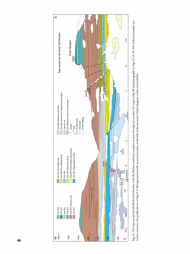
4848
3284
90O
rpiit
Qaq
qaat
Type
sect
ion
for t
he R
inks
Dal
Mem
ber
3547
04
3547
33
?
3547
19-2
0
Cgl.
3284
79
200
12
1.5
0.5
2.5
33.
5
?
?
4 km
400
600
800
1000
1200
1400
mW
E
Fig.
22
Uni
t 518
Uni
t 517
Uni
t 516
Uni
t 515
Uni
t 513
(Ak
uaru
t uni
t)U
nit 5
12
Uni
t 511
(Ska
rvef
jeld
uni
t)U
nit 5
09–5
11 u
ndiff
eren
tiate
dU
nit 5
09U
nit 5
07 su
baer
ial la
va fl
ows
Uni
t 507
fore
set-b
edde
d hy
alocla
stite
sU
nit 5
06 l
arge
pon
ded
lava
flow
Uni
t 506
suba
queo
us la
va fl
ows
Uni
t 506
suba
erial
and
suba
queo
us la
va to
ngue
sLa
terit
ic so
ilU
nit 5
05 p
illow
lava
s and
hya
locla
stite
s
Sam
ple
Faul
tC
onglo
mer
ate
Col
onna
deFo
rese
t bed
ding
Cgl.
3547
18
GV0
3_03
_047
_LM
L.ep
sFi
g. 2
4. T
he ty
pe se
ctio
n fo
r the
Rin
ks D
al M
embe
r with
the t
hick
est a
nd m
ost c
ompl
ete s
ectio
n th
roug
h th
e mem
ber.
See m
ap in
Fig
. 28
and
phot
ogra
phs i
n Fi
gs 2
5, 3
1, 6
3. T
he in
dica
ted
sam
ples
are
us
ed to
cons
truc
t the
pro
file s
how
n in
Fig
s 8, 9
. Pho
togr
amm
etric
ally
mea
sure
d se
ctio
n, so
uth
side o
f the
mou
ntai
n O
rpiit
Qaq
qaat
, sou
th-c
entr
al D
isko.

49
and m2 in the South Disko section at 65–82 km (see Fig. 36) and as parts of the units βf1 and βf1u on the geologi-cal map sheet Uiffaq (Fig. 27). On central Disko, unit 507 occurs on both sides of the inner part of the fjord Kuannersuit Sulluat and on both sides of the valley Kuannersuit Kuussuat and its side val-ley Sorte Hak. It is mapped as unit βfph1 on the geologi-cal map sheet Pingu (Pedersen et al. 2001; Fig. 28). Unit 507 has a total thickness of 360 m north of Sorte Hak (Fig. 9, profile 3) of which the lower 295 m is in subaque-ous facies which makes it one of the thickest subaqueous successions in the Maligât Formation.
South coast of Disko. The Disko Gneiss Ridge is exposed and reaches heights up to c. 350 m at the south coast of Disko between Killiit in the west and Rødeelv in the east (Figs 6, 27). The relationship between the gneiss topo-graphy, subaerial lava flows and subaqueous hyaloclastite
breccias is discussed below at four localities (South Disko section at 67–81 km, see Fig. 36). At Killiit at least four subaerial lava flows of unit 507 onlap the western flank of the Disko Gneiss Ridge, but the contact is not exposed. The flow packet is 115 m thick and the flows vary in thickness between 15 and 50 m (Fig. 7, profile 2). The uppermost flow is overlain by c. 30 cm of reddish lateritic soil. About 4–5 km farther to the east, north-east of Tini, 30–35 m of unit 507 are exposed in a gully. The two localities are separated by a gneiss hill that rises up to 200 m above the level of the lavas of unit 507 (see also Fig. 36 at 69–72 km), indicat-ing that the flows near Tini must have followed an unex-posed palaeovalley. The succession near Tini starts with a strongly columnar-jointed subaqueous lava flow cov-ered by a hyaloclastite composed of decimetre-sized pil-lows and matrix glass shards. The hyaloclastite contains decimetre-sized clasts of claystone and lateritic soil and
MF19_17cmLML_1991_14_16mod_c.eps
cgl.
513
507
506
505
Fig. 25. The western part of the type section for the Rinks Dal Member; unit codes are indicated. cgl: conglomerate. The photo corresponds to Fig. 24 at 0.9–2 km; unit 506 (subaqueous and ponded flows) is 230 m thick. South side of the Orpiit Qaqqaat mountain, south-central Disko.

5050
centimetre-sized clasts of gneiss, all of which have been stripped off a weathered gneiss surface. At the contact be-tween the subaqueous flow and the hyaloclastite there are patches of red-oxidised scoria and up to 15 cm of lateritic soil. The top of the hyaloclastite is covered by several dec-imetres of reddish-brown soil of subaerial origin. This is in turn covered by a compound pahoehoe flow indicating subaerial conditions. East of Tini, at Tuapassuit, unit 507 forms a 115 m thick succession of six subaerial lava flows above a 55 cm thick horizon of sandstone and siltstone with plant re-mains overlying unit 506 (Fig. 7, profile 3). Most of unit 507 must bank up against the Disko Gneiss Ridge north-west of Qeqertarsuaq town because it is not present on the top of the ridge (see Fig. 36 at 76–77.5 km). A single flow of unit 507 overlies the gneiss ridge in the canyon between Apostelfjeld and Lyngmarksfjeld (Fig. 29).
MF20_8cm332960uPcut_c.eps
cpx
pl
cpx
ol
5 mm
Fig. 26. Thin section (scanned) of a typical lava from Rinks Dal Member unit 507. Highly porphyritic basalt with many phenocrysts of plagioclase (pl), olivine (ol, altered to brown clay and white zeo-lite) and augite (cpx) in a medium-grained matrix. Sample GGU 332960, Sorte Hak, central Disko.
ng1f
2f
u
uu
u
eF
u1f1f
ng
5.1
5.1
5.0
1
1
1
5.1
1
2.5 km54°45’ 54°30’
GV01_02_155_LML
60°15’
βf2
βf1 βf1u
OqaatsunnguitQaqqaat
qausrotrolroQ
eQG
qatreqeQnełdłK
tiilliKyabenutroF
turaukAdlejfskramgnyL
taanaravaNdlejfletsopA
Kuus
suaq
Rød
eelv
qailaqqaQneggikdU
tiusuraaQsneksroT
iniT
6
QaarusuitTorskenæs
QeqertaqKødøen
KilliitFortunebay
QaqqaliaqUdkiggen
QeqertarsuaqGodhavn
Fe
gn
gnTini Tuapass
uit
βf1
609Fig. 69 Figs 18,19
Figs 17, 29
Fig. 30
Fig. 35
Fig. 27. Excerpt from the 1:100 000 scale geological map sheet 69 V.1 Syd Uiffaq, showing the lava succession of the Rinks Dal Member cover-ing the hilly relief on the Disko Gneiss Ridge. The brown unit comprises the Fe-Ti-rich lava flows of the Akuarut unit (513). Annotation as on the original map, see Fig. 28. The native-iron-bearing Killiit dyke is shown as red lines marked Fe. The locations of some figures are indicated.

51
This flow has a brecciated lower part and a thin top zone with oxidised scoria and traces of sediment. Between Tuapassuit and Qeqertarsuaq the Disko Gneiss Ridge is c. 200 m high. On its eastern flank, to-wards the outflow of Rødeelv, unit 507 reappears. Sub-aqueous lava flows of this unit are exposed for about 2 km along a rocky beach and a coastal cliff. Here a varied succession of large pillow lobes, subaqueous basalt brec-cias and fine-clastic hyaloclastites formed when a number
of subaerial pahoehoe lava lobes entered the Assoq Lake basin. The elongate pillow lobes (Fig. 30) show a general flow direction from the north-west. Parts of the lobes have cavities now filled by zeolites. The breccias are com-posed of pillows with thin glassy rims in a coarse matrix of brownish-weathering palagonitised glass.
2.5 km
53°15’
69°45’
53°30’
1.5
1
0.5
0.5
1.5
1.5
1.5
1
0.5
0.50.5
0.5
1
1.51
1
1
1 2
1075
0.5 0.5
1.5
1.5
2
1.511149
1
948
1210
βf3
βi
βi
βi
βf1
βf1
βf1
βf1u
βf1u
βf2
βf1u
βf2
βf2
Pmu
Pmu
t
Is
Is
βf1
βf1
βf1
βfph1
βfph1
βfph1
βfph1
βfph1
1282
1
1450
Blomsterdalen
Orpiit Qaqqaat
Kuan
ners
uit K
uuss
uat
Kuannersuit
IsIs
Orpiit
Anguuja
artuutit
Pullanni
Sorte Hak
GV01_02_156_LML
Fig. 63
Fig. 24
Fig. 31Fig. 25
Fig. 33
Fig. 32
Fig. 28. Excerpt from the 1:100 000 scale geological map sheet 69 V.2 Nord Pingu, showing almost the full stratigraphy of the Rinks Dal Member. Annotation as on the original map. This corresponds to the more detailed lithological units in this work as follows: βf1u is units 505–506, βfph1is unit 507, βf1 is units 509–512, βi is unit 513 and βf2 is units 514–518. βf3 is the overlying lava flows of the Nordfjord Member, and Pmu is small exposures of the underlying mudstones of the Assoq Member. The line of view of the type section (Fig. 24) is shown, as well as the locations of some figures.

5252
Central Disko. The basalts of unit 507 extend from the south coast of Disko northwards to central Disko, but they have not been studied or sampled between the south coast and the inner part of Kuannersuit Sulluat (eastern-most Kangerluk). Unit 507 is present in the profile at Eqalunnguaqqat Qaqqaat (Fig. 8, profile 2) as two more than 30 m thick subaerial lava flows overlying unit 506. In the gully on the south slope of Orpiit Qaqqat, unit 507 consists of a small flow field of pahoehoe lobes about 12 m thick covered by a c. 12 m thick lava flow (Fig. 8, pro-file 4). Eastwards from there unit 507 rapidly increases in thickness to more than 100 m just 2 km farther to the east, where it changes facies to form foreset-bedded hya-loclastite infill into the Assoq Lake. The foresets show infilling from the west and north-west, but a very dense joint system striking NW to NNW locally obscures the breccia structure when seen at a distance (Fig. 31). The infill into the lake occurred over a more than 20 km long, north–south-extending front that prograded more than 5 km eastwards, reducing the western lake area by more than 100 km2 (Figs 15, 16).
MF23_8cmIMG_4467AKPcut_c.eps
cpx
pl
top zone
breccia
gneiss
Fig. 29. Lava flow of unit 507 overlying the Disko Gneiss Ridge in the canyon between Apostelfjeld and Lyngmarksfjeld (South Disko section at 77.6 km, Fig. 36). The flow is c. 30 m thick and in transi-tional facies between subaqueous and subaerial: it has a brecciated lower part, its interior is a coarse entablature, and there is a thin rub-bly top zone with oxidised scoria.
MF24_11cmIMG_0618AKP_c.eps
1 m
Fig. 30. Metre-long pillow lobe from a pahoehoe flow of unit 507 that flowed into the Assoq Lake. The lobe has a near-tubular central cavity filled by zeolites. Near the out-flow of Rødeelv east of Qeqertarsuaq town, south Disko.

53
Up to 10 m of black mudstone of the Assoq Member from the lake floor is exposed at the base of the volcanic rocks at a few localities (unit Pmu on the map sheet Pin-gu, Fig. 28). In the profile 5 km north of Sorte Hak, the contact between mudstone and infilling hyaloclastites has produced a chaotic mixture like very coarse peperite where pillow tongues invaded unconsolidated mud (Fig. 32). On both walls of the Kuannersuit Kuussuat valley and its side valley Sorte Hak (Fig. 28), unit 507 consists of foreset-bedded hyaloclastites and overlying subaerial pa-hoehoe lava flows. Excellent exposures in the eastern wall of Kuannersuit Kuussuat north of Sorte Hak formerly
showed the presence of several distinct hyaloclastite beds which cannot have been formed during a single eruptive event. These exposures were covered in 1995 by a surg-ing glacier lobe. The highest foresets produced in a single filling event, which record the water depth in the Assoq Lake at that time, are around 100–150 m high and occur in the northern wall of Sorte Hak. The subaerial pahoehoe lava flows comprise 10 to 15 individual lava lobes in vertical section and represent several flow fields. The uppermost lava flow of unit 507 north of Sorte Hak is thick (35–40 m) and massive and has a regular colonnade indicating that it solidified in a moist environment (Fig. 33).
MF25_17cmLML_1991_14_10mod_c.eps
507 hy
506 sLa
509
507 La
511
Fig. 31. Middle part of the type section of the Rinks Dal Member. The photo corresponds to Fig. 24 at 2.8–3.5 km. Unit 506 is in subaqueous lava facies (506 sLa). A subaerial succession of thin pahoehoe flows of unit 507 (507 La) entered the Assoq Lake from the west and formed a thick horizon of massive foreset-bedded hyaloclastites (507 hy) that prograded more than 5 km into the lake. The foresets are obscured by a very pronounced vertical joint system. The overlying flows are all subaerial. The combined unit 507 (flows and hyaloclastites) is 150 m thick. South side of the Orpiit Qaqqaat mountain, south-central Disko.

5454
Fig. 32. Lava lobes and pillows of a subaque-ous lava flow invading black mudstones of the Assoq Member. The hammer is 32 cm long. Valley bottom 5 km north of Sorte Hak (Fig. 28; Fig. 9, base of profile 4); the locality was covered by ice after a major glacier surge in 1995–1999.
MF27_17cmLML_1991_11_36cut_c.eps
507 La
507 La
507 hy
sediment
Fig. 33. Lithological variations in unit 507. The unit comprises hyaloclastites (507 hy, the foresets dip away from the viewer), a thin sediment horizon, subaerial pahoehoe flows (507 La) and a thick, massive flow with a well-developed colonnade (also 507 La). The thick flow is 35–40 m thick. Kuannersuit Kuussuat north of Sorte Hak, central Disko.

55
Unit 509Composition and petrography. Unit 509 is composed of basalts with TiO2 contents of 1.8–2.5 wt% (Fig. 21). They contain scattered plagioclase and augite glomero-crysts between 1 and 3 mm in size and pseudomorphs up to 1 mm large after olivine crystals (Fig. 34A) in a fine-grained to glassy groundmass. Some regional varia-tions are present. The subaqueous lava flows along the south coast of Disko from Ippik (east of Skarvefjeld) to Tuapaat Qaqqaat have very uniform compositions with TiO2 contents of 2.0–2.2 wt% and mg-numbers of 48–55; these flows were called the Ippik unit by Larsen et al. (2006). On central and northern Disko, several lava flows of unit 509 have higher mg-numbers (57–62), cor-responding to MgO contents of 7.7–8.8 wt%; these flows may be aphyric to slightly olivine-microphyric (Fig. 34B). Other northern flows are very similar to those on south-ern Disko.
Distribution. Unit 509 is present over large parts of cen-tral and southern Disko (Fig. 15); to the north, it reaches Qullissat and Asuutaa but peters out before Orlingasoq
(Fig. 10). It also peters out on eastern Disko and is not present east of Tuapaat Qaqqaat (Fig. 7), Laksedal (Fig. 8) and Inussuk (Fig. 10). It is present on western Disko around inner Nordfjord (Fig. 13) and is assumed to be present beneath sea or exposure level in large areas west of the Disko Gneiss Ridge. Excluding onlap settings, thick-nesses are between 50 m and 240 m. Unit 509 almost, but not completely, covered the Disko Gneiss Ridge. The unit is in subaerial facies on the gneiss ridge and west of it. East of the gneiss ridge the lavas plunged into the Assoq Lake and continued as coherent subaqueous lava flows. The unit prograded far into the Assoq Lake where the flows burrowed into lacustrine and fluvial sediments and continued as invasive lava flows that resemble sills (South Disko section).
Lithologies. In subaerial facies, unit 509 comprises 2–10 lava flows per profile, commonly around five flows. The combined thickness of the flows may exceed 150 m. Indi-vidual flows vary in thickness from less than 5 m to more than 50 m, typical flows being 10–30 m thick. The grey-ish weathering flows are of blocky pahoehoe type (Fig.
5 mm
MF28A_8cm332986uPcut_c.eps
A
5 mm
MF28B_8cm332881uPcut_c.eps
B
Fig. 34. Thin sections (scanned) of typical lavas from Rinks Dal Member unit 509. A: Basalt with numerous glomerocrysts of plagioclase (white), augite (grey) and olivine (dark brown, altered to clay) and smaller single plagioclase and olivine phenocrysts in a fine-grained matrix. Sample GGU 332986, Daugaard-Jensen Dal, south Disko. B: Nearly aphyric basalt with a few microphenocrysts of olivine (dark brown, altered to clay) and plagioclase. Sample GGU 332881, Kuugannguaq, northern Disko.

5656
35; Kilburn 2000) and are visually indistinguishable from most other subaerial flows of the Rinks Dal Member. The flows onlap the flank of the Disko Gneiss Ridge at Killiit (Fig. 7) and west of Tini but overflowed the ridge farther to the east and north (Fig. 36). The lava flows entered the Assoq Lake in an easterly di-rection along a palaeoshore that extended for more than 50 km from the south coast of Disko at Blæsedalen and northwards, where much is presently below exposure lev-el. The infill of unit 509 into the lake must have reduced the lake area by more than 1750 km2. A northern lake or wetland, which may have been continuous or contempo-raneous with the Assoq Lake, existed on north-eastern
Disko between Kuugannguaq and Qullissat (Fig. 15, see also Fig. 48). The large and relatively thick lava flows of unit 509 that entered the Assoq Lake maintained their coherence, also at subaqueous conditions (e.g. Fig. 56). This is in contrast to the small pahoehoe lobes in the flow fields of unit 507 (as well as the overlying unit 511) which were transformed into pillow lavas and foreset-bedded hyaloclastites. A fac-tor contributing to this difference is probably higher mag-ma flow rates in the large flows of unit 509.
South coast of Disko: Infilling of the southern part of the Assoq LakeThe lake floor. Mudstones of the Assoq Member underlie the volcanic units in the Assoq Lake over large areas on south and south-east Disko (Dam et al. 2009, fig. 124), but there are very few exposures due to extensive land-slides and solifluction. The contact relations between the subaqueous lavas of unit 509 and the mudstones are therefore only seen at few localities. The westernmost mudstone crops out beneath Skarvefjeld in a small land-slide, but the main exposures are farther to the east at As-soq (Larsen et al. 2006, fig. 5; Dam et al. 2009, figs 138, 139; Fig. 7, profile 6), Niuluut (Larsen et al. 2006, fig. 13), and Tuapaat Qaqqaat (Dam et al. 2009, fig. 140; Fig. 7, profile 8). The depth of the Assoq Lake when unit 509 was em-placed was estimated to 200 ± 100 m by Larsen et al. (2006).
Subaqueous lava flows. The south coast of Disko con-tains remarkable exposures of strongly columnar-jointed basalts with brecciated tops interpreted to be subaque-ous lava flows (Heinesen 1987; Larsen et al. 2006). The subaqueous lava flows extend for more than 25 km from Blæsedalen in the west to east of Siniffik (South Disko section at 82–107 km, unit m3) and their total thickness is at least 200 m, but over large distances east of Assoq the exposures are poor and fragmented by landslides. The best and most coherent exposures are found between Blæsedalen and Brededal. The individual subaqueous flows may well exceed 10 km in length; however, the chemical and petrographical homogeneity of unit 509 make correlation across valleys, landslides and talus virtually impossible. Several flows have been mapped continuously for 2–3 km along cliff exposures. The thickness of individual flows varies from 5 m to more than 100 m due to local ponding. In typical cliff sections unit 509 consists of 4–5 subaqueous flows.
MF29_8cmIMG_4470AKPmod_c.eps
base
top
Fig. 35. Typical, c. 30 m thick subaerial lava flow of blocky pahoehoe type with a massive, crudely jointed central part and an oxidised rub-bly top. Traces of red lateritic soil occur at the top and base. A patch of brick-red laterite is worked into the flow near its base. Rinks Dal Member unit 509, Lyngmarksfjeld, south Disko.

57
Despite their compositional homogeneity, the flows seem to be well separated in time because there are com-monly small patches of sediment between them. Just east of Blæsedalen hyaloclastite and breccia of unit 507 form an E-dipping palaeoslope which is overlain by a thick flow of unit 509 with a regular colonnade at the base and a thick entablature with several tiers; the top is not exposed. There are traces of sediment in small basins at the base of the flow. At sea level around Kuannit the
spectacular columnar-jointed masses of basalt form a lo-cal tourist attraction. In the cliff beneath Skarvefjeld the lowermost flow ex-tends from sea level to c. 60 m and has a wavy top surface on which there are accumulations of a few centimetres to decimetres of mudstone in the local depressions (see also Fig. 56). A typical subaqueous lava flow such as seen at Ippik (Fig. 37) has at its base a few metres thick regular colon-
GV03_03_051_LML
7069
75 km7473
76 77 78 79 km
200
400
600
800 m
200
600
?
800 m
200
400
600
800 m
71 72 km
m4
m3T2b
m2
gneiss
gn
Fe
Fe
Fe
gn
m7.3
m7.3
m8
m7
m7
m4
m4
m8.29
m8.29
m8
m8
δC
m7
m7
m4
m2
Cr
m7
m7
m2
m8.29
m7.3
?
Tuapassuit
Killiit dyke Tini
gneiss
Oqaatsunnguit Qaqqaat
QaarusuitTorskenæs
QeqertarsuaqGodhavn
ArktiskStation
AkuarutLyngmarksfjeld
NavaranaatApostelfjeld
515
516
515
514
513
514513
509
509
507507
507
W E
W E
W E
Figs 18,19
Fig. 30
Figs 17, 29
Fig. 36. Photogrammetrically measured section along the coastal cliffs on south Disko between Killiit and Arktisk Station near Qeqertarsuaq. Blue three-digit numbers are lithological codes; other annotations as in the original. The brown lava succession is the Akuarut unit (513). Some marker flows are coloured and numbered individually. The locations of some figures are indicated. Excerpt from the South Disko section (Pedersen et al. 2003).

5858
nade which changes abruptly into a 10 m to more than 20 m thick entablature from which lobes may extend upwards into a 5–10 m thick, thoroughly brecciated top zone. Within the top zone itself, and in small depressions on the surface, there may be pockets of volcaniclastic sand and gravel (Fig. 38) that may contain layers of mud-stone with plant remains. There is no red-oxidation at the flow top or between flows. The top zone itself is dis-turbed by the overlying subaqueous flow. Disturbances of the substrate by bulldozing and loading are especially
pronounced where a subaqueous lava flow has run onto unconsolidated mudstone (Fig. 39).
Subaqueous rootless cones. At Niuluut about 20 km from the lake shore, a rootless cone field developed when the first subaqueous lava that flowed onto the lake floor was locally brecciated throughout, providing outlet points for hydroclastic explosions of the pressurised and heated wa-ter in the underlying mud (Larsen et al. 2006). The cliff section cuts through the centres of two cones (Fig. 40; also shown on a scale of 1:2500 in the South Disko sec-
MF31_8cmLML_1981_05_28modcut_c.eps MF32_8cmLML_1981_05_26cut_c.epsFig. 37. Typical subaqueous lava flow of unit 509. The basal zone is a regular colonnade a few metres thick, whereas the major part of the flow is in entablature facies with smaller, curved columns that com-monly form swirls. The top zone (not seen) is thoroughly brecciated. The part of the flow visible in the photo is c. 35 m thick. Ippik, south coast of Disko.
Fig. 38. Fine-grained volcaniclastic sediment between two subaque-ous lava flows (the lower flow is just beneath the outcrop). The lower part of the sediment is normally graded with a weak lamination; the upper part is homogeneous. Note the absence of red oxidation col-ours. The basal zone of the overlying flow is thoroughly brecciated. Ippik, south coast of Disko.

59
tion), and others are probably present both seawards and landwards. The cones are small mounds about 25 m high and 100–200 m wide, composed of normally graded and well-bedded volcaniclastic material intimately mingled with mudstone in up to metre-sized clasts, frequently with plant fragments. In both cones, the bedding dips
away from a central ‘chimney’ that is considered to be the outlet point for the explosions and later filled with shaly sediment. Large pieces of apparent driftwood indicate the proximity of emerged and forested land. Detailed de-scriptions and interpretations are found in Larsen et al. (2006).
MF33_17cmA871231Bennymod_c.eps
mudstone
509
Fig. 39. A large subaqueous lava flow of unit 509 that has filled a depression within unconsolidated mudstones of the Assoq Member and deformed and probably partly replaced the mud. The colonnade columns are of different heights but always perpendicular to the lower boundary of the flow. Person for scale. The locality is also seen in Fig. 40. Niuluut, south coast of Disko.
mm m
m
Lavatongues
chimney
MF34_fig7_LML-rgb._c_Vers 2.epsFig. 40. Section through a subaqueous rootless cone. The flank of an adjacent cone is seen to the right. See text and Larsen et al. (2006) for descriptions. The cone was covered with mud (m) that also filled the central explosion site (chimney). A thick lava flow (white line traces its base) subsequently overran the cones; thin lava tongues invaded the mud overlying the cone flank to the left, and the massive lava subsided into the mud between the cones (Fig. 39). Height of cliff section c. 25 m. Niuluut, south coast of Disko.

6060
115 116 117 km
m3 m3
K1b
m7
m8
200
400
600
800 m
m7T2b
T2a
T2a
TuapaatQaqqaat
Nuuk
Ls
LsLs
Sm
Ls
Ls
Ls
E
ECgl
InIn
In InIn
Ls
GV03_03_052_LML
513
509 Not exposed
WSW ENE
Fig. 73Fig. 72
Fig. 41. Lava flows of Rinks Dal Member units 509 (blue) and 513 (brown) invasive (In) into Paleocene mudstones (T2a) and sandstones (T2b) of the Assoq Member of the Atanikerluk Formation. Cgl: conglomerate. Sm: sill. Pale yellow K1b: Cretaceous sandstone. E: Entablature. Ls: landslipped exposures. The locations of some figures are indicated. Tuapaat Qaqqaat, south coast of Disko, excerpt from the South Disko section (Pedersen et al. 2003).
MF36_17cmIMG_8486EVSmod_c.eps
subaq 1
inv 3m
m
mm
inv 2
inv 1
Fig. 42. Lava flows of Rinks Dal Member unit 509 invasive into dark brown mudstones (m) of the Assoq Member at its type locality. There are three successive, invasive, sill-like flows (inv 1 to inv 3) and a thick subaqueous flow (subaq 1). Note the colonnades at both base and top of inv 2. The exposure is about 100 m high and is slightly slipped and rotated. Assoq just east of Brededal, south coast of Disko. Photo: Erik Vest Sørensen.

61
Invasive lava flows. A number of basaltic sill-like bodies crop out over a distance of more than 23 km between As-soq and Tuapaat Qaqqaat (South Disko section at 95–118 km (Fig. 41); in small gullies along the coast there are sometimes fragmentary exposures of mudstone beneath, between and above them. The sills are chemically and petrographically identical to the subaerial and subaque-ous lava flows of unit 509. The complete absence of any feeder bodies led Larsen & Pedersen (1990) to conclude that the sills are invasive lava flows formed when sub-aqueous flows invaded unconsolidated Assoq Member sediments and continued their eastward flow as sills. The sill-like invasive lava flows may show planar, con-cordant lower and upper contacts to the mudstone, or they may form more irregular bodies. At the upper con-tacts, there may occasionally be pillow bodies, and small apophyses may extend from the lavas to form auto-brec-ciated hyaloclastite. The ‘sills’ may show well-developed upper and lower colonnades and, in the central part, an entablature zone of small, irregular columns. The best ex-posures are in the type section of the Assoq Member in a landslide at Assoq just east of Brededal (Fig. 42; Dam et al. 2009, fig. 138 and 139; Larsen et al 2006, fig. 6). Here three to four successive invasive lava flows are embedded in mudstone and underlying sandstone (Fig. 7, profile 6). They are covered by 3–4 subaqueous lava flows, which are broken up into several smaller landslides and are not seen in continuity (Fig. 42). Some samples of the mudstones between the flows contain dinoflagellate cysts (Piasecki et al. 1992; H. Nøhr-Hansen, personal communication 2017). On the south coast of Disko invasive lava flows are relatively well preserved along a W–E oriented ridge ex-tending from Tuapaat Qaqqaat to Tuapaat at the coast (South Disko section at 116 to 118 km (Fig. 41; Fig. 7, profile 8). Here both the lower and upper contacts be-tween mudstone of the Assoq Member and four invasive lava flows of unit 509 are preserved. They are overlain by sand with at least two invasive flows of unit 513. The upper boundary of unit 509 is poorly exposed between Assoq and Tuapaat Qaqqaat but seems to have been entirely beneath the surface of the Assoq Lake (Fig. 7). To the west, beneath Skarvefjeld, subaqueous lava flows of unit 509 with traces of mudstone on top are cov-ered by up to 160 m of regularly foreset-bedded hyalo-clastites of unit 511 (see also Fig. 56). Heinesen (1987) provided evidence of semi-continuous subsidence of the Assoq basin in the western part of Skarvefjeld in the time interval of the eruption of the overlying lava plateau; if subsidence also took place during the emplacement of
the subaqueous parts the 160 m height of the foresets is a maximum depth for the lake overlying unit 509.
Daugaard-Jensen Dal. Complete filling of the central As-soq Lake took place about 30 km farther to the north in Daugaard-Jensen Dal (Fig. 8, profile 5) where 210 m of subaqueous lavas and a single subaerial lava flow of unit 509 can be observed in the northern wall of the valley (Fig. 43). There are several typical subaqueous lava flows with well-preserved, thick top zones of pillow breccia with metre-sized pillows and pillow tubes. One of the top zones encloses up to metre-sized boulders of basaltic lava, which are talus fragments from the palaeoshore carried into the lake by the later lava flow (Fig. 44). The upper-most subaqueous flow is covered by a 35–40 m thick lava flow that has a well-developed colonnade and entablature zone and a thick scoriaceous top zone which is slightly high-temperature oxidised and obviously subaerial.
The northern basin in the Kuugannguaq–Qullissat areaLava flows and breccias of unit 509 form the basal part of the Maligât Formation over large areas on north-eastern Disko between the inner Kuugannguaq valley and the Vaigat coast around Qullissat (see also Fig. 48). Here unit 509 onlaps the Vaigat Formation, and the volcanic rocks display a considerable range of morphologies de-pending on the nature of the environment in which they were emplaced. In large areas unit 509 is concealed below younger basalts or glaciers, scree or landslides. However, semi-continuous exposures of the succession occur in three, more than 10 km long, subparallel sections orient-ed approximately NW–SE. Two sections form the walls of the inner part of the Kuugannguaq valley and are only 2–3 km apart, whereas the third section comprises the coastal slopes along the Vaigat strait 15 km north-east of Kuugannguaq.
Kuugannguaq valley. On both walls of the inner part of the Kuugannguaq valley (map sheets Qutdligssat and Pingu), lava flows of unit 509 are seen onlapping the gently SE-sloping top surface of the Vaigat Formation. The geology of both walls has been compiled from long photogrammetric panels, and the succession has been sampled in a profile on the north-eastern wall where unit 509 is 240 m thick (Fig. 9, profile 5); the north-eastern wall is shown in the Central Disko section at 51.5–60.5 km where the sample profile is situated at 55–56 km. The

6262
distances to the nearest investigated exposures of unit 509 to the south and south-east are around 25 km. In Kuugannguaq the lavas of unit 509 encountered waterlogged or water-covered areas which were either an extension of the Assoq Lake or a separate wetland. The volcanic morphologies record two phases of interaction between the inflowing magmas and water in the subsid-ing basin. The first phase is seen in both valley walls but is best exposed in the south-western wall. Here the basal part of unit 509 comprises a group of several strongly brecciated lava flows up to 40 m thick, which can be fol-lowed for about 5 km towards north-west, petering out
to 0 m by onlap onto the Vaigat Formation. These flows are overlain by a few entirely subaerial lava flows, which step directly onto the Vaigat Formation for 5–6 km far-ther towards north-west (Fig. 45). There are three such flows in the south-west wall and two thinner ones in the north-east wall (Fig. 46), indicating that the flows arrived from a south-westerly direction. The flows were probably deflected by the SE-sloping surface of the Vaigat Forma-tion and channelled along this. Continued basin subsidence led to renewed accumu-lation of water in the area. A second water-influenced phase is indicated by a renewed occurrence of brecci-
MF37AB_17cmDAU1_2_06mod3_c.eps
509 sLa
509 sLa
509
511
513
514
512
509 sLa
Fig. 43. Section illustrating the filling of the western Assoq Lake by unit 509. Numbers are unit codes. Unit 509 comprises 210 m of subaqueous lava flows (509 sLa) and a single subaerial flow. The overlying units are all in subaerial lava facies. North side of Daugaard-Jensen Dal, central Disko; sampled pro-file in Fig. 8, profile 5.

63
ated flows and flows with distinct development of colon-nades and entablature zones, followed by a huge ponded lava flow with a large, regular colonnade (Figs 45, 46). This lava packet is well exposed on both valley walls and is thicker in the north-east wall than in the south-west wall, suggesting a somewhat deeper basin to the north-east, filled during continued volcanic inflow from the south-west. These lavas extended 5–10 km farther to the north-west than those of the first phase. The large ponded lava flow can be followed for at least 9–10 km on both valley sides and locally attains a thickness of 70–80 m. It covers more than 50 km2 and has a volume
well above 2–3 km3. Towards the south-east it seems to consist of several separate subaqueous lava tongues. To-wards the north-west it forms a single distinct flow with load structures towards the underlying volcaniclastic sediment (Fig. 46); its colonnade becomes thicker, con-tinuous, and extremely regular, whereas its top gradually develops scoria and becomes high-temperature oxidised. Farther towards the north and north-west the flow thins against the sloping surface of the Vaigat Formation and the colonnade becomes coarse and less regular until the flow has the appearance of an entirely subaerial lava flow (Fig. 47). This flow provides the best example from the Maligât Formation of the morphological variations of a basaltic lava flow emplaced under changing wet and dry conditions.
Qullissat coastal section. The exposures along the Vaigat coast comprise a c. 11 km long, SE–NW-oriented section extending from just north of Qullissaaqqat (Gamle Qul-lissat) in the south-east to Killerpaat Qaqqarsuat north-west of Qullissat, shown in Fig. 48. In the north (Fig. 48 at 7.3– >11 km), subaerial picritic lava flows of the Vaigat Formation form a gently SE-sloping surface, similarly to the setting in the inner part of Kuugannguaq. At 6.2 to 7.3 km, the Vaigat Formation terminates in c. 200 m high fans of bedded hyaloclastite deposits. These are covered by lacustrine mudstone except where the sediments have been removed by a glacier. The mudstone is tentatively referred to the Assoq Member on the basis of its mineral-ogy, indicating that the Assoq Lake, or a contemporane-ous lake, extended into this area. Maligât Formation lavas of unit 509 overlie sediments and the Vaigat Formation throughout the section, but to the south, the boundary and the lower part are poorly exposed because of talus and landslides (Fig. 48 at 2–6.5 km). Unit 509 is up to 150 m thick in the Qullissat section and composed of one to four lava flows, most of which are strongly affected by emplacement over a wet or ful-ly water-covered surface (Fig. 10, profiles 4, 5). In the mountain wall beneath Killarpaat Qaqqarsuat three vo-luminous lava flows are exposed which have very promi-nent dark grey entablature zones and olive grey brecci-ated tops (Fig. 49). The top zone of the lowermost flow is entirely a subaqueous pillow breccia, whereas the second flow top is dominated by pillow breccia with metre-sized pillows and also contains patches of high-temperature air-oxidised scoria, showing that this flow for a time completely displaced the water. The third flow also has a top of partly glassy breccia and partly oxidised scoria and was emplaced after return of the water to this part of the
MF38_8cmLML_1991_12_02modcut2_c.eps
509 sLa
1 m
Fig. 44. Top zone of a subaqueous lava flow of unit 509 enclosing a large boulder of subaerial basalt lava as well as the usual pillows and pillow fragments. The lava boulders are older talus fragments from the palaeoshore carried into the lake by the lava flow. North side of Daugaard-Jensen Dal, central Disko.

6464
MF39_17cmAKP_1991_12_05modcut_c.eps
509 La
450 La
Fig. 45. Lava flows of Maligât Formation unit 509 onlapping the gently sloping surface of the Vaigat Formation (450 La). The three lowest flows of unit 509 are subaerial, the following dark flow is brecciated, and the overlying thick flow is ponded. Height of exposure c. 400 m. South-western wall of the inner Kuugannguaq valley c. 45 km from the mouth of the valley.
MF40_11cmLML_1988_08_20udcut_c.eps
509 sLa
509 La
soil
509 La
picrite450 La
volcaniclasticsediment
Fig. 46. Subaerial picrite flows of the Vaigat Formation unit 450 overlain by basalt flows of the Maligât Formation unit 509. There are two subaerial flows with a reddish soil horizon between them, a black volcaniclastic sediment and a thick subaqueous flow (509 sLa) with irregular base because of load-ing into the soft sediment. Height of field of view c. 100 m. North-eastern wall of the inner Kuugannguaq valley c. 45 km from the mouth of the valley.

65
subsiding basin. Farther to the north-west, just north of Fig. 48, only one of these flows has well developed col-onnade and entablature; it has an entirely oxidised and scoriaceous top and marks the final infilling of the wet-land in this part of Disko. Five kilometres farther to the north-west, at Asuutaa, unit 509 consists of one or two entirely subaerial lava flows with a total thickness of less than 40 m (Fig. 10, profile 2). In the central part of the Qullissat section, where Vai-gat Formation hyaloclastites are covered by mudstones and sandstones of the Atanikerluk Formation, a colum-nar-jointed sill is intruded into the sediments (Fig. 48); see also Pedersen et al. (2017, fig. 162). The sill has a composition typical for unit 509 and is interpreted as an invasive lava flow. Its continuation into the normal lava package is obscured by landslides. In the south-eastern part of the Qullissat section, at Inussuk, unit 509 consists of three or four entirely sub-aqueous lava flows with glassy brecciated top zones. In one of the flows, the top zone is a 10 m thick stratified hyaloclastite. The lower part of unit 509 is here covered by landslides.
As in Kuugannguaq, the basalts of unit 509 reached the Qullissat area from the south-west and onlapped the gently SE-sloping top surface of the Vaigat Formation.
Unit 511 (Skarvefjeld unit)Composition. The Skarvefjeld unit represents a shift in chemical composition. The defining feature is that, for a given mg-number (atomic 100Mg/(Mg + Fe2+)), the la-vas of the Skarvefjeld unit have significantly higher TiO2 contents than the lavas of the earlier units, so much that in a plot of TiO2 versus mg-number there is little or no overlap between the Skarvefjeld unit and the earlier units (see also Fig. 97). The lavas of the Skarvefjeld unit have TiO2 contents of 1.9–2.8 wt%; most of them have MgO contents of 6–9 wt% but the unit also includes magne-sian rocks with MgO contents of 10–25 wt%; of the 13 samples from the Rinks Dal Member with MgO >10 wt%, 11 are from the Skarvefjeld unit. It is sometimes difficult to chemically distinguish the most evolved lavas of unit 511 from unit 512. This is un-derstandable in view of the interpretation by Larsen &
MF41_17cmAKP_1988_10_23mod_c.eps
450 La
450 hy
509
Fig. 47. Picrite hyaloclastites (450 hy) and subaerial lava flows (450 La) of the Vaigat Formation overlain by entirely subaerial flows of the Ma-ligât Formation unit 509. The lowest flow, thinning towards the north (left), is the same as the thick ponded flow shown in Figs 45, 46. Height of field of view c. 500 m. North-eastern wall of the inner Kuugannguaq valley c. 40 km from the mouth of the valley.

6666
Pedersen (2009) that the Skarvefjeld unit is the result of incomplete mixing of the evolved magma residing in the deep-seated magma chamber with a new batch of primi-tive magnesian magma. Thus unit 512 represents the residing magma which in principle grades continuously into the mixed magma at the evolved end of the mixing curve. This also explains the local co-occurrence of lavas
of unit 511 and 512, as in the profiles in Kuugannguaq (Fig. 9), Asuutaa and Killerpaat Qaqqarsuat (Fig. 10).
Petrography. The most magnesian rocks of the Skarvefjeld unit (with MgO >10 wt%) are strongly olivine-phyric and similar to picrites of the Vaigat Formation. These lavas are confined to a small area around Orlingasoq on
1800
1600
1400
1200
1000
800
600
400
200
1800mm
1600
1400
1200
1000
800
600
400
200
0 km
Ls
Ls
Ls
Ls
LsLs Ls
Ls
Ls Ls
Ls
Ls
LsLs Ls
Ls
Ls
LsLs
In
LsLs
Ls
Ls LsT?
T? T?
Ls Ls
Ls
Ls
LsFe
FeFe Fe
Fe
1 2 NunngarutCoal mine
Peak 1727 m
Killerpaat Qaqqarsuat
Killerpaat Qaqqarsuat
Inussuk
Q u l l i s s a t
3 4 5 6 7 8 9 10 11 km
GV03_03_033_04_LML.eps
SE NW
In Invasive lava Fe Native iron Ls Landslipped area Houses (Qullissat)
Mali
gât F
orm
atio
n
Vaiga
t For
mat
ion
Atan
ikerlu
k Fm
T?
ORDLINGASSOQ MEMBER PALEOCENE?
CRETACEOUS
Fluvial sandstone, age uncertain
ATANE FORMATION, sandstone with shale beds and coal layers
PALEOCENEQUATERNARY
Undifferentiated Maligât Formation
Subaerial lava flows
Olivine-phyric picrites (unit 450)Subaerial lava flowsForeset-bedded hyaloclastites
Intrusion of iron-bearing magnesian andesite, probably equivalent to Asuk Member
Undifferentiated landslipped volcanic rocks
ASSOQ MEMBER sandstone and mudstone
NÂUJAT MEMBER mudstoneForeset-bedded hyaloclastites Lower Rinks Dal Mb lava flows with prominent entablatures and thicktop breccias, partly or wholly subaqueous (unit 509)
Akuarut unit lava flows. Iron-titanium-rich basalt (unit 513)
Lower Rinks Dal Mb subaerial lava flows. Feldspar-phyric and aphyric basalt(unit 512)
Boundary between massive lower part and thick top breccia of lava flow
RINKS DAL MEMBER
Skarvefjeld unit (unit 511) Olivine- and feldspar-microphyric basalt
Ice and perennial snow
Undifferentiateddeposits
A
N
A
N N N
509511
512
513
514–517
450
Fig. 48. Photogrammetrically measured section along the north coast of Disko around Qullissat. A pencil drawing by R.R.J. Hammer of the same coastal section (from Steenstrup 1900) is shown for comparison. Numbers are lithological unit codes.

67
north-eastern Disko where they are intercalated with less magnesian lavas of the same unit (Fig. 10, profiles 1, 2). Basalts with 7–10 wt% MgO are characterised by a few equidimensional olivine phenocrysts and abundant skel-etal, frequently platy, olivine microphenocrysts, and by microphenocrysts of plagioclase which increase in abun-dance as MgO decreases to 7 wt% (Fig. 50A). Tiny semi-
transparent chromite crystals occur enclosed in olivines in these rocks. Basalts with 6–7 wt% MgO have augite as an additional phenocryst phase to olivine and plagio-clase, and some rocks contain glomerocrysts of augite, plagioclase and olivine (Fig. 50B).
1800
1600
1400
1200
1000
800
600
400
200
1800mm
1600
1400
1200
1000
800
600
400
200
0 km
Ls
Ls
Ls
Ls
LsLs Ls
Ls
Ls Ls
Ls
Ls
LsLs Ls
Ls
Ls
LsLs
In
LsLs
Ls
Ls LsT?
T? T?
Ls Ls
Ls
Ls
LsFe
FeFe Fe
Fe
1 2 NunngarutCoal mine
Peak 1727 m
Killerpaat Qaqqarsuat
Killerpaat Qaqqarsuat
Inussuk
Q u l l i s s a t
3 4 5 6 7 8 9 10 11 km
GV03_03_033_04_LML.eps
SE NW
In Invasive lava Fe Native iron Ls Landslipped area Houses (Qullissat)
Mali
gât F
orm
atio
n
Vaiga
t For
mat
ion
Atan
ikerlu
k Fm
T?
ORDLINGASSOQ MEMBER PALEOCENE?
CRETACEOUS
Fluvial sandstone, age uncertain
ATANE FORMATION, sandstone with shale beds and coal layers
PALEOCENEQUATERNARY
Undifferentiated Maligât Formation
Subaerial lava flows
Olivine-phyric picrites (unit 450)Subaerial lava flowsForeset-bedded hyaloclastites
Intrusion of iron-bearing magnesian andesite, probably equivalent to Asuk Member
Undifferentiated landslipped volcanic rocks
ASSOQ MEMBER sandstone and mudstone
NÂUJAT MEMBER mudstoneForeset-bedded hyaloclastites Lower Rinks Dal Mb lava flows with prominent entablatures and thicktop breccias, partly or wholly subaqueous (unit 509)
Akuarut unit lava flows. Iron-titanium-rich basalt (unit 513)
Lower Rinks Dal Mb subaerial lava flows. Feldspar-phyric and aphyric basalt(unit 512)
Boundary between massive lower part and thick top breccia of lava flow
RINKS DAL MEMBER
Skarvefjeld unit (unit 511) Olivine- and feldspar-microphyric basalt
Ice and perennial snow
Undifferentiateddeposits
A
N
A
N N N
509511
512
513
514–517
450

Distribution. The distribution of the Skarvefjeld unit is shown in Fig. 15. The Skarvefjeld unit is centred on Disko east of the gneiss ridge but is also present on west-ern Disko and south-eastern Nuussuaq (Fig. 15; Larsen & Pedersen 1990, fig. 4). On eastern and southern Disko the unit is easily distinguished lithologically as a compact package of foreset-bedded hyaloclastites capped by their equivalent subaerial facies of thin pahoehoe lava flows. With this morphology the unit has been mapped on the 1:100 000 scale geological maps Uiffaq 69V.1S and Pingu 69V.2N (unit βfph2), as well as on the 1:20 000 geological sections (South Disko section, Central Disko section). The unit is well exposed on the south coast of Disko between Skarvefjeld and Ippik where it is up to 180 m thick, and on eastern Disko around Kvandalen and Blåbærdalen where thicknesses are 50–150 m. It is
MF42_17cmIMG_2738EVSmod_c.eps
450
509
511–512
513
Fig. 49. Facies of the Maligât Formation at the north-western shore zone of the Assoq Lake basin. Subaerial picrite flows of the Vaigat Forma-tion unit 450 are overlain by two voluminous lava flows of Maligât Formation unit 509 with very prominent dark grey entablature zones and light grey brecciated tops, indicating emplacement into water. These are followed by subaerial flows of units 511–513. The height of the ex-posed section is c. 600 m. Killerpaat Qaqqarsuat, north Disko (north-western part of the coastal section in Fig. 48). Photo: Erik Vest Sørensen.
5 mm
MF43A_8cm362315Polcut_c.eps
A
1 mm
ol
pl
glass
cpx
MF43B_8cm176765g_c.eps
BFig. 50. Thin sections of rocks from Rinks Dal Member unit 511, Skarvefjeld unit. A: Typical basalt lava with a few equidimensional olivine phenocrysts and abundant skeletal, commonly very elongate olivine phenocrysts (all altered to yellowish brown clay) together with a few plagioclase glomerocrysts (white) in a medium-grained groundmass. Scanned thin section. Sample GGU 362315 (MgO = 7.3 wt%), Laksedalen, eastern Disko. B: Pillow breccia of basalt with glomerocrystic plagioclase (pl), fresh olivine (ol) and augite (cpx) in a glassy groundmass with tiny crystals of the same phases. Micro-photograph, plane polarised light. Sample GGU 176765 (MgO = 6.5 wt%), Skarvefjeld, south Disko.
68

69
also present on northern Disko around Qullissat where it is c. 200 m thick and shows a morphological variety com-prising subaqueous lava flows, foreset-bedded hyaloclas-tites and associated thin subaerial pahoehoe lava flows, and thick subaerial lava flows (Figs 48, 49). On central and northern Disko, lavas of the Skarvefjeld unit are in subaerial facies and lithologically indistin-guishable from the surrounding lavas. Two to five flows referred to the Skarvefjeld unit are present in nearly all profiles from Orpiit Qaqqaat to Daugaard-Jensen Dal, Sorte Hak, Kuugannguaq, Orlingasoq and Qullissat, commonly intercalated with flows referred to unit 512, as explained above. On southern Nuussuaq one to two water-influenced flows are found lowest in the profiles at Giesecke Monument and Eqi.
Lithologies. The volcanic rocks of the Skarvefjeld unit oc-cur as subaerial and subaqueous lava flows, pillow lavas, hyaloclastites and volcaniclastic beds. The successions of thin pahoehoe flows and foreset-bedded hyaloclastites, to which all the picritic rocks belong, show considerable lithological similarity to the picritic rocks of the Vaigat Formation. Many lavas form flow fields consisting of many thin flow lobes with ropy flow surfaces, testifying to the fluid character of the magma (Fig. 51). Subaerial lava flows with MgO >10 wt% tend to develop subhori-zontal, vesiculated segregation veins (Fig. 52). Soil layers of centimetre to decimetre thickness within the succession show that the Skarvefjeld unit was erupted in several phases separated by sufficient time intervals to allow soil formation.
MF44_8cmAKP_1987_10_24_c.epsFig. 51. Well-preserved ropy surface of a thin pahoehoe lava flow in the Skarvefjeld unit. South-western slope of Qinngusaq mountain, innermost head of Kvandalen valley, east Disko.
MF45_8cmAKP_1987_09_19modcut_c.epsFig. 52. A 7 m thick subaerial pahoehoe flow of olivine-rich basalt of the Skarvefjeld unit (511) with subhorizontal, vesiculated segrega-tion veins. The overlying flow is a feldspar-phyric basalt also of unit 511. Ridge between Frederik Lange Dal and Charles Polaris Dal, east Disko (Fig. 10, profile 9 around 600 m). The background shows the same succession in the north wall of Charles Polaris Dal. For lo-cation, see Fig. 140.
MF46_8cmAKP_1987_09_26cut_c.epsFig. 53. Pillow lava of the Skarvefjeld unit: basalt pillows in a brown-weathering matrix of volcanic glass, formed close to the entry point of the flow into the Assoq Lake. Length of hammer 32 cm. North side of Frederik Lange Dal, east Disko; for location, see Fig. 140.

7070
Where the pahoehoe flows entered the Assoq Lake, pillow lavas (Fig. 53) and hyaloclastites were formed, and volcaniclastic sediments occur as distal deposits along the basin floor (Fig. 54). These sediments frequently contain scattered fragments of silicified wood or coal. Mudstone of the Assoq Member is occasionally exposed beneath the volcanic rocks (Fig. 55). The Skarvefjeld unit formed the western shore zone of the Assoq Lake for nearly 100 km from south to north across Disko (Fig. 15). It prograded into the lake in a gen-eral easterly direction until the magma was exhausted. Despite the fact that much of unit 511 is composed of pahoehoe flow fields which are unlikely to have flowed individually for more than at most a few tens of kilome-tres and hence must have been erupted on the present Disko, no trace of any feeder dykes or necks have been
located. Three subareas of inflow into the Assoq Lake can be recognised and are described below.
South coast of Disko around SkarvefjeldThe south coast of Disko around Skarvefjeld has been described by Heinesen (1987), Larsen & Pedersen (1990) and documented by Pedersen et al. (2000) and in the South Disko section. The Skarvefjeld unit is ex-posed in the coastal cliffs over a distance of c. 7 km from Skarvefjeld in the west to the western side of Brededal in the east (South Disko section at 84.3–91.3 km). Here it forms a 80–100 m thick succession of foreset-bedded hyaloclastites and an overlying 30–40 m thick succession of pahoehoe flow lobes with transitional breccia facies at the interface between lavas and hyaloclastites (Fig. 7,
MF47_8cmAKP_1987_10_19cut2_c.eps
MF48_8cmAKP_1987_10_14cut2_c.epsFig. 54. Relatively fine-grained hyaloclastite with a few larger clasts deposited as a sediment gravity flow distally from the entry point of the lava flow into the Assoq Lake. About 15 cm of the underly-ing Assoq Member siltstone are seen lowest in the photo. Length of hammer 55 cm. Innermost head of Kvandalen, east Disko; for loca-tion, see Fig. 140.
Fig. 55. Laminated, silt-streaked mudstone with normal and inverse grading (shown by white open triangles at left) deposited from distal density currents, overlain by nearly homogeneous mudstone (above dashed line). Assoq Member underlying the Skarvefjeld unit, detail of loose boulder; diameter of lens cap 5 cm. Innermost head of Kvan-dalen, east Disko; for location, see Fig. 140.

71
profile 4). The foresets dip consistently S to SE, showing that the subaerial lavas flowed into the Assoq Lake basin from the north and north-west. Individual foresets can be followed from the palaeoshore to the basin floor and demonstrate a lake depth of 80–100 m at the time (Figs 56–57, 89). The hyaloclastites are separated from the un-derlying subaqueous lava flows of unit 509 by an up to a few decimetres thick veneer of dark mudstone, which may be disturbed by the hyaloclastites. The western and eastern margins of unit 511 are unexposed due to scree or erosion. At Ippik the top of the subaerial lava flows of the Skarvefjeld unit is eroded and covered by a c. 2 m thick bed of fine-grained yellow sandstone with millimetre-sized clasts of quartz and chert but entirely devoid of Tertiary volcanic components. The sandstone is a distal facies of sandstone from the Assoq Member (Dam et al. 2009) which is well exposed at Tuapaat Qaqqaat some 25
km to the east (Fig. 41; also Fig. 72). The sandstone at Ip-pik is covered by lava flows of unit 512 (Figs 57–58). All the basalts of the Skarvefjeld unit along the south coast of Disko show a narrow compositional range (6.1–6.5 wt% MgO) and could have originated from the same flow field.
East Disko around KvandalenThe lavas and hyaloclastites of the Skarvefjeld unit are shown as unit βfph2 on the map sheet Pingu (Pedersen et al. 2001). On the Central Disko section at 79.5–93 km, they comprise units m5 (foreset-bedded hyaloclas-tites) and m6 (lava flows) in the inner part of Kvandalen. Three localities aligned NW–SE for about 30 km (inner Kvandalen, Charles Polaris Dal and Point 1123 m) illus-trate the compositional and lithological variation of the Skarvefjeld unit on eastern Disko.
MF49_17cmAKP_1987_01_29mod3_c.eps
514–518
511 hy
513
509 sLa
Fig. 56. Systematic upward changes of volcanic facies in the succession beneath Skarvefjeld, demonstrating the filling of the Assoq Lake basin. The lowest unit (509) is 160 m thick and comprises at least four subaqueous lava flows with thick, yellowish brown breccia tops (509 sLa); deposits of mudstone have accumulated in the lows on the undulating surface of the lowest flow (arrow). The overlying Skarvefjeld unit com-prises an 80 m thick horizon of foreset-bedded hyaloclastite (511 hy; the foresets dip towards the viewer); the associated overlying subaerial pahoehoe flows are concealed beneath scree. Scree also conceals a few flows of unit 512 and a thin horizon of quartzo-feldspathic sandstone, probably a fluvial deposit. The following units 513 to 518 are all in subaerial facies with red-oxidised top rubble. Cliff face, 920 m high, beneath Skarvefjeld, south coast of Disko just east of Qeqertarsuaq town; see also Figs 57, 58, 89.

7272
IPPIK
400 m
sst
297 m
Pahoehoeflows (511)
sstsst
Irregular flows (513)
Subaerial flowsoxidised top (513)
Thick flow with colonnade+entablature (512)
300 m
Foreset-beddedhyaloclastitebreccia (511)
Three subaqueouslava flows(509)
Mudstoneschlieren
200 m
MF50_Ippikscan_bitmap.eps
Fig. 57. Photogrammetric interpretation of the volcanic succession at Ippik 4 km east of Skarvefjeld, south coast of Disko. Subaque-ous lava flows of unit 509 and hyaloclastites of unit 511 filled in the Assoq Lake. The foresets can be traced from top to bottom of the hyaloclastite, indicating a lake depth of around 85 m. Note two very thin levels of sandstone (sst). Lithological unit codes in parentheses. See also Fig. 58. From Heinesen (1987), with slightly modified text.
MF51_17cmAKP_1989_02_11mod_c.eps
512 La
sst
sst
511 hy
511 La
513
513
Fig. 58. The volcanic succession at Ippik. Hyaloclastites of the Skarvefjeld unit (511 hy) and subaerial lava flows of units 511, 512 and 513. The single flow of unit 512 has a well-developed colonnade indicating emplacement on a wet surface; thin layers of quartzo-feldspathic sandstone (sst), probably fluvial, are seen both below and above this flow. See also Fig. 57. Ippik, south coast of Disko (south Disko section at around 90 km).

73
Inner Kvandalen. Fig. 10, profile 8. In the innermost part of Kvandalen the Skarvefjeld unit is about 200 m thick. It overlies more than 20 m of Assoq Member mudstones, which contain plant fossils and thin shell fragments of a small bivalve. The lowermost c. 180 m of the unit is in subaqueous facies and forms various hyaloclastites and volcaniclastic beds, which were derived from at least three different eruptive events separated in time by beds of non-volcanic clastic sediments. The lower hyaloclastite unit comprises some of the most evolved basalts of unit 511 (with c. 5.5 wt% MgO) and is composed of glassy clasts and pillow fragments of plagioclase-augite microphyric basalt together with clasts of subaerial basalt, mudstone and scarce siderite concre-tions derived from clastic sediments. The unit comprises several beds with varying amounts of moderately baked mudstone and conglomeratic layers of up to decimetre-sized basalt clasts derived by coastal erosion of subaerial lava flows of unit 511. Some of the beds are dominated by volcaniclastic gravel and are separated by up to dec-
imetre-thick beds of deformed mudstone (Fig. 54). A middle unit is composed of slightly more magnesian hya-loclastite (with c. 6 wt% MgO) with scattered clasts of mudstone. The uppermost unit is up to 100 m thick and consists of foreset-bedded hyaloclastite and pillow lava of distinctly more magnesian basalt (with 8–9 wt% MgO) which were fed from overlying, compositionally similar subaerial pahoehoe lava flows.
Charles Polaris Dal. Fig. 10, profile 9. About 11–12 km south-east of profile 8, the Skarvefjeld unit is excellently exposed on both walls of Charles Polaris Dal, in particu-lar the south wall at the corner to Frederik Lange Dal. The Skarvefjeld unit is here about 125 m thick and over-lies quartzo-feldspathic sandstone and c. 80 cm of poorly exposed mudstone of the Assoq Member. The lowermost part of unit 511 is an about 7 m thick volcaniclastic bed composed of glassy basalt clasts and pillow fragments together with scattered millimetre-sized polished quartz grains, rare centimetre-sized clasts of polished chert, and
MF52_17cmLML_1987_03_27_c.eps
511 hy
511 La
513
512
sstsst
Fig. 59. The Skarvefjeld unit (511) in the south wall of Charles Polaris Dal, eastern Disko. Thick foreset-bedded hyaloclastites (511 hy) showing infill from the west (right), and associated subaerial thin pahoehoe flows ending with one or two thicker flows (511 La). A c. 10 m horizon of quartzo-feldspathic sandstone (sst) separates the overlying flows of unit 512 and 513. The subaerial part of the Skarvefjeld unit (511 La) is c. 60 m thick. For location, see Fig. 140.

7474
fragments of coal and silicified wood picked up from the underlying sediments. This bed is overlain by a 7 m thick columnar-jointed basalt of unit 511 with poorly exposed lower and upper contacts, interpreted as an invasive flow. This is overlain by a c. 45 m thick, foreset-bedded hyalo-clastite showing inflow from the west, covered by a c. 50 m thick succession of thin pahoehoe lava flows feeding the hyaloclastites (Fig. 59). The upper part of the Skarvefjeld unit in Charles Pola-ris Dal is composed of two olivine-rich lava flows with up to 12.2 wt% MgO and a top flow of feldspar-phyric ba-salt (Fig. 52). The olivine-rich flows have very dark grey, partly olivine-cumulative basal zones with prominent sub-horizontal segregation veins, and upper light grey zones, which are vesicular and less rich in olivine. The top zones of both flows are high-temperature oxidised and
the upper flow has a c. 5 cm cover of lateritic soil. The upper picritic flow shows a distinct local up-doming and a thickening of its olivine-rich lower part which might indicate proximity to an eruption site, but no trace of a volcanic feeder has been recognised. The uppermost flow of unit 511 is a c. 7 m thick feld-spar-phyric basalt with red-oxidised top with traces of lateritic soil. It is covered by a thick lava flow of unit 512.
South wall of Kvandalen east of Point 1123 m. Fig. 7, pro-file 12. The easternmost exposures of the Skarvefjeld unit are situated on the south wall of Kvandalen about 29 km south-east of profile 8. At least 55 m of the Skarvefjeld unit are exposed in a slightly slipped block c. 1.5–2 km east of Point 1123 m (Fig. 60; Larsen & Pedersen 1990, fig 7; Dam et al. 2009, fig. 131). The lower boundary is
MF53_17cmAKP_1987_11_24_c.eps
511 hy
514
515
516
sst
sst
511 La
512 La
513 inv
Fig. 60. The easternmost exposures of the Skarvefjeld unit in Kvandalen. The view is from west-south-west (Point 1123 m) and shows hyalo-clastites (511 hy) and subaerial lava flows (511 La) of the Skarvefjeld unit, in total c. 55 m thick. Units 512–516 are each represented by a single flow. The flow of unit 513 has yellow quartzo-feldspathic sandstone (sst) at its base and top and is probably invasive (inv). See also Dam et al. (2009, fig. 131). The exposure is slightly slipped. The white outcrops in the background are Cretaceous sandstones in Kvandalen. South side of Kvandalen c. 1.5 km east of Point 1123 m, east Disko (Fig. 7, profile 12).

75
not exposed. The Skarvefjeld unit here comprises 20–25 m of foreset-bedded hyaloclastites covered by c. 30 m of subaerial pahoehoe flows feeding the hyaloclastites. The compositional variation is much smaller than in the localities described above (8.0–8.2 wt% MgO in the hyaloclastites and the lavas just above them, and about 6.5 wt% MgO in the uppermost lava flows), which sug-gests that the Skarvefjeld unit here is distal relative to its source and represents just one or two flow fields. The up-per boundary of the pahoehoe lavas is a planar erosion surface covered by about 10 cm of coaly mudstone. The final volcanic front, which marks the exhaustion of unit 511 is not exposed at any locality.
North coast of Disko around QullissatThe northern part of the Assoq Lake deposits and vol-canic infill are virtually unexposed over a distance of c. 30 km along the Vaigat coast between innermost Kvan-dalen and Qullissat. The lack of exposures is caused by large landslides, which have covered both the lowermost part of the Maligât Formation and the underlying Creta-ceous to Tertiary sediments (Pedersen et al. 2001; Cen-tral Disko section). However, blocks of hyaloclastites of
the Skarvefjeld unit occur in the landslipped masses at several localities, and the unit may therefore be present along the whole distance. Exposures of the Skarvefjeld unit reappear in the coastal mountain walls at Inussuk and Qullissat (Fig. 10, profiles 4, 5; Fig. 48). Over a distance of about 8 km the near-vertical walls of the Inussuk mountain in the south-east and the Kil-lerpaat Qaqqarsuat mountain in the north-west show an up to 200 m thick succession of subaerial and subaque-ous lava flows and foreset-bedded hyaloclastites of the Skarvefjeld unit. The basalts have a limited chemical vari-ation (6–7 wt% MgO) but form both thick individual flows and successions of thin pahoehoe tongues. The re-peated facies variations, with two hyaloclastite horizons (Fig. 48 at 2.5–5 km), demonstrate that the basalts were emplaced in a number of individual eruption events that were sufficiently spaced in time to record synvolcanic subsidence. In the Killerpaat Qaqqarsuat mountain, only the lowermost lava flow of the Skarvefjeld unit records wet conditions at the time of inflow. This flow overlies partly subaqueous flows of unit 509 (see section on unit 509) and has an intensely jointed colonnade and entabla-ture but a vesiculated and oxidised top surface and a thin coat of lateritic soil. A few kilometres to the south-east
MF54_17cmIMG_2681EVSmodcut_c.eps
511 La
Lahy
512
511 hy
509 sLa
511 sLa
513
Fig. 61. The eastern part of the mountain wall Inussuk just south of Qullissat, north-eastern Disko (Fig. 48 at 3–4.2 km). The major part of the wall comprises the Skarvefjeld unit in subaqueous lava facies (511 sLa), foreset-bedded hyaloclastite facies (511 hy) and subaerial lava facies (511 La). The foresets of the lower hyaloclastite horizon are NW-inclined whereas the foresets of the upper hyaloclastite horizon are SE-inclined (Fig. 48). The total thickness of unit 511 is here c. 200 m. Photo: Erik Vest Sørensen.

7676
the same flow is probably present as one or two entirely subaqueous, thick lava flows emplaced on top of sub-aqueous flows of unit 509 (Figs 10, 61). The palaeo-wa-ter depth cannot be estimated from these flows, but they are covered by a foreset-bedded hyaloclastite horizon fed from a flow field of pahohehoe lava lobes, and the 35–45 m high foresets truly reflect the water depth at that time. After the filling of the Assoq Lake, the area was inundat-ed again and filled by a new series of pahoehoe flows of the Skarvefjeld unit, which form an upper, just 5–10 m thick, foreset-bedded hyaloclastite. This marks the final filling of the Assoq Lake in this part of Disko, and the final flows of unit 511 are entirely subaerial (Fig. 61).
Unit 512 (lower transition flows)Composition and petrography. These flows form a transi-tion from the Skarvefjeld unit to the overlying Fe-Ti-rich Akuarut unit. In a plot of TiO2 vs mg-number (see Fig.
97) they form a partially more evolved extension of the trend of the Skarvefjeld unit, with equal or higher TiO2 contents (2.4–3.2 wt%) and lower mg-numbers caused by higher FeO* and relatively low MgO (5.8–6.8 wt%). A few exceptions with lower TiO2 are found on eastern Disko. The lower transition flows are moderately phyric to almost aphyric basalts with some phenocrysts, com-monly glomerocrysts, of plagioclase up to 6 mm in size, scarce augite up to 1 mm in size, and olivine up to 1 mm in size but always pseudomorphed by smectite (Fig. 62). Chromite has not been observed.
Distribution. The lower transition flows are found throughout Disko; on eastern Disko the unit oversteps unit 509 and the Skarvefjeld unit (511) and forms inva-sive flows which are the oldest in the area (Fig. 7, profiles 8, 10, 11, 13, 14). On most of Disko unit 512 is 20–100 m thick and consists of only one to three flows; an excep-tion is seen at Qinngusaq on north-eastern Disko where a succession of four flows reaches 170 m thickness and two flows have a combined thickness of 100 m because of ponding (Fig. 10, profile 8). Unit 512 is present in the southernmost part of Nuus-suaq where it is represented by a single invasive flow, the lowest one in the profiles at Tartunaq, Umiusat and Eqip Qaqqaa, and flow 2 at Giesecke Monument (Fig. 11). Transition flows are absent in a few profiles (Lyng-marksfjeld, Orlingasoq).
Lithology. The lower transition flows are widespread, massive, blocky pahoehoe lava flows, and except for their chemical composition, they are indistinguishable from most other Rinks Dal Member basalts (Fig. 63). At most localities, the one to four flows of unit 512 are situated between the Skarvefjeld unit (511) and the over-lying prominent Akuarut unit (513). However, at Kuu-gannguaq SE and Killarpaat Qaqqarsuat (Fig. 9, profile 5; Fig. 10, profile 4) unit 512 lavas interdigitate with flows of both units 511 and 513. On eastern Disko (Frederik Lange Dal, Blåbærdalen and Point 1123 m in Kvandalen) unit 512 is represented by a single 20–30 m thick subaerial lava flow, which over-lies subaerial pahoehoe lava tongues of the Skarvefjeld unit (Fig. 60). The flow top is eroded and covered by a widespread, around 10 m thick horizon of non-volcan-ic, quartzo-feldspathic sand and siltstone of the Assoq Member (Fig. 60; Dam et al. 2009, fig. 131). At Frederik Lange Dal this horizon contains marine dinoflagellate cysts in some samples (Piasecki et al. 1992), indicating marine incursions into the Assoq Lake at this stage. The
MF55_8cm340873Polcut_c.eps
cpx
pl
5 mm
ol
Fig. 62. Thin section (scanned) of a typical lava from Rinks Dal Member unit 512, lower transition flows. Basalt with many glom-erocrysts and individual phenocrysts of plagioclase (pl) and less com-mon augite (cpx) and olivine (ol, altered to dark brown clay), in a fine-grained matrix. Sample GGU 340873, Qinngusaq, north-east Disko.

77
sediment horizon on top of unit 512 extends for more than 50 km to the south coast of Disko and farther west-wards where it thins gradually; a sand layer a few decime-tres thick persists into the lava plateau at Skarvefjeld and Ippik (Fig. 7, profile 4; Fig. 57).
Invasive lava flows on eastern DiskoThe subaerial lava flows of unit 512 are nowhere di-rectly observed to pass onto or into the Assoq Member sediments, but basaltic sill-like bodies in the sediments are widespread on eastern Disko. They have chemical compositions similar to unit 512 lavas and occur at an equivalent stratigraphic level, and they are interpreted as invasive lava flows (Larsen & Pedersen 1990). They oc-cur from Tuapaat Qaqqaat on the south coast to Pingu and Inngigissoq on the east coast (Fig. 7, profiles 8–14; Fig. 10, profiles 10–12; Fig. 64). At Inngigissoq the upper of two such lavas is thoroughly pillowed (Fig. 7, profile
14), indicating that the sediments were wet and uncon-solidated at the time of intrusion.
Invasive lava flows on southern NuussuaqA very well-exposed invasive lava flow of unit 512 (Figs 65, 66) can be followed semi-continuously for about 18 km along the south coast of Nuussuaq from Giesecke Monument in the west to Tartunaq in the east (South Nuussuaq section at 59–77 km). Samples from three profiles (Fig. 11, profiles 7, 9, 10) have virtually identical chemical compositions, confirming that the flow repre-sents a single eruption. The flow burrowed into uncon-solidated mud of the Assoq Member (formerly named the Aussivik Member). Figure 66 shows that at c. 72.7 km the boundary between sandstone of the Umiussat Member and mudstone of the Assoq Member is located below unit 512. Farther to the east unit 512 is invasive into the Umiussat Mb (Fig. 11, profile 10). Unit 512 is at least locally composed of two columnar-jointed bodies
MF56_17cmLML_1991_14_06mod4_c.eps
507 hy
507 La
509
511
512
513
513515
514
Fig. 63. The eastern part of the type section for the Rinks Dal Member at Orpiit Qaqqaat. The photo corresponds approximately to Fig. 24 at 3–4 km but is viewed at a different angle. From unit 509 upwards, all flows are subaerial. The sample profile follows the left edge of the gully (Fig. 24). The Fe-Ti-rich Akuarut unit (513) is recognised by having stronger reddish-brown colours than the other units. See also Figs 25 and 31. South side of the Orpiit Qaqqaat mountain, south-central Disko.

7878
with upper and lower contacts chilled against mudstone (Pedersen 1975b; see also Fig. 76). The flow is 20–50 m thick along the coastal section and extends for more than 5 km inland (Pedersen et al. 2007b); it has an estimated volume in excess of 2 km3. This is a much larger volume than that of the preceding thin lavas of unit 511, and the
flow evidently had volume enough to extend the lava area much farther into the Assoq Lake basin. A separate sill-like body which covers at least 4 km2 c. 5 km north-north-east of Giesecke Monument (Pedersen et al. 2007b), represents the northernmost extension of unit 512.
MF57_17cmIMG_2427EVSmodcut_c.eps
514 inv
512 inv
A
U
P
515
Fig. 64. Sediments and lava flows on eastern Disko. Two invasive lava flows belong to units 512 and 514, whereas unit 513 is absent. The flows of unit 515 are in normal subaerial facies (Fig. 10, profile 12). The sediments belong to the Atanikerluk Formation. The boundary between the upper part of the Pingu Member (P) and the Umiussat Member (U) is indicated. The lower boundary of the Assoq Member (A) is not well exposed in this section, but is probably located above 512 inv. The north-east facing slope of Inngigissoq, east Disko. The outcrop is shown on the Central Disko section around 103 km (viewed at a different angle) and in Dam et al. 2009, fig. 132. Photo: Erik Vest Sørensen.

79
Fig. 65. Invasive lava flows of units 512 and 513 in mudstones (the 512 flow) and sandstones (the 513 flow) of the Assoq Member. Flows of units 514–515 are in normal subaerial facies. The sandstone seen in the lower part of the photo is the Umiussat Member. The fine-grained sandstones are interpreted as low-energy fluvial deposits. Slope beneath Point 975 m, south coast of Nuussuaq (Fig. 66 at c. 71.8–72.5 km).
Fig. 66. Photogrammetrically measured section of the south coast of Nuussuaq around Point 975 m, showing invasive lava flows of units 512 and 513 and subaerial lava flows of unit 515(?). Blue three-digit numbers are lithological codes. The invaded sediments are sandstones (yellow, labelled Tsa) and mudstones (dark grey) of the Assoq Member of the Atanikerluk Formation. Lower sediments are mudstones of the Naujât Member (Tmu) of the Atanikerluk Formation and sandstones of the Kingittoq Member (K) of the Cenomanian Atane Formation. Ls: land-slipped blocks. δ: dykes. The dark purple area at Atanikerluk is an Eocene sill. Excerpt from the South Nuussuaq section (Pedersen et al. 1993). Note that the horizontal scale is at the top.
MF58_17cmAKP_1986_04_01mod2_c.eps
514-515 LaPoint 975 m
513 inv
512 inv
513
71 72 73 74 km
200
400
600
800
1000
1200
SmSm
K
Tsa
Tmu
mT
mL
Point 1033 m
Atanikerluk
Point 970 mPoint 975 mKeglenAssoq Mb
Umiussat MbNaujât Mb
Kingittoq Mb
Ls
Ls
δδ
Ls
GV03_03_054_LML
515?
513512512
NW SE
Not exposed

8080
Middle Rinks Dal Member
Summary of the main features of the middle Rinks Dal Member• Comprises a single unit, the Akuarut unit (513), with
high TiO2 (≥3.2 wt%).• Stratigraphic ‘backbone’ of the Rinks Dal Member.
Generally mappable by a combination of chemistry and strong brown colours. Not well distinguished on north-west Disko and not shown on the 1:100 000 map sheet Qullissat. Otherwise shown on all relevant geological maps and photogrammetric sections.
• Covered the last remaining hills of the Disko Gneiss Ridge on southern Disko.
• Spread on a flat plain on Disko and stepped farther north onto the Vaigat Formation picrite shield on south Nuussuaq.
• All lava flows are subaerial. On eastern Disko and southern Nuussuaq they are also invasive into Assoq Member sediments. Rare dinoflagellate cysts in the Assoq Member indicate episodic marine incursions on Disko.
• The most evolved basalts of the Rinks Dal Member. Tilted REE spectra suggest garnet fractionation in deep-seated magma chambers.
Unit 513 (Akuarut unit)The Akuarut unit is an important stratigraphic marker and is shown as unit βi on the three 1:100 000 scale geological map sheets covering Disko south of 70°N (Mellemfjord, Uiffaq and Pingu) and as unit Mi on the 1:100 000 geological map sheet Paatuut covering south-ern Nuussuaq. It is also shown on the 1:20 000 scale geo-logical sections showing the south coast of Disko, central Disko and the south coast of Nuussuaq.
Composition. The flows of this unit are characterised by high contents of iron and TiO2, and the unit was called the ‘Fe-Ti unit’ by Larsen & Pedersen (1990) and ‘iron-titanium-rich basalts’ on the maps and sections. It is here defined as all flows around the middle level of the Rinks Dal Member with TiO2 ≥3.2 wt% (Table 2; Fig. 21). This value was chosen because it is practically applicable and results in the clearest divisions between units. Thus de-fined, the flows of the Akuarut unit have 3.2–4.8 wt% TiO2, 4.4–6.8 wt% MgO, and 12.3–16.8 wt% FeO*. These flows are the most evolved basalts in the Rinks Dal Member, yet their mg-numbers show a large overlap with other units (Fig. 97).
Petrography. The basalts of the Akuarut unit range from almost aphyric to distinctly porphyritic or glomeropor-phyritic with phenocrysts of plagioclase, augite and olivine (always altered; Fig. 67). Almost aphyric basalts occur through the entire compositional range in TiO2. Cognate dolerite inclusions occur occasionally. Some of the invasive lava flows have a doleritic groundmass tex-ture.
Distribution. The distribution of the Akuarut unit is shown in Fig. 15. The Akuarut unit is present over nearly all of Disko but is missing in a small area around Pingu on eastern Disko (Fig. 7, profile 14; Pedersen et al. 2001; Central Disko section). In some places, e.g. at Lyngmarks-
MF59_8cm279038Dglcut_c.eps
pl
5 mm
cpx
ol
Fig. 67. Thin section (scanned) of a typical lava from Rinks Dal Member unit 513, Akuarut unit. Basalt with a few small plagioclase phenocrysts and a glomerocryst of plagioclase (pl), augite (cpx) and pseudomorphosed olivine (ol) in a fine-grained matrix with a dark, glass-rich streak at top of photo. Sample GGU 279038, Killerpaat Qaqqarsuat, northern Disk

81
fjeld, the unit can be distinguished lithologically because the flows are very brown and have thick, purple top brec-cias, but commonly it is not clearly visually distinguish-able. The unit is thickest on western and central Disko where there are from five to about 20 flows present (Fig. 68) with a combined thickness of 150–400 m. It is prob-able that the unit is up to 600 m thick on north-western Disko, but due to lack of flow-by-flow sampled profiles in that area this cannot be ascertained. It is represented by a single lava flow at the mouth of Giesecke Dal on north-western Disko (Fig. 13, profile 6), whereas its dis-tribution among the mountain tops on northern Disko on both sides of the Kuugannguaq valley is unknown due to lack of sampling. On eastern Disko, the Akuarut unit thins eastwards; it goes into invasive facies, is reduced to five to one flows and peters out. A single flow reached Sortebærdalen, Kvandalen and Aqajaruata Qaqqaa, but the unit never reached Pingu. On south and south-east Nuussuaq, the Akuarut unit is present south of the central Aaffarsuaq valley (Fig. 15) where it comprises one to four flows (Fig. 11). The flows onlap the surface of the Vaigat Formation, which rises to-wards the north and west. It is thickest at Giesecke Mon-ument and Eqip Qaqqaa where it is represented by four thick flows of which the lowest two are invasive. One subaerial flow reached Point 1722 m just west of Ataata Kuua as the lowest flow of the Rinks Dal Member, resting directly on the flows of the Vaigat Formation, but none reached Point 1888 m only 8 km northeast of Point 1722 m. In the south-eastern profiles of Umiusat and Tartunaq
a single thin invasive flow is present, the same in the two profiles. Over much of Disko the Akuarut unit forms a single, well-defined unit. This is the case on southern and east-ern Disko as seen in the South Disko section, e.g. Fig. 36. However, in some profiles on central Disko there are a few flows with less than 3.2 wt% TiO2 intercalated in the Akuarut unit (Fig. 9, profiles 3, 4, 5). On Nuussuaq, a group of flows with less than 3.2 wt% TiO2 is intercalated within the upper part of the Akuarut unit, as seen on the South Nuussuaq section at 50–56 km and Fig. 11. The intercalated lavas are considered to belong to unit 514 (the upper transition unit) described below.
Lithology. The Akuarut unit is mainly composed of subaerial lava flows. On eastern Disko and Nuussuaq the flows are water-influenced and commonly invasive. The flows are mostly blocky pahoehoe flows, but aa flow mor-phology is also encountered. Typical flow morphologies are seen in the steep wall above Ippik (Fig. 58). In parts of southern, central and eastern Disko and Nuussuaq the flows have a distinctive, rusty brown weathering colour (Figs 20, 43), but in other areas, such as north-western Disko, the flows are greyish brown and do not show suf-ficient colour contrast to the surrounding flows to allow visual identification of the Akuarut unit. Individual lava flows extend over large areas and in-dividual flow volumes must commonly exceed 1 km3. In general, the mean flow thickness is about 20 m on west-ern Disko and more than 30 m on central and eastern
16 17 18 19 km
GV03_03_050_LML
m4
i3
m8.6m8
?δmδm
δm
δmm8
m7.5
m7.4
Perlertut Kuuat
509-512
513
514-517
???
?
WNW ESE
1200 m
1000
800
600
400
200
Fig. 68. The Rinks Dal Member at Perlertut, north coast of Nordfjord, west Disko, characterised by a large number of relatively thin lava flows. White and blue three-digit numbers are lithological codes; other annotations are from the original. Some individual marker flows are shown with deviating colours. Picritic lava flows of the Vaigat Formation are denoted i3. Excerpt from the Central Disko section (Pedersen et al. 2005).

8282
Disko. Some individual flows can be traced photogram-metrically on southern and central Disko, and the sec-tioned length of these is 3.7–12.5 km (South Disko sec-tion, Central Disko section). If a typical flow occupies a circular area with a diameter of 10 km, this amounts to c. 80 km2, and with a thickness of 20 m, it has a volume of c. 1.6 km3. One or two flows can be distinguished by a particular chemical composition; of these, one flow on Nuussuaq extends over 17 × 10 km between six profiles with an estimated volume around 3.4 km3. Another flow on south-western Disko appears to be present over 55 × 35 km in five profiles; if it is truly a single flow its volume is in the order of 30 km3. No primary eruption sites or dykes have been found and it is assumed that the Akuarut unit was erupted on western Disko or in the western offshore areas, but erup-tion sites on central and south-central Disko cannot be excluded.
The time intervals between eruptions of the flows of the Akuarut unit were frequently large enough to allow deep weathering, erosion of the lava tops and deposition of decimetre-thick layers of lateritic soil, well exemplified by lava flows in the Killiit area (Fig. 7, profile 2; Fig. 69). The Akuarut unit seems to have spread over a flat plain very close to sea level on Disko and to have onlapped the low shield of Vaigat Formation picrites on Nuussuaq. To the east, it was bordered by the shallow Assoq Lake ba-sin. The lava flows progressed from a westerly direction and invaded and interacted with the sediments of the ba-sin over a more than 100 km long shore zone extending from the south coast of Disko to the Aaffarsuaq valley on Nuussuaq (Fig. 16). On Disko, dinoflagellate cysts have been recovered from interbasaltic sediments associ-ated with the Akuarut unit at two localities, indicating a brackish environment, whereas similar sediments on Nuussuaq appear to be non-marine (Piasecki et al. 1992).
MF62_17cmIMG_4493_c.eps
Laterite
gneiss
513
513
Fig. 69. Two lava flows of the Akuarut unit (513) onlapping the Disko Gneiss Ridge. The lower flow was weathered and eroded and an up to 1 m thick brick-red laterite horizon was developed before the upper flow arrived. South coast of Disko above Killiit (South Disko section at 68 km).

83
Exposures of the Akuarut unit in the eastern shore zone are scarce on much of eastern Disko and south-east-ern Nuussuaq because of extensive landslides and soli-fluction, but the lithological variations are well-exposed in an 8 km long section along the south coast of Disko between Marraat Qaqqaat and Tuapaat Qaqqaat, and also in a 24 km long section along the Vaigat coast on Nuussuaq between Point 1760 m and Tartunaq. These are described in the following.
South coast of Disko between Marraat Qaqqaat and Tuapaat QaqqaatEast of Brededal good partial exposures of the contacts between lava flows and the largely contemporaneous sed-iments of the Assoq Member are seen over a distance of c. 8 km between Marraat Qaqqaat and Tuapaat Qaqqaat (South Disko section at 108–116 km; Fig. 41). Here the Akuarut unit interacted with the quartzo-feldspathic
sands, which in this region form the upper part of the Assoq Member (Dam et al. 2009). Two exposures illus-trate the interaction between subaerial lava flows and un-consolidated sand.
Rootless phreatic cones at Marraat Qaqqaat. At the slope of Marraat Qaqqaat (South Disko section at c. 109 km; Fig. 7, profile 7), the lowermost of three lava flows of unit 513 forms a c. 30 m thick invasive flow with a pro-nounced colonnade and a well-defined upper chill zone against a sandstone horizon which is no more than 5 m thick (Fig. 70). Above the sandstone, there is a 5–8 m thick mixed horizon consisting of a volcanic breccia with pillow-like clasts in a matrix of sand and glass fragments; the deposit may be called a peperite (Fig. 71). This bed has a 20–30 cm thick, oxidised weathering surface. It is overlain by a 4–6 m thick, irregular, subaerial lava flow, which in places grades upwards into a number of spatter cones with beds of centimetre- to decimetre-sized achne-
Fig. 70. Volcanic breccias interpreted as rootless cones. The lower lava flow (513 inv) is 30 m thick and has a columnar-jointed lower half with a sharp transition to entablature facies in its upper half. This flow has invaded a sandstone horizon (ss) only c. 5 m below the palaeosurface and re-erupted up through the sandstone, forming a volcanic breccia with sediment matrix (vbr 1). After a pause indicated by a red, weathering surface (red line), a 4–6 m thick lava flow arrived, and on top of this a brecciated zone of rootless phreatic cones (vbr 2) was created by explo-sions of heated vapour in the wet sand underlying the flow. See text for detailed descriptions. South coast of Disko at Marraat Qaqqaat (South Disko section at 109.2 km).
MF63_17cmA1984_02_06mod4cut.eps
513 inv
vbr 1
vbr 2
ssss
513 La
513 La

8484
liths (rounded pyroclastic fragments) at the top. This is covered by a massive, about 50 m thick subaerial lava flow with a several metres thick, blocky and scoriaceous top, which is the uppermost flow of the Akuarut unit. This flow is in turn covered by 5 m of yellow sandstone.
The breccia above the lower invasive lava flow is inter-preted as basalt from the same flow, re-erupted through the very thin sandstone cover, while the spatter cones from the middle flow are interpreted as rootless phreatic cones created by explosions of heated vapour in the un-derlying wet sand. The oxidised weathering surface and the subaerial spatter cones show that the water was very shallow, probably a shore-near lake or a riverbed. Thus, the Assoq Lake had shrunk and shallowed considerably since the formation of the rootless cones at Niuluut, only 10 km east-south-east of Marraat Qaqqaat, beneath around 200 m of water in the lake at the time of deposi-tion of unit 509 (Larsen et al. 2006).
Invasive lava flows and conglomerate at Tuapaat Qaqqaat. About 6 to 7 km east of the rootless spatter cones at Mar-raat Qaqqaat, there are remarkable exposures of Akuarut unit lava flows interacting with unconsolidated yellow sand of the upper part of the Assoq Member (Fig. 41). As at Marraat Qaqqaat, there are three invasive flows. The two lower ones are compositionally identical to the two lower flows at Marraat Qaqqaat, but here they are sepa-rated by c. 50 m of sand (Fig. 7, profile 8; Fig. 72). The upper flow is compositionally identical to the 50 m thick upper flow at Marraat Qaqqaat, but here its thickness has decreased to 14 m and it overlies a thin mudstone horizon on top of 11 m of sand. The top of the flow is eroded and covered by several metres of a conglomerate with rounded, polished basalt clasts and a mixed matrix of quartzo-feldspathic yellow sand and basalt gravel (Fig. 73).
MF64_8cmA1984_02_07modcut2_c.epsFig. 71. Peperite deposit from rootless cones: a breccia consisting of volcanic clasts in a matrix of quartzo-feldspathic sand and glass frag-ments. Length of hammer 32 cm. Marraat Qaqqaat, South Disko.
Fig. 72. Lava flows of the Akuarut unit (513) invasive into sandstone of the upper Assoq Member. The fine-grained, friable sand-stone shows cross-lamination indicative of deposition from low-energy currents, but the exposure is generally very poor. The sand-stone between the two flows is c. 50 m thick, and more than 100 m of sand is indicated by patchy outcrops in the scree below the lower flow. Ridge just west of Tuapaat Qaqqaat, south coast of Disko (South Disko section at 114.9–115.7 km, Fig. 41).
MF65_11cmA890229mod_c.eps
513 inv 513 inv
513 inv

85
The presence of marine dinoflagellate cysts in the mudstone beneath the flow (Piasecki et al. 1992) sug-gests that the conglomerate on top of the flow could have resulted from marine coastal erosion and abrasion. Sam-ples from the lower sand horizons at Tuapaat Qaqqaat do not contain dinoflagellate cysts. However, dinoflagel-late cysts are also found in the mudstones at Assoq that are invaded by flows of unit 509 (see text on unit 509). The dinoflagellate Taurodinium granulatum, which is indicative of brackish-water conditions (Fensome et al. 2016), is present at some levels (H. Nøhr-Hansen, per-sonal communication 2017). The kinds and distribution of dinoflagellate cysts thus suggest that the Assoq Lake was subject to periodic marine inundations. The other known sediment locality with dinoflagellate cysts associated with subaerial lava flows of the Akuarut unit is situated in Frederik Lange Dal c. 40 km north of Tuapaat Qaqqaat. Taken together and combined with the very extensive regional distribution of subaerial lava flows of the Akuarut unit over most of Disko and parts of southern Nuussuaq (Fig. 15), this supports the interpre-tation that the Akuarut unit was erupted over a flat plain very close to sea level at that time.
South coast of NuussuaqLarge ponded flow. The Akuarut unit forms the base of the Maligât Formation between Paatuut and Point 1760 m west of Giesecke Monument (South Nuussuaq section at 50–58 km) where it directly overlies picritic subaerial lavas and hyaloclastites of the Vaigat Formation. Beneath Point 1760 m (Fig. 11, profile 5; Fig. 74) the Akuarut unit contains an up to 150 m thick, ponded lava flow that consists of a number of irregular, strongly columnar-jointed basalt bodies with distinct but thin colonnades and very thick entablature zones. The flow has a top zone of highly vesiculated, blocky and scoriaceous basalt which clearly solidified subaerially. Towards the east, the large flow overlies mudstones of the Assoq Member. The large flow is interpreted as having ponded in a lake basin, leading to temporary complete displacement of the water from the area. It is covered by a poorly exposed, 10–20 m thick subaerial lava flow also of unit 513.
Invasive lava flows along the Vaigat coast. About 5 to 6 km south-east of Point 1760 m, beneath the ridge just south of Giesecke Monument, more than 200 m of invasive lava flows of the Maligât Formation are exposed, interbedded with contemporaneous or slightly older mudstones of the lower part of the Assoq Member (Fig. 11, profile 7, Figs 74, 75). Above two older invasive flows of units 511 and 512, there are two massive sill-like flows of the Akuarut unit, which both have a chemical composition that dif-fers significantly from that of the large ponded flow be-neath Point 1760 m. The lower flow is c. 60 m thick and was emplaced in a single pulse. It has a poorly exposed contact against Assoq Member mudstones at both the base and the top. The upper flow is 80–90 m thick and composed of at least two cooling units (note the colum-nar-jointing pattern in Fig. 75); it has a bulging, irregu-lar top composed of decimetre-sized pillow bodies. The flow has baked and hydrothermally affected the overlying mudstones, which include a c. 0.5 m thick coal-rich layer with a deposit of well-preserved, compacted, close-lying fossil leaves. The pillowed structure indicates that the flow invaded unconsolidated wet sediment. On top of the large invasive flow there is a lava flow of unit 514, which has a subaerial flow top; it is followed by two subaerial flows which form the upper part of the Akuarut unit. Along the Vaigat coast south-east of Giesecke Monu-ment the number of flows in the Akuarut unit decreases, and south-east of Umiusat there is only a single flow pre-sent. Most contacts to sediments are covered by scree, but over a distance of 7 km from just west of Keglen to the
Fig. 73. Conglomerate overlying the thin top flow on Tuapaat Qaqqaat, south Disko, consisting of polished, rounded basalt clasts in a matrix of basalt gravel and yellow, quartzo-feldspathic sand. Ma-rine dinoflagellate cysts in a thin mudstone beneath the lava flow suggest that the rounded cobbles and pebbles could have resulted from marine coastal erosion and abrasion. The ruler is 15 cm long. The conglomerate is indicated in Fig. 41.
MF66_8cmA1984_10_05modcut2_c.eps

8686
5655
5457
5859
60 k
m
200
400
800
1600
1800
m
1400
200
400
600
800
1000
1600
1800
m
1400
T sa
Sill
mTm
L
mN
mM
mL
mTm
M
mL
T mu
Inva
sive
flow
EE
?
?
i 3i 3i 3i 3
i 1i 2
Poin
t 158
0 m
Ipeq
arfiu
nngi
Atan
e Fm
, Qila
kits
oq M
b
Atan
e Fm
, Kin
gitto
q M
b
Atan
ikerlu
k Fm
, Nau
jât M
b
Gie
seck
e M
onum
ent
Upp
alluk
Poin
t 176
0 m
LsLs
Ls
Ls
InIn
K
Ls
LsSil
l
Sill
Ls
Ls
GV0
3_03
_053
_LM
L
514
520
517
516
515
514
513
450
450
513
NW
SE
No
t e
xp
ose
dFi
g. 7
5
Fig.
74.
Pho
togr
amm
etric
ally
mea
sure
d se
ctio
n al
ong t
he so
uth
coas
t of N
uuss
uaq
at th
e eas
tern
mos
t occ
urre
nce o
f the
Vai
gat F
orm
atio
n (u
nit 4
50),
show
ing h
yalo
clas
tites
and
lava
flow
s abo
ve p
oorly
expo
sed
sedi
men
ts (m
any
land
slips
, Ls)
. The
eas
tern
mos
t lav
a of t
he V
aiga
t For
mat
ion
is an
inva
sive p
icrit
e flo
w. F
arth
er e
astw
ard,
this
was
ove
rste
pped
by
flow
s of t
he A
kuar
ut u
nit (
513)
of t
he M
alig
ât F
orm
atio
n,
whi
ch in
vade
d th
e sed
imen
ts (I
n) b
enea
th G
iese
cke M
onum
ent.
Blue
thre
e-di
git n
umbe
rs ar
e lith
olog
ical
code
s, ot
her a
nnot
atio
ns as
in th
e orig
inal
. Exc
erpt
from
the S
outh
Nuu
ssua
q se
ctio
n (P
eder
sen
et a
l. 19
93).

87
ridge above Tartunaq (South Nuussuaq section at 70 to 76.5 km) there are semicontinuous exposures of this flow showing that it is invasive. It is particularly well exposed beneath Point 975 m (Figs 65, 66). The flow, which is compositionally quite similar to the invasive lava flows south of Giesecke Monument, has intruded within the top part of a mudstone overlain by a sandstone horizon. The mudstone belongs to the lower part of the Assoq Member (formerly the Aussivik Member). The overlying 100 m of sandstone belongs to the upper part of the As-soq Member (formerly the Point 976 Member of Koch
1959). The upper contact of the flow is developed as a pillowed sill (Fig. 76) similar to that beneath Giesecke Monument. Koch (1959, p. 28–29) noted the curious combination of extrusive and intrusive features of the la-vas around Point 975 m, but the concept of invasive lava flows was not developed at the time. In the inland areas around the valley Puiatussuaq north-east of the Vaigat coast, this flow and an underly-ing, similar invasive flow of unit 512 can be followed as two prominent ledges in the sediment-dominated and scree-covered terrain.
MF68_17cmIMG_8071EVSmodcut_c.eps
513
513 inv
513 inv
514
sed
sed
Fig. 75. Lava flows of the Akuarut unit (513) and an intercalated flow of unit 514, invasive (inv) into mudstones (sed) of the Assoq Member. Ridge just south of Giesecke Monument, south Nuussuaq (South Nuussuaq section at 58.9–59.3 km, see Fig. 74). Photo: Erik Vest Sørensen.

8888
Upper Rinks Dal Member
Summary of the main features of the upper Rinks Dal Member • Comprises five units (514–518) defined by chemistry
(intervals with variations in TiO2 contents) but litho-logically indistinguishable from each other; therefore shown as one group on maps and photogrammetric sections.
• Covered the flat surface of the Akuarut unit on Disko and part of southern Nuussuaq and extended farther east onto the fluvial plain of the Assoq Member by onlap and invasion. Stepped farther north onto the Vaigat Formation picrite shield. Extends in remnants to the north coast of Nuussuaq and onlaps gneisses on eastern Nuussuaq.
• Eruption sites are known from west Disko.• Individual lava flows extend over large areas. Flow vol-
umes are up to 10 km3 but generally between 0.5 and 5 km3.
• The uppermost unit (518) is retracted in distribution relative to the earlier units of the upper Rinks Dal Member; it is also the most evolved unit and may re-flect waning magma production in the final stage of the Rinks Dal Member volcanism.
The upper Rinks Dal Member has been divided into five chemostratigraphic units (514–518). The division relies solely on chemical analyses (Fig. 21), and distinction is not possible outside the analysed profiles. The geological maps and sections therefore show the upper Rinks Dal Member as one undivided unit. The upper Rinks Dal Member is present throughout Disko and central to eastern Nuussuaq from the south coast to the north coast. Thicknesses are greatest, 500–600 m, on western Disko and decrease to around 400 m on central and southern Disko and 300 m on northern and eastern Disko. On Nuussuaq, the upper Rinks Dal Member is 340 m thick between Paatuut and Giesecke Monument and decreases eastwards to 300 m. On cen-tral-eastern and north-eastern Nuussuaq only the upper Rinks Dal Member is present, and its thickness is reduced to c. 200 m due to onlap on the picrites of the Vaigat Formation and on the gneiss in the easternmost areas. Around Point 2000 m in the easternmost lava areas on Nuussuaq, thicknesses locally reach 360 m due to pond-ing of flows in depressions on the old gneiss surface. The number of flows is largest on western Disko, where there are around 25 flows present in any vertical succession, giving an average flow thickness of around 20 m, but with considerable variation as seen in the geologi-cal profiles and sections. The number of flows decreases and the average flow thickness increases eastwards, and at Skarvefjeld on southern Disko, there are 13 flows with an average thickness around 30 m. At Qinngusaq on eastern Disko, there are nine flows with an average thickness of 37 m. At Giesecke Monument on south-eastern Nuus-suaq, there are 13 flows with an average thickness of 26 m, and at Nunavik on eastern Nuussuaq there are four flows with an average thickness of 60 m. The five units (514–518) are present over most of the region, which shows that the eastwards decrease in the number of flows affected all units equally.
Unit 514 (upper transition flows)Composition. These flows form a transition from the Akuarut unit (513) into the main upper Rinks Dal Mem-ber. The development with time towards lower TiO2 contents was gradual (Fig. 21), and the lower boundary of the upper Rinks Dal Member is therefore not always well defined. The flows of unit 514 have 2.4–3.2 wt% TiO2 and 5.4–7.6 wt% MgO, and in a plot of TiO2 vs mg-number they fall in the same field as the lower transition flows (unit 512) to which they are very similar.
MF69_PillowedSill_GGURap69.eps
Black Shale, Assoq Member
1 m
Zone of hydrothermal alteration
Brecciated shaleand basaltBasaltic sill(invasive lava flow)
1 m
Fig. 76. The upper contact between an invasive lava flow of the Akuarut unit and mudstone of the Assoq Member. The flow forms a ‘pillowed sill’: irregular lava tongues intrude the mudstone in a zone that is more than a metre thick, and both mudstone and basalt are brecciated and hydrothermally altered at the contact. The relations show that the flow invaded the mudstone while this was still water-rich and only partly consolidated. South coast of Nuussuaq, the slope beneath Point 975 m (Fig. 65). Redrawn after Pedersen (1975b).

89
Petrography. Unit 514 basalts are commonly almost aphy-ric with very scarce phenocrysts of plagioclase. The aphy-ric rocks range in TiO2 between 2.4 and 3.02 wt%. Some unit 514 basalts contain abundant microphenocrystic plagioclase and augite and scarce pseudomorphs after olivine, exemplified by Fig. 77. Basalts with a very fine-grained groundmass and glomerocrystic plagioclase and pseudomorphed olivine and scarce augite also occur.
Distribution. The flows of unit 514 are found through-out Disko and south-eastern Nuussuaq (Fig. 15). They form a 20–80 m thick succession of one to five flows, some of which may interdigitate with the upper part of the Akuarut unit, as described above, and some interdigi-tate with unit 515, particularly on southern Nuussuaq. Unit 514 is absent in a few profiles.
Lithologies. Descriptions are included in the lithology section on the entire upper Rinks Dal Member.
Units 515, 516 and 517 (the main upper Rinks Dal Member)Composition. These three units, which constitute the main part of the upper Rinks Dal Member, comprise basalts with TiO2 contents within the rather wide range of 1.5–3.4 (3.7) wt%. The variation at any stratigraphic level is usually within one per cent TiO2, typically in the interval 2–3 wt% TiO2, but in all profiles there is an in-terval around the middle part with lower TiO2 contents of 1.5–2.0 wt% (unit 516), which is used as a stratigraph-ic partitioning (Fig. 21). The flows below and above this interval (units 515 and 517) are chemically indistin-guishable and all three units are considered to be closely related. They are treated here under one heading. In a TiO2 vs mg-number diagram (see Fig. 97), most samples of units 515, 516 and 517 plot together with the lower Rinks Dal Member and separate from the Akuarut unit and the two units of transition flows. Some flows of unit 515 show compositional overlap to unit 514, and the two units interdigitate on southern Nuussuaq.
Petrography of unit 515. Unit 515 is dominated by basalts with abundant plagioclase phenocrysts and plagioclase-augite glomerocrysts up to 2 mm in size in a fine-grained groundmass. Pseudomorphs after olivine less than 1 mm in size are scarce but present in all rocks (Fig. 78A). The range of TiO2 in this main type is 1.7–3.2 wt%. Another common type has only scattered, 1 to 2 mm large pla-gioclase and augite glomerocrysts but carries abundant microphenocrystic plagioclase and augite less than 0.5 mm in size. Pseudomorphs after microphenocrystic oli-vine are also present. A few basalts are almost aphyric and contain only scarce microphenocrysts and phenocrysts of plagioclase, augite and olivine pseudomorphs (Fig. 78B). The range in TiO2 for this type is 2.5–3.4 wt%.
Petrography of unit 516. The low-TiO2 basalts of unit 516 (1.5–2.0 wt% TiO2) are all strongly plagioclase and augite glomerophyric with 1–3 mm glomerocrysts. Pseu-domorphs after olivine are also present. No phenocryst-poor or aphyric samples were found. Groundmasses range from very fine grained to almost doleritic. None of the samples are obvious plagioclase cumulates, and none are distinctive petrographical markers as compared to ba-salts of units 515 and 517.
Petrography of unit 517. The basalts of unit 517 show a considerable range in texture, varying from a few very phenocryst-poor basalts with fine-grained groundmass, through microphyric or micro-glomerophyric basalts
MF70_8cm332813Polcut_c.eps
pl
cpx
5 mmol
Fig. 77. Thin section (scanned) of a lava of Rinks Dal Member unit 514, upper transition flows. Basalts with abundant microphenocrys-tic plagioclase (pl) and augite (cpx) and scarce olivine (ol) pseudo-morphs. Sample 332813, Paatuut, southern Nuussuaq.

with very abundant microphenocrystic plagioclase and augite, to common, distinctly porphyritic basalts; these have plagioclase and augite glomerocrysts up to 5–10 mm in size, individual plagioclase phenocrysts up to 5 mm, augites up to 4 mm, and distinctive olivine phe-nocrysts (pseudomorphed) up to 2 mm (Fig. 79).
Distribution. Units 515 and 516 have the same distribu-tion as unit 514 throughout Disko and south-eastern Nuussuaq and are not found east of the boundary fault on Nuussuaq. Unit 517 is the most widespread of the 12 units in the Rinks Dal Member; it crossed the eastern boundary fault and reached northern Nuussuaq where it onlapped the picrite shield of the Vaigat Formation and the high gneiss terrain in the east (Fig. 15). It is present in sampled profiles at both Saqqaq and Nunavik (Figs 11, 12).
Lithologies. Descriptions are included in the lithology section on the entire upper Rinks Dal Member.
5 mm
MF71A_8cm354773Polcut_c.eps
A
5 mm
MF71B_8cm332917uPmodcut_c.eps
B
Fig. 78. Thin sections (scanned) of typical lavas from Rinks Dal Member unit 515. A: Basalt with abundant plagioclase phenocrysts and plagioclase-augite-olivine glomerocrysts in a fine-grained groundmass. Plagioclase is colourless, augite (near lower edge) grey and olivine pseu-domorphosed by brown and yellow clay. Sample 354773, Kvandalen, eastern Disko. B: Nearly aphyric basalt with scarce microphenocrysts and phenocrysts of plagioclase, augite and olivine pseudomorphs. Sample 332917, Kvandalen, eastern Disko.
MF72_8cm326430Polmodcut_c.eps
cpx
pl
5 mm
ol
Fig. 79. Thin section (scanned) of a lava from Rinks Dal Member unit 517. Basalt with common plagioclase-augite glomerocrysts and individual phenocrysts of plagioclase (pl), augite (cpx) and distinc-tive olivine (ol, black pseudomorphs). Sample 326430, Marraat Qaqqaat, south-eastern Disko.

91
Unit 518 (uppermost flows)Composition. The uppermost flows of the Rinks Dal Member have increased TiO2 contents relative to the underlying succession (units 514–517), and more than half of them have just as high TiO2 as the Akuarut unit (Fig. 21). In general, they have more than 2.5 wt% TiO2 and mostly more than 2.8 wt%. In particular, one to two flows with up to 4.4 wt% TiO2 occur in many profiles. This unit plots in a TiO2 vs mg-number diagram in the same area as the Akuarut unit and the transition flows; however, unit 518 and the Akuarut unit can be distin-guished by their trace elements (see below and Larsen & Pedersen 2009).
Petrography. The basalts of unit 518 show a considerable range in textures. Slightly less than half of the rocks are phenocryst-poor or almost aphyric. Many basalts are rich in plagioclase and augite microphenocrysts and glomero-crysts. One such lava flow contains decimetre-sized lava pegmatites (Fig. 80A) which were dated by Storey et al. (1998). Finally, there are glomerophyric basalt samples with up to 6 mm large glomerocrysts of plagioclase, au-gite and pseudomorphs after olivine (Fig. 80B).
Distribution. Unit 518 is the only unit of the Rinks Dal Member that has a more limited distribution than its predecessor (Fig. 15). On western Disko, it typically con-sists of four to five flows with a combined thickness of 100–150 m; on central and parts of eastern Disko, there are one to two flows with a combined thickness between 20 m and 100 m. No flows reached north-eastern Disko and Nuussuaq. The unit is interpreted as representing a waning stage of the volcanism of the Rinks Dal Member, when dwindling volumes of increasingly evolved magmas were erupted, centred on western Disko or west of Disko.
Lithologies. Descriptions are included in the lithology section on the entire upper Rinks Dal Member.
Lithologies of the upper Rinks Dal MemberAll lava flows in the upper Rinks Dal Member are suba-erial. On easternmost Disko and south-easternmost Nuussuaq, they are also invasive into, or flowed onto, wet sediments, with ensuing development of colonnades and entablatures in the flows. However, at this stage the Assoq Lake was reduced to small temporary pools, coal swamps and fluvial plains. On north-easternmost Nuussuaq, the flows of unit 517 ponded in water-filled depressions on the gneiss surface, leading to development of thick flows with prominent entablatures.
10 mm
MF73A_8cm328406uPcut_c.eps
A
5 mm
MF73B_8cm327016Polmodcut_c.eps
B
Fig. 80. Thin sections (scanned) of Rinks Dal Member unit 518. A: Pegmatitic vein with large crystals of plagioclase (white) and augite (grey) and smaller crystals of ilmenite and magnetite (black). The matrix of the same phases shows micrographic intergrowths. Dated sample 328406 (Storey et al. 1998), Daugaard-Jensen Dal, south-central Disko. B: Sparsely glomerophyric basalt with up to 6 mm large glomerocrysts of plagioclase and olivine (pseudomorphosed) in a very fine-grained groundmass. Sample 327016, Skarvefjeld, south Disko.

9292
On western Disko, the upper Rinks Dal Member dis-plays a significant variation in lava flow thickness and morphology, whereas these are more uniform on central and eastern Disko and Nuussuaq. The few eruption sites that have been found are all located on western Disko. Together with the higher number of flows and larger to-tal thicknesses in the west, these features support the in-terpretation that the primary source areas of these basalts were on western Disko and west of Disko.
Eruption sites on western DiskoUiffaq, unit 515. A volcanic eruption site is exposed in the steep coastal cliff on the Uiffaq peninsula c. 14 km west of the Disko Gneiss Ridge at Nuuk Kangilleq (Fig. 81). Here a brecciated basaltic feeder dyke can be fol-lowed vertically for about 180 m until it ends in a funnel-shaped, reddish scoria zone within a basaltic lava flow (Fig. 82) situated in the middle of nine successive lava flows of unit 515. The lower part of the feeder dyke is strongly brecciated and crudely bedded (Fig. 83) and was described briefly by Pedersen (1977c, p. 63) who suggest-ed that the dyke was brecciated when it came into contact with a local aquifer.
Nordfjord, unit 517. A prominent basaltic volcanic neck is exposed high in the steep mountain wall along the south side of Nordfjord/Kangersooq c. 2 km WNW of Point 1137 m (see Fig. 103, loc. 25). It was originally
mapped as part of the Nordfjord Member by Pedersen & Ulff-Møller (1987). A later visit revealed that the neck is an eruption site feeding basalts of unit 517 of the up-per Rinks Dal Member. The semi-cylindrical neck has a diameter of c. 500 m and comprises two basalt bodies, of which the upper one is part of a lava flow originating from the neck (Fig. 84). The top of the neck is poorly exposed except in the near-vertical northern wall, but a more than 50 m thick coarsely columnar-jointed lava flow of unit 517 can be seen south-west of the neck at a distance of c. 500 m (Fig. 85). Two sample profiles, at distances of c. 500 m and 900 m from the neck, through the top of the upper Rinks Dal Member and the Nord-fjord Member (Fig. 86) demonstrate that at the time of eruption of the Nordfjord Member (unit 520), the neck and its toplava constituted a prominent hill which al-lowed airborne tuffs to settle on it, while a total of 85 m of andesitic and dacitic lava flows were banked up against its flank. The neck constitutes the largest known basaltic eruption site of the Maligât Formation.
Lithologies on DiskoWest of the Disko Gneiss Ridge. The general lithologies are well illustrated by the section along the north coast of Kangerluk between Naqerloq and Illukasik (South Dis-ko section at 18–42 km). The upper Rinks Dal Member is here c. 520 m thick and consists of about 25 lava flows (Fig. 8, profile 1, and Fig. 87). West of Tunup Qaqqaa,
51 52 53 kmFig. 82-83
400
600
800 m
m7
m8.25
m8
m8.32
m8.26
no1
Uiffaq ironlocallity
Nuuk Kangilleq
δc
δc
Fe
520
514–518
514–518
513
FeCr
GV03_03_055_LML
NW SE
Fig. 81. Photogrammetrically measured section of a part of the south-west-coast of the Uiffaq peninsula, south Disko. A feeder dyke and small eruption crater (Cr) in the upper Rinks Dal Member are located at 52.9 km (shown in Figs 82, 83). A native-iron-bearing dyke (red) described later cuts obliquely through the exposure at 50–51 km and appears at the coast at 51.2 km in the famous locality where native iron was first described (Nordenskiöld 1871). Blue three-digit numbers are lithological codes; other annotations as in the original. Excerpt from the South Disko section (Pedersen et al. 2003).

93
the thickness variation of the flows is particularly large, as illustrated by the South Disko section at 23–30 km, where individual lava flows range in thickness from less than 10 m to 60 m (the thick marker flow m8.11) and there are intercalated flow fields of thin pahoehoe flows (e.g. unit m8.13) that can be followed over more than 14 km and which were at least partially erupted from a crater site near Ukaleqartarfik (Fig. 88).
Fig. 82. Eruption site for a lava flow of unit 515, Nuuk Kangilleq, Uiffaq (Fig. 81). The brecciated feeder dyke can be followed verti-cally for about 180 m until it ends in a funnel-shaped reddish scoria zone within a lava flow. Photo: Finn Ulff-Møller.
MF75_8cmFUM_1984_02_14modcut_c.eps
514
515
515
513
MF76_8cmAKP_1974_Uiffacbrdyke1udglmodcut_c.epsFig. 83. The lower part of the brecciated feeder dyke shown in Fig. 82. Height of field of view 8–10 m.
Fig. 84. Eruption site for Rinks Dal Member unit 517 on the south side of Nordfjord, west Disko (for locality, see Fig. 103, loc. 25). The dark exposure faces north; yellow lines schematically trace neck outline, base of thick lava flow and columnar jointing. The semi-cylindrical neck has a diameter of c. 500 m. It is composed of a lower body of compact basalt showing coarse columnar jointing roughly perpendicular to the wall, and an upper basalt body with a compact lower part with vertical columns up to several metres thick and an up-per vesiculated part. The upper body is part of a lava flow originating from the neck (Fig. 85).
MF77_11cmAKP_34_C3_79modcut_c.eps

9494
MF78_17cmAKP_1985_08_33L85-28modcut_c.eps
520
520 sed+tuff
517
530
517 lava flowfrom neck
Fig. 85. The lava succession c. 500 m south-west of the volcanic neck in Fig. 84. The more than 50 m thick flow of unit 517 was erupted from the neck; it is the third flow beneath the top of the Rinks Dal Member. The flows of unit 517 are covered by sediments, including tuffs, and basalt lava flows of the Nordfjord Member (unit 520), followed by flows of the Niaqussat Member (unit 530).
1050
1000
950
900
m1050
1000
950
900
900 m 800 700 600 500 400
?
300
Olderlava
flows
200 100
Centre of neck
Volcanic neck
EW
0
m
279060279059279058 Basalt tuff279057279056
279300
279299
279298
279297
279278
279295
279296279294 Laterite
Tuff and claystone
279292-93 Baked acid tuff
279073
Lava flowfed from neck
279072
Tuff, soil
Rhyolite tuff
279074
1000
900
m
1000
900
900 m 800 700 600 500 400 300 200 100No vertical exaggeration
Niaqussat Member
Nordfjord Member
Niaqussat Member
NordfjordMember
Nordfjord Member
Rinks Dal MemberTuffs
Tuffs
Tuffs
Rinks Dal Member
RinksDal
Member
Rinks Dal Member
EW
0
?
m
GV04_06_029_LML
518
518
517 517
A
B
Fig. 86. Eruption site for Rinks Dal Member unit 517 on the south side of Nordfjord (Figs 84, 103). A: schematic reconstruction. B: profiles through the neck and the surrounding lava succession. For colours and symbols, see Fig. 7. See text for interpretation.

95
Fig. 87. The full upper Rinks Dal Member, 520 m thick, on south-central Disko. The boundaries between the successive units in the upper Rinks Dal Member are not precisely located because the Tunup Qaqqaa sample profile was not flow-by-flow sampled (Fig 8, profile 1). A: Photograph. B: Photogrammetric interpretation, excerpt from the South Disko section (Pedersen et al. 2003). Some characteristic marker flows are separately coloured and annotated. The Rinks Dal Member is overlain by the Nordfjord Member (unit 520, red and pink) and the Niaqussat Member (unit 530, olive green). Note the red scoria of the eruption crater (cr) for the lowest Nordfjord Member flow. South side of the Tunup Qaqqaa mountain, south-central Disko.
40 km39
1000 m
800
600
400
200
m4
m7
m8.3
m7
m8.18
m8.20
m8
m8.22
m8.19
ni3
no1
δm
CrCr
Tunup Qaqqaa
GV03_03_056_LML
W E
BMF80A_17cmL9118_3_02mod_c.eps
520cr
513
514–518
530A

9696
MF81A_17cmA9122_3_02mod_c.eps
520
A
514–518
25 km24
200
400
600
800 m
m8
m8.12
m8
m8.16
m8.4m8.13
m8.5
m8.10
no2no1
mCr
Ukaleqartarfik
GV03_03_057_LML
NNW SSE
B
Fig. 88. The upper Rinks Dal Member on south-west Disko. A: Photograph. B: Photogrammetric interpretation, excerpt from the South Disko section (Pedersen et al. 2003). Some characteristic marker flows are separately coloured and annotated. Note the intercalated thick and thin flows and the eruption crater (Cr) for the flow field of thin flows of marker unit m8.13, marked with a black star in A. The boundaries between the successive units in the upper Rinks Dal Member cannot be located because no sample profiles are close enough. Flows of the Nordfjord Member (unit 520) overlie the Rinks Dal Member. Ukaleqartarfik 15 km west of Tunup Qaqqaa, south-west Disko.

97
Fig. 89. Skarvefjeld on the south coast of Disko, exposing a large part of the Rinks Dal Member and the upper boundary to the Nordfjord Member. Some characteristic marker flows are separately coloured and annotated. Blue three-digit numbers are lithological codes; other anno-tations as in the original. The photo in Fig. 56 covers the section from 85.3 to 86.7 km on the base line. Excerpt from the South Disko section (Pedersen et al. 2003).
85 86 km84
800
1000 m
200
400
m8
m6
m8
no1
m3.1 m3.1
m6
m4 s
LsLs
m7
m8.17
m8.17
m7.1
m5
m3
m8.17
Innarsuaq
InnapQaqqaa
Qeqertaluk509
511511
513
514
515517
518
520
Skarvefjeld
GV03_03_058_LML
WSW ENE
MF83_17cmIMG_9424EVSmod_c.eps
515
515 (m8.17)
514
?
513513
514
?
517
518
Fig. 90. Lava flows of the upper Rinks Dal Member at Innap Qaqqaa, the highest part of the Skarvefjeld mountain. Compare with the photo-grammetric interpretation in Fig. 89 where the flow labelled m8.17 is identified. Photo: Erik Vest Sørensen.

9898
Central and southern Disko. On the Disko Gneiss Ridge and just east of it, the upper Rinks Dal Member forms a fairly monotonous succession of subaerial lava flows with blocky pahoehoe flow morphology and with only very limited lithological variation. The lava succession is well illustrated by the coastal wall at Skarvefjeld between Blæsedalen and Brededal on the south coast of Disko, shown in Fig. 89 and Fig. 7, profile 4. The upper Rinks Dal Member is here 390 m thick and consists of 13 sub-aerial lava flows, which vary in thickness between 10 m and c. 50 m. (Fig. 90). Some of the flows have slightly eroded top surfaces with a few centimetres of lateritic soil while others are devoid of soil. The lava flows show a crude columnar jointing with no indication of the pres-ence of water.
Eastern Disko. On eastern Disko, the upper Rinks Dal Member thins gradually eastwards from 300 m to less than 200 m, and the number of lava flows decreases to less than ten. Individual lava flows more than 40 m thick occur, e.g. Fig. 7, profile 10 (Skorstensfjeld) or profile 12 (Point 1123 in Kvandalen). The lower part of the suc-cession shows eastwards increasing interaction with un-
consolidated sand and coal swamps of the upper part of the Assoq Member. The flows ponded in topographic lows and are strongly columnar-jointed as illustrated by the two lowermost flows of the upper Rinks Dal Member exposed in a corrie in Blåbærdalen 2 km north-west of Skorstensfjeld (Fig. 91). The upper of these two flows is capped by a prominent horizon of red soil. An example of a very thick, ponded flow, which reaches 90 m in thickness is seen at Aqajaruata Qaqqaa (Fig. 7, profile 13). Well developed, curved colonnades and prominent entablature zones attest to ponding in a water-filled depression. The uppermost part of the Rinks Dal Member is par-ticularly well illustrated by the basalt plateau exposed at Point 1014 m in Sortebærdalen (Fig. 7, profile 11). In the lower part of the succession, three lava flows of units 512−514 have invaded friable sandstone with a thick coal bed referred to the Assoq Member. The overlying six lava flows of units 515−518 have no traces of sandstone between them (Fig. 92), suggesting that at this stage the Assoq Lake basin was obliterated throughout the Disko area.
MF84_17cmIMG_9303EVSmodcut_c.eps
513 inv
514
515
100 m
Assoq Mb
Assoq Mbponded flow
lateritelat.
Fig. 91. The middle and upper Rinks Dal Member on eastern Disko. A single flow of the Akuarut unit (513 inv) is invasive into sediments of the Assoq Member. The following two flows of the upper Rinks Dal Member (unit 514) are subaerial and ponded in wet depressions where they developed pronounced columnar jointing; the upper flow is capped by a prominent laterite horizon (lat). The overlying two flows (unit 515) are purely subaerial. North-exposed corrie wall in Blåbærdalen 2 km north-west of Skorstensfjeld, eastern Disko. Photo: Erik Vest Sørensen.

99
Lithologies on NuussuaqSouth coast of Nuussuaq. The original thickness of the upper Rinks Dal Member can only be assessed at a few localities where the overlying Nordfjord Member is pre-served. Along the south coast, the upper Rinks Dal Mem-ber is c. 300 m thick at Point 1888 m north of Ataata Kuua (Fig. 11, profile 2) where it consists of c. 15 flows. Farther to the east the upper Rinks Dal Member is c. 340 m thick at Point 2010 m (Fig. 93) and at Giesecke Monu-ment where it consists of 12–13 flows (Figs 74, 94). The flow thickness varies from less than 10 m to a maximum of c. 70 m for the large flow mM in the South Nuussuaq section (Fig. 93). This flow may have a local origin (see map Fig. 96), but most of the other flows are considered to have flowed in from the south-west, partly channelled along the south-easterly sloping surface of the Vaigat For-mation picrite lava shield.
The easternmost exposure of the upper Rinks Dal Member is a just 40 m thick succession of three subae-rial lava flows of unit 517, which have crossed the eastern boundary fault to be emplaced on gneiss north of Saqqaq (Pedersen & Larsen 1987; Pedersen et al. 2007a; Fig. 11, profile 11) where they are covered by lava flows of the Nordfjord Member and separated from these by traces of soil.
Nunavik ridge. North of the Aaffarsuaq valley, lava flows of the upper Rinks Dal Member unit 517 rest either on picrite lavas from the Vaigat Formation or on gneisses. They cap a number of local high mountaintops and are overlain by lavas of the Nordfjord and Niaqussat mem-bers. They are best illustrated by their occurrence along the mountain ridge Nunavik (Nuugajukassak Alleq and Qulleq; Larsen & Pedersen 1992, figs 3 and 4, Central
Fig. 92. The Rinks Dal Member on eastern Disko. Single flows of units 512 and 513 are invasive into Assoq Member sandstones. The overlying upper Rinks Dal Member comprises a unit 514 flow invasive into coal-bearing Assoq Member sands, followed by six subaerial flows of units 515–518 without traces of sandstone between them. The upper part of sample profile 11 in Fig. 7 is situated just left of the ridge in the centre of the image, and the lower part is situated to the right of the ridge. The level of a poorly exposed coal layer more than 1.5 m thick is indicated (coal). Height of field of view 300 m. Basalt plateau at Point 1014 m in Sortebærdalen, eastern Disko, seen from the south-west. Photo: Erik Vest Sørensen.
MF85_17cmIMG_0529EVSmod_c.eps
514 inv
512 inv
513 inv
Assoq Mb
518
516
515
coal

100100
GV03_03_059_LML
45 46 47 km 48
200
400
600
800
1000
1400
1600
1800
2000 m
j
450
450
450
520
513512
458450
514–517
iM
i2
i3
mL
mL
i3
i2
mL
mM
mN
mT
i1
Point 2010 m
Naujât Mb level not exposed
Atane FmQilakitsoq Mb
Eruption site
Sills
NW SE
MF87_17cmIMG_8058EVSmod_c.eps
520
?
517
516
515
514
513

101
Nuussuaq section at 59 to 71 km, units mu and mM; Fig. 163, unit Mf2). They are shown in Fig. 12, profile 13 and Fig. 95, where they form a succession of about seven lava flows with a total thickness of up to 315 m. Some of the flows are ponded and as much as 75 m thick, and one flow locally reaches a thickness of 90 m. Several flows have prominent colonnades and entablatures suggesting solidification in a wet environment.
Lava volumes in the upper Rinks Dal MemberDespite the fairly monotonous character of the upper Rinks Dal Member, photogrammetric studies have iden-tified a number of individual lava flows or flow fields. These are indicated with colours and/or annotation on the photogrammetric sections where they can be fol-lowed over distances ranging from a few kilometres to more than 15 km, commonly over 4–8 km (Table 3). These measurements are not easy to convert into areas, but if the lengths are simply squared, and if a typical thickness of c. 30 m is assumed, many flows will have vol-umes between 0.5 and 3 km3, and very few will exceed 5 km3. The largest of the measured flows belongs to unit 514 and can be followed for a distance of 25 km along the south coast of Nuussuaq from west of Ataata Kuua to Giesecke Monument. It is shown as marker unit mM in the South Nuussuaq section (Fig. 93). The thickness of this flow was measured by Pedersen & Dueholm (1992, fig. 13), who found that it varies from less than 45 m to more than 70 m within a ‘measurable’ area of 18 × 3–4 km (Fig. 96). The flow has a minimum area of c. 240 km2 and its minimum volume can be estimated at 10 km3. The thickness measurements can be contoured and show a maximum near Paatuut, suggesting either ponding or that the feeder zone might have been located in this part of Nuussuaq; no actual feeders have been observed. The real volume of the flow may substantially exceed 10 km3. By comparison, the most voluminous lava flow known in the Maligât Formation is a native-iron-bearing com-posite lava flow of the Nordfjord Member in the Mellem-fjord area on south-western Disko which has a volume of at least 14 km3 (Pedersen 1977b, fig. 19 and page 41).
Facing page (top):Fig. 93. Photogrammetrically measured section along the south coast of Nuussuaq, showing subaerial lava flows of the Rinks Dal Member (units 512–517) and the Nordfjord Member (unit 520) overlying the Vaigat Formation (Ordlingassoq Member, units 450 and 458). Blue three-digit numbers are lithological codes; other annotations as in the original. The synvolcanic mudstones of the Naujât Member are not exposed; their approximate level is indicated. Point 2010 m near Paatuut, excerpt from the South Nuussuaq section (Pedersen et al. 1993).
Facing page (bottom):Fig. 94. Giesecke Monument, a landmark peak reaching 1574 m a.s.l. on the south coast of Nuussuaq. Subaerial flows of the upper Rinks Dal Member (units 514–517) constitute the major part of the peak, which is topped by a remnant of a Nordfjord Member basalt flow (unit 520). The exposed section is 550 m thick. See also Fig. 74. Photo: Erik Vest Sørensen.

102102
MF88_17cmAKP_1991_10_07mod_c.eps
517
VF
520
530+532
VF
gneiss
Fig. 95. The Nunavik mountain ridge on northern Nuussuaq, just east of the eastern boundary fault. Here the gneiss rises to 1300–1500 m altitude and is overstepped by the Vaigat Formation (VF) in lows, overlain by seven flows of unit 517 of the upper Rinks Dal Member, two basalt flows of the Nordfjord Member (520) and a series of picrite and basalt flows of the lower and upper Niaqussat Member (530, 532). Unit 517 is here 315 m thick. The ridge is located in Figs 4, 6.
Fig. 96. Thickness map of the most volumi-nous lava flow measured in the upper Rinks Dal Member. The thickness measurement points, tracing the coastal wall, are spaced over a sufficiently wide coastal strip that a contoured thickness map can be made. The flow has a minimum area of c. 240 km2 and a minimum volume of 10 km3. Paatuut, south coast of Nuussuaq. After Pedersen & Dueholm (1992, fig. 13).
70°18’N
52°35’W
0
60
60
50
45 m
50
70
70
N
5 km
Vaigat
Paatuut
70–80 m (>70 m)
Thickness of lava low
Ataa
ta Ku
ua
60–70 m
50–60 m
40–50 m
Thickness measurement bymulti-model photogrammetry
GV01_02_163_LML

103
Annotation Localities Length, km Western end Eastern end Akuarut unit (513)South Disko section (west to east)m 7.2 Naqerloq to Tunup Qaqqaa 7.4 Scree Screem 7.3 Kangaarsuk to Akuarut 12.5 Air Airm 7.1 Skarvefjeld to Ippik 3.3 Scree AirCentral Disko section (west to east)m 7.1 Perlertut Qaqqaat 2.4 Scree Screem 7.2 Perlertut Qaqqaat 1.6 Scree Screem 7.3 Perlertut Qaqqaat 2.0 Scree Screem 7.4 Perlertut Kuuat to Stordal 3.0 Air Screem 7.5 Perlertut Kuuat to Stordal 2.9 Air Screem 7.6 Perlertut Kuuat to Stordal 2.8 Air Airm 7.7 Stordal 8.5 Featheredge Featheredgem 7.8 Stordal 6 Featheredge Featheredgem 7.9 Stordal 3.9 Featheredge Screem 7.10 Kuugannguaq 2.8 Scree Screem 7.11 Narsap Qaqqaa 5.0 Scree ScreeSouth Nuussuaq section m Umiusat to Tartunaq c. 12 Air Air Median length3.3 km; mean length 5.1 km. Upper Rinks Dal Member (units 514–518)South Disko section (west to east) m 8.8 Point 639 m to Nuuk Qiterleq 6.1 Scree Airm 8.7 Point 639 m to Point 691 m 7.0 Scree Airm 8.15 Point 639 m to Point 691 m 6.6 Scree Airm 8.6 Nuuk Killeq to Point 691 m 4.5 Fault Airm 8.14 Point 691 m 2.6 Air Airm 8.5 Nuuk Killeq to Umiiarneq 13.1 Scree Airm 8.13 Nuuk Killeq to Umiiarneq 13.8 Scree Airm 8.4 Nuuk Kangilleq to Naqerloq 8.9 Scree Airm 8.2 Point 691 m 2.6 Scree Airm 8.12 Ukaleqartarfik to Umiiarneq 5.6 Featheredge Featheredgem 8.11 Ukaleqartarfik to Kuussuaq 8.0 Featheredge Near featheredgem 8.10 Ukaleqartarfik to Naqerloq 3.2 Scree Airm 8.1 Naqerloq to Kuussuaq 5.1 Air Airm 8.9 Naqerloq to Kuussuaq 7.7 Scree Featheredgem 8.21 Kuussuaq 1.6 Featheredge Airm 8.24 Tunup Qaqqaa 3.5 Air Airm 8.22 Tunup Qaqqaa 3.5 Air Airm 8.20 Tunup Qaqqaa 4.9 Featheredge Airm 8.19 Tunup Qaqqaa 6.0 Featheredge Airm 8.18 Tunup Qaqqaa 7.0 Featheredge Airm 8.3 Tunup Qaqqaa 6.0 Featheredge Screem 8.32 Kangerluk to Itilleq (Uiffaq) 13.8 Air Airm 8.23 Kangerluk to Uiffaq 5.0 Air Featheredgem 8.27 Uiffaq 5.0 Air Featheredgem 8.26 Uiffaq 5.8 Air Featheredgem 8.25 Uiffaq 10.0 Featheredge Screem 8.28 Uiffaq to Itilleq 6.0 Featheredge Airm 8.29 Killiit to Lyngmarksfjeld 11.8 Air Airm 8.17 Skarvefjeld to Ippik 6.8 Air Airm 8.30 Brededal to Nuugaarsunnguaq 4.7 Air Featheredgem 8.31 Brededal to Niuluut 2.1 Air ScreeCentral Disko section (west to east) m 8.2 Perlertut Qaqqaat 4.3 Fault Airm 8.3 Perlertut Qaqqaat 2.8 Scree Screem 8.6 Perlertut Qaqqaat to Stordal 5.2 Featheredge Airm 8.8 Stordal 6.3 Air Featheredgem 8.9 Stordal 3.1 Featheredge Airm 8.12 Kuugannguaq 4.3 Air Featheredgem 8.16 Point 1530 m 5.7 Air Airm 8.14 Point 1530 m to Qinngusaq 17.5 Featheredge Airm 8.17 Point 1530 m 6.0 Panel boundary Airm 8.15 Narsap Qaqqaa to Qinngusaq 10.0 Featheredge Featheredgem 8.18 Qinngusaq 3.0 Panel boundary Screem 8.19 Kvandalen 4.8 Featheredge Screem 8.20 Kvandalen 12.5 Air ScreeSouth Nuussuaq section m M Point 1722 m to Upalluk 25.6 Air FeatheredgeCentral Nuussuaq sectionm M Point 2080 m to Point 2000 m 12.9 Air Air Median length 5.9 km; mean length 7.0 km.Note: Similarly annotated flows in different sections are not identical flows.The annotation numbers were made during compilation and are not systematic with height or longitude.Ends noted as scree or air are ‘open’, i.e. the flow may be longer. Featheredges are true ends.
Table 3. Measured minimum lengths of individual lava flows in the Rinks Dal Member

104104
Chemical compositions of the Rinks Dal MemberAs stated earlier, the Rinks Dal Member almost exclusive-ly consists of three-phase cotectic basalts evolved in deep-seated magma chambers (Larsen & Pedersen 2009). The crystallisation sequence is olivine (+ rare chromite) → olivine + plagioclase → olivine + plagioclase + clinopy-roxene. Fe-Ti oxides are late. Most lava samples contain small amounts of interstitial clay, probably altered glass. However, the samples are generally fresh, with an average volatile content of 1.27 ± 0.70 wt%; of 1011 chemically analysed samples only 14 have more than 4 wt% volatiles. Mobile elements such as K, Rb, and Ba do, however, show some scatter. Representative analyses are shown in Table 4. In contrast to the Vaigat Formation, MgO is a poor variation parameter for the Rinks Dal Member because of its narrow variation interval (mainly 4.4–9.2 wt% MgO; only 13 samples have higher MgO up to 25.4 wt%). The mg-number (mg = atomic 100Mg/(Mg + Fe2+)) provides a much better data spread (mainly mg 35–64, but up to 83) and has therefore been chosen as the main variation parameter for the Rinks Dal Member. This means that the geochemical plots for the Vaigat and Maligât Forma-tions shown in Pedersen et al. (2017), and in the pre-sent work, are not directly comparable. For plots of the Maligât Formation with MgO as the common variation parameter, see Larsen & Pedersen (2009). The 12 chemostratigraphic units of the Rinks Dal Member are difficult to show individually in chemical plots. Therefore, in many plots the analyses have been grouped into the Lower Rinks Dal Member (units 505–509, 512), the Skarvefjeld unit (511), the Akuarut unit (513), and the Upper Rinks Dal Member (units 514–518).
Major elementsVariation diagrams for the major elements are shown in Fig. 97. Crystallisation proceeds from right to left in the diagrams. Only the most Mg-rich samples have crystal-lised olivine alone. Plagioclase began crystallising around mg-number 58 (MgO around 7.5 wt%) where Al2O3 be-gan to decrease. It was followed shortly by clinopyroxene, and CaO began to decrease also. Na2O increased slightly but was also removed with the plagioclase. FeO* in-creased markedly, and so did TiO2, K2O and P2O5. The most fractionated basalts, with mg-number <40 (MgO <c. 4.8 wt%), may perhaps have started to fractionate titanomagnetite, whereas K2O and P2O5 remained in-
compatible throughout. The K2O diagram shows a fair amount of scattering due to secondary alteration. The SiO2 trend forms a broad arc with maximum val-ues that generally do not exceed 50.3 wt% SiO2. Of the analysed samples, 361 (36%) are Q normative, but only 120 (12%) have >1% Q. Some flows with around and above 50 wt% SiO2 may be slightly crustally contami-nated. Two flows with 51.3–51.4 wt% SiO2 are clearly contaminated. The Skarvefjeld unit does not follow the general frac-tionation trend shown by the other units. Its major ele-ment trends have higher TiO2, FeO* and P2O5 and lower CaO and Al2O3 than the other units at similar mg-num-bers; however, the trends merge into the main trend at low mg-numbers. As pointed out by Larsen & Pedersen (2009), the Skarvefjeld unit is best explained as a result of an episode of mixing followed directly by eruption: A batch of picrite magma, perhaps unusually large, en-tered the deep-seated magma chamber and mixed with the residing fractionated melt there; the mixed magma was then erupted without further equilibration and frac-tionation. The Skarvefjeld trends in Fig. 97 are thus not fractionation trends but mixing curves. Curves calcu-lated by mixing of average unit 512 basalt with 6.2 wt% MgO (the residing melt in the chamber at the time) with a calculated unit 511 picrite with c. 21 wt% MgO model the Skarvefjeld trends very well (Fig. 97). There is also petrographic support for this explanation because some of the samples with 12−13 wt% MgO contain plagioclase glomerocrysts although plagioclase is not on the liquidus in such MgO-rich magmas. Three samples with 18−24 wt% MgO (mg-number >75) contain accumulated oli-vine; plagioclase phenocrysts were not observed in these.
Trace elementsVariation diagrams for trace elements are shown in Figs 98, 99. The incompatible elements (Fig. 98) show a gen-eral increase with decreasing mg-number, but significant scatter is apparent for some elements. This is primarily due to the fact that the Skarvefjeld unit and the upper and lower transition units comprise some lavas that are significantly enriched in Rb, Ba, Sr, Nb, Ce, and Zr/Y relative to the ‘normal’ lavas. These enriched lavas are only present in a small area on north-eastern Disko and on southern Nuussuaq (Figs 10–11). It is also notable that most flows of the Akuarut unit have particularly high contents of Sr and high Zr/Y. Of the transition elements (Fig. 99), V, Cu, and Zn increase throughout the sequence of melt evolution.

105
40
45
50
55
60
30 35 40 45 50 55 60 65 70 75 80 85
Upper Rinks Dal Mb (units 514-518)Akuarut unit (513)Skarvefjeld unit (511)Lower Rinks Dal Mb (units 505-509, 512)
5
10
15
20
30 35 40 45 50 55 60 65 70 75 80 85
5
10
15
20
30 35 40 45 50 55 60 65 70 75 80 850
5
10
15
30 35 40 45 50 55 60 65 70 75 80 85
0
1
2
3
4
5
30 35 40 45 50 55 60 65 70 75 80 850
1
2
3
4
5
30 35 40 45 50 55 60 65 70 75 80 85
0.0
0.5
1.0
1.5
30 35 40 45 50 55 60 65 70 75 80 850.0
0.2
0.4
0.6
0.8
30 35 40 45 50 55 60 65 70 75 80 85
SiO2 Al2O3
FeO* CaO
TiO2
Na2O
K2O P2O5
mg-number mg-number
Fig. 97. Major element variation diagrams for rocks of the Rinks Dal Member. Data in wt% oxides recalculated volatile-free. FeO* is total iron as FeO. The curves in all diagrams are mixing curves calculated by mixing of an average unit 512 basalt with a modelled unit 511 picrite composi-tion (tick marks shown for every 10% increment). The mixing trend reproduces the Skarvefjeld trend well; see text for discussion.

106106
0
10
20
30
40
30 35 40 45 50 55 60 65 70 75 80 850
50
100
150
200
250
300
30 35 40 45 50 55 60 65 70 75 80 85
0
100
200
300
400
30 35 40 45 50 55 60 65 70 75 80 850
10
20
30
40
50
60
70
30 35 40 45 50 55 60 65 70 75 80 85
0
100
200
300
400
30 35 40 45 50 55 60 65 70 75 80 850
5
10
15
20
25
30
35
30 35 40 45 50 55 60 65 70 75 80 85
0
1
2
3
4
5
6
7
30 35 40 45 50 55 60 65 70 75 80 85mg-number mg-number
0
10
20
30
40
50
60
70
80
90
30 35 40 45 50 55 60 65 70 75 80 85
Rb Ba
Sr Y
Zr Nb
Zr/Y Ce
Uppermost flows (518)Upper Rinks Dal Mb (515–517)Enriched Upper transition flowsUpper transition flows (514)Akuarut unit (513)Lower transition flows (512)Enriched SkarvefjeldSkarvefjeld unit (511)Lower Rinks Dal Mb (505–509)
Fig. 98. Incompatible trace-element variation diagrams for rocks of the Rinks Dal Member. Data in ppm.

107
mg-number mg-number
0
100
200
300
400
500
600
30 35 40 45 50 55 60 65 70 75 80 850
10
20
30
40
50
30 35 40 45 50 55 60 65 70 75 80 85
0
100
200
300
400
500
30 35 40 45 50 55 60 65 70 75 80 850
50
100
150
200
30 35 40 45 50 55 60 65 70 75 80 85
0
100
200
300
400
30 35 40 45 50 55 60 65 70 75 80 850
200
400
600
800
30 35 40 45 50 55 60 65 70 75 80 85
Three samplesoff scale at
900-1450 ppm
Three samplesoff scale at
900-1450 ppm
Uppermost flows (518)Upper Rinks Dal Mb (515–517)Enriched Upper transition flowsUpper transition flows (514)Akuarut unit (513)Lower transition flows (512)Enriched SkarvefjeldSkarvefjeld unit (511)Lower Rinks Dal Mb (505–509)
V Sc
Cu Zn
Ni Cr
Fig. 99. Transition-element variation diagrams for rocks of the Rinks Dal Member. Data in ppm.

108108
Sc peaks around mg-number 50–55 and is then lowered by fractionation of clinopyroxene. Ni and Cr are com-patible in olivine, chromite and clinopyroxene and de-crease throughout the sequence of melt evolution. The Skarvefjeld unit has relatively low Sc and high Ni and Cr which is an effect of magma mixing, as described above. REE and multi-element diagrams are shown in Fig. 100. With few exceptions, the REE patterns are parallel and show hump-backed shapes with (La/Sm)N <1 and (Tb/Lu)N >1. Parallel displacement of patterns correlate well with mg-numbers and is due to ordinary olivine- plagioclase-augite fractionation. The low-Mg, evolved rocks of the Akuarut unit show small Eu troughs, pre-sumably due to extended plagioclase fractionation.
The REE patterns of the Akuarut unit are steeper than those of the other units and are tilted relative to these, with higher LREE and lower or equal HREE. This can be modelled by involving stabilisation and fractionation of small amounts of garnet (c. 1%) in the deep-seated magma chamber at this stage (Larsen & Pedersen 2009), which will also explain the high Zr/Y. The multi-element patterns have curved shapes like the REE patterns, with relative depletion of the most incompatible elements Rb–Ba–Th–U, and distinct troughs for K, Pb and P. There are some variations in the levels of Rb and K of individual samples which may be due to secondary alteration. The increased levels of the most incompatible elements in the enriched samples
Fig. 100 (first of two parts). REE and multi-element diagrams for representative rocks of the Rinks Dal Member. Left diagram: chondrite normalised; right diagram: primitive mantle normalised; normalisation factors from McDonough & Sun (1995). DISKO-1 from unit 509 is GEUS’ in-house geochemical standard.
1
10
100
1000
La Ce Pr Nd Sm Eu Gd Tb Dy Ho Er Tm Yb Lu
Lower Rinks Dal Member units 505, 506, 509 unit 507 (low Ti) DISKO-1
1
10
100
1000
Rb Ba Th U Nb Ta K La Ce Pb Pr Sr Nd P Sm Zr Hf Eu Ti Gd Tb Dy Y Yb
1
10
100
1000
La Ce Pr Nd Sm Eu Gd Tb Dy Ho Er Tm Yb Lu
Skarvefjeld unit unit 511 Enriched
1
10
100
1000
Rb Ba Th U Nb Ta K La Ce Pb Pr Sr Nd P Sm Zr Hf Eu Ti Gd Tb Dy Y Yb
1
10
100
1000
A
La Ce Pr Nd Sm Eu Gd Tb Dy Ho Er Tm Yb Lu
Akuarut unit and lower transition flows Akuarut unit (513) lower transition flows (512)
1
10
100
1000
Rb Ba Th U Nb Ta K La Ce Pb Pr Sr Nd P Sm Zr Hf Eu Ti Gd Tb Dy Y Yb

109
shown in Fig. 98 are clearly seen in Fig. 100 as well. In the most enriched samples, such as 136969 of the Skarvefjeld unit and 318758 of the upper transition flows (Table 4), the increase comprises all elements from Rb to Ti but not the HREE. These enriched flows bear an imprint of accidental contamination with an enriched mantle com-
ponent, as discussed in Larsen & Pedersen (2009). Sam-ple 327065 of the lower transition flows (Table 4) has a different enrichment pattern with a small increase in the most incompatible elements from Rb to Pb but not other elements; the Sr–Nd isotope analyses suggest that this increase is caused by slight crustal contamination.
1
10
100
1000
La Ce Pr Nd Sm Eu Gd Tb Dy Ho Er Tm Yb Lu
Upper transition flows unit 514 Enriched
1
10
100
1000
Rb Ba Th U Nb Ta K La Ce Pb Pr Sr Nd P Sm Zr Hf Eu Ti Gd Tb Dy Y Yb
1
10
100
1000
La Ce Pr Nd Sm Eu Gd Tb Dy Ho Er Tm Yb Lu
RDM uppermost flows unit 518
1
10
100
1000
Rb Ba Th U Nb Ta K La Ce Pb Pr Sr Nd P Sm Zr Hf Eu Ti Gd Tb Dy Y Yb
1
10
100
1000
La Ce Pr Nd Sm Eu Gd Tb Dy Ho Er Tm Yb Lu
Main upper Rinks Dal Member units 515, 517 unit 516 (low Ti)
1
10
100
1000
Rb Ba Th U Nb Ta K La Ce Pb Pr Sr Nd P Sm Zr Hf Eu Ti Gd Tb Dy Y Yb
B
Fig. 100 (second of two parts). REE and multi-element diagrams for representative rocks of the Rinks Dal Member. Left diagram: chondrite normalised; right diagram: primitive mantle normalised; normalisation factors from McDonough & Sun (1995).

5052 5061 5071 5091 5092 5111 5111 5112 5111 5121 5121 5131 354719 332881 326406 340961 157246 136969 332930 362348 136973 362344 327065 279041 5324.25 5319.33 5338.17 5342.09 5314.41 5324.06 5318.62 5215.44 5324.11 5215.40 5319.79 5307.77 6935.355 6958.587 6916.251 6915.768 6918.378 7009.380 6958.831 6939.040 7009.392 6939.014 6917.262 7005.896 18 786 162 103 148 1256 1184 639 1207 687 312 1193 48.43 48.72 48.24 49.57 49.10 44.82 47.88 48.21 48.17 48.93 48.88 49.13 2.94 1.88 1.66 2.00 2.15 1.36 2.10 2.16 2.41 2.94 2.69 3.44 13.69 14.59 15.26 14.48 13.91 11.01 13.27 13.92 13.85 13.64 13.12 13.12 5.25 4.70 4.58 1.73 3.70 2.08 5.54 2.25 4.92 3.05 4.80 4.53 8.62 6.76 6.91 10.20 8.90 8.50 6.24 9.49 7.39 9.94 8.67 9.25 0.24 0.18 0.20 0.18 0.20 0.17 0.18 0.18 0.19 0.19 0.21 0.21 5.99 8.06 6.92 6.86 6.47 18.09 10.39 8.07 6.65 6.33 5.83 5.76 10.68 12.14 11.96 11.54 11.47 9.31 10.85 11.41 10.39 10.55 10.33 10.17 2.52 2.14 2.23 2.46 2.38 1.49 2.05 2.27 2.97 2.60 2.68 2.59 0.243 0.088 0.078 0.210 0.180 0.475 0.329 0.136 0.125 0.226 0.266 0.624 0.279 0.135 0.154 0.179 0.190 0.203 0.198 0.196 0.213 0.287 0.273 0.399 1.16 0.74 1.77 1.02 0.95 2.63 0.94 1.98 2.68 0.95 2.29 0.94 100.03 100.13 99.96 100.44 99.60 100.14 99.96 100.26 99.96 99.62 100.04 100.16 13.34 10.99 11.03 11.76 12.23 10.37 11.22 11.51 11.82 12.68 12.99 13.33 47.59 59.73 55.92 54.13 51.69 77.91 65.18 58.64 53.23 50.23 47.58 46.65 118 83.4 91.6 99.1 106 76.9 88.5 99.6 108 124 123 125 282 176 171 194 216 126 146 200 178 294 407 270 71.7 132 76.7 84.7 76.6 774 266 220 96.4 110 60.9 68.7 48.7 46.7 36.6 41.5 39.5 27.4 38.2 33.6 35.7 39.0 33.1 34.1 558 422 330 404 403 243 364 350 409 453 354 465 134 381 158 201 173 1049 683 348 277 206 167 92.11 22.6 19.4 19.8 20.8 20.7 13.4 19.2 20.4 20.9 24.0 22.7 25.0 4.50 1.05 1.77 1.53 3.04 10.3 4.79 1.69 1.21 2.95 4.81 10.6 249 222 221 215 224 243 296 228 212 253 274 342 40.9 25.6 26.8 32.3 32.4 20.4 23.1 30.7 32.9 42.5 35.1 39.4 186 103 92.4 123 128 93.5 125 132 140 186 175 232 8.11 4.30 3.55 4.79 5.06 13.5 6.98 5.25 5.43 8.48 11.6 13.5 0.067 0.017 0.109 0.008 0.062 0.035 0.145 0.034 0.028 0.046 0.110 0.124 43.5 19.1 26.4 37.9 33.8 75.6 51.9 39.8 34.9 52.2 93.5 90.0 9.63 5.01 5.05 6.02 6.19 12.52 7.59 6.15 6.52 9.55 12.78 14.54 26.9 14.6 13.5 16.5 17.8 27.3 21.0 17.8 19.7 26.4 32.8 39.4 4.30 2.46 2.08 2.71 2.74 3.44 3.33 2.89 3.04 4.31 4.66 5.88 21.9 12.6 11.0 14.0 14.7 14.9 16.7 15.0 16.5 22.2 22.9 29.5 6.58 3.96 3.56 4.47 4.69 3.66 4.62 4.68 5.15 6.55 6.33 8.08 2.24 1.47 1.32 1.61 1.71 1.20 1.61 1.64 1.83 2.23 2.06 2.62 7.67 4.92 4.31 5.28 5.46 4.19 5.09 5.61 5.96 7.46 7.02 8.66 1.28 0.819 0.747 0.903 0.932 0.635 0.789 0.910 1.04 1.27 1.14 1.33 7.64 4.79 4.53 5.54 5.63 3.66 4.50 5.48 6.10 7.62 6.47 7.61 1.50 0.948 0.932 1.16 1.16 0.755 0.833 1.12 1.22 1.55 1.27 1.42 3.94 2.50 2.53 3.09 3.13 2.03 2.20 2.97 3.24 3.97 3.39 3.74 0.580 0.359 0.367 0.449 0.446 0.280 0.317 0.422 0.470 0.582 0.473 0.508 3.39 2.11 2.30 2.64 2.72 1.76 1.79 2.55 2.81 3.44 2.89 3.02 0.476 0.305 0.320 0.394 0.384 0.252 0.244 0.368 0.399 0.502 0.404 0.415 4.75 2.76 2.51 3.21 3.35 2.36 3.18 3.48 3.73 4.92 4.72 5.76 0.487 0.272 0.250 0.313 0.329 0.801 0.430 0.343 0.371 0.523 0.749 0.886 1.52 0.704 1.17 0.950 0.920 0.731 0.973 1.17 0.918 1.34 2.19 2.19 0.720 0.361 0.424 0.421 0.449 0.868 0.501 0.439 0.412 0.624 1.14 1.01 0.246 0.115 0.110 0.134 0.145 0.401 0.171 0.143 0.117 0.214 0.433 0.337 0.703389 0.703283 0.703318 0.703444 0.703253 0.703354 0.703819 -16.49 -17.99 -17.49 -15.71 -18.41 -16.99 -10.39 0.512945 0.512942 0.512959 0.512794 0.512965 0.512990 0.512785 7.50 7.43 7.78 4.56 7.89 8.37 4.38 17.650 17.719 17.754 18.068 17.982 17.860 17.761 15.346 15.307 15.352 15.533 15.419 15.395 15.301 37.425 37.408 37.552 37.831 37.665 37.661 37.494
Lith. codeGGU No.Deg. WDeg. NAltitude, m SiO2TiO2Al2O3Fe2O3FeOMnOMgOCaONa2OK2OP2O5VolatilesSumFeO*mg number ZnCuNiScVCrGaRbSrYZrNbCsBaLaCePrNdSmEuGdTbDyHoErTmYbLu Hf Ta PbThUIsotope ratios calculated at 60 Ma 87Sr/86Sr60εSr143Nd/144Nd60εNd 206Pb/204Pb60207Pb/204Pb60208Pb/204Pb60 For explanation of lithological codes, see Table 1. For petrographical notes on the samples, see Table 4c.Geographical coordinates in WGS 84. First two digits are degrees, then follow minutes in decimal form.Major elements in wt% (XRF analyses). Trace elements in ppm (Zn–Ga: XRF analyses; Rb–U: ICP-MS analyses).FeO* = total iron as FeO. mg number = 100 × atomic Mg/(Mg+Fe2+), with the iron oxidation ratio adjusted to Fe2O3/FeO = 0.15.
Table 4a. Chemical analyses of rocks of the Rinks Dal Member
Lower Rinks Dal Member Skarvefjeld unitUnit Akuarutunit
Lower trans-ition flows

111
5131 5131 5131 5131 5141 5141 5151 5161 5171 5171 5181 5181 327049 332861 332852 362227 362168 318758 327023 157261 400255 340908 332945 327014 5324.88 5318.69 5247.61 5228.36 5215.17 5227.90 5326.28 5333.01 5256.76 5216.78 5313.35 5321.72 6916.722 6958.798 7018.247 7012.534 6938.994 7013.426 6916.755 6916.575 7022.688 6938.608 6944.899 6917.239 409 1140 1551 1129 766 1095 620 719 1803 945 1318 829 47.92 47.02 47.86 47.95 48.75 46.43 48.68 48.71 49.33 49.54 48.95 48.17 4.08 4.71 4.51 4.26 2.94 3.00 2.81 1.62 1.98 2.15 2.71 3.87 12.25 12.82 11.85 11.86 12.97 13.75 13.33 14.59 14.51 14.57 13.44 12.22 5.48 6.57 4.94 3.95 3.79 4.97 5.99 5.22 6.00 4.53 4.97 4.82 9.99 8.97 11.33 12.02 10.84 9.10 8.15 6.27 6.11 7.75 9.39 10.90 0.22 0.23 0.26 0.23 0.22 0.22 0.21 0.17 0.18 0.19 0.24 0.23 5.24 5.37 4.66 4.49 5.88 5.46 5.90 7.49 6.72 6.19 6.12 5.58 9.50 9.81 9.16 9.02 10.52 10.69 10.23 12.19 11.60 11.17 10.13 9.57 2.83 2.72 2.71 2.71 2.70 2.79 2.77 2.26 2.43 2.44 2.41 2.67 0.817 0.281 0.688 0.936 0.288 0.962 0.404 0.170 0.153 0.272 0.391 0.472 0.495 0.525 0.620 0.630 0.351 0.410 0.345 0.150 0.184 0.210 0.236 0.458 1.29 1.03 0.96 1.35 0.74 1.83 0.86 0.92 0.65 0.77 1.14 1.22 100.11 100.04 99.54 99.40 99.98 99.61 99.68 99.76 99.84 99.78 100.12 100.18 14.92 14.88 15.78 15.57 14.25 13.57 13.54 10.97 11.51 11.83 13.86 15.24 41.53 42.19 37.40 36.83 45.49 44.86 46.85 58.01 54.15 51.43 47.17 42.55 154 147 164 160 129 115 127 88.0 92.8 101 120 155 354 500 443 396 281 253 304 151 208 218 202 400 55.4 69.5 36.9 36.5 51.7 58.7 53.3 86.0 85.2 63.1 63.6 49.8 36.1 40.8 39.7 30.9 39.1 32.4 34.9 36.3 37.1 39.2 33.7 36.2 506 630 522 416 457 405 419 328 359 404 396 497 62.0 104 39.3 32.4 65.6 65.5 58.6 232 279 171 91.7 75.9 25.9 27.2 26.2 26.2 23.6 21.8 22.9 19.7 20.5 21.0 23.3 24.3 16.5 2.88 16.3 22.6 5.47 19.0 7.65 2.25 0.81 5.71 4.79 5.04 308 347 327 334 263 358 245 212 192 214 220 230 49.5 54.1 56.9 55.1 39.3 35.5 39.9 23.6 30.4 33.8 35.2 55.7 303 348 390 384 186 246 185 82.2 111 128 161 275 20.9 20.1 26.6 26.5 9.11 29.2 8.98 3.36 4.63 6.39 7.84 12.43 0.116 0.064 0.285 0.387 0.084 0.128 0.099 0.010 0.009 0.153 0.053 0.049 130 104 153 155 55.0 190 57.1 24.6 33.0 46.5 74.0 81.0 21.5 21.3 27.4 26.5 9.51 23.5 9.68 3.93 5.32 6.79 9.08 14.4 54.4 57.9 70.5 68.2 27.0 56.0 27.1 11.6 15.0 18.8 24.4 39.5 8.03 9.03 10.78 9.88 4.15 7.45 4.09 1.90 2.55 2.95 3.93 5.82 37.4 43.4 50.4 47.5 21.3 33.8 21.0 10.3 13.3 15.5 19.8 29.9 9.55 11.4 12.5 11.8 6.44 7.95 6.38 3.41 4.38 4.91 5.96 8.88 3.02 3.48 3.69 3.48 2.16 2.44 2.11 1.28 1.56 1.71 2.03 2.81 9.94 12.3 13.7 13.0 7.50 8.35 7.25 4.06 5.10 5.74 6.46 10.3 1.60 1.89 2.05 1.90 1.18 1.20 1.19 0.691 0.885 0.969 1.10 1.65 9.11 10.6 11.4 10.6 7.00 6.65 7.06 4.08 5.45 5.77 6.59 9.80 1.76 1.95 2.10 2.01 1.37 1.29 1.39 0.866 1.14 1.21 1.32 1.94 4.51 5.27 5.39 5.23 3.68 3.43 3.71 2.31 2.99 3.26 3.44 5.33 0.634 0.716 0.765 0.709 0.525 0.463 0.535 0.335 0.441 0.479 0.482 0.751 3.72 4.28 4.50 4.28 3.16 2.86 3.29 1.99 2.58 2.96 2.88 4.58 0.555 0.595 0.632 0.593 0.447 0.407 0.470 0.277 0.395 0.416 0.427 0.663 7.54 8.33 9.52 9.36 4.65 5.82 4.75 2.28 3.02 3.36 4.23 7.03 1.24 1.18 1.57 1.54 0.578 1.67 0.599 0.218 0.336 0.457 0.471 0.769 2.94 2.71 3.49 3.66 1.54 2.46 1.48 0.519 1.04 1.34 1.41 2.50 1.66 1.61 2.38 2.29 0.730 2.23 0.757 0.230 0.403 0.522 0.726 1.19 0.555 0.471 0.777 0.745 0.247 0.634 0.258 0.078 0.127 0.181 0.203 0.415 0.703242 0.703392 0.703182 0.703252 0.703271 0.703390 0.703329 -18.57 -16.45 -19.42 -18.44 -18.16 -16.47 -17.33 0.512962 0.512965 0.512964 0.512993 0.512987 0.512951 0.512978 7.83 7.88 7.87 8.43 8.32 7.61 8.13 17.923 17.957 17.960 17.863 17.987 17.847 17.708 15.404 15.399 15.398 15.383 15.403 15.333 15.338 37.613 37.711 37.711 37.706 37.709 37.591 37.560
Lith. codeGGU No.Deg. WDeg. NAltitude, m SiO2TiO2Al2O3Fe2O3FeOMnOMgOCaONa2OK2OP2O5VolatilesSumFeO*mg number ZnCuNiScVCrGaRbSrYZrNbCsBaLaCePrNdSmEuGdTbDyHoErTmYbLu Hf Ta PbThUIsotope ratios calculated at 60 Ma 87Sr/86Sr60εSr143Nd/144Nd60εNd 206Pb/204Pb60207Pb/204Pb60208Pb/204Pb60
Table 4b. Chemical analyses of rocks of the Rinks Dal Member
Upper Rinks Dal MemberAkuarut unitUnit Uppermostflows
Upper trans-ition flows

112112
354719 Very fine-grained basalt with tiny microphenocrysts of plagioclase, clinopyroxene and olivine. Foreset-bedded pillow breccia, c. 190 m thick, deposited in the Assoq Lake. Unit 1 in the Orpiit Qaqqaat profile, south-central Disko just east of the gneiss ridge.332881 Very fine-grained, nearly aphyric basalt with sparse microphenocrysts of olivine and plagioclase. From entablature zone in lava flow with well-developed entablature, 25 m thick, resting directly on weathered picrite of the Vaigat Formation. Flow 1 in the Kuugannguaq SE profile, inner Kuugannguaq valley, north-central Disko.326406 Fine-grained basalt with numerous plagioclase-olivine glomerocrysts and scattered clinopyroxene phenocrysts. From entablature zone in lava flow with well-developed colonnade and entablature, 30 m thick. Flow 4 in the Tuapassuit profile, south Disko, on depression in the gneiss ridge just west of Qeqertarsuaq town.340961 Fine-grained basalt with plagioclase-olivine-clinopyroxene glomerocrysts. Lava flow, 60 m thick. Flow 4 in the Fortunebay East profile, south Disko, on depression in the gneiss ridge.157246 Very fine-grained basalt with plagioclase-olivine-clinopyroxene glomerocrysts. From entablature zone in subaqueous lava flow with well-developed colonnade and entablature and thick yellow top breccia, 40 m thick, deposited in the Assoq lake. Flow 8 in the Ippik profile, south Disko well east of the gneiss ridge.136969 Picrite with numerous olivine phenocrysts wth inclusions of chromite crystals. Pahoehoe lava flow, 7 m thick, one of a group of four picrite flows enriched in some incompatible trace elements. Flow 7 in the Orlingasoq profile, north Disko.332930 Fine-grained basalt with scattered phenocrysts of olivine and clinopyroxene. Lava flow, 30 m thick. Flow 24 in the Kuugannguaq SE profile, inner Kuugannguaq valley, north-central Disko.362348 Fine-grained intersertal basalt with many microphenocrysts of skeletal olivine and a few plagioclases. Foreset-bedded pillow breccia, >25 m thick, deposited in the Assoq lake. Unit 1 in the Point 1123 profile, south side of Kvandalen, east Disko.136973 Fine-grained almost aphyric basalt. Lava flow, 5 m thick. Flow 2 in the Orlingasoq profile, north Disko.362344 Fine-grained basalt with sparse plagioclase phenocrysts and olivine microphenocrysts. From entablature zone in 30 m thick lava flow with well-developed colonnade and entablature and red-oxidised top breccia, resting on 10 cm black shale and overlain by 8 m yellow sand (filling stage of the Assoq lake). Flow 4 in the Point 1123 profile, south side of Kvandalen, east Disko.327065 Well-crystallised basalt with phenocrysts and glomerocrysts of plagioclase. Slightly contaminated. Lava flow, 12 m thick, with 40 cm thick yellowish brown sediment on top. Flow 2 in the Skarvefjeld profile, south Disko.279041 Very fine-grained basalt with small phenocrysts of plagioclase and olivine and clusters of clinopyroxene. Lava flow, 8 m thick. Flow 18 in the Qullissat profile, north Disko.327049 Basalt with scattered plagioclase phenocrysts and glomerocrysts of plagioclase and augite. Lava flow, 45 m thick. Flow 15 in the Skarvefjeld profile, southern Disko.332861 Very fine-grained basalt with tiny microphenocrysts of plagioclase, olivine and clinopyroxene. Highest TiO2 content in the Rinks Dal Member. Lava flow, 13 m thick. Flow 20 in the Kuugannguaq SE profile, inner Kuugannguaq valley, north-central Disko.332852 Very fine-grained basalt with tiny microphenocrysts of plagioclase, olivine and clinopyroxene. Lava flow, 14 m thick. Flow 5 in the Ivissussat Qaqqaat profile, east of Ataata Kuua, south Nuussuaq.362227 Very fine-grained basalt with sparse small plagioclase phenocrysts and tiny clinopyroxene microphenocrysts. Lava flow, 7 m thick. Flow 6 in the Giesecke Monument profile, south Nuussuaq.362168 Fine-grained, nearly aphyric basalt with rare small phenocrysts of plagioclase and clinopyroxene. From entablature zone in 25 m thick lava flow with well developed entablature zone, overlain by c. 2 m of black, coal-bearing sediment. Flow 6 in the Point 1123 profile, south side of Kvandalen, eastern Disko.318758 Very fine-grained basalt with scattered phenocrysts of clinopyroxene, plagioclase and olivine, and many microphenocrysts of the same minerals. Lava flow, 20 m thick. Flow 5 in the Giesecke Monument profile, south Nuussuaq. Enriched in some incompatible trace elements.327023 Very fine-grained, nearly aphyric basalt with a few tiny microphenocrysts of plagioclase, olivine and clinopyroxene. Lava flow, 45 m thick. Flow 21 in the Skarvefjeld profile, south Disko.157261 Very fine-grained basalt with glomerocrysts of plagioclase and olivine. Lava flow, >13 m thick. Flow 19 (top flow) in the Lyngmarksfjeld profile, south Disko.400255 Fine-grained basalt with small plagioclase phenocrysts and plagioclase-olivine-clinopyroxene glomerocrysts. Lava flow, 12 m thick. Flow 9 in the Point 1888 profile, west of Ataataa Kuua, south Nuussuaq.340908 Fine-grained basalt with numerous plagioclase-clinopyroxene-olivine glomerocrysts. Lava flow, 55 m thick. Flow 9 in the Point 1123 profile, south side of Kvandalen, east Disko.332945 Fine-grained, nearly aphyric basalt with rare plagioclase phenocrysts. Lava flow, 25 m thick, with laterite-impregnated top zone, uppermost flow in the Rinks Dal Member. Flow 33 in the Sorte Hak profile, central Disko.327014 Very fine-grained, nearly aphyric basalt with scattered small phenocrysts of plagioclase and microphenocrysts of clinopyroxene and olivine. Lava flow, 45 m thick, next-highest flow in the Rinks Dal Member. Flow 28 in the Skarvefjeld profile, south Disko. Phenocryst phases as observed in thin section are mentioned in order of decreasing abundance. Samples of subaerial lava flows are usually taken in massive columns a few metres above the flow base.
Table 4c. Notes on analysed samples of the Rinks Dal Member

113
Eruption sites for the Rinks Dal MemberVery few eruption sites for the Rinks Dal Member are known. It would be natural to assume that the member was fed from the widespread uncontaminated basalt dykes in the region, but this is not the case, as shown be-low.
Uncontaminated basalt dykes and sillsMany dykes of uncontaminated basalt on Disko and Nuussuaq cut the Rinks Dal Member. In addition, seis-mic sections and aeromagnetic maps suggest that the sediments beneath Disko Bugt are intruded by sills; one such sill crops out on a group of small islands in the south-eastern corner of Disko Bugt (Fig. 1), and anoth-er has been sampled by dredging in eastern Disko Bugt (Larsen & Dalhoff 2007; Larsen et al. 2016). South of Disko Bugt, three large young dykes are known; these are the >60 km long N–S-trending ‘globule dyke’, the 110 km long NNE–SSW-trending Manermiut dyke and the >13 km long WNW–SSE-trending Sydostbugt dyke (Ellitsgaard-Rasmussen 1951; Henderson 1969; Árting 2004; Larsen 2006). On the aeromagnetic maps (Ras-mussen 2002) the globule dyke and the Manermiut dyke form conspicuous linear features with reversed magnetic signature that can be followed northwards into Disko Bugt and almost to the south coast of Disko. No Tertiary intrusions have been found on the mainland east of the eastern boundary fault.
Some dykes are clearly younger than the lava succes-sion because they cut through the whole succession. Naturally, such dykes have mainly been identified in the complete lava succession on western Disko. Such identi-fication cannot be made over large areas, and the age of the dykes must be constrained by other methods. Uncontaminated basalt dykes have major element compositions in the same general range as the lavas of the Rinks Dal Member, i.e. 4–8 wt% MgO and 1.4–5 wt% TiO2. However, in detail the dykes and sills on Disko and Nuussuaq are compositionally different from the lavas of the Rinks Dal Member. All dykes with more than 3.2 wt% TiO2 (similar to the Akuarut unit lavas) have much higher contents of K2O (0.7–1.3 wt%) and P2O5 (0.4–0.7 wt%) and other in-compatible elements than the Akuarut Member lavas and are therefore clearly not feeders for the lava flows. These dykes also have higher Ce/Y and Nb/Y than any Rinks Dal Member lavas (Fig. 101). Most of the cross-cutting dykes on western Disko are of this type. They are inter-preted to be associated with Eocene lavas of the Naqerloq Formation (Larsen et al. 2016). Uncontaminated dykes and sills with less than 3.2 wt% TiO2 have trace element contents and ratios that are slightly but significantly different from those of the lavas of the Rinks Dal Member. Almost all analysed dykes of this kind have lower Zr/Nb for similar Ce/Y ratios, and most of them have higher Nb/Y for similar Zr/Y ratios (Fig. 101) and mainly plot in the Iceland field of Fitton
0.0
0.5
1.0
1.5
2.0
2.5
0 5 10 15 20 25 30ZrNb
Rinks Dal Mb lavasDykes
0.01
0.10
1.00
10.00
1 10Zr/Y
Iceland field
Ce/Y Nb/Y
Fig. 101. Immobile trace-element ratios of uncontaminated dykes on Disko and Nuussuaq compared with those of the lavas of the Rinks Dal Member, showing that the dykes were not feeders for the lava flows. Three apparent exceptions are discussed in the text. The dykes are inter-preted as associated with lavas of the Svartenhuk Formation (the low-Ce/Y group) and the Naqerloq Formation (the high-Ce/Y group; Larsen et al. 2016).

114114
et al. (1998). These dykes are interpreted to be associated with lavas of the latest Paleocene Svartenhuk Formation (Larsen et al. 2016). Only two intrusions are compositionally similar to the Rinks Dal Member lavas: the Manermiut dyke south of Disko Bugt (two analyses) and an apparent dyke at Niu-luut on the south coast of Disko. The Niuluut dyke as observed in 1984 cut a highly fractured subaqueous lava flow with a similar chemistry and was later interpreted as a fracture filling in the flow; the dyke had disappeared completely from the coastal cliff when the locality was revisited in 2011. Thus, no analysed dykes on Disko and Nuussuaq are feeders for the lavas of the Rinks Dal Member. Radiometric age determinations confirm the compo-sitional differences because the dated uncontaminated dykes and sills are younger than the Maligât Formation (Fig. 2). The low-Ti intrusions are latest Paleocene in age, 59–57.5 Ma (Larsen et al. 2016) whereas the high-Ti intrusions, including the ‘globule dyke’ in the Aasiaat district, are earliest Eocene in age, 56–54 Ma (Storey et al. 1998; Larsen 2006; Larsen et al. 2009). The undated low-Ti Manermiut dyke (1.7 wt% TiO2) in the Aasiaat district is considered to be contempora-neous with the Rinks Dal Member lavas, i.e. 61–60 Ma. This long, thick dyke, which skirts the outermost west coast south of Aasiaat, may be connected northwards to feeder systems for the Rinks Dal Member on western Disko and farther west.
Feeder systems for the Rinks Dal MemberOnly in two localities on western Disko, a dyke and a neck have been observed feeding lava flows of the Rinks Dal Member (units 515 and 517, see p. 92–94). As shown above, the dyke systems in the region are unrelated to the Rinks Dal Member, and thus the locations of the
feeders for the member largely have to be inferred. Several lines of evidence suggest that the main feeder systems are situated west of the Disko Gneiss Ridge: the successive units of the Rinks Dal Member spread eastwards from areas on the gneiss ridge (Fig. 15); the lava morphologies are more variable in the west than in the east, the num-ber of flows is higher and the total thicknesses are larger west of the ridge, and the two eruption sites that have been found are both situated west of the ridge. The lack of potential feeder dykes east of the gneiss ridge points in the same direction. West of the gneiss ridge, the feeders will be covered by younger flows, but east of the ridge, erosion has cut sufficiently deep to expose them, if they were present. Already Henderson (1973) speculated that the primary source areas of these basalts were on western Disko and west of Disko. The Skarvefjeld unit (unit 511) may have been erupt-ed from more easterly sites. The very thin pahoehoe flows of this unit that filled the Assoq Lake on eastern Disko could not have flowed for very long distances and may be fed from sites east of the Gneiss Ridge. Support for this may be found in the distribution of geochemically enriched flows of unit 511: these occur in a limited area on eastern north Disko around Orlingasoq, where the strongly enriched flows of the Manîtdlat Member of the Vaigat Formation also occur (Larsen et al. 2003; Pedersen et al. 2017). The enriched unit 511 magmas could have acquired their composition during passage through old feeder systems for the Manîtdlat Member in the crust, leaving the main, deep crustal magma chambers unaf-fected. Another small succession of thin pahoehoe flows (unit 507; flows βfph1 on the map of Pedersen et al. 2001) only known from a 20 × 6 km area in the Kuannersuit Kuus-suat valley on central Disko was probably also erupted locally.

115
Nordfjord and Niaqussat members
Revision of the boundary between the Nordfjord and Niaqussat membersThe upper part of the Maligât Formation is lithologi-cally very variable and comprises crustally contaminated rocks ranging from basalts and picrites to andesites, dac-ites and rhyolites. The rocks form lava flows, high-level intrusions, crater breccias and rhyolitic tuff layers, with crater areas centred on western Disko. Pedersen (1975a, 1977a, b) divided this succession into two members, the Nordfjord and Niaqussat members, based on lithological differences between the basic rocks coupled with compo-sitional differences. The Nordfjord Member was restrict-ed to comprise relatively evolved basalts together with si-licic rocks derived from evolved basaltic parent magmas, whereas the Niaqussat Member also comprised picrites and magnesian basalts, as well as more silicic rocks with magnesia-rich parents. Included in the Niaqussat Mem-ber were silicic rocks in a number of craters and feeder dykes on north-western Disko, with Niaqussat as the type area for the Member. The Niaqussat Member was interpreted to represent a major new influx of primitive picritic melt into the main crustal magma reservoir. Subsequent investigations have shown that the origi-nal distinction between the two members is difficult to uphold, particularly for the more silicic rocks. Pedersen (1981) showed that some of the andesites and dacites of the Niaqussat Member have evolved basaltic parents. Moreover, at various stratigraphic levels, the Nordfjord Member comprises subordinate magnesian basalts with up to 10.5 wt% MgO; this indicates that the influx of primitive magma that culminated with the basic magmas
of the Niaqussat Member with up to 15 wt% MgO had al-ready begun in Nordfjord Member time. In consequence, we here revise the boundary between the Nordfjord and Niaqussat members as follows. The base of the Niaqussat Member is now placed at the base of a succession of flow-folded pahoehoe lavas of olivine-microphyric magnesian basalts and picrites. This succession is lithologically distinctive and has a large re-gional extent over all of Disko and parts of eastern Nuus-suaq. All the crater facies rocks on north-western Disko, including the Niaqussat crater, as well as a large compos-ite native-iron-bearing lava flow in the Mellemfjord area, are thereby moved to the Nordfjord Member. This leaves no andesites and dacites, and only few basaltic andesites, in the Niaqussat Member. The revision has no consequence for the boundary be-tween the two members on central and eastern Disko and Nuussuaq, which stays in place. It also has no consequence for the geological map sheets on a scale of 1:100 000 be-cause these combine the Nordfjord and Niaqussat mem-bers on western Disko. The two members are shown separately on the geological map of the Mellemfjord area on a scale of 1:50 000 (Pedersen 1977b) and in the photogrammetric sections on a scale of 1:20 000 (South Disko section, Central Disko section), and the only con-sequence for these is that the large native-iron-bearing Mellemfjord lava flow, which appears as the lowest flow of the Niaqussat Member on the 1:50 000 scale map and in the South Disko section at 8–16.3 km, is now consid-ered to be the uppermost flow of the Nordfjord Member (Fig. 102).
200
11 12 13 14 15 km
400
600
800
1000 m
Point 639 m
Inngissuaq
FeFe
Fe
dd532
530
531?
520
Fe
Cr
GV03_03_060_LML
530531?
520
WNW ESE
Fig. 102. Photogrammetrically measured section of the coastal cliff at Eqaluit on south-west Disko, documenting the boundaries between the Rinks Dal, Nordfjord and Niaqussat members. After the present revision of the boundary between the Nordfjord (520) and Niaqussat (530–532) members, the native-iron-bearing lava flow (Fe) is shifted from the lowest Niaqussat Member to the uppermost Nordfjord Member (this flow is the composite Mellemfjord lava flow described later). Green flows beneath the Nordfjord Member belong to the upper Rinks Dal Member. Some characteristic marker flows are separately coloured. An eruption crater (Cr) in unit 532 is traced with a white outline. Two dykes (d) cut the succession, one very obliquely. Slightly modified excerpt from the South Disko section (Pedersen et al. 2003).

116116
Nordfjord Member
Summary of the main features of the Nordfjord Member • Original extent over all of Disko and southern and
eastern Nuussuaq, with depocentre on western Disko. • Cannot be subdivided based on stratigraphy. Descrip-
tions based on rock types and localities.• Very wide igneous compositional range, from basalt to
rhyolite, with no stratigraphic significance. Numerous tuff layers.
• All igneous rocks are more or less crustally contami-nated except for one alkali basalt flow. Sediment xeno-liths are common in the more silicic lavas and tuffs.
• The dominant lithology is basalt lava flows. Andesites, dacites and rhyolites are confined to north-west and central-west Disko where eruption sites are known and inferred.
• Native iron occurs in some basaltic andesites, andesites and dacites, and rarely in basalts.
• Composite lavas with more basic lower parts and more silicic upper parts, and many with native iron, occur on west Disko and northern east Disko. They indicate the presence of several individual high-level magma cham-bers within sediments west of the Disko Gneiss Ridge and, on northern east Disko also east of the ridge.
• An unexposed central volcano, the West Disko Graph-ite Rhyolite Volcano, is situated somewhere on north-west Disko or just offshore from there. The volcano produced massive rhyolites (now only found in con-glomerates) and graphite-bearing tuffs which are the most strongly sediment-contaminated and evolved rocks of the Maligât Formation.
• A metre-thick sediment deposit at the base of the member suggests an interruption of the volcanic activ-ity after the formation of the Rinks Dal Member.
• Volcanogenic conglomerates and sandstones with plant fossils occur at several levels on north-west Disko and indicate an active erosive environment with river transport. Picrite blocks in the conglomerates indicate exposure and erosion of the Vaigat Formation to the north.
Lithostratigraphy of the Nordfjord MemberRevised member
History. The Nordfjord Member was informally estab-lished by Pedersen (1975a) in the area between Ham-mer Dal and Nordfjord on north-western Disko. It was further investigated on north-western Disko by Pedersen (1977a) and on western and south-western Disko by Ped-ersen (1977b, 1981) who gave the first detailed descrip-tions. The Nordfjord Member was subsequently mapped on southern, south-eastern and eastern Disko (Pedersen & Larsen 1987; Larsen & Pedersen 1989) and on Nuus-suaq (Pedersen & Larsen 1987; Larsen & Pedersen 1992). The definition is here formalised and extended to cover the whole of Disko and Nuussuaq.
Name. After Nordfjord, north-western Disko (Fig. 4).
Distribution. The Nordfjord Member originally extended over the whole of Disko and southern and eastern Nuus-suaq (Fig. 15); its main occurrence now is in the down-faulted, west-dipping blocks of western Disko where it is preserved over wide areas (Fig. 103). It is eroded away on central and north-central Disko (Fig. 4), whereas on eastern and southern Disko it is present as erosional rem-nants on peaks and ridges, particularly on nunataks in and around the central glacier Sermersuaq (e.g. Pedersen et al. 2001, 2003, 2005). It caps the highest peaks on southern Nuussuaq (Point 2010 m and Giesecke Monument) and is present at high altitudes on eastern Nuussuaq (Larsen & Pedersen 1992).
Type section. Point 440 m, northern gully, on north-western Disko (Fig. 14, profile 11). The locality is an E–W-oriented gully 3.5–4 km north of the river in Ham-mer Dal (Fig. 103); the succession is faulted and tilted and dips 22°W (photogrammetrically measured section in Fig. 104A). The Nordfjord Member is exposed over a lateral distance of c. 2000 m at around 350 m altitude.
Reference sections. Point 440 m, southern gully, an E–W-running gully c. 1.2 km south of the gully with the type section (Fig. 14, profile 10; Figs 103, 104B). Niaqussat at 280–380 m altitude, north-western Disko (Fig. 14, pro-file 12). Point 600 m, north side of Hammer Dal (Fig.

117
14, profile 9; Figs 103, 104C). Sedimentkløften at the south side of the mouth of Hammer Dal, north-western Disko (Fig. 117). Point 1070 m at c. 950–1200 m alti-tude, north of outer Nordfjord, western Disko (Fig. 14, profile 8; Central Disko section at 7.5–9 km). Sapernu-vik at c. 50–140 m altitude, west coast of Disko north of Kangerluk (Fig. 14, profile 1; South Disko section at 4 km). The eastern side of the mountain Akuliaru-sersuaq at 1045–1080 m altitude, central Disko (Fig. 9, profile 2). The eastern wall of the Kuugannguaq valley just south of 70°N, at 1600–1670 m altitude, northern Disko (Fig. 9, profile 5; Central Disko section at 55–57 km). The southern shoulder of the mountain Qinngusaq above the innermost part of Kvandalen, at c. 1150–1290 m altitude, eastern Disko (Fig. 10, profile 8; Central Dis-ko section at 81–83 km). The mountain Point 1888 m west of Ataata Kuua, at 1860–1893 m altitude, 7.5 km from the south coast of Nuussuaq (Fig. 11, profile 2). The southern slopes (Nunavik), at c. 1650–1680 m altitude, of the mountain Point 2000 m, eastern Nuussuaq (Fig. 12, profile 13; Central Nuussuaq section at 67–68 km). Saqqaq, Point 1266 m at 1235–1270 m altitude, 10 km north of the village Saqqaq, south-eastern Nuussuaq (Fig. 11, profile 11).
Thickness. The Nordfjord Member has its depocentre on western Disko where it is up to 290 m thick and where 10 or more lava flows are present in some profiles. An-other, smaller, depocentre seems to exist on eastern Disko around Kvandalen where the member is up to 180 m thick and comprises nine lava flows in the Qinngusaq section. In most other places on Disko where the upper bound-ary to the Niaqussat Member is preserved, the Nordfjord Member is less than100 m thick and comprises only 2–5 lava flows. In many profiles only 1–2 flows are left after erosion. On eastern Nuussuaq, the Nordfjord Member is only about 30 m thick and comprises 2–3 lava flows.
Lithology. Lava flows comprise plagioclase-phyric tho-leiitic basalts, plagioclase-phyric to aphyric basaltic an-desites and andesites some of which carry native iron, and weakly plagioclase-orthopyroxene-phyric dacites, some with native iron. Some lava flows are composite. One flow is an alkali basalt. Quartz-feldspar-biotite-phyric rhyolite, some with almandine garnet, forms tuff layers. All lava flows are subaerial. Volcaniclastic sediments oc-cur at several horizons and comprise conglomerates with clasts of dacite and rhyolite, and sandstones of redepos-ited tuffaceous material, some with plant remains. Sedi-
ment xenoliths showing variable degrees of reaction with the magma are common in the silicic lavas and tuffs.
Subdivisions. The Nordfjord Member has not been sub-divided.
Boundaries. The Nordfjord Member conformably over-lies the lava flows of the Rinks Dal Member; as described below there is commonly, but not always, a sediment ho-rizon at the base. At the upper boundary, the Nordfjord Member is conformably overlain by a distinctive succes-sion of flow-folded pahoehoe lavas of olivine-microphyric magnesian basalts and picrites of the Niaqussat Member.
Age. Paleocene, 61–60 Ma, magnetochron C26r, based on radiometric dating (Storey et al. 1998; Larsen et al. 2016).
Correlation. None certain.
Internal structure of the Nordfjord MemberDespite its modest thickness, the Nordfjord Member is the most variable and complex member in the Maligât Formation. In contrast to the Rinks Dal and Niaqussat members with their laterally continuous units, the Nord-fjord Member contains a patchwork of local eruption sites surrounded by various lithologies of limited areal extent. A subdivision into chemostratigraphic units is conse-quently not possible, and the entire member is referred to as unit 520. The description of the geology of the Nord-fjord Member in the following is therefore structured dif-ferently from the descriptions of the other members. The Nordfjord Member descriptions comprise, firstly, a sec-tion with descriptions of the different igneous rock types and, secondly, a section arranged according to geological themes illustrated by many locality descriptions. Many of these localities are situated on north-western Disko and their locations are shown in Fig. 103.

118118
5
4
7
5
5
4
2
3
44
3
2
3
2
2
4
44
3
3
5
111014
57
7
777
1020
37
7
5
4
1070 m
26
3
3
3
3
2
42
2
4
715
16
211333
20
5
15
8
16
132232
37
25
30 27
27
34
1412
20
22
22440 m
500 m
18
10
8 74
15
32
?
??
GV01_02_158_LML
5 km Niaqussat1
2
3
45
A
B
C
668
9 10
11
12
13
1427
16
18
17
19
20
21
22
23
24
25
15
7
Jamm
a
Nordfjord and Niaqussat mbs
Contaminated dykes and craters
late dolerite intrusions
Quaternary3 Locality
Rinks Dal Member
Vaigat Formation
Nordf jord
Stor
dal
Stee
nstr
up D
al
Gie se c k e Dal
Rink Dal
Hammer Dal
1460 m
1560 m
1510 m1590 m
1610 m
1380 m
Hanekammen
1132 m
28
30
29
3132
3334
Rink Dal
882 m
70°15'N
54°40'54°50' 54°20'54°30' 54°10'
70°10'N
70°05'N
70°

119
Igneous rock typesThe major part of the Nordfjord Member consists of subaerial basalt lava flows. Lava flows and crater deposits of basaltic andesite, andesite and dacite, some of which carry native iron, are subordinate and mainly occur on western Disko except for a few flows of basaltic andesite on eastern Disko. Some lava flows are composite, typi-cally with more basic lower parts and more silicic, com-monly native-iron-bearing main parts. The most charac-teristic component of the Nordfjord Member, although volumetrically insignificant, is rhyolite, which solely oc-curs as tuffs and conglomerate blocks on western Disko and at one locality on north-eastern Disko.
BasaltComposition and petrography. The basalt lava flows of the Nordfjord Member are commonly very similar to the ba-salts of the underlying Rinks Dal Member. Composition-ally, the Nordfjord Member lavas are ordinary tholeiitic basalts; compared to the Rinks Dal Member basalts they show small but systematic differences (see below) sug-gesting that almost all the Nordfjord Member basalts are slightly crustally contaminated, as discussed by Larsen & Pedersen (2009). They show wide ranges in MgO (5.3–10.0 wt%) and TiO2 (1.3–3.9 wt%). Basalts with 50–52 wt% SiO2 are also called silicic basalts. Petrographically the basalts vary from aphyric to strongly plagioclase-phyric. The most magnesian basalts (Fig. 105A) are olivine-microphyric and may in addition carry scarce microphenocrysts of plagioclase. There are many almost aphyric basalts which comprise a consider-able compositional range. Several basalts carry microphe-nocrysts of plagioclase, augite and scarce olivine and are petrographically indistinguishable from typical Rinks Dal Member basalts. The lithologically most distinctive Nordfjord Member basalts, which are widespread and common, are highly plagioclase-phyric with many indi-vidual phenocrysts larger than 5 mm and glomerocrysts up to 15–20 mm in size (Fig. 105B). These basalts also contain phenocrysts of augite and olivine and represent a range in TiO2 of 2.2–3.0 wt%. The silicic basalts may also carry microphenocrysts of low-Ca clinopyroxene or orthopyroxene. The slight to strong crustal contmination of the Nordfjord Member basalts is also demonstrated by the widespread occurrence of xenocrysts and xenoliths of crustal (mostly sedimentary) origin. Some xenoliths comprise plagioclase-spinel-graphite aggregates derived from mudstone.
Facing page:Fig. 103. Geological map of north-west Disko showing mentioned localities and figured photographs. Localities 1–26 are numbered in a general direction from north to south; localities 27–34 are scat-tered. 1: Logs c and d in Fig. 113, photos in Figs 114–116. 2: Airfall tuff locality 3 km north-north-east of Point 440 m north of Ham-mer Dal; log in Fig. 117, photos in Fig. 122. 3: Photo in Fig. 129. 4: Purple line: ‘Point 440 m, northern gully’, Type section for the Nordfjord and lower and middle Niaqussat members, Fig. 104A. 5: Figures from the type section: base of the Nordfjord Member log b in Fig. 113, airfall tuff log in Fig. 117, photos in Figs 121, 123B, 127. 6: Purple line: ‘Point 440 m, southern gully’, Reference section for the Nordfjord and Niaqussat members, Fig. 104B. 7: Point 440 crater, photos in Figs 143, 144. 8: Point 600 m, photo in Fig. 132. 9: Purple line: ‘Point 600 m, north side of Hammer Dal’, Reference section for the Nordfjord Member, Fig. 104C. 10: Hammer Dal complex, drawing and photo in Figs 175, 176. 11: Hammer Dal transgres-sive sill, drawing and photos in Figs 177–179. 12: Sedimentkløften with tuffaceous sediments, log in Fig. 117, photos in Figs 118–120. 13: Conglomerate, photo in Fig. 128. 14: Volcaniclastic sandstone, photo in Fig. 131. 15: Prominent conglomerate, photo in Fig. 130. 16: Picritic lava succession of the Niaqussat Member, photo in Fig. 151. 17: Hanekammen complex, neck, photo in Fig. 180, map in Fig. 181. 18: Niaqussat Member basalt lava flow packed with xe-noliths, photo in Fig. 154. 19: Hanekammen complex, crater, map in Fig. 181, photo in Fig. 182, drawing in Fig. 183. 20: Nordfjord complex, map in Fig. 181. 21: Nordfjord complex, tubular intrusion, photo in Fig. 184. 22: The Point 1070 section (Fig. 14, profile 8) with sediments at the base of the Nordfjord Member, log a in Fig. 113. 23: Nordfjord Member lava flows, photo in Fig. 134. 24: Nord-fjord complex, important sediment xenolith locality. 25: Rinks Dal Member, volcanic neck in unit 517, photo in Fig. 84. 26: The Kingit-tuusaq section (Fig. 14, profile 7). 27: Tuff locality, 2.5 km SSW of Point 521 m (Avatarpaat Qaqqaat). 28–29: Inner Giesecke Dal dyke zone. 30: Outer Giesecke Dal dyke. 31–34: Innermost Hammer Dal dyke swarm.

200
Fe
Fe
Fe
FeFe
Cgl.
Cgl.
t
tt
tt
Fe
170°
/22°
W
Cra
ter
Bas
e o
f gu
lly
Bas
e o
f gu
lly
600
800
400
1000
1200
1400
W 500
m
400
300
E
200
m
Poin
t 440
m, n
orth
ern
gully
Type
sect
ion
for t
he N
ordf
jord
Mem
ber a
nd th
e lo
wer
and
mid
dle
Niaq
ussa
t Mem
ber
GV0
3_03
_048
_LM
L
1400
1800
1600
2200
2000
2400
2600
WE
500
m
400
300
162°
/22°
W
A A
Fig
127
Fig
121
Fig
113
Fig
117
?
?
??
??

121
200
m
200
m
GV0
3_03
_049
_LM
L
040
060
020
080
010
00
400
600
Fe
Fe
Fe
200
800
WE
Niaq
ussa
t Mem
ber
Solif
luct
ion
and
scre
e
Basa
lt lav
a flo
ws,
unit
531
Basa
lt an
d pi
crite
lava
flow
s, un
it 53
0
Mas
sive
grap
hite
-rich
dac
ite la
va fl
ow
Mas
sive
dacit
e lav
a flo
w
Ande
site
lava
flow
sAn
desit
e cr
ater
scor
ia
Ande
site
tuff
Basa
ltic
ande
site
lava
flow
s
Silici
c ba
salt
lava
flow
s
Con
glom
erat
e ric
h in
rhyo
lite
bloc
ks
Gra
phite
-bea
ring
rhyo
lite
tuffs
Late
ritic
soil
Basa
lt lav
a flo
ws,
unit
518
Basa
lt lav
a flo
ws,
unit
517
Basa
lt lav
a flo
ws,
undi
ffere
ntiat
ed
Dol
erite
intr
usio
n
Tect
onic
brec
cia
Gra
phite
-rich
dac
ite c
rate
r bre
ccia
500
m
400
300 W
E
600
m
500
400
Fe
Cgl. t
Fe
FeFe
Fe
?
24°W
Cra
ter
Cra
ter
FeFe
Fe
Poin
t 440
m, s
outh
ern
gully
Poin
t 600
m, n
orth
side
of H
amm
er D
al
Nat
ive ir
onFe
Faul
t
Nor
dfjo
rd M
embe
r
Rink
s Dal
Mem
ber
Bas
e o
f gu
lly
B C
dip
?
Fig.
104
(pag
es 12
0, 1
21).
Phot
ogra
mm
etric
dra
win
gs o
f tilt
ed an
d fa
ulte
d se
ctio
ns n
orth
of H
amm
er D
al, w
este
rn D
isko.
A: P
oint
440
m, n
orth
ern
gully
(sho
wn
in tw
o ov
erla
ppin
g pan
els),
the t
ype s
ectio
n fo
r th
e Nor
dfjo
rd M
embe
r and
the l
ower
and
mid
dle N
iaqu
ssat
Mem
ber.
B: P
oint
440
m, s
outh
ern
gully
. C: P
oint
600
m. B
and
C ar
e ref
eren
ce se
ctio
ns. C
ompa
re th
e rec
onst
ruct
ed p
rofil
es in
Fig
. 14,
pro
files
9–1
1,
and
the p
hoto
grap
h of
Poi
nt 6
00 m
in F
ig. 1
32. T
he tr
aces
of t
he th
ree p
roje
ctio
n pl
anes
are s
how
n in
Fig
. 103
.

122122
Over a distance of around 5 km along the north coast of Nordfjord, the first lava flow above the basal sediment horizon is an alkali basalt, the only alkaline rock in the entire Maligât Formation. Pebbles of this flow occur in a
conglomerate in the Hammer Dal area c. 7 km north of the exposures of the flow. The alkali basalt is a very fine-grained, aphyric rock and differs from other basalts by containing traces of dark mica in micropegmatitic vugs in slowly cooled parts of the lava. In a few profiles on western Disko, notably in the Giesecke Dal and Niaqussat profiles (Figs 13, 14), the first lava flow above the basal sediment horizon is a high-Ti basalt flow with 3.3–3.9 wt% TiO2, similar to some of the flows in the uppermost unit (518) of the Rinks Dal Member. However, the sediment horizon provides an unequivocal boundary between the two members.
Distribution. Basalt lava flows constitute the volumetri-cally dominant rock type in the Nordfjord Member and are present throughout the member on Disko and Nuus-suaq (Fig. 15; see also e.g. Figs 155, 156 and 159).
Basaltic andesiteComposition and petrography. By definition, the basaltic andesites have 52–57 wt% SiO2; the transition from ba-salt is gradual. They show wide ranges in MgO (3.4–10.6 wt%) and TiO2 (1.2–3.2 wt%). The majority of the basaltic andesites carry phe-nocrysts of plagioclase and orthopyroxene and frequently xenocrysts of plagioclase and plagioclase-spinel aggregates. Several of these rocks carry native iron and sulfides, and many have a very fine-grained groundmass with a globu-lar texture (Fig. 106A). Patches of decomposed magma-equilibrated mudstone are common in these rocks. Some of the most magnesian rocks of the Nordfjord Member are basaltic andesites in Vesterdalen/Qasigissat Kuussuat. These rocks have more than 800 ppm Cr and are clearly derived from a much more primitive magma than represented by the basalts of the upper Rinks Dal Member. The glassy sample 263934 (Fig. 106B) is one of the most magnesian basaltic andesites and the only one
MF098A_8cm327011Polmodcut.eps
A
pl
5 mm
ol
MF098B_8cm332964uPmodcut.eps
B
pl
ze
cpx
5 mm
ol
Fig. 105. Thin sections (scanned) of basalts of the Nordfjord Mem-ber. A: Basalt with olivine microphenocrysts (ol, pseudomorphed) and a plagioclase phenocryst (pl) in a fine-grained groundmass. Sample GGU 327011, Skarvefjeld, south Disko; SiO2 = 50.2 wt%, TiO2 = 1.69 wt%, MgO = 8.9 wt%. B: Characteristic Nordfjord Member basalt type with many large phenocrysts and glomerocrysts of plagioclase (pl), augite (cpx) and smaller olivine crystals (ol, pseu-domorphed) in a fine-grained groundmass. Rounded vesicles are filled with zeolite (ze). Sample GGU 332964, nunatak near Point 1440 m, central Disko; SiO2 = 49.2 wt%, TiO2 = 2.90 wt%, MgO = 6.0 wt%. Concentrations are recalculated volatile-free.

123
with fresh, well-preserved phenocrysts and microphe-nocrysts of olivine. In addition, the rock contains scarce microphenocrysts of orthopyroxene, spongy plagioclase xenocrysts and tiny microphenocrysts of clinopyroxene. The glass contains 55.4 wt% SiO2 and 6.5 wt% MgO. One of the least magnesian basaltic andesites is exempli-fied by sample 332944 with 53.3 wt% SiO2 and 5.8 wt% MgO. This rock is very fine-grained, flow-laminated, and virtually aphyric except for very scarce plagioclase micro-phenocrysts (not illustrated).
Distribution. Basaltic andesites mainly occur on western and north-western Disko. Here they form simple lava flows intercalated with basalt or andesite flows, as in the Hammer Dal area (Fig. 14), or several successive flows, as in Vesterdalen. Basaltic andesite also forms part of com-posite lava flows, as described later. A few basaltic andesite flows occur on southern and eastern Disko and Nuussuaq. At Uiffaq, Tunup Qaqqaa, Daugaard-Jensen Dal, Sorte Hak and Point 1888 m, the first lava flow in the Nordfjord Member is a basaltic an-desite (Figs 7–9, 11). In the Kvandalen area on eastern-most Disko, an up to 30 m thick flow of basaltic andesite with native iron occurs in the middle of the Nordfjord Member (Fig. 10).
AndesiteComposition and petrography. By definition, the andesites have 57–63 wt% SiO2; the transition from basaltic an-desite is gradual. They show a wide range in MgO (2.4–7.9 wt%) and less in TiO2 (1.1–2.3 wt%). The andesites range from very fine-grained, nearly aphyric rocks to very phenocryst-, xenocryst- and ante-cryst-rich, native-iron-bearing rocks exemplified by the andesite erupted from a crater at Niaqussat (Fig. 107A). The phenocrysts include orthopyroxene, pigeonite, pla-gioclase and armalcolite. There are traces of ilmenite, ru-
tile, native iron, troilite and graphite, and xenocrysts of plagioclase, spinel, corundum, cordierite, mullite, quartz and graphite. There is an abundance of magma-modified xenoliths of mudstone and sandstone, and cognate clus-ters of relatively coarse noritic rocks.
MF099A_8cm264076Dglmofcut.eps
A
pl
Fe
xen
opx
5 mm
MF099B_8cm263934Polmodcut.eps
B
5 mm
Fig. 106. Thin sections (scanned) of basaltic andesites of the Nord-fjord Member. A: Native-iron-bearing magnesian basaltic andesite with phenocrysts of plagioclase (pl) and microphenocrysts of orthopy-roxene (opx) in a very fine-grained groundmass with globular texture and blebs of native iron (Fe). A xenolith (xen) is seen in the lower right corner. Sample GGU 264076, Vesterdalen, west Disko; SiO2 = 56.1 wt%, TiO2 = 1.53 wt%, MgO = 6.8 wt%. B: Magnesian basaltic an-desite, nearly aphyric glassy rock with brown alteration rims of the glass along cracks and vesicle walls. Sample GGU 263934, pahoehoe tongue, Point 1114 m, Vesterdalen, west Disko; SiO2 = 55.2 wt%, TiO2 = 1.58 wt%, MgO = 9.2 wt%. Concentrations are recalculated volatile-free.

124124
A low-Al2O3, high-P2O5 variety of andesite associ-ated with similar dacite (see below) contains microphe-nocrysts of tridymite in a glassy groundmass (Fig. 107B).
Distribution. Andesites in the Nordfjord Member are restricted in occurrence to western and north-western Disko from Mellemfjord to Niaqussat (Fig. 108). The Niaqussat crater erupted a thick andesite flow (Fig. 14, profile 12).
DaciteComposition and petrography. The dacites have SiO2 in the range 63–67.7 wt% and contain 1.3–3.0 wt% MgO and 1.3–2.3 wt% TiO2. There are four main types of dac-ite, which are distinguishable both chemically and petro-graphically.
Native-iron-bearing dacite with ilmenite. This is the most voluminous dacite type. It is confined to north-western Disko around and north of Hammer Dal, where it oc-curs as a few lava flows and as pebbles in conglomerate. Three samples of this type were described in detail by Pedersen (1981). The type is exemplified here by sample 176486 (Fig. 109A); this is a very fine-grained rock with phenocrysts of plagioclase and orthopyroxene and scarce microphenocrystic ilmenite, which has been modified by progressive reduction and sulfidation to aggregates of ilmenite, armalcolite, rutile, native iron and troilite (Fig. 110). There are small, dispersed grains of native iron and troilite and flakes of graphite in the groundmass. Xeno-liths and xenocrysts derived from mudstone and sand-stone and antecrysts and cognate noritic inclusions are widespread. MF100A_8cm176411XDglmodcut.eps
A
pl
pl
opx
opx
opx
opxpl
5 mm
MF100B_8cm263910Polmodcut_c.eps
B
glass
opx
plpl
opx
5 mm
Fig. 107. Thin sections (scanned) of andesites of the Nordfjord Member. A: Andesite (lower and upper part of the image) with phe-nocrysts of plagioclase (pl) and orthopyroxene (opx) in a fine-grained groundmass with tiny black specks of native iron. Most of the image is occupied by a cognate inclusion of orthopyroxene and plagioclase with a dark brown, altered residuum. Detailed description and mode of this sample in Pedersen (1981). Sample GGU 176411, Niaqussat, north-west Disko; SiO2 = 60.6 wt%, TiO2 = 2.02 wt%, MgO = 2.51 wt%. B: Low-Al2O3, high-P2O5 andesite with microphenocrysts of orthopyroxene and xenocrysts of sieve-textured plagioclase in a glassy groundmass. Pie-sector-shaped microliths of tridymite in the groundmass are too small to be discernible in this image. Sample 263910, Qasigissat, west Disko; analysed bulk rock 263911 has SiO2 = 60.7 wt%, TiO2 = 2.00 wt%, MgO = 4.45 wt%.

125
A closely related native-iron-bearing dacite with 66–67 wt% SiO2 is only known from a coastal exposure at Jamma. It is the most silicic igneous rock with native iron known from the Nuussuaq Basin and has been described in detail by Pedersen (1981). It carries phenocrysts of or-thopyroxene, pigeonite, plagioclase and ilmenite and a range of xenocrysts derived from sediments and sediment xenoliths, and cognate noritic inclusions (Fig. 109B).
Low-Al2O3 , high-P2O5 dacite. Dacite of this type is characterised by relatively high P2O5 and TiO2 and low Al2O3 and K2O. It is confined to western Disko between Mellemfjord and the north coast of Nordfjord (Fig. 108C), where it forms part of a composite lava flow with a range of compositions from high-Si andesite to dacite that share similar chemical characteristics. The dacitic rocks are generally very fine-grained and phenocryst-poor but may contain up to a few per cent phenocrysts of orthopyroxene and plagioclase and scarce microphe-nocrysts of clinopyroxene and pseudomorphed olivine. The orthopyroxene phenocrysts commonly have reaction rims of clinopyroxene. Resorbed xenocrysts of quartz and
quartz aggregates and scattered, sieve-textured plagio-clase grains are common, whereas fine-grained plagio-clase-spinel-graphite microxenoliths are scarce. Most rocks contain scarce native iron and troilite. The ground-mass, especially when well crystallised, reveals the pres-ence of tridymite in addition to plagioclase, clinopy-roxene, ilmenite and residuum, and in glassy rocks, the tridymite is seen to be an early crystallising phase. This magma type is inferred to have been formed by the re-action of evolved basalt (delivering the P2O5 and TiO2) with a sandstone-dominated contaminant (delivering the quartz xenocrysts).
High-Ni dacite. Dacite of this type is characterised by relatively low TiO2 and CaO and significantly higher Ni than in the other dacites (c. 200 ppm, see Table 6 (pages 164–168), sample 176443). It forms a thick crater de-posit with an associated lava flow in the Hammer Dal area where it is the highest unit in the Nordfjord Mem-ber (Fig. 14, profiles 9, 10). The dacite has phenocrysts, glomerocrysts and microphenocrysts of orthopyroxene and plagioclase together with minor ilmenite, armalco-
Nordfjord Stor
dal
GV01_02_159_LML
25 km
Maligaat
Mellemfjord
70°N
55°W
Nordfjord Stor
dal
Maligaat
Mellemfjord
70°N
55°W
Nordfjord Stor
dal
Mellemfjord
70°N
55°W
Nordfjord Stor
dal
Maligaat
Mellemfjord
70°N
55°W
Composite Mellemfjord flow, basalt-to-andesite with native iron.
Two composite basalt-to-basaltic andesite flows with native iron.
Red contour: Composite andesite-to-dacite flows with low Al and high P. Green contours: Andesite flows with native iron.
Dacite flows with native iron, ilmenite and armalcolite.
Niaqussat
Jamma
A B C D
Fig. 108. Distribution of some composite flows, andesite flows and dacite flows in the Nordfjord Member, outlined in red (A–D) and green (C); dashed lines are inferred boundaries. Blue dots are the location of profiles shown in Fig. 14, but several samples from outside these profiles were also used to construct the figure. There are no systematic age differences between the flows.

126126
MF102A_8cm176486RPolcut_c.eps
A
5 mm
ilmxen
mu
opx pl
pl
pl+opx
MF102B_8cm176471XDglmodcut_c.eps
B
5 mm
pl xpl
ilm
pl
opx
opx MF102C_8cm176443RPomod2_c.eps
C
5 mm
xen
opx
opx
opx+pl
plpl
opx
pl+sp+gr
pl+sp+gr
MF102D_8cm326550Polmodcut_c.eps
D
5 mm
sp
pl+gr+sp
pl+gr+sp
opx+pl
pl
pl
opx
Fe-Ti ox
mul+gr

127
lite and rutile (Fig. 109C). It also contains native iron, troilite and disseminated graphite. The very fine-grained groundmass contains disseminated flakes of graphite and has a composition transitional between dacite and rhyo-lite, with 68–71 wt% SiO2. There is an abundance of me-dium- to fine-grained igneous clasts of picrite and noritic dolerite together with a large range of magma-modified xenocrysts and xenoliths derived from mudstone and sandstone. Xenocrysts of resorbed quartz and cordierite rimmed by plagioclase are common, together with plagi-oclase-spinel-cordierite-mullite-graphite rocks and many other similar rocks. Scarce plagioclase-quartz-pyroxene rocks with glassy residuum and tiny flakes of phlogopitic mica and graphite also occur. Residual glass within the xenoliths is rhyolitic.
High-Al graphite dacite. Dacite of this type is character-ised by relatively high Al2O3 and MgO and low P2O5 and FeO*. Graphite is abundant. It is only found as cobbles in a Nordfjord Member conglomerate just north of Ham-mer Dal. It has not been located in situ and is speculated to have originated from the West Disko rhyolite volcano. It is a very fine-grained volcanic rock with phenocrysts of orthopyroxene and plagioclase in a dark ground-mass with about 2.7 wt% TOC (total organic carbon) in dispersed graphite flakes. There are abundant small xenocrystic aggregates of aluminous phases and graphite in various stages of equilibration with the magma. The aluminous phases include mullite, cordierite, aluminous spinel and corundum and are derived from carbonaceous mudstone. Rare xenocrystic aggregates with calcic clino-pyroxene and without graphite are probably derived from sandstone. The rock is inhomogeneous with a veined
Facing page:Fig. 109. Thin sections (scanned) of dacites of the Nordfjord Mem-ber. A: Dacite with phenocrysts of plagioclase (pl), orthopyroxene (opx) and scarce microphenocrystic ilmenite (ilm). The ground-mass contains small dispersed grains of native iron and troilite (both weathered to brown rusty spots) and flakes of graphite (tiny black specks). A re-equilibrated xenolith (xen) consists of mullite (mu) rimmed by plagioclase (pl). Detailed description and mode of this sample in Pedersen (1981). Sample 176486, clast in conglom-erate north of Hammer Dal, north-west Disko; SiO2 = 65.4 wt%, TiO2 = 1.52 wt%, MgO = 1.42 wt%. B: Dacite with phenocrysts of plagioclase (pl) and orthopyroxene (opx) as well as xenocrysts (x) derived from sediments and sediment xenoliths. Native iron forms tiny black specks in the groundmass. A cognate noritic inclusion is seen at the top. Detailed description and mode in Pedersen (1981). Sample 176471, Jamma, north-west Disko; SiO2 = 67.7 wt%, TiO2 = 1.28 wt%, MgO = 1.31 wt%. C: High-Ni-dacite with phenocrysts, glomerocrysts and microphenocrysts of orthopyroxene (opx) and plagioclase (pl). Native iron forms small black specks in the ground-mass. Several xenocrystic clusters of plagioclase, spinel and graph-ite (pl+sp+gr) are seen. A picrite xenolith (xen) is present near the base. Sample176443, Hammer Dal, north-west Disko; SiO2 = 66.0 wt%, TiO2 = 1.29 wt%, MgO = 2.11 wt%. The sample contains 1.14 wt% carbon. D: High-Al graphite dacite with phenocrysts of orthopyroxene (opx) and plagioclase (pl) in a dark groundmass with dispersed graphite flakes. Small xenocrystic aggregates consist of aluminous phases and graphite (gr). The aluminous phases include mullite (mul), cordierite and red aluminous spinel (sp). The rock is inhomogeneous due to the mixing and mingling of more and less contaminated magma. Sample 326550, clast in conglomerate north of Hammer Dal, north-west Disko; SiO2 = 63.5 wt%, TiO2 = 1.76 wt%, MgO = 3.02 wt%. The sample contains 2.7 wt% carbon.
MF102,5_11cm176486x16oililmamhund_c.eps
Fe
grms
ilm
0.1 mm
arm
Fe
Fe
ru
troFig. 110. Reflected-light image of oxides and native iron in dacite, same sample as in Fig. 109A. An ilmenite microphenocryst (ilm) is affected by progressive reduction and sulfidation and has partly recrystallised to rutile (ru), armalcolite (arm), troilite (tro) and native iron (Fe). It is surrounded by the dacitic groundmass (grms), also with native iron. See detailed description in Pedersen (1981). Sample 176486, clast in conglomerate north of Hammer Dal, north-west Disko.

128128
structure due to the mixing and mingling of more and less contaminated magma, as exemplified by sample 326550 (Fig. 109D; Table 6, pages 164–168).
Distribution. The dacites are restricted in occurrence to western and north-western Disko from just north of Mel-lemfjord to north of Hammer Dal and Jamma at the coast (Figs 108C, D).
RhyoliteComposition and petrography. The rhyolitic rocks con-tain 70.5–76.9 wt% SiO2; they include two samples that plot just inside the dacite field in a TAS diagram (Le Maitre 2002) but are closely related to the rhyolites. The rhyolites are low in MgO (1.2–0.2 wt%) and TiO2 (0.67–0.04 wt%). They comprise two compositional and petrographic groups both of which are peraluminous. These are garnet rhyolite, which is strongly porphyritic and sometimes transitional to dacite, and sanidine rhyo-lite, which is much less porphyritic and more evolved and has higher SiO2 contents. Because no ferromagnesian silicate or oxide mineral analyses have been published from the rhyolites, a selec-tion of pyroxene, garnet, biotite, ilmenite and hercynite analyses is presented here in Table 5.
Garnet rhyolite. These rocks, exemplified by sample 156518 (Fig. 111A), consist of 65–70% glassy ground-mass, c. 25% crystals and c. 5% xenoliths. The crystals comprise phenocrysts of quartz, plagioclase, orthopy-roxene, biotite and almandine garnet, cognate clusters of plagioclase, orthopyroxene, pigeonite and garnet (Fig. 111B), minor ilmenite, apatite, zircon and graphite, and various xenocrysts of sillimanite (Fig. 111C), corundum, hercynitic spinel and feldspar. There is a variety of sedi-ment xenoliths dominated by equilibrated mudstone (Fig. 111A) and also some highly equilibrated clasts, per-haps of sandstone, with intergrown quartz, garnet and plagioclase (Fig. 111D). Graphite is as a significant com-ponent of many xenoliths and xenocrysts. At a locality described below, garnet ryholite clasts were picked up by a subaerial basalt lava flow that en-gulfed a conglomerate bed. These rhyolite clasts are rounded, weathered and oxidised; pyrometamorphism by the basalt magma has transformed the biotite, or-thopyroxene, garnet and ilmenite into ferric-oxide-rich oxide-silicate assemblages (Fig. 111E), while the original textures are preserved. In particular, the very characteris-tic quartz-garnet intergrowth patterns are now preserved
as pseudomorphs consisting of quartz, iron oxide and silicate.
Sanidine rhyolite. This rock type mainly forms dark, glassy pitchstone (Fig. 112A) but also microcrystalline laminated rocks. The glassy sanidine rhyolite contains c. 95% glassy groundmass, about 5% phenocrysts of quartz, plagioclase, sanidine and biotite (Fig. 112B), and very minor ilmenite, zircon, apatite, monazite and almandine-rich garnet. The rocks also contain very scarce xenocrysts of aluminous phases and highly equilibrated sediment xenoliths, which are now aggregates of feldspar, her-cynite, biotite, orthopyroxene, ilmenite, sillimanite and graphite. The graphite occurs in xenoliths, enclosed in il-menite and biotite, and as small flakes in the groundmass glass (Fig. 112C). The microcrystalline sanidine rhyolites are strongly flow-laminated rocks with 80–85% groundmass and <20% phenocrysts of quartz, plagioclase, sanidine and biotite. The minor phases have not been investigated. The rocks are carbon-poor (organic C <0.02%) and graphite may have been oxidised away completely.
Facing page:Fig. 111. Thin sections (scanned) of garnet rhyolites of the Nord-fjord Member. A: Garnet rhyolite with phenocrysts of feldspar (fsp), quartz (qz), biotite (bi), orthopyroxene (opx) and garnet (not in im-age). The upper right half is a graphite-rich, magma-modified mud-stone xenolith (xen with graphite). Sample 156518, clast in conglom-erate in Sedimentkløften, Hammer Dal, north-west Disko; SiO2 = 72.6 wt%, TiO2 = 0.49 wt%, MgO = 0.56 wt%. B: Cognate cluster of garnet (gt), quartz (qz) and plagioclase (pl) in a glassy ground-mass (grm). Garnet rhyolite sample 113508, clast in conglomerate in Sedimentkløften, Hammer Dal, north-west Disko. C: Sillimanite xenocryst (sil) and quartz phenocrysts (qz) in garnet rhyolite sam-ple 113508, clast in conglomerate in Sedimentkløften, Hammer Dal, north-west Disko. D: The upper right half of this image is a cluster of highly equilibrated clasts, perhaps of sandstone, with in-tergrown quartz, garnet and plagioclase (gt+qz+pl) and interstitial smectite. The lower left half is the host rock, a garnet rhyolite with plagioclase (pl), quartz (qz), orthopyroxene (opx) and garnet (gt). Sample 326468, clast in Sedimentkløften, Hammer Dal, north-west Disko. E: A former garnet rhyolite pebble that has been picked up in a basalt lava flow and metamorphosed at high temperature and low pressure. Garnet-quartz-plagioclase aggregates have recrystallised to iron oxide-quartz-plagioclase aggregates (Feox+qz+pl), whereas the rhyolite textures with groundmass (grm), plagioclase (pl) and quartz (qz) are preserved. Sample 274424, Hammer Dal, north-west Disko; SiO2 = 72.6 wt%, TiO2 = 0.47 wt%, MgO = 0.84 wt%.

129
MF103A_8cm156518xenutuschBmodcut_c.eps
A
pl
fsp
opx
bi
qz
xen withgraphite
5 mm
MF103B_8cm113508x4granatogqzmodcut_c.eps
Bpl grm
gtqz
5 mm
MF103C_8cm113508x4sillimanitcut_c.eps
C
silsilqz
1 mm
MF103D_8cm326468XPolmodcut_c.eps
D
gt+qz+pl
gt+qz+pl
gt
qz
pl
opx
10 mm
MF103E_8cmtværs274424Pol5modcut_c.eps
E
grm
pl
qzFeox+qz+plFeox+qz+pl
10 mm

130130
Xenoliths in rhyolite. Mudstone xenoliths in the native-iron-bearing rocks elsewhere on Nuussuaq and Disko comprise a suite of more or less equilibrated rocks, from melted but unequilibrated buchites composed of glass, cordierite, mullite, sulfide and graphite to highly magma-equilibrated rocks with plagioclase, spinel, corundum and graphite (e.g. Törnebohm1878; Pedersen 1979a; Pedersen & Larsen 2006). The equilibrated rocks have exchanged elements with the basic magma, and a marked depletion in some elements and a strong enrichment in others, e.g. Ca, has taken place. Of the xenoliths in rhyo-lite, a single c. 3 cm large, equilibrated mudstone xenolith has been analysed (see Table 13, sample 156518.2). This shows that the reaction between the mudstone and the rhyolite magma was different from the reaction with the
basic magma: the mudstone has taken up K and Ba from the rhyolite to stabilise biotite and K-feldspar, whereas the uptake of Ca is small. The xenolith now contains 6.15 wt% K2O, which is much more than measured in any sediment in the Nuussuaq Basin, and has retained much of its carbon as graphite (11.72 wt% C).
Distribution. Rhyolite as glassy and microcrystalline mas-sive rock has only been found as transported cobbles and pebbles in conglomerates on west Disko from Vester-dalen north-east of Hammer Dal, and in a river deposit on north-east Disko (described below). However, Rhyo-lite is extensively distributed as primary airfall tuffs and altered and redeposited tuffaceous sediments.
1 2 3 4 5 6 7 8 9 10 11 12 156518.1 156518.1 113508 156518.1 113508 113515 156518.1 113515 156518.1 113515 156518.2 156518.2 Pigeonite Orthopyx Orthopyx Garnet Garnet Garnet Biotite Biotite Ilmenite Ilmenite Hercynite Hercynite 49.43 46.61 47.71 37.51 36.86 37.21 33.28 33.47 0.39 0.22 0.13 0.14 0.24 0.12 5.72 4.90 50.01 51.76 0.44 1.85 1.09 1.42 0.98 22.28 21.48 22.15 14.78 16.44 0.23 0.29 59.33 37.53 0.16 12.80 30.12 43.89 44.35 32.16 35.19 36.90 29.14 28.97 46.86 46.17 34.15 42.11 0.55 0.46 0.73 0.62 1.23 2.16 0.35 0.53 0.25 0.23 13.06 6.24 6.60 6.00 2.99 2.20 4.63 4.27 0.80 0.63 5.67 2.14 5.11 0.77 0.52 1.51 2.62 1.65 0.11 0.17 0.24 0.54 0.58 0.74 1.03 8.81 8.90 99.99 100.15 101.60 100.22 100.61 102.39 97.21 97.98 98.25 99.38 100.00 96.83
1.937 1.928 1.944 2.946 2.946 2.943 5.375 5.330 0.000 0.000 0.000 0.000 0.050 0.069 0.047 2.063 2.024 2.065 2.814 3.086 0.007 0.009 1.950 1.404 0.011 0.007 0.004 0.008 0.014 0.007 0.695 0.587 0.957 0.982 0.009 0.044 0.004 0.321 0.987 1.518 1.511 2.112 2.352 2.441 3.936 3.858 0.998 0.974 0.796 1.118 0.018 0.016 0.025 0.041 0.083 0.145 0.000 0.000 0.008 0.011 0.006 0.006 0.763 0.385 0.401 0.702 0.356 0.259 1.114 1.013 0.030 0.024 0.236 0.101 0.215 0.034 0.023 0.127 0.224 0.140 0.019 0.006 0.018 0.043 0.046 0.232 0.318 1.815 1.808 43.59 20.21 20.96 24.95 13.15 9.60 22.07 20.80 2.95 2.37 22.83 8.30
4 4 4 8 8 8 16 16 2 2 3 3
No.GGU No.MineralOxides, wt%SiO2TiO2Al2O3Cr2O3FeO*MnOMgOCaONa2OK2OSumRecalculated to cationsNo of cationsSiAlTiCrFe2+
MnMgCaNaKmg number 1. Pigeonite in glomerocryst in garnet rhyolite 156518.12. Orthopyroxene margin on cognate pyroxene-feldspar cluster in garnet rhyolite 156518.13. Orthopyroxene in pyroxene-garnet aggregate in garnet rhyolite 1135084. Garnet fragment in glass in garnet rhyolite 156518.15. Garnet in garnet-ilmenite aggregate in garnet rhyolite 1135086. Small garnet clast in glass in sanidine rhyolite 1135157. Biotite in glass in garnet rhyolite 156518.18. Biotite in glass in sanidine rhyolite 1135159. Ilmenite intergrown with biotite in garnet rhyolite 156518.110. Ilmenite in glass in sanidine rhyolite 11351511. Hercynite in magma-modified mudstone xenolith 156518.2 in garnet rhyolite12. Chromian hercynite in magma-modified mudstone xenolith 156518.2 in garnet rhyoliteAnalyses of bulk rocks 156518.1 and 156518.2 are shown in Tables 6c and 13, respectively.FeO* is total iron as FeO. mg number is 100 × Mg/(Mg+Fe). 156518.2 is a xenolith in sample 156518.1When recast to equivalent oxygen, the pyroxenes, garnets and oxides show no significant Fe2O3, with one exception: the chromian hercynite no. 12 with 0.2 Fe3 cations.The oxidation state of biotite cannot be calculated because of possible vacancies in the crystal lattice.
Table 5. Microprobe analyses of minerals in rhyolites of the Nordfjord Member

131
Geological themes and locality descriptions Sediment horizons at the base of the Nordfjord MemberThe base of the Nordfjord Member is marked by a promi-nent sediment horizon deposited on the eroded top sur-face of basaltic lavas of the upper Rinks Dal Member. De-pending on local topography the sediment may exceed 2 m in thickness but may also be just a few decimetres thick (Fig. 113). On north-western Disko, the lower part of the sedi-ment horizon is a yellowish-brown claystone which some-times contains beds of extensively weathered volcanic material interpreted as derived from rhyolitic pumice tuffs, sometimes with graphite. This indicates that for-mation of strongly sediment-contaminated and evolved rhyolitic magmas took place from the very beginning of the formation of the Nordfjord Member, in this case even before the beginning of the basaltic to andesitic activity (several similar events took place later). Three particu-larly significant localities are described below.
Niaqussat (Fig. 103, loc. 1; Fig. 14, profile 12; Fig. 113, profiles c, d). The locality is shown from a distance in Fig. 114. The eroded basalt lava surface of the upper Rinks Dal Member (unit 517) is overlain by a few me-tres of claystone and tuffaceous sandstone with strongly altered rhyolitic pumice. This sediment is covered, partly by a subaerial basalt lava flow, and partly by c. 10 m of stratified conglomerate deposited by a river, which erod-ed laterally into the lava flow (Fig. 113). The lava flow and the conglomerates are in turn covered by two basaltic lava flows with prominent colonnades and entablatures indicative of emplacement over a wet surface (Fig. 115). The conglomerate comprises three beds. The lowest bed has a matrix of claystone and mostly carries clasts of basalt from the Rinks Dal Member but also a minor component of highly weathered clasts of picrite, indicating that parts of the Vaigat Formation must have been exposed to ero-sion at that time. The upper two conglomerate beds like-wise carry basalt clasts but also clasts of rhyolitic pumice and pitchstone (Fig. 115), and parts of the matrix are rich in quartz crystals and decomposed rhyolite pumice (Fig. 116). Altogether, the basal conglomerates of the Nord-fjord Member at Niaqussat indicate tectonic activity between the deposition of the Rinks Dal and Nordfjord members.
MF104A_8cm156516Polukumodl_c.eps
A
5 mm
glass
bio qz
fsp
MF104B_8cm156559x4biqzplirh_c.eps
B
5 mm
bio
bio
glass
qz
san
MF104C_8cmtværs113515x4BiotIlmgrafirhyreflmod3_c.eps
C
0.4 mm
glass
bio
zr
ilm
Fig. 112. Thin sections of sanidine rhyolites of the Nordfjord Mem-ber. A: Glassy pitchstone with about 5% phenocrysts of quartz (qz), feldspar (fsp) and biotite (bio). Sample 156516, clast in conglom-erate in Sedimentkløften, Hammer Dal, north-west Disko; SiO2 = 76.6 wt%, TiO2 = 0.10 wt%, MgO = 0.17 wt%. Plane polarised light. B: Cluster of phenocrysts of quartz (qz), sanidine (san) and biotite (bio) in glass in sanidine rhyolite sample 156559, clast in conglomerate north of Rink Dal, north-west Disko. Plane polarised light. C: Reflected-light image of sanidine rhyolite showing flakes of graphite (at yellow arrows) enclosed in ilmenite (ilm), in biotite (bio) that forms a reaction rim on ilmente, and in the groundmass glass. Note also minor zircon (zr) in biotite. Sample 113515, clast in conglomerate in Sedimentkløften, Hammer Dal, north-west Disko.

132132
The type section of the Nordfjord Member north of Ham-mer Dal (Fig. 103, loc. 5; Fig. 104; Fig. 14, profile 11; Fig. 113, profile b). This section includes two sediment horizons with a lava flow between them near the lower boundary (Fig. 104 around 1800 m). The lower sediment horizon is a 10–20 cm thick, yellowish-brown claystone; the chemical composition of the overlying lava flow sug-gests, without being definitely diagnostic, that it belongs to the upper Rinks Dal Member (unit 518). The base of the Nordfjord Member is therefore placed at the base of the upper sediment horizon. This is a 1.6 m thick vol-caniclastic sediment composed of several units of which the lower c. 45 cm is a lateritic soil with scattered volcanic
clasts (Fig. 113). The soil is covered by a c. 40 cm thick, matrix-rich conglomerate bed with up to 4 cm large clasts of basalt and, remarkably, clasts of garnet rhyolite and scarce millimetre-sized clasts of almandine garnet. The matrix is partly derived from a rhyolitic source. The con-glomerate is covered by c. 60 cm of claystone, greenish-grey and reddening upwards, with altered rhyolite clasts containing recognisable phenocrysts of quartz and bio-tite. The 10–15 cm thick top zone consists of tuff and lateritic soil that has been strongly baked by the overlying lava flow. Again, it is evident that highly evolved rhyolitic rocks were available as a source for the initial sediments at the base of the Nordfjord Member.
3
m
2
0
1
278
280
282
284
286
288
290
292
278
280
282
284
286
288
290
292
2m
0
1
No exposure
Photo:Fig. 116
No exposure
Alkali basalt
Baked
Baked
URDMURDM
URDM
a
b
c d
NiaqussatEast West
NordfjordPoint 1070 m
Hammer DalPoint 440 m
northern gully
GV04_06_034_LML.eps
Fig. 113. Detailed logs through the sediment horizon at the base of the Nordfjord Member. Note different vertical scales. For legend, see Fig. 117, for localities, see Fig. 103, locs 1, 5, 22.

133
The Point 1070 m section north of Nordfjord (Fig. 103, loc. 22; Fig. 14, profile 8; Fig. 113, profile a). This section shows the well-exposed base of the Nordfjord Member. The strongly weathered surface of a lava flow of the up-
per Rinks Dal Member (unit 518) is overlain by a 2.5 to c. 4 m thick succession of claystone. The lower c. 2 m of the claystone is yellowish-brown and contains a number of strongly altered tuff beds and beds with altered vol-
MF106_17cmA9021_5_01mod2_c.eps
520 La
520 basaltic andesite
520 andesite
326659
326643
520 sedURDM
URDM
Fig. 114. Overview photo of the Nordfjord Member at Niaqussat, north-west Disko. The Nordfjord Member begins with a basal sediment (520 sed) that is overlain by lava flows (520 La) of basalt, basaltic andesite and a single native-iron-bearing andesite erupted from a nearby crater. Some samples from profile 12 in Fig. 14 are indicated. The circle indicates the location of log d in Fig. 113 and Figs 115, 116. URDM: upper Rinks Dal Member.
MF107_11cm1984_06_20mod_c.eps
Fig. 115. The basal c. 12 m thick sediment ho-rizon of the Nordfjord Member at Niaqussat (Fig. 113, log d). The locality is encircled in Fig. 114. The sediments comprise claystone, tuffaceous sandstone and bedded conglomer-ates described in the text. The prominent colonnade of the overlying lava flow indicates a wet environment during its emplacement.

134134
canic clasts and remnants of plant fossils. The upper half of the claystone gradually becomes more reddish, and the uppermost 20 cm is a red lateritic soil, which is strongly baked by the overlying alkali basaltic lava flow.
The West Disko Graphite Rhyolite (WDGR) volcanoThe West Disko Graphite Rhyolite volcano (WDGR) denotes one or several volcanoes located somewhere in the westernmost part of north-western Disko or on the shallow shelf offshore Disko. The volcano erupted rhyolitic tuffs but also massive glassy lavas and perhaps bombs. One of the unusual features of the erupted rocks is the ubiquitous presence of graphite, which, together with scattered magma-modified sediment xenoliths, shows that the rhyolitic magmas evolved in high-level res-ervoirs within carbonaceous mudstones and sandstones. The main occurrences of WDGR rocks are situated on north-western Disko. They were first noted by GGU geologists in a small gully in the south wall of Hammer Dal (V. Münther, personal communication 1968); the gully was subsequently named Sedimentkløften (‘Sedi-ment gully’). They were described by Pedersen (1969, 1975a, 1977a), Pedersen & Pedersen (1987) and Hansen & Pedersen (1985).
MF108_8cmAKP_1984_06_16mod_c.epsFig. 116. Clast-supported conglomerate in the basal sediment hori-zon of the Nordfjord Member at Niaqussat. The rounded clasts are mainly basalt but clasts of rhyolitic pumice also occur. The matrix is rich in quartz and decomposed rhyolite pumice. For location of the photo, see Fig. 113, log d. Length of ruler 15 cm.
Lava flow, basalt to basaltic andesite
Lava top, entablature and top rubble
Legend (facing page, Figs 113, 124)
Strong thermal metamorphic overprint
White to yellow, rhyolitic
Pyroclastic beds:
Clasts in pyroclastic beds:
Grey, rich in disseminated graphite, rhyolitic
Altered to clay
Intermediate to basaltic
Reworked
Cross-bedded
Conglomerate; clasts of basalt (blue), picrite (green),rhyolite (yellow), garnet rhyolite (yellow + red dot),graphite rhyolite (grey), claystone (brown),sandstone (white), laterite (red)
Euhedral quartz phenocrysts
Volcaniclastic sandstone and conglomerate(river deposit)
Lithic clasts, non-rhyolitic
Lithic clasts, rhyolitic (pitchstone, garnet rhyolite)
Pumice clasts of white rhyolite
Pumice clasts of grey graphite rhyolite
Coalified plant debris
Rhyolitic glassy rock formed by remeltingof tuff or volcaniclastic rock
Lateritic soil, purple to redClaystone, reddish brownClaystone, dark brownClaystone, yellowish brown
GV04_06_032_LML_legende.eps
Facing page:Fig. 117. Detailed logs of three successions with rhyolite tuffs on north-west Disko. Locality numbers are those in Fig. 103. Unrewor-ked, primary airfall tuffs are only found north of Hammer Dal. Note the different vertical scales in the Sedimentkløften and north of Ham-mer Dal logs. Several photographs are located on the logs. The legend also covers Figs 113 and 124.

135
2.5m
2
1.5
1
0.50
m
4.5
4.9
4
3.5
3
Altered basaltscoria
7 tuff layers
Erosion
Graphite-rich
+ Garnet
Matrixrichin rhyolitepumice
Basalticmatrix
Phot
o, Fi
g. 12
0 Photo,Fig. 123A
Photo,Fig. 122B
Photo,Fig. 122A
Photo,Fig. 123B
Photo,Fig. 119
Sandstonexenoliths
Basalticandesite
GV04_06_033_LML.eps
2.5m
2
1.5
1
0.5
0No exposure
5
Loc. 2
Loc. 12
Loc. 5
North of Hammer Dal
Sedimentkløften
4.5
4
3.5
3
2.50
1
2
3
4
5
6
7
8
9
10
11
12
13
14
15
16
17
18
19m
7
m
6.5
6
5.5

136136
The area on north-western Disko with the main occur-rences of WDGR rocks is generally poorly exposed and extensively faulted, and large areas along the coasts and in the valleys are covered by Quaternary deposits. Because of the unique nature of the rocks, and in order to locate the volcano or lava flows from the volcano, all the gullies and valley sides in the western part of the area between Giesecke Dal and Nordfjord have been systematically searched. While many individual exposures of WDGR tuffs and coarser volcaniclastic beds were located, no feeders, craters or rhyolitic lava flows from the WDGR volcano have ever been found.
Timing and duration of the WDGR volcanism. Tuffs and conglomerates with WDGR rocks occur in the volcani-clastic deposits at the base of the Nordfjord Member, im-mediately overlying the Rinks Dal Member, and the vol-cano must therefore have developed in the time interval represented by the basal sediment horizon. On the other hand, there are no traces of primary WDGR rocks within the uppermost part of the Nordfjord Member, and the volcano thus appears to have become extinct before the formation of this member ended.
Tuff successionsTuffs derived from the WDGR volcano occur on western and north-eastern Disko, but undisturbed tuffs many metres
thick are only preserved in a limited area on north-western Disko from Rink Dal to north of Hammer Dal (Fig. 103).
Redeposited tuffs and conglomerates in Sedimentkløften. An about 18 m thick succession of volcaniclastic sand-stone, conglomerate and lava flows is exposed within Sedimentkløften in the south wall of Hammer Dal. The strata dip 30°W and are disturbed by faulting. The suc-cession belongs to the lower part of the Nordfjord Mem-ber but is not stratigraphically well constrained. It con-tains the most diverse assemblage and the largest rhyolite blocks found and is probably the exposure that is most proximal to the volcano. It is reconstructed here as a ver-tical log in Fig. 117. At the base of the succession, a weathered basalt flow with a surface of basalt blocks in a claystone matrix is covered by 2 m of claystone and rhyolite tuff. The most conspicuous unit is the following, c. 5 m thick, light grey-white tuffaceous sandstone which is visible from a distance of several kilometres and has given the gully its name (Fig. 118). This sandstone contains rounded peb-bles and cobbles of garnet rhyolite and must have been derived by reworking of material produced by explosive activity associated with one of the main rock types of the WDGR volcano, the garnet rhyolite (Fig. 119). It is cov-ered by a sediment-contaminated basalt lava flow with sandstone xenoliths. On top of the flow is a c. 5 m thick bedded succession composed of reworked rhyolite tuff, a
MF110_17cmAKP_1972_H_01_06SedklHDmod_c.eps
Fig. 118. The tuffaceous sediment succession in Sedimentkløften; a log is shown in Fig. 117. Note encircled person for scale.

137
conglomerate with a large diversity of clasts up to boulder size ranging from several types of rhyolite to basalt and alkali basalt, and an upper oxidised conglomerate with clasts of basalt, laterite and basaltic scoria (Fig. 120).
Airfall tuffs north of Hammer Dal. The three best pre-served tuff localities occur in the Hammer Dal area, two north of Hammer Dal and a third south of Hammer Dal (Fig. 103, locs 2, 5, and 27). The tuffs have minimum thicknesses of 7.1 m, 4.85 m and 5.3 m, respectively. Detailed logs of the successions at the two northern lo-calities are shown in Fig. 117. Figure 121 is an overview photo of tuff locality 5. The most distinctive constituent of the tuffs, which is recognised in all profiles through airfall tuffs, is a c. 20 cm thick horizon of bedded, graphite-rich rhyolitic tuffs (Fig. 122). Graphite gives the pumice a dark grey to black colour. The horizon comprises five to six thin, fine-clastic beds, which vary in colour between light grey and black, followed by seven coarser pumice beds, some of which are mixtures of white rhyolite pumice and dark grey graphitic rhyolite pumice. The horizon is overlain by a white-grey rhyolitic pumice bed (Fig. 122A), which is more than 1 m thick at the two northern localities but only 30 cm at the southern locality. Hand-picked separates of a white and a dark grey pumice clast from a mixed pumice layer were analysed for TOC and sulfur (see Table 7, sample 326497). The white clast contains 0.51 wt% TOC whereas the dark grey clast is graphite-rich and contains 3.1 wt% TOC;
MF111_8cmAKP_1968_Sed1HDmdglmod_c.eps
1 m
Fig. 119. Rhyolitic tuffaceous sandstone in Sedimentkløften. The two red arrows point to garnet rhyolite clasts. For location of the photo, see the log in Fig. 117.
MF112_17cmakp_1972_H_01_07SedklHDmod2_c.eps
1 m
tu�-sed
cgl
ox-cgl
basalt
Fig. 120. The upper part of the tuffaceous sediment succession in Sedimentkløften: a bedded succession of reworked rhyolite tuff (tuff-sed), a light-coloured conglomerate (cgl) and an upper oxidised conglomerate (ox-cgl), overlain by a basalt lava flow. The succession dips towards the viewer. The boulder at the hammer has rolled down from the light conglomerate; it is the largest rhyolite boulder found on Disko. Length of hammer 47 cm. For location of the photo, see the log in Fig. 117.

138138
the difference demonstrates a significant heterogeneity in the erupting high-level magma chamber. In the thick tuff succession at locality 2, the lower 3.8 m are dominated by a number of claystone beds varying in colour between greyish-green and dark grey, which con-tain altered clasts of rhyolitic pumice. Notably, a num-ber of these beds contain clear bipyramidal quartz crys-tals (phenocrysts) that are perfectly preserved, whereas their host pumice has decomposed to clay. Together, the thick tuffs at the two northern localities have preserved evidence of 24 explosive eruptive events, with many more small, individual beds; 20 events were rhyolitic and three non-rhyolitic. Graphite is important in four of these eruptive events. Plant fossils occur at four to five levels, and clay and lateritic soil at six to eleven levels. Loose trunks of silici-fied wood occur at locality 2 and must have been eroded out of the tuff succession. These occurrences indicate significant time gaps between the individual eruptions of the tuffs. Moreover, there are signs of local erosion and reworking by water of several tuffs (Fig. 123), notably in the southern locality 27, which comprises two promi-nent conglomerate beds. The intensive weathering to clay of the lower part of the succession and the better-preserved state of the upper 3 m of the tuffs indicate a considerable duration of the
explosive eruptive phase and a much higher eruption rate for the uppermost 3 m of the tuffs. Altogether, the distribution of the airfall tuffs indi-cates a location of the WDGR volcano around or just north of Hammer Dal or within the neighbouring off-shore area.
Conglomerates and volcaniclastic sandstonesIn addition to the conglomerates and sandstones de-scribed above, the Nordfjord Member contains a number of other conglomerate and volcaniclastic sandstone beds which all indicate active tectonic movements, recurrent phases of local erosion, and the presence of rivers. The main occurrences of such sediments are on west-ern and north-western Disko from Nordfjord to Giesecke Dal and in a limited area on north-eastern Disko. They seem to be absent on south-western Disko, and no evi-dence of conglomerate beds is found in the large areas where only erosional remnants of the Nordfjord Member are preserved. In the poorly exposed and severely block-faulted west-ern and north-western Disko, individual sediment beds are only preserved over short lateral distances from a few metres to at most a few hundred metres, and no recon-structions of palaeo-riverbeds are possible. In contrast, a
MF113_11cm1984_03_27L84-19modcut_c.eps
5 m
Fig. 121. Tuff horizon north of Hammer Dal, loc. 5 in Fig. 103. A detailed log is shown in Fig. 117.

139
0.5 m
MF114A_8cmA1974_lok7432_surtufno28mod_c.eps
A
MF114B_8cm1984_04_22L84-27mod_c.eps
B
Fig. 122. A characteristic horizon of bedded, graphite-rich rhyolite tuff found in all profiles through airfall tuffs, here at locality 2 north of Hammer Dal. For description, see text. A: Overview of the succes-sion with the c. 15 cm thick, graphite-rich tuff horizon in the centre. B: Close-up of the graphite-rich tuff horizon. The thin tuff layers (1–2 cm) in the lower part show normal grading, which suggests that they may have been deposited in water. The absence of wave- or current-generated cross-lamination suggests rapid deposition in a low-energy environment. The thick, coarse-grained tuff layer in the middle indicates either a more violent eruption or a crater much closer to the locality. For location of the photos, see the log in Fig. 117 (where the measured tuff layer is 20 cm thick).
MF115A_8cmAKP_1984_06_30L84-47modcut_c.eps
A
MF115B_8cmAKP_1984_03_36L84-19mod_c .eps
B
Fig. 123. Rhyolite tuffs north of Hammer Dal showing signs of re-working by water. A: Well-sorted rhyolite tuff with cross-bedding indicating fluvial transport and deposition. B: Moderately sorted, very coarse-grained tuffaceous sandstone with weak stratification, interbedded with two thin dark claystone layers in the upper part of the photo, suggesting settling from suspension in water. For loca-tions of the two photos, see the logs in Fig. 117.

140140
0
1
2
3
4
5
0
1
2
3
4
5
m
6
7
8
m
9
10
11
12
13
14
15
16no exposure
Disturbed bypermafrost
Base of invasivelava flow
Top of invasivelava flow
m
Below invasive lava flow Above invasive lava flow
GV04_06_036_LML
Fig. 124. Log of c. 21 m of rhyolitic tuffaceous sediments in a river deposit, north-eastern Disko. The succession is split in two by an invasive lava flow. Legend in Fig. 117. Three sedimentary facies are distinguished: mudstone, presumably altered tuff; pebbly sandstones with weak stratification, locally interbedded with thin mudstones; and conglomerates, massive or weakly cross-bedded. The mudstones are interpreted as floodplain deposits and the sandstones and conglomerates are fluvial. See text for descriptions and discussion.

141
horizon of conglomerate and sandstone on north-eastern Disko is continuous over at least 3 km. The conglomerate and sandstone beds contain very different clast populations. Here two types will be de-scribed, namely beds with a substantial component of rhyolitic rocks from the WDGR volcano and beds with-out rhyolitic rocks.
Sediments with clasts from the WDGR volcanoRiver deposit on north-eastern Disko. The most extensive conglomerate-bearing horizon within the Nordfjord Member is an up to 20 m thick deposit of tuffaceous sandstone and conglomerate rich in rhyolitic clasts and pumice, which is exposed in the steep coastal cliff below Point 1530 m near Uunartuarsuk on north-eastern Dis-ko (Central Disko section at 69 km; Fig. 10, profile 6 at 1315−1365 m; sediment log in Fig. 124). The deposit
forms a white sediment layer that can be followed for 3 km along the cliff face. No similar sediments are present in the surrounding areas, and the massive rhyolite clasts cannot have been deposited by airfall from a volcanic ex-plosion in the WDGR volcano more than 75 km to the north-west. This, and the rounded and abraded state of the clasts, indicate that the sediment was deposited by a river, which must have transported rhyolitic rocks from the WDGR volcano on north-western Disko for at least 75 km towards south-south-east across northern Disko (Larsen & Pedersen 1989). The deposit is only accessible at the eastern end of the exposure where it is partly disturbed by a c. 30 m thick invasive lava flow of the Nordfjord Member (Fig. 125; also Larsen & Pedersen 1989, figs 2 and 4). The flow has intruded the upper part of the succession and has melted the sediments at its lower and upper contacts into glassy zones in which reddish layers of oxidised claystone can
MF117_17cmAKP_1985_09_08L85-30mod_c.epsFig. 125. Few metres of rhyolitic, tuffaceous sediment deposited on the irregular, eroded top of the underlying lava flow. The sediment is rela-tively fine grained with parallel bedding and is baked (dark grey colour) by the overlying, invasive lava flow. The lower boundary of the tuff layer is mostly covered by down-washed tuffaceous material. Nordfjord Member below Point 1530 m, north-eastern Disko. The part of the invasive flow seen here is c. 20 m thick. See also Fig. 10, profile 6.

142142
still be distinguished from blue-grey layers of melted vol-caniclastic sediment rich in rhyolitic pumice (Fig. 126). Close to a palaeo-riverbank cut into the lowermost lava flow of the Nordfjord Member, there are c. 15 m of sedi-ment below the invasive lava flow and more than 5 m above the flow (Fig. 124). The lowermost c. 3.5 m of the sediment consist of yellowish-brown to dark-brown clay-stone beds with a few millimetre-thick layers of coalified plant remains. This is interpreted as a floodplain deposit. Upwards, the succession is composed of alternating beds of volcaniclastic sandstone and conglomerate, in places separated by thin layers of yellowish brown claystone. Numerous erosive structures are present (Fig. 126). The volcaniclastic beds have a whitish-grey matrix dominated by reworked rhyolitic pumice (Fig. 126). The conglomer-ate comprises basalt clasts up to 15 cm large and rhyolite and andesite clasts up to 5 cm large. Among the rhyolites,
which all carry graphite, are the three characteristic com-ponents of the WDGR volcano: glassy quartz-biotite-feldspar rhyolite (pitchstone), which is predominant; flow-laminated microcrystalline rhyolite (felsite, from lavas) with the same phenocrysts, which is common; and scarce, strongly porphyritic garnet rhyolite. Andesites, and possibly dacites, with xenoliths of magma-modified mudstone are also present. The main part of the sediment is transported from north-western Disko, and the many beds separated by claystone show that the succession was deposited over some time and not in a single catastrophic event.
Conglomerate deposits on north-western Disko. It is not possible to correlate any conglomerate bed on western Disko with the fluvial deposit on north-eastern Disko, although some similarities are seen in a conglomerate
MF118_11cmAKP_1985_09_17L85-30mod_c.eps
Fig. 126. Sediments in rhyolitic tuffaceous deposit on north-eastern Disko. Pebbly sandstone and fine-grained sandstone form trough-shaped sets. The parts with contrast-ing grain sizes are well separated, indicating abrupt changes from high to lower energy conditions; deposition could have taken place in a fluvial channel. The base of an invasive lava flow is seen in the upper part of the photo; the sediment at the contact has been melted into a glassy rock; the glassy interval is indicated by a white vertical line at upper right; the amount of glass decreases downwards from the contact. In the glassy interval, a reddish layer of oxidised claystone (a former soil horizon?) can be distinguished from blue-grey layers of melted volcaniclastic sediment rich in rhyolitic pumice. Length of field spade 67 cm.

143
horizon about 70 m above the base of the Nordfjord Member in the type section (Fig. 103, loc. 5; Fig. 14, profile 11, lower part at 173 m), and in a parallel gully. This horizon is 10.2 m thick and composed of volcani-clastic sandstone and conglomerate rich in rhyolite clasts, with a matrix that is light grey due to a large component of reworked rhyolitic pumice. The clast size varies from pebbles to rare boulders. The clasts vary considerably in composition from bed to bed and from locality to local-ity, but strongly sediment-contaminated volcanic rocks are always abundant and particularly rhyolitic rocks from the WDGR volcano. A typical fresh conglomerate sur-
face is shown in Fig. 127. The rhyolitic rocks comprise pitchstones, felsites and garnet rhyolites just as in the north-east Disko conglomerates. Dacites with native iron are common, as are basaltic to andesitic rocks. A charac-teristic but rather scarce rock type, which is only known from these conglomerates is graphite-rich high-Al dacite. At some localities feldspar-phyric basalt clasts seem to be missing, at others they are subordinate. Pitchstone glass clasts are very common to dominant in the sand to gravel fraction. South of Hammer Dal there is a conglomerate bed with a clast population dominated by basalt, but also
MF119_11cmA1984_04_12L84-20mod_c.eps
pu
pt
pt
bas
Fig. 127. Conglomerate bed north of Ham-mer Dal, north-west Disko. Matrix-support-ed, poorly sorted conglomerate bed with rounded to sub-angular clasts. The clasts comprise basalt (bas), pitchstone (pt) and white rhyolitic pumice (pu). The light grey matrix has a large component of reworked rhyolitic pumice. The conglomerate may be a debris-flow deposit. For locality, see Fig. 103, loc. 5.
Fig. 128. Conglomerate bed south of Hammer Dal, north-west Disko. Matrix-supported, poorly sorted conglomerate bed, tentatively interpreted as a debris flow deposit. The clasts comprise basalt, garnet rhyolite, felsite, pitchstone and rare clasts of picrite derived from the Vaigat Formation. Length of hammer 32 cm. For locality, see Fig. 103, loc. 13.
MF120_11cmAKP_1985_09_31L85-32mod_c.eps

144144
with common clasts of garnet rhyolite, felsite and pitch-stone (Fig. 128). A rare component is weathered and well-rounded clasts of picrite, which must have been derived from the Vaigat Formation.
Conglomerate engulfed by a lava flow. About 2.8 km north-east of Point 440 m north of Hammer Dal (Fig. 103, loc. 3), a more than 6 m thick feldspar-phyric basalt lava flow of the Nordfjord Member has engulfed a conglomerate with rhyolitic blocks from the WDGR volcano. The low-er 2 m of the flow are very rich in rounded xenoliths of several types of basalt and rhyolite and show chill zones against the blocks (Fig. 129). Some of the blocks were weathered before they were picked up by the flow. Dur-ing reheating in the flow, pumice clasts were partly re-melted and the almandine garnets of the garnet rhyolites were transformed into oxide-silicate assemblages, which have preserved the original characteristic garnet-quartz intergrowth texture of this rock type (Fig. 111E).
Sediments without clasts from the WDGR volcano A number of uncorrelatable exposures of metre-thick conglomerates and volcaniclastic sandstones without rhy-olitic clasts occur in an area on north-west Disko from just south of the western part of Hammer Dal, through the western part of Rink Dal to the north coast of Nordfjord. The sediments are sandwiched between plagioclase-phyr-ic basalts within the upper part of the Nordfjord Member. The most extensive of these sediment deposits is found in the northern and southern walls of the western part of Rink Dal (Fig. 130; Fig. 103, loc. 15). The succession is up to c. 10 m thick and composed of beds of volcaniclas-tic sandstone alternating with variably coarse conglom-erate beds. The clasts vary in size from less than 1 cm to more than 2 m and predominantly consist of plagioclase-phyric and aphyric basalt; in addition, there are strongly sediment-contaminated basaltic andesites and andesites, some of which contain native iron and graphite-rich mod-ified mudstone xenoliths. Native-iron-bearing lava flows are not preserved within this part of Rink Dal, but they are present to the north, south and east. Within a few kilometres from the main conglomerate locality in the north wall of Rink Dal, there are several lo-calities with cross-bedded volcaniclastic sandstones, one of which contains a rich assemblage of fossil leaf imprints and coal fragments (Fig. 103, loc. 14). The sandstones are covered by a decimetre-thick layer of lateritic soil, and at one locality there are two volcaniclastic sandstone beds separated by lateritic soil and an additional lateritic soil layer on top (Fig. 131). This demonstrates that the small stream that deposited the sand dried up several times be-fore the sand was covered by lateritic soil and finally by the next basalt lava flow.
Simple dacite lava flows between Hammer Dal and JammaOne or two dacite lava flows with native iron occur in the strongly faulted and poorly exposed area that ex-tends from Hammer Dal and about 10 km northwards to Jamma (Fig. 108D). The mineralogy and textures are interpreted as recording a trend of progressive reduction in T-fO2 space, as described in detail by Pedersen (1981). Most localities have only preserved part of a single dacite lava, but the north wall of Hammer Dal at Point 600 m shows a continuous exposure of the uppermost 240 m of the Nordfjord Member (Fig. 14, profile 9; Figs 104C, 132; also Pedersen 1977a, fig. 7). Here a c. 120 m thick dacite lava flow with native iron is exposed, the thickest recorded lava flow in the Paleocene of the Nuussuaq Ba-
rhy
MF121_8cmA1984_07_03L84-16mod_c.eps
basaltlava
rhy
Fig. 129. Conglomerate with rhyolitic clasts (rhy) engulfed by a Nord-fjord Member basalt lava flow. North of Hammer Dal, north-west Disko. For locality, see Fig. 103, loc. 3.

145
MF122_17cmA1972_01_11mod_c.epsFig. 130. Succession of conglomerate and sandstone beds within the upper part of the Nordfjord Member. The conglomerates are moderately sorted and are overlain by red volcaniclastic sandstone. The sediments do not contain any rhyolitic component, and due to their predominantly basaltic composition, they are not visibly baked by the overlying lava flow. Length of hammer 47 cm. Rink Dal, north-west Disko. For locality, see Fig. 103, loc. 15.
MF123_11cmA1984_05_37L84-38modcut_c.eps
520 La
lat
lat
sst
sstFig. 131. Sediments within the Nordfjord Member. Two volcaniclastic sandstone beds (sst) each overlain by a lateritic soil (lat), indicating alternating wet and dry conditions. The sediments were eventually covered by a lava flow (520 La). Length of ruler 15 cm. North of Rink Dal, north-west Disko. For locality, see Fig. 103, loc. 14.

146146
sin. Its lower part is very compact and has a rusty brown weathering colour; it is jointed into more than 1 m thick columns and blocks. The upper c. 20 m is a blocky lava top. Part of the same flow is exposed in an E–W-running gully c. 1.5 km to the north (Fig. 104B; Fig. 14, profile 10) and there are other small exposures in gullies 3 km to the south in the south wall of Hammer Dal, but no realistic map of the extent of the lava flow can be made. No feeders or intrusive rocks of similar composition are known. A very similar rock (Pedersen 1981, table 1 sample 176466) is preserved as wave-eroded skerries around the small point Jamma at the coast (Fig. 103). The skerries consist of a dark grey, very fine-grained dacite with na-tive iron (Table 6; Pedersen 1981, table 1 and 2, sample 176471). It is not seen in contact with other volcanic rocks. In addition to the exposed native-iron-bearing dacite lavas in the upper part of the Nordfjord Member, native-iron-bearing dacite also occurs as clasts in conglomerate beds with rhyolite (see above) embedded within basaltic lavas older than the dacite lavas (Fig. 14, profile 11, lower part at 170 m). There are both native-iron-bearing dacite clasts that are very similar to the lavas (Pedersen 1981 ta-ble 1 and 2, sample 176486) and clasts of graphite-rich,
high-Al dacite of a type not known as lavas and likely to be associated with the WDGR volcano (see above).
Composite lava flowsBasaltic andesites, andesites and dacites commonly form part of composite lava flows or groups of flows from the same eruption centre. As shown in the last chapter, they are likely to have erupted from composite feeder dykes. The distribution and extent of some of the more charac-teristic composite flows is shown in Fig. 108.
Eqaluit/Nordre Laksebugt. A c. 27 m thick, composite lava flow at the base of the Nordfjord Member occurs 2.5 km east-north-east of the river outlet at Eqaluit (Fig. 133). The flow is only known from this locality. It has a 2.5–3.5 m thick lower part of columnar-jointed, nearly aphyric basaltic andesite with 53 wt% SiO2, 2.2 wt% TiO2 and 5.8 wt% MgO (Table 6, sample 176579). This passes upwards through a thin hybrid zone with incom-plete mixing into a more than 20 m thick, more silicic ba-saltic andesite with 55 wt% SiO2, 3.1 wt% TiO2 and 3.6 wt% MgO (Table 6, sample 176582). This part is dotted with rusty spots of weathered native iron and troilite; it contains numerous xenoliths of graphitic, magma-mod-
MF124_17cmA1972_K600HamDalmod2_c.eps
Fe-graphite dacite
Fe-dacite
100 m
Fig. 132. A Nordfjord Member lava succession with two native-iron-bearing dacite flows, a lower 120 m thick and an upper 45 m thick, with a series of thinner andesite flows in between. Point 600 m, north side of Hammer Dal, west Disko, looking north. See also Fig. 14, profile 9 and the photogrammetric interpretation in Fig. 104C. For locality, see Fig. 103, loc. 8.

147
ified mudstone. The upper 5 m of the flow is vesiculated and strongly oxidised. The flow provides an example of contamination of a fairly evolved basaltic magma.
Qasigissat–Vesterdalen–Nordfjord. In the area between Mellemfjord and Nordfjord several lava flows of basal-tic andesite to andesite form the lowermost part of the Nordfjord Member. Their total thickness is up to about 50 m (Fig. 14, profiles 4–7) and several of the flows are composite. All the rocks contain xenoliths of magma-modified mudstone and sandstone, and several carry na-tive iron. The composite flows are exposed over an area of between 150 and 200 km2 but must also have been pre-sent in the offshore areas in the west. Their feeder dykes are likely to be composite similar to some of the dykes of dyke system A described below (see also Fig. 174), but none have been found. An example of the diversity of the erupting pulses is illustrated by a composite andesite lava flow with native iron in the Point 1300 m profile in Vesterdalen (Fig. 14, profile 5). The c. 12 m thick flow is composed of a lower part transitional between basaltic andesite and andesite and an upper part transitional between andesite and dacite. The lower part contains 57.0 wt% SiO2, 1.7 wt% TiO2, 8.1 wt% MgO and 0.57 wt% K2O. The upper part has a very inhomogeous groundmass; it contains 62.4
wt% SiO2, 2.0 wt% TiO2, 4.0 wt% MgO and 0.84 wt% K2O (Table 6, sample 264067). Here two different, both strongly contaminated magmas were emplaced during the same eruption. This flow belongs to the low-Al2O3, high-P2O5 group of flows described below.
Low-Al2O3 , high-P2O5 magmas in a group of composite lava flows. A group of one to three lava flows of andesitic to dacitic composition and sharing a unique geochemi-cal character constitutes an important local marker ho-rizon that was presumably produced from a single erup-tive centre. The lavas are exposed along the outer part of Nordfjord and extend southward to the inner part of Mellemfjord, where the horizon is present at Saqqarliit Ilorliit (Pedersen 1977b, table 7 no. 5). It belongs to the lowest part of the Nordfjord Member and is known from a number of profiles (Fig. 14, profiles 5–8); its distribu-tion is shown in Fig. 108C. One large dacitic lava flow varies in thickness from more than 50 m around Perler-tut Qaqqaat on the north wall of Nordfjord (Central Disko section at 7.6 to 12.6 km) to less than 10 m. This flow forms a prominent, rusty brown horizon due to the weathering of native iron and sulfides (Fig. 134). It is known from the south coast of Nordfjord to Mellem-fjord. On the north side of Nordfjord, the dacite overlies an alkali basalt lava flow and is partly covered by rhyolitic tuff from the WDGR volcano (Fig. 14, profile 8; Central Disko section at 7.5–12.5 km). The horizon thins out just north of Nordfjord and is missing in Rink Dal. No eruption sites have been found and there are no known intrusive rocks of similar chemistry. The thickness varia-tions suggest that the lavas originated in the outer part of the present Nordfjord.
The composite Mellemfjord lava flow. A large, native-iron-bearing composite lava flow in the Mellemfjord area on south-western Disko forms an important local marker horizon in the uppermost part of the Nordfjord Mem-ber (Figs 135, 136). The flow has been mapped photo-grammetrically (Pedersen 1977b, plate 1 and an isopach map, fig. 19). It extends along the northern and southern shores of the central and western parts of Mellemfjord and must continue offshore well to the west of the coast-line (Fig. 108A). The flow must have covered an area of more than 400 km2 and its volume must have exceeded 14 km3, which makes it the most voluminous crustally contaminated lava flow on Disko and among the largest lava flows within the Nuussuaq Basin. The flow was first discovered by K.J.V. Steenstrup in 1880 and was later described by Steenstrup (1883), Lor-
MF125_Eqaluit_compositelava.eps
Fig. 133. Drawing of a composite lava flow at the base of the Nord-fjord Member near Eqaluit, south-western Disko. From Pedersen (1977, fig. 18).

148148
enzen (1882), Nicolau (1900), Pauly (1969), Pedersen (1977b, p. 41–46) and Klöck et al. (1986). Pedersen (1977b) originally assigned the flow to the Niaqussat Member because of its estimated high-magnesium pa-rental composition, but it is here reassigned to the up-permost Nordfjord Member (see Fig. 14, profile 3). The Mellemfjord lava flow is lithologically very simi-lar to the native-iron-bearing composite lava flows of the Asuk Member in the Vaigat Formation (Pedersen et al. 2017), but it has a much larger volume. A simpli-fied section through the flow is shown in Fig. 137. The flow has a thin lower zone of basalt, a thin hybrid zone of basaltic andesite, and a thick upper zone of highly mag-nesian andesite. The lower few metres of the flow are a
very fine-grained basalt without native iron (Fig. 138A; Table 6, sample 176565). The basalt carries very scarce plagioclase phenocrysts up to 1 mm in size and abundant pseudomorphed olivine microphenocrysts together with scarce augite microphenocrysts. The groundmass is com-posed of plagioclase, pigeonite and augite, ilmenite and residuum. Native iron appears within the hybrid zone of basaltic andesite (Table 6, sample 176556), and 2−3 m above the base the rock becomes a magnesian andesite with native iron (Fig. 138B; Table 6, sample 176564) and with sufficiently high Cr (418 ppm) to demonstrate a highly magnesian parent. The magnesian andesite has been described by Nico-lau (1900) and Klöck et al. (1986). It is a very fine-
MF126_17cm1985_10_02mod_c.eps
d
dacite
alkali basalt
URDM
d
sed
rhy tuff
Fig. 134. Nordfjord Member lava flows and rhyolitic tuff layer (rhy tuff) in the north wall of Nordfjord, west Disko (central Disko section at around 7.8 km). The large dacite flow is 60 m thick and forms a prominent rusty brown horizon due to the weathering of native iron and sulfides. Thin sediments (sed) at the base of the Nordfjord Member are just visible below the alkali basalt flow. URDM: upper Rinks Dal Member. The succession is cut by a dyke (d).

149
MF127_17cmAKP_1974_MelfSvEnokH1modcut_c.eps
530
520
URDMURDM
Fe
ba
Fig. 135. The cliffs along the south coast of Mellemfjord. The large native-iron-bearing composite Mellemfjord lava flow (Fe) forms a major marker horizon over a large area. It is the highest flow in the Nordfjord Member and is overlain by lava flows of the Niaqussat Member (unit 530). The Nordfjord Member (unit 520) has a basaltic andesite (ba) flow at the base. URDM: upper Rinks Dal Member. The highest part of the cliffs reaches 900 m a.s.l. East of Ivisaarqut/Enok Havn, west Disko.
MF128_17cmA790213mod2_c.eps
basalt
andesite
Fig. 136. The composite Mellemfjord lava flow at the north coast of Mellemfjord just east of Ikorfarsuit. The flow is here 75 m thick; the basaltic and andesitic parts are indicated.

150150
grained rock with an unusual assemblage of pyroxenes. There are common phenocrysts of low-Ca-clinopyrox-ene and abundant microphenocrysts of orthopyroxene and plagioclase. The cores of some pyroxene phenocrysts show intense lamellar twinning resembling twinning in clino-hypersthene commonly found in chondrites. Such twinned cores have not been found in any other andesites with native iron from Disko. The magnesian
andesite carries up to millimetre-sized bodies of native iron rimmed by troilite. There are scattered xenocrysts of olivine, red spinel and plagioclase with graphite, and xe-noliths of magma-modified mudstone. The groundmass is composed of plagioclase, orthopyroxene and calcic clinopyroxene, ilmenite, native iron and troilite, and re-sidual glass with a composition of potassic rhyolite. Rare grains of armalcolite have been found associated with the native iron (Klöck et al. 1986). In the lower part of the flow, the andesite groundmass is very fine-grained and fairly homogeneous (Fig. 138B), but upwards the fine-grained groundmass develops a distinct globular texture (Fig. 138C) resembling a product of liquid immiscibility, similar to the texture in native-iron-bearing basaltic an-desite of the Asuk Member. The composite Mellemfjord lava flow is covered by a thin layer of lateritic claystone, which has also impreg-nated the uppermost metre of the scoria of the flow. The overlying lava flows are olivine-microphyric and aphyric basaltic lavas assigned to the Niaqussat Member.
Minor flows from the Mellemfjord eruption site. Along the north cost of Mellemfjord, the composite Mellem-fjord lava flow is underlain by several flows packed with cognate gabbroic olivine-clinopyroxene-plagioclase nod-ules and magma-modified sediment inclusions up to 20 cm in size; one of the flows contains up to 4 cm long oli-vine grains (Fig. 139). These lava flows have highly irreg-ular upper parts where heaps of scoria alternate with thin pahoehoe lava tongues. Despite the absence of a feeder body and a visible crater, these features strongly indicate close proximity to an eruption site. The first eruptions must have comprised the xenolith-rich flows, later fol-lowed by the large native-iron-bearing lava flow.
Composite lava flow in the Kvandalen valley, eastern Disko. On eastern Disko, there are only two eruptive units more silicic than basalt, one in each of the Nordfjord and Ni-aqussat members. Both flows are believed to be associ-ated with the NW–SE-trending dykes of system C de-scribed below (see Fig. 174), which seems to have been active over a long time period. The lava flow of the Nordfjord Member is a large com-posite basaltic andesite flow with native iron in the Kvan-dalen area. It was briefly described by Pedersen & Larsen (1987, fig. 2) and Larsen & Pedersen (1989) and shown as marker unit τ (tau) on the geological map sheet Pingu (Fig. 140). The lava flow extends along the north wall of Kvandalen westwards from Aqajaruata Qaqqaa (Fig. 141; Fig. 10, profiles 10, 11; Central Disko section at
0
10
20
30
40
50
60
70
80
m
0
1
2
3
4
5Fe
Lateritic claystone
Disseminated Fe
Fe
Fe
Red tuff
Fe
GV04_06_035_LML
Fig. 137. Simplified section through the composite Mellemfjord lava flow; the basal part is shown expanded in the right column. The flow has a lower zone of basalt without native iron (pale red), a hy-brid zone of basaltic andesite (stronger red) with disseminated native iron and three horizons of native iron accumulations (black), and a thick upper zone of highly magnesian andesite (reddish brown) with disseminated native iron (small black specks). Sediment xenoliths are grey. For further description, see text. The section represents the flow along the north coast of Mellemfjord between Ikorfarsuit (Fig. 14, profile 3) and Saqqarliit Silarliit (Fig. 6), where the flow attains its maximum thickness of about 88 m.

151
82.5–105.4 km); its northern and eastern delimitations are unconstrained because of erosion. Towards the north-west the lava flow terminates in the eastern part of the Qinngusaq mountain. On the south side of Kvandalen it is only present on the ridge towards Charles Polaris Dal.
The lava flow is up to 25–30 m thick and composite, with the lower few metres consisting of basaltic andesite very close to basalt (52.1 wt% SiO2) while the rest of the flow is a basaltic andesite with 53–54 wt% SiO2. Rusty spots of weathered native iron and troilite are widespread in
MF130A_8cm176565Polmodcut_c.eps
ol
5 mm
A
MF130B_8cm176564Dglmodcut_c.eps
Fe
opx
pl xen
5 mm
B
MF130C_8cm447260AuPcut1_c.eps
FeFe
sed xen
pl
5 mm
C
Fig. 138. Thin sections (scanned) of the composite Mellemfjord lava flow. A: Basal part of the flow: very fine-grained silicic basalt with scattered olivine (ol) that is mostly altered. No native iron is present. Sample 176565, Saqqarliit Ilorliit, north coast of Mellem-fjord, western Disko. B: Upper zone: very fine-grained magnesian andesite with native iron (Fe), orthopyroxene (opx) and a plagioclase xenocryst (pl xen). Sample 176564, Saqqarliit Ilorliit, north coast of Mellemfjord, western Disko. C: Upper zone: magnesian andesite with native iron (Fe), a plagioclase microphenocryst (pl) and a large reacted sediment xenolith (sed xen). The fine-grained groundmass has a globular texture resembling a product of liquid immiscibility. Sample 447260, Jernpynten, western Disko.

152152
MF131_11cmFUM_1979_02_11udmod_c.eps
gabbro
sed
ol
ol
Fig. 139. Nordfjord Member lava flow with cognate gabbroic plagioclase-olivine-clinopy-roxene nodules and a magma-modified sedi-ment xenolith (sed) that is c. 8 cm long. Two large olivine grains are indicated (ol). North coast of Mellemfjord just east of Ikorfarsuit (same locality as Fig. 136). Photo: Finn Ulff-Møller.
10 km52°30 52°15
69°45
Figs 54, 55
Fig. 53
Fig. 156
Fig. 59
Fig. 141
GV01_02_157_LML
Ujarasussuk
Nuugaarsuk
Amisut
Illukunnguaq
ALANNGOQ
Qinngusaq
Illorsuaasaq
Qingaasaq
Fe
Ni, Fe
δTS
δS
δS
δT
δT
K
Is
K
K
K
Fe
Psa
Pmu
Psa
Psa
Psa
s
Is
Is
Is
Is
Is
Is
IsIs
s
Is
Is
Is
Is
IsIsIs Is
s
IsIs
IsIs
Is Is
Pmu
βfph2
βi
βf2
βf2
βf2
βf2
βf2βi βf1i
βf1iβi
βf2
βf3
βf3
βf3βi
βfph2
βfph2
βf3
βi
βi
βf2
13660.5
0.5
0.5
13
2.5
0.5
0.5
1.5
1
1
1
1
0.5
1.5
1
1054
1287
1.5
1.51.5
1
1218
870
570
1065 m
Moltke Gletscher
Frede
rik La
nge Dal Sullorsuaq • Kvandalen
AqajaruataQaqqaa
Inngigissoq
QatsissupTasia
Charles Polaris Dal
Fig. 52

153
the upper part of the flow, which has a light rusty brown weathering colour. The flow contains scattered xenoliths of magma-modified mudstone. The flow extends for more than 23 km in a general NW–SE to W–E direction and probably originally covered at least 100 km2. The erupted volume was probably in excess of 1 km3. The ap-parent elongation of the flow suggests emplacement from
a NW–SE-trending feeder dyke, which has not been located.
Crater site lithologiesBasaltic fissure eruption site on north-eastern Disko. Fea-tures indicative of an eruption site are seen in the second lava flow of the Nordfjord Member in the excellently ex-posed vertical coastal cliff below Point 1530 m (Fig. 4). The flow is ususally 15–20 m thick, but over a distance of c. 700 m its thickness increases to up to 35 m and it has a very thick scoriaceous top zone in which there are irregu-lar lava tongues (Fig. 142). The feature is interpreted as a longitudinal section through an eruption fissure. The fis-sure runs SE–NW, parallel to the cliff face and parallel to the inferred eruption sites for the contaminated magmas (dyke system C in Fig. 174).
Facing page:Fig. 140. Excerpt from the 1:100 000 scale geological map sheet 69 V.2 Nord Pingu, showing the extent of the native-iron-bearing lava flow (dark red) of the Nordfjord Member on eastern Disko. Other Nordfjord and Niaqussat Member lavas are pink. The Rinks Dal Member (RDM) flows are green (upper RDM), brown (middle RDM), and blue and olive-green (lower RDM). Sediments are yel-low and orange. Light bluish grey areas are landslipped. The loca-tions of some figures are indicated. Annotations as on map.
MF133_17cmAKP_1986_06_14modcut_c.eps
520
520 Fe-lava
520
518sst
Fig. 141. The lava succession at the top of Aqajaruata Qaqqaa, eastern Disko (Fig. 7, profile 13). The Nordfjord Member (520) rests on flows of Rinks Dal Member unit 518. Fe-lava: the composite, c. 25 m thick, native-iron-bearing basaltic andesite flow shown in dark red in Fig. 140. For location, see Fig. 140.

154154 010
020
030
040
050
060
070
080
090
010
00 m
Niaq
ussa
t Mem
ber
Nor
dfjo
rd M
embe
rTw
o su
cces
sions
of l
ava
flow
s sep
arat
ed b
y re
d se
dim
ent
Two
succ
essio
ns o
f lav
a flo
ws s
epar
ated
by
red
sedi
men
t
Lava
flow
s slig
htly
youn
ger t
han
the
erup
tive
fissu
re
Yello
wish
tuffa
ceou
s pyr
oclas
tic ro
cks
Pyro
clast
ic de
posit
s fro
m e
rupt
ive fi
ssur
eM
assiv
e ba
salt
lava
flow
from
eru
ptive
fiss
ure
Nor
dfjo
rd M
embe
r
Low
est l
ava
flow
in N
ordf
jord
Mem
ber
Whi
te rh
yolit
ic tu
ff, re
depo
sited
Thre
e lav
a flo
ws
Scor
iaceo
us la
va to
pC
olum
nar j
oint
ing
Rink
s Dal
Mem
ber
1500
SEN
Wm 14
00
1300
1450
1350
GV0
3_03
_034
_LM
L
Fig.
142
. Lon
gitu
dina
l sec
tion
thro
ugh
a bas
altic
fiss
ure e
rupt
ion
site i
n th
e Nor
dfjo
rd M
embe
r. T
he fi
ssur
e run
s SE–
NW
, par
alle
l to
the c
liff f
ace.
Phot
ogra
mm
etric
ally
mea
sure
d se
ctio
n al
ong t
he co
asta
l clif
f be
low
Poi
nt 15
30 m
, nor
th-e
aste
rn D
isko.
For
loca
tion,
see F
igs 4
, 6.

155
Craters and lava flows around Point 440 m near Hammer Dal. The top lava in the Point 600 m profile north of Hammer Dal is a more than 45 m thick, native-iron-bear-ing dacite with disseminated graphite (Figs 104C, 132) which was formerly assigned to the Niaqussat Member (Pedersen 1977a, fig. 7), but which is here reassigned to the Nordfjord Member (Fig. 14, profile 9). The lava was erupted from a crater site c. 1.7 km west-north-west of Point 600 m exposed in a gully close to Point 440 m and described as the Point 440 crater by Pedersen (1977a, p. 11–13, fig. 9). The locality shows preserved parts of a more than 250 m wide crater with a height of at least 110 m which is easily distinguished by rocks with a yel-lowish-grey colour speckled with red (Fig. 143; see also the photogrammetric interpretation in Fig. 104B). The crater is composed of a mushroom-shaped central feeder body of massive, native-iron-bearing dacite surrounded by vesiculated and fragmented, oxidised dacite forming a crater breccia rich in dark grey, graphite-bearing magma-modified mudstone xenoliths (Fig. 144). The crater de-posit is covered by a thin layer of lateritic claystone. The crater was subsequently overflowed and gradually cov-ered by more than six basaltic lava flows of the Niaqussat Member. These flows are olivine-microphyric pahoehoe lavas; the lowermost flow is 45 m thick and formed a local lava lake when it filled part of the crater. The succession was later tilted to dip 24°W.
MF135AB_17cmA1974_K440krvestråfil_c.eps
530 La
dip 24°W
530 La
530 La
cr
feeder
cr
d cr
Fig. 143. Exposed section through the Point 440 crater north of Hammer Dal, north-western Disko. The light rock (cr) is a native-iron-graphite dacite crater breccia with a feeder body; the dark rocks comprise later infill of lava flows of the Niaqussat Member (530 La). The succession dips 24°W and is cut by a later dyke (d). The red circle indicates the position of Fig. 144. See text for detailed descriptions. For locality, see Fig. 103, loc. 7.
MF136_8cmA1974_K440kraterbreccnærmodcut_c.epsFig. 144. The volcanic breccia in the Point 440 crater (see Fig. 143). The breccia is composed of vesiculated and fragmented, oxidised dacite that is rich in dark grey, graphite-bearing, magma-modified mudstone xenoliths. Length of hammer 47 cm.

156156
The site illustrates how an area rich in local craters was re-shaped into a lava plateau after the onset of the regional basaltic volcanism of the Niaqussat Member.
Craters and lava flows between Hanekammen, Hammer Dal and Giesecke Dal. The upper part of the Nordfjord Member (from the top of the dacites described above) in an area extending from Hanekammen and Hammer Dal to Giesecke Dal, north-western Disko, is dominat-ed by basaltic to andesitic lavas and craters decribed by Pedersen (1977a, figs 1 and 2). The western part of the area has been extensively faulted, subsequently eroded into a Tertiary planation surface that now has a wester-ly dip (Bonow et al. 2006), cut by large incised valleys, and eroded again by the Holocene sea. It is now mostly covered either by Quarternary deposits or by extensive low-lying marine deposits. Despite the generally poor ex-posure, excellent sections are exposed in the north wall of Hammer Dal around Point 600 m (Fig. 14, profile 9; Fig. 104C), in two E–W-trending gullies north of Hammer Dal (Fig. 14, profiles 10, 11; Fig. 104A, B), and in the mountain walls around Point 500 m south of Niaqussat (Fig. 14, profile 12). The area contains scattered craters and volcanic necks, and many more must exist undetect-ed beneath the Quaternary cover. Some of the craters and necks are connected to feeder dykes such as the Hammer Dal complex (Ulff-Møller 1977) and the Hanekammen complex (Ulff-Møller 1990). Some of the lavas and cra-ters were probably fed by dyke system A described below. The basalts and andesites of the upper part of the Nord-fjord Member are extensively sediment-contaminated and were clearly fed from high-level magma reservoirs; many lavas and crater breccias are packed with magma-modified mudstones and sandstones as well as cognate igneous inclusions (autoliths). However, the volcanism at the individual sites was short-lived, and except for the elusive West Disko Graphite Rhyolite volcano there is no evidence of large central volcanoes that sustained long-lived activity.
Tunup Qaqqaa, south-western Disko. The mountaintops in the area around Tunup Qaqqaa north of the inner part of Kangerluk are capped by lavas of the Nordfjord and Niaqussat members (Pedersen & Ulff-Møller 1987; South Disko section at 35.5–42 km). A feeder crater site is exposed in the mountain wall facing Kangerluk (Fig. 87). The crater was part of the feeder system for a c. 40 m thick basaltic andesite lava erupted at the base of the Nordfjord Member (Fig. 8, profile 1, sample 175077). The lava flow probably covered more than 20 km2 with a
volume of around 0.5–1 km3; it is likely to be composite, but present knowledge is incomplete.
Chemical compositions of the Nordfjord MemberThe Nordfjord Member comprises an almost continuous compositional suite from basalt over basaltic andesite, andesite and dacite to rhyolite. It should, however, be noted that these rocks are distinctly different from oro-genic rocks with the same names. In particular, the Nord-fjord Member rocks have much higher contents of MgO, Ni, and Cr than their orogenic namesakes. Table 6 shows representative chemical analyses of the Nordfjord Member rocks, and all analyses are plotted in the variation diagrams in Figs 145–147. In contrast to the variation diagrams for the Rinks Dal Member, MgO was chosen as the main variation parameter because the Nordfjord Member rocks show strongly divergent trends in FeO* that invalidate the mg-number as a common vari-ation parameter.
Major elementsThe Nordfjord Member rocks are subalkaline, with total alkalis for basalts and basaltic andesites less than 3.5 wt% except for the above mentioned single alkali basalt flow which has 4 wt% total alkalis. Many basalts are quartz normative. Of the analysed samples four andesites, three dacites, and all the rhyolites are corundum normative. The alkali basalt samples are either slightly nepheline or slightly hypersthene normative, demonstrating its mildly alkaline character. The Nordfjord Member basalts overlap composition-ally with the Rinks Dal Member basalts but with a dis-placement towards slightly higher SiO2 and lower CaO, TiO2 and Na2O contents (Fig. 145). The Nordfjord Member basalts have on average 49.8 wt% SiO2, 31% of the analyses have SiO2 >50 wt%, and 76% are quartz normative. In comparison, the Rinks Dal Member basalts have on average 49.2 wt% SiO2, 6% of the analyses have SiO2 >50 wt%, and 35% are quartz normative. FeO* con-tents are similar to those in the Rinks Dal Member. The single alkali basalt flow (four analysed samples) is particularly discernible by its high Na2O. It has corre-spondingly low CaO and low SiO2, and high TiO2, K2O and P2O5. Basaltic andesites and andesites span a larger range in MgO than the basalts and form trends parallel to the basalts at higher SiO2 and K2O and lower FeO*, CaO,

157
45
50
55
60
65
70
75
80
0 2 4 6 8 10
RhyoliteDaciteMellemfjord lava flowBasaltic andesite and andesiteBasaltAlkali basalt flow
Rinks Dal Mb
5
10
15
20
0 2 4 6 8 10
Rinks Dal Mb
0
5
10
15
0 2 4 6 8 10
Rinks Dal Mb
0
5
10
15
0 2 4 6 8 10
Rinks Dal Mb
0
1
2
3
4
5
0 2 4 6 8 10
Rinks Dal Mb
0
1
2
3
4
5
0 2 4 6 8 10
Rinks Dal Mb
0
1
2
3
4
5
6
0 2 4 6 8 10MgO (wt%)
Rinks Dal Mb
0 2 4 6 8 10MgO (wt%)
Rinks Dal Mb
SiO2 Al2O3
FeO* CaO
TiO2 Na2O
K2O P2O5
0.8
0.6
0.4
0.2
0.0
Fig. 145. Major-element variation diagrams for rocks of the Nordfjord Member. Data in wt% oxides recalculated volatile-free. FeO* is total iron as FeO. Dotted outlines in the Al2O3, P2O5 and K2O diagrams show the fields of the low-Al2O3, high-P2O5 andesites and dacites.

158158
0
50
100
150
200
0 2 4 6 8 10
RhyoliteDaciteMellemfjord lava flowBasaltic andesite and andesiteBasaltAlkali basalt flow
0
100
200
300
400
500
600
700
800
900
0 2 4 6 8 10
0
100
200
300
400
500
600
700
800
900
0 2 4 6 8 100
10
20
30
40
50
60
70
0 2 4 6 8 10
0
100
200
300
400
0 2 4 6 8 100
5
10
15
20
25
30
35
0 2 4 6 8 10
0
2
4
6
8
10
12
14
0 2 4 6 8 100
20
40
60
80
100
120
0 2 4 6 8 10
Rinks Dal Mb
Rinks Dal Mb
Rinks Dal Mb
Rinks Dal Mb
Rinks Dal Mb
Rinks Dal Mb
Rinks Dal Mb
Rinks Dal Mb
Rb Ba
Sr Y
MgO (wt%)
Zr
MgO (wt%)
Nb
Zr/Y Ce
Fig. 146. Incompatible trace element variation diagrams for rocks of the Nordfjord Member. Data in ppm. Dotted outlines in some diagrams show the fields of the low-Al2O3, high-P2O5 andesites and dacites.

159
TiO2 and Na2O. In contrast to the basalts, FeO* is con-stant or decreases with decreasing MgO. The dacites continue the trend from the andesites to-wards higher SiO2 and K2O and lower FeO* and CaO and show no increase in TiO2 and Na2O. A subgroup of andesites and dacites form separate trends, which are contoured in some of the diagrams in Fig. 145. These rocks have particularly high P2O5 and also high SiO2, low Al2O3, and low K2O. They represent
a group of related lava flows in a limited area of about 25 km2 around Nordfjord and southwards to Mellemfjord. These flows are regarded as predominantly sandstone-contaminated, as discussed later. The rhyolites contain 70–77 wt% SiO2 and 0.2–1.2 wt% MgO and are the most evolved rocks on Disko. They comprise two compositional subgroups (best seen in the K2O, TiO2 and CaO diagrams, Fig. 145), a low-silica group (garnet rhyolites) with lower SiO2 and K2O
RhyoliteDaciteMellemfjord lava flowBasaltic andesite and andesiteBasaltAlkali basalt flow
0
100
200
300
400
500
600
0 2 4 6 8 10
0 2 4 6 8 10
0
10
20
30
40
50
0 2 4 6 8 10
0
100
200
300
400
500
0
50
100
150
200
0 2 4 6 8 10
0
100
200
300
400
0 2 4 6 8 100
200
400
600
800
1000
1200
0 2 4 6 8 10
Rinks Dal Mb
Rinks Dal Mb
Rinks Dal Mb
Rinks Dal Mb
Rinks Dal Mb
Rinks Dal Mb
V Sc
Cu Zn
MgO (wt%)
Ni
MgO (wt%)
Cr
Fig. 147. Transition-element variation diagrams for rocks of the Nordfjord Member. Data in ppm. Dotted outline in the V diagram shows the field of the low-Al2O3, high-P2O5 andesites and dacites.

160160
and higher Al2O3, CaO, FeO*, TiO2 and P2O5 than the other, high-silica group (sanidine rhyolites). The rocks contain 0.9–1.2 wt% FeO and the glasses have very low MgO/(MgO+FeO) ratios of 0.04–0.08, indicative of a reduced state. The most unusual feature of the strongly contami-nated volcanic rocks of the Nordfjord Member is the presence of native iron (iron-carbon alloys), sulfur and
carbon in many of these rocks; analytical data for these elements are given in Table 7. The highest content of na-tive iron analysed is 2.4 wt% Fe0 in an andesite, and the highest TOC is 3.1 wt% in a rhyolite (apart from a sedi-ment xenolith with 11.72 wt% TOC). The rhyolites do not contain native iron but are rich in graphite. Sulfur in rhyolite is generally low and has disappeared by degassing of the flow during eruption.
1
10
100
1000
La Ce Pr Nd Sm Eu Gd Tb Dy Ho Er Tm Yb Lu
Basalts, SiO2 = 48–50 wt%Alkali basalt
1
10
100
1000
La Ce Pr Nd Sm Eu Gd Tb Dy Ho Er Tm Yb Lu
Highest SiO2
Basalts, SiO2 = 50–52 wt%
1
10
100
1000
Rb Ba Th U Nb Ta K La Ce Pb Pr Sr Nd P Sm Zr Hf Eu Ti Gd Tb Dy Y Yb
1
10
100
1000
Rb Ba Th U Nb Ta K La Ce Pb Pr Sr Nd P Sm Zr Hf Eu Ti Gd Tb Dy Y Yb
1
10
100
1000
La Ce Pr Nd Sm Eu Gd Tb Dy Ho Er Tm Yb Lu
Basaltic andesites, SiO2 = 52–57 wt%
Andesites, normal P2O5
1
10
100
1000
Rb Ba Th U Nb Ta K La Ce Pb Pr Sr Nd P Sm Zr Hf Eu Ti Gd Tb Dy Y Yb
1
10
100
1000
La Ce Pr Nd Sm Eu Gd Tb Dy Ho Er Tm Yb Lu1
10
100
1000
Rb Ba Th U Nb Ta K La Ce Pb Pr Sr Nd P Sm Zr Hf Eu Ti Gd Tb Dy Y Yb
Fig. 148 (first of two parts). REE and multi-element diagrams for representative rocks of the Nordfjord Member. Dacites with ‘normal P2O5’ comprise high-Ni, high-Al and iron-ilmenite dacites. Left diagram, chondrite normalised; right diagram, primitive mantle normalised; nor-malisation factors from McDonough & Sun (1995).

161
Trace elementsVariation diagrams for trace elements are shown in Figs 146, 147. The basalts have trace-element contents within the same range as the Rinks Dal Member basalts although high values of Sr, Y, Zr, Nb, and Cu are not attained. The more silicic rocks have higher Rb, Ba, Ce and Cr, and lower V and Cu. Apparent trends for Sr, Y, Zr, Nb, Sc and Zn pass through the level of the basalts but do not in-
crease, or even decrease, with decreasing MgO. Ni shows rather erratic variations, which are tied to the presence or absence of native iron or sulfides in some flows. The high-P2O5 andesites and dacites have high Zr, Nb and Zr/Y and distinctly low V without having low TiO2. The high-silica sanidine rhyolites have higher Rb, low-er Sr and V, and particularly much lower Ba, Zr and Ce than the low-silica garnet rhyolites.
1
10
100
1000
La Ce Pr Nd Sm Eu Gd Tb Dy Ho Er Tm Yb Lu1
10
100
1000
Rb Ba Th U Nb Ta K La Ce Pb Pr Sr Nd P Sm Zr Hf Eu Ti Gd Tb Dy Y Yb
1
10
100
1000
La Ce Pr Nd Sm Eu Gd Tb Dy Ho Er Tm Yb Lu0
1
10
100
1000
Rb Ba Th U Nb Ta K La Ce Pb Pr Sr Nd P Sm Zr Hf Eu Ti Gd Tb Dy Y Yb
1
10
100
1000
La Ce Pr Nd Sm Eu Gd Tb Dy Ho Er Tm Yb Lu
Mellemfjord composite lava flow Andesite Basaltic andesite Basalt
Garnet rhyolitesSanidine rhyolites
1
10
100
1000
Rb Ba Th U Nb Ta K La Ce Pb Pr Sr Nd P Sm Zr Hf Eu Ti Gd Tb Dy Y Yb
1
10
100
1000
La Ce Pr Nd Sm Eu Gd Tb Dy Ho Er Tm Yb Lu1
10
100
1000
Rb Ba Th U Nb Ta K La Ce Pb Pr Sr Nd P Sm Zr Hf Eu Ti Gd Tb Dy Y Yb
Dacites, normal P2O5
Andesites and dacites, low Al2O3, high P2O5
Dacite Andesite
Fig. 148 (second of two parts). REE and multi-element diagrams for representative rocks of the Nordfjord Member. Dacites with ‘normal P2O5’ comprise high-Ni, high-Al and iron-ilmenite dacites. Left diagram, chondrite normalised; right diagram, primitive mantle normalised; nor-malisation factors from McDonough & Sun (1995).

162162
The alkali basalt has high contents of incompatible trace elements, particularly Sr and Nb, and low Sc and Cu. REE and multi-element diagrams are shown in Fig. 148. The REE patterns of the basalts are fairly similar to those of the basalts of the Rinks Dal Member except for slightly increased La–Nd limbs in five out of nine sam-ples; these do not possess the humpback-shaped charac-teristic of the Rinks Dal Member. The basaltic andesites have significantly increased La–Nd and almost straight REE patterns; a few have negative Eu anomalies. The an-desites and dacites have REE patterns parallel displaced towards higher values than the basaltic andesites, and, apart from the high-P2O5 group, have distinct negative Eu anomalies. The high-P2O5 group has REE patterns without Eu anomalies and lower HREE than the other rocks. The low-silica garnet rhyolites have very high REE patterns nearly parallel to those of the low-P2O5 dacites, whereas the high-silica sanidine rhyolites have very dif-ferent patterns with decreased LREE and very deep Eu anomalies. The multi-element patterns show that many of the basalts have slightly increased Ba–Th–U relative to the Rinks Dal Member. Basalts with <50 wt% SiO2 have diminished K and Pb troughs, whereas basalts with >50 wt% SiO2 have variable K and no Pb troughs. A high-TiO2 basalt (328463, Table 6) has distinct peaks at Ti and P while other incompatible elements are not increased; there are four analyses (probably represent-ing three flows, all on western Disko) of this basalt type (Fig. 145) which seems to have acquired its high Ti and P by other means than normal fractionation. The basal-tic andesites have further increased Rb–Ba–Th–U limbs, Nb–Ta troughs, K and Pb peaks and small Zr–Hf peaks. The normal-P2O5 andesites and dacites have deepened Nb–Ta troughs because the elements on both sides are increased more than Nb and Ta; they also have distinct K and Pb peaks and relative troughs at Sr, P, Eu and Ti. The high-P2O5 andesites and dacites have lower contents of many incompatible elements but higher P and Zr–Hf–Eu than the corresponding low-P2O5 rocks. The garnet rhyolites have the highest contents of incompatible ele-ments; a deep Ti trough indicates Ti-oxide fractionation. The sanidine rhyolites appear to have fractionated feld-spar (very low Ba, Sr, Eu), apatite, Ti-oxide, zircon, and monazite. Monazite, which is identified petrographical-ly, has removed Th (but not U) and light to middle REE.
Composite lava flowsThe Nordfjord Member contains a number of composite lava flows as described above and in Pedersen (1977b). The chemical analyses (Fig. 149) show that the variation within the composite flows mainly occurs in the basaltic andesite compositional interval (52–57 wt% SiO2). The basal parts of the flows are generally more MgO-rich and SiO2-poor than their main parts, with a few exceptions where the opposite is the case. Other elements behave variably and may decrease from base to main part in some flows and increase in others (e.g. TiO2 and CaO), testi-fying that the variation is not caused by ordinary crystal fractionation processes. The incompatible elements nor-mally increase from the base to the main part of a flow (Na2O, P2O5 and many trace elements). Most of the compatible trace elements, including V, decrease from base to main part, but Ni increases. The composite Mellemfjord lava flow has a composi-tional range of 50.9–61.1 wt% SiO2, 8.8–5.7 wt% MgO, 10.9–6.6 wt% CaO, 0.36–1.78 wt% K2O, and 12.5–6.8 wt% FeO*. The least contaminated basalt sample has 10.2 wt% FeO*; a single sample with higher FeO* than this value (12.5 wt% FeO*) has accumulated native iron.

163
EqaluitMellemfjord lavaVesterdalen 1012Vesterdalen 1300Nordfjord 1137Kvandalen
Cr
SiO2 CaO
TiO2 Sr
Zr V
Ni
0
200
400
600
800
1000
1200
0 2 4 6 8 10 MgO (wt%)
45
50
55
60
65
0 2 4 6 8 10 5
10
15
0 2 4 6 8 10
1
2
3
0 2 4 6 8 10 0
100
200
300
400
0 2 4 6 8 10
0
100
200
300
0 2 4 6 8 10 0
100
200
300
400
0 2 4 6 8 10
0
50
100
150
200
250
300
350
0 2 4 6 8 10 MgO (wt%)
Fig. 149. Variation diagrams for composite lava flows of the Nordfjord Member.

5201 5201 5201 5201 5201 5201 5201 5201 5201 5201 5201 5201 156678 327011 332882 279298 326647 362398 279465 328463 318768 279297 263934 318809 5440.66 5322.36 5221.55 5431.57 5438.32 5240.68 5433.37 5359.31 5151.96 5431.57 5439.11 5210.29 7002.622 6917.510 7028.983 6955.205 7015.636 6950.968 7000.524 6923.916 7006.107 6955.189 6954.400 6944.761 406 921 1679 951 377 1267 1092 818 1238 931 761 1036 45.82 49.06 48.18 50.77 49.57 48.87 48.91 47.04 49.12 48.80 54.22 53.04 3.49 1.65 1.49 1.55 1.98 2.23 2.60 3.64 2.90 1.39 1.55 1.72 15.91 14.35 14.82 16.06 14.79 15.20 13.40 13.42 12.94 13.25 13.46 15.03 4.27 6.38 3.85 1.49 3.25 2.98 4.23 6.49 4.60 6.67 2.25 1.04 8.00 4.93 6.90 8.20 7.91 8.43 9.70 7.77 11.03 3.52 7.37 8.12 0.17 0.18 0.17 0.16 0.17 0.17 0.22 0.20 0.23 0.14 0.15 0.17 6.90 8.69 8.40 8.11 7.53 6.36 6.20 6.14 5.24 9.30 9.05 7.72 8.46 10.59 11.79 9.96 10.91 11.23 10.43 10.43 9.95 7.97 7.94 9.12 3.28 2.02 2.01 1.97 2.05 2.30 2.46 2.43 2.39 1.51 1.38 2.17 0.630 0.307 0.136 0.189 0.250 0.133 0.260 0.244 0.300 0.842 0.660 0.622 0.390 0.154 0.122 0.178 0.192 0.220 0.254 0.368 0.286 0.146 0.230 0.198 1.92 1.70 1.48 1.85 2.02 1.06 1.51 1.53 1.05 5.32 1.17 0.88 99.24 100.01 99.35 100.49 100.62 99.18 100.17 99.69 100.04 98.86 99.43 99.83 11.84 10.67 10.36 9.54 10.83 11.11 13.51 13.61 15.17 9.52 9.39 9.06 54.10 62.22 62.11 63.23 58.43 53.66 48.15 47.71 41.13 66.39 66.08 63.29 92.0 93.1 77.3 82.3 94.1 96.2 116 106 128 80.1 76.8 86.2 56.2 107 154 21.8 111 131 173 318 255 26.5 66.9 71.3 76.6 136 142 77.4 116 73.7 63.4 84.8 47.0 39.0 88.2 165 21.0 32.0 38.4 28.8 38.9 36.4 35.3 32.0 36.2 29.4 27.7 32.1 311 282 317 233 319 334 398 360 432 265 206 261 94.1 562 407 630 411 233 95.4 139 26.5 1198 830 552 18.4 19.3 18.3 20.5 19.8 21.9 23.2 23.9 24.2 18.1 19.2 21.4 10.5 5.26 0.83 2.02 1.51 1.09 3.89 1.51 4.71 21.0 20.4 19.3 574 195 186 246 183 224 248 230 243 177 203 226 30.2 24.6 24.1 23.7 30.6 32.5 36.4 34.1 38.4 18.2 23.0 29.0 213 99.9 81.1 141 130 150 155 138 178 110 188 161 17.5 4.41 5.12 6.37 5.56 6.48 7.72 6.48 8.12 4.88 7.03 7.09 0.137 0.087 0.004 0.065 0.007 0.022 0.050 0.116 0.072 0.543 0.788 0.477 124 56.0 44.9 130 63.0 52.2 55.7 37.8 50.1 137 224 181 13.9 5.79 6.13 12.8 7.36 8.27 8.85 7.48 8.73 8.53 13.2 13.5 36.5 15.3 14.4 28.9 19.4 22.4 23.6 19.9 24.9 20.5 29.5 32.1 5.21 2.20 2.08 3.86 2.91 3.43 3.86 3.38 4.02 2.89 4.05 4.28 25.2 11.5 10.3 16.7 14.6 17.5 19.4 17.2 21.2 13.0 17.3 19.4 6.61 3.52 3.29 4.01 4.44 5.24 5.66 5.14 6.36 3.53 4.29 4.97 2.31 1.31 1.20 1.36 1.53 1.74 1.95 1.79 2.21 1.19 1.42 1.51 7.06 4.22 4.12 4.28 5.44 6.15 6.43 5.83 7.67 4.00 4.39 5.78 1.05 0.713 0.705 0.690 0.885 1.01 1.06 0.984 1.243 0.590 0.727 0.882 5.89 4.22 4.24 4.07 5.24 6.01 6.27 5.82 7.27 3.44 4.10 5.17 1.13 0.877 0.874 0.807 1.094 1.20 1.23 1.17 1.42 0.676 0.880 1.06 3.01 2.36 2.41 2.09 3.00 3.10 3.22 3.04 3.77 1.77 2.16 2.79 0.416 0.330 0.351 0.308 0.428 0.453 0.459 0.449 0.548 0.244 0.313 0.382 2.45 2.05 2.07 1.91 2.58 2.73 2.79 2.66 3.19 1.53 2.00 2.48 0.343 0.285 0.302 0.280 0.367 0.393 0.410 0.371 0.454 0.224 0.284 0.347 5.14 2.59 2.15 3.60 3.35 3.80 4.06 3.62 4.61 2.82 4.57 4.01 1.15 0.285 0.289 0.391 0.344 0.386 0.518 0.405 0.569 0.290 0.470 0.679 1.66 1.32 0.583 3.28 1.69 1.58 1.22 1.00 1.63 2.74 3.37 3.17 1.09 0.669 0.394 2.50 0.930 0.977 0.731 0.592 0.665 1.44 2.45 2.51 0.355 0.198 0.129 0.429 0.292 0.260 0.214 0.155 0.223 0.375 0.645 0.641 0.703419 0.703303 0.707465 0.708146 -16.06 -17.70 41.37 51.04 0.512964 0.512883 0.512286 0.512222 7.87 6.28 -5.36 -6.62 17.910 18.430 16.936 16.978 15.388 15.482 15.045 15.079 37.677 38.172 37.225 37.219
Lith. codeGGU No.Deg. WDeg. NAltitude, m SiO2TiO2Al2O3Fe2O3FeOMnOMgOCaONa2OK2OP2O5VolatilesSumFeO*mg number ZnCuNiScVCrGaRbSrYZrNbCsBaLaCePrNdSmEuGdTbDyHoErTmYbLu Hf Ta PbThUIsotope ratios calculated at 60 Ma 87Sr/86Sr60εSr143Nd/144Nd60εNd 206Pb/204Pb60207Pb/204Pb60208Pb/204Pb60 For explanation of lithological codes, see Table 1. For petrographical notes on the samples, see Table 6d–e.Geographical coordinates in WGS 84. First two digits are degrees, then follow minutes in decimal form.Major elements in wt% (XRF analyses). Trace elements in ppm (Zn–Ga: XRF analyses; Rb–U: ICP-MS analyses).FeO* = total iron as FeO. mg number = 100 × atomic Mg/(Mg+Fe2+), with the iron oxidation ratio adjusted to Fe2O3/FeO = 0.15.
Table 6a. Chemical analyses of rocks of the Nordfjord Member
Basalt Basaltic andesiteLithology Alkalibasalt

165
5201 5201 5201 5201 5201 5201 5201 5201 5201 5201 5201 5201 264087 176626 274430 176565 176556 176564 176579 176582 176448 176473 113463 176411 5432.80 5452.49 5441.97 5447.61 5432.14 5447.61 5444.68 5444.68 5439.89 5441.43 5438.72 5438.76 6949.408 6944.605 7010.578 6947.511 6944.859 6947.511 6938.688 6938.688 7009.282 7012.046 7015.447 7015.246 802 128 309 456 821 459 245 241 500 360 410 368 56.11 52.55 56.19 49.90 54.60 59.93 52.93 54.87 57.40 58.71 56.93 59.80 1.42 2.17 1.71 1.62 1.18 1.11 2.18 3.06 1.75 1.72 1.86 1.99 15.14 15.17 15.34 14.33 13.19 13.49 15.11 14.14 14.55 14.75 16.14 15.57 2.69 1.84 1.06 2.02 4.13 0.62 2.02 1.33 0.95 2.54 0.00 0.00 5.74 8.40 7.57 8.21 8.76 6.83 8.15 9.84 7.27 4.77 10.85 8.48 0.12 0.19 0.15 0.20 0.16 0.15 0.17 0.17 0.15 0.12 0.13 0.14 6.20 6.06 5.28 8.59 6.94 5.76 5.81 3.57 5.25 4.44 3.37 2.48 8.16 9.72 7.64 10.72 7.69 6.70 9.50 8.35 7.42 6.32 6.75 5.79 1.91 2.52 2.10 2.06 2.26 2.41 2.54 2.45 2.27 2.34 1.89 2.27 1.210 0.510 1.313 0.420 1.120 1.690 0.930 0.880 1.320 1.490 1.347 1.640 0.170 0.240 0.237 0.130 0.165 0.150 0.230 0.290 0.190 0.270 0.273 0.340 0.82 0.79 1.93 1.55 0.66 1.20 1.07 1.14 1.32 1.65 0.95 1.16 99.69 100.16 100.52 99.75 100.86 100.04 100.64 100.09 99.94 99.12 100.49 99.66 8.16 10.06 8.52 10.03 12.48 7.39 9.97 11.04 8.12 7.06 10.85 8.48 60.58 54.93 55.61 63.41 52.94 61.19 54.11 39.55 56.65 56.00 38.58 37.17 0.09 0.22 0.03 0.18 0.00 0.41 81.2 89.3 86.0 80.3 62.9 55.7 92.6 106.3 90.2 89.6 80.4 81.2 12.7 11.3 71.9 225 78.4 79.9 11.7 28.4 68.1 63.4 110 101 14.8 10.3 67.5 84.1 85.8 113 9.1 65.0 63.6 69.2 87.2 90.4 28.5 30.4 31.0 33.3 29.7 22.3 33.7 34.0 29.1 28.8 28.3 26.0 238 211 215 272 218 160 236 206 218 209 186 155 442 359 301 586 507 411 365 128 334 297 152 106 20.5 21.8 22.1 18.7 19.4 19.1 22.5 23.9 21.3 21.6 23.7 23.3 34.0 18.8 33.7 9.07 38.2 46.8 29.7 29.7 35.6 43.2 40.2 50.3 240 268 208 189 178 172 255 266 197 190 239 234 23.3 26.6 33.6 26.6 30.7 31.6 27.6 30.9 35.0 35.2 35.3 34.7 145 185 222 104 180 214 182 258 230 238 231 262 7.29 8.19 9.08 4.42 6.44 7.39 8.09 10.8 8.84 9.51 10.8 11.5 0.499 0.408 0.895 0.123 0.847 0.742 0.875 1.03 0.932 1.03 0.993 1.28 251 178 284 79.78 291 358 193 271 285 322 364 398 15.7 13.9 19.8 6.88 17.2 21.2 14.3 18.8 19.9 21.1 24.8 26.5 33.3 32.6 45.7 18.1 37.6 47.8 32.5 41.2 45.7 48.9 53.1 59.1 4.51 4.24 5.85 2.68 4.93 6.05 4.57 5.89 5.72 6.17 7.01 7.19 18.6 19.2 25.2 13.3 20.9 25.5 20.3 25.0 25.1 26.7 29.3 30.1 4.25 4.93 6.30 4.08 5.13 6.05 5.08 5.95 6.32 6.57 6.49 6.95 1.25 1.67 1.57 1.30 1.20 1.17 1.66 1.91 1.55 1.54 1.62 1.64 4.27 5.65 7.01 4.92 5.32 6.71 5.17 6.10 7.20 7.10 6.72 7.66 0.693 0.847 1.056 0.804 0.898 1.033 0.885 0.989 1.096 1.113 1.073 1.111 3.95 4.85 6.10 4.74 5.24 5.84 5.09 5.77 6.34 6.39 6.06 6.33 0.782 0.968 1.24 0.965 1.09 1.17 1.05 1.14 1.26 1.24 1.18 1.25 2.10 2.62 3.31 2.61 2.80 3.13 2.66 2.93 3.50 3.47 3.24 3.42 0.302 0.357 0.483 0.373 0.419 0.451 0.380 0.406 0.488 0.504 0.479 0.497 1.89 2.29 2.93 2.17 2.58 2.69 2.24 2.57 3.08 3.01 2.90 2.88 0.280 0.315 0.417 0.311 0.361 0.386 0.335 0.378 0.441 0.439 0.437 0.430 3.76 4.59 5.63 2.81 4.70 5.42 4.78 6.33 5.98 6.17 5.75 6.61 0.478 0.561 0.561 0.311 1.080 0.963 0.544 0.935 0.818 0.623 0.699 0.817 5.43 3.68 5.94 1.83 4.27 5.14 3.98 4.78 6.16 7.01 6.82 6.93 3.30 2.36 4.27 1.03 4.02 5.19 2.47 3.41 4.22 4.62 5.64 5.64 0.855 0.621 1.10 0.286 1.04 1.37 0.673 0.901 1.13 1.22 1.33 1.43 0.708947 0.704900 0.709988 0.709660 0.714259 62.40 4.96 77.17 72.53 137.79 0.512195 0.512595 0.511918 0.511766 -7.14 0.66 -12.54 -15.50 16.892 17.072 16.763 16.907 15.044 15.105 15.010 15.041 37.177 37.306 37.112 37.172
Lith. codeGGU No.Deg. WDeg. NAltitude, m SiO2TiO2Al2O3Fe2O3FeOMnOMgOCaONa2OK2OP2O5VolatilesSumFeO*mg numberTOC wt%S wt% ZnCuNiScVCrGaRbSrYZrNbCsBaLaCePrNdSmEuGdTbDyHoErTmYbLu Hf Ta PbThUIsotope ratios calculated at 60 Ma 87Sr/86Sr60εSr143Nd/144Nd60εNd 206Pb/204Pb60207Pb/204Pb60208Pb/204Pb60
AndesiteBasaltic andesiteLithology
Table 6b. Chemical analyses of rocks of the Nordfjord MemberMellemfjord
composite lava flowEqaluit
composite flow

166166
5201 5201 5201 5201 5201 5201 5201 5207 5207 5207 5207 5207 264064 264067 176441 176466 176471 176555 176443 326550 326465 156518.1 156516 156559 5428.35 5428.36 5439.52 5450.27 5449.50 5432.29 5440.02 5439.65 5446.30 5446.31 5446.31 5444.46 6952.312 6952.302 7009.224 7011.902 7012.836 6944.730 7009.311 7010.035 7007.630 7007.633 7007.633 7004.514 998 990 434 3 1 734 525 417 164 160 160 266 59.67 61.62 62.87 63.86 66.20 62.86 64.07 59.15 70.05 70.24 72.49 73.35 1.93 2.01 1.74 1.62 1.25 2.27 1.25 1.64 0.48 0.47 0.09 0.04 13.05 12.86 14.46 14.34 13.59 12.82 14.65 15.80 13.60 12.88 12.39 12.63 1.62 1.07 1.20 0.00 2.22 1.05 0.00 0.00 0.84 1.16 0.72 0.57 6.72 6.82 6.84 7.61 4.39 6.88 6.52 4.93 2.55 2.78 0.68 0.60 0.15 0.14 0.12 0.13 0.11 0.16 0.10 0.10 0.06 0.05 0.03 0.03 5.19 3.96 2.02 1.49 1.29 2.03 2.05 2.81 0.64 0.54 0.16 0.17 7.19 6.78 5.47 4.98 3.62 6.34 3.63 5.21 2.05 2.12 0.58 0.58 2.10 2.15 2.43 2.48 2.67 2.45 2.28 1.88 2.40 2.50 1.76 2.68 0.610 0.830 1.830 1.990 2.340 0.850 2.150 1.358 3.848 3.820 5.730 5.100 0.420 0.460 0.290 0.300 0.310 0.500 0.250 0.181 0.198 0.200 0.070 0.090 1.06 1.12 0.98 0.95 1.40 1.69 2.40 6.19 3.33 2.61 4.15 3.59 99.71 99.82 100.25 99.75 99.39 99.90 99.35 99.24 100.05 99.37 98.85 99.43 8.18 7.78 7.92 7.61 6.39 7.82 6.52 4.93 3.31 3.82 1.33 1.11 56.21 50.72 34.03 28.37 29.00 34.42 38.87 53.53 28.14 22.22 19.60 23.60 0.07 0.27 1.17 2.72 0.17 0.22 0.01 0.19 0.22 0.28 0.64 0.02 85.1 88.5 80.67 89.0 79.7 92.9 68.2 89.6 62.1 57.1 60.7 57.6 29.5 21.7 47.71 41.1 58.6 31.2 131 86.7 7.50 9.13 4.10 7.67 44.0 20.1 63.91 71.5 59.9 44.1 201 28.8 5.57 4.86 2.09 1.33 32.1 31.8 25.37 22.9 20.5 32.6 20.2 28.5 13.2 17.8 8.73 6.23 144 116 96.20 70.5 60.5 89.5 108 164 20.9 21.6 5.72 0.80 389 244 62.64 36.8 37.1 64.5 124 145 9.19 6.96 0.80 1.29 20.7 21.1 22.88 22.3 22.3 21.7 20.6 26.3 22.8 22.1 22.7 22.3 19.7 27.8 48.50 56.1 65.9 26.9 61.1 52.7 121 125 197 211 264 274 242.37 249 193 304 198 225 174 172 29 18 29.8 31.1 33.30 33.5 42.2 31.7 29.2 37.1 37.8 40.3 53.0 25.0 320 355 252.17 275 342 436 267 240 69.3 83.4 60.5 37.4 11.2 12.2 10.92 11.5 12.9 13.9 11.3 11.1 12.3 12.1 9.82 9.73 0.537 0.688 0.793 1.06 1.11 0.635 1.41 1.49 2.86 2.94 5.69 7.12 322 295 473.81 485 536 346 491 365 798 769 181 66.2 20.2 22.1 27.23 28.7 32.6 24.0 30.5 25.6 42.2 43.3 14.9 8.79 44.1 47.6 57.13 62.9 72.5 53.7 66.0 51.4 92.3 92.7 36.3 22.1 5.96 6.33 7.50 7.60 9.13 7.09 7.78 7.31 10.97 11.44 4.81 2.89 25.4 27.1 30.23 31.2 38.0 31.1 31.0 29.0 42.0 44.7 19.2 11.6 5.80 6.04 6.60 6.94 8.39 7.18 6.46 6.76 8.82 9.26 6.08 3.88 1.87 1.97 1.636 1.72 1.54 2.33 1.24 1.66 1.43 1.57 0.283 0.165 5.95 6.31 6.718 7.76 9.33 7.62 6.85 6.88 9.50 10.2 7.21 4.22 0.898 0.945 1.056 1.10 1.35 1.07 0.968 1.10 1.30 1.41 1.43 0.795 4.99 5.22 6.129 6.26 7.78 5.87 5.24 6.67 7.03 7.73 8.98 4.56 0.992 1.02 1.213 1.22 1.51 1.18 1.04 1.28 1.35 1.44 1.83 0.814 2.68 2.79 3.157 3.31 4.24 3.21 2.95 3.45 3.63 4.05 5.08 2.14 0.379 0.406 0.463 0.480 0.598 0.433 0.420 0.508 0.517 0.552 0.779 0.333 2.38 2.47 2.828 2.84 3.70 2.74 2.57 3.01 3.16 3.42 4.55 2.06 0.358 0.369 0.420 0.415 0.516 0.406 0.369 0.465 0.435 0.481 0.662 0.279 7.25 7.99 6.561 7.06 8.87 9.80 6.78 6.07 2.71 3.01 2.93 2.09 0.663 0.740 0.814 1.25 1.17 0.836 1.02 1.86 0.852 1.38 1.39 1.52 5.6 6.1 9.289 11.2 13.1 8.12 12.5 13.7 25.3 23.1 31.4 26.0 3.9 4.2 5.833 5.97 7.84 4.42 7.20 5.87 12.2 12.2 6.61 4.36 0.969 1.02 1.534 1.57 2.03 1.13 1.91 1.42 2.81 2.73 5.02 5.65 0.714161 0.714587 0.713227 0.720139 0.720129 0.714831 136.41 142.45 123.15 221.25 221.12 145.92 0.511715 0.511812 0.511490 0.511671 -16.49 -14.61 -20.89 -17.37 16.706 16.813 16.484 16.778 15.002 15.017 15.005 15.023 37.051 37.091 37.238 37.171
Lith. codeGGU No.Deg. WDeg. NAltitude, m SiO2TiO2Al2O3Fe2O3FeOMnOMgOCaONa2OK2OP2O5VolatilesSumFeO*mg numberTOC wt%S wt% ZnCuNiScVCrGaRbSrYZrNbCsBaLaCePrNdSmEuGdTbDyHoErTmYbLu Hf Ta PbThUIsotope ratios calculated at 60 Ma 87Sr/86Sr60εSr143Nd/144Nd60εNd 206Pb/204Pb60207Pb/204Pb60208Pb/204Pb60
DaciteLithology
Table 6c. Chemical analyses of rocks of the Nordfjord MemberGarnetrhyolite
Sanidinerhyolite
Dacitehigh-Ni
Dacitehigh-Al graphite
Andesitehigh-P2O5
Dacitehigh-P2O5

167
156678 Alkali basalt with scarce microphenocrystic olivine and plagioclase in a very fine-grained, flow-laminated groundmass with tiny interstitial biotite. Lowest flow in the Nordfjord Member, Illuluarsuit Qaqqaa, mouth of Nordfjord, west Disko.327011 Well crystallised basalt with scattered microphenocrysts of olivine (pseudomorphosed) and clinopyroxene and scarce sieve-textured plagioclase xenocrysts. Lowest flow in the Nordfjord Member, top flow in the Skarvefjeld profile, south Disko.332882 Basalt with plagioclase glomerocrysts and microphenocrysts of olivine (mostly pseudomorphosed and rarely enclosing chromite) and scarce clinopyroxene. Up to 3 mm zeolite-filled vesicles. Lava flow, Nunavik profile, central Nuussuaq.279298 Silicic basalt with scattered microphenocrysts of olivine (pseudomorphosed) in a very fine-grained groundmass. Lava flow, Point 1137 m south of Nordfjord, west Disko.326647 Very fine-grained aphyric basalt with up to 3 mm smectite-filled vesicles. Lava flow, Niaqussat profile, north-west Disko.362398 Strongly porphyritic basalt with glomerocrysts and phenocrysts of plagioclase, phenocrysts of olivine (pseudomophosed) and glomero- crysts of calcic clinopyroxene. Lava flow, Qinngusaq profile, Kvandalen, east Disko.279465 Basalt with olivine phenocrysts (pseudomorphosed) and scarce plagioclase-clinopyroxene glomerocrysts in a fine-grained groundmass. Lava flow, Point 1070 m profile, outer Nordfjord, west Disko.328463 Porphyritic basalt with phenocrysts and up to 8 mm glomerocrysts of plagioclase, olivine (pseudomorphosed) and clinopyroxene in a very fine-grained groundmass. Lava flow, Uiffaq, south-west Disko.318768 Porphyritic basalt with phenocrysts and up to 10 mm glomerocrysts of plagioclase, minor olivine (pseudomorphosed) and scarce clinopyroxene in a very fine-grained groundmass. Lava flow, Saqqaq profile, south Nuussuaq.279297 Basaltic andesite, aphyric. Lowest flow in the Nordfjord Member, Point 1137 m south of Nordfjord, west Disko.263934 Basaltic andesite with phenocrysts of olivine (partly pseudomorphosed), scattered microphenocrysts of orthopyroxene and clinopyroxene, and scattered plagioclase xenocrysts in a glassy groundmass. Lava flow, Point 1114 m, Vesterdalen, west Disko.318809 Iron-bearing basaltic andesite with orthopyroxene-plagioclase glomerocrysts, phenocrysts of orthopyroxene, and microphenocrysts of orthopyroxene, clinopyroxene and plagioclase. Up to 10 mm magma-modified sediment xenoliths with plagioclase and graphite, and groundmass with traces of native iron. Centre of composite lava flow, Aqajaruata Qaqqaa profile, east Disko.264087 Basaltic andesite transitional to andesite with scattered phenocrysts of orthopyroxene and scarce microphenocrysts of plagioclase in an extremely fine-grained groundmass. Lava flow, Point 1012 m profile, Vesterdalen, west Disko.176626 Basaltic andesite, aphyric. Lava flow, Enok Havn, outer Mellemfjord, west Disko.274430 Basaltic andesite transitional to andesite with phenocrysts and microphenocrysts of orthopyroxene and plagioclase, glomerocrysts of orthopyroxene and plagioclase, and small xenocrystic aggregates of plagioclase, mullite, red spinel and graphite; traces of native iron. Lava flow, ‘Point 440 m northern gully’ profile, north of Hammer Dal, north-west Disko.176565 Basalt with common olivine microphenocrysts (pseudomorphosed) and scarce plagioclase phenocrysts in a fine-grained groundmass. Basal part of the Mellemfjord composite lava flow, Saqqarliit Ilorliit, Mellemfjord, west Disko.176556 Native-iron-bearing basaltic andesite with phenocrysts of orthopyroxene and plagioclase and microphenocrysts of clinopyroxene, scattered xenocrystic aggregates of plagioclase, red spinel and graphite, and rare xenocryst rosettes of mullite. The groundmass is very fine-grained and contains up to 2 mm native iron-troilite bodies. Lower part of the Mellemfjord composite lava flow, Saqqarliit Ilorliit, Mellemfjord, west Disko.176564 Native-iron-bearing andesite with phenocrysts of resorbed plagioclase and lamellar-twinned low-Ca clinopyroxene mantled by ortho- pyroxene which also occurs as microphenocrysts. There are scattered xenocrystic aggregates of plagioclase with red spinel and graphite and up to 1 mm large native iron and sulphide grains in a very fine-grained groundmass. Central part of the Mellemfjord composite lava flow, Saqqarliit Ilorliit, Mellemfjord, west Disko.176579 Basaltic andesite with scattered small plagioclase phenocrysts in a groundmass with inhomogeneous grain size distribution and with up to 0.3 mm large ilmenite grains. Lower part of composite lava flow, Eqaluit (Nordre Laksebugt), south-west Disko.176582 Native-iron-bearing basaltic andesite with phenocrysts of plagioclase and orthopyroxene (which may be mantled by lamellar-twinned pigeonite) in a well-crystallised groundmass with rusty spots after weathered native iron. There are scarce plagioclase xenocrysts with red spinel. Upper part of composite lava flow, Eqaluit (Nordre Laksebugt), south-west Disko.176448 Andesite with native iron in a partly glassy groundmass. Microphenocrysts of plagioclase, orthopyroxene, pigeonite and olivine, and scattered xenocrystic aggregates of plagioclase and mullite. Lava flow, Point 600 m profile, north side of Hammer Dal, north-west Disko.176473 Native-iron-bearing andesite with phenocrysts of plagioclase and orthopyroxene and microphenocrysts of orthopyroxene, pigeonite and plagioclase; scattered plagioclase xenocrysts derived from sediments. Lava flow c. 5.5 km east of Jamma, north-west Disko.113463 Native-iron-bearing andesite (transitional to basaltic andesite) with abundant phenocrysts of plagioclase and orthopyroxene and micro- phenocrysts of plagioclase, orthopyroxene and pigeonite. Abundant xenocrysts and xenocryst-aggregates of plagioclase, red spinel, mullite, graphite and quartz in a very fine-grained groundmass with native iron, troilite and graphite. Lava flow 60 m thick, fed from crater, Niaqussat profile, north-west Disko.176411 Native-iron-bearing andesite with phenocrysts of plagioclase and orthopyroxene and a large range of microphenocrysts and xenocrysts (Pedersen 1981 table 2 no. 1 shows a detailed modal analysis). There are decimetre-sized cognate inclusions of norite. Lava flow within the Niaqussat crater, Niaqussat profile, north-west Disko.264064 Native-iron-bearing andesite with common phenocrysts of plagioclase and orthopyroxene and microphenocrysts of plagioclase, ortho- pyroxene and clinopyroxene and possibly olivine pseudomorphs. The groundmass contains up to 0.5 mm grains of native iron. Lava flow, Point 1300 m profile, Vesterdalen, west Disko.264067 Native-iron-bearing andesite with an inhomogeneous groundmass with variable grain size. Scarce up to 1 mm phenocrysts of plagioclase, orthopyroxene and clinopyroxene and common prismatic microphenocrysts of orthopyroxene and clinopyroxene. Scarce xenocrysts include quartz, plagioclase and mullite. Lava flow, Point 1300 m profile, Vesterdalen, west Disko.176441. Native-iron-bearing dacite (transitional to andesite) with common phenocrysts of plagioclase and orthopyroxene and microphenocrysts of plagioclase, orthopyroxene and clinopyroxene. Abundant aggregates of plagioclase and quartz and aggregates of plagioclase, spinel and graphite. Xenocrysts include plagioclase, quartz, spinel, cordierite, corundum and mullite. Base of 120 m thick lava flow, Point 600 m profile, north side of Hammer Dal, north-west Disko. Phenocryst phases as observed in thin section are mentioned in order of decreasing abundance. Samples of subaerial lava flows are usually taken in massive columns a few metres above the flow base.
Table 6d. Notes on analysed samples of the Nordfjord Member

168168
176466 Native-iron-bearing dacite with common phenocrysts of plagioclase and orthopyroxene and scarce ilmenite with armalcolite and rutile formed by progressive reduction and sulphidation. The very fine-grained groundmass contains native iron and troilite. A detailed mode, which also shows the range of xenocrysts, is given by Pedersen (1981 table 2 no. 3). Lava flow, Jamma, coast of north-west Disko.176471 The most silicic native-iron-bearing volcanic rock in the Nuussuaq Basin. Dacite with common phenocrysts of plagioclase, orthopyroxene and pigeonite; microphenocrysts of ilmenite have been transformed to aggregates of ilmenite, rutile, native iron and troilite. The very fine-grained groundmass contains native iron, troilite and graphite. The abundance of various xenocrysts and cognate microxenoliths with plagioclase, orthopyroxene and pigeonite is described in Pedersen (1981). Lava flow, Jamma, coast of north-west Disko.176555 Native-iron-bearing dacite with scattered small phenocrysts of plagioclase and orthopyroxene and abundant microphenocrysts of tridymite and plagioclase in a fine-grained groundmass with scarce native iron. There are scattered xenocrystic aggregates of quartz and plagioclase and rare spinel. Lava flow, Saqqarliit Ilorliit, Mellemfjord, west Disko.176443 Native-iron-bearing dacite with abundant phenocrysts of plagioclase and orthopyroxene and microphenocrysts of ilmenite and armalcolite. Abundant xenocrysts and aggregates of plagioclase, quartz, cordierite, spinel and graphite; common xenoliths of picrite with chromite, and common cognate fine-grained norites. The very fine-grained groundmass contains native iron, troilite and graphite. Lava flow fed from the Point 440 crater, Point 600 m profile, north side of Hammer Dal, north-west Disko.326550 High-Al graphite dacite with disseminated graphite and phenocrysts of orthopyroxene and plagioclase in a fine-grained groundmass. Abundant xenocrysts of mullite, cordierite, aluminous spinel and corundum. Rounded cobble from conglomerate in Nordfjord Member from the ‘Point 440 m northern gully’ profile north of Hammer Dal, north-west Disko. 326465 Garnet rhyolite with graphite flakes in the groundmass. More than 20% phenocrysts of plagioclase, quartz, orthopyroxene and garnet and minor ilmenite, apatite and zircon. Abundant xenocrysts include plagioclase, quartz, sillimanite, corundum and hercynite. Large (60 cm × 40 cm) rounded lava boulder in conglomerate. Sedimentkløften, south side of Hammer Dal, north-west Disko.156518.1 Garnet rhyolite with graphite flakes in the groundmass. About 25% phenocrysts of plagioclase, quartz, orthopyroxene, garnet and biotite and minor ilmenite, apatite and zircon. There is a range of sediment xenoliths, xenocrysts and cognate clusters of plagioclase, orthopyroxene, pigeonite and almandine-rich garnet. Rounded lava cobble in conglomerate. Sedimentkløften, south side of Hammer Dal, north-west Disko.156516 Sanidine rhyolite, pitchstone with tiny flakes of graphite in the groundmass glass. About 5% phenocrysts of plagioclase, quartz, sanidine, biotite and very minor ilmenite, zircon, apatite, monazite and almandine-rich garnet. There are very scarce aluminous xenocrysts and highly equilibrated sediment xenoliths composed of aggregates of feldspar, hercynite, orthopyroxene, ilmenite, sillimanite and graphite. Rounded lava cobble in conglomerate. Sedimentkløften, south side of Hammer Dal, north-west Disko.156559 Sanidine rhyolite, vesiculated glassy rock with <10% phenocrysts of plagioclase, quartz, sanidine and biotite and very minor ilmenite, graphite and garnet. Lithic clast in pumice tuff. North side of outer Rink Dal, north-west Disko.
Table 6e. Notes on analysed samples of the Nordfjord Member
Rock type GGU No. TOC S Fe0 SiO2 Andesite flow at Niaqussat 176411* 0.09 0.41 2.4 60.71Dacite clast N of Hammer Dal 176486 0.9 0.22 0.9 65.49Dacite clast N of Hammer Dal 326550 2.72 0.02 n.a. 63.52Dacite clast N of Hammer Dal 326551 2.60 0.02 n.a. 62.75Hammer Dal Point 600 m, dacite lava flow 176442 n.a. 0.2 1.6 63.07Point 600 m, dacite lava flow 176443* 1.17 0.64 + 66.03Point 440 crater, dacite 176497 0.8 0.67 + 66.09Jamma Dacite lava 176466* 0.07 0.22 0.7 64.64Dacite lava 176471* 0.27 0.28 0.14 67.71Mellemfjord composite lava flow Lower part, basaltic andesite 176556* n.a. 0.22 + 54.72Central part, andesite 176564* n.a. n.a 0.26 60.67Central part, andesite 176548 n.a. 0.26 + 61.19Sedimentkløften, Hammer Dal Sanidine rhyolite clast in conglomerate 113515 0.20 n.a. 0 75.68Garnet rhyolite clast in conglomerate 113508 0.53 n.a. 0 70.76Garnet rhyolite clast in conglomerate 156518.1* 0.17 n.a. 0 72.68Sediment xenolith in rhyolite clast 156518.2** 11.72 n.a. 0 52.47Airfall tuffs north of Hammer Dal White rhyolitic pumice clast in tuff 326497† 0.51 0.01 0 n.a.Dark grey rhyolitic pumice clast in tuff 326497† 3.1 0.02 0 n.a.TOC: total organic carbon. n.a. : not analysed. +: trace amounts.*Sample included in Table 6 (major and trace elements, some isotopes). **Sample included in Table 13 (major and trace elements, some isotopes).†: Hand-picked pumice clasts from tuff with a mixed population of white and dark grey pumice clasts.Total sulfur determined by combustion using a LECO CS-200 induction furnace apparatus.Total organic carbon determined similarly after elimination of carbonate-bonded carbon through several stages of prolonged treatment with hot hydrochloric acid (HCl, 2N). Analyst: J. Bojesen-Koefoed. Metallic iron determined by the HgCl2•NH4Cl method. Analyst M. Mouritzen.SiO2 is recalculated on volatile-free basis except for the carbon-rich sediment xenolith.
Table 7. Chemical analyses of carbon, sulfur and metallic iron in rocks of the Nordfjord Member

169
Niaqussat Member
Summary of the main features of the Niaqussat Member • Original extent over all of Disko and southern and
eastern Nuussuaq, with depocentre on western Disko. • Except for a thin soil at some localities, the member
directly overlies the Nordfjord Member; the lava flows covered the cratered landscape on north-west Disko and formed a new level surface.
• The onset of the member indicates renewed upflow of magnesian magmas from depth.
• The lower Niaqussat Member is dominated by picrites and magnesian basalts. There are a few magnesian ba-saltic andesites, some of which are native-iron-bearing. The middle and upper Niaqussat Member comprise successively more evolved silicic basalts.
• All igneous rocks are more or less crustally contami-nated; sediment xenoliths are scarce but in one case occur in abundance.
• Dykes with compositions similar to weakly contami-nated Niaqussat Member basalt are found over large areas of Disko and Nuussuaq, suggesting eruption over wide areas.
• On north-east Nuussuaq, basalt flows of the upper Ni-aqussat Member extended the volcanic plateau c. 10 km eastward over the elevated gneiss country and in-vaded sediments with tuff layers believed to correlate with the Nordfjord Member.
• The two highest preserved lava flows of the upper Ni-aqussat Member on north-east Nuussuaq have a high-TiO2, slightly enriched chemical composition very similar to that of the two highest flows on west Disko, suggesting that the member on Nuussuaq is close to completely represented.
Lithostratigraphy of the Niaqussat MemberRevised member
History. The Niaqussat Member was informally estab-lished by Pedersen (1975a) on north-western Disko. The definition is formalised here and extended to cover the whole of Disko and Nuussuaq.
Name. After Niaqussat, a coastal slope on north-western Disko (Fig. 4).
Distribution. The Niaqussat Member originally extended over the whole of Disko and eastern Nuussuaq; its main present occurrence is in the downthrown, west-dipping fault blocks on western Disko. It has been removed by erosion over wide areas on central and southern Disko but is preserved on peaks and ridges on eastern and north-eastern Disko (e.g. Pedersen et al. 2001; South Disko section; Central Disko section). It has been erod-ed away on southern and central Nuussuaq but is present at high altitudes on north-eastern Nuussuaq (Larsen & Pedersen 1992; Central Nuussuaq section).
Type section. The type section is composite. For the lower and middle Niaqussat Member: Point 440 m, northern gully, on north-western Disko (Fig. 14, profile 11; Figs 103, 104A). The locality is an E–W-oriented gully c. 4 km north of the river in Hammer Dal. The Niaqussat Member overlies the Nordfjord Member and is exposed over a lateral distance of c. 500 m at around 300 m alti-tude; the succession is faulted and tilted and dips 22°W (photogrammetrically measured section in Fig. 104A). The upper Niaqussat Member is eroded away at this lo-cality; for this part, the type section is the Sapernuvik profile above c. 140 m, north of outer Kangerluk, western Disko (Fig. 14, profile 1; see also Figs 161, 171).
Reference sections. Ikorfarsuit, outer Mellemfjord, west-ern Disko, above c. 400 m (Fig. 14, profile 3). The high peak Pyramiden, at above 1830 m, northern Disko (Fig. 10, profile 3). The southern shoulder of the mountain Qinngusaq above the innermost part of Kvandalen, above c. 1290 m, eastern Disko (Fig. 10, profile 8; Central Disko section at 81–83 km). The north-western wall of Frederik Lange Dal, at above c. 1150 m, eastern Disko (Fig. 10, profile 9). The southern slopes (Nunavik), at above c. 1680 m, of the mountain Point 2000 m, eastern Nuussuaq (Fig. 12, profile 13; Central Nuussuaq section at 67–68 km).
Thickness. On western Disko, the Niaqussat Member at-tains thicknesses of up to 500 m at Sapernuvik where it is most complete; more commonly it is 200–300 m thick, dependent on the level of erosion. Thicknesses are up to 160 m on north-western Disko, up to 180 m on eastern Disko and up to 200 m on eastern Nuussuaq. The maxi-mum number of flows preserved in one section is c. 30 at

170170
Sapernuvik, c. 10 at Frederik Lange Dal on eastern Disko, and at least seven on eastern Nuussuaq. The youngest flows preserved occur on eastern Nuussuaq and at Saper-nuvik on western Disko.
Lithology. The Niaqussat Member consists of subaerial lava flows. These comprise olivine-phyric picrites and olivine-plagioclase-phyric and aphyric magnesian basalts and normal basalts. Many of the more magnesian lavas show a characteristic flow folding and flow lamination (Fig. 150). A few flows are basaltic andesites, some of which carry native iron.
Subdivisions. The Niaqussat Member has been subdi-vided into three informal units (units 530, 531 and 532), for convenience also called the lower, middle and upper Niaqussat Member. The subdivision is based on a step-wise decrease in MgO contents up-section; the units are clearly separated in geochemistry diagrams (see also Figs 167, 168), but the middle unit is generally indistinguish-able in the field.
Boundaries. The Niaqussat Member conformably over-lies the Nordfjord Member. Its lower boundary is placed at the base of a succession of lithologically distinctive, flow-folded pahoehoe lavas of olivine-phyric magnesian basalt and picrite. In places, there is a small sediment ho-rizon at the base, but in most cases the Niaqussat Mem-ber lava flows rest directly on lavas and crater deposits of the Nordfjord Member. Particularly on north-western Disko, the top of the Nordfjord Member formed a very irregular and intensely cratered volcanic landscape which was drowned by the highly fluid lava flows of the Niaqus-sat Member so that an even lava field was re-established. This is for example seen at the Point 440 crater site (Fig. 143). Elsewhere, the flows continued to build up the ex-isting lava field. The upper boundary is erosional except in a small area at Sapernuvik on westernmost Disko, where the Niaqus-sat Member is conformably overlain by the lava flows of the Sapernuvik Member.
Age. Paleocene, 61–60 Ma, magnetochron C26r, based on radiometric dating (Storey et al. 1998; Larsen et al. 2016).
Correlation. None certain.
Lower Niaqussat Member (unit 530)Composition and petrography. The onset of the Niaqus-sat Member volcanism is marked by a return to olivine-phyric, relatively primitive, picritic magma compositions. Unit 530 comprises picrites with up to 15 wt% MgO and olivine-microphyric magnesian basalts with more than 7 wt% MgO (except for three samples with 6–7 wt% MgO). There are also a few more silicic flows of basaltic andesite, some of which carry native iron.
Distribution and thickness. Unit 530 constitutes the ma-jor volume of the Niaqussat Member. The thickest and largest occurrences are on western Disko between Mel-lemfjord and Hammer Dal (Fig. 14), where thicknesses are close to 200 m and up to 240 m. Erosional remnants are widespread on peaks and ridges in other parts of Dis-ko and on north-eastern Nuussuaq with thicknesses up to 100 m. On Nuussuaq unit 530 has only been sampled in one profile at Nunavik where a c. 30 m thick succession remains (Fig. 12); from photogrammetric studies (Cen-tral Nuussuaq section), the unit appears to comprise only a few flows in this area.
MF142_8cmAKP_1972_Has_17_06CSHmod_c.eps
0.5 m
Fig. 150. Picrite lava flow of the lower Niaqussat Member showing the characteristic flow lamination and folding of this part of the member. Note compass in lower right corner.

171
Dykes with chemical compositions similar to the low-er Niaqussat Member are known from both sides of the Vaigat strait on eastern Disko and south-eastern Nuus-suaq, as well as on the south coast of Disko (Larsen & Pedersen 1992; see also Fig. 174 and Table 8). This sug-gests that the eruption sites were widespread.
Lithologies. The magnesian basalt to picrite flows occur as successions of pahoehoe lava flows from a few metres to more than 30 m thick. Many of the flows display a characteristic flow folding (Fig. 150) due to an inhomo-geneous distribution of vesicles, which has given rise to grain-size variation throughout the flows. Despite a universal chemical signature of crustal con-tamination (see below), the typical picrites and olivine-microphyric basalts of unit 530 are with few exceptions devoid of sediment xenoliths or xenocrysts. The few strongly contaminated lava flows, some of which carry native iron, contain numerous sediment xenoliths.
Western DiskoOn western Disko, unit 530 forms a thick succession of many <10 m thick pahoehoe lava flows (Figs 151, 152), which seem to have built up small shield volcanoes.
Feeder dyke and lava flows on the northern wall of Rink Dal. An up to 4 m thick dyke of olivine-microphyric ba-salt is situated in the north-western corner of Rink Dal about 1.5 km east of the coast. The dyke strikes E–W over a distance of a few hundred metres. It is associated with a local up-doming of similar basalt and of a layer up to 5 m thick of partly welded tuff of olivine-microphyric basalt. The deposit is interpreted as having erupted from lava fountains along an eruptive fissure fed from the dyke, emitting pahoehoe lava flows and tuffs. The northern wall of Rink Dal is strongly faulted and not well exposed (Pedersen 1975a, Plates 1, 2), but an excellent section through unit 530 is exposed about 3–4 km east of the feeder dyke (Fig. 103, loc. 16; Fig. 151). Here several strongly plagioclase-phyric basalts of the
MF143_17cmA1985_07_04mod_c.eps
530 basalt
520
530 picrite
50 m
530–532
d530 Fe-ba
Fig. 151. Well-exposed lava succession of the Niaqussat Member. The lower Niaqussat Member (unit 530) comprises, lowest, a basaltic tuff layer (1.5 m thick, not seen in the picture), an olivine-microphyric basalt flow 15 m thick, two native-iron-bearing basaltic andesite flows (Fe-ba) and a characteristic succession of many thin picrite pahoehoe flows, c. 30 m thick. The thin picrites are overlain by thicker basalt flows of units 530–532. Unit 530 is underlain by tuffs and basalt flows of the Nordfjord Member (520). The succession is cut by a younger dyke (d). North side of the western Rink Dal, western Disko. For locality, see Fig. 103, loc. 16.

172172
Nordfjord Member are covered by a tuff partly altered to laterite, which defines the top of the member. The laterite is covered by an up to 1.5 m thick olivine-microphyric basaltic tuff assigned to the Niaqussat Member. The tuff has bluish black and reddish, fiamme-like tongues and is
similar in structure to the basaltic tuff overlying the feed-er dyke described above. The tuff is covered by a c. 15 m thick, flow-folded and flow-laminated olivine-microphy-ric basalt with 10.4 wt% MgO; this is overlain by a >6 m thick basaltic andesite flow with 9.7 wt% MgO, with
MF144_11cmAKP_25_C1_79mod_c.eps
Fig. 152. A characteristic, thick succession of many thin picrite pahoehoe flows of unit 530 at Qasigissat, west Disko (Fig. 14, profile 6). Height of section in view 170 m.
Fig. 153. Accumulation of xenoliths at the base of a lava flow of unit 530. The close-packed xenoliths are rounded, up to 20 cm in size and consist of strongly magma-equil-ibrated mudstone that is now transformed into plagioclase-spinel-orthopyroxene rocks. The red arrows point to two xenoliths such as shown in Fig. 154B. Length of hammer 47 cm. Illuluarsuit Qaqqaa, westernmost Rink Dal. For locality, see Fig. 103, loc. 18. The occurrence is exposed in a small gully on the southern side of a fault block with lavas dipping 10°W.
MF146_11cmAKP_1972_H_04_17Igdlkxenmod2_c.eps
530 lava

173
native iron and sulfides in the basal part and abundant mudstone xenoliths up to 15 cm in size concentrated in the upper part. This flow is covered by a basaltic andesite flow several metres thick, with rusty spots and sediment xenoliths. Then follows a spectacular succession of c. 15 contaminated, picritic pahoehoe lava flows each a few metres thick (Fig. 151), on top of which there are several >5 m thick flows of olivine- and slightly plagioclase-phy-ric basalts. The monotonous succession of thin picrite flows suggests proximity to a feeder system in the western part of Rink Dal, which produced small lava shields. Similar distinct successions of very thin, olivine-rich pahoehoe flows of unit 530 also occur along the west coast of Disko for 25 km farther south from Rink Dal to Qasi-gissat (Fig. 14, profiles 6, 7; Fig. 152), whereas fewer and thicker olivine-microphyric basalt flows are encountered farther south and east of the coast (Fig. 14, profiles 3–5).
Xenolith accumulation in olivine-microphyric basalt lava in Rink Dal. An exception to the general lack of sediment xenoliths is found in western Rink Dal (Fig. 103, loc. 18), where a thick accumulation of xenoliths occurs at the base of a lava flow (Fig. 153). At this locality, a strongly plagio-clase-phyric basalt flow covered by a laterised, 30 cm thick tuff marks the top of the Nordfjord Member. This is over-lain by an olivine-microphyric basalt tuff c. 0.8 m thick, with fiamme structure very similar to the basal Niaqussat Member tuff 4 km to the north-west described above. The tuff is covered by an olivine-microphyric basalt flow 9–17 m thick (Fig. 154A) with very prominent flow lamination and flow folding structures (Fig. 150). The lowermost part of this flow is an up to 2.5 m thick deposit of rounded, up to 20 cm large xenoliths of strongly magma-equilibrated mudstones transformed into plagioclase-spinel-orthopy-
MF145A_8cm156677Dglmodcut_c.eps
ol
ol
5 mm
A
pl
MF145B_8cm156676XDglmodcut_c.eps
5 mm
B
pl
ca
plopx
opx
opx
spsp
Fig. 154. Thin sections (scanned) of an olivine microphyric basalt flow packed with mudstone xenoliths. A: Flow-laminated basalt with micro-phenocrysts of olivine (ol) and plagioclase (pl) in a groundmass with zones of variable grain size. B: Pyrometamorphosed mudstone xenolith now consisting of an aggregate of plagioclase (pl, predominant), spinel (sp) and orthopyroxene (opx). Vesicles are filled with calcite (ca). See text for details. Sample 156677, Rink Dal, western Disko.

174174
roxene rocks rich in plagioclase (Fig. 154B). The xenoliths are packed in a matrix of vesiculated basalt, and the de-posit can be followed for 300 m along the base of the flow. On the northern part of the same fault block the lava flow is exposed again c. 1 km to the north of the xenolith-rich site, but here without visible xenoliths. The occurrence links the lavas of unit 530 to high-level magma reservoirs within sediments, and the huge accumulation of sediment xenoliths must indicate close proximity to another eruption site in the lowermost part of the Niaqussat Member.
Eastern DiskoOlivine-microphyric basaltic to picritic pahoehoe lava flows of unit 530 cap many plateaus and mountaintops on eastern Disko (Pedersen & Larsen 1987). This is well exemplified by Point 1123 m on the southern side of Kvandalen (Fig. 7, profile 12; Fig. 155; also Larsen & Pedersen 1988, fig. 4). Here, two basaltic lava flows of the Nordfjord Member are covered by a lateritic soil layer a few decimetres thick and overlain by three olivine-mi-crophyric magnesian basalt lavas of unit 530. Some of the lava flows of the Niaqussat Member were erupted locally,
as attested by the occurrence of basaltic dykes of similar composition in the area (Larsen & Pedersen 1992, ta-ble 1, no. 8, sample 318824 with 12.64 wt% MgO from Akunneq). Unit 530 is 90 m thick at Frederik Lange Dal (Fig. 10, profile 9) and c. 150 m thick at Point 1530 m north-west of Kvandalen (Fig. 10, profile 6). The lower part of unit 530 is dominated by olivine-microphyric to almost aphy-ric magnesian basalts, which are macroscopically almost devoid of sediment xenoliths or xenocrysts and carry nei-ther native iron nor sulfides. However, at a level 40–55 m above the base of the member in Frederik Lange Dal and 25–30 m above the base at Qinngusaq mountain, lava flows, which are clearly contaminated, occur in both profiles. This part of the profile at Point 1530 m (Fig. 10, profile 6) remains unsampled.
Compound lava flow with sediment xenoliths and sulfides in Frederik Lange Dal. About 40 m above the base of the Niaqussat Member in Frederik Lange Dal (Fig. 10, pro-file 9), a compound lava flow consisting of at least four flow lobes overlies a thin horizon of lateritic soil which in turn overlies three lava flows of olivine-microphyric
MF147_17cmAKP_1987_11_12mod2_c.eps
530
520
517
Fig. 155. The top of Point 1123 m on the south side of Kvandalen, eastern Disko (Fig. 7, profile 12). The lowest, thick lava flow belongs to unit 517 of the Rinks Dal Member. This is followed by two thinner flows of the Nordfjord Member (unit 520); these are covered by a few decimetres thick, brick-red lateritic soil layer and overlain by three olivine microphyric basalt flows of the lower Niaqussat Member (unit 530). The shown succession is 130 m thick.

175
basalt. The compound flow is 12–15 m thick and has a rusty brown weathering colour (Fig. 156). The lower-most flow lobe is composed of olivine-microphyric basalt (51 wt% SiO2, 11 wt% MgO); its lower part contains dis-seminated iron sulfides (pyrrhotite or troilite) and scat-tered, few-millimetres-sized xenoliths of magma-modi-fied mudstone with fine-grained plagioclase and reddish spinel which form radiating aggregates derived from reac-tion with mullite (as in Fig. 109A and in Pedersen et al. 2017, fig. 111). The flow must have been erupted locally on eastern Disko.
Basaltic andesite lava flow with native iron and sulfide at Qinngusaq. A c. 4 m thick, light grey aa lava flow is exposed about 25 m above the base of the Niaqussat Member at Qinngusaq (Fig. 10, profile 8). It is a highly magnesian basaltic andesite (55.8 wt% SiO2, 9.2 wt% MgO) with scattered up to 8 mm aggregates of native iron and sulfide (Fig. 157). The rock contains resorbed olivine phenocrysts and abundant orthopyroxene phe-nocrysts and microphenocrysts. There are also scattered xenocrysts of quartz and abundant aggregates of sieve-textured plagioclase derived from sediment–magma
reaction. The flow also contains centimetre-sized, mag-ma-modified mudstone xenoliths. The flow is the only native-iron-bearing lava flow in the Niaqussat Member on eastern Disko and Nuussuaq. The chemical composition of the flow is comparable to that of the basaltic andesite dyke with native iron and sulfide at Illukunnguaq (Pauly 1958) at the Vaigat coast 5 km north-east of Qinngusaq, and the dyke is therefore considered to be a likely feeder for the lava flow (Larsen & Pedersen 1992, dyke analysis table 1, no. 7, sample 362140).
Eastern NuussuaqLava flows of the Niaqussat Member occur in the elevated country east of the eastern boundary fault on north-east-ern Nuussuaq. Here, between Points 2080 m and 2000 m, there is a less than 50 m thick succession of 2–5 light grey picritic pahoehoe flows of unit 530 (Fig. 12, profile 13 (Nunavik); Figs 158, 159). The flows are separated from the underlying two basalt flows of the Nordfjord Member by 1–2 m of yellow brown tuffaceous volcani-clastic sandstone with up to 1 cm large fragments of plant
MF148_17cmAKP_1987_07A_13mod_c.eps
xs530
520
518
517
531–532
Fig. 156. Part of the sampled profile in Frederik Lange Dal, eastern Disko (Fig. 10, profile 9). Unit numbers are indicated. The compound flow of unit 530 with sediment xenoliths and sulfides is labelled xs. The shown succession is 350 m thick; there is a strong perspective shortening uphill, compare with Fig. 10, profile 9. For location, see Fig. 140.

176176
fossils. Traces of similar sandstone are also seen in the scree coming down from the top of the picritic succes-sion. About 3–4 km east of the Nunavik profile both the picrites and the underlying lava flows of the Nordfjord and Rinks Dal members are banked up against a topo-graphic high of Precambrian gneiss that blocked further eastward progression (Central Nuussuaq section at 71.6 km; see also Fig. 163).
Middle Niaqussat Member (unit 531)Composition and petrography. Unit 531 comprises a few lava flows of silicic basalt with 50–52 wt% SiO2, 6–7 wt% MgO and 1.7–2.2 wt% TiO2. The rocks show only little petrographical variation; most have plagioclase phenocrysts and glomerocrysts varying in size between 0.5 and 2 mm, and in addition phenocrysts and glom-erocrysts of augite <0.5–1 mm in size. Olivine is scarce or absent. Some rocks are almost aphyric. Xenocrysts of sedimentary origin have not been observed; however, oc-casional aggregates of plagioclase xenocrysts up to 7 mm in size with sieve-textured cores provide evidence for re-action between magma and crustal rocks. Unit 531 is chemically well defined but is not recog-nisable as a field marker horizon.
Distribution and thickness. Flows of unit 531 overlie the more magnesian flows of unit 530 in four profiles on western Disko and three profiles on eastern Disko. The unit is absent in an area in Vesterdalen on western Disko
MF149_8cm362179Polmod_c.eps
ve
xen
opx
Fe+tro
5 mm
Fig. 157. Thin section (scanned) of a magnesian basaltic andesite of unit 530. The vesicular (ve) groundmass contains orthopyroxene microphenocrysts (opx) and a large aggregate of native iron and troi-lite (Fe+tro). The xenolith (xen) is a plagioclase-rich, strongly mag-ma-modified mudstone. Sample 362179, Qinngusaq, eastern Disko.
GV03_03_062_LML
65 66 67 68 69 70 km200
400
600
800
1000
1200
1600
2000 m
i2
N1mNmMmu
N1mNmM
mumu
gn
gn
E EE
E EE
EE
E E
EEE
i1b
Point 2000 m
532520
517517
450
520+530
W E
Fig. 158. Photogrammetrically measured section of the mountainside between Nunavik (just left of the picture) and Point 2000 m, eastern Nuussuaq. Blue three-digit numbers are lithological codes; other annotations as in the original. E: Entablature lava. The red horizon labelled mN comprises both unit 520 and unit 530. Unit 531 is not present. Compare with Fig. 159. Excerpt from the Central Nuussuaq section (Pedersen et al. 2002a).

177
and at Pyramiden on northern Disko. In many other pro-files, the level is eroded away. Its presence has not been confirmed on Nuussuaq. The unit is 15–35 m thick and only comprises one to three flows except at Point 440 m in the Hammer Dal area, where there are five flows with a combined thickness of 35 m, truncated upwards by ero-sion. At one locality (Fig. 14, profile 2), 10 cm of lateritic tuff or soil separate unit 531 and 530, but otherwise there are no indications of significant interruption in volcanic activity between the two units.
Upper Niaqussat Member (unit 532)Composition. Unit 532 comprises lava flows of silicic ba-salt with 50–52 wt% SiO2, 4.9–6.4 wt% MgO and 2.4–2.9 wt% TiO2, which are capped by two or more flows of enriched basalt with c. 3.9 wt% TiO2 on Nuussuaq (Fig. 12, profile 12) and by two flows of very enriched basalt
with 4.3 and 5.2 wt% TiO2 at Sapernuvik on south-west-ern Disko (Fig. 14, profile 1).
Petrography. The basalts of unit 532 vary petrographi-cally from rocks with distinctive millimetre-sized glom-erophyric clusters of plagioclase, augite and pseudomor-phed olivine (Fig. 160A) to almost aphyric rocks. Some of the more silicic basalts show flow lamination; besides scarce plagioclase phenocrysts and glomerocrysts, these basalts contain prismatic and commonly twinned mi-crophenocrysts of clinopyroxene, some of which may be subcalcic or pigeonitic. In rare cases, these flows contain stellate clusters of prismatic clinopyroxene. The enriched basalt flow no. 2 from the top of the Ni-aqussat Member at Sapernuvik on Disko with 4.3 wt% TiO2 has scarce glomerocrysts of plagioclase up to 4 mm in size and scattered microphenocrysts of plagioclase, au-gite and pseudomorphed olivine. The top flow with 5.2
MF151_17cmAKP_1991_11_04udmod_c.eps
517
520
530
532
tuff
Fig. 159. Lava flows east of Nunavik, eastern Nuussuaq (Fig. 158 at c. 67 km). The Rinks Dal Member is present as unit 517; the Nordfjord Member (unit 520) comprises two basalt flows, the lower Niaqussat Member (unit 530) comprises 2–5 light grey picritic pahoehoe flows and the upper Niaqussat Member (unit 532) comprises about seven dark brown basalt flows. The combined thickness of units 520 + 530 is about 60 m. For location, see Fig. 163.

178178
wt% TiO2 is a fine-grained basalt with thin, platy plagio-clase phenocrysts up to 2 mm in size, scattered augites up to 0.5 mm in size and fairly abundant olivine microphe-nocrysts up to 0.3 mm in size (Fig. 160B). Many olivine microphenocrysts have an oxidised rim and an unaltered core. Despite the very high TiO2 content, microphe-nocrysts of iron-titanium oxide are not seen.
Distribution and thickness. Unit 532 has been sampled in five profiles on western Disko, one on northern Disko (Pyramiden), one on eastern Disko (Frederik Lange Dal), and two profiles and a reconnaissance site on eastern Nuussuaq. It is most complete at Sapernuvik where ten flows (160 m) are present. At Frederik Lange Dal, five flows (c. 60 m) are present. In other profiles on Disko, only one flow of this unit has been left by erosion. The unit is in fact better preserved on north-eastern Nuus-suaq, where there are up to seven flows with a combined thickness of around 200 m and up to 300 m in the east-
ernmost parts of Nuussuaq where flows have ponded in lows on the gneiss surface.
DiskoUpper Niaqussat Member at Sapernuvik on western Disko. The most complete exposures, and the only ones where the top of the Niaqussat Member is preserved, are found in the area between Sapernuvik and Kingittup Qaqqaa on western Disko. The upper Niaqussat Member is here c. 230 m thick (Fig. 14, profile 1) and consists of about 12 robust flows with brownish weathering colour but be-coming more greyish towards the top of the succession (Fig. 161). Thin horizons of lateritic soil occur between most flows, indicating a low eruption frequency for this part of the volcanic succession (Fig. 162; Fig. 14, pro-file 1). The area has been briefly described by Pedersen (1977b); it was mapped by Pedersen (1977b, Plate 1)
MF152A_8cm332900Polmod_c.eps
ol
5 mm
cpx
pl
A
MF152B_8cm176615Polcutmod_c.eps
ol
ol
ol
5 mm
plB
Fig. 160. Thin sections (scanned) of basalts of the upper Niaqussat Member. A: Typical basalt with millimetre-sized, glomerophyric clusters of plagioclase (pl), pseudomorphed olivine (ol) and sparse augite (cpx) in a fine-grained groundmass. Sample 332900, Point 2080 m, Nunavik, eastern Nuussuaq. Dated sample (Storey et al. 1998). B: The Ti-rich uppermost flow of the Niaqussat Member: a fine-grained basalt with thin platy plagioclase (pl) phenocrysts, olivine microphenocrysts (ol) and scattered augite. Sample 176615, Sapernuvik, west Disko.

179
and Pedersen & Ulff-Møller (1987) and is shown on the South Disko section at 0–5 km (see Fig. 171). The top of the Niaqussat Member, which ends with two unusually Ti-rich flows, is best exposed on the steep corrie wall c. 3 km south-west of Kingittup Qaqqaa (Fig. 162). The 20–30 m thick, second highest flow with 4.3 wt% TiO2 here overlies a ‘normal’ flow with 2.54 wt% TiO2, separated by a decimetre-thick lateritic soil layer. The flow can be observed as a local marker horizon in several corrie walls between Sapernuvik and Kingittup Qaqqaa (Fig. 161); it must once have covered an area of more than 16 km2 and represents an original volume of at least 0.5 km3. The flow is capped by a thin lateritic soil layer, which is covered by two lava lobes (considered to be one flow) with a maximum thickness of c. 13 m and containing 5.2 wt% TiO2. The volume of this flow can-not be assessed accurately but must be well below 0.1 km3; it must have been erupted close to the vicinity of Sapernuvik. A less than 20 cm thick horizon of lateritic soil on top of the flow separates it from the olivine-phyric
basalts of the Sapernuvik Member. There is no indication of prolonged volcanic quiescence between the formation of the Niaqussat and Sapernuvik members, despite a very marked contrast in their geochemical signatures.
Eastern NuussuaqLava flows of unit 532 form a succession more than 200 m thick in the high area north and north-east of Nuna-vik (Larsen & Pedersen 1992, figs 3, 4). The lavas rest on basalt flows of the lower Niaqussat Member and, in the eastern parts, on Precambrian gneiss. The flows of unit 532 are the youngest preserved volcanic rocks on Nuussuaq east of the Itilli fault; their upper boundary is erosional. About seven lava flows are preserved above the picrites of unit 530 (Fig. 12, profiles 12, 13). These basalts (the upper lava sequence of Larsen & Pedersen 1992) are very similar to the flows of unit 532 elsewhere. One of the flows (sample 332900) was dated by Storey et al. (1998)
Fig. 161. The lava succession in the type section for the upper Niaqussat Member and the Sapernuvik Member. The sample profile runs along the ridge in the right foreground. The Niaqussat Member is well developed and comprises all of the lower (530), middle (531) and upper (532) parts of the member. It is overlain by the three preserved flows of the Sapernuvik Member (540). The top plateau is at around 600 m altitude. Photogrammetric interpretation in Fig. 171. Paakkarut, Sapernuvik, west Disko.
MF153_17cmL9119_1_06mod2cut_c.eps
540
Kingittup Qaqqaa
531
520
530
532
d
540

180180
to 60.2 ± 0.5 Ma (recalculated), i.e. Selandian. The lava flows have a characteristic dark brown to almost black weathering colour (Fig. 159). They range in thickness from less than 5 m to more than 50 m; several have very prominent colonnades and entablature zones, indicating emplacement in a wet environment. A 2 m thick horizon of laterised, red volcaniclastic sediment is exposed in the upper part of the succession,
indicating a distinct time gap in the volcanism; several more soil horizons may exist hidden in scree. East of a palaeo-topographic high of Precambrian gneiss near Point 2000 m (Central Nuussuaq section at 71.6 km), the lava flows of unit 532 flowed directly onto the gneiss (Fig. 163). In this area the flows ponded in small basins where they invaded a thin succession of Paleocene quartzo-feldspathic clastic sediments (Cen-
MF154_11cmA1974_Sapernuvik4no10uglasm2_c.eps
532
530–531
lat
lat
lat
532 (176616)
540
176615
Fig. 162. The lava succession in a steep corrie wall between Sapernuvik and Kingittup Qaqqaa, west Disko. The upper Niaqus-sat Member (unit 532) here comprises nine lava flows with lateritic soil (lat) horizons between them. The 20–30 m thick, second highest flow (with sample 176616) is a local marker horizon. The highest Niaqussat Member flow is compositionally unusual, with the highest TiO2 content of all lavas in the Maligât Formation (sample 176615: 5.1 wt% TiO2). It is overlain by the Sapernuvik Member flows (540). The two numbered samples were taken in the respective flows al-though not at this locality; the actual sample profile is shown in Fig. 161.
52°52°30'
70°29'
5 km
GV01_02_161_LML.eps
5 km
1985
0.1
2.00.6
0.40.4
pCpC
pCNunavik
NuugajukassakAlleq
NuugajukassakQulleq
Makittarissagaq
Umiar
torfi
up S
erm
ia
pC
Mni1
Vo?Vo
Vo
VoMni3
Mni3
T3c
Mf2Mf2
2011
1715
Fig. 159
Fig. 163. Map demonstrating the eastward onlap of successively younger volcanic units onto the high gneiss terrain east of Nunavik on eastern Nuussuaq. The gneiss (pC) is pale red; Grass green (Vo) is the Vaigat Formation, dark green (Mf2) is the upper Maligât Formation unit 517, olive green (Mni1) is the combined Nordfjord and lower Niaqussat Members, and dark purple (Mni3) is the upper Niaqussat Member (unit 532). The red arrow points to the location of Paleocene sediments (T3c) and Figs 164–166. Excerpt from the 1:100 000 scale special map sheet Paatuut (Pedersen et al. 2007a). Annotations from the original.

181
tral Nuussuaq section at 59–79 km; Fig. 164; Pedersen et al. 2007a; Fig. 12, profiles 12, 14). These small basins may have reflected the local topography and may have been short-lived. The sediments may be referred to the Atanikerluk Formation, but it is uncertain whether they represent the youngest and most easterly remnants of the Assoq Member (Dam et al. 2009; Pedersen et al. 2007a,
unit T3c). The lava flows can be followed for about 10 km towards the east but not continuously, and most contacts are obscured by scree or ice. At Makittarissagaq the suc-cession is at least 200 m thick and consists of at least five flows, with traces of sediment between the two lowest flows (Central Nuussuaq section at 78.3 km). The east-ernmost localities with Niaqussat Member lava flows are
Fig. 164. Photogrammetrically measured sec-tion of some of the easternmost exposures of lava flows on eastern Nuussuaq, 3 km north of Makittarissagaq (Fig. 163). The flows (N1) belong to the upper Niaqussat Member and have invaded tuff-bearing sediments (T2) assigned to the Atanikerluk Formation. Excerpt from the Central Nuussuaq section, panel L–M (Pedersen et al. 2002a). Annota-tions from the original.
1200
1400
1600
500 1000 m
N1
N1
N1
T2
T2
gn
In
In
GV03_03_063_LML
W E
MF157_17cmOLIEAGAT_4_04mod2_c.eps
532 inv
532 inv
532 inv 100 m
Fig. 166
sed
Fig. 165. Lava flows of the upper Niaqussat Member (unit 532) invading tuff-bearing sediments (sed) assigned to the Atanikerluk Formation. See photogrammetric interpretation in Fig. 164 and location in Fig. 163. The sediments are shown in more detail in Fig. 166.

182182
three small nunataks (at 70°25–26′N, 51°58–59′W) in the ice cap 6–8 km south of Umiartorfiup Qaqqaa. Most-ly, only a few flows of dark basalt are seen together with traces of a sediment cover on the eroded gneiss (Central Nuussuaq section, panel J–K).
Lava flows and intercalated sediments. A c. 300 m thick section through the youngest volcanic and sedimentary lithologies is excellently exposed on a nunatak 3 km north of Makittarissagaq (Figs 163–166). The sediment local-ity is of difficult access and has only been investigated on the ground during a short helistop in 2016. Four flows are preserved, of which the uppermost is a small erosion-al remnant. The two upper flows appear to be subaerial, whereas the two lower ones have the appearance of sills intruded into more than 50 m of quartzo-feldspathic clastic sediments. The lowermost sill is up to 100 m thick. The sills are almost certainly invasive lava flows. Parts of the sediments are deformed and partially melted by the sills, but in the easternmost part of the exposure, there are more than 50 m of undeformed sediments (Fig. 164). Figure 165 presents an overview of the sedimentary succession. The lower invasive lava flow cuts the succes-
sion at a low angle, whereas the flow above the sediments appears to be parallel to the bedding. The sedimentary succession is c. 50 m thick and comprises six intervals, A to F (Fig. 166). The lower sandstone (A) is cross-laminat-ed, fine-grained and contains comminuted plant debris. The sandstone is interbedded with sand-streaked silty mudstone (B) with a few thin tuff beds. (C) is a chan-nelised, cross-beddded, medium-grained sandstone. The overlying, coal-rich bed (D) is clayey, contains large piec-es of coalified wood, and becomes sandier upwards. The sandstone (E) is similar to (A), and grades up into mud-stone with tuff layers and coalified wood. The uppermost mudstone (F) is baked black towards the overlying lava. The succession is tentatively interpreted as lacustrine de-posits, truncated by a minor fluvial channel (C).
Chemical compositions of the Niaqussat MemberThe large majority of Niaqussat Member rocks are tho-leiitic basalts and picrites; only a few flows of basaltic andesite occur. The basaltic andesites, like those of the Nordfjord Member, have much higher contents of MgO,
MF158ny_11cmv7pm5c6kmkb2cut_c.eps
520
532 inv
50 m
F
E
D
C
B
A
Fig. 166. Sediments between invasive lava flows of the upper Niaqussat Member on eastern Nuussuaq. The six intervals A to F are described in the text. The succession is tentatively interpreted as lacustrine deposits truncated by a minor fluvial channel. For location, see Fig. 165.

183
Ni, and Cr than their orogenic namesakes and are very different rocks. Representative chemical analyses of the Niaqussat Member rocks are shown in Table 8, and all analyses are plotted in the variation diagrams, Figs 167–169. As for the Nordfjord Member, MgO was chosen as the main variation parameter because the variations in FeO* invali-date the mg-number as a common variation parameter.
Major elementsThe successively more evolved character (lower MgO) of the three units of the Niaqussat Member is clearly seen in Fig. 167, where the separate identity of the middle unit is evident. The Niaqussat Member rocks are distinctly sub-alkaline, with total alkalis less than 3.4 wt%. Of the ba-salts (MgO <12 wt%), 90 of 129 analysed samples (70%) are quartz normative. All basalts with MgO <8 wt% (59 samples) are quartz normative. The more silica-saturated character of the basalts and picrites compared with the Rinks Dal Member is seen in the silica diagram of Fig. 167, where the compositional field of the Niaqussat Member is situated at a higher level than that of the Rinks Dal Member. The Niaqus-sat Member basalts with less than 10 wt% MgO have on average 50.4 wt% SiO2 compared with 49.2 wt% SiO2 in similar basalts of the Rinks Dal Member. Likewise, the Niaqussat Member picrites (with 12–15.2 wt% MgO) have on average 49.3 wt% SiO2 compared with 47.7 wt% SiO2 in similar uncontaminated picrites of the Rinks Dal Member and the underlying Vaigat Formation. Thus all the rocks of the Niaqussat Member have increased SiO2 relative to uncontaminated rocks of the earlier parts of the volcanic succession. Further in comparison with the Rinks Dal Member, the Niaqussat Member basalts and picrites have generally higher Al2O3 and lower TiO2, FeO*, Na2O, and P2O5. The Niaqussat Member basalts generally have TiO2 contents lower than 2 wt%. Only in the upper Niaqus-sat Member are TiO2 contents increased to 2–3 wt% (Fig. 167); four flows have unusually high TiO2 (3.9–5.2 wt%). Two of these flows are the two uppermost Niaqus-sat Member flows in the Sapernuvik profile, lying im-mediately beneath the flows of the Sapernuvik Member; the uppermost flow has the highest TiO2 content in the entire Maligât Formation. The two other flows are the uppermost two of the seven flows of the upper Niaqussat Member in the Point 2080 m profile on north-eastern Nuussuaq, situated 130 km from Sapernuvik. The four flows have many chemical characters in common, and it is
therefore likely that the upper Niaqussat Member is prac-tically complete at Point 2080 m, despite the extensive erosion in the intervening area between the two profiles. The few basaltic andesites only cover a fairly narrow range in MgO (7.2–10 wt%). This is in strong contrast to the Nordfjord Member where the basaltic andesites range down to 3.4 wt% MgO and grade continuously into andesites and dacites. The difference suggests fewer high-level magma chambers and much shorter residence times in these for the Niaqussat Member magmas.
Trace elementsVariation diagrams for trace elements are shown in Figs 168, 169. Many elements show more scatter than in the Rinks Dal Member, e.g. Rb, Ba, and Ce. In general, the lower Niaqussat Member rocks have lowered Sr, Nb, V, Cu and Ni, and increased Rb, Ba and Cr relative to the Rinks Dal Member. The middle and upper Niaqussat Member basalts are in many respects quite similar to the Rinks Dal Member basalts but have lower Sr and higher Sc. The basaltic andesites have higher Rb, Ba, Zr, Zr/Y, Ce and Cr and lower V and Zn than the basalts and picrites. REE and multi-element diagrams are shown in Fig. 170. The picrites and basalts, including the evolved ba-salts of the upper Niaqussat Member, have LaN/SmN ra-tios close to but above 1. This clearly distinguishes the ba-salts of the upper Niaqussat Member from the otherwise quite similar basalts of the Rinks Dal Member (Fig. 100). The basaltic andesites have higher LaN/SmN ratios than other rocks of the member. In the multi-element dia-grams the picrites and basalts all have Nb-Ta troughs and do not show the K and Pb troughs that characterise the Rinks Dal Member basalts, or even have K and Pb peaks. The basaltic andesites show these features more pro-nouncedly and also have visible Eu-Ti troughs. The Ti-rich basalt flows just below the Sapernuvik Member are different from all other rocks in the Niaqussat Member: they have no Nb-Ta troughs, they have K and Pb troughs, and they appear not to be crustally contaminated. In conclusion, except for the latest high-Ti flows all the rocks of the Niaqussat Member are to some degree crustally contaminated. Processes and degrees of contam-ination are discussed in the last chapter.

184184
45
50
55
60
65
70
0 2 4 6 8 10 12 14 16
Rinks Dal Mb
5
10
15
20
0 2 4 6 8 10 12 14 16
0
5
10
15
0 2 4 6 8 10 12 14 160
5
10
15
0 2 4 6 8 10 12 14 16
0
1
2
3
4
5
0 2 4 6 8 10 12 14 160
1
2
3
4
5
0 2 4 6 8 10 12 14 16
0
1
2
3
4
0 2 4 6 8 10 12 14 16
0.8
0.6
0.4
0.2
0.00 2 4 6 8 10 12 14 16
Sapernuvik Member (unit 540)Upper Niaqussat Mb (unit 532)Middle Niaqussat Mb (unit 531)Basaltic andesite and andesite (unit 530)Basalt and picrite, lower Nia Mb (unit 530)
Rinks Dal Mb
Rinks Dal MbRinks Dal Mb
Rinks Dal MbRinks Dal Mb
Rinks Dal Mb
Rinks Dal Mb
SiO2 Al2O3
FeO* CaO
TiO2 Na2O
K2O P2O5
Fig. 167. Major-element variation diagrams for rocks of the Niaqussat Member. Four data points for the Sapernuvik Member are included. Data in wt% oxides recalculated volatile-free. FeO* is total iron as FeO.

185
0
10
20
30
40
50
60
70
80
90
100
0 2 4 6 8 10 12 14 160
100
200
300
400
500
600
0 2 4 6 8 10 12 14 16
0
100
200
300
400
0 2 4 6 8 10 12 14 160
10
20
30
40
50
60
70
80
0 2 4 6 8 10 12 14 16
0
100
200
300
400
0 2 4 6 8 10 12 14 160
5
10
15
20
25
30
35
40
0 2 4 6 8 10 12 14 16
0
1
2
3
4
5
6
7
8
9
10
0 2 4 6 8 10 12 14 160
10
20
30
40
50
60
70
80
0 2 4 6 8 10 12 14 16
Rinks Dal Mb Rinks Dal Mb
Rinks Dal Mb
Rinks Dal Mb
Rinks Dal MbRinks Dal Mb
Rinks Dal Mb
Rinks Dal Mb
Sapernuvik Member (unit 540)Upper Niaqussat Mb (unit 532)Middle Niaqussat Mb (unit 531)Basaltic andesite and andesite (unit 530)Basalt and picrite, lower Nia. Mb (unit 530)
Rb Ba
Sr Y
MgO (wt%)
Zr
MgO (wt%)
Nb
Zr/Y Ce
Fig. 168. Incompatible trace-element variation diagrams for rocks of the Niaqussat Member. Four data points for the Sapernuvik Member are included. Data in ppm.

186186
VF
VF
0
100
200
300
400
500
0 2 4 6 8 10 12 14 160
10
20
30
40
50
0 2 4 6 8 10 12 14 16
0
100
200
300
400
500
0 2 4 6 8 10 12 14 160
50
100
150
200
0 2 4 6 8 10 12 14 16
0
100
200
300
400
0 2 4 6 8 10 12 14 160
200
400
600
800
1000
0 2 4 6 8 10 12 14 16
Rinks Dal Mb Rinks Dal Mb
Rinks Dal Mb
Rinks Dal Mb
Rinks Dal Mb
Rinks Dal Mb
Sapernuvik Member (unit 540)Upper Niaqussat Mb (unit 532)Middle Niaqussat Mb (unit 531)Basaltic andesite and andesite (unit 530)Basalt and picrite, lower Nia. Mb (unit 530)
V Sc
Cu Zn
MgO (wt%)
Ni
MgO (wt%)
Cr
Fig. 169. Transition-element variation diagrams for rocks of the Niaqussat Member. Four data points for the Sapernuvik Member are included. Data in ppm.

187
Fig. 170. REE and multi-element diagrams for representative rocks of the Niaqussat Member. Data for the Sapernuvik Member are included. Left diagram, chondrite normalised; right diagram, primitive mantle normalised; normalisation factors from McDonough & Sun (1995).
1
10
100
1000
La Ce Pr Nd Sm Eu Gd Tb Dy Ho Er Tm Yb Lu
Picrites (MgO ≥12 wt%), lower Nq. Mb (unit 530)
1
10
100
1000
Rb Ba Th U Nb Ta K La Ce Pb Pr Sr Nd P Sm Zr Hf Eu Ti Gd Tb Dy Y Yb
1
10
100
1000
La Ce Pr Nd Sm Eu Gd Tb Dy Ho Er Tm Yb Lu
Basalts (MgO <12 wt%), lower Nq. Mb (unit 530)
1
10
100
1000
Rb Ba Th U Nb Ta K La Ce Pb Pr Sr Nd P Sm Zr Hf Eu Ti Gd Tb Dy Y Yb
1
10
100
1000
La Ce Pr Nd Sm Eu Gd Tb Dy Ho Er Tm Yb Lu
Basaltic andesites, lower Nq. Mb (unit 530)
1
10
100
1000
Rb Ba Th U Nb Ta K La Ce Pb Pr Sr Nd P Sm Zr Hf Eu Ti Gd Tb Dy Y Yb
1
10
100
1000
La Ce Pr Nd Sm Eu Gd Tb Dy Ho Er Tm Yb Lu
Sapernuvik Member (unit 540)Upper Niaqussat Mb (unit 532)Middle Niaqussat Mb (unit 531)
Uppermost, high-Ti flows
1
10
100
1000
Rb Ba Th U Nb Ta K La Ce Pb Pr Sr Nd P Sm Zr Hf Eu Ti Gd Tb Dy Y Yb

5301 5301 5301 5301 5301 5301 5301 5301 5301 5301 5301 5301 332859 263973 156625 176642 340824 176603 264057 274415 318827 328420 362179 156571 5219.82 5450.71 5445.76 5441.90 5240.88 5455.12 5427.73 5442.51 5220.01 5358.23 5240.45 5445.94 7029.213 6948.649 7004.492 6957.254 6944.488 6940.704 6952.778 7010.641 6946.544 6923.912 6950.978 7004.470 1694 581 236 572 1162 312 1274 278 1193 872 1319 216 46.85 46.14 47.42 46.68 47.65 49.09 48.71 49.56 50.07 49.39 55.30 53.37 1.14 1.25 1.33 1.34 1.34 1.51 1.60 1.45 1.61 1.94 1.28 1.50 12.15 11.87 13.34 12.79 13.46 14.21 14.68 15.25 14.89 14.87 15.18 16.74 1.68 2.61 2.95 1.45 3.03 2.63 3.09 4.59 3.91 5.77 0.40 0.89 8.55 8.21 7.28 8.61 7.62 8.05 7.45 5.96 7.13 6.40 7.50 7.49 0.16 0.17 0.16 0.20 0.17 0.18 0.18 0.17 0.18 0.19 0.14 0.14 14.53 14.50 13.12 12.04 11.61 9.03 8.05 7.77 7.61 7.23 9.13 7.64 9.15 9.77 8.21 9.96 9.44 11.29 11.25 11.45 11.33 10.73 7.41 7.64 1.26 1.01 1.30 1.00 1.51 1.97 1.79 2.00 2.12 2.11 2.04 1.94 0.178 0.280 0.120 0.240 0.170 0.328 0.120 0.208 0.312 0.379 0.442 0.640 0.099 0.100 0.100 0.070 0.116 0.133 0.140 0.142 0.152 0.167 0.172 0.160 4.36 4.30 3.94 5.48 3.82 1.53 2.66 1.80 0.79 1.11 1.20 1.31 100.11 100.21 99.27 99.86 99.93 99.95 99.72 100.35 100.10 100.28 100.19 99.46 10.06 10.56 9.93 9.91 10.35 10.42 10.23 10.09 10.65 11.59 7.86 8.29 74.50 73.53 72.76 71.07 69.42 63.68 61.41 60.90 59.11 55.78 70.14 65.08 72.2 77.7 77.1 76.2 81.6 78.2 82.2 75.8 86.2 92.7 69.8 84.3 81.8 71.4 48.0 38.3 97.7 95.0 94.6 60.9 124 119 38.4 30.7 413 465 122 151 208 171 123 91.5 107 95.9 113 36.7 37.7 32.5 32.3 32.8 33.5 38.8 40.0 37.6 40.1 33.1 28.6 30.9 278 261 272 267 274 301 308 313 319 323 215 253 1401 1037 1055 1114 856 527 404 651 392 293 715 523 12.3 12.6 17.2 13.2 17.1 20.0 18.5 18.5 19.7 20.9 19.9 22.8 4.78 4.68 1.77 2.68 1.88 4.64 0.79 1.82 4.44 6.50 13.5 15.8 242 144 129 137 135 188 145 180 173 210 206 231 19.0 21.6 21.6 20.9 22.2 25.3 28.2 25.7 30.3 28.8 24.0 27.0 82.8 72.7 91.6 88.4 91.4 93.3 94.8 91.7 99.9 114 175 168 3.35 2.85 3.69 3.57 3.78 3.47 3.78 3.94 3.98 5.15 7.48 8.09 0.067 0.047 0.044 0.048 0.150 0.133 0.030 0.032 0.042 0.091 0.368 0.415 55.3 36.0 57.0 69.3 53.5 48.0 47.1 56.3 67.5 54.2 229 262 5.34 4.07 6.60 6.28 5.48 4.88 5.72 5.54 6.19 6.67 17.6 21.0 13.3 10.6 16.0 15.5 14.5 13.3 14.4 13.9 15.2 17.2 39.8 44.7 2.04 1.61 2.30 2.26 2.11 2.05 2.27 2.17 2.41 2.82 4.81 5.45 9.78 8.24 10.6 10.6 10.7 10.6 11.4 10.8 12.0 14.0 20.0 22.3 2.86 2.54 3.04 3.00 3.20 3.40 3.43 3.21 3.75 4.17 4.60 4.90 0.984 0.943 1.04 1.05 1.11 1.22 1.20 1.24 1.31 1.50 1.28 1.42 3.47 3.13 3.69 3.62 3.88 4.23 4.18 3.86 4.47 4.89 5.12 5.05 0.592 0.545 0.614 0.631 0.648 0.723 0.743 0.684 0.765 0.816 0.762 0.832 3.50 3.38 3.73 3.71 3.89 4.39 4.55 4.07 4.81 4.90 4.42 4.74 0.710 0.704 0.798 0.800 0.805 0.906 0.951 0.857 0.985 0.994 0.856 0.984 1.93 1.90 2.03 2.02 2.18 2.46 2.57 2.37 2.64 2.59 2.33 2.52 0.282 0.284 0.296 0.295 0.315 0.360 0.374 0.352 0.394 0.369 0.340 0.367 1.69 1.70 1.82 1.86 1.93 2.21 2.34 2.09 2.46 2.27 2.04 2.26 0.241 0.258 0.268 0.262 0.276 0.309 0.350 0.310 0.359 0.328 0.293 0.337 2.15 1.89 2.44 2.43 2.41 2.48 2.58 2.45 2.60 2.99 4.28 4.37 0.212 0.194 0.268 0.274 0.242 0.216 0.250 0.260 0.286 0.322 0.552 0.596 1.36 0.927 1.75 1.40 1.50 0.999 1.28 1.31 1.18 1.02 4.38 8.80 0.896 0.511 1.16 1.03 0.816 0.629 0.834 0.774 0.817 0.664 4.03 4.39 0.220 0.127 0.216 0.256 0.174 0.173 0.152 0.194 0.191 0.185 1.03 1.05 0.705004 0.711708 6.43 101.59 0.512814 0.511796 4.93 -14.93 17.149 16.950 15.094 15.038 37.346 37.270
Lith. codeGGU No.Deg. WDeg. NAltitude, m SiO2TiO2Al2O3Fe2O3FeOMnOMgOCaONa2OK2OP2O5VolatilesSumFeO*mg number ZnCuNiScVCrGaRbSrYZrNbCsBaLaCePrNdSmEuGdTbDyHoErTmYbLu Hf Ta PbThUIsotope ratios calculated at 60 Ma 87Sr/86Sr60εSr143Nd/144Nd60εNd 206Pb/204Pb60207Pb/204Pb60208Pb/204Pb60 For explanation of lithological codes, see Table 1. For petrographical notes on the samples, see Table 8c.Geographical coordinates in WGS 84. First two digits are degrees, then follow minutes in decimal form.Major elements in wt% (XRF analyses). Trace elements in ppm (Zn–Ga: XRF analyses; Rb–U: ICP-MS analyses).FeO* = total iron as FeO. mg number = 100 × atomic Mg/(Mg+Fe2+), with the iron oxidation ratio adjusted to Fe2O3/FeO = 0.15.
Table 8a. Chemical analyses of rocks of the Niaqussat Member
Picrite Basalt Basaltic andesiteLithologyLower Niaqussat Member
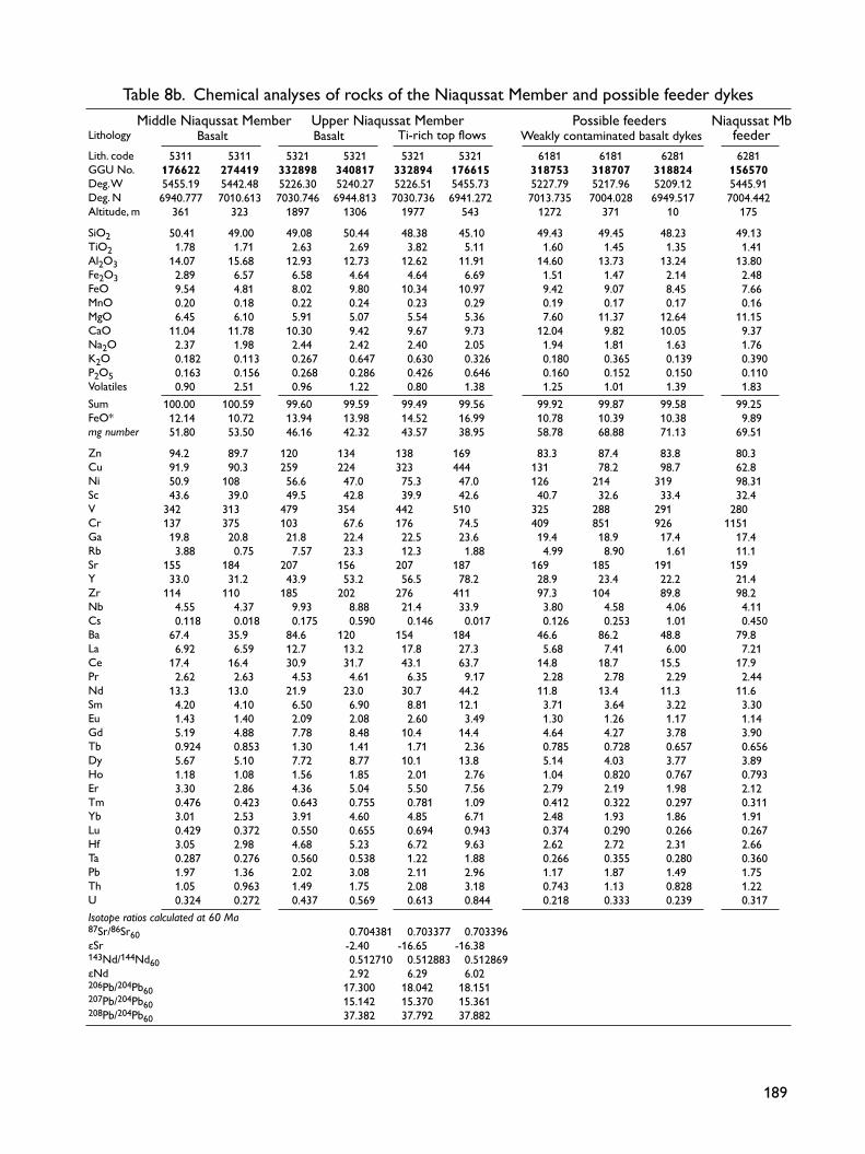
189
5311 5311 5321 5321 5321 5321 6181 6181 6281 6281 176622 274419 332898 340817 332894 176615 318753 318707 318824 156570 5455.19 5442.48 5226.30 5240.27 5226.51 5455.73 5227.79 5217.96 5209.12 5445.91 6940.777 7010.613 7030.746 6944.813 7030.736 6941.272 7013.735 7004.028 6949.517 7004.442 361 323 1897 1306 1977 543 1272 371 10 175 50.41 49.00 49.08 50.44 48.38 45.10 49.43 49.45 48.23 49.13 1.78 1.71 2.63 2.69 3.82 5.11 1.60 1.45 1.35 1.41 14.07 15.68 12.93 12.73 12.62 11.91 14.60 13.73 13.24 13.80 2.89 6.57 6.58 4.64 4.64 6.69 1.51 1.47 2.14 2.48 9.54 4.81 8.02 9.80 10.34 10.97 9.42 9.07 8.45 7.66 0.20 0.18 0.22 0.24 0.23 0.29 0.19 0.17 0.17 0.16 6.45 6.10 5.91 5.07 5.54 5.36 7.60 11.37 12.64 11.15 11.04 11.78 10.30 9.42 9.67 9.73 12.04 9.82 10.05 9.37 2.37 1.98 2.44 2.42 2.40 2.05 1.94 1.81 1.63 1.76 0.182 0.113 0.267 0.647 0.630 0.326 0.180 0.365 0.139 0.390 0.163 0.156 0.268 0.286 0.426 0.646 0.160 0.152 0.150 0.110 0.90 2.51 0.96 1.22 0.80 1.38 1.25 1.01 1.39 1.83 100.00 100.59 99.60 99.59 99.49 99.56 99.92 99.87 99.58 99.25 12.14 10.72 13.94 13.98 14.52 16.99 10.78 10.39 10.38 9.89 51.80 53.50 46.16 42.32 43.57 38.95 58.78 68.88 71.13 69.51 94.2 89.7 120 134 138 169 83.3 87.4 83.8 80.3 91.9 90.3 259 224 323 444 131 78.2 98.7 62.8 50.9 108 56.6 47.0 75.3 47.0 126 214 319 98.31 43.6 39.0 49.5 42.8 39.9 42.6 40.7 32.6 33.4 32.4 342 313 479 354 442 510 325 288 291 280 137 375 103 67.6 176 74.5 409 851 926 1151 19.8 20.8 21.8 22.4 22.5 23.6 19.4 18.9 17.4 17.4 3.88 0.75 7.57 23.3 12.3 1.88 4.99 8.90 1.61 11.1 155 184 207 156 207 187 169 185 191 159 33.0 31.2 43.9 53.2 56.5 78.2 28.9 23.4 22.2 21.4 114 110 185 202 276 411 97.3 104 89.8 98.2 4.55 4.37 9.93 8.88 21.4 33.9 3.80 4.58 4.06 4.11 0.118 0.018 0.175 0.590 0.146 0.017 0.126 0.253 1.01 0.450 67.4 35.9 84.6 120 154 184 46.6 86.2 48.8 79.8 6.92 6.59 12.7 13.2 17.8 27.3 5.68 7.41 6.00 7.21 17.4 16.4 30.9 31.7 43.1 63.7 14.8 18.7 15.5 17.9 2.62 2.63 4.53 4.61 6.35 9.17 2.28 2.78 2.29 2.44 13.3 13.0 21.9 23.0 30.7 44.2 11.8 13.4 11.3 11.6 4.20 4.10 6.50 6.90 8.81 12.1 3.71 3.64 3.22 3.30 1.43 1.40 2.09 2.08 2.60 3.49 1.30 1.26 1.17 1.14 5.19 4.88 7.78 8.48 10.4 14.4 4.64 4.27 3.78 3.90 0.924 0.853 1.30 1.41 1.71 2.36 0.785 0.728 0.657 0.656 5.67 5.10 7.72 8.77 10.1 13.8 5.14 4.03 3.77 3.89 1.18 1.08 1.56 1.85 2.01 2.76 1.04 0.820 0.767 0.793 3.30 2.86 4.36 5.04 5.50 7.56 2.79 2.19 1.98 2.12 0.476 0.423 0.643 0.755 0.781 1.09 0.412 0.322 0.297 0.311 3.01 2.53 3.91 4.60 4.85 6.71 2.48 1.93 1.86 1.91 0.429 0.372 0.550 0.655 0.694 0.943 0.374 0.290 0.266 0.267 3.05 2.98 4.68 5.23 6.72 9.63 2.62 2.72 2.31 2.66 0.287 0.276 0.560 0.538 1.22 1.88 0.266 0.355 0.280 0.360 1.97 1.36 2.02 3.08 2.11 2.96 1.17 1.87 1.49 1.75 1.05 0.963 1.49 1.75 2.08 3.18 0.743 1.13 0.828 1.22 0.324 0.272 0.437 0.569 0.613 0.844 0.218 0.333 0.239 0.317 0.704381 0.703377 0.703396 -2.40 -16.65 -16.38 0.512710 0.512883 0.512869 2.92 6.29 6.02 17.300 18.042 18.151 15.142 15.370 15.361 37.382 37.792 37.882
Lith. codeGGU No.Deg. WDeg. NAltitude, m SiO2TiO2Al2O3Fe2O3FeOMnOMgOCaONa2OK2OP2O5VolatilesSumFeO*mg number ZnCuNiScVCrGaRbSrYZrNbCsBaLaCePrNdSmEuGdTbDyHoErTmYbLu Hf Ta PbThUIsotope ratios calculated at 60 Ma 87Sr/86Sr60εSr143Nd/144Nd60εNd 206Pb/204Pb60207Pb/204Pb60208Pb/204Pb60
Table 8b. Chemical analyses of rocks of the Niaqussat Member and possible feeder dykes
Ti-rich top flowsBasalt Basalt Weakly contaminated basalt dykesLithologyMiddle Niaqussat Member Upper Niaqussat Member Possible feeders Niaqussat Mb
feeder

190190
Table 8c. Notes on analysed samples of the Niaqussat Member and possible feeder dykes332859. Picrite with well-crystallised doleritic groundmass and abundant microphenocrysts of olivine with tiny enclosed chromites. Zeolites and carbonate in vugs and groundmass. Lowest flow in the Niaqussat Member, Nunavik profile, eastern Nuussuaq.263973. Picrite with well-crystallised doleritic groundmass and abundant up to 1 mm olivine phenocrysts with tiny enclosed chromites. Zeolites in vugs and groundmass. Lava flow, Ikorfarsuit profile, Mellemfjord, west Disko.156625. Picrite with olivine microphenocrysts. Lava flow 2 m thick, north wall of Rink Dal c. 1.5 km from the coast, north-west Disko.176642. Picrite close to magnesian basalt with well-crystallised doleritic groundmass and up to 1 mm large olivine phenocrysts with enclosed chromite crystals. Lava flow 3 m thick, Kingittuusaq profile, outer Nordfjord, West Disko.340824. Picrite close to magnesian basalt with well-crystallised doleritic groundmass and scattered up to 1 mm olivine phenocrysts (mostly pseudomorphosed). Rare up to 3 mm glomerocrysts of plagioclase and pseudomorphosed olivine. Traces of tiny chromites. Lava flow 5 m thick, Frederik Lange Dal profile, east Disko.176603. Basalt with well-crystallised doleritic groundmass and scattered up to 1 mm phenocrysts of olivine. Lava flow 10 m thick, Sapernuvik profile, west Disko.264057. Basalt with well-crystallised groundmass and common up to 2 mm phenocrysts and glomerocrysts of plagioclase and scarce up to 1 mm olivine penocrysts (pseudomorphosed). Lava flow 12 m thick, Point 1300 m profile, Vesterdalen, west Disko.274415. Almost aphyric basalt with very fine-grained groundmass and very scarce microphenocrysts of plagioclase and olivine (pseudomorphosed). Lava flow 14 m thick, ‘Point 440 m northern gully’ profile, north of Hammer Dal, north-west Disko.318827. Basalt with very fine-grained groundmass and scarce <1 mm glomerocrysts of plagioclase and olivine (pseudomorphosed). Uppermost exposed lava flow on plateau, Kvandalen profile, east Disko.328420. Basalt with very fine-grained groundmass and widespread phenocrysts and up to 4 mm glomerocrysts of plagioclase, olivine (partly pseudomorphosed) and augite. Lava flow 12 m thick, Alanngup Qaqqai profile, south-west Disko.362179. Magnesian basaltic andesite with rare up to 1 cm bodies of native iron rimmed by troilite. Abundant up to 1 mm phenocrysts and micro- phenocrysts of orthopyroxene and scarce up to 1 mm phenocrysts of olivine, sometimes with chromite. Widespread xenocrysts and micro- xenoliths of plagioclase and red spinel, and rare xenocrysts of quartz. Lava flow 5 m thick, Qinngusaq profile, inner Kvandalen, east Disko.156571. Basaltic andesite; thin section lost. Lava flow, north wall of Rink Dal c. 1.5 km from the coast, north-west Disko.176622. Basalt with fine-grained groundmass and common phenocrysts and glomerocrysts of plagioclase up to 1.5 mm large and very scarce microphenocrystic augite. Lava flow 8 m thick, Sapernuvik profile, west Disko.274419. Basalt with well-crystallised doleritic groundmass, common up to 2 mm glomerocrysts of plagioclase and scarce microphenocrysts of olivine (pseudomorphosed) and augite. Lava flow 8 m thick, ‘Point 440 m northern gully’ profile, north of Hammer Dal, north-west Disko.332898. Basalt with well-crystallised fine-grained groundmass rich in equidimensional Fe-Ti oxide grains. Scattered microphenocrystic plagioclase and augite. Glomerocrysts <1.5 mm of plagioclase and augite. Entablature-dominated lava flow 20 m thick, Point 2080 m profile, eastern Nuussuaq.340817. Basalt; thin section lost. Lava flow 15 m thick, Frederik Lange Dal profile, east Disko.332894. Evolved high-Ti basalt; thin section lost. Lava flow 20 m thick, Point 2080 m profile, eastern Nuussuaq.176615. Evolved high-Ti basalt with fine-grained groundmass rich in Fe-Ti oxide grains. Common phenocrytsts of plagioclase, olivine and augite. There are no Fe-Ti oxide microphenocrysts. Most Ti-rich basalt in the Maligât Formation. Lava flow 5 m thick, Sapernuvik profile, west Disko.318753. Picrite dyke. Glass chill with abundant microphenocrystic olivine and plagioclase up to 1 mm large. The crystalline groundmass is composed of plagioclase, clinopyroxene, olivine, ilmenite and residuum, and there is abundant microphenocrystic olivine and plagioclase. Dyke 1 m thick cutting lava flows of the Rinks Dal Member. Giesecke Monument, south coast of Nuussuaq.318707. Magnesian basalt dyke with well-crystallised doleritic groundmass of plagioclase, clinopyroxene, olivine, Fe-Ti oxides and residuum and scattered olivine phenocrysts up to 1.5 mm and abundant olivine microphenocrysts <0.5 mm large. Dyke 3–4 m thick, striking NE–SW, cutting sediments of the Atane Formation east of Atanikerluk, south Nuussuaq.318824. Picrite dyke. The groundmass is well crystallised and composed of plagioclase with characteristic leaf-textured hollow-cored grains, clinopyroxene, olivine, Fe-Ti oxide and residuum. The abundant microphenocrystic olivines (<0.5 mm) are much smaller than the plagioclase grains, and the rock does not therefore appear as porphyritic. Dyke 3.5 m thick, striking 60°NE, shore north of Inngigissoq, east Disko.156570. Magnesian basalt feeder dyke for a Niaqussat Member lava flow. Abundant up to 1 mm phenocrysts and microphenocrysts of olivine, a few with chromite. The doleritic groundmass is composed of plagioclase, low- and high Ca clinopyroxene, ilmenite and residuum. North wall of Rink Dal c. 1.5 km from the coast, north-west Disko. Phenocryst phases as observed in thin section are mentioned in order of decreasing abundance. Samples of subaerial lava flows are usually taken in massive columns a few metres above the flow base.

191
5401 5401 5401 5401 176611 176614 176608 176609 5454.77 5455.80 5455.74 5455.48 6942.010 6941.302 6941.734 6941.725 637.29 559.41 584.05 596.39 47.37 47.85 49.01 48.96 0.80 1.11 1.54 1.50 16.09 14.69 14.75 14.68 2.57 3.96 3.84 6.04 6.70 6.92 8.00 5.89 0.15 0.19 0.19 0.19 10.59 9.80 7.50 7.37 12.71 11.21 11.72 12.02 1.57 1.71 2.22 2.21 0.188 0.126 0.248 0.258 0.062 0.099 0.171 0.171 1.75 2.48 1.33 1.04 100.55 100.15 100.52 100.33 9.01 10.48 11.46 11.32 70.39 65.41 56.98 56.83 54.8 73.2 80.1 83.6 118 227 161 151 234 189 91 93 38.6 44.7 35.2 39.9 229 270 312 298 440 465 198 214 51.7 50.5 48.4 48.8 14.8 15.8 18.5 18.9 4.82 1.09 1.86 2.93 142 101 176 178 15.7 23.8 26.8 27.6 40.4 60.0 83.2 84.2 1.48 4.16 7.77 8.10 0.009 0.153 0.009 0.015 17.7 35.7 74.6 70.8 1.82 3.33 6.41 6.64 5.20 8.82 16.0 15.7 0.850 1.27 2.42 2.41 4.87 6.74 11.5 11.5 1.74 2.44 3.40 3.35 0.699 0.936 1.25 1.23 2.22 3.22 4.26 4.16 0.422 0.617 0.736 0.713 2.69 3.91 4.59 4.59 0.585 0.869 0.986 0.957 1.64 2.53 2.63 2.55 0.238 0.365 0.395 0.400 1.49 2.35 2.41 2.39 0.211 0.346 0.367 0.368 1.16 1.72 2.18 2.33 0.194 0.244 0.484 0.317 0.417 0.565 0.680 0.143 0.331 0.620 0.636 0.043 0.094 0.143 0.167 0.703382 0.703306 -16.58 -17.66 0.512971 0.512929 7.99 7.18 17.669 17.807 15.304 15.431 37.602 37.608
Table 9a. Chemical analyses of rocksof the Sapernuvik Member
Lithology BasaltLith. codeGGU No.Deg. WDeg. NAltitude, m SiO2TiO2Al2O3Fe2O3FeOMnOMgOCaONa2OK2OP2O5VolatilesSumFeO*mg number ZnCuNiScVCrCoGaRbSrYZrNbCsBaLaCePrNdSmEuGdTbDyHoErTmYbLu Hf Ta PbThUIsotope ratios calculated at 60 Ma 87Sr/86Sr60εSr143Nd/144Nd60εNd 206Pb/204Pb60207Pb/204Pb60208Pb/204Pb60 For explanation of lithological codes, see Table 1. Geographical coordinates in WGS 84. First two digits are degrees, then follow minutes in decimal form.Major elements in wt% (XRF analyses). Trace elements in ppm (Zn–Ga: XRF analyses; Rb–U: ICP-MS analyses). FeO* = total iron as FeO. mg number = 100 × atomic Mg/(Mg+Fe2+), with the iron oxidation ratio adjusted to Fe2O3/FeO = 0.15.
176611 Fine-grained basalt with up to 3 mm large phenocrysts of plagioclase and up to 1.5 mm olivine, and up to 3 mm glomerocrysts of plagioclase with resorbed outlines. Third and youngest preserved flow in the Sapernuvik Member; Sapernuvik profile, south-west Disko.176614 Fine-grained basalt with common 1–2 mm large phenocrysts of plagioclase, olivine and augite, and scattered up to 1 cm large, gabbroic inclusions with augite and plagioclase. Lowest flow in the Sapernuvik Member, Sapernuvik profile, south-west Disko.176608 Fine-grained basalt with up to 2 mm large glomerocrysts and phenocrysts of plagioclase and olivine (pseudomorphed) and <1 mm large augite. Second flow in the Sapernuvik Member, Sapernuvik profile, south-west Disko.176609 Fine-grained basalt with sparse phenocrysts and up to 3 mm large glomerocrysts of plagioclase, augite and olivine (pseudomorphed). Central part of second flow in the Sapernuvik Member, Sapernuvik profile, south-west Disko. Phenocryst phases as observed in thin section are mentioned in order of decreasing abundance. Samples of subaerial lava flows were normally collected in massive columns a few metres above the flow base.
Table 9b. Notes on analysed samples of the Sapernuvik Member
Footnotes, Table 9

192192
Sapernuvik Member
Summary of the main features of the Sapernuvik Member • The youngest lava flows on Disko and Nuussuaq east
of the Itilli fault.• Only three lava flows preserved in an erosional rem-
nant on southern west Disko; original thickness and extent unknown.
• Conformably overlies lava flows of the upper Niaqus-sat Member.
• Uncontaminated, relatively magnesian basalts. One flow may include a component of remelted gabbro cu-mulates.
Lithostratigraphy of the Sapernuvik MemberNew member
History. The Sapernuvik Member lava succession is shown on the geological map 1:100 000 Mellemfjord 69 V.1 Nord as unit βol (Pedersen & Ulff-Møller 1987) and on the geological section along the south coast of Disko (Sapernuvik unit, ni5; Pedersen et al. 2003). The flows were briefly described by Pedersen (1977b, p. 47–48 and table 8 nos 11–13).
Name. After Sapernuvik, a small cove on the west coast of Disko (Fig. 4).
Distribution. The Sapernuvik Member is only preserved within an area measuring 4 × 6 km in a down-thrown, west-dipping fault block on southern west Disko.
Type section. Sapernuvik on southern west Disko, on the mountaintop above 560 m (Fig. 14, profile 1; Figs 161 (photograph) and 171 (South Disko section at 0–5 km)).
Thickness. 80 m.
Lithology. Three subaerial lava flows of olivine-micro-phyric basalt.
Subdivisions. None.
Boundaries. The Sapernuvik Member conformably over-lies the lava flows of the Niaqussat Member. The upper boundary is erosional.
Age. Inferred to be Paleocene, 61–60 Ma, magnetochron C26r, based on radiometric dating (Storey et al. 1998) of one of the youngest flows in the underlying Niaqussat Member.
Correlation. The Sapernuvik Member is not known to correlate with any other lava succession in the region.
1 2 3 5 km
1000 m
200
400
600
800
SapernuvikPaakkarut
GV03_03_061_LML
540
532
531?530 520
518
NW SE
Fig. 171. The type section for the Sapernuvik Member (unit 540) and the upper Niaqussat Member (unit 532), and reference section for the lower and middle Niaqussat Member (units 530 and 531, respectively). Photogrammetrically measured section of the coastal cliff on south-western Disko between Paakkarut and Sapernuvik. Blue three-digit numbers are lithological codes. Slightly modified excerpt from the South Disko section (Pedersen et al. 2003). See also photograph in Fig. 161.

193
Geology and geochemistry of the Sapernuvik MemberThe Sapernuvik Member (unit 540) comprises only a few lava flows. These are the youngest lava flows preserved on Disko, and they are so compositionally different from all the other flows in the Maligât Formation that they have been assigned the status of a separate member. The lava flows of the Sapernuvik Member cap four separate flat mountaintops on westernmost Disko south of Mellemfjord between Kingittup Qaqqaa and Saper-nuvik (Figs. 4, 161). The member has only been sam-pled in the type section. Here, three flows are preserved capping a lava succession that dips 2.5–3°W (Fig. 171). They conformably overlie flows of the upper Niaqussat Member (Fig. 172) and are separated from these by a few decimetres of lateritic claystone. One or two more addi-tional flows may be present on the top plateau of Kingit-tup Qaqqaa. The member is cut by several basalt dykes, which may have been feeders to inferred lava flows of the younger Svartenhuk and Naqerloq formations (Larsen et al. 2016).
Lithologically, the dark grey lavas are fine-grained with phenocrysts of olivine and plagioclase up to a few millimetres in size. One flow also has up to 5 mm large augite phenocrysts. Two of the flows have inclusions of dolerite and gabbro up to a few centimetres in size (Fig. 173). The four existing analyses of lava flows of the Sapernu-vik Member are given in Table 9. They have been plotted with the Niaqussat Member in Figs 167–170. The flows are distinctly more magnesian (7.5–10.7 wt% MgO) than the underlying evolved flows of the upper Niaqus-sat Member. They also have lower SiO2 and higher CaO and appear not to be crustally contaminated. The high-est flow has very high Al2O3 (16.3 wt%) and CaO (12.9 wt%) without being plagioclase-accumulative; it also has low FeO* and very low TiO2 (0.8 wt%) and P2O5 (0.06 wt%). The Sapernuvik Member lavas have low contents of several incompatible trace elements and Cr, and highish Sc and Cu contents. The REE patterns have Gd/Lu ra-tios lower than any other flows in the Maligât Formation,
MF164_17cmA1974_Sapernuvik2no12Amod2_c.eps
532 (176616)
540 (176614) 176608
540 (176614)
532
Fig. 172. The two lowest lava flows of the Sapernuvik Member (540) conformably overlying lava flows of the upper Niaqussat Member (532). The same corrie between Sapernuvik and Kingittup Qaqqaa as shown in Fig. 162 but at another place. The numbered samples are taken in the indicated flows but at another locality; the actual sample profile is shown in Fig. 161.

194194
suggesting melt formation at relatively shallow levels. The Al- and Ca-rich flow (sample 176611) has relatively high Rb, K, and Sr contents in accordance with its high normative feldspar content (52%). Larsen & Pedersen (2009) suggested that the Sapernuvik Member lavas in-clude a component of remelted gabbroic cumulates.
MF165_8cm176614uPcut_c.eps
ol
5 mm
cpx
pl
Fig. 173. Thin section of sparsely olivine-plagioclase phyric basalt of the Sapernuvik Member with a gabbro xenolith 1 cm large, consist-ing of augite (cpx) and plagioclase (pl). Sample 176614, Sapernuvik, south-west Disko.

195
Dyke systems of the Nordfjord and Niaqussat members
Summary of the main features of the contaminated dyke systems• Weakly contaminated small dykes scattered over Dis-
ko and Nuussuaq.• Strongly contaminated large dykes in three major
zones on Disko; structurally related to the Disko Gneiss Ridge.
• Composite basalt/andesite dykes up to 80 km long, many with native iron and troilite.
• Magma chambers concentrated on north-west and east Disko.
• Subvolcanic magma chambers and tube-shaped intru-sions with native iron and sulfide accumulations.
• Economic geology: Accumulations of native iron and sulfides have been subjected to exploration for Ni and platinum-group elements.
The dyke systems for the Nordfjord and Niaqussat mem-bers are treated together here because they are difficult to distinguish from each other and appear to have followed similar patterns.
Weakly contaminated dykesThe basalts and picrites of the Nordfjord and Niaqussat members were presumably erupted mainly, but not solely, west of the Disko Gneiss Ridge. On eastern Disko and south-eastern Nuussuaq there are scattered occurrences of dykes of silica-enriched magnesian basalt with 50–52 wt% SiO2 and 7.5–13 wt% MgO, very similar to the less contaminated rocks of the Nordfjord and Niaqussat members, indicating that these magmas were also erupt-ed over larger areas east of the Disko Gneiss Ridge (Fig. 174; Larsen & Pedersen 1992). Similar dykes occur on western Disko as single dykes or part of the larger, com-monly composite intrusive systems.
Main dyke systems of the strongly contaminated magmasA considerable number of strongly sediment-contami-nated dykes, craters and necks related to the Nordfjord and Niaqussat members have been located on Disko. In contrast, no dykes of this kind are known from Nuussuaq. Many of these rocks carry native iron and sulfides. Except
for two dykes at the coast which were noted in the 1870s, these dykes were first located during the regional geologi-cal mapping, and later, as their economic potential be-came evident (Pedersen 1975c), during systematic pros-pecting by mining companies (Ulff-Møller 1991). These intrusive systems, in which dykes, feeder dykes, necks and craters are associated, have given rise to spectacular lo-calities with native iron, sulfides and sediment xenoliths. Almost all the intrusions carry xenoliths of magma-mod-ified mudstone and sandstone in various stages of melt-ing and equilibration, indicating that the magmas were emplaced from high-level reservoirs situated within suc-cessions of mudstone and sandstone. Many of the dykes are composite, and eruption through such feeders would have formed the composite lava flows found within both the Nordfjord and Niaqussat members. The dyke systems are shown in Fig. 174. The intru-sions have a characteristic distribution pattern apparently influenced by the Disko Gneiss Ridge that extends S–N for about 80 km from the central south coast of Disko to Stordal in the north and continues northwards below exposure level to the Kuugannguaq valley but not farther (Chalmers et al. 1999). A number of intrusive systems can be recognised. System A comprises at least 10–12 composite dykes striking NW–SE to NNW–SSE within a zone c. 15 km wide between the central part of Hammer Dal and Morten Porsild Dal on northern Disko. Several craters and volcanic necks are associated with the dyke bodies. The western part of the zone is poorly defined because of the strongly faulted and very poorly exposed areas along the northern west coast of Disko. Particularly important intrusions within system A, described below, are the Hammer Dal, Hanekammen and Nordfjord complexes and the Inner Giesecke Dal intrusion. System B comprises at least two N–S-striking compos-ite dykes, which extend for more than 50 km along the crest of the Disko Gneiss Ridge between Stordal in the north and the south coast of Disko. One of the dykes, the Killiit dyke, extends for more than 85 km. It originates as a NW–SE-striking dyke within system A north-west of Stordal; south of Stordal it changes strike to N–S and continues for more than 70 km to the south coast of Dis-ko at Killiit. System C comprises a few dykes striking NW–SE with-in a 70 km long zone along the north-east coast of Disko,

196196
GV01_02_162_LML.eps
A C
B
20 km53°W54°W55°W
Maligât Formation
Vaigât Formation
Cretaceous and Paleocene sediments
Precambrian gneiss and amphibolite
Fault
Crater or volcanic neck
Segments of large, strongly contaminated dykes
Small dyke, presumed Niaqussat Member
Large native iron boulders at Uiffaq and in Stordal
69°30'N
70°N
Maniillat dykeNiaqussat
HammerDal
Rink Dal
Nordfjord
Mellemfjord
HD
C
HKCN
C
Stord
alMP d
al
Illukunnguaq dyke
Killiit dyke Qeqertarsuaq
Uifffaq dykeUifffaq
Kvandalen
Kuugannguaq
Skansen
52°W
Eocene volcanic rocks and intrusions Ice
Lake
Giesecke Dal
Kangerluk
Rink’s dyke
Fig. 174. Geological map of Disko and southern Nuussuaq showing the extension of the three main systems (green outlines A, B, C) of strongly contaminated, commonly native-iron- and sulfide-bearing dykes and craters described in the text. Some specific occurrences are indicated as explained in the legend. HDC: Hammer Dal complex. HKC: Hanekammen complex. NC: Nordfjord complex. MP dal: Morten Porsild Dal. The black frame on north-west Disko shows the location of the map in Fig. 181.

197
semi-parallel to the Vaigat strait. The easternmost dyke exposure is a sulfide-mineralised dyke at Illukunnguaq. It is possible, but not proved, that a large composite, native-iron-bearing lava flow in the Kvandalen area could have been erupted from a system C dyke. Others comprise a number of small dyke segments striking in various directions from N–S to NNE–SSW to E–W, found between the Uiffaq peninsula west of the Disko Gneiss Ridge in the south and Giesecke Dal in the north. Parts of the areas have not been searched in any detail and are likely to contain many dyke segments, and other areas, such as the outer west coast between Nord-fjord and Giesecke Dal, are extensively faulted and poorly exposed. There must also be hidden dykes in the shallow sea offshore western Disko. Strongly contaminated dykes and lavas are conspicu-ously absent in the area east of the Disko Gneiss Ridge and south of Kvandalen on eastern Disko. Evidently, the Disko Gneiss Ridge had a confining influence which prevented horizontal flow of magma from the high-level magma reservoirs eastwards via dykes across the ridge. As seen for System B, the stress pattern along the crest of the gneiss ridge and within the overlying older basalts may have forced the magma conduits to change direction from SE-bound to S-bound over distances of more than 50 km. Only north of the Disko Gneiss Ridge (north-east of the Kuugannguaq valley), NW–SE-trending dyke in-trusions continued eastwards within system C, allowing strongly contaminated lavas and dykes to be formed on eastern Disko. The strongly contaminated intrusions yield important information on the sediment–magma reactions in the high-level magma reservoirs and on the sediments that participated in the contamination and redox processes, as well as on the processes in the dyke and feeder systems that led to surface-near mineralisation with native iron and sulfides. For about 100 years (1871−1971), only two intrusions with native iron and sulfide were known: the Uiffaq and Illukunnguaq dykes. An extensive literature exists on the intrusions; the history of the discovery of the intrusions and their native iron bodies is reviewed below in the sections on the individual intrusions.
Intrusions in dyke system AHammer Dal complex. This complex illustrates the com-posite nature of many of the native-iron-bearing intru-sions, with an early intrusive pulse of contaminated basalt followed by a later pulse of much more contaminated an-desite. The subhorizontal funnel- or tube-shaped intru-
sions interconnected by thin dykes illustrate better than anywhere else the gravitational control of the mineral accumulations, with deposition of the heavy native-iron and sulfide bodies from the basaltic pulse along the lower depressions of the tubes, and accumulation of the much
50
?
40
30
20Fig. 176
10
0 m
Siliceous basalt
Native-iron cumulate
Xenoliths in siliceous basalt matrix
Sulfide-mineralised scoria
Tilted basalt lava flows, dip 12–15°W
with columnar jointingXenolith-bearing andesite
with blocky jointing
with platy jointing
GV03_03_065_LML
s
s
s
Fig. 175. Funnel-shaped intrusion in the northern segment of the Hammer Dal complex (Fig. 174). See text for description. Photo-grammetrically constructed cross section, after Ulff-Møller (1977). For locality, see Fig. 103, loc. 10.

198198
lighter sediment xenoliths below the hanging walls and roofs of the intrusions. The Hammer Dal complex was first discovered in 1972 in the northern wall of Hammer Dal about 10 km from the west coast of Disko (Pedersen 1975a). It has been described by Ulff-Møller (1975, 1977, 1983). It dis-plays spectacular cumulates of native iron and nickelifer-ous pyrrhotite, and accumulations of sediment xenoliths that have floated in the magma. The complex comprises a number of intrusions, which were emplaced into a suc-cession of basalt lava flows of the Rinks Dal Member. The intrusions are situated along a zone that is now oriented 155–160°/80°W after a later westward tilting of the lava succession, with a horizontal extent of at least 7 km. The
complex also comprises a downfaulted transgressive sill about 0.5–1 km east of the main intrusions. A block dia-gram of the complex is shown in Ulff-Møller (1977, fig. 11). The main intrusions form westerly tilted, funnel-shaped, columnar-jointed masses which vary in thickness from 10 to 40 m; the individual intrusions are intercon-nected by thin basaltic dykes. The main intrusions widen to between 50 and 100 m in the uppermost, poorly ex-posed zone, which is probably close to the eruption site that may be a neck or a short feeder dyke. The best-exposed part is the lowermost intrusion (Figs 175, 176). The inclined body of this has a vertical extent of 129 m and a maximum width of 30 m. It has a margin-al zone up to 2–3 m wide of silicic magnesian basalt, in
MF168_11cmAKP_1972_01_04HDcompudmod_c.eps
Fe-andesite+ xenoliths
sFe cum
Fe-basalt
Fig. 176. The lower part of the funnel-shaped intrusion in the Hammer Dal complex. s: the sulfide-mineralised zone. Fe cum: the native-iron cumulate zone in Fig. 175. The position of the photo is indicated in Fig. 175.

199
50
40
30
20
10
0 m
GV03_03_066_LML
Siliceous basalt
Native-iron cumulate
Xenoliths in siliceous basalt matrix
Sulfide-mineralised scoria
Tilted basalt lava flows, dip 12–15°W
Late dyke
with columnar jointingXenolith-bearing andesite
with blocky jointing
with platy jointing
s
s
MF170_17cmAKP_1972_02_15HDmod2_c.eps
Fes
Fe-andesite
11 m
Fes
Fe-andesite
11 m d
Fig. 178. Transgressive sill east of the main funnel-shaped intrusion of the Hammer Dal complex. The sulfide mineralisation (s) and the native iron cumulate zone (Fe) are indicated. The cross-cutting dyke (d) in the right part of the photo is also seen in the right part of Fig. 177.
Fig. 177. Transgressive sill east of the main funnel-shaped intrusion of the Hammer Dal complex. See text for description. Photogrammetrically constructed cross section, after Ulff-Møller (1977). For locality, see Fig. 103, loc. 11.

200200
which native iron accumulated in local depressions. The central part consists of magnesian andesite with native iron (Table 11; Ulff-Møller 1983, table 7). The transgressive sill intrusion east of the main intru-sion is up to 10 m thick and is cut by younger, uncon-taminated basalt dykes (Figs 177, 178). The sill is com-posite, like the main intrusions, and has a lower basaltic part with native-iron accumulation and an upper basaltic part; the central part is a fairly silicic graphite andesite with native iron (Ulff-Møller 1983, table 7). Along the lower margin of the transgressive sill, where it cuts across the vesiculated top zone of a basaltic lava flow, a less than 1 m thick zone is developed that is heavily miner-alised with nickeliferous pyrrhotite. The basaltic upper margin of the sill is strongly contaminated and packed with sediment xenoliths. Inspection of these sediment accumulations reveals a strong dominance of graphitic, magma-equilibrated mudstone, while sandstone is scarce (Fig. 179).
Hanekammen complex. The Hanekammen complex was discovered in 1972 (Pedersen 1975a) and later investi-gated by F. Ulff-Møller (Pedersen & Ulff-Møller 1980,
MF171_8cmAKP_1972_H_HDALxenNatverdmod_c.epsFig. 179. Sediment xenoliths packed by floating along the upper mar-gin of the transgressive sill of the Hammer Dal complex (Fig. 177). The xenoliths are almost all magma-equilibrated mudstone with graphite. Length of pencil 13 cm.
MF172_17cmA1972_01_29mod_c.epsFig. 180. Volcanic neck of the Hanekammen complex, seen from the west. The 300–400 m wide neck is shown in the upper left part of the map area in Fig. 181.

201
Ulff-Møller 1983, p. 28–55 and Ulff-Møller 1990). The complex comprises a number of intrusions. The north-ernmost part is a prominent volcanic neck c. 2.5 km north-west of Hanekammen (Figs 180, 181). It measures 300 × 400 m in cross section and probably represents an eruption site. The neck is composed of basaltic andesite with native iron and is rich in sediment xenoliths. A series
of NNW–SSE-trending dykes extends from this neck for at least 13 km towards south-south-east. In the northern 3 km there are several irregular dyke intrusions, whereas the southern 10 km is a simple en echelon dyke which has its southernmost exposure in the western wall of Stor-dal. The composite intrusions have early marginal pulses ranging from native-iron-bearing, contaminated basalt to
500 m
GV01_02_164_LML
Fig. 182
Fig. 180
Fig. 181. Geological map of an area on north-west Disko with the Hanekammen complex necks and dykes (red) and the Nordfjord complex neck and dykes (blue). The surrounding lava succession is the Rinks Dal Member; pale brown: Fe-Ti rich basalt, yellow: aphyric and feldspar-phyric basalt, green: feldspar-phyric basalt. The red lava remnant on the peak Hanekammen is a Nordfjord Member flow. Dark grey is moraine and white with blue margins is ice. Map by Finn Ulff-Møller (1983). The map location is shown in Fig. 174.

202202
almost uncontaminated basalt, whereas the later pulses consist of native-iron-bearing basaltic andesite. The Hanekammen complex has been investigated in detail on the SE-exposed wall of a large ridge extending from the peak Hanekammen towards the south-west. Here, several tube-shaped or irregular, horizontal intru-sive bodies are connected into a subvertical dyke that
widens upwards to form an eruption site with crater breccia on the top of the ridge (Fig. 182). The lowermost intrusive body is particularly instructive (Fig. 183; Table 11). It is an irregular intrusion with a marginal zone of native-iron-bearing, silicic basalt which contains a small native-iron cumulus zone, and a later central pulse of na-tive-iron-bearing basaltic andesite which contains chemi-
MF174_11cmFUM_1987_04_12mod_c.eps
d
d
cr
Fig. 183
Fig. 180Fig. 182. Dyke and crater of the Hanekam-men complex viewed from the south-south-east along the strike of the near-vertical dyke. The dyke (d) is seen here to widen upwards into an eruption site with an oxidised crater breccia (cr) on the crest of the ridge in the foreground. The larger volcanic neck in Fig. 180 is visible on the ridge in the background. Compare with the map in Fig. 181. Photo: Finn Ulff-Møller.

203
cally zoned native-iron bodies. This intrusion was used by Ulff-Møller (1990) to discuss the relation between zoning in the native iron and the dynamics of the process of contamination with crustal rocks.
Nordfjord complex. The Nordfjord complex was discov-ered in 1979 (Pedersen & Ulff-Møller 1980) and de-scribed by Ulff-Møller (1983, p. 56–65). A small outcrop on the north coast of the innermost part of Nordfjord, consisting of silicic basalt with a very rich assemblage of sediment xenoliths, had already been discovered in 1968 (Pedersen 1969). Exposures are fragmentary. The main exposure has a N–S extent of 1 km and is found on both the north-western and south-eastern wall of the ridge extending south-west from the Hanekammen peak (Fig. 181). It
comprises a composite dyke up to 10 m wide that has locally developed upwards into a brecciated crater pipe with a circular outline and a diameter of c. 60 m. Just 70 m below the crater, a tubular subhorizontal intrusion is exposed that has a height of 35 m and a width of at least 25 m. It is composite, and its basaltic marginal part (Ta-ble 11) contains small native-iron bodies and a zone with 10–15 cm-sized, coarse-grained plagioclase-olivine nod-ules. The inner part of the intrusion is a younger pulse of basaltic andesite to andesite with native iron (Table 11). About 2 km south of the crater, on the south wall of Rink Dal, the complex continues as a funnel-shaped, subhorizontal intrusion that shows spectacular columnar jointing (Fig. 184). The core of this part of the intrusion is a native-iron-bearing silicic basalt (Ulff-Møller 1983, table 5, no. 3) similar in composition to the silicic basalt
10 m
WSW ENE
Silicic basalt
Native-iron cumulate
Basalt lavas
Basaltic andesite with native iron
Vesiculated zone
GV03_03_067_LML.epsFig. 183. The lowermost intrusive body of the Hanekammen com-plex. See text for description. The arrow points to an accumulation of sediment xenoliths in the marginal basalt. Drawing modified from Ulff-Møller (1990). Location indicated in Fig. 182.
MF176_8cmFUM1983thesisfig20mod_c.epsFig. 184. The Nordfjord complex in the south wall of Rink Dal, north-western Disko. The complex here forms a subhorizontal, funnel-shaped intrusion with spectacular columnar jointing. The height of the intrusion tube seen is 20 m. Photo: Finn Ulff-Møller.

204204
found on the north coast of Nordfjord (Pedersen 1969). This indicates that the Nordfjord complex extends for at least about 12 km. The chemical compositions of the rocks of the Nord-fjord complex are very similar to the most common magnesium-poor basalts and basaltic andesites represent-ed by most of the contaminated lavas of the Nordfjord Member.
Stordal dyke with 10 tons native-iron boulder. For the first time in more than 100 years of research, a new major boul-der of native iron was discovered in 1985 (Ulff-Møller 1986). The locality is in the northern wall of Stordal about 3.5 km east-south-east of Point 780 m at 389 m altitude (central Disko section at 33.2 km; Fig. 174). The boulder belongs to a 2 m thick, contaminated basic dyke from which it is slightly displaced due to sliding. It meas-ures 0.8 × 1.5 × 2 m and has an estimated weight of about 10 tons (Fig. 185). A modal and chemical comparison with the large Uiffaq native-iron boulder (Table 10; Ulff-Møller, unpublished data 1990) shows that the Stordal
boulder contains much more troilite (FeS) and much less cohenite (Fe3C) than the Uiffaq boulder. The host dyke trends NW–SE and forms part of a small swarm of two to three thin dykes that cut lavas and hyaloclastites of the Vaigat Formation but not the underlying Disko Gneiss Ridge. The dyke belongs to dyke
MF177_17cml922721_c.epsFig. 185. The 10 tons native iron boulder found in Stordal in 1985 (Fig. 174). The boulder measures 0.8 × 1.5 × 2 m and comes from a 2 m thick, contaminated basic dyke from which it is slightly displaced due to sliding. The substrate in the photo is a lava flow.
Dyke
Iron blockLava flow
Lava flow
GV03_03_069_LML.epsFig. 186. A model for native iron accumulation in steep intrusions from droplet size to boulder size by gravity accumulation (arrows) at irregularities such as on ledges and in wedges. After Ulff-Møller (1986).

205
system A and is interpreted as the result of horizontal magma transport from a high-level magma reservoir situ-ated within the sedimentary basin north-west of the Disko Gneiss Ridge. The dyke rock is olivine-phyric and contains native iron and many xenoliths of graphite-rich, magma-modified mudstone. Its composition varies between si-licic basalt and basaltic andesite (Table 11, samples F062, F066). A model for native-iron accumulation from drops to block size is shown in Fig. 186 (Ulff-Møller 1986).
Inner Giesecke Dal dyke zone. This is the easternmost part of dyke system A. The zone is rather narrow and extends from east of Giesecke Dal in the north-west for more than 22 km to Stordal in the south-east, where it lies east of the Stordal dyke described above (Fig. 174). The zone hosts a number of NW–SE-trending, contaminated dykes that are basaltic at the north-western and south-eastern ends and composite with native-iron-bearing andesitic cores within an 8 km long central part of the zone. The cen-tral part is therefore interpreted as the primary upwelling zone for the strongly contaminated magmas from a res-ervoir within a succession of mudstones and sandstones. These dykes have been investigated and sampled by F. Ulff-Møller (Ulff-Møller 1991), but the results have not been published before. The northernmost dyke in this zone has been sampled 2–3 km north-west of Point 1460 m north of Giesecke Dal (Fig. 103, loc. 28). It is a NW-trending, 4–5 m thick,
regularly columnar-jointed dyke of contaminated basalt (Fig. 187) with about 8.9 wt% MgO. The southernmost dyke in the zone cuts the Disko Gneiss Ridge and the Vaigat Formation (Fig. 174). It is 8–10 m thick and has fine-grained margins and a crum-bling core of more coarse-grained dolerite; from a dis-tance, this gives it the appearance of a double dyke. It consists of contaminated basalt with 11.3 wt% MgO and is rich in graphite-bearing magma-modified mudstone xenoliths 2–7 cm in size. The central part of the dyke zone hosts one major dyke and several smaller ones, which are all composite with native iron. Within 1 km of the main dyke, the smaller dykes may cut each other at low angles.
Locality Stordal Uiffaq Year of find 1985 1870Weight, tons 10 25 Estimated mode, vol.%Iron 60 43Cohenite 7 54Troilite 30–40 3 Schreibersite 0 TraceSilicate glass 0.1 0Chromite 0.01 0Wüstite Trace ? Calculated chemical composition, wt% Fe 80 91.6Co 0.4 0.5Ni 2 1.8Cu 0.1 0.16C 0.5 3.62P 0.4 0.15S 10–15 1.09O Trace 0.97 Source: Finn Ulff-Møller, personal communication, c. 1990.
Table 10. Estimated compositions of nativeiron boulders from Disko
MF179_8cmFUM_1985_12_10mod_c.epsFig. 187. The northernmost contaminated dyke in the Inner Giesecke Dal dyke zone, 2–3 km north-west of Point 1460 m north of Giesecke Dal (Fig. 174). Length of hammer handle 60 cm. Photo: Finn Ulff-Møller.

206206
Inner Giesecke Dal intrusion. The single major dyke in the Inner Giesecke Dal dyke zone is named the Inner Giesecke Dal intrusion. The northernmost, well-exposed part of the Inner Giesecke Dal intrusion is located c. 500–600 m west of Point 1560 m north-east of Giesecke Dal (Fig. 103, loc. 29), where it forms a spectacular, native-iron-bearing composite dyke about 10 m thick. The dyke is rich in sediment xenoliths and its core is strongly con-taminated and transitional between basaltic andesite and andesite in composition. In the same area a loose boulder with a native-iron cumulate zone more than 0.5 m thick was located, together with other loose blocks with kid-ney-shaped native-iron bodies with troilite rims 2–3 cm in size. The central part of the Inner Giesecke Dal intrusion is exposed around the top of the high plateau at Point 1590 m between Giesecke Dal and Morten Porsild Dal (Fig. 103). Here, the intrusion is 12–15 m wide and dips c. 70° NE; it has a distinctly rusty colour due to weather-
ing of native iron and sulfide. The dyke is composite with 1–2 m thick basaltic margins and an andesitic core; as an unusual feature, it also contains an inner zone of basalt 1 m thick, which is slightly chilled against the andesite. The marginal basalt contains small native-iron cumulates along the footwall and sediment accumulations along the hanging wall. Another, parallel, composite dyke with na-tive iron occurs c. 10 m south-west of the main dyke. The southernmost exposures of the Inner Giesecke Dal intrusion are situated c. 2 km north-west of Point 1650 m north of Agatfjeldet, on walls at the end of Morten Porsild Dal (Fig. 174). Here the intrusion forms a c. 7 m thick, seg-mented, composite dyke dipping 70° NE. It has a basaltic to basaltic andesitic margin c. 0.5 m thick, and an andesitic core with up to 1 cm large native-iron bodies (Table 11, nos F045 and F048; Fig. 188). On both sides of the com-posite intrusion, there are several 1–4 m thick, subparallel basaltic intrusions with sediment xenoliths, and also other intrusions that are only slightly contaminated.
MF180_17cmFUM_1985_05_31mod_c.eps
picrite flows
picrite flows
Fig. 188. The southernmost exposures of the Inner Giesecke Dal intrusion, c. 2 km north-west of Point 1650 m north of Agatfjeldet, at the end of Morten Porsild Dal (Fig. 174). The intrusion forms a segmented composite dyke c. 7 m thick, with basaltic to basaltic andesitic margins and an andesitic native-iron-bearing core. Photo: Finn Ulff-Møller.

207
Outer Giesecke Dal dyke. A prominent composite dyke intrusion was discovered by F. Ulff-Møller in 1984 c. 8 km south-east of the entrance to Giesecke Dal and c. 1.5 km east of the volcanic neck at Point 882 m (Fig. 103, loc. 30). The dyke trends WNW–ESE and is well exposed on both walls of a gully south of Giesecke Dal from where it can be traced eastwards for 3 km. The dyke is up to 25 m thick and composite, with a marginal zone of con-taminated basalt up to 7 m thick, which locally contains a native-iron cumulus zone several metres thick, and a core zone of basaltic andesite with native iron and sediment xenoliths.
Small swarm of NW–SE-trending dykes around inner-most Hammer Dal. A small swarm of at least five NW–SE-trending dykes discovered by F. Ulff-Møller in 1985 and 1987 in the innermost Hammer Dal area belongs to dyke system A. A ‘double dyke’ (two closely set parallel dykes) has a main exposure c. 3 km NNW of Point 1380 m (Fig. 103, loc. 31). The western dyke is 6–8 m thick and distinctly contaminated (Table 11, no. F074). It is notable for a rich assemblage of xenoliths up to 1 m large of magma-modified sandstone and mudstone and abundant, 2–50 cm large gabbroic nodules. The eastern dyke is 20–30 m thick and only slightly contaminated (Table 11, no. F076). It is composed of medium- to coarse-grained dol-erite with light grey residual veins and up to 5 cm large gabbroic xenoliths. About 1.5–2 km east of the double dyke is another par-allel basaltic dyke (Fig. 103, loc. 32; Table 11, no. F162) which is c. 5 m thick and contains glomerocrysts up to 1 cm large of plagioclase and abundant xenoliths of sand-stone and mudstone. Along the strike and across a gla-cier, 8 km to the south-east, loose blocks of contaminated basalt from a dyke occur in the talus close to Steenstrup Dal. The basalt contains coarse plagioclase and olivine glomerocrysts and abundant small xenoliths of sandstone and mudstone and is similar to, but less evolved than, the dyke 8 km to the north-west. About 1.5–2 km farther to the east another composite dyke c. 4 m thick is exposed a few kilometres south-west of Point 1610 m (Fig. 103, loc. 33). It strikes NNW–SSE and is composed of a distinctly flow-laminated, contami-nated basalt with a core of more silicic, contaminated basalt with disseminated graphite (Table 11, no. F169). A similar, flow-laminated dyke has been traced a few kilo-metres to the north-west and is probably the same dyke. The flow-lamination is very irregular and discordant to the strike direction of the dyke.
Finally, a NW–SE-trending dyke has been traced south-east of the Point 1610 m plateau between the in-nermost parts of Hammer Dal and Giesecke Dal (Fig. 103, loc. 34). This dyke is a c. 10 m thick, contaminated, evolved dolerite (Table 11, no. F173) with scattered, c. 1 cm large xenoliths of plagioclase and graphite, i.e. mag-ma-modified mudstone.
Intrusions in dyke system BKilliit dyke. The third discovery of a native-iron-bearing intrusion came almost 100 years after the Uiffaq report, when Fundal (1972, 1975) described an 8 m thick ba-salt dyke with native iron and plagioclase-spinel-graphite xenoliths cutting the Disko Gneiss Ridge at Killiit (old spelling Kitdlît) on the south coast of Disko, 9 km west of Qeqertarsuaq town (Figs 27, 36). Another segment of the dyke at Luciefjeld c. 7 km north of the coast cuts ba-saltic lavas of the Rinks Dal Member but not the under-lying gneiss. Based on these observations Fundal (1975) argued that the native iron and the graphite-bearing xe-noliths could not be a product of sediment–magma reac-tion but required a much deeper origin. The same argu-ments were subsequently pursued by Bird and Weathers (1977) but were later abandoned by Bird et al. (1981). The Killiit dyke was subsequently mapped north-wards along the Disko Gneiss Ridge over a distance of more than 80 km (Pedersen 1977c; Ulff-Møller 1979; Pedersen & Ulff-Møller 1980; Ulff-Møller 1983, 1985). In the south the dyke is basaltic (e.g. Pedersen 1979b ta-ble 2) and strikes close to N–S. About 65 km north of Killiit it changes direction to NW–SE and becomes com-posite with a basaltic margin and an andesitic core (Table 11; Ulff-Møller 1985, table 1, nos 2 and 3; Fig. 189). The dyke increases in thickness to 10–15 m towards the north and was clearly emplaced from the north-west. In the northern area, there are several offshoots from the dyke that consist of basalt packed with gneiss xenoliths (Fig. 190). In a limited area, the dyke develops an oxidised, crater-like breccia along one of its margins. From just north of Kangerluk, a c. 100 kg native-iron body called the Kitdlît Lens has been described in detail and reveals a complex solidification history (Ulff-Møller 1985). This paper is a major contribution to our knowledge about the native iron. The present interpretation of the Killiit dyke is that it originated from a high-level magma reservoir within the sedimentary basin north-west of Stordal as a part of dyke system A. The intrusion was emplaced in several pulses, of which the first was a native-iron-bearing basalt magma

208208
that travelled subhorizontally for more than 85 km to-wards the south to Killiit, where basalt with sediment xenoliths and native iron has now been found cutting the Disko Gneiss Ridge. When the dyke changed direction to N–S, about 65 km north of the coast it became part of dyke system B. Shortly afterwards, a second pulse of much more contaminated and viscous andesite magma with native iron was emplaced towards the south but be-came exhausted after having travelled only 15–20 km.
Intrusions in dyke system CManiillat dyke. The Maniillat dyke trends NW–SE and runs subparallel with the Vaigat coast on north-eastern Disko for at least 12 km between Maniillat and Pyra-miden (Fig. 174). The dyke dips 70–80° NE and is 5–6 m thick in its northern part and around 10 m thick far-ther south. It cuts both picritic lavas of the Vaigat Forma-tion and basalt flows of the Rinks Dal Member of the Maligât Formation. The dyke has marginal zones of con-taminated basalt (Table 11, no. 138235) with olivines up to 2 cm in size and native-iron bodies up to 1 cm in
MF181_8cmFUM_1979_11_17mod_c.eps
Fe
Fe
Fig. 189. The northern part of the Killiit dyke, 65 km north of Kil-liit. The dyke (Fe) is here c. 15 m thick and cuts lava flows of the Rinks Dal Member. It is composite with a basaltic margin and a c. 13 m thick andesitic core; both parts are native-iron-bearing. Locality c. 10 km south of Stordal and c. 1 km west of Point 1266 m (Figs 6, 174). Photo: Finn Ulff-Møller.
Fig. 190. Offshoot from the Killiit dyke 75 km north of Killiit. The dyke here trends NW and cuts lava flows of the Rinks Dal Member. The apophysis is c. 1 m thick and consists of basalt packed with xeno-liths of gneiss or arkose. Locality c. 1 km east of Point 1578 m in the north-western side of a corrie leading into the south side of Stordal (Figs 6, 174). Photo: Finn Ulff-Møller.
MF182_8cmFUM_1979_05_15mod_c.eps

209
size, beside a range of sediment xenoliths and also sharp-edged xenoliths of uncontaminated basalt with plagio-clase phenocrysts. The central, 4–6 m wide part of the dyke (Table 11, no. 138233) has a sharp, but not glassy, contact against the marginal basalt and is composed of andesite with microphenocrysts of olivine and orthopy-roxene; it also contains disseminated graphite and xeno-liths of magma-modified mudstone. Along the hanging wall, the marginal basalt is particularly rich in sediment xenoliths, and at one locality it contains a 40 cm thick zone of densely packed xenoliths of sandstone, mudstone and coal fragments with an appearance almost like a sedi-ment breccia (Fig. 191). The dyke disappears beneath the glacier- and moraine-filled areas around Qullissat. It is possibly connected to the small dyke segment at Il-lukunnguaq c. 35 km to the south-east (see below).
Illukunnguaq dyke. The second early known intrusion is a 5 m thick basic dyke intruding sandstone of the Atane Formation near the abandoned settlement Illukunnguaq (Igdlukúnguaq) on eastern Disko. The dyke strikes NW–SE and can be followed for about 800 m close to the Vaigat coast (Steenstrup 1874, p. 88, also briefly men-tioned by Nordenskiöld 1871). The dyke contained a 28 tons body of nickeliferous pyrrhotite (now nearly mined out) that was described in detail by Pauly (1958). The dyke also contains a range of sediment xenoliths (Fundal 1975). The occurrence shows that the contaminated in-trusions have a potential for sulfide mineralisation. The dyke has been described by Ulff-Møller (1983, p. 92–98) who found sulfide blebs with native iron in its glassy chill
zone. An analysis is presented in Table 11, no. 362140.The dyke is now interpreted as part of dyke system C, and it is possible that it acted as feeder for the compos-ite native-iron-bearing lava flow in the lower Niaqussat Member on eastern Disko (Fig. 10, profile 8; Fig. 140).
Other dyke intrusionsUiffaq dyke. The discovery of three large native-iron boulders (25, 6.5 and 4 tons) on the south-western shore of the Uiffaq peninsula west of Qeqertarsuaq was report-ed by Nordenskiöld (1871) who interpreted them as iron meteorites. Their unusual composition was reported by Nordström (1871). The history of recovery and research of the native iron is summarised by Sjögren (1916) and an extensive bibliography is given by Bøggild (1953). A memoir based on the largest (25 tons) iron boulder housed in Stockholm (Löfquist & Benedicks 1941) showed that the native iron is dominated by iron carbide (cohenite) and is a cast-iron type. Field observations by Nauckhoff (1872, p. 38) and Steenstrup (1875, fig. 3) suggested the presence of a poorly exposed basaltic dyke at the shore. The host body for the native-iron boulders was finally proved by magnetometer mapping to be a c. 7 m thick, approximately N–S-running, composite basaltic dyke (Fundal 1975). Various segments of the dyke have been mapped over a distance of 8 km across the Uiffaq peninsula to its north coast (Pedersen et al. 2000); the dyke is shown in Fig. 81. Detailed data on the Uiffaq na-tive iron and sulfide have been presented by Goodrich (1984), Goodrich & Bird (1985) and Howarth et al. (2017).
MF183_11cmAKP_1971_06_18mod_c.eps
Fig. 191. The Maniillat dyke (Fig. 174) with an accumulation of closely packed, black sedi-ment xenoliths along its hanging wall. Length of ruler 1 m.

210210
‘Rink’s dyke’. For many years, the existence of this dyke was inferred from a sample collected by H. Rink around 1850 on the north coast of Kangerluk. The dyke was rediscovered by F. Ulff-Møller in 1978 (Fig. 174) and briefly described by him (Ulff-Møller 1979, 1983). It is only known to be exposed at the beach where it is verti-cal, c. 4 m thick and strikes N–S. It is composite, with a marginal zone of silicic basalt, a hybrid zone 10–20 cm thick, and a central part 2.5 m thick of basaltic andesite (Table 11). The central part contains numerous 1–10 cm equilibrated sediment xenoliths consisting mainly of pla-gioclase and graphite. No native iron was observed.
Mellemfjord dyke. This dyke was discovered by AKP in 1974 at Saqqarliit Ilorliit on the north coast of Mel-lemfjord (Fig. 174) and described by Ulff-Møller (1979, 1983). The dyke is exposed over about 1 km where it is vertical and strikes N–S; it is c. 10 m thick at low altitudes but narrows to just 1 m at 700 m a.s.l. The dyke is rich in vesicles. Chemically it is a basaltic andesite (Table 11), probably with a more basic margin. The chilled margin contains sulfide blebs but no native iron.
Concluding remarks on the strongly contaminated dyke systemsThe largest and most frequent strongly contaminated intrusions are situated on western and north-western Disko west of the Disko Gneiss Ridge. Therefore, the high-level magma reservoirs within the underlying sedi-ments must have been concentrated in this area, and pos-sibly also beneath the shallow sea north-west of Disko. In addition to the described contaminated intrusions, there are other minor exposures on Disko west of the Disko Gneiss Ridge, and a detailed search, particularly on south-western Disko, would doubtlessly increase the known localities. However, the general picture will most probably not change.
Chemical compositions of the Nordfjord and Niaqussat Member dykes and feeder systemsThe intrusions range from only slightly contaminated si-licic basalts to strongly crustally contaminated andesites; there are no dacites or rhyolites. The chemical composi-tions are illustrated in Fig. 192, and representative analy-ses are shown in Table 11. Most of the contaminated in-trusives have compositionally similar counterparts in the lavas of the Nordfjord and Niaqussat members (Figs 145, 147, 167, 169), but some have not, most notably the Kil-liit dyke which has higher MgO for a given SiO2 than any other intrusions or lavas. The weakly contaminated dykes on eastern Disko and Nuussuaq (green dots in Fig. 192) represent an almost normal magma evolution series. In contrast, the large intrusive dyke and crater complexes, such as the Nord-fjord complex, the Hanekammen complex and the Killiit dyke, show different compositional evolutions, mainly caused by different compositions of the starting magmas of each system. The Killiit dyke had the most magne-sian starting magma (12–13 wt% MgO), the Hanekam-men complex was intermediate (9–10 wt% MgO) and the Nordfjord complex was the most evolved (c. 8 wt% MgO). The contamination processes comprised sidewall melting, mixing, mineral re-equilibration and reduc-tion (e.g. Ulff-Møller 1990; Larsen & Pedersen 2009), and in each system the contamination led to increasing SiO2 and K2O and decreasing MgO, CaO and FeO*, while TiO2 and P2O5 stayed approximately constant. The Cr contents are higher than in uncontaminated magmas because chromite fractionation was delayed by the contamination process (Pedersen 1985), but all the intrusions have a lower degree of Cr-enrichment than the most contaminated rocks of the Vaigat Formation (the Asuk and Kûgánguaq members). Also, no intrusions show Ni-depletion as severe as in the Asuk and Kûgán-guaq members, but some native-iron-bearing samples of the Hanekammen complex and the Stordal dyke show Ni-accumulation, presumably in the metallic phase. There are no compositional differences between dyke systems A, B and C described above. Dyke groups such as the dykes in Giesecke Dal and inner Hammer Dal show widely variable compositions, and the individual dykes must have been generated independently of each other. There are not enough chemical data to characterise the Hammer Dal complex further.

211
45
47
49
51
53
55
57
59
61
63
65
0
100
200
300
400
500
600
700
800
900
1000
1100Cr (ppm)
6
8
10
12
14
16FeO*
1
2
3
4Weakly contaminated, outside W DiskoVarious contaminated, C-W Disko
Uiffaq dykeKilliit dykeStordal Fe-dykeNordfjord complexHanekammen complexHammer Dal complexInner Hammer Dal dykesGiesecke Dal dykesManiillat dykeIllukunnguaq dyke
TiO2
10
100
1000Ni (ppm)
5
7
9
11
13
15CaO
Kûgánguaq Mb
KûgánguaqMb
Asuk Mb
AsukMb
RDM + VF
RDM + VF
Asuk Mb
SiO2
0 2 4 6 8 10 12 14 0 2 4 6 8 10 12 14
0 2 4 6 8 10 12 14 0 2 4 6 8 10 12 14
0 2 4 6 8 10 12 14 0 2 4 6 8 10 12 14
MgO (wt%) MgO (wt%)
Fig. 192. Variation diagrams of selected major and trace elements for contaminated intrusions of the Nordfjord and Niaqussat Members. Major element data in wt% oxides recalculated volatile-free. FeO* is total iron as FeO. C–W: central to west. Arrows indicate compositional changes with increasing contamination in the Killiit dyke and the Nordfjord and Hanekammen complexes. The fields for the contaminated Asuk and Kûgánguaq Members of the Vaigat Formation are shown for comparison in the Cr and Ni diagrams. The shaded areas in these two diagrams labelled RDM + VF are the fields for the uncontaminated Rinks Dal Member and the uncontaminated parts of the Vaigat Formation.

212212
6261 6261 6161 6161 6271 6271 6281 6281 6291 6291 6281 6281 175950 176007 264355 264424 264350 264349 F062 F066 F045 F048 F074 F076 5434.27 5434.27 5419.78 5419.86 5421.8 5421.8 5355.62 5355.62 5404.30 5404.30 5423.43 5423.39 7009.14 7009.15 7002.99 7003.00 7002.7 7002.7 6959.75 6959.75 7006.40 7006.40 7006.91 7006.91 472 490 1055 1100 1015 1030 385 386 1223 1222 592 587 49.15 57.55 50.38 53.92 48.42 56.10 50.09 53.01 52.10 58.61 51.00 47.92 1.37 1.30 1.47 1.43 2.97 2.10 1.281 1.237 1.761 1.281 2.095 1.513 13.49 14.35 14.17 16.30 13.54 15.70 14.33 13.91 14.66 15.57 14.93 15.00 0.88 0.00 1.22 0.00 4.06 2.55 11.79 11.18 10.74 8.22 12.11 11.65 10.52 8.40 9.96 8.73 9.88 7.14 0.16 0.12 0.21 0.13 0.145 0.135 0.154 0.116 0.166 0.176 10.62 5.85 9.37 6.22 5.92 3.38 9.10 8.86 6.84 5.59 6.19 7.94 10.00 6.97 9.84 7.98 10.91 7.02 8.94 7.28 9.35 6.41 9.52 12.55 1.66 2.17 1.99 1.84 2.54 2.32 1.73 1.73 2.05 2.28 2.19 2.04 0.310 1.400 0.330 0.900 0.260 1.250 0.604 0.845 0.756 1.021 0.491 0.177 0.120 0.150 0.150 0.180 0.310 0.280 0.156 0.170 0.201 0.187 0.217 0.132 1.63 1.75 1.06 2.09 1.03 1.95 1.53 1.14 0.86 0.35 0.63 0.54 99.75 99.52 100.10 99.71 100.05 99.92 99.69 99.49 99.47 99.64 99.55 99.64 11.31 8.40 11.06 8.73 13.53 9.43 10.61 10.06 9.66 7.40 10.90 10.48 65.50 58.48 63.15 59.04 46.94 42.02 63.44 64.06 58.87 60.43 53.47 60.51 79.1 55.7 72.0 53.0 181 99.2 65.4 76.0 87.8 64.2 94.3 73.4 138 119 148 127 294 114 59.8 171 49.4 55.9 105 161 548 161 343 228 78.9 115 151 482 128 84.0 84.5 152 33.8 27.4 31.0 26.9 37.1 30.0 33.5 28.7 32.6 25.7 34.7 37.3 284 187 258 213 432 209 308 244 266 185 279 323 859 450 665 429 120 160 936 742 601 388 303 386 18.7 19.5 19.6 21.8 24.1 24.9 16.8 19.3 20.9 21.2 22.3 19.4 6.76 32.2 7.54 26.3 4.77 33.8 3.48 15.8 13.5 39.2 23.2 2.61 165 185 191 230 243 238 181 192 199 218 215 199 23.5 27.5 23.2 24.2 39.8 34.2 16.5 21.3 24.8 25.3 30.9 23.6 96.6 192 111 155 181 218 64.5 114 132 190 155 81.1 4.14 7.84 4.90 7.27 9.08 10.25 2.71 5.13 6.02 8.37 7.32 4.16 0.237 0.805 0.220 0.763 0.135 0.814 0.128 0.344 0.327 1.04 0.434 0.038 62.01 304 127 270 53.79 348 39.4 148 145 340 163 28.8 7.02 19.5 10.4 18.0 10.1 23.4 4.68 11.7 12.8 21.9 13.3 4.56 17.16 42.4 24.1 39.6 28.4 51.7 11.9 26.8 30.1 48.3 31.8 12.8 2.48 5.37 3.19 4.80 4.46 6.60 1.67 3.47 3.85 5.73 4.29 2.06 11.8 21.7 14.3 19.8 22.3 27.9 8.24 15.2 17.0 23.1 19.5 10.7 3.35 4.95 3.72 4.38 6.41 6.37 2.34 3.72 4.20 4.96 5.05 3.43 1.11 1.19 1.19 1.30 2.20 1.65 0.94 1.18 1.30 1.30 1.60 1.25 4.05 5.35 4.38 4.64 7.37 6.75 2.84 4.02 4.60 5.11 5.74 4.16 0.674 0.830 0.694 0.741 1.20 1.05 0.471 0.652 0.750 0.798 0.930 0.688 4.07 4.90 4.32 4.24 7.38 6.24 2.90 3.91 4.48 4.47 5.51 4.31 0.832 0.989 0.847 0.853 1.46 1.23 0.574 0.775 0.906 0.917 1.12 0.900 2.26 2.64 2.36 2.36 3.91 3.32 1.57 2.07 2.43 2.47 3.01 2.36 0.323 0.393 0.329 0.334 0.551 0.482 0.216 0.306 0.357 0.364 0.426 0.354 1.98 2.34 1.99 2.06 3.30 2.95 1.35 1.82 2.09 2.16 2.63 2.07 0.309 0.370 0.297 0.310 0.510 0.445 0.196 0.264 0.311 0.326 0.391 0.313 2.52 4.84 2.94 3.98 4.59 5.61 1.74 3.10 3.51 4.92 4.05 2.14 0.394 0.516 0.453 0.656 0.852 0.898 0.210 0.338 0.405 0.569 0.481 0.272 2.29 5.23 2.39 4.00 6.54 8.66 1.44 5.35 3.98 5.89 4.28 0.610 1.15 4.59 2.10 4.11 0.799 5.03 0.735 2.42 2.64 5.15 2.52 0.345 0.320 1.18 0.509 1.00 0.243 1.23 0.189 0.603 0.680 1.25 0.650 0.113
Margin Centre Margin Centre Margin Centre Margin Centre
Lith. codeGGU No.Deg. WDeg. NAltitude, m SiO2TiO2Al2O3Fe2O3FeOMnOMgOCaONa2OK2OP2O5VolatilesSumFeO*mg number ZnCuNiScVCrGaRbSrYZrNbCsBaLaCePrNdSmEuGdTbDyHoErTmYbLu Hf Ta PbThU For explanation of lithological codes, see Table 1. For petrographical notes on the samples, see Table 11c.Geographical coordinates in WGS 84. First two digits are degrees, then follow minutes in decimal form.Major elements in wt% (XRF analyses). Trace elements in ppm (Zn–Ga: XRF analyses; Rb–U: ICP-MS analyses).FeO* = total iron as FeO. mg number = 100 × atomic Mg/(Mg+Fe2+), with the iron oxidation ratio adjusted to Fe2O3/FeO = 0.15.
Table 11a. Chemical analyses of intrusions of the Nordfjord and Niaqussat Members
Intrusion
Locality
Hammer Dal complex
Hanekammen complex
Nordfjord complex
Inner Giesecke Dal
Inner Hammer Dal swarm
Stordal dyke
Hammer Dal Hanekammen Rink Dal Giesecke Dal Inner Hammer DalStordal

213
6281 6281 6281 6171 6171 6281 6281 6281 6281 6281 6281 6281 F162 F169 F173 176669 264338 138235 138233 362140 176683 175156 175164 175005 5420.36 5417.18 5413.78 5346.26 5353.5 5332.25 5332.26 5234.72 5412.18 5416.2 5416.2 5434 7007.09 7006.40 7006.64 6919.306 6956.36 7010.930 7010.93 6953.103 6921.676 6934.1 6934.1 6946 778 1019 1530 514 755 1059 1066 82 1 4 4 170 49.05 51.68 50.30 52.09 56.61 48.67 56.66 51.16 50.67 50.92 53.14 54.90 2.473 1.162 2.454 1.35 1.25 1.75 1.28 1.57 1.73 1.62 1.58 1.45 13.22 14.49 12.63 13.81 14.05 13.31 15.36 13.49 14.53 14.36 15.33 14.86 14.36 10.44 13.11 0.00 1.88 3.03 0.90 1.48 3.37 1.38 1.60 0.60 9.44 5.35 8.45 6.54 8.33 7.74 8.31 7.76 8.26 0.204 0.138 0.186 0.16 0.14 0.18 0.11 0.15 0.16 0.22 0.18 0.19 5.86 9.52 7.46 10.48 8.80 10.36 6.54 9.57 7.86 8.83 6.90 7.48 10.58 8.67 10.11 9.06 7.60 10.38 6.81 9.07 10.43 10.97 8.39 8.47 2.26 1.79 2.19 1.82 2.25 2.02 2.34 1.99 2.15 2.19 2.29 2.24 0.320 0.554 0.487 0.660 0.730 0.250 0.820 0.215 0.435 0.230 0.530 0.520 0.233 0.136 0.245 0.160 0.140 0.170 0.170 0.183 0.173 0.150 0.180 0.200 1.00 1.34 0.38 0.42 0.99 1.58 2.35 2.97 0.76 1.06 2.08 0.95 99.56 99.93 99.55 99.45 99.79 99.15 98.88 100.18 100.00 100.24 99.96 100.12 12.92 9.40 11.80 9.44 7.04 11.18 7.35 9.66 10.77 9.55 9.20 8.80 47.84 67.20 56.12 69.19 71.65 65.22 64.28 66.70 59.60 65.15 60.27 63.23 110 19.3 101 76.6 49.4 95.6 77.1 88.8 84.9 82.7 75.1 77.2 174 241 94.0 36.2 70.3 162 36.1 24.3 71.8 79.1 110 39.6 52.1 733 119 42.8 102 201 76.5 123 100 143 218 104 35.2 25.9 35.7 32.2 26.4 34.5 25.3 31.2 34.6 35.0 29.7 27.0 363 221 320 259 204 327 196 265 295 296 227 231 197 823 373 854 720 492 420 613 557 622 472 586 22.5 18.7 22.6 18.4 18.0 19.3 20.9 19.7 20.2 19.7 21.2 20.5 3.89 17.2 13.0 16.1 27.6 3.34 31.6 4.29 8.97 5.37 23.0 23.1 213 205 198 194 195 188 213 240 207 196 213 236 35.4 20.9 38.2 21.9 24.3 28.2 25.1 27.0 25.8 24.7 25.0 20.1 149 119 168 123 161 116 185 137 119 105 147 135 6.74 5.07 7.29 5.30 6.56 5.30 8.11 6.24 5.08 4.40 6.73 6.31 0.054 0.398 0.218 0.448 0.659 0.107 0.839 1.08 0.160 0.126 0.542 0.714 65.8 175 94.2 141 247 47.98 300 250 97.8 60.9 205 263 8.70 12.6 10.4 10.5 16.2 7.31 20.3 11.2 8.35 7.43 15.7 13.6 23.6 28.3 27.3 24.6 35.8 19.1 44.1 27.0 20.4 18.6 35.1 29.9 3.67 3.64 4.15 3.29 4.47 2.95 5.52 3.70 2.94 2.67 4.49 3.95 18.6 15.6 20.7 14.8 18.8 14.6 22.8 16.7 14.2 12.8 19.3 17.0 5.55 3.71 6.02 3.81 4.41 4.19 4.87 4.35 3.92 3.62 4.47 3.90 1.89 1.20 1.89 1.20 1.15 1.46 1.32 1.31 1.36 1.22 1.29 1.30 6.57 4.04 7.07 4.29 4.63 4.79 5.18 4.79 4.61 4.31 4.92 4.25 1.07 0.638 1.16 0.672 0.737 0.856 0.801 0.802 0.765 0.698 0.762 0.655 6.66 3.80 7.05 3.97 4.29 4.79 4.22 4.80 4.71 4.33 4.52 3.85 1.33 0.770 1.42 0.814 0.850 0.990 0.869 0.956 0.909 0.862 0.908 0.738 3.55 1.98 3.75 2.21 2.30 2.59 2.33 2.47 2.53 2.38 2.42 1.95 0.495 0.294 0.531 0.320 0.324 0.387 0.337 0.358 0.362 0.338 0.345 0.285 2.93 1.79 3.16 1.87 2.06 2.33 2.15 2.30 2.15 2.02 2.13 1.74 0.435 0.259 0.473 0.255 0.314 0.361 0.325 0.345 0.335 0.315 0.324 0.261 4.05 3.13 4.40 3.23 4.10 3.02 4.56 3.47 3.15 2.76 3.84 3.52 0.460 0.347 0.474 1.19 0.712 0.478 0.679 0.407 0.398 0.263 0.415 0.372 1.66 1.04 2.19 2.95 2.70 1.75 6.77 3.03 2.10 1.82 5.35 4.36 0.900 2.59 1.33 2.05 3.73 0.839 4.42 2.12 1.28 1.19 3.55 2.81 0.274 0.620 0.374 0.529 0.912 0.249 1.20 0.566 0.345 0.314 0.846 0.688
Margin Centre Margin Centre Margin Centre
Lith. codeGGU No.Deg. WDeg. NAltitude, m SiO2TiO2Al2O3Fe2O3FeOMnOMgOCaONa2OK2OP2O5VolatilesSumFeO*mg number ZnCuNiScVCrGaRbSrYZrNbCsBaLaCePrNdSmEuGdTbDyHoErTmYbLu Hf Ta PbThU
Table 11b. Chemical analyses of intrusions of the Nordfjord and Niaqussat Members
Intrusion
Locality
Inner Hammer Dal swarm
Killiitdyke
Maniillatdyke
Rink’s dyke Mellem-fjorddyke
Uiffaqdyke
Illukunn-guaqdyke
Inner Hammer Dal Luciefjeld Stordal Maniilat Disko Fjord MellemfjordIllukunnguaq Uiffaq

214214
175950 Olivine microphyric basalt with native iron beneath native iron cumulate. Hammer Dal complex, west Disko. Ulff-Møller (1983) table 7 no. 1.176007 Andesite with native iron from the centre of intrusive body (0.37 wt% carbon). Hammer Dal complex. Ulff-Møller (1983) table 7 no. 6.264355 Plagioclase-glomerophyric basalt, 20 cm from western contact in the lowermost intrusion of the Hanekammen complex. Northern wall of Rink Dal, west Disko. Ulff-Møller (1983) table 2 no. 3.264424 Basaltic andesite with native iron from above the centre of the lowermost intrusion in the Hanekammen complex. Northern wall of Rink Dal, west Disko. Ulff-Møller (1983) table 2 no. 11 and Ulff-Møller (1990) table 1 no. 2.264350 Basalt with native iron from the margin of the northern tube-like intrusion in the Nordfjord complex. Northern wall of Rink Dal, west Disko. Ulff-Møller (1983) table 5 no. 2.264349 Andesite with native iron from the centre of the northern tube-like intrusion of the Nordfjord complex. Northern wall of Rink Dal, west Disko. Ulff-Møller (1983) table 5 no. 4.F062 Basalt with native iron from dyke associated with 10 tons native iron boulder in the northern wall of Stordal, central Disko.F066 Basaltic andesite with native iron from dyke associated with 10 tons native iron boulder in the northern wall of Stordal, central Disko.F045 Basaltic andesite with native iron from margin of composite dyke (Inner Giesecke Dal dyke), 5 km north-west of Agatfjeldet, north Disko.F048 Andesite with native iron from centre of composite dyke (Inner Giesecke Dal dyke), same locality as F045.F074 Basalt from 6–8 m thick, NW-trending basalt dyke from the south-west side of the inner part of Hammer Dal, west Disko.F076 Basalt 2 m from the margin of 20–30 m thick, NW-trending basalt dyke from the south-west side of the inner part of Hammer Dal, west Disko.F162 Evolved basalt 0.5 m from margin of 5 m thick, NW-trending composite dyke from gully in the north-eastern wall of Hammer Dal, west Disko.F169 Basaltic andesite with graphite and sparse native iron from centre of 4 m thick NW-trending, composite dyke south-east of Hammer Dal, west Disko.F173 Basalt from near the margin of 10 m thick, NW-trending dyke between Hammer Dal and Giesecke Dal, west Disko.176669 Basaltic andesite with native iron and troilite (0.09 wt% carbon). Chilled margin of the Killiit dyke at Luciefjeld, south Disko. Pedersen (1979b) table 1 no. 1.264338 Andesite with native iron from the centre of the Killiit dyke south of Stordal, central Disko. Ulff-Møller (1985) table 1 no. 3.138235 Basalt with native iron from margin of composite dyke (Maniillat dyke), north-east Disko.138233 Andesite with native iron from centre of composite dyke (Maniillat dyke), same locality as 138235.362140 Magnesian basaltic andesite from NW-trending basalt dyke associated with a 28 tons pyrrhotite body with traces of native iron. Illukunnguaq, east Disko.176683 Basalt with native iron from the Uiffaq dyke. Uiffaq, south Disko.175156 Basalt with native iron from composite dyke (Rink’s dyke). North coast of Disko Fjord. Ulff-Møller (1983) table 1 no. 6.175164 Basaltic andesite with native iron from core of composite dyke (Rink’s dyke). Same locality as sample 176156. Ulff-Møller (1983) table 1 no. 7.175005 Basaltic andesite with native iron from dyke at Saqqarliit Ilorliit. Mellemfjord, west Disko. Ulff-Møller (1983) table 1 no. 4.
Table 11c. Notes on analysed samples of intrusions of the Nordfjord and Niaqussat Members

215
Volume relations of the Maligât Formation
In estimating the volume of the Maligât Formation, it must be remembered that it is not well delimited to the west and south; the formation extends below sea level west of Disko and must also have extended south of Disko where it is now removed by erosion. Therefore, measured volumes of the formation are minimum values. On the other hand, the formation is reasonably well de-limited to the north and east. The volume calculations presented here are based on a common area comprising all of Disko and Nuussuaq east of the Itilli fault, delim-ited to the north by the north coast of Nuussuaq, to the west by the Itilli fault and longitude 55°W, to the east by longitude 52°W and to the south by latitude 69°15′N which passes through Qeqertarsuaq town (see e.g. Fig. 4). The area measures close to 18 000 km2. Estimated volumes of the various units of the Maligât Formation within the delimited area are presented in Table 12. The estimates are based on thickness measure-ments with interpolations in the five geological sections on a scale of 1:20 000 together with thicknesses measured in the many sampled profiles. The numbers were plot-ted on maps and the thicknesses contoured. On western Disko, the succession dips below sea level and the lower units are extrapolated. In western and central Nuussuaq, extrapolation is also required due to erosion. The values given in Table 12 are rounded figures because of the un-certainties involved, in particular for the more volumi-nous units. The total volume of the formation within the delimited area is close to 21 200 km3, of which the uncontaminated rocks (Rinks Dal Member) constitute about 13 000 km3 (61%) and the contaminated rocks 8200 km3 (39%) of the succession.
Within the delimited area, the volume of the Rinks Dal Member is reasonably well constrained. It has a pro-nounced depocentre west of the Disko Gneiss Ridge where the most complete succession with the oldest part is present and thicknesses exceed 1200 m (Fig. 8; Central Disko section). In the north, the lavas gradually onlapped the shield of the earlier Vaigat Formation that rose to the north so that only the upper Rinks Dal Member reached far into Nuussuaq. The upper Rinks Dal Member origi-nally extended east of 52°W, but little is left of it except for small outliers on eastern Nuussuaq. The Rinks Dal Member constitutes between 60% and 66% of the vol-ume of the Maligât Formation. The volumes of the con-stituent units of the member have been estimated sepa-rately (Table 12); with about 7000 km3 the upper Rinks Dal Member constitutes more than half the total volume of the member. The Nordfjord Member is of large lateral extent (Fig. 12) but of limited thickness and volume (1200 km3) and constitutes only around 6% of the Maligât Formation (Table 12). It has a clear depocentre on north-western Disko where thicknesses reach 350 m and eruption sites, intermediate lavas and acid tuffs are present (Fig. 14). However, over most of the area it is only represented by a few lava flows with combined thicknesses of 30−100 m. The Niaqussat Member is also of large lateral extent, but its thickness is uncertain because of erosion and re-moval of much of its upper part. Over much of central and western Nuussuaq (east of the Itilli fault), the mem-ber has been completely removed. Erosional remnants are present on eastern Disko with thicknesses up to 180 m in Frederik Lange Dal where the lower, middle and upper
Volcanic episode code Area (km2) Average thickness (m) Volume (km3) % of totalNiaqussat Member 530 18000 600–240, av. 400 7000 33Nordfjord Member 520 18000 200–30 1200 6Rinks Dal Member 505–518 18000 1400–200 13000 61Maligât Formation, total volume 18000 2200–200 21200 100Units of the Rinks Dal MemberUpper Rinks Dal Member 514–518 18000 600–200, av. 400 7000 33Akuarut unit 513 13300 350–0, av. 170 2300 11Skarvefjeld unit 511 5000 200–0, av 70 350 2Lower Rinks Dal Member (excl. 511) 505–512 13300 600–0, av. 250 3500 16Volumes are measured within an area bounded by the north coast of Nuussuaq, the Itilli Fault, longitudes 55°W and 52°W, and latitude 69°15′N through Qeqertarsuaq town. Thicknesses were contoured, sub-areas measured, and volumes calculated in 100-m thick layers. av.: average.
Table 12. Volumes of different parts of the Maligât Formation

216216
Niaqussat Member are all present. The best constraint comes from the fact that the upper Niaqussat Member is present with nearly equal thicknesses (150−190 m) in the most complete profile on western Disko (Sapernu-vik, Fig. 14) and in the easternmost volcanic outliers on Nuussuaq (Point 2080 m, Fig. 12). In both profiles, the two uppermost flows even have the same slightly changed geochemical character, suggesting that the succession on eastern Nuussuaq is close to the top of the member. In the Sapernuvik area, the entire Niaqussat Member is 500 m thick. The lower Niaqussat Member seems to be thinner in the east where the whole member may have been around 300 m thick. A good estimate of the aver-age thickness of the Niaqussat Member is thus 400 m. This means that the Niaqussat Member originally had a volume of about 7000 km3 and constituted as much as 33% of the Maligât Formation (Table 12). If a thickness of 300 m is used instead, the volume decreases to 5500 km3, i.e. 28% of the Maligât Formation. In any case, the Niaqussat Member originally constituted a considerably larger proportion of the Maligât Formation than it does at present.
Thickness of the removed successionThe average thickness of the Niaqussat Member as esti-mated above (400 m) means that a succession of about this thickness has been removed over large areas of Disko and Nuussuaq where the member is missing. The origi-nal extent and thickness of the Sapernuvik Member is un-constrained but may not have been large. On the other hand, the frequent occurrence throughout Disko and Nuussuaq of dykes with compositions and ages identi-cal to those of the 60–58 Ma Svartenhuk Formation and the 56–54 Ma Naqerloq Formation (Larsen et al. 2016) that form the thick basaltic lava successions on Ubekendt Ejland and Svartenhuk Halvø indicate that these lava for-mations have also been present on Disko and Nuussuaq. This means that the removed succession was probably significantly thicker than 400 m. Uplift studies by Japsen et al. (2005, 2009) have indicated that about 1 km of rock succession has been removed from Disko and Nuussuaq, in good agreement with the above.

217
Crustal contamination of the volcanic rocks
Summary of the main features of the crustal contamination processes• The contaminants are carbon-bearing mudstones and
sandstones of the Nuussuaq Group; these occur abun-dantly as xenoliths in the contaminated magmas and have the required chemical and isotopic compositions.
• Degrees of contamination vary from 2−5% in the ba-salts to 10−50% in the basaltic andesites, andesites, dac-ites and rhyolites. No rocks more evolved than basalt were produced by ordinary fractional crystallisation.
• Magma modification was mainly caused by mixing with partial melts from the sediment sidewall and xe-noliths, including transfer of sedimentary sulfur and organic carbon to the melt. Selective exchange of ele-ments, e.g. Ca and Fe, also took place.
• Progressive reduction processes during heating and pressure decrease led to formation of troilite, native iron and graphite.
• Oxygen fugacities varied by as much as eight orders of magnitude from uncontaminated magmas to xe-noliths carrying oxygen-deficient, Ti3+-bearing (mag-néli) phases.
Crustal contamination of the Nordfjord and Niaqus-sat member magmas is interpreted to have taken place at two different levels: the basalts became slightly con-taminated in deep-seated magma chambers in the lower crust, whereas basaltic andesites, andesites, dacites and rhyolites formed in high-level magma chambers by strong contamination with carbon-bearing mudstones and sandstones (Larsen & Pedersen 2009). A general feature of the strongly contaminated rocks is signs of progressive reduction, delayed or suppressed magnetite crystallisa-tion, unusual mineral zonation patterns, and formation of native iron, sulfides and graphite (e.g. Pedersen 1981). Below, we discuss the character of the contaminants, the degrees of contamination and the contamination pro-cesses for the magmas of both the Vaigat and the Maligât formations.
Possible contaminantsOn their way through the crust, the magmas could have reacted with both the basement gneisses and the up to 6–8 km thick sediments in the Nuussuaq Basin. Sediment
xenoliths in more or less modified and re-equilibrated states have been found in the contaminated volcanic units, providing direct evidence of the contamination processes. Basement xenoliths are rare, but the possibility of basement contamination cannot be excluded. In the following, compositional data for the possible contami-nants are presented in Figs 193–195, and the contamina-tion processes and geochemical changes during contami-nation are summarised.
BasementThe exposed basement in the Disko Bugt region mainly consists of Archaean orthogneisses of tonalitic to trond-hjemitic composition that were reworked during the Proterozoic; other major Archaean units are the Atâ to-nalite and the Rodebay granodiorite (Garde & Steenfelt 1999). Another major unit of the basement is the thick succession of Proterozoic metagreywackes in the Karrat Group that occurs over large areas north of Nuussuaq; in the Disko–Nuussuaq region, it may be present at depth within the substrate of the Nuussuaq Basin. Composi-tional and isotopic data on the various rock units have been published by Kalsbeek et al. (1988, 1998), Kals-beek & Skjernaa (1999) and Kalsbeek & Taylor (1999) but rarely on the same samples. In Table 13, we provide systematic compositional and isotopic data for samples of the different basement units. The chemical compositions of the basement samples vary within quite narrow limits. The Rodebay grano-diorite has distinctly high K2O (3.5 wt%), Rb, and Ba. The metagreywackes (average of 23 analyses) have higher MgO (3.5 wt%) and lower Na2O than the igneous base-ment rocks, but the trace element compositions are not very different. The multi-element patterns (Fig. 195) show a characteristic feature of the metagreywackes: they have higher contents of Zr, Y and the heavy REE than the igneous rocks, presumably because heavy minerals such as zircon are concentrated in the sediments relative to their igneous sources.
SedimentsThe exposed sediments in the Nuussuaq Basin are fluvial, deltaic and marine, with fluvial facies dominating in the south-east and marine facies dominating in the north-

30
40
50
60
70
80
90
100SiO2
0
0
0
10
20
30
40
0
2
4
6
8
10
12
14
16
18
20FeO*
2
4
6
8
10
12
14
16
18
0.5
1.0
1.5
2.0
2.5
0
0
1
2
3
4
MgO (wt%)
K2O
0.01
0.10
1.00
10.00
MgO (wt%)
P2O5
1
2
3
4
5Precambrian gneissSandstoneMudstoneSandstone xenolithMudstone xenolithEquilibrated sandstone xenolithEquilibrated mudstone xenolith
0 2 4 6 8 10 0 2 4 6 8 10
0 2 4 6 8 10 0 2 4 6 8 10
0 2 4 6 8 10 0 2 4 6 8 10
0 2 4 6 8 10 0 2 4 6 8 10
TiO2
Al2O3
CaO
Na2O
Sedi-majplot_5_7_16.eps
Fig. 193. Major element variation diagrams for possible contaminants of the volcanic rocks. Data in wt% oxides recalculated volatile-free. FeO* is total iron as FeO. Vertical double-headed arrows at the right side of diagrams show the ranges of the respective elements in uncontaminated magmas with 9–18 wt% MgO.

219
west (e.g. G.K. Pedersen & Pulvertaft 1992). The domi-nant lithology is arkosic sandstone (Schiener 1975). The friable sandstones may be cemented with carbonate, silica or kaolinite. In the fluvial and deltaic successions, the sandstones are interbedded with mudstones and locally with thin coal beds. Thicker, non-marine mudstones (the Atanikerluk Formation, Fig. 5) in the south-east have low sulfur contents (up to 0.1 wt% S) and 6−10 wt% TOC
(G.K. Pedersen et al. 1998). Marine mudstones (of the It-illi and Kangilia formations) in the north-west have high sulfur contents (up to 5 wt% S) and mostly 2.5−6 wt% TOC (Christiansen et al. 1996, 1997; Bojesen-Koefoed et al. 1997). The GRO#3 well on western Nuussuaq pen-etrated c. 3000 m of deep-water marine sediments (Dam et al. 2009, fig. 67). The sediments that contaminated the volcanic rocks are situated within the unexposed part of
0
10
20
30Precambrian gneissSandstoneMudstoneSandstone xenolithMudstone xenolithEquilibrated sandstone xenolithEquilibrated mudstone xenolith
Nb
0
50
100
150
200Ce
0
100
200
300
400
500
600
MgO (wt%)
Sr
0
100
200
300
400Cu
0
100
200
300
400Ni
0
500
1000
1500
2000
2500
3000
MgO (wt%)
Cr
0 2 4 6 8 10 0 2 4 6 8 10
0 2 4 6 8 10 0 2 4 6 8 10
0 2 4 6 8 10 0 2 4 6 8 10
Sedi-sporplot_6_7_16
Fig. 194. Selected trace element variation diagrams for possible contaminants of the volcanic rocks. Data in ppm. Vertical double-headed arrows at the right side of diagrams show the ranges of the respective elements in uncontaminated magmas with 9–18 wt% MgO.

220220
the thick succession but are expected to have lithologies similar to those of the exposed sediments. Chemical anal-yses of mudstones and sandstones from the Nuussuaq Ba-sin are shown in Table 13. These rocks have high contents of volatiles, 10−25 wt% except for a few sandstones, and the recalculation of analyses to 100% volatile-free makes significant differences.
The recalculated mudstone analyses form a fairly dis-tinct population in Fig. 193. The largest scatter is seen for total iron contents, while a few samples have deviat-ing contents of one or more elements such as Na2O, K2O and MgO. The recalculated sandstone analyses show considerable scatter, ranging from a quartzitic sandstone with 90 wt% SiO2 to more arkosic varieties with lower
1
10
100
1000 Disko Gneiss RidgeUndifferentiated gneissRodebay granodioriteAtaa tonaliteKarrat Group metagreywacke
0
1
10
100
1000
1
10
100
1000Atane Fm arkosic sandstoneAtane Fm quartzitic sandstoneUnequilibrated sandstone xenolithEquilibrated sandstone xenolith
0
1
10
100
1000
1
10
100
1000Atane Fm mudstoneUnequilibrated mudstone xenolithEquilibrated graphite-rich mudstone xenolith
0
1
10
100
1000
Sedi-spid.eps_6_7_16
La Ce Pr Nd Pm Sm Eu Gd Tb Dy Ho Er Tm Yb Lu Rb Ba Th U Nb Ta K La Ce Pb Pr Sr Nd P Sm Zr Hf Eu Ti Gd Tb Dy Y Yb
La Ce Pr Nd Pm Sm Eu Gd Tb Dy Ho Er Tm Yb Lu Rb Ba Th U Nb Ta K La Ce Pb Pr Sr Nd P Sm Zr Hf Eu Ti Gd Tb Dy Y Yb
La Ce Pr Nd Pm Sm Eu Gd Tb Dy Ho Er Tm Yb Lu Rb Ba Th U Nb Ta K La Ce Pb Pr Sr Nd P Sm Zr Hf Eu Ti Gd Tb Dy Y Yb
Fig. 195. REE and multi-element diagrams for possible contaminants of the volcanic rocks. Left diagram, chondrite normalised; right diagram, primitive mantle normalised; normalisation factors from McDonough & Sun (1995).

221
1001 1001 1001 1001 1001 1001 1001 9202 9102 6274 6274 4204 157205 348667 360907 360994 177375 177378 177379 176769 176770 113449 113450 136992 -5332.66 -5032.26 -5044.15 -5025.39 -5145 -5145 -5145 not def. not def. 5416.36 5416.36 5317.60 6915.94 6949.38 6922.55 7010.89 7115 7115 7115 not def. not def. 6956.19 6956.19 7011.78 176.17 not def. not def. 4.88 4.88 33.25 71.73 69.34 71.43 71.84 59.96 71.58 72.72 44.85 50.09 53.74 51.03 54.30 0.37 0.53 0.2 0.28 0.79 0.60 0.54 1.03 0.97 0.84 0.87 1.21 13.62 15.24 14.94 14.5 15.94 10.96 11.11 23.68 22.9 25.44 25.91 27.80 1.09 3.53 2.03 2.6 0.74 0.54 0.52 0.62 2.28 6.64 4.77 3.55 5.21 4.87 5.63 6.8 7.73 0.04 0.05 0.02 0.03 0.06 0.10 0.08 0.05 0.04 0.06 0.04 0.04 0.99 1.04 0.49 0.67 5.14 3.53 2.96 0.87 0.96 1.45 0.91 1.58 3.22 3.4 2.26 2.66 1.33 5.07 4.79 0.53 0.68 1.13 0.81 1.30 3.9 4.31 4.16 4.38 3.46 0.46 0.34 0.62 0.78 2.3 2.65 1.47 1.25 1.94 3.47 2.03 3.633 1.107 1.734 1.65 2.03 1.7 1.36 1.880 0.08 0.13 0.07 0.08 0.100 0.095 0.086 0.159 0.13 0.14 0.24 0.170 0.44 0.5 0.2 0.3 1.64 0.99 1.39 20.69 12.26 6.7 9.03 1.48 99.01 100.01 99.27 99.37 99.43 99.80 99.82 99.34 99.67 99.75 99.65 99.99 37.5 71.8 62.6 69.1 156 124 94 71.4 68.4 93 110 67 6.3 10.7 4.3 5.3 91.2 11.5 14 42.2 37.7 84 51 67 49.9 57.9 2 4.8 33.3 48.6 40 16.5 14.8 22 34 25 7.5 6.5 7.2 7.8 85.7 53.6 54 50.9 50.1 67 102 72 8.7 4.7 3.6 4.6 23.2 15 15 19.2 14.0 22 25 24 30.2 11.8 19.1 28.2 140 109 108 106 126 244 170 142 7.3 48.1 12.8 20.5 195 217 177 134 131 156 177 163 13 20.8 17.8 16.7 24 17.2 17 31.2 30.5 33 38 46.0 50.4 104 97.5 121 88.8 84 64.7 77.3 82.8 57.4 102 238 464 384 139 86.8 93.2 123 201 182 213 193 171 12.9 14.1 12.8 7.76 23.2 21 18 24.6 19.7 25.0 27.1 36 114 104 137 152 133 169 135 173 170 232 134 177 3.01 5.99 5.77 6.54 10.6 10.5 7.9 16.4 13.5 13.8 15.1 17 1.38 1.64 0.84 1.70 6.20 6.00 4.70 3.00 2.87 1.67 2.12 432 543 1208 288 495 392 366 464 490 471 353 478 30.4 18.9 39.3 28.1 29.7 21.1 19.2 53.1 42.7 44.2 47.5 60.6 61.6 46.0 72.6 49.4 56 42 39 111 88.3 105 125 126 7.56 6.22 8.14 6.08 12.5 10.4 11.1 12.8 27.1 23.7 26.2 19.9 23 19 16 45.7 37.7 41.5 47.9 53 4.79 5.20 4.29 3.77 4.03 3.41 3.03 8.13 6.31 7.77 8.31 0.907 1.16 0.652 0.529 0.9 0.78 0.72 1.74 1.35 1.51 1.69 4.39 3.97 3.26 3.11 8.01 6.08 7.57 8.61 0.579 0.543 0.445 0.382 0.5 0.5 0.5 0.938 0.689 0.964 0.995 2.90 2.88 2.38 1.77 4.80 3.66 5.09 5.43 0.512 0.484 0.423 0.266 0.863 0.685 0.923 0.961 1.25 1.30 1.18 0.691 2.42 1.95 2.62 2.70 0.152 0.177 0.170 0.084 0.321 0.280 0.353 0.408 0.918 1.08 1.00 0.501 1.71 2.12 1.67 2.04 1.83 2.25 2.55 0.129 0.154 0.141 0.083 0.24 0.31 0.23 0.297 0.272 0.325 0.358 3.18 2.75 3.50 3.93 2.8 3.8 3.1 4.24 4.16 6.29 3.63 0.181 0.699 0.651 0.422 0.8 0.6 0.5 0.981 0.875 0.834 1.11 5.53 11.3 16.3 14.7 37.8 17.9 14 18.7 21.9 25.0 16.7 6.96 6.77 12.0 8.87 11.9 7.9 7 10.4 8.67 12.9 14.3 15.2 0.411 2.06 0.669 0.651 2.5 1.2 1.1 3.77 2.60 3.22 5.18 0.721167 0.713490 0.732382 0.781592 0.81954 0.76145 0.76212 0.725067 0.720346 0.730705 235.85 126.88 395.03 1093.48 1632.15 807.55 817.05 291.20 224.19 371.22 0.511068 0.511221 0.510750 0.510909 0.511270 0.511475 0.511469 0.511121 0.511123 -29.12 -26.14 -35.32 -32.22 -25.19 -21.19 -21.30 -28.10 -28.05 16.948 18.581 14.964 14.878 17.364 18.099 18.878 17.692 17.526 15.189 15.389 14.705 14.719 15.493 15.575 15.712 15.192 15.135 42.659 37.540 39.379 38.261 36.948 37.681 38.334 37.966 37.873
Lith. codeGGU No.Deg. WDeg. NAltitude, m SiO2TiO2Al2O3Fe2O3FeOMnOMgOCaONa2OK2OP2O5VolatilesSum ZnCuCoNiScVCrGaRbSrYZrNbCsBaLaCePrNdSmEuGdTbDyHoErTmYbLu Hf Ta PbThUIsotope ratios calculated at 60 Ma 87Sr/86Sr60εSr143Nd/144Nd60εNd 206Pb/204Pb60207Pb/204Pb60208Pb/204Pb60 For explanation of lithological codes, see Table 1. For petrographical notes on the samples, see Table 13c.Geographical coordinates in WGS 84. First two digits are degrees, then follow minutes in decimal form. Not def.: Not definable.Major elements in wt% (XRF analyses). Trace elements in ppm (Zn–Ga: XRF and some ICP-MS analyses; Rb–U: ICP-MS analyses).Trace elements in 177375-379: XRF and INA analyses; in samples 136992, 113306 and 176506 only XRF analyses.High contents of analytical volatiles are due to high contents of TOC and S (see Table 13c).
MudstonePrecambrian basementLithology
Table 13a. Chemical analyses of Precambrian basement, Nuussuaq Basin sediments, and xenoliths

2201 4204 2201 2201 2201 4204 6274 6284 4204 5207 5204 113202 113223 113493 176771 176772 113306 113443 113527 400296 156518.2 176506 5332.67 5332.79 5314.20 5315 5300.0 5317.69 5416.36 5411.94 5330.08 5446.31 5442.88 7013.42 7012.92 7010.76 7011 7004.5 7011.81 6956.19 6921.64 7029.95 7007.633 7014.60 360.19 535.62 3.67 25.64 4.88 1144.77 160 420.21 73.29 88.97 87.77 53.61 55.15 46.08 81.84 32.01 45.07 52.47 66.19 0.75 0.06 0.05 0.71 1.31 0.27 0.33 0.56 0.54 0.57 0.24 5.15 2.24 5.82 10.53 11.31 25.29 9.1 24.83 26.52 16.97 7.46 0.08 1.50 0.92 0.34 0.51 3.40 1.76 0.92 1.29 0.48 0.2 1.65 4.06 2.74 1.35 8.15 0.00 1.37 1.87 0.02 0.03 0.02 0.1 0.09 0.06 0.04 0.09 0.04 0.03 2.62 2.08 0.28 0.77 3.63 2.9 0.83 4.46 3.74 0.92 6.51 5.32 0.85 0.71 13.73 6.58 9.02 3.12 7.82 7.67 1.64 11.95 0.81 0.41 0.69 1.63 0.56 1.41 1.03 0.92 0.77 3.26 0.99 2.12 0.260 2.08 2.28 2.34 0.59 0.45 0.080 0.408 6.150 1.670 0.06 0.040 0.07 0.07 0.01 0.060 0.030 0.120 0.020 8.09 2.27 1.89 14.05 14.67 10.47 1.38 19.63 11.69 14.47 2.09 99.60 99.19 99.51 99.98 100.11 98.93 99.99 98.61 99.87 99.70 99.94 21.0 8.32 7.41 33.9 53.7 63 21.6 126 88.1 40.3 8 2.94 10.4 1.45 7.42 10.7 65 7.18 227 29.7 22.0 12 4.30 18.9 1.77 8.85 8.98 15 3.12 56.3 14.9 6.32 4 11.0 30.0 4.73 17.4 23.7 94 12.1 287 47.4 13.9 17 8.61 3.93 1.11 8.18 16.2 8.3 5.67 11.8 8.93 9.57 4.6 62.6 227 6.40 32.5 63.1 176 26.7 318 132 72.6 29 58.5 34.5 11.7 54.4 78.6 910 33.9 870 569 77.8 35 5.64 3.39 5.65 10.9 14.5 9.94 26.9 29.0 23.8 9 48.6 11.2 47.9 58.3 57.7 18 5.26 2.31 14.32 83.4 43 382 92.3 83.7 1075 115 342 245 285 298 379 244 25.1 3.40 2.54 14.1 22.8 6 8.43 8.18 8.04 32.4 4.9 657 28.4 40.4 294 711 62 184 42.0 123 17.9 311 9.94 0.51 1.16 9.86 17.6 3 5.25 1.72 6.67 8.55 2.6 0.388 0.166 0.308 0.886 0.809 0.122 0.115 0.467 0.448 569 183 484 705 598 284 363 59.32 219 2653 554 41.5 3.80 3.64 20.9 38.0 10 11.7 7.551 17.5 48.7 9.8 78.3 6.91 6.61 38.4 72.9 19 21.3 14.5 33.2 93.2 20 8.83 0.791 0.796 4.44 8.42 2.58 1.71 3.79 10.7 30.5 2.91 2.81 15.9 29.7 7 9.13 6.95 13.7 38.8 11 4.78 0.531 0.482 2.82 4.98 1.70 1.62 2.50 7.24 0.577 0.103 0.174 0.572 0.723 0.595 1.34 1.29 2.74 5.27 0.590 0.487 3.08 5.38 1.95 1.75 2.23 6.72 0.627 0.082 0.078 0.392 0.619 0.269 0.264 0.282 1.02 3.86 0.495 0.438 2.31 3.46 1.53 1.50 1.58 5.49 0.808 0.099 0.087 0.450 0.731 0.307 0.301 0.319 1.03 2.50 0.275 0.245 1.34 2.22 0.887 0.815 0.896 2.71 0.399 0.039 0.033 0.207 0.356 0.135 0.108 0.125 0.390 2.69 0.223 0.206 1.30 2.35 0.863 0.688 0.834 2.21 0.419 0.031 0.033 0.209 0.375 0.130 0.095 0.116 0.321 14.9 0.639 1.16 7.42 18.2 4.40 1.19 3.64 0.818 0.677 0.068 0.083 0.579 1.13 0.324 0.222 0.558 0.568 10.6 0.398 8.223 12.7 12.3 4.60 6.066 3.80 46.0 6 13.5 0.186 0.831 6.25 14.9 1.95 3.12 0.833 5.70 7.87 4 2.17 0.065 0.256 1.53 3.20 0.837 0.193 1.04 1.43 0.718483 0.718084 0.717170 0.717855 0.714886 0.727655 197.75 192.09 179.12 188.84 146.70 327.93 0.510700 0.510962 0.511028 0.511890 -36.30 -31.19 -29.91 -13.09 17.832 16.316 17.226 16.973 15.205 14.954 15.118 15.037 46.498 37.227 37.309 37.297
Lith. codeGGU No.Deg. WDeg. NAltitude, m SiO2TiO2Al2O3Fe2O3FeOMnOMgOCaONa2OK2OP2O5VolatilesSum ZnCuCoNiScVCrGaRbSrYZrNbCsBaLaCePrNdSmEuGdTbDyHoErTmYbLu Hf Ta PbThUIsotope ratios calculated at 60 Ma 87Sr/86Sr60εSr143Nd/144Nd60εNd 206Pb/204Pb60207Pb/204Pb60208Pb/204Pb60
Magma-equilibrated sediment xenoliths BuchiteSandstoneLithology
Table 13b. Chemical analyses of Precambrian basement, Nuussuaq Basin sediments, and xenoliths
222

223
SiO2. The sandstones with more than 5 wt% CaO, three of which also have high MgO (3−4 wt%), are carbonate-cemented. Some of the sandstone samples have very high contents of Zr (up to 1650 ppm recalculated), indicating high contents of detrital zircon grains. Elements such as Y and HREE, which are concentrated in zircon, are there-fore also quite high. The arkosic sandstones have LREE contents similar to those of the basement gneisses but sig-nificantly increased HREE and Y contents due to rela-tive accumulation of heavy minerals such as zircon (Fig. 195). This ’heavy mineral effect’ is more pronounced in the mature sandstones than in the mudstones and the immature Karrat Group metagreywackes. Except for this effect, the multi-element patterns of the sediments are largely similar to those of the meta-igneous basement rocks from which the sediments were ultimately derived. Thus, all samples have high contents of Rb-Ba-Th-U and K-La-Ce, and significant Nb-Ta troughs, Pb peaks, and P and Ti troughs in the multi-element patterns.
Distinction between contaminantsAs discussed by Larsen & Pedersen (2009), the Sr, Nd and Pb isotope data enable us to distinguish between the different potential contaminants. The Proterozoic meta-greywackes of the Karrat Group have higher 207Pb/204Pb ratios (15.5–15.7) than both the uncontaminated and contaminated magmas (207Pb/204Pb = 15.2–15.5 and 14.9–15.4, respectively), thereby excluding any signifi-cant contamination from these rocks. The four local basement orthogneisses analysed in this work have quite variable isotope ratios, and so have other orthogneisses from the region (Kalsbeek & Taylor 1999) which have 87Sr/86Sr up to >1. In contrast, the sediments of the Nuussuaq Basin have restricted Sr isotopic compositions, which are within the middle range of the orthogneisses, as expected for sediments derived from these gneisses (Fig. 196). In all, the sediments serve very well as possible contaminants, as detailed below. Contamination by base-ment orthogneisses with relatively low 87Sr/86Sr cannot be excluded but is not necessary to explain the data.
157205 Gneiss c. 6 m below the contact to the volcanic rocks, Disko Gneiss Ridge below Lyngmarksfjeld, southern Disko.348667 Atâ tonalite, Illuluarsuit Nunataat island east of northern Arveprinsen Ejland.360907 Rodebay granodiorite, Paakitsup Nunaa c. 25 km north-north-east of Ilulissat.360994 Undifferentiated gneiss, easternmost Nuussuaq.177375 Karrat Group metagreywacke, Alfred Wegener Halvø, Uummannaq Fjord.177378 Karrat Group metagreywacke, Alfred Wegener Halvø, Uummannaq Fjord.177379 Karrat Group metagreywacke, Alfred Wegener Halvø, Uummannaq Fjord.176769 Composite of 12 unmetamorphosed Cretaceous to Paleocene mudstone samples from Disko.176770 Composite of 11 unmetamorphosed Cretaceous to Paleocene mudstone samples from Nuussuaq. Pedersen (1979a), new ICP-MS data. ‘Volatiles’ include 5.43 wt% TOC and 0.85 wt% S.113449 Mudstone xenolith, unequilibrated, in Nordfjord Member Fe-andesite dyke, innermost Nordfjord, western Disko. ‘Volatiles’ include 1.86 wt% TOC and 2.46 wt% S.113450 Mudstone xenolith, graphite-rich, unequilibrated, in Nordfjord Member Fe-andesite dyke, innermost Nordfjord, western Disko. Pedersen & Larsen (2006), new ICP-MS data. ‘Volatiles’ include 4.07 wt% TOC and 3.05 wt% S.136992 Mudstone xenolith, slightly equilibrated, in Fe-andesite lava flow of the Asuk Member at Asuk, northern Disko. Pedersen (1979a). ‘Volatiles’ include 0.33 wt% TOC and 0.78 wt% S.113202 Cretaceous sandstone, Maniillat Kussinersuat gully, northern Disko.113223 Sandstone xenolith in basaltic andesite lava flow of the Asuk Member, Maniillat Kussinersuat gully, northern Disko.113493 Cretaceous sandstone, quartz-rich, coast south-east of Asuk, northern Disko.176771 Cretaceous sandstone with muddy streaks, Asuk. Sample collected by K.J.V. Steenstrup 1872.176772 Cretaceous sandstone with plant imprints, Ritenbenks Kulbrud south of Qullissat. Sample collected by K.L. Giesecke July 17–18 1811 (217 no. 235).113306 Mudstone xenolith, graphite-rich, equilibrated, in Fe-andesite lava flow from Asuk Member at Asuk, northern Disko. Pedersen (1979a). ‘Volatiles’ include 6.98 wt% TOC and 0.06 wt% S.113443 Sandstone xenolith, glass-rich, equilibrated, in Nordfjord Member Fe-andesite dyke, innermost Nordfjord, western Disko.113527 Mudstone xenolith, graphite-rich, equilibrated, from dyke on Uiffaq, south-west Disko. Sample collected by K.J.V. Steenstrup 1881.400296 Mudstone xenolith, graphite-rich, equilibrated, in graphite andesite tuff at Ilugissoq, central Nuussuaq. Pedersen & Larsen (2006), new ICP-MS data. ‘Volatiles’ include 8.83 wt% TOC and 0.03 wt% S.156518.2 Mudstone xenolith, K2O-rich and graphite-rich, equilibrated, in garnet rhyolite lava block in conglomerate. Sedimentkløften, south side of Hammer Dal, north-west Disko. TOC and S in Table 7.176506 Sandstone buchite xenolith in Fe-andesite lava flow of the Nordfjord Member at Toornivit, north-west coast of Disko.
Table 13c. Notes on analysed samples of Precambrian basement,sediments of the Nuussuaq Basin, and xenoliths

224224
Contamination by an enriched lithospheric compo-nent in some rocks was identified by Larsen et al. (2003) and Larsen & Pedersen (2009). This took place at deep levels before the magmas entered high-level magma chambers and reacted with sediments and is not consid-ered further here.
Degrees of contaminationAs shown in Fig. 196 the total Sr-Nd isotope data set conforms well to a simple model of bulk mixing between a picrite and an average sediment. The various contami-nated units of both the Vaigat and Maligât formations are shown in details in Fig. 197A. The major contami-nated members of the Vaigat Formation require more than about 10% contamination except for the Nuusap Qaqqarsua Member which only requires 5−10% and whose chemical composition is also less modified (Ped-ersen et al. 2017, fig. 156). The Asuk Member rocks are contaminated with up to 40% sediment, which is mudstone-dominated according to Pedersen & Pedersen (1987) and Goodrich & Patchett (1991). The Kûgán-
guaq Member is contaminated with 12–24% sediment, which is sandstone-dominated according to Pedersen & Pedersen (1987). In contrast the contaminated members of the Ma-ligât Formation (Nordfjord and Niaqussat members) represent a large range of contamination from only 12% to >50% and c. 35%, respectively, in accordance with their large compositional ranges. The most highly con-taminated rocks of all are the rhyolites of the Nordfjord Member, which contain around 50% sediment, which is mudstone-dominated according to Pedersen & Pedersen (1987). Very slight contamination may be difficult to detect. Some samples that are considered contaminated because of small compositional anomalies appear to contain only around 1% contaminant (Fig. 197B). On the other hand, three samples from the low-Ti unit in the Anaanaa Mem-ber have Sr-Nd isotope ratios that suggest 2−3% contami-nation even though their chemical compositions do not match this. This unit is possibly not contaminated, as discussed by Larsen & Pedersen (2009). In general, we consider a sample to be crustally contaminated if it has
0.5106
0.5111
0.5116
0.5121
0.5126
0.5131
0.70 0.712 0.722 0.732 0.742 0.752 0.762
87Sr/86Sr(60)
143 N
d/14
4 Nd(
60)
UncontaminatedContaminatedAlkaline/enrichedContaminated alkaline/enrichedBasement gneissBasement metasedimentSandstoneEquilibrated sandstone xenolithShaleEquilibrated shale xenolith
B a s e m e n t o r t h o g n e i s s e s
40%
20%
10%
5%
Bulletin_JP16bFig. 196. All Sr and Nd isotope data for the Vaigat and Maligât formations and some possible contaminants (slightly modified from Larsen & Pedersen 2009). Four basement orthogneisses are from Nuussuaq, Disko and the mainland east of Disko (one sample is off scale with 87Sr/86Sr(60) = 0.7816). Other local basement orthogneisses with 87Sr/86Sr(60) up to >1 are from Kalsbeek & Taylor (1999). The basement metasediments are from the Proterozoic Karrat Group (Kalsbeek et al. 1998). The shales and sandstones are Cretaceous sediments from the Nuussuaq Basin. The curve is a mixing curve calculated by bulk mixing of a picrite with 120 ppm Sr, 7 ppm Nd, 87Sr/86Sr(60) = 0.7031, and 143Nd/144Nd(60) = 0.5130 with an average sediment with 230 ppm Sr, 39 ppm Nd, 87Sr/86Sr(60) = 0.7250, and 143Nd/144Nd(60) = 0.5111. Tick marks indicate the amount of sediment (wt%) in the mixture.

225
several or all the following characteristics relative to ‘nor-mal’ rocks: increased SiO2, Rb, Ba, Th, K, LREE, Pb, and 87Sr/86Sr, and decreased 143Nd/144Nd. Nb and Zr may not decrease and there need not be any Nb or Zr trough in the multi-element pattern because some sediments have quite high Nb and Zr (up to 17 ppm Nb and 1100 ppm Zr). An important conclusion of Pedersen & Pedersen (1987) is that no rocks more evolved than basalt were produced by ordinary fractional crystallisation; this is probably the result of very high magma production and throughput rates. More evolved rocks are always contam-inated and were produced in local magma chambers with limited or no input of fresh magma. In such chambers the most evolved magmas that were formed were high-Si rhyolites which had fractionated plagioclase, sanidine, Ti-oxide and zircon, judged from the Sr, Ba, Eu, Ti and Zr troughs in the multi-element patterns (Fig. 148). The minimum MgO content in the parent magma can be estimated from the Cr content in the contaminated magma because chromite crystallisation was delayed by low fO2 caused by organic compounds from the sedi-ments (Pedersen 1985).
Contamination processes and geochemial changes during contaminationThe contamination processes in the magma chambers are very complex and have been dealt with in numer-ous papers, viz. Melson & Switzer (1966), Pedersen (1978a,b, 1979a,b, 1981, 1985), Ulff-Møller (1979, 1985, 1990), Pedersen & Pedersen (1987), Pedersen & Rønsbo (1987), Goodrich & Patchett (1991), Lightfoot et al. (1997) and Larsen & Pedersen (2009). Sediment xenoliths in the volcanic rocks provide direct evidence for the contamination processes, and analyses of slightly to strongly magma-modified and equilibrated xenoliths are included in Table 13.
Mixing and AFC processesBulk mixing of disintegrated sediment fragments into the magma took place to some extent, but the major magma modification was caused by mixing with partial melts of the sediment sidewall in high-level magma chambers. As evidenced by pyrometamorphosed and melted xenoliths (buchites), the high temperatures of the magmas induced partial melting of the sidewall, including the loosened xenoliths, and it was these melts, which were of rhyolitic composition, that mixed with the magmas. Analyses of melts from buchites are presented in Table 14. On a vol-
Fig. 197. A: Degrees of crustal contamination in the various contaminated units of the Vaigat and Maligât formations. The mixing model is the same as shown in Fig. 196. Tick marks indicate the amount of contaminant (wt%) in the mixture. A model using a parent basalt with slightly higher Nd and Sr instead of a picrite would not change the mixing curvature significantly but would shift the tick marks upwards to require slightly more contaminant. B: Enlargement of the less contaminated part of A. Slightly modified from Larsen & Pedersen (2009, fig. 19).
0.5114
0.5116
0.5118
0.5120
0.5122
0.5124
0.5126
0.5128
0.5130
0.5132UncontaminatedNiaqussat MbNordfjord MbContam. enriched/alkalineEnriched/alkalineManîtdlat MbContam. OrdlingassoqTunoqqu MbKûgánguaq MbAsuk MbNuuk Killeq MbNuusap Qaqqarsua MbMarraat unitOther contaminated
40%30%
20%
10%
5%
50%A0.5125
0.5127
0.5129
0.5131
UncontaminatedContaminatedAlkaline/enriched
4%
B
1%0.5%
2%
3%
5%
0.702 0.702 0.703 0.704 0.705 0.7060.706 0.710 0.714 0.718
143 N
d/14
4 Nd(
60)
143 N
d/14
4 Nd(
60)
87Sr/86Sr(60) 87Sr/86Sr(60)
Bulletin_JP19

226226
atile-free basis, these melts contain 72−77 wt% SiO2 and 6−8 wt% alkalis with high K/Na ratios. The mudstone buchite melts are peraluminous. The calculated result of simple mixing of such a rhyolitic buchite melt into a picrite magma with 15 wt% MgO is shown in Table 15. In the contaminated melt, SiO2 and K2O are increased, FeO*, MgO and CaO are decreased, and TiO2, Al2O3, Na2O and P2O5 are nearly unaffected. Such changes can be seen in all the contaminated rocks in West Greenland. The calculated mixture with 10% crustal melt is actually very close in composition to the magmas of the Nuusap Qaqqarsua Member of the Vaigat Formation. If the contaminated magmas also fractionate, SiO2 and K2O will increase further and MgO and CaO will de-crease further, whereas the lowered TiO2 and FeO* will
be counteracted by fractionation-induced increases. As-similation coupled with fractional crystallisation (AFC) was modelled with Sr isotopes for the contaminated mag-mas in West Greenland by Pedersen & Pedersen (1987), and bulk mixing was modelled with Sr and Nd isotopes by Goodrich & Patchett (1991), and with trace elements by Lightfoot et al. (1997). The isotopes are easily mod-elled but do not yield much information about other pro-cesses, such as assimilation of partial melts and exchange of other elements.
Reduction processesWhen sediments are heated by magmas, they lose volatile components to the melt, mainly water but also sulfur and carbon compounds. If the sediments are rich in sulfur and carbon, a chain of P−T-dependent reduction pro-cesses takes place in the magma that may ultimately lead to the formation of sulfides, native iron (alloyed with car-bon) and graphite. The C−CO−CO2 buffer equilibrium plays a key role in the processes (e.g. Pedersen 1981). This equilibrium is strongly pressure-dependent (French & Eugster 1965; French 1966; Sato 1978); at pressures very much higher than atmospheric, such as prevails in a magma chamber, the magma may not be very reduced, but by pressure release during high-level intrusion or sur-face eruption large amounts of oxygen are consumed by this reaction, and liquid sulfide and native iron may form. The contaminated rocks of the Vaigat and Maligât for-mations and their xenoliths display a range of oxides, met-als and sulfides which indicate that the oxygen fugacities at high temperatures varied by as much as eight orders of magnitude (Fig. 198) from uncontaminated picrites
113449 113450 176522 138237 176506 Average glass Mudstone Mudstone Mudstone Sandstone Sandstone 6 1σ 8 1σ 3 1σ 2 1σ 7 1σ 26 recalculated 67.94 0.49 66.45 0.52 69.40 0.82 69.20 0.14 73.82 0.86 69.36 73.89 1.00 0.12 1.23 0.06 1.73 0.31 0.45 0.03 0.26 0.06 0.94 1.00 14.79 0.53 15.59 0.23 13.53 1.10 13.35 0.21 11.62 0.25 13.78 14.70 0.82 0.09 0.25 0.05 2.90 0.87 1.75 0.07 0.14 0.11 1.17 1.25 0.02 0.02 0.54 0.09 0.81 0.10 0.94 0.35 1.30 0.00 0.25 0.14 0.77 0.82 1.73 0.10 1.27 0.06 0.95 0.65 1.35 0.07 1.83 0.21 1.43 1.52 3.03 0.34 3.69 0.95 3.23 0.67 2.85 0.07 2.01 0.11 2.96 3.16 3.57 0.20 2.40 0.07 2.40 0.36 2.55 0.49 5.84 0.15 3.35 3.56 0.48 0.05 93.41 92.18 95.09 92.80 95.78 94.24 100.00
GGU No.Xenolith typen SiO2TiO2Al2O3FeOMnOMgOCaONa2OK2OP2O5Sumn: Number of analyses
Table 14. Microprobe analyses of glasses in partially melted sediment xenoliths (buchites)
Picrite Melt 9:1 mix Difference Relative 400176 difference, % 47.5 73.9 50.14 2.64 5.6 49.73 1.2 1 1.18 -0.02 -1.7 1.2 12.5 14.7 12.72 0.22 1.8 12.95 11.5 1.3 10.48 -1.02 -8.9 10.68 15 0.8 13.58 -1.42 -9.5 13.11 10.5 1.5 9.6 -0.9 -8.6 9.92 1.5 3.1 1.66 0.16 10.7 1.84 0.1 3.6 0.45 0.35 350 0.37 0.1 0.2 0.11 0.01 10 0.1 99.9 100.1 99.92 99.9
SiO2TiO2Al2O3FeOMgOCaONa2OK2OP2O5SumPicrite: simplified typical composition, Naujánguit Member.Melt: average of five buchite glasses (microprobe analyses), Table 14.Difference: difference between between mixture and picrite.400176: contaminated lava flow, Nuusap Qaqqarsua Member.Compare 400176 with the calculated mixture.
Table 15. Contamination of picrite bysimple mixing with rhyolitic melted sediment

227
-3
-4
-5
-6
-7
-8
-9
-10
NON
HM
MQF
MW
WFe
llmFe-F
b
llmFe-
Ru
Ti 6O11
Ti 5O9 Ti 5
O 9Ti 4
O 7
Ti 4O7
Ti 3O5
Ti 3O5
Ti 2O3
Ti 2O3
TiO
Ti 7O13
Ti 6O11
Fb
Fe-Ru
-11
-12
-13
-14
-15
-16
-17
-18
-19
-20
-21
1000 1100 1200 T°C
GV03_03_068_LML
log fO2
1
2
4
57
8
6
3
Fig. 198. fO2–T diagram at 1 bar pressure for a number of inves-tigated volcanic rocks and their xenoliths from the Vaigat and Maligât Formations on Disko and Nuussuaq. A series of oxygen buffer curves are shown as reference curves, with the following abbreviations: H: hematite. M: magnetite. NO: nickel oxide. N: nickel metal. Q: quartz. F: fayalite. W: wüstite. Fe: metallic iron. ilm: ilmenite. Fb: ferropseudobrookite. Ru: rutile. The stabilities of a number of reduced Ti-oxides are shown with formulae.Field 1: Uncontaminated volcanic rocks of the Vaigat Formation (Pedersen 1985). Field 2: Kûgánguaq Member, Disko. Magnesian basaltic andesite and magnesian andesite lava flows with very low Fe3+ but no native iron and only trace amounts of sulfides; anomalously low Cu and Ni indicate previous sulfide fractionation (Pedersen 1985). Field 3: Killiit dyke, Disko. Chilled margin of magnesian basaltic andesite glass with native iron and sulfide glob-ules (Pedersen 1979b). Field 4: Asuk Member tuffs in Agatdalen, Nuussuaq. Graphite-rich magnesian andesites with sulfide globules with wüstite and iron metal (Pedersen 1978b). Field 5: Andesite and dacite lava flows, Nordfjord Member, Disko, with ilmenite phenocrysts reacted to rutile, iron metal and armalcolite (Pedersen 1981). Field 6: Xenolith in native-iron-bearing lava flow, Asuk Member, Disko. Partially melted and chilled mudstone contain-ing native iron, troilite, rutile and armalcolite (Pedersen 1979a).Field 7: Magnesian andesite lava flow, Asuk Member, Disko, with native iron and rutile (unpublished). Field 8: Xenolith in native-iron-bearing magnesian andesite lava flow, Asuk Member, Disko. Heated and chilled mudstone with oxygen-deficient Ti-oxides (Pedersen & Rønsbo 1987).

228228
and basalts to xenoliths carrying Ti3+ -bearing, oxygen-deficient magnéli phases (general formula TinO2n−1, e.g. Pedersen 1978b, 1979a, 1981, 1985; Pedersen & Rønsbo 1987). The formation of native iron can readily be ex-plained by well-known terrestrial reduction processes involving carbon components from sediments, and there is no need to appeal to exotic sources such as Earth’s sub-lithospheric mantle (Bird & Weathers 1977) or iron me-teorites (Nordenskiöld 1871; Jones et al. 2005).
Exchange of elementsMajor elements. Very large decreases in FeO* (and Ni, Cu and PGE) as seen in the Asuk and Kûgánguaq Member rocks are caused by fractionation of sulfides or native iron. The large decreases in CaO and MgO in many of the con-taminated rocks are caused by loss of these elements from the magma into the sidewall. Evidence for this is found in the magma-equilibrated mudstone xenoliths: the highly aluminous mudstones have scavenged CaO and MgO from the magma to form calcic plagioclase and magne-sian spinel (Melson & Switzer 1966; Pedersen 1978a). The completely recrystallised and equilibrated xenoliths consist of plagioclase-spinel-corundum-graphite aggre-gates. Comparison with the exposed sediments (Table 13; Fig. 193) shows that the equilibrated mudstone xe-noliths have lost FeO, TiO2, K2O and P2O5, and have gained CaO (in gross amounts), MgO and Na2O. Even the allegedly unequilibrated mudstone xenoliths seem to have gained Na2O. Na2O shows that an element may
participate in counteracting processes: it is both delivered into the magma with the partial melt and scavenged back again through mineral equilibration. Other examples of complex element behaviour are the losses of FeO* and TiO2 in the equilibrated xenoliths. Trace elements. Figure 195 shows that the equilibrated xe-noliths have suffered losses of almost the whole range of incompatible trace elements but have gained Sr, which is scavenged with Ca into plagioclase. Eu is not lost because it is retained as Eu2+ in the new-formed plagioclase in the xenolith; the rhyolitic partial melt from the xenolith would have had a pronounced negative Eu anomaly with-out having fractionated plagioclase. The exchange of incompatible elements between mud-stone and picrite magma is illustrated in Fig. 199. The compositional differences between picrite and mudstone are around two orders of magnitude for the most incom-patible elements Rb−U (e.g. 0.04 ppm U in picrite, 4 ppm U in mudstone), declining to around one order of magni-tude for Pr, and to a factor of <2 for Dy−Yb. The differ-ences between picrite and a rhyolitic partial melt would be even greater. Accordingly, the contaminated magma (a magnesian andesite) has very strongly increased concen-trations of the most incompatible elements and almost unchanged concentrations of the least incompatible ele-ments. The Nb−Ta, Sr, P and Ti troughs and Th−U and Pb peaks of the sediment pattern are transferred to the pattern of the contaminated magma. It should be noted that despite the Nb−Ta, Sr and P troughs the contami-
1
10
100
1000MudstoneEquilibrated xenolithContaminated magmaUncontaminated picrite
1
10
100
1000Sediment–magma reaction
uko+kon+sed+xen_Bull_6_7_16
La Ce Pr Nd Pm Sm Eu Gd Tb Dy Ho Er Tm Yb Lu Rb Ba Th U Nb Ta K La Ce Pb Pr Sr Nd P Sm Zr Hf Eu Ti Gd Tb Dy Y Yb
Fig. 199. REE and multi-element diagrams illustrating the behaviour of incompatible elements during crustal contamination. Left diagram: chondrite normalised; right diagram: primitive mantle normalised; normalisation factors from McDonough & Sun (1995). The uncontami-nated picrite is of the Naujánguit Member (400139, 16.4 wt% MgO), the contaminated magma is an andesite of the Kûgánguaq Member (135927, 8.5 wt% MgO, 58.4 wt% SiO2), the equilibrated mudstone xenolith is of the Nordfjord Member (400296) and the unmodified mud-stone is a composite of 10 mudstone samples from Disko (176769). Note selective retention of Eu and Sr in the equilibrated xenolith. See text for discussion. Slightly modified from Larsen & Pedersen (2009, fig. 20).

229
nated magma has not lost these elements, only gained less of them than of the neighbouring elements in the pattern. The Eu trough in the contaminated magma is caused by fixation of Eu2+ in the sediment by crystallisa-tion of plagioclase, while the other REE were transferred to the melt. In the case of Pb, a trough in the uncontami-nated picrite with 0.5 ppm Pb is turned into a peak in the contaminated magma with 9.5 ppm Pb, illustrating that most of the Pb in the contaminated magma comes from the sediment. The variation of transition elements in the contami-nated rocks (Fig. 147; Pedersen et al. 2017, fig. 158) is caused by several mechanisms. Ni, Cu and platinum-group elements (PGE) partition extremely efficiently into sulfide and particularly metal liquid, and a hallmark of sulfide or metal fractionation from a silicate magma is its extremely low contents of Ni and Cu, as seen in the Asuk and Kûgánguaq Member rocks. Some of the Ni- and Cu-depleted rocks carry native iron but other, such as all of the Kûgánguaq Member rocks, do not. This in-
dicates that sulfide or metal fractionation has taken place at depth before eruption (Pedersen 1985; Lightfoot et al. 1997). Andesites of the Asuk Member do not show Ni and Cu depletion, presumably because the andesite magma quickly became too viscous to allow metal and sulfide to settle out. Relative enrichment in Cr compared to uncontaminated rocks with similar MgO took place because carbon-induced reduction delayed or prevented precipitation of chromite in the melt (Pedersen 1985). Except for the effects of native-iron and sulfide ac-cumulation or fractionation, the native-iron-bearing contaminated rocks do not show marked compositional differences from the native-iron-free counterparts. In detail, however, the segregated metal-rich bodies show very complex and unusual mineralogies (e.g. Goodrich 1984; Ulff-Møller 1985, 1989). In rare cases, highly re-duced fluids have been preserved as inclusions in olivine in basaltic glass chills and have precipitated hydrocarbon minerals there (Solovova et al. 2002).

230230
Concluding remarks
The deposition of the Maligât Formation succeeded that of the Vaigat Formation with little or no time lapse be-tween them, and perhaps they even overlapped in time. The transition was presumably caused by changed tec-tonic conditions, which resulted in establishment of long-lived, deep-seated magma chambers where the pic-ritic primary magmas, which were still produced (Larsen & Pedersen 2009), were stalled and fractionated to ba-salt. In this respect, the Maligât Formation is a more nor-mal volcanic succession than the unique, picritic Vaigat Formation. The Rinks Dal Member magmas represent condi-tions of quasi-equilibrium in the deep magma chambers, although periods with variable magma residence times may be inferred from the oscillating degrees of fractiona-tion. The Nordfjord Member may represent a period with reduced magma production and therefore greater likelihood for magmas to stall at high crustal levels. The Niaqussat Member reflects a new episode of increased magma production with formation of picrites at its on-set but gradually waning to end with quite fractionated basalt magmas. This would have been a suitable end to the magmatic history of the Maligât Formation; how-ever, the existence of the few lava flows of the Sapernuvik Member with a suggestion of remelted gabbro at depth shows that a full record of the magmatic history of the formation is probably not preserved. The Maligât Formation is confined to the south-ern part of the Nuussuaq Basin. The contemporaneous evolution in the northern part of the basin (Svartenhuk Halvø) probably did not comprise deposition of volcanic rocks (any age difference between the uppermost Vaigat Formation in the south and in the north is unresolved), but a non-marine sediment horizon of sandstones and mudstones with coal seams was deposited ( J.G. Larsen & Grocott 1991; J.G. Larsen & Pulvertaft 2000). The volcanic activity in the southern part of the Nuus-suaq Basin did not terminate with the deposition of the Maligât Formation. Following this, two major volcanic episodes led to the deposition of the late Paleocene ba-salts of the Svartenhuk Formation and the early Eocene basalts of the Naqerloq Formation, which were both orig-inally present over the whole Nuussuaq Basin from south to north (Larsen et al. 2016). These formations contain mass flows and acid tuffs and will be described elsewhere.
AcknowledgementsThe results described in this bulletin are based on field work carried out under the auspices of GGU and sub-sequently GEUS, and with support from the Bureau of Minerals and Petroleum, Government of Greenland. Arktisk Station (University of Copenhagen) in Qeqer-tarsuaq also provided generous field support. The work was begun in 1968 (AKP) at the suggestion of professor Arne Noe-Nygaard, and over the years we have been in-debted to many persons, in particular to the expedition leaders Gilroy Henderson, Feiko Kalsbeek and Flemming Getreuer Christiansen, as well as to department leaders Niels Henriksen, Christian Knudsen and Karen Hanghøj for general GEUS support. The photogrammetric work was mainly carried out at the Technical University of Denmark in close coop-eration with Keld S. Dueholm and with generous sup-port from Ole Mærsk-Møller and Ole Jacobi. We are also grateful for support from Hans Jepsen and Erik Vest Sø-rensen at the GGU/GEUS photogrammetric laboratory, to Jakob Lautrop for reproduction of countless photo-graphs in the pre-digital age and to Annette Hindø and Willy Weng for technical and geodetic help in the design and production of the geological maps and sections. Jørgen Kystol and Ib Sørensen, and in later years Olga Nielsen, at GGU/GEUS’s rock geochemical laboratory, and John Bailey at the XRF laboratory of the Geologi-cal Institute, University of Copenhagen, maintained the constantly high quality of the chemical analyses of the rocks. Jørgen Bojesen-Koefoed is thanked for the TOC and sulfur analyses. Jette Halskov prepared the drawings and annotated the photographs, and without her patient and excellent help over several years, this bulletin and its companion on the Vaigat Formation would not have been the same. We are grateful to the reviewers Richard Wilson and the late Henry Emeleus for their helpful and constructive reviews, and to the scientific bulletin editor Adam Garde for his careful and competent handling of the manuscript. We are highly indebted to our late friend and colleague Finn Ulff-Møller who took part in the field work during several years and who later, during work for the mining company Greenex, collected invaluable information in ar-eas not visited by us. Special thanks go to the Ulff-Møller family who handed all his field notes, photographs and other unpublished material over to us after his death.

231
References
Árting, U.E. 2004: A petrological study of basic dykes and sills of assumed Palaeoproterozoic age in central West Greenland. Un-published M.Sc. thesis, University of Copenhagen, 121 pp. + ap-pendices.
Athavale, R.N. & Sharma. P.V. 1975: Paleomagnetic results on Early Tertiary lava flows from West Greenland and their bearing on the evolution history of the Baffin Bay–Labrador Sea region. Cana-dian Journal of Earth Sciences 12, 1–18.
Bird, J.M. & Weathers, M.S. 1977: Native iron occurrences of Disko Island, Greenland. Journal of Geology 85, 359–371.
Bird, J.M., Goodrich, C.A. & Weathers, M.S. 1981: Petrogenesis of Uivfaq Iron, Disko Island, Greenland. Journal of Geophysical Re-search 86(B12), 11787–11805.
Bøggild, O.B. 1953: The mineralogy of Greenland. Meddelelser om Grønland 149(3), 442 pp.
Bojesen-Koefoed, J.A., Christiansen, F.G., Nytoft, H.P. & Dalhoff, F. 1997: Organic geochemistry and thermal maturity of sediments in the GRO#3 well, Nuussuaq, West Greenland. Danmarks og Grønlands Geologiske Undersøgelse Rapport 1997/143, 18 pp.
Bonow, J.M. 2005: Re-exposed basement landforms in the Disko re-gion, West Greenland – disregarded data for estimation of glacial erosion and uplift modelling. Geomorphology 72, 106–127.
Bonow, J.M., Japsen, P., Lidmar-Bergström, K., Chalmers, J.A. & Pedersen, A.K. 2006: Cenozoic uplift of Nuussuaq and Disko, West Greenland – elevated erosion surfaces as uplift markers of a passive margin. Geomorphology 80, 325–337.
Byerly, G. & Swanson, D. 1978: Invasive Columbia River Basalt flows along the northwestern margin of the Columbia Plateau, North-Central Washington. Abstracts, Geological Society of America 10(3), 98 only.
Chalmers, J.A. & Pulvertaft, T.C.R. 2001: Development of the con-tinental margins of the Labrador Sea: a review. In: Wilson, R.C.L. et al. (eds): Non-volcanic rifting of continental margins: a compar-ison of evidence from land and sea. Geological Society (London) Special Publication 187, 77–105.
Chalmers, J.A., Pulvertaft, T.C.R., Marcussen, C. & Pedersen, A.K. 1999: New insight into the structure of the Nuussuaq Ba-sin, central West Greenland. Marine and Petroleum Geology 16, 197–224.
Christiansen, F.G., Marcussen, C. & Chalmers, J.A. 1995: Geo-physical and petroleum geological activities in the Nuussuaq − Svartenhuk Halvø area 1994: promising results for an onshore ex-ploration potential. Rapport Grønlands Geologiske Undersøgelse 165, 32−41.
Christiansen, F.G., Bojesen-Koefoed, J., Nytoft, H.P. & Laier, T. 1996: Organic geochemistry of sediments, oils and gases in the GANE#1, GANT#1 and GANK#1 wells, Nuussuaq, West Greenland. Danmarks og Grønlands Geologiske Undersøgelse Rapport 1996/23, 35 pp.
Christiansen, F.G., Bojesen-Koefoed, J. & Laier, T. 1997: Organic
geochemistry of sediments and gases in the borehole Umiivik-1, Svartenhuk Halvø, West Greenland. Danmarks og Grønlands Geologiske Undersøgelse Rapport 1997/33, 14 pp. + figures and tables.
Clarke, D.B. 1970: Tertiary basalts of the Baffin Bay: possible pri-mary magma from the mantle. Contributions to Mineralogy and Petrology 25, 203–224.
Clarke, D.B. & Pedersen, A.K. 1976: Tertiary volcanic province of West Greenland. In: Escher, A. & Watt, W.S. (eds): Geology of Greenland, 364−385. Copenhagen: Geological Survey of Green-land.
Clarke, D.B. & Upton, B.G.J. 1971: Tertiary basalts of Baffin Island: field relations and tectonic setting. Canadian Journal of Earth Sciences 8, 248–258.
Dam, G. 2002: Sedimentology of magmatically and structurally controlled outburst valleys along rifted volcanic margins; exam-ples from the Nuussuaq Basin, West Greenland. Sedimentology 49, 505–532.
Dam, G. & Sønderholm, M. 1994: Lowstand slope channels of the Itilli succession (Maastrichtian−Lower Paleocene), Nuussuaq, West Greenland. Sedimentary Geology 94, 49−71.
Dam, G. & Sønderholm, M. 1998: Sedimentological evolution of a fault-controlled Early Paleocene incised valley system, Nuussuaq Basin, West Greenland. In: Shanley, K.W. & McCabe, P.J. (eds): Relative role of eustacy, climate, and tectonism in continental rocks. Society of Economic Palaeontologists and Mineralogists, Special Publication 59, 109−121.
Dam, G., Nøhr-Hansen, H., Pedersen, G.K. & Sønderholm, M. 2000: Sedimentary and structural evidence of a new early Cam-panian rift phase in the Nuussuaq Basin, West Greenland. Creta-ceous Research 21, 127–154.
Dam, G., Pedersen, G.K., Sønderholm, M.S., Midtgaard, H.H., Larsen, L.M., Nøhr-Hansen, H. & Pedersen, A.K. 2009: Lithostratigraphy of the Cretaceous–Paleocene Nuussuaq Group, Nuussuaq Basin, West Greenland. Geological Survey of Denmark and Greenland Bulletin 19, 171 pp.
Deutsch, E.R. & Kristjansson, L.G. 1974: Palaeomagnetism of the Late Cretaceous-Tertiary volcanics from Disko Island, West Greenland. Geophysical Journal of the Royal Astronomical Soci-ety 39, 343−360.
Drever, H.I. 1953: The origin of some ultramafic rocks: a prelimi-nary survey of the evidence for and against gravitative accumu-lation of olivine. Meddelelser fra Dansk Geologisk Forening 12, 227–229.
Drever, H.I. 1956: The geology of Ubekendt Ejland, West Green-land. II. The picritic sheets and dykes of the east coast. Meddelel-ser om Grønland 137(4), 41pp.
Ellitsgaard-Rasmussen, K. 1951: A West Greenland globule dike. Meddelelser fra Dansk Geologisk Forening 12, 83−101.
Fensome, R.A., Nøhr-Hansen, H. & Williams, G.L. 2016: Creta-

232232
ceous and Cenozoic dinoflagellate cysts and other palynomorphs from the western and eastern margins of the Labrador Sea. Geo-logical Survey of Denmark and Greenland Bulletin 36, 143 pp.
Fitton, J.G., Saunders, A.D., Larsen, L.M., Hardarson, B.S. & Norry, M.J. 1998: Volcanic rocks from the South-East Greenland margin at 63°N: composition, petrogenesis and mantle sources. In: Saunders, A.D., Larsen, H.C. & Wise, S.H. (eds): Proceedings of the Ocean Drilling Program, Scientific Results 152, 331–350. College Station, TX.
French, B.M. 1966: Some geological implications of equilibrium be-tween graphite and a C–H–O gas phase at high temperatures and pressures. Reviews of Geophysics 4(2), 223–253.
French, B.M. & Eugster, H.P. 1965: Experimental control of oxygen fugacities by graphite–gas equilibrium. Journal of Geophysical Research 70, 1529–1539.
Funck, T., Gohl, K., Damm, V. & Heyde, I. 2012: Tectonic evolu-tion of southern Baffin Bay and Davis Strait: Results from a seis-mic refraction transect between Canada and Greenland. Jour-nal of Geophysical Research 117, B04107, 24 pp., http://dx.doi.org/10.1029/2011JB009110
Fundal, E. 1972: Det vestgrønlandske jern – geologiens arbejdsfelt og eskimoens værktøj. Tidsskriftet Grønland 1972(4), 97–110.
Fundal, E. 1975: The Uivfaq dike and related hybrid dikes from southern Disko, West Greenland. Meddelelser om Grønland 195(7), 28 pp.
Garde, A.A. & Steenfelt, A. 1999: Precambrian geology of Nuus-suaq and the area north-east of Disko Bugt, West Greenland. Ge-ology of Greenland Survey Bulletin 181, 6–40.
Goodrich, C.A. 1984: Phosphoran pyroxene and olivine in silicate inclusions in natural iron-carbon alloy, Disko Island, Greenland. Geochimica et Cosmochimica Acta 48, 1115–1126.
Goodrich, C.A. & Bird, J.M. 1985: Formation of iron-carbon alloys in basaltic magma at Uivfaq, Disko Island: The role of carbon in mafic magmas. Journal of Geology 93, 475−492.
Goodrich, C.A. & Patchett, P.J. 1991: Nd and Sr isotope chemistry of metallic iron-bearing, sediment-contaminated Tertiary volcan-ics from Disko Island, Greenland. Lithos 27, 13−27.
Gregersen, U. & Bidstrup, T. 2008: Structures and hydrocarbon prospectivity in the northern Davis Strait area, offshore West Greenland. Petroleum Geoscience 14, 151−166.
Gregersen, U., Hopper, J.R. & Knutz, P.C. 2013: Basin seismic stra-tigraphy and aspects of prospectivity in the NE Baffin Bay, North-west Greenland. Marine and Petroleum Geology 46, 1−18.
Hald, N. 1976: Early Tertiary flood basalts from Hareøen and west-ern Nûgssuaq, West Greenland. Bulletin Grønlands Geologiske Undersøgelse 120, 36 pp.
Hald, N. 1977: Lithostratigraphy of the Maligât and Hareøen For-mations, West Greenland Basalt Group, on Hareøen and west-ern Nûgssuaq. Rapport Grønlands Geologiske Undersøgelse 79, 9−16.
Hald, N. & Pedersen, A.K. 1975: Lithostratigraphy of the Early Ter-tiary volcanic rocks of central West Greenland. Rapport Grøn-lands Geologiske Undersøgelse 69, 17−24.
Hansen, K. & Pedersen, A.K. 1985: Fission track dating of lower
Tertiary rhyolitic glass rocks from Disko. Rapport Grønlands Geologiske Undersøgelse 125, 28−30.
Heinesen, M. 1987: Nedre tertiære basaltbreccier og undervands-la-vastrømme, sydlige Disko, Vestgrønland: Strukturelle, petrografi-ske og mineralogiske studier. Unpublished MSc thesis, University of Copenhagen, 118 pp. + 3 volumes appendices.
Henderson, G. 1969: The Precambrian rocks of the Egedesminde−Christianshåb area, West Greenland. Rapport Grønlands Geolo-giske Undersøgelse 23, 37 pp. + map.
Henderson, G. 1973: The geological setting of the West Greenland basin in the Baffin Bay region. Earth Science Symposium on Off-shore Eastern Canada. Geological Survey of Canada, Paper 71-23, 521–544.
Holm, P.M., Gill, R.C.O., Pedersen, A.K., Larsen, J.G., Hald, N., Nielsen, T.F.D. & Thirlwall, M.F. 1993: The Tertiary picrites of West Greenland: contributions from ‘Icelandic’ and other sour-ces. Earth and Planetary Science Letters 115, 227−244.
Howarth, G.H., Day, J.M.D., Pernet-Fisher, J.F., Goodrich, C.A., Pearson, D.G., Luo, Y., Ryabov, V.V. & Taylor, L.A. 2017: Precious metal enrichment in terrestrial native Fe-bearing basalts investi-gated using laser-ablation ICP-MS. Geochimica et Cosmochimica Acta 203, 343–363.
Japsen, P., Green, P.F. & Chalmers, J.A. 2005: Separation of Palaeo-gene and Neogene uplift on Nuussuaq, West Greenland. Journal of the Geological Society (London) 162, 299–314.
Japsen, P., Bonow, J.M., Green, P.F., Chalmers, J.A. & Lidmar-Berg-ström, K. 2009: Formation, uplift and dissection of planation surfaces at passive continental margins – a new approach. Earth Surface Processes and Landform 34(5), 683–699, http://dx.doi.org/10.1002/esp.1766
Jones, A.P., Kearsley, A.T., Friend, C.R.L., Robin, E., Beard, A., Ta-mura, A., Trickett, S. & Claeys, P. 2005: Are there signs of a large Paleocene impact preserved around Disko Bay, West Greenland? Nuussuaq spherule beds origin by impact instead of volcanic eruption? In: Kenkmann, T., Hörz, F. & Deutsch, A. (eds): Large meteorite impacts III. Geological Society of America, Special Pa-per 384, 281–298.
Kalsbeek, F. & Skjernaa, L. 1999: The Archaean Atâ intrusive com-plex (Atâ tonalite), north-east Disko Bugt, West Greenland. Ge-ology of Greenland Survey Bulletin 181, 103–112.
Kalsbeek, F. & Taylor, P.N. 1999: Review of isotope data for Precam-brian rocks from the Disko Bugt region, West Greenland. Geol-ogy of Greenland Survey Bulletin 181, 41–47.
Kalsbeek, F., Taylor, P.N. & Pidgeon, R.T. 1988: Unreworked Ar-chaean basement and Proterozoic supracrustal rocks from north-eastern Disko Bugt, West Greenland: implications for the nature of Proterozoic mobile belts in Greenland. Canadian Journal of Earth Sciences 25, 773–782.
Kalsbeek, F., Pulvertaft, T.C.R. & Nutman, A.P. 1998: Geochemis-try, age and origin of metagreywackes from the Palaeoproterozoic Karrat Group, Rinkian Belt, West Greenland. Precambriam Re-search 91, 383–399.
Kilburn, C.R.J. 2000: Lava flows and flow fields. In: Sigurdsson, H. (ed.): Encyklopedia of volcanoes, 291−305. London: Academic Press.

233
Klöck, W., Palme, H. & Tobschall, H.J. 1986: Trace elements in nat-ural metallic iron from Disko Island, Greenland. Contributions to Mineralogy and Petrology 93, 273–282.
Koch, B.E. 1959: Contribution to the stratigraphy of the non-ma-rine Tertiary deposits on the south coast of the Nûgssuaq Penin-sula, northwest Greenland, with remarks on the fossil flora. Med-delelser om Grønland 162, 100 pp.
Larsen, J.G. 1977: Transition from low potassium olivine tholeiites to alkali basalts on Ubekendt Ejland. Meddelelser om Grønland 200(1), 42 pp.
Larsen, J.G. & Grocott, J. 1991: Geological Map of Greenland, 1:100 000, Svartenhuk 71 V.1 Nord. Copenhagen: Geological Survey of Denmark and Greenland.
Larsen, J.G. & Pulvertaft, T. C. R. 2000: The structure of the Cre-taceous–Palaeogene sedimentary-volcanic area of Svartenhuk Halvø, central West Greenland. Geology of Greenland Survey Bulletin 188, 40 pp.
Larsen, L.M. 2006: Mesozoic to Palaeogene dyke swarms in West Greenland and their significance for the formation of the Labra-dor Sea and the Davis Strait. Danmarks og Grønlands Geologiske Undersøgelse Rapport 2006/34, 69 pp. + appendices.
Larsen, L.M. & Dalhoff, F. 2007: Composition and significance of igneous rocks dredged in 2006 from the northern Labrador Sea and the Davis Strait. Danmarks og Grønlands Geologiske Under-søgelse Rapport 2007/67, 29 pp. + appendix.
Larsen, L.M. & Pedersen, A.K. 1988: Investigations of Tertiary volcanic rocks along the south coast of Nûgssuaq and in eastern Disko, 1987. Rapport Grønlands Geologiske Undersøgelse 140, 28–32.
Larsen, L.M. & Pedersen, A.K. 1989: New geological investigations in eastern Disko: redeposited volcanoclastic sediments with rhyo-lite from the Nordfjord Member. Rapport Grønlands Geologiske Undersøgelse 145, 45–49.
Larsen, L.M. & Pedersen, A.K. 1990: Volcanic marker horizons in the Maligât Formation on Disko and Nûgssuaq, and implications for the development of the southern part of the West Greenland basin in the early Tertiary. Rapport Grønlands Geologiske Un-dersøgelse 148, 65–73.
Larsen, L.M. & Pedersen, A.K. 1992: Volcanic marker horizons in the upper part of the Maligât Formation on eastern Disko and Nuussuaq, Tertiary of West Greenland: syn- to post-volcanic basin movements. Rapport Grønlands Geologiske Undersøgelse 155, 85–93.
Larsen, L.M. & Pedersen, A.K. 2000: Processes in high-Mg, high-T magmas: Evidence from olivine, chromite and glass in Palaeogene picrites from West Greenland. Journal of Petrology 41, 1071–1098.
Larsen, L.M. & Pedersen, A.K. 2009: Petrology of the Paleocene picrites and flood basalts on Disko and Nuussuaq, West Green-land. Journal of Petrology 50, 1667–1711.
Larsen, L.M., Pedersen, A.K., Sundvoll, B. & Frei, R. 2003: Alkali picrites formed by melting of old metasomatised lithospheric mantle: Manîtdlat Member, Paleocene of West Greenland. Jour-nal of Petrology 44, 3–38.
Larsen, L.M., Pedersen, A.K. & Pedersen, G.K. 2006: A subaqueous rootless cone field at Niuluut, Disko, Paleocene of West Green-land. Lithos 92, 20–32.
Larsen, L.M., Heaman, L.M., Creaser, R.A., Duncan, A.R., Frei, R. & Hutchison, M. 2009: Tectonomagmatic events during stretch-ing and basin formation in the Labrador Sea and the Davis Strait: evidence from age and composition of Mesozoic to Palaeogene dyke swarms in West Greenland. Journal of the Geological Soci-ety (London) 166, 999–1012.
Larsen, L.M., Pedersen, A.K., Tegner, C., Duncan, R.A., Hald, N. & Larsen, J.G. 2016: Age of Tertiary volcanic rocks on the West Greenland continental margin: volcanic evolution and event cor-relation to other parts of the North Atlantic Igneous Province. Geological Magazine 153, 487–511, http://dx.doi.org/10.1017/S0016756815000515
Le Maitre, R.W. (ed.) 2002: Igneous Rocks, A classification and glossary of terms. 2nd edition. Recommendations of the IUGS subcommission on the systematics of igneous rocks, 236 pp. Cam-bridge: Cambridge University Press.
Lightfoot, P.C., Hawkesworth, C.J., Olshevsky, K., Green, A., Do-herty, W. & Keays, R.R. 1997: Geochemistry of Tertiary tholeiites and picrites from Qeqertarssuaq (Disko Island) and Nuussuaq, West Greenland with implications for the mineral potential of comagmatic intrusions. Contributions to Mineralogy and Petrol-ogy 128, 139–163.
Löfquist, H. & Benedicks, C. 1941: Det stora Nordenskiöldska Järn-blocket från Ovifak: Mikrostruktur och Bildningssätt. Kungliga Svenska Vetenskapsakademiens Handlingar 19(3), 96 pp.
Lorenzen, J. 1882: Kemisk Undersøgelse af det metalliske Jern fra Grønland samt nogle af de dermed følgende Bjergarter. Meddelel-ser om Grønland 4(4), 133–172.
McDonough, W.F. & Sun, S.-S. 1995: The composition of the Earth. Chemical Geology 120, 223–253.
Melson, W.G. & Switzer, G. 1966: Plagioclase-spinel-graphite xe-noliths in metallic iron-bearing basalts, Disko Island, Greenland. American Mineralogist 51, 664–676.
Midtgaard, H.H. 1996: Inner-shelf to lower-shoreface hummocky sandstone bodies with evidence for geostrophic influenced com-bined flow, Lower Cretaceous, West Greenland. Journal of Sedi-mentary Research 66, 343–353.
Murphy, M.A. & Salvador, A. (eds) 1999: International Stratigraphic Guide – an abridged version. International Subcommission on Stratigraphic Classification of IUGS, International Commission on Stratigraphy. Episodes 22(4), 255–271.
Nauckhoff, G. 1872: Om förekomsten af gediget jern i en basaltgång vid Ovifak i Grönland. Bihang till Kungliga Svenska Vetenskaps-akademiens Handlingar 1(5), 38 pp.
Nicolau, T. 1900: Untersuchungen an den eisenführenden Gestei-nen der Insel Disko. Meddelelser om Grønland 24, 215–248.
Noe-Nygaard, A. 1974: Cenozoic to recent volcanism in and around the North Atlantic basin. In: Nairn, A.E.M. & Stehli, F.G. (eds): The ocean basins and margins 2, 391–443. New York: Plenum.
Nordenskiöld, N.A.E. 1871: Redogörelse för en ekspedition till Grönland år 1870. Öfversikt af Kungliga Svenska Vetenskaps-

234234
akademiens Förhandlingar, Stockholm 27(10), 923–1082.Nordström, T. 1871: Kemisk undersökning af Meteorjern från Ovi-
fak på Grönland. Öfversigt af Kungliga Svenska Vetenskapsakad-emiens Förhandlingar, Stockholm 28, 453–462.
Oakey, G.N. & Chalmers, J.A. 2012: A new model for the Paleogene motion of Greenland relative to North America: Plate reconstruc-tions of the Davis Strait and Nares Strait regions between Canada and Greenland. Journal of Geophysical Research 117, B10401, 28 pp., http://dx.doi.org/ 10.1029/2011JB008942
Pauly, H. 1958: Igdlukúnguaq nickeliferous pyrrhotite. Meddelelser om Grønland 157(3), 169 pp. (also Bulletin of the Geological Sur-vey of Greenland 17).
Pauly, H. 1969: White cast iron with cohenite, schreibersite and sul-phides from Tertiary basalts on Disko, Greenland. Meddelelser fra Dansk Geologisk Forening 19, 8–26.
Pedersen, A.K. 1969: Preliminary notes on the Tertiary volcanic lavas of northern Disko. Rapport Grønlands Geologiske Under-søgelse 19, 21–24.
Pedersen, A.K. 1975a: New mapping in north-western Disko 1972. Rapport Grønlands Geologiske Undersøgelse 69, 25–32.
Pedersen, A.K. 1975b: A pillowed sill from the Atanikerdluk area, Nûgssuaq. Rapport Grønlands Geologiske Undersøgelse 69, 33–34.
Pedersen, A.K. 1975c: New investigations of the native iron bearing volcanic rocks of Disko, central West Greenland. Rapport Grøn-lands Geologiske Undersøgelse 75, 48–51.
Pedersen, A.K. 1977a: Iron-bearing and related volcanic rocks in the area between Gieseckes Dal and Hammers Dal, noth-west Disko. Rapport Grønlands Geologiske Undersøgelse 81, 5–14.
Pedersen, A.K. 1977b: Tertiary volcanic geology of the Mellemfjord area, south-west Disko. Rapport Grønlands Geologiske Undersø-gelse 81, 35–51.
Pedersen, A.K. 1977c: Dyke intrusions along the south coast of Disko. Rapport Grønlands Geologiske Undersøgelse 81, 57–67.
Pedersen, A.K. 1978a: Non-stoichiometric magnesian spinels in shale xenoliths from a native iron bearing andesite at Asuk, Disko, Central West Greenland. Contributions to Mineralogy and Pe-trology 67, 331–340.
Pedersen, A.K. 1978b: Graphite andesite tuffs resulting from high-Mg tholeiite and sediment reaction; Nûgssuaq, West Greenland. Bulletin of the Geological Society of Denmark 27, Special Issue, 117–130.
Pedersen, A.K. 1979a: A shale buchite xenolith with armalcolite and native iron in a lava from Asuk, Disko, central West Greenland. Contributions to Mineralogy and Petrology 69, 83–94.
Pedersen, A.K. 1979b: Basaltic glass with high-temperature equili-brated immiscible sulphide bodies with native iron from Disko, central West Greenland. Contributions to Mineralogy and Pe-trology 69, 397–407.
Pedersen, A.K. 1981: Armalcolite-bearing Fe-Ti oxide assemblages in graphite-equilibrated salic volcanic rocks with native iron from Disko, central West Greenland. Contributions to Mineralogy and Petrology 77, 307–324.
Pedersen, A.K. 1985: Reaction between picrite magma and conti-
nental crust: early Tertiary silicic basalts and magnesian andesites from Disko, West Greenland. Bulletin Grønlands Geologiske Undersøgelse 152, 126 pp.
Pedersen, A.K. & Dueholm, K.S. 1992: New methods for the geo-logical analysis of Tertiary volcanic formations on Nuussuaq and Disko, central West Greenland, using multi-model photogram-metry. In: Dueholm, K.S. & Pedersen, A.K. (eds): Geological analysis and mapping using multi-model photogrammetry. Rap-port Grønlands Geologiske Undersøgelse 156, 19–34.
Pedersen, A.K. & Larsen, L.M. 1987: Early Tertiary volcanic rocks from eastern Disko and south-eastern Nûgssuaq. Rapport Grøn-lands geologiske Undersøgelse 135, 11–17.
Pedersen, A.K. & Larsen, L.M. 2006: The Ilugissoq graphite an-desite volcano, Nuussuaq, central West Greenland. Lithos 92, 1–19.
Pedersen, A.K. & Pedersen, S. 1987: Sr isotope chemistry of contam-inated Tertiary volcanic rocks from Disko, central West Green-land. Bulletin of the Geological Society of Denmark 36, 315–336.
Pedersen, A.K. & Rønsbo, J.G. 1987: Oxygen deficient Ti oxides (natural magnéli phases) from mudstone xenoliths with native iron from Disko, central West Greenland. Contributions to Min-eralogy and Petrology 96, 35–46.
Pedersen, A.K. & Ulff-Møller, F. 1980: Field work in central west Disko, 1979. Rapport Grønlands Geologiske Undersøgelse 100, 51–55.
Pedersen, A.K. & Ulff-Møller, F. 1987: Geological Map of Green-land, 1:100 000, Mellemfjord 69 V.1 Nord. Copenhagen: Geo-logical Survey of Greenland.
Pedersen, A.K., Larsen, L.M. & Dueholm, K.S. 1993: Geological section along the south coast of Nuussuaq, central West Green-land. 1:20 000 coloured geological sheet. Copenhagen: Geologi-cal Survey of Greenland.
Pedersen, A.K., Larsen, L.M. & Pedersen, G.K. 1996: Filling and plugging of a marine basin by volcanic rocks: the Tunoqqu Mem-ber of the Lower Tertiary Vaigat Formation on Nuussuaq, central West Greenland. Bulletin Grønlands Geologiske Undersøgelse 171, 5–28.
Pedersen, A.K., Ulff-Møller, F., Larsen, L.M., Pedersen, G.K. & Dueholm, K.S. 2000: Geological Map of Greenland, 1:100 000, Uiffaq 69 V.1 Syd. Copenhagen: Geological Survey of Denmark and Greenland.
Pedersen, A.K., Larsen, L.M., Ulff-Møller, F., Pedersen, G.K. & Dueholm, K.S. 2001: Geological Map of Greenland, 1:100 000, Pingu 69 V.2 Nord. Copenhagen: Geological Survey of Denmark and Greenland.
Pedersen, A.K., Larsen, L.M. & Dueholm, K.S. 2002a: Geological section along the north side of the Aaffarsuaq valley and central Nuussuaq, central West Greenland. 1:20 000 coloured geological sheet. Copenhagen: Geological Survey of Denmark and Greenland.
Pedersen, A.K., Larsen, L.M., Riisager, P. & Dueholm, K.S. 2002b: Rates of volcanic deposition, facies changes and movements in a dynamic basin: the Nuussuaq Basin, West Greenland, around the C27n–C26r transition. In: Jolley, D.W. & Bell, B.R. (eds): The North Atlantic Igneous Province: stratigraphy, tectonics, volcan-

235
ic and magmatic processes. Geological Society (London) Special Publication 197, 157–181.
Pedersen, A.K., Larsen, L.M., Pedersen, G.K., Heinesen, M.V. & Dueholm, K.S. 2003: Geological section along the south and south-west coast of Disko, central West Greenland. 1:20 000 col-oured geological sheet. Copenhagen: Geological Survey of Den-mark and Greenland.
Pedersen, A.K., Larsen, L.M., Pedersen, G.K. & Dueholm, K.S. 2005: Geological section across north central Disko from Nord-fjord to Pingu, central West Greenland. 1:20 000 coloured geo-logical sheet. Copenhagen: Geological Survey of Denmark and Greenland.
Pedersen, A.K., Larsen, L.M., Pedersen, G.K., Sønderholm, M., Midtgaard, H.H., Pulvertaft, T.C.R. & Dueholm, K.S. 2006a: Geological section along the north coast of the Nuussuaq penin-sula, central West Greenland. 1:20 000 coloured geological sheet. Copenhagen: Geological Survey of Denmark and Greenland.
Pedersen, A.K., Larsen, L.M., Pedersen, G.K. & Dueholm, K.S. 2006b: Five slices through the Nuussuaq Basin. Geological Sur-vey of Denmark and Greenland Bulletin 10, 53–56.
Pedersen, A.K., Pedersen, G.K., Larsen, L.M., Pulvertaft, T.C.R., Sønderholm, M., & Dueholm, K.S. 2007a: Geological map of the Nuussuaq Basin in southern Nuussuaq, 1:100 000, special map Paatuut, with detailed sections. Copenhagen: Geological Survey of Denmark and Greenland.
Pedersen, A.K., Pedersen, G.K., Larsen, L.M., Pulvertaft, T.C.R., Sønderholm, M., & Dueholm, K.S. 2007b: Geological map of the south-east coast of Nuussuaq between Ataata Kuua and Saqqaqdalen, central West Greenland, 1:50 000, with detailed sections. Copenhagen: Geological Survey of Denmark and Greenland.
Pedersen, A.K., Larsen, L.M. & Pedersen, G.K. 2017: Lithostratigra-phy, geology and geochemistry of the volcanic rocks of the Vaigat Formation on Disko and Nuussuaq, Paleocene of West Green-land. Geological Survey of Denmark and Greenland Bulletin 39, 244 pp.
Pedersen, G.K. & Pulvertaft, T.C.R. 1992: The non-marine Cre-taceous of the West Greenland Basin, onshore West Greenland. Cretaceous Research 13, 263–272.
Pedersen, G.K., Larsen, L.M., Pedersen, A.K. & Hjortkjær, B.F. 1998: The synvolcanic Naajaat lake, Paleocene of West Green-land. Palaeogeography, Palaeoclimatology, Palaeoecology 140, 271–287.
Pedersen, G.K., Andersen, L.A., Lundsteen, E.B., Petersen, H.I., Boejesen-Koefoed, J.A. & Nytoft, H.P. 2006: Depositional en-vironments, organic maturity and petroleum potential of the Cretaceous coal-bearing Atane Formation at Qullissat, Nuussuaq Basin, West Greenland. Journal of Petroleum Geology 29, 3–26.
Piasecki, S., Larsen, L.M., Pedersen, A.K. & Pedersen, G.K. 1992: Palynostratigraphy of the Lower Tertiary volcanics and marine clastic sediments in the southern part of the West Greenland Ba-sin: Implications for the timing and duration of the volcanism. Rapport Grønlands Geologiske Undersøgelse 154, 13–31.
Rasmussen, T.M. 2002: Aeromagnetic survey in central West
Greenland: Project Aeromag 2001. Geology of Greenland Survey Bulletin 191, 67–72.
Riisager, J., Riisager, P. & Perrin, M. 1999: Palaeodirectional and palaeointensity results of Paleocene and Eocene basalts from West Greenland. Bulletin of the Geological Society of Denmark 46, 69–78.
Riisager, J., Riisager, P. & Pedersen, A.K. 2003: Paleomagnetism of large igneous provinces: case-study from West Greenland, North Atlantic igneous province. Earth and Planetary Science Letters 214, 409–425.
Riisager, P. & Abrahamsen, N. 1999: Magnetostratigraphy of Pale-ocene basalts from the Vaigat Formation of West Greenland. Geo-physical Journal International 137, 774–782.
Ross, M.E. 1989: Stratigraphic relationships of subaerial, invasive, and intracanyon flows of Saddle Mountains Basalt in the Troy Basin, Oregon, Washington. In: Reidel, S.P. & Hooper, P.R. (eds): Volcanism and tectonism in the Columbia River flood-ba-salt province. Geological Society of America, Special Paper 239, 131–142.
Sato, M. 1978: Oxygen fugacity and the role of gas-forming ele-ments. Geophysical Research Letters 5, 447–449.
Saunders, A.D., Fitton, J.G., Kerr, A.C., Norry, M.J. & Kent, R.W. 1997: The North Atlantic Igneous Province. In: Mahoney, J.J. & Coffin, M.L. (eds): Large Igneous Provinces. Geophysical Mono-graph 100, 45–93. Washington, D.C.: American Geophysical Union.
Schiener, E.J. 1975: Sedimentological notes on sandstones from Nûgssuaq, central West Greenland, Rapport Grønlands Geolo-giske Undersøgelse 69, 35–44.
Schmidt, A.G., Riisager, P., Abrahamsen, N., Riisager, J., Pedersen, A.K. & van der Voo, R. 2005: Palaeomagnetism of the Eocene Talerua Member lavas on Hareøen, West Greenland. Bulletin of the Geological Society of Denmark 52, 27–38.
Schmincke, H.-U. 1967: Fused tuff and peperites in south-central Washington. Bulletin of the Geological Society of America 78, 319–330.
Sjögren, H.J. 1916: Om ovifakjärnet och andra telluriska basaltjärn. Kungliga Svenska Vetenskapsakademiens Årsbok för år 1916, 255–290.
Skaarup, N. 2002: Evidence for continental crust in the offshore Pal-aeogene volcanic province, central West Greenland. Geology of Greenland Survey Bulletin 191, 97–102.
Skaarup, N. & Pulvertaft, T.C.R. 2007: Aspects of the structure on the coast of the West Greenland volcanic province revealed in seismic data. Bulletin of the Geological Society of Denmark 55, 65–80.
Solovova, I.P., Ryabchikov, I.D., Girnis, A.V., Pedersen, A. & Han-steen, T. 2002: Reduced magmatic fluids in basalt from the is-land of Disko, central West Greenland. Chemical Geology 183, 365–371.
Steenstrup, K.J.V. 1874: Om de kulförende Dannelser på Öen Disko, Hareöen og Syd-Siden af Nûgssuak’s Halvöen i Nord-Grönland. Videnskabelige Meddelelser fra den naturhistoriske Forening i Kjöbenhavn for Aaret 1874, 75–112 + 3 plates.

236236
Steenstrup, K.J.V. 1875: Om de Nordenskiöldske Jærnmasser og om Forekomsten af gedigent Jærn i Basalt. Videnskabelige Meddelel-ser fra den naturhistoriske Forening i Kjöbenhavn for Aaret 1875, 284–306 + 2 plates.
Steenstrup, K.J.V. 1883: Bidrag til Kjendskab til de geognostiske og geographiske Forhold i en Del af Nord-Grønland. Meddelelser om Grønland 4(5), 173–242.
Steenstrup, K.J.V. 1900: Beretning om en Undersøgelsesrejse til Øen Disko i Sommeren 1898. Meddelelser om Grønland 24, 249–306 + plates.
Storey, M., Duncan, R.A., Pedersen, A.K., Larsen, L.M. & Larsen, H.C. 1998: 40Ar/39Ar geochronology of the West Greenland Ter-tiary volcanic province. Earth and Planetary Science Letters 160, 569–586.
Törnebohm, A.E. 1878: Über die eisenführenden Gesteine von Ovifaq und Assuk in Grönland. Bihang till Kungliga Svenska Vetenskapsakademiens Handlingar 4(10), 1–22.
Ulff-Møller, F. 1975: High temperature pyrrhotite and telluric iron mineralisations in western Disko, central West Greenland. Rap-port Grønlands Geologiske Undersøgelse 75, 51–53.
Ulff-Møller, F. 1977: Native iron bearing intrusions of the Hammers Dal Complex, North-west Disko. Rapport Grønlands Geologiske Undersøgelse 81, 15–33.
Ulff-Møller, F. 1979: New investigations of Tertiary lavas and dykes in the area around Disko Fjord, South Disko, central West Green-land. Rapport Grønlands Geologiske Undersøgelse 95, 30–34.
Ulff-Møller, F. 1983: Tellurisk jern fra subvulkanske intrusioner på Disko, Grønland. En Petrografisk og kemisk undersøgelse. Un-published PhD thesis, University of Copenhagen, 124 pp. + ap-pendices.
Ulff-Møller, F. 1985: Solidification history of the Kitdlît lens: im-miscible metal and sulphide liquids from a basaltic dyke on Disko, central West Greenland. Journal of Petrology 26, 64–91.
Ulff-Møller, F. 1986: Støbejernsblok på 10 tons fundet på Disko. Forskning i Grønland/Tusaat 2/86, 20–25.
Ulff-Møller, F. 1989: Exsolution of metallic Pb liquid in a magmatic sulphide–metal lens from Disko, central West Greenland. Neues Jahrbuch für Mineralogie Abhandlungen 160, 193–206.
Ulff-Møller, F. 1990: Formation of native iron in sediment-contam-inated magma. I. A case study of the Hanekammen Complex on Disko Island, West Greenland. Geochimica et Cosmochimica Acta 54, 57–70.
Ulff-Møller, F. 1991: Magmatic platinum-nickel occurrences in the Tertiary West Greenland Basalt Province: prospecting by Green-ex A/S in 1985–1988. Open File Series Grønlands Geologiske Undersøgelse 91/1, 37 pp.
Upton, B.G.J. 1988: History of Tertiary igneous activity in the N Atlantic borderlands. In: Morton, A.C. & Parson, L.M. (eds): Early Tertiary volcanism and the opening of the NE Atlantic. Geological Society (London) Special Publication 39, 429–453.
Vandenberghe, N., Hilgen, F.J. & Speijer, R.P. 2012: The Paleogene period. In: Gradstein, F.M. et al. (eds): The geologic time scale 2012, 855–921. Amsterdam: Elsevier, http://dx.doi.org/10.1016/B978-0-444-59425-9.00028-7
White, J.D.L. & Houghton, B.F. 2006: Primary volcaniclastic rocks. Geology 34, 677–680.
Geological map sheets and sectionsExcepting Rosenkrantz et al. (1974, 1976), Pulvertaft (1987) and Pedersen et al. (2008) all these are also included in the reference list because they are referred to in the main text.Pedersen, A.K. & Ulff-Møller, F. 1987: Geological Map of Green-
land, 1:100 000, Mellemfjord 69 V.1 Nord. Copenhagen: Geo-logical Survey of Greenland.
Pedersen, A.K., Larsen, L.M. & Dueholm, K.S. 1993: Geological section along the south coast of Nuussuaq, central West Green-land. 1:20 000 coloured geological sheet. Copenhagen: Geologi-cal Survey of Greenland.
Pedersen, A.K., Ulff-Møller, F., Larsen, L.M., Pedersen, G.K. & Dueholm, K.S. 2000: Geological Map of Greenland, 1:100 000, Uiffaq 69 V.1 Syd. Copenhagen: Geological Survey of Denmark and Greenland.
Pedersen, A.K., Larsen, L.M., Ulff-Møller, F., Pedersen, G.K. & Dueholm, K.S. 2001: Geological Map of Greenland, 1:100 000, Pingu 69 V.2 Nord. Copenhagen: Geological Survey of Denmark and Greenland.
Pedersen, A.K., Larsen, L.M. & Dueholm, K.S. 2002: Geological sec-tion along the north side of the Aaffarsuaq valley and central Nuus-suaq, central West Greenland. 1:20 000 coloured geological sheet. Copenhagen: Geological Survey of Denmark and Greenland.
Pedersen, A.K., Larsen, L.M., Pedersen, G.K., Heinesen, M.V. & Dueholm, K.S. 2003: Geological section along the south and south-west coast of Disko, central West Greenland. 1:20 000 col-oured geological sheet. Copenhagen: Geological Survey of Den-mark and Greenland.
Pedersen, A.K., Larsen, L.M., Pedersen, G.K. & Dueholm, K.S. 2005: Geological section across north central Disko from Nord-fjord to Pingu, central West Greenland. 1:20 000 coloured geo-logical sheet. Copenhagen: Geological Survey of Denmark and Greenland.
Pedersen, A.K., Larsen, L.M., Pedersen, G.K., Sønderholm, M., Midtgaard, H.H., Pulvertaft, T.C.R. & Dueholm, K.S. 2006: Geological section along the north coast of the Nuussuaq penin-sula, central West Greenland. 1:20 000 coloured geological sheet. Copenhagen: Geological Survey of Denmark and Greenland.
Pedersen, A.K., Pedersen, G.K., Larsen, L.M., Pulvertaft, T.C.R., Sønderholm, M., & Dueholm, K.S. 2007a: Geological map of the Nuussuaq Basin in southern Nuussuaq, 1:100 000, special map Paatuut, with detailed sections. Copenhagen: Geological Survey of Denmark and Greenland.
Pedersen, A.K., Pedersen, G.K., Larsen, L.M., Pulvertaft, T.C.R., Sønderholm, M., & Dueholm, K.S. 2007b: Geological map of the south-east coast of Nuussuaq between Ataata Kuua and Saqqaqdalen, central West Greenland, 1:50 000, with detailed sections. Copenhagen: Geological Survey of Denmark and Greenland.

237
Pedersen, A.K., Larsen, L.M., Pedersen, G.K. & Dueholm, K.S. 2008: Geological map of the area around Sikillingi, western Nuussuaq, central West Greenland, 1:20 000. Copenhagen: Geo-logical Survey of Denmark and Greenland.
Pulvertaft, T.C.R. 1987: Geological Map of Greenland, 1:100 000, Agpat 70 V.2 Nord. Copenhagen: Geological Survey of Denmark and Greenland.
Rosenkrantz, A., Münther, V. & Henderson, G. 1974: Geological map of Greenland, 1:100 000, Agatdal 70 V.1 Nord. København: Grønlands Geologiske Undersøgelse.
Rosenkrantz, A., Münther, V., Henderson, G., Pedersen, A.K. & Hald, N. 1976: Geological map of Greenland, 1:100 000, Qutd-ligssat 70 V.1 Syd. København: Grønlands Geologiske Undersø-gelse.

238238
Appendix: Place names
The place names mentioned in the text and listed below are shown on the maps in Fig. 1 (regional names) and Figs 4, 6 and 103 (local names and localities).
Aasiaat ............................................................................. Fig. 1Aaffarsuaq .................................................................. Figs 4, 6 Agatdalen ........................................................................ Fig. 6Agatfjeldet ....................................................................... Fig. 6Akuarut (Lyngmarksfjeld) .......................................... Fig. 6Akuliarusersuaq ........................................................ Figs 4, 6Akulliit (Mellemfjord) ............................................ Figs 4, 6Akunneq ......................................................................... Fig. 6Alanngup Qaqqai .......................................................... Fig. 6Apostelfjeld (Navaranaat) ........................................... Fig. 6Aqajaruata Qaqqaa .................................................. Figs 4, 6Assoq .......................................................................... Figs 4, 6Asuk ............................................................................ Figs 4, 6Asuutaa ....................................................................... Figs 4, 6Ataata Kuua ............................................................... Figs 4, 6Blæsedalen ...................................................................... Fig. 6Blåbærdalen ............................................................... Figs 4, 6Brededal ..................................................................... Figs 4, 6Charles Polaris Dal ....................................................... Fig. 6Daugaard-Jensen Dal ............................................... Figs 4, 6Disko Bugt ...................................................................... Fig. 1Disko Gneiss Ridge ....................................................... Fig. 4Disko Fjord (Kangerluk) ......................................... Figs 4, 6Enok Havn (Ivisaarqut) ................................................ Fig. 6Eqaluit (Nordre Laksebugt) ................................... Figs 4, 6Eqalunnguaqqat Qaqqaat ...................................... Figs 4, 6Eqi ............................................................................... Figs 4, 6Eqip Qaqqaa ............................................................. Figs 4, 6Fortunebay (Killiit) ................................................. Figs 4, 6Frederik Lange Dal .................................................. Figs 4, 6Gamle Qullissat (Qullissaaqqat) ............................... Fig. 6 Giesecke Dal ..................................................... Figs 4, 6, 103Giesecke Monument (Uppalluk) ......................... Figs 4, 6Godhavn (Qeqertarsuaq) ....................................... Figs 4, 6Hammer Dal .................................................... Figs 4, 6, 103 Hanekammen .................................................. Figs 4, 6, 103Hareøen .................................................................Figs 1, 4, 6Ikorfarsuit .................................................................. Figs 4, 6Ikorfat ......................................................................... Figs 4, 6 Illukasik ........................................................................... Fig. 6Illukunnguaq .................................................................. Fig. 6
Illuluarsuit Qaqqaa .............................................. Fig. 6, 103Innerit .............................................................................. Fig. 1Inngigissoq ................................................................ Figs 4, 6Innarsuaq (Skarvefjeld) .......................................... Figs 4, 6Inussuk ............................................................................ Fig. 6Ippik ................................................................................. Fig. 6Itilli (fault) ................................................................. Figs 1, 4Ivisaarqut (Enok Havn) ............................................... Fig. 6Ivissussat Qaqqaat .................................................... Figs 4, 6Jamma .............................................................................. Fig. 6Jernpynten ...................................................................... Fig. 6Kangerluk .................................................................. Figs 4, 6Kangersooq (Nordfjord) ........................................ Figs 4, 6Keglen .............................................................................. Fig. 6Killerpaat Qaqqarsuat .................................................. Fig. 6 Killiit (Fortunebay) ................................................. Figs 4, 6Kingittup Qaqqaa ......................................................... Fig. 6Kingittuusaq .........................................................Figs 6, 103Kuannersuit Kuussuat .................................................. Fig. 6Kuannersuit Sulluat ...................................................... Fig. 6Kuannit ........................................................................... Fig. 6Kuugannguaq ............................................................ Figs 4, 6Kvandalen .................................................................. Figs 4, 6Laksedalen ................................................................. Figs 4, 6Luciefjeld ........................................................................ Fig. 6Lyngmarksfjeld (Akuarut) .......................................... Fig. 6Makittarissagaq ............................................................. Fig. 6Maniillat .......................................................................... Fig. 6 Marraat Qaqqaat ...................................................... Figs 4, 6Mellemfjord (Akullit) ............................................. Figs 4, 6Morten Porsild Dal .............................................. Fig. 6, 174Naqerloq ......................................................................... Fig. 6Narsap Qaqqaa ......................................................... Figs 4, 6Navaranaat (Apostelfjeld) ........................................... Fig. 6Niaqussat ................................................................... Figs 4, 6Niiortuut .................................................................... Figs 4, 6Niuluut ........................................................................ Figs 4, 6Nordfjord (Kangersooq) ......................................... Figs 4, 6 Nordre Laksebugt (Eqaluit) ................................... Figs 4, 6Nunavik ...................................................................... Figs 4, 6 Nuuk Kangilleq ............................................................. Fig. 6

239
Orlingasoq ................................................................. Figs 4, 6 Orpiit Qaqqaat ......................................................... Figs 4, 6Paatuut ....................................................................... Figs 4, 6 Perlertut Qaqqaat ..................................................... Figs 4, 6Pingu ........................................................................... Figs 4, 6Point 440 m ...........................................................Figs 6, 103 Point 500 m ...........................................................Figs 6, 103 Point 600 m ............................................................... Fig. 103Point 780 m .................................................................... Fig. 6Point 882 m ...........................................................Figs 6, 103Point 975 m .................................................................... Fig. 6Point 1014 m ............................................................. Figs 4,6Point 1025 m ................................................................. Fig. 6Point 1070 m ........................................................Figs 6, 103Point 1109 m ................................................................. Fig. 6Point 1123 m ............................................................ Figs 4, 6Point 1132 m ........................................................Figs 6, 103Point 1137 m ........................................................Figs 6, 103Point 1266 m ................................................................. Fig. 6 Point 1300 m ............................................................ Figs 4, 6Point 1380 m ........................................................Figs 6, 103Point 1440 m ................................................................. Fig. 6Point 1460 m ........................................................Figs 6, 103Point 1510 m .........................................................Figs 6, 103Point 1530 m ............................................................ Figs 4, 6Point 1560 m ............................................................ Figs 4, 6Point 1578 m ............................................................ Figs 4, 6Point 1590 m ........................................................Figs 6, 103Point 1610 m ........................................................Figs 6, 103Point 1640 m ............................................................ Figs 4, 6Point 1650 m ................................................................. Fig. 6Point 1722 m ................................................................. Fig. 6Point 1760 m ................................................................. Fig. 6Point 1888 m .............................................................Fig. 4, 6Point 2000 m ................................................................. Fig. 6Point 2010 m ................................................................. Fig. 6Point 2080 m .............................................................Fig. 4, 6Puiattussuaq ................................................................... Fig. 6Pyramiden ................................................................. Figs 4, 6Qasigissat (Sælbugten) ............................................ Figs 4, 6Qasigissat Kuussuat (Vesterdalen) ........................ Figs 4, 6Qeqertarsuaq (Godhavn) ....................................... Figs 4, 6Qinngusaq ................................................................. Figs 4, 6Qullissaaqqat (Gamle Qullissat) ............................... Fig. 6Qullissat ..................................................................... Figs 4, 6Qunnilik ......................................................................... Fig. 6Rink Dal ............................................................ Figs 4, 6, 103Rødeelv ........................................................................... Fig. 6Sapernuvik ................................................................. Figs 4, 6Saqqaq ........................................................................ Figs 4, 6
Saqqarliit Ilorliit ....................................................... Figs 4, 6Saqqarliit Silarliit .......................................................... Fig. 6Sedimentkløften ...................................................Figs 6, 103Sermersuaq ..................................................................... Fig. 6Skarvefjeld (Innarsuaq) .......................................... Figs 4, 6Skorstensfjeld ............................................................ Figs 4, 6Siniffik ............................................................................. Fig. 6Sorte Hak ................................................................... Figs 4, 6Sortebærdalen ........................................................... Figs 4, 6Steenstrup Dal ......................................................Figs 6, 103Stordal ........................................................................ Figs 4, 6Svartenhuk Halvø ......................................................... Fig. 1Tartunaq ..................................................................... Figs 4, 6Tini .................................................................................. Fig. 6Tuapassuit ....................................................................... Fig. 6Tuapaat ............................................................................ Fig. 6Tuapaat Qaqqaat ...................................................... Figs 4, 6Tunup Qaqqaa .......................................................... Figs 4, 6Ubekendt Ejland ........................................................... Fig. 1Uiffaq ......................................................................... Figs 4, 6Ukaleqartarfik ............................................................... Fig. 6Umiartorfiup Qaqqaa .................................................. Fig. 6Umiusat ...................................................................... Figs 4, 6Uppalluk (Giesecke Monument) .......................... Figs 4, 6Uunartuarsuk ................................................................. Fig. 6Vaigat ......................................................................Figs 1, 4, 6Vesterdalen ................................................................ Figs 4, 6

De Nationale Geologiske Undersøgelserfor Danmark og Grønland (GEUS)Geological Survey of Denmark and Greenland
Geological Survey of D
enmark and G
reenland Bulletin 40 • 2018
Volcanic rocks of the Paleocene Maligât Form
ation, West G
reenland
Øster Voldgade 10DK-1350 Copenhagen KDenmark
Lithostratigraphy, geology and geochemistry of the volcanic rocks of the Maligât Formation and associated intrusions on Disko and Nuussuaq, Paleocene of West Greenland
The upper Cretaceous–Tertiary Nuussuaq Basin in West Greenland contains a many kilometres thick succession of siliciclastic sediments and overlying volcanic rocks. The first studies in the early 19th century were centred on the coal and fossils in the sediments and the minerals in the volcanic rocks, including famous occurrences of native iron. The present focus of interest includes modern stratigraphic and volcanological studies to decipher the basin evolution and support hydrocarbon and mineral exploration.
This bulletin presents the lithostratigraphy, geology and geochemistry of the Paleocene volcanic rocks of the Maligât Formation and its related intrusions on Disko and the Nuussuaq peninsula; it concludes with a detailed discus-sion of the effects of crustal contamination processes. The Maligât Forma-tion is up to 2000 m thick and comprises four formally defined members and 15 chemically defined informal units. It is mainly composed of basalt lavas but also includes basaltic andesite, andesite and dacite flows and rhyolite tuffs. The silicic rocks and intrusions were produced by contamina-tion in high-level magma chambers and commonly contain native iron.The comprehensive descriptions and analyses of each member and unit represent a synthesis of many years of work and are intended to serve as a guide for future studies, including exploration for mineral deposits associated with some units of the formation.
A companion bulletin (volume 39) on the volcanic rocks of the picritic Vaigat Formation that underlies the Maligât Formation was published in 2017.
lithostratigraphy
Lithostratigraphy, geology and geochemistry of thevolcanic rocks of the Maligât Formation and
associated intrusions on Disko andNuussuaq, Paleocene of
West Greenland
Asger Ken Pedersen, Lotte Melchior Larsen& Gunver Krarup Pedersen
G E O L O G I C A L S U R V E Y O F D E N M A R K A N D G R E E N L A N D B U L L E T I N 4 0
C O P E N H A G E N • 2 0 1 8
Printed 2018ISSN 1604-8156
ISBN 978-87-7871-498-5
GEUS is a research and advisory institution in the Danish Ministry of Energy, Utilities and Climate
D E N M A R K
Geocenter Denmark is a formalised cooperation betweenGeological Survey of Denmark and Greenland (GEUS),
Department of Geoscience at Aarhus Universityand the Geological Museum and Department ofGeosciences and Natural Resource Management
at the University of Copenhagen.
9 788778 714985