Annexure - - Geological Survey of India
256
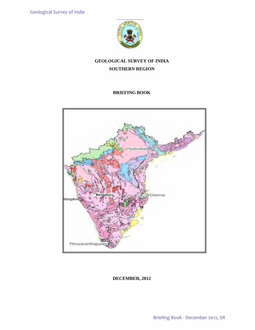
GEOLOGICAL SURVEY OF INDIA SOUTHERN REGION BRIEFING BOOK DECEMBER, 2012 Mangalore Geological Survey of India Briefing Book - December 2012, SR
-
Upload
khangminh22 -
Category
Documents
-
view
1 -
download
0
Transcript of Annexure - - Geological Survey of India
GEOLOGICAL SURVEY OF INDIA
SOUTHERN REGION
BRIEFING BOOK
DECEMBER, 2012
Mangalore
Geological Survey of India
Briefing Book - December 2012, SR
ii
CONTENTS S.No. Subject Page No. Executive summary 1
1.
Introduction: (i) Geological milieu of South India. (ii) Mineral resources of South India. (iii) Geology & Mineral Resources of Southern States.
4 4 7 7
2. Organisational structure of the Region: Organogram in Mission – Region Mode. 20
3.
Activity domain of the region: A. Important activities of Southern Region. B. Ongoing projects in Southern Region (F.S.2012-13) C. Envisaged target of Southern Region for FS: 2012-13 D. Target achievement of Southern Region for FS: 2012-13 (upto 31ST Dec.2012) E. Brief on the work carried out in Southern Region: (i) Geological Mapping (ii) Specialised Thematic Mapping (STM) (iii) Geochemical Mapping (NGCM). (iv) Geophysical Mapping (GPM) (v) Marine and Coastal Surveys (vi) Natural Resource Assessment (vii) Geodata / Geoinformatics (viii) Engineering Geology & Geotechnical Studies (ix) Earthquake Geology (x) Photogeology & Remote Sensing (PGRS) (xi) Geoenvironmental studies (xii) Information Dissemination (xiii) Technical Consultancy Service (xiv) Quality Management (xv) Library (xvi) Core Repository (xvii) Geological Museum / Rock Garden /Geoparks F. Major Achievements and Milestones G. Significant Mineral Resource Assessment H. Assistance to State Government and other agencies I. Status Map of the State Units (STM & GCM)
21 21 22 30 31 32 32 32 36 40 43 46 53 53 56 57 58 58 61 62 63 64 65 68 68 74 74
4. XI & XII Plan work envisaged for the region 82 5. Financial performance under current plan, state-wise and year wise 82 6. FSP work (FS 2012-13):
I. Field items in tribal areas. II. Field supervision
III. RCA management
82 83 84 89
7. Laboratory infrastructure, items, output- actual vs norm, AMC, budget etc. 119 8. Geoinformatics. 122 9. Training / Capacity Building Activities in the Region 127 10. Scientific workshops/Meetings/Seminars/Symposium, Exhibitions etc., organized/
participated. 128
11. HRD, Establishment, Payroll, HRMIS, e-service book etc.(including Statement of Grievance, Vigilance, Right to Information & Legal cases)
132
12. Vehicles & transport infrastructure including outsourcing and age of vehicles 139 13. Modernization. 139 14. Drilling Infrastructure 139 15. Outsourcing of routine services (house keeping, security, garden, etc) 139
Geological Survey of India
Briefing Book - December 2012, SR
iii
ANNEXURES
1. ANNEXURE – 1A: Major mineral resources estimated in the Southern Region 141
2. ANNEXURE – 1B: National Mineral Inventory: No. of reports converted as per UNFC compliance. 143
3. ANNEXURE – 2A: Activity domain pertaining to Mission I & II of the region and achievement during the XI plan period (2007-12). 160
4. ANNEXURE – 2B: FSP rolling plan for FS 2012-13 & FS 2013-14. 162
5. ANNEXURE – 2C: Shelf of Projects. 169
6. ANNEXURE – 3A: Financial outlay and expenditure during XI & XII plan period. 174
7. ANNEXURE – 3B: Scheme-wise, quarter-wise distribution of approved plan funds and actual expenditure for the years 2011-12 & 2012-13. 175
8. ANNEXURE – 3C: Scheme-wise, month-wise distribution of approved plan funds and actual expenditure for 2011-12 & 2012-13. 177
9. ANNEXURE – 4: Mission wise pro-rata RCA expenditure in different Projects vis- a- vis targets and achievements. 179
10. ANNEXURE – 5: Progress & pendency report of chemcial analysis of NGCM samples. 211
11. ANNEXURE – 6: Data Universe on Region-wise – Mission-wise Status of Pending Progress Reports. 216
12. ANNEXURE – 7: Status of uploading in GSI portal. 217
13. ANNEXURE – 8: Case studies uploaded in GSI portal. 221
14. ANNEXURE – 9: List of publications brought out in last five years. 223
15. ANNEXURE – 10: Courses conducted at FTCs along with list of faculty members. 224
16. ANNEXURE – 11: List of RAC/OAC/Stage Review/SGPB meetings with date and status of uploading of minutes. 225
17. ANNEXURE – 12: Employment position in the region. 226
18. ANNEXURE – 13: Vehicle position in the region. 227
19. ANNEXURE – 14: Procurement status of major equipments/ modernization items/machinery proposed for procurement during 2012-13. 229
20. ANNEXURE – 15A: Status of existing drilling equipments under deployment. 233
21. ANNEXURE – 15B: Status of drilling and other high end ( Rs.> 1 Crore) equipment to be procured during FY 2012-13.
235
22. ANNEXURE- 16 : Status of pending legal cases of the region 236
Geological Survey of India
Briefing Book - December 2012, SR
1
EXECUTIVE SUMMARY OF THE BRIEFING BOOK OF SOUTHERN REGION
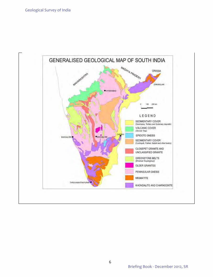
1) Geological milieu and mineral resources of South India as well as geology and mineral resources of different constituent states units of GSI, Southern Region, are presented in geological context in the introductory chapter. The digitized geological map (generalized) of South India as also the geological and mineral maps of all the State Units - Andhra Pradesh, Karnataka & Goa, Tamil Nadu & Puducherry and Kerala depicting the distribution of various mineral commodities are included in the first chapter.
UPTO DECEMBER, 2012
2) Organizational structure of GSI, Southern Region, in Region – Mission hybrid matrix mode is shown by an
updated organogram, as a single page “flow chart” on the last page.
3) Under activity domain, the activities of Southern Region in Mission mode have been enumerated.
4) The ongoing projects under execution during FS 2012-13 have been listed mission wise under activity domain of the Region.
5) The envisaged target for FS: 2012-13 and achievements upto 31st December, 2012 are tabulated and presented
under activity domain. Prorata targets have been achieved for most of the items and the envisaged targets are likely to be accomplished by March 2013.Accomplishment of Southern Region along with the brief background and highlights of the work carried out under different heads have been presented under the “Brief on the work carried out in Southern Region”.
6) Status of STM, GCM and GPM showing area covered up to F.S: 2010-12 and the area under investigation
during the current F.S: 2012-13 in Southern Region as well as different SUs have been plotted on the geological maps of the respective states.
7) During F.S. 2012-13, under Mission-I, 11 STM items and 30 GCM items are under execution as against 8 STM items and 12 GCM items carried out during FS 2010-12. Three items of GPM, 17 items of Marine and Coastal surveys and one Geomorphological and lineament mapping item under PGRS Division are being carried out during the current field season.
8) Under Mission - II, a total of 30 mineral investigations have been taken up during the ongoing field season as against 26 items carried out during FS 2010-12. Out of these; 7 investigations are for PGE, 4 for gold, 4 for diamond, 2 for limestone, 2 for copper / basemetals, 1 each for molybdenum, chromite, REE, manganese, baryte, phosphorite and bentonite besides, 3 for coal and 1 for lignite. One service item of maintenance of Diamond Processing plant at Wajrakarur under Mission – II is continued during the current Field Season. State-wise break up of investigations taken up for different mineral commodities are given in Table-11.
9) Six mineral investigations (except Mission-IIB: Natural Energy Resources) are under UNFC, G3 stage while the rest of the items are under G4 stage of preliminary investigation. The G3 stage mineral investigation items are as under:
i) Exploration for limestone resources in Guntur district, AP. ii) Exploration for copper in Cherlapalle Block, Ananthapur district, AP. iii) Investigation for gold in Ajjanahalli Block-E, Tumkur district, Karnataka iv) Exploration for PGE in Tasampalaiyam Block, in Sittampudi Anorthosite Complex, TN. v) Exploration for PGE in Solavanur Block, Mettupalaiyam mafic–ultramafic complex, TN. vi) Exploration for molybdenum in Vellampatti south block, Dharmapuri district, TN.
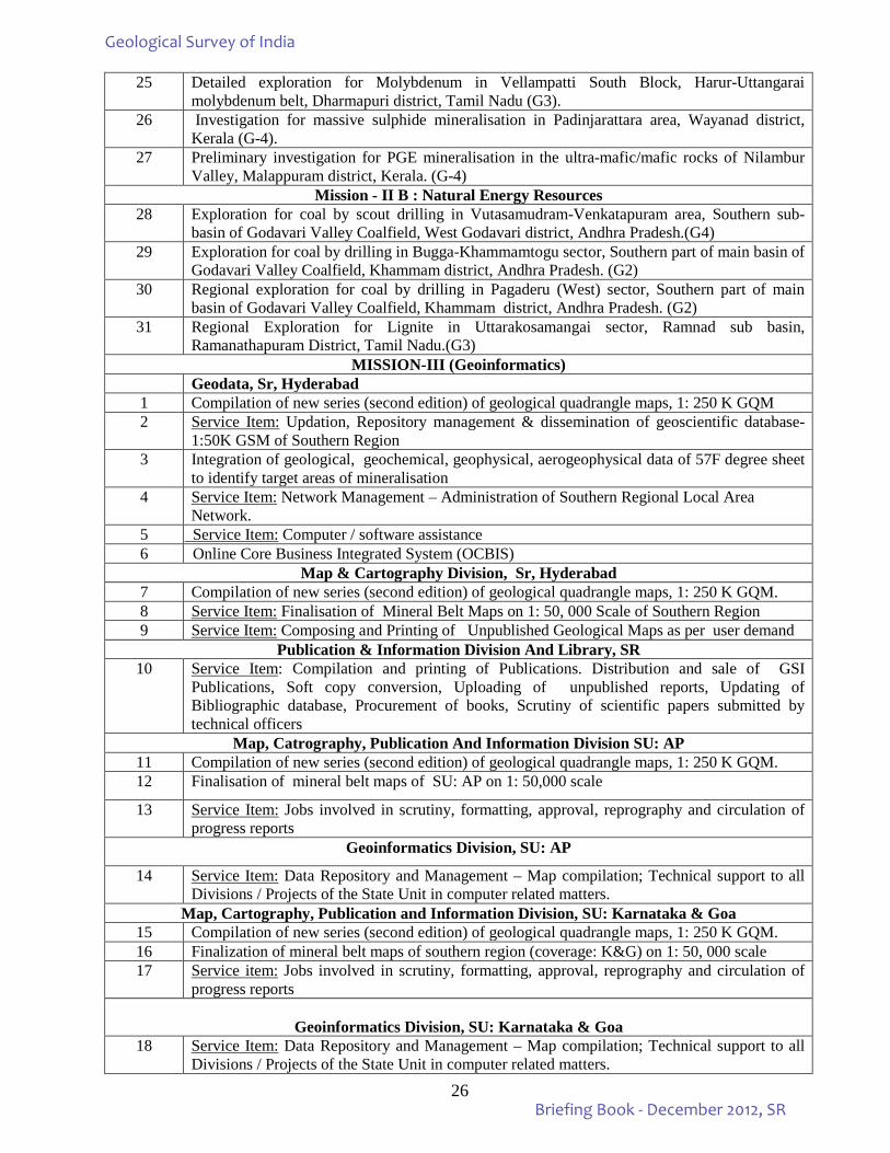
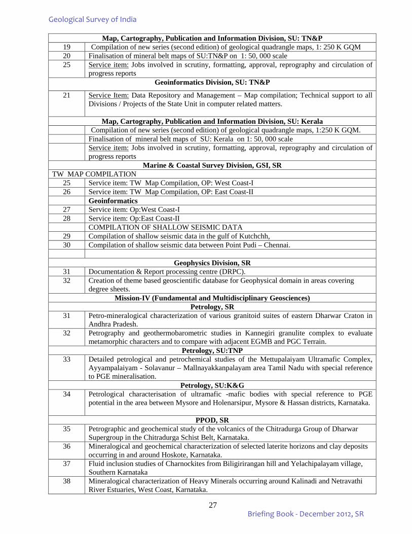
10) Under Mission - III, 32 items are taken up during the current field season. It includes compilation of new
series of Geological Quadrangle maps, 1:250K, finalization of mineral belt maps, OCBIS implementation besides service items pertaining to Geodata/Geoinformatics, Map & Cartography, Publication and Information Division of Southern Region, HQ as well as State Units and M&CSD.
Geological Survey of India
Briefing Book - December 2012, SR
2
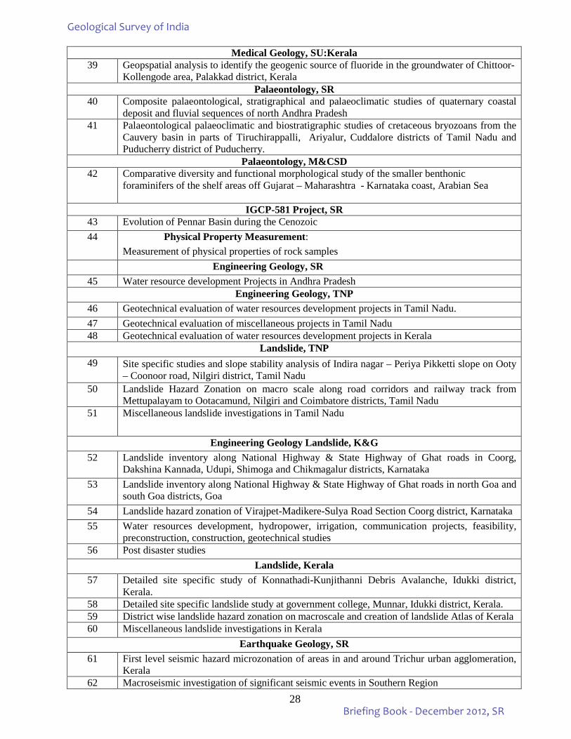
11) Under Mission - IV, a total of 32 items, encompassing geotechnical evaluation and water resource development projects, earthquake geology and landslide investigations, medical geology project and research projects under Petrology, Palaeontology and PPOD, Bangalore have been undertaken during the field season 2012-13. The work of Engineering Geology Division is spaced round the year and largely, the programmes are sponsored, taken up on payment basis.
12) F.S.P. Implementation:
All the field investigations have been taken up in the 1st quarter of FS: 2012-13 itself and efforts have been made to achieve prorata targets. Item-wise targets, achievements, number of field days spent by the officers, the total and unit expenditure incurred are given in Annexure-4.
13) Field Supervision:
Annual programme implementation and its effective monitoring are actively pursued by the supervisory officers through regular field visits for necessary technical guidance and to ensure the high quality of work. Details of field visit of supervisory officers are tabulated and presented under Chapter-6.
14) RCA Management
: RCA recoupment & pendency are closely monitored and a relevant statement of RCA details in the prescribed format, including the data inputs of date of application, initial sanction and recoupment received etc is regularly sent to the Director (Finance-Monitoring) in DGCO, New Delhi and to the Dy.Director General (IT), CHQ Kolkata for uploading to GSI Portal. Data as on 7th January, 2013 regarding the status of RCA recoupment and pendency in respect of individual officer is presented in respective tables under RCA management.
15) Status of Reports
: No report pertaining to F.S. 2010-12 is pending for circulation. Time lines were set for two classified categories of reports, Non-NGCM reports wherein chemical data are not very significant and NGCM reports, to be circulated by 30th September and 30th November 2012 respectively. All the reports have been circulated as per the specified date lines.
16) Chemical Analysis
: A total number of 2836 samples were received for FS 2012-13 upto the end of December, 2012. Package wise chemical analysis is under progress.
17) UNFC Code: UNFC compliance of all the 177 mineral investigation reports enlisted for Southern Region has been accomplished within the stipulated time frame. The certificate on UNFC compliance with appropriate code assigned for these reports have been uploaded along with the abstract of the reports available, in the portal (Annexure –IB).
18) Detailed Information Dossiers (DIDs): DID updation documents in respect of Southern Region have been
submitted for Diamond, Basemetal, Iron Ore, Chromite, Manganese as well as Gold. 19) Uploading of Progress Reports: Softcopy conversion of 1834 Pre- 2004 unpublished progress reports of SR is
under progress on outsourcing basis. 1634 reports have been supplied for softcopy conversion. Out of that 1299 reports have been keyed and uploaded in the portal upto 31st December, 2012. Remaining 335 reports are to be keyed and uploaded.
20) Quality Management: Quality Management at Regional Headquarters (RHQ) and State Headquarters (SHQ)
are working in tandem to improve the quality of work carried out in the Region. All the follow-up actions for the peer review of progress reports pertaining to FS 2007-08, 2008-09 have been taken up by the QM cell, SR as per the directives of the QM Cell New Delhi. For FS- 2009-2010: (a) Three (3) reports have been peer reviewed. (b) QM Cell, New Delhi vide its letter dated 14th June 2012 sent a list of six reports for peer review. Out of the six reports required by QM Cell, New Delhi for peer review, hard copy of five reports (three reports of M-II and two reports of M- IV) have been sent to QM Cell, New Delhi. The remaining one report has already been peer reviewed, modified and circulated.
Geological Survey of India
Briefing Book - December 2012, SR
3
21) Case Studies: 35 Case Studies and 196 Photographs from Southern Region have been uploaded to GSI Portal till December 2012 (Annexure-8). Few case studies are under process for uploading and some more case studies are in different stages of scrutiny and modification etc.
22) RAC Meeting of Region: 3rd Regional Advisory Council meeting of Southern Region under XII Plan was
held on 24th December, 2012 at SU:TNP, Chennai. Minutes of the XII_SR_03 RAC meeting are uploaded to portal.
23) OAC Meeting of State Units: All the State Units have conducted the 3rd OAC meetings of the XII Plan as per the schedule given below and minutes of all the OAC meetings have been uploaded to GSI Portal:-
SU: Andhra Pradesh (XII_AP_OAC_03) - held on 20-12-2012 SU: Karnataka & Goa (XII_KG_OAC_03) - held on 20-12-2012 SU: Tamil Nadu & Puducheery (XII_TNP_OAC_03) - held on 21-12-2012 SU: Kerala (XII_KRL_OAC_03) - held on 20-12-2012
24) Stage Reivew / Term Review Meetings: Stage Review meeting for FS: 2012-13, of all the State Units and Headquarter Divisions, SR have been held and completed by October, 2012. The Term Review meeting of SR is proposed to be held on 18th & 19th February, 2013.
25) SGPB Meetings: All the States’ Directorates of Mines & Geology are regularly requested by the respective
State Units to hold their SGPB meetings before the scheduled CGPB meetings. The last SGPB meetings held by the different State Governments are as under:
46th SGPB meeting of AP - 14.09.2012 (meeting date postponed) 51st SGPB meeting of Karnataka - 22.08.2012 56th SGPB meeting of Tamilnadu - 16.02.2012 49th SGPB meeting of Kerala - 01.08.2012
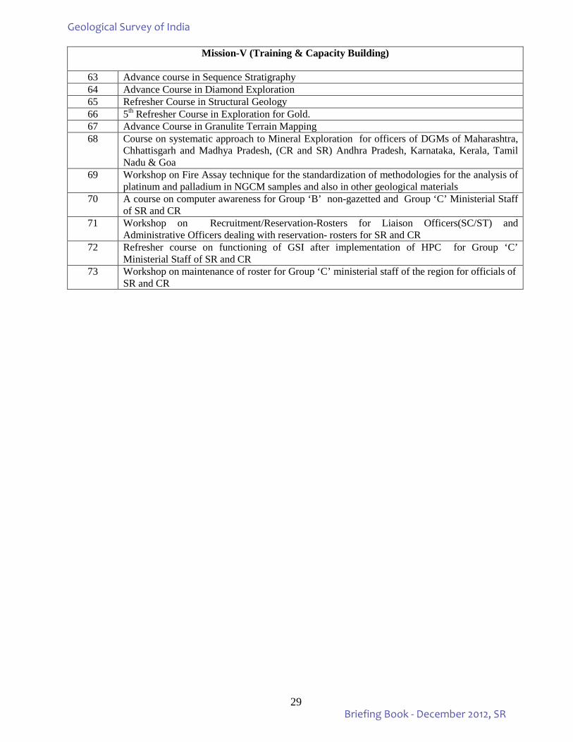
26) Training & Capacity Building: Training courses conducted by RTI, SR during October – December, 2012
have been given in Annexure-10. Core faculty and guest faculty (GSI, Ex-GSI etc.) invited for various courses are also given.
27) “Rolling Plan” and “Shelf of programmes” for the next two years, Mission-wise, proposed for different SUs
of SR are included in the briefing book as Annexure-2B & 2C respectively.
28) Finance: Fund disbursement for the 1st, 2nd & 3rd quarters of the Financial Year 2012-13 have been very judiciously done keeping in view the demand & fund availability. Utilization of fund against the fund allotment of Southern Region for 2012-13 uptill now has been satisfactory in the overall assessment.
29) Financial outlay figure, approved plan funds and actual expenditures for the 1st, 2nd & 3rd quarters of XII plan
period (April-December, 2012) are included in Annexures-3A, 3B, &3C. 30) HRMIS: HRMIS data are constantly updated with regards to transfers, promotion and other details. All the
officers and Staff have been directed to update the records regarding field of specializsation, deputation/training etc. which the officers/officials have to update/upload individually with the assistance of Geodata division and e-Governance Cell.
31) Claim modules: Pay roll module has been fully implemented in Southern Region at HQ as well as in all the
State Units and Marine & Coastal Survey Division and pay is disbursed through ECS. Increasing number of employees are applying for leave, tour approvals etc., through portal and is expected to gain momemtum.
32) Statement of Grievance cases, Vigilance cases and Legal cases with the current status are incorporated in the
Briefing Book. Nature & Status of legal cases are summarized in Annexure-16. ****
Geological Survey of India
Briefing Book - December 2012, SR
4
GEOLOGICAL SURVEY OF INDIA Southern Region
1. INTRODUCTION
• Geological Survey of India (GSI) was set up in 1851 with its headquarters at Kolkata, primarily to locate coal deposits for Railways.
• Subsequently, in order to study the various geological provinces / milieus and conduct detailed mineral exploration in geologically unique territories spread over the country, six Regional Offices were set up at Lucknow, Jaipur, Nagpur, Hyderabad, Shillong and Kolkata. State offices were also set up in all the States of India to conduct geological / mineral investigations in the States of the Union, and to assist the State Governments in their endeavours in geological work.
• Geological Survey of India, Southern Region (SR) with its headquarters at Hyderabad was set up in November, 1961 under the Directorship of K. R. Khedkar.
• The Southern Region Office comprises (i) State Unit Andhra Pradesh at Hyderabad; (ii) State Unit Tamil Nadu & Puducherry at Chennai; (iii) State Unit Kerala at Thiruvananthapuram; and (iv) State Unit Karnataka & Goa at Bengaluru. After implementation of the HPC recommendations and Mission mode operations in SR, the activities of three Marine and Costal Surveys (M&CS) Divisions (Kochi, Mangalore and Visakhapatnam) under Mission 1A, two Divisions of Coal and Lignite under Mission II B--Natural Energy Resource (NEnR) and two units of Remote Sensing and Airborne Surveys (RSAS—Hyderabad and PPOD, Bangalore) of Mission IB have been brought under SR. Similarly the Regional Training Institute (RTI), Hyderabad and FTCs at Kothagudem and Wajrakarur are working under Southern Region headquarters whereas the Field Training Centres (FTCs) at Salem and Chitradurga are attached to the respective State Units under jurisdiction of which they are situated.
GEOLOGICAL CONTEXT
Southern peninsular India comprising States of Andhra Pradesh, Karnataka, Kerala, Goa, Tamil Nadu and
the Union Territory of Puducherry exposes lithological assemblages from Archaean to Holocene. It is divisible into four physiographic units namely, (i) East and West Coastal Plains, (ii) Eastern Ghats, (iii) Deccan Plateau and (iv) Western Ghats. The Deccan Plateau constitutes the region predominantly and it is flanked on either side by linear stretches of coastal plains and is drained by major easterly flowing rivers like the Godavari, Krishna, Tungabhadra, Pennar, Palar, Cauvery and Vaigai, as also a few westerly flowing rivers such as Mandovi, Zuari, Netravathi, Bharathapuzha, Periyar and Pamba, which originate from the Western Ghats. GEOLOGICAL MILIEU OF SOUTH INDIA Archaean to Proterozoic
Southern peninsular India is a shield area comprising Dharwar Craton in the north and Southern Granulite
Terrian in the south; a boundary called the Fermor Line separates these two. Dharwar Craton encompasses major parts Karnataka and Andhra Pradesh States. Dharwar Craton is a typical Archaean-Proterozoic granite-greenstone terrain. An array of granitic lithounits such as tonalite, trondhjemite, granodiorite, adamellite and granite constitute this Archaean-Proterozoic granitic terrain. These are deformed and metamorphosed into complex gneisses. The granitic rocks of varying composition and the gneisses are together known as Peninsular Gneissic Complex (PGC). The PGC contains several linear, deformed and folded greenstone / schist belts. Prominent intra-cratonic Proterozoic sedimentary basins namely Cuddapah Basin, Kurnool Basin, Bhima Basin and Kaladgi Basin have formed over the basement of Dharwar Craton. The craton is bounded in the east by Eastern Ghats Mobile Belt, in the northeast by the Bastar Craton, and is overlain in the northwest by the basalt flows of Deccan Trap. Eastern Ghats Mobile Belt is a granulite terrain made up of charnockite, khondalite, quartzite, calc-
Geological Survey of India
Briefing Book - December 2012, SR
5
granulite, pyroxene-granulite, granite and leptynite. This belt extends into Orissa in a northeasterly direction. In the northern part, Dharwar Craton is partly covered by Proterozoic sediments of Pakhal Supergroup and Phanerozoic sediments of Gondwana in a NW-SE trending rift basin called as Godavari Basin / Rift / Graben. They are flanked on either side by Proterozoic sedimentary sequences of Penganga and Sullavai basins. Different types of Charnockites and Gneisses (PGC I & II) are the predominant rock types in the States of Kerala and Tamil Nadu. In these states Neo-Proterozoic magmatism is represented by intrusives of alkaline group of rocks and granitoids. Meso-Proterozoic dykes are present in the area to the North of Palghat Cauvery Lineament and the Mesozoic dykes are seen in the western part of Kerala. Palaeozoic and Mesozoic Sediments: Rocks of Gondwana Supergroup are exposed along the Pranhita-Godavari valley in Andhra Pradesh. In Tamil Nadu, Lower Gondwana Formations occur in north south trending linear belts in the southern part of the Palar Basin. Upper Gondwana rocks occur in Tiruchirappali, Sivaganga and Palar sub basins. Recent Borehole intersections (2010) indicate the presence of Upper Gondwana plant fossils at depth in Vridhachalam sub basin. Gondwana sediments of the Godavari Valley host rich coal deposits in Andhra Pradesh. In the coastal belt of Tamil Nadu, marine Cretaceous rocks distributed in Tiruchirapalli, Vriddhachalam and Pondicherry sub basins have been lithostratigraphically divided into different groups. Some of the formations under these groups are very rich in their fossil content, mostly, lamellibraches, gastropods and brachiopods. The 26 m long fossil tree occurs in ‘Trichinopoly Group’. Deccan Trap:
Basalt flows of Deccan Trap with their infratrappean and intertrappean sedimentary beds, cover a vast
area of Karnataka and Andhra Pradesh over an area of about 42,000 sq km in the northern and northwestern parts of South India. Adilabad, Nizamabad, Medak, Ranga Reddy, Mahbubnagar, East Godavari and West Godavari districts of Andhra Pradesh and Bidar district and parts of Belgaum, Bijapur and Gulbarga districts in Karnataka expose Deccan Trap. Tertiary Sediments:
Tertiary sedimentary sequence in Andhra Pradesh is represented by Rajahmundry Formation, along the coast between Samarlakota and Eluru. In Tamil Nadu Lower Tertiary sediments are seen in Tiruchirappali and Pondicherry sub basins. Upper tertiary sedimentary sequence is represented by Cuddalore Formation which occupies thousands of sq. km along East Coast. Huge lignite deposits occur in these sediments. NLC is exploiting these lignite deposits. In the southern part of the west coast, particularly in Kerala, Tertiary sediments are represented by Warkalli and Quilion formations. Quaternary and Holocene Sediments:
The Quaternary sediments in the southern peninsular India occur along inland river valleys and along the
coastal tracks interrupted by the prograding deltas of major rivers. They are represented by thick blankets of alluvium, gravel and colluvial deposits, beach sand, kankar, soils of various types and laterite.
Geological Survey of India
Briefing Book - December 2012, SR
6
Geological Survey of India
Briefing Book - December 2012, SR
7
MINERAL RESOURCES OF SOUTH INDIA
The southern Indian States are endowed with rich mineral wealth. Significant mineral deposits such as ferrous, non-ferrous and noble metals, precious and semi-precious stones, strategic minerals, fossil fuels and other industrial minerals are found in diverse geological formations ranging from Archaean to Quaternary. The Archaean high grade metamorphic rocks such as Sargur Group host mica, copper, barytes and gemstones; the greenstone belts of Dharwar Craton are repositories of gold and iron ore; Peninsular Gneissic Complex is the host for diamondiferous kimberlite pipes, apart from bearing potential for dimension stones, chromite and semi-precious stones. Granulites of Eastern Ghats Supergroup and Southern Granulite Terrain contain bauxite, manganese, graphite, apatite, gemstones, tungsten and dimension stones. The Proterozoic rocks that are confined in the intra-cratonic basins, contain basemetals, barytes, asbestos, limestone, dolomite, diamonds, iron and manganese ores, magnesite, phosphorite and uranium. Late Palaeozoic to Early Mesozoic rocks of Gondwana Supergroup contain coal deposits and clay. The Tertiary and Quaternary rocks contain oil and natural gas, lignite, beach sands, clay, diamond and other gemstones. Mineral deposits linked to the growth of Gross Domestic Product (GDP) are limestone, bauxite, iron, barytes, coal, lignite, gold, diamond, dimension stones, manganese, mica, oil and natural gas. The Southern States offers favourable geological milieu to host all the mineral deposits linked with GDP growth.
GEOLOGY AND MINERAL RESOURCES OF SOUTHERN STATES
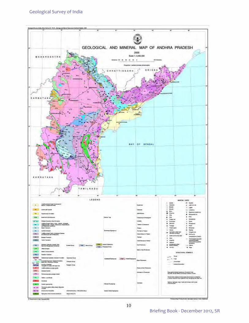
ANDHRA PRADESH Geology: The State of Andhra Pradesh has an area of 2,76,800 sq.km. and is bounded by N 12045’ – 19050 and E long. 76054’ – 84045’. Physiographically, the State comprises hill ranges, plateaus, deltas and coastal plains. The State is divisible, from east to west, into three distinct units viz. (i) the coastal plains, interspersed with deltas of the major rivers like Godavari, Krishna and Pennar, to the east (ii) the Eastern Ghats (prominent in the north) and Nallamalai hill ranges (prominent in the south) to the west and (iii) the undulating plateau region dotted with hill ranges to the western most. A major part of the State forms the Peninsular Shield referred to as Dharwar Craton, which comprises the Late Archaean granite – gneiss and a few widely separated narrow greenstone belts, especially in the south and west. The Craton is bounded by the Eastern Ghats Mobile Belt to the northeast and the Pranhita – Godavari Valley to the north. The Proterozoic sedimentary sequence, Cuddapah and Kurnool, occupy large tracts in the south – central part. The Pranhita-Godavari valley exposes a sequence of sedimentary rocks ranging in age from Proterozoic to Cretaceous. The Gondwana sediments of Pranhita – Godavari valley are the only coal bearing formations in South India. The Deccan Trap effusive cover some of the formations in the northwest and west. The isolated Cretaceous – Tertiary outcrops and the Quaternary alluvial covers occupy the coastal belt, which hosts sizeable reserves of oil and natural gas – both onshore and offshore. Tertiary laterite capping are conspicuous along the coast and also over the Eastern Ghats. The East Coast Bauxite deposits, one of the biggest deposits of Asia, occur as cappings on the Eastern Ghats.
Geological Survey of India
Briefing Book - December 2012, SR
8
Mineral resources: The State has huge reserves of bauxite, limestone, coal, barytes and dimension stones and is a leading producer of these minerals. Other minerals of commercial significance that occur in the State include apatite, base metals, clay, diamond, gold, graphite, manganese, mica, petroleum and natural gas, quartz, silica & radioactive sands, garnet, feldspar, beryl, ruby, slate, marble, rare earth elements and radioactive minerals.
Andhra Pradesh has large reserves of different grades of limestone (about 35.18 billion tonnes). It accounts for nearly 20% of the country’s limestone resources. Quite a significant proportion of country’s cement production takes place in 34 cement plants that are in operation in Andhra Pradesh. The cement production is of the order of 12 Mt / annum. Besides cement grade limestone, significant reserves of BF, SMS and high-grade limestone is also found. AP stands next to Orissa in bauxite reserves. Good quality bauxite, with significant aluminium-content occurs as high-level cappings over the khondalite and granulites. The deposits in AP and Orissa with a total reserve of about 2423.538 Mt constitute one of the largest bauxite deposits in the world. The largest barytes deposit in the world is located in Mangampeta in Cuddapah District. This deposit occurs in the Pullampet Shale of the Cuddapah Super group. The state possesses reserves of coal, non cocking coal up to 1200 m depth have been estimated to be 22054.58 Mt (April 2011), from coal bearing formations in Godavari Valley. Archaean greenstone belts are the major repositories of gold. They occur as linear, narrow and subparallel N-S to NNW-SSE trending schist belts amidst Peninsular Gneissic Complex. Andhra Pradesh has the distinction of having produced many of the historically famous diamonds like the Koh-i-noor, the Great Mogul, the Hope and the Orloff. Both primary (kimberlites / lamproites) and secondary (conglomerates and gravel) source rocks of diamond occur in different parts of the State. Andhra Pradesh has immense potential for granite based dimensional stone industry. The Archaean-Proterozoic granite-gneiss terrain occupying more than 60% of the state is a storehouse of multi-coloured rocks of which the Galaxy Granite occurring in Prakasam district has high export potential. The State contributes about 6% of the manganese ore production in the country. The ore is mainly associated with kodurites of Khondalite Group in Eastern Ghats Supergroup and Penganga beds in the Pakhal Basin. At the national level, Andhra Pradesh occupies eighth position in mineral production with a share of about 8%. Apart from these mineral commodities significant prospects of oil and natural gas have been identified over an area of about 40,000 sq km on-shore and off-shore in the Krishna-Godavari basins in parts of East and West Godavari and Krishna districts. The State is endowed with significant occurrences of strategic minerals/metals, which include monazite, ilmenite, tungsten, uranium and molybdenum. These are found in various geological environments. A number of occurrences of precious and semiprecious stones are known from gem belt in the Eastern Ghats, distributed in East Godavari, Visakhapatnam and Vizianagaram districts.
Geological Survey of India
Briefing Book - December 2012, SR
9
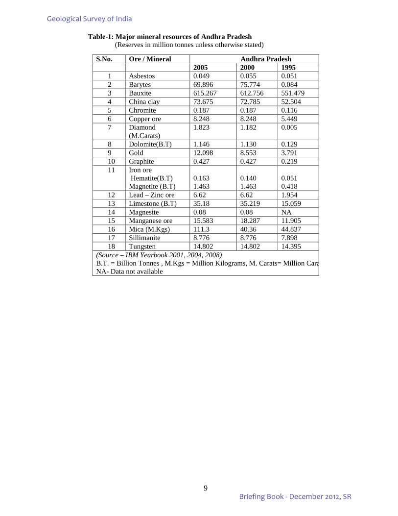
Table-1: Major mineral resources of Andhra Pradesh (Reserves in million tonnes unless otherwise stated)
S.No. Ore / Mineral Andhra Pradesh 2005 2000 1995 1 Asbestos 0.049 0.055 0.051 2 Barytes 69.896 75.774 0.084 3 Bauxite 615.267 612.756 551.479 4 China clay 73.675 72.785 52.504 5 Chromite 0.187 0.187 0.116 6 Copper ore 8.248 8.248 5.449 7 Diamond
(M.Carats) 1.823 1.182 0.005
8 Dolomite(B.T) 1.146 1.130 0.129 9 Gold 12.098 8.553 3.791 10 Graphite 0.427 0.427 0.219 11 Iron ore
Hematite(B.T) Magnetite (B.T)
0.163 1.463
0.140 1.463
0.051 0.418
12 Lead – Zinc ore 6.62 6.62 1.954 13 Limestone (B.T) 35.18 35.219 15.059 14 Magnesite 0.08 0.08 NA 15 Manganese ore 15.583 18.287 11.905 16 Mica (M.Kgs) 111.3 40.36 44.837 17 Sillimanite 8.776 8.776 7.898 18 Tungsten 14.802 14.802 14.395
(Source – IBM Yearbook 2001, 2004, 2008) B.T. = Billion Tonnes , M.Kgs = Million Kilograms, M. Carats= Million Cara NA- Data not available
Geological Survey of India
Briefing Book - December 2012, SR
10
Geological Survey of India
Briefing Book - December 2012, SR
11
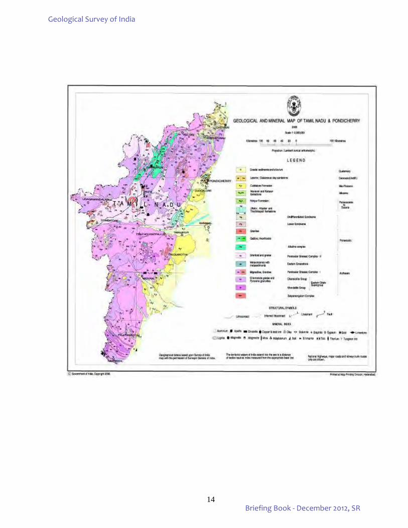
TAMILNADU & PUDUCHERRY Geology: Tamil Nadu, with an area of 1,30,058 sq.km. is situated in the SE part of the Indian peninsula between North Latitudes 08000’ and 13030’ and East Longitudes 76000’ and 80018’. The western part comprises the Western Ghat roughly trending N-S and marked by a continuous range of Hills. The central part of the state is a vast track of dissected pediments and pediplains with residual hills. A coastal plain with associated landforms marks the eastern part. The Union Territory of Puducherry is located on the East Coast, about 160 km. south of Chennai and occupies an area of 492 sq.km. Crystalline rocks of Archaean to late Proterozoic age occupy over 80% of the area while the rest is covered by Phanerozoic sedimentary rocks mainly along the coastal belt and in a few inland River valleys. The hard rock terrain comprises predominantly of Charnockite and Khondalite groups and their migmatitic derivatives, supracrustal sequences of Sathyamangalam and Kolar groups and Peninsular Gneissic Complex (Bhavani Group), intruded by ultramafic-mafic complexes, basic dykes, granites and syenites. The crystalline rocks are derived through a complex evolutionary history during Archaean and Proterozoic times with multiple deformations, anatexis, intrusions and polyphase metamorphic events. The sedimentary rocks of the coastal belt include fluviatile, fluvio-marine and marine sequences ranging in age from Carboniferous to Mi-Pliocene and sediments of Quaternary age. The Pre-Crambrian terrain of Tamil Nadu is extensively fractured and deeply faulted particularly in the northern and central parts. The Phanerozoic sediments are relatively unaffected. The Phanerozoic sediments show well-preserved bedding planes where the dips vary from horizontal to 100. The crystaline rocks on the other hand, had undergone polyphase deformation and metamorphism resulting in well-developed foliation (S1, which follows the litho contacts at many places. Subsequent deformations have induced local development of new S fabrics. In the northeast, the regional structure trend is NNE-SSW. This sector is characterised by long linear canoe-shaped folds as a result of F2 deformation. The northwest is characterised by nearly N-S regional structural trend. Although polyphase folding has been recognized in this terrain, no distinct regional structures have been interpreted. In the central part, the regional structureal trend is E-W often swerving to ENE-WSW and WNW-ESE. The southernmost sector, to the south of Tambaraparani River shows a distinct NW-SE structural grain. A number of shear zones have been recognized in the Pre-Cambrian terrain. This includes Moyyar, Bhavani, Salem-Attur, Cauvery, Dharmapuri, Gangavalli and Achankovil shear zones. Mineral resources: Tamil Nadu is endowed with varieties of minerals. The chief mineral resources are fossil fuels (lignite, petroleum and natural gas), metalliferous minerals (iron ore, bauxite, gold, platinum, molybdenum and poly-metallic sulphides) and non-metallic and industrial minerals (limestone, dimension stone, magnesite, ceramic raw materials, graphite, gypsum, heavy mineral, silica sands, vermiculite, quartz, feldspar and gemstones). There is scope for getting coal bed methane in the deep level lignite beds. Lignite is associated with Cuddalore Formation in Cauvery basin. A total of 31327 million tonnes of lignite has been estimated in Cuddalore, Perambalur, Puducherry, Ramanathapuram, Thanjavur and Tiruvarur districts. About 0.79 million tonnes of poly-metallic mineralisation, mainly zinc and lead has been estimated in Mamandur, Tiruvannamalai Districts. A total of 26.85 million tonnes of bauxite ore has been estimated for the State. Bauxite occurs as irregular lenses - pockets and high-level laterite cappings over charnockite in the Nilgiri, Shevroy, Kollimalai and Palani Hills. Gold occurs associated with quartz confined to shear zone in the Nilgiri district and associated with granite greenstone belt in Krishnagiri District. The State possesses around 500 million tonnes of low grade iron ore resources, mainly magnetite, with an average grade of 38% iron. The major deposits occur in Salem, Vellore, Tiruvannamalai, Villupuram, Dharmapuri, Thiruchirappalli, Namakkal and Perambalur districts. Molybdenum occurs in different geological settings - in Alangayam, Vellore district it is associated with quartz-barite veins, in Harur- Uttangarai Belt (HUB), Dharmapuri District it is confined to a shear zone traversing epidote hornblende gneiss and quartzofeldspathic gneiss and in Karadikuttam area, Dindigul District molybdenum is assocated with pegmatite intrusive into migmatitic gneiss. Layered mafic and ultramafic complexes of the state are the repositories of PGE.
Geological Survey of India
Briefing Book - December 2012, SR
12
Sittampundi UM Complex in Namakkal District and Mettupalaiyam UM Copmplex in Erode district are currently being prospected.
Substantial limestone deposits occur in Tamil Nadu. Non-crystalline (sedimentary) limestones of marginal garde are located in parts of Cuddalore, Perambalur and Tiruchirapalli districts, confined to the Creatceous formations of Cauvery Basin. Tertiary coralline limestone is exposed in the series of islands in Gulf of Mannar, Palk Bay and Rameswaram. High grade crystalline limestone occurs in parts of Salem, Karur, Madurai, Virudhunagar and Coimbatore districts as pockets in the migmatite terrain. The total limestone reserves of the state are estimated as 1282 million tonnes (IBM, 2008). Prominent deposit of magnesite is located on Chalk Hills, Salem district. Magnesite occurs as criss-cross veins traversing dunite / peridotite. About 45.52 million tonnes of ore has been estimated. Graphite occurs in Sivaganga District, Kurinjankulam in Tirunelveli District, Palakottai Hill and near Pudupalaiyam in Vellore District and Tirumangalam, Ponnamangalam in Madurai district. A total of 7.91 million tonnes of resource has been estimated in the Sivaganga Graphite Belt which is currently under exploitation. Gypsum reserves of Tamil Nadu are estimated to be 27.311 mt mainly reported from Perambalur and Lalgudi in Tiruchirapalli district. The State has major heavy mineral deposit (ilmenite, rutile, monazite and garnet-bearing sands) that occur as beach placers. About 8.62 mt of zircon, 28.35 mt of garnet, 106.68 mt of ilmenite, 5.11 mt of rutile and 4.91 mt of leucoxene has been estimated for the southern coastal area (IBM year book 2008). Apatite occurs in hybrid rocks (syenite-pyroxenite) and in the carbonatite near Sevattur, Vellore District, with total reserves of 2, 40,000 tonnes. Phosphatic nodules occur in association with gypseous clay and shale of Karai Formation, Uttattur Group of Cretaceous age, in Tiruchirapalli district. A total probable reserve of 1,27,000 tonnes was estimated. The P205 content of the nodules varies from 21.14 to 26.50%. Tamil Nadu is the dimensional stone capital of the country. Rasipuram Blue, Moonstone/Raw, Black granite, Olive/sea Green, Columbu Jubrano, English Teak/ Someka Red/Black, Sappire Blue, Paradiso, Pink Multi, Red Wave, Red Mond, Hosur Grey, Tiger Skin, Kashmir White and Kunnam Black are some of the commercial varities produced in the State. A probable resource of 30.39 million cu m has been estimated up to 2008. Apart from these, other commodities like asbestos, barytes, clay, corundum, feldspars, gemstones, mica, ochre, moulding / glass sand, quartz, sillimanite, steatite and vermiculite are also present. Minor occurrences of minerals such as beryl, celestite, columbite-tantalite, garnet, ilmenite, kankar, nickel ore, pyrite, allanite and salt are also recorded
In the Union Territory of Puducherry, ilmenite and garnet sands occur along the coast of Karaikal with reserves of 17,26,862 tonnes (source AMD). In Puducherry, china clay (2 mt) and limestone (15 mt) are also available.
Geological Survey of India
Briefing Book - December 2012, SR
13
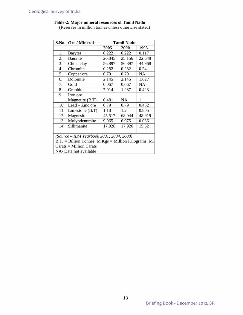
Table-2: Major mineral resources of Tamil Nadu (Reserves in million tonnes unless otherwise stated) S.No. Ore / Mineral Tamil Nadu 2005 2000 1995
1. Barytes 0.222 0.222 0.117 2. Bauxite 26.845 25.156 22.648 3. China clay 56.897 56.897 44.968 4. Chromite 0.282 0.282 0.24 5. Copper ore 0.79 0.79 NA 6. Dolomite 2.145 2.145 1.627 7. Gold 0.067 0.067 NA 8. Graphite 7.914 1.287 0.423 9. Iron ore
Magnetite (B.T) 0.481
NA
1
10. Lead – Zinc ore 0.79 0.79 0.462 11. Limestone (B.T) 1.18 1.2 0.805 12. Magnesite 45.517 68.044 48.919 13. Molybdenumite 9.965 6.975 0.036 14. Sillimanite 17.926 17.926 15.62
(Source – IBM Yearbook 2001, 2004, 2008) B.T. = Billion Tonnes, M.Kgs = Million Kilograms, M. Carats = Million Carats NA- Data not available
Geological Survey of India
Briefing Book - December 2012, SR
14
Geological Survey of India
Briefing Book - December 2012, SR
15
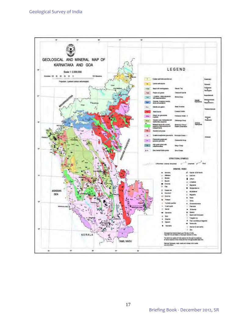
KARNATAKA & GOA Geology:
The State of Karnataka occupying an area of 1,91,792 sq.km. is bounded by north latitudes 11032’ and
18030’ and east longitudes 74005’ and 78032’ whereas the State of Goa bounded by latitudes 14054’ and 15048’ and east longitudes 73048’ and 74020’ along the West Coast between Western Ghats and Arabian Sea has an area of 3,701 sq.km.
The States of Karnataka & Goa forming a part of the Indian Shield are constituted of rock formations ranging in age from 3300 m.a. to 5 m.a. Barring a narrow coastal strip of about 5000 sq.km. of Tertiary and Quaternary sediments and another 31,250 sq.km. of Deccan basalts, the remaining area is occupied by Archaean-Proterozoic rocks. Major part of the state is constituted of Dharwar Craton comprising greenstone belts, gneisses and granites which, at the southern margin of the craton, give way to granulite suite of rocks. The greenstone belts, host a variety of mineralization, essentially consist of meta-volcano-sedimentary sequences, surrounded and dissected by granite-gneiss complex. Dharwar craton is considered to comprise two tectonic blocks viz; the Western Tectonic Block and the Eastern Tectonic Block. The green stone belt in the Eastern block are considered as true greenstone belts whereas those of the Western block are considered as schistose belts. The greenstone belts of the western block include the Sargur Group and the Dharwar Supergroup. The main litho-assemblages in the Sargur Group are meta ultramafics such as serpentinised komatiite, talc-tremolite schist, amphibolite, high grade metapelites such as fuchsite quartzite, kyanite-sillimanite schist, carbonates and Banded Iron Formation. The Dharwar Supergroup is divided into lower Bababudan Group, consisting largely of volcanic suites with shelf/platformal metasediments rich in iron and manganese precipitates; and the upper Chitradurga Group, largely made up of meta-sedimentary sequences of argillite-greywacke assemblage with meta-volcanics. Litho assemblage of the eastern belts comprises greenstone suite consisting of bimodal mafic-felsic volcanics, and pyroclastics and minor amount of meta-sedimentary sequence consisting of quartzite, meta-pelites, marbles and Banded Iron Formation. The peripheral zones of these belts are extensively migmatised by the younger phase of Peninsular Gneiss, hence the basement-cover relationship remains ambiguous. Characteristically these belts are endowed with gold mineralisation. The craton preserves a billion year orogenic history from 3400 m.a. to 2400 m.a. Epicratonic or intracratonic sedimentary basins called Purana Basins occupy the northern segment of the craton whose northern part in turn is concealed by Deccan basalts. The southern coastal tracts of Dakshina Kannada district expose beds of shelly limestone, clay and grit, intercalated with lignite layers which are considered to be the extension of Warkalli Beds of Kerala. The majority of the rock sequences of Karnataka are lateritised due to their exposure to suitable climatic condiditions for a prolonged period. These laterites occur as extensive cappings in the Western Ghats and in coastal plains. The other rock types exposed belong to Quaternary formations and include Recent Soil and Alluvium.
The State of Goa comprises a narrow strip of land measuring about 100 km. in north-south direction and 20-50 km. in east-west direction, along the West Coast. The Goa State constitutes the northwesterly extensions of the granite-greenstone terrain of Karnataka comprising gneisses, migmatites, schists, meta-volcanics (both acid and basic), meta-greywacke, banded ferruginous quartzite associated with mangniferous phyllite / argillite, limestone, dolomite and thin bands of quartzite intruded by granite and ultramafic complexes. Basaltic flows of Deccan Traps are exposed in northeastern border of Goa. Mineral resources:
Karnataka occupies the premier position in terms of metallic mineral production. This state is the sole producer of felsite and the leading producer of gold accounting for 94% of the total production of gold in the country. Karnataka State is second largest producer of metallic ores and occupies seventh place in mining non metallic minerals. No fuel minerals of economic grade and scale are reported. Total reserves in terms of percentage contributed by the state to the all India resources is 64% of gold, 36.5% of manganese ore, 80% of magnetite and 22.5% limestone. Manganese, chromite and ores of iron (both haematite and magnetite) are the principal commodities being exploited for decades; the state still holds huge reserves of the same in the geographic domains of Chitradurga belt, Kudremukh belt, Western Ghat belts and Sandur basin. Aluminium rich laterite cappings, a residual product of selective and sustained weathering and leaching of Deccan basalts and basement granitoids/gneisses in parts of coastal districts constitute the notable metallic ore of aluminium of Karnataka. Major mineral deposits and estimated reserves are narrated here in brief.
Geological Survey of India
Briefing Book - December 2012, SR
16
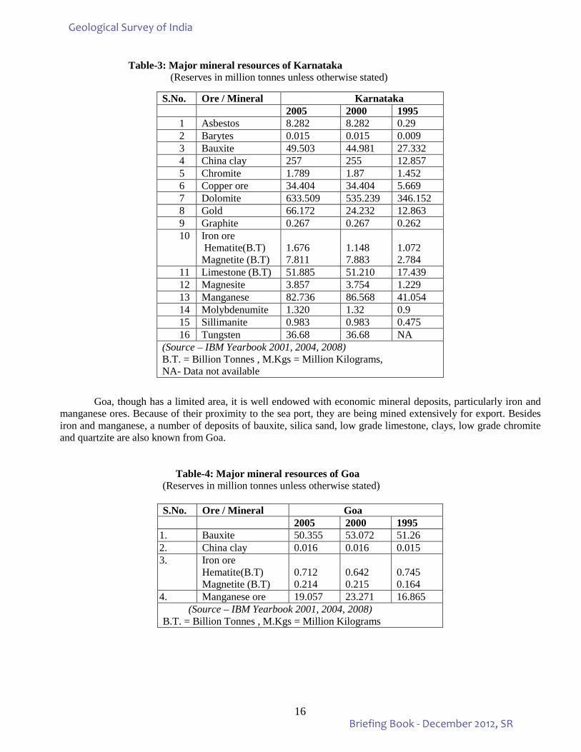
Table-3: Major mineral resources of Karnataka (Reserves in million tonnes unless otherwise stated)
Goa, though has a limited area, it is well endowed with economic mineral deposits, particularly iron and
manganese ores. Because of their proximity to the sea port, they are being mined extensively for export. Besides iron and manganese, a number of deposits of bauxite, silica sand, low grade limestone, clays, low grade chromite and quartzite are also known from Goa.
Table-4: Major mineral resources of Goa
(Reserves in million tonnes unless otherwise stated)
S.No. Ore / Mineral Karnataka 2005 2000 1995 1 Asbestos 8.282 8.282 0.29 2 Barytes 0.015 0.015 0.009 3 Bauxite 49.503 44.981 27.332 4 China clay 257 255 12.857 5 Chromite 1.789 1.87 1.452 6 Copper ore 34.404 34.404 5.669 7 Dolomite 633.509 535.239 346.152 8 Gold 66.172 24.232 12.863 9 Graphite 0.267 0.267 0.262 10 Iron ore
Hematite(B.T) Magnetite (B.T)
1.676 7.811
1.148 7.883
1.072 2.784
11 Limestone (B.T) 51.885 51.210 17.439 12 Magnesite 3.857 3.754 1.229 13 Manganese 82.736 86.568 41.054 14 Molybdenumite 1.320 1.32 0.9 15 Sillimanite 0.983 0.983 0.475 16 Tungsten 36.68 36.68 NA
(Source – IBM Yearbook 2001, 2004, 2008) B.T. = Billion Tonnes , M.Kgs = Million Kilograms, NA- Data not available
S.No. Ore / Mineral Goa 2005 2000 1995
1. Bauxite 50.355 53.072 51.26 2. China clay 0.016 0.016 0.015 3. Iron ore
Hematite(B.T) Magnetite (B.T)
0.712 0.214
0.642 0.215
0.745 0.164
4. Manganese ore 19.057 23.271 16.865 (Source – IBM Yearbook 2001, 2004, 2008)
B.T. = Billion Tonnes , M.Kgs = Million Kilograms
Geological Survey of India
Briefing Book - December 2012, SR
17
Geological Survey of India
Briefing Book - December 2012, SR
18
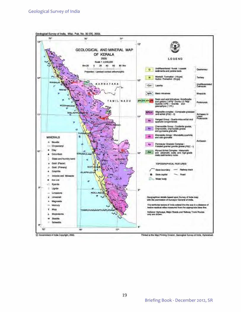
KERALA Geology: Kerala is bounded by N Latitudes 8017’ and 12047’ and E Longitudes 74052’ and 77025’ and has an area of 38,864 sq.km. spread in a linear stretch along the southwest coast of India. The land is divisible into four physiographic features – (i) a low-lying coastal plain fringing the Lakshadweep Sea in the west, (ii) vast stretch of laterite-capped midland region between 30 and 200 m height above MSL, (iii) the moderate to gently sloping foothills of the Western Ghats, between 200 and 600m elevation above MSL and (iv) the rugged high mountains of the Western Ghats, which rise to heights of over 2500 m above MSL. While hard crystalline rocks occupy about 35,955 sq.km. of the total area, the rest of 2,909 sq.km. area is covered by soft sedimentary formations. The major rock types found in the State belong to the Khondalite and Charnockite Groups and the Peninsular Gneissic Complex of Precambrian age. Meta-basic, meta-ultrabasic and meta-sedimentary rocks belonging to the Archaean Wayanad Group (equivalent to the Sargurs of Karnataka) are the oldest rock units in the State, which are found as large enclaves, mainly within the Peninsular Gneissic Complex occupying the northern parts of the State. Granites, syenites, granodiorite, quartzo-feldspathic veins, gabbro and dolerite dykes are the youngest acid and basic intrusives, found across the State. The only sedimentary formation found in the State is the Tertiary Warkalli Formation. Detached, linear outcrops of Warkalli Formation are found all along the west coast, with the type section exposed at the Warkalli cliff. Quaternary deposits of marine fluviomarine and fluvial origin are extensively found over the coastal plains and within major river basins. Mineral resources:
Kerala is not a rich State as far its mineral wealth is concerned. However, its clay and heavy mineral rich beach placer deposits are being effectively exploited. General Cullen (1840-60), had discovered graphite deposits at Vellanad and Venganur in Thiruvananthapuram district in the erstwhile Travancore (now South Kerala) and during the period 1898-1912, these deposits were under active mining. Bruce Foote (1883) and William King (1875, 1878, 1882) of the Geological Survey of India had taken traverses across the State and recorded their findings on geology and mineral resources. In 1907, a Geology Department was formed in Travancore for the systematic survey of minerals. The important mineral deposits found in the State are- china clay, beach sand rich in heavy minerals like ilmenite, rutile, monazite, zircon, garnet, sillimanite etc; bauxite, glass-sand, iron-ore, limestone, lime shell, gold, graphite, dimension stones, gems and semi-precious stones. The resource potential of important minerals found in the State is given below.
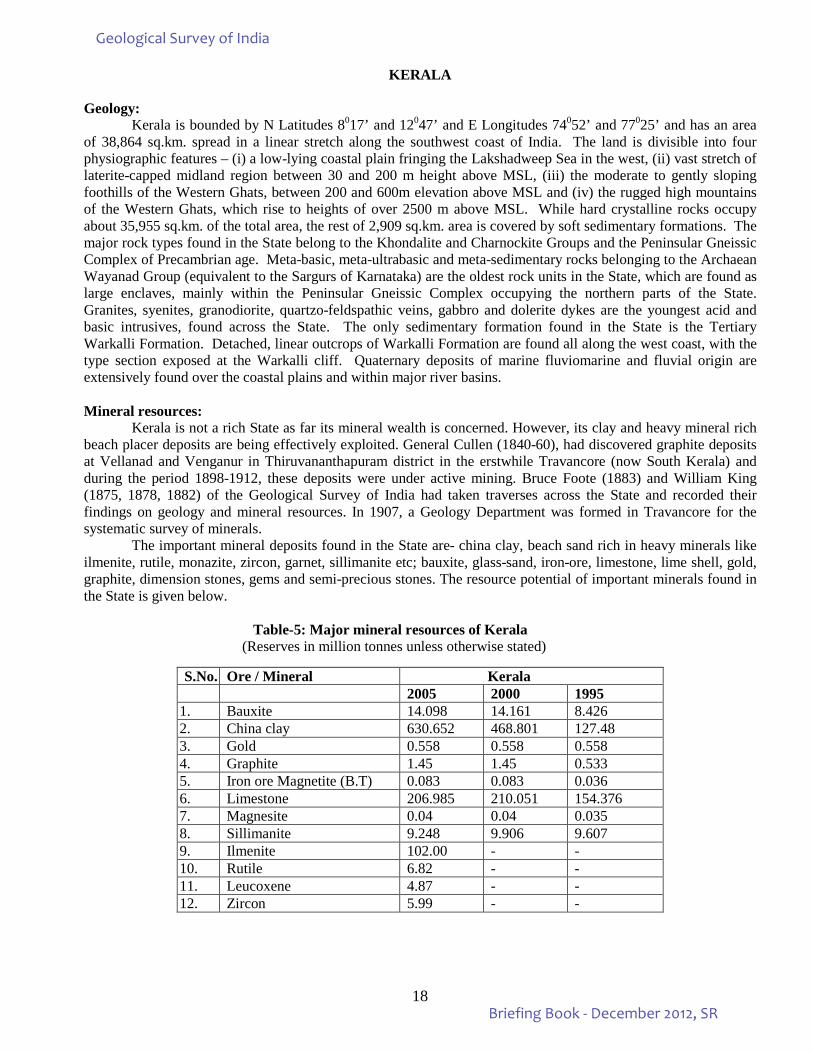
Table-5: Major mineral resources of Kerala (Reserves in million tonnes unless otherwise stated)
S.No. Ore / Mineral Kerala 2005 2000 1995
1. Bauxite 14.098 14.161 8.426 2. China clay 630.652 468.801 127.48 3. Gold 0.558 0.558 0.558 4. Graphite 1.45 1.45 0.533 5. Iron ore Magnetite (B.T) 0.083 0.083 0.036 6. Limestone 206.985 210.051 154.376 7. Magnesite 0.04 0.04 0.035 8. Sillimanite 9.248 9.906 9.607 9. Ilmenite 102.00 - - 10. Rutile 6.82 - - 11. Leucoxene 4.87 - - 12. Zircon 5.99 - -
Geological Survey of India
Briefing Book - December 2012, SR
19
Geological Survey of India
Briefing Book - December 2012, SR
20
2. ORGANIZATIONAL STRUCTURE OF THE REGION: IN MISSION – REGION MODE Organizational Structure of the Region:
GSI has its Central Headquarters in Kolkata and six Regional Offices, geographically based at Kolkata, Lucknow, Jaipur, Nagpur, Hyderabad and Shillong, and has State Units in all the States. GSI is now an Attached Office of the Ministry of Mines. Till July, 2009 it was a subordinate office of the Ministry. Its upgradation follows recommendation of a High Powered Committee set up in 2008.
The Union Cabinet had constituted a High Powered Committee (HPC) to review the functioning of
Geological Survey of India and assess its capacity to meet the emerging challenges taking into account the technological and manpower resources of the organization. The report of the committee was accepted by the Government. As per the recommendations of the HPC the organizational structure of GSI is undergoing changes commensurate with its new-found status. The organizational structure of GSI is already substantially reoriented to meet the needs of specialization as well as multidisciplinary study. Accordingly, changes in organizational setup were made based on the Mission – Region – Hybrid Matrix Mode of functioning of the organization. However, to meet the challenge and to take up the task envisaged, GSI has to expand its human resource potential and infractural facility to manifold which can be achieved only over a period of time. The process is on and continuous, perceptible changes are taking place.
Implementation of the Mission-Region Hybrid Matrix mode of functioning is already effected by the
Southern Region. The current organizational setup of the GSI, SR in Region-Mission mode is shown in the Organogram attached at the last page.
Geological Survey of India
Briefing Book - December 2012, SR
21
3. ACTIVITY DOMAIN OF THE REGION A) IMPORTANT ACTIVITIES OF SOUTHERN REGION IN MISSION MODE: I) Mission – I
Mission IA i) Systematic geological mapping/specialised thematic studies. ii) Geochemical mapping. iii) Geophysical mapping/surveys. iv) Marine and Coastal Surveys
Mission IB v) Geomorphological and Lineament Mapping vi) Photogeology and Remote Sensing
II) Mission –II Mission -IIA
vii) Mineral Resource assessment. Mission -IIB
viii) Natural Energy Resource (Coal and Lignite) III) Mission- III
ix) Geodata and Geoinformatics x) Map compilation and Map Publication xi) Publication and Information Delivery
IV) Mission- IV xii) Geotechnical studies. xiii) Lanslide studies xiv) Earthquake geology studies. xv) Medical Geology xvi) Fundamental Geoscience - Petrology, Palaeontology and Mineral Physics.
V) Mission- V xvii) RTI / FTC Programmes VI) S & T Support System (STSS)
xviii) Laboratory support xix) IT infrastructure connectivity xx) Chemical Laboratory support xxi) Drilling xxii) Transport
Administrative Support System: xxiii) Finance xxiv) Personnel xxv) Legal Cell xxvi) HRD xxvii) Information and Publications xxviii) Core Repository xxix) Geoparks and Museums xxx) Estates
Policy Support System: xxxi) Science Policy & coordination xxxii) Planning & Monitoring xxxiii) Commercial Operations xxxiv) Geoscience partnerships xxxv) Survey xxxvi) Technical Consultancy Service
Geological Survey of India
Briefing Book - December 2012, SR
22
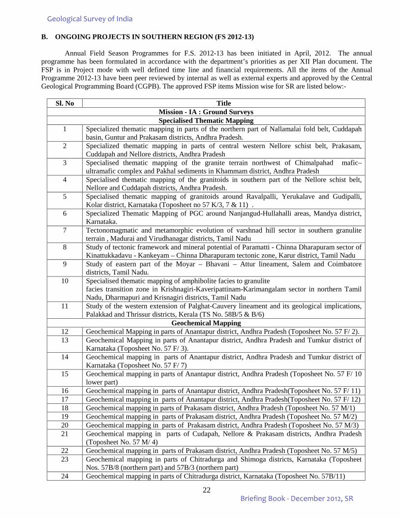
B. ONGOING PROJECTS IN SOUTHERN REGION (FS 2012-13)
Annual Field Season Programmes for F.S. 2012-13 has been initiated in April, 2012. The annual programme has been formulated in accordance with the department’s priorities as per XII Plan document. The FSP is in Project mode with well defined time line and financial requirements. All the items of the Annual Programme 2012-13 have been peer reviewed by internal as well as external experts and approved by the Central Geological Programming Board (CGPB). The approved FSP items Mission wise for SR are listed below:-
Sl. No Title
Mission - IA : Ground Surveys Specialised Thematic Mapping
1 Specialized thematic mapping in parts of the northern part of Nallamalai fold belt, Cuddapah basin, Guntur and Prakasam districts, Andhra Pradesh.
2 Specialized thematic mapping in parts of central western Nellore schist belt, Prakasam, Cuddapah and Nellore districts, Andhra Pradesh
3 Specialised thematic mapping of the granite terrain northwest of Chimalpahad mafic–ultramafic complex and Pakhal sediments in Khammam district, Andhra Pradesh
4 Specialised thematic mapping of the granitoids in southern part of the Nellore schist belt, Nellore and Cuddapah districts, Andhra Pradesh.
5 Specialised thematic mapping of granitoids around Ravalpalli, Yerukalave and Gudipalli, Kolar district, Karnataka (Toposheet no 57 K/3, 7 & 11) .
6 Specialized Thematic Mapping of PGC around Nanjangud-Hullahalli areas, Mandya district, Karnataka.
7 Tectonomagmatic and metamorphic evolution of varshnad hill sector in southern granulite terrain , Madurai and Virudhanagar districts, Tamil Nadu
8 Study of tectonic framework and mineral potential of Paramatti - Chinna Dharapuram sector of Kinattukkadavu - Kankeyam – Chinna Dharapuram tectonic zone, Karur district, Tamil Nadu
9 Study of eastern part of the Moyar – Bhavani – Attur lineament, Salem and Coimbatore districts, Tamil Nadu.
10 Specialised thematic mapping of amphibolite facies to granulite facies transition zone in Krishnagiri-Kaveripattinam-Karimangalam sector in northern Tamil Nadu, Dharmapuri and Krisnagiri districts, Tamil Nadu
11 Study of the western extension of Palghat-Cauvery lineament and its geological implications, Palakkad and Thrissur districts, Kerala (TS No. 58B/5 & B/6)
Geochemical Mapping 12 Geochemical Mapping in parts of Anantapur district, Andhra Pradesh (Toposheet No. 57 F/ 2). 13 Geochemical Mapping in parts of Anantapur district, Andhra Pradesh and Tumkur district of
Karnataka (Toposheet No. 57 F/ 3). 14 Geochemical mapping in parts of Anantapur district, Andhra Pradesh and Tumkur district of
Karnataka (Toposheet No. 57 F/ 7) 15 Geochemical mapping in parts of Anantapur district, Andhra Pradesh (Toposheet No. 57 F/ 10
lower part) 16 Geochemical mapping in parts of Anantapur district, Andhra Pradesh(Toposheet No. 57 F/ 11) 17 Geochemical mapping in parts of Anantapur district, Andhra Pradesh(Toposheet No. 57 F/ 12) 18 Geochemical mapping in parts of Prakasam district, Andhra Pradesh (Toposheet No. 57 M/1) 19 Geochemical mapping in parts of Prakasam district, Andhra Pradesh (Toposheet No. 57 M/2) 20 Geochemical mapping in parts of Prakasam district, Andhra Pradesh (Toposheet No. 57 M/3) 21 Geochemical mapping in parts of Cudapah, Nellore & Prakasam districts, Andhra Pradesh
(Toposheet No. 57 M/ 4) 22 Geochemical mapping in parts of Prakasam district, Andhra Pradesh (Toposheet No. 57 M/5) 23 Geochemical mapping in parts of Chitradurga and Shimoga districts, Karnataka (Toposheet
Nos. 57B/8 (northern part) and 57B/3 (northern part) 24 Geochemical mapping in parts of Chitradurga district, Karnataka (Toposheet No. 57B/11)
Geological Survey of India
Briefing Book - December 2012, SR
23
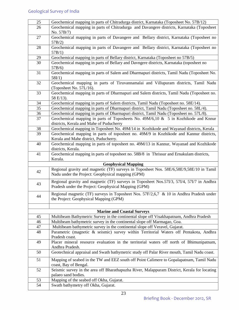
25 Geochemical mapping in parts of Chitradurga district, Karnataka (Toposheet No. 57B/12) 26 Geochemical mapping in parts of Chitradurga and Davangere districts, Karnataka (Toposheet
No. 57B/7) 27 Geochemical mapping in parts of Davangere and Bellary district, Karnataka (Toposheet no
57B/2) 28 Geochemical mapping in parts of Davangere and Bellary district, Karnataka (Toposheet no
57B/1) 29 Geochemical mapping in parts of Bellary district, Karnataka (Toposheet no 57B/5) 30 Geochemical mapping in parts of Bellary and Davngere districts, Karnataka (toposheet no
57B/6) 31 Geochemical mapping in parts of Salem and Dharmapuri districts, Tamil Nadu (Toposheet No.
58I/1) 32 Geochemical mapping in parts of Tiruvannamalai and Villupuram districts, Tamil Nadu
(Toposheet No. 57L/16). 33 Geochemical mapping in parts of Dharmapuri and Salem districts, Tamil Nadu (Toposheet no.
58 E/13). 34 Geochemical mapping in parts of Salem districts, Tamil Nadu (Toposheet no. 58E/14). 35 Geochemical mapping in parts of Dharmapuri district, Tamil Nadu (Toposheet no. 58L/4). 36 Geochemical mapping in parts of Dharmapuri district, Tamil Nadu (Toposheet no. 57L/8). 37 Geochemical mapping in parts of Toposheets No. 49M/6,10 & 5 in Kozhikode and Knnur
districts, Kerala and Mahe of Puducherry 38 Geochemical mapping in Toposheet No. 49M/14 in Kozhikode and Wayanad districts, Kerala 39 Geochemical mapping in parts of toposheet no. 49M/9 in Kozhikode and Kannur districts,
Kerala and Mahe district, Puducherry. 40 Geochemical mapping in parts of toposheet no. 49M/13 in Kannur, Wayanad and Kozhikode
districts, Kerala. 41 Geochemical mapping in parts of toposheet no. 58B/8 in Thrissur and Ernakulam districts,
Kerala. Geophysical Mapping
42 Regional gravity and magnetic (TF) surveys in Toposheet Nos. 58E/6,58E/9,58E/10 in Tamil Nadu under the Project: Geophysical mapping (GPM)
43 Regional gravity and magnetic (TF) surveys in Toposheet Nos.57I/3, 57I/4, 57I/7 in Andhra Pradesh under the Project: Geophysical Mapping (GPM)
44 Regional magnetic (TF) surveys in Toposheet Nos. 57F/2,6,7 & 10 in Andhra Pradesh under the Project: Geophysical Mapping (GPM)
Marine and Coastal Surveys
45 Multibeam Bathymetric Survey in the continental slope off Visakhapatnam, Andhra Pradesh 46 Multibeam bathymetric survey in the continental slope off Marmagao, Goa. 47 Multibeam bathymetric survey in the continental slope off Veravel, Gujarat. 48 Parametric (magnetic & seismic) survey within Territorial Waters off Pentakota, Andhra
Pradesh coast. 49 Placer mineral resource evaluation in the territorial waters off north of Bhimunipatnam,
Andhra Pradesh. 50 Geotechnical appraisal and Swath bathymetric study off Palar River mouth, Tamil Nadu coast.
51 Mapping of seabed in the TW and EEZ south off Point Calimere to Gopalapatnam, Tamil Nadu coast, Bay of Bengal.
52 Seismic survey in the area off Bharathapuzha River, Malappuram District, Kerala for locating palaeo sand bodies.
53 Mapping of the seabed off Okha, Gujarat. 54 Swath bathymetry off Okha, Gujarat.
Geological Survey of India
Briefing Book - December 2012, SR
24
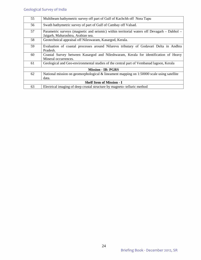
55 Multibeam bathymetric survey off part of Gulf of Kachchh off Nora Tapu
56 Swath bathymetric survey of part of Gulf of Cambay off Valsad.
57 Parametric surveys (magnetic and seismic) within territorial waters off Devagarh – Dabhol – Jaigarh, Maharashtra, Arabian sea.
58 Geotechnical appraisal off Nileswaram, Kasargod, Kerala.
59 Evaluation of coastal processes around Nilarevu tributary of Godavari Delta in Andhra Pradesh.
60 Coastal Survey between Kasargod and Nileshwaram, Kerala for identification of Heavy Mineral occurrences.
61 Geological and Geo-environmental studies of the central part of Vembanad lagoon, Kerala
Mission - IB: PGRS 62 National mission on geomorphological & lineament mapping on 1:50000 scale using satellite
data. Shelf Item of Mission - I
63 Electrical imaging of deep crustal structure by magneto- telluric method
Geological Survey of India
Briefing Book - December 2012, SR
25
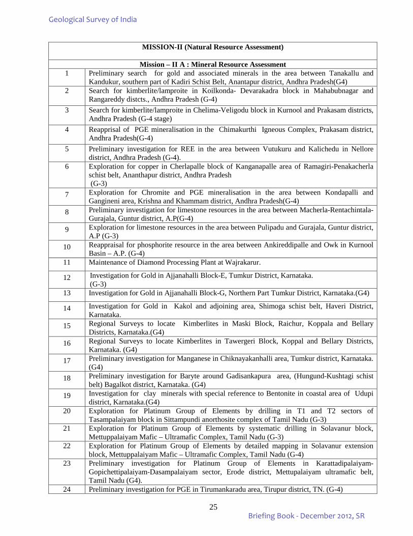
MISSION-II (Natural Resource Assessment)
Mission – II A : Mineral Resource Assessment
1 Preliminary search for gold and associated minerals in the area between Tanakallu and Kandukur, southern part of Kadiri Schist Belt, Anantapur district, Andhra Pradesh(G4)
2 Search for kimberlite/lamproite in Koilkonda- Devarakadra block in Mahabubnagar and Rangareddy distcts., Andhra Pradesh (G-4)
3 Search for kimberlite/lamproite in Chelima-Veligodu block in Kurnool and Prakasam districts, Andhra Pradesh (G-4 stage)
4 Reapprisal of PGE mineralisation in the Chimakurthi Igneous Complex, Prakasam district, Andhra Pradesh(G-4)
5 Preliminary investigation for REE in the area between Vutukuru and Kalichedu in Nellore district, Andhra Pradesh (G-4).
6 Exploration for copper in Cherlapalle block of Kanganapalle area of Ramagiri-Penakacherla schist belt, Ananthapur district, Andhra Pradesh (G-3)
7 Exploration for Chromite and PGE mineralisation in the area between Kondapalli and Gangineni area, Krishna and Khammam district, Andhra Pradesh(G-4)
8 Preliminary investigation for limestone resources in the area between Macherla-Rentachintala-Gurajala, Guntur district, A.P(G-4)
9 Exploration for limestone resources in the area between Pulipadu and Gurajala, Guntur district, A.P (G-3)
10 Reappraisal for phosphorite resource in the area between Ankireddipalle and Owk in Kurnool Basin – A.P. (G-4)
11 Maintenance of Diamond Processing Plant at Wajrakarur.
12 Investigation for Gold in Ajjanahalli Block-E, Tumkur District, Karnataka. (G-3)
13 Investigation for Gold in Ajjanahalli Block-G, Northern Part Tumkur District, Karnataka.(G4)
14 Investigation for Gold in Kakol and adjoining area, Shimoga schist belt, Haveri District, Karnataka.
15 Regional Surveys to locate Kimberlites in Maski Block, Raichur, Koppala and Bellary Districts, Karnataka.(G4)
16 Regional Surveys to locate Kimberlites in Tawergeri Block, Koppal and Bellary Districts, Karnataka. (G4)
17 Preliminary investigation for Manganese in Chiknayakanhalli area, Tumkur district, Karnataka. (G4)
18 Preliminary investigation for Baryte around Gadisankapura area, (Hungund-Kushtagi schist belt) Bagalkot district, Karnataka. (G4)
19 Investigation for clay minerals with special reference to Bentonite in coastal area of Udupi district, Karnataka.(G4)
20 Exploration for Platinum Group of Elements by drilling in T1 and T2 sectors of Tasampalaiyam block in Sittampundi anorthosite complex of Tamil Nadu (G-3)
21 Exploration for Platinum Group of Elements by systematic drilling in Solavanur block, Mettuppalaiyam Mafic – Ultramafic Complex, Tamil Nadu (G-3)
22 Exploration for Platinum Group of Elements by detailed mapping in Solavanur extension block, Mettuppalaiyam Mafic – Ultramafic Complex, Tamil Nadu (G-4)
23 Preliminary investigation for Platinum Group of Elements in Karattadipalaiyam-Gopichettipalaiyam-Dasampalaiyam sector, Erode district, Mettupalaiyam ultramafic belt, Tamil Nadu (G4).
24 Preliminary investigation for PGE in Tirumankaradu area, Tirupur district, TN. (G-4)
Geological Survey of India
Briefing Book - December 2012, SR
26
25 Detailed exploration for Molybdenum in Vellampatti South Block, Harur-Uttangarai molybdenum belt, Dharmapuri district, Tamil Nadu (G3).
26 Investigation for massive sulphide mineralisation in Padinjarattara area, Wayanad district, Kerala (G-4).
27 Preliminary investigation for PGE mineralisation in the ultra-mafic/mafic rocks of Nilambur Valley, Malappuram district, Kerala. (G-4)
Mission - II B : Natural Energy Resources 28 Exploration for coal by scout drilling in Vutasamudram-Venkatapuram area, Southern sub-
basin of Godavari Valley Coalfield, West Godavari district, Andhra Pradesh.(G4) 29 Exploration for coal by drilling in Bugga-Khammamtogu sector, Southern part of main basin of
Godavari Valley Coalfield, Khammam district, Andhra Pradesh. (G2) 30 Regional exploration for coal by drilling in Pagaderu (West) sector, Southern part of main
basin of Godavari Valley Coalfield, Khammam district, Andhra Pradesh. (G2) 31 Regional Exploration for Lignite in Uttarakosamangai sector, Ramnad sub basin,
Ramanathapuram District, Tamil Nadu.(G3) MISSION-III (Geoinformatics)
Geodata, Sr, Hyderabad 1 Compilation of new series (second edition) of geological quadrangle maps, 1: 250 K GQM 2 Service Item: Updation, Repository management & dissemination of geoscientific database-
1:50K GSM of Southern Region 3 Integration of geological, geochemical, geophysical, aerogeophysical data of 57F degree sheet
to identify target areas of mineralisation 4 Service Item: Network Management – Administration of Southern Regional Local Area
Network. 5 Service Item: Computer / software assistance 6 Online Core Business Integrated System (OCBIS)
Map & Cartography Division, Sr, Hyderabad 7 Compilation of new series (second edition) of geological quadrangle maps, 1: 250 K GQM. 8 Service Item: Finalisation of Mineral Belt Maps on 1: 50, 000 Scale of Southern Region 9 Service Item: Composing and Printing of Unpublished Geological Maps as per user demand
Publication & Information Division And Library, SR 10 Service Item: Compilation and printing of Publications. Distribution and sale of GSI
Publications, Soft copy conversion, Uploading of unpublished reports, Updating of Bibliographic database, Procurement of books, Scrutiny of scientific papers submitted by technical officers
Map, Catrography, Publication And Information Division SU: AP 11 Compilation of new series (second edition) of geological quadrangle maps, 1: 250 K GQM. 12 Finalisation of mineral belt maps of SU: AP on 1: 50,000 scale
13 Service Item: Jobs involved in scrutiny, formatting, approval, reprography and circulation of progress reports
Geoinformatics Division, SU: AP
14 Service Item: Data Repository and Management – Map compilation; Technical support to all Divisions / Projects of the State Unit in computer related matters.
Map, Cartography, Publication and Information Division, SU: Karnataka & Goa 15 Compilation of new series (second edition) of geological quadrangle maps, 1: 250 K GQM. 16 Finalization of mineral belt maps of southern region (coverage: K&G) on 1: 50, 000 scale 17 Service item: Jobs involved in scrutiny, formatting, approval, reprography and circulation of
progress reports
Geoinformatics Division, SU: Karnataka & Goa 18 Service Item: Data Repository and Management – Map compilation; Technical support to all
Divisions / Projects of the State Unit in computer related matters.
Geological Survey of India
Briefing Book - December 2012, SR
27
Map, Cartography, Publication and Information Division, SU: TN&P 19 Compilation of new series (second edition) of geological quadrangle maps, 1: 250 K GQM 20 Finalisation of mineral belt maps of SU:TN&P on 1: 50, 000 scale 25 Service item: Jobs involved in scrutiny, formatting, approval, reprography and circulation of
progress reports Geoinformatics Division, SU: TN&P
21
Service Item: Data Repository and Management – Map compilation; Technical support to all Divisions / Projects of the State Unit in computer related matters.
Map, Cartography, Publication and Information Division, SU: Kerala Compilation of new series (second edition) of geological quadrangle maps, 1:250 K GQM. Finalisation of mineral belt maps of SU: Kerala on 1: 50, 000 scale Service item: Jobs involved in scrutiny, formatting, approval, reprography and circulation of
progress reports Marine & Coastal Survey Division, GSI, SR
TW MAP COMPILATION 25 Service item: TW Map Compilation, OP: West Coast-I 26 Service item: TW Map Compilation, OP: East Coast-II Geoinformatics
27 Service item: Op:West Coast-I 28 Service item: Op:East Coast-II COMPILATION OF SHALLOW SEISMIC DATA
29 Compilation of shallow seismic data in the gulf of Kutchchh, 30 Compilation of shallow seismic data between Point Pudi – Chennai.
Geophysics Division, SR 31 Documentation & Report processing centre (DRPC). 32 Creation of theme based geoscientific database for Geophysical domain in areas covering
degree sheets. Mission-IV (Fundamental and Multidisciplinary Geosciences)
Petrology, SR 31 Petro-mineralogical characterization of various granitoid suites of eastern Dharwar Craton in
Andhra Pradesh. 32 Petrography and geothermobarometric studies in Kannegiri granulite complex to evaluate
metamorphic characters and to compare with adjacent EGMB and PGC Terrain. Petrology, SU:TNP
33
Detailed petrological and petrochemical studies of the Mettupalaiyam Ultramafic Complex, Ayyampalaiyam - Solavanur – Mallnayakkanpalayam area Tamil Nadu with special reference to PGE mineralisation.
Petrology, SU:K&G 34
Petrological characterisation of ultramafic -mafic bodies with special reference to PGE potential in the area between Mysore and Holenarsipur, Mysore & Hassan districts, Karnataka.
PPOD, SR 35 Petrographic and geochemical study of the volcanics of the Chitradurga Group of Dharwar
Supergroup in the Chitradurga Schist Belt, Karnataka. 36 Mineralogical and geochemical characterization of selected laterite horizons and clay deposits
occurring in and around Hoskote, Karnataka. 37 Fluid inclusion studies of Charnockites from Biligirirangan hill and Yelachipalayam village,
Southern Karnataka 38 Mineralogical characterization of Heavy Minerals occurring around Kalinadi and Netravathi
River Estuaries, West Coast, Karnataka.
Geological Survey of India
Briefing Book - December 2012, SR
28
Medical Geology, SU:Kerala 39
Geopspatial analysis to identify the geogenic source of fluoride in the groundwater of Chittoor-Kollengode area, Palakkad district, Kerala
Palaeontology, SR 40 Composite palaeontological, stratigraphical and palaeoclimatic studies of quaternary coastal
deposit and fluvial sequences of north Andhra Pradesh 41
Palaeontological palaeoclimatic and biostratigraphic studies of cretaceous bryozoans from the Cauvery basin in parts of Tiruchirappalli, Ariyalur, Cuddalore districts of Tamil Nadu and Puducherry district of Puducherry.
Palaeontology, M&CSD 42
Comparative diversity and functional morphological study of the smaller benthonic foraminifers of the shelf areas off Gujarat – Maharashtra - Karnataka coast, Arabian Sea
IGCP-581 Project, SR 43 Evolution of Pennar Basin during the Cenozoic 44 Physical Property Measurement:
Measurement of physical properties of rock samples Engineering Geology, SR
45 Water resource development Projects in Andhra Pradesh Engineering Geology, TNP
46 Geotechnical evaluation of water resources development projects in Tamil Nadu. 47 Geotechnical evaluation of miscellaneous projects in Tamil Nadu 48 Geotechnical evaluation of water resources development projects in Kerala
Landslide, TNP 49 Site specific studies and slope stability analysis of Indira nagar – Periya Pikketti slope on Ooty
– Coonoor road, Nilgiri district, Tamil Nadu 50 Landslide Hazard Zonation on macro scale along road corridors and railway track from
Mettupalayam to Ootacamund, Nilgiri and Coimbatore districts, Tamil Nadu 51 Miscellaneous landslide investigations in Tamil Nadu
Engineering Geology Landslide, K&G
52
Landslide inventory along National Highway & State Highway of Ghat roads in Coorg, Dakshina Kannada, Udupi, Shimoga and Chikmagalur districts, Karnataka
53 Landslide inventory along National Highway & State Highway of Ghat roads in north Goa and south Goa districts, Goa
54 Landslide hazard zonation of Virajpet-Madikere-Sulya Road Section Coorg district, Karnataka 55
Water resources development, hydropower, irrigation, communication projects, feasibility, preconstruction, construction, geotechnical studies
56 Post disaster studies Landslide, Kerala
57
Detailed site specific study of Konnathadi-Kunjithanni Debris Avalanche, Idukki district, Kerala.
58 Detailed site specific landslide study at government college, Munnar, Idukki district, Kerala. 59 District wise landslide hazard zonation on macroscale and creation of landslide Atlas of Kerala 60 Miscellaneous landslide investigations in Kerala
Earthquake Geology, SR 61 First level seismic hazard microzonation of areas in and around Trichur urban agglomeration,
Kerala 62 Macroseismic investigation of significant seismic events in Southern Region
Geological Survey of India
Briefing Book - December 2012, SR
29
Mission-V (Training & Capacity Building)
63 Advance course in Sequence Stratigraphy 64 Advance Course in Diamond Exploration 65 Refresher Course in Structural Geology 66 5th Refresher Course in Exploration for Gold. 67 Advance Course in Granulite Terrain Mapping 68 Course on systematic approach to Mineral Exploration for officers of DGMs of Maharashtra,
Chhattisgarh and Madhya Pradesh, (CR and SR) Andhra Pradesh, Karnataka, Kerala, Tamil Nadu & Goa
69 Workshop on Fire Assay technique for the standardization of methodologies for the analysis of platinum and palladium in NGCM samples and also in other geological materials
70 A course on computer awareness for Group ‘B’ non-gazetted and Group ‘C’ Ministerial Staff of SR and CR
71 Workshop on Recruitment/Reservation-Rosters for Liaison Officers(SC/ST) and Administrative Officers dealing with reservation- rosters for SR and CR
72 Refresher course on functioning of GSI after implementation of HPC for Group ‘C’ Ministerial Staff of SR and CR
73
Workshop on maintenance of roster for Group ‘C’ ministerial staff of the region for officials of SR and CR
Geological Survey of India
Briefing Book - December 2012, SR
30
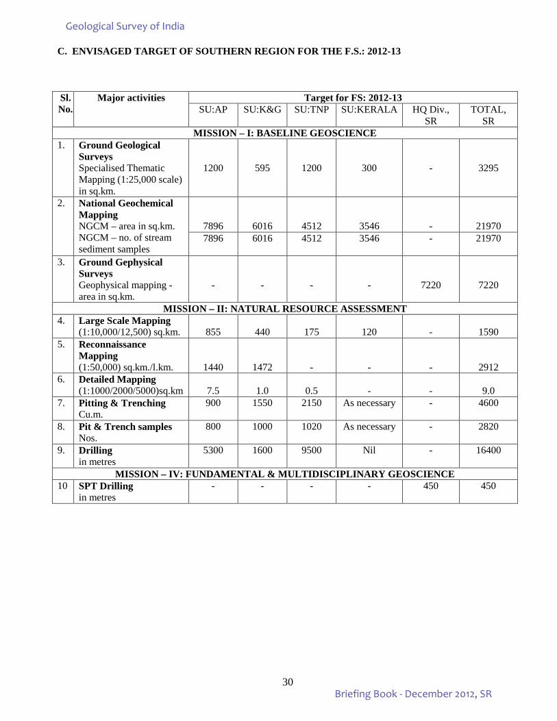
C. ENVISAGED TARGET OF SOUTHERN REGION FOR THE F.S.: 2012-13 Sl.No.
Major activities Target for FS: 2012-13 SU:AP SU:K&G SU:TNP SU:KERALA HQ Div.,
SR TOTAL,
SR MISSION – I: BASELINE GEOSCIENCE
1. Ground Geological Surveys Specialised Thematic Mapping (1:25,000 scale) in sq.km.
1200
595
1200
300
-
3295
2. National Geochemical Mapping NGCM – area in sq.km. NGCM – no. of stream sediment samples
7896
6016
4512
3546
-
21970 7896 6016 4512 3546 - 21970
3. Ground Gephysical Surveys Geophysical mapping - area in sq.km.
-
-
-
-
7220
7220
MISSION – II: NATURAL RESOURCE ASSESSMENT 4. Large Scale Mapping
(1:10,000/12,500) sq.km.
855
440
175
120 -
1590
5. Reconnaissance Mapping (1:50,000) sq.km./l.km.
1440
1472
-
-
-
2912 6. Detailed Mapping
(1:1000/2000/5000)sq.km
7.5
1.0
0.5 -
-
9.0
7. Pitting & Trenching Cu.m.
900 1550 2150 As necessary - 4600
8. Pit & Trench samples Nos.
800 1000 1020 As necessary - 2820
9. Drilling in metres
5300 1600 9500 Nil - 16400
MISSION – IV: FUNDAMENTAL & MULTIDISCIPLINARY GEOSCIENCE 10 SPT Drilling
in metres - - - - 450 450
Geological Survey of India
Briefing Book - December 2012, SR
31
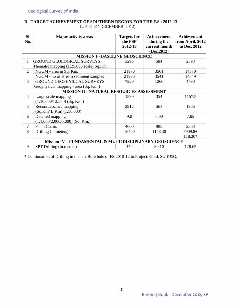
D. TARGET ACHIEVEMENT OF SOUTHERN REGION FOR THE F.S.: 2012-13 (UPTO 31st DECEMBER, 2012)
Sl. No.
Major activity areas Targets for the FSP 2012-13
Achievement during the
current month (Dec.2012)
Achievement from April, 2012
to Dec. 2012
MISSION I - BASELINE GEOSCIENCE 1 GROUND GEOLOGICAL SURVEYS
Thematic mapping (1:25,000 scale) Sq.Km. 3295 584 2593
2 NGCM - area in Sq. Km. 21970 3561 14370 NGCM - no of stream sediment samples 21970 3541 14349
3 GROUND GEOPHYSICAL SURVEYS Geophysical mapping - area (Sq. Km.)
7220 1260 4790
MISSION II - NATURAL RESOURCES ASSESSMENT 4 Large scale mapping
(1:10,000/12,500) (Sq. Km.) 1590 354 1157.5
5 Reconnaissance mapping (Sq.Km/ L.Km) (1:50,000)
2912 561 1966
6 Detailed mapping (1:1,000/2,000/5,000) (Sq. Km.)
9.0 0.90 7.85
7 PT in Cu. m. 4600 985 2368 8 Drilling (in meters) 16400 1148.30 7909.8+
118.30* Mission IV – FUNDAMENTAL & MULTIDISCIPLINARY GEOSCIENCE
9 SPT Drilling (in meters) 450 30.10 128.65 * Continuation of Drilling in the last Bore hole of FS 2010-12 in Project: Gold, SU:K&G.
Geological Survey of India
Briefing Book - December 2012, SR
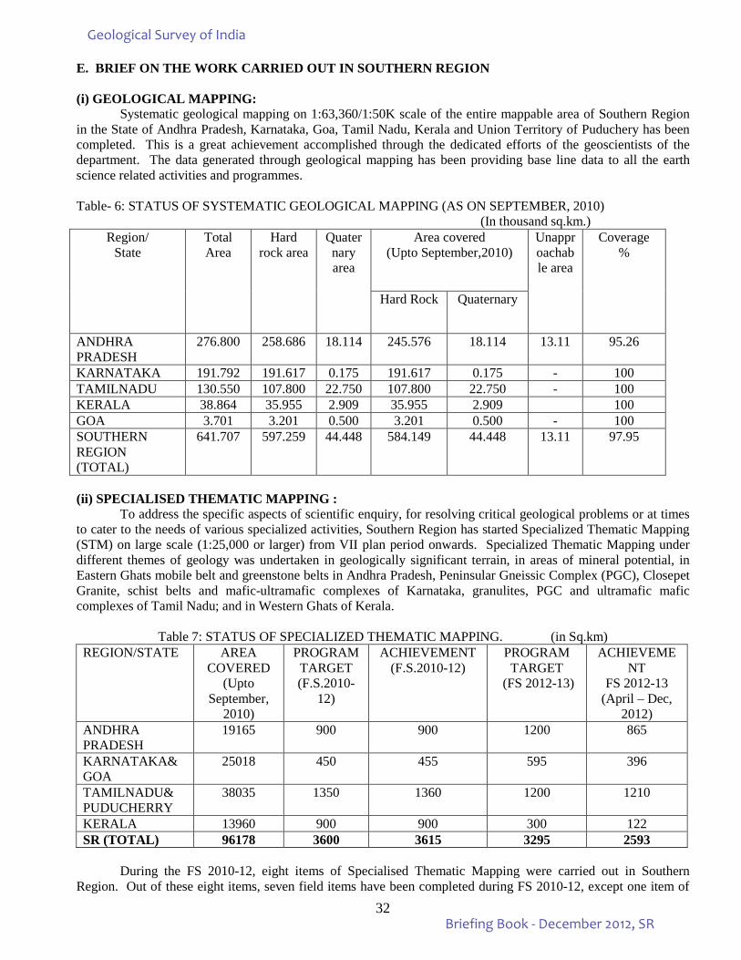
32
E. BRIEF ON THE WORK CARRIED OUT IN SOUTHERN REGION
(i) GEOLOGICAL MAPPING: Systematic geological mapping on 1:63,360/1:50K scale of the entire mappable area of Southern Region
in the State of Andhra Pradesh, Karnataka, Goa, Tamil Nadu, Kerala and Union Territory of Puduchery has been completed. This is a great achievement accomplished through the dedicated efforts of the geoscientists of the department. The data generated through geological mapping has been providing base line data to all the earth science related activities and programmes.
Table- 6: STATUS OF SYSTEMATIC GEOLOGICAL MAPPING (AS ON SEPTEMBER, 2010)
(In thousand sq.km.) Region/
State
Total Area
Hard rock area
Quaternary area
Area covered (Upto September,2010)
Unapproachable area
Coverage %
Hard Rock Quaternary
ANDHRA PRADESH
276.800 258.686 18.114 245.576 18.114 13.11 95.26
KARNATAKA 191.792 191.617 0.175 191.617 0.175 - 100 TAMILNADU 130.550 107.800 22.750 107.800 22.750 - 100 KERALA 38.864 35.955 2.909 35.955 2.909 100 GOA 3.701 3.201 0.500 3.201 0.500 - 100 SOUTHERN REGION (TOTAL)
641.707 597.259 44.448 584.149 44.448 13.11 97.95
(ii) SPECIALISED THEMATIC MAPPING : To address the specific aspects of scientific enquiry, for resolving critical geological problems or at times to cater to the needs of various specialized activities, Southern Region has started Specialized Thematic Mapping (STM) on large scale (1:25,000 or larger) from VII plan period onwards. Specialized Thematic Mapping under different themes of geology was undertaken in geologically significant terrain, in areas of mineral potential, in Eastern Ghats mobile belt and greenstone belts in Andhra Pradesh, Peninsular Gneissic Complex (PGC), Closepet Granite, schist belts and mafic-ultramafic complexes of Karnataka, granulites, PGC and ultramafic mafic complexes of Tamil Nadu; and in Western Ghats of Kerala.
Table 7: STATUS OF SPECIALIZED THEMATIC MAPPING. (in Sq.km) REGION/STATE AREA
COVERED (Upto
September, 2010)
PROGRAM TARGET (F.S.2010-
12)
ACHIEVEMENT (F.S.2010-12)
PROGRAM TARGET
(FS 2012-13)
ACHIEVEMENT
FS 2012-13 (April – Dec,
2012) ANDHRA PRADESH
19165 900 900 1200 865
KARNATAKA& GOA
25018 450 455 595 396
TAMILNADU& PUDUCHERRY
38035 1350 1360 1200 1210
KERALA 13960 900 900 300 122 SR (TOTAL) 96178 3600 3615 3295 2593
During the FS 2010-12, eight items of Specialised Thematic Mapping were carried out in Southern Region. Out of these eight items, seven field items have been completed during FS 2010-12, except one item of
Geological Survey of India
Briefing Book - December 2012, SR
33
“Specialised thematic mapping of Granitoids around Ravalpalli, Yerukalave and Gudipalli, Kolar district, Karntaka” which is continuing during FS 2012-13. Ten new items of STM have been taken up in FS 2012-13. Therefore, a total of eleven STM item are being carried out during FS 2012-13. Four STM items each have been taken up in SU:AP & SU:TNP while two STM items are in SU:K&G and one item in SU:Kerala. Highlights of the work carried out during FS 2010-12:
(i) Specialised Thematic Mapping of the Granite terrain southwest of Chimalpahad Mafic-Ultramafic complex and Pakkal sediments in Khammam district, Andhra Pradesh:
During Specialised Thematic Mapping carried out in the area on 1:25,000 scale, rock types of Archean Supracrustals, layered anorthosite, gabbro / norite, pyroxenite besides, the Pakhals and Gondwana sediments were recorded. In-situ titanium bearing magnetite body (100m x 30 m dimension) recorded about 2km. east of Rangapuram and 6 magnetite float bodies associated with pyroxenite were also recorded. Cr value in pyroxenite ranges from 1412 ppm to 1876 ppm. The Fe2O, value is 21.12% and FeO is ranging upto 20.12% in magnetite ore, while PGE value is upto 20 ppb for platinum. This item has been concluded in FS 2010-12.
(ii) Specialised Thematic Mapping in the rocks of Penganga Group of Pakhal Basin in parts of Adilabad district, Andhra Pradesh:
Specialised Thematic Mapping on 1:25,000 scale was carried out in part of Toposheet 56M/15. Glouconite rich arkose zone of 3 km. strike length, with a thickness of around 6 to 8 m in thin basal sandstone of Pakhal Supergroup is recorded to the northwest of Mugavelli village. It also hosts persistent band of stromatolitic dolomite of around 2 to 5 m thickness. The grey limestone that occurs at upper stratigraphic levels has a strike extension of more than 3 km. and thickness of around 200 m. The results of initial lot (23 samples) from lower stromatolitic dolomite / limestone indicated CaO < 43% in 30% samples. The initial lot of samples from grey limestone (8 samples) analysed CaO <45%, MgO >1.72% and SiO2 > 11.42% in 88% of the samples, which falls under high grade limestone. This item has been completed in FS 2010-12.
(iii) Specialised Thematic Mapping of Granitoids around Ravalpalli, Yerukalave and Gudipalli, Kolar district, Karnataka:
During Specialised Thematic Mapping high grade Mg – granitoids were identified and its geochemical characteristics interpreted in Nannivla – Chitradurga area. High Mg – granitoids were also identified in Srinivasapura area. Presence of leucogranitic dykes and multiple magmatic fabrics in granitoids are recorded. Evidence of high temperature deformation, folded magmatic banding and chalcopyrite-pyrite vein in granitoids are noted. The item is continued during the FS 2012-13.
(iv) Study of Tectonomagmatic and Metamorphic Evolution of Varshnad Hill Sector in Southern Granulite Terrain, Tamil Nadu:
Specialised Thematic Mapping was carried out around Andipatti area, Theni district (Toposheet 58G/9). The rock types exposed in the area are; charnokite, khondalite group of rocks, quartzite, granite gneiss and granites. Charnockite is a major rock type exposed in the study area. The rock is associated / interbanded with Khondalite Group of rocks. Charnockite is intruded by granites. The item has been concluded in FS 2010-12.
(v) Study of Tectonic Framework and Mineral Potential of Kangeyam – Chinna Dharapuram Sector of Kinattukkadavu – Kangeyam – Chinna Dharapuram Tectonic zone of Central Tamil Nadu:
Specialised Thematic Mapping was carried out in parts of Karur and Tirupur districts, Tamil Nadu covering parts of Toposheets 58F/9 and 13. The study area is located in between Palghat – Cauveri shear zone in the north and Kodaikanal Charnockitic massif in the south. The study area is mostly covered with massive and gneissic charnockite. Pyroxenite granulite occurs as bands and enclaves within the gneissic charnockite. Structural details with respect to mineralization were studied in the area. The item is completed in FS 2010-12.
Geological Survey of India
Briefing Book - December 2012, SR
34
(vi) Study of central part of Moyar – Bhavani – Attur lineament, Tamilnadu:
Specialised Thematic Mapping was carried out in areas falling in Toposheets 58E/6&7. The rock types of Satyamangalam Group, Bhavani Gneissic Complex, Charnockites granites are exposed. In the southern part of the area numbers of discrete shear zones have been recorded. The item is concluded in FS 2010-12.
(vii) Study of the structure and tectonostratigraphy of the area between Wandur and Edakkara, Nilambur Gold Belt, Malappuram district, Kerala with a bearing on gold mineralization:
Specialised Thematic Mapping was taken up in the gap area between Bhavani shear zone and Nilambur gold belt in Toposheet 58A/3,4,7&8. The area of study forms a part of the Southern Granulite Terrain of Peninsular India. The major rock types belong to the Charnockite Group and the Peninsular Gneissic complex with Archean Supracrustals as enclaves which are equivalent to Waynad group. Sulphide bearing quartz veins are mainly sampled for gold analysis. Some quartz veins besides samples of BMQ and minor amphibolite bands have analysed gold values ranging upto 190 ppb during the initial stage of the work. The item is concluded in FS 2010-12.
(viii) Specialised Thematic Mapping of the Precambrian Metamorphics and Intrusives in the vicinity of Bavali Tectonic Zone (BTZ), Irikkur – Payyannur Sector, Kannur district, North Kerala:
The study area lies in the Moyar-Bavali Tectonic Zone in the northern part of Southern Granulite Terrain and exposes Precambrian metamorphics and Mesozoic intrusives. The rock units of the Waynad Group, PGC, Charnockite Group are exposed, while the tertiary sandstone of Mio-Pliocene age occurs as lateritised cappings. Waynad Group is equivalent to the Sargur Group of Dharwar Craton and occurs as enclaves and rafts in the gneisses and charnockites. This item is completed in FS 2010-12.
Geological Survey of India
Briefing Book - December 2012, SR
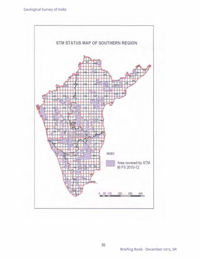
35
Geological Survey of India
Briefing Book - December 2012, SR
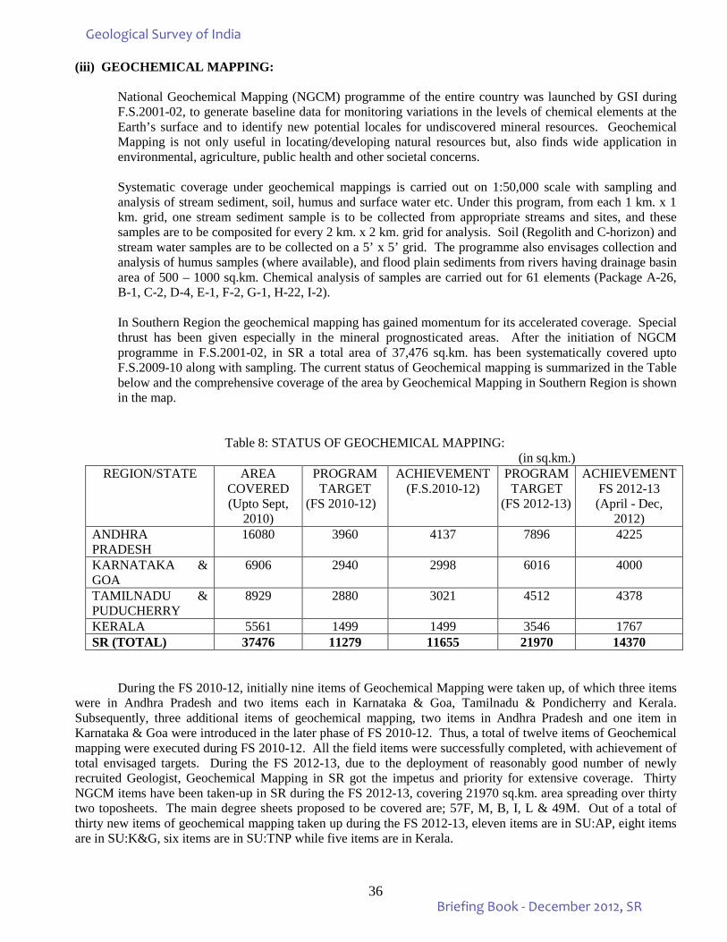
36
(iii) GEOCHEMICAL MAPPING:
National Geochemical Mapping (NGCM) programme of the entire country was launched by GSI during F.S.2001-02, to generate baseline data for monitoring variations in the levels of chemical elements at the Earth’s surface and to identify new potential locales for undiscovered mineral resources. Geochemical Mapping is not only useful in locating/developing natural resources but, also finds wide application in environmental, agriculture, public health and other societal concerns.
Systematic coverage under geochemical mappings is carried out on 1:50,000 scale with sampling and
analysis of stream sediment, soil, humus and surface water etc. Under this program, from each 1 km. x 1 km. grid, one stream sediment sample is to be collected from appropriate streams and sites, and these samples are to be composited for every 2 km. x 2 km. grid for analysis. Soil (Regolith and C-horizon) and stream water samples are to be collected on a 5’ x 5’ grid. The programme also envisages collection and analysis of humus samples (where available), and flood plain sediments from rivers having drainage basin area of 500 – 1000 sq.km. Chemical analysis of samples are carried out for 61 elements (Package A-26, B-1, C-2, D-4, E-1, F-2, G-1, H-22, I-2). In Southern Region the geochemical mapping has gained momentum for its accelerated coverage. Special thrust has been given especially in the mineral prognosticated areas. After the initiation of NGCM programme in F.S.2001-02, in SR a total area of 37,476 sq.km. has been systematically covered upto F.S.2009-10 along with sampling. The current status of Geochemical mapping is summarized in the Table below and the comprehensive coverage of the area by Geochemical Mapping in Southern Region is shown in the map.
Table 8: STATUS OF GEOCHEMICAL MAPPING: (in sq.km.)
REGION/STATE AREA COVERED (Upto Sept,
2010)
PROGRAM TARGET
(FS 2010-12)
ACHIEVEMENT (F.S.2010-12)
PROGRAM TARGET
(FS 2012-13)
ACHIEVEMENT FS 2012-13 (April - Dec,
2012) ANDHRA PRADESH
16080 3960 4137 7896 4225
KARNATAKA & GOA
6906 2940 2998 6016 4000
TAMILNADU & PUDUCHERRY
8929 2880 3021 4512 4378
KERALA 5561 1499 1499 3546 1767 SR (TOTAL) 37476 11279 11655 21970 14370
During the FS 2010-12, initially nine items of Geochemical Mapping were taken up, of which three items
were in Andhra Pradesh and two items each in Karnataka & Goa, Tamilnadu & Pondicherry and Kerala. Subsequently, three additional items of geochemical mapping, two items in Andhra Pradesh and one item in Karnataka & Goa were introduced in the later phase of FS 2010-12. Thus, a total of twelve items of Geochemical mapping were executed during FS 2010-12. All the field items were successfully completed, with achievement of total envisaged targets. During the FS 2012-13, due to the deployment of reasonably good number of newly recruited Geologist, Geochemical Mapping in SR got the impetus and priority for extensive coverage. Thirty NGCM items have been taken-up in SR during the FS 2012-13, covering 21970 sq.km. area spreading over thirty two toposheets. The main degree sheets proposed to be covered are; 57F, M, B, I, L & 49M. Out of a total of thirty new items of geochemical mapping taken up during the FS 2012-13, eleven items are in SU:AP, eight items are in SU:K&G, six items are in SU:TNP while five items are in Kerala.
Geological Survey of India
Briefing Book - December 2012, SR
37
A brief account on the highlights of the work done in the State Units are given below: ANDHRA PRADESH In SU:Andhra Pradesh, after the iniation of NGCM programme in 2001-02 field season, a total number of 21 toposheets, including 15 toposheets in 57E and 6 toposheets in 57 M have been completed by the end of F.S.2009-10, covering an area of 16,080 sq.km. During FS 2010-12, five items were taken up and an area of 4137 sq.km. was covered in toposheets 57E/4, 57F/1,5,6,9 and upper part of 57F/10. These include GCM in Anantapur district of Andhra Pradesh and Bellary district of Karnataka. The mapping so far carried out mainly covered parts of Gadwal, Jonnagiri and Nellore schist belts which are known for their mineral potential. Samples generated, adhering to the NGCM guidelines, have been analysed and the analytical results have been processed and elemental distribution maps for each toposheet have been prepared. The study has indicated some anomalous values of gold in 57E/12, radioactive nature of granites in 57E/3 and anomalous zones of REE in parts of 57M/11. Local inhabitants of the area falling under T.S.: 57M/10&11 are found to be severely suffering from various health problems which appears to have been resulted due to the consumption of polluted water from various sources, which are contaminated with REE and toxic elements. NGCM spin off programme of preliminary search of Molybdenum and REE in Kanigiri area, Prakasam district has led to the delineation of a 40 to 70 cm wide mineralized zone of app. 100 m strike length besides, some anomalous concentration of Mo, Pb and Zr in adjoining areas. Elements belonging to Lanthanoid series comprising REE (La, Ce, Pr, Nd, Eu, Sm, Gd, Tb, Dy, Ho, Er, Tm, Yb, Lu) were analysed by ICPMS and distribution map for the combined REE was prepared for the Degree sheet 57E. Statistical analysis of data from Degree sheet 57E has indicated the average value of LREE (La to Lu) in the area to be 137 ppm (approx.) with minimum of 44 ppm and maximum of 760 ppm. From the distribution map, it is quite clear that the NW – SE trending anomalous zone passes through T.S. No.57E/1, E/5, E/6, E/11 and E/16. The anomalous zone is stretched for about 100 km. along NW-SE direction with an average width of 15 km. Background geology of the area indicates that the anomalous zone is to be litho-controlled as the rock assemblage is Grey hornblende biotite granite, Biotite gneiss, Grey hornblende biotite gneiss, Grey biotite granite. Further work is required to ascertain the nature and control of REE mineralization in the area. Lithology of the area covered in T.S. No. 57F/5,6,9 & 10 is grey hornblende-Biotite Gneiss and course grained pink hornblende biotite granite of PGC-II, chlorite-sericite schist representing Ramagiri Schist Belt rocks. The economic importance of the area is manifested by the occurrence of kimberlite pipes and existence of old workings for gold.
For the Annual Programme of 2012-13, eleven items are proposed covering an area of 7896 sq.km. All the items are falling in OGP (Obvious Geological Potential) areas and are proposed so as to complete the degree sheets of 57F & 57M.
KARNATAKA & GOA: In SU: Karnataka &Goa, work under National Geochemical Mapping Programme was initiated during F.S.2002-03. From F.S.2002-03 to F.S.2009-10, systematic geochemical mapping is carried out covering an area of 6906 sq.km. in 12 toposheets, of which 8 toposheets are falling in 56D and 4 toposheets are in 48E. During the FS 2010-12 Geochemical Mapping in T.S.No.56 D/10, 14, 57B/4, 57B/8(southern part) & 57B/3 (southern part) in parts of Gulbarga, Chitradurga and Shimoga districts were completed covering 2998 sq.km. as against revised target of 2940 sq.km. The area so far covered is mainly underlain by Hungund-Kushtagi schist belt, Peninsular Gneissic complex, Proterozic sediments and Deccan Trap. The analytical data from toposheets 56D/8,11,12,15 & 16 indicate anomalous zones of REE, U, Th, Nb,Zr and Hf over granitoids on the eastern and northern side of the Hatti-Maski Schist Belt. A 25 m long Cu enriched zone beyond the occurrences of Tinthini Cu prospect has been identified besides, some higher values of Fe Ti, V and Sc. From the analysis of stream sediment samples in T.S.No.56D/3, it is observed that the granite/gneissic terrain is characterized by a high abundance of SiO2, Ga, Ba, Pb and low abundance of Fe2O3, CaO, MgO, Ti, Cu, V, Zn. On the other hand, the basaltic terrain is characterized by a low abundance of the former and a high abundance of the latter group of elements. The clear distinction between two lithologies is evident from this distribution of elements. The NW-SE trending linear K2O, Ba, Nb, Rb, Th, Y, Zr high anomalies and low anomalies of MnO, Co, Ni, Sc noticed in the central part of the study area indicate the influence of Krishna River on the sediments. The samples over the basaltic terrain in the north indicate a high abundance of Cu.
Geological Survey of India
Briefing Book - December 2012, SR
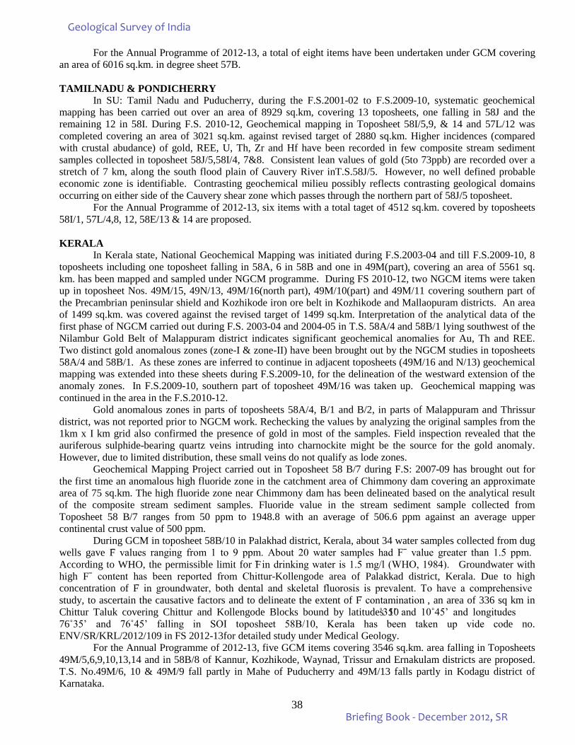
38
For the Annual Programme of 2012-13, a total of eight items have been undertaken under GCM covering an area of 6016 sq.km. in degree sheet 57B. TAMILNADU & PONDICHERRY In SU: Tamil Nadu and Puducherry, during the F.S.2001-02 to F.S.2009-10, systematic geochemical mapping has been carried out over an area of 8929 sq.km, covering 13 toposheets, one falling in 58J and the remaining 12 in 58I. During F.S. 2010-12, Geochemical mapping in Toposheet 58I/5,9, & 14 and 57L/12 was completed covering an area of 3021 sq.km. against revised target of 2880 sq.km. Higher incidences (compared with crustal abudance) of gold, REE, U, Th, Zr and Hf have been recorded in few composite stream sediment samples collected in toposheet 58J/5,58I/4, 7&8. Consistent lean values of gold (5to 73ppb) are recorded over a stretch of 7 km, along the south flood plain of Cauvery River inT.S.58J/5. However, no well defined probable economic zone is identifiable. Contrasting geochemical milieu possibly reflects contrasting geological domains occurring on either side of the Cauvery shear zone which passes through the northern part of 58J/5 toposheet. For the Annual Programme of 2012-13, six items with a total taget of 4512 sq.km. covered by toposheets 58I/1, 57L/4,8, 12, 58E/13 & 14 are proposed. KERALA In Kerala state, National Geochemical Mapping was initiated during F.S.2003-04 and till F.S.2009-10, 8 toposheets including one toposheet falling in 58A, 6 in 58B and one in 49M(part), covering an area of 5561 sq. km. has been mapped and sampled under NGCM programme. During FS 2010-12, two NGCM items were taken up in toposheet Nos. 49M/15, 49N/13, 49M/16(north part), 49M/10(part) and 49M/11 covering southern part of the Precambrian peninsular shield and Kozhikode iron ore belt in Kozhikode and Mallaopuram districts. An area of 1499 sq.km. was covered against the revised target of 1499 sq.km. Interpretation of the analytical data of the first phase of NGCM carried out during F.S. 2003-04 and 2004-05 in T.S. 58A/4 and 58B/1 lying southwest of the Nilambur Gold Belt of Malappuram district indicates significant geochemical anomalies for Au, Th and REE. Two distinct gold anomalous zones (zone-I & zone-II) have been brought out by the NGCM studies in toposheets 58A/4 and 58B/1. As these zones are inferred to continue in adjacent toposheets (49M/16 and N/13) geochemical mapping was extended into these sheets during F.S.2009-10, for the delineation of the westward extension of the anomaly zones. In F.S.2009-10, southern part of toposheet 49M/16 was taken up. Geochemical mapping was continued in the area in the F.S.2010-12.
Gold anomalous zones in parts of toposheets 58A/4, B/1 and B/2, in parts of Malappuram and Thrissur district, was not reported prior to NGCM work. Rechecking the values by analyzing the original samples from the 1km x I km grid also confirmed the presence of gold in most of the samples. Field inspection revealed that the auriferous sulphide-bearing quartz veins intruding into charnockite might be the source for the gold anomaly. However, due to limited distribution, these small veins do not qualify as lode zones.
Geochemical Mapping Project carried out in Toposheet 58 B/7 during F.S: 2007-09 has brought out for the first time an anomalous high fluoride zone in the catchment area of Chimmony dam covering an approximate area of 75 sq.km. The high fluoride zone near Chimmony dam has been delineated based on the analytical result of the composite stream sediment samples. Fluoride value in the stream sediment sample collected from Toposheet 58 B/7 ranges from 50 ppm to 1948.8 with an average of 506.6 ppm against an average upper continental crust value of 500 ppm.
During GCM in toposheet 58B/10 in Palakhad district, Kerala, about 34 water samples collected from dug wells gave F̄ values ranging from 1 to 9 ppm. About 20 water samples had Fˉ value greater than 1.5 ppm. According to WHO, the permissible limit for F̄ in drinking water is 1.5 mg/l (WHO, 1984). Groundwater with high Fˉ content has been reported from Chittur-Kollengode area of Palakkad district, Kerala. Due to high concentration of F̄ in groundwater, both dental and skeletal fluorosis is prevalent. To have a comprehensive study, to ascertain the causative factors and to delineate the extent of F̄ contamination , an area of 336 sq km in Chittur Taluk covering Chittur and Kollengode Blocks bound by latitudes 10˚35’ and 10˚45’ and longitudes 76˚35’ and 76˚45’ falling in SOI toposheet 58B/10, Kerala has been taken up vide code no. ENV/SR/KRL/2012/109 in FS 2012-13for detailed study under Medical Geology.
For the Annual Programme of 2012-13, five GCM items covering 3546 sq.km. area falling in Toposheets 49M/5,6,9,10,13,14 and in 58B/8 of Kannur, Kozhikode, Waynad, Trissur and Ernakulam districts are proposed. T.S. No.49M/6, 10 & 49M/9 fall partly in Mahe of Puducherry and 49M/13 falls partly in Kodagu district of Karnataka.
Geological Survey of India
Briefing Book - December 2012, SR
39
COMPREHENSIVE COVERAGE OF GEOCHEMICAL MAPPING IN
57I
58I
48I
56J
57J
58J
56L
57L
57F
58F
57K
56K
56P
57A 57E
57B
58A 58E
57P
56D 56H
57C
57H
48N
57D
57N
65D
65C
56N
47P
48P
48O
56O
57G
56G
58G
57O
58B
57M 48M
58K
65G
56I
65K
58H
65N
48J
58M
65H
58N
58C
56C
65B 56F
56M
47L
49M
66A
48K
65J
66C
74B
65L
58D
65O 47O
66B
66D
58L
48L
48E
56E
58O
48E
74A 65M
66E
56B
48E
58O 58O
65F
SOUTHERN REGION
Legend
Area covered in FS 2010-12 Area covered during 2001-2010
0 110 220 330 440 55
Km
Area proposed for FS 2012-13
Geological Survey of India
Briefing Book - December 2012, SR
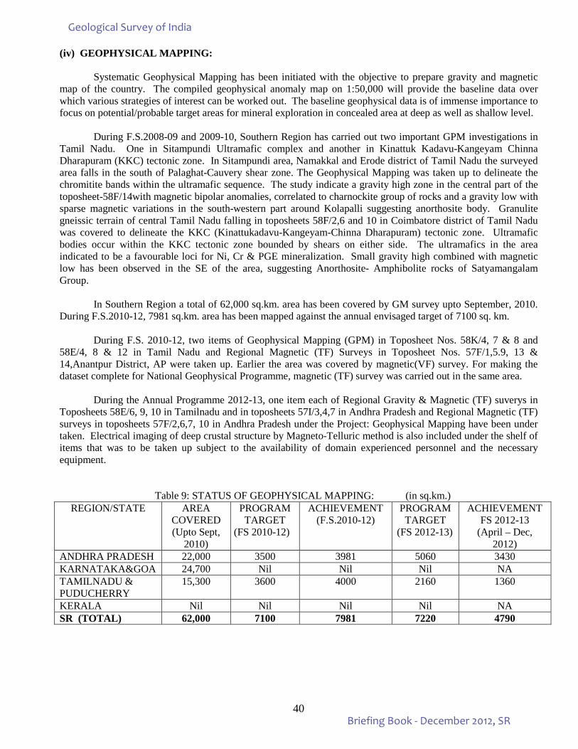
40
(iv) GEOPHYSICAL MAPPING:
Systematic Geophysical Mapping has been initiated with the objective to prepare gravity and magnetic map of the country. The compiled geophysical anomaly map on 1:50,000 will provide the baseline data over which various strategies of interest can be worked out. The baseline geophysical data is of immense importance to focus on potential/probable target areas for mineral exploration in concealed area at deep as well as shallow level.
During F.S.2008-09 and 2009-10, Southern Region has carried out two important GPM investigations in
Tamil Nadu. One in Sitampundi Ultramafic complex and another in Kinattuk Kadavu-Kangeyam Chinna Dharapuram (KKC) tectonic zone. In Sitampundi area, Namakkal and Erode district of Tamil Nadu the surveyed area falls in the south of Palaghat-Cauvery shear zone. The Geophysical Mapping was taken up to delineate the chromitite bands within the ultramafic sequence. The study indicate a gravity high zone in the central part of the toposheet-58F/14with magnetic bipolar anomalies, correlated to charnockite group of rocks and a gravity low with sparse magnetic variations in the south-western part around Kolapalli suggesting anorthosite body. Granulite gneissic terrain of central Tamil Nadu falling in toposheets 58F/2,6 and 10 in Coimbatore district of Tamil Nadu was covered to delineate the KKC (Kinattukadavu-Kangeyam-Chinna Dharapuram) tectonic zone. Ultramafic bodies occur within the KKC tectonic zone bounded by shears on either side. The ultramafics in the area indicated to be a favourable loci for Ni, Cr & PGE mineralization. Small gravity high combined with magnetic low has been observed in the SE of the area, suggesting Anorthosite- Amphibolite rocks of Satyamangalam Group.
In Southern Region a total of 62,000 sq.km. area has been covered by GM survey upto September, 2010.
During F.S.2010-12, 7981 sq.km. area has been mapped against the annual envisaged target of 7100 sq. km. During F.S. 2010-12, two items of Geophysical Mapping (GPM) in Toposheet Nos. 58K/4, 7 & 8 and
58E/4, 8 & 12 in Tamil Nadu and Regional Magnetic (TF) Surveys in Toposheet Nos. 57F/1,5.9, 13 & 14,Anantpur District, AP were taken up. Earlier the area was covered by magnetic(VF) survey. For making the dataset complete for National Geophysical Programme, magnetic (TF) survey was carried out in the same area.
During the Annual Programme 2012-13, one item each of Regional Gravity & Magnetic (TF) suverys in
Toposheets 58E/6, 9, 10 in Tamilnadu and in toposheets 57I/3,4,7 in Andhra Pradesh and Regional Magnetic (TF) surveys in toposheets 57F/2,6,7, 10 in Andhra Pradesh under the Project: Geophysical Mapping have been under taken. Electrical imaging of deep crustal structure by Magneto-Telluric method is also included under the shelf of items that was to be taken up subject to the availability of domain experienced personnel and the necessary equipment.
Table 9: STATUS OF GEOPHYSICAL MAPPING: (in sq.km.) REGION/STATE AREA
COVERED (Upto Sept,
2010)
PROGRAM TARGET
(FS 2010-12)
ACHIEVEMENT (F.S.2010-12)
PROGRAM TARGET
(FS 2012-13)
ACHIEVEMENT FS 2012-13
(April – Dec, 2012)
ANDHRA PRADESH 22,000 3500 3981 5060 3430 KARNATAKA&GOA 24,700 Nil Nil Nil NA TAMILNADU & PUDUCHERRY
15,300 3600 4000 2160 1360
KERALA Nil Nil Nil Nil NA SR (TOTAL) 62,000 7100 7981 7220 4790
Geological Survey of India
Briefing Book - December 2012, SR
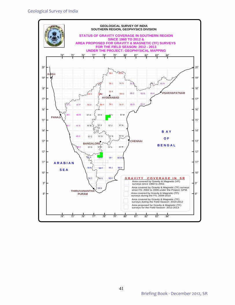
41
MUMBAI
PANAJI
CHENNAI
THIRUVANANTHAPURAM
VISAKHAPATNAM
STATUS OF GRAVITY COVERAGE IN SOUTHERN REGIONSINCE 1960 TO 2012 &
AREA PROPOSED FOR GRAVITY & MAGNETIC (TF) SURVEYS FOR THE FIELD SEASON: 2012 - 2013
UNDER THE PROJECT: GEOPHYSICAL MAPPING
48 I 57 A
G R A V I T Y C O V E R A G E I N S R
56 M56 I
Area covered by Gravity & Magnetic (VF) surveys since 1960 to 2002.
GEOLOGICAL SURVEY OF INDIASOUTHERN REGION, GEOPHYSICS DIVISION
65 C
57 D 57 H 57 P
56 F 56 J 56 N 65 B
56 C 56 O
56 D
48 J 48 N 57 J 57 N
48 O 57 O
48 P
58 A 58 M
74° 75° 76° 77° 78° 79° 80° 81° 82° 83° 84°
74° 75° 76° 77° 78° 79° 80° 81° 82° 83° 84°
8°
9°
10°
11°
12°
13°
14°
15°
16°
17°
18°
19°
20°
8°
9°
10°
11°
12°
13°
14°
15°
16°
17°
18°
19°
20°
B A Y
O F
B E N G A L
A R A B I A N
S E A
47 L 47 P 56 H
58 K
57 E
57 B
57 C
BANGALORE57 L
57 F
57 G 57 K
48 M 57 M
56 L
56 G56 K
56 P 65 D 65 H
65 G 65 K
65 N65 J
58 H
58 C 58 G
58 N58 J58 F58 B
58 I58 E
HYDERABAD
Area covered by Gravity & Magnetic (TF) surveyssince FS: 2002 to 2009 under the Project: GPM.Area covered by Gravity & Magnetic (TF) surveys during the FS: 2009-2010
Area covered by Gravity & Magnetic (TF) surveys during the Field Season: 2010-2012Area proposed for Gravity & Magnetic (TF) surveys for the Field Season: 2012-2013
57 I
Geological Survey of India
Briefing Book - December 2012, SR
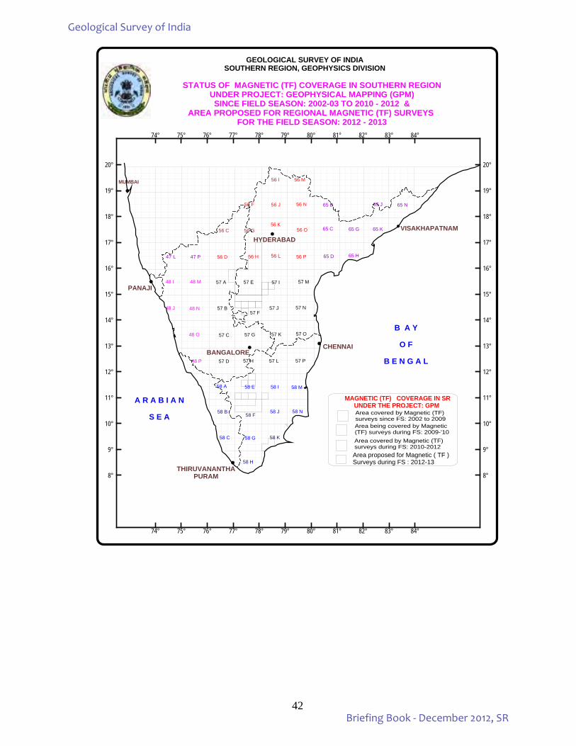
42
MUMBAI
PANAJI
CHENNAI
THIRUVANANTHAPURAM
VISAKHAPATNAM
STATUS OF MAGNETIC (TF) COVERAGE IN SOUTHERN REGIONUNDER PROJECT: GEOPHYSICAL MAPPING (GPM)SINCE FIELD SEASON: 2002-03 TO 2010 - 2012 &
AREA PROPOSED FOR REGIONAL MAGNETIC (TF) SURVEYS FOR THE FIELD SEASON: 2012 - 2013
48 I 57 A
MAGNETIC (TF) COVERAGE IN SRUNDER THE PROJECT: GPM
56 M56 I
GEOLOGICAL SURVEY OF INDIASOUTHERN REGION, GEOPHYSICS DIVISION
65 C
57 D 57 H 57 P
56 F 56 J 56 N 65 B
56 C 56 O
56 D
48 J 48 N 57 J 57 N
48 O 57 O
48 P
58 A 58 M
B A Y
O F
B E N G A L
A R A B I A N
S E A
47 L 47 P 56 H
57 I
58 K
57 E
57 B
57 C
BANGALORE57 L
57 G 57 K
48 M 57 M
56 L
56 G56 K
56 P 65 D 65 H
65 G 65 K
65 N65 J
58 H
58 C 58 G
58 N58 J58 F
58 B
58 I58 E
HYDERABAD
Area covered by Magnetic (TF) surveys since FS: 2002 to 2009Area being covered by Magnetic (TF) surveys during FS: 2009-'10Area covered by Magnetic (TF) surveys during FS: 2010-2012
74° 75° 76° 77° 78° 79° 80° 81° 82° 83° 84°
74° 75° 76° 77° 78° 79° 80° 81° 82° 83° 84°
8°
9°
10°
11°
12°
13°
14°
15°
16°
17°
18°
19°
20°
8°
9°
10°
11°
12°
13°
14°
15°
16°
17°
18°
19°
20°
57 F
Area proposed for Magnetic ( TF )Surveys during FS : 2012-13
Geological Survey of India
Briefing Book - December 2012, SR

43
(v) MARINE AND COASTAL SURVEYS: India has a coast line of 7,600 km. The right to explore / exploit all living / non-living resources are upto
200 nautical miles (EEZ). The total area of the EEZ is 2.0149 million sq.km. of which 1.980428 million sq.km. is covered by marine surveys. The Territorial Waters of India extend from appropriate coast line to a distance of 12 nautical miles (22.224 km) in to the sea. The total area of TW of India is about 1, 50,000 sq.km. The seabed mapping by the Marine & Coastal Survey Division of GSI have covered 1, 29,885 sq.km.
Table 10: STATUS OF MARINE AND COASTAL SURVEYS REGION/STATE LENGTH OF THE
COAST IN KM AREA OF TERITORIAL
WATERS (12 NM = 22.224 KM)
SQ.KM. GUJARAT 1915 42559 MAHARASHTRA 510 11334 ANDHRA PRADESH 970 21557
KARNATAKA & GOA 400 8890
TAMILNADU & PUDUCHERRY
910 20224
KERALA 540 12000
SR (TOTAL) 5245 116564
Offshore survey including sea bed mapping, geophysical surveys, geotechnical studies, environmental
studies and mineral investigation are being carried out within the Exclusive Economic Zone (EEZ) including the Territorial Waters (TW) by the Marine and Coastal Surveys Division.
The geological mapping of the territorial waters is complete for the state of Andhra Pradesh and is almost complete except for the southern tip of the Tamil Nadu state. The heavy mineral occurrences in the north Andhra coast are of particular significance. A brief description of investigations carried out in the offshore area of the four southern states, viz., Andhra Pradesh, Tamil Nadu, Kerala and Karnataka is given below.
Reconnoitre and detailed investigations for heavy minerals (HM) have been carried out in the Andhra
Pradesh, Kerala and Tamil Nadu in the east and west coasts of India. Twelve cruises on board RV Samudra Shaudhikama, exclusively for HM have been completed covering the area from Kolachel in Tamil Nadu to Azhikkal in Kerala with variable sampling grids. Block wise reserve estimation has also been done in this area. Detailed sampling by vibrocoring at 250m x 250m grid was carried out in a small area off Chavara, Kerala as per a MoU between GSI and IRE Ltd. Seventeen cruises off Andhra Pradesh from Kapaskudi in the north to Pudimadaka in the south has been carried out for placer mineral investigation in variable grids of 5 x 2 km. to 0.5 x 0.5 km. grids.
The preliminary offshore geological mapping of the sea bed from 1987 till 2009 has indicated promising occurrences of offshore placer sands within 8 to 35m isobath off North Andhra Pradesh coast. Three blocks have been identified 1) Bavanpadu-Kapaskuddi (5 to 15% of heavies) and 2) Bodaguntlapalem-Kutukanda (5 to 10 % of heavies) and 3) Pudimadaka- Revupolavaram (3 to 10% of heavies).
As part of the baseline mapping for MCS during F.S. 2010-12, there were 24 items of which 5 items were in Exclusive Economic Zone (EEZ), 17 items were in Territorial waters and 2 near coastal surveys.
The 5 EEZ surveys were distributed in two cruises off Andhra Coast and one each off Tamil Nadu, Maharashtra and Gujarat Coasts.
Geological Survey of India
Briefing Book - December 2012, SR
44
Six TW surveys in the east coast were distributed in three cruises off Andhra coast and three off Tamil Nadu coast.
Eleven TW surveys in the west coast were distributed as three off Kerala coast, one off Kanyakumari and one in Gulf off Mannar, both taken up by west coast offices, one off Karnatka and five off Gujarat. Out of the five cruises off Gujarat, only three could be undertaken as the survey vessel was not ready for survey during the 2nd half of FS 2010-12 due to unavailability of dry-docking slot at Cochin Shipyard Limited.
The two near coast Geotechnical items (063 & 064) are off Kerala related to Harbour projects using mechanized boats. Two additional coastal items (067 and 067A) were taken up during the FS 2010-12 with due approval from CHQ.
The cruise numbers are as shown below:
SU : AP : EEZ – Two -- SM-218 & 222 ; TW- Three - ST- 209, 215 & 216 - 5 SU : TN : EEZ - One -- SM-216 ;
TW- Five – ST- 213, 214 & 220 and SD – 235 & 240 - 6 SU : KERALA : Geotechnic- Two-- Items-063 & 064;
TW- Three – SD - 232, 233 & 239 - 5 SU :Karnataka : TW- one -- SD- 234 and Coastal Item-067A - 2 Maharastra: EEZ- One -- SM-217 - 1 Gujarat : EEZ- One -- SM-223; TW- Five – SD - 230, 231, 236, and
and Coastal Item-067 - 5 Total - 24
Overall during the FS 2010-12, seabed mapping of 3630 sq.km. (2225 sq.km. in the EEZ and 1405 sq.km. in TW) was carried out. In the deep sea region, under parametric surveys, 2203 l.km. bathymetry, 1923 l.km. of magnetic, 43273 sq.km. of swath bathymetric survey were carried out. In the shallow water domain, under parametric studies 4334 l.km. of bathymetry, 1836 l.km. of shallow seismic, 2971 l.km. of magnetic survey, 76 sq.km. of swath bathymetric survey were carried out besides, collection of sedimentary samples. In the Annual Programme of 2012-13 a total of 17 items are included for the coasts of southern states. In addition six service items under Mission – III and one service item under Mission – IV are also taken up.
Geological Survey of India
Briefing Book - December 2012, SR
45
CRUISES TAKEN UP BY MARINE AND COASTAL SURVEYS UNDER SOUTHERN REGION DURING F.S. 2010-12
RV Samudra Manthan SM-216 Systematic magnetic survey in Bay of Bengal over 85o E Ridge and Multibeam Bathymetric
Survey of the three submarine valleys off Pondicherry (20-1-2011 to 13.2.2011) SM-217 Search for possible occurrence of phosphatic sediments off Ratnagiri, Maharashtra (26-2-2011 to
20-3-2011) SM-218 Multibeam Bathymetric Survey of the continental slope off Gopalpur – Kalingapatnam –
Pudimadaka, Orissa - Andhra Pradesh coast (10.04.11 to 04.05.11) SM-222 Multibeam Bathymetric Survey of the continental slope off Pudimadaka – Godavari, Andhra
Pradesh coast (15.01.12 to 08.02.12) SM-223 Preliminary survey for phosphatic sediments off Okha, Gujarat (5.3. 2012 to 26.3.2012) RV Samudra Kaustubh ST-209 Placer mineral resource evaluation in the territorial waters off north of Bhimunipatnam, Andhra
Pradesh (27.10.2010 to 20.11.2010) ST-213 Parametric survey within Territorial Waters off Porto Novo and north of Pondicherry, Tamil Nadu
(25-01-2011 to 18-02-2011) ST-214 Mapping of seabed within Territorial Waters North east of Point Calimere, Tamil Nadu (22-02-
2011 to 18-03-2011) ST-215 Parametric (magnetic & seismic) survey within Territorial Waters off north Andhra Pradesh coast
(28.03.11 to 19.04.11) ST-216 Placer mineral resource evaluation in the territorial waters off north of Bhimunipatnam, Andhra
Pradesh (9.11.2011 to 29.11.2011) ST-220 Mapping of seabed within Territorial Waters off Point Calimere, Tamil Nadu (03-03-2012 to 27-
03-2012) RV Samudra Shaudhikama SD-230 Mapping of the seabed off Okha, Gujarat (03.11.2010 to 24.11.2010) SD-231 Swath bathymetric survey of part of Gulf of Cambay off Valsad (01-12-2010 to 22-12-2010) SD-232 Parametric (seismic and magnetic) survey in the shelf area off Vizhinjam-Kanyakumari, Kerala &
Tamil Nadu coast (02-01-2011 to 24-01-2011) SD-233 Evaluation of relict sand body off Shertallai, Kerala (27-01-2011 to 02-03-2011) SD-234 Geotechnical appraisal off Kulai, Karnataka (12-03-2011 to 2.4.2011) SD-235 Parametric (magnetic) survey within Territorial Waters off Gulf of Mannar (12.04.11–04.05.11) SD-236 Mapping of the seabed off Okha, Gujarat (30.12.2011 to 21.01.2012) SD-239 Evaluation of relict sand body off Ponnani, Kerala (2.2.2012 – 20.2.2012) SD-240 Parametric (magnetic & Seismic) survey within Territorial Waters off Kanyakumari – Tuticorin
coast (5.3.2012 to 26.3.2012) Coastal Programmes Item-063 Geological appraisal of Azhikkal port, Kannur, Kerala Item-064 Preliminary Geological studies at Ponnani Harbour, Kerala Item-067 Reconnaisance survey for a preliminary appraisal heavy mineral occurrence Item-067A Reconnaissance survey for glass sand in the coastal area between Yermal and Mukka, Dakshina
Kannada Dist., Karnataka.
Geological Survey of India
Briefing Book - December 2012, SR
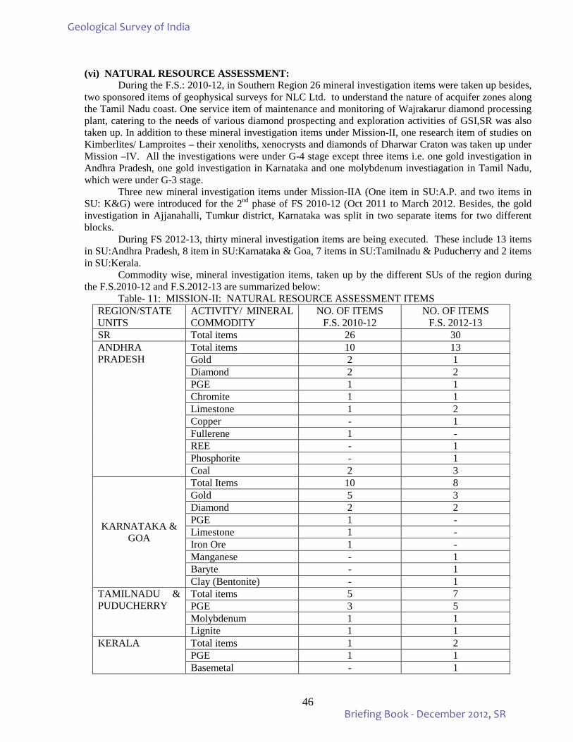
46
(vi) NATURAL RESOURCE ASSESSMENT: During the F.S.: 2010-12, in Southern Region 26 mineral investigation items were taken up besides,
two sponsored items of geophysical surveys for NLC Ltd. to understand the nature of acquifer zones along the Tamil Nadu coast. One service item of maintenance and monitoring of Wajrakarur diamond processing plant, catering to the needs of various diamond prospecting and exploration activities of GSI,SR was also taken up. In addition to these mineral investigation items under Mission-II, one research item of studies on Kimberlites/ Lamproites – their xenoliths, xenocrysts and diamonds of Dharwar Craton was taken up under Mission –IV. All the investigations were under G-4 stage except three items i.e. one gold investigation in Andhra Pradesh, one gold investigation in Karnataka and one molybdenum investiagation in Tamil Nadu, which were under G-3 stage.
Three new mineral investigation items under Mission-IIA (One item in SU:A.P. and two items in SU: K&G) were introduced for the 2nd phase of FS 2010-12 (Oct 2011 to March 2012. Besides, the gold investigation in Ajjanahalli, Tumkur district, Karnataka was split in two separate items for two different blocks.
During FS 2012-13, thirty mineral investigation items are being executed. These include 13 items in SU:Andhra Pradesh, 8 item in SU:Karnataka & Goa, 7 items in SU:Tamilnadu & Puducherry and 2 items in SU:Kerala. Commodity wise, mineral investigation items, taken up by the different SUs of the region during the F.S.2010-12 and F.S.2012-13 are summarized below: Table- 11: MISSION-II: NATURAL RESOURCE ASSESSMENT ITEMS
REGION/STATE UNITS
ACTIVITY/ MINERAL COMMODITY
NO. OF ITEMS F.S. 2010-12
NO. OF ITEMS F.S. 2012-13
SR Total items 26 30 ANDHRA PRADESH
Total items 10 13 Gold 2 1 Diamond 2 2 PGE 1 1 Chromite 1 1 Limestone 1 2 Copper - 1 Fullerene 1 - REE - 1 Phosphorite - 1 Coal 2 3
KARNATAKA & GOA
Total Items 10 8 Gold 5 3 Diamond 2 2 PGE 1 - Limestone 1 - Iron Ore 1 - Manganese - 1 Baryte - 1 Clay (Bentonite) - 1
TAMILNADU & PUDUCHERRY
Total items 5 7 PGE 3 5 Molybdenum 1 1 Lignite 1 1
KERALA Total items 1 2 PGE 1 1 Basemetal - 1
Geological Survey of India
Briefing Book - December 2012, SR
47
MINERAL RESOURCE ASSESSMENT
ANDHRA PRADESH During the Field Season 2010-12, State Unit: Andhra Pradesh has taken up 8 items under Mission IIA. These include two items under gold, two items under diamond, one item under limestone and one item each under PGE, Chromite and Fullerene. Preliminary investigation for gold & other associated elements west of Remeta of Gadwal schist Belt, Mahabubnagar & Kurnool districts, AP (G4). The Gadwal Schist Belt is a hook shaped belt with two arms, the eastern arm considered as the main Gadwal Schist Belt and the western arm joins the Raichur Schist Belt in Karnataka. The NNW-SSE trending Gadwal Schist Belt extends over a cumulative straight length of 85 Km from Narayapet to Veldurthi in the south. In the study area the supra crustal rocks trend NNW-SSE dipping due south comprising mainly volcanic rocks with minor chemogenic and tuffaceous sediments. It is further divided into lower ‘Sangala Formation’ constituting mainly metabaslts and amphibolites and an upper ‘Ulindakonda Formation’ which is essentially made up of intermediate to acid volcanic and interflow chemogenic sediments. These two formations are intruded by granitoids, gabbro and dolerite dykes and quartz and pegmatitite veins. A total of 164 samples were analysed for gold conent, out of which only one stream sediment sample analysed gold content of 150ppb.
Exploration for gold in Tellakonda block of Veligallu Greenstone Belt, Cuddapah district, Andhra Pradesh (G-3) Exploration in Tellakonda block was carried out with an objective to test the subsurface behaviour of the mineralized zone of 550 m strike length at 60 m vertical depth. The four boreholes drilled have intersected feeble to moderate mineralized zones in the form of sheared quartz veins within the amphibolite and granite. The core samples were analysed and the weighted average gold values ranged from 0.10 to 1.05 gm/ton.
Search for Kimberlite/Lamproite in Palwai block in Nalgonda District, Andhra Pradesh and Search for Kimberlites in Amangal and Bhimanapalli Blocks in parts of Mahabubnagar, Nalgonda and Rangareddy districts, Andhra Pradesh (G-4) The search for Kimberlites were taken up in Palwai block in Nalgonda district and in Amangal and Bhimanapalli Blocks in parts of Mahabubnagar, Nalgonda and Rangareddy districts. The areas were covered by multi disciplinary approach which include study of IRS imagery, aerial photograph, geomorphological, geological and geophysical maps of the target areas. Detailed ground surveys coupled with intensive stream sediment sampling was carried out. Heavy mineral concentrates were examined for the specific Kimberlite indicator minerals. 55 stream sediment samples in Palwai block, 185 stream sediment samples from Amangal and Bhimanapalli blocks were carried out and four lamproitic bodies were brought out to the 1.6 km west and 1.4 km to the SW of Vattikonda area in Paluvai block in Nalgonda district. In all the blocks, major heavy mineral population includes magnetite, garnet, ilmenite, spinel, hornblende, zircon, rutile, biotite etc. Preliminary exploration for PGE in the western margin of Ramagiri schist belt, Anantapur district, Andhra Pradesh (G-4) An area of 113 sq. km has been mapped in the NNW – SSW hill at NW and SW of Ramagiri and south of Mushtikovilla on 1:12,500 scale. The rock types comprise of meta-sedimentary as well as meta-volcanics in association with granitoids. The rock types identified in the field are quartzite with quartz-chlorite-sericite schist, metabasalt, BIF, ultramafics, chlorite schist, metagabbro and vein quartz. Two different ultra mafic rock units, one (UM-I) at the north of Mushtikovilla village and the other (UM-II) at the south of Mushtikovilla were identified.
Geological Survey of India
Briefing Book - December 2012, SR
48
UM-I unit: It is a NNW-SSE trending narrow linear ultramafic body, traced for a strike length of about 14 km form Konda Motu in the north to Enamurala Gutta in the south. The bands show pinching and swelling nature. Thickness of the band varies from 0.5m to 250m. The ultramafic rock are tremolite-talc schist, serpentinite, dunite (at places partially altered), magnetite bearing chlorite-schist and pyroxenite. UM-II unit: trend varies from NNW-SSE to NNE-SSW and is located at the south of Mushtikovilla village. The ultramafic rocks are tremolite-talc schist, dunite, magnesite bearing talc schist occurring as small patches, lenses within the chlorite-schist. EPMA study of ultramafic rock indicate that Mgnesite grains are Mg- rich in coreand Fe-rich in rim. The opaques are magnetite and chrom-spinel (core rich in Cr, rim rich in Fe). XRF study shows that the Ni value in the ultramafic rocks ranges from 443ppm to 3001ppm and The Cr value ranges from 458ppm to 6973ppm. The PGM values ranges from < 19 ppb to 629 ppb. Preliminary investigation for limestone in the area west of Nandikotkur, Cuddapah basin, Kurnool district, AP. (G-4) The Narji limestone occurs as a narrow band of 1.5 to 2.00 km trending in NE-SW direction for about 25 km. The chemical analysis of the limestones show that the CaO content varies from 41 to 46% and SiO2 ranges from 12 to 20% on an average. The limestone is of cement grade. Investigation for possible fullerene occurrence within carbonaceous tuff of Mangampeta baryte prospect and demarcation of carbonaceous tuff bearing areas for prospective drilling work around Mangampeta, Kadapa district, Andhra Pradesh. The Mangampeta is known for world class single largest deposit of barytes. Geologically the rocks belong to the Pullampet Formation (Time equivalent of Cumbum Formation) of Nallamalai sub-basin, Cuddapah Basin of Meso Proterozoic age. Detailed Geological Map for an area of 0.7 sq. km was prepared marking the contacts between tuffs, dolomite and barite. The carbon spherules and tubules within the dolomite and stromatolitic dolomite were observed for the first time during the reconnoitory surveys. The branching type stromatolites were also observed for the first time in the dolomite. The carbon mineralisation was observed for the first time within the dolomites. The carbon occurs as spherules, tubules, amorphous form and in hydrothermal veins. The glassy carbon is occurring as spherules and tubules showing conchoidal fracture, black streak, low specific gravity and non-soiling nature. This glassy carbon shows resemblance to the shungites of Proterozoic rocks of Karelian province, Russia (where natural fullerenes were reported by Dr. Peter R Buseck) in its physical properties and XRD peaks. The carbon spherule also hosts silica spherules. The occurrence of carbon and silica together indicates liquid immiscibility and high temperature processes which may have been caused by high energetic events such as lightning or paleoseismic events or impact. Exploration for chromite mineralisation in the area between Kondapalli and Gangineni area, Krishna and Khammam districts, Andhra Pradesh (G-4) Large scale mapping of 200 sq km area and detailed mapping of 1 sq km area was carried out on 1:12,500 and 1:2,000 scale respectively. The rocks belong to the Khondalite and Charnockite groups of Eastern Ghat Supergroup. Layered igneous complex in the form of gabbroic anorthosite and younger intrusives like pyroxenite, pegmatite and quartz veins have been observed. Chromite associated with the ultramafic rocks particularly in pyroxenite and serpentinite occur as lenses, veins, veinlets, thin bands and disseminations. Two types of pyroxenite bodies were noticed in the area i.e. one in the form of enclaves within charnockite which are devoid of chromite and younger pyroxenite bodies bearing chromite which are intruded within charnockite along the shear plane of an antiformal fold trending
Geological Survey of India
Briefing Book - December 2012, SR
49
roughly N-S to NNW-SSE. Three known old quarries for chromite mineralization Binny, Loya and Gangineni quarry are noticed along the shear zone. At Duggiralapadu one more chromite mineralized zone is noticed along the same shear zone. Analytical results of 248 bed rock samples show Cr % ranging from 1.34% to 29.44%. An analytical result of 107 samples for PGE mineralization shows Pt 495 ppb, Pd 65 ppb, Ir 15 ppb, Ru 240 ppb and Rh 135 ppb. Geobotanical path finder of chromite mineralization plant Hyptis Suaveolens (?) (Darp Tulasi) has also been observed at Gangineni quarry. During the Annual Programme of 2012-13 it is proposed to take up a total of 10 investigations, two each for Diamond and Limestone and one each for PGE, REE, Phosphorite, Chromite, Basemetal and Gold. Karnataka: During F.S. 2010-12 nine Mineral investigations were taken up. Item wise highlights of work carried out is given below: Search for Kimberlites in parts of Raichur dist. Karnataka: Geochemical anomaly brought out by NGCM 2004-06 near Paidoddi (56D/11) was found to be due to presence of meta ultramafic enclave in the area. Intersection points of certain lineaments in parts of toposheet 56H/4 have been investigated. Calcrete development is seen at one km west of Govindoddi in the vicinity of a very small exposure of ultramafic body. Suspected chrome diopside grains collected from stream sediment samples are submitted for EPMA analysis. The studies were intensified for the search of kimberlite. Exploration for gold in Ajjanahalli block-D, Tumkur district, Karnataka: Ajjanahalli Block – E: The main litho units in the area are metabasalt, argillite and sheared BIF. The BIF is sheared, brecciated, highly limonitised with quartz carbonate veins and contains oxidized sulphides. In the BIF, bedrock samples are collected across the strike at every 1 m along width of the band. A cumulative strike length of 5230 m of BIF bands (Band No.1 to 7) has been established by detailed mapping and trenching.
Ajjanahalli Block – D: Till the end of December, 2011, a total of 2347.89 m of drilling has been carried out in this block to target the mineralized zone VIII and zone III and intermittently intersecting zone IV of eastern limb at shallow depth. Band No.8 and 3 has been targeted at a vertical depth of 60 m. The gold assay values received for bedrock samples vary from 0.030 to 1.8 g/t over a width of 1 m. In trenches, the gold assay values vary from 0.25 gpt. to 2.82 gpt. with a width range from 1 m. to 2 m. In ADG – 11 borehole drill cores gave the gold values of 16.4 gpt. / 0.50 m., 3.37 gpt. / 0.50 m., 0.96 gpt. / 1.5 m.
Investigation for Gold in Ajjanahalli Block – E, Tumkur district, Karnataka (G4): The main lithounits are metabasalt, argillite, BIF with various generations of quartz vein and later basic intrusives trending NNW-SSE.
Investigation for gold in Ajjanahalli Block - G, Tumkur district, Karnataka (G4): The major lithounits are metabasalt, argillite, BIF and various generations of quartz veins. Thin impersistent ferrodolomite bands are recorded at the contact of metabasalt and BIF band at places. An old working is noticed at one of the BIF band which is sheared and highly limonitised with quartz veins. Preliminary investigation for gold mineralization between Adivala to Obulapura, Chitradurga & Tumkur districts, Karnataka (G4): The area exposes argillite, silicified BIF bands and carbonated, massive, schistose, pillowed metabasalt. The surface evidence of mineralization like silicification, shearing and brecciation were noticed. About 1 km length of mineralized zone is observed west of Madinahalli. The sheared hinge zone is showing indications of mineralization like silicification, carbonatisation, leaching of sulphides, peacock blue stains,
Geological Survey of India
Briefing Book - December 2012, SR
50
limonitisation, etc. 85 bed rock samples and trench samples analysed for gold gave gold value ranges from 0.12 ppm to 2.10 ppm in the mineralized zone having a strike length of 100 m and 4 to 6 m width located 1.5 km west of Mavinamadu. Preliminary investigation for gold and associated minerals in southern part of Shimoga schist belt, Chikmagalur District, Karnataka: The lithounits of massive metabasalt, quartz chlorite, quartz carbonate rock, talc chlorite schist, amphibolite, quartz, BMQ, fuchsite quartzite and sheared granite gneiss are recorded. Quartz and ankerite veins traverse the rock units. Structures seen include both primary and secondary structures. A mylonitic silicified, highly limonitised and carbonated quartz chlorite schist zone is noticed and bedrock sampling and trenching were done to delineate the zone. Investigation of the iron ore resources in selected freehold areas in Kenkeri, Melanahalli, Guruvapura, Kempanahalli, Dasudi, Kandikere blocks in Hosadurga Taluk, Chitradurga district, Karnataka (G4). The Department of Mines and Geology, Government of Karnataka has delineated six lease-free blocks and requested Geological Survey of India to take up regional targeting for iron ore and estimate the reserve of iron ore in these blocks. In the western part of the investigation area manganese bearing dolomitic limestone and HBQ bands are traced. The NW-SE trending westerly dipping 20-25 m wide BHQ band is traced for about 300m. The trench samples analysed from Guruvapura Block has given a range of 33.23 to 34.01 wt% Fe. Higher value of 55.01% Fe was obtained near a fold closure indicating a structural control for the ore concentration. BRS samples gave a value range of 20.11 to 46.91 wt% Fe. Examination of SMS grade limestone of Jalikatte, Lokapur, Bijapur districts, Karnataka for alkali content: Rock types exposed in the study areas between Kadarkoppa – Hammaneru – Yendigore and Kagidoni in eastern part and Varchagul and Arliketti in the south are quartzite, limestone, dolomite, shale and conglomerate of Lokapur and Semikere subgroup of Bagalkot Group. General trend of rock is NW-SE with 240 dips due southwest and northeast. Preliminary investigation for PGE in mafic-ultramafic rocks of Nuggihalli schist belt, Hassan district, Karnataka: The Department of Mines and Geology, Government of Karnataka has requested Geological Survey of India to carry out investigation for PGE in the chromite lease hold areas of M/s.Mysore Minerals Ltd. in Nuggehalli Schist belt. Accordingly a one year programme was taken up. Rock types exposed in the area are talc-tremolite-actinolite schist, talc-chlorite schist, talc schist, serpentinite, pyroxenite and anorthosite with chromite & titano magnetite. Numerous basic dyke swarms mainly in the NW-SE and NE-SW directions were noticed. In one of the mine pit, typical igneous layering starting with altered peridotite at bottom and gabbroic anorthosite at the top is observed. Chromite lenses and veins are seen confined within the talcose serpentinite. Fine dissemination of sulphides (pyretic and chalcopyrite) are seen along the schistose planes of the amphibolite. During the Annual Programme of 2012-13, following 9 mineral investigations are proposed: 1. Regional Surveys to locate Kimberlites in Maski Block, Raichur, Koppala and Bellary Districts,
Karnataka in toposheets 57A/9 and 57A/10 (G4). 2. Regional Surveys to locate Kimberlites in Tawergeri Block, Koppal and Bellary Districts, Karnataka in
Toposheet No. 57A/5 and 57A/6 (G4). 3. Investigation for Gold in Ajjanahalli Block-E, Tumkur District, Karnataka TSNo. 57C/10 (G3). 4. Investigation for Gold in Ajjanahalli Block-G, Tumkur District, Karnataka TS No. 57C/10 (G4). 5. Investigation for Gold in Kakol-Kengond-Alalgeri-Budapanhalli and adjoining area, Shimoga schist
belt, Haveri District, Karnataka, parts of TS no 48N/9 and 10.
Geological Survey of India
Briefing Book - December 2012, SR
51
6. Preliminary investigation for Baryte around Gadisankapura area, Hungund-Kushtagi schist belt, Bagalkot district, Karnataka in parts of TS No 56 D/4 and 56A/1 (G4).
7. Preliminary investigation for Baryte in Kunigal schist belt, Tumkur district, Karnataka in parts of TS no. 57C/16, 57 D/13 & 57 H/1(G4).
8. Preliminary investigation for Manganese in Chiknayakanhalli area, Tumkur district, Karnataka in parts of TS No 57 C/11) (G4).
9. Investigation for clay minerals with special reference to Bentonite in coastal area of Udupi district, Karnataka in parts of TS No 48K/15 (G4).
Tamil Nadu: During F.S.2010-12, the following investigations were taken up. Investigation for platinum group of elements by scout drilling in Tasampalaiyam block in Sittampundi layered mafic-ultramafic complex of Tamil Nadu: In Sittampundi complex, the mineralized zone in Tasampalaiyam – Karungalpatti block was delineated and in Tasampalaiyam block with PGE values ranging from 1.10 ppm to 4.93 ppm over a maximum width of 3.10 m. The exploration is under way to prove the depth persistence of mineralization up to 30 m vertical depth and also to delineate strike continuity of PGE mineralized zone. Investigation for platinum group of elements by scout drilling in Solavanur and Karappadi blocks and detailed mapping in Mallanayakanpalaiyam block: Meta-pyroxenite is the rock type intersected in boreholes. Partial results that have been received indicate Pt value ranging from 5 ppb to 255 ppb and Pd value ranging from 10 ppb to 730 ppb. Seven boreholes (MBH-1 to 7) have been drilled in Mallanayakanpalaiyam block to intersect the meta-pyroxenite+chromitite band. The study is under progress. Preliminary investigation for PGE in Mettupalaiyam ultramafic belt, Tamil Nadu. Under this item a total of 360 sq.km was mapped on 1:25,000 scale along with 805 cu. m trenching work. The rock types are hornblende - biotite gneiss, charnockite, meta-gabbro, meta-pyroxenite, amphibolites, ferruginous quartzite, magnetite quartzite, K-feldspar rich pegmatoidal granite, dolerite dyke and quartz veins. The contact between hornblende biotite gneiss and Pegmotoidal granite is sheared which is very well exposed south of Togamalai hill. The regional foliation is trending NE-SW to ENE-WSW with moderate to steep dip towards north to northwest. The shear zones observed in the area are ductile to semi brittle-ductile in nature and predominantly showing dextral shear sense. A total of 10 meta pyroxenite bands/bodies are demarcated in the T.S.No: 58A/15 & 16 58E/3. Detailed exploration for molybdenum in Vellakkal central block, Harur-Uttangarai molybdenum belt, Dharmapuri district, Tamil Nadu: The concept oriented study has brought to light the lode geometry in Vellakkal Central Block. The zones of quartz veins occur one below the other in a ladder type fashion as sub-horizontal to gentle easterly dipping lensoidal and sigmoidal bodies within the shear zone. However, out of three shear zones intersected in boreholes, only one shear zone in borehole BH AVLC-5 in the central part of the Vellakkal central block has indicated encouraging Mo mineralization i.e. 2m x 305 ppm Mo with 2.5% corresponding Pb value, 3m x 307ppm with 1% corresponding Pb value, 5.95m x 293 ppm. During the Annual Programme of 2012-13, the items on PGE investigation, Solavanur, Mallanayakanpalaiyam, Karappadi blocks and Tasampalaiyam block of Sittampundi area and concept oriented investigation on molybdenum in Velampatti south block is proposed. Kerala: During F.S.: 2010-12, mineral investigations on PGE in the Attapadi valley, Palakkad District was taken up in an area of 150 sq.km on 1:25,000 scale, which is the western continuation of the Mettuppalayam
Geological Survey of India
Briefing Book - December 2012, SR
52
Ultramafic Complex of Tamil Nadu. Talc-tremolite schist, metapyroxenite and altered peridotite constitute the ultramafites, while the mafic units are represented by amphibolite and metagabbro. A total of 202 groove samples were collected for the analysis of Platinum Group of Elements. Apart from the channel samples, 29 samples for petrological studies, 33 samples for petrochemical studies, 15 samples for ore microscopy, 23 samples for SEM and 15 samples for EPMA have also been collected. 17 core samples from the earlier gold investigation of Vannathura block in Attapadi valley were also sampled. The available analytical results do not show any encouraging PGE values. Highlights: i) Sulphide-bearing BIF reported for the first time from this area extends intermittently over a cumulative strike length of 8 km in a zone between Anaikatti in the east and Sholayur in the west. The width of sulphide rich zone in BIF is about 2.5m. ii) EPMA and SEM studies led to the identification of PGE in the form of Copper-Osmium alloy within the sulphide-bearing Banded Iron Formation (BIF) exposed around Nallasinge as well as in the meta-pyroxenites found near Narasimukku and Kalkandi. iii) EPMA studies done on the chromitite rock at Kalkandi revealed that the chromite-like mineral is in fact, chrome-spinel. A single grain of Cu-Os alloy was found during SEM studies. During the Annual Programme of 2012-13 it is proposed to take up preliminary investigation for massive sulphide mineralization in Padinjarattara area, Wayanad district for base metals and for PGE in the ultra-mafic rocks of Nilambur Valley, Malappuram district. NATURAL ENERGY RESOURCE ANDHRA PRADESH Two items under this Mission were taken up during F.S. 2010-12. Exploration for coal by scout drilling in Vutasamudram-Venkatapuram area, Southern sub basin, Godavari Valley Coalfield, West Godavari district, Andhra Pradesh. A total of 1513.70m was drilled in three boreholes, viz. GVVK-1, GVVK-2 and GVVK-3. Occurrence of one coal/carbonaceous shale zone (‘C’) of Lower Kamthi Formation between 548.30m and 631.80m depths having 8.98m cumulative thickness in 8 to 9 thin coal sections, 0.60m-1.80m thick (pre-analysis), was recorded in borehole GVVK-1.
Exploration for coal by drilling in Bugga-Khammamtogu sector, Southern part of main basin of Godavari Valley Coalfield, Khammam district, Andhra Pradesh. In GBK-2, a coal/carbonaceous shale zone with 9.48m cumulative thickness (in 12 split section) having individual split section thickness of 0.50m to 1.60m (pre-analysis) was intersected within Lower Kamthi Formation between 43.79m and 187.35m depth. Another coal/carbonaceous shale seam/band occurs within Barakar Formation in three coal split sections of 0.51m to 1.25m thickness between 280.30m and 288.96m depth. The cumulative thickness of coal is 2.81m (pre-analysis). During the Annual Programme of 2012-13, the following items are proposed to be taken up: 1. Item: Exploration for coal by drilling in Bugga-Khammamtogu sector, Southern part of main basin of
Godavari Valley Coalfield, Khammam district, Andhra Pradesh. 2. Item: Regional exploration for coal by drilling in Pagaderu (West) sector, Southern part of main basin
of Godavari Valley Coalfield, Khammam district, Andhra Pradesh.
Geological Survey of India
Briefing Book - December 2012, SR
53
TAMIL NADU Regional exploration for lignite in Bogalur east sector, Ramnad sub-basin, Ramanathapuram district, Tamil Nadu. Lignite exploration commenced in Bogalur East sector on 03.06.2009 as an additional item in F.S. 2008-09 with an objective to assess the strike continuity of the lignite seams towards north and east of the earlier explored Bogalur block, Ramnad sub-basin, Tamil Nadu. Two regionally persistent Lignite seams, Seam –I (max thickness 17.5 m) and Seam –II (max thickness 4.6 m), in ascending order, have been recorded within Neyveli Formation between depths of 375m and 390m. The exploration has established a northeast strike continuity of lignite seams for about 4 km and dip continuity of about 4 km. Seventy percent of the samples analysed a calorific value of more than 3000 Kcal / kg and belongs to the Lignite “A” Grade. The analytical results of PAL study, Trace Element study and LPS study are awaited. The tentative geological resource of this area is around 400 million tonnes within 450m depths. During the Annual Programme of 2012-13 it is proposed to take up the investigation in Uttarakosamangai sector of Ramnad basin. (vii) GEODATA / GEOINFORMATICS: GSI has a wealth of geoscientific data in the form of maps, published & thousands of unpublished progress reports. Digitisation of all maps and soft copy conversion of all unpublished progress reports were undertaken on priority basis and completed. To achieve this task, the Geodata Division of SR was strengthened and a separate centre called Project: Geoinformatics was created and both were equipped with a number of high-end computers, specialised software and state-of-the-art software peripherals. GSI has enriched its digital database with high precision geocoded imagery on 1:50,000 scale for entire area for two seasons viz., Rabi and Kharif.
Keeping in tune with the rapidly changing IT scenario, GSI went ahead with the establishment of
LANs in all the Regional Offices in Phase-I during 2003-2004 which have been connected by WAN under Phase-II by 2009-2010.
During F.S. 2010-12, Integration of Geological, Geochemical, Geophysical, Aero-geophysical, Photo-geological Data of 57E Degree Sheet to identify Target Areas of Mineralization; Versioning-2 on the input (V-1) layers was carried out by Geodata Division, SR. In addition, the uploading of 50K maps (VERSION.1) was continued for the remaining 5 toposheets, besides the service item of Network Management and Assistance to Scientific and Administrative staff.
During the Annual Programme of 2012-13 compilation of new series (second edition) of geological quadrangle maps, 1:250K GQM, Integration of Geological, Geochemical, Geophysical, Aero-geophysical, Photo-geological Data of 57F Degree Sheet and coordinating the implementation activities pertaining to the OCBIS would constitute the priority activities; besides, the activities pertaining to the network management and assistance to Scientific and Administrative staff will also be carried out. (viii) ENGINEERING GEOLOGY & GEOTECHNICAL STUDIES:
Geotechnical and engineering geological studies were undertaken for planning, design and execution of major civil engineering structures for water resource development, power and communication. Some of the important geotechnical studies in Andhra Pradesh include Jurala project, Tungabhadra barrage of Sunkesula, Yeleru reservoir, Polavaram and Telugu Ganga projects, Gorakallu balancing reservoir, Srisailam Right Bank Canal. Lakya earth-dam, Kochigehole earth-dam and Singsara earth-dam projects were taken up in Karnataka. Bhavani-Kattali barrage hydro-electric project (HEP) and Pykara ultimate storage projects were carried out in Tamil Nadu. In Kerala, Pambar HEP, Kuttiyadi augmentation scheme,
Geological Survey of India
Briefing Book - December 2012, SR
54
Muvathupuzha valley irrigation project and Kadamparai PSHEP were attended to. In Goa, geotechnical studies for the construction of dams and bridge across Mandovi River, foundation studies for LCA aircraft for ADA and slope stability studies at Cabo Hills, Raj Bhavan, Panaji were carried out.
Abstract on geotechnical investigations viz. pre-construction stage, construction stage projects taken up during the period from 1st October, 2012 to 31st December, 2012
• Geotechnical investigations carried out : 17 • Preconstruction stage investigations : 5 a) Pranahita-Chevella Sujala Sravanthi Packages: : 4 b) Navigation tunnel, I S P M Project: : 1 • Construction stage investigations : 11 a) Balancing Reservoirs: : 5 b) Tunnels: : 6 Pranahita-Chevella Sujala Sravanthi Packages Tunnel from Ramappa Tank to Dharmasagar Tank Gandikota Tunnel Project under GNSS Scheme • Post Construction stage investigation : 1 N.S.R.S Srisailam Project: : 1 • Achievements Detailed geological mapping on 1:5000 scale : 1.00 L. km Detailed geological mapping of Out crops on 1:5000 scale : 63,125 Sq. m Cut off trench mapping of earth dams on 1:200 scale : 645.00 m Geological logging of boreholes : 501.00 m 3D geological mapping of Tunnel on 1:200 scale : 3.677 L .km
• No. of field days : 77 days
Geological Survey of India
Briefing Book - December 2012, SR
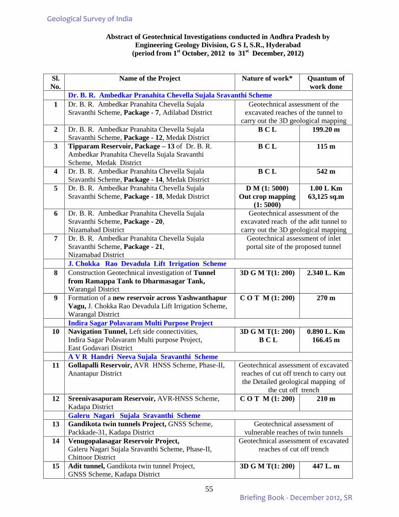
55
Abstract of Geotechnical Investigations conducted in Andhra Pradesh by Engineering Geology Division, G S I, S.R., Hyderabad
(period from 11sstt OOccttoobbeerr,, 22001122 ttoo 3311sstt DDeecceemmbbeerr,, 22001122))
Sl. No.
Name of the Project Nature of work* Quantum of work done
Dr. B. R. Ambedkar Pranahita Chevella Sujala Sravanthi Scheme 1 Dr. B. R. Ambedkar Pranahita Chevella Sujala
Sravanthi Scheme, Package - 7, Adilabad District Geotechnical assessment of the
excavated reaches of the tunnel to carry out the 3D geological mapping
2 Dr. B. R. Ambedkar Pranahita Chevella Sujala Sravanthi Scheme, Package - 12, Medak District
B C L 199.20 m
3 Tipparam Reservoir, Package – 13 of Dr. B. R. Ambedkar Pranahita Chevella Sujala Sravanthi Scheme, Medak District
B C L 115 m
4 Dr. B. R. Ambedkar Pranahita Chevella Sujala Sravanthi Scheme, Package - 14, Medak District
B C L 542 m
5 Dr. B. R. Ambedkar Pranahita Chevella Sujala Sravanthi Scheme, Package - 18, Medak District
D M (1: 5000) Out crop mapping
(1: 5000)
1.00 L Km 63,125 sq.m
6 Dr. B. R. Ambedkar Pranahita Chevella Sujala Sravanthi Scheme, Package - 20, Nizamabad District
Geotechnical assessment of the excavated reach of the adit tunnel to carry out the 3D geological mapping
7 Dr. B. R. Ambedkar Pranahita Chevella Sujala Sravanthi Scheme, Package - 21, Nizamabad District
Geotechnical assessment of inlet portal site of the proposed tunnel
J. Chokka Rao Devadula Lift Irrigation Scheme 8 Construction Geotechnical investigation of Tunnel
from Ramappa Tank to Dharmasagar Tank, Warangal District
3D G M T(1: 200)
2.340 L. Km
9 Formation of a new reservoir across Yashwanthapur Vagu, J. Chokka Rao Devadula Lift Irrigation Scheme, Warangal District
C O T M (1: 200) 270 m
Indira Sagar Polavaram Multi Purpose Project 10 Navigation Tunnel, Left side connectivities,
Indira Sagar Polavaram Multi purpose Project, East Godavari District
3D G M T(1: 200) B C L
0.890 L. Km 166.45 m
A V R Handri Neeva Sujala Sravanthi Scheme 11 Gollapalli Reservoir, AVR HNSS Scheme, Phase-II,
Anantapur District Geotechnical assessment of excavated reaches of cut off trench to carry out the Detailed geological mapping of
the cut off trench 12 Sreenivasapuram Reservoir, AVR-HNSS Scheme,
Kadapa District C O T M (1: 200) 210 m
Galeru Nagari Sujala Sravanthi Scheme 13 Gandikota twin tunnels Project, GNSS Scheme,
Packkade-31, Kadapa District Geotechnical assessment of
vulnerable reaches of twin tunnels 14 Venugopalasagar Reservoir Project,
Galeru Nagari Sujala Sravanthi Scheme, Phase-II, Chittoor District
Geotechnical assessment of excavated reaches of cut off trench
15 Adit tunnel, Gandikota twin tunnel Project, GNSS Scheme, Kadapa District
3D G M T(1: 200)
447 L. m
Geological Survey of India
Briefing Book - December 2012, SR
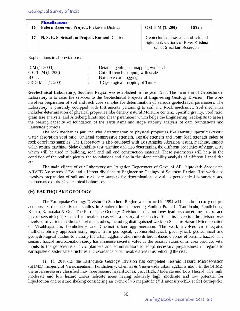
56
Miscellaneous 16 Paleru Reservoir Project, Prakasam District C O T M (1: 200)
165 m
17 N. S. R. S. Srisailam Project, Kurnool District Geotechnical assessment of left and
right bank sections of River Krishna d/s of Srisailam Reservoir
Explanations to abbreviations: D M (1: 5000) : Detailed geological mapping with scale C O T M (1: 200) : Cut off trench mapping with scale B C L : Borehole core logging 3D G M T (1: 200) : 3D geological mapping of Tunnel Geotechnical Laboratory, Southern Region was established in the year 1973. The main aim of Geotechnical Laboratory is to cater the services to the Geotechnical Projects of Engineering Geology Division. The work involves preparation of soil and rock core samples for determination of various geotechnical parameters. The Laboratory is presently equipped with Instruments pertaining to soil and Rock mechanics. Soil mechanics includes determination of physical properties like density natural Moisture content, Specific gravity, void ratio, grain size analysis, and Atterberg limits and shear parameters which helps the Engineering Geologists to assess the bearing capacity of foundation of the earth dams and slope stability analysis of dam foundations and Landslide projects.
The rock mechanics part includes determination of physical properties like Density, specific Gravity, water absorption void ratio, Uniaxial compressive strength, Tensile strength and Point load strength index of rock core/lump samples. The Laboratory is also equipped with Los Angeles Abrasion testing machine, Impact value testing machine, Slake durability test machine and also determining the different properties of Aggregates which will be used in building, road and rail and construction material. These parameters will help in the condition of the realistic picture the foundations and also in the slope stability analysis of different Landslides etc.
The main clients of our Laboratory are Irrigation Department of Govt. of AP, Jaiprakash Associates, ARVEE Associates, SEW and different divisions of Engineering Geology of Southern Region. The work also involves preparation of soil and rock core samples for determination of various geotechnical parameters and maintenance of the Geotechnical Laboratory. (ix) EARTHQUAKE GEOLOGY:
The Earthquake Geology Division in Southern Region was formed in 1994 with an aim to carry out pre and post earthquake disaster studies in Southern India, covering Andhra Pradesh, Tamilnadu, Pondicherry, Kerala, Karnataka & Goa. The Earthquake Geology Division carries out investigations concerning macro- and micro- seismicity in selected vulnerable areas with a history of seismicity. Since its inception the division was involved in various earthquake related studies, including distinguished work on Seismic Hazard Microzonation of Visakhapatnam, Pondicherry and Chennai urban agglomeration. The work involves an integrated multidisciplinary approach using inputs from geological, geomorphological, geophysical, geotechnical and geohydrological studies to classify the urban agglomeration into different discrete zones of seismic hazard. The seismic hazard microzonation study has immense societal value as the seismic status of an area provides vital inputs to the geoscientists, civic planners and administrators to adopt necessary preparedness in regards to earthquake disaster safe structures and avoidance of vulnerable areas thus reducing the risk.
Till FS 2010-12, the Earthquake Geology Division has completed Seismic Hazard Microzonation
(SHMZ) mapping of Visakhapatnam, Pondicherry, Chennai & Vijayawada urban agglomeration. In the SHMZ, the urban areas are classified into three seismic hazard zones, viz., High, Moderate and Low Hazard. The high, moderate and low hazard zones indicate areas having relatively high, moderate and low potential for liquefaction and seismic shaking considering an event of >6 magnitude (VII intensity-MSK scale) earthquake.
Geological Survey of India
Briefing Book - December 2012, SR
57
The seismic hazard maps are of considerable significance for land use and urban planning. In the high seismic hazard areas construction of seismic resistant structures should be made mandatory.
During F.S. 2012-13, a two year programme of Seismic Hazard Microzonation of areas in and around
Trichur urban agglomeration, Kerala was initiated. Mapping was carried out in the eastern part of the study area covering 65 sq. km. falling in Survey of India toposheet no 58B/2 and thematic data on geology, geomorphology and landuse were generated. Geologically, the study area comprises dominantly of quaternary/tertiary sediments which is underlain by crystallines of Archaean age.
The study area has low relief ranging from 0m in the western part to 161m in NE part. The area is
occupied by two major geomorphic zones (i) the low land in the west and (ii) small mound/hillock and valley tract in the east. The small mound and hillocks occurs as upland landforms and consists of laterite/lateritic soil (Tertiary). It belongs to Kunamkulam Formation (Pliocene/Upper Tertiary age). The laterite is massive, hard, reddish brown colour. These are underlain by cystallines (Archaean). The valley tract is occupied by flood plain landforms comprising sand, silt and clay admixture (Quaternary). The landuse pattern in upland landforms is plantation and settlements whereas in floodplain it is mostly used for agriculture purpose. The area is drained by a few streams flowing west, the prominent being the Alur Puzha.
Mapping was carried out in and around Tolur, Venkidanga, Vaga etc. areas covering 20 sq. km. falling in Survey of India toposheet no 58B/2 and thematic data on geology, geomorphology and land use were generated. Geologically, Venkidanga area comprises dominantly sand with mixture of silt and clay forming strandline and belongs to the Guruvayur Formation. In Vaga area, lowland forms flood plain. The flood plains are waterlogged and are mostly used for paddy cultivation by dewatering. Coconut plantations are seen in the upland areas.
During the period, eighth borehole (BHT-08) was drilled at Tolur in the low land of the flood plain area. The borehole was started on 29.11.2012 and was closed on 08.12.2012. The depth of borehole is 11.1m. The SPT was conducted at regular interval of 2m which yielded N values viz. 3m to 3.45m (SPT-1) – 12, 17 & 19; 5m-5.45m (SPT-2) – 13, 32 & 42; 7m-7.45m (SPT-3) – 35, 75 & 80. Three nos. of SPT soil samples were collected from this borehole.
The ninth borehole (BHT-09) was drilled at Annakara (near Solar Agency) in lowland of flood plain area. The borehole was started on 14.12.2012 and was closed on 20.12.2012 after attaining the bedrock. The depth of borehole is 22.0m. The N values obtained at different depths are viz. 3m to 3.45m (SPT-1) – 1, 3 & 5; 5m-5.45m (SPT-2) – 10, 15 & 16; 7m-7.45m (SPT-3) – 19, 20 & 25; 9m-9.45m (SPT-4) – 15, 17 & 19; 11m-11.45m (SPT-5) – 9, 12 & 15; 13m-13.45m (SPT-6) – 10, 15 & 17; 15m-15.45m (SPT-7) – 7, 8 & 10; 17m-17.45m (SPT-8) – 15, 20 & 30; 19m-19.45m (SPT-9) – 25, 30 & 40. Nine nos. of SPT soil samples were collected from this borehole.
Joint field traverses was also carried out along with the team of Geophysicist associated with this project with an aim to identify suitable areas for drilling and location of VES and Seismic site response survey sites so as to cover the gap areas.
(x) PHOTOGEOLOGY & REMOTE SENSING:
During F.S. 2010-12 the following items were taken up by the PGRS Division, SR: i) National Mission on Geomorphological & Lineament Mapping on 1:50,000 scale using satellite
data. It is an ongoing item. ii) Service item relating to procurement of digital data from NRSC and generation of digital elevation
models and geocoded imagery besides extending support for PGRS inputs to the various field items. iii) Creation of PGRS domain for degree sheets under the Project: Geoinformatics. During the Annual Programme of 2012-13, the National mission on geomorphological & lineament mapping on 1:50000 scale using satellite data is continued. A collaborative item with SU: K&G on Penner
Geological Survey of India
Briefing Book - December 2012, SR
58
River Basin studies linked to IGCP-581 has also been taken up by the Division under Mission-IVA. In addition, the service item as in the FS 2010-12 is continued.
Work done at PGRS Division between October to December 2012
1. National Geomorphological and Lineament Mapping (NGLM)
GSI team attended to External Quality Check meeting at NRSC, Hyderabad along with the officers of NRSC and scrutinized and cleared 135 sheets pertaining to states of Tamilnadu, Andhra Pradesh and Karnataka was carried out, out of which 46 Karnataka, 18-Andhra Pradesh and 71-Tamilnadu were cleared after attending necessary corrections up to December 2012.
2. First level Seismic Hazard microzonation of Areas in and around Thirussur urban agglomeration,
Kerala Preparation Geomorphological maps using Cartosat and Resourcesat data for Thirussur area, Kerala using Erdas Imagine software pertaining to the toposheets No58 B/2 &3 for Earthquake Geology Division in connection with FSP 2012-13.
3. Evolution of Penner Basin during the Cenozoic - IGCP-581
Carried out Twenty days field work in search and identification of river sections for sampling purposes in and around Hindupur area at Anantapur district of Andhra Pradesh in connection with IGCP-581 FSP work and also six samples collected for TL/OSL dating .
4. Seminars, Symposium and Conferences
Three officers from the Division participated in the 3rd annual symposium on “Response of Asian Rivers to Climate Change-Past, Present and Future Scenario, IGCP-581 held at NGRI Hyderabad. The 2nd NWG business meeting of IGCP-581: Evolution of Asian river systems was organized at NGRI, Hyderabad by the Convenor, IGCP-581 and director and other officers of PGRS Division, SR attended.
(xi) GEO-ENVIRONMENTAL STUDIES:
The GSI is well poised to tackle environmental impact assessment / environmental management planning (EIA & EMP) studies in conformity with the norms evolved by the department of Environment, Government of India.
For the first time, monitoring of micrometeorological parameters like wind speed / direction, temperature and humidity were carried by instruments, in Bellary-Hospet area in Karnataka and in Chimakurthi area of Prakasam District of Andhra Pradesh.
Geo-environmental studies with an aim to provide inputs for rural development and resource
management programme in drought-prone backward regions in Mahabubnagar district of Andhra Pradesh, Chitradurga district of Karnataka, and environmental impact of coastal zone, resource position and ecology along the coastal region of Goa were carried-out. Some of the Geo-environmental studies carried out by the State Unit: Karnataka with an aim to provide inputs for development and resource management include:
1. Geo-environmental studies with an aim to provide inputs for rural development and resource management programme in drought-prone backward regions Chitradurga district of Karnataka
2. Urban geo-environmental study of Mysore city 3. Environmental impact of coastal zone of Karnataka 4. Evaluation of land degradation in the mining districts of Goa, resource position and ecology along the
coastal region of Goa
During the F.S.2012-13, environmental geology project of Geospatial analysis to identify the Geogenic source of Fluoride in the ground water in Palakhad district, Kerala under medical geology has been taken up for detailed study.
Geological Survey of India
Briefing Book - December 2012, SR
59
(xii) INFORMATION DISSEMINATION:
GSI brings out several publications in the form of books and maps to disseminate information on earth sciences. Publication of quadrangle geological maps, district resource maps and bringing out special volume containing highlights/findings each year is routine activity. GSI also participates in a number of exhibitions to promote this activity. It also renders help to many educational institutions by training their students and also by throwing open its museum and laboratories for visits. Work carried out by different Divisions during the period from October - December, 2012 are summarized below:
Work carried out by Publication Division, SR During the period (October – December - 2012)
1. GSI Rec.Vol.145 & 146, Part-5 (Extended Abstracts for F.S. 2010-12): Manuscript Under Preparation. Mission I of SR, HQ and SU:AP has been finalised.
2. Miscellaneous Publication No. 30: (Revised version) (3 state units):- Reminders have already been sent to respective state units for timely action. Material of the Revised version of Andhra Pradesh is under scrutiny with the Publication division.
3. Distribution of GSI publications : Record 144 (Part 5) & Memoir 133 is under Distribution. 4. AGR, SR, 2010-12 : Finalized and submitted to CHQ 5. Processing for scrutiny of abstracts/papers for publication in various seminars and Journals: 19 nos. 6. Sale of 13 copies of GSI publications generated resource of Rs 2,260/-) 7. The work related to soft copy conversion of 1834 Pre-2004 unpublished progress reports of Southern
Region on outsourcing basis is under progress. 1634 reports outsource/supplied for soft copy conversion of pre-2004 unpublished reports. Out of them 1299 reports have been keyed and uploaded in the portal. Remaining 335 (1634-1299) reports to be keyed and uploaded. During this period no reports are uploaded in GSI portal.
8. In-house uploading of metadata of unpublished progress reports of Post 2004 : Meta data = 17 nos. Full Reports = 33 nos.
9. As part of automation of SR Library, database for 837 books have been created using open source “New Gen Lib” software.
Geological Survey of India
Briefing Book - December 2012, SR
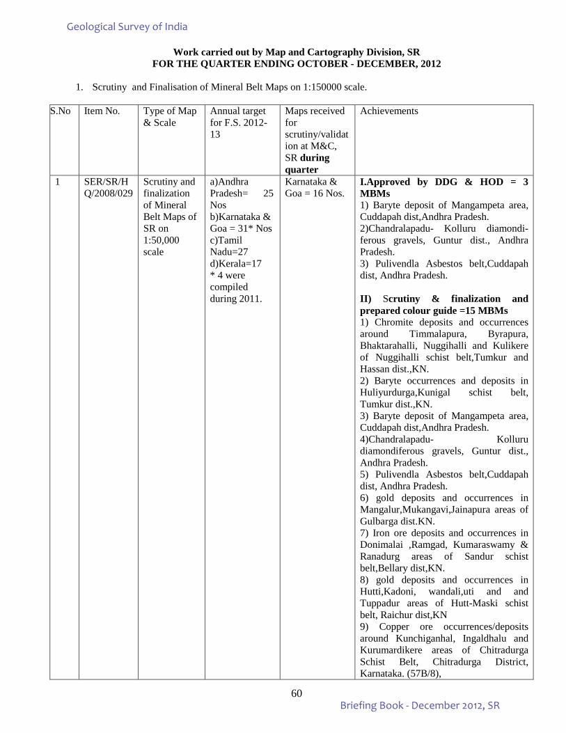
60
Work carried out by Map and Cartography Division, SR FOR THE QUARTER ENDING OCTOBER - DECEMBER, 2012
1. Scrutiny and Finalisation of Mineral Belt Maps on 1:150000 scale.
S.No Item No. Type of Map & Scale
Annual target for F.S. 2012-13
Maps received for scrutiny/validation at M&C, SR during quarter
Achievements
1 SER/SR/HQ/2008/029
Scrutiny and finalization of Mineral Belt Maps of SR on 1:50,000 scale
a)Andhra Pradesh= 25 Nos b)Karnataka & Goa = 31* Nos c)Tamil Nadu=27 d)Kerala=17 * 4 were compiled during 2011.
Karnataka & Goa = 16 Nos.
I.Approved by DDG & HOD = 3 MBMs 1) Baryte deposit of Mangampeta area, Cuddapah dist,Andhra Pradesh. 2)Chandralapadu- Kolluru diamondi- ferous gravels, Guntur dist., Andhra Pradesh. 3) Pulivendla Asbestos belt,Cuddapah dist, Andhra Pradesh. II) Scrutiny & finalization and prepared colour guide =15 MBMs 1) Chromite deposits and occurrences around Timmalapura, Byrapura, Bhaktarahalli, Nuggihalli and Kulikere of Nuggihalli schist belt,Tumkur and Hassan dist.,KN. 2) Baryte occurrences and deposits in Huliyurdurga,Kunigal schist belt, Tumkur dist.,KN. 3) Baryte deposit of Mangampeta area, Cuddapah dist,Andhra Pradesh. 4)Chandralapadu- Kolluru diamondiferous gravels, Guntur dist., Andhra Pradesh. 5) Pulivendla Asbestos belt,Cuddapah dist, Andhra Pradesh. 6) gold deposits and occurrences in Mangalur,Mukangavi,Jainapura areas of Gulbarga dist.KN. 7) Iron ore deposits and occurrences in Donimalai ,Ramgad, Kumaraswamy & Ranadurg areas of Sandur schist belt,Bellary dist,KN. 8) gold deposits and occurrences in Hutti,Kadoni, wandali,uti and and Tuppadur areas of Hutt-Maski schist belt, Raichur dist,KN 9) Copper ore occurrences/deposits around Kunchiganhal, Ingaldhalu and Kurumardikere areas of Chitradurga Schist Belt, Chitradurga District, Karnataka. (57B/8),
Geological Survey of India
Briefing Book - December 2012, SR
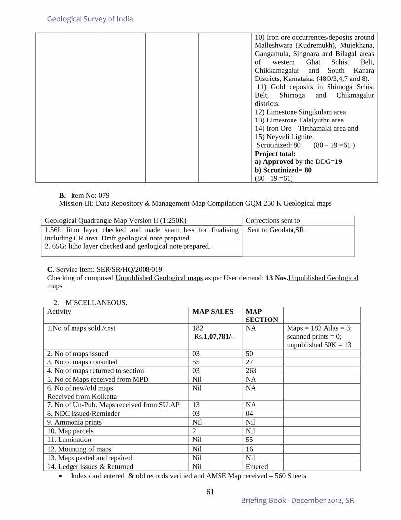
61
10) Iron ore occurrences/deposits around Malleshwara (Kudremukh), Mujekhana, Gangamula, Singnara and Bilagal areas of western Ghat Schist Belt, Chikkamagalur and South Kanara Districts, Karnataka. (48O/3,4,7 and 8). 11) Gold deposits in Shimoga Schist Belt, Shimoga and Chikmagalur districts. 12) Limestone Singikulam area 13) Limestone Talaiyuthu area 14) Iron Ore – Tirthamalai area and 15) Neyveli Lignite. Scrutinized: 80 (80 – 19 =61 ) Project total: a) Approved by the DDG=19 b) Scrutinized= 80 (80– 19 =61)
B. Item No: 079 Mission-III: Data Repository & Management-Map Compilation GQM 250 K Geological maps
Geological Quadrangle Map Version II (1:250K) Corrections sent to 1.56I: litho layer checked and made seam less for finalising including CR area. Draft geological note prepared. 2. 65G: litho layer checked and geological note prepared.
Sent to Geodata,SR.
C. Service Item: SER/SR/HQ/2008/019 Checking of composed Unpublished Geological maps as per User demand: 13 Nos.Unpublished Geological maps
2. MISCELLANEOUS. Activity MAP SALES MAP
SECTION
1.No of maps sold /cost 182 Rs.1,07,781/-
NA Maps = 182 Atlas = 3; scanned prints = 0; unpublished 50K = 13
2. No of maps issued 03 50 3. No of maps consulted 55 27 4. No of maps returned to section 03 263 5. No of Maps received from MPD Nil NA 6. No of new/old maps Received from Kolkotta
Nil NA
7. No of Un-Pub. Maps received from SU:AP 13 NA 8. NDC issued/Reminder 03 04 9. Ammonia prints NIl Nil 10. Map parcels 2 Nil 11. Lamination Nil 55 12. Mounting of maps Nil 16 13. Maps pasted and repaired Nil Nil 14. Ledger issues & Returned Nil Entered
• Index card entered & old records verified and AMSE Map received – 560 Sheets
Geological Survey of India
Briefing Book - December 2012, SR
62
Work carried out by Map Production Division, SR during the period OCTOBER - DECEMBER, 2012.
Geological Quadrangle Maps: (GQMs): Digital processing of the five maps, three unrestricted (63P, 65I and 72L) and two restricted (78D and 79A) sheets are completed and pre-print proofs were sent for scrutiny to M&C-I, Mission IIIB, CHQ and M&C, ER, Kolkata. All the corrections and modifications suggested in GQMs of 63P, 65I, 72L, 78D and 79A sheets were incorporated and fresh pre-print proofs were generated again and sent for finalisation to respective M&C divisions. Digital processing of 79B (restricted) is under progress. State Map Series: Digitisation of Geological and Mineral Map of Karnataka (1:500,000 scale) 2nd edition is completed and digital processing is under progress. Digitisation of Geological and Mineral Map of Jharkhand (1:500,000) is completed and pre-print proof (inkjet print) was sent to M&C, ER. District Resource Maps: Digital processing and modifications as per scrutiny of pre-print proof of DRMs of Hardoi (UP), Sitapur (UP) and Jammu (J&K) are completed and final copies are sent to M&C, NR, Lucknow, for further action. Geological Map of India (1:5 M, New Edition): Incorporation of the Misc. Pub. 30 map data pertaining CR, ER, SR, WR, NR & NER states in to digitally reduced 1:2M map published in 1998 is completed and further digital processing is in progress. Geological and Mineral Map of Gujarat, Diu & Daman (1:2M): Digital processing of this map pertaining to Misc. Publ. 30 of Gujarat, Diu & Daman is completed and MOD has cleared it for publication. Process for final printing by outsourcing is initiated and job order is placed for printing of 700 copies.
Technical Consultancy Services Division carried out the following activities from October, 2012 to December, 2012
1. The Internal Resource Generated during the period is as follows:
a) Total Internal Resource Generated ` 23,50,743.00 b) Total Service Tax Generated ` 2,72,053.00
2. Prepared the status of recovery of the consultancy charges and service tax from July – 2001 to December,2012. Raised revised bills for the recovery and also informed the same to the Director General, GSI.
3. Raised the Bills of Commercial Projects of Engineering Geology Division and Chemical Division, SR, for 2010-2012.
4. Reminders are also sent to the commercial projects taken up by Engineering Geology Division,SR, GSI, Hyderabad during the period October 2005 to December,2012 for the recovery of the raised charges.
5. During the period one unpublished progress reports are priced and sent for approval to the Director General, GSI.
6. Had discussions with the commercial parties regarding sponsored items and sold two unpublished progress reports.
(xiv) QUALITY MANAGEMENT: In GSI, SRO, the Regional Quality Management Cell is working meticulously for the improvement of quality of work of the Region. Every month end, the field progress is monitored and reviewed from the quality management point of view. Supervisory Officers forward the monthly QM data sheet in respect of each item everymonth with their comments to the State Quality Management Cell. The State Quality Management Cell in turn sends the data sheets to the Regional Mission Head. The Regional Mission Heads after their remark send the datasheets to the
Geological Survey of India
Briefing Book - December 2012, SR
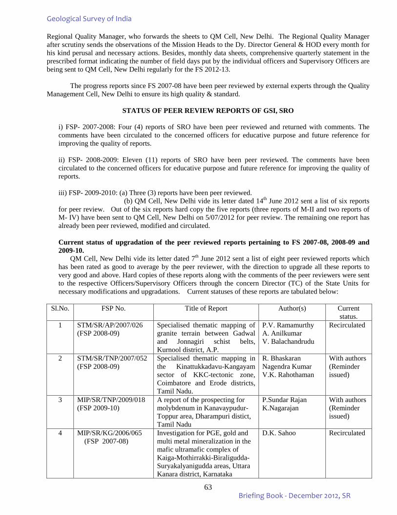
63
Regional Quality Manager, who forwards the sheets to QM Cell, New Delhi. The Regional Quality Manager after scrutiny sends the observations of the Mission Heads to the Dy. Director General & HOD every month for his kind perusal and necessary actions. Besides, monthly data sheets, comprehensive quarterly statement in the prescribed format indicating the number of field days put by the individual officers and Supervisory Officers are being sent to QM Cell, New Delhi regularly for the FS 2012-13. The progress reports since FS 2007-08 have been peer reviewed by external experts through the Quality Management Cell, New Delhi to ensure its high quality & standard.
STATUS OF PEER REVIEW REPORTS OF GSI, SRO i) FSP- 2007-2008: Four (4) reports of SRO have been peer reviewed and returned with comments. The comments have been circulated to the concerned officers for educative purpose and future reference for improving the quality of reports. ii) FSP- 2008-2009: Eleven (11) reports of SRO have been peer reviewed. The comments have been circulated to the concerned officers for educative purpose and future reference for improving the quality of reports. iii) FSP- 2009-2010: (a) Three (3) reports have been peer reviewed. (b) QM Cell, New Delhi vide its letter dated 14th June 2012 sent a list of six reports for peer review. Out of the six reports hard copy the five reports (three reports of M-II and two reports of M- IV) have been sent to QM Cell, New Delhi on 5/07/2012 for peer review. The remaining one report has already been peer reviewed, modified and circulated. Current status of upgradation of the peer reviewed reports pertaining to FS 2007-08, 2008-09 and 2009-10.
QM Cell, New Delhi vide its letter dated 7th June 2012 sent a list of eight peer reviewed reports which has been rated as good to average by the peer reviewer, with the direction to upgrade all these reports to very good and above. Hard copies of these reports along with the comments of the peer reviewers were sent to the respective Officers/Supervisory Officers through the concern Director (TC) of the State Units for necessary modifications and upgradations. Current statuses of these reports are tabulated below:
Sl.No. FSP No. Title of Report Author(s) Current
status. 1 STM/SR/AP/2007/026
(FSP 2008-09) Specialised thematic mapping of granite terrain between Gadwal and Jonnagiri schist belts, Kurnool district, A.P.
P.V. Ramamurthy A. Anilkumar V. Balachandrudu
Recirculated
2 STM/SR/TNP/2007/052 (FSP 2008-09)
Specialised thematic mapping in the Kinattukkadavu-Kangayam sector of KKC-tectonic zone, Coimbatore and Erode districts, Tamil Nadu.
R. Bhaskaran Nagendra Kumar V.K. Rahothaman
With authors (Reminder issued)
3 MIP/SR/TNP/2009/018 (FSP 2009-10)
A report of the prospecting for molybdenum in Kanavaypudur-Toppur area, Dharampuri distict, Tamil Nadu
P.Sundar Rajan K.Nagarajan
With authors (Reminder issued)
4 MIP/SR/KG/2006/065 (FSP 2007-08)
Investigation for PGE, gold and multi metal mineralization in the mafic ultramafic complex of Kaiga-Mothirrakki-Biraligudda-Suryakalyanigudda areas, Uttara Kanara district, Karnataka
D.K. Sahoo Recirculated
Geological Survey of India
Briefing Book - December 2012, SR
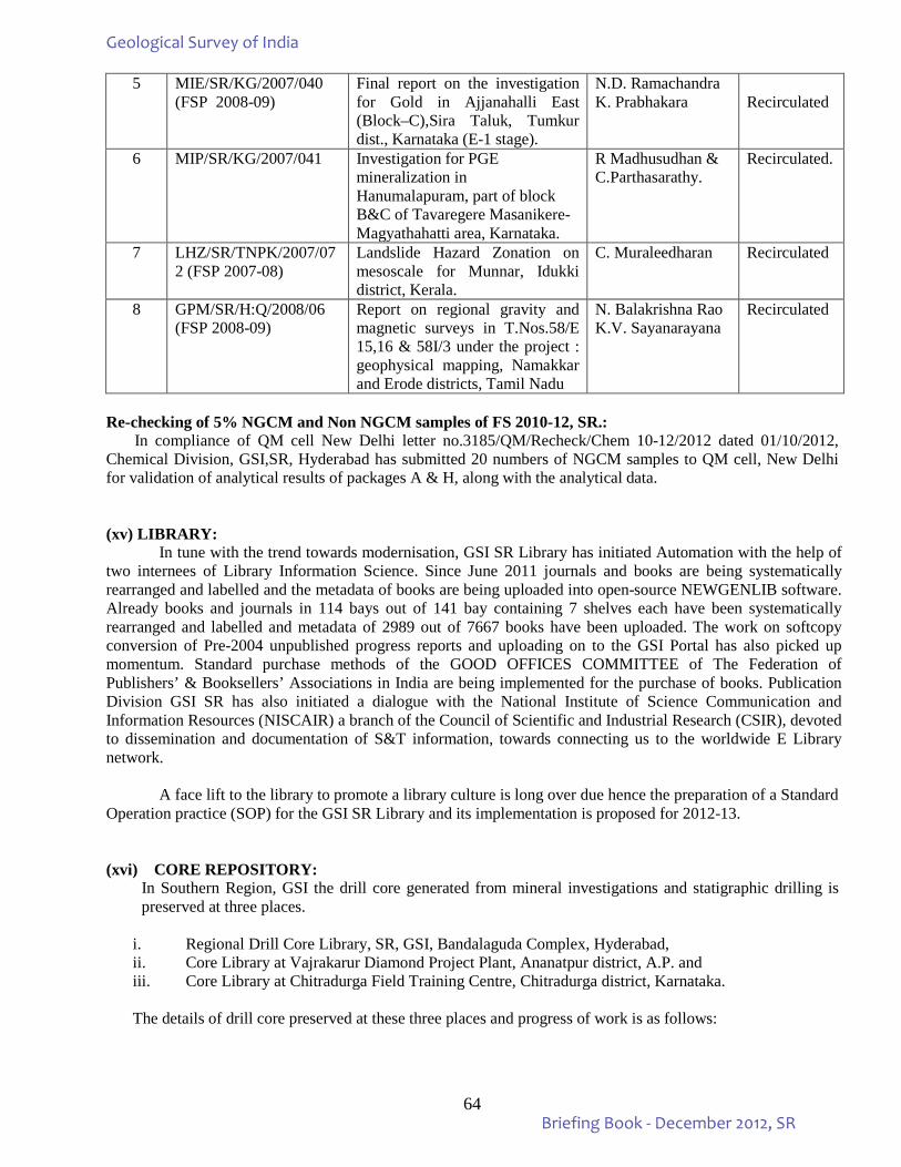
64
5 MIE/SR/KG/2007/040 (FSP 2008-09)
Final report on the investigation for Gold in Ajjanahalli East (Block–C),Sira Taluk, Tumkur dist., Karnataka (E-1 stage).
N.D. Ramachandra K. Prabhakara
Recirculated
6 MIP/SR/KG/2007/041 Investigation for PGE mineralization in Hanumalapuram, part of block B&C of Tavaregere Masanikere-Magyathahatti area, Karnataka.
R Madhusudhan & C.Parthasarathy.
Recirculated.
7 LHZ/SR/TNPK/2007/072 (FSP 2007-08)
Landslide Hazard Zonation on mesoscale for Munnar, Idukki district, Kerala.
C. Muraleedharan Recirculated
8 GPM/SR/H:Q/2008/06 (FSP 2008-09)
Report on regional gravity and magnetic surveys in T.Nos.58/E 15,16 & 58I/3 under the project : geophysical mapping, Namakkar and Erode districts, Tamil Nadu
N. Balakrishna Rao K.V. Sayanarayana
Recirculated
Re-checking of 5% NGCM and Non NGCM samples of FS 2010-12, SR.: In compliance of QM cell New Delhi letter no.3185/QM/Recheck/Chem 10-12/2012 dated 01/10/2012, Chemical Division, GSI,SR, Hyderabad has submitted 20 numbers of NGCM samples to QM cell, New Delhi for validation of analytical results of packages A & H, along with the analytical data. (xv) LIBRARY:
In tune with the trend towards modernisation, GSI SR Library has initiated Automation with the help of two internees of Library Information Science. Since June 2011 journals and books are being systematically rearranged and labelled and the metadata of books are being uploaded into open-source NEWGENLIB software. Already books and journals in 114 bays out of 141 bay containing 7 shelves each have been systematically rearranged and labelled and metadata of 2989 out of 7667 books have been uploaded. The work on softcopy conversion of Pre-2004 unpublished progress reports and uploading on to the GSI Portal has also picked up momentum. Standard purchase methods of the GOOD OFFICES COMMITTEE of The Federation of Publishers’ & Booksellers’ Associations in India are being implemented for the purchase of books. Publication Division GSI SR has also initiated a dialogue with the National Institute of Science Communication and Information Resources (NISCAIR) a branch of the Council of Scientific and Industrial Research (CSIR), devoted to dissemination and documentation of S&T information, towards connecting us to the worldwide E Library network.
A face lift to the library to promote a library culture is long over due hence the preparation of a Standard
Operation practice (SOP) for the GSI SR Library and its implementation is proposed for 2012-13. (xvi) CORE REPOSITORY:
In Southern Region, GSI the drill core generated from mineral investigations and statigraphic drilling is preserved at three places.
i. Regional Drill Core Library, SR, GSI, Bandalaguda Complex, Hyderabad, ii. Core Library at Vajrakarur Diamond Project Plant, Ananatpur district, A.P. and iii. Core Library at Chitradurga Field Training Centre, Chitradurga district, Karnataka. The details of drill core preserved at these three places and progress of work is as follows:
Geological Survey of India
Briefing Book - December 2012, SR
65
i. The Regional Drill Core Library at GSI Complex, Hyderabad. A total of 1973 core boxes for 265 nos. boreholes from 35 investigations carried out in the states of
Andhra Pradesh, Karnataka, Kerala and Tamil Nadu by Southern Region and the erstwhile AMSE Wing, GSI since 1975 have been preserved in the Regional Drill Core Library, Hyderabad. The cores preserved belong to investigations carried out for gold, limestone, molybdenum, copper, lead, zinc, platinoid group elements and clay investigations. Details of investigations for which the core is preserved are as follows:
1. Gold Investigations in Andhra Pradesh : a. Jonnagiri deep drilling, b. Dona North and South, c. Kottapalli blocks 2. Kerala Clay investigation a. Palai block 3. Kerala Gold investigations b. Naikerpadi, c. Mundayur, d. Pottupadi, e. Kallakeri, f. Puttumala blocks. 4. Tamil Nadu investigations a. Molybdenum of Dharampuri sector, b. Limestone of Ariyalur sector, c. Gold of Nilagiri sector d. Stratigraphic drilling of Kanchipuram sector, e. Limestone of Patti-Vriddhachalam sector. 5. AMSE Wing investigations a. Varrikunta & Karredukuppa areas, Cuddapah district, A.P. b. Ghantapuram-Rayavaram(Markapur area), Prakasam district, A.P. c. Padusalabhavi & Marripadu areas, Nellore district, A.P. d. Tippireddipalle block, Cuddapah district, A.P. e. Kadikengaebetta and Ramanahalli areas, Hassan district, Karnataka. f. Musturu area, Chitradurga district, Karnataka. g. Turuvanur and Kumabevu areas, Chitradurga district, Karnataka. h. Papanasi and Doni blocks, Dharwar district, Karnataka. i. Alladahalli (East block), Hassan district, Karnataka. j. Karimaranahalli block, Hasan district, Karnataka. k. Banasandra area, Tumkur district, Karnataka. l. Bellibetta block, Mandya district, Karnataka. m. Gaudikatte area, Davangere district, Karnataka. During the current field season 42 wooden drill core boxes for borehole AKT-1, FSP item Code No. MIE/SR/AP/2010/016, toposheet No. 57J/8, Exploration for gold in Tallakonda Block of Veligalu schist belt, Cuddapah dist., A.P., are received for preservation from state unit Andhra Pradesh GSI, Hyderabad. The core is being transferred in GI sheet boxes. Action is initiated for assembling 6 racks for storage of core. Procurement of 1000 number of GI sheet boxes is in progress. The Drill Core Library at Vajrakarur was visited and drill core for kimberlite investigations is identified for preservation in the Regional Drill Core library. Rearrangement of racks as per the plan approved by the Dy. Director General and HOD, Southern Region, GSI is in progress. All drill core coxes have been unloaded from the racks. The racks are re-arranged as per the approved plan and the core depth details in each box are written on body of the box after necessary measurements and data base for the core available borehole and box wise is being generated. The job of loading the core boxes in racks after writing depth details is in progress. The HOD, SR, GSI visited Regional drill Core Library in on 04.12.2012 and inspected the work being carried out and advised for future work. The Computer Application for digital storage of drill core data used in Regional drill Core Library, Central Region, GSI, Nagpur has been modified and it is being used for generating data base for the core preserved at Hyderabad. The action is initiated for procurement of a ladder, a trolley, racks for display of selected drill core and boards with stands for display of maps, borehole sections and data related to core preserved. The technical evaluation of samples of gavazised iron sheet core boxes received from suppliers has been carried out. ii. Core Library at Vajrakarur Diamond Project Plant, Ananatpur district, A.P.
GSI camp Wajrakarur has been maintaining a core library to store drill core recovered from various drilling programmes pertaining to Project: Diamond since 1998. The cores are mainly from Kimberlite lithologies and also a couple of core runs from Jonnagiri Schist Belt as part of Gold programmes. The total of 1,430.25 mts of drill core run from 5 kimberlites and 306.9 mts of cores from Jonnagiri Gold prospect are stored in the Wajrakarur drill core library.
Geological Survey of India
Briefing Book - December 2012, SR
66
iii. Core Library at Chitradurga Field Training Centre, Chitradurga district, Karnataka.
In Chitradurga FTC, presently the skeletonized and stratigraphic drill cores of about 165 boreholes drilled for gold, diamond, PGE and Iron Ore investigations have been kept in about 1110 GI core boxes. The drill cores belong to about 25 mineral investigations with a total preserved core length of about 4 km. Number of borehole cores of gold mineralization from the Hutti- Maski, Gadag, Shimoga, Chitradurga and Nuggihalli schist belts, Hanumalapura PGE investigation, Undraldoddi diamond investigation and Donimalai iron ore investigation have been preserved in the core library. Apart from the skeletonized mineralized cores a few borehole cores of hanumalapura, Donimalai and Ajjanahalli have been preserved in full for the purpose of study of stratigraphic/lithoassemblage and mineralization controls. The details of brief description of the area, summarized lithologs and sample details with values have been recorded and completion of computerizing the same is in progress. (xvii) GEOLOGICAL MUSEUM / ROCK GARDENS / GEOPARKS: Geological Museum:
The Geological Survey of India started its Southern Regional Office at Hyderabad during 1961. In the formative stages, a Geological Museum was established for housing specimens of rocks, minerals and fossils of geological importance, collected by the field officers.
In the year 1990, when GSI shifted to its own premises at Bandlaguda a Geological Museum was set up in the GSI Complex of Southern Region, Hyderabad. The museum was named after Dr. William King, a pioneering worker of GSI in 2004. It is housed in a quite elegant 14m x 23m single, 13m – high hall.
The museum has two sections, one dedicated to rocks, minerals and ores and other to fossils. The museum houses over 305 rocks and 235 mineral specimens collected from southern parts of the country representing the entire geololgical column. Rocks are displayed genesis-wise. Minerals are displayed separately as per mode of occurrence and industrial use. Approximately 103 specimens of dimensional stones/building stones are displayed as cut and polished slabs/blocks.
The Palaeontology section houses various plant and animal fossils. It contains vertebrate fossils, mainly of dinosaurus, collected from Godavari-Pranhita valley Andhra Pradesh and inveretebrate fossils, most importantly Ammonites, etc. A total of more than 163 vertebrate and invertebrate fossils along with 14 reptile models of different sizes are stored in the museum. Special mention may be made of the full-sized fossilized skeleton of Rhynocosaurus discovered in Gondwana Formations from Karimnagar district, Andhra Pradesh. GSI, SR has reconstructed a full sized dinosaur skeleton in Birla Science Museum, which is located in the Central part of Hyderabad and is visited by many people including tourists. The dinosaur was discovered in Yamanpalli area of Adilabad district, Andhra Pradesh.
The museum exhibits 29 paintings on the important events of the evolution and morphological features of earth and evolution of life, 17 maps and one globe. The major share of exhibits belongs to the characteristic rocks and minerals of the southern states (Andhra Pradesh, Tamil Nadu, Kerala, Karnataka and Goa). Some samples from other states and a few foreign specimens are also housed.
GSI, SR has a ‘Parks & Museums’ division. As per the HPC recommendations, National level
museums have to be established in Chennai, Bengaluru & Hyderabad along with State level museums in Goa, Kerala and Puducherry. In Chennai there is a museum which has a geology gallery. There is a need to enhance / enrich the state galleries with geological samples / exhibits. All the State Units have identified nodal officers to interact with the State Governments to indicate the role of GSI to enrich / establish National level as well as State level museums as per the HPC recommendations.
Geological Survey of India
Briefing Book - December 2012, SR
67
Work carried out upto December, 2012: • Preparation and designing of new label stands with coloured display for exhibits of GSI Museum,
Hyderabad in connection with proposed visit of Secretary to GoI, MoM in GSI, SR, Hyderabad on 1st January, 2013
• Systematic arrangements of all the exhibits of GSI Museum, Hyderabad.
Rock Garden: In commemoration of 150 years of service to the nation by Geological Survey of India, a rock garden was established in 2001, adjacent to geological museum. The rock garden exhibits large sized rock specimens from different parts of Southern India. The map boundaries of southern states of India in 1; 250K scale has been created in the rock garden on which the rocks are displayed according to their respectrive geographical position as such. At least, 50 numbers of large sized rock and fossil specimens are kept as exhibits and arranged vide geological ages, representing various geological domains of southern India in the field. Noteworthy of them is the “Cuddapah column” which represents the sedimentary succession called Cuddapah Super Group (exposed in Cuddapah, Kurnool and Guntur districts of A.P) depecting the order of super position of different sedimentary formations age wise. The conglomerate of the Banganapalli Formation within the Cuddapah Super Group of rocks is known for the incidence of diamond. The exihibits of the museum in rock garden create curiosity and awareness on earth science to all from general mass to scholars. It attracts wide spectrum of visitors from students of school/colleges/research scholars/professionals and amateur geologist from National and international institutions of repute. The data and specimens of rock garden are always updated with new collections. Rashtrapati Bhawan Rock Garden:
All the State Units of Tamil Nadu, Kerala, Karnataka & Andhra Pradesh were informed regarding the requirements for Rashtrapati Bhawan Rock Garden and requested to send Photographs of rock sample having explicit, exotic and attractive morphological features. Out of more than 100no rock photos, 52 nos. were selected for collection of rock samples (6” x 6” size) from the field. Ultimately, 22no rock samples from Andhra Pradesh, 13no from Karnataka, 8no from Kerala and 9no from Tamil Nadu were collected and kept in the Museum of the Hyderabad Office with proper labels. However, ultimately 26 nos from Southern Region are zeroed in for dispatch to DGCO, Delhi after thorough examination for the Rashtrapati Bhawan Rock Garden. At present, the status is that 20 samples comprising 3 samples from Kerala, 4 samples from TNP, 3 samples from Karnataka and 10 rock samples collected from AP have been dispatched and delivered to the DGCO office, New Delhi by 31st March, 2012. Geoparks: It is decided to develop all National Geological Monuments in India into a Geopark following the norms of UNESCO. GSI is the custodian of 26 National Geological Monuments. There are 11 numbers of National Geological Monuments in Southern Region, as given below: 1. Nagari Quartzite ridge (Natural arch), Tirumala hills, Andhra Pradesh 2. Eparchaean Unconformity, Tirumala, Tirupati Rd., Andhra Pradesh 3. Baryte Beds, Mangampeta, Andhra Pradesh 4. Peninsular Gneiss, Lalbagh, Bangaluru, Karnataka 5. Columnar Volcanics (Rhyolites and Rhyodacites), Coconut Island, Udupi dist., Karnataka. 6. Pillow Lava, Maradihalli, Chitradurga dist., Karnataka 7. Pyroclastic Rocks, Pedapalli, Kolar dist., Karnataka 8. Charnockite Monument, St. Thomas mount, Chennai, Tamil Nadu. 9. Fossil Wood Park, Sattanur, Perambalur, Tamil Nadu 10. Fossil Wood Park, Tirruvakkarai, Villupuram dist., near Puduchhery, Tamil Nadu 11. Laterrite Monument, Angadippuram, Malappuram dist., Kerala.
Geological Survey of India
Briefing Book - December 2012, SR
68
All State Units had already been requested to send a status note on the National Geological Monuments and the Geoparks of their respective states to develop all National Geological Monuments in SR into Geoparks following the norms of UNESCO. • Designing and Finalization for printing of brochure on “National Geological Monuments of India, Region
South” on Geotourism • Designing and Preparation of Rock Garden backlit flex in connection with proposed visit of Secretary to
GoI, MoM in GSI, SR, Hyderabad on 1st January, 2013 • Writing of nomenclature of all exhibits in GSI Rock Garden, Hyderabad
• It was decided to develop all National Geological Monuments in India into Geoparks following the norms of UNESCO. There are 11 National Geological Monuments in Southern Region.
• Two new Geoparks in SR viz., Varkala Geopark and Karai Badlands as ‘National Cretaceous Fossil Park’ have been proposed for consideration. The Feasibility of declaring those sites as NGM has been prepared & submitted.
Support Systems:
Preparation of ppt presentation of Achievements of Park & Museum and submitted to the DDG & HoD, SR Preparation of poster, banners regarding various activities of GSI in connection with proposed visit of Secretary to GoI, MoM in GSI, SR, Hyderabad
GSI Museum-Rock Garden visit During the period 270 students of 5 Engineering Colleges from AP and Maharastra visited the GSI Museum and Rock Garden, Hyderabad.
Publicity Publication of an article regarding addition of one new sample (Volcanic Ash: collected from Quaternaries of Pampa River Basin, Gavarampeta, East Godavari dist, AP) as exhibits in GSI Museum, Hyderabad in E-Nadu (Telugu Newspaper) on 05.10.2012
F. MAJOR ACHIEVEMENTS AND MILESTONES: • Coverage of 6, 28, 597 sq.km. out of total area of 6,41,707 sq.km of Southern Region by geological
mapping on 1:50,000/63,360 scale covering both hard rock and quaternary areas. • A total area of 99,793 sq.km covered in geologically critical areas of Southern Region on large scale
(1:25,000) under Specialised Thematic Mapping including structure, stratigraphy, etc. • Geophysical Mapping (GPM) carried out in 69,981 sq,km on 1:50,000 scale. • Geochemical Mapping (GCM) carried out in 49,131 sq.km on 1:50,000 scale • Publication of Geological Quadrangle Maps • Publication of Mineral Belt Maps. • Publication of District Resource Maps (DRM). • Technical Advice rendered to Nuclear Power Corporation for Kaiga Nuclear Power Plant • Technical advice rendered to Karnataka Power Corporation for Kudigi Plant • Engineering Geological service to Irrigation Departments Govt. of Andhra Pradesh, Karnataka, Tamil
Nadu through sponsored field programmes for building reservoirs, dams, tunnels etc. • Building repository of Information on Landslides and providing information to the Nodal Agencies at
GSI, New Delhi. • Southern Region Core Library is under revamp on modern lines for consultation and study by interested
parties/ professionals.
Geological Survey of India
Briefing Book - December 2012, SR
69
G. SIGNIFICANT MINERAL RESOURCE ASSESSMENT: Concerted efforts in the field of mineral exploration have paid positive result in the form of proving
additional resources and identifying several promising mineral prospects in recent years by Geological Survey of India, SR. An important location of major mineral deposits/promising prospects; their geological settings and estimated reserves are described below in brief:
1. Gold: In Andhra Pradesh:
• 9.841 m.t of gold ore with a grade in the range of 1.16 to 31.29 g/t of Au in Dona sector of Jonnagiri area.
• 0.115 m.t with an average grade of 2.65 g/t in Kattapalle block. • 3.47 m.t. with a grade in the range of 4.00 to 6.22 g/t in Chigaragunta area, South Kolar schist belt. • 0.65 m.t with an average grade of 4.30 g/t in Mallappakonda
In Karnataka: Gold deposits explored by G.S.I in different blocks in the schist belts of Karnataka are i) Hutti-Maski Schist
belt (Uti, Wandalli, Hira-Buddini, Kadoni, Chinchergi Blocks) ii) Gadag Schist Belt (Hosur-Champion, Sangli mine, Mysore mine, Kabuliyatkatti North, Nagavi Blocks) iii) Chitradurga Schist Belt (Ajjanahalli Main Ajjanahalli West and G. R. Halli Blocks) iv) Nuggihalli Schist Belt (Kempinkote Block) v) Shimoga Schist Belt (Chinmulgund Block). A total of 15.915 m.t. of reserve having grade upto 23.20 g/t Au is estimated for these blocks. Gold resources in some of these blocks are given below:
• 1.5 m.t of gold ore with an average grade of 3.00 g/t in Chinmalgund area of Shimoga schist belt, Dharwar District, Karnataka.
• 0.54 m.t with a grade of 11.95 to 16.16 g/t in Hira-Buddini block of Hutti—Maski schist belt. • 0.089 m.t with an average grade of 3.92 g/t in Tuppadhur blockof Hutti-Massi schist belt. • 0.60 m.tg with an average grade of 4 g/t in G.R. block of Chitradurga Schist Belt, Chidradurga District. In the Ajjanahalli Block –A the following estimates of gold ore were made: • At 0.5 g/t cut off grade with average width of 1.83 m with a tonnage of 5,80,337 m.t. with a grade of
1.76 g/t. • At 1 g/t cut off grade with an average width of 1.93 m with a tonnage of 3,11,435 m.t. with a grade of
2.40 g/t. • At 2 g/t cut off grade with an average width of 1.83 m for a tonnage of 1,53,064 m.t. with a grade of
3.50 g/t. In Ajjanahalli Block – B the following estimates of gold ore have been made: • At 0.5 g/t cut off grade with average width of 1.92 m with a tonnage of 3,65,962 m.t. with a grade of
1.35 g/t. • At 1 g/t cut off grade with an average width of 1.71 m with a tonnage of 1,27,528 m.t. with a grade of
2.71 g/t.
In Kerala: • Primary gold 0.77 m t is associated with epigenetic quartz veins emplaced into weak planes of the
country rock in Malappuram district, Kerala. • Placer gold 1993 kg (metal) occurs in association with heavy minerals in stream and river
channels draining primary gold-bearing terrains in Palakkad district, Kerala.
2. Diamond: In Andhra Pradesh:
• Surveys carried at in search of Kimberlites has resulted in locating 21 kimberlite bodies in Wajrakarur field of Anatapur district and 36 bodies in the Narayanpet field in the western part of Mahabubnagar district in AP and adjoining Gulbarga district of Karnataka – the Raichur field in Raichur district and adjoining Mahabubnagar district in AP hold 5 bodies.
• In recent years, processing of bulk samples of 2000 tonnes collected from Anumpalle Dibbasani, Gollapalle at Wajrakarur plant has yielded 81 diamonds weighting 20.74 carats.
Geological Survey of India
Briefing Book - December 2012, SR
70
In Karnataka: An area of 5043 sq km of area in Gulbarga, Raichur and Bellary districts have been surveyed for Kimberlite and 14 Kimberlite bodies (10 in Gulbarga and 4 in Raichur district) have been identified. Out of these, one in Raichur district is proved to be diamondiferous. 3. Iron Ore In Karnataka: Major iron ore deposits are spread over Bellary, North Kanara, Chickmagalur, Shimoga, Chitradurga and Tumkur districts. Reserves of 2784 million tonnes of magnetite and 1072 million tonnes of haematite have been estimated. Sizeable Iron ore resources have been estimated in the free hold areas in NMDC Block in Sandur Schist Belt, Bellary district. These resources, estimated for two banded haematite chert bands for a strike length of 1470 and 620 m (total length 2.09 km) with an average width of 25-30 m. include:
• 82,05,513 tonnes with a grade of 57.37% of Fe(t) at 45% cut off • 71,32,299 tonnes with a grade of 59.55% of Fe(t) at 50% cut off and • 57, 17,634 tonnes with a grade of 61.40% of Fe (t) at 55% cut off.
In Goa: Iron and manganese ore deposits are reported along a 95 km long NW-SE trending belt extending from Saliginim to Noibaga. The iron ore deposits consist of essentially haematite and partially magnetite, limonite and goethite. The iron ore bodies are massive, bedded, platy, brecciated, earthy laminated (biscuity) concretionary and powdery (blue dust) in nature. The important deposits in North Goa found areund Bicholim, Sanquelim, Velguem and Palle. In situ reserves of 1061 million tonnes of haematite ore with 62.62% Fe and 144 million tonnes of low grade magnetite ore with 35.91% Fe have been established in North Goa where as a total of 680 million tonnes of ores of all grades are estimated in South Goa. Large resources of low grade magnetite ore with 25-40% Fe content are available in the Dhave-Sonal area. In Tamilnadu: A resource of over 500 million tonnes with an average grade of 38% Fe is estimated for the major magnetite quartzite bands occurring in Salem, Vellore, Tiruvannamalai, Vilupuram, Dharmapuri, Tiruchirapalli, Namakkal and Perambalur Districts. In Kerala 100 mt of iron ore occurring as banded magnetite quartzite (quartz-magnetite grunerite) associated with charnockite and peninsular gneissic complex in Kozhikode & Malappuram districts in Kerala. 4. Lignite In Tamilnadu: GSI has established a 130 x 5-150 km. lignite belt between Mannargudi in the south to Bahur (Puducherry) in the north. Neyveli Lignite Corporation Ltd. Currently exploits parts of this belt. 5. Limestone In Karnataka Sizeable reserves of cement grade limestone and dolomite are present in parts of Belgaum and Bijapur districts. Besides, crystalline limestone is also found in parts of Tumkur, Chitradurga and Belgaum districts. The total proved limestones of all grades in the state are about 694 million tones
In Goa: Magnesium rich crystalline limestone containing CaO 33%, MgO 12.8%, with a few cement grade zones is reported from Ivore khurd in the west to Derodem in the east and in the Surla Ghat. The band extends over a strike length of about 20 km and is about 50 m thick. The estimated reserves of all grades of limestone are about 80 million tonnes.
Geological Survey of India
Briefing Book - December 2012, SR
71
In Tamil Nadu Geological Survey of India has established about 670 mt. of limestone in the state. A number of cement industries are functioning based on these resources. An additional resource of 96.49 mt. of marginal to cement grade limestone has been established recently in Cuddalore district. In Kerala 12 mt of crystalline limestone associated with calc-granulites of the Khondalite Group in Palakkad district, Kerala.
6. Bauxite In Karnataka Bauxite occurs in Khanapur taluk, Belgaum district, Coondapur & Baindoor in South Kanara district, Kumta, Honavar and Bhatkal in North Kanara district, Guppripare, Nagarkalpare and Dodhara in Bababudan giri hill ranges. A total reserve of 27.42 million tonnes of bauxite has been estimated in the entire region of Karnataka. In Goa: Bauxite occurs in the plateau areas of Goa around Mopa, Pernem, Morgim, Ibrampur, Dargalim, Koragaon, Consua, Quelossim, Betul, Palolem and Galgibaga. The recoverable reserve estimated is 28.09 million tonnes. In Kerala 15.75 mt of bauxite, formed by insitu weathering of Arachaean crystalline rocks and Warkali sedimentary rocks was found as patches within laterite capping. The change is gradational from laterite to aluminous laterite to bauxite in Thiruvananthapuram, Kollam, Kannur m &Kasaragod districts in Kerala. 7. Molybdenum In Tamil Nadu
• 4.90 m.t with an average grade of 0.078% Mo at the cut-off of 0.01% Mo in Velampatti South Block of Harur-Uttangarai Belt, Tamil Nadu.
• 0.484 m.t with an average grade of 0.11% Mo in Marudipatti Central Block of Harur - Uttangarai Belt, Tamil Nadu.
8. Chromite In Karnataka: Chromite deposits are found around Tagadur, Byraour, Jambur, Aladahalli and Kadakola in parts of Mysore and Hassan districts. Around 1.5 million tonnes of recoverable reserves of chromite has been established. 9. Graphite In Tamil Nadu About 0.5 million tonnes of graphite resource with 15% FC has been estimated in the Sivaganga Graphite Belt. GSI has recently established an additional 0.72 mt. graphite with 13% FC in the hitherto unexplored parts. Government and private entrepreneurs currently exploit this deposit. 10. Manganese In Karnataka: Karnataka has the second largest recoverable reserves of manganese ores in India and has reserve to the extent of 4.10 million tonnes. Sizeable deposits are found in Kanvihalli, Deogiri- Subbrayanahalli in Bellary district, Kumsi and Tarkebail in north Kanara district and Dodaguni and Chikkanayakanahalli in Tumkur district. In Goa Manganese ore deposits of Goa are lateritoid type and found at or near the surface, in areas occupied by Fe-Mn phyllites. They occur as irregular lensoid bodies and pockets of varying dimensions. The deposits comprise laterite at the surface with concretions of black coloured iron and manganese ores followed at depth by bouldery manganese ore and then by manganiferous clay called ‘Wad’. The ore minerals are mainly pyrolusite,
Geological Survey of India
Briefing Book - December 2012, SR
72
psilomelane and partly cryptomelane, biannite and manganite. The grade of ore ranges from metallurgical to black iron ore with total Fe+Mn content of 42-45%. The iron content varies inversely with manganese in general. All deposits of economic significance are confined to the southern part of Goa viz., Rivona, Canvorem, Salginim, Verlem, Columba, Netrolim, Muriem, Pirla and Cosmor areas. 11. Magnesite In Tamil Nadu The most prominent deposit of magnesite in Tamilnadu is located on Chalk Hills, Salem district. The total reserves in the Chalk Hills are estimated at 44 million tonnes. 12. Clay: In Kerala:
• 24 mt of China clay. Primary and sedimentary clay are associated with Tertiary Warkali Formation, underlying Archaean crystalline rocks in Palai Block, Nileswaram, & Kasaragod districts, Kerala
• 3000 mt of China clay. Insitu kaolinisation of upper part of feldspar rich Archaean rocks produced thick deposits of primary clay. Sedimentary clays are bedded deposits associated with the Warkalli Formation in Thiruvananthapuram, Kollam, Kannur, & Kasaragod districts, Kerala.
In Goa: Small and lenticular deposits of clay are recorded at Camarconda, Concem and Befora in Ponda taluk, Kakora in Quepem taluk and Colvale in Bardez taluk. The Camarconda (south) and Kakora (north) deposits constitute high grade refractory material. Reserves of about 0.164 million tonnes of washed clay have been estimated.
13. Dimension stone In Andhra Pradesh:
• 13.628 million cubic meters of ‘black granite’ and 182.0226 million cubic meters of varieties of multi-coloured granites in Prakasam, Kurnool, Vizianagaram and Mahabubnagar districts.
In Karnataka: Karnataka occupies a prominent position in producing variety of quality stones to cater to the external and domestic demands. Ilkal red/ chilly red (granite), Chamarajanagar black (dolerite with clouded felspars), flaggy limestones (marketed in the name of Shahabad Slabs) are some of the commercial types of dimension/ ornamental stones exploited from different parts of the state. Sizable deposits of dimensional stones have been established which include:
• 500 million Cu.m of black granite in Hassan, Chickmagalur Districts • 1500 million Cu.m of other varieties in Bangalore, Tumkur, Kolar and Gulbarga district
In Tamil Nadu:
• 29.398 million cubic meters in Madurai, Dharmapuri, Villupuram, Thiruchirapalli, Virudunagar, Dindugal, Tiruvannamalai, Vellore, Kanya Kumari districts.
In Kerala: 42,571 cubic meters in Kerala. 14. Miscellaneous minerals: In Goa Silica Sand deposits of considerable magnitude are reported along the coast of Goa. The important deposits are: (1) Calanguta, Baga sector extending from Agoada in the south to Baga in the north and (2) Betul, Pali sector extending from Betul in the south to Pali in the north. The chemical analysis shows SiO2 93.20-96.48%, Fe2O3 0.53-1.67%, Al2O3 0.21-2.08% and TiO2 0.11-1.20%. The estimated recoverable re serves are 17.02 million tonnes.
Geological Survey of India
Briefing Book - December 2012, SR
73
In Kerala Glass Sand, 41.6 mt, associated with palaeo-beach ridges in Alappuzha district, Kerala. Heavy Mineral Sand 163 mt. The concentration of heavy minerals in the beach sands is higher towards south of Kayamkulam in Kerala coast.
In Tamil Nadu Sizeable concentrations of heavy minerals which include ilmenite, rutile, monazite and garnet occur in the beach sands of Kanyakumari, Tuticorin and Nagapattinam districts. Indian Rare Earths Lt. Currently exploits the occurrence in Kanyakumari district. H. ASSISTANCE TO STATE GOVERNMENT AND OTHER AGENCIES:
GSI is open for all sort of collaboration and assistance to the State Governments, Universities and other agencies including private companies and firms for the advancement and propagation of Geoscience.
GSI renders assistance to the State Directorates of Mines and Geology and to the Ministry of Irrigation
and Power as and when required. It has also provided necessary information to multi national companies in supplying all available data as desired by them. It has also undertaken several investigations on sponsorship basis for state and central government undertakings of which Project: Jaladhatri is an excellent example.
Project: Jaladhatri is World Bank funded, sponsored item of Ground Water Department, Government of Andhra Pradesh which envisages generation of digital data sets in GIS mode on 12 themes (geology, geomorphology and structure, land use, soil, culture, topographic and administrative themes) for the State of Andhra Pradesh (2,86,000 sq. kms.) spread over nearly 462 toposheets on 1:50,000 scale. This work has been completed by GSI in association with Survey of India.This 12 layer digital thematic data is a powerful tool for earth scientists/ administrators/planners/developers in the development of the State of Andhra Pradesh in ground water, natural resources, forest wealth, disaster mitigation and in sustainable general development of the state.
In the state of Karnataka GSI has undertaken several investigations which include:
(a) Construction of dams of Goa and bridge across Mandori River. (b) Foundation studies for LCA aircraft for ADA. (c) Slope stability studies at Cabo Hills, Raj Bhavan, Panaji. (d) Protection of Dattapeetha Cave, Chickmagalur district, Karnataka. (e) Stability analysis on the Railway Lines SWR, Karnataka. (f) Technical support and investigations of landslides upon district authoritis request.
During the FS 2012-13, several field items including State Government sponsored geotechnical investigations, landslide and seismic studies have been taken up by GSI, SR. Certain mineral investigation items have also been undertaken at the instance of State Governments. The mineral investigation items taken up at the request of State Government / other agencies during the field season 2012-13 are as follows:
1. Investigation for limestone resources in the area between Machela – Rentachintala – Gurajala, Guntur district, AP – linked with SGPB / State Govt. of AP.
2. Exploration for limestone resources in the area between Pulipadu and Gurajala, Guntur district, AP – linked with SGPB / Stage Govt. of AP.
3. Preliminary investigation for Baryte around Gadisankapura area (Hungund-Kushtagi schist belt) Bagalkot district, Karnataka – linked with CGPB / State Govt. of Karnataka.
4. Investigation for clay minerals with special reference to Bentonite in coastal area of Udupi district, Karnataka – linked with CGPB / State Govt. of Karnataka.
5. Exploration for PGE by drilling in Tasampalaiyam block in Sittampundi anorthosite complex of Tamilnadu – linked with TAMIN, State Govt. of Tamilnadu.
6. Detailed exploration for Molybdenum in Vellampatti South Block, Harur-Uttangarai molybdenum belt, Dharmapuri district, Tamilnadu – linked with TAMIN, State Govt. of Tamilnadu.
Geological Survey of India
Briefing Book - December 2012, SR
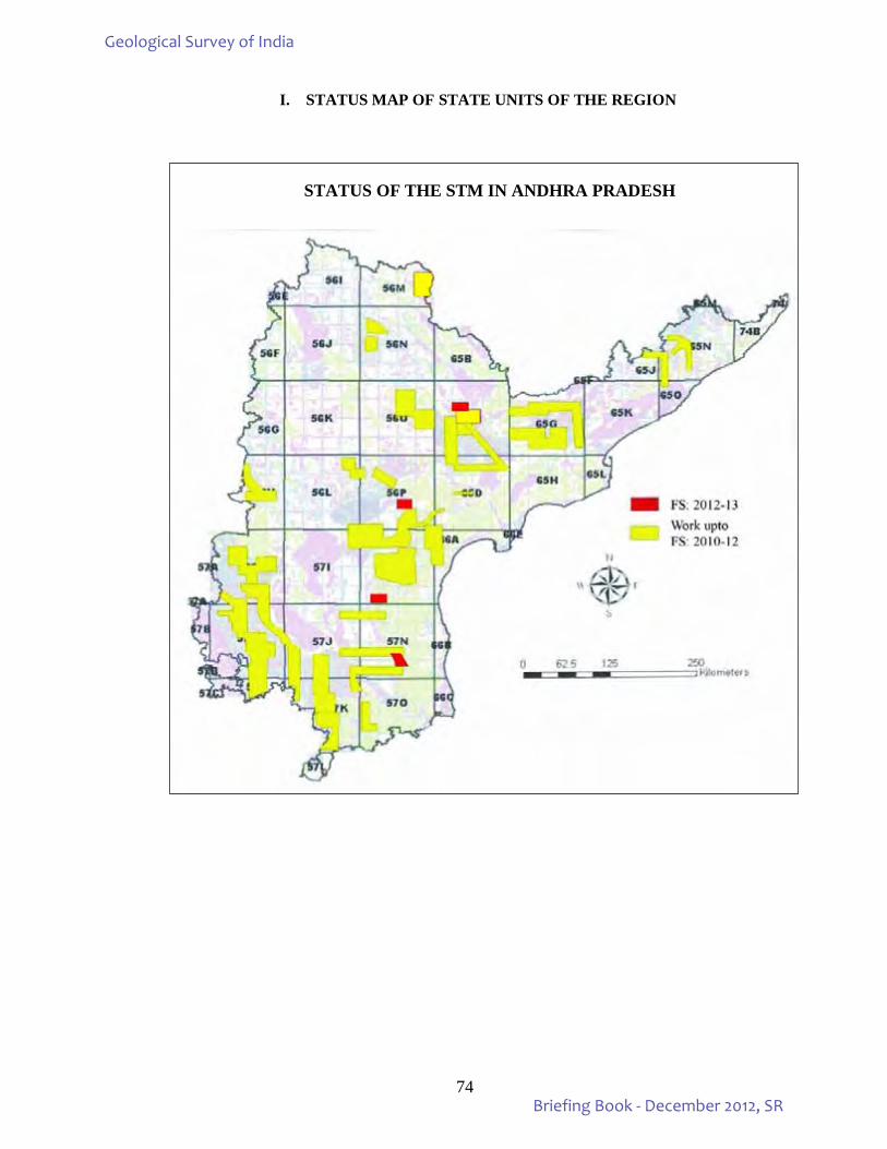
74
I. STATUS MAP OF STATE UNITS OF THE REGION
STATUS OF THE STM IN ANDHRA PRADESH
Geological Survey of India
Briefing Book - December 2012, SR
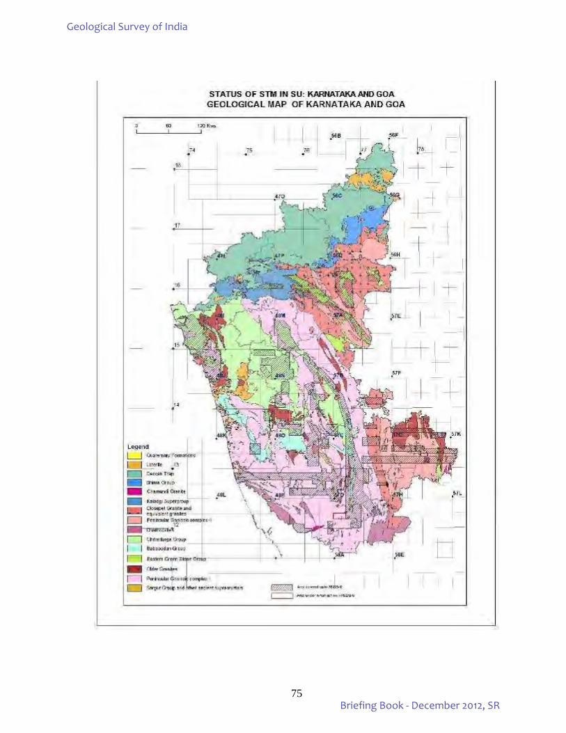
75
Geological Survey of India
Briefing Book - December 2012, SR
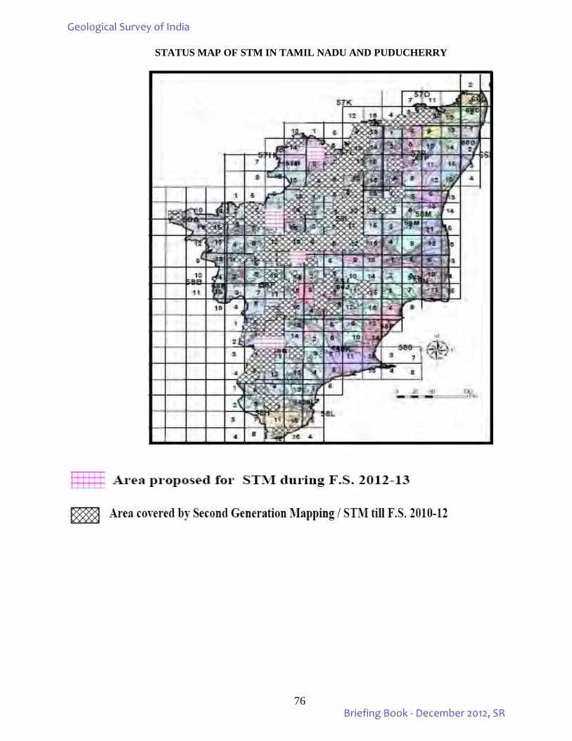
76
STATUS MAP OF STM IN TAMIL NADU AND PUDUCHERRY
Geological Survey of India
Briefing Book - December 2012, SR
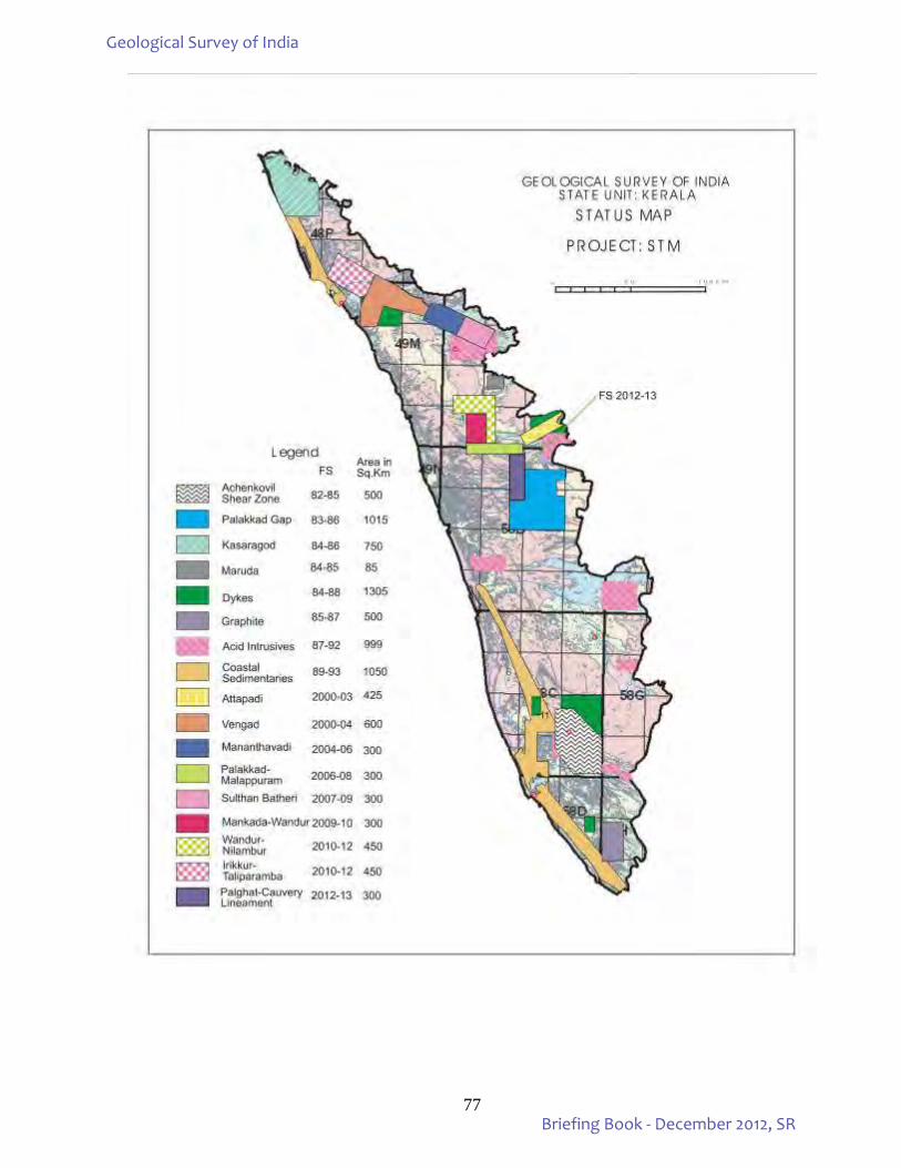
77
Geological Survey of India
Briefing Book - December 2012, SR
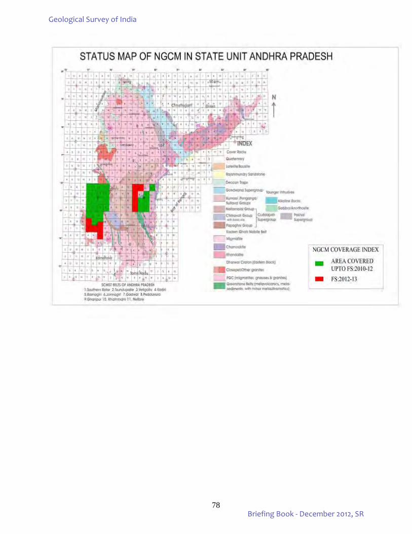
78
Geological Survey of India
Briefing Book - December 2012, SR
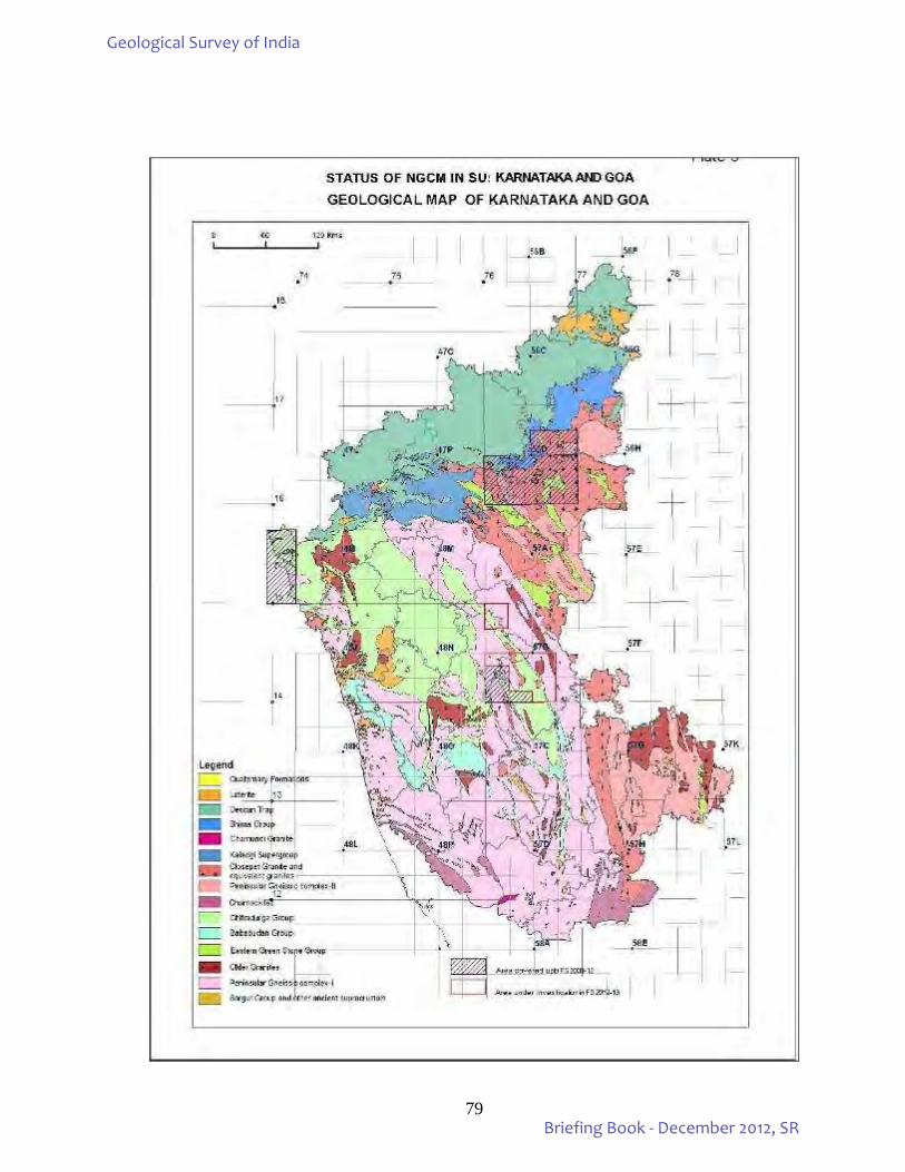
79
Geological Survey of India
Briefing Book - December 2012, SR
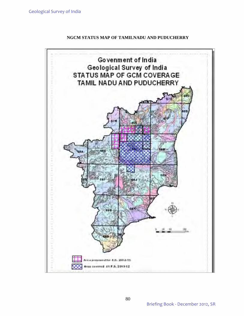
80
NGCM STATUS MAP OF TAMILNADU AND PUDUCHERRY
Geological Survey of India
Briefing Book - December 2012, SR
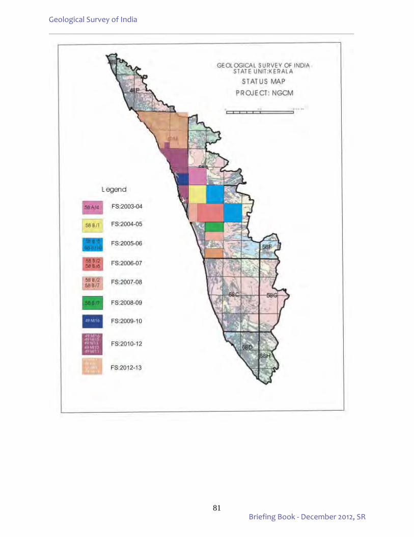
81
Geological Survey of India
Briefing Book - December 2012, SR
82
4. XI & XII PLAN WORK ENVISAGED FOR GSI, SR: Works carried out by Southern Region (pertaining to Mission – I & II) during the XI Plan period with
details on the targets and achievements for the first three field seasons of the XI plan and fourth extended field season: 2010-12 as well as for the 1st, 2nd & 3rd quarters of the Field Season 2012-13 under XII Plan including the State Units: A.P, Karnataka & Goa, TN & Puducherry and Kerala beside Geophysics Division, SR are given in Annexure - 2A. 5. FINANCIAL PERFORMANCE UNDER CURRENT PLAN, GSI, SR: Financial outlay during XI Plan Period is given in Annexure–3A. Scheme-wise, quarter-wise distribution of approved plan funds and actual expenditure for the years 2011-12 & 2012-13 are given in Annexures-3B. Scheme-wise, month-wise distribution of approved plan funds and actual expenditure for 2011-12 & 2012-13 are given in Annexures-3C. 6. FSP WORK (FS 2012-13):
The current field season programme has been formulated in tune with the departmental priorities as per the XII plan document, taking into consideration the recommendations of the State Geological Programming Boards and the decisions taken by the SRC and Term Review committees with the final approval of the Central Geological Programming board.
Under Mission-I, 11 STM items and 30 GCM items are under excecution. One geomorphological and lineament mapping item under PGRS Division, 3 items of Regional Gravity and Magnetic (TF) Surveys under project Geophysical Mapping besides 17 items of Marine and Coastal Surveys are being carried out during F.S.2012-13. Under Mission–II, as many as 30 mineral investigations besides one service item of maintenance of Diamond Processing Plant at Wajrakarur, Anantapur district, AP have been taken up during F.S.:2012-13. Out of this, 7 investigations are for PGE, 4 for gold, 4 for diamond, 2 for limestone, 1 each for copper / basemetal, one each for chromite, REE, manganese, baryte, bentonite, phosphorite, molybdenum besides 3 for coal and 1 for lignite. State wise the break up is 13 items in Andhra Pradesh (1 gold, 2 diamond, 1 PGE, 2 limestone, 1 chromite, 1 copper, 1 REE and 1 phosphorite, besides, 3 coal items), 8 items in Karnataka (3 gold, 2 diamond, 1 manganese, 1 baryte and 1 bentonite), 7 items in Tamil Nadu (5 PGE and 1 molybdenum, besides one item of lignite), 2 items are in Kerala one each for PGE and basemetal mineralisation. All the investigations are under G-4 stage except 6 items which are under G3 stage. Under Mission-III, 32 items under Geodata, Geoinformatics, Map & Cartography, Publication and Information Division of SR, HQ and SUs including 7 service items pertaining to Headquarter Divisions, State Units, M&CSD and Geophysics Divisions have been taken up during FS 2012-13. Under Mission –IV, a total of 32 items encompassing geotechnical investigations and water resource development projects under Engineering Geology, Earthquake Geology and Landslide investigations, petrology, palaeontology and PPOD are being carried out in Southern Region during the current field season. Under Mission – V, 12 training programmes have been envisaged under Regional Training Institute, SR to be conducted during FS 2012-13. All the field investigations have been initiated well in time and are progressing well. Pro rata targets have been achieved for most of the ongoing projects/items.
Geological Survey of India
Briefing Book - December 2012, SR
83
I. FIELD ITEMS IN TRIBAL AREAS:
Details of investigations taken up in Tribal areas during the field season 2012-13 in Southern Region
State Unit: Andhra Pradesh M-IIB 1. Exploration for Coal by drilling in Bugga-Khammamtogu sector, Southern part of main basin of
Godavari Valley Coalfield, Khammam district, Andhra Pradesh (G2). Item No.MIE/CW/CW/2010/034 (T.S. No.65C/9)
M-IIB 2. Regional exploration for coal by drilling in Pagaderu (West) sector, Southern part of main basin of
Godavari Valley Coalfield, Khammam district, Andhra Pradesh (G2). Item No.MIE/SR/NEnR/2012/072 (T.S. No.65C/9)
State Unit: Karnataka & Goa M-I 3. Specialized thematic mapping of PGC around Nanjangud-Hullahalli areas, Mandya district, Karnataka. Item No.STM/SR/KG/2012/006. (T.S. No.57D/12) M-IIA 4. Investigation for clay minerals with special reference to Bentonite in coastal area of Udupi district, Karnataka (G-4) Item No.ME/SR/KG/2012/064. (T.S.No.48K/15) M-IIA 5. Investigation for gold in Ajjanahalli block-E Tumkur district, Karnataka (G-3). Item No.ME/SR/KG/2012/057 (T.S. No.57C/10) State Unit: Tamil Nadu & Puducherry M-I 6. Study of eastern parts of the Moyar - Bhavani - Attur lineament, Salem and Coimbatore districts, Tamil
Nadu. Item No.STM/SR/TNP/2012/009. (T.S.No.58E/10, 11) M-I 7. Geochemical mapping in parts of Dharmapuri district, Tamil Nadu. Item No.GCM/SR/TNP/2012/035. (T.S. No.57L/4) M-I 8. Geochemical mapping in parts of Dharmapuri district, Tamil Nadu. Item No.GCM/SR/TNP/2012/036. (T.S. No.57L/8) M-I 9. Geochemical mapping in parts of Tiruvannamalai and Villupuram districts, Tamil Nadu.
Item No.GCM/SR/TNP/2012/032. (T.S. No.57L/16) M-I 10. Geochemical mapping in parts of Salem and Dharmapuri districts, Tamil Nadu.
Item No.GCM/SR/TNP/2012/031. (T.S. No.58I/1) M-I 11. Geochemical mapping in parts of Dharmapuri and Salem districts, Tamil Nadu. Item No.GCM/SR/TNP/2012/033. (T.S. No.58E/13)
Geological Survey of India
Briefing Book - December 2012, SR
84
M-I 12. Geochemical mapping in parts of Salem district, Tamil Nadu. Item No.GCM/SR/TNP/2012/034. (T.S. No.58E/14)
M-IIA 13. Preliminary investigation for Platinum group of elements in Karattadipalaiyam - Gopichettipaiyam -
Dasampalaiyam sector, Mettupalaiyam ultramafic belt, Erode district, Tamil Nadu (G-4) Item No.ME/SR/TNP/2010/031 (T.S. No.58E/7, E/11)
M-IIA 14. Detailed exploration for Molybdenum in Vellampatti south block, Harur-Uttangarai Molybdenum belt, Dharmapuri district, Tamil Nadu (G-3). Item No.ME/SR/TNP/2012/069 (T.S.No.57L/8) State Unit: Kerala M-IIA 15. Investigation for massive sulphide mineralization in Padinjarattara area, Wayanad district, Kerala (G-4). Item No.ME/SR/KRL/2012/070 (T.S. No.49M/14) M-IIA 16. Preliminary investigation for PGE mineralization in the ultra-mafic/mafic rocks of Nilambur Valley, Malappuram district, Kerala (G-4) Item No.ME/SR/KRL/2012/071 (T.S. No.58A/7) M-IV 17. Detailed site specific study of Konnathadi-Kunjithanni debris avalanche, Idukki district, Kerala. Item
No. LHZ/SR/KRL/2012/124 (T.S. No.58G/1) M-IV 18. Detailed site specific study at government college, Munnar, Idukki district, Kerala.
Item No. LHZ/SR/KRL/2012/125 (T.S. No.58F/4) Total Number of Items under Tribal Areas in Southern Region M-I - 8 M-IIA - 6 M-IIB - 2 M-IV - 2 Total - 18 II. Field Supervision:
The performances of field officers and achievements of field targets are being regularly pursued and guided by the supervisory officers in field as well as at headquarters. The work progress are evaluated and discussed in OAC and RAC meetings. Detailed presentations pertaining to all the field items are reviewed by the Stage Review Committees comprising external experts and Term Review Committee. Number of field visits and stay of supervisory officers – project wise is given in the table below:
Geological Survey of India
Briefing Book - December 2012, SR
85
SOUTHERN REGION
Field days of Supervisory Officers for FS 2012-13 from April – December, 2012
Sl. No. FSP Item No. Name of
Supervisor
Date of taking over Field work
April, 2012
May, 2012
June, 2012
July. 2012
Aug, 2012
Sept, 2012
Oct, 2012
Nov., 2012
Dec. 2012
Cumula-tive (in FS 12-13)
No. of
visits (in FS 12-13)
Comments regarding fulfillment
of field days as per
norm
Justification of shortfal
l
1
STM/SR/AP/2012/002
S.K.Mitra
Nil Nil nil nil 6 nil 4 2 nil 12 3 STM/SR/AP/2012/003 21/05/12 Nil 2 nil nil nil 1 3 2 nil 8 4 ME/SR/AP/2012/051 Nil Nil nil nil nil nil nil nil nil nil -
STM/SR/AP/2012/004 4/5/2012 Nil 5 2 nil nil nil nil nil nil 7 2 STM/SR/AP/2012/005 23/05/12 Nil 8 nil nil nil 4 2 4 nil 18 4
2 STM/SR/AP/2012/004 M. Chandra Das 7.12.12 10 10 1
3 STM/SR/AP/2012/004 Md. Burhanuddin
Nil Nil nil nil nil nil nil nil nil nil 0 Superannuated on 30/6/12
STM/SR/AP/2012/005 14/05/12 Nil 6 nil nil nil nil nil nil nil 6 1
4 STM/SR/KG/2010/005
M. Mohanty Nil Nil 3 nil nil nil 3 nil 3 9 3
STM/SR/KG/2012/006 Nil Nil 5 nil nil nil 6 5 5 21 4
5 STM/SR/TNP/2012/007
R.Baskaran 17/7/12 Nil Nil nil 4 nil 3 3 2 nil 12 4 transferred
to FTC, Salem
STM/SR/TNP/2012/008 20/7/12 Nil Nil nil 4 nil 2 2 1 nil 9 4
6 STM/SR/TNP/2012/007
D. Sundaravanan 1 1 1
STM/SR/TNP/2012/008 1 1 1 ME/SR/TNP/2010/031 26.6.12 3 3 1
7 STM/SR/TNP/2012/009
Dr.S.Raju 23/7/12 Nil Nil nil 3 nil nil nil 5 4 12 3
STM/SR/TNP/2012/010 26.7.12 Nil Nil nil 3 nil 4 nil nil 5 12 4
8
STM/SR/KRL/2012/011
G.P.Gupta
Nil Nil nil nil nil nil nil 4 4 8 2 GCM/SR/KRL/2012/041 Nil Nil nil nil nil nil nil nil nil nil nil ENV/SR/KRL/2012/109 Nil Nil nil nil nil nil nil 1 1 2 2 SER/SR/HQ/2012/156 28.05.12 Nil 2 nil 1 nil nil nil nil nil 3 3
9 GCM/SR/AP/2012/012
Surendra Prasad 11.07.12 Nil Nil nil 2 3 nil 4 3 nil 12 4
GCM/SR/AP/2012/013 13.07.12 Nil Nil nil 2 3 nil 4 3 nil 12 4 GCM/SR/AP/2012/014 15.07.12 Nil Nil nil 2 nil nil 4 3 nil 9 3
10 GCM/SR/AP/2012/015
G. Vidyasagar - Nil Nil nil nil nil nil nil nil 2 2 1
GCM/SR/AP/2012/016 23/6/12 Nil Nil 1 nil nil nil nil nil 2 3 2 GCM/SR/AP/2012/017 24/6/12 Nil Nil 1 nil nil nil nil nil 2 3 2
Geological Survey of India
Briefing Book - December 2012, SR
86
11
GCM/SR/AP/2012/018 Amit Kumar Ray
7/5/2012 Nil 2 2 nil nil 2 2 3 nil 11 5 GCM/SR/AP/2012/019 9/5/12 Nil 2 1 nil nil 3 2 3 nil 11 5 GCM/SR/AP/2012/021 29/6/12 Nil Nil 1 nil nil nil nil nil nil 1 1 GCM/SR/AP/2012/020
S. Rajakrishnan - Nil Nil nil nil nil nil nil nil nil nil - taken up
charge from 21.6.2012
GCM/SR/AP/2012/022 - Nil Nil nil nil nil nil nil nil nil nil -
12 GCM/SR/KG/2012/023 Dr.
Venkataswamy Nil Nil 3 nil nil nil 2 2 1 8 4
GCM/SR/KG/2012/025 Nil Nil nil nil nil nil 2 2 1 5 3
13 GCM/SR/KG/2012/024
B. Ranganath Nil Nil 5 nil nil nil 0 nil nil 5 1
GCM/SR/KG/2012/029 Nil Nil nil nil nil nil 0 9 5 14 2 ME/SR/KG/2012/064 Nil Nil 4 nil nil nil 0 nil 3 7 2
14 GCM/SR/KG/2012/026
D Purushothaman Nil Nil nil nil nil nil 3 3 3 9 3
GCM/SR/KG/2012/030 Nil Nil 3 nil nil nil 2 2 2 9 4
15 GCM/SR/KG/2012/027
T. Mullaivendhan Nil Nil nil nil nil nil 3 4 3 10 3
GCM/SR/KG/2012/028 Nil Nil 10 nil nil nil 2 4 2 18 5 16 GCM/SR/TNP/2012/031 J.Sankar 29.7.12 Nil Nil nil 2 nil nil 3 5 nil 10 3
17 GCM/SR/TNP/2012/032
V. Srinivasan 16.7.12 - - - 3 3 2 2 2 nil 12 5
GCM/SR/TNP/2012/035 19.7.12 - - - 3 3 3 nil 2 nil 11 4
18 GCM/SR/TNP/2012/032
P.K.Parui Nil Nil nil nil - - - - - nil -
GCM/SR/TNP/2012/035 Nil Nil nil nil - - - - - nil - MIC/C/SR/NEnR/2010/035 25/04/12 4 2 nil 4 2 4 nil - nil 16 5
19 GCM/SR/TNP/2012/033
Dr. V. Ganesan 13.8.12 3 nil 3 nil 2 8 3
GCM/SR/TNP/2012/034 16.8.12 2 nil 3 1 2 8 4
20
GCM/SR/TNP/2012/033
S.Sekar
Nil Nil nil 2 - - nil nil nil 2 1 GCM/SR/TNP/2012/034 19/06/12 Nil Nil 2 2 - - nil nil nil 4 2 GCM/SR/TNP/2012/036 11.7.12 Nil nil nil 2 nil 3 3 4 3 15 5 ME/SR/TNP/2012/067 16.12.12 2 2 1
21
GCM/SR/KRL/2012/037
Shafeeq Ahmed
nil Nil Nil nil nil nil 1 2 nil 3 2 GCM/SR/KRL/2012/039 Nil Nil Nil nil nil nil 1 3 nil 4 2 GCM/SR/KRL/2012/040 Nil Nil Nil nil nil nil 2 2 nil 4 2 LHZ/SR/KRL/2012/124 Nil Nil Nil nil nil nil nil nil nil Nil - LHZ/SR/KRL/2012/125 Nil Nil Nil nil nil nil nil nil nil Nil - LHZ/SR/KRL/2012/126 Nil Nil Nil nil nil nil nil nil nil Nil - LHZ/SR/KRL/2012/127 Nil Nil Nil nil nil nil nil nil nil Nil - SER/SR/HQ/2012/156 28.05.12 Nil 2 nil 1 nil nil nil nil nil 3 3
22
GCM/SR/KRL/2012/038
S.Singanenjam
Nil Nil nil nil nil nil 2 2 2 6 3 ME/SR/KRL/2010/070 Nil Nil nil nil nil nil 3 1 1 5 3 ME/SR/KRL/2010/071 Nil Nil nil nil nil nil 3 1 1 5 3 SER/SR/HQ/2012/156 28.05.12 Nil 2 1 1 nil 1 nil nil nil 5 5
Geological Survey of India
Briefing Book - December 2012, SR
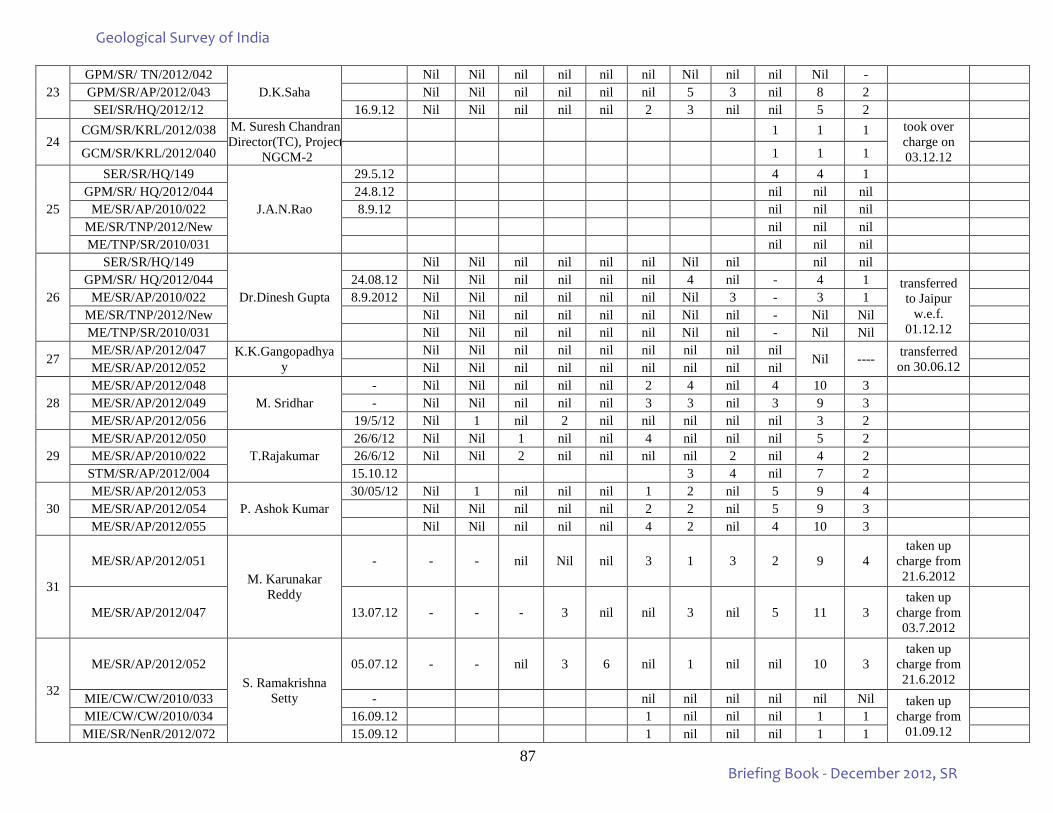
87
23 GPM/SR/ TN/2012/042
D.K.Saha Nil Nil nil nil nil nil Nil nil nil Nil -
GPM/SR/AP/2012/043 Nil Nil nil nil nil nil 5 3 nil 8 2 SEI/SR/HQ/2012/12 16.9.12 Nil Nil nil nil nil 2 3 nil nil 5 2
24 CGM/SR/KRL/2012/038 M. Suresh Chandran,
Director(TC), Project NGCM-2
1 1 1 took over charge on 03.12.12
GCM/SR/KRL/2012/040 1 1 1
25
SER/SR/HQ/149
J.A.N.Rao
29.5.12 4 4 1 GPM/SR/ HQ/2012/044 24.8.12 nil nil nil
ME/SR/AP/2010/022 8.9.12 nil nil nil ME/SR/TNP/2012/New nil nil nil ME/TNP/SR/2010/031 nil nil nil
26
SER/SR/HQ/149
Dr.Dinesh Gupta
Nil Nil nil nil nil nil Nil nil nil nil GPM/SR/ HQ/2012/044 24.08.12 Nil Nil nil nil nil nil 4 nil - 4 1 transferred
to Jaipur w.e.f.
01.12.12
ME/SR/AP/2010/022 8.9.2012 Nil Nil nil nil nil nil Nil 3 - 3 1
ME/SR/TNP/2012/New Nil Nil nil nil nil nil Nil nil - Nil Nil ME/TNP/SR/2010/031 Nil Nil nil nil nil nil Nil nil - Nil Nil
27 ME/SR/AP/2012/047 K.K.Gangopadhya
y Nil Nil nil nil nil nil nil nil nil
Nil ---- transferred on 30.06.12
ME/SR/AP/2012/052 Nil Nil nil nil nil nil nil nil nil
28 ME/SR/AP/2012/048
M. Sridhar - Nil Nil nil nil nil 2 4 nil 4 10 3
ME/SR/AP/2012/049 - Nil Nil nil nil nil 3 3 nil 3 9 3 ME/SR/AP/2012/056 19/5/12 Nil 1 nil 2 nil nil nil nil nil 3 2
29 ME/SR/AP/2012/050
T.Rajakumar 26/6/12 Nil Nil 1 nil nil 4 nil nil nil 5 2
ME/SR/AP/2010/022 26/6/12 Nil Nil 2 nil nil nil nil 2 nil 4 2 STM/SR/AP/2012/004 15.10.12 3 4 nil 7 2
30 ME/SR/AP/2012/053
P. Ashok Kumar 30/05/12 Nil 1 nil nil nil 1 2 nil 5 9 4
ME/SR/AP/2012/054 Nil Nil nil nil nil 2 2 nil 5 9 3 ME/SR/AP/2012/055 Nil Nil nil nil nil 4 2 nil 4 10 3
31
ME/SR/AP/2012/051 M. Karunakar
Reddy
- - - nil Nil nil 3 1 3 2 9 4 taken up
charge from 21.6.2012
ME/SR/AP/2012/047 13.07.12 - - - 3 nil nil 3 nil 5 11 3 taken up
charge from 03.7.2012
32
ME/SR/AP/2012/052 S. Ramakrishna
Setty
05.07.12 - - nil 3 6 nil 1 nil nil 10 3 taken up
charge from 21.6.2012
MIE/CW/CW/2010/033 - nil nil nil nil nil Nil taken up charge from
01.09.12
MIE/CW/CW/2010/034 16.09.12 1 nil nil nil 1 1 MIE/SR/NenR/2012/072 15.09.12 1 nil nil nil 1 1
Geological Survey of India
Briefing Book - December 2012, SR
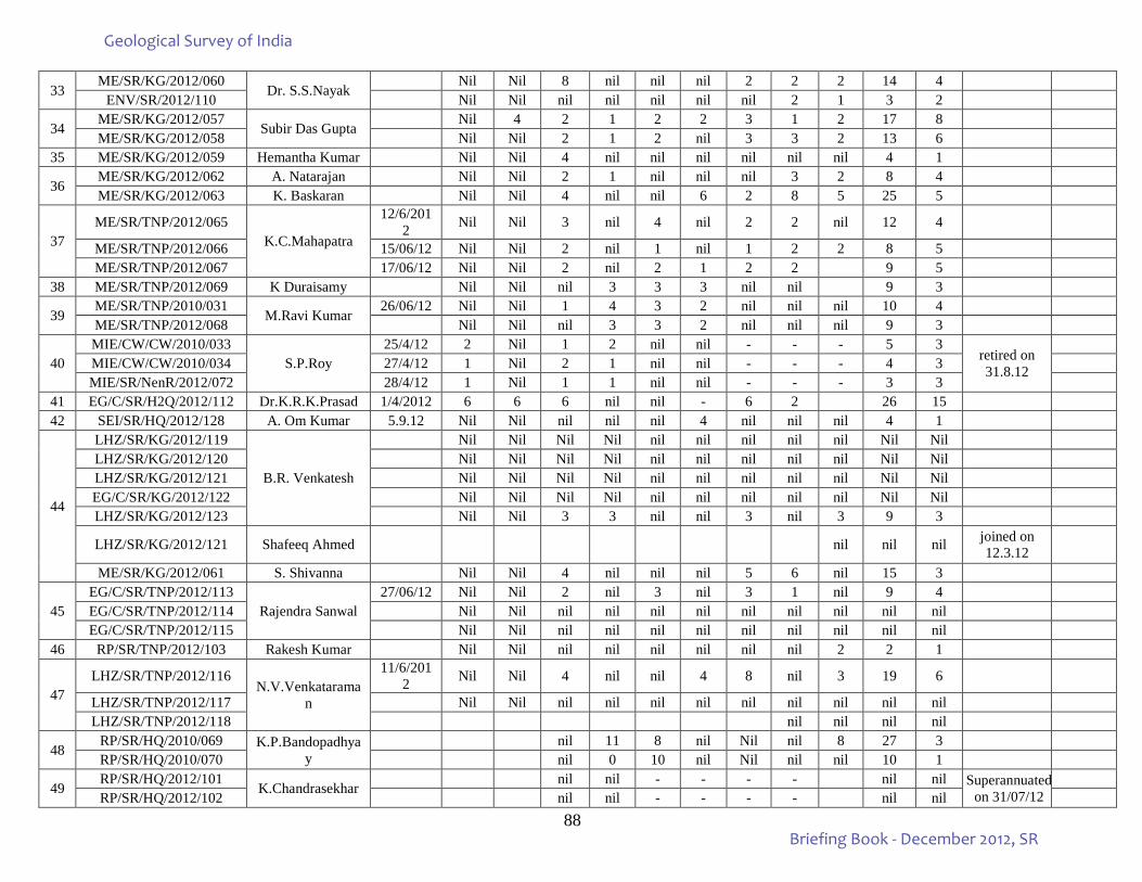
88
33 ME/SR/KG/2012/060
Dr. S.S.Nayak Nil Nil 8 nil nil nil 2 2 2 14 4
ENV/SR/2012/110 Nil Nil nil nil nil nil nil 2 1 3 2
34 ME/SR/KG/2012/057
Subir Das Gupta Nil 4 2 1 2 2 3 1 2 17 8
ME/SR/KG/2012/058 Nil Nil 2 1 2 nil 3 3 2 13 6 35 ME/SR/KG/2012/059 Hemantha Kumar Nil Nil 4 nil nil nil nil nil nil 4 1
36 ME/SR/KG/2012/062 A. Natarajan Nil Nil 2 1 nil nil nil 3 2 8 4 ME/SR/KG/2012/063 K. Baskaran Nil Nil 4 nil nil 6 2 8 5 25 5
37 ME/SR/TNP/2012/065
K.C.Mahapatra
12/6/2012 Nil Nil 3 nil 4 nil 2 2 nil 12 4
ME/SR/TNP/2012/066 15/06/12 Nil Nil 2 nil 1 nil 1 2 2 8 5 ME/SR/TNP/2012/067 17/06/12 Nil Nil 2 nil 2 1 2 2 9 5
38 ME/SR/TNP/2012/069 K Duraisamy Nil Nil nil 3 3 3 nil nil 9 3
39 ME/SR/TNP/2010/031
M.Ravi Kumar 26/06/12 Nil Nil 1 4 3 2 nil nil nil 10 4
ME/SR/TNP/2012/068 Nil Nil nil 3 3 2 nil nil nil 9 3
40 MIE/CW/CW/2010/033
S.P.Roy 25/4/12 2 Nil 1 2 nil nil - - - 5 3
retired on 31.8.12
MIE/CW/CW/2010/034 27/4/12 1 Nil 2 1 nil nil - - - 4 3 MIE/SR/NenR/2012/072 28/4/12 1 Nil 1 1 nil nil - - - 3 3
41 EG/C/SR/H2Q/2012/112 Dr.K.R.K.Prasad 1/4/2012 6 6 6 nil nil - 6 2 26 15 42 SEI/SR/HQ/2012/128 A. Om Kumar 5.9.12 Nil Nil nil nil nil 4 nil nil nil 4 1
44
LHZ/SR/KG/2012/119
B.R. Venkatesh
Nil Nil Nil Nil nil nil nil nil nil Nil Nil LHZ/SR/KG/2012/120 Nil Nil Nil Nil nil nil nil nil nil Nil Nil LHZ/SR/KG/2012/121 Nil Nil Nil Nil nil nil nil nil nil Nil Nil EG/C/SR/KG/2012/122 Nil Nil Nil Nil nil nil nil nil nil Nil Nil LHZ/SR/KG/2012/123 Nil Nil 3 3 nil nil 3 nil 3 9 3
LHZ/SR/KG/2012/121 Shafeeq Ahmed nil nil nil joined on 12.3.12
ME/SR/KG/2012/061 S. Shivanna Nil Nil 4 nil nil nil 5 6 nil 15 3
45 EG/C/SR/TNP/2012/113
Rajendra Sanwal 27/06/12 Nil Nil 2 nil 3 nil 3 1 nil 9 4
EG/C/SR/TNP/2012/114 Nil Nil nil nil nil nil nil nil nil nil nil EG/C/SR/TNP/2012/115 Nil Nil nil nil nil nil nil nil nil nil nil
46 RP/SR/TNP/2012/103 Rakesh Kumar Nil Nil nil nil nil nil nil nil 2 2 1
47 LHZ/SR/TNP/2012/116
N.V.Venkataraman
11/6/2012 Nil Nil 4 nil nil 4 8 nil 3 19 6
LHZ/SR/TNP/2012/117 Nil Nil nil nil nil nil nil nil nil nil nil LHZ/SR/TNP/2012/118 nil nil nil nil
48 RP/SR/HQ/2010/069 K.P.Bandopadhya
y nil 11 8 nil Nil nil 8 27 3
RP/SR/HQ/2010/070 nil 0 10 nil Nil nil nil 10 1
49 RP/SR/HQ/2012/101
K.Chandrasekhar nil nil - - - - nil nil Superannuated
on 31/07/12
RP/SR/HQ/2012/102 nil nil - - - - nil nil
Geological Survey of India
Briefing Book - December 2012, SR
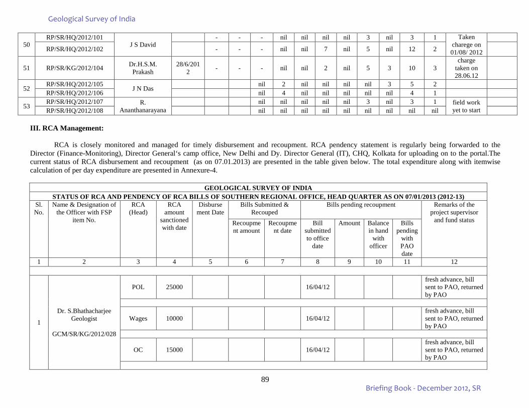
89
50 RP/SR/HQ/2012/101
J S David - - - nil nil nil nil 3 nil 3 1 Taken
charege on 01/08/ 2012
RP/SR/HQ/2012/102 - - - nil nil 7 nil 5 nil 12 2
51 RP/SR/KG/2012/104 Dr.H.S.M. Prakash
28/6/2012 - - - nil nil 2 nil 5 3 10 3
charge taken on 28.06.12
52 RP/SR/HQ/2012/105
J N Das nil 2 nil nil nil nil 3 5 2
RP/SR/HQ/2012/106 nil 4 nil nil nil nil nil 4 1
53 RP/SR/HQ/2012/107 R.
Ananthanarayana nil nil nil nil nil 3 nil 3 1 field work
yet to start
RP/SR/HQ/2012/108 nil nil nil nil nil nil nil nil nil III. RCA Management:
RCA is closely monitored and managed for timely disbursement and recoupment. RCA pendency statement is regularly being forwarded to the Director (Finance-Monitoring), Director General‘s camp office, New Delhi and Dy. Director General (IT), CHQ, Kolkata for uploading on to the portal.The current status of RCA disbursement and recoupment (as on 07.01.2013) are presented in the table given below. The total expenditure along with itemwise calculation of per day expenditure are presented in Annexure-4.
GEOLOGICAL SURVEY OF INDIA
STATUS OF RCA AND PENDENCY OF RCA BILLS OF SOUTHERN REGIONAL OFFICE, HEAD QUARTER AS ON 07/01/2013 (2012-13) Sl. No.
Name & Designation of the Officer with FSP
item No.
RCA (Head)
RCA amount
sanctioned with date
Disbursement Date
Bills Submitted & Recouped
Bills pending recoupment Remarks of the project supervisor
and fund status Recoupment amount
Recoupment date
Bill submitted to office
date
Amount Balance in hand
with officer
Bills pending
with PAO date
1 2 3 4 5 6 7 8 9 10 11 12
1
Dr. S.Bhathacharjee Geologist
GCM/SR/KG/2012/028
POL 25000 16/04/12 fresh advance, bill sent to PAO, returned by PAO
Wages 10000 16/04/12 fresh advance, bill sent to PAO, returned by PAO
OC 15000 16/04/12 fresh advance, bill sent to PAO, returned by PAO
Geological Survey of India
Briefing Book - December 2012, SR
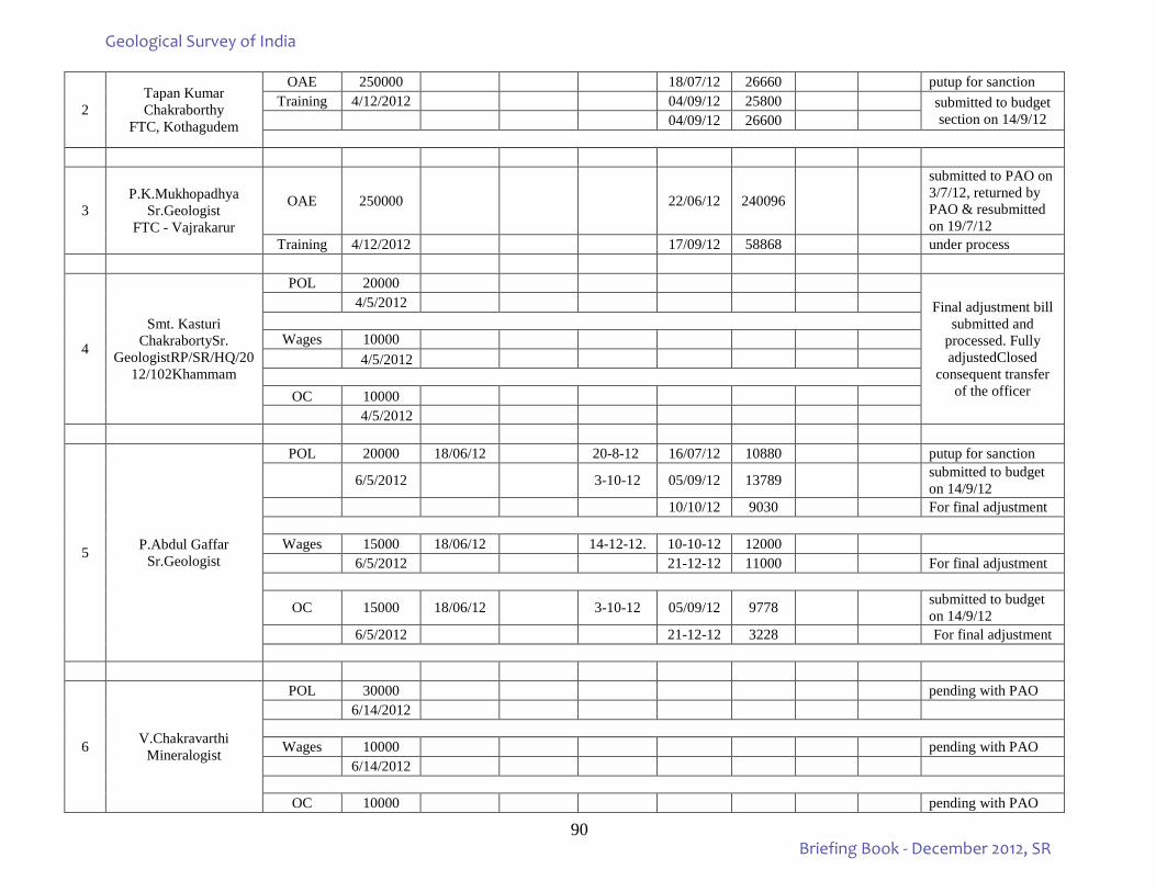
90
2 Tapan Kumar Chakraborthy
FTC, Kothagudem
OAE 250000 18/07/12 26660 putup for sanction Training 4/12/2012 04/09/12 25800 submitted to budget
section on 14/9/12 04/09/12 26600
3 P.K.Mukhopadhya
Sr.Geologist FTC - Vajrakarur
OAE 250000
22/06/12 240096
submitted to PAO on 3/7/12, returned by PAO & resubmitted on 19/7/12
Training 4/12/2012 17/09/12 58868 under process
4
Smt. Kasturi ChakrabortySr.
GeologistRP/SR/HQ/2012/102Khammam
POL 20000 Final adjustment bill
submitted and processed. Fully adjustedClosed
consequent transfer of the officer
4/5/2012
Wages 10000 4/5/2012
OC 10000 4/5/2012
5 P.Abdul Gaffar Sr.Geologist
POL 20000 18/06/12 20-8-12 16/07/12 10880 putup for sanction
6/5/2012 3-10-12 05/09/12 13789 submitted to budget on 14/9/12
10/10/12 9030 For final adjustment
Wages 15000 18/06/12 14-12-12. 10-10-12 12000 6/5/2012 21-12-12 11000 For final adjustment
OC 15000 18/06/12 3-10-12 05/09/12 9778 submitted to budget on 14/9/12
6/5/2012 21-12-12 3228 For final adjustment
6 V.Chakravarthi Mineralogist
POL 30000 pending with PAO 6/14/2012
Wages 10000 pending with PAO
6/14/2012
OC 10000 pending with PAO
Geological Survey of India
Briefing Book - December 2012, SR
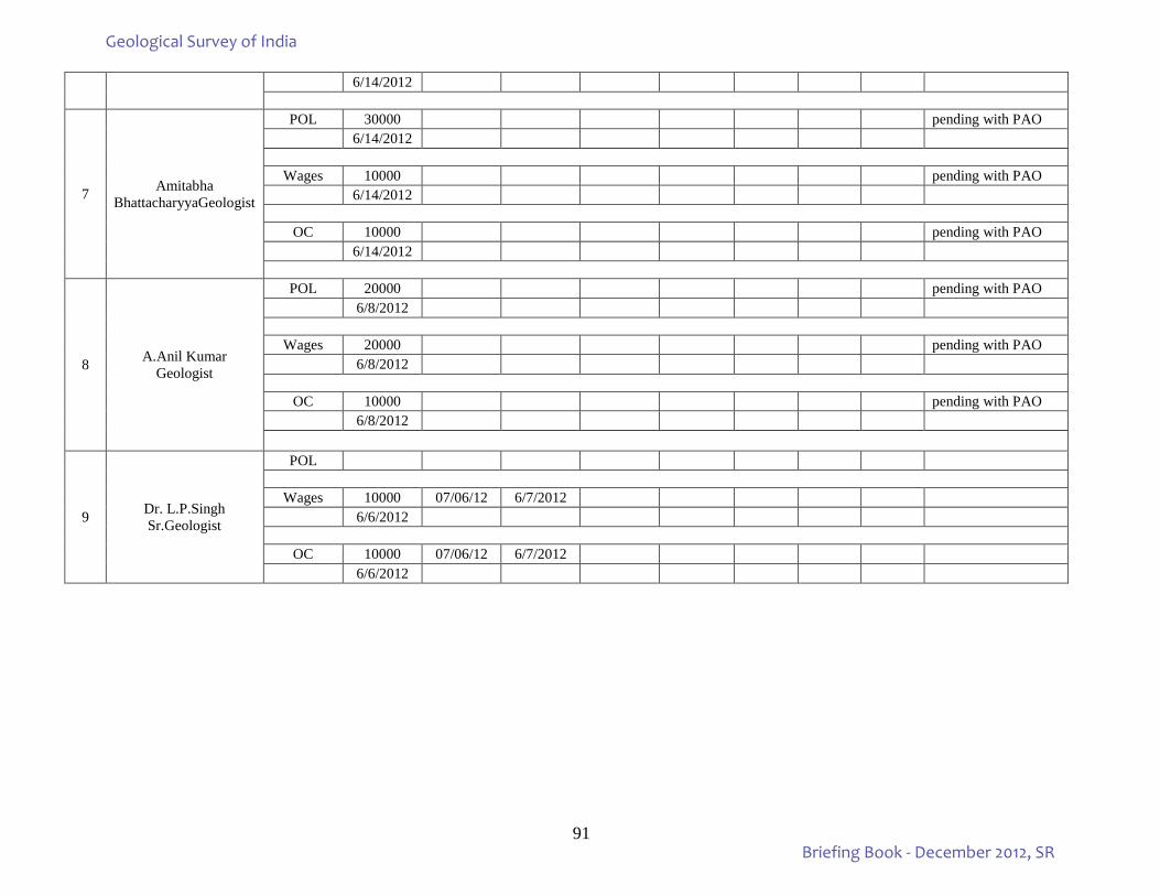
91
6/14/2012
7 Amitabha BhattacharyyaGeologist
POL 30000 pending with PAO 6/14/2012
Wages 10000 pending with PAO
6/14/2012
OC 10000 pending with PAO 6/14/2012
8 A.Anil Kumar Geologist
POL 20000 pending with PAO 6/8/2012
Wages 20000 pending with PAO
6/8/2012
OC 10000 pending with PAO 6/8/2012
9 Dr. L.P.Singh Sr.Geologist
POL
Wages 10000 07/06/12 6/7/2012 6/6/2012
OC 10000 07/06/12 6/7/2012
6/6/2012
Geological Survey of India
Briefing Book - December 2012, SR
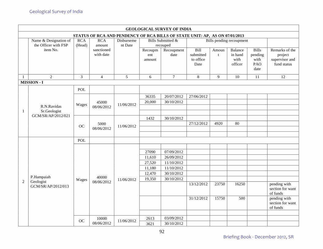
92
GEOLOGICAL SURVEY OF INDIA STATUS OF RCA AND PENDENCY OF RCA BILLS OF STATE UNIT: AP, AS ON 07/01/2013
Name & Designation of the Officer with FSP
item No.
RCA (Head)
RCA amount
sanctioned with date
Disbursement Date
Bills Submitted & recouped
Bills pending recoupment
Recoupment
amount
Recoupment date
Bill submitted to office
Date
Amount
Balance in hand
with officer
Bills pending
with PAO date
Remarks of the project
supervisor and fund status
1 2 3 4 5 6 7 8 9 10 11 12 MISSION - I
1 R.N.Ravidas Sr.Geologist
GCM/SR/AP/2012/021
POL
Wages 45000 08/06/2012 11/06/2012
36335 20/07/2012 27/06/2012 20,000 30/10/2012
OC 5000 08/06/2012 11/06/2012
1432 30/10/2012 27/12/2012 4920 80
2 P.Hampaiah Geologist GCM/SR/AP/2012/013
POL
Wages 40000 08/06/2012 11/06/2012
27090 07/09/2012 11,610 26/09/2012 27,520 11/10/2012 11,180 11/10/2012 12,470 30/10/2012 19,350 30/10/2012
13/12/2012 23750 16250 pending with
section for want of funds
31/12/2012 15750 500 pending with
section for want of funds
OC 10000 08/06/2012 11/06/2012 2613 03/09/2012
3621 30/10/2012
Geological Survey of India
Briefing Book - December 2012, SR
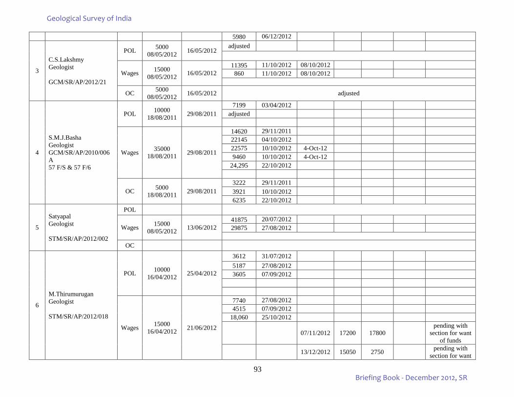
93
5980 06/12/2012
3
C.S.Lakshmy Geologist GCM/SR/AP/2012/21
POL 5000 08/05/2012 16/05/2012
adjusted
Wages 15000 08/05/2012 16/05/2012
11395 11/10/2012 08/10/2012 860 11/10/2012 08/10/2012
OC 5000 08/05/2012 16/05/2012 adjusted
4
S.M.J.Basha Geologist GCM/SR/AP/2010/006A 57 F/S & 57 F/6
POL 10000 18/08/2011 29/08/2011
7199 03/04/2012 adjusted
Wages 35000 18/08/2011 29/08/2011
14620 29/11/2011 22145 04/10/2012 22575 10/10/2012 4-Oct-12 9460 10/10/2012 4-Oct-12
24,295 22/10/2012
OC 5000 18/08/2011 29/08/2011
3222 29/11/2011 3921 10/10/2012 6235 22/10/2012
5
Satyapal Geologist STM/SR/AP/2012/002
POL
Wages 15000 08/05/2012 13/06/2012
41875 20/07/2012 29875 27/08/2012
OC
6
M.Thirumurugan Geologist STM/SR/AP/2012/018
POL 10000 16/04/2012 25/04/2012
3612 31/07/2012 5187 27/08/2012 3605 07/09/2012
Wages 15000 16/04/2012 21/06/2012
7740 27/08/2012 4515 07/09/2012
18,060 25/10/2012
07/11/2012 17200 17800 pending with
section for want of funds
13/12/2012 15050 2750 pending with section for want
Geological Survey of India
Briefing Book - December 2012, SR
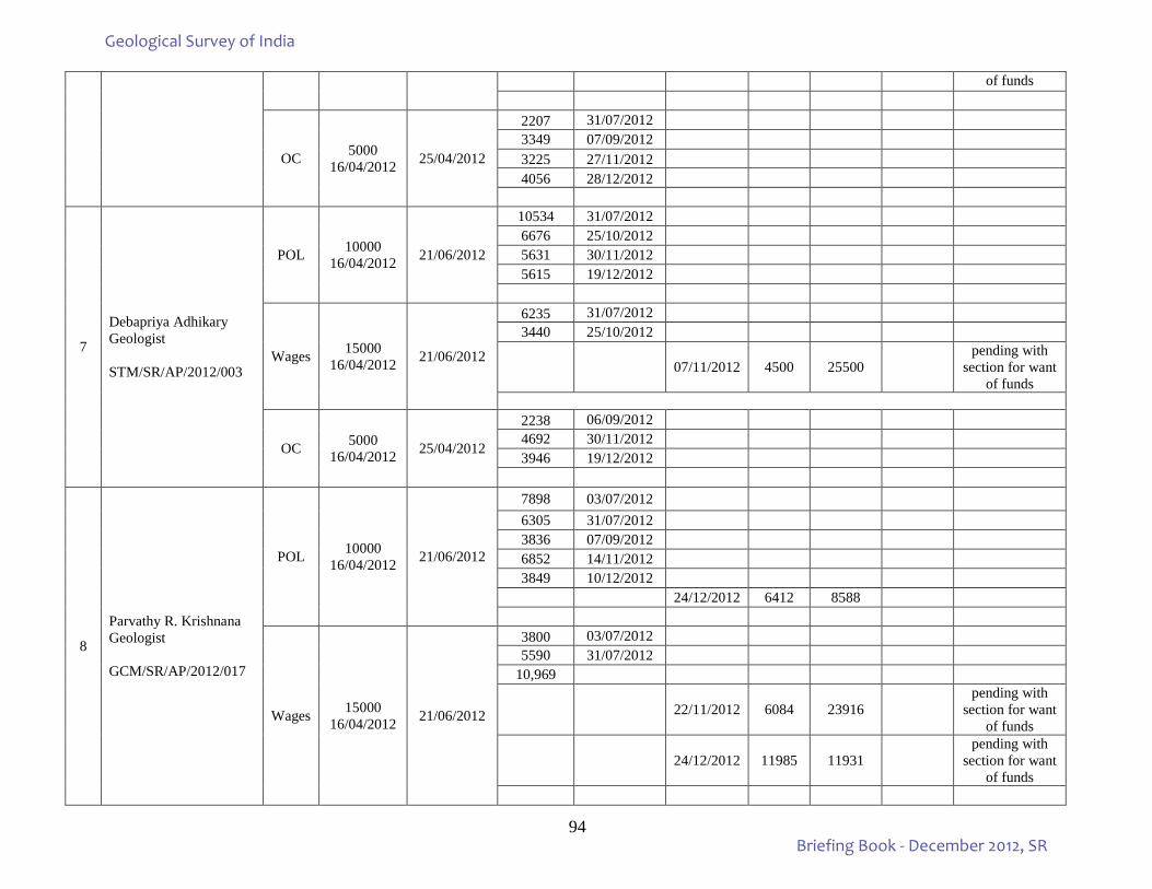
94
of funds
OC 5000 16/04/2012 25/04/2012
2207 31/07/2012 3349 07/09/2012 3225 27/11/2012 4056 28/12/2012
7
Debapriya Adhikary Geologist STM/SR/AP/2012/003
POL 10000 16/04/2012 21/06/2012
10534 31/07/2012 6676 25/10/2012 5631 30/11/2012 5615 19/12/2012
Wages 15000 16/04/2012 21/06/2012
6235 31/07/2012 3440 25/10/2012
07/11/2012 4500 25500 pending with
section for want of funds
OC 5000 16/04/2012 25/04/2012
2238 06/09/2012 4692 30/11/2012 3946 19/12/2012
8
Parvathy R. Krishnana Geologist GCM/SR/AP/2012/017
POL 10000 16/04/2012 21/06/2012
7898 03/07/2012 6305 31/07/2012 3836 07/09/2012 6852 14/11/2012 3849 10/12/2012
24/12/2012 6412 8588
Wages 15000 16/04/2012 21/06/2012
3800 03/07/2012 5590 31/07/2012
10,969
22/11/2012 6084 23916 pending with
section for want of funds
24/12/2012 11985 11931 pending with
section for want of funds
Geological Survey of India
Briefing Book - December 2012, SR
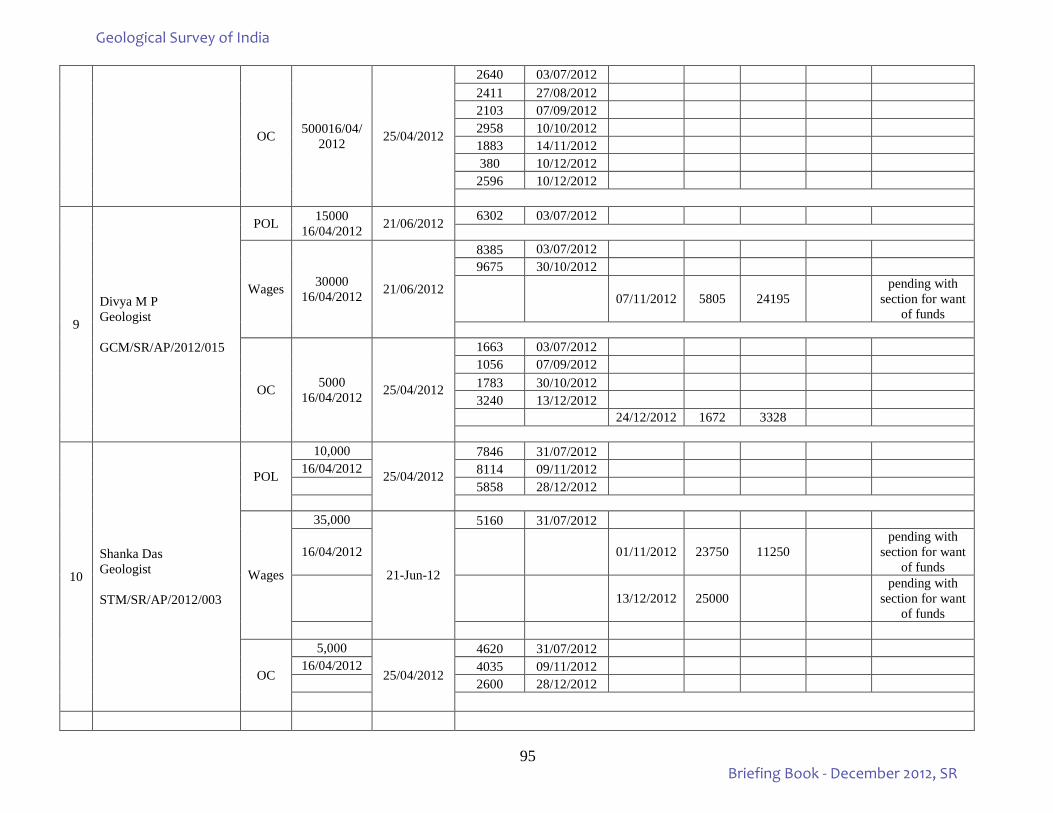
95
OC 500016/04/2012 25/04/2012
2640 03/07/2012 2411 27/08/2012 2103 07/09/2012 2958 10/10/2012 1883 14/11/2012 380 10/12/2012
2596 10/12/2012
9
Divya M P Geologist GCM/SR/AP/2012/015
POL 15000 16/04/2012 21/06/2012 6302 03/07/2012
Wages 30000 16/04/2012 21/06/2012
8385 03/07/2012 9675 30/10/2012
07/11/2012 5805 24195 pending with
section for want of funds
OC 5000 16/04/2012 25/04/2012
1663 03/07/2012 1056 07/09/2012 1783 30/10/2012 3240 13/12/2012
24/12/2012 1672 3328
10
Shanka Das Geologist STM/SR/AP/2012/003
POL
10,000
25/04/2012
7846 31/07/2012 16/04/2012 8114 09/11/2012
5858 28/12/2012
Wages
35,000
21-Jun-12
5160 31/07/2012
16/04/2012
01/11/2012 23750 11250 pending with
section for want of funds
13/12/2012 25000 pending with
section for want of funds
OC
5,000
25/04/2012
4620 31/07/2012 16/04/2012 4035 09/11/2012
2600 28/12/2012
Geological Survey of India
Briefing Book - December 2012, SR
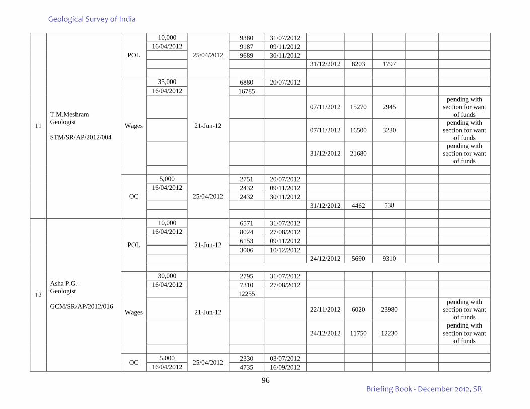
96
11
T.M.Meshram Geologist STM/SR/AP/2012/004
POL
10,000
25/04/2012
9380 31/07/2012 16/04/2012 9187 09/11/2012
9689 30/11/2012 31/12/2012 8203 1797
Wages
35,000
21-Jun-12
6880 20/07/2012 16/04/2012 16785
07/11/2012 15270 2945 pending with
section for want of funds
07/11/2012 16500 3230 pending with
section for want of funds
31/12/2012 21680 pending with
section for want of funds
OC
5,000
25/04/2012
2751 20/07/2012 16/04/2012 2432 09/11/2012
2432 30/11/2012 31/12/2012 4462 538
12
Asha P.G. Geologist GCM/SR/AP/2012/016
POL
10,000
21-Jun-12
6571 31/07/2012 16/04/2012 8024 27/08/2012
6153 09/11/2012 3006 10/12/2012 24/12/2012 5690 9310
Wages
30,000
21-Jun-12
2795 31/07/2012 16/04/2012 7310 27/08/2012
12255
22/11/2012 6020 23980 pending with
section for want of funds
24/12/2012 11750 12230 pending with
section for want of funds
OC 5,000
25/04/2012 2330 03/07/2012 16/04/2012 4735 16/09/2012
Geological Survey of India
Briefing Book - December 2012, SR
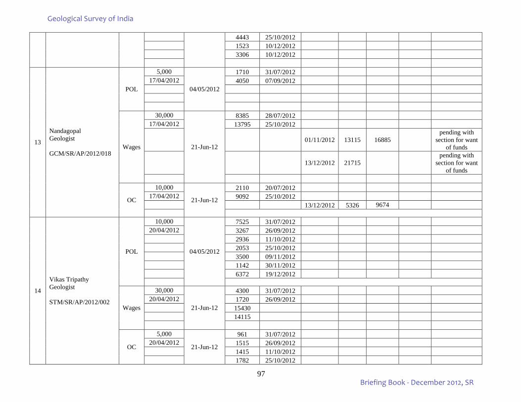
97
4443 25/10/2012 1523 10/12/2012 3306 10/12/2012
13
Nandagopal Geologist GCM/SR/AP/2012/018
POL
5,000
04/05/2012
1710 31/07/2012 17/04/2012 4050 07/09/2012
Wages
30,000
21-Jun-12
8385 28/07/2012 17/04/2012 13795 25/10/2012
01/11/2012 13115 16885 pending with
section for want of funds
13/12/2012 21715 pending with
section for want of funds
OC
10,000
21-Jun-12
2110 20/07/2012 17/04/2012 9092 25/10/2012
13/12/2012 5326 9674
14
Vikas Tripathy Geologist STM/SR/AP/2012/002
POL
10,000
04/05/2012
7525 31/07/2012 20/04/2012 3267 26/09/2012
2936 11/10/2012 2053 25/10/2012 3500 09/11/2012 1142 30/11/2012 6372 19/12/2012
Wages
30,000
21-Jun-12
4300 31/07/2012 20/04/2012 1720 26/09/2012
15430 14115
OC
5,000
21-Jun-12
961 31/07/2012 20/04/2012 1515 26/09/2012
1415 11/10/2012 1782 25/10/2012
Geological Survey of India
Briefing Book - December 2012, SR
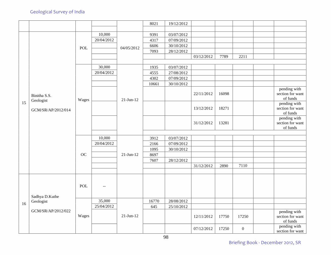
98
8021 19/12/2012
15
Binitha S.S. Geologist GCM/SR/AP/2012/014
POL
10,000
04/05/2012
9391 03/07/2012 20/04/2012 4317 07/09/2012
6606 30/10/2012 7093 28/12/2012 03/12/2012 7789 2211
Wages
30,000
21-Jun-12
1935 03/07/2012 20/04/2012 4555 27/08/2012
4302 07/09/2012 10661 30/10/2012
22/11/2012 16098 pending with
section for want of funds
13/12/2012 18271 pending with
section for want of funds
31/12/2012 13281 pending with
section for want of funds
OC
10,000
21-Jun-12
3912 03/07/2012 20/04/2012 2166 07/09/2012
1095 30/10/2012 8697 7607 28/12/2012 31/12/2012 2890 7110
16
Sadhya D.Kuthe Geologist GCM/SR/AP/2012/022
POL --
Wages
35,000
21-Jun-12
16770 28/08/2012 25/04/2012 645 25/10/2012
12/11/2012 17750 17250 pending with
section for want of funds
07/12/2012 17250 0 pending with section for want
Geological Survey of India
Briefing Book - December 2012, SR
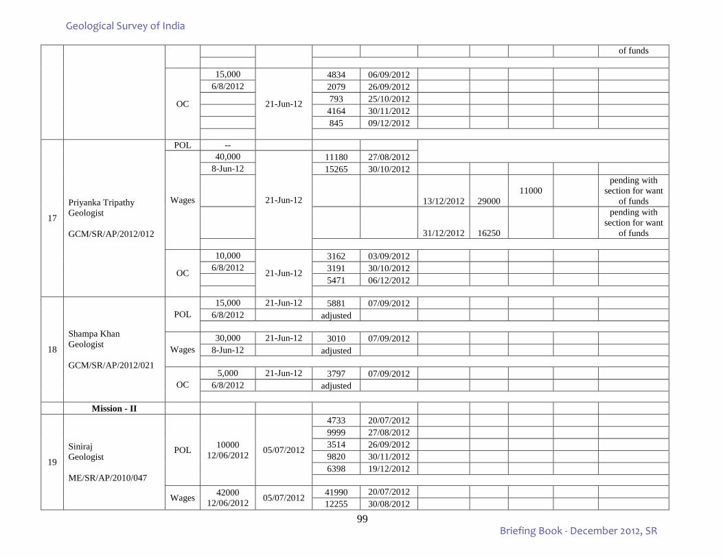
99
of funds
OC
15,000
21-Jun-12
4834 06/09/2012 6/8/2012 2079 26/09/2012
793 25/10/2012 4164 30/11/2012 845 09/12/2012
17
Priyanka Tripathy Geologist GCM/SR/AP/2012/012
POL --
Wages
40,000
21-Jun-12
11180 27/08/2012 8-Jun-12 15265 30/10/2012
13/12/2012 29000
11000
pending with section for want
of funds
31/12/2012 16250
pending with section for want
of funds
OC
10,000
21-Jun-12
3162 03/09/2012 6/8/2012 3191 30/10/2012
5471 06/12/2012
18
Shampa Khan Geologist GCM/SR/AP/2012/021
POL 15,000 21-Jun-12 5881 07/09/2012
6/8/2012 adjusted
Wages 30,000 21-Jun-12 3010 07/09/2012
8-Jun-12 adjusted
OC 5,000 21-Jun-12 3797 07/09/2012
6/8/2012 adjusted
Mission - II
19
Siniraj Geologist ME/SR/AP/2010/047
POL 10000 12/06/2012 05/07/2012
4733 20/07/2012 9999 27/08/2012 3514 26/09/2012 9820 30/11/2012 6398 19/12/2012
Wages 42000 12/06/2012 05/07/2012 41990 20/07/2012
12255 30/08/2012
Geological Survey of India
Briefing Book - December 2012, SR

100
10750 30/11/2012 31/12/2012 18000 24000
OC 8000 12/06/2012 05/07/2012
2304 14/09/2012 4708 30/11/2012 1479 19/12/2012
20
Lawanya Suren Geologist ME/SR/AP/2012/049
POL 10000 12/06/2012 21/06/2012
9970 09/11/2012 2400 9366 10/12/2012
Wages 40000 08/05/2012 16/05/2012
39345 20/07/2012 13760 27/08/2012 20200 09/11/2012 21250 10/12/2012
07/12/2012 20520 19480 bill returned by
PAO on 26/12/2012
24/12/2012 36585
OC 10000 12/6/12 21/06/2012
21
Rohit V.Gajbhiye Geologist ME/SR/AP/2012/047
POL 15,000 21/06/2012 11414 11/10/2012
12/06/2012
Wages
40000 08/05/2012 13/06/2012 11825 20/07/2012
8/05/2012 31390 03/09/2012 33970 11/10/2012
OC 5,000 21/06/2012 4660 03/09/2012
12/06/2012 4912 26/09/2012 4963 25/10/2012
22
S.Sarkar Geologist MIE/CW/CW/2010/033
POL 10000 08/05/2012 16/05/2012
9452 adjusted
Wages 40000 08/05/2012 16/05/2012 39899 03/09/2012
39990 26/09/2012
Geological Survey of India
Briefing Book - December 2012, SR
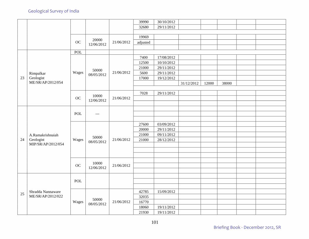
101
39990 30/10/2012 32680 29/11/2012
OC 20000 12/06/2012 21/06/2012
19969 adjusted
23 Rimpalkar Geologist ME/SR/AP/2012/054
POL
Wages 50000 08/05/2012 21/06/2012
7400 17/08/2012 12500 10/10/2012 21000 29/11/2012 5600 29/11/2012 17000 19/12/2012
31/12/2012 12000 38000
OC 10000 12/06/2012 21/06/2012
7028 29/11/2012
24 A.Ramakrishnaiah Geologist MIP/SR/AP/2012/054
POL ---
Wages 50000 08/05/2012 21/06/2012
27600 03/09/2012 20000 29/11/2012 21000 09/11/2012 21000 28/12/2012
OC 10000 12/06/2012 21/06/2012
25 Shradda Nannaware ME/SR/AP/2012/022
POL
Wages 50000 08/05/2012 21/06/2012
42785 15/09/2012 32035 16770 18060 19/11/2012 21930 19/11/2012
Geological Survey of India
Briefing Book - December 2012, SR
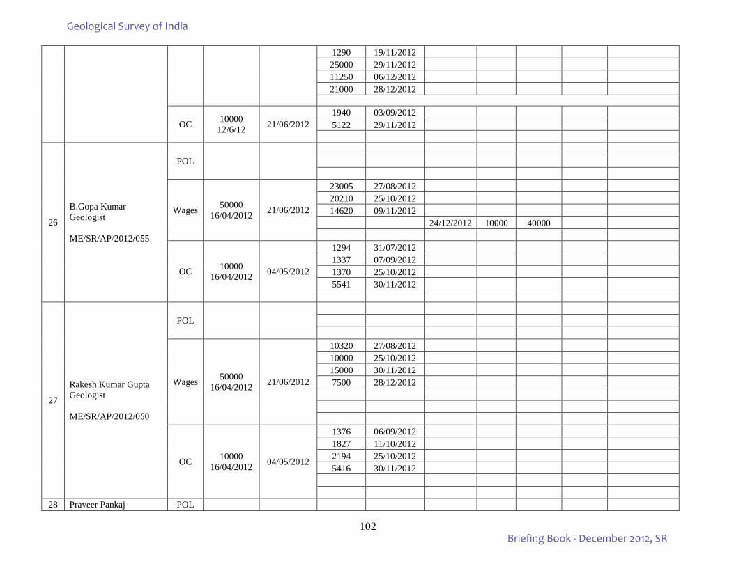
102
1290 19/11/2012 25000 29/11/2012 11250 06/12/2012 21000 28/12/2012
OC 10000 12/6/12 21/06/2012
1940 03/09/2012 5122 29/11/2012
26
B.Gopa Kumar Geologist ME/SR/AP/2012/055
POL
Wages 50000 16/04/2012 21/06/2012
23005 27/08/2012 20210 25/10/2012 14620 09/11/2012
24/12/2012 10000 40000
OC 10000 16/04/2012 04/05/2012
1294 31/07/2012 1337 07/09/2012 1370 25/10/2012 5541 30/11/2012
27
Rakesh Kumar Gupta Geologist ME/SR/AP/2012/050
POL
Wages 50000 16/04/2012 21/06/2012
10320 27/08/2012 10000 25/10/2012 15000 30/11/2012 7500 28/12/2012
OC 10000 16/04/2012 04/05/2012
1376 06/09/2012 1827 11/10/2012 2194 25/10/2012 5416 30/11/2012
28 Praveer Pankaj POL
Geological Survey of India
Briefing Book - December 2012, SR
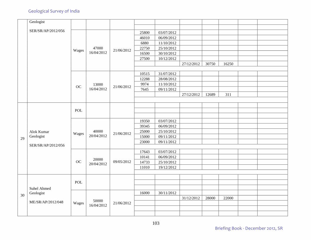
103
Geologist SER/SR/AP/2012/056
Wages 47000 16/04/2012 21/06/2012
25800 03/07/2012 46010 06/09/2012 6880 11/10/2012 22750 25/10/2012 16500 30/10/2012 27500 10/12/2012
27/12/2012 30750 16250
OC 13000 16/04/2012 21/06/2012
10515 31/07/2012 12288 28/08/2012 9974 11/10/2012 7645 09/11/2012
27/12/2012 12689 311
29
Alok Kumar Geologist SER/SR/AP/2012/056
POL
Wages 40000 20/04/2012 21/06/2012
19350 03/07/2012 39345 06/09/2012 25000 25/10/2012 15000 09/11/2012 23000 09/11/2012
OC 20000 20/04/2012 09/05/2012
17643 03/07/2012 10141 06/09/2012 14733 25/10/2012 11010 19/12/2012
30
Suhel Ahmed Geologist ME/SR/AP/2012/048
POL
Wages 50000 16/04/2012 21/06/2012
16000 30/11/2012 31/12/2012 28000 22000
Geological Survey of India
Briefing Book - December 2012, SR
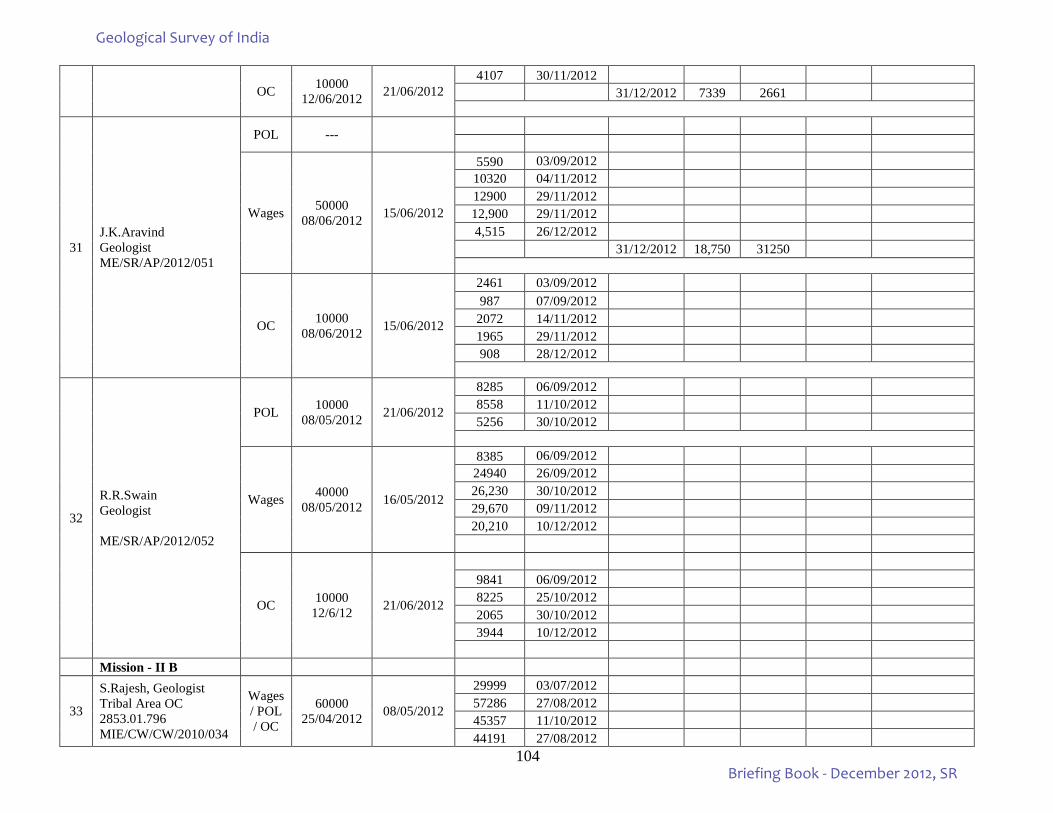
104
OC 10000 12/06/2012 21/06/2012
4107 30/11/2012 31/12/2012 7339 2661
31 J.K.Aravind Geologist ME/SR/AP/2012/051
POL ---
Wages 50000 08/06/2012 15/06/2012
5590 03/09/2012 10320 04/11/2012 12900 29/11/2012 12,900 29/11/2012 4,515 26/12/2012
31/12/2012 18,750 31250
OC 10000 08/06/2012 15/06/2012
2461 03/09/2012 987 07/09/2012
2072 14/11/2012 1965 29/11/2012 908 28/12/2012
32
R.R.Swain Geologist ME/SR/AP/2012/052
POL 10000 08/05/2012 21/06/2012
8285 06/09/2012 8558 11/10/2012 5256 30/10/2012
Wages 40000 08/05/2012 16/05/2012
8385 06/09/2012 24940 26/09/2012 26,230 30/10/2012 29,670 09/11/2012 20,210 10/12/2012
OC 10000 12/6/12 21/06/2012
9841 06/09/2012 8225 25/10/2012 2065 30/10/2012 3944 10/12/2012
Mission - II B
33
S.Rajesh, Geologist Tribal Area OC 2853.01.796 MIE/CW/CW/2010/034
Wages / POL / OC
60000 25/04/2012 08/05/2012
29999 03/07/2012 57286 27/08/2012 45357 11/10/2012 44191 27/08/2012
Geological Survey of India
Briefing Book - December 2012, SR
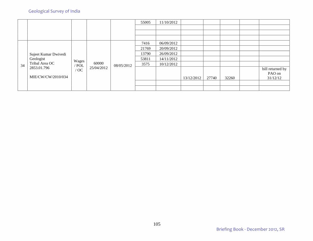
105
55005 11/10/2012
34
Sujeet Kumar Dwivedi Geologist Tribal Area OC 2853.01.796 MIE/CW/CW/2010/034
Wages / POL / OC
60000 25/04/2012 08/05/2012
7416 06/09/2012 21769 20/09/2012 13790 26/09/2012 53811 14/11/2012 3575 10/12/2012
13/12/2012 27740 32260
bill returned by PAO on 31/12/12
Geological Survey of India
Briefing Book - December 2012, SR
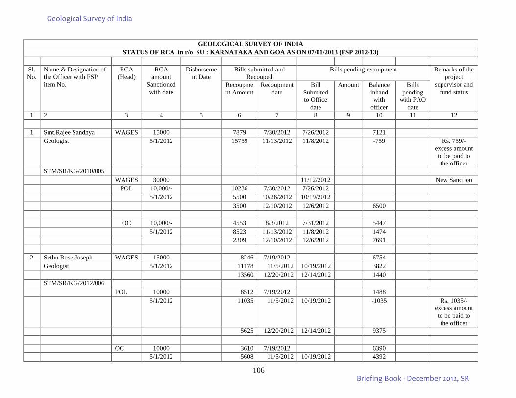
106
GEOLOGICAL SURVEY OF INDIA
STATUS OF RCA in r/o SU : KARNATAKA AND GOA AS ON 07/01/2013 (FSP 2012-13)
Sl. No.
Name & Designation of the Officer with FSP item No.
RCA (Head)
RCA amount
Sanctioned with date
Disbursement Date
Bills submitted and Recouped
Bills pending recoupment Remarks of the project
supervisor and fund status
Recoupment Amount
Recoupment date
Bill Submited to Office
date
Amount Balance inhand with
officer
Bills pending
with PAO date
1 2 3 4 5 6 7 8 9 10 11 12
1 Smt.Rajee Sandhya WAGES 15000 7879 7/30/2012 7/26/2012 7121 Geologist 5/1/2012 15759 11/13/2012 11/8/2012 -759 Rs. 759/-
excess amount to be paid to the officer
STM/SR/KG/2010/005 WAGES 30000 11/12/2012 New Sanction POL 10,000/- 10236 7/30/2012 7/26/2012 5/1/2012 5500 10/26/2012 10/19/2012 3500 12/10/2012 12/6/2012 6500 OC 10,000/- 4553 8/3/2012 7/31/2012 5447 5/1/2012 8523 11/13/2012 11/8/2012 1474 2309 12/10/2012 12/6/2012 7691
2 Sethu Rose Joseph WAGES 15000 8246 7/19/2012 6754 Geologist 5/1/2012 11178 11/5/2012 10/19/2012 3822 13560 12/20/2012 12/14/2012 1440 STM/SR/KG/2012/006 POL 10000 8512 7/19/2012 1488 5/1/2012 11035 11/5/2012 10/19/2012 -1035 Rs. 1035/-
excess amount to be paid to the officer
5625 12/20/2012 12/14/2012 9375 OC 10000 3610 7/19/2012 6390 5/1/2012 5608 11/5/2012 10/19/2012 4392
Geological Survey of India
Briefing Book - December 2012, SR
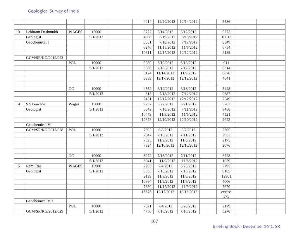
107
4414 12/20/2012 12/14/2012 5586
3 Lekhram Deshmukh WAGES 15000 5727 6/14/2012 6/12/2012 9273 Geologist 5/1/2012 4988 6/19/2012 6/18/2012 10012 Geochemical I 6651 7/18/2012 7/12/2012 8349 8246 11/15/2012 11/8/2012 6754 10811 12/17/2012 12/12/2012 4189 GCM/SR/KG/2012/023 POL 10000 9089 6/19/2012 6/18/2012 911 5/1/2012 3686 7/18/2012 7/12/2012 6314 3124 11/14/2012 11/9/2012 6876 5359 12/17/2012 12/12/2012 4641 OC 10000 4552 6/19/2012 6/18/2012 5448 5/1/2012 313 7/18/2012 7/12/2012 9687 2451 12/17/2012 12/12/2012 7549
4 S.S.Gawade Wages 15000 9237 6/22/2012 6/21/2012 5763 Geologist 5/1/2012 5542 7/18/2012 7/11/2012 9458 10479 11/9/2012 11/6/2012 4521 12378 12/10/2012 12/10/2012 2622 Geochemical VI GCM/SR/KG/2012/028 POL 10000 7695 6/8/2012 6/7/2012 2305 5/1/2012 7047 7/18/2012 7/11/2012 2953 7825 11/9/2012 11/6/2012 2175 7924 12/10/2012 12/10/2012 2076 OC 10000 3272 7/18/2012 7/11/2012 6728 5/1/2012 8941 11/9/2012 11/6/2012 1059
5 Remi Raj WAGES 15000 7205 7/4/2012 6/28/2012 7795 Geologist 5/1/2012 6835 7/18/2012 7/10/2012 8165 2199 11/9/2012 11/6/2012 12801 10994 11/9/2012 11/6/2012 4006 7330 11/15/2012 11/9/2012 7670 15575 12/17/2012 12/13/2012 excess
575
Geochemical VII POL 10000 7821 7/4/2012 6/28/2012 2179 GCM/SR/KG/2012/029 5/1/2012 4730 7/18/2012 7/10/2012 5270
Geological Survey of India
Briefing Book - December 2012, SR
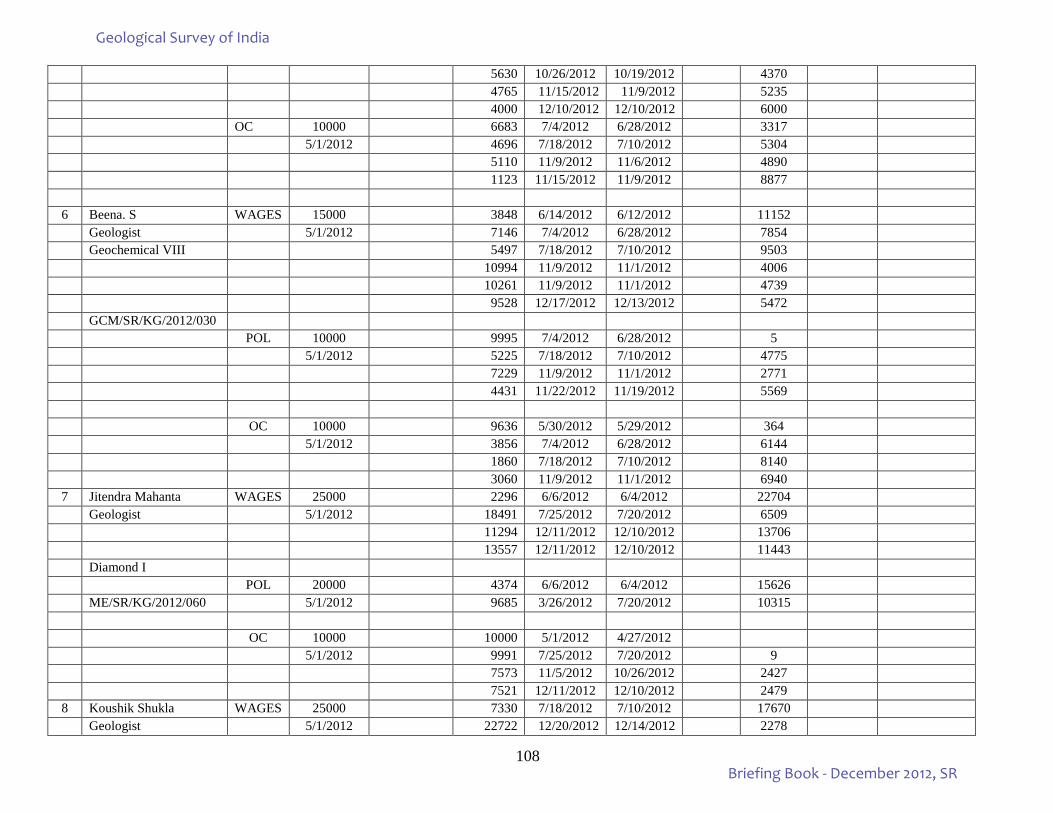
108
5630 10/26/2012 10/19/2012 4370 4765 11/15/2012 11/9/2012 5235 4000 12/10/2012 12/10/2012 6000 OC 10000 6683 7/4/2012 6/28/2012 3317 5/1/2012 4696 7/18/2012 7/10/2012 5304 5110 11/9/2012 11/6/2012 4890 1123 11/15/2012 11/9/2012 8877
6 Beena. S WAGES 15000 3848 6/14/2012 6/12/2012 11152 Geologist 5/1/2012 7146 7/4/2012 6/28/2012 7854 Geochemical VIII 5497 7/18/2012 7/10/2012 9503 10994 11/9/2012 11/1/2012 4006 10261 11/9/2012 11/1/2012 4739 9528 12/17/2012 12/13/2012 5472 GCM/SR/KG/2012/030 POL 10000 9995 7/4/2012 6/28/2012 5 5/1/2012 5225 7/18/2012 7/10/2012 4775 7229 11/9/2012 11/1/2012 2771 4431 11/22/2012 11/19/2012 5569 OC 10000 9636 5/30/2012 5/29/2012 364 5/1/2012 3856 7/4/2012 6/28/2012 6144 1860 7/18/2012 7/10/2012 8140 3060 11/9/2012 11/1/2012 6940
7 Jitendra Mahanta WAGES 25000 2296 6/6/2012 6/4/2012 22704 Geologist 5/1/2012 18491 7/25/2012 7/20/2012 6509 11294 12/11/2012 12/10/2012 13706 13557 12/11/2012 12/10/2012 11443 Diamond I POL 20000 4374 6/6/2012 6/4/2012 15626 ME/SR/KG/2012/060 5/1/2012 9685 3/26/2012 7/20/2012 10315 OC 10000 10000 5/1/2012 4/27/2012 5/1/2012 9991 7/25/2012 7/20/2012 9 7573 11/5/2012 10/26/2012 2427 7521 12/11/2012 12/10/2012 2479
8 Koushik Shukla WAGES 25000 7330 7/18/2012 7/10/2012 17670 Geologist 5/1/2012 22722 12/20/2012 12/14/2012 2278
Geological Survey of India
Briefing Book - December 2012, SR
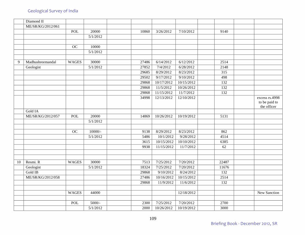
109
Diamond II ME/SR/KG/2012/061 POL 20000 10860 3/26/2012 7/10/2012 9140 5/1/2012 OC 10000 5/1/2012
9 Madhushreemandal WAGES 30000 27486 6/14/2012 6/12/2012 2514 Geologist 5/1/2012 27852 7/4/2012 6/28/2012 2148 29685 8/29/2012 8/23/2012 315 29502 9/17/2012 9/10/2012 498 29868 10/17/2012 10/15/2012 132 29868 11/5/2012 10/26/2012 132 29868 11/15/2012 11/7/2012 132 34998 12/13/2012 12/10/2012 excess rs.4998
to be paid to the officer
Gold IA ME/SR/KG/2012/057 POL 20000 14869 10/26/2012 10/19/2012 5131 5/1/2012 OC 10000/- 9138 8/29/2012 8/23/2012 862 5/1/2012 5486 10/1/2012 9/28/2012 4514 3615 10/15/2012 10/10/2012 6385 9938 11/15/2012 11/7/2012 62
10 Resmi. R WAGES 30000 7513 7/25/2012 7/20/2012 22487 Geologist 5/1/2012 18324 7/25/2012 7/20/2012 11676 Gold IB 29868 9/10/2012 8/24/2012 132 ME/SR/KG/2012/058 27486 10/16/2012 10/15/2012 2514 29868 11/9/2012 11/6/2012 132 WAGES 44000 12/18/2012 New Sanction POL 5000/- 2300 7/25/2012 7/20/2012 2700 5/1/2012 2000 10/26/2012 10/19/2012 3000
Geological Survey of India
Briefing Book - December 2012, SR
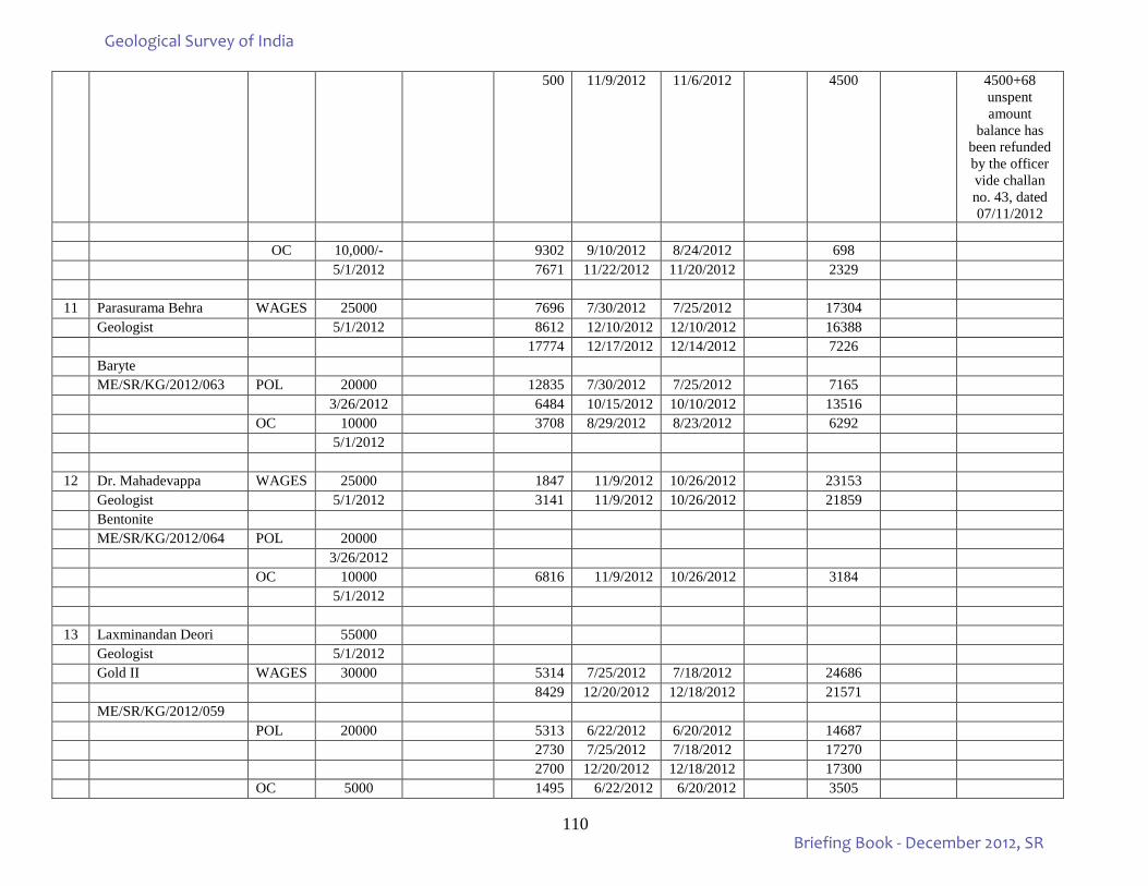
110
500 11/9/2012 11/6/2012 4500 4500+68 unspent amount
balance has been refunded by the officer vide challan no. 43, dated 07/11/2012
OC 10,000/- 9302 9/10/2012 8/24/2012 698 5/1/2012 7671 11/22/2012 11/20/2012 2329
11 Parasurama Behra WAGES 25000 7696 7/30/2012 7/25/2012 17304 Geologist 5/1/2012 8612 12/10/2012 12/10/2012 16388 17774 12/17/2012 12/14/2012 7226 Baryte ME/SR/KG/2012/063 POL 20000 12835 7/30/2012 7/25/2012 7165 3/26/2012 6484 10/15/2012 10/10/2012 13516 OC 10000 3708 8/29/2012 8/23/2012 6292 5/1/2012
12 Dr. Mahadevappa WAGES 25000 1847 11/9/2012 10/26/2012 23153 Geologist 5/1/2012 3141 11/9/2012 10/26/2012 21859 Bentonite ME/SR/KG/2012/064 POL 20000 3/26/2012 OC 10000 6816 11/9/2012 10/26/2012 3184 5/1/2012
13 Laxminandan Deori 55000 Geologist 5/1/2012 Gold II WAGES 30000 5314 7/25/2012 7/18/2012 24686 8429 12/20/2012 12/18/2012 21571 ME/SR/KG/2012/059 POL 20000 5313 6/22/2012 6/20/2012 14687 2730 7/25/2012 7/18/2012 17270 2700 12/20/2012 12/18/2012 17300 OC 5000 1495 6/22/2012 6/20/2012 3505
Geological Survey of India
Briefing Book - December 2012, SR
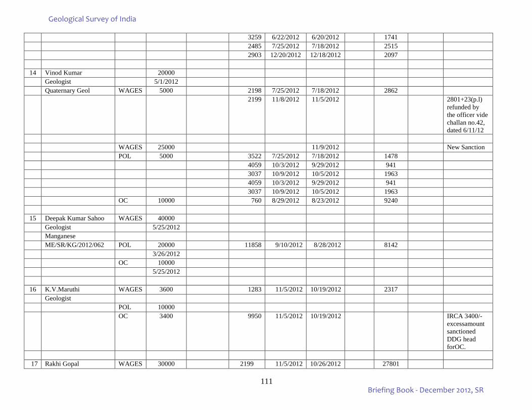
111
3259 6/22/2012 6/20/2012 1741 2485 7/25/2012 7/18/2012 2515 2903 12/20/2012 12/18/2012 2097
14 Vinod Kumar 20000 Geologist 5/1/2012 Quaternary Geol WAGES 5000 2198 7/25/2012 7/18/2012 2862 2199 11/8/2012 11/5/2012 2801+23(p.l)
refunded by the officer vide challan no.42, dated 6/11/12
WAGES 25000 11/9/2012 New Sanction POL 5000 3522 7/25/2012 7/18/2012 1478 4059 10/3/2012 9/29/2012 941 3037 10/9/2012 10/5/2012 1963 4059 10/3/2012 9/29/2012 941 3037 10/9/2012 10/5/2012 1963 OC 10000 760 8/29/2012 8/23/2012 9240
15 Deepak Kumar Sahoo WAGES 40000 Geologist 5/25/2012 Manganese ME/SR/KG/2012/062 POL 20000 11858 9/10/2012 8/28/2012 8142 3/26/2012 OC 10000 5/25/2012
16 K.V.Maruthi WAGES 3600 1283 11/5/2012 10/19/2012 2317 Geologist POL 10000 OC 3400 9950 11/5/2012 10/19/2012 IRCA 3400/-
excessamount sanctioned DDG head forOC.
17 Rakhi Gopal WAGES 30000 2199 11/5/2012 10/26/2012 27801
Geological Survey of India
Briefing Book - December 2012, SR
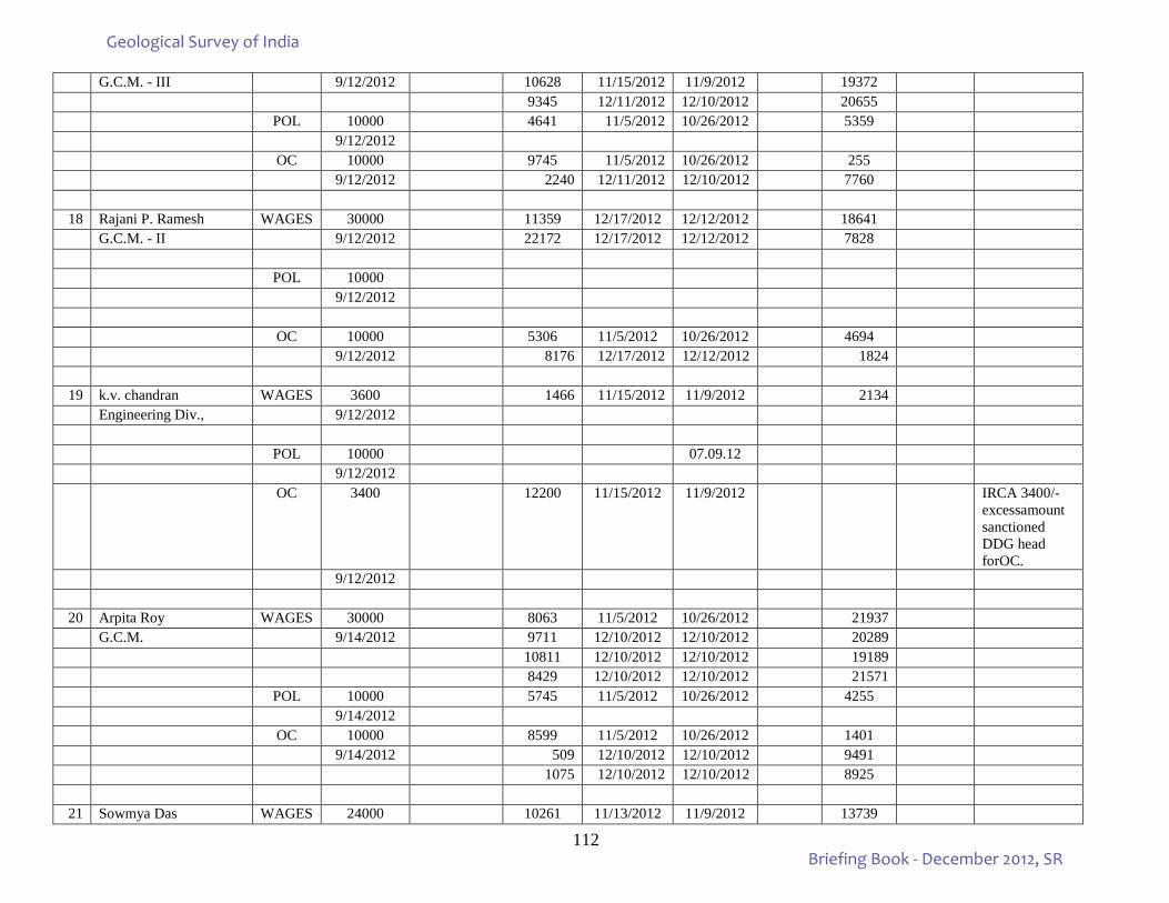
112
G.C.M. - III 9/12/2012 10628 11/15/2012 11/9/2012 19372 9345 12/11/2012 12/10/2012 20655 POL 10000 4641 11/5/2012 10/26/2012 5359 9/12/2012 OC 10000 9745 11/5/2012 10/26/2012 255 9/12/2012 2240 12/11/2012 12/10/2012 7760 18 Rajani P. Ramesh WAGES 30000 11359 12/17/2012 12/12/2012 18641
G.C.M. - II 9/12/2012 22172 12/17/2012 12/12/2012 7828 POL 10000 9/12/2012 OC 10000 5306 11/5/2012 10/26/2012 4694 9/12/2012 8176 12/17/2012 12/12/2012 1824 19 k.v. chandran WAGES 3600 1466 11/15/2012 11/9/2012 2134
Engineering Div., 9/12/2012 POL 10000 07.09.12 9/12/2012 OC 3400 12200 11/15/2012 11/9/2012 IRCA 3400/-
excessamount sanctioned DDG head forOC.
9/12/2012 20 Arpita Roy WAGES 30000 8063 11/5/2012 10/26/2012 21937
G.C.M. 9/14/2012 9711 12/10/2012 12/10/2012 20289 10811 12/10/2012 12/10/2012 19189 8429 12/10/2012 12/10/2012 21571 POL 10000 5745 11/5/2012 10/26/2012 4255 9/14/2012 OC 10000 8599 11/5/2012 10/26/2012 1401 9/14/2012 509 12/10/2012 12/10/2012 9491
1075 12/10/2012 12/10/2012 8925
21 Sowmya Das WAGES 24000 10261 11/13/2012 11/9/2012 13739
Geological Survey of India
Briefing Book - December 2012, SR
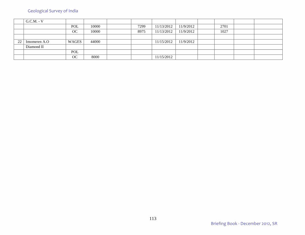
113
G.C.M. - V POL 10000 7299 11/13/2012 11/9/2012 2701 OC 10000 8975 11/13/2012 11/9/2012 1027 22 Imomeren A.O WAGES 44000 11/15/2012 11/9/2012
Diamond II POL OC 8000 11/15/2012
Geological Survey of India
Briefing Book - December 2012, SR
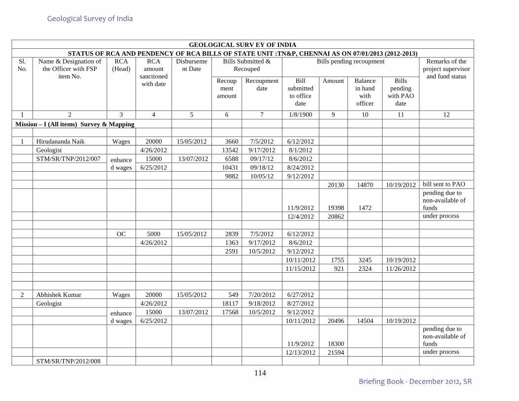
114
GEOLOGICAL SURV EY OF INDIA
STATUS OF RCA AND PENDENCY OF RCA BILLS OF STATE UNIT :TN&P, CHENNAI AS ON 07/01/2013 (2012-2013) Sl. No.
Name & Designation of the Officer with FSP
item No.
RCA (Head)
RCA amount
sanctioned with date
Disbursement Date
Bills Submitted & Recouped
Bills pending recoupment Remarks of the project supervisor
and fund status Recoup
ment amount
Recoupment date
Bill submitted to office
date
Amount Balance in hand
with officer
Bills pending
with PAO date
1 2 3 4 5 6 7 1/8/1900 9 10 11 12 Mission – I (All items) Survey & Mapping
1 Hirudananda Naik Wages 20000 15/05/2012 3660 7/5/2012 6/12/2012 Geologist 4/26/2012 13542 9/17/2012 8/1/2012 STM/SR/TNP/2012/007 enhance
d wages 15000 13/07/2012 6588 09/17/12 8/6/2012
6/25/2012 10431 09/18/12 8/24/2012 9882 10/05/12 9/12/2012 20130 14870 10/19/2012 bill sent to PAO
11/9/2012 19398 1472
pending due to non-available of funds
12/4/2012 20862 under process OC 5000 15/05/2012 2839 7/5/2012 6/12/2012 4/26/2012 1363 9/17/2012 8/6/2012 2591 10/5/2012 9/12/2012 10/11/2012 1755 3245 10/19/2012 11/15/2012 921 2324 11/26/2012
2 Abhishek Kumar Wages 20000 15/05/2012 549 7/20/2012 6/27/2012 Geologist 4/26/2012 18117 9/18/2012 8/27/2012 enhance
d wages 15000 13/07/2012 17568 10/5/2012 9/12/2012
6/25/2012 10/11/2012 20496 14504 10/19/2012
11/9/2012 18300
pending due to non-available of funds
12/13/2012 21594 under process STM/SR/TNP/2012/008
Geological Survey of India
Briefing Book - December 2012, SR
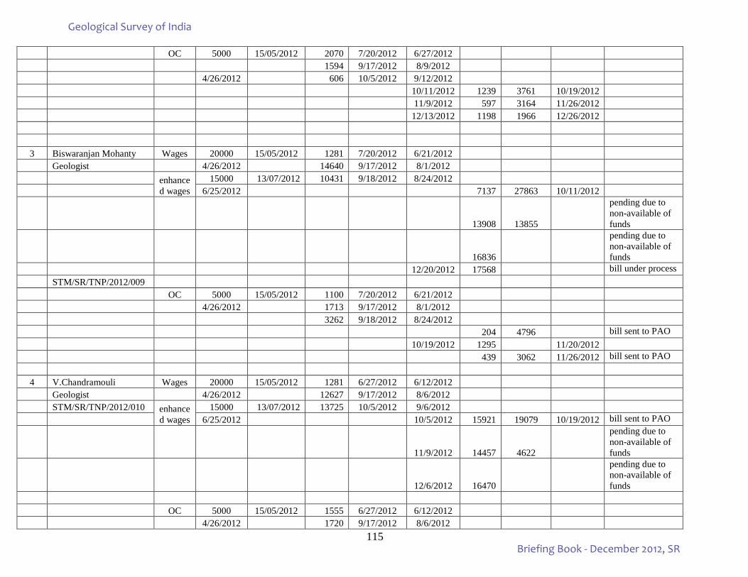
115
OC 5000 15/05/2012 2070 7/20/2012 6/27/2012 1594 9/17/2012 8/9/2012 4/26/2012 606 10/5/2012 9/12/2012 10/11/2012 1239 3761 10/19/2012 11/9/2012 597 3164 11/26/2012 12/13/2012 1198 1966 12/26/2012
3 Biswaranjan Mohanty Wages 20000 15/05/2012 1281 7/20/2012 6/21/2012 Geologist 4/26/2012 14640 9/17/2012 8/1/2012 enhance
d wages 15000 13/07/2012 10431 9/18/2012 8/24/2012
6/25/2012 7137 27863 10/11/2012
13908 13855
pending due to non-available of funds
16836
pending due to non-available of funds
12/20/2012 17568 bill under process STM/SR/TNP/2012/009 OC 5000 15/05/2012 1100 7/20/2012 6/21/2012 4/26/2012 1713 9/17/2012 8/1/2012 3262 9/18/2012 8/24/2012 204 4796 bill sent to PAO 10/19/2012 1295 11/20/2012 439 3062 11/26/2012 bill sent to PAO 4 V.Chandramouli Wages 20000 15/05/2012 1281 6/27/2012 6/12/2012 Geologist 4/26/2012 12627 9/17/2012 8/6/2012 STM/SR/TNP/2012/010 enhance
d wages 15000 13/07/2012 13725 10/5/2012 9/6/2012
6/25/2012 10/5/2012 15921 19079 10/19/2012 bill sent to PAO
11/9/2012 14457 4622
pending due to non-available of funds
12/6/2012 16470
pending due to non-available of funds
OC 5000 15/05/2012 1555 6/27/2012 6/12/2012 4/26/2012 1720 9/17/2012 8/6/2012
Geological Survey of India
Briefing Book - December 2012, SR
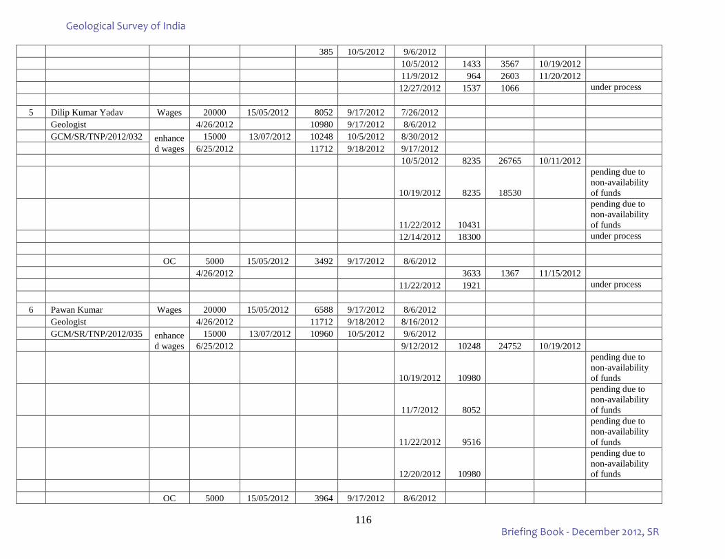
116
385 10/5/2012 9/6/2012 10/5/2012 1433 3567 10/19/2012 11/9/2012 964 2603 11/20/2012 12/27/2012 1537 1066 under process 5 Dilip Kumar Yadav Wages 20000 15/05/2012 8052 9/17/2012 7/26/2012 Geologist 4/26/2012 10980 9/17/2012 8/6/2012 GCM/SR/TNP/2012/032 enhance
d wages 15000 13/07/2012 10248 10/5/2012 8/30/2012
6/25/2012 11712 9/18/2012 9/17/2012 10/5/2012 8235 26765 10/11/2012
10/19/2012 8235 18530
pending due to non-availability of funds
11/22/2012 10431
pending due to non-availability of funds
12/14/2012 18300 under process OC 5000 15/05/2012 3492 9/17/2012 8/6/2012 4/26/2012 3633 1367 11/15/2012 11/22/2012 1921 under process
6 Pawan Kumar Wages 20000 15/05/2012 6588 9/17/2012 8/6/2012 Geologist 4/26/2012 11712 9/18/2012 8/16/2012 GCM/SR/TNP/2012/035 enhance
d wages 15000 13/07/2012 10960 10/5/2012 9/6/2012
6/25/2012 9/12/2012 10248 24752 10/19/2012
10/19/2012 10980
pending due to non-availability of funds
11/7/2012 8052
pending due to non-availability of funds
11/22/2012 9516
pending due to non-availability of funds
12/20/2012 10980
pending due to non-availability of funds
OC 5000 15/05/2012 3964 9/17/2012 8/6/2012
Geological Survey of India
Briefing Book - December 2012, SR
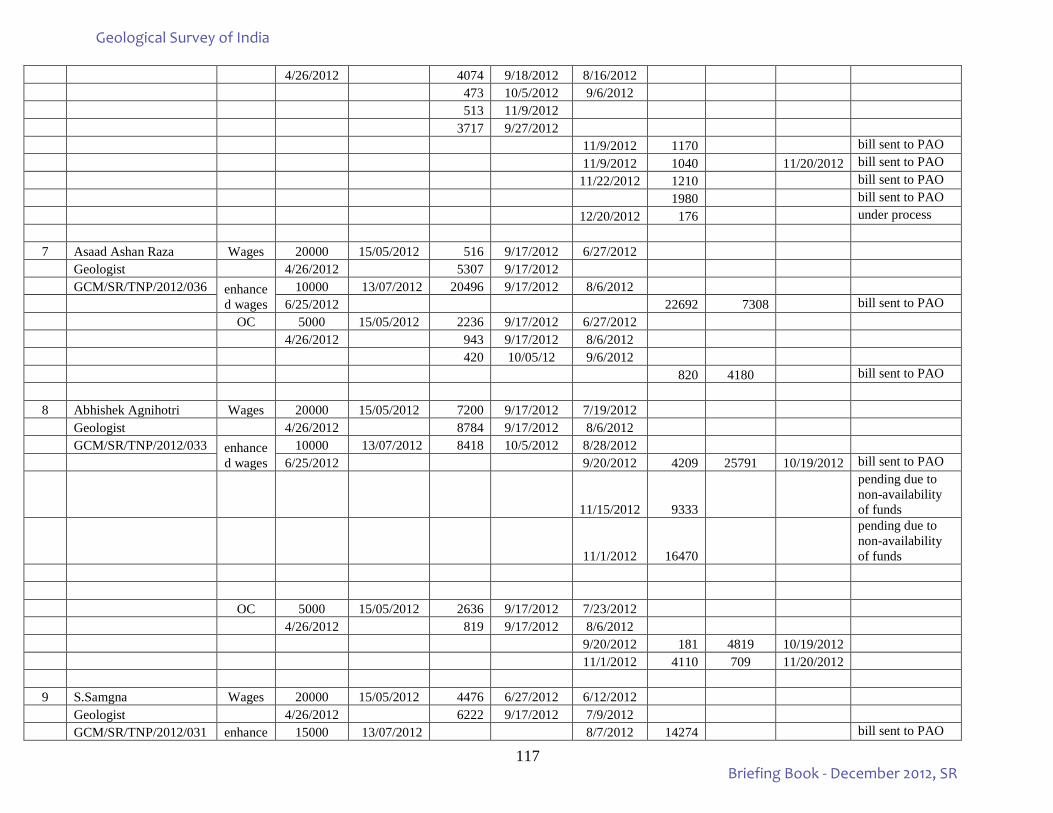
117
4/26/2012 4074 9/18/2012 8/16/2012 473 10/5/2012 9/6/2012 513 11/9/2012 3717 9/27/2012 11/9/2012 1170 bill sent to PAO 11/9/2012 1040 11/20/2012 bill sent to PAO 11/22/2012 1210 bill sent to PAO 1980 bill sent to PAO 12/20/2012 176 under process 7 Asaad Ashan Raza Wages 20000 15/05/2012 516 9/17/2012 6/27/2012 Geologist 4/26/2012 5307 9/17/2012 GCM/SR/TNP/2012/036 enhance
d wages 10000 13/07/2012 20496 9/17/2012 8/6/2012
6/25/2012 22692 7308 bill sent to PAO OC 5000 15/05/2012 2236 9/17/2012 6/27/2012 4/26/2012 943 9/17/2012 8/6/2012 420 10/05/12 9/6/2012 820 4180 bill sent to PAO 8 Abhishek Agnihotri Wages 20000 15/05/2012 7200 9/17/2012 7/19/2012 Geologist 4/26/2012 8784 9/17/2012 8/6/2012 GCM/SR/TNP/2012/033 enhance
d wages 10000 13/07/2012 8418 10/5/2012 8/28/2012
6/25/2012 9/20/2012 4209 25791 10/19/2012 bill sent to PAO
11/15/2012 9333
pending due to non-availability of funds
11/1/2012 16470
pending due to non-availability of funds
OC 5000 15/05/2012 2636 9/17/2012 7/23/2012 4/26/2012 819 9/17/2012 8/6/2012 9/20/2012 181 4819 10/19/2012 11/1/2012 4110 709 11/20/2012
9 S.Samgna Wages 20000 15/05/2012 4476 6/27/2012 6/12/2012 Geologist 4/26/2012 6222 9/17/2012 7/9/2012 GCM/SR/TNP/2012/031 enhance 15000 13/07/2012 8/7/2012 14274 bill sent to PAO
Geological Survey of India
Briefing Book - December 2012, SR
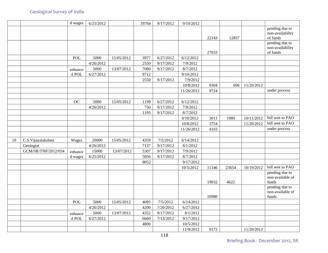
118
d wages 6/25/2012 19764 9/17/2012 9/10/2012
22143 12857
pending due to non-availability of funds
27633
pending due to non-availability of funds
POL 5000 15/05/2012 3977 6/27/2012 6/12/2012 4/26/2012 2550 9/17/2012 7/9/2012 enhance
d POL 5000 13/07/2012 7080 9/17/2012 8/7/2012
6/27/2012 9712 9/10/2012 2550 9/17/2012 7/9/2012 10/8/2012 9304 696 11/20/2012 11/26/2012 9724 under process OC 5000 15/05/2012 1199 6/27/2012 6/12/2012 4/26/2012 750 9/17/2012 7/9/2012 1195 9/17/2012 8/7/2012 9/10/2012 3011 1989 10/11/2012 bill sent to PAO 10/8/2012 3754 11/20/2012 bill sent to PAO 11/26/2012 4103 under process
10 C.S.Vijayalakshmi Wages 20000 15/05/2012 4359 7/5/2012 6/14/2012 Geologist 4/26/2012 7137 9/17/2012 8/1/2012 GCM/SR/TNP/2012/034 enhance
d wages 15000 13/07/2012 5307 9/17/2012 7/9/2012
6/25/2012 5856 9/17/2012 8/7/2012 8052 9/17/2012 10/5/2012 11346 23654 10/19/2012 bill sent to PAO
19032 4622
pending due to non-available of funds
10980
pending due to non-available of funds
POL 5000 15/05/2012 4085 7/5/2012 6/14/2012 4/26/2012 4200 7/20/2012 6/27/2012 enhance
d POL 5000 13/07/2012 4352 9/17/2012 8/1/2012
6/27/2012 6669 7/13/2012 9/17/2012 4800 10/5/2012 11/9/2012 9172 11/20/2012
Geological Survey of India
Briefing Book - December 2012, SR
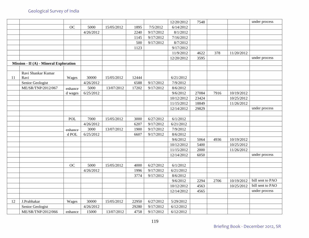
119
12/20/2012 7548 under process OC 5000 15/05/2012 1895 7/5/2012 6/14/2012 4/26/2012 2240 9/17/2012 8/1/2012 1145 9/17/2012 7/16/2012 500 9/17/2012 8/7/2012 1123 9/17/2012 11/9/2012 4622 378 11/20/2012 12/20/2012 3595 under process
Mission - II (A) - Mineral Exploration
11 Ravi Shankar Kumar Ravi Wages 30000 15/05/2012 12444 6/21/2012
Senior Geologist 4/26/2012 6588 9/17/2012 7/9/2012 ME/SR/TNP/2012/067 enhance
d wages 5000 13/07/2012 17202 9/17/2012 8/6/2012
6/25/2012 9/6/2012 27084 7916 10/19/2012 10/12/2012 23424 10/25/2012 11/15/2012 18849 11/26/2012 12/14/2012 29829 under process POL 7000 15/05/2012 3000 6/27/2012 6/1/2012 4/26/2012 6207 9/17/2012 6/21/2012 enhance
d POL 3000 13/07/2012 1900 9/17/2012 7/9/2012
6/25/2012 6607 9/17/2012 8/6/2012 9/6/2012 5064 4936 10/19/2012 10/12/2012 5400 10/25/2012 11/15/2012 2000 11/26/2012 12/14/2012 6050 under process OC 5000 15/05/2012 4000 6/27/2012 6/1/2012 4/26/2012 1996 9/17/2012 6/21/2012 3774 9/17/2012 8/6/2012 9/6/2012 2294 2706 10/19/2012 bill sent to PAO 10/12/2012 4563 10/25/2012 bill sent to PAO 12/14/2012 4565 under process
12 J.Prabhakar Wages 30000 15/05/2012 22950 6/27/2012 5/29/2012 Senior Geologist 4/26/2012 29280 9/17/2012 6/12/2012 ME/SR/TNP/2012/066 enhance 15000 13/07/2012 4758 9/17/2012 6/12/2012
Geological Survey of India
Briefing Book - December 2012, SR
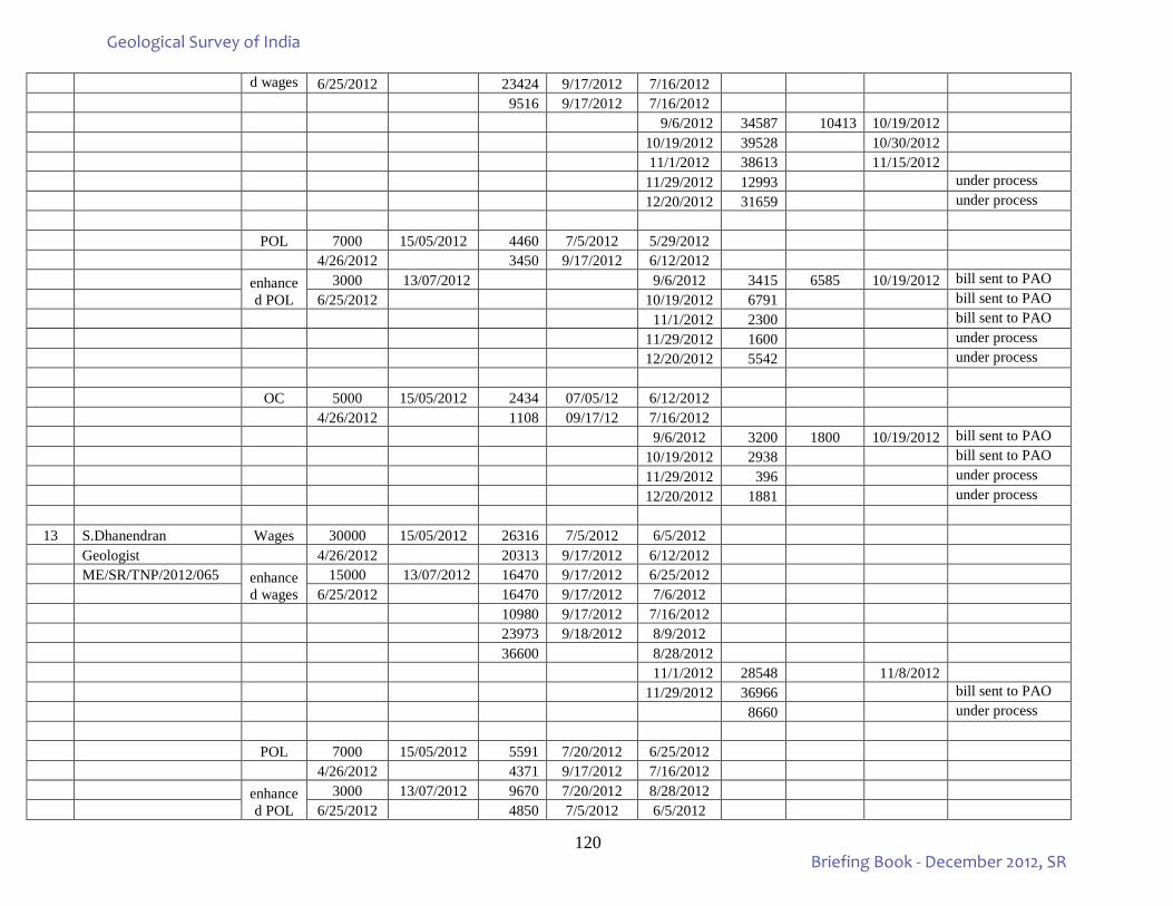
120
d wages 6/25/2012 23424 9/17/2012 7/16/2012 9516 9/17/2012 7/16/2012 9/6/2012 34587 10413 10/19/2012 10/19/2012 39528 10/30/2012 11/1/2012 38613 11/15/2012 11/29/2012 12993 under process 12/20/2012 31659 under process POL 7000 15/05/2012 4460 7/5/2012 5/29/2012 4/26/2012 3450 9/17/2012 6/12/2012 enhance
d POL 3000 13/07/2012 9/6/2012 3415 6585 10/19/2012 bill sent to PAO
6/25/2012 10/19/2012 6791 bill sent to PAO 11/1/2012 2300 bill sent to PAO 11/29/2012 1600 under process 12/20/2012 5542 under process OC 5000 15/05/2012 2434 07/05/12 6/12/2012 4/26/2012 1108 09/17/12 7/16/2012 9/6/2012 3200 1800 10/19/2012 bill sent to PAO 10/19/2012 2938 bill sent to PAO 11/29/2012 396 under process 12/20/2012 1881 under process
13 S.Dhanendran Wages 30000 15/05/2012 26316 7/5/2012 6/5/2012 Geologist 4/26/2012 20313 9/17/2012 6/12/2012 ME/SR/TNP/2012/065 enhance
d wages 15000 13/07/2012 16470 9/17/2012 6/25/2012
6/25/2012 16470 9/17/2012 7/6/2012 10980 9/17/2012 7/16/2012 23973 9/18/2012 8/9/2012 36600 8/28/2012 11/1/2012 28548 11/8/2012 11/29/2012 36966 bill sent to PAO 8660 under process POL 7000 15/05/2012 5591 7/20/2012 6/25/2012 4/26/2012 4371 9/17/2012 7/16/2012 enhance
d POL 3000 13/07/2012 9670 7/20/2012 8/28/2012
6/25/2012 4850 7/5/2012 6/5/2012
Geological Survey of India
Briefing Book - December 2012, SR
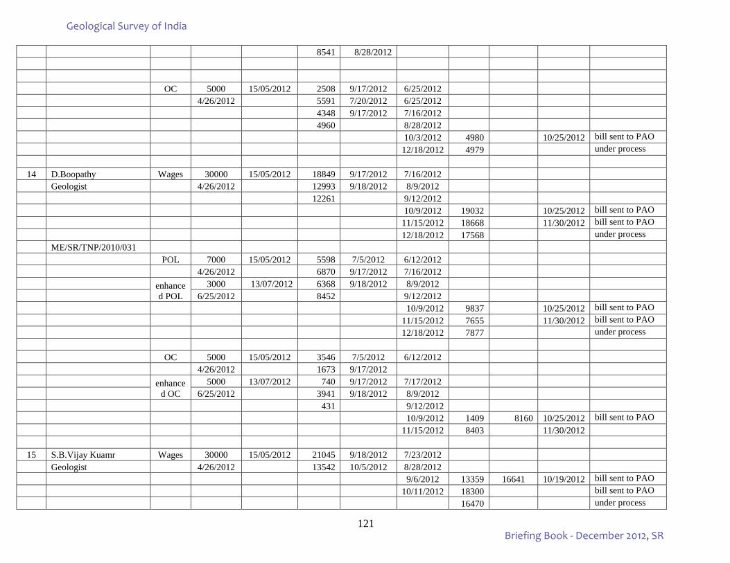
121
8541 8/28/2012 OC 5000 15/05/2012 2508 9/17/2012 6/25/2012 4/26/2012 5591 7/20/2012 6/25/2012 4348 9/17/2012 7/16/2012 4960 8/28/2012 10/3/2012 4980 10/25/2012 bill sent to PAO 12/18/2012 4979 under process
14 D.Boopathy Wages 30000 15/05/2012 18849 9/17/2012 7/16/2012 Geologist 4/26/2012 12993 9/18/2012 8/9/2012 12261 9/12/2012 10/9/2012 19032 10/25/2012 bill sent to PAO 11/15/2012 18668 11/30/2012 bill sent to PAO 12/18/2012 17568 under process ME/SR/TNP/2010/031 POL 7000 15/05/2012 5598 7/5/2012 6/12/2012 4/26/2012 6870 9/17/2012 7/16/2012 enhance
d POL 3000 13/07/2012 6368 9/18/2012 8/9/2012
6/25/2012 8452 9/12/2012 10/9/2012 9837 10/25/2012 bill sent to PAO 11/15/2012 7655 11/30/2012 bill sent to PAO 12/18/2012 7877 under process OC 5000 15/05/2012 3546 7/5/2012 6/12/2012 4/26/2012 1673 9/17/2012 enhance
d OC 5000 13/07/2012 740 9/17/2012 7/17/2012
6/25/2012 3941 9/18/2012 8/9/2012 431 9/12/2012 10/9/2012 1409 8160 10/25/2012 bill sent to PAO 11/15/2012 8403 11/30/2012
15 S.B.Vijay Kuamr Wages 30000 15/05/2012 21045 9/18/2012 7/23/2012 Geologist 4/26/2012 13542 10/5/2012 8/28/2012 9/6/2012 13359 16641 10/19/2012 bill sent to PAO 10/11/2012 18300 bill sent to PAO 16470 under process
Geological Survey of India
Briefing Book - December 2012, SR
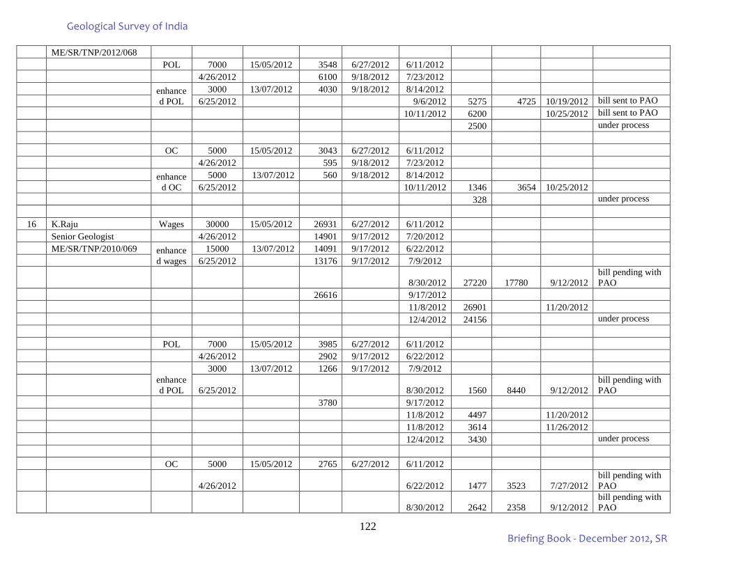
122
ME/SR/TNP/2012/068 POL 7000 15/05/2012 3548 6/27/2012 6/11/2012 4/26/2012 6100 9/18/2012 7/23/2012 enhance
d POL 3000 13/07/2012 4030 9/18/2012 8/14/2012
6/25/2012 9/6/2012 5275 4725 10/19/2012 bill sent to PAO 10/11/2012 6200 10/25/2012 bill sent to PAO 2500 under process OC 5000 15/05/2012 3043 6/27/2012 6/11/2012 4/26/2012 595 9/18/2012 7/23/2012 enhance
d OC 5000 13/07/2012 560 9/18/2012 8/14/2012
6/25/2012 10/11/2012 1346 3654 10/25/2012 328 under process
16 K.Raju Wages 30000 15/05/2012 26931 6/27/2012 6/11/2012 Senior Geologist 4/26/2012 14901 9/17/2012 7/20/2012 ME/SR/TNP/2010/069 enhance
d wages 15000 13/07/2012 14091 9/17/2012 6/22/2012
6/25/2012 13176 9/17/2012 7/9/2012
8/30/2012 27220 17780 9/12/2012 bill pending with PAO
26616 9/17/2012 11/8/2012 26901 11/20/2012 12/4/2012 24156 under process POL 7000 15/05/2012 3985 6/27/2012 6/11/2012 4/26/2012 2902 9/17/2012 6/22/2012
enhanced POL
3000 13/07/2012 1266 9/17/2012 7/9/2012
6/25/2012 8/30/2012 1560 8440 9/12/2012 bill pending with PAO
3780 9/17/2012 11/8/2012 4497 11/20/2012 11/8/2012 3614 11/26/2012 12/4/2012 3430 under process OC 5000 15/05/2012 2765 6/27/2012 6/11/2012
4/26/2012 6/22/2012 1477 3523 7/27/2012 bill pending with PAO
8/30/2012 2642 2358 9/12/2012 bill pending with PAO
Geological Survey of India
Briefing Book - December 2012, SR
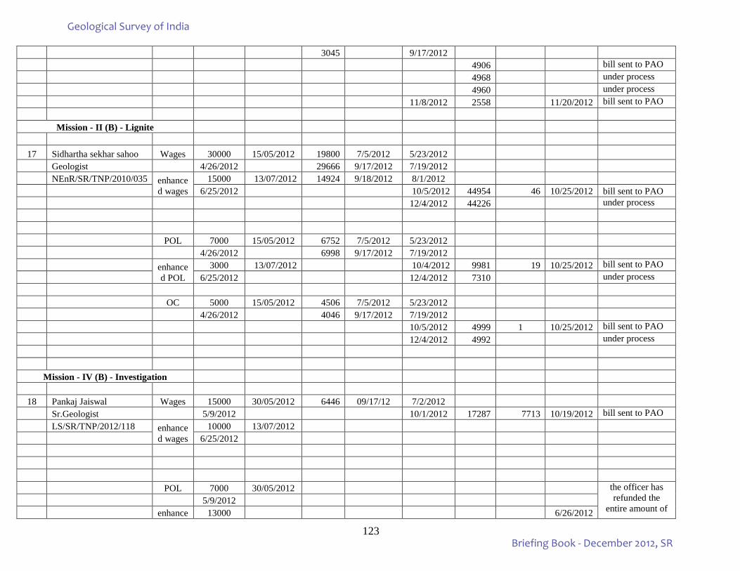
123
3045 9/17/2012 4906 bill sent to PAO 4968 under process 4960 under process 11/8/2012 2558 11/20/2012 bill sent to PAO
Mission - II (B) - Lignite
17 Sidhartha sekhar sahoo Wages 30000 15/05/2012 19800 7/5/2012 5/23/2012
Geologist 4/26/2012 29666 9/17/2012 7/19/2012 NEnR/SR/TNP/2010/035 enhance
d wages 15000 13/07/2012 14924 9/18/2012 8/1/2012
6/25/2012 10/5/2012 44954 46 10/25/2012 bill sent to PAO 12/4/2012 44226 under process POL 7000 15/05/2012 6752 7/5/2012 5/23/2012 4/26/2012 6998 9/17/2012 7/19/2012 enhance
d POL 3000 13/07/2012 10/4/2012 9981 19 10/25/2012 bill sent to PAO
6/25/2012 12/4/2012 7310 under process OC 5000 15/05/2012 4506 7/5/2012 5/23/2012 4/26/2012 4046 9/17/2012 7/19/2012 10/5/2012 4999 1 10/25/2012 bill sent to PAO 12/4/2012 4992 under process
Mission - IV (B) - Investigation
18 Pankaj Jaiswal Wages 15000 30/05/2012 6446 09/17/12 7/2/2012 Sr.Geologist 5/9/2012 10/1/2012 17287 7713 10/19/2012 bill sent to PAO LS/SR/TNP/2012/118 enhance
d wages 10000 13/07/2012
6/25/2012 POL 7000 30/05/2012 the officer has
refunded the entire amount of
5/9/2012 enhance 13000 6/26/2012
Geological Survey of India
Briefing Book - December 2012, SR
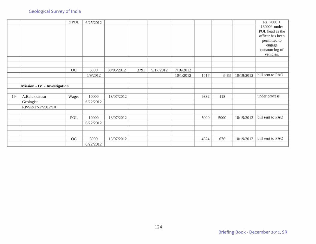
124
d POL 6/25/2012 Rs. 7000 + 13000/- under
POL head as the officer has been
permitted to engage
outsourcing of vehicles.
OC 5000 30/05/2012 3791 9/17/2012 7/16/2012 5/9/2012 10/1/2012 1517 3483 10/19/2012 bill sent to PAO
Mission - IV - Investigation
19 A.Balukkarasu Wages 10000 13/07/2012 9882 118 under process Geologist 6/22/2012 RP/SR/TNP/2012/10 POL 10000 13/07/2012 5000 5000 10/19/2012 bill sent to PAO 6/22/2012
OC 5000 13/07/2012 4324 676 10/19/2012 bill sent to PAO 6/22/2012
Geological Survey of India
Briefing Book - December 2012, SR
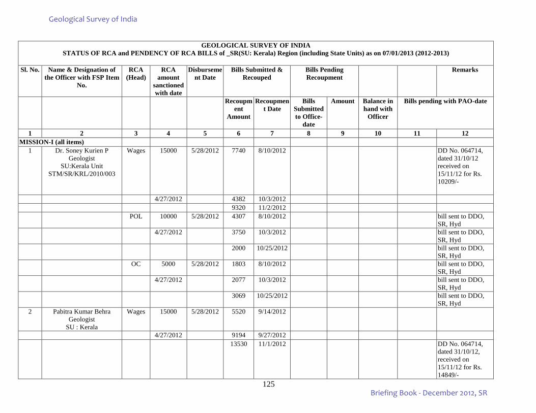
125
GEOLOGICAL SURVEY OF INDIA
STATUS OF RCA and PENDENCY OF RCA BILLS of _SR(SU: Kerala) Region (including State Units) as on 07/01/2013 (2012-2013)
Sl. No. Name & Designation of the Officer with FSP Item
No.
RCA (Head)
RCA amount
sanctioned with date
Disbursement Date
Bills Submitted & Recouped
Bills Pending Recoupment
Remarks
Recoupment
Amount
Recoupment Date
Bills Submitted to Office-
date
Amount Balance in hand with
Officer
Bills pending with PAO-date
1 2 3 4 5 6 7 8 9 10 11 12 MISSION-I (all items)
1 Dr. Soney Kurien P Geologist
SU:Kerala Unit STM/SR/KRL/2010/003
Wages 15000 5/28/2012 7740 8/10/2012 DD No. 064714, dated 31/10/12 received on 15/11/12 for Rs. 10209/-
4/27/2012 4382 10/3/2012 9320 11/2/2012 POL 10000 5/28/2012 4307 8/10/2012 bill sent to DDO,
SR, Hyd 4/27/2012 3750 10/3/2012 bill sent to DDO,
SR, Hyd 2000 10/25/2012 bill sent to DDO,
SR, Hyd OC 5000 5/28/2012 1803 8/10/2012 bill sent to DDO,
SR, Hyd 4/27/2012 2077 10/3/2012 bill sent to DDO,
SR, Hyd 3069 10/25/2012 bill sent to DDO,
SR, Hyd 2 Pabitra Kumar Behra
Geologist SU : Kerala
Wages 15000 5/28/2012 5520 9/14/2012
4/27/2012 9194 9/27/2012 13530 11/1/2012 DD No. 064714,
dated 31/10/12, received on 15/11/12 for Rs. 14849/-
Geological Survey of India
Briefing Book - December 2012, SR
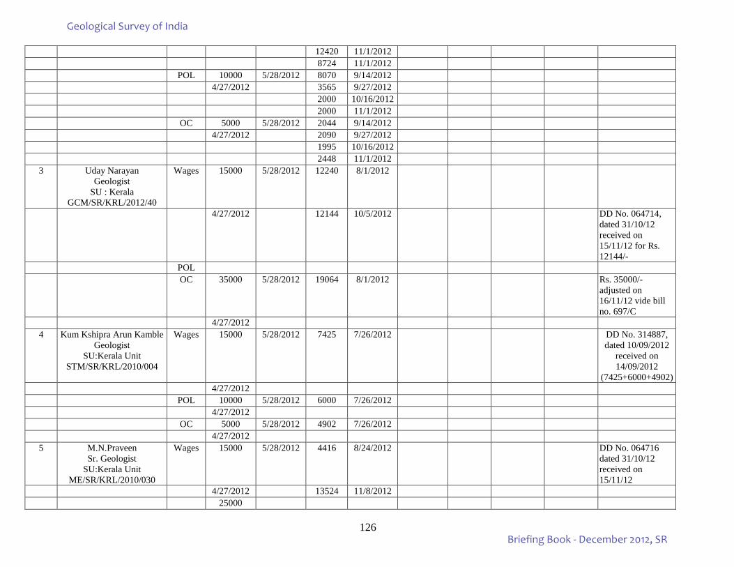
126
12420 11/1/2012 8724 11/1/2012 POL 10000 5/28/2012 8070 9/14/2012 4/27/2012 3565 9/27/2012 2000 10/16/2012 2000 11/1/2012 OC 5000 5/28/2012 2044 9/14/2012 4/27/2012 2090 9/27/2012 1995 10/16/2012 2448 11/1/2012
3 Uday Narayan Geologist
SU : Kerala GCM/SR/KRL/2012/40
Wages 15000 5/28/2012 12240 8/1/2012
4/27/2012 12144 10/5/2012 DD No. 064714, dated 31/10/12 received on 15/11/12 for Rs. 12144/-
POL OC 35000 5/28/2012 19064 8/1/2012 Rs. 35000/-
adjusted on 16/11/12 vide bill no. 697/C
4/27/2012 4 Kum Kshipra Arun Kamble
Geologist SU:Kerala Unit
STM/SR/KRL/2010/004
Wages 15000 5/28/2012 7425 7/26/2012 DD No. 314887, dated 10/09/2012
received on 14/09/2012
(7425+6000+4902) 4/27/2012 POL 10000 5/28/2012 6000 7/26/2012 4/27/2012 OC 5000 5/28/2012 4902 7/26/2012 4/27/2012
5 M.N.Praveen Sr. Geologist
SU:Kerala Unit ME/SR/KRL/2010/030
Wages 15000 5/28/2012 4416 8/24/2012 DD No. 064716 dated 31/10/12 received on 15/11/12
4/27/2012 13524 11/8/2012 25000
Geological Survey of India
Briefing Book - December 2012, SR
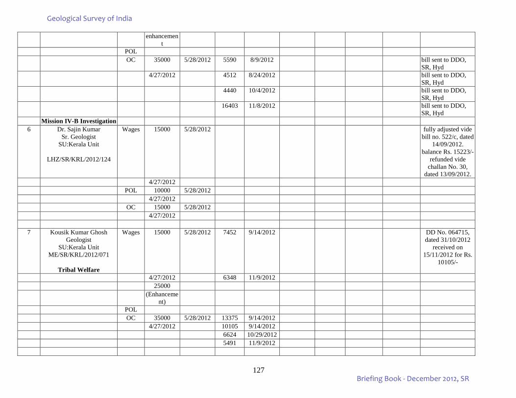
127
enhancement
POL OC 35000 5/28/2012 5590 8/9/2012 bill sent to DDO,
SR, Hyd 4/27/2012 4512 8/24/2012 bill sent to DDO,
SR, Hyd 4440 10/4/2012 bill sent to DDO,
SR, Hyd 16403 11/8/2012 bill sent to DDO,
SR, Hyd Mission IV-B Investigation
6 Dr. Sajin Kumar Sr. Geologist
SU:Kerala Unit
LHZ/SR/KRL/2012/124
Wages 15000 5/28/2012 fully adjusted vide bill no. 522/c, dated
14/09/2012. balance Rs. 15223/-
refunded vide challan No. 30,
dated 13/09/2012. 4/27/2012 POL 10000 5/28/2012 4/27/2012 OC 15000 5/28/2012 4/27/2012
7 Kousik Kumar Ghosh Geologist
SU:Kerala Unit ME/SR/KRL/2012/071
Tribal Welfare
Wages 15000 5/28/2012 7452 9/14/2012 DD No. 064715, dated 31/10/2012
received on 15/11/2012 for Rs.
10105/-
4/27/2012 6348 11/9/2012 25000 (Enhanceme
nt)
POL OC 35000 5/28/2012 13375 9/14/2012 4/27/2012 10105 9/14/2012 6624 10/29/2012 5491 11/9/2012
Geological Survey of India
Briefing Book - December 2012, SR
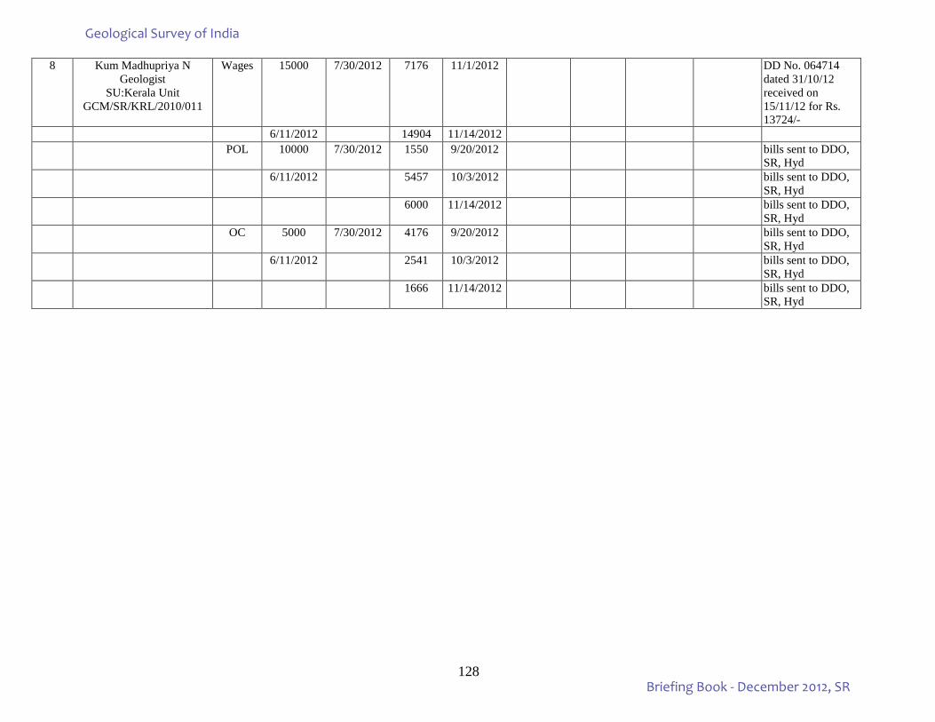
128
8 Kum Madhupriya N Geologist
SU:Kerala Unit GCM/SR/KRL/2010/011
Wages 15000 7/30/2012 7176 11/1/2012 DD No. 064714 dated 31/10/12 received on 15/11/12 for Rs. 13724/-
6/11/2012 14904 11/14/2012 POL 10000 7/30/2012 1550 9/20/2012 bills sent to DDO,
SR, Hyd 6/11/2012 5457 10/3/2012 bills sent to DDO,
SR, Hyd 6000 11/14/2012 bills sent to DDO,
SR, Hyd OC 5000 7/30/2012 4176 9/20/2012 bills sent to DDO,
SR, Hyd 6/11/2012 2541 10/3/2012 bills sent to DDO,
SR, Hyd 1666 11/14/2012 bills sent to DDO,
SR, Hyd
Geological Survey of India
Briefing Book - December 2012, SR
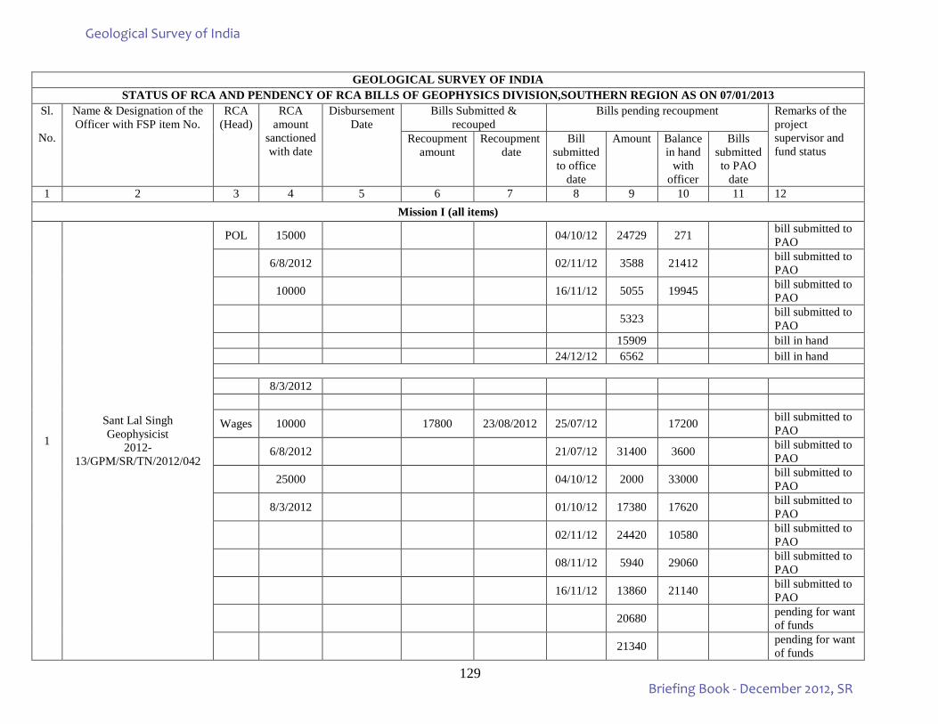
129
GEOLOGICAL SURVEY OF INDIA
STATUS OF RCA AND PENDENCY OF RCA BILLS OF GEOPHYSICS DIVISION,SOUTHERN REGION AS ON 07/01/2013 Sl.
No.
Name & Designation of the Officer with FSP item No.
RCA (Head)
RCA amount
sanctioned with date
Disbursement Date
Bills Submitted & recouped
Bills pending recoupment Remarks of the project supervisor and fund status
Recoupment amount
Recoupment date
Bill submitted to office
date
Amount Balance in hand
with officer
Bills submitted to PAO
date 1 2 3 4 5 6 7 8 9 10 11 12
Mission I (all items)
1
Sant Lal Singh Geophysicist
2012-13/GPM/SR/TN/2012/042
POL 15000 04/10/12 24729 271 bill submitted to PAO
6/8/2012 02/11/12 3588 21412 bill submitted to PAO
10000 16/11/12 5055 19945 bill submitted to PAO
5323 bill submitted to PAO
15909 bill in hand 24/12/12 6562 bill in hand
8/3/2012
Wages 10000 17800 23/08/2012 25/07/12 17200 bill submitted to PAO
6/8/2012 21/07/12 31400 3600 bill submitted to PAO
25000 04/10/12 2000 33000 bill submitted to PAO
8/3/2012 01/10/12 17380 17620 bill submitted to PAO
02/11/12 24420 10580 bill submitted to PAO
08/11/12 5940 29060 bill submitted to PAO
16/11/12 13860 21140 bill submitted to PAO
20680 pending for want of funds
21340 pending for want of funds
Geological Survey of India
Briefing Book - December 2012, SR
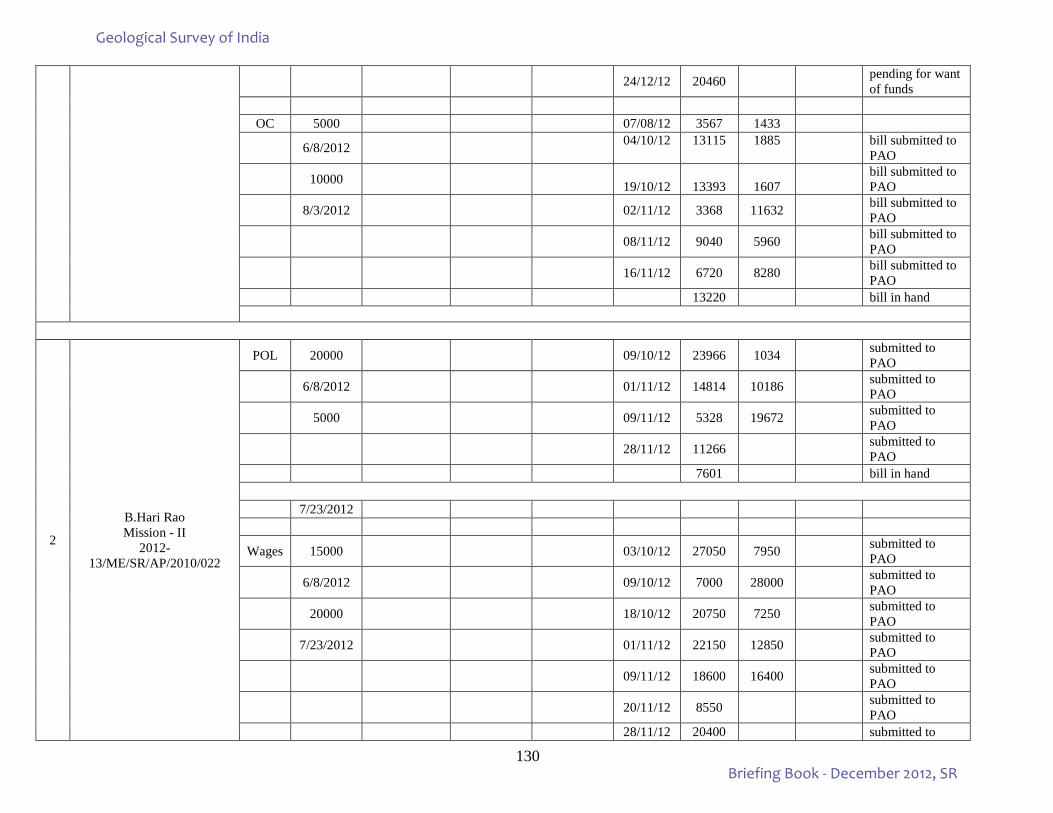
130
24/12/12 20460 pending for want of funds
OC 5000 07/08/12 3567 1433
6/8/2012 04/10/12 13115 1885
bill submitted to PAO
10000 19/10/12 13393 1607 bill submitted to PAO
8/3/2012 02/11/12 3368 11632 bill submitted to PAO
08/11/12 9040 5960 bill submitted to PAO
16/11/12 6720 8280 bill submitted to PAO
13220 bill in hand
2
B.Hari Rao Mission - II
2012-13/ME/SR/AP/2010/022
POL 20000 09/10/12 23966 1034 submitted to PAO
6/8/2012 01/11/12 14814 10186 submitted to PAO
5000 09/11/12 5328 19672 submitted to PAO
28/11/12 11266 submitted to PAO
7601 bill in hand
7/23/2012
Wages 15000 03/10/12 27050 7950 submitted to PAO
6/8/2012 09/10/12 7000 28000 submitted to PAO
20000 18/10/12 20750 7250 submitted to PAO
7/23/2012 01/11/12 22150 12850 submitted to PAO
09/11/12 18600 16400 submitted to PAO
20/11/12 8550 submitted to PAO
28/11/12 20400 submitted to
Geological Survey of India
Briefing Book - December 2012, SR
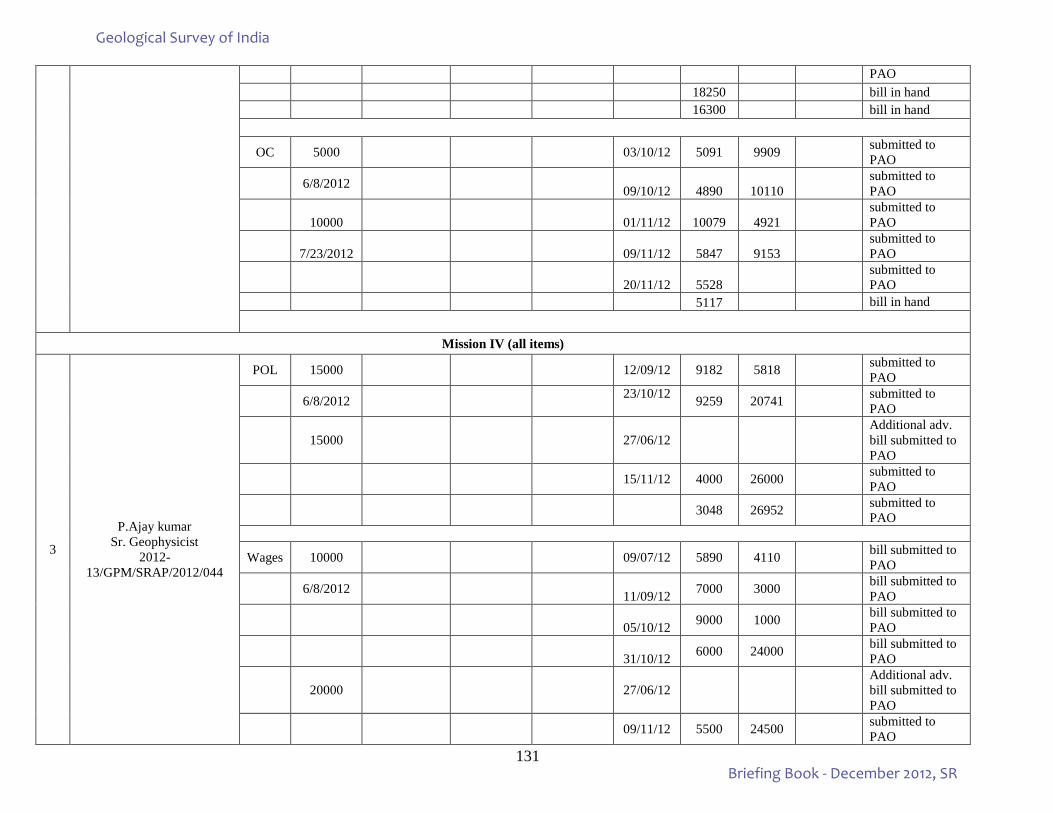
131
PAO 18250 bill in hand 16300 bill in hand
OC 5000 03/10/12 5091 9909 submitted to PAO
6/8/2012 09/10/12 4890 10110 submitted to PAO
10000 01/11/12 10079 4921 submitted to PAO
7/23/2012 09/11/12 5847 9153 submitted to PAO
20/11/12 5528 submitted to PAO
5117 bill in hand
Mission IV (all items)
3
P.Ajay kumar Sr. Geophysicist
2012-13/GPM/SRAP/2012/044
POL 15000 12/09/12 9182 5818 submitted to PAO
6/8/2012 23/10/12 9259 20741 submitted to PAO
15000 27/06/12 Additional adv. bill submitted to PAO
15/11/12 4000 26000 submitted to PAO
3048 26952 submitted to PAO
Wages 10000 09/07/12 5890 4110 bill submitted to PAO
6/8/2012 11/09/12 7000 3000 bill submitted to PAO
05/10/12 9000 1000 bill submitted to PAO
31/10/12 6000 24000 bill submitted to PAO
20000
27/06/12
Additional adv. bill submitted to PAO
09/11/12 5500 24500 submitted to PAO
Geological Survey of India
Briefing Book - December 2012, SR
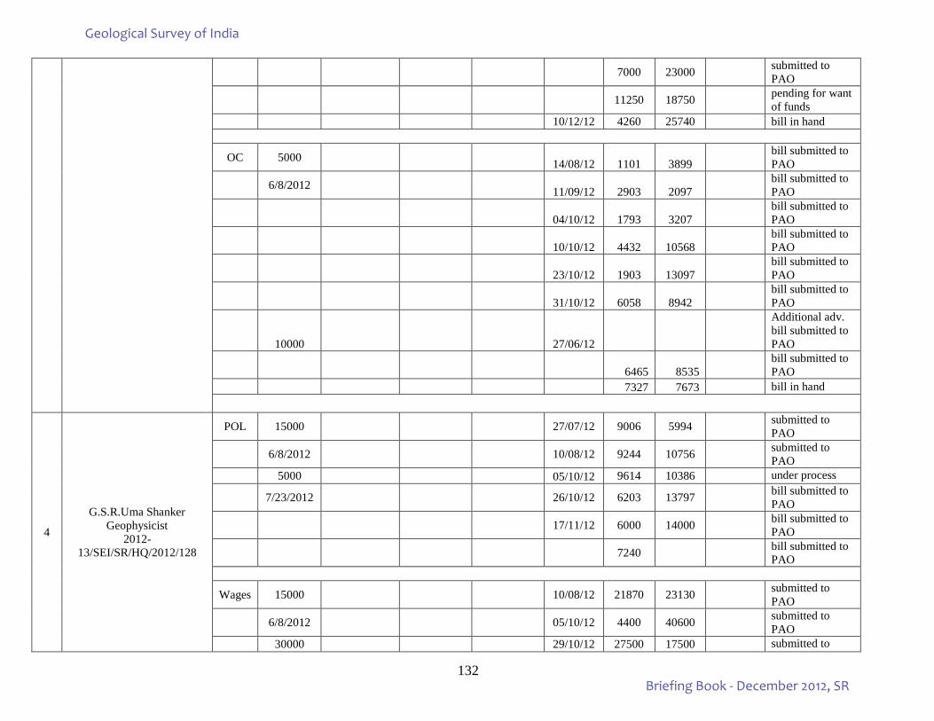
132
7000 23000 submitted to PAO
11250 18750 pending for want of funds
10/12/12 4260 25740 bill in hand
OC 5000 14/08/12 1101 3899 bill submitted to PAO
6/8/2012 11/09/12 2903 2097 bill submitted to PAO
04/10/12 1793 3207 bill submitted to PAO
10/10/12 4432 10568 bill submitted to PAO
23/10/12 1903 13097 bill submitted to PAO
31/10/12 6058 8942 bill submitted to PAO
10000 27/06/12
Additional adv. bill submitted to PAO
6465 8535 bill submitted to PAO
7327 7673 bill in hand
4
G.S.R.Uma Shanker Geophysicist
2012-13/SEI/SR/HQ/2012/128
POL 15000 27/07/12 9006 5994 submitted to PAO
6/8/2012 10/08/12 9244 10756 submitted to PAO
5000 05/10/12 9614 10386 under process
7/23/2012 26/10/12 6203 13797 bill submitted to PAO
17/11/12 6000 14000 bill submitted to PAO
7240 bill submitted to PAO
Wages 15000 10/08/12 21870 23130 submitted to PAO
6/8/2012 05/10/12 4400 40600 submitted to PAO
30000 29/10/12 27500 17500 submitted to
Geological Survey of India
Briefing Book - December 2012, SR
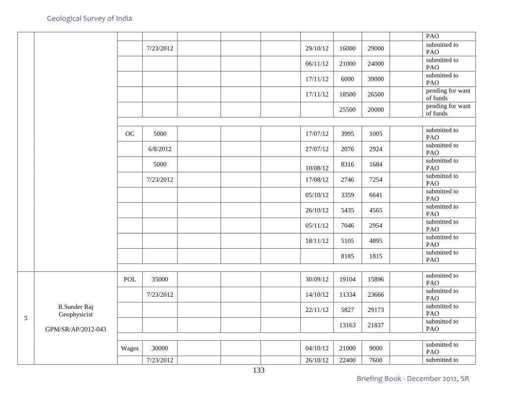
133
PAO
7/23/2012 29/10/12 16000 29000 submitted to PAO
06/11/12 21000 24000 submitted to PAO
17/11/12 6000 39000 submitted to PAO
17/11/12 18500 26500 pending for want of funds
25500 20000 pending for want of funds
OC 5000 17/07/12 3995 1005 submitted to PAO
6/8/2012 27/07/12 2076 2924 submitted to PAO
5000 10/08/12 8316 1684 submitted to PAO
7/23/2012 17/08/12 2746 7254 submitted to PAO
05/10/12 3359 6641 submitted to PAO
26/10/12 5435 4565 submitted to PAO
05/11/12 7046 2954 submitted to PAO
18/11/12 5105 4895 submitted to PAO
8185 1815 submitted to PAO
5
B.Sunder Raj Geophysicist
GPM/SR/AP/2012-043
POL 35000 30/09/12 19104 15896 submitted to PAO
7/23/2012 14/10/12 11334 23666 submitted to PAO
22/11/12 5827 29173 submitted to PAO
13163 21837 submitted to PAO
Wages 30000 04/10/12 21000 9000 submitted to PAO
7/23/2012 26/10/12 22400 7600 submitted to
Geological Survey of India
Briefing Book - December 2012, SR
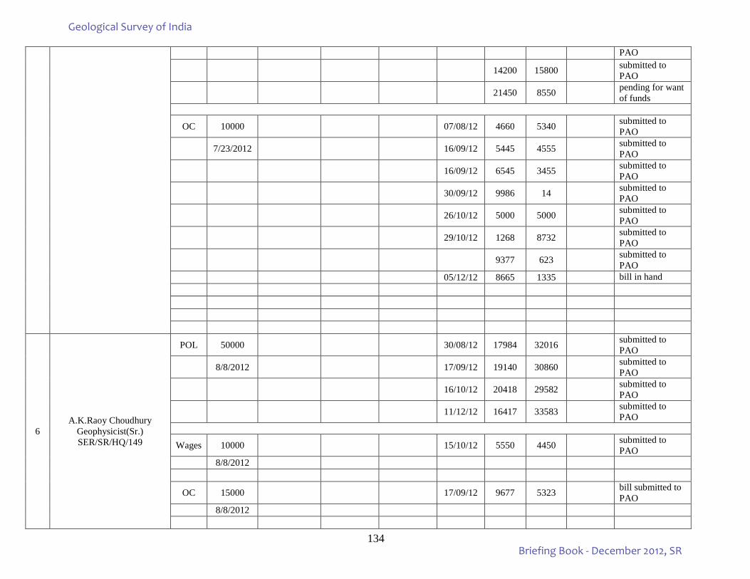
134
PAO
14200 15800 submitted to PAO
21450 8550 pending for want of funds
OC 10000 07/08/12 4660 5340 submitted to PAO
7/23/2012 16/09/12 5445 4555 submitted to PAO
16/09/12 6545 3455 submitted to PAO
30/09/12 9986 14 submitted to PAO
26/10/12 5000 5000 submitted to PAO
29/10/12 1268 8732 submitted to PAO
9377 623 submitted to PAO
05/12/12 8665 1335 bill in hand
6 A.K.Raoy Choudhury
Geophysicist(Sr.) SER/SR/HQ/149
POL 50000 30/08/12 17984 32016 submitted to PAO
8/8/2012 17/09/12 19140 30860 submitted to PAO
16/10/12 20418 29582 submitted to PAO
11/12/12 16417 33583 submitted to PAO
Wages 10000 15/10/12 5550 4450 submitted to PAO
8/8/2012
OC 15000 17/09/12 9677 5323 bill submitted to PAO
8/8/2012
Geological Survey of India
Briefing Book - December 2012, SR
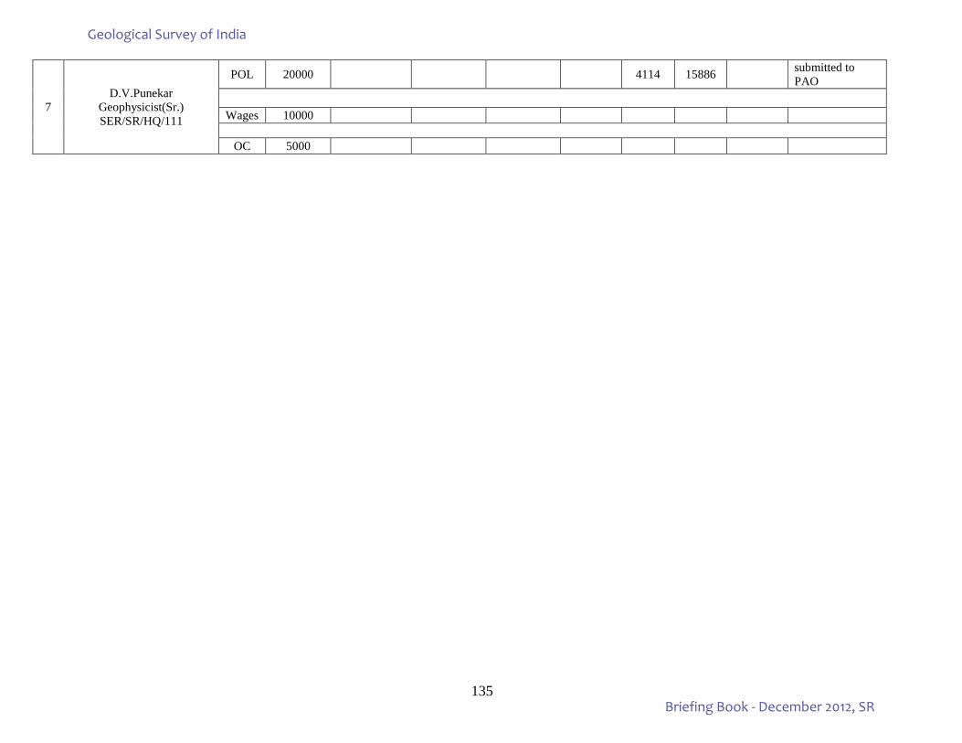
135
7 D.V.Punekar
Geophysicist(Sr.) SER/SR/HQ/111
POL 20000 4114 15886 submitted to PAO
Wages 10000
OC 5000
Geological Survey of India
Briefing Book - December 2012, SR
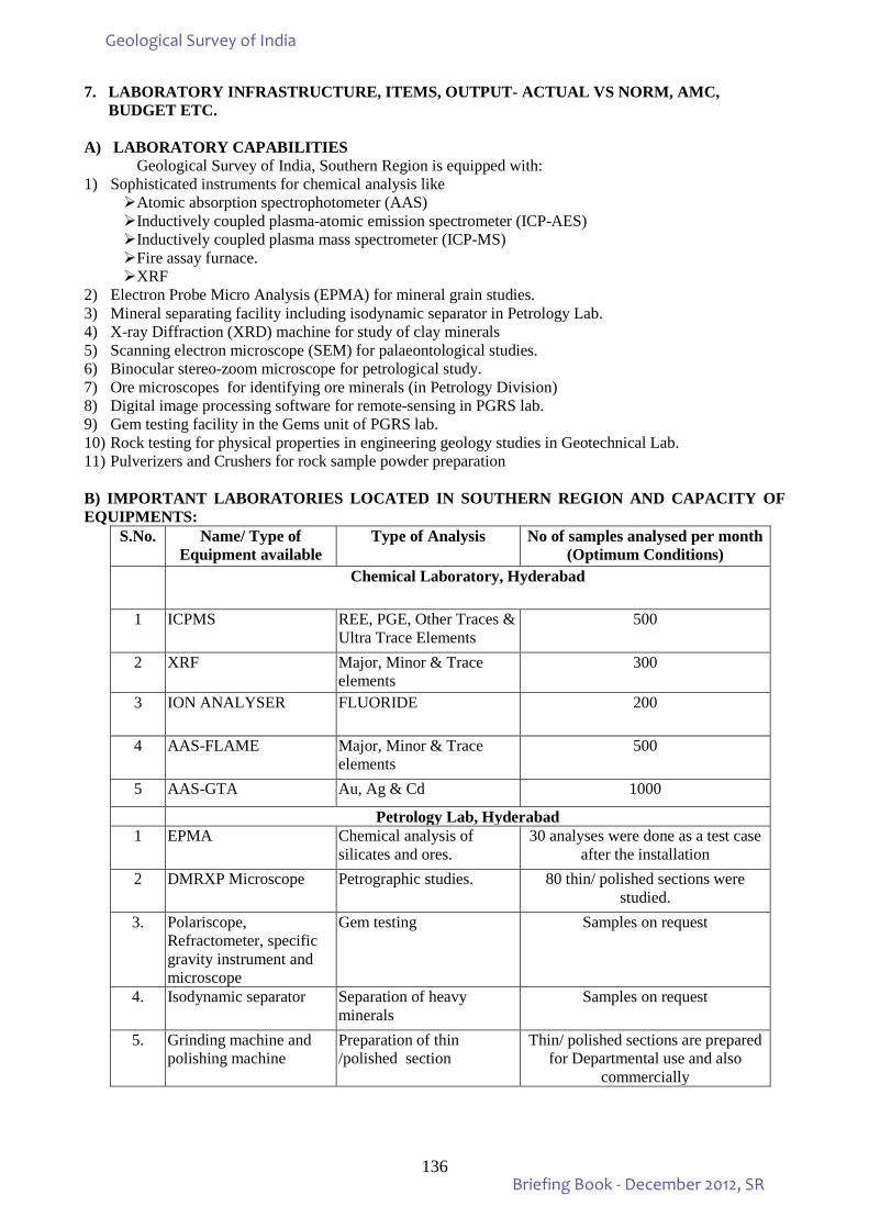
136
7. LABORATORY INFRASTRUCTURE, ITEMS, OUTPUT- ACTUAL VS NORM, AMC, BUDGET ETC. A) LABORATORY CAPABILITIES
Geological Survey of India, Southern Region is equipped with: 1) Sophisticated instruments for chemical analysis like
Atomic absorption spectrophotometer (AAS) Inductively coupled plasma-atomic emission spectrometer (ICP-AES) Inductively coupled plasma mass spectrometer (ICP-MS) Fire assay furnace. XRF
2) Electron Probe Micro Analysis (EPMA) for mineral grain studies. 3) Mineral separating facility including isodynamic separator in Petrology Lab. 4) X-ray Diffraction (XRD) machine for study of clay minerals 5) Scanning electron microscope (SEM) for palaeontological studies. 6) Binocular stereo-zoom microscope for petrological study. 7) Ore microscopes for identifying ore minerals (in Petrology Division) 8) Digital image processing software for remote-sensing in PGRS lab. 9) Gem testing facility in the Gems unit of PGRS lab. 10) Rock testing for physical properties in engineering geology studies in Geotechnical Lab. 11) Pulverizers and Crushers for rock sample powder preparation B) IMPORTANT LABORATORIES LOCATED IN SOUTHERN REGION AND CAPACITY OF EQUIPMENTS:
S.No. Name/ Type of Equipment available
Type of Analysis No of samples analysed per month (Optimum Conditions)
Chemical Laboratory, Hyderabad
1 ICPMS REE, PGE, Other Traces & Ultra Trace Elements
500
2 XRF Major, Minor & Trace elements
300
3 ION ANALYSER FLUORIDE 200
4 AAS-FLAME Major, Minor & Trace elements
500
5 AAS-GTA Au, Ag & Cd 1000
Petrology Lab, Hyderabad 1 EPMA Chemical analysis of
silicates and ores. 30 analyses were done as a test case
after the installation 2 DMRXP Microscope Petrographic studies. 80 thin/ polished sections were
studied. 3. Polariscope,
Refractometer, specific gravity instrument and microscope
Gem testing Samples on request
4. Isodynamic separator Separation of heavy minerals
Samples on request
5. Grinding machine and polishing machine
Preparation of thin /polished section
Thin/ polished sections are prepared for Departmental use and also
commercially
Geological Survey of India
Briefing Book - December 2012, SR
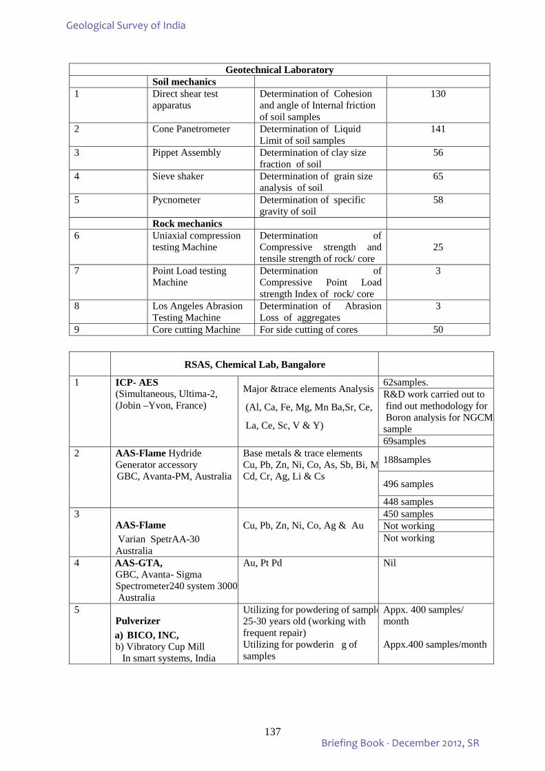
137
Geotechnical Laboratory
Soil mechanics 1 Direct shear test
apparatus Determination of Cohesion and angle of Internal friction of soil samples
130
2 Cone Panetrometer Determination of Liquid Limit of soil samples
141
3 Pippet Assembly Determination of clay size fraction of soil
56
4 Sieve shaker Determination of grain size analysis of soil
65
5 Pycnometer Determination of specific gravity of soil
58
Rock mechanics 6 Uniaxial compression
testing Machine Determination of Compressive strength and tensile strength of rock/ core
25
7 Point Load testing Machine
Determination of Compressive Point Load strength Index of rock/ core
3
8 Los Angeles Abrasion Testing Machine
Determination of Abrasion Loss of aggregates
3
9 Core cutting Machine For side cutting of cores 50
RSAS, Chemical Lab, Bangalore
1 ICP- AES (Simultaneous, Ultima-2, (Jobin –Yvon, France)
Major &trace elements Analysis
(Al, Ca, Fe, Mg, Mn Ba,Sr, Ce,
La, Ce, Sc, V & Y)
62samples. R&D work carried out to find out methodology for Boron analysis for NGCM sample 69samples
2 AAS-Flame Hydride Generator accessory GBC, Avanta-PM, Australia
Base metals & trace elements Cu, Pb, Zn, Ni, Co, As, Sb, Bi, M Cd, Cr, Ag, Li & Cs
188samples
496 samples
448 samples 3
AAS-Flame Varian SpetrAA-30 Australia
Cu, Pb, Zn, Ni, Co, Ag & Au
450 samples Not working Not working
4 AAS-GTA, GBC, Avanta- Sigma Spectrometer240 system 3000 Australia
Au, Pt Pd Nil
5 Pulverizer a) BICO, INC, b) Vibratory Cup Mill In smart systems, India
Utilizing for powdering of sample 25-30 years old (working with frequent repair) Utilizing for powderin g of samples
Appx. 400 samples/ month Appx.400 samples/month
Geological Survey of India
Briefing Book - December 2012, SR
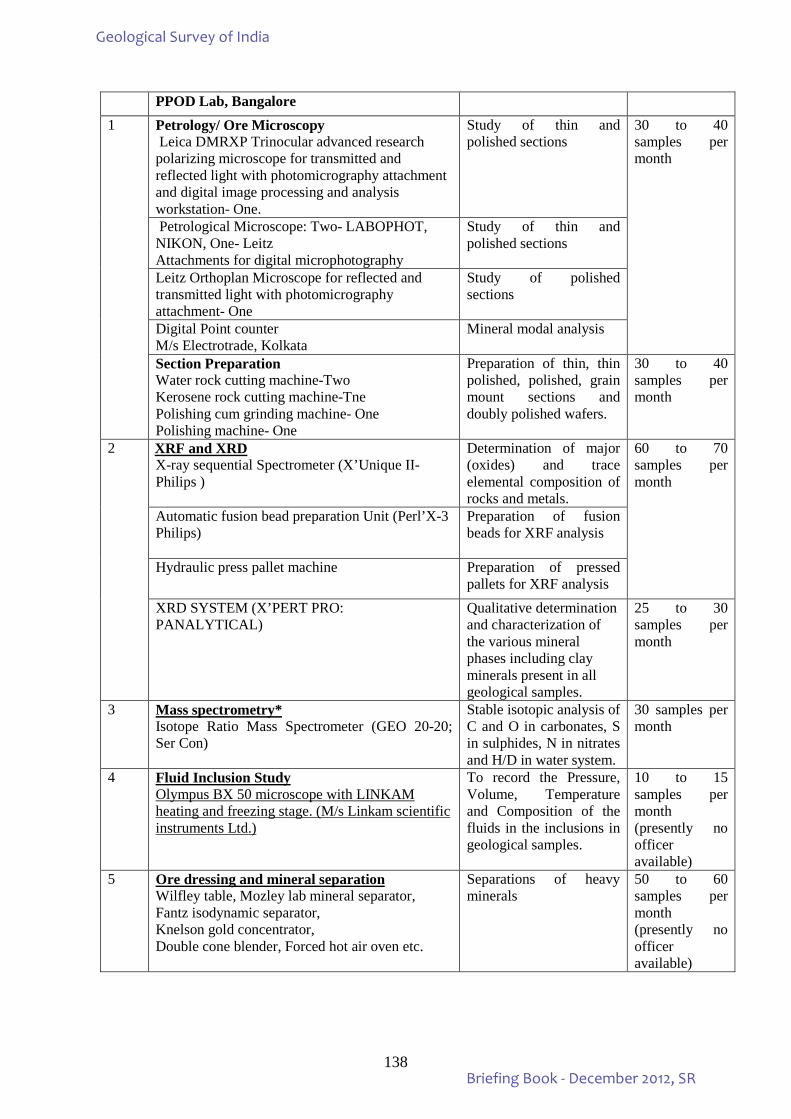
138
PPOD Lab, Bangalore 1 Petrology/ Ore Microscopy
Leica DMRXP Trinocular advanced research polarizing microscope for transmitted and reflected light with photomicrography attachment and digital image processing and analysis workstation- One.
Study of thin and polished sections
30 to 40 samples per month
Petrological Microscope: Two- LABOPHOT, NIKON, One- Leitz Attachments for digital microphotography
Study of thin and polished sections
Leitz Orthoplan Microscope for reflected and transmitted light with photomicrography attachment- One
Study of polished sections
Digital Point counter M/s Electrotrade, Kolkata
Mineral modal analysis
Section Preparation Water rock cutting machine-Two Kerosene rock cutting machine-Tne Polishing cum grinding machine- One Polishing machine- One
Preparation of thin, thin polished, polished, grain mount sections and doubly polished wafers.
30 to 40 samples per month
2 XRF and XRD X-ray sequential Spectrometer (X’Unique II- Philips )
Determination of major (oxides) and trace elemental composition of rocks and metals.
60 to 70 samples per month
Automatic fusion bead preparation Unit (Perl’X-3 Philips)
Preparation of fusion beads for XRF analysis
Hydraulic press pallet machine Preparation of pressed pallets for XRF analysis
XRD SYSTEM (X’PERT PRO: PANALYTICAL)
Qualitative determination and characterization of the various mineral phases including clay minerals present in all geological samples.
25 to 30 samples per month
3 Mass spectrometry* Isotope Ratio Mass Spectrometer (GEO 20-20; Ser Con)
Stable isotopic analysis of C and O in carbonates, S in sulphides, N in nitrates and H/D in water system.
30 samples per month
4 Fluid Inclusion Study Olympus BX 50 microscope with LINKAM heating and freezing stage. (M/s Linkam scientific instruments Ltd.)
To record the Pressure, Volume, Temperature and Composition of the fluids in the inclusions in geological samples.
10 to 15 samples per month (presently no officer available)
5 Ore dressing and mineral separation Wilfley table, Mozley lab mineral separator, Fantz isodynamic separator, Knelson gold concentrator, Double cone blender, Forced hot air oven etc.
Separations of heavy minerals
50 to 60 samples per month (presently no officer available)
Geological Survey of India
Briefing Book - December 2012, SR
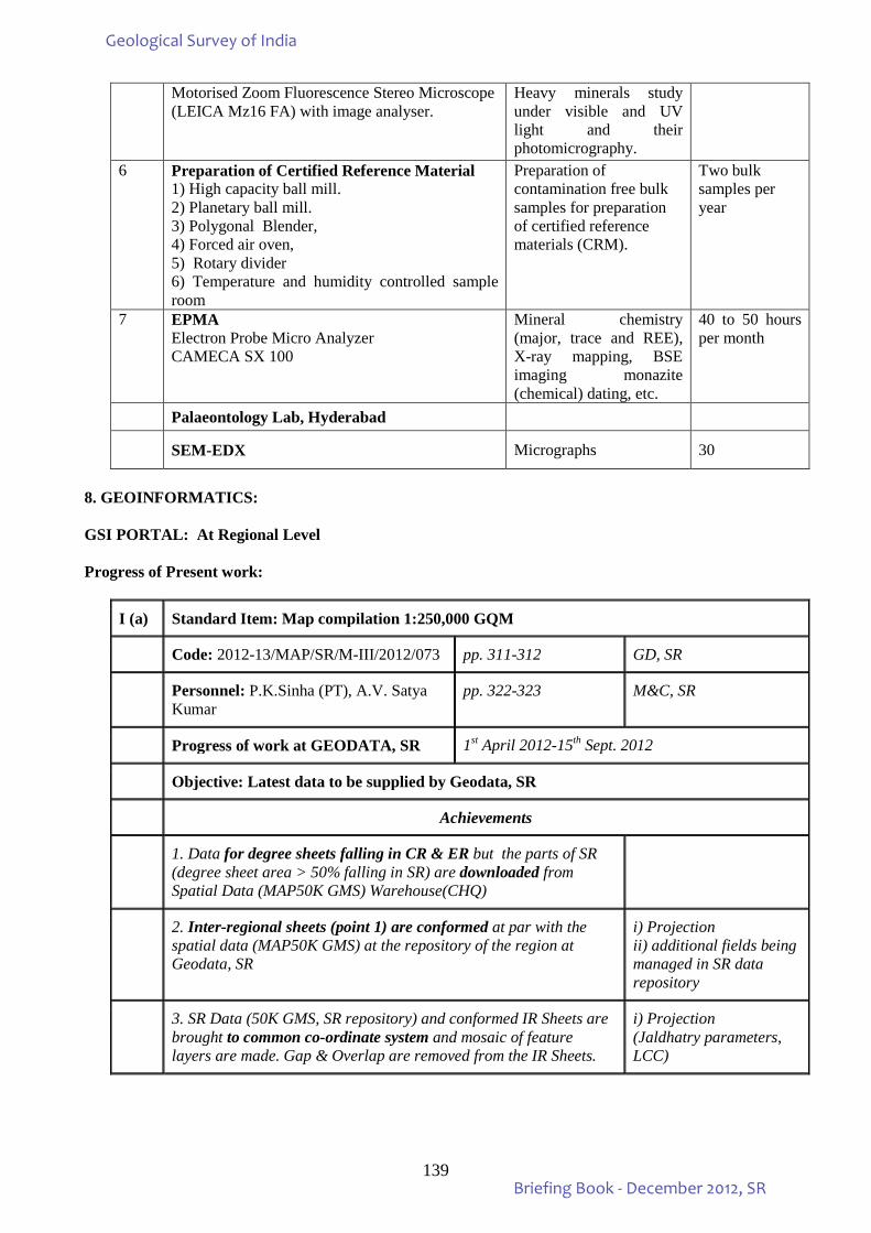
139
Motorised Zoom Fluorescence Stereo Microscope (LEICA Mz16 FA) with image analyser.
Heavy minerals study under visible and UV light and their photomicrography.
6 Preparation of Certified Reference Material 1) High capacity ball mill. 2) Planetary ball mill. 3) Polygonal Blender, 4) Forced air oven, 5) Rotary divider 6) Temperature and humidity controlled sample room
Preparation of contamination free bulk samples for preparation of certified reference materials (CRM).
Two bulk samples per year
7 EPMA Electron Probe Micro Analyzer CAMECA SX 100
Mineral chemistry (major, trace and REE), X-ray mapping, BSE imaging monazite (chemical) dating, etc.
40 to 50 hours per month
Palaeontology Lab, Hyderabad
SEM-EDX Micrographs 30
8. GEOINFORMATICS: GSI PORTAL: At Regional Level Progress of Present work:
I (a) Standard Item: Map compilation 1:250,000 GQM
Code: 2012-13/MAP/SR/M-III/2012/073 pp. 311-312 GD, SR
Personnel: P.K.Sinha (PT), A.V. Satya Kumar
pp. 322-323 M&C, SR
Progress of work at GEODATA, SR 1st April 2012-15th Sept. 2012
Objective: Latest data to be supplied by Geodata, SR
Achievements
1. Data for degree sheets falling in CR & ER but the parts of SR (degree sheet area > 50% falling in SR) are downloaded from Spatial Data (MAP50K GMS) Warehouse(CHQ)
2. Inter-regional sheets (point 1) are conformed at par with the spatial data (MAP50K GMS) at the repository of the region at Geodata, SR
i) Projection ii) additional fields being managed in SR data repository
3. SR Data (50K GMS, SR repository) and conformed IR Sheets are brought to common co-ordinate system and mosaic of feature layers are made. Gap & Overlap are removed from the IR Sheets.
i) Projection (Jaldhatry parameters, LCC)
Geological Survey of India
Briefing Book - December 2012, SR
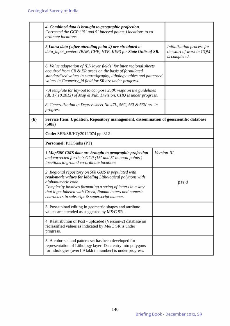
140
4. Combined data is brought to geographic projection. Corrected the GCP (15’ and 5’ interval points ) locations to co-ordinate locations.
5.Latest data ( after attending point 4) are circulated to data_input_centers (BAN, CHE, HYB, KER) for State Units of SR.
Initialization process for the start of work in GQM is completed.
6. Value adaptation of ‘LI- layer fields’ for inter regional sheets acquired from CR & ER areas on the basis of formulated standardized values in statratigraphy, lithology tables and patterned values in Geometry_id field for SR are under progress.
7.A template for lay-out to compose 250k maps on the guidelines (dt. 17.10.2012) of Map & Pub. Division, CHQ is under progress.
8. Generalization in Degree-sheet No.47L, 56C, 56I & 56N are in progress
(b) Service Item: Updation, Repository management, dissemination of geoscientific database (50K)
Code: SER/SR/HQ/2012/074 pp. 312
Personnel: P.K.Sinha (PT)
1.Map50K GMS data are brought to geographic projection and corrected for their GCP (15’ and 5’ interval points ) locations to ground co-ordinate locations
Version-III
2. Regional repository on 50k GMS is populated with readymade values for labeling Lithological polygons with alphanumeric code. Complexity involves formatting a string of letters in a way that it get labeled with Greek, Roman letters and numeric characters in subscript & superscript manner.
βPt1d
3. Post-upload editing in geometric shapes and attribute values are attended as suggested by M&C SR.
4. Reattribution of Post - uploaded (Version-2) database on reclassified values as indicated by M&C SR is under progress.
5. A color-set and pattern-set has been developed for representation of Lithology layer. Data entry into polygons for lithologies (over1.9 lakh in number) is under progress.
Geological Survey of India
Briefing Book - December 2012, SR
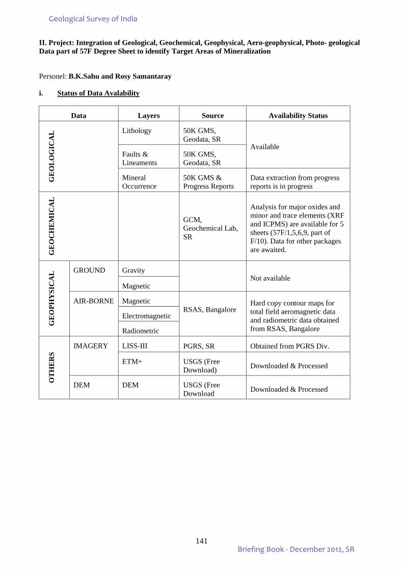
141
II. Project: Integration of Geological, Geochemical, Geophysical, Aero-geophysical, Photo- geological Data part of 57F Degree Sheet to identify Target Areas of Mineralization
Personel: B.K.Sahu and Rosy Samantaray
i. Status of Data Avalability
Data Layers Source Availability Status
GE
OLO
GIC
AL
Lithology 50K GMS, Geodata, SR
Available Faults & Lineaments
50K GMS, Geodata, SR
Mineral Occurrence
50K GMS & Progress Reports
Data extraction from progress reports is in progress
GE
OC
HE
MIC
AL
GCM, Geochemical Lab, SR
Analysis for major oxides and minor and trace elements (XRF and ICPMS) are available for 5 sheets (57F/1,5,6,9, part of F/10). Data for other packages are awaited.
GE
OPH
YSI
CA
L GROUND Gravity Not available
Magnetic
AIR-BORNE Magnetic RSAS, Bangalore
Hard copy contour maps for total field aeromagnetic data and radiometric data obtained from RSAS, Bangalore
Electromagnetic
Radiometric
OT
HE
RS
IMAGERY LISS-III PGRS, SR Obtained from PGRS Div.
ETM+ USGS (Free Download) Downloaded & Processed
DEM DEM USGS (Free Download Downloaded & Processed
Geological Survey of India
Briefing Book - December 2012, SR
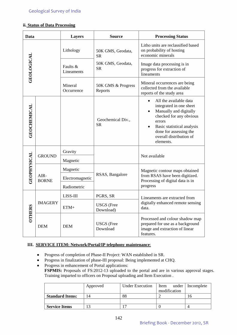
142
ii. Status of Data Processing
III. SERVICE ITEM: Network/Portal/IP telephony maintenance:
• Progress of completion of Phase-II Project: WAN established in SR. • Progress in finalization of phase-III proposal: Being implemented at CHQ. • Progress in enhancement of Portal applications:
FSPMIS: Proposals of FS:2012-13 uploaded to the portal and are in various approval stages. Training imparted to officers on Proposal uploading and Item Execution . Approved Under Execution Item under
modification Incomplete
Standard Items: 14 88 2 16 Service Items 13 17 0 4
Data Layers Source Processing Status G
EO
LOG
ICA
L Lithology 50K GMS, Geodata,
SR
50K GMS, Geodata, SR
Litho units are reclassified based on probability of hosting economic minerals
Faults & Lineaments
Image data processing is in progress for extraction of lineaments
Mineral Occurrence
50K GMS & Progress Reports
Mineral occurrences are being collected from the available reports of the study area
GE
OC
HE
MIC
AL
Geochemical Div., SR
• All the available data integrated in one sheet
• Manually and digitally checked for any obvious errors
• Basic statistical analysis done for assessing the overall distribution of elements.
GE
OPH
YSI
CA
L GROUND Gravity
Not available Magnetic
AIR-BORNE
Magnetic RSAS, Bangalore
Magnetic contour maps obtained from RSAS have been digitized. Processing of digital data is in progress
Electromagnetic
Radiometric
OT
HE
RS IMAGERY
LISS-III PGRS, SR Lineaments are extracted from digitally enhanced remote sensing data. ETM+ USGS (Free
Download)
DEM DEM USGS (Free Download
Processed and colour shadow map prepared for use as a background image and extraction of linear features.
Geological Survey of India
Briefing Book - December 2012, SR
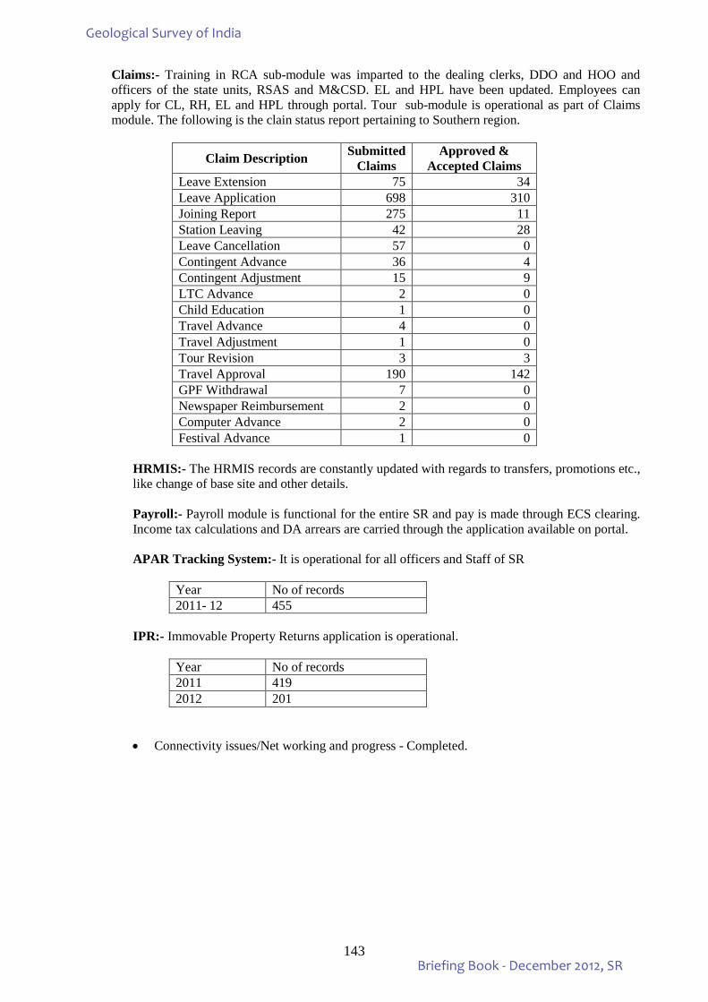
143
Claims:- Training in RCA sub-module was imparted to the dealing clerks, DDO and HOO and officers of the state units, RSAS and M&CSD. EL and HPL have been updated. Employees can apply for CL, RH, EL and HPL through portal. Tour sub-module is operational as part of Claims module. The following is the clain status report pertaining to Southern region.
Claim Description Submitted Claims
Approved & Accepted Claims
Leave Extension 75 34 Leave Application 698 310 Joining Report 275 11 Station Leaving 42 28 Leave Cancellation 57 0 Contingent Advance 36 4 Contingent Adjustment 15 9 LTC Advance 2 0 Child Education 1 0 Travel Advance 4 0 Travel Adjustment 1 0 Tour Revision 3 3 Travel Approval 190 142 GPF Withdrawal 7 0 Newspaper Reimbursement 2 0 Computer Advance 2 0 Festival Advance 1 0
HRMIS:- The HRMIS records are constantly updated with regards to transfers, promotions etc., like change of base site and other details. Payroll:- Payroll module is functional for the entire SR and pay is made through ECS clearing. Income tax calculations and DA arrears are carried through the application available on portal. APAR Tracking System:- It is operational for all officers and Staff of SR
Year No of records 2011- 12 455
IPR:- Immovable Property Returns application is operational.
Year No of records 2011 419 2012 201
• Connectivity issues/Net working and progress - Completed.
Geological Survey of India
Briefing Book - December 2012, SR
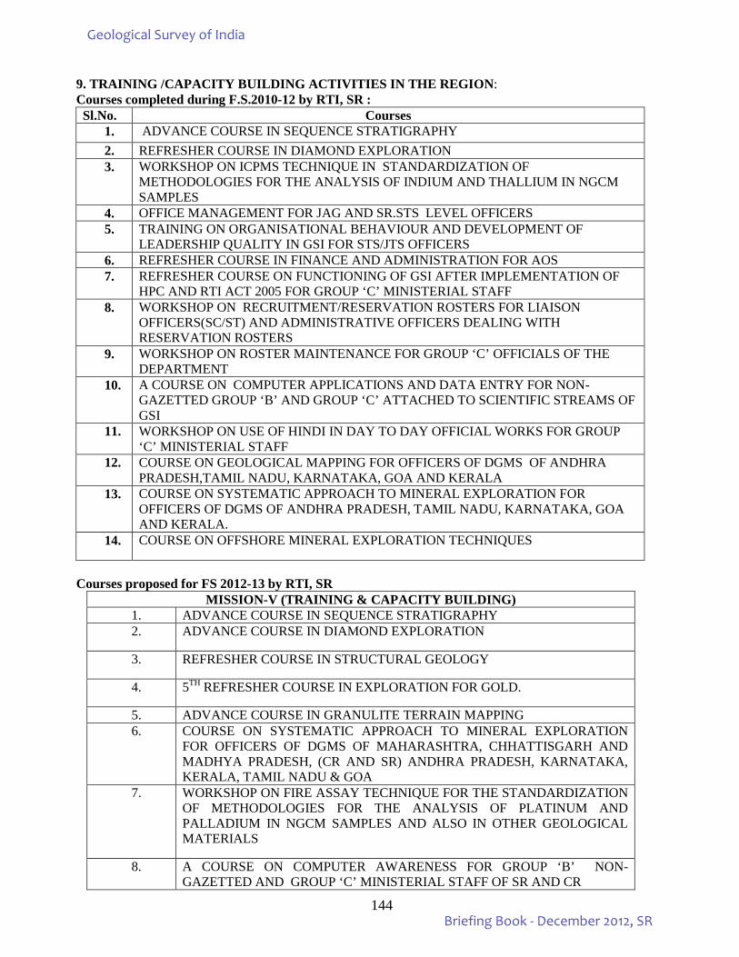
144
9. TRAINING /CAPACITY BUILDING ACTIVITIES IN THE REGION: Courses completed during F.S.2010-12 by RTI, SR : Sl.No. Courses
1. ADVANCE COURSE IN SEQUENCE STRATIGRAPHY 2. REFRESHER COURSE IN DIAMOND EXPLORATION 3. WORKSHOP ON ICPMS TECHNIQUE IN STANDARDIZATION OF
METHODOLOGIES FOR THE ANALYSIS OF INDIUM AND THALLIUM IN NGCM SAMPLES
4. OFFICE MANAGEMENT FOR JAG AND SR.STS LEVEL OFFICERS 5. TRAINING ON ORGANISATIONAL BEHAVIOUR AND DEVELOPMENT OF
LEADERSHIP QUALITY IN GSI FOR STS/JTS OFFICERS 6. REFRESHER COURSE IN FINANCE AND ADMINISTRATION FOR AOS 7. REFRESHER COURSE ON FUNCTIONING OF GSI AFTER IMPLEMENTATION OF
HPC AND RTI ACT 2005 FOR GROUP ‘C’ MINISTERIAL STAFF 8. WORKSHOP ON RECRUITMENT/RESERVATION ROSTERS FOR LIAISON
OFFICERS(SC/ST) AND ADMINISTRATIVE OFFICERS DEALING WITH RESERVATION ROSTERS
9. WORKSHOP ON ROSTER MAINTENANCE FOR GROUP ‘C’ OFFICIALS OF THE DEPARTMENT
10. A COURSE ON COMPUTER APPLICATIONS AND DATA ENTRY FOR NON-GAZETTED GROUP ‘B’ AND GROUP ‘C’ ATTACHED TO SCIENTIFIC STREAMS OF GSI
11. WORKSHOP ON USE OF HINDI IN DAY TO DAY OFFICIAL WORKS FOR GROUP ‘C’ MINISTERIAL STAFF
12. COURSE ON GEOLOGICAL MAPPING FOR OFFICERS OF DGMS OF ANDHRA PRADESH,TAMIL NADU, KARNATAKA, GOA AND KERALA
13. COURSE ON SYSTEMATIC APPROACH TO MINERAL EXPLORATION FOR OFFICERS OF DGMS OF ANDHRA PRADESH, TAMIL NADU, KARNATAKA, GOA AND KERALA.
14. COURSE ON OFFSHORE MINERAL EXPLORATION TECHNIQUES
Courses proposed for FS 2012-13 by RTI, SR
MISSION-V (TRAINING & CAPACITY BUILDING) 1. ADVANCE COURSE IN SEQUENCE STRATIGRAPHY 2. ADVANCE COURSE IN DIAMOND EXPLORATION
3. REFRESHER COURSE IN STRUCTURAL GEOLOGY
4. 5TH REFRESHER COURSE IN EXPLORATION FOR GOLD.
5. ADVANCE COURSE IN GRANULITE TERRAIN MAPPING 6. COURSE ON SYSTEMATIC APPROACH TO MINERAL EXPLORATION
FOR OFFICERS OF DGMS OF MAHARASHTRA, CHHATTISGARH AND MADHYA PRADESH, (CR AND SR) ANDHRA PRADESH, KARNATAKA, KERALA, TAMIL NADU & GOA
7. WORKSHOP ON FIRE ASSAY TECHNIQUE FOR THE STANDARDIZATION OF METHODOLOGIES FOR THE ANALYSIS OF PLATINUM AND PALLADIUM IN NGCM SAMPLES AND ALSO IN OTHER GEOLOGICAL MATERIALS
8. A COURSE ON COMPUTER AWARENESS FOR GROUP ‘B’ NON-GAZETTED AND GROUP ‘C’ MINISTERIAL STAFF OF SR AND CR
Geological Survey of India
Briefing Book - December 2012, SR
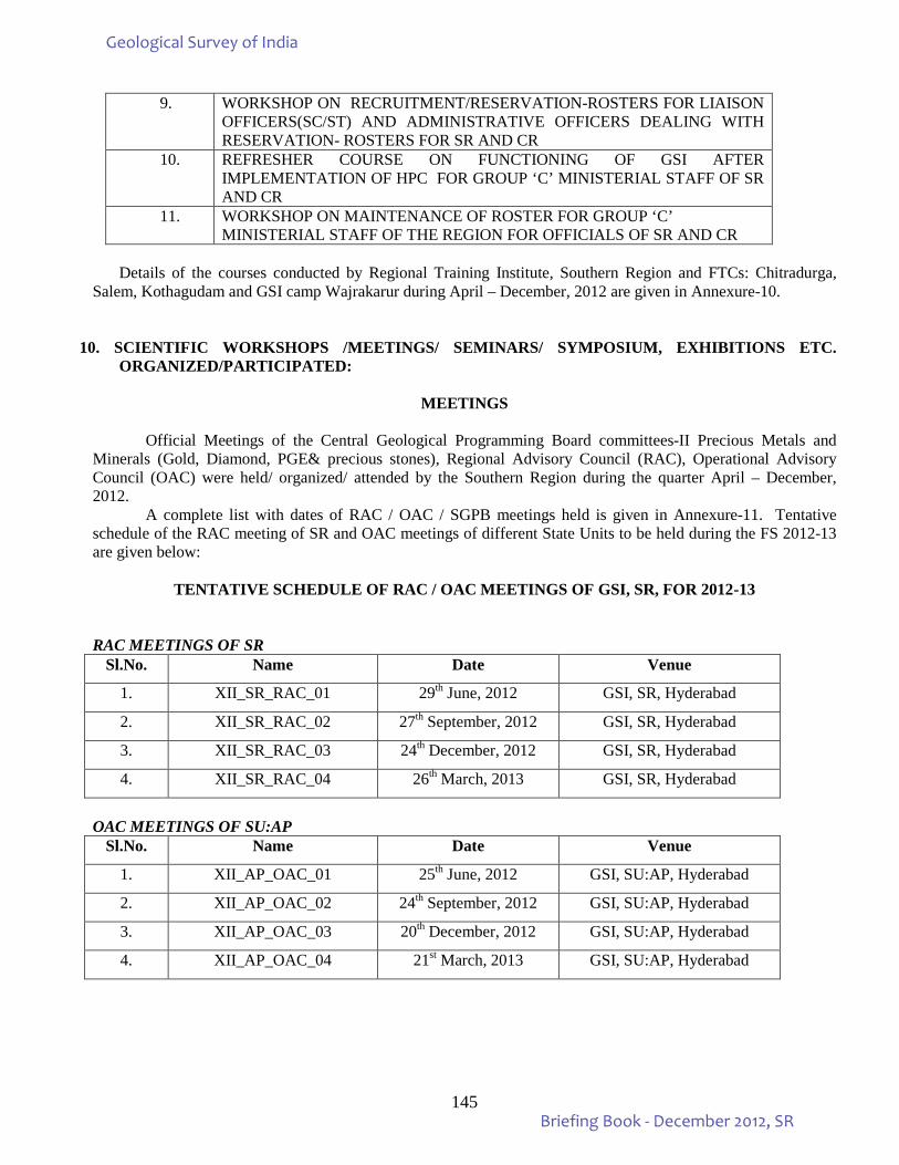
145
9. WORKSHOP ON RECRUITMENT/RESERVATION-ROSTERS FOR LIAISON OFFICERS(SC/ST) AND ADMINISTRATIVE OFFICERS DEALING WITH RESERVATION- ROSTERS FOR SR AND CR
10. REFRESHER COURSE ON FUNCTIONING OF GSI AFTER IMPLEMENTATION OF HPC FOR GROUP ‘C’ MINISTERIAL STAFF OF SR AND CR
11. WORKSHOP ON MAINTENANCE OF ROSTER FOR GROUP ‘C’ MINISTERIAL STAFF OF THE REGION FOR OFFICIALS OF SR AND CR
Details of the courses conducted by Regional Training Institute, Southern Region and FTCs: Chitradurga,
Salem, Kothagudam and GSI camp Wajrakarur during April – December, 2012 are given in Annexure-10.
10. SCIENTIFIC WORKSHOPS /MEETINGS/ SEMINARS/ SYMPOSIUM, EXHIBITIONS ETC.
ORGANIZED/PARTICIPATED:
MEETINGS
Official Meetings of the Central Geological Programming Board committees-II Precious Metals and Minerals (Gold, Diamond, PGE& precious stones), Regional Advisory Council (RAC), Operational Advisory Council (OAC) were held/ organized/ attended by the Southern Region during the quarter April – December, 2012.
A complete list with dates of RAC / OAC / SGPB meetings held is given in Annexure-11. Tentative schedule of the RAC meeting of SR and OAC meetings of different State Units to be held during the FS 2012-13 are given below:
TENTATIVE SCHEDULE OF RAC / OAC MEETINGS OF GSI, SR, FOR 2012-13
RAC MEETINGS OF SR
Sl.No. Name Date Venue
1. XII_SR_RAC_01 29th June, 2012 GSI, SR, Hyderabad
2. XII_SR_RAC_02 27th September, 2012 GSI, SR, Hyderabad
3. XII_SR_RAC_03 24th December, 2012 GSI, SR, Hyderabad
4. XII_SR_RAC_04 26th March, 2013 GSI, SR, Hyderabad
OAC MEETINGS OF SU:AP
Sl.No. Name Date Venue
1. XII_AP_OAC_01 25th June, 2012 GSI, SU:AP, Hyderabad
2. XII_AP_OAC_02 24th September, 2012 GSI, SU:AP, Hyderabad
3. XII_AP_OAC_03 20th December, 2012 GSI, SU:AP, Hyderabad
4. XII_AP_OAC_04 21st March, 2013 GSI, SU:AP, Hyderabad
Geological Survey of India
Briefing Book - December 2012, SR
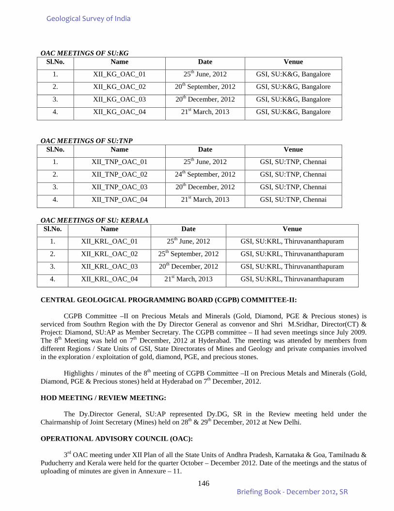
146
OAC MEETINGS OF SU:KG
Sl.No. Name Date Venue
1. XII_KG_OAC_01 25th June, 2012 GSI, SU:K&G, Bangalore
2. XII_KG_OAC_02 20th September, 2012 GSI, SU:K&G, Bangalore
3. XII_KG_OAC_03 20th December, 2012 GSI, SU:K&G, Bangalore
4. XII_KG_OAC_04 21st March, 2013 GSI, SU:K&G, Bangalore
OAC MEETINGS OF SU:TNP
Sl.No. Name Date Venue
1. XII_TNP_OAC_01 25th June, 2012 GSI, SU:TNP, Chennai
2. XII_TNP_OAC_02 24th September, 2012 GSI, SU:TNP, Chennai
3. XII_TNP_OAC_03 20th December, 2012 GSI, SU:TNP, Chennai
4. XII_TNP_OAC_04 21st March, 2013 GSI, SU:TNP, Chennai
OAC MEETINGS OF SU: KERALA Sl.No. Name Date Venue
1. XII_KRL_OAC_01 25th June, 2012 GSI, SU:KRL, Thiruvananthapuram
2. XII_KRL_OAC_02 25th September, 2012 GSI, SU:KRL, Thiruvananthapuram
3. XII_KRL_OAC_03 20th December, 2012 GSI, SU:KRL, Thiruvananthapuram
4. XII_KRL_OAC_04 21st March, 2013 GSI, SU:KRL, Thiruvananthapuram
CENTRAL GEOLOGICAL PROGRAMMING BOARD (CGPB) COMMITTEE-II:
CGPB Committee –II on Precious Metals and Minerals (Gold, Diamond, PGE & Precious stones) is serviced from Southrn Region with the Dy Director General as convenor and Shri M.Sridhar, Director(CT) & Project: Diamond, SU:AP as Member Secretary. The CGPB committee – II had seven meetings since July 2009. The 8th Meeting was held on 7th December, 2012 at Hyderabad. The meeting was attended by members from different Regions / State Units of GSI, State Directorates of Mines and Geology and private companies involved in the exploration / exploitation of gold, diamond, PGE, and precious stones.
Highlights / minutes of the 8th meeting of CGPB Committee –II on Precious Metals and Minerals (Gold,
Diamond, PGE & Precious stones) held at Hyderabad on 7th December, 2012. HOD MEETING / REVIEW MEETING: The Dy.Director General, SU:AP represented Dy.DG, SR in the Review meeting held under the Chairmanship of Joint Secretary (Mines) held on 28th & 29th December, 2012 at New Delhi. OPERATIONAL ADVISORY COUNCIL (OAC):
3rd OAC meeting under XII Plan of all the State Units of Andhra Pradesh, Karnataka & Goa, Tamilnadu &
Puducherry and Kerala were held for the quarter October – December 2012. Date of the meetings and the status of uploading of minutes are given in Annexure – 11.
Geological Survey of India
Briefing Book - December 2012, SR
147
REGIONAL ADVISORY COUNCIL (RAC): 3rd RAC meeting of XII Plan XII_SR_RAC_03 of SR for the quarter October – December, 2012 was held on 24th December, 2012 at SU:TN&P, Chennai. Minutes of the RAC meeting have been uploaded on the GSI portal. VIDEO CONFERENCE: The Director General, GSI interacted through video conferencing with the Dy Director General and HOD/Director PSS / All Region Mission Heads and other officials of SR on 31.12.2012 to discuss matters related to the plan fund expenditure for financial year 2012-13. VISIT OF THE DIRECTOR GENERAL TO SRO, HYDERABAD: Shri A. Sundaramoorthy, Director General, GSI visited GSI, SR, Hyderabad on 9th & 10th December, 2012 and held a review meeting with the HOD, SR & Directors on deployment of officers at FTC & participated in the inaugural function of 36th OCG at GSITI, Hyderabad. VISIT OF THE SECRETARY, MINISTRY OF MINES TO SU:K&G, SR, BANGALORE: Shri R.H. Khwaja, Secretary Mines, Government of India visited GSI SU:K&G Office, Bangalore on 28.12.2012 and held technical discussions with the Dy. Director General, SU:K&G and Dy.DG, RSAS, Bangalore.
SCIENTIFIC WORKSHOPS/MEETINGS/SEMINARS/SYMPOSIUM, EXHIBITION ETC.
o Shri K.K. Chhatri, Supdt. Geologist attended workshop and delivered a talk on technical translation
methodology – problem and solution organized by GSI, Mangalore. o Shri S.Balakrishnan, Dy. Director General, SU:AP, participated in the meeting convened by Secretary,
Ministry of Mines, Government of India with Chief Secretary, Government of AP along with officers from Forest Department, Department of Geology & Mining & IBM.
o Shri M.S.Jairam attended and participated in Ore Teams International Exhibition & Conference, 2012
held at Hyderbad International Convention Centre, Novotel & HICC Complex and presented a presentation on IRON ORE – STATUS AND FUTURE PROSPECTS in the conference, on 13th &14th December, 2012.
o S. Singanenjam, Director Delivered lecture entitled “Southern Granulite Terrain” in the University of
Kerala, Karionttam Campus, Thiruvananthapuram.
o Shri J.N.Das, Director PPOD Bangalore attended inauguration programme of International Conference on “Recent Developments in the chromite – platinum group of elements and Ni-cu-sulphides, Cr, Ti & V prefields” held at EDC, SJP Campus, Bangalore on 7th & 8th December, 2012 as a part of the International workshop on magmatic ore development meeting and discussions with DG, GSI, about PPOD administration.
o Shri R.P.Nagar, SUpdt. Geologist attended two days training camp in connection with Kannada Postal
Correspondence Course at Kannada and Culture Department, Bangalore.
Geological Survey of India
Briefing Book - December 2012, SR
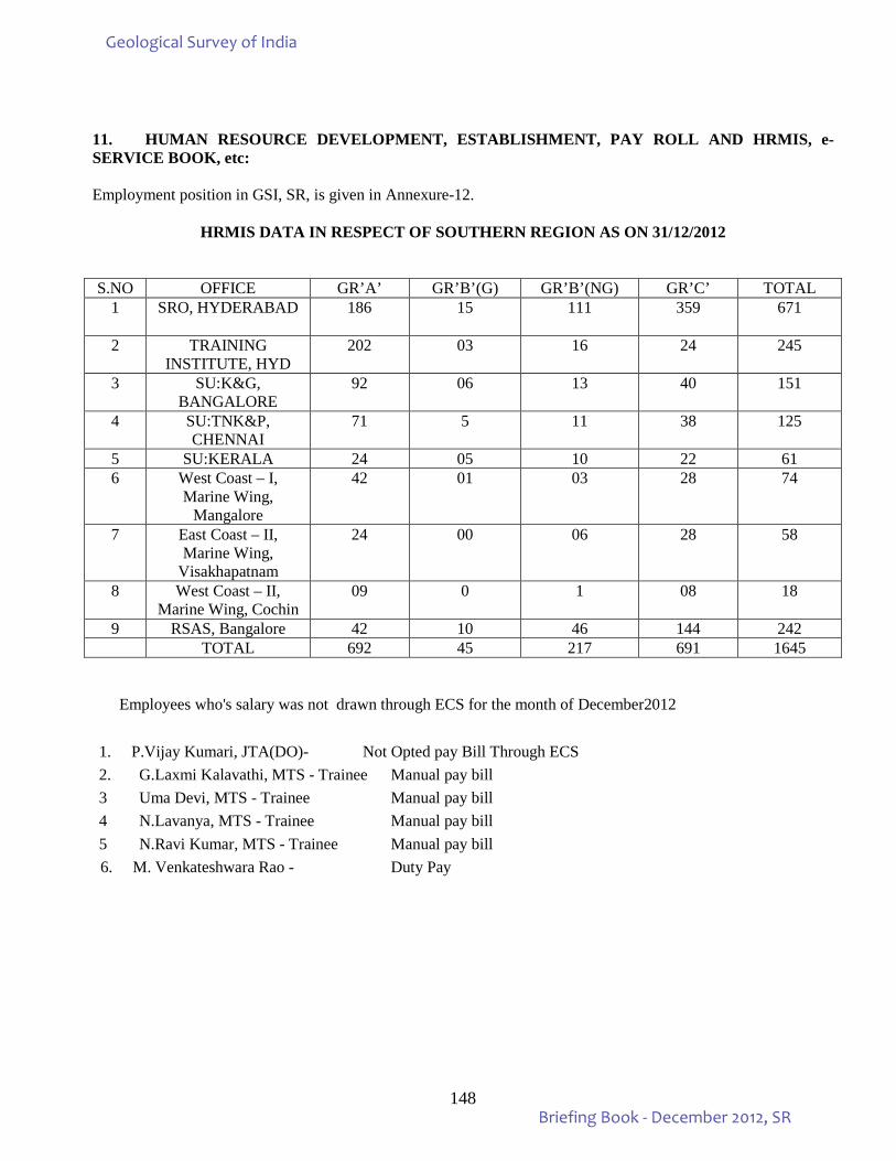
148
11. HUMAN RESOURCE DEVELOPMENT, ESTABLISHMENT, PAY ROLL AND HRMIS, e-SERVICE BOOK, etc: Employment position in GSI, SR, is given in Annexure-12.
HRMIS DATA IN RESPECT OF SOUTHERN REGION AS ON 31/12/2012
S.NO OFFICE GR’A’ GR’B’(G) GR’B’(NG) GR’C’ TOTAL 1 SRO, HYDERABAD 186 15 111 359 671
2 TRAINING
INSTITUTE, HYD 202 03 16 24 245
3 SU:K&G, BANGALORE
92 06 13 40 151
4 SU:TNK&P, CHENNAI
71 5 11 38 125
5 SU:KERALA 24 05 10 22 61 6 West Coast – I,
Marine Wing, Mangalore
42 01 03 28 74
7 East Coast – II, Marine Wing,
Visakhapatnam
24 00 06 28 58
8 West Coast – II, Marine Wing, Cochin
09 0 1 08 18
9 RSAS, Bangalore 42 10 46 144 242 TOTAL 692 45 217 691 1645
Employees who's salary was not drawn through ECS for the month of December2012
1. P.Vijay Kumari, JTA(DO)- Not Opted pay Bill Through ECS 2. G.Laxmi Kalavathi, MTS - Trainee Manual pay bill 3 Uma Devi, MTS - Trainee Manual pay bill 4 N.Lavanya, MTS - Trainee Manual pay bill 5 N.Ravi Kumar, MTS - Trainee Manual pay bill
6. M. Venkateshwara Rao - Duty Pay
Geological Survey of India
Briefing Book - December 2012, SR
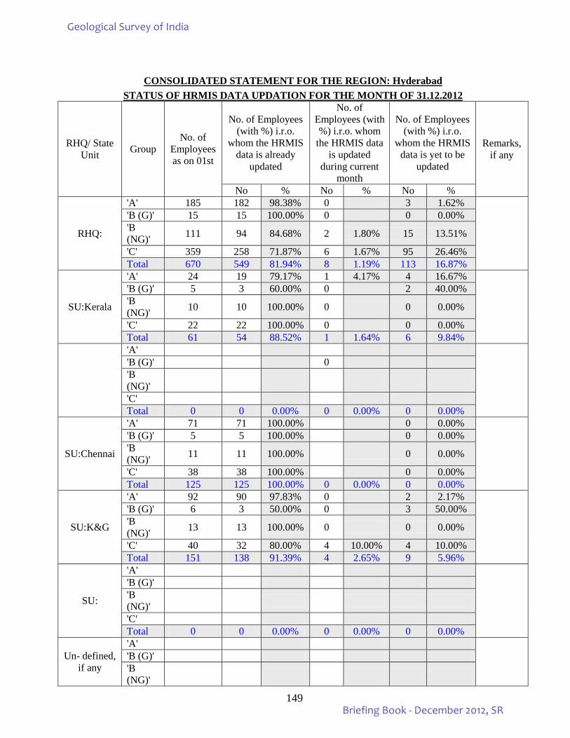
149
CONSOLIDATED STATEMENT FOR THE REGION: Hyderabad
STATUS OF HRMIS DATA UPDATION FOR THE MONTH OF 31.12.2012
RHQ/ State Unit Group
No. of Employees as on 01st
No. of Employees (with %) i.r.o.
whom the HRMIS data is already
updated
No. of Employees (with %) i.r.o. whom
the HRMIS data is updated
during current month
No. of Employees (with %) i.r.o.
whom the HRMIS data is yet to be
updated
Remarks, if any
No % No % No %
RHQ:
'A' 185 182 98.38% 0 3 1.62%
'B (G)' 15 15 100.00% 0 0 0.00% 'B (NG)' 111 94 84.68% 2 1.80% 15 13.51%
'C' 359 258 71.87% 6 1.67% 95 26.46% Total 670 549 81.94% 8 1.19% 113 16.87%
SU:Kerala
'A' 24 19 79.17% 1 4.17% 4 16.67%
'B (G)' 5 3 60.00% 0 2 40.00% 'B (NG)' 10 10 100.00% 0 0 0.00%
'C' 22 22 100.00% 0 0 0.00% Total 61 54 88.52% 1 1.64% 6 9.84%
'A'
'B (G)' 0 'B (NG)'
'C' Total 0 0 0.00% 0 0.00% 0 0.00%
SU:Chennai
'A' 71 71 100.00% 0 0.00%
'B (G)' 5 5 100.00% 0 0.00% 'B (NG)' 11 11 100.00% 0 0.00%
'C' 38 38 100.00% 0 0.00% Total 125 125 100.00% 0 0.00% 0 0.00%
SU:K&G
'A' 92 90 97.83% 0 2 2.17%
'B (G)' 6 3 50.00% 0 3 50.00% 'B (NG)' 13 13 100.00% 0 0 0.00%
'C' 40 32 80.00% 4 10.00% 4 10.00% Total 151 138 91.39% 4 2.65% 9 5.96%
SU:
'A'
'B (G)' 'B (NG)'
'C' Total 0 0 0.00% 0 0.00% 0 0.00%
Un- defined, if any
'A'
'B (G)' 'B (NG)'
Geological Survey of India
Briefing Book - December 2012, SR
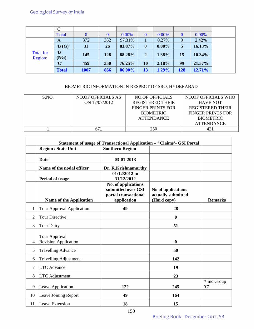
150
'C' Total 0 0 0.00% 0 0.00% 0 0.00%
Total for Region:
'A' 372 362 97.31% 1 0.27% 9 2.42%
'B (G)' 31 26 83.87% 0 0.00% 5 16.13% 'B (NG)' 145 128 88.28% 2 1.38% 15 10.34%
'C' 459 350 76.25% 10 2.18% 99 21.57% Total 1007 866 86.00% 13 1.29% 128 12.71%
BIOMETRIC INFORMATION IN RESPECT OF SRO, HYDERABAD
S.NO. NO.OF OFFICIALS AS ON 17/07/2012
NO.OF OFFICIALS REGISTERED THEIR FINGER PRINTS FOR
BIOMETRIC ATTENDANCE
NO.OF OFFICIALS WHO HAVE NOT
REGISTERED THEIR FINGER PRINTS FOR
BIOMETRIC ATTENDANCE
1 671 250 421
Statement of usage of Transactional Application – ‘ Claims’- GSI Portal Region / State Unit Southern Region
Date 03-01-2013
Name of the nodal officer Dr. R.Krishnamurthy
Period of usage 01/12/2012 to
31/12/2012
Name of the Application
No. of applications submitted over GSI portal transactional
application
No of applications actually submitted (Hard copy) Remarks
1 Tour Approval Application 49 28
2 Tour Directive 0
3 Tour Dairy 51
4 Tour Approval Revision Application 0
5 Travelling Advance 50
6 Travelling Adjustment 142
7 LTC Advance 19
8 LTC Adjustment 23
9 Leave Application 122 245 * inc Group 'C'
10 Leave Joining Report 49 164
11 Leave Extension 18 15
Geological Survey of India
Briefing Book - December 2012, SR
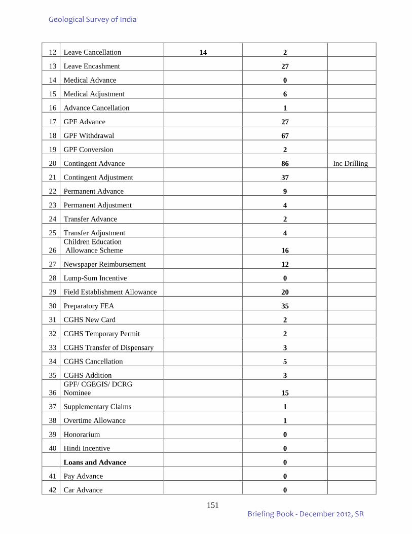
151
12 Leave Cancellation 14 2
13 Leave Encashment 27
14 Medical Advance 0
15 Medical Adjustment 6
16 Advance Cancellation 1
17 GPF Advance 27
18 GPF Withdrawal 67
19 GPF Conversion 2
20 Contingent Advance 86 Inc Drilling
21 Contingent Adjustment 37
22 Permanent Advance 9
23 Permanent Adjustment 4
24 Transfer Advance 2
25 Transfer Adjustment 4
26 Children Education Allowance Scheme 16
27 Newspaper Reimbursement 12
28 Lump-Sum Incentive 0
29 Field Establishment Allowance 20
30 Preparatory FEA 35
31 CGHS New Card 2
32 CGHS Temporary Permit 2
33 CGHS Transfer of Dispensary 3
34 CGHS Cancellation 5
35 CGHS Addition 3
36 GPF/ CGEGIS/ DCRG Nominee 15
37 Supplementary Claims 1
38 Overtime Allowance 1
39 Honorarium 0
40 Hindi Incentive 0
Loans and Advance 0
41 Pay Advance 0
42 Car Advance 0
Geological Survey of India
Briefing Book - December 2012, SR
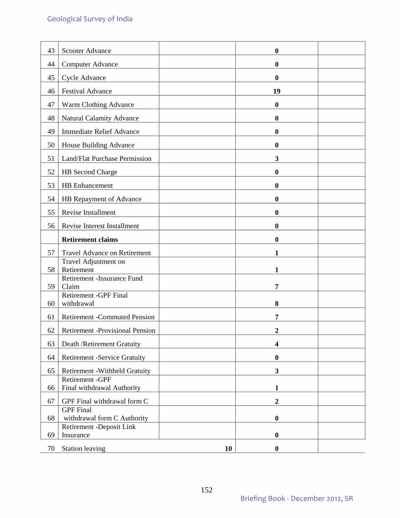
152
43 Scooter Advance 0
44 Computer Advance 0
45 Cycle Advance 0
46 Festival Advance 19
47 Warm Clothing Advance 0
48 Natural Calamity Advance 0
49 Immediate Relief Advance 0
50 House Building Advance 0
51 Land/Flat Purchase Permission 3
52 HB Second Charge 0
53 HB Enhancement 0
54 HB Repayment of Advance 0
55 Revise Installment 0
56 Revise Interest Installment 0
Retirement claims 0
57 Travel Advance on Retirement 1
58 Travel Adjustment on Retirement 1
59 Retirement -Insurance Fund Claim 7
60 Retirement -GPF Final withdrawal 8
61 Retirement -Commuted Pension 7
62 Retirement -Provisional Pension 2
63 Death /Retirement Gratuity 4
64 Retirement -Service Gratuity 0
65 Retirement -Withheld Gratuity 3
66 Retirement -GPF Final withdrawal Authority 1
67 GPF Final withdrawal form C 2
68 GPF Final withdrawal form C Authority 0
69 Retirement -Deposit Link Insurance 0
70 Station leaving 10 0
Geological Survey of India
Briefing Book - December 2012, SR
153
STATEMENT OF PENDENCY OF GRIEVANCE CASES (As on 31.12.2012):
Region Pending at the
start of the
quarter.
Received,during the quarter
Disposal during
the quarter
Grievanc pendency on 30.06.2012
0-4 weeks
4-8 weeks
8-16 weeks
More than 16 weeks.
Southern Region. 0 0 0 - - -
CATEGORIZATION OF PENDING GRIEVANCES (As on 31.12.2012):
1 Pension related - 2 Transfer related - 3 Promotion related - 4 Seniority related - 5 MACP/ACP related - 6 Others - Total -
STATEMENT OF PENDING OF VIGILANCE CASES (Disciplinary cases pending in SR, Hyderabad upto the end of December, 2012)
Sl.No Description No of Cases 1 Total No of cases pending as on 30.11.2012 6 2 Total No of cases pending as on 31.12.2012 7 3 Total No of cases added during quarter from
October to December, 2012 1
4 Total No. of cases disposed during the quarter from October to December, 2012
0
5 Total No of cases at the end of December, 2012 7 RTI Application / Request Status (from 01.04.2012 to 31.12.2012) Organistion Number of cases Geological Survey of
India
Previous pendency
No of RTI request/application received during the
period
Disposal Balance Information denied under section
8(!),9,11,24 & other RTI acts
1 2 3 4 5 6
- - 84 40 44 Nil
Geological Survey of India
Briefing Book - December 2012, SR
154
STATEMENT OF PENDING COURT CASES UNDER DIFFERENT HEADS IN GSI For the month ending December, 2012
BRIEF ABOUT LEGAL CASES AS ON 07.01.2013 OF GSI, SR
1. CONTEMPT CASES PENDING WITH SR : 05 i) Savaraiah case W.P. filed at High Court of AP ii) Ibrahim Kunju case for DPC Hon'ble CAT,Ernakulam directed to produce the records of DPC files. The case was heard on 18.12.2012. iii) GR.N. Tagore for Director promotion (stay granted by High court in favour of Deptt. ). iv) M.P. Muraleedharan case W.P dismissed by High Court filed by the dept. and awaiting for the directions of MOM/DG, GSI. v) M.N.Ramachandra Rao W.P filed and re-submission is yet to be submitted by RS&AS, Bangalore.
2. a). No. of cases with High court : 20 b). No. of cases with CAT : 19 c). No. of cases with Other Courts : 07 ____ Total No. of cases 46 ____ 3. CASES MONITORING BY SOUTHERN REGION 1. No. OF CASES PERTAINS TO VISAKHAPATNAM: 02 2. No. OF CASES PERTAINS TO SU:TAMILNADU : 02 3. No. OF CASES PERTAINS TO SU:KERALA : 08 4. No. OF CASES DIRECTLY DEALING, HYDERABAD: 34 No. of cases pertains to RS&AS(directly dealing by RS&AS) 22 Total No. of cases 68
Sl.No. DIFFERENT HEADS SR Remarks
1 Payment of retirement benefit, counting of past service etc., of retired persons 8
2 Reclassification, Upgradation, Promotion, Pay fixation, recruitment & allied matter of serving employees 18
3 MACT & Compensation cases 3 4 Regularisation of contingent/casual workers 2 5 Compassionate appointment cases 4 6 Cases against disciplinary action, against adverse C.R. 1 7 Estate accommodation, land & related cases 2 8 Transfer/posting cases 1 9 Service association related cases 1
10 Cases under I D Act / P G Act. 1 11 Miscellaneous/unclassified cases 4 12 Contempt cases 2 13 Filed appeal in (a) High Count (B) Supreme Court 1
Total 48
14 Special clarification/remarks including compliance report, if any
Geological Survey of India
Briefing Book - December 2012, SR
155
12. VEHICLES & TRANSPORT INFRASTRUCTURE INCLUDING OUTSOURCING AND AGE OF VEHICLES The required informations are given in the attached Annexure- 13 13. MODERNISATION As part of the effort to meet emerging challenges, SR upgrades periodically its technology both for field
as well as laboratory equipment, at an optimum needed level. In addition, GSI as part of Modernisation has been regularly purchasing IT, laboratory & field equipments. A Modernization Committee was set up which made recommendations in this regard. Current status on procurement of important capital assets is presented in Annexure – 14. 14. DRILLING INFRASTRUCTURE
The informations pertaining to the drilling infrastructure are given in the attached Annexure- 15A 15. OUTSOURCING OF ROUTINE SERVICES (HOUSE KEEPING, SECURITY, GARDEN ETC):
As far as practically feasiable, routine services have been outsourced in Southern Region. Out sourcing of routine human services are made through open advertisement / tender invitation followed by short listing the lowest bidding firm and inviting the firm to enter into an agreement for providing the required manpower and / or to accomplish the task assigned for outsourcing jobs. Presently, the entire security as well as house keeping including cleaning and maintenance of office premises are through outsourcing. Vehicle deployment including deployment for field duties (partly) are outsourced. Some of the technical works including uploading of field reports, reorganization of library, as well as some chemical analysis of samples are being undertaken on outsource basis.
Geological Survey of India
Briefing Book - December 2012, SR
156
ANNEXURES
Geological Survey of India
Briefing Book - December 2012, SR
157
Annexure – 1A
MAJOR MINERAL RESOURCES ESTIMATED IN SOUTHERN REGION, SHOWING STATE-WISE, FIVE–YEARLY INCREMENT (Reserve in million tonnes unless otherwise stated)
S.No. Ore / Mineral Andhra Pradesh Karnataka 2005 2000 1995 2005 2000 1995 1 Asbestos 0.049 0.055 0.051 8.282 8.282 0.29 2 Barytes 69.896 75.774 0.084 0.015 0.015 0.009 3 Bauxite 615.267 612.756 551.479 49.503 44.981 27.332 4 China clay 73.675 72.785 52.504 257 255 12.857 5 Chromite 0.187 0.187 0.116 1.789 1.87 1.452 6 Copper 8.248 8.248 5.449 34.404 34.404 5.669 7 Diamond
(M.Carats) 1.823 1.182 0.005 --
8 Dolomite 1146 1130 129 633.509 535.239 346.152 9 Gold 12.098 8.553 3.791 66.172 24.232 12.863 10 Graphite 0.427 0.427 0.219 0.267 0.267 0.262 11 Iron ore
Hematite(B.T) Magnetite (B.T)
0.163 1.463
0.140 1.463
0.051 0.418
1.676 7.811
1.148 7.883
1.072 2.784
12 Lead – Zinc ore 6.62 6.62 1.954 NA NA NA 13 Limestone (B.T) 35.18 35.219 15.059 51.885 51.210 17.439 14 Magnesite 0.08 0.08 NA 3.857 3.754 1.229 15 Manganese 15.583 18.287 11.905 82.736 86.568 41.054 16 Mica (M.Kgs) 111.3 40.36 44.837 NA NA NA 17 Molybdenum NA NA NA 1.320 1.32 0.9 18 Sillimanite 8.776 8.776 7.898 0.983 0.983 0.475 19 Tungsten 14.802 14.802 14.395 36.68 36.68 NA
Geological Survey of India
Briefing Book - December 2012, SR
158
S.No. Ore / Mineral Goa Tamil Nadu Kerala 2005 2000 1995 2005 2000 1995 2005 2000 1995
15. Asbestos NA NA NA NA NA NA NA NA NA 16. Barytes NA NA NA 0.222 0.222 0.117 NA NA NA 17. Bauxite 50.355 53.072 51.26 26.845 25.156 22.648 14.098 14.161 8.426 18. China clay 0.016 0.016 0.015 56.897 56.897 44.968 630.652 468.801 127.48 19. Chromite NA NA NA 0.282 0.282 0.24 NA NA NA 20. Copper NA NA NA 0.79 0.79 NA NA NA NA 21. Diamond NA NA NA NA NA NA NA NA NA 22. Dolomite NA NA NA 2.145 2.145 1.627 NA NA NA 23. Gold NA NA NA 0.067 0.067 NA 0.558 0.558 0.558 24. Graphite NA NA NA 7.914 1.287 0.423 1.45 1.45 0.533 25. Iron ore
Hematite(B.T) Magnetite (B.T)
0.712 0.214
0.642 0.215
0.745 0.164
NA 0.481
NA NA
NA 1
NA 0.083
NA 0.083
NA 0.036
26. Lead – Zinc ore NA NA NA 0.79 0.79 0.462 NA NA NA 27. Limestone (B.T) NA NA NA 1.18 1.2 0.805 0.206 0.210 0.154 28. Magnesite NA NA NA 45.517 68.044 48.919 0.04 0.04 0.035 29. Manganese 19.057 23.271 16.865 NA NA NA NA NA NA 30. Mica NA NA NA NA NA NA NA NA NA 31. Molybdenum NA NA NA 9.965 6.975 0.036 NA NA NA 32. Sillimanite NA NA NA 17.926 17.926 15.62 9.248 9.906 9.607 33. Tungsten NA NA NA NA NA NA NA NA NA
(Source – IBM Yearbook 2001, 2004, 2008) B.T. = Billion Tonnes, M.Kgs = Million Kilograms, M. Carats= Million Carats NA- Data not available
Geological Survey of India
Briefing Book - December 2012, SR
159
Annexure- 1B NMI: NO. OF REPORTS CONVERTED AS PER UNFC COMPLIANCE
Nodal Officer: N devaraj, Director. Target: Upto June 2011, -- 177 Nos. Achievements: Upto June 2011, --177 Nos. Reports remaining for UNFC compliance: Nil.
Sl. No. Accession
No. Source/Report’s Title Field Season Author(s) Stage of
Mineral Investigation/UNFC Code
1. SRO-12309
Report on the investigation for gold in Volagere-Ambale and adjoining areas, Mysore District, Karnataka.
1996- 1997
D.D.Raju G-4
2. SRO-12258
A report on gold investigation in contact zones at acid/basic volcanics in Hira-Buddini Western Block of Hutti-Maski Schist Belt, Raichur District, Karnataka.
1996- 1997
Venkataswamy and A.N. Susheelendra
G-4
3. SRO-12316
A report on the evaluation of soil geochemical anomaly zones near the contact of acid-volcanics in Chinchergi South Block, Hutti-Maski Schist Belt, Raichur District, Karnataka.
1997- 1998
C.G. Hemantha Kumar, Venkataswamy and A.N. Susheelendra
G-4
4. SRO-12285
Regional assessment of iron ore in parts of South Goa, Sanguem Taluk, Goa State.
1997- 1999
D.Purushothaman and N.D.Ramachandra
334
5. SRO-13544
Prelimnary assessment of potential of the multi-coloured granites in parts of Prakasam and Guntur Districts, Andhra Pradesh.
1998-1999 T.Rajesham and Ch.Jayant Kumar
333
6. SRO-13318
Geology and resource potential survey of dimension stone granite deposits in parts of Dindigul District, Tamil Nadu
1998-1999 M.Ravikumar and Dr.K.Rajaram
334
7. SRO-13357
Geology and resource survey of dimension stone deposits in and around Sivakasi, Virudhunagar District, Tamil Nadu.
1998-1999 T.Mullaivendan and K.Rajaram 334
Geological Survey of India
Briefing Book - December 2012, SR
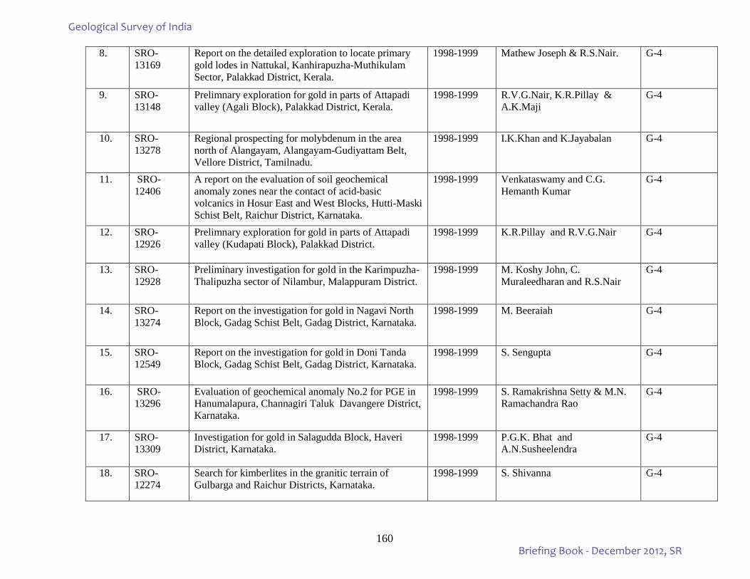
160
8. SRO-13169
Report on the detailed exploration to locate primary gold lodes in Nattukal, Kanhirapuzha-Muthikulam Sector, Palakkad District, Kerala.
1998-1999 Mathew Joseph & R.S.Nair. G-4
9. SRO-13148
Prelimnary exploration for gold in parts of Attapadi valley (Agali Block), Palakkad District, Kerala.
1998-1999 R.V.G.Nair, K.R.Pillay & A.K.Maji
G-4
10. SRO-13278
Regional prospecting for molybdenum in the area north of Alangayam, Alangayam-Gudiyattam Belt, Vellore District, Tamilnadu.
1998-1999 I.K.Khan and K.Jayabalan G-4
11. SRO-12406
A report on the evaluation of soil geochemical anomaly zones near the contact of acid-basic volcanics in Hosur East and West Blocks, Hutti-Maski Schist Belt, Raichur District, Karnataka.
1998-1999 Venkataswamy and C.G. Hemanth Kumar
G-4
12. SRO-12926
Prelimnary exploration for gold in parts of Attapadi valley (Kudapati Block), Palakkad District.
1998-1999 K.R.Pillay and R.V.G.Nair G-4
13. SRO-12928
Preliminary investigation for gold in the Karimpuzha-Thalipuzha sector of Nilambur, Malappuram District.
1998-1999 M. Koshy John, C. Muraleedharan and R.S.Nair
G-4
14. SRO-13274
Report on the investigation for gold in Nagavi North Block, Gadag Schist Belt, Gadag District, Karnataka.
1998-1999 M. Beeraiah G-4
15. SRO-12549
Report on the investigation for gold in Doni Tanda Block, Gadag Schist Belt, Gadag District, Karnataka.
1998-1999 S. Sengupta G-4
16. SRO-13296
Evaluation of geochemical anomaly No.2 for PGE in Hanumalapura, Channagiri Taluk Davangere District, Karnataka.
1998-1999 S. Ramakrishna Setty & M.N. Ramachandra Rao
G-4
17. SRO-13309
Investigation for gold in Salagudda Block, Haveri District, Karnataka.
1998-1999 P.G.K. Bhat and A.N.Susheelendra
G-4
18. SRO-12274
Search for kimberlites in the granitic terrain of Gulbarga and Raichur Districts, Karnataka.
1998-1999 S. Shivanna G-4
Geological Survey of India
Briefing Book - December 2012, SR
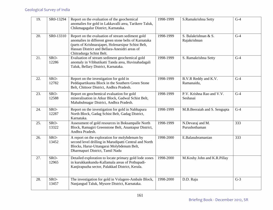
161
19. SR0-13294 Report on the evaluation of the geochemical anomalies for gold in Lakkavalli area, Tarikere Taluk, Chikmagagalur District, Karnataka.
1998-1999 S.Ramakrishna Setty G-4
20. SR0-13310 Report on the evaluation of stream sediment gold anomalies in different green stone belts of Karnataka (parts of Krishnarajapet, Holenarsipur Schist Belt, Hassan District and Bellara-Anesidri areas of Chitradurga Schist Belt.
1998-1999 S. Balakrishnan & S. Rajakrishnan
G-4
21. SRO-12286
Evaluation of stream sediment geochemical gold anomaly in Vibhutikatti Tanda area, Huvinahadagali Taluk, Bellary District, Karnataka.
1998-1999 S. Ramakrishna Setty G-4
22. SRO-12782
Report on the investigation for gold in Peddapartikunta Block in the Southern Green Stone Belt, Chittoor District, Andhra Pradesh.
1998-1999 B.V.R Reddy and K.V. Ramanaidu,
G-4
23. SRO-12588
Report on geochemical evaluation for gold mineralisation in Atkur Block, Gadwal Schist Belt, Mahabubnagar District, Andhra Pradesh.
1998-1999 P.V. Krishna Rao and V.V. Seshasai
G-4
24. SRO-12287
Report on the investigation for gold in Nabhapura North Block, Gadag Schist Belt, Gadag District, Karnataka.
1998-1999 M.B.Beeraiah and S. Sengupta G-4
25. SRO-13322
Assessment of gold resources in Boksampalle North Block, Ramagiri Greenstone Belt, Anantapur District, Andhra Pradesh.
1998-1999 N.Devaraj and M. Purushothaman
333
26. SRO-13452
A report on the exploration for molybdenum by second level drilling in Marudipatti Central and North Blocks, Harur-Uttangarai Molybdenum Belt, Dharmapuri District, Tamil Nadu
1998-2000 E.Balasubramanian 333
27. SRO-12965
Detailed exploration to locate primary gold lode zones in kurukkankundu-Kallamala areas of Pothupadi-Kanjirapuzha sector, Palakkad District, Kerala.
1998-2000 M.Koshy John and K.R.Pillay
28. SRO-13457
The investigation for gold in Volagere-Ambale Block, Nanjangud Taluk, Mysore District, Karnataka.
1998-2000 D.D. Raju G-3
Geological Survey of India
Briefing Book - December 2012, SR
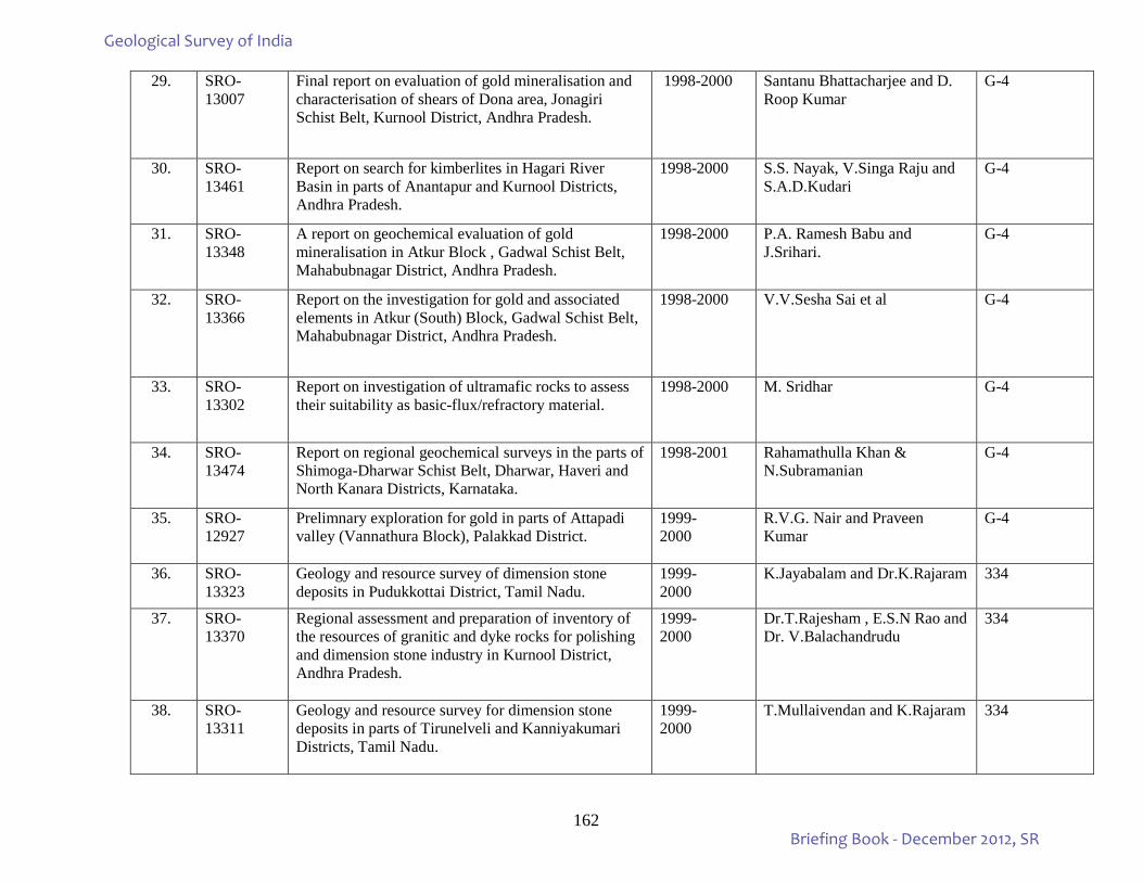
162
29. SRO-13007
Final report on evaluation of gold mineralisation and characterisation of shears of Dona area, Jonagiri Schist Belt, Kurnool District, Andhra Pradesh.
1998-2000 Santanu Bhattacharjee and D. Roop Kumar
G-4
30. SRO-13461
Report on search for kimberlites in Hagari River Basin in parts of Anantapur and Kurnool Districts, Andhra Pradesh.
1998-2000 S.S. Nayak, V.Singa Raju and S.A.D.Kudari
G-4
31. SRO-13348
A report on geochemical evaluation of gold mineralisation in Atkur Block , Gadwal Schist Belt, Mahabubnagar District, Andhra Pradesh.
1998-2000 P.A. Ramesh Babu and J.Srihari.
G-4
32. SRO-13366
Report on the investigation for gold and associated elements in Atkur (South) Block, Gadwal Schist Belt, Mahabubnagar District, Andhra Pradesh.
1998-2000 V.V.Sesha Sai et al G-4
33. SRO-13302
Report on investigation of ultramafic rocks to assess their suitability as basic-flux/refractory material.
1998-2000 M. Sridhar G-4
34. SRO-13474
Report on regional geochemical surveys in the parts of Shimoga-Dharwar Schist Belt, Dharwar, Haveri and North Kanara Districts, Karnataka.
1998-2001 Rahamathulla Khan & N.Subramanian
G-4
35. SRO-12927
Prelimnary exploration for gold in parts of Attapadi valley (Vannathura Block), Palakkad District.
1999- 2000
R.V.G. Nair and Praveen Kumar
G-4
36. SRO-13323
Geology and resource survey of dimension stone deposits in Pudukkottai District, Tamil Nadu.
1999- 2000
K.Jayabalam and Dr.K.Rajaram 334
37. SRO-13370
Regional assessment and preparation of inventory of the resources of granitic and dyke rocks for polishing and dimension stone industry in Kurnool District, Andhra Pradesh.
1999- 2000
Dr.T.Rajesham , E.S.N Rao and Dr. V.Balachandrudu
334
38. SRO-13311
Geology and resource survey for dimension stone deposits in parts of Tirunelveli and Kanniyakumari Districts, Tamil Nadu.
1999- 2000
T.Mullaivendan and K.Rajaram 334
Geological Survey of India
Briefing Book - December 2012, SR
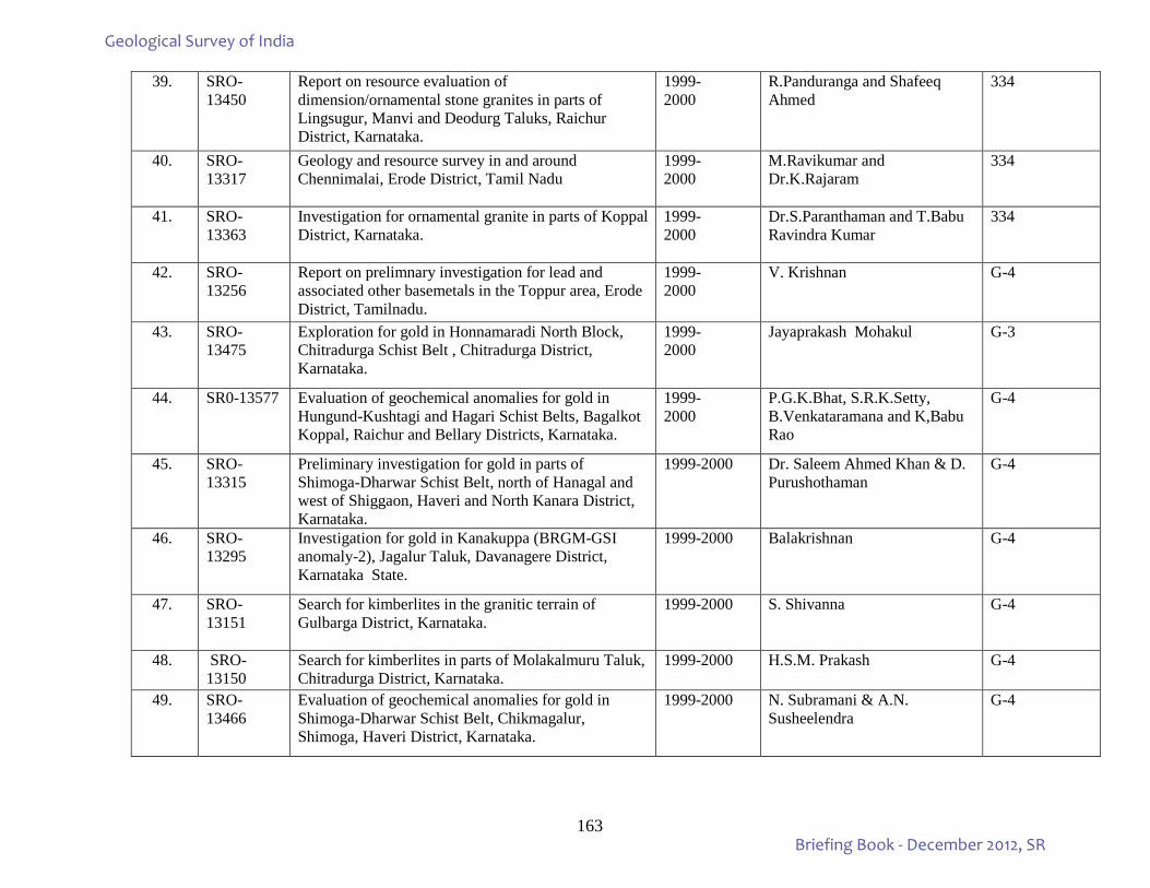
163
39. SRO-13450
Report on resource evaluation of dimension/ornamental stone granites in parts of Lingsugur, Manvi and Deodurg Taluks, Raichur District, Karnataka.
1999- 2000
R.Panduranga and Shafeeq Ahmed
334
40. SRO-13317
Geology and resource survey in and around Chennimalai, Erode District, Tamil Nadu
1999- 2000
M.Ravikumar and Dr.K.Rajaram
334
41. SRO-13363
Investigation for ornamental granite in parts of Koppal District, Karnataka.
1999- 2000
Dr.S.Paranthaman and T.Babu Ravindra Kumar
334
42. SRO-13256
Report on prelimnary investigation for lead and associated other basemetals in the Toppur area, Erode District, Tamilnadu.
1999- 2000
V. Krishnan G-4
43. SRO-13475
Exploration for gold in Honnamaradi North Block, Chitradurga Schist Belt , Chitradurga District, Karnataka.
1999- 2000
Jayaprakash Mohakul G-3
44. SR0-13577 Evaluation of geochemical anomalies for gold in Hungund-Kushtagi and Hagari Schist Belts, Bagalkot Koppal, Raichur and Bellary Districts, Karnataka.
1999- 2000
P.G.K.Bhat, S.R.K.Setty, B.Venkataramana and K,Babu Rao
G-4
45. SRO-13315
Preliminary investigation for gold in parts of Shimoga-Dharwar Schist Belt, north of Hanagal and west of Shiggaon, Haveri and North Kanara District, Karnataka.
1999-2000 Dr. Saleem Ahmed Khan & D. Purushothaman
G-4
46. SRO-13295
Investigation for gold in Kanakuppa (BRGM-GSI anomaly-2), Jagalur Taluk, Davanagere District, Karnataka State.
1999-2000 Balakrishnan G-4
47. SRO-13151
Search for kimberlites in the granitic terrain of Gulbarga District, Karnataka.
1999-2000 S. Shivanna G-4
48. SRO-13150
Search for kimberlites in parts of Molakalmuru Taluk, Chitradurga District, Karnataka.
1999-2000 H.S.M. Prakash G-4
49. SRO-13466
Evaluation of geochemical anomalies for gold in Shimoga-Dharwar Schist Belt, Chikmagalur, Shimoga, Haveri District, Karnataka.
1999-2000 N. Subramani & A.N. Susheelendra
G-4
Geological Survey of India
Briefing Book - December 2012, SR
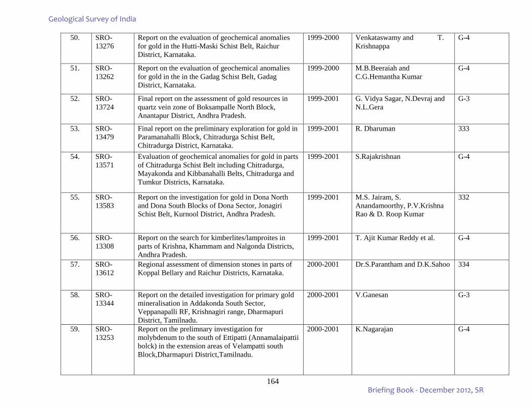
164
50. SRO-13276
Report on the evaluation of geochemical anomalies for gold in the Hutti-Maski Schist Belt, Raichur District, Karnataka.
1999-2000 Venkataswamy and T. Krishnappa
G-4
51. SRO-13262
Report on the evaluation of geochemical anomalies for gold in the in the Gadag Schist Belt, Gadag District, Karnataka.
1999-2000 M.B.Beeraiah and C.G.Hemantha Kumar
G-4
52. SRO-13724
Final report on the assessment of gold resources in quartz vein zone of Boksampalle North Block, Anantapur District, Andhra Pradesh.
1999-2001 G. Vidya Sagar, N.Devraj and N.L.Gera
G-3
53. SRO-13479
Final report on the preliminary exploration for gold in Paramanahalli Block, Chitradurga Schist Belt, Chitradurga District, Karnataka.
1999-2001 R. Dharuman 333
54. SRO-13571
Evaluation of geochemical anomalies for gold in parts of Chitradurga Schist Belt including Chitradurga, Mayakonda and Kibbanahalli Belts, Chitradurga and Tumkur Districts, Karnataka.
1999-2001 S.Rajakrishnan G-4
55. SRO-13583
Report on the investigation for gold in Dona North and Dona South Blocks of Dona Sector, Jonagiri Schist Belt, Kurnool District, Andhra Pradesh.
1999-2001 M.S. Jairam, S. Anandamoorthy, P.V.Krishna Rao & D. Roop Kumar
332
56. SRO-13308
Report on the search for kimberlites/lamproites in parts of Krishna, Khammam and Nalgonda Districts, Andhra Pradesh.
1999-2001 T. Ajit Kumar Reddy et al. G-4
57. SRO-13612
Regional assessment of dimension stones in parts of Koppal Bellary and Raichur Districts, Karnataka.
2000-2001 Dr.S.Parantham and D.K.Sahoo 334
58. SRO-13344
Report on the detailed investigation for primary gold mineralisation in Addakonda South Sector, Veppanapalli RF, Krishnagiri range, Dharmapuri District, Tamilnadu.
2000-2001 V.Ganesan G-3
59. SRO-13253
Report on the prelimnary investigation for molybdenum to the south of Ettipatti (Annamalaipattii bolck) in the extension areas of Velampatti south Block,Dharmapuri District,Tamilnadu.
2000-2001 K.Nagarajan G-4
Geological Survey of India
Briefing Book - December 2012, SR
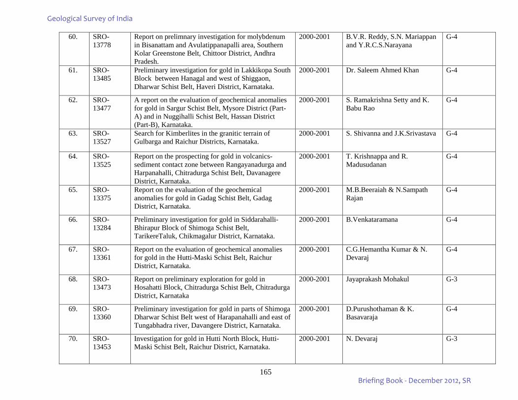
165
60. SRO- 13778
Report on prelimnary investigation for molybdenum in Bisanattam and Avulatippanapalli area, Southern Kolar Greenstone Belt, Chittoor District, Andhra Pradesh.
2000-2001 B.V.R. Reddy, S.N. Mariappan and Y.R.C.S.Narayana
G-4
61. SRO-13485
Preliminary investigation for gold in Lakkikopa South Block between Hanagal and west of Shiggaon, Dharwar Schist Belt, Haveri District, Karnataka.
2000-2001 Dr. Saleem Ahmed Khan G-4
62. SRO-13477
A report on the evaluation of geochemical anomalies for gold in Sargur Schist Belt, Mysore District (Part-A) and in Nuggihalli Schist Belt, Hassan District (Part-B), Karnataka.
2000-2001 S. Ramakrishna Setty and K. Babu Rao
G-4
63. SRO-13527
Search for Kimberlites in the granitic terrain of Gulbarga and Raichur Districts, Karnataka.
2000-2001 S. Shivanna and J.K.Srivastava G-4
64. SRO-13525
Report on the prospecting for gold in volcanics-sediment contact zone between Rangayanadurga and Harpanahalli, Chitradurga Schist Belt, Davanagere District, Karnataka.
2000-2001 T. Krishnappa and R. Madusudanan
G-4
65. SRO-13375
Report on the evaluation of the geochemical anomalies for gold in Gadag Schist Belt, Gadag District, Karnataka.
2000-2001 M.B.Beeraiah & N.Sampath Rajan
G-4
66. SRO-13284
Preliminary investigation for gold in Siddarahalli-Bhirapur Block of Shimoga Schist Belt, TarikereTaluk, Chikmagalur District, Karnataka.
2000-2001 B.Venkataramana G-4
67. SRO-13361
Report on the evaluation of geochemical anomalies for gold in the Hutti-Maski Schist Belt, Raichur District, Karnataka.
2000-2001 C.G.Hemantha Kumar & N. Devaraj
G-4
68. SRO-13473
Report on preliminary exploration for gold in Hosahatti Block, Chitradurga Schist Belt, Chitradurga District, Karnataka
2000-2001 Jayaprakash Mohakul G-3
69. SRO-13360
Preliminary investigation for gold in parts of Shimoga Dharwar Schist Belt west of Harapanahalli and east of Tungabhadra river, Davangere District, Karnataka.
2000-2001 D.Purushothaman & K. Basavaraja
G-4
70. SRO-13453
Investigation for gold in Hutti North Block, Hutti-Maski Schist Belt, Raichur District, Karnataka.
2000-2001 N. Devaraj G-3
Geological Survey of India
Briefing Book - December 2012, SR
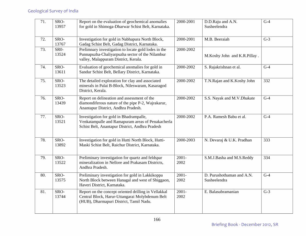
166
71. SRO-13957
Report on the evaluation of geochemical anomalies for gold in Shimoga-Dharwar Schist Belt, Karnataka.
2000-2001 D.D.Raju and A.N. Susheelendra
G-4
72. SRO-13767
Investigation for gold in Nabhapura North Block, Gadag Schist Belt, Gadag District, Karnataka.
2000-2001 M.B. Beeraiah G-3
73. SR0- 13524
Prelimnary investigation to locate gold lodes in the Punnapuzha-Chaliyarpuzha sector of the Nilambur valley, Malappuram District, Kerala.
2000-2002 M.Koshy John and K.R.Pillay .
74. SRO-13611
Evaluation of geochemical anomalies for gold in Sandur Schist Belt, Bellary District, Karnataka.
2000-2002 S. Rajakrishnan et al. G-4
75. SRO-13523
The detailed exploration for clay and associated minerals in Palai B-Block, Nileswaram, Kasaragod District, Kerala.
2000-2002 T.N.Rajan and K.Koshy John 332
76. SRO-13439
Report on delineation and assessment of the diamondiferous nature of the pipe P-2, Wajrakarur, Anantapur District, Andhra Pradesh.
2000-2002 S.S. Nayak and M.V.Dhakate G-4
77. SRO-13521
Investigation for gold in Bhadrampalle, Venkatampalle and Ramapuram areas of Penakacherla Schist Belt, Anantapur District, Andhra Pradesh
2000-2002 P.A. Ramesh Babu et al. G-4
78. SRO-13892
Investigation for gold in Hutti North Block, Hutti-Maski Schist Belt, Raichur District, Karnataka.
2000-2003 N. Devaraj & U.K. Pradhan 333
79. SRO-13522
Preliminary investigation for quartz and feldspar mineralization in Nellore and Prakasam Districts, Andhra Pradesh.
2001- 2002
S.M.J.Basha and M.S.Reddy 334
80. SRO-13575
Preliminary investigation for gold in Lakkikoppa North Block between Hanagal and west of Shiggaon, Haveri District, Karnataka.
2001- 2002
D. Purushothaman and A.N. Susheelendra
G-4
81. SRO-13744
Report on the concept oriented drilling in Vellakkal Central Block, Harur-Uttangarai Molybdenum Belt (HUB), Dharmapuri District, Tamil Nadu.
2001- 2002
E. Balasubramanian G-3
Geological Survey of India
Briefing Book - December 2012, SR
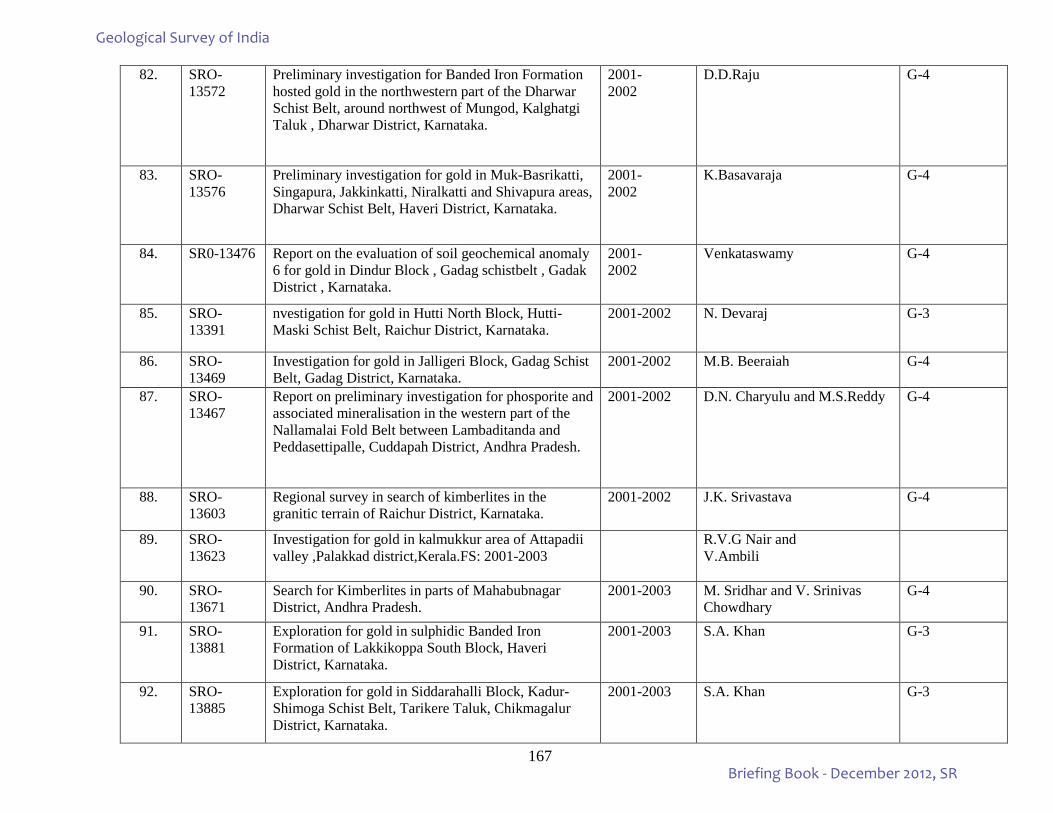
167
82. SRO-13572
Preliminary investigation for Banded Iron Formation hosted gold in the northwestern part of the Dharwar Schist Belt, around northwest of Mungod, Kalghatgi Taluk , Dharwar District, Karnataka.
2001- 2002
D.D.Raju G-4
83. SRO-13576
Preliminary investigation for gold in Muk-Basrikatti, Singapura, Jakkinkatti, Niralkatti and Shivapura areas, Dharwar Schist Belt, Haveri District, Karnataka.
2001- 2002
K.Basavaraja G-4
84. SR0-13476 Report on the evaluation of soil geochemical anomaly 6 for gold in Dindur Block , Gadag schistbelt , Gadak District , Karnataka.
2001- 2002
Venkataswamy G-4
85. SRO-13391
nvestigation for gold in Hutti North Block, Hutti-Maski Schist Belt, Raichur District, Karnataka.
2001-2002 N. Devaraj G-3
86. SRO-13469
Investigation for gold in Jalligeri Block, Gadag Schist Belt, Gadag District, Karnataka.
2001-2002 M.B. Beeraiah G-4
87. SRO-13467
Report on preliminary investigation for phosporite and associated mineralisation in the western part of the Nallamalai Fold Belt between Lambaditanda and Peddasettipalle, Cuddapah District, Andhra Pradesh.
2001-2002 D.N. Charyulu and M.S.Reddy G-4
88. SRO-13603
Regional survey in search of kimberlites in the granitic terrain of Raichur District, Karnataka.
2001-2002 J.K. Srivastava G-4
89. SRO- 13623
Investigation for gold in kalmukkur area of Attapadii valley ,Palakkad district,Kerala.FS: 2001-2003
R.V.G Nair and V.Ambili
90. SRO-13671
Search for Kimberlites in parts of Mahabubnagar District, Andhra Pradesh.
2001-2003 M. Sridhar and V. Srinivas Chowdhary
G-4
91. SRO-13881
Exploration for gold in sulphidic Banded Iron Formation of Lakkikoppa South Block, Haveri District, Karnataka.
2001-2003 S.A. Khan G-3
92. SRO-13885
Exploration for gold in Siddarahalli Block, Kadur-Shimoga Schist Belt, Tarikere Taluk, Chikmagalur District, Karnataka.
2001-2003 S.A. Khan G-3
Geological Survey of India
Briefing Book - December 2012, SR
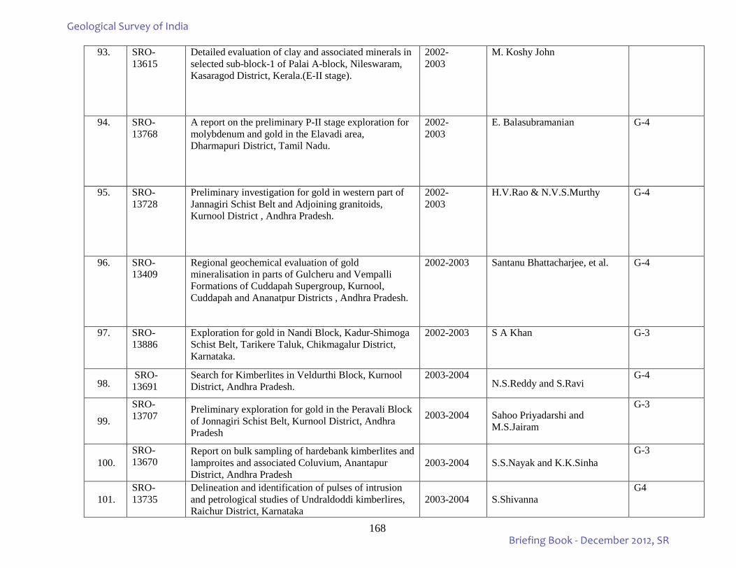
168
93. SRO-13615
Detailed evaluation of clay and associated minerals in selected sub-block-1 of Palai A-block, Nileswaram, Kasaragod District, Kerala.(E-II stage).
2002- 2003
M. Koshy John
94. SRO-13768
A report on the preliminary P-II stage exploration for molybdenum and gold in the Elavadi area, Dharmapuri District, Tamil Nadu.
2002- 2003
E. Balasubramanian G-4
95. SRO-13728
Preliminary investigation for gold in western part of Jannagiri Schist Belt and Adjoining granitoids, Kurnool District , Andhra Pradesh.
2002- 2003
H.V.Rao & N.V.S.Murthy G-4
96. SRO-13409
Regional geochemical evaluation of gold mineralisation in parts of Gulcheru and Vempalli Formations of Cuddapah Supergroup, Kurnool, Cuddapah and Ananatpur Districts , Andhra Pradesh.
2002-2003 Santanu Bhattacharjee, et al. G-4
97. SRO-13886
Exploration for gold in Nandi Block, Kadur-Shimoga Schist Belt, Tarikere Taluk, Chikmagalur District, Karnataka.
2002-2003 S A Khan G-3
98. SRO-13691
Search for Kimberlites in Veldurthi Block, Kurnool District, Andhra Pradesh.
2003-2004 N.S.Reddy and S.Ravi
G-4
99. SRO-13707 Preliminary exploration for gold in the Peravali Block
of Jonnagiri Schist Belt, Kurnool District, Andhra Pradesh
2003-2004
Sahoo Priyadarshi and M.S.Jairam
G-3
100. SRO-13670
Report on bulk sampling of hardebank kimberlites and lamproites and associated Coluvium, Anantapur District, Andhra Pradesh
2003-2004 S.S.Nayak and K.K.Sinha G-3
101. SRO-13735
Delineation and identification of pulses of intrusion and petrological studies of Undraldoddi kimberlires, Raichur District, Karnataka
2003-2004 S.Shivanna G4
Geological Survey of India
Briefing Book - December 2012, SR
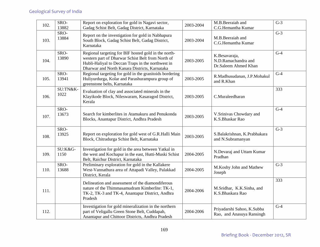
169
102. SRO-13882
Report on exploration for gold in Nagavi sector, Gadag Schist Belt, Gadag District, Karnataka 2003-2004 M.B.Beeraiah and
C.G.Hemantha Kumar G-3
103. SRO-13884 Report on the investigation for gold in Nabhapura
South Block, Gadag Schist Belt, Gadag District, Karnataka
2003-2004 M.B.Beeraiah and C.G.Hemantha Kumar
G-3
104.
SRO-13890
Regional targeting for BIF hosted gold in the north-western part of Dharwar Schist Belt from North of Hubli-Haliyal to Deccan Traps in the northwest in Dharwar and North Kanara Districts, Karnataka
2003-2005 K.Besavaraja, N.D.Ramachandra and Dr.Saleem Ahmed Khan
G-4
105. SRO-13941
Regional targeting for gold in the granitoids bordering Huliyurdurga, Kolar and Parashurampura group of greenstone belts, Karnataka
2003-2005 R.Madhusudanan, J.P.Mohakul and R.Khan
G-4
106.
SU:TN&K-1022 Evaluation of clay and associated minerals in the
Klayikode Block, Nileswaram, Kasaragod District, Kerala
2003-2005 C.Muraleedharan
333
107.
SRO-13673 Search for kimberlites in Atamakuru and Penukonda
Blocks, Anantapur District, Andhra Pradesh 2003-2005 V.Srinivas Chowdary and K.S.Bhaskar Rao
G-4
108. SRO-13925 Report on exploration for gold west of G.R.Halli Main
Block, Chitradurga Schist Belt, Karnataka 2003-2005 S.Balakrishnan, K.Prabhakara and N.Subramanyan
G-3
109. SU:K&G-1150
Investigation for gold in the area between Yatkal in the west and Kochapur in the east, Hutti-Muski Schist Belt, Raichur District, Karnataka
2004-2005 N.Devaraj and Uttam Kumar Pradhan
110. SRO-13688
Preliminary exploration for gold in the Kallakere West-Vannathura area of Attapadi Valley, Palakkad District, Kerala
2004-2005 M.Koshy John and Mathew Joseph
G-3
111.
Delineation and assessment of the diamondiferous nature of the Thimmasamudram Kimberlite: TK-1, TK-2, TK-3 and TK-4, Anantapur District, Andhra Pradesh
2004-2006 M.Sridhar, K.K.Sinha, and K.S.Bhaskara Rao
333
112. Investigation for gold mineralization in the northern
part of Veligallu Green Stone Belt, Cuddapah, Anantapur and Chittoor Districts, Andhra Pradesh
2004-2006 Priyadarshi Sahoo, K.Subba Rao, and Anasuya Ransingh
G-4
Geological Survey of India
Briefing Book - December 2012, SR
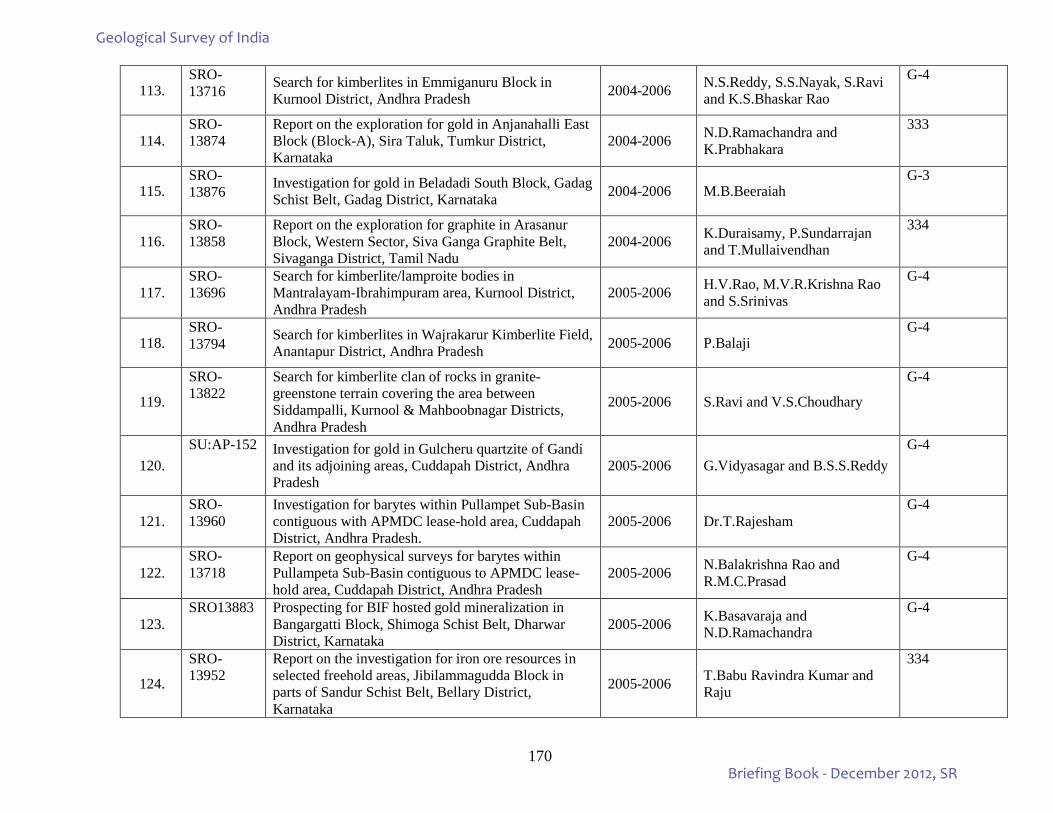
170
113. SRO-13716 Search for kimberlites in Emmiganuru Block in
Kurnool District, Andhra Pradesh 2004-2006 N.S.Reddy, S.S.Nayak, S.Ravi and K.S.Bhaskar Rao
G-4
114. SRO-13874
Report on the exploration for gold in Anjanahalli East Block (Block-A), Sira Taluk, Tumkur District, Karnataka
2004-2006 N.D.Ramachandra and K.Prabhakara
333
115. SRO-13876 Investigation for gold in Beladadi South Block, Gadag
Schist Belt, Gadag District, Karnataka 2004-2006 M.B.Beeraiah G-3
116. SRO-13858
Report on the exploration for graphite in Arasanur Block, Western Sector, Siva Ganga Graphite Belt, Sivaganga District, Tamil Nadu
2004-2006 K.Duraisamy, P.Sundarrajan and T.Mullaivendhan
334
117. SRO-13696
Search for kimberlite/lamproite bodies in Mantralayam-Ibrahimpuram area, Kurnool District, Andhra Pradesh
2005-2006 H.V.Rao, M.V.R.Krishna Rao and S.Srinivas
G-4
118. SRO-13794 Search for kimberlites in Wajrakarur Kimberlite Field,
Anantapur District, Andhra Pradesh 2005-2006 P.Balaji G-4
119.
SRO-13822
Search for kimberlite clan of rocks in granite-greenstone terrain covering the area between Siddampalli, Kurnool & Mahboobnagar Districts, Andhra Pradesh
2005-2006 S.Ravi and V.S.Choudhary
G-4
120. SU:AP-152 Investigation for gold in Gulcheru quartzite of Gandi
and its adjoining areas, Cuddapah District, Andhra Pradesh
2005-2006 G.Vidyasagar and B.S.S.Reddy G-4
121. SRO-13960
Investigation for barytes within Pullampet Sub-Basin contiguous with APMDC lease-hold area, Cuddapah District, Andhra Pradesh.
2005-2006 Dr.T.Rajesham G-4
122. SRO-13718
Report on geophysical surveys for barytes within Pullampeta Sub-Basin contiguous to APMDC lease-hold area, Cuddapah District, Andhra Pradesh
2005-2006 N.Balakrishna Rao and R.M.C.Prasad
G-4
123. SRO13883 Prospecting for BIF hosted gold mineralization in
Bangargatti Block, Shimoga Schist Belt, Dharwar District, Karnataka
2005-2006 K.Basavaraja and N.D.Ramachandra
G-4
124.
SRO-13952
Report on the investigation for iron ore resources in selected freehold areas, Jibilammagudda Block in parts of Sandur Schist Belt, Bellary District, Karnataka
2005-2006 T.Babu Ravindra Kumar and Raju
334
Geological Survey of India
Briefing Book - December 2012, SR
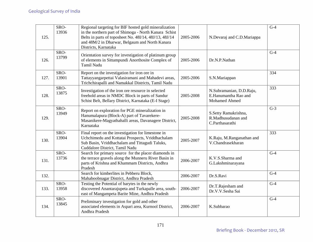
171
125.
SRO-13936
Regional targeting for BIF hosted gold mineralization in the northern part of Shimoga - North Kanara Schist Belts in parts of toposheet No. 48I/14, 48J/13, 48J/14 and 48M/2 in Dharwar, Belgaum and North Kanara Districts, Karnataka
2005-2006 N.Devaraj and C.D.Mariappa
G-4
126.
SRO-13799 Orientation survey for investigation of platinum group
of elements in Sittampundi Anorthosite Complex of Tamil Nadu
2005-2006 Dr.N.P.Nathan
G-4
127. SRO-13901
Report on the investigation for iron ore in Tattayyangarpettai Valasiramani and Mahadevi areas, Trichchirapalli and Namakkal Districts, Tamil Nadu
2005-2006 S.N.Mariappan 334
128.
SRO-13875 Investigation of the iron ore resource in selected
freehold areas in NMDC Block in parts of Sandur Schist Belt, Bellary District, Karnataka (E-I Stage)
2005-2008 N.Subramanian, D.D.Raju, E.Hanumantha Rao and Mohamed Ahmed
333
129.
SRO-13949
Report on exploration for PGE mineralization in Hanumalapura (Block-A) part of Tavarekere-Masanikere-Magyathahalli areas, Davanagere District, Karnataka
2005-2008 S.Setty Ramakrishna, R.Madhusudanan and C.Parthasarathi
G-3
130.
SRO-13904
Final report on the investigation for limestone in Uchchimedu and Kottatai Prospects, Vriddhachalam Sub Basin, Vriddhachalam and Tittagudi Taluks, Cuddalore District, Tamil Nadu
2005-2007 K.Raju, M.Ranganathan and V.Chandrasekharan
333
131.
SRO-13736
Search for primary source for the placer diamonds in the terrace gravels along the Munneru River Basin in parts of Krishna and Khammam Districts, Andhra Pradesh
2006-2007 K.V.S.Sharma and G.Lakshminarayana
G-4
132. Search for kimberlites in Pebberu Block, Mahaboobnagar District, Andhra Pradesh 2006-2007 Dr.S.Ravi G-4
133. SRO-13958
Testing the Potential of barytes in the newly discovered Anantarajupeta and Turkapalle area, south-east of Mangampeta Barite Mine, Andhra Pradesh
2006-2007 Dr.T.Rajesham and Dr.V.V.Sesha Sai
G-4
134.
SRO-13845 Preliminary investigation for gold and other
associated elements in Aspari area, Kurnool District, Andhra Pradesh
2006-2007 K.Subbarao
G-4
Geological Survey of India
Briefing Book - December 2012, SR
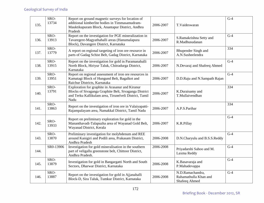
172
135.
SRO-13734
Report on ground magnetic surveys for location of additional kimberlite bodies in Timmasamudram-Mauktikapuram Block, Anantapur District, Andhra Pradesh
2006-2007 T.Vaideswaran
G-4
136. SRO-13913
Report on the investigation for PGE mineralization in Tavaregere-Magyathahalli areas (Hanumalapura Block), Davangere District, Karnataka
2006-2007 S.Ramakrishna Setty and R.Madhusudanan
G-4
137. SRO-13779 A report on regional targeting of iron ore resource in
parts of Gadag Schist Belt, Gadag District, Karnataka 2006-2007 Bhupender Singh and A.N.Susheelendra
334
138. SRO-13915
Report on the investigation for gold in Paramanahalli North Block, Hiriyur Taluk, Chitradurga District, Karnataka
2006-2007 N.Devaraj and Shafeeq Ahmed G-4
139. SRO-13951
Report on regional assessment of iron ore resources in Kamatagi Block of Hungund Belt, Bagalkot and Raichur Districts, Karnataka
2006-2007 D.D.Raju and N.Sampath Rajan G-4
140.
SRO-13791
Exploration for graphite in Arasanur and Kiranur Blocks of Sivaganga Graphite Belt, Sivaganga District and Terku Kallikulam area, Tirunelveli District, Tamil Nadu
2006-2007 K.Duraisamy and T.Mullaivendhan
334
141. SRO-13863 Report on the investigation of iron ore in Valaiyapatti-
Rajampalayam area, Namakkal District, Tamil Nadu 2006-2007 A.P.S.Parihar 334
142.
SRO-13933
Report on preliminary exploration for gold in the Mananthavadi-Talapuzha area of Wayanad Gold Belt, Wayanad District, Kerala
2006-2007 K.R.Pillay
G-4
143. SRO-13870
Preliminary investigation for molybdenum and REE around Kanigiri and Podili area, Prakasam District, Andhra Pradesh
2006-2008 D.N.Charyulu and B.S.S.Reddy G-4
144. SR0-13906 Investigation for gold mineralisation in the southern
part of veligallu greenstone belt, Chittoor District, Andhra Pradesh.
2006-2008 Priyadarshi Sahoo and M. Laxma Reddy
G-4
145. SRO-13879 Investigation for gold in Bangargatti North and South
Sectors, Dharwar District, Karnataka 2006-2008 K.Basavaraja and P.Mahadevappa
G-4
146. SRO-13887 Report on the investigation for gold in Ajjanahalli
Block-D, Sira Taluk, Tumkur District, Karnataka 2006-2008 N.D.Ramachandra, Rahamathulla Khan and Shafeeq Ahmed
G-4
Geological Survey of India
Briefing Book - December 2012, SR
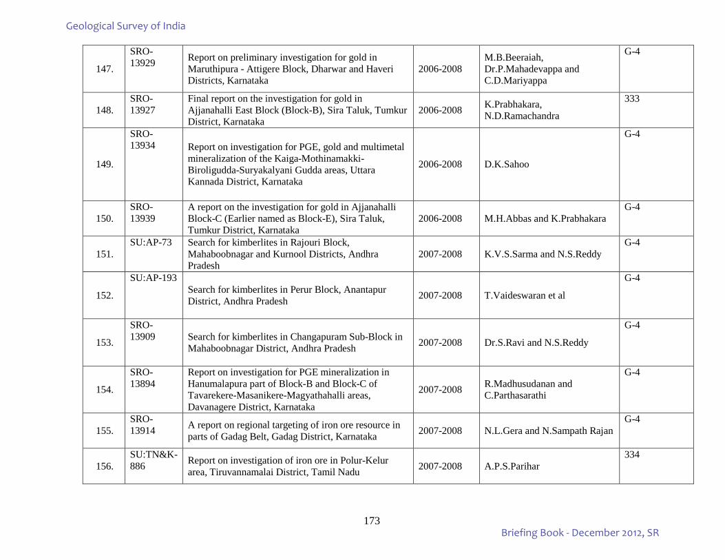
173
147.
SRO-13929 Report on preliminary investigation for gold in
Maruthipura - Attigere Block, Dharwar and Haveri Districts, Karnataka
2006-2008 M.B.Beeraiah, Dr.P.Mahadevappa and C.D.Mariyappa
G-4
148. SRO-13927
Final report on the investigation for gold in Ajjanahalli East Block (Block-B), Sira Taluk, Tumkur District, Karnataka
2006-2008 K.Prabhakara, N.D.Ramachandra
333
149.
SRO-13934 Report on investigation for PGE, gold and multimetal
mineralization of the Kaiga-Mothinamakki-Biroligudda-Suryakalyani Gudda areas, Uttara Kannada District, Karnataka
2006-2008 D.K.Sahoo
G-4
150. SRO-13939
A report on the investigation for gold in Ajjanahalli Block-C (Earlier named as Block-E), Sira Taluk, Tumkur District, Karnataka
2006-2008 M.H.Abbas and K.Prabhakara G-4
151. SU:AP-73 Search for kimberlites in Rajouri Block,
Mahaboobnagar and Kurnool Districts, Andhra Pradesh
2007-2008 K.V.S.Sarma and N.S.Reddy G-4
152.
SU:AP-193 Search for kimberlites in Perur Block, Anantapur District, Andhra Pradesh 2007-2008 T.Vaideswaran et al
G-4
153.
SRO-13909 Search for kimberlites in Changapuram Sub-Block in
Mahaboobnagar District, Andhra Pradesh 2007-2008 Dr.S.Ravi and N.S.Reddy
G-4
154.
SRO-13894
Report on investigation for PGE mineralization in Hanumalapura part of Block-B and Block-C of Tavarekere-Masanikere-Magyathahalli areas, Davanagere District, Karnataka
2007-2008 R.Madhusudanan and C.Parthasarathi
G-4
155. SRO-13914 A report on regional targeting of iron ore resource in
parts of Gadag Belt, Gadag District, Karnataka 2007-2008 N.L.Gera and N.Sampath Rajan G-4
156. SU:TN&K-886 Report on investigation of iron ore in Polur-Kelur
area, Tiruvannamalai District, Tamil Nadu 2007-2008 A.P.S.Parihar 334
Geological Survey of India
Briefing Book - December 2012, SR
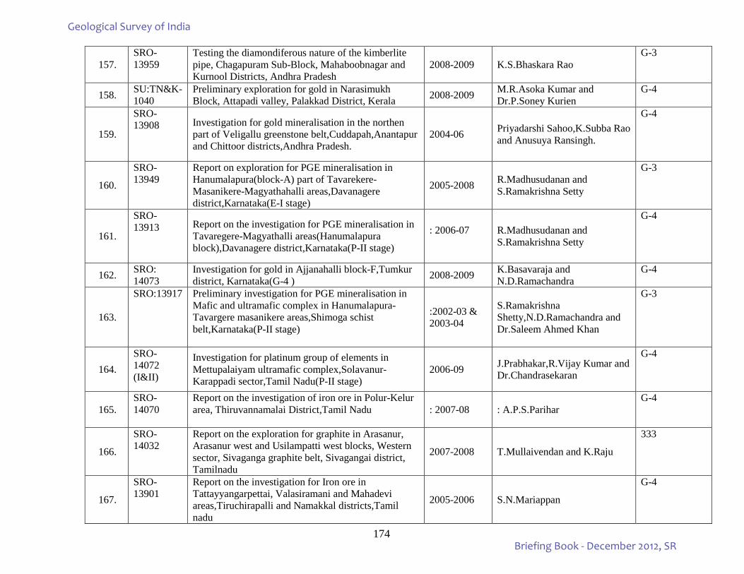
174
157. SRO-13959
Testing the diamondiferous nature of the kimberlite pipe, Chagapuram Sub-Block, Mahaboobnagar and Kurnool Districts, Andhra Pradesh
2008-2009 K.S.Bhaskara Rao G-3
158. SU:TN&K-1040
Preliminary exploration for gold in Narasimukh Block, Attapadi valley, Palakkad District, Kerala 2008-2009 M.R.Asoka Kumar and
Dr.P.Soney Kurien G-4
159.
SRO-13908 Investigation for gold mineralisation in the northen
part of Veligallu greenstone belt,Cuddapah,Anantapur and Chittoor districts,Andhra Pradesh.
2004-06 Priyadarshi Sahoo,K.Subba Rao and Anusuya Ransingh.
G-4
160.
SRO-13949
Report on exploration for PGE mineralisation in Hanumalapura(block-A) part of Tavarekere-Masanikere-Magyathahalli areas,Davanagere district,Karnataka(E-I stage)
2005-2008 R.Madhusudanan and S.Ramakrishna Setty
G-3
161.
SRO-13913 Report on the investigation for PGE mineralisation in
Tavaregere-Magyathalli areas(Hanumalapura block),Davanagere district,Karnataka(P-II stage)
: 2006-07
R.Madhusudanan and S.Ramakrishna Setty
G-4
162. SRO: 14073
Investigation for gold in Ajjanahalli block-F,Tumkur district, Karnataka(G-4 ) 2008-2009 K.Basavaraja and
N.D.Ramachandra G-4
163.
SRO:13917 Preliminary investigation for PGE mineralisation in Mafic and ultramafic complex in Hanumalapura-Tavargere masanikere areas,Shimoga schist belt,Karnataka(P-II stage)
:2002-03 & 2003-04
S.Ramakrishna Shetty,N.D.Ramachandra and Dr.Saleem Ahmed Khan
G-3
164. SRO-14072 (I&II)
Investigation for platinum group of elements in Mettupalaiyam ultramafic complex,Solavanur-Karappadi sector,Tamil Nadu(P-II stage)
2006-09 J.Prabhakar,R.Vijay Kumar and Dr.Chandrasekaran
G-4
165. SRO-14070
Report on the investigation of iron ore in Polur-Kelur area, Thiruvannamalai District,Tamil Nadu
: 2007-08 : A.P.S.Parihar G-4
166.
SRO-14032
Report on the exploration for graphite in Arasanur, Arasanur west and Usilampatti west blocks, Western sector, Sivaganga graphite belt, Sivagangai district, Tamilnadu
2007-2008 T.Mullaivendan and K.Raju
333
167.
SRO-13901
Report on the investigation for Iron ore in Tattayyangarpettai, Valasiramani and Mahadevi areas,Tiruchirapalli and Namakkal districts,Tamil nadu
2005-2006 S.N.Mariappan
G-4
Geological Survey of India
Briefing Book - December 2012, SR
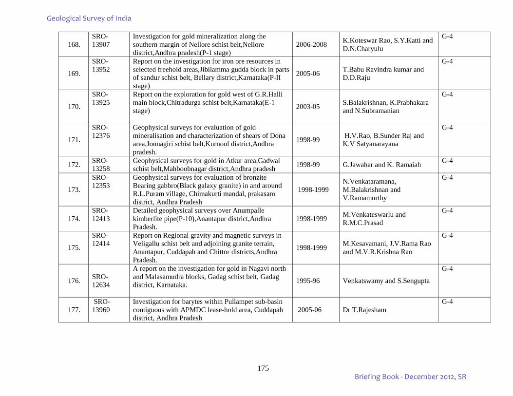
175
168. SRO-13907
Investigation for gold mineralization along the southern margin of Nellore schist belt,Nellore district,Andhra pradesh(P-1 stage)
2006-2008 K.Koteswar Rao, S.Y.Katti and D.N.Charyulu
G-4
169.
SRO-13952
Report on the investigation for iron ore resources in selected freehold areas,Jibilamma gudda block in parts of sandur schist belt, Bellary district,Karnataka(P-II stage)
2005-06 T.Babu Ravindra kumar and D.D.Raju
G-4
170.
SRO-13925
Report on the exploration for gold west of G.R.Halli main block,Chitradurga schist belt,Karnataka(E-1 stage)
2003-05 S.Balakrishnan, K.Prabhakara and N.Subramanian
G-4
171.
SRO-12376
Geophysical surveys for evaluation of gold mineralisation and characterization of shears of Dona area,Jonnagiri schist belt,Kurnool district,Andhra pradesh.
1998-99 H.V.Rao, B.Sunder Raj and K.V Satyanarayana
G-4
172. SRO-13258
Geophysical surveys for gold in Atkur area,Gadwal schist belt,Mahboobnagar district,Andhra pradesh 1998-99 G.Jawahar and K. Ramaiah G-4
173.
SRO-12353
Geophysical surveys for evaluation of bronzite Bearing gabbro(Black galaxy granite) in and around R.L.Puram village, Chimakurti mandal, prakasam district, Andhra Pradesh
1998-1999 N.Venkataramana, M.Balakrishnan and V.Ramamurthy
G-4
174. SRO-12413
Detailed geophysical surveys over Anumpalle kimberlite pipe(P-10),Anantapur district,Andhra Pradesh.
1998-1999 M.Venkateswarlu and R.M.C.Prasad
G-4
175.
SRO-12414
Report on Regional gravity and magnetic surveys in Veligallu schist belt and adjoining granite terrain, Anantapur, Cuddapah and Chittor districts,Andhra Pradesh.
1998-1999 M.Kesavamani, J.V.Rama Rao and M.V.R.Krishna Rao
G-4
176.
SRO-12634
A report on the investigation for gold in Nagavi north and Malasamudra blocks, Gadag schist belt, Gadag district, Karnataka.
1995-96 Venkatswamy and S.Sengupta
G-4
177. SRO-13960
Investigation for barytes within Pullampet sub-basin contiguous with APMDC lease-hold area, Cuddapah district, Andhra Pradesh
2005-06 Dr T.Rajesham G-4
Geological Survey of India
Briefing Book - December 2012, SR
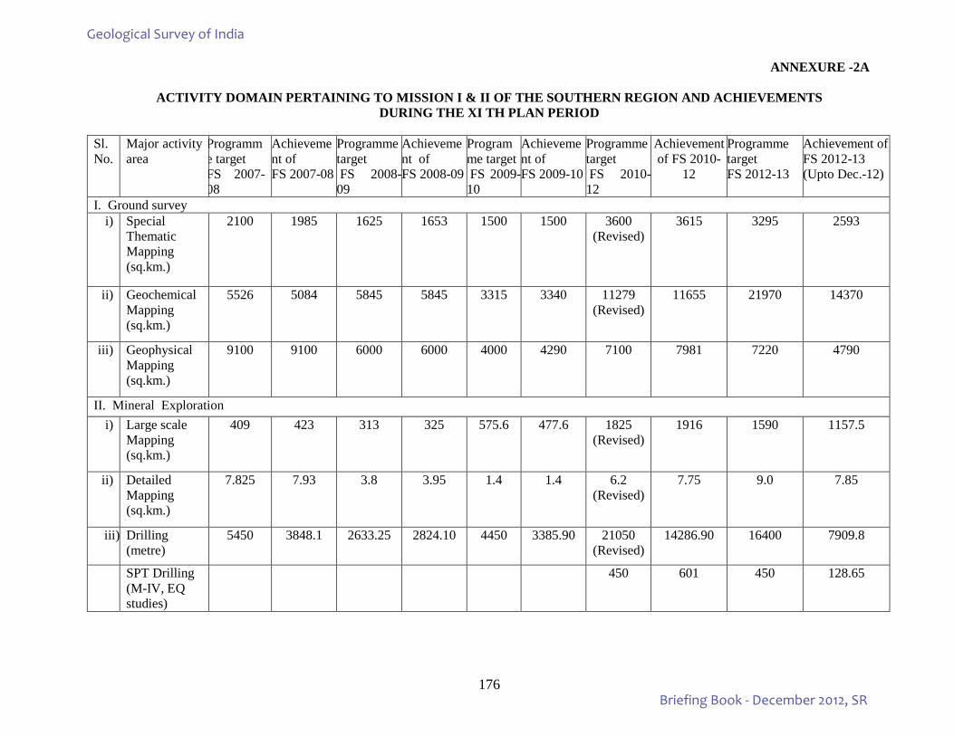
176
ANNEXURE -2A
ACTIVITY DOMAIN PERTAINING TO MISSION I & II OF THE SOUTHERN REGION AND ACHIEVEMENTS DURING THE XI TH PLAN PERIOD
Sl.No.
Major activity area
Programme target FS 2007-08
Achievement of FS 2007-08
Programme target FS 2008-09
Achievement of FS 2008-09
Programme target FS 2009-10
Achievement of FS 2009-10
Programme target FS 2010-12
Achievement of FS 2010-
12
Programme target FS 2012-13
Achievement of FS 2012-13 (Upto Dec.-12)
I. Ground survey i) Special
Thematic Mapping (sq.km.)
2100 1985 1625 1653 1500 1500 3600 (Revised)
3615 3295 2593
ii) Geochemical Mapping (sq.km.)
5526 5084 5845 5845 3315 3340 11279 (Revised)
11655 21970 14370
iii) Geophysical Mapping (sq.km.)
9100 9100 6000 6000 4000 4290 7100 7981 7220 4790
II. Mineral Exploration i) Large scale
Mapping (sq.km.)
409 423 313 325 575.6 477.6 1825 (Revised)
1916 1590 1157.5
ii) Detailed Mapping (sq.km.)
7.825 7.93 3.8 3.95 1.4 1.4 6.2 (Revised)
7.75 9.0 7.85
iii) Drilling (metre)
5450 3848.1 2633.25 2824.10 4450 3385.90 21050 (Revised)
14286.90 16400 7909.8
SPT Drilling (M-IV, EQ studies)
450 601 450 128.65
Geological Survey of India
Briefing Book - December 2012, SR
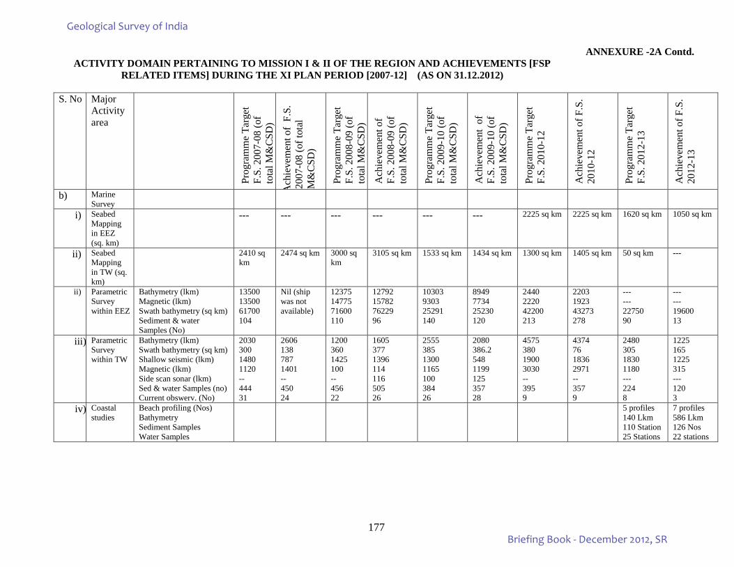
177
ANNEXURE -2A Contd. ACTIVITY DOMAIN PERTAINING TO MISSION I & II OF THE REGION AND ACHIEVEMENTS [FSP
RELATED ITEMS] DURING THE XI PLAN PERIOD [2007-12] (AS ON 31.12.2012)
S. No Major Activity area
Prog
ram
me
Targ
et
F.S.
200
7-08
(of
tota
l M&
CSD
)
Ach
ieve
men
t of
F.S.
20
07-0
8 (o
f tot
al
M&
CSD
)
Prog
ram
me
Targ
et
F.S.
200
8-09
(of
tota
l M&
CSD
)
Ach
ieve
men
t of
F.S.
200
8-09
(of
tota
l M&
CSD
)
Prog
ram
me
Targ
et
F.S.
200
9-10
(of
tota
l M&
CSD
)
Ach
ieve
men
t of
F.
S. 2
009-
10 (o
f to
tal M
&C
SD)
Prog
ram
me
Targ
et
F.S.
201
0-12
Ach
ieve
men
t of F
.S.
2010
-12
Prog
ram
me
Targ
et
F.S.
201
2-13
Ach
ieve
men
t of F
.S.
2012
-13
b) Marine Survey
i) Seabed Mapping in EEZ (sq. km)
--- --- --- --- --- --- 2225 sq km 2225 sq km 1620 sq km 1050 sq km
ii) Seabed Mapping in TW (sq. km)
2410 sq km
2474 sq km 3000 sq km
3105 sq km 1533 sq km
1434 sq km 1300 sq km 1405 sq km 50 sq km ---
ii) Parametric Survey within EEZ
Bathymetry (lkm) Magnetic (lkm) Swath bathymetry (sq km) Sediment & water Samples (No)
13500 13500 61700 104
Nil (ship was not available)
12375 14775 71600 110
12792 15782 76229 96
10303 9303 25291 140
8949 7734 25230 120
2440 2220 42200 213
2203 1923 43273 278
--- --- 22750 90
--- --- 19600 13
iii) Parametric Survey within TW
Bathymetry (lkm) Swath bathymetry (sq km) Shallow seismic (lkm) Magnetic (lkm) Side scan sonar (lkm) Sed & water Samples (no) Current obswerv. (No)
2030 300 1480 1120 -- 444 31
2606 138 787 1401 -- 450 24
1200 360 1425 100 -- 456 22
1605 377 1396 114 116 505 26
2555 385 1300 1165 100 384 26
2080 386.2 548 1199 125 357 28
4575 380 1900 3030 -- 395 9
4374 76 1836 2971 -- 357 9
2480 305 1830 1180 --- 224 8
1225 165 1225 315 --- 120 3
iv) Coastal studies
Beach profiling (Nos) Bathymetry Sediment Samples Water Samples
5 profiles 140 Lkm 110 Station 25 Stations
7 profiles 586 Lkm 126 Nos 22 stations
Geological Survey of India
Briefing Book - December 2012, SR
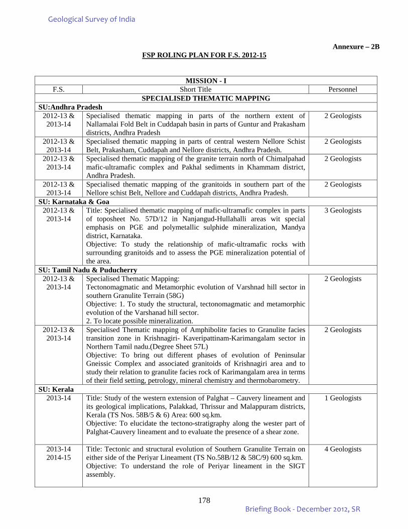
178
Annexure – 2B FSP ROLING PLAN FOR F.S. 2012-15
MISSION - I F.S. Short Title Personnel
SPECIALISED THEMATIC MAPPING SU:Andhra Pradesh
2012-13 & 2013-14
Specialised thematic mapping in parts of the northern extent of Nallamalai Fold Belt in Cuddapah basin in parts of Guntur and Prakasham districts, Andhra Pradesh
2 Geologists
2012-13 & 2013-14
Specialised thematic mapping in parts of central western Nellore Schist Belt, Prakasham, Cuddapah and Nellore districts, Andhra Pradesh.
2 Geologists
2012-13 & 2013-14
Specialised thematic mapping of the granite terrain north of Chimalpahad mafic-ultramafic complex and Pakhal sediments in Khammam district, Andhra Pradesh.
2 Geologists
2012-13 & 2013-14
Specialised thematic mapping of the granitoids in southern part of the Nellore schist Belt, Nellore and Cuddapah districts, Andhra Pradesh.
2 Geologists
SU: Karnataka & Goa 2012-13 &
2013-14 Title: Specialised thematic mapping of mafic-ultramafic complex in parts of toposheet No. 57D/12 in Nanjangud-Hullahalli areas wit special emphasis on PGE and polymetallic sulphide mineralization, Mandya district, Karnataka. Objective: To study the relationship of mafic-ultramafic rocks with surrounding granitoids and to assess the PGE mineralization potential of the area.
3 Geologists
SU: Tamil Nadu & Puducherry 2012-13 &
2013-14 Specialised Thematic Mapping: Tectonomagmatic and Metamorphic evolution of Varshnad hill sector in southern Granulite Terrain (58G) Objective: 1. To study the structural, tectonomagmatic and metamorphic evolution of the Varshanad hill sector. 2. To locate possible mineralization.
2 Geologists
2012-13 & 2013-14
Specialised Thematic mapping of Amphibolite facies to Granulite facies transition zone in Krishnagiri- Kaveripattinam-Karimangalam sector in Northern Tamil nadu.(Degree Sheet 57L) Objective: To bring out different phases of evolution of Peninsular Gneissic Complex and associated granitoids of Krishnagiri area and to study their relation to granulite facies rock of Karimangalam area in terms of their field setting, petrology, mineral chemistry and thermobarometry.
2 Geologists
SU: Kerala 2013-14 Title: Study of the western extension of Palghat – Cauvery lineament and
its geological implications, Palakkad, Thrissur and Malappuram districts, Kerala (TS Nos. 58B/5 & 6) Area: 600 sq.km. Objective: To elucidate the tectono-stratigraphy along the wester part of Palghat-Cauvery lineament and to evaluate the presence of a shear zone.
1 Geologists
2013-14 2014-15
Title: Tectonic and structural evolution of Southern Granulite Terrain on either side of the Periyar Lineament (TS No.58B/12 & 58C/9) 600 sq.km. Objective: To understand the role of Periyar lineament in the SIGT assembly.
4 Geologists
Geological Survey of India
Briefing Book - December 2012, SR
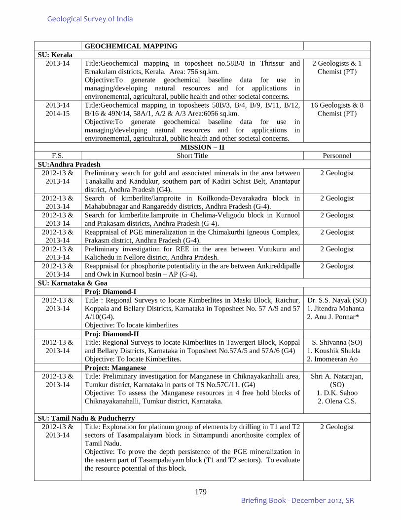
179
GEOCHEMICAL MAPPING SU: Kerala
2013-14 Title:Geochemical mapping in toposheet no.58B/8 in Thrissur and Ernakulam districts, Kerala. Area: 756 sq.km. Objective:To generate geochemical baseline data for use in managing/developing natural resources and for applications in environemental, agricultural, public health and other societal concerns.
2 Geologists & 1 Chemist (PT)
2013-14 2014-15
Title:Geochemical mapping in toposheets 58B/3, B/4, B/9, B/11, B/12, B/16 & 49N/14, 58A/1, A/2 & A/3 Area:6056 sq.km. Objective:To generate geochemical baseline data for use in managing/developing natural resources and for applications in environemental, agricultural, public health and other societal concerns.
16 Geologists & 8 Chemist (PT)
MISSION – II F.S. Short Title Personnel
SU:Andhra Pradesh 2012-13 &
2013-14 Preliminary search for gold and associated minerals in the area between Tanakallu and Kandukur, southern part of Kadiri Schist Belt, Anantapur district, Andhra Pradesh (G4).
2 Geologist
2012-13 & 2013-14
Search of kimberlite/lamproite in Koilkonda-Devarakadra block in Mahabubnagar and Rangareddy districts, Andhra Pradesh (G-4).
2 Geologist
2012-13 & 2013-14
Search for kimberlite.lamproite in Chelima-Veligodu block in Kurnool and Prakasam districts, Andhra Pradesh (G-4).
2 Geologist
2012-13 & 2013-14
Reappraisal of PGE mineralization in the Chimakurthi Igneous Complex, Prakasm district, Andhra Pradesh (G-4).
2 Geologist
2012-13 & 2013-14
Preliminary investigation for REE in the area between Vutukuru and Kalichedu in Nellore district, Andhra Pradesh.
2 Geologist
2012-13 & 2013-14
Reappraisal for phosphorite potentiality in the are between Ankireddipalle and Owk in Kurnool basin – AP (G-4).
2 Geologist
SU: Karnataka & Goa Proj: Diamond-I
2012-13 & 2013-14
Title : Regional Surveys to locate Kimberlites in Maski Block, Raichur, Koppala and Bellary Districts, Karnataka in Toposheet No. 57 A/9 and 57 A/10(G4). Objective: To locate kimberlites
Dr. S.S. Nayak (SO) 1. Jitendra Mahanta 2. Anu J. Ponnar*
Proj: Diamond-II 2012-13 &
2013-14 Title: Regional Surveys to locate Kimberlites in Tawergeri Block, Koppal and Bellary Districts, Karnataka in Toposheet No.57A/5 and 57A/6 (G4) Objective: To locate Kimberlites.
S. Shivanna (SO) 1. Koushik Shukla 2. Imomeeran Ao
Project: Manganese 2012-13 &
2013-14 Title: Preliminary investigation for Manganese in Chiknayakanhalli area, Tumkur district, Karnataka in parts of TS No.57C/11. (G4) Objective: To assess the Manganese resources in 4 free hold blocks of Chiknayakanahalli, Tumkur district, Karnataka.
Shri A. Natarajan, (SO)
1. D.K. Sahoo 2. Olena C.S.
SU: Tamil Nadu & Puducherry 2012-13 &
2013-14 Title: Exploration for platinum group of elements by drilling in T1 and T2 sectors of Tasampalaiyam block in Sittampundi anorthosite complex of Tamil Nadu. Objective: To prove the depth persistence of the PGE mineralization in the eastern part of Tasampalaiyam block (T1 and T2 sectors). To evaluate the resource potential of this block.
2 Geologist
Geological Survey of India
Briefing Book - December 2012, SR
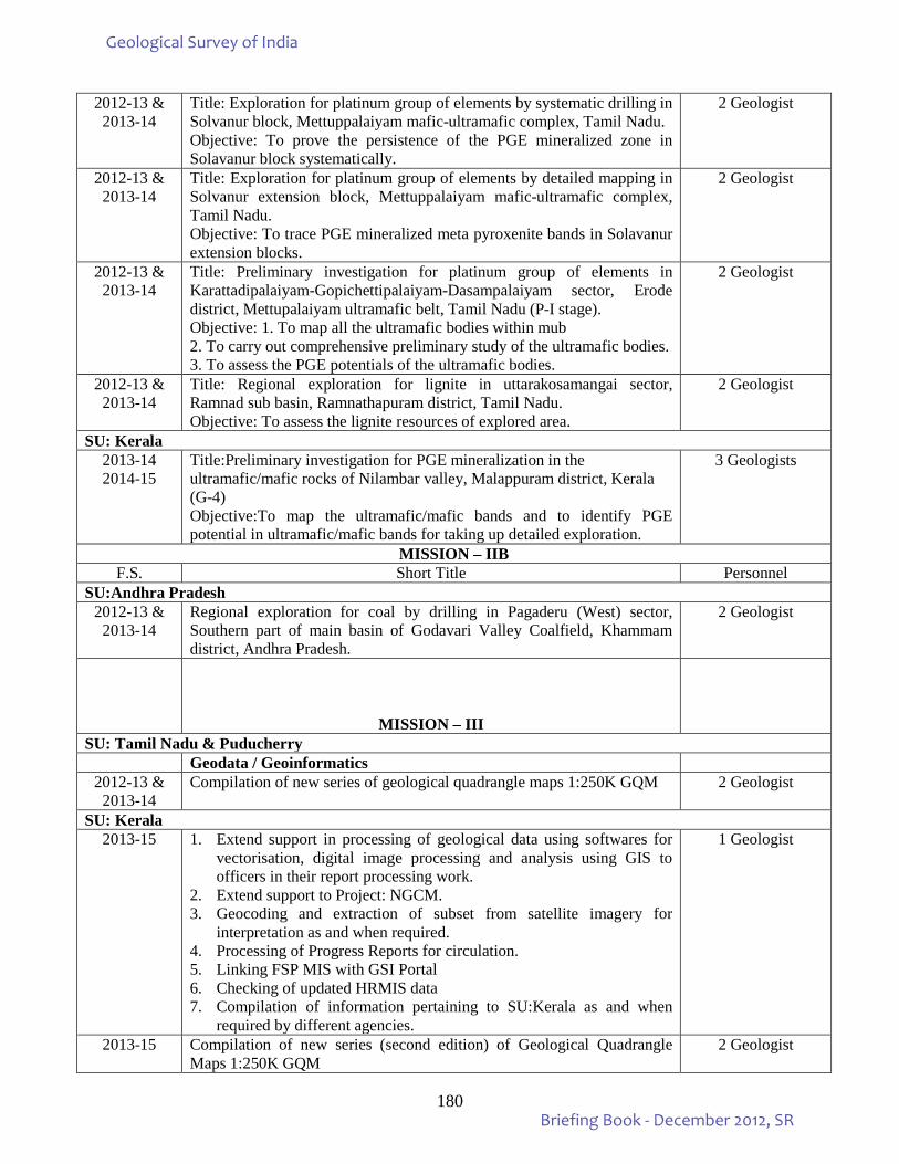
180
2012-13 & 2013-14
Title: Exploration for platinum group of elements by systematic drilling in Solvanur block, Mettuppalaiyam mafic-ultramafic complex, Tamil Nadu. Objective: To prove the persistence of the PGE mineralized zone in Solavanur block systematically.
2 Geologist
2012-13 & 2013-14
Title: Exploration for platinum group of elements by detailed mapping in Solvanur extension block, Mettuppalaiyam mafic-ultramafic complex, Tamil Nadu. Objective: To trace PGE mineralized meta pyroxenite bands in Solavanur extension blocks.
2 Geologist
2012-13 & 2013-14
Title: Preliminary investigation for platinum group of elements in Karattadipalaiyam-Gopichettipalaiyam-Dasampalaiyam sector, Erode district, Mettupalaiyam ultramafic belt, Tamil Nadu (P-I stage). Objective: 1. To map all the ultramafic bodies within mub 2. To carry out comprehensive preliminary study of the ultramafic bodies. 3. To assess the PGE potentials of the ultramafic bodies.
2 Geologist
2012-13 & 2013-14
Title: Regional exploration for lignite in uttarakosamangai sector, Ramnad sub basin, Ramnathapuram district, Tamil Nadu. Objective: To assess the lignite resources of explored area.
2 Geologist
SU: Kerala 2013-14 2014-15
Title:Preliminary investigation for PGE mineralization in the ultramafic/mafic rocks of Nilambar valley, Malappuram district, Kerala (G-4) Objective:To map the ultramafic/mafic bands and to identify PGE potential in ultramafic/mafic bands for taking up detailed exploration.
3 Geologists
MISSION – IIB F.S. Short Title Personnel
SU:Andhra Pradesh 2012-13 &
2013-14 Regional exploration for coal by drilling in Pagaderu (West) sector, Southern part of main basin of Godavari Valley Coalfield, Khammam district, Andhra Pradesh.
2 Geologist
MISSION – III
SU: Tamil Nadu & Puducherry Geodata / Geoinformatics
2012-13 & 2013-14
Compilation of new series of geological quadrangle maps 1:250K GQM 2 Geologist
SU: Kerala 2013-15 1. Extend support in processing of geological data using softwares for
vectorisation, digital image processing and analysis using GIS to officers in their report processing work.
2. Extend support to Project: NGCM. 3. Geocoding and extraction of subset from satellite imagery for
interpretation as and when required. 4. Processing of Progress Reports for circulation. 5. Linking FSP MIS with GSI Portal 6. Checking of updated HRMIS data 7. Compilation of information pertaining to SU:Kerala as and when
required by different agencies.
1 Geologist
2013-15 Compilation of new series (second edition) of Geological Quadrangle Maps 1:250K GQM
2 Geologist
Geological Survey of India
Briefing Book - December 2012, SR
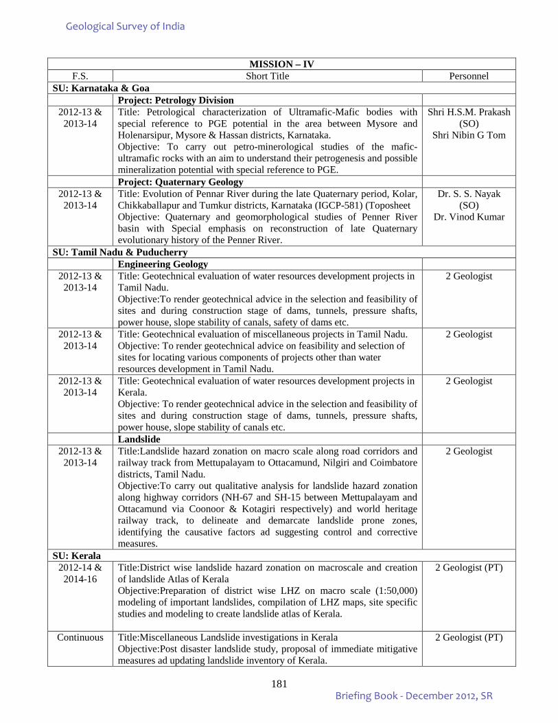
181
MISSION – IV F.S. Short Title Personnel
SU: Karnataka & Goa Project: Petrology Division
2012-13 & 2013-14
Title: Petrological characterization of Ultramafic-Mafic bodies with special reference to PGE potential in the area between Mysore and Holenarsipur, Mysore & Hassan districts, Karnataka. Objective: To carry out petro-minerological studies of the mafic-ultramafic rocks with an aim to understand their petrogenesis and possible mineralization potential with special reference to PGE.
Shri H.S.M. Prakash (SO)
Shri Nibin G Tom
Project: Quaternary Geology 2012-13 &
2013-14 Title: Evolution of Pennar River during the late Quaternary period, Kolar, Chikkaballapur and Tumkur districts, Karnataka (IGCP-581) (Toposheet Objective: Quaternary and geomorphological studies of Penner River basin with Special emphasis on reconstruction of late Quaternary evolutionary history of the Penner River.
Dr. S. S. Nayak (SO)
Dr. Vinod Kumar
SU: Tamil Nadu & Puducherry Engineering Geology
2012-13 & 2013-14
Title: Geotechnical evaluation of water resources development projects in Tamil Nadu. Objective:To render geotechnical advice in the selection and feasibility of sites and during construction stage of dams, tunnels, pressure shafts, power house, slope stability of canals, safety of dams etc.
2 Geologist
2012-13 & 2013-14
Title: Geotechnical evaluation of miscellaneous projects in Tamil Nadu. Objective: To render geotechnical advice on feasibility and selection of sites for locating various components of projects other than water resources development in Tamil Nadu.
2 Geologist
2012-13 & 2013-14
Title: Geotechnical evaluation of water resources development projects in Kerala. Objective: To render geotechnical advice in the selection and feasibility of sites and during construction stage of dams, tunnels, pressure shafts, power house, slope stability of canals etc.
2 Geologist
Landslide 2012-13 &
2013-14 Title:Landslide hazard zonation on macro scale along road corridors and railway track from Mettupalayam to Ottacamund, Nilgiri and Coimbatore districts, Tamil Nadu. Objective:To carry out qualitative analysis for landslide hazard zonation along highway corridors (NH-67 and SH-15 between Mettupalayam and Ottacamund via Coonoor & Kotagiri respectively) and world heritage railway track, to delineate and demarcate landslide prone zones, identifying the causative factors ad suggesting control and corrective measures.
2 Geologist
SU: Kerala 2012-14 &
2014-16 Title:District wise landslide hazard zonation on macroscale and creation of landslide Atlas of Kerala Objective:Preparation of district wise LHZ on macro scale (1:50,000) modeling of important landslides, compilation of LHZ maps, site specific studies and modeling to create landslide atlas of Kerala.
2 Geologist (PT)
Continuous Title:Miscellaneous Landslide investigations in Kerala Objective:Post disaster landslide study, proposal of immediate mitigative measures ad updating landslide inventory of Kerala.
2 Geologist (PT)
Geological Survey of India
Briefing Book - December 2012, SR
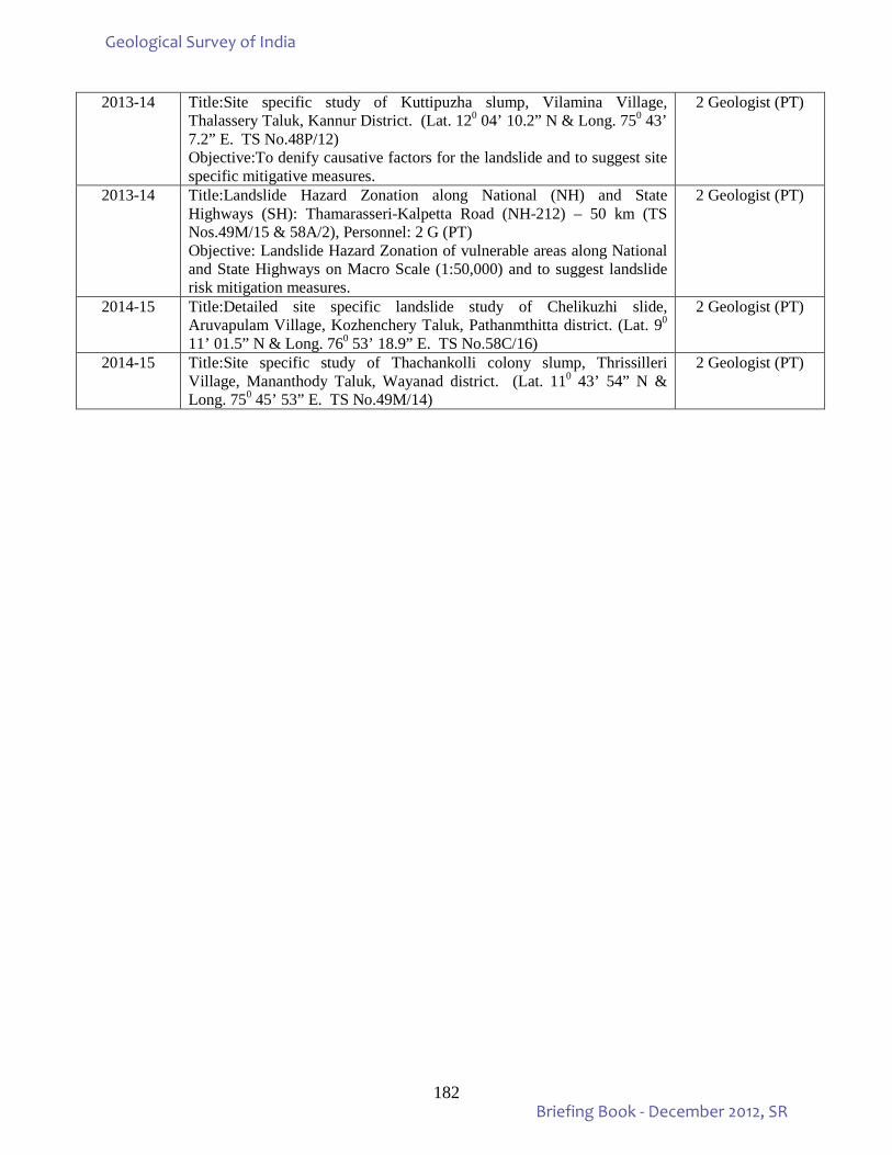
182
2013-14 Title:Site specific study of Kuttipuzha slump, Vilamina Village, Thalassery Taluk, Kannur District. (Lat. 120 04’ 10.2” N & Long. 750 43’ 7.2” E. TS No.48P/12) Objective:To denify causative factors for the landslide and to suggest site specific mitigative measures.
2 Geologist (PT)
2013-14 Title:Landslide Hazard Zonation along National (NH) and State Highways (SH): Thamarasseri-Kalpetta Road (NH-212) – 50 km (TS Nos.49M/15 & 58A/2), Personnel: 2 G (PT) Objective: Landslide Hazard Zonation of vulnerable areas along National and State Highways on Macro Scale (1:50,000) and to suggest landslide risk mitigation measures.
2 Geologist (PT)
2014-15 Title:Detailed site specific landslide study of Chelikuzhi slide, Aruvapulam Village, Kozhenchery Taluk, Pathanmthitta district. (Lat. 90 11’ 01.5” N & Long. 760 53’ 18.9” E. TS No.58C/16)
2 Geologist (PT)
2014-15 Title:Site specific study of Thachankolli colony slump, Thrissilleri Village, Mananthody Taluk, Wayanad district. (Lat. 110 43’ 54” N & Long. 750 45’ 53” E. TS No.49M/14)
2 Geologist (PT)
Geological Survey of India
Briefing Book - December 2012, SR
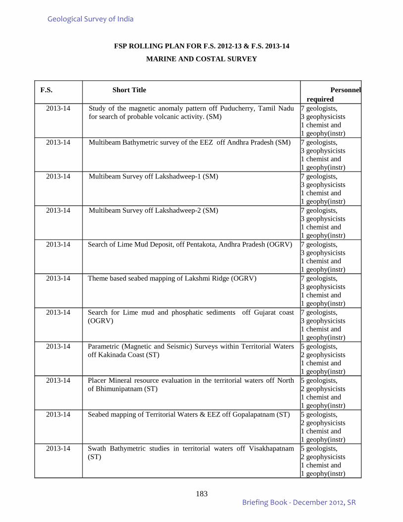
183
FSP ROLLING PLAN FOR F.S. 2012-13 & F.S. 2013-14
MARINE AND COSTAL SURVEY
F.S. Short Title Personnel required
2013-14 Study of the magnetic anomaly pattern off Puducherry, Tamil Nadu for search of probable volcanic activity. (SM)
7 geologists, 3 geophysicists 1 chemist and 1 geophy(instr)
2013-14 Multibeam Bathymetric survey of the EEZ off Andhra Pradesh (SM) 7 geologists, 3 geophysicists 1 chemist and 1 geophy(instr)
2013-14 Multibeam Survey off Lakshadweep-1 (SM) 7 geologists, 3 geophysicists 1 chemist and 1 geophy(instr)
2013-14 Multibeam Survey off Lakshadweep-2 (SM) 7 geologists, 3 geophysicists 1 chemist and 1 geophy(instr)
2013-14 Search of Lime Mud Deposit, off Pentakota, Andhra Pradesh (OGRV) 7 geologists, 3 geophysicists 1 chemist and 1 geophy(instr)
2013-14 Theme based seabed mapping of Lakshmi Ridge (OGRV) 7 geologists, 3 geophysicists 1 chemist and 1 geophy(instr)
2013-14 Search for Lime mud and phosphatic sediments off Gujarat coast (OGRV)
7 geologists, 3 geophysicists 1 chemist and 1 geophy(instr)
2013-14 Parametric (Magnetic and Seismic) Surveys within Territorial Waters off Kakinada Coast (ST)
5 geologists, 2 geophysicists 1 chemist and 1 geophy(instr)
2013-14 Placer Mineral resource evaluation in the territorial waters off North of Bhimunipatnam (ST)
5 geologists, 2 geophysicists 1 chemist and 1 geophy(instr)
2013-14 Seabed mapping of Territorial Waters & EEZ off Gopalapatnam (ST) 5 geologists, 2 geophysicists 1 chemist and 1 geophy(instr)
2013-14 Swath Bathymetric studies in territorial waters off Visakhapatnam (ST)
5 geologists, 2 geophysicists 1 chemist and 1 geophy(instr)
Geological Survey of India
Briefing Book - December 2012, SR
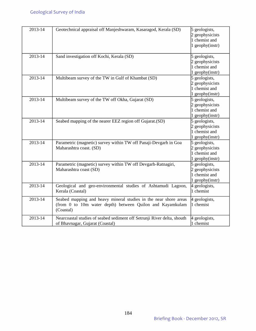
184
2013-14 Geotechnical appraisal off Manjeshwaram, Kasaragod, Kerala (SD) 5 geologists, 2 geophysicists 1 chemist and 1 geophy(instr)
2013-14 Sand investigation off Kochi, Kerala (SD) 5 geologists, 2 geophysicists 1 chemist and 1 geophy(instr)
2013-14 Multibeam survey of the TW in Gulf of Khambat (SD) 5 geologists, 2 geophysicists 1 chemist and 1 geophy(instr)
2013-14 Multibeam survey of the TW off Okha, Gujarat (SD) 5 geologists, 2 geophysicists 1 chemist and 1 geophy(instr)
2013-14 Seabed mapping of the nearer EEZ region off Gujarat.(SD) 5 geologists, 2 geophysicists 1 chemist and 1 geophy(instr)
2013-14 Parametric (magnetic) survey within TW off Panaji-Devgarh in Goa Maharashtra coast. (SD)
5 geologists, 2 geophysicists 1 chemist and 1 geophy(instr)
2013-14 Parametric (magnetic) survey within TW off Devgarh-Ratnagiri, Maharashtra coast (SD)
5 geologists, 2 geophysicists 1 chemist and 1 geophy(instr)
2013-14 Geological and geo-environmental studies of Ashtamudi Lagoon, Kerala (Coastal)
4 geologists, 1 chemist
2013-14 Seabed mapping and heavy mineral studies in the near shore areas (from 0 to 10m water depth) between Quilon and Kayamkulam (Coastal)
4 geologists, 1 chemist
2013-14 Nearcoastal studies of seabed sediment off Setrunji River delta, shouth of Bhavnagar, Gujarat (Coastal)
4 geologists, 1 chemist
Geological Survey of India
Briefing Book - December 2012, SR
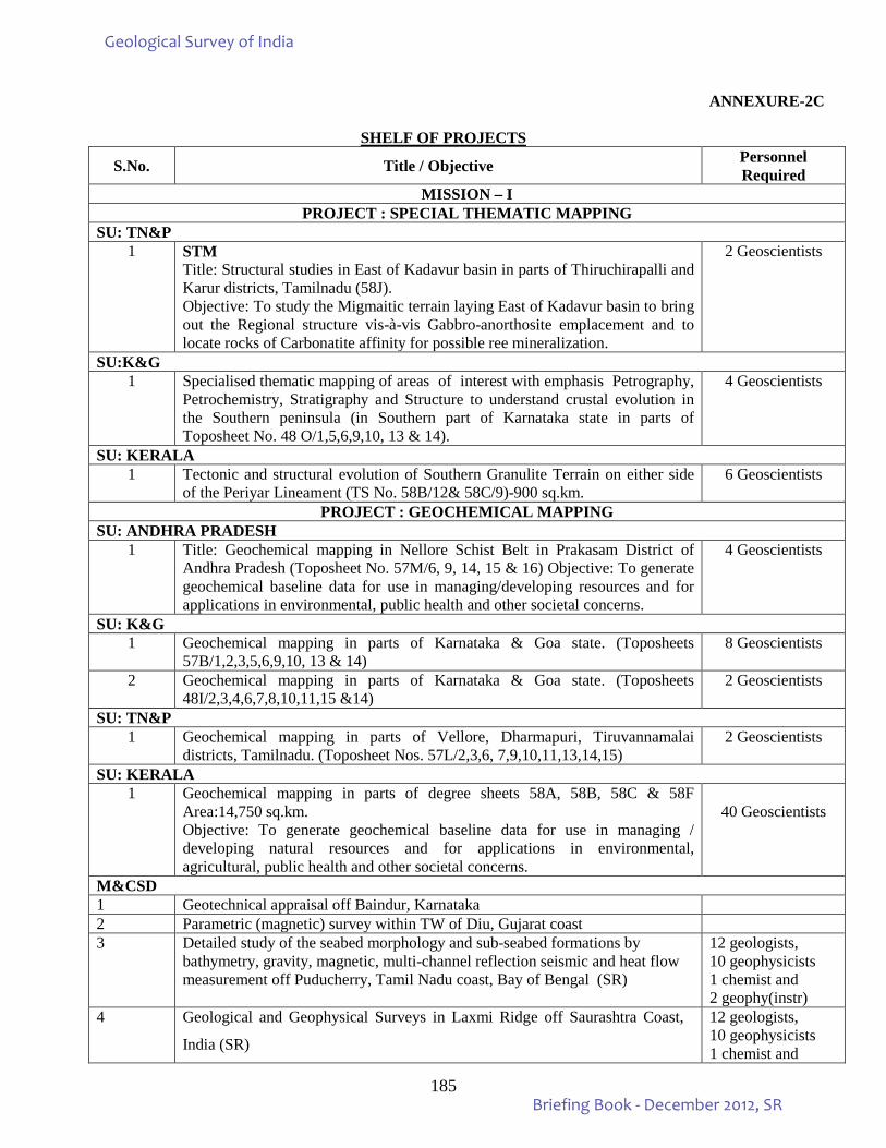
185
ANNEXURE-2C
SHELF OF PROJECTS
S.No. Title / Objective Personnel Required
MISSION – I PROJECT : SPECIAL THEMATIC MAPPING
SU: TN&P 1 STM
Title: Structural studies in East of Kadavur basin in parts of Thiruchirapalli and Karur districts, Tamilnadu (58J). Objective: To study the Migmaitic terrain laying East of Kadavur basin to bring out the Regional structure vis-à-vis Gabbro-anorthosite emplacement and to locate rocks of Carbonatite affinity for possible ree mineralization.
2 Geoscientists
SU:K&G 1 Specialised thematic mapping of areas of interest with emphasis Petrography,
Petrochemistry, Stratigraphy and Structure to understand crustal evolution in the Southern peninsula (in Southern part of Karnataka state in parts of Toposheet No. 48 O/1,5,6,9,10, 13 & 14).
4 Geoscientists
SU: KERALA 1 Tectonic and structural evolution of Southern Granulite Terrain on either side
of the Periyar Lineament (TS No. 58B/12& 58C/9)-900 sq.km. 6 Geoscientists
PROJECT : GEOCHEMICAL MAPPING SU: ANDHRA PRADESH
1 Title: Geochemical mapping in Nellore Schist Belt in Prakasam District of Andhra Pradesh (Toposheet No. 57M/6, 9, 14, 15 & 16) Objective: To generate geochemical baseline data for use in managing/developing resources and for applications in environmental, public health and other societal concerns.
4 Geoscientists
SU: K&G 1 Geochemical mapping in parts of Karnataka & Goa state. (Toposheets
57B/1,2,3,5,6,9,10, 13 & 14) 8 Geoscientists
2 Geochemical mapping in parts of Karnataka & Goa state. (Toposheets 48I/2,3,4,6,7,8,10,11,15 &14)
2 Geoscientists
SU: TN&P 1 Geochemical mapping in parts of Vellore, Dharmapuri, Tiruvannamalai
districts, Tamilnadu. (Toposheet Nos. 57L/2,3,6, 7,9,10,11,13,14,15) 2 Geoscientists
SU: KERALA 1 Geochemical mapping in parts of degree sheets 58A, 58B, 58C & 58F
Area:14,750 sq.km. Objective: To generate geochemical baseline data for use in managing / developing natural resources and for applications in environmental, agricultural, public health and other societal concerns.
40 Geoscientists
M&CSD 1 Geotechnical appraisal off Baindur, Karnataka 2 Parametric (magnetic) survey within TW of Diu, Gujarat coast 3 Detailed study of the seabed morphology and sub-seabed formations by
bathymetry, gravity, magnetic, multi-channel reflection seismic and heat flow measurement off Puducherry, Tamil Nadu coast, Bay of Bengal (SR)
12 geologists, 10 geophysicists 1 chemist and 2 geophy(instr)
4 Geological and Geophysical Surveys in Laxmi Ridge off Saurashtra Coast,
India (SR) 12 geologists, 10 geophysicists 1 chemist and
Geological Survey of India
Briefing Book - December 2012, SR
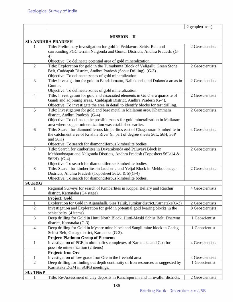
186
2 geophy(instr)
MISSION – II SU: ANDHRA PRADESH
1 Title: Preliminary investigation for gold in Peddavuru Schist Belt and surrounding PGC terrain Nalgonda and Guntur Districts, Andhra Pradesh. (G-4) Objective: To delineate potential area of gold mineralization.
2 Geoscientists
2 Title: Exploration for gold in the Tumukunta Block of Veligallu Green Stone Belt, Cuddapah District, Andhra Pradesh (Scout Drilling). (G-3). Objective: To delineate zones of gold mineralization.
2 Geoscientists
3 Title: Investigation for gold in Bandalamattu, Nallakonda and Dukonda areas in Guntur. Objective: To delineate zones of gold mineralization.
2 Geoscientists
4 Title: Investigation for gold and associated elements in Gulcheru quartzite of Gandi and adjoining areas. Cuddapah District, Andhra Pradesh (G-4). Objective: To investigate the area in detail to identify blocks for test drilling.
2 Geoscientists
5 Title: Investigation for gold and base metal in Mailaram area, Khammam district, Andhra Pradesh. (G-4) Objective: To delineate the possible zones for gold mineralization in Mailaram area where copper mineralization was established earlier.
2 Geoscientists
6 Title: Search for diamondiferous kimberlites east of Chagapuram kimberlite in the catchment area of Krishna River (in part of degree sheets 56L, 56H, 56P and 56K) Objective: To search for diamondiferous kimberlite bodies.
4 Geoscientists
7 Title: Search for kimberlites in Devarakonda and Paluvayi Block in Mehboobnagar and Nalgonda Districts, Andhra Pradesh (Toposheet 56L/14 & 56E/I). (G-4) Objective: To search for diamondiferous kimberlite bodies.
2 Geoscientists
8 Title: Search for kimberlites in Jadcherla and Yeljal Block in Mehboobnagar Districts, Andhra Pradesh (Toposheet 56L/I & 5)(G-4) Objective: To search for diamondiferous kimberlite bodies.
2 Geoscientists
SU:K&G 1 Regional Surveys for search of Kimberlites in Koppal Bellary and Raichur
district, Karnataka (G4 stage) 4 Geoscientists
Project: Gold 1 Exploration for Gold in Ajjanahalli, Sira Taluk,Tumkur district,Karnataka(G-3) 2 Geoscientists 2 Investigation and Exploration for gold in potential gold bearing blocks in the
schist belts. (4 items) 8 Geoscientists
3 Deep drilling for Gold in Hutti North Block, Hutti-Maski Schist Belt, Dharwar district, Karnataka (G-3)
1 Geoscientist
4 Deep drilling for Gold in Mysore mine block and Sangli mine block in Gadag Schist Belt, Gadag district, Karnataka (G-3).
1 Geoscientist
Project: Platinum Group of Elements 1 Investigation of PGE in ultramafics complexes of Karnataka and Goa for
possible mineralization (2 items) 4 Geoscientists
Project: Iron Ore 1 Investigation of low grade Iron Ore in the freehold area 4 Geoscientists 2 Deep drilling for finding out depth continuity of Iron resources as suggested by
Karnataka DGM in SGPB meetings. 1 Geoscientist
SU: TN&P 1 Title: Re-Assessment of clay deposits in Kanchipuram and Tiruvallur districts, 2 Geoscientists
Geological Survey of India
Briefing Book - December 2012, SR
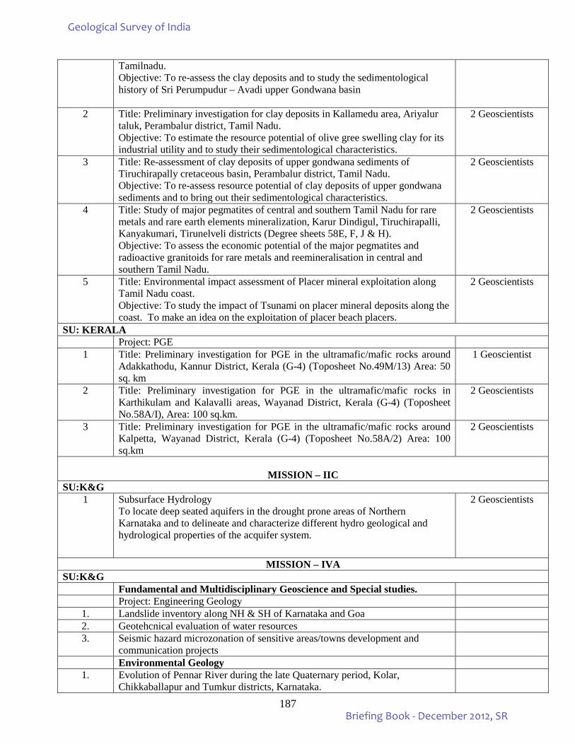
187
Tamilnadu. Objective: To re-assess the clay deposits and to study the sedimentological history of Sri Perumpudur – Avadi upper Gondwana basin
2 Title: Preliminary investigation for clay deposits in Kallamedu area, Ariyalur taluk, Perambalur district, Tamil Nadu. Objective: To estimate the resource potential of olive gree swelling clay for its industrial utility and to study their sedimentological characteristics.
2 Geoscientists
3 Title: Re-assessment of clay deposits of upper gondwana sediments of Tiruchirapally cretaceous basin, Perambalur district, Tamil Nadu. Objective: To re-assess resource potential of clay deposits of upper gondwana sediments and to bring out their sedimentological characteristics.
2 Geoscientists
4 Title: Study of major pegmatites of central and southern Tamil Nadu for rare metals and rare earth elements mineralization, Karur Dindigul, Tiruchirapalli, Kanyakumari, Tirunelveli districts (Degree sheets 58E, F, J & H). Objective: To assess the economic potential of the major pegmatites and radioactive granitoids for rare metals and reemineralisation in central and southern Tamil Nadu.
2 Geoscientists
5 Title: Environmental impact assessment of Placer mineral exploitation along Tamil Nadu coast. Objective: To study the impact of Tsunami on placer mineral deposits along the coast. To make an idea on the exploitation of placer beach placers.
2 Geoscientists
SU: KERALA Project: PGE 1 Title: Preliminary investigation for PGE in the ultramafic/mafic rocks around
Adakkathodu, Kannur District, Kerala (G-4) (Toposheet No.49M/13) Area: 50 sq. km
1 Geoscientist
2 Title: Preliminary investigation for PGE in the ultramafic/mafic rocks in Karthikulam and Kalavalli areas, Wayanad District, Kerala (G-4) (Toposheet No.58A/I), Area: 100 sq.km.
2 Geoscientists
3 Title: Preliminary investigation for PGE in the ultramafic/mafic rocks around Kalpetta, Wayanad District, Kerala (G-4) (Toposheet No.58A/2) Area: 100 sq.km
2 Geoscientists
MISSION – IIC
SU:K&G 1 Subsurface Hydrology
To locate deep seated aquifers in the drought prone areas of Northern Karnataka and to delineate and characterize different hydro geological and hydrological properties of the acquifer system.
2 Geoscientists
MISSION – IVA SU:K&G
Fundamental and Multidisciplinary Geoscience and Special studies. Project: Engineering Geology
1. Landslide inventory along NH & SH of Karnataka and Goa 2. Geotehcnical evaluation of water resources 3. Seismic hazard microzonation of sensitive areas/towns development and
communication projects
Environmental Geology 1. Evolution of Pennar River during the late Quaternary period, Kolar,
Chikkaballapur and Tumkur districts, Karnataka.
Geological Survey of India
Briefing Book - December 2012, SR
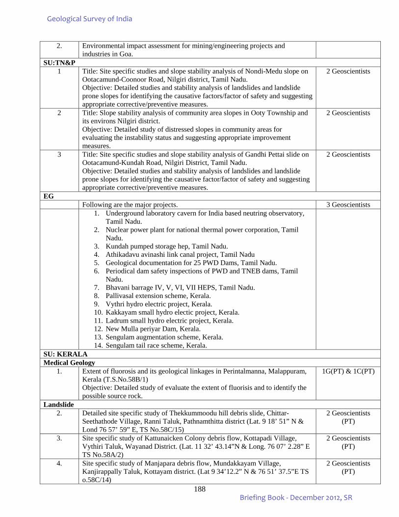
188
2. Environmental impact assessment for mining/engineering projects and industries in Goa.
SU:TN&P 1 Title: Site specific studies and slope stability analysis of Nondi-Medu slope on
Ootacamund-Coonoor Road, Nilgiri district, Tamil Nadu. Objective: Detailed studies and stability analysis of landslides and landslide prone slopes for identifying the causative factors/factor of safety and suggesting appropriate corrective/preventive measures.
2 Geoscientists
2 Title: Slope stability analysis of community area slopes in Ooty Township and its environs Nilgiri district. Objective: Detailed study of distressed slopes in community areas for evaluating the instability status and suggesting appropriate improvement measures.
2 Geoscientists
3 Title: Site specific studies and slope stability analysis of Gandhi Pettai slide on Ootacamund-Kundah Road, Nilgiri District, Tamil Nadu. Objective: Detailed studies and stability analysis of landslides and landslide prone slopes for identifying the causative factor/factor of safety and suggesting appropriate corrective/preventive measures.
2 Geoscientists
EG Following are the major projects. 3 Geoscientists 1. Underground laboratory cavern for India based neutring observatory,
Tamil Nadu. 2. Nuclear power plant for national thermal power corporation, Tamil
Nadu. 3. Kundah pumped storage hep, Tamil Nadu. 4. Athikadavu avinashi link canal project, Tamil Nadu 5. Geological documentation for 25 PWD Dams, Tamil Nadu. 6. Periodical dam safety inspections of PWD and TNEB dams, Tamil
Nadu. 7. Bhavani barrage IV, V, VI, VII HEPS, Tamil Nadu. 8. Pallivasal extension scheme, Kerala. 9. Vythri hydro electric project, Kerala. 10. Kakkayam small hydro electic project, Kerala. 11. Ladrum small hydro electric project, Kerala. 12. New Mulla periyar Dam, Kerala. 13. Sengulam augmentation scheme, Kerala. 14. Sengulam tail race scheme, Kerala.
SU: KERALA Medical Geology
1. Extent of fluorosis and its geological linkages in Perintalmanna, Malappuram, Kerala (T.S.No.58B/1) Objective: Detailed study of evaluate the extent of fluorisis and to identify the possible source rock.
1G(PT) & 1C(PT)
Landslide 2. Detailed site specific study of Thekkummoodu hill debris slide, Chittar-
Seethathode Village, Ranni Taluk, Pathnamthitta district (Lat. 9 18’ 51” N & Lond 76 57’ 59” E, TS No.58C/15)
2 Geoscientists (PT)
3. Site specific study of Kattunaicken Colony debris flow, Kottapadi Village, Vythiri Taluk, Wayanad District. (Lat. 11 32’ 43.14”N & Long. 76 07’ 2.28” E TS No.58A/2)
2 Geoscientists (PT)
4. Site specific study of Manjapara debris flow, Mundakkayam Village, Kanjirappally Taluk, Kottayam district. (Lat 9 34’12.2” N & 76 51’ 37.5”E TS o.58C/14)
2 Geoscientists (PT)
Geological Survey of India
Briefing Book - December 2012, SR
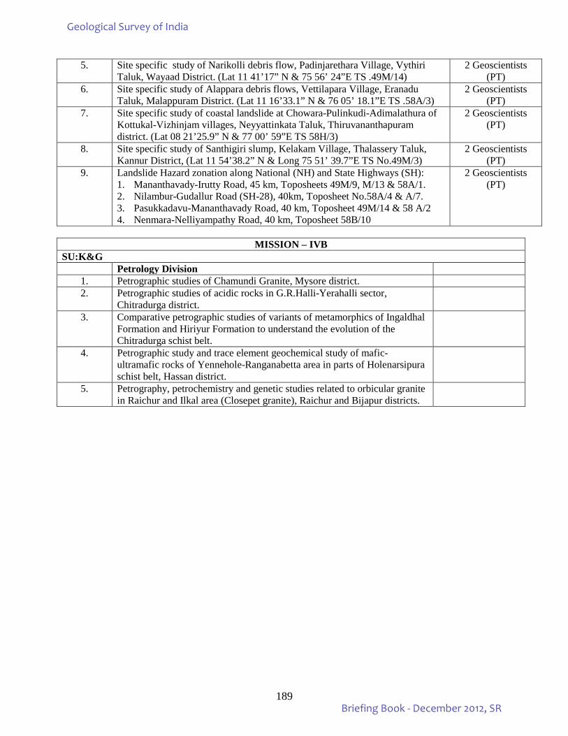
189
5. Site specific study of Narikolli debris flow, Padinjarethara Village, Vythiri Taluk, Wayaad District. (Lat 11 41’17” N & 75 56’ 24”E TS .49M/14)
2 Geoscientists (PT)
6. Site specific study of Alappara debris flows, Vettilapara Village, Eranadu Taluk, Malappuram District. (Lat 11 16’33.1” N & 76 05’ 18.1”E TS .58A/3)
2 Geoscientists (PT)
7. Site specific study of coastal landslide at Chowara-Pulinkudi-Adimalathura of Kottukal-Vizhinjam villages, Neyyattinkata Taluk, Thiruvananthapuram district. (Lat 08 21’25.9” N & 77 00’ 59”E TS 58H/3)
2 Geoscientists (PT)
8. Site specific study of Santhigiri slump, Kelakam Village, Thalassery Taluk, Kannur District, (Lat 11 54’38.2” N & Long 75 51’ 39.7”E TS No.49M/3)
2 Geoscientists (PT)
9. Landslide Hazard zonation along National (NH) and State Highways (SH): 1. Mananthavady-Irutty Road, 45 km, Toposheets 49M/9, M/13 & 58A/1. 2. Nilambur-Gudallur Road (SH-28), 40km, Toposheet No.58A/4 & A/7. 3. Pasukkadavu-Mananthavady Road, 40 km, Toposheet 49M/14 & 58 A/2 4. Nenmara-Nelliyampathy Road, 40 km, Toposheet 58B/10
2 Geoscientists (PT)
MISSION – IVB
SU:K&G Petrology Division
1. Petrographic studies of Chamundi Granite, Mysore district. 2. Petrographic studies of acidic rocks in G.R.Halli-Yerahalli sector,
Chitradurga district.
3. Comparative petrographic studies of variants of metamorphics of Ingaldhal Formation and Hiriyur Formation to understand the evolution of the Chitradurga schist belt.
4. Petrographic study and trace element geochemical study of mafic-ultramafic rocks of Yennehole-Ranganabetta area in parts of Holenarsipura schist belt, Hassan district.
5. Petrography, petrochemistry and genetic studies related to orbicular granite in Raichur and Ilkal area (Closepet granite), Raichur and Bijapur districts.
Geological Survey of India
Briefing Book - December 2012, SR
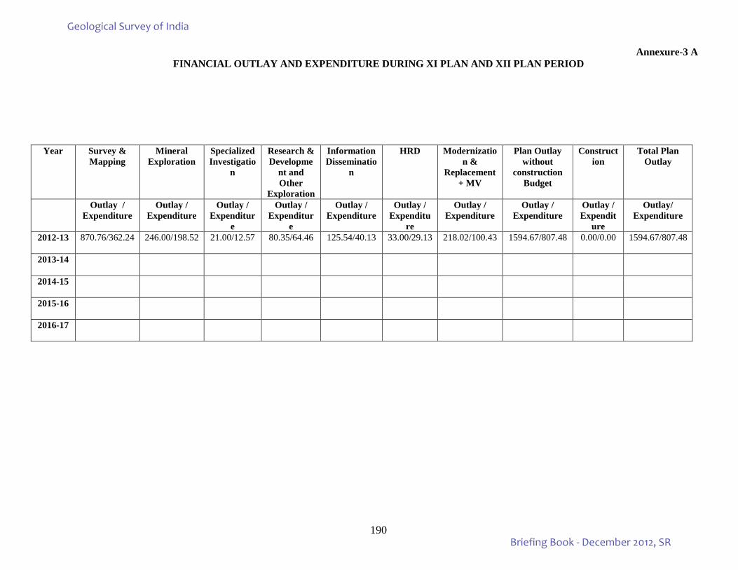
190
Annexure-3 A FINANCIAL OUTLAY AND EXPENDITURE DURING XI PLAN AND XII PLAN PERIOD
Year Survey & Mapping
Mineral Exploration
Specialized Investigatio
n
Research & Developme
nt and Other
Exploration
Information Disseminatio
n
HRD Modernization &
Replacement + MV
Plan Outlay without
construction Budget
Construction
Total Plan Outlay
Outlay / Expenditure
Outlay / Expenditure
Outlay / Expenditur
e
Outlay / Expenditur
e
Outlay / Expenditure
Outlay / Expenditu
re
Outlay / Expenditure
Outlay / Expenditure
Outlay / Expendit
ure
Outlay/ Expenditure
2012-13 870.76/362.24 246.00/198.52 21.00/12.57 80.35/64.46 125.54/40.13 33.00/29.13 218.02/100.43 1594.67/807.48 0.00/0.00 1594.67/807.48
2013-14
2014-15
2015-16
2016-17
Geological Survey of India
Briefing Book - December 2012, SR
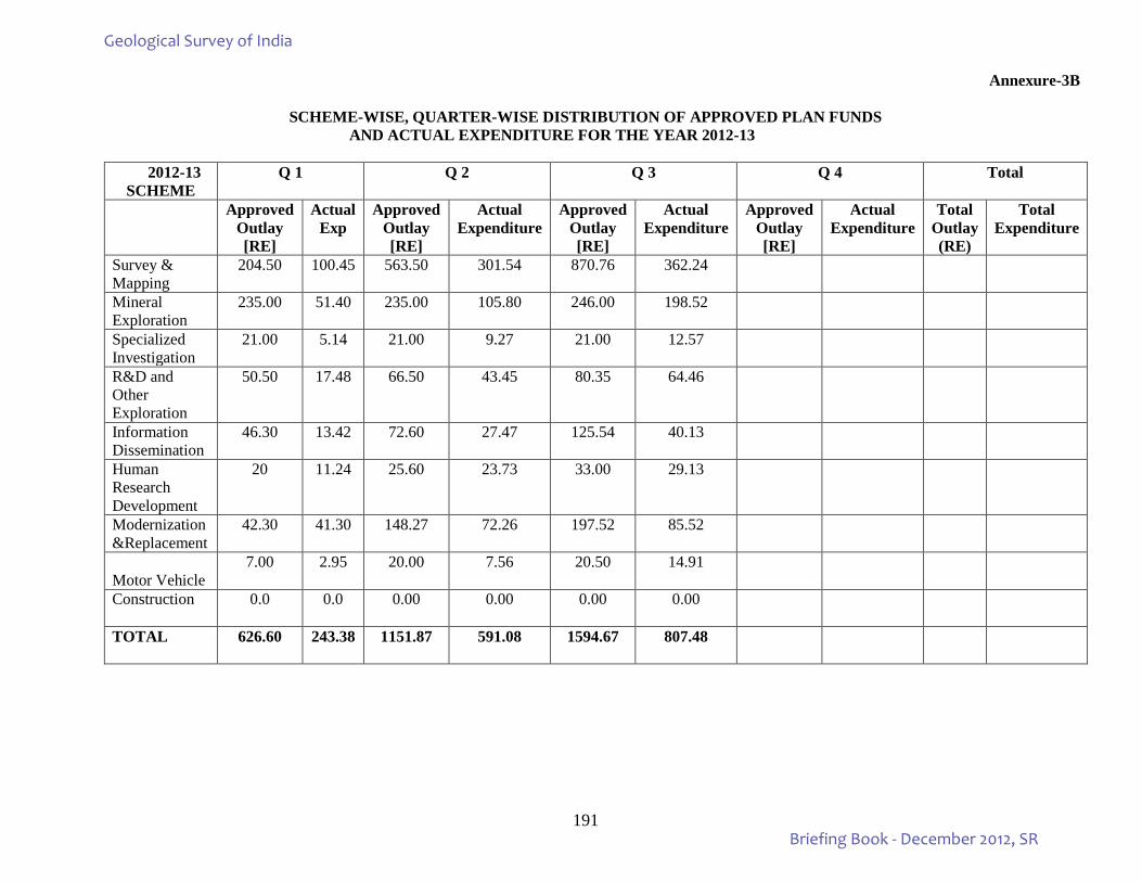
191
Annexure-3B
SCHEME-WISE, QUARTER-WISE DISTRIBUTION OF APPROVED PLAN FUNDS AND ACTUAL EXPENDITURE FOR THE YEAR 2012-13
2012-13 SCHEME
Q 1 Q 2 Q 3 Q 4
Total
Approved Outlay [RE]
Actual Exp
Approved Outlay [RE]
Actual Expenditure
Approved Outlay [RE]
Actual Expenditure
Approved Outlay [RE]
Actual Expenditure
Total Outlay (RE)
Total Expenditure
Survey & Mapping
204.50 100.45 563.50 301.54 870.76 362.24
Mineral Exploration
235.00 51.40 235.00 105.80 246.00 198.52
Specialized Investigation
21.00 5.14 21.00 9.27 21.00 12.57
R&D and Other Exploration
50.50 17.48 66.50 43.45 80.35 64.46
Information Dissemination
46.30 13.42 72.60 27.47 125.54 40.13
Human Research Development
20 11.24 25.60 23.73 33.00 29.13
Modernization &Replacement
42.30 41.30 148.27 72.26 197.52 85.52
Motor Vehicle
7.00 2.95 20.00 7.56 20.50 14.91
Construction 0.0 0.0 0.00 0.00 0.00 0.00
TOTAL 626.60 243.38 1151.87 591.08 1594.67 807.48
Geological Survey of India
Briefing Book - December 2012, SR
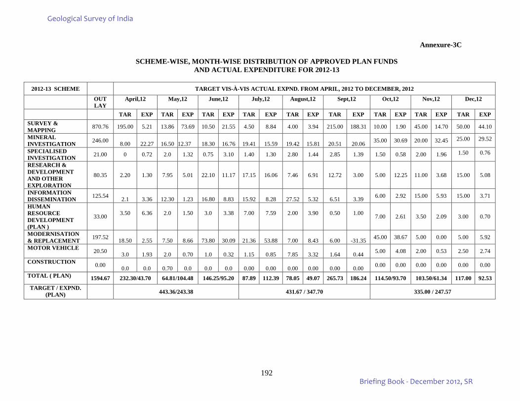
192
Annexure-3C
SCHEME-WISE, MONTH-WISE DISTRIBUTION OF APPROVED PLAN FUNDS
AND ACTUAL EXPENDITURE FOR 2012-13
2012-13 SCHEME TARGET VIS-À-VIS ACTUAL EXPND. FROM APRIL, 2012 TO DECEMBER, 2012
OUT LAY
April,12 May,12 June,12 July,12 August,12 Sept,12 Oct,12 Nov,12 Dec,12
TAR EXP TAR EXP TAR EXP TAR EXP TAR EXP TAR EXP TAR EXP TAR EXP TAR EXP SURVEY & MAPPING 870.76 195.00 5.21 13.86 73.69 10.50 21.55 4.50 8.84 4.00 3.94 215.00 188.31 10.00 1.90 45.00 14.70 50.00 44.10
MINERAL INVESTIGATION 246.00
8.00
22.27
16.50
12.37
18.30
16.76
19.41
15.59
19.42
15.81
20.51
20.06 35.00 30.69 20.00 32.45 25.00 29.52
SPECIALISED INVESTIGATION 21.00 0 0.72 2.0 1.32 0.75 3.10 1.40 1.30 2.80 1.44 2.85 1.39 1.50 0.58 2.00 1.96 1.50 0.76
RESEARCH & DEVELOPMENT AND OTHER EXPLORATION
80.35 2.20 1.30 7.95 5.01 22.10 11.17 17.15 16.06 7.46 6.91 12.72 3.00 5.00 12.25 11.00 3.68 15.00 5.08
INFORMATION DISSEMINATION 125.54
2.1
3.36
12.30
1.23
16.80
8.83
15.92
8.28
27.52
5.32
6.51
3.39 6.00 2.92 15.00 5.93 15.00 3.71
HUMAN RESOURCE DEVELOPMENT (PLAN )
33.00
3.50
6.36
2.0
1.50
3.0
3.38
7.00
7.59
2.00
3.90
0.50
1.00 7.00 2.61 3.50 2.09 3.00 0.70
MODERNISATION & REPLACEMENT 197.52
18.50
2.55
7.50
8.66
73.80
30.09
21.36
53.88
7.00
8.43
6.00
-31.35 45.00 38.67 5.00 0.00 5.00 5.92
MOTOR VEHICLE 20.50 3.0
1.93
2.0
0.70
1.0
0.32
1.15
0.85
7.85
3.32
1.64
0.44 5.00 4.08 2.00 0.53 2.50 2.74
CONSTRUCTION 0.00 0.0
0.0
0.70
0.0
0.0
0.0
0.00
0.00
0.00
0.00
0.00
0.00 0.00 0.00 0.00 0.00 0.00 0.00
TOTAL ( PLAN) 1594.67 232.30/43.70 64.81/104.48 146.25/95.20 87.89 112.39 78.05 49.07 265.73 186.24 114.50/93.70 103.50/61.34 117.00 92.53 TARGET / EXPND.
(PLAN) 443.36/243.38 431.67 / 347.70 335.00 / 247.57
Geological Survey of India
Briefing Book - December 2012, SR
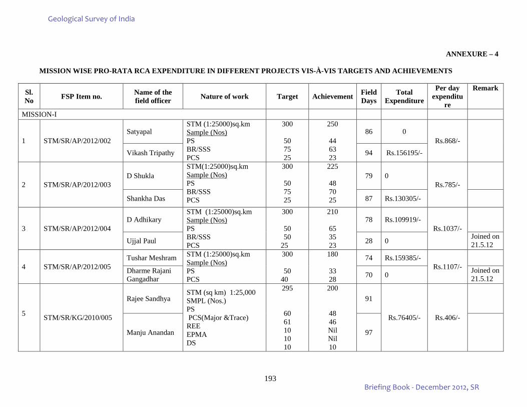
193
ANNEXURE – 4
MISSION WISE PRO-RATA RCA EXPENDITURE IN DIFFERENT PROJECTS VIS-À-VIS TARGETS AND ACHIEVEMENTS
Sl. No FSP Item no. Name of the
field officer Nature of work Target Achievement Field Days
Total Expenditure
Per day expenditu
re
Remark
MISSION-I
1 STM/SR/AP/2012/002 Satyapal
STM (1:25000)sq.km Sample (Nos) PS BR/SSS PCS
300
50 75 25
250
44 63 23
86 0 Rs.868/-
Vikash Tripathy 94 Rs.156195/-
2 STM/SR/AP/2012/003 D Shukla
STM(1:25000)sq.km Sample (Nos) PS BR/SSS PCS
300
50 75 25
225
48 70 25
79 0 Rs.785/-
Shankha Das 87 Rs.130305/-
3 STM/SR/AP/2012/004 D Adhikary
STM (1:25000)sq.km Sample (Nos) PS BR/SSS PCS
300
50 50
25
210
65 35 23
78 Rs.109919/- Rs.1037/-
Ujjal Paul 28 0 Joined on 21.5.12
4 STM/SR/AP/2012/005 Tushar Meshram STM (1:25000)sq.km
Sample (Nos) PS PCS
300
50 40
180
33 28
74 Rs.159385/- Rs.1107/-
Dharme Rajani Gangadhar 70 0 Joined on
21.5.12
5 STM/SR/KG/2010/005
Rajee Sandhya STM (sq km) 1:25,000 SMPL (Nos.) PS PCS(Major &Trace) REE EPMA DS
295
60 61 10 10 10
200
48 46 Nil Nil 10
91
Rs.76405/- Rs.406/-
Manju Anandan 97
Geological Survey of India
Briefing Book - December 2012, SR
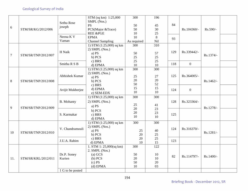
194
6 STM/SR/KG/2012/006
Sethu Rose joseph
STM (sq km) 1:25,000 SMPL (Nos.) PS PCS(Major &Trace) REE &PGE EPMA Channel Sampling
300
50 50 10 10
As required
196
45 30 25 8
Nil
84 Rs.104360/- Rs.590/-
Neena K V Vaman 93
7 STM/SR/TNP/2012/007 H Naik
1) STM (1:25,000) sq km 2) SMPL (Nos.) a) PS b) PCS c) BRS d) EPMA
300
50 25 25 10
310
57 25 25 10
129 Rs.339442/- Rs.1374/-
Smitha R S B 118 0
8 STM/SR/TNP/2012/008 Abhishek Kumar
1) STM (1:25,000) sq km 2) SMPL (Nos.) a) PS b) PCS c) BRS d) EPMA e) SEM-EDX
300
25 20 50 15 10
300
27 20 52 15 10
125 Rs.364005/- Rs.1462/-
Avijit Mukherjee 124 0
9 STM/SR/TNP/2012/009
B. Mohanty 1) STM (1:25,000) sq km 2) SMPL (Nos.) a) PS b) PCS c) BRS d) EPMA
300
25 20 20 10
300
41 23 23 10
128 Rs.323364/-
Rs.1278/-
S. Karmakar 125
10 STM/SR/TNP/2012/010 V. Chandramouli
1) STM (1:25,000) sq km 2) SMPL (Nos.) a) PS b) PCS c) BRS d) EPMA
300
25 20 20 10
300
40 25 25 15
124 Rs.316370/- Rs.1281/-
J.U.A. Rahim 123
11. STM/SR/KRL/2012/011 Dr.P. Soney Kurien
1. STM 1: 25,000(sq km) 2. SMPL (Nos.) (a) GCS
(b) PCS
(c) PS
(d) EPMA
300
50 20 50 10
122
10 10 20 03
82 Rs.114797/- Rs.1400/-
1 G to be posted
Geological Survey of India
Briefing Book - December 2012, SR
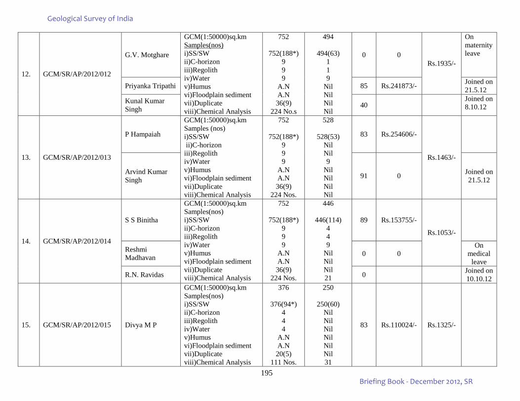
195
12. GCM/SR/AP/2012/012
G.V. Motghare
GCM(1:50000)sq.km Samples(nos) i)SS/SW ii)C-horizon iii)Regolith iv)Water v)Humus vi)Floodplain sediment vii)Duplicate viii)Chemical Analysis
752
752(188*) 9 9 9
A.N A.N 36(9)
224 No.s
494
494(63) 1 1 9
Nil Nil Nil Nil
0 0 Rs.1935/-
On maternity leave
Priyanka Tripathi 85 Rs.241873/- Joined on 21.5.12
Kunal Kumar Singh 40
Joined on 8.10.12
13. GCM/SR/AP/2012/013
P Hampaiah
GCM(1:50000)sq.km Samples (nos) i)SS/SW ii)C-horizon iii)Regolith iv)Water v)Humus vi)Floodplain sediment vii)Duplicate viii)Chemical Analysis
752
752(188*) 9 9 9
A.N A.N 36(9)
224 Nos.
528
528(53) Nil Nil 9
Nil Nil Nil Nil
83 Rs.254606/-
Rs.1463/-
Arvind Kumar Singh 91 0 Joined on
21.5.12
14. GCM/SR/AP/2012/014
S S Binitha
GCM(1:50000)sq.km Samples(nos) i)SS/SW ii)C-horizon iii)Regolith iv)Water v)Humus vi)Floodplain sediment vii)Duplicate viii)Chemical Analysis
752
752(188*) 9 9 9
A.N A.N 36(9)
224 Nos.
446
446(114) 4 4 9
Nil Nil Nil 21
89 Rs.153755/-
Rs.1053/-
Reshmi Madhavan 0 0
On medical
leave
R.N. Ravidas 0 Joined on 10.10.12
15. GCM/SR/AP/2012/015 Divya M P
GCM(1:50000)sq.km Samples(nos) i)SS/SW ii)C-horizon iii)Regolith iv)Water v)Humus vi)Floodplain sediment vii)Duplicate viii)Chemical Analysis
376
376(94*) 4 4 4
A.N A.N 20(5)
111 Nos.
250
250(60) Nil Nil Nil Nil Nil Nil 31
83 Rs.110024/- Rs.1325/-
Geological Survey of India
Briefing Book - December 2012, SR
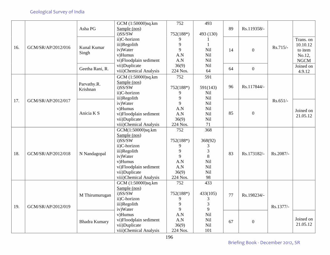
196
16. GCM/SR/AP/2012/016
Asha PG GCM (1:50000)sq.km Sample (nos) i)SS/SW ii)C-horizon iii)Regolith iv)Water v)Humus vi)Floodplain sediment vii)Duplicate viii)Chemical Analysis
752
752(188*) 9 9 9
A.N A.N 36(9)
224 Nos.
493
493 (130) 1 1
Nil Nil Nil Nil 64
89 Rs.119358/-
Rs.715/-
Kunal Kumar Singh 14 0
Trans. on 10.10.12 to item No.12, NGCM
Geetha Rani, R. 64 0 Joined on 4.9.12
17. GCM/SR/AP/2012/017
Parvathy.R. Krishnan
GCM (1:50000)sq.km Sample (nos) i)SS/SW ii)C-horizon iii)Regolith iv)Water v)Humus vi)Floodplain sediment vii)Duplicate viii)Chemical Analysis
752
752(188*) 9 9 9
A.N A.N 36(9)
224 Nos.
591
591(143) Nil Nil Nil Nil Nil Nil 71
96 Rs.117844/-
Rs.651/-
Anicia K S 85 0 Joined on 21.05.12
18. GCM/SR/AP/2012/018 N Nandagopal
GCM(1:50000)sq.km Sample (nos) i)SS/SW ii)C-horizon iii)Regolith iv)Water v)Humus vi)Floodplain sediment vii)Duplicate viii)Chemical Analysis
752
752(188*) 9 9 9
A.N A.N 36(9)
224 Nos.
368
368(92) 3 3 8
Nil Nil Nil 98
83 Rs.173182/- Rs.2087/-
19. GCM/SR/AP/2012/019
M Thirumurugan
GCM (1:50000)sq.km Sample (nos) i)SS/SW ii)C-horizon iii)Regolith iv)Water v)Humus vi)Floodplain sediment vii)Duplicate viii)Chemical Analysis
752
752(188*) 9 9 9
A.N A.N 36(9)
224 Nos.
433
433(105) 3 3 9
Nil Nil Nil 101
77 Rs.198234/-
Rs.1377/-
Bhadra Kumary 67 0 Joined on 21.05.12
Geological Survey of India
Briefing Book - December 2012, SR
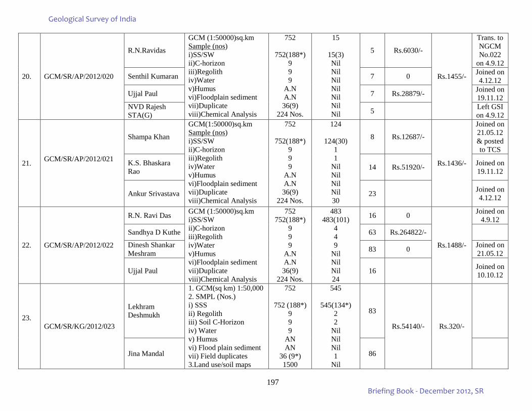
197
20. GCM/SR/AP/2012/020
R.N.Ravidas
GCM (1:50000)sq.km Sample (nos) i)SS/SW ii)C-horizon iii)Regolith iv)Water v)Humus vi)Floodplain sediment vii)Duplicate viii)Chemical Analysis
752
752(188*) 9 9 9
A.N A.N 36(9)
224 Nos.
15
15(3) Nil Nil Nil Nil Nil Nil Nil
5 Rs.6030/-
Rs.1455/-
Trans. to NGCM No.022
on 4.9.12
Senthil Kumaran 7 0 Joined on 4.12.12
Ujjal Paul 7 Rs.28879/- Joined on 19.11.12
NVD Rajesh STA(G) 5 Left GSI
on 4.9.12
21. GCM/SR/AP/2012/021
Shampa Khan
GCM(1:50000)sq.km Sample (nos) i)SS/SW ii)C-horizon iii)Regolith iv)Water v)Humus vi)Floodplain sediment vii)Duplicate viii)Chemical Analysis
752
752(188*) 9 9 9
A.N A.N 36(9)
224 Nos.
124
124(30) 1 1
Nil Nil Nil Nil 30
8 Rs.12687/-
Rs.1436/-
Joined on 21.05.12 & posted to TCS
K.S. Bhaskara Rao 14 Rs.51920/- Joined on
19.11.12
Ankur Srivastava 23 Joined on 4.12.12
22. GCM/SR/AP/2012/022
R.N. Ravi Das GCM (1:50000)sq.km i)SS/SW ii)C-horizon iii)Regolith iv)Water v)Humus vi)Floodplain sediment vii)Duplicate viii)Chemical Analysis
752 752(188*)
9 9 9
A.N A.N 36(9)
224 Nos.
483 483(101)
4 4 9
Nil Nil Nil 24
16 0
Rs.1488/-
Joined on 4.9.12
Sandhya D Kuthe 63 Rs.264822/-
Dinesh Shankar Meshram 83 0 Joined on
21.05.12
Ujjal Paul 16 Joined on 10.10.12
23.
GCM/SR/KG/2012/023
Lekhram Deshmukh
1. GCM(sq km) 1:50,000 2. SMPL (Nos.) i) SSS ii) Regolith iii) Soil C-Horizon iv) Water v) Humus vi) Flood plain sediment vii) Field duplicates 3.Land use/soil maps
752
752 (188*) 9 9 9
AN AN
36 (9*) 1500
545
545(134*) 2 2
Nil Nil Nil 1
Nil
83
Rs.54140/- Rs.320/-
Jina Mandal 86
Geological Survey of India
Briefing Book - December 2012, SR
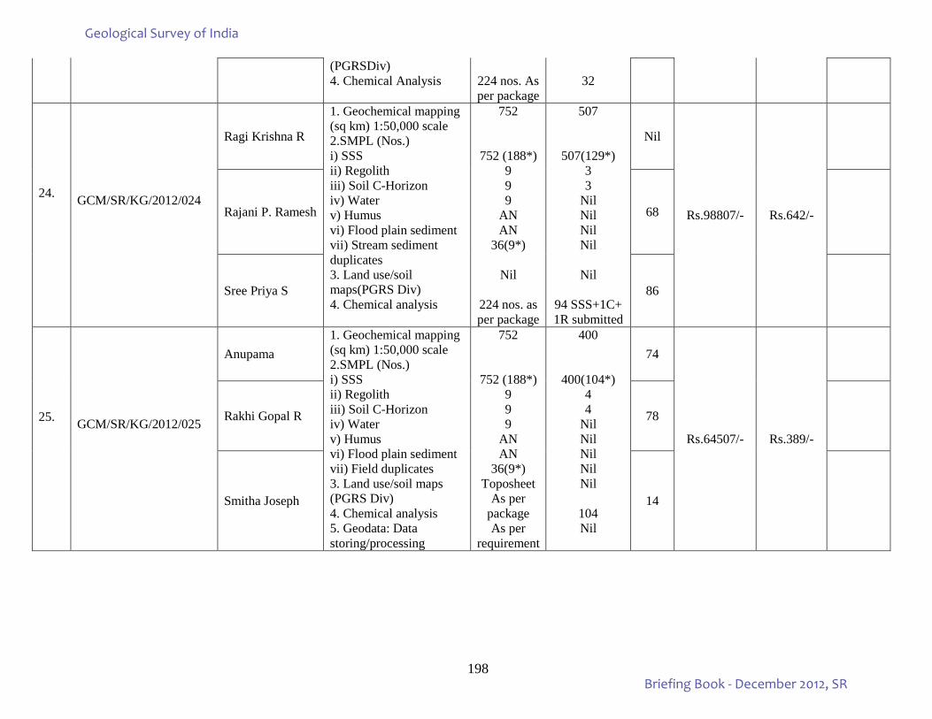
198
(PGRSDiv) 4. Chemical Analysis
224 nos. As per package
32
24.
GCM/SR/KG/2012/024
Ragi Krishna R
1. Geochemical mapping (sq km) 1:50,000 scale 2.SMPL (Nos.) i) SSS ii) Regolith iii) Soil C-Horizon iv) Water v) Humus vi) Flood plain sediment vii) Stream sediment duplicates 3. Land use/soil maps(PGRS Div) 4. Chemical analysis
752
752 (188*) 9 9 9
AN AN
36(9*)
Nil
224 nos. as per package
507
507(129*) 3 3
Nil Nil Nil Nil
Nil
94 SSS+1C+ 1R submitted
Nil
Rs.98807/- Rs.642/-
Rajani P. Ramesh 68
Sree Priya S 86
25.
GCM/SR/KG/2012/025
Anupama 1. Geochemical mapping (sq km) 1:50,000 scale 2.SMPL (Nos.) i) SSS ii) Regolith iii) Soil C-Horizon iv) Water v) Humus vi) Flood plain sediment vii) Field duplicates 3. Land use/soil maps (PGRS Div) 4. Chemical analysis 5. Geodata: Data storing/processing
752
752 (188*) 9 9 9
AN AN
36(9*) Toposheet
As per package As per
requirement
400
400(104*) 4 4
Nil Nil Nil Nil Nil
104 Nil
74
Rs.64507/- Rs.389/-
Rakhi Gopal R 78
Smitha Joseph 14
Geological Survey of India
Briefing Book - December 2012, SR
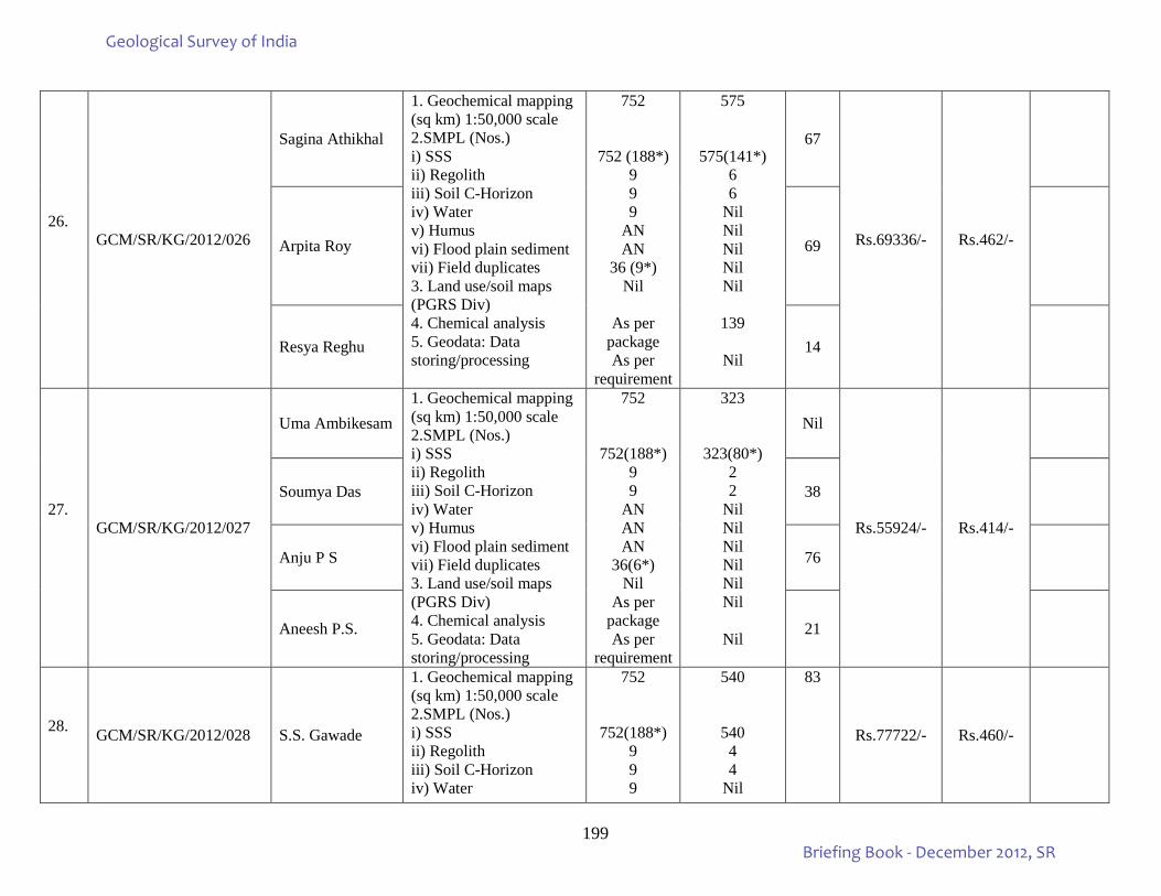
199
26.
GCM/SR/KG/2012/026
Sagina Athikhal
1. Geochemical mapping (sq km) 1:50,000 scale 2.SMPL (Nos.) i) SSS ii) Regolith iii) Soil C-Horizon iv) Water v) Humus vi) Flood plain sediment vii) Field duplicates 3. Land use/soil maps (PGRS Div) 4. Chemical analysis 5. Geodata: Data storing/processing
752
752 (188*) 9 9 9
AN AN
36 (9*) Nil
As per
package As per
requirement
575
575(141*) 6 6
Nil Nil Nil Nil Nil
139
Nil
67
Rs.69336/- Rs.462/-
Arpita Roy 69
Resya Reghu 14
27.
GCM/SR/KG/2012/027
Uma Ambikesam 1. Geochemical mapping (sq km) 1:50,000 scale 2.SMPL (Nos.) i) SSS ii) Regolith iii) Soil C-Horizon iv) Water v) Humus vi) Flood plain sediment vii) Field duplicates 3. Land use/soil maps (PGRS Div) 4. Chemical analysis 5. Geodata: Data storing/processing
752
752(188*) 9 9
AN AN AN
36(6*) Nil
As per package As per
requirement
323
323(80*) 2 2
Nil Nil Nil Nil Nil Nil
Nil
Nil
Rs.55924/- Rs.414/-
Soumya Das 38
Anju P S 76
Aneesh P.S. 21
28. GCM/SR/KG/2012/028 S.S. Gawade
1. Geochemical mapping (sq km) 1:50,000 scale 2.SMPL (Nos.) i) SSS ii) Regolith iii) Soil C-Horizon iv) Water
752
752(188*) 9 9 9
540
540 4 4
Nil
83
Rs.77722/- Rs.460/-
Geological Survey of India
Briefing Book - December 2012, SR
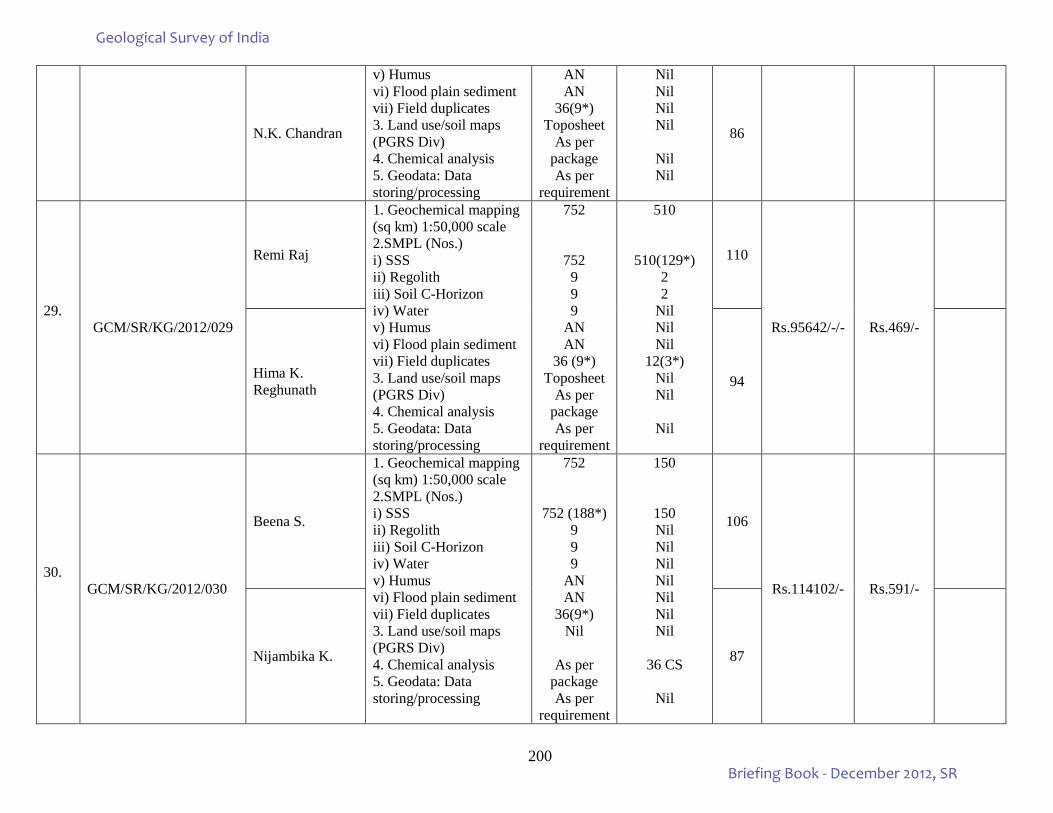
200
N.K. Chandran
v) Humus vi) Flood plain sediment vii) Field duplicates 3. Land use/soil maps (PGRS Div) 4. Chemical analysis 5. Geodata: Data storing/processing
AN AN
36(9*) Toposheet
As per package As per
requirement
Nil Nil Nil Nil
Nil Nil
86
29.
GCM/SR/KG/2012/029
Remi Raj
1. Geochemical mapping (sq km) 1:50,000 scale 2.SMPL (Nos.) i) SSS ii) Regolith iii) Soil C-Horizon iv) Water v) Humus vi) Flood plain sediment vii) Field duplicates 3. Land use/soil maps (PGRS Div) 4. Chemical analysis 5. Geodata: Data storing/processing
752
752 9 9 9
AN AN
36 (9*) Toposheet
As per package As per
requirement
510
510(129*) 2 2
Nil Nil Nil
12(3*) Nil Nil
Nil
110
Rs.95642/-/- Rs.469/-
Hima K. Reghunath 94
30.
GCM/SR/KG/2012/030
Beena S.
1. Geochemical mapping (sq km) 1:50,000 scale 2.SMPL (Nos.) i) SSS ii) Regolith iii) Soil C-Horizon iv) Water v) Humus vi) Flood plain sediment vii) Field duplicates 3. Land use/soil maps (PGRS Div) 4. Chemical analysis 5. Geodata: Data storing/processing
752
752 (188*) 9 9 9
AN AN
36(9*) Nil
As per
package As per
requirement
150
150 Nil Nil Nil Nil Nil Nil Nil
36 CS
Nil
106
Rs.114102/- Rs.591/-
Nijambika K. 87
Geological Survey of India
Briefing Book - December 2012, SR
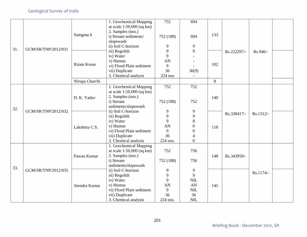
201
31.
GCM/SR/TNP/2012/031
Samgma.S
1. Geochemical Mapping at scale 1:50,000 (sq km) 2. Samples (nos.) i) Stream sediments/ slopewash ii) Soil C-horizon iii) Regolith iv) Water v) Humus vi) Flood Plain sediment vii) Duplicate 3. Chemical analysis
752
752 (188)
9 9 9
AN 9
36 224 nos
694
694
9 9 - - -
36(9) -
133
Rs.222297/- Rs.946/-
Ritam Konar 102
Nirupa Charchi 8
32.
GCM/SR/TNP/2012/032
D. K. Yadav
1. Geochemical Mapping at scale 1:50,000 (sq km) 2. Samples (nos.) i) Stream sediments/slopewash ii) Soil C-horizon iii) Regolith iv) Water v) Humus vi) Flood Plain sediment vii) Duplicate 3. Chemical analysis
752
752 (188)
9 9 9
AN 9
36 224 nos.
752
752
9 9 8 0 0 4 0
140
Rs.338417/- Rs.1312/-
Lakshmy C.S. 118
33.
GCM/SR/TNP/2012/035
Pawan Kumar
1. Geochemical Mapping at scale 1:50,000 (sq km) 2. Samples (nos.) i) Stream sediments/slopewash ii) Soil C-horizon iii) Regolith iv) Water v) Humus vi) Flood Plain sediment vii) Duplicate 3. Chemical analysis
752
752 (188)
9 9 9
AN 9
36 224 nos.
756
756
9 9
NIL AN NIL 36
NIL
148 Rs.343950/-
Rs.1174/-
Jitendra Kumar 145
Geological Survey of India
Briefing Book - December 2012, SR
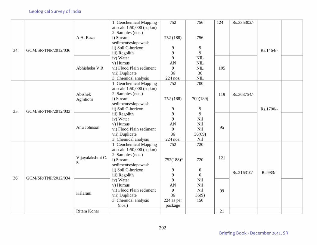
202
34. GCM/SR/TNP/2012/036
A.A. Raza
1. Geochemical Mapping at scale 1:50,000 (sq km) 2. Samples (nos.) i) Stream sediments/slopewash ii) Soil C-horizon iii) Regolith iv) Water v) Humus vi) Flood Plain sediment vii) Duplicate 3. Chemical analysis
752
752 (188)
9 9 9
AN 9
36 224 nos.
756
756
9 9
NIL NIL NIL 36
NIL
124 Rs.335302/-
Rs.1464/-
Abhisheka V R 105
35. GCM/SR/TNP/2012/033
Abishek Agnihotri
1. Geochemical Mapping at scale 1:50,000 (sq km) 2. Samples (nos.) i) Stream sediments/slopewash ii) Soil C-horizon iii) Regolith iv) Water v) Humus vi) Flood Plain sediment vii) Duplicate 3. Chemical analysis
752
752 (188)
9 9 9
AN 9
36 224 nos.
700
700(189)
9 9
Nil Nil Nil
36(09) Nil
119 Rs.363754/-
Rs.1700/-
Anu Johnson 95
36. GCM/SR/TNP/2012/034
Vijayalakshmi C. S.
1. Geochemical Mapping at scale 1:50,000 (sq km) 2. Samples (nos.) i) Stream sediments/slopewash ii) Soil C-horizon iii) Regolith iv) Water v) Humus vi) Flood Plain sediment vii) Duplicate 3. Chemical analysis (nos.)
752
752(188)*
9 9 9
AN 9
36 224 as per package
720
720
6 6
Nil Nil Nil
36(9) 150
121
Rs.216310/- Rs.983/-
Kalarani 99
Ritam Konar 21
Geological Survey of India
Briefing Book - December 2012, SR
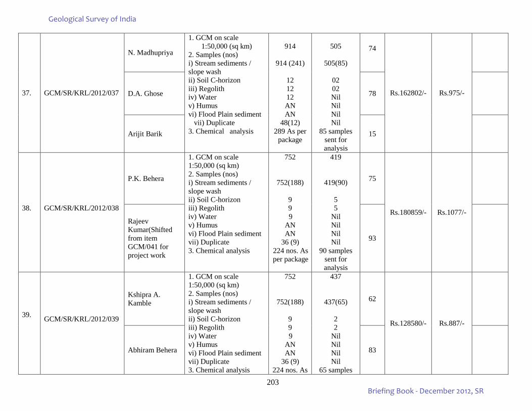
203
37. GCM/SR/KRL/2012/037
N. Madhupriya
1. GCM on scale 1:50,000 (sq km)
2. Samples (nos) i) Stream sediments / slope wash ii) Soil C-horizon iii) Regolith iv) Water v) Humus vi) Flood Plain sediment vii) Duplicate 3. Chemical analysis
914
914 (241)
12 12 12 AN AN
48(12) 289 As per
package
505
505(85)
02 02 Nil Nil Nil Nil
85 samples sent for analysis
74
Rs.162802/- Rs.975/-
D.A. Ghose 78
Arijit Barik 15
38.
GCM/SR/KRL/2012/038
P.K. Behera
1. GCM on scale 1:50,000 (sq km) 2. Samples (nos) i) Stream sediments / slope wash ii) Soil C-horizon iii) Regolith iv) Water v) Humus vi) Flood Plain sediment vii) Duplicate 3. Chemical analysis
752
752(188)
9 9 9
AN AN
36 (9) 224 nos. As per package
419
419(90)
5 5
Nil Nil Nil Nil
90 samples sent for analysis
75
Rs.180859/- Rs.1077/-
Rajeev Kumar(Shifted from item GCM/041 for project work
93
39.
GCM/SR/KRL/2012/039
Kshipra A. Kamble
1. GCM on scale 1:50,000 (sq km) 2. Samples (nos) i) Stream sediments / slope wash ii) Soil C-horizon iii) Regolith iv) Water v) Humus vi) Flood Plain sediment vii) Duplicate 3. Chemical analysis
752
752(188)
9 9 9
AN AN
36 (9) 224 nos. As
437
437(65)
2 2
Nil Nil Nil Nil
65 samples
62
Rs.128580/- Rs.887/-
Abhiram Behera 83
Geological Survey of India
Briefing Book - December 2012, SR
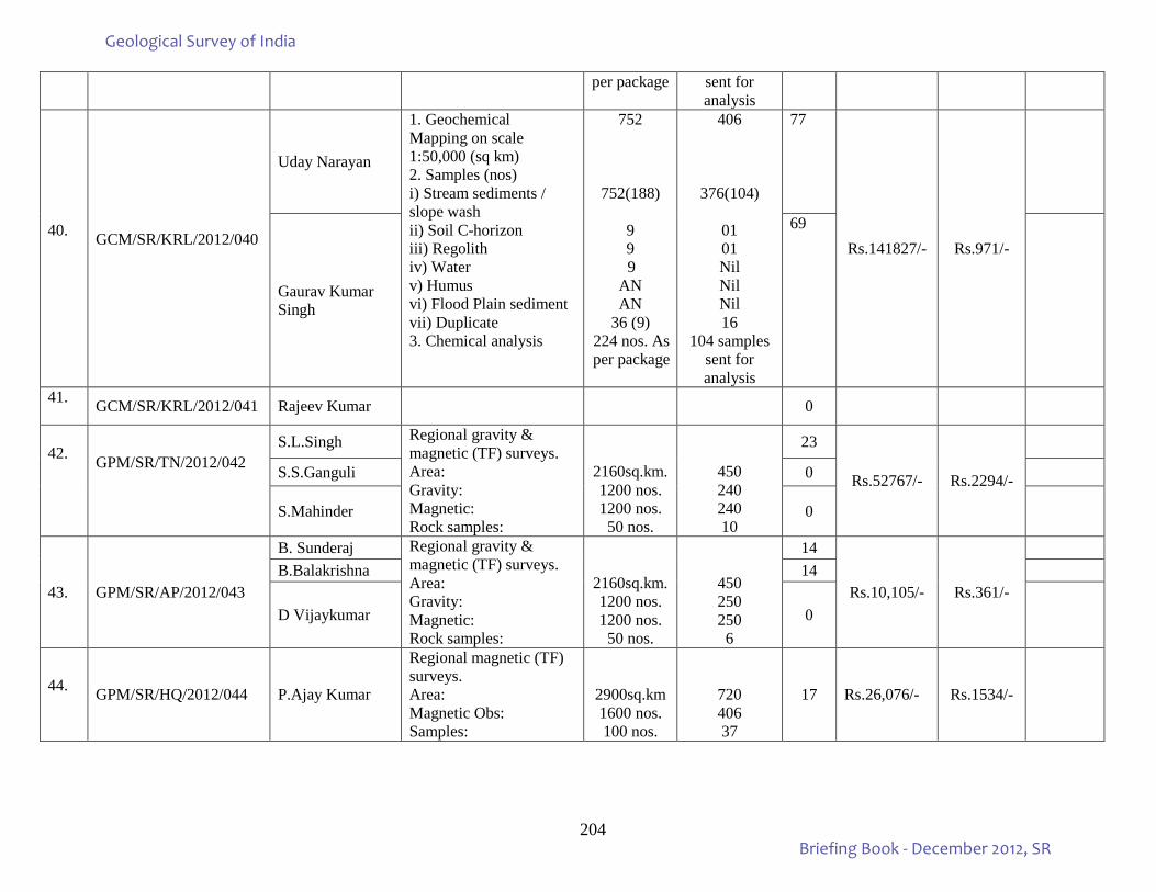
204
per package sent for analysis
40.
GCM/SR/KRL/2012/040
Uday Narayan
1. Geochemical Mapping on scale 1:50,000 (sq km) 2. Samples (nos) i) Stream sediments / slope wash ii) Soil C-horizon iii) Regolith iv) Water v) Humus vi) Flood Plain sediment vii) Duplicate 3. Chemical analysis
752
752(188)
9 9 9
AN AN
36 (9) 224 nos. As per package
406
376(104)
01 01 Nil Nil Nil 16
104 samples sent for analysis
77
Rs.141827/- Rs.971/-
Gaurav Kumar Singh
69
41. GCM/SR/KRL/2012/041 Rajeev Kumar 0
42.
GPM/SR/TN/2012/042
S.L.Singh Regional gravity & magnetic (TF) surveys. Area: Gravity: Magnetic: Rock samples:
2160sq.km. 1200 nos. 1200 nos. 50 nos.
450 240 240 10
23
Rs.52767/- Rs.2294/-
S.S.Ganguli 0
S.Mahinder 0
43. GPM/SR/AP/2012/043
B. Sunderaj Regional gravity & magnetic (TF) surveys. Area: Gravity: Magnetic: Rock samples:
2160sq.km. 1200 nos. 1200 nos.
50 nos.
450 250 250
6
14
Rs.10,105/- Rs.361/-
B.Balakrishna 14
D Vijaykumar 0
44. GPM/SR/HQ/2012/044 P.Ajay Kumar
Regional magnetic (TF) surveys. Area: Magnetic Obs: Samples:
2900sq.km 1600 nos. 100 nos.
720 406 37
17 Rs.26,076/- Rs.1534/-
Geological Survey of India
Briefing Book - December 2012, SR
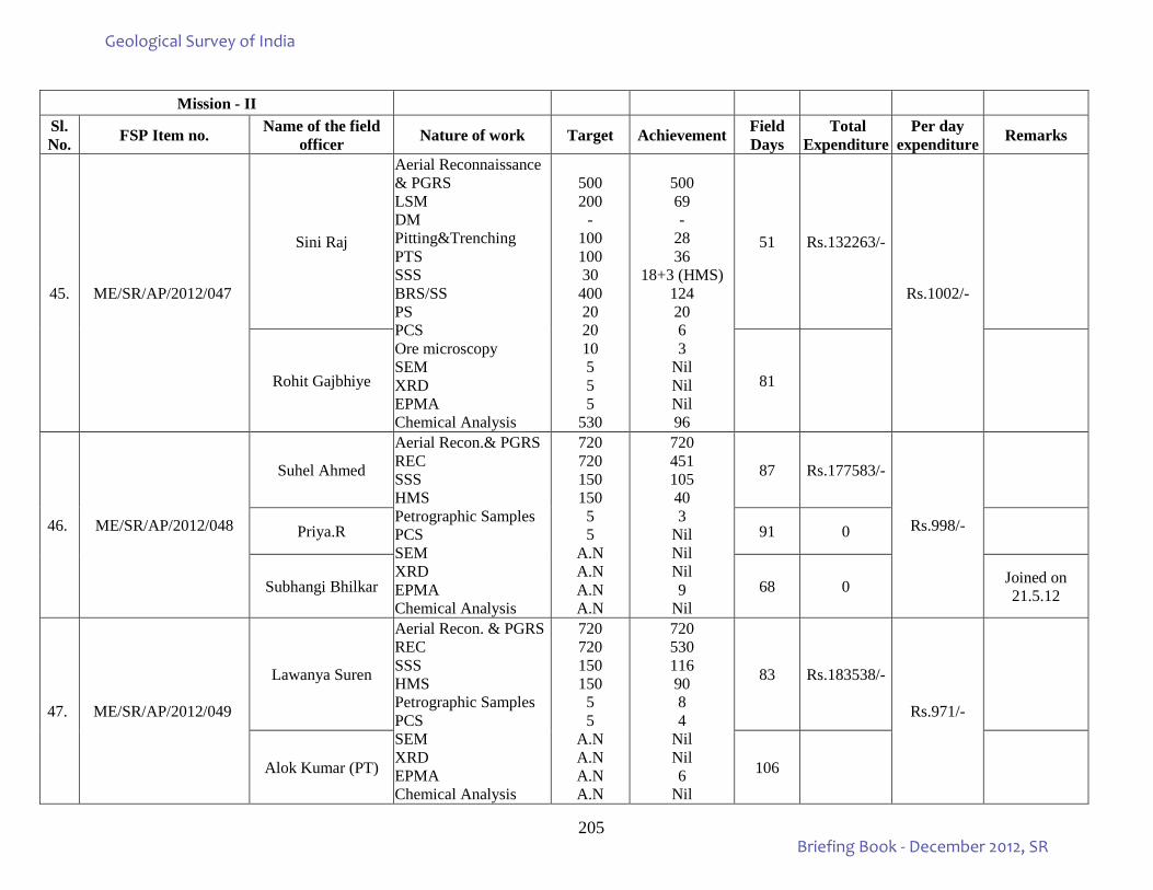
205
Mission - II
Sl. No. FSP Item no. Name of the field
officer Nature of work Target Achievement Field Days
Total Expenditure
Per day expenditure Remarks
45. ME/SR/AP/2012/047
Sini Raj
Aerial Reconnaissance & PGRS LSM DM Pitting&Trenching PTS SSS BRS/SS
PS
PCS Ore microscopy SEM XRD EPMA Chemical Analysis
500 200
- 100 100 30
400 20 20 10 5 5 5
530
500 69 -
28 36
18+3 (HMS) 124 20 6 3
Nil Nil Nil 96
51 Rs.132263/-
Rs.1002/-
Rohit Gajbhiye 81
46. ME/SR/AP/2012/048
Suhel Ahmed
Aerial Recon.& PGRS REC SSS HMS
Petrographic Samples
PCS SEM XRD EPMA Chemical Analysis
720 720 150 150 5 5
A.N A.N A.N A.N
720 451 105 40 3
Nil Nil Nil 9
Nil
87 Rs.177583/-
Rs.998/-
Priya.R 91 0
Subhangi Bhilkar 68 0 Joined on 21.5.12
47. ME/SR/AP/2012/049
Lawanya Suren
Aerial Recon. & PGRS REC SSS HMS
Petrographic Samples
PCS SEM XRD EPMA Chemical Analysis
720 720 150 150 5 5
A.N A.N A.N A.N
720 530 116 90 8 4
Nil Nil 6
Nil
83 Rs.183538/-
Rs.971/-
Alok Kumar (PT) 106
Geological Survey of India
Briefing Book - December 2012, SR
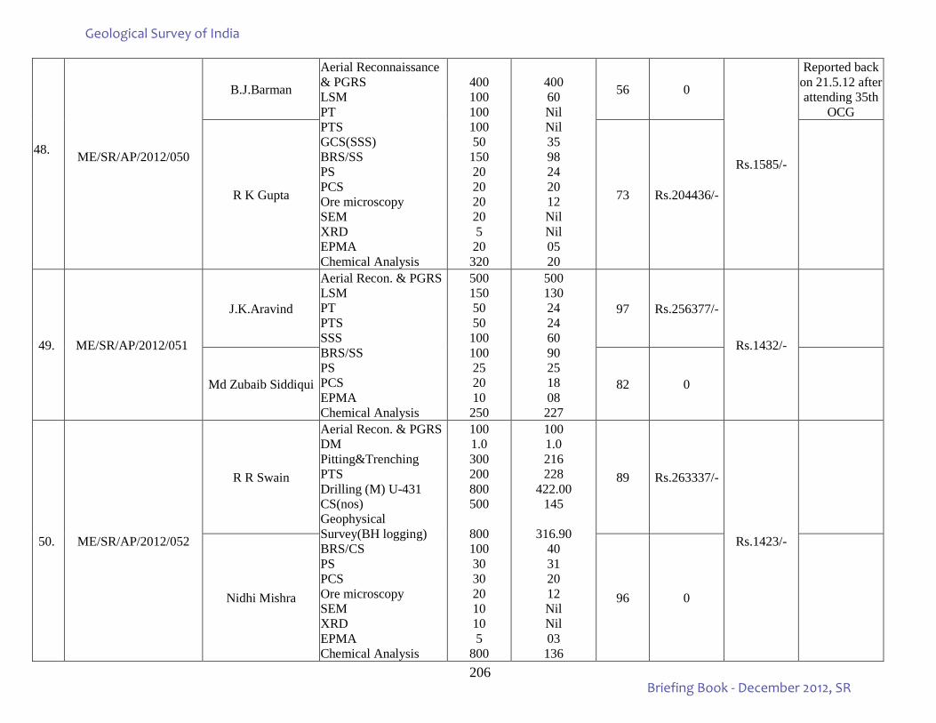
206
48.
ME/SR/AP/2012/050
B.J.Barman
Aerial Reconnaissance & PGRS LSM PT PTS GCS(SSS) BRS/SS
PS
PCS
Ore microscopy SEM XRD EPMA Chemical Analysis
400 100 100 100 50
150 20 20 20 20 5
20 320
400 60 Nil Nil 35 98 24 20 12 Nil Nil 05 20
56 0
Rs.1585/-
Reported back on 21.5.12 after attending 35th
OCG
R K Gupta 73 Rs.204436/-
49. ME/SR/AP/2012/051
J.K.Aravind
Aerial Recon. & PGRS LSM PT PTS SSS BRS/SS
PS PCS EPMA
Chemical Analysis
500 150 50 50
100 100 25 20 10
250
500 130 24 24 60 90 25 18 08
227
97 Rs.256377/-
Rs.1432/-
Md Zubaib Siddiqui 82 0
50. ME/SR/AP/2012/052
R R Swain
Aerial Recon. & PGRS DM Pitting&Trenching PTS Drilling (M) U-431 CS(nos) Geophysical Survey(BH logging) BRS/CS
PS
PCS
Ore microscopy SEM XRD EPMA Chemical Analysis
100 1.0 300 200 800 500
800 100 30 30 20 10 10 5
800
100 1.0 216 228
422.00 145
316.90
40 31 20 12 Nil Nil 03 136
89 Rs.263337/-
Rs.1423/-
Nidhi Mishra 96 0
Geological Survey of India
Briefing Book - December 2012, SR
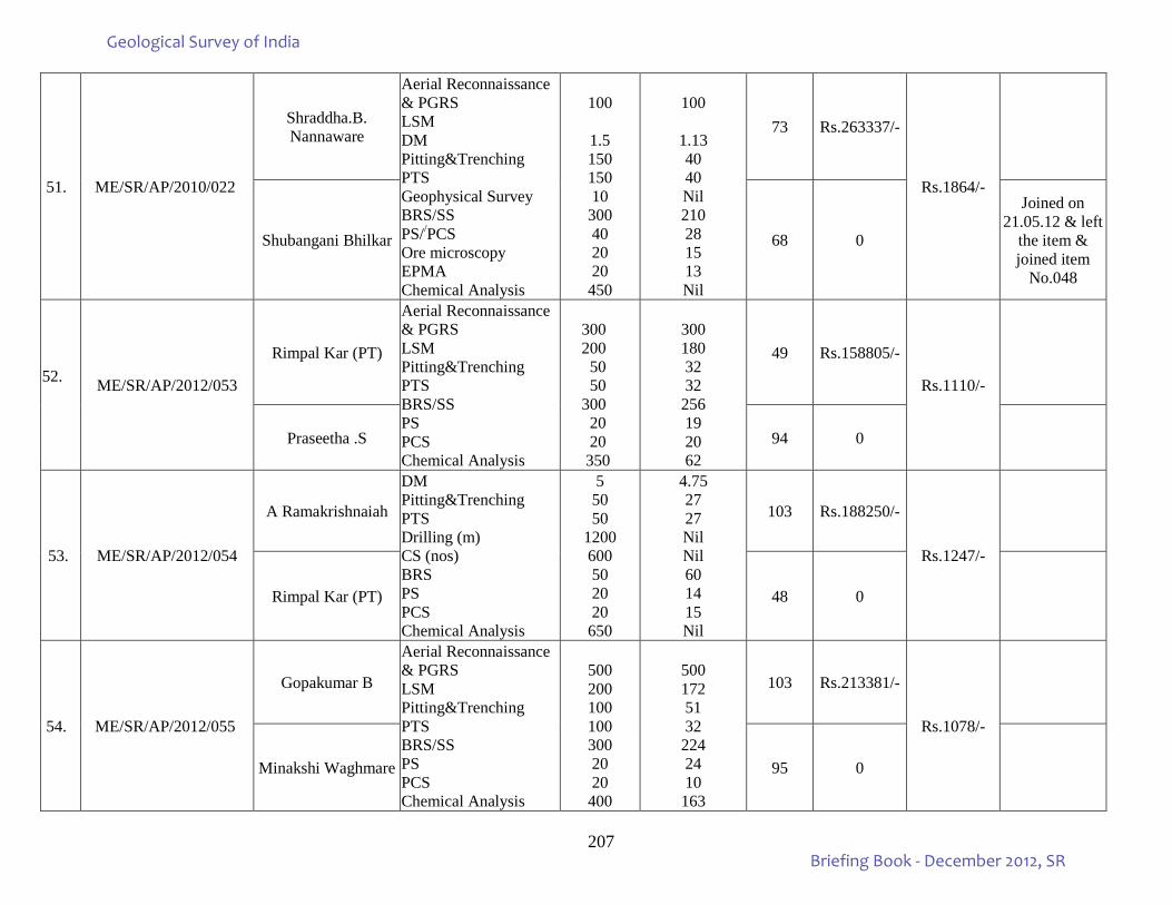
207
51. ME/SR/AP/2010/022
Shraddha.B. Nannaware
Aerial Reconnaissance & PGRS LSM DM Pitting&Trenching PTS Geophysical Survey BRS/SS
PS//PCS
Ore microscopy EPMA Chemical Analysis
100
1.5 150 150 10
300 40 20 20
450
100
1.13 40 40 Nil 210 28 15 13 Nil
73 Rs.263337/-
Rs.1864/-
Shubangani Bhilkar 68 0
Joined on 21.05.12 & left
the item & joined item
No.048
52. ME/SR/AP/2012/053
Rimpal Kar (PT)
Aerial Reconnaissance & PGRS LSM Pitting&Trenching PTS BRS/SS
PS
PCS Chemical Analysis
300 200 50 50 300 20 20 350
300 180 32 32
256 19 20 62
49 Rs.158805/-
Rs.1110/-
Praseetha .S 94 0
53. ME/SR/AP/2012/054
A Ramakrishnaiah
DM Pitting&Trenching PTS Drilling (m) CS (nos) BRS
PS
PCS Chemical Analysis
5 50 50
1200 600 50 20 20
650
4.75 27 27 Nil Nil 60 14 15 Nil
103 Rs.188250/-
Rs.1247/-
Rimpal Kar (PT) 48 0
54. ME/SR/AP/2012/055
Gopakumar B
Aerial Reconnaissance & PGRS LSM Pitting&Trenching PTS BRS/SS
PS PCS
Chemical Analysis
500 200 100 100 300 20 20
400
500 172 51 32
224 24 10
163
103 Rs.213381/-
Rs.1078/-
Minakshi Waghmare 95 0
Geological Survey of India
Briefing Book - December 2012, SR
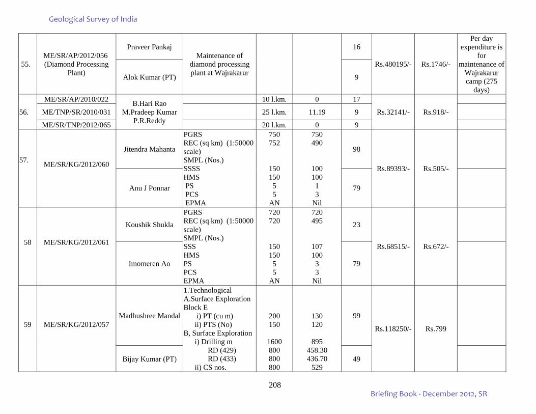
208
55. ME/SR/AP/2012/056 (Diamond Processing
Plant)
Praveer Pankaj Maintenance of
diamond processing plant at Wajrakarur
16
Rs.480195/- Rs.1746/-
Per day expenditure is
for maintenance of
Wajrakarur camp (275
days)
Alok Kumar (PT) 9
56.
ME/SR/AP/2010/022 B.Hari Rao M.Pradeep Kumar
P.R.Reddy
10 l.km. 0 17
Rs.32141/- Rs.918/-
ME/TNP/SR/2010/031 25 l.km. 11.19 9
ME/SR/TNP/2012/065 20 l.km. 0 9
57.
ME/SR/KG/2012/060
Jitendra Mahanta
PGRS REC (sq km) (1:50000 scale) SMPL (Nos.) SSSS HMS PS PCS EPMA
750 752
150 150 5 5
AN
750 490
100 100 1 3
Nil
98
Rs.89393/- Rs.505/-
Anu J Ponnar 79
58
ME/SR/KG/2012/061
Koushik Shukla
PGRS REC (sq km) (1:50000 scale) SMPL (Nos.) SSS HMS PS PCS EPMA
720 720
150 150 5 5
AN
720 495
107 100 3 3
Nil
23
Rs.68515/- Rs.672/-
Imomeren Ao 79
59
ME/SR/KG/2012/057
Madhushree Mandal
1.Technological A.Surface Exploration Block E i) PT (cu m) ii) PTS (No) B, Surface Exploration i) Drilling m RD (429) RD (433) ii) CS nos.
200 150
1600 800 800 800
130 120
895
458.30 436.70
529
99
Rs.118250/- Rs.799
Bijay Kumar (PT) 49
Geological Survey of India
Briefing Book - December 2012, SR
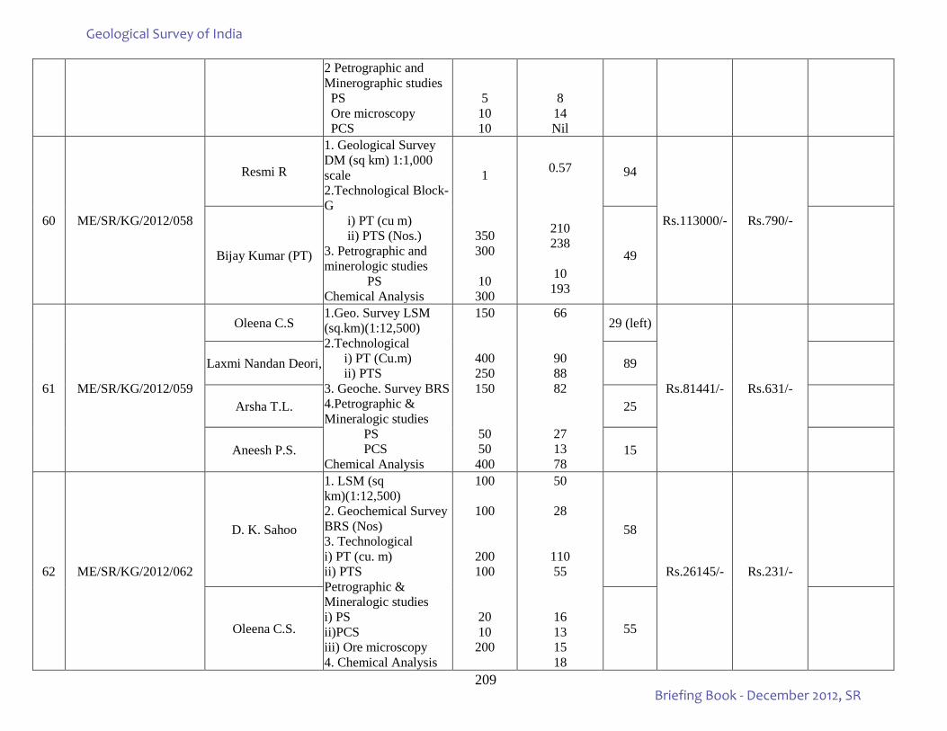
209
2 Petrographic and Minerographic studies PS Ore microscopy PCS
5 10 10
8 14 Nil
60 ME/SR/KG/2012/058
Resmi R
1. Geological Survey DM (sq km) 1:1,000 scale 2.Technological Block-G i) PT (cu m) ii) PTS (Nos.) 3. Petrographic and minerologic studies PS Chemical Analysis
1
350 300
10 300
0.57
210 238
10
193
94
Rs.113000/- Rs.790/-
Bijay Kumar (PT) 49
61 ME/SR/KG/2012/059
Oleena C.S 1.Geo. Survey LSM (sq.km)(1:12,500) 2.Technological i) PT (Cu.m) ii) PTS 3. Geoche. Survey BRS 4.Petrographic & Mineralogic studies PS PCS Chemical Analysis
150
400 250 150
50 50
400
66
90 88 82
27 13 78
29 (left)
Rs.81441/- Rs.631/-
Laxmi Nandan Deori, 89
Arsha T.L. 25
Aneesh P.S. 15
62 ME/SR/KG/2012/062
D. K. Sahoo
1. LSM (sq km)(1:12,500) 2. Geochemical Survey BRS (Nos) 3. Technological i) PT (cu. m) ii) PTS Petrographic & Mineralogic studies i) PS ii)PCS iii) Ore microscopy 4. Chemical Analysis
100
100
200 100
20 10
200
50
28
110 55
16 13 15 18
58
Rs.26145/- Rs.231/-
Oleena C.S. 55
Geological Survey of India
Briefing Book - December 2012, SR
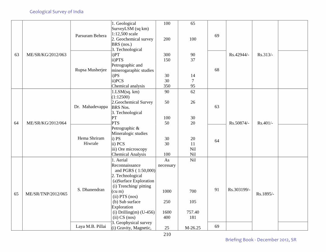
210
63 ME/SR/KG/2012/063
Parsuram Behera
1. Geological SurveyLSM (sq km) 1:12,500 scale 2. Geochemical survey BRS (nos.) 3. Technological i)PT ii)PTS Petrographic and minerogaraphic studies i)PS ii)PCS Chemical analysis
100
200
300 150
30 30
350
65
100
90 37
14 7
95
69
Rs.42944/- Rs.313/-
Rupsa Musherjee 68
64 ME/SR/KG/2012/064
Dr. Mahadevappa
1.LSM(sq. km) (1:12500) 2.Geochemical Survey BRS Nos. 3. Technological PT PTS Petrographic & Mineralogic studies i) PS ii) PCS iii) Ore microscopy Chemical Analysis
90
50
100 50
30 30
100
62
26
30 20
20 11 Nil Nil
63
Rs.50874/- Rs.401/-
Hema Shriram Hiwrale 64
65 ME/SR/TNP/2012/065 S. Dhanendran
1. Aerial Reconnaissance and PGRS ( 1:50,000) 2. Technological (a)Surface Exploration (i) Trenching/ pitting (cu m) (ii) PTS (nos) (b) Sub surface Exploration (i) Drilling(m) (U-456) (ii) CS (nos) 3. Geophysical survey (i) Gravity, Magnetic,
As necessary
1000
250
1600 400
25
Nil
700
105
757.40 181
M-26.25
91 Rs.303199/- Rs.1895/-
Laya M.B. Pillai 69
Geological Survey of India
Briefing Book - December 2012, SR
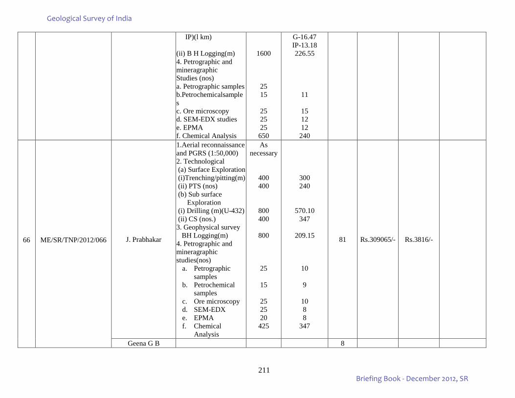
211
IP)(l km) (ii) B H Logging(m) 4. Petrographic and mineragraphic Studies (nos) a. Petrographic samples b.Petrochemicalsamples c. Ore microscopy d. SEM-EDX studies e. EPMA f. Chemical Analysis
1600
25 15
25 25 25
650
G-16.47 IP-13.18 226.55
11
15 12 12 240
66
ME/SR/TNP/2012/066
J. Prabhakar
1.Aerial reconnaissance and PGRS (1:50,000) 2. Technological (a) Surface Exploration (i)Trenching/pitting(m) (ii) PTS (nos) (b) Sub surface Exploration (i) Drilling (m)(U-432) (ii) CS (nos.) 3. Geophysical survey BH Logging(m) 4. Petrographic and mineragraphic studies(nos)
a. Petrographic samples
b. Petrochemical samples
c. Ore microscopy d. SEM-EDX e. EPMA f. Chemical
Analysis
As necessary
400 400
800 400
800
25
15
25 25 20
425
300 240
570.10 347
209.15
10
9
10 8 8
347
81 Rs.309065/- Rs.3816/-
Geena G B 8
Geological Survey of India
Briefing Book - December 2012, SR
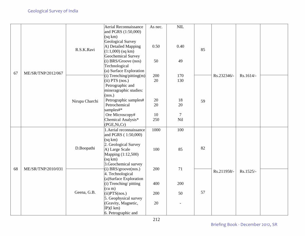
212
67
ME/SR/TNP/2012/067
R.S.K.Ravi
Aerial Reconnaissance and PGRS (1:50,000) (sq km) Geological Survey A) Detailed Mapping (1:1,000) (sq km) Geochemical Survey (i) BRS/Groove (nos) Technological (a) Surface Exploration (i) Trenching/pitting(m) (ii) PTS (nos.) Petrographic and mineragraphic studies: (nos.) Petrographic samples# Petrochemical samples#* Ore Microscopy# Chemical Analysis* (PGE,Ni,Cr)
As nec.
0.50
50
200 20
20 20
10 250
NIL
0.40
49
170 130
18 20
7 Nil
85
Rs.232346/- Rs.1614/-
Nirupa Charchi 59
68
ME/SR/TNP/2010/031
D.Boopathi
1.Aerial reconnaissance and PGRS ( 1:50,000) (sq km) 2. Geological Survey A) Large Scale Mapping (1:12,500) (sq km) 3.Geochemical survey (i) BRS/groove(nos.) 4. Technological (a)Surface Exploration (i) Trenching/ pitting (cu m) (ii)PTS(nos.) 5. Geophysical survey (Gravity, Magnetic, IP)(l km) 6. Petrographic and
1000
100
200
400
200
20
100
85
71
200
50 -
82
Rs.211958/- Rs.1525/-
Geena, G.B. 57
Geological Survey of India
Briefing Book - December 2012, SR
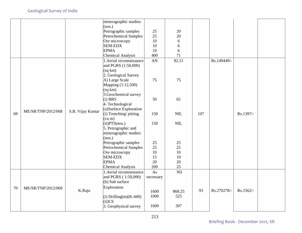
213
mineragraphic studies: (nos.) Petrographic samples Petrochemical Samples Ore microscopy SEM-EDX EPMA Chemical Analysis
25 25 10 10 10
400
20 20 6 6 6
71
69 ME/SR/TNP/2012/068
S.B. Vijay Kumar
1.Aerial reconnaissance and PGRS (1:50,000) (sq km) 2. Geological Survey A) Large Scale Mapping (1:12,500) (sq km) 3.Geochemical survey (i) BRS 4. Technological (a)Surface Exploration (i) Trenching/ pitting (cu m) (ii)PTS(nos.) 5. Petrographic and mineragraphic studies: (nos.) Petrographic samples Petrochemical Samples Ore microscopy SEM-EDX EPMA Chemical Analysis
AN
75
50
150
150
25 25 10 15 20
200
82.21
75
65
NIL
NIL
25 25 10 10 20 25
107
Rs.149449/-
Rs.1397/-
70
ME/SR/TNP/2012/069 K.Raju
1.Aerial reconnaissance and PGRS ( 1:50,000) (b) Sub surface Exploration
(i) Drilling(m)(K-449) (ii)CS 3. Geophysical survey
As necessary
1600 1000
1600
Nil
868.25 525
307
93 Rs.270278/- Rs.1562/-
Geological Survey of India
Briefing Book - December 2012, SR
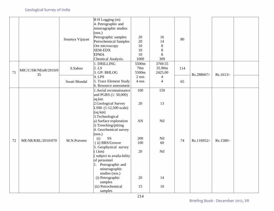
214
Soumya Vijayan
B H Logging (m) 4. Petrographic and mineragraphic studies (nos.) Petrographic samples Petrochemical Samples Ore microscopy SEM-EDX EPMA Chemical Analysis.
20 20 10 10 10
1000
16 14 8 8 8
309
80
71
MIC/C/SR/NEnR/2010/035
S.Sahoo 1. DRILLING 2. LS 3. GP: BHLOG 4. LPS 5. Trace Element Study 6. Resource assessment
5500m 70m
5500m 2 nos 4 nos
3769.55 35.90m 2425.00
4 4
114
Rs.288667/- Rs.1613/-
Swati Mondal 65
72 ME/SR/KRL/2010/070 M.N.Praveen
1.Aerial reconnaissance and PGRS (1: 50,000) sq.km 2.Geological Survey LSM: (1:12,500 scale) (sq km) 3.Technological a) Surface exploration i) Trenching/pitting 4. Geochemical survey (nos.)
(i) SS ( ii) BRS/Groove 5. Geophysical survey ( l.km) ( subject to availa-bility of personnel 1. Petrographic and
mineragraphic studies (nos.)
(i) Petrographic samples
(ii) Petrochemical samples
100
20
AN
200 100
20
20
15
150
13
Nil
Nil 60
Nil
14
10
74 Rs.116952/- Rs.1580/-
Geological Survey of India
Briefing Book - December 2012, SR
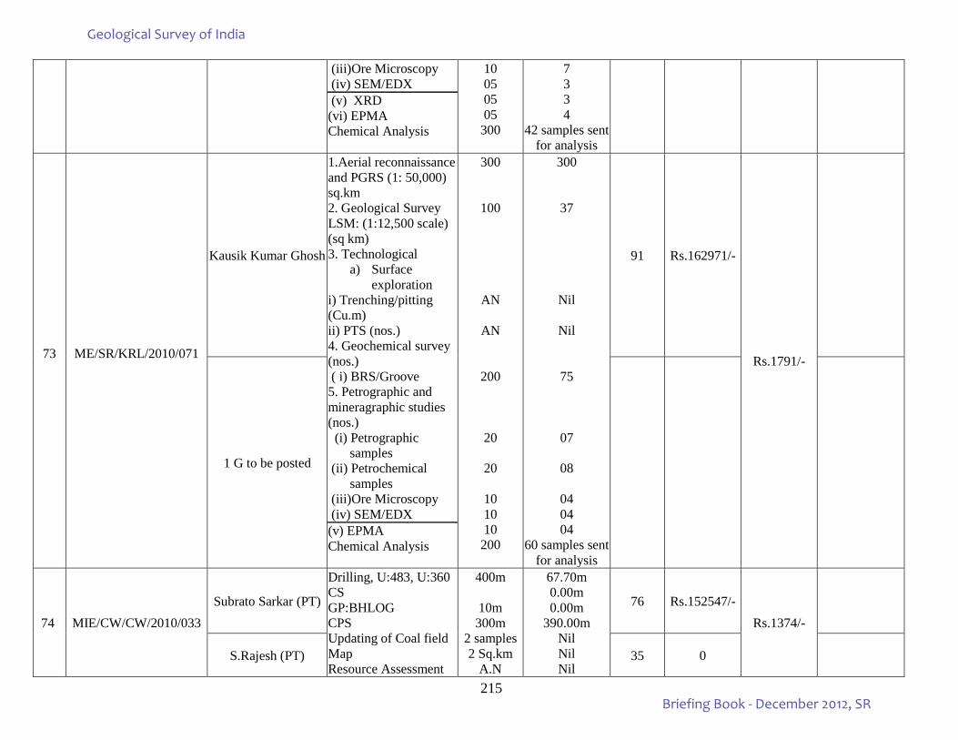
215
(iii)Ore Microscopy (iv) SEM/EDX (v) XRD (vi) EPMA Chemical Analysis
10 05 05 05
300
7 3 3 4
42 samples sent for analysis
73
ME/SR/KRL/2010/071
Kausik Kumar Ghosh
1.Aerial reconnaissance and PGRS (1: 50,000) sq.km 2. Geological Survey LSM: (1:12,500 scale) (sq km) 3. Technological
a) Surface exploration
i) Trenching/pitting (Cu.m) ii) PTS (nos.) 4. Geochemical survey (nos.) ( i) BRS/Groove 5. Petrographic and mineragraphic studies (nos.) (i) Petrographic
samples (ii) Petrochemical
samples (iii)Ore Microscopy (iv) SEM/EDX (v) EPMA Chemical Analysis
300
100
AN
AN
200
20
20
10 10 10
200
300
37
Nil
Nil
75
07
08
04 04 04
60 samples sent for analysis
91 Rs.162971/-
Rs.1791/-
1 G to be posted
74 MIE/CW/CW/2010/033 Subrato Sarkar (PT)
Drilling, U:483, U:360 CS GP:BHLOG CPS Updating of Coal field Map Resource Assessment
400m
10m 300m
2 samples 2 Sq.km
A.N
67.70m 0.00m 0.00m
390.00m Nil Nil Nil
76 Rs.152547/- Rs.1374/-
S.Rajesh (PT) 35 0
Geological Survey of India
Briefing Book - December 2012, SR
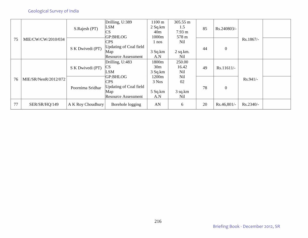
216
75 MIE/CW/CW/2010/034
S.Rajesh (PT) Drilling, U:389 LSM CS GP:BHLOG CPS Updating of Coal field Map Resource Assessment
1100 m 2 Sq.km
40m 1000m 1 nos
3 Sq.km
A.N
305.55 m 1.5
7.93 m 578 m
Nil
2 sq.km. Nil
85 Rs.240803/-
Rs.1867/-
S K Dwivedi (PT) 44 0
76 MIE/SR/NenR/2012/072
S K Dwivedi (PT) Drilling, U:483 CS LSM GP:BHLOG CPS Updating of Coal field Map Resource Assessment
1800m 30m
3 Sq.km 1200m 3 Nos
5 Sq.km
A.N
250.00 16.42 Nil Nil 02
3 sq.km Nil
49 Rs.11611/-
Rs.941/-
Poornima Sridhar 78 0
77 SER/SR/HQ/149 A K Roy Choudhury Borehole logging AN 6 20 Rs.46,801/- Rs.2340/-
Geological Survey of India
Briefing Book - December 2012, SR
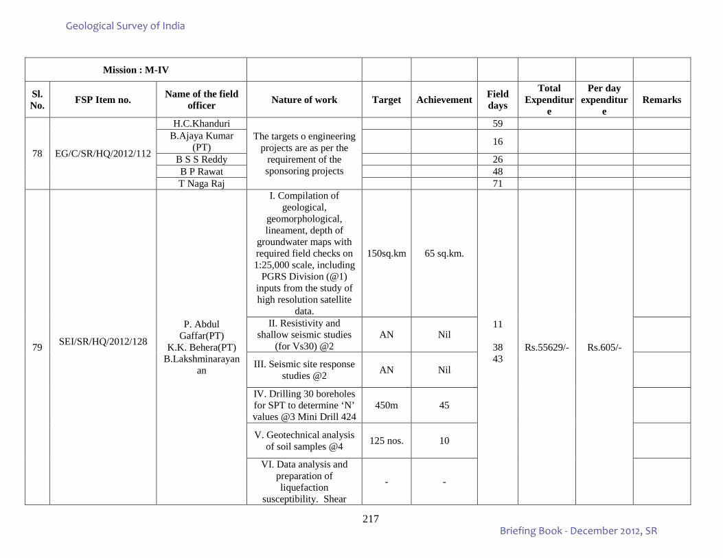
217
Mission : M-IV
Sl.No. FSP Item no. Name of the field
officer Nature of work Target Achievement Field days
Total Expenditur
e
Per day expenditur
e Remarks
78 EG/C/SR/HQ/2012/112
H.C.Khanduri The targets o engineering
projects are as per the requirement of the sponsoring projects
59 B.Ajaya Kumar
(PT) 16
B S S Reddy 26 B P Rawat 48 T Naga Raj 71
79 SEI/SR/HQ/2012/128
P. Abdul Gaffar(PT)
K.K. Behera(PT) B.Lakshminarayan
an
I. Compilation of geological,
geomorphological, lineament, depth of
groundwater maps with required field checks on 1:25,000 scale, including
PGRS Division (@1) inputs from the study of high resolution satellite
data.
150sq.km 65 sq.km.
11
38 43
Rs.55629/- Rs.605/-
II. Resistivity and shallow seismic studies
(for Vs30) @2 AN Nil
III. Seismic site response studies @2 AN Nil
IV. Drilling 30 boreholes for SPT to determine ‘N’ values @3 Mini Drill 424
450m 45
V. Geotechnical analysis of soil samples @4 125 nos. 10
VI. Data analysis and preparation of liquefaction
susceptibility. Shear
- -
Geological Survey of India
Briefing Book - December 2012, SR
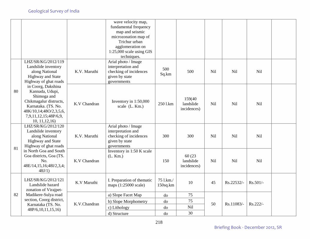
218
wave velocity map, fundamental frequency
map and seismic microzonation map of
Trichur urban agglomeration on
1:25,000 scale using GIS techniques.
80
LHZ/SR/KG/2012/119 Landslide inventory
along National Highway and State
Highway of ghat roads in Coorg, Dakshina Kannada, Udupi,
Shimoga and Chikmagalur distructs,
Karnataka. (TS. No. 48K/10,14;48O/2,3,5,6,7,9,11,12,15;48P/6,9,
10, 11,12,16)
K.V. Maruthi
Arial photo / Image interpretation and checking of incidences given by state governments
500 Sq.km 500 Nil Nil Nil
K.V Chandran Inventory in 1:50,000 scale (L. Km.) 250 l.km
159(40 landslide
incidences) Nil Nil Nil
81
LHZ/SR/KG/2012/120 Landslide inventory
along National Highway and State
Highway of ghat roads in North Goa and South Goa districts, Goa (TS.
No. 48E/14,15,16;48I/2,3,4;
48J/1)
K.V. Maruthi
Arial photo / Image interpretation and checking of incidences given by state governments
300 300 Nil Nil Nil
K.V Chandran
Inventory in 1:50 K scale (L. Km.)
150 60 (23
landslide incidences)
Nil Nil Nil
82
LHZ/SR/KG/2012/121 Landslide hazard
zonation of Virajpet-Madikere-Sulya road
section, Coorg district, Karnataka (TS. No. 48P/6,10,11,15,16)
K.V Maruthi I. Preparation of thematic maps (1:25000 scale)
75 l.km./ 150sq.km 10 45 Rs.22532/- Rs.501/-
K.V.Chandran
a) Slope Facet Map do 75
50 Rs.11083/- Rs.222/- b) Slope Morphometry do 75 c) Lithology do Nil d) Structure do 30
Geological Survey of India
Briefing Book - December 2012, SR
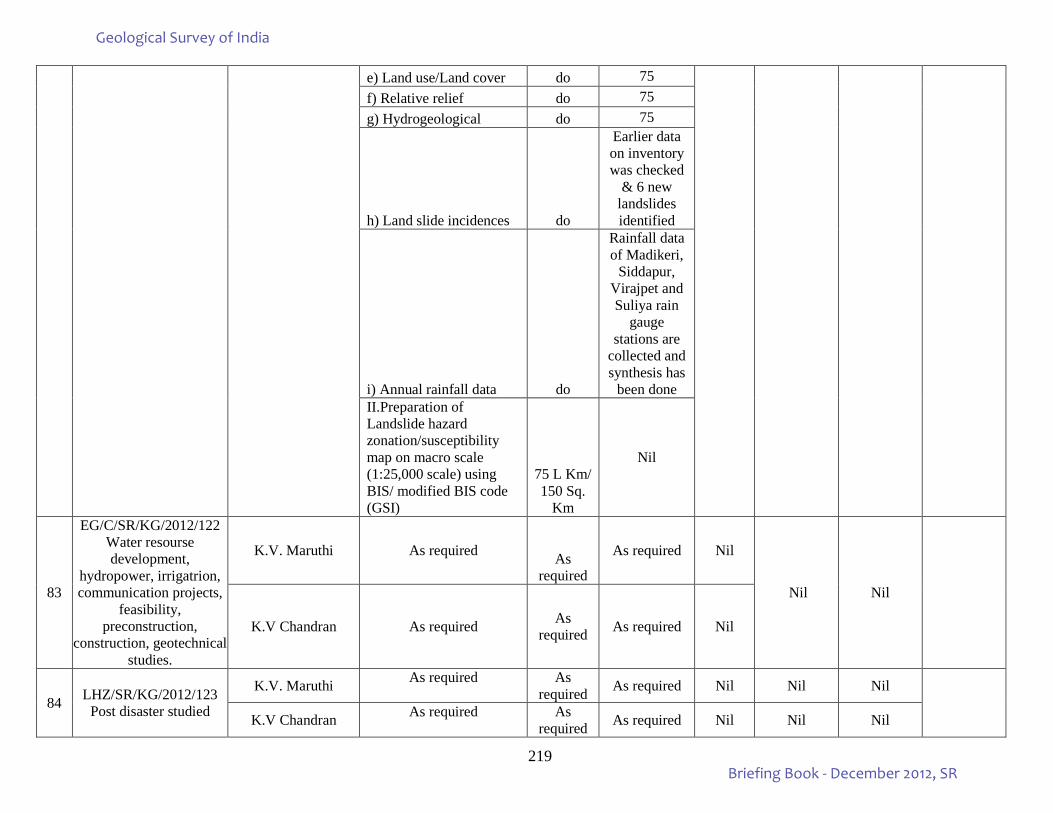
219
e) Land use/Land cover do 75 f) Relative relief do 75 g) Hydrogeological do 75
h) Land slide incidences do
Earlier data on inventory was checked
& 6 new landslides identified
i) Annual rainfall data do
Rainfall data of Madikeri,
Siddapur, Virajpet and Suliya rain
gauge stations are
collected and synthesis has
been done II.Preparation of Landslide hazard zonation/susceptibility map on macro scale (1:25,000 scale) using BIS/ modified BIS code (GSI)
75 L Km/ 150 Sq.
Km
Nil
83
EG/C/SR/KG/2012/122 Water resourse development,
hydropower, irrigatrion, communication projects,
feasibility, preconstruction,
construction, geotechnical studies.
K.V. Maruthi As required As required
As required Nil
Nil Nil
K.V Chandran As required As required As required Nil
84 LHZ/SR/KG/2012/123 Post disaster studied
K.V. Maruthi As required As required As required Nil Nil Nil
K.V Chandran As required As required As required Nil Nil Nil
Geological Survey of India
Briefing Book - December 2012, SR
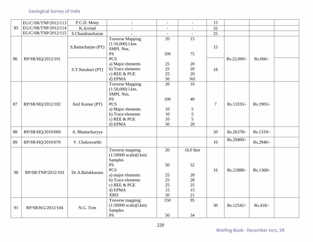
220
85 EG/C/SR/TNP/2012/113 EG/C/SR/TNP/2012/114 EG/C/SR/TNP/2012/115
P.C.D. Mony - - - 15 K.Arvind - - - 32
S.Chandrasekaran - - - 25
86 RP/SR/HQ/2012/101
S.Battacharjee (PT)
Traverse Mapping (1:50,000) l.km. SMPL Nos. PS PCS a) Major elements b) Trace elements c) REE & PGE d) EPMA
20
100
25 25 25 50
15
75
20 20 20 Nil
15
Rs.22,000/- Rs.666/-
S.T.Narahari (PT) 18
87 RP/SR/HQ/2012/102 Anil Kumar (PT)
Traverse Mapping (1:50,000) l.km. SMPL Nos. PS PCS a) Major elements b) Trace elements c) REE & PGE d) EPMA
20
100
10 10 10 50
10
40
5 5 5
20
7 Rs.13335/- Rs.1905/-
88 RP/SR/HQ/2010/069 A. Bhattacharyya 20 Rs.26378/- Rs.1319/-
89 RP/SR/HQ/2010/070 V. Chakravarthi 10 Rs.29400/- Rs.2940/-
90 RP/SR/TNP/2012/103 Dr.A.Balukkarasu
Traverse mapping (1:50000 scale)(l.km) Samples PS PCS a) major elements b) Trace elements c) REE & PGE d) EPMA XRD
20
50
25 25 25 15 20
16.0 lkm
52
28 28 25 15 21
16 Rs.21888/- Rs.1368/-
91 RP/SR/KG/2012/104 N.G. Tom
Traverse mapping (1:50000 scale)(l.km) Samples PS
150
50
95
34
30 Rs.12542/- Rs.418/-
Geological Survey of India
Briefing Book - December 2012, SR
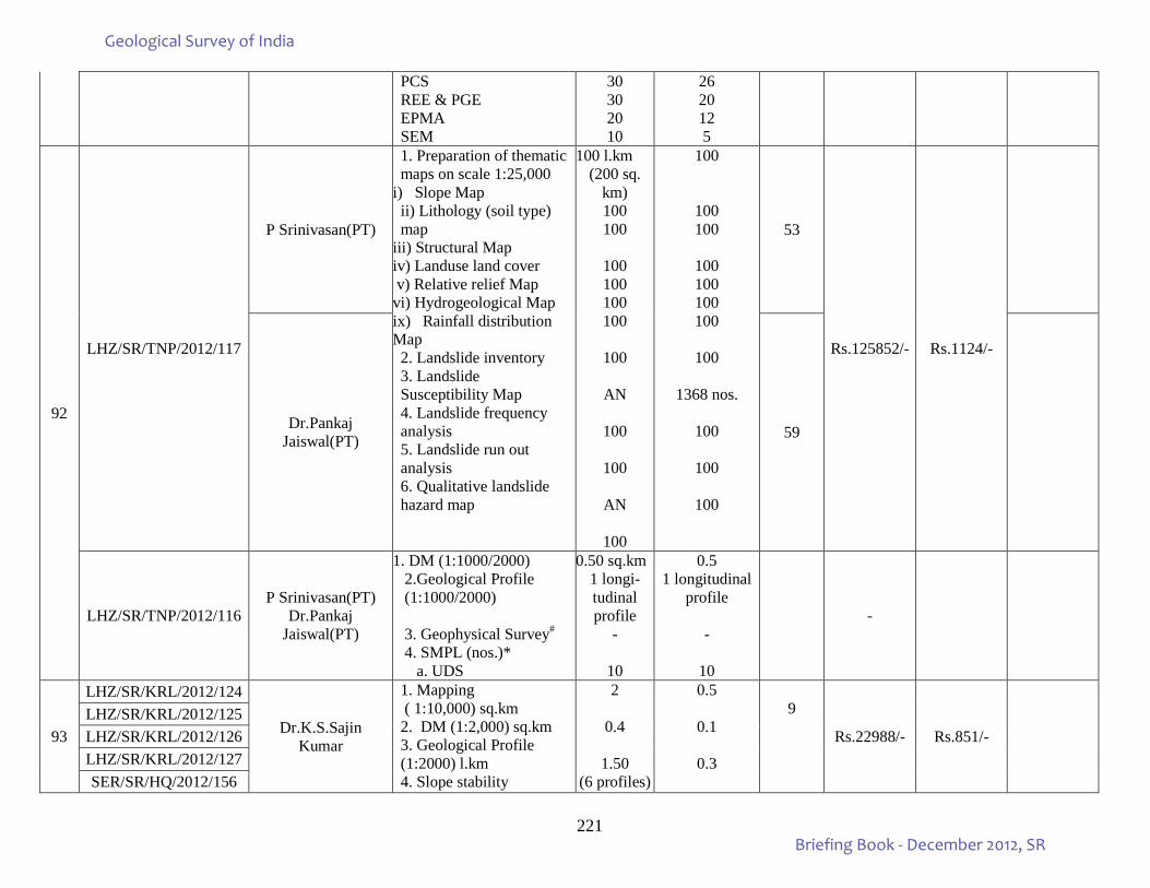
221
PCS REE & PGE EPMA SEM
30 30 20 10
26 20 12 5
92
LHZ/SR/TNP/2012/117
P Srinivasan(PT)
1. Preparation of thematic maps on scale 1:25,000
i) Slope Map ii) Lithology (soil type) map
iii) Structural Map iv) Landuse land cover v) Relative relief Map vi) Hydrogeological Map ix) Rainfall distribution Map 2. Landslide inventory 3. Landslide Susceptibility Map 4. Landslide frequency analysis 5. Landslide run out analysis 6. Qualitative landslide hazard map
100 l.km (200 sq.
km) 100 100
100 100 100 100
100
AN
100
100
AN
100
100
100 100
100 100 100 100
100
1368 nos.
100
100
100
53
Rs.125852/- Rs.1124/-
Dr.Pankaj Jaiswal(PT) 59
LHZ/SR/TNP/2012/116 P Srinivasan(PT)
Dr.Pankaj Jaiswal(PT)
1. DM (1:1000/2000) 2.Geological Profile (1:1000/2000)
3. Geophysical Survey# 4. SMPL (nos.)* a. UDS
0.50 sq.km 1 longi-tudinal profile
-
10
0.5 1 longitudinal
profile -
10
-
93
LHZ/SR/KRL/2012/124
Dr.K.S.Sajin Kumar
1. Mapping ( 1:10,000) sq.km 2. DM (1:2,000) sq.km 3. Geological Profile (1:2000) l.km 4. Slope stability
2
0.4
1.50 (6 profiles)
0.5
0.1
0.3
9
Rs.22988/- Rs.851/-
LHZ/SR/KRL/2012/125 LHZ/SR/KRL/2012/126 LHZ/SR/KRL/2012/127 SER/SR/HQ/2012/156
Geological Survey of India
Briefing Book - December 2012, SR
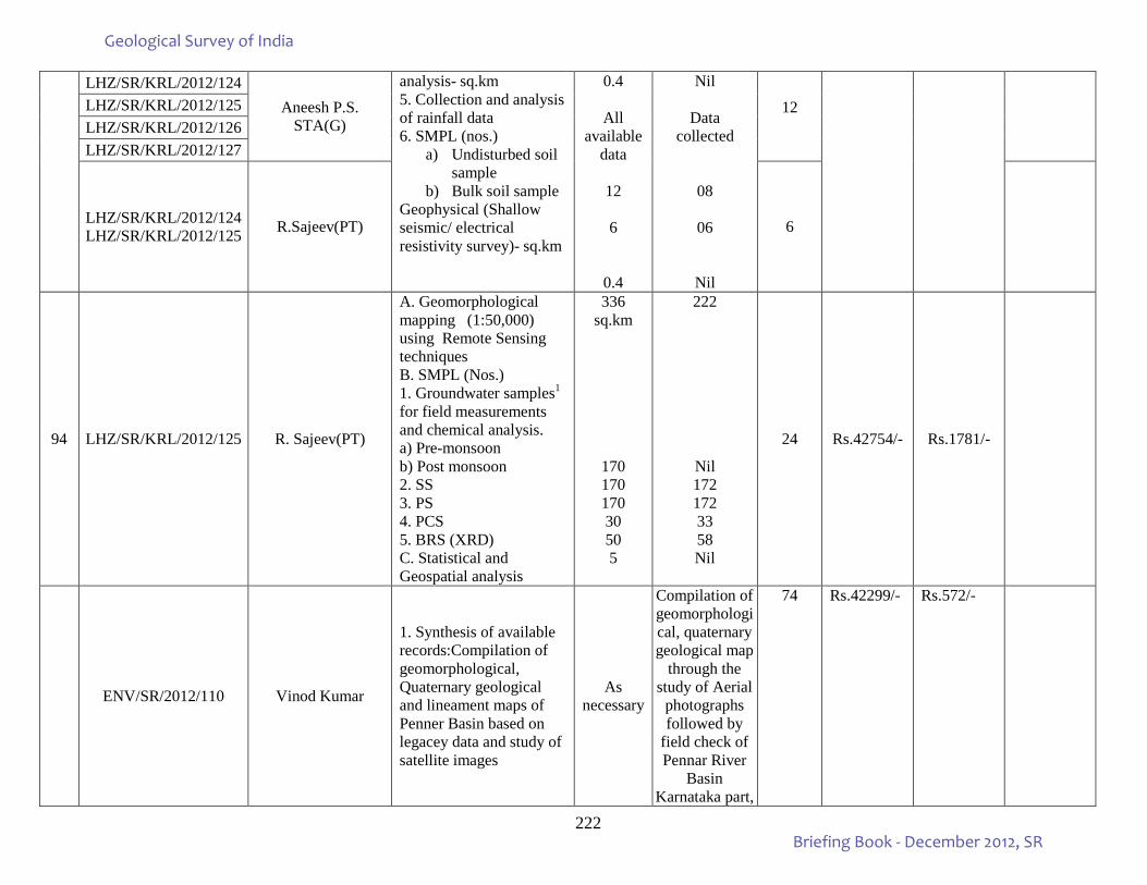
222
LHZ/SR/KRL/2012/124 Aneesh P.S.
STA(G)
analysis- sq.km 5. Collection and analysis of rainfall data 6. SMPL (nos.)
a) Undisturbed soil sample
b) Bulk soil sample Geophysical (Shallow seismic/ electrical resistivity survey)- sq.km
0.4
All available
data
12
6
0.4
Nil
Data collected
08
06
Nil
12
LHZ/SR/KRL/2012/125 LHZ/SR/KRL/2012/126 LHZ/SR/KRL/2012/127
LHZ/SR/KRL/2012/124 LHZ/SR/KRL/2012/125 R.Sajeev(PT) 6
94 LHZ/SR/KRL/2012/125 R. Sajeev(PT)
A. Geomorphological mapping (1:50,000) using Remote Sensing techniques B. SMPL (Nos.) 1. Groundwater samples1 for field measurements and chemical analysis. a) Pre-monsoon b) Post monsoon 2. SS 3. PS 4. PCS 5. BRS (XRD) C. Statistical and Geospatial analysis
336 sq.km
170 170 170 30 50 5
222
Nil 172 172 33 58 Nil
24 Rs.42754/- Rs.1781/-
ENV/SR/2012/110 Vinod Kumar
1. Synthesis of available records:Compilation of geomorphological, Quaternary geological and lineament maps of Penner Basin based on legacey data and study of satellite images
As necessary
Compilation of geomorphological, quaternary geological map
through the study of Aerial
photographs followed by
field check of Pennar River
Basin Karnataka part,
74 Rs.42299/- Rs.572/-
Geological Survey of India
Briefing Book - December 2012, SR
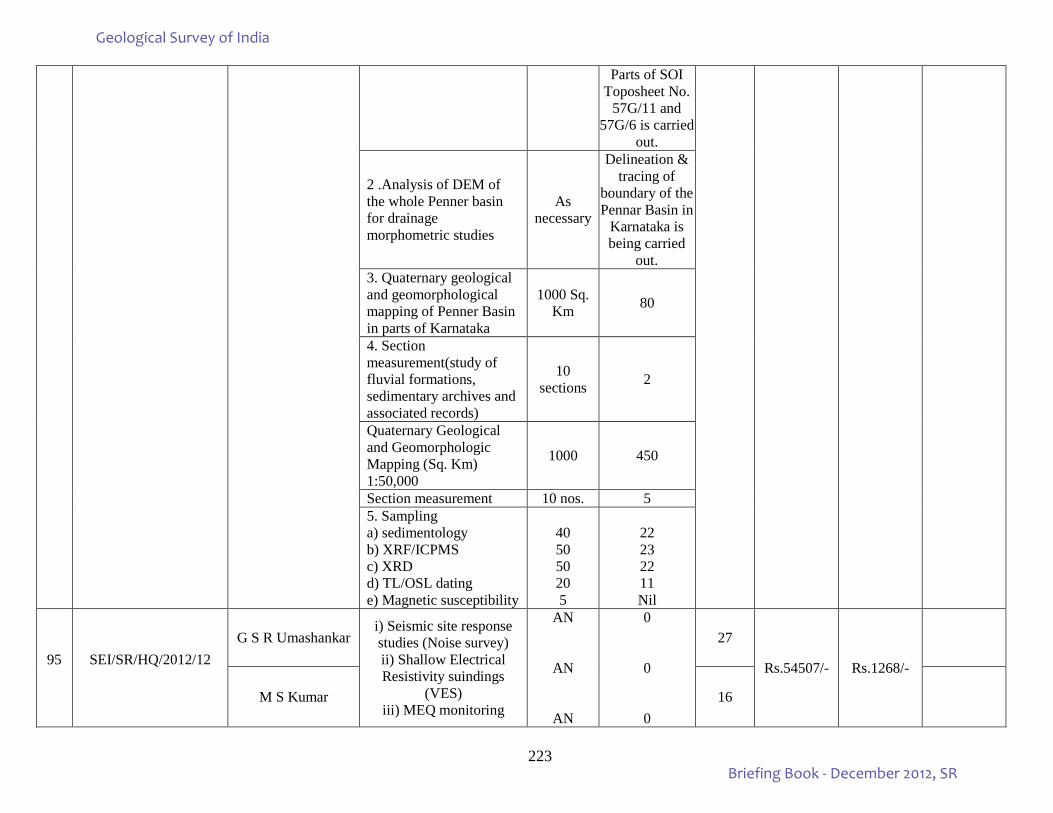
223
Parts of SOI Toposheet No.
57G/11 and 57G/6 is carried
out.
2 .Analysis of DEM of the whole Penner basin for drainage morphometric studies
As necessary
Delineation & tracing of
boundary of the Pennar Basin in
Karnataka is being carried
out. 3. Quaternary geological and geomorphological mapping of Penner Basin in parts of Karnataka
1000 Sq. Km 80
4. Section measurement(study of fluvial formations, sedimentary archives and associated records)
10 sections 2
Quaternary Geological and Geomorphologic Mapping (Sq. Km) 1:50,000
1000 450
Section measurement 10 nos. 5 5. Sampling a) sedimentology b) XRF/ICPMS c) XRD d) TL/OSL dating e) Magnetic susceptibility
40 50 50 20 5
22 23 22 11 Nil
95
SEI/SR/HQ/2012/12
G S R Umashankar i) Seismic site response studies (Noise survey) ii) Shallow Electrical Resistivity suindings
(VES) iii) MEQ monitoring
AN
AN
AN
0
0
0
27
Rs.54507/- Rs.1268/-
M S Kumar 16
Geological Survey of India
Briefing Book - December 2012, SR
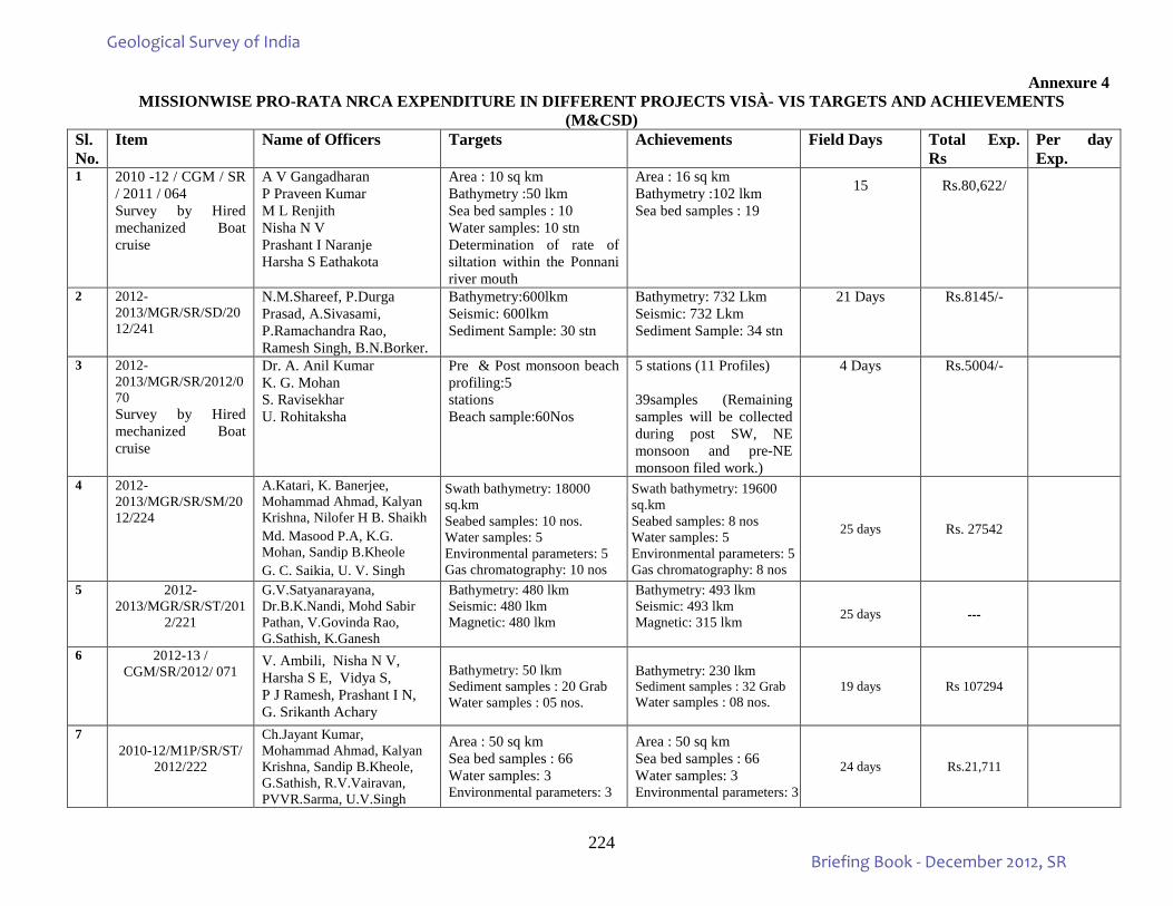
224
Annexure 4 MISSIONWISE PRO-RATA NRCA EXPENDITURE IN DIFFERENT PROJECTS VISÀ- VIS TARGETS AND ACHIEVEMENTS
(M&CSD) Sl. No.
Item Name of Officers Targets Achievements Field Days Total Exp. Rs
Per day Exp.
1 2010 -12 / CGM / SR / 2011 / 064 Survey by Hired mechanized Boat cruise
A V Gangadharan P Praveen Kumar M L Renjith Nisha N V Prashant I Naranje Harsha S Eathakota
Area : 10 sq km Bathymetry :50 lkm Sea bed samples : 10 Water samples: 10 stn Determination of rate of siltation within the Ponnani river mouth
Area : 16 sq km Bathymetry :102 lkm Sea bed samples : 19
15 Rs.80,622/
2 2012-2013/MGR/SR/SD/2012/241
N.M.Shareef, P.Durga Prasad, A.Sivasami, P.Ramachandra Rao, Ramesh Singh, B.N.Borker.
Bathymetry:600lkm Seismic: 600lkm Sediment Sample: 30 stn
Bathymetry: 732 Lkm Seismic: 732 Lkm Sediment Sample: 34 stn
21 Days Rs.8145/-
3 2012-2013/MGR/SR/2012/070 Survey by Hired mechanized Boat cruise
Dr. A. Anil Kumar K. G. Mohan S. Ravisekhar U. Rohitaksha
Pre & Post monsoon beach profiling:5 stations Beach sample:60Nos
5 stations (11 Profiles) 39samples (Remaining samples will be collected during post SW, NE monsoon and pre-NE monsoon filed work.)
4 Days Rs.5004/-
4 2012-2013/MGR/SR/SM/2012/224
A.Katari, K. Banerjee, Mohammad Ahmad, Kalyan Krishna, Nilofer H B. Shaikh Md. Masood P.A, K.G. Mohan, Sandip B.Kheole G. C. Saikia, U. V. Singh
Swath bathymetry: 18000 sq.km Seabed samples: 10 nos. Water samples: 5 Environmental parameters: 5 Gas chromatography: 10 nos
Swath bathymetry: 19600 sq.km Seabed samples: 8 nos Water samples: 5 Environmental parameters: 5 Gas chromatography: 8 nos
25 days Rs. 27542
5 2012-2013/MGR/SR/ST/201
2/221
G.V.Satyanarayana, Dr.B.K.Nandi, Mohd Sabir Pathan, V.Govinda Rao, G.Sathish, K.Ganesh
Bathymetry: 480 lkm Seismic: 480 lkm Magnetic: 480 lkm
Bathymetry: 493 lkm Seismic: 493 lkm Magnetic: 315 lkm
25 days ---
6 2012-13 / CGM/SR/2012/ 071
V. Ambili, Nisha N V, Harsha S E, Vidya S, P J Ramesh, Prashant I N, G. Srikanth Achary
Bathymetry: 50 lkm Sediment samples : 20 Grab Water samples : 05 nos.
Bathymetry: 230 lkm Sediment samples : 32 Grab Water samples : 08 nos.
19 days Rs 107294
7 2010-12/M1P/SR/ST/
2012/222
Ch.Jayant Kumar, Mohammad Ahmad, Kalyan Krishna, Sandip B.Kheole, G.Sathish, R.V.Vairavan, PVVR.Sarma, U.V.Singh
Area : 50 sq km Sea bed samples : 66 Water samples: 3 Environmental parameters: 3
Area : 50 sq km Sea bed samples : 66 Water samples: 3 Environmental parameters: 3
24 days Rs.21,711
Geological Survey of India
Briefing Book - December 2012, SR
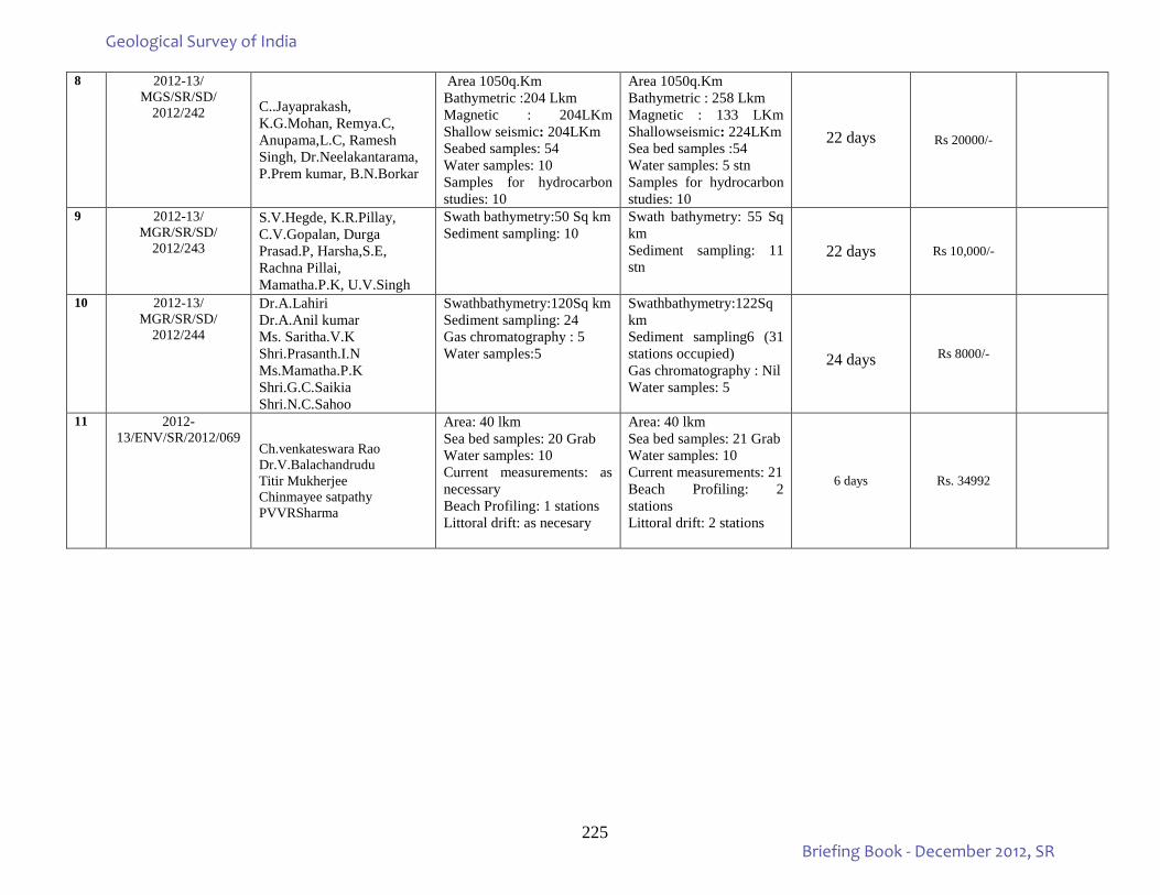
225
8 2012-13/ MGS/SR/SD/
2012/242
C..Jayaprakash, K.G.Mohan, Remya.C, Anupama,L.C, Ramesh Singh, Dr.Neelakantarama, P.Prem kumar, B.N.Borkar
Area 1050q.Km Bathymetric :204 Lkm Magnetic : 204LKm Shallow seismic: 204LKm Seabed samples: 54 Water samples: 10 Samples for hydrocarbon studies: 10
Area 1050q.Km Bathymetric : 258 Lkm Magnetic : 133 LKm Shallowseismic: 224LKm Sea bed samples :54 Water samples: 5 stn Samples for hydrocarbon studies: 10
22 days Rs 20000/-
9 2012-13/ MGR/SR/SD/
2012/243
S.V.Hegde, K.R.Pillay, C.V.Gopalan, Durga Prasad.P, Harsha,S.E, Rachna Pillai, Mamatha.P.K, U.V.Singh
Swath bathymetry:50 Sq km Sediment sampling: 10
Swath bathymetry: 55 Sq km Sediment sampling: 11 stn
22 days Rs 10,000/-
10 2012-13/ MGR/SR/SD/
2012/244
Dr.A.Lahiri Dr.A.Anil kumar Ms. Saritha.V.K Shri.Prasanth.I.N Ms.Mamatha.P.K Shri.G.C.Saikia Shri.N.C.Sahoo
Swathbathymetry:120Sq km Sediment sampling: 24 Gas chromatography : 5 Water samples:5
Swathbathymetry:122Sq km Sediment sampling6 (31 stations occupied) Gas chromatography : Nil Water samples: 5
24 days Rs 8000/-
11 2012-13/ENV/SR/2012/069
Ch.venkateswara Rao Dr.V.Balachandrudu Titir Mukherjee Chinmayee satpathy PVVRSharma
Area: 40 lkm Sea bed samples: 20 Grab Water samples: 10 Current measurements: as necessary Beach Profiling: 1 stations Littoral drift: as necesary
Area: 40 lkm Sea bed samples: 21 Grab Water samples: 10 Current measurements: 21 Beach Profiling: 2 stations Littoral drift: 2 stations
6 days Rs. 34992
Geological Survey of India
Briefing Book - December 2012, SR
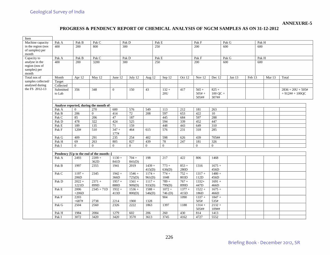
226
ANNEXURE-5 PROGRESS & PENDENCY REPORT OF CHEMICAL ANALYSIS OF NGCM SAMPLES AS ON 31-12-2012
Item Machine capacity in the region (nos of samples) per month
Pak A Pak B Pak C Pak D Pak E Pak F Pak G Pak H 400 200 800 300 250 200 600 600
Capacity to analyse in the region (nos of samples) per month
Pak A Pak B Pak C Pak D Pak E Pak F Pak G Pak H 400 200 3200 300 250 200 600 600
Total nos of samples collected/ analysed during the FS 2012-13
Month Apr 12 May 12 June 12 July 12 Aug 12 Sep 12 Oct 12 Nov 12 Dec 12 Jan 13 Feb 13 Mar 13 Total Target Collected Submitted to Lab
356 348 0 150 43 132 + 20U
417 565 + 505# + 505##
825 + 100 QC + 307##
2836 + 20U + 505# + 912## + 100QC
Analyse reported, during the month of- Pak A 0 270 600 576 549 113 212 181 263 Pak B 206 0 414 72 208 597 653 422 10 Pak C 85 206 47 187 445 684 597 288 Pak D 478 322 424 525 594 339 452 447 Pak E 189 135 71 159 448 443 649 310 Pak F 120# 510 347 +
177# 464 615 576 231 318 285
Pak G 409 291 235 254 402 598 626 439 705## Pak H 69 263 805 827 439 78 247 181 326 Pak I 0 0 0 0 0 0 0 0
Pendency [Up to the end of the month:-] Pak A 2493 2209 +
362D 1130 + 841D
704 + 841(D)
198 217 422 806 1468
Pak B 1997 2355 1941 2019 1439 + 415(D)
773 + 636(D)
853 + 280D
1316 1675 + 456D
Pak C 1197 + 206D
2345 1942 + 366D
1546 + 725(D)
1174 + 961(D)
774 + 1048
752 + 803D
1317 + 112D
1480 + 456D
Pak D 2022 + 1221D
2371 + 899D
1957 + 888D
1561 + 909(D)
1117 + 933(D)
789 + 799(D)
767 + 899D
1332+ 447D
1691 + 466D
Pak E 2006 +206D
2345 + 71D 1932 + 413D
1536 + 800(D)
1588 + 546(D)
1072 + 746 (D)
1377 + 415D
1522 + 186D
1675 + 466D
Pak F 2203 +687#
2738
2214
1900
1328
904 1090 1337 + 505#
1847 + 535#
Pak G 2504 2560 2326 2222 1863 1397 1188 1314 + 505##
2132 + 109##
Pak H 1984 2084 1279 602 206 260 430 814 1413 Pak I 3072 3420 3420 3570 3613 3745 4162 4727 5552
Geological Survey of India
Briefing Book - December 2012, SR
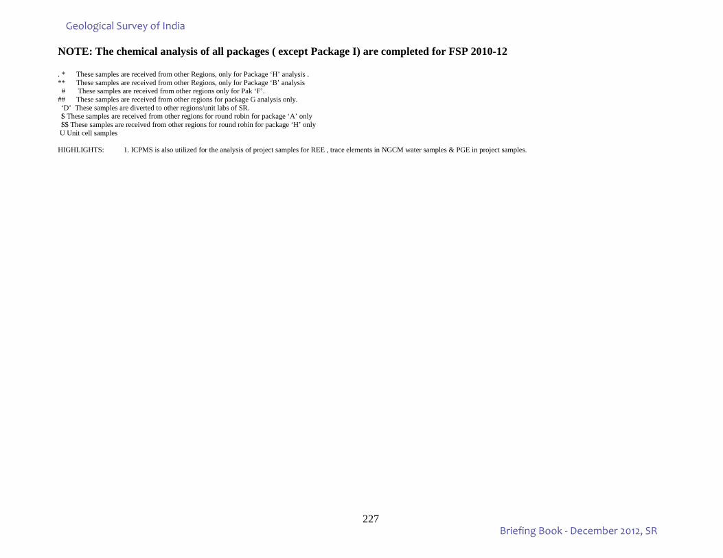
227
NOTE: The chemical analysis of all packages ( except Package I) are completed for FSP 2010-12 . * These samples are received from other Regions, only for Package ‘H’ analysis . ** These samples are received from other Regions, only for Package ‘B’ analysis # These samples are received from other regions only for Pak ‘F’. ## These samples are received from other regions for package G analysis only. ‘D’ These samples are diverted to other regions/unit labs of SR. $ These samples are received from other regions for round robin for package ‘A’ only $$ These samples are received from other regions for round robin for package ‘H’ only
U Unit cell samples HIGHLIGHTS: 1. ICPMS is also utilized for the analysis of project samples for REE , trace elements in NGCM water samples & PGE in project samples.
Geological Survey of India
Briefing Book - December 2012, SR
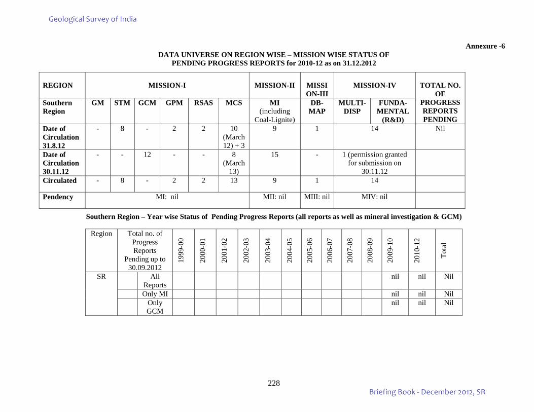
228
Annexure -6
DATA UNIVERSE ON REGION WISE – MISSION WISE STATUS OF PENDING PROGRESS REPORTS for 2010-12 as on 31.12.2012
Southern Region – Year wise Status of Pending Progress Reports (all reports as well as mineral investigation & GCM)
REGION
MISSION-I
MISSION-II
MISSION-III
MISSION-IV
TOTAL NO.
OF PROGRESS REPORTS PENDING
Southern Region
GM STM GCM GPM RSAS MCS MI (including
Coal-Lignite)
DB-MAP
MULTI- DISP
FUNDA-MENTAL
(R&D) Date of Circulation 31.8.12
- 8 - 2 2 10 (March 12) + 3
9 1 14 Nil
Date of Circulation 30.11.12
- - 12 - - 8 (March
13)
15 - 1 (permission granted for submission on
30.11.12
Circulated - 8 - 2 2 13 9 1 14
Pendency MI: nil MII: nil MIII: nil MIV: nil
Region Total no. of Progress Reports
Pending up to 30.09.2012
1999
-00
2000
-01
2001
-02
2002
-03
2003
-04
2004
-05
2005
-06
2006
-07
2007
-08
2008
-09
2009
-10
2010
-12
Tota
l
SR All Reports
nil nil Nil
Only MI nil nil Nil
Only GCM
nil nil Nil
Geological Survey of India
Briefing Book - December 2012, SR
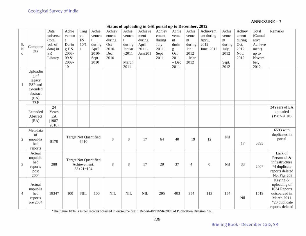
229
ANNEXURE – 7 Status of uploading in GSI portal up to December, 2012
S. No
Components
Data universe (total vol. of data) in SR Library
Achievement During F.S 2008-09 & 2009-10
Target FS 10/11
Achievement during April 2010- Sept 2010
Achievement during Oct 2010- Dec 2010
Achievement during January2011- March 2011
Achievement during April 2011 - June2011
Achievement during July 2011 – Sept 2011
Achievement during Oct 2011 – Dec 2011
Achievement during Jan 2012 – Mar 2012
Achievement during April, 2012 – June, 2012
Achievement during July, 2012 – Sept, 2012
Achievement during Oct, 2012 – Nov, 2012
Total (Cumulative Achievement) up to November, 2012
Remarks
1
Uploading of
legacy FSP and extended abstract
(EA)
FSP
Extended Abstract
(EA)
24 Years EA
(1987-2010)
24Years of EA uploaded
(1987-2010)
2
Metadata of
unpublished
reports
8178
Target Not Quantified 6410 8 8 17 64 40 19 12 Nil
17
6593
6593 with duplicates in
portal
3
Actual unpublis
hed reports
post 2004
288 Target Not Quantified
Achievement: 83+21=104
8 8 17 29 37 4 0 Nil 33
240*
Lack of Personnel & infrastructure *4 duplicate
reports deleted Net Fig. 203
4
Actual unpublis
hed reports
pre 2004
1834* 100 NIL 100 NIL NIL NIL 295 403 354 113 154
Nil 1519
Keying & uploading of 1634 Reports outsourced in March 2011
*20 duplicate reports deleted
*The figure 1834 is as per records obtained in outsource file: 1 Report/48/PD/SR/2009 of Publication Division, SR.
Geological Survey of India
Briefing Book - December 2012, SR
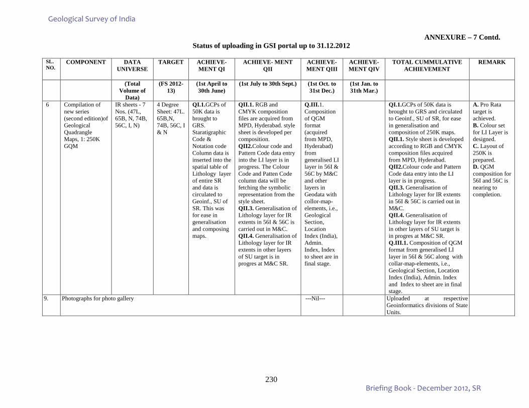
230
ANNEXURE – 7 Contd. Status of uploading in GSI portal up to 31.12.2012
SL. NO.
COMPONENT DATA UNIVERSE
TARGET ACHIEVE- MENT QI
ACHIEVE- MENT QII
ACHIEVE-MENT QIII
ACHIEVE- MENT QIV
TOTAL CUMMULATIVE ACHIEVEMENT
REMARK
(Total Volume of
Data)
(FS 2012-13)
(1st April to 30th June)
(1st July to 30th Sept.) (1st Oct. to 31st Dec.)
(1st Jan. to 31th Mar.)
6 Compilation of new series (second edition)of Geological Quadrangle Maps, 1: 250K GQM
IR sheets - 7 Nos. (47L, 65B, N, 74B, 56C, I, N)
4 Degree Sheet: 47L. 65B,N, 74B, 56C, I & N
QI.1.GCPs of 50K data is brought to GRS. Staratigraphic Code & Notation code Column data is inserted into the spatial table of Lithology layer of entire SR and data is circulated to Geoinf., SU of SR. This was for ease in generalisation and composing maps.
QII.1. RGB and CMYK composition files are acquired from MPD, Hyderabad. style sheet is developed per composition. QII2.Colour code and Pattern Code data entry into the LI layer is in progress. The Colour Code and Patten Code column data will be fetching the symbolic representation from the style sheet. QII.3. Generalisation of Lithology layer for IR extents in 56I & 56C is carried out in M&C. QII.4. Generalisation of Lithology layer for IR extents in other layers of SU target is in progres at M&C SR.
Q.III.1. Composition of QGM format (acquired from MPD, Hyderabad) from generalised LI layer in 56I & 56C by M&C and other layers in Geodata with collor-map-elements, i.e., Geological Section, Location Index (India), Admin. Index, Index to sheet are in final stage.
QI.1.GCPs of 50K data is brought to GRS and circulated to Geoinf., SU of SR, for ease in generalisation and composition of 250K maps. QII.1. Style sheet is developed according to RGB and CMYK composition files acquired from MPD, Hyderabad. QII2.Colour code and Pattern Code data entry into the LI layer is in progress. QII.3. Generalisation of Lithology layer for IR extents in 56I & 56C is carried out in M&C. QII.4. Generalisation of Lithology layer for IR extents in other layers of SU target is in progres at M&C SR. Q.III.1. Composition of QGM format from generalised LI layer in 56I & 56C along with collar-map-elements, i.e., Geological Section, Location Index (India), Admin. Index and Index to sheet are in final stage.
A. Pro Rata target is achieved. B. Colour set for LI Layer is designed. C. Layout of 250K is prepared. D. QGM composition for 56I and 56C is nearing to completion.
9. Photographs for photo gallery ---Nil--- Uploaded at respective Geoinformatics divisions of State Units.
Geological Survey of India
Briefing Book - December 2012, SR
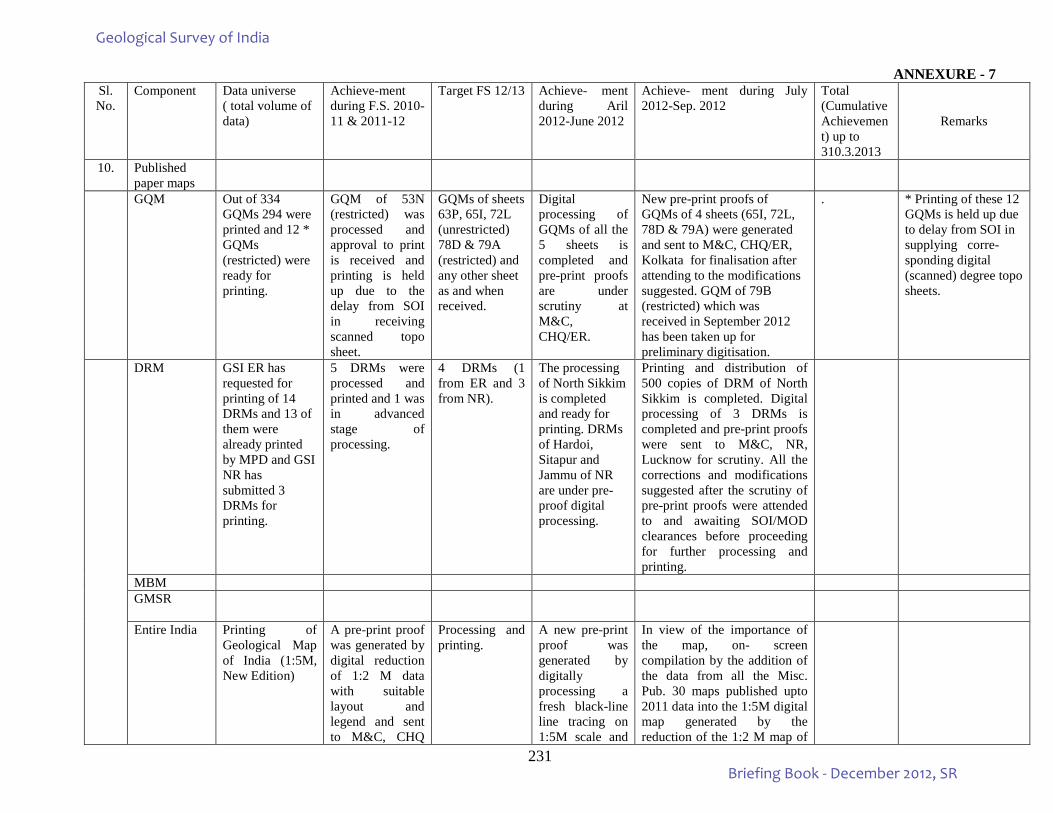
231
ANNEXURE - 7 Sl. No.
Component Data universe ( total volume of data)
Achieve-ment during F.S. 2010-11 & 2011-12
Target FS 12/13 Achieve- ment during Aril 2012-June 2012
Achieve- ment during July 2012-Sep. 2012
Total (Cumulative Achievement) up to 310.3.2013
Remarks
10. Published paper maps
GQM Out of 334 GQMs 294 were printed and 12 * GQMs (restricted) were ready for printing.
GQM of 53N (restricted) was processed and approval to print is received and printing is held up due to the delay from SOI in receiving scanned topo sheet.
GQMs of sheets 63P, 65I, 72L (unrestricted) 78D & 79A (restricted) and any other sheet as and when received.
Digital processing of GQMs of all the 5 sheets is completed and pre-print proofs are under scrutiny at M&C, CHQ/ER.
New pre-print proofs of GQMs of 4 sheets (65I, 72L, 78D & 79A) were generated and sent to M&C, CHQ/ER, Kolkata for finalisation after attending to the modifications suggested. GQM of 79B (restricted) which was received in September 2012 has been taken up for preliminary digitisation.
. * Printing of these 12 GQMs is held up due to delay from SOI in supplying corre- sponding digital (scanned) degree topo sheets.
DRM GSI ER has requested for printing of 14 DRMs and 13 of them were already printed by MPD and GSI NR has submitted 3 DRMs for printing.
5 DRMs were processed and printed and 1 was in advanced stage of processing.
4 DRMs (1 from ER and 3 from NR).
The processing of North Sikkim is completed and ready for printing. DRMs of Hardoi, Sitapur and Jammu of NR are under pre-proof digital processing.
Printing and distribution of 500 copies of DRM of North Sikkim is completed. Digital processing of 3 DRMs is completed and pre-print proofs were sent to M&C, NR, Lucknow for scrutiny. All the corrections and modifications suggested after the scrutiny of pre-print proofs were attended to and awaiting SOI/MOD clearances before proceeding for further processing and printing.
MBM GMSR
Entire India Printing of Geological Map of India (1:5M, New Edition)
A pre-print proof was generated by digital reduction of 1:2 M data with suitable layout and legend and sent to M&C, CHQ
Processing and printing.
A new pre-print proof was generated by digitally processing a fresh black-line line tracing on 1:5M scale and
In view of the importance of the map, on- screen compilation by the addition of the data from all the Misc. Pub. 30 maps published upto 2011 data into the 1:5M digital map generated by the reduction of the 1:2 M map of
Geological Survey of India
Briefing Book - December 2012, SR
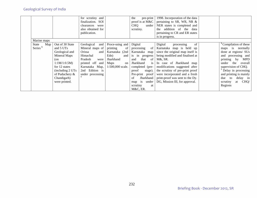
232
for scrutiny and finalization. SOI clearances were also obtained for publication.
the pre-print proof is at M&C CHQ under scrutiny.
1998. Incorporation of the data pertaining to SR, WR, NR & NER states is completed and the addition of the data pertaining to CR and ER states is in progress.
Marine maps State Map Series $
Out of 30 State and 5 UTs Geological and Mineral Maps (on 1:1M/1:0.5M) for 12 states (including 2 UTs of Puduchery & Chandigarh) were printed.
Geological and Mineral maps of Orissa and Himachal Pradesh were printed off and Karnataka Map, 2nd Edition is under processing †
Proce-ssing and printing of Karnataka (2nd Edn) and Jharkhand Maps on 1:500,000 scale.
Digital processing of Karnataka map is in progress and that of Jharkhand is completed (pre-proof stage). Pre-print proof of Jharkhand map is under scrutiny at M&C, ER.
Digital processing of Karnataka map is held up since the original map itself is being modified and finalised at M&, SR. In case of Jharkhand map modifications suggested after the scrutiny of pre-print proof were incorporated and a fresh print-proof was sent to the Dy. DG, Mission III, for approval.
$ Compilation of these
maps is normally done at regions/ SUs and processing and printing by MPD under the overall supervision of CHQ. † Delay in processing and printing is mainly due to delay in scrutiny at CHQ/ Regions
Geological Survey of India
Briefing Book - December 2012, SR
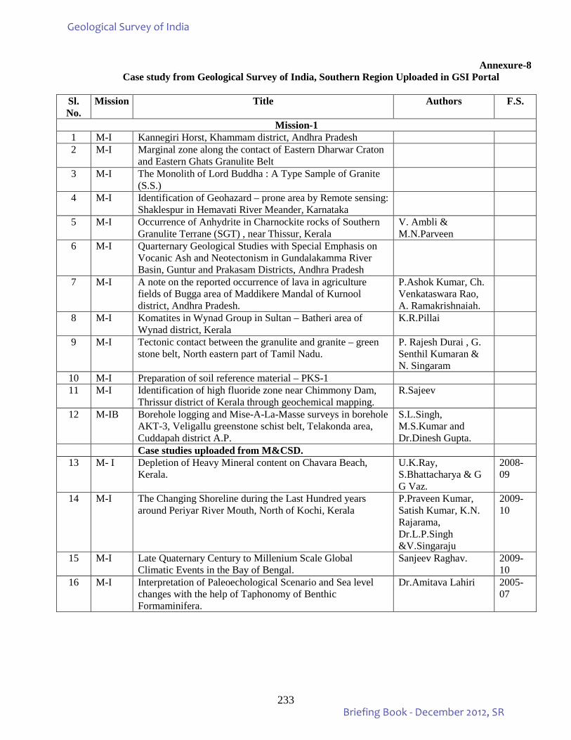
233
Annexure-8 Case study from Geological Survey of India, Southern Region Uploaded in GSI Portal
Sl. No.
Mission Title Authors F.S.
Mission-1 1 M-I Kannegiri Horst, Khammam district, Andhra Pradesh 2 M-I Marginal zone along the contact of Eastern Dharwar Craton
and Eastern Ghats Granulite Belt
3 M-I The Monolith of Lord Buddha : A Type Sample of Granite (S.S.)
4 M-I Identification of Geohazard – prone area by Remote sensing: Shaklespur in Hemavati River Meander, Karnataka
5 M-I Occurrence of Anhydrite in Charnockite rocks of Southern Granulite Terrane (SGT) , near Thissur, Kerala
V. Ambli & M.N.Parveen
6 M-I Quarternary Geological Studies with Special Emphasis on Vocanic Ash and Neotectonism in Gundalakamma River Basin, Guntur and Prakasam Districts, Andhra Pradesh
7 M-I A note on the reported occurrence of lava in agriculture fields of Bugga area of Maddikere Mandal of Kurnool district, Andhra Pradesh.
P.Ashok Kumar, Ch. Venkataswara Rao, A. Ramakrishnaiah.
8 M-I Komatites in Wynad Group in Sultan – Batheri area of Wynad district, Kerala
K.R.Pillai
9 M-I Tectonic contact between the granulite and granite – green stone belt, North eastern part of Tamil Nadu.
P. Rajesh Durai , G. Senthil Kumaran & N. Singaram
10 M-I Preparation of soil reference material – PKS-1 11 M-I Identification of high fluoride zone near Chimmony Dam,
Thrissur district of Kerala through geochemical mapping. R.Sajeev
12 M-IB Borehole logging and Mise-A-La-Masse surveys in borehole AKT-3, Veligallu greenstone schist belt, Telakonda area, Cuddapah district A.P.
S.L.Singh, M.S.Kumar and Dr.Dinesh Gupta.
Case studies uploaded from M&CSD. 13 M- I Depletion of Heavy Mineral content on Chavara Beach,
Kerala. U.K.Ray, S.Bhattacharya & G G Vaz.
2008-09
14 M-I The Changing Shoreline during the Last Hundred years around Periyar River Mouth, North of Kochi, Kerala
P.Praveen Kumar, Satish Kumar, K.N. Rajarama, Dr.L.P.Singh &V.Singaraju
2009-10
15 M-I Late Quaternary Century to Millenium Scale Global Climatic Events in the Bay of Bengal.
Sanjeev Raghav. 2009-10
16 M-I Interpretation of Paleoechological Scenario and Sea level changes with the help of Taphonomy of Benthic Formaminifera.
Dr.Amitava Lahiri 2005-07
Geological Survey of India
Briefing Book - December 2012, SR
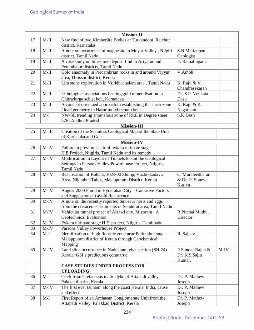
234
Mission-1I
17 M-II New find of two Kimberlite Bodies at Turkandoni, Raichur district, Karnataka
18 M-II A note on occurrence of magnesite in Moyar Valley , Nilgiri district, Tamil Nadu
S.N.Mariappan, Geologist
19 M-II A case study on limestone deposit find in Ariyalur and Perambalur districts, Tamil Nadu
E. Ramalingam
20 M-II Gold anaomaly in Precambrian rocks in and around Viyyur area, Thrissur district, Kerala
V.Ambli
21 M-II Lim stone exploration in Vriddhachalam area , Tamil Nadu K. Raju & V. Chandrasekaran
22 M-II Lithological associations hosting gold mineralisation in Chitradurga schist belt, Karnataka
Dr. S.P. Venkata Dasu
23 M-II A concept orientaed approach in establishing the shear zone / load geometry in Harur molybdenum belt.
K. Raju & K. Nagarajan
24 M-I NW-SE trending anomalous zone of REE in Degree sheet 57E, Andhra Pradesh
S.K.Dash
Mission-1II 25 M-III Creation of the Seamless Geological Map of the State Unit
of Karnataka and Goa
Mission-1V 26 M-IV Failure in pressure shaft of pykara ultimate stage
H.E.Project, Nilgiris, Tamil Nadu and its remedy
27 M-IV Modification in Layout of Tunnels to suit the Geological Settings in Parsons Valley Powerhouse Project, Nilgiris, Tamil Nadu
28 M-IV Reactivation of Kallala, 102/800 Slump, Vazhikkadavu Area, Nilambur Taluk, Malappuram District, Kerala
C. Muraleedharan & Dr. P. Soney Kurien
29 M-IV August 2000 Flood in Hyderabad City – Causative Factors and Suggestions to avoid Recurrence
30 M-IV A note on the recently reported dinosaur nests and eggs from the cretaceous sediments of Sendurai area, Tamil Nadu
31 M-IV Vehicular tunnel project of Aizawl city, Mizoram : A Geotechnical Evaluation
R.Pitchai Muthu, Director
32 M-IV Pykara ultimate stage H.E. project, Nilgiris, Tamilnadu 33 M-IV Parsons Valley Powerhouse Project 34 M-I Identification of high fluoride zone near Perintalmanna,
Malappuram district of Kerala through Geochemical Mapping
R. Sajeev
35 M-IV Land slide occurrence in Nadukanni ghat section (SH-24) Kerala: GSI’s predictions come true.
P.Sundar Rajan & Dr. K.S.Sajin Kumar.
M-IV
CASE STUDIES UNDER PROCESS FOR UPLOADING:
36 M-I Oceli from Cretaceous mafic dyke of Attapadi valley, Palakal district, Kerala
Dr. P. Mathew Joseph
37 M-IV The first ever tsunami along the coast Kerala, India, cause and effect.
Dr. P. Mathew Joseph
38 M-I First Report of an Archaean Conglomerate Unit from the Attapadi Valley, Palakkad District, Kerala
Dr. P. Mathew Joseph
Geological Survey of India
Briefing Book - December 2012, SR
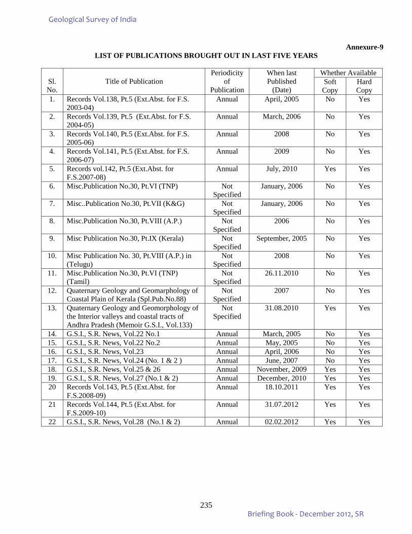
235
Annexure-9 LIST OF PUBLICATIONS BROUGHT OUT IN LAST FIVE YEARS
Sl. No.
Title of Publication
Periodicity of
Publication
When last Published
(Date)
Whether Available Soft
Copy Hard Copy
1. Records Vol.138, Pt.5 (Ext.Abst. for F.S. 2003-04)
Annual April, 2005 No Yes
2. Records Vol.139, Pt.5 (Ext.Abst. for F.S. 2004-05)
Annual March, 2006 No Yes
3. Records Vol.140, Pt.5 (Ext.Abst. for F.S. 2005-06)
Annual 2008 No Yes
4. Records Vol.141, Pt.5 (Ext.Abst. for F.S. 2006-07)
Annual 2009 No Yes
5. Records vol.142, Pt.5 (Ext.Abst. for F.S.2007-08)
Annual July, 2010 Yes Yes
6. Misc.Publication No.30, Pt.VI (TNP) Not Specified
January, 2006 No Yes
7. Misc..Publication No.30, Pt.VII (K&G) Not Specified
January, 2006 No Yes
8. Misc.Publication No.30, Pt.VIII (A.P.) Not Specified
2006 No Yes
9. Misc Publication No.30, Pt.IX (Kerala) Not Specified
September, 2005 No Yes
10. Misc Publication No. 30, Pt.VIII (A.P.) in (Telugu)
Not Specified
2008 No Yes
11. Misc.Publication No.30, Pt.VI (TNP) (Tamil)
Not Specified
26.11.2010 No Yes
12. Quaternary Geology and Geomarphology of Coastal Plain of Kerala (Spl.Pub.No.88)
Not Specified
2007 No Yes
13. Quaternary Geology and Geomorphology of the Interior valleys and coastal tracts of Andhra Pradesh (Memoir G.S.I., Vol.133)
Not Specified
31.08.2010 Yes Yes
14. G.S.I., S.R. News, Vol.22 No.1 Annual March, 2005 No Yes 15. G.S.I., S.R. News, Vol.22 No.2 Annual May, 2005 No Yes 16. G.S.I., S.R. News, Vol.23 Annual April, 2006 No Yes 17. G.S.I., S.R. News, Vol.24 (No. 1 & 2 ) Annual June, 2007 No Yes 18. G.S.I., S.R. News, Vol.25 & 26 Annual November, 2009 Yes Yes 19. G.S.I., S.R. News, Vol.27 (No.1 & 2) Annual December, 2010 Yes Yes 20 Records Vol.143, Pt.5 (Ext.Abst. for
F.S.2008-09) Annual 18.10.2011 Yes Yes
21 Records Vol.144, Pt.5 (Ext.Abst. for F.S.2009-10)
Annual 31.07.2012 Yes Yes
22 G.S.I., S.R. News, Vol.28 (No.1 & 2) Annual 02.02.2012 Yes Yes
Geological Survey of India
Briefing Book - December 2012, SR
236
Annexure - 9 contd.. M&CSD
LIST OF PUBLICATIONS BROUGHT OUT IN LAST FIVE YEARS
Sl. No.
Title of Publication Periodicity of
Publication
When last Published
(Date)
Whether Available Soft Copy Hard Copy
1. Newsletter, Vol,XX No 1 & 2 (March & September 2006)
Annual - - Yes
2. Newsletter, Vol,XXI No1 & 2 (March & September 2007)
Annual - - Yes
3. Newsletter, Vol,XXII No1 & 2 (March & September 2008)
Annual April, 2009
- Yes
4. News letter (Commemorative Volume No. 1.2009)
Annual April, 2009
- Yes
5. Samudrika (Combined Vol. 13-14. 2007-08
Annual September, 2008
- Yes
Geological Survey of India
Briefing Book - December 2012, SR
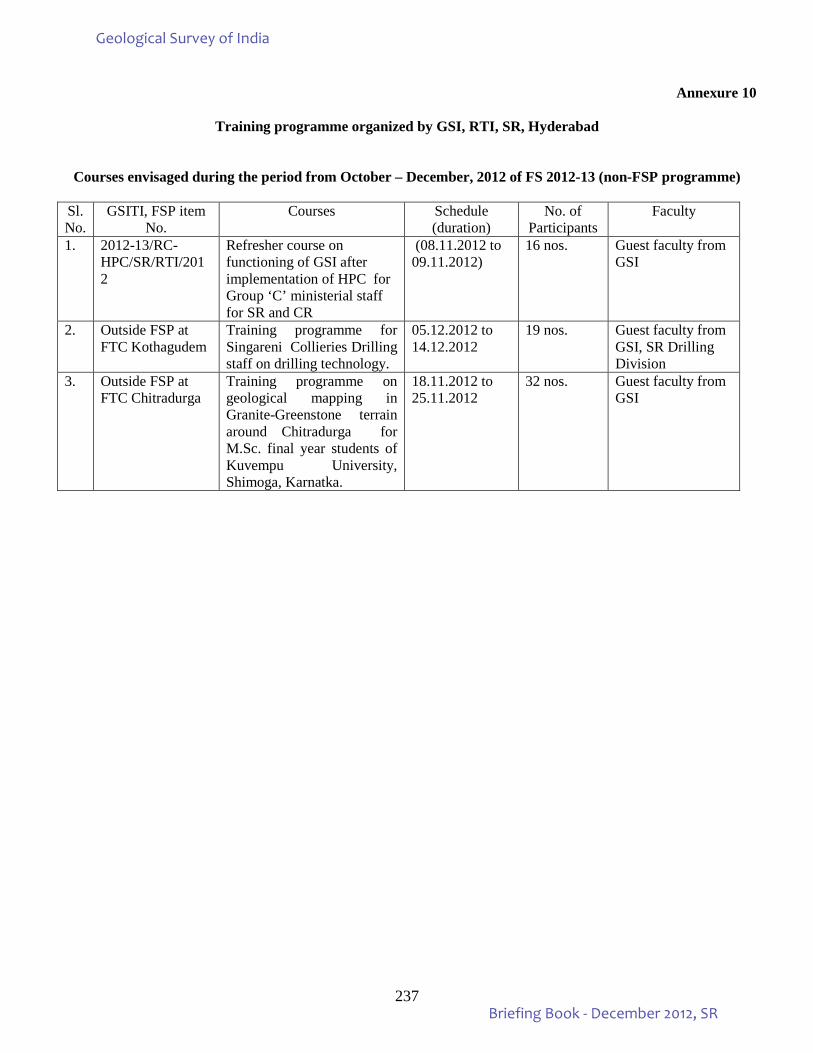
237
Annexure 10
Training programme organized by GSI, RTI, SR, Hyderabad
Courses envisaged during the period from October – December, 2012 of FS 2012-13 (non-FSP programme)
Sl.No.
GSITI, FSP item No.
Courses Schedule (duration)
No. of Participants
Faculty
1. 2012-13/RC-HPC/SR/RTI/2012
Refresher course on functioning of GSI after implementation of HPC for Group ‘C’ ministerial staff for SR and CR
(08.11.2012 to 09.11.2012)
16 nos. Guest faculty from GSI
2. Outside FSP at FTC Kothagudem
Training programme for Singareni Collieries Drilling staff on drilling technology.
05.12.2012 to 14.12.2012
19 nos. Guest faculty from GSI, SR Drilling Division
3. Outside FSP at FTC Chitradurga
Training programme on geological mapping in Granite-Greenstone terrain around Chitradurga for M.Sc. final year students of Kuvempu University, Shimoga, Karnatka.
18.11.2012 to 25.11.2012
32 nos. Guest faculty from GSI
Geological Survey of India
Briefing Book - December 2012, SR
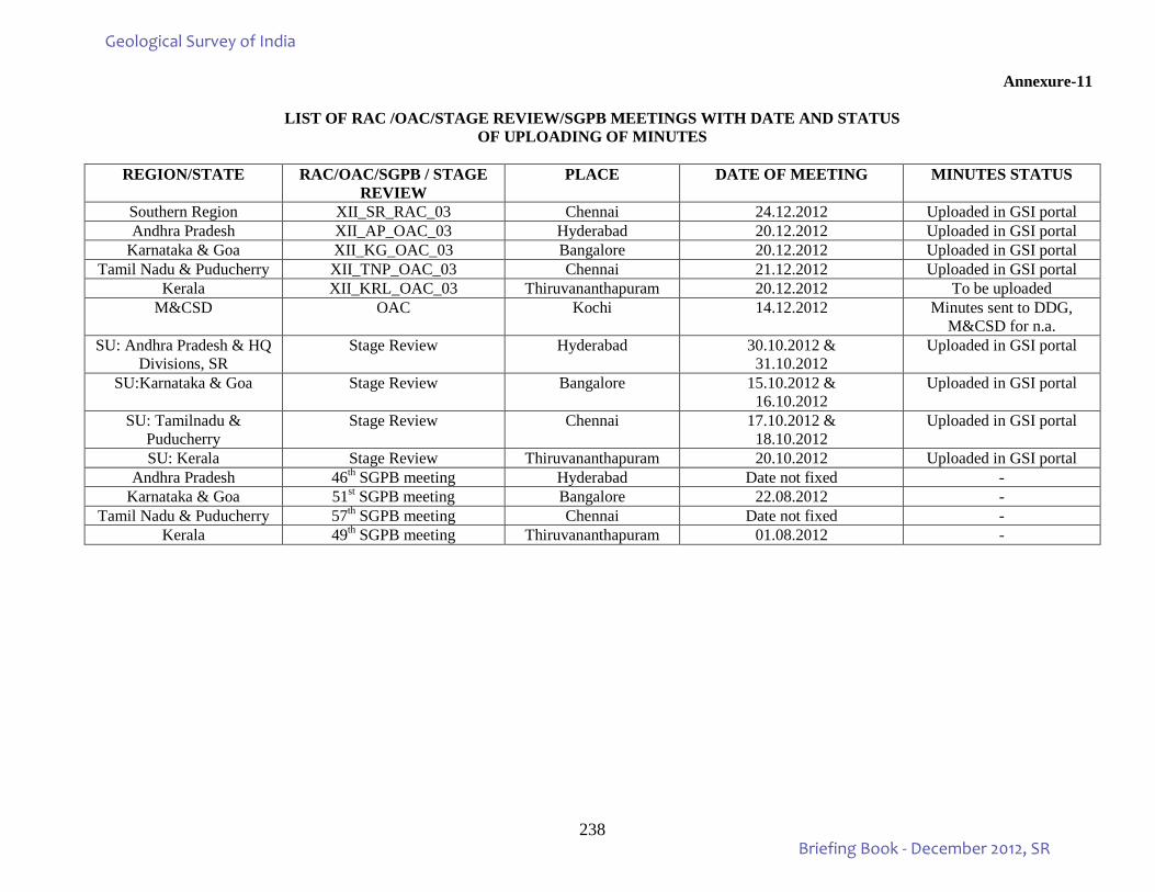
238
Annexure-11
LIST OF RAC /OAC/STAGE REVIEW/SGPB MEETINGS WITH DATE AND STATUS OF UPLOADING OF MINUTES
REGION/STATE RAC/OAC/SGPB / STAGE
REVIEW PLACE DATE OF MEETING MINUTES STATUS
Southern Region XII_SR_RAC_03 Chennai 24.12.2012 Uploaded in GSI portal Andhra Pradesh XII_AP_OAC_03 Hyderabad 20.12.2012 Uploaded in GSI portal
Karnataka & Goa XII_KG_OAC_03 Bangalore 20.12.2012 Uploaded in GSI portal Tamil Nadu & Puducherry XII_TNP_OAC_03 Chennai 21.12.2012 Uploaded in GSI portal
Kerala XII_KRL_OAC_03 Thiruvananthapuram 20.12.2012 To be uploaded M&CSD OAC Kochi 14.12.2012 Minutes sent to DDG,
M&CSD for n.a. SU: Andhra Pradesh & HQ
Divisions, SR Stage Review Hyderabad 30.10.2012 &
31.10.2012 Uploaded in GSI portal
SU:Karnataka & Goa Stage Review Bangalore 15.10.2012 & 16.10.2012
Uploaded in GSI portal
SU: Tamilnadu & Puducherry
Stage Review Chennai 17.10.2012 & 18.10.2012
Uploaded in GSI portal
SU: Kerala Stage Review Thiruvananthapuram 20.10.2012 Uploaded in GSI portal Andhra Pradesh 46th SGPB meeting Hyderabad Date not fixed -
Karnataka & Goa 51st SGPB meeting Bangalore 22.08.2012 - Tamil Nadu & Puducherry 57th SGPB meeting Chennai Date not fixed -
Kerala 49th SGPB meeting Thiruvananthapuram 01.08.2012 -
Geological Survey of India
Briefing Book - December 2012, SR
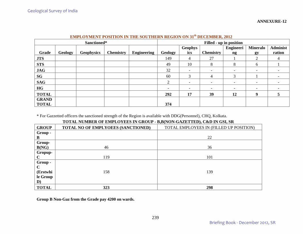
239
ANNEXURE-12
EMPLOYMENT POSITION IN THE SOUTHERN REGION ON 31th DECEMBER, 2012 Sanctioned* Filled - up in position
Grade Geology Geophysics Chemistry Engineering Geology Geophys
ics Chemistry Engineeri
ng Mineralo
gy Administ
ration JTS 149 4 27 1 2 4 STS 49 10 8 8 6 1 JAG 32 - - - - - SG 60 3 4 3 1 - SAG 2 - - - - - HG - - - - - - TOTAL 292 17 39 12 9 5 GRAND TOTAL 374 * For Gazzetted officers the sanctioned strength of the Region is available with DDG(Personnel), CHQ, Kolkata.
TOTAL NUMBER OF EMPLOYEES IN GROUP - B,B(NON-GAZETTED), C&D IN GSI, SR GROUP TOTAL NO OF EMPLYOEES (SANCTIONED) TOTAL EMPLOYEES IN (FILLED UP POSITION) Group -B 22 Group-B(NG) 46 36 Gropup-C 119 101 Group -C (Erstwhile Group D)
158 139
TOTAL 323 298 Group B Non-Gaz from the Grade pay 4200 on wards.
Geological Survey of India
Briefing Book - December 2012, SR
240
ANNEXURE-13
STATEMENT OF RUNNING VEHICLES & Drivers in SRO, GSI as on 31.12.2012
INCLUDING VEHICLES HANDEDOVER BY RSAS & COAL WING (DRILLING CAMPS & HQ, HYDERABAD)
Type of Vehicle < 25000 km 25000 - 50000
km 50000 -
1,50,000 km > 1.5 Lakh Km Total Sanctioned strength of
Drivers
Drivers in position
Field Vehicles
Jeeps/ Invader 28 41 69
Trucks (LCVs/ HCVs) 16 @ 16
Spl Vehicles 1 1
Head Quarter Vehicles
Cars/ MUVs 10 6 16
TOTAL 0 0 39 59 102 107 * 77 ** @ - Out of these 16, 12 are HCVs and of more than 30 years old, but are running due to operational constraints with minimum repairs in Drilling Camps * - Strength as per the redistribution of Transport Stream based on HPC recommendations ** - Drivers of RSAS, MARINE & COAL WING are not taken into account as per policy - 2 Drivers are retiring on 31/10/2012
Geological Survey of India
Briefing Book - December 2012, SR
241
STATEMENT OF RUNNING VEHICLES in SRO, GSI as on 01.10.2012
INCLUDING VEHICLES HANDEDOVER BY RSAS & COAL WING (DRILLING CAMPS & HQ, HYDERABAD)
Type of Vehicle < 6 Years 6 - 10 Years 10 - 15 Years 15 - 20 Years > 20 Years Total Remarks
Field Vehicles
Jeeps/ Invader 22 35 3 9 69
Trucks
(LCVs/ HCVs) 4 12 16
Spl Vehicles 1 1
Head Quarter Vehicles
Cars/ MUVs 16 16
TOTAL 0 38 40 3 21 102
Geological Survey of India
Briefing Book - December 2012, SR
242
ANNEXURE – 14
PROCUREMENT STATUS OF MAJOR EQUIPMENTS / MODERNIZATION ITEMS/ MACHINERY PROPOSED FOR PROCUREMENT DURING 2011-12 (as on 31.12.2012)
Previous Year- Under ME Head Pending Pos of 2011 – 2012 Planned for 2012-13
Sl No
PO No dt Description of the stores
Firm Name Amount in Rs. Present Status
1 98/11 Dt.05-03-2012
200KVA DG Set
( Generator)
DPS Sales Services (I) Ltd, Hyd
13,75,000-00 Material Supply was not affected due to ME funds problem
2 101/11 Dt.22-03-2012
ICPMS for Chemical Division, SRO
M/s. Agilent Technologies, Singapore
63,78,281-00
(USD 1,23,371-00)
Material Supply was affected due to ME Funds Problem , Hence LC not yet opened
3 102/11 Dt.22-03-2012
He Gas, Argon Gas, 20KVA UPS for ICPMS
M/s. Camtek Inc, Hyd
5,14,500-00 Supply along with ICPMS,
4 104/11 Dt.26-03-2012
Total Stations ( Nikon make)
M/s.Trimble Europe B.V The Netherlands
13,96,323-00
(USD 22,884-00)
Material Supply was affected due to non- availability of ME Funds. Hence LC not yet opened.
Geological Survey of India
Briefing Book - December 2012, SR
243
Purchase Order place by APMD, GSI, SR, from 01-10-2012 to 31-12-2012.
Sl.no Po.No. Description of item Amount Firm Name Remarks
01 30/12 dt. 2/10/12
Cannon Plotter Rs.3,23,180-00 M/s Laser System Bill sent for payment
02. 31/12 dt.9/10/2012
Stationery items Rs.7959-00 M/sShekar Enterprises Bill to processed
03. 32/12 dt.15/10/12
Jaw Crusher 20,027-00
Euros.
M/s RETSCH Csmbh,Germany
L.C Opened
04. 33/12 dt.15/10/12
Vibratory Cup Mill Rs.11,25,747/- -do- LC Opened
05. 34/12 dt.17/10/12
Graphite Crucibles Rs.9,936-00 M/s Chintamani Paraswanath Ent.
Material received
06. 35/12 dt.30/10/12
Heavy Duty Skid MUD Pump.
Rs.8,79,900-00 M/s.GSP Eng Company Material yet to receive
07. 36/12 dt.31/10/12
Pedestal Fans. Rs.8200-00 M/s.Balaji Trading Material Received
08. 37/12 dt.21/11/12
High Pressure Hose Rs.84,233-00 M/s.Soni Rubber Products Material yet to receive
09. 38/12 dt.29/11/12
Diamond Bits.(76mm imp &76mm s/s)
Rs.92,820-00 M/s.Indian Diamond Material yet to receive
10. 39/12 dt.29/11/12
Diamond Bits (76mmD/t) Rs.14,625-00 M/s.Vajra Tools Material received
11. 40/12 dt. 29/11/12
Spares for MUD Pump Rs.1,54,664-00 M/s.Rock Drill Material yet to receive
12. 41/12 dt.26/11/12
Uniforms Rs.1,36,356-00 M/s U.P.Handicrafts Material yet to receive
13. 42/12 dt. 29/11/12
Uniform Rs.15,215-00 M/s.NTC Material yet to receive
Geological Survey of India
Briefing Book - December 2012, SR
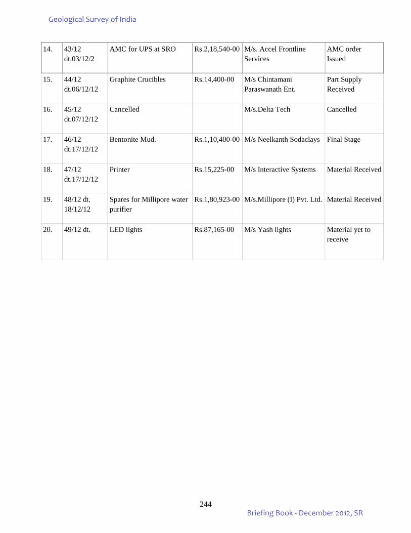
244
14. 43/12 dt.03/12/2
AMC for UPS at SRO Rs.2,18,540-00 M/s. Accel Frontline Services
AMC order Issued
15. 44/12 dt.06/12/12
Graphite Crucibles Rs.14,400-00 M/s Chintamani Paraswanath Ent.
Part Supply Received
16. 45/12 dt.07/12/12
Cancelled M/s.Delta Tech Cancelled
17. 46/12 dt.17/12/12
Bentonite Mud. Rs.1,10,400-00 M/s Neelkanth Sodaclays Final Stage
18. 47/12 dt.17/12/12
Printer Rs.15,225-00 M/s Interactive Systems Material Received
19. 48/12 dt. 18/12/12
Spares for Millipore water purifier
Rs.1,80,923-00 M/s.Millipore (I) Pvt. Ltd. Material Received
20. 49/12 dt.
LED lights Rs.87,165-00 M/s Yash lights Material yet to receive
Geological Survey of India
Briefing Book - December 2012, SR
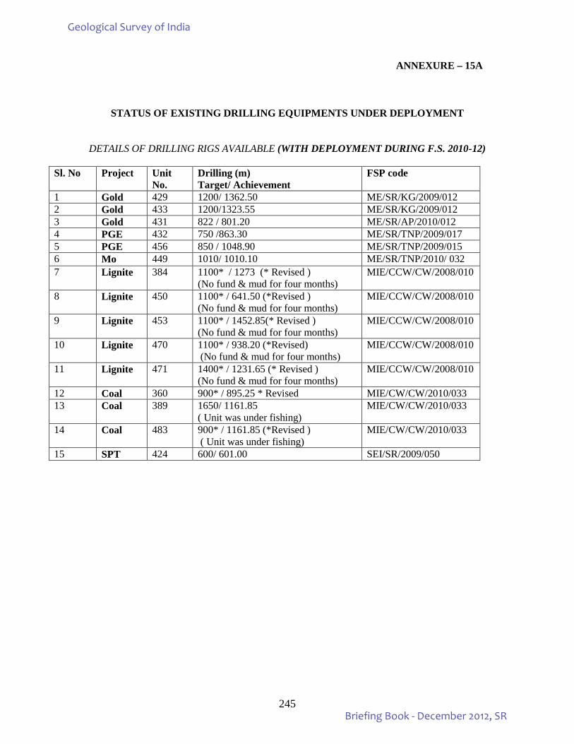
245
ANNEXURE – 15A
STATUS OF EXISTING DRILLING EQUIPMENTS UNDER DEPLOYMENT
DETAILS OF DRILLING RIGS AVAILABLE (WITH DEPLOYMENT DURING F.S. 2010-12)
Sl. No Project Unit No.
Drilling (m) Target/ Achievement
FSP code
1 Gold 429 1200/ 1362.50 ME/SR/KG/2009/012 2 Gold 433 1200/1323.55 ME/SR/KG/2009/012 3 Gold 431 822 / 801.20 ME/SR/AP/2010/012 4 PGE 432 750 /863.30 ME/SR/TNP/2009/017 5 PGE 456 850 / 1048.90 ME/SR/TNP/2009/015 6 Mo 449 1010/ 1010.10 ME/SR/TNP/2010/ 032 7 Lignite 384 1100* / 1273 (* Revised )
(No fund & mud for four months) MIE/CCW/CW/2008/010
8 Lignite 450 1100* / 641.50 (*Revised ) (No fund & mud for four months)
MIE/CCW/CW/2008/010
9 Lignite 453 1100* / 1452.85(* Revised ) (No fund & mud for four months)
MIE/CCW/CW/2008/010
10 Lignite 470 1100* / 938.20 (*Revised) (No fund & mud for four months)
MIE/CCW/CW/2008/010
11 Lignite 471 1400* / 1231.65 (* Revised ) (No fund & mud for four months)
MIE/CCW/CW/2008/010
12 Coal 360 900* / 895.25 * Revised MIE/CW/CW/2010/033 13 Coal 389 1650/ 1161.85
( Unit was under fishing) MIE/CW/CW/2010/033
14 Coal 483 900* / 1161.85 (*Revised ) ( Unit was under fishing)
MIE/CW/CW/2010/033
15 SPT 424 600/ 601.00 SEI/SR/2009/050
Geological Survey of India
Briefing Book - December 2012, SR
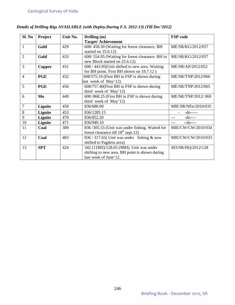
246
Details of Drilling Rigs AVAILABLE (with Deploy.During F.S. 2012-13) (Till Dec’2012)
Sl. No Project Unit No. Drilling (m) Target/ Achievement
FSP code
1 Gold 429 608/ 458.30 (Waiting for forest clearance. BH started on 25.6.12)
ME/SR/KG/2012/057
2 Gold 433 608/ 554.95 (Waiting for forest clearance. BH in new Block started on 25.6.12)
ME/SR/KG/2012/057
3 Copper 431 608 / 443.95(Unit shifted to new area. Waiting for BH point. First BH shown on 18.7.12 )
ME/SR/AP/2012/052
4 PGE 432 608/575.10 (First BH in FSP is shown during last week of May’12)
ME/SR/TNP/2012/066
5 PGE 456 608/757.40(First BH in FSP is shown during third week of May’12)
ME/SR/TNP/2012/065
6 Mo 449 608 /868.25 (First BH in FSP is shown during third week of May’12)
ME/SR/TNP/2012/ 069
7 Lignite 450 836/680.00 MIE/SR/NEn/2010/035 8 Lignite 453 836/1285.15 - -do----- 9 Lignite 470 836/852.20 --- -do---- 10 Lignite 471 836/949.10 --- --do---- 11 Coal 389 836 /305.55 (Unit was under fishing. Waited for
forest clearance till 18th sept.12) MIE/CW/CW/2010/034
12 Coal 483 836 / 317.65( Unit was under fishing & now shifted to Pagderu area)
MIE/CW/CW/2010/033
13 SPT 424 342 (11BH)/128.65 (9BH). Unit was under shifting to new area. BH point is shown during last week of June’12.
SEI/SR/HQ/2012/128
Geological Survey of India
Briefing Book - December 2012, SR
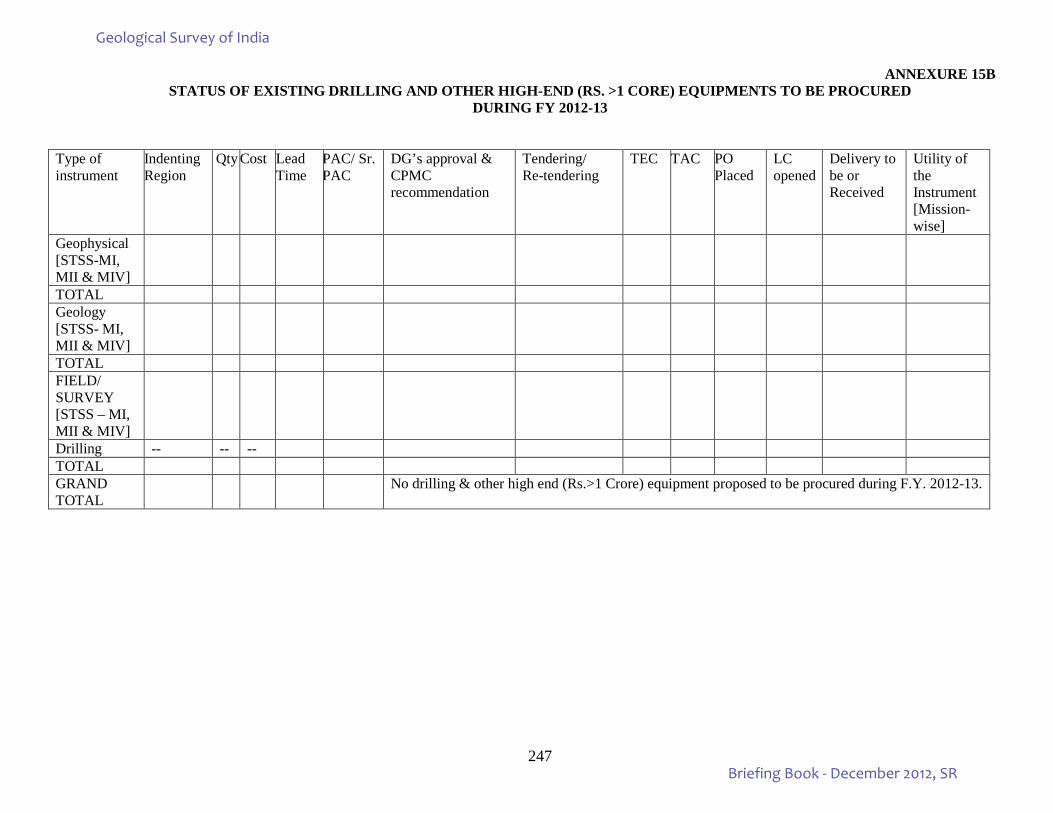
247
ANNEXURE 15B STATUS OF EXISTING DRILLING AND OTHER HIGH-END (RS. >1 CORE) EQUIPMENTS TO BE PROCURED
DURING FY 2012-13
Type of instrument
Indenting Region
Qty Cost Lead Time
PAC/ Sr. PAC
DG’s approval & CPMC recommendation
Tendering/ Re-tendering
TEC TAC PO Placed
LC opened
Delivery to be or Received
Utility of the Instrument [Mission-wise]
Geophysical [STSS-MI, MII & MIV]
TOTAL Geology [STSS- MI, MII & MIV]
TOTAL FIELD/ SURVEY [STSS – MI, MII & MIV]
Drilling -- -- -- TOTAL GRAND TOTAL
No drilling & other high end (Rs.>1 Crore) equipment proposed to be procured during F.Y. 2012-13.
Geological Survey of India
Briefing Book - December 2012, SR
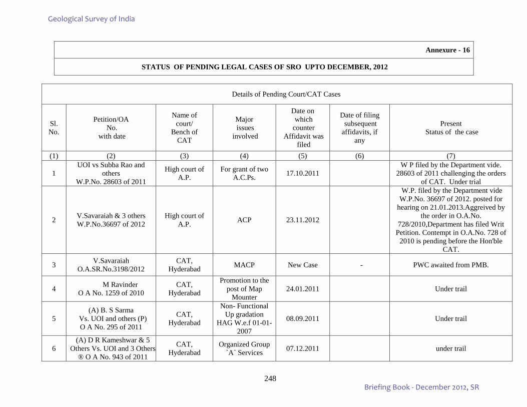
248
Annexure - 16
STATUS OF PENDING LEGAL CASES OF SRO UPTO DECEMBER, 2012
Details of Pending Court/CAT Cases
Sl. No.
Petition/OA No.
with date
Name of court/
Bench of CAT
Major issues
involved
Date on which
counter Affidavit was
filed
Date of filing subsequent affidavits, if
any
Present Status of the case
(1) (2) (3) (4) (5) (6) (7)
1 UOI vs Subba Rao and
others W.P.No. 28603 of 2011
High court of A.P.
For grant of two A.C.Ps. 17.10.2011
W P filed by the Department vide. 28603 of 2011 challenging the orders
of CAT. Under trial
2 V.Savaraiah & 3 others W.P.No.36697 of 2012
High court of A.P. ACP 23.11.2012
W.P. filed by the Department vide W.P.No. 36697 of 2012. posted for
hearing on 21.01.2013.Aggreived by the order in O.A.No.
728/2010,Department has filed Writ Petition. Contempt in O.A.No. 728 of
2010 is pending before the Hon'ble CAT.
3 V.Savaraiah O.A.SR.No.3198/2012
CAT, Hyderabad MACP New Case - PWC awaited from PMB.
4 M Ravinder O A No. 1259 of 2010
CAT, Hyderabad
Promotion to the post of Map
Mounter 24.01.2011 Under trail
5 (A) B. S Sarma
Vs. UOI and others (P) O A No. 295 of 2011
CAT, Hyderabad
Non- Functional Up gradation
HAG W.e.f 01-01-2007
08.09.2011 Under trail
6 (A) D R Kameshwar & 5
Others Vs. UOI and 3 Others ® O A No. 943 of 2011
CAT, Hyderabad
Organized Group `A` Services 07.12.2011 under trail
Geological Survey of India
Briefing Book - December 2012, SR
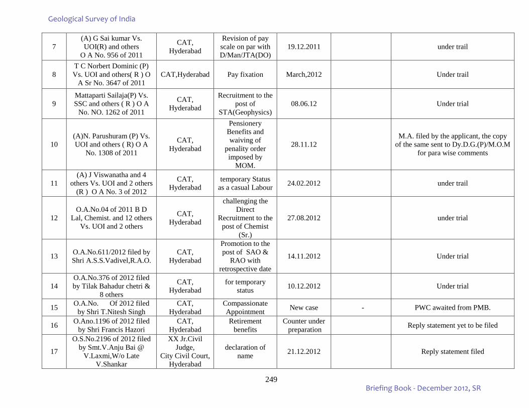
249
7 (A) G Sai kumar Vs. UOI(R) and others
O A No. 956 of 2011
CAT, Hyderabad
Revision of pay scale on par with D/Man/JTA(DO)
19.12.2011 under trail
8 T C Norbert Dominic (P) Vs. UOI and others( R ) O
A Sr No. 3647 of 2011 CAT,Hyderabad Pay fixation March,2012 Under trail
9 Mattaparti Sailaja(P) Vs. SSC and others ( R ) O A
No. NO. 1262 of 2011
CAT, Hyderabad
Recruitment to the post of
STA(Geophysics) 08.06.12 Under trial
10 (A)N. Parushuram (P) Vs. UOI and others ( R) O A
No. 1308 of 2011
CAT, Hyderabad
Pensionery Benefits and waiving of
penality order imposed by
MOM.
28.11.12 M.A. filed by the applicant, the copy
of the same sent to Dy.D.G.(P)/M.O.M for para wise comments
11 (A) J Viswanatha and 4
others Vs. UOI and 2 others (R ) O A No. 3 of 2012
CAT, Hyderabad
temporary Status as a casual Labour 24.02.2012 under trail
12 O.A.No.04 of 2011 B D
Lal, Chemist. and 12 others Vs. UOI and 2 others
CAT, Hyderabad
challenging the Direct
Recruitment to the post of Chemist
(Sr.)
27.08.2012 under trial
13 O.A.No.611/2012 filed by Shri A.S.S.Vadivel,R.A.O.
CAT, Hyderabad
Promotion to the post of SAO &
RAO with retrospective date
14.11.2012 Under trial
14 O.A.No.376 of 2012 filed by Tilak Bahadur chetri &
8 others
CAT, Hyderabad
for temporary status 10.12.2012 Under trial
15 O.A.No. Of 2012 filed by Shri T.Nitesh Singh
CAT, Hyderabad
Compassionate Appointment New case - PWC awaited from PMB.
16 O.Ano.1196 of 2012 filed by Shri Francis Hazori
CAT, Hyderabad
Retirement benefits
Counter under preparation Reply statement yet to be filed
17
O.S.No.2196 of 2012 filed by Smt.V.Anju Bai @
V.Laxmi,W/o Late V.Shankar
XX Jr.Civil Judge,
City Civil Court, Hyderabad
declaration of name 21.12.2012 Reply statement filed
Geological Survey of India
Briefing Book - December 2012, SR
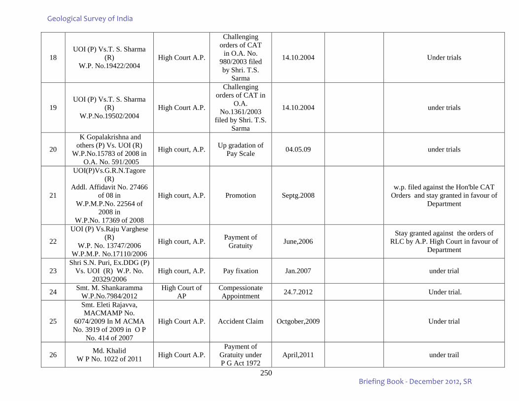
250
18 UOI (P) Vs.T. S. Sharma
(R) W.P. No.19422/2004
High Court A.P.
Challenging orders of CAT
in O.A. No. 980/2003 filed by Shri. T.S.
Sarma
14.10.2004 Under trials
19 UOI (P) Vs.T. S. Sharma
(R) W.P.No.19502/2004
High Court A.P.
Challenging orders of CAT in
O.A. No.1361/2003
filed by Shri. T.S. Sarma
14.10.2004 under trials
20
K Gopalakrishna and others (P) Vs. UOI (R)
W.P.No.15783 of 2008 in O.A. No. 591/2005
High court, A.P. Up gradation of Pay Scale 04.05.09 under trials
21
UOI(P)Vs.G.R.N.Tagore (R)
Addl. Affidavit No. 27466 of 08 in
W.P.M.P.No. 22564 of 2008 in
W.P.No. 17369 of 2008
High court, A.P. Promotion Septg.2008 w.p. filed against the Hon'ble CAT
Orders and stay granted in favour of Department
22
UOI (P) Vs.Raju Varghese (R)
W.P. No. 13747/2006 W.P.M.P. No.17110/2006
High court, A.P. Payment of Gratuity June,2006
Stay granted against the orders of RLC by A.P. High Court in favour of
Department
23 Shri S.N. Puri, Ex.DDG (P)
Vs. UOI (R) W.P. No. 20329/2006
High court, A.P. Pay fixation Jan.2007 under trial
24 Smt. M. Shankaramma W.P.No.7984/2012
High Court of AP
Compessionate Appointment 24.7.2012 Under trial.
25
Smt. Eleti Rajavva, MACMAMP No.
6074/2009 In M ACMA No. 3919 of 2009 in O P
No. 414 of 2007
High Court A.P. Accident Claim Octgober,2009 Under trial
26 Md. Khalid W P No. 1022 of 2011 High Court A.P.
Payment of Gratuity under P G Act 1972
April,2011 under trail
Geological Survey of India
Briefing Book - December 2012, SR
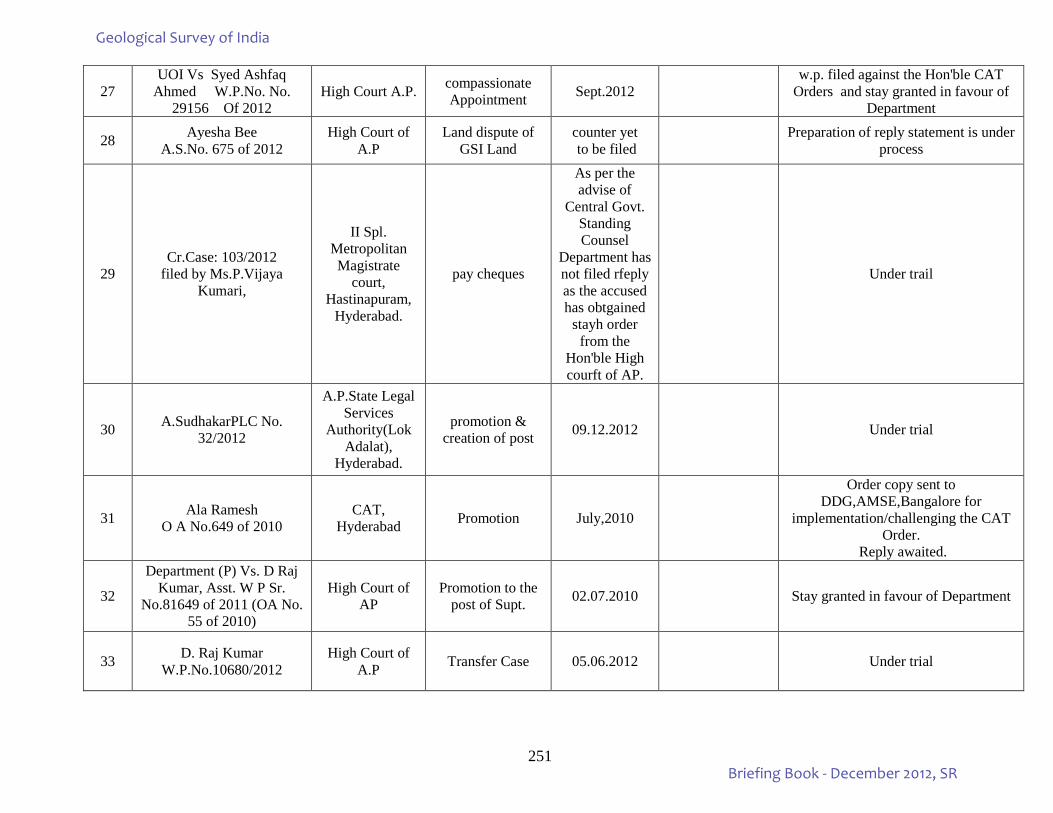
251
27 UOI Vs Syed Ashfaq
Ahmed W.P.No. No. 29156 Of 2012
High Court A.P. compassionate Appointment Sept.2012
w.p. filed against the Hon'ble CAT Orders and stay granted in favour of
Department
28 Ayesha Bee A.S.No. 675 of 2012
High Court of A.P
Land dispute of GSI Land
counter yet to be filed Preparation of reply statement is under
process
29 Cr.Case: 103/2012
filed by Ms.P.Vijaya Kumari,
II Spl. Metropolitan Magistrate
court, Hastinapuram,
Hyderabad.
pay cheques
As per the advise of
Central Govt. Standing Counsel
Department has not filed rfeply as the accused has obtgained
stayh order from the
Hon'ble High courft of AP.
Under trail
30 A.SudhakarPLC No. 32/2012
A.P.State Legal Services
Authority(Lok Adalat),
Hyderabad.
promotion & creation of post 09.12.2012 Under trial
31 Ala Ramesh O A No.649 of 2010
CAT, Hyderabad Promotion July,2010
Order copy sent to DDG,AMSE,Bangalore for
implementation/challenging the CAT Order.
Reply awaited.
32
Department (P) Vs. D Raj Kumar, Asst. W P Sr.
No.81649 of 2011 (OA No. 55 of 2010)
High Court of AP
Promotion to the post of Supt. 02.07.2010 Stay granted in favour of Department
33 D. Raj Kumar W.P.No.10680/2012
High Court of A.P Transfer Case 05.06.2012 Under trial
Geological Survey of India
Briefing Book - December 2012, SR
252
CASES PERTAINS TO VISAKHAPATNAM
34 Kutikuppala Surya Rao (P) Vs. Govt. of AP & 4 Others
PIL No. 15 of 2012
High Court of AP Public Interest 01.03.2012 Under trail
35 K.Govinda Rao I.A.No. 280/2012
VI Addl. Junior Civil Judge,
Visakhapatnam
Land dispute of the office premises
filed by Marine
Wing,Vizag under trial
CASES PERTAINS TO TAMILNADU REGION
36 Smt. Kamala & 2 others MCOP No. 210/2003
Sub-Court, Kumbakonam
Accident compensation
filed by SU:TNP under trial
37 Minor Viveknandan M.C.OP.No. 686/2003
District Judge Court
Krishnagiri Accident Claim filed by
SU:TNP under trial
38 O.A.No.1076 of 2012 filed
by Shri N.Singaram
CAT,Chennai Pension and other terminal benefits
Counter filed by
SU:TNP
M.A.filed by the Department and two months time from 25-11-2012 granted
by the Hon'ble Tribunal.Speaking order is to be issued by the DG,GSI
CASES PERTAINS TO KERALA REGION
39
Smt. Pramila Vs. Director, SU: K & G, Bangalore (R) W P No. 29011 -29012 of
2011
High Court of Karnataka
compassionate Appointment
filed by SU:K&G under trail
40 M.N. Ramachandra Rao, O.A. 404 of 2009 CAT, Bangalore for NFSG benefits
W.P. yet to be filed by the
RSAS W.P. yet to be filed by the RSAS
41 (A) M P Muraleedharan Vs. UOI and other (R) O A No.
417 of 2010
CAT, Ernakulam
Promotion to the post of DDG
filed by SU:Kerala
Awaiting the directions of DDG(P) & MOM being the W.P. filed by the
Department was dismissed.
42
UOI (P) Vs. K. Sadashivan Nair(R)
W.P. No. 15825 of 2004 in O.A. No. 11 of 2003
(New No. W.P No.10701/2009)
High court, Kerala
Payment of Gratuity
filed by SU:Kerala under trial
Geological Survey of India
Briefing Book - December 2012, SR
253
43
UOI(P) Vs. N. Raghavan Pillai (R)
W.P. No. 15824 of 2004 in
O.A. No. 13 of 2003 (New W P No. 10682/2009)
High court, Kerala
Payment of Gratuity
filed by SU:Kerala under trial
44
UOI(P) Vs. K.M. Gopi (R)
W.P. No. 15827of 2004 in
O.A. No. 12 of 2003 (New W P No. 10714/2009)
High court, Kerala
Payment of Gratuity
filed by SU:Kerala under trial
45
K.A.Ibrahim Kunju Vs Union of India & Others C.P.(C) No. 095/2010 in
O.A. No. 766/2007
Ernakulam, CAT Promotion filed by
SU:Kerala
Hon'ble CAT,Ernakulam directed to produce
the records of DPC files. The case was heard on 18.12.2012 and posted for
next hearing. Date not yet given
46 Shri Antony
A.S.No.111/2011 in O.S.No. 1537/2007
District Court, Thiruvananthap
uram
Land dispute on the office premises
filed by SU:Kerala The District court dismissed and
referred the case to the Lower court
Geological Survey of India
Briefing Book - December 2012, SR