U.S. Geological Survey activities related to American Indians ...
130
U.S. Department of the Interior U.S. Geological Survey Circular 1403 U.S. Geological Survey Activities Related to American Indians and Alaska Natives Fiscal Years 2009 and 2010
-
Upload
khangminh22 -
Category
Documents
-
view
0 -
download
0
Transcript of U.S. Geological Survey activities related to American Indians ...

U.S. Department of the InteriorU.S. Geological Survey
Circular 1403
U.S. Geological Survey Activities Related to American Indians and Alaska Natives
Fiscal Years 2009 and 2010
U.S. Geological Survey Activities Related to American Indians and Alaska Natives
By Monique Fordham and Maria R. Montour
Fiscal Years 2009 and 2010
Circular 1403
U.S. Department of the InteriorU.S. Geological Survey

U.S. Department of the InteriorSALLY JEWELL, Secretary
U.S. Geological SurveySuzette M. Kimball, Acting Director
U.S. Geological Survey, Reston, Virginia: 2015
For more information on the USGS—the Federal source for science about the Earth, its natural and living resources, natural hazards, and the environment, visit http://www.usgs.gov or call 1–888–ASK–USGS.
For an overview of USGS information products, including maps, imagery, and publications, visit http://www.usgs.gov/pubprod
To order this and other USGS information products, visit http://store.usgs.gov
Any use of trade, firm, or product names is for descriptive purposes only and does not imply endorsement by the U.S. Government.
Although this information product, for the most part, is in the public domain, it also may contain copyrighted materials as noted in the text. Permission to reproduce copyrighted items must be secured from the copyright owner.
Suggested citation:Fordham, M.A. and Montour, M.R., 2015, U.S. Geological Survey activities related to American Indians and Alaska Natives—Fiscal years 2009 and 2010: U.S. Geological Survey Circular 1403, 112 p., http://dx.doi.org/10.3133/cir1403.
ISSN 2330-5703 (online)ISSN 1067-084X (print)ISBN 978-1-4113-3864-7

iii
Contents
List of Federally Recognized Tribes or Tribal Governments Mentioned in the Report ......................ixOrganizations, Agencies/Departments, Educational Institutions or Events Related
to American Indians or Alaska Natives Mentioned in the Report ........................................xiiiStates Mentioned in the Report ...............................................................................................................xviIntroduction.....................................................................................................................................................1
What This Report Contains .................................................................................................................1Formal Activities....................................................................................................................................1Informal Activities .................................................................................................................................2How to Use This Report .......................................................................................................................2Web Access—http://www.usgs.gov/tribal/ .....................................................................................3The Future ..............................................................................................................................................3Contributors ...........................................................................................................................................3
National and Multi-Geographic Area Activities .......................................................................................4Eastern United States (Northeast and Southeast Geographic Areas)
(Maine, New Hampshire, Vermont, New York, Massachusetts, Rhode Island, Connecticut, New Jersey, Delaware, Maryland, Pennsylvania, West Virginia, Virginia, Tennessee, North Carolina, South Carolina, Georgia, Alabama, Mississippi, and Florida)................................................................................................................17
Midwest Geographic Area (Michigan, Ohio, Indiana, Kentucky, Wisconsin, Illinois, Minnesota, Iowa, North Dakota, South Dakota, and Nebraska) ............................................23
South Central Geographic Area (Missouri, Arkansas, Louisiana, Kansas, Oklahoma, Texas) ...........................................................................................................................33
Rocky Mountain Geographic Area (Montana, Wyoming, Colorado, New Mexico)..........................40Northwest Geographic Area (Idaho, Washington, and Oregon) .........................................................50Southwest Geographic Area (Utah, Arizona, Nevada, California, Hawaii) ........................................75Alaska Geographic Area (Alaska) .............................................................................................................92Water Resources Monitoring Stations (Multiple States) ....................................................................107
Streamgages......................................................................................................................................107Water-Quality Monitoring Stations ................................................................................................109Groundwater Monitoring Stations .................................................................................................110Lake and Reservoir-Stage Monitoring Stations ...........................................................................110Sediment-Monitoring Stations .......................................................................................................110
U.S. Geological Survey Office of Tribal Relations—Tribal Liaison Team, 2009–2010......................111

iv
Figures 1. Photograph showing U.S. Geological Survey hydrologist Ed “Nick” Nickerson
instructs tribal students participating in the Bureau of Indian Affairs Water Technician Training Program in Las Cruces, New Mexico ....................................................6
2. Photograph showing students learning about a U.S. Geological Survey streamgage during a Bureau of Indian Affairs Water Technician training course in Las Cruces, New Mexico ..................................................................................................................................6
3. Image showing the November 2008 (Fiscal Year 2009) Native American Heritage Month poster .................................................................................................................................7
4. High-resolution satellite image of McLaughlin, South Dakota, Standing Rock Reservation ....................................................................................................................................8
5. Photograph showing 2010 U.S. Geological Survey Tribal Relations training course participants and instructors ........................................................................................11
6. Photograph showing U.S. Geological Survey Student Interns in Support of Native American Relations student intern Cara Holem-Bell (Tlingit) participating in fish assessment research on the Rock Creek, Buck Creek, and Klickitat River migration behavior study, Washington, Yakama Nation as part of her Student Interns in Support of Native American Relations internship .................................................................13
7. Photograph showing Lorri Salawater, Bad River Band of Lake Superior Chippewa Indians, a 2010 U.S. Geological Survey Student Interns in Support of Native American Relations student intern ..........................................................................................13
8. Image showing poster of hydrological research by U.S. Geological Survey Student Interns in Support of Native American Relations student intern Parker Norton, U.S. Geological Survey South Dakota Water Science Center .................13
9. Photograph showing a field demonstration during a TEchnical training in Support of Native American Relations training program showing how pressure transducers are used to estimate streamflow for members of the Spokane Tribe and the Kalispell Tribe ................................................................................................................14
10. Photograph showing U.S. Geological Survey wildlife biologist Bryan Richards presents a wildlife disease workshop as part of a TEchnical training in Support of Native American Relations training program for tribal biologists at the 2010 Native American Fish and Wildlife Society National Conference .............................14
11. Photograph showing the U.S. Geological Survey exhibit at the 2010 American Indian Science and Engineering Society 2009 National Conference ................................15
12. Photograph showing streamgage house (01017060) on Hardwood Brook, Maine, November 2008 and February 2009 ............................................................................16
13. Photograph showing Tribal members of the Penobscot Indian Nation, U.S. Geological Survey scientists from the Maine Water Science Center, and U.S. Environmental Protection Agency staff on the Penobscot River .......................18
14. Photograph showing Stanislaus family in a Birch bark canoe on the Penobscot River near Lincoln, Maine .....................................................................................18
15. Photograph showing U.S. Geological Survey Student Interns in Support of Native American Relations intern Jan Paul (Penobscot Indian Nation) making water-quality measurements in the Penobscot River aboard a University of Maine research vessel ..............................................................................................................19

v
16. Photograph showing Penobscot River and Dolby Pond in north-central, Maine ...........20 17. Photograph showing cyanobacterial bloom forming on Dolby Pond, East
Millinocket, Maine ......................................................................................................................21 18. Photograph showing U.S. Geological Survey scientists processing adult brook
trout at Dakota Creek, Michigan, August 2008 ......................................................................24 19. Photograph showing view looking upstream at Silver River, Michigan ............................24 20. Image showing U.S. Geological Survey Scientific Investigations Map 2993,
sheet 1, “Generalized potentiometric surface of the Arikaree aquifer, Pine Ridge Indian Reservation and Bennett County, South Dakota” .....................................................32
21. Photograph showing U.S. Geological Survey Scientific Investigations Map 2993, sheet 2, “Generalized potentiometric surface of the Arikaree aquifer, Pine Ridge Indian Reservation and Bennett County, South Dakota” .....................................................32
22. Photograph showing the Neosho madtom (Noturus placidus) a fish federally listed as threatened in Oklahoma ............................................................................................33
23. Photograph showing chat piles in the Tri-State mining district in Picher, Oklahoma .....................................................................................................................................35
24. Photograph showing tailings pile in the Tri-State mining district near Picher, Oklahoma .....................................................................................................................................35
25. Photographs showing U.S. Geological Survey scientists measuring and processing sediment cores collected in the upstream end of Grand Lake O’ the Cherokees, Oklahoma .........................................................................................................36
26. Photograph showing a U.S. Geological Survey scientist retrieving a passive sampler called a semipermeable membrane device from a stream in north- eastern Oklahoma .......................................................................................................................37
27. Photograph showing Chad Ashworth, U.S. Geological Survey hydrologic technician, wading a stream to deploy a passive sampler .................................................37
28. Photograph showing Art Horowitz, U.S. Geological Survey hydrologist, and Ernie Smith, U.S. Geological Survey hydrologic technician, instructing tribal members in streambed-sediment-collection equipment and techniques during a Technical training in Support of Native American Relations training program on the South Canadian River, central Oklahoma ...................................................................38
29. Photograph showing Joy Savoia, U.S. Geological Survey hydrologic technician, instructs a class member in the equal-width-increment method of surface- water-quality sampling during a Technical training in support of Native American Relations training program on the South Canadian River, central Oklahoma ..................39
30. Photograph showing Jessica Magers, U.S. Geological Survey Student Interns in Support of Native American Relations student intern, using a hand-held X-ray fluorescence analyzer to determine arsenic and other element concentrations on outcrops and rock cores from the Rush Springs sandstone aquifer, Caddo County, Oklahoma .......................................................................................................................39
31. Photograph showing presentation of a 2008 Department of Interior Environmental Achievement award to the team of scientists from the U.S. Geological Survey and Fort Peck Tribes, along with the U.S. Environmental Protection Agency and private industry, for their efforts to identify brine-contaminated groundwater in the East Poplar oil field, Montana ............................................................................................40

vi
32. Photograph showing the 2010 Northern Continental Divide Ecosystem grizzly bear DNA crew including two Student Interns in Support of Native American Relations student interns ...........................................................................................................41
33. Photograph showing tribal members from the Confederated Salish and Kootenai Tribes and Salish Kootenai College learn about using the acoustic Doppler current profiler to measure streamflow during a Technical training in Support of Native American Relations tribal training program on the Flathead River, Montana ............................................................................................................................41
34. Photograph showing U.S. Geological Survey Student Interns in Support of Native American Relations student intern Josh Handley, Salish Kootenai College student, doing field work on the Flathead Indian Reservation, Montana, 2010 ...............42
35. Photograph showing classroom and field training during a Technical training in Support of Native American Relations supported National Wetlands Inventory Classification course, Polson, Montana, 2010 .......................................................................43
36 Aeromagnetic map for the southern Española Basin, displayed after a reduction- to-pole transformation to facilitate interpretation ................................................................46
37. Map showing perspective view of the modeled elevation of the base of the Santa Fe Group in relation to topography, looking east .......................................................48
38. Photograph showing U.S. Geological Survey Student Interns in Support of Native American Relations student intern Matthew Laramie (Colville Tribes) performing field work on the effects of stream restoration following gold mining in Idaho ............................................................................................................................51
39. Photograph showing ashed contents from the gut of a White Sturgeon (Acipenser transmontanus) ......................................................................................................52
40. Photograph showing a stained histology cross section of control fish tissues ...............52 41. Image of U.S. Geological Survey Fact Sheet 2010–3056, “USGS Activities at
Lake Roosevelt and the Upper Columbia River” ....................................................................53 42. Photograph showing deposits of slag along the Columbia River near the
Canadian border .........................................................................................................................53 43. Photographs showing U.S. Geological Survey scientist Bill Taylor measuring
depth to water at the Chamokane observation well, February 2009 and U.S. Geological Survey streamgage at Chamokane Creek, Stevens County, Washington June 2009 ...............................................................................................................54
44. Photographs showing tribal students at the U.S. Geological Survey Marine Water Quality Technician Technical training in Support of Native American Relations training at Northwest Indian College, June 2010 .................................................55
45. Photograph showing sunrise over March’s Point from the Samish canoe landing near Anacortes, Washington......................................................................................56
46. Photograph showing Squamish Nation canoe towing water-quality monitoring equipment during the 2009 Coast Salish Journey .................................................................56
47. Photograph showing log jam on the Elwha River (looking upstream) entering Lake Mills, Clallam County, Washington .................................................................................61
48. Photograph showing bank-operated cable system and D-74 suspended- sampler viewed from the USGS streamgage Elwha River above Lake Mills (12044900), Elwha River Basin, Clallam County, Washington ..............................................61

vii
49. Photograph showing Elwha River looking downstream of U.S. Geological Survey streamgage Elwha River at McDonald Bridge (12045500), Elwha River Basin, Clallam County, Washington .........................................................................................62
50. Photograph showing conifer encroachment into the huckleberry meadows in the vicinity of Bone Lake, Western Cascade Mountains, Washington .........................64
51. Photograph showing representative otolith sample of freshwater growth from Nisqually Basin, Washington, 2005.................................................................................65
52. Image showing cover of the U.S. Geological Survey Scientific Investigations Report 2009–5152, “Hydrogeologic framework of the Yakima River Basin aquifer system, Washington” .................................................................................................................69
53. Image from U.S. Geological Survey Scientific Investigations Report 2009–5152, “Hydrogeologic framework of the Yakima River Basin aquifer system, Washington showing spatial distribution of mean annual recharge, 1960–2001” .................................70
54. Photograph showing U.S. Geological Survey evaporation station on Walker Lake, Nevada ...............................................................................................................................77
55. Photograph showing view looking upstream at the streamgage Walker River near Wabuska, Nevada (10301500) ..........................................................................................77
56. Photograph showing view from Walker Lake looking southwest at Mount Grant, Nevada .............................................................................................................................77
57. Photograph showing Bridgeport Valley, California, looking south from Highway 395 towards the Twin Lakes area and 12,000-foot peaks of the Sierra Nevada. ............................. 78
58. Photograph showing U.S. Geological Survey geologist Bob Horton collecting a sample of surface sediment for geochemical analysis downgradient from the Tuba City Open Dump site ...................................................................................................81
59. Photograph showing an abandoned uranium mine site, the Kanab North Mine, in Grand Canyon National Park, Arizona ................................................................................83
60. Photograph showing Grand Canyon National Park ..............................................................83
61. Photograph showing U.S. Geological Survey scientists Brian Collins and Helen Fairley discussing Light Detection and Ranging surveys in Grand Canyon with staff from the Hopi Tribe’s Cultural Resource Monitoring team as part of the Glen Canyon Dam Adaptive Management Program ..................................................84
62. Photograph showing U.S. Geological Survey Student Interns in Support of Native American Relations student intern Juanita Francis-Begay standing in front of study area (‘Arroyos’ groundwater recharge site) at the San Xavier District of the Tohono O’odham Nation ...................................................................................85
63. Photograph showing participants from the 2010 U.S. Geological Survey California Water Science Center Technical training in Support of Native American Relations tribal water-quality training .............................................................................................................90
64. Photograph showing U.S. Geological Survey scientist Frank Urban servicing the Marsh Creek permafrost and climate monitoring station in the foothills of the Arctic Coastal Plain, Arctic National Wildlife Refuge, Alaska, spring 2007 ...........92
65. Photograph showing the Marsh Creek permafrost and climate monitoring station in the foothills of the Arctic Coastal Plain, Arctic National Wildlife Refuge, Alaska, spring 2007 .....................................................................................................................92

viii
66. Photograph showing the Marsh Creek permafrost and climate monitoring station in the foothills of the Arctic Coastal Plain, Arctic National Wildlife Refuge, Alaska, summer 2007 ..................................................................................................................93
67. Photographs showing U.S. Geological Survey scientist Paul Schuster with Yukon River Inter-Tribal Watershed Council staff and Alaska Native volunteers performing field work in the Yukon River Basin during 2010 ...............................................94
68. Photograph showing U.S. Geological Survey Scientist Paul Schuster and Student Interns in Support of Native American Relations student intern Brett Uhle performing field work in the Yukon River Basin during 2010 ...............................................94
69. Photographs showing signing of the U.S. Geological Survey and Yukon River Inter-Tribal Watershed Council Memorandum of Understanding, August 2010 ..............95
70. Photographs showing Participants of a training workshop in conjunction with the Yukon River Inter-Tribal Watershed Council for volunteer water technicians after completing an under-ice sampling with a streamflow measurement made by the U.S. Geological Survey Fairbanks field office staff, Tanana River at Nenana, Alaska ...........................................................................................................................95
71. Photograph showing walrus carcasses near Icy Cape, Alaska, September 14, 2009 ........... 98 72. Photograph showing U.S. Geological Survey Alaska Science Center study site
on Meadow Creek, Alaska ......................................................................................................100 73. Photograph showing U.S. Geological Survey Alaska Science Center study reach
on unnamed tributary to Little Meadow Creek, Alaska ......................................................101 74. Photograph showing U.S. Geological Survey Alaska Science Center study site
on a tributary to Little Susitna River locally known as Swiftwater Creek, Alaska .........101 75. Photograph showing U.S. Geological Survey Alaska Science Center study site
on Meadow Creek, Alaska ......................................................................................................101 76. Photograph showing view looking northeast below the Quarry Prospect
traverse, Seward Peninsula, Alaska, showing the tall version of the common willow (Salix pulchra) found throughout the study area ....................................................102
77. Photograph showing an area along the Big Hurrah traverse, Seward Peninsula, Alaska, showing the typical tundra vegetation with the abundant low-growing version of the common willow (Salix pulchra) .....................................................................102
78. Photograph showing view looking southeast from Big Hurrah traverse, Seward Peninsula, Alaska .....................................................................................................................102
79. Image of the cover of U.S. Geological Survey Scientific Investigations Report 2009–5045, “Status and Trends of Sea Otter Populations in Southeast Alaska, 1969–2003” ...................................................................................................................103
80. Photograph showing Alaska Native community structures in the area monitored for impacts from climate change, North Slope Alaska ......................................................105
81. Photograph showing U.S. Geological Survey Student Interns in Support of Native American Relations student intern Laura Brosius, (University of Alaska Fairbanks) surveys the lake perimeter for water-quality sampling locations ..........................................106
82. Image of U.S. Geological Survey Fact Sheet 2009–3072, “Alaska Interagency Ecosystem Health Work Group”.............................................................................................106
83. Map showing U.S. Geological Survey geographic areas, 2009–2010 ..............................112
ix
Tables 1. 2009 and 2010 student interns and descriptions of their projects funded
through the U.S. Geological Survey Student Interns in Support of Native American Relations (SISNAR) internship program ...............................................................12
2. U.S. Geological Survey Scientists, tribal participants, and tribal training programs funded through the TEchnical training in Support of Native American Relations (TESNAR) program in 2009 and 2010 ...................................................14
3. Tribes that cooperated with the U.S. Geological Survey in the operation of streamgaging stations in 2009 and 2010 ...........................................................................107
4. Tribes that cooperated with the U.S. Geological Survey in the operation of water-quality-monitoring stations in 2009 and 2010 .......................................................109
5. Tribes that cooperated with the U.S. Geological Survey in the operation of groundwater-monitoring stations in 2009 and 2010 ........................................................110
6. Tribes that cooperated with the U.S. Geological Survey in the operation of lake/reservoir-monitoring stations in 2009 .......................................................................110
7. Tribes that cooperated with the U.S. Geological Survey in the operation of sediment-monitoring stations in 2009 and 2010 ..............................................................110
List of Federally Recognized Tribes or Tribal Governments Mentioned in the ReportTribal Name (State)
Acoma Pueblo (New Mexico) ....................................................................................................................14Agua Caliente Band of Cahuilla Indians (California) ..............................................................................91Akwesasne Mohawk Nation (New York) .................................................................................................22Apsáalooke Nation (see Crow Tribe) (Montana) ....................................................................................44Arikara Tribe (see Three Affiliated Tribes) (North Dakota) ...............................................................8, 28Aroostook Band of Micmacs (Maine) ....................................................................................................107Bad River Band of Lake Superior Chippewa Indians (Wisconsin) ................................13, 25, 107, 109Blackfeet Nation (Montana) ......................................................................................................................12Caddo Nation (Oklahoma) ..........................................................................................................................38Cahto Tribe of Laytonville Rancheria (California) .........................................................................108, 109Cherokee Nation (Oklahoma) .......................................................................................................34, 38, 107Chevak Native Village (Alaska) ..................................................................................................................99Cheyenne River Sioux Tribe (South Dakota) ........................................................................................8, 30Chickasaw Nation (Oklahoma) ..........................................................................................................38, 107Chitimacha Tribe of Louisiana (see Sovereign Nation of the Chitimacha) (Louisiana) ....................33Choctaw Nation of Oklahoma (Oklahoma) ............................................................................................107Citizen Potawatomi Nation (Oklahoma) ...........................................................................................38, 107Coast Salish Native Peoples (see Lummi, Nisqually, Nooksack, Quileute, Quinault, Samish, Sauk-Suattle, Skokomish, Squaxin Island, Suquamish, Swinomish, and Tulalip) (Washington) ...................................................................................................8, 12, 56Cochiti, Pueblo of (New Mexico) ..............................................................................................46, 108, 109Cocopah Tribe (Arizona) ...........................................................................................................................108Confederated Salish and Kootenai Tribes (Montana) ......................................... 12, 14, 40–43, 107, 109

x
Confederated Tribes and Bands of the Yakama Nation (Washington) ...........................67, 68, 71, 108Confederated Tribes of Siletz Indians (Oregon) ................................................................................12, 74Confederated Tribes of the Colville Reservation (Washington) .............................. 14, 51–53, 108, 109Confederated Tribes of the Umatilla Indian Reservation (Oregon) ........................................72, 73, 108Confederated Tribes of Warm Springs (Oregon) ................................................................12, 73, 74, 108Crow Creek Sioux Tribe (South Dakota) .............................................................................................29, 30Crow Tribe of Indians (Montana) .......................................................................................................5, 44, 8Duck Valley Reservation (see Shoshone Paiute Tribes) (Nevada) ....................................................108Duckwater Shoshone Tribe (Nevada) ..............................................................................................76, 108Eastern Shawnee Tribe (Oklahoma) .........................................................................................................38Eastern Shoshone Tribe (Wyoming) .............................................................................................29, 44, 45Flandreau Santee Sioux Tribe (South Dakota) ..................................................................................8, 107Flathead Reservation (see Confederated Salish and Kootenai Tribes) (Montana)...........................42Fond du Lac Band of Lake Superior Chippewa (Minnesota) ..................................................14, 26, 107Fort Belknap Indian Community (see Gros Ventre and Assiniboine Tribes) (Montana) ...................43Fort Peck Assiniboine and Sioux Tribes (Montana) .................................................................8, 107, 109Gila River Indian Community (Arizona) .....................................................................................................89Grand Portage Band of Lake Superior Chippewa (Minnesota) ...........................................................26Gros Ventre and Assiniboine Tribes (Montana) ..................................................................................8, 29Havasupai Tribe (Arizona) ............................................................................................................86, 87, 108Hidatsa Tribe (see Three Affiliated Tribes) (North Dakota) ...............................................................8, 28Hoh Indian Tribe (Washington) ................................................................................................................108Hoopa Valley Tribe (California) ............................................................................................................11, 91Hopi Tribe, The (Arizona) ............................................................................... 5, 78–82, 84, 85, 87, 108, 110Houlton Band of Maliseet Indians (Maine) .....................................................................................17, 107Hualapai Tribe (Arizona) ........................................................................................................ 78–80, 87, 107Iowa Tribe of Kansas and Nebraska (Kansas, Nebraska) ......................................................................8Isleta, Pueblo of (New Mexico) .................................................................................................49, 108, 109Jemez, Pueblo of (New Mexico) .............................................................................................................108Jicarilla Apache Nation (New Mexico) ...........................................................................................49, 107Kaibab Band of Paiute Indians (Arizona) .............................................................................78, 79, 84, 110Kaibab Paiute Tribe (see Kaibab Band of Paiute Indians) (Arizona) ...........................................86, 110Kalispell Tribe of Indians (Washington) ...................................................................................................14Karuk Tribe of California (California) ...................................................................................... 11, 14, 89–91Keweenaw Bay Indian Community (Michigan) ................................................................23, 25, 107, 109Kickapoo Tribe of Kansas (Kansas) ..................................................................................................36, 109Kickapoo Tribe of Oklahoma (Oklahoma) ...........................................................................................36, 37Klamath Tribes, The (Oregon) ................................................................................................14, 74, 91, 109Kootenai Tribe of Idaho (Idaho) ...................................................................................................50, 51, 110L’Anse Reservation (see Keweenaw Bay Indian Community) (Michigan) .........................................23Lac du Flambeau Band of Lake Superior Chippewa (Wisconsin) .............................................107, 109Lac Vieux Desert Band of Lake Superior Chippewa (Michigan)..................................................25, 110Laguna Pueblo (New Mexico) .............................................................................................................12, 14Lake Traverse Reservation (see Sisseton Wahpeton Oyate Tribe) (South Dakota)..........................29Leech Lake Band of Ojibwe (Minnesota) .....................................................................................10, 26, 27Lower Brule Sioux Tribe (South Dakota) ....................................................................................29, 30, 107Lower Elwha Klallam Tribe (Washington) ........................................................................12, 59, 60, 62, 63Lower Sioux Indian Community (Minnesota) ........................................................................................110Makah Nation (Washington) ........................................................................................................10, 63, 108
xi
Mandan Tribe (see Three Affiliated Tribes) (North Dakota) .................................................................28Maricopa Tribe (see Gila River Indian Community) (Arizona) ..............................................................89Menominee Indian Tribe of Wisconsin (Wisconsin) ...................................................................107, 109Miami Tribe of Oklahoma (Oklahoma) ..............................................................................................38, 110Miccosukee Tribe of Indians of Florida ....................................................................................................22Micmac Tribe (see Aroostook Band of Micmacs) (Maine) .................................................................107Mole Lake (see Sokaogon Chippewa Community) (Wisconsin) ................................................107, 109Muckleshoot Indian Tribe (Washington) ............................................................................................12, 64Nambe Pueblo (New Mexico) ...........................................................................................................46, 108Native Village of Kaktovik (Alaska) ...................................................................................................92, 104Native Village of Point Hope (Alaska) .............................................................................................105, 106Native Village of Wainwright (Alaska) .....................................................................................99, 104, 109Navajo Nation (Arizona, New Mexico, Utah) ....................................... 5, 14, 79–82, 84, 85, 87, 108–110Nez Perce Tribe (Idaho) ............................................................................................................................108Nisqually Indian Tribe (Washington) ....................................................................................12, 65, 66, 108Nooksack Indian Tribe (Washington) .............................................................................................108, 109Northern Arapaho Tribe (Wyoming) ...............................................................................................8, 29, 45Northern Cheyenne Tribe (Montana) ....................................................................14, 43, 44, 107, 109, 110Northern Ute Indian Tribe (Utah) ...............................................................................................................75Oglala Sioux Tribe (South Dakota) ..............................................................................................10, 32, 107Ohkay Owingeh Pueblo (New Mexico) ............................................................................................46, 108Omaha Tribe of Nebraska and Iowa (Nebraska) ..................................................................................107Oneida Nation of Wisconsin (Wisconsin) ......................................................................................107, 109Onondaga Nation (New York) ....................................................................................................................22Otoe-Missouria Tribe of Indians (Oklahoma) ..........................................................................................38Ottawa Tribe of Oklahoma (Oklahoma) .....................................................................................................38Paiute Indian Tribe of Utah (Utah) .......................................................................................................79, 84Passamaquoddy Tribe of Maine (Maine) ...............................................................................................107Pechanga Band of Luiseño Mission Indians (California) ............................................................109, 110Penobscot Indian Nation (Maine) ................................................................................................ 12, 17–21Peoria Tribe of Indians of Oklahoma (Oklahoma) ...................................................................................33Pima Tribe (see Gila River Indian Community) (Arizona) .......................................................................89Ponca Tribe of Nebraska (Nebraska) .........................................................................................................8Prairie Band Potawatomi Nation (Kansas) ................................................................................................8Prairie Island Sioux Community (Minnesota) ........................................................................................107Pyramid Lake Paiute Tribe (Nevada) ....................................................................................... 76, 108–110Quapaw Tribe (Oklahoma) ..........................................................................................................................38Quartz Valley Indian Community ................................................................................................................91Quileute Nation (Washington) .................................................................................................................108Quinault Indian Nation (Washington) ...................................................................................10, 57, 63, 108Rosebud Sioux Tribe (South Dakota) ................................................................................................31, 107Sac and Fox Nation of Missouri in Kansas and Nebraska (Kansas, Nebraska) .................................8Samish Indian Tribe (Washington) ........................................................................................................8, 56San Carlos Apache Tribe (Arizona) ...................................................................................................89, 108San Felipe, Pueblo of (New Mexico) ..............................................................................................108, 109San Ildefonso, Pueblo of (New Mexico) ..................................................................................46, 108, 109San Juan Pueblo (see Ohkay Owingeh Pueblo) (New Mexico) .................................................108, 109Santa Ana Pueblo (New Mexico) ..............................................................................................................38Santa Clara Pueblo (New Mexico) ...........................................................................................................46

xii
Santee Sioux Nation (Nebraska) .........................................................................................................8, 107Santo Domingo Pueblo (New Mexico) .............................................................................................45, 108Sauk-Suiattle Indian Tribe (Washington) .................................................................................................57Seminole Tribe of Florida (Florida) ............................................................................................................22Seneca-Cayuga Tribe (Oklahoma) ............................................................................................................38Shoshone Paiute Tribes (Nevada) .............................................................................................75, 108, 110Shoshone-Bannock Tribes (Idaho) .........................................................................................................108Sisseton Wahpeton Oyate Tribe (South Dakota) ....................................................................................29Skokomish Tribal Nation (Washington) ..................................................................................................108Sokaogon Chippewa Community (Wisconsin) ..............................................................................107, 109Southern Ute Indian Tribe (Colorado) ...............................................................................................45, 107Sovereign Nation of the Chitimacha (Louisiana) ....................................................................................33Spirit Lake Nation (North Dakota) .......................................................................................................27, 28Spokane Tribe of Indians (Washington) .............................................................................. 14, 52–54, 108Squaxin Island Tribe (Washington) ...................................................................................................59, 108St. Regis Mohawk Tribe (see Akwesasne Mohawk Nation) (New York) ............................................22Standing Rock Sioux Tribe (North Dakota, South Dakota) ......................................................29, 44, 107Stillaguamish Tribe (Washington) .............................................................................................................72Stockbridge-Munsee Community, Band of Mohican Indians (Wisconsin) ..............................107, 109Summit Lake Paiute Tribe (Nevada) ..........................................................................................................76Suquamish Indian Tribe (Washington) .....................................................................................................58Swinomish Indian Tribal Community (Washington) ...................................................................55, 57, 58Taos, Pueblo of (New Mexico) ...........................................................................................................46, 108Tesuque Pueblo (New Mexico) .................................................................................................................46Thlopthlocco Creek Tribal Town (Oklahoma) ..........................................................................................34Three Affiliated Tribes of the Fort Berthold Reservation (North Dakota) .........................8, 28, 29, 107Tohono O’odham Nation (Arizona) ........................................................................................12, 80, 85, 108Tonkawa Tribe (Oklahoma) .........................................................................................................................38Torres Martinez Desert Cahuilla Indians (California) .............................................................................91Tulalip Tribes, The (Washington) .......................................................................................................57, 108Tule River Indian Tribe (California) ..........................................................................................................109Turtle Mountain Band of Chippewa Indians (North Dakota) ................................................................29Northern Ute Indian Tribe (Utah) ...............................................................................................................75United Keetoowah Band of Cherokee Indians (Oklahoma) ..................................................................38Upper Sioux Community (Minnesota) .....................................................................................................110Ute Mountain Ute Tribe (Utah, Colorado, New Mexico) ..................................................45, 75, 107, 108Walker River Paiute Tribe (Nevada) .................................................................................. 76–78, 108, 110White Mountain Apache Tribe (Arizona) .................................................................................89, 108, 110Wind River Reservation (see Northern Arapaho Tribe or Eastern
Shoshone Tribe) (Wyoming) .................................................................................................43, 107Winnebago Tribe of Nebraska (Nebraska) ........................................................................................8, 107Wyandotte Nation (Oklahoma) ..................................................................................................................38Yakama Nation (see Confederated Tribes and Bands of the Yakama
Nation) (Washington) .................................................................................... 12, 13, 67–69, 71, 108Yankton Sioux Tribe of South Dakota (South Dakota) ..............................................................................8Yavapai-Prescott Indian Tribe (Arizona) ..........................................................................................88, 108Yurok Tribe (California) ............................................................................................................. 11, 14, 89–91Zuni, Pueblo of (New Mexico, Arizona) .......................................................................79, 84, 86, 108, 110

xiii
Organizations, Agencies and or Departments, Educational Institutions or Events Related to American Indians or Alaska Natives Mentioned in the ReportAdvanced National Seismic System (ANSS) ..........................................................................................49Agency for Toxic Substances and Disease Registry (ATSDR) .............................................................17Alaska Center for Energy and Power (ACEP) ........................................................................................105Alaska Department of Environmental Conservation ............................................................................106Alaska Department of Fish and Game ....................................................................................100, 102, 106Alaska Division of Geological and Geophysical Surveys ....................................................................104Alaska Interagency Ecosystem Health Work Group ............................................................................106Alaska Nanuuq Commission ......................................................................................................................99Alaska Native Science and Engineering Program (ANSEP) ................................................................97Alaska Native Tribal Health Consortium ..................................................................................96, 105, 106Alaska Sea Otter and Stellar Sea Lion Commission ............................................................................103American Indian Science and Engineering Society (AISES) ...............................................................15Arctic Slope Regional Corporation ...........................................................................................................99Arizona Department of Water Resources ........................................................................................82, 108Arizona State University .............................................................................................................................88Bering Straits Native Corporation ...................................................................................................102, 105Boise State University .................................................................................................................................51Bristol Bay Native Corporation ........................................................................................................100, 108Bureau of Indian Affairs (BIA) ...................................................................................1, 6, 45, 107, 108, 110Bureau of Land Management (BLM) ................................................................7, 82, 89, 99, 105, 108, 109Bureau of Reclamation (BOR)................................... 7, 10, 32, 38, 60, 69, 74, 77, 79, 81, 84, 85, 90, 107, 108California Department of Fish and Game .................................................................................................90Carnegie Institution for Science ...............................................................................................................88Chadron State College ................................................................................................................................42Chickaloon Village Traditional Council ...........................................................................................100, 108Chippewa Ottawa Resource Authority ....................................................................................................23Coast Salish Gathering................................................................................................................................56Coconino Plateau Water Advisory Council .............................................................................................87Columbia River Inter-Tribal Fish Commission (CRITFC) .........................................................................73Colville River Inter-Tribal Fish Commission............................................................................................109Comprehensive Test Ban Treaty Organization ........................................................................................49Confederated Salish and Kootenai Tribes Department of Natural Resources ..................................43Confederated Salish and Kootenai Tribes Environmental Quality Agency ........................................42Conte Anadromous Fish Laboratory .........................................................................................................21Crooked Creek Traditional Council ..........................................................................................................108Crow Tribe Environmental Program ..........................................................................................................44Department of Energy (US) ..................................................................................................................45, 88Department of the Interior (US) (DOI) ...............................................1, 4, 9, 11, 40, 46, 49, 53, 79, 97, 103Eskimo Walrus Commission .................................................................................................................97, 98Federal Emergency Management Agency (Department of Homeland Security) (DHS/FEMA) .......... 4, 25Federal Geographic Data Committee (FGDC) ................................................................................4, 5, 7, 8First Nations Technical Committee for British Columbia .........................................................................4Freeport-McMoRan Copper and Gold ......................................................................................................89

xiv
GeoConnections (Natural Resources Canada) .........................................................................................4Geological Survey of Canada ......................................................................................................................5Gila Water Commission .............................................................................................................................108Global Seismographic Network (GSN) .....................................................................................................49Grand Portage Reservation Environmental Department .......................................................................26Great Lakes Fishery Commission ..............................................................................................................23Great Lakes Indian Fish and Wildlife Commission (GLIFWC) ...................................................14, 23, 26Harold Kaveolook School ...........................................................................................................................92Hawai’i Conservation Alliance...................................................................................................................91Hohokam Resource Conservation and Development Council .......................................................15, 88U.S. Department of Health and Human Services/Administration of Native Americans (ANA).......1, 72Indian Health Service (IHS) ..............................................................................................................1, 25, 81Information and Communications Technology Summit ...........................................................................4Institute for Tribal Environmental Professionals (ITEP) .........................................................................80Inter-Tribal Council of Michigan ................................................................................................................25Keweenaw Bay Indian Community Natural Resources Department ......................12, 23, 25, 107, 109Klickitat White Salmon Fisheries & Watershed Science Conference ................................................71Lake and Peninsula School District ..........................................................................................................96Langston University .....................................................................................................................................35Lewis County Public Utility District ...........................................................................................................59Little Bighorn College ..................................................................................................................................44Maine Department of Environmental Protection ....................................................................................21Mary’s Igloo Native Corporation .............................................................................................................105Mexican Geological Survey .........................................................................................................................5Michigan Tribal Environmental Group ......................................................................................................25Missouri River Interagency Roundtable ....................................................................................................8Missouri River Recovery Implementation Committee .............................................................................8Missouri River Recovery Program ..............................................................................................................8Montana Department of Environmental Protection ...............................................................................43Montana Natural Heritage Program .........................................................................................................43Museum of Southwestern Biology ...........................................................................................................49National Aeronautics and Space Administration (NASA) ......................................................................7National Agriculture Imagery Program (NAIP) .......................................................................................42National Congress of American Indians ................................................................................................4, 8National Geospatial Advisory Committee (NGAC) ...................................................................................4National Oceanic and Atmospheric Administration (NOAA) .........................................................21, 23National Park Service (NPS) ....................................................................11, 59, 60, 62, 63, 82, 84, 86, 110National Science Foundation (NSF) .........................................................................................................91National Streamflow Information Program (NSIP) ................................................................89, 108, 111National Tribal Science Forum ..................................................................................................................11National Water Information System (NWIS) ...................................................................34, 36, 52, 75, 87National Water Quality Laboratory (NWQL) ..........................................................................27, 28, 30, 75National Water Quality Assessment Program (NAWQA)......................................................................69National Weather Service (NWS) .............................................................................................................25Native American Fish and Wildlife Society (NAFWS) ...............................................9, 10, 14, 27, 69, 88NativeView, Inc. .............................................................................................................................................7Natural Resources Conservation Service (NRCS) ...........................................................................25, 88Navajo Tribal Utility Authority ....................................................................................................................82

xv
New Mexico State University .....................................................................................................................6New York State Department of Environmental Conservation...............................................................22North Slope Borough Department of Wildlife Management ..........................................................97, 99Northwest Indian College ................................................................................................................ 7, 55–57Northwest Indian Fisheries Commission .......................................................................................9, 57, 59Northwest Tribal GIS User Group ..............................................................................................................50Office of Surface Mining (OSM) ..................................................................................................................7Office of the Special Trustee for American Indians (OST) ....................................................................11Oklahoma Water Resources Board ..........................................................................................................36Olgoonik Corporation.................................................................................................................................109Ontario Ministry of Natural Resources Canada .....................................................................................23Oregon Department of Environmental Quality ........................................................................................73Oregon State University ........................................................................................................................73, 74Oregon Water Resources Department .....................................................................................................10Peabody Energy ...........................................................................................................................................82Penobscot Indian Nation Department of Natural Resources ........................................................17, 20Penobscot River Restoration Trust ...........................................................................................................21Portland State University ............................................................................................................................73Puget Sound Partnership ...........................................................................................................................58Rio Puerco Alliance ............................................................................................................................46, 107Salish Kootenai College ........................................................................................................................41, 42Science Museum of Minnesota ................................................................................................................26Sinte Gleska University ...............................................................................................................................31Six Middle Rio Grande Pueblos Water Planning Coalition ...................................................................45Skagit Climate Science Consortium .........................................................................................................58Skagit River System Cooperative ........................................................................................................57, 58South Dakota State Health Laboratory ....................................................................................................30South Florida Water Management District ..............................................................................................22Southwest Alaska Sea Otter Recovery Team .......................................................................................103Southwest Strategy ...............................................................................................................................15, 88Southwestern Indian Polytechnic Institute .......................................................................................46, 49Spirit Lake Environmental Protection Agency ........................................................................................27State of Idaho ...............................................................................................................................................51State of Michigan.........................................................................................................................................25State of Nevada............................................................................................................................................75State of North Dakota..................................................................................................................................28State of Washington ..........................................................................................................................9, 57, 63Teck Metals Ltd. ...........................................................................................................................................53Tribal Science Advisory Council ................................................................................................................38U.S. Air Force ................................................................................................................................................49U.S. Army Corps of Engineers (USACE) .................................................................................21, 22, 25, 51U.S. Department of Agriculture (USDA) .......................................................................................11, 25, 88U.S. Environmental Protection Agency (EPA) ...............................................................1, 5, 18, 19, 34, 40U.S. Fish and Wildlife Service (FWS) ........................................................................................4, 12, 17, 97U.S. Forest Service (USFS) .........................................................................................................................51University of Alaska Fairbanks Geophysical Institute .........................................................................104University of Maine......................................................................................................................................19University of New Mexico ..........................................................................................................................49

xvi
University of Washington ...........................................................................................................................56Washington State Department of Ecology ..............................................................................................69Washington State Department of Fish and Wildlife ...............................................................................68Washington State Orthoimagery Program ..............................................................................................59Western Washington University................................................................................................................57Wind River Environmental Quality Council ..............................................................................................45Yakama/Klickitat Fisheries Project ...........................................................................................................68Yukon River Inter-Tribal Watershed Council .............................................................................. 12, 93–96
States Mentioned in the ReportAlaska ................................................................................................................................... 92–106, 108–111Arizona .................................................................................................................................... 86–89, 108, 110California ........................................................................................................ 10, 75, 78, 89–91, 93, 108–110Colorado ................................................................................................................................5, 27, 40, 45, 107Florida ......................................................................................................................................................17, 22Hawaii ......................................................................................................................................................75, 91Idaho ..................................................................................................................................12, 50, 51, 108, 110Kansas .............................................................................................................................8, 12, 33, 34, 36, 109Louisiana .......................................................................................................................................................33Maine .............................................................................................................................................. 16–21, 107Michigan............................................................................................................. 10, 11, 23–25, 107, 109, 110Minnesota ...................................................................................................................10, 23, 26, 27, 107, 110Montana ............................................................................................... 5, 8, 12, 27, 29, 40–44, 107, 109, 110Nebraska .....................................................................................................................................8, 23, 42, 107Nevada.................................................................................................................................... 75–78, 108–110New Mexico ........................................................................................ 6, 12, 15, 40, 45–49, 79, 88, 107–109New York .................................................................................................................................................17, 22North Dakota.................................................................................................................... 5, 8, 23, 27–29, 107Oklahoma.................................................................................................................... 11, 12, 33–39, 107, 110Oregon .............................................................................................................. 8–10, 15, 50, 71–74, 108, 109South Dakota ................................................................................................. 5, 8, 10, 13, 23, 27, 29–32, 107Utah ..................................................................................................................................5, 75, 79, 84, 86, 109Washington ............................................................................................................ 7–14, 50, 52–73, 108, 109Wisconsin................................................................................................................9, 10, 12, 23, 25, 107, 109Wyoming ....................................................................................................................8, 27, 29, 40, 43, 45, 107
Conversion FactorsInch/Pound to SI
Multiply By To obtainLength
inch (in.) 2.54 centimeter (cm)foot (ft) 0.3048 meter (m)mile (mi) 1.609 kilometer (km)
Areaacre 0.40468 hectaresquare mile (mi2) 2.59 square kilometer (km2)

U.S. Geological Survey Activities Related to American Indian and Alaska Natives—Fiscal Years 2009 and 2010
By Monique Fordham and Maria R. Montour
IntroductionThe U.S. Geological Survey (USGS) is the earth and natural science bureau within
the U.S. Department of the Interior (DOI). The USGS provides impartial information on the health of our ecosystems and environment, the natural hazards that threaten us, the natu-ral resources we rely on, the negative effects of climate and land-use change, and the core science systems that help us provide timely, relevant, and usable information. The USGS is not responsible for regulations or land management.
In the late 1800s, John Wesley Powell the second director of the USGS, followed his interest in the Tribes of the Great Basin and Colorado Plateau and studied their cultures, languages, and surroundings. From that early time, the USGS has recognized the importance of Native knowledge as a complement to the USGS mission to better understand the Earth and its systems. Collaboration combining tribal traditional ecological knowledge with empiri-cal studies allows the USGS and Native American governments, organizations, and peoples to increase their mutual understanding of the increasing challenges facing our natural world.
Although this report uses the term “resources,” the USGS, through its interdisciplin-ary research, acknowledges the interconnectedness of the Earth and all the life forms that live upon it.
What This Report Contains
This report briefly describes the cooperative activities between USGS scientists and Native peoples that occurred in federal Fiscal Years (FY) 2009 and 2010 (October 1, 2008 to September 30, 2010). Most of these were collaborations with tribes, tribal organizations, or professional societies. Others were conducted cooperatively with the Bureau of Indian Affairs (BIA) or other federal entities. Each activity relates to Native Americans and or Alaska Natives in some way. There is wide variation in the work, the goals and products, the duration of the study or activity, and whether it was local or covered a broad area. The range of topics includes wildlife diseases, water availability, contaminants, energy and minerals, invasive and endangered species, and other impacts that human activity are having on our planet. It also includes field and laboratory studies, training, and internships.
Formal Activities
The primary type of USGS activity described in this report involves collection of specific types of data as well as investigative and research projects. These projects typically occur in the course of formal scientific studies conducted through existing USGS programs that last two or three years, although a few are longer term activities. Some projects are funded through coop-erative agreements with individual tribal governments or the BIA. The USGS provides match-ing funds for some cooperative water projects. Formal activities may also receive funding from tribal governments, the U.S. Environmental Protection Agency (EPA), the Indian Health Service (part of the Department of Health and Human Services), or other federal agencies.

ED = Educational/Training /General Cooperation EH = Environmental HealthE = Ecosystems GC = Global ChangeG = Geospatial NH = Natural HazardsEM = Energy & Minerals W = Water
2 U.S. Geological Survey Activities Related to American Indian and Alaska Natives—Fiscal Years 2009 and 2010
Informal Activities
Informal activities are those undertaken by USGS employees and are usually con-ducted as collateral tasks that involve collaborating with tribal governments and their communities, intertribal organizations, and tribal colleges and universities. Through these activities, USGS employees help fulfill a mission of the USGS—to provide reliable scientific information—while collaborating with and learning from tribal communities. Increasingly, some of these activities are becoming parts of formal USGS projects.
USGS employees have also taken the initiative in assisting American Indians and Alaska Natives through participation in several organizations that were created to pro-mote awareness of science career opportunities among Native peoples and to help build support and communication networks.
Through these activities, USGS employees help fulfill a
mission of the USGS—to provide reliable scientific information—
while collaborating with and learning from tribal communities.
How to Use This Report
In the following pages, diverse USGS activities related to American Indians and Alaska Natives are grouped by geographic area, listed under the activity location. Each activity may fall into one or more of several categories: Education, Training, and General Coordination [ED], Ecosystems [E], Energy and Minerals [EM], Environmental Health [EH], Global Change [GC], Natural Hazards [NH], Water [W], and Geospatial [G]. Each activity will be denoted by the appropriate category code(s). If you find an activity you think might be appropriate for your interests, contact the person(s) listed to learn more. Contacts listed are from USGS unless otherwise indicated. The USGS has a National Tribal Liaison representing the bureau as a whole, and Tribal Liaisons representing each USGS geographic area and each scientific mission area. Contact information for these liaisons is provided in the Geographic Area Liaisons section of this report.

ED = Educational/Training /General Cooperation EH = Environmental HealthE = Ecosystems GC = Global ChangeG = Geospatial NH = Natural HazardsEM = Energy & Minerals W = Water
Introduction 3
Web Access—http://www.usgs.gov/tribal/
The USGS maintains a Web site dedicated to making the USGS more acces-sible to American Indians and Alaska Natives, their governments, and institutions. This Web site—http://www.usgs.gov/tribal/—provides information resources, infor-mation on USGS activities and products pertaining to tribes, and contact information for the USGS Tribal Liaisons. Links to digital versions of this report and previous editions are also available at this site.
The Future
We hope that this report captures the variety of cooperative activities that enrich both science and American Indian and Alaska Native communities. We also hope that it encourages additional cooperative scientific studies and education/training opportunities. The USGS has enjoyed long, productive partnerships with Native communities that have resulted in greater understanding of the Earth and each other.
Contributors
This document was compiled by Monique Fordham (National Tribal Liaison) and Maria Montour (former Rocky Mountain Geographic Area Tribal Liaison), with assistance of Carol Becker (Oklahoma Water Science Center).

ED = Educational/Training /General Cooperation EH = Environmental HealthE = Ecosystems GC = Global ChangeG = Geospatial NH = Natural HazardsEM = Energy & Minerals W = Water
4 U.S. Geological Survey Activities Related to American Indian and Alaska Natives—Fiscal Years 2009 and 2010
National and Multi-Geographic Area Activities
Cooperative Training with Department of Homeland Security/Federal Emergency Management Agency (National) [ED, G]
The USGS supports the Federal Geographic Data Committee (FGDC), which, through its Memorandum of Understanding (MOU) with Department of Homeland Security/Federal Emergency Management Agency (FEMA), offers several classes for tribal entities on such topics as: Tribal Framework for Emergency Preparedness; Emergency Operations for Tribal Governments; Introduction to Basic HAZUS (Hazards Use)-Multi Hazards; Intermediate Basic HAZUS-Multi Hazards; and, Mitigation for Tribal Officials. The MOUs performance period was from May 2009 to May 2010. All courses were held at FEMAs Emergency Management Institute and included overviews of the National Spatial Data Infrastructure, Cooperative Agreement Program, Geospatial One Stop, and the National Map. Contact: Kenneth Shaffer, 703-648-5740, [email protected]
Cross Border Geospatial Connections in the Pacific Northwest (National and British Columbia, Canada) [ED, G]
The USGS supports the Federal Geographic Data Committee (FGDC), which worked with GeoConnections (Natural Resources Canada) to continue collaborative tribal activities. In 2010, FGDC sent tribal representatives from the United States to the Information and Communications Technology Summit in Vancouver, British Columbia. The First Nations Technical Committee for British Columbia and GeoConnections sponsored the event. One of the United States representa-tives, Robert Holden, Deputy Director of the National Congress of American Indians, provided opening remarks at the Natural Resources Day. The Summit included a presentation on cross-border issues related to the Columbia River Treaty and other issues that need a spatial data infra-structure. This was the first time that United States tribal representatives had participated in the event. FGDC sponsored travel for three tribal representatives to attend. Contact: Kenneth Shaffer, 703-648-5740, [email protected]
Introduction to Metadata and Geographic Information Systems/Global Positioning Systems Courses for American Indian Conservation Professionals (National) [ED, G]
The USGS, through its support of the Federal Geographic Data Committee and the U.S. Fish and Wildlife Service (FWS), continues through a MOU to offer training sessions that introduce tribal students to the National Spatial Data Infrastructure (NSDI) and the uses of GIS and global positioning systems (GPS). Topics include the development of the NSDI, Geospatial One Stop, the National Map, metadata spatial data themes and layers, constructing queries and cartographic principles. Courses included in the MOU are GIS Introduction for Conservation Professionals, GIS Cartographic Design, and GPS Introduction for Natural Resource Field Personnel. These courses are offered several times per year at the FWS National Conservation Training Center. Contact: Kent Swanjord, 703-648-6887, [email protected]
National Geospatial Advisory Committee Tribal Representation (National) [G]
The National Geospatial Advisory Committee (NGAC) is established under the Federal Advisory Committee Act and is sponsored by the U.S. Department of the Interior. It is an advi-sory body that provides advice on recommendations pertaining to Federal geospatial policy

ED = Educational/Training /General Cooperation EH = Environmental HealthE = Ecosystems GC = Global ChangeG = Geospatial NH = Natural HazardsEM = Energy & Minerals W = Water
National and Multi-Geographic Area Activities 5
and management issues and a forum to convey views representative of partners in the geospatial community. USGS sponsors and coordinates the activities of the NGAC. Representation includes 28 government and nongovernmental organizations, including tribal representation. The Federal Geographic Data Committee Secretary funds the travel costs of NGAC members. In FY 2010, a second tribal member was added to the NGAC membership. Contact: John Mahoney, 206-220-4621, [email protected]
Tribal Samples Included in North American Soil Geochemical Landscapes Project (National, Arizona, Montana) [EM, EH]
The USGS North American Soil Geochemical Landscapes Project is a collaborative effort of the USGS, the Geological Survey of Canada, and the Mexican Geological Survey. The project’s long-term goals are to (1) produce a soil geochemical database, and its representation in map form, for the continent of North America; (2) interpret observed geochemical pat-terns in terms of the processes that produced the patterns; and (3) establish an archive of soil samples for use by future investigators. Soil samples will be collected at approximately 13,500 sites throughout the continent, representing a density of one site per 1,600-square kilometers (617.8-square miles). In 2009, the project received permission from the Navajo Nation, Hopi Tribe, and the Crow Tribe to sample on their reservations. Thirty sites were sampled on the Navajo Reservation, six on the Hopi Reservation, and seven on the Crow Reservation. At each site, three samples were collected: a sample from a depth of 0 to 5 centimeters (0 to 1.97 inches), a sample of the uppermost mineral soil (A horizon) and a sample of the weathered parent material (C horizon). USGS laboratories will analyze each sample for a variety of major and trace elements including elements of environmental interest. Contact: David B. Smith, 303-236-1849, [email protected]
Cooperating with U.S. Environmental Protection Agency Region VIII Tribal Water-Quality Programs (Colorado, North Dakota, South Dakota, Utah) [W, ED]
In 2009 and 2010, the USGS Colorado Water Science Center (CWSC) continued work-ing through an interagency agreement (IAG) with the U.S. Environmental Protection Agency (EPA) Region VIII Tribal Assistance Program Office with technical assistance on water-quality programs for tribes funded by Sections 106 and 319 of the Clean Water Act. Under terms of the agreement, the USGS provided a CWSC hydrologist to work with EPA and the Region VIII tribes full time for FY 2009 and FY 2010 and provided technical assistance on diverse water-quality issues. The goal of the program was to improve the understanding of current water-quality conditions on tribal lands pursuant to improving water quality. The CWSC-EPA program provides outreach/education support to tribes such as onsite assistance in techniques and methods for collection of water-quality samples for constituents of concern, selection of sampling sites, and determining data needs. In 2009, the CWSC provided technical assistance to 5 tribes (Unitah and Ouray, Spirit Lake, Lower Brule, Crow Creek, and Ute Mountain Ute). CWSC also participated in the EPA sponsored annual water-quality meeting in Denver, Colorado for the 26 EPA Region VIII Tribes, and a 1-week EPA training class in field methods for collection and processing of water-quality samples and streamgaging in South Dakota. In 2010, CWSC continued to assist EPA Region VIII tribes that receive Clean Water Act funding to design, implement, and report on water-quality studies conducted on various reservations. Contact: Tony Ranalli, 303-236-6915, [email protected]

ED = Educational/Training /General Cooperation EH = Environmental HealthE = Ecosystems GC = Global ChangeG = Geospatial NH = Natural HazardsEM = Energy & Minerals W = Water
6 U.S. Geological Survey Activities Related to American Indian and Alaska Natives—Fiscal Years 2009 and 2010
Water Technician Training Program (National, New Mexico) [ED, W]
The BIA sponsored its annual Water Resources Technician Training Course in Las Cruces, New Mexico during June 2009 and 2010 at New Mexico State University. USGS New Mexico Water Science Center personnel conducted a four-day training session entitled “Introduction to Hydrologic Data Collection Techniques” during each course. The field-oriented training session was based on hands-on experience to help develop basic data collection skills. Instruction included classroom and field activities on groundwater concepts and data collection, surface-water data collection techniques with emphasis on the wading discharge measurement, and surface-water-quality data collection. Training is national in scope with tribal students from throughout the country. Eleven students completed the 2009 training program and seventeen students completed the 2010 training program and looked forward to internships with their respective tribes or pueblos. Participating agencies included the BIA,
Figure 1. U.S. Geological Survey hydrologist Ed “Nick” Nickerson instructs tribal students participating in the Bureau of Indian Affairs Water Technician Training Program in Las Cruces, New Mexico. Photograph from U.S. Geological Survey New Mexico Water Science Center.
Figure 2. Students learning about a U.S. Geological Survey streamgage during a Bureau of Indian Affairs Water Technician training course in Las Cruces, New Mexico. Photograph from U.S. Geological Survey New Mexico Water Science Center.

ED = Educational/Training /General Cooperation EH = Environmental HealthE = Ecosystems GC = Global ChangeG = Geospatial NH = Natural HazardsEM = Energy & Minerals W = Water
National and Multi-Geographic Area Activities 7
“In every deliberation, we must consider the impact
of our decisions on the next seven generations.”
—Great Law of the Iroquois Confederacy
U.S. Department of the InteriorU.S. Geological Survey
November 2008
“In every deliberation, we must consider the impact of our decisions on the next seven generations.” – Great Law of the Iroquois Confederacy
Chandlar River Indians at Fort Yukon. Yukon Flats District, Alaska, 1909.
An evening with Navajo Indians about the camp fire, north-central Arizona, 1905.
Indians at Greenland Ranch, Death Valley, California, 1901.
Indian pictograph on Dakota sandstone cliff in Apishapa Canyon below mouth of South Canyon, made by chipping the “desert varnish” from the weathered surface of the rock. Las Animas County, Colorado, 1912.
Dug Well with Cypress log as curbing. John D. Locklear and family. Coratan Indians. Robeson County, North Carolina, 1936.
Major J.W. Powell (right), second Director of the U.S. Geological Survey, with Tau-gu, a chief of the Paiute Indians, in southern Utah, 1870.
Seventh Annual Tribal College Forum: USGS in concert with NativeView, Inc. has hosted seven annual Tribal College Forums (TCF) to promote the value of science in Tribal Education. TCF VII was held at Haskell Indian Nations University, Lawrence, KS, 2008.
November is
Native American Heritage MonthSeven Generations of American Indian and U.S. Geological Survey Relationships
USGS, Bureau of Reclamation, EPA, Office of Surface Mining, FWS, and Bureau of Land Management. The USGS Office of Tribal Relations sponsored USGS participation. Contact: Monique Fordham, 703-648-4437, [email protected]
Support for Tribal College Forum VIII (National, Washington) [ED, G]
The Tribal College Forum, held annually from 2000 through 2009, assists tribal colleges and universities (TCUs) in obtaining and using geospatial information and technology to benefit their students and communities. Tribal College Forum VIII, spon-sored by the National Aeronautics and Space Administration (NASA), USGS, the Federal Geographic Data Committee, and NativeView, Inc., was held at Northwest Indian College during August 2009. The theme of the forum was “Sacred Lands, Sacred Trust: Geo-Spatial and Spiritual Perspectives.” Tribal college students, participants in NASAs Summer Research Institute, presented their projects at the forum. Support for the forum was part of the USGS implementation of Executive Order 13336 on American Indian and Alaska Native Education reaffirming the federal government’s commitment to TCUs as they continue to provide job training and other career-building programs to Native American students. NativeView, Inc. was a Native American initiative to empower TCUs by creat-ing innovative applications of geospatial information to meet the unique needs of Native students, tribal governments and their communities. Contact: Eric Wood, 605-594-6068, [email protected]
USGS Native American Heritage Month Poster (National) [ED]
USGS celebrated Native Heritage during fiscal year 2009 by recognizing the relation-ship between tribes and the USGS. USGS Earth Resources Observation and Science Center (EROS) personnel prepared a poster for the November Native American Heritage Month cel-ebrating, “Seven Generations of American Indian and U.S. Geological Survey Relationships.” The poster portrayed examples of historical USGS photographs accompanied by a quote from the Great Law of the Iroquois Confederacy. Contact: Eric Wood, 605-594-6068, [email protected]
Figure 3. November 2008 (Fiscal Year 2009) Native American Heritage Month poster. Image from Eric Wood, U.S. Geological Survey.

ED = Educational/Training /General Cooperation EH = Environmental HealthE = Ecosystems GC = Global ChangeG = Geospatial NH = Natural HazardsEM = Energy & Minerals W = Water
8 U.S. Geological Survey Activities Related to American Indian and Alaska Natives—Fiscal Years 2009 and 2010
Missouri River Basin Recovery Implementation Committee (National, Missouri, Kansas, North Dakota, South Dakota, Nebraska, Montana, Wyoming) [W, E]
The USGS is a member of the Federal Working Group established by the Missouri River Basin Interagency Roundtable. The Federal Working Group worked closely with the 28 tribes in the Missouri River Basin in the establishment of the Missouri River Recovery Implementation Committee (MRRIC). The MRRIC serves as a basinwide collaborative forum composed of representatives from the states, tribes, and river-user groups who come together and develop a shared vision and comprehensive plan for Missouri River recovery. The tribes participating in the MRRIC Stakeholders Group include Cheyenne River Sioux
Tribe, Chippewa-Cree Tribe, Crow Tribe of Montana, Eastern Shoshone Tribe, Gros Ventres and Assiniboine Tribes, Flandreau Santee Sioux Tribe, Fort Peck Assiniboine and Sioux Tribes, Iowa Tribe of Kansas and Nebraska, Northern Arapaho Tribe, Ponca Tribe of Nebraska, Prairie Band Potawatomi Nation, Sac and Fox Nation of Missouri in Kansas and Nebraska, San-tee Sioux Nation, Spirit Lake Sioux Nation, Three Affiliated Tribes of Fort Berthold Reservation (Mandan, Hidatsa, and Arikara Nations), Winnebago Tribe of Nebraska, and the Yankton Sioux Tribe of South Dakota. A USGS scientist serves as chair of MRRIC. Additional information about MRRIC and the Missouri River Recovery Program can be found at http://moriverrecovery.usace.army.mil/mrrp/f?p=136:1:0. Contact: Bryan Richards, 608-270-2485
Satellite Imagery Provided for Multi-temporal Coverage of Reservations and Tribal Lands (South Dakota, Washington, Oregon) [G]
Orders were placed for high-resolution commercial satel-lite imagery to provide multi-temporal coverage of reservations and other tribal lands to support land management, planning, and geospatial database development activities by tribal agen-cies. A small section of an image is shown below for the town of McLaughlin, South Dakota, on the Standing Rock Reservation. In addition, a satellite mosaic of Puget Sound was created cov-ering the homelands of the Coast Salish Tribes and First Nations (not shown). The Coast Salish Peoples invited the USGS to collect water-quality data from the back of an oceangoing canoe as part of the Coast Salish Canoe Journey, July 21–August 1, 2009. Deputy Director Bob Doyle (retired) represented the USGS at the launching and presented the tribes with the image. Bonnie Gallahan (retired), and the USGS-Federal Geographic Data Committee (FGDC), worked to enable arrangements to be made for the first FGDC/Canadian Indigenous Workshop in conjunction with the National Congress of American Indians. Contact: Eric Wood, 605-594-6068, [email protected]
Figure 4. High-resolution satellite image of McLaughlin, South Dakota, Standing Rock Reservation. Image by U.S. Geological Survey.

ED = Educational/Training /General Cooperation EH = Environmental HealthE = Ecosystems GC = Global ChangeG = Geospatial NH = Natural HazardsEM = Energy & Minerals W = Water
National and Multi-Geographic Area Activities 9
Native American Fish and Wildlife Society and USGS (National, Alaska) [ED, E]
The USGS continues to coordinate with the Native American Fish and Wildlife Society (NAFWS) to share information of mutual interest. The Native American Fish and Wildlife Society’s mission is to promote the prudent use of natural resources on tribal lands throughout the country. USGS staff attended the 2009 national annual meeting of the society in Juneau, Alaska. The theme for this conference was “Subsistence, Our Way of Life.” The most press-ing issue for tribes in Alaska is the effect of climate change on their traditional subsistence lifestyle. Many of their subsistence foods are no longer found in their traditional foraging grounds that non-native species are now invading. Attendance at the conference led to discus-sions during breaks with NAFWS members and others on the scope of work that is accom-plished by the USGS both in Alaska and nationwide. The USGS was thanked for their sound, unbiased science that benefits Native American peoples. Contact: A.C. Brown, 907-786-7002, [email protected]
Technical Assistance in Fish Health (National, Alaska, Oregon, Washington) [E, ED]
Scientists in the Fish Health Research Program at the USGS Western Fisheries Research Center (WFRC) in Seattle, Washington, have a strong commitment to respond to requests for research and technical assistance from tribal fisheries agencies as well as from Department of the Interior bureaus. The assistance is typically in the form of technical support, laboratory services, education and training, technology transfer, and rapid response concerning aquatic animal health issues. In 2009 and 2010, the fish health research group at the WFRC contribu-tions included: (1) providing reference laboratory service to identify viral pathogens submitted by staff from the Northwest Indian Fisheries Commission (NWIFC) fish health laboratory. The NWIFC and other northwest tribal entities are important clients for technical assistance related to management of tribal hatcheries and for focused research on diseases affecting salmonids and other fishes important to tribal cultures. These services include electron microscopy, sequencing strains of known viruses for epidemiological information and identification of viruses new to science that are discovered during disease outbreaks, or more commonly, during routine surveillance efforts of fish managed by various tribes. (2) Providing information on the effects of temperature on ichthyophonus disease affecting Chinook salmon in the Yukon River of Alaska. These fish are important to subsistence fishers along the entire river where declining catches have been reduced the numbers of wild fish harvested by Alaska Natives. (3) Providing advice requested by the State of Washington in response to the development of a Washington Co-Managers Disease Control Policy by which the various entities rearing salmonids in the State of Washington, including tribal hatcheries and fisheries programs, agree to a set of stan-dard practices to minimize the spread and severity of diseases affecting salmonids in the state. (4) Providing presentations and technical information on the potential effects of global climate change on the ecology of infectious diseases affecting tribal fisheries in the Northwest. Contact: James Winton, 206-526-6587, [email protected]
Wildlife Health Bulletins (National, Wisconsin) [E]
The USGS National Wildlife Health Center (NWHC) in Madison, Wisconsin, distributes Wildlife Health Bulletins to federal, tribal, and state natural resource and conservation agen-cies, including BIA. Wildlife Health Bulletins provide and promote an exchange of informa-tion on important threats to wildlife health. They are issued for specific wildlife diseases and related topics. The NWHC produced and distributed three Wildlife Health Bulletins in 2009 and six Wildlife Health Bulletins in 2010. The distribution list includes members of the Native

ED = Educational/Training /General Cooperation EH = Environmental HealthE = Ecosystems GC = Global ChangeG = Geospatial NH = Natural HazardsEM = Energy & Minerals W = Water
10 U.S. Geological Survey Activities Related to American Indian and Alaska Natives—Fiscal Years 2009 and 2010
American Fish and Wildlife Society, as well as natural resource managers and conservation agency professionals. Wildlife Health Bulletins are issued to inform people about various wildlife diseases in a timely manner. Topics in the FY 2009 Bulletins included salmonellosis in wild birds, avian influenza surveillance, bat rabies, and white-nose syndrome in bats. Topics in FY 2010 Bulletins included avian salmonellosis, and several white-nose syndrome updates. Tribal governments are encouraged to contact the USGS to be added to the announcement list. Contact: Paul Slota, 608-270-2420, [email protected]
Wildlife Diseases (National, Minnesota, South Dakota, Washington) [E]
The USGS National Wildlife Health Center (NWHC) in Madison, Wisconsin, has responsibility for disease prevention, detection, and control in free-ranging wildlife. Avian, mammalian, and amphibian wildlife carcasses from all over the country are submitted to the NWHC for diagnostic evaluation. Potential responses to wildlife mortality include onsite assistance to contain the outbreak, diagnostic services to determine the cause, and research to improve understanding of the ecology of the disease. Services are available to bureaus within the DOI and to tribal governments. During FY 2009, the NWHC was consulted regarding the following disease issues on tribal lands: (1) hair loss syndrome in black-tailed deer and elk mortalities, Makah Nation; (2) elk health, Quinault Indian Nation; (3) porcupine and beaver diseases, Oglala Sioux Tribe; and (4) trematodiasis in waterfowl, Leech Lake Band of Ojibwe. Contact: Anne Ballmann, 608-270-2445, [email protected]
Native American Fish and Wildlife Society Regional Conference Wildlife Disease Workshops (Michigan, South Dakota, Oregon) [ED, E]
The USGS National Wildlife Health Center (NWHC) continues to coordinate with the Native American Fish and Wildlife Society to share information on wildlife diseases. In FY 2009, NWHC staff attended regional Society conferences in Pendleton, Oregon (Pacific), Custer, South Dakota (Great Plains) and Williamsburg, Michigan (Great Lakes). Half-day wildlife disease sessions were presented at each conference and included presentations on avian influenza, chronic wasting disease, hair-loss syndrome in deer, eagle mortality, lead poison-ing, white-nose syndrome in bats, and other regional disease topics. Contact: Bryan Richards, 608-270-2485, [email protected]
Quantification of the Groundwater Resources of the Upper Klamath Basin (Oregon, California) [W]
Groundwater has long been considered a possible source to meet the increasing demands for water in the upper Klamath Basin. However, the amount of groundwater that can be pumped without adversely affecting existing well users, streamflow, and aquatic habitat is often difficult to know. A quantitative understanding of the regional groundwater system, therefore, is crucial to managing water resources in the basin. The USGS Oregon Water Science Center continued working on a multiyear investigation in 2009–2010 to quantify the groundwater resources of the upper Klamath Basin funded by the Oregon Water Resources Department and the Bureau of Reclamation. Information and models developed through the project, scheduled for completion in 2012, will be used to evaluate how groundwater can be used to help solve water-supply problems while maintaining groundwater discharge to streams that is critical for

ED = Educational/Training /General Cooperation EH = Environmental HealthE = Ecosystems GC = Global ChangeG = Geospatial NH = Natural HazardsEM = Energy & Minerals W = Water
National and Multi-Geographic Area Activities 11
aquatic wildlife. The results of this work will provide tribes residing in the basin, including the Klamath, Hoopa Valley, Yurok, and Karuk Tribes, the ability to assess the likely impacts of proposed groundwater use on streamflow, spring discharge, and aquatic habitat. USGS proj-ect personnel periodically communicate with tribal representatives on project status. Contact: Marshall Gannett, 503-251-3233, [email protected]
USGS Tribal Relations Training (National, Washington) [ED]
In August 2010, the USGS deployed an interactive two-day Tribal Relations training course. The two-day course was held on August 31–September 1, 2010, in Tacoma, Washington, for USGS employees in all regions and scientific mission areas, and also attracted attendees from other federal agencies, and the White House. The course engaged the participants, both students and instructors, in dialogue about legal, historical, and cultural issues. Topics included the unique aspects of tribal sovereignty, including government-to-government laws, regulations, and policies relating to Native American and cultural issues that impact collaboration. Native Americans, some of whom are USGS employees, and others who were invited guests, described their experiences and perspectives, which enhanced the learning for all. A panel including USGS scientists discussed several innovative approaches to cooperative tribal relations. The USGS Office of Organizational and Employee Development partnered with the Department of the Interior Office of the Special Trustee for American Indians and other bureaus (U.S. Department of Agriculture, EPA, and National Park Service) to capitalize on best practices, instructors, and curriculum. The course will be offered again in future fiscal years. Contact: Pam Marsters, 703-648-6703, [email protected]
Tribal Environmental Science (National, Michigan) [ED, W]
Staff of the USGS Oklahoma and Michigan Water Science Centers gave talks on USGS projects with tribes and the organizational realignment of the USGS, and presented two half-day training sessions on surface-water quality equipment and sampling techniques and hydro-logic data-analyses techniques at the 2010 National Tribal Science Forum held at Traverse City, Michigan, June 6–10, 2010. The U.S. EPA Tribal Science Council sponsored both the Forum and USGS participation. Contact: William Andrews, 405-810-4416, [email protected]
Figure 5. 2010 U.S. Geological Survey Tribal Relations training course participants and instructors. Photograph from Pamela Marsters, U.S. Geological Survey.

ED = Educational/Training /General Cooperation EH = Environmental HealthE = Ecosystems GC = Global ChangeG = Geospatial NH = Natural HazardsEM = Energy & Minerals W = Water
12 U.S. Geological Survey Activities Related to American Indian and Alaska Natives—Fiscal Years 2009 and 2010
Table 1. 2009 and 2010 student interns and descriptions of their projects funded through the U.S. Geological Survey Student Interns in Support of Native American Relations (SISNAR) internship program.
SISNAR student intern Project description2009
Ryan Adams Noninvasive grizzly bear monitoring, Blackfeet Nation and the Confederated Salish and Kootenai Tribes, Montana
Michelle Attean Developing exposure concentrations, Penobscot River, Penobscot Nation, MaineBrett Blundon Variability of freshwater mussels, Lower Elwha Klallam Tribe, Confederated Tribes of Warm Springs,
Confederated Tribes of Siletz Indians, Pacific NorthwestNicole Herman-Mercer Yukon River Basin Project, Yukon River Inter-Tribal Watershed Council, AlaskaJoyce LeCompte-Mastenbrook Huckleberry management, Muckleshoot Indian Tribe, WashingtonAnthone Lopez Escherichia coliform assessment, Little Bighorn River, Crow Reservation, MontanaAlbert Naljahih Monitoring early biophysical changes for the Nisqually Delta restoration project, Nisqually Indian
Tribe, WashingtonChris Wippert Noninvasive grizzly bear monitoring, Blackfeet Nation and the Confederated Salish and Kootenai
Tribes, Montana2010
Ryan Adams Noninvasive grizzly bear monitoring, Blackfeet Nation and the Confederated Salish and Kootenai Tribes, Montana
Heather Allgood Estuarine restoration in Nisqually Delta, Washington, Nisqually Indian TribeJason Baldes Climate change and invasive species, Montana, U.S. Fish and Wildlife Service National Fish Hatcheries/
Bozeman Fish Technology CenterBrett Blundon Variability of freshwater mussels, Lower Elwha Klallam Tribe, Confederated Tribes of Warm Springs,
Confederated Tribes of Siletz Indians, Pacific NorthwestLaura Brosius Community water supply lakes analysis, Alaska, North Slope Borough of Alaska (8 villages)Juanita Francis-Begay Santa Cruz Watershed Ecosystem Portfolio Model, Arizona, Tohono O’odham NationSam Friedman GIS―Geographic Information Systems coverage of drinking-water supplies vulnerable to ash leachates,
Alaska, Aleutian Arc Alaska NativesSonny Hawk Climate change and invasive species, Montana, U.S. Fish and Wildlife Service National Fish Hatcheries/
Bozeman Fish Technology CenterCara Holem-Bell Rock Creek and Buck Creek, fish assessments and Klickitat River migration behavior study,
Washington, Yakama NationSharon Kavenaugh Metals in sediment from streams in the Tri-State mining district, Kansas, Missouri, and Oklahoma,
Ten Tribes in the Spring River watershed, OklahomaJoshua Kraude Wetland Education Through Mapping and Aerial Photography (WETMAAP), Montana, Salish and
Kootenai CollegeMatthew Laramie Ecological research studies—Effects of fire and land use on water resources, Idaho, Northwest
Area TribesJessica Magers Rush Springs aquifer study, Oklahoma, nine tribes located on the Rush Springs aquiferPatrick Naranjo Release of trace metal contaminants in aquifers, New Mexico, Laguna PuebloParker Norton Hydroclimatic changes and water availability, Missouri River Basin, Missouri River Basin TribesBenjamin Parker Coast Salish—Water-quality study, Washington, Coast Salish Native PeoplesJan Paul Cyanobacteria in Penobscot River, Maine, Penobscot NationLorrie Salawater Lake Superior reef herring, Wisconsin, Lake Superior Chippewa Bands including Grand Portage
and Keweenaw BayBrett Uhle Yukon River Basin project, Yukon River Inter-Tribal Watershed Council, AlaskaTristany Wagner Climate change and invasive species, Montana, USFWS National Fish Hatcheries/Bozeman Fish
Technology CenterDustin Weatherwax Noninvasive grizzly bear monitoring, Blackfeet Nation and the Confederated Salish and Kootenai
Tribes, MontanaVanessa Wilcox-Healy Mercury levels in Pacific halibut, Alaska, Alaska NativesTomi Woodenlegs Monitoring groundwater availability, Montana, Northern Cheyenne Reservation
USGS Student Interns in Support of Native American Relations (SISNAR) (National) [ED]
The USGS initiated the Student Interns in Support of Native American Relations (SISNAR) internship program in FY 2006 for students on USGS projects that take place on or are somehow related to tribal lands. Through an internal, competitive process, the USGS Office of Tribal Relations Liaison Team selects USGS projects that benefit tribes and fund one or more interns for those projects. This internship opportunity will continue annually, depending on available funding. Eight students were placed on USGS projects during FY 2009 (table 1). During FY 2010, a one-time increase in funding allowed an increase in the number of interns funded to 24. Contact: Monique Fordham, 703-648-4437, [email protected]
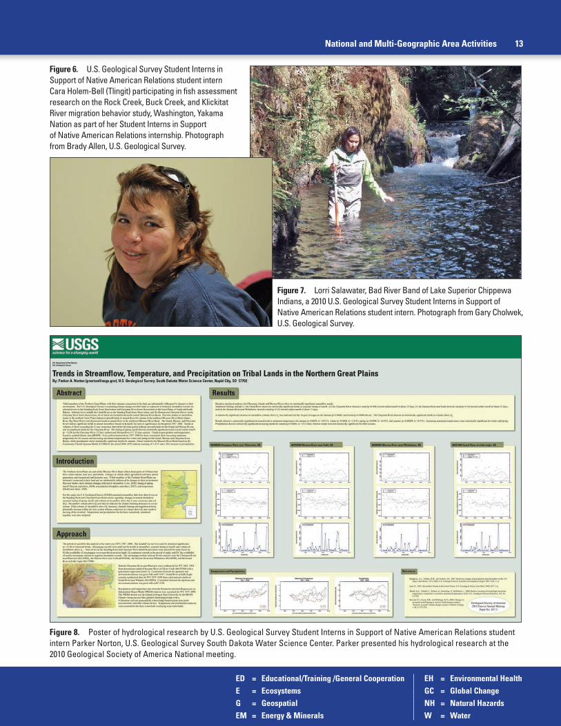
ED = Educational/Training /General Cooperation EH = Environmental HealthE = Ecosystems GC = Global ChangeG = Geospatial NH = Natural HazardsEM = Energy & Minerals W = Water
National and Multi-Geographic Area Activities 13
Figure 8. Poster of hydrological research by U.S. Geological Survey Student Interns in Support of Native American Relations student intern Parker Norton, U.S. Geological Survey South Dakota Water Science Center. Parker presented his hydrological research at the 2010 Geological Society of America National meeting.
Figure 7. Lorri Salawater, Bad River Band of Lake Superior Chippewa Indians, a 2010 U.S. Geological Survey Student Interns in Support of Native American Relations student intern. Photograph from Gary Cholwek, U.S. Geological Survey.
Figure 6. U.S. Geological Survey Student Interns in Support of Native American Relations student intern Cara Holem-Bell (Tlingit) participating in fish assessment research on the Rock Creek, Buck Creek, and Klickitat River migration behavior study, Washington, Yakama Nation as part of her Student Interns in Support of Native American Relations internship. Photograph from Brady Allen, U.S. Geological Survey.

ED = Educational/Training /General Cooperation EH = Environmental HealthE = Ecosystems GC = Global ChangeG = Geospatial NH = Natural HazardsEM = Energy & Minerals W = Water
14 U.S. Geological Survey Activities Related to American Indian and Alaska Natives—Fiscal Years 2009 and 2010
Table 2. U.S. Geological Survey Scientists, tribal participants, and tribal training programs funded through the TEchnical training in Support of Native American Relations (TESNAR) program in 2009 and 2010.
U.S. Geological Survey TESNAR recipient Training title/tribal participants
2009John Kilpatrick Water quality, streamflow discharge, and aquifer-storage training; Crow and Northern Cheyenne TribesScott VanderKooi Fish tagging implementation and management training; Klamath, Yurok, and Karuk TribesKim Winton and William Andrews Water-quality training for tribes; U.S. Geological Survey south-central geographic area tribes
2010William Andrews Watershed refresher/data-analysis techniques/aquatic-sediment sampling training; U.S. Geological Survey
south-central geographic area tribesKyle Blasch Surface-water/water-quality training; Flathead ReservationStephen Cox Groundwater/surface-water interactions: Field identification and measurement; Washington State tribesTanya Gallegos Uranium in the environment; Acoma and Laguna PueblosEric Grossman Water-quality technician; Washington State tribesLarry Handley Wetland Education Through Maps and Aerial Photography (WETMAAP); Confederated Salish and
Kootenai TribesPerry Jones Understanding the vegetation and hydrology of upper Midwest wetlands; Fond du Lac Band of Lake
Superior Chippewa and Great Lakes Indian Fish and Wildlife CommissionJames Orlando Water-quality sampling training; Klamath Basin TribesBryan Richards Wildlife disease workshops; Native American Fish and Wildlife Society MeetingsChristopher Smith Surface-water data collection and processing; Navajo NationSteve Sumioka Using pressure transducers for estimating streamflow discharge; Spokane Tribe of Indians, Confederated
Tribes of the Colville Reservation, Kalispel Tribe of Indians
USGS TEchnical Training in Support of Native American Relations (TESNAR) (National) [ED]
The USGS Office of Tribal Relations makes funds available for USGS scientists to design and conduct technical training for employees of tribal governments or inter-tribal organizations. The purpose of the program is to strengthen the technical capacity of tribes for managing their natural resources and build collaboration between the USGS and tribal governments. Through an internal, competitive process, the USGS Office of Tribal Relations Liaison Team selected training proposals that benefited tribes. Many pro-posals are derived from tribal training requests that result from ongoing USGS tribal-related research. This internal opportunity will continue annually, depending on available funding. USGS scientists, tribal participants, and tribal training programs funded through the TESNAR program in 2009 and 2010 are shown on table 2. Contact: Monique Fordham, 703-648-4437, [email protected]
Figure 10. U.S. Geological Survey wildlife biologist Bryan Richards presents a wildlife disease workshop as part of a TEchnical training in Support of Native American Relations training program for tribal biologists at the 2010 Native American Fish and Wildlife Society National Conference. Photograph from U.S. Geological Survey National Wildlife Health Center.
Figure 9. Field demonstration during a TEchnical training in Support of Native American Relations training program showing how pressure transducers are used to estimate streamflow for members of the Spokane Tribe and the Kalispell Tribe. Photograph from Steve Sumioka, U.S. Geological Survey.

ED = Educational/Training /General Cooperation EH = Environmental HealthE = Ecosystems GC = Global ChangeG = Geospatial NH = Natural HazardsEM = Energy & Minerals W = Water
National and Multi-Geographic Area Activities 15
Figure 11. U.S. Geological Survey exhibit at the 2010 American Indian Science and Engineering Society 2009 National Conference. Photograph from Wai Allen, Fort Lewis College.
American Indian Science and Engineering Society (National, Oregon) [ED]
The USGS continued its support of Native American and Alaska Native students by participating in the American Indian Science and Engineering Society’s (AISES) 2009 national conference in Portland, Oregon. This annual conference is one of the largest gatherings of Native American/Alaska Native science and engineering students and professionals, as well as Native American educators. USGS had an exhibit booth at the career fair and continues its participation on the AISES Government Relations Council, which is comprised of U.S. Government employ-ees and works to establish working relationships between agencies and AISES and promote gov-ernment careers. Conference participants from across the Nation showed great interest in USGS scientific programs and unbiased science, educational materials, and internship opportunities at USGS. Contact: Maria Montour, 303-236-2787, [email protected]
Southwest Strategy (Arizona, New Mexico) [ED]
The USGS was an active partner in the Southwest Strategy Tribal Relations Support Team. The Southwest Strategy was an intergovernmental process that provided a forum for diverse entities to collaborate and resolve natural resource conservation, management, and community development issues affecting Arizona and New Mexico tribes. The Southwest Strategy brought together federal, tribal, state, and local governments in a problem-solving process. The USGS served as a sponsor for the Tribal Relations Support Team. Because of declining participation from federal agencies and tribal governments, the Southwest Strategy decided to cease opera-tions in early FY 2010. During FY 2010 and 2011, remaining Southwest Strategy training funds were used to fund final workshops through a competitive proposal process administered by the Hohokam Resource Conservation and Development Council. Contact: Maria Montour, 303-236-2787, [email protected].

ED = Educational/Training /General Cooperation EH = Environmental HealthE = Ecosystems GC = Global ChangeG = Geospatial NH = Natural HazardsEM = Energy & Minerals W = Water
Figure 12. Streamgage house (01017060) on Hardwood Brook, Maine, November 2008 (top) and February 2009 (bottom). Photograph from U.S. Geological Survey Maine Water Science Center.
Water Resources Monitoring Activities (Multiple States)
USGS conducts water resources monitoring activities throughout the United States. Tribes cooperate with the USGS on a variety of water resources monitor-ing activities including surface water (streamgages), water quality, groundwater, lake/reservoir-stage, and sediment monitor-ing. USGS water science centers operate the various monitoring stations, usually with cooperative funding from the tribe, BIA, or a third party. Tribal governments may use streamgage station data to man-age their resources in a variety of ways, including:
• Water-supply plans
• Water-resource appraisal and allocation
• Operations (reservoirs, power production, and navigation)
• Streamflow effects from changes in land use, water use, and climate
• Flood planning and forecasting
• Streamflow forecasting
• Water-quality evaluations
• Stream-habitat assessments
• Recreation safety
• Traditional cultural activities
• Design of bridges, culverts, and dams
• Tribal monitoring stations are listed in tables 3–7.
Contact: J. Michael Norris, 603-226-7847, [email protected]
16 U.S. Geological Survey Activities Related to American Indian and Alaska Natives—Fiscal Years 2009 and 2010

ED = Educational/Training /General Cooperation EH = Environmental HealthE = Ecosystems GC = Global ChangeG = Geospatial NH = Natural HazardsEM = Energy & Minerals W = Water
Eastern United States (Northeast and Southeast Geographic Areas) (Maine, New Hampshire, Vermont, New York, Massachusetts, Rhode Island, Connecticut, New Jersey, Delaware, Maryland, Pennsylvania, West Virginia, Virginia, Tennessee, North Carolina, South Carolina, Georgia, Alabama, Mississippi, and Florida)
Continuous, Real-Time Storm Sampling on the Meduxnekeag River (Maine) [W]
The USGS Maine Water Science Center and the Houlton Band of Maliseet Indians collaborated on a project beginning in 2009 to identify possible relations between the real-time optical measurement of river water turbidity and factors affecting water quality, including nutrients, suspended sediments, and fecal coliform bacteria. The use of turbidity as a water-quality surrogate will provide a tool for near real-time estimate of loads of these constituents associated with river runoff. The information from this project will help the tribe develop a strategy to protect one of its most important natural resources, the Meduxnekeag River. Contact: Charles Culbertson, 207-622-8201 ext. 127, [email protected]
Characterization of Hydrology of the Meduxnekeag River Watershed During Periods of Low-Flow (Maine) [W]
In 2006 the Houlton Band of Maliseet Indians started collaborating with the USGS Maine Water Science Center on a project to characterize the hydrology of the Meduxnekeag River watershed during periods of low flow. The tribe is using this information to determine loads of water-quality constituents including nutrients, suspended sediments, and fecal coliform bacteria. The results of this study will also be incorporated into a planned watershed budget for the Meduxnekeag River that will help the tribe’s water resource managers during periods of potential water-use conflicts in basins with varying degrees of land use and water use. Contact: Greg Stewart, 207-622-8205 ext. 118, [email protected]
Tribal Exposure Assessment to Potential Contamination in the Penobscot River (Maine) [W, EH, E]
USGS Columbia Environmental Research Center (CERC) and USGS Maine Water Science Center scientists are working together with the Penobscot Indian Nation Department of Natural Resources (PIN DNR) scientists on a multiagency study concerning contamination of water, plants, and animals in the Penobscot River. The river, with its water and biota, is an important cultural, sus-tenance, and economic resource for the tribe. The multiagency team conducted a preliminary con-taminant exposure assessment for the Penobscot Indian Nation. Human exposure to dioxins, furans, mercury, and polychlorinated biphenyls (PCBs) that occur in the context of tribal cultural uses of the Penobscot River is the focus of the study. Five species of fish, along with ducks, turtles, fiddleheads of ostrich ferns, and a medicinal plant were collected and analyzed for chemical contaminants. In addition, Penobscot River impounded sediments as well as sediments from specific areas where tribal members wade were analyzed. A meeting to discuss the study results was held in October 2010 on Penobscot Indian Island. This EPA Regional Applied Research Effort (RARE) project began in October 2007 and concluded in December 2010. Partner agencies included EPA, PIN DNR, Agency for Toxic Substances and Disease Registry, U.S. Fish and Wildlife, BIA, and USGS. Contact: Carl Orazio, 573-876-1823, [email protected]; Charles Culbertson, 207-622-8201 ext. 127, [email protected]; Robert Dudley, 207-622-8201 ext. 115, [email protected]
Eastern United States 17
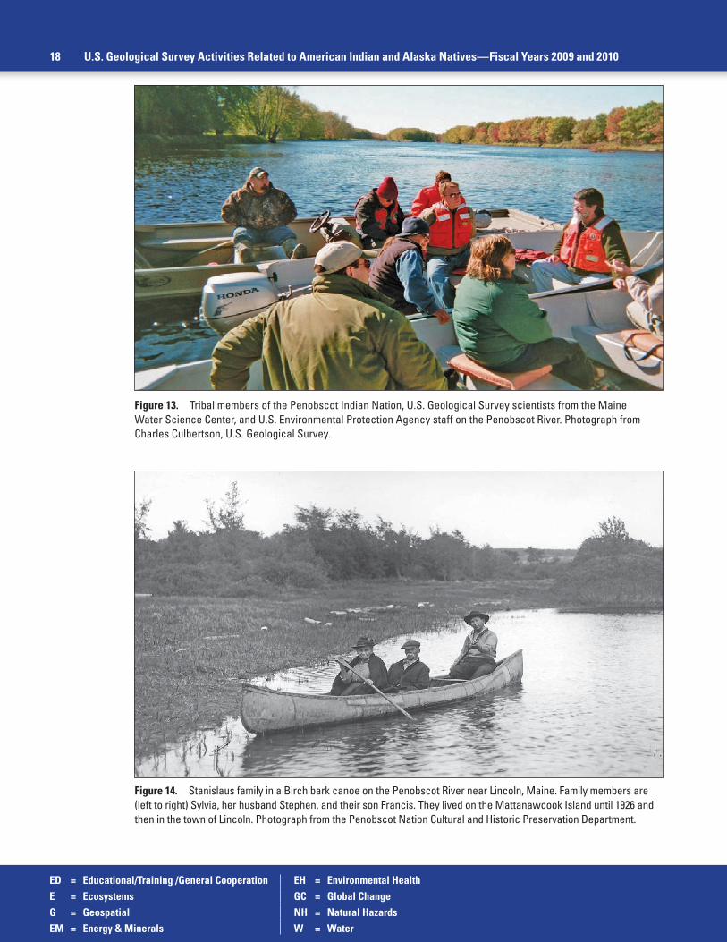
ED = Educational/Training /General Cooperation EH = Environmental HealthE = Ecosystems GC = Global ChangeG = Geospatial NH = Natural HazardsEM = Energy & Minerals W = Water
Figure 13. Tribal members of the Penobscot Indian Nation, U.S. Geological Survey scientists from the Maine Water Science Center, and U.S. Environmental Protection Agency staff on the Penobscot River. Photograph from Charles Culbertson, U.S. Geological Survey.
Figure 14. Stanislaus family in a Birch bark canoe on the Penobscot River near Lincoln, Maine. Family members are (left to right) Sylvia, her husband Stephen, and their son Francis. They lived on the Mattanawcook Island until 1926 and then in the town of Lincoln. Photograph from the Penobscot Nation Cultural and Historic Preservation Department.
18 U.S. Geological Survey Activities Related to American Indian and Alaska Natives—Fiscal Years 2009 and 2010

ED = Educational/Training /General Cooperation EH = Environmental HealthE = Ecosystems GC = Global ChangeG = Geospatial NH = Natural HazardsEM = Energy & Minerals W = Water
Eastern United States 19
Figure 15. U.S. Geological Survey Student Interns in Support of Native American Relations intern Jan Paul (Penobscot Indian Nation) making water-quality measurements in the Penobscot River aboard a University of Maine research vessel. Photograph from Collin Roesler, Bowdoin College.
Tribal Student Intern Project Supports U.S. Environmental Protection Agency Regional Applied Research Effort (EPA-RARE) on Penobscot River (Maine) [ED, E, W, G]
The USGS Maine Water Science Center received a 2009 USGS SISNAR award in support of their Penobscot River research. The intern’s work supports the USGS Columbia Environmental Research Center participation with the EPA’s Regional Applied Research Effort Penobscot River Maine Study. Internship tasks focused on the development of educational and outreach products to communicate the nature of the study and its findings to the Penobscot Indian Nation commu-nity, the greater Penobscot River Watershed community, and tribes and watershed communities across the country. The Penobscot Indian Nation intern, Michelle Attean, relied heavily on map-ping and GIS technologies in the development of the materials. She was also trained as a field assistant for sample collection activities associated with developing exposure concentrations for the cyanobacteria detection in river water. The project included installing an underwater instru-ment for the continuous measurement of three optical properties of river water: chlorophyll-a, phycocyanin (a pigment specific to cyanobacteria), and colored dissolved organic matter. The monitoring of these optical properties in the river will allow for the early detection of an impending cyanobacterial bloom and will serve as a reference base in which to compare the optical character-istics of the Penobscot River in the future. Contact: Charles Culbertson, 207-622-8201 ext. 127, [email protected]; Carl Orazio, 573-876-1823, [email protected]
Tribal Student Intern on Penobscot Indian Nation Project 2010 (Maine) [ED, E, W]
Jan Paul (Penobscot Indian Nation) University of Maine environmental studies student was selected as an USGS Office of Tribal Relations’ SISNAR intern for 2010. Jan’s internship project related to monitoring and detection of harmful algal blooms on the Penobscot River. She worked with scientists from the USGS Maine Water Science Center and USGS Columbia Environmental Research Center (CERC), Columbia, Missouri. In addition to being trained in a variety of USGS field and laboratory procedures, Jan visited the CERC facility in Columbia, Missouri, to interact with center scientists and observe specific analytical procedures related to environmental research on toxic cyanobacteria. Contact: Charles Culbertson, 207-622-8201 ext.127, [email protected]; Carl Orazio, 573-876-1823, [email protected]

ED = Educational/Training /General Cooperation EH = Environmental HealthE = Ecosystems GC = Global ChangeG = Geospatial NH = Natural HazardsEM = Energy & Minerals W = Water
Figure 16. Penobscot River and Dolby Pond in north-central, Maine.
20 U.S. Geological Survey Activities Related to American Indian and Alaska Natives—Fiscal Years 2009 and 2010
Training Class for the Penobscot Indian Nation (Maine) [ED, W]
The USGS Maine Water Science Center provided a two-day training course in the fall 2009 to the Penobscot Indian Nation Department of Natural Resources personnel in the use and deployment of water-quality instrumentation for the continuous measurement of river-water-quality constituents, and laboratory extraction and measurement of algal pigments. Contact: Charles Culbertson, 207-622-8201 ext. 127, [email protected]
Monitoring for Early Detection of Harmful Algal Blooms on the Penobscot River (Maine) [W, E, EH, GC]
The Penobscot Indian Nation has determined a critical need for real-time, continuous monitoring of the river for the early detection of algal blooms in the future in order to protect the health and safety of those who use this resource for recreational activities, or rely on it for sustenance purposes. Between 2005 and 2010, two algal blooms (later determined to be associated with species of cyanobacteria) have been observed on the Penobscot River extend-ing from near Millinocket to approximately 100 miles (160.9 kilometers) south into Penobscot Bay. While blooms have been observed in the past, chlorophyll-a concentrations associated with these blooms were the highest ever recorded on the river and led to hypoxia in some impoundments. Moreover, the dominant species identified in these blooms was a cyanobacte-rium known to produce the human neurotoxin anatoxin-a and the liver toxin microcystin. The USGS Maine Water Science Center partnered with the Penobscot Indian Nation in the summer 2010 to install a floating in-situ instrument station for real-time measurement and telemetry of physical, chemical, and optical properties of the river. The monitoring of these constituents will enable early detection of changing environmental conditions in the river, including an early warning of developing harmful algal blooms. In addition, this monitoring project will provide a reference database in which to compare future water-quality characteristics of the Penobscot River, and will be a key climate change index site within the climate change network being developed by the USGS Maine Water Science Center. Contact: Charles Culbertson, 207-622-8201 ext. 127, [email protected]

ED = Educational/Training /General Cooperation EH = Environmental HealthE = Ecosystems GC = Global ChangeG = Geospatial NH = Natural HazardsEM = Energy & Minerals W = Water
Figure 17. Cyanobacterial bloom forming on Dolby Pond, East Millinocket, Maine. Photographs from U.S. Geological Survey Maine Water Science Center.
Eastern United States 21
Dam Removal in Penobscot River Basin (Maine) [E, W]
The USGS Maine Water Science Center and the Conte Anadromous Fish Laboratory is conducting sediment transport and fish passage studies to assist the Penobscot Indian Nation and the Penobscot River Trust effort to increase fish passage on the Penobscot River. The study includes: continuous monitoring of water quality including turbidity, acoustical back-scatter, temperature, dissolved oxygen, pH, and specific conductance. Study goals include the determination of baseline conditions for a future assessment of the effects of anticipated dam removal. Colleagues at the National Oceanic and Atmospheric Administration, the U.S. Army Corps of Engineers, the Maine Department of Environmental Protection, and the Penobscot River Restoration Trust are using this ongoing study. The Penobscot Indian Nation is a key partner in the Penobscot River Restoration Trust. This project began in 2007 with installation of equipment for continuous water-quality monitoring and compilation of information and model evaluation necessary for hydraulic modeling. The project was continued in 2009 and is ongoing. Contact: Greg Stewart, 207-622-8205, ext. 118, [email protected]
Technical Assistance to the Penobscot Indian Nation (Maine) [ED, W]
The USGS Maine Water Science Center provided technical assistance in 2010 to the Penobscot Indian Nation in the acquisition and use of specific field and laboratory equipment for their water-quality program. In addition, the Maine Water Science Center provided tech-nical assistance in acquiring and using dedicated environmental software packages specific to their program needs and in the use and management of an environmental water-quality database. Contact: Charles Culbertson, 207-622-8201 ext. 127, [email protected]

ED = Educational/Training /General Cooperation EH = Environmental HealthE = Ecosystems GC = Global ChangeG = Geospatial NH = Natural HazardsEM = Energy & Minerals W = Water
22 U.S. Geological Survey Activities Related to American Indian and Alaska Natives—Fiscal Years 2009 and 2010
Evaluation of Threatened, Endangered and Declining Species of the St. Lawrence River and Its Tributaries (New York) [E]
A research team from the USGS Great Lakes Science Center, Tunison Laboratory of Aquatic Science worked in close cooperation with St. Regis Mohawk Tribe, Environment Division scientists to evaluate threatened, endangered, and declining species of the St. Lawrence River and its tributaries. This work is designed to better characterize the loca-tions and distributions of fish species that are classified as Threatened and Endangered (T&E) and Species of Greater Conservation Need (SGCN) within aquatic habitat in and adjacent to the St. Lawrence River. Greatly improved information about the distributions and status of imperilment of T&E and SGCN species within the study region will be provided to the St. Regis Mohawk Tribe (Akwesasne Mohawk Nation) and New York State Department of Environmental Conservation. . The results will identify critical habitats in need of management action and support the State Wildlife Action Plan. Sampling in 2009 yielded fish community collections from more than 100 locations, with a second field-sampling season performed in 2010. Analysis and reporting is being conducted jointly between USGS and the tribe. Contact: Jim McKenna, 607-753-9391 ext. 7521, [email protected]
Onondaga Nation Fisheries Restoration and Enhancement and Environmental Education (New York) [E]
The USGS Great Lakes Science Center, Tunison Laboratory of Aquatic Science continued assisting tribes in restoring and enhancing their fisheries and environmental education in 2009. USGS staff stocked catchable rainbow trout, reared at the Tunison facility, in waters of the Onondaga Nation. They were stocked in Onondaga Creek on May 5, 2009 and a community fishing festival was held on May 8, 2009. More than 100 tribal members in total attended for fishing education and fun. The first-place prize was for a 4.75-inch long (12.06 centimeters) Creek Chub. Four of the stocked trout were caught during the festival. Contact: Dawn Dittman, 607-753-9391 ext. 23, [email protected]
South Florida Ecosystem Program, Flows from Big Cypress Seminole Tribe Reservation (Florida) [W]
As part of the Everglades Restoration programs, the U.S. Army Corps of Engineers and South Florida Water Management District (SFWMD) proposed modified water deliver-ies to the Seminole Tribe of Florida, the Miccosukee Tribe of Indians of Florida, Big Cypress National Preserve, and other parts of the Florida interior. The project, called the Modified Water Deliveries, is intended to provide net flood protection and water delivery to agricultural lands as well as partial restoration of historic ecosystem conditions within the Seminole tribal lands. Baseline data are needed to help determine the effects of proposed water delivery changes on Seminole tribal lands. The USGS has installed and is obtaining data from strategically located streamgages for the SFWMD and the Seminole Tribe of Florida to help define future surface-water flow requirements and to provide data for the Comprehensive Everglades Restoration Plan future planned efforts. Studies based on accurate flow calibrations generated by data from these sites have been used by other agencies for computation of nutrient and other contaminant loading in the canal system since 2002. Ongoing data collection from continuous streamgages, at selected impact points for interior basins, has complemented the existing east-ern flow canal discharge network and allowed more accurately timed surface-water releases to and from Seminole tribal lands. Contact: Mark Dickman, 954-377-5927, [email protected]; Craig Tepper (Seminole Tribe of Florida), 954-965-4380, ext. 202, [email protected]

ED = Educational/Training /General Cooperation EH = Environmental HealthE = Ecosystems GC = Global ChangeG = Geospatial NH = Natural HazardsEM = Energy & Minerals W = Water
Midwest Geographic Area (Michigan, Ohio, Indiana, Kentucky, Wisconsin, Illinois, Minnesota, Iowa, North Dakota, South Dakota, and Nebraska)
Great Lakes Fishery and Aquatic Resources (Michigan, Minnesota, Wisconsin) [E]
The Chippewa Ottawa Resource Authority (CORA) and the Great Lakes Indian Fish and Wildlife Commission (GLIFWC) are members of interagency committees established by the Great Lakes Fishery Commission to coordinate fishery resource management throughout the Great Lakes. The USGS Great Lakes Science Center (GLSC) provides scientific information, data, and technical assistance to these tribes and reports on the status and trends of Great Lakes fish species and communities. The GLSC also provides information on the status of lake trout and other fish restoration efforts to assist managers in assessing the success of these efforts. Contact: Kurt Newman 734-214-7257, [email protected]
Great Lakes Fishery—Cisco Survival Study (Michigan, Minnesota, Wisconsin) [E]
The USGS Great Lakes Science Center (GLSC) Lake Superior Biological Station is partnering with the Chippewa Ottawa Resource Authority and the Great Lakes Indian Fish and Wildlife Commission on a project to understand factors affecting survival of young-of-year cisco Coregonus artedi in the Great Lakes. This four-year study is being funded by the FWS Fisheries Restoration Act; the Ontario Ministry of Natural Resources Canada-Ontario Agreement; and by in-kind contributions by the FWS Ashland Fish and Wildlife Conservation Office; and the USGS GLSC Lake Superior Biological Station. A North American Journal of Fisheries Management arti-cle, “A synthesis of cisco recovery in Lake Superior: Implications for native fish rehabilitation in the Laurentian Great Lakes” was published in 2009 (http://www.tandfonline.com/doi/abs/10.1577/M08-002.1#preview). Contact: Dan Yule, 715-682-6163, [email protected]
Lake Superior—Factors Affecting Interactions Between Invasive Sea Lamprey and the Deep Water Fish Community (Michigan, Minnesota, Wisconsin) [E]
USGS Great Lakes Science Center, Lake Superior Biological Station is partnering with the Chippewa Ottawa Resource Authority (CORA) and the National Oceanic and Atmospheric Administration (NOAA) on a project to understand factors affecting interactions between sea lamprey, siscowet lake trout, and the deep water fish community in Lake Superior. Principal investigators include CORA, NOAA, and USGS. Contact: Owen Gorman, 715-682-6163 ext. 16, [email protected]
Silver River Studies with the Keweenaw Bay Indian Community (Michigan) [W]
The Keweenaw Bay Indian Community (KBIC) is concerned about the environmental impact of future development within the 69-square mile (178.7-square kilometer) Silver River watershed. Much of the Silver River watershed, with the exception of the East Branch, is either within or adjacent to the KBICs L’Anse Reservation. The Silver River drains an area in Baraga County, Michigan, dominated by highlands. The river flows into a bay of Lake Superior, pro-viding habitat for a diverse aquatic population, including trout and salmon, and serves as a
Midwest Geographic Area 23

ED = Educational/Training /General Cooperation EH = Environmental HealthE = Ecosystems GC = Global ChangeG = Geospatial NH = Natural HazardsEM = Energy & Minerals W = Water
Figure 18. U.S. Geological Survey scientists processing adult brook trout at Dakota Creek, Michigan, August 2008. Photograph from Thomas Weaver, U.S. Geological Survey.
Figure 19. View looking upstream at Silver River, Michigan. Photograph from Thomas Weaver, U.S. Geological Survey.
drinking-water supply to three communities. The USGS Michigan Water Science Center oper-ates three continuous-data streamgages with water-quality-monitoring equipment in the Silver River Watershed in a cooperative project with the KBIC Natural Resources Department. Tem-perature, specific conductance, stage, and streamflow data from the streamgages are available on a real-time basis. A separate multiyear cooperative water-quality project started in June 2005 when USGS and KBIC began collecting and analyzing discrete water-quality samples for a variety of chemical constituents and measuring streamflow at eight locations within the Silver River watershed. USGS Scientific Investigations Report 2010–5050, “Water quality and hydrol-ogy of the Silver River watershed, Baraga County, Michigan, 2005–08,” interpreting results of the data-collection effort was published in 2010 (http://pubs.usgs.gov/sir/2010/5050/). Contact: Tom Weaver, 517-887-8923, [email protected]
24 U.S. Geological Survey Activities Related to American Indian and Alaska Natives—Fiscal Years 2009 and 2010

ED = Educational/Training /General Cooperation EH = Environmental HealthE = Ecosystems GC = Global ChangeG = Geospatial NH = Natural HazardsEM = Energy & Minerals W = Water
Studies of the Salmon Trout, East Branch Salmon Trout, and Yellow Dog Rivers with the Keweenaw Bay Indian Community (Michigan) [E, EM, EH]
Since FY 2005, the USGS Michigan Water Science Center and the Keweenaw Bay Indian Community (KBIC) have cooperated on a project on the Salmon Trout, East Branch Salmon Trout, and Yellow Dog Rivers. The rivers, which flow into Lake Superior, are noted for their diverse aquatic populations and species abundance. The KBIC and other interested parties are concerned about the environmental effects of future development—including sulfide mineral min-ing—within the watersheds, which are west and south of Big Bay in northern Marquette County, Michigan. The drainage areas of these rivers upstream from the streamgages are about 7-, 11-, and 32-square miles (18.1-, 28.5-, and 82.9-square kilometers), respectively. Temperature, specific conductance, stage, and streamflow data from the streamgages are available on a real-time basis. Contact: Steve Blumer, 517-887-8922, [email protected], or Tom Weaver, 517-887-8923, [email protected]
Michigan Tribal Environmental Group Participation and EPA Multi-Federal Agency MOU Meetings (Michigan) [W, EH]
Scientists from the USGS Michigan Water Science Center (MIWSC) attend quarterly Michigan Tribal Environmental Group (MTEG) meetings, on invitation, to present topics of perti-nence to the workgroup. Michigan tribes, Inter-Tribal Council of Michigan, EPA Region V, USGS, U.S. Department of Agriculture, State of Michigan, and other groups and agencies are represented as requested by the MTEG, and the meetings serve as a forum for environmental issues pertinent to Michigan tribes. USGS MIWSC staff members also attend quarterly BIA Midwest Region Office Multi-Federal Agency MOU meetings. Federal agencies participating in the MOU work-group include the BIA, the USGS, the Indian Health Service, the U.S. Army Corps of Engineers, the EPA, the Federal Emergency Management Agency, and the Natural Resources Conservation Service. The workgroup cooperatively plans and coordinates agency tribal activities in the region. Contact: Tom Weaver, 517-887-8923, [email protected]
Water-Resources Investigation with the Lac Vieux Desert Band of Lake Superior Chippewa Indians (Michigan, Wisconsin) [W]
A cooperative four-year study of surface-water quality and basin characteristics of Lac Vieux Desert was completed in FY 2005. Lac Vieux Desert, a 6.6-square mile (17.1-square kilometers) lake that has been used for generations by members of the Lac Vieux Desert Band of Lake Superior Chippewa Indians for hunting, fishing, and wild rice gathering, straddles the Michigan-Wisconsin border and is the headwaters of the Wisconsin River. As an outgrowth of the study, the Lac Vieux Desert Band has continued funding the operation of the real-time lake-level streamgage at the lake outlet since 2005. The National Weather Service in Wisconsin is also using the site to remotely measure precipitation. Contact: Tom Weaver, 517-887-8923, [email protected]
Bad River Streamflow, Sedimentation, and Erosion Study (Wisconsin) [W]
The original objective of this study was to understand how historical streamflow, erosion, and sedimentation rates have changed in the Bad River and some of its key tributaries because of changes in land cover. More recently, the study has expanded to include trace elements (related to potential iron mining) and nutrients (related to agricultural land-cover effects on Bear Trap Creek). Nutrient and sediment loads from Bear Trap Creek have been monitored since 2007. Contact: Faith Fitzpatrick, 608-821-3818, [email protected]; Naomi Tillison (Bad River Band of Lake Superior Chippewa Indians), 715-682-7123, [email protected]
Midwest Geographic Area 25

ED = Educational/Training /General Cooperation EH = Environmental HealthE = Ecosystems GC = Global ChangeG = Geospatial NH = Natural HazardsEM = Energy & Minerals W = Water
Evaluating Historic Trends in Nutrient Concentrations from Lake Sediments, Grand Portage Reservation (Minnesota) [E, W]
The USGS Minnesota Water Science Center, the Science Museum of Minnesota, and the Grand Portage Reservation Environmental Department are using recent water-quality data with diatom and nutrient analyses of lake sediment cores to infer historical nutrient conditions in two lakes on the reservation. Grand Portage Band of Lake Superior Chippewa water-quality specialists will use study results to establish nutrient criteria for lakes on the reservation. In 2010, study results were summarized in USGS Scientific Investigations Report 2010–5192, “Water quality (2000–08) and historical phosphorus concentrations from paleolimnological studies of Swamp and Speckled Trout Lakes, Grand Portage Reservation, northeastern Minnesota.” (http://pubs.usgs.gov/sir/2010/5192/). Contact: Perry Jones, 763-783-3253, [email protected]
Fate and Transport of Petroleum Hydrocarbons in the Subsurface near Cass Lake (Minnesota) [W, EH]
The Leech Lake Band of Ojibwe and the USGS Minnesota Water Science Center investigated the natural attenuation of petroleum hydrocarbons at the Enbridge Energy Limited Partnership South Cass Lake Pumping Station, in Cass Lake, Minnesota. Three weeks of field work were conducted between May 2007 and July 2008 to delineate the dissolved plume of benzene and characterize the biodegradation processes. Field activities included the installation of monitoring wells, collection of sediment cores, sampling of wells, and measurement of water-table elevations. Analytical results consist of grain-size distributions and concentrations of spilled and pipeline oil constituents, dissolved alkyl-benzenes and redox constituents in groundwater, sediment bioavailable iron, and aquifer microbial populations. Results from this study will determine the extent of the oil plume and an understanding of the attenuation of the oil plume. USGS Scientific Investigations Report 2010–5080, “Fate and transport of petroleum hydrocarbons in the subsurface near Cass Lake, Minnesota” presents investigation findings (http://pubs.usgs.gov/sir/2010/5085/). Contact: Barbara Bekins, 650-329-4691, [email protected]
Groundwater Resource Assessment for the Fond du Lac Band of Lake Superior Chippewa (Minnesota) [W, EH]
The USGS Minnesota Water Science Center and the Fond du Lac Band of Lake Superior Chippewa are assessing groundwater resources and the effect of a judicial ditch system on surrounding groundwater resources on the reservation. In 2009, water levels were measured continuously in 13 monitoring wells installed in shallow aquifers across the water-shed. Analysis of water-level data will provide vital hydrologic information regarding the hydrologic conditions that will be most beneficial for wild rice protection on the reservation. Contact: Perry Jones, 763-783-3253, [email protected]
Wetland Vegetation and Hydrology Characterization Workshop (Minnesota) [ED, E, W]
The USGS, the Fond du Lac Band of Lake Superior Chippewa, and the Great Lakes Indian Fish and Wildlife Commission held a three-day workshop September 22–24, 2010 demonstrating techniques and tools used to characterize wetland vegetation and hydrology and assessing the impact of land use and climate change on wetlands. Twenty-one scientists
26 U.S. Geological Survey Activities Related to American Indian and Alaska Natives—Fiscal Years 2009 and 2010

ED = Educational/Training /General Cooperation EH = Environmental HealthE = Ecosystems GC = Global ChangeG = Geospatial NH = Natural HazardsEM = Energy & Minerals W = Water
from government agencies, universities, and private companies presented technical informa-tion, data-collection methods, and research results on wetland topics on the first two days of the workshop (http://mn.water.usgs.gov/projects/pdf/TESNAR2010WORKSHOP.pdf). Topics included wetland water budgets, water chemistry, groundwater and surface-water interactions, nutrient dynamics, impacts of climate change, hydrologic effects on wild rice production, wetland ecology, and mining impacts on wetlands. Sixty-six water-resource and environmental managers from tribal governments; universities; federal, state, and local government agencies; and private companies participated in the workshop. A field trip to the Stoney Brook Watershed was done on the third day of the workshop, demonstrating lake coring, groundwater-level monitoring, surface-water modeling, and other environmental research activities done in or for the watershed. The workshop provided valuable informa-tion needed to assess the vulnerability of ecosystems and reduce wetland losses resulting from adverse changes to the landscape. The workshop also aided managers with evaluating potential effects of land-use activities on resources that are significant parts of the cultural heritage of the tribes. The workshop was funded by the USGS Office of Tribal Relations’ TESNAR program and the Fond du Lac Resources Management Division. Contact: Perry Jones, 763-783-3253, [email protected]
Wildlife Disease Workshops for Tribal Resource Departments (South Dakota, Minnesota) [ED, E]
In FY 2009, the USGS National Wildlife Health Center developed and presented two, two-day wildlife disease workshops for tribal natural resource departments. One workshop, developed in cooperation with the Native American Fish and Wildlife Society was con-ducted in Spearfish, South Dakota and included tribal natural resources professionals from Wyoming, Montana, North Dakota and South Dakota tribes. The second workshop, devel-oped in coordination with the Leech Lake Band of Ojibwe, was conducted in Cass Lake, Minnesota and included natural resource professionals from the Leech Lake Band of Ojibwe and neighboring tribes. Materials presented during these workshops included an introduc-tion to wildlife diseases and presentations on various avian, mammalian and ungulate diseases, a section on zoonoses (infectious diseases that can be transmitted between species), and select disease topics of regional importance. Each workshop also included a necropsy and dissection laboratory, where attendees were trained to dissect carcasses and collect diagnostic tissue samples. Contact: Bryan Richards, 608-270-2485, [email protected]; Anne Ballmann, 608-270-2445, [email protected]
Spirit Lake Nation Capacity Building (North Dakota) [W, ED]
USGS North Dakota Water Science Center personnel has provided Spirit Lake tribal staff technical assistance and quality assurance with collecting, processing, and shipping water-quality samples since 1999. The USGS has provided training on the techniques of making water-quality measurements. The Spirit Lake Nation has its water-quality samples processed by the USGS National Water Quality Laboratory in Denver, Colorado. Contact: Joel Galloway, 701-250-7402, [email protected]
Spirit Lake Nation Wetlands Ecology Training (North Dakota) [E, ED]
The Spirit Lake Nation’s EPA Office was interested in gaining a better understanding of wetland ecology and knowledge of a wide array of science-based techniques for monitor-ing the status and condition of wetland resources on tribal lands. At the request of the Spirit Lake EPA office staff, the USGS Northern Prairie Wildlife Research Center conducted a
Midwest Geographic Area 27

ED = Educational/Training /General Cooperation EH = Environmental HealthE = Ecosystems GC = Global ChangeG = Geospatial NH = Natural HazardsEM = Energy & Minerals W = Water
two-week instructional workshop (August 3–13, 2009) that provided an overview of general wetland ecology, climate cycles, and the hydrologic functioning of prairie wetlands. Par-ticipants gained an understanding of the effects of climate and groundwater on hydrologic function, water chemistry, and biota of prairie wetlands in addition to learning about wetland classification systems. The workshop included a significant amount of time spent at the USGS Cottonwood Lake study area north of Jamestown, North Dakota, where participants (1) gained hands-on experience by using sampling methods to collect scientific information of wetland bird, amphibian, invertebrate, and plant communities, and (2) spent time process-ing aquatic invertebrate samples at the USGS Northern Prairie Wildlife Research Center’s aquatics laboratory. Contact: Ned H. Euliss, Jr., 701-253-5564, [email protected]
Spirit Lake Nation Water Quality Analysis and Training (North Dakota) [W]
USGS continued water-quality work with the Spirit Lake Nation on the Fort Totten Reservation in eastern North Dakota during FY 2010. The ongoing work, in cooperation with tribal environmental staff and the EPA, includes a retrospective analysis of exist-ing tribal, USGS, and the State of North Dakota hydrologic and water-quality data to (1) understand sources of water and nutrients to the lakes and wetlands on the reservation so that the tribe can decide what, if any, Clean Water Act Section 319 water-quality protec-tion strategies need to be implemented to protect water quality from agricultural practices, and (2) provide training to tribal environmental staff in the interpretation of water-quality data. Contact: Tony Ranalli, 303-236-6915, [email protected]; Kathleen Rowland, 701-250-7418, [email protected]; Oliver Gourd, Spirit Lake Sioux Tribe, 701-766-1259, [email protected]
Data Loading to National Water-Quality Database (North Dakota) [W]
The Spirit Lake Nation is one of many tribes working with the EPA to test water qual-ity in areas under tribal control. Often these tribes will work with the USGS personnel to develop, implement, and maintain a water sampling and testing plan where some or all of the samples are sent to the USGS National Water Quality Laboratory (NWQL) for analysis. An ongoing issue has been the loading of the results to the tribally-controlled, EPA database. The NWQL began work in 2010 with the Spirit Lake Nation to create an application that provides results in a file that can easily be loaded to the tribal database. This application can also be used to retrieve results from previous sampling events and should work for other tribes. Contact: Gary Cottrell, 303-236-3490, [email protected]
Understanding Effects of Land Use on Water Quality on the Fort Berthold Indian Reservation, North Dakota (North Dakota) [W, ED]
The three affiliated tribes (Mandan, Arikara, and Hidatsa) on the Fort Berthhold Indian Reservation requested the assistance of the USGS to improve understanding of the effects of energy development and agricultural land use on reservation surface-water and groundwater quality. The ongoing work, in cooperation with tribal environmental staff and the EPA, includes a retrospective analysis of tribal, USGS, and the State of North Dakota hydrologic and water-quality data to (1) characterize water-quality conditions on the Reservation, (2) identify data gaps in the existing data so that future data collection will effectively monitor the effects of energy development and agricultural land on water qual-ity, and (3) provide training to tribal environmental staff members in the interpretation of
28 U.S. Geological Survey Activities Related to American Indian and Alaska Natives—Fiscal Years 2009 and 2010
ED = Educational/Training /General Cooperation EH = Environmental HealthE = Ecosystems GC = Global ChangeG = Geospatial NH = Natural HazardsEM = Energy & Minerals W = Water
water-quality data Contact: Tony Ranalli, 303-236-6915, [email protected]; Bob Lundgren, 701-250-7417, [email protected]; Edmund Baker, Three Affiliated Tribes, 701-627-4569, [email protected]
Biological Research Career Intern with Northern Great Plains Tribes (South Dakota) [E, ED]
Tribal nations on the northern Great Plains encounter the same environmental threats such as invasive plant species, water quality, and climate change to tribal lands as adjacent federal, state, and private lands; yet have varying levels of scientific research expertise available to address environmental issues that also encompass tribal cultures and traditions. The USGS Northern Prairie Wildlife Research Center initiated a Native American Research Scientist training program to begin training Native American students to fill staff research scientist positions through the Student Career Experience Program in May 2009. The first student was working on a master’s degree in biology, investigating ecological and cultural aspects of salt cedar invasion on tribal lands in South Dakota. This future scientist will have an important role in increasing USGS-tribal partnerships on local and regional environ-mental science and land management issues throughout the northern Great Plains. Contact: Amy Symstad, 605-745-1191, [email protected]
Water Field Techniques Training for Northern Plains Tribes (South Dakota) [ED, W]
EPA worked with the USGS South Dakota Water Science Center on a one-week train-ing class about field techniques for the collection of field parameters (temperature, pH, dissolved oxygen, and specific conductivity), discharge measurements, and the collection of water-quality and sediment samples in 2009. The class was held in Pierre, South Dakota, and was attended by the Crow Creek Sioux, Lower Brule Sioux, Standing Rock Sioux, and Sisseton Wahpeton Oyate Tribes from South Dakota, the Eastern Shoshone and Northern Arapaho Tribes from Wyoming, Turtle Mountain Band of Chippewa from North Dakota, Gros Ventre and Assiniboine Tribes from Montana, and the Three Affiliated Tribes from North Dakota. Follow-up activities in 2010 included working individually with the South Dakota tribes on field activities and techniques. Tribes where individual work was focused included Lower Brule, Crow Creek, and Flandreau. This activity continued into 2011. Contact: Joyce Williamson, 605-394-3219, [email protected]
Water Resource Assessment of the Standing Rock Reservation (South Dakota) [W]
Groundwater resources are important water supplies for homesteads and agriculture on the Standing Rock Sioux Reservation. A previous study of groundwater availability for the reservation was completed in the early 1980s and was based on limited informa-tion. USGS South Dakota Water Science Center started cooperating with the Standing Rock Sioux Tribe in 2010 on a study to provide updated hydrologic information for the tribe to effectively manage groundwater resources. The study will provide quantifi-able and defensible information to protect and preserve water resources on tribal lands. Contact: Larry Putnam, 605-394-3200, [email protected]
Midwest Geographic Area 29

ED = Educational/Training /General Cooperation EH = Environmental HealthE = Ecosystems GC = Global ChangeG = Geospatial NH = Natural HazardsEM = Energy & Minerals W = Water
30 U.S. Geological Survey Activities Related to American Indian and Alaska Natives—Fiscal Years 2009 and 2010
High-Flow Discharge Measurement Collection Training (South Dakota) [W, ED]
The Cheyenne River Sioux Tribe and USGS South Dakota Water Science Center worked together to train tribal staff to install a wire-weight gage and collect high-flow discharge measurements at two locations on the Cheyenne River Reservation. One of the two sites was at a USGS streamgage so the tribe would have a future reference on the accuracy of their gage. The necessary equipment was ordered in 2009 and training was conducted when higher streamflow occurred in the spring and summer of 2010. Contact: Joyce Williamson, 605-394-3219, [email protected]
Evaluation of Water Quality on the Crow Creek Reservation (South Dakota) [W]
The USGS South Dakota Water Science Center collaborated with the Crow Creek Sioux Tribe on a study during 2009 and 2010 that: compiled historical information on water-quality conditions of surface-water bodies within the Crow Creek Sioux Reservation; developed a GIS layer of the data for the tribe; collected surface-water samples from four streams that are located within or pass through the reservation; collected water-quality samples from the Missouri River; and, trained tribal personnel on sampling techniques for small to midsize streams and for a large water body. The study focused on Crow Creek and selected tributaries. The data col-lected were provided to the Crow Creek Sioux Tribe and the BIA for future planning. Contact: Kathleen Neitzert, 605-352-4241 ext. 226, [email protected]
Field Water-Quality Sampling on the Crow Creek Reservation (South Dakota) [W]
Staff from the USGS South Dakota Water Science Center trained and assisted the Crow Creek Sioux Tribe in the collection of water-quality samples and discharge measurements from May 2009 through October 2010. Samples were shipped to and analyzed at the USGS National Water Quality Laboratory and the South Dakota State Health Laboratory. Results were provided to the tribe. The tribe is working to determine if there are impacts from con-fined feeding operations on the water quality of select streams. Contact: Joyce Williamson, 605-394-3219, [email protected]
Evaluation of Water Use Resources on the Lower Brule Reservation (South Dakota) [W, G]
The Lower Brule Sioux Tribe and the USGS South Dakota Water Science Center inves-tigated water use and water-quality conditions on the Lower Brule Sioux Indian Reservation. Compilations of historic water-use data and water-quality data are being used to develop GIS data layers for the tribe. These layers will be used to create maps identifying changes that have occurred within the reservation. Field activities will include collecting water-quality samples at two sites on the Missouri River and two stream sites, and identifying locations of springs within the reservation, with the assistance of historical knowledge from the tribe. When acces-sible, field properties (specific conductance, pH, dissolved oxygen, and temperature) will be sampled at each spring. These data will be used to develop GIS coverage of spring loca-tions and their field properties. This project continued into 2011. Contact: Kathleen Neitzert, 605-352-4241 ext. 226, [email protected]

ED = Educational/Training /General Cooperation EH = Environmental HealthE = Ecosystems GC = Global ChangeG = Geospatial NH = Natural HazardsEM = Energy & Minerals W = Water
Midwest Geographic Area 31
Native American Interns Develop Digital Map of Rosebud Reservation (South Dakota) [G, ED]
Two Sinte Gleska University student interns were hired in 2010 to develop a digital map of the Rosebud Reservation using USGS digital datasets as a foundation for incorpo-rating information about culturally sensitive features. These features were located in the field using GPS coordinates and were depicted by means of digital historical and contem-porary photography such as that of Pine Ridge from the early 1950s. Contact: Eric Wood, 605-594-6068, [email protected]
Rosebud Reservation Groundwater-Flow Model Development (South Dakota) [W]
In cooperation with the Rosebud Sioux Tribe, the USGS South Dakota Water Science Center has been working to update a previously published groundwater-flow model for the Ogallala and Arikaree aquifers within the Rosebud Indian Reservation. This effort has primarily consisted of (1) incorporating additional datasets to improve model calibration; and (2) simulating future model scenarios for extended drought conditions and increased groundwater withdrawals. The project was completed in 2010 with the publication of USGS Scientific Investigations Report 2010–5105, “Simulated groundwater flow in the Ogallala and Arikaree aquifers, Rosebud Indian Reservation area, South Dakota—Revisions with data through water year 2008 and simulations of potential future scenarios” (http://pubs.usgs.gov/sir/2010/5105/). Contact: Andy Long, 605-394-3237, [email protected]
Flood-Warning Network Operation and Maintenance Training (South Dakota) [W]
USGS South Dakota Water Science Center staff provided training to the Rosebud Sioux Tribe on how to operate and maintain their flood-warning network. Existing streamgages were inventoried, those that were in working order were serviced, and nonworking streamgages were further tested and some equipment sent in for repair. This work started in 2009 and continued through 2011 to upgrade some of the network sites to ensure that all streamgages were operational by spring 2011. Contact: Joyce Williamson, 605-394-3219, [email protected]
Evaluation of Water Use Resources on the Rosebud Reservation (South Dakota) [W, G]
The Rosebud Sioux Tribe and the USGS South Dakota Water Science Center are inves-tigating water use and water-quality conditions on the Rosebud Indian Reservation. Compi-lations of historic water-use and water-quality data are being used to develop GIS data layers for the tribe. These layers will be used to create maps identifying changes that have occurred within the Reservation. Field activities will include collecting multiple water-quality sam-ples at three sites within the reservation, and results will be used to develop a GIS data layer for the Tribe. The project started in 2010 and concluded in 2011. Contact: Kathleen Neitzert, 605-352-4241 ext. 226, [email protected]

ED = Educational/Training /General Cooperation EH = Environmental HealthE = Ecosystems GC = Global ChangeG = Geospatial NH = Natural HazardsEM = Energy & Minerals W = Water
32 U.S. Geological Survey Activities Related to American Indian and Alaska Natives—Fiscal Years 2009 and 2010
Monitoring Network Training for the Oglala Sioux Tribe (South Dakota) [W]
The BIA funded the USGS South Dakota Water Science Center to provide training and technical assistance to the Oglala Sioux Tribe. The USGS trained tribal staff in methods used for selecting good sampling locations, what equipment is needed for developing a field sampling program, collection of field notes, and archival of data. This work started in 2009 and will con-tinue into 2011. Contact: Joyce Williamson, 605-394-3219, [email protected]
Arikaree Aquifer Digital Datasets Development and Water-Management Plan—Technical Assistance for Pine Ridge Reservation (South Dakota) [W, G]
The Arikaree aquifer is present near the surface in about 80 percent of the Pine Ridge Reservation and is the single largest source of groundwater for the Oglala Sioux Tribe. The USGS South Dakota Water Science Center published Scientific Investigations Map 2993, “Generalized potentiometric surface of the Arikaree aquifer, Pine Ridge Indian Reservation and Bennett County, South Dakota” in 2007 (http://pubs.usgs.gov/sim/2993/). As a follow-up to this study, selected GIS datasets relevant to the potentiometric map, along with metadata files, were completed and pub-lished in FY 2009. The shapefiles associated with Scientific Investigations Map 2993 posted to the Pubs Warehouse Web site include: (1) area where Arikaree aquifer is absent, (2) groundwater-flow directions, (3) observation wells, (4) non-observation wells, (5) springs, (6) water-table contours. In addition, the USGS and Bureau of Reclamation provided GIS training to the Oglala Sioux Tribe. Contact: Janet Carter, 605-394-3215, [email protected]
Figure 20. U.S. Geological Survey Scientific Investigations Map 2993, sheet 1, “Generalized potentiometric surface of the Arikaree aquifer, Pine Ridge Indian Reservation and Bennett County, South Dakota.” For the full view, see: http://pubs.usgs.gov/sim/2993/.
Figure 21. U.S. Geological Survey Scientific Investigations Map 2993, sheet 2, “Generalized potentiometric surface of the Arikaree aquifer, Pine Ridge Indian Reservation and Bennett County, South Dakota.” For the full view, see: http://pubs.usgs.gov/sim/2993/.
Groundwater Modeling Project for Assessing Groundwater Resources and Supply of the Oglala Sioux Tribe (South Dakota) [W]
Groundwater is a vital resource for the Oglala Sioux Tribe in South Dakota. A groundwater-flow model of the Ogallala and Arikaree aquifers, which are used extensively for water supplies within the Pine Ridge Indian Reservation, is needed to provide quantifiable information to protect and preserve groundwater resources on tribal lands and to help resolve water rights issues. The USGS South Dakota Water Science Center began a groundwater-flow study in 2009 to assess groundwater resources and supply. The study area includes the Pine Ridge Indian Reservation in Shannon and Jackson Counties and also includes Bennett County, which contains Indian Trust Lands. The model will serve as a western extension of an existing groundwater-flow model for Todd and Mellette Counties, which border the east side of the study area. The project includes assembling hydrologic data, compiling datasets for the numerical groundwater-flow model, calibrating the numerical-flow model, and simulation of a 10–20 year period that includes pos-sible future scenarios of water-use increases and climatic changes, such as drought. Contact: Larry Putnam, 605-394-3212, [email protected]

ED = Educational/Training /General Cooperation EH = Environmental HealthE = Ecosystems GC = Global ChangeG = Geospatial NH = Natural HazardsEM = Energy & Minerals W = Water
South Central Geographic Area 33
South Central Geographic Area (Missouri, Arkansas, Louisiana, Kansas, Oklahoma, Texas)
Discussions with the Chitimacha Tribe (Louisiana) [W]
The Louisiana Water Science Center has had indirect talks with the Chitimacha Tribe of Louisiana (Sovereign Nation of the Chitimacha) through the FWS in 2010 on a possible sedi-ment study of a Louisiana lake. A proposal was submitted for funding from the tribe. Contact: George Arcement, 225-298-5481 ext. 3116, [email protected]
USGS and Peoria Tribe Develop Fish Propagation Capabilities for Reintroduction of the Neosho Madtom (Oklahoma) [E, EH]
USGS CERC scientists are working together with the Peoria Tribe of Indians of Okla-homa (Peoria Tribe) on a study to propagate and reintroduce a federally listed threated fish, the Neosho madtom (Noturus placidus). Historically, Neosho madtoms are found in main stems of the Neosho, Cottonwood, and Spring Rivers in Kansas, Missouri, and Oklahoma. These rivers have been altered by reservoirs, heavy metals contamination, and gravel mining. Since 2006, CERC scientists have provided assistance in the culture and development of a draft reintroduc-tion plan for the Neosho madtom. CERC and Peoria Tribe scientists have collected and paired fish using novel ultrasonic and hatchery spawning methods. These efforts are all based on past CERC research into Neosho madtom reproductive behavior. As part of this work, CERC-developed methods are used to assess the sexual maturation of Neosho madtoms through the application of a clinical ultrasound. Staff of CERC used ultrasound assessment of the sexual maturation of Neosho madtoms that were collected in 2007 and guided pair selection for spawning efforts in 2009. One of the pairs spawned and progeny were produced. The ultimate goal of this effort will be to help the Peoria Tribe develop the capability to reintroduce the Neosho madtom and other aquatic species into the wild. In 2011, CERC scientists will develop population genetics methods based on fin clips, and using fin clip specimens from previous monitoring efforts, USGS and the Peoria Tribe will develop genetic markers for use in future Neosho madtom population studies. Study information can be found at http://www.cerc.usgs.gov/Projects.aspx?ProjectId=148. Contact: Mark Wildhaber, 573-876-1847, [email protected]
Figure 22. The Neosho madtom (Noturus placidus) a fish federally listed as threatened in Oklahoma. Photograph from Janice Albers, U.S. Geological Survey.

ED = Educational/Training /General Cooperation EH = Environmental HealthE = Ecosystems GC = Global ChangeG = Geospatial NH = Natural HazardsEM = Energy & Minerals W = Water
34 U.S. Geological Survey Activities Related to American Indian and Alaska Natives—Fiscal Years 2009 and 2010
Pesticide Assessment Assistance to U.S. Environmental Protection Agency on Behalf of Tribes (Oklahoma) [G, W, EH]
The USGS Oklahoma Water Science Center, in cooperation with the EPA Region VI, developed a GIS technique for ranking pesticide use and risk of exposure to pesticides on tribal lands in Oklahoma. A GIS-based approach was used (using currently-available data layers) to display probable pesticide exposures and use relative to: (1) tribal jurisdictional areas, (2) tribal population size and density, (3) locations of residential developments, (4) other land uses such as agricultural, (5) water quality (including suspended sedi-ment concentrations), (6) soil types and their organic-carbon contents and permeabilities, (7) topography, (8) bedrock geology, (9) incidence of endangered species, and (10) pesticide concentrations in fish and other organisms. The pesticide-use information was estimated from agricultural census data and other existing data sources. USGS staff summarized the data layers and highlighted geographic areas producing the greatest risks of pesticide exposure from use and consumption of water and provided the data to EPA. This project took place in 2008 and 2009 and Data Series 480, “A Compilation of spatial datasets to sup-port a preliminary assessment of pesticides and pesticide use on tribal lands in Oklahoma,” can be found at http://pubs.er.usgs.gov/publication/ds480. Contact: Shana Mashburn, 405-810-4427, [email protected]
Digital Atlas of Environmental and Anthropogenic Information for the Thlopthlocco Tribal Town (Oklahoma) [G, W]
The USGS Oklahoma Water Science Center provided the Thlopthlocco Tribal Town with spatial data layers describing anthropogenic features and detailing surface-water, groundwater, and other types of environmental information that can be used by tribal deci-sionmakers as a tool for managing, protecting, and better understanding their environmental resources. The spatial layers encompass Creek, Okfuskee, and Okmulgee Counties in east central Oklahoma and include water-related data describing characteristics of the upstream drainage basins of the Cimarron, Deep Fork, and Canadian Rivers. The digital atlas contains surface-water and groundwater data from the USGS National Water Information System, USGS publications, and state and federal agencies. This project began in 2010 and will end in 2011. Contact: Carol Becker, 405-810-4436, [email protected]
Concentration of Selected Metals in Stream and Flood Plain Sediment Within the Tri-State Mining District in Kansas, Missouri, and Oklahoma (Oklahoma) [W, EM, EH, E, ED]
The USGS Oklahoma Water Science Center participated in a study to assess mining damages to streams within the Tri-State Mining District (southwest Missouri, southeast Kansas, and northeastern Oklahoma) and the distribution and concentrations of metals in area sediments. Stream sediment samples were collected beginning in 2002 in the Tri-State Mining District which is located within the Spring River watershed and extends from south-west Missouri through southeast Kansas to the upper end of Grand Lake O’ the Cherokees in northeast Oklahoma. Ten tribes lie within the Spring River watershed in Oklahoma and have concerns about the environmental effect metals have on the effect of sediment and uptake of labile metals derived from the Tar Creek mining area on aquatic life and potential threat to Native American subsistence gathering in Grand Lake O’ the Cherokees. Many of the native plants and aquatic life are important cultural resources, and the degradation or loss of these resources would be a loss to the traditional customs of the tribes. USGS SISNAR

ED = Educational/Training /General Cooperation EH = Environmental HealthE = Ecosystems GC = Global ChangeG = Geospatial NH = Natural HazardsEM = Energy & Minerals W = Water
South Central Geographic Area 35
Figure 23. Chat piles in the Tri-State mining district in Picher, Oklahoma. Photograph from William Andrews, U.S. Geological Survey.
Figure 24. Tailings pile in the Tri-State mining district near Picher, Oklahoma. Photograph from William Andrews, U.S. Geological Survey.
intern Sharon Kavanaugh, an environmental science undergraduate at Langston University, assisted in the study. Sharon helped contact landowners to get permission for sampling as well as participated in discussions with the EPA. The findings are described in USGS Scientific Investigations Report 2009–5032, “Selected metals in sediments and streams in the Oklahoma part of the Tri-State mining district, 2000–2006” which can be found at: http://pubs.usgs.gov/sir/2009/5032/. The report summarizes study findings and was pub-lished in 2009. Contact: Bill Andrews, 405-810-4416, [email protected]

ED = Educational/Training /General Cooperation EH = Environmental HealthE = Ecosystems GC = Global ChangeG = Geospatial NH = Natural HazardsEM = Energy & Minerals W = Water
36 U.S. Geological Survey Activities Related to American Indian and Alaska Natives—Fiscal Years 2009 and 2010
Kickapoo Tribe of Oklahoma Water Resources Geographic Information System Development (Oklahoma) [G, W]
USGS Oklahoma Water Science Center staff, in cooperation with the Kickapoo Tribe of Oklahoma, developed a GIS geodatabase of existing groundwater and surface-water data for the area in and surrounding Kickapoo Tribal jurisdictional boundaries, and compiled complementary existing data relevant to hydrogeologic setting and land uses in those areas. Data were obtained from two primary databases: (1) the USGS National Water Information System; and (2) the groundwater database of the Oklahoma Water Resources Board. Addi-tional data was obtained from other state agencies. The data were entered into a geodatabase, and linked to a GIS containing natural and anthropogenic data layers, so that individual types of data can be displayed and viewed. This project started in 2008 and was completed in 2010 and published in USGS Data Series 402, “A compilation of spatial datasets and surface-water and ground-water data from the USGS and other Federal and Oklahoma state agencies for the Kickapoo Tribe of Oklahoma” (http://pubs.er.usgs.gov/publication/ds402). Contact: Shana Mashburn, 405-810-4427, [email protected]
Kickapoo Reservation Surface Water Quality (Kansas) [W, ED]
The Delaware River and Plum Creek drain the Kickapoo Tribe of Kansas’ Reservation and play an important role in maintaining the tribe’s water supply and fishing and hunting needs. The Kickapoo Tribe wants to monitor water quality at selected surface-water sites on the reservation to determine baseline water-quality conditions. The USGS Kansas Water Science Center sampled 5 base-flow and 10 storm-flow sites in 2009 and 2010 to assist the tribe in water-quality monitoring. Training opportunities were provided for tribal staff in water quality sampling and analysis. The USGS provides the water-quality data to the tribe in a database-friendly format. Contact: Mandy L. Stone, 785-832-3578, [email protected]
Figure 25. U.S. Geological Survey scientists measuring and processing sediment cores collected in the upstream end of Grand Lake O’ the Cherokees, Oklahoma. Photograph from William Andrews, U.S. Geological Survey.

ED = Educational/Training /General Cooperation EH = Environmental HealthE = Ecosystems GC = Global ChangeG = Geospatial NH = Natural HazardsEM = Energy & Minerals W = Water
South Central Geographic Area 37
Figure 26. U.S. Geological Survey scientist retrieving a passive sampler called a semipermeable membrane device from a stream in northeastern Oklahoma. The passive sampler was used to sample for pesticides and synthetic organic compounds by the U.S. Geological Survey in cooperation with the Kickapoo Tribe of Oklahoma. Photograph from Carol Becker, U.S. Geological Survey.
Figure 27. Chad Ashworth, U.S. Geological Survey hydrologic technician, wading a stream to deploy a passive sampler. The passive sampler was used to sample for pesticides within tribal lands in central Oklahoma by the U.S. Geological Survey. Photograph from Carol Becker, U.S. Geological Survey.
Reconnaissance of Selected Organic Compounds in Streams in Tribal Lands in Oklahoma (Oklahoma) [W, EH]
USGS Oklahoma Water Science Center staff deployed passive samplers during January–February, 2009 at seven stream sites in jurisdictional areas of several tribes in Oklahoma. The passive samplers were left in place for about 30 days, then retrieved and analyzed for pesticides, pesticide metabolites, polycyclic aromatic hydrocarbons, polychlorinated biphenyl compounds, and synthetic organic compounds. Synthetic organic compound are commonly found in treated wastewater effluent and are referred to as emerging contaminants. The samplers are devised such that they reflect the amounts of these compounds that are bioavailable to aquatic biota. The findings were published in a report titled, “A reconnaissance of selected organic compounds in streams in tribal lands in central Oklahoma, January–February 2009” and can be found at http://pubs.er.usgs.gov/publication/sir20105110. Contact: Carol Becker, 405-810-4436, [email protected]

ED = Educational/Training /General Cooperation EH = Environmental HealthE = Ecosystems GC = Global ChangeG = Geospatial NH = Natural HazardsEM = Energy & Minerals W = Water
38 U.S. Geological Survey Activities Related to American Indian and Alaska Natives—Fiscal Years 2009 and 2010
Watershed Scale Tribal Training—USGS South Central Area (Oklahoma) [ED, W]
Through partnership with the USGS Office of Tribal Relations’ TESNAR program, the USGS South Central Area, and the Bureau of Reclamation, USGS Oklahoma Water Science Center staff developed and taught a watershed scale training class in 2009. The three-day class entailed one day of review of water-quality sampling methods both in the classroom and field. The second day was focused on learning about watersheds (where to sample, how to analyze the data, point and nonpoint sources, etc.). Activities included work groups that delineated water-sheds, sampling points, and how to evaluate the collected data. The third day was a brief introduc-tion to biological habitat assessments and evaluating biodiversity as an indicator of the quality of the water in the watershed. Contact: William Andrews, 405-810-4416, [email protected]
Tribal Training Class in Sediment-Collection, Hydrologic Data Analysis Techniques, and Watershed Assessment—USGS South-Central Area (Oklahoma) [ED, W]
Based on training needs identified by Tribal Science Advisory Council, tribal environmental staff members, and EPA, the USGS Oklahoma Water Science Center conducted a three-day train-ing class on sediment-collection techniques, analysis methods for hydrologic data, and watershed assessment methods. Tribal environmental staff members in the south-central United States met in Oklahoma City August 30–September 1, 2010 for the training. Staff members from the Miami Tribe, Wyandotte Nation, Citizen Potawatomi Nation, Eastern Shawnee Tribe of Oklahoma, United Keetoowah Band of Cherokee Indians in Oklahoma, Ottawa Tribe of Oklahoma, Santa Ana Pueblo, Quapaw Tribe of Oklahoma, Tonkawa Tribe of Oklahoma, Caddo Nation, Seneca-Cayuga Tribe of Oklahoma, Cherokee Nation, Chickasaw Nation, and Otoe-Missouria Tribe attended the train-ing class, which was highly rated by the attendees. The training class was sponsored by the USGS Office of Tribal Relations’ TESNAR Program, in cooperation with the Bureau of Reclamation and the EPA. Contact: William Andrews, 405-810-4416, [email protected]
Figure 28. Art Horowitz, U.S. Geological Survey hydrologist, and Ernie Smith, U.S. Geological Survey hydrologic technician, instructing tribal members in streambed-sediment-collection equipment and techniques during a Technical training in Support of Native American Relations training program on the South Canadian River, central Oklahoma. Photograph from Kim Winton, U.S. Geological Survey.

ED = Educational/Training /General Cooperation EH = Environmental HealthE = Ecosystems GC = Global ChangeG = Geospatial NH = Natural HazardsEM = Energy & Minerals W = Water
South Central Geographic Area 39
Figure 29. Joy Savoia, U.S. Geological Survey hydrologic technician, instructs a class member in the equal-width-increment method of surface-water-quality sampling during a Technical training in support of Native American Relations training program on the South Canadian River, central Oklahoma. Photograph from Kim Winton, U.S. Geological Survey.
Figure 30. Jessica Magers, U.S. Geological Survey Student Interns in Support of Native American Relations student intern, using a hand-held X-ray fluorescence analyzer to determine arsenic and other element concentrations on outcrops and rock cores from the Rush Springs sandstone aquifer, Caddo County, Oklahoma. Photograph from Shana L. Mashburn, U.S. Geological Survey.
Light Detection And Ranging Data Collection Over Tar Creek (Oklahoma) [G]
The BIA and the USGS Oklahoma Water Science Center developed an agreement to col-lect Light Detection and Ranging (LiDAR) high-resolution elevation data over 13-square miles (33.7-square kilometers) of chat fields north of Miami, Oklahoma near Tar Creek in 2010 (“chat” is the remaining rocks and debris fragments left after lead and zinc mining and milling operations have ended). The 2010 LiDAR data were compared with 2005 LiDAR data to compute changes in chat volume and mass for the BIA. The LiDAR data project was a continuation of previ-ous USGS research near Tar Creek, which was summarized in USGS Scientific Investigations Report 2007–5115, “Streamflow, water quality, and metal loads from chat leachate and mine outflow to Tar Creek, Ottawa County, Oklahoma, 2005” (http://pubs.usgs.gov/sir/2007/5115/). The project was completed and data was delivered to the BIA in July 2010. Contact Jerrod Smith, 405 810-4408, [email protected]
Rush Springs Aquifer Arsenic Study (Oklahoma) [W, EH, ED]
In 2010, USGS Oklahoma Water Science Center student intern Jessica Magers participated in a study of the occurrence of arsenic in the Rush Springs aquifer and the relation to the occur-rence of arsenic in groundwater. With support from the Office of Tribal Relations, Jessica was hired with funding from the SISNAR and collected data using a handheld X-ray fluorescence analyzer to determine arsenic and other element concentrations in outcrops and rock cores from the Rush Springs aquifer. Outcrop and rock cores were geologically described to determine if there was a trend in arsenic concentrations in relation to the depositional environment, mineral composi-tion, or grain size. Understanding the nature and occurrence of arsenic in the sandstone matrix of the Rush Springs aquifer is critical to address the EPA drinking water exceedances of arsenic in municipal groundwater supplies. Project information can be found at http://ok.water.usgs.gov/projects/caddo/. Contact: Shana Mashburn, 405-810-4427, [email protected]

ED = Educational/Training /General Cooperation EH = Environmental HealthE = Ecosystems GC = Global ChangeG = Geospatial NH = Natural HazardsEM = Energy & Minerals W = Water
40 U.S. Geological Survey Activities Related to American Indian and Alaska Natives—Fiscal Years 2009 and 2010
Rocky Mountain Geographic Area (Montana, Wyoming, Colorado, New Mexico)
Delineation of Brine Contamination in and Near the East Poplar Oil Field, Fort Peck Indian Reservation (Montana) [W, EH]
Brine is produced with crude oil in the East Poplar oil field. Handling and disposing of brine begin-ning in the 1950’s in the East Poplar oil field has resulted in the contamination of the shallow Quaternary aquifers and the Poplar River. USGS investigations have documented and delineated a portion of the brine contamination in the East Poplar oil field during the early 1990s. Water in the contaminated Quaternary aquifers flows toward the nearby City of Poplar, Montana, a town of nearly 3,000 residents and headquarters for the Assiniboine and Sioux Tribes of the Fort Peck Indian Reservation. The shal-low sand and gravel aquifers are the sole source of potable groundwater. In 2003, the USGS Crustal Geophysics and Geochemistry Science Center began a study to better delineate the extent of brine contamination in the East Poplar oil field using a helicopter-borne electromagnetic survey, mapping of oil field infrastructure, borehole geophysics, and water-quality sampling at selected wells to determine the boundaries of the brine plume. The study is nearing completion and final products are in preparation.
Figure 31. Presentation of a 2008 Department of Interior Environmental Achievement award to the team of scientists from the U.S. Geological Survey and Fort Peck Tribes, along with the U.S. Environmental Protection Agency and private industry, for their efforts to identify brine-contaminated groundwater in the East Poplar oil field, Montana. Photograph from Department of the Interior.
field, Montana” (http://pubs.usgs.gov/of/2010/1326/) was published in 2010 and confirmed that water from the City of Poplar’s public water-supply wells is enriched in constituents that are present in oil-field brines. In 2012, a pipeline was completed that supplies treated water from the Missouri River to the City of Poplar and nearby residents, replacing the use of the shallow aquifers as a source of water. Additional project information and products can be found at the USGS project Web site at http://mt.water.usgs.gov/projects/east_poplar/. Contact: Joanna Thamke, 406-457-5923, [email protected].
Noninvasive Sampling of Grizzly Bear DNA in the Northern Continental Divide Ecosystem (Montana) [E, ED]
USGS Northern Rocky Mountain Science Center (NOROCK) is conducting research to evalu-ate the effectiveness of noninvasive sampling to monitor trends in the threatened grizzly bear popu-lation in the Northern Continental Divide Ecosystem. NOROCK has been working with several Native American students and biologists to develop a research project that will sample grizzly bear DNA from rub trees. Confederated Salish and Kootenai tribal members and students, including
The USGS also provided technical assistance to the tribes in further addressing the brine contamination issue by helping design a monitoring well network and researching the use of strontium isotopes to detect small amounts of brine contamina-tion. The team of scientists work-ing on the project from the USGS and Fort Peck Tribes, along with their partners with the EPA and private industry, were presented a 2008 Department of Interior Environmental Achievement award for their efforts to identify brine-contaminated groundwater for reme-diation by one of the oil companies. USGS Open-File Report 2010–1326, “Strontium isotope detection of brine contamination in the East Poplar oil

ED = Educational/Training /General Cooperation EH = Environmental HealthE = Ecosystems GC = Global ChangeG = Geospatial NH = Natural HazardsEM = Energy & Minerals W = Water
Rocky Mountain Geographic Area 41
Figure 32. 2010 Northern Continental Divide Ecosystem grizzly bear DNA crew including two Student Interns in Support of Native American Relations student interns. Photograph from Kate Kendall, U.S. Geological Survey.
two SISNAR 2009–2010 interns, were involved in the implementation of the field sites and col-lected data from these sites. Information from hair samples was used to identify individual griz-zly bears, determine the sex of the bears and will ultimately be used to test whether this method is effective as an additional long-term monitoring tool in the Northern Continental Divide Ecosystem. Additional information can be found at the USGS project Web site at http://www.nrmsc.usgs.gov/research/NGSbear_monitoring.htm. Contact: Kate Kendall, 406-888-7994, [email protected]; Amy MacLeod (USGS contractor), 406-888-7988, [email protected]
Training on Surface-Water Discharge Measurement and Water-Quality Sampling on Large Rivers (Montana) [ED, W]
In response to a request from the Confederated Salish and Kootenai Tribes (CSKT), the USGS Montana Water Science Center conducted a two-day training session on large river surface-water dis-charge measurement and water-quality sampling techniques for CSKT personnel and Salish Kootenai College students on September 22 and 23, 2010. The training was organized with morning in-office presentations, and afternoon hands-on field sessions on the Flathead River. The first day of training focused on streamflow-measurement techniques, with presentations and demonstrations on the use
Figure 33. Tribal members from the Confederated Salish and Kootenai Tribes and Salish Kootenai College learn about using the acoustic Doppler current profiler to measure streamflow during a Technical training in Support of Native American Relations tribal training program on the Flathead River, Montana. Photograph from U.S. Geological Survey Montana Water Science Center.
and limitations of traditional and acoustic Doppler current profiler measurement methods. The second day of training focused on identifying and using the appropriate water-quality sampling equipment to collect and process depth- or width-integrated samples from bridges. Electronic presentations were created for both the water-quality and advanced stream-flow-measurement courses and made available to training participants. These presentations also will be useful for many other tribes that have to potential to collect water-quality samples or streamflow measurements on large rivers. Contact: Jill Frankforter, 406-457-5917, [email protected]

ED = Educational/Training /General Cooperation EH = Environmental HealthE = Ecosystems GC = Global ChangeG = Geospatial NH = Natural HazardsEM = Energy & Minerals W = Water
42 U.S. Geological Survey Activities Related to American Indian and Alaska Natives—Fiscal Years 2009 and 2010
Figure 34. U.S. Geological Survey Student Interns in Support of Native American Relations student intern Josh Handley, Salish Kootenai College student, doing field work on the Flathead Indian Reservation, Montana, 2010. Photograph from Larry Handley, U.S. Geological Survey.
Wetland and Habitat Mapping and Training with the Confederated Salish and Kootenai Tribes (Montana) [E, G, ED]
Scientists from the USGS Mid-Continent Geographic Science Center (MCGSC) and the USGS National Wetlands Research Center assisted the Confederated Salish and Kootenai Tribes (CSKT) Environmental Quality Agency’s wetlands section in creating complete coverage of the Flathead Reservation using the National Wetlands Inventory habitat classification system. The EPA awarded a grant to the Confederated Salish and Kootenai Tribes to begin remapping the entire Flathead Reservation that will become an integral part of the tribes’ GIS. The project included photointerpretation of National Agriculture Imagery Program (NAIP) color infrared aerial photography for 70 USGS 1:24,000-scale quadrangles. The basic wetland and riparian inventory project began in 2008 and was successfully completed in 2010 and ends a series of mapping projects for the CSKT natural resource and wildlife programs that spanned nine years. A USGS MCGSC geographer taught a National Wetlands Inventory Classification course in August 2009, started the development of a photograph interpretation signature key, and reviewed in-the-field mapping progress. Also, in August 2009, a USGS volunteer from Chadron State College in Nebraska presented a class on wetland education to 12 educators and tribal agency personnel in Polson, Montana, using the Wetland Education through Maps and Aerial Photography (WETMAAP) program as the basic training methodology. In 2011, CKST received two additional grants for additional wetland-related work, which includes plans for the USGS to teach a third wetlands course on the use of the data and maps. Contact: Larry Handley, 337-266-8500, [email protected]; D. Phil Turnipseed, 337-266-8501, [email protected]
Salish Kootenai College Student Intern (Montana) [G, ED]
In 2010, the USGS National Wetlands Research Center working with the USGS Mid-Continent Geographic Science Center, received a USGS SISNAR grant from the USGS Office of Tribal Relations to support a student intern from Salish Kootenai College on the Flathead Reservation. The Salish Kootenai College student researched his-torical information and mapped wetlands on the Flathead Indian Reservation. The final product was an educational workshop to benefit reservation teachers and tribal government employees. The National Wetlands Research Center also received USGS TENSAR grant to pro-vide two wetland-mapping workshops on the Flathead Indian Reservation of Montana. Contact: D. Phil Turnipseed, 337-266-8501, [email protected]

ED = Educational/Training /General Cooperation EH = Environmental HealthE = Ecosystems GC = Global ChangeG = Geospatial NH = Natural HazardsEM = Energy & Minerals W = Water
Rocky Mountain Geographic Area 43
Figure 35. Classroom (top) and field training (bottom) during a Technical training in Support of Native American Relations supported National Wetlands Inventory Classification course, Polson, Montana, 2010. Photographs from Larry Handley, U.S. Geological Survey.
National Wetlands Inventory Classification Training (Montana) [G, E, ED]
In August 2010, USGS Mid-Continent Geographic Science Center, with support from the USGS Office of Tribal Relations’ TESNAR program, taught a three-day National Wetlands Inventory Classification course at the Confederated Salish and Kootenai Tribes (CSKT) Department of Natural Resources in Polson, Montana to 15 personnel from the CSKT program, Blackfoot Tribal staff, and Assiniboine and Sioux tribal staff (Fort Peck Reservation). USGS also conducted fieldwork and ground truthing with the CSKT Department of Natural Resources on two wetland mitigation sites, and provided training to the CSKT Water Resources program on using the National Wetlands Inventory wetland and riparian maps for water rights issues. Contact: D. Phil Turnipseed, 337-266-8501, [email protected]
Wetland Interpretation Forum (Montana) [G, E]
In January 2010, the USGS National Wetlands Research Center held a wetlands interpretation forum in Helena, Montana, to standardize interpretation and mapping techniques, and to discuss issues with wetlands and riparian interpretation and mapping consistency. The forum was held in conjunction with the Montana Department of Environmental Protection and the Montana Natural Heritage Program, and was attended by person-nel from the Salish-Kootenai Confederated Tribes, Blackfoot, Crow, Fort Peck Reservation, the Fort Belknap Reservation from Montana, and Wind River Reservation of Wyoming, and the Cheyenne Reservation from Montana and Wyoming. Contact: D. Phil Turnipseed, 337-266-8501, [email protected]
Northern Cheyenne Groundwater (Montana) [W, EM]
The Powder River structural basin of Montana and Wyoming is the target of extensive development of coal-bed methane. Development of coal-bed methane on lands adjacent to the southern and southeastern boundaries of the Northern Cheyenne Reservation may have unwanted effects on valuable groundwater resources within the reservation, such as depletion of the water resource and lowering of water levels over large areas. The coal-bearing forma-tion targeted for methane development supplies most of the domestic and livestock water used on the reservation. During 2009 and 2010, the USGS Montana Water Science Center in cooperation with the Northern Cheyenne Tribe evaluated the quantity of groundwater in coal-bed aquifers in areas of the reservation that are adjacent to non-reservation lands hav-ing a high potential for development of coal-bed methane. As part of the project, geologic cross sections, constructed using coal outcrop, topographic, and drill-hole data, are being used to estimate volumes of coal that comprise the aquifers. Volumes of groundwater in coal-bed aquifers are being estimated using measured water levels, calculated volumes of coal, and local and regional values of specific yield and storage coefficient. The study results are presented in USGS Scientific Investigations Report 2012–5209, “Estimates of the volume of water in five coal aquifers, Northern Cheyenne Indian Reservation, southeastern Montana” (http://pubs.usgs.gov/sir/2012/5209/). Contact: Lori Tuck, 406-457-5925, [email protected]

ED = Educational/Training /General Cooperation EH = Environmental HealthE = Ecosystems GC = Global ChangeG = Geospatial NH = Natural HazardsEM = Energy & Minerals W = Water
44 U.S. Geological Survey Activities Related to American Indian and Alaska Natives—Fiscal Years 2009 and 2010
Groundwater and Surface-Water Training for the Crow and Northern Cheyenne Tribes (Montana) [W, ED]
In August 2009, the USGS Montana Water Science Center provided classroom and field instruction on groundwater and surface-water hydrology to staff members of the natural resources and environmental protection departments of the Northern Cheyenne and Crow Tribes. On the first day, a morning of classroom presentations was followed by a visit to Birney Spring where the group measured pH, specific conductance, and discharge. The class then visited monitoring wells west of Birney, Montana. The USGS and the Northern Cheyenne Tribe have worked coop-eratively to monitor water levels in these wells since 2002. The wells are in an area having high potential for development of coal-bed methane gas. The next day, students were taught how to measure streamflow and procedures for surface-water quality sampling. Training included a dem-onstration of stream-sample collection using the Equal-Discharge Increment and Equal-Width Increment methods. The concept of two-person sampling teams with specific designated roles in sample collection and handling (referred to as “clean hands/dirty hands”) was also discussed. After classroom instruction on these topics, the group visited a USGS streamgage on Rosebud Creek near the reservation boundary for field demonstrations of streamflow measurement and water-quality sampling. Volunteers from both tribes donned hip waders and personal flotation devices to practice the procedures discussed earlier in the day. Contact: Lori Tuck, 406-457-5925, [email protected]
Studying the Occurrence of Escherichia Coli Bacteria in the Little Bighorn River (Montana) [W]
In 2009 and 2010, the USGS Montana Water Science Center worked with the Crow Tribe Environmental Program and Little Bighorn College to conduct reconnaissance sam-pling for nutrients and Escherichia coli bacteria (E. coli) along the Little Bighorn River in southeastern Montana. E. coli are bacteria that can cause illness in humans if consumed in water or food. Surface-water samples were collected during four different hydrologic conditions at seven sites. This study also funded a USGS student intern from Little Bighorn College who conducted synoptic sampling for E. coli near a confined animal feeding operation. The USGS provided technical assistance and training on water-quality data interpretation, water-quality sampling, and surface-water discharge measurement for the staff of the Apsáalooke (Crow) Nation Environmental Program. Contact: Joanna Thamke, 406-457-5923, [email protected]
Control of Non-Native Trout in the Greater Yellowstone Ecosystem (Montana) [ED, E]
In 2010 the USGS Northern Rocky Mountain Science Center (NOROCK) was awarded two SISNAR grants to assist USGS biologists in the development of control strategies for non-native trout in the Greater Yellowstone Ecosystem. Eastern Shoshone Tribal member Jason Baldes and Standing Rock Sioux Tribal member Sonny Hawk were SISNAR program student interns with the project and helped in designing studies that look at the most effective way of controlling non-native aquatic species where they co-occur with native Yellowstone cutthroat trout. Both interns prepared several presentations and posters on their work in collaboration with NOROCK. The projects goal was to develop control strategies for non-native species in a number of fisheries in the western United States Contact: Jackson Gross, 406-994-7408, [email protected]

ED = Educational/Training /General Cooperation EH = Environmental HealthE = Ecosystems GC = Global ChangeG = Geospatial NH = Natural HazardsEM = Energy & Minerals W = Water
Rocky Mountain Geographic Area 45
Streamgaging and Canal Streamgaging, Wind River Indian Reservation (Wyoming) [W]
The USGS Wyoming Water Science Center, in cooperation with the BIA, operated and maintained one seasonal streamgage and four seasonal canal streamgages on behalf of the Northern Arapahoe and Eastern Shoshone Tribes on the Wind River Indian Reservation in 2009. Real-time discharge data from the streamgages were used in administering water rights for irrigators. In 2010, the USGS operated and maintained one seasonal streamgage on behalf of the tribes. Real-time discharge data from the streamgages were used in administering water rights for irrigators. Continued funding of the streamgages in 2011 was a concern. Contact: Kirk Miller, 307-775-9168, [email protected]
Comprehensive Site Investigation of Former Uranium Mill Tailings Reclamation Act (UMTRA) Site (Wyoming) [W, EM, EH]
The Wind River Environmental Quality Council (WREQC), in cooperation with the USGS Wyoming Water Science Center, EPA Region VIII, and the Department of Energy, is leading an effort to better characterize and understand the ecological impacts of an UMTRA site near Riverton, Wyoming on the subsistence and cultural resources of the Wind River Indian Reservation. WREQC staff met with the EPA and USGS scientists in April and May 2010, with additional activities planned for FY 2011. Contact: Mike Sweat, 307-775-9174, [email protected]
Streamgaging on Ute Tribal Lands (Colorado) [W]
The USGS Colorado Water Science Center operated and maintained three streamgages in 2009 and two streamgages in 2010 in cooperation with the Southern Ute Indian Tribe near Ignacio, Colorado. One streamgage was operated and maintained in 2009 and 2010 for the Ute Mountain Ute Tribe near Towaoc, Colorado. Streamflow data are needed to address water rights issues and to calculate trace element loads. Contact: Steve Anders, 970-245-5257 ext. 13, [email protected]
Survey of Model Applicability and Data Needs Towards Accounting Types of Water in the Rio Grande, Northern New Mexico (New Mexico) [W]
The Six Middle Rio Grande Pueblos Water Planning Coalition (Coalition) in New Mexico want to ensure predictable water deliveries to meet their needs for irrigation, domestic, stock, and other water uses. The Pueblos have prior and paramount rights to deliveries of water from the natural flow of the Rio Grande for their use. In 2008 the coalition and the USGS New Mexico Water Science Center began a collaborative effort to survey specific hydrologic models to determine how applicable these models are in accounting for types of water—including natural flow—in the Rio Grande in northern New Mexico and to identify data gaps that prohibit accu-rate, consistent, and timely accounting of water in the Rio Grande. During the 2010 water year, the models and the model documentation were compiled and the assumptions and dependencies upon which the models were based were cited along with data gaps that affect model accuracy were also identified in Scientific Investigations Report 2011–5207, “Survey of hydrologic models and hydrologic data needs for tracking flow in the Rio Grande, north-central New Mexico, 2010” (http://pubs.usgs.gov/sir/2011/5207/). Contact: Anne Tillery, 505-830-7929, [email protected]; Blane Sanchez (Santo Domingo Pueblo), 505-456-0055; Holly O’Grady (Bureau of Indian Affairs), 505-563-3404

ED = Educational/Training /General Cooperation EH = Environmental HealthE = Ecosystems GC = Global ChangeG = Geospatial NH = Natural HazardsEM = Energy & Minerals W = Water
46 U.S. Geological Survey Activities Related to American Indian and Alaska Natives—Fiscal Years 2009 and 2010
Study of Geologic Framework in the Española and San Luis Basins (New Mexico) [W, EM]
The USGS conducted geologic and geophysical studies to provide a framework for understand-ing aquifers in the Española and San Luis Basins, two areas along the Rio Grande where increasing urban demands on water resources concern several tribal nations. The Española Basin includes the Pueblos of Cochiti, Nambe, Ohkay Owingeh, Pojoaque, Tesuque, San Ildefonso, and Santa Clara, and the cities of Santa Fe and Española. The southern San Luis Basin includes the town of Taos and Taos Pueblo. Geologic and geophysical studies of these basins provide the Pueblos with information that aids in groundwater protection and assessment of water and other natural resources. In 2009, USGS Professional Paper 1761, “Geophysical interpretations of the southern Española Basin, New Mexico, that contribute to understanding its hydrogeologic framework” (http://pubs.usgs.gov/pp/1761/) was published and synthesizes geophysical work in the Española Basin. This report was sent to each Pueblo in the Española Basin with additional information provided on the work by personal visits and by contacts at an annual public workshop in Santa Fe, which USGS cosponsors. Contact: Mark Hudson, 303-236-7446, [email protected]; Tien Grauch, 303-236-1393, [email protected]
Torreon Wash Watershed Monitoring (New Mexico) [W]
The Rio Puerco Alliance (RPA) is a 501(c)3 nonprofit organization formed by members of fed-eral agencies, tribes, state agencies, nonprofit organizations and interest groups, residents, landown-ers, and interested citizens. The RPA’s mission is to restore the Rio Puerco watershed for present and future generations through outreach, education, and collaborative action. The RPA has undertaken projects in the watershed and in Torreon Wash in particular with the goals of sediment reduction and vegetation and habitat improvement. The effectiveness of these various projects has never been quan-titatively measured. In 2008, the USGS entered into an agreement with RPA to monitor the effec-tiveness of the mitigation projects. The objectives of the study are: (1) to determine if the results of watershed mitigation and improvement practices can be detected as a decrease in sediment delivery at the basin outlet, and (2) to develop and implement a monitoring strategy that will be able to detect long-term changes in downstream sediment load, even if these changes are not detectable in the short term. During the 2009 water year, monitoring sites were selected, topographic data was collected, monitoring equipment and erosion control measures were installed and local volunteers were trained on the collection of streamflow and precipitation data at each site. During the 2010 water year, local volunteers collected streamflow, sediment, and precipitation data from monitoring sites. Sites were visited and volunteers were supervised and trained by USGS personnel. Contacts: Anne Tillery, 505-830-7929, [email protected]; Anne Marie Matherne 505-830-7971, [email protected]; Barbara Johnson (Rio Puerco Alliance), 505-474-6689
Department of the Interior Youth in the Great Outdoors Initiative: First Annual Federal Employment Workshop (New Mexico) [ED, E]
USGS personnel participated in the first Department of the Interior agency-wide Federal Employment Workshop, held at the Southwestern Indian Polytechnic Institute (SIPI), Albuquerque, New Mexico, in April 2010. The Federal Employment Workshop is part of the Secretary’s Youth in the Great Outdoors Initiative. This first workshop was intended to reach Native American youth and provide them with access to federal employment opportunities. At the USGS information table, a Fort Collins Science Center (FORT) scientist talked to Native American students about his USGS career as a wildlife biologist, and provided insight and advice on how to achieve similar careers. He demonstrated the use of “green technology” used by FORT scientists in the field by having a solar

ED = Educational/Training /General Cooperation EH = Environmental HealthE = Ecosystems GC = Global ChangeG = Geospatial NH = Natural HazardsEM = Energy & Minerals W = Water
Rocky Mountain Geographic Area 47
Figure 36. Aeromagnetic map for the southern Española Basin, displayed after a reduction-to-pole transformation to facilitate interpretation. From U.S. Geological Survey Professional Paper 1761, “Geophysical interpretations of the southern Española Basin, New Mexico, that contribute to understanding its hydrogeologic framework.” Image by Tien Grauch, U.S. Geological Survey.
Rio
Grand
e
25
25
285
84
285
84
285
68
502
Santa Fe
Pojoaque
Eldoradoat Santa Fe
Española
CerrillosHills
La Cienega
Cerros del RioVolcanic Field
106°00'
36°00'
35°45'
35°30'
106°15'
10 KILOMETERS0 5
5 10 MILES0
EXPLANATION
Mapped contact of Santa Fe Group sediments—Generalized from figure 3Aeromagnetic data area
–1,200
0
–800
–400
400
800
1,200
1,600
2,000
2,400
2,800
NANOTESLAS
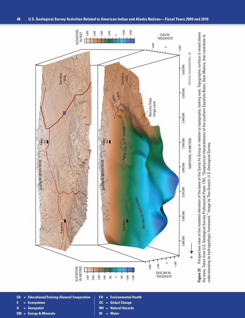
ED = Educational/Training /General Cooperation EH = Environmental HealthE = Ecosystems GC = Global ChangeG = Geospatial NH = Natural HazardsEM = Energy & Minerals W = Water
48 U.S. Geological Survey Activities Related to American Indian and Alaska Natives—Fiscal Years 2009 and 2010
Figu
re 3
7.
Pers
pect
ive
view
of t
he m
odel
ed e
leva
tion
of th
e ba
se o
f the
San
ta F
e Gr
oup
in re
latio
n to
topo
grap
hy, l
ooki
ng e
ast.
Topo
grap
hic
surfa
ce is
rais
ed a
bove
th
e ba
se. T
aken
from
U.S
. Geo
logi
cal S
urve
y Pr
ofes
sion
al P
aper
176
1, “
Geop
hysi
cal i
nter
pret
atio
ns o
f the
sou
ther
n Es
paño
la B
asin
, New
Mex
ico,
that
con
tribu
te to
un
ders
tand
ing
its h
ydro
geol
ogic
fram
ewor
k.”
Imag
e by
Tie
n Gr
auch
, U.S
. Geo
logi
cal S
urve
y.
–1,0
000
1,00
0
2,00
0
–5,0
00
ELEVATION, IN METERS
05,00
0
ELEVATION, IN FEET
3,98
0,00
03,
970,
000
3,96
0,00
03,
950,
000
3,99
0,00
03,
940,
000
3,93
0,00
03,
920,
000
NOR
THIN
G, IN
MET
ERS
VERT
ICAL
EXA
GGER
ATIO
N =
4X
–1,5
00
–1,0
00
–5000500
1,00
0
1,50
0
2,00
0
2,50
0
–2,0
00
–4,0
00
6,00
0
8,00
0
02,00
0
ELEV
ATIO
N,
IN M
ETER
SEL
EVAT
ION
,IN
FEE
T
4,00
0
Cerr
illos
Hi
lls
Santa F
e Pla
tform
Sant
aFe
Cerr
illos
Hi
lls
Sant
aFe
N
S
ANTA
FE
MOU
NTA
INS
S
ANTA
FE
MOU
NTA
INS
Ranc
ho V
iejo
hing
e zo
ne
Bar
ranc
os fa
ult s
yste
m
Agua
Fria
fau
lt s
yste
mE
spañ
ola
Esp
añol
a25
84
68
285
285

ED = Educational/Training /General Cooperation EH = Environmental HealthE = Ecosystems GC = Global ChangeG = Geospatial NH = Natural HazardsEM = Energy & Minerals W = Water
Rocky Mountain Geographic Area 49
panel and rechargeable lithium battery storage setup and used it to operate electronic equipment including a laptop computer displaying a DVD slideshow. The slideshow featured scenes of stu-dents working in the field and with the USGS natural history collection, interspersed with images of animals, plants and habitat encountered during these projects. In keeping with the theme of the workshop, a summer job opportunity flyer was displayed regarding working with the USGS natu-ral history collection located at the Museum of Southwestern Biology in Albuquerque. Contact: Ernest Valdez, 505-346-2870 ext. 10, [email protected]
Student Internship with USGS Biological Collections at the Museum of Southwestern Biology (New Mexico) [ED, E]
A recent graduate from the Southwestern Indian Polytechnic Institute (SIPI) in Albuquerque, New Mexico, spent the summer 2010 getting firsthand experience in the value of biological collections. Working as a student service contractor, the Jicarilla Apache tribal member assisted with the care and management of the Museum of Southwestern Biology scien-tific collection of vertebrates (http://msb.unm.edu/) managed by the USGS Fort Collins Science Center on the University of New Mexico campus. The student learned of the opportunity at the Department of the Interior Federal Employment Workshop Event held at SIPI in April 2010. In addition to preparing scientific specimens of birds and organizing mammal skins and skulls, the student worked with fluid-preserved specimens of amphibians, reptiles, and fishes, including a collection of endangered fishes from the upper Colorado River. Learning about these irreplace-able specimens and their value to biological research and conservation should benefit the stu-dent’s future education in wildlife and environmental. Contact: Cindy Ramotnik, 505-277-5369, [email protected]
Albuquerque Seismological Laboratory Serves a Global Community from the Pueblo of Isleta (New Mexico) [NH]
The USGS completed negotiations for a multiyear lease with the Pueblo of Isleta for the use of all buildings and facilities of the original Albuquerque Seismological Laboratory (ASL) in FY 2010. This locale includes seismometer test tunnels, surface vaults, and boreholes on Isleta lands south of Albuquerque, New Mexico. The ASL has used these facilities since 1961 for seismic network maintenance, data collection and quality control, and for testing seismic instrumentation. Today, the ASL installs, operates, and maintains seismograph networks includ-ing the USGS component of the Global Seismographic Network (GSN) and the backbone of the Advanced National Seismic System (ANSS) and ensures the quality and integrity of the data. GSN and ANSS data are used for real-time seismic monitoring by the USGS National Earthquake Information Center and the National Oceanic and Atmospheric Administration Tsunami Warning Center, for nuclear test monitoring by the Comprehensive Test Ban Treaty Organization and the U.S. Air Force, and for research on earthquake processes, earth struc-ture, and other geophysical problems by a broad community of international users. Additional information can be found online at http://earthquake.usgs.gov/regional/asl/. Contact: Lind Gee, 505-853-8887, [email protected]
Streamgage Operation for the Jicarilla Apache Tribe (New Mexico) [W]
The USGS operated a streamgage for the Jicarilla Apache on the Navajo River near Dulce, New Mexico, through the USGS Cooperative Water Program in 2009. The Jicarilla Apache funded the cost of the streamgage. Contact: Linda Weiss, 505-830-7900, [email protected]

ED = Educational/Training /General Cooperation EH = Environmental HealthE = Ecosystems GC = Global ChangeG = Geospatial NH = Natural HazardsEM = Energy & Minerals W = Water
50 U.S. Geological Survey Activities Related to American Indian and Alaska Natives—Fiscal Years 2009 and 2010
Northwest Geographic Area (Idaho, Washington, and Oregon)
Light Detection And Ranging Webinar Workshops for Pacific Northwest Tribal GIS Users (Idaho, Washington, Oregon) [G, ED]
Recognizing a need for Pacific Northwest tribal GIS users to develop a foundation and working knowledge of LiDAR and its applications, the USGS Geospatial Liaison for Washington worked with a LiDAR vendor to develop a series of three webinar workshops designed to intro-duce the Pacific Northwest tribal GIS community to LiDAR technology and its applications. The webinar series was designed for place-bound individuals, as many people of the tribal GIS com-munity reside in remote locations and cannot attend traditional classroom-based workshops. The first webinar presented LiDAR basics, an introduction to LiDAR and its applications. Subsequent webinars covered LiDAR acquisition and production examples as well as new and innovative LiDAR tools and sensors. The workshops held in 2010 lasted for 90 minutes, which included a follow-up question and answer period after each webinar. Contact: Tom Carlson, 253-552-1682, [email protected]
Presentations at the Northwest Tribal Geographic Information System User Group Meetings (Idaho, Washington, Oregon) [G]
The USGS Geospatial Liaison for Washington attended bimonthly meetings in 2010 and gave presentations on The National Map and the National Spatial Data Infrastructure, The New National Map Viewer and the new US Topo, as well as the Historic Quadrangle Scanning Project to the Northwest Tribal GIS Users Group. Other topics of discussion were the National Spatial Data Infrastructure, and applications of the National Hydrography Dataset in Washington. The presentations also explored important opportunities to collaborate on future data collection efforts and are an ongoing activity with three or four meetings a year. These meetings are used as a means to connect tribal members with USGS scientists. Contact: Tom Carlson, 253-552-1682, [email protected]
Feasibility Assessment of Enhancing White Sturgeon Spawning Habitat, Kootenai River (Idaho) [W, E]
Scientists and resource managers charged with Kootenai River white sturgeon recovery are evaluating recovery actions to enhance spawning substrate and improve spawning, early life survival, and recruitment. The white sturgeon has an enormous spiritual significance to the Kootenai Tribe of Idaho. The endangered Kootenai white sturgeon (Acipenser transmontanus) is a naturally landlocked, locally adapted population that has been isolated since the last glacial age approximately 10,000 years ago. The Kootenai sturgeon was listed as endangered under the Endangered Species Act (ESA) in 1994. A recent population assessment concluded that the wild population was between 800 and 1,000 adults with the population declining by approximately 4 percent a year. At this rate there will be no remaining wild population by approximately 2080, although functional extinction could occur well before that time.
The Kootenai Tribe of Idaho is leading the ongoing effort. Several proposed recovery actions include the alteration of streamflow or channel geometry to enhance spawning sub-strate. Scientists and resource managers need an improved understanding of the channel geometry, water depth, stream velocity, riverbed geology, and sediment transport characteristics of spawning habitat reaches of the river and tools to simulate the potential effects of proposed recovery actions to assess their feasibility and relative utility.

ED = Educational/Training /General Cooperation EH = Environmental HealthE = Ecosystems GC = Global ChangeG = Geospatial NH = Natural HazardsEM = Energy & Minerals W = Water
Northwest Geographic Area 51
Figure 38. U.S. Geological Survey Student Interns in Support of Native American Relations student intern Matthew Laramie (Colville Tribes) performing field work on the effects of stream restoration following gold mining in Idaho. Photograph from David Pilliod, U.S. Geological Survey.
USGS Idaho Water Science Center is also working in cooperation with the FWS and U.S. Army Corps of Engineers to model the water depth and streamflow velocity of the Kootenai River. The model is a tool to aid understanding of the physical factors affecting quality and quantity of spawning habitat used by the endangered white sturgeon. Model simulations were used to compute the percentage of longitudinal profiles through critical habitat that meet FWS 2006 Biological Opinion water depth and streamflow velocity criteria, on a daily interval during the spawning seasons since 2006. The model will aid the FWS in managing and enhancing white sturgeon spawning conditions. USGS project information and related products can be found at http://id.water.usgs.gov/studies/North/KootenaiRiver-SturgeonHabitat/. Contact: Greg Clark, 208-387-1324, [email protected]; Gary Barton, 253-552-1613, [email protected]; Sue Ireland (Kootenai Tribe of Idaho), 208-267-3620, [email protected]
Tribal Intern Studies Effects of Stream Restoration Following Gold Mining (Idaho) [EH, E, ED, EM]
USGS SISNAR student intern Matthew Laramie, a member of the Confederated Tribes of the Colville Reservation, examined the effects of fire and fire-management practices on stream-water quality and ecosystem dynamics and to measure restoration success of streams contaminated by gold mining for his upcoming Boise State University graduate research. Since the closure of the Stibnite gold mine in Idaho, the U.S. Forest Service, State of Idaho, and the EPA have cooperated to restore the site. The major contaminant in the watershed is arsenic with groundwater containing some of the highest residues in the nation. The USGS Forest and Rangeland Ecosystem Science Center will sample Meadow Creek for macroinvertebrates, including aquatic insects and mollusks, and measure habitat parameters, including stream temperature, gradient, and sediment levels, as indicators of restoration success. Results will be compared to data collected prior to stream restoration by the Payette National Forest scientists. Contact: David Pilliod, 208-426-5202, [email protected]

ED = Educational/Training /General Cooperation EH = Environmental HealthE = Ecosystems GC = Global ChangeG = Geospatial NH = Natural HazardsEM = Energy & Minerals W = Water
52 U.S. Geological Survey Activities Related to American Indian and Alaska Natives—Fiscal Years 2009 and 2010
Figure 39. Ashed contents from the gut of a White Sturgeon (Acipenser transmontanus). Photograph from Michael Parsley, U.S. Geological Survey.
Figure 40. A stained histology cross section of control fish tissues. Photograph from Carla Conway, U.S. Geological Survey.
Assessment of Metal Contamination in Sturgeon of Lake Roosevelt and the Upper Columbia River (Washington) [E, EH, EM]
Historical releases of smelter and mining waste products into the upper Columbia River have introduced large quantities of metals into Lake Roosevelt, the reservoir formed by Grand Coulee Dam, causing concerns about the effects of these contaminants on fisheries resources. USGS Washington Water Science Center scientists collected samples of stomach and muscle tissue from juvenile sturgeon residing in Lake Roosevelt and the upper Columbia River. Muscle samples were analyzed to determine concentrations of trace elements and stomach contents were analyzed for the presence of slag particles. USGS Open-File Report 2010–1193, “Characterization of the contents and histology of the gastrointestinal tracts of White Sturgeon (Acipenser transmontanus) captured from Upper Lake Roosevelt, Washington, October 2008,” was published in 2010 (http://pubs.usgs.gov/of/2010/1193/). This research is being conducted by the USGS in partnership with the Confederated Tribes of the Colville Reservation, the Washington Department of Fish and Wildlife, and the FWS, and will provide data to evaluate potential effects of waste products from historical metals smelting operation on this important fish species. Lake Roosevelt is a cultural and economic resource for the Confederated Tribes of the Colville Reservation and the Spokane Tribe of Indians. Summaries of this and related research can be found at http://wa.water.usgs.gov/projects/roosevelt/summary.htm. Contact: Steve Cox, 253-552-1623, [email protected]
Groundwater/Surface-Water Interactions in Bonaparte Creek, Okanogan County (Washington) [E, W]
The Confederated Tribes of the Colville Reservation (Colville Tribes) are concerned with maintaining and enhancing endangered Upper Colum-bia summer steelhead fish stocks in the Okanogan River and its tributaries. Scientists from the USGS Washington Water Science Center are working with biologists from the Colville Tribes to develop science-based alterna-tives for augmenting streamflow in the lower 1.6 miles (2.6 kilometers) of Bonaparte Creek below Bonaparte Falls, used for spawning and rearing by summer steelhead. During September and October 2009, the USGS and Colville Tribes visited selected springs in the lower Bonaparte Creek Basin that potentially contribute flow to lower Bonaparte Creek, and made multiple streamflow-discharge and groundwater-level measurements along the lower few miles of the creek to understand groundwater/surface-water exchanges in the basin. During FY 2010, the USGS and Colville Tribes made multiple streamflow-discharge and groundwater-level measure-ments along the lower 8 miles (12.9 kilometers) of the creek to understand groundwater/surface-water interactions in the basin. Study results were published in 2010: USGS Scientific Investigations Report 2009–5143, “Groundwater/surface-water interactions in the Tunk, Bonaparte, Antoine, and Tonasket Creek subbasins, Okanogan River basin, north-central Washington, 2008” (http://pubs.usgs.gov/sir/2009/5143/). All data col-lected for this investigation are in the USGS National Water Information System database and are published in the annual data reports. Contact: Rick Dinicola, 253-552-1603, [email protected]

ED = Educational/Training /General Cooperation EH = Environmental HealthE = Ecosystems GC = Global ChangeG = Geospatial NH = Natural HazardsEM = Energy & Minerals W = Water
Northwest Geographic Area 53
Figure 41. U.S. Geological Survey Fact Sheet 2010–3056, “USGS Activities at Lake Roosevelt and the Upper Columbia River.”
Figure 42. Deposits of slag along the Columbia River near the Canadian border. The slag is the darker deposits. Photograph from Cynthia Barton, U.S. Geological Survey.
U.S. Department of the InteriorU.S. Geological Survey Printed on recycled paper
Fact Sheet 2010–3056 August 2010
USGS Activities at Lake Roosevelt and the Upper Columbia RiverLake Roosevelt (Franklin D. Roosevelt Lake) is the impoundment of the upper Columbia River behind Grand Coulee Dam, and is the largest reservoir within the Bureau of Reclamation’s Columbia Basin Project (CBP). The reservoir is located in northeastern Washington, and stretches 151 miles from Grand Coulee Dam north to the Canadian border (fig. 1). The 15–20 miles of the Columbia River downstream of the border are riverine and are under small backwater effects from the dam. Grand Coulee Dam is located on the mainstem of the Columbia River about 90 miles northwest of Spokane. Since the late 1980s, trace-element contamination has been known to be widely present in Lake Roosevelt. Trace elements of concern include arsenic, cadmium, copper, lead, mercury, and zinc. Contaminated sediment carried by the Columbia River is the primary source of the widespread occurrence of trace-element enrichment present in Lake Roosevelt. In 2001, the U.S. Environmental Protection Agency (EPA) initiated a preliminary assessment of environmental contamination of the Lake Roosevelt area (also referred to as Upper Columbia River, UCR site, or UCR/LR site) and has subsequently begun remedial investigations of the UCR site.
Many large landowners have interests in the reservoir and surrounding lands, including the Department of the Interior. The upland area surrounding Lake Roosevelt is thinly populated and consists primarily of forests. The Bureau of Reclamation operates Grand Coulee Dam, and the National Park Service manages the Lake Roosevelt (LARO) National Recreation Area. The Colville
Confederated Tribes and the Spokane Tribe of Indians have large reservations bordering parts of the reservoir, but both Tribes’ “usual and customary” hunting and fishing grounds are accepted as including the entire reservoir. Federal lands administered by the U.S. Forest Service Colville National Forest and the Bureau of Land Management, and much private land also border the reservoir.
The region of the upper Columbia River Basin is rich in mineral deposits. Beginning in the mid to late 1800s, widespread mining activities occurred for various metals, primarily gold, silver, copper, lead, and zinc. These mineral deposits also contained antimony, arsenic, iron, manganese, cobalt, and molybdenum. Several smelters and numerous mines have been built and operated in the upper Columbia River Basin. The only remaining operational smelter in the basin is located 10 miles upstream of Lake Roosevelt at Trail, British Columbia, now owned by Teck Resources Limited of Canada. The complex includes one of the world’s largest integrated lead-zinc smelting facilities, and in 2009, annual production was 240,000 tons of refined zinc and 73,000 tons of refined lead (Teck Resources Limited, 2010), with smaller quantities of silver, gold, cadmium, bismuth, and many other associated metal products. For nearly a century, metallurgical and industrial wastes from the smelter, including process wastewater and slag, have been discharged to the Columbia River (fig. 2). Effluent treatment and upgrades in metals refinement technology since 1981 have greatly reduced the quantities of metals discharged to the Columbia River. The discharge of slag to the river was discontinued in 1995. Improvements in river health adjacent to the smelter following the operational upgrades at the smelter have been well documented (G3 Consulting, Ltd., 2001).
Other industrial discharges affecting Lake Roosevelt include the Celgar pulp mill located in Castlegar, British Columbia. Prior to modernization completed in 1993, effluent from the pulp mill was discharged to the Columbia River without significant treatment, and water quality of the Columbia River downstream of the Celgar pulp mill was reported (Butcher, 1992; Hatfield Consultants Ltd., 2005) to be substantially affected from effluent that contained dioxins and furans. Modernization of the mill and the installation of effluent treatment systems in 1993 greatly reduced dioxins and furans from the mill effluent (Serdar and others, 1994; Hatfield Consultants Ltd., 2005).
Activities in the Upper Columbia River and Lake Roosevelt Region (Washington) [W, EH, EM]
Lake Roosevelt is the 150-mile (241.4 kilometers) long reservoir impounded behind Grand Coulee Dam in northeast Washington. The lake has accumulated metals discharged from one of the world’s largest lead-zinc smelters. The smelter, in Trail, British Columbia, Canada, and owned by Teck Metals Ltd. (as of 2010), has been in operation since the late 1800s. Though contaminant discharges have decreased considerably in recent years, historically, millions of tons of slag have been discharged into the upper Columbia River. The U.S. Department of the Interior (DOI) has considerable trust interests in the reservoir and surrounding lands, among them operation of the dam, management of the Lake Roosevelt National Recreation Area, threatened and endangered fish in the reservoir, the interests of the Spokane Tribe of Indians and the Confederated Tribes of the Colville Reservation, and several abandoned mines on federal lands. The health of the lake’s ecosystem is crucial to the tribes’ cultural heritages and to their economies.
The DOI at present is participating in the implementation of the Upper Columbia River Site Investigation under the authority of the Comprehensive Environmental Response, Compensation, and Liability Act (CERCLA), commonly known as Superfund. The CERCLA Remedial Investigation and Feasibility Study (RI/FS) is being conducted in accor-dance with a June 2, 2006, settlement agreement between Teck Metals Ltd., and the EPA. Under the agreement, in FY 2007, Teck Metals Ltd., prepared an overall draft work plan and several specific study plans for RI/FS studies to be conducted. After review by the EPA and several other stakeholders, including DOI and the two tribes, the plans were approved in 2009. The USGS provides technical assistance to DOI agencies and continues to assist in reviewing the plans and sampling activities to make sure all studies are properly conducted and that the Department’s interests are met. This effort is done primarily through USGS participation on the Department’s Regional Management Team, Case Management Team, and Technical Advisory Group. Teck Metals Ltd. and the EPA have provided funding to cover costs incurred by the USGS for these activities. For additional information, see USGS Fact Sheet 2010–3056, “USGS Activities at Lake Roosevelt and the Upper Columbia River” (http://pubs.usgs.gov/fs/2010/3056/). Contact: Cindi Barton, 253-552-1600, [email protected]

ED = Educational/Training /General Cooperation EH = Environmental HealthE = Ecosystems GC = Global ChangeG = Geospatial NH = Natural HazardsEM = Energy & Minerals W = Water
54 U.S. Geological Survey Activities Related to American Indian and Alaska Natives—Fiscal Years 2009 and 2010
Chamokane Creek Basin Groundwater Study (Washington) [W, G]
Chamokane Creek Basin is an area of 179-square miles (463.6-square kilometers) that borders and partially overlaps the Spokane Indian Reservation. In 1979, the U.S. District Court adjudicated all water rights in the Chamokane Creek Basin. The Chamokane Creek Adjudication requires that junior water-right holders on Chamokane Creek and its tributaries be regulated in favor of the Spokane Tribe of Indian’s senior water right. The Spokane Tribe, BIA, Washington Department of Ecology, and USGS are working together to determine the effects of future groundwater development that may occur in the upstream part of the basin, particularly outside the reservation bound-ary. With increased subdivision and development, an increase in exempt groundwater use is expected to continue, although the potential effects of this growth on Chamokane Creek are unknown. The BIA requested that the USGS Washington Water Science Center conduct a study with the primary goals of (1) describing the groundwater and surface-water system of the valley-fill deposits of the basin, and (2) assessing the effects of potential increases in groundwater withdrawals on groundwater and surface-water resources. Driller’s logs, information describing the hydro-geologic framework, and geologic maps were compiled. Land use and or land cover, soils, and vegetation data for the estimation of groundwater recharge were also compiled for the study area. Well and spring records were compiled and a subset was selected and located in the field from October through November 2007. The depth to water has been measured monthly in selected wells from March 2008 through December 2009 to document seasonal changes in water levels. Hourly meteorological data were collected from November 2007 through December 2009 at an auto-mated agricultural weather station that was installed in the Chamokane Creek Basin in November 2007. Pictures of the site and data can be
Figure 43. U.S. Geological Survey scientist Bill Taylor measuring depth to water at the Chamokane observation well, February 2009 (top) and U.S. Geological Survey streamgage at Chamokane Creek, Stevens County, Washington June 2009 (bottom). Photographs from Karen Payne and Lisl Fasser, U.S. Geological Survey.
viewed at http://www.usbr.gov/pn/agrimet/agrimetmap/chawda.html. Water-use data were obtained from a number of sources, including Spokane Tribal representatives, public water system managers, and local, state, and other federal agencies. In 2009, the data were compiled and monthly and annual averages of water use were computed. Aquifers and confining units were identified and mapped using well drillers logs and geologic maps. Water-level contour maps were drawn for the two aquifer units in the study area using water-level measurements made during autumn 2007. Current (2009) and historic (1985) satellite data from the USGS Earth Resources Observation and Science Center was used to conduct a land use land cover change analysis of Chamokane Creek Basin. Images were classified using geospatial software. Historic aerial-photograph and ground-truth data were used to assess the accuracy of the historic and present-day classifications, respectively. A change analysis between the two periods was then carried out to determine how land use and land cover has changed in the basin. The USGS coupled groundwater and surface-water flow model (GSFLOW) is being used to investigate the aquifer-creek interactions and simulate the effects of potential groundwater withdrawals and climate scenarios on Chamokane Creek. In addition to measured streamflow and water levels, the model is constrained by snow course data, measured evapotranspiration, and estimates of actual evapotranspiration derived from a coupled remote sensing and Simplified Surface Energy Balance approach. A phase 1 report describing the groundwater and surface-water system of basin was published in 2010, “Hydrogeologic framework, groundwater and surface-water systems, land use, pumpage, and water budget of the Chamokane Creek basin, Stevens County, Washington” (http://pubs.usgs.gov/sir/2010/5165/). A phase 2 USGS report describing the effects of potential increases in groundwater withdrawals on groundwater and surface-water resources, “Simulation of groundwater and surface-water resources and evaluation of water-management alternatives for the Chamokane Creek basin, Stevens County, Washington,” is available at http://pubs.usgs.gov/sir/2012/5224/. Contact: Sue Kahle, 253-552-1616, [email protected]

ED = Educational/Training /General Cooperation EH = Environmental HealthE = Ecosystems GC = Global ChangeG = Geospatial NH = Natural HazardsEM = Energy & Minerals W = Water
Northwest Geographic Area 55
Figure 44. Tribal students at the U.S. Geological Survey Marine Water Quality Technician Technical training in Support of Native American Relations training at Northwest Indian College, June 2010. Photographs from Eric Grossman, U.S. Geological Survey.
Northwest Indian College Training Workshop and Internships (Washington) [ED, W]
The USGS Western Fisheries Research Center works with the Northwest Indian College (NWIC) to provide internships and training opportunities for tribal students through the USGS Office of Tribal Relations’ SISNAR and TESNAR Programs. In 2010 scientists from USGS Pacific Coastal and Marine Science Center, USGS Washington Water Science Center, and the Swinomish Indian Tribal Community held the first Water Quality Training Workshop to train and engage tribal students in marine science activities and USGS SISNAR internships. Together USGS and NWIC are in early stages of developing curricula within NWIC to train and engage students in technical and applied sciences including stream hydrologic technician, marine water-quality technician, and restoration technician modeled after efforts underway within the USGS Native American Program. These efforts aim to fulfill the President’s Youth Initiative and goals of building science capacity with tribes. Contact: Eric Grossman, 831-460-7525, [email protected]
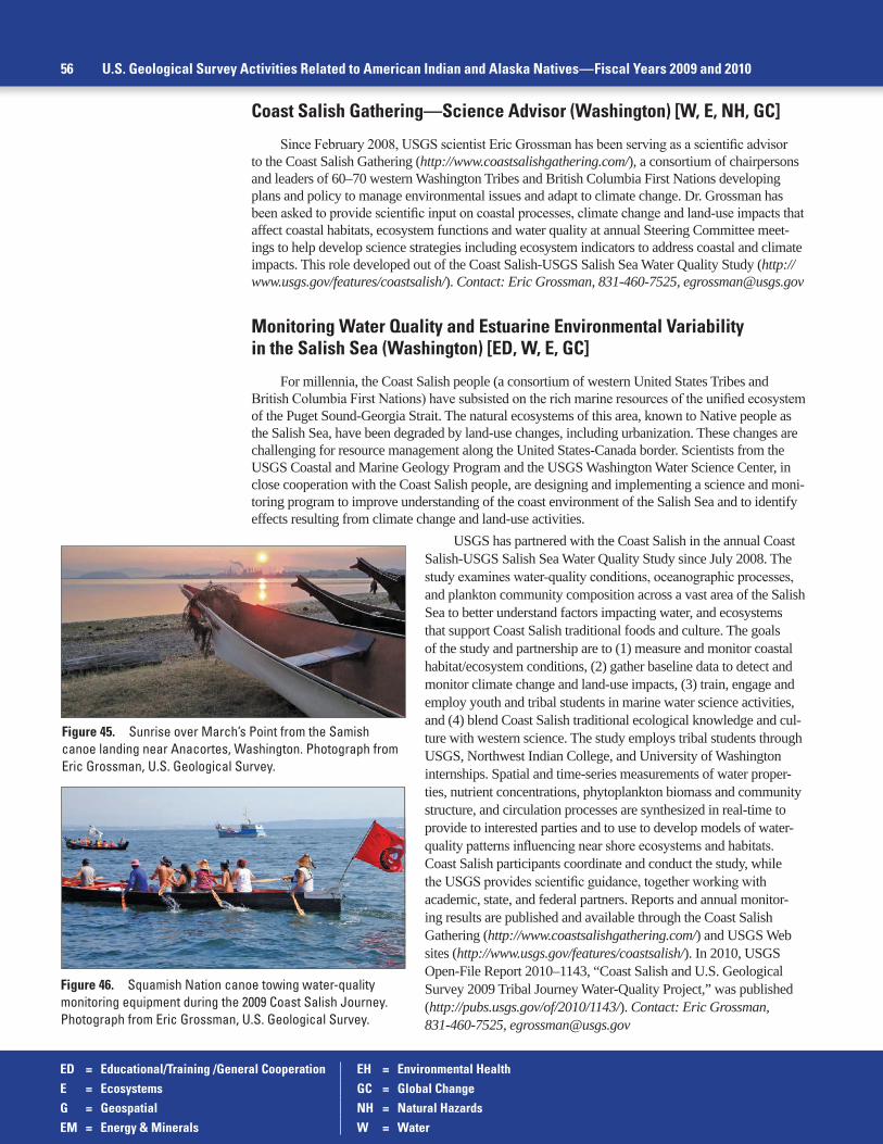
ED = Educational/Training /General Cooperation EH = Environmental HealthE = Ecosystems GC = Global ChangeG = Geospatial NH = Natural HazardsEM = Energy & Minerals W = Water
56 U.S. Geological Survey Activities Related to American Indian and Alaska Natives—Fiscal Years 2009 and 2010
Coast Salish Gathering—Science Advisor (Washington) [W, E, NH, GC]
Since February 2008, USGS scientist Eric Grossman has been serving as a scientific advisor to the Coast Salish Gathering (http://www.coastsalishgathering.com/), a consortium of chairpersons and leaders of 60–70 western Washington Tribes and British Columbia First Nations developing plans and policy to manage environmental issues and adapt to climate change. Dr. Grossman has been asked to provide scientific input on coastal processes, climate change and land-use impacts that affect coastal habitats, ecosystem functions and water quality at annual Steering Committee meet-ings to help develop science strategies including ecosystem indicators to address coastal and climate impacts. This role developed out of the Coast Salish-USGS Salish Sea Water Quality Study (http://www.usgs.gov/features/coastsalish/). Contact: Eric Grossman, 831-460-7525, [email protected]
Monitoring Water Quality and Estuarine Environmental Variability in the Salish Sea (Washington) [ED, W, E, GC]
For millennia, the Coast Salish people (a consortium of western United States Tribes and British Columbia First Nations) have subsisted on the rich marine resources of the unified ecosystem of the Puget Sound-Georgia Strait. The natural ecosystems of this area, known to Native people as the Salish Sea, have been degraded by land-use changes, including urbanization. These changes are challenging for resource management along the United States-Canada border. Scientists from the USGS Coastal and Marine Geology Program and the USGS Washington Water Science Center, in close cooperation with the Coast Salish people, are designing and implementing a science and moni-toring program to improve understanding of the coast environment of the Salish Sea and to identify effects resulting from climate change and land-use activities.
Figure 45. Sunrise over March’s Point from the Samish canoe landing near Anacortes, Washington. Photograph from Eric Grossman, U.S. Geological Survey.
Figure 46. Squamish Nation canoe towing water-quality monitoring equipment during the 2009 Coast Salish Journey. Photograph from Eric Grossman, U.S. Geological Survey.
USGS has partnered with the Coast Salish in the annual Coast Salish-USGS Salish Sea Water Quality Study since July 2008. The study examines water-quality conditions, oceanographic processes, and plankton community composition across a vast area of the Salish Sea to better understand factors impacting water, and ecosystems that support Coast Salish traditional foods and culture. The goals of the study and partnership are to (1) measure and monitor coastal habitat/ecosystem conditions, (2) gather baseline data to detect and monitor climate change and land-use impacts, (3) train, engage and employ youth and tribal students in marine water science activities, and (4) blend Coast Salish traditional ecological knowledge and cul-ture with western science. The study employs tribal students through USGS, Northwest Indian College, and University of Washington internships. Spatial and time-series measurements of water proper-ties, nutrient concentrations, phytoplankton biomass and community structure, and circulation processes are synthesized in real-time to provide to interested parties and to use to develop models of water-quality patterns influencing near shore ecosystems and habitats. Coast Salish participants coordinate and conduct the study, while the USGS provides scientific guidance, together working with academic, state, and federal partners. Reports and annual monitor-ing results are published and available through the Coast Salish Gathering (http://www.coastsalishgathering.com/) and USGS Web sites (http://www.usgs.gov/features/coastsalish/). In 2010, USGS Open-File Report 2010–1143, “Coast Salish and U.S. Geological Survey 2009 Tribal Journey Water-Quality Project,” was published (http://pubs.usgs.gov/of/2010/1143/). Contact: Eric Grossman, 831-460-7525, [email protected]

ED = Educational/Training /General Cooperation EH = Environmental HealthE = Ecosystems GC = Global ChangeG = Geospatial NH = Natural HazardsEM = Energy & Minerals W = Water
Northwest Geographic Area 57
Student Internships in Coastal Ecosystem Science (Washington) [ED]
The Swinomish Indian Tribal Community, Western Washington University (WWU), Northwest Indian College, and USGS are collaborating to develop and implement undergraduate student research projects and internships in Earth and coastal ocean sciences and to promote quan-titative skill sets with applications to tribal, USGS, and restoration science needs. In February 2009, mentors from WWU, the Swinomish Tribe, and the USGS provided instruction on near shore map-ping and sample-collection methods, and WWU students conducted field investigations to measure baseline nearshore geology and habitat characteristics and collect sediment cores. Students analyzed sediment composition and radioisotopes and produced a report describing historical environmental changes, including sedimentation history and an assessment of future restoration scenarios in impor-tant tribal shellfish and endangered salmon nursery habitat. Contact: Eric Grossman, 831-460-7525, [email protected]
Research on Emerging Virus of Salmonids (Washington) [E]
An emergence of a deadly fish virus in river basins on the Olympic Peninsula and Puget Sound in Washington State has been found. The further spread of a new strain (referred to as the M-D genotype) of Infectious Hematopoietic Necrosis Virus (IHNV), continues to threaten steelhead and rainbow trout populations in river basins on the Olympic Peninsula and Puget Sound. The new strain of IHNV differs from those common to sockeye stocks throughout the Washington coast and Puget Sound because it is highly lethal to steelhead and rainbow trout. The continued spread of this virus to new locations constitutes a significant risk to both hatchery and wild stocks of steelhead that support economically important treaty and nontreaty fisheries and that are important elements in recovery planning for ESA listed stocks. At the request of the State of Washington, the FWS, and the Northwest Indian Fisheries Commission (NWIFC), the USGS Western Fisheries Research Center has been providing technical advice and conducting research regarding the emergence of IHNV in the watersheds of coastal Washington State. The virus is causing high mortality among young steelhead trout reared at state and tribal facilities and is of special concern to the Quinault Indian Nation and the Tulalip Tribes fisheries programs. Support for further research from the NWIFC resulted in funding from the BIA as well as from the FWS. Contact: James Winton, 206-526-6282 ext. 328, [email protected]
Joint USGS and Skagit River System Tribal Cooperative Research Identifies Critical Habitat for Chinook Salmon (Washington) [E]
The USGS Western Fisheries Research Center and the Skagit River System Cooperative (SRSC) continue a collaboration to investigate whether rearing Chinook salmon in the Skagit River delta increases the survival of juveniles and whether limitations in the amount of that habitat are limiting the Skagit population of Chinook salmon. The SRSC provides natural resource manage-ment services for the Sauk-Suiattle Indian Tribe and the Swinomish Indian Tribal Community. The SRSC staff have been monitoring densities and size of juvenile salmon for more than a decade and collecting samples for USGS to analyze otoliths (ear “stones”) to reveal specific rearing strategies used by the juvenile salmon. Fish otoliths accumulate daily growth rings that are spaced propor-tionally to the growth rate of the fish. These rings also record movement among the freshwater, delta, and bay habitats.
This research has shown that the longer juvenile salmon stay and grow in the delta, the faster they grow when they move on to the bay. Faster growth in the bay should increase survivability because faster growth reduces vulnerability to predation and predators are com-mon in the bay and at sea. These and other data from this research show that, in future years, the remaining delta habitat is insufficient to support the number of juvenile salmon produced. Therefore, restoring delta habitat that was formerly lost to diking is a promising means to

ED = Educational/Training /General Cooperation EH = Environmental HealthE = Ecosystems GC = Global ChangeG = Geospatial NH = Natural HazardsEM = Energy & Minerals W = Water
58 U.S. Geological Survey Activities Related to American Indian and Alaska Natives—Fiscal Years 2009 and 2010
increase the numbers of adult Chinook salmon in the Skagit River. The results have provided a clear, scientific basis for advocating delta restoration in the Skagit River and other rivers of Puget Sound, and already have led to initiation of several habitat restoration projects in the Skagit River delta. The results also contribute to a larger applied research framework by providing specific life history data to a habitat-based salmon production model. In turn, the data support priorities listed in the Skagit River System Cooperative Chinook Recovery Plan. This research is described in “Pre-Restoration Habitat Use by Chinook Salmon in the Nisqually Estuary Using Otolith Analysis: An Additional Year” (http://pubs.usgs.gov/of/2009/1106), Contact: Kim Larsen, 206-526-6282 ext. 232, [email protected]
Skagit Climate Science Consortium (SC2) (Washington) [W, E, GC, NH]
As part of the USGS Coastal Habitats in Puget Sound Project, USGS participates in the Skagit Climate Science Consortium, led by Swinomish Indian Tribal Community. USGS provides information to help decisionmakers develop plans for climate change adapta-tion using results of coastal habitat mapping and marine resources assessments, sediment transport studies and impact assessments to salmon habitat, flood hazard planning, and ecosystem restoration monitoring. The results are being integrated into watershed-wide decision support tools to help develop long-term land-use plans that balance ecosystems that support tribal trust resources and human livelihood. Information on the USGS Coastal Habitats in Puget Sound research (CHIPS) can be found at http://puget.usgs.gov/. Contact: Eric Grossman, 831-460-7525, [email protected]
Genetic Diversity and Gene Flow for Puget Sound Surf Smelt (Washington) [E]
USGS Western Fisheries Research Center scientists worked with the Suquamish Tribe and the Washington Department of Fish and Wildlife Habitat Program from 2009 through 2011 to evaluate the genetic connectivity of the beach-spawning surf smelt (Hypomesus pretiosus), an important member of the Puget Sound forage fish community. Forage fish in Puget Sound support high profile species such as salmon, seabirds, and marine mammals, and have been recognized by regional entities such as the Puget Sound Partnership as spe-cies of interest because of the declining population levels of many of these charismatic spe-cies at higher trophic levels. Although surf smelt are widespread and critical components of the marine food web, nothing is known about the genetic population structure of this species in Puget Sound. Resource managers cannot draw sound-wide inferences about the role of surf smelt, or other forage fishes in the ecosystem until they can define the population struc-ture of these fish. This study will evaluate the genetic diversity and gene flow of surf smelt collected from coastal beaches, the Strait of Juan de Fuca, and within Puget Sound. Infor-mation about this research can be found at http://pubs.er.usgs.gov/publication/fs20123023. Contact: Theresa Liedtke, 509-538-2299 ext. 270, [email protected]
Winter Behavior of Juvenile Coho Salmon in the Upper Cowlitz River Basin (Washington) [E]
Salmon specifies are of important cultural significance to Northwest tribes. Cowlitz Falls Dam is 143 kilometers (88.9 miles) upriver from the confluence of the Cowlitz River with the Columbia River and is the highest of 3 dams in the system. Anadromous salmonid stocks are trapped downstream from the lowest dam, then trucked and released upstream from Cowlitz Falls Dam where they are presumed to spawn. Downstream migrants are

ED = Educational/Training /General Cooperation EH = Environmental HealthE = Ecosystems GC = Global ChangeG = Geospatial NH = Natural HazardsEM = Energy & Minerals W = Water
Northwest Geographic Area 59
collected at Cowlitz Falls Dam and transported to the lower Cowlitz River. Based on the design of the trap and haul program, juvenile salmon that pass downstream of Cowlitz Falls Dam are lost to the anadromous population. USGS Western Fisheries Research Center scientists are working with Washington Department of Fish and Wildlife staff to investigate the winter behavior of juvenile coho salmon above Cowlitz Falls Dam. The objective of the work is to assess the risk of dam passage for these fish in the event of a high-flow event that would force spill at the dam during the fall and winter. Juvenile coho salmon were implanted with radio transmitters and their movements are monitored to determine how closely they approach the dam and what proportion of them is passed over the dam during winter spill events. Lewis County Public Utility District funds the research. Contact: Theresa Liedtke, 509-538-2299 ext. 270, [email protected]
Elk Monitoring Review and Survey Design in Pacific Northwest National Parks (Washington) [E]
Monitoring elk population trends is one of the elements of the National Park Service’s strategy to evaluate the overall health of park resources and provide scientific informa-tion needed for education and management decisions. In the Pacific Northwest, the USGS Forest and Rangeland Ecosystem Science Center is working with a variety of cooperators to review survey procedures and to provide input for developing standardized protocols. One of these cooperators is the Lower Elwha-Klallam Tribe located on the Olympic Peninsula of Washington State. Contact: Kurt Jenkins, 360-565-3041, [email protected]
Assistance to the Northwest Indian Fisheries Commission—Tribal Water Resources Assessment (Washington) [W]
The Northwest Indian Fisheries Commission (NWIFC) and the USGS Washington Water Science Center continued working on a comprehensive assessment of tribal water resources in western Washington. The assessment is designed to support the member tribes of the NWIFC, individually and collectively, in the protection of their treaty and reserved water rights. In FY 2009, study plans were developed for FY 2010 that focus on document-ing low-flow conditions in western Washington over time, publishing best estimates of low-flow statistics at selected sites, and documenting methods and development of tools for estimating regional low-flow statistics. Also in 2010, the NWIFC member tribes and USGS held a workshop to prioritize possible future study components of the comprehensive assessment of tribal water resources in western Washington. Contact: Marijke van Heeswijk, 253-552-1625, [email protected]
Squaxin Island Tribe Geospatial Data Collaboration (Washington) [G]
The Squaxin Island Tribe received support for the USGS to participate in the Washington State Orthoimagery Program’s 6-inch (15.2 centimeter) pixel resolution image product. The Squaxin Island Tribe, in Mason County, has ongoing studies in Johns Creek and the Skookum Valley Basin that will benefit from having higher resolution orthoimagery over those study areas. Work on the project began in 2007 and data collected support The National Map, fish and wildlife studies, hazard studies as well as economic planning and development for the tribe. Contact: Tom Carlson, 253-552-1682, [email protected]

ED = Educational/Training /General Cooperation EH = Environmental HealthE = Ecosystems GC = Global ChangeG = Geospatial NH = Natural HazardsEM = Energy & Minerals W = Water
60 U.S. Geological Survey Activities Related to American Indian and Alaska Natives—Fiscal Years 2009 and 2010
Elwha River Channel Studies (Washington) [W]
The planned removal of two dams on the Elwha River is to begin in 2011. The USGS Washington Water Science Center conducted a channel survey of the Lower Elwha River in May 2006 to document baseline conditions prior to dam removal. The survey used an acoustic Doppler current profiler, a real-time kinematic GPS, and an echo sounder to collect data on channel current velocities and bathymetry. This study of the Elwha River channel continues, in close cooperation with the Lower Elwha Klallam Tribe, to document the recovery of near shore ecosystems. The studies also support actions of the Bureau of Reclamation and the National Park Service, and others involved in the restoration of the Elwha River ecosystem. Contact: Chris Curran, 253-552-1614, [email protected]
Elwha Sediment Model—Transport of Suspended Sediment and Its Effect on Aquatic Habitat in Elwha River (Washington) [W]
The USGS Washington Water Science Center has completed the development and running of a sediment transport model in the Elwha River. The model will assist management agen-cies, the Lower Elwha Klallam Tribe, and stakeholders in understanding the potential changes in hydrology and sediment transport in response to the removal of two dams on the river in 2011 and 2012. The model was applied to analyze suspended sediment concentrations and riverbed stability. The model predicts that suspended sediment concentrations and bed stability will recover rapidly and return to levels observed upstream of Lake Mills during the recovery period. Monitoring of these impacts and recovery, however, will be complicated by episodic high flows. A 2009 report on the model results was published, “Simulating the recovery of suspended sediment transport and river-bed stability in response to dam removal on the Elwha River, Washington” (http://pubs.er.usgs.gov/publication/70036693). Contact: Chris Konrad, 253-552-1634, [email protected]
Elwha River Coastal Habitats in Puget Sound Studies (Washington) [E, W]
The removal of two long-standing dams on the Elwha River on Washington’s Olympic Peninsula is planned in 2011. The USGS continues to work closely with scientists from the Lower Elwha Klallam Tribe, whose reservation is at the river’s mouth, on studies focused on understanding the ecologic and hydrologic components of the river, estuary, and nearshore prior to the dam removal. The baseline scientific studies completed in 2009 include an estimate of the sediment load in the naturally flowing river; temperature mapping in the estuary; a rhoda-mine dye study; characterization of groundwater/surface-water interactions; continuing map-ping of physical oceanography and ecosystem of the nearshore; beach-cobble movement; and the collection of ecological datasets, including seasonal water nutrients, salmon habitat use, and estuary vegetation mapping. Some study results were published in USGS Scientific Investiga-tions Report 2009–5221, “Estimates of sediment load prior to dam removal in the Elwha River, Clallam County, Washington” (http://pubs.usgs.gov/sir/2009/5221/). These data will be compared with post-dam-removal river and coastal changes to analyze the effects of dam removal and res-toration of upstream sediment supply on topography and sediment transport, and to help scientists track changes to the Elwha River ecosystem as dam removal progresses and salmon populations return to their former range throughout the watershed. In 2010 the focus was on reporting study results concerning temperature mapping in the estuary; a dye-tracer study; characterization of groundwater/surface-water interactions; continued mapping of the morphology and ecosystem of the nearshore; beach-cobble movement; and the collection of ecological datasets, includ-ing seasonal water nutrients, salmon habitat use, and estuary vegetation mapping. These results are described in a comprehensive USGS Scientific Investigations Report “Coastal Habitats of

ED = Educational/Training /General Cooperation EH = Environmental HealthE = Ecosystems GC = Global ChangeG = Geospatial NH = Natural HazardsEM = Energy & Minerals W = Water
Northwest Geographic Area 61
Figure 47. Log jam on the Elwha River (looking upstream) entering Lake Mills, Clallam County, Washington. Photograph from Christopher Konrad, U.S. Geological Survey.
Figure 48. Bank-operated cable system and D-74 suspended-sampler viewed from the USGS streamgage Elwha River above Lake Mills (12044900), Elwha River Basin, Clallam County, Washington. Photograph from Christopher Konrad, U.S. Geological Survey.
the Elwha River, Washington—Biological and Physical Patterns and Processes Prior to Dam Removal” (http://pubs.usgs.gov/sir/2011/5120/) that documents important baseline scientific information for the river and estuary before dam removal. The team, comprised of USGS and tribal scientists, also successfully secured an additional 3-year EPA grant for biological and physical science monitoring of the lower Elwha River system. This new work includes continu-ous suspended-sediment monitoring of load in the lower Elwha River, sediment monitoring and research of sediment dynamics in the estuary, continuous monitoring and analysis of suspended-sediment dynamics in the nearshore and offshore environments, and continued biannual benthic dive surveys of the nearshore marine ecosystem at the river mouth. This work is supported, in part, by the USGS Coastal Habitats in Puget Sound (CHIPS) Project (http://puget.usgs.gov/) described in USGS Fact Sheet 2006–3081, “Coastal Habitats in Puget Sound (CHIPS)” (http://pubs.usgs.gov/fs/2006/3081/). USGS Elwha River Restoration Project information can be found at http://walrus.wr.usgs.gov/elwha/. Contact: Jeff Duda, 206-526-2532, [email protected]; Chris Magirl, 253-552-1617, [email protected]

ED = Educational/Training /General Cooperation EH = Environmental HealthE = Ecosystems GC = Global ChangeG = Geospatial NH = Natural HazardsEM = Energy & Minerals W = Water
62 U.S. Geological Survey Activities Related to American Indian and Alaska Natives—Fiscal Years 2009 and 2010
Understanding Fish Populations in the Elwha River Prior to Dam Removal (Washington) [E]
Starting in 2011, two dams on the Elwha River on the Olympic Peninsula will be removed. The USGS Western Fisheries Research Center is conducting research to document some of the conditions prior to dam removal as a reference for understanding how the river and the watershed change. Dismantling the dams will provide access to the upper reaches of the Elwha River for salmon and steelhead, whose annual migrations have been blocked for more than 90 years. The Lower Elwha Klallam Tribe Fisheries Program has assisted with surveys of Elwha River fish and habitat and continues to work with the USGS on a variety of aspects of Elwha River fish and habi-tat research. USGS study information can be viewed at http://wfrc.usgs.gov/projects/YD00BQJ/7/. Contact: Jason Dunham, 541-750-0990, [email protected]
Understanding Wildlife Response to Restoration of the Elwha River (Washington) [E]
The Lower Elwha Klallam Tribe and the National Park Service Olympic National Park are leading the Nation’s largest dam removal to restore free-flowing waters to the Elwha River. This project will restore pacific salmon to more than 70 miles (112.6 kilometers) of river, will renew cultural traditions and restore access to sacred sites for the Lower Elwha Klallam Tribe, and will restore native ecosystem processes to the Elwha River watershed. The USGS Forest and Rangeland Ecosystem Science Center, Tribal, and National Park Service scien-tists are studying the pre-restoration in-stream and stream-side wildlife community in order to evaluate community response to the return of native hydrology and nutrient dynamics. Contact: Kurt Jenkins, 360-565-3041, [email protected]; Jason Dunham, 541-750-0990, [email protected]
Figure 49. Elwha River looking downstream of U.S. Geological Survey streamgage Elwha River at McDonald Bridge (12045500), Elwha River Basin, Clallam County, Washington. Photograph from Christopher Konrad, U.S. Geological Survey.

ED = Educational/Training /General Cooperation EH = Environmental HealthE = Ecosystems GC = Global ChangeG = Geospatial NH = Natural HazardsEM = Energy & Minerals W = Water
Northwest Geographic Area 63
Evaluating Success of Fisher Restoration in Olympic National Park (Washington) [E]
Fishers are reclusive members of the weasel family that were native to Washington forests but disappeared decades ago because of over-trapping and habitat loss. In 2004, an interagency team led by the Washington Department of Fish and Wildlife (WDFW) evaluated the feasibil-ity of restoring fishers to the State of Washington and concluded that Olympic National Park had the best quantity and quality of habitat to maximize restoration success. The USGS Forest and Rangeland Ecosystem Science Center is working with cooperators from the National Park Service and the WDFW to release fishers, monitor their survival and movements, and evalu-ate the success of the reintroduction. Some fishers released in the park have migrated to lands managed by the Lower Elwha Klallam Tribe and the Makah Nation. These tribes are providing assistance with aspects of monitoring the fishers residing on their lands. Contact: Kurt Jenkins, 360-565-3041, [email protected]
Quinault Indian Nation Light Detection And Ranging Collection (Washington) [G, E, NH]
The Quinault Indian Nation received support from the USGS for LiDAR acquisition more than a 205,000-acre area on the Quinault Reservation. Part of this acquisition is 16,000 acres (647.5 hectares) of LiDAR collection over the Upper Quinault River flood plain, which is located outside the reservation boundaries. The Quinault Reservation faces the Pacific Ocean, and the Quinault Indian Nation will use the collected data for environmental studies, in addition to emergency management, watershed analysis, and flood protection projects. The Quinault Indian Nation will also obtain high-resolution, natural-color digital orthophotographic imagery, coacquired with the LiDAR data, over a 16,000-acre area of interest, comprising the network of existing and historical channels in the flood plain of the heavily braided Quinault River above Lake Quinault—the historical spawning and rearing habitat of the Quinault sockeye salmon, a signature fish of the Quinault Tribal culture. This upper Quinault area is the focus of a long-term salmon habitat restoration, with initial efforts already underway. The datasets will also be extremely useful to a variety of other purposes including land use and climate change research, manage forest resources, and model tsunami, flooding, and landslide hazards. The LiDAR data collection is complete and the data are in the processing stage. The orthophotographic imag-ery data collection is ongoing. When completed, the LiDAR and orthophotographic imagery data will be included in The National Map (http://nationalmap.gov/). Contact: Tom Carlson, 253-552-1682, [email protected]
Geospatial Data Used for Managing Salmon Habitat (Washington) [G, E]
The USGS Geospatial Liaison for Washington invited representatives from the Quinault Indian Nation (QIN) Department of Fisheries to speak at the USGS Water Science Center in Tacoma and meet with the Northwest Area Regional Executive and staff, as well as USGS sci-entists to discuss elements of the QIN Salmon Restoration Program and the Comprehensive Plan for Quinault Sockeye Salmon Restoration. The meeting served as an important vehicle to connect tribal and USGS scientists for potential collaborations in research efforts. A long-term plan for the restoration and maintenance of salmon habitat in the Upper Quinault River flood plain is needed as annual runs of the unique Quinault River sockeye salmon have decreased significantly during the last century from 250,000 adult fish in 1908 to 3,200 in 2006 (the smallest return on record). This plan presents a long-term restoration approach (on the order of 75 years) for restor-ing and maintaining salmon habitat and production in the Upper Quinault River flood plain. Core

ED = Educational/Training /General Cooperation EH = Environmental HealthE = Ecosystems GC = Global ChangeG = Geospatial NH = Natural HazardsEM = Energy & Minerals W = Water
64 U.S. Geological Survey Activities Related to American Indian and Alaska Natives—Fiscal Years 2009 and 2010
elements of the plan include construction of engineered log jams and application of reforestation methods. The Quinault have worked with the USGS Washington Geospatial Liaison to acquire high-resolution digital orthoimagery and LiDAR over the study area and examples of the use of those datasets were presented. The use of LiDAR on this project is highlighted as the engineered log jams are visible on the LiDAR surface data as well as on the digital orthoimagery. Contact: Tom Carlson, 253-552-1682, [email protected]
Mountain Huckleberry (Vaccinium membranaceum) Management in the Western Cascade Mountains (Washington) [E, G]
In cooperation with the Muckleshoot Indian Tribe, USGS scientists are evaluating the fire history of Bone Lake, a traditional mountain huckleberry (Vaccinium membranaceum) gather-ing site in the western Cascades of Washington State. Tribal oral history indicates that a tribal member burned a portion of the huckleberry meadows as recently as the 1940s. Project goals are to (1) document the long-term fire history and human use of the site, and (2) examine the rate of conifer encroachment into huckleberry meadows and the effects of conifer encroachment on huckleberry productivity. Initial research objectives for the 2009 field season included conduct-ing archival research, developing site and vicinity maps using a GIS, and conducting ecological research at Bone Lake. Archival data collection accomplishments include the collection of a series of historical fire maps and aerial photos covering the site for each decade from the mid-1940s to present, as well as the development of site and vicinity base maps in GIS format, including current (2006) and historical (1944) extent of huckleberry meadows using georeferenced aerial photos. Field accomplishments include the development of a research plan for documenting the effects of conifer encroachment on huckleberry productivity at Bone Lake; installation of 20 vegeta-tion plots, and documenting the presence of 140 plant species at the site. Contact: Lief Horwitz, 206-220-4616, [email protected]
Figure 50. Conifer encroachment into the huckleberry meadows in the vicinity of Bone Lake, Western Cascade Mountains, Washington. Photograph from Tracy Fuentes, U.S. Geological Survey.

ED = Educational/Training /General Cooperation EH = Environmental HealthE = Ecosystems GC = Global ChangeG = Geospatial NH = Natural HazardsEM = Energy & Minerals W = Water
Support for the Nisqually Chinook Recovery Plan (Washington) [E]
The USGS Western Fisheries Research Center, the Nisqually Tribe, and FWS continued a collaboration to investigate the use of the Nisqually delta by juvenile Chinook salmon. The Nisqually Tribe and the FWS made collec-tions of juvenile Chinook salmon from various habitats within the Nisqually River System, and USGS scientists processed the Chinook otoliths. Monitor-ing efforts, collections, and otolith processing occurred for multiple years prior to planned estuary restoration efforts (which began spring 2009) by the FWS at the Nisqually National Wildlife Refuge. The otoliths (ear “stones”) are calcium carbonate structures that can be used to determine residence and growth in particular habitat types and ultimately identify successful life his-tory strategies. This particular research, in partnership with the Nisqually Indian Tribe and FWS, provided data needed for evaluating the estuary FWS restoration efforts at the Nisqually National Wildlife Refuge and assisted in meeting Nisqually Tribe monitoring priorities listed in the 2001 Nisqually Chinook Recovery Plan. Additional information on the USGS research can be found at http://wfrc.usgs.gov/projects/3210APN/11.8/. Reports on this research have been published as USGS Open-File Report 2008–1102, “Characterization of estuary use by Nisqually Hatchery Chinook based on otolith analysis” (http://pubs.usgs.gov/of/2008/1102/); USGS Open-File Report 2009–1106, “Pre-restoration habitat use by Chinook salmon in the Nisqually Estuary using otolith analysis: An additional year” (http://pubs.usgs.gov/of/2009/1106/); and USGS Open-File Report 2010–1238, “Otolith analysis of pre-restoration habitat use by Chinook salmon in the delta-flats and near shore regions of the Nisqually River Estuary” (http://pubs.usgs.gov/of/2010/1238/). Contact: Kim Larsen, (206-526-2539), [email protected]
Nisqually Delta Nearshore Habitat Restoration Science and Monitoring (Washington) [E, GC, W]
USGS scientists from the USGS Pacific Coastal and Marine Science Center, USGS Western Ecological Research Center, USGS Western Fisheries Research Center, and the USGS Washington Water Science Center are coin-vestigators with the Nisqually Indian Tribe and Nisqually National Wildlife Refuge (NNWR) on the interdisciplinary science and monitoring of the Nisqually Delta restoration project. Project goals are to examine how near-shore delta habitat structure and cross-shore hydrodynamic processes respond to the largest dike removal project in Puget Sound at the Nisqually Delta, and includes the design, implementation and reporting of science, and monitoring of the largest wetland restoration project in the Pacific Northwest at Nisqually Delta. A comprehensive set of ecosystem variables were measured prior to dike removal in September 2009 and will be remeasured over the next several years. The goals are to quantify the biophysical processes that shape salmon and bird habitat and to develop models to predict the evolution and interaction of geomorphology, vegetation, food resources, and salmon-habitat use follow-ing the removal of 5 miles (8 kilometers) of dike complex and the recovery of 750 acres (303.5 hectares) of salt marsh. USGS leads efforts to (1) quantify sediment delivery to the restored delta and assess if sufficient sediment will offset threats of sea-level rise, and (2) examine the response of nearshore benthic communities and the food-web (food-prey resources for salmon)
Northwest Geographic Area 65
Figure 51. Representative otolith sample of freshwater growth from Nisqually Basin, Washington, 2005. Abbreviations: H = hatch, E = emergence; FF = first feed; and FW = freshwater residence. Photograph from Angie Lind-Null and Kim Larsen, U.S. Geological Survey.

ED = Educational/Training /General Cooperation EH = Environmental HealthE = Ecosystems GC = Global ChangeG = Geospatial NH = Natural HazardsEM = Energy & Minerals W = Water
to the enhanced land-sea connectivity stemming from dike removal and impending climate change. The Nisqually Indian Tribe and NNWR provide guidance, study design, operational resources, and financial support; while the USGS contributes scientific input, study implemen-tation, and interpretations. Contact: Eric Grossman, 831-460-7525, [email protected]
Sediment Inputs to the Nisqually Delta from the Nisqually River (Washington) [W]
The USGS Washington Water Science Center is monitoring suspended sediment input from the Nisqually River to the Nisqually Delta in collaboration with the Nisqually Indian Tribe as part of a multipartner effort to learn how a previously diked estuary and delta recover to a more natural state. In the fall 2009, dikes were removed from the Nisqually National Wildlife Refuge and tidal inundation returned to more than 750 acres (303.5 hectares) of the refuge. The dike removal com-plemented 3 earlier restoration projects completed by the Nisqually Indian Tribe on tribal property to restore more than 900 acres (364.2 hectares) of the estuary, representing the largest estuary res-toration project in the Pacific Northwest and one of the most significant advances to date towards the recovery of Puget Sound. However, it remains uncertain how the delta will respond to this new inundation in light of many altered physical processes (river flow control, reduced sediment inputs) and the 100-year history of subsidence and freshwater peat development since initial dik-ing. The need for project monitoring and research is great because the magnitude of the Nisqually Delta restoration project makes its potential contribution to restoration science unprecedented in Puget Sound. The results of this project will guide the design of long-term monitoring methods for application at the Nisqually Delta and elsewhere in support of designing and evaluating estu-ary restoration. Contact: Chris Curran, 253-552-1614, [email protected]
Juvenile Salmon and Forage Fish Use of the Nisqually Delta Tide Flats and Nearshore Habitat (Washington) [E]
The USGS Western Fisheries Research Center (WFRC) working in conjunction with ongo-ing efforts by the Nisqually Indian Tribe to characterize Nisqually River estuary and nearshore habitat use by juvenile Chinook and chum salmon, forage fish, and other species. USGS scientists are using a lampara net to sample delta tide flat and nearshore areas inaccessible to beach seining, thereby providing more complete coverage of estuarine habitats than in the past. The Nisqually delta tide flats are extensive (2,224 acres, 900 hectares) and include eelgrass beds considered valuable to juvenile salmon and other fish. An important additional benefit is collecting juvenile Chinook salmon for ongoing otolith analyses by WFRC biologists. Delta tidal flat and nearshore samples will supplement samples from other habitats to provide a more complete picture of growth rates and residence time in the estuary, and Chinook salmon life history diversity. Dike removal in fall 2009 returned tidal inundation to more than 750 acres (303.5 hectares) of the FWS Nisqually National Wildlife Refuge and represents the largest estuary restoration project to date in Puget Sound. This study is one component of a multidisciplinary effort by USGS and the Nisqually Indian Tribe to track restoration of physical and biological processes to the estuary fol-lowing dike removal. Contact: Steve Rubin, 206-526-2533, [email protected]
Buck Creek Watershed Fish Population Habitat Analysis Prior to the Condit Dam Removal (Washington) [E, ED]
After blocking fish passage into the White Salmon River above river mile 3.3 for more than 95 years, the planned removal of Condit Dam planned in 2011 affords an opportunity to regain an important watershed for threatened salmon stocks. This will be the tallest dam in
66 U.S. Geological Survey Activities Related to American Indian and Alaska Natives—Fiscal Years 2009 and 2010

ED = Educational/Training /General Cooperation EH = Environmental HealthE = Ecosystems GC = Global ChangeG = Geospatial NH = Natural HazardsEM = Energy & Minerals W = Water
Northwest Geographic Area 67
the United States to be removed to date. Buck Creek is one of the largest tributaries upstream from Condit Dam that is in the historic range of anadromous salmonids in the White Salmon River. The area is within the southern ceded lands of the Confederated Tribes and Bands of the Yakama Nation (Yakama Nation). USGS Western Fisheries Research Center has partnered with the Yakama Nation to evaluate the status of fish and stream habitat in Buck Creek over a two-year period. A Native American student intern, hired through the USGS Office of Tribal Relations’ SISNAR program, conducted the habitat survey and fish sampling for this study. This fish and habitat assessment will provide the necessary information to track changes in fish use after dam removal for the establishment and evaluation of management actions. Informa-tion about this USGS research can be found at http://wfrc.usgs.gov/projects/YD00BQP/31/. Contact: Brady Allen, 509-538-2299, [email protected]
Rock Creek Fish Population and Life History Assessment (Washington) [E]
Rock Creek is a unique tributary to the Columbia River, located on the eastern end of the Washington side of the Columbia River Gorge at river mile 229. The watershed is within the southern ceded lands of the Confederated Tribes and Bands of the Yakama Nation (Yakama Nation), and much of the property being surveyed is Yakama Nation property. Despite the seasonally intermittent flow in the lowermost reaches of Rock Creek, three species of anad-romous salmon are present. USGS Western Fisheries Research Center biologists PIT tagged juvenile steelhead and installed PIT (Passive Integrated Transponder) tag arrays in the creek to monitor juvenile movement. Spawning surveys, completed by Yakama Nation fish biologists, found the greatest density of steelhead spawners in the lower 5 miles (8 kilometers) of Rock Creek, where 34 to 45 spawning nests per mile were observed. The stock of steelhead pres-ent in Rock Creek has been listed as “threatened” under the ESA. The research, conducted in coordination with the Yakama Nation, is designed to determine stream habitat conditions, fish abundance, and fish life history characteristics such as movement growth and distribution. This baseline information will provide the necessary background to prioritize restoration actions and to track changes for the evaluation of management actions. Information about this research can be found at http://wfrc.usgs.gov/projects/YD00BQP/29/. Contact: Brady Allen, 509-538-2299, [email protected]
Klickitat River Steelhead and Spring Chinook Adult Migration Behavior Study (Washington) [E, ED]
The Klickitat River has two native salmon stocks, steelhead and spring Chinook, which are listed as “threatened” under the ESA. The headwaters of the Klickitat River are within the Reservation of the Confederated Tribes and Bands of the Yakama Nation (Yakama Nation) and there is an active traditional tribal dip net fishery at a waterfall near its confluence with the Columbia River. USGS Western Fisheries Research Center biologists are cooperating with Yakama Nation fishery biologists and technicians to conduct a migration behavior study of returning adult steelhead and spring Chinook using radio telemetry. Migration behaviors to be investigated include determin-ing: (1) migration behavior and timing, (2) adult holding and spawning areas, (3) frequency and consequences of fallback at several natural barriers, (4) locations and duration of delay at natural and man-made obstacles to upstream migration, and (5) movement and emigration timing of post-spawn steelhead kelts. A USGS Office of Tribal Relations’ SISNAR intern assisted with tagging and track-ing the fish for this study. This information will be used to help identify and prioritize restoration and conservation efforts. Information about USGS research can be found at http://wfrc.usgs.gov/projects/YD00BQP/38/. Contact: Brady Allen, 509-538-2299, [email protected]

ED = Educational/Training /General Cooperation EH = Environmental HealthE = Ecosystems GC = Global ChangeG = Geospatial NH = Natural HazardsEM = Energy & Minerals W = Water
White Creek Steelhead Life History Study (Washington) [E]
White Creek is a tributary of the Klickitat River that is entirely within the Reservation of the Confederated Tribes and Bands of the Yakama Nation (Yakama Nation). It has accounted for an average of 40 percent of the observed steelhead spawning nests in the Klickitat subbasin the past few years. USGS Western Fisheries Research Center biologists have teamed with Yakama Nation fishery biologists to conduct a life history study of the juvenile steelhead using small electronic PIT (Passive Integrated Transponder) tags. The USGS biologists are installing electronic tracking equipment and providing techni-cal assistance to gather data and maintain the equipment. This information will be used to identify specific reaches of White Creek that are responsible for anadromous fish produc-tion as well as to monitor the biological response of ongoing stream restoration actions that are being conducted by the Yakama Nation. Information about USGS research can be found at http://wfrc.usgs.gov/projects/YD00BQP/38/. Contact: Brady Allen, 509-538-2299, [email protected]
Linkages Between Spring Chinook Habitat Quality and Spawning Sites in the Yakima River (Washington) [E]
People living and working in the Yakima River watershed in the Columbia River basin are challenged to balance a variety of interests in water resources, including habitat for fish. The USGS Forest and Rangeland Ecosystem Science Center is part of a collaborative project to address how flow regulations, such as dam releases, affects patterns of ground-water and surface-water exchange and the behavior of spawning salmon. Although not an explicit part of the research design, the aquatic habitat mapping associated with this project on the Yakima River has direct linkages to the Yakama/Klickitat Fisheries Project, (http://www.ykfp.org/), which is a joint undertaking by the Confederated Tribes and Bands of the Yakama Nation and the Washington State Department of Fish and Wildlife to manage fish populations. USGS scientists are developing models of key habitat features for spawn-ing spring Chinook salmon and their associations with aquatic productivity and flow regula-tion. These models provide guidance to resource managers regarding flow regulation in the context of current and future habitat status. Contact: Christian Torgersen, 206-616-1874, [email protected]
Mid-Columbia River Tributary Habitat Enhancement Potential—Geomorphic Mapping Using Remote Sensing (Washington) [G]
In cooperation with a consortium of concerned parties, including hydropower operators and the Confederated Tribes and Bands of the Yakama Nation, the USGS Washington Water Science Center continued development of methods used in western Washington to identify areas near salmon-bearing streams that are the most promising for habitat enhancement proj-ects. LiDAR, digital color orthophotography, infrared photography, and infrastructure data were used to map abandoned and overflow channels that offer the most area for habitat and in areas where habitat enhancement projects are most feasible. The project was completed in 2009. The LiDAR can be accessed at http://catalog.data.gov/dataset/2007-puget-sound-lidar-consortium-pslc-topographic-lidar-eastern-washington-and-river-corridors. Contact: Joseph L. Jones, 253-552-1684, [email protected]
68 U.S. Geological Survey Activities Related to American Indian and Alaska Natives—Fiscal Years 2009 and 2010
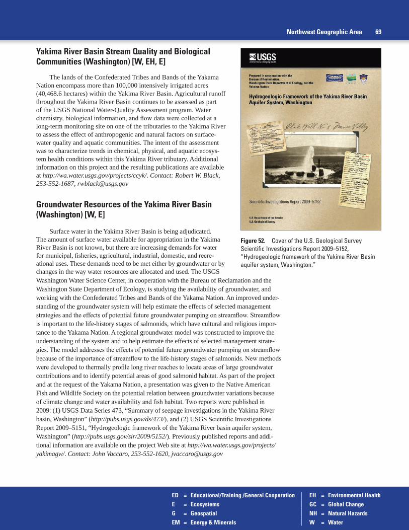
ED = Educational/Training /General Cooperation EH = Environmental HealthE = Ecosystems GC = Global ChangeG = Geospatial NH = Natural HazardsEM = Energy & Minerals W = Water
Northwest Geographic Area 69
Yakima River Basin Stream Quality and Biological Communities (Washington) [W, EH, E]
The lands of the Confederated Tribes and Bands of the Yakama Nation encompass more than 100,000 intensively irrigated acres (40,468.6 hectares) within the Yakima River Basin. Agricultural runoff throughout the Yakima River Basin continues to be assessed as part of the USGS National Water-Quality Assessment program. Water chemistry, biological information, and flow data were collected at a long-term monitoring site on one of the tributaries to the Yakima River to assess the effect of anthropogenic and natural factors on surface-water quality and aquatic communities. The intent of the assessment was to characterize trends in chemical, physical, and aquatic ecosys-tem health conditions within this Yakima River tributary. Additional information on this project and the resulting publications are available at http://wa.water.usgs.gov/projects/ccyk/. Contact: Robert W. Black, 253-552-1687, [email protected]
Groundwater Resources of the Yakima River Basin (Washington) [W, E]
Surface water in the Yakima River Basin is being adjudicated. The amount of surface water available for appropriation in the Yakima River Basin is not known, but there are increasing demands for water for municipal, fisheries, agricultural, industrial, domestic, and recre-ational uses. These demands need to be met either by groundwater or by changes in the way water resources are allocated and used. The USGS
Figure 52. Cover of the U.S. Geological Survey Scientific Investigations Report 2009–5152, “Hydrogeologic framework of the Yakima River Basin aquifer system, Washington.”
Washington Water Science Center, in cooperation with the Bureau of Reclamation and the Washington State Department of Ecology, is studying the availability of groundwater, and working with the Confederated Tribes and Bands of the Yakama Nation. An improved under-standing of the groundwater system will help estimate the effects of selected management strategies and the effects of potential future groundwater pumping on streamflow. Streamflow is important to the life-history stages of salmonids, which have cultural and religious impor-tance to the Yakama Nation. A regional groundwater model was constructed to improve the understanding of the system and to help estimate the effects of selected management strate-gies. The model addresses the effects of potential future groundwater pumping on streamflow because of the importance of streamflow to the life-history stages of salmonids. New methods were developed to thermally profile long river reaches to locate areas of large groundwater contributions and to identify potential areas of good salmonid habitat. As part of the project and at the request of the Yakama Nation, a presentation was given to the Native American Fish and Wildlife Society on the potential relation between groundwater variations because of climate change and water availability and fish habitat. Two reports were published in 2009: (1) USGS Data Series 473, “Summary of seepage investigations in the Yakima River basin, Washington” (http://pubs.usgs.gov/ds/473/), and (2) USGS Scientific Investigations Report 2009–5151, “Hydrogeologic framework of the Yakima River basin aquifer system, Washington” (http://pubs.usgs.gov/sir/2009/5152/). Previously published reports and addi-tional information are available on the project Web site at http://wa.water.usgs.gov/projects/yakimagw/. Contact: John Vaccaro, 253-552-1620, [email protected]

ED = Educational/Training /General Cooperation EH = Environmental HealthE = Ecosystems GC = Global ChangeG = Geospatial NH = Natural HazardsEM = Energy & Minerals W = Water
70 U.S. Geological Survey Activities Related to American Indian and Alaska Natives—Fiscal Years 2009 and 2010
Figure 53. Image from U.S. Geological Survey Scientific Investigations Report 2009–5152, “Hydrogeologic framework of the Yakima River Basin aquifer system, Washington showing spatial distribution of mean annual recharge, 1960–2001.”
0 5 10 20 30 MILES
0 5 10 20 30 KILOMETERS
Cle Elum
Parker
Wapato
Ellensburg
Umtanum
Kittitas
Thrall
Toppenish
Moxee CityUnion
Gap
Yakima
Selah
Naches
SunnysideRichland
Kiona
KennewickProsser
Grandview
Mabton
Satus
Zillah
Granger
Roza
Easton
Teanaway
TietonRimrock
121°
47°
47°30'
46°
120°121°30' 120°30' 119°30'
46°30'
EXPLANATION
Less than 0.5
25 to 48
Greater than 48
Mean annual recharge, in inches
13 to 24
7 to 12
0.6 to 2
3 to 6
wa19_0148_fig16-Mean Annual Recharge
T.24N.
T.22N.
T.20N.
T.18N.
T.16N.
T.14N.
T.12N.
T.10N.
T.8
N.
T.6
N.
R.28E.R.26E.R.24E.R.22E.R.20E.R.18E.R.16E.R.14E.R.12E.R.10E.

ED = Educational/Training /General Cooperation EH = Environmental HealthE = Ecosystems GC = Global ChangeG = Geospatial NH = Natural HazardsEM = Energy & Minerals W = Water
USGS Presentation at Klickitat White Salmon Fisheries and Watershed Science Conference (Washington) [E, NH]
A USGS Cascades Volcano Observatory scientist presented at the Klickitat White Salmon Fisheries & Watershed Science Conference, an interagency, multidisciplinary con-ference hosted by the Confederated Tribes and Bands of the Yakama Nation in The Dalles, Oregon, on March 16, 2010. The third annual Klickitat White Salmon Fisheries & Watershed Science Conference focused mainly on the status of anadromous fish and their habitats in south-central Washington watersheds and in the lower Columbia River as well as other ongoing scientific investigations in the region. The presentation included information on Mount Adams volcano, one of the largest volcanoes in the Cascade Range. Half of the volcano lies on tribal lands belonging to the Yakama Nation. The presentation covered the volcano’s history, potential hazards, and offered a geologic perspective on volcanic and glacial processes and their role in sediment production and effects on stream systems. Volcanic events constitute relatively rare occurrences that can have sudden and profound effects on watersheds, in contrast to the human and climate-induced events on which research and effort usually is focused. Contact: William Scott, 360-993-8942, [email protected]
Expert Consultation with Yakama Nation Fisheries Program (Washington) [E, NH]
The Confederated Tribes and Bands of the Yakama Nation are interested in improv-ing habitat for spawning salmon in the Klickitat River and its tributaries. A USGS Cascades Volcano Observatory hydrologist was consulted in 2010 to provide perspective on projected long-term sedimentation coming from Mount Adams, a Cascade volcano with considerable volumes of hydrothermally altered and weakened rock in the upper part of the edifice. One primary interest of Yakama Nation Fisheries Program was to identify the type and age of thick boulder-rich deposits along the banks of the Klickitat River. It was verified that sediment pulses occasionally have entered the river over the last several decades, triggered by small avalanches and debris flows from hydrothermally weakened source areas on the volcano. Based on recent USGS geophysical surveys of the upper cone of Mount Adams, it was also noted that a large and potentially devastating failure is also possible. However, the river does not appear to have experienced a large lahar or volcanic flood for at least several hundred thousand years. Contact: Thomas C. Pierson, 360-993-8935, [email protected]; Will Conley (Yakama Nation), 509-369-3183, [email protected]
Water Technical Training Workshops for Washington Tribes (Washington) [ED, W]
Technical training workshops as part of the TESNAR were conducted in 2010 by the USGS Washington Water Science Center for Pacific Northwest tribal members and staff. A workshop (held once in western Washington and once in eastern Washington) focused on methods of measurements of interrelationships of groundwater and surface water. A second workshop focused on the calibration and use of continuously recording water-quality field instruments, and a third workshop focused on methods for measuring low flows in streams and rivers. Contact: Steve Cox, 253-552-1623, [email protected]; Chris Curran, 253-552-1614, [email protected]; Rick Wagner, 253-552-1685, [email protected]
Northwest Geographic Area 71

ED = Educational/Training /General Cooperation EH = Environmental HealthE = Ecosystems GC = Global ChangeG = Geospatial NH = Natural HazardsEM = Energy & Minerals W = Water
72 U.S. Geological Survey Activities Related to American Indian and Alaska Natives—Fiscal Years 2009 and 2010
Emerging Contaminants in Water and Fish of the Stillaguamish River (Washington) [W, E, EH]
The Stillaguamish Tribe of Indians worked in collaboration with the USGS Washington Water Science Center to develop and implement a multiple-year study plan to examine emerg-ing contaminants in water and sediments and effects on fish using state of the art methods such as microarray tests on fish tissue and cumulative in-stream passive samplers for monitoring trace amounts of polar organic and highly sorptive contaminants. The project included support for a tribal fisheries employee to pursue her Master’s degree research. In FY 2010, the Washington Water Science Center conducted a preliminary small-scale sampling effort to identify the type and magnitude of emerging contaminants present in samples of wastewater effluent from cities adjacent to the Stillaguamish River and the Stillaguamish Tribal lands and hatchery. Emerg-ing contaminants are a group of chemical compounds that generally include pharmaceuticals, personal-care products, surfactants, industrial and household chemicals, and food additives; their presence in the environment is typically associated with discharges from wastewater treat-ment plants, on-site septic systems, and some animal production operations. Currently, there are limited data for the occurrence of emerging contaminants in Washington State streams. Contact: Rick Wagner, 253-552-1685, [email protected]; Patrick Moran, 253-552-1646, [email protected]
Traditional Native Place Names Project (Washington) [G]
The USGS Geospatial Liaison for Washington contacted Washington Tribal GIS staff for the purpose of developing a traditional place names project among the tribes located in Washington. This ongoing effort is significant for the cultural heritage of the tribes through language preservation and the history of place. The liaison discussed the potential of such a project with 10 of the tribes in Washington who have begun development of the necessary geospatial databases to make such an effort successful. Several of the tribes now have tradi-tional place name maps under construction. The majority of the tribes already have some basic knowledge of traditional place names on their reservation lands or in their ancestral areas, but in many cases this information is not held in any readily accessible data format. The goal would be that once complete the geospatial information might be shared among the tribes. Contact: Tom Carlson, 253-552-1682, [email protected]
Groundwater Resources on the Umatilla Indian Reservation (Oregon) [W, ED]
The USGS Oregon Water Science Center and the Confederated Tribes of the Umatilla Indian Reservation submitted a proposal to the Administration of Native Americans (part of the U.S. Department of Health and Human Services) in 2010 for building groundwater hydrology and modeling technical expertise in the Umatilla Tribe. The proposed work will provide training and mentoring to a tribal staff member on conducting hydrogeologic studies including familiarity with modeling techniques. The cooperative arrangement seeks to develop expertise within the tribal for understanding and managing their water resources. Past collaboration of the USGS Oregon Water Science Center with the Umatilla Tribes included groundwater-level data collection, borehole geophysics, and streamflow analysis. Project information can be found at http://or.water.usgs.gov/proj/umatilla_gw/. Contact: Terrence Conlon, 503-251-3232, [email protected]

ED = Educational/Training /General Cooperation EH = Environmental HealthE = Ecosystems GC = Global ChangeG = Geospatial NH = Natural HazardsEM = Energy & Minerals W = Water
Contaminants in Juvenile Pacific Lamprey in the Columbia River Basin (Oregon) [E]
The USGS Oregon Water Science Center began working in partnership with the Columbia River Inter-Tribal Fish Commission (CRITFC) and the Confederated Tribes of the Umatilla Indian Reservation in 2010 to investigate the presence of contaminants in juvenile Pacific lamprey. Stakeholders need to better understand the role of contaminants in the Columbia River as a potential threat to the survival of imperiled Pacific lamprey, and the implications for human health. Juvenile Pacific lamprey collected as part of the Umatilla Tribe’s restoration planning will be analyzed for emerging and legacy contaminant concentrations. Information on human consumption rates of lamprey is under development. These datasets will be combined along with background information on the sites to contribute to CRITFC’s Pacific Lamprey Restoration Plan. The project goals include an interpretive product that will help define the potential threat to Pacific lamprey populations, support management of the species, and under-stand implications for human health. Contact: Elena Nilsen, 503-251-3277, [email protected]
Assessment of Contaminants in the Lower Columbia River (Oregon) [E, W, EH]
The USGS Oregon Water Science Center is working in collaboration with the Columbia River Inter-Tribal Fish Commission (CRITFC) and other nongovernmental organizations on assessing contaminants in the Columbia River. The USGS has performed a study designed to assess contaminant concentrations directly contributed to the Columbia River through (1) wastewater-treatment-plant effluent, and (2) stormwater runoff from adjacent urban envi-ronments. Additionally, this study was intended to provide preliminary information on emerg-ing contaminants in the Columbia River system that can be used to stimulate future study with regards to occurrence, source, pathways, effects, and potential reduction efforts for these com-pounds. USGS Scientific Investigations Report 2012–5068, “Reconnaissance of contaminants in selected wastewater-treatment-plant effluent and stormwater runoff entering the Columbia River, Columbia River Basin, Washington and Oregon, 2008–2010” (http://pubs.usgs.gov/sir/2012/5068/) presents the results of this study. Contact: Jennifer Morace, 503-251-3229, [email protected]
Pesticides in Surface Water and Aquatic Organisms, Hood River Basin (Oregon) [E, EH, W]
The USGS Oregon Water Science Center was asked by the Confederated Tribes of Warm Springs to analyze pesticide and trace-element data from fish, macroinvertebrate, and water-quality samples that were collected in the Hood River Basin from 1999 through 2009 to determine the distribution and concentrations in surface water. This included data collected by the Oregon Department of Environmental Quality, Oregon State University, Portland State University, and other agencies. The USGS worked with the tribes in performing the inte-grated analysis of these multi-year datasets to produce a report that addressed tribal needs and provided guidance for planning future sampling efforts. The USGS has been asked to perform sampling in FY 2011 to address data gaps determined as a part of this analysis in FY 2010. The report, “Occurrence and distribution of pesticides in surface waters of the Hood River basin, Oregon, 1999–2009,” summarizes the results (http://pubs.usgs.gov/sir/2011/5082/). Contact: Whitney Temple, 503-251-3459, [email protected]
Northwest Geographic Area 73

ED = Educational/Training /General Cooperation EH = Environmental HealthE = Ecosystems GC = Global ChangeG = Geospatial NH = Natural HazardsEM = Energy & Minerals W = Water
Analysis of Hydrologic Response to Climate Change in the Upper Deschutes River Basin (Oregon) [W, GC]
Starting in 2009 the USGS Oregon Water Science Center modeled a range of future climate scenarios to better understand possible hydrologic responses of the Upper Deschutes River Basin. The effect of climate change on groundwater recharge and base flow in streams is simulated by using climate change scenarios from general circulation models in a calibrated groundwater-flow model of the upper Deschutes Basin. The study, funded by the Bureau of Reclamation, provides information on streamflow response to climate change. The study is relevant for the Confederated Tribes of Warm Springs, who have a water right on the Deschutes River. USGS information about this study can be found at http://or.water.usgs.gov/proj/Deschutes_climate_effects/. Contact: Marshall Gannett, 503-251-3233, [email protected]
Tree-Ring Techniques Compare Recorded History in Mussels and Pines (Oregon) [ED, E, GC]
Mussels are the longest-living, freshwater animals, and the annual growth rings inscribed on their shells may parallel tree-ring accounting of terrestrial variability. USGS, Native American, and Oregon State University scientists collaborated on a study starting in 2010 that looked at growth histories inscribed in tree rings and mussel shells collected across the Pacific Northwest to evaluate how each responds to long-term climate variabil-ity. Results for mussels have indicated that their long-term growth patterns are sensitive to climate, and that streamflow is the primary driver of growth. Water temperature was also important, but relations were less consistent. Tribal involvement was through Brett Blundon, a USGS SISNAR student intern and member of the Confederated Tribes of Siletz Indians, who used aspects of this work for his graduate research at Oregon State University. Contact: Jason Dunham, 541-750-0990, [email protected]
Evaluation of Water Use and Water-Right Retirement, Upper Klamath Basin: (Oregon) [W]
In 2010 the USGS Oregon Water Science Center collaborated with the Klamath Tribes and others on a study to evaluate water use, rights, and availability in the upper Klamath Basin. The study used multiple approaches to determine consumptive use of water in the basin and provide information to resource managers to prioritize potential voluntary retire-ment of water rights in support of increasing flows into Upper Klamath Lake and Klamath River, important ecosystems to the Klamath Tribes. The project results are described in the report, “Hydrological information products for the off-project water program of the Klamath Basin Restoration Agreement” (http://pubs.usgs.gov/of/2012/1199/). Contact: Daniel Snyder, 503-251-3287, [email protected]
Nutrient Analysis of Upper Klamath Lake (Oregon) [W, E]
The USGS Oregon Water Science Center continues to collaborate with the Klamath Tribes in water-quality studies of Upper Klamath Lake. Scientists are assessing sources of nutrient loading to the lake and the role reservoir regulation has on flushing patterns. Weekly samples collected from Upper Klamath Lake by USGS staff are analyzed at the Sprague River Water Quality Laboratory, which is operated by the Klamath Tribe. Contact: Joseph Rinella, 503-251-3278, [email protected]
74 U.S. Geological Survey Activities Related to American Indian and Alaska Natives—Fiscal Years 2009 and 2010

ED = Educational/Training /General Cooperation EH = Environmental HealthE = Ecosystems GC = Global ChangeG = Geospatial NH = Natural HazardsEM = Energy & Minerals W = Water
Southwest Geographic Area (Utah, Arizona, Nevada, California, Hawaii)
Collection and Analysis of Surface Waters in and Adjacent to Ute Tribal Lands (Utah) [W, E]
The USGS Utah Water Science Center is working with the Northern Ute Indian Tribe to collect water-quality samples from streams and rivers within and adjacent to tribal lands. The samples are analyzed at the USGS National Water Quality Laboratory and the results are stored in the USGS National Water Information System. The data add to the long-term record of water-quality information available for this area. This work also provides the opportunity for the USGS to conduct training in water-quality sample collection and processing for tribal personnel. Contact: Cory Angeroth, 801-908-5048, [email protected]; Bart Powaukee (Ute Tribe), 435-725-4821, [email protected]
Assessment of Potential Emissions from a Uranium Mill to Tribal Lands (Utah) [W, EM, EH, ED]
The Ute Mountain Ute Tribe (UMUT) has lands that border a uranium mill in southeastern Utah. The White Mesa Uranium Mill has been in operation since May 1980 and has processed more than 4.5 million tons of ore. Increased interest in uranium mining, driven by increasing ore prices, has resulted in ongoing and planned mill expansion. The UMUT is concerned that processing of uranium ore at the mill may be impacting bordering tribal lands. UMUT col-laborated with USGS Utah Water Science Center, CWSC, and EPA on a study that evaluated the offsite migration of radionuclides and selected trace elements from ore storage and mill-ing processes. The study goals were to: (1) define baseline geochemical conditions in Tribal water, sediments, and vegetation; and (2) assess the potential for offsite migration of uranium and associated trace elements. A concurrent objective of the project was to provide on-the-job training to tribal members in USGS sampling and field-monitoring methods. The project was initiated in September 2007 and concluded in September 2010. A quarterly monitoring plan was executed during FY 2008 and 2009 on selected monitoring wells (4) and seeps (10) bordering the mill site. Water samples were analyzed for more than 30 chemical constituents including uranium, arsenic, and selenium at the USGS National Water Quality Laboratory and a variety of stable and radioactive isotopes including uranium, hydrogen, oxygen, and sulfur. More than 40 sediment samples were collected from ephemeral drainages and more than 70 sagebrush samples were collected from lands bordering the mill site. The sediment and sagebrush samples were analyzed for more than 45 major and trace elements to detect offsite impacts from the mill site. Water, sediment, and vegetation data were stored in USGS databases, allowing easy access by tribal members. An interpretive report describing the results from this study can be found in Scientific Investigations Report 2011–5231, “Assessment of potential migration of radionuclides and trace elements from the White Mesa uranium mill to the Ute Mountain Ute Reservation and surrounding areas, southeastern Utah” (http://pubs.usgs.gov/sir/2011/5231/). Contact: David Naftz, 406-457-5945, [email protected]; Tony Ranalli, 303-236-6915, [email protected]; Colin Larrick (UMUT), 970-564-5437, [email protected]
Streamgaging for Duck Valley Shoshone Paiute Tribes (Nevada) [W]
USGS Nevada Water Science Center personnel operated and maintained two streamgages and one lake stage station for the Duck Valley Shoshone Paiute Tribes in north-eastern Nevada. The gages were funded by the State of Nevada under an agreement with the tribe. Contact: Steve Berris, 775-887-7693, [email protected]; Dave Evetts, 208-387-1316, [email protected]
Southwest Geographic Area 75

ED = Educational/Training /General Cooperation EH = Environmental HealthE = Ecosystems GC = Global ChangeG = Geospatial NH = Natural HazardsEM = Energy & Minerals W = Water
Proposed Well Sites on the Summit Lake Reservation, Summit Lake Paiute Tribe (Nevada) [W]
A USGS Nevada Water Science Center hydrologist assisted the Natural Resource Director for the Summit Lake Paiute Tribe during May 2009 in selecting sites for stock water wells within the Summit Lake Reservation. Considerations for site selection included distance from Summit Lake, depth to the water table, existing wells, and perennial springs. Contact: Dave Berger, 775-887-7658, [email protected]
Potential Effects of Groundwater Pumping on Discharge Volumes along the Tracy Segment of the Truckee River, Pyramid Lake Paiute Tribe (Nevada) [W]
Under the Orr Ditch decree, the Pyramid Lake Paiute Tribe owns the two most senior water rights on the Truckee River. The tribe relies on water from the Tracy Segment for a large por-tion of its water supply. Groundwater use has increased as the result of urban growth and indus-trial development. The effects of groundwater pumping on discharge to the Truckee River and consequently on appropriated surface-water rights are unknown. A study to quantify the hydro-logic effects of groundwater pumping on Truckee River flows was initiated with the USGS in October 2009 because a decrease in groundwater discharge to the river could jeopardize efforts to protect threatened and endangered species, change the limnology of Pyramid Lake, and impact downstream surface-water rights. Contact: Carl Thodal, 775-887-7685, [email protected]
Streamgaging for Pyramid Lake Paiute Tribe (Nevada) [W]
USGS Nevada Water Science Center personnel operate and maintain two streamgages, a lake stage, and a water temperature monitor for the Pyramid Lake Paiute Tribe. The stations have been in operation for several years and collection of these basic data is expected to continue in future years. Contact: Steve Berris, 775-887-7693, [email protected]
Streamgages for Duckwater Shoshone Tribe (Nevada) [W]
The USGS Nevada Water Science Center personnel operate and maintain a streamgage for the Duckwater Shoshone Tribe at the Big Warm Springs near Ely, Nevada. The streamgage was installed in September 2007 to monitor the flow on a regional spring. Contact: Steve Berris, 775-887-7693, [email protected]; Dave Evetts, 208-387-1316, [email protected]
Hydrologic Study of the Walker Basin, Walker River Paiute Tribe (Nevada) [W]
The USGS Nevada Water Science Center began a study in FY 2004 to quantify stream-flow in the Walker Basin, estimate evapotranspiration losses from natural and agricultural vegetation and the surface of Walker Lake, and to develop an improved water budget for Walker Lake. The first phase of the study was completed in 2009 and the results were sum-marized in six reports: (1) USGS Fact Sheet 2005–3124 described the objectives and tasks of the study (http://nevada.usgs.gov/walker/fs2005-3124.pdf); (2) USGS Scientific Investigations Report 2007–5012 described the bathymetry of Walker Lake (http://pubs.usgs.gov/sir/2007/5012/); (3) An article in the Journal of Nevada Water Resources Association about estimated precipita-tion in west-central Nevada including the Walker River basin (https://onedrive.live.com/view.aspx?resid=16BA3DB0E0CE6624!428&ithint=file%2c.pdf&app=WordPdf&wdo=2&authkey=!AMoBDuODfOHObIQ); (4) USGS Scientific Investigations Report 2009–5079 quantified
76 U.S. Geological Survey Activities Related to American Indian and Alaska Natives—Fiscal Years 2009 and 2010
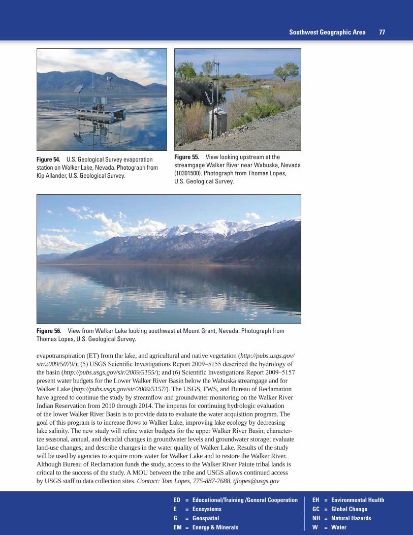
ED = Educational/Training /General Cooperation EH = Environmental HealthE = Ecosystems GC = Global ChangeG = Geospatial NH = Natural HazardsEM = Energy & Minerals W = Water
evapotranspiration (ET) from the lake, and agricultural and native vegetation (http://pubs.usgs.gov/sir/2009/5079/); (5) USGS Scientific Investigations Report 2009–5155 described the hydrology of the basin (http://pubs.usgs.gov/sir/2009/5155/); and (6) Scientific Investigations Report 2009–5157 present water budgets for the Lower Walker River Basin below the Wabuska streamgage and for Walker Lake (http://pubs.usgs.gov/sir/2009/5157/). The USGS, FWS, and Bureau of Reclamation have agreed to continue the study by streamflow and groundwater monitoring on the Walker River Indian Reservation from 2010 through 2014. The impetus for continuing hydrologic evaluation of the lower Walker River Basin is to provide data to evaluate the water acquisition program. The goal of this program is to increase flows to Walker Lake, improving lake ecology by decreasing lake salinity. The new study will refine water budgets for the upper Walker River Basin; character-ize seasonal, annual, and decadal changes in groundwater levels and groundwater storage; evaluate land-use changes; and describe changes in the water quality of Walker Lake. Results of the study will be used by agencies to acquire more water for Walker Lake and to restore the Walker River. Although Bureau of Reclamation funds the study, access to the Walker River Paiute tribal lands is critical to the success of the study. A MOU between the tribe and USGS allows continued access by USGS staff to data collection sites. Contact: Tom Lopes, 775-887-7688, [email protected]
Southwest Geographic Area 77
Figure 54. U.S. Geological Survey evaporation station on Walker Lake, Nevada. Photograph from Kip Allander, U.S. Geological Survey.
Figure 55. View looking upstream at the streamgage Walker River near Wabuska, Nevada (10301500). Photograph from Thomas Lopes, U.S. Geological Survey.
Figure 56. View from Walker Lake looking southwest at Mount Grant, Nevada. Photograph from Thomas Lopes, U.S. Geological Survey.
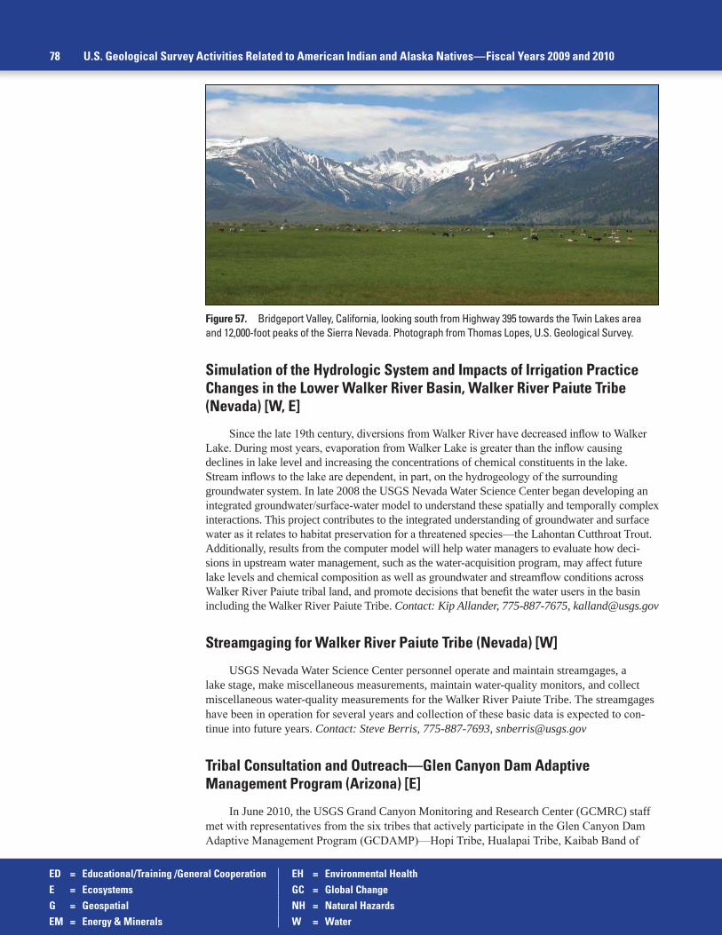
ED = Educational/Training /General Cooperation EH = Environmental HealthE = Ecosystems GC = Global ChangeG = Geospatial NH = Natural HazardsEM = Energy & Minerals W = Water
Simulation of the Hydrologic System and Impacts of Irrigation Practice Changes in the Lower Walker River Basin, Walker River Paiute Tribe (Nevada) [W, E]
Since the late 19th century, diversions from Walker River have decreased inflow to Walker Lake. During most years, evaporation from Walker Lake is greater than the inflow causing declines in lake level and increasing the concentrations of chemical constituents in the lake. Stream inflows to the lake are dependent, in part, on the hydrogeology of the surrounding groundwater system. In late 2008 the USGS Nevada Water Science Center began developing an integrated groundwater/surface-water model to understand these spatially and temporally complex interactions. This project contributes to the integrated understanding of groundwater and surface water as it relates to habitat preservation for a threatened species—the Lahontan Cutthroat Trout. Additionally, results from the computer model will help water managers to evaluate how deci-sions in upstream water management, such as the water-acquisition program, may affect future lake levels and chemical composition as well as groundwater and streamflow conditions across Walker River Paiute tribal land, and promote decisions that benefit the water users in the basin including the Walker River Paiute Tribe. Contact: Kip Allander, 775-887-7675, [email protected]
Streamgaging for Walker River Paiute Tribe (Nevada) [W]
USGS Nevada Water Science Center personnel operate and maintain streamgages, a lake stage, make miscellaneous measurements, maintain water-quality monitors, and collect miscellaneous water-quality measurements for the Walker River Paiute Tribe. The streamgages have been in operation for several years and collection of these basic data is expected to con-tinue into future years. Contact: Steve Berris, 775-887-7693, [email protected]
Tribal Consultation and Outreach—Glen Canyon Dam Adaptive Management Program (Arizona) [E]
In June 2010, the USGS Grand Canyon Monitoring and Research Center (GCMRC) staff met with representatives from the six tribes that actively participate in the Glen Canyon Dam Adaptive Management Program (GCDAMP)—Hopi Tribe, Hualapai Tribe, Kaibab Band of
78 U.S. Geological Survey Activities Related to American Indian and Alaska Natives—Fiscal Years 2009 and 2010
Figure 57. Bridgeport Valley, California, looking south from Highway 395 towards the Twin Lakes area and 12,000-foot peaks of the Sierra Nevada. Photograph from Thomas Lopes, U.S. Geological Survey.

ED = Educational/Training /General Cooperation EH = Environmental HealthE = Ecosystems GC = Global ChangeG = Geospatial NH = Natural HazardsEM = Energy & Minerals W = Water
Southwest Geographic Area 79
Paiute Indians, Paiute Indian Tribe of Utah, Navajo Nation, and Pueblo of Zuni—to review the GCMRC biennial work plan for FY 2011 and FY 2012 and solicit feedback and identify any concerns from the tribes about planned science projects. In addition, the Director and Sociocultural Program Manager of GCMRC attended multiple government-to-government meetings during FY 2010 with officials from the Zuni Tribe, the Hualapai Tribe, the Hopi Tribe, and the Navajo Nation to discuss tribal concerns related to the Bureau of Reclamation’s (BOR) compliance mandate to mechanically remove non-native fishes from the vicinity of the Little Colorado River, an area of great cultural and spiritual significance to these tribes. In an attempt to find a solution to the non-native fish issue that would be more acceptable to tribes and respectful of their concerns in this area, and thereby assist BOR and other Department of the Interior agencies in developing suitable and scientifically defensible alternatives to mechani-cal removal of non-native fishes in the Grand Canyon, GCMRC staff gave a series of science presentations at meetings of the GCDAMP during the summer and fall, as well as at a two structured-decision making workshops, in which the tribes and various state and federal agen-cies participated. The results of these workshops are being used by BOR to develop and analyze alternatives to non-native mechanical removal as part of its environmental review and compli-ance process in FY 2011. Contact: Helen Fairley, 928-556-7285, [email protected]
Navajo Land Use Planning Project Geologic Map Products (Arizona) [G]
Map products by the USGS Navajo Land Use Planning Project include 30’ × 60’ quadrangle geologic maps of the western Navajo Nation. These maps will be used for planning and reha-bilitation of infrastructure in the Bennett Freeze area of the Navajo Nation. This area is the focus of a rehabilitation plan that will be funded by Congress, to address economic development and infrastructure needs in one of the poorest regions in the United States. Navajo Land Use Project product information can be found at http://geomaps.wr.usgs.gov/navajo/products.html. Contact: George Billingsley, 928-556-7198, [email protected]
Monitoring Drought and Climate Change Impacts on the Navajo Nation (Arizona, New Mexico, Utah) [GC, W]
Scientists from the USGS Flagstaff Science Center are continuing to work with communi-ties on the Navajo Nation to establish relations of land use and climate change to changes in the landscape. The Navajo Nation (roughly the size of West Virginia) has the largest land base and reservation population of all tribes in the United States. Sand dunes cover approximately one-third of the arid to semiarid 65,000-square kilometers (25,097-square miles) Navajo Nation on the southern Colorado Plateau. The Navajo Nation is one of the least climatologically instrumented regions of the country and is suffering one of the longest and most severe droughts in the last century with an increase in average annual temperatures indicative of long-term climatic change. Changes in temperature, precipitation, and wind circulation patterns on the Navajo Nation are closely linked to increasing aridity, ephemeral river flow, riparian corridor flood events, sand dune movement, and dust storms. These events are having severe impacts to the livelihood and health of Navajo Nation residents because of degrading rangeland viability and other natural resources and lack of monitoring instrumentation and sparse data records may lead to misdiagnosis of the severity of real and potential impacts on the tribe and its natural resources. USGS is conducting work addressing drought and climate change impacts on the Navajo Nation by using techniques of landscape monitoring, meteorological monitoring, mapping of temporal aerial photographs, sediment sampling, and vegetation surveys. This interdisciplinary technique is used to learn about the linkages between geology, climate, and land-use history, to assess climate change impacts to reservation communities and the landscape on which they live. The USGS is building an auto-mated network of meteorological stations, cameras, and sensors to record and study the long-term ongoing trends in both drought and changing climate conditions. This work provides a foundation

ED = Educational/Training /General Cooperation EH = Environmental HealthE = Ecosystems GC = Global ChangeG = Geospatial NH = Natural HazardsEM = Energy & Minerals W = Water
for evaluating flood hazards, drought risk, and rangeland impacts to help the tribe more accu-rately assess the changing conditions and impacts on their resources. Project information can be found at http://geomaps.wr.usgs.gov/navajo/. Contact: Margaret Hiza-Redsteer, 928-556-7366, [email protected]; Rian Bogle, 928-556-7212, [email protected]; Debra Block, 928-556-7138, [email protected]
Satellite-Based Monitoring of Rangeland Condition and Potential Dune Activation on the Navajo Nation (Arizona) [E, GC, G]
A significant part of the Navajo Nation economy depends on grazing; careful assessment and management of these dwindling semiarid grassland communities is important to sustain-ing this resource. Attention to rangeland condition is critical since desertification processes can be accelerated during times of drought, and the Navajo Nation is in the midst of a prolonged and severe drought. Many desertification effects may prove irreversible, and timely informa-tion about trends in grassland condition could be invaluable. In addition, dune mobility is an increasingly important issue to the Tribe; as the drought is beginning to enable formerly stable dune fields to become active, resulting in loss of potential grazing lands and human habitat disruption. Since historical grazing pressures and the ongoing drought have adversely impacted the condition of much of the rangeland on the Navajo Reservation, dune mobility is expected to increasingly impact the lives of the Navajo people. USGS research will attempt to gener-ate historical and baseline information for three large study areas on the reservation in order to monitor grassland degradation and to identify areas at risk for future dune activation. Moderate Resolution Imaging Spectroradiometer (MODIS) and Landsat satellite image data will be used to map and monitor the relative condition and productivity trends of grassland areas on the Navajo Nation. This research will seek to provide reservation land managers with easily inter-pretable image products illustrating the effectiveness of their rangeland management practices and maps of potential dune activation “hot spots” over vast areas. Contact: Barry Middleton, 928-556-7465, [email protected]
Lower Colorado Basin Drought Preparedness Workshop for Tribes (Arizona) [ED, W, GC]
USGS Flagstaff Science Center scientists, in cooperation with the National Integrated Drought Information System (http://www.drought.gov/drought/), hosted a workshop, “Drought Preparedness for Tribes: Lower Colorado Basin Workshop,” held in Flagstaff, Arizona on April 8–9, 2010. The purpose of the workshop was to identify critical drought and climate related needs of tribal leaders and natural resource managers on the Colorado Plateau in efforts to form a partnership network needed to develop and implement a drought early warning system on tribal lands, and to bring visibility of local drought impacts to federal agencies and regional entities. This workshop gathered approximately 40 individuals from regional tribes, state and local agencies and organizations, and federal agencies. Participating tribes included Hualapai, Hopi, Navajo, Southern Ute, Zuni and Tohono O’odam. The small size of the workshop was intended in order to focus discussions, recommendations, and collaborations. Contact: Margaret Hiza-Redsteer, 928-556-7366, [email protected]
Collaborations with the Institute for Tribal Environmental Professionals (Arizona) [ED, GC]
Beginning in 2008, a USGS Flagstaff Science Center scientist has instructed a climate change workshop, in partnership with the Institute for Tribal Environmental Professionals (ITEP), every year for tribal employees at Northern Arizona University. The class typically
80 U.S. Geological Survey Activities Related to American Indian and Alaska Natives—Fiscal Years 2009 and 2010

ED = Educational/Training /General Cooperation EH = Environmental HealthE = Ecosystems GC = Global ChangeG = Geospatial NH = Natural HazardsEM = Energy & Minerals W = Water
consists of about 20 Native American and Alaskan Native students from various tribes across the United States. Additionally, through partnership with ITEP, a USGS scientist takes high school students from different tribes on geologic field trips for a Summer Scholars Program. Students learn about local geology, land use, and environmental issues of their reservation lands. Contact: Margaret Hiza-Redsteer, 928-556-7350, [email protected]
Uranium in Arizona Landfill (Arizona) [EH, W, EM]
The USGS, in collaboration with the BIA, the Navajo Nation, the Hopi Tribe, and EPA, is continuing investigations that began in 2008 of the source of elevated uranium and other trace elements of concern measured in groundwater from shallow monitoring wells in and near the Tuba City Open Dump in Tuba City, Arizona. The concern is whether the uranium is related to former mining activities or occurs naturally in groundwater and the rocks. USGS scientists are mapping the surface geology and analyzing water and sediment samples from the dump site. The purpose of the USGS study is to help identify the source, distribution, and mobility of uranium and other metals in the dump area. The water-quality data collected in 2008 from the study can be found at http://pubs.usgs.gov/of/2012/1126/. Contact: Bob Horton, 303-236-1338, [email protected]
Water Supply and Quality Near Upper and Lower Moenkopi Villages, Hopi Tribe (Arizona) [W, GC, EH, EM]
Drinking-water supplies from the regional N aquifer in the vicinity of Moenkopi Villages on the Hopi Tribe Reservation in northeastern Arizona are being depleted. This may be attributed to increasing demands in the local area (population growth), potential well deterioration, and pos-sibly to changes in recharge rates due to changing climatic conditions. Also, the water supply is potentially threatened by migration of contaminants in the overlying, shallower, alluvial ground-water system. The source of the contaminants and the potential to reach water-supply wells was
Southwest Geographic Area 81
Figure 58. U.S. Geological Survey geologist Bob Horton collecting a sample of surface sediment for geochemical analysis downgradient from the Tuba City Open Dump site. Photograph from James Otton, U.S. Geological Survey.
investigated. The villages reside downgradient from a former landfill and a former uranium-ore processing site, and also from the larger community of Tuba City, Arizona. Begin-ning in 2008 and continuing through 2011, the USGS, in cooperation with the Indian Health Service, the Bureau of Reclamation, and the Hopi Tribe, used various methods for evalu-ating the connectivity between the shallow and deep aquifers, well productivity, and the overall occurrence and movement of groundwater in the area of the Villages of Moenkopi, Arizona. Single-well aquifer tests, zonal-water sampling for quality analysis, and controlled source audio-frequency magnetotelluric (CSAMT) geophysical methods were used in this evalua-tion. More information about this study can be found at http://az.water.usgs.gov/projects/ 9671-E6X00/. Contact: Robert Carruth, 520-670-6671 ext. 234, [email protected]; Jamie Macy, 928-556-7276, [email protected]; Robert Hart, 928-556-7137, [email protected]

ED = Educational/Training /General Cooperation EH = Environmental HealthE = Ecosystems GC = Global ChangeG = Geospatial NH = Natural HazardsEM = Energy & Minerals W = Water
Recent Uranium Mine Development and Its Potential Effect on Water Resources in the Grand Canyon Region (Arizona) [EM, EH, W]
Recent increases in the price of uranium have prompted renewed interest in the exploration and mining of uranium ore on public lands in the Grand Canyon region of Arizona. Some of the highest-grade uranium ore in the country is located in many potentially mineralized breccia pipes scattered across this region. The increase in mining claims and permits to develop mines in this region has heightened public awareness of the potential issues related to uranium mining. This heightened awareness has led to expressed concerns by the general public, Native American tribes, and the National Park Service about the potential impacts of exploration and mining to natural resources in the region, especially the water resources. These concerns prompted legislation that would with-draw operation of the public-land laws that allow mining from three separate areas adjacent to Grand Canyon National Park. As a result of this legislation, the Secretary of the Interior temporarily withdrew about 1 million acres (404,685.6 hectares) in the region from mineral entry and directed the USGS to gather additional data and report on potential uranium mining impacts. This informa-tion will be used in an Environmental Impact Statement (EIS) being conducted by the Bureau of Land Management (BLM) who manages the majority of the uranium withdraw area. The USGS is evaluating water, soils, and biological indicators based on available information and more recent data that were collected for this issue. The USGS is continuing to provide technical assistance to BLM in support of the EIS and collecting additional surface-water and groundwater samples to improve our understanding of natural-occurring and mine-extracted uranium and associated trace elements in water and sediments. Study findings were published in USGS Scientific Investigations Report 2010–5025, “Hydrological, geological, and biological site characterization of breccia pipe uranium deposits in northern Arizona” (http://pubs.usgs.gov/sir/2010/5025/). Contact: Donald J. Bills, 928-556-7142, [email protected]; John Hoffmann, 520-670-6671, [email protected]; Robert Hart, 928-556-7137, [email protected].
Monitoring N Aquifer Withdrawals, Navajo Nation and Hopi Tribal Lands (Arizona) [W]
Groundwater from the N aquifer is increasingly being used for domestic and municipal purposes in the Black Mesa area of northeast Arizona. Peabody Energy Corporation (Peabody) had historically been the principal industrial water user, whereas the Navajo Nation and Hopi Tribe have been the principal domestic and municipal water users. Peabody stopped pumping groundwater for their coal-slurry pipeline in 2006. In 2007 Peabody was only pumping enough water for maintenance purposes. Both tribes have been concerned about the long-term effects of withdrawals from the N aquifer. In 1971, these concerns led to the establishment of a monitor-ing program in the Black Mesa area by the USGS in cooperation with the Arizona Department of Water Resources. In 1983, the BIA joined the cooperative effort. Since 1983, the Navajo Tribal Utility Authority, the Hopi Tribe, the Western Navajo and Chinle Agencies of the Navajo Nation, the Western and Navajo Regional offices of the BIA, and Peabody have assisted in the collec-tion of hydrologic data. A Web site containing links to data associated with N aquifer monitoring program can be found at http://az.water.usgs.gov/projects/9671-9E9/ and USGS data reports for this program are at http://az.water.usgs.gov/projects/9671-9E9/pubs.html. Contact: Jamie Macy, 928-556-7276, [email protected]; Robert Hart, 928-556-7137, [email protected]
Hopi Water Monitoring Program (Arizona) [W, ED]
The USGS Arizona Water Science Center continues cooperating with the Hopi Tribe by providing technical assistance and training to Hopi personnel concerning their surface-water resources monitoring program. One streamgage, a crest-stage gage, and three sediment stations are operated by the USGS for the Hopi Tribe. Contact: Gregory Fisk, 520-556-7225, [email protected]; Robert Hart, 928-556-7137, [email protected]
82 U.S. Geological Survey Activities Related to American Indian and Alaska Natives—Fiscal Years 2009 and 2010

ED = Educational/Training /General Cooperation EH = Environmental HealthE = Ecosystems GC = Global ChangeG = Geospatial NH = Natural HazardsEM = Energy & Minerals W = Water
Southwest Geographic Area 83
Figure 59. An abandoned uranium mine site, the Kanab North Mine, in Grand Canyon National Park, Arizona. Photograph from Don Bills, U.S. Geological Survey.
Figure 60. Grand Canyon National Park. Photograph from George Billingsley, U.S. Geological Survey.
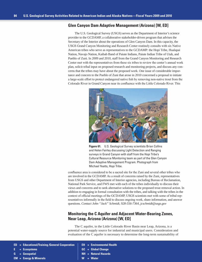
ED = Educational/Training /General Cooperation EH = Environmental HealthE = Ecosystems GC = Global ChangeG = Geospatial NH = Natural HazardsEM = Energy & Minerals W = Water
84 U.S. Geological Survey Activities Related to American Indian and Alaska Natives—Fiscal Years 2009 and 2010
Figure 61. U.S. Geological Survey scientists Brian Collins and Helen Fairley discussing Light Detection and Ranging surveys in Grand Canyon with staff from the Hopi Tribe’s Cultural Resource Monitoring team as part of the Glen Canyon Dam Adaptive Management Program. Photograph from Michael Yeatts, Hopi Tribe.
Glen Canyon Dam Adaptive Management (Arizona) [W, ED]
The U.S. Geological Survey (USGS) serves as the Department of Interior’s science provider to the GCDAMP, a collaborative stakeholder-driven program that advises the Secretary of the Interior about the operations of Glen Canyon Dam. In this capacity, the USGS Grand Canyon Monitoring and Research Center routinely consults with six Native American tribes who serve as representatives to the GCDAMP: the Hopi Tribe, Hualapai Nation, Navajo Nation, Kaibab Band of Paiute Indians, Paiute Indian Tribe of Utah, and Pueblo of Zuni. In 2009 and 2010, staff from the Grand Canyon Monitoring and Research Center met with the representatives from these six tribes to review the center’s annual work plan, solicit tribal input on proposed research and monitoring projects, and discuss any con-cerns that the tribes may have about the proposed work. One issue of considerable impor-tance and concern to the Pueblo of Zuni that arose in 2010 concerned a proposal to initiate a large-scale effort to protect endangered native fish by removing non-native trout from the Colorado River in Grand Canyon near its confluence with the Little Colorado River. This
confluence area is considered to be a sacred site for the Zuni and several other tribes who are involved in the GCDAMP. As a result of concerns raised by the Zuni, representatives from USGS and other Department of Interior agencies, including Bureau of Reclamation, National Park Service, and FWS met with each of the tribes individually to discuss their views and concerns and to seek alternative solutions to the proposed trout removal action. In addition to engaging in formal consultation with the tribes, and talking with the tribes in the context of official meetings of the GCDAMP, USGS scientists met with some of tribal rep-resentatives informally in the field to discuss ongoing work, share information, and answer questions. Contact John “Jack” Schmidt, 928-556-7364, [email protected]
Monitoring the C Aquifer and Adjacent Water-Bearing Zones, Near Leap, Arizona (Arizona) [W, ED]
The C aquifer, in the Little Colorado River Basin near Leap, Arizona, is a potential water-supply source for industrial and municipal users. Consideration and evaluation of the C aquifer is necessary to determine the long-term sustainability of

ED = Educational/Training /General Cooperation EH = Environmental HealthE = Ecosystems GC = Global ChangeG = Geospatial NH = Natural HazardsEM = Energy & Minerals W = Water
Southwest Geographic Area 85
Figure 62. U.S. Geological Survey Student Interns in Support of Native American Relations student intern Juanita Francis-Begay standing in front of study area (‘Arroyos’ groundwater recharge site) at the San Xavier District of the Tohono O’odham Nation. Photograph from Laura Norman, U.S. Geological Survey.
this groundwater resource. The BIA and other stakeholders are concerned about the sustainability of this groundwater resource, since increasing groundwater withdrawals may affect the sufficiency of this resource to meet tribal demands and sustain critical cultural, religious, and riparian sites. The Hopi Tribe, the Navajo Nation, and the BIA asked the USGS Arizona Water Science Center to develop a monitoring program for the C aquifer in areas of potential groundwater withdrawals to determine the baseline conditions. Monitoring focused on water levels and water chemistry of the C aquifer in the Leap area and other water-bearing zones and base-flow evaluations in streams. Monitoring may be expanded to include other water-bearing zones above and below the C aquifer and base-flow evaluations in natural discharge areas. A Web site con-taining links to data associated with the C Aquifer Monitoring Program can be found at http://az.water.usgs.gov/projects/9671-C1D/. The BIA has provided funding for this program from FY 2004 through FY 2010. Contact: Jamie Macy, 928-556-7276, [email protected]; Robert Hart, 928-556-7137, [email protected]; Donald J. Bills, 928-556-7142, [email protected]
Santa Cruz Watershed Ecosystem Portfolio Model (Arizona) [W, G]
In collaboration with the San Xavier District of the Tohono O’odham Nation, Bureau of Reclamation, and the EPA, 2010 USGS SISNAR student intern Juanita Francis-Begay studied the Ecosystem Services Analysis on tribal lands derived from effluent. One study site was a riparian restoration site (Walk Hickman) while the other site was a groundwater recharge site (Arroyos), both of which receive renewable water from the Central Arizona Project (CAP). Mrs. Francis-Begay was working to document the ecosystem services perceived by the tribe at the San Xavier to help rep-resent cultural resources and the community. This research is meant to fit into the Santa Cruz watershed Ecosystem Portfolio Model (SCWEPM) online decision-support sys-tem to visualize Ecosystem Services as a means to convey information and help with decision making and potentially policy in the long term. The SCWEPM is mapping out ecosystem services in the Santa Cruz Watershed, which encompasses the San Xavier District land. Project information can be found at http://geography.wr.usgs.gov/science/ecoSevicesSCWatershed.html. Research results were presented to the San Xavier District Council of the Tohono O’odham Nation and at the Arizona Hydrological Society meeting. Contact: Laura Norman, 520-670-5510, [email protected]
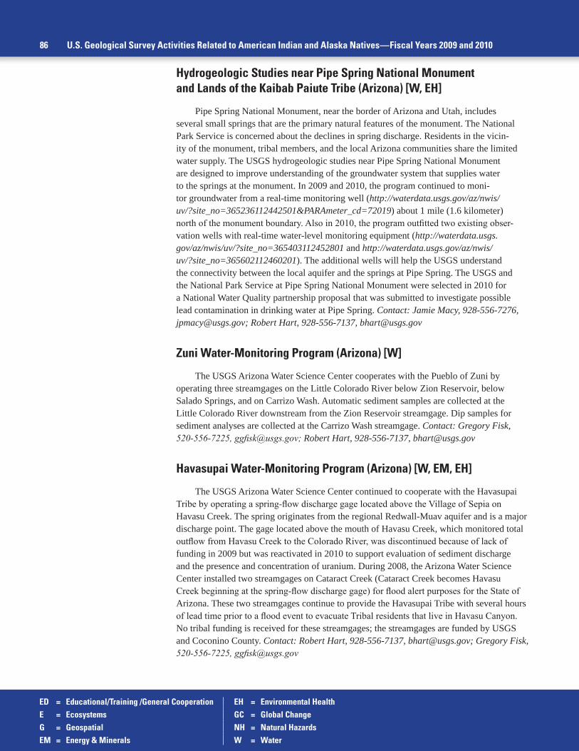
ED = Educational/Training /General Cooperation EH = Environmental HealthE = Ecosystems GC = Global ChangeG = Geospatial NH = Natural HazardsEM = Energy & Minerals W = Water
Hydrogeologic Studies near Pipe Spring National Monument and Lands of the Kaibab Paiute Tribe (Arizona) [W, EH]
Pipe Spring National Monument, near the border of Arizona and Utah, includes several small springs that are the primary natural features of the monument. The National Park Service is concerned about the declines in spring discharge. Residents in the vicin-ity of the monument, tribal members, and the local Arizona communities share the limited water supply. The USGS hydrogeologic studies near Pipe Spring National Monument are designed to improve understanding of the groundwater system that supplies water to the springs at the monument. In 2009 and 2010, the program continued to moni-tor groundwater from a real-time monitoring well (http://waterdata.usgs.gov/az/nwis/uv/?site_no=365236112442501&PARAmeter_cd=72019) about 1 mile (1.6 kilometer) north of the monument boundary. Also in 2010, the program outfitted two existing obser-vation wells with real-time water-level monitoring equipment (http://waterdata.usgs.gov/az/nwis/uv/?site_no=365403112452801 and http://waterdata.usgs.gov/az/nwis/uv/?site_no=365602112460201). The additional wells will help the USGS understand the connectivity between the local aquifer and the springs at Pipe Spring. The USGS and the National Park Service at Pipe Spring National Monument were selected in 2010 for a National Water Quality partnership proposal that was submitted to investigate possible lead contamination in drinking water at Pipe Spring. Contact: Jamie Macy, 928-556-7276, [email protected]; Robert Hart, 928-556-7137, [email protected]
Zuni Water-Monitoring Program (Arizona) [W]
The USGS Arizona Water Science Center cooperates with the Pueblo of Zuni by operating three streamgages on the Little Colorado River below Zion Reservoir, below Salado Springs, and on Carrizo Wash. Automatic sediment samples are collected at the Little Colorado River downstream from the Zion Reservoir streamgage. Dip samples for sediment analyses are collected at the Carrizo Wash streamgage. Contact: Gregory Fisk, 520-556-7225, [email protected]; Robert Hart, 928-556-7137, [email protected]
Havasupai Water-Monitoring Program (Arizona) [W, EM, EH]
The USGS Arizona Water Science Center continued to cooperate with the Havasupai Tribe by operating a spring-flow discharge gage located above the Village of Sepia on Havasu Creek. The spring originates from the regional Redwall-Muav aquifer and is a major discharge point. The gage located above the mouth of Havasu Creek, which monitored total outflow from Havasu Creek to the Colorado River, was discontinued because of lack of funding in 2009 but was reactivated in 2010 to support evaluation of sediment discharge and the presence and concentration of uranium. During 2008, the Arizona Water Science Center installed two streamgages on Cataract Creek (Cataract Creek becomes Havasu Creek beginning at the spring-flow discharge gage) for flood alert purposes for the State of Arizona. These two streamgages continue to provide the Havasupai Tribe with several hours of lead time prior to a flood event to evacuate Tribal residents that live in Havasu Canyon. No tribal funding is received for these streamgages; the streamgages are funded by USGS and Coconino County. Contact: Robert Hart, 928-556-7137, [email protected]; Gregory Fisk, 520-556-7225, [email protected]
86 U.S. Geological Survey Activities Related to American Indian and Alaska Natives—Fiscal Years 2009 and 2010

ED = Educational/Training /General Cooperation EH = Environmental HealthE = Ecosystems GC = Global ChangeG = Geospatial NH = Natural HazardsEM = Energy & Minerals W = Water
Hydrogeology of the Coconino Plateau and Adjacent Areas, Coconino and Yavapai Counties, Arizona (Arizona) [W]
Two regional groundwater-flow systems are present on the Coconino Plateau and adjacent areas of northern Arizona: the C aquifer and the Redwall-Muav aquifer. Stakeholders, includ-ing the Hopi Tribe, the Navajo Nation, the Havasupai Tribe, and federal, state, and local governments are members of the Coconino Plateau Water Advisory Council, who are planning for the long-term water-supply needs for the region. Sustainability and protection of springs, seeps, and riparian habitat on the Coconino Plateau are major issues. These water sources are also critical cultural, religious, and natural resources to Native American cultures. The USGS Arizona Water Science Center evaluated the hydrogeology of the Coconino Plateau to develop a hydrogeologic framework and conceptual model of groundwater flow and estimated water budgets. USGS Scientific Investigations Report 2005–5222, “Hydrogeology of the Coconino Plateau and adjacent areas, Coconino and Yavapai Counties, Arizona,” is available at http://pubs.usgs.gov/sir/2005/5222/. The USGS has established a groundwater-monitoring program to evaluate baseline conditions and change in the C aquifer in areas of interest to the BIA, the Navajo Nation and the Hopi Tribe. This groundwater monitoring includes a net-work of observation wells and springs and a series of base-flow evaluations on Clear Creek, Chevelon Creek, and the Little Colorado River. Contact: Donald J. Bills, 928-556-7142, [email protected]; Robert Hart, 928-556-7137, [email protected]; Donald Pool, 520-670-6771 ext. 258, [email protected]
Hualapai Water-Monitoring Program (Arizona) [W]
The USGS Arizona Water Science Center is cooperating with the Hualapai Tribe by pro-viding technical assistance to Hualapai personnel with their water-resources monitoring pro-gram. During 2009, USGS personnel also assisted the tribe with the installation of two meteo-rological stations on the Hualapai Reservation. The meteorological data was entered into the USGS National Water Information System database. Contact: Gregory Fisk, 520-556-7225, [email protected]; Robert Hart, 928-556-7137, [email protected]
Water Resources Assessments and Technical Assistance for the Havasupai and Hualapai Tribes (Arizona) [W]
Both the Havasupai and Hualapai Reservations are located adjacent to and at the western end of Grand Canyon National Park. Both tribes claim extended historic natural and cultural resources to the greater Grand Canyon region including water resources of the Colorado River and its tributaries. These water rights claims have never been recognized in the “Law of the River” which is a collection of documents used to manage and operate the Colorado River (http://www.usbr.gov/lc/region/g1000/lawofrvr.html.) Since the late mid-1980s, the USGS Arizona Water Science Center has assisted both the Havasupai and Hualapai Tribes with water-resource assessments of their reservations. The USGS has assisted the Hualapai Tribe with development and updates to its EPA Water-Quality Inventory report in 1996, 2000, 2003, 2006, and 2009. The USGS has also established long-term streamgages on both the Havasupai (Havasu Creek) and Hualapai Reservations (Diamond Creek, Spencer Canyon, and Truxton Wash) to determine reservation tributary discharge to the Colorado River. In 2009 and 2010, the USGS provided the Hualapai and Havasupai Tribes with technical assistance in location and devel-opment of water-supply wells. Contact: Donald J. Bills, 928-556-7142, [email protected]; Robert Hart, 928-556-7137, [email protected]
Southwest Geographic Area 87

ED = Educational/Training /General Cooperation EH = Environmental HealthE = Ecosystems GC = Global ChangeG = Geospatial NH = Natural HazardsEM = Energy & Minerals W = Water
Yavapai-Prescott Water-Monitoring Program (Arizona) [W, ED]
The USGS Arizona Water Science Center continues to cooperate with the Yavapai- Prescott Indian Tribe by providing technical assistance and training to Yavapai-Prescott per-sonnel with their water-resources monitoring program. Two streamgages located on Granite Creek are operated and maintained by the USGS. The tribe operates and maintains a crest-stage gage network and its own well-monitoring program following training with the USGS staff. This program was designed to assist the tribe in managing its water resources and to provide water-quality data that the tribe can use to assess the health of tribal members by meeting EPA water-quality standards. Contact: Gregory Fisk, 520-556-7225, [email protected]; Robert Hart, 928-556-7137, [email protected]
Hohokam Resource Conservation and Development Council (Arizona) [ED]
During FY 2010, the USGS Regional Executive Office for the Rocky Mountain Area provided funding to support peer-reviewed project proposals that focus on tribal-federal partner-ships in order to enhance trust and relationship building and promote education. These activities were a continuation of previous funding provided for these efforts through the defunct Southwest Strategy. Funding provided by the USGS leverages additional funding from other sources and collaborating partners. This grassroots program in trust building is conducted in partnership with the U.S. Department of Agriculture Natural Resources Conservation Service and the Hohokam Resource Conservation and Development Council. Contact: Monique Fordham, 703-648-4437, [email protected]
USGS Presentations at Regional Native American Fish and Wildlife Society Meeting (Arizona) [E, GC]
USGS Southwest Biological Science Center staff presented two invited talks at the 25th Southwest Regional Conference of the Native American Fish and Wildlife Society held during July 2010 in Scottsdale, Arizona. One talk described an analysis of prospects for restor-ing grizzly bears to the Southwest, concluding that adequate habitat existed in east central Arizona and west-central New Mexico. The second talk described the USGS National Climate Change and Wildlife Science Center and related regional Climate Science Centers. Contact: David Mattson, 928-523-7768, [email protected]
Biofuels Development in the Southwestern United States (Arizona) [E, W, GC]
In the spring 2010, the USGS Southwest Biological Science Center started a long-term program to assess the ecosystem and biogeochemical effects of biofuel development on the landscapes of the southwestern United States. The study was funded by the USGS and con-ducted in collaboration with the BIA, Department of Energy, U.S. Department of Agriculture, Arizona State University, Stanford University, and the Carnegie Institution for Science. The study focused on five priority issues related to biofuels development identified by the collabora-tors, including (1) quantity and quality of water for natural ecosystems and human communi-ties, (2) air quality and its effects on plants and human communities, (3) effects on greenhouse gases emissions, (4) soil fertility and stability (including dust production), and (5) synthesis and modeling efforts to facilitate the use of data in decision making. Contact: Sasha Reed, 435-719-2334, [email protected]
88 U.S. Geological Survey Activities Related to American Indian and Alaska Natives—Fiscal Years 2009 and 2010

ED = Educational/Training /General Cooperation EH = Environmental HealthE = Ecosystems GC = Global ChangeG = Geospatial NH = Natural HazardsEM = Energy & Minerals W = Water
White Mountain Apache Streamgaging Cooperation (Arizona) [W, ED]
The White Mountain Apache Tribe allows the USGS Arizona Water Science Center staff to access five streamgages located on tribal lands under the terms of an Intergovernmental Agreement that was signed in December 1998. The USGS National Streamflow Information Program and the Salt River Project funds the streamgages. As part of the agreement, USGS staff has provided training to White Mountain Apache tribal staff in water-quality and surface-water data collection techniques. On an annual basis, the USGS provides technical assistance and training on streamflow records computation. Contact: Christopher Smith, 520-670-6671 ext. 251, [email protected]
Dos Pobres/San Juan Groundwater Monitoring (Arizona) [W, EM]
In December 2007, Freeport-McMoRan Copper and Gold, Inc. (FM) (formerly Phelps Dodge Safford, Inc.) opened the Dos Pobres/San Juan Copper Mine in southeastern Arizona. This is the first major copper mine opened in Arizona since 1973. The San Carlos Apache Tribe and the BIA have expressed concern that groundwater withdrawals for the mine project will negatively impact tribal Gila River water rights as well as the San Carlos Apache Tribe’s groundwater supplies under the reservation. At the request of the Secretary of the Interior, USGS Arizona Water Science Center personnel worked with the Bureau of Land Management, the BIA, and other parties to develop a plan to monitor impacts to the groundwater system caused by mine-related pumping in the foothills of the Gila Mountains. The results could affect the claims to water by the Gila River Indian Community and the San Carlos Apache Tribe. The USGS has been actively involved with the monitoring plan since 2004 and will be involved with the project throughout the life of the mine and beyond. In FY 2009, USGS hydrologists collected groundwater samples at 14 FM monitoring wells and 5 springs. Isotopic analyses were conducted on samples from all the well and spring sites, and a suite of water-chemistry analyses were conducted on 5 of the 14 well samples. In conjunction with FM personnel, USGS scientists conducted 2 rounds of side-by-side water-level measurements at 47 wells. Further information on this project is available at http://az.water.usgs.gov/projects/9671-BGJ/. Contact: Jeff Cordova, 520-670-6671 ext. 270, [email protected]
Characterizing Juvenile Salmon Use of Thermal Refugia and Overwintering Habitats on the Klamath River (California) [E]
The USGS Western Fisheries Research Center provided technical assistance, beginning in 2008 through 2010 for the Karuk and Yurok Tribes by constructing, installing, and help-ing operate a series of passive integrated transponder (PIT) tag antenna systems to document juvenile salmon use of thermal refugia and overwintering habitats at selected sites in tributaries of the Klamath River. These arrays are generating data that will allow for the characterization of use of these areas by juvenile salmonids during summer thermal extremes, high winter flows, and other periods of interest. These data will help describe the use of these habitats and provide a means to quantify their potential benefit. Agreements with both tribes have been signed annu-ally thereafter to install additional systems and to help maintain and repair existing systems. Information about this USGS study can be found at http://wfrc.usgs.gov/projects/YD00BQL/9/. Contact: Eric Janney, 541-273-8689, [email protected]
Development of Basin-Wide Passive Integrated Transponder (PIT) Tag Database—Lower Klamath River Basin (California) [E]
State, federal, and tribal natural resource agencies in the Klamath Basin use fish-tagging methods to study population dynamics and habitat use of several species including threat-ened coho salmon and endangered Lost River and shortnose suckers. In addition to traditional capture, tag, and release methods, researchers installed underwater PIT tag antenna systems to
Southwest Geographic Area 89

ED = Educational/Training /General Cooperation EH = Environmental HealthE = Ecosystems GC = Global ChangeG = Geospatial NH = Natural HazardsEM = Energy & Minerals W = Water
improve data-collection efficiency of previously PIT tagged fish. Because a number of spe-cies are anadromous or migratory, fish tagged by one agency have the potential to be recap-tured by another. Dam removals in the Klamath Basin will increase this potential. To date, natural resource agencies are individually responsible for managing their tagging data, mak-ing the exchange of tagging data among the various agencies difficult and time consuming. To facilitate information exchange and encourage collaborative research, the USGS Western Fisheries Research Center has completed development of a relational database manage-ment system to house all PIT-tagging data from the Lower Klamath Basin. Beginning in 2009, a centralized database was developed as a means of making PIT-tag data collected in the basin readily available and secure without duplicating effort between entities. Partners in this effort include the Karuk Tribe of California, Yurok Tribe, Bureau of Reclamation, FWS, and California Department of Fish and Game. Information about this study can be found at: http://wfrc.usgs.gov/projects/YD00BQL/10/. Contact: Eric Janney, 928-556-7376, [email protected]
Water-Quality Surface-Water Sampling Techniques Training (California) [E, W]
In April 2010, USGS California Water Science Center staff provided two full days of train-ing for tribal members in basic water-quality sampling techniques. The USGS Office of Tribal Relations’ TESNAR funded training included both classroom instruction and hands on field training. Training topics included selection of sampling sites and sampling equipment, equal-width increment and equal-depth increment procedures using USGS isokinetic samplers, clean hands/dirty hands sampling techniques, QA/QC sampling theory, sample processing, sources of
90 U.S. Geological Survey Activities Related to American Indian and Alaska Natives—Fiscal Years 2009 and 2010
Figure 63. Participants from the 2010 U.S. Geological Survey California Water Science Center Technical training in Support of Native American Relations tribal water-quality training. Photographs from James Orlando, U.S. Geological Survey.

ED = Educational/Training /General Cooperation EH = Environmental HealthE = Ecosystems GC = Global ChangeG = Geospatial NH = Natural HazardsEM = Energy & Minerals W = Water
sample contamination, and field safety. Since the formal training USGS has continued to pro-vided technical advice to participants. Participants included staff of the Yurok, Klamath, Hoopa, Karuk, and Quartz Valley Tribes. Contact: James Orlando, 916-278-3271, [email protected]
Desert Pupfish Survey in the Torres Martinez Desert Cahuilla Wetlands (California) [E]
At the request of the Torres Martinez Tribe of Desert Cahuilla Indians (Torres Martinez), the USGS Western Fisheries Research Center conducted a fish survey in November 2009 at an artificial (constructed) wetland complex known as the Desert Cahuilla Wetlands Project. This wetland complex is located on the north shore of the Salton Sea, Riverside County, California. The tribe requested this fish survey because a federally listed endangered species, the desert pupfish (Cyprinodon macularius), historically occurred in the watershed. The survey, which yielded mostly non-native fishes, included 12 pupfish in the combined catch. The tribe intends to consider the needs of pupfish in their long-range plans to create a recreational fishery and other related activities in an effort to encourage ecotourism as a source of tribal revenue. Contact: Michael Saiki, 707-678-0682, [email protected]
Salton Seismic Imaging Project—Torres Martinez Desert Cahuilla Indians (California) [NH]
The Torres Martinez Tribe of Desert Cahuilla Indians (Torres Martinez) has agreed to allow the USGS Earthquake Hazards Program and academic collaborators (funded by the National Science Foundation) to conduct a seismic-imaging project (Salton Seismic Imag-ing Project—SSIP) on their lands, as part of an effort to mitigate earthquake hazards in the region of the Salton Trough, southern California. The San Andreas Fault extends, in this region, through the northeastern part of Torres Martinez lands. This southern most stretch of the San Andreas Fault in southern California has not ruptured in more than 300 years and the strain level is quite high. The geometry of the San Andreas Fault (its dip) and the depth and seismic velocities of the deep sedimentary basin that underlies Torres Martinez and other lands in the Salton Trough are key factors in shaking amplification, but are currently unknown. The SSIP relies on generating sources of seismic energy that are recorded on seismographs and processed much like oil-industry exploration data to produce seismic images of the subsurface. The shot-hole drilling has already taken place on Torrez Martinez lands. The shotholes will be loaded in January 2011 and detonated, after seismograph deployment, in February 2011. Contact: Gary Fuis, 650-329-4758, [email protected]
Integration of Native Hawaiian Approaches and Knowledge Systems with Contemporary Western Conservation Efforts (Hawaii) [E]
As a charter member of the Hawai’i Conservation Alliance (HCA), the USGS Pacific Island Ecosystems Research Center is actively participating in discussions to use and respect the role of traditional Hawaiian ecological knowledge alongside western science. The HCA documented this effort in a position paper that was accepted in December 2010. USGS scien-tists also have participated in a multiagency partnership to develop the Hawai’i Restoration and Conservation Initiative to help protect Hawai’i’s cultural and natural heritage. Contact: Gordon Tribble, 808-587-2405, [email protected]
Southwest Geographic Area 91

ED = Educational/Training /General Cooperation EH = Environmental HealthE = Ecosystems GC = Global ChangeG = Geospatial NH = Natural HazardsEM = Energy & Minerals W = Water
Alaska Geographic Area (Alaska)
Climate Station Data Sharing and Educational Outreach with Native Communities (Alaska) [GC, ED]
The USGS Geology and Environmental Change Science Center Cryospheric Studies Project maintain a network of climate monitoring stations in the Arctic National Wildlife Refuge. Radio-telemetry access to these stations is based at the Harold Kaveolook K-12 School in the coastal village of Kaktovik. Kaktovik is a small village of about 300 people, approximately 90 percent Iñupiat and 10 percent other. USGS scientists working on the Cryospheric Studies Project have established and maintained a working relationship with administrators and teachers at the school. The project scientists share data from the climate monitoring stations and aid in interpreta-tion to help teachers develop work plans and activities that incorporate the climate data. This is a valuable resource for the teachers as it allows them to develop student activities that use climate and weather information from their local area while developing appreciation for climate change issues. The USGS Real-Time Permafrost and Climate Monitoring Network—Arctic Alaska data portal can be found at http://data.usgs.gov/climateMonitoring/region/show?region=alaska. Contact: Gary Clow, 303-735-7806, [email protected]
92 U.S. Geological Survey Activities Related to American Indian and Alaska Natives—Fiscal Years 2009 and 2010
Figure 64. U.S. Geological Survey scientist Frank Urban servicing the Marsh Creek permafrost and climate monitoring station in the foothills of the Arctic Coastal Plain, Arctic National Wildlife Refuge, Alaska, spring 2007. The station is part of the Department of Interior’s contribution to the Global Terrestrial Network for Permafrost. Photograph from Frank Urban, U.S. Geological Survey.
Figure 65. The Marsh Creek permafrost and climate monitoring station in the foothills of the Arctic Coastal Plain, Arctic National Wildlife Refuge, Alaska, spring 2007. The station is part of the Department of Interior’s contribution to the Global Terrestrial Network for Permafrost. Photograph from Frank Urban, U.S. Geological Survey.

ED = Educational/Training /General Cooperation EH = Environmental HealthE = Ecosystems GC = Global ChangeG = Geospatial NH = Natural HazardsEM = Energy & Minerals W = Water
Alaska Geographic Area 93
Figure 66. The Marsh Creek permafrost and climate monitoring station in the foothills of the Arctic Coastal Plain, Arctic National Wildlife Refuge, Alaska, summer 2007. The station is part of the Department of Interior’s contribution to the Global Terrestrial Network for Permafrost. Photograph from Frank Urban, U.S. Geological Survey.
Yukon River Inter-Tribal Watershed Council Joint Water-Quality Monitoring Program (Alaska, Canada) [W, EH, ED, GC]
The Yukon River Inter-Tribal Watershed Council (YRITWC) has designed and implemented a water-quality monitoring program that covers much of the 2,100-mile (3,379.6 kilometer) reach of the Yukon River in Alaska and Canada. The partnership between the YRITWC and the USGS began in 2004 and has evolved to a mutually beneficial, long-term system of water-quality data collec-tion, analysis, and database development described in USGS Fact Sheet 2010–3020, “Studies of climate change in the Yukon River Basin—Connecting community and science through a unique partnership” (http://pubs.usgs.gov/fs/2010/3020/). The USGS col-laborated with the YRITWC to develop sampling methods, protocols, and a training structure modeled on existing USGS methods. The implementation of this joint water-quality monitoring program has resulted in an Indigenous Observation Network (ION) that cov-ers much of the 2,100-mile (3,379.6 kilometer) reach of the Yukon River in Alaska and Canada. From 2005 through 2010, sampling locations were established from the headwaters of the Yukon River at Atlin Lake in British Columbia, Canada, to Pilot Station, Alaska (an area twice the size of California). Training focused on educating water technicians about the hydrology of the Yukon River and the importance of collecting baseline water-quality data. In March 2006, under the supervision of the YRITWC and the USGS, the water technicians collected the first water-quality samples. Since then, trained technicians have been collecting water samples during both the open water and under ice seasons (the latter being sometimes challenging). Five consecutive field seasons led to the successful acquisition of more than 750 samples taken from 45 sites throughout the Yukon River Basin by more than 100 volunteer water technicians, most of whom are Alaska Natives. Analysis of the 2006–2008 data indicates a strong consistency between the USGS data collected from 2001 through 2005 and the YRITWC data collected in 2006–2008, thus demonstrating the success of this program. USGS Open-File Report 2010–1241, “Water quality in the Yukon River Basin, Alaska, water years 2006–2008,” was published that contains the 2006–2008 water-quality data (http://pubs.usgs.gov/of/2010/1241/). USGS SISNAR student intern Brett Uhle helped with fieldwork and labora-tory work processing and analyzing water-quality samples during 2010. Both the YRITWC and the USGS fully recognize the impor-tance of long-term baseline water-quantity and water-quality data col-lection in regards to the rapidly changing climate of the Yukon River Basin. The water-quality database will help the Indigenous Peoples along the Yukon River manage resources and help USGS research-ers improve their understanding of the effects of climate change. The USGS and the YRITWC signed a MOU in August 2009. Contact: Paul Schuster, 303-541-3052, [email protected]; Jon Waterhouse (YRITWC), 907-258-3337, [email protected]

ED = Educational/Training /General Cooperation EH = Environmental HealthE = Ecosystems GC = Global ChangeG = Geospatial NH = Natural HazardsEM = Energy & Minerals W = Water
Figure 68. U.S. Geological Survey Scientist Paul Schuster and Student Interns in Support of Native American Relations student intern Brett Uhle performing field work in the Yukon River Basin during 2010. Photograph from Paul Schuster, U.S. Geological Survey.
Figure 67. U.S. Geological Survey scientist Paul Schuster with Yukon River Inter-Tribal Watershed Council staff and Alaska Native volunteers performing field work in the Yukon River Basin during 2010. Photographs from Paul Schuster, U.S. Geological Survey.
94 U.S. Geological Survey Activities Related to American Indian and Alaska Natives—Fiscal Years 2009 and 2010

ED = Educational/Training /General Cooperation EH = Environmental HealthE = Ecosystems GC = Global ChangeG = Geospatial NH = Natural HazardsEM = Energy & Minerals W = Water
Figure 70. Participants of a training workshop in conjunction with the Yukon River Inter-Tribal Watershed Council for volunteer water technicians after completing an under-ice sampling with a streamflow measurement made by the U.S. Geological Survey Fairbanks field office staff, Tanana River at Nenana, Alaska. Photograph from U.S. Geological Survey.
Figure 69. Signing of the U.S. Geological Survey and Yukon River Inter-Tribal Watershed Council Memorandum of Understanding, August 2010. Photograph from U.S. Geological Survey.
Alaska Geographic Area 95

ED = Educational/Training /General Cooperation EH = Environmental HealthE = Ecosystems GC = Global ChangeG = Geospatial NH = Natural HazardsEM = Energy & Minerals W = Water
Yukon River Basin Active Layer Network (Alaska, Canada) [GC, ED]
The Active Layer Network (ALN) was launched in 2009 as a cooperative project between the Yukon River Inter-Tribal Watershed Council (YRITWC) and the USGS. The active layer is the layer of soil above the permanently frozen ground that thaws during the summer months and freezes again in the autumn months. Measuring the depth of the active layer in the late summer at the time of maximum thaw may allow better understanding of the effects of a warming climate on permafrost. The goal of the first two years of the project was to install the first Yukon River Basin-wide active layer monitoring network and determine the feasibility of sustaining and evolving the network with the Yukon River Basin. In August 2009, the project was initiated and staff from the USGS and YRITWC installed twelve grid sites with substantial assistance from community mem-bers, most of whom are Alaska Natives, where the sites are located. In 2010, USGS, YRITWC staff, and community members installed the remaining eight sites, completing a basin-wide net-work of twenty sites across the Yukon River Basin. Sites for grid installations were chosen based on the presence of generally continuous permafrost and in a manner that allowed for representa-tion of each of the physiographic regions within the Yukon River Basin. The specific location of each site within the chosen regions was selected through community participation by using indigenous environmental knowledge of permafrost distribution and depth, followed by onsite ground-truthing. Educating communities about the purpose and importance of the ALN proj-ect is essential to the success of this study. During site installations in 2009, students from Fort Yukon and Beaver, Alaska, participated in the grid installations in their communities. During site visitation and the installation of the remaining sites in 2010, USGS and YRITWC staff lectured at local schools about the project and involved students and teachers in the actual grid installation or mock grid installations. Community participation at each grid location will increase the chances of moving toward long-term data collection, which is crucial to the objectives of the ALN project. Contact: Paul Schuster, 303-541-3052, [email protected]; Jon Waterhouse (YRITWC), 907-258-3337, [email protected]
Collaboration with Alaska Native Tribal Health Consortium (Alaska) [EH, ED]
USGS Alaska Science Center collaborates with the Alaska Native Tribal Health Consortium (ANTHC) to investigate the relations among earth and natural resource patterns and Alaska Native health records throughout Alaska. Since 2007, USGS has hired students to conduct research on this project, using natural resource data provided by the USGS and Alaska Native health data provided by ANTHC and others. During the summer 2009, a tribal student worked on a project to better understand the potential transport of naturally occurring toxic mercury, which is increasingly appearing in the natural ecosystem. During the summer 2010, a tribal student worked on a project to identify linkages between mercury in the environment and the impact on Alaska Natives by examining marine fish data for 19 species of fish, many of which are important subsis-tence foods. These data were examined spatially using a GIS to look for associations between spe-cies, geographic locations, and total mercury concentrations. Mercury may eventually accumulate in Alaska Native subsistence foods, such as salmon, creating potential health threats to the Native community. Contact: Durelle Smith, 907-786-7104, [email protected]
Science Outreach to Alaska Native Students (Alaska) [ED, E]
The USGS Alaska Science Center presented four half-day short courses on sea otters to Alaska high school students from the Lake and Peninsula School District in Alaska during science career week in April 2009. About 60 students, mostly Alaska Natives, and teachers
96 U.S. Geological Survey Activities Related to American Indian and Alaska Natives—Fiscal Years 2009 and 2010

ED = Educational/Training /General Cooperation EH = Environmental HealthE = Ecosystems GC = Global ChangeG = Geospatial NH = Natural HazardsEM = Energy & Minerals W = Water
attended the classes. This annual event is held at the district’s largest school building in Newhalen, Alaska. The courses included an overview of sea otters and their adaption to the marine environment, the history of human interaction with otters, and the importance of sea otters as a keystone species. The students also participated in hands-on activities such as conducting radio tracking and beacon recovery using the equipment that researchers use to study wildlife. Contact: Durelle Smith, 907-786-7104, [email protected]
Alaska Native Science and Engineering Program (Alaska) [ED, E]
USGS Alaska Science Center is a partner of the Alaska Native Science and Engineering Program (ANSEP) coordinated by the University of Alaska, Anchorage. The ANSEP program is designed to work with students from the time they are freshman in high school through graduate school to increase university recruitment and student retention rates. ANSEPs objec-tive is to effect a systematic change in the hiring patterns of Native Americans in the fields of science, technology, engineering and mathematics. During 2009 and 2010, 12 colleges and universities located in 9 states participated in the ANSEP program. During the summer 2009 the USGS Alaska Science Center provided an internship to an ANSEP student in the molecular genetics and avian influenza laboratories. During the summer 2010 the USGS Alaska Science Center provided two internships to ANSEP students. The students worked in the molecular genetics laboratory, conducted groundwater surveys, and worked with fish otolith samples. An Alaska Science Center instructor teamed up with a U.S. Fish and Wildlife instructor and offered a Department of the Interior (DOI) motorboat operator certification course for six ANSEP students in June 2009. An Alaska Science Center instructor also presented a half-day, in-class introduction to DOI Motorboat Operation Certificate Course (MOCC) to eight ANSEP students in June 2010. The presentation covered the history and rationale of the MOCC program. There was an emphasis on emergency preparedness, equipment, and procedures. Successful completion of the course certifies that a student can operate Department of the Interior watercraft up to 26 feet (7.9 meters) in length. Contact: Durelle Smith, 907-786-7104, [email protected]
Alaska Walrus Research (Alaska) [E, GC, ED]
Walruses are important culturally and are a source of subsistence food and traditional materials for Alaska Natives and Russians, who harvest the animals. USGS scientists collabo-rated with FWS and Russian colleagues to complete a range-wide walrus population survey in 2006, the first such effort in almost 20 years. In 2009 and 2010, USGS personnel completed analyses and reported final results as USGS Open-File Report 2009–1291, “Enumeration of Pacific walrus carcasses on beaches of the Chukchi Sea in Alaska following a mortality event, September 2009” (http://pubs.usgs.gov/of/2009/1291/), and a 2010 article in Marine Mammal Science, “Results and evaluation of a survey to estimate Pacific walrus population size, 2006” (http://onlinelibrary.wiley.com/doi/10.1111/j.1748-7692.2010.00419.x/suppinfo). USGS research that began in 2010 focused on the seasonal distribution and habitat use of walruses in the Chukchi Sea to meet the needs of diverse stakeholders that are concerned about climate warming and the potential effects of resource development. USGS staff met with the represen-tatives of the Eskimo Walrus Commission and the North Slope Borough to facilitate research planning, field work, and communications with Alaska Native communities. USGS researchers partnered with the North Slope Borough Department of Wildlife Management and the Eskimo Walrus Commission to deploy radio tags from a small boat launched from the Native village of Barrow. Alaska Native youths participated in this research and were instrumental in obtaining biopsy samples from radio-tagged walruses. During the exceptionally extensive sea ice retreats
Alaska Geographic Area 97

ED = Educational/Training /General Cooperation EH = Environmental HealthE = Ecosystems GC = Global ChangeG = Geospatial NH = Natural HazardsEM = Energy & Minerals W = Water
Figure 71. Walrus carcasses near Icy Cape, Alaska, September 14, 2009. Photograph from Daniel H. Monson, U.S. Geological Survey.
of 2009 and 2010, USGS scientists tracked these walruses and provided near-real time updates to Alaska Native communities through fliers mailed to Chukchi Sea coastal villages, radio and newspaper interviews, and the projects Web site: http://alaska.usgs.gov/science/biology/walrus/. USGS researchers tracked walruses throughout the Chukchi Sea from May through December 2010. When the last of the Chukchi Sea ice dissipated in early September, walruses came ashore to rest in the Icy Cape and Point Lay area. To develop a baseline under-standing of how walruses that were forced ashore by loss of sea ice use the area, USGS sent a team to deploy radios on theses walruses. In Point Lay, USGS worked with a local Iñupiat from the fire department to deploy tags on walruses resting near the village. During these deployments, USGS encountered large numbers of walrus carcasses and coordinated with the Eskimo Walrus Commission, the North Slope Borough, and Wainwright residents to mobilize teams of Native hunters and veterinarians to assess the mortality event. Contact: Chad Jay, 907-786-7414, [email protected]
98 U.S. Geological Survey Activities Related to American Indian and Alaska Natives—Fiscal Years 2009 and 2010

ED = Educational/Training /General Cooperation EH = Environmental HealthE = Ecosystems GC = Global ChangeG = Geospatial NH = Natural HazardsEM = Energy & Minerals W = Water
Yup’ik Students Assist in Biological Research (Alaska) [E, ED]
USGS scientists in Alaska continued to enhance communication between government researchers and Alaska Natives as they encouraged Native youth to consider careers in the biological sciences. To demonstrate the kind of research being conducted by the USGS, the USGS Alaska Science Center recruited 23 Yup’ik Eskimo high school students in 2009 to assist in a waterfowl study on the Yukon-Kuskokwim Delta in western Alaska. Nineteen Yup’ik Eskimo high school students were recruited for the 2010 study. The students were transported by boat from their village to a remote study site where they lived and worked with biologists for up to three days. The students assisted the scientists in capturing geese and swans and fitting the birds with leg bands and neck collars. Movements of these waterfowl are monitored to determine annual survival rates, migration pathways, and important staging and winter habitats. This cooperative effort supports a regional need for information on the population biology of species of interest to indigenous people, scientists, wildlife enthusiasts, and sport hunters. The year 2010 marked the 25th consecutive year of involvement by Alaska Native students from the Native Village of Chevak in this research project. Several hundred Yup’ik youth have participated in this program since 1986. Contact: Craig Ely, 907-786-7182, [email protected]
Evaluating Coalbed Natural Gas as an Alternative Energy Source for the Iñupiat Village of Wainwright (Alaska) [EM]
The Arctic community of Wainwright, Alaska, currently relies on diesel fuel, transported annually by ocean-going barge, as its sole source for power generation. In addition to the environmental concerns associated with the transport, transfer, and storage of diesel fuel, the financial burden on the community has increased significantly as the cost of diesel and other fuels has continued to rise. In 2007, the USGS Energy Resources Program, in partnership with the Bureau of Land Management, the Arctic Slope Regional Corporation, and the North Slope Borough, conducted drilling and testing operations to evaluate methane potential contained within coal seams underlying Wainwright as a potential alternative energy source for local use. Initial results indicated that adequate amounts of methane gas are present within subpermafrost coal seams to serve as a long-term energy source for the community. Further drilling and test-ing in 2008 and 2009 confirmed the resource and further delineated the reservoir. Additionally, a production and monitoring-well array were installed from which reservoir stimulation and production testing was conducted in 2010. This work will define the production potential of this resource. USGS Open-File Report 2010–1210, “Geologic cross section, gas desorption, and other data from four wells drilled for Alaska rural energy project, Wainwright, Alaska, coal bed methane project, 2007–2009,” was published in 2010 (http://pubs.usgs.gov/of/2010/1210/). Contact: Art Clark, 303-236-5793, [email protected]
Polar Bear Research (Alaska) [E]
The USGS Alaska Science Center’s polar bear program continues to actively collabo-rate and communicate with the Alaska Nanuuq Commission and the North Slope Borough Department of Wildlife Management. Efforts to determine polar bear population size, boundar-ies, and health have direct bearing on the subsistence harvest quota set for Alaska Native hunt-ers. Information about this project and products can be found at http://alaska.usgs.gov/science/biology/polar_bears/. Contact: Steve Amstrup, 907-786-7076, [email protected]
Alaska Geographic Area 99

ED = Educational/Training /General Cooperation EH = Environmental HealthE = Ecosystems GC = Global ChangeG = Geospatial NH = Natural HazardsEM = Energy & Minerals W = Water
Southwestern Alaska Mineral Resources Studies (Alaska) [EM]
The USGS has completed field investigations needed to assess the undiscovered metallic resource potential of a poorly known part of southwestern Alaska. The USGS work includes new geologic field mapping, regional geochemical sampling, and collection of airborne magnetic data for an 8,500-square mile (22,014.9-square kilometer) area, much of which lies within the Bristol Bay Native Corporation regional boundary. Publications to date include the aeromagnetic survey, all but the final year of rock, stream-sediment, and water-analytical data, and various pre-liminary summary reports. Results of these studies are expected to assist in land-use planning, facilitate mineral exploration, and encourage economic development. The Bristol Bay Native Corporation is interested in bringing resource development to its region and has participated in the study under a Cooperative Research and Development Agreement (CRADA). Contact: Marti L. Miller, 907-786-7437, [email protected]
Clear-Water Side Channels Investigation Along the Matanuska River (Alaska) [W, E]
The Chickaloon Village Traditional Council is partnering with USGS Alaska Science Center hydrologists and biologists and other agencies to investigate how small, clear-water side channels to the glacially-fed Matanuska River are formed and how these channels are used by salmon. The spring- and tributary-fed channels flow through channels abandoned
Figure 72. U.S. Geological Survey Alaska Science Center study site on Meadow Creek, Alaska. Photograph from Janet Curran, U.S. Geological Survey.
by the braided river, providing spawning habitat for salmon that are part of Alaska’s Cook Inlet fishery. In collaboration with the FWS, the Alaska Department of Fish and Game, and the Chickaloon Village Traditional Council, USGS scientists are helping to determine the river processes necessary to sustain side channel habitats. The research is also investigating the characteristics of fish use in these largely undocumented Matanuska River habitats. In 2007, USGS scientists mapped the present and historical distribution of clear-water channels and measured their surface-water conditions. In 2008, summer field studies broadened to include monitoring temperatures and hydraulic gradients within spawning gravels. In 2009, temperatures in spawning areas used by chum salmon and coho salmon were monitored to evaluate thermal habitats and determine their suitability as spawning and incuba-tion habitats. Results from this work were published in three reports, “Baseline channel geometry and aquatic habitat data for selected streams in the Matanuska-Susitna Valley, Alaska” (http://pubs.usgs.gov/sir/2009/5084/), “Distribution, persistence, and hydrologic charac-teristics of salmon spawning habitats in clearwater side channels of the Matanuska River, south-central Alaska” (http://pubs.usgs.gov/sir/2011/5102/) and “Geomorphology and bank erosion of the Matanuska River, south-central Alaska” (http://pubs.usgs.gov/sir/2011/5214/). Contact: Janet Curran, 907-786-7128, [email protected]; Christian Zimmerman, 907-786-7071, [email protected].
100 U.S. Geological Survey Activities Related to American Indian and Alaska Natives—Fiscal Years 2009 and 2010

ED = Educational/Training /General Cooperation EH = Environmental HealthE = Ecosystems GC = Global ChangeG = Geospatial NH = Natural HazardsEM = Energy & Minerals W = Water
Figure 73. U.S. Geological Survey Alaska Science Center study reach on unnamed tributary to Little Meadow Creek, Alaska. Photograph from Janet Curran, U.S. Geological Survey.
Figure 74. U.S. Geological Survey Alaska Science Center study site on a tributary to Little Susitna River locally known as Swiftwater Creek, Alaska. Photograph from Janet Curran, U.S. Geological Survey.
Figure 75. U.S. Geological Survey Alaska Science Center study site on Meadow Creek, Alaska. Photograph from Janet Curran, U.S. Geological Survey.
Alaska Geographic Area 101

ED = Educational/Training /General Cooperation EH = Environmental HealthE = Ecosystems GC = Global ChangeG = Geospatial NH = Natural HazardsEM = Energy & Minerals W = Water
Arctic Soils, Metal Uptake, and Moose—Cooperative Studies With BSNC on the Seward Peninsula (Alaska) [E]
The Bering Straits Native Corporation (BSNC) is working with USGS, the Alaska Department of Fish and Game, and the University of Alaska on the south-central Seward Peninsula to study the movement of metals from tundra soils, through browse vegetation, and finally into moose. Metasedimentary rocks (known generally as the “Nome Formation”) that have been shown to possess vari-able amounts of bioavailable metals underlay a large part of these native lands. For example, research has found that the numerous species of willow throughout the area tend
Figure 76. View looking northeast below the Quarry Prospect traverse, Seward Peninsula, Alaska, showing the tall version of the common willow (Salix pulchra) found throughout the study area. Photograph from U.S. Geological Survey.
Figure 78. View looking southeast from Big Hurrah traverse, Seward Peninsula, Alaska. The structure in the foreground is part of the abandoned Tipple Mine, and in the distance in the valley is the Big Hurrah mine. Photograph from U.S. Geological Survey.
Figure 77. An area along the Big Hurrah traverse, Seward Peninsula, Alaska, showing the typical tundra vegetation with the abundant low-growing version of the common willow (Salix pulchra). Photograph from U.S. Geological Survey.
to accumulate the metal cadmium from soils derived from certain rock units within the Nome Formation. Subsis-tence hunting by the native population results in the annual harvest of moose that feed primarily on willow. This study seeks to examine the relation between a metal-bioaccu-mulating plant species and moose, and whether there are human health implications of the consumption of moose. This project started in FY 2006 and continued through FY 2007. USGS Open-File Report 2009–1124, “The Regional geochemistry of soils and willow in a metamorphic bedrock terrain, Seward Peninsula, Alaska, 2005, and its possible relation to moose” (http://pubs.usgs.gov/of/2009/1124/) summarized study results. Contact: Larry Gough, 703-648-4404, [email protected]
102 U.S. Geological Survey Activities Related to American Indian and Alaska Natives—Fiscal Years 2009 and 2010
Willow
Willow

ED = Educational/Training /General Cooperation EH = Environmental HealthE = Ecosystems GC = Global ChangeG = Geospatial NH = Natural HazardsEM = Energy & Minerals W = Water
USGS Provides Updates on Status of the Alaska Sea Otter Population to Federal and Tribal Managers (Alaska) [E]
USGS Alaska Science Center biologists are determining impor-tant status and trends information on the sea otter population in southeast Alaska. Their findings are of interest to Alaska Natives, who harvest sea otters, and to the FWS, which has management author-ity for sea otters for the U.S. Department of the Interior. The sea otter population of southeast Alaska was extirpated then reintroduced to the outer coast in the late 1960s. The USGS studies compare results of a population survey in 2002 and 2003 to results from previous surveys on the distribution and abundance of this recolonizing popula-tion. The high growth rate of the population (typical for recolonizing populations) appears to have slowed and otters have reoccupied the inner waters, such as Glacier Bay. In 2009, researchers published USGS Scientific Investigations Report 2009–5045, “Status and trends of sea otter populations in southeast Alaska, 1969–2003,” (http://pubs.usgs.gov/sir/2009/5045/). The report identifies trends in sea otter populations in southeast Alaska and identifies additional work to assist FWS and Alaska Native managers in conserving and managing sea otter populations. The USGS has new studies underway to conduct range-wide comparisons of sea otter populations and effects to their habitats. In 2010, the researchers published USGS Scientific Investigations Report 2010–5096, “Modeling the effects of mortality on sea otter populations,” (http://pubs.usgs.gov/sir/2010/5096/). The report identifies predicted trends in sea otter populations based on modeling varying degrees of mortality and identifies additional research needs to improve sea otter population models which can then assist FWS and Alaska Native managers in conserving and managing sea otter populations. USGS Fact Sheet 2010–3099, “U.S. Geological Survey (USGS), western region: Coastal ecosystem responses to influences from land and sea, coastal and ocean science” (http://pubs.usgs.gov/fs/2010/3099/) provides an overview of the research as well as the project Web site (http://alaska.usgs.gov/science/biology/nearshore_marine/). Contact: Jim Bodkin, 907-748-4367, [email protected]
Southwest Alaska Sea Otter Recovery Team (Alaska) [E]
During 2009 and 2010 the USGS participated in the Southwest Alaska Sea Otter Recovery Team along with members of the Alaska Sea Otter and Steller Sea Lion Commission. The Alaska Sea Otter and Steller Sea Lion Commission is an organiza-tion that represents Alaska Natives and brings their traditional eco-logical knowledge to discussions of these issues. In 2005 the FWS listed sea otters in southwest Alaska (Cook Inlet to Attu Island) as threatened under the ESA. The team met in Anchorage and drafted a recovery plan that will be submitted to the U.S. Department of Interior to aid in the recovery and delisting of sea otters in this region. Contact: Jim Bodkin, 907-748-4367, [email protected]
Figure 79. Cover of U.S. Geological Survey Scientific Investigations Report 2009–5045, “Status and Trends of Sea Otter Populations in Southeast Alaska, 1969–2003.”
Alaska Geographic Area 103
Status and Trends of Sea Otter Populations in Southeast Alaska, 1969–2003
Scientific Investigations Report 2009-5045
U.S. Department of the InteriorU.S. Geological Survey
Jointly supported by the U.S. Geological Survey, U.S. Fish and Wildlife Service, and Glacier Bay National Park and Preserve

ED = Educational/Training /General Cooperation EH = Environmental HealthE = Ecosystems GC = Global ChangeG = Geospatial NH = Natural HazardsEM = Energy & Minerals W = Water
Alaska Volcanoes and Alaska Natives (Alaska) [NH]
The USGS Alaska Volcano Observatory (AVO), a cooperative program of the USGS, the University of Alaska Fairbanks Geophysical Institute, and the Alaska Division of Geological and Geophysical Surveys, issues forecasts of hazardous activity for volcanoes near many Alaska Native villages in the Cook Inlet region of south-central Alaska, along the Alaskan Peninsula and in the Aleutian Islands. In 2009, AVO issued warnings for three significant explosive erup-tions in Alaska. In addition to these major events, minor eruptions and vigorous steaming at Cleveland and Veniaminof volcanoes also occurred in 2009. These two frequently active volca-noes have the potential to impact Native communities at Nikolski in the Aleutians and Perryville on the Alaska Peninsula. On several occasions, Perryville residents communicated observations of activity at Veniaminof of which were combined with AVO instrumental monitoring data to assess activity at the volcano. AVO maintains a volcano Web camera in the Perryville commu-nity and assistance from residents helps to keep the camera functioning. For all of these erup-tions, AVO issued formal warnings and made phone contact with public safety officials to ensure that residents of nearby communities were receiving necessary information. The AVO Web site (http://www.avo.alaska.edu/) is populated frequently with information on the status of volcanoes, images often submitted by members of the public, and instructions on how to collect volcanic ash samples for scientific analysis by AVO. Contact: Tom Murray, 907-786-7443, [email protected]
Arctic Bluff Retreat and Inundation of Barrier Island Systems (Alaska) [GC]
Global modeling studies consistently show the Arctic to be one of the most sensitive regions to global climate change. This sensitivity, in conjunction with recent findings of increasing bluff erosion rates and rapidly changing shorelines along Alaska’s North Slope has the potential to adversely affect wildlife habitats and livelihoods of Alaska’s rural Native population. In order to gain an understanding of the current conditions and support numerical modeling efforts aimed at understanding near-term consequences of a warming climate, USGS scientists during 2009 and 2010 collected oceanographic and land-based data at two select sites on the North Slope. Data were collected along the shores and in the vicinity of Wainwright, Alaska, a native village of approximately 4,500 people (95 percent Natives) situated on actively eroding coastal bluffs facing the Chukchi Sea. The numerical model was calibrated and vali-dated against measurements and used to assess the historical wave climate, storm surge levels, and erosion potential because of a shrinking perennial Arctic ice pack in the eastern Chukchi Sea. Results indicated that since the late-1970s, the minimum annual ice-pack extent has shrunk to the extent that a further decrease will not significantly affect wave growth, but that the wave climate has increased over the past 50 years because of amplified storm intensity and frequency. The numerical model was also used to simulate storm surge elevations for the entire North Slope. Graphic tools, relating storm surge elevations to wind magnitude and direction, were developed for crucial areas where infrastructure or sensitive habitats exist. High-resolution simulations are under study for the coastal village of Kaktovik, at the east end of the North Slope region. The aim of the study is to assess the potential for more frequent inundation of the airstrip, a critical element for the transport of goods and people to and from the village. Find-ings will assist the city managers in mitigation and infrastructure planning. A key component to the inundation modeling is the recently acquired high-resolution elevation data commissioned by USGS for the 3,700 kilometers (2,299 miles) long coastline from west of Point Barrow to the Canadian border. The findings for this project can be found at http://ascelibrary.org/doi/abs/10.1061/41185%28417%2925. Contact: Li Erikson, 831-460-7563, [email protected]; Curt Storlazzi, 831-460-7521, [email protected]; Bruce Richmond, 831-460-7531, [email protected]; Ann Gibbs, 831-460-7540, [email protected]
104 U.S. Geological Survey Activities Related to American Indian and Alaska Natives—Fiscal Years 2009 and 2010

ED = Educational/Training /General Cooperation EH = Environmental HealthE = Ecosystems GC = Global ChangeG = Geospatial NH = Natural HazardsEM = Energy & Minerals W = Water
Evaluating the Geothermal Potential of Pilgrim Hot Springs, Alaska (Alaska) [EM]
The USGS Central Energy Resources Science Center’s Alaska Rural Energy Project, in collaboration with the Alaska Center for Energy and Power (ACEP) at the University of Alaska Fairbanks, worked at Pilgrim Hot Springs, Alaska, to assess the energy potential of the local geothermal system. The Alaska Rural Energy Project, a collaborative effort between the USGS and the Bureau of Land Management (Alaska), was designed to identify and assess local subsur-face resources, such as geothermal and coalbed methane, with the potential to serve as alternative energy sources for native and other communities in rural Alaska. The Pilgrim Hot Springs geo-thermal system is located on properties owned by a consortium of local native groups including the Bering Straits Native Corporation and the Mary’s Igloo Native Corporation. The Alaska Rural Energy Project, in conjunction with the USGS Geophysical Unit, conducted a two-week field effort at Pilgrim Hot Springs in April 2010 to collect local and regional magnetic and gravity data that will help identify the faults and structures controlling the upwelling and near-surface move-ment of the area’s geothermally-heated fluids. This information, in addition to soil sampling and aerial surveys conducted by ACEP in August and September 2010, will help pinpoint the location of geothermal gradient and confirmation wells to be drilled and tested in 2011–2012. The confir-mation wells, if properly placed, will intersect the fracture system that controls the upwelling of heated fluids from depth, and will be used to test both the temperature and the flow rate of these fluids. Ultimately, these data, in conjunction with computer modeling, will be used to assess the system’s power-production potential. Contact: Durelle Smith, 907-786-7104, [email protected]
Climate Change and Health Impacts in Village of Point Hope (Alaska) [GC, W]
The Arctic climate is changing rapidly impacting all aspects of the ecosystem, which in turn has ramifications for the health and vitality of Native communities in Alaska. In the Native vil-lage of Point Hope, located at the western most point on the northwest Alaska coast, subsistence resources, food security, drinking water, and infrastructure are all vulnerable to impacts from cli-mate change. In order to help this remote Alaskan village adapt to changing Arctic conditions, the USGS Alaska Science Center in collaboration with the Alaska Native Tribal Health Consortium
Alaska Geographic Area 105
Figure 80. Alaska Native community structures in the area monitored for impacts from climate change, North Slope Alaska. Photograph from Benjamin Jones, U.S. Geological Survey.

ED = Educational/Training /General Cooperation EH = Environmental HealthE = Ecosystems GC = Global ChangeG = Geospatial NH = Natural HazardsEM = Energy & Minerals W = Water
106 U.S. Geological Survey Activities Related to American Indian and Alaska Natives—Fiscal Years 2009 and 2010
Figure 82. U.S. Geological Survey Fact Sheet 2009–3072, “Alaska Interagency Ecosystem Health Work Group.”
“The Alaska Interagency Ecosystem Health Work Group is a community of practice that recognized the interconnections between health of ecosystems,
wildlife, and humans and meets to facilitate the change of ideas, data,
and research opportunities.”
U.S. Department of the InteriorU.S. Geological Survey
Fact Sheet 2009–3072August 2009Printed on recycled paper
Alaska Interagency Ecosystem Health Work Group
The Alaska Interagency Ecosystem Health Work Group is a community of practice that recognizes the interconnections between the health of ecosystems, wildlife, and humans and meets to facilitate the exchange of ideas, data, and research opportunities. Membership includes the Alaska Native Tribal Health Consortium, U.S. Geological Survey, Alaska Department of Environmental Conservation, Alaska Department of Health and Social Services, Centers for Disease Control and Prevention, U.S. Fish and Wildlife Service, Alaska Sea Life Center, U.S. Environmental Protection Agency, and Alaska Department of Fish and Game. Background
Environmental contamination and emerging infectious diseases are causing growing public health concern worldwide. These public health threats influence the relations between people and the physical, chemical, and biological aspects of our natural environments. The interaction of climate change with population growth and the related pressures of development are increasing the difficulties associated with sustaining effective public health practices and policies. Vector-borne and zoonotic (diseases animals can transmit to humans, like rabies) diseases, water contamination, bioaccumulative contaminants in the food chain, and environmental threats to public health the world over require marshalling our scientific knowledge to develop new approaches and solutions. Understanding environmental and ecological health is a prerequisite to protecting public health. In Alaska, where the human community is inseparably linked to its surrounding natural resources, the Alaska Interagency Ecosystem Health Work Group (AIEHWG) will play a significant role in providing scientific knowledge and information that will improve our understanding of the contribution of the environment to disease and human health.
The mission of the AIEHWG is to bring together and leverage the significant and diverse missions, skills, and capacities of the participants to gain a greater understanding of the relations between ecosystems and human health.
Goals• Establish baselines for hazards (contaminants and
environmental).
• Identify and study pathways and sentinels to determine their effects on human health.
• Identify relevant data sets and mechanisms for exchange of information.
• Facilitate pilot projects that demonstrate the connections between the natural environment and human health issues.
Figure 81. U.S. Geological Survey Student Interns in Support of Native American Relations student intern Laura Brosius, (University of Alaska Fairbanks) surveys the lake perimeter for water-quality sampling locations. Photograph from Benjamin Jones, U.S. Geological Survey.
conducted studies related to community drinking-water source quality, coastal erosion and storm-surge flooding, and storage of food stuffs in permafrost ice cellars. Through this observation and monitoring pro-gram, the village of Point Hope will be able to make more informed decisions as they begin to address climate-change impacts to public health, safety, and welfare. Laura Brosius, a student at the University of Alaska Fairbanks provided field support with funding through the USGS Office of Tribal Relations’ SISNAR internship program. Contact: Benjamin Jones, 907-786-7033, [email protected]
Geospatial Data of Water Supplies Vulnerable to Volcanic Ash Fallout (Alaska) [NH, W, G, ED]
In 2010 the USGS AVO received funding from the USGS Office of Tribal Relations’ SISNAR internship program. Sam Friedman the SISNAR student intern, created a GIS of all vulnerable water sup-plies subject to volcanic ash fallout. Water supplies were cataloged in towns, villages, and cities along the Aleutian volcanic arc enabling rapid identification of locations and contacts for each water supply. Protocols established with Alaska Department of Environmental Conservation Drinking Water Program facilitated communication with operators of public water systems to inform them of pending ash fallout and provide
guidance (that is, fill tanks before ash fall begins). The Alaska Native Tribal Health Consortium partnership with the Alaska Interagency Ecosystem Health Work Group continues to provide a direct line of communication to Native populations to produce timely warnings and reporting of hazard conditions during eruptive events. Leaching of potentially toxic elements and compounds from volcanic ash particles into water supplies poses a potential threat to the environment and human health. Eruptions in Alaska occur on average every one to two years. Therefore the rapid assessment of the potential for ash leachates to negatively impact water supplies needs to be shared with local author-ities. This project contributed to AVO’s ongoing efforts to monitor, assess and provide timely and accurate information on potential volcanic hazards to Alaskan communities. USGS Fact Sheet 2009–3072, “Alaska Interagency Ecosystem Health Work Group,” (http://pubs.usgs.gov/fs/2009/3072/) describes this study and other USGS activities with the Alaska Interagency Ecosystem Health Work Group. Contact: Kristi Wallace, 907-786-7109, [email protected]

ED = Educational/Training /General Cooperation EH = Environmental HealthE = Ecosystems GC = Global ChangeG = Geospatial NH = Natural HazardsEM = Energy & Minerals W = Water
Water Resources Monitoring Stations 107
Water Resources Monitoring Stations (Multiple States)
Streamgages
Tribes cooperate with the USGS to measure the flow of surface water for diverse reasons, including determining streamflow trends, monitoring flows necessary for subsistence and commercial agriculture (examples: wild rice and fisheries), and com-mercial development. The USGS Water Science Centers operated the streamgages listed in table 3 in fiscal years 2009 and 2010, usually with cooperative funding from the tribe, the BIA, or a third party.
Table 3. Tribes that cooperated with the U.S. Geological Survey in the operation of streamgaging stations in 2009 and 2010.—Continued
Cooperator Number of stationsHoulton Band of Maliseet Indians 2 (2009)Passamaquoddy Tribe of Maine 1 (2009)Aroostook Band of Micmacs 1 (2009)Contact: Greg Stewart (Maine), 207-622-8205, ext. 118, [email protected] Bay Indian Community 6 (2009)Contact: Tom Weaver (Michigan), 517-887-8923, [email protected] Chippewa Community (Mole Lake) 2 (2009)Bad River Band of Lake Superior Chippewa Indians 1 (2009)Lac du Flambeau Band of Lake Superior Chippewa 1 (2009)Menominee Indian Tribe of Wisconsin 1 (2009)Oneida Nation of Wisconsin 1 (2009)Stockbridge-Munsee Community (Mohican) 1 (2009)Contact: Rob Waschbusch (Wisconsin), 608-821-3868, [email protected] du Lac Band of Lake Superior Chippewa 1 (2009)Contact: Perry Jones (Minnesota), 763-783-3253, [email protected] Island Sioux Community 2 (2009)Contact: Don Hansen (Minnesota), 763-783-3250, [email protected] Affiliated Tribes of the Fort Berthold Reservation 3 (2009)Contact: Stevne Robinson (North Dakota), 701-250-7404, [email protected] Santee Sioux Tribe 2Lower Brule Sioux Tribe 3Oglala Sioux Tribe 4 (2009), 4 (2010)Rosebud Sioux Tribe 2 (2009), 1.5 (2010)Standing Rock Sioux Tribe 2Contact: Joyce Williamson (South Dakota), 605-394-3219, [email protected] Tribe of Nebraska 1 (2009)Santee Sioux Nation 2 (2009)Omaha Tribe of Nebraska 2 (2009)Contact: Robert Swanson (Nebraska), 402-328-4100, [email protected] Potowatomi Nation 1 (2009)Bureau of Indian Affairs 1Chickasaw Nation 7 (2010)Choctaw Nation of Oklahoma 9 (2010)Cherokee Nation 1 (2010)Contact: Jason Lewis (Oklahoma), 405-810-4404, [email protected] Cheyenne Tribe 2Fort Peck Assiniboine and Sioux Tribes 2Confederated Salish and Kootenai Tribes 9 (2009), 5 (2010)Bureau of Indian Affairs 6 (2009)Bureau of Reclamation 4 (2009), 3 (2010)Contact: Wayne Berkas (Montana), 406-457-5903, [email protected] of Indian Affairs (Wind River Reservation) 5 (2009), 1 (2010)Contact: Kirk Miller (Wyoming), 307-775-9168, [email protected] Ute Indian Tribe 3 (2009), 2 (2010)Ute Mountain Ute Tribe 1Contact: Joseph Sullivan (Colorado), 970-245-5257 ext. 20, [email protected] Apache Nation 1 (2009)Contact: Linda Weiss (New Mexico), 505-830-7901, [email protected] Puerco Alliance 7 (2009)Contact: Anne Tillery (New Mexico), 505-830-7929, [email protected]
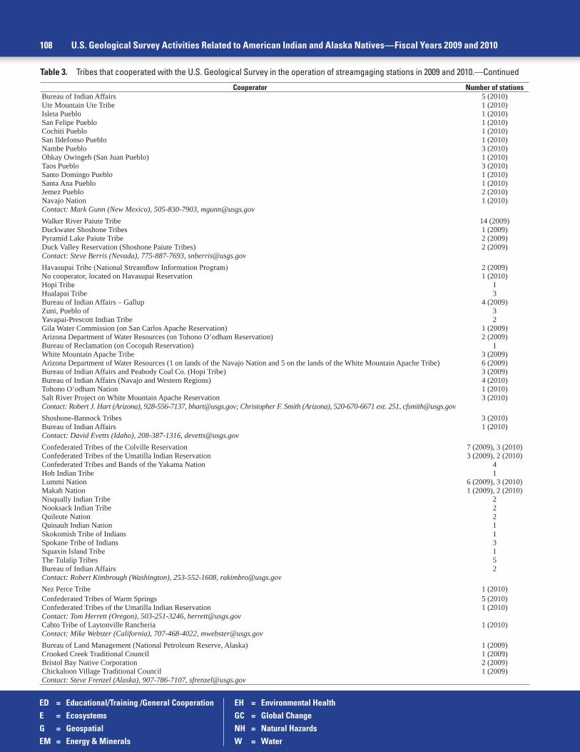
ED = Educational/Training /General Cooperation EH = Environmental HealthE = Ecosystems GC = Global ChangeG = Geospatial NH = Natural HazardsEM = Energy & Minerals W = Water
108 U.S. Geological Survey Activities Related to American Indian and Alaska Natives—Fiscal Years 2009 and 2010
Table 3. Tribes that cooperated with the U.S. Geological Survey in the operation of streamgaging stations in 2009 and 2010.—Continued
Cooperator Number of stationsBureau of Indian Affairs 5 (2010)Ute Mountain Ute Tribe 1 (2010)Isleta Pueblo 1 (2010)San Felipe Pueblo 1 (2010)Cochiti Pueblo 1 (2010)San Ildefonso Pueblo 1 (2010)Nambe Pueblo 3 (2010)Ohkay Owingeh (San Juan Pueblo) 1 (2010)Taos Pueblo 3 (2010)Santo Domingo Pueblo 1 (2010)Santa Ana Pueblo 1 (2010)Jemez Pueblo 2 (2010)Navajo Nation 1 (2010)Contact: Mark Gunn (New Mexico), 505-830-7903, [email protected] River Paiute Tribe 14 (2009)Duckwater Shoshone Tribes 1 (2009)Pyramid Lake Paiute Tribe 2 (2009)Duck Valley Reservation (Shoshone Paiute Tribes) 2 (2009)Contact: Steve Berris (Nevada), 775-887-7693, [email protected] Tribe (National Streamflow Information Program) 2 (2009)No cooperator, located on Havasupai Reservation 1 (2010)Hopi Tribe 1Hualapai Tribe 3Bureau of Indian Affairs – Gallup 4 (2009)Zuni, Pueblo of 3Yavapai-Prescott Indian Tribe 2Gila Water Commission (on San Carlos Apache Reservation) 1 (2009)Arizona Department of Water Resources (on Tohono O’odham Reservation) 2 (2009)Bureau of Reclamation (on Cocopah Reservation) 1White Mountain Apache Tribe 3 (2009)Arizona Department of Water Resources (1 on lands of the Navajo Nation and 5 on the lands of the White Mountain Apache Tribe) 6 (2009)Bureau of Indian Affairs and Peabody Coal Co. (Hopi Tribe) 3 (2009)Bureau of Indian Affairs (Navajo and Western Regions) 4 (2010)Tohono O’odham Nation 1 (2010)Salt River Project on White Mountain Apache Reservation 3 (2010)Contact: Robert J. Hart (Arizona), 928-556-7137, [email protected]; Christopher F. Smith (Arizona), 520-670-6671 ext. 251, [email protected] Tribes 3 (2010)Bureau of Indian Affairs 1 (2010)Contact: David Evetts (Idaho), 208-387-1316, [email protected] Tribes of the Colville Reservation 7 (2009), 3 (2010)Confederated Tribes of the Umatilla Indian Reservation 3 (2009), 2 (2010)Confederated Tribes and Bands of the Yakama Nation 4Hoh Indian Tribe 1Lummi Nation 6 (2009), 3 (2010)Makah Nation 1 (2009), 2 (2010)Nisqually Indian Tribe 2Nooksack Indian Tribe 2Quileute Nation 2Quinault Indian Nation 1Skokomish Tribe of Indians 1Spokane Tribe of Indians 3Squaxin Island Tribe 1The Tulalip Tribes 5Bureau of Indian Affairs 2Contact: Robert Kimbrough (Washington), 253-552-1608, [email protected] Perce Tribe 1 (2010)Confederated Tribes of Warm Springs 5 (2010)Confederated Tribes of the Umatilla Indian Reservation 1 (2010)Contact: Tom Herrett (Oregon), 503-251-3246, [email protected] Tribe of Laytonville Rancheria 1 (2010)Contact: Mike Webster (California), 707-468-4022, [email protected] of Land Management (National Petroleum Reserve, Alaska) 1 (2009)Crooked Creek Traditional Council 1 (2009)Bristol Bay Native Corporation 2 (2009)Chickaloon Village Traditional Council 1 (2009)Contact: Steve Frenzel (Alaska), 907-786-7107, [email protected]
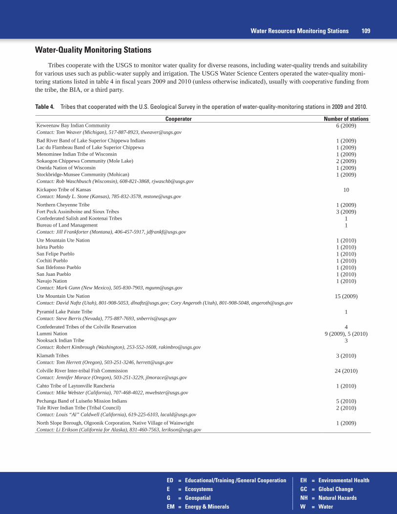
ED = Educational/Training /General Cooperation EH = Environmental HealthE = Ecosystems GC = Global ChangeG = Geospatial NH = Natural HazardsEM = Energy & Minerals W = Water
Water Resources Monitoring Stations 109
Table 4. Tribes that cooperated with the U.S. Geological Survey in the operation of water-quality-monitoring stations in 2009 and 2010.
Cooperator Number of stationsKeweenaw Bay Indian Community 6 (2009)Contact: Tom Weaver (Michigan), 517-887-8923, [email protected] River Band of Lake Superior Chippewa Indians 1 (2009)Lac du Flambeau Band of Lake Superior Chippewa 1 (2009)Menominee Indian Tribe of Wisconsin 1 (2009)Sokaogon Chippewa Community (Mole Lake) 2 (2009)Oneida Nation of Wisconsin 1 (2009)Stockbridge-Munsee Community (Mohican) 1 (2009)Contact: Rob Waschbusch (Wisconsin), 608-821-3868, [email protected] Tribe of Kansas 10Contact: Mandy L. Stone (Kansas), 785-832-3578, [email protected] Cheyenne Tribe 1 (2009)Fort Peck Assiniboine and Sioux Tribes 3 (2009)Confederated Salish and Kootenai Tribes 1Bureau of Land Management 1Contact: Jill Frankforter (Montana), 406-457-5917, [email protected] Mountain Ute Nation 1 (2010)Isleta Pueblo 1 (2010)San Felipe Pueblo 1 (2010)Cochiti Pueblo 1 (2010)San Ildefonso Pueblo 1 (2010)San Juan Pueblo 1 (2010)Navajo Nation 1 (2010)Contact: Mark Gunn (New Mexico), 505-830-7903, [email protected] Mountain Ute Nation 15 (2009)Contact: David Naftz (Utah), 801-908-5053, [email protected]; Cory Angeroth (Utah), 801-908-5048, [email protected]
Pyramid Lake Paiute Tribe 1Contact: Steve Berris (Nevada), 775-887-7693, [email protected] Tribes of the Colville Reservation 4Lummi Nation 9 (2009), 5 (2010)Nooksack Indian Tribe 3Contact: Robert Kimbrough (Washington), 253-552-1608, [email protected] Tribes 3 (2010)Contact: Tom Herrett (Oregon), 503-251-3246, [email protected] River Inter-tribal Fish Commission 24 (2010)Contact: Jennifer Morace (Oregon), 503-251-3229, [email protected] Tribe of Laytonville Rancheria 1 (2010)Contact: Mike Webster (California), 707-468-4022, [email protected] Band of Luiseño Mission Indians 5 (2010)Tule River Indian Tribe (Tribal Council) 2 (2010)Contact: Louis “Al” Caldwell (California), 619-225-6103, [email protected] Slope Borough, Olgoonik Corporation, Native Village of Wainwright 1 (2009)Contact: Li Erikson (California for Alaska), 831-460-7563, [email protected]
Water-Quality Monitoring Stations
Tribes cooperate with the USGS to monitor water quality for diverse reasons, including water-quality trends and suitability for various uses such as public-water supply and irrigation. The USGS Water Science Centers operated the water-quality moni-toring stations listed in table 4 in fiscal years 2009 and 2010 (unless otherwise indicated), usually with cooperative funding from the tribe, the BIA, or a third party.

ED = Educational/Training /General Cooperation EH = Environmental HealthE = Ecosystems GC = Global ChangeG = Geospatial NH = Natural HazardsEM = Energy & Minerals W = Water
110 U.S. Geological Survey Activities Related to American Indian and Alaska Natives—Fiscal Years 2009 and 2010
Groundwater Monitoring Stations
The USGS Water Science Centers operated the groundwater-monitoring stations listed in table 5 in fiscal years 2009 and 2010 (unless otherwise indicated), usually with cooperative funding from the tribe.
Table 5. Tribes that cooperated with the U.S. Geological Survey in the operation of groundwater-monitoring stations in 2009 and 2010.
Cooperator Number of stationsUpper Sioux Community 6 (2009)Lower Sioux Indian Community 1 (2009)Contact: Don Hansen (Minnesota), 763-783-3250, [email protected] of Indian Affairs 1Miami Tribe of Oklahoma 1Contact: Jason Lewis (Oklahoma), 405-810-4404, [email protected] Cheyenne Tribe 7Contact: Joanna Thamke (Montana), 406-457-5923, [email protected] Tribe of Idaho 25 (2010)Contact: Annette Campbell (Idaho), 208-387-1317, [email protected] Stream Information Program (NSIP) (observation well located on Kaibab Paiute Reservation) 1 (2009)National Park Service (Kaibab Band of Paiute Indians) 1 (2009), 3 (2010)Bureau of Indian Affairs (Navajo Nation, Hopi Tribe, White Mountain Apache Tribe) 9Contact: Christopher Smith (Arizona), 520-670-6671 ext. 251, [email protected] Band of Luiseño Mission Indians 19 (2010)Contact: Louis “Al” Caldwell (California), 619-225-6103, [email protected]
Lake and Reservoir-Stage Monitoring Stations
Tribes cooperate with the USGS to monitor lake levels for diverse reasons, including flood and irrigation management, and commercial and tribal recreation. The USGS Water Science Centers operated the lake-stage monitoring stations listed in table 6 to determine lake levels in fiscal years 2009, usually with cooperative funding from the tribe.
Table 6. Tribes that cooperated with the U.S. Geological Survey in the operation of lake/reservoir-monitoring stations in 2009.
Cooperator Number of stationsLac Vieux Desert Band of Lake Superior Chippewa 1 (2009)Contact: Tom Weaver (Michigan), 517-887-8923, [email protected] Lake Paiute Tribe 1 (2009)Walker River Paiute Tribe 1 (2009)Shoshone Paiute Tribe (Duck Valley) 1 (2009)Contact: Steve Berris (Nevada), 775-887-7693, [email protected]
Table 7. Tribes that cooperated with the U.S. Geological Survey in the operation of sediment-monitoring stations in 2009 and 2010.
Cooperator Number of stationsHopi Tribe 3Pueblo of Zuni 1Contact: Robert J. Hart (Arizona), 928-556-7137, [email protected]
Sediment-Monitoring Stations
The USGS Water Science Centers operated the sediment-monitoring stations listed in table 7 in fiscal years 2009 and 2010, usually with cooperative funding from the tribe.

ED = Educational/Training /General Cooperation EH = Environmental HealthE = Ecosystems GC = Global ChangeG = Geospatial NH = Natural HazardsEM = Energy & Minerals W = Water
U.S. Geological Survey Office of Tribal Relations—Tribal Liaison Team, 2009–2010 111
U.S. Geological Survey Office of Tribal Relations—Tribal Liaison Team, 2009–2010
The U.S. Geological Survey (USGS) Office of Tribal Relations has a Tribal Liaison Team that works with the Bureau to establish policy and to coordinate USGS activities. Liaison Team members represent USGS scientific mission areas and geo-graphic areas (fig. 98). Please contact any of the individuals listed below for more information or find additional information on our Web site at http://www.usgs.gov/tribal/.
Bureau and Scientific Mission Area Liaisons
Director’s Office, National Tribal Liaison Ecosystems Climate and Land-Use ChangeMonique Fordham12201 Sunrise Valley DriveMail Stop 911Reston, VA, 20192-0002Phone: 703-648-4437Fax: [email protected]
Steven Hilburger12201 Sunrise Valley DriveMail Stop 301Reston, VA 20192Phone: 703-648-4036Fax: [email protected]
Eric C. WoodCenter for Earth Resources Observation and Science (EROS)47914 252nd Street Sioux Falls, SD 57198-9801Phone: 605-594-6068Fax: [email protected]
Energy, Minerals, and Environmental Health Natural Hazards WaterSharon Swanson12201 Sunrise Valley DriveMail Stop 956Reston, VA 20192Phone: 703-648-6453Fax: [email protected]
Eric GrossmanWestern Fisheries Research Center6505 NE 65th StreetSeattle, WA 98115Phone: 360-650-4697Fax: [email protected]
J. Michael NorrisUSGS National Streamflow Information Program331 Commerce Way, Suite #2, Mail Stop 415Pembroke, NH 03275-3718Phone: 603-226-7847Fax: [email protected]
Core Science Systems Geographic Information (FGDC)Mark DeMulder12201 Sunrise Valley DriveMail Stop 511Reston, VA 20192Phone: 703-648-5569Fax: [email protected]
Kent Swanjord12201 Sunrise Valley DriveMail Stop 119Reston, VA 20192Phone: 703-648-6887Fax: [email protected]
Geographic Area Liaisons
Southeast Area Midwest Area Northeast AreaBarry H. Rosen12703 Research ParkwayOrlando, FL 32826Phone: 407-803-5508Fax: [email protected]
Bryan Richards6006 Schroeder RoadMadison, WI 53711Phone: 608-270-2485Fax: [email protected]
Glenn Holcomb11649 Leetown RoadKearneysville, WV 20540Phone: 304-724-4526Fax: [email protected]
South Central Area Alaska AreaKim Winton301 David L. Boren BlvdSuite 3030Norman, OK 73109 Phone: [email protected]
Durelle Smith4210 University DriveAnchorage, AK 99508Phone: 907-786-7104Fax: [email protected]
Northwest Area Southwest AreaTracy Fuentes (Tribal Liaison
during 2009–2010)Lee Case (Tribal Liaison
during 2009–2010)
Lief Horowitz909 First AvenueSeattle, WA 98104Phone: 206-220-4616 [email protected]
Leslie ArmstrongWest 6th Ave. & Kipling St.Denver, CO 80225Phone: [email protected]
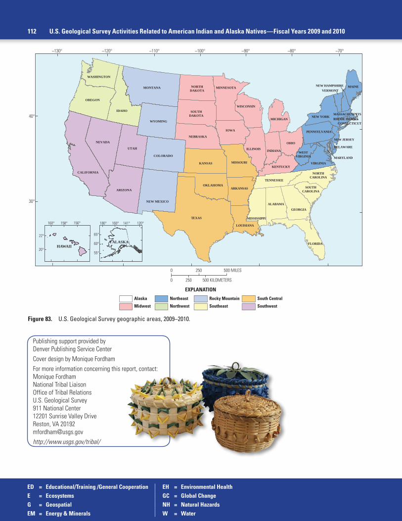
112 U.S. Geological Survey Activities Related to American Indian and Alaska Natives—Fiscal Years 2009 and 2010
Figure 83. U.S. Geological Survey geographic areas, 2009–2010.
EXPLANATION
Alaska
Midwest
Northeast
Northwest
Rocky Mountain
Southeast
South Central
Southwest
–130°
40°
30°
–120° –100° –90° –80° –70°–110°
UTAH
CALIFORNIA
ARIZONA
NEVADA
VIRGINIA
PENNSYLVANIA
WESTVIRGINIA
NEW YORK
IDAHO
OREGON
WASHINGTON
TEXAS
KANSAS MISSOURI
OKLAHOMA
LOUISIANA
FLORIDA
GEORGIA
ALABAMA
TENNESSEE
NORTHCAROLINA
MISSISSIPPI
SOUTHCAROLINA
IOWA
OHIO
ILLINOIS
NEBRASKA
MINNESOTA
SOUTHDAKOTA
WISCONSIN
NORTHDAKOTA
INDIANA
KENTUCKY
MONTANA
COLORADO
WYOMING
NEW MEXICO
NEW JERSEY
MASSACHUSETTSRHODE ISLAND
DELAWARE
MARYLAND
NEW HAMPSHIREVERMONT
MAINE
CONNECTICUT
ARKANSAS
MICHIGAN
0 250
250
500 MILES
0 500 KILOMETERS
HAWAII20°
22°
156°158°160°
65°
60°
55°
160° 141° 120°180°
ALASKA
Publishing support provided byDenver Publishing Service CenterCover design by Monique FordhamFor more information concerning this report, contact:Monique FordhamNational Tribal LiaisonOffice of Tribal RelationsU.S. Geological Survey911 National Center12201 Sunrise Valley DriveReston, VA [email protected]://www.usgs.gov/tribal/
ED = Educational/Training /General Cooperation EH = Environmental HealthE = Ecosystems GC = Global ChangeG = Geospatial NH = Natural HazardsEM = Energy & Minerals W = Water

Fordham and M
ontour—U
.S. Geological Survey A
ctivities Related to Am
erican Indians and Alaska N
atives—Circular 1403
Printed on recycled paperISSN 2330-5703 (online) ISSN 1067-084X (print)http://dx.doi.org/10.3133/cir1403