Visualisation of active normal fault scarps in the Apennines, Italy

Available online http:/amq.aiqua.it ISSN (print): 2279-7327, ISSN (online): 2279-7335
Alpine and Mediterranean Quaternary, 26 (1), 2013, 31-39
THE UPPERMOST MIDDLE PLEISTOCENE-HOLOCENE ALLUVIAL DEPOSITS OF THE UPPER TIBER BASIN (NORTHERN APENNINES, CENTRAL ITALY):
CHRONOLOGIC CONSTRAINTS FROM ARCHAEOLOGICAL DATA
Marco Benvenuti1, Adriana Moroni2, Francesca Tangocci1, 1 Dipartimento di Scienze della Terra, Università di Firenze, Italy
2 Unità di Ricerca di Ecologia Preistorica - Dipartimento di Scienze Fisiche, della Terra e dell’Ambiente - Università di Siena, Italy
Corresponding author : Marco Benvenuti <[email protected]>
ABSTRACT: The paper reports the results of a geomorphologic and stratigraphic study of the NW portion of the Upper Tiber Basin (Cen-tral Italy), and focuses on the terraced alluvial deposits which are grouped into late Middle-Upper Pleistocene (MUP) and Holocene (HOL) units. The drainage development in the basin was deeply influenced by an active tectonic setting characterized by orthogonal fault systems, which forced river deviations and attracted alluvial deposition in the subsiding portions of the basin. The occupation of this in-termountain territory by ancient human communities is recorded by late Prehistoric-Protohistoric archaeological findings collected within or on the surfaces delimiting these units. This archaeological dataset allowed an indicative dating of the major stages of the fluvial evolu-tion between the end of the middle Pleistocene and the late Holocene. The chronological constraint indicates that the morpho-stratigraphic events recorded in the MUP and HOL units, have reasonably occurred within the two last glacial-interglacial cycles. Rapid climate changes, affecting the surface hydrology and the sediment supply to the river systems, and the active tectonic setting, thus, may account for the gaps in the local archaeological record, including most of the late Paleolithic, the Mesolithic and the early Neolithic. Late Pleistocene and the early Holocene stages of relevant alluvial deposition in a subsiding basin may have caused the burial of the missing cultural stages or may have prevented the human occupation of hydraulically unsafe valley floors.
Keywords: Alluvial terraced deposits, Intermontane basin, Archaeology, Middle Pleistocene-Holocene, Central Italy.
1. INTRODUCTION
Despite several techniques are suitable for the geo-chronological calibration of the Quaternary successions (Walker, 2005), a major problem in the study of terraced alluvial deposits is frequently represented by their dating. Nevertheless, temporary or stable human settlements have occupied alluvial plains, especially during the Late Quaternary. This is testified by archaeological remains spanning the late prehistorical-historical cultural stages. The Geoarchaeology of alluvial plains (Brown, 1997; Woodward & Huckleberry, 2011), thus, may provide suit-able tools for analysing the dynamics of these environ-ments induced by concurrent natural and anthropic pro-cesses. In the Northern Apennines (Central Italy) terraced fluvial deposits occurring in several intermountain basins (Fig. 1a), are ascribed to the late Quaternary on the basis of weak morpho-stratigraphic constraints, often lacking absolute dating. The occurrence of archaeological re-mains on the surfaces and within the alluvial deposits of this region, attests to a human occupation dating back to the Prehistory. The dating of different cultural stages that developed in Central Italy may be quite precise for the late Prehistory (late Pleistocene-early Holocene)-Protohistory (mid-late Holocene) interval, becoming ex-tremely accurate in historic periods. This feature makes the archaeologic data a suitable tool for an indicative to accurate chronologic constraint of late Quaternary land-forms and deposits occurring in this region.
In this paper we present the spatial and strati-
graphic distribution of terraced alluvial deposits in the intermountain Upper Tiber Basin (NE Tuscany, Central Italy) referred to the latest Middle Pleistocene-Holocene on the base of the distribution and dating of archaeolog-ical materials collected in the last decades.
2. REGIONAL SETTING
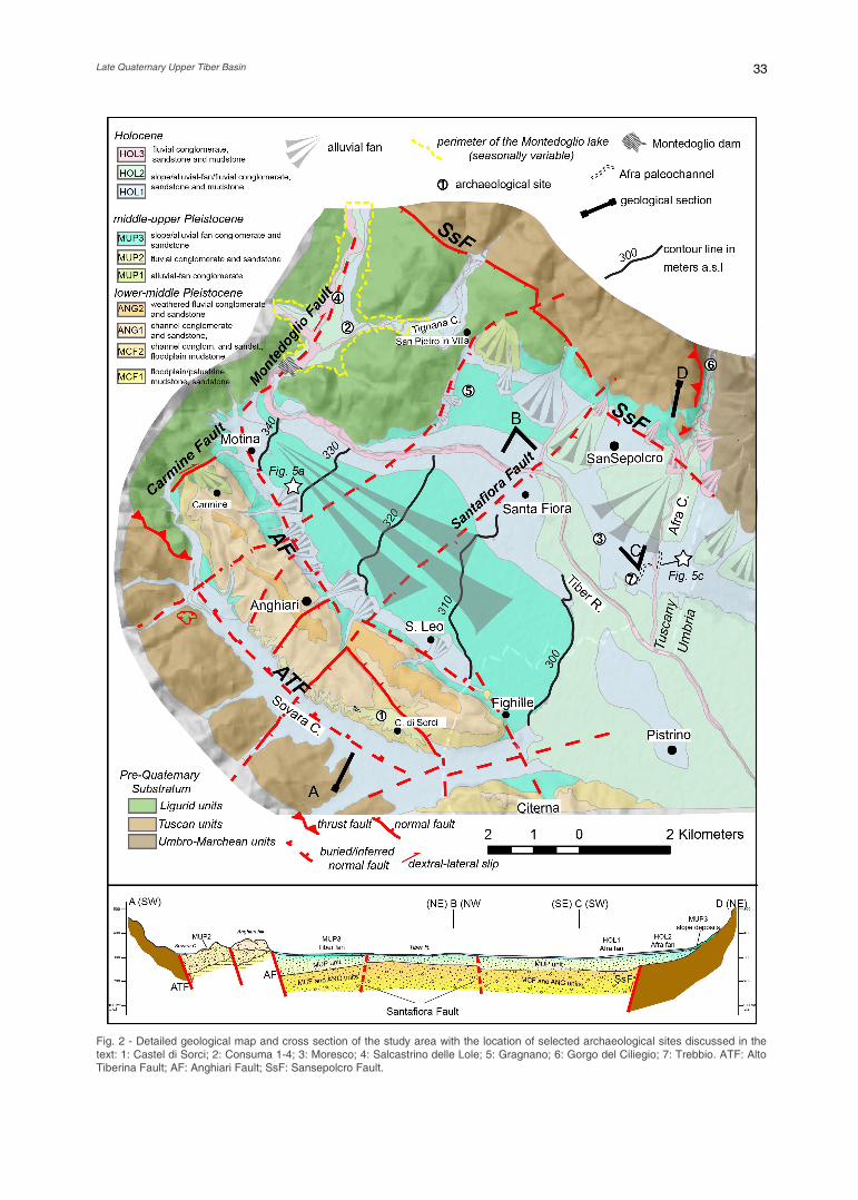
The study area is located in the upper reach of the Tiber River, barred by the Montedoglio Dam and includ-ing the tributaries Singerna, Sovara, Tignana and Afra creeks. This is a portion of the Upper Tiber River basin (UTB, Figs. 1, 2), a NW-SE trending intermountain de-pression about 21 km long and 10 km wide, flanked by steep hills composed of Miocene turbiditic sandstones (Tuscan and Umbro-Marchean units respectively) to the NNE and SSW and Jurassic-Eocene ophiolithes, lime-stone and marls (Ligurid units) to the NNW. The basin is bounded by the Alto Tiberina Fault along the SW shoul-der (ATF, Figs. 1b, 2) and by the antithetic Sansepolcro Fault on the opposite side (SsF in Fig. 2; Barchi & Ciac-cio, 2004). The NW-SE elongated Anghiari-Citerna hills are delimited toward the Tiber plain by the ATF-synthetic Anghiari Fault and cross-cut by NE-SW trend-ing faults (Fig. 2). A portion of a basin fill about 1,000 meters thick (Sani et al., 2009), is exposed on the flanks of these hills (Benvenuti, 1989; Cattuto et al., 1995; Pial-li & Plesi, 2009), consisting of 150 m thick Lower-Middle Pleistocene alluvial gravels, sands and subordinated

Benvenuti M. et al. 32
muds subdivided in this study into four main units (Fig. 2; Tab. 1). The older, Monterchi-Citerna-Fighille unit (MCF, Fig. 2), includes final lower Pleistocene flood-plain-palustrine sands and muds (MCF1) (Ciangherotti & Esu, 2000; Argenti, 2003-2004) erosively overlain by early Middle Pleistocene fluvial arenaceous-calcareous gravels, sands and muds (MCF2) (Benvenuti, 1989). The MCF unit is tilted against the ATF (cross section in Fig. 2; Sani et al., 2009) and unconformably overlain by the Anghiari unit (ANG), made of Middle Pleistocene fluvial calcareous gravels (ANG1) unconformably over-lain by deeply weathered fine conglomerate and sand (ANG2) (Van Waveren, 1986). The Tiber River plain is characterized by alluvial and colluvial deposits (MUP and HOL units, Fig. 2) that are described and discussed in more detail in section 4.
3. ARCHAEOLOGICAL RECORDS
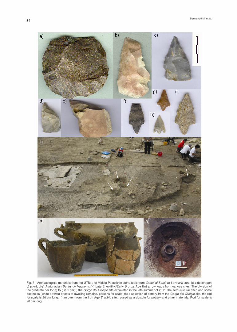
Since Prehistory and Protohistory the Upper Tiber Valley has represented a strategic connection route across the Northern Apennines divide as documented by extensive archaeological surveys (Moroni Lanfredini & Benvenuti, 2010; Fig. 2). The Middle Palaeolithic is the earliest period recorded. This is represented by stone tools collected southwest of Anghiari on the sur-faces of the ANG2 unit and in the palaeoSovara ter-raced deposits (MUP2 at Castel di Sorci and nearby sites, site 1 in Fig. 2; Cocchi et al., 1978; Borgia & Mo-roni Lanfredini, 2004, Moroni et al., 2011) attesting to the presence of Neanderthal groups for seasonal hunt-ing and gathering. The lithic assemblages are character-ized by Levallois and, subordinately, discoid production systems and include mainly side scrapers, points, den-ticulates (Fig. 3a-c) and rare handaxes.
The Early Upper Paleolithic is documented on the
NW slopes of the basin by an Aurignacian lithic industry, very rich in burins des Vachons (Fig. 3d-e), recovered near Caprese Michelangelo (Fig. 1b) (Moroni Lanfredini & Ronchitelli, 2001), which dates back around 30 ka ago (Arrighi et al., 2006). The floodplain occupation is rec-orded from the Final Upper Paleolithic in the Consuma 2 site (site 2 in Fig. 2; Moroni, 1990), presently flooded by the Montedoglio lake, by a Final Epigravettian lithic as-semblage dating back to around 12 ka ago, character-ized by microlithic backed tools. Evidence of the human presence on the valley floor during the early Holocene is fragmentary with a missing Mesolithic stage and only few Early Neolithic findings discovered in the Tiber plain (Consuma, site 2 in Fig. 2). The Neolithic to Eneolithic (Copper Age) transition is recorded near the Tiber River (Consuma 1 and Moresco; sites 2 and 3 in Fig. 2; Cas-telletti et al., 1992; Moroni Lanfrendini, 1995-1996), by two open-air sites which yielded pottery decorated with the Late Neolithic Chassey style and pot-shapes and handles typical of the Early Eneolithic of Central Italy. The Middle Eneolithic is currently attested by sporadic material, while the late Eneolithic/Early Bronze Age pe-riod (Vaso Campaniforme stage) is represented by the Consuma 2 and Salcastrino delle Lole sites (Fig. 3f-i) (sites 2 and 4 in Fig. 2; Moroni, 1990; Guidi & Moroni Lanfredini, 2001). The Bronze Age, particularly its mid-dle stage, marks a period of wider occupation in the plain close to the Tiber River banks or in the narrow val-leys of its tributaries. Almost the whole of the Early Mid-dle Bronze Age sites is on the Tiber floodplain (Salcas-trino delle Lole upper layer, Consuma 4, Gragnano; sites 2, 4, 5 in Fig. 2; Moroni Lanfredini & Ronchitelli, 1997; Guidi & Moroni Lanfredini, 2001). The Middle Bronze Age (Apennine phase) recorded at Gorgo del Ciliegio (site 6 in Fig. 2; Fig. 3l-m; Arrighi & Moroni Lanfredini, 2004) and around Caprese Michelangelo, points to settlements on the higher slopes. A significant
Fig. 1 - Generalized geological maps: a) distribution of intermontane basins of the Northern Apennines. Codes of the basins: Lu: Luni-giana; Vm: Val di Magra; Mtc: Montecarlo; Fpp: Firenze-Prato-Pistoia; Mu: Mugello; Ca: Casentino; Va: Upper Valdarno; Ch: Valdichia-na; UTB: Upper Tiber Basin; Tib: Tiberino (after Sani et al., 2009); b) schematic geology of the UTB; ATF: Alto Tiberina Fault. The boxedarea represents the portion of the basin investigated in this study (Fig. 2).
Late Quaternary Upper Tiber Basin
33
Fig. 2 - Detailed geological map and cross section of the study area with the location of selected archaeological sites discussed in thetext: 1: Castel di Sorci; 2: Consuma 1-4; 3: Moresco; 4: Salcastrino delle Lole; 5: Gragnano; 6: Gorgo del Ciliegio; 7: Trebbio. ATF: AltoTiberina Fault; AF: Anghiari Fault; SsF: Sansepolcro Fault.
Benvenuti M. et al. 34
Fig. 3 - Archaeological materials from the UTB: a-c) Middle Paleolithic stone tools from Castel di Sorci: a) Levallois core; b) sidescraper;c) point; d-e) Aurignacian Burins de Vachons; f-i) Late Eneolithic/Early Bronze Age flint arrowheads from various sites. The division ofthe graduate bar for a) to i) is 1 cm; l) the Gorgo del Ciliegio site excavated in the late summer of 2011: the semi-circular ditch and somepostholes (white arrows) attests to dwelling remains, persons for scale; m) a selection of pottery from the Gorgo del Ciliegio site, the rodfor scale is 20 cm long; n) an oven from the Iron Age Trebbio site, reused as a dustbin for pottery and other materials. Rod for scale is20 cm long.

Late Quaternary Upper Tiber Basin
35
occupation of the floodplain during the Iron Age is rec-orded south of Sansepolcro by a 20-hectares wide pro-to-urban settlement (Trebbio, site 7 in Fig. 2; Iaia & Mo-roni Lanfredini, 2009), characterized by well-developed handicraft activities mostly related to pottery production (Fig. 3n).
When plotted against time, the Prehistoric-Protohistoric archaeological record of the UTB, thus, shows a pattern of documented cultural stages separat-ed by quite long periods of missing or occasionally rep-resented cultures (Fig. 4a). The calibration of artefact assemblages mostly collected within the deposit of the different units described below has been obtained by a variety of methods, reported in the papers cited above, including comparison with well-dated archaeological materials from other Italian localities, and radiocarbon dating of charcoal derived from the human activity.
4. GEOMORPHOLOGY AND STRATIGRAPHY OF THE LATEST MIDDLE PLEISTOCENE-HOLOCENE SUCCESSION
The landforms and the underlying sediments re-ferred to units MUP and HOL (Fig. 2) are briefly de-scribed in this section providing a geomorphologic pic-ture quite different from those represented in the exist-ing geological maps (Jacobacci & Malatesta, 1969; Pialli & Plesi, 2009).
4.1. MUP Unit Landforms and deposits referred to this unit (Fig. 2)
are further subdivided in sub-units MUP1-3 on the base of geomorphologic and stratigraphic lines of evidence.
4.1.1. MPU1 sub-unit Arenaceous-ophiolitic boulder to pebble-sized
gravels (MUP1) is exposed for few meters at a road cut NW of Anghiari. The gravels are poorly stratified and show a clast-supported texture with abundant sandy-silty interstitial matrix. Clasts are rounded to well-rounded showing an embrication hinting to paleocur-rents from NW. This outcrop is at the base of a fan-shaped, relief considered the evidence of a small alluvi-al fan fed by the paleoSovara Creek that flowed from NW to SE. A SW-NE trending fault (Carmine fault in Fig.
2) that places the ophiolites of the Ligurid Units in con-tact with these and older Quaternary deposits of the Anghiari hill, suggests a tectonic control on a possible diversion of the Sovara Creek, today flowing to SW.
4.1.2 MPU2 sub-unit Remnants of a fluvial terraced surface occur on
the right of the Sovara Creek with a wider patch near Castel di Sorci, a few kilometers SE of Anghiari. At this location, the terrace, standing about ten meters above the modern valley floor, contains gravel, sand and mud referred to the MUP2 sub-units. These deposits are af-fected by a deep yellowish-reddish paleosol bearing Middle Paleolithic stone implements (Fig. 3a-c; Cocchi et al., 1978; Moroni Lanfredini & Benvenuti, 2010; Mo-roni et al., 2011).
4.1.3. MPU3 sub-unit The Tiber River plain between Montedoglio Dam
and Santa Fiora village is a large NW-SE trending fan-shaped surface topographically outlined by contour lines oriented transversally to the basin (Fig. 2). Such mor-phology indicates an abandoned large alluvial fan pos-sibly fed by the Tiber and/or Singerna rivers. The latter behaved as distributive fluvial systems (Hartley et al., 2010), that is, axial rivers flowing into a subsiding basin that expand into terminal alluvial fans. Notably, the oc-currence of such a large relict fan in the Tiber plain is not detectable in the existing geological maps (Jaco-bacci & Malatesta, 1969; Pialli & Plesi, 2009), which represent it as the active floodplain of the Tiber River (Tab. 1). The deposits subtended by this fan-shaped plain are referred to sub-unit MUP3 and have been par-tially observed in a 2.5 meters deep excavation (Fig. 5a, location on Fig. 2). From the base, the deposits consist of about 2 meters thick clast-supported and well-rounded arenaceous pebble-sized gravels and sand af-fected on top by a well-developed reddish paleosol. This is buried by medium-fine yellowish sand, 0.5 meters thick. The buried soil suggests that the fan remained morphologically stable for a relatively long time, later on covered by the toe of a small alluvial fan (HOL 1 sub-unit, see below) fed by a local stream and not by the main Tiber River. The soil development, thus, indicates that the fan was abandoned due to a possible feeder deviation. The NW-SE trend of the MUP3 fan does not
Geological Map of Italy, 1:100,000 sheet 115 “Città di Castello”
Geological Map of Italy, 1:50,000 sheet 289 “Città di Castello”
This study
dt (slope talus) q1 (“old” terraced alluvial deposits) q2 (terraced alluvial deposits) a (recent alluvial deposits)
b2 (colluvial deposits) bn (terraced alluvial deposits) b (recent alluvial deposits)
HOL1-3 sub-units MUP3 sub-unit
QT2 (fluvio-lacustrine clay, sand and gravel)
MCT2 (Monterchi Synthem: Anghiari sub-synthem)
MUP1-2 sub-units ANG1-2 sub-units
CTA2a-CTA2c (Citerna Synthem: Monte Rodondo sub-synthem) MCF2 sub-unit
QT1 (lacustrine clay) FHL (Citerna Synthem: Fighille sub-synthem) MCF1 sub-unit
Tab. 1 - Comparative scheme of the stratigraphic subdivisions adopted in this study and in the existing geological maps (Jacobacci & Malatesta, 1969; Pialli & Plesi, 2009) of the study area.

Benvenuti M. et al. 36
match the WSW-ENE orientation of the present Tiber valley upstream the Montedoglio Dam fitting on the con-trary the proximal valley reaches of the Singerna and Tiber rivers which may represent the original fan feed-
ers, then displaced by a NE-SW dextral fault (Montedoglio Fault in Fig. 2; see Sani et al., 2009).
A few km east of San Pietro in Villa (Fig. 2), a further N-S trending fan-shaped hill faces the NW corner of the Tiber plain. Despite the lack of outcrops, the surface sediments are arenaceous and subordinate calcareous gravels indi-cating a thin clastic sedimentary cover on the Ligurid limestone and marlstone bed-rock. This landform and the related clas-tic deposits are ascribed to MUP3 sub-unit and interpreted as the evidence of a further small alluvial fan originally pro-grading in the Tiber plain and then be-headed from its original fluvial feeder. The latter was the precursor of the Tignana Creek whose entrenched valley is characterized by a proximal N-S trend-ing reach, coaxial with the San Pietro in Villa fan. In proximity of the NW prosecu-tion of the Sansepolcro fault, the valley turns in a NE-SW trend reach. This evi-dence suggests that also the Tignana Creek may have diverted as the conse-quence of active faulting.
4.2. HOL unit Landforms and deposits ascribed to
the HOL unit (Fig. 2), occur in the lower-most and partly still active alluvial plains. This unit is further subdivided in the HOL1-3 sub-units coinciding with three distinct alluvial surfaces.
4.2.1. HOL1 sub-unit The HOL1 alluvial plain is en-
trenched in the MUP and older units. The distribution of this landform in the Tiber River valley as well as in the valleys of its tributaries, testifies to the development of stream channels and adjacent floodplains upstream from the bridge between Santa Fiora village and Sansepolcro town (Fig. 2). Downstream, the HOL1, though dis-sected by the HOL2 and the modern river network (HOL3), widens in a surface that hints to a further Tiber alluvial fan. A lobed morphology, with a main NE-SW oriented axis, ascribed to this sub-unit characterizes also the plain of the adja-cent Afra Creek, suggesting the possible coalescence of the tributary HOL1 Afra fan. The deposits subtended by these surfaces are not exposed and a partial view of the HOL1stratigraphy derives from the excavation of the Consuma 2 site before the valley flooding upstream the Montedoglio dam (Fig.2; Moroni, 1990). In a 3-meter deep trench excavat-
ed in deposits morphologically correlated to the HOL1 sub-unit, the lower part consisted of brownish pebble-size and clast-supported conglomerate (Fig.5b), overlain by mottled sandy mudstone with pebbly lenses on top.
Fig. 4 - Archaeology and Chronology of the UTB: a) the archaeological stages docu-mented in the UTB and the approximate duration of the morpho-stratigraphic units.Hatched intervals refer to missed cultural stages possibly due to: 1) still not discov-ered materials, 2) prevented occupation of unsafe alluvial plains, 3) materials eventu-ally buried by alluvial deposition; b) the basin stratigraphy compared with the chronos-tratigraphy, magnetostratigraphy and marine isotope stages of the late Quaternary.

Late Quaternary Upper Tiber Basin
37
Final Epigravettian stone tools (Moroni, 1990) have been found In the middle of these deposits together with isolated arenaceous cobbles. The upper part was char-acterized by a lag of pebble-sized conglomerate over-lain by massive dark mudstone bearing late Eneolithic-Early Bronze age stone tools indicating a middle Holo-cene reoccupation of this river bank. At the SW margins of the Tiber plain, slope deposits and small alluvial fans developed at the foot of the Anghiari hills represent the HOL1 sub-unit. These fans, fed by the gravel-rich ANG1-2 units, evidently graded at a base level different from that of the main river network. The inferred activity of the Anghiari fault (Delle Donne et al., 2007) and the confinement of the MUP3 fan lobe, concurrently deter-mined a local topographic low for the fan deposition fed by the short and steep creeks draining the Anghiari hill.
4.2.2 HOL2-3 sub-units In the Tiber plain the landforms and deposits as-
cribed to HOL2 unit point to a geomorphic development similar to that recorded by the HOL1. A river channel entrenchment widens downstream in a relatively larger plain attesting to a progressive telescopic shift toward SE of the Tiber fluvial-fan complex. Similarly to the pre-vious unit, small alluvial fans graded to a higher base level with respect to the HOL2 plain. Notably, the alluvial fans ascribed to HOL2 sub-unit occur only SE of Santa Fiora on the left of the Tiber River. The HOL2 Afra fan is the largest one. Unit HOL3 represents the recent fluvial landforms in the plain. These are related to the narrow (and up to 5 meters deep) river valleys incised in the older units and by small alluvial fans that aggraded onto
the fans of the HOL2 unit. The related deposits have been investigated in a trench excavated on the left of the modern Afra channel, about 0.9 km NE of the Treb-bio site (Figs.5c; 2 site 7). The alluvial succession is composed of about 1.30 meters of mottled muddy sand with land snail shells referred to the distal portion of the HOL1 Afra fan. These deposits are overlain by 0.8 m thick lenticular gravel bed that records a HOL3 palae-oAfra channel, in turn overlain by 0.4 meter thick muddy sand representing the overbank deposits of the nearby active Afra channel.
5. THE ARCHAEOLOGICAL CONTRIBUTION TO A CHRONOLOGIC CONSTRAINT OF MUP AND HOL UNITS
The ancient human occupation of the UTB is con-sidered largely controlled by the alluvial dynamics record-ed by the MUP and HOL units, which in turn resulted from a balance between active tectonics and climate varia-tions. From one side the material evidence of occupation of alluvial plains is considered a proof of local reduced alluvial sedimentation and attitude to flooding, conditions that made safe the temporary and/or stable settling of human communities on these surfaces. From the other side the gaps in the archaeological record of the UTB, beside indicating still undiscovered cultural stages, may reflect: 1) sporadic and/or absent occupation of areas of active alluvial deposition such as the documented large alluvial fans or 2) sediment deposition that buried any ma-terial evidence of possible land occupation.
Fig. 5 - Stratigraphy of selected trenches excavated in the UTB: a) the stratigraphic profile in the trench dug onto the MUP3 Singerna-Tiber fan, location in Fig. 2); b) the Consuma 2 site stratigraphy (location in Fig. 2 site 2); c) HOL3 palaeoAfra channel fill (delimited bythe dotted white line) resting over the distal deposits of the HOL 1 Afra fan. The gravelly channel fill is characterized by a pillar-like struc-ture protruding into the underlying muddy sand which hints to the liquefaction of the latter deposits, of possible paleoseismic origin.Trench location in Fig. 2.

Benvenuti M. et al. 38
Under these assumptions the archaeological rec-ord, included its hiatus, may be considered for dating the depositional stages represented by the units and sub-units described above (Fig. 3a).
1) The Middle Paleolithic stone tool assemblage found within the MUP2 deposit of the Castel dei Sorci terrace indicates that possibly around 130-100 ka ago Neanderthal populations moved on the Anghiari hills flanked to SW by a terraced paleoSovara valley. The fault-controlled deactivation of the MUP1 Sovara fan was followed by the incision of a MUP2 Sovara valley trending as the present one.
2) From the Anghiari hills Neanderthals could have seen the MUP3 fans in the plain, which were active up to the latest Pleistocene. This chronologic reference is sug-gested by the final Epigravettian tools, collected in the stratified Consuma 2 site, upstream the Montedoglio dam, and confidently referred to about 12 ka ago. The latest Palaeolithic people occupied the left bank of the WSW-ESE trending Tiber valley evidently when the MUP3 fans would have been inactive due to the fault-controlled devi-ation of the Singerna-Tiber and Tignana rivers. The long span of time, characterized by the missing of most of the late Paleolithic during the late Pleistocene, coincided with huge sedimentation on the Tiber alluvial fan that may have prevented a stable human occupation of the plain and/or may have buried any artefact.
3) Similarly, the missing/sporadic Mesolithic and Neolithic stages suggest that the Tiber valley floor was unsuitable for stable human occupation also during the early Holocene. The HOL1 sub-unit developed during this span of time.
4) The geomorphic setting related to less intense fluvial processes evidently determined favourable condi-tion for a safe settling on the valley floor since the Ene-olithic and particularly in the mid-late Holocene when the alluvial plains were occupied by Bronze-Iron ages people. HOL 2 unit testifies to a period of renewed allu-vial-fan development particularly in the Afra Creek plain. Here the human occupation shows a gap from the Mid-dle Eneolithic (Moresco site) to the Iron Age (Trebbio site) which is considered an approximate duration of the HOL2 Afra fan development.
5) Finally, the large Trebbio settlement in the Afra plain is indicative of the human presence during the de-velopment of the HOL3 sub-unit. The latter marks a pe-riod of generalized fluvial incision in the basin and de-finitive deactivation of the large alluvial fans, which es-tablished safe hydraulic conditions on the terraced allu-vial plains.
Despite the active tectonic setting may have rep-resented a primary factor controlling the alluvial dynam-ics, autogenic processes of alluvial-fan deposition (Schumm et al., 1987; De Celles et al., 1991) may be not ruled out. The progressive south-eastward migration of MUP3-HOL2 alluvial fans in the Tiber plain may have also determined by channel entrenchment in response to local modification of base level induced by the fan lobes.
When compared with the Marine Isotope Stratig-raphy (Fig. 3b), the latest Middle Pleistocene-Holocene alluvial deposits and landforms of the UTB reasonably encompass at least two major glacial/interglacial cycles including the marine isotopic stages (MIS) 7-1. The ef-fects of these climatic changes on water discharge, sed-
iment production and transfer may have affected the geomorphic dynamics recorded by the MUP and HOL units. An analysis of the fluvial response to climate change during the last 200 ka in the Mediterranean Ba-sin (Macklin et al., 2002), indicates that, despite differ-ences related to local morpho-tectonic settings, alluvial deposition occurred particularly during glacial stages (i.e MIS6 and between the late MIS5 and MIS2). In the stud-ied case this seems confirmed by the large MUP3 Tiber fan whose development reasonably encompasses the MIS 4-2 interval. Due to an uncertain dating of MUP1-2 sub-units, older than 130 ka, at the moment clear rela-tions with glacial/interglacial stages cannot be estab-lished and a partial correlation to MIS 7 and 6 is only hypothetic.
6. CONCLUSIONS
A portion of the alluvial intermontane Upper Tiber Basin and its occupation by ancient human communities have been investigated through the integration of geo-morphology, stratigraphy and archaeology. Not exclud-ing intrinsic factors, alluvial deposition, recorded by the MUP and HOL units, was primarily influenced by an ac-tive tectonic setting characterized by orthogonal NW-SE and NE-SW trending fault systems which created sedi-ment accommodation through differential subsidence and forced river deviations through vertical and lateral displacement of faulted blocks. The spatial and chrono-logical distribution of late Prehistoric-Protohistoric ar-chaeological findings, collected on and within these units, has allowed an indicative dating of the major stages of fluvial network modification occurred between the end of the middle Pleistocene and the late Holo-cene. This chronologic calibration indicates that, be-sides the active tectonic setting, the morpho-stratigraphic events recorded in the described units have occurred within two major glacial-interglacial cy-cles. The latter may have controlled the local surface hydrology and the sediment supply to the fluvial sys-tems. Accordingly, gaps in the archaeological record, including most of the late Paleolithic, the Mesolithic and the early Neolithic, attest to stages of huge alluvial dep-osition in a highly subsiding basin. This may have de-termined the burial of the missing cultural stages or may have prevented any occasional or stable occupation in lowlands during the development of large alluvial fans. From a methodological point of view the integration of geological and archaeological data, adopted in this study, demonstrate the potentiality of cooperation be-tween physical and human sciences in revealing the complex interaction of Man and Environment.
ACKNOWLEDGEMENTS
The authors are indebted with Luca Trombino, Marco Mancini and an anonymous reviewer for the con-structive comments to an early version of this paper. The authors are also grateful to the Archaeological Of-fice of Tuscany which authorized and supported the re-search in the Upper Tiber Valley over the years and to Centro Studi sul Quaternario onlus for its assistance during excavations.

Late Quaternary Upper Tiber Basin
39
REFERENCES
Argenti P. (2003-2004) - Plio-Quaternary mammal fossil-iferous sites of Umbria (Central Italy). Geologica Romana, 37, 67-78.
Arrighi S., Moroni Lanfredini A. (2004) - L’insediamento appenninico di Gorgo del Ciliegio (Sansepolcro - Arezzo). In: Negroni Catacchio N. (Ed), Miti simbo-li decorazioni ricerche e scavi.VI Incontro di Studi Preistoria e Protostoria in Etruria, Proceedings Vo-lume 1, 505-507.
Arrighi S., Borgia V., Moroni Lanfredini A., Ronchitelli A. (2006) - Burins des Vachons en Italie: typologie, morphotechnique et tracéologie. ArchéoLogiques, 2, 103-118
Barchi M., Ciaccio M. (2004) - Ricostruzione geometrica del bacino di Sansepolcro dall’interpretazione di profili di sismica a riflessione. 23th GNGTS Meet-ing, Abstract Volume,195-196.
Benvenuti M. (1989) - Stratigrafia e Sedimentologia del-le Colline di Anghiari nella Valtiberina Superiore. Unpublished Laurea Dissertation, Università degli studi di Firenze, 80 pp.
Borgia V., Moroni Lanfredini A. (2004) - Le peuplement de la Haute Vallée du Tevère durant l’Acheuléen (Arezzo, Italie). 14th Congress UISPP, BAR Inter-national Series 1272, 193-200.
Brown A.G. (1997) - Alluvial Geoarchaeology: Flood-plain Archaeology and Environmental Change (Cambridge Manuals in Archaeology). Cambridge University Press, 404 pp., Cambridge, U.K.
Castelletti L., Martinelli M.C., Maspero A., Moroni A. (1992) - II sito neolitico della Consuma 1 (Pieve S. Stefano-Arezzo). Rivista di Scienze Preistoriche, 44, 44-114.
Cattuto C., Cencetti C., Fisauli M., Gregori L. (1995) - I bacini pleistocenici di Anghiari e Sansepolcro nel-l’alta valle del Tevere. Il Quaternario 8(1), 119-128.
Ciangherotti A., Esu D. (2000) - Paleoecologic and bio-chronologic meaning of the Early Pleistocene mol-luscan fauna from the Anghiari basin (Tiber River Upper Valley, Central Italy). Bollettino della Socie-tà Paleontologica Italiana, 39, 217-224.
Cocchi D., Gambassini P., Laurenzi G. (1978) - L’industria paleolitica di Castel di Sorci fra Anghiari e Sansepolcro (Arezzo). Rivista di Scienze Prei-storiche, 33, 283-303.
De Celles P.G., Gray M.B., Ridgway K.D., Cole R.B., Pivnik D.A., Pequera N., Srivastava P. (1991) - Controls on syn-orogenic alluvial-fan architecture, Beartooth Conglomerate (Paleocene), Wyoming and Montana. Sedimentology, 38, 567-590.
Delle Donne D., Piccardi L., Odum J.K., Stephenson W.J., Williams R.A. (2007) - High resolution shal-low reflection seismic image and surface evidence of the Upper Tiber Basin active faults (Northern Apennines, Italy). Bollettino della Società Geologi-ca Italiana, 126, 323-331.
Guidi R., Moroni Lanfredini A. (2001) - L’età del Bronzo nell’Alta Valtiberina toscana. 34th Meeting IIPP, Proceedings, 427-439.
Hartley A.J., Weissmann G.S., Nichols G.J., Warwick G.L. (2010) - Large Distributive Fluvial Systems: Characteristics, Distribution, and Controls on De-velopment. Journal Sedimentary Research, 80,
167-183. Iaia C., Moroni Lanfredini A. (Eds.) (2009) - L’età del
Ferro a Sansepolcro, attività produttive e ambiente nel sito di Trebbio. Aboca Museum Edizioni, Peru-gia.
Jacobacci A., Malatesta A. (1969) - Carta Geologica d’Italia in scala 1:100.000, Foglio 115 “Città di Ca-stello”. Servizio Geologico d’Italia.
Macklin M.G., Fuller I.C., Lewin J., Maas G.S., Passmo-re D.G., Rose J., Woodward J.C., Black S., Hamlin R.H.B., Rowan J.S. (2002) - Correlation of fluvial sequences in the Mediterranean basin over the last 200 ka and their relationship to climate chan-ge. Quaternary Science Reviews, 21, 1633-1641.
Moroni A. (1990) - Il Paleolitico superiore e l’Eneolitico di La Consuma (Pieve S. Stefano, Arezzo). Ras-segna di Archeologia, 9, 250-289.
Moroni A., Abati F., Baldanza A., Coltorti M., De Angelis M.C., Mancini S., Moroni B., Pieruccini P. (2011) - L’alto e medio bacino del Tevere durante il Paleoli-tico medio. Ipotesi sul popolamento e la mobilità dei gruppi di cacciatori - raccoglitori neandertaliani. Bollettino di Archeologia, 2-3, 171-201.
Moroni Lanfredini A. (1995-1996) - II Moresco (Sanse-polcro, prov. di Arezzo). Rivista di Scienze Preisto-riche, 47, 439-440.
Moroni Lanfredini A., Benvenuti M. (2010) - Alta Valtiberi-na Toscana. Preistoria e protostoria di un territorio. Le ricerche, gli aspetti culturali, il paleoambiente. IpoTESI di Preistoria, 3, 1-26, http://ipotesidipreisto-ria.unibo.it/article/view/1874.
Moroni Lanfredini A., Ronchitelli A. (1997) - Gragnano (Sansepolcro, prov. di Arezzo). Rivista di Scienze Preistoriche, 48, 431-432.
Moroni Lanfredini A., Ronchitelli A. (2001) - S. Cassia-no, un sito a bulini dei Vachons. Osservazioni tipo-logiche e tecnologiche. 34th Meeting IIPP, Pro-ceedings, 325 - 335.
Pialli G., Plesi G. (2009) - Carta Geologica d’Italia in scala 1:50.000, Foglio 289 “Città di Castello”. ISPRA - Servizio Geologico d’Italia.
Sani F., Bonini M., Piccardi L., Vannucci G., Delle Don-ne D., Benvenuti M., Moratti G., Corti G., Montana-ri D., Sedda L., Tanini C. (2009) - Late Pliocene-Quaternary evolution of outermost hinterland ba-sins of the Northern Apennines (Italy), and their re-levance to active tectonics. Tectonophysics, 476, 336-356.
Schumm S.A., Mosley M.P., Weaver W.E. (1987) - Ex-perimental fluvial geomorphology. Wiley Inter-science, 413 pp., New York.
Van Waveren E. (1986) - Ecologia del paesaggio del-l’Alta Valle del Tevere (dati di base integrati per la land evaluation). Giunta Regionale Toscana, Pa-tron Editore, 117 pp.
Walker M. (2005) - Quaternary Dating Methods. Wiley, 286 pp., UK.
Woodward J., Huckleberry G. (2011) - The Geoarchae-ology of river basin systems: an introduction. Geo-archaeology, 26, 611-615.
Ms. received: September 20, 2012 Final text received: February 26, 2013

Copyright © 2022 FDOKUMEN