Discovering Morphological Paradigms from Plain Text Using a ...

Chapter 6 6
The Miocene Petroleum System of the Northern Apennines in the Central Po Plain (Italy)
Vincenzo Picotti · Rossella Capozzi · Giuseppe Bertozzi · Fausto Mosca · Andrea Sitta · Maria Tornaghi
Abstract. We describe the Miocene petroleum system in the context of the geology of the Northern Apennines as a sys-tem fed by multiple sources including some potential for deep oil accumulation. The presence of sources deeper than the Miocene reservoir is required by the high thermal matu-rity of the oils, the thermogenic nature of methane and the high ion content, in the reservoir brines, deriving from decay-ing organic matter. This is in contrast with the lower thermal maturity measured in the Miocene reservoir coupled with its low organic matter content. A Miocene secondary sour-ce, however, is required by the presence of a Tertiary organic marker in the oil. The deeper sources charged reservoirs of different age, geometry and sediment provenance, mostly as a function of stepwise migration of the foredeep and the overlying Ligurian units toward the foreland, which provided rapid overburden. The porosity of the reservoir was preserved in the anticlines mostly because of up-dip migration into early formed structures in the foredeep units. Therefore, the structural evolution of the area, especially the time interval between deposition and deformation of the foredeep units, is crucial for the definition of the quality of the reservoirs. Fi-nally, the Quaternary reactivation of the thrust sheets in the foothills changed the geometry of the reservoirs, inducing new accumulations and/or dismigration from deeper and older traps.
1 Introduction
The petroleum exploration and production history of the Northern Apennines and the facing Po Plain go back to the end of the XIX century (around 1870), when natural oil seepages were exploited in the foot-hills close to Parma. The first wells producing oil and thermogenic gas from a Miocene reservoir in the same area of the central Po plain between Parma and Pi-acenza were drilled around 1923–1925. In 1932 82% of the oil production of Italy came from the Vallezza oil field (Parma) (Scicli, 1972; AGIP, 1984). Research, however, was expanded after 1950, when biogenic gas from various pools of Pliocene and Pleistocene reser-voirs were discovered around the Po river delta and some tens years after with the discovery of deep reser-voirs in the western Po Plain, sourced by Triassic rocks (Errico et al., 1979). At the end of the last century, the wells drilled in the Po Plain province were more than 2600.
Today the Po Plain is a mature area from the explo-ration point of view, however, in the foothills of the Northern Apennines and the adjacent Po Plain, the so-called Miocene petroleum province, some open problems exist. They are mainly due to scarce quali-ty of the available aged seismic lines, and to the occur-rence of surface lithologies, such as highly deformed Ligurian units (see Pini, 1999 and Zattin et al., 2002), which makes it difficult to reconstruct the geological structures. These difficulties could be partially over-come using surface geological data that, however, are difficult to obtain in a densely vegetated, poorly out-cropping, area.
Most important to define is the source rock that charged the Miocene reservoirs. Riva et al. (1986) pro-vided geochemical data documenting an origin from siliciclastic formations and the presence of a Terti-ary geochemical marker for these oils; therefore these authors suggested that the Miocene deep-water clas-tics of the Apennine foredeep succession represent a source – reservoir system. Whereas such a source could account for the occurrence of the gas in the Mi-ocene reservoirs, volumetrically the most abundant hydrocarbons, two important arguments make it dif-ficult to accept this for the oil: first, the occurrence of the oil in the central portion of the Po Plain, although the foredeep basins were originally much wider, and, in the present deformed state, build the backbone of the Northern Apennines; second, the low TOC con-tent and the type III kerogen, highly diluted within the foredeep succession, makes it difficult to infer a high oil generation potential for the Miocene units.
A last problem, still open to discussion is the pre-diction of porosity in the foredeep units, that is highly variable and for which no published models are avail-able. In our paper we address these problems in or-der to better define the petroleum system and even-tually to open new perspectives for the evaluation of the residual reserves in this province. For this purpose we discuss the structures and the geochemistry of flu-ids (brines, oil and gas) stored in some Miocene reser-voir. As many aspects of the study case have been al-ready treated by previous authors, we concentrate on

2 Vincenzo Picotti · Rossella Capozzi · Giuseppe Bertozzi · Fausto Mosca · Andrea Sitta · Maria Tornaghi
our data and discuss them in the frame of the open problems presented above.
2 Geological Background
The Northern Apennines are a fold-and-thrust belt evolving during the Tertiary as a response to the sub-duction of the Adriatic plate under the European lith-osphere. The flexuring of the lithosphere brought about the evolution of subsiding foreland basins and thick foredeep successions, which developed since the Oligocene and which were progressively incorporated within the thrust belt. The evolution of the pronounced foredeep and the stretching of the back-arc area (Ligu-rian – Provençal and Tyrrhenian basins, Late Oligo-cene to Early Miocene and Late Miocene to Pliocene respectively) have been interpreted as the result of the retreat of the Adriatic slab (Elter et al., 1975; Malinver-no and Ryan, 1986). The residual oceanic accretionary wedge, the so-called Ligurian unit, encroached onto the foredeep and travelled toward the foreland from the Oligocene to the Early Pliocene as a surface nappe,
overthrusting, as a rule, the youngest foredeep turbi-dites (Zattin et al., 2002).
The central Po Plain (Fig. 1) includes also, along its northern side, the front of the Southern Alps, which are of a fold-and-thrust belt of Middle to Late Miocene age. This belt developed during the post-collisional history of the Alps as a retro-wedge with southern ver-gence (Bertotti et al., 1998), that however was deacti-vated during the Messinian (see discussion in Willet et al., 2006), and finally tilted to the south and included into the foreland of the Northern Apennines.
The front of the Apennines, covered by Plio-Pleis-tocene sediments, presently lies below the Po Plain where it forms three arcuate thrust systems, from west to east: the Monferrato, the Emilia and the Ferr-ara arcs (Fig. 1). The growth of the three arcuate belts was strongly diachronous: the Monferrato arc started in the Early Miocene, the Emilia arc in the Tortoni-an and the Ferrara arc in the Messinian (Castellarin and Vai, 1986). The eastward progression of deforma-tion is related to the counterclockwise rotation of the Apennine orogen (LePichon et al., 1971), apparently due to the along-strike increasing importance of the
Fig. 1. Simplified structural sketch map of the Northern Apennines and adjacent Po Plain, with location of the wells quoted in the text and tracks of the cross-sections.

Chapter 6 · The Miocene Petroleum System of the Northern Apennines in the Central Po Plain (Italy) 3
slab retreat toward the southeast. The youngest arcu-ate system is apparently inactive, since all the struc-tures are sealed by Middle to Upper Pleistocene de-posits. Within the Emilia arc, a few structures are still active, namely the San Colombano thrust, that forms an isolated hill within the Po Plain (in the sector of the Emilia arc close to the San Colombano well, Fig. 1). The Monferrato arc is an active thrust system, espe-cially in its western part, where it interacts with the fluvial network (e.g. Carraro et al., 1995).
In the Northern Apennines, the mountain front does not coincide with the tip of the orogenic wedge, and, even in the presence of some neotectonic activity in the foothills (Bernini and Papani, 1987), there is no clear correlation between this major geomorphic fea-ture and any large-scale tectonic structure.
Our study area extending along the foothills and the adjacent Po Plain west of Parma (Fig. 1), belongs to the structure of the Emilia arc. It comprises the front of the Ligurian nappe, the underlying Tertiary fore-deep deposits, outcropping in a half-window (the Sal-somaggiore structure), and the Plio-Pleistocene de-posits, progressively less deformed and covering the most external thrusts below the Po Plain.
3 Stratigraphy of the Petroleum System
3.1 Looking for a Source: The Organic-Rich Deposits of the Central Po Plain
In this paragraph we will briefly recall the main char-acteristics of the sediments that potentially could be the source rocks of the oils of the Miocene province. We do not intend to provide an exhaustive review, and the reader is referred to the cited literature for the ad-opted stratigraphic nomenclature.
The oldest proven source rock is the Upper Anisian to Ladinian interval of the northwestern Po Plain. It consists of two formations: the older is the Up-per Anisian and the Lower Ladinian Besano Shale (=Grenzbitumenzone of Swiss authors, e.g. Bernasco-ni and Riva, 1993), a reduced succession (around 15 m) of interbedded black shales and organic-rich dolos-tones, deposited in a small intraplatform basin (Riva and Bernasconi, 1993; Bernasconi, 1994). Its organic content is very high (ranging 1 to 15% TOC), but its paleogeographic distribution is limited to the west-ern Southalpine foothills, and very probably does not reach the subsurface of the Po Plain. The young-er formation is the Upper Ladinian Meride Limestone, again an intraplatform succession of limestones, dolo-mites and thin black shales, but much thicker (250 to 600 m) even though poorer in organic carbon, averag-ing around 1% TOC. Its distribution is wider in the Po Plain, where it has been documented to be the source
of the oil of the Villafortuna-Trecate and Gaggiano fields (Riva et al., 1986; Mattavelli and Novelli, 1990); however, to the south, it is limited by facies changes toward continental clastics, drilled in the Rea 1 dir well (Fig.1) and eventually by emerged land, below the present-day Apennines (Fig. 2). The potential of these Middle Triassic successions to generate the oils of the Northern Apennines is therefore nil, as confirmed by geochemical data (Riva et al., 1986).
The other important source rock in the region is part of the Upper Triassic succession. It consists of two formations: the older Zorzino Limestone, never drilled in the subsurface of the Po Plain, consists of a thick interval of organic-rich carbonates, also depos-ited in fault-bounded intraplatform basins, created by rifting associated with the onset of the stretching of the Adriatic margin (Bertotti et al., 1993). This inter-val could be the source of the Cavone oil that has been generally referred to an anoxic carbonate source rock (Riva et al., 1986). The younger formation is overlying the Riva di Solto Shale (Thery et al., 1989; Stefani and Burchell, 1990; 1993) , a thick (locally more than 1 km) succession of prevailing shales with an average 1% of TOC that is much more widespread and is considered to be the source of the oil of the Malossa field (Riva et al., 1986; Mattavelli and Novelli, 1990). Together with the overlying Zu limestone (again interbedded with organic-rich shales), they probably were extend-ing toward the south below the Northern Apennines (Fig. 2), where coeval and similar, although thinner, succession outcrop again (Upper Triassic of the Tus-can nappe system of the Apennines).
The last potential source rock of the Mesozoic are two well-known intervals of black shales, representing the two Oceanic Anoxic Events (OAE) of the late early Aptian (OAE 1a, the so-called Selli level) and the Late Cenomanian (OAE 2, the Bonarelli level) (e.g. Jenkyns 1980; Erba, 2004, and references therein). They consist of decimetre-thick black shales, intercalated within a pelagic succession of limestones and marlstones. Al-though they have a limited thickness, these intervals could have some minor petroleum potential, mainly because their widespread distribution in the Tethyan basins and their richness of organic carbon (2 to 13%, Jenkyns, 1980). In the literature we find, however, no evidence that this interval was a source rock for oil ac-cumulation in Italy (Riva et al., 1986; Mattavelli and Novelli, 1990).
Finally, Tertiary successions have been considered as possible source rocks for the oils of the Miocene system (Cortemaggiore group). These include the sed-iments of the foredeep succession (Marnoso-arenacea Formation) or their foreland ramp counterparts (Gal-lare Marls). This hypothesis is based on the occurrence in the oils of biomarkers typical of the Tertiary, such as 18α(H)oleanane and sterane X, whereas other geo-

4 Vincenzo Picotti · Rossella Capozzi · Giuseppe Bertozzi · Fausto Mosca · Andrea Sitta · Maria Tornaghi
chemical parameters of the Cortemaggiore group oils do not fit well with the rock extracts (Riva et al., 1986). These and other Oligocene and Miocene sediments of the area have been sampled by us for their organic matter content; our results confirm the literature data in most cases. With an average TOC content of less than 0.4% and a terrestrial origin of the kerogen, these successions appear gas prone, but can hardly account for the oil of the Miocene reservoirs.
3.2 The Reservoirs: Stratigraphy of the Tertiary Foredeeps
The Miocene petroleum system of the central Po Plain has been referred to a general “Marnoso-arenacea” res-ervoir (Riva et al., 1986; Mattavelli and Novelli, 1990). This is the name of a formation of the northern Apen-nines of Romagna that was deposited in the foredeep of the Apennines during the Middle and Late Miocene (e.g. Gandolfi et al., 1983; Dondi and D’Andrea, 1986; Zattin et al., 2002). There is a discrepancy between the
stratigraphy of the original Marnoso- arenacea For-mation and the use of the term that has been suggested by Riva et al. (1986) and Mattavelli and Novelli (1990). These authors included in this name all clastic depos-its from the Early Miocene to the onset of the Messin-ian (Late Miocene). During this time period, however, the configuration of the Northern Apennines foredeep was changing, as well as the source of the clastic mate-rial, reflecting, the dramatic changes in the paleogeog-raphy (Boccaletti et al., 1990). In fact, different basin geometries developed through time as will be briefly described in the following. This stratigraphic uncer-tainty renders shaky the Riva et al. (1986) oil-rock ex-tracts correlation.
In order to distinguish the different sedimentary formations we constructed a cross correlation along a section crossing the Piedmont Tertiary Basin along dip and the Northern Apennines foothills along strike (Fig. 1 and Figs. 3, 4), with a datum line at the top of the Serravallian.
The Burdigalian to Serravallian evolution of the Tertiary Piedmont Basin (TPB), crossed by our sec-
Fig. 2. Distribution of Triassic organic-rich successions in the Southalpine foothills (after Bertotti et al., 1993) and the subsurface of the central Po Plain.
Chapter 6 · The Miocene Petroleum System of the Northern Apennines in the Central Po Plain (Italy) 5
tion in its eastern sector (Fig. 3), is typical of a thrust top basin, perched above the evolving thrust of the Monferrato arc. Overlying foreland slope marls (Rig-oroso Marls), a turbiditic lobe, developing through-out the Burdigalian and early Langhian (Costa Areasa Formation), gradually passes into a prograding slope to platform unit (Cessole Marls) deposited during the Langhian. At the top of this unit, an abrupt unconfor-mity developed, overlain by a coarse-grained unit of deltaic environment: the Serravalle Sandstone that de-veloped throughout the Serravallian (Ghibaudo et al., 1985). The evolution of the TPB was independent from the southeastern area since the Burdigalian, both with respect to sediment provenance, located in the Alpine sector to the south and west (Carrapa, 2002), and its depocenters that were not communicating with the less deformed foredeep to the east.
In the subsurface of the western Po Plain and the westernmost foothills of the Apennines, east of the Monferrato thrust (at its footwall), few data are avail-able on the Middle Miocene, based on only a few wells and small outcrops. A coarse-grained unit has been defined in the Middle Miocene, called Rio Lora sand-stone from the name of a small window below the Li-gurian unit in the foothills west of Piacenza, with prov-enance from the Alps to the northwest, as documented by the presence of glaucophane (for the use of marker minerals, see discussion in Gandolfi et al., 1983). Poor data exist on facies characteristics of this unit (scat-tered data based on cores of the Ponte dell’Olio well), but this sector was during the Serravalian the center of the foredeep, even though we cannot precise its paleo-bathymetry. To accumulate detritus from a source at least 150 km to the Nortwest, the most suitable mech-anism is gravity-driven transport: this means that a
turbiditic origin of the sand-rich intervals of the Rio Lora sandstone is most likely.
The Burdigalian to lower Langhian clastic unit is the Cervarola Sandstone, derived from the Alps, and con-sisting of lithic arkoses, rich in clasts derived from a shallow metamorphic basement (presumably the Aus-troalpine) located to the northwest. The geometry of this unit shows a depocenter located close to the pres-ent-day foothills in the western portion of the North-ern Apennines (Fig. 3): at the Bobbio window (Fig. 1) where about 3000 m are exposed. In the Salsomaggio-re well (Fig. 1), the reconstructed thickness is around 1600 m (see next chapter). Moving to the southeast along strike of the Apennines, we found the Cervaro-la depocenter shifted in a more internal position, close to the present-day water divide. The profile, running along the foothills (Fig. 3), therefore, is oblique with respect to the depocenter axis, and slowly moves from the vicinity of the depocenter in the northwest to the foreland in the southeast. Figure 3 shows the decreas-ing thickness of the Cervarola Sandstone and the lat-eral passage to the foreland slope marls of the Schlier unit. At Salsomaggiore, many wells penetrated the up-permost few hundred meters of this unit, drilled more than 70 years ago. As a whole, the Cervarola Sand-stone can be described as a succession of interbedded marls (mostly sandy marls) and sandstones, whose ce-mentation strongly varies both vertically and laterally, suggesting a possible carbonate origin of these patchy cements, as it is the case for other outcropping suc-cessions in a central basin location (e.g. the Tortonian Marnoso-arenacea, Fontana et al., 1986). The oil-bear-ing beds consist of sand with a high porosity. The cor-relability of the coarser intervals is good, documenting
Fig. 3. Stratigraphic cross-sec-tion reconstructed at the top Serravallian, providing lo-cal stratigraphic nomenclature (see the track in Fig. 1 and text for different sources).
6 Vincenzo Picotti · Rossella Capozzi · Giuseppe Bertozzi · Fausto Mosca · Andrea Sitta · Maria Tornaghi
a lateral continuity of the sand layers that represent more or less 50% of the entire succession.
During the Langhian, a dramatic paleogeographic change took place in the western part of the foredeep, likely related to tectonic activity of the Salsomaggiore structure. It was associated with a change of the clastic transport system, which brought about the local de-activation of the Cervarola turbiditic lobe: the sand-stones gradually pass up-section into a succession of marls, with minor interbedded coarser layers: the Sal-somaggiore marls (Figs. 3 and 4) that locally acted as a seal for the Cervarola Sandstone. At the end of the Langhian, a sharp seaward shift of the coastline oc-
curred in the Tertiary Piedmont Basin with the rap-id progradation of the deltaic system of the Serra-valle Sandstone (Figs 3 and 4). Within the foredeep, a renewed input of coarse-grained clastics is record-ed both over the growing Salsomaggiore structure and the undeformed basin to the southeast. Here, another turbiditic lobe developed: the Marnoso-arenacea unit, still supplied from the northwest, but along different transport routes, with the upper Langhian sand-rich Premilcuore member (Fig. 4). Atop the Salsomaggiore anticline, a thickening and coarsening upward succes-sion of interbedded sandstones and marls occurs, the Recchio sandstone. This coarse unit (Figs. 3 and 4), be-
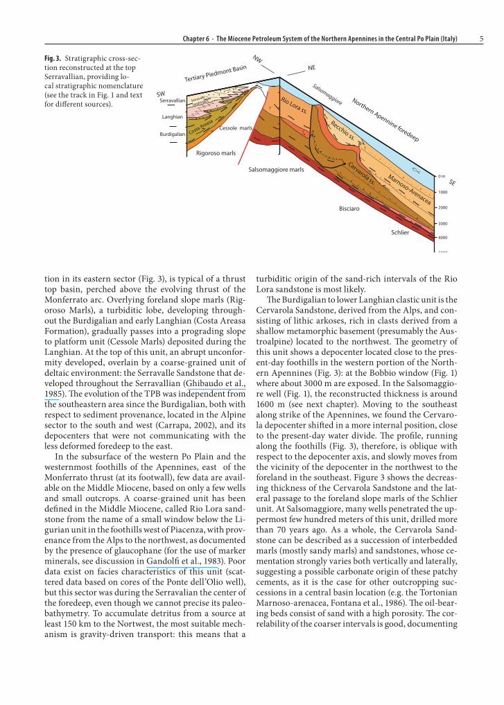
Fig. 4. Chronostratigrapic scheme along the same cross section of Fig. 3, including the Tortonian. Time scale af-ter Gradstein et al., 2004. The lithostratigraphic subdivision of the Marnoso-arenacea Fm is from Antolini et al., (2001); S:P is the sandstone:pelite ratio. To the right, dots represent tim-ing of the δ18O-positive peaks of Abreu and Anderson (1998), proportional to their intensity. The bars indicate the duration of the third-order lowstand sys-tem tracts after Haq et al. (1987) and Hentz and Zeng (2003), blue and yellow, respectively.

Chapter 6 · The Miocene Petroleum System of the Northern Apennines in the Central Po Plain (Italy) 7
ing the reservoir for the fields immediately east of Sal-somaggiore, still contains glaucophane like the coeval Rio Lora Sandstone (Spinelli, 1964) but mixed with coarser-grained detritus derived from the north: it possibly represents a laterally confined basin, closed to the west by the growing Salsomaggiore thrust, toward which it shows clear onlap relationships in the field, and to the south by the front of the Ligurian unit.
The late Langhian sharply defined arrival of detri-tus over most the Northern Apenninic foredeep nice-ly coincides with a positive peak of the δ18O (the stron-gest of the Miocene, Abreu and Anderson, 1998) and with a pronounced lowstand on the curve of Haq et al. (1987) (Fig. 4). This suggests that the deforming fore-deep recorded the eustatic sea-level variations, as doc-umented for the Pliocene of the Northern Apennines (Capozzi and Picotti, 2003).
After the Serravallian, the foredeep shifted north-ward in the central Po Plain: fine-grained deposits occur in the foothills of the westernmost Northern Apennines, whereas coarse-grained successions still were deposited in the Marnoso-arenacea basin to the southeast (Figs. 3 and 4). Upper Miocene equivalents of the Marnoso-arenacea, deposited north of the Sal-somaggiore structure, are the reservoirs of the Cor-temaggiore field (see Fig. 1) (Pieri, 1992).
4 Tectonic Evolution of the Northern Apenninic Foredeep
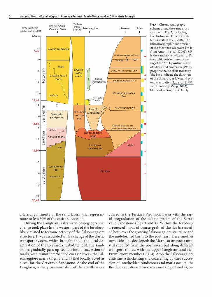
The structural evolution of the Northern Apennines will be discussed by means of two cross sections (Fig. 5). Profile AA’, running across the foothills and the Po Plain, is based on a re-interpretation of the depth-converted seismic line of Pieri (1987; his line BB’), combined with a cross section across the Northern Apennines north of the water divide, interpreted at depth after a profile of Zanzucchi (1980). Profile BB’ is a cross section oriented along strike of the main Apen-ninic features, crossing the Salsomaggiore culmina-tion. It has been constructed after the map of Zanzuc-chi (1980), checked on the field and finally compared with an unpublished seismic line running parallel to its western portion.
4.1 Profile AA’. The Tip of the Orogenic Wedge and the Foreland Deformation
Four main features characterize the external front of the Northern Apennines in the area studied: 1) the Li-gurian nappe; 2) the Salsomaggiore thrust; 3) the Cor-temaggiore thrust; and 4) the Piadena-Brè inverted ba-sin.
1. Ligurian nappe. The northeastward advanc-ing thrusting of the Ligurian allochthonous units over the sediments of the foredeep is reflected by the northeastward younging of sediments under-lying the allochthonous units. For this reason, the age of the deposits underlying the Ligurian nappe constrains the timing of this advancement (Zat-tin et al., 2002). Along our transect three tecton-ic windows in the Ligurian nappes document this relationship (Fig. 1). The Zuccone window (Fig. 5), close to the watershed, shows an Aquitanian age for the youngest foredeep formation. In the Bobbio window, some ten km west of the cross section (see Figs. 1 and 5), the youngest deposit is Burdigalian in age, whereas the northern Salsomaggiore win-dow shows different ages: to the south of the anti-cline the Ligurian units overlie Langhian rocks, to the north of the anticline Upper Messinian depos-its. This age difference documents the growth of the structure during Serravallian and Tortonian times and confirms the role of structural highs growing in the foredeep and hampering the advancement of the nappe, as discussed by Zattin et al., 2002. In fact, during the Burdigalian, the front of the nappe advanced 3 km/My, abruptly slowing in the Lang-hian to 0.5 km/My and finally stopping, in the area of the growing thrust, during the Serravallian and Tortonian. Both, emplacement of the Ligurian units and the Tertiary foredeep deposits produced rapid overburden of the underlying sediments. The Zuccone window that rather appears as a horst, is bounded by normal faults, that possibly reactivated ancient thrust contacts. The cross-cutting relation-ships of these high-angle faults with the deeper low-angle thrusts are not clear, even though their activi-ty should be contemporaneous for the Pliocene and Pleistocene.
2. Salsomaggiore thrust. Close to the northern tip of the Cervarola clastic wedge, this thrust started growing in the Langhian, as suggested by the Sal-somaggiore marls (see discussion in Chapt. 3). The anticline grew during the Serravallian as an in-trabasinal structure close to the depocenter of the Recchio Sandstone, whereas during the Tortonian it started to create a submarine relief and the top of the structure became eroded. The reconstructed shortening is about 6 km. Again, in this structure a prominent southwest-dipping normal fault now juxtaposes the Ligurian units with the Salsomag-giore thrust. This extensional structure, which shows evidence of Quaternary activity, plays an un-clear kinematic role on the regional evolution of the foothill belt that seems to be controlled rather by compression. However, important normal faults active close to the mountain front of the Northern

8 Vincenzo Picotti · Rossella Capozzi · Giuseppe Bertozzi · Fausto Mosca · Andrea Sitta · Maria Tornaghi
Apennines have been reported (Bertotti et al., 1997; Capozzi and Picotti, 2002; 2006).
3. Cortemaggiore thrust. This 20-km-long thrust sheet started to grow at the end of the Tortonian, again close to the tip of the Tortonian clastic wedge (the subsurface Marnoso-arenacea; see Fig. 3), as suggested by convergence of the uppermost reflec-tors of the wedge. The thrust was particularly active forming a submarine structure during the Mes-sinian, the deposits of which are in fact reduced in thickness above the thrust sheet. After formation of the late Messinian unconformity, the eroded thrust top was onlapped by uppermost Messinian sedi-ments that include the Ligurian wedge (Artoni et al., 2004), and finally by a reduced prism of Pliocene sediments, which still shows convergence toward the thrust top. The very rapid emplacement of the Ligurian unit (up to 10 cm /y), after many million years of local inactivity of this nappe in the back of the Salsomaggiore structure, can be explained by gravity emplacement re-establishing the equilibri-um of the thickened wedge. The Pleistocene is very thin and only slightly deformed close to the tip of the fault, which is clearly sealed by these deposits. The overall shortening attains 7 km.
4. Piadena – Brè basin. The Messinian depocenter, in the footwall of the Cortemaggiore thrust, is partic-ularly clearly developed over this 22 km-long-ba-sin. The seismic stratigraphy of the basin suggests the possible presence of an Upper Triassic succes-sion with Lombardian facies, i.e. organic-rich de-posits (Zorzino Limestone, and/or Argillite di Riva di Solto and Zu Limestone), which are known as good source rocks (see Chapt. 3). The sharp later-al truncation of these reflectors suggests the pres-ence of a basin bounded by faults, which could have been active during the Late Triassic to Early Juras-sic rifting period (Bertotti et al., 1993). These nor-mal faults appear to have been reactivated during the Messinian, when this sector was affected by rap-id subsidence with the deposition of a thick fore-deep wedge (Fig. 3). The sedimentary prism, whose geometry was perturbated by the fault reactivation, is wider than the Serravallian and Tortonian ba-sins, and located more externally in the foreland. North of the basin, the Messinian tends to cover the tip of a northward thickening Miocene wedge of the Southalpine retroforeland, documenting its deactivation. Finally, during the Pliocene, the ba-sin was inverted, as documented by the the growth pattern of the reflectors close to the anticlines of Brè and Piadena (Fig. 5). The depocenter of the Pliocene and Lower Pleistocene clastic wedge was the same as during the Messinian, suggesting that the Mes-sinian was the last step of the encroachment of the Northern Apenninic foredeep onto the foreland.
4.2 Profile BB’. The Quaternary Northwest Verging Reactivation of the External Thrust Sheet
In map view, the Salsomaggiore anticline shows a dom-al shape, that suggests possible lateral ramps or strain interferences (Fig. 5). In order to highlight its lateral culminations and depressions, we constructed a cross section oriented along strike of the main structures of the Apennines and running along the axis of the Sal-somaggiore anticline (section BB’, Fig. 5). The geome-try of the eroded portion of the anticline has been re-constructed after projecting about 4 km to the south the unit boundaries along their dip toward the crest of the anticline, mainly using our section AA’ (Fig. 5) and other available dip sections crossing the anticline (Zanzucchi, 1980). The section BB’, has been interpret-ed into depth mainly after field geology, with the aid of few subsurface informations, such as the stratigra-phy of Chero Carpaneto 2 and Salsomaggiore 1 wells, whereas the eastward termination of some Pliocene re-flectors (under Bacedasco, see BB’, Fig. 5), come from an unpublished seismic line, running parallel, but few km north of the section BB’.
The bottom of the Pleistocene is clearly deformed and uplifted, defining a wide asymmetric anticline with culmination at Salsomaggiore (at the intersec-tion with section AA’, see section BB”, Fig. 5), a longer limb to the southeast and a vergence to the northwest. The shape of this anticline has not been the same in previous times, such as the Messinian, when the Ligu-rian units passed over the thrust top (as described in sect. 4.1.). In our reconstruction of the eroded portion of the anticline, in fact, the Ligurian units (floored by a purple line in section BB’) are thicker close to the cul-mination, pinching-out to disappearance in the vicin-ity of the creek Recchio, and eventually reappearing toward the river Taro (Fig. 5). This suggest that, dur-ing the Messinian, the period of the rapid gravitation-al emplacement of the Ligurian units, the actual cul-mination of the Salsomaggiore anticline was located between the Recchio and the Taro channels, whereas the present-day culmination was morphologically less pronounced, providing accommodation for the thick (around 1.5 km) Ligurian wedge.
The shape of the culmination was even different during Serravallian, as suggested by the westward thinning of the Recchio sandstone, which defines an-other relative culmination during this time: This Ser-ravallian culmination has been explored by the Che-ro-Carpaneto 2 well, that documents the absence of the units comprised between the Burdigalian (Cer-varola Sandstone) and the upper Messinian period, marking the onset of a new subsidence pulse for the
Chapter 6 · The Miocene Petroleum System of the Northern Apennines in the Central Po Plain (Italy) 9
Fig.
5. C
ross
-sec
tions
alo
ng d
ip a
nd st
rike
of t
he fr
ont o
f the
Nor
ther
n A
penn
ines
in th
e ar
ea st
udie
d. D
eep
inte
rpre
tatio
n aft
er th
e se
ism
ic li
ne o
f Pie
ri (1
987)
in th
e su
bsur
face
of t
he
Po P
lain
. Ape
nnin
e su
rfac
e da
ta a
fter Z
anzu
cchi
(198
0) a
nd o
ur o
wn
field
wor
k.
10 Vincenzo Picotti · Rossella Capozzi · Giuseppe Bertozzi · Fausto Mosca · Andrea Sitta · Maria Tornaghi
western half of the section BB’, providing accommo-dation for the Plio-Quaternary deposits.
The described diachronous culminations are asso-ciated to different kinematic behaviour along strike of the hangingwall of the Salsomaggiore thrust. The oldest (Chero Carpaneto: Serravallian to Messinian; Recchio-Taro: ?Tortonian to Messinian) have similar wavelengths of about 10 km and likely represent dif-ferent asperities of the footwall ramp of the Salsomag-giore thrust. As an alternative, they could be due to the inversion of previous (normal) faults in the hanging-wall. This latter phenomenon, indeed difficult to ascer-tain in this case, is quite common in this sector of the Northen Apennines. The Salsomaggiore culmination, associated with a wider anticline (about 20 km) has been related to the Quaternary activity of the deep-er Cortemaggiore thrust, ramping toward the north-west with a shortening of about 2 km. Note that the same Cortemaggiore thrust along the perpendicular section (AA’ in Fig 5), practically do not show Pleis-tocene deformation, if we except some folding. This inferred deep northwest verging ramp, and associat-ed anticline, could explain the observed Quaternary features such as the important local exhumation (up to 2 km eroded) and the high relief of the Salsomag-giore hills, as well as the activity of the main south-west dipping normal fault, located in the upper thrust sheet (described at point ii of sect. 4.1, section AA’, Fig. 5). This fault, oriented perpendicular to the axis of the culmination, could play the role of southern boundary of the culmination.
5 Fluid Composition: Origin, Evolution and Migration
At Salsomaggiore, saline waters and hydrocarbons from spontaneous emissions have been described since 193 B.C., and were widely exploited for centu-ries. We collected samples from seven drilled wells, lo-cated around and in the center of the village of Sal-somaggiore, at the culmination of the structure (see Figs. 1 and 5) in an area of about 20 km2. These wells reached an average depth of about 1000 m. The stratig-raphy of the wells indicates various interbedded sand and marly layers yielding hydrocarbons and brines, and minor cemented sandstones, within the Langhi-an interval. Sandy-marly interbeds, more regularly arranged, occur in the underlying Burdigalian inter-val. The measured porosity reaches up to 20%, howev-er, the occurrence of hydrocarbons and saline waters is discontinuous, essentially due to the patchy cemen-tation. Sampling was carried out during spring 2004 and samples were analysed for their physical, chemi-cal and isotopic characteristics. All chemical and iso-topic analyses have been duplicated and some of the
wells were resampled, to validate the analyses, during the fall of 2004.
The water temperature is very constant among the different wells and in the range of 16–18°C.
5.1 Composition of Brines
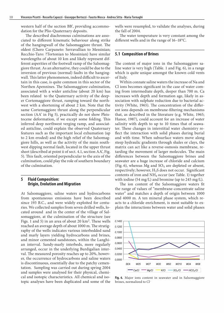
The content of major ions in the Salsomaggiore sa-line water is very high (Table. 1 and Fig. 6), in a range which is quite unique amongst the known cold vents of Italy.
Within connate saline waters the increase of Na and Cl ions becomes significant in the case of water com-ing from intermediate depth, deeper than 700 m. Ca increases with depth and formation age, likely in as-sociation with sulphate reduction due to bacterial ac-tivity (White, 1965). The concentration of the differ-ent ions depends on membrane-filtering mechanisms that, as described in the literature (e.g. White, 1965; Hanor, 1987), could account for an increase of water salinity with depth to up to 10 times that of seawa-ter. These changes in interstitial water chemistry re-flect the interaction with solid phases during burial and with time. When subsurface waters move along steep hydraulic gradients through shales or clays, the matrix can act like a reverse-osmosis membrane, re-tarding the movement of larger molecules. The main differences between the Salsomaggiore brines and seawater are a huge increase of chloride and calcium (Fig. 6), whereas Mg and SO4 are depleted or absent, respectively; however, H2S does not occur. Significant contents of iron and NH4 occur (see Table. 1) together with iodine (54 mg/L) and bromine (up to 245 mg/L).
The ion content of the Salsomaggiore waters fit the range of values of “membrane-concentrate saline water” and matches a depth of origin between 1000 and 4000 m. A ten mineral phase system, which re-acts to a chloride enrichment, is most suitable to ex-plain the interactions between water and solid phases
Fig. 6. Major ions content in seawater and in Salsomaggiore brines, normalized to Cl–

Chapter 6 · The Miocene Petroleum System of the Northern Apennines in the Central Po Plain (Italy) 11
within the Salsomaggiore siliciclastic reservoir (Ha-nor, 1996). In this case, we assume that the system de-veloped in the absence of CO2, as normal under sub-surface condition. In fact, the δ2H- and δ18O-values provide evidence that the analysed saline waters nev-er mixed with meteoric water (see next chapter) doc-umenting a system closed to the supply of CO2 from the surface. In the absence of CO2, calcite and dolo-mite interact no longer with the system and the alka-linity does not change. With high chloride content, quartz is mobilized: however, Si in the brines increas-es slowly, because it is incorporated into other miner-al phases. In this system, anorthite partially dissolves and the calcium concentration increases in the solu-tion, whereas K and Na do not increase because they are involved in the precipitation of K-feldspar and al-bite (Hanor, 1996). This mass transfer between miner-al phases can locally increase the porosity of the reser-voir, as could be the case for Salsomaggiore.
NH4, bromine and iodine are likely due to the in situ reduction of abundant organic matter, even if we can-not establish the source of this from the water compo-sition. However, most Northern Apenninic brines, de-rived from Miocene reservoirs as in the Regnano mud volcano system (Capozzi and Picotti, 2002), do not show a similar enrichment. In this case, there was not enough organic matter to generate high amounts of these ions: in fact, in this case, the hydrocarbon com-position includes only thermogenic methane with mi-nor retrograde condensate. Therefore, the high NH4, bromine and iodine concentrations could only be sup-plied to the brine by the oil that characterizes the Sal-somaggiore to Cortemaggiore area.
As sulphate is totally depleted, we would expect the occurrence of bacterially mediated sulphide. Howev-er, as sulphide no longer occurs, a possible subsur-face equilibrium could have been reached. At the mea-sured values of pH and alkalinity, relatively moderate sulphate reduction process probably occurred in the system and prevented the precipitation of calcium car-bonate (Morse, 2003).
The total removal of H2S can be ascribed to the very high Fe content which can precipitate, in the mea-sured range of pH and Eh, mainly as marcasite (See-man, 1987).
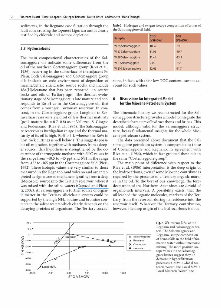
5.2 Brine Isotopes
Isotopic measurements of brines in sedimentary ba-sin (Fig. 7 and Table. 2) typically show a trend toward 18O enrichment with minor 2H enrichment (Clayton, 1966, Clark and Fritz, 1997). δ2H enrichment in basin-al brines can be partially explained by dehydration of clay minerals, but can also be generated through ex-change with H2S or hydrocarbons that, in turn, can impart a positive shift in δ18OH2O. The hyperfiltration mechanism hypothesized to explain the high ion con-tents in the Salsomaggiore waters, is likely a more suit-able mechanism that can account for the enrichment in Cl–, 18O and 2H. This interpretation could be support-ed by a comparison with the Regnano isotopic values that have been correlated to membrane-filtered forma-tion waters (Capozzi and Picotti, 2002). The filtrate wa-ter is expected to be depleted in heavier isotopes and, in fact, even if the reservoir of both Salsomaggiore and Regnano water is constituted by Tertiary siliciclastic
Samples pH EhmV
Ca2+ Mg2+ Na+ K+ Cl– SO42– HCO3
– NH4+ Fe Si
Well 25 25/05/04
6.72 -130 2725.4 1021.4 47900 153 72318 43 73.2 126 14.47 2.1
Well 27 25/05/04
7.22 -181 2324.6 559.36 42750 116 64164 38 109.8 108 11.63 2.3
Well 20 25/05/04
6.65 -117 4388.8 1422.7 63100 184 95715 22 97.6 144 13.46 3.3
Well Salsomaggiore 1 22/04/04
6.79 -103 5852 1556.5 60900 269 95006 90 170.8 135 11.53 3.4
Well 210 25/05/04
6.75 -240 4028 790.40 59100 185 92170 22 109.8 153 22.59 2.4
Well 24 22/04/04
7.16 -203 4509 620.16 47950 102 70900 24 109.8 99 10 1
Well 8 22/04/04
6. 4 -100 4306 1280 51180 292 93588 8.93 104 200 63.3 8.69
Seawater 400 1272 10560 380 18980 2649 140 0.07 0.02 7
Table 1. Chemical analyses on the Salsomaggiore brines. Ion content in ppm.
12 Vincenzo Picotti · Rossella Capozzi · Giuseppe Bertozzi · Fausto Mosca · Andrea Sitta · Maria Tornaghi
sediments, in the Regnano case filtration through the fault zone crossing the topmost Ligurian unit is clearly testified by chloride and isotope depletion.
5.3 Hydrocarbons
The main compositional characteristics of the Sal-somaggiore oil indicate some differences from the oil of the northern Cortemaggiore group (Riva et al., 1986), occurring in the subsurface of the adjacent Po Plain. Both Salsomaggiore and Cortemaggiore group oils indicate an oxic environment of deposition of marine/deltaic siliciclastic source rocks and include 18α(H)oleanane that has been reported in source rocks and oils of Tertiary age. The thermal evolu-tionary stage of Salsomaggiore is late mature and cor-responds to Ro >1 as in the Cortemaggiore oil, that comes from a younger, Tortonian reservoir. In con-trast, in the Cortemaggiore group, Langhian to Ser-ravallian reservoirs yield oil of less thermal maturity (peak mature Ro = 0.7–0.8) as at Vallezza, S. Giorgio and Podenzano (Riva et al., 1986). The Salsomaggio-re reservoir is Burdigalian in age and the thermal ma-turity of its oil is high, Ro% > 1.1, whereas the Ro% in host rock cuttings is well below 1. This suggests possi-ble oil migration, together with methane, from a deep-er source. This hypothesis is strengthened by the oc-currence of thermogenic methane with δ13C values in the range from -40.5 to -45 ppt and δ2H in the range from -152 to -165 ppt in the Cortemaggiore field (Pieri, 1992). These isotopic values are very similar to those measured in the Regnano mud volcano and are inter-preted as signatures of methane migrating from a deep (Mesozoic) source into the Tertiary reservoir, where it was mixed with the saline waters (Capozzi and Picot-ti, 2002). At Salsomaggiore, a further source of organ-ic matter in the Tertiary siliciclastic system could be supported by the high NH4, iodine and bromine con-tents in the saline waters which clearly depends on the decaying proteins of organisms. The Tertiary succes-
sions, in fact, with their low TOC content, cannot ac-count for such values.
6 Discussion: An Integrated Model for the Miocene Petroleum System
The kinematic history we reconstructed for the Sal-somaggiore structure provides a model to integrate the described characters of hydrocarbons and brines. This model, although valid for the Salsomaggiore struc-ture, bears fundamental insights for the whole Mio-cene petroleum system.
The data presented above document that the Sal-somaggiore petroleum system is comparable to those of Cortemaggiore and Regnano, in agreement with Riva et al. (1986), which in fact grouped these oils in the same “Cortemaggiore group”.
The main point of difference with respect to the Riva et al. (1986) interpretation is the deep origin of the hydrocarbons, even if some Miocene contribute is required by the presence of a Tertiary organic mark-er in the oil. To the best of our knowledge, the fore-deep units of the Northern Apennines are devoid of organic-rich intervals. A possibility exists, that the oil leached the organic molecules, markers of the Ter-tiary, from the reservoir during its residence into the reservoir itself. Whatever the Tertiary contribution, however, the deep origin of the hydrocarbons is docu-
Fig. 7. δ2H versus δ18O of the Regnano and Salsomaggire wa-ters. The Salsomaggiore and Regnano isotope composition of brines falls in the field of for-mation water without meteoric mixing. The more positive iso-tope values in the Salsomag-giore brines suggest they un-derwent to hyperfiltration processes. GMWL: Global Me-teoric Water Line; Local MWL: Local Meteoric Water Line.
Samplesδ18O(VSMOW)
δ2H(VSMOW)
W 25 Salsomaggiore 10.57 -9.1
W 27 Salsomaggiore 11.05 -19.7
W 20 Salsomaggiore 11.45 -13.3
W 1 Salsomaggiore 9.14 -9.2
W 210 Salsomaggiore 12.63 -11.7
Table 2. Hydrogen and oxygen isotope composition of brines of the Salsomaggiore oil field.
Chapter 6 · The Miocene Petroleum System of the Northern Apennines in the Central Po Plain (Italy) 13
mented by the high fractionation and maturity of the oil and the thermogenic imprint of the methane. These deep sources have never been drilled, or documented indirectly in the Northern Apennines, but should be Mesozoic, Upper Triassic (see Fig. 2) and/or (?) Cre-taceous. Furthermore, the distribution of the oil of the Cortemaggiore group does not match that of the Miocene foredeep that is elongated along strike of the Apennines. Rather, it matches the distribution of the Upper Triassic source rocks, as illustrated in Fig. 2. As a matter of fact, the brines spontaneously leaking at surface from the Regnano mud volcano to the south-east differ from Salsomaggiore in that they never came into contact with oil, as documented by the low con-tent of NH4, bromine and iodine.
Within the Miocene province, the stratigraphic age of the reservoirs changes frequently, ranging from the Burdigalian Cervarola Sandstone of Salsomaggio-re to the Serravallian Recchio sandstone in Torrente Baganza, to the Tortonian Marnoso-arenacea of Cor-temaggiore. In the literature, all these different res-ervoirs, charged with the same oil of the “Cortemag-giore group”, have been treated as the same formation and proposed as a source-reservoir system (Riva et al., 1986). The presence of the same oil in so different res-ervoirs implies common and deeper, source(s).
The geochemistry of brines of Salsomaggiore docu-ments their origin from formation waters of the Ter-tiary foredeep units, in this case the Burdigalian Cer-varola Sandstone. The formation waters have been trapped in the early formed (Langhian) structure, pre-venting the late compaction and loss of porosity in the tectonic culmination.
The ?Plio- Quaternary northwest verging reactiva-tion of the Miocene thrust belt produced a domal cul-mination in the Salsomaggiore anticline, creating new gradients and the migration of oil via water-washing.
7 Conclusions
We described the main elements of the Miocene petro-leum system of the central Po in order to reassess the petroleum potential of this province.The Miocene reservoirs range from Burdigalian to Tor-tonian. Their locally good porosity is related to their deformation, occurring soon after their deposition and allowing for fluid trapping, preventing complete mechanical compaction that, in contrast, occurred in the intervening structural depressions. Another factor of permeability reduction, i.e. the carbonate cementa-tion, is a process very difficult to predict, both for its patchy nature and late dissolution during brine migra-tion.
The source is suggested to be multiple, likely dom-inated by Mesozoic (Upper Triassic, ?Cretaceous), in
our cross sections located at depth ranging from 7 to 10 km (Fig. 5). The sand-rich units of the Miocene are rather gas prone, but they have contributed with un-known percentage of normal maturity oil, bearing the Tertiary biomarker recorded by Riva et al. (1986).
Overburden to the source(s) is mainly due to the Ter-tiary foredeep units, tectonically covered by the Ligu-rian units. This foreland-ward moving couple brought about the rapid maturation of the source rocks during the Miocene, with hydrocarbons migrating up-dip to-ward the foreland where they could be trapped in the growing structures.
Finally, natural leakage of oil and brines occur in the Salsomaggiore culmination that is part of a wid-er Serravallian – Tortonian anticlinal trap deformed during the Quaternary. The recent tectonically in-duced changes in the geometry of this prominent cul-mination allowed further migration of oil via water-washing. This still active migration process could be too young to have generated important accumulation at the culmination of the structure. Alternatively, the oil could have dismigrated from a deeper trap whose sealing effects could have deteriorated after the recent deformation. This second hypothesis implies the pos-sible presence of deeper accumulations of unspecified potential.
Acknowledgments
This paper is the result of a two year cooperative proj-ect between the Edison S.p.A. and the University of Bologna, aimed at assessing the Miocene petroleum potential of the Po Plain and the surrounding foot-hills. The exploration department of Edison, chaired by G. Bolis, is warmly thanked for the discussions and the permission to publish the data. A special thanks to L. Papani, for providing stratigraphic data and shar-ing field work. The kind collaboration of the Terme di Salsomaggiore S.p.A. is acknowledged. Brine analyses were performed at the laboratory of the Dipartimen-to di Scienze della Terra, University of Bologna and at the Centro Studi Ambientali of Rimini. Isotope analy-ses were performed at the CNR, Istituto di Geochimi-ca e Georisorse of Pisa CNR.
D. Bernoulli and an anonymous reviewer are warmly thanked for suggestions and comments that improved the manuscript.
References
Abreu, V.S. and Anderson, J.B., 1998. Glacial eustasy during Cenozoic: sequence stratigraphic implications. AAPG Bull. 82, 1385–1400.
AGIP, 1984. Geologia d’Italia. CEDI, S.Donato Milanese.

14 Vincenzo Picotti · Rossella Capozzi · Giuseppe Bertozzi · Fausto Mosca · Andrea Sitta · Maria Tornaghi
Antolini, P., Borsetti A.M., Cremonini G., Pialli G. and Ricci Lucchi F., 2001. Foglio 254 Modigliana. Note illustrative della carta geologica d’Italia alla scala 1:50.000. Istituto po-ligrafico dello Stato, pp 118.
Artoni, A., Papani G., Rizzini F., Bernini, M., Roveri, M., Gen-nari, R., Calderoni M., Rossi, M., Rogledi S., Argnani A., 2004. The Salsomaggiore structure (Northwestern Apen-nine foothills, Italy): a Messinian mountain front shaped by mass-wasting products. Geoacta, 3, 107–127.
Bernasconi, S. M., 1994. Geochemical and microbial controls on dolomite formation in anoxic environments: a case study from the Middle Triassic (Ticino, Swizerland). Contr. Sed-im., 109 pp.
Bernasconi, S. M., and Riva, A., 1993. Organic geochemistry and depositional environment of a hydrocarbon source rock: the Middle Triassic Grenzbitumenzone formation, southern Alps, Italy/Switzerland, in: Spencer, A. M., editor, Generation, accumulation and production of Europe’s hy-drocarbons III: European Association of Petroleum Geolo-gists Special Publication, Springer, Heidelberg, p. 179–190.
Bernini, M. and Papani G., 1987. Alcune considerazioni sulla struttura del margine appenninico emiliano fra lo Stirone e l’Enza (e sue relazioni con il sistema del Taro). Acta Natura-lia Ateneo Parmense, 23, 219 – 240.
Bertotti, G., Picotti, V., Bernoulli D, and Castellarin, A., 1993. From rifting to drifting: tectonic evolution of the South-Al-pine upper crust from the Triassic to the Early Cretaceous, Sediment. Geol., 86, 53–76.
Bertotti, G., Capozzi, R. and Picotti, V., 1997. Extension con-trols Quaternary tectonics, geomorphology and sedimenta-tion of the N-Apennines foothills and adjacent Po Plain (It-aly). Tectonophysics, 282, 291–301.
Bertotti, G., Picotti, V. and Cloetingh, S., 1998. Lithospheric weakening during “retro-foreland” basin formation: tecton-ic evolution of the central South Alpine foredeep. Tectonics, 17, 1, 131–142.
Boccaletti, M., Calamita, F., Deiana G., Gelati, R., Massari, F., Moratti, G., and Ricci Lucchi, F., 1990. Migrating foredeep-thrust belt system in the northern Apennines and Southern Alps. Palaeogeogr. Palaeoclimat. Palaeoecol., 77, 3–14
Castellarin, A., and Vai, G.B., 1986. Southalpine versus Po Plain apenninic arcs. In: The Origin of Arcs, F.C. Wezel (ed.), Development in Geotectonics, 21, Elsevier, Amster-dam, 253–280.
Capozzi, R. and Picotti, V., 2002. Fluid migration and origin of a mud volcano in the Northern Apennines (Italy): role of deeply rooted normal faults. Terra Nova, 14, 5, 363–370.
Capozzi, R, and Picotti, V., 2003. Pliocene sequence stratigra-phy, climatic trends and sapropel formation in the Northern Apennines (Italy). In: Meyers, P.A., Negri, A. (Eds.), Paleo-climatic and Paleoceanographic Records in Mediterranean Sapropels and Mesozoic Black Shales. Palaeogeogr. Palaeo-clim. Palaeoecol. 190, 349–371.
Capozzi, R. and Picotti, V., 2006. Genesis of cold seeps and mud volcanoes of the Northern Apennine foothills. CIESM 2006. Fluid seepages / mud volcanism in the Mediterranean and adjacent domains. CIESM Workshop Monographs n°29, 59–64.
Carrapa, B., 2002. Tectonic evolution of an active orogen as re-flected by its sedimentary record, an integrated study of the Tertiary Piedmont Basin (Internal Western Alps, NW Italy). Ph.D. Thesis, ISBN 90–9016220–8, Amsterdam, 177p.
Carraro F., Collo G., Forno M. G., Giardino M.,Maraga F., Pe-rotto A. & Tropeano D. (1995). L’evoluzione del reticolato
idrografico del Piemonte centrale in relazione alla mobilità quaternaria. In: Polino R. & Sacchi R. (Eds.), Acc. Naz. Sc., Roma, Scritti e Documenti, 14: 445–461.
Clark, I.D., and Fritz, P., 1997. Environmental Isotopes in Hy-drogeology. Lewis Publishers, Boca Raton, New York, pp.328.
Clayton, R.N., Friedman, I., Graff, D.L., Mayeda, T.K., Meents, W.F., and Shimp, N.F., 1966. The origin of saline formation water, 1. Isotopic composition. Journ. of Geophys. Research, 71, 3869–3882.
Dondi, L., and D’Andrea, M.G., 1986. Paleogeografia della Pia-nura Padana e Veneta dall’Oligocene Superiore al Pleistoce-ne. Giornale di Geologia, 48, 197–225.
Elter, P. and Trevisan, L., 1973. Olistostromes in the tectonic ev-olution of the Northern Apennines, in: De Jong K.A. and Scholten R. Eds., Gravity and Tectonics, John Wiley and Sons, p. 175–188.
Elter, P., Giglia, G., Tongiorgi, M. and Trevisan, L., 1975. Ten-sional and compressional areas in the recent (Tortonian to present) evolution of the Northern Apennines: Bollettino Geofisica Teorica e Applicata, v.17, p. 3–18.
Erba E., 2004. Calcareous nannofossils and Mesozoic oceanic anoxic events. Marine Micropaleontology, 52, 85–106.
Errico, G., Groppi., G., Savelli, S., and Vaghi, G.C., 1979. Malos-sa Field, deep discovery in Po Valley, in: Giant Oil and Gas Fields of the Decade: 1968–1978. AAPG Memoir 30, 525–538.
Fontana, D., McBride, E.F. and Kugler, R., 1986. Diagenesis and porosity evolution of submarine-fan and basin-plain sand-stones, Marnoso-Arenacea Formation, northern Apen-nines, Italy. Bulletin of Canadian Petroleum Geology 34, 313–328.
Gandolfi, G., Paganelli, L. and Zuffa, G.G., 1983. Petrology and dispersal pattern in the Marnoso-arenacea Formation (Mi-ocene, Northen Apennines). Journ. Sedim. Petrol., 53, 493–500.
Ghibaudo, G., Clari, P. and Perello, M., 1985 , Litostratigrafia, sedimentologia ed evoluzione tettonico-sedimentaria dei depositi miocenici del margine Sud-Orientale del Bacino Terziario Ligure-Piemontese (Valli Borbera, Scrivia e Lemme). Boll. Soc. Geol. Ital. 104, 349–397.1985.
Gradstein F.M., Ogg J.G., Smith A.G., Bleeker W. and Lourens L., 2004. A new Geologic Time Scale, with special reference to Precambrian and Neogene. Episodes, 27, 2, 83–100.
Hanor, J.S., 1987. Origin and Migration of Subsuface Sedimen-tary Brines. Society of Economic Paleontologists and Min-eralogists Short Course No. 21, pp.1–247.
Hanor, J.S., 1996. Variations in chloride as a driving force in sil-iciclastic diagenesis. In: Crossey, L.J., Loucks, R., and Tot-ten, M.W. (eds.), Siliciclastic diagenesis and fluid flow: con-cepts and applications: SEPM Special Publication, n. 55, p. 3–12.
Haq, B.U., Hardenbol, J., and Vail, R., 1987. Chronology of fluc-tuating sea levels since Triassic, Science 235, 1156–1167.
Hentz T.F. and Zeng H., 2003. High frequency Miocene se-quence stratigraphy, offshore Louisiana: Cycle framework and influence on production distribution in a mature shelf province. AAPG Bull. 87, 197–230.
Jenkyns, H. C., 1980. Cretaceous anoxic events: from conti-nents to oceans. J. geol. Soc. London,. 137, 171–188..
LePichon, X., Pautot, G., Auzende, J.-M. and Olivet, J.-L.1971, La Méditerranée Occidentale depuis l’Oligocène: schéma d’évolution. Earth and Planetary Sciences Letters, 13, 142–152.

Chapter 6 · The Miocene Petroleum System of the Northern Apennines in the Central Po Plain (Italy) 15
Malinverno, A. and Ryan, W., 1986. Extension in the Tyrrheni-an Sea and shortening in the Apennines as result of arc mi-gration driven by sinking of the lithosphere. Tectonics, 5, 227–245.
Mattavelli, L., and Novelli, L., 1990. Geochemistry and habitat of the oils in Italy. AAPG Bull., 74, 10, 1623–1639.
Morse, J.W., 2003. Formation and diagenesis of carbonate sedi-ments. Treatise in Geochemistry, 7, 67–85.
Pieri M., 1987. Three seismic profiles through the Po Plain. In: Bally A.W. (Ed.) Atlas of seismic stratigraphy, volume 3. AAPG Studies in Geology, n 27, 90–110.
Pieri, M., 1992. Cortemaggiore Field-Italy Po Plain, Northern Apennines. In: Foster, N.H., and Beaumont, E.A., Treatise of Petroleum Geology, Atlas of Oil and Gas Fields, Structur-al Traps VII: Tulsa, OK, American Association of Petroleum Geologists, p. 99–118.
Pini, G.A., 1999. Tectonosomes and olistostromes in the Argille Scagliose of the Northern Apennines, Italy. Special Paper-Geological Society of America 335, 73 pp.
Riva, A., Salvatori, T., Cavaliere, R., Ricciuto, T., and Novelli, L., 1986. Origin of oils in the Po Basin, Northern Italy. Ad-vances in Organic Geochemistry, 10, 391–400.
Seemann, R., 1987. Mineralparagenesen in Osterreichischen Karsthohlen. Proc. VIII int. Spel. Cong., Bowling Green, 256–259.
Scicli, A., 1972. L’attività estrattiva e le risorse minerarie della Regione Emilia-Romagna. Artioli, Modena, 626 pp.
Spinelli, L., 1964. Studio petrografico e sedimentologico di una formazione clastica elveziana dell’Appennino Parmense: se-rie del Recchio – Salsomaggiore. Rend. Soc. Miner. Ital., 20, 251–278.
Stefani, M.M., Burchell, M.T., 1990. Upper Triassic (Rhaetic) argillaceous sequences in Northern Italy: Depositional dy-namics and source potential. In Huc A.Y. (Ed.) Deposition of organic facies. AAPG Stud. Geol. 30, 93–106.
Stefani, M.M., Burchell, M.T., 1993. A review of the Upper Tri-assic source rocks of Italy. In: Generation, Accumulation and Production of Europe’s Hydrocarbons, Spencer, A.M. (Ed.), Special Publication of EAPG. Springer, 1, 169–178, Berlin.
Thery J.M., Cros P., Bouroullec J., 1989. Relations entre envi-ronment et sdimentologie de la mattire organique: le Trias du Nord de l’Italie. Bull. Centre Rech. Expl-Prod Elf-Aqui-taine, 13, 23–33.
White, D.E., 1965. Saline waters of sedimentary rocks. In: Flu-ids in subsurface environments (A. Young and J.E. Galley, eds.), The American Association of Petroleum Geologists Memoir 4, pp. 342–366.
Willett, S., Schlunegger F., and Picotti V., 2006. Messinian cli-mate change and erosional destruction of the central Euro-pean Alps. Geology, 34, 8, 613–616, doi: 10.1130/G22280.1.
Zanzucchi, G., 1980. I lineamenti geologici dell’Appennino parmense. Note illustrative alla Carta e Sezioni geologiche della Provincia di Parma e Zone limitrofe (1:100.000). Vol. dedicato a Sergio Venzo, Grafiche STEP (ed.), Parma, 201–233.
Zattin, M., Picotti, V., and Zuffa, G.G., 2002. Fission-track re-construction of the front of the Northern Apennine thrust wedge and overlying Ligurian unit. Am. Jour. of Science, 302,4, 346–379.
Copyright © 2022 FDOKUMEN