Basal glacier ice and massive ground ice: different scientists, same science?
Upload
independentCategory
view
5download
0
Quaternary Research xxx (2014) xxx–xxx
YQRES-03616; No. of pages: 12; 4C:
Contents lists available at ScienceDirect
Quaternary Research
j ourna l homepage: www.e lsev ie r .com/ locate /yqres
A 10,300-year-old permafrost core from the active rock glacier Lazaun,southern Ötztal Alps (South Tyrol, northern Italy)
Karl Krainer a,⁎, David Bressan a, Benjamin Dietre b, Jean Nicolas Haas b, Irka Hajdas c, Kathrin Lang d,Volkmar Mair d, Ulrike Nickus e, Daniel Reidl b, Hansjörg Thies f, David Tonidandel d
a Institute of Geology and Paleontology, University of Innsbruck, Austriab Institute of Botany, University of Innsbruck, Austriac Laboratory of Ion Beam Physics, ETH Zürich, Switzerlandd Office for Geology and Building Materials Testing, Autonomous Province of Bolzano, Italye Institute of Meteorology and Geophysics, University of Innsbruck, Austriaf Institute of Ecology, University of Innsbruck, Austria
⁎ Corresponding author at: Institute of Geology, Univ6020 Innsbruck, Austria.
E-mail address: [email protected] (K. Krainer).
http://dx.doi.org/10.1016/j.yqres.2014.12.0050033-5894/© 2014 University of Washington. Published b
Please cite this article as: Krainer, K., et al., ATyrol, northern Italy), Quaternary Research (
a b s t r a c t
a r t i c l e i n f oArticle history:Received 1 August 2014Available online xxxx
Keywords:Rock glacierLazaunÖtztal AlpsHolocene drought
Two coreswere drilled on rock glacier Lazaun in the southernÖtztal Alps (N Italy). The average ice content of coreLazaun I is 43 vol.% and of core Lazaun II is 22 vol.%. Radiocarbon dating of plant macrofossil remains of coreLazaun I yielded ages ranging from 8960 cal yr BP at a depth of ca. 23.5 m to 2240 cal yr BP at a depth of 2.8 m,indicating that the ice near the base is approximately 10,300 yr old. The rock glacier was intact since that timeand the ice persisted even during warm periods of the Holocene. An ice-free debris layer between 16.8 and14.7 m separates the rock glacier into two frozen bodies. Inclinometer measurements indicate that both frozenbodies are active and that deformation occurs within a shear horizon at a depth of 20–25 m at the base of thelower frozen body and to a minor extent at a depth of approximately 14 m at the base of the upper frozenbody. The ice-free debris layer in the middle of the Lazaun rock glacier indicates a more than five centenniallong drought period, which dates to about 4300–3740 cal yr BP.
© 2014 University of Washington. Published by Elsevier Inc. All rights reserved.
Introduction
Alpine permafrost is widespread in the European Alps with rock gla-ciers being the most common and most spectacular feature(Gärtner-Roer, 2010; Boeckli et al., 2012). In Austria, up to 2000 km2
(ca. 2.4% of the area) is probably under permafrost conditions, i.e.under negative ground temperatures throughout the year, and containsconsiderable amounts of permafrost ice (Lieb, 1998). In Switzerland,about 5% of the area (~2100 km2) is classified as permafrost, in SouthTyrol (northern Italy) about 6% (440 km2).
In the past the formation of rock glaciers has been the subject ofextensive debate, but now it is widely accepted that rock glaciers areeither permafrost phenomena (“ice-cemented rock glaciers”) or maydevelop from debris-covered glaciers (“ice-cored rock glaciers”).
In recent years progress has been achieved concerning the knowl-edge about the distribution of permafrost in the European Alps. Recent-ly, Haeberli et al. (2010) and Haeberli (2013) provided an overview onthe relatively short history, and on the important issues and primarychallenges of research on alpine permafrost. Cremonese et al. (2011)
ersity of Innsbruck, Innrain 52,
y Elsevier Inc. All rights reserved.
10,300-year-old permafrost2014), http://dx.doi.org/10.1
presented the first version of a permafrost inventory for the EuropeanAlps including a rock glacier inventory. Kellerer-Pirklbauer et al.(2012) compiled a rock glacier inventory for the eastern part of theAustrian Alps, Krainer and Ribis (2012) for the Tyrolean part of theAustrian Alps and Bollmann et al. (2012) for South Tyrol. More than4500 rock glacierswere identified in the Austrian Alps. In Tyrol, westernAustria, active and inactive rock glaciers cover an area of approximately87 km2.
Ground temperatures in mountain permafrost are measured inboreholes and with temperature loggers installed near the surface(e.g. Haeberli and Funk, 1991; Lüthi and Funk, 2001; Harris et al.,2003; Christiansen et al., 2010; Nötzli and Vonder Mühll, 2010; Nötzliet al., 2010; Schoeneich et al., 2010; Zhao et al., 2010).
Nevertheless, little information exists on the amount of icecontained in rock glaciers, the age of the ice and its chemical character-istics. Hausmann et al. (2007, 2012) used geophysical methods to calcu-late the thickness, internal structure and ice content of active rockglaciers.
Age-determination of rock glaciers is difficult and thus rare (summaryin Barsch, 1996). Methods for absolute and relative-age dating ofrock glacier surfaces are discussed by Haeberli et al. (2003).Laustela et al. (2003) measured the weathering rinds of the debristo determine the relative ages of rock glacier surfaces. Fossil (relict)
core from the active rock glacier Lazaun, southern Ötztal Alps (South016/j.yqres.2014.12.005

2 K. Krainer et al. / Quaternary Research xxx (2014) xxx–xxx
rock glaciers which commonly are strongly or completely covered withvegetation are older features compared to the intact (active and inactive)rock glaciers and are interpreted to have formed during and after theLate-Glacial deglaciation period (Kellerer-Pirklbauer et al., 2012). Intactrock glaciers formed during the Holocene, some of themprobably duringretreat of debris-covered cirque-glaciers after the Little Ice Age (Bergeret al., 2004). Haeberli et al. (1999) presented pollen and spores and 14Cages of moss remains from a permafrost core of the active rock glacierMurtél-Corvatsch in Switzerland. Fuchs et al. (2013) report lumines-cence ages between 3 ka and 8 ka from three rock glaciers of theSwiss Alps and stated that these ages represent the travel times of grainsand thus minimum ages of rock glacier formation. Schmidt hammerexposure-age dating on three relict talus-foot rock glaciers in SouthernNorway yielded ages of approximately 10 ka (Matthews et al., 2013).
However, core drillings that provide direct information on thicknessand ice content so far have been carried out only on a few rock glaciers(Barsch, 1977; Barsch et al., 1979; Vonder Mühll, 1992; Barsch, 1996;Vonder Mühll, 1996; Haeberli et al., 1998, 1999; Konrad et al., 1999;Arenson et al., 2002; Haeberli et al., 2006) mainly because of high costs.
The present contribution provides basic information on the activerock glacier Lazaun (northern Italy), describes the two cores whichhave been drilled on this rock glacier and presents calibrated radiocar-bon ages (cal yr BP) of the permafrost ice from the two cores.
The aim of the present paper is the discussion of the age, evolutionand dynamics of a medium-sized active rock glacier based on a detailedanalysis which includes grain-size analysis, temperaturemeasurementsat the base of the winter snow cover, hydrological studies, flow velocitymeasurements, analysis of two cores drilled trough the rock glacier,radiocarbon dating of the permafrost ice, borehole temperatures andborehole deformation measurements.
Location
The 0.12 km2 large rock glacier of Lazaun is located at Lazaunkar, anorth-northeast facing cirque in the upper Schnals Valley west ofKurzras in the southern Ötztal Alps (South Tyrol, northern Italy) and ex-tends from 2480 m to 2700 m asl, the coordinates are 46°44′49″ N and10°45′20″ E (Fig. 1).
Figure 1. Map showing the location of the studied rock glacier Laz
Please cite this article as: Krainer, K., et al., A 10,300-year-old permafrostTyrol, northern Italy), Quaternary Research (2014), http://dx.doi.org/10.1
Methods
The rock glacier and the catchment area were mapped in detailconcerning bedrock geology, Quaternary sediments and morphology.
The grain size of the coarse-grained debris layer at the surface ofthe rock glacier was measured at several locations (coarse-grained,fine-grained). At each location the longest axis (a-axis) of 200 clastswas measured. The clasts were lying side by side within an area of ap-proximately 5 × 5 m. At the steep front, sediment samples were takenfor the determination of the grain-size distribution by manual sieving.
Information on the thermal characteristics of the active layer wasobtained by temperature loggers (optic stow-away temperature loggersby Onset Computer Corporation, USA) whichwere installed on the rockglacier and outside the rock glacier to measure the temperature at thebase of the winter snow cover (BTS = base temperature of wintersnow cover) during the winter 2005/2006 and 2006/2007. Measure-ments were obtained at an interval of 2 h with an accuracy of ±0.2°C.
A gaging station was installed at the meltwater stream about 100 mdownstream of the rock glacier spring in June 2006. Water depth wasrecorded by using a pressure transducer (Micro-Logotronic and SEBADipper-PTEC) at an interval of 1 h. Discharge was determined by usingthe tracer dilutionmethod (integrationmethod)with a salt tracer at dif-ferent water heights.
The flow velocity of the rock glacier was determined by using differ-ential GPS technique (Hofmann-Wallenhof et al., 1994; Eiken et al.,1997; Lambiel and Delaloye, 2004; Krainer and Mostler, 2006). Weestablished a geodetic network of 53 surveymarkers along 5 transverseprofiles on the rock glacier and 7 fixed control points in front of the rockglacier in August 2006. The survey markers were first measured on Au-gust 28, 2006. The survey markers were re-measured on July 10, 2007,July 23, 2008, October 15, 2011 and October 25, 2012.
As the study of the rock glacier Lazaun provided clear evidence forthe existence of permafrost ice and due to the easy accessibility, thisrock glacier was chosen for drilling. Two cores were drilled on thelower part of Lazaun rock glacier by a cooled rotary core drilling devicein summer 2010 (see below). Diameter of the core was 12.5 cm. CoreLazaun I – with a length of 40 m – was drilled at an elevation of2580 m, at a distance of about 240 m from the rock-glacier front,between GPS survey markers 54 and 55 (see below). Core Lazaun II –
aun in the southern Ötztal Alps (South Tyrol, northern Italy).
core from the active rock glacier Lazaun, southern Ötztal Alps (South016/j.yqres.2014.12.005
3K. Krainer et al. / Quaternary Research xxx (2014) xxx–xxx
with a length of 30 m – was drilled at an elevation of 2538 m near thefront of the rock glacier, near GPS survey marker 8. At both drillingsites an almost-continuous core was obtained. Ice-containing coreswere stored in cooling boxes at the drill site, and then transported toInnsbruck (Austria) and stored in a cooling room at a temperature of−20°C.
Ice-bearing sub-samples were taken from the frozen core for deter-mination of the grain-size of the debris, ice content, geochemical analy-sis, isotope studies, radiocarbon dating and paleoecological studies at aninterval of approximately 10 cm, resulting in a total of 149 samples forcore Lazaun I and 21 samples for core Lazaun II. The samples (mixtureof ice and debris)weremelted at room temperature in closed containersunder a hood to prevent contaminations. Melted water samples werefiltered through a 0.45 μm filter (ME 25, Schleicher & Schuell) in orderto separate the particulate fraction from the dissolved fraction. The par-ticulate fraction was used for geological and palynological analyses, aswell as for isotope studies and radiocarbon dating on extracted plantmacrofossils. The following grain-size classes were determined fromeach sample by sieving: the maximum grain size, the amount of cob-ble/boulder (N32 mm), granule/pebble (2–32 mm), sand (0.063–32mm) and silt/clay (b0.063mm). Results of the geochemical analyses,isotopes, palynology and macrofossils will be published separately.
In both drill holes a thermistor chain (YSI 4403110 10 k Ohm, accu-racy 0.1°C) was installed. Temperatures were recorded since the end ofOctober 2010 at intervals of 1 h at depths of 0.2, 1, 2, 5, 10, 15, 20, 25 and30 m at drill hole Lazaun II, and also at 40 m at Lazaun I. At boreholeLazaun I no data were recorded from mid June 2011 until mid March2012 due to problems with energy supply. At borehole Lazaun II the re-cording ended in November 2011 because the thermistor chain wasdestroyed due to the high deformation (flow) rates of the rock glacier.
An inclinometer-pipe consisting of flexible ABS plastic with an innerdiameter of 76mmwas installed in both drill holes to determine the dy-namics and flow velocitywithin the rock glacier. In the drill hole LazaunI with a depth of 40 m the zero measurements started on August 11,2010 and in drill hole Lazaun II (30 m deep) on September 16, 2010.
Chronology
Eleven ice/debris samples from the rock glacier core Lazaun I, as wellas two sample from the core Lazaun II yielded enough plant macrofos-sils (1.1–9.7mg dryweight) for radiocarbon datingwith the AMSmeth-od (see below). All AMS analyses were performed at the Laboratory ofIon Beam Physics of the ETH Zürich, Switzerland, using the dedicatedMICADAS system (Synal et al., 2007). All macrofossil samples werepre-treated to remove potential young and old contamination with car-bonates and humic acids according to the methods described in Hajdas(2008). The radiocarbon ages were calculated according to Stuiver andPolach (1977). Afterwards, calibration of the radiocarbon dates wasdone using the software CLAM (Blaauw, 2010, version 2.1) and theINTCAL09 calibration curve (Reimer et al., 2009), within the statisticalsoftware R (R Core Team, 2013, version 3.0.0). All calibrated ages are re-ported as ‘calendar’ years before present (i.e., AD 1950 = 0 cal yr BP)with 95% confidence interval (2σ). The age-depth model (see below)for the rock-glacier core Lazaun I was drawn using linear interpolationbetween calibrated dates and the surface date (AD 2010).
Results
Geology of the catchment area
The bedrock in the catchment area of the rock glacier Lazaun is com-posed of alternating paragneiss and micaschists of the Ötztal–StubaiMetamorphic Complex. In the study area garnetmicaschists and stauro-litemicaschists are exposed. The rock is distinctly schistose, rich inmicaand weathers reddish-brown. In the catchment area a system of faultsoccurs, which are almost perpendicular to each other and which
Please cite this article as: Krainer, K., et al., A 10,300-year-old permafrostTyrol, northern Italy), Quaternary Research (2014), http://dx.doi.org/10.1
produce rectangular blocks in the paragneiss. The N–S-trending faultsare mostly steep (80–90°). The dominant faults are oriented WSW–
ENE and are also steep (70–90°). Flat faults dip towards E–S (20–30°)and cut the main schistosity in an oblique angle producing platy clastsin the mica schists.
Rock-glacier morphology
The cirque (Lazaunkar) is occupied by an active, tongue-shaped rockglacier which is 660 m long, up to 200 m wide and covers an area of0.12 km2 (Figs. 2 and 3). The rock glacier extends from the rootingzone at an elevation of approximately 2700 m to 2480 m at the front.The rock glacier is supportedwith debris (micaschist and subordinatelyparagneiss) derived from frost weathering of the western part of theStotz ridge (Bressan, 2007).
The southern margin of the rock glacier is less steep than the north-ern margin. A depression in the frontal part divides the front into twolobes. The gradient of the front measures 35–45°. At the front the rockglacier is approximately 30 m thick. The front of the rock glacier over-rides an alpine meadow. The surface of the rock glacier displays a pro-nounced morphology of longitudinal (upper part) and transverseridges and furrows (lower part) (Figs. 2 & 3).
Grain size of the surface debris layer
The surface layer of the rock glacier Lazaun is coarse-grained andconsists of angular blocks with open pore space. Sand-sized and finer-grained material is rare. At finer-grained sites clasts with diameters upto 10 cm dominate (N35%), clasts with diameters of 11–60 cm are sub-ordinate, and clasts measuring 61–100 cm and N100 cm are rare. Atcoarser-grained sites clasts up to 30 cm are most common, clasts withdiameters of 31–60 cm are subordinate, and clasts N60 cm are rare.
The grain-size distribution of two finer-grained samples taken at thesteep front of the rock glacier is similar to samples from other rock gla-ciers composed of metamorphic rocks (schists and gneisses). Thesorting values of 2.42 and 2.88 indicate very poor sorting. The materialis transported to the rooting zone of the rock glacier by rock fall andavalanches.
Temperatures at the base of the winter snow cover (BTS)
FromDecember 2005 until the endof April 2006 temperatures at thebase of thewinter snow cover remained between−4 and−12°C on therock glacier. At the base of the snow cover no daily temperature varia-tions were observed. Temperatures were higher adjacent to the rockglacier on permafrost-free ground (Fig. 4).
During January 2007 temperatures on the rock glacier varied be-tween −7 and −5°C, and during February between −5.5 and −8°C.After February the BTS on the rock glacier was constantly around−5.5°C until April 15, when the snowmelt period started and tempera-tures increased rapidly from −4°C to 0°C.
Hydrology
During the beginning of the snowmelt in May daily discharge andvariations are highest; from the end of June onwards discharge anddaily variations decrease. Heavy rainfall events in summer causesingle-peak floods.
Daily variations in discharge are highest during the snowmelt periodin June with peak discharge of about 140 l/s, decrease until autumn andreach its minimum of approximately 9 l/s during winter. The averagedischarge during summer (July to October) is approximately 26 l/s.The discharge pattern of the rock glacier Lazaun is very similar to thatof other active rock glaciers in areas composed of metamorphic bedrock(Krainer and Mostler, 2001a,b, 2002; Krainer et al., 2007).
core from the active rock glacier Lazaun, southern Ötztal Alps (South016/j.yqres.2014.12.005
Figure 2. Map showing the morphology of the rock glacier Lazaun (Ötztal Alps, northernItaly). The rock glacier extends from 2480 m (front) to 2700 m (rooting zone) m asl; seeFig. 1. LZ I and LZ II indicate the locations of the two core drillings. RGS = rock glaciersprings, G = gaging station, S = spring.
Figure 4. Temperatures recorded at the base of thewinter snowcover (BTS) duringwinter2005/2006 on the rock glacier Lazaun (T 15, TS 15, TS 18, TS 19, TS 20) and besides the rockglacier (S 16) in the Ötztal Alps (South Tyrol, northern Italy).
4 K. Krainer et al. / Quaternary Research xxx (2014) xxx–xxx
The rock glacier spring is characterized by relatively high electricalconductivity of 100–275 μS/cm. Electrical conductivity is lowest duringthe snow-melt period in May and June, and increases towards autumn.Water temperature of the rock glacier spring is low (1.3°C or less) dur-ing the entire melt season.
Flow velocity measurements
Due to themorphologywe already inferred that the highest flow ve-locities occur in themiddle of the rock glacier along its axis, in the upperpart of the rock glacier and at the northeastern part of the front. Thesesuggestions were confirmed by GPS measurements.
Figure 3. The active rock glacier Lazaun, located in a northeast-facing cirque at Lazaunalm
Please cite this article as: Krainer, K., et al., A 10,300-year-old permafrostTyrol, northern Italy), Quaternary Research (2014), http://dx.doi.org/10.1
The flow direction is towards the NE. The highest flow velocitieswere recorded on the northeastern part of the front at transect 1, withmaximum annual values at survey markers 4 and 5 (Fig. 5). Flow veloc-ities decreased upward and the lowest flow velocity was recorded attransect 5. The annual flow velocities for transects 1–5 are listed inTable 1; flow velocities of the period 2011–2012 are shown onFigure 5. For the period 2006–2012 the maximum horizontal displace-ment at transect 1 was 8.2 m, recorded at survey marker 5. Averagedaily flow velocities were in the range of 1.4–4.5 mm and increasedfrom 2006 to 2011 (see Table 1).
Flow velocities are low along bothmargins and increase towards thecentral part of the rock glacier. The highest flow velocities were record-ed on that part of the rock glacier where transverse ridges and furrowsare well developed.
Core drilling and ice content
Core Lazaun ICore Lazaun I is 40 m long (Figs. 6 & 7). The active layer is 2.8 m
thick; a continuous frozen core (mixture of ice and debris)was obtainedfrom 2.8 m to a depth of 14.70 m. From 14.70 m to 16.82 m ice-free de-bris is present, and from 16.82 to 25 m again a continuous frozen corewas obtained. The core part from 19.5 to 25m containing high amounts
in the southern Ötztal Alps, Northern Italy (Figs. 1 and 2). View towards southwest.
core from the active rock glacier Lazaun, southern Ötztal Alps (South016/j.yqres.2014.12.005
Figure 5. Surface flow velocities on the lower part of the rock glacier Lazaun (Ötztal Alps, South Tyrol, northern Italy) for the period October 15, 2011 until October 25, 2012.
5K. Krainer et al. / Quaternary Research xxx (2014) xxx–xxx
of dark colored, banded ice with fine-grained sediment is of special in-terest (Fig. 8). Few clasts with diameters up to several cm float in thebanded ice. Between 22.5 and 25 m the core contains higher amountsof sandy material. From 25 to 28 m coarse debris is present, underlainby debris with high amounts of fine-grained sediment down to adepth of 40 m.
The grain-size analysis of the samples from the upper frozen part(2.8–14.7 m) showed that in almost all samples the maximum grain-size is greater than the diameter of the core (12.5 cm). In some samplesthemaximum grain-size exceeds 30 cm. Inmost samples the amount ofsilt and clay (b0.063 mm) is below 0.1%, rarely as high as 3%. Theamount of the sand fraction (0.063–2 mm) is also mostly b1%, rarelyas high as 3%. The granule/pebble fraction (2–32 mm) constitutes upto 41% of some samples, but is mostly b20%. The samples are dominant-ly composed of cobble/boulder-sized material (N32 mm), ranging from52 to almost 100% of the volume.
Table 1Flow velocities of transects 1–5 (central part) on the rock glacier Lazaun (Ötztal Alps, South Ty
marker points 2006–2007 2
318 days 3
Transect 1 4–10 0.45–0.77 m(1.4–2.4 mm/day)
0(
Transect 2 28–32 0.55–0.64 m(1.7–2 mm/day)
0(
Transect 3 16–21 0.18–0.55 m(0.6–1.7 mm/day)
0(
Transect 4 38–44 0.20–0.54 m(0.6–1.7 mm/day)
0(
Transect 5 52–66 0.11–0.55 m(0.3–1.7 mm/day)
0(
Please cite this article as: Krainer, K., et al., A 10,300-year-old permafrostTyrol, northern Italy), Quaternary Research (2014), http://dx.doi.org/10.1
The lower part of the frozen core (16.82–25 m) is slightly finergrained. The maximum grain-size is N10 cm at a depth from 16.82–18.5 m, ranges from 4–10 cm between 18.5 and 21.5 m, and is againN10 cm between 21.5 and 22 m, and mostly b10 cm between 22 and23.6 m. The maximum grain-size ranges from 3.5 to 9 cm at a depth of22.7 and 23.3 m where banded ice is present. The maximum grain-size is mostly N10 cm at depths between 23.6 and 25 m, in some sam-ples exceeding 25 cm. The amount of granule/pebble is up to 21%,whereas the amount of sand is b1% and the amount of silt and clay isb0.5% in all samples.
The ice content of the samples varies considerably from almost zeroup to 98%. The average ice content of core Lazaun I between 2.8 and25 m was 43% (all values are vol.%; density of the rock – micaschistand paragneiss – is estimated to be 2.6 g cm−3). The average ice contentis higher between 2.8 and 14 m (48%) and between 19.5 and 25 m(51%).We assume that in the upper part of the rock glacier, particularly
rol, northern Italy) for the period 2006–2012.
007–2008 2008–2011 2011–2012
79 days 1179 days 376 days
.66–1.53 m1.7–4 mm/day)
3.25–5.35 m(2.7–4.5 mm/day)
1.05–1.71 m(2.8–4.5 mm/day)
.41–0.99 m1.1–2.6 mm/day)
2.08–4.76 m(1.7–4 mm/day)
0.62–1.55 m(1.6–4.1 mm/day)
.45–0.86 m1.2–2.2 mm/day)
2.43–4.33 m(2–3.7 mm/day)
0.59–1.4 m(1.6–3.7 mm/day)
.31–0.82 m0.8–2.1 mm/day)
1.74–3.92 m(1.5–3.3 mm/day)
0.47–1.23 m(1.3–3.3 mm/day)
.16–0.75 m0.4–2 mm/day)
0.82–3.44 m(0.7–2.9 mm/day)
0.14–1.05 m(0.4–2.8 mm/day)
core from the active rock glacier Lazaun, southern Ötztal Alps (South016/j.yqres.2014.12.005
Figure 6.Drilling equipment at location Lazaun I on the Lazaun rock glacier in 2010 (ÖtztalAlps, South Tyrol, northern Italy; Fig. 2).
Figure 7. Graphic log through the rock glacier cores Lazaun I and Lazaun II (Ötztal Alps,South Tyrol, northern Italy) showing frozen parts (gray) and calibrated ages (cal yr BP) per-formed on plant macrofossils.
6 K. Krainer et al. / Quaternary Research xxx (2014) xxx–xxx
in the rooting zone, the ice content is somewhat higher. Near the front(core Lazaun II) the ice content is 22%.
The average ice content of Lazaun rock glacier is approximately 35–40%. The total area of the rock glacier is 0.12 km2, the area of the frozencore is estimated to be 0.1 km2 resulting in a total ice volume of 740,000to 850,000 m3 (average thickness of the frozen core 21 m).
Core Lazaun IICore Lazaun II is 32 m long. This core, which is situated close to the
front of the rock glacier, contained significantly lower amounts of icecompared to core Lazaun I (Fig. 7).
The active layer is 4.5 m thick. Ice is present from 4.5 m to 5.5 m(mixture of debris and ice), from 6.65 to 7.7 m (coarse sandy materialfrom 6.65 to 6.8 m, followed by a mixture of debris and ice to 7.7 m),from 9.1 to 10.5 m (coarse debris with ice) and from 15.5 to 18.5 m(coarse debris with ice, large block at 18m). From 18.5 to 24.5 m coarsedebriswith small amounts offine sedimentwas obtained,whereas from24.5 to 32m coarse debris with high amounts of fine sediment occurred(Fig. 7). The average ice content is 22%.
Ice-content varies considerably (b2–73%) and was mostly b12%.Higher ice contents were recorded at 5.15–5.50 m (32%), 6.65–6.8 m(73%), 7.20–7.35 m (47%), 7.35–7.5 m (32%), 9.45–9.5 m (56%),18.25–18.35 m (50%) and 18.35–18.50 m (26%).
Radiocarbon dating
Radiocarbon ages from core Lazaun I ranged from 2240 cal yr BP at adepth of 2.82 m (near the surface of the frozen core of the rock glacier)to 8960 ± 95 cal yr BP at a depth of 23.51 m (Table 2), approximately1.5 m above the base of the frozen core of the rock glacier. The age-
Please cite this article as: Krainer, K., et al., A 10,300-year-old permafrostTyrol, northern Italy), Quaternary Research (2014), http://dx.doi.org/10.1
depth model of the Lazaun I core (Fig. 9) shows a linear relationshipallowing very good chronological control of changes in the establish-ment of ice/debris layers, as well as of palynological and geochemicalchanges for nearly the whole of the Holocene.
Radiocarbon ages on the plant macrofossils from the Lazaun I core(Table 2) and the age-depth model (Fig. 9) clearly indicate that the iceat the base of the rock glacier is of early Holocene age, and that thefrozen core of the rock glacier represents an undisturbed stratigraphicsuccession covering a time span from ca. 10,250 to 2200 cal yr BP. Ac-cordingly, and given the linear age-depth model, a vertical percolationby water of the analyzed plant macrofossils (N125 μm) through theice/debris rock glacier layers can be excluded at the drilling location.Two main phases can be described, the first one from ca. 10,250 to
core from the active rock glacier Lazaun, southern Ötztal Alps (South016/j.yqres.2014.12.005

Figure 8. Frozen core from the rock glacier drill hole Lazaun I (Ötztal Alps, South Tyrol,northern Italy) at a depth of 23–23.5 m composed of banded ice and debris. Figure 9. Age-depth model for the rock glacier core Lazaun I (Ötztal Alps, South Tyrol,
northern Italy) based on eleven AMS radiocarbon dates (Table 2). Chronological calibra-tion was done using the software CLAM (Blaauw, 2010, version 2.1) and by using the cal-ibration curves byReimer et al. (2009)within the statistical software R (R Core Team2013,version 3.0.0).
7K. Krainer et al. / Quaternary Research xxx (2014) xxx–xxx
4500 cal yr BP. During this phase the average ice/debris accumulationrate was 7.1 yr cm−1. The second accumulation phase was from ca.4500 to 2250 cal yr BP, during which the compaction of the ice/debrismaterial was much lower (1.5 yr cm−1).
In addition, two plant macrofossil samples were dated by radiocar-bon from the Lazaun II core from a depth of 7.27 and 9.47 m (Table 2),which confirm the mid-Holocene age of the corresponding ice/debrislayers compared to the dates obtained from the Lazaun I core.
Temperatures in the drill hole
In borehole Lazaun I minimum temperatures (Tmin) in 2011 werebelow 0°C down to a depth of 35 m. From 10 m to 25 m, Tmin was be-tween −0.9 and −0.1°C. In the upper part of the upper frozen bodymaximum temperatures (Tmax) above 0°C were recorded to a depth of10 m. Tmax values were slightly below 0°C (−0.1 to −0.4°C) between10 and 35 m and increased to 0.5°C from 35 to 40 m (Fig. 10).
In borehole Lazaun II, Tmin at a depth of 10 m was −0.3°C, and−0.1°C from 15 m to 25 m. Tmax was 4.8°C at 5 m, 1°C at 10 m, 0°Cfrom 15 to 20 m, 1°C at a depth of 25 m and 1.2°C at 30 m. The temper-atures N0°C demonstrate that down to a depth of 13 m no permafrostconditions occur although ice is present. From a depth of 13 m to20 m the temperature in the borehole is close to 0°C (Fig. 10).
Table 2Radiocarbon dates obtained on plant macrofossils from the rock glacier core Lazaun I and LazauIon BeamPhysics of the ETH Zürich, Switzerland. Calibrated ages are calculated at 95% confidenccurve of Reimer et al. (2009) within the statistical software R (R Core Team 2013, version 3.0.0
Lab no. Sample no. Depth(cm)
Mean depth(cm)
S(
Lazaun IETH-50127 LZ I — 1 280–285 282.5 2ETH-45016 LZ I — 11 368–375 371.5 5ETH-45017 LZ I — 40 825–838 831.5 8ETH-45945 LZ I — 47 930–950 940 3ETH-48389 LZ I — 51 985–1000 992.5 9ETH-48390 LZ I — 58 1082–1105 1093.5 2ETH-48391 LZ I — 69 1330–1350 1340 2ETH-45946 LZ I — 87 1682–1702 1692 2ETH-45947 LZ I — 97 1830–1850 1840 1ETH-50128 LZ I — 121 2117–2138 2127.5 2ETH-45948 LZ I — 145 + 146 2342–2360 2351 1
Lazaun IIETH-48392 LZ II — 13 720–735 727.5 3ETH-45949 LZ II — 5A + 5B 945–950 947.5 3
Please cite this article as: Krainer, K., et al., A 10,300-year-old permafrostTyrol, northern Italy), Quaternary Research (2014), http://dx.doi.org/10.1
Inclinometer measurements
The high flow rates of the rock glacier caused strong deformation ofboth inclinometer pipes. Therefore at Lazaun I inclinometer measure-ments were only possible from Aug. 11, 2010 until Sept. 15, 2010 andat Lazaun II from Sept. 16, 2010 until Oct. 15, 2010, but shear planescan still be localized via the installed coaxial wires.
In drill hole Lazaun II a distinct shear horizon was determined at adepth of 17 m with a horizontal displacement of 6 cm (resulting in adaily flow rate of 2.3mm). The inclinometer curve shows that the entirerock glaciermoves down-valley along this plane. The coaxialwire deter-mined this horizon at a depth of 17.3 m during several measurements(last measurement on March 14, 2012). This shear horizon is locatedwithin the lower, approximately 2.5m thick frozen body of the rock gla-cier. Another less distinct shear horizon was determined at a depth of4 m near the upper boundary of the upper frozen body of the rock gla-cier, probably caused by the movement of the active layer on top of thefrozen body of the rock glacier or by subsidence (no movements deter-mined by the coaxial wire).
n II (Ötztal Alps, South Tyrol, northern Italy). AMS analyses were done at the Laboratory ofe (2σ) using the software CLAM (Blaauw, 2010, version 2.1), and the INTCAL09 calibration).
ample dry weightmg)
14C age(14C yr BP)
Δ13C(‰)
Age (cal yr BP)(95% probability/2σ)
.6 2214 ± 33 −25.52 2240 ± 88
.0 2445 ± 30 −21.13 2529 ± 172
.0 2830 ± 30 −28.81 2956 ± 102
.9 2860 ± 30 −16.72 2976 ± 97
.7 2994 ± 28 −27.14 3198 ± 121
.3 3206 ± 35 −24.15 3456 ± 94
.9 3384 ± 29 −28.39 3630 ± 66
.0 3940 ± 45 −26.62 4382 ± 136
.1 4850 ± 65 −20.29 5532 ± 199
.4 6162 ± 37 −25.40 7060 ± 102
.3 8080 ± 95 −13.52 8959 ± 311
.9 4581 ± 30 −24.58 5257 ± 190
.0 5145 ± 30 −28.18 5873 ± 114
core from the active rock glacier Lazaun, southern Ötztal Alps (South016/j.yqres.2014.12.005

Figure 10. Temperatures recorded in the rock glacier boreholes of Lazaun I and Lazaun II (Ötztal Alps, South Tyrol, northern Italy) for winter (Oct. 2010–May 2011) and summer (June–September) 2012.
8 K. Krainer et al. / Quaternary Research xxx (2014) xxx–xxx
In drill hole Lazaun I the most distinctive shear horizon was deter-mined at a depth between 20 and 25 m. At this horizon a deformationrate of 12 cm was recorded after 36 days, corresponding to a dailyflow rate of 3.3 mm. The entire rock glacier is moving along this shearplane which was determined with the coaxial wire at a depth of23.7 m. This shear plane is located near the base of the lower frozenbody of the rock glacier which is composed of banded ice containingabundant sandy and silty material (Figs. 8, 11).
A second shear plane was determined at a depth of approximately14 m, near the base of the upper frozen body of the rock glacier with adeformation rate of approximately 6 cm. At this depth no distinctshear plane was determined by the coaxial wire (Fig. 11).
The flow rates determined within the drill holes correspond well tothe surfaceflow ratesmeasured by GPS, althoughmeasurementswithinthe drill holes were possible only over a short period.
Discussion
The rock glacier inventory of the Austrian Alps (Kellerer-Pirklbaueret al., 2012; Krainer and Ribis, 2012) shows that by far most of therock glaciers are located in mountain ranges composed of metamorphicrocks, particularly gneiss, schist and amphibolites (Kellerer-Pirklbauer,2007).
The rock glacier Lazaun is a medium-sized, tongue-shaped activerock glacier with a typical morphology, grain-size distribution andpoor sorting values (Barsch, 1996; Krainer and Mostler, 2000; Bergeret al., 2004; Krainer and Mostler, 2004; Krainer et al., 2010).
The temperature at the base of the winter snow cover (BTS) clear-ly indicates the presence of permafrost-ice within the rock glacier.Similar BTS temperatures were recorded on other rock glaciers inthe Austrian Alps and South Tyrol (e.g. Krainer and Mostler, 2000,2001a,b; Berger et al., 2004; Krainer and Mostler, 2004; Kraineret al., 2010, 2012).
The discharge pattern,which is characterized by pronounced diurnaland seasonal variations, equals that of other rock glaciers of similar size(Krainer and Mostler, 2002; Krainer et al., 2007). The water tempera-ture at the rock glacier spring, which does not exceed 1.3°C at any
Please cite this article as: Krainer, K., et al., A 10,300-year-old permafrostTyrol, northern Italy), Quaternary Research (2014), http://dx.doi.org/10.1
time during the melt season, demonstrates that within the rock glacierthe water flows in contact with ice. Electrical conductivity of the melt-water released from rock glaciers composed of metamorphic rockssuch as gneiss and micaschist is generally low and rarely exceeds150 μS/cm (Krainer and Mostler, 2001a,b, 2002; Krainer et al., 2007).At the rock glacier Lazaun much higher values of electrical conductivitywere recorded and the meltwater contains extremely high concentra-tions of nickel and other heavy metals.
The frozen core of the rock glacier covers an area of approximately0.1 km2, the annual melting rate of the rock glacier ice according toGPS measurements is in the order of 10 cm on average resulting in atotal ice volume of 10,000 m3 (approximately 9100 m3 water) whichthe rock glacier is losing by melting each year during the melt seasonfrom May until October (6 months). This resulted in an average dis-charge of 0.6 l/s which is only about 2.3% of the average discharge ofthe rock glacier (approximately 26 l/s) and less than 2% of the total icevolume.
This discharge rate indicates that the amount of meltwater derivedfrom the melting of permafrost ice is very low. Even if the melting rateof permafrost ice is 20 cm/yr, the amount is less than 5% of the total dis-charge of the rock glacier. Discharge is mostly derived from snowmeltand summer rainfall with very small amounts of groundwater andmelt-ing of permafrost ice.
Flow velocity measurements show that the Lazaun rock glacier cur-rently is very active and that the flow velocity increased from 2006/2007 to 2011/2012. The highest velocities were recorded near thefront and along the central axis of the rock glacier. The velocity ofmost rock glaciers is less than 1 m yr−1 (Barsch, 1996), however a fewrock glaciers in the Alps were advancing with velocities of more than2 m yr−1 (Krainer and Mostler, 2000; Schneider and Schneider, 2001;Kaufmann and Ladstädter, 2002; Ladstädter and Kaufmann, 2005;Krainer andMostler, 2006; Kaufmann, 2012). An increase in flow veloc-itywas also observed at other rock glaciers until 2003/2004, followed bya significant decrease during the subsequent years 2004–2006 (Krainerand Mostler, 2006; Delaloye et al., 2008). Measurements from theLazaun rock glacier indicate that since 2006 flow velocity increasedagain.
core from the active rock glacier Lazaun, southern Ötztal Alps (South016/j.yqres.2014.12.005
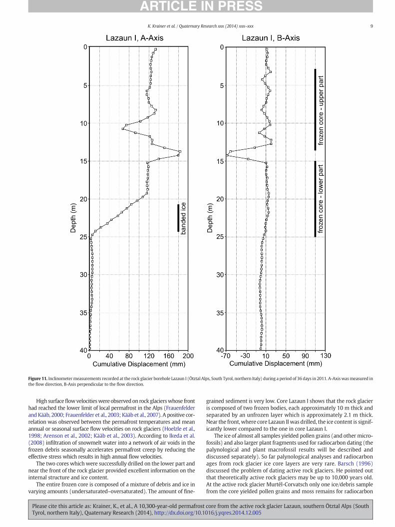
Figure 11. Inclinometermeasurements recorded at the rock glacier borehole Lazaun I (Ötztal Alps, South Tyrol, northern Italy) during a period of 36 days in 2011. A-Axiswasmeasured inthe flow direction, B-Axis perpendicular to the flow direction.
9K. Krainer et al. / Quaternary Research xxx (2014) xxx–xxx
High surfaceflowvelocitieswereobservedon rockglacierswhose fronthad reached the lower limit of local permafrost in the Alps (Frauenfelderand Kääb, 2000; Frauenfelder et al., 2003; Kääb et al., 2007). A positive cor-relation was observed between the permafrost temperatures and meanannual or seasonal surface flow velocities on rock glaciers (Hoelzle et al.,1998; Arenson et al., 2002; Kääb et al., 2003). According to Ikeda et al.(2008) infiltration of snowmelt water into a network of air voids in thefrozen debris seasonally accelerates permafrost creep by reducing theeffective stress which results in high annual flow velocities.
The two cores whichwere successfully drilled on the lower part andnear the front of the rock glacier provided excellent information on theinternal structure and ice content.
The entire frozen core is composed of a mixture of debris and ice invarying amounts (undersaturated–oversaturated). The amount of fine-
Please cite this article as: Krainer, K., et al., A 10,300-year-old permafrostTyrol, northern Italy), Quaternary Research (2014), http://dx.doi.org/10.1
grained sediment is very low. Core Lazaun I shows that the rock glacieris composed of two frozen bodies, each approximately 10 m thick andseparated by an unfrozen layer which is approximately 2.1 m thick.Near the front, where core Lazaun II was drilled, the ice content is signif-icantly lower compared to the one in core Lazaun I.
The ice of almost all samples yielded pollen grains (and othermicro-fossils) and also larger plant fragments used for radiocarbon dating (thepalynological and plant macrofossil results will be described anddiscussed separately). So far palynological analyses and radiocarbonages from rock glacier ice core layers are very rare. Barsch (1996)discussed the problem of dating active rock glaciers. He pointed outthat theoretically active rock glaciers may be up to 10,000 years old.At the active rock glacier Murtél-Corvatsch only one ice/debris samplefrom the core yielded pollen grains and moss remains for radiocarbon
core from the active rock glacier Lazaun, southern Ötztal Alps (South016/j.yqres.2014.12.005

10 K. Krainer et al. / Quaternary Research xxx (2014) xxx–xxx
dating (Haeberli et al., 1999), resulting in a modeled maximum age ofthe rock glacier Murtél-Corvatsch in the order of 10,000 years. This con-firmed the former assumption byHaeberli (1989) that at the shear zoneat a depth of 28–32 m the ice of the core from the rock glacier Murtélmight be of early Holocene age.
Plant macrofossils (N125 μm)were extracted from eleven ice/debrissamples concerning the Lazaun I core and from two samples for theLazaun core II. The radiocarbon ages and the age-depth model(Table 2, Fig. 9) show a linear relationship, implying therefore an ex-trapolated age of ca. 10,250 cal yr BP for the first ice-forming processesnear the base of the frozen core at a depth of 25 m.
This indicates that:
a) The formation of the rock glacier most likely started about10,300 years ago, immediately after the retreat of the glacier occupy-ing the cirque of the Lazaun Alm during the Egesen stage (YoungerDryas) which is documented by well-preserved lateral moraines.Barsch (1996) and Haeberli et al. (1999) already assumed that theformation of some rock glaciers started around the onset of theHolocene.
b) Ice within the rock glacier formed continuously since10,250 cal yr BP. The insulating surface debris layer preserved theunderlying ice. The radiocarbon ages and palynological results alsoindicate that periods with warmer climatic conditions, duringwhich permafrost ice did not form or duringwhich older icemelted,were short and lasted probably less than a few hundred years.
c) As the rock glacier is only 660 m long but exists since at least10,300 yr (considering that the present study was performed nearthe front of the Lazaun rock glacier and that older ice may exist inthe upper rock glacier parts), periods of activity (as at present) dur-ing this long period must have been short and were interrupted bylong periods of inactivity. The rock glacier is composed of two creep-ing lobes (“polymorphic” sensu Frauenfelder and Kääb, 2000). Aftera period of inactivity, represented by the ice-free layer between thetwo lobes, the younger lobe was reactivated and overrode the olderlobe.
d) Interestingly, a N500 yr long drought period started 4300 ±140 cal yr BP, which led to ice melting and to the formation of ice-free debris layers between 16.82 and 14.70 m depth (separatingthe two active ice containing frozen bodies), andwhichmight be re-lated to a general Central European climatic re-organization duringthis time period marking a climatic reversal following the Holoceneclimatic optimum, and characterizing the onset of the Neoglacial(Haas et al., 1998; Magny et al., 2009, 2012; Zanchetta et al., 2012;Brisset et al., 2013; Magny et al., 2013; Zanchetta et al., 2013;Dietre et al., in press). According to the age–depthmodel ice formedagain after 3740 ± 110 cal yr BP.
e) Ice younger than 2200 yr is not preserved in the lower front part ofthe rock glacier, probably due to increased melting of ice sinceabout 1990 AD.
Borehole temperatures within the frozen core are between −0.9and 0°C and thus very close to themelting point. Most detailed analysesof borehole temperatures fromAlpine rock glaciers are derived from theMurtél rock glacier (borehole Murtél 2; Vonder Mühll and Haeberli,1990; Vonder Mühll and Holub, 1992; Vonder Mühll et al., 1998;Haeberli et al., 2006). At the borehole Murtél 2, temperature rangedfrom −2.6°C to −1.2°C at a depth of 10 m and from −2.1°C to−1.6°C at a depth of 20 m with a warming trend of a few tenths of de-grees Celsius per decade. From a depth of 10 m temperature increasesdownward in the borehole to 0°C at approximately 50m. At other local-ities borehole temperatures are even higher, mostly ranging between−1.5 and −0.5°C which is similar to the temperatures recorded atLazaun I. Borehole temperatures show that the ice of the rock glacierLazaun is very close to themelting point and thus indicates the presence
Please cite this article as: Krainer, K., et al., A 10,300-year-old permafrostTyrol, northern Italy), Quaternary Research (2014), http://dx.doi.org/10.1
of “warm permafrost.” This is astonishing as the permafrost ice of therock glacier Lazaun is about 10,300 yr old and thus must have survivedeven warmer climatic phases during the last 10,300 yr. Particularly theearly andmiddle Holocene until about 4000 cal yr BP were significantlywarmer than the late Holocene based on paleoecological and dendro-chronological investigations (Haas et al., 1998; Nicolussi, 2009).Hormes et al. (2001) presented evidence for eightHolocene phases dur-ing which glaciers in the Central Swiss Alps were smaller than today.
The present state of knowledge on the creep mechanisms of rockglaciers was recently summarized and discussed by Haeberli et al.(2006). In general, the rheological behavior of rock glaciers is highly de-pendent on the ice content, ice temperature and grain size of the debristhickness of the rock glacier and gradient of the slope. At some rock gla-ciers a distinct shear zone which is up to several meters thick, was ob-served in which most of the creep deformation occurs (e.g. Haeberliet al., 1998; Arenson et al., 2002). At Reichenkar rock glacierHausmann et al. (2007, 2012) argued that basal sliding could takeplace along thewater-saturated, fine-grained till layer which occurs be-tween the frozen core of the rock glacier and the bedrock.
Inclinometermeasurements in the borehole of Lazaun I demonstratethe presence of a shear horizon at a depth between 20 and 24 mwherebanded ice containing higher amounts of fine-grained sediment occur.According to the inclinometer measurements a second shear horizonoccurs at a depth of 14.70 m, i.e. near the base of the upper frozenpart of the rock glacier, which can be dated to ca. 3740 cal yr BP(Fig. 9). Inclinometer data also show that most of the deformation rateoccurs at these shear horizons and that internal deformation is ofminor importance as the high flow velocities recorded at present are al-most identical to the deformation ratesmeasured at the shear horizons.High rates of deformation are probably favored by the temperature ofthe ice which is close to the melting point.
Conclusions and summary
Flow velocitymeasurements, BTS, water temperature of the springs,steep front and surface morphology of the tongue-shaped rock glacierLazaun demonstrate that the rock glacier is active and contains substan-tial amounts of ice.
The discharge pattern is typical for active rock glaciers and is charac-terized by strong diurnal and seasonal variations. During winter (Octo-ber until May) discharge is extremely low and electrical conductivityhigh. Highest discharge is recorded during the snowmelt period inJune and July, and during rainfall events. Pronounced diurnal variationsin discharge are recorded inMay and June. From the end of July until Oc-tober discharge decreases, interrupted by single peaks caused by rainfallevents. Warm-weather periods in autumn may also cause a slight in-crease in discharge (increased melting of ice).
The rock glacier spring is characterized by relatively high electricalconductivity. The average ice content of the rock glacier is approximate-ly 35–40 vol.%. Increased melting of permafrost ice causes a loss of ap-proximately 10,000 m3 ice/year which is 1.2–1.3% of the total icevolume of the rock glacier. Increased melting of permafrost ice of therock glacier causes an average discharge of 0.6 l/s. This is only about2.3% of the average discharge of the rock glacier which is approximately26 l/s.
Two core drillings confirmed that the rock glacier contains a frozencore with locally high amounts of ice. The frozen core is largely com-posed of a mixture of debris and ice (“ice-cemented rock glacier”). Icecontent varies from undersaturated to highly oversaturated. At thebase of the core Lazaun I banded icewith low amounts of debris is pres-ent. The rock glacier is composed of two frozen bodies, separated by anice-free layerwhich is about 2.1m thick, andwhich can be dated to havebeen formed from ca. 4300 to 3740 cal yr BP. At present both frozenbodies are active. After a period of inactivity, represented by the ice-free layer, the lower creeping lobewas overridden by a younger lobe. In-clinometer measurements indicate that deformation occurs within a
core from the active rock glacier Lazaun, southern Ötztal Alps (South016/j.yqres.2014.12.005
11K. Krainer et al. / Quaternary Research xxx (2014) xxx–xxx
shear horizon at a depth of 20–24m, which is 1 m above the base of thefrozen core, and to a minor extent also at a shear horizon at 14.70 mdepth, which is at the base of the upper frozen core, and which isdated to ca. 3740 cal yr BP.
Borehole temperatures in the frozen core are near themelting point,indicating thepresence ofwarmpermafrost ice. Although no icewas de-termined below a depth of 25 m, borehole temperatures in the debrislayer and diamict are slightly below zero down to a depth of 35 m.
Radiocarbon ages indicate that the rock glacier started to form about10,300 yr ago and since this time was intact. The rock glacier is under-lain by diamict, which can in part be ascribed to the lodgement till ofthe Egesen (Younger Dryas) cold climatic period and near the frontalso to debris which formed when the rock glacier overrode itselfwhenmoving forward. Periods of activitymust have alternatedwith pe-riods of inactivity since 10,300 yr ago (Early Holocene). Even duringwarm periods the ice of the rock glacier persisted although the temper-ature of the permafrost ice at present is close to the melting point. Theonly exception to this happened 4300 cal yr BP, when a N500-yr-longdrought period started, which led to the unfrozen debris sedimentsfound in the Lazaun rock glacier between 16.82 and 14.70mdepth (sep-arating the two active ice-containing frozen bodies), and which mightbe related to a general Central European climatic re-organization duringthis time period. The Lazaun rock glacier might therefore be seen as amodel rock glacier for the reconstruction of climatically driven meltingprocesses during the onset of the Neoglacial in the southern part of theEuropean Alps.
Radiocarbon ages show a normal, undisturbed stratigraphic succes-sion within the frozen core of the rock glacier with the oldest ice nearthe base and the youngest ice at the top. At first glance this appears dif-ficult to understand, but considering that a)most of the deformation oc-curs within a shear horizon at the base of the frozen bodies, thatb) internal deformation is extremely small or absent within the frozencore, and that c) the rock glacier must have beenmostly inactive duringthe last 10,000 years with only short periods of activity, these resultsmake sense. Therefore a more or less linear accumulation of debrisand ice in the rooting zone of the rock glacier seems to be a reasonableprocess. From the rooting zone the frozen core moves forward mostlyby “basal gliding” along the shear horizon at the base and so the strati-graphic succession within the frozen body remains undisturbed.
Acknowledgments
This work was funded by Proalp (Mapping and Monitoring of per-mafrost phenomena in the Alps — Autonomous Province of Bolzano-South Tyrol), PermaNET (Permafrost long-term monitoring network,Interreg Alpine Space project) and PERMAQUA (Interreg IV Italy–Austria). We thank Thomas Fontana for assistance in the field (GPSmeasurements), and we are very grateful to the landowner of theLazaun Alm, Peter Tumler, for access to the rock glacier Lazaun. Manythanks also go to Michel Magny (University of Franche-Comté/Besançon, France) for fascinating discussions on the onset of theNeoglacial, and we greatly acknowledge the comments by WilfriedHaeberli (University of Zürich, Switzerland) and two anonymous re-viewers which helped to improve the manuscript.
References
Arenson, L., Hoelzle, M., Springman, S., 2002. Borehole deformation measurements andinternal structure of some rock glaciers in Switzerland. Permafrost and PeriglacialProcesses 13, 117–135.
Barsch, D., 1977. Ein Permafrostprofil aus Graubünden, Schweizer Alpen. Zeitschrift fürGeomorphologie, N.F. 21, 79–86.
Barsch, D., 1996. Rockglaciers. Indicators for the Present and Former Geoecology in HighMountain Environments. Springer-Verlag, Berlin.
Barsch, D., Fierz, H., Haeberli, W., 1979. Shallow core drilling and bore-hole measure-ments in the permafrost of an active rock glacier near the Grubengletscher, Wallis,Swiss Alps. Arctic and Alpine Research 11 (2), 215–228.
Please cite this article as: Krainer, K., et al., A 10,300-year-old permafrostTyrol, northern Italy), Quaternary Research (2014), http://dx.doi.org/10.1
Berger, J., Krainer, K., Mostler, W., 2004. Dynamics of an active rock glacier (Ötztal Alps,Austria). Quaternary Research 62, 233–242.
Blaauw, M., 2010. Methods and code for ‘classical’ age-modelling of radiocarbon se-quences. Quaternary Geochronology 5 (5), 512–518.
Boeckli, L., Brenning, A., Gruber, S., Noetzli, J., 2012. A statistical approach to modellingpermafrost distribution in the European Alps or similar mountain ranges. TheCryosphere 6, 125–140.
Bollmann, E., Rieg, L., Spross, M., Sailer, R., Bucher, K., Maukisch, M., Monreal, M., Zischg, A.,Mair, V., Lang, K., Stötter, J., 2012. Blockgletscherkataster Südtirol – Erstellung undAnalyse. Permafrost in Südtirol. Innsbrucker Geographische Studien 39, pp. 147–171.
Bressan, D., 2007. Aufbau und Dynamik aktiver Blockgletscher am Beispiel der Lazaunalm(Ötztaler Alpen/Südtirol), Unpubl. Master Thesis, Univ. of Innsbruck, 197 pp.
Brisset, E., Miramont, C., Guiter, F., Anthony, E.J., Tachikawa, K., Poulenard, J., Arnaud, F.,Delhon, C., Meunier, J.-D., Bard, E., Suméra, F., 2013. Non-reversible geosystemdestabilisation at 4200 cal. BP: sedimentological, geochemical and botanical markersof soil erosion recorded in a Mediterranean alpine lake. The Holocene 23 (12),1863–1874.
Christiansen, H.H., et al., 2010. The thermal state of permafrost in the Nordic area duringthe International Polar Year 2007–2009. Permafrost and Periglacial Processes 21,156–181.
Cremonese, E., Gruber, S., Phillips, M., Pogliotti, P., Boeckli, L., Noetzli, J., Suter, C., Bodin, X.,Crepaz, A., Kellerer-Pirklbauer, A., Lang, K., Letey, S., Mair, V., Morra di Cella, U.,Ravanel, L., Scapozza, C., Seppi, R., Zischg, A., 2011. An inventory of permafrost evi-dence for the European Alps. The Cryosphere 5, 651–657.
Delaloye, R., Perruchoud, E., Avian, M., Kaufmann, V., Bodin, X., Ikeda, A., Hausmann, H.,Kääb, A., Kellerer-Pirklbauer, A., Krainer, K., Lambiel, C., Mihajlovic, D., Staub, B.,Roer, I., Thibert, E., 2008. Recent interannual variations of rock glaciers creep in theEuropean Alps. In: Kane, D.L., Hinkel, K.M. (Eds.), Proceedings, Ninth InternationalConference on Permafrost (NICOP). University of Alaska, Fairbanks, pp. 343–348.
Dietre, B., Walser, C., Lambers, K., Reitmaier, T., Hajdas, I., Haas, J.N., 2014. Palaeoecologicalevidence forMesolithic toMedieval climatic change and anthropogenic impact on theAlpine flora and vegetation of the Silvretta Massif (Switzerland/Austria). QuaternaryInternational 353, 3–16 (in press).
Eiken, T., Hagen, J.O., Melvold, K., 1997. Kinematic GPS survey of geometry changes onSvalbard glaciers. Annals of Glaciology 24, 157–163.
Frauenfelder, R., Kääb, A., 2000. Towards a paleoclimatic model of rock-glacier formationin the Swiss Alps. Annals of Glaciology 31, 281–286.
Frauenfelder, R., Haeberli, W., Hoelzle, M., 2003. Rock glacier occurrence and related ter-rain parameters in a study area of the Eastern Swiss Alps. In: Phillips, N., Springman,S.M., Arenson, L.U. (Eds.), Proceedings of the 8th International Conference on Perma-frost. A.A. Balkema, Lisse, Netherlands, pp. 253–258.
Fuchs, M.C., Böhlert, R., Krbetschek, M., Preusser, F., Egli, M., 2013. Exploring the potentialof luminescence methods for dating Alpine rock glaciers. Quaternary Geochronology18, 17–33.
Gärtner-Roer, I., 2010. Permafrost. In: Voigt, Th., Füssel, H.-M., Gärtner-Roer, I., Huggel,Ch., Marty, Ch., Zemp, M. (Eds.), Impacts of Climate Change on Snow, Ice, and Perma-frost in Europe: Observed Trends, Future Projections, and Socioeconomic Relevance,ETC/ACC Technical Paper 2010/13, pp. 66–76.
Haas, J.N., Richoz, I., Tinner, W.,Wick, L., 1998. Synchronous Holocene climatic oscillationsrecorded on the Swiss Plateau and at timberline in the Alps. The Holocene 8 (3),301–309.
Haeberli, W., 1989. Pilot analysis of permafrost cores from the active rock glacier Murtél I,Piz Corvatsch, Eastern Swiss Alps. Versuchsanstalt für Wasserbau, Hydrologie undGlaziologie ETH Zürich, Arbeitsheft 9 p. 38.
Haeberli, W., 2013. Mountain permafrost — research frontiers and a special long-termchallenge. Cold Regions Science and Technology 96, 71–77.
Haeberli, W., Funk, M., 1991. Borehole temperatures at the Colle Gnifetti core-drilling site(Monte Rosa, Swiss Alps). Journal of Glaciology 37, 37–46.
Haeberli,W., Hoelzle, M., Kääb, A., Kellerer, F., VonderMühll, D.,Wagner, S., 1998. Ten yearsafter drilling through the permafrost of the active rock glacier Murtél, eastern SwissAlps: answered questions and new perspectives. Permafrost — 7th International Con-ference (Proceedings), Yellowknife (Canada). Collection Nordicana 55, pp. 403–410.
Haeberli, W., Kääb, A., Wagner, S., Vonder Mühll, D., Geissler, P., Haas, J.N., Glatzel-Mattheier, H., Wagenbach, D., 1999. Pollen analysis and 14C age of moss remains ina permafrost core recovered from the active rock glacier Murtél-Corvatsch, SwissAlps: geomorphological and glaciological implications. Journal of Glaciology 45, 1–8.
Haeberli, W., Brandova, D., Burga, C., Egli, M., Frauenfelder, R., Kääb, A., Maisch, M., Mauz,B., Dikau, R., 2003. Methods for absolute and relative age dating of rock-glacier sur-faces in alpine permafrost. In: Phillips, M., Springman, S., Arenson, L. (Eds.), Proceed-ings of the 8th International Conference on Permafrost 2003, Zürich, pp. 343–348.
Haeberli, W., Hallet, B., Arenson, L., Elconin, R., Humlum, O., Kääb, A., Kaufmann, V.,Ladanyi, B., Matsuoka, N., Springman, S., VonderMühl, D., 2006. Permafrost creepand rock glacier dynamics. Permafrost and Periglacial Processes 17, 189–216.
Haeberli, W., Noetzli, J., Arenson, L., Delaloye, R., Gärtner-Roer, I., Gruber, S., Isaksen, K.,Kneisel, C., Krautblatter, M., Phillips, M., 2010. Mountain permafrost: developmentand challenges of a young research field. Journal of Glaciology 56 (200), 1043–1058.
Hajdas, I., 2008. Radiocarbon dating and its applications in Quaternary studies. Eiszeitalterund Gegenwart – Quaternary Science Journal 57, 2–24.
Harris, C., et al., 2003. Warming permafrost in European mountains. Global PlanetaryChange 39, 215–225.
Hausmann, H., Krainer, K., Brückl, E., Mostler, W., 2007. Internal structure and ice contentof Reichenkar Rock Glacier (Stubai Alps, Austria) assessed by geophysical investiga-tions. Permafrost and Periglacial Processes 18, 351–367.
Hausmann, H., Krainer, K., Brückl, E., Ullrich, C., 2012. Internal structure, ice content anddynamics of Ölgrube and Kaiserberg rock glaciers (Ötztal Alps, Austria) determinedfrom geophysical surveys. Australian Journal of Earth Sciences 105 (2), 12–31.
core from the active rock glacier Lazaun, southern Ötztal Alps (South016/j.yqres.2014.12.005

12 K. Krainer et al. / Quaternary Research xxx (2014) xxx–xxx
Hoelzle, M., Wagner, S., Kääb, A., VonderMühll, D., 1998. Surface movement and internaldeformation of ice-rock mixtures within rock glaciers at Pontresina-Schafberg, UpperEngadin, Switzerland. In: Lewkowicz, A.G., Allard, M. (Eds.), Proceedings of the 7thInternational Conference on Permafrost. Centre D'Etudes Nordiques, Sainte-Foy,Quebec, Canada, pp. 465–471.
Hofmann-Wallenhof, B., Lichtenegger, H., Collins, J., 1994. GPS Theory and Practice.Springer-Verlag, New York.
Hormes, A., Müller, B.U., Schlüchter, C., 2001. The Alps with little ice: evidence for eightHolocene phases of reduced glacier extent in the Central Swiss Alps. The Holocene11 (3), 255–265.
Ikeda, A., Matsuoka, N., Kääb, A., 2008. Fast deformation of perennially frozen debris in awarm rock glacier in the Swiss Alps: an effect of liquid water. Journal of GeophysicalResearch 113, F01021. http://dx.doi.org/10.1029/2007JF000859.
Kääb, A., Kaufmann, V., Ladstädter, R., Eiken, T., 2003. Rock glacier dynamics: implicationsfrom high-resolution measurements of surface velocity fields. In: Phillips, N.,Springman, S.M., Arenson, L.U. (Eds.), Proceedings of the 8th International Conferenceon Permafrost. A.A. Balkema, Lisse, Netherlands, pp. 501–506.
Kääb, A., Frauenfelder, R., Roer, I., 2007. On the response of rockglacier creep to surfacetemperature increase. Global Planetary Change 56, 172–187.
Kaufmann, V., 2012. The evolution of rock glacier monitoring using terrestrial photogram-metry: the example of Äußeres Hochebenkar rock glacier (Austria). Australian Journalof Earth Sciences 105 (2), 63–77.
Kaufmann, V., Ladstädter, R., 2002. Spatio-temporal analysis of the dynamic behaviour ofthe Hochebenkar rock glaciers (Oetztal Alps, Austria) bymeans of digital photogram-metric methods. Grazer Schriften der Geographie und Raumforschung 37, 119–140.
Kellerer-Pirklbauer, A., 2007. Lithology and the distribution of rock glaciers: NiedereTauern Range, Styria, Austria. Zeitschrift für Geomorphologie, N.F. 51 (Suppl. 2),17–38.
Kellerer-Pirklbauer, A., Lieb, G.K., Kleinferchner, H., 2012. A new rock glacier inventory forthe easternmost part of the European Alps. Australian Journal of Earth Sciences 105(2), 78–93.
Konrad, S.K., Humphrey, N.F., Steig, E.J., Clark, D.H., Potter Jr., N., Pfeffer, W.T., 1999. Rockglacier dynamics and paleoclimatic implications. Geology 27, 1131–1134.
Krainer, K., Mostler, W., 2000. Reichenkar Rock Glacier, a glacial derived debris–ice sys-tem in the Western Stubai Alps, Austria. Permafrost and Periglacial Processes 11,267–275.
Krainer, K., Mostler, W., 2001a. Aktive Blockgletscher als Transportsysteme fürSchuttmassen im Hochgebirge: Der Reichenkar Blockgletscher in den westlichenStubaier Alpen. Geoforum Umhausen 1, 28–43.
Krainer, K., Mostler, W., 2001b. Der aktive Blockgletscher im Hinteren Langtal Kar,Gößnitz Tal (Schober Gruppe, Nationalpark Hohe Tauern). WissenschaftlicheMitteilungen aus dem Nationalpark Hohe Tauern 6, 139–168.
Krainer, K., Mostler, W., 2002. The discharge of active rock glaciers: examples from theEastern Alps (Austria). Arctic Antarctic and Alpine Research 34 (2), 142–149.
Krainer, K., Mostler, W., 2004. Ein aktiver Blockgletscher im Sulzkar, westliche StubaierAlpen (Tirol). Geo.Alp 1, 37–55.
Krainer, K., Mostler, W., 2006. Flow velocities of active rock glaciers in the Austrian Alps.Geografiska Annaler 88A, 267–280.
Krainer, K., Ribis, M., 2012. A rock glacier inventory of the Tyrolean Alps (Austria).Australian Journal of Earth Sciences 105 (2), 32–47.
Krainer, K., Mostler, W., Spötl, C., 2007. Discharge from active rock glaciers, Austrian Alps:a stable isotope approach. Australian Journal of Earth Sciences 100, 102–112.
Krainer, K., Lang, K., Hausmann, H., 2010. Active rock glaciers at Croda Rossa/Hohe Gaisl,eastern Dolomites (Alto Adige/South Tyrol, northern Italy). Geografia Fisica eDinamica Quaternaria 33, 25–36.
Krainer, K., Mussner, L., Behm, M., Hausmann, H., 2012. Multi-disciplinary investigationof an active rock glacier in the Sella Group (Dolomites; Northern Italy). AustralianJournal of Earth Sciences 105 (2), 48–62.
Ladstädter, R., Kaufmann, V., 2005. Studying the movement of the Outer Hochebenkarrock glacier: aerial vs. ground-based photogrammetric methods. 2nd European Con-ference on Permafrost, Potsdam, Germany, Terra Nostra, 2005 (2), p. 97 (abstract).
Lambiel, C., Delaloye, R., 2004. Contribution of real-time kinematic GPS in the study ofcreeping mountain permafrost: examples from the Western Swiss Alps. Permafrostand Periglacial Processes 15 (3), 229–241.
Laustela, M., Egli, M., Frauenfelder, R., Kääb, A., Maisch, M., Haeberli,W., 2003.Weatheringrind measurements and relative age dating of rock glacier surfaces in crystallineregions of the Eastern Swiss Alps. In: Phillips, M., Springman, S., Arenson, L. (Eds.),
Please cite this article as: Krainer, K., et al., A 10,300-year-old permafrostTyrol, northern Italy), Quaternary Research (2014), http://dx.doi.org/10.1
Proceedings of the 8th International Conference on Permafrost 2003, Zürich,pp. 627–632.
Lieb, G.K., 1998. High-mountain permafrost in the Austrian Alps (Europe). Permafrost —7th International Conference (Proceedings), Yellowknife (Canada). CollectionNordicana 55, pp. 663–668.
Lüthi, M.P., Funk, M., 2001. Modelling heat flow in a cold, high altitude glacier: interpre-tation of measurements from Colle Gnifetti, Swiss Alps. Journal of Glaciology 47,314–324.
Magny, M., Vannière, B., Zanchetta, G., Fouache, E., Touchais, G., Petrika, L., Coussot, C.,Walter-Simmonet, A.-V., Arnaud, F., 2009. Possible complexity of the climatic eventaround 4300–3800 cal. BP in the central and western Mediterranean. The Holocene19 (6), 823–833.
Magny,M., Arnaud, F., Billaud, Y.,Marguet, A., 2012. Lake-levelfluctuations at LakeBourget(eastern France) around 4500–3500 cal. a BP and their palaeoclimatic and archaeolog-ical implications. Journal of Quaternary Science 27 (5), 494–502.
Magny, M., et al., 2013. North–south palaeohydrological contrasts in the central Mediter-ranean during the Holocene: tentative synthesis and working hypotheses. Climate ofthe Past 9, 2043–2071.
Matthews, J.A., Nesje, A., Linge, H., 2013. Relict talus-foot rock glaciers at Oyberget, UpperOttadalen, SouthernNorway: Schmidt hammer exposure ages andpalaeoenvironmentalimplications. Permafrost and Periglacial Processes 24, 336–346.
Nicolussi, K., 2009. Alpine Dendrochronologie – Untersuchungen zur Kenntnis derholozänen Umwelt- und Klimaentwicklung. Klimawandel in Österreich. Alpinespace – man and environment 6, pp. 41–54.
Nötzli, J., Vonder Mühll, D. (Eds.), 2010. Permafrost in Switzerland 2006/2007 and 2007/2008, Zürich. Swiss Academy of Sciences (SCNAT) (Cryospheric Commission (Glacio-logical Report Permafrost), 8/9).
Nötzli, J., Gruber, S., von Poschinger, A., 2010. Modellierung und Messung vonPermafrosttemperaturen im Gipfelgrat der Zugspitze, Deutschland. GeographicaHelvetica 65, 113–123.
R Core Team, 2013. R: A Language and Environment for Statistical Computing. R Founda-tion for Statistical Computing, Vienna, Austria (Version 3.0.0, http://www.r-project.org/).
Reimer, P.J., Baillie, M.G., Bard, E., Bayliss, A., Beck, J.W., Blackwell, P.G., Ramsey, C.B., Buck,C.E., Burr, G.S., Edwards, R.L., 2009. IntCal09 and Marine09 radiocarbon age calibra-tion curves, 0–50,000 years cal BP. Radiocarbon 51 (4), 1111–1150.
Schneider, R., Schneider, H., 2001. Zur 60-jährigen Messreihe der kurzfristigenGeschwindigkeitsschwankungen am Blockgletscher im Äusseren Hochebenkar,Ötztaler Alpen, Tirol. Zeitschrift für Gletscherkunde und Glazialgeologie 37, 1–33.
Schoeneich, P., Bodin, X., Krysiecki, J.-M., Deline, P., Ravanel, L., 2010. Permafrost in France,Grenoble. PermaFRANCE (PermaFRANCE Network Report 1).
Stuiver, M., Polach, H.A., 1977. Discussion — reporting of 14C data. Radiocarbon 19 (3),355–363.
Synal, H.-A., Stocker, M., Suter, M., 2007. MICADAS: a new compact radiocarbon AMS sys-tem. Nuclear Instruments and Methods in Physics Research B: Beam Interactionswith Materials and Atoms 259 (1), 7–13.
Vonder Mühll, D., 1992. Evidence of intrapermafrost groundwater flow beneath an activerock glacier in the Swiss Alps. Permafrost and Periglacial Processes 3, 169–173.
Vonder Mühll, D., 1996. Drilling in alpine permafrost. Norwegian Journal of Geography(Norsk Geografisk Tidsskrift) 50 (1), 17–24.
Vonder Mühll, D., Haeberli, W., 1990. Thermal characteristics of the permafrost within anactive rock glacier (Murtél/Corvatsch, Grisons, Swiss Alps). Journal of Glaciology 36(123), 151–158.
Vonder Mühll, D., Holub, P., 1992. Borehole logging in Alpine permafrost, Upper Engadin,Swiss Alps. Permafrost and Periglacial Processes 3 (2), 125–132.
Vonder Mühll, D., Stucki, T., Haeberli, W., 1998. Borehole temperatures in Alpine perma-frost: a ten year series. Permafrost — 7th International Conference (Proceedings),Yellowknife (Canada). Collection Nordicana 55, pp. 1089–1095.
Zanchetta, G., Giraudi, C., Sulpizio, R., Magny, M., Drysdale, R.N., Sadori, L., 2012.Constraining the onset of theHolocene “Neoglacial” over the central Italy using tephralayers. Quaternary Research 78, 236–247.
Zanchetta, G., Bini, M., Cremaschi, M., Magny, M., Sadori, L., 2013. The transition from nat-ural to anthropogenic-dominated environmental change in Italy and the surroundingregions since the Neolithic: an introduction. Quaternary International 303, 1–9.
Zhao, L.,Wu, Q.,Marchenko, S.S., Sharkuu, N., 2010. Thermal state of permafrost and activelayer in Central Asia during the International Polar Year. Permafrost and PeriglacialProcesses 21, 198–207.
core from the active rock glacier Lazaun, southern Ötztal Alps (South016/j.yqres.2014.12.005
Copyright © 2022 FDOKUMEN