Covered Tile and "Flying" Tassels // Iranica Antiqua. Vol. 38. Gent, 2003, 259-325

Iranica Antiqua, vol. XLIX, 2014
doi: 10.2143/IA.49.0.3009240
PRELIMINARY REPORT ON THE SOUNDINGS AT TEPE DAMGHANI SABZEVAR, SPRING 2008
BY
Henri-Paul FRANCFORT1, Ali A. VAHDATI2, Julio BENDEZU-SARMIENTO1, Johanna LHUILLIER3, Eric FOUACHE4,
Margaret TENGBERG5, Marjan MASHKOUR5, Zohreh SHIRAZI6
(1 CNRS, UMR 7041 ArScAn, Nanterre, France; 2 ICHHTO North Khorassan, Bojnurd, Iran; 3 Humboldt Foundation, DAI, Berlin, Germany / UMR 7041
ArScAn, Nanterre, France; 4 Univ. Paris, Sorbonne, Abou Dhabi;
5 Musée national d’histoire naturelle, Paris, France; 6 Zahedan Univ., Iran)
Abstract: A season of archaeological sounding at Tepe Damghani and survey of the surrounding area was carried out by a joint Irano-French expedition in the Spring of 2008. A multidisciplinary approach was adopted consisting of archae-ological, geomorphological, archaeobotanical, archaeozoological, and anthropo-logical studies for better understanding of the different aspects of the Bronze and Iron Age cultures at the site. Data-gathering was made possible through a small trial trench (Tr. 1) and cleaning of a large section which was exposed by road construction. Archaeological analysis of the materials from a sounding at Tepe Damghani and the survey of the neighbouring sites (Tepe Ferizi and Mirabad sites) show strong cultural links with Central Asia from the late Chal-colithic to the late Bronze Age. Iron Age material can only be found in the plough zone, but not in situ. Typological analysis of pottery, confirmed by var-ious radiocarbon dates, suggest that the main occupation at Tr. 1 belongs to a period contemporary with Namazga IV (Early Bronze Age) in the Central Asian chronology. The discovery of various chert and ophiolitic artifacts indicate exploitation of local resources and the presence of chipping industry at the site during the Bronze Age, but no workshops were uncovered. Study of animal bones, wood charcoals, as well as charred seeds and fruit remains has provided us with invaluable information on subsistence pattern and plant economy of the ancient inhabitants of Tepe Damghani and allows us to answer various questions regarding the ancient water management and the exploitation and use of local faunal and floral resources.
Keywords: Iran, Khorassan, Sabzevar Plain, Tepe Damghani, Central Asia, Bronze Age, Iron Ages
96550.indb 111 25/02/14 13:48

112 HENRI-PAUL FRANCFORT ET AL.
Introduction
Due to the extremely uneven archaeological coverage of the territory
of Iran, our knowledge of the prehistoric periods in northeastern Iran in
particular, and the province of Khorassan in general, is piecemeal. Most of
archaeological activities have been concentrated in the west, southwest and
the central regions of the Iranian Plateau, while the region of Khorassan in
the northeast remained largely neglected and is still a relatively ‘blank spot’
on the archaeological map of Iran. The slowly accomplished evidence from
a few excavated sites and surveyed areas still have not given researchers a
clear image of historical evolution and devolution of this region.
Despite the limited archaeological fieldwork in modern Khorassan, the
northern part of “Greater Khorassan”, much of which nowadays lies in
Turkmenistan, has been more active in terms of archaeological research. In
this region, excavations at various sites of the Neolithic, Chalcolithic,
Bronze and Iron Ages (e.g., Anau, Namazga-depe, Altyn-depe, Ulug-depe)
as well as sites of the historical period (e.g., at Nisa, the first capital of the
Parthians), have provided us with evidence of a long sequence from the
Neolithic to the arrival of Islam.
Fortunately, few archaeological projects have recently begun on prehis-
toric sites of the southern foothills of the Kopet-Dagh Mountains to the
north of Iranian Khorassan. These studies are gradually projecting a clearer
picture of the ancient past of the region. Given the lack of stratified sites
and settlements in the region, however, it is obvious that without a chron-
ological framework for this area, the well-known sequence of the northern
foothills of the Kopet-Dagh in southern Turkmenistan will have to be used
for study of recovered cultures in the southern foothills of this mountain
range. It is hoped that in the near future, the expansion of archaeological
fieldwork in the region will lead to the compilation of a particular periodi-
zation of ancient sites of Khorassan. With this in hand, we will not only be
able to investigate the independent development of societies in this region,
but also come to understand the cultures of this territory in between the
two cultural zones of Central Asia and the Iranian Plateau. To that end,
the Joint Irano-French expedition began its fieldwork at Tepe Damghani in
the spring of 2008 with the excavation of one sounding and the cleaning
of a stratigraphic section, leading to the identification of part of the prehis-
toric sequence of the Sabzevar Plain.
96550.indb 112 25/02/14 13:48

TEPE DAMGHANI SABZEVAR 113
Tepe Damghani
Tepe Damghani lies to the southeast of the city of Sabzevar in the prov-
ince of Khorassan-e Razavi (Map 1). The mound is 2-3 meters higher than
the surrounding plain on the north and approximately 5 meters above in the
south. During the course of constructing the Delqand Road, the northern
half of the mound was largely destroyed and a cut of approximately 2
meters in elevation was created in this part, in which the sequence of archi-
tectural layers and ancient occupations can easily be observed. Moreover,
on the remaining surface of the southern half of the mound, a large pool of
water and several hectares of cropland have been created which have been
plotted, ploughed and irrigated continuously, disturbing the original topog-
raphy of the mound and the upper layers (Pl. 1, Map 2). The remaining part
of the mound has been separated from the surrounding land by a modern
brick-wall, 2.5 meters in height to enclose agricultural plots. To the north
Map 1. Location of Sabzevar township in NE Iran.
96550.indb 113 25/02/14 13:48

114 HENRI-PAUL FRANCFORT ET AL.
Map 2. Contour map and profile view of Tepe Damghani.
96550.indb 114 25/02/14 13:48

TEPE DAMGHANI SABZEVAR 115
of the brick-wall, Delqand Road stretches from east to west, enclosing the
main part of the mound.
Having examined various parts of the mound, a point at the extreme
north, where evidently the thickness of the ancient layers were greater
compared to other points on the mound, was selected as the best location
for opening a test trench (Trench 1). This point was located in the northern
parts of the ploughed lands, in the middle of an agricultural path that had
not been ploughed or irrigated (Pl. 2). In the resulting section cut from
construction of Delqand Road to the north of the brick-wall, the cultural
layers and architectural remains from prehistoric periods are visible (Pl. 3).
Nevertheless, due to the fact that this section-cut is neighboring to the
south with Trench 1, and the northward extension of archaeological layers
observed in the trench, cleaning this section-cut provided a convenient
opportunity to review and verify the stratigraphy of Trench 1.
Trench 1
In this first season of excavation, one 3 ≈ 3 meter test trench was opened
and excavated to a depth of approximately 5 meters below the present
surface of the mound (see Map 2). In the excavation of this trench, 43
stratigraphic units were distinguished, which after closer examination were
separated into 4 construction phases and 6 occupation levels.
The surface layer was a compact and beaten earth, resulting from con-
tinuous traffic of tractors. Beneath the surface layer was a plow-disturbed
layer whose materials were churned up and down during past years of
repeated plowing of the ground. Underneath this layer there is an alluvial
deposit mixed with pieces of pottery, which is possibly an indicator of
flooding in the area.
At a depth of 65 cm, a wall was discovered running in a line from NW
to SE (Wall no.1, SU 12). The wall is constructed with large rectangular
mud-bricks measuring 45x25x12 cm of which 6 rows are preserved: a
course of two bricks in width alternating with a course of four bricks in
length. In the NE corner of the Trench another wall was found (Wall no. 2,
SU 14) that is perpendicular to wall no.1. After abandonment of these
spaces and the walls had collapsed, a grave of a neonate (Grave no. 1,
SU 10), was dug directly on top of one of these walls.
At the foot of wall no. 2, a leveled floor (SU 26) and an occupation floor
(SU 28) were observed. Above these stratigraphic units, the stratigraphic
96550.indb 115 25/02/14 13:48

Map
3.
Sec
tion (
right)
and N
sec
tion (
left
) of
Tre
nch
1 (
num
ber
s in
dic
ate
to S
trat
igra
phic
al U
nit
s).
96550.indb 116 25/02/14 13:48

TEPE DAMGHANI SABZEVAR 117
units 00 to 28 consisted of abandonment layers (SU 2, 5) and ash layers
including a quantity of charcoal fragments and fired mud bricks (SU 03,
09, 15, 21-22, 24). Several occupation layers also were observed (SU 07,
23, 28) that continued to a depth of 1.5 meters (Map 3).
Between stratigraphic unit 29 and the beginning of units 33-34 (the begin-
ning of possible cultivated soils resembling lower stratigraphic units, namely
SU 36, 37 and 40), no structures were identified. Moreover, it is possible
that this area was flooded several times as indicated by superimposition of
fine layers of sand and silt. A thick ashy layer (SU 29) and an occupation
floor (SU 31-32) linked with a structure were excavated, which could pos-
sibly be a hearth (SU 35) located in the SE corner of the trench. In lower
parts of the trench, other layers appeared that were possibly occupational
layers (SU 38, 40- 41). All of the occupation layers were located in the SE
corner of the trench. In this part of the trench the depth reached 4.90 cm.
The stratigraphic units 42 and 43 included an important massive mud-
brick structure, more than 1 meter thick, that could possibly be part of a
defensive wall structure or even a mud-brick platform. This mud-brick struc-
ture, which we came across in the lowest part of the trench was oriented NE
to SW and, due to erosion, slopes to the SE. The depth of the trench at this
point was more than 5 meters and the excavation was stopped at this depth.
The North Section-Cut
This cut was created during construction of “Delqand Road” that passes
through the northern part of the mound. This unfortunate cut resulted in the
destruction of an important part of the architectural remains and prehistoric
layers in this segment, the remains of which can clearly be seen in the wall
of the cut. Even though the cut exists through the whole length of the north
part of the mound, only a small part of it (11 meters across and 2 meters
high) was selected for recording and analysis. This segment was located
parallel to Trench 1 on the other side of the before-mentioned brick wall
and most of the architectural remains can be seen in it. A short distance to
the east of the cleaned cut, traces of a grave was also found (Grave no. 2),
part of which was destroyed during the road construction. Except for the
feet and one third of the tibia, which were destroyed by the bulldozer dur-
ing road construction, the skeleton was almost intact. Burial-goods con-
sisted of two stone vessels, one copper pin and one stone bead (Pl. 4-7).
Mud-brick architectural remains can be seen along the entire length of the
96550.indb 117 25/02/14 13:48

118 HENRI-PAUL FRANCFORT ET AL.
north section-cut. The walls are identical in terms of construction materials
and size of mud-bricks, all oriented NE to SW and SE to NW and con-
nected with occupational floors and layers and/or with abandonment and
ash layers (Map 4). In this section-cut, from the bottom to the top, 4 phases
of construction (A to D) and perhaps some intermediate sub-phases in
between phase B and C were observed. They are presented as follows:
Construction Phase A: At a depth of 1.5 m from the surface, two walls
exist that are made of perpendicular bricks (wall A2) or double longitudinal
(wall A1) and are preserved to a height of at least 30 cm. These two walls
may have been included in the same construction in a NW corner. A
brown, homogenous sandy layer is associated with these walls.
Construction Phase B: This phase is separated from the previous phase
by two thick layers: an ash layer and an alluvial, ‘flood’ type layer. This
phase is represented by three mud brick walls separated by a distance of
approximately 7 m, but in terms of stratigraphy are connected with each
other. From the easternmost wall seven longitudinal brick rows are pre-
served (B1). To the east of the section-cut, walls B2 and B3 lie in the usual
orientation, and were constructed in longitudinal rows and form the corner
of an architectural space. From these walls 4 rows of bricks preserved
(Map 4).
Construction Phase C:The walls of this phase seem to have been in use
with walls of the previous phase at least for a short span of time. This
phase is the most important construction phase that can be discerned in the
northern section-cut and consists of 4 thick walls made of double longitu-
dinal or perpendicular mud-bricks of which 7 rows are preserved in some
parts. Two outer walls in the eastern side (C1) and western side (C2) are
part of the same walls, the length of which we found inside Trench 1 and
named them stratigraphic unit 12 and 14. Two interior walls (C2 and C3)
also formed a corner because they lie parallel to the former walls. There-
fore, the collection of these walls shapes a corridor about 1.5 m width
(Map 4).
Construction Phase D: This phase was separated from the previous
phase by an obvious abandonment layer of alluvial gravels. Wall D1 in this
phase was found largely eroded and destroyed (Map 4).
96550.indb 118 25/02/14 13:48

Map
4.
Num
ber
of
layer
s (t
op),
wal
ls a
nd f
loors
(bott
om
) re
cogniz
ed i
n t
he
N s
ecti
on.
Let
ter
‘F’
in t
he
low
er d
raw
ing s
ignif
ies
‘Flo
or’
.
96550.indb 119 25/02/14 13:48

120 HENRI-PAUL FRANCFORT ET AL.
Provisional Period Categorization
As mentioned above, excavation at Trench 1 of Tepe Damghani did not
reach virgin soil. Hence, the stratigraphy and final periodization of Tepe
Damghani will not be completed until a time when the whole sequence of
this ancient site will be available following further excavation and survey.
Nevertheless, a provisional reconstruction of the sequence of structural and
non-structural layers is feasible with the help of data acquired from exca-
vation in Trench 1 and examination of the north section-cut. Overall, from
the results of this excavation, four architectural phases and six occupa-
tional layers have been discerned. From the bottom to the top, they were
named period 1 to period 4. Based on the typological analysis of the cul-
tural materials, especially the pottery, and also the results of radiocarbon
analysis of several pieces of charcoal from various layers of this trench
(stratigraphic units 26, 29, 31, 35, 39), the identified layers at Tepe
Damghani belong to the Early Bronze Age (ca. 3000-2500 BC) and pos-
sibly also to the beginning of the Middle Bronze Age (ca. 2200-2000 BC).
However, we assume that the materials gathered from the deepest part of
the trench could date to the transition from the Chalcolithic to the Bronze
Age. Further field research in future campaigns will shed light on this
issue. Moreover, it must be added that some Late Bronze and Iron Age
materials were also found from the disturbed surface layers, none of which
were in the original context. Here below, in addition to separate description
of the four architectural phases and the six occupation phases from the
trench, the phases and layers coincident with those found in the northern
section-cut were also ascertained.
Period I
Occupational Level I
Trench 1: This layer was formed by a massive mud-brick wall (SU 43),
which was uncovered in the lowest part of the trench at a depth of approx-
imately 5 m. Based on the slope of the layer to the SE, we may suppose
that the excavated area is located outside the massive considered building.
This wall eroded after its abandonment and as a result, a layer of sand
(SU 40) had been deposited on top of it (this layer was constituted by
stratigraphic units 41 to 43, which had an overall thickness of 20-25 cm).
Considering the fact that we stopped excavation at this depth, no materials
96550.indb 120 25/02/14 13:48

TEPE DAMGHANI SABZEVAR 121
were collected from this layer. Based on the type and designs of the ceram-
ics obtained at this depth, it seems that this layer dates to the beginning of
the Early Bronze Age and/or the transition Chalcolithic to the Bronze Age.
Northern Section-cut: This period was not observed in the northern
section-cut.
Period II
This period was composed of three occupational layers (Layers 2-4) that
altogether had deposits of a thickness of approximately 340 cm.
Occupational Level 2
Trench 1: no architectural features were observed in this layer but it is
related to settlement. The layer is made out of several sandy layers with
great quantities of pottery and faunal remains; generally of large size and
found lying flat (SU 40). In these layers (SU 39) we have found reed
impressions on pieces of dried mud that perhaps had fallen from domestic
ceilings (occupational level 2 consists of Stratigraphical Units 37-41 that
altogether is 150-180 cm thick).
Northern Section-cut: Due to the similar elevation and sediments, it is
possible that these identified buildings with walls are contemporary with
construction phase A (A1& A2).
Calibrated Radiocarbon dates for this occupational level based on anal-
ysis on charcoal samples from Stratigraphical Unit 39 is between 2910-
2850 BC. (Table 1)
Occupational Level 3
Trench 1: this layer shows agricultural activity. Characterized by layers
of lightly cultivated soils (SU 33, 34, 36, 37) containing gravels, brick
fragments, micro-layers of sand and silt possibly produced by artificial
irrigation. These layers were beneath a more or less visible floor (SU 35)
associated with a hearth (formed from stratigraphic units 33, 34, 36 and 37,
which together have a thickness of 1 m).
Northern section-cut: In the profile, after the first building phase, aban-
donment layer was observed that was similar to the layer in the trench
and is possibly the result of agricultural activity.
96550.indb 121 25/02/14 13:48

122 HENRI-PAUL FRANCFORT ET AL.
Occupational Level 4
Trench 1: This layer is connected with buildings that are not observed
in the trench, but based on the slope of the layers to the SE, are possibly
located in the NW. Following this, there is a solid occupational floor that
is covered by several layers of soft ash mixed with small fragments of
mud-brick. On this floor there were tiny cracks and crevices, whose con-
tinuations can be traced to the mud-brick wall in the layer above. These
cracks could be indicators of a relatively severe earthquake in the region
during or after this occupation.1 This layer was composed of stratigraphic
units 27, 29, 30, 31 and 32, which together were 65 cm thick.
Northern Section-cut: Structures possibly related with this phase are
those that were identified as construction phase B, and were composed of
three walls (B1-B3) that were constructed on top of a layer of ash.
Based on the results of samples taken for radiocarbon dating from strati-
graphic units 29, 31, 35 and 39, this period (period II) dates to 2910-
2500BC, which places it in one chronological horizon with Namazga IV
(Early Bronze Age).
Period III
This layer is composed of two occupation layers (layers 5 and 6), whose
deposits altogether was 80 cm thick.
Occupation Level 5
Trench 1: This level is characterized by the presence of two walls, the
first oriented WN-SE (SU 12), the second perpendicular to the first (SU 14)
and only part of it was excavated. The observed evidence in this level is
a floor level apparently for leveling the place before erection of the wall
(SU 26), one occupational floor before that and a sequence of layers
1 The city of Sabzevar has been relatively free from earthquakes in the modern age, although slight damage was caused by two small earthquakes (with magnitudes of 4.6 and 4.2), on the 12th and 17th December 2004 (from, Institute of Geophysics, Tehran Univer-sity). However, Sabzevar remains at risk from earthquakes in the future, and historical sources describe how the city was destroyed by a large earthquake in AD 1052 (named the Baihaq earthquake; Ambraseys & Melville 1982). As the Sabzevar thrust is the major identifiable active fault in the region, and passes very close to the city, it seems likely that this fault was responsible for the AD 1052 event.
96550.indb 122 25/02/14 13:48

TEPE DAMGHANI SABZEVAR 123
(SU 11-25) made up of several floors (SU 11, 19, 23) and layers of refuse
(SU 17, 18, 20, 21, 22, 24 and 25) that in some parts contained large
amount of ash. Use of the excavated area as a dumping spot for refuse and
gentle sloping of the excavated layers to the SE shows that this area was
located outside the aforementioned building space.
Northern Section-cut: These two walls can clearly be observed in the
northern section cut (C2, C3), particularly the one that is traceable in a con-
siderable length, associated with two other walls (C1, C4) (Map 4). This
shows the existence of a major construction phase that continues to the north
and indicates that Trench 1 has encountered layers outside of the architec-
tural space. Here we are dealing not with deposits from inside the residential
space, but a location of occupational trash dumping. This assumption is
also corroborated by the results of archaeobotanical and archaeozoological
studies, which will be discussed later in the present article.
Occupation Level 6 (Final)
Trench 1: examination of this level in the trench shows that the area was
abandoned and then reoccupied again after some time. The grave of a neo-
nate (SU 10) has been dug on top of the wall of the abandoned space. A
floor level (SU 7) and a fireplace discharge (SU 6) that was composed of
fired mud-brick fragments and ashes (SU 3-4) is evidence of a continuation
of residence in this place (SU 11-27, that altogether had a thickness of
80 cm). Grave 2, which was found in the north section-cut, could possibly
be connected to this phase, based on the level of the mouth of the grave pit
and also the grave of the neonate on top of the ruins of a wall (SU 12).
According to Calibrated Radiocarbon dates from stratigraphical Unit 26
the C14 age of period III is between 2520-2500 BC (Table 1).
Period IV
Trench 1: apparently, the whole occupation area is sealed by a flood
depositing great quantities of gravel mixed with pottery (SU 2, 5) on the
surface of the site. In the uppermost level of the trench, only disturbed
layers are present (stratigraphic units 00- 1, altogether 70 cm thick).
Northern Section-cut: The flood layer of sand and gravel is easily
visible in the northern section and is located right underneath the mud-
bricks of wall D1 that is in a bad state of preservation.
96550.indb 123 25/02/14 13:48

124 HENRI-PAUL FRANCFORT ET AL.
Pottery
In this preliminary stage of research, the aim of pottery study is to char-
acterize the chronological and cultural sequence of Trench 1 in particular
and Tepe Damghani in general. The ceramics obtained from the excavation
of Trench 1 have not been the subject of statistical analysis, but we have
expanded the domain of investigation with the collection of pottery by
unsystematic random sample from the surface of Tepe Damghani, Mirabad 1
and 2, and more observations (but no soundings) at Tepe Ferizi.
The pottery of Trench 1 often is plain and related to every-day domestic
use; however, amongst them, a number of painted shards are also present
that perhaps one can consider as belonging to luxury or prestige wares.
Pottery of the first and second layer had burnished surface and a red-orange
slip. The paste of this pottery is pinkish cream and temper agent is mineral
in the form of red and grey pebble. Many of these shards have black
patches of firing on the exterior, which could possibly be a type of decora-
tive element. Coarse ceramics with sooty surface or the ‘cooking ware’
with mineral temper agent, especially large white grit are amongst the
ceramics of these periods. These vessels often had spherical bodies and
wide mouths (fig. 1, no. 3, SU-29; fig. 2, no. 2,5; SU-36). One of the
notable types in the first two layers is a brownish buff pottery with perfo-
rated body, similar to a strainer but the diameter of the body holes was
approximately 1 cm (fig. 3, no. 4, SU-40). Examples of these vessels,
which sometimes are referred to as “Braziers”, are found in northeastern
Iran at Tepe Hissar-Damghan (Period III) (Schmidt 1937: 184, Pl. xxxvi,
h5215; xliii, h3300, h3304), at Tureng Tepe (K. Olson pers. comm. 2011),
Shah Tepe (Period II and III), Tepe Chalow (trench 3, SU2) (Vahdati &
Biscione, 2011:59, unpublished report) and at Tepe Qal’eh-Khan (Trench
3, layer 19) (Garazhian 2008, unpublished report). These items have also
been reported from some other sites of South Asia such as Merhgarh (San-
toni 1981: 54, Fig 8.3:12) as well as in south Central Asia (e.g the ceme-
tery at Gonur Tepe) (Sarianidi 1998: 39) and Afghanistan (e.g Mundigak,
Shortughaï) (Francfort et al., 1989: pl. 38, no 11-19). Some of the research-
ers believe that this type of vessel in the third millennium BC was used for
processing dairy products in the Indus river valley (Gouin 1992).
A type of burnished grey pottery or grey ware with incised patterns was
also observed in this period (fig. 4, no. 7, SU 36). Clay of this type of pot-
tery is washed, well levigated, very compact, and tempered with fine sand.
96550.indb 124 25/02/14 13:48

TEPE DAMGHANI SABZEVAR 125
Fig. 1. Pottery of period III (SU 26) and II (SU 29), Tepe Damghani.
96550.indb 125 25/02/14 13:48

126 HENRI-PAUL FRANCFORT ET AL.
Fig. 2. Pottery of period II (SU 31, 33, 36), Tepe Damghani.
96550.indb 126 25/02/14 13:48

TEPE DAMGHANI SABZEVAR 127
Fig. 3. Pottery of period II (SU 36, 37) and I (SU 40), Tepe Damghani.
96550.indb 127 25/02/14 13:48

128 HENRI-PAUL FRANCFORT ET AL.
Fig. 4. Pottery of period II (SU 36), Tepe Damghani.
96550.indb 128 25/02/14 13:48

TEPE DAMGHANI SABZEVAR 129
The form and the production technique of this type of pottery resemble the
Qara-depe pottery in the northern foothills of the Kopet Dagh and to some
extent is also similar to the Gurgan Grey Wares (for example see Kohl
1984: 100, Pl. 7a; Kohl et al. 1982; Kircho 1999; Masson 1960: 354;
Khlopin 1959).
In general, the amount of painted pottery from Trench 1 is small. The
painted pottery of Period II has a buff paste, mostly covered with cream
slip and painted by black or dark brown designs. The designs sometimes
are limited to one simple band on the brim of the lip, and sometimes are
composed of geometric designs including stepped motive, patterns of diag-
onal bands, rhomboid patterns and Maltese crosses (fig. 3, SU 36-37).
Amongst the ceramics of the beginning of Period II (Level 4, SU 39), a
painted buff sherd with black lozenges on red band on cream slip was
found (fig. 3, no. 1, SU 40). This decoration is similar to the ceramics of
the Namazga III period and samples from the southern Hindu-Kush but
since the form of shard is uncertain no conclusive comments can yet be
made about it. In the upper layers of this period, namely, the third occupa-
tion level (SU 36), a painted buff shard was found decorated with a black
band on the rim and
Maltese Crosses inside lozenges (fig. 3, no. 9, SU 36) that is similar to
examples from Namazga IV in Central Asia. Moreover, this unit produced
a fragment of body-rim junction of a small beaker painted with black band
and half stepped motives in a grid of rectangles (fig. 3, no. 10, SU 36),
which in every aspect is similar to the characteristic decorations of the
Namazga IV period in the northern foothills of the Kopet Dagh. The
stepped patterns are prevalent from Period III of Mundigak in southeastern
Afghanistan, but are also present in many of the ceramics of Periods XLI
(Casal 1961: no. 269, fig. 77), XLII (Ibid, no. 392, fig. 91), and XLIII
(Ibid, no. 444, fig. 96, no. 478, fig. 102) of Mundigak (fig. 1, 2 and 4).
The forms of ceramics from Period II and Period III often include cups
with straight bodies and sharp rims, vessels with narrow mouths, flat lips
and spherical bodies as well as sherds from thick, large jars with tall
necks.
Deep, open mouthed bowls with carinated bodies often in buff or red
and covered with red-ocher or plum colored slip (fig. 1, SU 17, 18, 24) are
predominant in period III of Tepe Damghani. This type of pottery is always
plain but, in one instance, a black band was painted on the edge of the lip.
The temper of these ceramics was sand and grit.
96550.indb 129 25/02/14 13:48

130 HENRI-PAUL FRANCFORT ET AL.
Fine grey wares with burnished surface, sometimes with incised patterns
were also observed in Period III. Among them, one can point to the pieces
of a multiple vessel (fig. 1, no. 3, SU 26), examples of which are to be
found in the Gurgan plain. Various types of ‘cooking wares’ with large
white, black and/or red mineral temper are plentiful in this level and their
forms are approximately the same in all of the layers.
Among the pottery of the latest period (IV), material of which is almost
totally disturbed, one can see various types of red-orange ceramics with
black patches of firing and similar to previous periods, including bowls
with carinated body (fig. 5, no. 11-15, SU 01), and rounded rims that are
paralleled in Namazga IV period but, carination of some instances are
closer to Namazga V and BMAC-Oxus bowls. Blackened cooking wares
including globular pots with flat rims and wide mouths, which were
observed among pottery of the previous period, also occur in this period.
Among ceramics of the disturbed surface layer, we observed some types
of pottery similar to pottery of period IV and various types of ceramics
connected with BMAC-Oxus, such as pedestal based cups (fig. 6, no. 5),
‘S’ carinated bowls (fig. 6, nos. 1-3) as well as buff sherds of moulded jars
belonging to Namazga VI horizon. Examples similar to these vessels have
also been found in the upper disturbed layer (Period IV) (fig. 5, nos. 19-20,
SU 01). Due to the fact that the lower part of these jars has been mould-
made and then connected to the upper part, sometimes the surface of the
lower part of these vessels was covered with soft sand.2 Different types of
ceramics similar to Namazga VI and Yaz II-III related ceramics (the Late
Bronze to Late Iron Age) were also found in the disturbed surface layers;
not one example of which was found in-situ.
As it is evident from above descriptions, in the sequence of Tepe
Damghani, which is almost completely contemporaneous with Namazga
IV, carinated forms are predominant in the bowl and cup assemblages of
the upper layers (down to SU 27-30) and are exceedingly rare in the lower
layers, where strait walls or curved bodies are more important (from SU
33 down to 40). This change from straight to carinated bodies may be
linked to the technical modification of wheel turning and in some way
anticipates the Namazga V or the Oxus conical cups.
2 The sand was either placed inside the mould to allow the vessel to be removed more easily or perhaps the mould was made of sand in the ground.
96550.indb 130 25/02/14 13:48

Fig. 5. Pottery of period IV, Tepe Damghani (Stratigraphical Unit 1).
96550.indb 131 25/02/14 13:48

132 HENRI-PAUL FRANCFORT ET AL.
Fig. 6. Potsherds from the surface of Tepe Damghani.
96550.indb 132 25/02/14 13:48

TEPE DAMGHANI SABZEVAR 133
One important aspect of the pottery assemblage of Tepe Damghani is
that it entirely belongs to quotidian domestic ware rather than prestige
wares. The painted pottery is rare in the assemblage and the variety of
forms is limited. It also must be pointed out that the cooking ware is ubiq-
uitous in the assemblage and in terms of form and production technique,
not much difference is observed between them. One has to take in account
the fact that these domestic wares, due to their simplicity, have usually
been ignored by authors, who in the most cases incline to publish only
complete painted pots or the prestige wares. Therefore, comparative analy-
sis of this type of ware is difficult indeed.
Secondly, the Sabzevar region in particular and Khorassan in general
could have developed original forms of assemblages, not to be included
into the previously and better known constituted assemblages of Central
Asia without reflection. More research will be needed to solve this impor-
tant question.
Small Finds
A number of small objects were found during the excavation of
Trench 1, Grave 2 in the Northern section-cut and in the surface survey at
Tepe Damghani, mostly dated to the Bronze Age. Among them, one can
point to a large number of fragments of stone vessels made of alabaster
that were found on the surface of the mound and in the disturbed layers
near the surface. These vessels often had a cylindrical or carinated body
(fig. 7), but one example that was found in Grave 2, had a cubic body and
a cylindrical neck (Pl. 6 and 7). Similar examples to the stone vessels of
Tepe Damghani are to be seen in the Early and Middle Bronze Age of
northeastern Iran and southern Central Asia (see for example Masson
1988: Pl. XXXV, no.8).
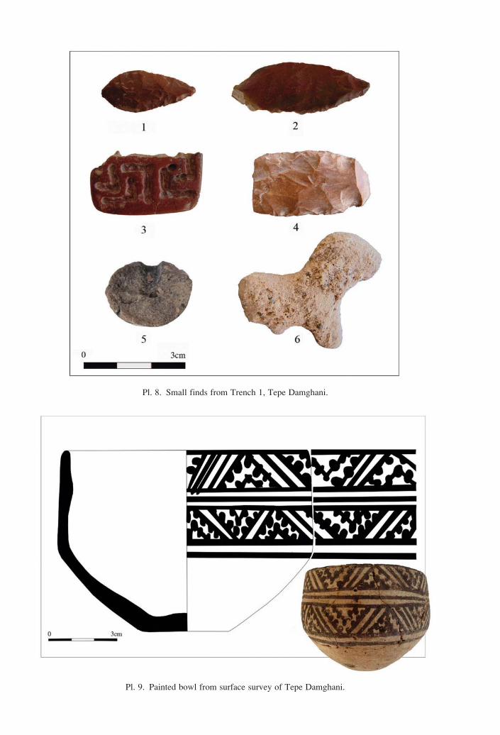
A number of stone arrowheads and a red stone stamp seal were also
obtained on the surface of the mound (Pl. 8). The stamp seal, which was
broken down the middle and only half of it was found, is rectangular and
has geometric designs drilled into its surface (Pl. 8, no. 3). In terms of
manufacturing technique, design and composition, the stamp seal of Tepe
Damghani is similar to a number of chlorite seals from Shahr-e Sokhta
(Sajjadi 2006: 151, fig 30; Lamberg-Karlovsky & Tosi 1989, fig 38) and
Altyn-Depe (Masson 1988: Pl. XVII, no. 7). Among the stone artifacts one
can point to a number of stone pestles, which were used for grinding.
96550.indb 133 25/02/14 13:48

134 HENRI-PAUL FRANCFORT ET AL.
These pestles were made from a type of smooth greenstone, which is found
abundantly in the mountains north of Sabzevar.
Among the clay objects, one can point to a small figurine of an animal,
possibly a zebu (Pl. 8, no. 6). A terracotta ‘drill head’ was also found, that
was broken and only half of it was recovered (Pl. 8, no. 5). Similar exam-
ples of this object have been reported found in several ancient sites of Iran,
including all three periods of Tepe Hissar (Schmidt 1937: Pl. XIV A, 117,
417(H2789), Tepe Esma’ilabad (Navai 1976: unpublished Mémoire de
l’Ecole du Louvre, fig 38) and Central Asia, including at Dashliji Depe
(Khlopin 1963: fig. XXII) as well as in period IB at Anau and were used
at least from the Chalcolithic until the late Bronze Age.
Fig. 7. Fragments of alabaster vessels from the surface of Tepe Damghani.
96550.indb 134 25/02/14 13:48

TEPE DAMGHANI SABZEVAR 135
In general, except for a bronze pin, probably a kohl stick that came from
Grave 2 (Pl. 6 and 7), no metal objects were found at Tepe Damghani. This
bronze pin, which was found near a stone vessel with cubical body and
cylindrical neck, was part of the grave-goods of Grave 2 in the Northern
section-cut of which part had been destroyed during road construction. The
shank of this pin is made of a twisted bronze bar and the head is pyramidal
flat, decorated with stepped lozenge. This stepped pattern is seen on a
number of the painted ceramics of Tepe Damghani (fig. 3; Pl. 9) and is
prevalent on the painted vessels of Namazga IV, Shahr-e Sokhta III, Mun-
digak III-IV and many of the other sites of northern Khorassan and south-
ern Central Asia. Very similar examples to this bronze pin are found in
Shahr-e Sokhta III (2500 to 2200 BC) (see for example Sajjadi 1374[1995]:
359, fig. 32; Sajjadi 2006: 152, fig. 152, g.3200/12) and some also reported
from Namazga V materials of Altyn-depe (Masson 1988: Pl. XXXVIII,
nos. 4-5).
Results of the archaeobotanical analysis
The excavation at Tepe Damghani in 2008 included sampling for
archaeobotanical remains in order to gain knowledge on the exploitation
and use of plant resources at the site during the Bronze Age. Tepe Hissar
in the Damghan plain, around 300 km west of Sabzevar, is so far the only
site in the Khorassan province that has been studied from an archaeobot-
anical point of view (Costantini and Dyson 1990) and Tepe Damghani
thus provided an excellent opportunity to complete our record from north-
eastern Iran. Moreover, the archaeological deposits excavated in Trench 1
were to a large extent favourable for conducting this type of analysis as
ashy layers, probably corresponding to domestic refuse, were frequent.
Such contexts are liable to contain the carbonised remains of wood used
for fuel, for example in domestic hearths and ovens, foodstuffs that came
into contact with fire by accident during cooking as well as intentionally
burnt refuse.
Samples were systematically collected from the various layers excavated
in Trench 1 resulting in 20 sediment samples corresponding to a total
volume of 1582.5 litres of soil. The size of individual samples varied
between 13 and 279 litres with a mean volume of 79 litres per sample. Nine
samples came from levels 2, 3 and 4 dated to Period II; eleven samples
96550.indb 135 25/02/14 13:48

136 HENRI-PAUL FRANCFORT ET AL.
belonged to levels 5 and 6 dated to Period III (Table 3). Finally one sample,
consisting of mineralised fruit remains, was manually collected from the
lowermost level 1 (Period I).
The sediment samples were treated by flotation in order to extract car-
bonised macroremains (wood, seeds and fruits). A flotation device, made
out of three empty petrol drums by a blacksmith in Sabzevar, was put up
on the site near Trench 1. Water drawn from a large basin used for irriga-
tion was recycled with the help of an electric pump. The heavy fraction
was recovered on a large sieve with a mesh size of 2 mm placed inside the
first flotation tank. Carbonised plant remains were recovered in a smaller
sieve with a 0.5 mm mesh. All of the samples except three (from US 7, 8
and 19) contained carbonised plant remains in variable quantities. Densi-
ties of seed/fruit remains vary from 0.1 remain/litre of sediment to 16
remains/litre (Table 3).
The analysis of the wood anatomical structure of 397 charcoal frag-
ments carried out with the help of a reflected-light microscope has allowed
the identification ten different woody taxa (Table 2, Pl.10). The most fre-
quently encountered wood type in the samples from Damghani is tamarisk
(Tamarix), a hardy tree or shrub that commonly grows on periodically
inundated soils but can withstand both drought and saline conditions. Char-
coals corresponding to shrubs from the goosefoot family (Chenopodi-
aceae), another group rich in halophilous species, are also met with in
many samples. Other taxa that are represented by a fair number of frag-
ments are the Russian olive or sea-buckthorn (Eleagnus/Hippophae), hack-
berry (Celtis) and pistachio (Pistacia). The remaining taxa are less fre-
quent, for example ash (Fraxinus) and oak (Quercus) occurring only
sporadically in samples from Period II.
In table 2 the identified taxa are tentatively grouped together in plant
formations according to their ecological characters, resulting in the distinc-
tion of two main vegetation types that were exploited for wood at
Damghani. Hygrophilous taxa, characteristic of humid conditions, domi-
nate the charcoal record in Period II (58%) and are frequent also in Period
III (46,1%). Riverine formations, or so-called gallery forests, thus seem to
have constituted an important source for fuel wood during the Bronze Age
and probably grew near the site. This result corroborates the hypothesis of
the presence of a permanent watercourse reaching Damghani in the past
(see above).
96550.indb 136 25/02/14 13:48

TEPE DAMGHANI SABZEVAR 137
An equally important group of plants, represented by 42% of the charcoal
fragments in Period II and 53,9% in Period III, would have grown in drier,
more steppic conditions and form open shrub- and woodlands. Of particular
interest are three arboreal taxa – hackberry, pistachio and oak – that do not
grow in the plain anymore but are common elements of woodlands, for
example in the Zagros mountain chains (Frey & Probst 1986). The mineral-
ised fruit stones (endocarps) of hackberry are identified from several con-
texts, especially in the levels of Periods I and II (Table 3). The fruits, globu-
lar drupes, are edible and may have been collected for food at Damghani or
brought in to the site together with wood. No fruit remains of pistachio have
so far been attested at the site even though these trees may also have pro-
vided edible fruits. Nutshell from pistachio (both true pistachio, P. vera, and
wild forms) have nevertheless been identified on other Bronze Age sites in
eastern Iran, such as Shahr-e Sokhta in Sistan-Baluchistan (Costantini et al.
2003), TepeYahya in Kerman (Costantini & Costantini-Biasini 1985) or in
southern Central Asia at Djarkutan in Uzbekistan (Miller 1999).
Among the more than 2500 identified seed/fruit remains from Tepe
Damghani fruits collected from the wild are not dominant though as the
majority of these plant remains belong to cultivated species (Table 3,
pl. 11).
Cereals are present in more than 80% of the samples and represent a
quarter of the identified remains. They appear in the lowermost samples
(except in the hand-picked sample from SU 40) and are present throughout
the sequence. Barley (Hordeum vulgare) is represented by both hulled and
free-threshing (var. nudum) types. The wheat is predominantly of the free-
threshing (“naked”) bread wheat type (Triticum aestivum) even though a
glume base of a more “primitive” hulled wheat taxa (Triticum dicoccum)
is also noted in a Period II sample. Only one pulse species, lentil (Lens
culinaris) is represented by a limited number of seeds found in two Period
II contexts.
Large quantities of grape pips (Vitis vinifera) are present in contexts
dated to Period III and are likely to represent the by-products of grape
pressing.
The remaining seed/fruit remains refer to wild species belonging to sev-
eral different botanical families, such as grasses (Poaceae) and wild pulses
96550.indb 137 25/02/14 13:48

138 HENRI-PAUL FRANCFORT ET AL.
(Fabaceae). They may in many cases correspond to weeds growing together
with the crops in the field from which they were separated and then burnt
during post-harvesting processing. The relatively numerous rachis remains
of barley and wheat found in the US 35 and 36 (Period II) are likely to cor-
respond to the cleaning of crops too. In general, the content of the archaeo-
botanical samples from Tepe Damghani is consistent with the interpretation
of these contexts as refuse layers associated with domestic structures.
Despite the small exposure during the excavation in 2008, archaeobot-
anical remains were rich at Tepe Damghani and show the potential for this
type of analysis on similar sites in northeastern Iran. The first results of the
charcoal study suggest an environment that was richer and more varied
than today including riverine formations, probably growing near the site,
as well as open woodlands on drier soils. Such vegetation types are not
present around Tepe Damghani anymore due to the arid climatic condi-
tions and especially the heavy impact of human activities in this area that
is today situated at the margin of the modern city.
The image of an agricultural economy based on the cultivation of free-
threshing wheat, barley and pulses is consistent with what has been found
on other 3rd millennium BC sites in eastern Iran as and southern Central
Asia (Miller 1999, 2003; Costantini & Costantini-Biasini 1985). The pres-
ence of grape remains is also a recurrent phenomenon from the Early
Bronze Age on sites in the Middle East reflecting the importance of fruit
growing practices and probably of wine production from this period on.
Animal exploitation at Tepe Damghani
The archaeozoological study of Tepe Damghani is among the rare exist-
ing faunal analysis for this part of Iran in general and more over for the
Bronze Age and Iron Age in northeastern part of Iran. A total of 4700
bones were recovered from 42 Stratigraphical Units of Trench 1. The ani-
mal bones and teeth were hand-picked and few bones were also recovered
during the botanical flotation and added to the main assemblage.
Animal bones like the botanical remains were recovered in a dump area
and as a result they were relatively abundant for the restricted area that was
excavated. The bones and teeth belong to butchery and consumption refuse
96550.indb 138 25/02/14 13:48

TEPE DAMGHANI SABZEVAR 139
showing typical indicators breaks, firing and cut marks. Some bones have
been gnawed or digested by carnivores and some bear rodent incisive
marks. This probably means that the material was probably exposed in the
dump area (Pl. 12: A, B, C). The faunal remains are differently preserved
in the stratigraphic units; the rate of unidentified bones fluctuates from
45% to 15% in some units, and upper layers seem to be better preserved.
It should also be noted that in the excavated section bones were covered
with a thin layer of concretion in all levels. A change is observed after
layer 39 towards the lower layers.
In order to analyze the evolution of subsistence economy during the
occupation of the site, the faunal remains were pooled together into three
units according to the chrono-cultural attribution of the stratigraphic units,
Early Namazga IV, Late Namazga IV and finally Late Bronze Age (BA)
and Yaz 2-3. The most abundant assemblage comes from the Early
Namazga IV(NISP = 1041) and decreases in the two other assemblages,
respectively to 647 and to 195 identified specimens. These figures are nev-
ertheless statistically valid and represent the general trend in the animal
exploitation during the cultural periods of the site.
The bulk of the faunal remains in all periods belong to small herbivores.
Caprini (sheep and goat) are highly dominant (between 93 to 98%).
According to morphological features most of these remains can be allo-
cated to domesticates. However some of them with diagnostic features
could be easily recognizable as wild specimens. In particular some frag-
ments of the horn cores show the presence of the wild sheep (Ovis
orientalis/O. vignei) and wild goat (Capra aegagrus).
Also noteworthy is the fact that in general the sheep outnumber goats
by a ratio of 2/1.
Gazelle bones are present in all SU groups by 1 to 3%. The species
present in this region is Gazella subgutturosa (Pl. 12: D, E). However the
presence of other proximate taxa, namely Saiga tatarica is not excluded.
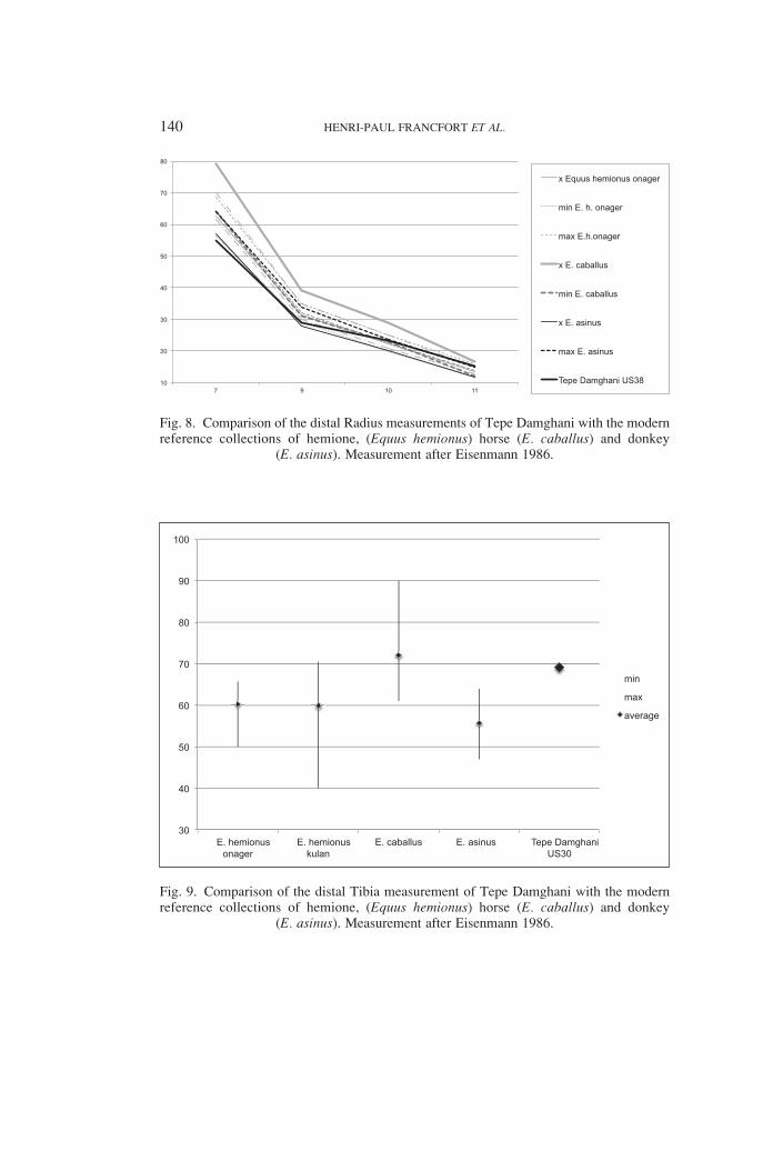
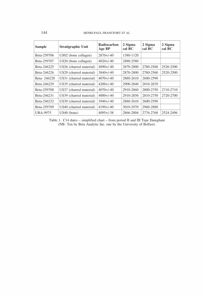
The Equids are scarcely present; they have been only identified in SU
38-26. The metric analysis for a distal radius in level 38 indicates that the
animal is either a hemione (Equus hemionus onager) or a donkey (Equus
asinus) (fig. 8).
96550.indb 139 25/02/14 13:48
140 HENRI-PAUL FRANCFORT ET AL.
Fig. 8. Comparison of the distal Radius measurements of Tepe Damghani with the modern reference collections of hemione, (Equus hemionus) horse (E. caballus) and donkey
(E. asinus). Measurement after Eisenmann 1986.
Fig. 9. Comparison of the distal Tibia measurement of Tepe Damghani with the modern reference collections of hemione, (Equus hemionus) horse (E. caballus) and donkey
(E. asinus). Measurement after Eisenmann 1986.
96550.indb 140 25/02/14 13:48

TEPE DAMGHANI SABZEVAR 141
It is not possible at this point to go further in the analysis. Another bone,
a distal tibia was found in upper layers and is more compatible with the
horse measurements (fig. 9).
Cattle remains are very badly represented in the assemblage (between 1
to 3%). They seem to be more abundant in basal layers. The size of the
bones is very small. The presence of the Zebu is not excluded.
Turtle bones are present only in SU 38-26. According to the morpho-
logical features of the shells it belongs to the Testudo graeca.
No fish or small bird bone has been identified among the remains, even
though flotation has been systematically performed.
The animal subsistence economy in Tepe Damghani is highly dependent
on pastoralism. The main domesticates are the sheep and goat with a clear
preference for sheep in the three cultural periods. Hunting of gazelles
seems to have been a more or less constant activity although not so impor-
tant; As well as the hunting of wild goat and sheep, in the foothills. The
probable presence of horse in the late Namazga IV period is one of the
interesting highlights of this study.
Fig. 10. Distribution of economically important species in the three cultural periods of Tepe Damghani.
96550.indb 141 25/02/14 13:48

142 HENRI-PAUL FRANCFORT ET AL.
The geo-archaeological study of the site and its environment conducted
during the field season tackled the issue of the water resources in the area
since the Bronze Age (Fouache et al., 2010). A geomorphological survey
evidenced that the Plio-Quaternary horst of Sabzevar played a significant
role in providing water in the whole area from the Bronze Age. At the back
of the horst, a graben has been discovered, housing an important water
table in its Quaternary alluvium: the overflowing of the water table pro-
vided a perennial flow of water for the site during the Bronze Age within
the Kal-e Shur river system. The development of the qanât system (prob-
ably dug during the Achaemenid period) allowed irrigation of the whole
hillfoot of the Sabzevar horst, but in return provoked a lowering of the
water table level, that massive pumping worsened; this level is currently
to approximately 150 m of average depth.
Conclusions
In sum, the preliminary conclusions resulted from the first season of
sounding at Tepe Damghani and investigation of nearby areas shows that
the residents of the region of Sabzevar during the third millennium BC
settled in parts of the plain in which the exploitation of surface water was
possible. At this time, the environment of the area was richer and more
varied than it is today and that the types of riparian, steppe and steppe for-
est formations were growing and the subsistence economy of the plain’s
residents was firmly based on cultivation of cereal crops (wheat and bar-
ley) and livestock (sheep and goats). However, the presence of fruits and
seeds of wild types of plants such as pistachio and hackberries and also the
bones of the wild sheep and wild goat, gazelle, and Persian onager shows
that the Bronze Age residents of Tepe Damghani exploited several type of
ecological zones in the surrounding of the site, including the piedmonts
and steppe natural resources.
The presence in the site of various stone vessels and artifacts from ala-
baster, serpentine, ophiolite and other colored stones, sources of which are
in the region (some of which we visited), show that the residents of Tepe
Damghani extracted stone from local mines and used it to manufacture
various types of vessels and tools, although during this season no work-
shop area was uncovered. On the other hand, the similarity of the pottery
from different archaeological layers as well as surface finds from Tepe
Damghani with those of Shahr-e Sokhta III, Mundigak IV and Namazga
96550.indb 142 25/02/14 13:48

TEPE DAMGHANI SABZEVAR 143
IV and some of the other sites in northern Greater Khorassan across the
border in today’s Turkmenistan, is indicative of the cultural connections
and exchange between these nearby regions. As we described above, these
similarities can also be seen in the stone chipping industry, glyptic and
metalworking technologies.
Undoubtedly, the strategic geographical location of Sabzevar on the
major trading road between east and west and the richness of the region in
terms of its mineral sources and deposits (ophiolitic belt of Sabzevar and
the turquoise mines of Nishapur) are among the major factors which caused
this region in general and Tepe Damghani in particular to play a role in the
expanding exchange network during the third millennium BC. Obviously,
in the future, with further investigations in the region, we will be able to
answer many questions regarding the connections between east and west
and the nature of the cultural interaction between Iran and Central Asia
during the Bronze and Iron Ages.
Acknowledgements
This project was done under the auspices of the Iranian Center for
Archaeological Research (ICAR) and benefited from the financial support
of the French Ministry of Foreign affairs under the MAFAC program
(director Henri-Paul Francfort). Mohsen Dana, Sa’id Shanjamali and
Mohammad Abdullahzadeh and M. Mottaghi, topographer, were partici-
pating in the fieldwork. A preliminary translation of the first part of this
paper from Persian to English was undertaken by Kyle G. Olson from Ohio
State University. Dr. Christopher P. Thornton from University of Pennsyl-
vania Museum kindly read the paper, gave useful comments and polished
the final text. We would like to gratefully acknowledge all the people who
have helped us to accomplish this project, especially Dr. Hasan Fazeli
(then director of ICAR, Tehran); Mr. A. Mokarramifar (then director of
ICHHTO, Mashad) and Mr. Bakhtiari (ICHHTO office, Mashad).
96550.indb 143 25/02/14 13:48
144 HENRI-PAUL FRANCFORT ET AL.
Sample Stratigraphic UnitRadiocarbon Age BP
2 Sigmacal BC
2 Sigmacal BC
2 Sigmacal BC
Beta-259706 US02 (bone collagen) 2870+/-40 1380-1120
Beta-259707 US20 (bone collagen) 4020+/-40 2880-2580
Beta-246225 US26 (charred material) 4090+/-40 2870-2800 2780-2560 2520-2500
Beta-246226 US29 (charred material) 3840+/-40 2870-2800 2780-2560 2520-2500
Beta- 246228 US31 (charred material) 4070+/-40 2880-2610 2600-2590
Beta-246229 US35 (charred material) 4200+/-40 2900-2840 2810-2670
Beta-259708 US37 (charred material) 4070+/-40 2910-2860 2800-2750 2710-2710
Beta-246231 US39 (charred material) 4000+/-40 2910-2850 2810-2750 2720-2700
Beta-246232 US39 (charred material) 3940+/-40 2880-2610 2600-2590
Beta-259709 US40 (charred material) 4190+/-40 3010-2970 2960-2880
UBA-9975 US40 (bone) 4095+/-38 2866-2804 2776-2768 2524-2496
Table 1. C14 dates – simplified chart – from period II and III Tepe Damghani (NB: Ten by Beta Analytic Inc. one by the University of Belfast).
96550.indb 144 25/02/14 13:48

TEPE DAMGHANI SABZEVAR 145T
ren
ch1
Per
iod
IIII
I
Lev
el2
34
NA
%5
6N
A%
Sta
tigra
ph
ical
Un
it (
SU
)40
39
38
37
36
35
33
31
30
29
26
24
23
20
15
93
Sam
ple
n°
24
25
23
20
18
17
22
14
12
10
9
8
7
5
41
Riv
erin
eR
uss
ian o
live/
Sea
buck
thorn
Ela
eagnus/
Hip
pophae
1
2
1
7
3
2
1
12
29
10,8
% 2
3
5
3,9
%
fore
stA
shF
raxi
nus
2
2
4
1,5
%0,0
%
Popla
rP
opulu
s 2
2
2
4
2
1
2
15
5,6
% 2
2
1,6
%
Tam
aris
kT
am
ari
x 1
11
10
13
10
12
18
11
12
10
108
40,1
%21
22
1
17
10
2 73
57,0
%
Tota
l ri
ver
ine
fore
st
213
12
14
21
17
24
14
25
14
156
58,0
%24
1
22
10
2 59
46,1
%
Open
shru
b-
Hac
kber
ryC
elti
s 2
7
1
3
1
3
17
6,3
% 5
2
1
5
10
1 24
18,8
%
and w
oodla
nds
Goose
foot
fam
ily
Chen
opodia
ceae
2
14
1
5
6
11
5
3
11
21
79
29,4
% 6
2
1
5
14
10,9
%
Wolf
ber
ryL
yciu
m 1
1
3
5
10
3,7
% 1
1
2
1,6
%
Conif
erous
wood
Pin
ophyt
a 1
1
0,8
%
Pis
tach
ioP
ista
cia
1
1
2
2
6
2,2
% 5
4
1
10
8
28
21,9
%
Oak
Quer
cus
1
1
0,4
%
Tota
l open
shru
b-
and w
oodla
nds
2
17
8
6
9
13
5
6
15
32
113
42,0
%17
9
3
20
19
1 69
53,9
%
TO
TA
L
430
20
20
30
30
29
20
40
46
269
100%
17
33
4
42
29
12
128
100%
Tab
le 2
. R
esult
s of
the
char
coal
anal
ysi
s at
Tep
e D
amghan
i ex
pre
ssed
in a
bso
lute
(N
) an
d r
elat
ive
(%)
num
ber
s of
char
coal
fra
gm
ents
iden
tifi
ed f
or
each
tax
on.
96550.indb 145 25/02/14 13:48

146 HENRI-PAUL FRANCFORT ET AL.
Tre
nch
1
N%
Per
iod
III
III
Lev
el1
%
23
4
N%
56
Str
ati
gra
ph
ical
Un
it (
SU
)40
39
38
37
36
35
33
31
30
29
26
24
23
20
15
95
3
Sam
ple
n°
24
25
23
20
18
17
22
14
12
10
98
75
421
1
Volu
me
bef
ore
flo
tati
on
(l)
/63
54
58
48
23
104
50
202,5
279
90
46
13
135
162
28
20
153
Volu
me
aft
er f
lota
tion
(m
l)/
23
13
10
55
80
50
20
300
730
73
20
180
50
15
10
30
Den
sity
of
see
d/f
ruit
rem
ain
s (v
ol/
N)
/0,1
90,1
30,2
13,1
316,2
61,0
80,9
20,9
60,5
53,7
70,9
30,0
85,0
82,1
90,0
70,8
50,4
Cer
eals
Nak
ed b
arle
yH
ord
eum
vulg
are
var
. nudum
1
7
8
0,8
%
Hull
ed b
arle
yH
ord
eum
vulg
are
2
2
4
0,4
% 1
1
0,1
%
Bar
ley,
undet
erm
ined
" 2
8
2
3
14
17
46
4,3
% 3
1
1 7
12
0,8
%
Bar
ley:
rach
is
segm
ent
" 37
148
1
33
31
250
23,6
% 3
3
0,2
%
Em
mer
whea
t:
glu
me
bas
e
Tri
ticu
m c
f dic
occ
um
1
1
0,1
%
Nak
ed w
hea
tT
riti
cum
aes
tivu
m/d
uru
m
1
1
1
4
2
9
0,8
%
Bre
ad w
hea
t:
rach
is s
egm
ent
Tri
ticu
m c
f aes
tivu
m
1
12
1
1
15
1,4
% 2
2
0,1
%
Whea
t,
undet
erm
ined
Tri
ticu
m s
p.
2
1
3
0,3
% 1
1
2
0,1
%
Whea
t: r
achis
segm
ent
" 9
16
3
1
1
2
32
3,0
%
Cer
eals
Cer
eali
a 4
2 1
12
67
22
2
44
34
188
17,7
% 16
33
6
1
56
3,7
%
96550.indb 146 25/02/14 13:48

TEPE DAMGHANI SABZEVAR 147
Cer
eals
:
rach
is s
egm
ent
" 9
16
8
3
36
3,4
% 3
3
0,2
%
Cer
eals
: node
" 1
1
0,1
% 1
1
0,1
%
Puls
esL
enti
lL
ens
culi
nari
s 4
4
8
0,8
%
Fru
it s
pec
ies
Hac
kber
ryC
elti
s17
100%
4
1 2
5
30
13
55
5,2
% 4
4
0,3
%
Russ
ian o
live
Ela
eagnus
4
1
5
4
14
1,3
%
Gra
pe
Vit
is v
inif
era
2
3
5
0,5
%195
23
558
179
8
963
64,0
%
Wil
d g
rass
esG
oat
face
gra
ss:
spik
elet
bas
e
Aeg
ilops
sp.
1
1
3
5
0,5
%
Gra
sses
,
undet
erm
ined
Poace
ae
3
1 6
4
8
2
1
7
4
36
3,4
% 5
2
7
14
0,9
%
Gra
sses
:
rach
is
segm
ents
" 1
1
0,1
% 1
1
0,1
%
Wil
d p
uls
esW
ild p
uls
es,
undet
erm
ined
Fabace
ae
1
3 3
45
72
65
1
23
32
245
23,1
% 62
14
15
38
2
131
8,7
%
Var
ious
Atr
iple
x 4
2
9
15
1,4
% 1
1
0,1
%
Bora
gin
ace
ae
type
1
7
1
2
3
13
1,2
% 55
49
104
6,9
%
Cary
ophyl
lace
ae
3
3
6
0,6
% 16
19
4
39
2,6
%
Goo
sefo
ot
fam
ily,
undet
erm
ined
Chen
opodia
ceae
3
2
2
2
7
16
1,5
% 11
1
21
4
213
52
3,5
%
Gali
um
sp.
4
1
1
6
0,6
%
Poly
gonace
ae
1
1
2
0,2
%
Thym
elaea
sp.
3
1
1
17
19
41
3,9
% 21
2
26
66
115
7,6
%
Tota
l17
100%
12
712
150
374
112
46
194
154
1061
100,0
%339
43
1686
355
217
61
1504
100%
Tab
le 3
. R
esult
s of
the
seed
/fru
it a
nal
ysi
s at
Tep
e D
amghan
i ex
pre
ssed
in a
bso
lute
(N
) an
d r
elat
ive
(%)
num
ber
s of
rem
ains
iden
tifi
ed f
or
each
tax
on.
96550.indb 147 25/02/14 13:48

148 HENRI-PAUL FRANCFORT ET AL.
Taxa
Earl
y N
MG
4/
Dam
gh
an
i II
Late
NM
G4/D
am
gh
an
i II
IL
ate
BA
/ Y
az
2-3
/Dam
gh
an
i IV
Tota
l
NF
%N
F%
NF
%N
F
Capri
ni
(Shee
p/G
oat
) 799
76,8
547
84,5
147
75,4
1493
Capra
(G
oat
) 75
7,2
32
4,9
10
5,1
117
Ovi
s (S
hee
p)
95
9,1
57
8,8
29
14,9
181
Bos
(Cat
tle)
24
2,3
5
0,8
1
0,5
30
Ovi
s cf
ori
enta
lis
(Wid
shee
p)
2
0,2
0
0,0
0
0,0
2
Capra
aeg
agru
s (W
ild g
oat
) 2
0,2
0
0,0
0
0,0
2
Gaze
lla (
Gaz
elle
) 21
2,0
6
0,9
8
4,1
35
Equus
(Hors
e, H
emio
ne,
Ass
, H
ybri
ds)
10
1,0
0
0,0
0
0,0
10
Tes
tudo g
raec
a (
Gre
ek T
ort
ois
e) 13
1,2
0
0,0
0
0,0
13
Tota
l 104
1100,0
0647
100,0
0195
100,0
01883
Sm
all
Rum
inan
t (C
apri
ni,
Gaze
lla)
305
297
83
685
Lar
ge
Mam
mal
(B
os,
Equus,
Cam
elus)
201
12
7
220
Med
ium
Mam
mal
(D
og/S
hee
p s
ize)
624
203
113
940
Unid
enti
fied
spec
imen
s 418
450
122
990
Tota
l 1548
962
325
2835
Tab
le 4
. F
aunal
spec
tra
of
Tep
e D
amghan
i.
96550.indb 148 25/02/14 13:48

TEPE DAMGHANI SABZEVAR 149
References:
AMBRASEYS, N.N. & MELVILLE C.P., 1982. A History of Persian Earthquakes, Cambridge: Cambridge University Press.
BAYHAQI, M., 1386/2007. The Great Encyclopaedia of Sabzevar, vol. 2, Tehran: Sonboleh Publishers (in Persian).
CASAL, J.M., 1961. Fouilles de Mundigak (=Mémoire de la délégation Archéo-logique française en Afghanistan, Tome 17/2), Paris.
COSTANTINI, L. & COSTANTINI-BIASINI, L., 1985. Agriculture in Baluchistan between the 7th and the 3rd millennium BC. Newsletter of Baluchistan Studies 2: 16-30.
COSTANTINI, L., COSTANTINI-BIASINI, L. & SAJJADI, S.M.S., 2003. Le spezienella documentazione archeologica: coriandolo, cumino e terebinto nel sito protos-torico di Shahr-i Sokhta, Sistan, Iran. In Aromatica. Essenze, profumi e spezie tra Oriente e Occidente.Elio de Rosa editore, Rome: 37-40.
COSTANTINI, L. & DYSON, R.H., 1990. The Ancient Agriculture of the Damghan Plain: The Archaeobotanical Evidence from Tepe Hissar, in: Miller N.F (ed.) Economy and Settlement in the Near East. MASCA Research Papers in Science and Archaeology, Supplement to Vol. 7, Philadelphia: 46-64.
EISENMANN, V., 1986. Comparative Osteology of Modern and Fossil Horses, Half-asses, and Asses, in: Meadow R.H. & Uerpmann H-P. (eds.), Equids in the Ancient World, vol. 1. Wiesbaden: 67-116.
FATTAHI, M. & WALKER R., 2007. Luminescence dating of the last earthquake of the Sabzevar thrust fault, NE Iran, Quaternary Geochronology 2: 284-289.
FOUACHE, E., FRANCFORT, H.-P., BENDEZU-SARMIENTO, J., VAHDATI, A. & LHUILLIER, J., 2010, “The Horst of Sabzevar and Regional Water Resources from the Bronze Age to the Present Day (Northeastern Iran)”, Geodinamica Acta 25 (3-6): 287-294.
FRANCFORT, H.-P. avec des contributions de, Boisset, Ch., Buchet, L., Desse, J., Echallier, J.-C., Kermorvant, A. & Willcox, G., 1989, Fouilles de Shortughaï: recherches sur l’Asie centrale protohistorique, Mémoires de la Mission Archéologique Française en Asie centrale, vol. II, Paris, Diffusion de Boccard.
FREY, W. & PROBST, W., 1986. A synopsis of the vegetation of Iran, in: Kürsch-ner H. (ed.) Contributions to the vegetation of Southwest Asia. Beihefte zum Tübinger Atlas des Vorderen Orient, Reihe A (Naturwissenschaften) 24, Wies-baden: 9-43.
GOUIN, Ph., 1992. Rapes, jarres et faisselles: la production et l’exportation des produits laitiers dans l’Indus du 3e millénaire, Paléorient 16/2: 38-57.
KHLOPIN, I.N., 1959. Verhknij sloj poselenija Kara-depe (po materialam JuTAKE v 1956 g), Kratkie Soobscenija Instituta Istorii Material’noj Kul’tury 76: 42-49.
KOHL, Ph.L., 1984. Central Asia: Palaeolithic Beginnings to the Iron Age. Paris: Editions Recherche sur les civilisations.
KOHL, Ph.L., BISCIONE, R. & INGRAHAM, M.L., 1982. Implications of recent evi-dence for the Prehistory of Northeastern Iran and Southwestern Turkmenistan, Iranica Antiqua 17: 1-20.
96550.indb 149 25/02/14 13:48

150 HENRI-PAUL FRANCFORT ET AL.
KIRCHO, L.B., 1999. K izucheniju pozdnego eneolita juzhnogo Turkmenistana. Saint-Pétersbourg, Instituta Istorii Material’noj Kul’tury Rossiskaia Akademiia Nauka.
LAMBERG-KARLOVSKY, C.C. & TOSI, M., 1989. Shahr-i Sokhta and TepeYahya: Tracks on the Earliest History of the Iranian Plateau, East and West 23: 21-58.
MASSON, V.M., 1960. Kara-Depe u Artykha, Trudy Juzno-Turkmenskaja Arxeo-logiceskaja Kompleksnaja Ekspedicija, Vol.10: 319-463.
—, 1988. Altyn-Depe. Philadelphia: University Museum of Archaeology and Anthropology, University of Pennsylvania.
MILLER, N.F., 1999. Agricultural development in western Central Asia in the Chalcolithic and Bronze Ages, Vegetation History and Archaeobotany 8: 13-19.
—, 2003. The use of plants at Anau North, in: Hiebert F.T. (ed.), A Central Asian village at the dawn of civilization, excavations at Anau, Turkmenistan, Univer-sity Museum Monograph 116, University of Pennsylvania Museum of Archae-ology and Anthropology, Philadelphia: 127-138.
SAJJADI, S.M.S., 1374/1995. Archaeology and History of Sistan and Baluchestan, Tehran: ICHTO press (in Persian).
—, 2006. Excavation at Shahr-i-Sokhta, Shahr-i-Sokhta Centre for Archaeological research, Zabol.
SANTONI, M., 1981. Sibri and the South Cemetery of Mehrgarh: Third Millennium Connections between the Northern Kachi Plain (Pakistan) and Central Asia, in: Allchin B. (ed.), South Asian Archaeology 1981, Cambridge: 52-60.
SARIANIDI, V.I., 1998. Margiana and Protozoroastrism. Athènes: Kapon Editions.SCHMIDT, E.F., 1937. Excavations at Tepe Hissar, Damghan, Philadelphia: The
University Museum.TENGBERG, M., VAHDATI, A.A., FRANCFORT, H.-P. & SHIRAZI, Z., 1389/2011.
Preliminary report on Archaeobotanical studies at Tepe Damghani, Spring 2008, Iranian Journal of Archaeology and History, Vol. 25, No. 1: 10-16 (in Persian with English summary).
VAHDATI, A., FRANCFORT, H.-P., FOUACHE, E., TENGBERG, M. & MASHKOUR, M., 2010, Preliminary report on the soundings at Tappeh Damghani, Sabzevar, Bastanshenasi, 24 (2): 17-36 (in Persian).
96550.indb 150 25/02/14 13:48

TEPE DAMGHANI SABZEVAR 151
Pl.
1.
Gen
eral
vie
w o
f T
epe
Dam
ghan
i sh
ow
ing l
oca
tion o
f T
rench
1,
vie
w f
rom
the
South
.
96550.indb 151 25/02/14 13:48

152 HENRI-PAUL FRANCFORT ET AL.
Pl. 2. A view of Trench 1 before excavation.
Pl. 3. General view of the N section on the edge of Delqand Road after cleaning, view from the N.
96550.indb 152 25/02/14 13:48

TEPE DAMGHANI SABZEVAR 153
Pl. 4. General view of grave 2 after cleaning (N.B. lower part of the grave and the skeleton has been destroyed during construction of Delqand Road).
Pl. 5. Position of skeleton in grave 2.
96550.indb 153 25/02/14 13:48

154 HENRI-PAUL FRANCFORT ET AL.
Pl. 6. Cubic stone vessel and bronze pin of grave 2 in situ.
Pl. 7. Stone vessel and bronze pin from grave 2.
96550.indb 154 25/02/14 13:48
Pl. 8. Small finds from Trench 1, Tepe Damghani.
Pl. 9. Painted bowl from surface survey of Tepe Damghani.
96550.indb 155 25/02/14 13:48

156 HENRI-PAUL FRANCFORT ET AL.
Pl.
10.
SE
M p
hoto
gra
phs
of
char
coal
fra
gm
ents
fro
m T
epeD
amghan
i: a
. R
uss
ian o
live/
Sea
buck
thorn
(E
laea
gnus/
Hip
pophae)
; b.
Wolf
ber
ry (
Lyc
ium
sp.)
; c.
Tam
aris
k (
Tam
ari
x sp
.);
d.
Pis
tach
io (
Pis
taci
a s
p.)
; e.
Hac
kber
ry (
Cel
tis
sp.)
.
96550.indb 156 25/02/14 13:48

TEPE DAMGHANI SABZEVAR 157
Pl. 11. Seed and fruit remains from Tepe Damghani: a. Dorsal, lateral and ventral view of barley grain (Hordeum vulgare, SU 35); b. Rachis segments, free-threshing, six-row barley (H. vulgare subsp. hexastichum var. nudum, SU 35); c. Rachis segment, free-threshing wheat of bread wheat type (Triticum aestivum, SU 31); d. Ventral and dorsal view, grape seed (Vitis vinifera, SU 26); e. Mineralised fruit stone of hackberry (Celtis sp., SU 40).
96550.indb 157 25/02/14 13:48

158 HENRI-PAUL FRANCFORT ET AL.
Pl. 12. A & B- Second phalanx of a caprini from US 20, digested and bearing rodent incisive marks.
C- A digested cubonavicular of a caprini from US 40.D- A Distal Humerus (US 36) and Metapodial (US 26) of Gazella.
96550.indb 158 25/02/14 13:48
Copyright © 2022 FDOKUMEN