Kids observing other kids’ hands: Visuomotor priming in children
Upload
khangminh22Category
view
1download
0
World Hydrological Cycle Observing System (WHYCOS)
IGAD-HYCOS Project Document
WHYCOS No. 1


© 2004, World Meteorological Organization
NOTE
The designations employed and the presentation of material in this publication do not imply the expression of any opinion whatsoever on the part of the Secretariats of the World Meteorological Organization, the European Commission and the Intergovermental Authority on Development concerning the legal status of any country, territory, city or area, or of its authorities, or concerning the delimitation of its frontiers or boundaries.


IGAD-HYCOS PROJECT DOCUMENT
iii
CONTENTS List of abbreviations ……………………….……………………………………………………… vi Executive summary ………………………………………………………………………………. vii 1. Structure and mission of the Intergovernmental Authority on Development (IGAD) ………………………………………………………………………. 1 2. Information on the participating IGAD countries ……………………………………. 6
2.1 Djibouti………………………………………………………………………………... 6 2.1.1 Geography and climate…………………………………………………….. 6 2.1.2 Socio-economic structure …………………………………………………. 6
2.2 Eritrea ………………………………………………………………………………… 8 2.2.1 Geography and climate ……………………………………………………. 8 2.2.2 Socio-economic structure …………………………………………………. 8
2.3 Ethiopia ………………………………………………………………………………. 9 2.3.1 Geography and climate ……………………………………………………. 9 2.3.2 Socio-economic structure …………………………………………………. 11
2.4 Kenya ………………………………………………………………………………… 12 2.4.1 Geography and climate ……………………………………………………. 12 2.4.2 Socio-economic structure ……………………………………………….... 13
2.5 Sudan ………………………………………………………………………………… 15 2.5.1 Geography and climate ……………………………………………………. 15 2.5.2 Socio-economic structure …………………………………………………. 18
2.6 Uganda………………………………………………………………………...……... 19 2.6.1 Geography and climate …………………………………….……………... 19 2.6.2 Socio-economic structure. ………………………………………………... 22
3. Water resources ……………………………………………………………………….…… 23
3.1 Overview of water resources in the region ………………………………………. 23 3.2 Djibouti ……………………………………………………………………………….. 24 3.3 Eritrea ………………………………………………………………………………… 25 3.4 Ethiopia …………………………………………..………………………………….. 25 3.5 Kenya ………………………………………………………………………………… 28 3.6 Sudan ………………………………………………………………………………… 30 3.7 Uganda ………………………………………………………………………………. 33
4. National Hydrological Services in the IGAD countries……………..……………….. 33 4.1 Ethiopia ………………………………………………………………………………. 33
4.1.1 Legislative and institutional framework …………………………………. 33 4.1.2 National Hydrological Service ……………………………………………. 34
4.1.2.1 Organization and management………………………………… 34 4.1.2.2 Personnel…………………………………………..…………….. 35 4.1.2.3 Budget…………………………………………………………….. 35 4.1.2.4 Data collection and management ……………………………... 36 4.1.2.5 Water resources studies, drought and flood management …..………………………………………………… 38 4.1.2.6 Water-quality monitoring………………………………………… 38
4.2 Kenya ………………………………………………………………………………… 39 4.2.1 Legislative and institutional framework ………………………………….. 39 4.2.2 National Hydrological Service …………………………………………….. 40
4.2.2.1 Organization and management ……………………………….. 40 4.2.2.2 Personnel ………………………………………………………… 41 4.2.2.3 Budget ……………………………………………………………. 42 4.2.2.4 Data collection and management …….……………………… 42

IGAD-HYCOS PROJECT DOCUMENT iv
4.3 Sudan ………………………………………………………………………………… 47 4.3.1 Legislative and institutional framework ………………………………….. 47 4.3.2 National Hydrological Service …………………………………………….. 47
4.3.2.1 Organization and management ……………………………… 48 4.3.2.2 Personnel ………………………………………………………… 48 4.3.2.3 Budget ……………………………………………………………. 48 4.3.2.4 Data collection and management ……………………………… 48
4.4 Uganda ………………………………………………………………………………. 51 4.4.1 Legislative and institutional framework ….………………………………. 51 4.4.2 National Hydrological Service ……………………………………………. 53
4.4.2.1 Organization and management ……………..………………… 53 4.4.2.2 Personnel ………………………………………………………… 55 4.4.2.3 Budget ……………………………………………………………. 56 4.4.2.4 Data collection and management …………………………….. 56
4.5 Comparison of NHSs in the IGAD region …….…………………….……..…….. 57 4.6 Regional and international cooperation in the IGAD region …………………… 60
5. Interventions ...........................................................................................................… 62
5.1 Need for intervention ………………………………………………………………. 62 5.2 Project proposal …………………………………………………………………….. 63 5.3 Project goals, purposes and components ……………………………………….. 63 5.4 Project management ……………………………………………………………….. 64
5.4.1 Regional Steering Committee (RSC) …………………………………….. 65 5.4.2 Implementing agency ………………………………………………………. 65 5.4.3 Participating countries …………………………………………………..… 67 5.4.4 Project Regional Centre (PRC) …………………………………………… 67 5.4.5 World Meteorological Organization (WMO) …………………………...… 68 5.4.6 IGAD Secretariat …………………………………………………………… 69 5.4.7 Project Management Unit (PMU) ………………………………………… 69
6. Project implementation …………………………………………………………………… 70
6.1 Identification of a regional centre …………………………………………………. 70 6.2 Creation of the Project Management Unit (PMU) ……………………………….. 71 6.3 IGAD-HYCOS network identification ……………………………………………… 73 6.4 Types of variables to be monitored, frequency of measurement and equipment …………………………………………………………………………… 74 6.5 Contribution of the National Hydrological Services to implementation and
operation of the project ………………………………..…………………………… 75 6.6 Integrated regional database, Web site and national databases ……………… 76 6.7 Data validation and communication ………………………………….. 76 6.8 Infrastructure mainte ……...………………………………………………………… 76 6.9 Capacity-building ……………………………………………………………………. 77 6.10 Cooperation with other HYCOS Regional Centres ……………………………… 77 6.11 Performance indicators and overall project progress assessment…………….. 77 6.12 Project evaluation …………………………………………………………………… 78
7. Reliability and sustainability of the IGAD-HYCOS project ……………….......……. 78 8. Instrument identification and proposed budget for the IGAD-HYCOS project ……………………………………………………………………… 80
8.1 General recommendations …………………………………………………………. 80 8.2 Instruments required ………………………………………………………………. 80

IGAD-HYCOS PROJECT DOCUMENT
v
8.3 Identified river, groundwater and meteorological observation sites …………… 84 8.3.1 Djibouti …………………………………………………………………….… 84 8.3.2 Eritrea ……………………………………………………………………….. 87 8.3.3 Ethiopia ……………………………………………………………………… 89 8.3.4 Kenya ……………………………………………………………………….. 90 8.3.5 Sudan ……………………………………………………………………….. 92 8.3.6 Uganda ………………………………………………………………………. 93
8.4 Proposed budget for the IGAD-HYCOS project …………………………………. 97 8.5 Budget summary ……………………………………………………………………. 98
9. References ………………………………………………………………………………….. 99 Annexes 1. Project planning matrix (logistical framework)………………………...……………….. 100 2. Tender specifications for instrumentation for the IGAD-HYCOS project .…………… 102 3. Job descriptions of the professionals of the Project Management Unit ……………… 126

IGAD-HYCOS PROJECT DOCUMENT vi
List of abbreviations DCP Data Collection Platform DMC Drought Monitoring Centre DMCH Drought Monitoring Centre Harare DMCN Drought Monitoring Centre Nairobi ESA External Support Agency FAO Food and Agricultural Organization of the United Nations GSM Global System for Mobile communications HYCOS Hydrological Cycle Observing System IGAD Intergovernmental Authority on Development ITCZ Intertropical convergence zone NGO Non-governmental organization NHS National Hydrological Service NMS National Meteorological Service PMU Project Management Unit PRC Project Regional Centre PSC Project Steering Committee (synonymous with RSC) RSC Regional Steering Committee SADC Southern African Development Community WMO World Meteorological Organization WRAP Water Resources Assessment Project

IGAD-HYCOS PROJECT DOCUMENT vii
Executive summary The Intergovernmental Authority on Development (IGAD) is an intergovernmental institution, bringing together Djibouti, Eritrea, Ethiopia, Kenya, Somalia, Sudan and Uganda, with the long-term goal of promoting sustainable economic development in its member countries. This project involves only six of these countries, as the current situation in Somalia prevents any activities in that country for the time being. IGAD countries occupy an area of about 5.2 million square kilometres with a population of about 160 million inhabitants. Most of the countries have arid or semi-arid climates, and available water resources are unevenly distributed and irregular in space and time, notwithstanding the presence of major African rivers, such as the Nile, and several lakes. A number of serious droughts have affected the region during the past several decades, with dramatic human, economic and ecological consequences. Annual renewable per capita fresh-water resources are also quite variable, with only Ethiopia, Sudan and Uganda above the threshold of 1 720 cubic metres per person per year. However, by 2015 all the IGAD countries will be below this threshold and experience severe water shortages. Despite this expected critical situation and the likelihood of water scarcity, the region's water resources remain largely undeveloped. Although there are hydroelectric plants and irrigation and water supply schemes in the region, demand for derived services and the potential for future development remain relatively high. The seasonal and spatial distribution of rainfall further complicates the situation. Most of the countries have a short rainy season with intense rainfall. The resulting flash floods cause devastating damage and loss of life, further aggravated by a lack of mitigation measures and advanced knowledge about their occurrence. Intensive subsistence farming and large numbers of livestock lead to land degradation. This is further exacerbated by the farming of marginal steep-sloped agricultural land that depends on rainfall. The search for firewood as a source of energy endangers forested areas and together with agricultural practices leads to high soil loss and erosion, resulting in food shortages during droughts. Existing waterworks capacities and designs are threatened, and deficient supplies of domestic and industrial water inhibit economic growth and affect the well-being of people. Examples of sufficient reforestation are few, while pressure on land utilization and a lack of proper land management contributes to desertification. Water resources are an important transboundary issue, as at least 60 per cent of the total area in the IGAD countries is in international water basins. This calls for judicious cooperation and equitable development and management of shared water resources, particularly between upstream and downstream countries. Up until now, the importance of groundwater as an integral part of the hydrological cycle had not been recognized and had not been included in a HYCOS project. Groundwater sustains life in rural areas throughout the world, releasing temporarily stored surface water into rivers during dry seasons. Groundwater is especially important in Djibouti and part of Eritrea. Due to very low rainfall in Djibouti, erratic response of rivers, extended periods of drought and an extremely hot climate, storage of surface water may be unfeasible. Greater emphasis should be placed on gaining management information about groundwater resources for its sustainable use and protection of its quality. It is proposed to gather groundwater management information only in Djibouti and Eritrea, but this in no way suggests that groundwater is not important in the other participating countries. The project proposes to focus on surface water in the other countries, primarily to ensure that the project is feasible and manageable, addressing current capacity-building needs through the introduction of modern technology.

IGAD-HYCOS PROJECT DOCUMENT
viii
A number of initiatives have been launched in the IGAD region to improve water-resource management at the national and regional levels. Concrete improvements in hydrological information management systems and the strengthening of the capacity of hydrological services have been neglected because of limited budgets. This has prevented the gathering of adequate baseline data and information for sustainable management of water resources. The proposed IGAD-HYCOS project seeks to strengthen the regional capacity to provide hydrological data and information services and support regional cooperation for water-resource assessment, monitoring and management. The project must address several problems, such as inadequate infrastructure for hydrological observation in many IGAD countries, inadequate water-quality monitoring, inadequate regional cooperation and exchange of information and lack of a regional water-resources information system. The project will provide the participating countries with an information system that will be a tool for integrated regional assessment, monitoring and management of water resources. The project will assist the participating countries to develop their national capacities in these fields and contribute to more efficient, cost-effective and sustainable water management in the IGAD region. One aspect of the project will be to reinforce the regional infrastructure for data collection, transmission, storage and retrieval. The project will create a network of about 50 data collection platforms (DCPs) installed at key sites of regional interest selected by the participating countries. These DCPs will transmit data in near real-time through satellites from remote areas to a regional centre and the respective NHSs. These platforms will be equipped with sensors to measure rainfall and water level in rivers, which will enhance decision-making for management of water resources. In addition, meteorological variables will be monitored to determine evaporation in order to contribute to the gathering of data and contribute to the database of the national meteorological services. Although no fixed water-quality probes are recommended, instrumentation to monitor a range of water-quality variables is proposed. Some of the DCPs will not be equipped with satellite transmission systems or meteorological sensors, but will measure water level and rainfall at river gauging stations of key importance in the network. Data from these electronic loggers will be downloaded regularly and sent to the NHSs for immediate use and storage. The NHSs will forward this data to the regional centre where it will be stored in a regional database. This data, transmitted in near real-time using a METEOSAT and the Internet, will be sent to all participating countries and archived in national databases, which will be improved by the project. A regional database will be developed and maintained at the regional centre. Participating institutions will exchange this data and derived information through a regional electronic network based on the Internet. An important aspect of the proposed project will be reinforcement of the national capabilities of the participating countries. This will be achieved through the use of the data collected by the project network (and by other national networks) to generate information that meets the need of the stakeholders active in water resources management and development activities. A training programme will be developed and implemented to enhance the skills of national personnel in the technical fields related to the project. During the course of the project, information products of national and regional interest will be developed in close cooperation with NHSs and stakeholders. A Project Regional Centre (PRC), hosted by a regional institution, will implement the project, supported by technical assistance and supervised by a Project Steering Committee (PSC), whose membership will include the participating countries, the IGAD Secretariat, donors and WMO. The total estimated cost of the project, with an initial six-month preparatory stage and a three-and-a-half-year period of project implementation, is estimated to be 4.2 million euros. The project will be implemented by the PRC with a full-time staff within a Project

IGAD-HYCOS PROJECT DOCUMENT ix
Management Unit (PMU). The PRC/PMU will report to the Project Steering Committee (PSC), the highest executive body for the project. The PSC, IGAD and WMO will jointly monitor the project by using performance indicators. The project will be subject to an end-of-project review and evaluation by an independent expert.


IGAD-HYCOS PROJECT DOCUMENT 1
1. Structure and mission of the Intergovernmental Authority on Development (IGAD)
Background The Intergovernmental Authority on Development (IGAD) for Eastern Africa was created in 1996 to supersede the Intergovernmental Authority on Drought and Development (IGADD), which was founded in 1986. Recurring severe droughts and other natural disasters caused widespread famine, ecological degradation and economic hardship in Eastern Africa between 1974 and 1984. Although individual countries made substantial efforts to cope with the situation and received generous support from the international community, the magnitude and extent of the problem argued strongly for a regional approach to supplement national efforts. In 1983 and 1984, six countries on the Horn of Africa–Djibouti, Ethiopia, Kenya, Somalia, Sudan and Uganda–took action through the United Nations to establish an intergovernmental body for development and drought control in the region. Heads of States and Governments of these countries held a summit in Djibouti in January 1986 to sign the agreement that officially established IGADD with headquarters in Djibouti. Eritrea became the seventh member after independence in 1993. In Addis Ababa in April 1995, the heads of states and governments of IGADD decided to revitalize IGADD and expand cooperation among member states. On 21 March 1996 in Nairobi, they signed a “Letter of Instrument to Amend the IGADD Charter/Agreement", establishing the revitalised IGAD with the new name "Intergovernmental Authority on Development". The revitalized IGAD, with expanded areas of regional cooperation and a new organizational structure, was launched by the IGAD Assembly of Heads of State and Government in Djibouti on 25 November 1996. Mission IGAD’s mission is to support regional cooperation and economic integration through promotion of food security, sustainable environmental management, peace and security, intra-regional trade and development of an improved communications infrastructure. IGAD is to coordinate the efforts of member states in the priority areas of economic cooperation, political and humanitarian affairs, food security and environmental protection. Objectives The ultimate goal of IGAD is to achieve economic integration and sustainable development for the region. In order for IGAD to play its proper role in regional and continental integration and be recognized as a suitable vehicle for promoting development in the region, it addresses the following objectives: • Promotion of joint development strategies and gradual harmonization of macro-
economic policies and programmes in the social, technological and scientific fields; • Harmonization of policies with regard to trade, Customs, transportation,
communications, agriculture and natural resources and promotion of free movement of goods, services and people within the region;
• Creation of an enabling environment for foreign, cross-border and domestic trade
and investment; • Initiation and promotion of programmes and projects to achieve regional food
security and sustainable development of natural resources and environmental protection, and encourage and assist efforts of member states to combat drought and other natural and man-made disasters and their consequences collectively;

IGAD-HYCOS PROJECT DOCUMENT
2
• Development of a coordinated and complementary infrastructure in the areas of transportation, telecommunications and energy in the region;
• Promotion of peace and stability in the region and creation of mechanisms within
the region for the prevention, management and resolution of regional and internal conflicts through dialogue;
• Mobilization of resources for implementation of emergency and short, medium and
long-term programmes within a framework of regional cooperation; • Facilitation, promotion and strengthening of cooperation in research and
development and application in science and technology. Operational structure of IGAD The Intergovernmental Authority on Development has four hierarchical policy organs: • The assembly of heads of state and government is the supreme policy-making
organ of IGAD. It determines the objectives, guidelines and programmes for IGAD and meets once a year. A chairperson is elected from among the member states in rotation;
• The council of ministers is composed of the ministers of foreign affairs and a focal
minister designated by each member state. The council formulates policy and approves the work programme and annual budget of the Secretariat during its biannual sessions;
• The committee of ambassadors is comprised of the ambassadors or
plenipotentiaries from IGAD member states accredited to the country in which the IGAD headquarters is established. It convenes whenever a need arises to advise and guide the executive secretary;
• The secretariat is headed by an executive secretary appointed by the Assembly of
Heads of State and Government for a term of four years (renewable once). The Secretariat assists member states in formulating regional projects in the priority areas, facilitates coordination and harmonization of development policies, mobilizes resources to implement regional projects and programmes approved by the Council and reinforces national infrastructures necessary for implementing regional projects and policies. Three directors heading Divisions of Economic Cooperation; Agriculture and Environment; and Political and Humanitarian Affairs assist the executive secretary. In addition, twenty-three regional professional staff plus various short-term project and technical assistance staff provide further support.
Profile of the IGAD region The seven IGAD member states–Djibouti, Eritrea, Ethiopia, Kenya, Somalia, Sudan and Uganda–cover an area of 5.2 million square kilometres and have a population of more than 160 million. The IGAD region has a very rich culture, owing to the contribution of numerous ethnic groups, languages and religious practises. The average population growth rate of 2.5 per cent is one of the highest in the world, and nearly half the population is under 14 years of age.

IGAD-HYCOS PROJECT DOCUMENT 3
EXECUTIVE SECRETARY
IGAD SECRETARIAT
Director:Agriculture & Environment
Director: Economic Cooperation
Chief:Documentation and
Info Section
Director: Political & Humanitarian Affairs
Chief:Admin and
Finance Section
Chief:IGAD Women’s
Desk
Chief:Agric Dev & Food Security Section
Chief:Conflict Prevention, Management and
Resolution
ChiefTrade, Industry & Tourism Section
Conference & Public Relations
Officer
Head: Admin Unit
Head: Finance Unit
Translators and Interpretors
Chief: Resource Mobilisation
Section
Head: Agric Research
Coordination Unit
Head: Early Warning Unit
Head: Pest Control Unit
Chief: Environment
Protection Section
Chief: Natural Resources &
Energy
Chief:Transport & Communication
Section
Chief:Disaster Management
Section
Legal Advisor
Internal Auditor
Figure 1.1: Organizational structure of the IGAD Secretariat
The region is highly affected by internal and external conflicts. Therefore, joint efforts to promote peace and prevent conflict among IGAD member states are crucial for the sustainable development of all the countries. The region has abundant resources, which when properly developed could provide economic prosperity for the people, in particular richly endowed rivers, lakes and forests, a large number of livestock and considerable potential agricultural production. IGAD provides a political platform through which the governments of the member states pool resources and coordinate efforts to initiate and implement regional programmes and projects to tackle the development challenges facing the region. As one economic block, the IGAD region will have an added advantage to compete effectively in the global economy. Table 1.1 provides basic data for the IGAD countries.

IGAD-HYCOS PROJECT DOCUMENT
4
Table 1.1
Basic data for the IGAD countries (IGAD Secretariat)
Country Surface area
(sq. km)
Population (millions)
Population density
(per sq. km)
Rural population (% of total)
Population growth
(annual in %)
GNP per capita (current
US$) Djibouti 23 200 0.632 27.2 16.7 2.0 880 Eritrea 117 600 4.1 34.9 81.3 2.6 170 Ethiopia 1 100 000 64.3 58.5 82.4 2.4 100 Kenya 580 400 30.1 51.9 66.9 2.3 350 Somalia 637 760 8.8 13.8 72.5 3.6 110 Sudan 2 500 000 31.1 12.44 63.9 1.7 310 Uganda 241 000 22.2 92.1 85.8 2.7 300 Total 5 199 900 161.232 av. 31.0 av. 67.07 av. 2.47 av. 317.14 NOTE: Table 1.1 contains data from the IGAD Web site. The figures in the table below, obtained from Microsoft Encarta 2004, report slightly different values for area and significantly different values for population and population density.
Table 1.2
Basic data for the IGAD countries (Microsoft Encarta)
Country Surface area (sq. km)
Population (millions)
Population density (per sq. km)
Djibouti 23 200 0.457 20 Eritrea 121 144 4.362 36 Ethiopia 1 133 380 66.5 59 Kenya 582 646 31.64 54 Somalia 637 700 8.025 13 Sudan 2 505 800 38.114 15 Uganda 241 038 25.633 106 Total 5 244 908 174.73 33.3

IGAD-HYCOS PROJECT DOCUMENT 5
Ethi
opian
East
ern
Wes
tern
Rift
Valle
y
Rift
Valle
y
Rift
D.R.C
Sudan
Egypt
Ethiopia
Tanzania
Kenya
Somalia
Uganda
Eritrea
Saudi Arabia
Yemen
Central African Republic
Rwanda
Burundi
Djibouti
10° 10°
5°
5°
0°
0°
5°
5°
10° 10°
15° 15°
20° 20°
25° 25°
25°
25°
30°
30°
35°
35°
40°
40°
45°
45°
East African Rift System
Map 1: East African Rift System

IGAD-HYCOS PROJECT DOCUMENT
6
2. Information on the participating IGAD countries 2.1 Djibouti 2..1 Geography and climate Djibouti is a republic on the Horn of Africa; the former French Territory of the Afars and the Issas. It is bounded on the east by the Gulf of Aden, on the south-east by Somalia, on the south and west by Ethiopia, and on the north by Eritrea. It is strategically located on the busy shipping lanes of the Bab el Mandeb, the strait that links the Red Sea with the Gulf of Aden. Djibouti has an area of about 23 200 square kilometres. The capital, a major port and the only city, is also called Djibouti. Most of the country is an arid plateau based on weathered volcanic remains and intrusions. Djibouti’s volcanic desert soil is among the least hospitable in Africa. Due to regular droughts and poor soil, the country produces only 3 per cent of its own food supply. Small saltwater basins are scattered throughout the country. Mountain ranges with summits of 1500 to 1 800 metres above sea level are found north of the Gulf of Tadjoura. Djibouti has a very hot desert climate and does not cool significantly at night. The average annual temperature in Djibouti City is 30oC. Annual rainfall ranges between 120 mm at the coast and 380 mm in the mountains. 2.1.2 Socio-economic structure There are two main ethnic groups: the Afar, of Ethiopian origin, and the Issa, closely related to the people of Somalia. Population minorities are Arabs, Europeans, Gadaboursi and Issaqs. Refugees from neighbouring Ethiopia and Somalia have increased the population of Djibouti in recent years. While French and Arabic are the official languages, Afar is spoken by the Afars, and Somali is spoken by the Issas. Ninety-four per cent of the population is Muslim. The remaining six per cent are Christians. Life expectancy is only 51.1 years (1998), and less than half the population has easy access to potable water. More than half of the inhabitants are nomads and herders, although less than one-tenth of Djibouti is suitable for grazing. Sheep, goats and a smaller number of cattle are raised. Agriculture is limited to a few oases, where dates, fruit and vegetables are grown. The national economy depends on the port of Djibouti, which is linked by rail to Addis Ababa, Ethiopia, and serves as a major seaport for Ethiopia. Exports include coffee (from Ethiopia), animal hides and cattle. Khat, the mildly narcotic green leaf of a privet-like bush, is a major import. Although many people chew khat, attempts to ban it have failed and the practise is now widely tolerated. The city of Djibouti also serves as a regional air transport base. The local currency is the Djibouti franc.

IGAD-HYCOS PROJECT DOCUMENT
7
Y
Y
Y
Y
Y
Y
YY
Y
Y
Y
#Y
Ú
Ú
Ú
Ú
Ú
Ú
Ú
U
U
U
U
U
U
U
U
T
T
T
%
%
%
%
%
%
%
%
%
% %
%
%
%
%
%
Fagal
Dorra
Balho
Obock
Yoboki
Loyado
Holhol
Dikhil
DJIBOUTI
Ali Sabieh
Sidiha Monghella
Ethiopia
Somalia
Eritrea
Lake Abbe
Lake Assal
YawliiD
alle
y
11° 11°
12° 12°
13° 13°
42°
42°
43°
43°
Djibouti: Requested HYCOS Sites
Administrative Boundary
Salt panNon-perennial WaterPerennial Water / Dam / Lake
Perennial River
International Boundary
Y Town#Y Capital City
Ú Climatological Weather StationU Recording Rain GuageT Rain Guage% Requested HYCOS Site% Recommended HYCOS Site Non-perennial River
LEGEND
20 0 20 40 60 80 100 120 140 Kilometers
Projection: Geographic
Map 2: Djibouti: Requested HYCOS sites

IGAD-HYCOS PROJECT DOCUMENT
8
2.2 Eritrea 2.2.1 Geography and climate Eritrea is bordered on the east by the Red Sea, on the south-east by Djibouti, on the south and west by Ethiopia, and on the north and north-west by Sudan. Eritrea has an area of 121 144 square kilometres. Asmara is the capital and largest city. Four types of land surface characterise the geography of Eritrea: the Red Sea coastal plain; the south-central highland plateau, the hill country of the north and mid-west, and the broad western plains. The Red Sea coastline extends for more than 1 150 kilometres. The Danakil Depression lies below sea level, and the highest temperatures in the world have been recorded here. The coastal plain rises sharply in the west to the highland plateau, where the elevations of the summits range from 1 830 to 2 440 metres above sea level. The countryside north and west of the plateau has elevations ranging from about 760 to 1 370 metres above sea level. Broad plains lie west of the Baraka River and north of the Tekeze River. The highlands are drained by the Anseba, Baraka and Mereb rivers. These rivers flow from the plateau west into Sudan, while the Alighede, Falkat and Laba rivers flow from the northern highlands to the Red Sea. Eritrea has a variety of climatic regions, including a highland climate in the central part of the country, a tropical savannah climate in the south-western corner, and semi-arid and arid climatic regions towards the coast. Eritrea experiences heaviest rainfall from June to September, except in the coastal desert, which receives very little rainfall and is extremely hot. Rainfall on the western plateau is significantly higher than on the coast. The north-western hill country receives less rainfall than the plateau. Eritrea experiences frequent drought. Like in other African countries, much of the highland forest in Eritrea has been destroyed for fuel. Pressure on agricultural land is very high, with consequent cultivation of marginal land, which leads to soil erosion. Approximately 45 million trees were planted in Eritrea up to the end of the previous century to help stop erosion and desertification. 2.2.2 Socio-economic structure Eritrea has primarily a rural population. The largest ethnic groups are the Tigrinya (about 50 per cent) and the Tigreans (33 per cent). The Tigrinya occupy the highland areas, while the Tigreans live in the highlands or the lowlands. The rest of the population is the Afar, Bilen, Hedareb, Kunama, Nara, Rashaida and Saho minorities. Tigrinya and Arabic are the main languages. English was introduced during the period of British administration (1941–1952) and is widely used in education. Most minority groups speak their own language, but are fluent or familiar with one of the two national languages. It is estimated that more than half a million Eritreans fled the country after the beginning of the war for independence from Ethiopia in 1961. After independence in 1993, about 200 000 Eritreans returned from Sudan. Many Eritreans still living in North America, Europe, East Africa, Saudi Arabia and Ethiopia would like to return, but their return depends on available jobs and housing. The capital of Eritrea is Asmara. Many different Eritrean ethnic groups were integrated into the Eritrean People’s Liberation Front, and marriage among different ethnics groups is common. The war helped unite people of different ethnic groups in a common cause for independence. This has led to religious freedom and tolerance in the country, and different ethnic and religious groups are currently well represented in government. Neither religion nor ethnicity can form the basis for a political party according to the current law.

IGAD-HYCOS PROJECT DOCUMENT
9
Y
Y
Y
YY
Y
Y Y
#Y
%
%
%
Laba
Gash
Labka
Aseb
Keren
ASMARA
Mitsiwa
Barentu
Adi Ugri
Akwirdet
Dekemhare
Mereb
Sudan
Ethiopia
Yemen
13° 13°
14° 14°
15° 15°
16° 16°
17° 17°
18° 18°
36°
36°
37°
37°
38°
38°
39°
39°
40°
40°
41°
41°
42°
42°
43°
43°
44°
44°
Eritrea: Requested HYCOS Sites
Salt pan
Non-perennial WaterPerennial Water / Dam / Lake Perennial River
International Boundary
Y Town#Y Capital City% Recommended HYCOS Site
Non-perennial River
LEGEND
Fresh water marsh
Mangrove
Projection: Geographic
50 0 50 100 150 200 Kilometers
Map 3: Eritrea: Requested HYCOS sites Eritrea's economy is extremely underdeveloped. Living standards are estimated to be among the ten lowest in the world. Subsistence agriculture provides a living for about 80 per cent of the Eritreans. Frequent droughts and war have kept food production low. The government and aid agencies are providing short-term food supplies based on impressive long-term plans developed by the government. Donors are helping rebuild the country's roads, schools, ports and telecommunications system. Solar and other energy technologies are being explored as an alternative source of energy to replace wood and charcoal. The construction of dams is being planned to help conserve water in this drought-prone country. The government is committed to creating a modern, technologically advanced, outward-looking economy in which the motivating force is private enterprise. Foreign investment is steadily increasing, and private enterprise is beginning to flourish, while nationalized industries are being returned to private owners, and new industries are emerging. Currently the most productive economic sectors are tourism, exploitation of marine resources, trade, (Eritrea is situated on the world's busiest shipping lane) and the mining of gold, copper, silver, marble, potash and iron ore. Major exports are sesame, gum arabic, leather shoes, beer and refined petroleum. The local currency is the Ethiopian birr, but a national currency is expected to be introduced. 2.3 Ethiopia 2.3.1 Geography and climate Ethiopia, once known as Abyssinia, is now the Federal Democratic Republic of Ethiopia, a republic in eastern Africa, bordered on the northeast by Eritrea and Djibouti, on the east and southeast by Somalia, on the southwest by Kenya, and on the west and

IGAD-HYCOS PROJECT DOCUMENT
10
northwest by Sudan. Ethiopia, the second largest IGAD country, has a total land area of about 1.13 million square kilometres. The highlands, which comprise two-thirds of the total area, have summits between 1000 and 4000 meters above sea level. Ethiopia is located between 3° and 15° North latitude and 36° and 48° East longitude. Proximity to the equator and the wide range in elevations result in a great variety of climate within the country. About 88 per cent of the human population and 60 per cent of the livestock are concentrated in the highlands above 1 000 metres above sea level. The capital of Ethiopia is Addis Ababa. The Great Rift Valley, which runs from southwest to northeast, divides the country into two plateaux forming the eastern and the western highlands (the eastern highlands sloping to the south-east towards the Indian Ocean and the western highlands sloping in a general north-westerly direction towards the Sudanese plain). The varied topography reflects extreme changes in altitude, with its lowest point, the Danakil Depression, at 116 metres below sea level and the highest point, Ras Dejen in the Semien Mountains, at 4 600 metres above sea level. Great differences in relief create large variations in climate and water resources throughout the country. Ethiopia has four drainage systems, which are further divided into twelve major drainage basins. The Nile drainage system consists of four major river basins, namely the Abay (Blue Nile), Baro-Akobo, Mereb and Tekezze-Atbara. The Rift Valley drainage system consists of four major drainage basins, the Awash, the Danakil Depression, the Omo-Ghibe and the Rift Valley Lakes. The Indian Ocean system comprises three major river basins: the Genale-Dawa, Ogaden and Wabi Shebelle. The Genale-Dawa and Wabi Shebelle flow through Somalia and discharge into the Indian Ocean. The Ogaden has no perennial rivers. The Gulf of Aden system has one river basin, the Aysha, which has no perennial rivers. The twelve major river basins are shown on map 4. The areas of the basins and their mean annual flow are listed in table 3.3. Different climates are found in Ethiopia, varying from one of the hottest in the world to cold mountain climates. Altitude is the most important factor for these climatic contrasts while other factors, such as proximity to the sea, and distance from the equator, have a definite influence. Since two-thirds of Ethiopia lies above 1 500 metres above sea level, it has a general highland climate, but due to temperature and especially altitude, three climatic zones are usually identified. These are: Dega Zone (temperate), Weyna Dega zone (temperate and sub tropical) and Kola zone (tropical and desert). Most of the Dega zone is above 2 400 metres above sea level. Heavy forest occurs in the highest regions of this zone, but many parts have much lower temperatures with an approximate annual average of 16°C. The Weyna Dega zone is found between 1500 and 2 400 metres above sea level and has an average annual temperature of 22°C. This climate is often considered to be the predominant climate of Ethiopia because it is the largest climatic region and has the highest population density. Temperature changes are minor through the year, but March to May has higher temperatures than November to January. The rainy season is from March through September with less rain occurring in April and May in the eastern and south-eastern parts of the country but heavy rains from June through September. The heavy rains have an influence on the average temperature, making those months cooler. The general climate of Ethiopia is under the influence of the intertropical convergence zone (ITCZ). This low-pressure zone marks the convergence of tropical easterlies and the moist equatorial westerlies. Annual migration of the ITCZ produces changes in seasonal rainfall distribution within Ethiopia. In March, the ITCZ advances across the south-eastern and eastern Ethiopia bringing low rainfall. In June and July, the ITCZ reaches its most northerly position producing heavy summer rains. It then moves southwards during September and October, restoring drier easterly air, which persists until the cycle repeats itself in March.

IGAD-HYCOS PROJECT DOCUMENT
11
The Kola zone is in the lowlands below 1 500 metres and has an average annual temperature of over 32°C. The eastern lowlands of Ethiopia are hot and dry with a desert or semi-desert climate.
Y
Y
Y
Y
Y
Y#Y
Dese
Aksum
Harar
Gonder
Dire Dawa
ADDIS ABABA
Abay
Shebelle
Genalle
Awash
Omo
Baro
Tekeze
Ogaden
Danakil
Rift Valley
Mereb
Sudan
Kenya
Somalia
Djibouti
Tekeze
Angereb
Awire
Abay
Om
o
Baro
Segen
Moj
o
Wabe Shebelle
Awash
Tekeze
Abay
Di desa
Dawa
Genale
Om
o
Awash
Yemen
4°
4°
6°
6°
8°
8°
10° 10°
12° 12°
14° 14°
32°
32°
34°
34°
36°
36°
38°
38°
40°
40°
42°
42°
44°
44°
46°
46°
48°
48°
Ethiopia
Salt pan
Non-perennial WaterPerennial Water / Dam / Lake
Drainage Region BoundaryInternational Boundary
Y Town#Y Capital City
Perennial River
LEGEND
Fresh water marsh
Non-perennial RiverDisputed Area
Projection: Geographic
100 0 100 200 300 400 500 Kilometers
Map 4: Ethiopia: Drainage basins
2.3.2 Socio-economic structure The population of Ethiopia is made up by the Oromo (about 40 per cent), the Amharic of central Ethiopia, the Tigreans in north-western Ethiopia (about 32 per cent) and other ethnic groups such as the Sidamo (9 per cent), Somali (6 per cent), Shankella (6 per cent), Afar (4 per cent) and Gurage (2 per cent). Amharic, a Semitic language related to Hebrew and Arabic, is the official language. There are many other languages and dialects spoken of which Tigrinya is widely spoken in the north and northwest, while Orominga is the predominant language in the south. Ge'ez is the liturgical language of the Ethiopian Orthodox Church in which the Bible and other works of literature are written. English is taught in most schools and is the most widely understood foreign language. Ethiopia traditionally follows the Coptic calendar, although business is conducted according to the Western calendar. The Coptic and Western calendars differ by seven years; the Coptic calendar being seven years behind the Western calendar. According to the Coptic calendar the 24-hour day begins at sunrise, rather than midnight. Ethiopia's population is growing at an annual rate of 2.21 per cent (1998), placing an enormous burden on the government for development of basic infrastructure. It is estimated that only 25 per cent of Ethiopia's population had access to safe drinking water during the early nineties.

IGAD-HYCOS PROJECT DOCUMENT
12
Soil erosion is a major problem in Ethiopia. It is caused by deforestation, overgrazing and poor land management. In 1990, about 85 per cent of Ethiopia's population were subsistence farmers. Cultivation of hillsides in the Ethiopian highlands causes topsoil to wash away during flash floods. Malaria has kept many farmers from developing parts of Ethiopia's potentially productive lowlands. Deforestation and desertification are exacerbated by widespread cutting of firewood, which represented about 90 per cent of the total energy used in 1990. Ethiopia began conservation efforts in rural areas during the 1970s, encouraging farmers to combat erosion by building terraces and planting trees. Many hilly areas were closed to agricultural development. In 1997, about 5.5 per cent of Ethiopia was officially protected. National parks and reserves often suffer from poaching and illegal logging. Ethiopia has ratified international agreements for protection of biodiversity, endangered species and the ozone layer, limiting nuclear testing and banning chemical and biological weapons. Ethiopia is also a signatory of the World Heritage Convention. Agriculture accounts for almost half the gross national product (GNP) and employs about three-quarters of the active workforce. About 13 per cent of the land is arable. The main crops are barley, maize, sorghum, teff (a native grain) and sugar cane. Cattle, sheep and goats are also raised. Major exports are coffee and animal hides. In the past, war, central planning and drought were the main factors for little economic progress. The government recently embarked on a programme of economic reform, encouraging private enterprise to lead improvement of the country’s economy. Parts of Ethiopia are subject to frequent drought and food insecurity. Ethiopia's mountainous terrain makes the development of transportation difficult. Cities have paved roads, taxis and buses, but many people in the rural areas have to walk or rely on donkeys and camels. There is a railway link between Addis Ababa and the coast. The national airline operates domestically and internationally. Communication systems are used mainly by government agencies. One television station and four radio stations operate in Ethiopia. 2.4 Kenya 2.4.1 Geography and climate Kenya borders Sudan and Ethiopia on the north, Somalia and the Indian Ocean on the east, Tanzania on the south and Lake Victoria and Uganda on the west. Kenya has an area of 582 646 square kilometres. The capital city is Nairobi. There is a tremendous diversity of climate and topography. Water resources are poorly distributed because of the variable terrain, changing geology, different soils that affect groundwater. The Kenya's climate is divided into the following four regions based on the Thornthwaite climate classification: • Moist sub-humid and humid climate (tropical temperate); • Dry sub-humid climate; • Semi-arid hot climate; • Very hot arid climate. Movement of the intertropical convergence zone (ITCZ) and monsoon winds influence Kenya's climate, but highland areas have a temperate climate and lowland areas are hot and dry. Kenya receives primarily convective rainfall, although there is some maritime influence on the coast. Rainfall is bimodal with heavy rainfall from March to April and lighter rain between November and December. Altitude plays an important role, producing extremes at Lodwar in the Northwest (less than 300 mm) to over 2 000 mm at Kericho and other points in the highlands. The coastal strip has a mean rainfall of about

IGAD-HYCOS PROJECT DOCUMENT
13
1 100 mm. The 750 mm rainfall isohyet divides areas with high agriculture potential (highlands) from areas of low agricultural potential (lowlands). The Rift Valley and Lake Victoria region form inland lowlands. Together with the coastal lowlands, they cover 80 per cent of the land area and have poor, unfertile soils. Areas to the west and east of the Rift Valley form the Kenya Highlands, based on volcanic formations producing fertile soils. The slopes of Mount Kenya, the Aberdares, the Mau Escarpment and the Cherangani Hills are part of these highlands. They are areas with abundant water resources, while the lowlands have few resources. The rainy season is characterized by widespread, fast-flowing water, sometimes developing into flash floods. Enormous volumes of floodwaters are lost to the oceans and lakes during this period. It is during this period that extensive soil erosion and land degradation take place. Most of the eroded material is deposited as sediment in lakes, reservoirs, oceans and other depressions. Most non-point pollutants are washed into bodies of water during this season. The mean annual temperature decreases with elevation. It ranges from minimums of below freezing point on top of Mount Kenya to maximums of over 40°C in the North and Northeast. Although the daily temperature variation is large, the mean daily temperature changes very little throughout the year. The daily variation is of the order of 5°C at Lamu and about 18°C at Rumuruti in the Highlands. Mean temperature is around 25°C. Relative humidity is highest (70–80 per cent) at the Coast and the lake region and lower in the arid and semi-arid areas where it is below 50 per cent. Mean annual evaporation varies with elevation between 1 000 and 4 000 metres. There is little extreme daily variation although variations in weather are caused by cyclic changes during the day. The landscape ranges from semi-arid coastal areas, a semi-arid lowland plateau, mountain highlands and finally to true desert. Altitude ranges from sea level to 5 199 metres on Mount Kenya, which is the highest point in Kenya. 2.4.2 Socio-economic structure Kenya's high population growth rate is increasing the need for firewood and agricultural land with resulting deforestation, which in turn leads to increased soil erosion and desertification. In an effort to combat land degradation, about 10 million trees were planted over the past two decades with the help of private groups and tree nursery programmes. About 2.3 per cent (1995) of the country is covered by woodlands, although only about 3 per cent is covered with natural forest. Only about 49 per cent (1990–1997) of the rural population has access to safe drinking water. About 7 per cent of the land is arable. Some of the most productive farming in Africa takes place in the Kenyan Highlands. Increased use of pesticides and fertilizers is producing significant water pollution. The well-known game parks attract large numbers of tourists and revenue each year. Conservation of wildlife within reserves has thus received high priority. In 1992, nearly 12 per cent of the total land was classified as game park, game reserve or other managed areas. At least 32 endemic species are endangered. The slopes of Mount Kenya and the coastal forests are threatened habitats. Conservation of the endangered African elephant and rhino populations are under way, and aggressive campaigns are waged against poachers.

IGAD-HYCOS PROJECT DOCUMENT
14
Y
Y
Y
Y
Y
#Y
%
%
%
%
%
%
%%
%
%
%
%
%
Sudan
Ethiopia
Tanzania
SomaliaLak e T urk ana
Ewaso Ngiro
Tana
Athi
Turwel
Nyando
Ewaso Ngiro
Tana
Athi
Rift Valley
Lake Victoria
NakuruKisumu
NAIROBI
Mombasa
Eldoret
5°
5°
2°
2°
1°
1°
4°
4°
35°
35°
38°
38°
41°
41°
Kenya: Requested HYCOS Sites
Drainage Region Boundary
Disputed AreaSalt pan
Non-perennial WaterPerennial Water / Dam / Lake Perennial River
International Boundary
Y Town#Y Capital City% Recommended HYCOS Site
Non-perennial River
LEGEND
Fresh water marshMangrove
100 0 100 200 300 Kilometers
Projection: Geographic
Map 5: Kenya: Requested HYCOS sites

IGAD-HYCOS PROJECT DOCUMENT
15
Five biosphere reserves have been recognized under UNESCO's Man and the Biosphere Programme. Kenya has ratified international agreements concerning biodiversity, climate change, protection of endangered species, marine life conservation, protection of the ozone layer, ship pollution and wetlands. Kenya's population is made up of some 47 distinct ethnic groups that developed largely along linguistic lines. The largest of these groups are the Kikuyu (21 per cent), Luo (15 per cent), Luhya (14 per cent), Kalenjin (11 per cent), Kamba (11 per cent), Kisii (6 per cent) and Meru (6 per cent). Smaller groups include the Embu, Maasai, Mijikenda, Samburu, Somali, Taita, Teso and Turkana. About 1 per cent of the population is Europeans, Asians and Arabs. Major cities are Nairobi (the capital), Nakuru, Mombasa and Kisumu. Most of the population is concentrated in the central and western parts of the country. English and Swahili are the official languages. Coffee and tea are the main cash crops, while pyrethrum, an insecticide made from chrysanthemums, are also produced. Livestock, maize, wheat, rice, cassava and sugar cane are also important agricultural products. Industries focus on small-scale manufacturing and petroleum products. The vital tourist industry is well developed, offering safaris and beach resorts. International and domestic air links are well developed. Matatu, shared taxis that can be cars, vans or small buses, are the most common form of transport within and between towns. Most rural roads are unpaved, requiring four-wheel-drive vehicles for rural transport and safaris. Kenya has one of Africa’s best telecommunication systems. Radios are extensively used by rural people. Broadcasts are in Swahili and English. Relatively few people own televisions. The former government-owned Kenya Broadcasting Corporation and the newer Kenya Television Network (KTN) are now private corporations. Partly due to government policy, primary school attendance has increased by more than 60 per cent since 1978, and attendance at secondary schools has also risen substantially. Nonetheless, only about half the pupils complete primary education, and only half of those go on to secondary school. Primary education is free, but fees are charged for secondary education. Teacher-training colleges are free but graduates are required to work as teachers for the government for at least three years. University-level training is available for competent students, but tuition must be paid. Self-help schools (harambee schools) are common in rural areas but depend largely on private donations. Harambee schools draw on volunteer educators and parents to offer hands-on agricultural training, basic education and instruction in practical subjects, such as health and various occupational skills. 2.5 Sudan 2.5.1 Geography and climate Sudan is the largest country in Africa. It is bordered on the north by Egypt; on the east by the Red Sea, Eritrea and Ethiopia; on the south by Kenya, Uganda and the Democratic Republic of the Congo; and on the west by the Central African Republic, Chad and Libya. Sudan has a total area of 2 505 800 square kilometres. Khartoum is the capital and largest city.

IGAD-HYCOS PROJECT DOCUMENT
16
The following main topographical features are present: • The River Nile and its tributaries, which flow through the country from south to
north; • The flat northern desert; • The Red Sea coast (with elevations of 2 100 metres above sea level); • The Jebel Marra Highland in western Sudan (with elevations of 3 089 metres); • The marshes and sudd (floating plants that make navigation difficult) in the
south along the flat White Nile plains; • The central Sudan, known as the Central Clay Plain, which is flat and sloping
towards the Nile and its tributaries. The country is divided into three distinct drainage systems by the following topographic features: • The Red Sea System: Draining the eastern slopes of the Red Sea hills into the
sea; It has an average drainage area of 107 000 square kilometres, which represents about 4.3 per cent of the total area of Sudan;
• The Lake Chad System: Draining the western slope of the Jebel Marra
Highlands towards Lake Chad. The drainage area is about 86 000 square kilometres, which is about 3.4 per cent of the total area of Sudan;
• The Inland System: Draining the rest of Sudan towards the Nile Valley. This
drainage area is around 2 300 000 square kilometres, which is about 92 per cent of the total area of Sudan.
Most of Sudan is within the tropical continental climate zone. The Red Sea coast has a maritime climate. The southwesterly moisture-laden monsoons blow from the Atlantic Ocean and are Sudan's source of rainfall, which is seasonal in nature. The length of the rainy season is about eight months in the south, three months in the central region and one month in the northern region. Accordingly, the year is divided into three seasons: autumn (rainy season), winter (cold and dry) and summer (hot and dry). Seasonal variation of cloud coverage is closely related to the position of the ITCZ, and solar radiation is the most important variable recorded at most meteorological stations. Variation in solar radiation is the dominant variable controlling changes in potential evaporation. During the dry season, hours of sunshine usually average 90 per cent of the possible maximum, while at meteorological stations north of 12° North the average number of hours of sunshine remain above 60 per cent of the possible maximum, even when the LTCZ is farther north. Mean temperature and maximum and minimum temperature follow a strong annual cycle in the northern half of Sudan, but is much less marked in the south. Temperatures typically reach a maximum before the arrival of the first seasonal rains. The diurnal range of temperature is greatest during the dry season, when there are few clouds to reduce the incoming solar radiation during daytime, and the dry atmosphere allows maximum radiative cooling at night.

IGAD-HYCOS PROJECT DOCUMENT
17
Y
Y
Y
Y
Y Y
Y
Y
Y
Y
Y
#Y
%
%
%
%
%
% %
%
%%
%
%
Wau
Juba
Kusti
Nyala
Atbara
Malakal
KHARTOUM
Al Fashir
Bur Sudan
Wad Madani
Al Ubayyid
Egypt
Ethiopia
KenyaUganda
Central African Republic
Eritrea
NileW
hite Nile
Blue Nile
Atba ra
Setit
Eldi ner
Rahad
Jur
E l
Nile
Blue
Gaza
0°
0°
5°
5°
10° 10°
15° 15°
20° 20°
25° 25°
25°
25°
30°
30°
35°
35°
Sudan: Requested HYCOS Sites
Salt pan
Non-perennial WaterPerennial Water / Dam / Lake Perennial River
International Boundary
Y Town#Y Capital City% Recommended HYCOS Site
Non-perennial River
LEGEND
Fresh water marsh
Mangrove
Projection: Geographic
200 0 200 400 600 Kilometers
Map 6: Sudan: Requested HYCOS sites

IGAD-HYCOS PROJECT DOCUMENT
18
2.5.2 Socio-economic structure Sudan is relatively poor, with a per capita gross domestic product (GDP) of US$ 370 (1997). Only 73 per cent (1990–1997) of the population has access to a safe supply of fresh water. Sudan suffers periodic famine owing to poverty and drought. Food shortages have been exacerbated by the long-running civil war between Sudan's government and rebel groups such as the Sudanese People's Liberation Army (SPLA). Fighting displaced hundreds of thousands of civilians who live on subsistence agriculture, and the war prevented them from planting crops or tending livestock. Despite the civil war, Sudan's population is growing at an annual rate of 2.73 per cent. As in other IGAD countries, the expanding human population as pressure on the country's forests. Traditional fuels such as wood provide 76 per cent of Sudan's energy, and demand for charcoal has led to the clearing of many Sudanese forests. Deforestation, overgrazing and poor land management practices all speed the process of desertification, as the Sahara encroaches on previously arable and forested land. There are an estimated 1 to 3 million buried land mines in Sudan, making about a third of Sudan’s land uninhabitable. Some of the land mines were laid during the Second World War, while other mines were recently deployed during the country's civil wars. Protected areas within Sudan total about 3.6 per cent of the total area. Poaching threatens animal populations throughout the country, and conservation efforts are hampered by the ongoing civil conflict because rebel forces control ecologically rich woodlands in southern Sudan. Sudan has ratified international agreements protecting biodiversity, endangered species and the ozone layer. Treaties limiting nuclear testing and whaling have also been signed. The country is party to the World Heritage Convention and the African Convention on the Conservation of Nature and Natural Resources. Sudan also participates in UNESCO's Man and the Biosphere Programme. About 40 per cent of the population is Arab, while about 20 per cent is composed of other ethnic groups that follow Arabic customs and live in the north or the central regions. A Nubian minority (8 per cent of the total population) is concentrated around the Nile in northern Sudan. The Dinka, Funj, Nuer, Shilluk and other African peoples of southern Sudan constitute the rest of the population. They speak Nilo-Saharan languages and have customs distinctly different from the northern inhabitants. There is a sharp cultural divide between the people of northern and central Sudan and those in the south. There has been an almost continuous civil war since Sudan’s independence in 1956. People in the south are generally much poorer than those in the north, partly due to the destruction of the local economy by the civil war. One major difference between the southern Sudanese and those in the north is religion. The southern Sudanese reject the idea of a state governed by Islamic law. Arabic is Sudan’s official language and is dominant in the northern and central areas among the Sunni Muslims. It is estimated that more than 100 languages are spoken in the country, including Nubian, Nilo-Saharan languages (such as Bari, Dinka, Lotuko and Nuer) and Zande. English was an official language in the south until 1956, and it is still spoken by some people. Sudan's economy is based on agriculture that employs more than half the labour force. Millet, sorghum, wheat, barley, cotton, peanuts, beans, gum arabic, and sesame are the main crops. Cotton is the main cash crop, accounting for 44 per cent of total export earnings. Sudan is a principal supplier of gum arabic and also produces sesame seeds and peanuts for export. Food processing is the main industry. Textiles and cement are produced and petroleum refined. The country's economy is in poor shape as a result of war, droughts, and mismanagement. The economy had been hampered by falling cotton

IGAD-HYCOS PROJECT DOCUMENT
19
prices and heavy foreign debt. Some economic reforms have been introduced, but unfortunately without the desired result. The status of the country’s economy and Sudan's large area are factors affecting the transportation system. A large number of Sudan’s roads are unpaved and often in disrepair. Limited taxi and bus service is available, and the communication system is inadequate and poorly maintained. Five radio and two television stations are operating in Sudan. Six years of education are compulsory in Sudan, although facilities are generally inadequate, especially in rural areas. The literacy rate is 46.1 per cent (1995). 2.6 Uganda 2.6.1 Geography and climate Uganda is located in East Africa and is bordered on the north by Sudan; on the east by Kenya; on the south by the United Republic of Tanzania and Rwanda; and on the west by the Democratic Republic of the Congo. A former British protectorate, Uganda became a fully independent member of the Commonwealth of Nations on 6 October 1962. Uganda has an area of 241 038 square kilometres and is land locked. Almost the entire country lies within the Nile River basin. The capital of Uganda is Kampala. Large parts of the large African lakes Victoria, Edward and Albert are in Uganda. The topography is characterized by elevated plains, vast forests, low swamps, arid depressions and snow-capped peaks. Mt. Margherita, 5 109 metres above sea level, is the highest peak and forms part of the Ruwenzori Mountains in southwestern Uganda. Lake Kyoga and Lake George lie completely within Uganda. The Nile River flows north from Lake Victoria to Nimule on the border with Sudan. Uganda has a mild climate despite its close proximity to the equator. The main reason for the mild climate is its relatively high elevation. Temperature ranges from about 16° to 25°C. The mean annual rainfall varies from some 760 mm in the northeast to about 1 520 mm near Lake Victoria.

IGAD-HYCOS PROJECT DOCUMENT
20
Sudan
TanzaniaRwanda
D.R.C
2°
2°
1°
1°
0°
0°
1°
1°
2°
2°
3°
3°
4°
4°
5°
5°
30°
30°
31°
31°
32°
32°
33°
33°
34°
34°
35°
35°
Uganda: Mean Annual Precipitation
50 0 50 100 150 200 Kilometers
Projection: Geographic
500 - 600mm 600 - 700mm 700 - 800mm 800 - 900mm 900 - 1000mm1000 - 1100mm
1100 - 1200mm1200 - 1300mm1300 - 1400mm1400 - 1500mm1500 - 1600mm1600 - 1700mm
1700 - 1800mm1800 - 1900mm1900 - 2000mm2000 - 2100mm2100 - 2200mm2200mm
PRECIPITATION
Map 7: Uganda: Mean annual precipitation

IGAD-HYCOS PROJECT DOCUMENT
21
%
%
%
%%
%
%
%
%
%
%
%%
%
%
%
%
%
%
%
%
%% %
%
%%
%
%
%
%
%%
%
%
%
%
%%
%
%
%%
%%
%
%
%
%
%
%
%
%
%
%
%
%
%
%
%
%
%
%
%
%
%
Y
Y
Y
YY
Y
#Y
Arua
Mbale
Jinja
Moroto
KAMPALA
Mbarara Lake Victoria
Lake A lbe
rt
Lake Edward
Lake Kyoga
Albe
rt N
ile
Vic toria Nile
Aswa
Aswa
Lake Kyoga
Lake Victoria
Victoria Nile
Albert Nile
Lake Albert
Lake Edward
Kidepo
D.R.C
Rwanda
Sudan
2°
2°
1°
1°
0°
0°
1°
1°
2°
2°
3°
3°
4°
4°
5°
5°
30°
30°
31°
31°
32°
32°
33°
33°
34°
34°
35°
35°
50 0 50 100 150 200 Kilometers
Projection: Geographic
Drainage Region Boundary
Perennial Water / Dam / Lake
Perennial River
International BoundaryY Town#Y Capital City
% Recommended HYCOS SiteNon-perennial River
LEGEND
Fresh water marsh
% Operational Hydrological Station% Non-operational Hydrological Station
Uganda: Requested HYCOS Sites
Map 8: Uganda: Requested HYCOS sites

IGAD-HYCOS PROJECT DOCUMENT
22
2.6.2 Socio-economic structure Civil unrest in the country during the 1970s and 1980s affected the country’s economy negatively. For that reason, Uganda is one of the poorest countries in Africa. Widespread poaching has destroyed conservation efforts and soil erosion, overgrazing and desertification caused considerable damage during the 1970s and early 1980s. Since the mid-1980s, the political situation in Uganda has improved and poaching has been curbed. Unfortunately, soil erosion, overgrazing and desertification continue and the annual population growth rate is 2.85 per cent per. Subsistence farming is the main occupation. Access to safe drinking water and sanitation services is limited, and cases of cholera have increased in recent years. The average life expectancy in Uganda is among the lowest in the world. About 85 per cent (1990) of Uganda's workforce is engaged in farming, forestry or fishing. There us heavy pressure for more agricultural land, and many forests and wetlands have been degraded owing to demand for firewood, which provides 89 per cent of Uganda's energy. Uganda is located in an area of rich biodiversity, where four vegetation regions are found. By 1997, about 9.6 per cent of the land area was protected as park or reserve. Uganda provides a habitat for 992 species of birds and 338 species of mammals. Uganda’s population is predominantly rural with only 13 per cent living in urban areas. Kampala, near Lake Victoria, is Uganda’s intellectual and business centre and its only city. Jinja is the most important industrial centre, located on the Nile at Lake Victoria. The next largest towns are Masaka, Mbale, Mbarara and Mpigi. Uganda has ratified international agreements intended to protect biodiversity, endangered species, marine life, wetlands and the ozone layer. Treaties limiting nuclear testing, chemical and biological weapons and trade involving endangered species of animals have also been signed. English is the official language of Uganda, but Swahili and Arabic are widely used. Ethnic groups speak their own languages. Luganda, the language of the Ganda people, is the most widely spoken indigenous language while several Nilo-Saharan and Sudanic languages are also spoken. The Ugandan economy is largely dependent on agriculture, and subsistence farming is widespread. The main cash crops are cotton and coffee. Political considerations curtailed Uganda's economic cooperation with its neighbours, but substantial progress has been made in re-establishing relationships. Unsettled internal political affairs damaged Uganda’s economy in the 1970s and 1980s. Drought in the north has also affected the economy since the 1970s. Uganda has significant natural resources, such as fertile land, regular and high rainfall, and mineral deposits. Since President Museveni came to power in 1986, the country's economy has grown steadily and at a faster pace than most countries in sub-Saharan Africa. Farming and the raising of cattle, goats, sheep and poultry are important occupations in Uganda. Coffee is the main commercial crop, followed by cotton and tea. Annual farm production in the early 1990s included bananas, cassava, sweet potatoes, sugar cane, maize, millet, beans and sorghum. Uganda also produces hardwoods, mainly mahogany, for export. Fish from the lake are consumed locally and also exported. Mining exports make a negligible contribution to Uganda's economy since copper was nearly exhausted in the early 1980s. Small amounts of tungsten, salt, phosphate rock and limestone were exported in the early 1990s. Uganda has reserves of tin, beryllium and gold, but these have not yet been exploited. Manufacturing is centred around Jinja, Kampala and Tororo. In the 1960s, goods such as textiles, shirts, footwear, processed food, beer, soft drinks and matches were

IGAD-HYCOS PROJECT DOCUMENT
23
manufactured. Since improvement of the political situation, production of building and construction materials and a variety of consumer goods has resumed. Major imports include transport equipment, petroleum, raw and processed metal, machinery, paper and paper products, food and cotton textiles. Important trading partners are the United States, the United Kingdom, France and Spain. The most important exporters to Uganda are Kenya, the United Kingdom and Italy. Tourism has increased since the political situation stabilized and has considerable growth potential. Uganda is linked by rail to the Indian Ocean through Kenya. Lake Victoria provides links to Kenya and Tanzania by ships. Air services are provided by the national airline. Entebbe is the main international airport. Radio Uganda and national television is under government control and broadcasts in English, French, Arabic and several African languages. New Vision, published in Kampala, is the official government newspaper. Economic reform policies led to the licensing of a few private radio stations, newspapers and television stations since 1994. The government has emphasized education since independence. Many primary and secondary schools have been opened, although they still lack equipment. Higher education in Uganda consists of degree-granting public and private universities and various management and technical institutions that award diplomas and certificates. Uganda also has a number of teacher-training colleges. 3. Water resources 3.1 Overview of water resources in the region The most significant river in the region is the Nile River. It originates in Burundi, discharging through the Nile Delta in Egypt into the Mediterranean Sea after flowing for approximately 6 700 kilometres. The Nile River plays an important role in the national economies of the riparian countries by providing water for fisheries, agriculture, hydroelectric power generation, navigation and tourism. Table 3.1 summarizes the basin areas of the Nile River in the riparian countries.
Table 3.1
The Nile River Basin
Country Basin area in country (sq km)
Total area of country (sq km)
Basin area in country (% of total
basin)
Basin area in country
(% of total country area)
Burundi 13 000 27 834 0.43 46.71Democratic Republic of Congo
21 700 2 344 885 0.71 0.93
Egypt 277 500 997 734 9.13 27.81Eritrea 3 500 117 600 0.12 2.98Ethiopia 356 900 1 100 000 11.75 32.45Kenya 50 900 580 400 1.68 8.77Rwanda 20 800 26 338 0.69 78.97Sudan 1 933 300 2 500 000 63.64 77.33United Republic of Tanzania
120 300 945 100 3.96 12.73
Uganda 238 900 241 000 7.86 99.13Total 3 036 800

IGAD-HYCOS PROJECT DOCUMENT
24
The lowest levels of the Nile occur between January and May each year. The variable climate, ranging from droughts to floods, in the basin gives rise to significant changes in the river stages. River stages were recorded in Egypt long ago, providing one of the longest time series of river stages in the world. Anthropogenic changes and evidence of global climate change make continued monitoring of this important river imperative. The IGAD region, part of which is situated on the Horn of Africa, has significant geomorphologic features. One of the most important is the Great African Rift Valley, formed by tectonic movement of the Earth’s crust. The Great African Rift Valley extends from the Red Sea in a general southerly direction, traversing Eritrea and Ethiopia in a southwesterly direction, then turning south in Kenya to form the Eastern Rift Valley. The Western Rift Valley also extends south through lakes Albert, Edward, Kivu, Tanganyika and Malawi. Over geological time, drainage of these areas scoured the earth’s crust to form rivers and lakes. Many of the lakes have no outlet to the sea, which made them sumps for salty minerals from the surrounding river basins. Salinity levels probably increase during periods of prolonged drought. The Western Rift Valley gave rise to the formation of significant lakes around the headwaters of the Nile River. Table 3.2 provides a brief description of the lakes.
Table 3.2
Important lakes around the headwaters of the Nile River
Lake Area (sq km)
Elevation (metres)
Maximum known depth
(metres)
Major outflow river
Remarks
Victoria 69 490 1 130 82 Victoria Nile Second largest freshwater lake in the world. Hydroelectric power plant at Owen Falls Dam at Jinja, feeds into Lake Kyoga
Edward 2 150 912 Semkili Rutshuru River is the main inflow source. Lake Edward feeds into Lake Albert
George Kazinga Lake George feeds into Lake Edward
Albert 5 350 610 17 Albert Nile, White Nile
Kyoga 8 Victoria Nile The lake is bordered by swamps Tana 2 156 1 829 15 Abbay (Blue
Nile) About 50 streams feed into the lake, of which the Little Abbay (Upper Nile) is the most important
3.2 Djibouti Sparse rainfall in Djibouti ranges from about 125 mm at the coast to 375 mm in small areas in the high mountains in northwestern Djibouti. Djibouti is characterized by extremely high temperatures that make the development of surface water resources unlikely. High evaporation rates with isolated occurrences of runoff and extended periods of drought would require extremely large surface reservoirs to create carry-over storage from year to year. The climate is unfavourable for the delivery of sustainable yields from reservoirs. Surface-water storage is currently used only for watering livestock from small dams created by low embankments in non-perennial streams and rivers. The greatest advantage of storage is the recharging of groundwater. Groundwater is the main source of water for man and beast in Djibouti. Generally, the groundwater table is low, and groundwater must be abstracted from very deep boreholes. At certain places, the temperature of the groundwater reaches 45°C, which

IGAD-HYCOS PROJECT DOCUMENT
25
indicates very deep aquifers or origins. It is imperative that groundwater levels and quality be monitored to guard against over-use, which may lead to seawater intrusion near the coast. A database with information on recharge from surface water and rainfall should be established. 3.3 Eritrea Eritrea has four main geomorphologic regions: the Red Sea coastal plain; the south-central highland plateau, which forms the core of the country; the hills of the northern and west-central areas; and the broad western plains. The Red Sea coast stretches more than 1 000 kilometres, and it is from this body of water that the country derived its name (Greek, erythraea, meaning “red”). To the west, the coastal plain rises sharply to the highland plateau, where altitudes range between 1 830 and 2 440 metres above sea level and annual rainfall is significantly higher than at the coast. The hill country north and west of the core plateau has altitudes between about 760 and 1 370 metres above sea level. It generally receives less rainfall than the plateau. Broad plains lie to the west of the Baraka River and north of the Setit River. The Red Sea coastal plain of Eritrea has the same hydrological regime as Djibouti. The narrow coastal plain receives little rainfall and is extremely hot. The Danakil Depression in the southeast lies below sea level and has been the site of some of the highest temperatures recorded on Earth; often exceeding 50°C. Average annual temperatures range from 17°C in the highlands to 30°C at the seaport of Mitsiwa. High rainfall in the highland areas produces significant runoff, which makes use of surface water reservoirs feasible. Groundwater and surface water resources in Eritrea should be studied. 3.4 Ethiopia Considerable variation in climate, topography, geology, soil and other pertinent physical features produces corresponding variations in the hydrological characteristics of the various drainage basins in Ethiopia. Most of the streams in the Nile system are perennial, whereas the streams in the semi-arid lowland areas of eastern Ethiopia are seasonal and subject to flash floods. The Nile system drainage basins usually have a unimodal flow pattern, while rivers in eastern and southeastern Ethiopia have a bimodal flow distribution. Mean annual flow varies from tens of thousands of cubic meter per second in large rivers such as the Baro, Blue Nile and Tekezze to a few litres per second for some of the small streams. Higher specific discharges are a characteristic of small basins located at the upper reaches of major basins with high rainfall and steep topography. Swift and steep rivers near drainage divide throughout Ethiopia contrast sharply with sinuous meanders in the lower reaches of all major river basins. Extensive swamps in the southern and western lowlands of Ethiopia play a vital role in reducing flood peaks. Ethiopia can be divided into the following three major rainfall belts: • Most of the southwestern plateau receives rainfall almost year round. Total
average annual rainfall is more than 1400 mm and in many places even exceeds 2000 mm. There is a concentration of rainfall during the summer months of June, July and August, accounting for 35 to 45 per cent of total annual rainfall. November, December and January are usually the driest months in this, the wettest part of Ethiopia;
• The Shewan Plateau, the North Central Massifs, the Tigrean Plateau and the
western lowlands, together with the southeastern highlands, have their rainfall primarily in the summer. Although these areas receive some rainfall between March and May and in October, rainfall is concentrated in the three summer months of June, July and August. Hence, Addis Ababa receives about

IGAD-HYCOS PROJECT DOCUMENT
26
55 per cent, Debre Markos 57 per cent and Gonder more than 75 per cent of total rainfall in the three summer months. The region receives a total average rainfall of 1000 to 1400 mm a year. The drier parts, such as the Danakil Depression and the Awash Valley have much less than 800 mm of rain a year. This results in wet summers and dry winters;
• The southeastern lowlands receive their rainfall twice a year. The lowlands
have two distinct rainy seasons separated by two distinct dry seasons. The summer and winter months are dry, while the autumn and spring months are generally wet. Average total rainfall in this region varies from less than 500 mm to over 1000 mm a year.
Ethiopia's available total mean surface water is estimated to be about 111 billion cubic metres per annum. The area and average annual flow of the 12 river basins as well as the countries sharing these water resources are shown in table 3.3.
Table 3.3
Ethiopian river basins and mean annual flow
River basin Area
(sq km) Mean annual
flow (109 cubic metres)
Basins shared with
Abbay (Blue Nile) 210 346 52.62 Egypt, Sudan Awash 112 697 4.60 Aysha 2 223 0.00 Baro-Akbo 74 102 11.81 Egypt, Sudan Danakil 74 002 0.86 Genale-Dawa-Weyib 171 042 5.88 Kenya, Somalia Mereb-Gash 23 932 0.88 Eritrea, Sudan Ogaden 77 121 0.00 Ome-Ghibe 78 213 17.96 Rift Valley lakes 52 739 5.64 Tekeze-Angereb-Goang 90 001 7.63 Egypt, Sudan Wabi Shebele 202 697 3.16 Somalia Total 1 160 115 111.04
Generally, the availability of water resources is markedly different from east to west. The eastern part of Ethiopia forms eight river basins with 11 per cent of Ethiopia's water resources and two thirds of the population. The west has four basins with 89 per cent of the water resources and only one third of the population. The marked variation in the availability of water resources, in time and space, will have a major impact on the planning and management of Ethiopia's water resources. Storage reservoirs will be required for irrigation schemes and most likely, inter-basin transfers, to meet water demands of the local inhabitants. A list of fresh water lakes and reservoirs in Ethiopia is given in table 3.4, while a list of major freshwater lakes, crater lakes and swamps is given table 3.5.

IGAD-HYCOS PROJECT DOCUMENT
27
Table 3.4
Fresh water lakes and reservoirs in Ethiopia
Freshwater lakes Volume (million cubic
metres)
Area (sq km)
Altitude (metres above sea
level)
Abays 8 183 1 169 1 285 Abyata 1 500 250 1 285 Alemana 2 409 Ashange 250 20 1 708 Awassa 1 300 129 1 285 Chamo 4 100 551 1 850 Hayik 24.5 5 1 585 Langano 3 600 230 1 565 Shalla 37 000 409 1 840 Tana 28 400 4 120 1 850 Zeway 1 100 434 2 035 Storage reservoirs Fincha 940 157 2 215 Koka 1 850 240 1 590 Melka Wakana 765 79 2 480
Table 3.5
Major saline lakes, crater lakes and swamps
Saline lakes Crater lakes Swamps Swamps along rivers
Abbe Hora Chomen Wabi Shebelle Afambo Bishoftu Guda Dabas Alwero Afrera Zequela Dillu (in Becho plain) Baro Asela Wonchi Borkena Akobo Beseka Gedebassa Gilo Chew Bahir Angereb Gamari Lower Awash Gargori Turkana (Rudolf)
Groundwater plays an important role in Ethiopia as a major source of water for domestic uses, industries and livestock. The geology of Ethiopia provides useable ground water for village water supplies. Some rock formations provide good transmission of rainfall to recharge aquifers, which produce springs and feed perennial streams. A detailed assessment of ground water resources is not available, but various studies estimate Ethiopia's potential groundwater resources between 2.60 and 45 billion cubic metres. Groundwater in the arid zones of Ethiopia is used mainly for domestic water supplies and for watering livestock. Most industries rely on groundwater. Direct infiltration of rainfall is the main source of recharge in the humid and semi-humid regions. Flood runoff and sub-surface horizontal recharge from the highlands serve as sources of groundwater recharge in the lowlands. Highly productive aquifers are found in the Rift Valley as a result of the extensive fracturing of volcanic rocks and the presence of relatively permeable unconsolidated sediments. There are also localized aquifers containing thermal groundwater in fractured volcanic rocks showing moderate to high productivity. Some of these hot groundwater sources are in the process of being developed as energy sources.

IGAD-HYCOS PROJECT DOCUMENT
28
Examples of these geothermal sources of energy in the Rift Valley are found at Danakil/Dallol, Tendaho and in the Lakes District. Based on existing studies, the groundwater recharge is estimated to be between 8 and 20 per cent of the total rainfall in the highlands and less than 5 per cent in the arid regions. The contribution of groundwater to total river flow is estimated to range between 20 and 25 per cent. 3.5 Kenya The estimated potential annual volume of surface water from perennial rivers is 19.6 million cubic metres. The projected water requirement from this source by 2010 is estimated to be 3.1 million cubic metres. This is 15 per cent of the total potential and about 5.6 per cent of the country's volume of annual rainfall. Most of the available dry season flow has been fully exploited in the highlands. The arid and semi-arid areas have very limited surface runoff during the dry season. The only exploitable water during the dry season is found in wetlands, shallow wells and water holes. Groundwater is not yet fully exploited in Kenya. The mean annual rainfall is estimated to be about 620 mm, which is equivalent to an annual volume of about 360 000 million cubic metres. Not all this rainwater contributes to the surface and groundwater resources due to loss through evapotranspiration. The estimated potential annual volume of groundwater is about 20 209 million cubic metres. The volume that can be extracted from boreholes is estimated to be about 193 million cubic metres, while that from shallow wells is about 426 million cubic metres. Groundwater in Kenya is spatially and seasonally extremely variable in quantity and quality. Quality is greatly influenced by the geological formation in which the aquifer occurs. In central and western Kenya, water is generally soft with moderate alkalinity. This water is chemically satisfactory for domestic purposes. In most parts of the coast, eastern and north-eastern region, groundwater is saline and of poor quality. In general, the major problem of exploiting groundwater is high levels of salinity and fluoride. Fluoride levels exceed WHO drinking-water standards in some areas. This resource is now being used for irrigation, livestock and industrial purposes. Exploitation of this ground water potential is constrained by a lack of technology, expertise and financial resources. Water quality in Kenya is generally good. There are areas, however, where water quality has been found to contain higher than normal chloride, fluoride and mineral salt. Pollution of water resources is of increasing concern to Kenya. Economic expansion, high population growth and consequent use of land for food security has led to pollution. This is happening in places where there are intensive industrial, agricultural and human settlement activities. River water is generally neutral to alkaline with some rivers having slightly acidic headwaters. The concentration of metal ions in most rivers is low. Pollution comes from point and non-point sources. There is an increase in nitrate and nitrite, heavy metal and other inorganic pollutants in urban areas. These pollutants find their way to streams and finally to major drainage basins. In general, Kenya's water resources are poorly distributed throughout the country. It is recommended that water be treated before it is used in Kenya. The degree of treatment depends on the source of supply. In most cases, boiling removes most harmful organisms. Groundwater is not overly contaminated except in some arid and semi-arid areas where water is extracted from shallow wells. Conventional water treatment plants are usually preferred for water supplies to major urban centres. The Ministry, in its endeavour to understand the quantity, quality, distribution, excesses and the timing of the available water advocates more routine gathering of hydrological data.

IGAD-HYCOS PROJECT DOCUMENT
29
Major uses and users of water resources Industrial uses and the technology applied in industry influence water use and economic development of Kenya to a greater degree than uses for domestic purposes. Industries use water for cooling, in boilers and for processing, drinking, air conditioning and cleaning. Cooling is a principal purpose and accounts for 60 to80 per cent of total water withdrawn for industrial use. Industries often draw saline as well as fresh water from surface and groundwater sources. Processed water can be used to make water-based products, for example beverages, or serve to wash, float or transport manufactured products. The total daily water requirement for domestic and industrial uses by 2000 was estimated to be 2.3 million cubic metres. Distribution is estimated to be 50 per cent for urban water supply, 33 per cent for rural and 17 per cent for industrial water supply. Irrigation is the largest single user of water. Kenya's total irrigation potential is estimated to be in the range of 342 000 hectares. This requires 4.3 million cubic metres of water per day. The current irrigated area is only 12 per cent of this potential, requiring 1.5 million cubic metres per day. In order to realize all the potential for irrigation, more groundwater and surface water will have to be extracted. Use of water for hydroelectricity generation depends on the average stream flow and requires an assured constant amount. In most cases, storage is required for generation of hydroelectricity, since stream-flow may be very unreliable. Thermal power generation is an alternative source for the production of electricity. This form of energy is economically competitive but is unfortunately a heavy consumer of water. Other water uses include water for livestock and wildlife. A conservative estimate of the total daily requirement for livestock is about 430 000 cubic metres in 2000, but this is expected to increase to 650 000 cubic metres by 2010 if potential wildlife and fisheries resources are fully exploited. The National Water Master Plan advises that to satisfy this need, more sources of water have to be developed. According to the 1992 National Water Master Plan, Kenya can meet its water requirements up to 2010, because the total demand then will still be less than 30 per cent of potential total water resources. National development priorities The water policy aims to ensure sustainable development and management of water resources through provision of a framework in which the desired targets set measures to guide activities and synchronize all water related activities and actors. As regards water and sanitation development, the policy states that the ministry will continue to: • Play a major role in the development of programmes in the water sector; • Meet demand for water for domestic and industrial uses, irrigation, livestock,
wildlife and fisheries and the development of hydroelectricity; • Promote the use of appropriate technology; • Develop comprehensive water sector monitoring systems in order to have
access to reliable socio-economic, institutional, technical and financial data and hence obtain information to support policy formulation and the regulatory process;
• Encourage active participation of beneficiaries in the development and
operation of water supplies. In this regard, it will encourage self-sustaining water systems and leave the operation and maintenance to beneficiaries;

IGAD-HYCOS PROJECT DOCUMENT
30
• Develop water supply and sanitation in urban and rural areas. Industrial wastewater will be treated before discharge into rivers. Strict water-quality standards will be established and enforced. Sanitation systems in urban and semi-urban areas will be developed along with water-supply systems. This is aimed at protecting health and water resources from pollution. On-site sanitation systems will be constructed in rural areas where economically and technically viable.
In this regard, the following development projects have the highest priority: • Sewerage projects in five urban centres, Kisumu, Machakos, Malindi, Mombasa
and Narok, will be developed in order to cope with the water supply and sewerage treatment requirements in 2010;
• Six districts have been earmarked for rural water supply development. These
have rural centres with a water deficit in excess of 5 000 cubic metres/day and a population exceeding 100 000 but that have reliable water supply;
• 260 livestock water supply facilities will be constructed in six districts by 2010. The Ministry will hand over these water supplies together with rural water supplies to local authorities and the community. The Ministry will provide technical services and carry out a supervisory role. 3.6 Sudan The annual rainfall of Sudan varies from none in the northern desert to more than 1 500 mm in some areas near the southern borders. From north to south, climatic zones can be categorized as desert, semi-desert, arid, semi-arid, semi-humid and humid. Rainfall in Sudan is characterized by high variability and unreliability. Droughts adversely affect the availability of surface water and groundwater and hence crop production. The total volume of rainfall in Kenya is estimated to be 1 094 billion cubic metres per year. The desert and semi-arid areas receive less than 100 mm per annum, which gives it a zonal contribution of only 3.8 per cent. Arid areas receive less than 300 mm and semi-arid areas less than 600 mm of annual rainfall. This is the equivalent of a zonal contribution of 6.4 and 18.3 per cent respectively. The semi-humid to humid areas receive more than 600 mm of annual rainfall and have the highest zonal contribution of 71 per cent. Estimates show that only 3 per cent out of the total mean annual rainfall in Sudan can be described as net rainfall. This contributes an average of 23 billion cubic metres to the inland drainage system, 7 billion cubic metres as recharge to groundwater and 5 billion cubic metres to the Red Sea and Lake Chad drainage systems. Annual rainfall has tended to decrease noticeably during the past few decades The following estimated annual flow from the Nile basin system is: • The Blue Nile at the borders yields about 50 billion cubic metres. Mean daily
discharge fluctuates between 11 million cubic metres in April and 535 million cubic metres in August;
• The Dinder and Rahad rivers yield 1.0 and 3.0 billion cubic metres,
respectively. Both rivers are seasonal and flow between July and November only;
• The Atbara River yields 12 billion cubic metres. This seasonal river flows
between June and February;

IGAD-HYCOS PROJECT DOCUMENT
31
• The White Nile at the junction with the Blue Nile yields 29 billion cubic metres. This river's average daily flow fluctuates between 51 million cubic metres in April to 114 million cubic metres in November. Half the water in the White Nile that enters Sudan from the Great Lakes is lost through evaporation from the swampy sudd. Downstream from the sudd, the Sobat River (originating in Ethiopia) replenishes that lost half.
Sudan’s share of the Nile water is defined by the 1959 agreement with Egypt to be 18.5 billion cubic metres as measured at Aswan, which are approximately 20.5 billion cubic metres when measured in central Sudan. Sudan's present consumption is 16 billion cubic metres. Any new development in irrigated agriculture will require implementation of proposed conservation projects in the sudd area before additional water will be available downstream. The flow of water in the non-Nilotic streams on the central clay plains of Sudan depend on the unreliable and variable rainfall that crosses the Ethiopian and Eritrean borders. On the average, the annual yield of the Baraka and Gash rivers is about 1.2 and 0.8 billion cubic metres, respectively. As in the case of the Dinder and Rahad rivers, the Baraka and Gash are seasonal streams. Smaller seasonal streams are scattered in the western part of Sudan in the states of Darfur and Kurdofan. Groundwater is one of the most important water resources in the Sudan and provides about 80 per cent of domestic water. This is in addition to the appreciable contribution of groundwater to agricultural development, especially in the Darfur, Kassala Kordofan and the Northern provinces. Groundwater in Sudan is available in three major aquifers covering about 60 per cent of the total area of Sudan. These are the Nubian sandstone, Umm Ruwaba formation and Gezira formation and alluvial deposits. Table 3.6 shows estimates of stored groundwater, annual recharge and abstraction from the major aquifers in Sudan. Groundwater in thin aquifers (between 30 and 50 metres thick) is sometimes found at shallow depths of as little as 10 metres. Groundwater in thick aquifers (between 50 to 900 metres thick) is found deep below the surface at up to 290 metres deep.
Table 3.6
Estimated groundwater storage, annual recharge and annual abstraction from major aquifers in Sudan
Aquifer Storage
(109 cubic metres)
Annual recharge (109 cubic metres)
Annual abstraction (109 cubic metres)
Nubian sandstone 503 000 381 86 Umm Ruwaba 22 000 582 40 Gezira 38 000 100 5 Alluvial deposits 1 000 500 96 Total 564 000 1 563 227
Current water use is about 16 billion cubic metres/year. Future needs is expected to reach about 30 billion cubic metres by 2010. These figures, however, do not include water consumed by rain-fed agriculture, which is practised in an area of about 20 million feddans. Irrigation is concentrated in a small area of Sudan because of the limited availability of water for irrigation, suitable land and soil type. Nearly 90 per cent of irrigation takes place on the Central Clay Plain in east-central Sudan. Average annual rainfall on that plain ranges from about 170 mm in the north to 550 mm in the south. Almost all the rain

IGAD-HYCOS PROJECT DOCUMENT
32
occurs between July and September, making supplementary irrigation necessary in order to ensure crop production and diversification. Modern irrigation methods were introduced in the Al Zeidab Scheme at the beginning of the twentieth century. Modern irrigation is to be followed by the Taiba Experimental Project and by the Gezira Scheme. New irrigation schemes have been introduced at Abu Niama, Es Suki, Halfa Al Gadida and Rahad.
Table 3.7
Major irrigation from rivers
River Irrigated area (103 feddans)*
Irrigated area (103 hectares)
Blue Nile 2 730 1 146.6 White Nile 649 272.6 Atbara 490 205.8 Nile 290 121.8 Gash and Barka 120 50.8 Total 4 279 1 797
* One feddan equals 4 200 square metres and one hectare equals 10 000 square metres National development priorities Provision of water for humans and animals is a priority in achieving socio-economic development. In most developing countries, irrigation schemes are pillars of sustainable development, not only because they provide cash products and food security but they are considered to be an important tool for rural development and the creation of employment. New developments include construction of the Great Kenana Irrigation Scheme (400 000 hectares) and Phase II of the Rahad Scheme (200 000 hectares). When these two schemes are fully operational, Sudan will have consumed almost all its share of water from the Nile River. Other smaller irrigation developments are being planned. This would require an increase in abstraction from the Nile River and development of other water resources. Considerable funds have been invested in the infrastructure of large irrigation projects (construction of dams, excavation of canal systems, regulators, pumps, etc.). The main objective of these projects is to conserve and fully utilize available water resources. In addition to the major dams on the Nile system (Jebel Aulia, Khashm el Girba, Roseires and Sennar), with a total present storage capacity of 7 billion cubic metres, there are 35 small dams on seasonal streams (khors) having a total storage capacity of 20 billion cubic metres. In addition, there are about 990 ponds (hafirs) with a total capacity of 25 billion cubic metres. The following projects have been established for conservation of water resources in Sudan. • Raising of the Roseires dam with an additional expected yield of 4 billion cubic
metres to be used for irrigation and hydroelectricity; • Upper Atbara dams (3.75 billion cubic metres for irrigation and hydroelectricity); • Jongolei canal, Bahr el Gazal and swampy region (8.1 billion cubic metres for
irrigation and hydroelectricity); • Bahr el Jebel (potential development for hydroelectricity); • Main Nile hydropower projects (Dal, Kajbar, Merowe, Sabaloka) which also
facilitate navigation in the Northern province;

IGAD-HYCOS PROJECT DOCUMENT
33
• Weed removal from the White Nile system to improve navigation and inhibit evapotranspiration.
From a regional perspective, it is expected that cooperation on flood and drought forecasting in the Nile Basin system (Ethiopian plateau and the Equatorial Lakes plateau) as well as measures to combat soil erosion and sediment transport would contribute to better use of water resources within the IGAD region. 3.7 Uganda Responsibility for water management has traditionally been vested in the government. However, political turmoil and insecurity during the 1970s and 1980s seriously affected the management of water resources. Enactment in 1995 of the water statute and the water resources regulations, which was finalized in 1996, have addressed the institutional, policy and legal weaknesses in the management of water resources in Uganda. Resources are still inadequate to enforce current policies. All of Uganda’s water basins eventually drain into the Nile. The land between Lake Victoria and the Western Rift Valley drains either into the rift area or into Lake Victoria, while the Katonga River flows between the Victoria Nile and Lake Albert in the Western Rift Valley. Ever since the up lifting of the western side of the Lake Victoria basin, rivers crossing it have partly reversed their direction of flow. Most of the Kafu River flows eastward to Lake Victoria, while the other part of the Kafu River flows northeastward to the Nile. The northwestern slopes of Uganda drain into Lake Edward through the Ishasha-Chiruruma, Nchwera and Nyamweru rivers and also through several streams that enter the western bank of the Katonga River. The northeastern part of the Virunga Range drains into the westward-flowing section of the Katonga and from there to Lake George and Lake Edward. The plateau immediately to the north of the Ruwenzori drains into Lake Albert through the Muzizi River. The Ugandan slopes of Mt Elgon and the central highlands along the Kenyan border drain through rivers with swampy areas, valleys, or seasonal flood plains into Lake Kyoga. Major users of water are industrial beverage companies, domestic-water suppliers, fishing, recreation, boating and travelling, trade, mining, energy, navigation and fauna and flora. Major industrial users of water resources are the National Water and Sewerage Corporation, Uganda Breweries Ltd., Nile Breweries Ltd., Nytil Textile Industry and the Century Bottling Company. National development priorities focus on primary health care, agriculture, industrialization, primary education and safe drinking water and sanitation. Development priorities focus on production of hydroelectricity. This entails developing additional power stations along the Nile. Some proposed sites are the Bujagali Falls, Kalagala, Murchision Falls and improvements to the Owen Falls dam. 4. National Hydrological Services in the IGAD countries 4.1 Ethiopia 4.1.1 Legislative and institutional framework In 1991, the new Ethiopian Government acknowledged the accelerating problems of poor food production and environmental degradation. Attention was focused on achieving efficient and integrated utilization of Ethiopia's water resources. The government became increasingly aware that water development institutions needed to be decentralized in the regional governments. At the federal level, the Ministry of Water Resources was created in 1995. The Ministry has the following powers and duties to:

IGAD-HYCOS PROJECT DOCUMENT
34
• Determine the conditions and methods required for optimum allocation and use of water that flows across or lies between more than one regional government;
• Prepare draft laws concerning the protection and utilization of water resources; • Issue permits to construct and operate water works and regulate them; • Make appropriate studies concerning water tariffs and, upon approval, collect
bulk charges for water us; • Undertake studies for the use of the water of transboundary rivers and, upon
approval, follow up on implementation of recommendations; • Prepare plans to utilize water resources properly for development purposes and
to supervise implementation upon approval; • Provide all the assistance considered necessary with regard to water resources
development; • Sign international agreements relating to transboundary rivers in accordance
with the law; • Prescribe quality standards for water to be used for various purposes in
cooperation with appropriate institutions; • Supervise the proper functioning of meteorological services. 4.1.2 National Hydrological Services Action plans and budget estimates are normally prepared annually for surface hydrology. The action plans provide for: • Surface hydrology; • Hydrological survey; • Construction and maintenance works; • Maintenance and rehabilitation of stations; • Workshop activities; • Construction of additional stations; • Staffing, organizational planning and purchase of vehicles and equipment. 4.1.2.1 Organization and management The Hydrological Studies Department is organized into three separate divisions, namely water resources data compilation, water resources data analysis and field operations. Currently, there are seven small regional offices in 12 main drainage regions. Operations in the Ogaden drainage region were scaled down due to insecurity in southeastern Ethiopia on the border with Somalia. Monitoring continues in this area, but staff have been redeployed to strengthen other regional offices. The role of the Hydrological Studies Department is clearly stated in the list of responsibilities and terms of reference of the department. The hydrological mandate and functions of the department are the following:

IGAD-HYCOS PROJECT DOCUMENT
35
• Collect and collate hydrological and hydrogeological data and distribute them to
users; • Establish a dependable database; • Study Ethiopia's potential water resources and their distribution; • Plan for the collection of data on water resources for use in the design of flood
protection dykes, irrigation, water supply, hydropower, water transport, national parks, game resources and development of fisheries;
• Prepare a strategy for the use and dissemination of hydrological data; • Prepare a study to discontinue gauging at some existing stations and open new
hydrometric stations; • Prepare norms and guidelines for evaluation of flood magnitudes and potential
water resources; • Prepare short and long-term plans for publication of hydrological year books
and carry out implementation; • Prepare annual plans and budgets for the department and implement
recommendations; • Regularly evaluate efficiency and performance of staff in the department and
make recommendations for rewards by way of training; • Submit reports on the department's activities. 4.1.2.2 Personnel The number and distribution of staff is shown in the comparative table 4.4. The professional staff consists of graduates in civil or hydraulic engineering and geology. Senior professional officers are those with more than 10 years of service. 4.1.2.3 Budget The Hydrological Studies Department is the only department within the Ministry that is required to undertake a continuous countrywide operational field programme. By its nature, it is required to maintain a large inventory of specialized instruments and equipment. Maintaining the integrity of this rather large hydrological network is a wide-ranging and expensive operation, requiring sufficient personnel, equipment and transportation. During 1998 and 1999, since the establishment of the Ministry of Water Resources, adequate budgets were allocated for recurrent costs and capital expenditures. Bilateral technical assistance agreements with Norway and the European Union strengthened the department with regard to equipment, vehicles, computers, software and training. The European Union agreed to finance a three-year study of erosion and sedimentation (1999–2001). This grant and the government’s contribution greatly improve knowledge about erosion and sedimentation as well as methods to control these processes. Multilateral funding with a commitment from the government builds capacity and assists the Hydrological Service in the operation and maintenance of its infrastructure.

IGAD-HYCOS PROJECT DOCUMENT
36
4.1.2.4 Data collection and management Data collection consists of routine stage, discharge and sediment observations, data processing, electronic archiving and publication of hydrological data. The hydrological network consists of 567 lake, reservoir and river gauging stations in 12 major river basins. About 405 of these stations are operational. Maintaining these stations and operating them according to operational procedures is a top priority. An additional 10 gauging stations were planned for 1999. A total of 138 stations have been closed over the years, primarily for hydrological reasons. Twenty-four stations are currently not operational. These are to be rehabilitated, provided budgets are sufficient. Table 4.1 shows the distribution of the hydrological observing stations based on the river basin.
Table 4.1
Distribution of river gauging stations by river basin
Basin Established Closed Non-operational Operational Danakil 12 3 1 8 Awash 111 38 4 69 Wabi-Shebele 49 19 4 26 Genale Dawa 28 4 1 23 Rift Valley 76 20 2 54 Ghibe-Omo 57 12 5 40 Baro-Akabo 39 12 0 27 Abay 157 27 3 127 Tekeze 33 1 4 28 Mereb-Gash 5 2 0 3 Ogaden Aysha Total 567 138 24 405
Measurement methods The methods for measuring river stage and discharge and sediment sampling used by the department are well documented in a number of publications. The Norwegian Water Resources and Energy Administration's "Manual on Procedures in Operational Hydrology" (volumes 1–5) is most commonly used. This has superseded the WMO "Manual on Stream Gauging" (volume 1) and the USGS's "Stream Gauging Procedure" (Paper no. 2175). Almost all these guidelines incorporate much of the fundamental work of the USGS in this field. The standards and techniques laid down in these documents are adhered to whenever practical and provide accurate and reliable data for most situations. The correct siting of a gauging station within a reach of a river will determine the quality of data collected. An experienced hydrologist or technician, who usually inspects the reach at different times of the year and at different stages of flow, considers alternate sites before making the final selection. In particular, the site chosen is normally located in still water above a natural or artificial control such as a rock bar or weir. If no such control exists, a straight uniform reach of river is selected. Other factors, such as accessibility for the gauge reader, the siting of a measuring section and cableway installation are also of importance. Every gauging station is provided with at least three benchmarks. These are located at reasonable distances from each other and at different elevations in positions unlikely to be destroyed or washed away by high floods, bolted into concrete on a rock foundation. Each benchmark is clearly marked and numbered with the gauge height zero datum. Water level data are usually collected by visually

IGAD-HYCOS PROJECT DOCUMENT
37
observing and recording the water level against the staff gauge. This is done every morning and every evening (at 07:00 and 18:00). A clock-driven mechanical water-level recorder is installed at some sites. At automatic water-level recorder sites, staff gauges are also installed for checking and setting the water level recorder, and control readings are taken. Discharge measurements by current meter are carried out either by wading the cross-section or by a bank-operated cableway or overhead cable. The ultimate aim of discharge measurement is to derive a relationship between stage and discharge for the full range of discharge at the site. However, the stage or gauge height value is governed by the station’s "control", be it sectional, channel or both. It is not always necessary that the gauging section be located at the stage measurement site. Minor maintenance, such as clearing silt from the gauges and stilling wells, fixing bolts and nuts and flushing recorder gauge houses, is the duty and responsibility of the observer. Every operational gauging station is checked annually with level runs to produce maintenance corrections that must be applied during the discharge data processing. This task is the responsibility of trained technicians, who also take discharge measurements and sediment samples from the gauging stations. Major maintenance and rehabilitation is the duty of technicians and is carried out once a year after the rainy season. Data transmission from field gauging stations to the head office is done usually by sending the gauge book or chart once every six months. During recent years, however, users' demand for hydrological data has become more complex. The department purchased six high-frequency radios to transmit hydrological observations from remote but important sites for flood management from the field to the head office. Infrequently, observers make pre-arranged telephone calls to the central office when real-time data are required, either from rainfall stations or river gauging stations. The information about the water levels of the three big reservoirs (Fincha, Koka and Melka Wakena) are sent by telephone from the power company whenever information about the water level of the reservoirs and magnitudes of spillage is required. There is currently no automated system of data transmission in the country. For many years, the department has maintained a database of stream flow records collected at over 500 gauging stations throughout Ethiopia. Daily gauge books arrivals are reported from which daily average values are compiled on annual face sheets on a monthly and daily basis. These data are then transformed into discharge using station rating curves and tables. The resulting daily discharge values are tabulated on the same face sheet. Raw data from each gauging station, such as gauge books, charts and discharge measurement notes, are filed and archived for future reference. Summary statistics (for example maximum, minimum and averages) are calculated and listed on each face sheet. Face sheets are bound together to form a time series of records for each station. The complete set of all station records comprises the department’s hydrometric database. The face sheet database is used to find specific data of interest, to add additional data or to make copies of data to disseminate to other users. This database can easily be accessed by data processing staff, easily understood by users and requires no special equipment for operation. However, the ever-growing bulk of data to be processed and stored requires the use of more efficient technology. The accuracy, speed and computational capabilities of modem microcomputers make them ideal for efficient database management. In addition, microcomputers store data in digital format, which require little space and can be rapidly copied for backup storage and dissemination. The same database records can be exported for statistical analysis, graphical presentation or modelling. This saves time of having to re-enter data and

IGAD-HYCOS PROJECT DOCUMENT
38
reduces copying errors. The department, as did similar departments in Kenya, Sudan, Uganda and the United Republic of Tanzania have chosen a programme called HYDATA as the ministry's database system. Entry of data into this database started with three major river basins, namely the Abay, Awash and Ghibe-Omo. Electronic archiving of the paper-based data system was completed by 2001. The Danish Hydraulic Institute provided Ethiopia with the Windows version of the HYDATA database. This facilitated transfer of the paper-archiving system to an electronic format. More than 5 000 station-year data were entered into the HYDATA system between 1999 and 2001. Data was checked through various studies and projects, especially the master plan studies of major river basins. The overall quality has been found to range from satisfactory to good. Stream gaugings in Ethiopia are not old. The longest records available in the department span only 45 years and are related to the Blue Nile Basin survey. Yearbooks for 1956–1998 have been published and distributed to government offices. Hydrological data is provided free of charge in Ethiopia for internal use only. There are no data for commercial purposes although there is a general tendency to exercise a cost-recovery approach for those services. The meteorological office, for instance, has been charging data users for some time. 4.1.2.5 Water resources studies, drought and flood management The department of hydrology was given the mandate to play a central role in the operation of major reservoirs, especially during flooding and low flows. The head of the hydrological department is the chairperson operation committee for the major dams. Among others, the Ethiopian Power Company (EPCO) and the National Meteorological Services Agency (NMSA) are members of the committee. According to the committee's terms of reference, the release from major dams needs to be optimized in order to alleviate serious flooding downstream from dams while maintaining safety of structures and ensuring sufficient water for hydropower and irrigation throughout the dry season. In order to accomplish this, long-term seasonal forecasts by the meteorology office (NMSA) are used to forecast the availability of seasonal water resources. Reservoir release plans are based on forecasts. Day-to-day reservoir releases are evaluated on the basis of short-term forecasts of rainfall and runoff. Formerly, these tasks were performed using simple water balance and reservoir routing techniques. In 1998, the department purchased NAM, Mike 11 and flood forecasting models that will be used for flood forecasting and reservoir routing. The Danish Hydraulic Institute installed these models thanks to a grant from Norway. Specific projects for flood forecasting models for major dams, a reservoir survey of Koka Dam and erosion and sedimentation control measures were recently undertaken. Monitoring of the groundwater of the Beseka well fields was recently undertaken. Data were evaluated and reported monthly to the ministry. 4.1.2.6 Water-quality monitoring Water quality in Ethiopia is acceptable to good in most rivers. The Awash River, rising near Addis Ababa, currently has the greatest potential of deteriorating water quality along its course where it discharges into Lake Abbe. This is due to return flows and storm-water runoff from the city and extensive irrigation along the river. Steep slopes, an ever-increasing rural population, farming and grazing, as well as extended periods of low rainfall, provide an opportunity for increasing erosion and sedimentation, especially evident during heavy showers after droughts. In collaboration with the European Union, the department undertook an erosion and sedimentation control study project in eight catchment basins where reservoirs have been constructed. This study took about three years to complete (1999–2001).

IGAD-HYCOS PROJECT DOCUMENT
39
Other organizations working in the field of water There is close collaboration between the Ministry of Water Resources and the regional bureaus on matters such as design and administration of projects and primary data generation. Communication lines between the department and the regional bureaus are confined to matters of data acquisition. The regional bureaus are the source of primary river stage and groundwater data. The groundwater data are obtained from exploratory and production drilling throughout Ethiopia. The department's groundwater studies rely on the regional bureaus for raw data. The department is unfortunately not organized to be able to readily use groundwater data. The Ethiopian Institute of Geological Surveys (EIGS) undertakes ground water research and analysis but is located within the Ministry of Mines and Energy. Its mandate includes aspects of mineral water and geothermal power research. There are numerous NGOs engaged in improving the use of water resources, and they rely on the department for the provision of hydrological data. Some of these agencies and the public require real-time data and information, especially during floods and periods of low flow. Due to a lack of a telemetering system, these data and information cannot be supplied when required. Flood-prone areas of large-scale irrigation farms along the Awash River require this kind of data and information. The Ethiopian Electric Power Company also requires real-time information on water resources. Regional administrations and the Disaster Prevention Commission require information on the status of water levels during the rainy season. 4.2 Kenya 4.2.1 Legislative and institutional framework
The Water Act, Chapter 372 of the laws of Kenya, is the main water law regulating and controlling water affairs in Kenya. It was last revised in 1972, but an amendment was recently prepared and submitted to the attorney general. The act gives the Minister for Water Resources wide power to control the abstraction and use of water through the Water Apportionment Board and six catchment boards. The act provides the detailed procedures for obtaining, obstructing, diverting, storing, drilling a borehole, varying and cancelling permits for surface water extraction, groundwater extraction and erecting or employing works for the diversion of water. The law provides the necessary management tools to ensure equitable provision and sharing of water resources, their protection, use, conservation, management and control. The Ministry of Water Resources is responsible for all water affairs in Kenya and has the overall responsibility for the proper and orderly management of water resources including the assessment, conservation and development and protection of the environment from degradation and the enforcement of the Water Act. The functions of the Ministry are water development and water supply, control of water catchments, water resources management, water quality and pollution control and water conservation. Organization of the Ministry The Ministry has two departments: the Administration Department and the Water Development Department. There are eleven divisions, a water training institute and provincial and district offices. Kenya's National Hydrological Services are within the Water Development Department, which is headed by the Director of Water Development. The Water Development Department has two branches: the Water Development Branch headed by a Senior Deputy Director and the second Water Resources Management Branch headed by another Senior Deputy Director. The Hydrological Services are under the second branch. Figure 4.1 shows the organization chart of the Water Development Department.

IGAD-HYCOS PROJECT DOCUMENT
40
4.2.2 National Hydrological Service 4.2.2.1 Organization and management The Water Resources Management Branch provides hydrological services in Kenya. The branch is responsible for the: • Assessment of water resources; • Development of strategies and methods of preservation, conservation,
utilization and apportionment of water resources; • Formulation of pollution control guidelines in accordance with the provisions of
the Water Act; • Review of national drinking water standards; • Coordination, collection, analysis and maintenance of water resources data; • Coordination of the functions of the Water Apportionment Board, the Water
Catchment Boards and District Water Boards; • Formulation of short and long-term plans for water resources conservation; • Coordination of the Nile Basin Water Resources Project and the Lake Victoria
Water Resources Management Programme. The branch has five divisions: the Surface Water Division, Groundwater Investigation Division, Groundwater Exploration Division, Water Quality and Pollution Control Division and the Water Rights and Assessment Division. The divisions are further divided into sections and the sections into units. National legislation on data ownership and access The Ministry has established a comprehensive National Water Resources Database for use for all water sector development. The database contains updated data on all water resources issues. The information system makes relevant information accessible in the form and at the time required to facilitate its use in the Kenya's socio-economic development, environmental protection and in the planning, design and operation of specific water-related projects.

IGAD-HYCOS PROJECT DOCUMENT
41
Director: Water Development Department
DD: Special Water Programme Division
AD: Hydrogeology Research Section DP: Academic
DivisionDistrict Water Officer: District
Offices (64)
Provincial Water Officer: Provincial
Offices (8)
SDD: Water Resources
Development Branch
Registrar: Administration & Finance Division
AD: Hydrology & Meteorology
Research Section
AD: Land Use Water Research
Section
AD: Water Technology
Research Section
DD: Applied Water Research Branch
Principal: Kenya Water Institute
DD: Water Resources
Management Branch
DD: Construction Division
DD: Mechanical and Electrical
Services Division
DD: Operations and Maintenance
Division
DD: Technical Planning and
Design Division
DD: Water Conservation,
Irrigation & Drainage Division
DD: Groundwater Exploration
Division
DD: Groundwater Investigations
Division
DD: Surface Water Division
DD: Water Quality & Pollution
Control Division
Registrar: Water Rights and
Assessment Division
Figure 4.1: Organizational chart of the Kenyan Water Development Department
Because of the need to be self-sustaining and the cost associated with information gathering, processing of the data, monitoring of the hydrological network, its operation and maintenance, the Ministry charges a nominal fees for information and data provided to users. The fees vary depending on the data specifications and the type of data required. The funds generated are used for assessing, monitoring, conserving and the management of water resources and improvement of the network. All users requiring data or information must submit an application to the Permanent Secretary, Ministry of Water Resources. 4.2.2.2 Personnel In January 1999, there were 276 professionals, 67 higher technicians and 206 technicians working in the Ministry of Water Resources. The professionals are made up of hydrologists, geologists and chemists with a degree in the relevant field. Senior technicians possess diplomas from the Kenya Polytechnic and the Kenya Water Institute. Technicians include assistant hydrologists, water bailiffs, groundwater inspectors and laboratory technicians. Information about hydrology personnel is contained in table 4.4. Professionals require training in their fields of specialization, computer skills and database management, water resources management, environmental assessment, impact mitigation, public health and microbiology. There are no local in-service training programmes on water, especially for senior technicians. There is a WMO post-graduate operational hydrology course cosponsored by IHE, Delft and the Institute for Meteorological Training and Research in Kenya. The institute trains 7 to 15 participants annually. Participants in this course are drawn from the African continent and only

IGAD-HYCOS PROJECT DOCUMENT
42
two places are reserved for Kenya. The IGAD-HYCOS project should assist member states by sponsoring some students to this course. 4.2.2.3 Budget The Government finances programmes in the water sector. Water development plays a central role in the overall development of the country. The Government mobilizes local financial resources and requests external donor funding (bilateral, multilateral, loans, grants and aid) where necessary in order to realize this objective. The Ministry, on the other hand, collects revenue from tariffs on water supplies and through fees for data and the provision of services. Further effluent discharge levies, commensurate with the amount and nature of effluent discharge and cost of treatment will be introduced soon as a way of raising revenue and at the same time protecting water resources from pollution. The budget for hydrological activities (excluding personnel costs) was US$ 101 555 in 1999. This amount is inadequate for monitoring and inspecting the existing network and the operation and maintenance of the installed equipment and plants. Provision of the highest level of service to users, in terms of data quality and accuracy, is restricted by a lack of funds. 4.2.2.4 Data collection and management Observation network The observation network consists of surface water and water-quality monitoring networks. Groundwater has not yet established a routine monitoring programme. The need to establish a regular groundwater-monitoring programme is one of the recommendations made in the National Water Master Plan. The Surface Water Division has installed stream and lake-level gauging stations in all five Kenyan drainage basins. These stations consist of staff gauges, water-level recording stations and weirs. The distribution of these by drainage area is given in table 4.2. It is at these reference points that water discharge and quality information is observed. The national network is sparse in the arid and semi-arid areas but is denser in the highly populated and settled areas. There are 923 river gauging stations of which 399 are operational; some have been washed away by floods, while others have been abandoned.
Table 4.2
Distribution of river gauging stations by drainage area Drainage area Drainage
area (sq km) Number of
gauging stations in operation
(1998)
Number of gauging stations abandoned (up to
1998)
Total number
Lake Victoria 46 229 114 115 229 Rift Valley 130 452 50 103 153 Athi River 66 837 74 149 223 Tana River 126 026 116 89 205 Ewasi Ng’iro North and South
210 226 45 68 113
Total 579 770 399 524 923 The Division also maintains climate-monitoring stations in strategic water catchments to collect rainfall information and other meteorological parameters in order to determine Penman evaporation. This network complements the network of the National

IGAD-HYCOS PROJECT DOCUMENT
43
Meteorological Service. The Water Quality and Pollution Control Division implement the national water-quality sampling programme. The network is made up of reference points located on the upper reaches of major rivers while impact sites are found near pollutant load discharge points and downstream of such points. In general, the Kenyan network provides baseline information and data, which is used for inventory studies, general assessment and for planning water sector programmes. Measurement methods Information collected at river-gauging stations is water-level depth, river discharge and water quality samples. In the case of lakes and reservoirs, only water level is observed for purposes of determining available storage. Water level is read from graduations on staff gauges of weirs or stable river sections. These devices have been installed at river gauging stations for this purpose. The observed level is recorded manually twice a day by an observer. It is important that observers are paid regularly to ensure reliable collection of data from these stations. There are stations however, where mechanical-recording instruments record river stage data on a chart. Field hydrologists must change the charts monthly. During those visits, river discharge is measured and the water level at the time of discharge measurement is observed and recorded on specially designed forms called Current Meter Gauging Forms. A sample of water from the stream is taken for water quality analysis and also for measurement of suspended sediment concentration. These analyses are carried out in the laboratory and the data sent to the head office. The same procedure is followed when samples are collected at impact measuring points, such as factory effluent discharge and receiving water points. Groundwater level data is monitored during test pumping and is used to determine aquifer properties, performance of the well and safe yield. There are 66 observation wells for monitoring groundwater level fluctuation only in the Nairobi conservation area. They are monitored infrequently, not routinely. Borehole completion records and borehole water quality data for 15 per cent of all bore holes in the country are available in the Groundwater Investigation Division. Drilling contractors and Ministry staff collect this information. The Division conducts hydro-geological surveys and geophysical borehole logging. This information is stored as raw data in files and division registry books. Equipment The equipment regularly used for determining water quantity and quality and groundwater is inadequate. The equipment required for the efficient operation of hydrological services in Kenya is discussed below. Surface water level is observed from staff gauges and recorded by water level recorders. While there are many staff gauge stations still operating, there were only nine water level recorders in operation in 1998. The service used to operate many water-level recording stations but a lack of charts and siltation have rendered a large number of stations inoperative. Neither staff gauges nor recorders are available in Kenya. Surface water flow discharge is measured using the standard current meter. Gauging rivers at low flow presents no problems. At high flow, however, special high-flow gauging equipment is needed. Unfortunately, these are not available. Gauging Kenyan rivers at high flows require suspension of current meter gauging equipment from a bridge, boat or a cableway across the channel. These facilities were available and operational in the late 1970s but are now completely rundown and require major rehabilitation. Technology has, however, advanced significantly with the introduction of the acoustic Doppler profiling technique. This technology was introduced in practice

IGAD-HYCOS PROJECT DOCUMENT
44
towards the last decade of the twentieth century. Unfortunately, this kind of instrumentation is very expensive. Kenya has only one such instrument provided by FAO. This technique has revolutionized stream-flow gauging and has rendered expensive cableway structures obsolete. Survey equipment for surveying cross sections and longitudinal profiles and benchmarks are needed. This equipment is necessary for hydrological installations and construction works. Water-quality equipment necessary for analysing water and wastewater consist of those facilities, chemicals, reagents and glassware needed for the analysis of chemical, physical and biological characteristics of water. Available equipment is inadequate. There is a need to have instruments such as the atomic absorption spectrophotometer, flame photometer, gas/liquid chromatograph, UV/VIS spectrophotometer, DO meter, COD apparatus and TOC analyser. Equipment for groundwater surveying and exploration are resistivity meters, water level dippers, portable water-quality pH meters and electrical conductivity meters, simple survey equipment, altimeters, compasses and Global Positioning System (GPS) instrumentation. The equipment available for carrying out hydrological investigation in the National Hydrological Services is inadequate and is not available locally. Maintenance Hydrological equipment maintenance and calibration are rarely done due to a lack of facilities and qualified personnel. Simple servicing and replacement of parts are done locally, whenever parts are available. Data transmission All hydrological field observations, data and relevant reports are posted by observers to the head office in Nairobi. Telemetry systems for data transmission are not yet installed in Kenya. Water-quality samples are sent to the laboratory on the same day they are collected, but this can be done only for samples where prolonged storage does not invalidate the analysis of certain constituents. Data analysis and storage Initial data processing to fill gaps and observation errors takes place at field offices under the supervision of water resources staff there. The main activities are extraction of data from charts, simple statistical analysis and river flow computations. Most of the complex analyses are carried out at the head office. The analyses include station-rating curve analysis, updating and extrapolation, time-series analysis, frequency analysis, modelling and flood flow analysis. By 1999, 115 rating equations had been developed and 5 843 samples at 277 river gauging stations on 195 rivers of suspended sediment had been archived in the database. Thirty-six sediment-rating equations have been developed, allowing correlation between flow and sediment discharge. The processed data is then stored in the Ministry’s database and copies filed in the respective station files. Some information on hours of sunshine, cumulative rainfall, instantaneous water level and climatic data is still in raw form in the Division. Arrangements to enter these into the database are yet to be made. The staff at the head office cannot cope with the massive information available. The Ministry's Database Section can carry out more complex analyses. The database is a relational database running in Oracle. The Water Resources Assessment Project has also installed a Geographical Information System and is now able to handle both spatial and non-spatial data. The HYDATA database system, developed by the Centre for

IGAD-HYCOS PROJECT DOCUMENT
45
Ecology and Hydrology in Wallingford, the United Kingdom, is also installed in this Section. The HYDATA analysis software is very handy. Data quality and availability Hydrological data collected from the field contains many cases of missing or inaccurate data. Inaccuracies are sometimes corrected in the field and at other times at the head office. Further training of field hydrologists is necessary to improve their skills in processing data. The national master plan recommends that annual seminars be organized for training. The quality of hydrological data depends on the density of the network, frequency of inspection, monitoring, station maintenance and regular payment of salary to private gauge readers or observers. The quality of data stored in the database is considered reliable, with missing data is filled in through linear interpolation. Users have a choice of using corrected data or data containing gaps. Some users prefer to do the infilling themselves. Data available on water quality is reliable. It is unfortunate, however, that this data cannot be correlated with instantaneous stream flow discharge because in many cases, sampling and discharge gauging are done on separate days. All national hydrological data is stored in the ministry's database and is accessible to users upon payment of a nominal fee. Data dissemination Data stored in the database is disseminated to users upon request. Potential users are required to write a formal request for data addressed to the Permanent Secretary, Ministry of Water Resources, specifying the type of data required. The data is then provided to the user after payment. The usual form of data dissemination is in the form of printouts or on diskettes provided by the user. The Ministry has only recently been connected to the Internet. The WMO Global Telecommunication System (GTS) is not available to the National Hydrological Service. Dissemination of data using the Internet and e-mail has only recently become possible. The National Hydrological Service has not published yearbooks for quite some time. However, long-term time-series data can be produced on very short notice. Other organizations working in the water sector Organizations working in the field of water include government ministries, state corporations, river basin authorities, non-governmental organizations and the private sector. Government ministries with some role in the water sector are: • Ministry of Finance - budgetary allocation to the ministry; • Ministry of Planning and National Development - formulates plans regarding
water, agricultural development, resources, the environment and welfare; • Ministry of Agriculture - formulates agriculture policy on irrigation which is
directly dependent on water availability; • Ministry of Local Authorities - responsible for the administration of water and
sewerage in Nairobi and some municipal water supplies; • Ministry of Health - water supply and sanitation in relation to health; • Ministry of Public Works and Housing - flood control, river works and sea
defence construction in collaboration with the Ministry of Water Resources; • Ministry of Energy - responsible for catchment protection, hydropower and
agricultural development in the Kerio Valley River Basin Authority;

IGAD-HYCOS PROJECT DOCUMENT
46
• Ministry of Natural Resources - responsible for forestry and forestation that directly affect water resources;
• Ministry of Education and Human Resource Development - UNESCO/IHP
programmes are run from this ministry. The programmes have direct bearing on the National Hydrological Service;
• Ministry of Environmental Conservation - issues concerning the environment
relate also to water resources; • Ministry of Regional Development - issues involving regional projects, including
water, are handled through this ministry; • Presidential Commission on Soil and Water Conservation - coordinating role for
the prevention of soil erosion, deforestation, inappropriate cultivation of steep slopes and river banks, encroachment of forests and water catchment areas.
State corporations and river basin authorities The National Water Conservation and Pipeline Corporation is responsible for the provision of bulk water supplies to water distributors, while river basin authorities and the Coastal Development Authority are responsible for the development of the basins. Kenya's river basin authorities are: Tana and Ami River Development Authority, Kerio Valley Development Authority, Ewaso Ng'iro North River Development Authority and Ewaso Ng'iro South River Development Authority. Non-governmental organizations Activities of these organizations in the water sector include the provision of safe drinking water, spring protection and construction of sanitation facilities in the rural areas of Kenya and some urban areas. They also deal with issues concerning hygiene and child welfare. There are several organizations active in Kenya: the Kenya Water and Health Organization (KWAHO), CARE International, Plan, Catholic Relief Services, Oxfam, Canadian Hunger Foundation, Catholic Diocese of Machakos, ActionAid, AMREF and the National Christian Foundation. International cooperation: Recent and on-going projects in Kenya On-going projects based on international cooperation between Kenya and other countries are: • Water Resources Assessment Project (WRAP) - cooperation between Kenya
and the Netherlands. The project is assisting assessment of available water resources;
• Kenya-Finland Cooperation (KEFINCO) project - cooperation between Kenya
and Finland. The project is assisting in the provision of water and sanitation facilities in the Western Province;
• Canadian International Development Agency (CIDA) projects - cooperation
between Kenya and Canada. There are several projects funded through CIDA; • Swedish International Development Agency (SIDA) - cooperation between
Kenya and Sweden. Several projects are funded through SIDA;

IGAD-HYCOS PROJECT DOCUMENT
47
• German Technical Cooperation (GTZ) - cooperation between Kenya and Germany. The German agency is assisting the Kenya Water Institute to build capacity for pump rehabilitation.
4.3 Sudan 4.3.1 Legislative and institutional framework Two laws, the Irrigation and Drainage Act of 1991 and the Water Resources Law of 1995 govern the use of water in Sudan. Water is considered to be public property that cannot be privately owned. The government is responsible for preparing plans, making assessments, and promoting optimal use of surface water and groundwater resources. The local inhabitants have a right to use water for different purposes with the permission of the authorities according to rules and regulations. Responsibility for the development of water resources, their management and use has been dispersed among several sectors and institutions. There are a number of separate governmental ministries and non-governmental organizations involved in the water sector. Government ministries The Ministry for Irrigation and Water Resources (MOIWR) is the government ministry responsible for water development and management as well as development of international relations and training of suitable cadres in the water resources sector. In addition to the directorates that fall under its direct supervision, the ministry has technical departments for water resources, several corporations and companies. These include the Irrigation Water Corporation (IWC), National Water Corporation, Public Corporation for Irrigation Works and Earth Moving, National Company for Manufacturing Water Equipment, National Company for Drilling and Investment; Jonglei Organ, Permanent Joint Technical Committee (PJTC) for the Nile Waters, Kenana and Rahad Projects Executing Corporation and the Merowe Dam Project Executive Corporation. The under-secretary of MOIWR is responsible for six general directorates: planning, dams, water resources, projects, finance and administration, and electrical and mechanical. There is also a general directorate for research and development and the Hydraulic Research Station. The headquarters of the first three directorates are at Khartoum, while the others are at Wad Medani in the Central Region. The Ministry for Agriculture and Forestry (MAF) has the following departments: irrigated schemes, the Agricultural Research Corporation, land-use planning and desertification control and the Forest National Corporation. • High Education and Scientific Research (MHESR); • Aviation (MA); (Sudan Meteorological Authority); • Survey and Physical Development (MSPD); • Environmental and Tourism (MET); (National Council for Environment and
National Resources); • Finance and Economy (MFE); • Federal Relations (MER). There are 26 state ministries of agriculture and 26 state ministries for engineering affairs. Non-governmental organizations are the UNESCO National Commission, UNICEF, the Red Crescent Society, the Sudan Farmers’ Union and the Animal Producers’ Union. 4.3.2 National Hydrological Service There is an obvious lack of a holistic approach in dealing with water resources in Sudan. The monitoring and assessment of water resources, for example, are the responsibility of

IGAD-HYCOS PROJECT DOCUMENT
48
several agencies, the Sudan Meteorological Authority (SMA), Nile Waters General Directorate (which includes the non-Nilotic and groundwater directorate) of the MOIWR. Water use is divided into agriculture, energy and municipal users. Each agency has a different institutional set-up with very little coordination between agencies and institutions, although they have overlapping responsibilities and functions. Even within the same institution, mandates and functions may be vaguely and poorly defined. 4.3.2.1 Organization and management National legislation on data ownership and access Hydrological data and information are government property. Printed stage and flow data are available at the Ministry of Irrigation and Water Resources, which is responsible for storage of that data. There is no fixed price to access that data. The ministry has the authority to sell data to any governmental or non-governmental agency for an agreed price or the data may be provided free of charge as a contribution to cooperation. The Meteorological Department has predetermined prices for their products. 4.3.2.2 Personnel There is a tendency among graduates, technicians and labourers not to work in the public sector. This is due mainly to low salaries and a lack of job satisfaction. During the past decade, training was restricted to in-country training. Fellowships and grants to study abroad were very seldom available. 4.3.2.3 Budget In 1991, the Sudanese Government adopted a free-market economy. The National Hydrological Service is funded from the federal budget. Each department in this sector must seek additional funds through the sale of services or external aid in order to function. Most departments have very limited budgets. 4.3.2.4 Data collection and management Hydrological data Sudan had 263 river-flow gauging stations in operation in 1989. Besides the river-flow gauging stations, there are a number of suspended-sediment measuring stations on the Nile and its tributaries as well as on some of the non-Nilotic streams. The planned network of gauging stations is adequate to monitor all the key tributaries of the Nile River. There is a need to maintain continuity and data-record quality. With a few exceptions, the general continuity of data records is satisfactory. The Ministry of Irrigation and Water Resources (MOIWR) is the governmental agency responsible for monitoring, collecting and storing hydrological data. The Egyptian Irrigation Department (EID) also carries out water-level and discharge measurements at key stations. There is adequate hydrological data for the past 65 to 90 years, which permits analysis for planning and design procedures. It was recently noticed that some stations are inoperative due to security considerations. Currently, very few sediment-concentration measurement stations are operating. These that are operating are Eddiem, Wad Alais and Sennar on the Blue Nile, Gawisi and Hawata on Dinder and Rahad rivers respectively, several stations on the Gezira and Rahad schemes and Abu Hamad on the main Nile. Because of the limited data available for most of the sites, estimates of sediment load and sediment concentration are subject to a wide range of error. The high sediment load of the main Nile, Blue Nile and Atbara rivers has a major influence on the design and operation of any river control and storage works on these rivers. The sediment, which originates from the Ethiopian highlands, is

IGAD-HYCOS PROJECT DOCUMENT
49
concentrated during the flood season, which lasts from July to October. Highest sediment concentration occurs during the rising flood between late July and the first ten days of August. Meteorological data There are about 50 first-order meteorological stations and 50 part-time second-order stations plus two main and 12 ordinary agro-meteorological stations. These stations cover Sudan's main climatic zones. Climatologic data, primarily air temperature, vapour, atmospheric pressure, humidity and rainfall, are obtained following international standards and is available for the past 55 to 65 years. The network's coverage has varied greatly since its inception. It was at a peak in 1969 with 589 operational stations and a national average density of one gauge per 4 250 square kilometres. The number of operational stations has since declined to 226 in 1982–1985, 152 in 1986 and 27 in 1996. Water-quality data The Ministry of Health and the National Water Corporation (NWC) monitor water quality. These organizations are now part of MOIWR. Monitoring groundwater characteristics in many of the 21 000 boreholes drilled in the country is now managed by the NWC. Measurement methods Water levels are generally measured by using staff gauges (masonry structures with marble scales). Observers usually read staff gauges three times a day. The observers are generally considered to be reliable. However, in places where gauges are far from the observer’s house, they may not be read as often as they should. There is evidence of this in the careful reading of sequences of gauge readings. This is also evident at sites where rivers are dry at the beginning of the flood season, but not reflected as such by observers. At a few sites, gauges are read more frequently. Readings are taken every two hours, and sometimes hourly during rapidly changing flows in the flood season at key sites. This provides estimates of inflow into the major reservoirs (Wad el Heleiw on the Setit River, Kubor on the Atbara River for Khashm El Girba Dam and at Eddiem on the Blue Nile for the Roseires Dam). These values are radioed to Khartoum to facilitate operation of the dams. Permanent teams live at or near the discharge measurement sites and usually make frequent measurements; up to three times a week. For very wide sections, a boat is used and distances are measured across the section along a cable or are derived by measuring the angle subtended by two posts on the bank with a sextant. At other sites, cableways are installed or measurements are made from a bridge. Very low flows are measured by wading. Velocity measurement is made at 10 to 15 points, approximately equally spaced in the cross section, and the meter is placed at half depth rather than the more usual 60 centimetres. The use of half depth was chosen for simplicity of calculation in the field. In this position three one-minute velocity readings are made, increased to five readings if there is a large variation between the readings, and the mean reading is used. Exceptions to the methods discussed above are the stations on the Gash River, which are measured by means of floats. A team of four observers and six labourers live at each gauging station during the flood season. At most sites, flow is of short duration, varying between a few hours and several days over an otherwise dry riverbed. The onset of a flood is detected by the noise of water heard for at least 15 minutes before it arrives. Once the flow starts at the site, measurements are taken every 15 minutes. These measurements consist of stage readings and float-velocity measurements.

IGAD-HYCOS PROJECT DOCUMENT
50
Equipment Staff gauges are generally masonry structures with marble scales. As most rivers in Sudan are alluvial, measuring sections are subject to dynamic changes from time to time, sometimes leaving the staff gauges high and dry due to the rivers having changed course. This leads to discontinuities in the data record. A variety of different types of current meters are used, but all meters are old and consequently calibration is difficult. There are no facilities for re-calibration in Sudan. The current meters have to be sent abroad, which has led to occasional loss and damage. In general, the number of current meters and other field equipment is insufficient for present requirements. There is no spare equipment; therefore, when an item fails data are lost until repair or replacement. Water-level gauge recorders have been used but the five instruments installed were later withdrawn because of a lack of spare parts and trained staff for maintenance. None of the historic or current records are obtained from automatic water level recorders. Six water-level loggers were installed in 1992 for the flood early-warning system (FEWS) at the Nile Waters Directorate (NWD). These loggers were installed at Eddiem (Blue Nile), Khashm el Girba, (Atbara River downstream of the dam), Shendi (Main Nile), Atbara town (Main Nile), Merowe (Main Nile) and Dongola (Main Nile). Current meters and accessories, sediment samplers (point and integrated) and other equipment are available at HRS at Wad Medani. HRS has a well-equipped soil mechanics laboratory and surveying equipment. Most desktop computers at directorates are very old. Maintenance is usually done annually. Unfortunately, this stopped after 1998 due to financial considerations. Data transmission Stage readings and calculated discharge (as described above) are transmitted by radios to the NWD. Data required for the operation of dams are also transmitted after the approval of the resident engineers. For some sites, data are sent by post. The flood early-warning system (FEWS) was initially operated partially with telemetry, but the programme ended due to lack of maintenance of the equipment. Data analysis and storage Most of the data processing is done manually, although a degree of computerization has been introduced over the past decade. In calculating discharges from field velocity measurements, the standard mid-section method is followed. Because half-depth is used, the results are multiplied by 0.96 to obtain the final discharge. This assumption is theoretically correct if a logarithmic velocity profile is assumed. Measured discharges and stage values are then plotted on linear scales and the rating curve is drawn by eye through the points. Where the range of points makes it necessary, a separate low-flow curve is drawn. In many cases the ratings are significantly different for rising and falling stages, in which case, separate ratings are derived. The ratings for each year are derived independently, using the hydrological year. In Sudan, the hydrological year and the calendar year are the same. At some sites, however, a single rating is used over a number of years, owing to the paucity of field measurements. At many sites, the riverbed shifts from time to time. Therefore, It is necessary to make frequent discharge measurements and redefine the rating curves in the event of significant shifts. The usual practice in Sudan is to treat each year separately: points from the most recent year are not plotted on the same curves produced for previous years. This procedure is satisfactory when reliable discharge measurements have been made at frequent intervals throughout the year. However, when, as is often the case, discharge measurements have been infrequent or are missing for a period of months, problems can arise. Curves may be derived from inadequate data even when the

IGAD-HYCOS PROJECT DOCUMENT
51
changes from previous years are negligible. Information from previous years could have been used to provide a more satisfactory curve but is often neglected. From the rating curves, values are extracted and a rating table is drawn up by hand. The three or more stage readings in a day are averaged to give the mean daily stage, and the rating table is used with this mean value to calculate the mean daily average discharge. When stage changes slowly, the error in method used will be negligible, but there could be significant error in small catchments at times of rapidly changing stage. Annual summary sheets of mean daily, ten-day, monthly means and monthly totals are summarized on different sheets. These sheets are then used for a yearbook. Yearbooks are available at the Ministry of Irrigation and Water Resources for 1971 to 1981. Before 1971, data was available for the Nile Basin for most of the stations, but was not published. Draft preliminary yearbooks are available with data from 1982 to 1986. Data quality and availability Errors in hydrological data are due to many different sources of error, such as method of measurement, robustness of the measuring equipment, methods of calculation, dynamic changes in river cross sections, recording and entry of values into the data sheets. Continuity of data records is generally maintained with some exceptions. Eddiem station, an essential key station in the Blue Nile system, has not been operational since 12 January 1997, because of insecurity in that area. Data dissemination Hydrological data and information is government property. Stage and flow data are available in hard copies at the Ministry of Irrigation and Water Resources, the agency responsible for storage of such data. There is no fixed sales price. The ministry has the authority to sell the data to any governmental or non-governmental agency for an agreed price. Data may be supplied even free of charge as a means of cooperation. Unlike, the Ministry of Irrigation, the Meteorological Department has set prices for their products. International cooperation and ongoing projects UNDP provided funded the building of capacity in Sudan’s water sector. The initiative for this programme came from UNDP through its UNDDSMS department as part of its global capacity-building for water resources management programme. This work was supported by a grant made available through a contract to the Irrigation Water Corporation. Other organizations working in the field of water Non-governmental organizations working in the field of water are UNESCO, UNICEF, the Red Crescent Society, the Sudan Farmers’ Union and the Animal Producers’ Union. 4.4 Uganda 4.4.1 Legislative and institutional framework The Government of Uganda has taken major steps to rationalize water resources management and the delivery of water and sanitation services. Foremost among these steps are a new constitution (1995), the Water Statute (1995), the National Environment Statute (1995), the Local Governments Act (1997) and a 1997 draft national water policy. As a result, a new legal framework for managing this sector is now in place, in full accordance with a redefinition of the role of the government. The central government is

IGAD-HYCOS PROJECT DOCUMENT
52
responsible for overall planning, policy formulation standards and monitoring compliance, while implementation and operation of water and sanitation facilities are the responsibility of local governments, communities and the private sector. At the same time, a framework has been put in place to protect the environment and ensure the protection and sustainable management of natural resources. Uganda has one of the lowest access coverage for safe water in the world (Kahangire, 1998) and the Government has decided to address this embarrassing situation. For existing and new programmes, set targets have to be implemented successfully. This depends on an enabling environment created by the legal and institutional framework. The 1995 constitution The constitution emphasizes sustainable management and development of natural resources and introduces a system of local government based on decentralization with local government councils to carry out certain functions and services that were performed centrally. Functions and services related to water resources management, water supply and environmental sanitation will now be performed in line with the new approaches and in conformity with the constitution. The water action plan and water sector polices and laws Uganda's Water Action Plan (WAP) was prepared with assistance from Denmark. It is a framework for the protection and development of Uganda’s water resources in conformity with the Water Statute. It is a flexible and dynamic framework for development and management of the water resources rather than the traditional prescriptive master plan. The guiding principles of the Water Action Plan, based on the ideas developed at the United Nations Conference on Environment and Development (June 1992) are: • Fresh water is a routine and vulnerable resource, essential to sustain life,
development and the environment; • Land and water resources should be managed at the lowest appropriate levels; • The Government plays an essential role as an enabler in a participatory,
demand-driven approach to development; • Water should be considered as a social and economic good, with a value
reflecting its most valuable potential; • Water and land-use management should be integrated; • Women play a central role in the provision, management and safeguarding of
water; • The private sector has an important role to play in water management. The 1995 Water Statute The Water Statute was enacted to "...provide for the use, protection and management of water resources and supply; to provide for the constitution of water and sewerage authorities, and to facilitate the devolution of water supply and sewerage undertakings." The main objectives of the statute are: • To promote the rational management and use of water in Uganda by:

IGAD-HYCOS PROJECT DOCUMENT
53
- The progressive introduction and application of appropriate standards and techniques for the study, use, control, protection, management and administration of water resources;
- The coordination of all public and private activities that influence the quality,
quantity, distribution, use or management of water resources; - The coordination, allocation and delegation of responsibilities among
ministries and public authorities for the investigation, use, control, protection, management and administration of water resources;
• To promote the provision of a clean, safe and sufficient supply of water for
domestic use to all persons; • To allow for the orderly development and use of water resources for purposes
other than domestic use, such as the watering of livestock, irrigation and agriculture, industrial, commercial and mining uses, energy, navigation, fishing, preservation of fauna and flora and recreation in ways that minimize harm to human health;
• To control pollution and promote the safe storage, treatment, discharge and
disposal of waste that can pollute water or otherwise harm the environment and human health.
The statute defines the rights in water and water administration vested in the government, the Water Policy Committee (constitution and functions), water resources planning tools (Water Action Plan), parameters affecting hydraulic works and uses of water, and water and waste discharge permits. The statute also defines the mode of water supply and sewerage emphasizing the concept of service delivery using the water and sanitation authorities, water user-groups and water-user associations. The 1995 National Water Statute revised the NWSC decree of 1972 and brought it into conformity with the water statute and strengthened the National Water and Sewerage Corporation to perform its mandated tasks. The National Water Policy The National Water Policy promotes a new integrated approach to water management to guide the allocation of water and related investments. This new approach is based on the continuing recognition of the social value of water, while giving much more attention to the economic value of water. This policy document sets the stage for water resources management and guides development efforts aimed at improving water supply and sanitation in Uganda. To a large extent, this policy reflects the socio-economic, development and financial fabric prevailing in present-day Uganda, but with foresight. Sectoral organizations and institutions The responsibility for water supply and sanitation are shared between several national agencies, districts and user communities. The lead agencies responsible for the provision of water and sanitation services are the Directorate of Water Development (DWD) and the National Water and Sewerage Corporation (NWSC), all under the Ministry of Water, Lands and Environment. In line with the decentralization policy, there is a deliberate move to increase the participation of lower levels of government and local communities for the provision of services.

IGAD-HYCOS PROJECT DOCUMENT
54
4.4.2 National Hydrological Service 4.4.2.1 Organization and management The Directorate of Water Development (DWD) is the lead water sector agency with a mandate for monitoring, assessing and managing water resources, including regulation of abstraction and waste discharge. Additional responsibilities are the overall planning and supervision of the implementation of urban and rural supply and sanitation programmes in liaison with relevant agencies. DWD is functionally structured with departments of Water Supply Development (WSD) and Water Resources Management (WRM). Discussions are under way to create two support divisions (sector Planning, monitoring and inspection, and finance and administration). A director heads DWD and commissioners head the departments. Mandate and functions of the hydrological service The mandate and functions of the hydrological service are the following: • Collection, processing and dissemination of hydrological data; • Water rights administration, including the issuing of water and waste water
permits; • Assessment, planning and management of the water resources; • Disaster management of floods and drought; • Trans-boundary and international water relations; • Periodic reviews of water rights control and licensing in the country and advice
to policy makers; • Maintenance of an inventory of water resources development and feasibility
studies of basins; • Compilation of a water resources development master plan. Internal organization The Directorate of Water Development, which is under the Ministry of Water, Lands and Environment, is subdivided into two departments: the department of Water Supply and the department of Water Resources Management. The Hydrology and Hydrogeology sections fall under the Water Resources Management Department, which is headed by a Commissioner and two assistant commissioners, respectively for water resources and water quality. Principal hydrologists head the hydrology and hydrogeology sections. Figure 4.2 shows the organisational structure for hydrology and hydrogeology, while the structure for water quality is shown in figure 4.3. In June 1996, an agreement was signed between the governments of Uganda and Denmark regarding implementation of a project for strengthening water resources monitoring and assessment services in Uganda (WRAP). The project is one of the priority programmes identified in 1994 under the Water Action Plan (WAP). The overall development objective is to contribute towards the sustainable use of Uganda's water resources.

IGAD-HYCOS PROJECT DOCUMENT
55
Commissioner
Assistant Commissioner: Water Resources
Assistant Commissioner: Water Quality
Principal Hydrologist
Senior Hydrologist: Data
Data Clerk (2)
Analyst
Computer Operator (2)
Senior Hydrologist: Network
Hydrological Attendant (6)
Hydrologist: Network (2)
Hydrological Inspector (2)
Senior Hydrologist: Planning
Hydrologist: Planning (4)
Senior Hydrogeologist
(Data)
Hydrogeologist(Data)
Entry Clerk
Senior Hydrogeologist
(Groundwater)
Technicians (2)
Hydrogeologist (Groundwater)
Hydrogeological Technician
Registrar
Entry Clerk (Registry)
Senior Water OfficerPrinciple Hydrogeologist
Figure 4.2: Water Resources Management Department 4.4.2.2 Personnel Information is given in table 4.3 on the staff in the hydrology section of the Directorate of Water Development and the Water Resources Management Department. The professional personnel in the hydrology section are inadequate given the numerous activities taking place in the Water Resources Management Department. National project: Water Resources Assessment Project (WRAP) The immediate objective of the project is to build the capacity of the Directorate of Water Development (DWD) to monitor water resources, undertake water resources assessment studies and make recommendations for the management of water resources. To achieve these aims, the project has been designed around the delivery of six main outputs: • Upgrading of the quantity and quality of the data collection network for surface
water and groundwater; • Upgrading an operational water-quality laboratory capable of handling most of
the relevant water quality parameters, applying appropriate quality assurance procedures;
• Operational data storage, data processing and modelling facilities established
at WRMD; • Results from selected water resources assessment studies available; • Updated information on water resources in Uganda available to users;

IGAD-HYCOS PROJECT DOCUMENT
56
• Staff at WRMID trained in planning and operating water resources monitoring networks, chemical and bacteriological analysis, use of data processing software and data modelling and water resources assessment studies.
Commissioner
Assistant Commissioner: Water Quality
Principal Analyst (WQ)
Senior Analyst (Data)
Analyst (Data)
Senior Analyst (Laboratory)
Chemical Technician Gr 1
Analyst (Chemical)
Senior Chemical Technician
Senior Field Analyst
Analyst (Microbiology)
Senior Quality Control Analyst
Analyst (Sampling)
Quality Analyst
Assistant Commissioner: Water
Resources
Chemical Technician (4)
Senior Technican (MB)
Figure 4.3: Water-quality section of the Water Resources Management Department
4.4.2.3 Budget The national hydrological service is financed through the Department of Water Resources Management. In 1998–1999, a total of US$ 5730 was paid monthly for the entire department. Additional revenue is obtained through the sale of hydrological data. On the average, the sale of hydrological data provides US$ 100 per year in additional funds. Other organizations working in the water sector Other organizations working in the water sector are: • National Water and Sewerage Corporation, which handles sewage disposal in
the major towns in Uganda; • Private entrepreneurs (such as Drillcon), private firms providing people in rural
areas with safe drinking water. 4.4.2.4 Data collection and management The DANIDA-funded Water Resources Assessment Project (WRAP) initially identified only 47 stations in 1997 that could be operated and maintained. The Water Resources Management Department identified 51 hydrological monitoring stations as an essential minimum network for continuous monitoring. This was later reduced to 37 stations, partly due to financial constraints. It has been impossible to rehabilitate hydrological and

IGAD-HYCOS PROJECT DOCUMENT
57
meteorological stations in insecure areas in northern and western Uganda. Plans are under way to rehabilitate them as soon as security returns to those areas. The distribution of hydrological stations in the country is shown on the map. Measurement methods The following measurement methods are used: • Stage/water level data: This is measured using both manual staff gauges and
automatic water-level recorders. The manual staff gauges are read off twice a day: in the morning and in the afternoon. Continuous monitoring is done by means of the automatic water-level recorders, and charts are changed every three months;
• Discharge and flow data: Flow data is obtained by through manual discharge
observations on a river using wading (for shallow rivers) and bridge/suspension (for deep rivers);
• Boats are used for big and wide rivers like the Nile or cableways and bridges.
Propeller-type current meters are used for this purpose. FAO has made an acoustic Doppler profiler available that simplifies stream-flow measurement significantly and saves considerable time. This type of equipment has been found to be very accurate. Most cableways are now redundant as a result of the new technology. Apart from the acoustic Doppler profiler, equipment is maintained locally by the department's technicians. Only a few hydrological monitoring stations have telecommunications, mainly those for monitoring the Nile River. The Lake Victoria water resources project has begun installing electronic data loggers at selected sites. Hydrological data processing and storage Data quality control is carried out in order to obtain quality data by comparing levels on charts with manual staff gauge readings. Data are corrected in accordance with manual readings. Data are processed and archived on the HYDATA database developed by the Centre for Ecology and Hydrology in the United Kingdom. Data quality, availability, dissemination and yearbooks The quality of the data has improved tremendously through the data quality control and quality-checking exercise, which is being financed by the WRAP project. Most of the data now available at WRMD is of good quality. Data is disseminated to users at a cost, which supplements government funding. Different fees are charged for different users. Currently, a fee of US$ 10 per station is charged. Because fees are levied for data, there are no plans to disseminate data over the Internet. No hydrological yearbook has been recently published. 4.5 Comparison of NHSs in the IGAD region Table 4.3 summarizes the most important aspects of the NHSs. All the NHSs are independent from the National Meteorological Services. The proposed project should endeavour to bring the two services closer together. This is of great importance for flood warning. In addition to very small NHSs, Djibouti and Eritrea do not have strong National Meteorological Services. They rely on the services at the local airports near the capitals.

IGAD-HYCOS PROJECT DOCUMENT
58
Table 4.3
Staff information
The NHSs of these countries already have some climate observing stations. It is proposed that at least some of these climate stations be provided with electronic loggers and satellite transmission systems. This data should be made available to the meteorological services. All the NHSs, with the exception of Uganda, have a centralized head office with regional offices. The staffing of the regional offices is shown in table 4.3. Although Uganda does not have regional offices, observers are used to collect data. Not all countries use the HYDATA database. Its use is, however, well established in the region. It is
Organizational and normal work practice information Djibouti Eritrea Ethiopia Kenya Sudan Uganda
NHS is independent of NMS (Y = Yes) Y Y Y Y Y YNHS is a centralized unit with regional or district offices Y Y Y Y Y No, centralRegional offices are staffed mainly with technicians and support staff No, obsrvrs Y Y Y+Prof staff Y not applicableRecorder charts are breakpoint digitized in head office Charts are manually read at set intervals at the head office Y Y Y Y No YHYDATA database (version=D or Win) maintained in head office No No Y, Win Y,Win Y,Win
Sediment DBCentral database for surface and groundwater other than HYDATA Y, Hydrom Y Oracle 7
Rainfall: DBASEG-Wtr: ACCESS
Water-quality monitoring done by HO staff or regional staff HO, conduc HO Reg Reg HONormal frequency of visits to gauging sites Monthly Quaterly Monthly Monthly Bi-Annual MonthlyStaff gauges read by local observers (minimum readings) daily, (if flow) daily, (if flow) 2xdaily 2xdaily 2xdaily 2xdailyCalibration of stream-flow gauges undertaken After Flood Annually Annually AnnuallyInspection report after each visit or infrequently by technician Each Each Infrequently Each Each
Human and financial resources Djibouti Eritrea Ethiopia Kenya Sudan Uganda
Minimum qualification for appointment as hydrologist BSc CivE BSc Hons BSc BSc BSc BSc HonsMinimum qualification for appointment as assistant hydrologist BSc BSc/Dip Dip Dip SurfW Diploma DiplomaMinimum qualification for appointment as technician Dip Hydro Dip HSG+InhT Cert SurfW Diploma Cert. W EngIn-house training for technicians, assistant and hydrologists No Y Y Y YMentorship programme for technicians, assistant and hydrologists No Y Y YHead office staff Civil engineers in head office (M = male; F = Female) 10M 5M,3F Hydrologists 3M,1F 12M 11MHydrogeologists 3M, 1F 3M 12M Assistant hydrologists 1M 2M, 1F 5M 5M, 3F 9M 4MAssistant hydrogeologists Technicians 1M 1M, 1F 4M,2F 15M 4M, 2FSupport and auxiliary staff 1M 4M 2F 1F 20M,10F 4M
Total HO staff including director of NHS 4 14 31 24 75 26
Regional office staff (number of regional offices) 5 10 8 Hydrologists and assistant hydrologists 5M 23M 149M, 31F Technicians 26M 60M, 10F 25M Support or auxiliary staff 10F 10M, 15F 80M Local observers in the regions/districts 40M 65M, 1F
Total regional staff 5 59 275 145 66Total staff in country involved in hydrological activity 4 19 90 299 88
Hydrological Service frequently supported by consultants/contractors Y Y Y No No YHydrological Service frequently supported by foreign aid or projects Y Y Y No No YHigh turnover of staff or stable staff component in hydrology Stable High Stable Stable Stable
Budget allocation and use of budgetTotal budget allocation for 2002 financial year in US$ 30000 150950* 40000 450000Total expenditure from budget allocation for 2002 financial year 27630 120760* 40000
* Excluding Staff salaries
Typical hardware and software profileComputer systems available to the NHS: Djibouti Eritrea Ethiopia Kenya Sudan UgandaMainframe computer Y Y No PCs running under DOS PCs running under Windows95/98 Y Y Y Y Y YPCs running under Windows 2000/XP YGIS hardware system available running ArcView (or other) No No Y Y YTypical configuration: 486 and Pentium with up to 64 Mb RAM, up to 5 Gb hard drive YPentium 2, 3 with up to 128 Mb Ram, up to 10 Gb hard drive Y Y Y Y Y YP4 with up to 256 Mb RAM or better, up to 20 Gb hard drive or better YOther computer system Vax, Mac Most computers are network coupled No No Y Y No YLaptops available in the NHS (P2, P3, P4 and number available Zero P3, 1 P3, 2 P3, 2 Zero P3, 5Internet available (Y, No), service acceptable (G), Not reliable/slow(S) None Y, G No, Dir only Y, G No Y, SE-mail available Y Y No, Dir only Y, G G, U-Secretary YGIS ArcView for PCs available No Y Y Y Y Y

IGAD-HYCOS PROJECT DOCUMENT
59
recommended that the HYDATA database be used, although it does not compare favourably with the latest generation of computer or server-based hydrological database and information systems. Countries not using the system should not be forced to do so, but they should be able to access, display, manipulate, export and disseminate project data. The IT specialist in the PRC/PMU should ensure that all databases are compatible with this requirement. Water quality data should be collected through HYCOS projects. No fixed installation of water-quality sensors is planned for IGAD-HYCOS because of the short lifespan of probes and also their accuracy if not regularly cleaned and calibrated. Portable water-quality instrumentation should be provided capable of collecting data for archiving on the regional database. Where water-quality data is captured by head office staff, there is no problem. It would be more expensive, however, to obtain data where regional offices collect the data, since a greater number of instruments would have to be purchased; ideally one instrument per region. One set of portable water-quality instrumentation should be provided for each country. To save money and follow a practical approach, it is recommended that the NHSs cooperate with the national units responsible for water-quality monitoring in order to collect as much water-quality data and information as possible. While the current primary focus may be on monitoring the quantity of water available in a country, water quality will soon become the primary focus. What would be the use of having water and not being able to use it because of pollution, salinity or toxicity? Table 4.3 illustrates the great need for strengthening the staffs of the NHSs. The NHSs in Djibouti and Eritrea are extremely small and are vulnerable should one or two people leave the service. This is a national responsibility, which should be addressed. Use of modern technology in the proposed IGAD-HYCOS project should provide a stimulus that will attract and retain young people in the NHSs. It is hoped that this opportunity to strengthen the NHSs will be recognized and appreciated, not only in terms of equipment and technology but also for empowerment of their human resources. Budget figures were difficult to obtain. Furthermore, direct comparison between countries is impossible. In Kenya, a different government department pays staff salaries, and the budget figures reflect only operational costs. The survey found reasonable access to computer hardware and software. Implementation of the HYCOS project will require additional hardware and software for which provision has been made in the proposed budget. The PRC/PMU should ensure full access to the Internet and must make provision for communication by e-mail between all participants in the project. A robust field data reader has been budgeted, and each country will need at least one laptop computer. Laptops can be used to download data from loggers and permit assessment of data quality in the field. Table 4.4 provides a comparison of data networks in the IGAD region. The numbers may not necessarily agree with information elsewhere in the document, because only networks with observations for more than five years are reflected.

IGAD-HYCOS PROJECT DOCUMENT
60
Table 4.4
Comparison of data networks
4.6 Regional and international cooperation in the IGAD region The most important regional and international cooperation in the IGAD region is reflected in table 4.5. This cooperation is of immense value to the NHSs, in many cases this cooperation provided the necessary stimulus to motivate staff and led to modernization of the services.
Hydrological network data and products COUNTRY Length of record 5 yr 5-10 yr >10 yr Total 5 yr 5-10 yr >10 yr Total 5 yr 5-10 yr >10 yr Total Type of gauging station Rain gauges non recording 38 38 10 22 3 35 0Rain gauges recording 0 2 2 0Evaporation 0 2 5 7 0Water level non recording (WL) 5 3 8 15 15 20 100 300 420Water level recording (WLR) 0 12 3 15 30 40 30 100Gauging stations calibrated 0 5 5 10 10 70 300 380Water quality (surface water) 0 7 7 0Suspended sediment 0 7 7 50 50Bedload sediment 0 7 7 0Groundwater level 0 9 4 13 0Groundwater quality 0 84 20 104 0Automatic weather stations 0 6 6 0Other 0 0 0
COUNTRY Length of record 5 yr 5-10 yr >10 yr Total 5 yr 5-10 yr >10 yr Total 5 yr 5-10 yr >10 yr Total Type of gauging station Rain gauges non recording 100 100 0 18 18Rain gauges recording 3 3 23 23 6 6Evaporation 40 40 40 40 1 18 19Water level non recording (WL) 230 230 100 100 2 30 20 52Water level recording (WLR) 4 10 14 0 0 9 30 39Gauging stations calibrated 4 230 234 11 11 5 30 10 45Water quality (surface water) 0 5 5 36 36Suspended sediment 0 5 5 4 4Bedload sediment 0 5 5 0Groundwater Level 0 0 18 18Groundwater quality 0 0 18 18Pollution Impact sites 0 0 39 39Water treatment plants 0 0 12 12Sewage treatment plants 0 0 5 5
Djibouti Eritrea
Kenya Sudan Uganda
Ethiopia

IGAD-HYCOS PROJECT DOCUMENT
61
Table 4.5
Regional and international cooperation
Institution Project
Major objectives Participating countries
IGAD Refer to section 1 Djibouti, Eritrea, Ethiopia, Kenya, Somalia, Sudan, Uganda
Hydromet, replaced by Tecconile, replaced by the Nile Basin Initiative
Development, conservation and use of the Nile Basin water resources in an integrated and sustainable way, through basin-wide cooperation for the benefit of all. Short-term objective: to develop national water master plans and integrate them into a Nile Basin Development Action Plan
Nile Basin riparian countries
UNDP: Nile River Basin Cooperative Framework Project
The project aims to provide the necessary technical and managerial support to the Nile River Basin countries in defining an adequate and acceptable framework for cooperation that may pave the way for equitable and legitimate use of Nile River Basin water resources.
Ethiopia, Sudan, Egypt, Kenya, Tanzania, Uganda, Zaire, Burundi, Rwanda
FAO: Operational Water Resources Management and Information Systems for the Nile Basin Countries, later abbreviated to: Nile basin water resources project
The project aims at strengthening regional coordination and the capacity to negotiate joint management and equitable sharing and use of water resources and protection of the environment in the Nile Basin system.
Ethiopia, Sudan, Egypt, Kenya, Tanzania, Uganda, Rwanda, Burundi, Zaire
World Bank Poverty alleviation programme through implementation of various water resources projects in the Nile Basin countries
Ethiopia, Zaire, Rwanda, Sudan, Burundi, Kenya, Tanzania, Egypt, Uganda
World Bank: Lake Victoria Environmental Management
Water-quality monitoring, tertiary industrial effluent treatment, management of industrial and municipal effluents, water sedimentation, agro-chemical assessment, waste management investment and management of industrial and municipal effluents
Kenya, Tanzania, Uganda
UNESCO (IHP): Flow Regimes from International and Experimental Data (FRIEND
Hydrology and water resources for sustainable development in a changing environment. Special attention is focussed on applications and methods of Hydrological analysis, using regional data sets and research results
Kenya, Tanzania, Uganda
Funded by Japan; Technical Assistance: FAG Lake Victoria Water Resources Project (LVWRM)
Establish and strengthen the technical capacity to monitor water resources in identified priority areas of the Lake Victoria basin and develop modelling tools for sustainable regionally coordinated water resources planning and management
Kenya, Tanzania, Uganda

IGAD-HYCOS PROJECT DOCUMENT
62
5. Interventions 5.1 Need for intervention IGAD countries occupy an area of approximately 5.2 million square kilometres with a rapidly growing population of about 160 million inhabitants. The climate and distribution of water resources in the IGAD region are quite diverse and variable in space and time. The region is seriously affected by drought from time to time, while massive floods pose a threat to life and property of large rural populations. Extreme climatic conditions pose a threat to sustainable water supply with dramatic human, economic and ecological consequences. Only Ethiopia, Sudan and Uganda currently exceed the accepted threshold of per capita water availability of 1 720 cubic metres/year/person. It is expected that all countries in the region will be below that threshold by about 2015. The high population growth rate places pressure on the environment as more and more forests are cleared for firewood and additional agricultural land. The majority of the land in the IGAD region is owned by the government and not by private citizens or businesses. There is little control of the amount of livestock, and marginal agricultural land is farmed for subsistence. This leads to increased soil erosion that enters the drainage system. Reservoirs, lakes, water supply works and hydrological gauging infrastructure are threatened by increasing sediment in the rivers. The governments in the IGAD region are under pressure to provide services to the increasing population and have to implement sound economic policies. The budgets of the NHSs are increasingly in competition with other sectors of the economy. Unfortunately, NHS budgets were reduced and apparently nothing has happened. The resulting savings on monitoring and hydrological services will be apparent only in years to come as the quantity per capita and quality of water resources decrease. A survey of the hydrological services in the IGAD region revealed a decline in the number of operational gauging stations. This is the clearest performance indicator of the NHSs and clearly reflects the effect of budget decreases in favour of other governmental programmes for the local population. Table 5.1 serves as example.
Table 5.1
Decline of the river gauging network in the IGAD region
Country Maximum river
gauging stations in operation
Operational river
gauging stations in 1998–1999
Operational gauging
stations in May 2003
Comments
Djibouti 12 5 None Payment to observers suspended, no transport
Eritrea No data No data 15 Newly independent country Ethiopia 567 405 400 Budget restrictions,
insecure areas Kenya 923 399 240 Budget restrictions Sudan 263 No data 100 Budget restrictions,
insecure areas Uganda No data No data 39 Budget restrictions,
insecure areas Better data and are needed to mitigate the hydrological extremes of flooding and drought and to contribute significantly to the development of water resources for hydropower,

IGAD-HYCOS PROJECT DOCUMENT
63
irrigation and industrial production. Sustainable development is required, subject to environmental and ecological protection of rivers, lakes, wetlands and floodplains. Although advances are being made through detailed studies on drought and the forecasting of droughts at the IGAD Drought Monitoring Centre in Nairobi, the climate, water resources and water-quality observation networks are still insufficient in number and, with few exceptions, are unable to provide data in near real-time. The survey of National Hydrological Services found that flood warning and management in the IGAD region needs to be improved significantly. This will lead to better management of reservoirs and lake levels, improvement of the safety of structures, minimization of the loss of human life and personal possessions at the local, national and regional levels. The regional hydrological services should be strengthened. Regional cooperation will have to be improved by improving the hydrological infrastructure and by implementation of a regional database and information system for the exchange of data and hydrological information in near real-time. The proposed IGAD-HYCOS project will provide the IGAD region with an information system, which will be a tool for regional integration of water resources, assessment, monitoring and management. The project will assist the development of national capacities in these fields and contribute to more efficient, cost-effective and sustainable water management in the IGAD region. 5.2 Project proposal The IGAD-HYCOS project proposal involves provision of electronic field equipment. DCPs will be interfaced with communication hardware and software for satellite communication for monitoring river stage and rainfall at selected important gauging sites. Data will be collected and logged at a predetermined frequency at specific sites. This data will then be transmitted every three hours via the METEOSAT satellite to a regional centre where it will be archived in a regional database. The regional database will be hosted on an Internet server from which data will be available to the participating countries. It is proposed that the Internet site display the hydrographs at these stations for public interest and awareness. Data collected at the gauging sites will be stored on the local logger in ring memory (first in, first out) with a data storage cycle of three to six months. Participating countries will be required to download this data from the logger and compare it with manual readings taken at set intervals at the sites. The countries will also be able to download transmitted data from the Internet into a national database. 5.3 Project goals, purposes and components The project's overall goal is to promote sustainable and integrated water resources development and management in the IGAD region. The project seeks to enhance regional cooperation for the collection hydrological and hydrometeorological data and information and the analysis, dissemination and exchange of information for water-related decision-making. The main outputs of the project and verifiable indicators are the following: • Strengthening the regional staff and institutional capacity
- At least three persons per NHS should be trained in database management under criteria of gender equality;
- The hardware and software and quality content of the data archived of at least one database per country should be improved;
- One four-wheel-drive vehicle should be provided for the HYCOS project. • Improvement of monitoring and communication systems
- At least five DCPs per country should be installed and operational within the first year of the project;

IGAD-HYCOS PROJECT DOCUMENT
64
- Upgrade an average of five monitoring stations per participating country among the river gauging stations, groundwater observation wells and climate observation stations;
- At least one communication link should be established between national
HYCOS; and the National Meteorological Service to exchange data and information.
• Available high-quality data hydrological for decision-making
- At least one accurate prediction issued by the PRC or NHS of an extreme hydrological event (onset of drought, drought intensification, flood warning) over four years.
• Establishment of a regional database and improvement of national
databases
- Established of a regional database at the PRC within six months of the start of the project prior and before installation of the first DCP;
- All NHSs should be upgraded and receive training in the Windows version of HYDATA.
• Regional policy framework for cooperation established and national
policy frameworks supported
- Memorandum of Understanding between the participating countries; - Memorandum of Understanding between various institutions (National
Meteorological Service, hydroelectric power companies.) at the national level.
• Establishment of a Project Regional Centre and coordination mechanisms
- Project facilities established, personnel recruited, work plan and implementation plan approved by the RSC within three months of project start-up;
- Monitoring and Evaluation reports available on a quarterly and annual basis.
For further information on activities, refer to the proceedings of the IGAD-HYCOS project planning workshop, specifically the project planning matrix in annex 1 as well as the specific responsibilities of different managerial bodies presented below. 5.4 Project management To ensure proper project management, a number of institutions that will play a leading role in the implementation, operation and maintenance of the project must be defined. A project Regional Steering Committee (RSC) will be established to oversee project policy, strategy and implementation. In addition, an implementing agency will be selected from existing regional centres or one of the National Hydrological Services of the IGAD members to be responsible for project management. The implementing agency will establish a Project Management Unit (PMU) to work in close collaboration with the PRC. A project manager will head the PMU. The project manager will be responsible for ensuring achievement of the project's objectives and for all communications with participants in the project. The project manager will be assisted by two hydrologists and an electronic data-processing specialist. The job descriptions of the project manager, the hydrologists and the electronic data-processing specialist are provided in annex 3.

IGAD-HYCOS PROJECT DOCUMENT
65
Experts to staff the PMU should be drawn preferably from the region with due attention to competence and experience of the candidates. The selection of the staff of the PMU will be approved by the Regional Steering Committee based on the recommendations of WMO and the IGAD Secretariat. Project management will be guided by an annual project plan, on which the implementing agency will report semi-annually to the Project Steering Committee. The wide range of equipment and services needed for the project will likely require sub-contracting. After the successful building of capacity, project activities will be gradually transferred to the participating countries through their NHSs. A regional technical support infrastructure for instrumentation, data transmission and database management will be established at the Project Regional Centre. Given the participating countries’ preference for in-country, hands-on training, PMU staff will need to spend approximately four weeks per year in each country. Figure 5.1 shows the recommended project management structure. The duties of the management team are shown in the following series of boxes.
5.4.1 Regional Steering Committee (RSC) The Regional Steering Committee will be the highest executive body of the project. Its role will be to ensure coherence and to oversee project policy, strategy and implementation. The committee will approve any changes to the project document and the annual work plan and budget (Box 1). The committee will be supported by the IGAD Secretariat and will vet the project's contractual obligations. Representatives of the IGAD Secretariat, the donors, WMO and the heads of the NHSs participating in the project will form the RSC. In order to ensure that the RSC is effective, a commitment should be obtained from the participating countries to make representatives available for all meetings and to ensure their availability for the work of the committee.
Box 1
Responsibilities of the Regional Steering Committee
• Settlement of conflicts or disagreements among participating countries and organizations
• Approval of the selection of the professional staff of the PMU • Approval of the project's implementation plan • Approval of annual work plans and budget • Monitoring of project implementation • Formulation of project policies and strategies • Approval of any changes to the project document • Assessment of project progress and success • Provision of a communication channel with regional bodies and other interests • Reporting on progress to the WRTC
5.4.2 Implementing agency The implementing agency will supervise the project. It will be responsible for implementation, management and administrative and financial control of the project (Box 2). The implementing agency must have demonstrated project management capabilities and be widely acceptable to the participating countries, donors and interested parties. The implementing agency will establish a Project Management Unit. The Project Management Unit will carry out project activities under the responsibility and control of the implementing agency to which it will report regularly.

IGAD-HYCOS PROJECT DOCUMENT
66
WMOWHYCOS Programme
Management
External Support Agency
IGAD Secretariat
DMCNImplementing Agency
Regional (Project)Steering Committee
Djibouti NHS Eritrea NHS Ethiopia NHS
Kenya NHS Sudan NHS Uganda NHS
Project Management Unit
Project Regional Centre
WMOWorld HYCOSInternational
Advisory Group
Figure 5.1: Schematic presentation of communication lines and project
management

IGAD-HYCOS PROJECT DOCUMENT
67
Box 2
Responsibilities of the implementing agency
• Obtain, coordinate and administer project funds • Prepare a draft project implementation plan • Set up a Project Management Unit (PMU) • Prepare a proposal for redesigning and enhancing the hydrological field network
in order to meet crucial identified needs at the IGAD regional level • Coordinate the project with other water-related projects in the region • Manage the bidding process for the provision of services and procurement of
equipment • Manage contracts for services • Manage procurement of materials and equipment • Provide administrative control for the project • Monitor and report to the steering committee on the project's progress
5.4.3 Participating countries The participating countries will be responsible for part of project implementation (Box 3). To ensure project success and sustainability, it will be essential to have the agreement of participating countries to assume these responsibilities in the form of a Memorandum of Understanding. The partner countries should commit themselves to providing real-time data generated under the project and the historical data required for expansion of the regional database and development of hydrological products. The success of the project will be increased if funds are provided to the NHSs in the participating countries to cover their project-related costs. The implementing agency will assist the participating countries to determine their budget requirements.
Box 3
Responsibilities of the participating countries
• Provide support to missions by staff of the Project Regional Centre and contractors
• Provide qualified staff to participate in project activities • Resolve all problems preventing successful implementation (for example land
access) • Carry out installations and other work for the sub-projects with the assistance of
the Project Regional Centre and contractors • Perform routine activities related to operational water resources assessment and
monitoring and the operation and maintenance of the project's installations • Undertake everything specified by the donors and agreed to with the
implementing agency (PRC/PMU) MoUs (civil works, additional information on lake levels, water-quality information obtained from national agencies, historical data at sites of hydrological importance and additional monitoring sites)
• Disseminate data and information to users and to the Project Regional Centre • Provide information about the project to at the national level and to the public
5.4.4 Project Regional Centre (PRC) The Project Regional Centre (PRC) is the dedicated structure of the implementing agency. It will act as a focal point for coordination of project activities in the participating

IGAD-HYCOS PROJECT DOCUMENT
68
countries, foster regional cooperation in the fields of water resources assessment, monitoring and management and provide a forum for exchange of expertise. The Project Management Unit will be established by the implementing agency to support the PRC and execute tasks identified in the mission statement of the PRC. Box 4 summarizes the responsibilities of the Project Regional Centre.
Box 4
Responsibilities of the Project Regional Centre
• In consultation with the participating countries, assess and revise the proposal in this document for the installation and development of the hydrological stations network, based on the needs of regional integrated water resources management, including real-time and non-real-time stations. Any revision of the plan must be approved by the RSC
• Cooperate in the preparation of the implementation plan for IGAD-HYCOS • In cooperation with WMO, make any necessary arrangements for the inclusion
of IGAD-HYCOS DCPs in the METEOSAT DCS • In cooperation with the supplier of the equipment, organize training courses on
DCP installation, operation and maintenance • Support the participating countries in the installation and maintenance of the
DCPs • Monitor daily the functioning of the network and notify the NHSs of any problem • Coordinate the development and implementation of a regional operational
database for raw and validated data collected through the IGAD-HYCOS network. NHSs shall validate raw data and archive it in the regional database in accordance with procedures agreed by the participating countries
• Disseminate in near real-time all raw data received from DCPs to participating countries without direct access to satellite data (through DRS, GTS or the Internet)
• Coordinate the development and implementation of a regional system for dissemination of data and information (especially through the Internet) between the participating NHSs
• Organize the dissemination at the international level of data and information originating from the IGAD-HYCOS network
• Conduct frequent surveys on training needs and appropriate training programmes. Particular attention should be paid to use of Internet and the Web, data quality and consistency control, primary and secondary data processing and preparation of hydrological products of national and regional interest
5.4.5 World Meteorological Organization (WMO) WMO will oversee and facilitate project implementation and provide technical and scientific backstopping (Box 5). WMO, as the custodian of the WHYCOS, will provide critical technical services to support IGAD in implementing the project. WMO will ensure that the project benefits from lessons learned in implementing other HYCOS projects and will ensure its linkage with ongoing or planned HYCOS components and with the global WHYCOS programme. WMO will be a member of the RSC of the IGAD-HYCOS project and provide technical assistance where and when required.

IGAD-HYCOS PROJECT DOCUMENT
69
Box 5
Responsibilities of WMO
• Assist in seeking project funding • Facilitate project implementation • Support the implementing agency by advising on technical matters and
appointment of PMU staff • Advise on the preparation and evaluation of tenders for equipment and services • Provide a link with the meteorological community (NMSs and EUMETSAT) to
facilitate the use of GMS satellite and the exchange of data through the GTS and Internet
• Interact with the project through regular missions and participation in the meetings of the Regional Steering Committee
5.4.6 IGAD Secretariat The IGAD Secretariat will facilitate implementation of the project through negotiations with the partners and sign financial agreements for the project on behalf of IGAD. It will facilitate the participation of member countries and coordinate their contributions and the project activities with the implementing agency. It will be represented on the RSC and ensure that IGAD decisions are reflected at the project implementation level.
Box 6
Responsibilities of IGAD
• Seek project funding, negotiate with the partners and sign financial agreements on behalf of IGAD
• Facilitate and coordinate participation and contributions from participating countries
• Coordinate and supervise activities with the implementing agency to ensure timely submission of reports and certify invoices and disbursement of funds to contractors
• Organize and participate in meetings of the steering committee • Report progress to IGAD and the Council of Ministers • Ensure that decisions by IGAD are reflected at the project level
5.4.7 Project Management Unit (PMU) The PMU is a temporary unit that will be established at the beginning of the project. The PMU will exist for the initial phase of the IGAD-HYCOS project, probably for four years. During this period, the PMU will manage all aspects of the project and ensure successful implementation and operation. In addition, staff of the PMU will be responsible for procurement of instrumentation and electronic communication systems, the creation and implementation of an integrated database and Web site and provide training and field support. The PMU will in fact assume all the responsibilities of the Project Regional Centre during the first four years. After successful project implementation and the transfer of skills to the staff at the PRC and the NHSs of the participating countries, the PMU will cease to exist beyond the duration of the project. At that stage, the PRC will assume full responsibility for continuing to support the project. The PMU may recruit

IGAD-HYCOS PROJECT DOCUMENT
70
some PRC staff or rely on its own staff for continued project support, which is expected to be decrease over time. 6. Project implementation 6.1 Identification of a regional centre Only two countries, Kenya and Uganda, expressed an interest in hosting a Project Regional Centre for IGAD-HYCOS. Should the PRC be located in Uganda, a new institution would have to be created, either within the NHS or as a joint activity between the Ugandan NHS and Ugandan NMS. However, human and financial resources are already stretched within Uganda. In an effort to minimize the negative impact of extreme climatic events and take advantage of the good years, 24 countries in the African eastern and southern sub-region under the auspices of WMO and UNDP established a regional Drought Monitoring Centre (DMC) in Nairobi and a sub-centre in Harare in 1989. Until 1989, the main objective of the DMC was to contribute to monitoring, prediction, early warning and mitigation of the adverse impact of extreme climatic events on agricultural production, food security, water resources, energy and health. The centre has played an important and useful role since the establishment of DMC in 1989 by providing the sub-region with weather and climate advisories and, more importantly, timely advance warning of drought, flooding and other extreme climate-related events. At the end of the UNDP-funded project in 1998 and due to the increased demand for climate information and prediction services, the Nairobi and Harare components began to operate independently and are referred to as the Drought Monitoring Centre, Nairobi (DMCN) and the Drought Monitoring Centre, Harare (DMCH). DMCN caters to IGAD countries and other countries in the Horn of Africa, while DMCH is responsible for providing those services to countries in southern Africa. The Eighth Summit of Heads of State and Government, held at Khartoum in November 2000, adopted DMC Nairobi as a specialized IGAD institution. The main mission of DMCN is to provide timely climate information, prediction services and enhanced applications of products in order to reduce climate and weather related risks to food security, water resources and health for sustainable development in the Horn of Africa. Current operational activities of DMCN are: • Development of regional and national quality-controlled databanks;
• Data processing including development of basic statistics on climate;
• Timely acquisition of near real-time remote-sensed climate data;
• Monitoring space-time evolution of weather and climate extremes in the region;
• Provision of capacity-building in climate monitoring, modelling and prediction;
• Delineation of risk zones of extreme climate-related events;
• Enhanced networking with the NMSs and NHSs and regional and international centres for data and information exchange;
• Assessment of the impact of extreme conditions on various socio-economic activities;
• Timely dissemination of early-warning products;

IGAD-HYCOS PROJECT DOCUMENT
71
• Public awareness and education of users about meteorological products;
• Carrying out capacity-building activities;
• Development of climate applications for users and pilot projects;
• Organization of climate outlook forums for the Greater Horn of Africa countries; • Enhancement of interaction with users through regional and national workshops
and projects. The Drought Monitoring Centre and the WMO East African Regional Office are conveniently located near the Kenyan Meteorological Service in Nairobi. The DMC is in the same building as the Institute for Meteorological Training and Research. The name might be misleading because the institute also trains hydrologists from the IGAD region. In May 2003, hydrologists from the IGAD region received training in the operation of the HYDATA database. Most NHSs in the IGAD region use this database, but a few countries still use the DOS-based system and others have moved to the newer Windows version. Training in water-quality sampling and analysis is provided at the Institute for Meteorological Training and Research. During June 2003, meteorologists and hydrologists from the IGAD region underwent training in hydrological forecasting at the DMC, using spatial data on sea surface temperatures in the Pacific and indices of vegetation cover and moisture stress in the IGAD region. For training and recognition of the excellent work being done at this centre, there could be no better institution than the DMC to host the PRC for the IGAD-HYCOS project. The infrastructure for training already exists, and it is an IGAD activity. High-level expertise is available from the staff of the DMC, Institute for Meteorological Training and Research and the University of Nairobi. The expertise and communication hardware and software required to receive data and satellite images from METEOSAT exist at the National Meteorological Service. 6.2 Creation of a Project Management Unit (PMU) Most NHSs in the IGAD region have insufficient trained staff. The staff of the DMC is already fully occupied, and the DMC can offer only training to support the IGAD-HYCOS project. It would be prudent to recruit qualified and experienced staff to support implementation and operation of the proposed IGAD-HYCOS project. The tasks are to: • Provide leadership in training; • Provide hands-on support for installation of DCPs; • Develop a regional database that is integrated into a Web site • Operate and maintain this system; • Develop a computer link with the Kenyan Meteorological Service to receive
data from the METEOSAT satellite; • Develop hydrological products. It is proposed that a Project Management Unit (PMU) be established within the PRC. The PRC defines national institutions within the country for project implementation, support and management. It is recommended that all staff recruited for this purpose be part of the Project Management Unit. The PMU should be a temporary arrangement for the duration of the initial IGAD-HYCOS project. The PMU can be phased out after the first phase of the project. Suitably qualified hydrological staff will be hired for the DMC/PRC. It is recommended that the project be implemented in two stages. The first stage will concentrate on preparation for project implementation, such as the procurement of instrumentation, finalization of the project network identified in this document and the

IGAD-HYCOS PROJECT DOCUMENT
72
creation of a regional database, which must be integrated into a project Web site. The Web site must be designed to communicate data from the field in near real-time to the PRC and to the NHSs where it will be verified and sent back to the PRC. The second stage will consist of the installation of the equipment, ensuring efficient flow of data, successful archiving of data on the regional database and effective operation of the Web site. The second stage will also concentrate on the creation of hydrological products such as an effective flood warning system within the region, hydrological forecasting including early identification of drought and water resources assessment. Assessment of water resources will require validation of historical data, not only for the identified HYCOS sites but also for other hydrological data on a national and regional scale. Missing data must be patched, infilled, flagged and archived on the regional database. Several methods, such as multiple linear regression, rainfall-runoff modelling and time-series analysis should be considered for infilling missing data. The regional database should be a growing archive of considerable future value for purposes of planning, design, operation of reservoirs and estimate of ecological needs. Although expertise for the installation of equipment exists within the NHSs, support will be needed for the transition to electronic-data capturing and communication of data through satellites, for which it will be necessary to train two technicians or hydrologists from the region at the site of the successful bidder for instrumentation in Europe. These two officials should conduct factory acceptance tests before shipment to the participating countries. Once the instrumentation has been received, these officials would hold a training course in collaboration with the supplier of the instrumentation about installation, maintenance and operation. Written material must be prepared for distribution. During stage one, the participating countries will prepare the gauging sites for installation of the equipment, including the civil works required for housing the instrumentation. It is recommended that countries appoint observers to act as watchmen. After installation of equipment, these observers will be trained to act as local flood warning officials for nearby and downstream communities. It would be useful for watchmen to have access to the Web site and to be able to communicate with their regional or head office. During extreme events, when instrumentation has been damaged or flooded, these local watchmen should ideally be able to provide river stage readings to their reporting centres. It is recommended that a project manager be appointed for the duration of the project, probably four years. Database and integrated Web site development should start as soon as possible during stage 1 ensuring an operational system prior to installation of the first Data Collection Platform (DCP). A qualified computer expert is required to do this work and must be available full time during stage one and during the initial period of stage two. A full-time, two-year appointment is recommended. Ideally, the expert should be available for missions during the following two years. The hydrologist/technician will receive training in Europe on the operation and maintenance of instrumentation, conducting factory acceptance tests and participate in the training of country representatives on installation, maintenance and operation of instrumentation and assist with the installation of equipment when requested by the participating countries. Her responsibilities are to ensure the proper functioning of the instrumentation in collaboration with the participating countries. Training should be provided in the operation of the national databases (the use of HYDATA is widespread in the region) in order to ensure that the countries can access their data through the Internet. Techniques should be established to edit and validate the HYCOS data and to archive it on the national database. After validation, the edited data will be sent to the PRC for final archiving in the regional database.

IGAD-HYCOS PROJECT DOCUMENT
73
At least one hydrologist will work for the PMU/PRC to participate in the development of hydrological products. Procedures for providing flood alerts are important. Rainfall and stream flow data (and other suitable indicators such as satellite images) should be carefully monitored for early detection of the onset of drought and the temporal and spatial dimension of drought intensity. The expertise of the DMC will be of special importance for the project. Additional data should be obtained at sites of interest from the participating countries. The products of the drought watch should be regularly posted on the PRC Web site. It is proposed that the project manager be appointed as early as possible. In consultation with IGAD and WMO, he will advertise the specialist positions and those of the two hydrologists or one hydrologist and one technician. At least one hydrologist will be attached to the PRC/PMU for the duration of the project, while the other hydrologist or technician with the PRC/PMU should have be for 24 months during the preparatory period for installation, training and support. 6.3 IGAD-HYCOS network identification Requested and recommended HYCOS gauging sites are discussed in section 8. The countries have provided brief explanations for the designation of the sites. The countries have also assigned priority to the requests in order to facilitate taking decisions that depend on available financing. The diverse climates and hydrological regimes in the IGAD region require providing different support to different countries. The needs for monitoring river stages in Ethiopia, Kenya, Sudan and Uganda are addressed, while Djibouti needs support for groundwater observation and establishment of meteorological observations. Eritrea's needs are the same as those of Djibouti but Eritrea also needs assistance in establishing a few river-gauging stations. Djibouti has a real need for a flood warning system on the Ambouli River. This river originates in the hillocks and plains west of Djibouti. Flash floods occur from time to time, and they killed approximately 150 people in Djibouti in 1995. Not one drop of rain fell in Djibouti City, whereas heavy showers occurred upstream. The Djibouti's NHS installed staff gauges next to the Ambouli River at Wea, approximately 60 kilometres from Djibouti. Unfortunately, the appointed observer (not an official from the NHSs did not inform the NHS of water in the river (a non-perennial river, normally bone dry for months; even for years on end), and the people living near the river in Djibouti were caught unaware. The slope of the river is rather steep near Wea. The mouth of the river was perhaps closed to the sea at the time of the flooding. Debris might have blocked the bridges in Djibouti, and road crossings might have exacerbated the rise of the water level. Electronic instrumentation may malfunction if a river is dry for months on end. The installation at road crossings is unfortunately vulnerable to vandalism. A number of options should be considered for creating a flood-warning system. The following options are feasible: • Appointment of an observer is one possibility. The observer should be paid a
monthly salary upon submission of river stage observations even if the readings are zero for months on end. This local observer should immediately inform designate officials in Djibouti should the river begin to flow;
• An alternate arrangement might be to give responsibility for a ‘river watch’ to
the local military camp commander, who is stationed about two kilometres downstream from the Djibouti-Addis Ababa road crossing the Ambouli River. The advantage of military involvement is the possibility of using of radio when telephone lines are damaged by heavy rains and flooding;
IGAD-HYCOS PROJECT DOCUMENT
74
• The electronic instrumentation should be installed either upstream or downstream from the road crossing. A radar-based DCP is best. Transmission of data by satellite every three hours, which is the frequency for big catchments, is too long for this application. It is recommended that an alert frequency be allocated to this installation. An alarm would be raised and sent via satellite if a certain threshold of water in the river is reached;
• An alternative to the transmission of an alarm on the Ambouli River is use of GSM, if a strong signal is available at the DCP installation. In this case, the logger can be configured to send an SMS message to a specific mobile phone or to a computer.
It is proposed that all three methods be used to safeguard the dense population in the Ambouli area near Djibouti City against floods. Only one of the alarm transmission systems (via satellite or GSM) can also be used. 6.4 Types of variables to be monitored, frequency of measurement and
equipment Countries with significant surface water resources are Ethiopia, Kenya, Sudan and Uganda (through which the Nile River and its tributaries flow). It is recommended that only calibrated gauging-sites (stage to flow rate) be considered for use as HYCOS river-gauging sites. River stages should be recorded by electronic logger once an hour and transmitted by METEOSAT every three hours. Shorter data-logging intervals may be used for the electronic equipment on highly variable rivers. Only hourly data will be archived for transmission, while the closer interval data will be available by downloading the data from the data logger. Rainfall should be monitored at every HYCOS gauging-site by means of a tipping-bucket rain gauge. Data should be logged at least every hour for satellite transmission every three hours. Basic meteorological data should be measured at secure sites. It is recommended that instrumentation for recording wind speed and direction, temperature, humidity, radiation and barometric pressure be supplied for certain sites. Measurement of meteorological variables should make it possible to calculate evaporation. Water-quality probes for conductivity and temperature were unreliable at SADC-HYCOS installations. It is proposed that hand-held instrumentation for the measurement of various water quality variables be available. The NHSs should regularly obtain a range of water-quality data, at least once every three months, but where possible, at shorter time intervals. The following variables should be considered for monitoring: • Conductivity and water temperature in order to monitor salinity; • Water pH if there is mining or industrial activity in the catchment area of the
HYCOS site; • Chlorides if the catchment has irrigated agriculture or significant informal
housing in the catchment basin; • Sulphates if there is mining activity or acid mine-drainage in the catchment
basin; • Nitrates and phosphates if algal growth is evident, which indicates possible
pollution from agricultural activities; • Ammonia if fresh sewage pollution is suspected or present.

IGAD-HYCOS PROJECT DOCUMENT
75
The recommended minimum water-quality variables to be measured are conductivity and temperature. Djibouti and Eritrea: Groundwater-dependent countries Groundwater level and rainfall should be monitored hourly at observation wells. This data and river flow measurements if available should be used to determine groundwater recharge. Because the meteorological infrastructure in Djibouti and Eritrea is still poorly developed, it is recommended that several weather stations be established at selected secure sites and that these sites be linked to satellite transmitters. The data will then be available in near real-time and will be of significant value to the meteorological services and agriculture in addition to its hydrological importance. As in the case of countries with significant surface water, hand-held water-quality instrumentation is recommended for Djibouti and Eritrea. It is recommended the variables already identified be used for monitoring. High conductivity and the presence of chloride indicate salt-water intrusion. The volcanic origin of these two coastal countries requires a close watch on the presence of fluorides and arsenic. Arsenic is carcinogenic. Volcanic water usually contains free sulphides that dissolve heavy metals such as manganese. On exposure to the atmosphere, the metals oxidize and precipitate as metallic oxides, which are black and lead to the discolouration of teeth. These metallic oxides and fluoride damage the vertebrae and may lead to the development of hunched backs in older people. 6.5 Contribution of the National Hydrological Services to implementation and
operation of the project To ensure the project’s success and to help ensure post-project sustainability, it is essential to have the agreement of the participating countries to carry out their responsibilities, in the form of a Memorandum of Understanding between the countries and the PRC. The partner countries should commit to providing the real-time data generated under the project and all historical data required for expansion of the regional database and the development of hydrological products. The likelihood of a successful project will be increased if funds are provided to participating country's NHSs to partially cover their project-related expenses. The implementing agency (PRC/PMU) will assist the participating countries in determining their budget requirements to meet their obligations and fulfil their responsibilities. The participating countries have the following responsibilities: • Provide support to missions by staff from the PMU and PRC and contractors; • Provide qualified staff to participate in project activities, as required; • Manage any impediments to successful project implementation (e.g. land
access, vandalism and theft through taking mitigating measures, such as appointment of local observers, watchmen and flood-warning officers;
• Complete installation and other work required to establish the sub-projects with
the assistance of the PMU, PRC and contractors; • Perform routine activities related to operational water resources assessment
and monitoring and ensure the operation and maintenance of project installations;
• Disseminate data and information to users and to the Project Regional Centre; • Provide information about the project to national interests and the public.

IGAD-HYCOS PROJECT DOCUMENT
76
Some ESAs expect a contribution from the participating countries towards implementation and operation of funded projects. It is reasonable to expect countries to do any civil works required for installation of the DCPs. This includes the building of proper instrument shelters. Owing to the region's extreme temperatures, it is recommended that the structures be a minimum 150 x 150 cm and 180 cm high and be built from concrete or bricks. These structures should have steel doors fitted with high-quality locks. A second contribution from countries to the proposed IGAD-HYCOS project is to provide water-quality data at the DCP sites or within reasonable distance to the PRC/PMU for inclusion in the regional database and publication on the Web site. This information can be obtained from the national agencies that are responsible for monitoring water-quality. A third contribution to the project is the monitoring of lake water-levels and the water quality of the important lakes within the IGAD region. Some lakes within the Rift Valley are already of may become saline due to internal drainage. The concentration of salts may vary with inflow. Data on this variation will provide useful information on the health of ecosystems and its variation over time. The impact of drought and flooding on ecosystems will provide very useful information that should be archived and shown on the Web site. Time-series data about lake levels should be archived in the regional database and displayed on the Web site. A fourth country contribution is inclusion of time-series flow and water-quality data at additional gauging sites of importance for the management of water resources. All the additional data mentioned above does not have to be monitored in near real-time, but should be archived and displayed on the Web site within an agreed period of time; say within two months from measurement. This data would ensure significant added value to the project. 6.6 Integrated regional database, Web site and national databases Upon receipt of data from the METEOSAT satellite, unverified data will immediately be archived on the regional database and displayed on the IGAD-HYCOS Web site. This data, even in unverified form, is of great importance to the NHSs, settlements on flood plains, downstream countries and for flood warning, forecasting and reservoir operation. Participating countries are expected to verify the data and to send improved data back to the PRC for archiving in the regional database and display on the project's Web site. 6.7 Data validation and communication Countries are expected to download the unverified data from the Web site into the national databases, which in most cases are HYDATA. After improvement of the data by correlation with observed gauge-plate readings and downloaded data from the HYCOS site’s electronic data logger, this data should be sent to the PRC either over the Internet by e-mail or by other media, for example CDs, for voluminous time series. The Web site will display unverified data until verified data has been received from the participating NHSs. 6.8 Infrastructure maintenance The participating countries must regularly maintain the installed equipment. It is for this reason that training of the staff of the NHSs will be provided by the PRC/PMU. The initial training will be carried out jointly by the PRC and the supplier of instrumentation. Countries take responsibility for the instrumentation after successful installation. The PRC/PMU will certify successful installation within three months of installation and register the installation as being the property of that country. Countries are henceforth responsible for the budget, maintenance and operation of the installations.

IGAD-HYCOS PROJECT DOCUMENT
77
The PRC will provide technical assistance for installation and maintenance when requested by the participating countries. The participating countries will be responsible for replacement of stolen or vandalized equipment and for replacement of faulty instrumentation after expiration of the supplier’s guarantee. 6.9 Capacity-building Strengthening the capacity of the NHSs includes providing modern field equipment, inadequate hardware and software at the NHSs' head offices, a modern national database and provision of a four-wheel drive vehicle for the project's operation. Equipment alone will not produce satisfactory results. The project has been designed to train staff at the PRC/PMU and in the NHSs. Training is part of capacity-building. The real benefit of training is the creation of an opportunity to provide direct experience. Possible training sessions and possibilities for experience are: • Installation, operation and maintenance of field equipment in Europe and at
PRC; • Operation and maintenance of the HYDATA database coupled with verification
of raw field-data; • Operation of the Web site for data transfer and data exploration through
graphical and statistical analysis; • Improvement of historical data by filling in gaps and improvement of quality
through control readings; • Calibration of river-gauging sites, using different methods; • Use of hydrological products. Provision has been made in the budgetary for additional training, based on the needs of participants to be identified through implementation of the project. 6.10 Cooperation with other HYCOS Regional Centres Excellent communication and cooperation should be sought from the various HYCOS projects. The WMO WHYCOS International Advisory Group (WIAG) can play an increasing important role by providing a forum for the exchange of experiences, performance of instrumentation, refinement of project management and exchange of hydrological products, data, information and software. Where possible, visits between the staff of different HYCOS projects should be encouraged to enhance communication and the exchange of ideas. It is recommended that staff from the IGAD-HYCOS PRC visit the SADC-HYCOS PRC to discuss project implementation and to learn from the experience already gained. The provision of purpose-developed software for SADC-HYCOS should be considered to assist the IGAD-HYCOS PRC in the early stages of project implementation. Development of hydrological product software should be considered by the HYCOS projects in order to limit duplication. However, the value of building local capacity should not be overlooked or minimized by the exchange of products or software. 6.11 Performance indicators and overall project progress assessment The PMU/PRC should develop a practical implementation plan in collaboration with the participating countries for the installation of equipment. It is important to recognize that the installation of equipment should not be the major thrust of the project. However, it should be completed by established deadlines, keeping in mind that the target for full installation of equipment should be within the first two years after the begging of the project. After successful installation, the participating countries and the PMU/PRC have

IGAD-HYCOS PROJECT DOCUMENT
78
a joint responsibility for detecting malfunctioning equipment, identification of data of questionable quality and improperly functioning systems (regional database, Web site, hydrological products, etc). 6.12 Project evaluation The project manager will submit quarterly progress reports about project implementation and operation, expenses and the status of the budget to WMO and the IGAD Secretariat. These reports will be discussed and approved by the PSC. It is the prerogative of WMO and the IGAD Secretariat, the PSC and the ESA to request specific information or interim reports on any aspect during the project. Independent experts will evaluate the IGAD-HYCOS project upon completion. 7. Reliability and sustainability of the IGAD-HYCOS project Reliability is an important aspect of the IGAD-HYCOS project and calls for several assumptions. The main assumptions regard the reliability of the instrumentation, the technology used and the support provided by various institutions. The project uses modern data-collection equipment, sophisticated computers and satellite technology that have been tested and successfully used throughout the world. It is strongly recommended that the project build on the experience of similar projects elsewhere and of certain National Hydrological Services. Although some electronic instrumentation has excellent technical specifications, that instrumentation does not always operate within specifications under field conditions and some probes have a very limited life span. The supplier of instrumentation should ensure the compatibility of instrumentation (for example, shaft encoder with logger, logger with satellite transmitter, etc). Normally, instrumentation is procured through tenders. It is recommended that a limited tender be issued only to approved companies. It is expected that the supplier will guarantee the operation of the instrumentation for at least one year after installation. The use of the Internet within the IGAD region is very limited, although it is widely used in institutions. In general, Internet service providers and telephone lines in the SADC region posed problems for data communication between the participating countries and the PRC and were extremely slow. In May 2003, the Internet service at the DMC was found to be totally unacceptable for use by the project. Fortunately, a decision had already been taken to upgrade the Internet service at the DMC via satellite communication rather than telephone landline. The participating countries reported an acceptable speed for the Internet in the NHSs. Funds should be provided for installation and upgrading the Internet in Djibouti and Sudan, for example. The project relies on the active participation of all NHSs in the region. Although some services are extremely small, such as Djibouti and Eritrea, it is important to support them, rather than to disqualify the whole project where one of the major aims is the strengthening of the capacity of countries. Donors and the PRC should devote special financial attention and technical assistance to these countries. It is recommended that these services recruit promising young people and train them as technicians or enhance the skills of graduates to be recruited and introduced to the project. The dedication displayed by a small number of staff in these services in performing their responsibilities diligently but with meagre resources is very impressive. The project relies on the full cooperation of the participating countries by providing the required human resources. Countries are expected to invest in suitable installation of instrumentation. Staff gauges (gauge plates) should be installed to measure river stage within known ranges of variation. These should be tied to the instrumentation to be installed by the project. Once the instrumentation has been installed, it should come under the responsibility of the NHSs. The participating countries will be responsible for the maintenance and operation of the stations. The PRC can provide assistance on technical matters.

IGAD-HYCOS PROJECT DOCUMENT
79
The participating countries should take all steps to safeguard the installations against vandalism and theft. For the SADC-HYCOS project, it was found that observers or watchmen should live at or very near the HYCOS station. Ownership of the installation implies that countries will have to budget for maintenance and replacement of any instrumentation lost through vandalism and theft. Possible risks of project failure of different aspects are discussed in table 7.1.
Table 7.1
Risks of failure of the project
Risk Measures Probability of failure Failure of instrumentation Specifications suitable for the site
and type of instrumentation Low
Failure of technology Dependable instrumentation and maintenance has been proven elsewhere in the world
Extremely low
Lack of trained staff Capacity-building is an important part of the project
Low
Delays in project implementation Progress reports will identify problems; WMO and IGAD will take action if delays occur
Medium (National priorities should not exceed project responsibilities. Partial funding provided to assist countries with basic civil works)
Failure to capture data Commitment of participants must be ensured right from the start
Low
National and regional database failure
Progress reports will identify problems; WMO and IGAD to take action; backup and support from other HYCOS projects will be available
Low
PRC/PMU technical support failure Work plan and job descriptions well communicated and understood; progress reports should identify problems; backup from other HYCOS projects; WIAG should provide the required leadership; IGAD and WMO responsibility
Low, provided well-qualified and experienced staff is employed
PRC/PMU resource failure Sufficient resource provision through the project document and design of the project; IGAD and WMO responsibility
Low, sufficient funding is provided to support the task; human resources are well qualified and experienced
Failure of participating NHSs to deliver
Commitment of participating NHSs for implementation, maintenance and operation of the project
Low to medium, limited funding provided and MoU between NHS and PRC to be implemented
Vandalism and theft Corrective measures from NHSs and drawing on the experience of other HYCOS projects; NHS to ensure that local community is informed and supportive
Low without war; medium to high with war and civil strife

IGAD-HYCOS PROJECT DOCUMENT
80
8. Instrument identification and proposed budget for the IGAD-HYCOS project
8.1 General recommendations Based on the reliance of Djibouti and Eritrea on groundwater because of climatic conditions rendering river flow is insufficient for economic development, groundwater should be monitored. Groundwater is an important phase in the hydrological cycle and this part of the cycle should be included in the HYCOS project. The importance of groundwater management warrants transmission of data in near-real time, especially in areas where seawater intrusion is possible and resource use is high. Regular monitoring of conductivity is essential, and instrumentation for this purpose is recommended and budgeted for. This proposal recognizes the importance of water quality. Based on experience obtained elsewhere, fixed probes for monitoring water quality are not recommended in rivers, because of their inherent inaccuracy, short life-span and difficulties to install equipment in flowing rivers that are often raging in flood stages or in ominous silence during drought. Portable instrumentation is proposed, with the requirement of uploading data onto the regional database within three months after collection. This places great responsibility on the participating countries and the PRC/PMU to support and ensure that the reporting takes place on time. Close attention must be paid to the procurement of instrumentation. All sorts of electronic equipment is currently on the market. Beautiful brochures and attractive specifications are printed in colour. However, when some of this equipment is installed in the field, a drop in accuracy is noticed. Extreme temperatures may be the most important factor in this regard. Within the IGAD region, extremes range from freezing to about 50°C, which will rise even higher within an enclosed building (a requirement for the IGAD-HYCOS project in order to protect the equipment from vandalism and theft). It is recommended that tried and tested instrumentation be procured rather than use of the criterion of the lowest quote, which may be a recipe for disaster. It is recommended that a restricted tender be considered where only reputable companies are invited to tender. As mentioned above, instrument shelters should preferably be built with bricks or concrete. Ventilation should be provided, but should be covered with fine gauze material to keep insects and birds out. Electric cabling should be protected against rats and mice. Loose cables should be placed in well-laid conduit. If conduit diameters are significantly larger than that of the cables, it is recommended that metal pot scourers or steel wool be placed at the joints. From discussions with hydrologists in the region and based on the questionnaire circulated to the NHSs, it is clear that the services lack unlimited resources for trained manpower, equipment and budgets. It should be mentioned that what has been achieved in the field of hydrology in the IGAD region with extremely limited budgets is remarkable. This had been achieved through perseverance and dedication. The talent is there, but it needs support to develop and excel. A common problem identified in all the participating countries is insufficient transport. Most countries cannot properly monitor sites because they simply cannot travel into the field. It is unrealistic to expect full implementation and successful operation if the sites cannot be monitored. Provision has been made in the budget for the allocation of one four-wheel-drive light delivery vehicle with canopy to every country and the PRC/PMU. 8.2 Instruments required From the hydrological survey carried out in the IGAD region, it was found that most river gauges are located at river sections. The design of the inlet systems where

IGAD-HYCOS PROJECT DOCUMENT
81
instrumentation is installed is very similar throughout the region, consisting of a vertical 200-to-300-mm-diameter pipe joined at a right angle with one or more 75-to-100-mm-diameter pipes leading to the river. Water from the river enters the vertical shaft, which acts as a stilling well. The water level is measured by a float and counterweight suspended onto a mechanical water level recorder. It is proposed to retain the mechanical recorders for backup but to interface these with an electronic shaft encoder. The shaft encoder will either have its own logger or will be interfaced with a logger where the frequency of observation can be set (for example, to take readings every 10, 15 or 30 minutes). This data will then be transmitted via METEOSAT to the regional centre. Figures 8.1 through 8.3 show typical river sections and gauging-station layout in the IGAD countries. Water-pressure probes may also be used to capture water level. From experience gained in South Africa and the SADC-HYCOS project, it has been found that these probes have a limited life span. They are prone to damage by lightning and eventually fail through moisture entering the enclosure and damaging the electronics. Water pressure probes are not recommended for water level monitoring with the exception of water level observations in boreholes and wells. It is not recommended that fixed probes into the water for measuring water-quality variables be installed. These probes are even more susceptible to failure than water pressure probes. From experience gained, the integrated water conductivity and temperature probes seldom have a life span longer than a few years. Instruments from various manufacturers were used in South Africa. The best reliability is in the instruments supplied by the current supplier of water-pressure probes to the South African Hydrological Service, but it is still too soon to draw a general conclusion on life span. It is proposed that portable water-quality equipment be used in the IGAD-HYCOS project. Apart from reliability, fixed water-quality probes have to be cleaned and calibrated regularly. It is thus expected that good quality portable instrumentation will provide more reliable data. Portable water-quality instrumentation will enable measurement of a much wider range of water-quality variables. In addition to capturing useful data at selected sites, the national hydrological service can use the instrumentation at other sites as well. The drawback is that the participating country will have to visit the HYCOS site at a predetermined frequency to inspect the installation and conduct the water-quality analysis for that site. This data will have to be uploaded via the Internet to the regional database. An arrangement should be made with the PRC on frequency of measurement and the time lag between measurement and archiving on the regional database. The time lag should be kept within an agreed range. It is proposed that water-quality information be obtained from the national agencies responsible for water-quality monitoring and incorporated into the IGAD-HYCOS project to enhance its functions and use. In some countries, water-quality monitoring is done by the same ministry that is responsible for hydrology where it should be easy to obtain close collaboration. In contrast to the other participating IGAD countries, Djibouti is totally dependent on groundwater and Eritrea is heavily dependent on groundwater. Unfortunately it is impossible to monitor groundwater levels at all observation wells by means of a float and counterweight system. Any slight inclination from vertical at a borehole will prevent the use of that method. Options are to use bubbler type instrumentation or to revert to pressure probes. Table 8.1 gives a short description of the required equipment for the IGAD-HYCOS project as well as an estimated price for the main components.

IGAD-HYCOS PROJECT DOCUMENT
82
Figure 8.1: Cross section of a typical river-gauging installation in the IGAD
countries (not drawn to scale)
Figure 8.2: Cross section of a typical river-gauging station installation in the IGAD region
(not drawn to scale)

IGAD-HYCOS PROJECT DOCUMENT
83
Figure 8.3: Plan of a typical installation with a bubbler or pressure transducer and
instrument shelter built with bricks or concrete
Table 8.1
Description and estimated unit price of the IGAD-HYCOS equipment Item no.
Description Estimated price(euros)
Remarks
1 Multi-channel data logger 2 625 Includes bi-direction serial cable and surge protection unit
2 Single-channel data logger with integrated shaft encoder
940 Includes bi-directional serial cable, float, counterweight and 25 metres of cable
3 Water-level sensor using radar principle 4 125 Includes 100 metres of cable 4 Water-level sensor using the bubble
principle 1 375 Includes a bubble chamber and
100 metres of plastic tubing 5 Water-level sensor using shaft encoder
principle 500
Shaft encoder only. To be used with data logger
6 Water-level sensor using pressure principle
1 000 Cable 12 metres
Exact cable lengths to be provided; Reinforced Teflon cable
7 METEOSAT transmitter 4 500 Includes antenna and GPS interface
8 Sealed lead-acid battery 65 9 Solar panel 75 Price is for a typical 20 W panel10 Solar charger/regulator 320 11 Integrated weather station 6 250 Recommend three weather
stations each for Djibouti and Eritrea
12 Portable multi-parameter water quality sensors
10 000 Includes conductivity, temperature, dissolved oxygen and pH
13 Four-channel data logger 1 850 Almost identical specification as multi-channel data logger
14 Tipping-bucket rain gauge 1 150

IGAD-HYCOS PROJECT DOCUMENT
84
8.3 Identified river, groundwater and meteorological observation sites 8.3.1 Djibouti The following gauging stations have been selected in Djibouti:
Table 8.2
Requested hydrometric gauging stations
District Basin River Dikhil Gobaad Degbour Hanleh Hanle Gobaad Gobaad Ali-Sabieh Bada Wein Mououd Yar Obock Weima Weima Saday Saday Tadjoura Darryou Darryou Djibouti Ambouli/Wea Ambouli
Some river-gauging sites have staff gauges installed and a few bubbler-type instruments. River gauging is of importance in Djibouti in order to assist in determining groundwater recharge and flood warning. The rivers in Djibouti are non-perennial and characterized by flash floods. A real need exists for flood warning, as was the experience in Djibouti City at Ambouli. Due to long dry spells, there is no guarantee that electronic instruments will function when required during a flood. It is thus recommended that the following steps be taken to ensure flood warning for Djibouti City: • Appointment of a watchman or flood alert officer at Wea equipped with a
reliable means of communication with a disaster management centre or the hydrological service;
• Appointment of a full-time senior officer at the military camp near Ambouli to
ensure that a flood warning will be sent to a disaster management centre in Djibouti City or the hydrological service;
• Installation of a radar-based monitoring system (see figures 8.4 and 8.5); • Collaboration with the Weather Service (Forecasts of rainfall should be
monitored by the hydrological service but better yet would be an agreement with the Weather Service to contact the NHS when rain is forecast).
It is recommended that all four approaches be followed to ensure that timely warning will reach Djibouti City. The advantage of having the military base involved is that in the event of an extremely large flood shout warnings could be undertaken by helicopter. The Weather Service will alert the NHS and the other institutions directly concerned. Djibouti’s dependence on water is fully centred on groundwater. The possibility for development of surface water is low, due to low rainfall and the very hot climate, which leads to very high evaporation. Rainfall and stream-flow observations support the measurement of the recharging of aquifers. It is recommended that the installation on the Ambouli River be the only IGAD-HYCOS river installation in Djibouti, but that support be provided to monitor groundwater and climate.

IGAD-HYCOS PROJECT DOCUMENT
85
Figure 8.4: Option one: A radar sensor installation directly above the thalweg
Figure 8.5: Option two: A radar sensor installation suspended on a cableway
across the river vertical to the thalweg
Table 8.3
The requested groundwater and water-quality observation network
District Basin Water level from
top/drawdown (metres)
Estimated length of vented cable
approximately +30 per cent (metres)
Dikhil Gobaad 15/3 23 Hanlé 7/5 16 Ali-Sabieh Moulod Her 65/20 110 Daddin 35/3 49 Tadjoura Darriyou 17/3 26 Dorra 54/5 76 Obock Weimar 20/3 30 Total 213/42 330
It is recommended that all observation wells in the groundwater production fields mentioned in table 8.2 be equipped with integrated water-level and temperature sensors.

IGAD-HYCOS PROJECT DOCUMENT
86
These should be interfaced with a four-channel data logger and satellite transmission system plus a tipping-bucket rain gauge. Water-quality samples should be analysed regularly with the recommended water quality instrumentation. The following water-quality variables should be monitored: conductivity and temperature, chlorides, nitrates, phosphates and pH. Observations should be entered regularly into the national database as well as the regional database within three months of observation. Caution should be taken in writing specifications for the water-level instrumentation. The water temperature in some wells is in the close to 45°C. This is near the limit of manufacturers' specifications and not all instruments are built to correct for temperature. Most water-level sensors are set to operate at 15°C.
Table 8.4
Requested agro-climatic weather stations
District Site Obock Waddi Obock (ville) Tadjoura Dorra Kallaf Ali-Sabieh Ali- Sabieh Dikhil Dikhil (ville) Yoboki As-Eyla Djibouti Arta
Three weather stations interfaced with a data logger and transmitter are recommended at secure locations, chosen by the NHS in collaboration with the Weather Service. Data must be shared with the Weather Service.
Table 8.5
Budget for recommended instrumentation
Equipment Quantity Estimated unit price (euro)
Estimated total price (euro)
Multi-channel data logger (3 weather stations)
3 2 625 7 875
Four-channel data logger (radar installation, 7 wells)
8 1 850 14 800
METEOSAT transmitter 11 4 500 49 500 Power supply 11 140 1 540 Solar-charge regulator 11 320 3 520 Radar W/L sensor 1 4 125 4 125 Groundwater sensor 7 1 000 7 000 Vented cable 330 m 12 3 960 Weather station (humidity, temperature, anemometer, wind direction, atmospheric pressure)
3 7 000 21 000
Rain gauges 11 1 150 12 650 Portable WQ sensors (Condition and temperature, chloride, nitrate, pH, depth)
1 10 000 10 000
Total 135 970

IGAD-HYCOS PROJECT DOCUMENT
87
8.3.2 Eritrea The following gauging sites have been selected in Eritrea in order of priority. 1. Site: 4003: Labka River at Smiib Data from this site will be used for flood forecasting, early warning, and management since this river is used for spate irrigation. The Labka River originates on the Eastern Escarpment of the Central Highlands at an elevation of 2 500 metres above sea level and flows towards the Red Sea. The Labka River has a gentle slope and at first flows northward through forest cover and then turns eastward and flows through large plains in the lowlands and drains into the Red Sea. At its point of origin on the escarpment, there are two rainy seasons: June–September (locally called kremti), and the November–February rainy season (usually called kremti-bahri). Perennial springs are found only in the catchment basin of the Labka River. A database will be an advantage for research on the impact of climate variation on the hydrological cycle of the area. The knowledge gained from the research will be a positive input for promotion of the socio-economic development of the people living in this part of Ethiopia. This area must be properly fenced off because in this remote area there are large numbers of livestock. A guard must also be hired. Technicians servicing the site need technical equipment and a four-wheel-drive vehicle for maintenance of the station. 2. Site 2001: Mereb-Gash River at Tesseny Data from this site will be used for flood forecasting, early warning and management. The Gash River is a transboundary river. It originates on the highlands of central Eritrea and Northern Ethiopia. It flows from the highlands to the lowlands and drains into Sudan. It passes through several agro-ecological zones, from sub-humid to arid agro-ecological zones that are prone to recurrent drought. In the agreement establishing IGAD, the member countries emphasized cooperation in managing water resources, specifically transboundary water resources. In addition to exploiting trans-boundary water resources, there is a need for a coordinated sub-regional hydrological information system to facilitate cooperation, equitable and judicious water resource use and management among the riparian countries. That information system would support intra-regional and international policy dialogue. Based on the principles and ideals of the WHYCOS project, it will enhance the monitoring of hydrological cycle and database of an international river basin for the benefit of the three countries. This will provide a positive input to the promotion of socio-economic development of the three countries. It is intended to fence off the monitoring area and to appoint a guard. 3. Site 4001: Laba River
This river is used for spate irrigation. Data of the Laba River will be used for early flood warning and forecasting and for management. The Laba River originates on the Eastern Escarpment of the Central Highlands at an elevation of 2 500 metres above sea level and flows towards the Red Sea. The area through which this river flows is usually called "three seasons in three hours". This saying comes from the three agro-climatic regions (sub-humid, semi-arid and arid) areas within the catchment basin. This river originates in the sub-humid part of the basin and flows through the semi-arid escarpment and the plains towards the coastal areas of the Red Sea. The place where this river originates and most of the escarpment through which it flows enjoy two rainy seasons. These are the June–September and November–February rainy seasons. Rainfall in this catchment basin feeds perennial springs that are unique in Eritrea. Variation in river flows observed

IGAD-HYCOS PROJECT DOCUMENT
88
during the past few years may reflect changes introduced by global climate change. The instrumentation must be properly fenced and a guard posted. This area is remote and has large numbers of livestock. Recommendation It is recommended that the three rivers be equipped with hydrometric equipment, rain gauges and integrated weather stations. The method used for river stage measurement is similar to the rest of the other countries in the IGAD region: a 200-to-300-mm-diameter vertical pipe on the river bank and one or two horizontal inlet pipes of 75 to 100 mm diameter extend into the river. The bottom part of the vertical pipe acts as a stilling well. Eritrea's heavy dependence on groundwater requires the installation of groundwater monitoring equipment. Information on the drawdown of boreholes and normal water levels is not available. Some assumptions are being made for budgetary purposes. Before tendering, information must be provided to the PRC/PMU about the required lengths of vented cable for groundwater-level observations. As for all the countries, portable water-quality instrumentation is recommended for monitoring the same water-quality variables as in Djibouti. There is currently no well-established weather service in Eritrea. The service is located at the airport and caters mainly to aviation. The Eritrea's NHS has taken on the task of monitoring climate for meteorology and agriculture. Support for the NHS is recommended with the installation of four weather stations.
Table 8.6
Recommended budget for instrumentation
Equipment Quantity Estimated unit price (euro)
Estimated total price (euro)
Multi-channel data logger 6 2 625 15 750 Four-channel data logger (for groundwater observations)
4 1 850 7 400
METEOSAT transmitter 10 4 500 45 000 Power supply 10 140 1 400 Solar charge regulator 10 320 3 200 Shaft encoder 3 500 1 500 Groundwater sensor 4 1 000 4 000 Vented cable 190 m 12 2 280 Integrated weather station (at hydrometric stations)
3 6 250 18 750
Weather station 3 7 000 21 000 Rain gauges 10 1 150 11 500 Portable WQ sensors 1 10 000 10 000 Total 141 780
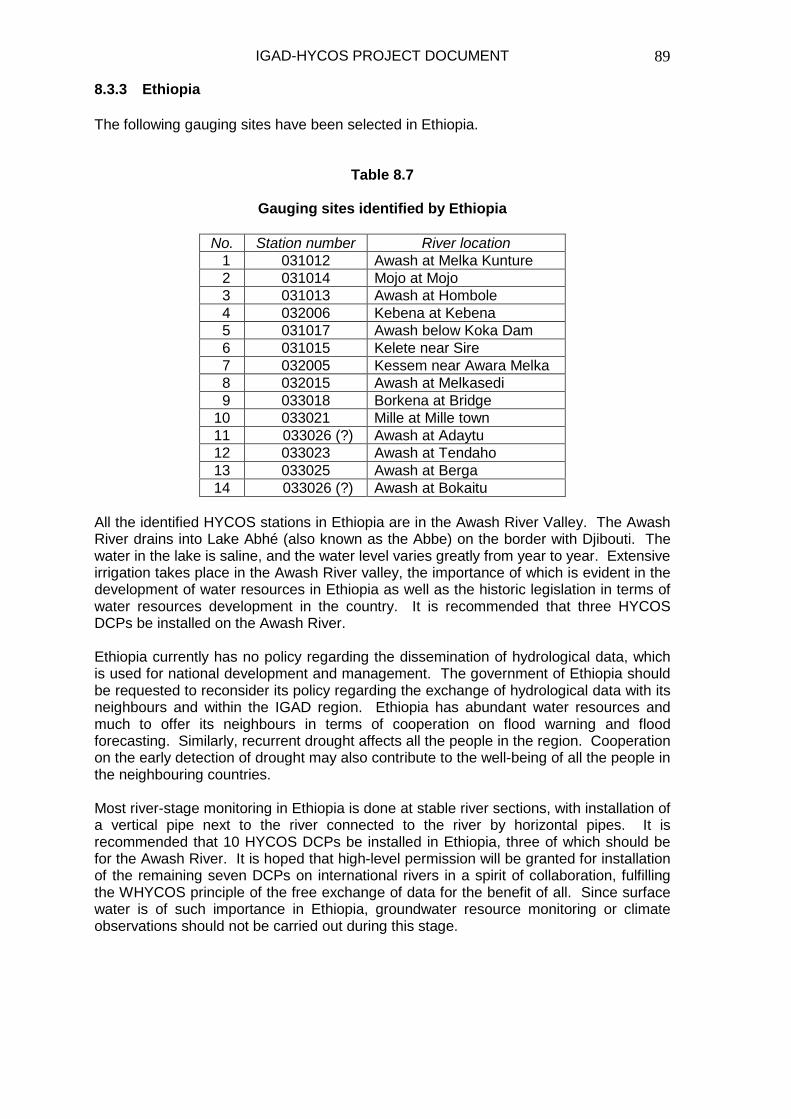
IGAD-HYCOS PROJECT DOCUMENT
89
8.3.3 Ethiopia The following gauging sites have been selected in Ethiopia.
Table 8.7
Gauging sites identified by Ethiopia
All the identified HYCOS stations in Ethiopia are in the Awash River Valley. The Awash River drains into Lake Abhé (also known as the Abbe) on the border with Djibouti. The water in the lake is saline, and the water level varies greatly from year to year. Extensive irrigation takes place in the Awash River valley, the importance of which is evident in the development of water resources in Ethiopia as well as the historic legislation in terms of water resources development in the country. It is recommended that three HYCOS DCPs be installed on the Awash River. Ethiopia currently has no policy regarding the dissemination of hydrological data, which is used for national development and management. The government of Ethiopia should be requested to reconsider its policy regarding the exchange of hydrological data with its neighbours and within the IGAD region. Ethiopia has abundant water resources and much to offer its neighbours in terms of cooperation on flood warning and flood forecasting. Similarly, recurrent drought affects all the people in the region. Cooperation on the early detection of drought may also contribute to the well-being of all the people in the neighbouring countries. Most river-stage monitoring in Ethiopia is done at stable river sections, with installation of a vertical pipe next to the river connected to the river by horizontal pipes. It is recommended that 10 HYCOS DCPs be installed in Ethiopia, three of which should be for the Awash River. It is hoped that high-level permission will be granted for installation of the remaining seven DCPs on international rivers in a spirit of collaboration, fulfilling the WHYCOS principle of the free exchange of data for the benefit of all. Since surface water is of such importance in Ethiopia, groundwater resource monitoring or climate observations should not be carried out during this stage.
No. Station number River location 1 031012 Awash at Melka Kunture 2 031014 Mojo at Mojo 3 031013 Awash at Hombole 4 032006 Kebena at Kebena 5 031017 Awash below Koka Dam 6 031015 Kelete near Sire 7 032005 Kessem near Awara Melka 8 032015 Awash at Melkasedi 9 033018 Borkena at Bridge 10 033021 Mille at Mille town 11 033026 (?) Awash at Adaytu 12 033023 Awash at Tendaho 13 033025 Awash at Berga 14 033026 (?) Awash at Bokaitu

IGAD-HYCOS PROJECT DOCUMENT
90
Table 8.8
Proposed budget for DCP allocation to Ethiopia
Equipment Quantity Estimated unit price (euro)
Estimated total price (euro)
Multi-channel data logger 12 2 625 31 500 METEOSAT transmitter 12 4 500 54 000 Power supply 12 140 1 680 Solar charge regulator 12 320 3 840 Shaft encoder 12 500 6 000 Integrated weather station (at hydrometric station)
12 6 250 75 000
Rain gauges 12 1 150 13 800 Portable WQ sensors 1 10 000 10 000 Total 195 820 8.3.4 Kenya The following gauging sites have been selected in Kenya by order of priority. 1. RGS 1EE1 - Zoia River at Nzoia Market This river is a major source of inflow into Lake Victoria (a shared resource). The river is prone to frequent flooding downstream from the proposed gauging site. The data will be used for flood management and the overall management of the Lake Victoria basin water resources. This site is appropriate, and data will be required in near real-time in the short-term. However, following the development of flood-plain management strategies, the data might be required in real-time during flooding periods. 2. RGS 2KO4 - Uaso Nyiro River at Nguruman Uaso Nyiro River is a resource shared between Kenya and the United Republic of Tanzania. This river is of major interest because it discharges into Lake Natron which is important to Tanzania for soda ash mining, thus requiring continuous monitoring of flows into the lake. The data would also improve on the planning process for the overall development of the basin. The site is appropriate and data will be required in near real-time. 3. RGS 5EO3 - Ewaso Ngiro at Archer’s Post This is a principal station whose data represents the total contributions of the Ewaso Ngiro River in this semi-arid region. The river discharges downstream from this station into the Lorian Swamp–a swamp requiring further study to establish flow patterns into Somalia. 4. RGS 3BA32 - Nairobi River at Juja The Nairobi River is a major tributary of the Athi River. The river is a recipient of major industrial and domestic pollutants from the city of Nairobi and its environs. It is important to monitor the pollution load in this river before it discharges into the Athi River–a river that is one of Mombasa's major sources of water. In order to improve the security of the gauging station and its equipment, a public awareness campaign must be carried out about the importance of the collection of data on water quality and quantity at this site. This data will be required in near real-time.

IGAD-HYCOS PROJECT DOCUMENT
91
5. RGS 3DA2 - Athi River at Gatuanyaga The Athi River drains the southern slopes of the Aberdare Mountains. Gaugings at RGS 3DA2 will measure the overall flow contribution from the Upper Athi Basin. This contribution plus the monitoring of water quality at this site will give an overall hydrological assessment of the Upper Athi River basin. On site security and public-awareness campaigns about the importance of the hydrological data to the local population and Kenya must be carried out. 6. RGS 3HA12 - Athi River at Lugards Falls Downstream from this station, the Athi River is known as the Galana River. Discharge measurements at this site give the total flow into the Baricho Water Works–one of the sources of Mombasa's water supply. Continuous monitoring at this site will improve the overall management and development of the Athi River Basin. 7. RGS 1AH1 - Sio River at Mundika This river is shared between Kenya and Uganda and the whole Nile Basin. Gauging on this river needs to be reliable in order to provide precise information for deciding water allocation between the two countries. Water-quality assessment should also be undertaken. The site is appropriate, and data will be required in near real-time. 8. RGS 4BC2 - Tana River at Sagana The Tana River drains the eastern slopes of the Aberdare Mountains and the western, southern and eastern slopes of Mount Kenya. Gaugings at 4BC2 will give the discharge contributions from the eastern slopes of the Aberdare Mountains and the western slopes of Mount Kenya. Monitoring flow at this station will contribute to the management and operation of hydropower dams downstream from this station. 9. RGS 4GO1 - Tana River at Garissa Gaugings at this station represent the total flow available for all purposes in the lower Tana River Basin. There are proposals to develop irrigation schemes in the lower Tana River Basin. 10. RGS 2CO7 - Kerio River at Chebloch Bridge This river discharges into Lake Turkana, a resource shared between Kenya and Ethiopia. Data from this station will be used for the overall management of Lake Turkana and its basin. The data will be required in near real-time. The site is appropriate and has no major shortcomings. 11. RGS 3KG1 - Umba River at Lunga Lunga This river is shared between Kenya and Tanzania. Data from this station on water quantity and quality will provide information for the sustainable management and development of the Umba River basin. This site is secure. 12. RGS 5 D Ø5 - Ewaso Ngiro at Junction The Ewaso Ngiro River and its tributaries drain the northern slopes of Mount Kenya. Gaugings at this station will record the Ewaso Ngiro flows before it is joined by the Ewaso Narok, hence the name of the site.

IGAD-HYCOS PROJECT DOCUMENT
92
13. RGS ILA4 - Mara River at Mara Bridge This river is shared between Kenya and Tanzania and the other Nile Basin countries. Data from this station must be reliable in order to provide accurate information for the management and use of the Mara River basin, which is a world-renowned wildlife conservation area. The site is prone to flooding, but the equipment could be installed on bridge pillars. It is recommended that 12 DCPs be provided to Kenya. A technician collects hydrological records from a gauging site from a local observer or, alternatively, the local observer posts the records to the district headquarters.
Table 8.9
Kenya: Recommended HYCOS sites
Equipment Quantity Estimated unit price (euro)
Estimated total price (euro)
Multi-channel data logger 12 2 625 31 500 METEOSAT transmitter 12 4 500 54 000 Power supply 12 140 1 680 Solar-charge regulator 12 320 3 840 Shaft encoder 12 500 6 000 Integrated weather station (at hydrometric station)
12 6 250 75 000
Rain gauges 12 1 150 13 800 Portable WQ sensors 1 10 000 10 000 Total 195 820 8.3.5 Sudan Gauging sites identified by Sudan and HYCOS DCP sites that are high-priority that are given in brackets. 1. Blue Nile Eldeim (1)
Wad El Eis (2) Sennar (3) HYCOS DCP (3) Khartoum (4) HYCOS DCP (2)
2. Eldinder River Gewesi (5) HYCOS DCP (4) 3. Rahad River Hawata (6) HYCOS DCP (5) 4. Upper Atbara River Setit Wad El Hielew (7) HYCOS DCP (9) 5. River Atbara Kubor (8) HYCOS DCP (8)
Atbara Kilo 3 (9) HYCOS DCP (7) 6. White Nile Malakal (10) HYCOS DCP (1) 7. Main Nile Tamanyat (11) HYCOS DCP (12)
Hassanab (12) HYCOS DCP (6) Dongola (13) HYCOS DCP (10)
8. Bahr El Gaza River Jur Wau (14) HYCOS DCP (11)

IGAD-HYCOS PROJECT DOCUMENT
93
No motivation for including near real-time satellite transmission has been given by Sudan. Recommendations for HYCOS satellite DCPs are indicated above (to the right of the stations identified by Sudan) based on real coverage. A total of 12 DCPs are recommended for Sudan.
Table 8.10
Sudan: Recommended HYCOS sites
Equipment Quantity Estimated unit price (euro)
Estimated total price (euro)
Multi-channel data logger 12 2 625 31 500 METEOSAT transmitter 12 4 500 54 000 Power supply 12 140 1 680 Solar-charge regulator 12 320 3 840 Shaft encoder 12 500 6 000 Integrated weather station (at hydrometric station)
12 6 250 75 000
Rain gauges 12 1 150 13 800 Portable WQ sensors 1 10 000 10 000 Total 195 820 8.3.6 Uganda The following gauging sites have been selected in order of priority in Uganda. 1. Lake Victoria at Jinja Pier Real-time data is required. The data are used for operation of the Owen Falls release and to regulate the water level in Lake Kyoga, which is downstream. The data are of international importance in the entire Nile Basin. This station should be well equipped with a telemetry system to enable real-time information to be obtained at the office; this will permit real-time monitoring of lake level and the provision of appropriate advice on time 2. Albert Nile at Panyango The data are necessary for determining outflow from both Lake Albert and the Kyoga Nile. The data is of international importance in the entire Nile Basin. This station should be equipped with a telemetry system to enable the furnishing of real-time information to be obtained, which in turn will enable real-time monitoring of lake level and the provision of accurate advice on time 3. Lake Albert at Butiaba This is a lake-level station of regional and international interest. It feeds into the Nile system, and the lake is shared with the Democratic Republic of Congo. Monitoring of river flow is of paramount interest to downstream countries. This station should be equipped with a telemetry system. 4. Victoria Nile at Mbulamuti Real-time data are required. Data are used to monitor the inflow into Lake Kyoga. This facilitates the calculation of the Lake Kyoga water balance. Information is required for a flood-warning system in and around Lake Kyoga, especially in the flood-prone areas.

IGAD-HYCOS PROJECT DOCUMENT
94
This station should be equipped with a telemetry system. The data are of international importance in the entire Nile Basin 5. Lake Kyoga at Bugonda This is a lake-level station of international importance. The data records fluctuations in the lake level. Information is used to give people an early warning in the flood-prone areas in order to enable people to move to less-flood-prone areas. Several studies have been carried out on the great lakes of Uganda. This station has provided vital information in determining the behaviour of the lake and the outflow at Masindi Port. 6. Kyoga Nile at Paraa Data are used to monitor inflow into Lake Albert. The river is of international concern within the Nile Basin countries. Information facilitates the calculation of the water balance of Lake Albert. Information is used locally for the ferry crossing at the site. It is a major area connecting Masindi District and Packwach (Nebbi District). The station should be equipped with a telemetry system. 7. Mitano at Kanungu Rwensama Road This site is proposed for a mini hydroelectric power station. Information will enable regulation of the outflow in order to maximize power production. There are several users. There is a need to determine available resources and to allocate them without disagreement between users. 8. Kyoga Nile at Masindi Port The river is the outlet of Lake Kyoga. The information is used to determine the water balance of Lake Kyoga. The station is of international concern within the Nile Basin countries. Information facilitates the carrying-out of studies throughout the Nile system. Telemetry information is vital to simulate the behaviour or effect of outflow at Owen Falls, Jinja, on the outflow at Masindi Port. This station should be equipped with a telemetry system. 9. River Malaba on Tororo-Iganga Road This river is of regional and international interest and crosses the borders of Kenya and Uganda. The city of Tororo takes its water from this river, which is a tributary of Lake Kyoga through River Mpologoma. Information is essential when establishing the water balance for Lake Kyoga as one of the inputs into the system. This station should be equipped with a telemetry system. 10. River Kafu on the Kampala-Karuma Road This river flows into Lake Kyoga. River flow information facilitates determination of the water balance of Lake Kyoga. It drains a catchment area whose land-use practice has drastically changed and is of interest to hydrologists to order to understand the hydrological regime and the impact of land use on water resources. Although only 10 stations have been identified for inclusion in the HYCOS project, the importance of Uganda as one of the main sources of the Nile River should be recognized by installing 12 DCPs in Uganda. About 99 per cent of Uganda forms part of the Nile Basin. It is recommended that the two additional stations be installed on Lake Albert and Lake Victoria to monitor fluctuations in lake level. Should a need exist for flood warning from two different sites, those sites may take precedence over monitoring of the lake since the lakes are already being monitored, although not in near real-time.

IGAD-HYCOS PROJECT DOCUMENT
95
11. DCPS and transmission systems for existing weather stations at Lolui, Bukasa and Kalangala
In addition to the request for DCPs at river-gauging stations, Uganda has requested loggers and data-transmission equipment for three existing weather stations. These weather stations monitor rainfall, air temperature, solar radiation, wind speed, wind direction and evaporation.
Table 8.11
Uganda: Recommended budget for HYCOS sites
Equipment Quantity Estimated unit price (euro)
Estimated total price (euro)
Multi-cannel data logger 15* 2 625 39 375 METEOSAT transmitter 15* 4 500 67 500 Power supply 15* 140 2 100 Solar-charge regulator 15* 320 4 800 Shaft encoder 12 500 6 000 Integrated weather station (at hydrometric station)
12 6 250 75 000
Rain gauges 12 1 150 13 800 Portable WQ sensors 1 10 000 10 000 Total 218 575 Three additional multi-channel loggers and three satellite transmitters are recommended in order to obtain near real-time data from three existing weather stations. Map 9 shows the IGAD participating countries and the River Nile basin as well as the locality of river-gauging sites recommended for inclusion in the IGAD-HYCOS project.

IGAD-HYCOS PROJECT DOCUMENT
96
Map 9: IGAD Region: Nile River Basin
#Y
#Y
#Y
#Y
#Y
#Y
#Y
%
%
%%
%%
%
%
%
%
%%
%
%
%
%
%
%
%
%
%
%
% %
%
%%
%
%
%
%
%%
%
%%
%
%
%
%
%
%
ASMARA
DJIBOUTI
ADDIS ABABA
KHARTOUM
KAMPALA
NAIROBI
MOGADISHO
D.R.C
Sudan
Egypt
Ethiopia
Tanzania
Kenya
Somalia
Uganda
Eritrea
Burundi
Rwanda
Djibouti
Saudi Arabia
Yemen
Lake Turkan a
Lake Victoria
IGAD Region: Nile River Basin
200 0 200 400 600 Kilometers
Drainage Region Boundary
Salt pan
Non-perennial WaterPerennial Water / Dam / Lake
Perennial River
International BoundaryY Town#Y Capital City% Recommended HYCOS Site
Non-perennial River
LEGEND
Fresh water marshMangrove
Elevation Below mean sea level0 to 1000 feet above mean sea level1000 to 3000 feet above mean sea level3000 to 7000 feet above mean sea level7000 to 11000 feet above mean sea levelOver 11000 feet above mean sea level
55°
00°
55°
1010°
1515°
2020°
2525°
25° 30° 35° 40° 45°

IGAD-HYCOS PROJECT DOCUMENT
97
8.4 Proposed budget for the IGAD-HYCOS project
Table 8.12 summarizes the budget proposal for the IGAD-HYCOS Project.
Table 8.12
Budget proposal for the IGAD-HYCOS Project
Task No. Activities/tasks to be carried out Responsibility and comments Estimatedcost in Euro
Stage 1 Stage 1Task 1 Establishment of the PMU and PRC Identified organisation(s)
Preparation of implementation plan and MoU's between PMU/PRC PMU Project managerand IGAD. PMU/PRC and participating countries
Task 2 Installation of computer network at PMU/PRC IT SpecialistFinalise network for HYCOS instrumentation installation PMU/PRC/Participating countriesProcurement of field equipment PMU/PRC/Donor Agency/IGAD/WMOInstrumentation for Djibouti 135970Instrumentation for Eritrea 141780Instrumentation for Ethiopia 195820Instrumentation for Kenya 195820Instrumentation for Sudan 195820Instrumentation for Uganda 218575Mixture of spares at PRC 49205Shipping of instrumentation to each country and PRC Instrumentation supplier / PRC 18010
Task 3 Development/Adaptation of Regional Database and WebSite (integrate Web Site and RDB) 6 months IT Specialist salary
Task 4 Training on instumentation installation and 2 PRC or PMU field expert officersmaintenance at the premises of the successful 2 Officers from NHS in IGAD region tenderer in Europe (E 32800 - see Imprest Fund)
Task 5 Factory acceptance tests of instrumentation prior to despatch 4 officers (E 7000 - see Imprest Fund)
Task 6 Follow up training at the PRC of instrumentation installation Representative(s) from successfuland maintenance instrumentation tenderer and (E 31200 - see Imprest Fund) 4 officers
Task 7 Field preparation for installation of instrumentation Participating countriesIdentification of necessary bugetary support for civil works PMU/PRC(300000 - see Imprest Fund)
Task 8 Installation of 2 computers in each participating country Participating countries(E18000 - see Imprest Fund)
Task 9 Ensure proper Internet communication between PMU/PRC and Kenya Meteorological Service IT Specialist 10000
Task 10 Preparation / Publication / Circulation of promotional material on IGAD-HYCOS Project PMU / PRC / IGAD / WMO 5000
Task 11 Review of Progress (Financed from Project Execution below) WMO / IGADStage 2 Stage 2Task 12 Field installations start - 12 months to complete Participating countries with TA
support from PRC / PMUTask 13 Budgetary support for civil works PRC/PMU and participating countries 300000Task 14 Establish data transmission and data dissemination procedures
as well as data supply protocols IT Specialist salaryTask 15 Training of staff in (Windows) HYDATA database 2 x 6 NHS staff 18000Task 16 Development of data quality assurance and archiving procedures 2 x 6 NHS staff + PRC /Training 18000Task 17 Ensure transfer of historical data to NHS Windows Database NHS staff + PRC/PMU (salary)Task 18 Training of staff in Web site use and data dissemination 2 x 6 NHS staff 18000Task 19 Training of NHS staff in calibration of gauging sites using current
meter gauging (wading, cable way, boat) 2 x 6 NHS staff 18000Task 20 Advanced training in use of Acoustic Doppler steamflow gauging 2 x 6 NHS staff + PRC + supplier 18000Task 21 Survey of needs for hydrological products PRC / PMU + NHS (salary)Task 22 Development of procedures for data analyses and presentation PRC / PMU + NHS (salary)Task 23 Training of staff in use of new tools and hydrological products PRC /PMU + 2 x 6 NHS staff 18000
Subtotal 1574000

IGAD-HYCOS PROJECT DOCUMENT
98
Staff costs, Operational costs, Travel and DSA
Project Management Unit and personnel Carried forward 1574000Project Manager (48 months) PMU personnel funding through DMCN 576000Field Hydrologist (24 months) 192000Hydrologist (46 months) 368000IT Expert (42 months) 336000Technical / Administrative Assistant (36 months) 72000Imprest Fund Imprest fund operated by PRC/PMU Support to project activities (installation and maintenance of equipment in collaboration with NHS's, Training and TA) Hardware and Software for PMU/PRC staff (4 P4 desk + 2 laptops) 24000Office supplies for PRC / PMU 10000Office equipment (Furniture, filing cabinets, etc.) 300001 4X4 vehicle for PMU/PRC 31000Running costs of one 4X4 vehicle estimated at 30 000 km per year 36000Travel and DSA in IGAD Region PRC / PMU 100000Travel and DSA outside IGAD Region PRC / PMU 40000Training of NHS's at PRC (needs during project implementation) 3 unscheduled training courses at PRC 54000
Task 24 Training and factory acceptance 71000Desktop computers to countries 18000One Laptop Computer for each country Countries 15000Software for Computers Countries 12000Project executionIGAD Travel and DSA: 4X WIAG meeting X4 days, Regional Travel IGAD Secretariat 20000
Task 25 Project Evaluation (4 week mission to PMU/PRC and countries) PMU/ PRC/ WMO 30000Task 26 Report preparation WMO/PRC/PMU 5000
Transport: 4X4 vehicle with canopy for each country Countries 186000(Running and maintenance costs to be paid by particip. countries)Contingencies 100000
Sub Total in Euro 3900000Project supervision and travel by WMO WMO 300000
Total in Euro 4200000 8.5 Budget summary Table 8.13 shows the summarized budget for the IGAD-HYCOS Project.
Table 8.13
Summarized budget
No. Category Amount (euro)
Percentage of total amount
1. Equipment 1.1 Instrumentation 1 181 000 28.121.2 Computing, hardware and software 69 000 1.641.3 4x4 Vehicles 217 000 5.17
2. Technical assistance 2.1 Salaries of PRC/PMU 1 544 000 36.762.2 Travel 140 000 3.332.3 PRC operation 66 000 1.572.4 Support to NHSs 307 000 7.312.5 Training 226 000 5.38
3. Project supervision and travel 3.1 WMO 300 000 7.143.2 IGAD 30 000 0.71
4. Assessment 20 000 0.485. Contingencies 100 000 2.38 Total 4 200 000 100.00

IGAD-HYCOS PROJECT DOCUMENT
99
9. References 1. Mohamed Ismael Mohamed. L‘Etat des Ressources en Eau de la Republique
de Djibouti’, Djibouti, Mars 1999. 2. Asefa Kidane. A National Report Submitted for the Formulation of IGAD-
HYCOS Project, Addis Ababa, December 1998. 3. Mnyamwezi E. M. Status Report on Kenya’s National Hydrological Services,
Ministry of Water Resources, Kenya, January 1999. 4. Medani Wad. Country Report: Sudan, Ministry of Irrigation and Water
Resources’, Republic of Sudan, January 1999. 5. Kyosingira W. F. Status of the National Hydrological Service and Water
Resource Activities in Uganda, Water Resources Management Department, Directorate of Water Development, Entebbe, Uganda, February 1999.
6. Microsoft Encarta, Interactive World Atlas, 2000. 7. Microsoft Encarta, Premium Suite, 2004. 8. Personal communication from hydrologists and meteorologists in the Horn of
Africa. 9. Mbagathi, S.M. Proceedings of the IGAD-HYCOS Project Planning Workshop,
Nairobi, 30 June to 2 July 2003.

IGAD-HYCOS PROJECT DOCUMENT
100
Annex 1
Project planning matrix (logistical framework) Name: IGAD-HYCOS Implementing agency: IGAD-DMC Project duration: four years (2004–2008) Location: IGAD region Summary Objectively verifiable indicators Means of
verification Important
assumptions Overall goal Sustainable and integrated water resources management and development in the IGAD region
Sustained country commitment
Project purpose Enhancement of regional cooperation in hydrological and hydro-meteorological data and information collection, analysis, dissemination and exchange for water-related decision-making
By end of the project, at least X per cent of key stakeholders (national weather institutions, researchers, decision-makers) will have received and used information and at least two major decisions that prevent loss of lives and property will have been made based on HYCOS project
Project progress reports, country reports, M and E reports
Other early-warning systems functional
Outputs 1. National and regional
staff and institutions strengthened
2. Monitoring and
communication systems improved
3. Quality data and
products available for enhancing decision-making
4. Relevant national
databases improved and a regional database established
5. Regional policy
framework for cooperation established and national policy frameworks supported
6. Establish a Project
Regional Centre and coordination mechanism
Output 1 National and regional staff and institution strengthened 1.1 At least three persons for each institution trained in
database management including at least one woman 1.2 Improvement of the hardware and software of at least one
database in each country 1.3 At least one four-wheel-drive vehicle per country provided
for the HYCOS project Output 2 Monitoring and communication systems improved 2.1 At least five DCPs per country installed and operational
within the first year of the project 2.2 Upgrading of an average of five stations in each
participating country 2.3 At least one communication link established between
national HYCOS project and meteorological stations in the participating countries
Output 3 Quality data and products available 3.1 At the end of four years at least accurately predicted and
warnings issued within the IGAD region Output 4 Relevant national database improved and a regional database established 4.1 Hardware and software improved of at least one database
per country and a regional database established at the PRC within six months after the start of the project
Output 5 Regional policy frameworks for cooperation established and national policy frameworks supported 5.1 Memorandum of Understanding signed between the
participating countries 5.2 Memorandum of Understanding among institutions at the
national level established Output 6 Establish a Project Regional Centre and coordination mechanisms 6.1 Project facilities established and plan of operation adopted
within the first three months of project 6.2 Quarterly and annual monitoring and evaluation reports
available
Stakeholders able and willing to use the HYCOS information

IGAD-HYCOS PROJECT DOCUMENT
101
Activities
Important
assumptions 1.0 National and regional staff and institutional capacity improved 1.1 Carry out national, regional and international training in equipment installation and maintenance, stream-flow gauging and calibration, data quality-control 1.2 Strengthen MET services in relevant operations 2.0 Monitoring and communications systems improved 2.1 Identify and design appropriate monitoring stations 2.2 Establish and strengthen the regional hydrological and hydrometeorological data and information networks 2.3 Review the status of the current communication system as related to the project and identify an appropriate communications system 3.0 Quality data and products available and used for decision-making 3.1 Standardize techniques in data measurement, processing and quality control 3.2 Calibrate gauging sites 3.3 Collect and analyse quality data 3.4 Use data to predict drought and its impacts, flood warning and the forecasting of severe storms 3.5 Measure the level of groundwater recharge and withdrawal 3.6 Prepare reports on water resources in rivers, reservoirs etc and spatial representation of water-quality indicators 4.0 Relevant national databases improved and a regional database established 4.1 Identify and acquire hardware and software 4.2 Identify data fields and frequency 4.3 Create and test regional databases 4.4 Create a Web site integrated with a database (dynamic Web site) 4.5 Promote the use of the database 4.6 Upgrade and ensure compatibility and user-friendliness of the software of national databases 4.7 Develop software to facilitate the exchange and dissemination of data and information at the regional level 4.8 Use the Internet and meteorological services to exchange data 5.0 Regional policy frameworks for cooperation established and national policy frameworks supported 5.1 Review and identify existing national and regional policies 5.2 Organize national workshops to strengthen existing policy frameworks 5.3 Organize a regional workshop for policy makers to develop a framework for cooperation 6.0 Establish a Project Regional Centre and coordination mechanisms 6.1 Identify the location of the Project Regional Centre 6.2 Establish the project infrastructure and hire relevant staff 6.3 Develop a project plan of operation and work plans 6.4 Facilitate meetings of the coordinating committees 6.4 Facilitate the implementation, monitoring, evaluation and reporting of project activities
The right persons attend the training and a critical number of them are retained Vandalism and theft are controllable Security is maintained in monitoring areas Coordination between national institutions possible Policy to exchange data will be followed by participating countries

IGAD-HYCOS PROJECT DOCUMENT
102
Annex 2
Tender specifications for instrumentation for the IGAD-HYCOS Project This part of the specifications covers the details of the hardware and software requirements for the data-logger equipment. The data loggers will be used at remote measuring stations to collect data. Operation will be in a totally unattended mode with inspections by staff on a 30-to-90-day cycle. The equipment will be mounted in concrete or brick recorder huts with a minimum size of 1.50 x 1.50 x 1.80 metres or mounted on pipes with diameters from 10 cm to 30 cm. The instrumentation will be subjected to a harsh environment. 1. Multi-channel Data Logger 1.1 Hardware requirements
1.1.1 Environmental conditions: The equipment must be designed to
function satisfactorily under the following conditions:
• Temperature range: Storage and operation -10°C to +60°C
• Relative humidity: 30 to 95 per cent, with condensation • Elevation: 0–3500 metres above sea level
The equipment must be designed to operate without degradation under the dusty conditions experienced at exposed sites.
1.1.2 Data processing
• Only intelligent data loggers, equipped with a microprocessor
will be considered. • The data logger must be equipped with a CPU watchdog
circuit that will automatically restart the system in the event of a severe electrical or electromagnetic disturbance.
1.1.3 Real-time clock
• The data loggers must be equipped with a battery-backed-
hardware real-time clock system. • The real-time clock system must provide time (24 hour
system) and date information and shall make provision for leap years.
• The accuracy and stability of the real-time clock must be
better than ±30 seconds per month, operating under harsh and extreme environmental conditions.
1.1.4 Memory
• The data loggers must be provided with three types of memory systems:
� EPROM for system programmes and default parameters

IGAD-HYCOS PROJECT DOCUMENT
103
� Non-volatile memory for system and station parameters
and user-defined variables � Battery-backed RAM for intermediate data storage and
processing (minimum 128 KB)
• The data logger must have a circular memory (first-in, first-out).
• The downloaded data should still be available and accessible
on the data logger’s memory after being read out or sent via the data communication module.
1.1.5 Operator interface
• The data logger shall be provided with the following minimum built-in facilities, to be used by the operational and
maintenance staff:
� An LCD unit capable of displaying the full ASCII character set
� A keyboard that allows the operator to enter parameters,
interrogate the data logger and enter messages
• The keyboard shall comply with the following requirements:
� The construction shall be a waterproofed-membrane type � Keys must provide positive feedback
1.1.6 Serial communication port
• Each data logger shall be equipped to allow bi-directional
communication with outside equipment (laptop) via an infrared interface or a 9-pin RS 232 serial port.
• The RS 232 port configuration shall allow user selection of the
number of data bits, start and stop bits and parity bits in accordance with the standard. Baud rates of 300, 600, 1200, 2400, 4800 and 9600 baud shall be available for selection.
• The logger shall have the facility to interface with transmission
equipment.
1.2 Power supply (For detailed external power supply specifications, refer to section 3 D)
1.2.1 Each data logger shall be equipped with an internal source that
would prevent equipment shutdown or loss of data when the main battery is disconnected for a short period or exchanged (±15 minutes).
• Power for all the sensors will be from the main battery through
the data logger

IGAD-HYCOS PROJECT DOCUMENT
104
1.2.2 The data logger must have low power consumption on standby
mode. 1.2.3 The data logger must be reverse polarity protected.
1.3 Surge protection
1.3.1 Surge-protection equipment must be installed on all system
input/output circuits and power supply input circuits (DC, mains).
1.3.2 The following equipment shall be the absolute minimum:
• On all analogue/digital input and output circuits, DEHN BLITZDUCTORS TYPE LZ or equivalent with appropriate voltage ratings
• On all mains power supply circuits, DEHN type VA-280 surge
arrestors or equivalent
1.3.3 The PRC/PMU may allow the use of alternative types of surge arrestors, provided that equivalent or higher protection levels are achieved. Test reports from accredited institutions shall be
provided for any alternative. 1.3.4 The equipment will be used without direct supervision and must
provide the required protection. The contractor must implement any additional measures required to achieve the necessary
protection level.
1.4 Input functions and interfacing
1.4.1 The data logger shall be designed to allow the input of combinations of measurements for a minimum of 16 user-definable channels for analogue and digital inputs.
1.4.2 The analogue modules shall be designed for inputs of signals at
0–20 mA; 4–20 mA; 0–10 V; 1–10 V; -2–+2V; 0–5V or 1–5V. 1.4.3 Analogue input signals shall be converted to digital signals using
an AD converter with not fewer than 12 bits. 1.4.4 Digital inputs shall be parallel, pulse or 24V signals. 1.4.5 Dedicated modules or changes to the internal software must
directly accept all types of sensors. 1.4.6 The analogue input signals shall be measured to an overall
accuracy of better than 0.5 per cent. The input circuits shall be designed so that no errors are introduced by ground loops.
1.4.7 The input channel for a specific sensor shall be user selectable.

IGAD-HYCOS PROJECT DOCUMENT
105
1.4.8 In order to conserve power, the data logger shall control the
power supply to each sensor. Sensors shall be switched on in sequence and readings taken under processor control. Sufficient warm-up and stabilization time for sensors must be controlled
by the logger. 1.4.9 During periods of non-measurement, power supply to the sensors
and signal converter units shall be interrupted for all analogue channels.
1.4.10 Full calibration procedures shall be provided for each sensor and
signal-conditioning unit. 1.4.11 Input connectors for sensors shall be clearly labelled, polarized to
prevent mismatching of connectors and configured to prevent damage if a unit is accidentally or intentionally connected to the wrong input channel. Each connector shall make provision for all the necessary signal lines, grounding, 0V and 12V (switched)
supplied lines.
1.5 Enclosure and housing
1.5.1 The data logger shall be enclosed in walled-mounted housing for installation in a recorder hut as described above.
1.5.2 The logger housing shall be water and dust protected and shall
comply with rating IP65 as defined in IEC144. 1.5.3 The housing shall be manufactured of corrosion-resistant
material. 1.5.4 Provision must be made in the housing to enable data
transmission via telephone line, satellite-telephone link and cellular-telephone link through a plug connector.
1.5.5 The housing will have an operator interface and an infrared
interface. 1.5.6 The data-logger housing shall not exceed the following
dimensions: height–300 mm, width–250 mm, depth–200 mm.
1.6 Internal software requirements
1.6.1 General
• All software packages shall be written and structured in a high-level programming language. To conserve memory space and power, the use of a compiled program is recommended.
• The data-logger operating software shall be located in ROM
(EPROM) and the contractor shall be responsible for the provision of all the software required for the data logger.

IGAD-HYCOS PROJECT DOCUMENT
106
• It must be impossible for an operator of any data logger to
accidentally or intentionally destroy the database or data recordings by entering faulty or erroneous instructions or messages.
• The data-logger software shall allow the equipment to
operate in a completely unattended mode, and all reasonable precautions shall be taken to structure error-trapping routines in order to prevent system hang-up.
1.6.2 Cold start
• When the data logger is switched on, it shall perform a self-
test, checking that all required cards and devices are present and that all RAM is operational. If any fault is detected, it shall display the fault description and halt operation. If no fault or error is detected, it shall resume operation, using the system information in RAM.
1.7 Data acquisition
1.7.1 The data logger shall operate with two data sequences: fixed-
interval logging and variable-interval logging.
1.7.2 Each data input channel shall be treated separately and have its own scanning-interval parameters. At start-up, the default parameter set shall be loaded for each channel. It must be possible for the operator to modify the parameter set at any stage.
1.7.3 For the water-level measurement channels, operators shall be
able to select a fixed interval and fixed variation data storage method apart from a manufacturer’s default method.
1.7.4 For each input channel the data logger shall provide a scaling
factor and offset so that the measured value can be adjusted to the actual reading. For the water-level channels, the transducer selected will determine the scaling factor. This will allow for placement of the transducer above or below the zero threshold.
1.8 Data storage
1.8.1 The storage of measured data records shall be done in order that
the data-retrieval process at the station can be done without operator intervention. This means that recorded messages and data shall be coded in different groups.
1.8.2 Data records shall contain the following information: ID numbers,
channel numbers, time/date and measured value. The measured value may be given in engineering units.
1.8.3 Channels shall be numbered numerically. 1.8.4 Data storage shall be based on a circulating storage system (first-
in, first-out).

IGAD-HYCOS PROJECT DOCUMENT
107
1.8.5 It must be possible to read out data as often as desired without
destroying it. 1.8.6 Memory contents must be retained in the event of a power supply
breakdown.
1.9 Data display
1.9.1 All conversation between the data logger and operator shall be done via the keyboard of the data logger display-unit or laptop.
1.9.2 When connecting to the data logger, the following information
should be displayed: measured values, date, time, battery status and minimum and maximum values for the previous 24-hour period.
1.9.3 A time-out shall be provided, so that the display will go into a
sleeping mode if no keyboard activity is detected for a period (typically five minutes).
1.9.4 The data-logger display will indicate when it is transferring data.
1.10 Operating procedures (The data logger must have three levels of access)
1.10.1 Data display (paragraph 1.9) and data retrieval (paragraph 1.10.3)
• No password should be required for this level, which should
be activated by touching any key on the keyboard of the data logger or laptop. The data logger should request “data display/read-out” or “operation menu”. Any change of any parameter must be impossible at this level.
• Upon selection of “operation menu” a password should be
required. This second level allows access to the data logger to perform all functions with the exception of station number, I.D. settings, baud-rate settings, data reset, system reset, interrogation and storage intervals, manufacturer's settings, install additional channels, remove unused channels, erase selective channel data, restore factory settings or any other action which can cause loss of data or system failure.
• With the exception of manufacturer's settings, these functions
should be accessible to a trained PRC/PMU technician or hydrologist requiring a second password.
1.10.2 Menu-driven procedures (All operator activities shall be menu
driven.)
• Station settings must be able to display and set
� Alphanumerical station ID � Date and time settings � Internal lithium cell voltage � Software version � RAM capacity � Number of sensors � Last data-readout date � Port settings � Language settings (if appropriate)

IGAD-HYCOS PROJECT DOCUMENT
108
• Sensor settings (Each sensor must be capable of separate adjustment and must include the following.)
� Sensor number � Sensor description � Display units � Minimum and maximum values for the past 24 hours � Sample intervals � Storage intervals � Delta values for event logging
• Service settings (password protected)
� Install additional channels � Remove unused channels � Erase selective channel data � System reset/start-up date � Restore factory settings
• General settings
� When scanning the current active parameter list, the
operator shall have access to the parameters listed in paragraph 1.10.2 (bullets 1 and 2).
� With the input channel facility, the operator shall be able to select any input channel, and the data logger shall measure and display the current input value (or a non-selected message, if the channel is not activated).
� Where single-channel, non-expandable, dedicated units can be used, they should be furnished.
1.10.3 Data retrieval
• It should be possible to retrieve data by the following means:
� A laptop, a laptop via direct infra-red, a laptop via cable
and nine-pin connectors � Although not a requirement data retrieval through a
dedicated data reader may be offered.
1.10.4 Determination of sampling intervals
• Procedure
� Time recording � Samples at set intervals. Record each sample or average
set of samples and store at set intervals. Minimum of five seconds and a maximum of 24 hours for intervals of sampling and storing.
� Delta recording for water levels - Compare measured
value with previous stored value at set time intervals. If new value differs from the pre-set difference, it must be stored, in addition to the last value. If not, the value must be ignored. Wait for next time interval.

IGAD-HYCOS PROJECT DOCUMENT
109
1.11 Future extension
As far as practicably possible, the contractor must make provision in the system to accommodate future extensions, ensuring compatibility with the current product.
2. Single-channel data logger with integrated shaft encoder
2.1 Shaft encoder
2.1.1 Application
• The shaft encoder operates with a float and counterweight
system. • The shaft encoder must have a standard resolution of 1 mm
and must be capable of measuring water levels between 0 and 20 metres.
2.1.2 Design and technical details
• The shaft encoder must be compact, robust and corrosion-
resistant. • The shaft encoder unit must be connected to the data logger
with a flexible cable. • It must be possible to select the sense of rotation for left-hand
or right-hand rising. • The shaft encoder must be able to process an extremely high
rotation speed. At least a one-metre rise or fall in 20 seconds or better.
• The pulley of the shaft encoder must be able to accommodate
a 1-mm-diameter float cable. • The float cable must not slip on the encoder pulley. • A corrosion-resistant bracket for stand-alone operation must
be available.
2.2 Data logger
2.2.1 Data processing
• The data logger shall be equipped with a CPU watchdog circuit that will automatically restart the system in the event of a severe electrical or electromagnetic disturbance.
2.2.2 Real-time clock
• The data logger shall be equipped with a battery-backed real-
time clock hardware.

IGAD-HYCOS PROJECT DOCUMENT
110
• The real-time clock system shall provide time (24-hour system) and date information and shall make provision for leap years.
• The accuracy and stability of the real-time clock shall be
better than ±30 seconds per month, operating under harsh and extreme environmental conditions.
2.2.3 Memory
• The data logger shall be provided with an EPROM ring
memory. • First in, first out buffered storage capacity of at least 100 000
readings over approximately 90 days at a storage interval of 60 seconds.
• Data must still be available after read-out.
2.2.4 Operator interface: The data logger shall be provided with the
following minimum built-in facilities to be used by the operating and maintenance staff:
• A well-readable single line, 4.5-character LCD unit capable of
displaying the water level to the nearest mm, date, time and battery voltage.
2.2.5 Power supply
• It must be possible for the data logger to be powered externally (main system battery, normally 12 V), or internally
with the use of commercially available dry alkaline batteries. The logger should operate for at least six months with commercially available dry alkaline batteries.
• Easy access for changing the batteries must be assured.
2.2.6 Serial communication port
• Each data logger shall be equipped to allow bi-directional
communication with outside equipment (laptop) via infrared technology or a 9-pin RS 232 port.
• The data logger shall also be equipped with an easily
accessible RS 232 interface for data transmission via a communication facility (telephone line, cellular telephone link, satellite transmitter or satellite telephone link)
2.2.7 Enclosure and shelter
• The equipment will be mounted in mild steel, concrete or
brick recorder huts with minimum dimensions of 80 x 80 x 180 cm or mounted on pipes with diameters between 100 mm to 300 mm and will be subjected to a harsh environment.

IGAD-HYCOS PROJECT DOCUMENT
111
• The logger shelter will be water and dust protected and must comply with rating IP65 as defined in IEC144.
• All connections are to be made internally.
2.3 Internal software requirements
2.3.1 General
• All software packages shall be written and structured in a high-level programming language. To conserve memory space and power, a compiled software programme is recommended.
• The operating software for the data logger shall be located in ROM (EPROM), and the contractor shall be responsible for the provision of all the software required to make a complete operational system.
• It shall be impossible for the operator of any data logger to
accidentally or intentionally destroy the database or data recordings by entering faulty or erroneous instructions or messages.
• The data logger software shall allow the equipment to operate
in a completely unattended mode and all reasonable precautions shall be taken in structuring error-trapping routines to prevent system hang-up.
2.3.2 Data acquisition
• The data logger shall operate on fixed-interval logging
sequences. • The water level must be measured at set intervals. The
operators shall, however, be able to select a fixed interval for measuring and storing the data.
� Sampling time should be a minimum of 60 seconds and a
maximum of 24 hours.
2.3.3 Data storage
• Data records shall contain the following information:
� ID number, time/date code and measured value � The measured value may be given in engineering units
• Data storage shall be done on a first-in-first-out circulating
storage system. • It must be possible to read out data as often as desired
without destroying it. • The contents of the memory must be retained in the event of a
power-supply breakdown.

IGAD-HYCOS PROJECT DOCUMENT
112
2.3.4 Data display
• All communication between the data logger and the operator shall be done by laptop or palm-held device.
• The following information shall be displayed:
� Measured value, date, time and battery status
• A time-out shall be provided so that the display will switch off if no activity is detected for a period (typically five minutes).
2.4. Operating procedures
2.4.1 Menu-driven procedures
• All operator activities shall be menu driven from the set-up software.
• Station settings must be able to display and set
alphanumerical station ID with at least 9 digits, date, time settings and water level.
2.4.2 Data retrieval
• Data shall be retrieved by laptop, an infrared data adapter or
a 9-pin RS 232 port. • It should be possible to use the data logger with integrated
shaft encoder in a stand-alone function or as an integral component of a larger system.
3. Radar sensor for water-level measurement
3.1 Application
The radar sensor must be capable of measuring water levels from between at least 1 metre and 25 metres from the point of installation to the water level. The sensor will be used primarily where the water surface fluctuates considerably, where heavy siltation occurs and under conditions of debris carried by the current during floods. The sensor must be suitably protected against lightning.
3.2 Design and technical details
3.2.1 Sensor housing
• The sensor housing must be robust, corrosion resistant,
resistant to ultra-violet rays, insensitive to vibration and be water and dust protected to comply with rating IP68 as defined in IEC144.
• The sensor housing shall not exceed the following dimensions
and weight: length–600 mm, diameter–200 mm and weight–10 kg.

IGAD-HYCOS PROJECT DOCUMENT
113
• The sensor housing must be fitted with a watertight plug for connection to the data transmission cable.
3.2.2 Measuring sensor
• The sensor shall be designed to function satisfactorily
between -10°C and +60°C. • The sensor must have a standard resolution of 1 mm and an
accuracy of 2 cm or better over the full measuring range. • The sensor should have a measuring interval of at least 60
seconds.
3.2.3 Data transmission cable
• The data transmission cable should function satisfactorily with a cable length of up to 750 metres.
• The outer diameter of the cable should not exceed 10 mm.
3.2.4 Power supply
• The nominal power supply for the sensor should be 12 volts. • The power consumption of the sensor should not exceed
500 mA in measurement mode and 1 µA during stand-by mode.
3.2.5 Output signal
• The output signal of the sensor should be transmitted via
RS 232. 4. Water-level sensor using the bubble principle
4.1 The bubble chamber
4.1.1 Application
• (The unit must be capable of measuring water levels in open channels over at least 0 to 10 metres)
4.1.2 Design and technical details
Compressor • The compressor for generating air bubbles should be a built-in
feature of the unit. • The compressed air should be generated by a maintenance-
free piston pump using an indirect bubble. No system using an external compressor or external gas bottles will be considered.

IGAD-HYCOS PROJECT DOCUMENT
114
Bubble chamber • The bubble chamber must be robust, corrosion resistant and
insensitive to impact and vibration. • The bubble chamber must be fitted with an easy push-on
connector for the measuring tube. • The diameter of the bubble chamber should not exceed
100 mm. Measuring tube • The measuring tube should be flexible and manufactured of
age-resistant PVC. • The measuring tube should not exceed an outer diameter of
10 mm. • A suitable non-stretch, age-resistant rope for fixing the bubble
chamber in wells must be available together with the measuring tube.
4.1.3 The following modifications for open channels are acceptable
• The bubble chamber must be the screw-on type suitable for at
least a 75 mm diameter protection tube. • The measuring tube should have a length of up to 150 metres
between the bubble chamber and the multi-channel data logger.
• The pneumatic unit (compressor) should have an output that
can be directly connected to a data logger. 5. Shaft encoder
5.1 Application
5.1.1 The shaft encoder will operate with a float and counterweight system.
5.1.2 The shaft encoder must have a standard resolution of 1 mm
and must be capable of measuring water levels between 0 and 20 metres.
5.2 Design and technical details
5.2.1 The shaft encoder must be compact, robust and corrosion-
resistant.
5.2.2 The shaft encoder unit must have an output that can be connected directly to a data logger (as mentioned under item 1).
5.2.3 It must be possible for the user to select the sense of rotation for
left or right-hand rising.

IGAD-HYCOS PROJECT DOCUMENT
115
5.2.4 The shaft encoder must be able to process an extremely high
rotation speed of at least 1 metre rise or fall in 20 seconds or better.
5.2.5 The pulley of the shaft encoder must be able to accommodate a
1-mm-diameter float cable. 5.2.6 The float cable must not slip on the encoder pulley. 5.2.7 A corrosion-resistant bracket for stand-alone operation must be
available. 6. Pressure transducer for water-level measurement using the piezo-resistive
method
6.1 Application
6.1.1 Pressure transducers must be capable of measuring water levels between 0 and 100 metres with the range of each transducer being determined by the client and pre-set in the factory. Typical ranges could be 0–5 m; 0–10 m; 0–20 m, 0–40 m and >40 m on request.
6.1.2 The pressure transducers must be highly reliable and ensure a
wide range of application for measuring pressure in all fields of water level measurement.
6.1.3 Transducers must be suitably protected against lightning, and test
results must be available upon request.
6.2 Design and technical details
6.2.1 Transducer housing
• The transducer housing must be robust, corrosion-resistant, insensitive to impact and vibration and watertight up to at least 40 metres of water column (>40 m on request).
• The transducer housing shall not exceed the following
dimensions and weight: length–300 mm, diameter–50 mm, weight–1 kg
• The transducer housing can be fitted with a watertight plug for
connection to the transducer cable.
6.2.2 Pressure sensor
• The measuring cell must be chemically and thermally resistant.
• The pressure-measuring cell must operate using the piezo-
resistive method. • The pressure sensor shall be designed and calibrated to
function satisfactorily under a temperature range of -5°C to

IGAD-HYCOS PROJECT DOCUMENT
116
+45°C. • The pressure sensor shall have a built-in temperature
compensator.
6.2.3 Transducer cable - The transducer cable must have the following characteristics:
• Flexible and at least a double sheathing with interposed
tinned copper-braiding or better with an outer diameter of not more than 12 mm
• The transducer cable shall be used as the carrying rope and
shall have an internal Kevlar-core assembly or equivalent for longitudinal stability.
• A polyamide pressure-compensation capillary tube for
measuring the reference pressure with an inside diameter of 3 mm but not less than 1.0 mm.
• End of cable connected by terminal box with additional Teflon-
coated filters and an exchangeable humidity absorber. • A fixing clamp for exact positioning of the pressure probe in a
stilling well or tube must be available, manufactured from a non-corrosive material.
• The pressure transducer and transducer cable shall be
designed to function satisfactorily with a cable length of 250 metres
• The transducer cable must be provided with a watertight plug
for connection to the transducer housing.
6.2.4 Temperature sensor
• The pressure transducer should have a platinum-resistor integrated temperature sensor. The sensitivity of the measuring element shall be 0.1°C in a temperature range of at least -5°C to +40°C.
6.2.5 Output signal
• The voltage output signal for each measuring range should be
1–5 V or 4–20 mA.
6.2.6 Measuring accuracy
• The overall measuring accuracy of the pressure transducer must be better than or equal to 0.1 per cent of the full scale.
6.3 Humidity absorber and pressure compensation
6.3.1 The capillary tube in the probe cable is intended to vent the
measuring cell to atmospheric pressure. In order to prevent humid air passing along this capillary tube, it is necessary to remove moisture at the vented side. A humidity absorber using silica gel crystals should do this. The humidity absorber housing

IGAD-HYCOS PROJECT DOCUMENT
117
should also house the connecting block for the power and signal cables between the data logger and the pressure sensor.
6.3.2 The pressure compensation box should be compact, wall mountable, and provide easy access for the changing of the desiccant silica gel cartridge.
6.3.3 The pressure compensation box must also contain the following:
• Two screw-and-clamping connections with core-end sleeves
for pressure probe cable and data line for the transfer of measured values to the data logger.
• A transparent sealing cover to inspect and change the
cartridge.
6.3.4 The silica gel must be treated with a colour indicator that changes when saturated.
6.3.5 The saturated silica gel should be housed so that it can be dried
by baking and be re-used. 6.3.6 The operating system shall be designed to function satisfactorily
with a data cable length of 250 metres. 7. METEOSAT satellite transmitter
7.1 Application A satellite transmitter system is required at remote stations where no GSM signal is available to transmit data.
7.2 Design and technical details
7.2.1 The equipment shall be designed to operate without degradation
under the dusty and wet conditions experienced at exposed sites. It shall be enclosed in a watertight case conforming to IP65.
7.2.2 The equipment shall function satisfactorily between -40°C and
+60°C when operating. 7.2.3 The equipment must be compact, robust and corrosion resistant.
7.2.4 The system shall have the following components:
• A satellite transmitter that is programmable by an external
terminal without modification of the equipment for METEOSAT and GOES international and regional channels.
• GPS interface for auto-synchronization of time • RS232/V28 serial interface for data transmission and control
from logger • A Yagi antenna

IGAD-HYCOS PROJECT DOCUMENT
118
7.2.5 The transmitter should have the following minimum features:
• Transmitting performance of 5W directional • Power consumption
� In idle mode <10 mA � During transmission <1.4 A
7.2.6 Data transmission time set by PRC/PMU according to
EUMETSAT time allocation 7.2.7 The input voltage to the system shall be nominal +12 volt DC
(from 10.8 to 16V), polarity and surge protected. 7.2.8 Self-timed and emergency frequencies should be available.
7.3 EUMETSAT certificate
7.3.1 The bidder should submit a certified copy of the EUMETSAT
“Data Collection Platform/Radio Set” Certificate for the proposed equipment. Failure to submit this certificate will invalidate the tender.
In most cases, no mains power supply will be available to power the data loggers. Provision shall be made to power the equipment from external rechargeable batteries, equipped with solar panels and regulators. In the case of a mains power supply, a power control unit or mains transformer will be used. The equipment will be used at remote measuring stations, and operation will be in a totally unattended mode, with inspections by staff on a 30-to-90-day cycle. Only high-quality equipment capable of offering extended service under arduous conditions on unmanned sites shall be proposed.
8. Sealed lead-acid battery
8.1 The battery shall meet the following specifications:
8.1.1 The battery shall be a sealed lead-acid battery. 8.1.2 Maintenance-free with a low self-discharge rate 8.1.3 The bidder will offer a set of terminal clamps/screws/lugs with
each battery.
8.2 The bidder will offer 12-volt DC/45 Ah 9. Solar panel (either 9.1 or preferably 9.2)
9.1 Normal rigid panels are not recommended for the IGAD region.
NOTE: The bidder is required to offer a rigid panel or a flexible panel. Unless the bidder has a very good reason to do otherwise, the flexible panel in 9.2 should be proposed.

IGAD-HYCOS PROJECT DOCUMENT
119
9.1.1. The solar panel shall meet the following specifications:
• The solar panel must be a crystalline photovoltaic module type or better.
• The crystalline cells must be enclosed in a tempered glass
cover.
9.1.2 The following solar panels shall be proposed. For most installations, one 20-W solar panel should be sufficient. The bidder may prefer a larger panel.
9.2 Flexible panels
9.2.1 The solar panel shall meet the following specifications:
• The solar cells should be deposited with multi-layers of silicon
alloy material onto a thin stainless-steel substrate in a roll-to-roll process.
• The cell assembly needs to be laminated in flexible and
durable weather-resistant polymers that provide long life and high reliability.
9.2.2 A flexible solar panel should not exceed the following power,
dimensions and weight:
• Maximum power (watts) 32 watts • Maximum length (mm) 1,500 • Maximum width (mm) - 500 • Maximum depth (mm) - 50 • Maximum weight (kg) - 4
10. Solar charge controller
10.1 The solar charge controller shall meet the following specifications:
10.1.1 The controller shall be capable of maintaining the output voltage to the battery within the required limits with a ± 25 per cent fluctuation of the input voltage. This shall apply to the total temperature range specified for the instrument.
10.1.2 The controller shall contain suitable circuitry to protect itself, to limit
the current supplied to the battery, in the event of malfunctioning of any of the major modules supplied from the regulator or in the event of what is commonly known as thermal runaway.
Electrical and physical characteristics Solar panel 1 Solar panel 2
Maximum power (watts) 20 40
Maximum length (mm) 600 600
Maximum width (mm) 600 700
Maximum depth (mm) 50 50
Maximum weight (kg) 4 6
Electrical wire colour code Positive (+) red/negative (-) black
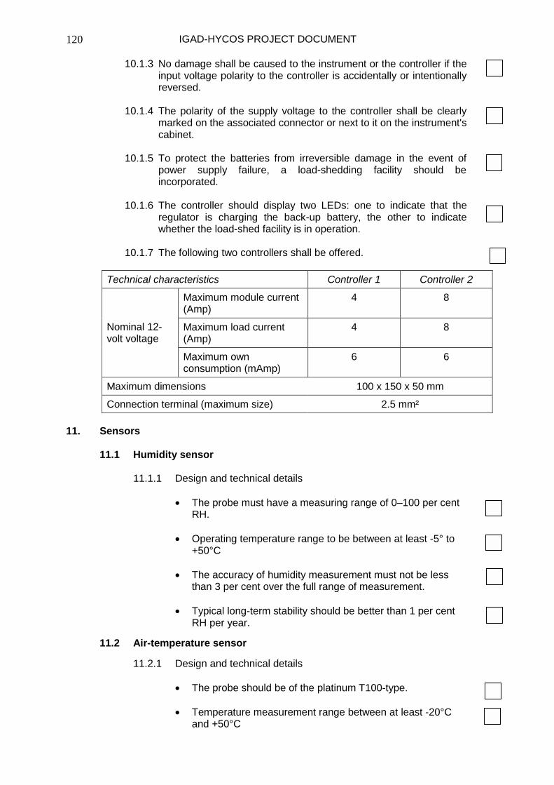
IGAD-HYCOS PROJECT DOCUMENT
120
10.1.3 No damage shall be caused to the instrument or the controller if the input voltage polarity to the controller is accidentally or intentionally reversed.
10.1.4 The polarity of the supply voltage to the controller shall be clearly
marked on the associated connector or next to it on the instrument's cabinet.
10.1.5 To protect the batteries from irreversible damage in the event of
power supply failure, a load-shedding facility should be incorporated.
10.1.6 The controller should display two LEDs: one to indicate that the
regulator is charging the back-up battery, the other to indicate whether the load-shed facility is in operation.
10.1.7 The following two controllers shall be offered.
11. Sensors
11.1 Humidity sensor
11.1.1 Design and technical details
• The probe must have a measuring range of 0–100 per cent RH.
• Operating temperature range to be between at least -5° to
+50°C • The accuracy of humidity measurement must not be less
than 3 per cent over the full range of measurement. • Typical long-term stability should be better than 1 per cent
RH per year.
11.2 Air-temperature sensor
11.2.1 Design and technical details
• The probe should be of the platinum T100-type. • Temperature measurement range between at least -20°C
and +50°C
Technical characteristics Controller 1 Controller 2
Maximum module current (Amp)
4 8
Maximum load current (Amp)
4 8 Nominal 12-volt voltage
Maximum own consumption (mAmp)
6 6
Maximum dimensions 100 x 150 x 50 mm
Connection terminal (maximum size) 2.5 mm²

IGAD-HYCOS PROJECT DOCUMENT
121
• The sensitivity of the measuring element should be 0.1°C or better.
• The probe shall be designed to allow measurement at
1.5 metres above the ground sheltered from the sun.
11.3 Rain gauge
11.3.1 Application
The tipping-bucket-type rainfall recorder and rainfall recorder using the weighing principle can be proposed.
11.3.2 Design and technical details
• The rainfall recorder should be manufactured of non-
corrosive material. • Operating temperature range to be between at least -5°C to
+50°C, without any heating device. • Depending on the needs, the size of the opening should be
between 200 and 1000 cubic metres. • The minimum rainfall to be measured will be 0.2 mm or 0.5
mm. • The rain gauge should be able to measure an intensity of at
least 10 mm/minute. • The bidder shall propose a warm-up device as an optional
feature. • At the client's request, the manufacturer shall produce a
calibration certificate.
11.4 Anemometer
11.4.1 Design and technical details
• An anemometer with a three-cup anemometric transmitter with pulsed output proportional to rotation speed should be proposed.
• The anemometer's measurement range should be between
0.5 metres/second and at least 50 metres/second (180 kilometres/hour), but should withstand a wind speed of up to 60 metres/second.
• Operating temperature range must be between at least -5° to
+50°C. • Accuracy shall be better than 0.5 metres/second under
20 metres/second and better than 0.3 metres/second over 20 metres/second.
• The threshold wind-speed value shall be greater than
0.5 metres/second.

IGAD-HYCOS PROJECT DOCUMENT
122
11.5 Wind-direction indicator
11.5.1 Design and technical details
• The measurement of the direction of the wind shall be with a continuous rotation transmitter.
• Operating temperature range to be between at least -5°C
and +50°C. • The range of measurement shall be 360 degrees
(mechanical) and 355 degrees (electrical). • The accuracy shall be better than three degrees and the
threshold value better than one metre/second over the displacement range.
11.6 Net radiation
11.6.1 Design and technical details
• The pyranometer shall be calibrated for the daylight
spectrum and provide an output of 4–20 mA with an accuracy better than 5 per cent.
• The measurement range of the radiometer should range
from 0 to at least 1500 w/square metres. • Operating temperature range should be between at least -
5°C and +50°C. • Stability shall be less than one per cent change per year. • Temperature dependence shall not exceed 0.1 percent per
degree C. • The cosine response shall be less than three per cent of the
value with a zenith angle of 0° to 80°. • The azimuth error shall be less than three per cent of the
value. • The sensor shall be housed in a waterproof case.
12. Portable multi-parameter water-quality sensor (sonde)
12.1 Application
12.1.1 This dedicated sensor/sonde will be used to measure multiple parameters simultaneously and must be proposed with a handheld multi-parameter display and logger.

IGAD-HYCOS PROJECT DOCUMENT
123
12.1.2 The sensor/sonde should be able to measure at least the following parameters: dissolved oxygen, water level, pH, redox-potential, conductivity, temperature, salinity, ORP, nitrate, ammonium, ammonia, turbidity, chlorophyll, rhodamine and chloride.
12.2 Design and technical details
12.2.1 The sensor should withstand immersion to 50 metres deep. 12.2.2 The sensor housing shall be manufactured from non-corrosive
material and not exceed the following dimensions and weight: diameter– 50 mm, length–500 mm and weight–3 kg
12.2.3 The sensor should have a RS 232 interface for connection to a
handheld logger or laptop/palmtop. 12.2.4 The following features and parameters will be standard on the
basic unit:
• Stirring-independent oxygen measurement • Internal memory of 384K flash ROM (150 000 readings) • Use of internal commercially available dry alkaline batteries • Conductivity • Temperature
12.2.5 The following parameters should be selectable: dissolved oxygen,
pH, ORP, salinity, depth, vented level, turbidity, chlorophyll, ammonium, ammonia, nitrate, chloride, specific conductance, resistivity and total dissolved solids.
12.3 Sensor specifications
The following minimum specification for each parameter will apply:
12.3.1 Dissolved oxygen (% saturation)
• Range: 0 to 500 % • Resolution: 0.1 % • Accuracy: 0–500 %; ± 6 % air saturation
12.3.2 Dissolved oxygen (mg/l)
• Range: 0 to 50 mg/L • Resolution: 0.01 mg/L • Accuracy: 0–50 mg/L; ± 6 mg/L
12.3.3 Conductivity
• Range: 0 to 100 mS/cm • Resolution: 0.001 to 0.1 mS/cm • Accuracy: ± 0.5 % of reading

IGAD-HYCOS PROJECT DOCUMENT
124
12.3.4 Temperature
• Range: -5°C to +45°C • Resolution: 0.01°C • Accuracy: ± 0.15°C
12.3.5 pH
• Range: 0 to 14 units • Resolution: 0.01 unit • Accuracy: ± 0.2 unit
12.3.6 Non-vented depth
• Range: 0 to 9 m • Resolution: 1 mm • Accuracy: ± 20 mm
12.3.7 Vented depth
• Range: 0 to 9 m • Resolution: 1 mm • Accuracy: ± 10 mm
12.3.8 ORP
• Range: -999 to +999 mV • Resolution: 0.1 mV • Accuracy: ± 20 mV
12.3.9 Salinity
• Range: 0 to 77 ppt • Resolution: 0.01 ppt • Accuracy: ± 1 % of reading
12.3.10 Nitrate-Nitrogen • Range: 0 to 200 mg/L-N • Resolution: 0.1 mg/L-N • Accuracy: ± 10 % of reading
12.3.11 Ammonium-Nitrogen
• Range: xxx to 200 mg/l-N • Resolution: 0.1 mg/L-N • Accuracy: ± 10 % of reading
12.3.12 Ammonia
• Range: 0 to 200 mg/L-N • Resolution: 0.1 mg/L-N • Accuracy: ± 10 % of reading
12.3.13 Turbidity
• Range: 0 to 1000 NTU • Resolution: 0.1 NTU • Accuracy: ± 5 % of reading
12.3.14 Chlorophyll • Range: 0 to 400 µg/l • Resolution: 0.1 µg/l Chl • Accuracy: ± 0.1 % FS

IGAD-HYCOS PROJECT DOCUMENT
125
12.3.15 Rhodamine
• Range: 0 to 200 µg/L • Resolution: 0.1 µg/l • Accuracy: ± 1.0 µg/l
12.3.16 Chloride • Range: 0 to 1000 mg/l • Resolution: 0.1 mg/l • Accuracy: ± 15 % of reading
13. Four-channel data logger
The specifications are the same as for the multi-channel logger, except there are only four channels.

IGAD-HYCOS PROJECT DOCUMENT
126
Annex 3
Job descriptions of the professionals of the Project Management Unit Project manager The project manager must be a water resources expert, holding a post-graduate degree in hydrology or a relevant scientific field. He/she should be familiar with hydrological cycle observation systems and water resources information systems. Furthermore, he/she must be well acquainted with the concept and practice of integrated water management issues at transboundary river basin scale. Knowledge of the organization and operation of National Hydrological Services is a requirement. The expert should be familiar with conventional and modern equipment and techniques for hydrological data collection, including up-to-date knowledge about remote data transmission. Sound knowledge and experience in hydrological data processing, hydrological database design and operation and information systems featuring data and information dissemination through the Internet are prerequisites. The project manager should have the experience and ability to turn hydrological data into information for hydrological applications and water resources management. These applications include water resources assessment at the river basin scale, reservoir systems modelling and operation, drought operating strategies, flood frequency estimation, flood routing, warning and forecasting. Experience in hydrological modelling is recommended. The project manager should have sound experience in technical and financial management and reporting. Experience of reporting on international development projects is recommended. He/she should have a proven ability in managing large, complex technical projects and in promoting regional cooperation. Knowledge of the institutional and technical specifications of the WHYCOS programme, HYCOS regional projects and familiarity with the water resources management issues in the Horn of Africa is highly recommended. The expert should have a minimum of fifteen years experience. Field hydrologist/technician The field hydrologist/technician is responsible for coordination of measurements and data collection in the field and for the primary processing of the data collected. He/she will be the everyday counterpart of the regional component of the project with the National Hydrological Services. He/she must have a sound experience in the operation of a national hydrological service and the organization of its duties, in the practice of hydrological measurements on large rivers and on the installation, use and maintenance of the instruments used in hydrology. Sound practical knowledge on the operation of electronic sensors, digital data loggers and transmissions vectors (satellite, cellular telephone, VHF, etc.) is required. The expert should have experience in processing information leading up to the operation of a national database. Past experience in using specialized software for that purpose (such as HYDATA, HYDROM, HYMOS, HYDSYS, WISKI and similar databases or information systems) is required. The expert should have excellent planning and organizational skills. This is required for organizing training sessions on hydrological practices and in preparing guidelines and standards for the operation of a regional network for in operational hydrology. In-depth knowledge and experience in the calibration of stable river sections, various types of gauging structures and reservoir spillways would be a recommendation. The expert should have a minimum of ten years experience.

IGAD-HYCOS PROJECT DOCUMENT
127
Hydrologist The hydrologist is responsible for the analysis of hydrological data. These data will emanate from various sources, such as the captured data from the project DCPs, data sent from the countries on water quality and lake levels. It is required to obtain long-term time-series data at the gauging sites equipped with DCPs and additional time-series data at other key gauging sites. The hydrologist will analyse these data sets and ensure their continuity by filling in gaps using statistical techniques and modelling. These data sets, in combination with other relevant data, such as spatial information from satellite images on rainfall, vegetation cover and soil moisture, will be used to develop hydrological products such as early drought identification and severity of drought. In addition, a study of major floods as well as flood frequencies at selected important locations will be undertaken. The stage of bank full flow will be established at important sites and procedures for forecasting these conditions (as well as out of bank flood flow conditions) from data received at the PRC/PMU will be developed. This information will be used to develop a flood warning strategy at the national and transboundary level. It will be necessary to collaborate and liaise closely with the NHSs within the region to develop a practical and useful system of flood warning and forecasting. It is expected that the hydrologist will use available spatial data in near real-time from the DMCN, the Kenyan Meteorological Service and historical data and expertise from the NHSs within the IGAD region to develop useful hydrological products. The hydrologist will be active in technology transfer to participants of the NHSs within the IGAD region. Developed software must be disseminated to participants of the project who should be trained to use and interpret the results. The hydrologist will contribute to the creation of the project's Web site where trends in the river stage (flow), lake levels, groundwater levels, precipitation and water quality variables will be displayed. The hydrologist must have extensive experience in water resources and flood-related analyses of at least ten years. Electronic data-processing expert The electronic data-processing expert is a specialist for designing, documenting and operating information systems for the environment having a strong water resources component. He/she must have direct experience in networking (TCP/IP, FTP and HTTP) and using major commercial relational databases (Oracle, Access, SQL Server). The expert must also be familiar with database administration of the above-mentioned databases. Extensive experience in an object orientated programming language (C++ or Dephi) will be needed to decode CREX messages and populate the regional database. The EDP expert will be expected to develop dynamic Web applications using databases and more recent available Web page development technologies (ASP, ISAPI, CGI, HTML and DHTML). Knowledge of maintaining and setting up a Web-based server using Microsoft Internet Information Server is also of cardinal importance. Experience in hydrology will also be an advantage, as the EDP expert will be expected to converse with hydrologists and design and develop packages that will process hydrological data in the National Hydrological Services. He/she shall have pedagogic capacity in organizing training sessions on database operation and in preparing user and maintenance guides for the operators of the regional database at the Project Regional Centre and in the National Hydrological Services. The expert should have a minimum of five years of experience.
Copyright © 2022 FDOKUMEN