What's new in Bentley Map V8i (SELECTseries 3)
36
© 2012 Bentley Systems, Incorporated What’s new in Bentley Map V8i (SELECTseries 3)
-
Upload
khangminh22 -
Category
Documents
-
view
0 -
download
0
Transcript of What's new in Bentley Map V8i (SELECTseries 3)

© 2
012
Ben
tley
Sys
tem
s, In
corp
orat
ed
What’s new in Bentley Map V8i (SELECTseries 3)

© 2
012
Ben
tley
Sys
tem
s, In
corp
orat
ed
2 | WWW.BENTLEY.COM
Bentley Map V8i (SELECTseries 3) New Features At-a-Glance • Spatial Database and Web Services
Enhancements
– SQL Server Spatial Support
– Web Feature Service (WFS) client
– Redesign of Spatial Database interface
– Major Performance Enhancements
– Direct Data Access
• Accessing Millions of Rows directly
• Affecting all parts of the application working with attributes information
– Spatial Data Streaming
– Dynamic Domains support
– Attribute filtering at the class level
– Selective posting
• Mapping
– Scalable Terrain Model
– Redesign of Grid Generation tool
– Export Bentley Map Manager thematic to DGN
– Create Polygon Parallel
– Automatically create thematic map from template
• 3D GIS Enhancements
– 3D Geometry clean-up
– Solar Analysis
– CityGML Application Template
• Feature Engine Performance Enhancements
– New more efficient polygon type
– Better memory management
– Streamlined relationships support
• More API (including Direct Database Access)
• Coordinate systems
– Custom Datum/Ellipsoid Definition
– Coordinate read-out in any alternate coordinate systems

© 2
012
Ben
tley
Sys
tem
s, In
corp
orat
ed
3 | WWW.BENTLEY.COM
Bentley Map Enterprise - Standalone
Bentley Map - Standalone or for MicroStation
Bentley Map PowerView - Standalone
Bentley Map
Assemble/ Integrate
Create Maps/Reports
Feature Modeling
3D Analysis/
Make Decisions
Mark-up/View/ Edit DGN/XFM
3D Modeling
Transform/
Edit Rasters
Cadastral Mapping Configuration
Advanced Map Finishing
3D Texturing
View Oracle
GeoRaster View Raster DEM
Advanced Interoperability
Edit Oracle Spatial
- Long
Transaction/Time
View Oracle Spatial
View Rasters
Edit Oracle Spatial - Short transaction
2D Analysis/ Make Decisions
Basic CAD tools
CAD tools
Advanced
CAD tools
Bentley Map PowerView
Functionality
Bentley Map
PowerView
and
Bentley Map
Functionality
GPS
Edit SQL Server Spatial
- Short transaction
View WMS/WFS
View SQL Server Spatial
Point Cloud Viewing
Advanced Point Cloud
Processing
3D Geometry Clean-
Up
Scalable Terrain
Model
Solar/Shadow
Analysis
Faster XFM Feature
engine API
Direct Database
Access API
Spatial Data Streaming API
Export Thematic Map Symbology
and Grid Generation
Edit /Create Custom
Coordinate Systems

© 2
012
Ben
tley
Sys
tem
s, In
corp
orat
ed
4 | WWW.BENTLEY.COM
ProjectWise/Bentley Geospatial Server
Data Files Data Files
w/ Database Linkages Spatial
Documents Business
Documents Ancillary Files
w/ RDBWS Web
Services Proprietary
GIS Databases Enterprise
Data Stores
MicroStation/Bentley Map
Bentley Map PowerView
Bentley Map
Bentley Map Enterprise
Geo Web
Publisher
Civil Engineering Architecture Imaging Communication Utilities
Interoperability
Connectors
Enterprise
Connectors
Web
Clients
Architecture
Spatial Databases

© 2
012
Ben
tley
Sys
tem
s, In
corp
orat
ed
5 | WWW.BENTLEY.COM
Spatial Data Streaming- SQL Server Spatial and Oracle Spatial • Connect directly to SQL
Server Spatial and Oracle Spatial
• Query, modify and post features
• Standard SQL Server and Oracle Spatial data - no required tables or columns
• Seamless access to spatial data at display time – faster display, more intuitive for the user

© 2
012
Ben
tley
Sys
tem
s, In
corp
orat
ed
6 | WWW.BENTLEY.COM
Direct Access to Large Databases
• Query millions of rows quickly in the Data Browser
• Sort and filter records at database speeds
• Minimal memory required for very large databases

© 2
012
Ben
tley
Sys
tem
s, In
corp
orat
ed
7 | WWW.BENTLEY.COM
Benefits - Direct Database Access
• Fast operation with very large databases
• Save time by not creating smaller project databases
• Reduce local machine memory requirements
• Reduce network traffic by sending only the data being viewed to the workstation

© 2
012
Ben
tley
Sys
tem
s, In
corp
orat
ed
8 | WWW.BENTLEY.COM
Web Feature Service
• Access WFS sources through Internet
• All Bentley Map query and symbology options supported
• WFS features behave as any Bentley Map feature
– Annotate
– Thematic
– Analyze
– Query
– Report

© 2
012
Ben
tley
Sys
tem
s, In
corp
orat
ed
9 | WWW.BENTLEY.COM
Benefits - Web Feature Service
• Take advantage of public WFS data
• Industry standard tool for spatial data access
• Enhances interoperability in multi-vendor installations

© 2
012
Ben
tley
Sys
tem
s, In
corp
orat
ed
10 | WWW.BENTLEY.COM
Improved Grid Generation Tool
• Automatically create grids and graticules using Wizard
• Combine multiple grids and graticules in the same instance
• Alternate coordinate systems supported
• Grid automatically updated based on changes to grid definition
• Drop grid to simple elements

© 2
012
Ben
tley
Sys
tem
s, In
corp
orat
ed
11 | WWW.BENTLEY.COM
3D Geometry Clean-up
• New tools to create valid solid models from existing geometry
• Correct and stitch surfaces
• Automatically fix some data errors
• Identify other data errors
• Extrude down to terrain

© 2
012
Ben
tley
Sys
tem
s, In
corp
orat
ed
12 | WWW.BENTLEY.COM
Benefits - 3D Geometry Clean-up
• Produce complete solid models from existing 3D surfaces
• Reduce time remodeling existing data
• The models produced are suitable for storing in Oracle Spatial, texturing, etc.
• Move from visualization to GIS data
© 2
012
Ben
tley
Sys
tem
s, In
corp
orat
ed
13 | WWW.BENTLEY.COM
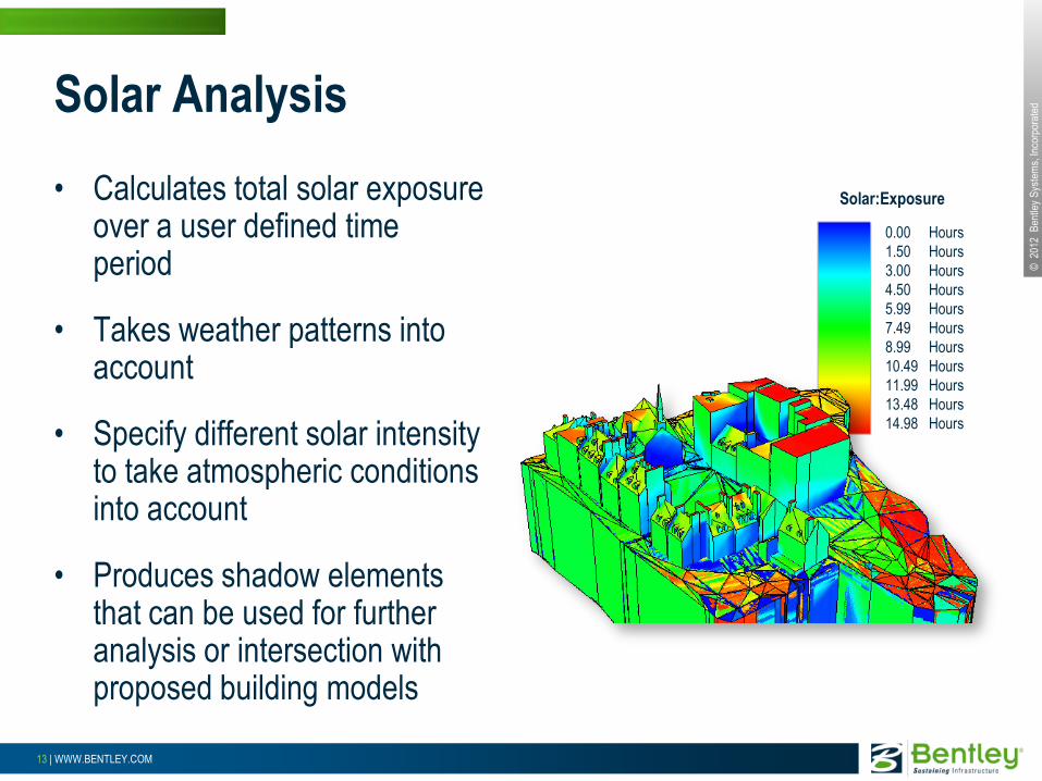
Solar Analysis
• Calculates total solar exposure over a user defined time period
• Takes weather patterns into account
• Specify different solar intensity to take atmospheric conditions into account
• Produces shadow elements that can be used for further analysis or intersection with proposed building models
0.00
1.50
3.00
4.50
5.99
7.49
8.99
10.49
11.99
13.48
14.98
Hours
Hours
Hours
Hours
Hours
Hours
Hours
Hours
Hours
Hours
Hours
Solar:Exposure

© 2
012
Ben
tley
Sys
tem
s, In
corp
orat
ed
14 | WWW.BENTLEY.COM
Benefits - Solar Analysis
• Calculate total solar exposure to help locate solar panels
• Solar exposure provides a better indicator of sun on public lands than simple time-of-day shadow studies
• Shadow objects show precise shadow areas and, optionally, the color of the shading object to easily assess the effect of a new development on the surrounding area

© 2
012
Ben
tley
Sys
tem
s, In
corp
orat
ed
15 | WWW.BENTLEY.COM
CityGML Application Template
• Bentley Map XFM model based on CityGML data model
• Supports all CityGML features
• Includes placement and promote tools

© 2
012
Ben
tley
Sys
tem
s, In
corp
orat
ed
16 | WWW.BENTLEY.COM
Benefits - CityGML Application Template
• Create CityGML models from existing 3D models using Promote tools
• Placement methods to create certain components directly
• Standard Bentley Map format means interoperability with the supported GIS data types
• Support from FME for many other formats
© 2
012
Ben
tley
Sys
tem
s, In
corp
orat
ed
17 | WWW.BENTLEY.COM
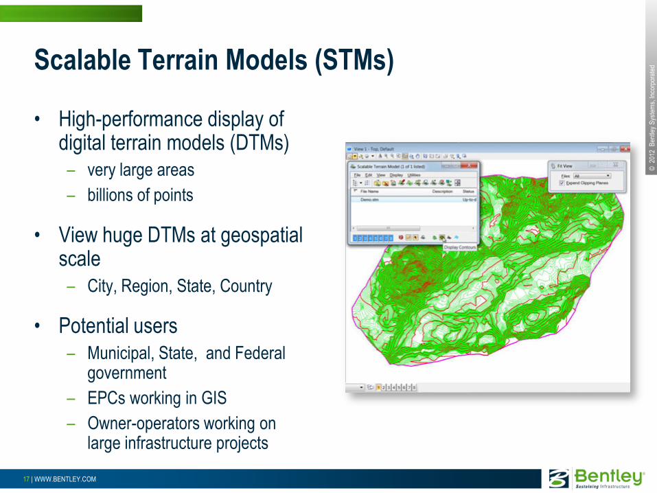
Scalable Terrain Models (STMs)
• High-performance display of digital terrain models (DTMs)
– very large areas
– billions of points
• View huge DTMs at geospatial scale
– City, Region, State, Country
• Potential users
– Municipal, State, and Federal government
– EPCs working in GIS
– Owner-operators working on large infrastructure projects

© 2
012
Ben
tley
Sys
tem
s, In
corp
orat
ed
18 | WWW.BENTLEY.COM
Benefits - Scalable Terrain Models
• Use city and regional scale DTM, no requirement to extract project-size DTMs
• Full access to every point
• New workflows possible with large scale DTMs
• High resolution image draping for high quality visualization
• Easy synchronization with original terrain sources

© 2
012
Ben
tley
Sys
tem
s, In
corp
orat
ed
19 | WWW.BENTLEY.COM
Point Cloud Processing
• Point Cloud Classification Editing
• Point Cloud Line Draping
• Point Cloud Advanced Export
• Point Cloud Geometry Extraction
• Point Cloud Visual Explorer
• Point Cloud Smart Snap

© 2
012
Ben
tley
Sys
tem
s, In
corp
orat
ed
20 | WWW.BENTLEY.COM
• Dynamically re-color points in the cursor neighborhood based on their 3D location and a direction
• Improves user understanding of how the points are organized: – Are there points behind my cursor position?
– Are there points around the cursor almost at the same depth?
– Is the cursor snapping on the top or the bottom of this edge?
Visual Explorer

© 2
012
Ben
tley
Sys
tem
s, In
corp
orat
ed
21 | WWW.BENTLEY.COM
• Enables better understanding of a 3D scene
• Enables simpler QA/QC of the point cloud data
• Enables better navigation of a 3D scene
• Provides faster and more accurate digitizing especially when combined with Smart Snap
Benefits – Visual Explorer

© 2
012
Ben
tley
Sys
tem
s, In
corp
orat
ed
22 | WWW.BENTLEY.COM
• Smart Snap is a tool for picking key points such as the lowest, highest, average or median point along a user defined path. For example, find the peak line along a road centerline.
• Works in conjunction with AccuSnap and uses the point found by AccuSnap as the center of the search area.
Point Cloud Smart Snap

© 2
012
Ben
tley
Sys
tem
s, In
corp
orat
ed
23 | WWW.BENTLEY.COM
• Fully integrated with MicroStation AccuSnap, it simplifies modeling with point clouds
• It enables: – Fast semi-automatic break line extraction
– Simple feedback on the particular point the tools are snapped on in the point cloud
– Easier distance measurement
– Faster digitizing by reducing the number of view rotations while working
Benefits – Smart Snap

© 2
012
Ben
tley
Sys
tem
s, In
corp
orat
ed
24 | WWW.BENTLEY.COM
• Plane results – Planar 3D polygon
(convex hull)
• Cylinder results – Cylinder shell
– Cylinder centerline
– Cylinder centerline and radius
Plane and Cylinder extraction

© 2
012
Ben
tley
Sys
tem
s, In
corp
orat
ed
25 | WWW.BENTLEY.COM
• Extract planar elements to build geometries of features – City furniture
– Building facades, roofs
• Extract planar elements to set ACS
Plane and Cylinder extraction – Usage

© 2
012
Ben
tley
Sys
tem
s, In
corp
orat
ed
26 | WWW.BENTLEY.COM
• Automatically drape lines on point cloud surface
• Convert line approximation into lines following exactly the point cloud surface.
Draping on Point Cloud

© 2
012
Ben
tley
Sys
tem
s, In
corp
orat
ed
27 | WWW.BENTLEY.COM
• Enables semi-automated geometry extraction from point cloud – For example
• Road profiles
• Transmission line cables
• Etc.
• Enables analysis of the extracted vector data using any Bentley Map tools
• Creates better terrain models by supporting the creation of break lines
Benefits – Point Cloud Draping

© 2
012
Ben
tley
Sys
tem
s, In
corp
orat
ed
28 | WWW.BENTLEY.COM
Point Cloud – Snap Element
• Similar to drape element
• Select snap points based on snap settings
• Better selection of specified points
– Highest
– Lowest
– Median
– Etc

© 2
012
Ben
tley
Sys
tem
s, In
corp
orat
ed
29 | WWW.BENTLEY.COM
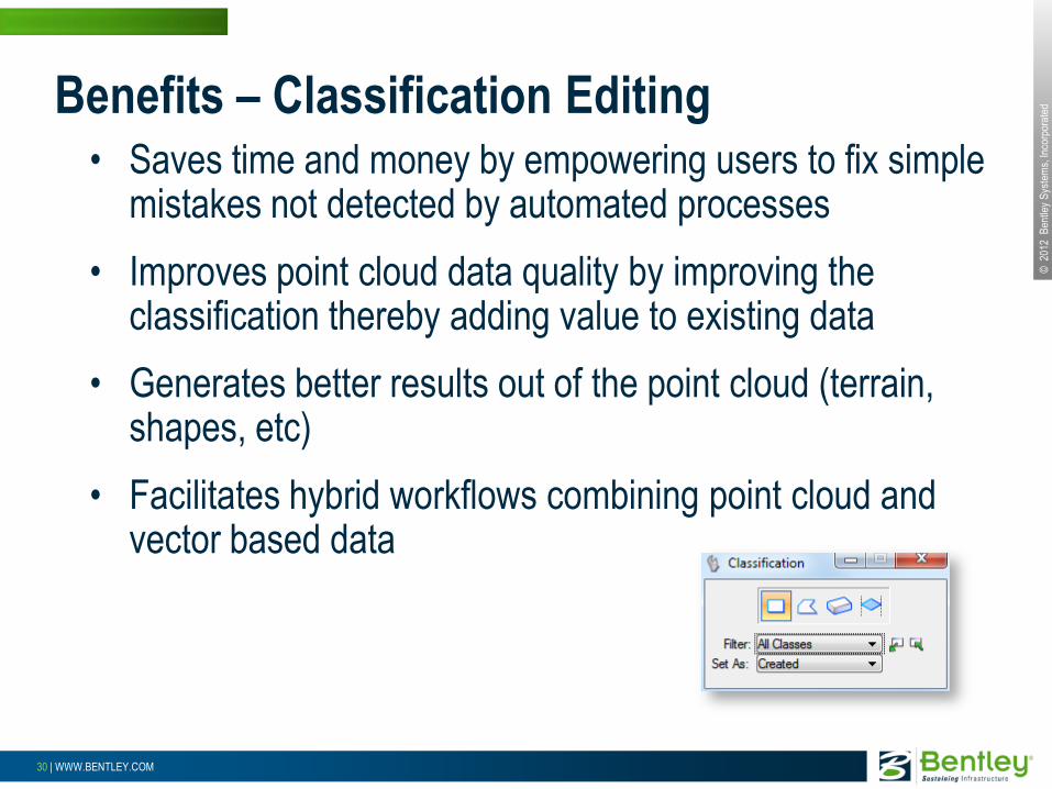
• Automatically classified data has mistakes impacting break line extraction, terrain creation, shape extraction, etc.
• Hybrid workflows need a way to structure point cloud parts and hide portion of it
• Point clouds have noise – People, cars, land surveying hardware etc..
– False points (ex: laser crossing windows)
Classification Editing
© 2
012
Ben
tley
Sys
tem
s, In
corp
orat
ed
30 | WWW.BENTLEY.COM
• Saves time and money by empowering users to fix simple mistakes not detected by automated processes
• Improves point cloud data quality by improving the classification thereby adding value to existing data
• Generates better results out of the point cloud (terrain, shapes, etc)
• Facilitates hybrid workflows combining point cloud and vector based data
Benefits – Classification Editing
© 2
012
Ben
tley
Sys
tem
s, In
corp
orat
ed
31 | WWW.BENTLEY.COM
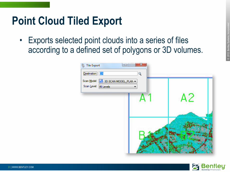
• Exports selected point clouds into a series of files according to a defined set of polygons or 3D volumes.
Point Cloud Tiled Export

© 2
012
Ben
tley
Sys
tem
s, In
corp
orat
ed
32 | WWW.BENTLEY.COM
• Splits large point clouds into smaller pieces
• Makes large datasets more manageable for 3rd party software having less capacity than MicroStation
Benefits - Point Cloud Tiled Export

© 2
012
Ben
tley
Sys
tem
s, In
corp
orat
ed
33 | WWW.BENTLEY.COM
• Exporting to LAS files – LAS is a well known standard in point cloud world
• Exporting to LAS, XYZ, or POD files in multiple tiles – User can specify a 3D “Grid” to define the extent of the
exported files
– Easily split large datasets in smaller files for easier handling in other software or for easier distribution on a network
More file format support

© 2
012
Ben
tley
Sys
tem
s, In
corp
orat
ed
34 | WWW.BENTLEY.COM
• New APIs to support new functionality
– Direct spatial database access
• Provides better integration between MicroStation and Bentley Map models
• Point Cloud API
API
VBA Visual Studio.
Net COM MDL
C#
C++
(managed)
Visual Basic
.NET
MicroStation
.NET Addins
Visual C++
Visual Basic
Microsoft Access
Microsoft Office (Excel, Word etc…)
XFT Object Library
Native C/C++ (unmanaged)
XFM Native C API
MDL Interpreted Code (not
recommended)
MicroStation Object Library
XFT Object Library

© 2
012
Ben
tley
Sys
tem
s, In
corp
orat
ed
35 | WWW.BENTLEY.COM
Export Bentley Map Data to DGN
• Allows the export of data from inside the Map Manager using the currently defined symbology
• Creates standard DGN elements (no attributes)
• Elements can be used in any CAD based workflows as the Bentley Map features are decomposed into their constituent base elements

© 2
012
Ben
tley
Sys
tem
s, In
corp
orat
ed
36 | WWW.BENTLEY.COM
• More speed improvements – Spatial Data Streaming, Direct Database Access, improved polygon
handling
• More interoperability – SQL Server Spatial, WFS, enhanced MicroStation integration,
streamlined interoperability interface
• New fundamental data types – Point Cloud – Scalable Terrain Model
• More tools – Alternate coordinate readout, improved grids and graticules, datum
and ellipsoid editing
Summary