Interfacial micromorphology and shear bond strength of single-bottle primer/adhesives
Upload
independentCategory
view
4download
0
Catena 61 (2005) 1–29
www.elsevier.com/locate/catena
Weathering and pedogenesis in the Sila
Grande Massif (Calabria, South Italy):
From field scale to micromorphology
Fabio Scarciglia*, Emilia Le Pera, Salvatore Critelli
Dipartimento di Scienze della Terra, Universita della Calabria, Via P. Bucci,
87036 Arcavacata di Rende (CS), Italy
Received 18 November 2003; received in revised form 31 December 2004; accepted 1 February 2005
Abstract
Weathering and soil features in the upland landscapes developed on granitic terrains of the Sila
Grande Massif (Calabria, South Italy) have been studied in this work. The attempt to link field scale
and micromorphological observations in order to better understand the main weathering processes
and their controlling factors is revealed to be very powerful. Six soil profiles in the area around the
Cecita Lake, representative of different geomorphological units, were characterised by field work,
optical microscopy and SEM-EDS analysis. A strong influence on weathering and pedogenesis by
micro-scale features of primary minerals and parent rock fabrics is shown. Key roles are played also
by relief, in the development and preservation or stripping of regolith + soil mantles in relation to
natural and man-induced phenomena; by time, controlling rates and degree of development of the
main weathering features; by climate, in terms of type and intensity of dominant processes.
D 2005 Elsevier B.V. All rights reserved.
Keywords: Granite weathering; Micromorphology; Quartz textures; Grus; Calabria
0341-8162/$ -
doi:10.1016/j.
T Correspon
E-mail add
(S. Critelli).
see front matter D 2005 Elsevier B.V. All rights reserved.
catena.2005.02.001
ding author. Tel.: +39 984 493549; fax: +39 984 493554.
resses: [email protected] (F. Scarciglia)8 [email protected] (E. Le Pera)8 [email protected]
F. Scarciglia et al. / Catena 61 (2005) 1–292
1. Introduction
Weathering of crystalline rocks and soil features of the Sila Grande Massif, in the
Calabria region (South Italy), have been widely investigated with special emphasis on
granular, in situ disintegration of granitoid/gneissic rocks (grus production) and soil
management, respectively. In more detail, previous papers dealt with the description of
typical weathering landforms, the interpretation of their formational factors and
processes, and their distribution (Matano and Di Nocera, 1999; Le Pera and Sorriso-
Valvo, 2000a). The evaluation of micropetrographic indices has permitted (i)
quantification and comparison of different degrees or stages of weathering (Le Pera
et al., 2001b), (ii) assessment of their effects on rock stability and landslide
phenomena (Critelli et al., 1991; Cascini et al., 1992), and (iii) application to
provenance studies linking siliciclastic sediments in fluvial catchments to source rocks
(Le Pera et al., 2001a). Petrographic and mineralogical analyses performed by
Mirabella et al. (1996) on parent rock materials and secondary clay minerals,
respectively, indicated connections between weathering and pedogenetic processes.
Other works report data concerning detailed soil survey, taxonomy and mapping,
mainly to estimate soil sensitivity to degradation under different land management, for
agriculture purposes (seed-potato crop suitability), pasture and forestry, or to test soil
conservation measures (Lulli et al., 1992; Costantini, 1993; Lulli and Vecchio, 1996,
2000).
Nevertheless, published studies lack an integrated approach to weathering and
pedogenesis, as well as any climatic interpretation or soil age assessment. This paper
attempts to address these questions and some wider issues in weathering studies. The
major factors responsible for weathering of crystalline rocks are widely reviewed and
discussed by Whalley et al. (1982), Twidale (1986), Migon and Lidmar-Bergstrfm(2001), Migon and Thomas (2002), where also the importance of linking different scales
of observations (Viles, 2001) to interpret weathering processes and landforms is
highlighted. The present work approaches this issue, scaling from field investigation to
micromorphological analysis, and combines both weathering and pedogenetic features,
in order to have a more complete understanding of their driving processes and to
interpret them in terms of environmental conditions and landscape evolution. In addition,
the controversial issue about relative roles of physical and chemical factors in grus
production is discussed.
Six selected soil profiles, representative of the main soil types (Umbrisols,
Cambisols and Luvisols, e.g. Lulli and Vecchio, 2000) associated with the major
landforms surrounding the Cecita Lake (central sector of the Sila uplands) are
considered in this paper, with a special focus on Late Quaternary soil evolution, the
most recurrent patterns of weathering, their degree of development and the main
alteration products. Both in situ granite weathering and soil development on granitic
fluvial deposits are taken into account, in order to include a variety of features and
consider weathering in its widest meaning. Physical, chemical and biological processes
operate changes on parent materials exposed to atmospheric agents at or near the
Earth’s surface, whether they consist of basement rocks, rock fragments, sediments,
colluvia or single minerals (cf. Butzer, 1976; Govett et al., 1992; SSSA, 2001).

F. Scarciglia et al. / Catena 61 (2005) 1–29 3
2. Geological, geomorphological and climatic setting
The study area (Fig. 1) is situated between 39810V and 39815VN latitude and between
16825V and 16835VE longitude, in the Sila Massif. This area represents a section of the
Hercynian orogenic belt of western Europe, where allochthonous crystalline basement
rocks are exposed to form the highest tectonic units (Calabrian Arc) of the southern Italy
Fig. 1. Geological sketch map of the study area (after Messina et al., 1991, modified) and location of the studied
soil profiles: (1) clastics (Recent to Tortonian); (2) sedimentary and metamorphic rocks (Oligocene to Devonian);
(3) phyllites+schists and ophiolitic rocks (Cretaceous to Palaeozoic); (4) gneissic rocks (Palaeozoic); (5) Sila
batholith (Palaeozoic); (6) stratigraphic contact; (7) thrust fault; (8) soil profile.

F. Scarciglia et al. / Catena 61 (2005) 1–294
fold–thrust belt (Amodio Morelli et al., 1976). The Sila Massif consists of Palaeozoic
intrusive and metamorphic rocks, locally with an unmetamorphosed, Mesozoic sedimen-
tary cover. A sedimentary succession of Miocene to Pleistocene age, about 2000 m thick,
crops out along the eastern border of the Sila Massif (Roda, 1964; Critelli, 1999). The
Palaeozoic rocks consist of gneiss, amphibolite, schist and phyllite, affected by various
Alpine metamorphic events and intruded by the Late Hercynian Sila batholith (Messina et
al., 1991). Gneisses consist of decimetre- to metre-thick biotite–sillimanite–garnet-rich
layers, varying in structure from massive to migmatitic. Contacts with plutons are marked
by a network of pegmatite dikes and an irregular thermal aureole with amphibolite facies
(Caggianelli et al., 1994). The Sila batholith consists of multiple intersecting intrusions,
heterogeneous in texture and fabric, ranging in composition from granodiorite to gabbro
and leucomonzogranite (Messina et al., 1991). Fission track analyses of apatite and zircon
from the basement rocks of the Sila Massif indicate a major period of exhumation ranging
from ~35 to ~15 Myr (Thomson, 1994).
The study area consists of flat to gently-inclined dissected landforms (summit
Paleosurface), cut across the Palaeozoic plutonic rocks and the Miocene–Pliocene
deposits and therefore developed during Pliocene(?)–Lower Pleistocene (Dramis et al.,
1990; Sorriso-Valvo, 1993; Matano and Di Nocera, 1999; Caruso et al., 2000), and of
younger paleosurface limbs, approximately spanning the whole Pleistocene, often sharply
separated by steep slopes (sometimes corresponding to fault planes), uplifted to different
elevations between 1650 and 1150 m a.s.l. (Ferrini and Moretti, 1997; Caruso et al.,
2000). Quaternary (Sorriso-Valvo, 1993; Matano and Di Nocera, 1999) terraced lacustrine
and fluvial deposits (of the paleo-Cecita Lake), morphologically entrenched within the
higher, uplifted paleosurface limbs and overlying the lower, downfaulted counterparts,
range from about 1270 to 1135 m a.s.l. (Fig. 2). Three main orders can be identified: the
lowest and intermediate terraces (III and II order) cut the lacustrine basin infilling of Late
Pleistocene age (Sorriso-Valvo, 1993), whereas the highest order (I) predates them and
postdates the paleosurfaces, tentatively being ascribed to Middle Pleistocene–Upper
Pleistocene pro parte(?).
A weakly reworked, weathered, yellowish tephra layer can be found towards the top
of Late Quaternary fluvial terraces both at the western and the eastern ends of the
Cecita Lake.
The study area has a typical upland Mediterranean climate (Csb, sensu Koppen, 1936),
i.e. a temperate humid climate with mean monthly temperatures ranging from �1 8C/1 8C(in January) to 16–18 8C (in August) and a not particularly prolonged dry summer
(Tmaxb22 8C), with July (and sometimes August) having less than 30 mm rainfall. Mean
annual precipitation reaches 1400–1600 mm according to elevation and aspect (Versace et
al., 1989; Lulli et al., 1992; Colacino et al., 1997). During winter the snow cover can be
preserved up to 6 months (Lulli et al., 2000). In more details, temperature data recorded at
Camigliatello Silano (1250 m a.s.l.) and Monte Scuro (1720 m a.s.l.), the thermopluvio-
metric stations closest to the study area, are available for the periods 1959–1970 and
1952–1980, respectively. Mean monthly values during the four coldest months (December
to March) range from �0.7 (recorded in January) to 3.8 8C (in March), with mean monthly
minima between �2.6 and 0.0 8C. Daily temperatures below zero commonly occur from
November to April and, although no detailed information about amount and frequency of

P2 P5 P1
P4
P3
Pliocene(?)-Lower Pleistocene
III
III
CecitaLake
Paleosurface limbs
Lower-MiddlePleistocene
Middle-UpperPleistocene(?)
Upper Pleistocene-Holocene
Tephra layer
? ?
II
P6
Clay coatings
Pumice fragments(Holocene)
Slope deposits(Late Holocene)?
Granite bedrock(Palaeozoic)
Lacustrine clays(Upper Pleistocene)
SpheroidalbouldersFaults
Fluvial sands andgravels (Middle-Upper Pleistocene )?
Fluvial sands andgravels (UpperPleistocene-Holocene )?
P1 P6 Soil profiles-
I-III Orders oflacustrine andfluvial terraces
A
R
Ap
Bw
C
P2
P5P6 P3 P4P1
R
AOi
A1
2Bw1
2BC
A2
A3
2Bw2
OiA1
A2
Bw
C
A
Bt
C
CBt
A
2Ab
2BC
2Bwb
Bw1
Bw2
Bw3
Bw4
50 cm
B
Fig. 2. Schematic geomorphological cross-section of the study area with the location (A) and logs of soil profiles
(B). See the text for details (Sections 2 and 5).
F. Scarciglia et al. / Catena 61 (2005) 1–29 5
diurnal cycles is available, oscillations a few degrees around zero can be supposed to occur
rather frequently. Mean monthly temperature of the warmest month (August) is 16–18 8C,with a mean monthly maximum of 24 8C.
The pedoclimate is characterised by a mesic soil temperature regime and a udic soil
moisture regime (sensu USDA, 1998).
As a consequence of these climatic conditions, an important role seems to be played
during the coldest months by a variety of cryonival phenomena, influencing rock
degradation and fragmentation, slow mass movements and soil processes. In particular,
seasonal snow-melt produces prolonged seepage and through-flow (inducing solifluction
and shallow soil slips or leaching phenomena and illuviation of silt particles in some sub-

F. Scarciglia et al. / Catena 61 (2005) 1–296
surface horizons) and overland-flow (inducing surface erosion, often concentrated into rills
or gullies).
Moreover, the leaching factor proposed by Crowther (1930), which depends on mean
annual precipitation and temperature, calculated for the Sila Massif, appears to be among
the highest in Europe (Le Pera and Sorriso-Valvo, 2000a).
3. Methods
A detailed geomorphological survey was carried out to describe the main weathering
features and landforms in the field, and to assess the associated geomorphic factors and
processes controlling the landscape evolution of the study area. Six representative
weathering/soil profiles corresponding to the main, different soil types (Section 1)
associated with the major landforms of this area (fluvial terraces, paleosurface limbs and
slopes with different steepness) were also described and sampled for bulk and
mineralogical analyses and for micromorphological and geochemical investigations.
Weathering features were first described using optical microscopy (OM) on thin
sections (10�5�0.003 cm), prepared after impregnation with a polyester crystic resin and
hardening of undisturbed samples for each soil horizon (FitzPatrick, 1984).
SEM-EDS analyses were performed on bulk samples (sand-textured mineral grains and
soil matrix clays) and thin sections, in order to (i) identify primary mineral species, (ii)
describe their pattern and degree of weathering (morphoscopic study), and (iii) recognise
neogenesis products (clay minerals due to pedogenesis). Samples were mounted on
aluminium stubs, coated with gold and examined with a Stereoscan 360 scanning electron
microscope (Cambridge Instruments), equipped with an energy dispersive X-ray analyser
with a Si/Li-SUTW detector (EDAX, Philips Electronics). X-ray intensities were
converted into weight percentages of oxides applying the ZAF standard matrix correction
procedure (Wilson, 1987).
4. Results
4.1. Weathering processes and landforms: field observations
The granitic bedrock constitutes the substratum both for lacustrine or fluvial deposits
and soils. Due to mechanical stresses building-up during history of tectonic activity and
unloading phenomena related to the emplacement and uplift of the Sila batholith, granites
exhibit very frequent shear zones, fault planes differently striking and dipping, and other
irregularly-arranged joint systems, sometimes intersecting (Fig. 3A and B). These and
other discontinuities (such as subordinate lithologic differences and contacts with
pegmatite dikes) isolate rock blocks and wedges of variable shape and size, which are
extremely prone to failure and occasionally fall down when slope stability thresholds are
overcome, especially from steep slopes and sub-vertical cliffs (Fig. 3B; Critelli et al.,
1991; Cascini et al., 1992). Joint widening is also observed to result from tree root
penetration or windthrow, ice intrusion related to freeze/thaw cycles and chemical

Fig. 3. Two typical outcrops of granites in the study area: (A) the bedrock exhibits intersecting fault planes (white
arrow) and other irregular joint systems, which (B) isolate rock blocks occasionally undergoing falls from cliffs
and steep slopes and accumulating at the foot-zone together with gritty and loosen, grussified debris. Note the
abrupt boundary between the thin soil and the underlying saprolite.
F. Scarciglia et al. / Catena 61 (2005) 1–29 7
weathering. Very often an intense grussification can be observed, leading to a further rock
flawing and crumbling to small polymineral aggregates and even single mineral particles
(grain-by-grain disintegration, sensu Butzer, 1976), as typical of crystalline rocks.
Rockfall debris from the cliffs and associated hillslope deposits appear often underlain
by 1–101 m thick, gritty and loosen grus (Fig. 3B), unsteadily stabilised at high scarp
angles (approximately 408–458) and repeatedly undergoing dry grain flow processes.
Despite the great depth of weathering profiles, ranging from one to some tens of metres,
up to about 100 m (Matano and Di Nocera, 1999; Cascini et al., 1992), the loosen and fine-
textured topsoils are often incomplete and lack of well-differentiated diagnostic horizons.
Sometimes, especially along steep slopes, they are extremely thin, reaching only few
centimetres in thickness, may appear truncated and/or exhibit abrupt boundaries – rather
than gradual transitions – towards the underlying weathered bedrock (Fig. 3B; Le Pera and
Sorriso-Valvo, 2000a; Le Pera et al., 2001b). It is also not uncommon to observe a
complete lack of soil cover, with exposed grus or bare rock, where tree roots directly
penetrate at depth within fractures. Frequently, where the saprolite has been removed,

F. Scarciglia et al. / Catena 61 (2005) 1–298
isolated rounded core-stones and core-boulders (Butzer, 1976; Ollier, 1988), derived from
deep spheroidal weathering (e.g. Ollier, 1967, 1971; Twidale, 1986; Thomas, 1994; Migon
and Lidmar-Bergstrom, 2001; Migon and Thomas, 2002), have been exhumed and outcrop
at the ground surface (Le Pera and Sorriso-Valvo, 2000a; Fig. 4A and B). Especially on the
highest and oldest paleosurface limbs they form wide boulder fields (Fig. 4B). The
exposed boulders are built of medium-grained and equigranular-textured granite, may
reach up to 2–3 m in diameter and appear occasionally split into large blocks along planar
or curved cracks. They have an essentially unweathered inner core surrounded by a weakly
weathered, outer shell, exhibiting encrusting lichens and thin exfoliation (flaking, sensu
Ollier, 1967, 1971) with millimetric to centimetric sheets – often not well defined,
incomplete and/or fragmented – at the rock/air surface (Fig. 5); also oxidation and cleaving
of biotite minerals can be observed, and local reddish iron staining frequently spreading
out from these crystals. More rarely, massive exfoliation (large-scale spalling or sheeting,
sensu Ollier, 1967, 1971) characterise the outline of boulders, showing curved, edge-
tapering sheets about 10–30 cm thick. On the other hand, thicker (up to 1.5 m), well-
developed soil profiles are preserved in protected flat landforms or depressions and along
gentle footslope belts, where also intense reworking and accumulation of colluvial
A
B
Fig. 4. Lots of spheroidal boulders, often splitted into large blocks (A), are exposed at the ground surface of the
highest paleosurface limbs (B).

Fig. 5. A spheroidal boulder showing various thin, curved sheets due to exfoliation (flaking), with incrusting
lichens on the outer shell.
F. Scarciglia et al. / Catena 61 (2005) 1–29 9
material – often including core-stones on the paleosurfaces – is observed. They often
exhibit humbric epipedon and cambic horizon/s, sand to sandy loam texture, very frequent
skeletal grains, sometimes lithic lower boundary towards underlying grus or bedrock, sub-
acid reaction.
4.2. Macromorphological soil features
The main pedological features of the six soil profiles sampled are reported in Table 1.
On the basis of the data produced they have been classified according to the WRB
taxonomy (ISRIC-FAO-ISSS, 1998), as follows: profiles P1, P3 and P6 are Hapli-Humic
Umbrisols, profile P2 is a Hapli-Dystric Cambisol, P4 a Hapli-Leptic Umbrisol and P5 a
Dystri-Cutanic Luvisol. They are soils representative of fluvial terraces, slope landforms
and paleosurfaces surrounding the Cecita Lake.
Soil profile P1 is located on a fluvial terrace along the southeast sector of the lake (1138
m a.s.l.). It is developed on sandy matrix-supported to clast-supported gravels of granitic
(and subordinately metamorphic) rocks, spherical to elongate in shape (approximately 2–
10 cm), with subrounded to subangular outlines.
Profile P2 was sampled on a depositional glacis (1150 m a.s.l.), gently sloping (with an
inclination not higher than 68–78) towards the valley floor of a stream, at the footslope of a
granitic hill along the northwestern margins of the lake. The slope of this glacis, grassy to
shrubby-vegetated, extends a hundred metres in length, after a headward break of slope
from a steeper portion (~208) about 150 m long. It consists of a weakly pedogenised,
stratified slope deposit, with very fine gravel to fine sand texture, overlying a well-
structured buried soil, developed on fluvial sands.
Profile P3 represents the oldest fluvial terrace elevated above the more recent (Late
Quaternary) lacustrine infilling of the basin, at an approximate height of 1270 m in the
Cecita Valley, at the eastern end of the lake. A man-restored pine forest represents its
vegetation cover. Beneath a thick litter and three distinct brownish A horizons – possibly
at least in part representing colluvial layers, as supported by the slight inclination (~58)

Table 1
Some selected features of the soil profiles studied (after Scarciglia et al., in press)
Soil
Profile
Horizon Depth
(cm)
Colour
(moist)
Sand
(%)
Clay
(%)
pH
(H2O)
Org. Mat.
(%)
CEC
(meq/100 g)
Mg
(meq/100 g)
Ca
(meq/100 g)
K
(meq/100 g)
Na
(meq/100 g)
P1 A1 0–5/10 10YR 2/2 56.4 8.0 5.4 9.3 12.4 0.1 1.6 0.7 0.1
A2 5/10–55 10YR 2/2 44.6 10.0 5.8 3.1 10.5 0.7 0.5 0.5 0.1
Bw 55–75 10YR 4/4 59.4 10.0 6 1.0 7.0 0.7 0.5 0.5 0.1
C 75–110+
P2 A 0–10 10YR 4/2
Bw1+Bw2+Bw3 10–125 10YR 5/4–4/4 75.4 8.0 6.1 0.6 5.6 0.7 0.7 0.2 0.1
Bw4 125–158 10YR 4/2 68.4 12.0 6.1 1.1 6.5 0.6 0.5 0.1 0.0
2Ab 158–190 10YR 2/2 55.8 12.0 6.2 3.2 9.0 0.6 0.5 0.1 0.1
2Bwb 190–230 10YR 6/6 75.4 6.0 6.5 0.5 5.3 0.5 0.5 0.4 0.1
2BC 230–260+ 10YR 6/6
P3 Oi 0–5
A1 5–20/30 10YR 2/2 54.6 8.0 5.7 5.7 12.0 0.5 1.0 0.4 0.1
A2 20/30–45 10YR 2/2 46 9.0 6.1 5.4 13.2 0.4 0.7 0.4 0.1
A3 45–60/65 10YR 3/2 46.8 8.0 5.9 3.7 11.5 0.7 0.5 0.4 0.0
2Bw1 60/65–80 7.5YR 4/3 57 8.0 6.4 0.9 7.0 0.8 0.8 0.4 0.1
2Bw2 80–100 7.5YR 4/4 61.8 10.0 6.2 0.6 4.8 0.7 0.6 0.3 0.1
2BC 100–120+ 7.5YR 5/4
P4 Oi 0–2
A 2–25 10YR 3/3 80.6 2.0 5.8 3.6 6.4 0.6 0.9 0.4 0.1
R 25–60+
P5 A 0–30/38 10YR 4/4 42.6 13.6 5.0 3.1 12.4 0.3 1.3 0.4 0.7
Bt 30/38–60 7.5YR 4/6 37.8 25.6 5.5 0.9 10.5 0.6 1.2 0.5 0.8
CBt 60–75 7.5YR 4/3 74.4 15.6 5.6 0.4 7.0 0.5 0.9 0.4 0.6
C 75–100+
P6a Ap 0–35 7.5YR3/2 50.7 10.9 5.6 5.6 23.2 1.5 1.1 0.2 0.4
Bw 35–60 10YR4/4 60.3 11.0 6.0 1.9 31.8 0.9 1.0 1.5 1.5
C 60–65 10YR5/6 73.2 4.9 5.9 0.8
R 65–100+
Org. Mat.: organic matter; CEC: cation exchange capacity; Mg, Ca, K, Na: exchangeable bases.a Data from Mirabella et al. (1996).
F.Scarcig
liaet
al./Caten
a61(2005)1–29
10
F. Scarciglia et al. / Catena 61 (2005) 1–29 11
of the flat surface for about 250 m towards the valley bottom – a buried soil (2Bw1–
2Bw2–2BC) is present. It exhibits reddish colours and includes, in a loam-sandy
matrix, very rare, rounded and elongated rock fragments (F max=15 cm), themselves
reddish to yellowish in colour as intensely weathered. The dearth of good outcrops and
the inability to drill deeper soil profiles made it impossible to determine whether they
represent core-stones typical of spheroidal weathering or coarse fluvial deposits;
however, the presence of nearby fluvial sediments, thinly stratified and sandy in texture
(eastward and upstream along the same valley terraces) better supports the latter
hypothesis. Scarce silt coatings on ped surfaces and skeletal grains occur in the same
buried horizons.
Profile P4 exhibits the granite saprolite, along an E-facing slope (incompletely
covered by a degraded grassland used for grazing) along the southeast border of the
lake (1160 m a.s.l.); slope inclination is about 158 while its length reaches 150 m. The
profile is extremely simple, consisting of a thin A horizon with a clear, linear lower
boundary (lithic contact) to the fissured and weathered bedrock. The organic-mineral
horizon includes frequent, very small skeletal grains (V1 cm), consisting both of single
minerals and irregular, polycrystalline rock fragments. The saprolite appears intensely
fragmented with very thin inter- and intra-granular cracks separating even small
(millimetre to centimetre) mineral aggregates loosely retained together; some crystals of
feldspar are quite weathered, have lost their original translucent aspect and acquired an
almost powdery consistency, with dirty white to pale yellow colours, whereas micas,
often oxidized, may show splitting along cleavage planes or distinct edge exfoliation.
Occasional Fe-oxide segregations and scarce clay coatings occur in inter-granular
spaces.
Soil profile P5 is cut at the top of an alluvial terrace in the southern sector of the
Cecita Lake (about 1150 m a.s.l.). It is developed on fluvial sands, and includes
frequent, rounded, granitic and metamorphic gravels. It is characterised by a yellowish
brown A horizon overlying a Bt and a CBt reddish horizons with abundant and thick
clay coatings.
Profile P6 is located on a grass-vegetated paleosurface limb along the southwestern
border of the Cecita Lake. It is about 1 m deep, with a dark brown Ap horizon
overlaying a yellowish brown Bw horizon and the poorly cohesive gritty grus (C), in
turn developed on the fractured granite rock (R). Parent rock fragments and single
mineral grains (F=1–15 mm) are frequent within the whole soil, but decrease from
bottom to top; C and R show occasional, reddish iron staining and rare illuvial clays
in inter-granular cracks, and slightly to moderately weathered feldspar (often with
whitish, non-translucent appearance) and biotite crystals (exfoliated and/or cleaved
apart).
Particle size distribution analysis showed the dominance of the sand fraction in
almost all soil horizons, with an extremely low amount of clay, except in the argillic
horizon of profile P5. Soil structure, moderately to strongly developed, is usually
angular or subangular blocky (medium to coarse), and crumby to granular in some A
horizons.
Organic matter appears coherently high in diagnostic A horizons. CEC values are low
as a whole, but increase with the organic matter content with the exception of profile P6;

F. Scarciglia et al. / Catena 61 (2005) 1–2912
exchangeable bases are always very low; pH (H2O) is weakly to moderately acid, and
strongly acid in the uppermost A horizon of profiles P1 and P5.
4.3. Micromorphology
All soil horizons have shown the dominance of quartz, feldspars and mica minerals, as
expected from the nature of the bedrock. The main weathering features observed in thin
sections are the following:
Soil profile P1 shows abundant quartz and feldspar grains (rarely microcline and albite
plagioclases) and biotite: they have unweathered surfaces and mechanical cracking
fissures only. Occasional moderate pitting or clay neogenesis (giving a speckled
appearance) and reddish-brown iron oxide staining occur along cleavage lines and
fractures.
In profile P2 the surface cambic horizons (Bw1 to Bw4) consist of very abundant coarse
sand-sized rock fragments (granite and rare phyllites) and monomineralic grains (quartz,
feldspars, biotite). The latter have euhedral, elongated shapes, and mainly show
mechanical fractures with low-intensity chemical weathering. Other grains (anhedral)
show severe etching pits, clay neogenesis and oxidation. Some vesicular pumice fragments
are present and appear extremely weathered. In the buried organic-mineral horizon (2Ab)
quartz dominates among detrital grains; feldspars (some consisting of microcline; Fig. 6A)
are quite weathered, with surface etching, clay formation and iron segregation (Fig. 6B and
B
C
A
D
Fig. 6. Micrographs from Profile P2 (horizon 2Ab): (A) microcline feldspar with typical microperthites (XPL);
(B, C) weathered feldspar grain showing surface etching, Fe-segregation and clay formation (PPL, XPL); (D)
weathered biotite crystal with etching holes, iron staining and exfoliation occurring along cleavage lines (XPL).

F. Scarciglia et al. / Catena 61 (2005) 1–29 13
C); biotite appears from strongly weathered to rather fresh with some edge exfoliation
(Fig. 6D). Very rare pumice fragments occur, spherical, with vesicular structure and
intensely weathered. Also phyllite fragments have been rarely identified. Similar
micromorphological features characterise the 2Bwb horizon, except the presence of
volcanoclastic products.
Profile P3 is characterised by topsoil horizons (A1–A3) which include mineral grains
consisting of quartz, feldspars (among which microcline is frequent, and rarely zoned and
albite-twinned plagioclase can be identified), and micas (biotite dominating, muscovite
uncommon). Rare grains of phyllite occur. In the buried horizons (2Bw1 and 2Bw2), the
degree of crystal weathering is much higher than in the surface soil, sometimes leading to
unrecognisable pseudomorphous grains. Weathering features appear concentrated along
preferential weakness zones (cleavage lines, fractures and Na-microperthites within K-
feldspar grains) or most likely widespread over great part of grain surfaces. Very rare
metamorphic rock fragments and pumices, the latter with elongated, subrounded shape and
intense clay neogenesis associated with iron staining, have been observed.
Mineral grains of profile P4, in horizon A as well as in the saprolite (R), comprise
dominant quartz, abundant feldspars and subordinately biotite. They show essentially
physical weathering, with linear (cleavage-controlled) to irregular cracks and fissures
(Fig. 7A), and reddish-brown iron segregation (Fig. 7B) or scarce clay infillings along
preferential lines. Some fractures appear widened and deepened by chemical solution,
occasionally showing neoformed clay inside; similar features characterise some outer
edges of mineral grains (mostly K-feldspars and plagioclases), thinned, worn and made
irregular by deep etching. Sometimes also moderate pitting occurs on mineral surfaces
(Fig. 7C). Biotite crystals are commonly exfoliated and at least partly split into two or
more fragments along cleavage lines; small fractures are often developed in feldspar
and quartz grains surrounding fragmented biotite minerals in the granite rock
originating from these crystals; in addition, inter-granular cracks may also radiate
from cleaved biotite, separating irregular polycrystalline rock fragments and single
mineral grains.
Also soil profile P5 is dominated by quartz and to a minor extent by feldspars (among
which microcline is present), Na-plagioclases, micas (dominantly biotite and subordinately
muscovite) and rare opaques. Occasional granite and phyllite fragments as well as scarce
metamorphic rocks are present. All of them show evidence of weak to moderate
weathering (mainly exfoliation and solution features), rarely with extremely abundant clay
neogenesis and iron oxide segregation. Fe staining involves also the matrix (up to about
50%), in the form of irregular segregations and subspherical concretions. Some rock
fragments show preferential fragmentation along inter-granular contacts between minerals
weathered at various extents.
In profile P6, mineral grains are dominated by quartz, with abundant K-feldspars (some
consisting of microcline) and twinned or zoned plagioclases, and minor micas (frequent
biotite and rare muscovite), both in soil horizons and in the saprolite/parent rock. Physical
weathering prevails, with linear or irregular fracture patterns, producing a loose, open
fabric in horizon C, coupled with reddish-brown iron segregations and scarce clay
coatings/infillings in cracks. In horizons Ap and Bw chemical features are more common
and a higher degree of weathering is observed on primary minerals. Feldspar grains may

A
B
C
Fig. 7. Micrographs from profile P4 (horizon A and R): (A) physical weathering characterised by linear to
irregular inter- and intra-granular cracks (XPL); moderate chemical weathering consisting of (B) iron segregation
along preferential lines (PPL) ad (C) pitting on mineral surfaces (XPL).
F. Scarciglia et al. / Catena 61 (2005) 1–2914
show outer weathering rims and moderate surface etching, especially along cleavage and
twinning lines (where also neoformed clays may occur); biotites have exfoliated, and show
frequently etched, outer boundaries (sometimes with clay neogenesis or Fe-oxide staining)
and may separate along cleavage lines.

F. Scarciglia et al. / Catena 61 (2005) 1–29 15
4.4. SEM analysis
Scanning electron microscopy (SEM), coupled with energy dispersive spectroscopy
(EDS), permitted to observe, at major magnification, the same weathering patterns
identified on sand grains in optical microscopy, and to assess further features recognisable
at a few microns scale, only. In addition, it permitted identification of some secondary
(pedogenetic) mineral components forming the clay fraction.
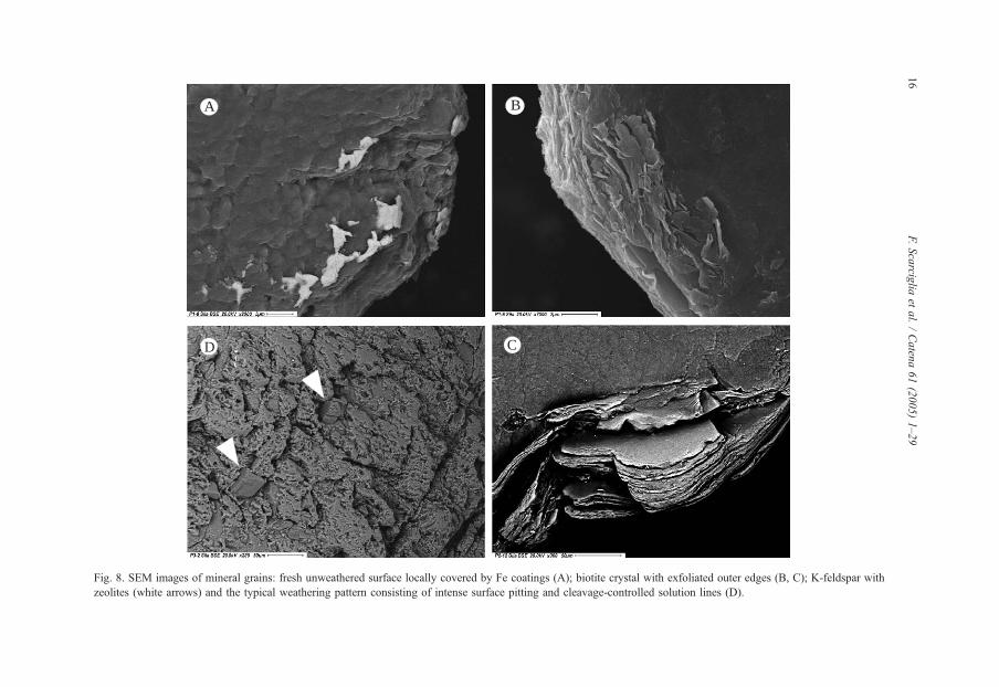
SEM morphoscopy of sand grains in profile P1 confirmed the optical microscopy
observations: mineral grain surfaces appear rather fresh, sometimes locally covered by Fe
coatings (Fig. 8A). Biotite crystals have exfoliated outer edges (presumably due to
hydration processes; Fig. 8B), sometimes showing early clay neogenesis (chloritization),
evidenced by a change in chemical composition with an increase in Al and Mg.
Plagioclases are generally more weathered, exhibiting typical etch pitted surfaces.
The analysis of the clay fraction showed that clay platelets are irregularly shaped
and arranged, as typical of pedogenetic origin. They have an extremely low content in
K, Na and Mg, whereas the Si/Al ratio is close to 1, suggesting that clays mainly
consist of 1:1 phyllosilicates, such as the kaolinite or halloysite group. In contrast,
where a weak increase in the Si/Al ratio and in the same bases were detected, possible
illite, chlorite or vermiculite and other interstratified (mixed layers) clay minerals may
be present.
Also in profile P2 the different primary mineral species show clear, polished
surfaces, as a whole. Some K-feldspars contain Na-rich perthites. The morphoscopic
analysis of sand particles in profile P2 showed rather fresh surfaces (sometimes with
solution pits in feldspars and plagioclases) in the top soil as well as in the buried one,
as a result of a weak weathering degree, as a whole. Iron segregations and coatings
preferentially occur on external grain surfaces, along cleavage planes and exfoliated
outer edges (e.g. in biotite minerals; Fig. 8C). In the buried soil of P2, occasional quartz
crystals show extremely superficial etch pits with subspherical, rounded shapes (Fig.
9A). Very rare amphiboles show a typical surface pitting pattern. SEM analysis of the
same horizon in thin sections showed very small glass fragments, consisting of rounded
to subrounded pumices with a vacuolar structure, moderately to strongly weathered,
with evidence of clay neogenesis and disruption of primary vacuoles towards very
irregular holes.
Scanning electron microscopy also allowed identification of the major components of
the clay fraction: halloysite in form of small spherules (e.g. Tazaki, 1979, 1982; Malucelli
et al., 1999; Adamo et al., 2001; Fig. 9A). EDS spectra exhibit Si/Al ratios approximately
comprised between 1 and 2, very high oxygen and iron content (the former suggesting it
occurs in a hydrated state), and extremely low phosphorous amounts, presumably deriving
from soil organic matter and the high phosphate retention of andic soils. The dominant
clay platelets are represented by illite and clay minerals with SiNAl and low amounts of
Mg and Fe, possibly vermiculite or chlorite.
Profile P3 revealed the most peculiar features in the buried soil: K-feldspar grains
locally show Na-microperthites, some possible zeolites (related to an early stage of
diagenesis), and the typical weathering pattern consisting of intense surface pitting and
deep solution lines (along preferred cleavage planes; Fig. 8D). Even most of quartz grains
B
C
A
D
Fig. 8. SEM images of mineral grains: fresh unweathered surface locally covered by Fe coatings (A); biotite crystal with exfoliated outer edges (B, C); K-feldspar with
zeolites (white arrows) and the typical weathering pattern consisting of intense surface pitting and cleavage-controlled solution lines (D).
F.Scarcig
liaet
al./Caten
a61(2005)1–29
16

B
C
A
D
Fig. 9. SEM images of clay minerals: halloysite spherules on grain surfaces, concentrated close to small cavities
(A, B); in Fig. 8A the quartz grain shows extremely superficial etch pits with subspherical, rounded shapes;
chaotically arranged clay platelets with irregular shapes (C); pseudo-hexagonal kaolinite crystals (D).
F. Scarciglia et al. / Catena 61 (2005) 1–29 17
exhibit very widespread weathering microtextures (Fig. 10). The main features are irregular
solution pits, angular to well-rounded holes and deep grooves, as a result of progressive
deepening and coalescence of originally regular etch pits (Fig. 10A and B). Sometimes they
produce an extremely vacuolar, cavernous structure in quartz grains (Fig. 10C). Never-
theless, triangular, hexagonal or rhomboidal outlines – sometimes concentric – of some
etched surfaces, regularly oriented along parallel or crossed preferential lines, are still
preserved on most samples.
Some grains show the presence of at least one flat, relatively sharp and fresh (or
weakly weathered) face, often with stepped fracture lines and angular edges, whereas
the other surfaces appear more irregular and pitted at a different extent (Fig. 10C). The
former can be interpreted as more recent breakage (mechanical) fracture (Mazzullo et
al., 1986). Other minerals exhibit smooth and flattened, sheet-like regular areas of
former grain contacts (Newsome and Ladd, 1999), suggesting an originally polycrystal-
line nature of the grains, detached from crystalline-rock sources (Higgs, 1979), namely
granites or gneisses.
Also in this buried soil spheroidal particles of halloysite were recognised (Fig. 9B). The
fine fraction shows clay platelets with irregular shapes and chaotically arranged (Fig. 9C),

A
B
C
Fig. 10. SEM images of quartz grains: irregular solution pits and angular to well-rounded holes (A); coalescing
deep grooves with a pseudo-dendritic pattern (A, B); vacuolar, cavernous appearance of a quartz grain (C), with
one flat, relatively sharp and fresh face.
F. Scarciglia et al. / Catena 61 (2005) 1–2918

F. Scarciglia et al. / Catena 61 (2005) 1–29 19
among which pseudo-hexagonal kaolinite crystals with Si/Alc1 can be clearly identified
(Fig. 9D); also possible illite and chlorite or vermiculite phyllosilicates occur.
Surface horizons of profile P3 contain very small vacuolar pumice fragments with a
rhyolitic composition, similar to those described in P2 buried soil, and occurring also in
the topsoil of P5.
The most interesting microtextures worthy to note in profiles P4 and P6 are the physical
breakage patterns along preferred lines, structurally controlled by cleavage planes
exhibited by sand grains, often associated with some iron staining and coatings, and
occasional solution features.
The most peculiar characters detected by electron microscopy in soil profile P5 have
been found in the argillic horizon. Mineral grains show both physical and chemical
weathering features. More specifically, a regular, geometric weathering pattern can be
observed, in places made irregular by severer etching: dominantly linear, sub-parallel or
rhombic to square-angled edges of cleavage planes, as well as subrectangular etch pits,
occur on surfaces of quartz, mica and feldspar grains. As well as in the P3 buried soil, flat
and relatively fresh grain surfaces with stepped, angular fracture lines, in contrast with the
other (irregular and weathered) ones occur, representing recent mechanical fractures or
former grain contacts of polymineral aggregates. The weathering degree of sand grains
appears moderate to strong, as a whole, although quite fresh micas and feldspars occur.
Even quartz shows chemical microtextures in forms of surface etching (solution) with rare
linear and parallel-oriented grooves, and silica precipitation (silica plastering and/or quartz
overgrowths) (e.g. Krinsley and Doornkamp, 1973; Eswaran and Stoops, 1979; Pell and
Chivas, 1995).
Clay minerals from the soil matrix have Si/Al ratios approximately close to 1 with low
content in K and extremely low Mg, Na and Fe (suggesting illite- or kaolinite-like
phyllosilicates) or slightly higher amounts of the latter elements, probably signifying
mixed layers clay minerals with dominant 1:1 species.
5. Discussion
By dealing with typical granite landforms, grus and/or soil profiles, this work
contributes to understanding the interplay between weathering and pedogenetic features,
forcing factors and related processes. Although some soils described formed on parent
material consisting of fluvial and slope deposits – i.e. on granite-derived sediments (rather
than to in situ granite grussification) and are, therefore, conceivably polycyclic or
polygenetic – a variety of moderately to intensely developed pedogenetic features has been
described, otherwise not recorded in the Sila Grande uplands as a consequence of erosion,
and the interpretation of driving processes are discussed.
On the basis of the data obtained, petrographic and mineralogical controls appear to
play key roles in the development of weathering products, cumulatively bpropagatingQtheir effects to the macro-scale. All discontinuities observed on the bedrock/grus and
spheroidal boulders in the field, can be interpreted as related to physical fracturing
(tectonics, pressure release, thermal stresses, freezing and thawing, impacts upon falling or
during transport-sedimentation, etc.) or chemical weathering, possibly often acting

F. Scarciglia et al. / Catena 61 (2005) 1–2920
concurrently, and thus producing a number of weathering patterns. The large variety of
microtextures described in the primary mineral component of studied saprolite and soil
horizons (twinning or cleavage planes; physical breakage patterns produced by inter-
granular or trans-granular micro-cracks; exfoliation and expansion of crystals such as
biotite; etch pitting of plagioclases, feldspars and even quartz; clay neogenesis or iron
release and oxide staining along cracks), could be among the effective preconditioning
factors which cause the weakening of rock fabric (e.g. Newsome and Ladd, 1999; Migon
and Thomas, 2002) and progressively lead to core-stone separation, grussification and
pedogenesis. Factors of physical and chemical weathering can be considered, at least in
part, as linked by mutual cause/effect relationships (Whalley et al., 1982) both at the
micro- and the macro-scale. In particular, inherent, mechanically or (bio)chemically
produced micro-flaws, as well as stress-induced large-scale joints, tend to increase access
to rock surfaces by groundwater, accelerating weathering processes (solution, hydration,
hydrolysis and oxidation); by aiding water penetration, they enhance rock splitting and
disintegration by wetting/drying or freeze/thaw cycles, progressively widening and
deepening (up-scaling effect) pre-existing joints (Ehlen, 2002; Migon and Thomas, 2002).
Cryoclastic phenomena due to freeze/thaw cycles are very likely to be active in the study
area – and presumably even more effective for rock shattering during past Quaternary
colder stages of glacial periods – according to its high altitude and temperature values/
oscillations during winter months (see Section 2). The long-lasting snow cover and the
occurrence of a variety of cryonival processes, support this hypothesis. Also thermal
stresses in response to diurnal insolation cycles can be assumed to be effective for rock
fatigue and physical breakdown in the study area, where changes in temperature can be
relevant (see Section 2), and differential responses to such variations are expected from
outer and inner rock layers, respectively, as well as from different-coloured mineral grains
(e.g. biotite and feldspar) which expand/contract at different extent because of a different
power of reflection/adsorption of solar radiation (Ehlen, 2002). This may be relevant for
weathering processes, especially in the case of small-scale boulder flaking (Ollier, 1967).
The spheroidal boulders which are found at the ground surface are very likely to have
previously formed at considerable depths (real spheroidal weathering, sensu Ollier, 1967),
where hydrolysis of silicate minerals dominate (Ollier, 1988) under constant volume
conditions (Ollier, 1967, 1971), and exposed by subsequent erosion. It is not to be
excluded that subaerial weathering processes could partly inherit previously developed
features due to stress release and/or subsurface chemical weathering (polygenetic origin).
The role of biotite in the weathering of granitoid rocks seems to be of prominent
importance (e.g. Blum and Erel, 1997; Le Pera and Sorriso-Valvo, 2000a). Hydration,
oxidation, chloritization or vermiculitization may lead to expansion and/or cleaving of this
mineral species with consequent weakening of the total rock mass strength (Taboada and
Garcıa, 1999a,b). More specifically, the occurrence of micro-fractures radiating from
exfoliating/splitting biotite minerals into adjacent mineral grains and inducing rock
fragmentation (Section 4.3), strongly confirms this hypothesis (Isherwood and Street,
1976). This is also supported by the macro-scale observations of weathering features both
on spheroidal core-stones/boulders and bedrock/detrital grains of profiles P4 and P6,
reported in Sections 4.1 and 4.2, respectively. The increase in the amount of biotite crystals
in granite soil sands than the related unweathered parent rock, is likely to be produced by
F. Scarciglia et al. / Catena 61 (2005) 1–29 21
the breaking of biotite along cleavage plains (Cullers, 1988; Le Pera et al., 2001a), as also
observed in thin section and on bulk mineral grains by scanning electron microscopy
(Sections 4.3 and 4.4). Also feldspars represent particularly unstable constituents leading
to rock disintegration while undergoing weathering. Plagioclases in particular are revealed
to be generally more weathered than K-feldspars, presumably related to a differential
dissolution for slight variations in chemical composition (FitzPatrick, 1986). Moreover,
recent dissolution experiments and SEM observations of reacted surfaces on different
types of alkali feldspars (treated with pH 2 HCl at 25 8C) have shown correlation between
dissolution rate and dislocation density and some visible signs of dissolution at particularly
reactive sites (Lee et al., 1998). Both intra-granular microtextures and secondary
microstructures induced by straining are highly significant in determining the weathering
behaviour of these minerals. In particular, strained structure dissolves at rates which are
orders of magnitude greater than unstrained feldspar, progressively leading to growth and
coalescence of etch forms with progressive pseudomorphic transformation (Sections 4.3
and 4.4), and presumably responsible for the dirty, non-translucent appearance in the field
(Section 4.2). At a late stage, mechanical flaking occurs, thus increasing available surface
area and exposing further reactive sites, until grain surfaces start to disintegrate to a
microgranular material (arenization process, sensu Power and Smith, 1994; Teeuw et al.,
1994). The existence of greater surface energy in fine-grained rocks enhances a greater
instability mainly along inter-mineral contacts and therefore an easier grain-by-grain
disintegration of the material (Taboada and Garcıa, 1999a). As soon as this process
progresses, further chemical reactions occur, increasing the production of a pedogenetic
matrix (neogenesis of clay minerals and iron oxides), which in turn favours chemical
attack as a prolonged interaction between mineral surfaces and the circulating soil solution
is promoted. Similarly, the organic-rich matrix of A horizons seems to induce some
etching of primary crystals, due to the acidic behaviour of humic substances. This is
consistent with an overall higher degree of weathering of mineral grains assessed in proper
soil horizons rather than in grus layers and bedrock (Section 4.3). In particular, the
rubification of the matrix observed in the buried soil of profile P3 and in the argillic
horizon of P5 correlates with the highly weathered primary minerals, which allowed
abundant amounts of iron to be released and segregated as oxides. Extremely etched and
thinned, irregular outer edges, described on feldspar and biotite grains (Section 4.3),
frequently lined by clay neogenesis/illuviation and/or Fe-segregations, suggest they could
represent previous cleavage planes, intra- or inter-granular fractures (often appearing
particularly deepened and widened by weathering processes), also observed in the field
(Sections 4.1 and 4.2). In fact, they correspond to weakness zones which could have
become preferential sites for further chemical attack, progressively leading to the isolation
and separation of intervening, less weathered portions of the crystals, until complete
fragmentation of the former integral crystals themselves. The presence of neoformed clay
along some of these fissures well could be another direct cause of fragmentation through
its expansion under wet conditions.
A very interesting point of discussion emerges from the morphoscopic analysis of
quartz sand grains. Many of them represent mere physical fracture surfaces related to
crystal ruptures (Krinsley and Doornkamp, 1973; Al-Saleh and Khalaf, 1982). Apart from
mechanical features, all the other microtextures can be considered as derived from

F. Scarciglia et al. / Catena 61 (2005) 1–2922
chemical dissolution (e.g. Krinsley and Doornkamp, 1973; Al-Saleh and Khalaf, 1982;
Newsome and Ladd, 1999). Hexagonal, rhombic and regularly oriented triangular etch
pits, as well as parallel crevasses suggest a selective, crystallographic control over
dissolution (Al-Saleh and Khalaf, 1982; Howard et al., 1995) presumably related to micro-
structural zones of weakness (differential composition, cleavage or twinning planes,
mechanical cracks).
Particularly worthy to note are the dissolution features of quartz grains observed both in
the buried soil of profile P3 and in the Bt horizon of P5: whether they derive from
diagenetic (pre-weathering) or pedogenetic processes cannot be precisely evaluated.
Although hydrothermal dissolution of quartz at different, elevated ranges of temperature
(102 8C) has been widely assessed (Dove and Nix, 1997; Dove, 1999), intensely etched
quartz has been observed in tropical weathering environments, in ancient (long time
forming, maybe polycyclic) or organic-rich soils (Eswaran and Stoops, 1979; Mazzullo
and Magenheimer, 1987; Stoops, 1989; Howard et al., 1995; Schulz and White, 1999).
Quartz weathering essentially depends on mineral mass, morphology and surface area, as
well as on environmental conditions (Krinsley and Doornkamp, 1973; Pell and Chivas,
1995; Schulz and White, 1999). More baggressiveQ climates, characterised by abundant
rainfall and humidity and relatively high temperatures, can induce a severe leaching effect
and acidic pH conditions under which silica solution is strongly enhanced (Krinsley and
Doornkamp, 1973; Summerfield, 1991; Malengreau and Sposito, 1997). Moreover, studies
show that quartz can suffer dissolution at a temperature of 25 8C also in neutral or more
alkaline pH conditions, as a consequence of alkali and alkaline-earth cations interactions at
the soil solution/mineral surfaces (Dove and Nix, 1997; Karlsson et al., 2001). This
availability of bases is possibly favoured by the hydrolysis of other primary minerals (e.g.
feldspars and micas), which characterises the soil weathering environment itself. Past
climatic conditions warmer and moister than the present are therefore suggested to explain
the solution quartz microtextures, in full agreement with the intense rubification and
kaolinite clay mineralogy identified in the buried P3 soil and in the argillic horizon of P5
(see Sections 4.2 and 4.4).
The studied soil profiles – and their epipedons – denote a relatively young pedogenesis,
as a whole, with weak horizon differentiation, variably loamy and sandy textures, still
witnessing a strong influence from the coarse-grained parent material. Conversely, they
have a very low amount of pedogenetic clay (except in the argillic horizon of profile P5).
The overall absent to moderate weathering of primary minerals, apart from the quartz
etching patterns present in the old soil of P3 and partly in P5, points out well the early
stages of weathering and soil development (cf. Le Pera et al., 2001b), under the favourable
temperate humid climate and udic soil moisture regime of the study area (Section 2).
The identification of pumice fragments in some humbric epipedons of these soils (the
2Ab horizon of profile P2 being included; Section 4.4) gives a further contribution to
estimate their age. The specific rhyolitic composition of glass fragments indicates the
Lipari Volcano eruptive activity (Aeolian Islands, more than 200 km SW, in the Tyrrhenian
Sea) during the last 10 kyr (Crisci et al., 1991; De Rosa et al., 2003) as the only likely
source of these volcanic products: thus, an essentially Holocene soil development for
topsoil horizons – clearly overlying older ones in profiles P3 and P5, at least (see below) –
is pointed out, in accordance with the chronological constraint represented by the youngest

F. Scarciglia et al. / Catena 61 (2005) 1–29 23
(Late Pleistocene) age of the basin infilling. The extremely small size and amount of
pumice suggest it should represent windblown ash (distal deposits of high-energy
eruption/s) progressively assimilated by pedogenic alteration within soil horizons.
The assemblage of clay mineral types suggested by SEM-EDS analyses, such as illite,
halloysite, chlorite and/or vermiculite, with possible mixed layers of 1:1 and/or 2:1 clays
(and kaolinite mainly in the buried soil of profile P3), accords well with the moderate
weathering environment assessed, as well as with the age supposed. This clay mineralogy
is also consistent with the CEC values determined in the studied soils (Table 1) and with
pre-existing mineralogical data related to analogous soils of the same area (Mirabella et al.,
1996).
Illite, chlorite and vermiculite minerals are the likely alteration products of primary
micas, formed by hydration and/or isomorphous substitution of cations in the structural
units, and are frequently found in weathered granitic saprolites under temperate climates
(e.g. Sequeira Braga et al., 2002), such as the Holocene – and present-day – temperate
humid, upland Mediterranean climate. In such conditions a common trend of biotite
weathering leads first to hydrobiotite (interstratified biotite-vermiculite; Blum and Erel,
1997; Taboada and Garcıa, 1999b), frequently associated with iron oxyhydroxides, and
then to vermiculite. The vermiculitization reaction is perhaps the earliest and most rapid
weathering reaction which takes place on fresh granitic materials exposed to weathering
(Blum and Erel, 1997). Both illite and chlorite often represent intermediate stages of
weathering towards vermiculite (or HIV, i.e. hydroxy-interlayered vermiculite) and
smectite (Barnhisel and Bertsch, 1989; Selby, 1993); chlorite is specially favoured in
aluminium-rich soil environments (acidic pH conditions), which are common in silicate
rocks (and specifically in the study area), where leaching of SiO2 creates an excess of Al3+
ions (Duchafour, 1982; Thomas et al., 1999). As for kaolinite, it could be the alteration
product of biotite (Sequeira Braga et al., 2002), possibly throughout an intermediate
transformation step from vermiculite, observed in highly leached soils and saprolites,
maybe in tropical regions (Blum and Erel, 1997). Kaolinite, which characterises the buried
soil in profile P3, presumably records a higher degree of pedogenesis (Bronger and Bruhn,
1989; Scarciglia et al., 2003b), in agreement with the older age (presumably Middle or
early Upper Pleistocene) of the terrace on which the soil developed, and indicates humid
but well drained environmental conditions (Righi et al., 1999). Also halloysite, detected in
the clay fraction of profiles P2 and P3 and possibly occurring also in the other profiles,
may represent a precursor to kaolinite (Selby, 1993). Halloysite is often a typical
weathering product of volcanic deposits (Tazaki, 1979, 1982; Driessen and Dudal, 1989;
Mizota and van Reeuwijk, 1989; Jongmans et al., 1999; Nieuwenhuyse et al., 2000). It
denotes a pedogenetic environment with particularly high silica availability (e.g. Buol et
al., 1989; Cronin et al., 1996; Malucelli et al., 1999), which is consistent with the Si-rich
soil environment, deriving from both the silica-rich parent bedrock (granite) and the silica-
rich pumice fragments of volcanic supply assimilated into the studied soil profiles. In
previous papers (Tazaki, 1979, 1982), halloysite morphology has been hypothetically
related to chemical composition and the spheroidal type considered as an early-
intermediate stage deriving from and evolving to other forms, as weathering products of
primary minerals after progressive iron removal. The dearth of other morphologies (but the
rounded ones) and the extremely great amount of Fe detected in our samples seem rather to
F. Scarciglia et al. / Catena 61 (2005) 1–2924
be in contrast. The occurrence of hydrated but confined conditions (possibly with silica
supersaturation), which could have promoted only restricted growth (Adamo et al., 2001),
could be more reliable, since spheroidal halloysite was found, in profiles P2 and P3, just
close to small cavities of mineral grains. This somewhat accords with the limited leaching
conditions and restricted drainage suggested by Nieuwenhuyse et al. (2000) for
pedogenetic halloysite formation.
The whole set of features described for the six profiles can be interpreted also in terms
of relief influence on weathering and pedogenetic processes. All soil profiles but the soil of
P4 record a substantial geomorphological stability (consistent with the flat, terraced, and
persistently exposed, landforms on which they developed), which could permit enough
horizon differentiation and deepening of the pedogenetic front. A key role appears to be
played also by time and climate: in particular, the deep horizons of profiles P3 and P5
show clearly more developed weathering features, as well as some specific diagnostic
properties (etched quartz grains, reddish colours, illuvial clay) presumably related to older
periods, possibly even characterised by humid but warmer conditions than the present-day
climate and pedoenvironment (Scarciglia et al., 2003a,b), such as Middle to Late
Pleistocene interglacial/s. In particular, the deep horizons of profile P5, developed on the
top of the Late Quaternary basin infilling, could be tentatively ascribed to the Last
Interglacial; the lack of analogous features in P1, occurring in a similar stratigraphic
position, could be related to intense erosion, typical of the pulsing erosive/sedimentary
processes of the fluvial environment, as also suggested by the extremely limited and
scattered outcrops of Luvisols at the study sites. This would indicate a complex feature, in
places recording a more bcompleteQ soil development (P5) and in other places lacking a
bcontinuousQ pedogenetic record (P1). In addition, the multicycle origin of their parent
material (fluvial deposits), very likely inheriting some degree of weathering of primary
minerals, clearly should have enhanced more advanced in situ alteration and pedogenesis.
Profile P4, in contrast, appears extremely weakly developed and shows evidence of severe
surface erosion, continuously rejuvenating pedogenetic processes. Similarly, the slope
deposit in the uppermost portion of profile P2 records intense morphodynamics,
tentatively ascribed to historical times (since being very weakly pedogenised and sealing
the buried soil including Holocene volcanic supply). These features are consistent with the
absence of a protective vegetation cover, as well as with the topographic context of steep
slopes, where erosive phenomena are more pronounced than chemical weathering (e.g. Le
Pera and Sorriso-Valvo, 2000b), and especially in those areas that experienced severe
phases of forest clearance from Greek to recent historical times (Sorriso-Valvo, 1993),
inducing a continuous soil truncation with a rejuvenation of the weathering front. The
widespread (i) rare preservation – even on the oldest/stable landscapes – of virtually
bcompleteQ profiles grading from unaltered granite to in situ grus (still including not
exposed core-stones/boulders) up to thick, mature and well-differentiated soils, (ii) the
small thickness (such as in P6) or absolute lack of soil cover, (iii) the frequent presence of
abrupt, lithic contacts between soil horizons and the underlying bedrock, (iv) the
recurrence of clay-poor saprolites, clearly indicate important disturbance and rejuvenation
of pedogenesis by erosion. Also the exhumed boulder fields dominating the landscape of
the highest and oldest paleosurface limbs in the area can be easily explained in this way.
On one hand, if a long time of exposure of paleosurfaces could account for the

F. Scarciglia et al. / Catena 61 (2005) 1–29 25
development of deep spheroidal weathering, on the other hand, their old age, along with
the high local relief and deep dissection produced by Quaternary tectonic uplift, represent
reliable causes of the complete exhumation of these landforms. Therefore, the present
thickness of the weathering mantle in the study area cannot be considered a reliable
indicator of the effective grus and soil formation (cf. Migon and Thomas, 2002) as well as
of their age, as a full record of the time and of the various processes leading to soil
development is lost.
6. Conclusions
This paper has shown how different scales of observation, by means of appropriate
specific methods (namely field work, micromorphology in optical and scanning
electron microscopy both on bulk samples and thin sections), give some contributions
to better understand weathering and pedogenesis during landscape evolution of granitic
terrains.
A possible combination of the effects of deep (inherited) and surface weathering acting
with different modes can be assumed. The importance of variable microtexture fabrics,
such as twinning and cleavage planes, physical micro-flaws, etch pitting, clay neogenesis
or iron release and oxide staining along cracks, seems to be prominent, inducing great part
of the macro-scale effects which lead to the progressive disintegration of the crystalline
rock mass in the Sila Grande uplands. Therefore, both physical and chemical factors
appear to contribute to grus production and subsequent enhancement of chemical attack by
increasing mineral surface area, in turn accelerating soil development.
Moreover, topographic factors revealed to be of primary importance in the development
and preservation or removal of grus/soil mantles, which may be regarded as a response of
weathering systems to relief differentiation; the implications of weathered materials in
relation with topography in determining the deepening of the weathering/soil profile and
the outcome of erosional processes results emphasised in an evolutionary approach to the
development of landscape (Thomas, 1994). On the other hand, time and climate seem
rather to influence modes, intensity and rates of rock degradation and pedogenesis, since
weathering/soil mantles are widespread across climatic zones (from the humid tropics to
cool temperate areas), but often show very different degree of development. Furthermore,
climatic conditions exert a strong control also on weathering features and soil types,
leading to the development of specific textures and diagnostic pedofeatures typical of
different environments, possibly in response to Quaternary climatic changes.
Acknowledgments
We thank Dr M. Davoli (University of Calabria) for his technical assistance and helpful
discussion in SEM-EDS analyses, and Mr F. Colonnese (University of Calabria) and Dr B.
Di Matteo (CNR-ISAFoM, Ercolano, Napoli) for thin section preparation. We are grateful
to the anonymous reviewers and to Prof. M. Thomas for their critical comments and
suggestions which improved our manuscript.

F. Scarciglia et al. / Catena 61 (2005) 1–2926
References
Adamo, P., Violante, P., Wilson, M.J., 2001. Tubular and spheroidal halloysite in pyroclastic deposits in the area
of the Roccamonfina volcano (Southern Italy). Geoderma 99, 295–316.
Al-Saleh, S., Khalaf, F.I., 1982. Surface textures of quartz grains from various recent sedimentary environments
in Kuwait. J. Sediment. Petrol. 52 (1), 215–225.
Amodio Morelli, L., Bonardi, G., Colonna, V., Dietrich, D., Giunta, G., Ippolito, F., Liguori, V., Lorenzoni, S.,
Paglionico, A., Perrone, V., Piccarreta, G., Russo, M., Scandone, P., Zanettin Lorenzoni, E., Zuppetta, A.,
1976. L’Arco Calabro Peloritano nell’orogene appenninico-maghrebide. Mem. Soc. Geol. Ital. 17, 1–60.
Barnhisel, R.I., Bertsch, P.M., 1989. Chlorite and hydroxy-interlayered vermiculite and smectite. In: Dixon, G.B.,
Weed, S.B. (Eds.), Minerals in soil environments, 2nd ed. Soil Science Society of America Book Series vol. 1.
Madison, Wisconsin, USA, pp. 729–788.
Blum, J.D., Erel, Y., 1997. Rb–Sr isotope systematics of a granitic soil chronosequence: the importance of biotite
weathering. Geochim. Cosmochim. Acta 61 (15), 3193–3204.
Bronger, A., Bruhn, N., 1989. Relict and recent features in tropical alfisols from south India. Catena, Suppl. 16,
107–128.
Buol, S.W., Hole, F.D., McCracken, R.J., 1989. Soil genesis and classification, 3rd ed. Iowa State University
Press, Ames.
Butzer, K.W., 1976. Geomorphology from the Earth. Harper and Row Publishers, New York.
Caggianelli, A., Del Moro, A., Piccarreta, G., 1994. Petrology of basic and intermediate orogenic granitoids from
the Sila Massif (Calabria, southern Italy). Geol. J. 29, 11–28.
Caruso, A.M., Ferrini, G., Vecchio, G., 2000. Geologia e geomorfologia del bacino del Lago Cecita. In: Lulli, L.,
Vecchio, G. (Eds.), I suoli della Tavoletta bLago CecitaQ nella Sila Grande in Calabria. Monografia Ist.
Sperim. Stud. Dif. Suolo, Prog. PANDA, Sottoprog. 2, Serie 1, Catanzaro, Italy, pp. 27–34.
Cascini, L., Critelli, S., Di Nocera, S., Gulla, G., Matano, F., 1992. Grado di alterazione e franosita negli gneiss
del massiccio silano: l’area di S. Pietro in Guarano (CS). Geol. Appl. Idrogeol. 27, 49–76.
Colacino, M., Conte, M., Piervitali, E., 1997. Elementi di climatologia della Calabria. In: Guerrini, A. (Ed.),
Collana Progetto Strategico bClima, ambiente e territorio nel MezzogiornoQ. CNR-IFA (Istituto di Fisica
dell’Atmosfera), Roma. 218 pp.
Costantini, E.A.C., 1993. Surface morphology and thinning grade effect on soils of a Calabrian Pine plantation in
the Sila Mountain (Calabria, Italy). Geogr. Fis. Din. Quat. 16, 29–35.
Crisci, G.M., De Rosa, R., Esperanca, S., Mazzuoli, R., Sonnino, M., 1991. Temporal evolution of a three
component system: the Island of Lipari (Aeolian Arc, southern Italy). Bull. Volcanol. 53, 207–221.
Critelli, S., 1999. The interplay of lithospheric flexure and thrust accommodation in forming stratigraphic sequences
in the southern Apennines foreland basin system, Italy. Rend. Fis. Accad. Naz. Lincei 10, 257–326.
Critelli, S., Di Nocera, S., Le Pera, E., 1991. Approccio metodologico per la valutazione petrografica del grado di
alterazione degli gneiss del massiccio silano (Calabria settentrionale). Geol. Appl. Idrogeol. 26, 41–70.
Cronin, S.J., Neal, V.E., Palmer, A.S., 1996. Investigation of an aggrading paleosol developed into andesitic ring-
plain deposits: Ruapehu volcano, New Zealand. Geoderma 69, 119–135.
Crowther, E.M., 1930. The relation of climate and geological factors to the composition of the clay and the
distribution of soil type. Proc. R. Soc. 107, 10–30.
Cullers, R., 1988. Mineralogical and chemical changes of soil and stream sediment formed by intense weathering
of the Danburg granite, Georgia, USA. Lithos 21, 301–314.
De Rosa, R., Guillou, H., Mazzuoli, R., Ventura, G., 2003. New unspiked K–Ar ages of volcanic rocks of the
central and western sector of the Aeolian Islands: reconstruction of the volcanic stages. J. Volcanol. Geotherm.
Res. 120, 161–178.
Dove, P.M., 1999. The kinetics of quartz in aqueous mixed cation solutions. Geochim. Cosmochim. Acta 63 (22),
3715–3727.
Dove, P.M., Nix, C.J., 1997. The influence of alkaline earth cations, magnesium, calcium and barium on the
dissolution kinetics of quartz. Geochim. Cosmochim. Acta 61 (16), 3329–3340.
Dramis, F., Gentili, B., Pambianchi, G., 1990. Geomorphological scheme of the River Trionto basin. In: Sorriso-
Valvo, M. (Ed.), Excursion Guide-Book. IGU-CoMTAG symposium on geomorphology of active tectonic
areas, CNR-IRPI, Rende (CS), Italy, 31 May–8 June 1990. Geodata, vol. 39, pp. 71–75.

F. Scarciglia et al. / Catena 61 (2005) 1–29 27
Driessen, P.M., Dudal, R. (Eds.) 1989. Lecture notes on the geography, formation, properties and use of the major
soils of the world. Agicultural University Wageningen, Katholieke Universiteit Leuven, 47-54.
Duchafour, P., 1982. Pedology. George Allen and Unwin, London, UK.
Ehlen, J., 2002. Some effects of weathering on joints in granitic rocks. Catena 49, 91–109.
Eswaran, H., Stoops, G., 1979. Surface textures of quartz in tropical soils. Soil Sci. Soc. Am. J. 43 (2),
420–424.
Ferrini, G., Moretti, A., 1997. L’evoluzione plio–pleistocenica dell’altopiano silano e la successione miocenica
dell’Alto Crotonese. In: Ferrini, G., Moretti, A., Sonnino, M. (Eds.), Guida alle escursioni. Riun. Scient. Ann.
Gruppo Inf. Sedim. CNR, Arcavacata di Rende (CS), Italy, 13–17 October 1997, pp. 9–51.
FitzPatrick, E.A., 1984. Micromorphology of Soils. Chapman and Hall, London, UK. 433 pp.
FitzPatrick, E.A., 1986. An Introduction to Soil Science, 2nd ed. Longman Scientific and Technical, Harlow, UK.
256 pp.
Govett, G.J.S., Butt, C.R.M., Zeegers, H. (Eds.) 1992. Regolith Exploration Geochemistry in Tropical and
Subtropical Terrains, Handbook of Exploration Geochemistry, vol. 4. Elsevier, Amsterdam.
Higgs, R., 1979. Quartz-grain surface features of Mesozoic–Cenozoic sands from the Labrador and Western
Greenland continental margins. J. Sediment. Petrol. 49, 599–610.
Howard, J.L., Amos, D.F., Daniels, W.L., 1995. Micromorphology and dissolution of quartz sand in some
exceptionally ancient soils. Sediment. Geol. 105, 51–62.
Isherwood, D., Street, A., 1976. Biotite-induced grussification of Boulder Creek Granodiorite, Boulder County,
Colorado. Geol. Soc. Amer. Bull. 87, 366–370.
ISRIC-FAO-ISSS, 1998. WRB world reference base for soil resources: introduction. In: Deckers, J.A.,
Nachtergaele, F.O., Spaargaren, O.C. (Eds.), WRB-ISSS Working Group RB, 1st ed. Acco, Leuven.
Jongmans, A.G., van Oort, F., Denaix, L., Jaunet, A.M., 1999. Mineral micro- and nano-variability revealed by
combined micromorphology and in situ submicroscopy. Catena 35, 259–279.
Karlsson, M., Craven, C., Dove, P.M., Casey, W.H., 2001. Surface charge concentrations on silica in different
1.0 M metal-chloride background electrolytes and implications for dissolution rates. Aquat. Geochem. 7,
13–32.
Koppen, W., 1936. Das geographische system der Klimate. Handbuch der Klimatologie. Gebrunder Borntraeger,
Berlin.
Krinsley, D.H., Doornkamp, J.C., 1973. Atlas of Quartz Sand Surface Textures. Cambridge University Press,
London, UK.
Lee, M.R., Hodson, M.E., Parsons, I., 1998. The role of intragranular microtextures and microstructures in
chemical and mechanical weathering: direct comparisons of experimentally and naturally weathered alkali
feldspars. Geochim. Cosmochim. Acta 62 (16), 2771–2788.
Le Pera, E., Sorriso-Valvo, M., 2000a. Weathering and morphogenesis in a Mediterranean climate, Calabria, Italy.
Geomorphology 34, 251–270.
Le Pera, E., Sorriso-Valvo, M., 2000b. Weathering, erosion and sediment composition in a high-gradient river,
Calabria, Italy. Earth Surf. Processes Landf. 25, 277–292.
Le Pera, E., Arribas, J., Critelli, S., Tortosa, A., 2001a. The effects of source rocks and chemical weathering on
the petrogenesis of siliciclastic sand from the Neto River (Calabria, Italy). Sedimentology 48, 357–378.
Le Pera, E., Critelli, S., Sorriso-Valvo, M., 2001b. Weathering of gneiss in Calabria, Southern Italy. Catena 42,
1–15.
Lulli, L., Vecchio, G., 1996. I suoli del bacino del Lago Cecita nella Sila Grande e la loro sensibilita. Agric. Ric.
164/165/166, 113–122.
Lulli, L., Vecchio, G. (Eds.) 2000. I suoli della Tavoletta bLago CecitaQ nella Sila Grande in Calabria. Monografia
Ist. Sperim. Stud. Dif. Suolo, Prog. PANDA, Sottoprog. 2, Serie 1, Catanzaro, Italy, 78 pp.
Lulli, L., Vecchio, G., Primavera, F., Gardin, L., Maletta, M., Napoli, R., Calı, A., 1992. Contributo alla
conoscenza dei suoli dell’altopiano Silano: descrizione e commento della carta dei suoli Centro Sperimentale
Dimostrativo ESAC di Molarotta, Camigliatello Silano (CS). Calabria Verde 11, 31–42.
Lulli, G., Vecchio, G., Torretti, S., Bernardini, V., Valboa, G., 2000. I suoli del bacino del Lago Cecita. In: Lulli,
L., Vecchio, G. (Eds.), I suoli della Tavoletta bLago CecitaQ nella Sila Grande in Calabria. Monografia Ist.
Sperim. Stud. Dif. Suolo, Prog. PANDA, Sottoprog. 2, Serie 1, Catanzaro, Italy, pp. 7–25.
Malengreau, N., Sposito, G., 1997. Short-time dissolution mechanisms of kaolinitic tropical soils. Geochim.
Cosmochim. Acta 61 (20), 4297–4307.

F. Scarciglia et al. / Catena 61 (2005) 1–2928
Malucelli, F., Terribile, F., Colombo, C., 1999. Mineralogy, micromorphology and chemical analysis of andosols
on the Island of Sao Miguel (Azores). Geoderma 88, 73–98.
Matano, F., Di Nocera, S., 1999. Weathering patterns in the Sila Massif (Northern Calabria, Italy). Il Quaternario,
Ital. J. Quat. Sci. 12 (2), 141–148.
Mazzullo, J., Magenheimer, S., 1987. The original shapes of quartz sand grains. J. Sediment. Petrol. 57 (3),
479–487.
Mazzullo, J., Sims, D., Cunningham, D., 1986. The effect of eolian sorting and abrasion upon the shapes of fine
quartz sand grains. J. Sediment. Petrol. 56 (1), 45–56.
Messina, A., Compagnoni, R., De Vivo, B., Perrone, V., Russo, S., Barbieri, M., Scott, B., 1991. Geological and
petrochemical study of the Sila Massif plutonic rocks (northern Calabria, Italy). Boll. Soc. Geol. Ital. 110,
165–206.
Migon, P., Lidmar-Bergstrfm, K., 2001. Weathering mantles and their significance for geomorphological
evolution of central and northern Europe since the Mesozoic. Earth-Sci. Rev. 56, 285–324.
Migon, P., Thomas, M.F., 2002. Grus weathering mantles. Problems of interpretation. Catena 49, 5–24.
Mirabella, A., Vecchio, G., Risi, B., 1996. Caratterizzazione mineralogica dei suoli su granito e micascisto in Sila
Grande. Calabria Verde 2, 17–24.
Mizota, C., van Reeuwijk, L.P., 1989. Clay mineralogy and chemistry of soils formed in volcanic material in
diverse climatic regions. ISRIC/Int. Soil Ref. Inf. Cent., Soil Monograph vol. 2. Wageningen, the Netherlands.
185 pp.
Newsome, D., Ladd, P., 1999. The use of quartz grain microtextures in the study of the origin of sand terrains in
Western Australia. Catena 35, 1–17.
Nieuwenhuyse, A., Verburg, P.S.J., Jongmans, A.G., 2000. Mineralogy of a soil chronosequence on andesitic lava
in humid tropical Costa Rica. Geoderma 98, 61–82.
Ollier, C.D., 1967. Spheroidal weathering, exfoliation and constant volume alteration. Z. Geomorphol. 11 (1),
103–108.
Ollier, C.D., 1971. Causes of spheroidal weathering. Earth-Sci. Rev. 7, 127–141.
Ollier, C.D., 1988. Deep weathering, groundwater and climate. Geogr. Ann. 70A (4), 285–290.
Pell, S.D., Chivas, A.R., 1995. Surface features of sand grains from the Australian Continental Dunefield.
Palaeogeogr. Palaeoclim. Palaeoecol. 113, 119–132.
Power, E.T., Smith, B.J., 1994. A comparative study of deep weathering and weathering products: case studies
from Ireland, Corsica and Southeast Brazil. In: Robinson, D.A., Williams, R.B.G. (Eds.), Rock Weathering
and Landform Evolution. John Wiley and Sons, New York, pp. 21–40.
Righi, D., Terribile, F., Petit, S., 1999. Pedogenic formation of kaolinite–smectite mixed layers in a soil
toposequence developed from basaltic parent material in Sardinia (Italy). Clays Clay Miner. 47 (4),
505–514.
Roda, C., 1964. Distribuzione e facies dei sedimenti neogenici nel Bacino Crotonese. Geol. Rom. 3, 319–366.
Scarciglia, F., Terribile, F., Colombo, C., 2003a. Micromorphological evidence of paleoenvironmental changes in
Northern Cilento (South Italy) during the Late Quaternary. Catena 54 (3), 515–536.
Scarciglia, F., Terribile, F., Colombo, C., Cinque, A., 2003b. Late Quaternary climatic changes in Northern
Cilento (South Italy): an integrated geomorphological and paleopedological study. Quat. Int. 106/107,
141–158.
Scarciglia, F., Le Pera, E., Vecchio, G., Critelli, S., in press. The interplay of geomorphic processes and soil
development in an upland environment, Calabria, South Italy. Geomorphology.
Schulz, M.S., White, A.F., 1999. Chemical weathering in a tropical watershed, Luquillo Mountains, Puerto Rico:
III. quartz dissolution rates. Geochim. Cosmochim. Acta 63 (3/4), 337–350.
Schulz, M.S., White, A.F., 1999. Chemical weathering in a tropical watershed, Luquillo Mountains, Puerto Rico:
III. Quartz dissolution rates. Geochim. Cosmochim. Acta 63 (3/4), 337–350.
Selby, M.J., 1993. Hillslope Materials and Processes, 2nd ed. Oxford University Press, Oxford, UK. 451 pp.
Sequeira Braga, M.A., Paquet, H., Begonia, A., 2002. Weathering of granites in a temperate climate (NW
Portugal): granitic saprolites and arenization. Catena 49, 41–56.
Sorriso-Valvo, M., 1993. The geomorphology of Calabria. A sketch. Geogr. Fis. Din. Quat. 16, 75–80.
SSSA (Soil Science Society of America), 2001. Internet glossary of soil science terms, (http://www.soils.org/
sssagloss/).
F. Scarciglia et al. / Catena 61 (2005) 1–29 29
Stoops, G., 1989. Relict properties in soils of humid tropical regions with special reference to central Africa.
Catena, Suppl. 16, 95–106.
Summerfield, M.A., 1991. Global Geomorphology: An Introduction to the Study of Landforms. Longman/Wiley,
London. 537 pp.
Taboada, T., Garcıa, C., 1999a. Pseudomorphic transformation of plagioclases during the weathering of granitic
rocks in Galicia (NW Spain). Catena 35, 291–302.
Taboada, T., Garcıa, C., 1999b. Smectite formation produced by weathering in a coarse granite saprolite in Galicia
(NW Spain). Catena 35, 281–290.
Tazaki, K., 1979. Micromorphology of halloysite produced by weathering of plagioclase in volcanic ash. In:
Mortland, M.M., Farmer, V.C. (Eds.), Int. Clay Conf., vol. 1978, pp. 415–422.
Tazaki, K., 1982. Analytical electron microscopic studies of halloysite formation processes. Morphology and
composition of halloysite. In: Van Olphem, H., Veniale, F. (Eds.), Int. Clay Conf. vol. 1981, pp. 573–584.
Teeuw, R.M., Thomas, M.F., Thorp, M.B., 1994. Regolith and landscape development in the Koidu basin of
Sierra Leone. In: Robinson, D.A., Williams, R.B.G. (Eds.), Rock Weathering and Landform Evolution. Wiley,
New York, pp. 303–320.
Thomas, M.F., 1994. Geomorphology in the Tropics: A Study of Weathering and Denudation in Low Latitudes.
John Wiley and Sons, New York. 460 pp.
Thomas, M.F., Thorp, M., Mc Alister, J., 1999. Equatorial weathering, landform development and the formation
of white sands in north western Kalimantan, Indonesia. Catena 36, 205–232.
Thomson, S.N., 1994. Fission-track analysis of the crystalline basement rocks of the Calabrian Arc, southern
Italy: evidence of Oligo–Miocene late-orogenic extension and erosion. Tectonophysics 238, 331–352.
Twidale, C.R., 1986. Granite landform evolution: factors and implications. Geol. Rundsch. 75 (3), 769–779.
USDA, 1998. Keys to Soil Taxonomy, 8th ed. U.S. Dept. Agric., Soil Survey Staff, Nat. Res. Cons. Serv.,
Washington D.C. 326 pp.
Versace, P., Ferrari, E., Gabriele, S., Rossi, F., 1989. Valutazione delle piene in Calabria. CNR-IRPI. Geodata 30.
232 pp.
Viles, H.A., 2001. Scale issues in weathering studies. Geomorphology 41, 63–72.
Whalley, W.B., Douglas, G.R., McGreevy, J.P., 1982. Crack propagation and associated weathering in igneous
rocks. Z. Geomorphol. 26 (1), 35–54.
Wilson, M.J. (Ed.) 1987. A Handbook of Determinative Methods in Clay Mineralogy. Blackie and Sons,
Glasgow, UK. 308 pp.
Copyright © 2022 FDOKUMEN