Pedogenesis in the sorted patterned ground of Devon Plateau, Devon Island, Nunavut, Canada
20
Pedogenesis in the sorted patterned ground of Devon Plateau, Devon Island, Nunavut, Canada Fiorenzo C. Ugolini a , Giuseppe Corti b , Giacomo Certini a, ⁎ a Dipartimento di Scienza del Suolo e Nutrizione della Pianta, Università degli Studi di Firenze, Piazzale delle Cascine, 28, 50144 Firenze, Italy b Dipartimento di Scienze Ambientali e delle Produzioni Vegetali, Università Politecnica delle Marche, Via Brecce Bianche, 60100 Ancona, Italy Received 27 July 2005; accepted 7 March 2006 Available online 6 May 2006 Abstract In the High Arctic, the barren expanses of Devon Plateau, Devon Island, are affected by intense frost action that conditions geomorphic processes at the landscape level, soil formation at the profile level, and the establishment and distribution of vascular plants at microsites. In the High Arctic, in areas of patterned ground, frost action is responsible for both the accumulation of parent material through the segregation of fines in features here called “islands of fines” and for the development of soil profiles through cryoturbation in these features. At the landscape level, segregation of fines results in the development of patterned ground, specifically in the formation of sorted stripes, sorted circles and plugs that repeat themselves on the landscape. Plugs consist of cylindrical to conical soil masses protruding from the frost/permafrost table in the stony areas that may coalesce to form island of fines. Cryoturbation, the dominant soil forming process, is manifested by the appearance of convoluted horizons, injection of material, up-heaving of stones and soil mixing. But there are also non-cryoturbated soils with A–B–C vertical sequences. We have described, sampled and analyzed the soils simultaneously present in the islands of fines. Also, we have examined the plugs, the stony areas and the stony borders. Non-cryoturbated soils, Typic Haplorthels or Brunosolic Eutric Static Cryosols, occurred at the edges of the sorted circles, once the injection of heaved material has subsided. They showed an A horizon grayish brown, relatively rich in carbon and nitrogen, sandier than the underlying B horizon, which is characterized by the presence of illuvial silt caps. The C horizon is low in organic carbon and nitrogen and poorly rooted. Despite wet conditions and impeded drainage, because of the high pH, low organic matter content and low biological activity, oxidation/reduction processes are not well expressed. C-horizon material injected from the frost/permafrost table penetrated into the body of the island of fines, rupturing horizons and merging at the surface. These soils are Aquic Haploturbels or Gleysolic Turbic Cryosols. The major soil forming processes that are acting in the Haplorthels or Brunosolic Cryosols include: brunification, lessivage and decarbonation/carbonation. In the Aquic Haploturbels or Gleysolic Turbic Cryosols the processes are: cryoturbation, gleying and decarbonation/carbonation. Stony areas play the important role of trapping air-born dust that includes mineral and organic components. Also autochthonous living organisms dwell in these block fields. The air-born mineral fines together with those left by the receding ice-cap and those produced by weathering aliment the formation of plugs, islands of fines and the sorted stripes. © 2006 Elsevier B.V. All rights reserved. Keywords: Arctic soils; Cryosols; Cryoturbation; Frost action; Gelisols; Patterned ground; Permafrost; Soil genesis Geoderma 136 (2006) 87 – 106 www.elsevier.com/locate/geoderma ⁎ Corresponding author. Tel.: +39 055 3288403; fax: +39 055 333273. E-mail address: [email protected] (G. Certini). 0016-7061/$ - see front matter © 2006 Elsevier B.V. All rights reserved. doi:10.1016/j.geoderma.2006.03.030
Transcript of Pedogenesis in the sorted patterned ground of Devon Plateau, Devon Island, Nunavut, Canada

2006) 87–106www.elsevier.com/locate/geoderma
Geoderma 136 (
Pedogenesis in the sorted patterned ground of Devon Plateau,Devon Island, Nunavut, Canada
Fiorenzo C. Ugolini a, Giuseppe Corti b, Giacomo Certini a,⁎
a Dipartimento di Scienza del Suolo e Nutrizione della Pianta, Università degli Studi di Firenze, Piazzale delle Cascine, 28, 50144 Firenze, Italyb Dipartimento di Scienze Ambientali e delle Produzioni Vegetali, Università Politecnica delle Marche, Via Brecce Bianche, 60100 Ancona, Italy
Received 27 July 2005; accepted 7 March 2006Available online 6 May 2006
Abstract
In the High Arctic, the barren expanses of Devon Plateau, Devon Island, are affected by intense frost action that conditionsgeomorphic processes at the landscape level, soil formation at the profile level, and the establishment and distribution of vascularplants at microsites. In the High Arctic, in areas of patterned ground, frost action is responsible for both the accumulation of parentmaterial through the segregation of fines in features here called “islands of fines” and for the development of soil profiles throughcryoturbation in these features.
At the landscape level, segregation of fines results in the development of patterned ground, specifically in the formation ofsorted stripes, sorted circles and plugs that repeat themselves on the landscape. Plugs consist of cylindrical to conical soil massesprotruding from the frost/permafrost table in the stony areas that may coalesce to form island of fines. Cryoturbation, the dominantsoil forming process, is manifested by the appearance of convoluted horizons, injection of material, up-heaving of stones and soilmixing. But there are also non-cryoturbated soils with A–B–C vertical sequences. We have described, sampled and analyzed thesoils simultaneously present in the islands of fines. Also, we have examined the plugs, the stony areas and the stony borders.
Non-cryoturbated soils, Typic Haplorthels or Brunosolic Eutric Static Cryosols, occurred at the edges of the sorted circles, oncethe injection of heaved material has subsided. They showed an A horizon grayish brown, relatively rich in carbon and nitrogen,sandier than the underlying B horizon, which is characterized by the presence of illuvial silt caps. The C horizon is low in organiccarbon and nitrogen and poorly rooted. Despite wet conditions and impeded drainage, because of the high pH, low organic mattercontent and low biological activity, oxidation/reduction processes are not well expressed. C-horizon material injected from thefrost/permafrost table penetrated into the body of the island of fines, rupturing horizons and merging at the surface. These soils areAquic Haploturbels or Gleysolic Turbic Cryosols.
The major soil forming processes that are acting in the Haplorthels or Brunosolic Cryosols include: brunification, lessivage anddecarbonation/carbonation. In the Aquic Haploturbels or Gleysolic Turbic Cryosols the processes are: cryoturbation, gleying anddecarbonation/carbonation. Stony areas play the important role of trapping air-born dust that includes mineral and organiccomponents. Also autochthonous living organisms dwell in these block fields. The air-born mineral fines together with those left bythe receding ice-cap and those produced by weathering aliment the formation of plugs, islands of fines and the sorted stripes.© 2006 Elsevier B.V. All rights reserved.
Keywords: Arctic soils; Cryosols; Cryoturbation; Frost action; Gelisols; Patterned ground; Permafrost; Soil genesis
⁎ Corresponding author. Tel.: +39 055 3288403; fax: +39 055 333273.E-mail address: [email protected] (G. Certini).
0016-7061/$ - see front matter © 2006 Elsevier B.V. All rights reserved.doi:10.1016/j.geoderma.2006.03.030

88 F.C. Ugolini et al. / Geoderma 136 (2006) 87–106
1. Introduction
The High Arctic landscape is underlain by perma-frost and affected by intense frost action includingcryoturbation. In this environment, soils show brokenand irregular horizons, injection of material, up-heavingof stones and soil mixing; but there are also soils non-cryoturbated with an A–B–C vertical sequence com-mon to terrain not affected by frost action. Cryoturba-tion has been considered the dominant soil formingprocess in permafrost regions (Bockheim and Tarnocai,1998, 2000) and is used to differentiate taxa, at thesuborder level, in the soil taxonomies of the U.S. andCanada and in the World Reference Base for SoilResources. Cryoturbation, other things being equal, iscontrolled by the freezing gradient, soil texture and soilmoisture (Brown and Péwé, 1973; Tedrow, 1977;Washburn, 1980; Bockheim and Tarnocai, 1998). Insilty soils cryoturbation is, commonly, better manifestedand the permafrost is closer to the surface than in coarse-textured soils (Tedrow et al., 1958; Douglas and Tedrow,1960; Washburn, 1980). In the High Arctic, as well as inother cold dominated environments, patterned ground isone of the most spectacular manifestations of frostaction. In the sorted forms of patterned ground e.g.sorted nets, sorted circles, sorted stripes, and others(Washburn, 1956), the coarse fraction, from pebbles toblocks, is segregated from the finer soil matrix. Theprocesses responsible for their origin are still incom-pletely understood as evidenced by the numeroushypotheses proposed for their formation (see inWashburn, 1997). Recently, Kessler and Werner(2003) have developed a numerical model that involvesself-organization of the material into sorted features.These authors support that freezing and thawing cyclescause feedback mechanisms that: firstly, induce thesegregation of stones and the concentration of fines intoseparate domains and secondly, favor the transport ofstones according to their long axis. In the case of stonecircles, the stony borders delineate areas where thedomain of fines prevails from those where stones arepreponderant. In this paper we refer to the areadominated by fine material as the island of fines, heredefined as isolated patches of stony soil includingorganic matter encircled by a border of stones andforming a repetitive pattern on the landscape. In sortedpatterned ground the spatial arrangement of fines andclasts creates a discontinuity in the distribution of soilsand plants (Ugolini, 1966; Anderson and Bliss, 1998).The island of fines may contain vertically assembledhorizons forming A–B–C profiles, or unassembledforming gelic materials (Bockheim et al., 1997). The
surrounding stony areas, including stony borders, are inthe upper part frequently devoid of fines and virtuallybarren except for a cover of crustose likens. Because oftheir fragmental structure, stony areas act as traps for air-born dust, insects, and part of plants or eroded soilmaterial from the adjacent islands of fines; however,they also harbor an autochthonous population of insects,green algae and plant seeds. Commonly, below thesurface of the stony areas one finds cylindrical to conicalsoil masses protruding from the frost/permafrost table.On Cornwallis Island, west of Devon, Washburn (1997)has described in great details these features andextensively reviewed the literature of their origin andformation. Washburn referred to them as “plugs”,Mackay (1953), who worked in the same area namedthem “mudplugs”, while Bunting and Jackson (1970)called them “clay plugs”. From the above considera-tions, it appears that in the High Arctic landscape, theformation of sorted patterned ground and its functioningis of considerable geomorphologic, pedogenic andbiological interest. Also, these sorted features providethe possibility of examining the coexistence of orga-nized soil horizons and gelic material in naturallysegregated cells, the island of fines, that repeatthemselves on the landscape forming a symmetricalarrangement. While, the processes are site specific, theworking principles of the system have wider spatialimplications.
The purpose of this paper is to report on soilsoccurring in sorted circles on the Devon Plateau.Specifically, to provide morphological, physical andchemical information of the soils in the island of finesand also to examine the surrounding stony areasincluding the stony borders.
2. Materials and methods
2.1. Study area
The study was conducted at Devon Island in thecontext of a multi and interdisciplinary project. DevonIsland (75° 31′ N and 84° 24′ W) has a surface of56,000 km2 and is part of the Queen Elizabeth Islands inthe Canadian High Arctic, Nunavut, Canada (Fig. 1).The climatic conditions of Devon are more continentalthan maritime as the surrounding sea is frozen for over10 months at year and the island is affected by a coldcircumpolar vortex that blows from west to east (Courtinand Labine, 1977). With the exception of the coastal andlow-laying areas where biological and pedologicalconditions resemble a wet tundra (Bliss, 1977), therest of the island is occupied by an ice-cap and a barren

Fig. 1. Location of the study site.
89F.C. Ugolini et al. / Geoderma 136 (2006) 87–106
plateau (Fig. 1). For Truelove, one of the coastallowlands, the summer climatic records go back to 1960,while for the entire year the information is available onlyfor 1961–1962 and 1972–1973 (King, 1969; Lev andKing, 1999). On the basis of these data, at Truelove themean annual air temperature is about −16.0 °C, and themean annual precipitation is about 185 mm (Courtin andLabine, 1977; Lev and King, 1999). The eastern side ofTruelove is delineated by a steep 300-m high escarp-ment that rises to the Plateau (Fig. 1). Climatic data forthe Devon Plateau are scarcer than for Truelove; theydocument a highly variable short growing season from16 to 50 days with highly variable cool and dry weather(Bliss and Gold, 1999; Dickson, 2000). The month ofJuly, 1991 was the warmest in the last 25 years with amean air temperature of 8.1 °C, while July, 1992 was thecoldest, with a mean air temperature of 4.0 °C and only16 days of snow-free terrain (Gold and Bliss, 1995). Interms of degree days, the 1991 summer accumulated252° versus 123 for the 1992 summer (Bliss and Gold,1999). Precipitation, including snow, for the month ofJuly varied from 33 mm in 1991 to 55 mm in 1992 (Goldand Bliss, 1995).
The Devon Plateau consists of Cambrian andOrdovician sedimentary rocks of the Cass FjordFormation. The rocks consist of dolomite, schist,sandstone, and conglomerates with scarce amounts ofgypsum (Thorsteinsson and Mayr, 1987). According toKrupicka (1977), the upper part of the Plateau is mostlydolomite with a thin layer of orthoquartzite on top of thedolomitic beds. During our surveys of the southern sideof the Plateau, we recognized several other types ofrocks; Appendix A reports their distribution, theirmineral composition and the NH4–N content.
The area was glaciated by expansion of the ice-capstill present on the northeast portion of the island.Deglaciation of the Plateau began approximately 9000years ago; ice-retreat was followed by glacio-isostaticcrustal rebound (Andrews et al., 1970). With the retreatof the ice-cap glacial deposits and bedrock have becomepermafrost and affected by frost action (Brown, 1977).
The present surface of the Plateau is covered by frost-shattered dolomitic rocks, scattered large granite erraticsand extensive areas of patterned ground. Patternedground consists of sorted circles on horizontal surfacesand of sorted stripes on gentle slopes. In the soils of the

90 F.C. Ugolini et al. / Geoderma 136 (2006) 87–106
sorted circles and sorted stripes the frost table was, onJuly 1992, at a depth of about 30 cm, on July 1994 and1995 of about 60 cm. In 1971 and 1972 the thickness ofthe active layer averaged about 30 cm (Brown, 1977).
Plant cover is sparse, less than 3%, and is representedby 14–16 species of vascular plants (Bliss et al., 1994;Bliss and Gold, 1999) and by a cryptogamic crustconsisting of cyanobacteria, fungi, lichens and mosses(Appendix B). The crust occurs where water isavailable, preferentially in proximity of melting snowbanks and drainages (Dickson, 2000).
For Truelove Lowland, a detailed soil map accom-panied by considerable analytical data was provided byWalker and Peters (1977), but only one profile wasdescribed for Devon Plateau. Pedological investigationsby Kelly and King (1995) and Lev and King (1999)were restricted to the soils of the beach ridges of theTruelove Lowland, as well as, a study of Ugolini et al.(2002).
Our study of soils was initiated in the summer of 1991and continued intermittently till 1995. The fieldobservations were concentrated on sorted circles,which prevail at the western edge of the Devon Plateau(Fig. 1).
2.2. Field methods
Before selecting the site for detailed study 13excavations were made within a radius of 200 m. Atthe chosen site, sorted circles were measured includingthe size of the island of fines, associated stony bordersand stony areas. The sorted features were excavated tothe frost table by cutting across stony borders and theisland of fines. Generally, three successive cuts weremade so as to dissect over one half of a feature. Theexposures were described according to Soil SurveyStaff (1993). To dig soil below the level of the frosttable no mechanical devices such as jackhammer ordrill were used. Trenches were left open for threeweeks and continuously emptied of the water producedby melting of the permafrost. By this method, 5 to7 cm of soil were thawed with respect to the maximumdepth of natural thawing, circa 60 cm. In this occasion,the near-surface permafrost was examined and collect-ed. One of the trenches was left open till the next year,after which an additional 10–12 cm of thawed soil wasobtained.
In the stony borders and stony areas, clasts weremeasured and described. Carbonates were assessed bytesting with 3 M HCl solution. Plants and smallinvertebrates were identified. From each cut, sampleswere collected by horizon. The Bw and Cjj horizons
were collected on a volume basis. Features, such asplugs protruding from the frost table, desiccation crustspresent at the surface, illuvial and compression capsexposed in the profiles, and several flagstones protrud-ing from the surface of the sorted circles were describedand collected.
2.3. Analytical methods
Soil samples collected on a volume basis were oven-dried at 105 °C and the bulk density (Db) was calculatedaccording to Corti et al. (1998). The other soil sampleswere left to air-dry and sieved at 2 mm so as to separatefine earth and skeleton. All the analyses were performedon the fine earth unless otherwise specified. The liquidlimit was determined on selected samples ground to<425 μm by the “drop-cone penetrometer” method(Sherwood and Ryley, 1970) and considered as themoisture content corresponding to 20 mm of penetrationof the cone penetrometer. For particle-size analysis,coarse, medium and fine sands were retrieved by sievingat 0.5, 0.25 and 0.05 mm respectively, while the claywas separated from the silt by timed sedimentation in asuspension adjusted to pH 8.8–8.9 with NaOH.Electrical conductivity (Ec) and pH were both deter-mined potentiometrically on water suspensions with asolid:liquid ratio of 1:2.5; pH was measured also in MKCl, and 0.02 M CaCl2. Organic carbon was measuredaccording to the Walkley–Black method (Walkley andBlack, 1934). Carbonates, including dolomite, calciteand magnesite were determined, in the different sizefractions, through the method of Bundy and Bremner(1972). The fine earth and the ground rocks wereanalyzed for the content of Kjeldahl NH4
+–N (Bremner,1960) and micaceous NH4
+–N (Corti et al., 1999).Porosity was measured on three selected flagstones,
slabs of dolomitic rocks, placed in nearly verticalposition at the edges of the sorted circle. Total porositywas calculated by the equation P%=(1-Db /Ds) · 100,where Db is the bulk density and Ds the specific densitydetermined as ratio between the oven-dry weight(105 °C at constant weight) and the volume obtainedby water displacement after sample was maintained 24 hunder vacuum. The porosity in the range 0.0037–150 μm was measured by a mercury intrusion CarloErba 2000 WS porosimeter. Mineral composition of thefine earth and rocks was assessed on powdered speci-mens by X-ray diffraction (XRD), using a PhilipsPW 1710 diffractometer producing a monochromaticCo–Kα1 radiation at 35 kV and 25 mA, filtered by Fe.The step size was 0.02° 2θ, and the scanning speed was1 s per step. Semi-quantitative estimation of the mineral

91F.C. Ugolini et al. / Geoderma 136 (2006) 87–106
assemblage was made using the “internal standard”method as described in Ugolini et al. (2001).
3. Results and discussion
3.1. Field observations and measurements
Patterned ground consists of sorted circles inter-spersed among stony areas. Diameters of the circlesranged from 0.5 to 4.3 m, while stony areas, excludingthe stony borders, had a width of 1.2 to 1.8 m and alength of 2.0 to 4.5 m. The circles were domed andhigher than the level of stony areas; these latter, inplaces, showed depressions. This spatial arrangement offines and clasts created a discontinuity in the distributionof soils and plants. The description of a stony area andthe associated island of fines that follows is represen-tative of the 13 excavations made. The area investigatedwas about 20 m2; it included a stony area (∼80% of thesurface), and two island of fines (∼10%) surrounded bystony borders (∼10%).
3.1.1. Stony area and stony bordersThe surface of the stony area was barren except for a
few clumps of vascular plants. In the stony borders,slabs in vertical position, emerging at the surface,showed three distinct biological zones. The upper andexposed part was angular, corroded, pitted and partiallycovered with crustous lichens. At midpoint, particularlyif in contact with the island of fines, mosses weregrowing, although lichens were still present. The basewas generally immersed in water during the thawingseason but, even if not immersed, was always moist; thesurface of this slab portion was smooth, non-pitted, andshowed areas colonized by green algae. The areascovered by the algae displayed a weathering rind 2–3 mm thick and were easily scratchable. Parts of slabspenetrating deeply into the stony border, and thereforenot affected by light, were apparently devoid of greenalgae.
In cross-section the stony area, resting on the frosttable, was about 50–55 cm thick and commonlyexhibited three layers. The upper one had a thicknessfrom 5 to 25 cm and consisted of large, angular,dolomitic slabs about 20 cm long with a thickness of 3–4 cm. Next to the island of fines these slabs, theflagstones, tended toward a vertical position with anoutward tilt from the island. They, typically, showedthree distinct biological zones. Intermixed with the slabsthere were smaller angular clasts, 10 to 20 cm long; athin (2–3 mm) film of silt with fragments of plants androotlets covered the stones in nearly horizontal position.
Within 10–16 cm of depth, seedlings, plant roots andcolonies of Nostoc grew on the silt accumulated on thehorizontal slabs. The middle layer, 10 to 20 cm thick,was dominated by angular dolomitic clasts less than20 cm long; a few large slabs were present. In this layer,silt and organic debris apparently illuviated from theoverlying layer had accumulated on flat stones lyinghorizontally or on those vertically oriented but providedwith cracks able to catch fines. On some clasts,illuviation had formed a sort of silt cap, which appearedstructureless (massive) with many pores and vesicles 1to 3 mm large. Underneath the illuvial cap, clastsshowed a weathering rind easily scratchable. Seeds werecommon at 17–20 cm depth, while Nostoc communecolonies were present within 15–16 cm of depth andalways associated with moist conditions. The bottomlayer, 15 to 32 cm thick, had fragmental texture andconsisted of sub-rounded and smooth clasts less than10 cm long that rested directly on ice or frozen ground.These clasts were covered by thin silt caps apparentlyoriginated by illuviation and had secondary carbonateson their underside. Silt caps had, at the surface,numerous larvae and Collembola (Babenko, 1994) andfragments of plants; rootlets were inside.
At the bottom of the stony area, the frost table wasstrewn with plugs made of fines and clasts. In an area ofabout 2 m2 we counted 10 such plugs of differentdimensions with ellipsoidal bases ranging from 11 to56 cm for the long and from 10 to 34 cm for the shortaxis. The height ranged from 7 to 28 cm; none of themreached the surface. The largest plugs were at the down-slope end of the excavation where more moisturecollected. The plugs consisted of two layers: an outerdark grayish brown was interpreted as an Ajj material;the inner one was yellowish brown, extended into thefrozen layer and was interpreted as a Cjj material.Stones, present in both layers, were, preferentially, innear vertical position; those larger than 10 cm in lengthwere angular, while the smaller ones were sub-angularto sub-rounded. The surface of the clasts was coated bystrongly adhering soil with pores and vesicles; this soilappeared to have been plastered on the clasts orsqueezed between them. Pebbles and cobbles aroundthe base of the plugs had an arrangement resemblingminiature stony borders of sorted circles. Washburn(1997) made similar observations in plugs at ResoluteBay, Cornwallis Island, Nunavut, Canada (Fig. 1). Threeplugs are described in Table 1.
3.1.2. Stone circlesThe descriptions that follow deal with three succes-
sive cuts made in two islands of fines. The two features

Table 1Morphological properties of plugs protruding from the frost/permafrost table in the stony area (Devon Plateau, Devon Island, Nunavut, Canada)
Thickness Color a Fieldtexture b
Structure c Consistency d Plasticity e Roots f Boundary g Observations
cm (crushed and moist) Moist Wet
Plug #1Ajj h 5–12 2.5Y 4/2 (dark
grayish brown)Cobbly sl 2 tpl fr–fi ss sp 0 ab Pores and
vesiclesCjj 14–21 10YR 5/4
(yellowish brown)Cobbly sl 2 tpl fr–fi ss sp 0 ab Pores and
vesicles
Plug #2Ajj h 6–14 2.5Y 4/2 (dark
grayish brown)Cobbly sl 2 tpl fr ss sp 0 ab Pores and
vesiclesCjj 12–17 10YR 5/4
(yellowish brown)Cobbly sl 2 tpl fr ss sp 0 ab Pores and
vesicles
Plug #3 i
Ajj h 11–20 2.5Y 4/2 (darkgrayish brown)
Cobbly sl 1 tpl fr ss sp 0 ab Pores andvesicles
Cjj 2–3 10YR 5/4(yellowish brown)
Cobbly sl 1 tpl fr ss sp 0 ab Pores andvesicles
These measurements were taken in the horizontal cross-sections of the plugs.a Munsell notation.b sl = sandy loam.c 1 = weak, 2 = moderate; t = thin; pl = platy.d fr = friable, fi = firm; ss = slightly sticky.e sp = slightly plastic.f 0 = no roots.g a = abrupt; b = broken.h The A horizon formed on the outlayer of the plug; it could be also called A “material” rather than “horizon”.i This plug had a flagstone 33 cm in length of which 20 cm were exposed and 13 cm buried in the plug itself; the flagstone showed three
biological zones: lichens (upper 5–15 cm), mosses (between 7 and 15 cm) and algae (between 14 and 20 cm).
92 F.C. Ugolini et al. / Geoderma 136 (2006) 87–106
were approximately circular; one had a diameter ofabout 120 cm, the other of 100 cm. This site was typicalof the numerous ones examined in less detail.
3.1.2.1. Cut 1. This cut involved a trench about 2 mlong that dissected the two islands of fines and the edgesof the stony border. The depth to the frost table rangedfrom 55 to 58 cm on July 16, 1995. Along the cut,starting from the southern end, profiles were describedat 0, 20, 50, 80, 100, 120, 150, 180 and 200 cm. Here,however, we present an overall description thatsummarizes the salient features of the entire trench. Aportion of Cut 1 between 95 and 200 cm is shown in Fig.2A, while soil description for the profile at 150 cm is inTable 2.
At the edge of the island of fines, flagstones nearly invertical position showed distinct biological zonation.Moss cushions and clumps of vascular plants weregrowing between the slabs. Abundant roots covered theslabs facing the island of fines; it appeared that thestones of the border were used as avenues for thepenetration of roots to depth. Fragmental pebbles werefound in the interstices.
Soil profile consisted of Ajj, Bw1jj, Cjj and Cfhorizons. The Ajj horizon ranged in thickness from 10 to31 cm and contained circa 90% stones (smooth, sub-angular to sub-rounded). These latter were covered by afilm of fines and showed a weathering rind; smallpebbles (1 to 2 cm in diameter and 0.5 cm thick) wereeasily broken by hand. Some stones had secondarycarbonates below the surface. In this pebbly horizon,clasts 10–15 cm in diameter, lying horizontally, hadilluvial caps about 1 to 2 cm thick, which were invadedby many fine and very fine roots (Table 3). Irrespectiveof the size of clasts, silt films and caps increased inthickness with depth. The soil matrix, in this stonyhorizon, represented about 5%, had a dark grayishbrown color and a silt loam texture.
The underlying horizon was named Bw1jj even if noBw2jj was present in the profiles of Cut 1; it was donefor tracing it in the profiles of Cuts 2 and 3. The Bw1jjhorizon had a thickness from 10 to 30 cm, and it showeda grayish brown color, a skeleton content ranging from60% to 80%, a silt loam texture and a thin platystructure. Fines between stones appeared compressed soto form features here called “compression caps”

93F.C. Ugolini et al. / Geoderma 136 (2006) 87–106
evidently not due to illuvial processes. They had agrayish brown color and were structureless (massive)with vesicles (Table 3). Roots invaded the upper 10 cmof this horizon and the face of the tabular stones, but notthe compression caps.
The Cjj horizon was similar to the Bw1jj one;however, it had a yellowish brown color, lacked rootsand showed thixotropic properties.
The Cf horizon showed a light yellowish browncolor, contained from 60% to 80% skeleton, had siltloam texture and displayed a very weak thin platystructure. Like the Cjj horizon, the Cf containedcompression caps and no roots.
Fig. 2. Portions of three successive cuts made in two islands of
Soil of Cut 1 can be classified as a Typic Haplorthelaccording to the Soil Taxonomy (Soil Survey Staff, 2003),a Brunisolic Eutric Static Cryosol for the CanadianClassification (Soil ClassificationWorking Group, 1998),and a Haplic Cryosol in theWorld Reference Base for SoilResources (FAO/ISRIC/ISSS, 1998).
These shallow profiles prevailed at the edges of theislands of fineswhere the drainagewas better, the injectionof C material into the solum nearly absent, cryoturbationwas minimum and vascular plants were common.
3.1.2.2. Cut 2. This trench was opened 25 cm inlandfrom Cut 1 on July 17, 1995. Cut 2 was about 2 m long
fines at Devon Plateau, Devon Island, Nunavut, Canada.
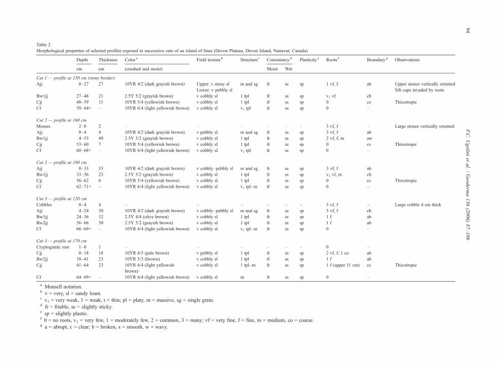
Table 2Morphological properties of selected profiles exposed in successive cuts of an island of fines (Devon Plateau, Devon Island, Nunavut, Canada)
Depth Thickness Color a Field texture b Structure c Consistency d Plasticity e Roots f Boundary g Observations
cm cm (crushed and moist) Moist Wet
Cut 1 — profile at 150 cm (stony border)Ajj 0–27 27 10YR 4/2 (dark grayish brown) Upper: v stony sl m and sg fr ss sp 1 vf, f ab Upper stones vertically oriented
Lower: v pebbly sl Silt caps invaded by rootsBw1jj 27–48 21 2.5Y 5/2 (grayish brown) v cobbly sl 1 tpl fr ss sp v1 vf cbCjj 48–59 11 10YR 5/4 (yellowish brown) v cobbly sl 1 tpl fr ss sp 0 cs ThixotropicCf 59–64+ – 10YR 6/4 (light yellowish brown) v cobbly sl v1 tpl fr ss sp 0 –
Cut 2 — profile at 160 cmMosses 2–0 2 – – – – – – 3 vf, f – Large stones vertically orientedAjj 0–4 4 10YR 4/2 (dark grayish brown) v pebbly sl m and sg fr ss sp 3 vf, f abBw1jj 4–53 49 2.5Y 5/2 (grayish brown) v cobbly sl 1 tpl fr ss sp 2 vf, f, m awCjj 53–60 7 10YR 5/4 (yellowish brown) v cobbly sl 1 tpl fr ss sp 0 cs ThixotropicCf 60–68+ – 10YR 6/4 (light yellowish brown) v cobbly sl v1 tpl fr ss sp 0 –
Cut 2 — profile at 180 cmAjj 0–33 33 10YR 4/2 (dark grayish brown) v cobbly–pebbly sl m and sg fr ss sp 3 vf, f abBw1jj 33–56 23 2.5Y 5/2 (grayish brown) v cobbly sl 1 tpl fr ss sp v1 vf, m cbCjj 56–62 6 10YR 5/4 (yellowish brown) v cobbly sl 1 tpl fr ss sp 0 cs ThixotropicCf 62–71+ – 10YR 6/4 (light yellowish brown) v cobbly sl v1 tpl–m fr ss sp 0 –
Cut 3 — profile at 120 cmCobbles 0–4 4 – – – – – – 3 vf, f – Large cobble 4 cm thickAjj 4–24 20 10YR 4/2 (dark grayish brown) v cobbly–pebbly sl m and sg fr ss sp 3 vf, f cbBw1jj 24–36 12 2.5Y 4/4 (olive brown) v cobbly sl 1 tpl fr ss sp 1 f abBw2jj 36–66 30 2.5Y 5/2 (grayish brown) v cobbly sl 1 tpl fr ss sp 1 f abCf 66–69+ – 10YR 6/4 (light yellowish brown) v cobbly sl v1 tpl–m fr ss sp 0 –
Cut 3 — profile at 170 cmCryptogamic rust 1–0 1 – – – – – – 0 –Cjj 0–18 18 10YR 6/3 (pale brown) v pebbly sl 1 tpl fr ss sp 2 vf, f; 1 co abBw2jj 18–41 23 10YR 5/3 (brown) v cobbly sl 1 tpl fr ss sp 1 f abCjj 41–64 23 10YR 6/4 (light yellowish
brown)v cobbly sl 1 tpl–m fr ss sp 1 f (upper 11 cm) cs Thixotropic
Cf 64–69+ – 10YR 6/4 (light yellowish brown) v cobbly sl m fr ss sp 0 –
a Munsell notation.b v = very, sl = sandy loam.c v1 = very weak, 1 = weak, t = thin; pl = platy, m = massive, sg = single grain.d fr = friable, ss = slightly sticky.e sp = slightly plastic.f 0 = no roots, v1 = very few, 1 = moderately few, 2 = common, 3 = many; vf = very fine, f = fine, m = medium, co = coarse.g a = abrupt, c = clear; b = broken, s = smooth, w = wavy.
94F.C
.Ugolini
etal.
/Geoderm
a136
(2006)87–106

95F.C. Ugolini et al. / Geoderma 136 (2006) 87–106
and included the cross-section of the stony borders andthe inside of the two islands of fines to the frost table,found at a depth of 63 cm. Profiles were described at 20,40, 70, 100, 120, 160, 170 and 200 cm; a summary ofthe descriptions follows. A portion of the trenchbetween 90 and 220 cm is shown in Fig. 2B, whiledetails of the profiles at 160 and 180 cm are in Table 2.
The surface showed a cover of mosses growingamong the clasts and clumps of Cerastium andSaxifraga spp. Mosses formed a carpet 2 to 6 cm thickat the edge of the island of fines and in cavities formedby the piling of cobbles and pebbles in the A horizon.
Similarly to profiles of Cut 1, those of Cut 2showed an Ajj–Bw1jj–Cjj–Cf sequence. The Ajjhorizon had a thickness of 4–6 cm in correspondenceof the middle of the feature, and reached a maximumof 35–37 cm at the edges, near the stony borders (Fig.2B). This horizon contained only 5–8% fine earth, andwas structureless (single grain or, in the case of theilluvial caps, massive). Stones were rounded, smoothand easily breakable; some had silt coatings; the largerones had illuvial caps invaded by roots and secondarycarbonates on their undersides. The underlying Bw1jjhorizon, 9 to 50 cm thick, had a grayish brown color,contained from 60% to 80% clasts, had a silt loamtexture and showed a thin, platy structure. Roots wereabundant at 18–20 cm, but drastically decreased belowthis depth and they were absent in the compressioncaps (Table 3). Clasts had secondary carbonatesunderneath. Morphologically, this horizon appearedto be a plug, with the upper portion apparentlyintruding into the A horizon (Fig. 2B). The Cjj andCf horizons showed the same features of thecorresponding horizons of Cut 1. However, in Cut 2they have been progressively changed into B material.
At the margins of the stone circle, the soil of Cut 2was similar to that of Cut 1, while in the center it wasclassified as an Aquic Haploturbel (Soil Survey Staff,2003), or a Gleysolic Turbic Cryosol (Soil ClassificationWorking Group, 1998), or a Turbic Cryosol (FAO/ISRIC/ISSS, 1998).
3.1.2.3. Cut 3. This face was obtained by removingabout 30 cm of material from the exposure of Cut 2; itwas described on July 18, 1995. The surface wassparsely vegetated, and cobbles and pebbles prevailed.Barren areas existed where new mineral soil had reachedthe surface (160–180 cm in Fig. 2C). Mosses grew inthe voids among the clasts, while the vascular plantswere limited to a few specimens of Saxifraga spp.,Cerastium alpinum and Papaver radicatum. A blackcryptogamic crust covered a few spots.
The face of Cut 3 was over 2 m long andencompassed part of the stony border and the cross-section of the two islands of fines. Profiles weredescribed at 0, 20, 40, 70, 100, 120, 140, 170, and200 cm. A segment of the cross-section, between 80 and210 cm, is shown in Fig. 2C, while soil descriptions forprofiles at 120 and 170 cm are in Table 2.
The face portrayed a rather intricate pattern of soil andclasts, with pockets of pebbles, intrusions of fresh soil,dislocated horizons and mixing of new with old soil.
A fine textured A horizon was present only underthe vascular plants, and was very limited in extent andthickness (about 1 cm). More often, B and C materialswere found at the surface. A pebbly Ajj horizon similarto that of the previous cuts was present at the northedge of the island of fines and it showed a thicknessranging from 13 to 20 cm. It had a dark grayish browncolor, a content of 80–90% of roundish clasts with siltcoatings and it was permeated by roots. Illuvial capswere dominated by silt, structureless (massive) andwell rooted. This horizon rested on a Bw1jj horizonthat, in turn, overlaid a Bw2jj. All Ajj, Bw1jj andBw2jj horizons were horizontally interrupted byinjection of soil material belonging to the Cjj horizon(Fig. 2C) that in places appeared at the surface. In theportion of the uncut part of the island of fines, Cjjmaterial reached the surface; it showed an olive browncolor, possibly acquired through mixing of yellowishand brownish soil materials. At the surface, theinjected Cjj material acquired a domed shape andupon drying it produced a massive crust (Table 3). Inother areas crust previously formed was partiallycolonized by Saxifraga, Papaver and some crypto-gams. The injected C horizon could be traced at thebottom of the trench where it was recognized by itsyellowish brown color.
At the north edge of island of fines the soil of Cut 3was similar to those of Cuts 1 and 2, a Typic Haplorthel(Soil Survey Staff, 2003) or Brunisolic Eutric StaticCryosol (Soil Classification Working Group, 1998). Thecryoturbated soil of Cut 3 is similar to that of Cut 2 and,thus, was classified as Aquic Haploturbel (Soil SurveyStaff, 2003), Gleysolic Turbic Cryosol (Soil Classifica-tion Working Group, 1998), and Turbic Cryosol (FAO/ISRIC/ISSS, 1998).
3.2. Physical properties
The bulk density (Db) of the fine earth collected fromthe Bw1jj horizons of Cut 1 and 2 was higher than thatof the underlying Cjj (Table 4). The liquid limit for theBwjj was higher than for the Cjj horizons (Table 4),

Table 3Morphological properties of desiccation crusts at the surface of the “injected” C material and of silt and compression caps from horizons of the Cuts 1 and 2 (Devon Plateau, Devon Island, Nunavut,Canada)
Depth Thickness Color a Fieldtexture b
Structure c Consistency d Plasticity e Roots f Boundary g Observations
cm cm (crushed and moist) Moist Wet
Desiccation crust #1 0–2 2 10YR 6/4(light yellowish brown)
sl m fr ss sp 0 ab Pores and vesicles
Desiccation crust #2 0–2 2 10YR 5/4(yellowish brown)
sl m fr ss sp 0 ab Pores and vesicles
Desiccation crust #3 0–3 3 10YR 6/3(pale brown)
sl v1 tpl fr ss sp 0 ab Pores and vesicles
Desiccation crust #4 0–2 2 10YR 5/3 (brown) sl m fr ss sp 0 ab Pores and vesiclesDesiccation crust #5 0–3 3 10YR 6/4
(light yellowish brown)sl m fr ss sp 0 ab Pores and vesicles
Illuvial cap #1(Ajj horizon of Cut 1)
18–24 ≈2 10YR 4/3(dark brown to brown)
sl m fr ss sp 2–3 vf, f ab Pores and vesicles
Compression cap #1(Bw1jj horizon of Cut 1)
30–36 ≈2 10YR 5/2(grayish brown)
sl m fr ss sp 0 ab Pores and vesicles
Compression cap #2(Cjj horizon of Cut 1)
49–55 ≈2 10YR 5/4(yellowish brown)
sl m fr ss sp 0 ab Pores and vesicles
Illuvial cap #2(Ajj horizon of Cut 2)
20–25 ≈2 10YR 4/2(dark grayish brown)
sl m fr ss sp 2–3 vf, f ab Pores and vesicles
Compression cap #3(Bw1jj horizon of Cut 2)
36–43 ≈3 10YR 5/2(grayish brown)
sl m fr ss sp 0 ab Pores and vesicles
Compression cap #4(Cjj horizon of Cut 2)
54–58 ≈2 10YR 5/4(yellowish brown)
sl m fr ss sp 0 ab Pores and vesicles
a Munsell notation.b sl = sandy loam.c v1 = very weak; t = thin; pl = platy, m = massive.d fr = friable; ss = slightly sticky.e sp = slightly plastic.f 0 = no roots, 2 = common, 3 = many; vf = very fine, f = fine.g a = abrupt; b = broken.
96F.C
.Ugolini
etal.
/Geoderm
a136
(2006)87–106

97F.C. Ugolini et al. / Geoderma 136 (2006) 87–106
implying that liquefaction of the Cjj material may occurwith less water.
The particle-size distribution for all the horizons wasdominated by the silt fraction, followed by the fine sand(Table 4). The sum of these two fractions amounts to 4/5of the fine earth. Clay was always low, ranging from 7 to amaximum of about 160 g kg−1. The Cjj horizon containedmore silt and slightly more clay than the Bwjj ones.
As a result of the excavation in the stony area, itbecame apparent that the stony area is not that stony! Infact, without considering the plugs rising from the frosttable, considerable quantity of fines, present as filmscovering the stones, or as pockets, or as illuvial caps,accumulate in the stony area. Knowing the volume ofthe area excavated, being equivalent to about 31 dm3,and the quantity of fines obtained after washing theexcavated clasts that equaled to 2154 g, we determinedthe volume of the fines knowing their bulk density (1.1–1.2 Mg m−3). This volume amounts to about 6% of theentire volume of the excavated area while the organic Cand the total N of the fines reached values of 60.8 and1.8 g kg−1, respectively. Based on the measurementstaken of the emerging plugs and assuming a cylindricalshape, the volume of the fines for 1 m2 of the stony areacould be sufficient to make 10 plugs of 11 cm of radiusor 4 of 17 cm of radius with a height of 17.5 cm. In thecase of plugs with a radius of 11 cm, the number of thesepotential features is twice the actual ones found at thesurface of the frost table. Considering that the plugsconsist of a mixture of fines and clasts, the number of theplugs could be higher. The Cjj horizon and the materialof the plugs showed comparable liquid limits andparticle-size distributions (Tables 4 and 5) suggesting acommon genetic provenance. Always, in terms of liquidlimit and particle-size distribution, the plugs and thecompression caps showed similar values; in the case ofthe illuvial caps the lower part appeared richer in claythan the upper part (Table 5). This is a characteristiccommon to the illuvial caps observed in the soils of theelevated beaches of Truelove Lowland (Ugolini et al.,2002). Textural differences were noticed also inextruded C material in the island of fines; here, thesuperficial crusts appeared depleted of clay with respectto the lower part (Table 5) implying a preferentialremoval of clay during the snowmelt event.
Both total porosity and porosity between 0.0037–150 μm were the highest for the exposed zone of theflagstones, with the tendency to decrease in the lowerportions, those embedded in the stony border (Table 6).We assumed that the increase of pore space in theexposed portion of the flagstones is due to dissolution ofthe dolomitic grains and fracturing due to frost action.
3.3. Chemical properties
Electrical conductivity (Ec) was always high in themost superficial material, irrespectively if it was a Ajj,Bwjj or Cjj horizon; the lowest value was recorded inthe Cf horizon (Table 7). We explain these results as dueto migration of soluble salts toward the surface inresponse to evaporation. The pHs in water were alkalinebecause of the presence of carbonates (Table 7); thosemeasured in CaCl2 and KCl were similar and both wereslightly lower than the ones measured in water.
The Bwjj horizons from all cuts were richer inorganic C and total NH4
+–N than the Cjj horizons (Table7). In fact, the soil of the Bw horizon is explored byroots that are absent in the C horizon. Micaceous NH4
+–N was approximately constant in the various samples,varying from 24 to 42 mg kg−1. The C/N ratios tendedto decrease with depth, ranging from about 38 to 10. Theoutlayer of the plugs, the Ajj horizon, showed highervalues for Ec, organic carbon and Kjeldahl N than theinner core, the Cjj horizon, indicating that soil formationoccurs on the outlayer of the plugs with the contributionof air-born organic fragments and the in situ biologicalactivity (Table 8). No relevant differences were noticedin the illuvial caps and compression caps with respect tothe measured parameters such as Ec and pH. Differencesappeared, however, in the organic C content being muchhigher in the illuvial caps as a result of root invasion andalso illuviation. The effect of the latter process is evidentin the distribution of N, higher in the upper part of theilluvial caps (Table 8).
Carbonaceous minerals included dolomite, calciteand magnesite, with dolomite largely prevailing in allthe fractions but in the clay where the three mineralsconstitute a negligible part (Tables 9 and 10). Except inthe outlayer of the plugs, carbonates are more abundantin the silt fraction than in the sand, where they amount toabout 1/3 of the total.
3.4. Production of fines
Following deglaciation, the rocks of Devon Plateauhave been frost-shattered and chemically weathered asshown by angular and pitted rock surfaces and by theincreased porosity of the exposed portions. Dredge(1992) concluded that the destruction of limestonebedrock in the High Arctic is an intense process datingonly from the Holocene and continuing today. Fineswere either left by the receding ice-cap or formed in situby weathering, or transported by wind. Their accumu-lation and production has been remarkable judging fromthe extensive mass-wasted silty deposits present on the

Table 4Physical properties of selected profiles exposed in successive cuts of an island of fines (Devon Plateau, Devon Island, Nunavut, Canada)
Depth of sampling Bulk density Liquid limit Particle-size distribution a F. sand + silt
cm Whole Fine earth % of water Sand Silt Clay
Mg m−3 Coarse Medium Fine g kg−1
Cut 1 (150 cm)Ajj 10–20 nd nd 35.7 (1.7) 122 60 355 445 18 800Bw1jj 31–40 1.54 (0.09) 1.22 (0.04) 33.0 (1.7) 125 45 317 488 25 805Cjj 45–55 1.74 (0.08) 1.07 (0.03) 26.2 (1.5) 55 34 318 500 93 818Cf 59–64 nd nd 24.2 (1.4) 36 20 266 579 99 845
Cut 2 (160 cm)Ajj 0–4 nd nd nd 145 60 354 426 15 780Bw1jj 10–30 1.59 (0.11) 1.16 (0.03) 30.7 (1.6) 109 49 376 459 7 835Bw1jj 35–50 1.68 (0.08) 1.26 (0.06) 27.5 (1.7) 97 50 332 507 14 839Cjj 55–60 1.65 (0.09) 1.09 (0.03) 24.8 (1.5) 33 43 347 555 22 902Cf 65–68 nd nd 24.0 (1.5) 25 33 281 604 57 885
Cut 2 (180 cm)Ajj 5–15 nd nd 34.9 (1.5) 135 52 323 477 13 800Bw1jj 40–51 1.70 (0.10) 1.25 (0.04) 29.9 (1.6) 83 43 324 535 15 859Cjj 56–63 1.67 (0.07) 1.08 (0.04) 25.1 (1.5) 64 35 318 561 22 879
Cut 3 (120 cm)Ajj 10–20 nd nd 35.5 (1.6) 121 49 340 475 15 815Bw1jj 25–35 1.54 (0.10) 1.20 (0.04) 28.3 (1.6) 105 43 306 525 21 831Bw2jj 45–55 1.65 (0.10) 1.21 (0.04) 27.5 (1.8) 103 65 317 385 130 702Cf 66–69 nd nd 24.2 (1.5) 19 23 241 585 132 826
Cut 3 (170 cm)Cjj 5–10 1.60 (0.07) 1.15 (0.06) 25.5 (1.4) 87 41 288 558 26 846Bw2jj 31–40 1.71 (0.12) 1.25 (0.09) 28.6 (1.6) 140 45 285 371 159 656Cjj 50–60 1.69 (0.10) 1.09 (0.04) 23.7 (1.4) 72 37 309 420 162 729Cf 65–69 nd nd 23.7 (1.3) 20 20 256 575 129 831
Numbers in parentheses are the standard errors. nd = not determined.a Coarse sand = 2–0.5 mm; medium sand = 0.5–0.25 mm; fine sand = 0.25–0.05 mm; silt = 0.05–0.002 mm; clay = <0.002 mm.
98F.C
.Ugolini
etal.
/Geoderm
a136
(2006)87–106

Table 5Physical properties of desiccation crusts formed at the surface of the “injected” Cmaterial, of plugs protruding from the frost table in the stony border,and of illuvial and compression caps (Devon Plateau, Devon Island, Nunavut, Canada)
Thickness Liquidlimit
Particle-size distribution a F. sand + silt
Sand Silt Clay
Coarse Medium Finecm % of water g kg−1
Desiccation crust #2Upper part 1 nd 56 114 265 534 31 799Lower part 3 23.8 (1.6) 25 48 208 652 67 860
Desiccation crust #5Upper part 1 nd 28 38 302 604 28 906Lower part 4 24.5 (1.5) 26 35 324 563 52 887
Plug #1Ajj 5 24.8 (1.2) 78 45 282 567 28 849Cjj 14 24.6 (1.4) 65 33 304 564 34 868
Plug #3Ajj 17 23.5 (1.3) 67 33 28 593 27 621Cjj 2 23.6 (1.2) 54 33 257 631 25 888
Illuvial cap #1Upper part 1 31.5 (1.8) 42 96 359 49 13 408Lower part (next to the clast) 1 33.3 (1.3) 35 76 345 505 39 850
Compression cap #1Upper part 1 30.5 (1.4) 104 54 284 523 35 807Lower part (next to the clast) 1 30.9 (1.7) 11 57 289 511 33 800
Compression cap #2Upper part 1 30.0 (1.5) 67 58 293 512 7 805Lower part (next to the clast) 1 29.4 (1.4) 63 64 291 504 78 795
Numbers in parentheses are the standard errors.a Coarse sand = 2–0.5 mm; medium sand = 0.5–0.25 mm; fine sand = 0.25–0.05 mm; silt = 0.05–0.002 mm; clay = <0.002 mm. nd = not
determined.
99F.C. Ugolini et al. / Geoderma 136 (2006) 87–106
Plateau slopes and on the bedrock benches. Dolomiticrocks are particularly suitable to produce fine sand andsilt-size particles when weathered in an Arctic environ-ment to the extent that these rocks have been called fines-making rocks byMann et al. (1986) and Van Vliet-Lanöe(1991). Although production of fines is important,crucial is their preservation. Key to the preservation offines is the cold climate that conditions the short growingseason that in turn limits biological activity and hence theproduction of organic and inorganic acids. At DevonPlateau, we observed that dissolution of dolomite clasts,with the associate production of fines, is particularlyeffective under cryptogamic crust where carbonic, nitricand organic acids are the major proton donors. Thecryptogamic crust includes N-fixing organisms that, inturn, favors the establishment of vascular plants (Gold,1998). These latter further contribute to the dissolution ofclasts as shown by weathering rinds on surfaces encasedby roots but absent where roots are lacking. In addition to
the low dissolution rates of the dolomitic matrix,important is also the insoluble residue that can reachalmost 50% of the less than 2-mm fraction (Table 9).Always, in cold dominated environments such aswestern and eastern Canadian Arctic and westernSpitsbergen the translocation of silt has been noted bydifferent authors in coarse-grained soils (King, 1969;Birkeland, 1978, 1999; Forman and Miller, 1984; Mannet al., 1986; Ugolini et al., 2002). An extensive mantle offines underlain Devon Plateau; it is displayed in theplugs, in the islands of fines of the sorted circles, in thesorted stripes and in the wet barren slopes. A self-sustaining mechanism to preserve this mantle appears tobe at work. In the sorted circles the surface of the islandsof fines is exposed to erosion through either particulateas well as mass wasting as shown by small lobes of soilpouring from the side during the snow melt in early July.However, the islands of fines are also the sites where thefines coming from depth concentrate and the sites where

Table 7Chemical properties of selected profiles exposed in successive cuts of an isl
Electrical conductivity pH
dS m−1 H2O CaCl2
Cut 1 (150 cm)Ajj 0.070 (0.003) 7.98 7.20Bw1jj 0.073 (0.003) 8.21 7.52Cjj 0.063 (0.003) 8.20 7.68Cf 0.050 (0.002) 8.26 7.68
Cut 2 (160 cm)Ajj 0.076 (0.004) 8.02 7.26Bw1jj a 0.068 (0.003) 8.24 7.66Bw1jj b 0.067 (0.003) 8.25 7.70Cjj 0.060 (0.002) 8.18 7.77Cf 0.051 (0.002) 8.29 7.80
Cut 3 (120 cm)Ajj 0.078 (0.004) 8.03 7.18Bw1jj 0.070 (0.002) 8.15 7.67Bw2jj 0.059 (0.003) 8.34 7.80Cf 0.048 (0.002) 8.25 7.77
Cut 3 (170 cm)Cjj 0.067 (0.003) 8.45 7.83Bw2jj 0.061 (0.002) 8.32 7.87Cjj 0.059 (0.002) 8.29 7.86Cf 0.050 (0.002) 8.30 7.85
Numbers in parentheses are the standard errors. nd = not determined.a From a depth of 10–30 cm.b From a depth of 35–50 cm.
Table 6Porosity of flagstones (Devon Plateau, Devon Island, Nunavut,Canada)
Total porosity Porosity between0.0037 and 150 μm
% %
Flagstone #1Upper portion a 12.8 (0.3) 9.5 (0.2)Intermediate portion b 10.7 (0.2) 9.1 (0.2)Lower portion c 9.3 (0.2) 6.0 (0.2)
Flagstone #2Upper portion 10.4 (0.3) 7.7 (0.2)Intermediate portion 8.7 (0.2) 7.1 (0.1)Lower portion 6.9 (0.1) 6.4 (0.1)
Flagstone #3Upper portion 9.3 (0.2) 5.9 (0.1)Intermediate portion 7.2 (0.2) 5.6 (0.2)Lower portion 8.1 (0.2) 5.9 (0.2)
Numbers in parentheses are the standard errors.a Exposed portion, lichen covered, angular, pitted.b Portion at the level of the island of fines, moss covered.c Distal embedded portion, facing fragmental texture, not vegetated.
100 F.C. Ugolini et al. / Geoderma 136 (2006) 87–106
weathering is particularly intense. In addition, supply offines on the landscape at large is provided by wind-blown dust that becomes captured in the stony areas andfiltered through the rock fragments. Some of these finesare intercepted by more or less horizontally lying claststo form a thin film on top or even caps. Lowering of thefrost table during warm summers relinquishes thethickness of soil material, which may become incorpo-rated in the island of fines or aliment the emerging plugs.
Considering now the stony areas, excavations haverevealed a crude size separation. The reason(s) for thecoarser clasts on top and the smaller ones at the bottomis not apparent. Equally perplexing is the contrastbetween the sharp and angular stones at the surface andthe altered and rounded ones present at depth. Differentexplanations have been proposed for these observedfeatures (Washburn, 1980). The one supporting theexistence of two weathering environments seems to bethe most acceptable for Devon Plateau: a superficialenvironment dominated by physical weathering, inparticular frost-shattering, produced a rock rubble ofangular and sharp clasts, and a subsurface environment
and of fines (Devon Plateau, Devon Island, Nunavut, Canada)
Organic C NH4+–N
KCl g kg−1 Kjeldahl Micaceous
mg kg−1
7.15 18.6 (0.8) 492 267.58 14.3 (0.3) 587 357.76 9.3 (0.3) 318 337.78 4.9 (0.1) 467 40
7.18 17.1 (0.5) 456 257.73 13.0 380 397.75 10.9 359 417.80 8.9 315 nd7.85 4.4 331 42
7.10 16.7 (0.4) 473 247.71 11.7 375 397.81 12.8 897 377.82 4.7 335 38
7.89 8.3 484 297.63 12.4 790 267.70 7.0 364 287.80 4.1 324 37

Table 8Chemical properties of: 1) desiccation crusts of the “injected” C material reaching the surface; 2) plugs protruding from the frost table in the stonyborder, and 3) silt and sandwiched caps from horizons of the Cuts 1 and 2 (Devon Plateau, Devon Island, Nunavut, Canada)
Electrical conductivity H2O pH KCl Organic C NH4+–N
dS m−1 CaCl2 g kg−1 Kjeldahl Micaceous
mg kg−1
Desiccation crust #2Upper part 0.058 (0.003) 8.17 7.78 7.79 6.4 (0.3) 424 38Lower part 0.072 (0.004) 8.45 7.92 7.89 10.5 (0.2) 469 40
Desiccation crust #5Upper part 0.060 (0.003) 8.15 7.77 7.75 7.7 (0.2) 475 37Lower part 0.073 (0.003) 8.52 7.90 7.91 10.5 (0.3) 465 42
Plug #1Ajj 0.072 (0.003) 8.26 7.70 7.7 14.2 (0.7) 770 39Cjj 0.055 (0.002) 8.43 7.91 7.8 7.3 (0.6) 341 35
Plug #3Ajj 0.074 (0.002) 8.18 7.78 7.75 16.9 (0.9) 752 28Cjj 0.061 (0.001) 8.54 7.86 7.86 6.8 (0.6) 364 28
Illuvial cap #1Upper part 0.066 (0.003) 8.24 7.79 7.59 21.4 (0.7) 751 30Lower part (next to the clast) 0.074 (0.003) 8.41 7.9 7.62 23.7 (0.7) 439 27
Compression cap #1Upper part 0.068 (0.002) 8.3 7.85 7.86 14.0 (0.4) 547 32Lower part (next to the clast) 0.066 (0.002) 8.28 7.86 7.84 14.4 (0.3) 571 36
Compression cap #2Upper part 0.065 (0.002) 8.31 7.83 7.81 9.1 (0.2) 306 32Lower part (next to the clast) 0.068 (0.002) 8.33 7.83 7.82 8.9 (0.2) 298 30
Numbers in parentheses are the standard errors.
101F.C. Ugolini et al. / Geoderma 136 (2006) 87–106
dominated by chemical dissolution resulted in a layer ofrounded pebbles. As far as size fractionation, theheaving and collapsing associated with freezing andthawing cycles have been proposed as an importantfactor in separating the coarser and finer clasts(Washburn, 1980).
3.5. Frost action
On the Devon Plateau formation of patterned ground,through frost action, is fundamental for segregating andconcentrating the fines. Island of fines, emerging andnon-emerging plugs are all discrete bodies of fines in adominant frost-shattered rubble field. Frost action isresponsible, therefore, for providing the parent materialfor soils to develop and the medium for plants to grow.Plugs represent foci for fines collection and thecoalescing of plugs seems to be responsible for theformation of islands of fines. We have observed in theinterior of these islands what appeared to be “old plugs”changed into A and or B horizons. Plugs are emanating
from the frost/permafrost table as observed during ourexcavations and as shown by the rounded pebbles,originally at the bottom of the stony area, that aredraping the outside of the rise of the island of fines andform extensive pockets at their borders (Figs. 2A,B).Mackay (1953) reported that plugs emerging at thesurface through beach gravel could form “mud circles”,however, as indicated by Washburn (1997), additionalsorting is needed to form sorted circles. This is the casefor the studied sorted circles where large slabs andflagstones have been concentrated at the edge of thefeatures contributing to the formation of stony borders.This ring of coarse fragments and the presence ofopenwork clasts are responsible for improving theinternal drainage at the edge of the island of fines.Frost action also contributes, through frost-shattering, tothe formation of stony areas important for capturing air-born dust (Ugolini et al., 2002). In the pedologicalcontext, in the island of fines, frost action is responsiblefor imparting structure to the soil either platy or massivewith vesicles. Similarly, stone ejection brings to the

Table 9Content of carbonates in the sand, silt and clay fractions of horizonsfrom selected profiles exposed in successive cuts of an island of fines(Devon Plateau, Devon Island, Nunavut, Canada)
Dolomite Calcite Magnesite Total carbonates
g kg−1
Cut 2 (160 cm)Bw1jj Sand 222.2 0.9 0.0 223.1
Silt 366.3 1.0 1.5 368.8Clay 2.1 2.2 2.9 7.2
Cjj Sand 227.1 1.8 1.5 230.4Silt 319.1 2.3 0.0 321.4Clay 3.1 2.7 1.5 7.3
Cf Sand 219.2 1.3 0.6 221.1Silt 328.4 1.5 0.6 330.5Clay 3.5 3.1 0.9 7.5
Cut 3 (120 cm)Bw1jj Sand 205.1 1.1 1.1 207.3
Silt 327.4 1.8 0.7 329.9Clay 2.7 3.0 1.7 7.4
Bw2jj Sand 228.1 1.5 0.7 230.3Silt 274.1 1.8 0.7 276.6Clay 3.7 3.1 0.7 7.5
Cf Sand 207.3 1.7 0.6 209.6Silt 336.4 1.8 0.8 339.0Clay 3.7 3.2 0.8 7.7
102 F.C. Ugolini et al. / Geoderma 136 (2006) 87–106
surface fresh rounded clasts that eventually areweathered and release fines that accrete the island offines. Frost action is responsible for the formation ofgelic material with the injection of new soil and thedisplacement and mixing of the existing horizons. Theintrusion of fresh substratum increases the volume ofthe islands of fines and hence of the soils covering thelandscape. Therefore, the action of frost introduces afeedback mechanism that counteracts the losses of soilfrom the island of fines. In terms of patterned groundformation, evidences gathered from our observationsshow that single plugs tend to persist as individualfeatures long enough to allow the development of an Ahorizon in their out shells. When plugs coalesce, islandsof fines are built up. They represent a concentration offines subjected to sorting and to further heaving.Sorting is manifested by formation of stony borders,while heaving is apparent by the intrusion of C-horizonmaterial rising at the surface forcing its way in theexisting soil stratigraphy (Fig. 2C).
Microscale environment gradients induced by frostaction have been considered crucial in the distribution ofvascular plants on the Devon Plateau (Anderson andBliss, 1998). These authors also measured frost-heave atsites uncovered and covered by cryptogamic crust. Theyfound that while maximum heave occurred at the
crusted sites most of the damage to plants was recordedin the noncrusted area.
3.6. Soil formation
Simonson, in 1978, recognized two steps in soilformation: the first is the accumulation of parentmaterial, the second is the development of the soilprofile (Simonson, 1978). At Devon Plateau, it isinteresting to observe that these two events areoccurring concurrently. By virtue of frost action parentmaterial is injected at the surface where it is eventuallypedogenized. In the case of Haploturbels or TurbicCryosols frost action is both a state factor, sensu Jenny(1980), because of responsible for the deposition ofparent material and also a process because ofresponsible for the formation of gelic material. Alwayson the Plateau, when the injection of fresh materialarising at the surface subsides, the gelic material isprogressively colonized by plants and vertical A–B–Cprofiles form. Horizon differentiation is helped by thewell drained conditions present at the edge of thesorted circles, and by the presence of vascular plantshere preferentially rooted (Anderson and Bliss, 1998).The common edgewise-attitude of the dolomitic slabsprovides avenues for root penetration into the island offines and, hence, for incorporation of organic matter.Migration of particulate matter contributes to theformation of illuvial caps. Remarkable is the formationof an Ajj horizon in the outlayer of the plugs. Theenrichment of organic carbon, double the amount ofthe surrounding C horizon, could be due to illuviationof organic debris and/or to in situ biological activity.This is a very important process demonstrating thatthese plugs have been sufficiently stable to allow theformation of A horizons. Also, that development ofhorizons is occurring irrespective of the position of thesubstrate, in this case represented by isolated columnsof soil material.
The B horizons acquired a brown color due to thepresence of organic matter and possibly to thecontribution of Fe in oxidized form. The Cjj horizonresting on the frost table is low in organic carbon, poorlyrooted and it appeared to be under reducing conditionsas deduced by the changes in color when exposed to theair. In fact, it changed from yellowish brown tobrownish yellow. The yellow color is assumed to belithochromic but also indicates that the typical graychroma associated with gleying is not acquired. Becauseat pH 8.2, even if the Eh (pe) reaches low values the ironremains in ferric form (Summ and Morgan, 1970). Inaddition, a number of other factors such as the low Fe

Table 10Content of carbonates in the sand, silt and clay fractions of plugs protruding from the frost table in the stony area and of illuvial and compression capsfrom horizons of the Cuts 1 and 2 (Devon Plateau, Devon Island, Nunavut, Canada)
Dolomite Calcite Magnesite Total carbonates
g kg−1
Plug #1 Ajj Sand 363.9 1.6 1.5 367.0Silt 296.8 1.5 2.6 300.9Clay 0.4 0.2 3.0 3.6
Cjj Sand 247.6 1.7 1.2 250.5Silt 351.7 1.3 1.4 354.4Clay 3.2 1.2 1.8 6.2
Plug #3 Ajj Sand 380.0 2.0 2.1 384.1Silt 289.0 1.1 1.5 291.6Clay 1.5 0.6 2.7 4.8
Cjj Sand 249.7 1.3 2.0 253.0Silt 333.1 1.5 2.5 337.1Clay 3.1 1.4 2.6 7.1
Illuvial cap #1 Upper part Sand 217.0 1.3 3.7 222.0Silt 310.0 1.0 3.7 314.7Clay 1.3 1.5 5.9 8.7
Lower part a Sand 226.0 1.7 2.1 229.8Silt 347.6 1.7 2.1 351.4Clay 2.5 3.4 3.2 9.1
Compression cap #1 Upper part Sand 201.4 1.7 1.5 204.6Silt 338.1 2.0 2.2 342.3Clay 2.3 2.7 3.0 8.0
Lower part a Sand 205.4 2.5 2.2 210.1Silt 334.0 2.8 2.0 338.8Clay 2.4 2.1 3.2 7.7
Compression cap #2 Upper part Sand 194.6 1.5 1.4 197.5Silt 300.8 1.7 1.1 303.6Clay 3.3 2.7 2.1 8.1
Lower part a Sand 198.5 1.6 1.1 201.2Silt 304.2 1.5 1.6 307.3Clay 3.7 3.4 1.7 8.8
a Next to clast.
103F.C. Ugolini et al. / Geoderma 136 (2006) 87–106
content (<0.5%) of the dolomite, the scarcity oforganic matter and the persistent low temperaturesretarding microbial activity all prevent a clearmanifestation of the process of oxidation/reduction ofthe soil material. The C horizon has a finer texture,lower density and lower liquid limit than the Bhorizon. On the exposed cut-faces it appearedcompressed between clasts and tended to ooze out.Silt caps present in the Cjj horizon were referred to as“compression caps” to be distinguished from “illuvialcaps” present in the A and B horizons. Illuvial capswere observed in the stony area where the fragmentalnature of the clasts favors the collection and migrationof particulate matter and in the soils at the edge of thestony border (Ugolini et al., 2002). Compression capsstrongly adhere to the clasts, are positioned in verticalor inclined position, and they are dense, massive, andcontain vesicles. The C-horizon material injected at thesurface retained most of its original characteristics,
such as color, low organic carbon and Kjeldahlnitrogen contents, thus implying little mixing withthe horizons encountered on the way. When the risingoccurs it is not precisely known. However, in late Juneor early July, when the snow leaves the Plateau, theisland of fines, generally the first sites to be snow free,show spots with very fresh C horizon. Also, the stonesthat were upthrusted from below show dirty sides anda carapace of fresh soil. All these observations suggestthat the rise of the C horizon, including clasts, is anearly summer event. Once at the surface, such soileventually formed a desiccation crust that underwenterosion as revealed by the depletion in clay (Table 5).It is anticipated that, with time, this soil will evolveinto A and/or B horizons. The observed changes fromthe yellowish brown color of the original Cjj horizonto olive brown, grayish brown and finally to browncould represent a progressive evolution of the Cjj intoa Bwjj and/or Ajj horizons.

104 F.C. Ugolini et al. / Geoderma 136 (2006) 87–106
4. Conclusion
The barren expanses of Devon Plateau are affected byintense frost action that conditions geomorphic processesat the landscape level, soil formation at the profile level,and the establishment and distribution of vascular plants atthe microsite level. Symmetrical arrangement of sortedfeatures provides the possibility of examining thecoexistence of gelic material and non-cryoturbatedprofiles in naturally segregated cells, the island of fines,which repeat themselves on the landscape. While theinteraction among the factors is site specific, the workingprinciples of the system have wider spatial implications.
Presence of fines, in an otherwise rock-rubble surfacecommon in other calcareous landscapes of the HighArctic, seems essential for initiating sorted patternedground. Although production of fines is important,crucial is their preservation. Key to the preservation offines, consisting mostly of dolomitic material, is the coldclimate that determines the short growing season that inturn limits the biological activity and hence theproduction of carbonic, nitric and organic acids. Givena milder environment the carbonatic fines would bedissolved and disappear.
In summarizing, the evolution of the sorted circlesand associated soils of Devon Plateau initiates with thecollection and preservation of fines and their transport tothe surface of the frost/permafrost table. Concentrationof fines at certain locations causes the formation of plugsthat may or may not emerge at the surface. Non-emerging plugs that remain stationary tend to develop asurface A horizon. Emerging plugs form plug circlessensu Washburn (1997). Coalescence of plugs bringsabout the formation of islands of fines and the sortingprocesses originate sorted circles. Sorted circles mayalso form without involving coalescence of plugs. Typic
Haplorthels or the Brunisolic Eutric Static Cryosolsform at the edge of the islands of fines wherecryoturbation has subsided and where plants becomepreferentially established. Heaving processes in thebody of the island of fines bring toward the surface freshC material causing disruption of the existing horizonstratigraphy and originating gelic materials. The Cmaterial that reaches the surface eventually desiccatesand forms a crust. These events are responsible for theformation of the Aquic Haploturbels or Gleysolic TurbicCryosols. The injection of C material from the bottom ofthe profile causes a migration of fines into the body ofthe islands of fines. This migration could explain thegrowth of the islands of fines and the temporary absenceof further growth of the surrounding plugs as evidencedby the formation of A horizons at the outsides; also,depressions in the stony areas could be explained by theremoval of material at their bases. In terms of soilforming processes, sensu Ugolini (1986) and Bockheimand Gennadiyev (2000), brunification is operating at theedge of the island of fines, whereas cryoturbation andgleying are acting prevalently at their center.
Acknowledgements
The authors, specifically F.C. Ugolini and G. Corti,are thankful for the congenial friendship of those thatparticipated to the 1994 and 1995 field seasons atDevon. We thank C. Santi for the execution of thedrawing of profiles, F. Piccardi and C. Manganelli DelFà for laboratory assistance, A.L. Washburn, L.C. Bliss,R.S. Sletten, and J.G. Bockheim for helpful criticism onthe manuscript. Accommodation of the Truelove Campwas provided by the Arctic Institute of North America.Funding support for this study was provided by NationalScience Foundation grant number OPP-93-00045.
Appendix A. Lithologies recognized on the southern area and flanks of Devon Plateau, their mineralogicalcomposition and contents of Kjeldahl and micaceous ammonium. Devon Island, Nunavut, Canada
Landscapedistribution
Mineral composition
NH4+–NDolomite
Quartz Pl⁎ Ph⁎ Calcite Py⁎ Kjeldahl Micaceous%
mg kg−1Dolomite
≈45 93 3 4 tr 0 0 20 2 Microcrystalline dolomite ≈15 99 tr 1 0 0 0 121 1 Dolomitic schist ≈10 71 9 15 5 0 0 92 20 Dolomitic shale ≈10 79 4 11 6 0 0 105 43 Dolomitic sandstone ≈10 66 8 21 5 tr 0 110 49 Dolomitic–quartzitic sandstone ≈5 58 28 9 5 0 tr 16 47 Limestone ≈5 0 3 0 0 97 0 32 4⁎Pl=plagioclases; Ph=phyllosilicates, including micas, kaolinite, and 2:1 clay minerals; Py=pyroxenes. tr=<0.5%.
105F.C. Ugolini et al. / Geoderma 136 (2006) 87–106
Appendix B. Plants present in 8 quadrats at 50 minterval at Devon Plateau, Devon Island, Nunavut,Canada
Species
Cover Frequency%
Saxifraga caespitosa L.
1.5 75.0 Papaver radicatum Rottb. 0.5 62.5 Cerastium alpinum L. 0.8 37.5 Saxifraga oppositifolia L. 0.3 25.0 Saxifraga cernua L. Traces 12.5 Total vascular plants 3.1 – Cryptogamic crust and lichens 3.0 37.5 Mosses 7.2 100.0 Bare soil 2.8 37.5 Rocks 83.9 100.0The very limited cover of vascular plants occurs largelyon bare soil, the mosses occur mainly between clasts.
References
Anderson, D.G., Bliss, L.C., 1998. Association of plant distributionpatterns and microenvironments on patterned ground in a polardesert. Arctic and Alpine Research 30, 97–107.
Andrews, J.T., Barry, R.G., Drapier, L., 1970. An inventory of thepresent and past glacierization of Home Bay and Okoa Bay, eastBaffin Island, N.W.T., Canada, and some climatic and paleocli-matic considerations. Journal of Glaciology 9, 337–362.
Babenko, A., 1994. Collembola in polar desert landscapes of DevonIsland (N.W.T., Canada). Arctic Insect News 5, 2–4.
Birkeland, P.W., 1978. Soil development as an indication of relativeage of Quaternary deposits, Baffin Island, N.W.T., Canada. Arcticand Alpine Research 10, 733–747.
Birkeland, P.W., 1999. Soils and Geomorphology, 3rd ed. OxfordUniversity Press. 430 pp.
Bliss, L.C., 1977. General summary, Truelove lowland ecosystem.In: Bliss, L.C. (Ed.), Truelove Lowland, Devon Island, Canada:A High Arctic Ecosystem. University of Alberta Press,Edmonton, Canada, pp. 657–675.
Bliss, L.C., Gold, W.G., 1999. Vascular plant reproduction, establish-ment, and growth and the effects of cryptogamic crusts within apolar desert ecosystem, Devon Island, N.W. T., Canada. CanadianJournal of Botany 77, 1–14.
Bliss, L.C., Henry, G.H.R., Svoboda, J., Bliss, D.I., 1994. Patterns ofplant distribution within two polar desert landscapes. Arctic andAlpine Research 26, 46–55.
Bockheim, J.G., Gennadiyev, A.N., 2000. The role of soil-formingprocesses in the definition of taxa in soil taxonomy and the worldsoil reference base. Geoderma 95, 53–72.
Bockheim, J.G., Tarnocai, C., 1998. Recognition of cryoturbation forclassifying permafrost-affected soils. Geoderma 81, 281–293.
Bockheim, J.G., Tarnocai, C., 2000. Gelisols. In: Sumner, M.E.(Ed.), Handbook of Soil Science. CRC Press, Boca Raton, FL,pp. E256–E269.
Bockheim, J.G., Tarnocai, C., Kimble, J.M., Smith, C.A.S., 1997. Theconcept of gelic materials in the new Gelisol order for permafrost-affected soils. Soil Science 162, 927–939.
Bremner, J.M., 1960. Determination of nitrogen in soil by the Kjeldahlmethod. Journal of Agricultural Sciences 55, 11–33.
Brown, R.J.E., 1977. Permafrost investigation on Truelove Lowland.In: Bliss, L.C. (Ed.), Truelove Lowland, Devon Island, Canada: AHigh Arctic Ecosystem. University of Alberta Press, Edmonton,Canada, pp. 15–30.
Brown, R.J.E., Péwé, T.L., 1973. Distribution of permafrost in NorthAmerica and its relationship to the environment. A review, 1963–1973. North America Contribution, Second International Confer-ence on Permafrost, Yakutsk, Russia, 13–28 July, 1973. NationalAcademy of Sciences, Washington, D.C.
Bundy, L.G., Bremner, J.M., 1972. A simple titrimetric method fordetermination of inorganic carbon in soils. Proceedings - SoilScience Society of America 36, 273–275.
Bunting, B.T., Jackson, R.H., 1970. Studies of patterned groundon SW Devon Island, N. W. T. Geografiska Annaler 52,194–208.
Corti, G., Ugolini, F.C., Agnelli, A., 1998. Classing the soil skeleton(greater than two millimiters): proposed approach and procedure.Soil Science Society of America Journal 62, 1620–1629.
Corti, G., Agnelli, A., Ugolini, F.C., 1999. A modified Kjeldahlprocedure for determining strongly fixed NH4
+–N. EuropeanJournal of Soil Science 50, 523–534.
Courtin, G.M., Labine, C.L., 1977. Microclimatological studies onTruelove Lowland. In: Bliss, L.C. (Ed.), Truelove Lowland, DevonIsland, Canada: A High Arctic Ecosystem. University of AlbertaPress, Edmonton, Canada, pp. 73–106.
Dickson, L.G., 2000. Constraints to nitrogen fixation by cryptogamiccrusts in a polar desert ecosystem, Devon Island, N.W.T., Canada.Arctic, Antarctic, and Alpine Research 32, 40–45.
Douglas, L.A., Tedrow, J.F.C., 1960. Tundra soils of arctic Alaska.Proceedings of 7th International Congress of Soil ScienceMadison, WI, vol. 4, pp. 291–304.
Dredge, L.A., 1992. Breakup of limestone bedrock by frost shatteringand chemical weathering, eastern Canada Arctic. Arctic and AlpineResearch 24, 314–323.
FAO/ISRIC/ISSS, 1998. World Reference Base for Soil Resources.World Soil resources, Report 84. Food and Agriculture Organiza-tion of the United Nations, International Soil Reference andInformation Centre, and International Society of Soil Science,Rome, Italy.
Forman, S.L., Miller, G.H., 1984. Time-dependent soil morphologiesand pedogenic processes on raised beaches, Broggerhalvoya,Spitzbergen, Svalbard archipelago. Arctic and Alpine Research 16,381–394.
Gold, W.G., 1998. The influence of cryptogamic crusts on the thermalenvironment and temperature relations of plants in a High ArcticPolar Desert, Devon Island, N.W.T., Canada. Arctic and AlpineResearch 30, 108–120.
Gold, W.G., Bliss, L.C., 1995. Water limitations and plant communitydevelopment in a polar desert. Ecology 76, 1558–1568.
Jenny, H., 1980. The Soil Resource. Springer Verlag, New York.377 pp.
Kelly, P.E., King, R.H., 1995. Factors controlling soil development ona sequence of raised beaches, Truelove Lowland, Devon Island, N.W.T., Canada. Arctic and Alpine Research 27, 54–71.
Kessler, M.A., Werner, B.T., 2003. Self-organization of sortedpatterned ground. Science 299, 380–383.
King, R.H., 1969. Periglaciation on Devon island, N.W.T. Ph.D.dissertation, University of Saskatchewan, Canada. 470 pp.
Krupicka, J., 1977. Bedrock geology of the Truelove River area. In:Bliss, L.C. (Ed.), Truelove Lowland, Devon Island, Canada: A

106 F.C. Ugolini et al. / Geoderma 136 (2006) 87–106
High Arctic Ecosystem. University of Alberta Press, Edmonton,Canada, pp. 63–72.
Lev, A., King, R.H., 1999. Spatial variation of soil development in ahigh Arctic soil landscape: Truelove Lowland, Devon Island,Nunavut, Canada. Permafrost and Periglacial Processes 10,289–307.
Mackay, J.R., 1953. Fissures and mud circles on Cornwallis Island, N.W.T. Canadian Geographer 3, 31–37.
Mann, D.H., Sletten, R.S., Ugolini, F.C., 1986. Soil development atKongsfjorden, Spitsbergen. Polar Research 4, 1–16.
Sherwood, P.T., Ryley, M.D., 1970. An investigation of a cone-penetrometer method for the determination of the liquid limit.Géotechnique 20, 203–208.
Simonson, R.W., 1978. A multiple-process model of soil genesis. In:Mahaney, W.C. (Ed.), Quaternary Soils. Geo-Abstract, Norwich,UK, pp. 1–26.
Soil Classification Working Group, 1998. The Canadian System ofSoil Classification, 3rd edition. Research Branch, Agriculture andAgri-Food Canada, Ottawa. Publication No. 1646. 187 pp.
Soil Survey Staff, 1993. Soil Survey Manual. USDA, Soil Conserva-tion Service, Agricultural Handbook, vol. 18. U.S. Gov. Print.Office, Washington D.C. 503 pp.
Soil Survey Staff, 2003. Keys to Soil Taxonomy. Ninth edition.United States Department of Agriculture, Natural ResourcesConservation Service. U.S. Government Printing Office,Washington, D.C. 332 pp.
Summ, W., Morgan, J.J., 1970. Aquatic Chemistry. Wiley-Inter-science, New York. 583 pp.
Tedrow, J.C.F., 1977. Soils of the Polar Landscape. Rutgers UniversityPress, New Brunswick, NJ. 638 pp.
Tedrow, J.C.F., Drew, J.V., Hill, D.E., 1958. Major genetics soils of theArctic Slope of Alaska. Journal of Soil Science 9, 33–45.
Thorsteinsson, R., Mayr, U., 1987. The Sedimentary Rocks of DevonIsland, Canadian Arctic Archipelago, Geological Survey ofCanada, Memoir No. 411. 182 pp.
Ugolini, F.C., 1966. Soils of the Mesters Vig District, northeastGreenland: I. The Arctic Brown and related soils. Meddelelser omGrønland 176, 1–22.
Ugolini, F.C., 1986. Pedogenic zonation in the well-drained soils of thearctic regions. Quaternary Research 26, 100–120.
Ugolini, F.C., Corti, G., Dufey, J.E., Agnelli, A., Certini, G., 2001.Exchangeable Ca, Mg and K of rock fragments and fine earth fromsandstone and siltstone derived soils and their availability to grass.Journal of Plant Nutrition and Soil Science 164, 309–315.
Ugolini, F.C., Corti, G., Sletten, R.S., Certini, G., 2002. Soil processesat well drained sites, Devon Island, Nunavut, Canada. Proceedingsof the 17th World Congress of Soil Science, symposium No. 43,paper No. 1774. August 14–21, 2002, Bangkok, Thailand. CD-ROM.
Van Vliet-Lanöe, B., 1991. Differential frost heave, load casting andconvection: converging mechanisms; a discussion of the origin ofcryoturbations. Permafrost and Periglacial Processes 2, 123–139.
Walker, B.D., Peters, T.W., 1977. Soils of Truelove Lowland andPlateau. In: Bliss, L.C. (Ed.), Truelove Lowland, Devon Island,Canada: A High Arctic Ecosystem. University of Alberta Press,Edmonton, Canada, pp. 31–62.
Walkley, A., Black, I.A., 1934. An examination of the Degtjareffmethod for determining soil organic matter and a proposedmodification of the chromic acid titration method. Soil Science 37,29–38.
Washburn, A.L., 1956. Classification of patterned ground and reviewof suggested origins. Geological Society of America Bulletin 67,823–865.
Washburn, A.L., 1980. Geocryology—A Survey of PeriglacialProcesses and Environments. John Wiley and Sons, New York.406 pp.
Washburn, A.L., 1997. Plugs and plug circles. A basic form ofpatterned ground, Cornwallis Island, Arctic Canada. Origin andImplications. Memoir, vol. 190. Geological Society of America,Boulder CO. 87 pp.