Pedogenesis in the sorted patterned ground of Devon Plateau, Devon Island, Nunavut, Canada
Upload
independentCategory
view
1download
0
Pedogenesis in disturbed alpine soils (NW Italy)
Riccardo Scalenghe a, Eleonora Bonifacio b, Luisella Celi b,*,Fiorenzo C. Ugolini c, Ermanno Zanini b
aDipartimento di Agronomia, Coltivazioni Erbacee e Pedologia, Universita di Palermo, viale delle Scienze,
I-90128 Palermo, ItalybDipartimento di Valorizzazione e Protezione delle Risorse Agroforestali, Chimica Agraria,
Universita degli Studi di Torino, 44, via Leonardo da Vinci, I-10095 Grugliasco, ItalycDipartimento di Scienza del Suolo e Nutrizione della Pianta, Universita di Firenze, 28, p.le Cascine,
I-50144 Florence, Italy
Received 17 July 2001; received in revised form 14 February 2002; accepted 17 May 2002
Abstract
In alpine environments, natural or man-induced disturbances are fairly common and
acknowledged as determining factors in pedogenesis and soil distribution. We have selected a
representative alpine valley in the Italian Northwestern Alps to evaluate the effects of perturbations
of different intensity and frequency on soil development and weathering during the last few
centuries. In order of decreasing disturbances, we selected: (i) an active avalanche shoot; (ii) a man-
built terrace; (iii) a park-like forest; and (iv) a coniferous forest. In the two most disturbed sites,
independently of the intensity and frequency of the disturbances, the active pedogenic processes are
restricted to the topsoil. At site 1, the acidity induced by the invading pioneer N2-fixing tree species
determines a certain degree of mineral dissolution, while at site 2, plowing and manuring influence
the properties of organic matter and limit its mobility. At site 3, where coniferous species are
associated to the herbaceous cover, the weathering proceeds further and a cambic horizon was
detected in the field and supported by evidences of K depletion from illite. The higher polarity of
the organic substances of mixed origin is certainly responsible for this more intense weathering. In
the coniferous forest, the least disturbed situation, the vegetation is more representative of the
climax in the area and pedogenesis further proceeds leading to the appearance of podzol-like
features. These, even if scarcely displayed by a very shallow and discontinuous E horizon, are
clearly manifested by the formation of interstratified minerals and by the amount of pedogenic iron
oxides. This can be related to the organic matter dynamics, with a high FA/HA ratio and
accumulation in the Bw horizons of acidic and highly polar aromatic molecules. However, podzols
0016-7061/02/$ - see front matter D 2002 Elsevier Science B.V. All rights reserved.
PII: S0016 -7061 (02 )00176 -3
* Corresponding author. Tel.: +39-011-6708515; fax: +39-011-4031819.
E-mail address: [email protected] (L. Celi).
www.elsevier.com/locate/geoderma
Geoderma 109 (2002) 207–224
are not common at this elevation and this steady state condition seems to be very vulnerable to
disturbances even of low intensity. In conclusion, in an alpine valley, the impact of different
disturbances on soil development, independently from their intensity and frequency, leads to a
pattern of development of soils in which the vegetation plays a key role.
D 2002 Elsevier Science B.V. All rights reserved.
Keywords: Avalanches; Anthropic disturbances; Organic matter; Podzolisation
1. Introduction
Disturbances, either natural or man-induced, are common and help to determine the
genesis and distribution of soils (e.g. Stewart et al., 1993; Little et al., 1996).
Disturbances interrupt the progression of soil development or may provide fresh
material for initiating a new pedogenic event; in alpine environments, disturbances
are not the exception but rather the rule. During the complex history of the Holocene,
disturbances to pedogenesis have been related to the intermittent periods of glacial
advance and retreats (Karlstrom and Osborn, 1992). Today, on the valley bottoms,
natural perturbations are caused mainly by catastrophic events, such as avalanches and
landslides. In the valleys of the Northwestern Alps, a lower impact is that of the human
perturbances caused by traditional agriculture, logging, grazing and recreational
activities.
Under undisturbed conditions in the cold-wet dominant climate of an alpine degla-
ciated valley, a continuum of soils derived from the interaction among parent material,
vegetation and time is expected (Legros, 1992). However, this continuity may be
interrupted abruptly by disturbances of high intensity that trigger vegetation changes
and disrupt soil evolution or by lower intensity perturbations that influence the dynamics
of organic matter (Richter et al., 1989). The result of these events brings about a mosaic
of environments that appear to have an element of predictability in the valleys of the
Italian side of the Northwestern Alps. We have selected one of these valleys, the Lys
Valley, to examine the different environments created by a range of perturbations and the
attendant evolutionary recovery.
The Lys Valley, a longitudinal south-facing area, typifies the physical and social
environment of the Northwestern Italian Alps and can serve as a pattern for these regions.
It has frequent spring snow avalanches (Capello, 1962; CSMA, 1966; Simonetta and
Negro, 1972) and a long history of human settlements and, therefore, of anthropic impacts
(Grotzbach and Stadel, 1997). More recently, winter sports with modern installations have
been present since the middle of the 20th century.
This work deals with an alpine valley whose upper reaches is still occupied by a
receding glacier, and where the slopes and valley bottom are affected by disturbances of
different levels of intensity and frequency.
The aim of the study is to describe and characterise benchmark sites expressing either
catastrophic events or anthropic disturbances and to relate soil properties to the frequency
and intensity of the disturbances.
R. Scalenghe et al. / Geoderma 109 (2002) 207–224208
2. Materials and methods
2.1. Study area
The Lys Valley (45j50VN and 7j49VE) lies in the Northwestern Alps ranging in
elevation from 342 to 4673 m a.s.l. The climate of the upper reaches of the valley is
strongly influenced by the presence of Mount Rose Glacier. Historically, after deglacia-
tion, the temperature increased to reach a maximum 5000 years ago, then decreased and,
once became relatively stable, it determined the present vegetational zones. At 1850 m
a.s.l., current mean annual air temperature is 4.0jC and annual precipitation is 1069 mm.
Annual precipitation (including water equivalent snow) increases with altitude being 736
mm at 342 m a.s.l. and 3000 mm at 3200 m a.s.l. Mean annual snowfall is 6.5 m and
represents up to 50% of total precipitation: snowfall days per year are 30, while the snow
cover extent is 180 days year � 1. Below 3300 m a.s.l., there is no permafrost but the soils
are subjected to considerable fluctuations in daily temperature across the freezing point.
In the upper reaches of the valley, the vegetation consists of hygrophiles pioneer tree
species such as the alder (Alnus incana and Alnus viridis) growing on the highly eroded
small alluvial fans as well as on the coarse grained young colluvial debris. On the
footslopes and toeslopes, where erosional events are less intense, man has developed
agriculture and built houses. As agricultural crops are not any longer profitable, the
terraces are now occupied by meadow, normally grazed and manured. Meadows are
normally associated with larch (Larix decidua) on shoulder and footslope positions, where
these trees provide a certain degree of slope stabilisation. The climax vegetation consists
of Norway spruce and Silver fir (Picea excelsa and Abies alba) colonising mid slope
positions up to about 1700 m a.s.l. Stone pine (Pinus cembra) forests occur at higher
elevations, often associated with larch. The timberline delineated by Stone pine is at
approximately 2300 m a.s.l. Modern recreational activities, such as winter sports, have led
to the logging of fir-spruce forests to open ski trails, and to the substitution of meadow for
forests at mid slope positions.
Four benchmark sites (Fig. 1), where perturbations range from low frequency and high
intensity to high frequency and low intensity, were selected in two different areas of the
valley, as representative by the following.
(1) Active avalanche shoot (E–NE, 1480 m a.s.l., slope 20%), located at the footslope
position, where frequently more than six avalanches tracks per kilometer occur. The last
high intensity event occurred approximately 20 years ago, as revealed by tree ring
analysis. The vegetation is alder (A. viridis and A. incana) and Eurasian maple (Acer
pseudoplatanus). The soils developed from clasts of mixed lithology with gneiss
prevailing.
(2) Man-built terraces (E, 1540 m a.s.l., slope 15%), located on the colluvial footslope,
but higher in the valley; they are grazed and manured, but not disturbed by avalanches.
The vegetation are Poa alpina, Festuca ovina, Phleum alpinum, Luzula lutea, Anthox-
anthum odoratum and Geranium sylvaticum. The lithology consists mainly of calcschists,
serpentinites, serpentinoschists and prasinites.
(3) Park-like forest (E–SE, 1560 m a.s.l., slope 50%), located on the shoulder position,
not disturbed by avalanches. The site is presently utilised for grazing and wood collection.
R. Scalenghe et al. / Geoderma 109 (2002) 207–224 209
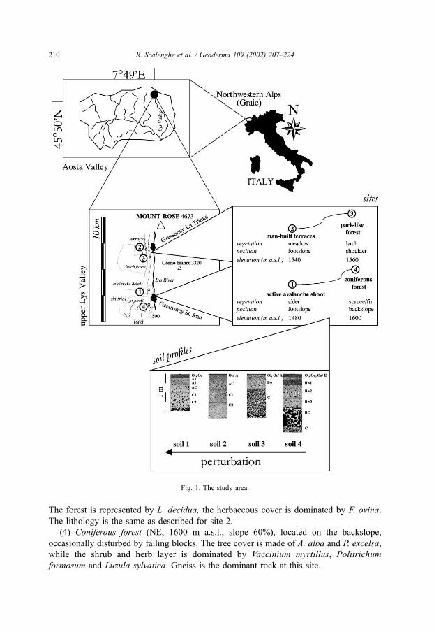
The forest is represented by L. decidua, the herbaceous cover is dominated by F. ovina.
The lithology is the same as described for site 2.
(4) Coniferous forest (NE, 1600 m a.s.l., slope 60%), located on the backslope,
occasionally disturbed by falling blocks. The tree cover is made of A. alba and P. excelsa,
while the shrub and herb layer is dominated by Vaccinium myrtillus, Politrichum
formosum and Luzula sylvatica. Gneiss is the dominant rock at this site.
Fig. 1. The study area.
R. Scalenghe et al. / Geoderma 109 (2002) 207–224210
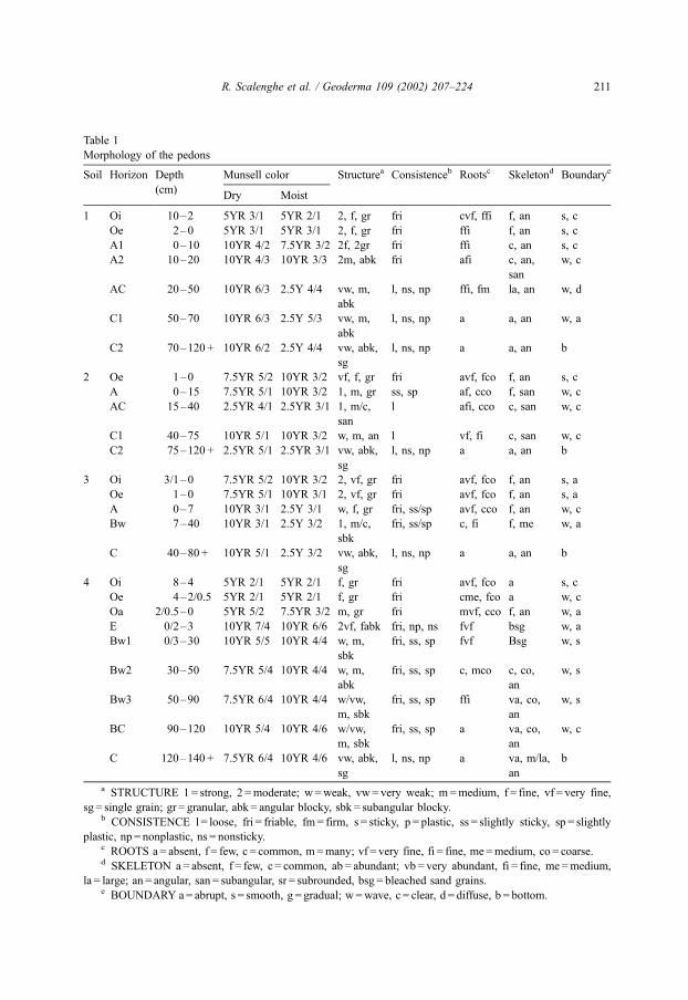
Table 1
Morphology of the pedons
Soil Horizon Depth Munsell color Structurea Consistenceb Rootsc Skeletond Boundarye
(cm)Dry Moist
1 Oi 10–2 5YR 3/1 5YR 2/1 2, f, gr fri cvf, ffi f, an s, c
Oe 2–0 5YR 3/1 5YR 3/1 2, f, gr fri ffi f, an s, c
A1 0–10 10YR 4/2 7.5YR 3/2 2f, 2gr fri ffi c, an s, c
A2 10–20 10YR 4/3 10YR 3/3 2m, abk fri afi c, an,
san
w, c
AC 20–50 10YR 6/3 2.5Y 4/4 vw, m,
abk
l, ns, np ffi, fm la, an w, d
C1 50–70 10YR 6/3 2.5Y 5/3 vw, m,
abk
l, ns, np a a, an w, a
C2 70–120 + 10YR 6/2 2.5Y 4/4 vw, abk,
sg
l, ns, np a a, an b
2 Oe 1–0 7.5YR 5/2 10YR 3/2 vf, f, gr fri avf, fco f, an s, c
A 0–15 7.5YR 5/1 10YR 3/2 1, m, gr ss, sp af, cco f, san w, c
AC 15–40 2.5YR 4/1 2.5YR 3/1 1, m/c,
san
l afi, cco c, san w, c
C1 40–75 10YR 5/1 10YR 3/2 w, m, an l vf, fi c, san w, c
C2 75–120 + 2.5YR 5/1 2.5YR 3/1 vw, abk,
sg
l, ns, np a a, an b
3 Oi 3/1–0 7.5YR 5/2 10YR 3/2 2, vf, gr fri avf, fco f, an s, a
Oe 1–0 7.5YR 5/1 10YR 3/1 2, vf, gr fri avf, fco f, an s, a
A 0–7 10YR 3/1 2.5Y 3/1 w, f, gr fri, ss/sp avf, cco f, an w, c
Bw 7–40 10YR 3/1 2.5Y 3/2 1, m/c,
sbk
fri, ss/sp c, fi f, me w, a
C 40–80 + 10YR 5/1 2.5Y 3/2 vw, abk,
sg
l, ns, np a a, an b
4 Oi 8–4 5YR 2/1 5YR 2/1 f, gr fri avf, fco a s, c
Oe 4–2/0.5 5YR 2/1 5YR 2/1 f, gr fri cme, fco a w, c
Oa 2/0.5–0 5YR 5/2 7.5YR 3/2 m, gr fri mvf, cco f, an w, a
E 0/2–3 10YR 7/4 10YR 6/6 2vf, fabk fri, np, ns fvf bsg w, a
Bw1 0/3–30 10YR 5/5 10YR 4/4 w, m,
sbk
fri, ss, sp fvf Bsg w, s
Bw2 30–50 7.5YR 5/4 10YR 4/4 w, m,
abk
fri, ss, sp c, mco c, co,
an
w, s
Bw3 50–90 7.5YR 6/4 10YR 4/4 w/vw,
m, sbk
fri, ss, sp ffi va, co,
an
w, s
BC 90–120 10YR 5/4 10YR 4/6 w/vw,
m, sbk
fri, ss, sp a va, co,
an
w, c
C 120–140 + 7.5YR 6/4 10YR 4/6 vw, abk,
sg
l, ns, np a va, m/la,
an
b
a STRUCTURE 1= strong, 2 =moderate; w =weak, vw= very weak; m=medium, f = fine, vf = very fine,
sg = single grain; gr = granular, abk = angular blocky, sbk = subangular blocky.b CONSISTENCE l = loose, fri = friable, fm = firm, s = sticky, p = plastic, ss = slightly sticky, sp = slightly
plastic, np = nonplastic, ns = nonsticky.c ROOTS a = absent, f = few, c = common, m=many; vf = very fine, fi = fine, me =medium, co = coarse.d SKELETON a = absent, f = few, c = common, ab = abundant; vb = very abundant, fi = fine, me =medium,
la = large; an = angular, san = subangular, sr = subrounded, bsg = bleached sand grains.e BOUNDARY a= abrupt, s = smooth, g = gradual; w =wave, c = clear, d = diffuse, b = bottom.
R. Scalenghe et al. / Geoderma 109 (2002) 207–224 211

The soils were described (Table 1) (Soil Survey Staff, 1951), sampled and classified
according to the USDA Soil Taxonomy (Soil Survey Staff, 1998).
2.2. Chemical and mineralogical analyses
All analyses were carried out on the fine earth fraction ( < 2 mm). Soil pH was
measured potentiometrically in H2O (1:2.5 w/v). When present, carbonates were detected
volumetrically (Ministero delle Politiche Agricole e Forestali, 2000). Particle-size analysis
was performed by the pipette method after dispersion with Na–hexametaphosphate.
Organic carbon (Org C) was determined by the Walkley–Black technique and total N
by standard Kjeldahl method (Bremner and Mulvaney, 1982). The cation exchange
capacity (CEC) and the exchangeable cations were determined in a BaCl2 solution
buffered at pH 8.1 (Rhoades, 1982). Available P (Pols) was extracted according to Olsen
et al. (1954) and determined colorimetrically by the ascorbic acid molybdate blue method
(Murphy and Riley, 1962).
Total iron (Fet) was determined after HCl–HNO3 digestion. The Fe extracted by the
DCB method (Fed) (Mehra and Jackson, 1960) was taken as representative of pedogenic
iron oxides, while the amorphous oxides were estimated from the extraction of Fe with an
ammonium oxalate solution buffered at pH 3 (Feo) (Schwertmann, 1964). In addition, Fe
was also extracted by 0.1 M Na–pyrophosphate (Fep). Aluminium extracted with the
oxalate solution (Alo) was also evaluated. Both elements were determined by atomic
absorption spectroscopy.
Humic acids (HA) and fulvic acids (FA) were extracted from the fine earth fraction and
purified as described by Schnitzer (1982). HA and FA were then freeze-dried and their
elemental composition (C, H and N) was determined by a CHN LECO 600 combustion
analyzer; the content of oxygen was calculated by difference.
The clay fraction ( < 2 Am) was separated by sedimentation and freeze-dried for the
mineralogical analyses. The X-ray diffraction (XRD) analyses were carried out using a
Philips PW 1710 diffractometer (40 kV and 20 mA, Fe-filtered Co–Ka radiation) on air-
dried (AD), ethylene glycol-solvated (EG) and heated (773 K) oriented mounts. Scans
were made from 3 to 35j2h at a speed of 1.5j2h min� 1. The amounts of phyllosilicates in
the oriented clay samples were estimated from the XRD peak height without any
correction factor.
3. Results and discussion
3.1. Site 1: active avalanche shoot
At site 1 (Fig. 1), the ‘‘spring-bottom avalanche’’ includes a 700-m-long sliding and a
500-m-long accumulation zone. The soil, located within the accumulation zone, is scarcely
developed and shows only an O–A–C horizon sequence (sandy, paramicaceous, acid,
mesic Typic Udorthent). The chemical data (Table 2) indicate an irregular distribution of
organic C, CEC and available P with a relative increase in the C2 horizon, suggesting the
burial of a preexisting soil surface by a layer of 50 cm of sediments. In the present scarcely
R. Scalenghe et al. / Geoderma 109 (2002) 207–224212
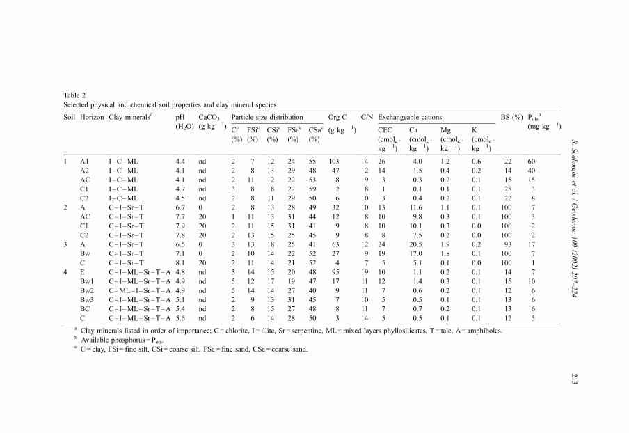
Table 2
Selected physical and chemical soil properties and clay mineral species
Soil Horizon Clay mineralsa pH CaCO3 Particle size distribution Org C C/N Exchangeable cations BS (%) Polsb
(H2O) (g kg� 1)Cc
(%)
FSic
(%)
CSic
(%)
FSac
(%)
CSac
(%)
(g kg� 1) CEC
(cmolc +
kg � 1)
Ca
(cmolc +
kg� 1)
Mg
(cmolc +
kg� 1)
K
(cmolc +
kg� 1)
(mg kg� 1)
1 A1 I–C–ML 4.4 nd 2 7 12 24 55 103 14 26 4.0 1.2 0.6 22 60
A2 I–C–ML 4.1 nd 2 8 13 29 48 47 12 14 1.5 0.4 0.2 14 40
AC I–C–ML 4.1 nd 2 11 12 22 53 8 9 3 0.3 0.2 0.1 15 15
C1 I–C–ML 4.7 nd 3 8 8 22 59 2 8 1 0.1 0.1 0.1 28 3
C2 I–C–ML 4.5 nd 2 8 11 29 50 6 10 3 0.4 0.2 0.1 22 8
2 A C–I–Sr–T 6.7 0 2 8 13 28 49 32 10 13 11.6 1.1 0.1 100 7
AC C–I–Sr–T 7.7 20 1 11 13 31 44 12 8 10 9.8 0.3 0.1 100 3
C1 C–I–Sr–T 7.9 20 2 11 15 31 41 9 8 10 10.1 0.3 0.0 100 2
C2 C–I–Sr–T 7.8 20 2 13 15 25 45 9 8 8 7.5 0.2 0.0 100 2
3 A C–I–Sr–T 6.5 0 3 13 18 25 41 63 12 24 20.5 1.9 0.2 93 17
Bw C–I–Sr–T 7.1 0 2 10 14 22 52 27 9 19 17.0 1.8 0.1 100 7
C C–I–Sr–T 8.1 20 2 11 14 21 52 4 7 5 5.1 0.1 0.0 100 1
4 E C–I–ML–Sr–T–A 4.8 nd 3 14 15 20 48 95 19 10 1.1 0.2 0.1 14 7
Bw1 C–I–ML–Sr–T–A 4.9 nd 5 12 17 19 47 17 11 12 1.4 0.3 0.1 15 10
Bw2 C–ML–I–Sr–T–A 4.9 nd 5 14 14 27 40 9 11 7 0.6 0.2 0.1 12 6
Bw3 C–I–ML–Sr–T–A 5.1 nd 2 9 13 31 45 7 10 5 0.5 0.1 0.1 13 6
BC C–I–ML–Sr–T–A 5.4 nd 2 8 15 27 48 8 11 7 0.7 0.2 0.1 13 6
C C–I–ML–Sr–T–A 5.6 nd 2 6 14 28 50 3 14 5 0.5 0.1 0.1 12 5
a Clay minerals listed in order of importance; C = chlorite, I = illite, Sr = serpentine, ML=mixed layers phyllosilicates, T = talc, A= amphiboles.b Available phosphorus = Pols.c C = clay, FSi = fine silt, CSi = coarse silt, FSa = fine sand, CSa = coarse sand.
R.Scalen
gheet
al./Geoderm
a109(2002)207–224
213
developed soil, the pH is low and increases slightly with depth; the acidity is probably
enhanced by the presence of the alder, its symbionts and the attendant process of
nitrification. There is little variation in particle size distribution throughout the profile,
and CEC values show a sharp decrease below the A horizons reflecting the organic carbon
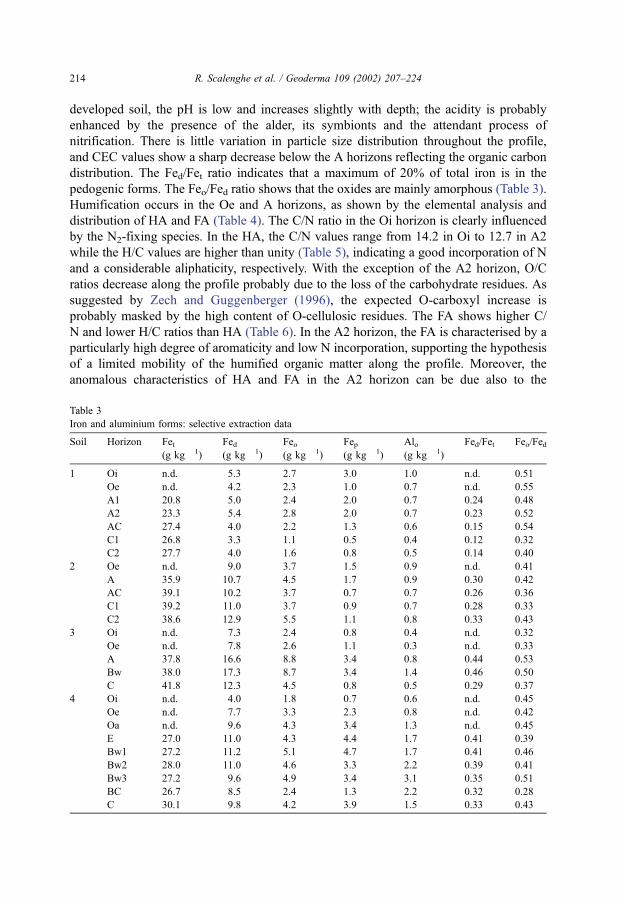
distribution. The Fed/Fet ratio indicates that a maximum of 20% of total iron is in the
pedogenic forms. The Feo/Fed ratio shows that the oxides are mainly amorphous (Table 3).
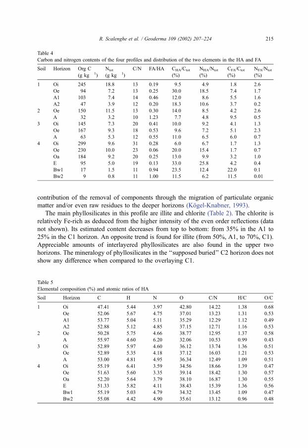
Humification occurs in the Oe and A horizons, as shown by the elemental analysis and
distribution of HA and FA (Table 4). The C/N ratio in the Oi horizon is clearly influenced
by the N2-fixing species. In the HA, the C/N values range from 14.2 in Oi to 12.7 in A2
while the H/C values are higher than unity (Table 5), indicating a good incorporation of N
and a considerable aliphaticity, respectively. With the exception of the A2 horizon, O/C
ratios decrease along the profile probably due to the loss of the carbohydrate residues. As
suggested by Zech and Guggenberger (1996), the expected O-carboxyl increase is
probably masked by the high content of O-cellulosic residues. The FA shows higher C/
N and lower H/C ratios than HA (Table 6). In the A2 horizon, the FA is characterised by a
particularly high degree of aromaticity and low N incorporation, supporting the hypothesis
of a limited mobility of the humified organic matter along the profile. Moreover, the
anomalous characteristics of HA and FA in the A2 horizon can be due also to the
Table 3
Iron and aluminium forms: selective extraction data
Soil Horizon Fet(g kg� 1)
Fed(g kg� 1)
Feo(g kg� 1)
Fep(g kg� 1)
Alo(g kg� 1)
Fed/Fet Feo/Fed
1 Oi n.d. 5.3 2.7 3.0 1.0 n.d. 0.51
Oe n.d. 4.2 2.3 1.0 0.7 n.d. 0.55
A1 20.8 5.0 2.4 2.0 0.7 0.24 0.48
A2 23.3 5.4 2.8 2.0 0.7 0.23 0.52
AC 27.4 4.0 2.2 1.3 0.6 0.15 0.54
C1 26.8 3.3 1.1 0.5 0.4 0.12 0.32
C2 27.7 4.0 1.6 0.8 0.5 0.14 0.40
2 Oe n.d. 9.0 3.7 1.5 0.9 n.d. 0.41
A 35.9 10.7 4.5 1.7 0.9 0.30 0.42
AC 39.1 10.2 3.7 0.7 0.7 0.26 0.36
C1 39.2 11.0 3.7 0.9 0.7 0.28 0.33
C2 38.6 12.9 5.5 1.1 0.8 0.33 0.43
3 Oi n.d. 7.3 2.4 0.8 0.4 n.d. 0.32
Oe n.d. 7.8 2.6 1.1 0.3 n.d. 0.33
A 37.8 16.6 8.8 3.4 0.8 0.44 0.53
Bw 38.0 17.3 8.7 3.4 1.4 0.46 0.50
C 41.8 12.3 4.5 0.8 0.5 0.29 0.37
4 Oi n.d. 4.0 1.8 0.7 0.6 n.d. 0.45
Oe n.d. 7.7 3.3 2.3 0.8 n.d. 0.42
Oa n.d. 9.6 4.3 3.4 1.3 n.d. 0.45
E 27.0 11.0 4.3 4.4 1.7 0.41 0.39
Bw1 27.2 11.2 5.1 4.7 1.7 0.41 0.46
Bw2 28.0 11.0 4.6 3.3 2.2 0.39 0.41
Bw3 27.2 9.6 4.9 3.4 3.1 0.35 0.51
BC 26.7 8.5 2.4 1.3 2.2 0.32 0.28
C 30.1 9.8 4.2 3.9 1.5 0.33 0.43
R. Scalenghe et al. / Geoderma 109 (2002) 207–224214
contribution of the removal of components through the migration of particulate organic
matter and/or even raw residues to the deeper horizons (Kogel-Knabner, 1993).
The main phyllosilicates in this profile are illite and chlorite (Table 2). The chlorite is
relatively Fe-rich as deduced from the higher intensity of the even order reflections (data
not shown). Its estimated content decreases from top to bottom: from 35% in the A1 to
25% in the C1 horizon. An opposite trend is found for illite (from 50%, A1, to 70%, C1).
Appreciable amounts of interlayered phyllosilicates are also found in the upper two
horizons. The mineralogy of phyllosilicates in the ‘‘supposed buried’’ C2 horizon does not
show any difference when compared to the overlaying C1.
Table 4
Carbon and nitrogen contents of the four profiles and distribution of the two elements in the HA and FA
Soil Horizon Org C
(g kg� 1)
Ntot
(g kg� 1)
C/N FA/HA CHA/Ctot
(%)
NHA/Ntot
(%)
CFA/Ctot
(%)
NFA/Ntot
(%)
1 Oi 245 18.8 13 0.19 9.5 4.9 1.8 2.6
Oe 94 7.2 13 0.25 30.0 18.5 7.4 1.7
A1 103 7.4 14 0.46 12.0 8.6 5.5 1.6
A2 47 3.9 12 0.20 18.3 10.6 3.7 0.2
2 Oe 150 11.5 13 0.30 14.0 8.5 4.2 2.6
A 32 3.2 10 1.23 7.7 4.8 9.5 0.5
3 Oi 145 7.3 20 0.41 10.0 9.2 4.1 1.3
Oe 167 9.3 18 0.53 9.6 7.2 5.1 2.3
A 63 5.3 12 0.55 11.0 6.5 6.0 0.7
4 Oi 299 9.6 31 0.28 6.0 6.7 1.7 1.3
Oe 230 10.0 23 0.06 20.0 15.4 1.7 0.7
Oa 184 9.2 20 0.25 13.0 9.9 3.2 1.0
E 95 5.0 19 0.13 33.0 25.8 4.2 0.4
Bw1 17 1.5 11 0.94 23.5 12.4 22.0 0.1
Bw2 9 0.8 11 1.00 11.5 6.2 11.5 0.01
Table 5
Elemental composition (%) and atomic ratios of HA
Soil Horizon C H N O C/N H/C O/C
1 Oi 47.41 5.44 3.97 42.80 14.22 1.38 0.68
Oe 52.06 5.67 4.75 37.01 13.23 1.31 0.53
A1 53.77 5.04 5.11 35.29 12.29 1.12 0.49
A2 52.88 5.12 4.85 37.15 12.71 1.16 0.53
2 Oe 50.28 5.75 4.66 38.77 12.95 1.37 0.58
A 55.97 4.60 6.20 32.06 10.53 0.99 0.43
3 Oi 52.89 5.97 4.60 36.12 13.74 1.36 0.51
Oe 52.89 5.35 4.18 37.12 16.03 1.21 0.53
A 53.00 4.81 4.95 36.34 12.49 1.09 0.51
4 Oi 55.19 6.41 3.59 34.56 18.66 1.39 0.47
Oe 51.63 5.60 3.35 39.14 18.42 1.30 0.57
Oa 52.20 5.64 3.79 38.10 16.87 1.30 0.55
E 51.33 5.82 4.11 38.43 15.39 1.36 0.56
Bw1 55.19 5.03 4.79 34.32 13.45 1.09 0.47
Bw2 55.08 4.42 4.90 35.61 13.12 0.96 0.48
R. Scalenghe et al. / Geoderma 109 (2002) 207–224 215
From these results, it appears that during the short interval of time since the last
avalanche, the genesis of this profile has been mainly influenced by the invasion of
pioneer tree species. The presence of humic materials and the acidity induced by N2-fixing
species cause the horizons at the surface to be more weathered than the deepest ones. In
fact, these factors may be responsible for the weathering of primary chlorite and for the
more pronounced Fe released from silicates in the A horizons. The iron-rich chlorites are
in fact reported to weather easily in acid environment (Ross, 1969), acting as source of
iron for the formation of oxides (Bain, 1977). The presence of humic substances, together
with the short time of soil development, favours the formation of amorphous Fe oxides
(Schwertmann, 1985). Moreover, the rate of mineralisation and the prevalence of humic
over fulvic acids limit the downward leaching of iron (Table 4).
The presence of interstratified minerals of the illite-vermiculite type, more abundant in
the surface horizons, suggests the transformation of illite through the loss of interlayer K, a
process which is well known to be enhanced by soil acidity (Norrish, 1973) and roots
(Mortland et al., 1956). Hence, although the last high intensity perturbation has destroyed
the existing soils, the colonisation by acidifying pioneer tree species has allowed to initiate
a certain degree of development, even if limited to soil surface horizons. The similarities in
the phyllosilicates of C1 and C2 horizons might indicate that the C2 horizon had been
present at the soil surface for a short time before its burial by the last catastrophic event,
not long enough to allow the colonisation of the surface by the alder.
3.2. Site 2: man-built terraces
At site 2 (Fig. 1), soil developed on downwasted material that has covered a preexisting
surface, including anthropic features. In fact, on the left side of the trench, we observed a
buried accumulation of poorly sorted fragmental clasts (the voids are empty) derived from
a former human stone-removal operation by Walser population. The collection of clasts
may have occurred during the 14th century when the valley was colonised. According to
Table 6
Elemental composition (%) and atomic ratios of FA
Soil Horizon C H N O C/N H/C O/C
1 Oi 50.01 4.31 3.18 41.81 20.33 1.04 0.63
Oe 50.80 4.15 3.41 41.19 19.96 0.98 0.61
A1 50.36 4.45 3.88 40.74 15.14 1.06 0.61
A2 52.18 2.98 2.47 42.37 24.62 0.68 0.61
2 Oe 50.41 4.65 3.56 40.81 19.22 1.11 0.61
A 50.63 4.36 4.71 39.57 12.53 1.03 0.59
3 Oi 51.04 4.37 2.95 41.26 23.08 1.03 0.61
Oe 50.56 4.29 2.89 41.87 23.69 1.02 0.62
A 50.83 4.25 3.47 40.90 17.06 1.00 0.60
4 Oi 53.15 4.61 2.56 39.40 26.84 1.04 0.56
Oe 51.38 4.12 1.87 42.30 35.06 0.96 0.62
Oa 49.49 3.95 1.84 44.54 34.57 0.96 0.68
E 50.25 4.10 1.98 43.47 32.94 0.98 0.65
Bw1 49.37 3.66 1.32 45.30 43.70 0.89 0.69
Bw2 43.69 2.47 1.50 52.34 33.92 0.68 0.90
R. Scalenghe et al. / Geoderma 109 (2002) 207–224216
this interpretation, the landslide that buried the rock mound could not be more than 600
years old, while the colluvial surfaces have been cultivated with traditional agriculture
until the present. Plowing and manuring are yearly performed. The soil (sandy, magnesic,
nonacid, frigid Typic Cryorthent) shows an A horizon followed by an AC transition
horizon. Below there are two C horizons enriched in coarse fragments. The pH increases
with depth and values below 7 were observed only in the surface horizon (Table 2).
Carbonates are present in the fine earth fraction in all horizons except in the A. The clay
fraction is at low level. The CEC is only slightly variable through the profile, while the
organic C decreases below the topsoil. The presence in the A horizon of easily degradable
organic matter, such as roots and rootlets of grasses, might be inferred from the
percentages of HA and FA (Table 4). Furthermore, the HA elemental composition (Table
5) shows low C/N, H/C and O/C ratios due, probably, to rapid mineralisation of degradable
compounds with associated accumulation of the more recalcitrant aromatic moieties. The
high incorporation of N can be influenced also by manure application associated to a
consistent biological activity.
The proportion of pedogenic iron oxides (Table 3), indicated by the Fed/Fet ratio, is
homogeneous throughout the profile. This homogeneity is also shown by the minera-
logical analyses that indicate little changes in the phyllosilicate types or in their relative
amounts (data not shown). Chlorite prevails in all horizons; illite and serpentine are also
present and approximately in the same amounts. Traces of talc are also found, hence
providing the only evidence of mineral weathering. In fact, the ratio between the height of
the peaks of talc and illite decreases from the bottom to the top of the profile (57 in C
horizons and 36 in the A one).
Since the building of the terrace, the major pedogenic processes are restricted to the
surface horizon, as manifested by the decrease in pH and the consequent removal of
carbonates and weathering of Mg-bearing minerals. Man-induced disturbances, connected
to land use, even though of low intensity, have limited the development of pronounced
morphological differentiation. Cultivation and manuring favoured the presence of easily
decomposable organic matter with low acidity. Moreover, the incorporation of N into the
humic materials may further decrease their complexing ability (Stevenson, 1994), limiting,
therefore, their effect on the mineral surface horizon.
3.3. Site 3: park-like forest
At site 3 (Fig. 1), the soil has developed on a former landslide material that includes
large boulders. The steepness and the surficial pietrosity have conditioned its use:
presently, a park-like association of larch and meadow provides wood for cutting and
herbage for grazing. The steep slope has determined the scarce depth of this soil that,
nevertheless, shows an A–B–C profile (sandy, magnesic, nonacid, frigid Mollic Eutroc-
ryept).
The pH increases with depth and carbonates were found only in the fine earth fraction
of the C horizon. However, boulders in the field and cobbles in all horizons contain
carbonates. As found by others, the relative low rainfall on the Italian side of the Alps
prevents the leaching of the carbonates from the coarse fraction (Legros, 1992). In this
profile, the organic C (Table 2) shows the influence of the arboreal species, with higher
R. Scalenghe et al. / Geoderma 109 (2002) 207–224 217
values either in the A1 and Bw horizons compared to the profile under herbaceous species
(site 2). The association of herbaceous and arboreal species at the same site results in a
higher C/N ratio, particularly in the organic horizons, demonstrating the accumulation of C
in the litter due to a low degradability of lignin-rich woody debris. This is also evident by
comparing the HA and FA contents (Table 4). Moreover, HA and FA show high C/N ratios
and H/C close to unity, indicating that material only partially degraded.
The fractionation of iron indicates that more than 40% of total Fe is in the pedogenic
oxides in the A and Bw horizons and that less than half of them are amorphous. The
mineralogy of the clay fraction of this profile, consisting of chlorite, illite and serpentine,
is very similar to that of the soil described at site 2. A trend towards a more weathered
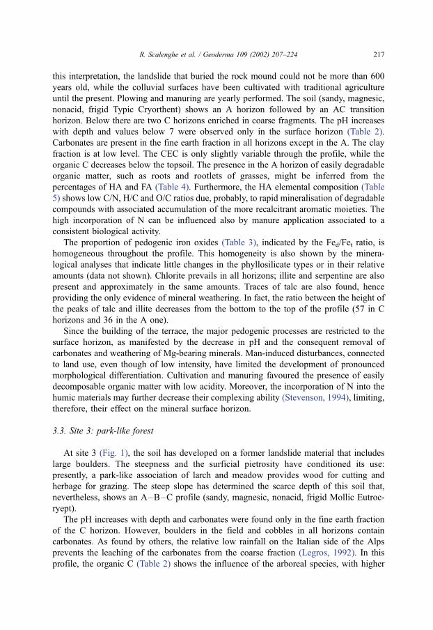
stage could, however, be observed in the illite of the Bw horizon, as manifested by some
degree of asymmetry in the air-dried sample, indicating a loss of K from the interlayer.
This depletion is confirmed by the collapse of the peak when heated to 500jC (Fig. 2).
Fig. 2. XRD patterns of the clay fractions of Profile 3.
R. Scalenghe et al. / Geoderma 109 (2002) 207–224218

In the disturbance scale (Fig. 1), this site is relatively stable; this fact, in addition to the
presence of a more recalcitrant humic material and its low N content, is probably
responsible for mineral weathering not limited to the surface horizon.
3.4. Site 4: coniferous forest
At site 4 (Fig. 1), soil has developed on a stabilised slope wash covered by large blocks;
it shows an O–E–B–C sequence of horizons (sandy, micaceous, acid, mesic Spodic
Dystrudept). The E horizon is, however, very shallow and discontinuous; in some cases, it
can be visualised only by the presence of a ‘‘salt and pepper’’ effect.
Soil pH is low and increases downward the profile, while organic C decreases
abruptly below the E horizon. In the E, Bw1 and Bw2 horizons (Table 4), a higher
proportion of organic C is extractable as HA and FA. The FA/HA ratio increases through
the profile (Table 4), indicating an incipient podzolisation (Andreux, 1996). Moreover,
the extraction procedure of FA and HA shows that the organic matter is strongly bound
to the mineral fraction and the removal of it was more difficult in the Bw1 than in Bw2
and E horizons. This, together with the accumulation of FA in the Bw1 horizon, further
supports the on-going podzolisation process. HA show a more condensed and aliphatic
structure compared to FA throughout the profile, as deduced by the O/C and H/C values
(Tables 5 and 6). Conversely, FA have high C/N and O/C and low H/C ratios, indicating
a high accumulation of acidic aromatic rich molecules with high polarity and, therefore,
great mobility and high ability to interact with Fe and Al (De Coninck, 1980). The
surprisingly high O/C and low H/C values registered in the Bw2 horizon of this profile
are probably due to a selective translocation of the more polar fraction of FA below the
Bw1 horizon.
The iron fractionation (Table 3) indicates that approximately 40% of total iron is in the
form of pedogenic iron oxides and that half of these are amorphous. In the Bw1 horizon, a
relative maximum of organic-complexed Fe (pyrophosphate-extractable Fe) was found.
Appreciable amounts of interstratified minerals were observed in all horizons, together
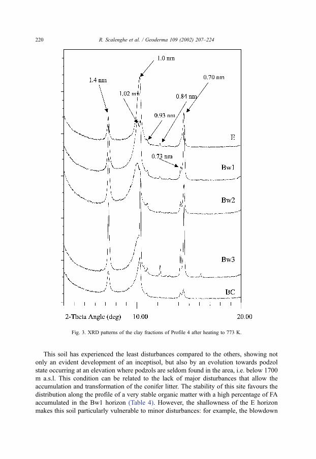
with chlorite, illite and serpentine. The interstratified minerals show a higher crystallinity
in the upper horizons of the profile, as evidenced by the different behaviour of the peaks in
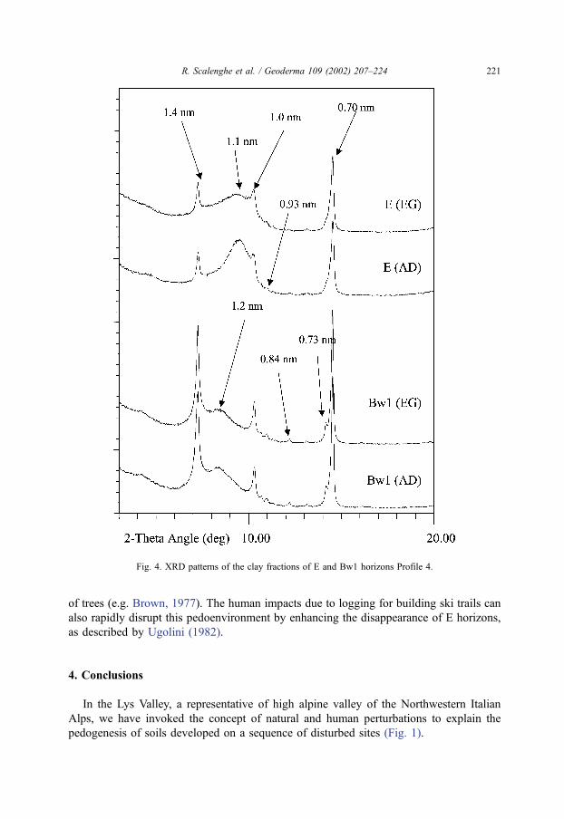
the 1.0-nm zone after heating to 773 K (Fig. 3). The interstratified minerals in the E
horizon show the complete collapse to 1.0 nm when heated, a d-spacing of about 1.1 when
air-dried and some swelling behaviour upon EG solvation (Fig. 4), indicating the presence
of some low-charge layers in an illite-vermiculite-type structure. The Bw1 and Bw2
horizons show instead a peak at 1.02 nm following heating, a peak at 1.2 nm when air-
dried and no swelling behaviour upon solvation. These evidences indicate a mixed layer
mineral of illite-vermiculite-type with some degree of Al hydroxy interlayering or of
chlorite-type layers.
The presence of swelling minerals in the E horizon again confirms the tendency
towards podzolisation. In fact, in the eluvial horizons of spodosols, smectites are often
found (e.g. Zabowski and Ugolini, 1992; Wang et al., 1989). These minerals derive from
preexisting micaceous materials (Righi et al., 1999) or from chlorites through the
depletion of Mg in interlayer, followed by the migration of structural Al (Carnicelli et
al., 1997).
R. Scalenghe et al. / Geoderma 109 (2002) 207–224 219
This soil has experienced the least disturbances compared to the others, showing not
only an evident development of an inceptisol, but also by an evolution towards podzol
state occurring at an elevation where podzols are seldom found in the area, i.e. below 1700
m a.s.l. This condition can be related to the lack of major disturbances that allow the
accumulation and transformation of the conifer litter. The stability of this site favours the
distribution along the profile of a very stable organic matter with a high percentage of FA
accumulated in the Bw1 horizon (Table 4). However, the shallowness of the E horizon
makes this soil particularly vulnerable to minor disturbances: for example, the blowdown
Fig. 3. XRD patterns of the clay fractions of Profile 4 after heating to 773 K.
R. Scalenghe et al. / Geoderma 109 (2002) 207–224220
of trees (e.g. Brown, 1977). The human impacts due to logging for building ski trails can
also rapidly disrupt this pedoenvironment by enhancing the disappearance of E horizons,
as described by Ugolini (1982).
4. Conclusions
In the Lys Valley, a representative of high alpine valley of the Northwestern Italian
Alps, we have invoked the concept of natural and human perturbations to explain the
pedogenesis of soils developed on a sequence of disturbed sites (Fig. 1).
Fig. 4. XRD patterns of the clay fractions of E and Bw1 horizons Profile 4.
R. Scalenghe et al. / Geoderma 109 (2002) 207–224 221
The starting member is the more disturbed situation where the avalanche event and the
consequent invasion of pioneer trees affect the composition of organic matter and,
therefore, the chemical and mineralogical soil characteristics. Thanks to the effectiveness
of the alder (Ugolini, 1968), the pedogenesis can proceed quickly as shown by the changes
that occur at least in the more surficial horizons in a time span of about 20 years. The
events of lower intensity, but higher frequency, as the cultivation of the land, seem to have
similar effects. In fact, in the second member of the disturbance sequence, the presence of
the herbaceous species, with easily decomposable organic matter, affects the profile
development keeping it in juvenile stage even if it is located in a rather stable geo-
morphologic position. In the third member, park-like forest, the larch associated to
herbaceous cover has increased the activity of the organic matter, which appears more
polar and more recalcitrant to degradation than under meadows. This has induced the
weathering of the clay minerals and the dissolution of carbonates from the fine earth
fraction. In the fourth member, there is a vegetation association that favours the
podzolisation process and, in fact, under undisturbed conditions, the soil tends to reach
a podzol-like state. In this case, the steady state is confirmed both by chemical and
mineralogical characteristics and widespread evidences of a shallow E horizon, which can
be easily destroyed even by low intensity disturbances.
The trend of these soils, from the most disturbed to the undisturbed, can be followed by
the Fed/Fet ratio that increases from site 1 to site 4. This clear trend can be also recognized
for clay minerals. The most disturbed situation (site 1) shows weathering only of the most
unstable minerals; at sites 2 and 3, the weathering proceeds through the depletion of K
from illite and little formation of mixed layers, while true transformations of the clay phase
are only visible in the undisturbed situation at site 4. The pedogenic processes are mainly
caused by the organic matter transformation. In soils with an easily degradable organic
matter, the effects are limited to the upper horizons, while the material under larch and
spruce, more recalcitrant and polar, manifests its effect also at depth.
In conclusion, in an alpine valley, the impact of different disturbances on soil
development, independently from their intensity and frequency, leads to a pattern of
development of soils in which the vegetation plays a key role.
Acknowledgements
We are grateful to Dr. Luca Mercalli (Societa Meteorologica Italiana) for his support on
glaciological and meteorological aspects and Dr. Stefania Santoni (Universita di Torino)
for drawing the soil profiles.
References
Andreux, F., 1996. Humus in world soils. In: Piccolo, A. (Ed.), Humic Substances in Terrestrial Ecosystems.
Elsevier, Amsterdam, Netherlands, pp. 45–100.
Bain, D.C., 1977. The weathering of ferruginous chlorite in a podzol from Argyllshire, Scotland. Geoderma 17,
193–208.
R. Scalenghe et al. / Geoderma 109 (2002) 207–224222
Bremner, J.M., Mulvaney, C.S., 1982. Nitrogen. In: Page, A.L., et al. (Eds.), Methods of Soil Analysis. Part 2,
2nd edn. Agron. Monogr., vol. 9. ASA and SSSA, Madison, WI, pp. 595–624.
Brown, J.L., 1977. Etude de la perturbation des horizons du sol par un arbre qui se renverse et son impact sur la
pedogenese. Can. J. Soil Sci. 57, 173–186.
Capello, C.F., 1962. Il limite temporaneo delle nevi e il manto nevoso in Piemonte. Studi sul manto nevoso no 2,
Istituto di Geografia Alpina, Torino, IT.
Carnicelli, S., Mirabella, A., Cecchini, G., Sanesi, G., 1997. Weathering of chlorite to a low-charge expandable
mineral in a spodosol on the Apenine Mountains, Italy. Clays Clay Miner. 45, 28–41.
CSMA (Comando Scuola Militare Alpina), 1966. Monografia delle valanghe. Le Alpi Occidentali, vol. III.
Ministero della Difesa, Roma, IT parte I, monographic cartography.
De Coninck, F., 1980. Major mechanisms in formation of spodic horizons. Geoderma 24, 101–128.
Grotzbach, E., Stadel, C., 1997. Mountain peoples and cultures. In: Messerli, B., Ives, J.D. (Eds.), Mountains of
the World. A Global Priority. The Parthenon Publishing Group, London, UK, pp. 17–38.
Karlstrom, E.T., Osborn, G., 1992. Genesis of buried paleosols and soil in Holocene and late Pleistocene tills,
Bugaboo Glacier area, British Columbia. Arct. Alp. Res. 24, 108–123.
Kogel-Knabner, I., 1993. Biodegradation and humification processes in forest soils. In: Bollag, J.-M., Stotzky, G.
(Eds.), Soil Biochemistry. Marcel Dekker, New York, USA, pp. 101–127.
Legros, J.P., 1992. Soils of the Alpine mountains. In: Martini, I.P., Chesworth, W. (Eds.), Weathering, Soils and
Paleosols. Elsevier, Amsterdam, Netherlands, pp. 155–181.
Little, D.J., Mitchell, F.J.G., von Engelbrechten, S., Farrel, E.P., 1996. Assessment of the impact of past dis-
turbance and prehistoric Pinus sylvestris on vegetation dynamics and soil development in Uragh Wood, SW
Ireland. Holocene 6, 90–99.
Mehra, O.P., Jackson, M.L., 1960. Iron oxide removal from soils and clays by a dithionite –citrate system
buffered with sodium bicarbonate. Clays Clay Min. Proc. 7th National Conf. on Clays and Clay Minerals.
Oct. 20–23, 1958, Washington, DC, USA. Pergamon, London, pp. 317–327.
Ministero delle Politiche Agricole e Forestali, 2000. Metodi di analisi chimica dei suoli. In: Violante, P., Sequi, P.
(Eds.), Collana di metodi analitici per l’agricoltura. Franco Angeli Editore, Milano.
Mortland, M.M., Lawton, K., Uehara, G., 1956. Alteration of biotite to vermiculite by plant growth. Soil Sci. 82,
477–481.
Murphy, J., Riley, J.P., 1962. A modified single solution method for determination of phosphate in natural waters.
Anal. Chim. Acta 27, 31–36.
Norrish, K., 1973. Factors in the weathering of mica to vermiculite. In: Serratosa, J.M. (Ed.), Proc. International
Clay Conference, Madrid, ES. CSIC, Madrid, pp. 417–432.
Olsen, S.R., Cole, C.V., Watanabe, F.S., Dean, L.A., 1954. Estimation of available phosphorus in soils by
extraction with sodium bicarbonate. USDA circular 939. US Gov. Print. Office, Washington, DC.
Rhoades, J.D., 1982. Cation exchange capacity. In: Page, A.L., et al. (Eds.), Methods of Soil Analysis. Part 2, 2nd
edn. Agron. Monogr., vol. 9. ASA and SSSA, Madison, WI, pp. 149–157.
Richter, D.D., King, K.S., Witter, J.A., 1989. Moisture and nutrient status of extremely acid Umbrepts in the
Black Mountains of North Carolina. Soil Sci. Soc. Am. J. 53, 1222–1228.
Righi, D., Huber, K., Keller, C., 1999. Clay formation and podzol development from postglacial moraines in
Switzerland. Clay Miner. 34, 319–332.
Ross, G.J., 1969. Acid dissolution of chlorites: release of magnesium, iron and aluminum and mode of acid
attack. Clays Clay Miner. 17, 347–354.
Schnitzer, M., 1982. Organic matter characterization. In: Page, A.L., et al. (Eds.), Methods of Soil Analysis. Part
2, 2nd edn. Agron. Monogr., vol. 9. ASA and SSSA, Madison, WI, pp. 581–594.
Schwertmann, U., 1964. Differenzierung der Eisenoxide des Bodens durch Extraktion mit ammonium oxalat
Losung. Z. Pflanzenernahr. Bodenkd. 105, 194–202.
Schwertmann, U., 1985. The effect of pedogenic environments on iron oxide minerals. Adv. Soil Sci. 1, 172–
200.
Simonetta, C., Negro, M.L., 1972. Carte generali delle valanghe delle Alpi italiane (note illustrative). Studi sulle
valanghe no. 7, Istituto di Geografia Alpina, Torino, IT.
Soil Survey Staff, 1951. Soil Survey Manual. US Department of Agriculture Handbook no. 18, Washington, DC,
USA.
R. Scalenghe et al. / Geoderma 109 (2002) 207–224 223
Soil Survey Staff, 1998. Keys to Soil Taxonomy, eighth edn. US Department of Agriculture, Natural Resources
Conservation Service, Washington, DC.
Stevenson, F.J., 1994. Humus Chemistry: Genesis, Composition and Reactions. Wiley, New York, NY.
Stewart, G.H., Basher, L.R., Burrows, L.E., Runkle, J.R., Hall, G.M.J., Jackson, R.J., 1993. Beech-hardwood
forest composition, landforms, and soil relationships, north Westland, New Zealand. Vegetatio 106, 11–125.
Ugolini, F.C., 1968. Soil development and alder invasion in a recently deglaciated area of Glacier Bay, Alaska.
Biology of the Alder. Proceedings of a Symposium Northwest Scientific Assoc. Publ. Pacific Northwest
Forest and Range Exp. Station. Forest Service, USDA, Portland, OR, pp. 115–140.
Ugolini, F.C., 1982. Soil development in the Abies amabilis zone of the Central Cascades, Washington. In: Oliver,
C.D., Kenady, R.M. (Eds.), Proceedings of the Biology and Management of trye fir in the Pacific Northwest
Symposium, 24–26 February 1981, Seattle-Tacoma, Washington, USA. University of Washington, Seattle—
USDA Forest Service, Portland, pp. 165–176.
Wang, C., Ross, G.J., Protz, R., 1989. Effect of crystalline iron oxides on development and classification of
podzolic soils in western Labrador, Newfoundland. Soil Sci. Soc. Am. J. 53, 870–875.
Zabowski, D., Ugolini, F.C., 1992. Seasonality in the mineral stability of a subalpine Spodosol. Soil Sci. 154,
497–507.
Zech, W., Guggenberger, G., 1996. Organic matter dynamics in forest soils of temperate and tropical ecosystems.
In: Piccolo, A. (Ed.), Humic Substances in Terrestrial Ecosystems. Elsevier, Amsterdam, Netherlands, pp.
101–170.
R. Scalenghe et al. / Geoderma 109 (2002) 207–224224
Copyright © 2022 FDOKUMEN