Sedimentology and Soil Micromorphology of the Late Pleistocene and Early Holocene Deposits of Grotta...
24
Sedimentology and Soil Micromorphology of the Late Pleistocene and Early Holocene Deposits of Grotta dell’Edera (Trieste Karst, NE Italy) Giovanni Boschian Laboratorio di Sedimentologia e Paleopedologia del Dipartimento di Scienze Archeologiche, Universita ` di Pisa, 53, via S. Maria, I-56100 Pisa, Italy The deposits of Grotta dell’Edera have been studied by both standard sedimentological and soil micromorphological techniques, and have been divided into four main stages. The two older ones have not been dated, as they did not yield any human artefacts; nevertheless, according to their stratigraphic position and sedimentological– micromorphological characteristics, they may be considered as Tardiglacial. They tes- tify to a thermoclastic event followed by loess deposition, both accompanied by strong inputs from outside the cave. The two following stages were ascribed to the Mesolithic (stage 3) and to the Neolithic-Copper Age (stage 4). In these two intervals sedimenta- tion was strongly affected by human activity, while external inputs decreased. Meso- lithic occupation produced sediments rich in ash and decayed organic matter. During the final stage, the cave was a shelter for domestic animals, and the deposits are mainly composed of their droppings. 1997 John Wiley & Sons, Inc. INTRODUCTION The Grotta dell’Edera is situated in the Trieste Karst, about 15 km north- west of Trieste, 3 km from the coast of the Adriatic Sea (Figure 1), at the bottom of a doline about 130 m above sea level. Middle Cretaceous limestones (Turonian fossiliferous mudstones of the ‘‘Borgo Grotta Gigante member’’; Cucchi et al., 1989) of the carbonatic platform series of the Trieste Karst crop out in the surroundings of the cave. The landscape morphology of the karstic plateau is rather smooth in the surroundings of the cave, sloping gently to- wards the sea with a few low rounded hills; the area is also deeply karstified, with common deep dolines and caves. The present day floristic association is the Orno-Ostryo-Quercetum, partially anthropized and recently re-afforested with Pinus nigra. Although several caves have been excavated in the Trieste Karst, very little is known about the ancient environment of this region; palaeoenvironmental studies have been limited to the faunal assemblages which are rather poor Geoarchaeology: An International Journal, Vol. 12, No. 3, 227–249 (1997) 1997 by John Wiley & Sons, Inc. CCC 0883-6353/97/030227-23
Transcript of Sedimentology and Soil Micromorphology of the Late Pleistocene and Early Holocene Deposits of Grotta...

Sedimentology and SoilMicromorphology of the LatePleistocene and Early HoloceneDeposits of Grotta dell’Edera(Trieste Karst, NE Italy)
Giovanni BoschianLaboratorio di Sedimentologia e Paleopedologia del Dipartimento di ScienzeArcheologiche, Universita di Pisa, 53, via S. Maria, I-56100 Pisa, Italy
The deposits of Grotta dell’Edera have been studied by both standard sedimentologicaland soil micromorphological techniques, and have been divided into four main stages.The two older ones have not been dated, as they did not yield any human artefacts;nevertheless, according to their stratigraphic position and sedimentological–micromorphological characteristics, they may be considered as Tardiglacial. They tes-tify to a thermoclastic event followed by loess deposition, both accompanied by stronginputs from outside the cave. The two following stages were ascribed to the Mesolithic(stage 3) and to the Neolithic-Copper Age (stage 4). In these two intervals sedimenta-tion was strongly affected by human activity, while external inputs decreased. Meso-lithic occupation produced sediments rich in ash and decayed organic matter. Duringthe final stage, the cave was a shelter for domestic animals, and the deposits are mainlycomposed of their droppings. 1997 John Wiley & Sons, Inc.
INTRODUCTION
The Grotta dell’Edera is situated in the Trieste Karst, about 15 km north-west of Trieste, 3 km from the coast of the Adriatic Sea (Figure 1), at thebottom of a doline about 130 m above sea level. Middle Cretaceous limestones(Turonian fossiliferous mudstones of the ‘‘Borgo Grotta Gigante member’’;Cucchi et al., 1989) of the carbonatic platform series of the Trieste Karst cropout in the surroundings of the cave. The landscape morphology of the karsticplateau is rather smooth in the surroundings of the cave, sloping gently to-wards the sea with a few low rounded hills; the area is also deeply karstified,with common deep dolines and caves. The present day floristic association isthe Orno-Ostryo-Quercetum, partially anthropized and recently re-afforestedwith Pinus nigra.
Although several caves have been excavated in the Trieste Karst, very littleis known about the ancient environment of this region; palaeoenvironmentalstudies have been limited to the faunal assemblages which are rather poor
Geoarchaeology: An International Journal, Vol. 12, No. 3, 227–249 (1997) 1997 by John Wiley & Sons, Inc. CCC 0883-6353/97/030227-23

BOSCHIAN
Figure 1. Location map and geologic outline of the Trieste Karst area.
and statistically unreliable because all these deposits have been excavatedover very narrow areas. Short geoarchaeological descriptions of some of thesedeposits have sometimes been provided, but they date back to a period whensoil micromorphology was almost unknown among Italian geoarchaeologists(Boschian and Pitti, 1984; Cremonesi et al., 1984; Meluzzi et al., 1984).
The cave, a rock shelter about 10 m wide (Figure 2), was first found in1969. The deposit was extensively excavated to a depth of about 4 m (Marzo-lini, 1970), where the Mesolithic horizons lie; later, a 4 m2 explorative pit wasdug through sterile deposits to about 7.5 m without reaching bedrock (Bosch-ian and Pitti, 1984).
The surface layers of the deposit yielded Roman age remains of 3rd to 4thcentury A.D., to which the activity of burrowers had mixed a few World WarI objects. The underlying levels display an almost complete sequence of hori-zons of Iron and Bronze Age, Copper Age, Neolithic, and Mesolithic cultures.
The Mesolithic culture is well known in the area even though excavationshave always been made on narrow areas (see Radmilli [1984] and Ciccone[1993] for reviews). In the Trieste Karst area the Mesolithic ranges from 95706 80 B.P. (R-981) at Grotta degli Zingari (level 7) (Cortesi, personal commu-
228 VOL. 12, NO. 3

SEDIMENTOLOGY OF LATE PLEISTOCENE–EARLY HOLOCENE, NE ITALY
Figure 2. Cross-section along the major axis of the doline of Grotta dell’Edera.
nication, in Cremonesi, 1981) to 7050 6 60 B.P. (R-1043) at Grotta Benussi(level 3) (Alessio et al., 1978; Muller, 1991).
A 14C date on Patella coerulea samples from the lowest Neolithic horizon ofGrotta dell’Edera (level 13, Figure 3) gave an age of 6600 6 100 B.P. (Bosch-ian, 1990). This age should be considered with care inasmuch as dating ofmollusc shells can be unreliable; nevertheless, this date is rather similar tothe new one of 6700 6 130 B.P. (GX-19569) (Biagi et al., 1993).
Finally no chronological information is available for the layers underlyingthe Mesolithic horizons. In fact, no traces of Upper Palaeolithic activity werefound there (nor in any other site of the Karst) nor have any faunal remainsbeen preserved in the lower levels of the deposit. Recent excavations by Biagiand Voytek (Biagi et al., 1993; Biagi and Voytek, 1994) have been wideningthe area under study and verifying the old data. More palaeoenvironmentalinformation is expected from the study of pollen, charcoal, land snails, micro-mammals, and archaeomagnetism.
This work is connected to the present-day excavations at Grotta dell’Ederaand is the first of a series of reviews of the deposits of the Karst caves. Itsaims are primarily to retrieve more environmental data about the period be-tween late Pleistocene and early Holocene in the Trieste Karst and possiblyto correlate the Edera sequence to those of the other sites in Northern Italy.It is noteworthy that Grotta dell’Edera is one of the very few sites that havebeen excavated deeply below the Mesolithic levels with the (failed) aim offinding Upper Palaeolithic or more ancient layers. At present, it is the onlyone of these sequences which is still open.
Another goal is to classify anthropic influences in deposition in order toinfer any differences in site use by Mesolithic fishers-hunters-gatherers andNeolithic food producers in the Karst area. These data may be helpful in
GEOARCHAEOLOGY: AN INTERNATIONAL JOURNAL 229

BOSCHIAN
Figure 3. Profile of the deposit. The location is marked by bold line in Figure 2.
230 VOL. 12, NO. 3

SEDIMENTOLOGY OF LATE PLEISTOCENE–EARLY HOLOCENE, NE ITALY
assessing site and land use by the ancient Karst populations, mainly Neo-lithic ones as their cultural remains are rather scarce in the cave deposits;open air sites have never been found.
METHODS
The profile of the deposit has been described in accordance with the stan-dard proposed by Catt (1991). Each lithologic unit was sampled for grain sizeand routine chemical analyses and for thin section preparation.
The texture of the fine (,2 mm) fraction was determined at As f precisionon 100 g samples by wet sieving (sand) and standard hydrometer technique(silt and clay). The gravelly (.2 mm) fraction was measured by sieving vari-able size samples of cleaned stones. In both cases, one sample per lithologicunit was examined.
Two undisturbed monoliths per each lithologic unit were impregnated withepoxy resin from which 20 3 40 mm thin sections were prepared. The smallsize of the thin sections is due to the high quantity of closely packed stonesin most of the levels. The thin sections were examined under the polarisingmicroscope; the descriptive criteria follow those in Bullock et al. (1985).
SEDIMENT DESCRIPTION
Field Observations
The profile described (Figure 3) is the most representative part of the trans-verse cross section (perpendicular to the profile of Figure 2). Though only2 m wide, it gives a reasonably good approximation of the actual geometry ofthe sedimentary bodies. The main characteristics of the levels are summa-rized from the base upwards in Table I.
The layers from level 1 to 9 gently dip towards the centre of the cave (Fig-ure 3), with secondary erosion surfaces and sedimentary structures that areparallel to the layering. Some rounded, ca. 20 cm wide stone clusters withfine matrix mark the limit between levels 7 and 8; several sigmoidal lenses,slightly darker than the matrix and 2–3 cm thick can be observed in levels 8and 9. The limit between 9 and 10 is a sharp concave erosion surface, overwhich several large limestone boulders chaotically lie. Above this level, thelayers are approximately horizontal and parallel.
Basic Mineral Components
The mineral composition of the sediments is rather homogeneous: All theexamined levels show the same mineral occurrences and the only deviationsfrom the average relate to quantity ratios.
The gravel grade fractions of all the levels are calcareous, and dominatedby local limestone elements with rare speleothem fragments. Chert becomesrelevant from level 11, but its origin must be ascribed to human activity(flaking and chipping).
GEOARCHAEOLOGY: AN INTERNATIONAL JOURNAL 231

BOSCHIAN
Tab
leI.
Mai
nfi
eld
char
acte
rist
ics
ofth
ese
dim
ents
.
Tex
ture
Sto
nes
Str
uct
ure
and
Th
ickn
ess
Col
orB
oun
dary
1S
ilty
clay
loam
,D
M-L
A-S
AS
tron
gly
deve
lope
d,—
5YR
4/4
skel
eton
supp
orte
dsl
igh
tly
corr
oded
med
ium
gran
ula
rre
ddis
hbr
own
Cfr
ost
slab
s2
Sil
tycl
aylo
am,
Fr
M-L
A-S
AS
tron
gly
deve
lope
d,20
–25
5YR
4/4–
4/6
skel
eton
supp
orte
dsl
igh
tly
corr
oded
med
ium
gran
ula
rre
ddis
hbr
own
-F
rfr
ost
slab
sC
lear
,pl
ane
yell
owis
hre
d3
Sil
tlo
am,
skel
eton
Fr
M-L
A-S
AS
tron
gly
deve
lope
d,35
–40
5YR
4/6
supp
orte
d,m
atri
xsl
igh
tly
corr
oded
med
ium
gran
ula
rye
llow
ish
red
supp
orte
dC
fros
tsl
abs
Cle
ar,
plan
e4
Sil
tlo
am,
skel
eton
Fr
F-L
A-S
AW
eakl
yde
velo
ped,
20–2
55Y
R4/
4su
ppor
ted
slig
htl
yco
rrod
edfi
ne
gran
ula
rre
ddis
hbr
own
Fw
fros
tsl
abs
Cle
ar,
plan
e5
Sil
tlo
am,
mat
rix
CF
-MA
-SA
Wea
kly
deve
lope
d,20
5YR
4/4
supp
orte
dsl
igh
tly
corr
oded
fin
egr
anu
lar
redd
ish
brow
nV
ffr
ost
slab
sC
lear
,u
ndu
lati
ng
6S
ilt
loam
,m
atri
xF
wF
-MA
-SA
Wea
kly
deve
lope
d,30
–40
5YR
4/6
supp
orte
dsl
igh
tly
corr
oded
fin
egr
anu
lar
yell
owis
hre
dC
lear
,u
ndu
lati
ng
7S
ilt
loam
Vf
F-M
A-S
AS
tron
gly
deve
lope
d,15
–25
7.5Y
R4/
4sl
igh
tly
corr
oded
med
ium
pris
mat
icbr
own
Sh
arp,
un
dula
tin
g
232 VOL. 12, NO. 3

SEDIMENTOLOGY OF LATE PLEISTOCENE–EARLY HOLOCENE, NE ITALY
8S
ilt
loam
Vf
F-M
SA
Str
ongl
yde
velo
ped,
15–2
57.
5YR
4/4
ston
ecl
ust
ers
med
ium
pris
mat
icbr
own
Sh
arp,
un
dula
tin
g9
Sil
tlo
am,
mat
rix
Fw
FS
AM
oder
atel
yde
velo
ped,
0–20
7.5Y
R4/
3su
ppor
ted
fin
epr
ism
atic
;br
own
diff
use
10S
ilt
loam
,m
atri
xF
wF
-VL
AW
eakl
yde
velo
ped,
30–4
07.
5YR
4/4
supp
orte
dF
rbl
ocks
med
ium
gran
ula
r;br
own
abru
pt,
un
dula
tin
g11
Sil
tlo
am,
mat
rix
CF
-MA
Str
uct
ure
less
;cl
ear,
25–3
07.
5YR
4/4
supp
orte
dF
rfr
ost
slab
spl
ane
brow
n12
Sil
tcl
aylo
am,
Fr
L-F
Str
uct
ure
less
;cl
ear,
307.
5YR
3/2–
3/3
mat
rix
supp
orte
dpl
ane
dark
brow
n12
aS
ilt
loam
,m
atri
xF
rL
-FS
tru
ctu
rele
ss;
shar
p15
7.5Y
R3/
2–3/
3su
ppor
ted
Vf
fros
tsl
abs
plan
eda
rkbr
own
13S
ilty
clay
loam
,F
wF
-MA
Str
uct
ure
less
;sh
arp
25–3
05Y
3/3
mat
rix
supp
orte
dpl
ane
dark
redd
ish
brow
n14
Sil
tlo
am,
mat
rix
Vf
FA
Str
uct
ure
less
;cl
ear,
207.
5YR
4/4
supp
orte
dpl
ane
brow
n15
Sil
tycl
aylo
am,
Vf
FA
Str
uct
ure
less
;cl
ear,
207.
5YR
4/4–
5/4
mat
rix
supp
orte
dpl
ane
brow
n
Tab
leab
brev
iati
ons.
F:
fin
e;M
:m
ediu
m;
L:
larg
e;V
L:
very
larg
e;A
:an
gula
r;S
A:
suba
ngu
lar;
(Vf)
:ve
ryfe
w;
(Fw
)fe
w;
(C)
com
mon
;(F
r)fr
equ
ent;
(D)
dom
inan
t.
GEOARCHAEOLOGY: AN INTERNATIONAL JOURNAL 233

BOSCHIAN
The sand and silt grade mineral components are mainly silicates: quartz isvery common, both as mono and polycrystalline grains, and it is usuallyslightly stressed; quartzite particles are common. Feldspars, mainly plagio-clase and some microcline, are rare. All minerals occur mainly in the mediumand fine sand, and coarse silt classes. Muscovite is the most frequent mineralin the silt fraction; it is shaped as small laminae which are in some instancesrather disrupted and altered. It is noteworthy that in levels 7, 8, and 9 musco-vite increases in quantity. Clinopyroxene and garnet are frequent among theaccessory minerals. Chert grains of various sizes, sometimes rounded, oftenimpure and slightly altered are frequent through the whole profile. Theirshape suggests that their origin is certainly nonanthropic in levels 1–10.
These silicate minerals cannot absolutely be inherited from the local bed-rock since it is composed of 96–99% CaCO3 limestone (Anonymous, 1985) ordolomitic limestone whose only noncalcareous components are Fe-oxydes,some clay and very rare authigenic quartz grains. Conversely the flysch sand-stones cropping out around the ‘‘classical’’ Karst are rich in quartz and feld-spar although their muscovite content has never been estimated (Malaroda,1947; Woletz, 1962).
Texture
Medium and fine gravel are the most outstanding grain sizes of the wholeprofile of Grotta dell’Edera (Figure 4). Two peaks are recognizable in the suc-cession, in levels 1–4 and 10–13. The former one has its maximum in level 1(70%), above which the quantity of coarse grains falls to about a half of thewhole sediment and remains almost constant in layers 2–4. Medium and finegravel is more frequent in level 1 while coarser, pebble- and cobble-size ele-ments are dominant in 3. The general trend within this peak is that of asteady increase of finer and finer elements though the horizons. The particlesare always angular, with edges slightly rounded by corrosion; over a half ofthem have a low sphericity, oblate shape, and can be described as frost slabsand small flakes. Above this peak the gravel percentage decreases steeply to10% through levels 5 and 6.
The latter gravel peak (levels 10–13) is strongly asymmetrical, with asteady increase in levels 10–12, the maximum in 12a (about 50%) and anabrupt fall to about 10% in 13. The size of the particles is somewhat finerthan in the lower maximum while their shape is about the same. In thishorizon the distribution of the gravel grade elements is chaotic and stronglyheterogeneous, complicated by the presence of a few large cobbles and blocksdeposited onto the underlying erosion surface.
Gravel is negligible in levels 7, 8, and 9 which lie between the two gravellylayers. Only at the boundary between levels 7 and 8 can some small stones beobserved, clustered in a few subspherical loose ‘‘aggregates’’ 10–20 cm large.
The fine fraction shows little variation throughout the profile: Sand de-
234 VOL. 12, NO. 3

SEDIMENTOLOGY OF LATE PLEISTOCENE–EARLY HOLOCENE, NE ITALY
Fig
ure
4.T
extu
rean
dC
aCO
3pr
ofile
s.(a
)2–
4m
m;
(b)
4–8
mm
;(c
)8–
16m
m;
(d)
16–3
2m
m;
(e)
32–6
4m
m;
(f)
.64
mm
;(g
)fl
akes
;(h
)fr
ost
slab
s;(i
)pr
ism
s;(j
)po
lyh
edra
.
GEOARCHAEOLOGY: AN INTERNATIONAL JOURNAL 235
BOSCHIAN
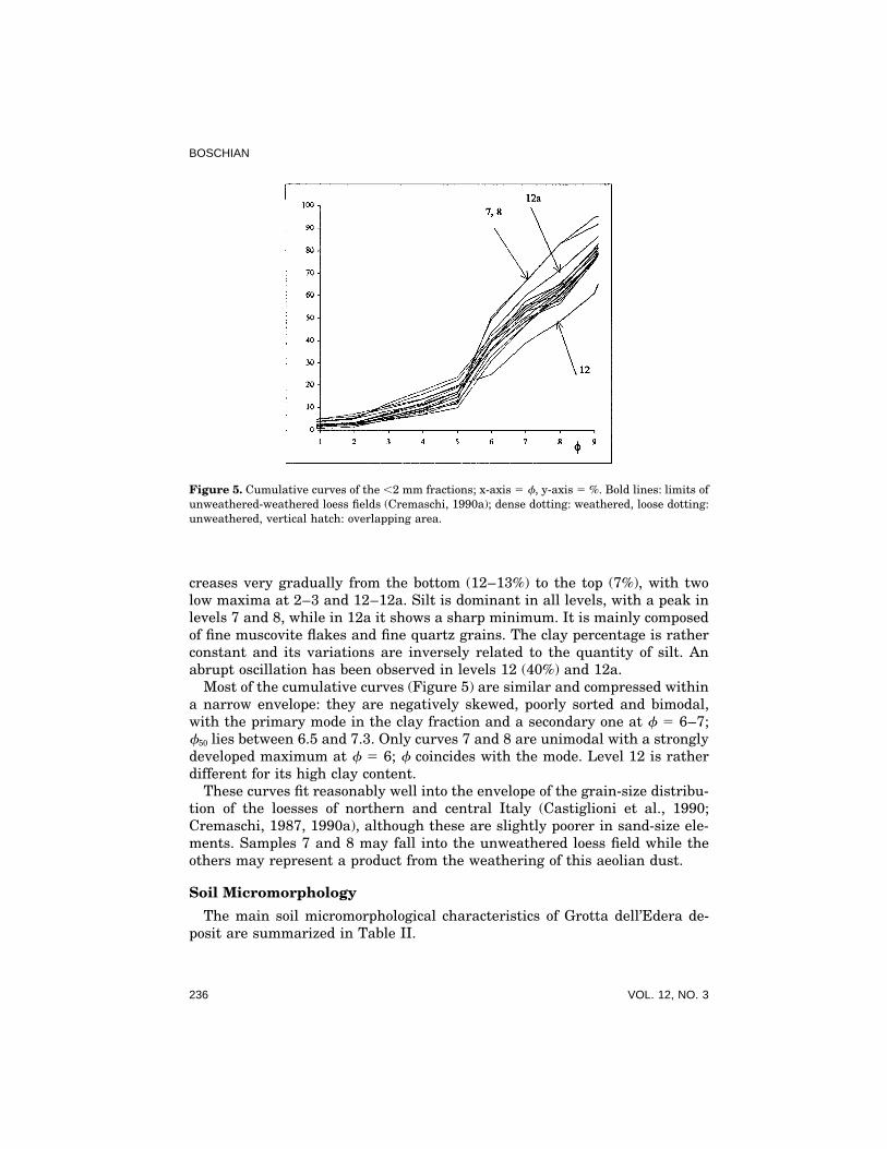
Figure 5. Cumulative curves of the ,2 mm fractions; x-axis 5 f, y-axis 5 %. Bold lines: limits ofunweathered-weathered loess fields (Cremaschi, 1990a); dense dotting: weathered, loose dotting:unweathered, vertical hatch: overlapping area.
creases very gradually from the bottom (12–13%) to the top (7%), with twolow maxima at 2–3 and 12–12a. Silt is dominant in all levels, with a peak inlevels 7 and 8, while in 12a it shows a sharp minimum. It is mainly composedof fine muscovite flakes and fine quartz grains. The clay percentage is ratherconstant and its variations are inversely related to the quantity of silt. Anabrupt oscillation has been observed in levels 12 (40%) and 12a.
Most of the cumulative curves (Figure 5) are similar and compressed withina narrow envelope: they are negatively skewed, poorly sorted and bimodal,with the primary mode in the clay fraction and a secondary one at f 5 6–7;f50 lies between 6.5 and 7.3. Only curves 7 and 8 are unimodal with a stronglydeveloped maximum at f 5 6; f coincides with the mode. Level 12 is ratherdifferent for its high clay content.
These curves fit reasonably well into the envelope of the grain-size distribu-tion of the loesses of northern and central Italy (Castiglioni et al., 1990;Cremaschi, 1987, 1990a), although these are slightly poorer in sand-size ele-ments. Samples 7 and 8 may fall into the unweathered loess field while theothers may represent a product from the weathering of this aeolian dust.
Soil Micromorphology
The main soil micromorphological characteristics of Grotta dell’Edera de-posit are summarized in Table II.
236 VOL. 12, NO. 3

SEDIMENTOLOGY OF LATE PLEISTOCENE–EARLY HOLOCENE, NE ITALY
Table II. Summary of the micromorphological characters of the Grotta dell’Edera deposit.
Pedofeatures
Crystalline
Textural CaCO3 Ca-Oxalate Amorphous ExcrementB-Fabric (Pedorelicts) (Fe/Mn-nodules)
15 Cr (Vd) (Fr) N (C), Hc (Fr) N-Ra (D) (D)14 Cr (D) (Vf) N (C) N-Ra (D) (D)13 SS (D), Cr (C), (C) N (D), Hc (C) (Fr)
Gs (Fw)12a U (Vd), Cr (Fr) (D) N (D), Hc (Fw) Co (Fw), Ty (Fr)
(Fw)12 SS (C), Gs (Fw) (Fr) N (D), Hc (Fw) Ty (C) (Fw)11 SS (Vd), Gs (C) (C) Ty (C), Nu (Fw)10 SS (D), Gs (C) (Fr) Hc (Vf) Co (Vf), Ty (C),
Nu (Vf)9 SS (D), Gs (C) (Fr) Hc (Fw) Ag (Fr)8 SS/Cr (C), Gs (C), (C) Hc (Fw) Ag (C), Co (C),
Pas (Fw), Ty (C)7 SS/Cr (C), Gs (C) (Fr) Hc (Fw) Ag (Fr), Co (C)6 SS (D), Gs (C) (D) Hc (Fw) Ag (Fr), Co (C)5 SS (D), Gs (C), (C) Hc (Fr)
Pas (Vf) Am (C), Ag (C)4 SS (D), Gs (C), (C)
Pas (Vf) Ag (Fr), Co (Fw)3 SS (D), Cr (Fr), (Fr) Hc (Fr) Ag (Fr), Co (C),
Gs (Fr) Ty (Fw)2 SS (Vd), Gs (Fr) (C) Hc (Fw) Ag (D), Nu (Vf)1 SS (Vd), Gs (D) (C) Hc (Fw) Ag (Fr), Co (D)
Table abbreviations: U: undifferentiated; Cr: crystallitic; SS: stipple speckled; Gs: granostriated;Pas: planostriated; Pos: porostriated; Hc: hypocoatings; N: nodules; Ty: typic; Co: concentric; Ag:aggregate; Ra: radiating. (Vd): very dominant; (D): dominant; (Fr): frequent; (C): common; (Fw):few; (Vf): very few.
Microstructure. Microstructure is generally medium to very fine granular(Figures 6a,b) or prismatic (only in levels 7 and 8), moderately or weaklydeveloped. The structure development is better in the lower (1–6) horizons,but the granules are always very densely packed, with very narrow interag-gregate voids so that it sometimes becomes massive. The original structure isalways more or less disturbed by channels and chambers and even almostcompletely disrupted by biological activity in the upper levels (11–15). Someaggregates have an internal fabric organised in thin layers of parallel-lyingmuscovite flakes.
Related distribution, groundmass and b-fabric. The related distribution isalways porphyric, mainly single or double spaced. In levels 7 and 8 the skele-ton grains seem to be more densely packed (closed porphyric related distribu-
GEOARCHAEOLOGY: AN INTERNATIONAL JOURNAL 237

BOSCHIAN
Figure 6. (a) Level 1. Fine granular microstructure: very fine prolate clayey pedorelicts (at cen-ter) and a rounded soil aggregate (at right). PPL, frame width 2200 em. (b) As in (a), XPL. Notethe wide birefringent rim of the aggregate. (c) Level 1. ‘‘Rolled’’ pedofeature developed around aquartz grain; the dark outer rim is made up of very fine grains. PPL, frame width 2200 em.(d) As in (c), XPL. The platy elements of the feature are arranged parallel to the surface, and
238 VOL. 12, NO. 3

SEDIMENTOLOGY OF LATE PLEISTOCENE–EARLY HOLOCENE, NE ITALY
tion) than in the others, and this situation is reflected by a lower clay percent-age in the grain-size curves.
The stipple-speckled b-fabric is present in almost all the levels, and only inlevel 12 and above is it not so well developed. In these thin sections it hasoften been difficult to distinguish the muscovite particles of the very fine siltfraction from the largest speckles of optically oriented clay (Fig. 7b). In factthe interference colours of the clay aggregates are very similar to the lowerones of the (partially) altered fine muscovite flakes; thus, in such cases itmay be better to rely more on the grain-size curves than on the thin sectionobservations.
The granostriated b-fabric is evident in levels 1–11, whereas it almost dis-appears in the upper ones. It is produced by platy or elongated speckles ofoptically oriented clay which lie along curved surfaces appearing as a rim ofrelatively dispersed birefringence; the specks are sometimes rather large, andmuscovite flakes often lie parallel to the specks, following the general trend.This type of b-fabric can be found either around skeleton grains or aroundtextural pedofeatures which are ‘‘more competent’’ (Fig. 6e,f), that is, they donot shrink and swell as much as the surrounding ground mass. In levels 1–4this type of b-fabric is also common as an inner rim of some soil aggregates,being an internal character of the aggregate itself. The crystallitic b-fabric isa peculiarity of levels 12–13, where it is due to widespread microsparite or tomicrite aggregates; high percentages of CaCO3 in these levels (Figure 4) re-flect this strong difference from the lower horizons. In levels 14–15 the bire-fringence pattern is strongly affected by countless spherulites of calcite, pseu-domorphic on Ca-oxalate, 15–20 em wide, each of them showing the typicalcrosslike extinction pattern. Also the b-fabric of levels 7 and 8 can be re-garded as crystallitic since the clay percentage is very low, and the muscoviteflakes are very fine and closely packed.
Pedofeatures. Textural pedofeatures have been identified only as pedorelicts:They are widespread and essentially of two types. The first are very rare, finesand-medium silt size, reddish clay nodules with undulating extinction bands(Figures 6a,b and 7a,b)—papules sensu Brewer (1976). The second are irregu-lar subspherical or prolate reddish brown granules, darker then the sur-rounding matrix. Their boundary is usually sharp, the basic mineral compo-
the outer rim is brightly birefringent. (e) Level 3. A large soil aggregate (at right) and a darkclayey pedorelict with fine skeleton grains (at left). PPL, frame width 1100 em. (f) As in (e),XPL. Well-developed granostriated b-fabric around the coarse silicate grains (bottom) and thepedorelict. The outer rim of the aggregate is also birefringent. (g) Level 3. Concentric Fe-nodulewith fine skeleton grains (pisolite). PPL, frame width 2200 em. (h) Level 4. Rounded pedorelictwith banded fabric: bands of medium oriented fine particles alternating to layers of coarsergrains. PPL, frame width 1100 em.
GEOARCHAEOLOGY: AN INTERNATIONAL JOURNAL 239

BOSCHIAN
Figure 7. (a) Level 8. Well-rounded reddish clay nodule without skeleton grains. PPL, framewidth 1100 em. (b) As in (a), XPL. Common muscovite flakes in the ground mass. (c) Level 13.Ash waste: pseudomorphs of dusty micrite on Ca-oxalate phytoliths with regular shape. PPL,frame width 550 em. (d) As in (c), XPL. (e) Level 12. Fine particles of organic matter dispersedthroughout the groundmass. PPL, frame width 1100 em. (f) Level 14. Spherulites of calcite pseu-domorphic on Ca-oxalate. XPL. PPL, frame width 550 em.
nents are the same as in the outside sediment, with a lower quantity ofmuscovite; the b-fabric is always stipple speckled, with specks often largerthan in the surrounding deposit groundmass (Figures 6e,f). The sizes are ex-tremely varied: the diameter is ordinarily smaller than 3–4 mm, and in levels1–5 they appear to be poorly sorted. Among the crystalline pedofeatures, theassociation of CaCO3 coatings merging into hypocoatings within the same
240 VOL. 12, NO. 3

SEDIMENTOLOGY OF LATE PLEISTOCENE–EARLY HOLOCENE, NE ITALY
pedofeature is common throughout the profile. The coatings are made up ofsubhedral microsparite crystals and the hypocoatings impregnate the ground-mass surrounding the pore forming light impregnations of crystallitic b-fabriceven 1–2 mm wide. In addition some small limestone fragments in levels 1and 2 are partially coated. Microsparite crystals and typic homogeneous mi-crite nodules are dominant in levels 12–13. As described before, radiatingnodules (spherulites) of CaCO3/Ca-oxalate pseudomorphs, 5–20 em wide aredominant in layers 14 and 15.
The amorphous Fe/Mn pedofeatures are present in a large variety. Concen-tric nodules (pisolites, Figure 6g) are more common in the lower half of theprofile: They are made up of dark shells of Fe/Mn-oxides alternating withclay-rich thin layers where speckles of optically oriented clay, and even somethin laminae of muscovite, lie parallel to the surfaces. Typic, well-impreg-nated nodules with sharp boundary are more common in the upper levels (8and upper); some of these have a rim with granostriated b-fabric. The aggre-gate nodules are small clusters of finer irregular well-impregnated nodules,often with a larger one in the center; they occur frequently in layers 1–9.Nucleic nodules are rather rare. Their nuclei can be single skeleton grains oraggregates, or small chips of organic matter (mainly charcoal). Excrementalpedofeatures are common in levels 12–15 where in some areas the deposithas been severely reworked by biological, maybe earthworm, activity. Never-theless, it is not so easy to identify their size and shape since compaction andageing are strong. A few very small subspherical pellets have been identified.Rare bowlike dense channel infillings could have been originated from earth-worm activity. These channels may be up to 2–3 mm wide.
Organic components. These are common in the anthropic horizons (11–15):bone (often charred), shells and charcoal are widespread in levels 12–13; theamorphous organic material is dominant in 12, where the whole groundmassis ‘‘dusty’’ from fine organic inclusions (Figure 7c). Many irregular elongatedor rodlike phytoliths have been observed in levels 14 and 15; here also thecalcium oxalate spherulites (Figure 7f) must be regarded as organic residuessince they may be a product of the digestion of plants by domestic herbivores(Brochier, 1983a, 1983b, 1991; Courty et al., 1991). Only few grains of woodcharcoal have been found in the lower levels.
DISCUSSION
The deposit of Grotta dell’Edera can be divided into four main stages ac-cording to its textural, micromorphological, and chemical characteristics.
The first stage (levels 1–6) may correspond to a relatively cold and wetperiod; the high quantity of stones, many of which shaped as small frost slabsshould be evidence of frequent, but short freezing and thawing cycles (Boni-fay, 1956; Laville, 1973, 1976). It may be useful to point out that deposits of
GEOARCHAEOLOGY: AN INTERNATIONAL JOURNAL 241
BOSCHIAN
frost slabs are not accumulating today in the rock shelters of the Karst, whilethey are developing at higher altitudes (1000–1500 m) in nearby regions.Moreover, the ice cover limit was not more than 75 km away from Grottadell’Edera during the cold peak of isotope stage 2 (about 18,000 B.P.); al-though climatic amelioration progressed greatly when levels 1–6 were beingdeposited, the climate was certainly colder than now.
The ubiquity of muscovite flakes, the shape of the cumulative curves of the,2 mm fractions, and the thin micaceous layers in some aggregates (Figure6h) suggest that at least a part of the sediments is of aeolian (probably loess)origin. Though the entrance of Grotta dell’Edera is wide enough to allow pri-mary loess deposition, several micromorphological characteristics suggestthat a substantial portion of the fine sediment had been carried into the caveby flow. In fact, the pedorelicts (Figures 6c,d) might be related to the clayclumps with mosepic or masepic plasmic fabric described by Goldberg (1979)in Bed X of Pech-de-l’Aze II. Even if ‘‘they will have to remain a mystery forthe time being’’ (Goldberg, 1979:41), he seems to be attracted by the ‘‘rolling’’genesis, which may as well be the cause of reorientation of mica flakes alongthe edges of the pedorelicts of Grotta dell’Edera. The concentric Fe-nodules(pisolites) may also be related to such processes inasmuch as muscovite flakesare embedded in the concentric shells.
The granostriated b-fabric might even be a consequence of cycles of shrink-ing and swelling of the ground mass clay; however, this may be true onlywhen the birefringent rims gradually merge into the surrounding ground-mass, as in the case of ‘‘hard’’ grains (crystals or lithic fragments). Con-versely, if the birefringent rims are separated from the ground mass by sharplimits, sometimes even marked by cracks, as in the case of the ‘‘soft’’ pedo-relicts, it may be inferred that they are produced by rolling.
Such a rolling may be the result of hillwash and runoff, caused by theerosion of soils developed on more ancient loess deposits sedimented outsidethe cave; pisolites may have partly been inherited from those soils and rolledinto the cave. This process fits well in a palaeoenvironmental model charac-terised by a relatively cold and wet climate, as suggested by the accumulationof frost slabs.
In the second stage (levels 7–9) the pedofeatures are about the same as inthe underlying one. Moreover, some flow or mudflow sedimentary structureshave been observed in layers 8 and 9 (sigmoidal lenses and clusters of rolledstones). It may be inferred that runoff was probably still active. Nevertheless,the stones are less frequent and the shape of the grain-size curves (7 and 8in Figure 5) is slightly shifted towards the field of the unaltered loess. Thismay mean that the climate was slightly drier and that small amounts ofprimary loess (assuming that unweathered loess is primary or almost pri-mary) were deposited contemporarily to colluvia. The upper limit of this stageis marked by a sharp erosion surface that may confirm a tendency to thereworking of the sediments.
242 VOL. 12, NO. 3

SEDIMENTOLOGY OF LATE PLEISTOCENE–EARLY HOLOCENE, NE ITALY
It is somewhat difficult to explain the very stony stage three (levels10–12a) which corresponds to the Mesolithic. The high amount of stones,many of which are cobble-sized, should testify to a cold period, more severethan that of the first stage; nevertheless, such an episode would be ratherunexpected in a period of relative warming as recorded in the Mesolithic.Perhaps as a consequence of human activity, the stones are very chaoticallyarranged so that the platy elements do not lie parallel to the bedding. Itmust be pointed out that similar levels have been found in almost all thecaves of the Karst, for example, Grotta Caterina (Cannarella and Pitti,1984), Grotta B. Lonza (Meluzzi et al., 1984) and Grotta Azzurra (Cre-monesi et al., 1984). In them, like in Grotta dell’Edera, the Mesolithic agelayers are very stony and overlie a level with large (up to 1 m) bouldersand with an erosion surface at its bottom. Even if the Karst is supposedto be a tectonically stable region now, several hints suggest that neotecton-ics has not been negligible during the Pleistocene (Boschian, 1993). Conse-quently, the large boulders may be the result of breakdown of the caveceiling triggered by seismic events.
The granostriated b-fabric becomes rare in this stage, probably showingthat shrinking and swelling of the clay fraction was less intensive as a conse-quence of minor seasonal fluctuations in sediment water content.
Bone fragments and charcoal are frequent, and together with the highamount of finely dispersed decayed organic matter (Figure 7e), they suggestintensive human activity within the cave.
Excrement pedofeatures appear in the upper horizons, showing a develop-ment of the biological activity partly due to the improvement of climatic con-ditions. In fact, earthworm activity may also have been favoured by the highorganic matter content, being therefore a secondary effect of human presence.
In the last stage (late Mesolithic-Neolithic-Copper Age) (levels 13–15),which may be ascribed to the Atlantic-Subboreal phases, gravel is scarce,probably because frost shattering was limited by warming of the climate. Thelow amount of silicates and the total lack of rolled pedorelicts and concentricFe-nodules show that the input from outside was limited. Again, the depositis partly reworked by earthworm activity and the traces of human activityare very strong (flaked chert, bone fragments, charcoal, shell fragments, andpottery).
The most outstanding micromorphological character of levels 12–13 isthe widespread crystallitic b-fabric, related to the high quantity of 15–25mm wide micrite aggregates in the sediment. It can also be easily detectedby chemically measuring the CaCO3 content of the fine grain-size fractions(Figure 4). These micrite grains had formerly been interpreted as ‘‘softpowdery lime’’ due to the decarbonation of the cave walls in a warm andwet climate (Cannarella and Pitti, 1984). In fact, even though the aggre-gates are mainly anhedral, several berry-like or lozenge (Figures 7c, d) orcrescent-shaped grains can be found; these shapes match those in the ash
GEOARCHAEOLOGY: AN INTERNATIONAL JOURNAL 243

BOSCHIAN
waste originated from the burning of wood (Brochier, 1983a, 1983b; Courtyand Wattez, 1987). Even the size of 15–25 mm is in agreement with suchan origin; some of these aggregates have been found in the pores of charredwood fragments. They can therefore definitely be considered as ash waste.
These micrite ash aggregates are few in level 12, which on the contrary isdominated by decayed organic matter; conversely, ash is dominant in level12a which is actually a hearth lens within 12. The ash waste quantity dropsagain in the upper layers. Secondary recrystallization of carbonates is com-mon but it is also easily recognisable because it produces limpid, often euhe-dral, microsparite, while the ash aggregates are made up of very fine, dustymicrite.
It is noteworthy that the Neolithic-Copper Age sediments of several othercaves in the Trieste Karst—Grotta degli Zingari (Marzolini, 1972; Boschian,excavations in progress), Grotta Caterina (Cannarella and Pitti, 1981, 1984),Grotta Azzurra (Cannarella and Cremonesi, 1967; Cremonesi et al., 1984—are very similar to the fumier deposits of the French Midi (Beeching andMoulin, 1983; Brochier, 1991) and of the Italian Liguria (Courty et al., 1991)caves. Unlike those deposits, the Grotta dell’Edera ones do not show typicalgrey-black-brown alternating layers but are rather homogenous and brown(levels 14–15); this pattern is not unique to this cave, but it has been ob-served in other sites too. The most significant character of levels 14–15 is thehigh quality of spherulites, made up of calcite pseudomorphic on Ca-oxalate,and of phytoliths that are also a primary component of the typical fumier ofthe French caves.
There is no agreement among authors about the origin of the spherulites.Nonetheless, they should be regarded as ‘‘coprogenic.’’ It is not clear whetherthey indicate a specific diet—mainly leaves and/or twigs and smallbranches—of whatever the animals species were (Courty et al., 1991), or ifthey were produced only by sheep and goat (Brochier, 1991). At Grottadell’Edera the spherulites are related to a high quantity of opal phytoliths,but the absence of well preserved coprolites—apart very few disrupted cat-tlelike ones—and the poor faunal data cannot contribute to the understand-ing of the spherulites and their relationship to the phytoliths. In fact, thespherulites have been regarded as one of the evidences of seasonality of Neo-lithic pastoralism at Arene Candide (Courty et al., 1991), as they may beassociated with an autumn diet rich in leaves and branches. This would bein contrast with the spherulites/phytoliths association of Grotta dell’Edera. Ifthe models proposed by Brochier (1991) were followed, then it might easilybe inferred that mainly sheep, and possibly goats, were stabled in Grottadell’Edera.
The Neolithic-Copper Age deposits of Grotta dell’Edera may be interpretedas the effect of human activity, such as sheep or cattle stabling within thecave; their difference from the typical stabling layers may be explained whensupposing that the stable layers were not burnt.
244 VOL. 12, NO. 3

SEDIMENTOLOGY OF LATE PLEISTOCENE–EARLY HOLOCENE, NE ITALY
CONCLUSIONS
The third and fourth stages of Grotta dell’Edera are well dated and cer-tainly Holocene. On the contrary the first two are of undetermined age; thus,even though they are very likely to be of late Tardiglacial age because theyunderlie the Holocene layers, they cannot be directly related to any of theNorth Italian sequences, as an erosion surface splits the succession just belowthe Mesolithic. However, this erosion surface probably represents a shorttime span since the sediments are rather similar above and below it; thesequence may be regarded as almost continuous.
The typical depositional cycle of the North Italian rock shelters in latePleistocene (Cremaschi, 1990b) is represented by a thermoclastic breccia fol-lowed by an aeolian dust (loess) deposition and finally weathering and thena period of soil formation. Three of these cycles have been correlated to iso-tope stages 5 d–a, 4–3, and 2–1 of the Tyrrhenian Sea-core Ket 8004 (Paterneet al., 1986).
The main characteristics of the first two stages of Grotta dell’Edera maypossibly be related to the second and third phases of one of these cycles (possi-bly the third, related to late isotopic stage 2) which is marked by ‘‘thermoclas-tism and loess deposition’’ (Cremaschi, 1990b). The first stage of Grottadell’Edera is quite thermoclastic and may correspond to the final events ofthe first phase of the cycle. The primary loess deposition of the second stage(levels 7 and 8), though rather limited, may correspond to the second phaseof the cycle.
In fact, it should be pointed out that the entire fine fraction of levels 1–6,and a major part of 7 and 8, is a colluvium of loess previously sedimentedoutside the cave; as shown by the grain-size curves (Figure 5) and by thepedofeatures of this sediment. This means that the climate was rather wet,which is necessary to frost shattering. Although the occurrence of frost slabssuggests that the climate was rather cold, no evidence of deep seasonal frostwas found in the deposit; therefore, it may be inferred that this ‘‘cold’’ peakwas less severe then the previous ones, as Dryas III really was; moreover,the sea level was rising rapidly, covering the Adriatic plain (Shackleton andVan Andel, 1985) and the proximity of the sea probably moderated the cli-matic effects.
The stony event deposited during the Mesolithic age may be considered theeffect of a relatively wetter climate (‘‘weathering phase’’?) not necessarilycolder than the previous aeolian dust period. On the contrary, the largeblocks underlying the Mesolithic levels cannot be related to a very cold peakbecause they are Holocene; they are probably the effect of other nonclimaticcauses, such as seismic events caused by the uplifting of the Karstic plateauarea along a tectonic line crossing the Gulf of Trieste parallel to the coast(Figure 1) (Boschian and Montagnari-Kokelj, 1984; Boschian, 1993).
Several hypotheses can be inferred to explain the total lack of Upper
GEOARCHAEOLOGY: AN INTERNATIONAL JOURNAL 245

BOSCHIAN
Palaeolithic settlements or camps in the Trieste Karst. One explanation isthat they may have not yet been found. However, the surveys have beenrather accurate even if never systematic, and therefore it is likely that theUpper Palaeolithic groups really did not frequent the area. This absence maybe explained by considering that the Italian Late Glacial hunters-gatherersrelied economically (and possibly culturally) on big game, usually horse ordeer. Therefore, the wide Adriatic plain was probably the most favorableplace for hunting while the marginal reliefs were occasionally visited.
Moreover, the sediments of Grotta dell’Edera suggest that the Karst areawas affected by erosion and runoff, with accumulation of fine sediments intothe caves and rock shelters. This probably means that the environment wasrather deteriorated and the soils were easily eroded because the region wasnot well afforested; however, the lack of pollen data does not provide directsupport for this hypothesis. As a consequence of these conditions, food sup-plies were inadequate and the region was (partially?) abandoned as theNorthern Adriatic and Po plans were probably more suitable to big game.
During the Mesolithic the cave was continuously frequented, if not evenoccupied, and thus the sediments have embodied a high quanity of decayedor charred organic matter, wood ash, bone, shells, and many artefacts. Thenonanthropic fraction of the sediment has almost the same characteristics asin the Late Glacial, which implies that the geomorphic processes were aboutthe same. However the Karst was ‘‘densely’’ populated as at least 10 caveswith Mesolithic remains have been excavated over 100 km2 (Boschian andMontagnari-Kokelj, 1983); the rise of the sea level probably squeezed the Up-per Palaeolithic groups northwards while they were shifting into a Mesolithiclife style. In the meanwhile, a slight amelioration of the climate (more theo-retical than really detected in the sediment sequence), the Pre-Boreal, fa-vored the settlement of the Mesolithic fishers-hunters-gatherers.
The sedimentation rate of silicate elements was very low during the Neo-lithic and a little higher during the Copper age, as testified by the smallamount of silicate minerals within the deposit. This is probably a conse-quence of land reafforestation that partially stopped soil erosion and hillwashduring the Neolithic, strongly diminishing the external input in cave deposi-tion. A change towards a more continental climate may have partly invertedthis process during the Copper Age, as quartz and muscovite are again morefrequent. Pottery and other arifacts are very scarce in this period; it is there-fore very difficult to date the deposits and determine the exact moment inwhich the environmental change took place. Again, pollen data are missing.
During the Neolithic and the Copper age, Grotta dell’Edera was used as ashelter for humans and/or domestic animals, and the bulk of sedimentationwas anthropogenic, caused by the accumulation and compaction of cattle and/or sheep-goat droppings that were intentionally burned.
The archaeological evidence does not allow us to determine whether thecase was continuously frequented or not. Bone and artifacts are very scarce,
246 VOL. 12, NO. 3

SEDIMENTOLOGY OF LATE PLEISTOCENE–EARLY HOLOCENE, NE ITALY
and faunistical and botanical data are at present insufficient to infer a reli-able model of the relationships between livestock and environment exploita-tion. Nevertheless, some hypotheses can be inferred by comparing the Grottadell’Edera data with evidence from other European sites. This cave (as almostall the others in the Karst) shares several sedimentological characteristicswith the so-called grottes bergeries of the Middle Neolithic (Chasseen) ofSouthern France; those (relatively) high altitude sites were exploited as tem-porary shelters for livestock stabling during transhumance from large openair settlements situated at the foot of the karstic plateaux (Brochier, 1989;Beeching, 1989). In those shelters, as at Grotta dell’Edera, the artifacts arerather scarce as the sites were not directly dwelled by shepherds. Such amodel apparently also fits the evidence from Arene Candide cave in WesternItaly (Courty et al., 1991), where thick ash deposits were identified as burntstable layers deposited during transhumance.
Therefore, it may be supposed that also in the Trieste Karst pastoralismand transhumance were a common practice. It may be observed that the mor-phology of the area was already karstic and therefore the region was notsuitable to Neolithic agriculture/horticulture; this may explain the absence ofopen air sites and the exploitation of the caves as grottes bergeries and notas shelters for humans and animals at the same time. It must be pointed outthat no large Neolithic open air sites were found around the Trieste Karst;therefore, this model cannot yet be confirmed.
Finally, as the artifacts are scarce in all the caves, it is impossible to scanwith good precision the cultural evolution of the Neolithic and Copper age inthe Karst. Therefore, it is also impossible to appraise the possible influenceof pastoralism on the triggering of deforestation after or even during the Neo-lithic.
The author is grateful to the Working Group on Archaeological Soil Micromorphology of theSubcommission B of the International Society of Soil Science for encouragement, advice and dataexchange; special thanks go to Dr. Richard I. Macphail (London University College) who alsorevised a first draft of this work and to Dr. Paul Goldberg who checked the last versions.
REFERENCES
Alessio, M., Allegri, L., Bella, S., Improta, S., Belluomini G., Cortesi, C., Manfra, L., Turi, B.(1978). University of Rome Carbon 14 Dates XVI. Radiocarbon 20/1, 79–104.
Anonymous (1991). Le Imprese Estrattive e della Lavorazione del Marmo di Trieste. Trieste:Camera di Commercio Industria Artigianato Agricoltura.
Beeching, A., and Moulin, B. (1983). Sediments Anthropiques et Coprolites Animaux: ModesteContribution a des Grands Problemes? Bulletin Sociiete Prehistorique Francaise 80(3), 72–74.
Biagi, P., Voytek, B. (1994). The Neolithization of the Trieste Karst in North-Eastern Italy and ItsRelationships with the Neighbouring Countries. A Nyıregyhazi Joza Andras Muzeum E
´vko-
nyve, XXXVI, in press.Biagi, P., Starnini, E., and Voytek, B. (1993). The Late Mesolithic and Early Neolithic Settlement
of Northern Italy: Recent Considerations. I Porocilo o Raziskovanju Paleolita, Neolita in Eneo-lita v Sloveniji, XXI, pp. 45–67. Ljubljana.
GEOARCHAEOLOGY: AN INTERNATIONAL JOURNAL 247

BOSCHIAN
Bonifay, E. (1956). Les Sediments Detritiques Grossieres dans le Remplissage des Grottes. Meth-ode d’Etude Morphologique et Statistique. L’Anthropologie, 60, 447–461.
Boschian, G. (1990). Un Nuovo Dato di Cronologia Assoluta nel Quadro Culturale del Mesoliticoe del Primo Neolitico del Carso Triestino. Atti dei Civici Musei di Storia ed Arte di Trieste 15(1985–1987), 49–56.
Boschian, G. (1993). Continental Deposits and Archaeological Data in the Trieste Karst (NEItaly). Evidence of Sea Level Changes and Possible Tectonic Activity in Late Pleistocene andEarly Holocene. Geologische Rundschau 82, 227–233.
Boschian , G., and Montagnari Kokelj, E. (1984). Siti Mesolitici del Carso Triestino: Dati Prelimi-nari di Analisi del Territorio. In Preistoria del Caput Adriae, pp. 40–50. Trieste: Atti delConvegno Internazionale.
Boschian, G., and Pitti, C. (1984). I Livelli Mesolitici della Grotta dell’Edera. In Radmilli, A.M.Ed., Il Mesolitico sul Carso Triestino, pp. 143–210. Quaderni Societa per la Preistoria e laProtostoria del Friuli-Venezia Giulia 5. Trieste.
Brewer, R. (1976). Fabric and Mineral Analysis of Soils. Huntington. Krieger.Brochier, J.-E. (1983a). Combustion et Parcage des Herbivores Domestiques. Le Point de Vue du
Sedimentologue. Bulletin Societe Prehistorique Francaise 80(5), 143–145.Brochier, J.-E. (1983b). Bergeries et Feux de Bois Neolitiques dans le Midi de la France. Quartar
33/34, 181–193.Brochier, J.-E. (1991). Geoarcheologie du Monde Agropastoral. In J. Guilaine, Ed., Pour une
Archeologie Agraire. Paris: A. Colin.Brochier, J.-L. (1989). Environment et Culture: Etat de la Question dans la Sud-Est de la France
et Principes d’Etude Autour du Chasseen de la Moyenne Vallee du Rhone. In Identite duCasseen. Actes Colloque International Nemours, Memoires du Musee de Prehistoire de l’ıle-de-France.
Bullock, P., Fedoroff, N., Jongerius, A., Stoops, G., Tursina, T., and Babel, U. (1985). Handbookfor Soil Thin Section Description. Wolvehampton: Waine Research Publications.
Cannarella, D., and Cremonesi G. (1967). Gli Scavi nella Grotta Azzurra di Samatorza nel CarsoTriestino. Rivista Scienze Preistoriche XXII(2), 281–330.
Cannarella, D., and Pitti C. (1984). Grotta Caterina: l’Orizzonte Mesolitico. In A. M. Radmilli,Ed., Il Mesolitico sul Carso Triestino, pp. 131–141. Quaderni Societa per la Preistoria e laProtostoria del Friuli-Venezia Giulia 5. Trieste.
Castiglioni, G.B., Cremaschi, M., Guerreschi, A., Meneghel, M., Sauro, U., Van Vliet-Lanoe, B.(1990). The Loess Deposits in the Lessini Plateau. In M. Cremaschi, Ed., The Loess in Northernand Central Italy: a Loess Basin between the Alps and the Mediterranean Sea, pp. 41–59.Quaderni di Geodinamica Alpina e Quaternaria 1. Milan.
Catt, J.A., Ed. (1991). Paleopedology Manual. Quaternary International 6, 1–95.Ciccone, A. (1993). L’Industria Mesolitica della Grotta Azzurra di Samatorza: Scavi 1982. Atti
Societa per la Preistoria e la Protostoria del Friuli-Venezia Giulia VII, 13–45.Courty, M.A., and Wattez, J. (1987). Morphology of Ash of Some Plant Materials. In N. Fedoroff,
L.M. Bresson, M.A. Courty, Eds., Soil Micromorphology, pp. 677–683. Paris.Courty, M.A., Macphail, R.I., and Wattez, J. (1991). Soil Micromorphological Indicators of Pasto-
ralism; with Special Reference to Arene Candide, Finale Ligure, Italy. In R. Maggi, R. Nisbet,and G. Barker, Eds. Archeologia della Pastorizia nell’Europa Meridionale, pp. 127–150.Rivista Studi Liguri LVII(1–4). Bordighera.
Cremaschi, M. (1987). Paleosols and Vetusols in the Central Po Plain (Northern Italy). A Studyin Quaternary Geology and Soil Development. Milan: Unicopli.
Cremaschi, M. (1990a). The Loess in Northern and Central Italy: a Loess Basin between theAlps and the Mediterranean Sea. In M. Cremaschi, Ed., The Loess in Northern and CentralItaly: a Loess Basin Between the Alps and the Mediterranean Sea, pp. 15–19. Quaderni diGeodinamica Alpina e Quaternaria 1. Milan.
Cremaschi, M. (1990b). Depositional and Post-depositional Processes in Rock Shelters of North-
248 VOL. 12, NO. 3

SEDIMENTOLOGY OF LATE PLEISTOCENE–EARLY HOLOCENE, NE ITALY
ern Italy during the Late Pleistocene: Their Paleoclimatic and Paleoenvironmental Signifi-cance. Quaternaire 1990(1), 51–64.
Cremonesi, G. (1981). Caratteristiche economico-industriali del Mesolitico nel Carso. Atti Societaper la Preistoria e la Protostoria del Friuli-Venezia Giulia 4, 171–186.
Cremonesi, G., Meluzzi, C., Pitti, C., and Wilkens, B. (1984). Grotta Azzurra: Scavi 1982 (NotaPreliminare). In A.M. Radmilli, Ed., Il Mesolitico sul Carso Triestino, pp. 65–108. QuaderniSocieta per la Preistoria e la Protostoria del Friuli-Venezia Giulia 5. Trieste.
Cucchi, F., Pirini Radrizzani, C., and Pugliese, N. (1989). The Carbonate Stratigraphic Sequenceof the Karst of Trieste (Italy). Memorie della Societa Geologica Italiana 40, 35–44.
Goldberg, P. (1979). Micromorphology of Pech-de-l’Aze II Sediments. Journal of ArchaeologicalScience 6, 17–47.
Laville, H. (1973). Climatologie et Chronologie du Paleolitique en Perigord; E´tude Sedimentolo-
gique des Depots en Grottes et Sous Abris. These de Doctorat, Sciences naturelles, Universitede Bordeaux I, Bordeaux.
Laville, H. (1976). Deposits in Calcareous Shelters: Analytical Methods and Climatic Interpreta-tion. In D. Shackley, Ed., Geoarcheology, pp. 137–155. London: Duckworth.
Malaroda, R. (1947). Arenarie Eoceniche della Regione di Trieste. Bollettino della Societa Adriat-ica di Scienze Naturali in Trieste XLIII, 99–112.
Marzolini, G. (1970). La Grotta dell’Edera. Annali Associazione XXX Ottobre—Club Alpino Ital-iano 4, 19–35.
Marzolini, G. (1972). Gli Scavi nella Grotta degli Zingari. Annali Gruppo Grotte Associazione XXXOttobre V, 57–103.
Meluzzi, C., Pitti, C., Radmilli, A.M., and Wilkens, B. (1984). Il Mesolitico nella Grotta Lonza.In A.M. Radmilli, Ed., Il Mesolitico sul Carso Triestino, Vol. 5, pp. 109–130. Trieste: QuaderniSocieta per la Preistoria e la Protostoria del Friuli-Venezia Giulia.
Muller, J. (1991). Die ostadriatische Fruhneolithikum. Die Impresso-Kultur und die Neolithisie-rung des Adriaraumes. Prahistorische Archaologie in Sudost Europa 9. Berlin: Volker Spiess.
Radmilli, A.M., Ed. (1984). Il Mesolitico sul Carso Triestino, Vol. 5. Trieste: Quaderni Societa perla Preistoria e la Protostoria del Friuli-Venezia Giulia.
Shackleton, J.C., and Van Andel T.H. (1985). Late Palaeolithic and Mesolithic Coastlines in theWestern Mediterranean. Cahiers Ligures de Prehistorie et de Protohistoire 2, 7–19.
Woletz, G. (1962). Schwermineralanalysen von Flyschsandstein aus Istrien. In Beobachtungenim Flysch von Istrien (Jugoslawien), Verhandlungen der Geologischen Bundesanstalt, 1–2,239–245.
Received September 10, 1995Accepted for publication December 20, 1996
GEOARCHAEOLOGY: AN INTERNATIONAL JOURNAL 249