Vascular Plant Inventory of Alaska's Arctic National Parklands
Upload
khangminh22Category
view
3download
0
U.S. Department of the InteriorU.S. Geological SurveyNational Park Service
Southwest Biological Science CenterOpen-File Report 2005-1142 July 2005
In Cooperation with the University of Arizona, School of Natural Resources
Vascular Plant and Vertebrate Inventory ofTumacácori National Historical Park
Vascular Plant and Vertebrate Inventory of Tumacácori N
ational Historical Park
Powell, A
lbrecht, Halvorson, Schm
idt, Anning, &
Docherty
Open-File Report 2005-1142


In cooperation with the University of Arizona, School of Natural Resources
Vascular Plant and Vertebrate Inventory of Tumacácori National Historic Park
By Brian F. Powell, Eric W. Albrecht, William L. Halvorson, Cecilia A. Schmidt, Pamela Anning, and Kathleen Docherty
Open-File Report 2005-1142
July 2005
U.S. Department of the Interior U.S. Geological Survey National Park Service
USGS Southwest Biological Science Center Sonoran Desert Research Station
University of Arizona School of Natural Resources 125 Biological Sciences East
Tucson, Arizona 85721

ii
U.S. Department of the Interior Gale A. Norton, Secretary U.S. Geological Survey P. Patrick Leahy, Acting Director U.S. Geological Survey, Reston, Virginia: 2005
Note: This document contains information of a preliminary nature and was prepared primarily for internal use in the U.S. Geological Survey. This information is NOT intended for use in open literature prior to publication by the investigators named unless permission is obtained in writing from the investigators named and from the Station Leader. Suggested Citation Powell, B.F., E.W. Albrecht, W.L. Halvorson, C.A. Schmidt, P. Anning, K. Docherty. 2005. Vascular Plant and Vertebrate Inventory of Tumacácori National Historic Park. USGS Open-File Report 2005-1142. U.S. Geological Survey, Southwest Biological Science Center, Sonoran Desert Research Station, University of Arizona, Tucson, AZ. This report supersedes Powell et al. (2002, 2003, and 2004). Cover photo: Ed Wittenberg, Tumacácori National Historic Park

iii
Authors Brian Powell, Eric Albrecht, Cecilia Schmidt, Pamela Anning, and Kathleen Docherty 125 Biological Sciences East Building School of Natural Resources The University of Arizona Tucson, AZ 85721 William L. Halvorson USGS Sonoran Desert Research Station 125 Biological Sciences East Building The University of Arizona Tucson, AZ 85721 U.S. Geological Survey Sonoran Desert Research Station Personnel Charles van Riper III, Station Leader Steve P. Gloss, Ecologist William L. Halvorson, Research Ecologist Cecil R. Schwalbe, Ecologist Michael R. Kunzmann, Ecologist Program and Expertise Areas of USGS and UA Personnel Administration & Outreach Cori Dolan Wendy Parrish Charles van Riper III Avian Ecology Claire Crow Glenn Johnson Mike Kunzmann Chris O’Brien Brian Powell Charles van Riper III Data Management Mike Kunzmann Brent Sigafus Ecology of Amphibians & Reptiles Kevin Baker Cristina Jones Dave Prival Phil Rosen Cecil Schwalbe Brent Sigafus Eric Stitt
Fire Management Cori Dolan James Feldmann Bill Halvorson Invasive Species Research Patricia Guertin Jim Malusa Phil Rosen Cecil Schwalbe Brent Sigafus Dennis Suhre Inventory & Monitoring Patricia Guertin Bill Halvorson Brian Powell Cecilia Schmidt Vegetation Mapping & Ecology Patricia Guertin Bill Halvorson Jim Malusa
Dennis Suhre USGS Southwest Biological Science Center http://sbsc.wr.usgs.gov
iv
Table of Contents Report Dedication ................................................................................................................................ viii Acknowledgements.................................................................................................................................ix Executive Summary ................................................................................................................................xi Chapter 1: Introduction to the Biological Inventories at Tumacácori NHP.............................................1
Project Overview ................................................................................................................................1 Report Format and Data Organization................................................................................................2 Verification and Assessment of Results .............................................................................................3 Technical Concepts.............................................................................................................................3
Chapter 2: Park Overview........................................................................................................................7 Park Area and History ........................................................................................................................7 Natural Resources Overview ..............................................................................................................7 Natural Resource Management Issues..............................................................................................11
Chapter 3: Plant Inventory .....................................................................................................................17 Previous Research.............................................................................................................................17 Methods ............................................................................................................................................17 Results ..............................................................................................................................................20 Inventory Completeness ...................................................................................................................21 Discussion.........................................................................................................................................22
Chapter 4: Fish Inventory ......................................................................................................................25 Previous Research.............................................................................................................................25 Methods ............................................................................................................................................25 Results ..............................................................................................................................................26 Inventory Completeness ...................................................................................................................26 Discussion.........................................................................................................................................29
Chapter 5: Amphibian and Reptile Inventory ........................................................................................31 Previous Research.............................................................................................................................31 Methods ............................................................................................................................................31 Results ..............................................................................................................................................36 Inventory Completeness ...................................................................................................................38 Discussion.........................................................................................................................................40
Chapter 6: Bird Inventory ......................................................................................................................43 Previous Research.............................................................................................................................43 Methods ............................................................................................................................................43 Results ..............................................................................................................................................50 Inventory Completeness ...................................................................................................................52 Discussion.........................................................................................................................................52
Chapter 7: Mammal Inventory...............................................................................................................59 Previous Research.............................................................................................................................59 Methods ............................................................................................................................................59 Results ..............................................................................................................................................63 Inventory Completeness ...................................................................................................................64 Discussion.........................................................................................................................................65
Chapter 8: Management Implications ....................................................................................................67

v
Chapter 9: Additional Inventories.......................................................................................................... 69 Chapter 10: Glossary ............................................................................................................................. 71 Chapter 11: Literature Cited .................................................................................................................. 73 List of Tables Table E.S.1. Summary results of vascular plant and vertebrate inventories at Tumacácori
NHP, 2000–2003. .................................................................................................................xi Table 2.1. Average monthly climate data for Tumacácori NHP, 1948–2003 (data from WRCC
2004).................................................................................................................................... 11 Table 4.1. Number of fish caught during four sampling periods at Tumacácori NHP, 2001–
2002. .................................................................................................................................... 26 Table 5.1. Amphibian and reptile survey effort by method, Tumacácori NHP, 2001–2002. ............... 31 Table 5.2. Relative abundance of reptilesa recorded during intensive surveys, by community
type and park unit, Tumacácori NHP, 2001–2002. ............................................................. 36 Table 5.3. Number of amphibians and reptiles recorded per 10 hours of extensive surveys,
and number of incidental observations for additional species, by park unit, Tumacácori NHP, 2001–2002. ............................................................................................ 37
Table 5.4. Number of animals captured per 100 hours of pitfall trap operation, Tumacácori unit, Tumacácori NHP, 2001–2002..................................................................................... 38
Table 6.1. Bird survey effort by method and community type, Tumacácori NHP, 2001–2003. .......... 46 Table 6.2. Relative abundance of birds recorded during VCP surveys, all units, Tumacácori
NHP, 2001–2002. ............................................................................................................... 51 Table 6.3. Relative abundance of birds recorded during line-transect surveys, all units,
Tumacácori NHP, 2002–2003. ............................................................................................ 53 Table 6.4. Observations of breeding behavior by birds, Tumacácori NHP, 2001–2002.
Breeding codes follow standards set by NAOAC (1990).................................................... 54 Table 7.1. Total number of small mammals trapped (n) and relative abundance (RA),
excluding recaptures, by park unit, Tumacácori NHP, 2000–2001..................................... 64 Table 7.2. Results from infrared-triggered cameras, Tumacácori unit, Tumacácori NHP,
2000–2001. .......................................................................................................................... 64 List of Figures Figure 2.1. Locations of the three units of Tumacácori NHP in southern Arizona. ............................... 8 Figure 2.2. Aerial photograph of the study area and park boundary, Tumacácori unit,
Tumacácori NHP.................................................................................................................. 9 Figure 2.3. Aerial photographs of the Calabazas and Guevavi units, Tumacácori NHP...................... 10 Figure 2.4. Comparison of monthly weather data during the time of the inventory (2000–
2002) compared to the mean (1948–2004; thick solid line in both figures), Tumacácori NHP (data from WRCC 2004). ...................................................................... 12
Figure 2.5. Trash accumulation along the Santa Cruz River, Tumacácori NHP, August 2002............ 15 Figure 3.1. Locations of modular plots for plants, Tumacácori unit, Tumacácori NHP, 2002.
See Appendix J for plot coordinates. ................................................................................. 18 Figure 3.2. Typical modular plot layout of four 10 x 10 m modules, eight 1 x 1 m quadrats,
and four 10-m point-intercept transects, Tumacácori unit, Tumacácori NHP, 2002. ........ 20

vi
Figure 3.3. Species accumulation curve for cumulative number of new plant species collected as a function of the number of sample days, general botanizing and modular plot surveys, all units, Tumacácori NHP, 2000–2003. ..............................................................22
Figure 3.4. Cumulative (A) and number of new plant species (B) recorded as a function of the number of modular plots surveyed, Tumacácori unit, Tumacácori NHP, 2002.................23
Figure 4.1. Total catch and species richness of fish, by sampling period, Tumacácori NHP, 2001–2002. .........................................................................................................................27
Figure 4.2. Percent total catch, by sampling period, for the three most common species of fishes at both sampling sites, Tumacácori NHP, 2001–2002. ............................................28
Figure 4.3. Crayfish, Tumacácori NHP, November 2002.....................................................................30 Figure 5.1. Locations of intensive survey plots and pitfall trap array for amphibians and
reptiles, Tumacácori unit, Tumacácori NHP, 2001–2002. .................................................33 Figure 5.2. Locations of intensive survey plots for amphibians and reptiles, Calabazas and
Guevavi units, Tumacácori NHP, 2001–2002....................................................................34 Figure 5.3. Species accumulation curves for intensive and extensive amphibian and reptile
surveys, Tumacácori NHP, 2001–2002..............................................................................39 Figure 5.4. American bullfrog, Tumacácori NHP.................................................................................42 Figure 6.1. Locations of VCP survey stations and line-transect breaks (winter) for birds,
Tumacácori unit, Tumacácori NHP, 2001–2003................................................................44 Figure 6.2. Locations of VCP survey stations and line-transect breaks (winter) for birds,
Calabazas and Guevavi units, Tumacácori NHP, 2002–2003............................................45 Figure 6.3. Species accumulation curves for number of bird species by sample event (i.e.,
survey days) for VCP and line-transect surveys, all units, Tumacácori NHP, 2001–2003. .........................................................................................................................55
Figure 7.1. Locations of small mammal trapping plots and infrared-triggered cameras, Tumacácori unit, Tumacácori NHP, 2000–2001................................................................60
Figure 7.2. Locations of small mammal trapping plots, Calabazas and Guevavi units, Tumacácori NHP, 2000–2001. ...........................................................................................61
Figure 7.3. Diagram of infrared-triggered camera set-up. ....................................................................62 Figure 7.4. Species accumulation curve for small mammal trapping, all park units,
Tumacácori NHP, 2000–2001. ...........................................................................................65 List of Appendices Appendix A. List of plant species that were observed (O) or documented (D) at Tumacácori
NHP by University of Arizona Inventory personnel, 2000–2003...................................83 Appendix B. Fish species recorded in the Santa Cruz River and Tumacácori Channel by
University of Arizona Inventory personnel, Tumacácori NHP, 2001–2002...................91 Appendix C. Amphibian and reptile species that were observed (O), documented with photo
voucher (P), or documented with specimen voucher (S) by University of Arizona Inventory personnel, Tumacácori NHP, 2001–2002.........................................92
Appendix D. Bird species recorded at Tumacácori NHP by University of Arizona Inventory personnel, 2001–2003, and by personnel working for the Monitoring Avian Productivity and Survivorship Program (MAPS), 1997–2003. ......................................93
Appendix E. Mammal species observed or documented by University of Arizona Inventory personnel or were found in museum collections (Appendix O), Tumacácori NHP, 2001–2002.............................................................................................................97

vii
Appendix F. Plant species recorded at the Tumacácori unit by previous researchers but not recorded by University of Arizona Inventory personnel, Tumacácori NHP. ................. 98
Appendix G. Amphibian and reptile species that were not recorded by University of Arizona Inventory personnel but that may occur at Tumacácori NHP based on documentation in the area by other researchers, or based on published range maps................................................................................................................................ 99
Appendix H. Bird species that were not recorded by University of Arizona Inventory personnel but that may occur at Tumacácori NHP. ...................................................... 101
Appendix I. Mammal species that were not recorded by University of Arizona Inventory personnel or were found in museum collections (Appendix O), but that may occur at Tumacácori NHP............................................................................................. 103
Appendix J. UTM coordinates (NAD 83) of vegetation (modular) survey plots at the Tumacácori Unit, Tumacácori NHP, 2002. .................................................................. 104
Appendix K. UTM coordinates (NAD 83) for intensive plots for amphibian and reptile surveys, Tumacácori NHP, 2001–2002. ....................................................................... 105
Appendix L. UTM coordinates (NAD 83) for bird survey stations and transect sections, Tumacácori NHP, 2001–2003. ..................................................................................... 106
Appendix M. UTM coordinates (NAD 83) of small mammal trapping plots, Tumacácori NHP, 2000-2001. .......................................................................................................... 107
Appendix N. Museums that were queried in 1998 for vertebrate voucher specimens with “Arizona” and “Tumacácori National Historical Park” in the collection location. ...... 108
Appendix O. Voucher specimens from Tumacácori NHP that were not collected by University of Arizona Inventory personnel. ................................................................. 109
Appendix P. Vertebrate voucher specimens collected at Tumacácori NHP by University of Arizona Inventory personnel, 2000–2002..................................................................... 110
Appendix Q. Summary of plant data from modular plots, Tumacácori NHP, 2002........................... 112 Appendix R. Plant species recorded in 10 x 10 m modular plots (P), point-intercept transects
within modular plots (TR) or in both modular plots and point-intercept transects (B), Tumacácori NHP, 2002. ........................................................................................ 119
Appendix S. Results of fish surveys at Tumacácori NHP, 2001–2002. These data are summarized in Table 5.1............................................................................................... 122
Appendix T. Total number of birds detected during incidental observations and VCP surveys for the time period of the most intensive surveys, Tumacácori NHP, 2001–2002. ...... 123
Appendix U. Summary of vegetation characteristics measured at VCP survey stations, Tumacácori NHP, 2002. ............................................................................................... 126

viii
Report Dedication
Eric Wells Albrecht 1970-2004
This report is dedicated to Eric’s life and work; he was an extraordinary ecologist, community member, father, partner, and friend. Eric was co-coordinator of the University of Arizona (UA) biological inventory and monitoring program from 2002 until his sudden and unexpected death on September 20, 2004. Eric was near completion of his MS degree in Wildlife Conservation from the UA, which was awarded posthumously in November 2004. In his last year, Eric spearheaded projects to investigate the efficiency of current monitoring programs; he was passionate about using the best available information to guide vertebrate monitoring efforts in the region. He is survived by his partner, Kathy Moore, and their two young children, Elizabeth and Zachary. We hope that the lives of his children will be enriched by Eric’s hard work on behalf of the national parks in the Sonoran Desert Network.

ix
Acknowledgements Thanks to Park Superintendent Ann Rasor, Roy Simpson, and the staff at Tumacácori National Historical Park (NHP) for their strong support of the Inventory Program. We are very pleased that data from our studies played a role in the legislated and actual expansion of the park boundary. Ms. Rasor deserves much of the credit for applying scientific data to management action; we recognize and applaud her vision. This project resulted from the collaboration of many people at the United State Geological Survey (USGS), the University of Arizona (UA) and the National Park Service (NPS) and was facilitated by the Southern Arizona Office of the National Park Service, and Desert Southwest and Colorado Plateau Cooperative Ecosystem Studies Units (CESUs). Andy Hubbard at the Sonoran Desert Network (SDN) Inventory and Monitoring (I&M) program has been a strong and convincing advocate for continuing and expanding the role of the USGS/UA Inventory in the I&M program. Kathy Davis at Tuzigoot and Montezuma Castle national monuments was instrumental for her initiative early in this project. Larry Norris at the Desert Southwest CESU provided strong support for our program and spent considerable time and effort providing clear and timely administrative assistance. Matt Goode, Don Swann, and Dale Turner provided much of the early planning for this project; we are indebted to their vision and work. Eric Albrecht, to whom this report is dedicated, was an outstanding spokesperson and leader of the program; he was an invaluable member of the team and his contributions are sorely missed. We are grateful to George Binney, Roy Ross, and Hank Cosper for allowing us access to their lands. We thank a core group of dedicated field biologists who persevered, day in and day out, to collect a wealth of data at Tumacácori NHP: Patty Guertin, Sky Jacobs, James MacAdam, Jeff McGovern, Katie Nasser, and Meg Quinn (plants); Miguel Lerma, Michael Olker, Andy Schultz, and Thomas Walker (fish); Dan Bell, Kevin Bonine, James Borgmeyer, Dave Prival, and Mike Wall (amphibians and reptiles); Gavin Beiber, Aaron Flesch, Chris Kirkpatrick, and Gabe Martinez (birds); Melanie Bucci, Ryan Gann, Ed Kuklinski, Neil Perry, Jason Schmidt, and Ronnie Sidner (mammals). We are appreciative of the following people, many of whom never ventured into the field, but whose office tasks made the field effort possible: Debbie Angell, Jennifer Brodsky, Brian Cornelius, Carianne Funicelli, Taylor Edwards, Colleen McClain, Heather McClaren, Lindsay Norpel, Jill Rubio, Brent Sigafus, Taffy Sterpka, Patina Thompson, Jenny Treiber, and Alesha Williams. Special thanks to Lisa Carder for her years of hard work on all aspects of the project. Additional administrative support was provided by Valery Catt at the USGS Sonoran Desert Research Station and Terri Rice, Andy Honaman, Jenny Ferry, and especially Cecily Westphal of the School of Natural Resources at the UA. Technical support was graciously given by the following experts: Dan Austin, Michael Chamberland, Phil Jenkins, and Charlette and John Reeder of the UA herbarium; George Bradley of the UA herpetology collection; Peter Reinthal of the UA fish collection; Tom Huels of the UA ornithology collection; and Yar Petryszyn and Melanie Bucci of the UA mammal collection. Thanks to Sharon Megdal, Peter Wierenga, and all the staff at the UA Water Resources Research Center, especially Terry Sprouse and colleagues (Sprouse et al. 2002) for use of background information on Tumacácori NHP contained in this report. We received helpful comments on earlier drafts of this report from Debbie Angell, Kevin Bonine, James Feldmann, Denny Fenn, Andy Hubbard, Brooke Gebow, Larry Laing, Theresa Mau-Crimmins, Larry Norris, Ann Rasor, Phil Rosen, and Don Swann. All mistakes and omissions are the responsibility of the authors.

x

xi
Executive Summary
This report summarizes the results of the first comprehensive biological inventory of Tumacácori National Historical Park (NHP) in southern Arizona. These surveys were part of a larger effort to inventory vascular plants and vertebrates in eight National Park Service units in Arizona and New Mexico. From 2000 to 2003 we surveyed for vascular plants and vertebrates (fish, amphibians, reptiles, birds, and mammals) at Tumacácori NHP to document presence of species within the administrative boundaries of the park’s three units. Because we used repeatable study designs and standardized field techniques, these inventories can serve as the first step in a long-term monitoring program. We recorded 591 species at Tumacácori NHP, significantly increasing the number of known species for the park (Table 1). Species of note in each taxonomic group include:
• Plants: second record in Arizona of muster John Henry, a non-native species that is ranked a “Class A noxious weed” in California;
• Amphibian: Great Plains narrow-mouthed toad;
• Reptiles: eastern fence lizard and Sonoran mud turtle;
• Birds: yellow-billed cuckoo, green kingfisher, and one observation of the endangered southwestern willow flycatcher;
• Fishes: four native species including an important population of the endangered Gila topminnow in the Tumacácori Channel;
• Mammals: black bear and all four species of skunk known to occur in Arizona.
We recorded 79 non-native species (Table E.S. 1), many of which are of management concern, including: Bermudagrass, tamarisk, western mosquitofish, largemouth bass, bluegill, sunfish, American bullfrog, feral cats and dogs, and cattle. We also noted an abundance
of crayfish (a non-native invertebrate). We review some of the important non-native species and make recommendations to remove them or to minimize their impacts on the native biota of the park. Based on the observed species richness, Tumacácori NHP possesses high biological diversity of plants, fish, and birds for a park of its size. This richness is due in part to the ecotone between ecological provinces (Madrean and Sonoran), the geographic distribution of the three units (23 km separates the most distant units), and their close proximity to the Santa Cruz River. The mesic life zone along the river, including rare cottonwood/willow forests and adjacent mesquite bosque at the Tumacácori unit, is representative of areas that have been destroyed or degraded in many other locations in the region. Additional elements such as the semi-desert grassland vegetation community are also related to high species richness for some taxonomic groups. Table E.S.1. Summary results of vascular plant and vertebrate inventories at Tumacácori NHP, 2000–2003.
Taxon group
Number of species recorded
Number of non-native
species
Number of new species added to
park lista Plants 378 67 168 Fish 8 4 3 Amphibians and Reptiles 24 1 22 Birds 146 3 40 Mammals 35 4 33 Totals 591 79 266
a Species that had not been observed or documented by previous studies.
This report includes lists of species recorded by us (or likely to be recorded with additional effort) and maps of study sites. We also suggest management implications and ways to maintain or enhance the unique biological resources of Tumacácori NHP: limit development adjacent to the park, exclude

xii
cattle and off-road vehicles, develop an eradication plan for non-native species, and hire a natural resource specialist. These recommendations are intended to assist park staff with addressing many of the goals set out in their most recent natural resources management plan. This study is the first step in a long-term process of compiling information on the biological resources of Tumacácori NHP and its surrounding areas, and our findings should not be viewed as the final authority on the plants and animals of the park. Therefore, we also recommend additional inventory and monitoring studies and identify components of our effort that could be improved upon, either through the application of new techniques (e.g., use of genetic markers) or by extending the temporal and/or spatial scope of our research.

1
Chapter 1: Introduction to the Biological Inventories at Tumacácori NHP
The unnamed is the heaven and earth’s origin; Naming is mother of ten thousand things.
Lao Tzu Project Overview Inventory: A point-in-time effort to document the resources present in an area.
In the early 1990s, responding to criticism that it lacked basic knowledge of natural resources within parks, the National Park Service (NPS) initiated the Inventory and Monitoring Program (NPS 1992). The purpose of the program is to increase scientific research in NPS units and to detect long-term changes in biological resources (NPS 1992). At the time of the program’s inception, basic biological information, including lists of plants and animals, were absent or incomplete for many parks. In fact, as of 1994, more than 80% of national parks did not have complete inventories of major taxonomic groups (Stohlgren et al. 1995). Species inventories have both direct and indirect value for management of natural areas. Species lists facilitate resource interpretation and visitor appreciation of natural resources. Knowledge of which species are present, particularly sensitive species, and where they occur is critical for making management decisions (e.g., locating new facilities). Inventories are also a cornerstone of long-term monitoring. Thorough biological inventories provide a basis for choosing parameters to monitor and can provide initial data (i.e., a baseline) for monitoring ecological populations and communities. Inventories can also test sampling strategies, field methods, and data collection protocols, and provide estimates of variation that are essential in prospective power analyses. Goals The purpose of this study was to complete basic inventories for vascular plants and vertebrates at Tumacácori NHP. This effort
was part of a larger biological inventory of eight NPS units in southern Arizona and southwestern New Mexico (Davis and Halvorson 2000). The goals of our biological inventory of Tumacácori NHP were to:
1. Conduct field surveys with the goal of documenting at least 90% of all species of vascular plants and vertebrates estimated to occur at the park.
2. Use repeatable sampling designs and survey methods (when appropriate) that allow estimation of parameters of interest (e.g., species richness and relative abundance by taxonomic group) with associated estimates of precision.
3. Compile historical occurrence data, for all species of vascular plants and vertebrates, from three sources: museum records (voucher specimens), previous studies, and park records.
4. Create resources that are useful to park managers, including detailed species lists, maps of study sites, and high-quality digital images for use in resource interpretation and education.
The bulk of our effort addressed goal numbers 1 and 2. To maximize efficiency of realizing these goals (i.e., the number of species recorded by effort) we used field techniques designed to detect multiple species. We did not undertake single-species survey for threatened or endangered species. Administrative History The inventory project at Tumacácori NHP is the first of eight park inventories to be completed by our group. Funding for this project was obligated by the NPS in federal fiscal year 2000 (through work order No. 5 under cooperative agreement number

2
1443CA860197006), and administered through the Southern Arizona Office of NPS. Additional effort for biological inventories at Tumacácori NHP was funded through the Desert Southwest CESU UAZ-57 under cooperative agreement 1248-00-002 in federal fiscal year 2002. The methodology used for the vegetation surveys in the riparian area was changed to be compatible with that used by other researchers completing surveys in other Sonoran Desert Network parks. This report integrates findings from these two projects and thus serves as the product for each. Report Format and Data Organization This report includes summaries and analyses of data related to vascular plants and vertebrates (fish, amphibians, reptiles, birds, mammals) collected from 2000 to 2003 at Tumacácori NHP. This report is intended for use by park managers, and as such we strive to make it relevant, easy to read, and well organized. Our intention is for this document to be used in internal planning processes and outreach and education. We report only common names (listed in phylogenetic sequence) unless we reference a species that is not listed later in an appendix, in which case we use both common and scientific names. For each taxon group we include an appendix of all species that we recorded in the park (Appendices A–E) or which we suspect may be recorded with additional survey effort (Appendices F–I). Species lists are in phylogenetic sequence and include taxonomic order, family, genus, species, subspecies (if applicable) and common name. Scientific and common names used throughout this document are current according to accepted authorities for each taxon: Integrated Taxonomic Information System (ITIS 2004) and the PLANTS database (USDA 2004) for plants; Robins (1991) for fish; Stebbins (2003) for amphibians and reptiles; American Ornithologist Union (AOU 1998, 2003) for birds; and Baker et al. (2003) for mammals. In this document we subscribe to the International System of Units (SI).
Spatial Data Most spatial data associated with this project are geographically referenced to facilitate mapping study plots and locations of plants or animals. Coordinate storage is the Universal Transverse Mercator (UTM) projection with North American datum 1983 (NAD 83), Zone 12. We recorded most UTM coordinates using hand-held Garmin E-Map® Global Positioning System (GPS) units (Garmin International Incorporated, Olathe, KS) (horizontal accuracy about 10–30 m) because of their ease of use. We obtained some plot or station locations by using more accurate Trimble Pathfinder® GPS units (Trimble Navigation Limited, Sunnyvale, CA; horizontal accuracy about 1 m). Unless otherwise noted, we used E-Map units. Not all reported UTM coordinates are accurate representations of the plant or animal location. For example, UTM coordinates for plot-based detections are for the plot corners (Appendices J–M). Bird sightings are an exception; the UTM coordinates were typically within 150 m of the station or transect line, but in rare cases were as far as 300 m away. We map the location of all plots or stations using Digital Orthophoto Quarter Quads (DOQQ; produced by the U.S. Geological Survey) as background images when projecting features of interest (Figs 1.2, 1.3, 3.1, 5.1, 5.2, 6.1, 6.2, 7.1, 7.2). Images of the Tumacácori unit are from the Tubac DOQQ (1996) and images of the Calabazas and Guevavi units are from the Rio Rico DOQQ (1994). Species Conservation Designations In this report we indicate species conservation designations by agencies, including U.S. Fish and Wildlife Service (responsible for administering the Endangered Species Act), Bureau of Land Management, U.S. Forest Service, Arizona Game and Fish Department, and Arizona Partners in Flight (a partnership of dozens of federal, state and local governments, non-governmental organizations).

3
Databases and Data Archiving We entered field data into taxon-specific databases (Microsoft Access version 97) and checked all data for transcription errors. From these databases we reproduced copies of the original field datasheets using the “Report” function in Access. The output looks similar to the original datasheets but all data are easier to read. The databases, printouts, and other data such as digital photographs and GIS layers will be distributed to monument staff, associated cooperators, and to the following data repositories:
Southern Arizona Office, National Park Service; Phoenix, Arizona
University of Arizona, Special Collections, Main Library; Tucson, Arizona
Original copies of all datasheets will be given to the NPS SDN I&M program office in Tucson and may be archived at an another location. This redundancy in data archiving is to ensure that these valuable data are never lost. Along with the archived data we will include copies of the original datasheets and a guide to filling out the datasheets. This information, in conjunction with the text of this report, should enable future researchers to repeat our work. Verification and Assessment of Results Photo Vouchers Whenever possible we documented vertebrate species with analog color photographs. Many of these photos show detail on coloration or other characteristics of visual appearance, and they may serve as educational tools for the monument staff and visitors. Photographs will be archived with other data as described above. Voucher Specimens In many cases we collected voucher specimens to verify identifications and document species presence. Before taking vertebrate voucher specimens, we checked for existing vouchers in a database of 36 natural history museums (Appendix N) for records from Tumacácori NHP (see Appendix O for results). For plants, we searched the University of Arizona
herbarium (see Appendices A and F for results). We collected herbarium specimens whenever flowers or fruit were present. All specimens were accessioned into the University of Arizona herbarium. Plant voucher specimens from this project are listed in Appendix A. For vertebrate specimens we preferred to use individuals that were killed incidentally (e.g., by cars), but occasionally we euthanized animals, particularly when identification was difficult or uncertain. For example, many small mammal species exhibit subtle variations in pelage color patterns within species and overlapping external measurements among species). The University of Arizona’s Institution for Animal Care and Use approved all field protocols for euthanizing animals (Protocol Control Number 03-177). We prepared all specimens according to standardized techniques and accessioned them into the appropriate University of Arizona vertebrate collection (vertebrate vouchers are listed in Appendix P). Assessing Inventory Completeness Assessing inventory completeness can most easily be accomplished by (1) examining the rate at which new species were recorded in successive surveys (i.e., species accumulation curves; Hayek and Buzas 1997: 314) and (2) by comparing the list of species we recorded with a list of species likely to be present based on previous research and/or expert opinion. We used different strategies tailored to each taxonomic group; for instance, it is not realistic to construct a list of potential plant species and so we used species accumulation curves. For all species accumulation curves, we randomized the order of the sampling periods to break up clusters of new detections that resulted from temporal conditions (e.g., monsoon initiation) independent of cumulative effort. Technical Concepts This section introduces some technical concepts and considerations related to our research at Tumacácori NHP. We also include

4
a glossary (Chapter 10) in which we define common terms used in this document. Habitat Habitat is a species-specific term referring to an area with resources and environmental conditions promoting occupancy, survival, and reproduction of that species (Morrison et al. 1998). Thus, referring to an area as “cottonwood habitat” indicates that the area supports this tree species, not that it supports a host of other species that may be (or in some times/locations may not be) associated with cottonwoods (e.g., yellow warblers). This also precludes general use of the term “riparian habitat”, a common usage that may result from confusion with the similar concept of “habitat type,” a term introduced by Daubenmire (1976) and defined as “land units having approximately the same capacity to produce vegetation.” In this report we refer to “community types” as a means of comparing vertebrate communities in areas with different vegetation and other environmental associations. Community types are identified differently in relation to amphibians and reptiles (Chapter 5) and birds (Chapter 6). A preferred approach to classifying community types would involve use of an objective source such as a vegetation map, which had not been developed for the park at the time of writing. Sampling Design Sampling design is the process of selecting sample units from a population or area of interest. Unbiased random samples allow inference to the larger population from which those samples were drawn. The precision of estimates, based on these samples, increases with the number of samples taken; theoretically, random samples can be taken until all possible samples have been selected and precision is exact – a census has been taken that approaches the true value. Non-random samples are less likely to be representative of the entire population, because the sample may be intentionally biased toward a characteristic of interest or convenience.
We briefly address sampling design in each chapter. In general our survey plots were not randomly located because we were more interested in detecting the maximum number of species than in maintaining inference to a larger area. Thus, abundance estimates (relative abundance) detailed in this report may be biased because we surveyed in areas likely to have high species richness; however the nature of that bias is difficult to characterize or quantify. If population estimates were a higher priority, avoiding this potential bias would have had greater importance. For a thorough review of issues related to sampling design, see Thompson (1992). Estimates of Abundance Estimating population size is a common goal of biologists, generally motivated by the desire to reduce (pest species), increase (endangered species), maintain (game species) or monitor (indicator species) populations. Use of abundance estimates as an indication of habitat quality has been soundly criticized (Van Horne 1983). Our surveys at Tumacácori NHP were generally focused on detecting species rather than estimating population size. In many cases, however, we present estimates of “relative abundance” by species, to give a general sense of species abundance among community types, and provide information on areas in which species might be more or less common. Relative abundance is an index to population size that we calculate as the number of individuals of a species recorded, scaled by the amount of effort used to record that number. Some researchers (particularly plant, marine, and invertebrate ecologists) prefer to scale such frequency counts by the number of observations of other species, which provides a measure of community dominance; abundance relative to other species present. Indices of abundance correlate with population size but do not attempt to account for variation in detectability among different species or groups of species under different circumstances. Metrics of abundance that consider variation in detection probability include density (number of individuals per unit

5
area; e.g., two northern cardinals per hectare of mesquite bosque), and absolute abundance (population size; e.g., 48 northern cardinals at Tumacácori NHP). These latter techniques are beyond the scope of our research. For a review of methods used to estimate abundance, see Lancia et al. (1996).

6

7
Chapter 2: Park Overview
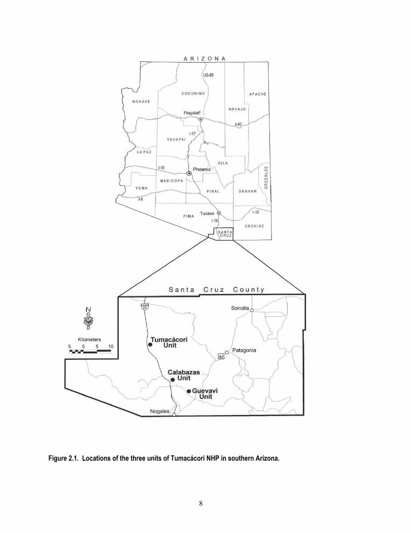
Park Area and History Park History Tumacácori NHP preserves the remnants of three Spanish colonial missions located along the upper Santa Cruz River in southern Arizona. Originally established in 1908 as a monument under the Antiquities Act, the park protected the San Jose de Tumacácori (Tumacácori unit), a Spanish mission founded in 1691. In 1990, the area was designated a National Historical Park with the inclusion of Los Santos Angeles de Guevavi mission (Guevavi unit; founded in 1691) and San Cayetano de Calabazas mission (Calabazas unit; founded in 1756). Park Boundaries Tumacácori NHP contains three units: Calabazas, Guevavi and Tumacácori. Tumacácori is the main administrative unit. The Calabazas and Guevavi units are 15 km and 23 km SSE of the Tumacácori unit, respectively (Figs. 2.1–2.3). The park contains two perennial stretches of the Santa Cruz River (in the Tumacácori and Guevavi units; Figs. 2.2, 2.3). In the summer of 2002, the U.S. Congress legislated expansion and (later) allocated money for the acquisition of an additional 125 ha located adjacent to the Tumacácori unit along the Santa Cruz River (Fig. 2.2). Unless otherwise noted, the “Tumacácori unit” collectively refers to the legislated boundary (Fig. 2.2) and a few areas just outside of the boundary. Natural Resources Overview The three units of Tumacácori NHP are associated with distinct pockets of reliable water, resulting from basin-fill sediments over relatively shallow aquifers that fill quickly after precipitation (Sprouse et al. 2002). Perennial flow at the Tumacácori unit is augmented by treated wastewater discharges from the Nogales International Wastewater Treatment Plant. The perennial water supports a cottonwood-willow gallery forest at the
Tumacácori unit. Mesquite bosque (forest), xeroriparian scrubland, and semi-desert grassland bound these mesic forests. The riparian area is habitat for a number of rare or federally listed animals such as the Gila topminnow (Chapter 4) and yellow-billed cuckoo (Chapter 6, Powell 2000). Physiography and Geology The Upper Santa Cruz River Valley is located in the southern Basin and Range Province of southeastern Arizona and northern Sonora. This terrain of alternating fault-bounded linear mountain ranges and sediment-filled basins began to form in southeastern Arizona as the result of dominantly east-northeast/west-southwest directed crustal extension. The mountain ranges (Santa Rita, San Cayetano, and Patagonia) to the east of the park consist of a variety of rocks, including igneous, metamorphic, volcanic, and sedimentary, ranging in age from Precambrian to Miocene. The Tumacácori and Atascosa Mountains west of the park are composed chiefly of Tertiary volcanic rocks with the exception of a Jurassic granitic pluton south of Sopori Wash at the northern end of the Tumacácori Mountains. The Pajarito Mountains at the southern end of the valley, west of Nogales, are composed of Cretaceous volcanics. Hydrology and Soils Basin-fill sediments along the Santa Cruz River, north of the City of Nogales to Amado, form three aquifer units: Nogales Formation, Older Alluvium, and Younger Alluvium (ADWR 1999). The floodplain alluvium of the Santa Cruz River increases in width from about 1.3 to 1.9 km between the Nogales International Wastewater Treatment Plant and the Tumacácori unit (including the Guevavi unit) and averages about 2.4 km wide between Josephine Canyon and Amado (including the Tumacácori unit) (ADWR 1999). In the vicinity of all the park units the soils are
8
Figure 2.1. Locations of the three units of Tumacácori NHP in southern Arizona.

9
Figure 2.2. Aerial photograph of the study area and park boundary, Tumacácori unit, Tumacácori NHP.

10
Figure 2.3. Aerial photographs of the Calabazas and Guevavi units, Tumacácori NHP.

11
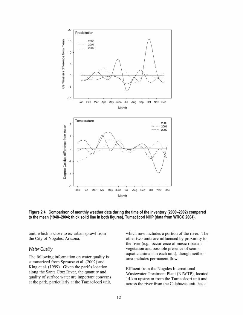
typical of floodplains, alluvial fans, and valley slopes of this semi-desert region; they are deep and well drained, with a high water-holding capacity (NPS 1996). Climate Tumacácori NHP is located within the semi-desert climatic zone of southern Arizona, which is characterized by heavy summer (monsoon) storms brought about by moisture coming from the Gulf of Mexico and less intense, frontal storms from the Pacific Ocean in the winter. Approximately half of the annual precipitation falls from July to September (Table 2.1) (WRCC 2004). The area’s hot season occurs from April through October; maximum temperatures in July often exceed 40 °C. Intense surface heating during the day and active radiant cooling at night can result in daily temperature ranges of 17° to 22°
C. Winter temperatures are mild. Prevailing winds tend to follow the Santa Cruz Valley, blowing downslope (from the south) during the night and early morning, and upslope (from the north) during the day. Weather during the three years of this study was highly variable and atypical (Fig. 2.4). Annual total precipitation ranged from slightly greater than average in 2000 (48.8 cm) and 2001 (42.2 cm) to one of the driest years on record in 2002 (23.6 cm; Fig. 2.4). Annual mean temperatures were above the long-term mean (17.7 oC) in 2000 and 2002 (18.0 oC in both years) and below it in 2001 (17.4 oC) (WRCC 2004). Vegetation All three units have vegetation typical of the semi-desert grassland association (Brown et al.
1979, Brown and Lowe 1980). Common species include velvet mesquite, foothills palo verde and species of acacia, wolfberry, and greythorn, annual and perennial grasses, and forbs (NPS 1996). At the Tumacácori unit, in particular, there are dense stands of mesquite bosque and gallery riparian vegetation. Velvet mesquite, netleaf hackberry, and Mexican elderberry are common in the mesquite bosque areas, whereas in the mesic riparian areas, Fremont cottonwood, Goodding’s willow, tamarisk, and Arizona walnut form dense and structurally diverse stands of vegetation, particularly adjacent to surface water. Natural Resource Management Issues Because of its location along a river corridor, its proximity to the border with Mexico, and its diversity of biotic communities, Tumacácori NHP has many natural resource management issues that deserve attention. Here we review some threats to the unique natural resources at the park. For a more detailed analysis of some species mentioned in this section refer to the Discussion section of the appropriate chapter. Adjacent Development The boundaries of the Tumacácori unit are near the town of Tubac (to the north) and the Rio Rico development (to the south). The population of Rio Rico is expected to increase three-fold by 2025 (ADWR 1999) and Tubac is rapidly expanding as well. Much of the remaining undeveloped land adjacent to the park is currently used for irrigated agriculture or livestock grazing but additional residential development has been proposed (Ann Rasor, pers. comm.). Similarly, increased residential development is taking place near the Calabazas
Table 2.1. Average monthly climate data for Tumacácori NHP, 1948–2003 (data from WRCC 2004).
Month Characteristic Jan Feb Mar Apr May Jun Jul Aug Sep Oct Nov Dec Annual Maximum temperature (°C) 19 21 23 27 32 37 36 34 34 29 23 19 28 Minimum temperature (°C) 0 1 3 5 9 14 19 18 15 9 3 1 8 Precipitation (cm) 2.5 2.3 2.3 0.8 0.5 1.3 9.9 9.7 3.8 2.8 1.8 3.3 3.4
12
Figure 2.4. Comparison of monthly weather data during the time of the inventory (2000–2002) compared to the mean (1948–2004; thick solid line in both figures), Tumacácori NHP (data from WRCC 2004). unit, which is close to ex-urban sprawl from the City of Nogales, Arizona. Water Quality The following information on water quality is summarized from Sprouse et al. (2002) and King et al. (1999). Given the park’s location along the Santa Cruz River, the quantity and quality of surface water are important concerns at the park, particularly at the Tumacácori unit,
which now includes a portion of the river. The other two units are influenced by proximity to the river (e.g., occurrence of mesic riparian vegetation and possible presence of semi-aquatic animals in each unit), though neither area includes permanent flow. Effluent from the Nogales International Wastewater Treatment Plant (NIWTP), located 14 km upstream from the Tumacácori unit and across the river from the Calabazas unit, has a
Month
Jan Feb Mar Apr May June Jul Aug Sep Oct Nov Dec
Cen
timet
ers
diffe
renc
e fro
m m
ean
-10
-5
0
5
10
15
20
200020012002
Month
Jan Feb Mar Apr May June Jul Aug Sep Oct Nov Dec
Deg
ree
Cel
cius
diff
eren
ce fr
om m
ean
-6
-4
-2
0
2
4 200020012002
Precipitation
Temperature
13
significant impact on both water quality and quantity at the Tumacácori unit. Treated effluent provides perennial surface flow for more than 15 km of the Santa Cruz River in an area that would otherwise be dry much of the year. Countering the benefits from the presence of the effluent, there are a number of water quality problems that affect park resources. Water samples from the Calabazas Road Bridge (located between the Tumacácori and Calabazas units) have included twenty-two groups of parameters that exceeded National Park Service Water Resources Division screening criteria (NPS 2001). In addition, dissolved oxygen, pH, chlorine, cyanide, cadmium, copper, lead, mercury, selenium, silver, and zinc exceeded respective U.S. Environmental Protection Agency (USEPA) criteria for the protection of freshwater aquatic life (ADEQ 2000, USEPA 2001). Nitrate, arsenic, barium, cadmium and chromium exceeded USEPA drinking water criteria (ADEQ 2000, USEPA 2001), fecal-indicator bacteria concentrations (total coliform and fecal coliform) exceeded Water Resources Division screening limits for freshwater bathing, and turbidity measurements exceeded Water Resources Division limits deemed safe for aquatic life (ADEQ 2000, NPS 2001). The ADEQ has categorized the water in the Santa Cruz River as “impaired” due to turbidity at the Guevavi unit and impaired due to fecal-indicator bacteria concentrations along stretches adjacent to both the Calabazas and Tumacácori units (ADEQ 2000). High levels of chromium (metal) and DDE (dichlorodiphenyldichloroethylene; organochlorine compound) were present in animals collected from the Santa Cruz River during a 1999 study (King et al. 1999). Almost half of the invertebrate samples in this study contained concentrations of chromium that could be harmful to higher-trophic-level organisms, and four of eight killdeer carcasses contained DDE levels that are associated with impaired reproduction and may also pose a bio-accumulation risk to predators (King et al. 1999). Perhaps the issue of greatest concern is
the presence of toxic levels of un-ionized ammonia in sampling locations downstream from the treatment plant. High concentrations of ammonia were documented by five studies between 1995 and 1999, and have been identified as responsible for fish mortality (summary in King et al. 1999). A high proportion of fish collected downstream from the treatment plant also possessed physical anomalies of unknown cause (King et al. 1999). Although levels of ammonia decreased with distance from the treatment plant, the toxicity of water upstream of the Tumacácori unit may dramatically reduce the likelihood that additional native aquatic or semi-aquatic animals will colonize that area from upstream locations. Indeed, in an earlier study, researchers noted that despite presence of five species of amphibian upstream from the treatment plant, “… no amphibians are found along the river from the waste water outfall downstream for several kilometers” (Drost 1998). The river is also vulnerable to releases of raw sewage from the NIWTP, whether from a break in the main sewer line (which occurred in 1977; NPS 1993) or from periodic surges in the volume of raw sewage coming into the plant, thereby overwhelming the facility (Sprouse et al. 2002). Increased treatment capacity is planned for the plant (which would improve its ability to handle surges; Terry Sprouse, pers. comm.) and installation of pre-treatment equipment would reduce ammonia concentrations to non-toxic levels. These improvements were initially scheduled for completion by March 2002 (King et al. 1999) but at the time of this writing (April 2005) they had not begun. Riparian Vegetation Regardless of the concerns regarding contamination, the water from NIWTP has resulted in the extensive cottonwood-willow riparian community at the Tumacácori unit and adjacent lands. Loss of those waters due to a proposed treatment plant in Nogales, Sonora,

14
could result in the degradation of the diverse riparian area at the park. Riparian plant communities in the southwestern United States account for less than 1% of the landscape cover (Skagen et al. 1998), yet it is estimated that greater than 50% of southwestern bird species (Knopf and Samson 1994) and up to 80% of all wildlife species in the southwest are dependent on riparian areas (Chaney et al. 1990). Riparian areas in arid regions support high bird species diversity due their structural and floristic diversity as compared to surrounding areas (Thomas et al. 1979, Lee et al. 1989, Strong and Bock 1990) that translates into abundant insects for foraging and large trees for nesting (Powell and Steidl 2000). Riparian vegetation, such as cottonwoods, willows, and ash have been found to decrease levels of heavy metals in water and soil in addition to decreasing water temperatures, providing a source of organic matter, and stabilizing stream banks (Karpiscak et al. 2001, Karpiscak et al. 1996, Osborne and Kovacic 1993). The Bureau of Land Management estimates that less than 20% of the western United States’ potential riparian vegetation remains to perform these vital services (BLM 1994). Such loss highlights the importance of maintaining these rare riparian plant communities along the Santa Cruz River. Off-road Vehicles Park staff and adjacent landowners prohibit off-road vehicles in the Santa Cruz River floodplain, but trespass is frequent, particularly at the Tumacácori unit where flood events wash out fencing (Roy Simpson, pers. comm.). Off-road vehicles cause soil compaction (Wilshire 1983) and erosion by damaging and destroying vegetation (Johnson and Smith 1983). They also affect wildlife through direct mortality and habitat destruction (e.g., crushed burrows; Wilshire 1983, Brotons and Herrando 2001). Non-native Species Awareness of non-native species as a management issue has risen dramatically in
recent years and ecologists have ranked it as one of the most significant causes of species endangerment (Brooks and Pyke 2001). Non-native plant species are a significant management issue at the park, particularly at the Tumacácori unit, where invasives such as tamarisk, Bermudagrass, and Russian thistle are well established. Non-natives plants are known to alter ecosystem function and processes (Naeem et al. 1996, D'Antonio and Vitousek 1992) and reduce the abundance of native species, potentially permanently changing diversity and species composition (Bock et al. 1986, D'Antonio and Vitousek 1992, OTA 1993). The Tumacácori unit provides habitat for non-native vertebrates as well, including western mosquitofish, largemouth bass, bluegill, and sunfish (Chapter 4); American bullfrog (Chapter 5); house sparrow and European starling (Chapter 6); and cattle, and feral cats and dogs (Chapter 7). Impacts from Undocumented Immigrants The proximity of the park to the U.S.-Mexico border results in a number of unique management issues. The Santa Cruz River provides a well-known and well-used corridor for undocumented immigrants traveling north from Mexico, and much of this traffic passes through the Tumacácori unit (NPS 2003). Although visitor safety concerns have not yet become a significant issue, reported impacts to the park include erosion, compacted soils, and vandalism (NPS 1996). Other national parks in the border region have reported fire hazards, theft and destruction of historic resources, disruption of wildlife movements (including reduced access to water sources), reduced water quality, and closure of park attractions due to safety concerns (NPS 2003). To our knowledge only one (recently initiated) study is aimed at quantifying the effects of immigrants on animal communities in southern Arizona (O’Dell 2003; but see McIntyre and Weeks 2002). Trash Flows During heavy flooding events in the Santa Cruz River watershed, a large quantity of trash washes downstream, primarily from the
15
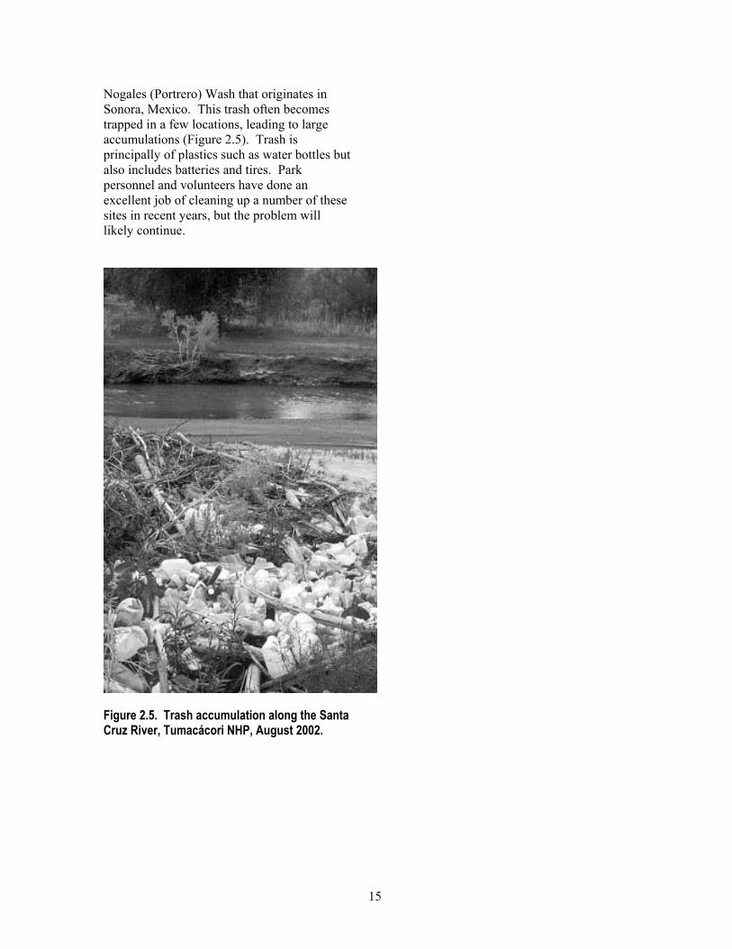
Nogales (Portrero) Wash that originates in Sonora, Mexico. This trash often becomes trapped in a few locations, leading to large accumulations (Figure 2.5). Trash is principally of plastics such as water bottles but also includes batteries and tires. Park personnel and volunteers have done an excellent job of cleaning up a number of these sites in recent years, but the problem will likely continue.
Figure 2.5. Trash accumulation along the Santa Cruz River, Tumacácori NHP, August 2002.

16

17
Chapter 3: Plant Inventory
Previous Research There have been two previous plant inventories at the Tumacácori unit. Mouat et al. (1977) recorded 130 species during seven survey days in the spring and summer of 1977. A less complete and poorly documented survey was conducted at the Tumacácori unit in the 1980s or 1990s (Bennett, year unknown). There are also 50 specimens from the park at the University of Arizona herbarium (Appendices A and F). To our knowledge, there were no prior plant inventories at either the Calabazas or Guevavi units. Methods Our surveys included both qualitative and quantitative methods: qualitative “general botanizing” surveys in which we opportunistically collected and recorded plants, and quantitative plot-based sampling which included three complementary methods to estimate abundance, percent cover by species, and species composition of all plants in a small area. For this report, statistics such as the number of species collected or percentage of non-native species exclude records that we could not identify to species (n = 10; e.g., Tithonia sp.) unless there were no other specimens identified to species for that genus (n = 7; e.g., Nandina sp.) (Appendix A). We recorded 11 species with > 2 subspecies and/or varieties (Appendix A), and we include all subspecies and/or varieties in our summary statistics of the number of “species” recorded. Counts include ornamental (i.e., planted) species (n = 10), unless otherwise noted. Spatial Sampling Designs General botanizing surveys encompassed most areas within the park during most visits. For modular plots we used a simple random sampling design (Thompson 1992) to locate the southwest corner of 17 plots. The study
area, from which we selected random points, covered approximately 111 ha (Fig. 3.1, Appendix J). When establishing plots on the ground we occasionally encountered obstacles (e.g., surface water, buildings) that prevented us from establishing a plot in the precise location specified. In this event we moved the plot, in most cases only a few meters from the original location and in a random direction. We also subjectively placed three plots in community types that we felt were not represented by one or more of the 17 other plots: one each in an agricultural field, in dense mesquite bosque, and in dense mesic riparian vegetation. General Botanizing Field Methods We surveyed for plants from 2000 to 2003 and during multiple seasons to ensure that we encountered as many species as possible. General botanizing surveys during 2000 and 2001 included only the area within the original unit boundaries, but later surveys included the expansion area of the Tumacácori unit. Whenever possible we collected one representative specimen (with reproductive structures) for each plant species in each park unit. We also maintained a list of species observed but not collected within each unit. These lists, along with the list of collected species, comprise a “flora” for each unit (Appendix A). When we collected a specimen, we assigned it a collection number and recorded the flower color, associated dominant vegetation, date, collector names, and UTM coordinates. We pressed and processed the specimens on site. Specimens remained pressed for 2–3 weeks and were later frozen for 48 hours or more to prevent infestation by insects and pathogens. We accessioned mounted specimens into the University of Arizona herbarium.

18
Figure 3.1. Locations of modular plots for plants, Tumacácori unit, Tumacácori NHP, 2002. See Appendix J for plot coordinates.

19
Effort We made 17 general botanizing visits (typically one observer for one-half day) within the original Tumacácori unit boundary, 12 visits to the expansion lands (typically two observers for one day), and 14 and 15 visits to the Calabazas and Guevavi units, respectively (typically one observer for one-half day at each unit). From August 2000 to October 2001, we surveyed approximately monthly within the original boundaries of all units. In 2002 (September and October) and 2003 (April and May) we expanded surveys to include areas within the expansion lands of the Tumacácori unit. Visits were more frequent from April through October to maximize opportunities for collecting specimens with reproductive structures (i.e., flowers or fruits). Analysis We present a variety of summary statistics: total number of species found by location and day of sampling, and number and percent of native and non-native species. To estimate inventory completeness we graph the number of new species by sampling event, which we randomized to account for seasonal differences in numbers of new species (e.g., we recorded a high number of new species after the summer monsoons and a low number of new species during the winter months). Modular Plots We performed modular plot fieldwork in cooperation with NPS Sonoran Desert Network staff who used the protocol (Peet et al. 1998) in multiple NPS units (e.g., Drake et al. 2003). The modular plot fieldwork reported here is part of that long-term vegetation-monitoring program, and these results may serve as a baseline to assess changes in the vegetation community at the Tumacácori unit. Field Methods We used a standardized, plot-based approach at the Tumacácori unit in November 2002. The basic unit was the 10 x 10 m module, two or four of which were joined to create a plot, measuring either 10 x 20 m or 20 x 20 m (Fig. 3.2). We used two types of sampling at
modular plots, each method with different objectives: (1) point-intercept transects to estimate species frequency and ground cover and (2) nested plots (similar to Braun-Blanquet plots [Braun-Blanquet 1965]), to estimate percent cover for all plants as well as basal- area measurements for large woody plants. We sited plots as follows: navigated to the northwest corner of each plot using Emap GPS units; marked the corner with a permanent rebar stake; used a compass and tape measure to define remaining module corners; and used a Pathfinder GPS unit to obtain accurate UTM coordinates for the point. We aligned plot boundaries in cardinal directions (e.g., the west boundary was along a north-south line). All plots were in a 2 x 2 module arrangement (Fig. 3.2) with the exception of one 1 x 2 module arrangement (“Bosque 1”). Point-intercept Transects We bisected each module with a north-south transect (Fig. 3.2) that was established using a 10-m tape measure marked at 10-cm increments. In each of three height categories (< 0.5 m, 0.5–2 m and > 2 m) we recorded the first species to be intercepted by a vertical line (created using a laser pointer), at each of 100 points located every 10 cm along the transect line. If no plant was encountered we recorded “no plant.” We classified ground cover at each point according to the following categories: bare soil, loose rock, bedrock, or litter (senescent plant material that was detached from plants). Braun-Blanquet Plots We used a form of the Braun-Blanquet method (Braun-Blanquet 1965) to estimate percent cover (area covered by each plant species as viewed from above) for each species on all modules and quadrats in each of the height categories used for point-intercept transects. We estimated coverage at two scales: large (10 x 10 m; covering the entire module; n = 2 or 4 per plot) and small (1 x 1 m quadrats; in opposite corners of each module; n = 4 or 8 quadrats per plot) (Fig. 3.2).

20
Figure 3.2. Typical modular plot layout of four 10 x 10 m modules, eight 1 x 1 m quadrats, and four 10-m point-intercept transects, Tumacácori unit, Tumacácori NHP, 2002. To estimate percent cover in each height category for each plant species, we assigned the total coverage by each species to one of six cover classes based on visual estimation: “trace” (< 1%), “1” (1–5%), “2” (6–25%), “3” (26–50%), “4” (51–75%), or “5” (76–100%). Because quadrats were nested within modules (Fig. 3.2), modules always contained all the plant species that were recorded in the quadrats. We recorded tree species in each module if the majority of the trunk was inside the module, and recorded basal diameter if it was > 15 cm. For stems < 15 cm basal diameter, we counted the number for each species but did not record basal diameter. Effort Four observers measured vegetation on 20 plots at the Tumacácori unit during ten field days from 2 to 17 November 2002. Nineteen plots had four modules in a 20 x 20 m arrangement (Fig. 3.2) and one plot had two modules in a 20 x 10 m arrangement (n = 78 modules).
Results We recorded 378 species during general botanizing and modular plot surveys from 2000 to 2003 (Appendix A). We recorded the most species at the Tumacácori unit (n = 293). We recorded fewer species at the Calabazas (n = 175) and Guevavi units (n = 151). The most common families were composites (Asteraceae), grasses (Poaceae) and legumes (Fabaceae). More than 82% of the remaining families were represented by three or fewer species, a pattern consistent with floras of nearby areas (McLaughlin et al. 2001). We recorded 67 non-native species in all units combined (Appendix A). Excluding ornamentals, the percentage of non-native species averaged 15% among park units but varied considerably: the highest percentage of non-native species was at the Tumacácori unit (18%; n = 52), a lower percentage at the Guevavi unit (11%; n = 17), and the lowest percentage at the Calabazas unit (9%; n = 16) (Appendix A). Considering all units, the grass family (Poaceae) had the highest percentage of
10
10 m
Point-intercept
1 x 1 m

21
non-native species (33%; n = 22). Perhaps the most notable non-native species we documented was the muster John Henry (at the Tumacácori unit); this was the second documentation of its occurrence in Arizona. General Botanizing Tumacácori Unit We recorded 191 species (representing 58 families) in the original Tumacácori unit boundaries and an additional 62 species (7 families) in the expansion area (Appendix A). We collected specimens at 139 sites: 102 near the Mission and 37 in the expansion area. Calabazas Unit We recorded 175 species and collected specimens at 74 sites (Appendix A). Guevavi Unit We recorded 151 species and collected specimens at 58 sites (Appendix A). Modular Plots We recorded 93 species in 20 plots at the Tumacácori unit (Appendix A, Q, R). The mean number of species per plot was 18.4 (±1.3 SE, range = 8 to 30) (Appendix Q). Over one-third of the species (n = 33) were found on only one plot, and five species (including the non-native Bermudagrass) were found on > 75% of the plots (Appendix R). Fourteen percent (n = 13) of the species were non-native, and of these more than half were grasses (Appendix A). Comparison of Braun-Blanquet Plots and Point-intercept Transects For all height classes, only 55% (n = 51) of the 93 species recorded on Braun-Blanquet plots were also recorded on point-intercept transects (Appendix R). There were also substantial differences in the frequency of species detections between the two methods; of the 24 species recorded in > 1 plot (using both methods), all but one were recorded more often in Braun-Blanquet plots than on point-intercept transects. We recorded the 13 most common species (those recorded on > 40% of plots) on a mean of 48% (± 7.5 SE) more plots
than the same species were recorded along transects. Velvet mesquite, the most frequently recorded species along transects, ranked sixth in percent cover using the Braun-Blanquet method while carelessweed (ranked first in percent cover Braun-Blanquet plots), ranked fourth in frequency along transects. The abundance rank of the most common non-native species changed little based on the method used; Bermudagrass was recorded in 17 of the 20 plots by both methods and ranked sixth and seventh in dominance according to transects and Braun-Blanquet plots, respectively. Pima Pineapple Cactus and Huachuca Water Umbel We searched for two endangered species thought to be in the area: Pima pineapple cactus (Coryphantha scheeri var. robustispina) and Huachuca water umbel (Lilaeopsis schaffneriana var. recurva), but did not find either. Inventory Completeness Other researchers listed 46 species at the Tumacácori unit that we did not find (Appendix F). While these may still be present and we missed them, alternative explanations include misidentification (many previous records were not documented), local extirpation, and use of different field methods. Judging from the presence of conspicuous perennial species at both the Calabazas and Guevavi units but not Tumacácori unit (e.g., whitethorn acacia), some local extirpation may have occurred. Ornamental species that we did not find such as myrtle, Japanese privet, Chinese firethorn and garden tomato were probably used in landscaping around park buildings and died or were removed without replacement. Species accumulation curves for general botanizing (Fig. 3.3) and modular plots (Fig. 3.4) show little sign of reaching asymptotes. Yet, taken together the general botanizing and modular plot work produced a high number of species for the park (see Discussion section).

22
We recorded plants over three years and during periods of average rainfall, thereby making it possible that we recorded 90% of the species. However, in order to confirm the completeness of our surveys it will be necessary to repeat our effort, particularly during spring and post-monsoon periods following above-average rainfall. Discussion Three factors likely contributed to our finding twice the number of species reported by previous studies (Mouat et al. 1977; Bennett year unknown): (1) our field effort was more than twice that of previous studies, (2) our survey area was larger (111 ha including the expansion area versus seven ha at the Tumacácori unit), and (3) we likely benefited
from a winter (2000) that had more precipitation than average. This unusual weather probably enhanced recruitment of winter annuals, resulting in higher species richness of annuals during our fieldwork than during sampling by Mouat et al. (1977). To develop a context for the species richness at Tumacácori NHP, we compared our results to the nearby flora of the Appleton-Whittell Research Ranch near Elgin in the Sonoita Valley (McLaughlin et al. 2001). This flora was comprised of approximately 345 species in an area about 30 times larger than Tumacácori NHP, yet species richness (n = 368 not including ornamental species) in all three units of Tumacácori NHP was greater than at the Appleton-Whittell Research Ranch.
Figure 3.3. Species accumulation curve for cumulative number of new plant species collected as a function of the number of sample days, general botanizing and modular plot surveys, all units, Tumacácori NHP, 2000–2003. Order of sampling days was randomized to account for seasonal spikes in new plant species (e.g., post-monsoon season).
Sample days
0 5 10 15 20 25 30 35
Cum
ulat
ive
num
ber o
f spe
cies
0
100
200
300
400

23
Figure 3.4. Cumulative (A) and number of new plant species (B) recorded as a function of the number of modular plots surveyed, Tumacácori unit, Tumacácori NHP, 2002.
Number of plots surveyed
0 5 10 15 20
Cum
ulat
ive
num
ber o
f spe
cies
0
20
40
60
80
100
Number of plots surveyed
0 5 10 15 20
Num
ber o
f new
spe
cies
0
5
10
15
20
(A)
(B)

24
The higher number of recorded species at the Tumacácori unit compared to the other units of the park may be due not only to the larger sample area (about 128 ha), but also to differences in environmental conditions. The Tumacácori unit contains both xeric and mesic riparian areas, mesquite bosque, semi-desert grassland and landscaped areas, some of which provide habitat for species not recorded at the Calabazas or Guevavi units. Typical shrub-invaded semi-desert grassland present at the Calabazas and Guevavi units is less species rich, but these areas possess a surprising number of species for their size. One notable difference among the units is that Calabazas and Guevavi units currently experience less disturbance than the Tumacácori unit; they are closed to the general public, are less subject to seed dispersal from the Santa Cruz river flow, and are less subject to ongoing disturbances (e.g., construction, grazing, flood events). These factors may explain why the floras of these units possess a lower percentage of non-native species and why they retain species that were historically recorded but no longer occur at the Tumacácori unit such as Takhoka-daisy, whitethorn acacia, and erect dayflower (Appendix A). Of the three units, Tumacácori appears to be the most highly affected by human activity. The unit hosts the park visitor center, offices, residential buildings, and maintenance compound. It has many unsurfaced utility roads and walkways, and receives many visitors. Of the 67 non-native species we recorded at the Tumacácori unit, 42 were not recorded by previous researchers (Appendix A). Many of these non-native species are winter annuals that may not have germinated following below-average winter rainfall preceding the survey of Mouat et al. (1977), though it should be expected that new non-native species might have colonized Tumacácori unit in the years since that study. Excluding ornamental species (though these were present in previous surveys as well), the percent of non-native species averaged 15% among units (Appendix A). The percentage of non-native species in floras of southern
Arizona varies greatly among areas; Felger (1990) considers a non-native species richness component of 5–10% to be “healthy” though other factors must be taken into consideration in assessing the impacts of non-native species. These factors include whether each species has a high potential for increased distribution or community dominance; potential for disrupting nutrient cycling, fire regimes, or other ecological processes; and whether they are easily controlled. Notable for our surveys is the second verified record in Arizona of the muster John Henry. It was found in the understory of the cottonwood-willow forest east of the Santa Cruz River southeast of the mission, but not at the Calabazas or Guevavi units. It is considered a noxious weed in California (California Department of Food and Agriculture 2004). Once well established, a number of non-native species pose a significant management problem. Prominent species include tamarisk, Bermudagrass, Lehmann lovegrass, Johnsongrass, Russian thistle, London rocket, and yellow sweet clover. Bermudagrass, in particular, is difficult to control and was recorded in 85% of the modular plots (Appendices Q, R). A complete description of these non-native species as well as their life history, threat to native species, and eradication method(s) can be obtained from (Halvorson and Guertin 2003).
25
Chapter 4: Fish Inventory
Previous Research Arizona Game and Fish Department personnel completed periodic surveys of the Santa Cruz River, in or near Tumacácori NHP, between 1998 and 2001, in 2003, and one survey in the Tumacácori Channel in 1999 (Voeltz and Bettaso 2003). Methods We surveyed for fish at two sites at the Tumacácori unit: the Santa Cruz River and the Tumacácori Channel (previously referred to as “Cosper Slough” by Powell et al. [2002, 2003]). The channel is an abandoned meander that maintains its downstream connection with the Santa Cruz River. Alluvial groundwater seeping into the channel forms a short tributary stream and may be similar to the original “Tumacácori Spring” (Larry Martin, hydrologist, National Park Service, Ft. Collins, CO). We surveyed the river from 30 m downstream of the confluence with the channel to about 25 m south of Santa Gertrudis Lane (Fig. 2.2). Spatial Sampling Design For each sampling event (i.e., day) we surveyed up to one-half of the channel or river in our study area by surveying in a subjectively determined length of reach then skipping a similar length of reach. One-half of each reach was the maximum length that could be surveyed in a single sampling event. Field Methods Our field crew captured fish using two methods: (1) electrofishing (Dauble and Gray 1980) with a Smith-Root backpack unit in both areas (12-B POW; Smith-Root, Inc., Vancouver, WA; set to: DC pulse width of 60 Hz, frequency of 6 ms, voltage of 300 V); and (2) dipnetting (long-handled dip nets with 4 mm mesh; Dauble and Gray 1980) in shallow-water areas of the channel. We identified captured fish to species, classified them as juvenile or adult according to relative size,
sexed them when possible, and returned all fish to the same reach from which they were captured. We randomly chose a bank of the river or channel from which to start surveys and proceeded upstream, concentrating on areas likely to shelter fish (e.g., stream margins and in-stream obstructions). We alternated banks and reaches of the river, sampling 100 m then skipping 150 m (i.e., surveying the east bank, skipping 150 m, then surveying the west bank, and repeating). For the channel, we surveyed alternating 50 m reaches from the confluence with the river to the point of its origin (Fig. 2.2). We used electrofishing for the first 200 m (downstream) of the channel (which has relatively large and deep pools that allow shocking) and dip netting for the remainder of the channel. Effort Three to four field personnel surveyed the channel and river on four sampling periods (eight sampling events), once each in the spring and fall of 2001 and 2002. We did not record sampling effort for individual reaches. Analysis Because we recorded total catch per sampling event (rather than by sampling within reaches), we were unable to apply statistical analyses to the data (n = 1 for each sampling event). Therefore, we report data summaries: total catch per day, percent of total catch by species, and species richness by site. Because we did not subsample or account for detectability of each species, we cannot estimate population parameters (e.g., size). We do not differentiate juveniles and adults in our summaries because reliable aging methods are time-intensive (Bill Matter, pers. comm.). We compare sex ratios in Gila topminnow and western mosquitofish, species in which gender is easily determined.
26
Results
Species Richness We recorded eight species (four native, four non-native) and one hybrid (green sunfish/bluegill) at Tumacácori NHP (Table 4.1, Appendix B). We recorded all eight species on the first sampling event in the channel and Gila topminnow, longfin dace, and western mosquitofish in both sites on all sampling events (Table 4.1, Appendix S). Species richness in the channel was higher than in the river on all but the last sampling event (Fig. 4.1). Total Catch We captured a total of 3,329 individuals (Appendix S). Fifty-seven percent of captures were from the channel (Table 4.1). Total number of individuals caught per sampling event was lowest in the river in April 2001 (35 captures in one day) and highest in the river approximately one year later (722 captures in one day) (Fig. 4.1). Total number of captures at both sites was similar for each sampling event except November 2002 when we captured 75% fewer individuals in the river (Fig. 4.1). For all sampling events and both sites, the species with the largest total catch were: western mosquitofish (45% of the total catch), longfin dace (42%), and Gila topminnow (11%) (Appendix S). Individuals of the other five species each made up < 1% of the total catch. There were substantial differences in the percentage of total catch by species between sites and among sampling events for the three most common species (Fig. 4.2). For both sites, percentage of total catch of western mosquitofish increased throughout the study (Fig. 4.2). In the channel, longfin dace showed a consistent decrease while Gila topminnow remained constant, but in the river the longfin dace and Gila topminnow showed inverse patterns of percent total catch (Fig. 4.2). The proportion of females to males was high for both the Gila topminnow (3.2 ± 0.87 SE)
and western mosquitofish (2.1 ± 0.36 SE) from all sites and sampling events (Appendix S). We noted breeding coloration only in the desert sucker (on 4 April 2001). Table 4.1. Number of fish caught during four sampling periods at Tumacácori NHP, 2001–2002. See Appendix B for scientific names and Appendix S for number of individuals caught by sampling event.
Common name Tumacácori
Channel Santa Cruz
River longfin dace 434 979 Sonora sucker 24 desert sucker 6 western mosquitofish 1,243 273 Gila topminnow 172 182 green sunfish 1 4 bluegill sunfish 6 bluegill/green sunfish hybrid 1 largemouth bass 3 1 Total catch 1,890 1,439 Inventory Completeness Based on distribution records (Minckley 1973) and expert opinion (Andrew Schultz, University of Arizona PhD candidate), we believe that we documented all species that are thought to occur in the park. It should be noted, however, that additional non-native species may be present (but undetected) or become established in the park. Gila Chub and Desert Pupfish The Gila chub (Gila intermedia) and desert pupfish (Cyprinodon macularius macularius) have not been recorded from the vicinity of the park but may have occurred historically. The U.S. Fish and Wildlife Service lists both species as endangered (AZGF 2004). The Gila chub is only known to occur in a few sites in the Santa Cruz River basin and nowhere near Tumacácori NHP (Weedman et al.1996). The desert pupfish was extirpated from the Santa Cruz River by 1904 (Minckley 1973).

27
Figure 4.1. Total catch and species richness of fish, by sampling period, Tumacácori NHP, 2001–2002.
Apr 2001 Nov 2001 May 2002 Nov 2002
Num
ber o
f ind
ivid
uals
cau
ght
0
200
400
600
800
Tumacácori ChannelSanta Cruz River
Sampling period
Apr 2001 Nov 2001 May 2002 Nov 2002
Num
ber o
f spe
cies
cau
ght
0
2
4
6
8
10
Tumacácori ChannelSanta Cruz River
Total catch
Species richness
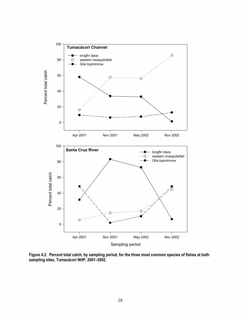
28
Figure 4.2. Percent total catch, by sampling period, for the three most common species of fishes at both sampling sites, Tumacácori NHP, 2001–2002.
Apr 2001 Nov 2001 May 2002 Nov 2002
Per
cent
tota
l cat
ch
0
20
40
60
80
100
longfin dacewestern mosquitofishGila topminnow
Tumacácori Channel
Sampling period
Apr 2001 Nov 2001 May 2002 Nov 2002
Per
cent
tota
l cat
ch
0
20
40
60
80
100
longfin dacewestern mosquitofishGila topminnow
Santa Cruz River

29
Discussion
Gila Topminnow The apparent persistence of the federally endangered Gila topminnow in the Tumacácori Channel is perhaps the most important finding of our inventory effort. We found Gila topminnow in all sampling periods (Appendix S) and were likely present in the channel during the extreme drought of the late spring/early summer of 2002 (B. Powell, pers. obs.), during which time no surface water was present in the river site. Therefore, the channel may act as a refugium for the species during these extreme drought events. The Gila topminnow was once the most abundant species in the southwest, but within the last 20 years has become restricted to approximately 14 isolated populations in the greater Gila River watershed (which includes the Santa Cruz River) (Meffe et al. 1983, Weedman and Young 1987, Weedman 1998, Minckley 1999). As with most native fish declines, that of the Gila topminnow is thought to be the result of habitat destruction due to grazing, groundwater pumping, water diversion, drought, and the introduction of non-native species, especially the western mosquitofish and American bullfrog (Miller 1961, AZGF 1995). Despite the presence of western mosquitofish and American bullfrogs in the channel, Gila topminnows are persisting (Table 4.1). Because our survey effort was not designed to estimate abundance, it is not possible to infer population size or trends in abundance of the Gila topminnow, though the 14-fold increase in number of individuals captured between the first and last sampling event in the channel may suggest a population increase. The high ratio of female to male Gila topminnow is not unusual and is at the low end of the 1.5 to 6.3 females per male ratio reported in the literature (Schoenher 1974; cited in Weedman 1998). Desert and Sonora Suckers The presence of desert and Sonora suckers for the first three sampling events in the Tumacácori Channel is significant because
both species are rare in southern Arizona (Recon 2004). There is at least one prior sighting of the desert sucker in the channel in June 1999 (Voeltz and Bettaso 2003). However, we did not find either species during our fourth sampling period in fall 2002, which was after a period of lower than average rainfall for the region (Fig. 2.4). It is possible, but not likely, that we missed them on the fourth visit. Assuming they were not present, the possible loss of these species from the park is particularly troubling given that it is thought to be sedentary (Bestgen et al. 1987); movement back to the park may take considerable time or may not happen at all. However, it is clear that habitat exists for these species in the channel near where it enters the river. The breeding coloration of a desert sucker in April is consistent with its typical breeding period of spring to early summer (Recon 2004). Both sucker species are designated “Species of Concern” by the U.S. Fish and Wildlife Service (HDMS 2004). Western Mosquitofish and Other Non-native Fishes Once introduced throughout the western U.S. to control mosquito populations, the western mosquitofish is thought to be one of the major reasons for population declines of the Gila topminnow (and other small native fishes in the southwest) through predation, harassment, and competition (Meffe 1985, Courtenay and Meffe 1989). One study indicates that Gila topminnow cannot exist sympatrically with western mosquitofish; within two years of the western mosquitofish introduction into Arivaipa Creek in Arizona, the topminnow disappeared from the creek (Miller 1961). Other studies have shown the local extirpation of the endangered Sonoran topminnow (Poeciliopsis occidentalis) in Arizona after the introduction of western mosquitofish (Meffe et al. 1983, Meffe 1985, Marsh and Minckley 1990). Therefore, the persistence of the Gila topminnow in presence of western mosquitofish is notable. In addition to large numbers of western mosquitofish, we recorded three other non-

30
native sport-fish species: largemouth bass, bluegill, and green sunfish (Table 4.1). Although we recorded these species in low numbers (11 individuals total) and inconsistently (Appendix S), their impact on the native fishes cannot be underestimated; all three species are predatory. These aggressive fishes have impacts on other fauna as well; they have likely contributed to the decline of the Chiricahua leopard frog in southeastern Arizona (Rosen et al. 1995). Crayfish During most of our surveys, we observed crayfish (Orconectes virilis; Fig. 4.3), an important non-native invertebrate, especially in the channel. Crayfish are one of the most serious threats to native aquatic biota because they effectively compete with aquatic herbivores, prey on aquatic invertebrates and vertebrates, disrupt normal nutrient cycling, and decrease aquatic macroinvertebrate diversity (Creed 1994, Fernandez and Rosen 1996). Crayfish are extremely drought resistant; they burrow in moist soil during dry periods thereby presenting a persistent threat (Holdich and Lowery 1988, Fernandez and Rosen 1996, Kubly 1997). In addition, their extensive burrowing leads to bank erosion, increased turbidity, and siltation, all of which can restrict reproduction of native fishes requiring coarse gravel for egg development (Fernandez and Rosen, 1996). Fernandez and Rosen (1996) suggest eradication methods that include poisoning heavily populated sites, trapping more lightly populated regions, reintroduction of natural predators such as native river otters, and building barriers to prevent upstream spread.
Figure 4.3. Crayfish, Tumacácori NHP, November 2002.
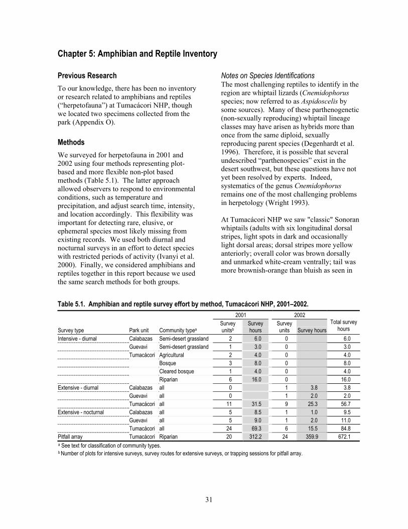
31
Chapter 5: Amphibian and Reptile Inventory
Previous Research To our knowledge, there has been no inventory or research related to amphibians and reptiles (“herpetofauna”) at Tumacácori NHP, though we located two specimens collected from the park (Appendix O). Methods We surveyed for herpetofauna in 2001 and 2002 using four methods representing plot-based and more flexible non-plot based methods (Table 5.1). The latter approach allowed observers to respond to environmental conditions, such as temperature and precipitation, and adjust search time, intensity, and location accordingly. This flexibility was important for detecting rare, elusive, or ephemeral species most likely missing from existing records. We used both diurnal and nocturnal surveys in an effort to detect species with restricted periods of activity (Ivanyi et al. 2000). Finally, we considered amphibians and reptiles together in this report because we used the same search methods for both groups.
Notes on Species Identifications The most challenging reptiles to identify in the region are whiptail lizards (Cnemidophorus species; now referred to as Aspidoscelis by some sources). Many of these parthenogenetic (non-sexually reproducing) whiptail lineage classes may have arisen as hybrids more than once from the same diploid, sexually reproducing parent species (Degenhardt et al. 1996). Therefore, it is possible that several undescribed “parthenospecies” exist in the desert southwest, but these questions have not yet been resolved by experts. Indeed, systematics of the genus Cnemidophorus remains one of the most challenging problems in herpetology (Wright 1993). At Tumacácori NHP we saw "classic" Sonoran whiptails (adults with six longitudinal dorsal stripes, light spots in dark and occasionally light dorsal areas; dorsal stripes more yellow anteriorly; overall color was brown dorsally and unmarked white-cream ventrally; tail was more brownish-orange than bluish as seen in
Table 5.1. Amphibian and reptile survey effort by method, Tumacácori NHP, 2001–2002. 2001 2002
Survey type Park unit Community typea Survey unitsb
Survey hours
Survey units Survey hours
Total survey hours
Intensive - diurnal Calabazas Semi-desert grassland 2 6.0 0 6.0 Guevavi Semi-desert grassland 1 3.0 0 3.0 Tumacácori Agricultural 2 4.0 0 4.0 Bosque 3 8.0 0 8.0 Cleared bosque 1 4.0 0 4.0 Riparian 6 16.0 0 16.0 Extensive - diurnal Calabazas all 0 1 3.8 3.8 Guevavi all 0 1 2.0 2.0 Tumacácori all 11 31.5 9 25.3 56.7 Extensive - nocturnal Calabazas all 5 8.5 1 1.0 9.5 Guevavi all 5 9.0 1 2.0 11.0 Tumacácori all 24 69.3 6 15.5 84.8 Pitfall array Tumacácori Riparian 20 312.2 24 359.9 672.1 a See text for classification of community types. b Number of plots for intensive surveys, survey routes for extensive surveys, or trapping sessions for pitfall array.

32
the Gila spotted whiptail [C. flagellicaudus]; Degenhardt et al. 1996, Phil Rosen pers. obs.) and a variation of this classic appearance (possibly older individuals) that superficially resembled the Gila spotted whiptail. In this document we report all of these individuals as Sonoran whiptails. Spatial Sampling Design For all methods except intensive surveys, we surveyed for herpetofauna in non-random sites because we wanted to detect as many species as possible. To determine locations for intensive survey plots we used a modified simple-random sampling design (Thompson 1992) whereby we used ArcView GIS software to select points (n = 15) at random in each park unit to serve as the southwest corner of each plot. We then post-stratified plots (Thompson 1992) by vegetation type; in lieu of a vegetation map for the park we used aerial photographs to estimate vegetation types and moved the location of some plots that appeared to cover more than one vegetation type into the type representing the majority of the area. Intensive Surveys In 2001 we used searches constrained by both time and area to provide a standardized survey method. These surveys are similar to visual encounter surveys (described by Crump and Scott [1994]), but were confined to a 1 ha (100 x 100 m) plot. Due to the heterogeneity of vegetation types at the Tumacácori unit, our random locations resulted in plots representing each of the dominant community types in the park: riparian, mesquite bosque, semi-desert grassland, and agricultural land (Figs. 5.1, 5.2). Riparian plots included a mixture of sandy, open floodplain and dense riparian vegetation. One of the mesquite bosque plots (referred to as “cleared bosque”) was located at the festival grounds where grasses were cut regularly, most perennial vegetation had been cleared, and only scattered large mesquites remained. Field Methods We visited each plot twice in a morning (each time with a different observer) to increase the probability that a survey occurred during a
period of peak activity for diurnal lizards, because activity levels vary with temperature (Rosen 2000). We determined UTM coordinates for each of the four plot corners using a Trimble GPS unit and marked the corners with rubber-capped rebar stake (except for the plot located in an agricultural field) (Appendix K). We wrote a brief description of the vegetation and soil characteristics of the area. Before and after each survey we recorded weather information: temperature, % relative humidity, % cloud cover, wind speed [km/h], and an overall description of the conditions. We used Garmin Emap GPS units to ensure that we stayed within the plot during the search. For each animal that we observed, we recorded species (using a four letter code) and sex and age class (if known). Effort We visited all plots in the spring (24–27 April), and most plots again in the summer (9–10 September; Table 5.1) of 2001. We began all 35 surveys (one person-hour each) between 7:30 A.M. and 12:30 P.M. In 2002 we chose not to continue intensive surveys because of the relatively low number of species and individuals recorded and instead focused our efforts on other methods. Analysis We estimated relative abundance for each species as the mean number of individuals recorded per person-hour. We estimated species richness by community type using only intensive surveys, but estimated species richness by park unit using data from both intensive and extensive surveys. We combined survey types for richness estimates because summaries of intensive search data are biased toward diurnally active species; we did not complete any nocturnal/crepuscular intensive surveys. Extensive Surveys We designed extensive surveys to enable us to search areas that, based on our field experience, were likely to have high species richness or species not previously recorded. Extensive surveys, a type of visual-encounter
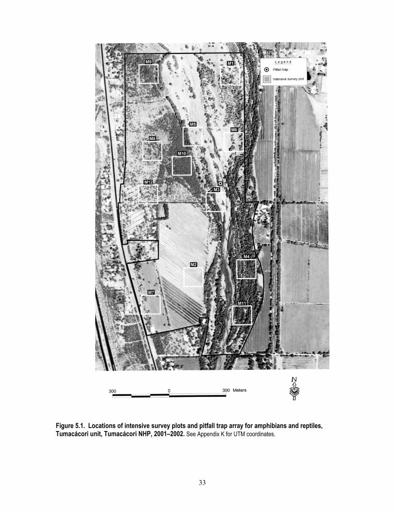
33
Figure 5.1. Locations of intensive survey plots and pitfall trap array for amphibians and reptiles, Tumacácori unit, Tumacácori NHP, 2001–2002. See Appendix K for UTM coordinates.

34
Figure 5.2. Locations of intensive survey plots for amphibians and reptiles, Calabazas and Guevavi units, Tumacácori NHP, 2001–2002. See Appendix K for UTM coordinates.
35
survey (Crump and Scott 1994), differed from intensive surveys in that they were not constrained by area or time. In 2002 we used this method almost exclusively because of its efficiency. In general we focused extensive surveys during the cooler morning, evening, and nighttime periods to maximize our chances of encountering snakes and amphibians, which would be active during these times (Ivanyi et al. 2000). Field Methods We used the extensive survey method for both diurnal and nocturnal surveys. Nocturnal surveys were defined as those beginning after 5 P.M. and lasting more than 1.5 hours, often including the crepuscular period. Search times varied from approximately one to five hours (mean = 2.9 hours) depending on conditions and logistical constraints. To increase the odds of finding rare animals, we placed 20 “cover boards” (0.5 x 0.5 m plywood squares which could be used as cover by animals; Fellers and Drost 1994) around the festival grounds area at the Tumacácori unit, and checked these opportunistically by turning the boards. Before and after each survey we recorded weather information: temperature, % relative humidity, % cloud cover, wind speed [km/h], and an overall description of the conditions. For each amphibian and reptile observed, we recorded species and sex and age class (if known). We recorded UTM coordinates to define the boundaries of our search area or the path we followed during our surveys. Effort We spent 168 hours on 52 extensive surveys between 24 April and 24 September 2001, and between 11 July and 25 August 2002 (Table 5.1). Almost 90% of the surveys (n = 46) were initiated during the cooler evening, nighttime, or morning hours (5 P.M. to 9 A.M.). It is not possible to accurately quantify search effort (total number of person-hours of searching) because more than one observer participated in some searches, and observers were occasionally close enough to one another to influence findings (i.e., an observer may have recorded an animal that was flushed by another observer). Also, volunteer observers
sometimes accompanied crewmembers and although they likely increased the number of observations, they were not as skilled at finding animals as crew members. Analysis We primarily used extensive survey data in conjunction with intensive survey data to estimate species richness by park unit, and for the park as a whole. We report the number of individuals recorded per ten hours of search time, regardless of the number of observers. Pitfall Trap Array Pitfall traps, a live-trap, passive sampling technique, are useful in detecting species that may be difficult to observe because of rarity, limited activity periods, or inconspicuous behavior (Corn 1994). Field Methods We constructed the pitfall trap array by placing three 19-L buckets roughly 8 m away and at angles of approximately 120 degrees each from a central bucket (Gibbons and Semlitsch 1981). We dug shallow trenches between buckets in which we placed drift fences (7.6-m long, 0.5-m tall aluminum-flashing that was supported with rebar) that connected each of the three outside buckets to the central bucket. Buckets were buried so that the lip of the bucket was at ground level. We placed cover boards (50 x 50 cm pieces of plywood) over the buckets to: (1) keep the animals cool during the day, (2) minimize mortality, and (3) attract additional animals (Corn 1994). Effort We established one pitfall trap array (with four pitfall traps and six funnel traps) in the expansion area adjacent to Tumacácori NHP, near the bank of the Santa Cruz River (Fig. 5.1). We operated the pitfall trap array for a total of 672 hours between 11 July and 24 September 2001, and between 10 July and 26 September 2002 (Table 5.1). Analysis We report the number of animals captured per 100 hours of array operation. Results

36
primarily contributed to species lists for the park. Incidental Observations When we encountered uncommon amphibians and reptiles outside of formal surveys, we recorded the species, sex and age class (if known), time of observation, UTM coordinates, and route we were following. Incidental detections recorded by other survey crews (e.g., bird crew) were not accompanied by route descriptions. We collected incidental observations between 25 April and 24 September 2001, and between 15 May and 25 August 2002. Results We recorded seven amphibian and 17 reptile species at Tumacácori NHP in 2001 and 2002 (Tables 5.2–5.4, Appendix C). We recorded the most species (n = 22) at the Tumacácori unit and the fewest (n = 9) at the Guevavi unit (Tables 5.2, 5.3; Appendix C). A single Woodhouse’s toad was heard calling on 24 July 2001; otherwise the only amphibians heard vocalizing were American bullfrogs.
We spent 208 hours actively searching for amphibians and reptiles at the park (103 hours on diurnal surveys, 105 hours on nocturnal surveys), and 672 hours sampling passively via the pitfall array (Table 5.1). Cumulative active search time at the Tumacácori unit (173.5 hours) was far greater than at the Calabazas (19.3 hours) or Guevavi units (16 hours). Intensive Surveys We recorded the most species (n = 7) in the semi-desert grassland community type and the fewest (n = 2) in the mesquite bosque community type (Table 5.2). Although Clark’s spiny lizard was the most widespread species (recorded at least once in all park units and community types), the Sonoran spotted whiptail was the most abundant reptile on plots in all community types, except in the mesquite bosque where it was not recorded. The common lesser earless lizard, Clark’s spiny lizard, and regal horned lizard were most abundant in the semi-desert grassland community type; the eastern fence
Table 5.2. Relative abundance of reptilesa recorded during intensive surveys, by community type and park unit, Tumacácori NHP, 2001–2002. See Appendix C for scientific names.
Calabazas Guevavi Tumacácori
Semi-desert grassland
Semi-desert grassland Agricultural
Mesquite bosque
Cleared bosque
Riparian
Common name n Mean SE Mean SE Mean SE Mean SE Mean SE Mean SE common lesser earless lizard 4 0.7 0.67 0.1 0.09 Clark's spiny lizard 15 0.2 0.17 0.7 0.67 0.3 0.25 0.4 0.26 0.3 0.25 0.4 0.22 eastern fence lizard 2 0.1 0.09 ornate tree lizard 20 1.5 0.67 0.7 0.33 0.3 0.25 3.0 1.29 2.1 0.62 regal horned lizard 1 0.2 0.17 desert grassland whiptail 42 0.2 0.17 0.8 0.48 0.1 0.13 0.5 0.29 2.2 0.78 Sonoran spotted whiptail 125 2.5 0.92 1.0 1.00 1.0 0.71 3.3 1.93 5.6 1.64 gopher snake 2 0.2 0.17 0.3 0.25 unknown lizard 58 0.2 0.17 0.3 0.33 0.3 0.25 0.5 0.50 0.9 0.28 Species richness 8 6 4 4 2 5 6 Total no. detections 29 10 10 4 31 185 a No amphibians were recorded during these surveys.

37
Table 5.3. Number of amphibians and reptiles recorded per 10 hours of extensive surveys, and number of incidental observations for additional species, by park unit, Tumacácori NHP, 2001–2002. See Appendix C for scientific names.
Group Number of individuals recorded per 10
hours of survey Incidental observations Common name
Total number recorded Calabazas Guevavi Tumacácori Calabazas Guevavi Tumacácori
Amphibians Couch's spadefoot 115 1.5 10.8 7.0 Mexican spadefoot 3 0.8 0.1 1 Colorado River toad 2 0.1 Woodhouse's toad 10 0.7 American bullfrog 41 2.9 Great Plains toad 17 1.2 unknown Bufo speciesa 37 2.6 Reptiles Sonora mud turtle 5 0.4 western box turtle 1 1 1 common lesser earless lizard 9 0.8 0.6 1 Clark's spiny lizard 25 1.5 0.8 1.6 eastern fence lizard 18 1.3 ornate tree lizard 55 3.0 3.6 regal horned lizard 1 < 0.1 desert grassland whiptail 70 4.9 Sonoran spotted whiptail 242 3.8 9.2 1.6 coachwhip 2 0.1 western patch-nosed snake 1 0.8 1 long-nosed snake 2 0.8 b < 0.1 b Southwestern black-headed snake 2 0.1 night snake 2 0.1 1 Sonoran coralsnake 1 0.8 b western diamond-backed rattlesnake 10 1.5 b 2.3 0.4 Species richness 23 7 7 20 3 2 1 a These were juvenile Woodhouse’s and Great Plains toads, which are difficult to differentiate. b Species was only recorded during nocturnal surveys.
lizard and the two whiptails were most abundant in riparian areas; and the ornate tree lizard and gophersnake were most abundant in the cleared mesquite bosque area. We recorded no amphibians during intensive surveys. We anticipated that surveys in riparian areas would yield more species than surveys in other community types. However, results were mixed. Relative abundance of all reptiles in the riparian community type was > 30% higher than in any other community type, yet species richness in riparian community type (n = 6 species) was equal to that of semi-desert grassland community type at the Calabazas
unit and only slightly greater than richness in the cleared mesquite bosque community type (n = 5 species), where we expended far less survey effort. The eastern fence lizard was the only species that we found only in one community type (riparian) at the Tumacácori unit. Similarly, we recorded the regal horned lizard only in the semi-desert grassland community type in the Calabasas unit. Extensive Surveys We recorded 21 species during extensive surveys, ten of these were not recorded during intensive surveys and seven were not recorded during either intensive surveys or incidental observations (Table 5.3). During nocturnal

38
extensive surveys we recorded three reptile species that we did not record during diurnal surveys (intensive or extensive; Tables 5.2, 5.3). Nocturnal surveys were essential for recording amphibian species; of the seven species we recorded, all except one (Great Plains narrow-mouthed toad, captured in the pitfall array) were recorded on nocturnal extensive surveys, whereas only one species (American bullfrog) was recorded during diurnal surveys (all methods combined; Tables 5.2–5.4). Incidental Observations and Pitfall Array We added one new species to the park list by using both incidental observations (western box turtle; Tables 5.3) and the pitfall array (Great Plains narrow-mouthed toad; Table 5.4). Great Plains narrow-mouthed toads may be more common than indicated by our results due to its climbing ability (and thus its potential to escape from pitfall buckets; Corn 1994). Inventory Completeness Species accumulation curves for intensive and extensive surveys show the number of new species reaching their asymptotes (Fig. 5.3), indicating that we recorded most of the species likely to be observed with these methods, at least under the environmental conditions (e.g., lack of precipitation) during our study. A list
comparing recorded amphibian species (Appendix C) with possible species (Appendix G) indicates that we recorded all but three amphibian species that may be present at Tumacácori NHP: canyon tree frog, red-spotted toad, and Sonoran green toad. The canyon tree frog was reported from the Santa Cruz River between Tumacácori and Calabazas units by Drost (1998), and was collected near the Santa Cruz River in 1978 (reported by Rosen et al. [2004]); the likely collection site was Potrero Cienega (Phil Rosen, pers. comm.). Eight red-spotted toads were collected between Nogales and Tubac on the Santa Cruz River from 1930 to 1991 (Rosen et al. 2004). The toad was recently reported from roughly 80 km downstream from the Tumacácori unit on the West Branch (Rosen and Mauz 2001). The Sonoran green toad was collected in the vicinity of the San Xavier Mission on the Santa Cruz River (Sullivan et al. 1996; 60 km downstream from the Tumacácori unit), and has been recorded by other reliable observers (Phil Rosen, pers. comm.). The few records of the canyon tree frog in the Tumacácori NHP area of the Santa Cruz River suggest that the species may not regularly occur in this area, and to our knowledge the red-spotted toad has not been reported in this area within the last ten years.
Table 5.4. Number of animals captured per 100 hours of pitfall trap operation, Tumacácori unit, Tumacácori NHP, 2001–2002. See Appendix C for scientific names.
Taxon group Common name
Total number captured 2001 2002
Amphibian Couch's spadefoot 11 2.9 0.6 Woodhouse's toad 2 0.6 Great Plains narrow-mouthed toad 1 0.3 Great Plains toada 11 3.5 Reptile Clark's spiny lizarda 1 0.3 eastern fence lizarda 1 0.3 desert grassland whiptaila 5 0.6 0.8 Sonoran spotted whiptail 1 0.3 Mammal small mammal 57 11.2 6.1 a One or more individuals captured in funnel trap

39
Number of surveys
0 2 4 6 8 10 12 14
Cum
ulat
ive
num
ber o
f spe
cies
0
2
4
6
8
10
12
Number of surveys
0 2 4 6 8 10 12
Cum
ulat
ive
num
ber o
f spe
cies
0
2
4
6
8
10
12
Number of surveys1-10
11-2021-30
31-4041-50
51-6061-70
71-82
Cum
ulat
ive
num
ber o
f spe
cies
10
12
14
16
18
20
22
24
Guevavi unitCalabazas unit
Tumacácori unit
Figure 5.3. Species accumulation curves for intensive and extensive amphibian and reptile surveys, Tumacácori NHP, 2001–2002.

40
The published geographic range of two non-native species may include the park (Stebbins 2003) but to our knowledge they have not yet been recorded in the area. The African clawed frog, which requires permanent water, likely would have been recorded during our surveys in 2002 because drought reduced the amount of surface water to an area that was thoroughly searched. The tiger salamander, which is large, conspicuously colored, and most active during the during monsoon period, was also not detected. We did not find three frog species that have likely been extirpated from the area: lowland and Chiricahua leopard frogs and the Tarahumara frog. The lowland leopard frog is sufficiently rare to be considered as a candidate for protection under the Endangered Species Act (HDMS 2004) and is unlikely in the area due to habitat degradation and regional population decline. The Chiricahua leopard frog, a species listed as threatened under the Endangered Species Act (HDMS 2004), is also unlikely in the area due to habitat degradation and regional population decline. Finally, the Tarahumara frog, a species that is thought to have been extirpated from the area, may be re-introduced (Stebbins 2003). In contrast to our amphibian species list, our reptile list for the park is likely far from complete. Reliable reports of the ring-necked snake from the Tumacácori unit (Dennis Jex, pers. comm.) and on Pendleton Drive between Calabazas and Guevavi units (Kevin Bonine, pers. comm.), and three reports of common kingsnakes at the Tumacácori unit in 2002 alone (by the park maintenance crew) indicate these species are present. Drost (1998) reported both black-necked and checkered garter snakes (one individual of each species) between the Tumacácori and Calabazas units. Based on consideration of range maps, known habitat requirements, historic records, and results of a nearby study, an additional 32 species may be present, may have been historically present in the park, or might pass through the park in the course of movement from nearby areas (Appendix G). Of these
species, at least the Mexican garter snake is likely extirpated from the area, and several other species are unlikely (but possible) at Tumacácori NHP based on local range and habitat association: yellow mud turtle, zebra-tailed lizard, desert spiny lizard, mountain skink, tiger whiptail, and saddled and spotted leaf-nosed snakes (Phil Rosen pers. comm.). The Baja California spiny-tailed iguana seems highly unlikely to occur naturally at Tumacácori NHP, but is listed here because Rosen et al. (2004) found a museum specimen that was collected from the area in 1890 (specimen number 17178, Smithsonian National Museum of Natural History). Two non-native turtles, slider (Pseudemys scripta) and spiny softshell (Trionyx spiniferus) have not, to our knowledge, been reported on the Santa Cruz River; however they could be illegally released in the area at any time and they could thus be observed at the park as they have at several other areas in southeast Arizona (Phil Rosen, pers. comm.). Many of the additional species that may occur at the park are uncommonly seen (e.g., fossorial species that are active on the soil surface for only a small percentage of their lifetimes [Ivanyi et al. 2000]) and some may be extirpated. Therefore, finding additional species at Tumacácori NHP will be a product of many factors: additional time in the field under favorable conditions (e.g., following years with average or above-average precipitation), skilled observers, or simple luck. Although the Santa Cruz River area may provide future source populations for re-establishing additional species at the park, potentially toxic chemicals in the water downstream of the Nogales International Wastewater Treatment Plant may prevent such distribution in the short term (see Water Quality section in Chapter 2). Discussion Tumacácori NHP has potentially high species richness for amphibians and reptiles because of its variety of community types and location along a borderlands riparian area (Felger and

41
Wilson 1995). However, dense vegetation in the riparian area and lack of surfaced roads make the park a challenging place to find these animals. Of the 24 species of amphibians and reptiles that we recorded, to our knowledge only two had previously been recorded (as vouchers) for this location (Appendix O). Overall, the species that we recorded in all park units indicate an area that, although far from pristine, maintains moderate species richness both in the presence of human activity (Tumacácori unit) and in relative isolation from human activity (Calabazas and Guevavi units). We recorded several species at the Tumacácori unit that are associated with riparian areas, such as the eastern fence lizard, Clark’s spiny lizard, Woodhouse’s toad, American bullfrog, box turtle, Sonoran mud turtle and Great Plains narrow-mouthed toad (Rosen and Mauz 2001, Stebbins 2003). Species richness in the riparian area was somewhat low, however, compared with historical records (e.g., Arnold 1940). We did not find many species associated with water and riparian vegetation (e.g., native frogs and garter snakes; Stebbins 2003). Two species of garter snakes have been recorded on the Santa Cruz River upstream of Tumacácori unit (Drost 1998, see Appendix G), and these species may have been missed by our survey crews or may colonize the Tumacácori unit in the future. Although we expected that species richness in the riparian area would be higher than other areas, the number of amphibian and reptile species that we recorded during intensive surveys in riparian areas (n =6) was equal to that recorded in semi-desert grasslands at Calabazas unit and similar to cleared mesquite bosque (n = 5; Table 5.2). This similarity may have been caused by thick vegetation in the riparian area (compared to other community types) that may reduce detectability of animals (Southwell 1996). A nearby area (about 80 km north of the Tumacácori unit) that has been the subject of recent research is the West Branch, a tributary of the Santa Cruz River (Rosen and Mauz
2001). Although the authors did not quantify survey effort or size of their study area, the geographic proximity and superficial ecological similarity of the location to Tumacácori NHP make it appropriate to compare the two areas. For that study, Rosen surveyed for amphibians and reptiles in an area within 2 km of the Santa Cruz River in 2001 (Rosen and Mauz, 2001), and later augmented that research with further surveys, which documented additional species (Phil Rosen, pers. comm.). In total, they recorded the same number of native amphibians species (n = 6) (but no American bullfrog) and nearly as many reptile species (15 compared with our 17 species) (Rosen and Mauz 2001, Rosen pers. comm.) as did our effort. While the proportion of lizards to snakes was higher in their study and they recorded several species that we did not (Appendix G), overall species richness was similar between the two areas. Despite the moderately high species richness values for the West Branch area and Tumacácori NHP, both areas host fragments of the herpetofauna community that existed in the area prior to European settlement (Arnold 1940, Rosen and Mauz 2001). The small Calabazas and Guevavi units appear to possess moderately species-rich herpetofaunas, and the number of species recorded at each unit is notable given our limited search time. A few of these species (western box turtle, western patch-nosed snake, western diamond-backed rattlesnake) have not been recorded by Rosen at his study site on the West Branch (Rosen and Mauz 2001, Phil Rosen pers. comm.), but were historically present in that area (Arnold 1940), suggesting that they may be sensitive to anthropogenic disturbance. Persistence of these species at the Calabazas and Guevavi units suggests that continuing to limit development (and possibly visitation) in these areas may ensure their presence. Recent surveys by other researchers suggest that western box turtle populations may be declining in the area of Tumacácori NHP (particularly in the region of the Calabazas and Guevavi units), possibly due to increased residential development and associated vehicle
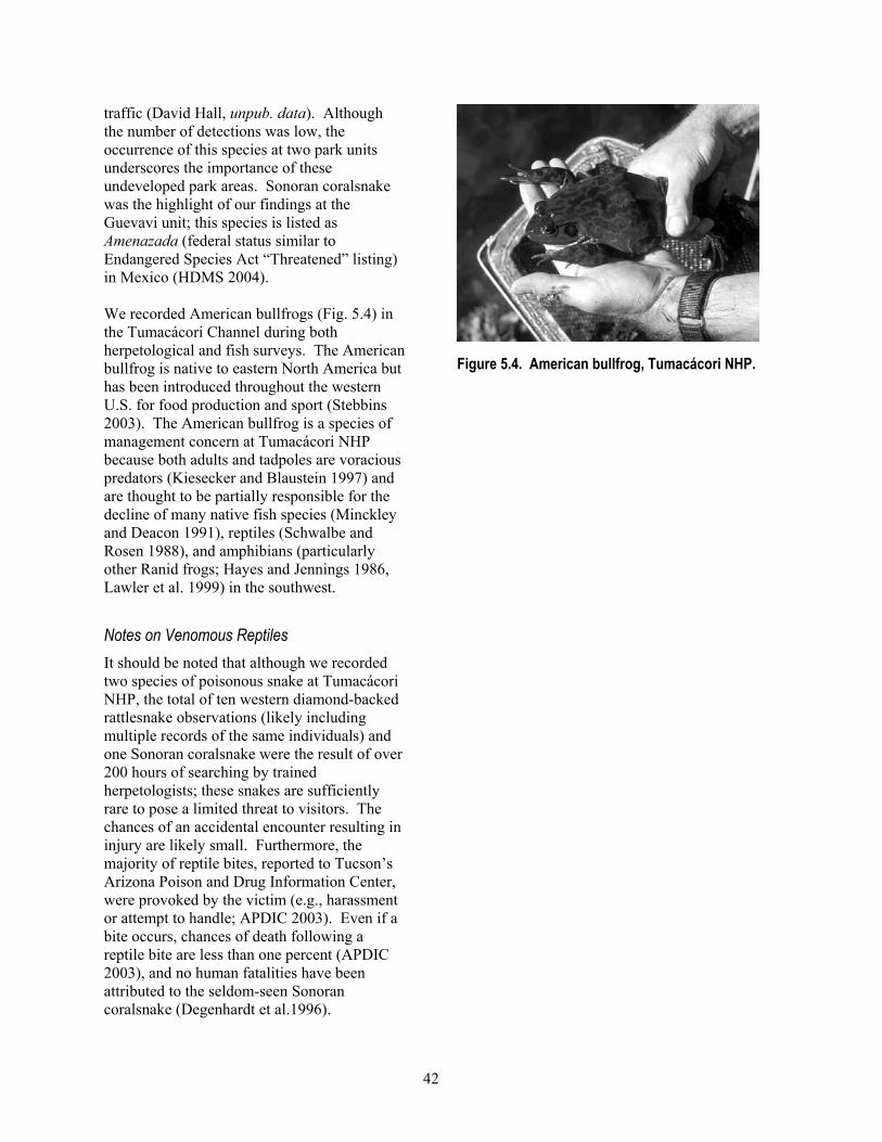
42
traffic (David Hall, unpub. data). Although the number of detections was low, the occurrence of this species at two park units underscores the importance of these undeveloped park areas. Sonoran coralsnake was the highlight of our findings at the Guevavi unit; this species is listed as Amenazada (federal status similar to Endangered Species Act “Threatened” listing) in Mexico (HDMS 2004). We recorded American bullfrogs (Fig. 5.4) in the Tumacácori Channel during both herpetological and fish surveys. The American bullfrog is native to eastern North America but has been introduced throughout the western U.S. for food production and sport (Stebbins 2003). The American bullfrog is a species of management concern at Tumacácori NHP because both adults and tadpoles are voracious predators (Kiesecker and Blaustein 1997) and are thought to be partially responsible for the decline of many native fish species (Minckley and Deacon 1991), reptiles (Schwalbe and Rosen 1988), and amphibians (particularly other Ranid frogs; Hayes and Jennings 1986, Lawler et al. 1999) in the southwest. Notes on Venomous Reptiles It should be noted that although we recorded two species of poisonous snake at Tumacácori NHP, the total of ten western diamond-backed rattlesnake observations (likely including multiple records of the same individuals) and one Sonoran coralsnake were the result of over 200 hours of searching by trained herpetologists; these snakes are sufficiently rare to pose a limited threat to visitors. The chances of an accidental encounter resulting in injury are likely small. Furthermore, the majority of reptile bites, reported to Tucson’s Arizona Poison and Drug Information Center, were provoked by the victim (e.g., harassment or attempt to handle; APDIC 2003). Even if a bite occurs, chances of death following a reptile bite are less than one percent (APDIC 2003), and no human fatalities have been attributed to the seldom-seen Sonoran coralsnake (Degenhardt et al.1996).
Figure 5.4. American bullfrog, Tumacácori NHP.

43
Chapter 6: Bird Inventory
Previous Research Previous bird research at Tumacácori NHP focused on the yellow-billed cuckoo (Powell 2000) and on mist-netting passerines and hummingbirds from 1997 to 2004 (MAPS; Turner 2003, Susan Wethington, unpub. data). Methods We surveyed for birds at the Tumacácori unit in 2001 and at all three units in 2002 and 2003. We used four field methods: variable circular-plot (VCP) counts for diurnal breeding-season birds, nocturnal surveys for owls and nightjars during the breeding season, line-transects for fall and winter-season birds, and incidental observations for all birds in all seasons. Although surveys in the fall and winter were not included in the original study proposal (Davis and Halvorson 2000), we nevertheless felt they were important because many species that use the area during the fall and winter may not be present during VCP surveys. We did, however, concentrate most of our survey effort during the breeding season because bird distribution is relatively uniform during the breeding season due to territoriality among birds (Bibby et al. 2000). This survey timing increases our precision in estimating relative abundance and enabled us to document breeding activity. Our survey period included peak spring migration times for most species, which added many migratory species to our list. We also sampled vegetation around VCP survey stations. Vegetation structure and plant species composition are important predictors of bird species richness or the presence of particular species (MacArthur and MacArthur 1961, Rice et al. 1984, Strong and Bock 1990, Powell and Steidl 2000). By identifying broad-scale vegetation characteristics associated with high species richness at the park, park managers can guide development and other human impacts away from the areas that contribute disproportionably to the rich bird community.
In most cases we do not report observations that failed to determine the species (e.g., “unknown woodpeckers”). Ravens and meadowlarks are an exception. Both the Chihuahuan and common ravens occur at the park and both species are difficult to differentiate unless they are viewed at a short range under certain conditions or if they are seen flying together (Bednarz and Raitt 2002). We were not able to positively determine the species for any raven sighting and therefore report all observations as “unknown raven.” For meadowlarks we were unable to determine the species of one individual observed during line-transect surveys; we report this record as “unknown meadowlark.” Spatial Sampling Designs We subjectively determined the location of all survey stations and transect sections as a matter of convenience or logistical necessity. Because of the small size of all three units we almost completely covered the park (Figs. 6.1, 6.2). We did not visit the Calabazas or Guevavi units in 2001 because these units were not included in the original study plan (Davis and Halvorson 2000); however, we included these units in 2002 and 2003 in order to obtain a complete inventory. We placed VCP stations and line-transect sections in sites selected to represent the bird communities in each park unit (Table 6.1). The relatively low number of stations and sections at Calabazas and Guevavi units are due to their small size. Although each of these smaller units possesses fewer than half the stations or transects present at the Tumacácori unit, together they comprise the most-sampled community type (semi-desert grassland; see below for description of community type designations). The “developed” community type at the Tumacácori unit was represented by only one station or transect section, and this was proportionate to its small area that includes buildings, bird feeders, and ornamental vegetation.

44
Figure 6.1. Locations of VCP survey stations and line-transect breaks (winter) for birds, Tumacácori unit, Tumacácori NHP, 2001–2003. See Appendix L for UTM coordinates.

45
Figure 6.2. Locations of VCP survey stations and line-transect breaks (winter) for birds, Calabazas and Guevavi units, Tumacácori NHP, 2002–2003. See Appendix L for UTM coordinates.

46
Table 6.1. Bird survey effort by method and community type, Tumacácori NHP, 2001–2003. Number of visits Survey type Park unit Community type
Number of stations or sections 2001 2002/2003 Efforta
VCP Calabazas Semi-desert grassland 3 0 5 15 Guevavi Semi-desert grassland 2 0 5 10 Tumacácori Mesquite bosque 3 4–5 7 35 Riparian 4 4 6–7 47 Developed 1 5 7 12 Line transect Calabazas Semi-desert grassland 3 0 3–4 10 Guevavi Semi-desert grassland 1 0 4 4 Tumacácori Mesquite bosque 2 0 4 8 Riparian 3 0 3–4 11 Developed 1 0 4 4 Nocturnal Calabazas Semi-desert grassland 1 0 2 2 Guevavi Semi-desert grassland 1 0 2 2 Tumacácori Mesquite bosque 2 3 2 10 Developed 1 3 2 5 a Number of stations multiplied by number of visits. Community Types To facilitate interpretation of results, we grouped survey stations and sections into bird community types. We used Ward’s hierarchical cluster sampling (McGarigal et al. 2000) using the total number of detections of all bird species at each station from VCP surveys. Clustering is a multivariate classification technique useful in grouping samples that share similar species assemblages (McGarigal et al. 2000). We identified four community types: semi-desert grassland, mesquite bosque, riparian, and developed. For a description of all community types (except the developed type) see the Vegetation section in Chapter 2. The developed community type at the Tumacácori unit was represented by one station, centered in the courtyard of the Tumacácori Mission; vegetation included scattered mesquite, hackberry, and elderberry and various ornamental trees and shrubs. This was also the only area with bird feeders. VCP Surveys Field Methods We used the variable circular-plot (VCP) method to survey for diurnally active birds during the breeding season (Reynolds et al. 1980, Buckland et al. 1993). Conceptually, these surveys are similar to traditional “point counts” (Ralph et. al 1995) during which an observer spends a standardized length of time
at one location and records all birds seen or heard and the distance to each bird or group of birds. We established one transect in 2001 at the Tumacácori unit (8 stations) and one transect each at the Calabazas (3 stations) and Guevavi (2 stations) units in 2002 (Table 6.1; Figs. 6.1, 6.2). Stations along each transect were a minimum of 250 m apart to maintain independence among observations at each station. Each year we surveyed from April through July, the period of peak breeding activity for most species in southern Arizona. The number of annual visits to each station varied slightly in some cases, but we maintained a minimum of 10 days between surveys. On each visit we alternated observers and the order in which we surveyed stations (along a transect) to minimize bias by observer, time of day, and direction of travel. We began bird surveys approximately 30 minutes before sunrise and concluded no later than four hours after sunrise, or when bird activity decreased markedly. We did not survey when winds exceeding 15 km/h or when precipitation exceeded an intermittent drizzle.
We recorded a number of environmental variables prior to beginning each transect: wind speed category (Beaufort scale), presence and severity of rain (qualitative assessment),

47
air temperature (ºF), relative humidity (%), and cloud cover (%). After arriving at a station, we waited for one minute before beginning the count to allow birds to resume their normal activities. We identified (to species) all birds seen or heard during an eight-minute “active” period. For each detection, we recorded its distance in meters from the observer (measured with laser range finder when possible), time of detection (measured in one-minute intervals beginning at the start of the active period), and the sex and/or age class (adult or juvenile) if known. We did not measure distances to birds that were seen flying overhead, nor did we use techniques to attract birds (e.g., “pishing”). We made an effort to avoid double-counting individuals that had been recorded at previous stations. If we observed a species during the “passive” count period (between the eight-minute counts), and which had not been recorded previously at a station on that visit, we recorded its distance to the nearest station. Effort We visited eight stations at the Tumacácori unit from four to seven times each in both 2001 and 2002 (Table 6.1). We visited the stations at the Calabazas and Guevavi units (three and two stations, respectively) five times each in 2002. We visited each park unit at least five times, and visited stations representing each community type at least 12 times over the two-year period. Analysis We calculated relative abundance of each species in each community type as the total number of detections at all stations and visits, divided by effort (the number of stations multiplied by the number of visits) for 53 of the most common species. We reduced our full collection of observations from the two years of the study (n = 2,360) to a subset of data (n = 1,282) more appropriate for estimating relative abundance. First, we used only those detections that occurred < 75 m from each count station (thereby excluding 586 observations) to facilitate comparisons of relative abundance of species, both within and among community types. We truncated
observations because the probability of detecting an individual is a function of both the conspicuousness of the species (ranging from loud and highly visible [e.g., the Gila woodpecker] to the quiet [e.g., the varied bunting]) (Verner and Ritter 1983) and the structure of the vegetation. By truncating we assume that all individuals within 75 m of all stations can be detected with equal probability. We excluded additional observations to further standardize data for comparative purposes: birds flying over stations (255 observations), birds observed outside of the eight-minute count period (278 observations), unknown species except ravens (35 observations), and instances when an observer failed to record a distance (4 observations). In addition, we excluded 38 species that were recorded on fewer than two occasions in both years (52 observations); these species were not reliable components of the bird community but are included in our species list for the park (Appendix D). Some observations met more than one of these criteria for exclusion from analyses. We modified the relative abundance estimates for six species that arrived at the park later in the breeding season (yellow-billed cuckoo, blue grosbeak, and varied bunting) or left early (Wilson's warbler, green-tailed towhee, and white-crowned sparrow; see Appendix T for arrival and departure time periods). For these species we used a sample size of one-half of that used for the other species to estimate their relative abundance in each community type. The results for these species (Table 6.2), therefore, should be interpreted as relative abundance during half of the breeding season, and not as the mean across the entire season as applies to the other species. Line-transect Surveys Field Methods We used a modified line-transect method (Bibby et al. 2000) to survey for birds in all units from November 2002 to January 2003. Line transects differ from station transects (such as those used in our VCP surveys) in that an observer records birds seen or heard while
48
the observer walks an envisioned transect line, rather than by standing at a series of stations. The transect method is more effective during the non-breeding season because bird vocalizations are less conspicuous and frequent, and therefore birds tend to be less visible (Bibby et al. 2000). At Tumacácori NHP we established transects along trails or in areas that provided relatively easy walking; observers needed to focus on detecting birds rather than on footing or obstacles. We divided transects into sections of approximately 250 m in length. Section breaks corresponded with VCP station locations (Figs. 6.1, 6.2). To account for seasonal variation in bird distribution and abundance, we visited each transect four times with about three weeks between each visit. As with other survey methods, we alternated observers and direction of travel along transects to reduce biases, and did not survey during periods of excessive rain or wind (see VCP survey methods for details). We began surveys about 30 minutes after sunrise and continued until all transect sections (in all three units) were completed. As with VCP surveys, we recorded weather conditions at the beginning and end of each survey. Prior to beginning a section, we recorded the section name (e.g., “A–B”) and the start time. For ten minutes we recorded all birds seen and/or heard within each section (i.e., we timed our travel so that we traversed the section in ten minutes) using the following distance categories: < 100 m, > 100 m, or “flyover.” When possible we noted sex and age class of birds. We recorded birds observed before or after surveys as “incidentals” (see section below), and we did not use techniques to attract birds (e.g., “pishing”). Effort We visited ten line-transect sections three to four times in the fall/winter of 2002–2003 (n = 37 surveys; Table 6.1). Each unit and community type was visited four times.
Analysis We used the same community types identified for VCP surveys, because the location of sections breaks and VCP stations were the same. To estimate relative abundance we used only detections that occurred within 100 m of the transect line in an effort to reduce bias associated with varying detectability (see details in VCP section). We calculated relative abundance using the same method as for VCP surveys and report detections in the “ > 100 m” and “flyover” categories in Appendix D. Nocturnal Surveys Field Methods To survey for owls we broadcasted commercially available vocalizations (Colver et al. 1999) using a compact disc player and broadcaster (Bibby et al. 2000), and recorded other nocturnal species (nighthawks and poorwills) when heard. We established one nocturnal survey transect along a road or trail in each park unit (Table 6.1, Figs. 6.1, 6.2). The number of stations varied from one to three per transect and stations were a minimum of 300 m apart. As with other survey methods, we varied observers and direction of travel along transects and did not survey during periods of excessive rain or wind. We began surveys approximately 45 minutes after sunset. We began surveys at each station with a three-minute “passive” listening period during which time we broadcasted no calls. We then broadcasted vocalizations for a series of two-minute “active” periods. We used vocalizations of species we thought, based on habitat requirements and range, might be present: burrowing owls at Calabazas and Guevavi units; elf, western screech, and barn owls at all three units. We broadcasted recordings of owls in sequence from smallest to largest size species so that smaller species would not be inhibited by the “presence” of larger predators or competitors (Fuller and Mosher 1987). During active periods, we broadcasted owl vocalizations for 30 seconds followed by a 30-second listening period. This pattern was repeated two times for each species. We excluded great horned owl from

49
the broadcast sequence because of their aggressive behavior toward other owls. We did not specifically survey for any species listed as threatened or endangered (e.g., the cactus-ferruginous pygmy owl [Glaucidium brasilianum cactorum]) because such species require specific protocols for surveying. During the count period, we used a flashlight to scan nearby vegetation for visual detections. If we observed a bird during the three-minute passive period, we recorded the minute of the passive period in which the bird was first observed, the type of detection (aural, visual or both), and the distance to the bird. If we observed a bird during any of the two-minute active periods, we recorded in which interval(s) it was detected and the type of detection (aural, visual or both). As with other survey types, we attempted to avoid double-counting individuals recorded at previous stations. We also used multiple observers, alternated direction of travel, and did not survey during inclement weather. Effort We surveyed at five nocturnal survey stations from two to five times in 2001 and 2002 (n = 19 surveys), and surveyed each unit at least twice and each community type (except riparian) at least four times (Table 6.1). Analysis We report the total number of detections by unit; sample size was inadequate for calculating meaningful estimates of relative abundance. Incidental and Breeding Observations Field Methods When we were not conducting formal surveys and we encountered a species of interest, a species in an unusual location, or an individual displaying breeding behavior, we recorded UTM coordinates, time of detection, and (if known) the sex and age class of the bird. We noted all breeding-behavior observations using a standardized classification system (NAOAC 1990), which characterizes breeding behavior into one of nine categories: adult carrying
nesting material, nest building, adult performing distraction display, used nest, fledged young, occupied nest, adult carrying food, adult feeding young, or adult carrying a fecal sac. Analysis We provide frequency counts for species observed incidentally but do not calculate relative abundance as we did for VCP and line-transect surveys. We report results of incidental observations by park unit. For breeding behavior observations we summarize the number of observations in each category, by park unit. Vegetation Sampling at VCP Stations We sampled vegetation near each VCP survey station to characterize vegetation. These data could be used to help determine habitat associations for specific bird species and identify important features of species-rich communities at the park. We sampled vegetation at five subplots located at a modified random direction and distance from each station. Each plot was located within a 72° range of the compass from the station (e.g., Plot 3 was located between 145° and 216°) to reduce clustering of plots. We randomly placed plots within 75 m of the stations to correspond with truncation of data used in estimating relative abundance. At each plot we used the point-quarter method (Krebs 1998) to sample vegetation by dividing the plot into four quadrants along cardinal directions. We applied this method to plants in three height categories: sub-shrubs (0.5–1.0 m), shrubs (> 1.0–2.0 m), trees (> 2.0 m), and one size category: potential cavity-bearing vegetation (> 20 cm diameter at breast height). If there was no vegetation for a given category within 25 m of the plot center, we indicated this in the species column. For each individual plant, we recorded distance from the plot center, species, height, and maximum canopy diameter (including errant branches). Association of a plant to a quadrant was determined by the location of its trunk, regardless of which quadrant the majority of

50
the plant was in; no plant was recorded in more than one quadrant. Standing dead vegetation was only recorded in the “potential cavity-bearing tree” category. On rare occasions when plots overlapped we repeated the selection process for the second plot. Within a 5-m radius around the center of each plot, we visually estimated (1) percent ground cover by type (bare ground, litter, or rock); and (2) percent aerial cover of vegetation in each quadrant using three height categories: 0–0.5 m, > 0.5–2.0 m, and > 2.0 m. For both estimates we used one of six categories for percent cover: “0” (0%), “10” (1–20%), “30” (21–40%), “50” (41–60%), “70” (61–80%), and “90” (81–100%). Analysis We collected these data to characterize gross vegetation characteristics around each survey station. In the event that future bird surveys detect marked changes in species or communities, the vegetation data reported in Appendix U will provide potential explanatory variables. Results
Species Richness We recorded 146 species during the two years of the study (considering all detections and survey types; Appendix D). Although comparisons among units may be biased by unequal survey effort, species richness was highest at the Tumacácori unit (n = 129), lower at the Calabazas unit (n = 80) and lowest at the Guevavi unit (n = 74). We recorded 50 species at all three units and 59 species at only one of the three units (Appendix D). All three non-native species that we found during this study (rock pigeon, European starling, and house sparrow) were recorded at the Tumacácori unit, whereas only one (European starling) was recorded at the Calabazas unit and no non-natives were recorded at the Guevavi unit. Neotropical migrant species made up 71% (n = 103) of all species recorded (Appendix D).
VCP Surveys We recorded 104 species during VCP surveys in 2001 and 2002. Considering all species recorded at each station (including those observations that we eliminated from estimation of relative abundance, as described in the methods sections), species richness varied little among stations in each community type: mesquite bosque (n = 71 species), semi-desert grasslands (n = 69 species), riparian (n = 63 species), and developed (57 species). We found 34 species that were unique to a single community type while an equal number of species were recorded in all community types (Appendix D). The number of species unique to a community type was highest for semi-desert grassland stations (n = 14 species) and fewest for the developed station (n = 4 species). Among the stations in each of the four community types, house sparrows were most abundant and were recorded predominantly in the developed community type (Table 6.2). Other abundant species at the developed station included the vermilion flycatcher and phainopepla. At the mesquite bosque stations, the yellow-breasted chat, Bell’s vireo, and Lucy’s warbler were most abundant; at the adjacent riparian stations, the yellow-breasted chat, Bewick’s wren, and song sparrow were the most abundant. At the Calabazas and Guevavi units, representing the semi-desert grassland community type, the Lucy’s warbler and Bewick’s wren were the most abundant (Table 6.2). Line-transect Surveys We recorded 56 species during line-transect surveys in the three park units (Table 6.3). Species richness was highest in the semi-desert grasslands (23 species) and lower in the other community types (21 species each). The most abundant species in each community type were: the chipping and white-crowned sparrows in the mesquite bosque; the European starling and white-crowned sparrow in the developed; the yellow-rumped warbler and chipping sparrow in the riparian; and the
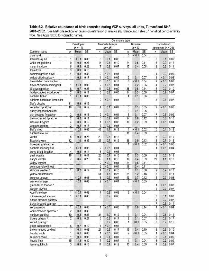
51
Table 6.2. Relative abundance of birds recorded during VCP surveys, all units, Tumacácori NHP, 2001–2002. See Methods section for details on estimation of relative abundance and Table 6.1 for effort per community type. See Appendix D for scientific names. Community type Developed
(n = 12) Mesquite bosque
(n = 35) Riparian (n = 43)
Semi-desert grassland (n = 25)
Common name n Mean SE n Mean SE n Mean SE n Mean SE gray hawk 3 < 0.1 0.04 Gambel's quail 1 < 0.1 0.08 5 0.1 0.08 3 0.1 0.09 white-winged dove 9 0.8 0.28 14 0.4 0.10 24 0.6 0.11 5 0.2 0.12 mourning dove 6 0.5 0.23 7 0.2 0.07 15 0.4 0.08 8 0.3 0.11 Inca dove 3 0.3 0.13 common ground-dove 4 0.3 0.33 2 < 0.1 0.04 4 0.2 0.09 yellow-billed cuckoo a 1 0.2 0.17 1 < 0.1 0.06 2 0.1 0.07 1 < 0.1 0.08 broad-billed hummingbird 16 0.5 0.13 3 < 0.1 0.04 2 < 0.1 0.06 black-chinned hummingbird 1 < 0.1 0.08 2 < 0.1 0.04 8 0.2 0.06 4 0.2 0.07 Gila woodpecker 8 0.7 0.26 11 0.3 0.09 35 0.8 0.14 5 0.2 0.10 ladder-backed woodpecker 2 0.2 0.11 5 0.1 0.06 14 0.3 0.09 4 0.2 0.07 northern flicker 1 < 0.1 0.08 4 0.1 0.06 northern beardless-tyrannulet 2 < 0.1 0.04 3 0.1 0.07 Say's phoebe 11 0.9 0.19 vermilion flycatcher 19 1.6 0.19 4 0.1 0.07 5 0.1 0.05 2 < 0.1 0.06 dusky-capped flycatcher 6 0.1 0.05 ash-throated flycatcher 3 0.3 0.18 2 < 0.1 0.04 6 0.1 0.07 7 0.3 0.09 brown-crested flycatcher 2 0.2 0.11 6 0.2 0.08 24 0.6 0.12 8 0.3 0.10 Cassin's kingbird 4 0.3 0.19 1 < 0.1 0.03 10 0.2 0.09 1 < 0.1 0.04 western kingbird 2 0.2 0.17 3 0.1 0.06 Bell's vireo 1 < 0.1 0.08 48 1.4 0.12 1 < 0.1 0.02 10 0.4 0.12 bridled titmouse 18 0.4 0.09 verdin 5 0.4 0.26 29 0.8 0.13 5 0.2 0.10 Bewick's wren 12 1.0 0.35 26 0.7 0.12 39 0.9 0.13 18 0.7 0.16 blue-gray gnatcatcher 1 < 0.1 0.02 2 < 0.1 0.06 northern mockingbird 1 < 0.1 0.08 2 < 0.1 0.04 1 < 0.1 0.04 curve-billed thrasher 4 0.3 0.14 5 0.1 0.06 phainopepla 16 1.3 0.41 26 0.7 0.15 13 0.3 0.09 12 0.5 0.13 Lucy's warbler 7 0.6 0.23 39 1.1 0.15 16 0.4 0.09 27 1.1 0.18 yellow warbler 2 < 0.1 0.04 24 0.6 0.11 common yellowthroat 2 < 0.1 0.04 16 0.4 0.11 Wilson's warbler a 1 0.2 0.17 4 0.2 0.18 3 0.1 0.08 2 0.2 0.10 yellow-breasted chat 54 1.5 0.25 51 1.2 0.18 8 0.3 0.11 summer tanager 1 < 0.1 0.08 8 0.2 0.07 29 0.7 0.12 5 0.2 0.08 western tanager 1 < 0.1 0.08 2 < 0.1 0.04 3 < 0.1 0.05 green-tailed towhee a 1 < 0.1 0.08 canyon towhee 4 0.2 0.07 Abert's towhee 1 < 0.1 0.08 7 0.2 0.08 3 < 0.1 0.04 rufous-winged sparrow 1 < 0.1 0.08 6 0.2 0.06 3 0.1 0.07 rufous-crowned sparrow 4 0.2 0.07 black-throated sparrow 7 0.3 0.14 song sparrow 1 < 0.1 0.08 1 < 0.1 0.03 36 0.8 0.14 1 < 0.1 0.04 white-crowned sparrow a 2 0.3 0.33 northern cardinal 10 0.8 0.21 34 1.0 0.12 4 0.1 0.04 12 0.5 0.14 blue grosbeak a 2 0.3 0.21 6 0.3 0.14 2 0.1 0.07 3 0.2 0.17 varied bunting a 3 0.2 0.09 1 < 0.1 0.05 2 0.2 0.15 great-tailed grackle 8 0.7 0.19 1 < 0.1 0.03 brown-headed cowbird 1 0.1 0.08 21 0.6 0.17 19 0.4 0.10 8 0.3 0.10 hooded oriole 1 0.1 0.08 1 < 0.1 0.03 2 < 0.1 0.05 1 < 0.1 0.04 Bullock's oriole 1 0.1 0.08 4 0.1 0.07 3 0.1 0.09 house finch 15 1.3 0.30 7 0.2 0.07 4 0.1 0.04 6 0.2 0.09 lesser goldfinch 3 0.3 0.13 14 0.4 0.12 15 0.4 0.09 4 0.2 0.07

52
Community type Developed
(n = 12) Mesquite bosque
(n = 35) Riparian (n = 43)
Semi-desert grassland (n = 25)
Common name n Mean SE n Mean SE n Mean SE n Mean SE house sparrow 32 2.7 1.01 1 < 0.1 0.03 a Relative abundance for these species was calculated using a reduced value for effort; see text for details. chipping sparrow and mourning dove in the semi-desert grassland (Table 6.3). Excluding incidental observations and nocturnal records from both seasons, we recorded 13 species (26%) during line-transect surveys that we did not record during the VCP surveys. Conversely, we recorded 68 species (65%) during VCP surveys that we did not record during line-transect surveys. Nocturnal Surveys We recorded three species of owls and one common poorwill at the Guevavi unit, two species of owl at the Tumacácori unit and no species at the Calabazas unit. All four nocturnal species at the Guevavi unit were recorded during one survey. We detected the barn owl twice at the Tumacácori unit and once at the Guevavi unit; the western screech owl seven times at the Tumacácori unit and twice at the Guevavi unit; and the elf owl and the common poorwill once and three times, respectively, at the Guevavi unit. Incidental and Breeding Observations We recorded incidental observations of 121 species at the park: 60 species at the Calabasas unit, 50 species at the Guevavi unit, and 100 species at the Tumacácori unit. We recorded 41 species that were not recorded during another survey type. We confirmed breeding for 32 species based on 72 observations of breeding behavior or evidence (Table 6.4). The highest number of species (n = 27) for which breeding was confirmed was at the Tumacácori unit, and the most records for an individual species (vermilion flycatcher; n = 9) were also at the Tumacácori unit. The fewest number of
species confirmed as breeders (n = 6) were recorded at the Guevavi unit, though two of these (Inca dove and common ground dove) were not recorded as breeding in either of the other units (Appendix U). Similarly, we observed evidence of breeding in three species at the Calabazas unit (lark sparrow, black-throated sparrow, and blue grosbeak) that were not observed in the other two units. We found two nests (one each of the Bell’s vireo and vermilion flycatcher) where adults were feeding brown-headed cowbird young. Inventory Completeness Based on the species accumulation curve, which shows the number of new species reaching an asymptote, we believe that we have recorded > 90% of the species that breed in and around the park or that stopover for a significant amount of time during the time of the VCP surveys (Fig. 6.3). However, based on the high bird species richness and the diversity of vegetation components at the park, we believe that the bird inventory is not complete and is likely missing spring and fall migrants and winter residents (Fig. 6.3). There are at least 40 species that were not recorded by us, MAPS personnel, or other researchers or observers, but which are likely to be recorded at Tumacácori NHP with additional survey effort (Appendix H; see Recommendations section for suggestions for completing inventories).
Discussion This bird inventory is an important step in understanding the valuable role of the park and surrounding lands in providing habitat for birds. With moderate search effort (approximately 20 field days over two years) we recorded 146 species, several of which

53
Table 6.3. Relative abundance of birds recorded during line-transect surveys, all units, Tumacácori NHP, 2002–2003. See Methods section for details on estimation of relative abundance and Table 6.1 for effort per community type. See Appendix D for scientific names. Community type Developed
(n = 4) Mesquite bosque
(n = 8) Riparian (n = 11)
Semi-desert grassland (n = 14)
Common name n Mean SE n Mean SE n Mean SE n Mean SE great egret 1 0.1 0.09 Cooper's hawk 1 0.1 0.09 red-tailed hawk 1 0.3 0.25 1 0.1 0.09 2 0.1 0.10 mourning dove 12 0.9 0.42 common ground-dove 1 0.1 0.09 greater roadrunner 1 0.1 0.13 Gila woodpecker 1 0.3 0.25 7 0.6 0.28 3 0.2 0.11 ladder-backed woodpecker 1 0.1 0.07 hairy woodpecker 1 0.1 0.13 northern flicker 1 0.3 0.25 2 0.3 0.16 3 0.3 0.19 4 0.3 0.22 gray flycatcher 1 0.1 0.07 black phoebe 3 0.3 0.14 Say's phoebe 4 1.0 0.71 2 0.3 0.16 vermilion flycatcher 1 0.1 0.13 ash-throated flycatcher 1 0.1 0.13 1 0.1 0.07 Cassin's kingbird 1 0.3 0.25 solitary vireo type 1 0.1 0.09 unknown raven 1 0.1 0.09 6 0.4 0.25 bridled titmouse 4 0.5 0.33 7 0.6 0.31 verdin 3 0.8 0.25 9 1.1 0.30 3 0.3 0.14 6 0.4 0.23 rock wren 1 0.1 0.07 Bewick's wren 5 1.3 0.48 10 1.3 0.31 8 0.7 0.27 8 0.6 0.20 house wren 1 0.1 0.13 1 0.1 0.09 ruby-crowned kinglet 1 0.3 0.25 9 1.1 0.44 7 0.6 0.24 2 0.1 0.10 blue-gray gnatcatcher 1 0.1 0.07 black-tailed gnatcatcher 1 0.1 0.07 hermit thrush 1 0.1 0.09 American robin 2 0.2 0.12 northern mockingbird 1 0.1 0.07 European starling 4 1.0 1.00 cedar waxwing 3 0.8 0.75 yellow-rumped warbler 3 0.8 0.75 3 0.4 0.25 9 0.9 0.53 green-tailed towhee 5 1.3 0.63 1 0.1 0.13 canyon towhee 7 0.5 0.27 Abert's towhee 5 0.6 0.32 3 0.3 0.14 1 0.1 0.07 rufous-winged sparrow 2 0.5 0.29 1 0.1 0.13 9 0.6 0.29 chipping sparrow 3 0.8 0.75 6 0.8 0.62 2 0.2 0.18 4 0.3 0.29 lark sparrow 1 0.3 0.25 black-throated sparrow 7 0.5 0.25 song sparrow 3 0.3 0.14 1 0.1 0.07 white-crowned sparrow 13 3.3 1.31 6 0.8 0.62 dark-eyed junco 1 0.3 0.25 northern cardinal 3 0.8 0.48 7 0.9 0.40 2 0.1 0.10 pyrrhuloxia 2 0.5 0.50 2 0.3 0.25 unknown meadowlark 1 0.1 0.07 house finch 2 0.5 0.50 2 0.1 0.10 lesser goldfinch 1 0.1 0.13 2 0.2 0.12 house sparrow 3 0.8 0.75

54
Table 6.4. Observations of breeding behavior by birds, Tumacácori NHP, 2001–2002. Breeding codes follow standards set by NAOAC (1990). See Appendix D for scientific names. Breeding behavior category
Park unit Common name
Adult(s) carrying
food
Adults carrying nesting material
Fledged young
Adult feeding fledged young
Nest building
Nests with
egg(s)
Nest with young
seen/heard Occupied
nest Calabazas Gambel's quail Cassin's kingbird 1 verdin 1 Lucy's warbler 1 Abert's towhee 1 lark sparrow 1 black-throated sparrow 2 blue grosbeak 1 Guevavi white-winged dove 1 Inca dove 1 common ground-dove 1 1 Cassin's kingbird 1 verdin 1 Lucy's warbler 1 Tumacácori Cooper's hawk 1 1 gray hawk 1 Gambel's quail white-winged dove 2 broad-billed hummingbird 2 black-chinned hummingbird 1 1 Gila woodpecker 1 1 2 ladder-backed woodpecker 1 Say's phoebe 1 vermilion flycatcher 2 1 1 1 4 Cassin's kingbird 1 Bell's vireo 1 1 verdin 1 1 Bewick's wren 1 northern mockingbird 1 2 curve-billed thrasher 1 1 2 2 1 European starling 1 phainopepla 1 Lucy's warbler 1 2 1 yellow warbler 1 common yellowthroat 1 yellow-breasted chat 1 1 1 summer tanager 1 Abert's towhee 1 song sparrow 1 northern cardinal 1 1 brown-headed cowbird 2 Total by nesting category 6 1 23 9 5 6 8 14

55
Figure 6.3. Species accumulation curves for number of bird species by sample event (i.e., survey days) for VCP and line-transect surveys, all units, Tumacácori NHP, 2001–2003. have narrow habitat requirements in the southwest. We do not hesitate to conclude that the park possesses valuable and regionally unique resources for birds and maintains a remarkable avifauna. Seventy percent of the species we recorded were Neotropical migrants (Appendix D). We recorded a number of species of special conservation status (U.S. Fish and Wildlife Service; HDMS 2004): one endangered species (southwestern willow flycatcher); one candidate for endangered-species status (yellow-billed cuckoo); and three species of concern (white-faced ibis, gray hawk, and peregrine falcon). The Monitoring Avian Productivity and Survivorship (MAPS) personnel recorded the olive-sided flycatcher (Turner 2003), an additional species of concern. We recorded only 16 individuals during 19 visits to nocturnal count stations (Table 6.4). Nevertheless, we recorded most of the owl and nightjar species that regularly inhabit the area, except for great horned owl, which was a surprising omission. Based on vegetation characteristics present in the park units, an increased survey effort would likely document all three owl species that we recorded at the Guevavi unit at the other two units, and the
great horned owl in all three units. Additional species such as long-eared owl and northern saw-whet owl are possible at all three units. Based on its distribution in southern Arizona and adjacent Sonora, Mexico, the endangered cactus ferruginous pygmy-owl is unlikely to be at the park (Aaron Flesch, pers. comm.). Cottonwood/Willow Riparian Area Tumacácori NHP contains riparian vegetation components that are extremely rare in the southwest, most notably the cottonwood/willow gallery riparian forest (Ohmart 1994). Bird species such as the yellow-billed cuckoo, yellow warbler, common yellowthroat, and song sparrow (Table 6.2) are almost completely reliant on cottonwood/willow forests for nesting habitat in the southwest (Rosenberg et al. 1991). Because of the loss and degradation of this community type across the region (Russell and Monson 1998), the local abundance of these species highlights the importance of the park and surrounding areas for their conservation. Two species in particular are noteworthy: yellow-billed cuckoo and southwestern willow flycatcher (discussed below).
Number of sample events
0 2 4 6 8 10 12 14
Cum
ultiv
e nu
mbe
r of s
peci
es
20
30
40
50
60
70
80
90
100
VCP surveysLine-transect surveys

56
Yellow-billed Cuckoo The riparian area at the Tumacácori unit has one of the highest densities of yellow-billed cuckoos in the western U.S. (Powell 2000). The yellow-billed cuckoo is currently being considered for listing under the Endangered Species Act because of an alarming reduction in its breeding distribution over the last 50 years (Laymon and Halterman 1987, Hughes 1999). We recorded only four yellow-billed cuckoos during our VCP surveys. This low number is not surprising given the inconspicuous behavior of the bird and its late arrival on the breeding ground (Hughes 1999), but this also highlights that the VCP survey method is inappropriate for estimating abundance for this species. Based on the findings by Powell (2000, 2001 unpub. data), more yellow-billed cuckoos were present at the Tumacácori unit than we recorded. Southwestern Willow Flycatcher We recorded one confirmed sighting of the endangered southwestern willow flycatcher along the Santa Cruz River on 25 June 2001. The three other willow flycatchers that we recorded may have been the southwestern subspecies, but this could not be determined. Surveys specifically targeted for the species in 2002 did not locate the southwestern subspecies (Brian Powell, unpub. data; submitted to the Arizona Game and Fish Department). This may have been due to increased numbers of cattle in the riparian area in 2002 and the subsequent reduction of vegetation structure (Brian Powell, pers. obs.). The southwestern subspecies prefers dense understory vegetation for nest sites (Hatten and Paradzick 2003) and it is unclear whether the riparian area at the Tumacácori unit provides adequate breeding habitat for the species. Mesquite Bosque The mesquite bosque plant community once covered large areas of the valley bottoms such as in the Santa Cruz River drainage (Arnold 1940), but due to woodcutting, groundwater pumping, and invasion of tamarisk, this plant community is increasingly rare (Bahre 1991). Bird species inhabiting this community
include: the Bell’s vireo, Lucy’s warbler, yellow-breasted chat, Abert’s towhee, and varied bunting (Rosenberg et al. 1991). Non-native Species The abundance of house sparrows in the developed area around the Tumacácori Mission can be problematic for both the native bird species and cultural resources. House sparrows nest in cavities or on ledges (e.g., broken limbs, woodpecker cavities, and cracks in walls; Erlich et al. 1988), and are known to be aggressive toward other cavity-nesting species. At Tumacácori NHP these sparrows may displace cavity-nesters such as the Bewick’s wren and Lucy’s warblers, can damage cultural resources by enlarging existing cracks, and certainly create a nuisance and distraction via excessive nest material and defecation. Brown-headed Cowbirds The brown-headed cowbird is endemic to the Great Plains and Great Basin regions of the U.S. where it evolved a comensal relationship with the bison (Bison bison) and other large ungulates (Rothstein 1994). Since the arrival of cattle in the southwest, however, brown-headed cowbird populations have thrived (Mehlman 1995). During the breeding season, brown-headed cowbirds prefer edge communities, the abrupt interface of agricultural fields and human development with areas of dense vegetation, particularly along riparian areas (Rothstein 1994) such as at Tumacácori NHP. Brown-headed cowbirds were abundant at the park during the breeding season in all community types except the developed area (Table 6.2). Brown-headed cowbirds pose a threat to many native birds because they are brood parasites (i.e., lay their eggs in the nests of other species), thereby reducing the productivity of host species. Species particularly susceptible to brown-headed cowbird parasitism include four abundant Neotropical migrants at Tumacácori NHP: Bell’s vireo, song sparrow, yellow-breasted chat, and yellow warbler (see review in

57
Schwietzer et al. 1998, Averill-Murray et al. 1999, Powell and Steidl 2000). In 2000, B. Powell (unpub. data) found six yellow-breasted chat nests at the Tumacácori unit that contained at least one cowbird egg each. Brown-headed cowbirds can be controlled by removing habitat (food and foraging sites) and by trapping (which has some success at increasing host productivity [Smith et al. 2002]). Habitat removal is not logistically possible and trapping is currently beyond the limited time and budget of park staff. Monitoring Avian Productivity and Survivorship Study The Monitoring Avian Productivity and Survivorship (MAPS) study at the Tumacácori unit provides further evidence of the uniqueness of the bird community in this area (see DeSante et al. 1995 for more information on the program). The MAPS station at the park is located in the mesquite bosque and cottonwood/willow riparian area and has been in operation since 1997. In the seven years of station operation, MAPS personnel have recorded a total of 128 species, 20 of which are not on our species list, including: elegant trogon, worm-eating warbler, ovenbird, and the northern and Louisiana waterthrushes (Turner 2003; Appendix D). Station personnel also noted evidence of breeding for 33 species.

58
59
Chapter 7: Mammal Inventory
Previous Research To our knowledge, there has been no previous mammal research at Tumacácori NHP, though some mammal specimens have been collected from the park (Appendix O). Methods We surveyed for mammals using four field methods: trapping for small terrestrial, nocturnal mammals (primarily rodents, herein referred to as small mammals), infrared-triggered photography for medium and large mammals, investigation of roost sites for bats, and incidental observations for all mammals. Spatial Sampling Design To assign plot locations for most small mammal trapping plots (n = 19) we used a simple random design. In addition, we subjectively placed three plots each at the Calabazas and Guevavi units (C1–C3 and G1–G3, respectively). We subjectively placed infrared-triggered cameras in areas that we thought would yield the most results (e.g., along animal trails). We searched for bats at roost sites at the Tumacácori Mission. Small Mammals Field Methods We trapped small mammals at all three units in 2000 and 2001 (Figs. 7.1, 7.2). We used Sherman® live traps (large, folding aluminum or steel, 3 x 3.5 x 9”; H. B. Sherman, Inc., Tallahassee, FL) set in grids (White et al. 1983), with 10-m spacing among traps arranged in configurations of five rows and five columns (Calabazas and Guevavi units) or 10 rows and five columns (Tumacácori unit). We opened and baited (one tablespoon; 16 parts dried oatmeal to one part peanut butter) traps in the evening then checked and closed traps the following morning. We placed a small amount of polyester batting in each trap to prevent mortality from the cold. We marked each captured animal with a semi-permanent marker to facilitate recognition; these “batch
marks” appeared to last for the duration of the sampling period (one to three days). For each animal we recorded species, sex, age class (adult, subadult, or juvenile), reproductive condition, weight, and measurements for right-hind foot, tail, ear, and head and body. For males, we recorded reproductive condition as either scrotal or non-reproductive. For females we recorded reproductive condition as one or more of the following: non-reproducing, open pubis, closed pubis, enlarged nipples, small or non-present nipples, lactating, post lactating, or not lactating. Effort We typically trapped for sampling periods of three nights at all plots (11 at the Tumacácori unit, nine at the Calabazas unit, and five at the Guevavi unit; Figs. 7.1, 7.2). Because of differences in unit size, number of plots, and the number of sprung but empty traps, the number of trap nights (see below for definition) varied by unit: Calabazas = 613; Guevavi = 382; Tumacácori = 1,695. Analysis We summarized data for each unit separately. We calculated relative abundance for species in each unit by dividing the number of captures by the number of trap nights (number of traps multiplied by number of nights they were open) after accounting for sprung traps (misfired or occupied; Beauvais and Buskirk 1999). Sprung traps reduce trap effort because they are no longer “available” to capture animals; we account for this by multiplying the number of sprung traps by 0.5 (lacking specific information, we estimate sprung traps were available for half of the night) (Nelson and Clark 1973). Note on Sigmodon Species During fieldwork we recorded two species of cotton rats (Arizona and yellow-nosed) but verification of our single voucher specimen for the yellow-nosed cotton rat confirmed it as a fulvous cotton rat. Given this uncertainty in

60
Figure 7.1. Locations of small mammal trapping plots and infrared-triggered cameras, Tumacácori unit, Tumacácori NHP, 2000–2001. See Appendix M for plot coordinates.

61
Figure 7.2. Locations of small mammal trapping plots, Calabazas and Guevavi units, Tumacácori NHP, 2000–2001. See Appendix M for plot coordinates.

62
field identification of cotton rats we present trapping results for this genus as “cotton rat species.” Infrared-triggered Cameras for Medium and Large Mammals Field Methods We used infrared-triggered cameras (Trailmaster®; model 1500, Goodman and Associates, Inc, Lenexa, KS; Kucera and Barrett 1993) to record the presence of medium and large mammals at the Tumacácori unit only (Fig. 7.1). Trailmasters have three components: a receiver, transmitter, and camera (Fig. 7.3). The transmitter sends an infrared beam to the receiver at a specified rate (5 times per second for this study). The receiver then sends a signal (via cable) to a camera mounted on a tripod 6–8 m away. When an animal blocks the infrared beam, the camera takes a picture. We set the receiver and transmitter approximately 20 cm above the ground to ensure that medium and large mammals were captured on film but smaller
animals such as rodents and birds were avoided. We cleared sufficient vegetation from the area so as not to disrupt the infrared beam but simultaneously sought to minimize disturbance; animals that regularly use an area might avoid it if there were too much disturbance. We set cameras to take no more than one photograph every five minutes to reduce the chances of recording the same individual more than once (at least on the same occasion). We placed cameras in areas that would capture the most species and highest numbers of animals, typically along trails and near water (e.g., Santa Cruz River; Fig. 7.1). We baited camera sites with a commercial scent lure (ingredients included synthetic cat-nip oil, bobcat musk, beaver castorium, and propylene glycol as a preservative) or canned cat food. We checked cameras approximately every two weeks to change film and batteries and to ensure their proper function. We photographed a placard documenting the date and camera location on the first exposure of every new roll of film.
Figure 7.3. Diagram of infrared-triggered camera set-up. Image based on Swann et al. (2004).
Receiver Transmitter
(1) Animal blocks infrared beam from getting to receiver
(2) Receiver triggers camera to takepicture Infrared beam Camera

63
Analysis Infrared-triggered cameras are the most cost-effective method for recording the presence of medium and large mammal species (Kucera and Barrett 1993, Cutler and Swann 1999). However, one drawback to this method is an inability to distinguish among most individuals, which precludes unbiased estimates of abundance (i.e., one must attempt to determine if one animal has been photographed repeatedly or a new individual is in each photo). Notable exceptions are species with distinctive markings that can be differentiated among individuals, such as bobcats (Heilbrun et al. 2003). In some cases, size or physical abnormality may differentiate individuals of any species, but this was not evident frequently enough in our photographs to be useful. Therefore, we report the number of times a species was photographed. Incidental Observations and Sign As with other taxa, we recorded UTM coordinates of mammal sightings. Observers from all field crews (e.g., bird crew as well as mammal crew) recorded mammal sightings and signs such as identifiable tracks or scat, and took photo vouchers when the sign alone was definitive. Bats We visited the Tumacácori unit once, on 2 October 2001, to search for bats in and around the Mission structure. We did not mist net bats at the Santa Cruz River because netting is most efficient when areas of open water are limited, thereby concentrating foraging bats into a small area (Ronnie Sidner, pers. comm.). This was not the case at Tumacácori NHP. Results Small Mammals Excluding recaptures, we trapped 477 individuals representing 16 species on a total of 2,689 trap nights in 2000 and 2001 combined (Table 7.1, Appendix E). Species richness was highest at the Calabazas unit (n =
12), slightly less at the Tumacácori unit (n =11), and lowest at the Guevavi unit (n = 9). However, the Guevavi unit had the most number of species not recorded at other units (n = 3; brush mouse, northern pygmy mouse, and northern grasshopper mouse) although just one individual represented each of these species (Table 7.1). The desert pocket mouse was the most abundant rodent at both the Calabazas and Guevavi units and the second most abundant at the Tumacácori unit, where the cactus mouse was the most abundant (Table 7.1). The only non-native rodent, the house mouse, was recorded twice at the Calabazas unit, not at all at the Guevavi unit, and 56 times at the Tumacácori unit. Despite field identification problems for the cotton rats, we trapped at least two species (based on voucher specimens). Based on our field measurements (tail, right-hind foot) it is likely that most of the “unknown cotton rats” were Arizona cotton rats; all but two adults that were originally recorded as “Arizona cotton rat” had measurements that are consistent with that species (Hoffmeister 1986). Medium and Large Mammals We took 70 Trailmaster photographs from which we could identify an animal to genus or species, and those photographs represented 10 species (Table 7.2). Eight of 10 species photographed are represented by five or fewer photographs (Table 7.2). The Virginia opossum was the most frequently photographed species. We photographed all four species of skunks that occur in Arizona. Bats We recorded one species, the pallid bat, during our visit to the Tumacácori unit on 2 October 2001; we heard its distinctive directive calls in the open courtyard on the north side of the mission. Upon inspection of the structure we found a few minor accumulations of guano

64
Table 7.1. Total number of small mammals trapped (n) and relative abundance (RA), excluding recaptures, by park unit, Tumacácori NHP, 2000–2001. See text for relative abundance formula. See Appendix E for scientific names.
Calabazas Guevavi Tumacácori Common name n RA n RA n RA desert shrew 1 0.2 2 0.1 desert pocket mouse 56 9.1 41 10.7 47 2.8 Bailey's pocket mouse 2 0.3 1 0.3 western harvest mouse 3 0.2 fulvous harvest mouse 6 1.0 9 2.4 1 0.1 cactus mouse 17 2.8 8 2.1 76 4.5 deer mouse 4 0.7 15 0.9 white-footed mouse 2 0.3 15 0.9 brush mousea 1 0.3 northern pygmy mouse 1 0.3 northern grasshopper mousea 1 0.3 southern grasshopper mouse 18 2.9 8 2.1 3 0.2 white-throated woodrat 13 2.1 14 3.7 14 0.8 unknown cotton-ratb 25 4.1 35 2.1 house mouse 2 0.3 56 3.3 Total captures 146 84 247 Species richness 12 9 11 a Identification uncertain- see Discussion section. b We trapped at least two species (Arizona and yellow-nosed) based on identification of voucher specimens. See Methods section for more information.
Table 7.2. Results from infrared-triggered cameras, Tumacácori unit, Tumacácori NHP, 2000–2001.
Common name Number of photographs Virginia opossum 26 northern raccoon 4 western spotted skunk 4 striped skunk 2 hooded skunk 5 white-backed hog-nosed skunk 1 feral cat 4 western white-throated woodrat 5 unknown cottontail 5 collared peccary 14 Total photos 70
along the east side of the interior of the Mission structure. Voucher Specimens and Photographs We collected 31 voucher specimens representing 15 species of small mammals (Appendix E). With the exception of the above-mentioned cotton rats, vouchers for each identified species were confirmed by Yar Petryszyn (UA mammal collection curator). We did not collect specimen vouchers for two
species: brush mouse and northern grasshopper mouse and based on habitat requirements, these identifications may be questionable. We documented black bears at the park by photographing definitive tracks adjacent to the Santa Cruz River. Inventory Completeness We believe that our mammal inventory was most successful in documenting presence of small mammals. We estimate that we

65
documented > 90% of the rodent species likely to occur at the park based on the asymptote of the species accumulation curve (Fig. 7.4); we did not detect any new species in the last 10 sampling periods. However, for other groups of mammals, the picture is quite different. Based on a comparison of the species we recorded to a list of “possible” species at the park (Appendix I), we believe that we recorded approximately 41% of the species. Bats make up the bulk of the species we did not find; we recorded only one species and there are a possible 24 additional species (Appendix I). It should be noted, however, that not all of the mammal species would use the building structures or vegetation for any significant amount of time. Most may simply fly over (bats) or pass through (e.g., jaguar) the park en route to habitat elsewhere. Large mammals that we would expect to find include: gray fox, kit fox, mountain lion, and ringtail (Hoffmeister 1986). Hank Cospar, a neighboring landowner, reported shooting a mountain lion on his property in 2000 (pers. comm. to Brian Powell).
Discussion A majority of our research on mammals involved trapping small mammals at 25 sites. The high species richness of small mammal communities at the smaller Calabazas and Guevavi units is consistent with known patterns of small mammal species richness in southern Arizona; true semidesert grasslands contain the highest species richness of any vegetation community in southern Arizona (Price 1978, Stamp and Ohmart 1979, Hoffmeister 1986, Sureda and Morrison 1999). Although we did not quantify ground cover at small mammal plots, our plant surveys (particularly modular plot research at the Tumacácori unit) documented high structural diversity (based on percent cover at three height categories), which appears to be important for rodents. We observed, but did not quantify, similar vegetation characteristics at the other two units.
Figure 7.4. Species accumulation curve for small mammal trapping, all park units, Tumacácori NHP, 2000–2001. One sampling period represents one trapping event (2–3 days) at each plot.
Sampling period
0 5 10 15 20 25
Num
ber o
f spe
cies
6
8
10
12
14
16
18

66
Non-native Species The only non-native rodent species that we recorded was the house mouse. It occurred primarily at the Tumacácori unit, not far from buildings (with which it is commonly associated; Hoffmeister 1986). By using Trailmaster photographs and incidental sightings, we documented or observed the non-native domestic cat, domestic dog, and cow. Domestic cats can pose a serious problem for native vertebrates, especially rodents, reptiles and birds, through harassment and predation of nests and individuals (Clarke and Pacin 2002). Cattle Cattle are prohibited from the riparian area around the Tumacácori unit, but trespass livestock is a persistent problem. Cattle are attracted to riparian areas because of an abundance of shade and palatable forage (Kauffman and Krueger 1984), and periodic flooding complicates construction of effective cattle exclosures. Particularly during the record-dry summer of 2002 (Fig. 2.4), the persistence of livestock in the river bottom appears to have contributed to a dramatic decline in understory herbaceous vegetation volume and total vegetation cover (Brian Powell, pers. obs.). Livestock grazing has degraded an estimated 80% of streams and riparian ecosystems in the western United States through loss of vegetation, stream-bank erosion, soil compaction, flooding, and water pollution (BLM 1994). Indeed, perhaps no single land use activity has affected western riparian systems as much as cattle grazing (Bahre 1991, Fleischner 1994). Livestock grazing can also increase the number and extent of non-native plants (Belsky et al. 1999) and can negatively affect wildlife through habitat modification and competition for resources (Saab et al. 1995). Nevertheless, it appears that riparian vegetation, and the animals that rely on these rare components, can recover quickly from grazing (Krueper et al. 2003), though recovery from soil erosion and compaction may never be complete.
Virginia Opossum We documented the Virginia opossum in 37% of our infrared photographs at the Tumacácori unit. It is likely that opossums are relatively new to the area (Hoffmeister 1986) and may have several impacts, including predation of bird nests (Peterson et al. 2004), competition with other medium-sized, omnivorous mammals such as the raccoon (Ginger et al. 2003) and transmission of tuberculosis (Mycobacterium bovis) to both wildlife and livestock (Fitzgerald et al. 2003). Bats Our limited field effort (one night) to search for bats produced only one species, the pallid bat. The buildings at the Tumacácori and Calabazas units and persistence of water in the Santa Cruz River and presence of adjacent vegetation certainly host additional species, five of which have been collected from the Tumacácori mission building (Appendix O). Extirpated Species It is important to mention four species that may have occurred at Tumacácori NHP within the last 100 years but which are now extirpated: grizzly bear (Ursus arctos), Mexican gray wolf (Canis lupus baileyi), and bighorn sheep (Ovis canadensis); or is extremely rare: jaguar (Hoffmeister 1986). Among these, the jaguar is the only species that has been seen in proximity to the Tumacácori unit in the last 50 years. The most recent documentation (from a photograph in 2001) is rumored to have been from the Pajarito Mountains (approximately 20 km southwest of the Calabasas unit), but no location was released to the public.

67
Chapter 8: Management Implications
Based on the data from this study and our knowledge of the natural resource issues at the park, we point out implications that could potentially affect management of the park’s natural resources. Coordination with other agencies, non-governmental organizations, and/or adjacent landowners may prove the best route in the future to resolving some of these issues. Development Adjacent to the Park The most serious threat to the biological diversity of Tumacácori NHP is residential development of adjacent and nearby lands. The high value of real estate in the area makes it likely that many of the larger landholders will sell their land to residential real estate developers. Potential impacts of residential development include an increase in the number and extent of non-native plants (see Plant chapter for review of associated concerns), increased runoff of toxins and sediment, disruption of animal movement patterns, habitat loss and fragmentation (Mills et al. 1989, Theobald et al. 1997, Riley et al. 2003), and increased harassment and mortality of native animals by free roaming pets, and feral dogs and cats. Development will also likely increase groundwater withdrawal, possibly reducing the amount of surface water that makes the area biologically rich and valuable. Conservation easements on critical land surrounding the park, which may be most effectively pursued in partnerships with other land-management agencies, non-governmental organizations, and private landowners, could be a valuable tool in helping to maintain the biodiversity of the park. Natural Resources Staff Current staff at Tumacácori NHP includes no natural resources professionals. Thus the monument lacks an efficient means of meeting the inventory, monitoring, assessment, and management needs related to maintaining biodiversity as described in this report. Without new staff the park will likely not
effectively (1) manage non-native species, (2) coordinate monitoring activities with Sonoran Desert Network Inventory and Monitoring program, (3) work with adjacent landowners to establish compatible land-use practices, and (4) coordinate research related to other natural resources management issues at the park. Cattle and Off-road Vehicles Cattle and off-road vehicles (ORVs) have a negative impact on the soil, water, and plants of the sensitive riparian area. These impacts can lead to an increase in non-native plant species, mortality of fossorial and slow-moving vertebrate species (e.g., ornate box turtle), increased erosion, and decreased water quality. Cattle and ORVs that are in the riparian area are in trespass and the park staff is currently maintaining fencing in the riparian area. Managing Invasive, Non-native Species There are many non-native plants and animals that pose significant threats to the park’s biological and cultural resources. American bullfrog, crayfish, and western mosquitofish should be of particular concern in the Tumacácori channel. A host of terrestrial non-native species including domestic cats and dogs, cattle (mentioned above), and many non-native plants, including Bermudagrass, tamarisk, and Russian thistle, thrive in the park. It was beyond the scope of this project to investigate specific control techniques for each species. Many National Park Service units have consulted experts and developed a non-native species management plan that would guide future management decisions (e.g., NPS 1996). The work by Halvorson and Guertin (2003) would provide an excellent foundation for this process. Impacts from Undocumented Immigrants Undocumented immigrants moving through the park leave behind trash, cut trails, and potentially threaten visitor safety. Border

68
Patrol and other law enforcement personnel, in pursuit of undocumented immigrants, may intensify soil compaction, establishment of trails, and other disturbances. Other National Park Service units have successfully worked with Border Patrol and local law-enforcement agencies to maintain visitor safety and resource preservation as priorities in their resources management programs.

69
Chapter 9: Additional Inventories
No inventory is ever truly complete; species’ distributions expand and contract across boundaries with time, particularly at small parks such as Tumacácori NHP. In general, we have balanced our efforts between qualitative surveys designed to detect the maximum number of species and quantitative, repeatable surveys designed to estimate relative abundance with an associated measure of precision. Additional inventories could reach the 90% completion mark for some taxonomic groups. Future inventory efforts at Tumacácori NHP will benefit from highly skilled and experienced field personnel, and researchers who seek outside expert confirmation of species identifications (with photos or, preferably, voucher specimens) early in the inventory project. We encourage identification and a clear presentation of uncertainties when they occur and openly acknowledge and account for identification problems within genera such as Sigmodon, Cnemidophorus, Sylvilagus, and Bufo (see mammal and amphibian and reptile chapters for details). Plants Additional general botanizing surveys, carried out during wet summers in the expansion area of the Tumacácori unit, should increase the species list for annual plants. A diligent effort to seek out species that have previously been reported (Moatt et al. 1977, Bennett, year unknown) but not found during our surveys, would help confirm possible changes to the flora. Additional modular plots, especially in the under-sampled mesquite bosque and dense cottonwood/willow forests, would be an effective tool for long-term monitoring of vegetation changes. Amphibians and Reptiles Cnemidophorus (whiptail) lizards are difficult to identify; John Wright is an expert who could confirm the identity of specimens from the Tumacácori unit. Confirming whiptails to
species would require collection of perhaps 20 individuals to represent various ages and variations in appearance. Whiptails are notoriously difficult to capture; methods that we used with limited success included stunning with large rubber bands, noosing, trapping in pitfall and funnel traps, and capture in blind tubes (PVC pipes capped at one end). We were sometimes able to discover and capture whiptails by “turning cover” (i.e., looking under logs, boards, and debris) during cold mornings. A possible strategy might be to use a hardware cloth net that is chain-weighted along the edges. Perhaps the two most effective ways to increase the species list for amphibians and reptiles are: 1) take high-quality photographs of animals as they are seen and 2) collect road-killed animals, particularly snakes, from along the Frontage Road, which borders the Tumacácori unit to the west. Other inventory efforts in Sonoran Desert Network parks have benefited from collection of these indisputable forms of evidence by park staff (Don Swann, pers. comm.). The Sonoran Desert Network staff can facilitate accession of collected specimens. Birds Additional surveys during the winter and late summer/early fall migration will add species missed by our efforts. It is important to note, however, that bird lists are difficult to complete, particularly for very rare species in the area (e.g., northern parula, gray catbird, and worm-eating warbler; Appendix D). Only sites that are visited regularly by avid bird watchers (e.g., Madera Canyon, Ramsey Canyon, and Sonoita Creek Preserve in southern Arizona) have bird lists that can be considered to be largely “complete.” The riparian area at the Tumacácori unit is becoming an increasingly popular destination for bird watchers. This increased attention is due to a number of factors including presence

70
of the Monitoring Avian Productivity and Survivorship station and the designation of the area as an “Important Bird Area” by the Tucson Audubon Society. Southwestern Willow Flycatcher Surveys Additional surveys, conducted by trained observers in cooperation with Arizona Game and Fish Dept, can confirm the status of the southwestern willow flycatcher at Tumacácori NHP. Such surveys are beyond the ability of current park personnel. Mammals Additional bat surveys would be useful, particularly mist-netting along the Santa Cruz River and periodic checking of the structures for roosting bats because it is possible to observe presence of additional species using these simple methods. The use of ultrasonic detectors to identify bat species is increasing and many researchers are refining the field techniques and improving the technology (e.g., Johnson et al. 2002, Gannon et al. 2003). These technologies may become more helpful in the coming years with these refinements. Additional infrared-triggered camera work can document the presence of medium and large terrestrial mammals, and a number of species will inevitably be documented with further surveys (e.g., mountain lion). Care must be taken in placing the units because of the potential for cameras to be damaged or stolen. Effects of Water Quality on Wildlife Water quality of the Santa Cruz River is currently being monitored because most of the perennial flow in the river comes from the Nogales Wastewater Treatment Plant. Better information is needed on the effects that the chemicals left in the water following treatment have on the vertebrates in the river (King et al. 1999). Currently, residual pharmaceuticals are not being tested for and potentially may be affecting river dwelling species in the park.

71
Chapter 10: Glossary
Abundance: Number of individuals (or groups, clusters), expressed in relative or absolute terms.
Accuracy: Closeness of a measured value to the true value (see precision).
Community species richness: Number of species in a grouping, which may be delineated at various scales and perspectives (e.g., functional, geographic, taxonomic). True richness is seldom known and in this report we present recorded richness.
Density: Number of individuals scaled by unit of area or volume (e.g., four chipping sparrows/hectare).
Documented: Species was verified by evidence: voucher specimen (or parts of a specimen) or photograph (see observed and recorded).
Ecological community: A collection of populations in a defined (spatial and temporal) location (e.g., amphibians at Tumacácori NHP).
Ecological population: A group of individuals of the same species in a defined location (e.g., cottonwood trees at Tumacácori NHP).
Habitat: A species-specific term that generally refers to an area with resources and environmental conditions to promote occupancy, survival, and reproduction of that species (Morrison et al. 1998; see Chapter 1).
n: Sample size; number of sample units.
Neotropical migrants: bird species that include populations breeding north and wintering south of the Tropic of Cancer (Rappole 1995).
Observed: Species or individual seen and/or heard by a reliable observer (see documented and recorded).
Precision: Closeness of repeated measurement to each other (see accuracy).
Recorded: Species or individual observed and/or documented (see observed and documented).
Relative abundance: An index to abundance, usually the number of individuals (groups, clusters) recorded in a survey, scaled by survey effort (e.g., five gopher snakes per person-hour) and presented as a mean of all surveys, with an estimate of precision (e.g., standard error)
Standard error (SE): The standard deviation of a mean divided by the square of n; a measure of the precision of an estimate (e.g., sample mean).
Standard deviation: The square root of variance, which is the average of squared deviations from the mean. Deviation from mean is the difference between individual samples and the mean of all samples.

72

73
Chapter 11: Literature Cited
American Ornithologists’ Union (AOU). 1998. Checklist of North American birds, seventh edition. American Ornithologists’ Union and Allen Press Inc., Lawrence, KS.
American Ornithologists’ Union (AOU). 2003. Forty-second supplement to the American Ornithologists’ Union checklist of North American birds. Auk 117:847–858.
Arizona Department of Environmental Quality (ADEQ). 2000. The status of water quality in Arizona Clean Water Act section 305(b) Report 2000. EQR–00–03. Phoenix, AZ.
Arizona Department of Water Resources (ADWR). 1999. Third management plan for the Phoenix Active Management Area, 2000–2010. Phoenix, AZ.
Arizona Game and Fish Department (AZGF). 1995. Poeciliopsis occidentalis occidentalis. Unpublished abstract compiled and edited by the Heritage Data Management System, Arizona Game & Fish Department, Phoenix, AZ.
Arizona Game and Fish Department (AZGF). 2004. Accessed 5 March February 2004 from : www.gf.state.az.us/w_c/edits/hdms_status_definitions.html.
Arizona Poison and Drug Information Center (APDIC). 2003. Accessed 20 February 2003 from APDIC website: http://www.pharmacy.arizona.edu/centers/apdic/snakes.shtml.
Arnold, L. W. 1940. An ecological study of the vertebrate animals of the mesquite forest. MS thesis, University of Arizona, Tucson, AZ.
Averill-Murray, A., S. Lynn, and M. L. Morrison. 1999. Cowbird parasitism of Arizona Bell’s vireos (Vireo bellii arizonae) in a desert riparian landscape: implications for cowbird management and riparian restoration. Studies in Avian Biology 18:109–120.
Baker, R. J., L. C. Bradley, R. D. Bradley, J. W. Dragoo, M. D. Engstrom, R. S. Hoffmann, C. A. Jones, F. Reid, D. W. Rice, and C. Jones. 2003. Revised checklist of North American mammals north of Mexico, 2003. Occasional Papers of the Museum of Texas Tech University 229:1–23.
Beauvais, G. P. and S. W. Buskirk. 1999. Modifying estimates of sampling effort to account for sprung traps. Wildlife Society Bulletin 27:39–43.
Bahre, C. J. 1991. A legacy of change: historic human impact on vegetation of the Arizona borderlands. University of Arizona Press, Tucson, AZ.
Bednarz, J. C. and R. J. Raitt. 2002. Chihuahuan raven (Corvus cryptoleucus). In The birds of North America, No. 606. A. Poole and F. Gill, eds. The Birds of North America, Inc., Philadelphia, PA.
Belsky, A. J., A. Matzke, and S. Uselman. 1999. Survey of livestock influences on stream and riparian ecosystems in the western United States. Journal of Soil and Water Conservation 54:419–431.
Bennett, P. Year unknown. Reference list. (A list of plants of Tumacácori National Historic Park; obtained in 1999). Unpublished; created while an employee of the US Geological Survey, Biological Resources Division, Sonoran Desert Research Station, University of Arizona, Tucson, AZ.
Bestgen, K. R., D. A. Hendrickson, D. M. Kubly, and D. L. Propst. 1987. Movement and growth of fishes in the Gila River drainage, Arizona and New Mexico. Southwestern Naturalist 32:351–356.
Bibby, C. J., N. D. Burgess, and D. A. Hill. 2000. Bird census techniques. Academic Press, London, England.
Bock, C. E., J. H. Bock, K. L. Jepson, and J. C. Ortega. 1986. Ecological effects of planting African lovegrasses in Arizona.

74
National Geographic Research 2:456–463.
Braun-Blanquet, J. 1965. Plant sociology: the study of plant communities. Hafner Inc., London, England.
Brooks, M. L. and D. A. Pyke. 2001. Invasive plants and fire in the deserts of North America. Tall Timbers Research Station Miscellaneous Publication 11:1–14.
Brotons, L. and S. Herrando. 2001. Reduced bird occurrence in pine forest fragments associated with road proximity in a Mediterranean agricultural area. Landscape and Urban Planning 57:77–89.
Brown, D. E. and C. H. Lowe. 1980. Biotic communities of the Southwest: supplementary map to biotic communities: southwestern United States and northwestern Mexico. D. Brown, editor. University of Utah Press, Salt Lake City, UT.
Brown, D. E., C. H. Lowe, and C. P. Pase. 1979. A digitized classification system for the biotic communities of North America, with community (series) and association examples for the southwest. Journal of Arizona-Nevada Academy of Science 14:1–16.
Buckland, S. T., D. R. Anderson, K. P. Burnham, and J. L. Laake. 1993. Distance sampling: estimating abundance of biological populations. Chapman and Hall, New York, NY.
Bureau of Land Management (BLM). 1994. Rangeland reform 1994. Draft environmental impact statement. U. S. Department of the Interior, Washington, D.C.
Burt, W. H. and R. P. Grossenheider. 1976. The Peterson field guide series: a field guide to the mammals of North America north of Mexico. Houghton Mifflin, New York, NY.
California Department of Food and Agriculture (CDFA). 2004. Encycloweedia: notes on identification, biology, and management of plants defined as noxious weeds by California law. Accessed 10 February
2004 from: http://pi.cdfa.ca.gov/weedinfo/Index.html.
Chaney, E., W. Elmore, and W. S. Platts. 1990. Livestock grazing on western riparian areas. Northwest Resource Information Center Inc., Eagle, ID.
Clarke A. L. and T. Pacin. 2002. Domestic cat “colonies” in natural areas: a growing exotic species threat. Natural Areas Journal 22:154–159.
Colver, K. J., D. Stokes, and L. Stokes. 1999. Stokes field guide to bird songs. Time Warner, New York, NY.
Corn, S. P. 1994. Straight-line drift fences and pitfall traps. Pp. 109–117. In W. R. Heyer, M. A. Donnelly, R. W. McDiarmid, L. C. Hayek, and M. S. Foster, eds. Measuring and monitoring biodiversity: standard methods for amphibians. Smithsonian Institution Press, Washington, D.C.
Courtenay, W. R., Jr., and G. K. Meffe. 1989. Small fishes in strange places: a review of introduced poeciliids. Pp. 319–331. In G. K. Meffe and F. F. Snelson, Jr., eds. Ecology and evolution of livebearing fishes (Poeciliidae). Prentice Hall, Engelwood Cliffs, NJ.
Creed, R. P. 1994. Direct and indirect effects of crayfish grazing in a stream community. Ecology 75:2091–2103.
Crump, M. L., and N. J. Scott. 1994. Visual encounter surveys. Pp. 84–92. In W. R. Heyer, M. A. Donnelly, R. W. McDiarmid, L. C. Hayek, and M. S. Foster, eds. Measuring and monitoring biodiversity: standard methods for amphibians. Smithsonian Institution Press, Washington, D.C.
Cutler, T. L., and D. E. Swann. 1999. Using remote photography in wildlife ecology: a review. Wildlife Society Bulletin 27:571–581.
D'Antonio, C. M., and P. M. Vitousek. 1992. Biological invasions by exotic grasses, the grass fire cycle, and global change. Annual Review of Ecology and Systematics 23:63–87.

75
Daubenmire, R. 1976. The use of vegetation in assessing the productivity of forest lands. Botanical Review 42:115–43.
Dauble, D. D. and R. H. Gray. 1980. Comparison of a small seine and a backpack electroshocker to evaluate nearshore fish population in rivers. The Progressive Fish-Culturist 42:93–95.
Davis, K. and W. L. Halvorson. 2000. A study plan to inventory vascular plants and vertebrates: Sonoran Desert Network. National Park Service, Phoenix, AZ.
Davis, W. A. and S. M. Russell. 1999. Finding birds in southeast Arizona. Tucson Audubon Society, Tucson, AZ.
Degenhardt, W. G., C. W. Painter, and A. H. Price. 1996. Amphibians and reptiles of New Mexico. University of New Mexico Press, Albuquerque, NM.
DeSante, D. F., K. M. Burton, J. F. Saracco, and B. L. Walker. 1995. Productivity indices and survival rate estimates from MAPS, a continent-wide programme of constant-effort mist netting in North America. Journal of Applied Statistics 22:935–947.
Drake, S., H. Rodriquez-Gallegos, A. Hubbard, and S. Skirvin. 2003. Comparative analysis of remote sensing techniques for vegetation mapping and monitoring on Sonoran Desert Network parks. Report to the Sonoran Desert Network Inventory and Monitoring program, National Park Service, Tucson, AZ.
Drost, C. A. 1998. Survey of amphibians and amphibian habitat on the upper Santa Cruz River, Arizona. Unpublished report to the U.S. Bureau of Reclamation.
Ehrlich, P. R., D. S. Dobkin, and D. Wheye. 1988. The birder’s handbook: a field guide to the natural history of North American birds. Simon and Shuster, New York, NY.
Fellers, G. M. and C. A. Drost. 1994. Sampling with artificial cover. Pp. 146–150. In W. R. Heyer, M. A. Donnelly, R.
W. McDiarmid, L. C. Hayek, and M. S. Foster, eds. Measuring and monitoring biodiversity: standard methods for amphibians. Smithsonian Institution Press, Washington, D.C.
Felger, R. S. 1990. Non-native plants of Organ Pipe Cactus National Monument, Arizona. Technical Report No. 31. Cooperative National Park Resource Studies Unit, University of Arizona, Tucson, AZ.
Felger R. S. and M. F. Wilson. 1995. Northern Sierra Madre Occidental and its Apachian outliers: a neglected center of biodiversity. In L. F. Debano, P. F. Ffolliott, A. Ortega-Rubio, G. Alfredo, G. J. Gottfried, R. H. Hamre, and C. B. Edminster, technical coordinators. 1995. Biodiversity and management of the Madrean Archipelago: the sky islands of southwestern United States and northwestern Mexico. 19–23 Sept 1994.; Tucson, AZ. Gen. Tech. Rep. RM-GTR-264. U.S. Department of Agriculture, Forest Service, Rocky Mountain Forest and Range Experiment Station, Fort Collins, CO.
Fernandez, P. J. and P. C. Rosen. 1996. Final report: effects of the introduced crayfish Orconectes virilis on native aquatic herpetofauna in Arizona. Submitted to Arizona Game and Fish Department, Heritage Fund, Phoenix, AZ.
Fitzgerald, S. D., L. S. Zwick, K. L. Diegel, D. E. Berry, S. V. Church, J. G. Sikarskie, J. B. Kaneene, and W. M. Reed. 2003. Experimental aerosol inoculation of Mycobacterium bovis in North American opossums (Didelphis virginiana). Journal of Wildlife Diseases 39:418–423.
Fleischner, T. L. 1994. Ecological costs of livestock grazing in western North America. Conservation Biology 8:629–644.
Fuller, M. R. and J. A. Mosher. 1987. Raptor survey techniques. Pp. 37–66. In B. A. Geron-Pendleton, B. A. Millsap, K. W. Cline, and D. M. Bird, eds. Raptor

76
management techniques manual. National Wildlife Federation, Washington, D.C.
Gannon, W. L., R. E. Sherwin, and S. Haymond. 2003. On the importance of articulating assumptions when conducting acoustic studies of habitat use by bats. Wildlife Society Bulletin 31:45–61.
Gibbons, J. M. and R. D. Semlitsch. 1981. Terrestrial drift fence with pitfall traps: an effective technique for quantitative sampling of animal populations. Brimleyana 7:1–6.
Ginger, S. M., E. C. Hellgren, M. A. Kasparian, L. P. Levesque, D. M. Engle and D. M. Leslie. 2003. Niche shift by Virginia opossum following reduction of a putatice competitor, the raccoon. Journal of Mammalogy 84:1279–1291.
Halvorson, W. L. and P. Guertin. 2003. USGS Weeds in the West project: status of introduced plants in southern Arizona Parks. U.S. Geological Survey, Southwest Biological Science Center, Sonoran Desert Research Station, University of Arizona, Tucson, AZ.
Hatten, J. R. and C. E. Paradzick. 2003. A multiscaled model of southwestern willow flycatcher breeding habitat. Journal of Wildlife Management 67:774–788.
Hayek, L. C. and M. A. Buzas. 1997. Surveying natural populations. Columbia University Press, New York, NY.
Hayes, M. P. and M. R. Jennings. 1986. Decline of Ranid frog species in western North America: are bullfrogs (Rana catesbeiana) responsible? Journal of Herpetology 20:490–509.
Heilbrun, R. D., N. J. Silvy, M. E. Tewes, and M. J. Peterson. 2003. Using automatically triggered cameras to identify individual bobcats. Wildlife Society Bulletin 31:748–755.
Heritage Data Management System (HDMS). 2004. Arizona Game and Fish Department. Accessed 5 March from: http://www.gf.state.az.us/w_c/edits/hdms_species_lists.html.
Hoffmeister, D. F. 1986. Mammals of Arizona. The University of Arizona Press, Tucson, AZ.
Holdich, D. M. and R. S. Lowery. 1988. Freshwater crayfish: biology, management, and exploitation. Timber Press, Portland, OR.
Hughes, J. M. 1999. Yellow-billed cuckoo. In Birds of North America: Life histories for the 21st century. A. Poole and F. Gill, eds. The birds of North America, Inc., Philadelphia, PA.
Integrated Taxonomic Information System (ITIS). 2004. Accessed on 20 March 2004. http://www.itis.usda.gov/index.html.
Ivanyi, C., J. Perry, T. R. Van Devender, and H. Lawler. 2000. Reptile and amphibian accounts. Pp. 533-585. In S. J. Phillips and P. W. Comus, eds. A natural history of the Sonoran Desert. Arizona-Sonora Desert Museum Press, Tucson, AZ.
Johnson, C. W. and J. P. Smith. 1983. Soil loss caused by off-road vehicle use on steep slopes. Transactions of the American Society of Agricultural Engineers 26:402–411.
Johnson, J. B., M. A. Menzel, J. W. Edwards, and W. M. Ford. 2002. A comparison of 2 acoustical bat survey techniques. Wildlife Society Bulletin 30:931–936.
Karpiscak, M. M., C. P. Gerba, P. M. Watt, K. E. Foster, and J. A. Falabi. 1996. Multi-species plant systems for wastewater quality improvements and habitat enhancement. Water Science and Technology 33:231–236.
Karpiscak, M. M., L. R. Whiteaker, J. F. Artiola, and K. E. Foster. 2001. Nutrient and heavy metal uptake and storage in constructed wetland systems in Arizona. Water Science and Technology 44:455–462.
Kauffman, J. B. and W. C. Krueger. 1984. Livestock impacts on riparian ecosystems and streamside management implications: a review. Journal of Range Management 37:430–438.

77
Kiesecker, J. M. and A. R. Blaustein. 1997. Population differences in responses of red-legged frogs (Rana aurora) to introduced bullfrogs. Ecology 78:1752–1760.
King, K. A., B. J. Zaun, and A. L. Velasco. 1999. Contaminants as a limiting factor of fish and wildlife populations in the Santa Cruz River, Arizona. United States Fish and Wildlife Service Region 2 Contaminants Program, Phoenix, AZ.
Knopf, F. L. and F. B. Samson. 1994. Scale perspectives on avian diversity in western riparian ecosystems. Conservation Biology 8:669–676.
Krebs, C. J. 1998. Ecological Methodology. Second Edition. Addison-Welsey Educational, Menlo Park, CA.
Kubly, D. 1997. Introduced crayfish in Arizona: a nuisance in our waters. Arizona Wildlife Views 40:14–15.
Kucera, T. E. and R. H. Barrett. 1993. The Trailmaster camera system for detecting wildlife. Wildlife Society Bulletin 21:505–508.
Krueper, D., J. Bart, and T. D. Rich. 2003. Response of vegetation and breeding birds to the removal of cattle on the San Pedro River, Arizona (U.S.A.). Conservation Biology 17:607–615.
Lancia, R. A., J. D. Nichols, and K. H. Pollock. 1996. Estimating the number of animals in wildlife populations. Pp. 215–253. In T. A. Bookhout, editor. Research and management techniques for wildlife and habitats. Fifth edition. The Wildlife Society, Bethesda, MD.
Latta, M. J., C. J. Beardmore, and T. E. Corman. 1999. Arizona Partners in Flight conservation plan. Technical Report 142. Nongame and Endangered Wildlife Program, Arizona Game and Fish Department, Phoenix, AZ.
Lawler, S. P., D. Dritz., T. Strange, and M. Holyoak. 1999. Effects of introduced mosquitofish and bullfrogs on the threatened California red-legged frog. Conservation Biology 13:613–622.
Laymon, S. A. and M. D. Halterman. 1987. Can the western subspecies of the yellow-billed cuckoo be saved from extinction? Western Birds 18:19–25.
Lee, L. C., T. A. Muir, and R. R. Johnson. 1989. Riparian ecosystems as essential habitat for raptors in the American West. Pp. 15–26. In B. G. Pendleton, editor. Western raptor management symposium and workshop. National Wildlife Federation, Washington, D.C.
MacArthur, R. H. and J. W. MacArthur. 1961. On bird species diversity. Ecology 42:594–598.
McIntyre, D. L. and J. R. Weeks. 2002. Environmental impacts of illegal immigration on the Cleveland National Forest in California. The Professional Geographer 54:392–405.
McLaughlin, S. P., E. L. Geiger, and J. E. Bowers. 2001. Flora of the Appleton-Whittell Research Ranch, Northeastern Santa Cruz County, Arizona. Journal of the Arizona-Nevada Academy of Science 33:113–131.
McGarigal, K., S. Cushman, and S. Stafford. 2000. Multivariate statistics for wildlife and ecology research. Springer-Verlag, New York, NY.
Marsh, P. C. and W. L. Minckley. 1990. Management of endangered Sonoran topminnow at Bylas Springs, Arizona: description, critique, and recommendations. Great Basin Naturalist 50:265–272.
Meffe, G. K. 1985. Predation and species replacement in southwestern fishes: a case study. Southwestern Naturalist 30:173–187.
Meffe, G. K., D. A. Hendrickson, W. L. Minckley, and J. N. Rinne. 1983. Factors resulting in decline of the endangered Sonoran topminnow (Antheriniformes: Poeciliidae) in the United States. Biological Conservation 25:135–159.
Mehlman. D. W. 1995. Notes on the increase of the brown-headed cowbird in New Mexico. Western Birds 23:59–63.

78
Miller, R. R. 1961. Man and the changing fish fauna of the American Southwest. Papers of the Michigan Academy of Sciences, Arts and Letters 45:365–404.
Mills, G. S., J. B. Dunning Jr., and J. M. Bates. 1989. Effects of urbanization of breeding bird community structure in southwestern desert habitats. Condor 91:416–428.
Minckley, W. L. 1973. Fishes of Arizona. Arizona Game and Fish Department, Phoenix, AZ.
Minckley, W. L. 1999. Ecological review and management recommendations for recovery of the endangered Gila topminnow. Great Basin Naturalist 59:230–244.
Minckley, W. L. and J. E. Deacon, eds. 1991. Battle against extinction: native fish management in the American West. University of Arizona Press, Tucson, AZ.
Morrison, M. L., B. G. Marcot, and R. W. Mannan. 1998. Wildlife-habitat relationships: concepts and applications. Second Edition. University of Wisconsin Press, Madison, WI.
Mouat, D. A., S. J. Walker, and B. D. Treadwell. 1977. The Tumacácori Mission National Monument floral inventory and vegetation map project. Office of Arid Lands Studies, Applied Remote Sensing Program, University of Arizona, Tucson, AZ.
Naeem, S., L. J. Thompson, T. H. Jones, J. H. Lawton, S. P. Lawler, and R. M. Woodfin. 1996. Changing community composition and elevated CO2. Pp. 93–100. In C. Korner, and F. A. Bazzaz, eds. Carbon Dioxide, Populations, and Communities. Academic Press, San Diego, CA.
National Park Service (NPS). 1992. NPS-75: Natural resources inventory and monitoring guidelines. U.S. Dept. of Interior, National Park Service, Washington, D.C.
National Park Service (NPS). 1993. Draft general management plan and environmental impact statement,
Tumacácori National Historical Park, Arizona. U.S. Dept. of Interior, National Park Service, Washington, D.C.
National Park Service (NPS). 1996. General management plan and environmental impact statement: Tumacácori National Historical Park. U.S. Dept. of Interior, National Park Service, Washington, D.C.
National Parks Service (NPS). 2001. Baseline water quality data inventory and analysis (BWQDIA), Tumacácori National Historical Park. U.S. Dept. of Interior, Water Resources Division and Servicewide Inventory and Monitoring Program, Fort Collins, CO.
National Park Service (NPS). 2003. Resource issues in southern U.S. border parks from drug trafficking and undocumented alien activity. Unpublished report, April 2003. Southern Arizona Office, National Park Service, Phoenix, AZ.
Nelson, L. and F. W. Clark. 1973. Correction for sprung traps in catch/effort calculations of trapping results. Journal of Mammology 54:295–298.
North American Ornithological Atlas Committee (NAOAC). 1990. Handbook for atlasing North American breeding birds. C. Smith, editor. Accessed 13 July 2001 from: http://americanbirding.org/norac/atlascont.htm.
O’Dell, D. 2003. Effects of trampling on small mammal, bird, and vegetation communities. Unpublished M.S. thesis proposal. School of Natural Resources, University of Arizona, Tucson, AZ.
Ohmart, R. D. 1994. The effects of human-induced changes on the avifauna of western riparian habitats. Studies in Avian Biology 15:272–285.
Office of Technology Assessment (OTA). 1993. Harmful non-indigenous species in the United States. OTA-F-565, U.S. Government Printing Office, Washington, D.C.
Osborne, L. L. and D. A. Kovacic. 1993. Riparian vegetated buffer strips in water-

79
quality restoration and stream management. Freshwater Biology 29:243–258.
Peet, R. K., T. R. Wentworth, and P. S. White. 1998. A flexible, multipurpose method for recording vegetation composition and structure. Castanea 63:262–274.
Peterson, B. L., B. E. Kus, and D. H. Deutschman. 2004. Determining nest predators of the least Bell’s vireo through point counts, tracking stations and video photography. Journal of Field Ornithology 75:89–95.
Powell, B. F. 2000. Results of yellow-billed cuckoo surveys adjacent to Tumacácori National Historical Park in Arizona: a report on the 2000 breeding season. U.S. Geological Survey, Sonoran Desert Research Station, University of Arizona, Tucson, AZ.
Powell, B. F. and R. J. Steidl. 2000. Nesting habitat and reproductive success of southwestern riparian birds. Condor 102:823–831.
Powell, B. F., E. W. Albrecht, W. L. Halvorson, C. A. Schmidt, P. Anning, and K. Docherty. 2004. Vascular plant and vertebrate inventory of Tumacácori National Historical Park. Final report to the National Park Service, Sonoran Desert Inventory and Monitoring Program, Tucson, AZ.
Powell, B. F., E. W. Albrecht, W. L. Halvorson, and K. Docherty. 2003. Biological inventory report for the Sonoran Desert Network: 2002. Annual Report No. 2. Sonoran Desert Network Inventory Program. U.S. Geological Survey, Sonoran Desert Research Station and School of Renewable Natural Resources, University of Arizona, Tucson, AZ.
Powell, B. F., K. Docherty, and W. L. Halvorson. 2002. Biological inventory report for the Sonoran Desert Network: 2000 and 2001 field seasons. Annual Report No. 1. Sonoran Desert Network Inventory Program. U.S. Geological Survey, Sonoran Desert Research Station
and School of Renewable Natural Resources, University of Arizona, Tucson, AZ.
Price, M. V. 1978. The role of microhabitat in structuring desert rodent communities. Ecology 59:10–921.
Ralph, C. J., J. R. Sauer, S. Droege, technical eds. 1995. Monitoring bird populations by point counts. Gen. Tech. Rep. PSW-GTR-149. Pacific Southwest Research Station, Forest Service, U.S. Department of Agriculture, Albany, CA.
Rappole, J. H. 1995. The ecology of migrant birds: a neotropical perspective. Smithsonian Institution Press, Washington, D.C.
Recon. 2004. Advance draft, Pima County multiple species conservation plan, Pima County, Arizona. Recon report number 3273B.
Reynolds, R. T., J. M. Scott, and R. A. Nussbaum. 1980. A variable circular-plot method for estimating bird numbers. Condor 82:309–313.
Rice, J., B. W. Anderson, and R. D. Ohmart. 1984. Comparison of the importance of different habitat attributes to avian community organization. Journal of Wildlife Management 48:895–911.
Riley, S. P. D., R. M. Sauvajot, T. K. Fuller, E. C. York, D. A. Kamradt, C. Bromley, and R. K. Wayne. 2003. Effects of urbanization and habitat fragmentation on bobcats and coyotes in southern California. Conservation Biology 17:566–576.
Robins, C. R. 1991. Common and scientific names of fishes from the United States and Canada. Fifth edition. American Fisheries Society Special Publication 20. American Fisheries Society, Bethesda, MD.
Rosen, P. C. 2000. A monitoring study of vertebrate community ecology in the northern Sonoran Desert, Arizona. Unpublished PhD dissertation, Department of Ecology and Evolutionary
80
Biology, University of Arizona, Tucson, AZ.
Rosen, P. C. and K. Mauz. 2001. Biological values of the West Branch of the Santa Cruz River, with an outline for a potential reserve; including a preliminary flora. Document for the Sonoran Desert Conservation Plan, Pima County Board of Supervisors, Tucson, AZ. Accessed 4 April 2004: http://www.co.pima.az.us/cmo/sdcp/sdcp2/reports/WB/WestBF.htm#_Toc524108384
Rosen, P. C., B. Radke, and D. J. Caldwell. 2004. Lowland riparian herpetofaunas in Southeastern Arizona. In Biodiversity and management of the Madrean Archipelago II: Connecting mountain islands and desert seas. General Technical Report. In prep. U.S. Department of Agriculture, Forest Service, Fort Collins, CO.
Rosen, P. C., C. R. Schwalbe, D. A. Parizek, Jr., P. A. Holm, and C. H. Lowe. 1995. Introduced aquatic vertebrates in the Chiricahua region: effects on declining native ranid frogs. Pp. 251–261. In biodiversity and management of the Madrean Archipelago: the sky island of the southwestern United States and northwestern Mexico. General Technical Report RM-GTR-264. U.S. Department of Agriculture, Forest Service, Rocky Mountain Research Station, Fort Collins, CO.
Rosenberg, K. V., R. D. Ohmart, W. C. Hunter, and B. W. Anderson. 1991. Birds of the lower Colorado River Valley. University of Arizona Press, Tucson, AZ.
Rothstein, S. I. 1994. The cowbird’s invasion of the far west: history, causes, and consequences experienced by host species. Pp. 301–315. In J. R. Jehl, Jr. and N. K. Johnson, eds. A century of avifaunal change in western North America. Studies in Avian Biology No. 15.
Russell, S. M. and G. Monson. 1998. The birds of Sonora. University of Arizona Press, Tucson, AZ.
Schwalbe, C. R. and P. C. Rosen. 1988. Preliminary report on effects of bullfrogs on wetland herpetofauna in southeastern Arizona. Pp. 166–173. In R. C. Szaro, K. E. Severson, and D. R. Patton, eds. Management of amphibians, reptiles, and small mammals in North America. Gen. Tech. Rep. RM-166, U.S. Department of Agriculture, Forest Service, Rocky Mountain Research Station, Fort Collins, CO.
Schweitzer, S. H., D. M. Finch, and D. M. Leslie, Jr. 1998. The brown-headed cowbird and its riparian dependant hosts in New Mexico. General Technical Report RMRS-GTR-1. U.S. Department of Agriculture, Forest Service, Rocky Mountain Research Station, Fort Collins, CO.
Saab, V. A., C. E. Bock, T. D. Rich and D. S. Dobkin. 1995. Livestock grazing effects in western North America. Pp. 311–353. In T. E. Martin and D. M. Finch, eds. Ecology and management of neotropical migratory birds: a synthesis and review of critical issues. Oxford University Press, London, England.
Skagen, S. K., C. P. Melcher, W. H. Howe, and F. L. Knopf. 1998. Comparative use of riparian corridors and oases by migrating birds in southeastern Arizona. Conservation Biology 12:896–909.
Smith, J. N. M., M. J. Taitt, and L. Zanette. 2002. Removing brown-headed cowbirds increases seasonal fecundity and population growth in song sparrows. Ecology 83:3037–3047.
Southwell, C. 1996. Estimation of population size and density when counts are incomplete. In D. E. Wilson, F. R. Cole, J. D. Nichols, R. Rudran, and M. S. Foster, eds. Measuring and monitoring biological diversity: standard methods for mammals. Smithsonian Institution Press, Washington, D.C.

81
Sprouse, T., R. Emanuel, B. Tellman. 2002. Final report: Surface water quality monitoring overview and assessment for the Sonoran Desert Network, National Park Service. Unpublished report. Water Resources Research Center, University of Arizona, Tucson, AZ.
Stamp, N. E. and R. D. Ohmart. 1979. Rodents of desert shrub and riparian woodland habitats of the Sonoran desert. Southwestern Naturalist 24:279–289.
Stebbins, R. C. 2003. A field guide to western reptiles and amphibians. Third edition. Houghton Mifflin, New York, NY.
Stohlgren, T. J., J. F. Quinn, M. Ruggiero, and G. S. Waggoner. 1995. Status of biotic inventories in U.S. national parks. Biological Conservation 71:97–106.
Strong, T. R. and C. E. Bock. 1990. Bird species distribution in riparian habitats in southeastern Arizona. Condor 92:866–885.
Sullivan, B. K., R. W. Bowker, K. B. Malmos, and E. W. A. Gergus. 1996. Arizona distribution of three Sonoran Desert anurans: Bufo retiformis, Gastrophryne olivacea, and Pternohyla fodiens. Great Basin Naturalist 56:38–47.
Sureda, M. and M. L. Morrison. 1999. Habitat characteristics of small mammals in southeastern Utah. Great Basin Naturalist 59:323–330.
Swann, D. E., C. C. Hass, D. C. Dalton, and S. A. Wolf. 2004. Infrared-triggered cameras for detecting wildlife: an evaluation and review. Wildlife Society Bulletin 32:1–9.
Theobald, D. M., J. R. Miller, and N. T. Hobbs. 1997. Estimating the cumulative effects of development on wildlife habitat. Landscape and Urban Planning 39:25–36.
Thomas, J. W., C. Maser, and J. E. Rodiek. 1979. Wildlife habitats in managed rangelands, the Great Basin of southeastern Oregon: riparian zones. General Technical Report PNW-80. U.S. Department of Agriculture, Forest Service, Arcata, CA.
Thompson, S. K. 1992. Sampling. John Wiley and Sons, New York, NY.
Turner, W. 2003. Bird banding at Tumacácori National Historical Park, AZ Draft. Unpublished report to the National Park Service, Phoenix, AZ.
United States Department of Agriculture (USDA). 2004. The PLANTS Database, Version 3.5 National Plant Data Center, Natural Resources Conservation Service, Baton Rouge, LA. Accessed 1 February 2004: (http://plants.usda.gov).
United States Environmental Protection Agency. 2001. National primary drinking water standards. EPA 816-F-01-007.
United States Fish and Wildlife Service (USFWS). 2002. Birds of conservation concern 2002. Division of migratory bird management, Arlington, VA.
VanHorne, B. 1983. Density as a misleading indicator of habitat quality. Journal of Wildlife Management 47:893–901.
Voeltz, J. B. and R. H. Bettaso. 2003. 2003 Status of the Gila topminnow and desert pupfish in Arizona. Nongame and Endangered Wildlife Program Technical Report 226. Arizona Game and Fish Department, Phoenix, AZ.
Verner, J. and L. V. Ritter. 1983. A comparison of transects and point counts in oak-pine woodlands of California. Condor 87:47–68.
Weedman, D. A. and K. L. Young. 1987. Status of the Gila topminnow and desert pupfish in Arizona. Nongame and Endangered Wildlife Program Technical Report 118. Arizona Game and Fish Department, Phoenix, AZ.
Weedman, D. A., A. L. Girmendonk, and K. L. Young. 1996. Status review of Gila chub, Gila intermedia, in the United States and Mexico. Nongame and Endangered Wildlife Program Technical Report 91. Arizona Game and Fish Department, Phoenix, AZ.
Weedman, D. A. 1998. Gila topminnow, Poeciliopsis occidentalis occidentalis,

82
revised recovery plan. Arizona Game and Fish Department, Phoenix, AZ. Prepared for U.S. Fish and Wildlife Service, Albuquerque, NM.
Western Regional Climate Center (WRCC). 2004. Arizona Climate Sumaries from Tumacácori National Historical Park: Accessed 1 March 2004: http://www.wrcc.dri.edu/summary/climsmaz.html.
White, G. C., K. P. Anderson, K. P. Burnham, and D. L. Otis. 1983. Capture-recapture and removal methods for sampling closed populations. Los Alamos National Laboratory, Los Alamos, NM.
Wilshire, H. G. 1983. Off-road vehicle recreation management policy for public lands in the United States: a case history. Environmental Management 7:489–500.
Wright, J. W. 1993. Evolution of the lizards in the genus Cnemidophorus. Pp. 27–81. In P. R. Brown and J. W. Wright, eds. Biology of whiptail lizards (genus Cnemidophorus). Oklahoma Museum of Natural History, Norman, OK.

83
Appendix A. List of plant species that were observed (O) or documented (D) at Tumacácori NHP by University of Arizona Inventory personnel, 2000–2003. Species in bold-faced type are non-native. Species denoted “ornamental” were in the landscaped areas around the visitors’ center. See Appendix F for list of species recorded by previous researchers but not by this inventory effort. Species with “**” were not previously recorded at the Tumacácori unit (by Mouat et al. 1977, Bennett [year unknown], and/or specimens stored at University of Arizona herbarium). Park units: “CAL” = Calabazas; “GUV” = Guevavi; “TUM” = Tumacácori. Park unit Family Scientific name Common name CAL GUV TUM Acanthaceae Anisacanthus thurberi (Torr.) Gray b c Thurber's desert honeysuckle O D D Carlowrightia arizonica Gray Arizona wrightwort D Dicliptera resupinata (Vahl) Juss. b c ** Arizona foldwing D Elytraria imbricata (Vahl) Pers. b ** purple scalystem D Ruellia nudiflora (Engelm. & Gray) Urban a c violet wild petunia D Tetramerium nervosum Nees a b hairy fournwort O D D Agavaceae Yucca elata (Engelm.) Engelm. soaptree yucca D Aizoaceae Trianthema portulacastrum L. a desert horsepurslane D D Aloeaceae Aloe sp. L. a (ornamental) ** aloe D Amaranthaceae Amaranthus palmeri S. Wats. a b c carelessweed O D D Gomphrena sonorae Torr. a Sonoran globe amaranth D Guilleminea densa var. densa (Humb. & Bonpl. ex
Willd.) Moq. a small matweed O D Tidestromia sp. Standl. c ** honeysweet O Anacardiaceae Rhus lanceolata (Gray) Britt. a ** prairie sumac D Schinus molle L. a (ornamental) American pepper D Apiaceae Bowlesia incana Ruiz & Pavón a ** bowlesia O D Conium maculatum L. b ** poison hemlock D Cyclospermum leptophyllum (Pers.) Sprague ex
Britt. & Wilson a b ** marsh parsley D Daucus pusillus Michx. a ** American wild carrot D O O Hydrocotyle verticillata Thunb. b ** whorled marshpennywort D Spermolepis echinata (Nutt. ex DC.) Heller a ** bristly scaleseed D O O Apocynaceae Nerium oleander L. a (ornamental) ** oleander D Vinca major L. a (ornamental) bigleaf periwinkle D Aristolochiaceae Aristolochia watsonii Woot. & Standl. a Watson's dutchman's pipe O O D Asclepiadaceae Funastrum cynanchoides ssp. cynanchoides (Dcne.)
Schlechter a c ** fringed twinevine D Funastrum cynanchoides ssp. heterophyllum (Vail)
Kartesz, comb. nov. ined. a Hartweg's twinevine D Asteraceae Acourtia nana (Gray) Reveal & King dwarf desertpeony D Agoseris heterophylla (Nutt.) Greene a ** annual agoseris D Ambrosia artemisiifolia L. annual ragweed D Ambrosia confertiflora DC. a b c weakleaf burr ragweed D D D Ambrosia trifida L. a b c ** great ragweed D Antheropeas lanosum (Gray) Rydb. white easterbonnets D O Artemisia ludoviciana Nutt .b c ** white sagebrush D D Baccharis salicifolia (Ruiz & Pavón) Pers. b c ** mule's fat D Baccharis sarothroides Gray a b c ** desertbroom O O D Baileya multiradiata Harvey & Gray ex Gray a ** desert marigold D O Bidens laevis (L.) B.S.P. b smooth beggartick D Bidens leptocephala Sherff a c fewflower beggarticks D D D Calycoseris wrightii Gray b ** white tackstem D D Chaetopappa ericoides (Torr.) Nesom rose heath D Cirsium neomexicanum Gray a ** New Mexico thistle D D Conyza bonariensis (L.) Cronq. a ** asthmaweed D Conyza canadensis (L.) Cronq. a b Canada horseweed D D O Erigeron arisolius Nesom arid throne fleabane D Erigeron divergens Torr. & Gray a ** spreading fleabane O D D Evax verna var. verna Raf. a ** spring pygmycudweed O D O

84
Park unit Family Scientific name Common name CAL GUV TUM Asteraceae Gamochaeta purpurea (L.) Cabrera a ** spoonleaf purple everlasting D Gnaphalium palustre Nutt. a ** western marsh cudweed O D D Gutierrezia microcephala (DC.) Gray c ** threadleaf snakeweed D O Helianthus annuus L. a b c ** common sunflower D D Helianthus petiolaris Nutt. c ** prairie sunflower O Heliomeris longifolia var. annua (M.E. Jones) Yates c
** longleaf false goldeneye O Heliomeris longifolia var. longifolia (Robins. &
Greenm.) Cockerell b ** longleaf false goldeneye D D Heliomeris multiflora var. multiflora Nutt. b ** showy goldeneye D Heterotheca subaxillaris (Lam.) Britt. & Rusby a c ** camphorweed O D O Hymenoclea monogyra Torr. & Gray ex Gray b c singlewhorl burrobrush D Isocoma tenuisecta Greene c burroweed O Lactuca serriola L. a prickly lettuce O D Laennecia coulteri (Gray) Nesom a ** conyza D D D Laennecia sophiifolia (Kunth) Nesom leafy marshtail D Machaeranthera gracilis (Nutt.) Shinners a ** slender goldenweed D D O Machaeranthera pinnatifida (Hook.) Shinners c ** lacy tansyaster D O Machaeranthera tagetina Greene a ** mesa tansyaster D D Machaeranthera tanacetifolia (Kunth) Nees tanseyleaf tansyaster D D Malacothrix clevelandii Gray a ** Cleveland's desertdandelion O D Malacothrix fendleri Gray a b Fendler's desertdandelion D D D Malacothrix glabrata (Gray ex D.C. Eat.) Gray a smooth desertdandelion D Melampodium longicorne Gray b ** Arizona blackfoot D D Parthenice mollis Gray annual monsterwort D Pseudognaphalium canescens ssp. canescens (DC.)
W.A. Weber a ** Wright's cudweed D D Pseudognaphalium leucocephalum (Gray) A. Anderb.
a b ** white cudweed D D Rafinesquia neomexicana Gray a ** New Mexico plumseed D D Senecio flaccidus var. douglasii (DC.) B.L. Turner &
T.M. Barkl. b ** Douglas' ragwort D Senecio flaccidus var. flaccidus Less. c ** threadleaf ragwort O Sonchus asper (L.) Hill a c ** spiny sowthistle D Tagetes minuta L. b ** muster John Henry D Tithonia sp. Desf. ex Juss. c tithonia O Tithonia thurberi Gray a Arizona sunflowerweed O D O Trixis californica Kellogg a ** American threefold D Uropappus lindleyi (DC.) Nutt. a Lindley’s silverpuffs D O O Viguiera sp. Kunth c ** goldeneye O Xanthium strumarium L. b c ** rough cockleburr D Xanthocephalum gymnospermoides (Gray) Benth. &
Hook. f. San Pedro matchweed D Zinnia acerosa (DC.) Gray desert zinnia D Berberidaceae Nandina sp. Thunb. a (ornamental) ** nandina D Bignoniaceae Chilopsis linearis (Cav.) Sweet b desert willow D Bixaceae Amoreuxia palmatifida Moc. & Sessé ex DC. c ** Mexican yellowshow O Boraginaceae Amsinckia menziesii var. intermedia (Fisch & C.A.
Mey.) Ganders a common fiddleneck D Cryptantha sp. Lehm. ex G. Don c cryptantha D O Cryptantha angustifolia (Torr.) Greene a ** Panamint cryptantha O D Cryptantha micrantha (Torr.) I.M. Johnston a ** redroot cryptantha D Cryptantha nevadensis A. Nels. & Kennedy Nevada cryptantha D Cryptantha pterocarya (Torr.) Greene wingnut cryptantha O D Cryptantha pusilla (Torr. & Gray) Greene low cryptantha D Lappula occidentalis var. occidentalis (S. Wats.)
Greene a flatspine stickseed D O D Pectocarya heterocarpa (I.M. Johnston) I.M. Johnston chuckwalla combseed D

85
Park unit Family Scientific name Common name CAL GUV TUM Boraginaceae Pectocarya recurvata I.M. Johnston a ** curvenut combseed D D O Plagiobothrys arizonicus (Gray) Greene ex Gray a ** Arizona popcornflower D O O Plagiobothrys pringlei Greene Pringle's speargrass D Brassicaceae Capsella bursa-pastoris (L.) Medik. a ** shepherd's purse D Descurainia pinnata (Walt.) Britt. a western tansymustard D O D Descurainia sophia (L.) Webb ex Prantl a ** herb sophia O D D Draba cuneifolia var. integrifolia S. Wats. wedgeleaf draba D Erysimum repandum L. spreading wallflower D Lepidium sp. L.a c pepperweed D Lepidium lasiocarpum Nutt. a shaggyfruit pepperweed D D Lepidium thurberi Woot. a c Thurber's pepperweed O D D Lesquerella gordonii (Gray) S. Wats. a gordon bladderpod O O D Rorippa nasturtium-aquaticum (L.) Hayek b ** watercress D Sisymbrium irio L. a London rocket O O D Cactaceae Ferocactus wislizeni (Engelm.) Britt. & Rose b candy barrelcactus D O O Opuntia ficus-indica (L.) P. Mill. a (ornamental) ** tuna cactus D Opuntia leptocaulis DC. Christmas cactus D Opuntia macrorhiza Engelm. twistspine pricklypear D Opuntia phaeacantha var. laevis (Coult.) L. Benson b tulip pricklypear O D O Opuntia santa-rita (Griffiths & Hare) Rose a
(ornamental) Santa Rita pricklypear D Opuntia spinosior (Engelm.) Toumey b c ** walkingstick cactus O D O Campanulaceae Nemacladus glanduliferus Jepson glandular threadplant D Triodanis perfoliata (L.) Nieuwl. a ** clasping Venus' looking-glass O D Caprifoliaceae Sambucus nigra ssp. canadensis (L.) R. Bolli a b ** common elderberry O O D Sambucus nigra ssp. cerulea (Raf.) R. Bolli c blue elderberry O Caryophyllaceae Loeflingia squarrosa Nutt. spreading pygmyleaf D Chenopodiaceae Atriplex canescens var. linearis (S. Wats.) Munz a thinleaf fourwing saltbush D Atriplex elegans (Moq.) D. Dietr. a b wheelscale saltbush D D D Atriplex wrightii S. Wats. a Wright saltbush D Chenopodium sp. L. goosefoot D D Chenopodium berlandieri Moq. pitseed goosefoot D Chenopodium pratericola Rydb. a ** desert goosefoot D Chenopodium rubrum L. a ** red goosefoot D Salsola kali L. a b c Russian thistle O D D Commelinaceae Commelina erecta L. whitemouth dayflower O D Convolvulaceae Evolvulus arizonicus Gray a wild dwarf morning-glory O D D Ipomoea barbatisepala Gray c ** canyon morning-glory O Ipomoea coccinea L. c ** redstar D O Ipomoea costellata Torr. c ** crestrib morningglory D O Ipomoea hederacea Jacq. a c ivyleaf morningglory O D O Cucurbitaceae Cucurbita digitata Gray a fingerleaf gourd O O D Cucurbita foetidissima Kunth b c Missouri gourd O D D Echinopepon wrightii (Gray) S. Wats. b ** wild balsam apple D D Sicyosperma gracile Gray b ** climbing arrowheads D Cupressaceae Juniperus coahuilensis (Martinez) Gaussen ex R.P.
Adams redberry juniper D Platycladus orientalis (L.) Franco a (ornamental) ** oriental arborvitae D Cuscutaceae Cuscuta umbellata Kunth b flatglobe dodder D Cyperaceae Cyperus odoratus L. b ** fragrant flatsedge D Eleocharis montevidensis Kunth b ** sand spikerush D Equisetaceae Equisetum laevigatum A. Braun b ** smooth horsetail D Euphorbiaceae Acalypha neomexicana Muell.-Arg. c New Mexico copperleaf D Acalypha ostryifolia Riddell b c pineland threeseed mercury D D Argythamnia neomexicana Muell.-Arg. a ** New Mexico silverbush D Chamaesyce albomarginata (Torr. & Gray) Small a ** whitemargin sandmat D Chamaesyce florida (Engelm.) Millsp. a ** Chiricahua Mountain sandmat D

86
Park unit Family Scientific name Common name CAL GUV TUM Euphorbiaceae Chamaesyce hirta (L.) Millsp. b pillpod sandmat D D D Chamaesyce hyssopifolia (L.) Small c hyssopleaf sandmat D D O Chamaesyce micromera (Boiss. ex Engelm.) Woot. &
Standl. a ** Sonoran sandmat D Chamaesyce pediculifera (Engelm.) Rose & Standl. Carrizo Mountain sandmat D Cnidoscolus angustidens Torr. mala mujer D Croton pottsii var. pottsii (Klotzsch) Muell.-Arg. leatherweed D O Croton texensis (Klotzsch) Muell.-Arg. b ** Texas croton D Euphorbia heterophylla L. a c Mexican fireplant D O O Tragia nepetifolia Cav. catnip noseburn D Fabaceae Acacia constricta Benth. whitethorn acacia D Acacia greggii Gray a b c catclaw acacia O O D Astragalus allochrous Gray halfmoon milkvetch D O Astragalus arizonicus Gray Arizona milkvetch D Astragalus nuttallianus DC.a ** smallflowered milkvetch O D O Caesalpinia gilliesii (Hook.) Wallich ex D. Dietr. a bird-of-paradise shrub D Calliandra eriophylla Benth. fairyduster O Cassia leptocarpa Benth. b ** woolly senna D Chamaecrista nictitans (L.) Moench b ** partridge pea D Chamaecrista nictitans var. leptadenia (Greenm.)
Gandhi & Hatch partridge pea D Crotalaria pumila Ortega b c ** low rattlebox D D Desmodium neomexicanum Gray b ** New Mexico ticktrefoil D D Hoffmannseggia glauca (Ortega) Eifert a Indian rushpea D Lotus humistratus Greene foothill deervetch D O Lupinus concinnus J.G. Agardh a ** scarlet lupine D D Marina calycosa (Gray) Barneby San Pedro false prairie-clover D Medicago polymorpha L. a burclover D Melilotus indicus (L.) All. a annual yellow sweetclover D Melilotus officinalis (L.) Lam. c ** yellow sweetclover O Mimosa aculeaticarpa Ortega catclaw mimosa D Mimosa aculeaticarpa var. biuncifera (Benth.)
Barneby b ** catclaw mimosa D Parkinsonia aculeata L. a (ornamental) Jerusalem thorn D Parkinsonia florida (Benth. ex Gray) S. Wats. a blue paloverde D Phaseolus ritensis M.E. Jones Santa Rita Mountain bean D Prosopis velutina Woot. a b c velvet mesquite O O D Rhynchosia senna var. texana (Torr. & Gray) M.C.
Johnston Texas snoutbean D D Senna bauhinioides (Gray) Irwin & Barneby twinleaf senna D O Fouquieriaceae Fouquieria splendens Engelm. ocotillo D Fumariaceae Pseudofumaria lutea (L.) Borkh. a ** rock fumewort O D O Geraniaceae Erodium cicutarium (L.) L'Hér. ex Ait. a ** redstem stork's bill D Erodium texanum Gray Texas stork's bill D Hydrophyllaceae Eucrypta micrantha (Torr.) Heller dainty desert hideseed D Nama hispidum Gray a bristly nama O O D Phacelia sp. Juss. phacelia D Phacelia affinis Gray limestone phacelia D Phacelia arizonica Gray a Arizona phacelia D O O Phacelia crenulata Torr. ex S. Wats. cleftleaf wildheliotrope D Phacelia distans Benth. a ** distant phacelia O D Juglandaceae Juglans major (Torr.) Heller a c Arizona walnut D Krameriaceae Krameria erecta Willd. ex J.A. Schultes littleleaf ratany D Lamiaceae Lamium amplexicaule L. a ** henbit deadnettle O D D Marrubium vulgare L. a b c horehound O D Salvia subincisa Benth. sawtooth sage D Liliaceae Calochortus kennedyi Porter desert mariposa lily D O

87
Park unit Family Scientific name Common name CAL GUV TUM Liliaceae Dasylirion wheeleri S. Wats. common sotol D Dichelostemma capitatum (Benth.) Wood ssp.
capitatum bluedicks D O Nothoscordum sp. Kunth a ** false garlic D Loasaceae Mentzelia albicaulis (Dougl. ex Hook.) Dougl. ex Torr.
& Gray a b c whitestem blazingstar O D D Mentzelia aspera L. b c ** tropical blazingstar D D Malvaceae Abutilon sp. P. Mill c ** Indian mallow O Abutilon mollicomum (Willd.) Sweet Sonoran Indian mallow O D Abutilon parvulum Gray dwarf Indian mallow D Anoda cristata (L.) Schlecht. c crested anoda D O Malva parviflora L. a cheeseweed mallow D Malvella leprosa (Ortega) Krapov. alkali mallow D Rhynchosida physocalyx (Gray) Fryxell a b c buffpetal O D D Sida abutifolia P. Mill. a c spreading fanpetals D D O Sida neomexicana Gray New Mexico fanpetals D Sida spinosa L. prickly fanpetals D Sphaeralcea angustifolia (Cav.) G. Don a copper globemallow D Sphaeralcea emoryi Torr. ex Gray Emory's globemallow D Meliaceae Melia azedarach L .a (ornamental) Chinaberrytree D Menispermaceae Cocculus diversifolius DC. a b c snailseed D Molluginaceae Mollugo verticillata L. green carpetweed D Moraceae Morus microphylla Buckl. b ** Texas mulberry D Nyctaginaceae Allionia incarnata L. a trailing windmills D O D Boerhavia coccinea P. Mill. a c scarlet spiderling O O D Boerhavia erecta L. erect spiderling D Boerhavia purpurascens Gray purple spiderling D Boerhavia scandens L. a b c climbing wartclub D O D Boerhavia spicata Choisy b ** creeping spiderling D Boerhavia watsonii Standl. a ** D Mirabilis longiflora L. b c ** sweet four o'clock D Oleaceae Fraxinus velutina Torr. a b c ** velvet ash D Ligustrum lucidum Ait. f. a (ornamental) ** glossy privet D Onagraceae Camissonia californica (Nutt. ex Torr. & Gray) Raven b
** California suncup D Camissonia chamaenerioides (Gray) Raven a ** longcapsule suncup D Gaura mollis James a b velvetweed O O D Ludwigia repens J.R. Forst. b ** creeping primrose-willow D Oenothera primiveris Gray a ** desert evening-primrose D O D Oenothera rosea L'Her. ex Ait b ** rose evening-primrose D Orobanchaceae Orobanche cooperi (Gray) Heller desert broomrape D Oxalidaceae Oxalis sp. L. (species with subterranean bulbs) woodsorrel D Oxalis corniculata L. a ** creeping woodsorrel D Papaveraceae Argemone pleiacantha Greene b c ** southwestern pricklypoppy D Argemone polyanthemos (Fedde) G.B. Ownbey a c crested pricklypoppy D Eschscholzia californica ssp. mexicana (Greene) C.
Clark a California poppy O O D Papaver rhoeas L. a ** corn poppy D Passifloraceae Passiflora mexicana Juss. a b Mexican passionflower O O D Pedaliaceae Proboscidea althaeifolia (Benth.) Dcne. desert unicorn-plant D Proboscidea parviflora (Woot.) Woot. & Standl. a b c doubleclaw D Phytolaccaceae Rivina humilis L. a b c rougeplant O D D Pinaceae Pinus eldarica Medw. b ** Afghan pine D Plantaginaceae Plantago major L. b ** common plantain D Plantago patagonica Jacq. a ** woolly plantain O D Plantago virginica L. Virginia plantain D Poaceae Aristida adscensionis L. a c sixweeks threeawn O D D

88
Park unit Family Scientific name Common name CAL GUV TUM Poaceae Aristida purpurea Nutt .c ** purple threeawn O Aristida purpurea var. nealleyi (Vasey) Allred a ** blue threeawn O D Aristida purpurea var. purpurea Nutt. purple threeawn D Aristida schiedeana var. orcuttiana (Vasey) Allred &
Valdés-Reyna c ** Orcutt's threeawn O Aristida ternipes Cav. spidergrass D O Aristida ternipes var. gentilis (Henr.) Allred spidergrass D Aristida ternipes var. ternipes Cav. a c spidergrass O Arundo donax L. c ** giant reed O Avena fatua L. a wild oat D Bothriochloa barbinodis (Lag.) Herter b ** cane bluestem D D D Bouteloua aristidoides (Kunth) Griseb. a c needle grama O D D Bouteloua barbata Lag. c sixweeks grama O Bouteloua curtipendula (Michx.) Torr. a sideoats grama O D O Bouteloua gracilis (Willd. ex Kunth) Lag. ex Griffiths c blue grama O Bouteloua radicosa (Fourn.) Griffiths c ** purple grama O Bouteloua repens (Kunth) Scribn. & Merr. c ** slender grama D D O Bouteloua rothrockii Vasey a b c Rothrock's grama D D D Bromus catharticus Vahl a rescuegrass D D Cenchrus longispinus (Hack.) Fern. c ** field sandbur O Cenchrus spinifex Cav. a b c coastal sandbur O D Chloris virgata Sw. a c feather fingergrass O O D Cottea pappophoroides Kunth b cotta grass D D Cynodon dactylon (L.) Pers. a b c Bermudagrass O D D Dactyloctenium aegyptium (L.) Willd. a ** Egyptian grass D Dasyochloa pulchella (Kunth) Willd. ex Rydb. a ** low woollygrass D O Digitaria californica (Benth.) Henr. a Arizona cottontop D Digitaria sanguinalis (L.) Scop. a b c hairy crabgrass D Echinochloa colona (L.) Link c ** jungle rice O Echinochloa crus-galli (L.) Beauv. b ** barnyardgrass D Elymus elymoides (Raf.) Swezey a b ** squirreltail O O D Eragrostis barrelieri Daveau a ** Mediterranean lovegrass D Eragrostis cilianensis (All.) Vign. ex Janchen a c stinkgrass O D O Eragrostis curvula (Schrad.) Nees a c ** weeping lovegrass O D Eragrostis intermedia A.S. Hitchc. c ** plains lovegrass O Eragrostis lehmanniana Nees a c ** Lehmann lovegrass O D D Eriochloa acuminata (J. Presl) Kunth c tapertip cupgrass O Eriochloa acuminata var. minor (Vasey) R.B. Shaw tapertip cupgrass D Hilaria belangeri (Steud.) Nash a ** curly-mesquite D D Hordeum murinum ssp. glaucum (Steud.) Tzvelev
a ** smooth barley D Hordeum pusillum Nutt. a little wildbarley O O D Hordeum vulgare L. a ** common barley D Leptochloa dubia (Kunth) Nees a green sprangletop O O D Leptochloa panicea ssp. mucronata (Michx.) Nowack a mucronate sprangletop D D Muhlenbergia fragilis Swallen c ** delicate muhly O Muhlenbergia microsperma (DC.) Trin. a littleseed muhly D Panicum hallii Vasey Hall's panicgrass D Panicum hirticaule J. Presl Mexican panicgrass D Panicum obtusum Kunth a vine mesquite D Paspalum dilatatum Poir. b ** dallisgrass D Poa bigelovii Vasey & Scribn.a Bigelow's bluegrass D D Polypogon monspeliensis (L.) Desf. b ** annual rabbitsfoot grass D Schismus arabicus Nees a ** Arabian schismus D O Schismus barbatus (Loefl. ex L.) Thellung a ** common Mediterranean
grass D O D Setaria grisebachii Fourn. a c Grisebach's bristlegrass O D O
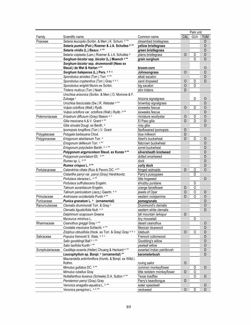
89
Park unit Family Scientific name Common name CAL GUV TUM Poaceae Setaria leucopila (Scribn. & Merr.) K. Schum. b ** streambed bristlegrass D Setaria pumila (Poir.) Roemer & J.A. Schultes b ** yellow bristlegrass D Setaria viridis (L.) Beauv. a ** green bristlegrass D Setaria vulpiseta (Lam.) Roemer & J.A. Schultes a plains bristlegrass O D D Sorghum bicolor ssp. bicolor (L.) Moench a ** grain sorghum D D Sorghum bicolor ssp. drummondii (Nees ex
Steud.) de Wet & Harlan a ** broom-corn O Sorghum halepense (L.) Pers. a b c Johnsongrass O D Sporobolus airoides (Torr.) Torr. b ** alkali sacaton D Sporobolus cryptandrus (Torr.) Gray a b c sand dropseed O D D Sporobolus wrightii Munro ex Scribn. big sacaton O D Tridens muticus (Torr.) Nash slim tridens D Urochloa arizonica (Scribn. & Merr.) O. Morrone & F.
Zuloaga c Arizona signalgrass D O Urochloa fasciculata (Sw.) R. Webster a ** browntop signalgrass D Vulpia octoflora (Walt.) Rydb. sixweeks fescue O D O Vulpia octoflora var. octoflora (Walt.) Rydb. a ** sixweeks fescue D Polemoniaceae Eriastrum diffusum (Gray) Mason a c miniature woollystar O D O Gilia mexicana A.& V. Grant a ** El Paso gilia D D D Gilia sinuata Dougl. ex Benth. a rosy gilia O Ipomopsis longiflora (Torr.) V. Grant flaxflowered ipomopsis D Polygalaceae Polygala barbeyana Chod. blue milkwort D Polygonaceae Eriogonum abertianum Torr. a Abert's buckwheat D D D Eriogonum deflexum Torr. c ** flatcrown buckwheat O Eriogonum polycladon Benth. b c ** sorrel buckwheat D Polygonum argyrocoleon Steud. ex Kunze b ** silversheath knotweed D Polygonum punctatum Ell. b ** dotted smartweed D Rumex sp. L. b ** dock D Rumex crispus L. b ** curly dock D Portulacaceae Calandrinia ciliata (Ruiz & Pavon) DC. a ** fringed redmaids D O O Cistanthe parryi var. parryi (Gray) Hershkovitz Parry's pussypaws D Portulaca oleracea L. a ** little hogweed D Portulaca suffrutescens Engelm. shrubby purslane D Talinum aurantiacum Engelm. orange fameflower D O Talinum paniculatum (Jacq.) Gaertn. a b jewels of Opar O O D Primulaceae Androsace occidentalis Pursh a ** western rockjasmine D O O Punicaceae Punica granatum L. a (ornamental) pomegranate D Ranunculaceae Clematis drummondii Torr. & Gray c Drummond's clematis O Clematis ligusticifolia Nutt. a b western white clematis D Delphinium scaposum Greene tall mountain larkspur D Myosurus minimus L. tiny mousetail D Rhamnaceae Ceanothus greggii Gray c ** desert ceanothus O Condalia mexicana Schlecht. a ** Mexican bluewood D Ziziphus obtusifolia (Hook. ex Torr. & Gray) Gray a b c lotebush O O D Salicaceae Populus fremontii S. Wats. a b c Fremont cottonwood D Salix gooddingii Ball b c ** Goodding's willow D Salix taxifolia Kunth c ** yewleaf willow O Scrophulariaceae Castilleja exserta (Heller) Chuang & Heckard a ** exserted Indian paintbrush D Leucophyllum sp. Bonpl. a (ornamental) ** barometerbush D Maurandella antirrhiniflora (Humb. & Bonpl. ex Willd.)
Rothm. roving sailor O Mimulus guttatus DC. b ** common monkeyflower D D Mimulus rubellus Gray little redstem monkeyflower D O Nuttallanthus texanus (Scheele) D.A. Sutton a ** Texas toadflax O D Penstemon parryi (Gray) Gray Parry's beardtongue D Veronica anagallis-aquatica L. b ** water speedwell D Veronica peregrina L. a b ** neckweed O D D
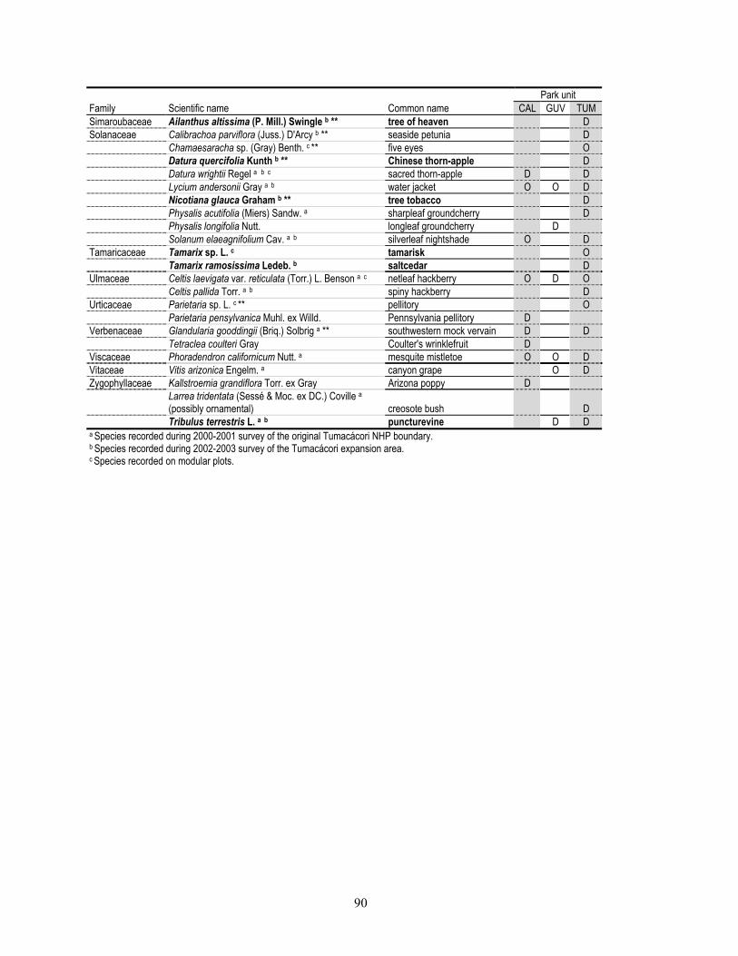
90
Park unit Family Scientific name Common name CAL GUV TUM Simaroubaceae Ailanthus altissima (P. Mill.) Swingle b ** tree of heaven D Solanaceae Calibrachoa parviflora (Juss.) D'Arcy b ** seaside petunia D Chamaesaracha sp. (Gray) Benth. c ** five eyes O Datura quercifolia Kunth b ** Chinese thorn-apple D Datura wrightii Regel a b c sacred thorn-apple D D Lycium andersonii Gray a b water jacket O O D Nicotiana glauca Graham b ** tree tobacco D Physalis acutifolia (Miers) Sandw. a sharpleaf groundcherry D Physalis longifolia Nutt. longleaf groundcherry D Solanum elaeagnifolium Cav. a b silverleaf nightshade O D Tamaricaceae Tamarix sp. L. c tamarisk O Tamarix ramosissima Ledeb. b saltcedar D Ulmaceae Celtis laevigata var. reticulata (Torr.) L. Benson a c netleaf hackberry O D O Celtis pallida Torr. a b spiny hackberry D Urticaceae Parietaria sp. L. c ** pellitory O Parietaria pensylvanica Muhl. ex Willd. Pennsylvania pellitory D Verbenaceae Glandularia gooddingii (Briq.) Solbrig a ** southwestern mock vervain D D Tetraclea coulteri Gray Coulter's wrinklefruit D Viscaceae Phoradendron californicum Nutt. a mesquite mistletoe O O D Vitaceae Vitis arizonica Engelm. a canyon grape O D Zygophyllaceae Kallstroemia grandiflora Torr. ex Gray Arizona poppy D Larrea tridentata (Sessé & Moc. ex DC.) Coville a
(possibly ornamental) creosote bush D Tribulus terrestris L. a b puncturevine D D a Species recorded during 2000-2001 survey of the original Tumacácori NHP boundary. b Species recorded during 2002-2003 survey of the Tumacácori expansion area. c Species recorded on modular plots.

91
Appendix B. Fish species recorded in the Santa Cruz River and Tumacácori Channel by University of Arizona Inventory personnel, Tumacácori NHP, 2001–2002. Species in bold-faced type are non-native.
Order Family Scientific name Common name ESAa
ESA date
Cypriniformes Cyprinidae Agosia chrysogasterb longfin dace SC 1996 Catostomidae Catostomus insignis Sonora sucker SC 1996 Catostomus clarkii desert sucker SC 1996 Cyprinodontiformes Poeciliidae Gambusia affinis western mosquitofish Poeciliopsis occidentalis occidentalis Gila topminnow LE 1967 Perciformes Centrarchidae Lepomis cyanellus green sunfish Lepomis macrochirus bluegill sunfish Micropterus salmoides largemouth bass a ESA = Endangered Species Act: LE = “Listed Endangered”, SC = “Species of Concern”; U.S. Fish and Wildlife Service (HDMS 2004). b “Sensitive species”; Bureau of Land Management (HDMS 2004).
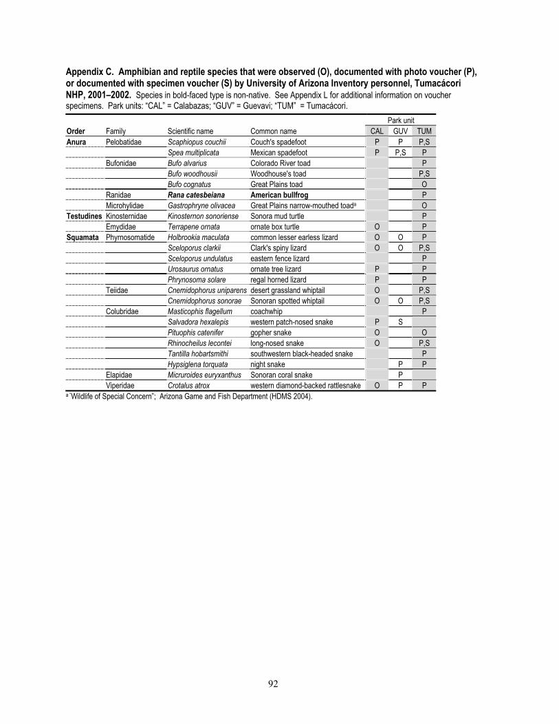
92
Appendix C. Amphibian and reptile species that were observed (O), documented with photo voucher (P), or documented with specimen voucher (S) by University of Arizona Inventory personnel, Tumacácori NHP, 2001–2002. Species in bold-faced type is non-native. See Appendix L for additional information on voucher specimens. Park units: “CAL” = Calabazas; “GUV” = Guevavi; “TUM” = Tumacácori. Park unit Order Family Scientific name Common name CAL GUV TUM Anura Pelobatidae Scaphiopus couchii Couch's spadefoot P P P,S Spea multiplicata Mexican spadefoot P P,S P Bufonidae Bufo alvarius Colorado River toad P Bufo woodhousii Woodhouse's toad P,S Bufo cognatus Great Plains toad O Ranidae Rana catesbeiana American bullfrog P Microhylidae Gastrophryne olivacea Great Plains narrow-mouthed toada O Testudines Kinosternidae Kinosternon sonoriense Sonora mud turtle P Emydidae Terrapene ornata ornate box turtle O P Squamata Phyrnosomatide Holbrookia maculata common lesser earless lizard O O P Sceloporus clarkii Clark's spiny lizard O O P,S Sceloporus undulatus eastern fence lizard P Urosaurus ornatus ornate tree lizard P P Phrynosoma solare regal horned lizard P P Teiidae Cnemidophorus uniparens desert grassland whiptail O P,S Cnemidophorus sonorae Sonoran spotted whiptail O O P,S Colubridae Masticophis flagellum coachwhip P Salvadora hexalepis western patch-nosed snake P S Pituophis catenifer gopher snake O O Rhinocheilus lecontei long-nosed snake O P,S Tantilla hobartsmithi southwestern black-headed snake P Hypsiglena torquata night snake P P Elapidae Micruroides euryxanthus Sonoran coral snake P Viperidae Crotalus atrox western diamond-backed rattlesnake O P P a “Wildlife of Special Concern”; Arizona Game and Fish Department (HDMS 2004).

93
Appendix D. Bird species recorded at Tumacácori NHP by University of Arizona Inventory personnel, 2001–2003, and by personnel working for the Monitoring Avian Productivity and Survivorship Program (MAPS), 1997–2003. Numbers of individuals recorded by Inventory personnel are noted in the “Park unit” columns; numbers are not scaled by search effort and should not to be used for comparison among species. Species in bold-faced type are non-native. Underlining indicates that we obtained a photo voucher. List includes individuals that were observed flying over the park. Park units: “CAL” = Calabazas; “GUV” = Guevavi; “TUM” = Tumacácori. Park unita
Order Family Scientific name Common name CAL GUV TUM MAPSb ESAc ESA dated
Anseriformes Anatidae Dendrocygna autumnalis*g black-bellied whistling duck 4 1 1 X Anas platyrhynchos* mallard 1 X Galliformes Odontophoridae Callipepla gambelii Gambel's quail 4 10 28 X Cyrtonyx montezumae Montezuma quail X Pelicaniformes Phalacrocoracidae Phalacrocorax auritus* double-crested cormorant 1 Ciconiiformes Ardeidae Ardea herodias* great blue heron 1 9 X Ardea alba* g great egret 2 1 2 Egretta thula* g snowy egret 1 Nycticorax nycticorax* black-crowned night-heron 1 Threskiornithidae Plegadis chihi* f white-faced Ibis 2 X SC 1996 Cathartidae Coragyps atratus* black vulture 2 6 X Cathartes aura* turkey vulture 1 25 X Falconiformes Accipitridae Accipiter striatus* f sharp-shinned hawk 2 Accipiter cooperii* Cooper's hawk 17 X Asturina nitida maxima e,f, g gray hawk 2 7 31 B SC 1996 Buteo swainsoni* Swainson's hawk 1 Buteo jamaicensis* red-tailed hawk 4 4 X Falconidae Falco sparverius* American kestrel 2 1 Falco peregrinus* f, g, i peregrine falcon 1 1 SC 1998 Charadriiformes Charadriidae Charadrius vociferus* killdeer 4 1 1 X Scolopacidae Actitis macularia* spotted sandpiper 1 Gallinago gallinago* common snipe 1 Columbiformes Columbidae Columba livia rock pigeon 1 X Patagioenas fasciata* band-tailed pigeon 1 X Zenaida asiatica* white-winged dove 7 8 109 B Zenaida macroura* mourning dove 36 18 140 B Columbina inca Inca dove 2 6 X Columbina passerina common ground-dove 6 11 22 B Cucluliformes
Cuculidae Coccyzus americanus
occidentalis* f, g, h, i yellow-billed cuckoo 2 5 20 B C 2002 Geococcyx californianus greater roadrunner 4 2 8 X Strigiformes Tytonidae Tyto alba barn owl 2 2 Strigidae Megascops kennicottii western screech-owl 2 7 B Bubo virginianus great horned owl X Micrathene whitneyi* i elf owl 1 X Caprimulgiformes Caprimulgidae Chordeiles acutipennis* lesser nighthawk 2 X Caprimulgidae Phalaenoptilus nuttallii* common poorwill 3
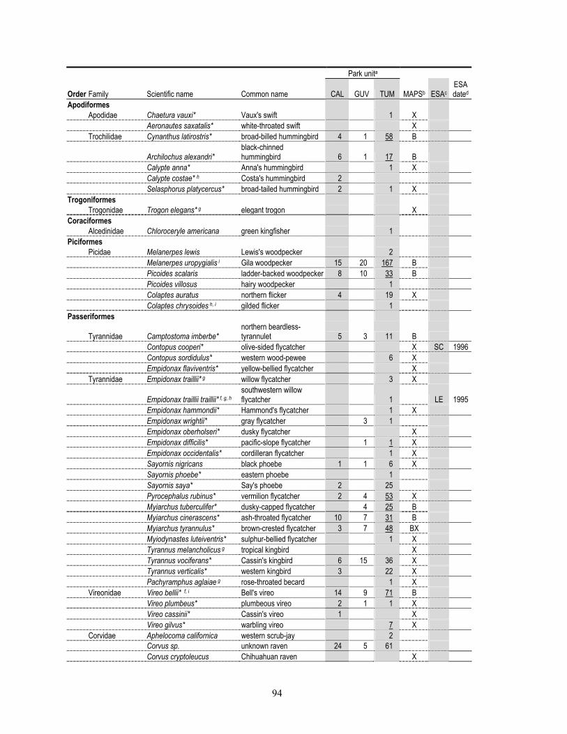
94
Park unita
Order Family Scientific name Common name CAL GUV TUM MAPSb ESAc ESA dated
Apodiformes Apodidae Chaetura vauxi* Vaux's swift 1 X Aeronautes saxatalis* white-throated swift X Trochilidae Cynanthus latirostris* broad-billed hummingbird 4 1 58 B
Archilochus alexandri* black-chinned hummingbird 6 1 17 B
Calypte anna* Anna's hummingbird 1 X Calypte costae* h Costa's hummingbird 2 Selasphorus platycercus* broad-tailed hummingbird 2 1 X Trogoniformes Trogonidae Trogon elegans* g elegant trogon X Coraciformes Alcedinidae Chloroceryle americana green kingfisher 1 Piciformes Picidae Melanerpes lewis Lewis's woodpecker 2 Melanerpes uropygialis i Gila woodpecker 15 20 167 B Picoides scalaris ladder-backed woodpecker 8 10 33 B Picoides villosus hairy woodpecker 1 Colaptes auratus northern flicker 4 19 X Colaptes chrysoides h, i gilded flicker 1 Passeriformes
Tyrannidae Camptostoma imberbe* northern beardless-tyrannulet 5 3 11 B
Contopus cooperi* olive-sided flycatcher X SC 1996 Contopus sordidulus* western wood-pewee 6 X Empidonax flaviventris* yellow-bellied flycatcher X Tyrannidae Empidonax traillii* g willow flycatcher 3 X
Empidonax traillii traillii* f, g, h southwestern willow flycatcher 1 LE 1995
Empidonax hammondii* Hammond's flycatcher 1 X Empidonax wrightii* gray flycatcher 3 1 Empidonax oberholseri* dusky flycatcher X Empidonax difficilis* pacific-slope flycatcher 1 1 X Empidonax occidentalis* cordilleran flycatcher 1 X Sayornis nigricans black phoebe 1 1 6 X Sayornis phoebe* eastern phoebe 1 Sayornis saya* Say's phoebe 2 25 Pyrocephalus rubinus* vermilion flycatcher 2 4 53 X Myiarchus tuberculifer* dusky-capped flycatcher 4 25 B Myiarchus cinerascens* ash-throated flycatcher 10 7 31 B Myiarchus tyrannulus* brown-crested flycatcher 3 7 48 BX Myiodynastes luteiventris* sulphur-bellied flycatcher 1 X Tyrannus melancholicus g tropical kingbird X Tyrannus vociferans* Cassin's kingbird 6 15 36 X Tyrannus verticalis* western kingbird 3 22 X Pachyramphus aglaiae g rose-throated becard 1 X Vireonidae Vireo bellii* f, i Bell's vireo 14 9 71 B Vireo plumbeus* plumbeous vireo 2 1 1 X Vireo cassinii* Cassin's vireo 1 X Vireo gilvus* warbling vireo 7 X Corvidae Aphelocoma californica western scrub-jay 2 Corvus sp. unknown raven 24 5 61 Corvus cryptoleucus Chihuahuan raven X
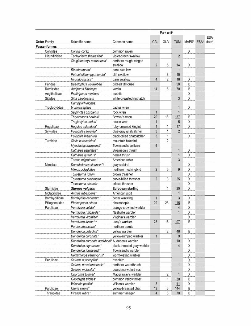
95
Park unita
Order Family Scientific name Common name CAL GUV TUM MAPSb ESAc ESA dated
Passeriformes Corvidae Corvus corax common raven X Hirundinidae Tachycineta thalassina* violet-green swallow 2
Stelgidopteryx serripennis* northern rough-winged
swallow 2 5 14 X Riparia riparia* bank swallow 1 Petrochelidon pyrrhonota* cliff swallow 3 15 Hirundo rustica* barn swallow 4 2 16 X Paridae Baeolophus wollweberi bridled titmouse 58 B Remizidae Auriparus flaviceps verdin 14 6 70 B Aegithalidae Psaltriparus minimus bushtit X Sittidae Sitta carolinensis white-breasted nuthatch 3 X
Troglodytidae Campylorhynchus brunneicapillus cactus wren 1 X
Salpinctes obsoletus rock wren 1 1 Thryomanes bewickii Bewick's wren 20 18 137 B Troglodytes aedon* house wren 1 5 X Regulidae Regulus calendula* ruby-crowned kinglet 1 1 17 X Sylviidae Polioptila caerulea* blue-gray gnatcatcher 3 1 2 Polioptila melanura black-tailed gnatcatcher 3 1 X Turdidae Sialia currucoides* mountain bluebird 2 Myadestes townsendi* Townsend's solitaire 6 Catharus ustulatus* Swainson's thrush 1 X Catharus guttatus* hermit thrush 1 X Turdus migratorius* American robin 3 Mimidae Dumetella carolinensis* g gray catbird X Mimus polyglottos northern mockingbird 2 3 9 X Toxostoma rufum brown thrasher X Toxostoma curvirostre curve-billed thrasher 2 3 25 X Toxostoma crissale i crissal thrasher 1 X Sturnidae Sturnus vulgaris European starling 1 20 X Motacillidae Anthus rubescens* American pipit 1 Bombycillidae Bombycilla cedrorum* cedar waxwing 1 3 X Ptilogonatidae Phainopepla nitens phainopepla 29 25 115 B Parulidae Vermivora celata* orange-crowned warbler 4 X Vermivora ruficapilla* Nashville warbler 1 X Vermivora virginiae* Virginia's warbler X Vermivora luciae* h Lucy's warbler 28 18 107 B Parula americana* northern parula 1 Dendroica petechia* yellow warbler 2 46 B Dendroica coronata* yellow-rumped warbler 1 9 Dendroica coronata auduboni* Audubon's warbler 10 X Dendroica nigrescens* black-throated gray warbler 4 X Dendroica townsendi* Townsend’s warbler X Helmitheros vermivorus* worm-eating warbler X Parulidae Seiurus aurocapilla* ovenbird X Seiurus noveboracensis* northern waterthrush 1 X Seiurus motacilla* Louisiana waterthrush X Oporornis tolmiei* Macgillivray's warbler 2 1 X Geothlypis trichas* common yellowthroat 1 30 B Wilsonia pusilla* Wilson's warbler 3 11 X Parulidae Icteria virens* yellow-breasted chat 13 6 144 B Thraupidae Piranga rubra* summer tanager 4 6 70 B
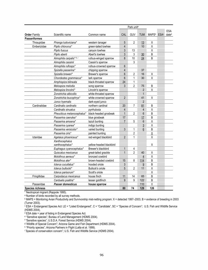
96
Park unita
Order Family Scientific name Common name CAL GUV TUM MAPSb ESAc ESA dated
Passeriformes Thraupidae Piranga ludoviciana* western tanager 5 2 13 X Emberizidae Pipilo chlorurus* green-tailed towhee 4 10 X Pipilo fuscus canyon towhee 3 13 X Pipilo aberti Abert's towhee 3 3 30 B Aimophila carpalis* h, i rufous-winged sparrow 8 10 24 B Aimophila cassinii Cassin's sparrow 3 Aimophila ruficeps* rufous-crowned sparrow 6 Spizella passerina* chipping sparrow 4 37 Spizella breweri* Brewer's sparrow 6 2 16 X Chondestes grammacus* lark sparrow 6 1 30 X Amphispiza bilineata black-throated sparrow 24 1 Melospiza melodia song sparrow 3 2 75 B Melospiza lincolnii* Lincoln's sparrow 2 X Zonotrichia albicollis white-throated sparrow 1 Zonotrichia leucophrys* white-crowned sparrow 2 41 X Junco hyemalis dark-eyed junco 2 Cardinalidae Cardinalis cardinalis northern cardinal 20 7 81 B Cardinalis sinuatus pyrrhuloxia 4 4 X Pheucticus melanocephalus* black-headed grosbeak 1 2 6 B Passerina caerulea* blue grosbeak 17 17 B Passerina amoena* lazuli bunting 7 5 6 X Passerina cyanea* indigo bunting 3 X Passerina versicolor* varied bunting 3 1 6 B Passerina ciris* painted bunting 2 X Icteridae Agelaius phoeniceus* red-winged blackbird 2 1 X
Xanthocephalus xanthocephalus* yellow-headed blackbird X
Euphagus cyanocephalus* Brewer's blackbird 1 4 Quiscalus mexicanus great-tailed grackle 1 2 40 X Molothrus aeneus* bronzed cowbird 4 X Molothrus ater* brown-headed cowbird 15 8 114 B Icterus cucullatus* hooded oriole 3 9 B Icterus bullockii* Bullock's oriole 5 2 11 X Icterus parisorum* Scott's oriole X Fringillidae Carpodacus mexicanus house finch 11 14 65 B Carduelis psaltria* lesser goldfinch 9 9 122 B Passeridae Passer domesticus house sparrow 110 0 Species richness 80 74 129 126 * Neotropical migrant (Rappole 1995). a Number of birds recorded by all survey methods. b MAPS = Monitoring Avian Productivity and Survivorship mist-netting program: X = detected 1997–2003, B = evidence of breeding in 2003 (Turner 2003). c ESA = Endangered Species Act: LE = “Listed Endangered”, C = “Candidate”, SC = “Species of Concern”; U.S. Fish and Wildlife Service (HDMS 2004). d ESA date = year of listing in Endangered Species Act. e “Sensitive species”; Bureau of Land Management (HDMS 2004). f “Sensitive species”; U.S.D.A. Forest Service (HDMS 2004). g “Wildlife of Special Concern”; Arizona Game and Fish Department (HDMS 2004). h “Priority species”; Arizona Partners in Flight (Latta et al. 1999). i “Species of conservation concern”; U.S. Fish and Wildlife Service (HDMS 2004).

97
Appendix E. Mammal species observed or documented by University of Arizona Inventory personnel or were found in museum collections (Appendix O), Tumacácori NHP, 2001–2002. Species in bold-faced type are non-native. Park units: “CAL” = Calabazas; “GUV” = Guevavi; “TUM” = Tumacácori.
Park unit
Order Family Scientific name Common name CAL GUV TUM Appendix
O Chiroptera Phyllostomidae Mactrotis californicus California leaf-nosed bat X Vespertilionidae Antrozous pallidus pallid bat X X Myotis velifer cave myotis X Myotis californicus California myotis X Molossidae Tadarida brasiensis Brazilian free-tailed bat X Didelphimorphia Didelphidae Didelphis virginiana Virginia opossum X Insectivora Sorcidae Notiosorex sp. unknown desert shrew X X Carnivora Ursidae Ursus americanus American black bear X Procyonidae Procyon lotor northern raccoon X Mephitidae Spilogale gracilis western spotted skunk X Mephitis mephitis striped skunk X Mephitis macroura hooded skunk X Conepatus leuconotus white-backed hog-nosed skunk X Canidae Canis familiaris domestic dog X Canis latrans coyote X Felidae Felis catus domestic cat X Lynx rufus bobcat X Rodentia Geomyidae Thomomys bottae Botta's pocket gopher X Heteromyidae Chaetodipus penicillatus Sonoran desert pocket mouse X X X Chaetodipus baileyi Bailey's pocket mouse X X Muridae Reithrodontomys megalotis a western harvest mouse X Reithrodontomys fulvescens fulvous harvest mouse X X X Peromyscus eremicus eremicus a, b cactus mouse X X X Peromyscus maniculatus deer mouse X X Peromyscus leucopus white-footed mouse X X Peromyscus boylii brush mouse X Baiomys taylori northern pygmy mouse X Onychomys leucogaster northern grasshopper mouse X Onychomys torridus southern grasshopper mouse X X X Neotoma albigula western white-throated woodrat X X X Sigmodon fulviventer tawny-belled cotton rat X Sigmodon ochrognathus a yellow-nosed cotton rat X Sigmodon arizonae arizonae Arizona cotton rat X X Mus musculus house mouse X X Lagomorpha Leporidae Sylvilagus species unknown cottontail X X Artiodactyla Bovidae Bos taurus domestic cow X Tayassuidae Pecari tajacu collard peccary X Cervidae Odocoileus species unknown deer X Odocoileus hemionus mule deer X Odocoileus virginianus white-tailed deer X X a “Species of Concern”; U.S. Fish and Wildlife Service. ESA date for all species: 28 February 1996 (HDMS 2004). b “Sensitive species”; U.S.D.A. Forest Service (HDMS 2004).

98
Appendix F. Plant species recorded at the Tumacácori unit by previous researchers but not recorded by University of Arizona Inventory personnel, Tumacácori NHP. Species in bold-faced type are non-native. Family Scientific name Common name Moatta Bennettb UAc Amaranthaceae Alternanthera pungens Kunth creeping chaffweed X Amaranthus arenicola I.M. Johnston sandhill amaranth X Amaranthus fimbriatus var. denticulatus (Torr.) Uline &
Bray fringed amaranth X Anacardiaceae Rhus trilobata var. anisophylla (Greene) Jepson skunkbush sumac X Asteraceae Ambrosia cordifolia (Gray) Payne heartleaf bursage X Ambrosia psilostachya DC. Cuman ragweed X X Bidens frondosa L. bur marigold X Bidens pilosa L. beggar’s tick X Dyssodia papposa (Vent.) A.S. Hitchc. dogbane dyssodia X Machaeranthera tanacetifolia (Kunth) Nees tanseyleaf aster X Sonchus oleraceus L. common sowthistle X Verbesina encelioides (Cav.) Benth. & Hook f. ex Gray golden crownbeard X X X Capparaceae Cleome lutea var. jonesii J.F. Macbr. Jones spiderflower X X Polanisia dodecandra spp. trachysperma (Torr. &
Gray) Iltis clammyweed X X Caprifoliaceae Lonicera interrupta Benth. chaparral honeysuckle X Chenopodiaceae Chenopodium dessicatum A. Nels. arid goosefoot X Chenopodium fremontii var. fremontii S. Wats. Fremont goosefoot X Chenopodium incanum (S. Wats.) Heller mealy goosefoot X Chenopodium leptophyllum (Moq.) Nutt. ex S. Wats. narrowleaf goosefoot X Commelinaceae Commelina erecta L. erect dayflower X Convolvulaceae Ipomoea purpurea (L.) Roth common morningglory X X Ipomoea ternifolia var. leptotoma (Torr.) J.A. McDonald pink morningglory X Cuscutaceae Cuscuta indecora var. indecora Choisy bigseed alfalfa dodder X Cyperaceae Cyperus esculentus L. chufa X Euphorbiaceae Chamaesyce abramsiana (L.C. Wheeler) Koutnik Abram’s spurge X Chamaesyce prostrata (Ait.) Small prostrate sandmat X X Chamaesyce serpyllifolia ssp. serpyllifolia (Pers.) Small thyme-leaf sandmat X Fabaceae Parkinsonia microphylla Torr. littleleaf palo verde X Sphinctospermum constrictum (S. Wats.) Rose hourglass peaseed X Myrtaceae Myrtus communis L. myrtle X Nyctaginaceae Boerhavia coulteri (Hook. f.) S. Wats. Coulter spiderling X X X Oleaceae Ligustrum japonicum Thunb. Japanese privet X Poaceae Bouteloua chondrosioides (Kunth) Benth. Ex S. Wats. sprucetop grama X Bromus tectorum L. cheat grass X Eragrostis pectinacae var. pectinacea (Michx.) Nees
ex Steud. purple love grass X Muhlenbergia filiformis (Thurb. ex S. Wats.) Rydb. pullup muhly X Muhlenbergia porteri Scribn. ex Beal bush muhly X X X Sporobolus contractus A.S. Hitchc. spike dropseed X Sporobolus wrightii Munro ex Scribn. big sacaton X Portulacaceae Portulaca umbraticola ssp. coronata (Small) Matthews
& Ketron wingpod purslane X Rosaceae Pyracantha fortuneana (Maxim.) Li Chinese firethorn X Rubus arizonensis Focke Arizona blackberry X Solanaceae Lycium berlandieri Dunal berlandier wolfberry X Solanum douglasii Dunal green-spot nightshade X Solanum lycopersicum var. lycopersicum L. garden tomato X Zygophyllaceae Kallstroemia grandiflora Torr. ex Gray Arizona poppy X X a Mouat et al. (1977). b Bennett (year unknown). c Voucher specimen(s) at the University of Arizona herbarium.

99
Appendix G. Amphibian and reptile species that were not recorded by University of Arizona Inventory personnel but that may occur at Tumacácori NHP based on documentation in the area by other researchers, or based on published range maps. Species in boldface-type are non-native. Order Family Scientific name Common name
Habitat/ rangea Rosenb Arnoldc Otherd
Rosen et al.e
Caudata Ambystomatidae Ambystoma tigrinum tiger salamander X Anura Bufonidae Bufo punctatus red-spotted toad X X Bufo retiformis Sonoran green toad X Ranidae Rana yavapaiensis lowland leopard frog X X Rana chiricahuensis Chiricahua leopard frog X Xf Rana tarahumarae Tarahumara frog X Hyla arenicolor canyon treefrog X Pipidae Xenopus laevis African clawed frog X Testudines Kinosternidae Kinosternon flavescens yellow mud turtle X Testudinidae Gopherus agassizii desert tortoise X Squamata Eublepharidae Coleonyx variegatus bogerti Tucson banded gecko X X X Gekkonidae Hemidactylus turcicus Mediterranean house gecko X Crotaphytidae Gambelia wislizenii long-nosed leopard lizard X Phrynosomatidae Callisaurus draconoides zebra-tailed lizard X X X Sceloporus magister desert spiny lizard X X X Uta stansburiana side-blotched lizard X Urosaurus ornatus ornate tree lizard X Anguidae Elgaria kingii Madrean alligator lizard X Scincidae Eumeces obsoletus Great Plains skink X Eumeces callicephalus mountain skink X
Teiidae Cnemidophorus burti stictogrammus giant spotted whiptail X X
Cnemidophorus tigris western whiptail X X Helodermatidae Heloderma suspectum Gila monster X Leptotyphlopidae Leptotyphlops humilis western blind snake X Colubridae Diadophis punctatus ring-necked snake X X X Phyllorhynchus decurtatus spotted leaf-nosed snake X Phyllorhynchus browni saddled leaf-nosed snake X Masticophis bilineatus Sonoran whipsnake X Senticolis triaspis green rat snake X Arizona elegans glossy snake X X Lampropeltis getula common kingsnake X X X X Thamnophis cyrtopsis black-necked garter snake X X Thamnophis eques Mexican garter snake X Oxybelis aeneus brown vine snake X Thamnophis marcianus checkered garter snake X X X Sonora semiannulata western ground snake X
Tantilla hobartsmithi southwestern black-headed
snake X Tantilla nigriceps plains black-headed snake X Tantilla yaquia Yaqui black-headed snake X Chilomeniscus cinctus banded sand snake X
Gyalopion canum Chihuahuan hook-nosed
snake X Gyalopion quadrangulare thornscrub hook-nosed snake X Trimorphodon biscutatus lyre snake X Viperidae Crotalus molossus black-tailed rattlesnake X
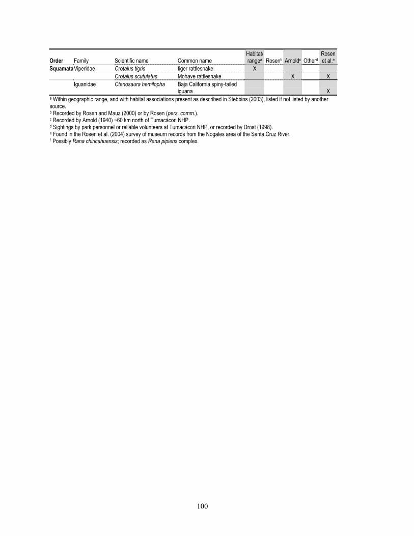
100
Order Family Scientific name Common name
Habitat/ rangea Rosenb Arnoldc Otherd
Rosen et al.e
SquamataViperidae Crotalus tigris tiger rattlesnake X Crotalus scutulatus Mohave rattlesnake X X
Iguanidae Ctenosaura hemilopha Baja California spiny-tailed
iguana X a Within geographic range, and with habitat associations present as described in Stebbins (2003), listed if not listed by another source. b Recorded by Rosen and Mauz (2000) or by Rosen (pers. comm.). c Recorded by Arnold (1940) ~60 km north of Tumacácori NHP. d Sightings by park personnel or reliable volunteers at Tumacácori NHP, or recorded by Drost (1998). e Found in the Rosen et al. (2004) survey of museum records from the Nogales area of the Santa Cruz River. f Possibly Rana chiricahuensis; recorded as Rana pipiens complex.
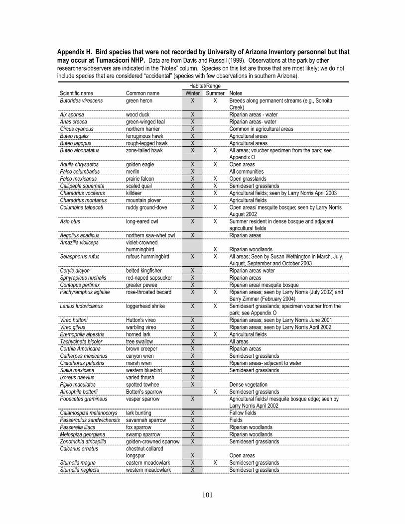
101
Appendix H. Bird species that were not recorded by University of Arizona Inventory personnel but that may occur at Tumacácori NHP. Data are from Davis and Russell (1999). Observations at the park by other researchers/observers are indicated in the “Notes” column. Species on this list are those that are most likely; we do not include species that are considered “accidental” (species with few observations in southern Arizona). Habitat/Range Scientific name Common name Winter Summer Notes Butorides virescens green heron X X Breeds along permanent streams (e.g., Sonoita
Creek) Aix sponsa wood duck X Riparian areas - water Anas crecca green-winged teal X Riparian areas- water Circus cyaneus northern harrier X Common in agricultural areas Buteo regalis ferruginous hawk X Agricultural areas Buteo lagopus rough-legged hawk X Agricultural areas Buteo albonatatus zone-tailed hawk X X All areas; voucher specimen from the park; see
Appendix O Aquila chrysaetos golden eagle X X Open areas Falco columbarius merlin X All communities Falco mexicanus prairie falcon X X Open grasslands Callipepla squamata scaled quail X X Semidesert grasslands Charadrius vociferus killdeer X X Agricultural fields; seen by Larry Norris April 2003 Charadrius montanus mountain plover X Agricultural fields Columbina talpacoti ruddy ground-dove X X Open areas/ mesquite bosque; seen by Larry Norris
August 2002 Asio otus long-eared owl X X Summer resident in dense bosque and adjacent
agricultural fields Aegolius acadicus northern saw-whet owl X Riparian areas Amazilia violiceps violet-crowned
hummingbird
X Riparian woodlands Selasphorus rufus rufous hummingbird X X All areas; Seen by Susan Wethington in March, July,
August, September and October 2003 Ceryle alcyon belted kingfisher X Riparian areas-water Sphyrapicus nuchalis red-naped sapsucker X Riparian areas Contopus pertinax greater pewee X Riparian area/ mesquite bosque Pachyramphus aglaiae rose-throated becard X X Riparian areas; seen by Larry Norris (July 2002) and
Barry Zimmer (February 2004) Lanius ludovicianus loggerhead shrike X X Semidesert grasslands; specimen voucher from the
park; see Appendix O Vireo huttoni Hutton's vireo X Riparian areas; seen by Larry Norris June 2001 Vireo gilvus warbling vireo X Riparian areas; seen by Larry Norris April 2002 Eremophila alpestris horned lark X X Agricultural fields Tachycineta bicolor tree swallow X All areas Certhia Americana brown creeper X Riparian areas Catherpes mexicanus canyon wren X Semidesert grasslands Cistothorus palustris marsh wren X Riparian areas- adjacent to water Sialia mexicana western bluebird X Semidesert grasslands Ixoreus naevius varied thrush X Pipilo maculates spotted towhee X Dense vegetation Aimophila botterii Botteri's sparrow X Semidesert grasslands Pooecetes gramineus vesper sparrow X Agricultural fields/ mesquite bosque edge; seen by
Larry Norris April 2002 Calamospiza melanocorys lark bunting X Fallow fields Passerculus sandwichensis savannah sparrow X Fields Passerella iliaca fox sparrow X Riparian woodlands Melospiza georgiana swamp sparrow X Riparian woodlands Zonotrichia atricapilla golden-crowned sparrow X Semidesert grasslands Calcarius ornatus chestnut-collared
longspur X
Open areas Sturnella magna eastern meadowlark X X Semidesert grasslands Sturnella neglecta western meadowlark X Semidesert grasslands

102
Habitat/Range Scientific name Common name Winter Summer Notes Carpodacus cassinii Cassin's finch X All areas-feeders Carduelis pinus pine siskin X All areas-feeders Carduelis lawrencei Lawrence's goldfinch X All areas-feeders Carduelis tristis American goldfinch X All areas-feeders

103
Appendix I. Mammal species that were not recorded by University of Arizona Inventory personnel or were found in museum collections (Appendix O), but that may occur at Tumacácori NHP. Habitat/Range
Family Scientific name Common name
Burt and Grossenheider
(1976) Hoffmeister
(1986) Insectivora Sorcidae Notiosorex crawfordi Crawford's desert shrew X X Notiosorex cockrumi Cockrum's desert shrew X Chiroptera Phyllostomidae Choeronycteris mexicana Mexican long-tongue bat X X Leptonycteris curasoae southern long-nosed bat X X Vespertilionidae Myotis occultus Arizona myotis X Myotis yumanensis Yuma myotis X Myotis auriculus southern myotis X Myotis thysanodes fringed myotis X X Myotis volans long-legged myotis X X Myotis cilioabrum western small-footed myotis X X Lasionycteris noctivagans silver-haired bat X Pipistrellus hesperus western pipistrelle X X Eptesicus fuscus big brown bat X X Lasiurus blossevillii western red bat X X Lasiurus cinereus hoary bat X X Lasiurus xanthinus western yellow bat X X Corynorhinus townsendii Townsend's big eared bat X X Molossidae Nyctinomops femorosaccus pocketed free-tailed bat X X Nyctinomops macrotis big free-tailed bat X Eumops perotis western bonneted bat X X Carnivora Procyonidae Nasua narica white-nosed coati X X Bassariscus astutus ringtail X X Mustelidae Taxidea taxus American badger X Canidae Urocyon cinereoargenteus common gray fox X X Vulpes macrotis kit fox X X Felidae Panthera onca jaguar X X Puma concolor mountain lion X X Rodentia Sciuridae Spermophilus variegatus rock squirrel X X Spermophilus spilosoma spotted ground squirrel X X Spermophilus tereticaudus round-tailed ground squirrel X X Ammospermophilus harrisii Harris' antelope squirrel X X Geomyidae Thomomys bottae Botta's pocket gopher X X Heteromyidae Perognathus flavus silky pocket mouse X X Perognathus amplus Arizona pocket mouse X X Chaetodipus intermedius rock pocket mouse X X Chaetodipus hispidus hispid pocket mouse X X Dipodomys spectabilis banner-tailed kangaroo rat X X Dipodomys ordii Ord's kangaroo rat X X Dipodomys merriami Merriam's kangaroo rat X X Castoridae Castor canadensis American beaver X Muridae Reithrodontomys megalotis western harvest mouse X X Peromyscus merriami Merriam's mouse X X Sigmodon hispidus hispid cotton rat X X Sigmodon ochrognathus yellow-nosed cotton rat X X Lagomorpha Leporidae Lepus alleni antelope jackrabbit X X Lepus californicus black-tailed jackrabbit X X Sylvilagus floridanus eastern cottontail X X Sylvilagus audubonii desert cottontail X X
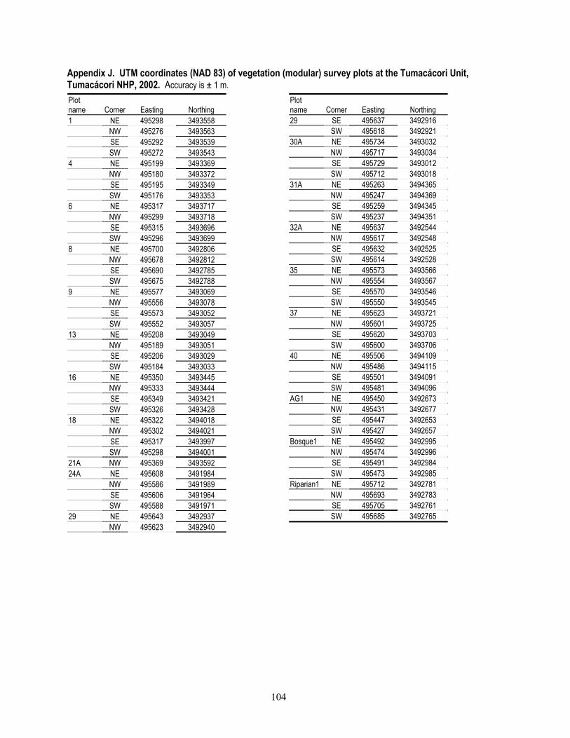
104
Appendix J. UTM coordinates (NAD 83) of vegetation (modular) survey plots at the Tumacácori Unit, Tumacácori NHP, 2002. Accuracy is ± 1 m.Plot name Corner Easting Northing 1 NE 495298 3493558 NW 495276 3493563 SE 495292 3493539 SW 495272 3493543 4 NE 495199 3493369 NW 495180 3493372 SE 495195 3493349 SW 495176 3493353 6 NE 495317 3493717 NW 495299 3493718 SE 495315 3493696 SW 495296 3493699 8 NE 495700 3492806 NW 495678 3492812 SE 495690 3492785 SW 495675 3492788 9 NE 495577 3493069 NW 495556 3493078 SE 495573 3493052 SW 495552 3493057 13 NE 495208 3493049 NW 495189 3493051 SE 495206 3493029 SW 495184 3493033 16 NE 495350 3493445 NW 495333 3493444 SE 495349 3493421 SW 495326 3493428 18 NE 495322 3494018 NW 495302 3494021 SE 495317 3493997 SW 495298 3494001 21A NW 495369 3493592 24A NE 495608 3491984 NW 495586 3491989 SE 495606 3491964 SW 495588 3491971 29 NE 495643 3492937 NW 495623 3492940
Plot name Corner Easting Northing 29 SE 495637 3492916 SW 495618 3492921 30A NE 495734 3493032 NW 495717 3493034 SE 495729 3493012 SW 495712 3493018 31A NE 495263 3494365 NW 495247 3494369 SE 495259 3494345 SW 495237 3494351 32A NE 495637 3492544 NW 495617 3492548 SE 495632 3492525 SW 495614 3492528 35 NE 495573 3493566 NW 495554 3493567 SE 495570 3493546 SW 495550 3493545 37 NE 495623 3493721 NW 495601 3493725 SE 495620 3493703 SW 495600 3493706 40 NE 495506 3494109 NW 495486 3494115 SE 495501 3494091 SW 495481 3494096 AG1 NE 495450 3492673 NW 495431 3492677 SE 495447 3492653 SW 495427 3492657 Bosque1 NE 495492 3492995 NW 495474 3492996 SE 495491 3492984 SW 495473 3492985 Riparian1 NE 495712 3492781 NW 495693 3492783 SE 495705 3492761 SW 495685 3492765

105
Appendix K. UTM coordinates (NAD 83) for intensive plots for amphibian and reptile surveys, Tumacácori NHP, 2001–2002. Unless otherwise indicated, accuracy is ± 1 m.
Park unit Plot name Corner Easting Northing Calabazas C01a NW 503714 3479918 NE 503814 3479917 SE 503814 3479817 SW 503715 3479817 C02 a NW 503838 3479740 NE 503938 3479739 SE 503938 3479640 SW 503838 3479640 Guevavi G01 a NW 509238 3475113 NE 509338 3475113 SE 509338 3475013 SW 509238 3475013 Tumacácori M01 NW 495638 3493431 NE 495741 3493428 SE 495737 3493326 SW 495641 3493326 M02 SW 495443 3492264 M03 SW 495562 3492658 M04 SW 495718 3492303 M05 SW 495441 3493012 SE 495536 3493006 NE 495543 3493107 NW 495433 3493112 M06 NW 495663 3493080 NE 495759 3493079 SE 495760 3492976 SW 495661 3492981 M07 SW 495220 3492117 M08 SE 495330 3492933 SW 495230 3492929 NW 495230 3493029 NE 495328 3493026 M09 NW 495215 3493441 NE 495315 3493440 SE 495307 3493347 SW 495213 3493339 M10 NW 495391 3492952 NE 495484 3492955 SE 495485 3492851 SW 495387 3492853 M11 SW 495701 3492053 M12 NW 495205 3492795 NE 495309 3492803 SE 495314 3492712 SW 495212 3492704 a Coordinates are the original used for navigating to the plot when it was established and therefore accuracy is ± 30m.

106
Appendix L. UTM coordinates (NAD 83) for bird survey stations and transect sections, Tumacácori NHP, 2001–2003. Accuracy is ± 15 m. Survey type Unit Station Community typea Easting Northing VCP Calabazas 1 SD grassland 503969 3479802 2 SD grassland 503775 3479906 3 SD grassland 503853 3479539 Guevavi 1 SD grassland 509363 3474931 2 SD grassland 509258 3475135 Tumacácori 1 Developed 495222 3492552 2 Mesquite bosque 495271 3492780 3 Mesquite bosque 495540 3492734 8 Mesquite bosque 495481 3492971 6 Riparian 495704 3492834 4 Riparian 495734 3492585 5 Riparian 495763 3492336 7 Riparian 495709 3493091 Line transectb Calabazas A–B SD grassland 504033 3479757 B–C SD grassland 503869 3479578 C–A SD grassland 503787 3479815 Guevavi A–B SD grassland 509412 3474931 B–A SD grassland 509232 3475107 Tumacácori A–B Developed 495193 3492545 B–C Mesquite bosque 495228 3492790 C–D Mesquite bosque 495468 3492722 D–E Riparian 495479 3492975 E–F Riparian 495687 3492835 F–G Riparian 495735 3492594 G–F Riparian 495763 3492346 Nocturnal breeding season Calabazas 1 SD grassland 503817 3479774 Guevavi 1 SD grassland 509363 3474931 Tumacácori 1 Developed 495248 3492594 2 Mesquite bosque 495520 3492715
3 Mesquite bosque/
Riparian 495515 3493009 a SD grassland = semi-desert grassland. b Line transect section breaks.

107
Appendix M. UTM coordinates (NAD 83) of small mammal trapping plots, Tumacácori NHP, 2000-2001. Accuracy is ± 15 m. Park units: “CAL” = Calabazas; “GUV” = Guevavi; “TUM” = Tumacácori.Park unit Plot name Corner Easting Northing CAL 1 A1 503863 3479672 A5 503896 3479674 E1 503859 3479637 E5 503898 3479640 2 A1 503948 3479656 A5 503930 3479685 E1 503968 3479679 E5 503959 3479699 3 A1 503846 3479547 A5 503821 3479561 E1 503864 3479565 E5 503845 3479580 4 A1 503916 3479830 A5 503911 3479791 E1 503948 3479824 E5 503948 3479791 5 A1 503783 3479870 A5 503779 3479905 E1 503754 3479883 E5 503757 3479917 6 A1 503853 3479905 A5 503852 3479939 E1 503824 3479908 E5 503816 3479940 C1 NE 503870 3479868 NW 503830 3479868 SE 503870 3479828 SW 503830 3479828 C2 NE 503798 3479827 NW 503758 3479827 SE 503798 3479787 SW 503758 3479787 C3 NE 503834 3479696 NW 503794 3479696 SE 503834 3479656 SW 503794 3479656 GUV 1 A1 509397 3474969 A5 509414 3474933 E1 509364 3474950 E5 509379 3474921 2 A1 509228 3475102 A5 509226 3475072 E1 509256 3475096 E5 509255 3475068 G1 NE 509305 3475108 NW 509265 3475108 SE 509305 3475068 SW 509265 3475068 G2 NE 509329 3475034 NW 509289 3475034 SE 509329 3474994 SW 509289 3474994 G3 NE 509400 3475023
Park unit Plot name Corner Easting Northing NW 509360 3475023 GUV G3 SE 509400 3474983 SW 509360 3474983 TUM M12 NE 495666 3493383 NW 495576 3493383 SE 495666 3493343 SW 495576 3493343 M16 NE 495244 3492921 NW 495154 3492921 SE 495244 3492881 SW 495154 3492881 M17 NE 495346 3492782 NW 495256 3492782 SE 495346 3492742 SW 495256 3492742 M03 NE 495350 3493401 NW 495260 3493401 SE 495350 3493361 SW 495260 3493361 M04 NE 495677 3491978 NW 495587 3491978 SE 495677 3491938 SW 495587 3491938 M06 NE 495551 3493272 NW 495461 3493272 SE 495551 3493232 SW 495461 3493232 M07 NE 495466 3493077 NW 495376 3493077 SE 495466 3493037 SW 495376 3493037 M09 NE 495281 3493095 NW 495191 3493095 SE 495281 3493055 SW 495191 3493055 M02 NE 495570 3492805 NW 495480 3492805 SE 495570 3492765 SW 495480 3492765 M11 NE 495433 3492600 NW 495343 3492600 SE 495433 3492560 SW 495343 3492560 M14 NE 495619 3492611 NW 495529 3492611 SE 495619 3492571 SW 495529 3492571

108
Appendix N. Museums that were queried in 1998 for vertebrate voucher specimens with “Arizona” and “Tumacácori National Historical Park” in the collection location. Collections in bold had specimens from Tumacácori NHP.
Collection Vertebrate group(s) Auburn University Reptiles and amphibians Chicago Academy of Sciences All Cincinnati Museum of Natural History & Science All Cornell Vertebrate Collections, Cornell University Birds and mammals Field Museum of Natural History, Chicago Mammals George Mason University (Fairfax, VA) All James Ford Bell Museum of Natural History, University of Minnesota Mammals Laboratory for Environmental Biology, Centennial Museum, University of Texas at El Paso
Unknown
Marjorie Barrick Museum, University of Nevada-Las Vegas Reptiles, amphibians, and birds Michigan State University Museum (East Lansing) All Milwaukee Public Museum All Monte Bean Life Science Museum, Brigham Young University Unknown Museum of Comparative Zoology, Harvard University Reptiles and amphibians Museum of Texas Tech University All Museum of Natural History , University of Kansas Reptiles, amphibians, and mammals Museum of Vertebrate Zoology , University of California, Berkeley All Museum of Life Sciences, Louisiana State University, Shreveport All Natural History Museum of Los Angeles County Reptiles and amphibians New Mexico Museum of Natural History (Albuquerque) Unknown North Carolina State Museum of Natural Sciences Birds and mammals Oklahoma Museum of Natural History, Norman All Peabody Museum, Yale University All Pipe Spring National Memorial, Arizona Mammals Saguaro National Park All Sharlot Hall Museum, Prescott, Arizona Unknown Strecker Museum, Baylor University, Waco All Texas Cooperative Wildlife Collection All but fish Tulane University Museum of Natural History Reptiles and amphibians University of Arizona All University of Texas, Arlington All University of Illinois, Champaign-Urbana All University of Michigan Reptiles and amphibians University of Colorado Museum All Walnut Canyon National Monument, Arizona All Western Archeological and Conservation Center, Tucson All Wupatki National Memorial, Flagstaff All

109
Appendix O. Voucher specimens from Tumacácori NHP that were not collected by University of Arizona Inventory personnel. See appendix N for list of collections that were queried for specimens from “Tumacácori National Historical Park”.
Taxon group Scientific name Common name Collection Date Collector
Number of specimens (if known)
Reptiles Sceloporus clarkii Clark's spiny lizard Chicago Academy of Science 01/01/1940 J. Y. Beaty 1 Pituophis catenifer gopher snake University of Arizona 06/28/1962 R.L. Bezy 1 Birds Callipepla gambelii Gambel's quail University of Arizona NA NA 2 Accipiter cooperii Cooper's hawk University of Arizona NA NA Buteo swainsoni Swainson's hawk University of Arizona NA NA Buteo albonotatus zone-tailed hawk University of Arizona NA NA Falco sparverius American kestrel University of Arizona NA NA Patagioenas fasciata band-tailed pigeon University of Arizona NA NA Cynanthus latirostris broad-billed hummingbird University of Arizona NA NA Camptostoma imberbe northern beardless-
tyrannulet University of Arizona NA NA Contopus sordidulus western wood-pewee University of Arizona NA NA Pyrocephalus rubinus vermilion flycatcher University of Arizona NA NA Myiarchus tuberculifer dusky-capped flycatcher University of Arizona NA NA Myiarchus cinerascens ash-throated flycatcher University of Arizona NA NA 2 Myiarchus tyrannulus brown-crested flycatcher University of Arizona NA NA Tyrannus vociferans Cassin's kingbird University of Arizona NA NA 2 Lanius ludovicianus loggerhead shrike University of Arizona NA NA Vireo gilvus warbling vireo University of Arizona NA NA Auriparus flaviceps verdin University of Arizona NA NA Thryomanes bewickii Bewick's wren University of Arizona NA NA Mimus polyglottos northern mockingbird University of Arizona NA NA Toxostoma curvirostre curve-billed thrasher University of Arizona NA NA 2 Phainopepla nitens phainopepla University of Arizona NA NA 2 Vermivora luciae Lucy's warbler University of Arizona NA NA Icteria virens yellow-breasted chat University of Arizona NA NA Piranga flava hepatic tanager University of Arizona NA NA Pipilo fuscus canyon towhee University of Arizona NA NA Cardinalis cardinalis northern cardinal University of Arizona NA NA Passerina caerulea blue grosbeak University of Arizona NA NA Passerina versicolor varied bunting University of Arizona NA NA Molothrus ater brown-headed cowbird University of Arizona NA NA 3 Carpodacus mexicanus house finch University of Arizona NA NA Mammals Antrozous pallidusa pallid bat Saguaro National Park 1938, 1950 A. G.
Henson 4 Macrotus californicusa Calfornia leaf-nosed bat Saguaro National Park 1950 A. G.
Henson 1 Myotis californicusa California myotis Saguaro National Park A. G.
Henson 2 Myotis velifer cave myotis University of California, Berkeley 1937 W. B.
Richardson 71 Myotis velifera cave myotis Saguaro National Park 1950, 1951 A. G.
Henson 7 Myotis velifera cave myotis Saguaro National Park 1937 S. Benson 2 Tadarida brasiliensisa Brazilian free-tailed bat Saguaro National Park 1950 A. G.
Henson 3 Odocoileus virginianus white-tailed deer University of Arizona 11/07/1966 Don Mott Odocoileus virginianus white-tailed deer University of Arizona 10/30/1964 A. Peyron a Specimen identification not verified.

110
Appendix P. Vertebrate voucher specimens collected at Tumacácori NHP by University of Arizona Inventory personnel, 2000–2002. All specimens are located in University of Arizona collections. Park units: “CAL” = Calabazas; “GUV” = Guevavi; “TUM” = Tumacácori. Taxon group Park unit Common name Date Collector
Accession number Specimen type
Amphibians and Reptiles GUV Mexican spadefoot 07/12/01 James Borgmeyer 53512 full western patch-nosed Snake 07/02/01 Dan Bell 53816 full TUM Couch's spadefoot 07/11/01 James Borgmeyer 53513 full Woodhouse's toad 07/10/02 Kevin Bonine full Clark's spiny lizard 07/11/02 Dan Bell full desert grassland whiptail 07/11/02 Kevin Bonine 53989 full Sonoran spotted whiptail 04/25/01 Mike Wall 53648 full Sonoran spotted whiptail 07/11/01 James Borgmeyer 53511 full Sonoran spotted whiptail 07/10/02 Kevin Bonine 53988 full long-nosed snake 04/11/01 Dave Prival 53514 full Fish TUM desert sucker 05/15/02 Eric Albrecht full Sonora sucker 05/15/02 Eric Albrecht 346 full longfin dace 05/15/02 Eric Albrecht 345 full western mosquitofish 05/15/02 Eric Albrecht 344 full green sunfish 05/15/02 Eric Albrecht 343 full largemouth bass 05/15/02 Eric Albrecht 341 full bluegill sunfish 05/15/02 Eric Albrecht 342 full Mammals CAL unknown desert shrew 09/24/00 Jason Schmidt 26900 skull and
skeleton Sonoran desert pocket mouse 09/23/00 Jason Schmidt 26862 skull Bailey's pocket mouse 09/23/00 Jason Schmidt 26904 skull fulvous harvest mouse 09/23/00 Neil Perry 26863 skull cactus mouse 09/23/00 Jason Schmidt 26838 skin and skull cactus mouse 06/13/01 Ryan Gann 26832 skin and skull house mouse 06/12/01 Neil Perry 26858 skin and skull deer mouse 09/25/00 Ryan Gann 26907 skull white-footed mouse 09/25/00 Neil Perry submitteda skull southern grasshopper mouse 09/23/00 Neil Perry 26861 skull western white-throated woodrat 09/24/00 Jason Schmidt 26899 skull tawny-belled cotton rat 09/23/00 Jason Schmidt 26929 skull GUV Sonoran desert pocket mouse 09/30/00 Neil Perry 26934 skull Sonoran desert pocket mouse 10/02/00 Jason Schmidt 26933 skull Bailey's pocket mouse 09/30/00 Neil Perry 26908 skull fulvous harvest mouse 10/02/00 Jason Schmidt 26864 skull cactus mouse 09/30/00 Jason Schmidt 26860 skull northern pygmy mouse 06/13/01 Neil Perry 26891 skin and skull southern grasshopper mouse 10/02/00 Jason Schmidt 26931 skull western white-throated woodrat 09/30/00 Neil Perry submitteda skull TUM desert shrew 10/29/00 Neil Perry 26902 skull feral cat 10/18/02 Neil Perry 26766 skull bobcat 02/27/03 Neil Perry submitteda skull Botta’s pocket gopher 11/03/00 Jason Schmidt 27049 skull Sonoran desert pocket mouse 10/29/00 Jason Schmidt 26865 skull Sonoran desert pocket mouse 11/03/00 Jason Schmidt 26923 skull Sonoran desert pocket mouse 11/05/00 Jason Schmidt 26912 skull western harvest mouse 06/05/01 Neil Perry 26859 skin and skull cactus mouse 10/29/00 Jason Schmidt 26909 skull cactus mouse 10/29/00 Jason Schmidt 26905 skull

111
Taxon group Park unit Common name Date Collector
Accession number Specimen type
Mammals TUM cactus mouse 10/31/00 Jason Schmidt 26924 skull cactus mouse 11/04/00 Jason Schmidt 26914 skull deer mouse 10/31/00 Ryan Gann 26906 skull Arizona cotton rat 10/29/00 Neil Perry submitteda a Voucher specimen submitted but has not been accessioned.
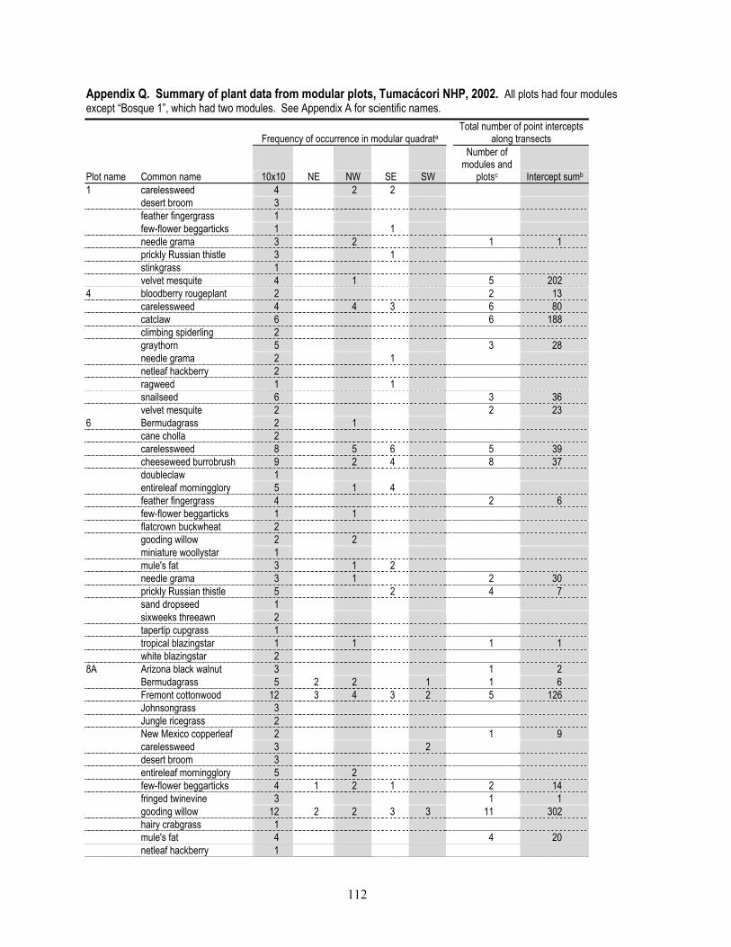
112
Appendix Q. Summary of plant data from modular plots, Tumacácori NHP, 2002. All plots had four modules except “Bosque 1”, which had two modules. See Appendix A for scientific names.
Frequency of occurrence in modular quadrata Total number of point intercepts
along transects
Plot name Common name 10x10 NE NW SE SW
Number of modules and
plotsc Intercept sumb 1 carelessweed 4 2 2 desert broom 3 feather fingergrass 1 few-flower beggarticks 1 1 needle grama 3 2 1 1 prickly Russian thistle 3 1 stinkgrass 1 velvet mesquite 4 1 5 202 4 bloodberry rougeplant 2 2 13 carelessweed 4 4 3 6 80 catclaw 6 6 188 climbing spiderling 2 graythorn 5 3 28 needle grama 2 1 netleaf hackberry 2 ragweed 1 1 snailseed 6 3 36 velvet mesquite 2 2 23 6 Bermudagrass 2 1 cane cholla 2 carelessweed 8 5 6 5 39 cheeseweed burrobrush 9 2 4 8 37 doubleclaw 1 entireleaf morningglory 5 1 4 feather fingergrass 4 2 6 few-flower beggarticks 1 1 flatcrown buckwheat 2 gooding willow 2 2 miniature woollystar 1 mule's fat 3 1 2 needle grama 3 1 2 30 prickly Russian thistle 5 2 4 7 sand dropseed 1 sixweeks threeawn 2 tapertip cupgrass 1 tropical blazingstar 1 1 1 1 white blazingstar 2 8A Arizona black walnut 3 1 2 Bermudagrass 5 2 2 1 1 6 Fremont cottonwood 12 3 4 3 2 5 126 Johnsongrass 3 Jungle ricegrass 2 New Mexico copperleaf 2 1 9 carelessweed 3 2 desert broom 3 entireleaf morningglory 5 2 few-flower beggarticks 4 1 2 1 2 14 fringed twinevine 3 1 1 gooding willow 12 2 2 3 3 11 302 hairy crabgrass 1 mule's fat 4 4 20 netleaf hackberry 1

113
Frequency of occurrence in modular quadrata
Total number of point intercepts along transects
Plot name Common name 10x10 NE NW SE SW
Number of modules and
plotsc Intercept sumb 8A prickly Russian thistle 2 ragweed 1 sacred thorn-apple 1 tapertip cupgrass 1 velvet ash 3 9 Bermudagrass 5 1 1 1 3 18 Fremont cottonwood 12 2 55 Johnsongrass 4 2 Lehmann's lovegrass 1 1 1 8 Mexican fireplant 2 1 2 New Mexico copperleaf 3 1 1 annual goldeneye 2 blood ragweed 3 1 1 canyon morning-glory 1 1 carelessweed 8 1 5 6 2 6 64 cocklebur 4 1 common sunflower 4 cutleaf goldenweed 3 1 desert broom 3 entireleaf morningglory 5 feather fingergrass 8 1 1 3 2 1 3 few-flower beggarticks 6 1 2 2 1 3 6 gooding willow 6 1 2 77 hairy crabgrass 4 1 2 hyssop spurge 2 1 low rattlebox 2 needle grama 5 1 1 2 2 15 plains lovegrass 3 2 1 1 prickly Russian thistle 1 ragweed 7 sand dropseed 2 1 1 1 stinkgrass 1 tapertip cupgrass 6 1 3 2 2 4 11 yellow sweet-clover 3 yewleaf willow 3 2 28 13 Arizona signalgrass 2 Bermudagrass 1 Mexican morningglory 1 2 Rothrock's grama 4 buff petal 2 1 1 1 burrow goldenweed 2 carelessweed 5 1 climbing spiderling 2 crestrib morning-glory 2 1 cutleaf goldenweed 3 desert broom 8 3 6 desert ceanothus 2 2 7 feather fingergrass 1 fringed twinevine 1 1 3 needle grama 4 2 1 1 4 prickly Russian thistle 4 1 1 2 1 procumbent sida 4 2 2 2 2 ragweed 4 1 1 1 sand dropseed 4

114
Frequency of occurrence in modular quadrata
Total number of point intercepts along transects
Plot name Common name 10x10 NE NW SE SW
Number of modules and
plotsc Intercept sumb 13 sixweeks grama 3 slender grama 1 1 southwestern prickly poppy 1 spidergrass 11 3 17 stinkgrass 3 1 threadleaf snakeweed 2 velvet mesquite 11 4 2 3 12 416 16 Bermudagrass 2 Fremont cottonwood 4 1 2 164 Mexican fireplant 3 1 Mexican yellowshow 1 New Mexico copperleaf 4 bloodberry rougeplant 2 1 blue elderberry 3 buff petal 1 catclaw 1 3 14 climbing spiderling 2 3 desert broom 4 1 2 17 entireleaf morningglory 3 1 few-flower beggarticks 4 2 2 2 5 graythorn 7 netleaf hackberry 4 1 1 ragweed 1 1 snailseed 6 1 1 1 3 tapertip cupgrass 1 threadleaf groundsel 1 tropical blazingstar 4 2 2 velvet mesquite 11 3 5 7 283 18 Bermudagrass 1 Lehmann's lovegrass 6 carelessweed 8 4 3 2 4 3 13 cheeseweed burrobrush 5 1 7 desert broom 2 2 feather fingergrass 8 2 1 11 few-flower beggarticks 2 2 needle grama 4 1 1 1 1 3 43 prickly Russian thistle 8 2 2 sorrel buckwheat 8 2 2 1 1 tapertip cupgrass 3 21A Bermudagrass 5 1 1 3 Lehmann's lovegrass 1 annual pricklepoppy 2 blue grama 1 carelessweed 8 4 4 4 4 4 19 common sunflower 2 feather fingergrass 8 2 3 2 2 4 18 few-flower beggarticks 1 1 field sandbur 8 needle grama 4 1 2 2 1 4 81 ragweed 2 1 sand dropseed 1 2 spidergrass 2 stinkgrass 2 tapertip cupgrass 4 1 1 1 2 4 20

115
Frequency of occurrence in modular quadrata
Total number of point intercepts along transects
Plot name Common name 10x10 NE NW SE SW
Number of modules and
plotsc Intercept sumb 21A threadleaf groundsel 5 28 tropical blazingstar 2 2 white blazingstar 1 1 2 24A Bermudagrass 5 2 1 1 4 11 Fremont cottonwood 4 1 3 190 Grisebach's bristlegrass 2 1 Mexican fireplant 4 2 1 2 3 New Mexico copperleaf 2 1 1 2 blue elderberry 12 1 4 2 1 9 carelessweed 7 2 3 3 coastal sandbur 3 1 1 3 crested anoda 1 feather fingergrass 2 1 1 1 few-flower beggarticks 5 1 3 2 1 4 11 fringed twinevine 9 2 2 2 6 graythorn 5 2 12 needle grama 2 1 1 netleaf hackberry 7 1 3 40 prairie sunflower 3 prickly Russian thistle 3 1 ragweed 5 1 2 2 3 sand dropseed 6 1 snailseed 12 5 3 3 stinkgrass 1 1 tapertip cupgrass 5 1 velvet mesquite 7 1 29 Arizona foldwing 1 Bermudagrass 4 2 2 1 2 4 59 Fremont cottonwood 12 2 1 1 2 62 Grisebach's bristlegrass 1 1 jungle ricegrass 1 1 Lehmann's lovegrass 3 1 1 1 Mexican fireplant 1 New Mexico copperleaf 4 1 carelessweed 8 2 2 2 4 4 32 cheeseweed burrobrush 2 cocklebur 1 feather fingergrass 6 1 2 1 1 2 3 few-flower beggarticks 8 2 1 1 1 3 fringed twinevine 3 2 1 gooding willow 6 2 53 longtube four o'clock 2 mule's fat 4 1 9 netleaf hackberry 3 1 ragweed 4 1 1 tapertip cupgrass 1 1 velvet mesquite 2 yellow sweet-clover 1 30A Lehmann's lovegrass 7 1 2 Mexican fireplant 1 1 New Mexico copperleaf 1 Orcutt's threeawn 2 Rothrock's grama 5 2 1 2 camphorweed 1

116
Frequency of occurrence in modular quadrata
Total number of point intercepts along transects
Plot name Common name 10x10 NE NW SE SW
Number of modules and
plotsc Intercept sumb 30A carelessweed 8 1 1 1 4 12 cutleaf goldenweed 2 delicate muhly 3 1 1 3 doubleclaw 1 feather fingergrass 4 1 1 2 8 few-flower beggarticks 3 1 1 1 field sandbur 1 flatcrown buckwheat 6 1 1 gooding willow 2 1 hairy crabgrass 1 low rattlebox 4 1 1 1 1 needle grama 4 2 2 1 2 4 95 plains lovegrass 2 1 1 prickly Russian thistle 2 purple grama 1 1 ragweed 1 sand dropseed 8 2 sixweeks threeawn 5 2 1 1 1 4 18 tapertip cupgrass 3 1 1 velvet mesquite 4 3 26 white blazingstar 4 31A Bermudagrass 5 1 1 1 1 3 10 Fremont cottonwood 12 1 1 2 65 Johnsongrass 8 1 2 Lehmann lovegrass 2 Mexican fireplant 1 1 New Mexico copperleaf 1 carelessweed 8 1 2 2 6 19 cocklebur 2 1 desert broom 4 feather fingergrass 2 few-flower beggarticks 7 1 2 1 1 3 14 gooding willow 11 2 3 2 3 4 100 low rattlebox 2 1 mule's fat 5 1 1 15 netleaf hackberry 2 prairie sunflower 4 prickly Russian thistle 4 ragweed 2 sacred thorn-apple 1 tapertip cupgrass 2 1 1 velvet mesquite 4 32A Bermudagrass 4 2 1 2 3 71 Rothrock's grama 1 Thurber pepperweed 1 buff petal 1 buffalo gourd 3 1 1 1 carelessweed 7 2 1 1 1 3 3 catclaw 5 3 1 11 desert broom 4 feather fingergrass 2 fringed twinevine 8 1 1 2 graythorn 7 3 1 4 horehound 2 1 3

117
Frequency of occurrence in modular quadrata
Total number of point intercepts along transects
Plot name Common name 10x10 NE NW SE SW
Number of modules and
plotsc Intercept sumb 32A needle grama 2 1 1 1 netleaf hackberry 2 2 sand dropseed 6 sixweeks threeawn 1 snailseed 3 2 spidergrass 1 stinkgrass 2 1 2 velvet mesquite 12 2 4 60 35 Bermudagrass 2 1 1 2 29 Fremont cottonwood 3 Grisebach's bristlegrass 1 1 Lehmann's lovegrass 3 Thurber pepperweed 1 carelessweed 8 6 2 2 6 4 75 cheeseweed burrobrush 5 1 1 1 feather fingergrass 6 2 3 few-flower beggarticks 4 needle grama 3 1 1 2 26 prickly Russian thistle 8 2 ragweed 1 sand dropseed 4 1 1 sorrel buckwheat 2 37 Bermudagrass 3 1 Fremont cottonwood 3 2 1 28 Grisebach's bristlegrass 1 Lehmann's lovegrass 8 1 carelessweed 8 2 4 4 feather fingergrass 7 2 2 2 1 3 8 few-flower beggarticks 1 1 needle grama 4 1 2 3 1 4 66 prickly Russian thistle 3 ragweed 2 sand dropseed 4 1 sixweeks grama 1 sorrel buckwheat 2 tapertip cupgrass 1 1 white blazingstar 2 40 Bermudagrass 2 1 Lehmann's lovegrass 3 1 carelessweed 8 1 2 2 4 14 desert honeysuckle 3 feather fingergrass 4 1 1 1 1 3 mule's fat 7 7 114 needle grama 4 1 3 3 1 4 23 prairie sunflower 2 prickly Russian thistle 1 2 14 ragweed 1 white blazingstar 1 AG1 Bermudagrass 4 1 2 42 Purple 3-awn 3 1 2 4 camphorweed 3 carelessweed 6 1 1 2 5 cutleaf goldenweed 1 desert broom 2

118
Frequency of occurrence in modular quadrata
Total number of point intercepts along transects
Plot name Common name 10x10 NE NW SE SW
Number of modules and
plotsc Intercept sumb AG1 doubleclaw 1 1 feather fingergrass 2 1 1 needle grama 3 2 prickly Russian thistle 4 1 3 1 2 7 procumbent sida 2 ragweed 2 1 sand dropseed 5 1 2 2 sixweeks grama 1 slender grama 1 spidergrass 3 2 1 stinkgrass 2 1 velvet mesquite 5 1 1 1 Bosque 1 Bermudagrass 1 1 Drummond's clematis 4 1 5 34 New Mexico copperleaf 2 2 2 1 1 blue elderberry 6 1 2 3 64 few-flower beggarticks 2 1 1 fringed twinevine 5 2 horehound 1 netleaf hackberry 6 1 1 6 29 procumbent sida 1 1 ragweed 1 ruellia 2 1 1 7 snailseed 6 2 1 5 14 velvet mesquite 6 1 3 6 195 Rip 1 Arizona foldwing 2 1 1 Bermudagrass 5 1 1 3 49 Fremont cottonwood 9 2 1 5 203 Grisebach's bristlegrass 2 Mexican morningglory 4 New Mexico copperleaf 2 1 2 9 blue elderberry 4 carelessweed 6 2 3 15 cudweed sagewort 1 desert broom 1 few-flower beggarticks 4 1 1 1 3 13 fringed twinevine 7 1 giant reed 2 gooding willow 11 3 1 2 7 127 hophornbeam copperleaf 2 longtube four o'clock 3 low rattlebox 1 mule's fat 2 2 netleaf hackberry 3 1 sacred thorn-apple 2 scarlet spiderling 2 1 3 weeping lovegrass 1 a Number of times a species was recorded in all quadrats and height categories. For all plots except Bosque 1 (which was half the size of the others) the maximum frequency was 12 for 10 x 10 m modules and 6 for each of the four 1 x 1 m quadrats. b Number of times a species was recorded along all line transects in each plot. For all plots except Bosque 1, the maximum frequency was 1200. c Number of line transects in which species was recorded. For all plots except Bosque 1, the maximum number was 12.

119
Appendix R. Plant species recorded in 10 x 10 m modular plots (P), point-intercept transects within modular plots (TR) or in both modular plots and point-intercept transects (B), Tumacácori NHP, 2002. Species in boldface-type are non-native. See Appendix A for common names. Plot name
Family Genus Species 1 13 16 18 21A 24A 29 30A 31A 32A 35 37 4 40 6 8a 9 AG1 Bosque
1 Rip 1 Number of plots
Acanthaceae Anisacanthus thurberi P 1 Dicliptera resupinata P B 2 Ruellia nudiflora B 1 Amaranthaceae Amaranthus palmeri P P B B B B B B B B P B B B P B B B 18 Asclepiadaceae Funastrum cynanchoides B B P B B P P 7 Asteraceae Ambrosia confertiflora B P P B B P P P P P P P P P P 15 Ambrosia trifida P 1 Artemisia ludoviciana P 1 Baccharis salicifolia B B B P B P 6 Baccharis sarothroides P B B P P P P P P P 10 Bidens leptocephala P B P P B B B B P P P B B P B 15 Gutierrezia microcephala P 1 Helianthus annuus P P 2 Helianthus petiolaris P P P 3 Heliomeris longifolia P 1 Heterotheca subaxillaris P P 2 Hymenoclea monogyra B P B B 4 Isocoma tenuisecta P 1 Machaeranthera pinnatifida P P P P 4 Senecio flaccidus P TR 2 Xanthium strumarium P P P 3 Bixaceae Amoreuxia palmatifida P 1 Brassicaceae Lepidium thurberi P P 2 Cactaceae Opuntia spinosior P 1 Caprifoliaceae Sambucus nigra P B B P 4 Chenopodiaceae Salsola kali P P P P P P P P B B P P B 13 Ipomoea barbatisepala P 1 Ipomoea coccinea P 2 Ipomoea costellata P 1 Ipomoea hederacea P P P P 4 Cucurbitaceae Cucurbita foetidissima B 1 Euphorbiaceae Acalypha neomexicana P B P P P B P B B 9 Acalypha ostryifolia P 1 Chamaesyce hyssopifolia P 1 Euphorbia heterophylla P B P P P B 6 Fabaceae Acacia greggii B B B 3 Crotalaria pumila P P P P 4
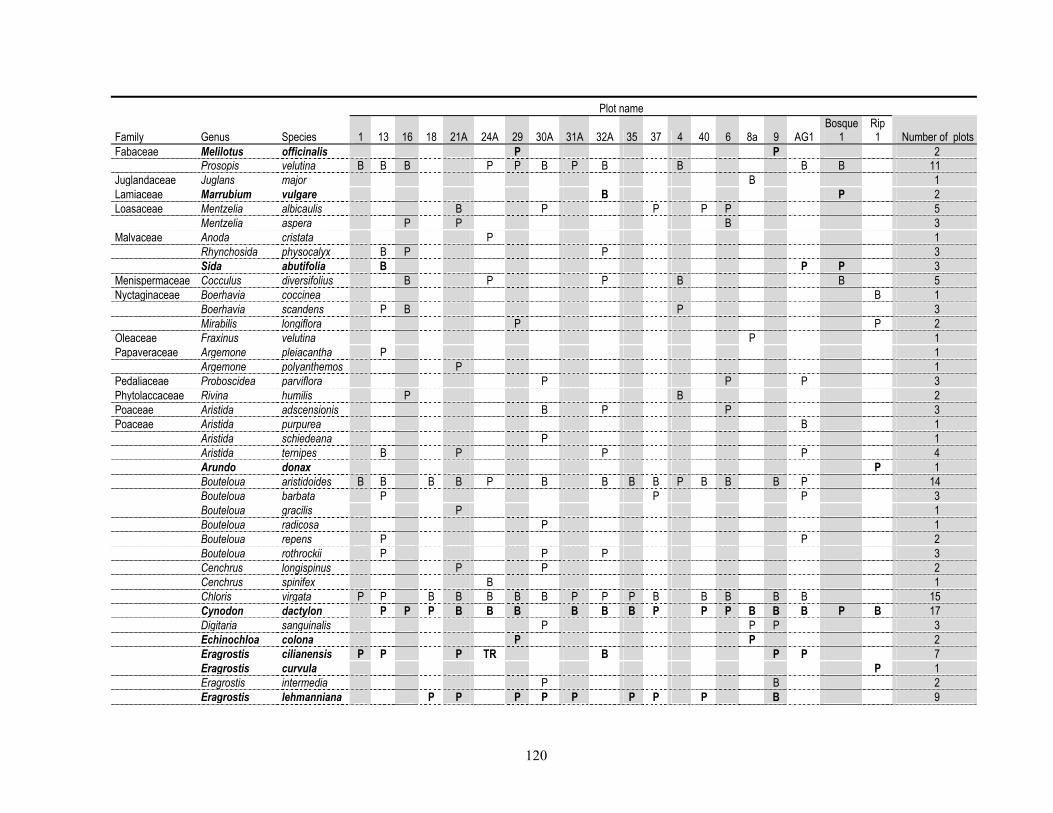
120
Plot name
Family Genus Species 1 13 16 18 21A 24A 29 30A 31A 32A 35 37 4 40 6 8a 9 AG1 Bosque
1 Rip 1 Number of plots
Fabaceae Melilotus officinalis P P 2 Prosopis velutina B B B P P B P B B B B 11 Juglandaceae Juglans major B 1 Lamiaceae Marrubium vulgare B P 2 Loasaceae Mentzelia albicaulis B P P P P 5 Mentzelia aspera P P B 3 Malvaceae Anoda cristata P 1 Rhynchosida physocalyx B P P 3 Sida abutifolia B P P 3 Menispermaceae Cocculus diversifolius B P P B B 5 Nyctaginaceae Boerhavia coccinea B 1 Boerhavia scandens P B P 3 Mirabilis longiflora P P 2 Oleaceae Fraxinus velutina P 1 Papaveraceae Argemone pleiacantha P 1 Argemone polyanthemos P 1 Pedaliaceae Proboscidea parviflora P P P 3 Phytolaccaceae Rivina humilis P B 2 Poaceae Aristida adscensionis B P P 3 Poaceae Aristida purpurea B 1 Aristida schiedeana P 1 Aristida ternipes B P P P 4 Arundo donax P 1 Bouteloua aristidoides B B B B P B B B B P B B B P 14 Bouteloua barbata P P P 3 Bouteloua gracilis P 1 Bouteloua radicosa P 1 Bouteloua repens P P 2 Bouteloua rothrockii P P P 3 Cenchrus longispinus P P 2 Cenchrus spinifex B 1 Chloris virgata P P B B B B B P P P B B B B B 15 Cynodon dactylon P P P B B B B B B P P P B B B P B 17 Digitaria sanguinalis P P P 3 Echinochloa colona P P 2 Eragrostis cilianensis P P P TR B P P 7 Eragrostis curvula P 1 Eragrostis intermedia P B 2 Eragrostis lehmanniana P P P P P P P P B 9
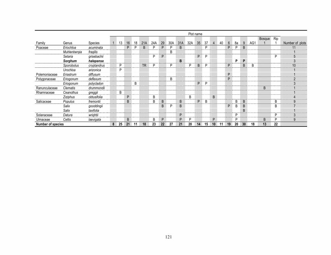
121
Plot name
Family Genus Species 1 13 16 18 21A 24A 29 30A 31A 32A 35 37 4 40 6 8a 9 AG1 Bosque
1 Rip 1 Number of plots
Poaceae Eriochloa acuminata P P B P P P B P P P B 11 Muhlenbergia fragilis B 1 Setaria grisebachii P P P P P 5 Sorghum halepense B P P 3 Sporobolus cryptandrus P TR P P P B P P B B 10 Urochloa arizonica P 1 Polemoniaceae Eriastrum diffusum P 1 Polygonaceae Eriogonum deflexum B P 2 Eriogonum polycladon B P P 3 Ranunculaceae Clematis drummondii B 1 Rhamnaceae Ceanothus greggii B 1 Ziziphus obtusifolia P B B B 4 Salicaceae Populus fremontii B B B B P B B B B 9 Salix gooddingii B P B P B B B 7 Salix taxifolia B 1 Solanaceae Datura wrightii P P P 3 Ulmaceae Celtis laevigata B B P P P P P B P 9 Number of species 8 25 21 11 18 23 22 27 21 20 14 15 10 11 19 20 30 18 13 22
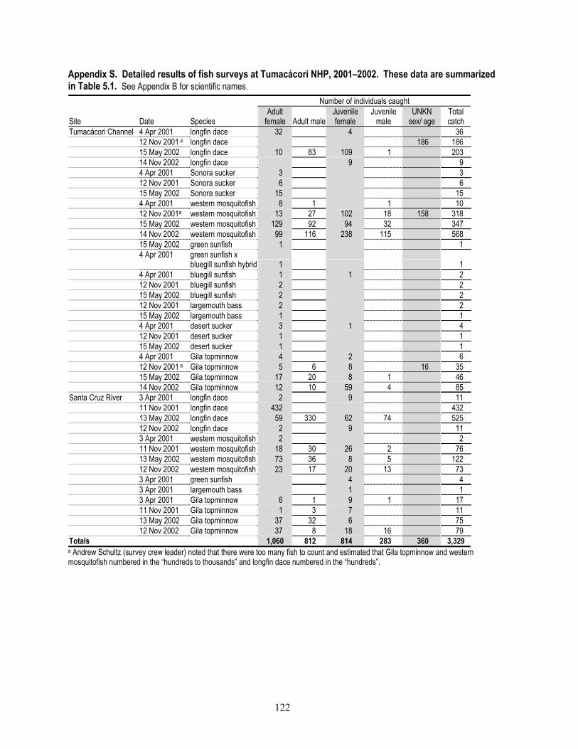
122
Appendix S. Detailed results of fish surveys at Tumacácori NHP, 2001–2002. These data are summarized in Table 5.1. See Appendix B for scientific names. Number of individuals caught
Site Date Species Adult
female Adult maleJuvenile female
Juvenile male
UNKN sex/ age
Total catch
Tumacácori Channel 4 Apr 2001 longfin dace 32 4 36 12 Nov 2001 a longfin dace 186 186 15 May 2002 longfin dace 10 83 109 1 203 14 Nov 2002 longfin dace 9 9 4 Apr 2001 Sonora sucker 3 3 12 Nov 2001 Sonora sucker 6 6 15 May 2002 Sonora sucker 15 15 4 Apr 2001 western mosquitofish 8 1 1 10 12 Nov 2001a western mosquitofish 13 27 102 18 158 318 15 May 2002 western mosquitofish 129 92 94 32 347 14 Nov 2002 western mosquitofish 99 116 238 115 568 15 May 2002 green sunfish 1 1
4 Apr 2001 green sunfish x
bluegill sunfish hybrid 1 1 4 Apr 2001 bluegill sunfish 1 1 2 12 Nov 2001 bluegill sunfish 2 2 15 May 2002 bluegill sunfish 2 2 12 Nov 2001 largemouth bass 2 2 15 May 2002 largemouth bass 1 1 4 Apr 2001 desert sucker 3 1 4 12 Nov 2001 desert sucker 1 1 15 May 2002 desert sucker 1 1 4 Apr 2001 Gila topminnow 4 2 6 12 Nov 2001 a Gila topminnow 5 6 8 16 35 15 May 2002 Gila topminnow 17 20 8 1 46 14 Nov 2002 Gila topminnow 12 10 59 4 85 Santa Cruz River 3 Apr 2001 longfin dace 2 9 11 11 Nov 2001 longfin dace 432 432 13 May 2002 longfin dace 59 330 62 74 525 12 Nov 2002 longfin dace 2 9 11 3 Apr 2001 western mosquitofish 2 2 11 Nov 2001 western mosquitofish 18 30 26 2 76 13 May 2002 western mosquitofish 73 36 8 5 122 12 Nov 2002 western mosquitofish 23 17 20 13 73 3 Apr 2001 green sunfish 4 4 3 Apr 2001 largemouth bass 1 1 3 Apr 2001 Gila topminnow 6 1 9 1 17 11 Nov 2001 Gila topminnow 1 3 7 11 13 May 2002 Gila topminnow 37 32 6 75 12 Nov 2002 Gila topminnow 37 8 18 16 79 Totals 1,060 812 814 283 360 3,329 a Andrew Schultz (survey crew leader) noted that there were too many fish to count and estimated that Gila topminnow and western mosquitofish numbered in the “hundreds to thousands” and longfin dace numbered in the “hundreds”.

123
Appendix T. Total number of birds detected during incidental observations and VCP surveys for the time period of the most intensive surveys, Tumacácori NHP, 2001–2002. Numbers should not used as a measure of relative abundance because there was not consistent sampling effort across time or between survey types. See Table 6.2 for relative abundance of the most common species and Appendix D for scientific names.
Month April May June July Common name 1–15 16–30 1–15 16–31 1–15 16–30 1–15 16–31 great blue heron 1 2 1 1 white-faced Ibis 1 1 turkey vulture 1 9 1 1 3 black vulture 1 2 3 black-bellied whistling duck 1 3 mallard 1 sharp-shinned hawk 1 Cooper's hawk 2 4 1 1 1 3 gray hawk 6 9 7 4 3 3 4 Swainson's hawk 1 red-tailed hawk 1 American kestrel 1 peregrine falcon 2 Gambel's quail 1 11 3 5 4 2 10 killdeer 1 1 1 spotted sandpiper 1 band-tailed pigeon 1 white-winged dove 14 26 5 21 19 10 3 12 mourning dove 12 39 6 15 7 5 2 18 Inca dove 2 1 1 common ground-dove 7 3 3 4 1 6 yellow-billed cuckoo 5 4 1 10 greater roadrunner 2 4 6 barn owl 1 lesser nighthawk 1 1 broad-billed hummingbird 6 16 2 7 3 2 1 13 black-chinned hummingbird 1 4 2 10 3 2 1 Costa's hummingbird 2 broad-tailed hummingbird 3 green kingfisher 1 Lewis's woodpecker 2 Gila woodpecker 21 45 4 26 25 10 7 24 ladder-backed woodpecker 6 6 2 8 5 4 1 5 northern flicker 1 4 4 gilded flicker 1 rose-throated becard 1 northern beardless-tyrannulet 3 10 2 1 2 1 western wood-pewee 2 1 1 2 willow flycatcher 2 1 1 gray flycatcher 1 2 pacific-slope flycatcher 1 cordilleran flycatcher 1 black phoebe 1 1 Say's phoebe 2 7 3 2 1 1 vermilion flycatcher 5 19 10 6 6 1 6

124
Month April May June July Common name 1–15 16–30 1–15 16–31 1–15 16–30 1–15 16–31 dusky-capped flycatcher 4 4 6 4 5 4 ash-throated flycatcher 3 8 3 7 4 11 brown-crested flycatcher 7 2 14 15 7 2 6 sulphur-bellied flycatcher 1 Cassin's kingbird 3 9 2 7 5 1 3 7 western kingbird 2 7 1 2 6 Bell's vireo 9 20 5 14 10 6 3 17 warbling vireo 1 2 2 1 plumbeous vireo 1 2 Cassin's vireo 1 western scrub-jay 2 unknown raven 2 4 3 3 2 violet-green swallow 1 northern rough-winged swallow 2 4 2 1 1 1 bank swallow 1 cliff swallow 2 7 barn swallow 3 2 2 1 1 3 bridled titmouse 2 8 7 3 3 1 3 verdin 3 14 2 7 6 5 3 13 white-breasted nuthatch 1 1 cactus wren 1 Bewick's wren 20 32 6 32 18 6 5 12 house wren 2 2 blue-gray gnatcatcher 1 2 1 black-tailed gnatcatcher 2 Swainson's thrush 1 northern mockingbird 1 1 3 3 2 curve-billed thrasher 2 4 6 1 4 2 7 crissal thrasher 1 European starling 5 2 1 phainopepla 4 6 3 25 22 16 8 25 northern parula 1 orange-crowned warbler 2 Nashville warbler 1 Lucy's warbler 16 35 8 31 19 2 6 9 yellow warbler 3 9 11 9 2 3 8 yellow-rumped warbler 2 black-throated gray warbler 3 1 MacGillivray's warbler 1 1 common yellowthroat 2 6 4 9 4 1 4 Wilson's warbler 1 11 2 yellow-breasted chat 5 2 42 30 23 12 35 summer tanager 1 25 1 17 11 8 2 10 western tanager 2 1 2 1 7 green-tailed towhee 5 1 1 1 canyon towhee 1 1 2 Abert's towhee 1 9 6 2 2 1 2 rufous-winged sparrow 8 5 3 1 1 2 3 rufous-crowned sparrow 1 1 2 1

125
Month April May June July Common name 1–15 16–30 1–15 16–31 1–15 16–30 1–15 16–31 chipping sparrow 2 2 Brewer's sparrow 3 2 lark sparrow 4 3 1 black-throated sparrow 1 1 4 2 song sparrow 4 18 13 13 4 1 12 Lincoln's sparrow 2 white-crowned sparrow 4 1 2 northern cardinal 9 27 1 9 12 9 3 14 pyrrhuloxia 2 2 black-headed grosbeak 1 1 3 3 blue grosbeak 5 2 5 3 4 lazuli bunting 1 1 3 indigo bunting 1 1 varied bunting 2 1 1 3 red-winged blackbird 1 1 Brewer's blackbird 1 great-tailed grackle 11 8 3 1 1 2 bronzed cowbird 3 brown-headed cowbird 11 4 28 24 11 4 14 hooded oriole 1 6 2 1 1 Bullock's oriole 2 5 4 1 2 1 house finch 9 21 3 6 9 3 1 8 lesser goldfinch 11 14 1 10 1 3 4 16 house sparrow 3 8 3 5 3 8

126
Appendix U. Summary of vegetation characteristics measured at VCP survey stations, Tumacácori NHP, 2002.
Mean vegetation
volume (%) Coverage (%)
Park unit Station 0–0.5 m 0.5–2.0 m > 2.0 m Litter Bare
ground RocksCalabazas 1 44 25 1 46 51 9 2 35 29 28 61 30 10 3 45 47 63 90 3 0 Guevavi 1 24 20 16 39 49 10 2 44 32 34 81 12 7 Tumacácori 1 36 9 27 42 56 0 2 38 8 15 52 47 0 3 46 37 46 65 33 2 4 39 38 55 76 23 0 5 46 32 48 74 23 2 6 40 38 56 72 28 0 7 41 11 15 64 36 1 8 57 23 48 89 10 0 Frequency (Freq.) and mean height (Ht; m) of dominant tree species at vegetation plotsa
No
plant Acacia greggi
Celtis reticulata
Populus fremontii
Prosopis velutina
Salix gooddingii
Sambucus mexicana
Park unit Station Freq. Freq. Ht Freq. Ht Freq. Ht Freq. Ht Freq. Ht Freq. Ht Calabazas 1 20 2 9 6 9 4 9 1 6 3 6 9 13 8 1 6 Guevavi 1 4 2 11 5 14 8 8 1 6 2 5 7 8 7 7 1 3 Tumacácori 1 18 8 1 5 2 3 1 6 1 8 4 11 11 8 3 5 1 7 4 11 5 8 5 7 4 1 16 12 3 11 5 18 10 2 10 6 13 13 7 13 7 20 10 8 5 5 12 7 7 2 9 1 4 a Recorded in the “possible cavity-bearing” category.
Copyright © 2022 FDOKUMEN