US 51 Stoughton Road Corridor Study, document
92
US 51- Stoughton Road Traffic, Safety & Needs Identification Analysis Report Project ID 5411-02-03 US 51 Corridor Study Terminal Drive/Voges Road – WIS 19 Dane County Prepared for: Wisconsin Department of Transportation Southwest Region Prepared by: KL Engineering, Inc. Graef Strand Associates, Inc. June 2012 Approved by: For Wisconsin Department of Transportation Date:
-
Upload
khangminh22 -
Category
Documents
-
view
1 -
download
0
Transcript of US 51 Stoughton Road Corridor Study, document
US 51- Stoughton Road Traffic, Safety & Needs Identification
Analysis Report Project ID 5411-02-03 US 51 Corridor Study
Terminal Drive/Voges Road – WIS 19 Dane County
Prepared for:
Wisconsin Department of Transportation Southwest Region
Prepared by:
KL Engineering, Inc.Graef
Strand Associates, Inc.June 2012
Approved by:
For Wisconsin Department of Transportation
Date:
TABLE OF CONTENTS PAGE
1.0 INTRODUCTION ........................................................................................................................ 1 1.1 Location ............................................................................................................................. 1 1.2 Route Significance ............................................................................................................. 2 1.3 Current Role of US 51 ........................................................................................................ 5
2.0 TRAFFIC CONDITIONS ............................................................................................................ 7 2.1 Historic Traffic Volumes ..................................................................................................... 7 2.2 Base Year Traffic Conditions ............................................................................................. 7 2.3 Forecasted Traffic Conditions (2035 ‘No-Build’) .............................................................. 12
3.0 ROADWAY GEOMETRICS ..................................................................................................... 20 3.1 Typical Section ................................................................................................................. 20 3.2 Horizontal Alignment ........................................................................................................ 23 3.3 Vertical Alignment ............................................................................................................ 26 3.4 Signalized Intersections ................................................................................................... 30 3.5 Unsignalized Intersections ............................................................................................... 36 3.6 Geometric Deficiencies .................................................................................................... 37
4.0 INTERCHANGE/RAMP GEOMETRICS .................................................................................. 39 4.1 US 12/18 (Beltline) ........................................................................................................... 39 4.2 Cottage Grove Road ........................................................................................................ 39 4.3 Milwaukee Street ............................................................................................................. 39 4.4 WIS 30 ............................................................................................................................. 40 4.5 I 39/90/94 ......................................................................................................................... 40 4.6 WIS 19 ............................................................................................................................. 40 4.7 Interchange/Ramp Geometrics Deficiencies .................................................................... 40
5.0 ACCESS CONTROL AND FRONTAGE ROAD SPACING ..................................................... 41 5.1 Access Control ................................................................................................................. 41 5.2 Frontage Roads ............................................................................................................... 43
6.0 BICYCLE AND PEDESTRIAN FACILITIES ............................................................................ 46 6.1 Existing Bicycle Facilities ................................................................................................. 46 6.2 Pedestrian Facilities ......................................................................................................... 51
7.0 CRASHES & SAFETY ............................................................................................................. 53 7.1 USH 51 Mainline Crashes ................................................................................................ 53 7.2 US 51 Intersection Crashes Rates and Types ................................................................. 55 7.3 Crash Severity ................................................................................................................. 57
8.0 PAVEMENT CONDITION ........................................................................................................ 59 8.1 Pavement Condition Deficiencies .................................................................................... 60
9.0 STRUCTURES ......................................................................................................................... 61 9.1 Physical Structure Condition, Clearance and Width ........................................................ 61 9.2 Physical Structure Condition, Clearance and Width Deficiencies .................................... 61
10.0 ALTERNATIVES ...................................................................................................................... 63 10.1 Alternatives Selection Process ........................................................................................ 63 10.2 Explanation of Alternatives .............................................................................................. 63 10.3 Evaluation of Alternatives ................................................................................................ 64 10.4 Impacts of Alternatives ..................................................................................................... 72
11.0 AGENCY COORDINATION ..................................................................................................... 82 11.1 Policy Advisory Committee .............................................................................................. 82 11.2 Technical Advisory Committee ........................................................................................ 82 11.3 Stoughton Road Revitalization Project ............................................................................ 83
12.0 PUBLIC INVOLVEMENT ......................................................................................................... 84 12.1 Focus Group Workshops ................................................................................................. 84 12.2 Business Interviews ......................................................................................................... 84 12.3 Public Meetings ................................................................................................................ 85
13.0 SUMMARY ............................................................................................................................... 88
Figures Figure 1 – Project Location Map ................................................................................................... 1 Figure 2 – US 51 System Linkage ................................................................................................ 2 Figure 3 – US 51 (Stoughton Road) Project Area Street Map ...................................................... 4 Figure 4 – US 51 National Highway System ................................................................................. 5 Figure 5 – Historic Traffic Volumes ............................................................................................... 7 Figure 6 – Northbound Travel Times .......................................................................................... 14 Figure 7 – Southbound Travel Times .......................................................................................... 14 Figure 8 – Broadway Intersection – Conceptual ‘Jughandle’ Interchange .................................. 30 Figure 9 – Existing Pflaum Road Intersection ............................................................................. 31 Figure 10 – Existing Buckeye Road Intersection ........................................................................ 32 Figure 11 – Existing East Washington Avenue Intersection ....................................................... 33 Figure 12 – Existing Anderson Street Intersection ...................................................................... 34 Figure 13 – Traffic Pattern Between East Washington Avenue and Anderson Street ................ 35 Figure 14 – Hoepker Road Intersection after Reconstruction ..................................................... 35 Figure 15 – Daentl Road Intersection from the North ................................................................. 36 Figure 16 – I 39/90/94 to WIS 19 Section ................................................................................... 37 Figure 17 – Access Spacing at Interchanges FDM 11-5-5, Attachment 5.2 ............................... 42 Figure 18 – Frontage Road Spacing and Access Standards FDM 11-25-45, Figure 45.1.......... 45 Figure 19 – Existing and Proposed Bicycle Facilities ................................................................. 50 Figure 20 – US 51 (Stoughton Road) Area Wetlands ................................................................. 76 Figure 21 – Map of Existing Land Uses (US 151/East Washington Avenue to WIS 19)............. 80 Tables Table 1 – Base Year Traffic Conditions ........................................................................................ 8 Table 2 – Base Year & Future PM Peak Hour Intersection Level of Service .............................. 11 Table 3 – Forecasted Traffic Summary ....................................................................................... 12 Table 4 – Signalized Intersection Operations (PM Peak Hour) .................................................. 16 Table 5 – Signalized Intersection Operations – Approaches, PM Peak Hour, LOS.................... 17 Table 6 – Unsignalized Intersection Operations (PM Peak Hour) .............................................. 18 Table 7 – Design Speeds and ADT (Base & Design Year) ......................................................... 20 Table 8 – Typical Section Design Requirements (from FDM 11-15-1, Attachment 1) ................ 21 Table 9 – Existing Typical Sections ............................................................................................ 22 Table 10 – Existing Horizontal Curves along US 51 within the project corridor .......................... 24 Table 11 – Vertical curves along US 51 within the project corridor ............................................ 26 Table 12 – Intersection Geometric and Operational Deficiencies ............................................... 38 Table 13 – Interchange Access Spacing .................................................................................... 41 Table 14 – Frontage Road Spacing from Lane Edge to Lane Edge ........................................... 43 Table 15 – US 51 Crashes by Roadway Segment 2005 – 2008 ................................................ 54 Table 16 – Crashes at US 51 Intersections ................................................................................ 57 Table 17 – Injury Crashes at US 51 Intersections ...................................................................... 58 Table 18 – Pavement Condition Indices US 51 Northbound ...................................................... 59 Table 19 – Pavement Condition Roughness Indices US 51 Southbound ................................... 59 Table 20 – Physical Structure Conditions ................................................................................... 61 Table 21 – Existing & Future PM Peak Hour Level of Service with Conceptual Alternatives ..... 67 Table 22 – Alternative Impacts ................................................................................................... 72 Table 23 – Number of Displaced Businesses and Jobs ............................................................. 74 Table 24 – Residential Impacts ................................................................................................... 75
1
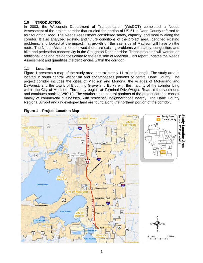
1.0 INTRODUCTION In 2003, the Wisconsin Department of Transportation (WisDOT) completed a Needs Assessment of the project corridor that studied the portion of US 51 in Dane County referred to as Stoughton Road. The Needs Assessment considered safety, capacity, and mobility along the corridor. It also analyzed existing and future conditions of the project area, identified existing problems, and looked at the impact that growth on the east side of Madison will have on the route. The Needs Assessment showed there are existing problems with safety, congestion, and bike and pedestrian connectivity in the Stoughton Road corridor. These problems will worsen as additional jobs and residences come to the east side of Madison. This report updates the Needs Assessment and quantifies the deficiencies within the corridor. 1.1 Location Figure 1 presents a map of the study area, approximately 11 miles in length. The study area is located in south central Wisconsin and encompasses portions of central Dane County. The project corridor includes the cities of Madison and Monona, the villages of McFarland and DeForest, and the towns of Blooming Grove and Burke with the majority of the corridor lying within the City of Madison. The study begins at Terminal Drive/Voges Road at the south end and continues north to WIS 19. The southern and central portions of the project corridor consist mainly of commercial businesses, with residential neighborhoods nearby. The Dane County Regional Airport and undeveloped land are found along the northern portion of the corridor. Figure 1 – Project Location Map
2
1.2 Route Significance US 51 is a designated multi-lane backbone highway under WisDOT’s 1989 Corridors 2020 Plan, Wisconsin’s Connections to the 21st Century. High quality backbone highways provide links to the state’s economic centers and meet maximum design standards for service, mobility and safety. However, this portion of US 51 doesn’t meet these maximum design standards. The Connections 2030 long-range transportation plan that has been developed by WisDOT identifies a series of multimodal corridors for each part of the state along with routes and/or services for several modes such as highways, rail, air and transit. US 51 is identified as a Principal Highway on the “Blackhawk Corridor” that connects Madison to Chicago via Beloit, and on the “Badger State Corridor” that links Madison to Eau Claire. US 51 is a major highway with national, statewide, regional and local importance. At the national level:
US 51 is a component of the National Highway System (NHS) under the 2005 Safe, Accountable, Flexible, Efficient Transportation Equity Act: A Legacy for Users (SAFETEA-LU). The NHS is a priority system of highways identified and designated to ensure connectivity to national defense highways and other important regional highways, and to provide a high level of safety, design and operational standards.
US 51 is a federally-designated long truck route allowing trucks up to 65 feet in length to use the highway (State of Wisconsin Official Designated Long Truck Route Map, WisDOT, October 2007).
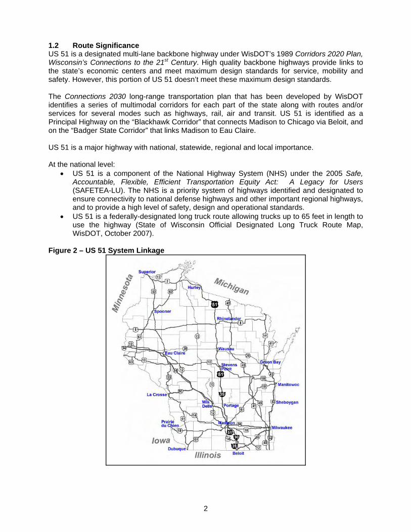
Figure 2 – US 51 System Linkage
3
At the State level:
US 51 is a major north-south highway from the Michigan state line near Hurley to the Illinois state line at Beloit (see Figure 2). US 51 provides direct access to economic centers throughout the state, and connections to other major highways including I-94, US 151, US 10, WIS 29 and US 8.
US 51 is a Tier II access management corridor under WisDOT’s 1989 Access Management System Plan. Tier II corridors are those where limiting access would be a cost effective strategy to improve safety, reduce congestion and facilitate planned access to developing land.
At the regional level:
Stoughton Road is functionally classified as a principal arterial highway and along with I 39/90/94 it is the main north-south travel corridor on Madison’s east side. As a principal arterial highway, Stoughton Road is intended to meet the needs of travelers with regional destinations; serve major activity centers in the Madison urbanized area, and provide connections to other major highways serving adjacent development and communities.
Stoughton Road provides a vital connection to the Beltline (US 12/18) on the south and to I 39/90/94 on the north for traffic on the eastside of Madison. These links provide commuter, business and industrial traffic freeway access to regional routes like US 12, US 14, US 18 and USH 151.
US 51 is part of the ‘Blue Route’ – an alternate route for traffic when incidents inhibit the flow of traffic on I 39/90/94.
At the local level:
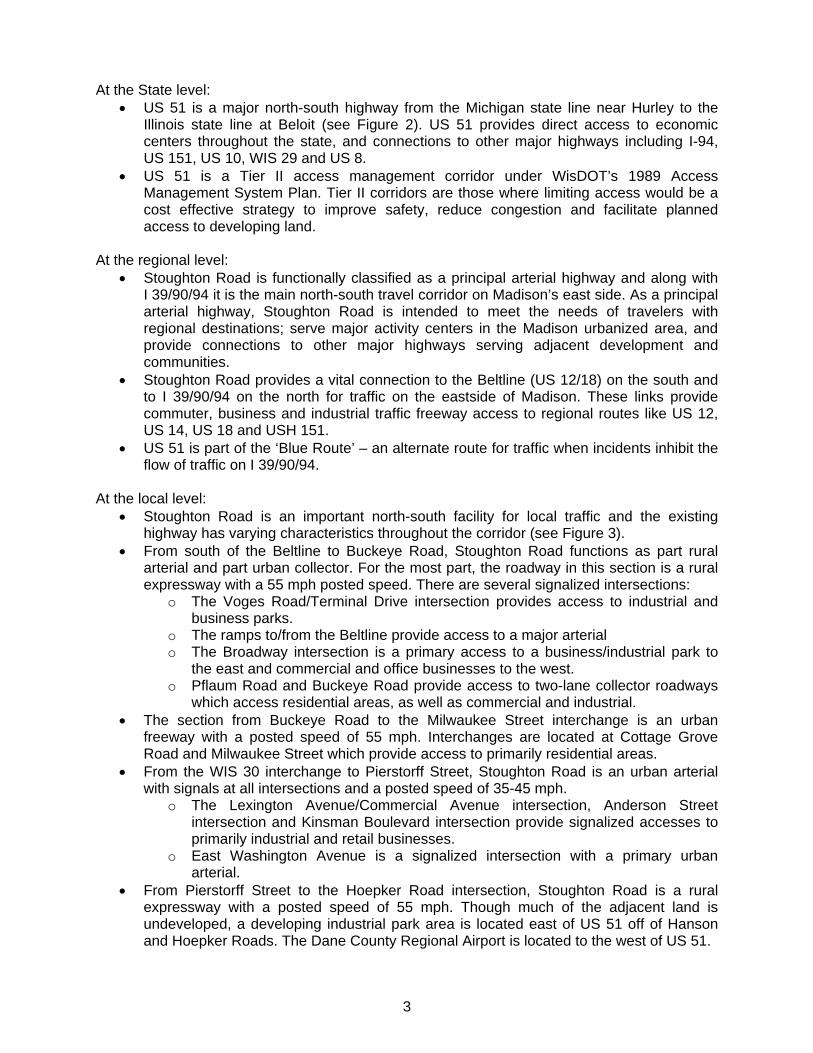
Stoughton Road is an important north-south facility for local traffic and the existing highway has varying characteristics throughout the corridor (see Figure 3).
From south of the Beltline to Buckeye Road, Stoughton Road functions as part rural arterial and part urban collector. For the most part, the roadway in this section is a rural expressway with a 55 mph posted speed. There are several signalized intersections:
o The Voges Road/Terminal Drive intersection provides access to industrial and business parks.
o The ramps to/from the Beltline provide access to a major arterial o The Broadway intersection is a primary access to a business/industrial park to
the east and commercial and office businesses to the west. o Pflaum Road and Buckeye Road provide access to two-lane collector roadways
which access residential areas, as well as commercial and industrial. The section from Buckeye Road to the Milwaukee Street interchange is an urban
freeway with a posted speed of 55 mph. Interchanges are located at Cottage Grove Road and Milwaukee Street which provide access to primarily residential areas.
From the WIS 30 interchange to Pierstorff Street, Stoughton Road is an urban arterial with signals at all intersections and a posted speed of 35-45 mph.
o The Lexington Avenue/Commercial Avenue intersection, Anderson Street intersection and Kinsman Boulevard intersection provide signalized accesses to primarily industrial and retail businesses.
o East Washington Avenue is a signalized intersection with a primary urban arterial.
From Pierstorff Street to the Hoepker Road intersection, Stoughton Road is a rural expressway with a posted speed of 55 mph. Though much of the adjacent land is undeveloped, a developing industrial park area is located east of US 51 off of Hanson and Hoepker Roads. The Dane County Regional Airport is located to the west of US 51.
4
Figure 3 – US 51 (Stoughton Road) Project Area Street Map
Rieder Rd
5
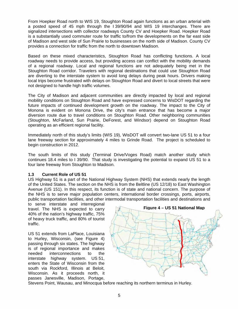
From Hoepker Road north to WIS 19, Stoughton Road again functions as an urban arterial with a posted speed of 45 mph through the I 39/90/94 and WIS 19 interchanges. There are signalized intersections with collector roadways County CV and Hoepker Road. Hoepker Road is a substantially used commuter route for traffic to/from the developments on the far east side of Madison and west side of Sun Prairie to businesses on the north side of Madison. County CV provides a connection for traffic from the north to downtown Madison. Based on these mixed characteristics, Stoughton Road has conflicting functions. A local roadway needs to provide access, but providing access can conflict with the mobility demands of a regional roadway. Local and regional functions are not adequately being met in the Stoughton Road corridor. Travelers with regional destinations that could use Stoughton Road are diverting to the interstate system to avoid long delays during peak hours. Drivers making local trips become frustrated with delays on Stoughton Road and divert to local streets that were not designed to handle high traffic volumes. The City of Madison and adjacent communities are directly impacted by local and regional mobility conditions on Stoughton Road and have expressed concerns to WisDOT regarding the future impacts of continued development growth on the roadway. The impact to the City of Monona is evident on Monona Drive, the city’s main entrance that has become a major diversion route due to travel conditions on Stoughton Road. Other neighboring communities (Stoughton, McFarland, Sun Prairie, DeForest, and Windsor) depend on Stoughton Road operating as an efficient regional facility. Immediately north of this study’s limits (WIS 19), WisDOT will convert two-lane US 51 to a four lane freeway section for approximately 4 miles to Grinde Road. The project is scheduled to begin construction in 2012. The south limits of this study (Terminal Drive/Voges Road) match another study which continues 18.4 miles to I 39/90. That study is investigating the potential to expand US 51 to a four lane freeway from Stoughton to Madison. 1.3 Current Role of US 51 US Highway 51 is a part of the National Highway System (NHS) that extends nearly the length of the United States. The section on the NHS is from the Beltline (US 12/18) to East Washington Avenue (US 151). In this respect, its function is of state and national concern. The purpose of the NHS is to serve major population centers, international border crossings, ports, airports, public transportation facilities, and other intermodal transportation facilities and destinations and to serve interstate and interregional travel. The NHS is expected to carry 40% of the nation’s highway traffic, 75% of heavy truck traffic, and 80% of tourist traffic. US 51 extends from LaPlace, Louisiana to Hurley, Wisconsin, (see Figure 4) passing through six states. The highway is of regional importance and makes needed interconnections to the interstate highway system. US 51, enters the State of Wisconsin from the south via Rockford, Illinois at Beloit, Wisconsin. As it proceeds north, it passes Janesville, Madison, Portage, Stevens Point, Wausau, and Minocqua before reaching its northern terminus in Hurley.
Figure 4 – US 51 National Map
6
Stoughton Road, along with Interstate Highway 39/90/94 (I 39/90/94), is the main north-south corridor for travel on the east side of Madison. US 51 is also important to the movement of regional traffic through the area. WisDOT has scheduled reconstruction of US 51 in the section north of the Stoughton Road section; an Environmental Impact Statement (EIS) corridor study examining potential capacity expansion is being conducted for the section of US 51 south of the Stoughton Road section. WisDOT identified a series of multimodal corridors for each part of the state in the Connections 2030; each identifies routes and/or services of several modes such as highways, local roads, rail, air, and transit. US 51 is identified as a Principal Highway on two of the corridors, the “Blackhawk Corridor” that connects Madison to Chicago via Beloit, and the “Badger State Corridor” that links Madison to Eau Claire. Stoughton Road is a “principal arterial” and a four-lane or six-lane divided roadway throughout the study area. As a fundamental link in the state highway system, this route’s primary purpose is to provide statewide mobility. A primary function of US 51 in the Madison area is as a regional traffic carrier. Regional traffic has neither an origin nor destination in Madison. It passes through the city but for many of its trips, US 51 also acts as a local street providing a moderate level of local access. These dual roles often conflict. This is especially true within the city of Madison, as evidenced by the Needs Assessment Technical Report completed for the project in 2003. Along the Stoughton Road alignment, the roadway provides access to local roads. In a limited area between East Washington Avenue and Pierstorff Street, there is direct access to businesses and residences; outside of this limited area, there is no direct access along the corridor. On street parking is not allowed on Stoughton Road. Bicycle and pedestrian access is limited to crossing roadways and along side streets parallel to Stoughton Road. Although bicycles are not prohibited from Stoughton Road no facilities are provided for bicycle travel along or on the roadway.
7
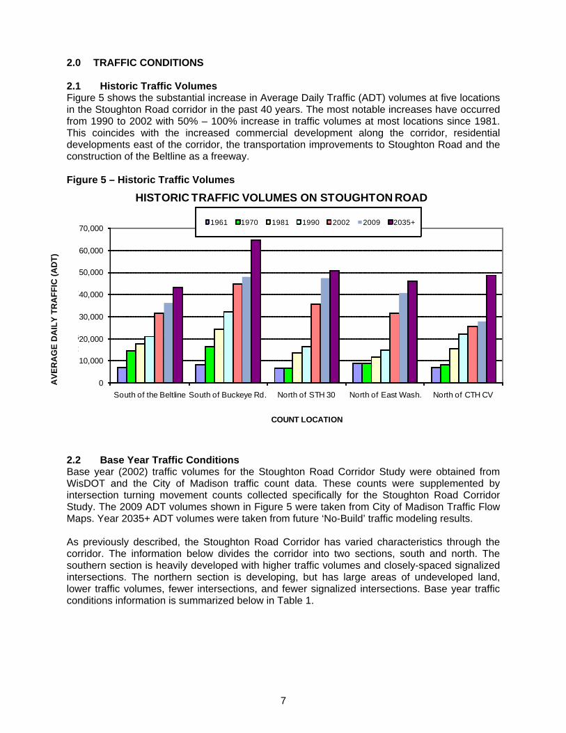
2.0 TRAFFIC CONDITIONS 2.1 Historic Traffic Volumes Figure 5 shows the substantial increase in Average Daily Traffic (ADT) volumes at five locations in the Stoughton Road corridor in the past 40 years. The most notable increases have occurred from 1990 to 2002 with 50% – 100% increase in traffic volumes at most locations since 1981. This coincides with the increased commercial development along the corridor, residential developments east of the corridor, the transportation improvements to Stoughton Road and the construction of the Beltline as a freeway. Figure 5 – Historic Traffic Volumes
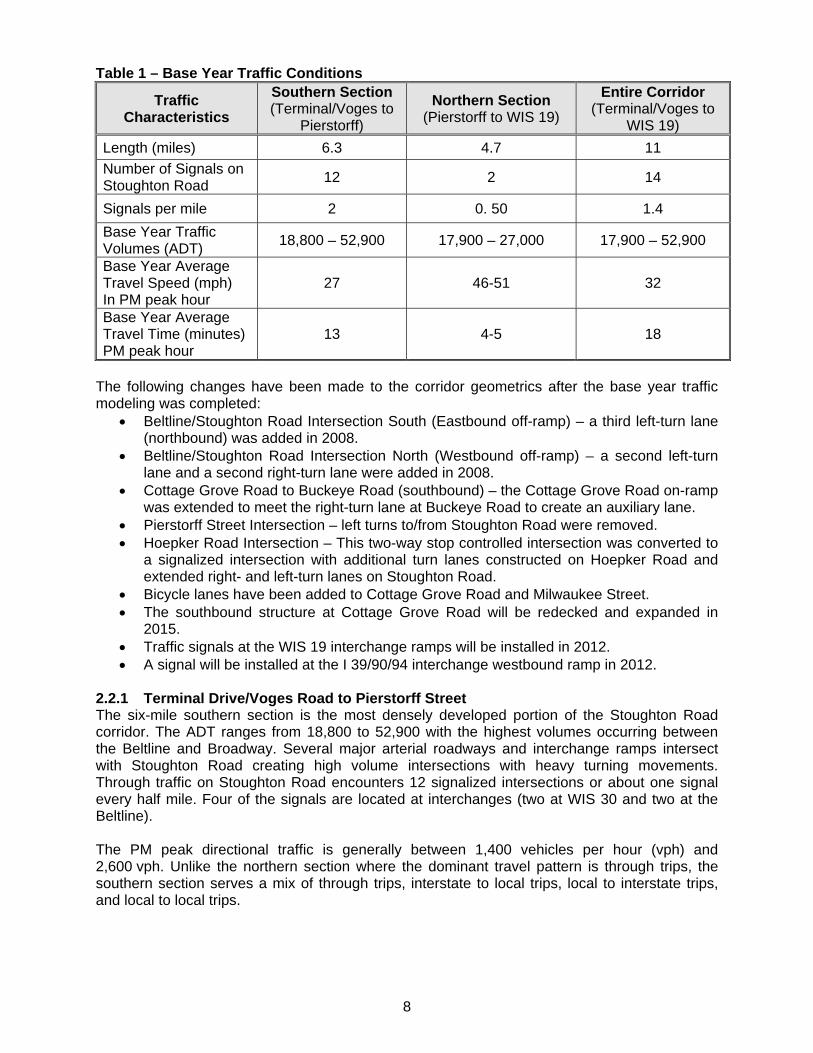
2.2 Base Year Traffic Conditions Base year (2002) traffic volumes for the Stoughton Road Corridor Study were obtained from WisDOT and the City of Madison traffic count data. These counts were supplemented by intersection turning movement counts collected specifically for the Stoughton Road Corridor Study. The 2009 ADT volumes shown in Figure 5 were taken from City of Madison Traffic Flow Maps. Year 2035+ ADT volumes were taken from future ‘No-Build’ traffic modeling results. As previously described, the Stoughton Road Corridor has varied characteristics through the corridor. The information below divides the corridor into two sections, south and north. The southern section is heavily developed with higher traffic volumes and closely-spaced signalized intersections. The northern section is developing, but has large areas of undeveloped land, lower traffic volumes, fewer intersections, and fewer signalized intersections. Base year traffic conditions information is summarized below in Table 1.
AV
ER
AG
E D
AIL
Y T
RA
FF
IC (
AD
T)
0
10,000
20,000
30,000
40,000
50,000
60,000
70,000
South of the Beltline South of Buckeye Rd. North of STH 30 North of East Wash. North of CTH CV
A
RAG
A
RA
A
COUNT LOCATION
HISTORIC TRAFFIC VOLUMES ON STOUGHTON ROAD
1961 1970 1981 1990 2002 2009 2035+
8
Table 1 – Base Year Traffic Conditions
Traffic Characteristics
Southern Section (Terminal/Voges to
Pierstorff)
Northern Section (Pierstorff to WIS 19)
Entire Corridor (Terminal/Voges to
WIS 19)
Length (miles) 6.3 4.7 11
Number of Signals on Stoughton Road
12 2 14
Signals per mile 2 0. 50 1.4
Base Year Traffic Volumes (ADT)
18,800 – 52,900 17,900 – 27,000 17,900 – 52,900
Base Year Average Travel Speed (mph) In PM peak hour
27 46-51 32
Base Year Average Travel Time (minutes) PM peak hour
13 4-5 18
The following changes have been made to the corridor geometrics after the base year traffic modeling was completed:
Beltline/Stoughton Road Intersection South (Eastbound off-ramp) – a third left-turn lane (northbound) was added in 2008.
Beltline/Stoughton Road Intersection North (Westbound off-ramp) – a second left-turn lane and a second right-turn lane were added in 2008.
Cottage Grove Road to Buckeye Road (southbound) – the Cottage Grove Road on-ramp was extended to meet the right-turn lane at Buckeye Road to create an auxiliary lane.
Pierstorff Street Intersection – left turns to/from Stoughton Road were removed. Hoepker Road Intersection – This two-way stop controlled intersection was converted to
a signalized intersection with additional turn lanes constructed on Hoepker Road and extended right- and left-turn lanes on Stoughton Road.
Bicycle lanes have been added to Cottage Grove Road and Milwaukee Street. The southbound structure at Cottage Grove Road will be redecked and expanded in
2015. Traffic signals at the WIS 19 interchange ramps will be installed in 2012. A signal will be installed at the I 39/90/94 interchange westbound ramp in 2012.
2.2.1 Terminal Drive/Voges Road to Pierstorff Street The six-mile southern section is the most densely developed portion of the Stoughton Road corridor. The ADT ranges from 18,800 to 52,900 with the highest volumes occurring between the Beltline and Broadway. Several major arterial roadways and interchange ramps intersect with Stoughton Road creating high volume intersections with heavy turning movements. Through traffic on Stoughton Road encounters 12 signalized intersections or about one signal every half mile. Four of the signals are located at interchanges (two at WIS 30 and two at the Beltline). The PM peak directional traffic is generally between 1,400 vehicles per hour (vph) and 2,600 vph. Unlike the northern section where the dominant travel pattern is through trips, the southern section serves a mix of through trips, interstate to local trips, local to interstate trips, and local to local trips.
9
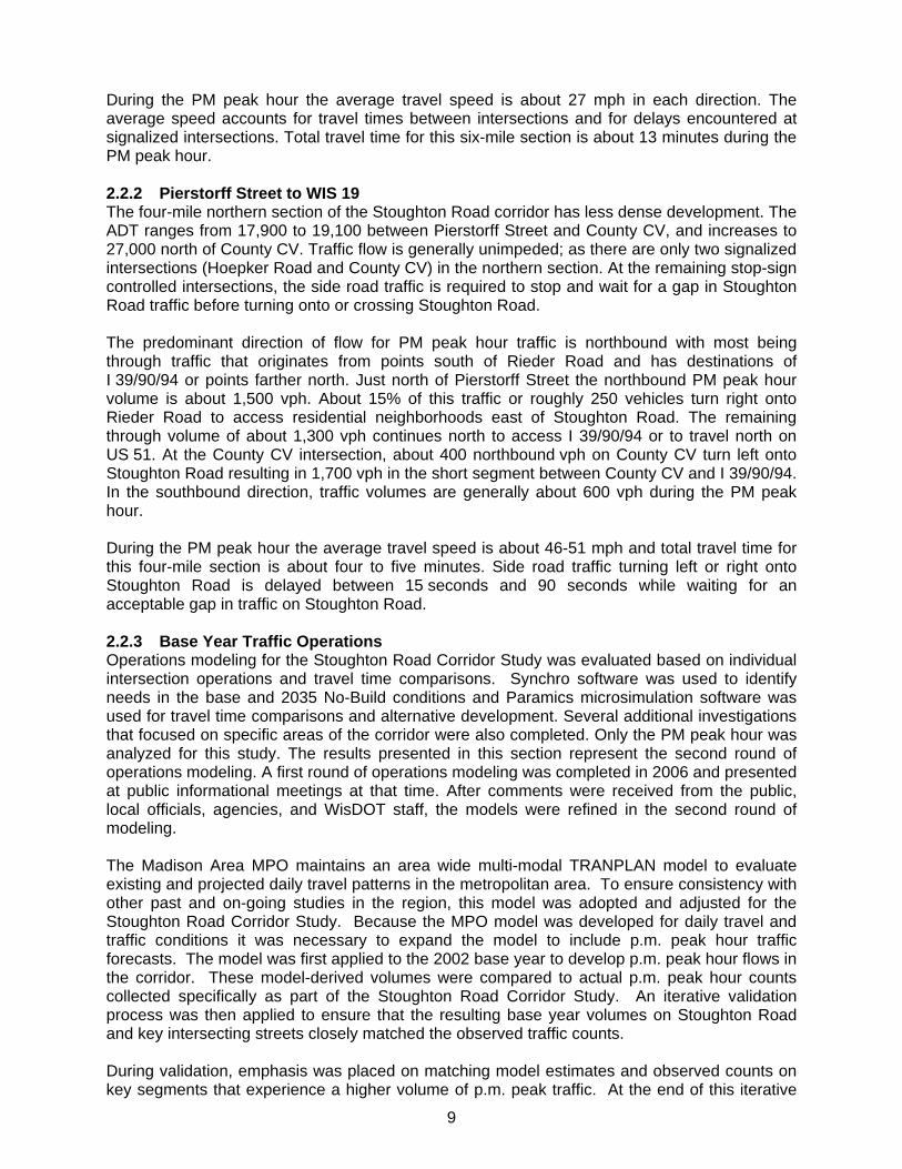
During the PM peak hour the average travel speed is about 27 mph in each direction. The average speed accounts for travel times between intersections and for delays encountered at signalized intersections. Total travel time for this six-mile section is about 13 minutes during the PM peak hour. 2.2.2 Pierstorff Street to WIS 19 The four-mile northern section of the Stoughton Road corridor has less dense development. The ADT ranges from 17,900 to 19,100 between Pierstorff Street and County CV, and increases to 27,000 north of County CV. Traffic flow is generally unimpeded; as there are only two signalized intersections (Hoepker Road and County CV) in the northern section. At the remaining stop-sign controlled intersections, the side road traffic is required to stop and wait for a gap in Stoughton Road traffic before turning onto or crossing Stoughton Road. The predominant direction of flow for PM peak hour traffic is northbound with most being through traffic that originates from points south of Rieder Road and has destinations of I 39/90/94 or points farther north. Just north of Pierstorff Street the northbound PM peak hour volume is about 1,500 vph. About 15% of this traffic or roughly 250 vehicles turn right onto Rieder Road to access residential neighborhoods east of Stoughton Road. The remaining through volume of about 1,300 vph continues north to access I 39/90/94 or to travel north on US 51. At the County CV intersection, about 400 northbound vph on County CV turn left onto Stoughton Road resulting in 1,700 vph in the short segment between County CV and I 39/90/94. In the southbound direction, traffic volumes are generally about 600 vph during the PM peak hour. During the PM peak hour the average travel speed is about 46-51 mph and total travel time for this four-mile section is about four to five minutes. Side road traffic turning left or right onto Stoughton Road is delayed between 15 seconds and 90 seconds while waiting for an acceptable gap in traffic on Stoughton Road. 2.2.3 Base Year Traffic Operations Operations modeling for the Stoughton Road Corridor Study was evaluated based on individual intersection operations and travel time comparisons. Synchro software was used to identify needs in the base and 2035 No-Build conditions and Paramics microsimulation software was used for travel time comparisons and alternative development. Several additional investigations that focused on specific areas of the corridor were also completed. Only the PM peak hour was analyzed for this study. The results presented in this section represent the second round of operations modeling. A first round of operations modeling was completed in 2006 and presented at public informational meetings at that time. After comments were received from the public, local officials, agencies, and WisDOT staff, the models were refined in the second round of modeling. The Madison Area MPO maintains an area wide multi-modal TRANPLAN model to evaluate existing and projected daily travel patterns in the metropolitan area. To ensure consistency with other past and on-going studies in the region, this model was adopted and adjusted for the Stoughton Road Corridor Study. Because the MPO model was developed for daily travel and traffic conditions it was necessary to expand the model to include p.m. peak hour traffic forecasts. The model was first applied to the 2002 base year to develop p.m. peak hour flows in the corridor. These model-derived volumes were compared to actual p.m. peak hour counts collected specifically as part of the Stoughton Road Corridor Study. An iterative validation process was then applied to ensure that the resulting base year volumes on Stoughton Road and key intersecting streets closely matched the observed traffic counts. During validation, emphasis was placed on matching model estimates and observed counts on key segments that experience a higher volume of p.m. peak traffic. At the end of this iterative

10
process a close overall match was obtained with the total estimated traffic on 97 key roadway segments in the corridor falling within 1.2% of the corresponding base year counts. The validated model was then applied to the future year in order to forecast changes in traffic resulting from transportation improvements and land use changes. The growth rate between base year and future year model volumes was calculated for each intersection. The resulting difference in traffic was then added to the current base year counts to produce adjusted future year volumes. Operations on a street or highway are evaluated using Measures of Effectiveness (MOEs). For Stoughton Road, the intersection operations were used as the primary MOE. The operation of an intersection is typically described as “Level of Service” (LOS). The LOS rating system describes the traffic flow conditions of the intersection and ranges from A (free flow conditions) to F (over capacity). In urban areas, intersection operations are the primary evaluation measure for operation levels. For the base year and Year 2035 No-Build shown in Table 2 LOS was calculated using Paramics models. The entire corridor from WIS 19 to Terminal Drive/Voges Road was included in these models. Paramics allows for the analysis of both roundabout and signal controlled intersections within the same model, aiding in the alterative development for this study. Additionally, the way in which interaction between vehicles impacts overall operations is better represented in Paramics. LOS characteristics are different for signalized and unsignalized intersections. Drivers anticipate longer delays at signalized intersections that carry large amounts of traffic. However, drivers generally feel unsignalized intersections should have less delay. Additionally, several driver behavior considerations combine to make delays at unsignalized intersections less desirable than at signalized intersections. For example, drivers at signalized intersections are able to relax during the red interval, whereas drivers on the minor approaches to an unsignalized intersection must remain attentive to identify acceptable gaps for entry. Typically, LOS is only calculated for the legs of an unsignalized intersection that must yield to other movements (stop control or left turns). Table 2 indicates the LOS characteristics for both signalized and unsignalized intersections in the base year and the 2035 ‘No-Build’ scenario.

11
Table 2 – Base Year & Future PM Peak Hour Intersection Level of Service Year 2002 Base Year
Year 2035 No-Build
WIS 19 SB Ramps / NB RampsSB NB SB NB
* A * A * A * E
Token Creek Park Road * B
F
I 39/90/93 Ramp Terminals SB NB
SB NB
* E * C * F * F
County CV/Anderson Road C
F
Hoepker Road * B * F
Kinsman Boulevard B
F
Anderson Street C
F
East Washington Avenue F
F
Lexington / Commercial Avenue B
F
WIS 30 WB Ramps / EB Ramps WB EB WB EB
C C F F
Milwaukee Street SB Ramps / NB Ramps SB NB SB NB
B B F F
Cottage Grove SB Ramps / NB Ramps SB NB SB NB
B A F F
Buckeye Road E F
Pflaum Road E F
Broadway C
F
US 12/18 WB Ramps / EB Ramps WB EB WB EB
D C F F
Terminal Drive/Voges Road B
F
*Stop controlled delay for minor approaches There are three major areas that experience poor signal operations with high levels of delay or significant queuing under the base year conditions:
The Pflaum Road and Buckeye Road intersections – the intersections have similar configuration and are in close proximity. Operational issues at one of these intersections have a direct effect on the other. They operate at LOS E during the PM peak hour. Significant queues were observed at both of the intersections, occasionally exceeding 1,000 feet in length along northbound and southbound Stoughton Road during the peak hour. Additional operational concerns were caused by the close proximity of the frontage roads to mainline Stoughton Road at these locations. The queues on Buckeye Road and Pflaum Road routinely blocked the frontage road intersections.
The Stoughton Road/East Washington Avenue intersection - Modeling indicates that the heavy volumes along both Stoughton Road (31,600 ADT) and East Washington Avenue (55,000 ADT) exceed the current traffic signal’s capacity during the PM peak hour. The intersection operates at LOS F during the PM peak hour. Long queues
12
were observed on all intersection approaches. The most significant queuing was observed on the westbound East Washington Avenue approach, with frequent cycle failures occurring. Queues at times extend beyond the Mendota Street intersection – the next intersection east of Stoughton Road on East Washington Avenue.
A recent project to expand the exit ramps from the both the eastbound and westbound Beltline has helped to alleviate the queuing for the short term. Prior to the construction of additional turn lanes on the westbound Beltline interchange ramp, the LOS was D, which is acceptable but not desirable. The primary operational issue at the Beltline interchange is the queuing that occurs on both of the Beltline off-ramps during the PM peak hour (similar issues were noticed during the AM peak hour for the westbound off-ramp). These queues were reaching the Beltline at times during the simulation. The operation of the mainline Beltline lanes is affected by the queuing that is present on the off-ramps. At the maximum, the queues on the off-ramps were reaching over 2,000 feet in length in the simulation. These conditions occur because approximately 50% of eastbound Beltline traffic exits at Stoughton Road during the PM peak hour. More the 50% of southbound Stoughton Road traffic exits to the westbound Beltline during the PM peak hour.
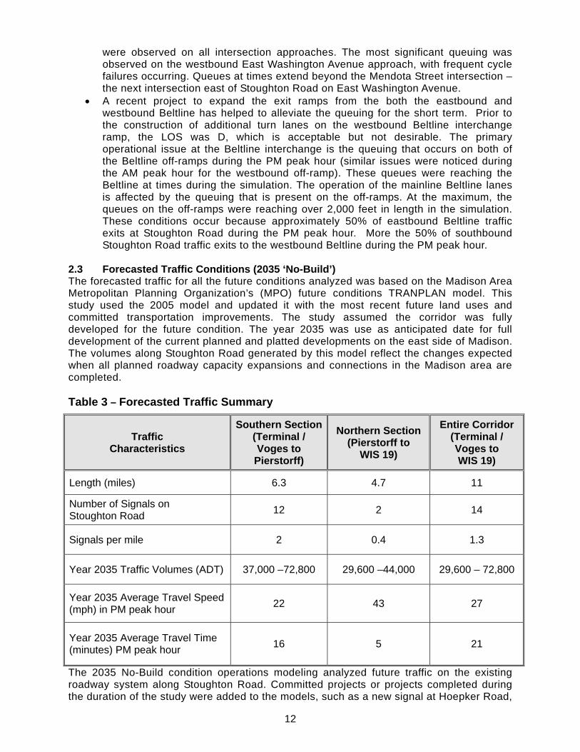
2.3 Forecasted Traffic Conditions (2035 ‘No-Build’) The forecasted traffic for all the future conditions analyzed was based on the Madison Area Metropolitan Planning Organization’s (MPO) future conditions TRANPLAN model. This study used the 2005 model and updated it with the most recent future land uses and committed transportation improvements. The study assumed the corridor was fully developed for the future condition. The year 2035 was use as anticipated date for full development of the current planned and platted developments on the east side of Madison. The volumes along Stoughton Road generated by this model reflect the changes expected when all planned roadway capacity expansions and connections in the Madison area are completed. Table 3 – Forecasted Traffic Summary
Traffic Characteristics
Southern Section(Terminal / Voges to
Pierstorff)
Northern Section (Pierstorff to
WIS 19)
Entire Corridor (Terminal / Voges to WIS 19)
Length (miles) 6.3 4.7 11
Number of Signals on Stoughton Road
12 2 14
Signals per mile 2 0.4 1.3
Year 2035 Traffic Volumes (ADT) 37,000 –72,800 29,600 –44,000 29,600 – 72,800
Year 2035 Average Travel Speed (mph) in PM peak hour
22 43 27
Year 2035 Average Travel Time (minutes) PM peak hour
16 5 21
The 2035 No-Build condition operations modeling analyzed future traffic on the existing roadway system along Stoughton Road. Committed projects or projects completed during the duration of the study were added to the models, such as a new signal at Hoepker Road,
13
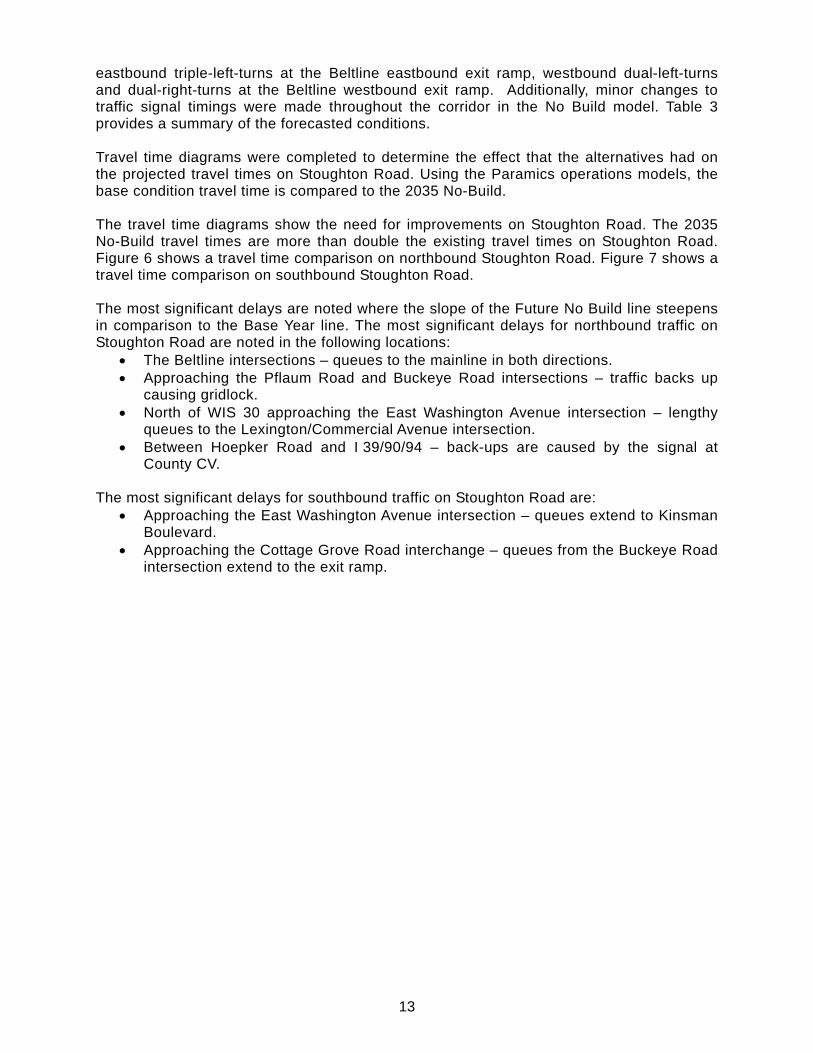
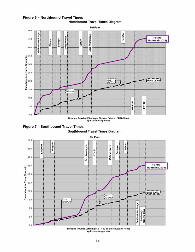
eastbound triple-left-turns at the Beltline eastbound exit ramp, westbound dual-left-turns and dual-right-turns at the Beltline westbound exit ramp. Additionally, minor changes to traffic signal timings were made throughout the corridor in the No Build model. Table 3 provides a summary of the forecasted conditions. Travel time diagrams were completed to determine the effect that the alternatives had on the projected travel times on Stoughton Road. Using the Paramics operations models, the base condition travel time is compared to the 2035 No-Build. The travel time diagrams show the need for improvements on Stoughton Road. The 2035 No-Build travel times are more than double the existing travel times on Stoughton Road. Figure 6 shows a travel time comparison on northbound Stoughton Road. Figure 7 shows a travel time comparison on southbound Stoughton Road. The most significant delays are noted where the slope of the Future No Build line steepens in comparison to the Base Year line. The most significant delays for northbound traffic on Stoughton Road are noted in the following locations:
The Beltline intersections – queues to the mainline in both directions. Approaching the Pflaum Road and Buckeye Road intersections – traffic backs up
causing gridlock. North of WIS 30 approaching the East Washington Avenue intersection – lengthy
queues to the Lexington/Commercial Avenue intersection. Between Hoepker Road and I 39/90/94 – back-ups are caused by the signal at
County CV. The most significant delays for southbound traffic on Stoughton Road are:
Approaching the East Washington Avenue intersection – queues extend to Kinsman Boulevard.
Approaching the Cottage Grove Road interchange – queues from the Buckeye Road intersection extend to the exit ramp.
14
Figure 6 – Northbound Travel Times
Figure 7 – Southbound Travel Times
Future No-Build (2035)
Future No-Build (2035)
15
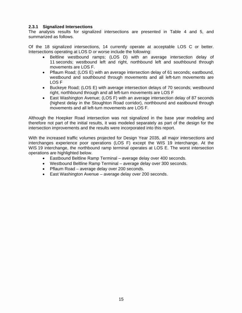
2.3.1 Signalized Intersections The analysis results for signalized intersections are presented in Table 4 and 5, and summarized as follows. Of the 18 signalized intersections, 14 currently operate at acceptable LOS C or better. Intersections operating at LOS D or worse include the following:
Beltline westbound ramps; (LOS D) with an average intersection delay of 11 seconds; westbound left and right, northbound left and southbound through movements are LOS F.
Pflaum Road; (LOS E) with an average intersection delay of 61 seconds; eastbound, westbound and southbound through movements and all left-turn movements are LOS F
Buckeye Road; (LOS E) with average intersection delays of 70 seconds; westbound right, northbound through and all left-turn movements are LOS F
East Washington Avenue; (LOS F) with an average intersection delay of 87 seconds (highest delay in the Stoughton Road corridor), northbound and eastbound through movements and all left-turn movements are LOS F.
Although the Hoepker Road intersection was not signalized in the base year modeling and therefore not part of the initial results, it was modeled separately as part of the design for the intersection improvements and the results were incorporated into this report. With the increased traffic volumes projected for Design Year 2035, all major intersections and interchanges experience poor operations (LOS F) except the WIS 19 interchange. At the WIS 19 interchange, the northbound ramp terminal operates at LOS E. The worst intersection operations are highlighted below.
Eastbound Beltline Ramp Terminal – average delay over 400 seconds. Westbound Beltline Ramp Terminal – average delay over 300 seconds. Pflaum Road – average delay over 200 seconds. East Washington Avenue – average delay over 200 seconds.
16
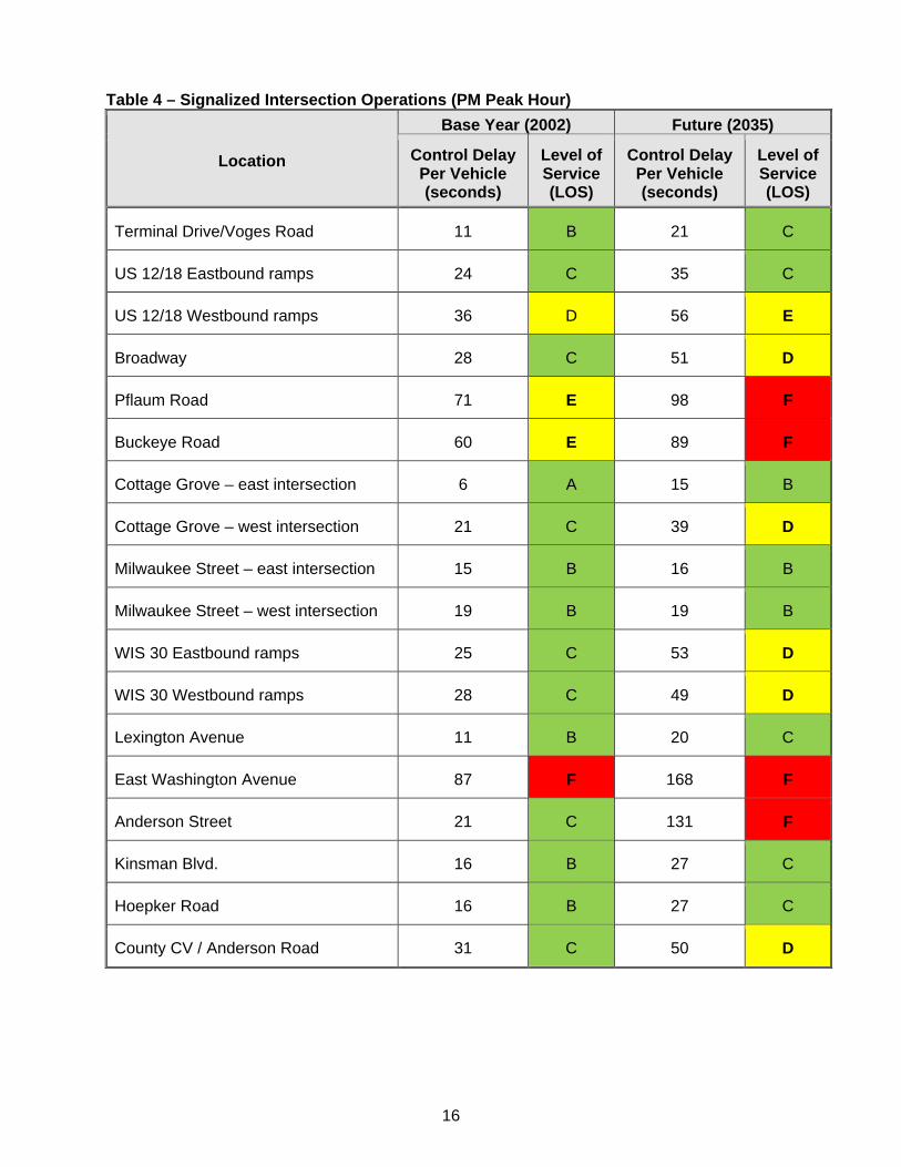
Table 4 – Signalized Intersection Operations (PM Peak Hour)
Location
Base Year (2002) Future (2035)
Control Delay Per Vehicle (seconds)
Level of Service (LOS)
Control Delay Per Vehicle (seconds)
Level of Service (LOS)
Terminal Drive/Voges Road 11 B 21 C
US 12/18 Eastbound ramps 24 C 35 C
US 12/18 Westbound ramps 36 D 56 E
Broadway 28 C 51 D
Pflaum Road 71 E 98 F
Buckeye Road 60 E 89 F
Cottage Grove – east intersection 6 A 15 B
Cottage Grove – west intersection 21 C 39 D
Milwaukee Street – east intersection 15 B 16 B
Milwaukee Street – west intersection 19 B 19 B
WIS 30 Eastbound ramps 25 C 53 D
WIS 30 Westbound ramps 28 C 49 D
Lexington Avenue 11 B 20 C
East Washington Avenue 87 F 168 F
Anderson Street 21 C 131 F
Kinsman Blvd. 16 B 27 C
Hoepker Road 16 B 27 C
County CV / Anderson Road 31 C 50 D
17
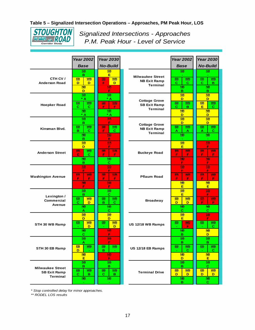
Table 5 – Signalized Intersection Operations – Approaches, PM Peak Hour, LOS
EB WB EB WB EB WB EB WB
D D F D C C C B
EB WB EB WB EB WB EB WB
C C F F C B E C
EB WB EB WB EB WB EB WB
B C F C A A A C
EB WB EB WB EB WB EB WB
E C F F F F F F
EB WB EB WB EB WB EB WB
F F F F F F F F
EB WB EB WB EB WB EB WB
C D B C D D F F
EB WB EB WB EB WB EB WB
- D - D - F - C
EB WB EB WB EB WB EB WB
D - B - - C - C
EB WB EB WB EB WB EB WB
C B C B D D D D
* Stop controlled delay for minor approaches.** RODEL LOS results
Signalized Intersections - ApproachesP.M. Peak Hour - Level of Service
Year 2002 Year 2030
Base No-Build
Terminal Drive
SB SB
B C
NB NB
B C
US 12/18 EB Ramps
SB SB
B B
NB NB
D E
US 12/18 WB Ramps
SB SB
E F
NB NB
B D
Broadway
SB SB
E F
NB NB
C C
Pflaum Road
SB SB
F F
NB NB
E E
Buckeye Road
SB SB
E F
NB NB
F F
Cottage Grove NB Exit Ramp
Terminal
SB SB
D D
NB NB
- -
Cottage Grove SB Exit Ramp
Terminal
SB SB
D D
NB NB
D D
Milwaukee Street NB Exit Ramp
Terminal
SB SB
- -
NB NB
B B
Milwaukee Street SB Exit Ramp
Terminal
CTH CV / Anderson Road
Hoepker Road
Kinsman Blvd.
Anderson Street
Washington Avenue
Lexington / Commercial
Avenue
STH 30 WB Ramp
F
NB
F FNB
F
NB NB
A
D
SB SB
SB SB
B
SB SB
SB
* A
NB
* A
E
F
Year 2002 Year 2030
Base No-Build
NB
SB
B
NB
D
E
F
NB NB
B
SB
* A
NB
* A
SB
NB
B
- -
F
NB
C
C
SB SB
B C
SB SB
STH 30 EB Ramp
D D
NB NB
C FSB SB
NB NB
A F
NB NB
E FSB SB
B B
18
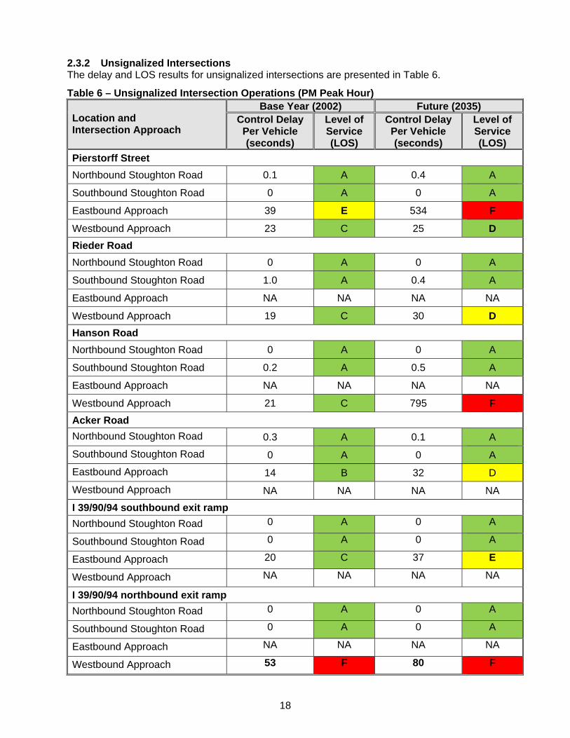
2.3.2 Unsignalized Intersections
The delay and LOS results for unsignalized intersections are presented in Table 6.
Table 6 – Unsignalized Intersection Operations (PM Peak Hour) Location and Intersection Approach
Base Year (2002) Future (2035) Control Delay Per Vehicle (seconds)
Level of Service (LOS)
Control Delay Per Vehicle (seconds)
Level of Service (LOS)
Pierstorff Street
Northbound Stoughton Road 0.1 A 0.4 A
Southbound Stoughton Road 0 A 0 A
Eastbound Approach 39 E 534 F
Westbound Approach 23 C 25 D
Rieder Road
Northbound Stoughton Road 0 A 0 A
Southbound Stoughton Road 1.0 A 0.4 A
Eastbound Approach NA NA NA NA
Westbound Approach 19 C 30 D
Hanson Road
Northbound Stoughton Road 0 A 0 A
Southbound Stoughton Road 0.2 A 0.5 A
Eastbound Approach NA NA NA NA
Westbound Approach 21 C 795 F
Acker Road
Northbound Stoughton Road 0.3 A 0.1 A
Southbound Stoughton Road 0 A 0 A
Eastbound Approach 14 B 32 D
Westbound Approach NA NA NA NA
I 39/90/94 southbound exit ramp
Northbound Stoughton Road 0 A 0 A
Southbound Stoughton Road 0 A 0 A
Eastbound Approach 20 C 37 E
Westbound Approach NA NA NA NA
I 39/90/94 northbound exit ramp
Northbound Stoughton Road 0 A 0 A
Southbound Stoughton Road 0 A 0 A
Eastbound Approach NA NA NA NA
Westbound Approach 53 F 80 F
19
Of the six unsignalized intersections on Stoughton Road that were modeled, the majority of the intersection approaches operate at acceptable LOS C or better in the base conditions. The following intersections have one or more approaches operating at LOS D or worse:
Pierstorff Street eastbound approach (LOS E) with an average delay of 39 seconds I 39/90/94 northbound exit ramp, westbound approach (LOS F) with an average
delay of 53 seconds With the increased traffic volumes projected for Design Year 2035, the following unsignalized intersections currently operating at an acceptable LOS will deteriorate to LOS D or worse:
Pierstorff Street westbound approach (LOS D), delay of 25 seconds, and eastbound approach (LOS F), delay of 534 seconds primarily due to difficulty making left turns (left turns are no longer allowed from eastbound Pierstorff Street)
Rieder Road westbound approach (LOS D), delay of 30 seconds Hanson Road westbound approach (LOS F), delay of 795 seconds Acker Road eastbound approach (LOS D), delay of 32 seconds I 39/90/94 southbound exit ramp, eastbound approach (LOS E), delay of 37 seconds I 39/90/94 northbound exit ramp, westbound approach (LOS F), delay of 80 seconds
(intersection to be signalized in 2012).
Prior to its conversion to a signalized intersection, the Hoepker Road eastbound and westbound approaches to Stoughton Road operated at LOS F with an average delay 91 and 55 seconds, respectively. Five unsignalized intersections at major side roads in the Stoughton Road corridor were also analyzed. Those intersections with all approaches currently operating at LOS C or better include Pflaum Road/East Frontage Road, Buckeye Road/Blossom Lane and Buckeye Road/West Frontage Road. Those intersections with one approach currently operating at LOS D or worse include the following:
Pflaum Road/West Frontage Road, southbound approach (LOS E) Buckeye Road/East Frontage Road, northbound approach (LOS F)
These intersections are expected to experience the same LOS under Design Year 2035 traffic volumes.
20
3.0 ROADWAY GEOMETRICS This section provides a comparison of standard design features of the roadway to WisDOT FDM standards. Traffic volumes and level of service (LOS) are a factor in determining the required design standards for comparison. Therefore the roadway geometrics were evaluated using base year and design year traffic volumes and LOS. 3.1 Typical Section The typical section for US 51 was evaluated for the following conditions:
US 51 is on Corridors 2020 Backbone System US 51 is a long truck route US 51 is a part of the National Highway System from US 12/18 (the Beltline) to East
Washington Avenue.
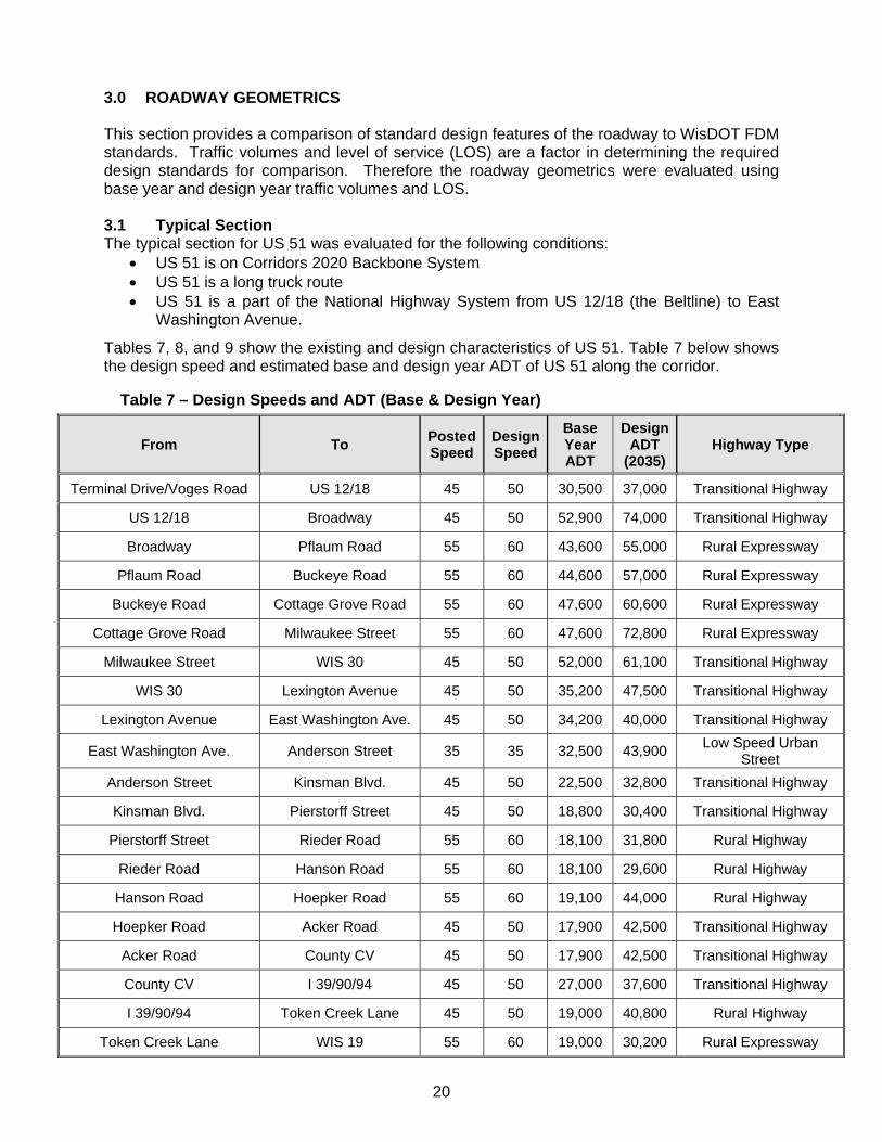
Tables 7, 8, and 9 show the existing and design characteristics of US 51. Table 7 below shows the design speed and estimated base and design year ADT of US 51 along the corridor.
Table 7 – Design Speeds and ADT (Base & Design Year)
From To Posted Speed
Design Speed
Base Year ADT
Design ADT
(2035) Highway Type
Terminal Drive/Voges Road US 12/18 45 50 30,500 37,000 Transitional Highway
US 12/18 Broadway 45 50 52,900 74,000 Transitional Highway
Broadway Pflaum Road 55 60 43,600 55,000 Rural Expressway
Pflaum Road Buckeye Road 55 60 44,600 57,000 Rural Expressway
Buckeye Road Cottage Grove Road 55 60 47,600 60,600 Rural Expressway
Cottage Grove Road Milwaukee Street 55 60 47,600 72,800 Rural Expressway
Milwaukee Street WIS 30 45 50 52,000 61,100 Transitional Highway
WIS 30 Lexington Avenue 45 50 35,200 47,500 Transitional Highway
Lexington Avenue East Washington Ave. 45 50 34,200 40,000 Transitional Highway
East Washington Ave. Anderson Street 35 35 32,500 43,900 Low Speed Urban
Street
Anderson Street Kinsman Blvd. 45 50 22,500 32,800 Transitional Highway
Kinsman Blvd. Pierstorff Street 45 50 18,800 30,400 Transitional Highway
Pierstorff Street Rieder Road 55 60 18,100 31,800 Rural Highway
Rieder Road Hanson Road 55 60 18,100 29,600 Rural Highway
Hanson Road Hoepker Road 55 60 19,100 44,000 Rural Highway
Hoepker Road Acker Road 45 50 17,900 42,500 Transitional Highway
Acker Road County CV 45 50 17,900 42,500 Transitional Highway
County CV I 39/90/94 45 50 27,000 37,600 Transitional Highway
I 39/90/94 Token Creek Lane 45 50 19,000 40,800 Rural Highway
Token Creek Lane WIS 19 55 60 19,000 30,200 Rural Expressway
21
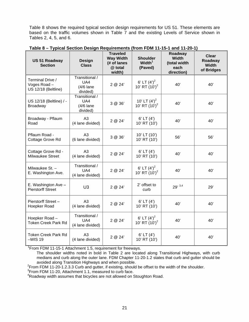
Table 8 shows the required typical section design requirements for US 51. These elements are based on the traffic volumes shown in Table 7 and the existing Levels of Service shown in Tables 2, 4, 5, and 6. Table 8 – Typical Section Design Requirements (from FDM 11-15-1 and 11-20-1)
US 51 Roadway Section
Design Class
Traveled Way Width (# of lanes
@ total width)
Shoulder Width1 (Paved)
Roadway Width
(total width each
direction)
Clear Roadway
Width of Bridges
Terminal Drive / Voges Road – US 12/18 (Beltline)
Transitional / UA4
(4/6 lane divided)
2 @ 24’ 6’ LT (4’)2
10’ RT (10’)2 40’ 40’
US 12/18 (Beltline) / - Broadway
Transitional / UA4
(4/6 lane divided)
3 @ 36’ 10’ LT (4’)2
10’ RT (10’)2 40’ 40’
Broadway - Pflaum Road
A3 (4 lane divided)
2 @ 24’ 6’ LT (4’)
10’ RT (10’) 40’ 40’
Pflaum Road - Cottage Grove Rd
A3 (6 lane divided)
3 @ 36’ 10’ LT (10’) 10’ RT (10’)
56’ 56’
Cottage Grove Rd - Milwaukee Street
A3 (4 lane divided)
2 @ 24’ 6’ LT (4’)
10’ RT (10’) 40’ 40’
Milwaukee St. – E. Washington Ave.
Transitional / UA4
(4 lane divided) 2 @ 24’
6’ LT (4’)2 10’ RT (10’)2
40’ 40’
E. Washington Ave – Pierstorff Street U3 2 @ 24’
2’ offset to curb
29’ 3,4 29’
Pierstorff Street – Hoepker Road
A3 (4 lane divided)
2 @ 24’ 6’ LT (4’)
10’ RT (10’) 40’ 40’
Hoepker Road – Token Creek Park Rd
Transitional / UA4
(4 lane divided) 2 @ 24’
6’ LT (4’)2 10’ RT (10’)2
40’ 40’
Token Creek Park Rd –WIS 19
A3 (4 lane divided)
2 @ 24’ 6’ LT (4’)
10’ RT (10’) 40’ 40’
1From FDM 11-15-1 Attachment 1.5, requirement for freeways. The shoulder widths noted in bold in Table 2 are located along Transitional Highways, with curb medians and curb along the outer lane. FDM Chapter 11-20-1.2 states that curb and gutter should be avoided along Transition Highways and when possible.
2From FDM 11-20-1.2.3.3 Curb and gutter, if existing, should be offset to the width of the shoulder. 3From FDM 11-20, Attachment 1.1, measured to curb face. 4Roadway width assumes that bicycles are not allowed on Stoughton Road.
22
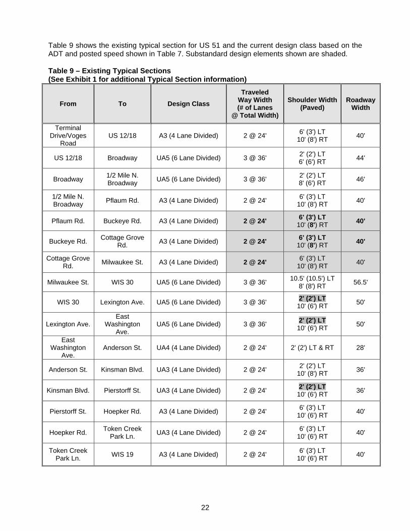
Table 9 shows the existing typical section for US 51 and the current design class based on the ADT and posted speed shown in Table 7. Substandard design elements shown are shaded. Table 9 – Existing Typical Sections (See Exhibit 1 for additional Typical Section information)
From To Design Class
Traveled Way Width (# of Lanes
@ Total Width)
Shoulder Width (Paved)
Roadway Width
Terminal Drive/Voges
Road US 12/18 A3 (4 Lane Divided) 2 @ 24'
6' (3') LT 10' (8') RT
40'
US 12/18 Broadway UA5 (6 Lane Divided) 3 @ 36' 2' (2') LT 6' (6') RT
44'
Broadway 1/2 Mile N. Broadway
UA5 (6 Lane Divided) 3 @ 36' 2' (2') LT 8' (6') RT
46'
1/2 Mile N. Broadway
Pflaum Rd. A3 (4 Lane Divided) 2 @ 24' 6' (3') LT
10' (8') RT 40'
Pflaum Rd. Buckeye Rd. A3 (4 Lane Divided) 2 @ 24' 6' (3') LT
10' (8') RT 40'
Buckeye Rd. Cottage Grove
Rd. A3 (4 Lane Divided) 2 @ 24'
6' (3') LT 10' (8') RT
40'
Cottage Grove Rd.
Milwaukee St. A3 (4 Lane Divided) 2 @ 24' 6' (3') LT
10' (8') RT 40'
Milwaukee St. WIS 30 UA5 (6 Lane Divided) 3 @ 36' 10.5' (10.5') LT
8' (8') RT 56.5'
WIS 30 Lexington Ave. UA5 (6 Lane Divided) 3 @ 36' 2' (2') LT
10' (6') RT 50'
Lexington Ave. East
Washington Ave.
UA5 (6 Lane Divided) 3 @ 36' 2' (2') LT
10' (6') RT 50'
East Washington
Ave. Anderson St. UA4 (4 Lane Divided) 2 @ 24' 2' (2') LT & RT 28'
Anderson St. Kinsman Blvd. UA3 (4 Lane Divided) 2 @ 24' 2' (2') LT
10' (8') RT 36'
Kinsman Blvd. Pierstorff St. UA3 (4 Lane Divided) 2 @ 24' 2' (2') LT
10' (6') RT 36'
Pierstorff St. Hoepker Rd. A3 (4 Lane Divided) 2 @ 24' 6' (3') LT
10' (6') RT 40'
Hoepker Rd. Token Creek
Park Ln. UA3 (4 Lane Divided) 2 @ 24'
6' (3') LT 10' (6') RT
40'
Token Creek Park Ln.
WIS 19 A3 (4 Lane Divided) 2 @ 24' 6' (3') LT
10' (6') RT 40'
23
3.1.1 Typical Section Deficiencies 3.1.1.1 Design Class As noted in Tables 8 and 9, one of the typical section deficiencies of the corridor for 2035 conditions is the number of travel lanes between Pflaum Road and Milwaukee Street. The corridor traffic volumes and LOS require an additional travel lane in each direction, additional roadway width, and additional structure width. The existing typical section is sufficient for existing conditions in the other sections of the corridor. 3.1.1.2 Shoulder Width The shoulder and paved shoulder widths are deficient for the design year based on freeway requirements. The shoulder widths are sufficient for existing conditions. 3.2 Horizontal Alignment Stoughton Road, in general is a north south roadway. However there are horizontal curves within the corridor at/near the following intersections and interchange ramps:
Terminal Drive/Voges Road, PI Station 569+25.36 Beltline and Broadway, PI Station 603+51.97 WIS 30 and Lexington/Commercial Avenue, PI Station 833+14.43 Rieder Road, PI Station 1143+04.00 Cottage Grove Road, Station 735+19.17
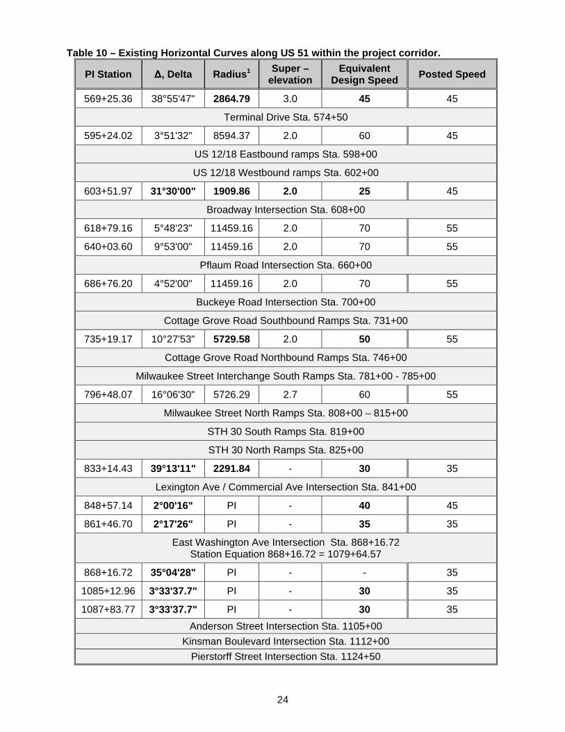
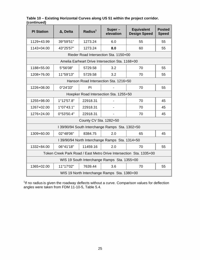
Near East Washington Avenue and within the intersection, the roadway deflects several times without curves. The following section provides details on the roadway alignment. 3.2.1 Curve Radius & Superelevation Evaluation of the horizontal curves along the corridor was completed utilizing the superelevation tables in FDM Chapter 11-10-5, Exhibit 5.1, A maximum of 6% or 8% superelevation was used in accordance with FDM Chapter 11-10-5.3, which notes that 8% superelevation is only acceptable when considering 3R reconstruction, rehabilitation, or resurfacing projects. Table 10 on the following page describes the horizontal curves on US 51 located within the project corridor, and give the design speed of each using current standards. Items that are shown in bold do not meet current standards.
24
Table 10 – Existing Horizontal Curves along US 51 within the project corridor.
PI Station Δ, Delta Radius1 Super –
elevation Equivalent
Design Speed Posted Speed
569+25.36 38°55'47" 2864.79 3.0 45 45
Terminal Drive Sta. 574+50
595+24.02 3°51'32" 8594.37 2.0 60 45
US 12/18 Eastbound ramps Sta. 598+00
US 12/18 Westbound ramps Sta. 602+00
603+51.97 31°30'00" 1909.86 2.0 25 45
Broadway Intersection Sta. 608+00
618+79.16 5°48'23" 11459.16 2.0 70 55
640+03.60 9°53'00" 11459.16 2.0 70 55
Pflaum Road Intersection Sta. 660+00
686+76.20 4°52'00" 11459.16 2.0 70 55
Buckeye Road Intersection Sta. 700+00
Cottage Grove Road Southbound Ramps Sta. 731+00
735+19.17 10°27'53" 5729.58 2.0 50 55
Cottage Grove Road Northbound Ramps Sta. 746+00
Milwaukee Street Interchange South Ramps Sta. 781+00 - 785+00
796+48.07 16°06'30" 5726.29 2.7 60 55
Milwaukee Street North Ramps Sta. 808+00 – 815+00
STH 30 South Ramps Sta. 819+00
STH 30 North Ramps Sta. 825+00
833+14.43 39°13'11" 2291.84 - 30 35
Lexington Ave / Commercial Ave Intersection Sta. 841+00
848+57.14 2°00'16" PI - 40 45
861+46.70 2°17'26" PI - 35 35
East Washington Ave Intersection Sta. 868+16.72 Station Equation 868+16.72 = 1079+64.57
868+16.72 35°04'28" PI - - 35
1085+12.96 3°33'37.7" PI - 30 35
1087+83.77 3°33'37.7" PI - 30 35
Anderson Street Intersection Sta. 1105+00
Kinsman Boulevard Intersection Sta. 1112+00
Pierstorff Street Intersection Sta. 1124+50
25
Table 10 – Existing Horizontal Curves along US 51 within the project corridor. (continued)
PI Station Δ, Delta Radius1 Super –
elevation Equivalent
Design Speed Posted Speed
1129+43.99 39°59'51" 1273.24 6.0 55 55
1143+04.00 43°25'57" 1273.24 8.0 60 55
Rieder Road Intersection Sta. 1150+00
Amelia Earheart Drive Intersection Sta. 1168+00
1188+55.00 5°56'08" 5729.58 3.2 70 55
1208+76.00 11°59'13" 5729.58 3.2 70 55
Hanson Road Intersection Sta. 1216+50
1226+08.00 0°24'33" PI - 70 55
Hoepker Road Intersection Sta. 1255+50
1255+98.00 1°12'57.8" 22918.31 - 70 45
1267+02.00 1°07'43.1" 22918.31 - 70 45
1276+24.00 0°53'50.4" 22918.31 - 70 45
County CV Sta. 1282+50
I 39/90/94 South Interchange Ramps Sta. 1302+50
1309+60.00 02°48'06" 8384.75 2.0 65 45
I 39/90/94 North Interchange Ramps Sta. 1314+50
1332+84.00 06°41'18" 11459.16 2.0 70 55
Token Creek Park Road / East Metro Drive Intersection Sta. 1335+00
WIS 19 South Interchange Ramps Sta. 1355+00
1365+02.00 11°17'02" 7639.44 3.6 70 55
WIS 19 North Interchange Ramps Sta. 1380+00
1If no radius is given the roadway deflects without a curve. Comparison values for deflection angles were taken from FDM 11-10-5, Table 5.4.
26
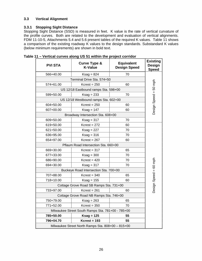
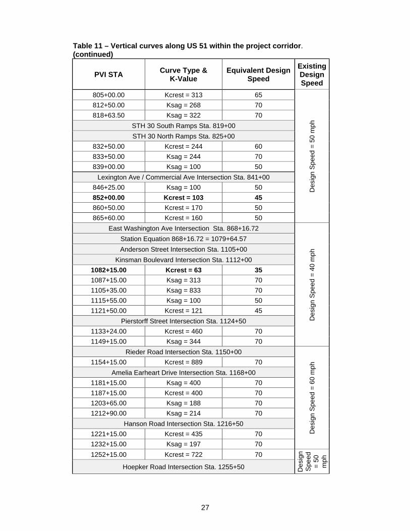
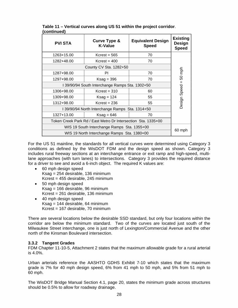
3.3 Vertical Alignment 3.3.1 Stopping Sight Distance Stopping Sight Distance (SSD) is measured in feet. K value is the rate of vertical curvature of the profile curves. Both are related to the development and evaluation of vertical alignments. FDM 11-10-5, Attachments 5.4 and 5.6 present tables of the required K values. Table 11 shows a comparison of the existing roadway K values to the design standards. Substandard K values (below minimum requirements) are shown in bold text. Table 11 – Vertical curves along US 51 within the project corridor
PVI STA Curve Type & K-Value
Equivalent Design Speed
Existing Design Speed
566+40.00 Ksag = 824 70
Des
ign
Spe
ed =
50
mph
Terminal Drive Sta. 574+50
574+61.00 Kcrest = 250 60
US 12/18 Eastbound ramps Sta. 598+00
599+50.00 Ksag = 233 70
US 12/18 Westbound ramps Sta. 602+00
604+50.00 Kcrest = 250 60
607+00.00 Ksag = 147 60
Broadway Intersection Sta. 608+00
609+50.00 Ksag = 317 70
619+50.00 Kcrest = 272 60
Des
ign
Spe
ed =
60
mph
621+50.00 Ksag = 227 70
636+95.00 Ksag = 316 70
654+97.00 Kcrest = 267 60
Pflaum Road Intersection Sta. 660+00
669+30.00 Kcrest = 317 65
677+33.00 Ksag = 300 70
686+90.00 Kcrest = 420 70
694+30.00 Ksag = 317 70
Buckeye Road Intersection Sta. 700+00
707+88.00 Kcrest = 340 65
718+10.00 Ksag = 155 60
Cottage Grove Road SB Ramps Sta. 731+00
733+97.00 Kcrest = 261 60
Cottage Grove Road NB Ramps Sta. 746+00
750+79.00 Ksag = 263 65
771+52.00 Kcrest = 350 70
Milwaukee Street South Ramps Sta. 781+00 - 785+00
785+50.00 Ksag = 125 55
796+04.70 Kcrest = 193 55
Milwaukee Street North Ramps Sta. 808+00 – 815+00
27
Table 11 – Vertical curves along US 51 within the project corridor. (continued)
PVI STA Curve Type & K-Value
Equivalent Design Speed
Existing Design Speed
805+00.00 Kcrest = 313 65
Des
ign
Spe
ed =
50
mph
812+50.00 Ksag = 268 70
818+63.50 Ksag = 322 70
STH 30 South Ramps Sta. 819+00
STH 30 North Ramps Sta. 825+00
832+50.00 Kcrest = 244 60
833+50.00 Ksag = 244 70
839+00.00 Ksag = 100 50
Lexington Ave / Commercial Ave Intersection Sta. 841+00
846+25.00 Ksag = 100 50
852+00.00 Kcrest = 103 45
860+50.00 Kcrest = 170 50
865+60.00 Kcrest = 160 50
East Washington Ave Intersection Sta. 868+16.72
Des
ign
Spe
ed =
40
mph
Station Equation 868+16.72 = 1079+64.57
Anderson Street Intersection Sta. 1105+00
Kinsman Boulevard Intersection Sta. 1112+00
1082+15.00 Kcrest = 63 35
1087+15.00 Ksag = 313 70
1105+35.00 Ksag = 833 70
1115+55.00 Ksag = 100 50
1121+50.00 Kcrest = 121 45
Pierstorff Street Intersection Sta. 1124+50
1133+24.00 Kcrest = 460 70
1149+15.00 Ksag = 344 70
Rieder Road Intersection Sta. 1150+00
Des
ign
Spe
ed =
60
mph
1154+15.00 Kcrest = 889 70
Amelia Earheart Drive Intersection Sta. 1168+00
1181+15.00 Ksag = 400 70
1187+15.00 Kcrest = 400 70
1203+65.00 Ksag = 188 70
1212+90.00 Ksag = 214 70
Hanson Road Intersection Sta. 1216+50
1221+15.00 Kcrest = 435 70
1232+15.00 Ksag = 197 70
1252+15.00 Kcrest = 722 70
Des
ign
Spe
ed
= 5
0 m
ph
Hoepker Road Intersection Sta. 1255+50
28
Table 11 – Vertical curves along US 51 within the project corridor. (continued)
PVI STA Curve Type & K-Value
Equivalent Design Speed
Existing Design Speed
1263+15.00 Kcrest = 565 70
Des
ign
Spe
ed =
50
mph
1282+48.00 Kcrest = 400 70
County CV Sta. 1282+50
1287+98.00 PI 70
1297+98.00 Ksag = 396 70
I 39/90/94 South Interchange Ramps Sta. 1302+50
1306+98.00 Kcrest = 310 60
1309+98.00 Ksag = 124 55
1312+98.00 Kcrest = 236 55
I 39/90/94 North Interchange Ramps Sta. 1314+50
1327+13.00 Ksag = 646 70
Token Creek Park Rd / East Metro Dr Intersection Sta. 1335+00
WIS 19 South Interchange Ramps Sta. 1355+00 60 mph
WIS 19 North Interchange Ramps Sta. 1380+00
For the US 51 mainline, the standards for all vertical curves were determined using Category 3 conditions as defined by the WisDOT FDM and the design speed as shown. Category 3 includes rural freeway sections at an interchange entrance or exit ramp and high-speed, multi-lane approaches (with turn lanes) to intersections. Category 3 provides the required distance for a driver to see and avoid a 6-inch object. The required K values are:
60 mph design speed Ksag = 254 desirable, 136 minimum Kcrest = 455 desirable, 245 minimum
50 mph design speed Ksag = 166 desirable, 96 minimum Kcrest = 261 desirable, 136 minimum
40 mph design speed Ksag = 144 desirable, 64 minimum Kcrest = 167 desirable, 70 minimum
There are several locations below the desirable SSD standard, but only four locations within the corridor are below the minimum standard. Two of the curves are located just south of the Milwaukee Street interchange, one is just north of Lexington/Commercial Avenue and the other north of the Kinsman Boulevard intersection. 3.3.2 Tangent Grades FDM Chapter 11-10-5, Attachment 2 states that the maximum allowable grade for a rural arterial is 4.0%. Urban arterials reference the AASHTO GDHS Exhibit 7-10 which states that the maximum grade is 7% for 40 mph design speed, 6% from 41 mph to 50 mph, and 5% from 51 mph to 60 mph. The WisDOT Bridge Manual Section 4.1, page 20, states the minimum grade across structures should be 0.5% to allow for roadway drainage.

29
The Stoughton Road mainline geometry meets current design standards for tangent grades on an expressway/freeway facility. Only one section of the roadway has a vertical profile greater than 4.0%. That area is an urban arterial section that is posted 45 mph just south of East Washington Avenue. There are nine locations in the corridor with profiles less than 0.5%, none of which are located on structures. Tables with the vertical grades for the corridor are included in Exhibit 4, Table 9.
30
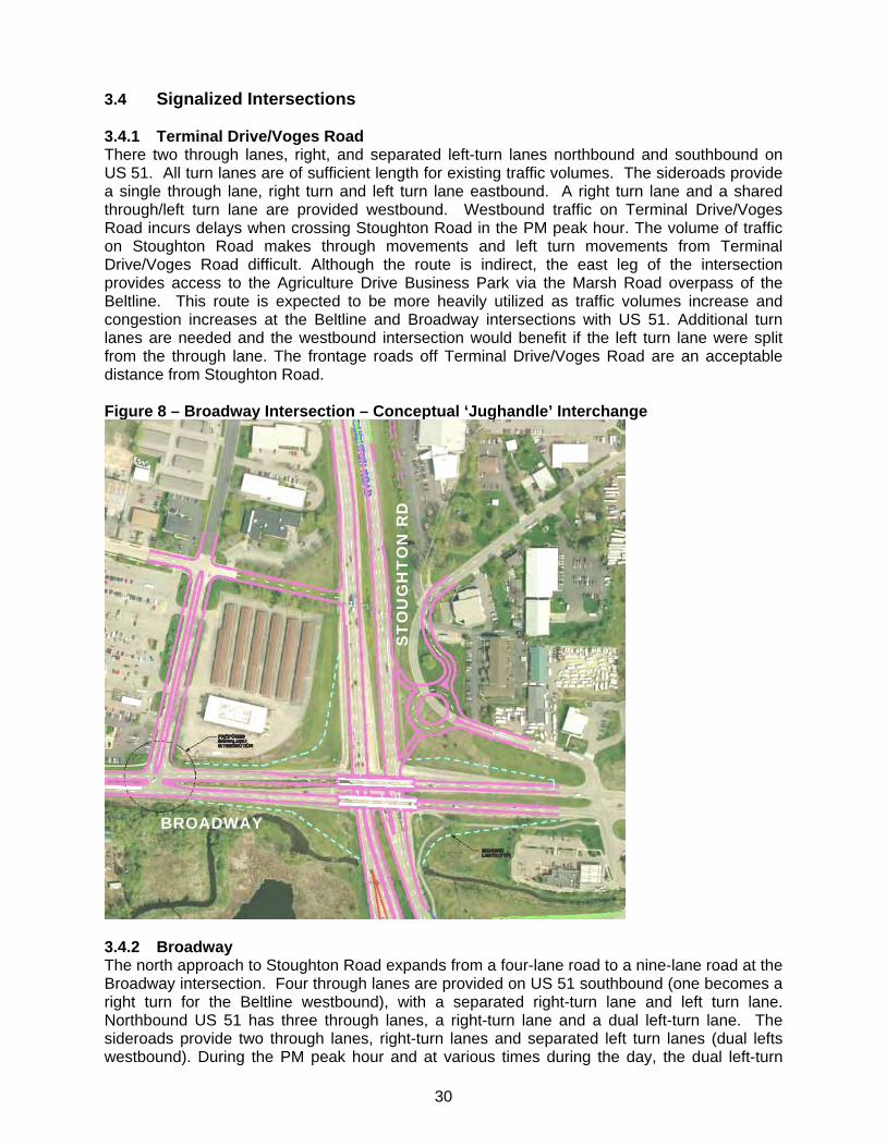
3.4 Signalized Intersections 3.4.1 Terminal Drive/Voges Road There two through lanes, right, and separated left-turn lanes northbound and southbound on US 51. All turn lanes are of sufficient length for existing traffic volumes. The sideroads provide a single through lane, right turn and left turn lane eastbound. A right turn lane and a shared through/left turn lane are provided westbound. Westbound traffic on Terminal Drive/Voges Road incurs delays when crossing Stoughton Road in the PM peak hour. The volume of traffic on Stoughton Road makes through movements and left turn movements from Terminal Drive/Voges Road difficult. Although the route is indirect, the east leg of the intersection provides access to the Agriculture Drive Business Park via the Marsh Road overpass of the Beltline. This route is expected to be more heavily utilized as traffic volumes increase and congestion increases at the Beltline and Broadway intersections with US 51. Additional turn lanes are needed and the westbound intersection would benefit if the left turn lane were split from the through lane. The frontage roads off Terminal Drive/Voges Road are an acceptable distance from Stoughton Road. Figure 8 – Broadway Intersection – Conceptual ‘Jughandle’ Interchange
3.4.2 Broadway The north approach to Stoughton Road expands from a four-lane road to a nine-lane road at the Broadway intersection. Four through lanes are provided on US 51 southbound (one becomes a right turn for the Beltline westbound), with a separated right-turn lane and left turn lane. Northbound US 51 has three through lanes, a right-turn lane and a dual left-turn lane. The sideroads provide two through lanes, right-turn lanes and separated left turn lanes (dual lefts westbound). During the PM peak hour and at various times during the day, the dual left-turn
BROADWAY
ST
OU
GH
TO
N R
D
31
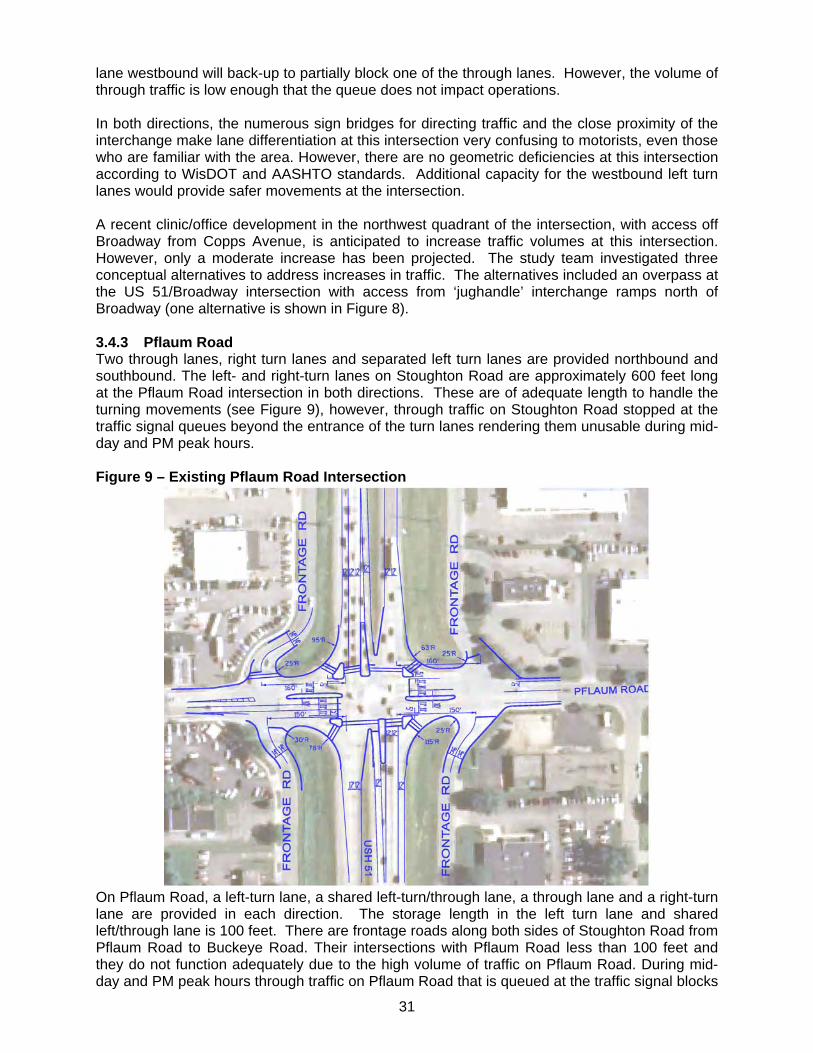
lane westbound will back-up to partially block one of the through lanes. However, the volume of through traffic is low enough that the queue does not impact operations. In both directions, the numerous sign bridges for directing traffic and the close proximity of the interchange make lane differentiation at this intersection very confusing to motorists, even those who are familiar with the area. However, there are no geometric deficiencies at this intersection according to WisDOT and AASHTO standards. Additional capacity for the westbound left turn lanes would provide safer movements at the intersection. A recent clinic/office development in the northwest quadrant of the intersection, with access off Broadway from Copps Avenue, is anticipated to increase traffic volumes at this intersection. However, only a moderate increase has been projected. The study team investigated three conceptual alternatives to address increases in traffic. The alternatives included an overpass at the US 51/Broadway intersection with access from ‘jughandle’ interchange ramps north of Broadway (one alternative is shown in Figure 8). 3.4.3 Pflaum Road Two through lanes, right turn lanes and separated left turn lanes are provided northbound and southbound. The left- and right-turn lanes on Stoughton Road are approximately 600 feet long at the Pflaum Road intersection in both directions. These are of adequate length to handle the turning movements (see Figure 9), however, through traffic on Stoughton Road stopped at the traffic signal queues beyond the entrance of the turn lanes rendering them unusable during mid-day and PM peak hours. Figure 9 – Existing Pflaum Road Intersection
On Pflaum Road, a left-turn lane, a shared left-turn/through lane, a through lane and a right-turn lane are provided in each direction. The storage length in the left turn lane and shared left/through lane is 100 feet. There are frontage roads along both sides of Stoughton Road from Pflaum Road to Buckeye Road. Their intersections with Pflaum Road less than 100 feet and they do not function adequately due to the high volume of traffic on Pflaum Road. During mid-day and PM peak hours through traffic on Pflaum Road that is queued at the traffic signal blocks
32
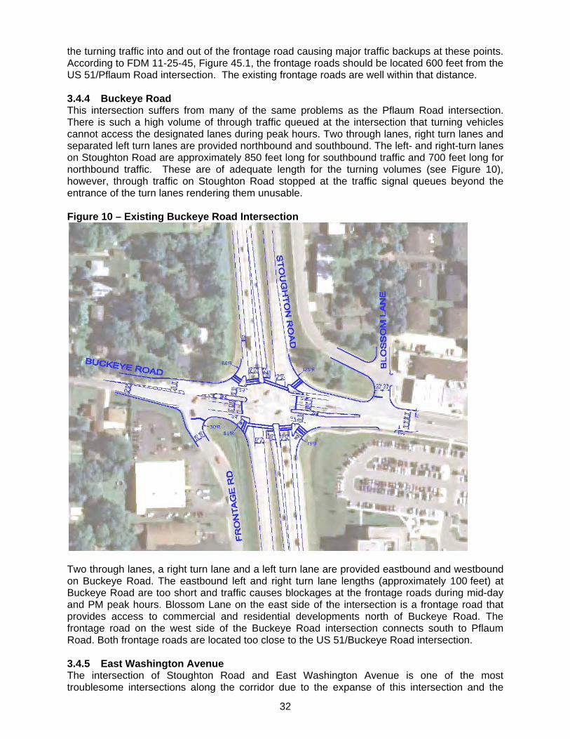
the turning traffic into and out of the frontage road causing major traffic backups at these points. According to FDM 11-25-45, Figure 45.1, the frontage roads should be located 600 feet from the US 51/Pflaum Road intersection. The existing frontage roads are well within that distance. 3.4.4 Buckeye Road This intersection suffers from many of the same problems as the Pflaum Road intersection. There is such a high volume of through traffic queued at the intersection that turning vehicles cannot access the designated lanes during peak hours. Two through lanes, right turn lanes and separated left turn lanes are provided northbound and southbound. The left- and right-turn lanes on Stoughton Road are approximately 850 feet long for southbound traffic and 700 feet long for northbound traffic. These are of adequate length for the turning volumes (see Figure 10), however, through traffic on Stoughton Road stopped at the traffic signal queues beyond the entrance of the turn lanes rendering them unusable. Figure 10 – Existing Buckeye Road Intersection
Two through lanes, a right turn lane and a left turn lane are provided eastbound and westbound on Buckeye Road. The eastbound left and right turn lane lengths (approximately 100 feet) at Buckeye Road are too short and traffic causes blockages at the frontage roads during mid-day and PM peak hours. Blossom Lane on the east side of the intersection is a frontage road that provides access to commercial and residential developments north of Buckeye Road. The frontage road on the west side of the Buckeye Road intersection connects south to Pflaum Road. Both frontage roads are located too close to the US 51/Buckeye Road intersection. 3.4.5 East Washington Avenue The intersection of Stoughton Road and East Washington Avenue is one of the most troublesome intersections along the corridor due to the expanse of this intersection and the
33
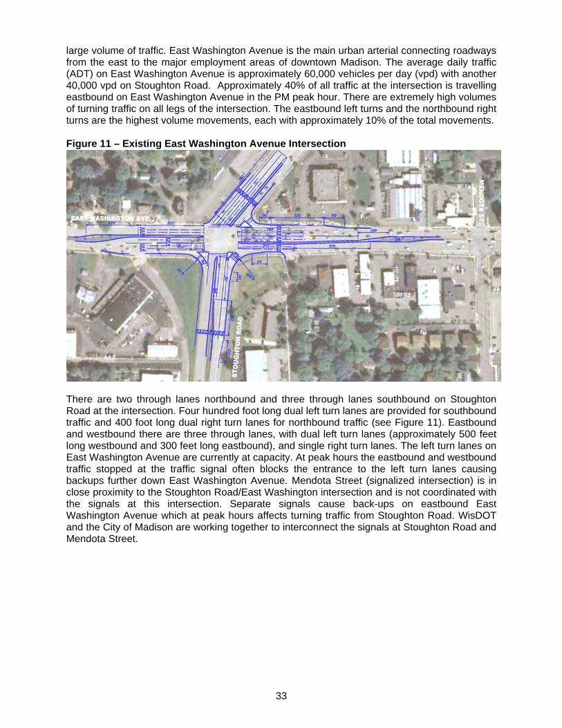
large volume of traffic. East Washington Avenue is the main urban arterial connecting roadways from the east to the major employment areas of downtown Madison. The average daily traffic (ADT) on East Washington Avenue is approximately 60,000 vehicles per day (vpd) with another 40,000 vpd on Stoughton Road. Approximately 40% of all traffic at the intersection is travelling eastbound on East Washington Avenue in the PM peak hour. There are extremely high volumes of turning traffic on all legs of the intersection. The eastbound left turns and the northbound right turns are the highest volume movements, each with approximately 10% of the total movements. Figure 11 – Existing East Washington Avenue Intersection
There are two through lanes northbound and three through lanes southbound on Stoughton Road at the intersection. Four hundred foot long dual left turn lanes are provided for southbound traffic and 400 foot long dual right turn lanes for northbound traffic (see Figure 11). Eastbound and westbound there are three through lanes, with dual left turn lanes (approximately 500 feet long westbound and 300 feet long eastbound), and single right turn lanes. The left turn lanes on East Washington Avenue are currently at capacity. At peak hours the eastbound and westbound traffic stopped at the traffic signal often blocks the entrance to the left turn lanes causing backups further down East Washington Avenue. Mendota Street (signalized intersection) is in close proximity to the Stoughton Road/East Washington intersection and is not coordinated with the signals at this intersection. Separate signals cause back-ups on eastbound East Washington Avenue which at peak hours affects turning traffic from Stoughton Road. WisDOT and the City of Madison are working together to interconnect the signals at Stoughton Road and Mendota Street.
34
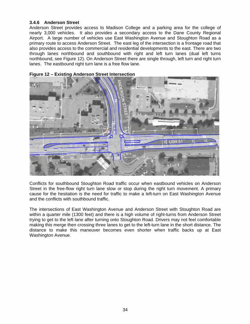
3.4.6 Anderson Street Anderson Street provides access to Madison College and a parking area for the college of nearly 3,000 vehicles. It also provides a secondary access to the Dane County Regional Airport. A large number of vehicles use East Washington Avenue and Stoughton Road as a primary route to access Anderson Street. The east leg of the intersection is a frontage road that also provides access to the commercial and residential developments to the east. There are two through lanes northbound and southbound with right and left turn lanes (dual left turns northbound, see Figure 12). On Anderson Street there are single through, left turn and right turn lanes. The eastbound right turn lane is a free flow lane. Figure 12 – Existing Anderson Street Intersection
Conflicts for southbound Stoughton Road traffic occur when eastbound vehicles on Anderson Street in the free-flow right turn lane slow or stop during the right turn movement. A primary cause for the hesitation is the need for traffic to make a left-turn on East Washington Avenue and the conflicts with southbound traffic. The intersections of East Washington Avenue and Anderson Street with Stoughton Road are within a quarter mile (1300 feet) and there is a high volume of right-turns from Anderson Street trying to get to the left lane after turning onto Stoughton Road. Drivers may not feel comfortable making this merge then crossing three lanes to get to the left-turn lane in the short distance. The distance to make this maneuver becomes even shorter when traffic backs up at East Washington Avenue.
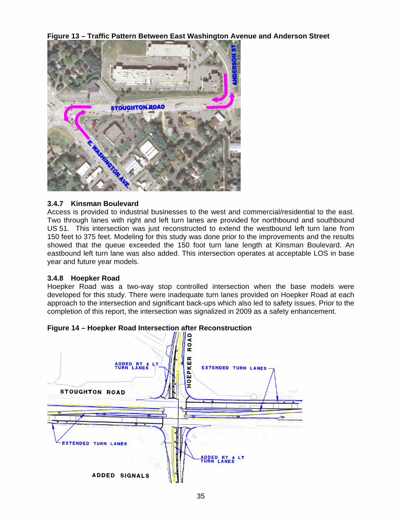
35
Figure 13 – Traffic Pattern Between East Washington Avenue and Anderson Street
3.4.7 Kinsman Boulevard Access is provided to industrial businesses to the west and commercial/residential to the east. Two through lanes with right and left turn lanes are provided for northbound and southbound US 51. This intersection was just reconstructed to extend the westbound left turn lane from 150 feet to 375 feet. Modeling for this study was done prior to the improvements and the results showed that the queue exceeded the 150 foot turn lane length at Kinsman Boulevard. An eastbound left turn lane was also added. This intersection operates at acceptable LOS in base year and future year models. 3.4.8 Hoepker Road Hoepker Road was a two-way stop controlled intersection when the base models were developed for this study. There were inadequate turn lanes provided on Hoepker Road at each approach to the intersection and significant back-ups which also led to safety issues. Prior to the completion of this report, the intersection was signalized in 2009 as a safety enhancement. Figure 14 – Hoepker Road Intersection after Reconstruction
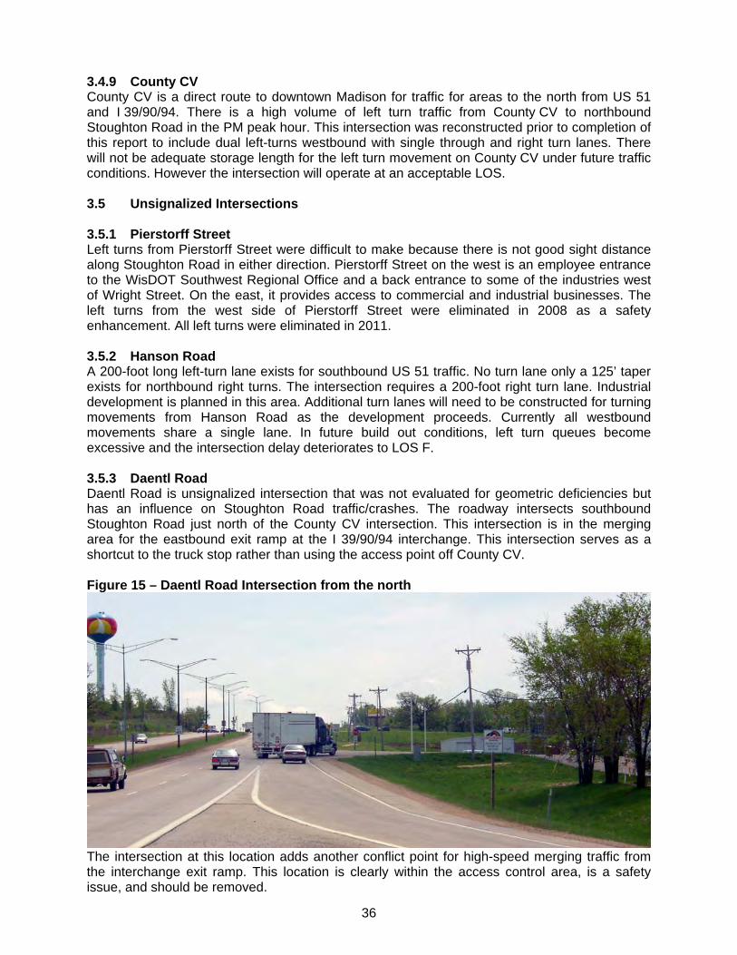
36
3.4.9 County CV County CV is a direct route to downtown Madison for traffic for areas to the north from US 51 and I 39/90/94. There is a high volume of left turn traffic from County CV to northbound Stoughton Road in the PM peak hour. This intersection was reconstructed prior to completion of this report to include dual left-turns westbound with single through and right turn lanes. There will not be adequate storage length for the left turn movement on County CV under future traffic conditions. However the intersection will operate at an acceptable LOS. 3.5 Unsignalized Intersections 3.5.1 Pierstorff Street Left turns from Pierstorff Street were difficult to make because there is not good sight distance along Stoughton Road in either direction. Pierstorff Street on the west is an employee entrance to the WisDOT Southwest Regional Office and a back entrance to some of the industries west of Wright Street. On the east, it provides access to commercial and industrial businesses. The left turns from the west side of Pierstorff Street were eliminated in 2008 as a safety enhancement. All left turns were eliminated in 2011. 3.5.2 Hanson Road A 200-foot long left-turn lane exists for southbound US 51 traffic. No turn lane only a 125’ taper exists for northbound right turns. The intersection requires a 200-foot right turn lane. Industrial development is planned in this area. Additional turn lanes will need to be constructed for turning movements from Hanson Road as the development proceeds. Currently all westbound movements share a single lane. In future build out conditions, left turn queues become excessive and the intersection delay deteriorates to LOS F. 3.5.3 Daentl Road Daentl Road is unsignalized intersection that was not evaluated for geometric deficiencies but has an influence on Stoughton Road traffic/crashes. The roadway intersects southbound Stoughton Road just north of the County CV intersection. This intersection is in the merging area for the eastbound exit ramp at the I 39/90/94 interchange. This intersection serves as a shortcut to the truck stop rather than using the access point off County CV. Figure 15 – Daentl Road Intersection from the north
The intersection at this location adds another conflict point for high-speed merging traffic from the interchange exit ramp. This location is clearly within the access control area, is a safety issue, and should be removed.
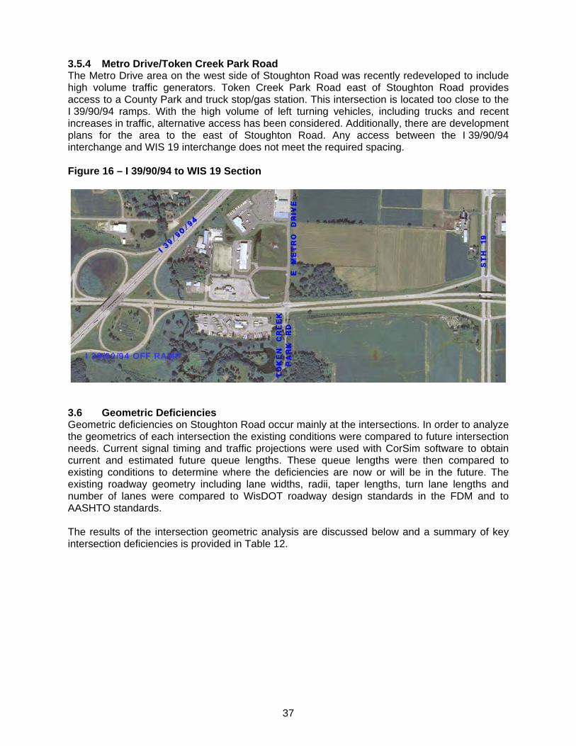
37
3.5.4 Metro Drive/Token Creek Park Road The Metro Drive area on the west side of Stoughton Road was recently redeveloped to include high volume traffic generators. Token Creek Park Road east of Stoughton Road provides access to a County Park and truck stop/gas station. This intersection is located too close to the I 39/90/94 ramps. With the high volume of left turning vehicles, including trucks and recent increases in traffic, alternative access has been considered. Additionally, there are development plans for the area to the east of Stoughton Road. Any access between the I 39/90/94 interchange and WIS 19 interchange does not meet the required spacing. Figure 16 – I 39/90/94 to WIS 19 Section
3.6 Geometric Deficiencies Geometric deficiencies on Stoughton Road occur mainly at the intersections. In order to analyze the geometrics of each intersection the existing conditions were compared to future intersection needs. Current signal timing and traffic projections were used with CorSim software to obtain current and estimated future queue lengths. These queue lengths were then compared to existing conditions to determine where the deficiencies are now or will be in the future. The existing roadway geometry including lane widths, radii, taper lengths, turn lane lengths and number of lanes were compared to WisDOT roadway design standards in the FDM and to AASHTO standards. The results of the intersection geometric analysis are discussed below and a summary of key intersection deficiencies is provided in Table 12.
I 39/90/94 OFF RAMP
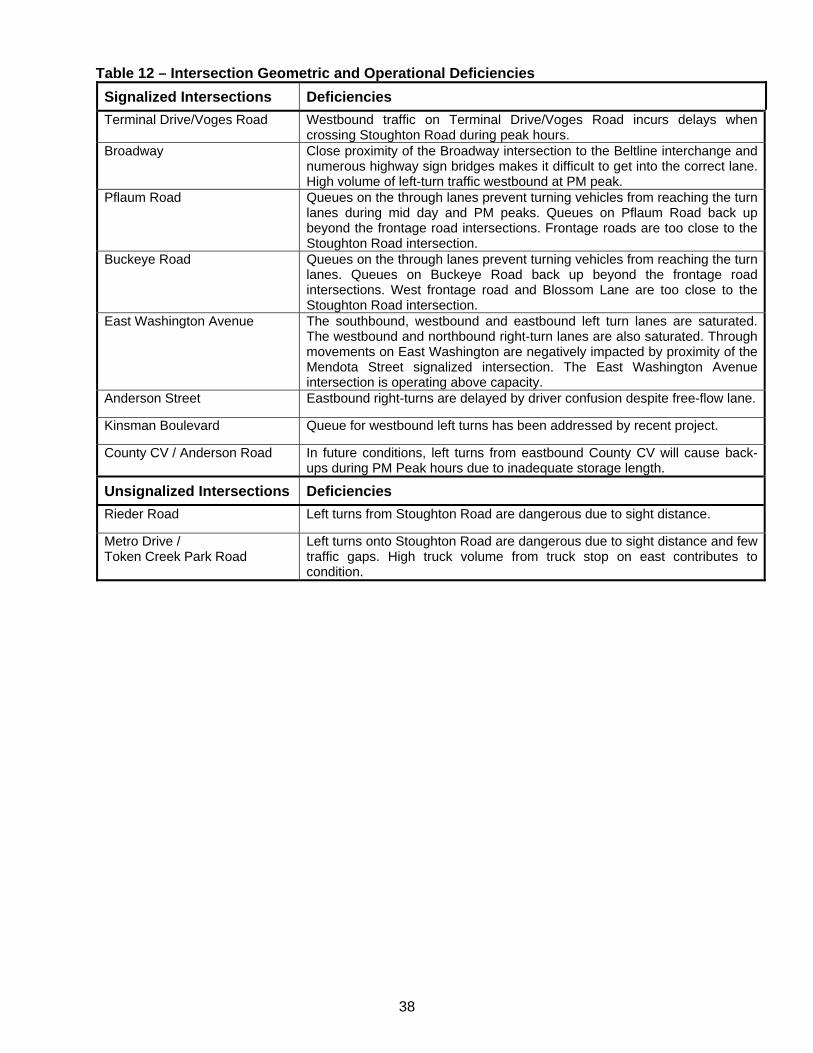
38
Table 12 – Intersection Geometric and Operational Deficiencies
Signalized Intersections Deficiencies
Terminal Drive/Voges Road Westbound traffic on Terminal Drive/Voges Road incurs delays when crossing Stoughton Road during peak hours.
Broadway Close proximity of the Broadway intersection to the Beltline interchange and numerous highway sign bridges makes it difficult to get into the correct lane. High volume of left-turn traffic westbound at PM peak.
Pflaum Road Queues on the through lanes prevent turning vehicles from reaching the turn lanes during mid day and PM peaks. Queues on Pflaum Road back up beyond the frontage road intersections. Frontage roads are too close to the Stoughton Road intersection.
Buckeye Road Queues on the through lanes prevent turning vehicles from reaching the turn lanes. Queues on Buckeye Road back up beyond the frontage road intersections. West frontage road and Blossom Lane are too close to the Stoughton Road intersection.
East Washington Avenue The southbound, westbound and eastbound left turn lanes are saturated. The westbound and northbound right-turn lanes are also saturated. Through movements on East Washington are negatively impacted by proximity of the Mendota Street signalized intersection. The East Washington Avenue intersection is operating above capacity.
Anderson Street Eastbound right-turns are delayed by driver confusion despite free-flow lane.
Kinsman Boulevard Queue for westbound left turns has been addressed by recent project.
County CV / Anderson Road In future conditions, left turns from eastbound County CV will cause back-ups during PM Peak hours due to inadequate storage length.
Unsignalized Intersections Deficiencies
Rieder Road Left turns from Stoughton Road are dangerous due to sight distance.
Metro Drive / Token Creek Park Road
Left turns onto Stoughton Road are dangerous due to sight distance and few traffic gaps. High truck volume from truck stop on east contributes to condition.
39
4.0 INTERCHANGE/RAMP GEOMETRICS There are five interchanges within the corridor. Three of the interchanges are diamond layouts (Beltline, Milwaukee Street & WIS 19) and two are partial cloverleaf layouts (Cottage Grove Road and I 39/90/94). The ramps terminals intersect on Stoughton Road at the Beltline (signalized) and I 39/90/94 (currently stop controlled for through and left-turn movements from I 39/90/94 with free flow right-turns, westbound ramp will be signalized with free flow right turn from I 39/90/94 in 2012). Traffic is free flow on Stoughton Road at the remaining interchanges. The Cottage Grove Road and Milwaukee Street ramp terminals are signalized, the WIS 19 interchange ramp terminals are stop controlled (a project to signalize the ramps will be constructed in 2012). The entrance and exit ramps were evaluated for acceleration length, deceleration length, taper and horizontal layout according to FDM Chapter 11-30-1, Attachments 1, 2, and 3. The interchanges along Stoughton Road also pose numerous traffic flow problems and safety concerns. The interchanges were constructed either in an urban environment adjacent to development or near environmentally sensitive resources so efforts were made to minimize their size and impacts. The following sections provide detailed descriptions of the interchanges. 4.1 US 12/18 (Beltline) The eastbound and westbound exit ramps from the Beltline are inadequate for handling existing traffic volumes. When this study began, significant queuing was noted on both ramps. Currently there are three left turn lanes and two right turn lanes on the eastbound ramp and two left and two right-turn lanes on the westbound ramp. During peak hours, traffic on these ramps backs up near the Beltline. The left-turns from the eastbound exit ramp to Stoughton Road cause the longest backup. On the westbound ramp, the right turn lane is not adequate. Queues for left-turning traffic prevent vehicles from reaching the right-turn lane. The queues backing onto the Beltline cause congestion and occasional stopped traffic. 4.2 Cottage Grove Road The acceleration lanes for northbound traffic entering Stoughton Road from Cottage Grove Road are too short and force vehicles to merge into traffic at a slow speed. This causes the higher speed traffic on Stoughton Road to weave around the merging traffic. According to AASHTO and WisDOT standards the minimum acceleration lane should be 910 feet with a 300 feet taper. The northbound acceleration is 600 feet. Both taper lengths are currently 300 feet. There are no deceleration lanes for northbound and southbound traffic exiting Stoughton Road onto Cottage Grove Road. A project is planned to extend the southbound deceleration lane in 2015. Traffic exiting Stoughton Road slows before the ramps causing backups, stopped traffic, and crashes. Also mainline Stoughton Road is on a curve rated for a 50 mph design speed with a 55 mph posted speed. It was noted a public meetings that during rain or snow conditions a number of crashes have occurred due to traffic sliding off the ramps trying to exit to the Cottage Grove Road ramps which are posted at 25 mph. 4.3 Milwaukee Street Milwaukee Street’s close proximity to the WIS 30 interchange causes weaving problems between northbound traffic from the Milwaukee Street entrance ramp and westbound traffic at the WIS 30 interchange. Traffic has to cross five lanes to make this maneuver. There is also a high demand on the southbound exit ramp from Stoughton Road causing conflicts with WIS 30 eastbound traffic turning right onto Stoughton Road. The short distance and high traffic volume prevent the WIS 30 exit ramp from being a free-flow movement.
40
4.4 WIS 30 The left turns on the eastbound exit ramp and the right turns on the westbound exit ramp back up beyond the dedicated turn lane and block traffic. The existing eastbound left-turn lane is approximately 400 feet long and the right turn lane is 330 feet long. According to projected future traffic queues the left turn lane will need to be 830 feet and the right turn lane will need to be 500 feet. Some of the congestion on these ramps is due to traffic diverting to WIS 30 and Thompson Road to avoid the East Washington Avenue intersection. 4.5 I 39/90/94 Left turns from the westbound exit ramp cause backups on the ramp. There is a high volume of truck traffic in this area. Vehicles including trucks get caught in the median and block turning traffic from Stoughton Road to I 39/90/94. There is also a private access in the southbound on ramp taper, the Daentl Road intersection in the southbound off ramp taper and the Metro Drive/Token Creek Park Road intersection at the end of the northbound off ramp taper. A project is planned for 2012 to add signals to the westbound ramp terminal. 4.6 WIS 19 This interchange is not located near any other major roads, and does not have access control spacing issues. Both exit ramps are 960 feet long and the entrance ramps are 500 feet long. The right turn lanes onto WIS 19 are 400 feet and 200 feet long; queues for turning vehicles may become an issue during peak periods with increased traffic. This interchange may also face increases in traffic as an alternative route due to high traffic volumes or construction on I 39/90/94. 4.7 Interchange/Ramp Geometrics Deficiencies Ramp types were not considered deficiencies for this section. The following interchanges have geometric deficiencies. Cottage Grove Road The southbound entrance ramp has a maximum grade of 7.0%. There are no deceleration lanes for the exit ramps both northbound and southbound and insufficient acceleration lane length for the northbound entrance ramp. A project is planned to extend the southbound deceleration lane in 2015. Milwaukee Street The northbound entrance ramp and southbound exit ramp are located extremely close to the ramp terminals of WIS 30. This causes dangerous weaving action as drivers attempt to switch lanes. In addition, the northbound entrance ramp has a lane width of only 11 feet. WIS 30 In addition the issues mentioned at Milwaukee Street above, both entrance ramps have lane widths of only 12 feet. I 39/90/94 All four of the ramps at this interchange contain multiple compound curves with design speeds as low as 30 mph. These types of curves can be dangerous as many drivers will not expect the ramps to suddenly switch to a much small radius in the middle of a curve. The ramps have inadequate acceleration lengths for traffic entering I 39/90/94 and inadequate deceleration lengths for traffic exiting I 39/90/94.
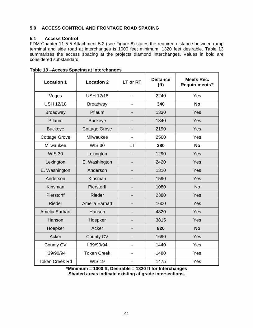
41
5.0 ACCESS CONTROL AND FRONTAGE ROAD SPACING 5.1 Access Control FDM Chapter 11-5-5 Attachment 5.2 (see Figure 8) states the required distance between ramp terminal and side road at interchanges is 1000 feet minimum, 1320 feet desirable. Table 13 summarizes the access spacing at the projects diamond interchanges. Values in bold are considered substandard. Table 13 –Access Spacing at Interchanges
Location 1 Location 2 LT or RT Distance
(ft) Meets Rec.
Requirements?
Voges USH 12/18 - 2240 Yes
USH 12/18 Broadway - 340 No
Broadway Pflaum - 1330 Yes
Pflaum Buckeye - 1340 Yes
Buckeye Cottage Grove - 2190 Yes
Cottage Grove Milwaukee - 2560 Yes
Milwaukee WIS 30 LT 380 No
WIS 30 Lexington - 1290 Yes
Lexington E. Washington - 2420 Yes
E. Washington Anderson - 1310 Yes
Anderson Kinsman - 1590 Yes
Kinsman Pierstorff - 1080 No
Pierstorff Rieder - 2380 Yes
Rieder Amelia Earhart - 1600 Yes
Amelia Earhart Hanson - 4820 Yes
Hanson Hoepker - 3815 Yes
Hoepker Acker - 820 No
Acker County CV - 1690 Yes
County CV I 39/90/94 - 1440 Yes
I 39/90/94 Token Creek - 1480 Yes
Token Creek Rd WIS 19 - 1475 Yes
*Minimum = 1000 ft, Desirable = 1320 ft for Interchanges Shaded areas indicate existing at grade intersections.
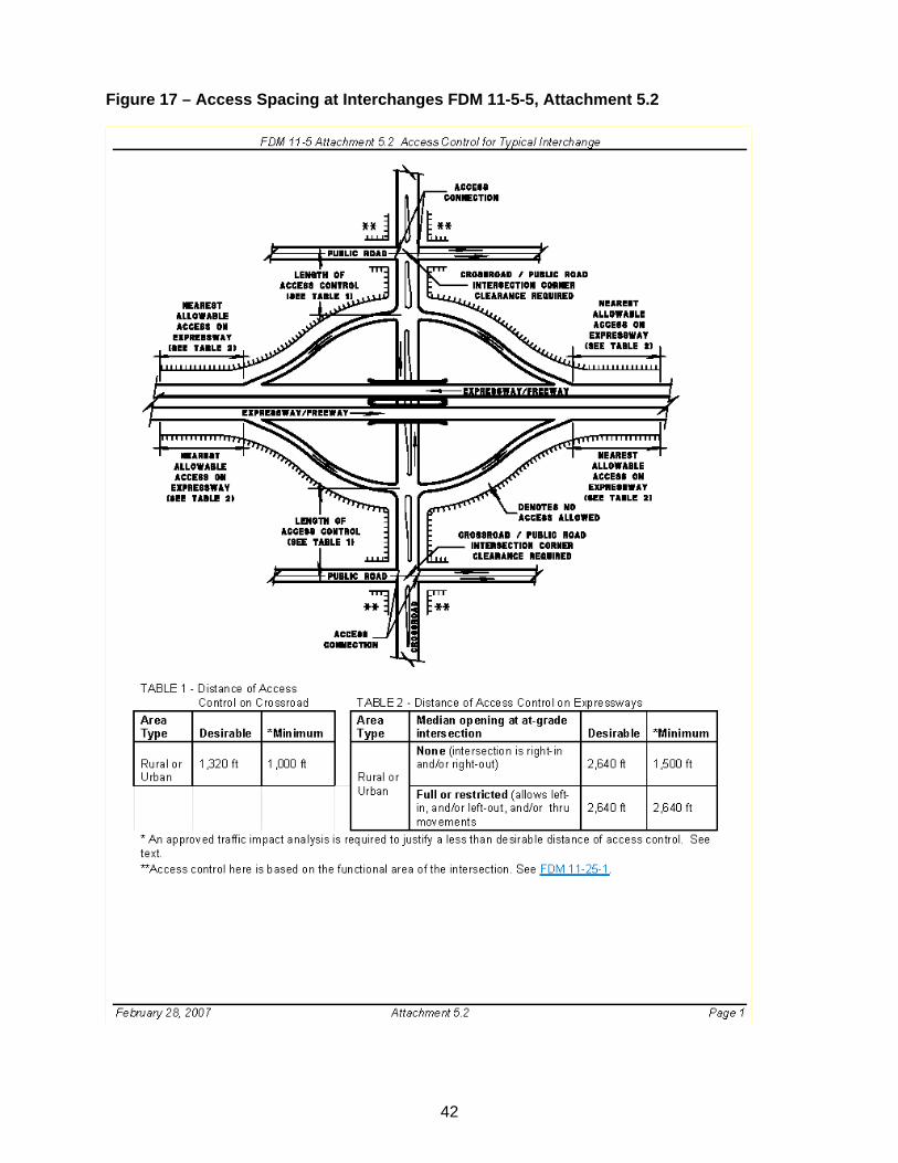
42
Figure 17 – Access Spacing at Interchanges FDM 11-5-5, Attachment 5.2
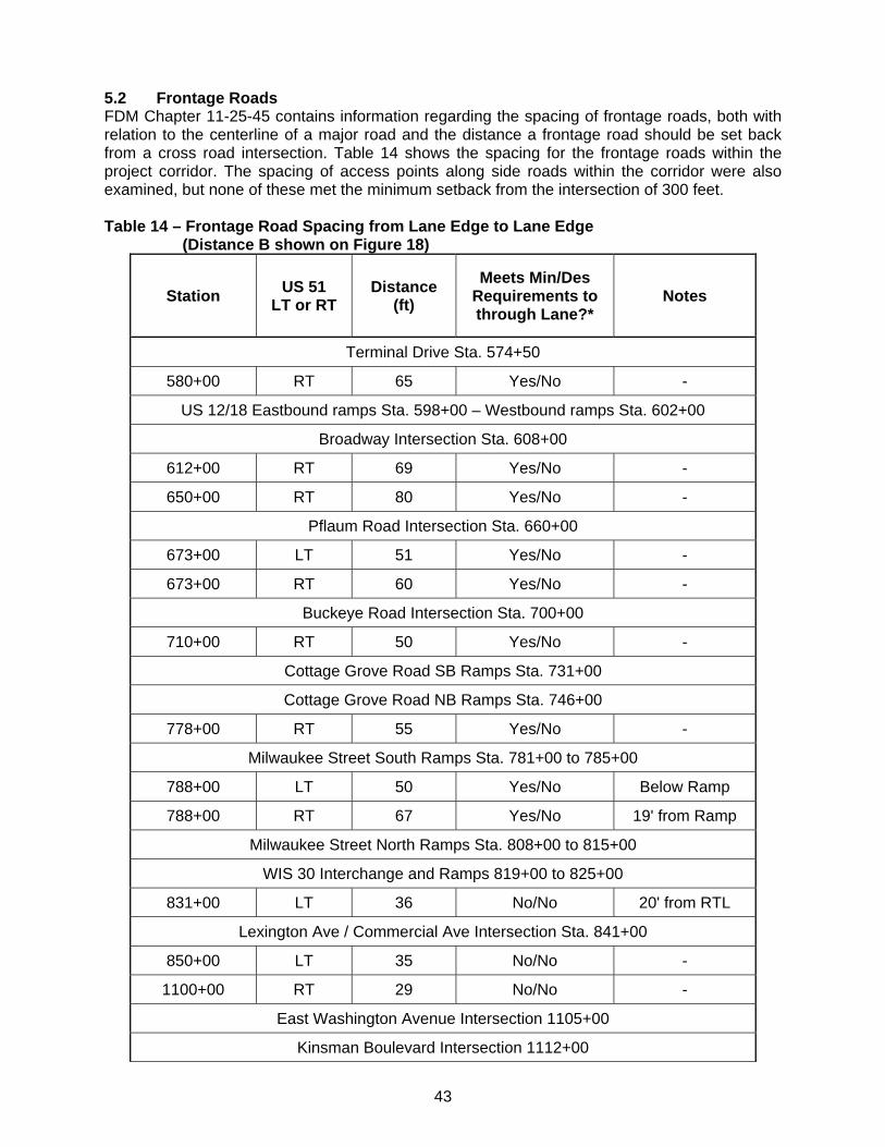
43
5.2 Frontage Roads FDM Chapter 11-25-45 contains information regarding the spacing of frontage roads, both with relation to the centerline of a major road and the distance a frontage road should be set back from a cross road intersection. Table 14 shows the spacing for the frontage roads within the project corridor. The spacing of access points along side roads within the corridor were also examined, but none of these met the minimum setback from the intersection of 300 feet. Table 14 – Frontage Road Spacing from Lane Edge to Lane Edge
(Distance B shown on Figure 18)
Station US 51
LT or RT Distance
(ft)
Meets Min/Des Requirements to through Lane?*
Notes
Terminal Drive Sta. 574+50
580+00 RT 65 Yes/No -
US 12/18 Eastbound ramps Sta. 598+00 – Westbound ramps Sta. 602+00
Broadway Intersection Sta. 608+00
612+00 RT 69 Yes/No -
650+00 RT 80 Yes/No -
Pflaum Road Intersection Sta. 660+00
673+00 LT 51 Yes/No -
673+00 RT 60 Yes/No -
Buckeye Road Intersection Sta. 700+00
710+00 RT 50 Yes/No -
Cottage Grove Road SB Ramps Sta. 731+00
Cottage Grove Road NB Ramps Sta. 746+00
778+00 RT 55 Yes/No -
Milwaukee Street South Ramps Sta. 781+00 to 785+00
788+00 LT 50 Yes/No Below Ramp
788+00 RT 67 Yes/No 19' from Ramp
Milwaukee Street North Ramps Sta. 808+00 to 815+00
WIS 30 Interchange and Ramps 819+00 to 825+00
831+00 LT 36 No/No 20' from RTL
Lexington Ave / Commercial Ave Intersection Sta. 841+00
850+00 LT 35 No/No -
1100+00 RT 29 No/No -
East Washington Avenue Intersection 1105+00
Kinsman Boulevard Intersection 1112+00
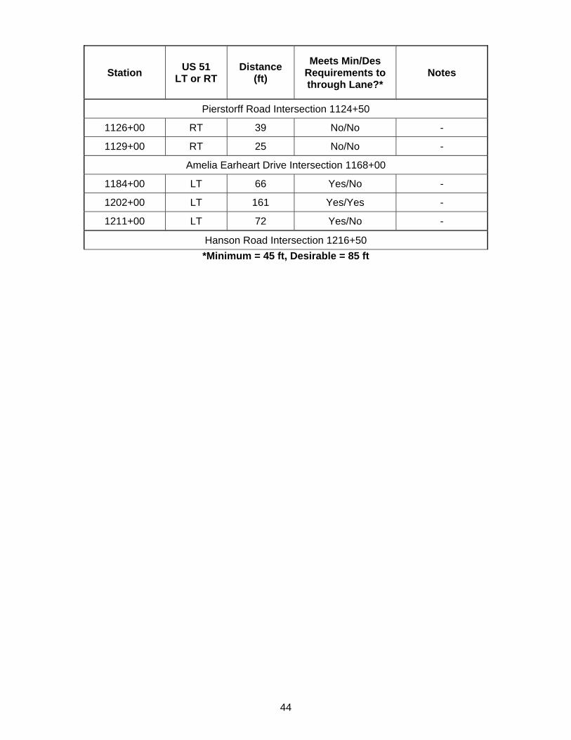
44
Station US 51
LT or RT Distance
(ft)
Meets Min/Des Requirements to through Lane?*
Notes
Pierstorff Road Intersection 1124+50
1126+00 RT 39 No/No -
1129+00 RT 25 No/No -
Amelia Earheart Drive Intersection 1168+00
1184+00 LT 66 Yes/No -
1202+00 LT 161 Yes/Yes -
1211+00 LT 72 Yes/No -
Hanson Road Intersection 1216+50
*Minimum = 45 ft, Desirable = 85 ft
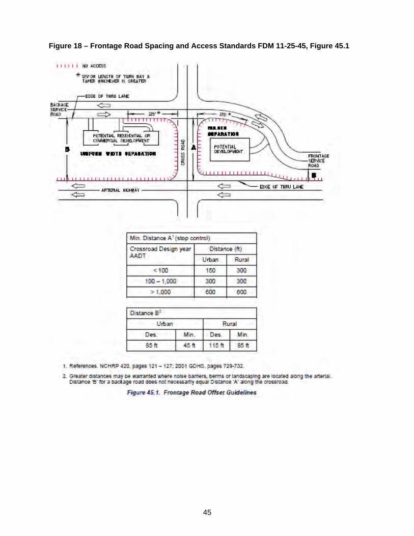
45
Figure 18 – Frontage Road Spacing and Access Standards FDM 11-25-45, Figure 45.1
46
6.0 BICYCLE AND PEDESTRIAN FACILITIES 6.1 Existing Bicycle Facilities In most locations Stoughton Road represents a substantial barrier to bicycle travel both across and along the corridor. While Madison has an excellent bikeway system throughout most of the city, there are substantial gaps, many of which are created by Stoughton Road. In general, Stoughton Road, I 39/90/94, the Beltline and WIS 30 surround and to some extent isolate a portion of the city from bicycle facilities available elsewhere. Existing bicycle facilities in the Stoughton Road corridor and surrounding area are shown in Figure 19. Problems with bicycle travel and lack of bicycle facilities in the Stoughton Road corridor are discussed below. 6.1.1 North-South Bicycle Travel Terminal Drive/Voges Road to Broadway The Beltline underpass at Stoughton Road is currently the only way for motorists and bicyclists to cross the six-lane freeway on the east side of Madison. Recent improvements by WisDOT included adding sidewalk and bicycle lanes on Stoughton Road through the Beltline interchange area. A Beltline overpass connecting Marsh Road south of the Beltline to Agriculture Drive north of the Beltline was also recently constructed. Broadway to Buckeye Road The East Broadway Service Road connection to Progress Road is the current best option for bicycle travel to Pflaum Road. The Service Road is a relatively short, two lane, twisting street that runs north from Dutch Mill Road to the intersection of Progress Road and Femrite Drive along the east side of Stoughton Road. It is an important bicycle route that serves an indoor skateboard and BMX park on Progress Road. This corridor has become more important due to the recent Beltline bicycle crossing improvements. There are no marked bike lanes on the East Broadway Service Road but traffic volumes are low and the pavement is wide enough to accommodate bicycle travel. However, safe bicycling is hampered by on-street parking and a high percentage of truck traffic. Travel south is currently interrupted at Collins Court and travel north is indirect because the road turns east to meet up with Progress Road which then continues north to Femrite Drive. West of Stoughton Road, there is currently a gap where there are no north-south bicycle facilities between Femrite Drive and Tompkins Drive. The service roads on each side of Stoughton Road between Tompkins Drive and Buckeye Road accommodate bicycles but do not have designated bicycle lanes. In addition, the intersections at Pflaum Road and Buckeye Road are difficult to cross. Buckeye Road to East Washington Avenue A portion of Dempsey Road is identified on the 2007 Dane County Bicycle Map as suitable for most bicyclists and together with other roadway segments, this corridor provides an uninterrupted bicycle route from Tompkins Road to Milwaukee Street as well as connections to the Buckeye Road bicycle route, Lake Loop bicycle route, Portland Parkway overpass and bicycle trail, and the Milwaukee street bicycle lane. The Union Pacific Railroad right-of-way from I 39/90/94 to Dempsey Road has good potential as a regional and local bicycle corridor. A bicycle trail along the railroad corridor would provide ultimate connections to the Capitol City Trail, Military Ridge Trail and Glacial Drumlin Trail. It would also provide a bicycle facility along the east side of Stoughton Road from the service road at Buckeye Road to Cottage Grove Road where it could then cross under Stoughton Road and continue to the Dempsey Road bike route.
47
Bicyclists are prohibited from using WIS 30 and along with Stoughton Road this causes a substantial barrier to bicycle travel at this location. The first crossing of WIS 30 that isn’t Stoughton Road is the Marsh View Bike Path which crosses under WIS 30 2000 feet west of Stoughton Road. The path connects to Mayfair Avenue which leads back to Lexington Avenue to the east and Commercial Avenue which meets Fair Oaks Avenue, a designated bike route, to the west. The path connects Milwaukee Street with the neighborhood west of Starkweather Creek. Unfortunately this path does not connect to the service road east of Stoughton Road. Such a connection would provide better access to the signalized Stoughton Road/Lexington Avenue intersection, Wal-Mart, and other destinations east of Stoughton Road. The only WIS 30 crossing east of Stoughton Road is North Thompson Drive located 3/4 mile away. East Washington Avenue to Pierstorff Street There are no bicycle facilities on Stoughton Road in this area of high vehicle traffic volumes. Bicyclists have to share the traffic lane with vehicles if they are to travel north and south. Wright Street, 2000 feet west of Stoughton Road, has bicycle lanes from East Washington Avenue to Pierstorff Street. Wright Street and Anderson Street border the Madison Area Technical College (MATC) Truax Campus which generates a high volume of bicycle and pedestrian traffic. South of East Washington Avenue, Wright Street becomes Fair Oaks Avenue which is a designated bicycle route. Wright Street/Fair Oaks Avenue provide an ultimate connection to the Lexington Avenue bike route, Portland Parkway overpass, Lake Loop bicycle route and the Marsh View bike path. Portage Road is the nearest continuous north/south road east of Stoughton Road and north of East Washington Avenue. Portage Road is a bicycle route that currently has substantial bicycle traffic but no marked bicycle lanes. The frontage road east of Stoughton Road between Anderson Street and Kinsman Boulevard does connect to Bartillon Drive, which provides access to Portage Road north of Reindahl Park. Pierstorff Street to I 39/90/94 From Pierstorff Street north there is no readily accessible bicycle facility parallel to Stoughton Road. County CV that intersects with Stoughton Road near the north project limits is listed as suitable for bicycle use. However, County CV is not a desirable route for those seeking access to Stoughton Road due to lack of defined bicycle lanes, narrow paved shoulders, heavy commuter use, sharp curves, and its location well west of the Dane County Regional Airport. 6.1.2 East-West Bicycle Travel Terminal Drive/Voges Road to Broadway Siggelkow Road between Terminal Drive/Voges Road and Marsh Road is a relatively wide road with sidewalks and is currently rideable for most experienced cyclists even though bike lanes are not defined. As the area develops and traffic volumes increase, bicycle travel will become more difficult. West of Stoughton Road, Broadway is an exceptional bicycle route with bicycle lanes, lighted median, and sidewalks. The signalized intersection with Stoughton Road is partially striped for bicycle traffic. However, the large scale of this intersection combined with long signal cycles for Stoughton Road traffic will continue to make bicycle crossings difficult. Broadway to Buckeye Road West of Stoughton Road, Femrite Drive runs from Copps Avenue to Monona Drive and the proposed bicycle facility on that road. East of Stoughton Road it runs from the East Broadway Service Road to Dutch Mill Road and beyond. Bicycle lanes were included as part of the recent reconstruction between Dutch Mill Road and Agriculture Drive. Femrite Drive does not intersect with Stoughton Road. West of Stoughton Road, Tompkins Drive runs from the Stoughton Road Service Road to Monona Drive. Tompkins Drive connects the Service Road with the neighborhood to the west
48
and Pflaum Road with Monona Drive. East of Stoughton Road Tompkins Drive connects the Stoughton Road Service Road with Progress Road. Tompkins Road does not intersect with Stoughton Road. Pflaum Road and Buckeye Road are designated bike routes from Agriculture Drive to Monona Drive. Pflaum Road and its bike route designation continue as Nichols Road west of Monona Drive. Buckeye Road joins the Lake Loop bike route and also continues northwest to the shore of Lake Monona. Pflaum Road has wide driving lanes but no marked bicycle lanes. West of Stoughton Road, Buckeye Road has parking/bike lanes and sidewalks. East of Stoughton Road, Buckeye Road has marked bike lanes and sidewalks. The signalized Pflaum Road and Buckeye Road intersections have bicycle lane accommodations. These large scale intersections with long signal phases for Stoughton Road traffic are difficult for most bicyclists to cross. With residential and commercial development, a golf course, and several nearby schools, Pflaum and Buckeye are important bicycle routes that should have designated bikeways east and west of Stoughton Road. Buckeye Road to East Washington Avenue Cottage Grove Road between Atlas Avenue and Thompson Drive has wide curb lanes and a center median making it suitable for bicycles but is otherwise unimproved for bicycle use. Cottage Grove Road passes under Stoughton Road but this underpass is not improved for bicyclists. In fact, many bicyclists use the sidewalks to avoid narrow lanes, high-speed traffic and medians without bicycle and handicap ramps. Cottage Grove Road crosses Dempsey Road and the Lake Loop bicycle route as well as the Union Pacific Railroad right-of-way which could be a future important trail link in this area. The Portland Parkway overpass is the only grade-separated Stoughton Road crossing designed specifically for bicyclists and pedestrians. The overpass provides connections to the future Marsh View bike path, Dawes Road bike route, Starkweather Creek bike path, North Fair Oaks Avenue bike route, Portland Parkway and Milwaukee Street. The overpass effectively provides a neighborhood crossing of Stoughton Road adjacent to the Milwaukee Street interchange. Milwaukee Street is an important bicycle route that runs from East Washington Avenue to Sprecher Road east of I 39/90/94. It has bike lanes for a short distance through the Stoughton Road interchange area but does not have marked bike lanes elsewhere. Lexington Avenue is a bike route that connects the Fair Oaks Avenue bike route with the Nakoosa Trail bike route, and the Thompson Drive bike route via Commercial Avenue. There are no bike lanes on Lexington Avenue but Commercial Avenue has bike lanes south and east of Nakoosa Trail. The Lexington Avenue/Stoughton Road intersection is unimproved for bicyclists. This crossing is further complicated by the railroad tracks that cross Commercial Avenue just east of the Stoughton Road intersection. East Washington Avenue to Pierstorff Street East Washington Avenue provides a direct route in and out of Madison for bicyclists and vehicular traffic. While Stoughton Road carries high volumes of vehicular traffic, it has relatively few bicyclists and there are no bicycle facilities on Stoughton Road in the vicinity of the East Washington Avenue intersection. The recent East Washington Avenue intersection reconstruction project included bicycle lanes. Anderson Street is a bicycle route west of Stoughton Road providing connections to the Starkweather Creek bike path and the bike route on Wright Street. Although Anderson Street is an important part of the bicycle network, there are no designated bike lanes between Wright Street and Stoughton Road and the intersection with Stoughton Road does not accommodate
49
bicycle travel. East of Stoughton Road, the Anderson Street bicycle route continues via a short bike path to Lien Road and to a bike path through Reindahl Park. Kinsman Boulevard connects Wright Street and its bicycle route to Stoughton Road but the intersection with Stoughton Road does not have bicycle accommodations. Pierstorff Street to I 39/90/94 Pierstorff Street provides access for bicyclists from Pearson Street, which runs north and south adjacent to the east side of the airport, to Stoughton Road. Pearson Street connects to Anderson Street. The Stoughton Road intersection with Rieder Road has been reconstructed under a WisDOT safety improvement project to prevent traffic from turning southbound onto Stoughton Road. Because there is a school and a growing subdivision east of this intersection, bicyclists will need access to and along Stoughton Road in this area. This could be accomplished by including bicycle lanes, marked paved shoulders or an adjacent multi-use path.
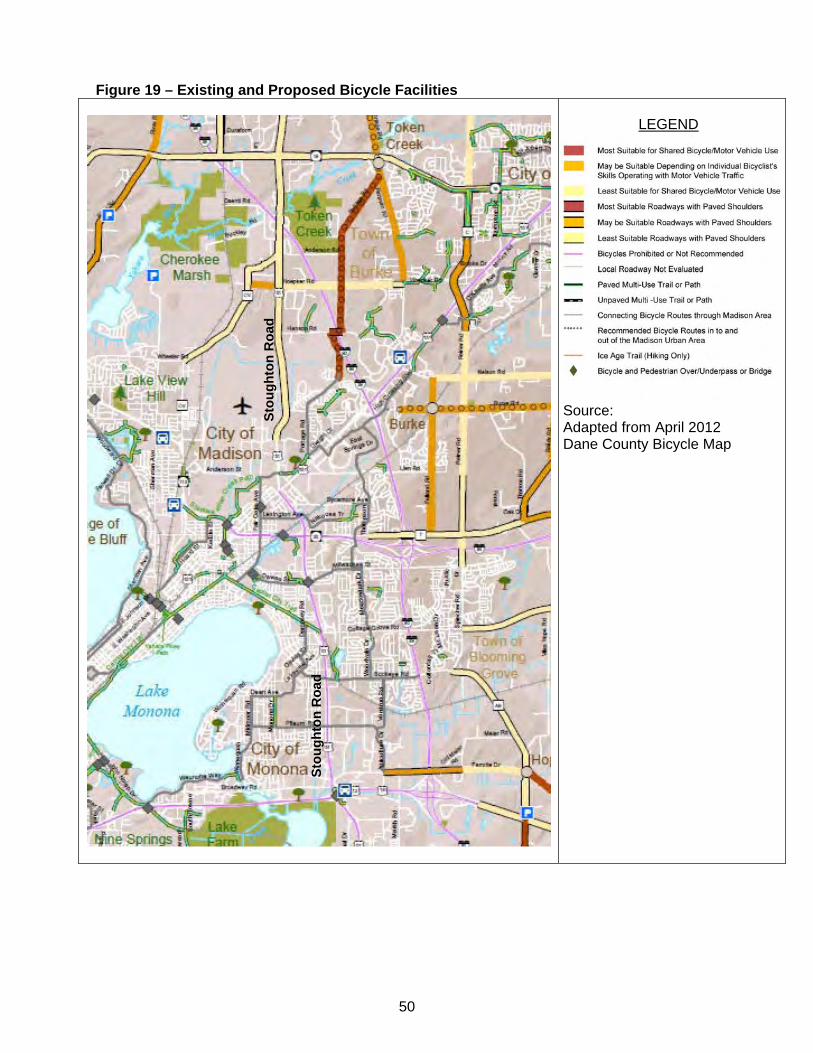
50
Figure 19 – Existing and Proposed Bicycle Facilities
LEGEND
Source: Adapted from April 2012 Dane County Bicycle Map
Sto
ug
hto
n R
oad
Sto
ug
hto
n R
oad
51
6.2 Pedestrian Facilities There are several sections of the project corridor where pedestrian accommodations are not an issue either because pedestrian facilities are currently adequate or there is a lack of destinations for pedestrian traffic. In general there are currently few pedestrian facilities between Terminal Drive/Voges Road and Pflaum Road because there is not a high demand for such facilities in this area. The only exceptions are at the Beltline interchange and the Broadway intersection. Access across the Beltline would provide for those pedestrians desiring to enter Madison from the south. The recently constructed Marsh Road overpass provides a pedestrian crossing over the Beltline. Broadway west of Stoughton Road has sidewalks along both sides; there are no sidewalks east of Stoughton Road. When local bus service is enhanced, the Dutchmill Park-Ride will become a pedestrian destination. From the west to Stoughton Road, Pflaum Road has sidewalks and there is a marked crosswalk at the Stoughton Road intersection. There are no sidewalks east of the Stoughton Road intersection area. Crossing Stoughton Road is difficult even with pedestrian buttons due to the long signal cycle and intersection islands that provide little refuge at the half-way point. From the west to Stoughton Road, Buckeye Road has sidewalks on its north side and there is a marked crosswalk at the Stoughton Road intersection. The sidewalk on the north side of Buckeye Road continues east of Stoughton Road. Like Pflaum Road, crossing the Buckeye Road intersection is difficult due to the long signal cycle and intersection islands that provide little refuge at the half-way point. With the Dean Clinic development on the frontage at this location, the City of Madison has an improvement project for the Buckeye Road and East Service Road intersection that will provide improved pedestrian facilities. Additional sidewalk on the west side of the Stoughton Road intersection will allow residents on both sides of Stoughton Road to access the clinic and schools in the area. The Cottage Grove Road interchange, Portland Parkway pedestrian overpass and the Milwaukee Street interchange provide sufficient access across the Stoughton Road freeway section extending to the WIS 30 interchange. Because no sidewalk is provided under WIS 30 on Stoughton Road, there is a 1 ½-mile gap between pedestrian crossings. However, there is not a substantial residential population or associated need for pedestrian facilities at the WIS 30 interchange. There is substantial demand for pedestrian facilities from East Washington Avenue to Kinsman Boulevard due to several restaurants, retail centers and a drugstore in this area. There is also a high demand for pedestrian facilities for those going to the MATC campus west of Stoughton Road from bus stops and parking facilities east of Stoughton Road. There are sidewalks along both sides of East Washington Avenue and crossings at the Stoughton Road intersection. Because this is another large scale intersection with long signal phases set to accommodate large volumes of turning traffic, pedestrians often get trapped on the islands and are unable to cross Stoughton Road in one signal cycle. There is sidewalk on the west side of Stoughton Road from East Washington Avenue to Anderson Street but the sidewalk on the east side is discontinuous and pedestrians need to walk through parking lots in some situations. There is sidewalk and a marked crosswalk only on the north side of Anderson Street west of Stoughton Road. Kinsman Boulevard has sidewalk on its south side, both east and west of Stoughton Road and on its north side west of Stoughton Road. There is a marked crosswalk at the Stoughton Road intersection but no sidewalk on the north side, east of the intersection. As indicated by the worn path on both sides of Stoughton Road between Kinsman Boulevard and the Orin Road frontage

52
road, there is a need for sidewalk in this area. A continuous frontage road with sidewalks between Anderson Street and Kinsman Boulevard would help meet current and future pedestrian demand. North of Kinsman Boulevard to the project’s north terminus there are no sidewalks and no substantial pedestrian demand. The Hanson Road development plan includes pedestrian accommodations along Hanson Road, Hoepker Road, Acker Road, County CV, and on the internal streets that will be constructed. Pedestrian facilities crossing Stoughton Road are also shown at Hanson Road and Hoepker Road.
53
7.0 CRASHES & SAFETY The crash data provided by WisDOT includes crashes from 2005 through 2008 that occurred on the State Trunk Highway System. The database includes crashes involving $1,000 or more damage to any one vehicle, an injury or fatality, and $200 or more in damage to government property such as traffic sign’s or guard rail. The 2009 Wisconsin Traffic Crash Facts publication gives the following definitions for injury severity:
Fatal Injury (K injury) - an injury received in a traffic crash that results in death within thirty days of the crash.
Incapacitating Injury (A injury) - an injury other than fatal, that prevents walking, driving or performing other activities that were performed before the crash.
Non-incapacitating Injury (B injury) - an injury, other than fatal or incapacitating, that is evident at the scene. Evidence includes known symptoms.
Possible Injury (C injury) - any injury that is not evident at the scene but that is claimed by the individual or suspected by the law enforcement officer.
The crash data used for this analysis identifies the crashes that are intersection-related and those that are not related to intersections. "Intersection-Related" is defined in the Law Enforcement Officer’s Instruction Manual for Completing the Wisconsin Motor Vehicle Crash Report Form (MV4000) as the following:
““Intersection-Related” crashes are crashes which result from an activity, behavior, or traffic control which affects a unit's movement in relation to an intersection; whether or not the point of origin or first harmful event occurred within the intersection”
The study analyzed the corridor crashes between 2005 and 2008. There were 1,158 crashes (excluding deer) in the corridor for the period between 2005 and 2008. Of the 1,158 crashes on Stoughton Road and the side road approaches between 2005 and 2008:
More than one out of every three crashes (449) resulted in injury or fatality. Eight of the crashes were fatal and another 28 resulted in incapacitating injuries. Ninety of the crashes were alcohol-related. These included two bicycle-vehicle crashes,
one pedestrian-vehicle crash, and four fatal crashes. The number of crashes involving pedestrians or bicycles was low and not surprising since the existing facility provides pedestrian and bicycle accommodations only at crossings. During the study period, there were seven crashes involving pedestrians (one fatality) and four crashes involving a bicycle. 7.1 USH 51 Mainline Crashes A summary of the US 51 mainline crashes is provided in Table 15. Substandard crash rates are noted in bold. The mainline segments were defined by the assigned travel safety class in the WisDOT Meta Manager system. This resulted in two segments, each with similar traffic and roadway characteristics along its length:
Travel Safety Class 2 (Rural/Small Urban Expressways) – WIS 19 to Hoepker Road Travel Safety Class 8 (Large Urban Divided Highway) – Hoepker Road to Terminal
Drive/ Voges Road
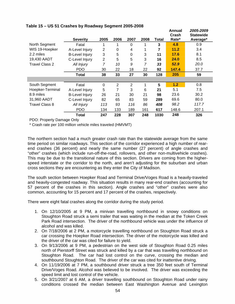
54
Table 15 – US 51 Crashes by Roadway Segment 2005-2008
Severity 2005 2006 2007 2008 Total
Annual Crash Rate*
2005-2009 Statewide Average*
North Segment Fatal 1 1 0 1 3 4.8 0.9 WIS 19-Hoepker A-Level Injury 2 0 4 1 7 11.2 3.4 2.2 miles B-Level Injury 3 5 0 3 11 17.6 8.1 19,430 AADT C-Level Injury 2 5 5 3 16 24.0 8.5 Travel Class 2 All Injury 7 10 9 7 33 52.9 20.0
PDO 30 22 18 22 92 147.4 37.7 Total 38 33 27 30 128 205 59
South Segment Fatal 0 2 2 1 5 1.2 0.8 Hoepker-Terminal A-Level Injury 5 7 3 6 21 5.1 7.5 8.9 miles B-Level Injury 26 21 30 21 98 23.6 30.2 31,960 AADT C-Level Injury 82 65 83 59 289 69.6 80.0 Travel Class 8 All Injury 113 93 116 86 408 98.2 117.7
PDO 134 133 189 161 617 148.6 207.1 Total 247 228 307 248 1030 248 326
PDO: Property Damage Only * Crash rate per 100 million vehicle miles traveled (HMVMT)
The northern section had a much greater crash rate than the statewide average from the same time period on similar roadways. This section of the corridor experienced a high number of rear-end crashes (36 percent) and nearly the same number (27 percent) of angle crashes and “other” crashes (which include run-off-the-road, rollovers, and other non-multivehicle crashes). This may be due to the transitional nature of this section. Drivers are coming from the higher-speed interstate or the corridor to the north, and aren’t adjusting for the suburban and urban cross sections they are encountering as they enter the City of Madison. The south section between Hoepker Road and Terminal Drive/Voges Road is a heavily-traveled and heavily-congested roadway. This situation results in many rear-end crashes (accounting for 57 percent of the crashes in this section). Angle crashes and “other” crashes were also common, accounting for 15 percent and 17 percent of the crashes, respectively. There were eight fatal crashes along the corridor during the study period.
1. On 12/10/2005 at 9 PM, a minivan travelling northbound in snowy conditions on Stoughton Road struck a semi trailer that was waiting in the median at the Token Creek Park Road intersection. The driver of the northbound vehicle was under the influence of alcohol and was killed.
2. On 7/18/2006 at 2 PM, a motorcycle travelling northbound on Stoughton Road struck a car crossing the Hoepker Road intersection. The driver of the motorcycle was killed and the driver of the car was cited for failure to yield.
3. On 9/13/2006 at 9 PM, a pedestrian on the west side of Stoughton Road 0.25 miles north of Pierstorff Street was struck and killed by a car that was travelling northbound on Stoughton Road. The car had lost control on the curve, crossing the median and southbound Stoughton Road. The driver of the car was cited for inattentive driving.
4. On 11/19/2006 at 7 PM, a southbound driver struck a tree 350 feet south of Terminal Drive/Voges Road. Alcohol was believed to be involved. The driver was exceeding the speed limit and lost control of the vehicle.
5. On 3/21/2007 at 6 AM, a driver travelling southbound on Stoughton Road under rainy conditions crossed the median between East Washington Avenue and Lexington
55
Avenue and struck a northbound vehicle head-on. The driver of the southbound vehicle had a pre-existing medical condition and was killed.
6. On 5/6/2007 at 3 AM, a driver travelling southbound near Acker Road left the roadway, the vehicle rolled over. The driver was not wearing a seatbelt.
7. On 7/3/2008 at 6 PM, a motorcycle travelling northbound on Stoughton Road was making a left turn to WIS 30 when it struck vehicle turning left from WIS 30 to southbound Stoughton Road. The traffic signal was not operating at the time. The motorcycle operator was killed.
8. On 9/19/2008 at 5 PM, a vehicle travelling westbound on Hoepker Road pulled out in front of a vehicle travelling northbound at Stoughton Road and was struck broadside. Neither driver was wearing a seatbelt. The driver of the westbound vehicle was killed.
Weather related crashes were an issue on the Cottage Grove Road interchange ramps. A large number of single vehicle crashes occurred under wet or icy conditions on the ramps. Speed is listed as a cause for many of these crashes. The configuration of the ramps may also be a factor. There are no deceleration lanes for the exit ramps from Stoughton Road to Cottage Grove Road. The ramps are posted at 25 miles per hour but without deceleration lanes, it is difficult for a vehicle to slow down in the travel lane on Stoughton Road prior to reaching the ramps. As mentioned earlier in this report, a project is scheduled for 2015 to expand the Cottage Grove Road bridge and extend the deceleration lane. Nearly 75 percent of the crashes along the corridor were intersection-related collisions, being within 200 feet of an intersection. This could be expected for a high speed corridor (majority posted 45 or 55 mph) with 17 traditional intersections and 12 ramp terminal intersections spaced on average approximately every 0.5 miles. Due to the mixed roadway functions in the Stoughton Road corridor, the large number of closely spaced intersections, and the majority of crashes occurring at the intersections, a more accurate determination of the roadway safety can be shown by analyzing the crashes at the intersections. 7.2 US 51 Intersection Crashes Rates and Types 7.2.1 Intersection Crash Rates and Types A summary of the US 51 intersection crashes is provided in Table 16. The intersections with the highest number of crashes are Buckeye Road (145), East Washington Avenue (103), Broadway (95) and Pflaum Road (87), which account for over half of the number of intersection crashes and 53 percent (172) of the injury crashes at intersections. The intersection crash rates are calculated based on number of crashes per million entering vehicles (MEV) the intersection. WisDOT’s threshold for concern for a standard intersection is 1.5 crashes per MEV. The Buckeye Road intersection had the highest crash rate, with 1.79 crashes per MEV. The west Milwaukee Street ramp terminal was also above the threshold, with 1.51 crashes per MEV. The Pflaum Road (1.39 crashes per MEV), east Milwaukee Street terminal (1.18 crashes per MEV), and Broadway (1.17 crashes per MEV) were the only other intersections with a crash rate above 1.0. The predominant intersection crash type is rear-end (56%). Angle crashes accounted for 21% of the total number of intersection crashes. These two types of crashes typically are 75% of the total crashes at intersections, based on the statewide averages. This is also typical of highly congested, signalized intersections. Many of the rear end crash reports listed following too close, inattentive driving, or too fast for conditions as contributing circumstances. These crashes are possibly caused by long traffic queues waiting on Stoughton Road at the traffic signals. Vehicles approaching the intersections and attempting to pass through the green phase of the signal overtake queued or slower-moving vehicles. Angle crashes also comprised a high percentage of the intersection crashes at Hoepker Road (prior to its signalization), Kinsman Boulevard, and at the interchange ramps for I 39/90/94, Milwaukee Street, and Cottage Grove
56
Road. Angle crashes typically occur when drivers tried to enter a gap in traffic and misjudged either the speed or direction of the oncoming traffic. Nearly all of the angle crashes were caused by drivers failing to yield or driving too fast for conditions. Twenty-five crashes, including eleven injury crashes and two fatal crashes occurred at the Hoepker Road intersection when it was an at-grade, two-way stop controlled intersection. This area was identified early the study as an area of concern. Subsequently, the intersection was converted to a signalized intersection late in the year 2009 through the Highway Safety Improvement Program (HSIP). At the request of WisDOT, the Pflaum Road, Buckeye Road, and WIS 30 intersections were evaluated for potential inclusion in the HSIP. Rear-end crashes are the predominant type of crashes at these intersections – 77% at Buckeye, 75% at Pflaum and 62% at WIS 30. Several alternatives were investigated that could provide short term safety improvements at a minimal cost. It was determined that upgrading the current standard signals to overhead monotube signals with re-timing and revised lane assignments would provide some level of safety improvement at the Pflaum and Buckeye Road intersections. However, the level of service improvement was negligible and the new signal phasing would not relieve the back-ups at the intersections, which are considered a significant contributing factor to the rear-end crashes. The potential improvements at these intersections are still under review.
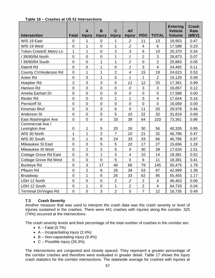
57
Table 16 – Crashes at US 51 Intersections
Intersection Fatal A
InjuryB
InjuryC
InjuryAll
Injury PDO TOTAL
Entering Vehicle Volume
Crash Rate
(MEV)
WIS 19 East 0 1 0 1 2 11 13 18,953 0.47 WIS 19 West 0 1 0 1 2 4 6 17,588 0.23 Token Creek/E Metro Ln 1 1 0 2 3 6 10 20,370 0.34 I 39/90/94 North 0 0 0 1 1 2 3 29,873 0.07 I 39/90/94 South 0 0 1 1 2 0 2 25,883 0.05 Daentl Rd 0 0 1 0 1 3 4 24,465 0.11 County CV/Anderson Rd 0 1 1 2 4 15 19 24,623 0.53 Acker Rd 0 0 1 0 1 1 2 15,120 0.09 Hoepker Rd 2 3 3 5 11 12 25 17,361 0.99 Hanson Rd 0 0 0 0 0 3 3 16,857 0.12 Amelia Earhart Dr 0 0 0 0 0 0 0 17,588 0.00 Rieder Rd 0 0 0 1 1 3 4 17,644 0.16 Pierstorff St 0 0 0 0 0 0 0 16,069 0.00 Kinsman Blvd 0 0 3 6 9 11 20 29,978 0.46 Anderson St 0 0 5 5 10 22 32 31,816 0.69 East Washington Ave 0 0 6 33 39 64 103 73,361 0.96 Commercial Ave / Lexington Ave 0 1 5 20 26 30 56 40,335 0.95 WIS 30 North 1 1 2 7 10 21 32 46,786 0.47 WIS 30 South 0 1 8 24 33 33 66 46,786 0.97 Milwaukee St East 0 0 5 5 10 17 27 15,666 1.18 Milwaukee St West 0 2 2 5 9 30 39 17,634 1.51 Cottage Grove Rd East 0 0 1 3 4 10 14 18,381 0.52 Cottage Grove Rd West 0 0 0 5 5 6 11 18,381 0.41 Buckeye Rd 0 3 17 46 66 79 145 55,475 1.79 Pflaum Rd 0 2 6 26 34 53 87 42,999 1.39 Broadway 0 1 6 26 33 62 95 55,455 1.17 USH 12 North 0 0 0 2 2 2 4 46,463 0.06 USH 12 South 0 1 0 1 2 2 4 64,733 0.04 Terminal Dr/Voges Rd 0 0 3 2 5 7 12 16,735 0.49
7.3 Crash Severity Another measure that was used to interpret the crash data was the crash severity or level of injuries sustained in the crashes. There were 441 crashes with injuries along the corridor, 325 (74%) occurred at the intersections. The crash severity levels and their percentage of the total number of crashes in the corridor are:
K – Fatal (0.7%) A – Incapacitating injury (2.4%) B – Non-capacitating injury (9.4%) C – Possible injury (26.3%)
The intersections are congested and closely spaced. They represent a greater percentage of the corridor crashes and therefore were evaluated in greater detail. Table 17 shows the injury crash statistics for the corridor intersections. The statewide average for crashes with injuries at
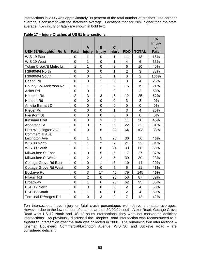
58
intersections in 2005 was approximately 38 percent of the total number of crashes. The corridor average is consistent with the statewide average. Locations that are 20% higher than the state average (45% injury or fatal) are shown in bold text. Table 17 – Injury Crashes at US 51 Intersections
USH 51/Stoughton Rd & Fatal A
InjuryB
InjuryC
Injury PDO TOTAL
% Injury
or Fatal
WIS 19 East 0 1 0 1 11 13 15% WIS 19 West 0 1 0 1 4 6 33% Token Creek/E Metro Ln 1 1 0 2 6 10 40% I 39/90/94 North 0 0 0 1 2 3 33% I 39/90/94 South 0 0 1 1 0 2 100% Daentl Rd 0 0 1 0 3 4 25% County CV/Anderson Rd 0 1 1 2 15 19 21% Acker Rd 0 0 1 0 1 2 50% Hoepker Rd 2 3 3 5 12 25 52% Hanson Rd 0 0 0 0 3 3 0% Amelia Earhart Dr 0 0 0 0 0 0 0% Rieder Rd 0 0 0 1 3 4 25% Pierstorff St 0 0 0 0 0 0 0% Kinsman Blvd 0 0 3 6 11 20 45% Anderson St 0 0 5 5 22 32 31% East Washington Ave 0 0 6 33 64 103 38% Commercial Ave/ Lexington Ave 0 1 5 20 30 56 46% WIS 30 North 1 1 2 7 21 32 34% WIS 30 South 0 1 8 24 33 66 50% Milwaukee St East 0 0 5 5 17 27 37% Milwaukee St West 0 2 2 5 30 39 23% Cottage Grove Rd East 0 0 1 3 10 14 29% Cottage Grove Rd West 0 0 0 5 6 11 45% Buckeye Rd 0 3 17 46 79 145 46% Pflaum Rd 0 2 6 26 53 87 39% Broadway 0 1 6 26 62 95 35% USH 12 North 0 0 0 2 2 4 50% USH 12 South 0 1 0 1 2 4 50% Terminal Dr/Voges Rd 0 0 3 2 7 12 42%
Ten intersections have injury or fatal crash percentages well above the state averages. However, due to the low number of crashes at the I 39/90/94 south, Acker Road, Cottage Grove Road west US 12 North and US 12 south intersections, they were not considered deficient intersections. As previously discussed the Hoepker Road intersection was reconstructed to a signalized intersection after the data was collected in 2008. The remaining four intersections – Kinsman Boulevard, Commercial/Lexington Avenue, WIS 30, and Buckeye Road – are considered deficient.
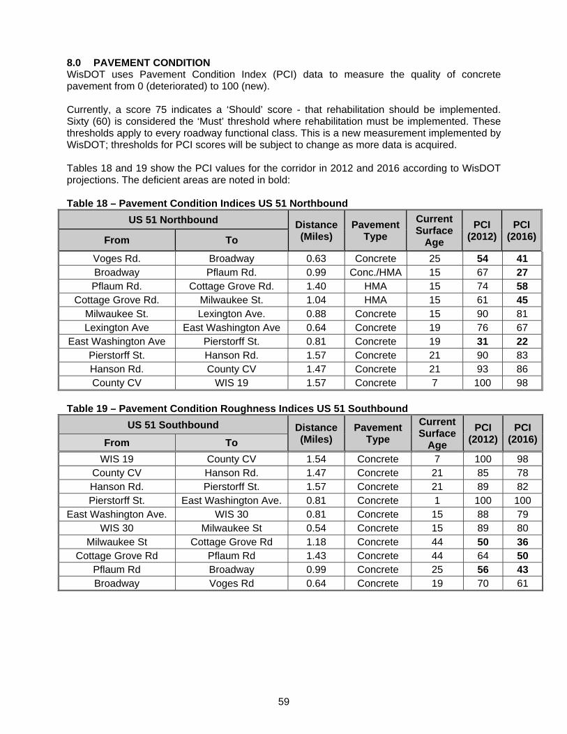
59
8.0 PAVEMENT CONDITION WisDOT uses Pavement Condition Index (PCI) data to measure the quality of concrete pavement from 0 (deteriorated) to 100 (new). Currently, a score 75 indicates a ‘Should’ score - that rehabilitation should be implemented. Sixty (60) is considered the ‘Must’ threshold where rehabilitation must be implemented. These thresholds apply to every roadway functional class. This is a new measurement implemented by WisDOT; thresholds for PCI scores will be subject to change as more data is acquired. Tables 18 and 19 show the PCI values for the corridor in 2012 and 2016 according to WisDOT projections. The deficient areas are noted in bold: Table 18 – Pavement Condition Indices US 51 Northbound
US 51 Northbound Distance (Miles)
Pavement Type
Current Surface
Age
PCI (2012)
PCI (2016)From To
Voges Rd. Broadway 0.63 Concrete 25 54 41 Broadway Pflaum Rd. 0.99 Conc./HMA 15 67 27 Pflaum Rd. Cottage Grove Rd. 1.40 HMA 15 74 58
Cottage Grove Rd. Milwaukee St. 1.04 HMA 15 61 45 Milwaukee St. Lexington Ave. 0.88 Concrete 15 90 81 Lexington Ave East Washington Ave 0.64 Concrete 19 76 67
East Washington Ave Pierstorff St. 0.81 Concrete 19 31 22 Pierstorff St. Hanson Rd. 1.57 Concrete 21 90 83 Hanson Rd. County CV 1.47 Concrete 21 93 86 County CV WIS 19 1.57 Concrete 7 100 98
Table 19 – Pavement Condition Roughness Indices US 51 Southbound
US 51 Southbound Distance (Miles)
Pavement Type
Current Surface
Age
PCI (2012)
PCI (2016)From To
WIS 19 County CV 1.54 Concrete 7 100 98 County CV Hanson Rd. 1.47 Concrete 21 85 78 Hanson Rd. Pierstorff St. 1.57 Concrete 21 89 82 Pierstorff St. East Washington Ave. 0.81 Concrete 1 100 100
East Washington Ave. WIS 30 0.81 Concrete 15 88 79 WIS 30 Milwaukee St 0.54 Concrete 15 89 80
Milwaukee St Cottage Grove Rd 1.18 Concrete 44 50 36 Cottage Grove Rd Pflaum Rd 1.43 Concrete 44 64 50
Pflaum Rd Broadway 0.99 Concrete 25 56 43 Broadway Voges Rd 0.64 Concrete 19 70 61

60
8.1 Pavement Condition Deficiencies The pavement between Broadway and Milwaukee Street is rapidly deteriorating. These areas will be below the ‘Must’ threshold by 2016 and require some form of rehabilitation. The northbound pavement between Terminal Drive/Voges Road and Broadway is also currently at the ‘Must’ threshold, while the southbound pavement is projected to be near that level by 2016. In addition, the worst measured and projected pavement condition the northbound pavement between East Washington Avenue and Pierstorff Street. Portions of this area have been rehabilitated several times in the last 10 years but still have ratings (31 in 2012 and 22 in 2016) that require pavement replacement.
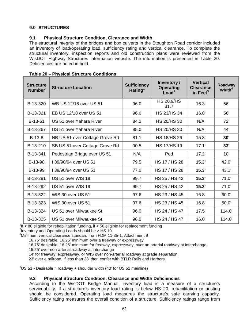
61
9.0 STRUCTURES 9.1 Physical Structure Condition, Clearance and Width The structural integrity of the bridges and box culverts in the Stoughton Road corridor included an inventory of load/operating load, sufficiency rating and vertical clearance. To complete the structural inventory, inspection reports and old construction plans were reviewed from the WisDOT Highway Structures Information website. The information is presented in Table 20. Deficiencies are noted in bold. Table 20 – Physical Structure Conditions
Structure Number
Structure Location Sufficiency
Rating1
Inventory / Operating
Load2
Vertical Clearance
in Feet3
Roadway Width4
B-13-320 WB US 12/18 over US 51 96.0 HS 20.9/HS
31.7 16.3' 56'
B-13-321 EB US 12/18 over US 51 96.0 HS 23/HS 34 16.8' 56'
B-13-61 US 51 over Yahara River 84.2 HS 20/HS 30 N/A 72'
B-13-267 US 51 over Yahara River 85.0 HS 20/HS 30 N/A 44'
B-13-8 NB US 51 over Cottage Grove Rd 81.1 HS 18/HS 26 15.3' 30'
B-13-210 SB US 51 over Cottage Grove Rd 90.5 HS 17/HS 19 17.1' 33'
B-13-341 Pedestrian Bridge over US 51 N/A Ped 17.2' 10'
B-13-98 I 39/90/94 over US 51 79.5 HS 17 / HS 28 15.3' 42.9'
B-13-99 I 39/90/94 over US 51 77.0 HS 17 / HS 28 15.3' 43.1'
B-13-291 US 51 over WIS 19 99.7 HS 25 / HS 42 15.3' 71.0'
B-13-292 US 51 over WIS 19 99.7 HS 25 / HS 42 15.3' 71.0'
B-13-322 WIS 30 over US 51 97.6 HS 23 / HS 45 16.8' 60.0'
B-13-323 WIS 30 over US 51 97.6 HS 23 / HS 45 16.8' 50.0'
B-13-324 US 51 over Milwaukee St. 96.0 HS 24 / HS 47 17.5' 114.0'
B-13-325 US 51 over Milwaukee St. 96.0 HS 24 / HS 47 16.0' 114.0' 1If < 80 eligible for rehabilitation funding, if < 50 eligible for replacement funding 2Inventory and Operating Loads should be > HS 10. 3Minimum vertical clearance standard from FDM 11-35-1, Attachment 9
16.75’ desirable, 16.25’ minimum over a freeway or expressway 16.75’ desirable, 16.25’ minimum for freeway, expressway, over an arterial roadway at interchange 15.25’ over non-arterial roadway at interchange 14’ for freeway, expressway, or WIS over non-arterial roadway at grade separation 23’ over a railroad, if less than 23’ then confer with BTLR Rails and Harbors.
4US 51 - Desirable = roadway + shoulder width (40’ for US 51 mainline)
9.2 Physical Structure Condition, Clearance and Width Deficiencies According to the WisDOT Bridge Manual, inventory load is a measure of a structure’s serviceability. If a structure’s inventory load rating is below HS 20, rehabilitation or posting should be considered. Operating load measures the structure’s safe carrying capacity. Sufficiency rating measures the overall condition of a structure. Sufficiency ratings range from
62
0 to 100 and a rating less than 50 indicates a structure is eligible for federal replacement funding. A rating less than 80 indicates a structure is eligible for rehabilitation funding. Vertical clearance should be 16.25 feet to 16.75 feet for structures over interstate or state trunk highways and a minimum of 14.75 feet over other roadways. Pedestrian overpasses should be a minimum of 17.25 feet over all roadways. All structures meet the standards for Sufficiency Rating, Inventory Load Rating and Operating Load Rating. The Stoughton Road structure analysis identified six deficient structures:
Roadway widths are deficient at the Cottage Grove Road structures. The width of the southbound structure will be addressed with the project scheduled for 2015.
The eastbound and westbound I 39/90/94 overpasses have 15.3 feet of vertical clearance. These bridges are being raised approximately four inches with the current reconstruction project, but will still be below the required vertical clearance.
The northbound and southbound WIS 19 overpasses have 15.3 feet of vertical clearance.
63
10.0 ALTERNATIVES The Dane County and City of Madison GIS databases were used to develop the property lines, parcel zoning, some environmental resources, and the right-of-way (R/W) corridor for the project. The Wisconsin Department of Natural Resources (WDNR) provided their GIS information on delineated wetlands and other natural resource inventories in the corridor. Aerials photos and digital elevation modeling provided by the Dane County Land Information Office were used as base data for alternative development. The accuracy of the base data provided was determined sufficient by WisDOT and three conceptual alternatives were developed using FDM design standards. Conceptual designs were developed and refined in corroboration with the study’s Technical (TAC) and Policy (PAC) Advisory Committees. Once approved by the TAC and PAC the impact areas of the conceptual designs were determined. 10.1 Alternatives Selection Process The study evaluated a reasonable range of alternatives. Three conceptual improvement alternatives were developed to address the identified problems. These alternatives were screened for meeting purpose and need, environmental considerations, technical feasibility and economic feasibility. To assist in the preliminary evaluation of the alternatives, an Initial Environmental Screening was conducted to compare the alternatives and to help decide which should be carried forward for detailed study. In addition, an Alternatives Assessment Worksheet was completed with the assistance of the public, Advisory Committees and the agencies to detail the benefits and drawbacks of each alternative. All alternatives were presented to, reviewed by, and commented on by the Technical Advisory Committee which included technical staff from WisDOT, FHWA, and local municipalities, and the Policy Advisory Committee which included elected officials from the municipalities. Environmental agencies were also contacted for their comments on the alternatives. 10.2 Explanation of Alternatives Based on comments received at the meetings, subsequent meetings with the Policy and Technical Advisory Committees, local businesses (November 2006), and a Value Engineering Study, Alternatives A, B, and C have been modified. Following is a summary of the Alternatives: Alternative A (Transportation System Management - TSM) – adds capacity to intersections and improves mobility without additional traffic lanes. Only one interchange has been considered in this alternative – a ‘jughandle’ at the Broadway intersection. Access roads from the relocated Broadway intersection area have been reconfigured. Signals and expanded turn lanes at the Hoepker Road intersection has also been included. Alternative B (Enhanced Expressway) – converts the intersections at Pflaum Road, Buckeye Road, Lexington/ Commercial Avenue, East Washington Avenue and Hoepker Road to interchanges. It also provides free-flow ramps to and from the west side of the Beltline (US 12/18), ramps to access Stoughton Road between Pflaum and Buckeye Roads and an overpass at existing County CV.
Alternative C (Freeway) – provides a free flow movement for traffic through the corridor. It includes interchanges at the locations listed in Alternative B (Enhanced Expressway) and at Kinsman Boulevard and Rieder Road/Amelia Earhart Drive. Alternative C (Freeway) also includes express lanes over the Beltline (US 12/18), express lanes over WIS 30/railroad crossing/Lexington Avenue, and overpasses at County CV and over I 39/90/94 for East Metro Drive.
The alternatives selected to undergo detailed study represent the full spectrum of reasonable alternatives. Each of the selected alternatives connect logical termini and are of sufficient length
64
to address environmental matters on a broad scope, have independent utility and do not restrict consideration of alternatives for other reasonable foreseeable transportation improvements. Since US 51 is part of the National Highway System and is designated as a Backbone Highway in the State’s Corridors 2020 plan, all alternatives were defined as meeting Corridors 2020 and NHS design standards. Input from local citizens and cooperating agencies, local municipalities and counties and the Technical and Policy Advisory Committees were taken into consideration in the selection of which alternatives should be carried forward for detailed study. 10.3 Evaluation of Alternatives The future build alternatives were evaluated using Paramics microsimulation software. The entire corridor from WIS 19 to Terminal Drive/Voges Road was included in these models. Paramics allows for the analysis of both roundabout and signal controlled intersections within the same model, aiding in the alterative development for this study. Additionally, the way in which interaction between vehicles impacts overall operations is better represented in Paramics. This assisted in identifying bottlenecks throughout the corridor as varying levels of improvements were made. Because of this interaction and significant spillback of queues from congested intersections, the No Build scenario operates worse in Paramics than in the Synchro analysis (discussed in Section 2). The Paramics results for the No Build scenario are shown in Table 21. The sections below discuss the details of each build alternative. 10.3.1 Alternative A (TSM) The roadway network for Alternative A (TSM) includes improvements designed to improve mobility and increase the safety of several intersections. Items noted with an asterisk (*) and italic font were proposed by the study as improvements over the existing/base year (2002) condition and have been implemented during the study. These include: Beltline
Construct triple left from EB Beltline to NB Stoughton Road.* Widen WB Beltline exit ramp to two lanes and intersection at Stoughton Rd to four
lanes.* Broadway (Internal roadways reconfigured)
Jughandle interchange Relocate intersection to the north. Off-road bike/pedestrian path from Femrite Drive to Pflaum Road.
Pflaum Road and Buckeye Road
Relocate frontage road intersections. Extend turn lanes. Bike and pedestrian connections across Stoughton Road at Tompkins Drive and
Helgeson Drive. Cottage Grove Road
Extend acceleration and deceleration lanes on northbound Stoughton Road ramps. Extend deceleration lane on southbound Stoughton Road ramps. Extend acceleration lane on southbound ramp to meet right-turn lane at Buckeye Road.*
WIS 30
Restrict NB Milwaukee Street entrance ramp traffic from making left turns at WIS 30. Reconstruct WB off-ramp to eliminate free-flow right-turn and add triple left turn lanes. Reconstruct EB off-ramp to add triple left turn lanes.
65
Increase turn-lane lengths on off ramps. Bike and pedestrian connection across WIS 30 at Walsh Road.
East Washington Avenue
Reconstruct Stoughton Road to improve intersection angle, with increased turn-lane lengths. Bike and pedestrian overpasses at intersection and Larson Court.
Anderson Street
Remove direct access to businesses east of Stoughton Road between East Washington Avenue and Anderson Street. Add frontage road from Mendota Street to provide access to properties
Connect Anderson Street to East Washington Avenue at the Lien Road intersection. Add turn lanes, extend existing turn lanes on Anderson Street.
Pierstorff Street
Bike and pedestrian connection across Stoughton Road, off-road path to Anderson Road.
Hoepker Road
Signalize intersection* Add right turn lanes to Hoepker Road* Extend left- and right-turn lanes on Stoughton Road*
County CV / Anderson Road
Bike and pedestrian connection across I 39/90/94. I 39/90/94
Remove truck stop accesses from ramps. Extend acceleration and deceleration lanes for I 39/90/94 ramps to/from US 51.
Conceptual maps of all the alternatives are provided in Exhibit 2. While no through lane capacity is added to mainline US 51, mobility is improve by expanding the WIS 30 ramps, moving the frontage road intersections on Buckeye Road and Pflaum Road farther away from Stoughton Road to provide more separation between the intersections, adding deceleration lanes and extending acceleration lanes on US 51 at the Cottage Grove Road interchange extending turn lanes at intersections, removing direct access from Daentl Road, and extending the acceleration and deceleration lanes on I 39/90/94. The WIS 19 interchange ramp terminals are also signalized in Alternative A. Three items proposed by this alternative have already been constructed:
the ramps at the Beltline expanded to three left-turn lanes eastbound and two left- and two-right turn lanes westbound
an auxiliary lane created for southbound traffic between Buckeye and Cottage Grove Roads
Hoepker Road intersection converted to a signalized intersection Traffic volumes for this and all alternatives are based on TRANPLAN travel demand modeling that accounts for the specific alternatives improvements. The traffic volumes reflect any redirection of traffic caused by the capacity and mobility enhancements. Alternative A provides some improvements to traffic operations, particularly north of East Washington Avenue. The intersections north of Anderson Street operate at LOS C, D, or E with 2035 projected volumes. Other areas where improved operations are observed include the Lexington/Commercial Avenue intersection and the WIS 30 and Milwaukee Street
66
interchanges. The operational improvements at these locations may be impacted by a metering effect because of significant congestion at the East Washington Avenue and the Buckeye Road/Pflaum Road areas. The intersections of East Washington Avenue and Anderson Street were observed to operate at LOS F during the PM peak hour. In addition, all intersections south of the Cottage Grove Road interchange were observed to operate at LOS E or F. The at-grade intersections of Buckeye Road, Pflaum Road, Broadway, and Terminal Drive/Voges Road were observed to operate poorest during the PM peak hour. The average delays at these intersections are highlighted below.
Terminal Drive/Voges Road - 163 seconds Pflaum Road - over 200 seconds. Buckeye Road - 130 seconds.
Queues on East Washington Avenue were observed to exceed 1000 feet during the peak hour. Northbound Stoughton Road queues of 2000 feet in length were observed at Buckeye Road and Pflaum Road. The westbound left turn at Broadway had queues that often exceeded the storage length of the turn bays. Northbound queuing at Broadway was also observed to back into the Beltline interchange and interfere with the off-ramp operations. The eastbound Beltline off-ramp was observed to back up onto the mainline Beltline at times during the peak hour. The northbound left-turning traffic at the Beltline interchange also routinely exceeded the storage capacity of the left-turn bays. Table 21 shows the Alternative A (TSM) Levels of Service along Stoughton Road.
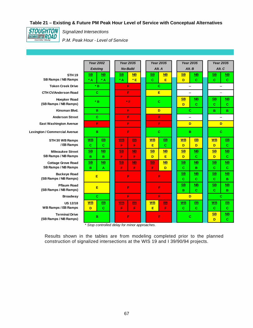
67
Table 21 – Existing & Future PM Peak Hour Level of Service with Conceptual Alternatives
Signalized Intersections
P.M. Peak Hour - Level of Service
SB NB SB NB SB NB SB NB SB NB
* A * A * A * E C E D C C C
SB NB SB NB
D C C C
B B
WB EB WB EB WB EB WB EB WB EB
C C F F E C D D D C
SB NB SB NB SB NB SB NB SB NB
B B F F D E D C D C
SB NB SB NB SB NB SB NB SB NB
B A F F F D C B C C
SB NB SB NB
C C C B
SB NB SB NB
B C C B
WB EB WB EB WB EB WB EB WB EB
D C F F E F C C C C
SB NB
D C
* Stop controlled delay for minor approaches.
D C
US 12/18 WB Ramps / EB Ramps
Terminal Drive (SB Ramps / NB Ramps)
B F F C
F
Pflaum Road (SB Ramps / NB Ramps)
E F F
Broadway C F F
STH 30 WB Ramps / EB Ramps
Milwaukee Street SB Ramps / NB Ramps
Cottage Grove Road SB Ramps / NB Ramps
Buckeye Road (SB Ramps / NB Ramps)
E F
Lexington / Commercial Avenue B F C B C
--
East Washington Avenue F F F D D
C
Anderson Street C F F --
Hoepker Road (SB Ramps / NB Ramps)
* B * F C
Kinsman Blvd. B F D
--
CTH CV/Anderson Road C F E -- --
STH 19 SB Ramps / NB Ramps
Token Creek Drive * B F C --
Year 2002 Year 2035 Year 2035 Year 2035 Year 2035
Existing No-Build Alt. A Alt. B Alt. C
Results shown in the tables are from modeling completed prior to the planned construction of signalized intersections at the WIS 19 and I 39/90/94 projects.
68
10.3.2 Alternative B (Enhanced Expressway) The Alternative B (Enhanced Expressway) roadway network includes free flow ramps from eastbound Beltline to northbound Stoughton Road and southbound Stoughton Road to the eastbound Beltline. There are five new interchanges - Hoepker Road, East Washington Avenue, Lexington/Commercial Avenue, Buckeye Road, and Pflaum Road. The intersections of County CV/Anderson Road and Anderson Street are grade separated, and access at the Daentl Road and Token Creek Road/East Metro Drive intersections are removed. Beltline
Free flow ramps to/from West Beltline. Broadway
Off-road bike/pedestrian path from Dutch Mill Road to Pflaum Road. Bike and pedestrian connection across Stoughton Road at Femrite Drive.
Pflaum Road and Buckeye Road
Bike and pedestrian connection across Stoughton Road at Tompkins Drive. Split diamond interchanges – south ramps at Pflaum, north ramps at Buckeye. One-way frontage roads and ‘Texas u-turns’ to provide access between Pflaum and
Buckeye. Southbound on-ramp to Stoughton Road between Helgeson Drive and Pflaum Road Northbound on-ramp to Stoughton Road between Helgeson Drive and Buckeye Road Additional lanes and bike accommodations on frontage roads for increased traffic
volumes. Reconstruct frontage roads south of Pflaum Road. Move Blossom Lane / Buckeye Road intersection to the east. Connection across Stoughton Road at Helgeson Drive.
Cottage Grove Road
Extend acceleration and deceleration lanes on Stoughton Road ramps. WIS 30
Restrict northbound Milwaukee Street entrance ramp traffic from making left turns at WIS 30 interchange.
Reconstruct westbound off-ramp to eliminate free-flow right-turn movement and add triple left turn lanes.
Reconstruct eastbound off-ramp to add triple left turn lanes. Bike and pedestrian connection across WIS 30 at Walsh Road.
Lexington Avenue/Commercial Avenue and Railroad Crossing
Interchange over Lexington/Commercial Avenue and Railroad with loop ramps on west side and diamond ramps on east side.
East Washington Avenue and Anderson Street
Reconstruct East Washington Avenue intersection to a single point urban interchange. Anderson Street overpass. Extend Anderson Street to the east; connect to East Washington Avenue near Lien
Road. Bike and pedestrian overpasses at intersection and Larson Court. Add frontage road south from Anderson Street to provide access to properties east of
Stoughton Road between East Washington Avenue and Anderson Street.
69
Kinsman Boulevard Additional through lane NB and SB on Stoughton Road. Double-left turn lanes NB and SB on Stoughton Road Improve lane configuration on Kinsman Boulevard.
Pierstorff Street
Bike and pedestrian connection across Stoughton Road, off-road multi-use path to Anderson Road.
No access from driveway (Pierstorff Street) on the east side of Stoughton Road. Rieder Road
Restricted to right-turn only (remove southbound Stoughton Road left-turns). Left-turns have access from Kinsman Boulevard to Bartillon Drive connection.
Hanson Road, Hoepker Road, and County CV / Anderson Road
Hanson Road movements restricted to right-turn only. Tight urban diamond interchange at Hoepker Road. Hoepker Road becomes County CV west of the interchange. Hoepker Road is a four-lane road. Local road connections from Hoepker Road to Hanson Road, old County CV, and
Anderson Road. County CV / Anderson Road overpass. Bike and pedestrian connection across I 39/90/94 at Anderson Road.
I 39/90/94 and Token Creek Park Road
Remove truck stop accesses from ramps. Token Creek Park Road intersection reconfigured to left-in from NB Stoughton Road,
right-in/out for SB Stoughton Road, and right-in/out for all Token Creek Park Road traffic. Extend acceleration and deceleration lanes for I 39/90/94 ramps to/from US 51. Create auxiliary lanes on I 39/90/94 between US 51 and WIS 19.
2035 operations on Stoughton Road are significantly improved with Alternative B (Enhanced Expressway). All intersections operate at LOS D or better overall. The westbound Beltline off-ramp and both ramp terminals of WIS 30 have one movement that operates at LOS E during the PM peak hour. The southbound approach at the East Washington Avenue Single Point Urban Interchange operates at LOS F during the PM peak hour. The operations of these intersections is highlighted below. Westbound Beltline–overall delay: 27 seconds, approach delay: 18 to 63 seconds. Eastbound WIS 30–overall delay: 49 seconds, approach delay: 29 to 58 seconds. Westbound WIS 30–overall delay: 40 seconds, approach delay: 31 to 64 seconds. East Washington Avenue–overall delay: 48 seconds, approach delay: 19 to
139 seconds.
Queues on northbound Stoughton Road at WIS 30 were observed to reach 800 feet during the peak hour and occasional cycle failures were observed. Queues of up to 500 feet were observed on the southbound Stoughton Road off-ramp at the East Washington Avenue Single Point Urban Interchange. Individual cycle failures were observed to occur on this approach during the busiest portion of the peak hour.
70
10.3.3 Alternative C (Freeway) The Alternative C (Freeway) roadway network includes the interchanges that were added for Alternative B. Alternative C (Freeway) also has the addition of express lanes for Stoughton Road over the Beltline interchange and the WIS 30 interchange. The summary of the Alternative C improvements includes: Beltline
Free flow ramps to/from West Beltline. Free flow for through movements on Stoughton Road via overpass.
Broadway
Off-road bike/pedestrian path from Dutch Mill Road to Pflaum Road. Bike and pedestrian connection across Stoughton Road near Femrite Drive.
Pflaum Road and Buckeye Road
Bike and pedestrian connections across Stoughton Road at Tompkins Drive and Helgeson Drive.
Full diamond interchanges at Pflaum and Buckeye. Relocate frontage roads. Reconstruct frontage roads south of Pflaum Road. Move Blossom Lane / Buckeye Road intersection to the east.
Cottage Grove Road
Reconstruct interchange ramps to meet higher design speed. Extend northbound acceleration and deceleration lanes.
WIS 30, Lexington Avenue/Commercial Avenue, and Railroad Crossing
Three-level interchange/overpass of WIS 30. Free flow for through movements on Stoughton Road via overpass from Milwaukee
Street through Lexington Avenue/Commercial Avenue, including railroad crossing. Bike and pedestrian connection across WIS 30 at Walsh Road.
East Washington Avenue and Anderson Street
Reconstruct East Washington Avenue intersection to a single point interchange. Free flow for through movements on Stoughton Road. Northbound and southbound ramps to Stoughton Road between East Washington
Avenue and Anderson Street. Anderson Street overpass. Extend Anderson St. to the east and connect to East Washington Avenue at Lien Road. Bike and pedestrian overpasses at intersection and Larson Court. Add frontage road from Anderson Street to provide access to properties east of
Stoughton Road between East Washington Avenue and Anderson Street. Kinsman Boulevard
Interchange at Kinsman Boulevard. Pierstorff Street
Pierstorff Street overpass. Bike and pedestrian connection across Stoughton Road, off-road path to Anderson
Road.
71
Rieder Road and Amelia Earhart Drive
Provide split interchange between Rieder Road and Amelia Earhart Drive. Northbound Stoughton Road exits at Rieder Road, enters at Amelia Earhart Drive. Southbound Stoughton Road exits and enters at Amelia Earhart Drive.
Hanson Road, Hoepker Road, and County CV / Anderson Road
Hanson Road cul de sac. Tight urban diamond interchange at Hoepker Road. Hoepker Road becomes County CV west of the interchange. Hoepker Road is a four-lane road. Local road connections from Hoepker Road to Hanson Road, old County CV, and
Anderson Road County CV / Anderson Road overpass. Bike and pedestrian connection across I 39/90/94 at Anderson Road.
I 39/90/94 and Token Creek Park Road
Remove truck stop accesses from ramps. Remove Token Creek Park Road accesses. Connect Token Creek Park Road to WIS 19 via frontage road. Token Creek Park Road overpass I 39/90/94 to connect to Daentl Road. Eliminate stop condition for WB I 39/90/94 left turns by converting to cloverleaf. Remove EB IH 39/90/94 left turn movement from this interchange. Turn can be made at
WIS 19 and I 39/90/94 interchange. Extend acceleration and deceleration lanes for I 39/90/94 ramps to/from US 51. Create auxiliary lanes on I 39/90/94 between US 51 and WIS 19.
Traffic volumes for this alternative are based on TRANPLAN travel demand modeling that accounts for the Alternative C (Freeway) improvements. The traffic volumes reflect any redirection of traffic caused by the Alternative C (Freeway) capacity enhancements. Alternative C (Freeway) provides a Stoughton Road that has no traffic signals for mainline through traffic from Terminal Drive/Voges Road to WIS 19. The 2035 operations on Stoughton Road are significantly improved over Alternative A (TSM) and are similar to Alternative B (Enhanced Expressway). All intersections operate at LOS D or better overall. The southbound Terminal Drive/Voges Road ramp terminal and the East Washington Avenue Single Point Urban Interchange each have a movement that operates at LOS E. No movements operate at LOS F with Alternative C (Freeway) improvements. The operations of these intersections are highlighted below. Southbound Terminal Drive/Voges Road–overall delay: 37 seconds, approach delay:
35 to 61 seconds. East Washington Avenue–overall delay: 39 seconds, approach delay: 20 to
60 seconds. Queues of 550 feet were observed on the southbound Stoughton Road approach at the Terminal Drive/Voges Road intersection. On East Washington Avenue, queues of around 600 feet were observed.
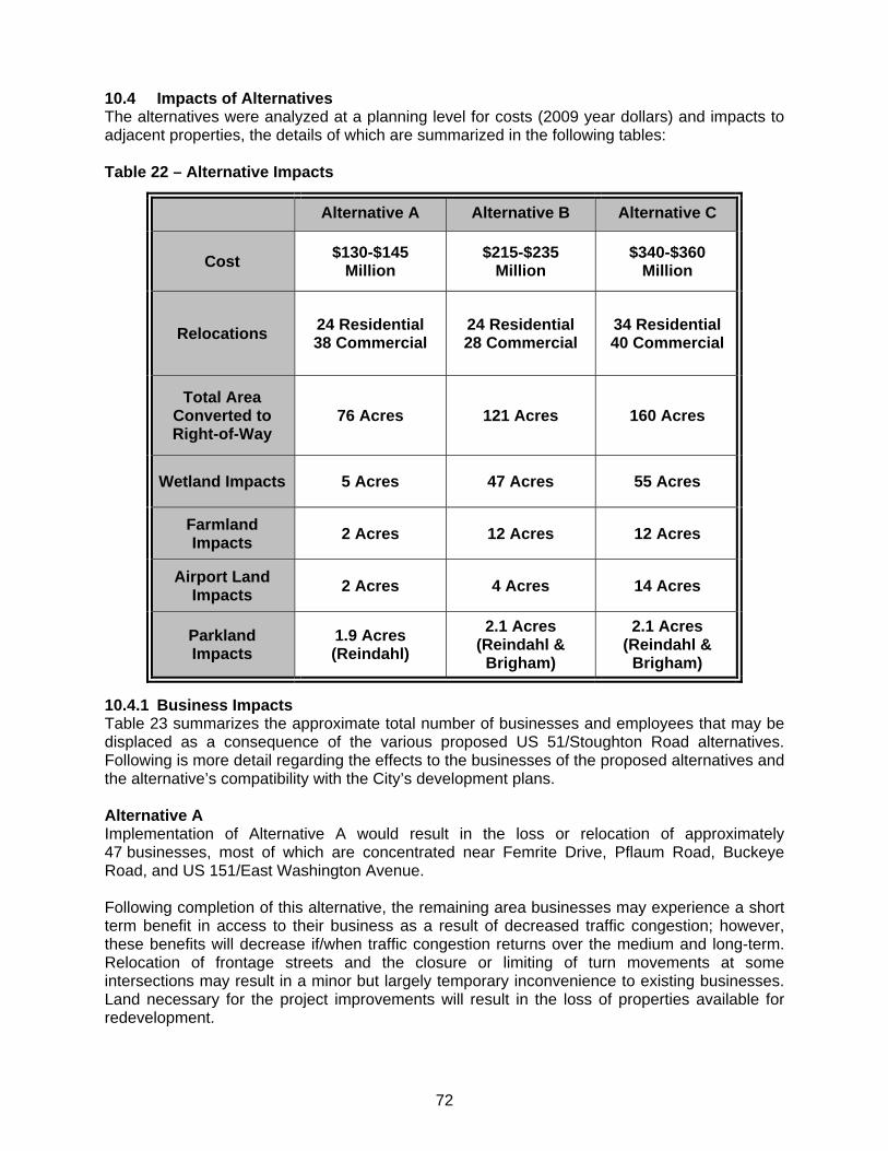
72
10.4 Impacts of Alternatives The alternatives were analyzed at a planning level for costs (2009 year dollars) and impacts to adjacent properties, the details of which are summarized in the following tables: Table 22 – Alternative Impacts 10.4.1 Business Impacts Table 23 summarizes the approximate total number of businesses and employees that may be displaced as a consequence of the various proposed US 51/Stoughton Road alternatives. Following is more detail regarding the effects to the businesses of the proposed alternatives and the alternative’s compatibility with the City’s development plans. Alternative A Implementation of Alternative A would result in the loss or relocation of approximately 47 businesses, most of which are concentrated near Femrite Drive, Pflaum Road, Buckeye Road, and US 151/East Washington Avenue. Following completion of this alternative, the remaining area businesses may experience a short term benefit in access to their business as a result of decreased traffic congestion; however, these benefits will decrease if/when traffic congestion returns over the medium and long-term. Relocation of frontage streets and the closure or limiting of turn movements at some intersections may result in a minor but largely temporary inconvenience to existing businesses. Land necessary for the project improvements will result in the loss of properties available for redevelopment.
Alternative A Alternative B Alternative C
Cost $130-$145
Million $215-$235
Million $340-$360
Million
Relocations 24 Residential 38 Commercial
24 Residential 28 Commercial
34 Residential 40 Commercial
Total Area Converted to Right-of-Way
76 Acres 121 Acres 160 Acres
Wetland Impacts 5 Acres 47 Acres 55 Acres
Farmland Impacts
2 Acres 12 Acres 12 Acres
Airport Land Impacts
2 Acres 4 Acres 14 Acres
Parkland Impacts
1.9 Acres (Reindahl)
2.1 Acres (Reindahl &
Brigham)
2.1 Acres (Reindahl &
Brigham)

73
Alternative A would be most consistent with City plans to redevelop the Gateway and Garden Development Areas, but inconsistent with City plans for the Grid Development Area at the US 51/151 intersection. Alternative B Implementation of Alternative B would result in the relocation or reduction of 42 businesses, most of which are concentrated near Pflaum Road, Buckeye Road, and US 151/East Washington Avenue. Upon completion, traffic efficiency and safety for all modes is expected to increase, which will ultimately improve access to area businesses. Businesses that rely on large trucks will benefit from increased use of exit and entrance ramps onto US 51. Direct visibility of US 51 corridor businesses from US 51/Stoughton Road will be reduced for businesses near new grade separated segments, interchanges, and overpasses, with potential adverse impacts for business retention or redevelopment. Land needed for the corridor improvements will not be available for businesses expansion or redevelopment. Closure, limited turn movements, or realignments of some existing US 51 intersections may result in minor inconvenience to businesses, but are not expected to have major negative consequences. Alternative B is compatible with City plans for the Gateway Development Area, though less so than the improvements associated with Alternative A. Alternative B is the most compatible of the proposed alternatives with City plans for the Grid Development Area and is also compatible with the remaining economic development areas. Alternative B is compatible with City plans for business development between US 151 and WIS 19 at the northern end of the project area, and will preserve long-term transportation efficiencies to the degree that Alternative C would, assuming traffic increases as projected by the Wisconsin Department of Transportation. Alternative C Implementation of Alternative C would result in the relocation or reduction of 48 business sites, most of which are concentrated near Pflaum Road, Buckeye Road, Cottage Grove Road, and US 151/East Washington Avenue. Alternative C will also result in the loss of some land near the corridor to future business redevelopment. Overall, traffic and safety improvements will benefit businesses and property values within and near the project area. Grade separated crossings and interchanges may reduce visibility or perceived accessibility of some existing or future businesses (particularly at US 12/18, between Pflaum Road and Buckeye Road, and at US 151), with possible negative effects. Businesses in existing and planned business/industrial parks near the US 51 corridor would not be negatively affected. This alternative will have similar impacts both positive and negative to traffic efficiency, safety, and access as Alternative B. The additional overpasses will have a greater impact to direct visibility of US 51 corridor businesses from US 51/Stoughton Road which will be reduced and may pose adverse impacts for business retention or redevelopment. This alternative will also have a slightly greater land impact to business expansion or redevelopment. Alternative C is compatible with City plans for the Gateway Development Area (Beltline Highway Interchange), though less so than the improvements associated with Alternative A. Alternative C is less compatible with City plans for the Grid Development Area (Pflaum Road and Buckeye Road) and less compatible the Garden Development Area than Alternative B. Alternative C is compatible with City plans for business development between US 151 and WIS 19 at the northern end of the project area.
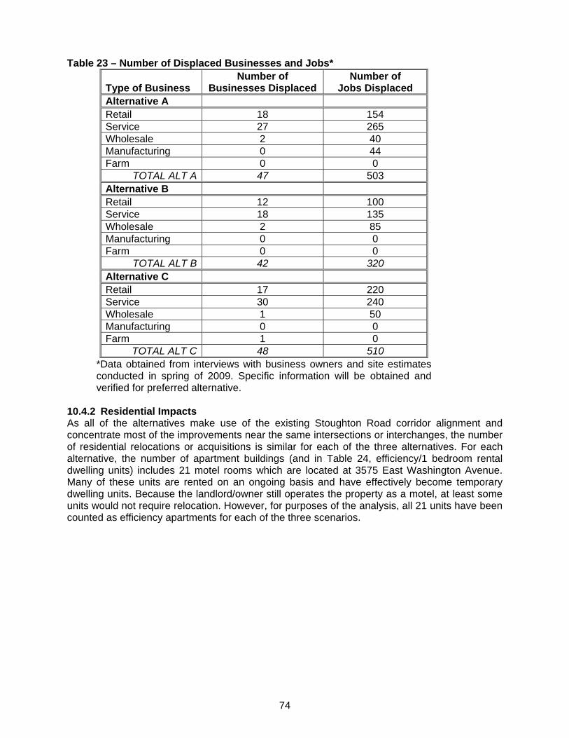
74
Table 23 – Number of Displaced Businesses and Jobs*
Type of Business Number of
Businesses Displaced Number of
Jobs Displaced Alternative A Retail 18 154 Service 27 265 Wholesale 2 40 Manufacturing 0 44 Farm 0 0
TOTAL ALT A 47 503 Alternative B Retail 12 100 Service 18 135 Wholesale 2 85 Manufacturing 0 0 Farm 0 0
TOTAL ALT B 42 320 Alternative C Retail 17 220 Service 30 240 Wholesale 1 50 Manufacturing 0 0 Farm 1 0
TOTAL ALT C 48 510 *Data obtained from interviews with business owners and site estimates conducted in spring of 2009. Specific information will be obtained and verified for preferred alternative.
10.4.2 Residential Impacts As all of the alternatives make use of the existing Stoughton Road corridor alignment and concentrate most of the improvements near the same intersections or interchanges, the number of residential relocations or acquisitions is similar for each of the three alternatives. For each alternative, the number of apartment buildings (and in Table 24, efficiency/1 bedroom rental dwelling units) includes 21 motel rooms which are located at 3575 East Washington Avenue. Many of these units are rented on an ongoing basis and have effectively become temporary dwelling units. Because the landlord/owner still operates the property as a motel, at least some units would not require relocation. However, for purposes of the analysis, all 21 units have been counted as efficiency apartments for each of the three scenarios.
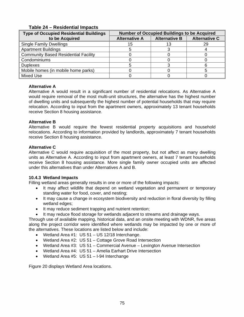
75
Table 24 – Residential Impacts
Type of Occupied Residential Buildings to be Acquired
Number of Occupied Buildings to be Acquired Alternative A Alternative B Alternative C
Single Family Dwellings 15 13 29 Apartment Buildings 5 3 4 Community Based Residential Facility 0 0 0 Condominiums 0 0 0 Duplexes 5 3 6 Mobile homes (in mobile home parks) 0 0 5 Mixed Use 0 0 0
Alternative A Alternative A would result in a significant number of residential relocations. As Alternative A would require removal of the most multi-unit structures, the alternative has the highest number of dwelling units and subsequently the highest number of potential households that may require relocation. According to input from the apartment owners, approximately 13 tenant households receive Section 8 housing assistance. Alternative B Alternative B would require the fewest residential property acquisitions and household relocations. According to information provided by landlords, approximately 7 tenant households receive Section 8 housing assistance. Alternative C Alternative C would require acquisition of the most property, but not affect as many dwelling units as Alternative A. According to input from apartment owners, at least 7 tenant households receive Section 8 housing assistance. More single family owner occupied units are affected under this alternatives than under Alternatives A and B. 10.4.3 Wetland Impacts Filling wetland areas generally results in one or more of the following impacts:
It may affect wildlife that depend on wetland vegetation and permanent or temporary standing water for food, cover, and nesting;
It may cause a change in ecosystem biodiversity and reduction in floral diversity by filling wetland edges;
It may reduce sediment trapping and nutrient retention; It may reduce flood storage for wetlands adjacent to streams and drainage ways.
Through use of available mapping, historical data, and an onsite meeting with WDNR, five areas along the project corridor were identified where wetlands may be impacted by one or more of the alternatives. These locations are listed below and include:
Wetland Area #1: US 51 – US 12/18 Interchange. Wetland Area #2: US 51 – Cottage Grove Road Intersection Wetland Area #3: US 51 – Commercial Avenue – Lexington Avenue Intersection Wetland Area #4: US 51 – Amelia Earhart Drive Intersection Wetland Area #5: US 51 – I-94 Interchange
Figure 20 displays Wetland Area locations.
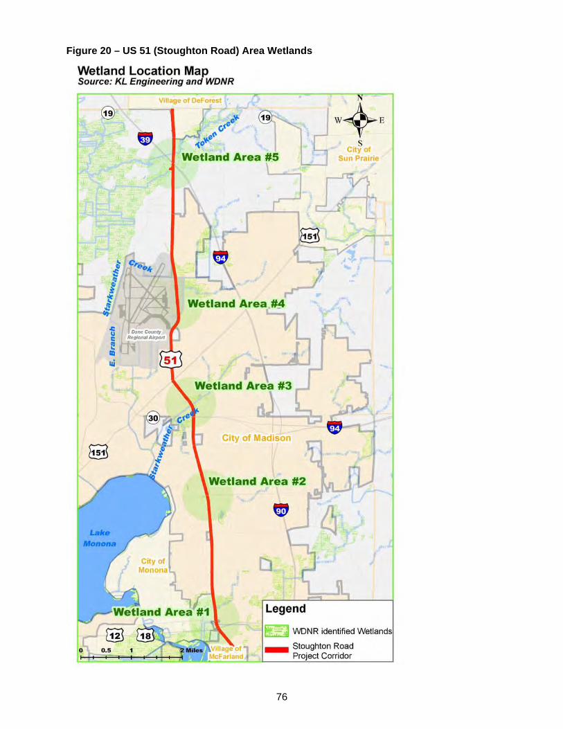
76
Figure 20 – US 51 (Stoughton Road) Area Wetlands
77
WisDOT held a meeting on September 11, 2006 that included representatives from WisDOT SW Region, WisDOT BEES, FHWA, WDNR, USACE, and EPA. The main purpose of the meeting was to discuss the impacts to wetlands at the south end of the project, near the Stoughton Road (US 51) – Beltline (US 12/18) interchange that would occur if Alternative B (Enhanced Expressway) or Alternative C (Freeway) is constructed. The following items were discussed:
The wetlands were constructed as a compensation site as part of the Beltline project. Construction started in 1984 and the majority of the work was done in 1986 and 1987. Prior to construction of the wetland, the site was occupied by a mini-golf course. Construction of the wetland involved excavating sand fill, then bringing in marsh material. The site is now dominated by reed canary grass and cattails, though it is still a good example of a constructed wetland because of topography, vegetation mixture, hydrology, use of salvaged marsh material, etc.
Conditions of the wetland construction were agreed to by WDNR and WisDOT prior to construction and formally reviewed and commented upon by USACE, Fish & Wildlife Service and EPA. The site is a formal mitigation site.
Since the time of the wetland/Beltline construction, WisDOT has somewhat changed their opinion of on-site mitigation, especially in urban and/or high volume traffic areas. Due to the potential for additional work at a later date, WisDOT now favors off-site or bank-site mitigation. The on-site mitigation sites are often low visibility, overlooked, and vulnerable to future roadway projects.
A special compensation rate may be necessary if the wetland is impacted, due to its previous construction as a mitigation wetland.
Alternative A (TSM) Work in wetlands associated with Alternative A (TSM) would mainly consist of filling during construction. Actions that would impact existing wetlands and their associated locations include: Wetland Area #1: US 51 – US 12/18 Interchange
No impacts as a result of Alternative A (TSM). Wetland Area #2: US 51 – Cottage Grove Road Intersection
Widened bridge and extended deceleration lanes for north and south bound US 51 off-ramps.
Reconstructing a portion of reconfigured south bound US 51 off-ramp. Construction of a reconfigured north bound US 51 on-ramp, north of the existing loop
ramp. Wetland Area #3: US 51 – Commercial Avenue – Lexington Avenue Intersection
Widened right turn lane onto northbound US 51. Wetland Area #4: US 51 – Amelia Earhart Drive Intersection
A multi-use path constructed east of US 51. Wetland Area #5: US 51 – I-94 Interchange
Extended acceleration and deceleration lanes for I 39/90/94 ramps to/from US 51. Alternative B (Enhanced Expressway) Work in wetlands associated with Alternative B (Enhanced Expressway) would mainly consist of filling during construction. Actions that would impact existing wetlands and their associated locations include:
78
Wetland Area #1: US 51 – US 12/18 Interchange
Construction of ramp structures in the northwest quadrant of US 51 – US 12/18 interchange.
Wetland Area #2: US 51 – Cottage Grove Road Intersection
Widened bridge, extending the deceleration lanes for north and south bound US 51 off-ramps.
Reconstructing a portion of reconfigured south bound US 51 off-ramp. Construction of a reconfigured north bound US 51 on-ramp, north of the existing loop
ramp. Wetland Area #3: US 51 – Commercial Avenue – Lexington Avenue Intersection
Widened right turn lane onto northbound US 51. New north bound on and off-ramps including associated round about. A portion of the proposed loop on-ramp for south bound US 51. Interchange right-of-way and roadway widening over Lexington/Commercial Avenue
and Railroad. Wetland Area #4: US 51 – Amelia Earhart Drive Intersection
A multi-use path constructed east of US 51. Widened right turn lane onto northbound US 51.
Wetland Area #5: US 51 – I-94 Interchange
Extended acceleration and deceleration lanes for I 39/90/94 ramps to/from US 51. Alternative C (Freeway) Work in wetlands associated with Alternative C (Freeway) would mainly consist of filling during construction. Actions that would impact existing wetlands and their associated locations include impacts listed in Alternative B and the following: Wetland Area #1: US 51 – US 12/18 Interchange
Any work in the northwest quadrant of US 51 – US 12/18 interchange. Wetland Area #2: US 51 – Cottage Grove Road Intersection
Widened bridge, extending the deceleration lanes for north and south bound US 51 off-ramps.
Reconstructing a portion of reconfigured south bound US 51 off-ramp. Construction of reconfigured northbound US 51 on/off-ramps, north of the existing
interchange ramps. Construction of reconfigured southbound US 51 on/off-ramps, south of the
interchange ramps. Wetland Area #3: US 51 – Commercial Avenue – Lexington Avenue Intersection
New US 51 north bound on ramp. New US 51 south bound off ramp. Roadway improvements north of Commercial/Lexington Avenue associated with free
flow through movements on Stoughton Road via overpass from Milwaukee Street through Lexington Avenue/Commercial Avenue, including railroad crossing.
Wetland Area #4: US 51 – Amelia Earhart Drive Intersection
A split interchange and associated roadway improvements between Rieder Road and Amelia Earhart Drive, immediately east and west of US 51.

79
Wetland Area #5: US 51 – I-94 Interchange
Work done in the northwest and northeast quadrants of the interchange, including flattening of the on-ramp curve in the northeast quadrant.
10.4.4 Agricultural Impacts A significant expanse of vacant/agricultural land is adjacent to the eastern side of the roadway near the intersection of Hanson Road. A mix of scattered industrial and commercial uses is located around the interchange with Interstate Highway 39/90/94. Another area of agricultural land is located northwest of I 39/90/94 between East Metro Drive and WIS 19. Figure 21 – Map of Existing Land Uses (US 151/East Washington Avenue to WIS 19) shows the agricultural and other land uses. The Hanson Road agricultural areas are currently being farmed to some extent and are undeveloped; however, several business parks have been approved in this area by the City of Madison. The McAllen Tech Corridor Phase III at Hanson Road, the Center for Industry and Commerce, and Industrial Commerce Park are home to various manufacturing, contracting, wholesale, and trucking related business. These parks have capacity for additional business growth in the future. The majority of land immediately north of the interstate is open space that is only lightly farmed, but industrial and large scale retail and service uses exist in both the northeast and northwest quadrant of the US 51/Stoughton Road and the I 39/90/94 interchange. Impacts to these agricultural parcels by the project are considered minor as the majority of the land is expected be converted by development in the long term. 10.4.5 Airport Impacts The Dane County Regional Airport owns parcels of land west of Stoughton Road immediately adjacent to the study corridor from Pierstorff Street to just south of Hoepker Road. The airport also owns parcels east of Stoughton Road near the Rieder Road and Hanson Road intersections. Airport runway 12 runs southwest to northeast and is 1000 feet from the roadway at its closest point, approximately 1700 feet along the runway flight path. The runway clear zone crosses Stoughton Road from approximately Station 1210+00 to 1255+00 in the area of the Hoepker Road intersection. This runway clear zone does not prohibit roadway improvements or development, as long as there are no permanent structures above a designated elevation. Two acres of the airport property would be impacted in Alternative A for the construction of an off-road bike path. In Alternative B a total of four acres is impacted for the bike path and Hoepker Road interchange. The additional 10 acres impacted in Alternative C includes the interchange at Rieder Road/Amelia Earheart Drive. During the alternatives development process, the impacts of the current proposed alternatives and other potential alternatives were discussed with Dane County Regional Airport representatives. Meetings were held with the airport director and there was an airport committee member on the study’s Technical Advisory Committee. The airport did not object to any of the potential alternatives. Interchanges of various configurations were proposed at Hanson Road during the alternatives analysis portion of the study. The Federal Aviation Administration has formally commented that no airport lands would be allowed for the construction of an interchange at Hanson Road. 10.4.6 Parkland Impacts The majority of the parkland impacts are to Reindahl Park due to the connection of East Washington Avenue to Anderson Street via an extension of Lien Road. This connection is proposed in all three alternatives and impacts 1.9 acres of the park property. In Alternatives B

80
Figure 21 – Map of Existing Land Uses (US 151/East Washington Avenue to WIS 19)
Airport parcels
Hanson Road
Hoepker Road
Rieder Road
Reindahl Park
81
and C the connection of the frontage road between the Lexington Intersection and East Washington Avenue west of Stoughton Road, impacts 0.2 acres of Brigham Park. Coordination was done with the City of Madison and resource agencies to determine if the parks were purchased using funding that would make them 6(f) eligible. No evidence was found of 6(f) sources funding. Reindahl Park was acquired by the City in 1956 from the Madison School District. The school district was deeded the property by Mr. Amund Reindahl under the stipulation that the property be used for park purposes only. The proposed alternatives impact an undeveloped and unused portion of the 87 acre parcel. The City of Madison was contacted regarding these restrictions. It was indeterminate whether the restrictions would still be in place at this time. However, it is unlikely that they would prohibit acquisition by WisDOT for the roadway connection. Additional alternatives were developed that did not impact the park. 10.4.7 Historical Impacts A literature and records search was completed for buildings immediately adjacent to Stoughton Road for the entire length of the corridor. The literature and records search included a review of the Architectural Site Inventory (ASI), the Architectural History Inventory (AHI), the national and state registers of historic places, literature on previous cultural resource investigations, historic plats and maps, as well an environmental data pertaining to the study area. Background research was conducted at the Wisconsin Historical Society (WHS) and the WHS provided GIS data on archaeological and architectural and historic resources and surveys within the study area. A preliminary field review of architectural and historic resources was also conducted for the study area. The literature and records search indicated that there are no structures on the National Register of Historic Places (NRHP) or in the Wisconsin Historic Buildings Inventory. A historic preservation consultant also conducted a preliminary review of the study area to determine if there were properties that might be significant. The consultant reported the presence of two potentially NRHP-eligible properties within the study area. According to the consultant, other architectural/historical resources located in the study area are either too recent to qualify for the NRHP (less than 50 years old) or lack integrity and would not be eligible for listing. 10.4.8 Archaeological Impacts A review of the Architectural Site Inventory (ASI) and Wisconsin Historical Society (WHS) files indicated that nine previously recorded archaeological and burial/cemetery sites occur within or immediately adjacent to the study area and that additional sites are located within Blooming Grove Township on Ho-Chunk Nation trust land. The nine sites are listed in Exhibit 6. Two uncataloged burial sites and one cataloged burial site are located along the project corridor, but not necessarily within the proposed right-of-way. Work cannot be conducted within the boundary of a cataloged site without permission to disturb. Proposed reconstruction at any of the sites could adversely affect historic property and burials which are protected under Wisconsin Statutes 157.70. The potential for adverse effects is present, although not yet determined fully as part of this report. No site forms were available for two of the sites or for those on Ho-Chunk land. Of the seven with forms, five are prehistoric in origin with three of them being mound sites. Only one, 47 DA-0058/BDA-0327, had a cultural affiliation assigned. Two historic sites, a cabin/homestead and a cemetery site, complete the list. One site, the Phlaum-McWilliams Mound Group (47 DA-0032/BDA-027), is listed in the NRHP.
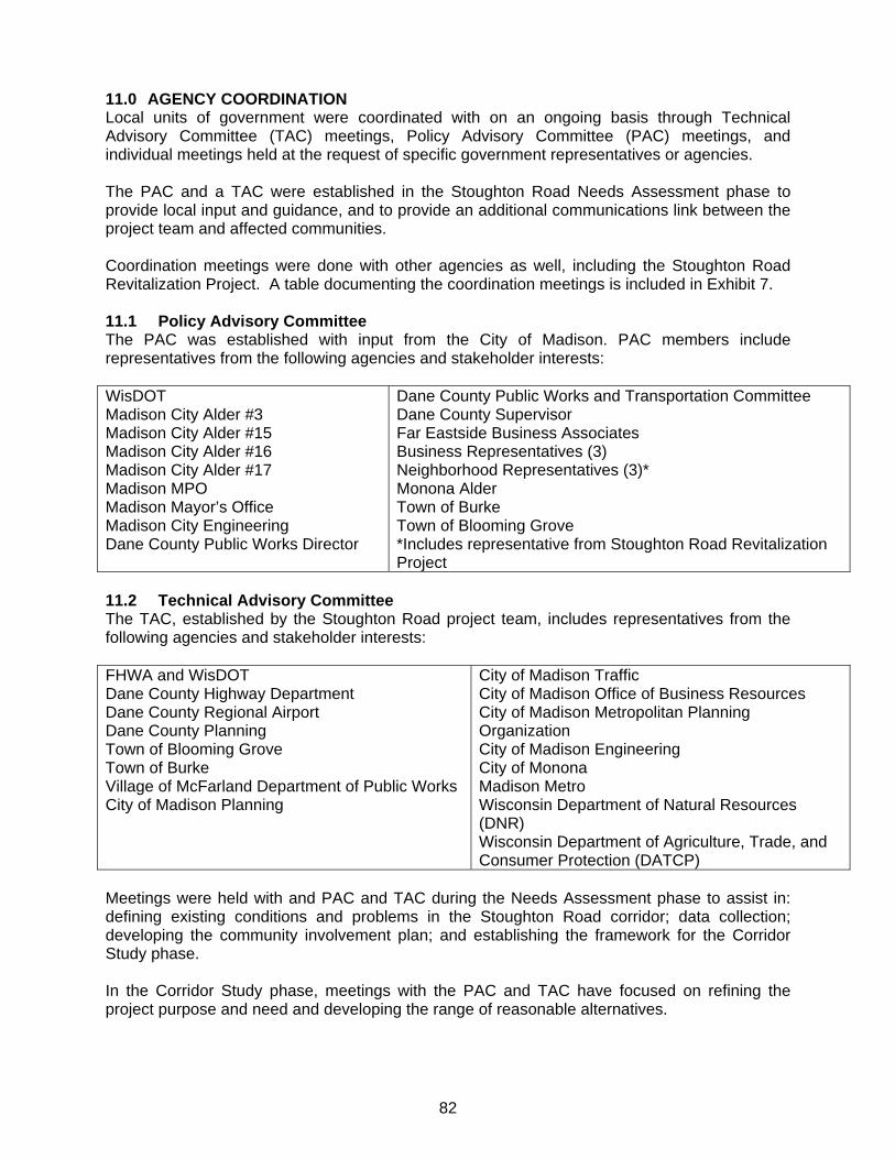
82
11.0 AGENCY COORDINATION Local units of government were coordinated with on an ongoing basis through Technical Advisory Committee (TAC) meetings, Policy Advisory Committee (PAC) meetings, and individual meetings held at the request of specific government representatives or agencies. The PAC and a TAC were established in the Stoughton Road Needs Assessment phase to provide local input and guidance, and to provide an additional communications link between the project team and affected communities. Coordination meetings were done with other agencies as well, including the Stoughton Road Revitalization Project. A table documenting the coordination meetings is included in Exhibit 7. 11.1 Policy Advisory Committee The PAC was established with input from the City of Madison. PAC members include representatives from the following agencies and stakeholder interests: WisDOT Madison City Alder #3 Madison City Alder #15 Madison City Alder #16 Madison City Alder #17 Madison MPO Madison Mayor’s Office Madison City Engineering Dane County Public Works Director
Dane County Public Works and Transportation Committee Dane County Supervisor Far Eastside Business Associates Business Representatives (3) Neighborhood Representatives (3)* Monona Alder Town of Burke Town of Blooming Grove *Includes representative from Stoughton Road Revitalization Project
11.2 Technical Advisory Committee The TAC, established by the Stoughton Road project team, includes representatives from the following agencies and stakeholder interests: FHWA and WisDOT Dane County Highway Department Dane County Regional Airport Dane County Planning Town of Blooming Grove Town of Burke Village of McFarland Department of Public Works City of Madison Planning
City of Madison Traffic City of Madison Office of Business Resources City of Madison Metropolitan Planning Organization City of Madison Engineering City of Monona Madison Metro Wisconsin Department of Natural Resources (DNR) Wisconsin Department of Agriculture, Trade, and Consumer Protection (DATCP)
Meetings were held with and PAC and TAC during the Needs Assessment phase to assist in: defining existing conditions and problems in the Stoughton Road corridor; data collection; developing the community involvement plan; and establishing the framework for the Corridor Study phase. In the Corridor Study phase, meetings with the PAC and TAC have focused on refining the project purpose and need and developing the range of reasonable alternatives.
83
11.3 Stoughton Road Revitalization Project In 2005 the Stoughton Road Revitalization Project (SRRP) group formed. The SRRP included a group of residents, business contacts, and elected officials, representing varied links to over 25,000 city residents, eight neighborhood associations, and many local businesses. The group included three City Alders and two Dane County Supervisors. Their focus was a development plan for the Stoughton Road area between the Beltline and WIS 30. WisDOT assisted in the development of the SRRP plan to establish land use and development guidelines for the corridor and adjacent areas. The WisDOT study team met several times with the SRRP to discuss the proposed alternatives for the corridor and their impact on the development of the corridor. A general consensus was reached on the compatibility of the plans and the recommended alternatives from WIS 30 through Pflaum Road. However, the SRRP plan identified Alternative A, retaining the Stoughton Road at-grade crossings, as its preferred alternative for the Broadway and Beltline area; it was not in favor of the free-flow ramps to/from the Beltline. WisDOT emphasized that Alternative A did not provide adequate mobility for the traffic demands of the corridor. The SRRP plan did provide for both at-grade and free-flow ramp alternatives. In June of 2008 the City adopted the SRRP plan.
84
12.0 PUBLIC INVOLVEMENT Information regarding the project was made available throughout the study through press releases, media articles, presentations, project newsletters, the project email address and the project web page on the Wisconsin Department of Transportation’s website. Information was received through questions from the email address, comment forms, telephone calls, and verbal inquiries. In addition a number of public meetings were held. 12.1 Focus Group Workshops Three focus group workshops were held in the spring of 2002. The purpose of the focus group workshops was to obtain input from the specific groups on perceived problems and issues early in the study process, in a small group format to encourage active participation. Workshops were held for the bicycle and pedestrian interests, neighborhood interests and business interests. After brainstorming sessions on the problems and needs in small groups, individuals were asked to rank the problems and needs in order of priority. Input from these workshops was presented to the advisory committees and incorporated into the identification of needs throughout the study. The problems identified at the three focus groups were consistent with the needs stated throughout the study. The main concerns addressed were the East Washington Avenue intersection, diversion of traffic through neighborhoods, access and facilities for bicycles and pedestrians, the congestion at the Buckeye Road and Pflaum Street (and frontage road) intersections, noise, and business visibility and accessibility. 12.2 Business Interviews Individual business interviews were conducted with over twenty businesses located along the project corridor. A letter explaining the background of the study and study process was sent to over 500 businesses in the study area. Businesses that were interviewed represented a range of business sizes, as well as commercial, industrial, retail and office interests. Results were presented at the advisory committee meetings and incorporated into the study. Businesses were met with individually and at group meetings. The study also attended some of the East Side Business Association meetings to present information. Three main types of businesses were interviewed along the study corridor – retail, office and industrial. While each group had their own list of concerns and issues, three areas were common to all – the East Washington Avenue/Stoughton Road intersection, the Buckeye/Pflaum and adjacent frontage road area, and the need to plan aggressively to accommodate growth so problems don’t get worse. All the groups stated it was very important to let the businesses along the corridor know what was being planned so they are aware of issues that may affect their business and be able to voice their ideas and concerns. The retail businesses main concerns addressed visibility and congestion. Many felt that the congestion on Stoughton Road discouraged some shoppers from coming into their businesses, yet they liked the high volume of traffic on the roadway because it provided them increased visibility. Businesses located near the East Washington Avenue intersection were concerned about maintaining accessibility when improvements are made. Businesses located near the Buckeye/Pflaum area would like to see improved traffic flow at the intersections with the frontage roads. Because of the close proximity to the main intersections, severe congestion occurs in these areas causing confusion and safety problems. The office developments along Stoughton Road were concerned that the congestion on the roadway was affecting their ability to attract tenants and workers. They stated that more access needs to be provided to the World Dairy Expo area; currently this is served mainly by the Pflaum Road and Broadway. They also noted problems with weaving movements between Milwaukee Street and WIS 30, in both directions.
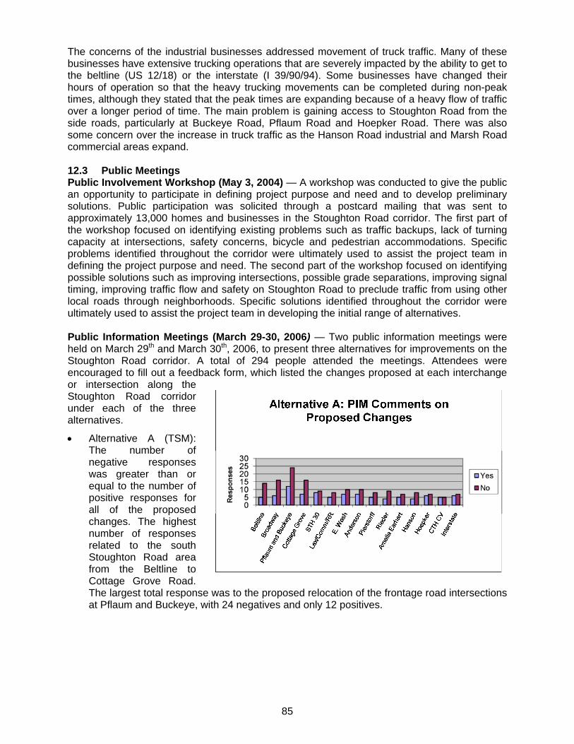
85
The concerns of the industrial businesses addressed movement of truck traffic. Many of these businesses have extensive trucking operations that are severely impacted by the ability to get to the beltline (US 12/18) or the interstate (I 39/90/94). Some businesses have changed their hours of operation so that the heavy trucking movements can be completed during non-peak times, although they stated that the peak times are expanding because of a heavy flow of traffic over a longer period of time. The main problem is gaining access to Stoughton Road from the side roads, particularly at Buckeye Road, Pflaum Road and Hoepker Road. There was also some concern over the increase in truck traffic as the Hanson Road industrial and Marsh Road commercial areas expand. 12.3 Public Meetings Public Involvement Workshop (May 3, 2004) — A workshop was conducted to give the public an opportunity to participate in defining project purpose and need and to develop preliminary solutions. Public participation was solicited through a postcard mailing that was sent to approximately 13,000 homes and businesses in the Stoughton Road corridor. The first part of the workshop focused on identifying existing problems such as traffic backups, lack of turning capacity at intersections, safety concerns, bicycle and pedestrian accommodations. Specific problems identified throughout the corridor were ultimately used to assist the project team in defining the project purpose and need. The second part of the workshop focused on identifying possible solutions such as improving intersections, possible grade separations, improving signal timing, improving traffic flow and safety on Stoughton Road to preclude traffic from using other local roads through neighborhoods. Specific solutions identified throughout the corridor were ultimately used to assist the project team in developing the initial range of alternatives. Public Information Meetings (March 29-30, 2006) — Two public information meetings were held on March 29th and March 30th, 2006, to present three alternatives for improvements on the Stoughton Road corridor. A total of 294 people attended the meetings. Attendees were encouraged to fill out a feedback form, which listed the changes proposed at each interchange or intersection along the Stoughton Road corridor under each of the three alternatives.
Alternative A (TSM): The number of negative responses was greater than or equal to the number of positive responses for all of the proposed changes. The highest number of responses related to the south Stoughton Road area from the Beltline to Cottage Grove Road. The largest total response was to the proposed relocation of the frontage road intersections at Pflaum and Buckeye, with 24 negatives and only 12 positives.
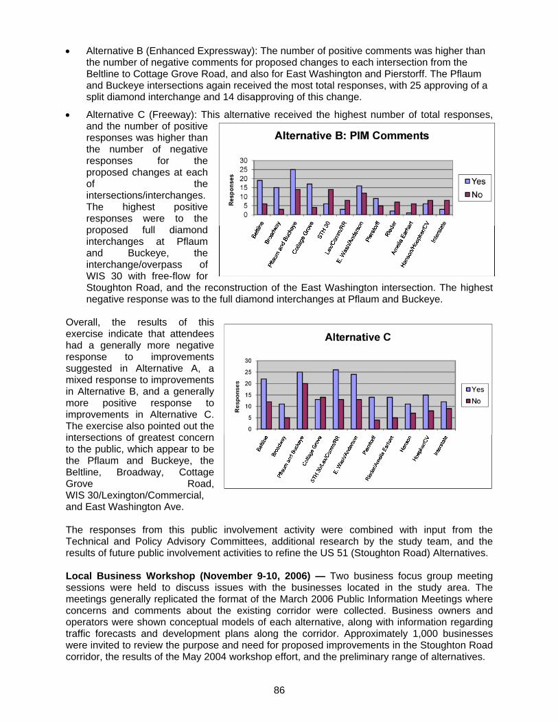
86
Alternative B (Enhanced Expressway): The number of positive comments was higher than the number of negative comments for proposed changes to each intersection from the Beltline to Cottage Grove Road, and also for East Washington and Pierstorff. The Pflaum and Buckeye intersections again received the most total responses, with 25 approving of a split diamond interchange and 14 disapproving of this change.
Alternative C (Freeway): This alternative received the highest number of total responses, and the number of positive responses was higher than the number of negative responses for the proposed changes at each of the intersections/interchanges. The highest positive responses were to the proposed full diamond interchanges at Pflaum and Buckeye, the interchange/overpass of WIS 30 with free-flow for Stoughton Road, and the reconstruction of the East Washington intersection. The highest negative response was to the full diamond interchanges at Pflaum and Buckeye.
Overall, the results of this exercise indicate that attendees had a generally more negative response to improvements suggested in Alternative A, a mixed response to improvements in Alternative B, and a generally more positive response to improvements in Alternative C. The exercise also pointed out the intersections of greatest concern to the public, which appear to be the Pflaum and Buckeye, the Beltline, Broadway, Cottage Grove Road, WIS 30/Lexington/Commercial, and East Washington Ave. The responses from this public involvement activity were combined with input from the Technical and Policy Advisory Committees, additional research by the study team, and the results of future public involvement activities to refine the US 51 (Stoughton Road) Alternatives. Local Business Workshop (November 9-10, 2006) — Two business focus group meeting sessions were held to discuss issues with the businesses located in the study area. The meetings generally replicated the format of the March 2006 Public Information Meetings where concerns and comments about the existing corridor were collected. Business owners and operators were shown conceptual models of each alternative, along with information regarding traffic forecasts and development plans along the corridor. Approximately 1,000 businesses were invited to review the purpose and need for proposed improvements in the Stoughton Road corridor, the results of the May 2004 workshop effort, and the preliminary range of alternatives.
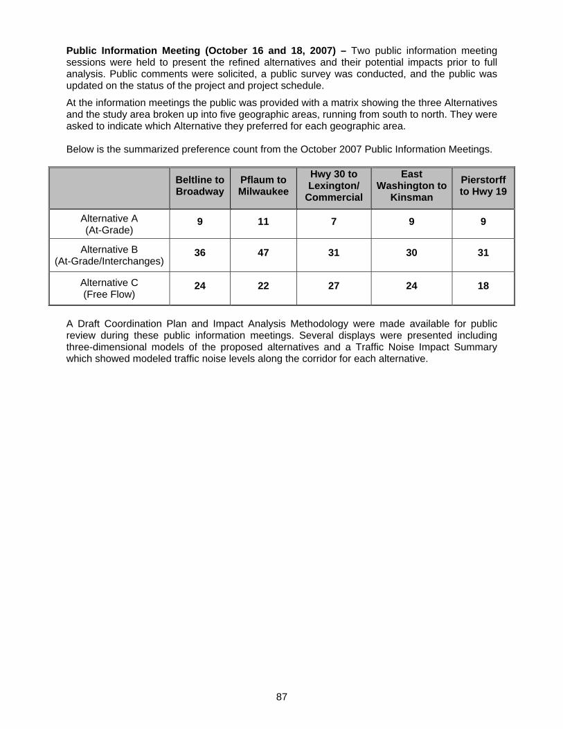
87
Public Information Meeting (October 16 and 18, 2007) – Two public information meeting sessions were held to present the refined alternatives and their potential impacts prior to full analysis. Public comments were solicited, a public survey was conducted, and the public was updated on the status of the project and project schedule.
At the information meetings the public was provided with a matrix showing the three Alternatives and the study area broken up into five geographic areas, running from south to north. They were asked to indicate which Alternative they preferred for each geographic area. Below is the summarized preference count from the October 2007 Public Information Meetings.
Beltline to Broadway
Pflaum to Milwaukee
Hwy 30 to Lexington/
Commercial
East Washington to
Kinsman
Pierstorff to Hwy 19
Alternative A (At-Grade)
9 11 7 9 9
Alternative B (At-Grade/Interchanges)
36 47 31 30 31
Alternative C (Free Flow)
24 22 27 24 18
A Draft Coordination Plan and Impact Analysis Methodology were made available for public review during these public information meetings. Several displays were presented including three-dimensional models of the proposed alternatives and a Traffic Noise Impact Summary which showed modeled traffic noise levels along the corridor for each alternative.
88
13.0 SUMMARY Alternatives A, B, and C were developed as corridor-wide alternatives to provide a consistent approach to addressing the corridor needs. Recommendations for the corridor improvements could include portions of each of the three alternatives. In some cases, the recommended alternative could include incremental application of two of the alternatives. To improve the safety of the roadway and provide long-term traffic mobility for local and regional traffic the potential alternatives are discussed in the following paragraph. The potential alternatives are provided in sections/impact areas, not just an intersection by intersection basis. Terminal Drive/Voges Road to Broadway – Alternative B The greatest traffic volumes of the corridor are in this section. Improvements to Stoughton Road in this location will also have a significant impact on the LOS of the Beltline in this area. Alternative A is not providing an adequate LOS and Alternative C offers only a minimal improvement in LOS compared to the much higher construction cost. Alternative B greatly improves traffic mobility and still provides the required access with the construction of the direct ramps to/from the west leg of the Beltline to the north leg of Stoughton Road at the Beltline interchange. Pflaum Road to Buckeye Road – Alternative B Alternative A is not meeting LOS or providing significant safety improvement. Alternative B (split diamond interchange) has been preferred by the public at public meetings and a form of Alternative B is recommended by the Stoughton Road Revitalization Project. Alternative C has received some public concurrence, but has the greatest impacts and costs. Alternative B enhances mobility and safety by separating cross and turning traffic, from the higher speed and through movements on Stoughton Road, which accounts for greater than 70% of traffic on Stoughton Road. By removing the signals at the major road intersection, improved safety can be expected and the number of rear-end crashes should be reduced. One-way frontage roads, with the ‘Texas u-turns’ and an grade crossing at Helgeson Road will provide access and enable traffic flow to the retail and commercial parcels located around this section. In addition, Alternative B has a lesser impact to adjacent properties than either Alternative A or C. Cottage Grove Road to Milwaukee Street – Alternative A/B Alternative A/B includes widening the existing structuring and providing deceleration and acceleration lanes to FDM standards. These items will improve safety and LOS at this location. With the same treatment, Alternative C has a greater impact without a significant improvement over Alternative A/B.
Milwaukee Street through Lexington/Commercial Avenue – Alternative B Alternative A provides a sufficient LOS but does not significantly improve safety. Alternative B would provide an overpass of the railroad if high-speed or commuter rail is utilized in this area. Alternative B provides improved safety and LOS, with a significant cost and impact over Alternative A. Alternative C is a much greater cost with little improvement in LOS over Alternative B. East Washington Avenue through Anderson Street – Alternative B/C Alternative A is not meeting LOS or providing a significant safety improvement. Alternatives B and C are the same (single point interchange at East Washington with overpass at Anderson Street) with improved LOS and safety. Removing the Stoughton Road through movements will reduce the traffic back-ups and improve safety. It will also enhance mobility by allowing greater signal phasing to the higher volume movements on East Washington Avenue. The overpass at Anderson Street will still allow access from East Washington Avenue and will remove all direct access from Stoughton Road.
89
Kinsman Boulevard through Amelia Earhart Drive - Alternative B Alternative A includes the existing geometry which provides a long-term LOS D. Alternative B, which includes additional through and turn lanes at the Kinsman Boulevard intersection provides sufficient LOS. Alternative B enhances mobility with greater impacts and costs. Alternative C further improves mobility but has even greater impacts than Alternative B, including impacts to quality wetlands near the airport with significantly increased costs. Alternative B also includes removing the southbound left-turn from Stoughton Road to Rieder Road. Currently the Rieder Road intersection is not a safety problem. That portion of the alternative may be implemented as traffic conditions warrant. Hoepker Road through County CV - Alternative B Alternative A (signalized intersection at Hoepker Road) has been implemented as a short term safety improvement. However, it provides a low LOS in the long term and traffic back-ups could lead to safety concerns. Alternatives B/C (interchange at Hoepker Road, overpass at County CV) are the same and meet long term LOS with a significant impact and cost. IH 39/90/94 - Alternative B With the Alternative B improvements to County CV and the Alternative C improvements from Token Creek Park Road to WIS 19 this alternative will be sufficient for the short term. Additional study of the potential to implement Alternative C should be done as traffic volumes and development increase in the area. Token Creek Park Road/East Metro Drive to WIS 19 – Alternative C Alternative A has low LOS long-term. Alternative B provides enhanced mobility yet has LOS and safety issues may arise from left-turns as traffic volumes increase. Alternative C, removing access and constructing an overpass for East Metro Drive over I 39/90/94, is a high impact to this developing area but is recommended because of this accesses close proximity to I 39/90/94 ramps. The development of a high volume traffic generator at East Metro Drive along with the existing truck stop at Token Creek Park Road create crossing conflicts that will be long-term safety issues unless these accesses are removed.