
D2 Design of the Sea2Sea Corridor
251
Feasibility Analysis and evaluation of the viability of multimodal corridor of the approved Action "Sea2Sea" under the Trans-European Transport Network (TEN-T) 2nd Deliverable - D2 Design of the Sea2Sea Corridor December 2014 ADK | AKKT | EVIAM | Milionis-Iliopoulou *The sole responsibility of this publication lies with the author. The European Union is not responsible for any use that may be made of the information contained therein. ΝΙΚΟΛΑΟΣ ΜΗΛΙΩΝΗΣ - ΚΩΣΤΟΥΛΑ ΗΛΙΟΠΟΥΛΟΥ
-
Upload
khangminh22 -
Category
Documents
-
view
0 -
download
0
Transcript of D2 Design of the Sea2Sea Corridor

Feasibility Analysis and evaluation of the viability of multimodal corridor of the approved Action "Sea2Sea" under the Trans-European Transport
Network (TEN-T)
2nd Deliverable - D2
Design of the Sea2Sea Corridor
December 2014
ADK | AKKT | EVIAM | Milionis-Iliopoulou
*The sole responsibility of this publication lies with the author. The European Union is not responsible for any use that may be made of the information contained therein.
ΝΙΚΟΛΑΟΣ ΜΗΛΙΩΝΗΣ - ΚΩΣΤΟΥΛΑ ΗΛΙΟΠΟΥΛΟΥ
Feasibility Analysis and evaluation of the viability of multimodal corridor of the approved Action "Sea2Sea" under the Trans-European Transport Network (TEN-T) - Deliverable D2 - Design of the Corridor
ΑDΚ | AKKT | ΕVΙΑΜ | Millionis-Iliopouou 2
TABLE OF CONTENTS
1 Identification of necessary improvements ......................................................................................... 11
1.1 Identification of necessary improvements along the corridor ................................................... 11
1.1.1 Key components of the approach for planning the Sea2Sea corridor ................................ 11
1.2 Concept of improvement projects synthesis and action plan .................................................... 16
1.2.1 Stage 1 of Aegean-Black Sea2Sea corridor implementation .............................................. 16
1.2.2 Stage 2 of Aegean-Black Sea2Sea corridor implementation .............................................. 19
1.2.3 Stage 3 of Aegean-Black Sea2Sea corridor implementation .............................................. 20
1.2.4 Stage 4 of Aegean-Black Sea2Sea corridor implementation .............................................. 20
1.2.5 Conclusions ......................................................................................................................... 22
1.3 Environmental consideration ...................................................................................................... 24
1.3.1 General information - Greece ............................................................................................ 24
1.3.2 Section 1 - Kavala Alexandroupolis - Protected Areas along the studied corridor and its improvements ..................................................................................................................................... 26
1.3.3 Section 2 - Alexandroupolis - Ormenio - Protected Areas along the studied corridor and its improvements ..................................................................................................................................... 37
1.3.4 Summary data - conclusions ............................................................................................... 45
1.3.5 General information - Bulgaria ........................................................................................... 47
1.3.6 Section 1 - Svilengrad - Provdiv Protected Areas along the studied corridor and its improvements ..................................................................................................................................... 50
1.3.7 Section 2 - Provdiv - Stara Zagora - Protected Areas along the studied corridor and its improvements ..................................................................................................................................... 56
1.3.8 Section 3 - Stara Zagora - Burgas- Protected Area along the studied corridor and its improvements ..................................................................................................................................... 58
1.3.9 Section 4 - Stara Zagora - Varna Protected Areas along the studied corridor and that improvements ..................................................................................................................................... 64
1.3.10 Section 5 - Gorna Orjahovica - Ruse Protected Areas along the studied corridor and its improvements ..................................................................................................................................... 78
1.3.11 Section 6 - Karnobat - Sindel - Protected Areas along the studied corridor and its improvements ..................................................................................................................................... 79
1.3.12 Summary data - conclusions ............................................................................................... 83

Feasibility Analysis and evaluation of the viability of multimodal corridor of the approved Action "Sea2Sea" under the Trans-European Transport Network (TEN-T) - Deliverable D2 - Design of the Corridor
ΑDΚ | AKKT | ΕVΙΑΜ | Millionis-Iliopouou 3
2 Formulation of improvement project mix and action plan ................................................................ 88
2.1 Administrative and preparatory actions ..................................................................................... 88
2.2 Scheduling of interventions ........................................................................................................ 90
2.2.1 Stage 1 - Improvement of the Alexandroupolis – Ormenio railway line ............................ 91
2.2.2 Stage 1 - Implementation of ERTMS ................................................................................... 96
2.2.3 Stage 1 - Implementation of SEA2SEA Traffic Control Center .......................................... 100
2.2.4 Stage 2 - Rehabilitation of the Plovdiv – Burgas railway line ............................................ 103
2.2.5 Stage 3 – Doubling and electrification of the Karnobat – Sindel railway line ................... 107
2.2.6 Stage 4 – Rail connection of the new port of Kavala ........................................................ 110
2.2.7 Stage 4 – Restoration of design parameters of the Ruse-Varna railway line ................... 114
2.2.8 Stage 4 – Improvement of the Ruse – Stara Zagora rail line............................................. 117
2.2.9 Stage 4 – Ruse Regional Intermodal Terminal .................................................................. 121
2.3 Comments and conclusions ...................................................................................................... 123
3 Assessment of the corridor's future competitiveness and freight flows .......................................... 125
3.1 Environmental Competitiveness Analysis ................................................................................. 125
3.1.1 General .............................................................................................................................. 125
3.1.2 Examined Scenarios .......................................................................................................... 125
3.1.3 Areas of protection for Scenario A .................................................................................... 127
3.1.4 Areas of protection for Scenario B .................................................................................... 142
3.1.5 Results comparison ........................................................................................................... 160
3.2 Flows Forecast........................................................................................................................... 165
3.2.1 The Model ......................................................................................................................... 165
3.2.2 The rail network ................................................................................................................ 173
3.2.3 The Shipping Lines ............................................................................................................. 173
3.2.4 Corridor forecasts ............................................................................................................. 179
3.2.5 The corridor as a whole..................................................................................................... 180
3.3 Economic Analysis ..................................................................................................................... 182
3.3.1 General .............................................................................................................................. 182
3.3.2 Investment costs ............................................................................................................... 182
Feasibility Analysis and evaluation of the viability of multimodal corridor of the approved Action "Sea2Sea" under the Trans-European Transport Network (TEN-T) - Deliverable D2 - Design of the Corridor
ΑDΚ | AKKT | ΕVΙΑΜ | Millionis-Iliopouou 4
3.3.3 Forecast traffic .................................................................................................................. 183
3.3.4 Estimated revenue ............................................................................................................ 184
3.3.5 Forecast expenditures ....................................................................................................... 184
3.3.6 Estimated net revenue ...................................................................................................... 186
3.3.7 Forecast cash flows ........................................................................................................... 187
3.3.8 Additional Scenarios ......................................................................................................... 190
4 Preliminary assessment of the socioeconomic impact of the Corridor ............................................ 208
4.1 Preliminary assessment and evaluation of environmental impact .......................................... 208
4.1.1 Impact on the natural environment ................................................................................. 209
4.1.2 Impact on air quality and related to climate change ........................................................ 213
4.1.3 Effects of noise .................................................................................................................. 216
4.1.4 Effects of vibrations .......................................................................................................... 219
4.1.5 Effects of radiation ............................................................................................................ 220
4.1.6 Effects on water ................................................................................................................ 225
4.2 Key findings and environmental measures ............................................................................... 227
4.2.1 Methodology of environmental studies for planned next stages..................................... 227
4.2.2 Monitoring system of the corridor operation ................................................................... 229
4.3 Sosioeconomic Analysis ............................................................................................................ 235
4.3.1 General .............................................................................................................................. 235
4.3.2 Socioeconomic Investment Cost Breakdown .................................................................... 235
4.3.3 Socioeconomic Operating Costs Breakdown .................................................................... 236
4.3.4 Estimated Net Socioeconomic Operating Revenue .......................................................... 238
4.3.5 Estimated Socioeconomic Cash Flows .............................................................................. 239
4.3.6 Estimated Socioeconomic Benefit Cost Relationship ....................................................... 240
4.3.7 General conclusions .......................................................................................................... 241
4.3.8 Additional Scenarios ......................................................................................................... 241
4.3.9 Final Remarks .................................................................................................................... 249
Feasibility Analysis and evaluation of the viability of multimodal corridor of the approved Action "Sea2Sea" under the Trans-European Transport Network (TEN-T) - Deliverable D2 - Design of the Corridor
ΑDΚ | AKKT | ΕVΙΑΜ | Millionis-Iliopouou 5
List of Figures
Figure 1: Sea2Sea corridor in stages of implementation ...........................................................13 Figure 2: Sea2Sea corridor connected transportation nodes .....................................................15 Figure 3: Illustration of corridor in digital background - Separation of sections and protected
areas ..................................................................................................................................25 Figure 4: Aesthetic Forest Nestos - Network Natura 2000)........................................................27 Figure 5: Aesthetic Forest Nestos - Greece National Protection Network ..................................28 Figure 6: Nestos gorge (Natura 2000 Network) .........................................................................29 Figure 7: Nestos gorge Wildlife Refuge .....................................................................................29 Figure 8: Nestos Delta and Keramoti Lagoons (Natura 2000 Network) .....................................30 Figure 9: Valley Kompsatos (Network Natura 2000) ..................................................................31 Figure 10: Lakes & Lagoons in Thrace (Natura 2000 Network) .................................................31 Figure 11: South forest complex of Evros (Natura 2000 Network) .............................................32 Figure 12: Zones EPAMTH .......................................................................................................33 Figure 13: Section of the corridor crossing the EPAMTH ..........................................................35 Figure 14: Wildlife Refuges .......................................................................................................36 Figure 15: Evros Delta and West Arm (Natura 2000 Network) ..................................................38 Figure 16: Mountains Evros (Natura 2000 Network) ..................................................................38 Figure 17: Riparian Forest Evros and Ardas (Natura 2000 Network) .........................................39 Figure 18: Corridor crossing section within EPAMTH ................................................................41 Figure 19: Map of the National Park Dadia - Protected Areas ...................................................43 Figure 20: Natura areas along the studied corridor and its improvements - Greece Territory ....44 Figure 21: The studied Corridor ................................................................................................47 Figure 22: Illustration of the corridor in digital background - Separation of sections and protected
areas ..................................................................................................................................49 Figure 23: Reka Maritsa (Network Natura 2000) .......................................................................51 Figure 24: Ostar Kamak (Natura 2000 Network) .......................................................................51 Figure 25: Zlato Pole (Natura 2000 Network) ............................................................................52 Figure 26: Maritsa Parvomay (Natura 2000 Network)................................................................53 Figure 27: Reka Chaya (Natura 2000 Network).........................................................................54 Figure 28: Fosilni Nahodki ........................................................................................................54 Figure 29: Nahodishte Na Blatno Kokiche - Mestnost Sazlaka ..................................................55 Figure 30: Reka Stryama (Natura 2000 Network) ......................................................................57 Figure 31: Chirpanska Koria......................................................................................................57 Figure 32: Reka Tundzha 1 (Natura 2000 Network) ..................................................................59

Feasibility Analysis and evaluation of the viability of multimodal corridor of the approved Action "Sea2Sea" under the Trans-European Transport Network (TEN-T) - Deliverable D2 - Design of the Corridor
ΑDΚ | AKKT | ΕVΙΑΜ | Millionis-Iliopouou 6
Figure 33: Adata Tundzha (Natura 2000 Network) ....................................................................59 Figure 34: Reka Mochuritsa (Natura 2000 Network) .................................................................61 Figure 35: Straldzha (Network Natura 2000) .............................................................................62 Figure 36: Burgasko ezero (Network Natura 2000) ...................................................................63 Figure 37: Tsentralen Balkan - Bufer (Natura 2000 Network) ....................................................66 Figure 38: Bulgarka (Natura 2000 Network) ..............................................................................67 Figure 39: Park Map Balgarka ...................................................................................................67 Figure 40: Park Map Balgarka - railway network transit area .....................................................68 Figure 41: Draynovska Reka (Network Natura 2000) ................................................................69 Figure 42: Dryanovski Manastir (Network Natura 2000) ............................................................70 Figure 43: Tarnovski visochini (Network Natura 2000) ..............................................................70 Figure 44: Reka Yantra (Natura 2000 Network) ........................................................................71 Figure 45: Golyama Reka (Natura 2000 Network) .....................................................................72 Figure 46: Stara Reka (Natura 2000 Network) ..........................................................................73 Figure 47: BG0002038 Provadiisko_Royaksko plato (Natura 2000 Network) ............................73 Figure 48: BG0000104 Provadiisko Royaksko plato (Natura 2000 Network) .............................74 Figure 49: Kamenitsa (Natura 2000 Network) ...........................................................................75 Figure 50: Varnesko Beloslavo Ezero (Natura 2000 Network) ...................................................76 Figure 51: Drianovo Monastery .................................................................................................77 Figure 52: Kalpunar ..................................................................................................................77 Figure 53: Lomovete Varnesko Beloslavo Ezero (Natura 2000 Network) ..................................79 Figure 54: Kamchiyska i Emenska planina (Natura 2000 Network) ...........................................80 Figure 55: Ekokoridor Kamchia -Emine (Natura 2000 Network) ................................................81 Figure 56: Recha Kamchia (Network Natura 2000) ...................................................................81 Figure 57: Natura areas along the studied corridor and its improvements (excluding section 6
Karnobat - Sindel) ..............................................................................................................82 Figure 58: CMA –CGN Black Sea Line ................................................................................... 170 Figure 59: Shipping line through Turkey ports: Piraeus Black-Sea Express (PBX) .................. 170 Figure 60: Black Sea Express (BSX) ....................................................................................... 174 Figure 61: Shipping line through Turkey: East Med / Black Sea Express Ser. (EMX) .............. 175
Feasibility Analysis and evaluation of the viability of multimodal corridor of the approved Action "Sea2Sea" under the Trans-European Transport Network (TEN-T) - Deliverable D2 - Design of the Corridor
ΑDΚ | AKKT | ΕVΙΑΜ | Millionis-Iliopouou 7
List of Tables
TABLE 1.1: SEA2SEA TRANSPORT LOGISTIC NODES AND THEIR ROLE IN THE CORRIDOR .......................................................................................................................14
TABLE 1.2: PROJECTS PROPOSED FOR INCLUSION IN THE SEA2SEA STAGE 1 .............18
TABLE 1.3: PROJECT PROPOSED FOR INCLUSION IN THE SEA2SEA STAGE 2 ...............19
TABLE 1.4: PROJECT PROPOSED FOR INCLUSION IN THE SEA2SEA STAGE 3 ...............20
TABLE 1.5: PROJECTS PROPOSED FOR INCLUSION IN THE SEA2SEA STAGE 4 .............21
TABLE 1.6: CONNECTED OD PAIRS BY IMPLEMENTATION STAGE * .................................22
TABLE 1.7: PROTECTED AREAS OF THE STUDIED CORRIDOR - PART 1 ..........................26
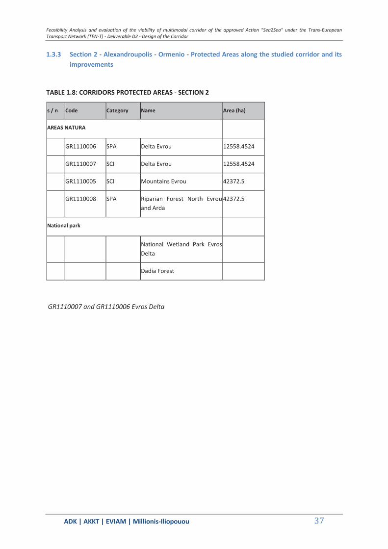
TABLE 1.8: CORRIDORS PROTECTED AREAS - SECTION 2 ...............................................37
TABLE 1.9: PROTECTED AREAS OF THE STUDIED CORRIDOR - AREAS A - .....................45
TABLE 1.10: PROTECTED AREAS WHICH ABUT THE STUDIED CORRIDOR - AREAS B- ..46
TABLE 1.11: PROTECTED AREAS OF THE STUDIED CORRIDOR - SECTION 1 .................50
TABLE 1.12: CORRIDORS PROTECTED AREAS - SECTION 2..............................................56
TABLE 1.13: PROTECTED AREAS OF THE STUDIED CORRIDOR - SECTION 3 .................58
TABLE 1.14: PROTECTED AREAS OF THE STUDIED CORRIDOR - SECTION 4 .................64
TABLE 1.15: PROTECTED AREAS OF THE STUDIED CORRIDOR - SECTION 5 .................78
TABLE 1.16: PROTECTED AREAS OF THE STUDIED CORRIDOR - SECTION 6 .................79
TABLE 1.17: PROTECTED AREAS OF THE STUDIED CORRIDOR - REGION A1 - ...............83
TABLE 1.18: PROTECTED AREAS OF THE STUDIED CORRIDOR - REGION A2 - ...............84
TABLE 1.19: PROTECTED AREAS WHICH ABUTS THE STUDIED CORRIDOR - REGION B - ..........................................................................................................................................85
TABLE 3.1: STAGE 2, ALEXANDROUPOLIS-BURGAS, RESTRICTIONS AND LENGTHS ... 160
TABLE 3.2: STAGE 3, ALEXANDROUPOLIS-VARNA, RESTRICTIONS AND LENGTHS ..... 160
TABLE 3.3: STAGE 4, KAVALA-RUSE, RESTRICTIONS AND LENGTHS ............................. 162
TABLE 3.4: SCENARIO A, THESSALONIKI-RUSE, RESTRICTIONS AND LENGTHS .......... 163
TABLE 3.5: PBX TRANSIT TIME (DAYS) ............................................................................... 170
TABLE 3.6: TYPICAL STUDY CONTAINERSHIP ................................................................... 171
TABLE 3.7: RAIL TRANSPORT COSTS (€/TEU) ................................................................... 173
TABLE 3.8: BLACK SEA EXPRESS (BSX) TRANSIT TIME (DAYS) ...................................... 174
TABLE 3.9: EAST MED / BLACK SEA EXPRESS SERVICE (EMX) PORTS AND TERMINALS ........................................................................................................................................ 175
TABLE 3.10: CONTAINER FAR EAST– MEDITERRANEAN EUROPE FREIGHT MARKET RATES ............................................................................................................................. 176
TABLE 3.11: COMPOSITION OF SHANGHAI CONTAINERIZED FREIGHT INDEX .............. 177
Feasibility Analysis and evaluation of the viability of multimodal corridor of the approved Action "Sea2Sea" under the Trans-European Transport Network (TEN-T) - Deliverable D2 - Design of the Corridor
ΑDΚ | AKKT | ΕVΙΑΜ | Millionis-Iliopouou 8
TABLE 3.12 : PLANNED LEVEL OF INVESTMENT & TIME SCHEDULE FOR EXPENDITURE (IN EUR, 2014 PRICES) .................................................................................................. 182
TABLE 3.13 : FORECAST CONTAINER TRAFFIC (TEU) ...................................................... 183
TABLE 3.14 : ESTIMATED REVENUE (EUR, 2014 PRICES) ................................................. 184
TABLE 3.15 : ESTIMATED EXPENDITURE (EUR, 2014 PRICES) ......................................... 185
TABLE 3.16 : ESTIMATED NET REVENUE (EUR 2014 PRICES) .......................................... 186
TABLE 3.17 : RESIDUAL VALUE IN THE YEAR 2039 (EUR, 2014 PRICES) ......................... 187
TABLE 3.18 : CASH FLOWS (EUR), PRESENT VALUE (NPV) & DNR/DIC FOR THE PROJECT ........................................................................................................................ 188
TABLE 3.19 : ESTIMATED PROJECT BENEFIT/COST RATIO (Β/C) .................................... 189
TABLE 3.20: PLANNED LEVEL OF INVESTMENT & TIME SCHEDULE FOR EXPENDITURE FOR SCENARIO B1 (€, in 2014 prices) ........................................................................... 190
TABLE 3.21: FORECAST CONTAINER TRAFFIC (TEU) - SCENARIO B1 ............................ 190
TABLE 3.22: ESTIMATED REVENUE (EUR, in 2014 prices) - SCENARIO B1 ....................... 192
TABLE 3.23: ESTIMATED EXPENDITURE (€, in 2014 prices) - SCENARIO B1 .................... 194
TABLE 3.24: ESTIMATED NET REVENUE (€, in 2014 prices) - SCENARIO B1 .................... 196
TABLE 3.25: RESIDUAL VALUE IN THE YEAR 2039 (€, in 2014 prices) - SCENARIO B1 .... 197
TABLE 3.26: CASH FLOW (€), NPV (€) &DNR/DIC FOR SCENARIO B1 OF THE PROJECT - SCENARIO B1 ................................................................................................................. 197
TABLE 3.27: ESTIMATED BENEFIT/COST (B/C) RATIO OF THE PROJECT - SCENARIO B1 ........................................................................................................................................ 198
TABLE 3.28: PLANNED LEVEL OF INVESTMENT & TIME SCHEDULE FOR EXPENDITURE FOR SCENARIO B2 (€, in 2014 prices) ........................................................................... 199
TABLE 3.29: FORECAST CONTAINER TRAFFIC (TEU) - SCENARIO B2 ............................ 199
TABLE 3.30: ESTIMATED REVENUE (EUR, in 2014 prices) - SCENARIO B2 ....................... 201
TABLE 3.31: ESTIMATED EXPENDITURE (€, in 2014 prices) - SCENARIO B2 .................... 203
TABLE 3.32: ESTIMATED NET REVENUE (€, in 2014 prices) - SCENARIO B2 .................... 205
TABLE 3.33: RESIDUAL VALUE IN THE YEAR 2039 (€, in 2014 prices) - SCENARIO B2 .... 205
TABLE 3.34: CASH FLOW (€), NPV (€) &DNR/DIC FOR SCENARIO B1 OF THE PROJECT - SCENARIO B2 ................................................................................................................. 206
TABLE 3.35: ESTIMATED BENEFIT/COST (B/C) RATIO OF THE PROJECT - SCENARIO B2 ........................................................................................................................................ 207
TABLE 4.1: PERCENTAGE DISTRIBUTION OF GASEOUS EMISSIONS FROM TRANSPORT BY TRANSPORT CATEGORY ........................................................................................ 213
TABLE 4.2: SHIP EMISSION FACTORS ................................................................................ 215
TABLE 4.3: NOISE LEVELS FROM MOTORBOATS UNDER DIRECTIVE 2003/44 / EU ....... 218
TABLE 4.4: MAXIMUM DISTANCE FOR NUISANCE FROM TRAIN VIBRATIONS ................ 219
Feasibility Analysis and evaluation of the viability of multimodal corridor of the approved Action "Sea2Sea" under the Trans-European Transport Network (TEN-T) - Deliverable D2 - Design of the Corridor
ΑDΚ | AKKT | ΕVΙΑΜ | Millionis-Iliopouou 9
TABLE 4.5: BASIC LIMIT FOR ON-SITE SAR, WITH VALUES FOR RADIATION EXPOSURE ON OPERATIONS PERSONNEL .................................................................................... 222
TABLE 4.6: BASIC LIMIT FOR ON-SITE SAR, WITH VALUES FOR RADIATION EXPOSURE OF PUBLIC ...................................................................................................................... 223
TABLE 4.7: DATA FROM MONITORING SYSTEM - MEASURING FREQUENCY ................. 232
TABLE 4.8: TRAINOSE FREIGHT TRANSPORT SERVICE OPERATING COST BREAKDOWN ........................................................................................................................................ 236
TABLE 4.9: ESTIMATED FINANCIAL OPERATING COST BREAKDOWN (EUR) ................. 238
TABLE 4.10: ESTIMATED SOCIOECONOMIC OPERATING COSTS (EUR) ......................... 238
TABLE 4.12: SOCIOECONOMIC CASH FLOWS, PRESENT VALUE (DNR) & DNR/DIC (EUR) ........................................................................................................................................ 239
TABLE 4.13: PROJECT BENEFIT COST RATIO (B/C) .......................................................... 240
TABLE 4.14: ESTIMATED FINANCIAL OPERATING COST BREAKDOWN (€) - SCENARIO B1 ........................................................................................................................................ 241
TABLE 4.15: ESTIMATED SOCIOECONOMIC OPERATING COSTS (€) - SCENARIO B1 .... 242
TABLE 4.16: ESTIMATED NET SOCIOECONOMIC OPERATING REVENUE (€) - SCENARIO B1 .................................................................................................................................... 243
TABLE 4.17: SOCIOECONOMIC CASH FLOWS, NPV & DNR/DIC - SCENARIO B1 ............ 244
TABLE 4.18: SOCIOECONOMIC BENEFIT COST (B/C) RATIO - SCENARIO B1 ................. 245
TABLE 4.19: ESTIMATED FINANCIAL OPERATING COST BREAKDOWN (€) - SCENARIO B2 ........................................................................................................................................ 245
TABLE 4.20: ESTIMATED SOCIOECONOMIC OPERATING COSTS (€) - SCENARIO B2 .... 246
TABLE 4.21: ESTIMATED NET SOCIOECONOMIC OPERATING REVENUE (€) - SCENARIO B2 .................................................................................................................................... 247
TABLE 4.22: SOCIOECONOMIC CASH FLOWS, NPV & DNR/DIC - SCENARIO B2 ............ 248
TABLE 4.23: SOCIOECONOMIC BENEFIT COST (B/C) RATIO - SCENARIO B2 ................. 248
TABLE 4.24: SUMMARY OF FINANCIAL RESULTS .............................................................. 249
TABLE 4.25: SUMMARY OF SOCIOECONOMIC RESULTS .................................................. 250

Feasibility Analysis and evaluation of the viability of multimodal corridor of the approved Action "Sea2Sea" under the Trans-European Transport Network (TEN-T) - Deliverable D2 - Design of the Corridor
ΑDΚ | AKKT | ΕVΙΑΜ | Millionis-Iliopouou 10
List of Graphs
Graph 3-1: Profit comparisons between alternatives A (all ports call) and B (rail land bridge) . 172 Graph 3-2: Growth of demand and supply in container shipping, 2000–2013 (Annual growth
rates) ............................................................................................................................... 176 Graph 3-3: Time series of the Shanghai Containerized Freight Index (USD/TEU) 2012-14 ..... 177 Graph 3-4: Container traffic forecasts through the Bulgarian Ports (mTEU’s) .......................... 179 Graph 3-5: Forecasts of transit container traffic through the rail corridor (mTEU’s) ................. 180 Graph 3-6: Scenario creation for the maritime sector. ............................................................. 181
Feasibility Analysis and evaluation of the viability of multimodal corridor of the approved Action "Sea2Sea" under the Trans-European Transport Network (TEN-T) - Deliverable D2 - Design of the Corridor
ΑDΚ | AKKT | ΕVΙΑΜ | Millionis-Iliopouou 11
1 IDENTIFICATION OF NECESSARY IMPROVEMENTS
The Consultant has reviewed the existing conditions of the transportation nodes and network of interest during the first phase of the project and has since elaborated into the bottleneck identification. Bottlenecks are considered on the nodes of the network, namely the ports and their connectivity capabilities with the rest of transportation network (mainly rail). Bottlenecks are also considered throughout the network itself, in respect of capacity and operational characteristics that may hinder mobility.
A big number of the suggested improvements are already included in the infrastructure development and investment plans of Bulgaria and Greece, hence the existence of data on estimated cost and time of completion.
The objective of the work and activities of the second Deliverable is to examine, analyse and determine the necessary improvements along the proposed Sea2Sea multimodal corridor between the Aegean Sea and the Black Sea. Furthermore, it contributes in assessing the impact of the corridors’ future potential capacity of handling freight flows and its competitiveness among other freight transport options in the study area.
1.1 Identification of necessary improvements along the corridor
Based on the current condition of the Sea2Sea proposed corridor, a number of bottlenecks have been observed and reported in Deliverable 1, where a set of necessary improvements has also been preliminarily defined. In this chapter, the improvements that have been previously considered are subjected to a review, while an approach is introduced, providing the means for planning and prioritization of the necessary interventions (administrative measures and projects) which can result to the development/ completion and successful operation of the Sea2Sea transport system.
1.1.1 Key components of the approach for planning the Sea2Sea corridor
The key components of the approach aiming at the completion and successful operation of the Sea2Sea transport system include the following: 1) There are ongoing investment plans (comprising interventions either under implementation or in the pipeline to be soon implemented) with a Pan-European scope that contribute also to the development of the Sea2Sea corridor; these plans can form a basis of interventions (needing no further action under the Sea2Sea programme) which can be combined with complementary interventions of the Sea2Sea programme; 2) The division of the corridor into implementation stages, can provide a good basis for the prioritization of the needed interventions, considering feasibility and other issues; 3) This division should consider all identified Sea2Sea significant Transport Logistic Nodes and their connections; and 4) The development and implementation of a Sea2Sea traffic control center and Observatory can facilitate/ enhance the operation conditions of the Corridor but also provide the means for the objective assessment of the potential of the Corridor in the future and thus provide the justification of its further development interventions as needed.
Details on these components are provided herebelow.
Feasibility Analysis and evaluation of the viability of multimodal corridor of the approved Action "Sea2Sea" under the Trans-European Transport Network (TEN-T) - Deliverable D2 - Design of the Corridor
ΑDΚ | AKKT | ΕVΙΑΜ | Millionis-Iliopouou 12
Major ongoing projects with a Pan-European range that contribute to the Sea2Sea corridor
Most of the Sea2Sea freight transport system upgrades that are mentioned in Deliverable 1 are part of the overall national plans of both countries (Bulgaria and Greece) and some of them are already under construction because they contribute to the formation of more than one corridor and/or to the internal (within the country) transportation system (since, additionally to the freight transport operation, these systems serve also the passenger demand). Some of the projects proposed for the upgrading of the Aegean – Black Sea2Sea Corridor are in line with the New TEN-T guidelines and are eligible to be funded by the CEF "Connecting Europe Facility" under the title Orient/East-Med Corridor. This long northwest-south eastern corridor, which connects central Europe with the maritime interfaces of the North, Baltic, Black and Mediterranean seas, aims at optimising the use of the ports concerned and the related Motorways of the Sea.
Division of the Sea2Sea corridor into implementation stages
The above mentioned projects, with a pan European scope/ effect and range, require major investments that cannot be justified in terms of a cost benefit analysis only by the forecasted Sea2Sea freight flows. For this reason only few of the projects that have been listed within the scope of the Deliverable 1 are promoted and proposed as Sea2Sea dedicated key schemes, while the bigger projects are expected to be integrated and function as a composition of schemes formulating the corridor stage by stage to its full functionality and its long term potential. Since the model and the relative forecasts show critical masses of freight flows mainly between the railway connection between Alexandroupolis and Plovdiv, emphasis is assigned on this railway section, designated as the core Aegean-Black Sea2Sea part.
Taking into consideration the objective of the Sea2Sea overall project and the estimated feasibility of the corridor’s sections, the necessary improvements along the Sea2Sea corridor can be divided into implementation and integration stages. Starting from the core stage 1 referring to the upgrading of the connection and the facilitation of freight flows between Alexandroupolis and Plovdiv, the rest sections of the corridor are proposed to be upgraded and interconnected to an optimum level of full functionality under a total of four stages. The sections of the Sea2Sea corridor to be upgraded and integrated under each stage are presented in Figure 1.

Feas
ibili
ty A
naly
sis a
nd e
valu
atio
n of
the
via
bilit
y of
mul
timod
al c
orrid
or o
f the
app
rove
d Ac
tion
"Sea
2Sea
" un
der
the
Tran
s-Eu
rope
an T
rans
port
Net
wor
k (T
EN-T
) - D
eliv
erab
le D
2 - D
esig
n of
the
Co
rrid
or
ΑDΚ
| AK
KT |
ΕVΙΑΜ
| M
illio
nis-
Iliop
ouou
13
Fi
gure
1: S
ea2S
ea c
orrid
or in
stag
es o
f im
plem
enta
tion

Feasibility Analysis and evaluation of the viability of multimodal corridor of the approved Action "Sea2Sea" under the Trans-European Transport Network (TEN-T) - Deliverable D2 - Design of the Corridor
ΑDΚ | AKKT | ΕVΙΑΜ | Millionis-Iliopouou 14
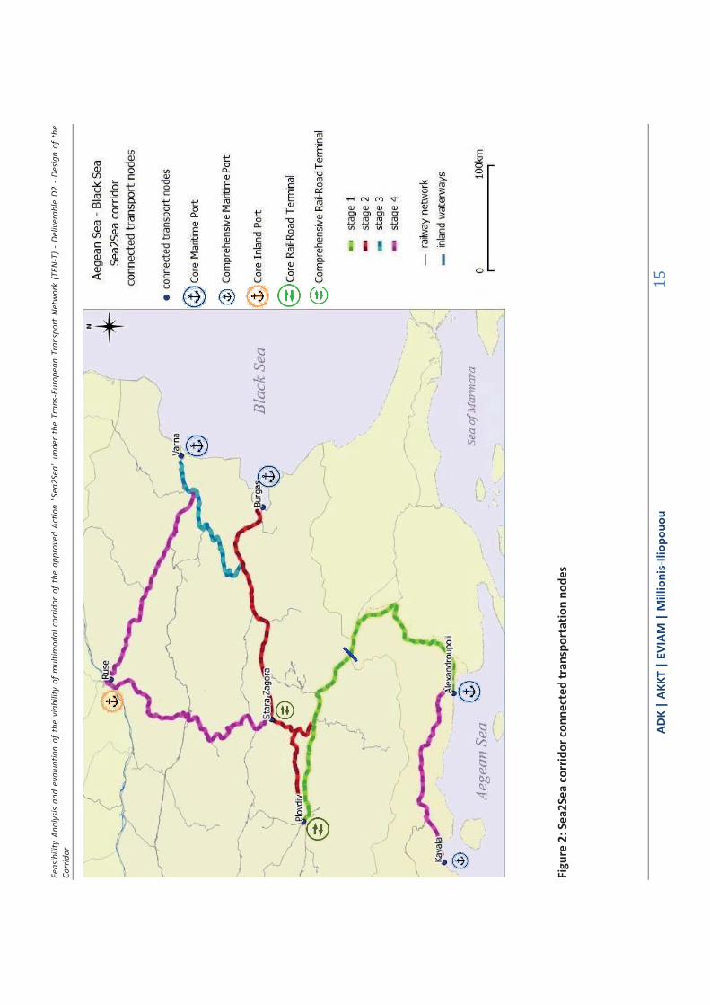
Sea2Sea transport logistic nodes and their connection
The first stage of the Sea2Sea corridor development, which is also considered as the core stage, is the only one on which a cost-benefit analysis has been performed and it is proposed as a separate investment plan. The rest of the implementation stages (2-3-4), although they cannot be justified as feasible only by the Sea2Sea freight flows, are relatively important for integration in the system, because they connect significant transport nodes of the greater area. The significant transport nodes, as identified in this study, are Alexandoupolis, Plovdiv, Burgas, Varna, Stara Zagora, Ruse and Kavala. These transport nodes of the Sea2Sea system and their functionality in the corridor are presented in TABLE 1.1. The position and the connection of these significant transport nodes along the corridor are presented in
Figure 2.
TABLE 1.1: SEA2SEA TRANSPORT LOGISTIC NODES AND THEIR ROLE IN THE CORRIDOR
Sea2Sea
Node Name
Sea2Sea
Maritime port
Sea2Sea
Inland port
Sea2Sea
Rail-Road Terminal
Alexandoupolis Core
Plovdiv Core
Burgas Core
Stara Zagora Comprehensive
Varna Core
Ruse Core
Kavala Comprehensive
Feas
ibili
ty A
naly
sis a
nd e
valu
atio
n of
the
via
bilit
y of
mul
timod
al c
orrid
or o
f the
app
rove
d Ac
tion
"Sea
2Sea
" un
der
the
Tran
s-Eu
rope
an T
rans
port
Net
wor
k (T
EN-T
) - D
eliv
erab
le D
2 - D
esig
n of
the
Co
rrid
or
ΑDΚ
| AK
KT |
ΕVΙΑΜ
| M
illio
nis-
Iliop
ouou
15
Figu
re 2
: Sea
2Sea
cor
ridor
con
nect
ed tr
ansp
orta
tion
node
s
Feasibility Analysis and evaluation of the viability of multimodal corridor of the approved Action "Sea2Sea" under the Trans-European Transport Network (TEN-T) - Deliverable D2 - Design of the Corridor
ΑDΚ | AKKT | ΕVΙΑΜ | Millionis-Iliopouou 16
Implementation of a Sea2Sea traffic control Centre and Observatory
The concept and operation of the Sea2Sea corridor could be better supported with the development and operation of a dedicated Sea2Sea traffic control Centre and Observatory. This traffic control Centre could be responsible for monitoring the Sea2Sea traffic and integrating important information in relation with: the rail freight corridor contained in the Sea2Sea network, the port terminals, the capacity allocation and the traffic management. Furthermore, this Centre could provide co-ordination of the authorities and the operators involved in the multimodal corridor in both countries. In the event of disturbances in traffic, the Centre could provide plans of alternative solutions for the minimisation of delays.
The Centre could also operate as an observatory of the Sea2Sea corridor and traffic, gathering all the information on the characteristics of the corridor, the elements of the transport market and the serviced demand side, as well as historical data on transported flows, commodity types and travel times among others.
The proposed Centre has to be fully equipped with advanced communication systems and with advance transport model applications for the integration and monitoring of all the incoming information. Once its systems have been “set up” and alternative scenarios have been developed, the Centre could operate on a 24hour basis with three shifts of one or two specialised personnel with skills in Greek and Bulgarian language. The location of the Centre could be either on a port terminal, for example on the commercial port of Kavala, or could be located at the national railway authority local office either of Greece or Bulgaria. The level of investment needed for the development of the Sea2Sea freight traffic control Centre is roughly estimated at approximately 0.7million €.
1.2 Concept of improvement projects synthesis and action plan
As mentioned before, it is difficult to secure the funding concurrently of all the necessary improvements. Therefore it is necessary to set a priority list, i.e. a “Project Synthesis”. This list will set the priorities to the essential infrastructure improvements and equipment in terms of cost and benefit, but also to the necessary operational aspects.
For each one of the projects to be included in the Stage 1 project synthesis, the corresponding action plan should be formulated, setting out the actions necessary to implement them, the authorities responsible for implementation and the deadlines for their completion. Both the "Project Synthesis" and the "Action Plan" will be incorporated into a Memorandum of Understanding to be signed by the parties involved in the development of the corridor.
1.2.1 Stage 1 of Aegean-Black Sea2Sea corridor implementation
The first stage of implementation of the Sea2Sea corridor is the realization and facilitation of an express freight transport railway connection in the route Alexandroupolis-Ormenio-Greek/Bougarian border- Svilengrand-Plovdiv. It can be considered as the core Sea2Sea route because it includes the part of the corridor which is interregional between Greece and Bulgaria and necessary for the formulation of the corridor and its continuation to the Bulgarian ports of the Black Sea and the transport cooperation among the two countries.

Feasibility Analysis and evaluation of the viability of multimodal corridor of the approved Action "Sea2Sea" under the Trans-European Transport Network (TEN-T) - Deliverable D2 - Design of the Corridor
ΑDΚ | AKKT | ΕVΙΑΜ | Millionis-Iliopouou 17
This axis is justified by the forecasts for freight transport in the area that have been conducted in the current study.
This first stage of the Sea2Sea corridor implementation is of major significance and particular emphasis is put on the projects that are necessary for the completion of this stage. The schemes related to this implementation are in an advanced state of maturity:
The works for the modernization of the railway axis Plovdiv –Svilengrand, which forms a big part of the corridor, have progressed significantly and are expected to be completed in 2015-2016. Also a new Intermodal Terminal will be delivered in Plovdiv as a combined project with the above mentioned specific railway infrastructure upgrading.
Additionally, the works for the direct railway connection of the port of Alexandroupoli to the main railway network are in an advanced stage of realization and are expected to be completed in 2015. Furthermore, there are ongoing works of dredging the port basin and the approach channel and there are plans for upgrading the container services in the port with new ship handling equipment.
What remains for the first implementation stage of the corridor is the improvement of the railway connection between Alexandroupoli and Ormenio/Bulgarian Border, with electrification and advanced signalling equipment with a centralized traffic control system. The relevant implementation study has been conducted and finalized for this project. The time horizon for the completion of the construction can be allocated between 2018 (optimistic scenario) and 2022 (pessimistic scenario). With an acceleration of the tendering process and the early provision of adequate funding, the target of works completion for this stage can be realistically set up to 2020.
Furthermore, the attainment of the supply of express railway freight services between the port of Alexandroupoli and Plovdiv requires the integration of the EMRTS systems in the two countries, in order to secure the functionality of the whole axis and the simplification of the border crossing operations. Practically, since it is the Greek side that needs to install an EMRTS system, it is proposed the first stage of implementation of the Sea2Sea corridor to include the relevant investment on the Greek side of the railway and rolling stock.
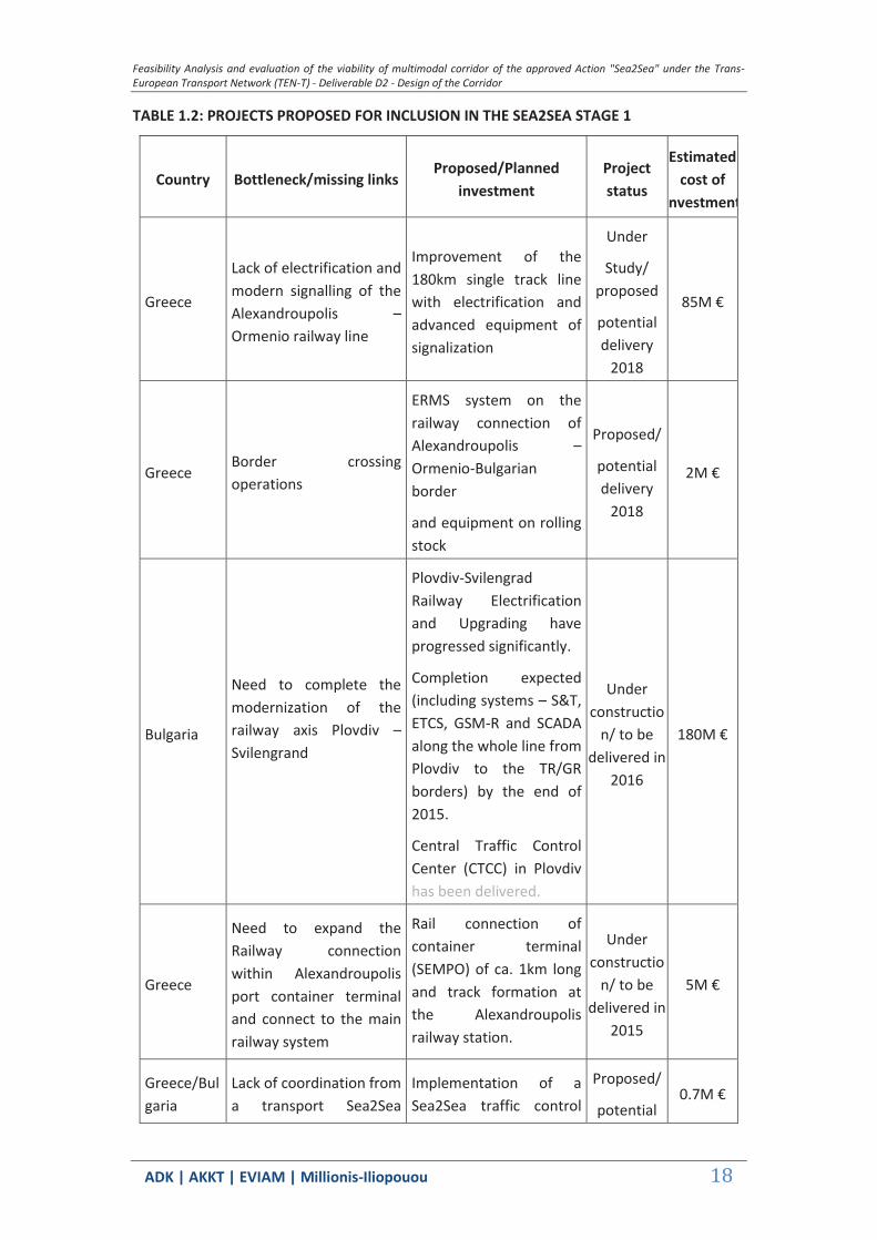
This first stage will be completed with the development and start of operation of the proposed Sea2Sea traffic control center and Observatory. The considered railway connection when completed will be approx. 307 km and will connect two of the Sea2sea Transport logistic nodes. More details on the key projects which are contributing to the completion of the Sea2Sea implementation stage 1 are set out in TABLE 1.2.
They are classified under (i) ongoing construction projects that are part of the greater planning and funding programmes of the two countries and (ii) investment projects proposed specifically for the Sea2Sea corridor with relevant estimated implementation costs.
Feasibility Analysis and evaluation of the viability of multimodal corridor of the approved Action "Sea2Sea" under the Trans-European Transport Network (TEN-T) - Deliverable D2 - Design of the Corridor
ΑDΚ | AKKT | ΕVΙΑΜ | Millionis-Iliopouou 18
TABLE 1.2: PROJECTS PROPOSED FOR INCLUSION IN THE SEA2SEA STAGE 1
Country Bottleneck/missing links Proposed/Planned
investment Project status
Estimated cost of
nvestment
Greece
Lack of electrification and modern signalling of the Alexandroupolis –Ormenio railway line
Improvement of the 180km single track line with electrification and advanced equipment of signalization
Under
Study/ proposed
potential delivery
2018
85M €
Greece Border crossing operations
ERMS system on the railway connection of Alexandroupolis –Ormenio-Bulgarian border
and equipment on rolling stock
Proposed/
potential delivery
2018
2M €
Bulgaria
Need to complete the modernization of the railway axis Plovdiv –Svilengrand
Plovdiv-Svilengrad Railway Electrification and Upgrading have progressed significantly.
Completion expected (including systems – S&T, ETCS, GSM-R and SCADA along the whole line from Plovdiv to the TR/GR borders) by the end of 2015.
Central Traffic Control Center (CTCC) in Plovdiv has been delivered.
Under constructio
n/ to be delivered in
2016
180M €
Greece
Need to expand the Railway connection within Alexandroupolis port container terminal and connect to the main railway system
Rail connection of container terminal (SEMPO) of ca. 1km long and track formation at the Alexandroupolis railway station.
Under constructio
n/ to be delivered in
2015
5M €
Greece/Bulgaria
Lack of coordination from a transport Sea2Sea
Implementation of a Sea2Sea traffic control
Proposed/
potential 0.7M €
Feasibility Analysis and evaluation of the viability of multimodal corridor of the approved Action "Sea2Sea" under the Trans-European Transport Network (TEN-T) - Deliverable D2 - Design of the Corridor
ΑDΚ | AKKT | ΕVΙΑΜ | Millionis-Iliopouou 19
Country Bottleneck/missing links Proposed/Planned
investment Project status
Estimated cost of
nvestmentflows dedicated operational centre
Centre and Observatory delivery 2016
1.2.2 Stage 2 of Aegean-Black Sea2Sea corridor implementation
The second stage of the Sea2Sea implementation can also be considered as the stage that actually connects via railway the Aegean Sea with the Black Sea. At this stage the transport nodes of Alexandroupolis, Plovdiv, Stara Zagora and Burgas will be connected.
The prerequisite for this stage is the modernisation of the Plovdiv-Burgas rail line. This is a project under construction and it is financed by the (Bulgarian) Operational Program for Transport, of the programming period 2007-2013. It is expected to be completed by the end of 2015 (end of eligible period). The remaining sections of the line will be reconstructed by OPTTI 2014-2020. Within the scope of project “Rehabilitation of Plovdiv – Burgas railway line – Phase 2” are included all the remaining sections and activities (excluded from the ongoing Phase 1 project) with the objective to fully complete the line from Plovdiv to Burgas, incl. implementation of ERTMS (ETCS and GSM-R). Some components of the Phase 2 will be tendered in 2015, while the rest in 2016.The transport logistic node of Stara Zagora, as comprehensive Rail-Road Terminal along the Sea2Sea corridor, will be introduced at this stage. Having the ability of container handling and consolidation, a total terminal area of 9000sqm and interim storage capacity of 350 TEUs, Stara Zagora Railway Station can play the role of a comprehensive rail-road terminal in the corridor. Above all, it is well situated in the center of gravity (mass) of the Sea2Sea network.
In this second stage the part of railway connection between Mihaylovo and Dimitrovgrad should also be integrated in the corridor, as a shortcut avoiding the standard route via Plovdiv, giving direct access to the port of Burgas via Stara Zagora. The upgrade of the Mihaylovo - Dimitrovgrad railway section is currently not included in the national priority list. Nevertheless, in the Study of the Orient/East-Med Core Network Corridor, the section is identified as a technical and operational bottleneck. NRIC would have to seek funding for study-design and implementation along that section.
At this stage, six Sea2Sea transport logistic node pairs will be connected. The projects which are contributing to the completion of the Sea2Sea implementation stage 2 are presented in TABLE 1.3.
TABLE 1.3: PROJECT PROPOSED FOR INCLUSION IN THE SEA2SEA STAGE 2
Country Bottleneck/missing links Proposed/Planned
investment Project status
Estimated cost of
nvestment

Feasibility Analysis and evaluation of the viability of multimodal corridor of the approved Action "Sea2Sea" under the Trans-European Transport Network (TEN-T) - Deliverable D2 - Design of the Corridor
ΑDΚ | AKKT | ΕVΙΑΜ | Millionis-Iliopouou 20
Country Bottleneck/missing links Proposed/Planned
investment Project status
Estimated cost of
nvestment
Bulgaria
Poor features of the Plovdiv-Burgas railway line, need to complete project phase 2
Rehabilitation of the Plovdiv-Burgas railway, including the Burgas railway junction
Under constructio
n
/ 80% completion,
completion phase 2 in
2019
340M €
Bulgaria Poor features of the Mihaylovo - Dimitrovgrad railway line
Upgrade of the Mihaylovo - Dimitrovgrad railway section
Under discussion
n.a
1.2.3 Stage 3 of Aegean-Black Sea2Sea corridor implementation
This third stage of the corridor implementation will connect the port of Varna with the transport nodes of Burgas, Stara Zagora, Plovdiv and Alexandroupoli. This will be possible via the railway connection of Sindel-Karnobat that requires an upgrade. The project is in the priority list according to the General Transport Master Plan of Bulgaria but it is not included in the final version of the Bulgarian Operational Programme (OP) on Transport 2014-2020; it will be realised when funding becomes available. With the completion of this stage the Sea2Sea corridor will be close to its full operation potential in connecting via railway the Aegean and Mediterranean Sea with the Black Sea. The prerequisite project of the Sea2Sea corridor implementation stage 3 is presented in TABLE 1.4.
TABLE 1.4: PROJECT PROPOSED FOR INCLUSION IN THE SEA2SEA STAGE 3
Country Bottleneck/missing links Proposed/Planned
investment Project status
Estimated cost of
nvestment
Bulgaria Poor features of the Karnobat - Sindel (close to Varna) railway line
Doubling and electrification of Karnobat-Sindel (close to Varna) railway
Seeking funding 180M €
1.2.4 Stage 4 of Aegean-Black Sea2Sea corridor implementation
At this final stage the remaining sections of the Sea2Sea corridor are proposed to be implemented. The relevant projects aim at connecting Ruse and Kavala as the remote edges
Feasibility Analysis and evaluation of the viability of multimodal corridor of the approved Action "Sea2Sea" under the Trans-European Transport Network (TEN-T) - Deliverable D2 - Design of the Corridor
ΑDΚ | AKKT | ΕVΙΑΜ | Millionis-Iliopouou 21
to the rest of the network. These new connections complete the corridor to its full implementation, connecting all the Sea2Sea Transport logistic nodes with one another. These extensions form a significant part of the network providing direct access, as shortest paths from Ruse to Varna, from Ruse to Stara Zagora and from there to the Aegean Sea. Additionally, these extensions provide direct access from the commercial port of Kavala to Alexandroupolis and from there to all the northern connected destinations of the Sea2Sea network. By this stage, the important north-south straight railway connection is established via the axis Ruse-Veliko Tarnovo - Stara Zagora-Dimitrovgrad. The required projects of the Sea2Sea corridor implementation stage 4 are presented in TABLE 1.5.
TABLE 1.5: PROJECTS PROPOSED FOR INCLUSION IN THE SEA2SEA STAGE 4
Country Bottleneck/missing links Proposed/Planned
investment Project status
Estimated cost of
investment
Bulgaria Poor features of the Varna-Ruse Railway line
Restoration of design parameters of the Ruse – Varna railway line.
The project is not included in the final version of OPTTI 2014-2020 and will be realised when funding becomes available
Seeking funding
305M €
Bulgaria Lack modern signalling of the RR section Ruse–Stara Zagora
Reconstruction of the line and advanced signalling equipment.
Under discussion
170M €
Bulgaria
Limited capacity and other restrictions in the accommodation of the transhipment to inland waterways at Ruse as the Intermodal node for (Danube river)
Ruse Region Intermodal Terminal
Under study
25M €
Greece
Lack of a railway connection between the commercial port of Kavala area and the national railway network
Construction of new single-track line of ca. 35km, which will connect the new commercial port of Kavala with the existing railway line Thessaloniki – Alexandroupolis at the
Under study / Seeking funding
250M €
Feasibility Analysis and evaluation of the viability of multimodal corridor of the approved Action "Sea2Sea" under the Trans-European Transport Network (TEN-T) - Deliverable D2 - Design of the Corridor
ΑDΚ | AKKT | ΕVΙΑΜ | Millionis-Iliopouou 22
Country Bottleneck/missing links Proposed/Planned
investment Project status
Estimated cost of
investment existing station of Toxotes - Xanthi*
*The upgrade of the section Toxotes-Anelxandroupolis (alignment, signalling and electrification) of an estimated budget of 105M € is not included in this project.
1.2.5 Conclusions
The reviewing of the interventions proposed for consideration for the integration of the Sea2Sea corridor as initially presented in Deliverable 1, has resulted to a limited number of selected projects for inclusion in the Sea2Sea corridor investment plan. These selected improvements form the core Sea2Sea corridor, while major projects of railway upgrades and freight terminals in the greater area under study can contribute to the full implementation of the Sea2Sea network in stages and support the initial implementation of its core part, as explained in the above sections for each stage.
Under the present review, we have also considered and assessed projects that are not promoted and therefore can be considered as rejected and excluded from the planning of the Sea2Sea corridor. These projects are: the high speed railway connection of Thessaloniki-Kavala via Amfipolis and the railway connection from Komotini to the Bulgarian border through Nymphaia up to Haskovo. Both these connections would require large amounts of investments, they are crossing environmentally sensitive areas, they have not been adequately studied and they lack the required maturity to be tendered and implemented.
The proposed implementation under 4 stages will enhance the connectivity of important intermodal transport nodes in the area of the northern-east Europe, the Black Sea and the Mediterranean Sea in a staged mode, according to the identified needs. Following its completion it will foster the development of the ports of Alexandroupolis-Burgas-Varna-Ruse and Kavala, as multimodal logistic platforms and will contribute to the economic revitalization of the European South that is facing direct and severe impacts of the ongoing financial crisis. Consequently, it will be enhancing internal market, strengthening territorial, economic and social cohesion. Finally, the operation of the Aegean-Black Sea2Sea corridor is expected to contribute in decongestion of the Bosporus strait. The summary TABLE 1.6 of the connected Sea2Sea Transport Node pairs shows how the 21 origin-destination pairs are integrated to the corridor in each implementation stage.
TABLE 1.6: CONNECTED OD PAIRS BY IMPLEMENTATION STAGE *
Node Name Alexandroupolis Plovdiv Burgas
Stara Zagora Varna Ruse Kavala
Alexandroupolis 1 2 2 3 4 4
Plovdiv 1 2 2 3 4 4

Feasibility Analysis and evaluation of the viability of multimodal corridor of the approved Action "Sea2Sea" under the Trans-European Transport Network (TEN-T) - Deliverable D2 - Design of the Corridor
ΑDΚ | AKKT | ΕVΙΑΜ | Millionis-Iliopouou 23
Burgas 2 2 2 3 4 4
Stara Zagora 2 2 2 3 4 4
Varna 3 3 3 3 4 4
Ruse 4 4 4 4 4 4
Kavala 4 4 4 4 4 4
*the colors are relevant to the ones used for each stage in Figure 1: Sea2Sea corridor in stages of implementation

Feasibility Analysis and evaluation of the viability of multimodal corridor of the approved Action "Sea2Sea" under the Trans-European Transport Network (TEN-T) - Deliverable D2 - Design of the Corridor
ΑDΚ | AKKT | ΕVΙΑΜ | Millionis-Iliopouou 24
1.3 Environmental consideration In order for the optimal design of the corridor to be elaborated, it is considered necessary to identify the most important and most sensitive - environmentally vulnerable areas that are crossed as well as their protection state.
The Consultant has identified weaknesses and problems related to environmental constraints and commitments, so that the alignment of the corridor and any of its improvements can be realized by avoiding -as much as possible- the most sensitive areas or limiting -at the maximum extent possible- the interventions in them. Where the passage of the corridor is through protected areas as indicated under environmental commitments, the limitations of each protected area and the potential of interference or not within them are given. The analysis relates to the existing railway line over which the corridor passes and on which any improvements - modifications are to be made.
1.3.1 General information - Greece
For practical reasons, the corridor is divided into individual sections so that protected areas along are identified and better depicted. Thus, the following sections are studied:
Section 1: Kavala - Alexandroupolis
Section 2: Alexandroupolis - Ormenio

Feas
ibili
ty A
naly
sis a
nd e
valu
atio
n of
the
viab
ility
of m
ultim
odal
corr
idor
of t
he a
ppro
ved
Actio
n "S
ea2S
ea" u
nder
the
Tran
s-Eu
rope
an T
rans
port
Net
wor
k (T
EN-T
) - D
eliv
erab
le D
2 - D
esig
n of
the
Corr
idor
ΑDΚ
| AK
KT |
ΕVΙΑΜ
| M
illio
nis-
Iliop
ouou
25
Figu
re 3
: Illu
stra
tion
of c
orrid
or in
dig
ital b
ackg
roun
d - S
epar
atio
n of
sect
ions
and
pro
tect
ed a
reas
(Sou
rce
Back
grou
nd G
oogl
e Ea
rth)

Feasibility Analysis and evaluation of the viability of multimodal corridor of the approved Action "Sea2Sea" under the Trans-European Transport Network (TEN-T) - Deliverable D2 - Design of the Corridor
ΑDΚ | AKKT | ΕVΙΑΜ | Millionis-Iliopouou 26
Running the railway corridor from Kavala to Alexandroupolis and then to Ormenio encountered by segment, the significant protection areas are included in the following paragraphs. Note that in the initial part of the corridor there is no railway line that connects Kavala with the existing railway network and therefore listed are the protection areas from which it is possible for the corridor to cross and / or is not the desired passage through.
The data presented in the following paragraphs was collected among other sources listed below, from the website of the Network Natura (http://natura2000.eea.europa.eu/), the official website of the Ministry of Environment of Greece and the website Oikoskopio (http://oikoskopio.gr/) combined with data from the website of the Ramsar Organisation and manager of Parks Evros Dadia Forest and the National Park of Eastern Macedonia and Thrace.
1.3.2 Section 1 - Kavala Alexandroupolis - Protected Areas along the studied corridor and its improvements
TABLE 1.7: PROTECTED AREAS OF THE STUDIED CORRIDOR - PART 1
n/s Code Category Name Area (ha)
NATURA AREAS
GR1110009 SPA South Forest Complex of Evros 29278.8184
GR1130009 SCI Lakes and Lagoons of Thrace - Wider Territory and seaside zone
29471.8658
GR1130012 SPA Kompsatou Valley 16609.9760
GR1150010 SCI Delta Nestou and Lagoons Keramotis - Wider Territory an seaside zone
22484.6300
GR1120004 SPA Nestos Gorge 8759.0719
GR1120005 SCI Aesthetic Forest of Nestos 2337.4929
Wildlife Refuges
K802 Panagia Kalamous Archangels
K26 Gorge Nestos-Left Riverside Nestos
K808 Kechrou Kerasias
K59 Agios Timotheos Koupia

Feasibility Analysis and evaluation of the viability of multimodal corridor of the approved Action "Sea2Sea" under the Trans-European Transport Network (TEN-T) - Deliverable D2 - Design of the Corridor
ΑDΚ | AKKT | ΕVΙΑΜ | Millionis-Iliopouou 27
n/s Code Category Name Area (ha)
Aesthetic Forests
Gorge of Nestos Kavala Xanthi
National park
National Park of East Macedonia and Thrace
72677.503
GR1120005 Aesthetic forest Nestos (network Natura) and Aesthetic forest Nestos
Figure 4: Aesthetic Forest Nestos - Network Natura 2000)
(Source: (http://natura2000.eea.europa.eu/),)
Corridor
Corridor
Corridor
Feasibility Analysis and evaluation of the viability of multimodal corridor of the approved Action "Sea2Sea" under the Trans-European Transport Network (TEN-T) - Deliverable D2 - Design of the Corridor
ΑDΚ | AKKT | ΕVΙΑΜ | Millionis-Iliopouou 28
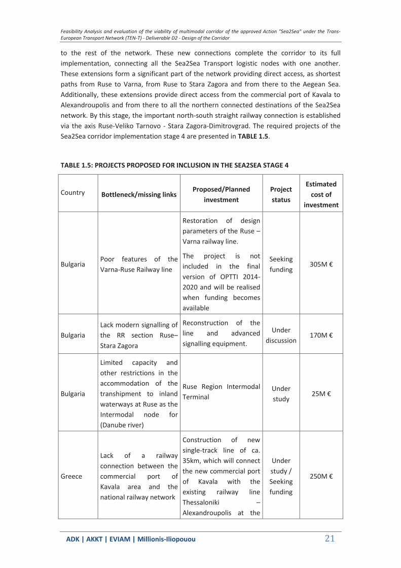
Figure 5: Aesthetic Forest Nestos - Greece National Protection Network
(Source: (http://www.oikoskopio.gr))
GR1120004 Nestos Gorge and K26 Nestos Gorge - Left Riverside Nestos
Corridor
Corridor
Corridor

Feasibility Analysis and evaluation of the viability of multimodal corridor of the approved Action "Sea2Sea" under the Trans-European Transport Network (TEN-T) - Deliverable D2 - Design of the Corridor
ΑDΚ | AKKT | ΕVΙΑΜ | Millionis-Iliopouou 29
Figure 6: Nestos gorge (Natura 2000 Network)
(Source: (http://natura2000.eea.europa.eu/),)
Figure 7: Nestos gorge Wildlife Refuge
(Source: (http://www.oikoskopio.gr/)
Corridor
Corridor
Corridor
Corridor
Corridor
Corridor
Corridor

Feasibility Analysis and evaluation of the viability of multimodal corridor of the approved Action "Sea2Sea" under the Trans-European Transport Network (TEN-T) - Deliverable D2 - Design of the Corridor
ΑDΚ | AKKT | ΕVΙΑΜ | Millionis-Iliopouou 30
GR1150010 Nestos Delta and Keramoti Lagoons
Figure 8: Nestos Delta and Keramoti Lagoons (Natura 2000 Network)
(Source: (http://natura2000.eea.europa.eu/),)
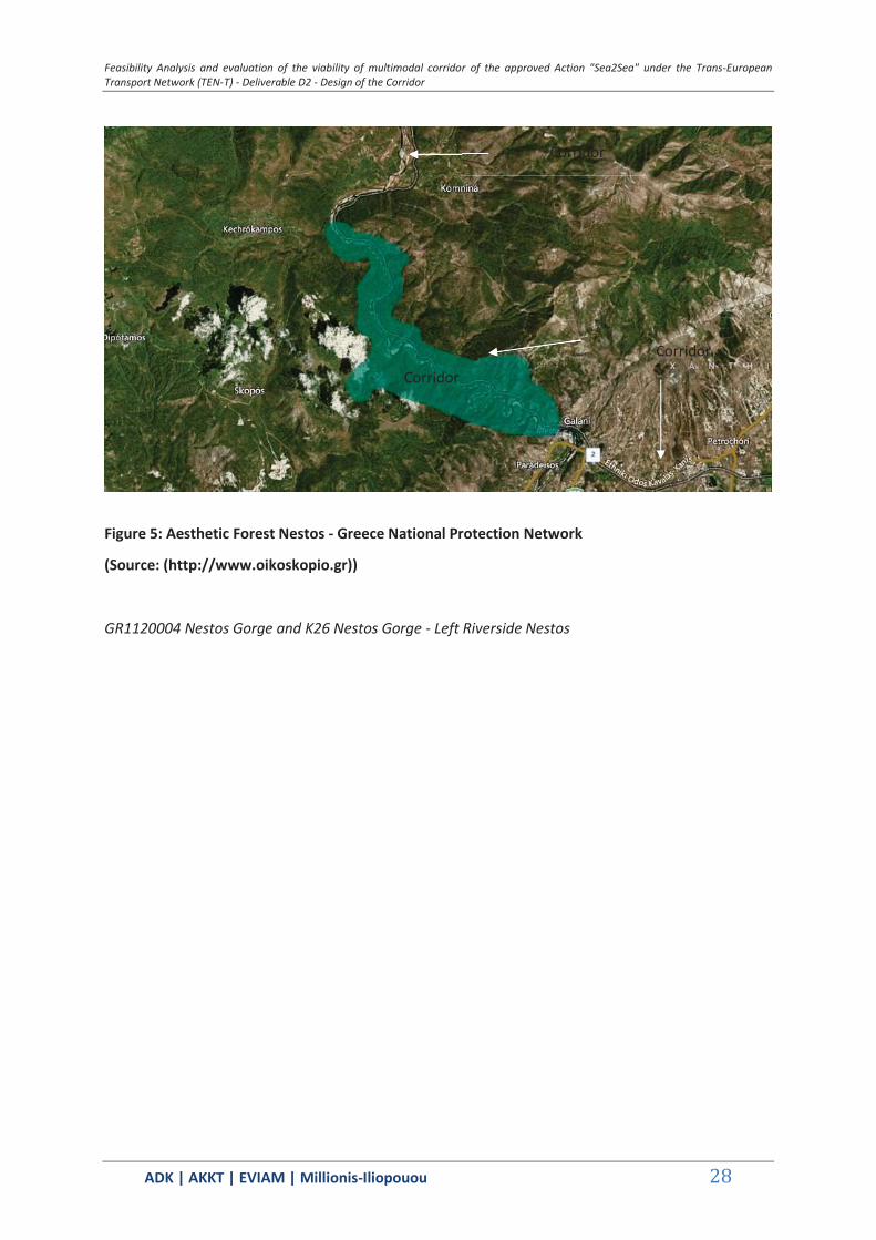
GR1130012 Valley Kompsatos
Feasibility Analysis and evaluation of the viability of multimodal corridor of the approved Action "Sea2Sea" under the Trans-European Transport Network (TEN-T) - Deliverable D2 - Design of the Corridor
ΑDΚ | AKKT | ΕVΙΑΜ | Millionis-Iliopouou 31
Figure 9: Valley Kompsatos (Network Natura 2000)
(Source: (http://natura2000.eea.europa.eu/),)
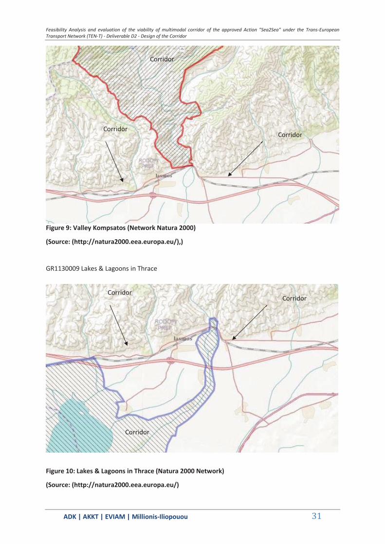
GR1130009 Lakes & Lagoons in Thrace
Figure 10: Lakes & Lagoons in Thrace (Natura 2000 Network)
(Source: (http://natura2000.eea.europa.eu/)
Corridor
Corridor Corridor
Corridor
Corridor Corridor

Feasibility Analysis and evaluation of the viability of multimodal corridor of the approved Action "Sea2Sea" under the Trans-European Transport Network (TEN-T) - Deliverable D2 - Design of the Corridor
ΑDΚ | AKKT | ΕVΙΑΜ | Millionis-Iliopouou 32
GR1110009 South forest complex of Evros
Figure 11: South forest complex of Evros (Natura 2000 Network)
((http://natura2000.eea.europa.eu/)
National Park of East Macedonia and Thrace (EPAMTH) 1
The National Park of East Macedonia and Thrace (EPAMTH) includes land and water area of a total
area of 726775.03str. (With the regional area). The Joint Ministerial Decision of 2008 (44549, OG
497/D/17.10.2008) essentially replaces the previous KYA57/ 96 (Government Gazette 854 / B /
16.9.1996) and determine the status and limitations within the park.
1 Characterization of wetlands Nestos Delta, Lake Vistonida with lagoonal and lake
characteristics Lake Ismarida and the wider area as a National Park with Regional
Zone (GG 497/D/17.10.2008).
Feasibility Analysis and evaluation of the viability of multimodal corridor of the approved Action "Sea2Sea" under the Trans-European Transport Network (TEN-T) - Deliverable D2 - Design of the Corridor
ΑDΚ | AKKT | ΕVΙΑΜ | Millionis-Iliopouou 33
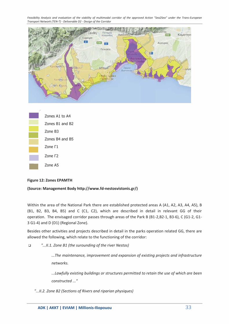
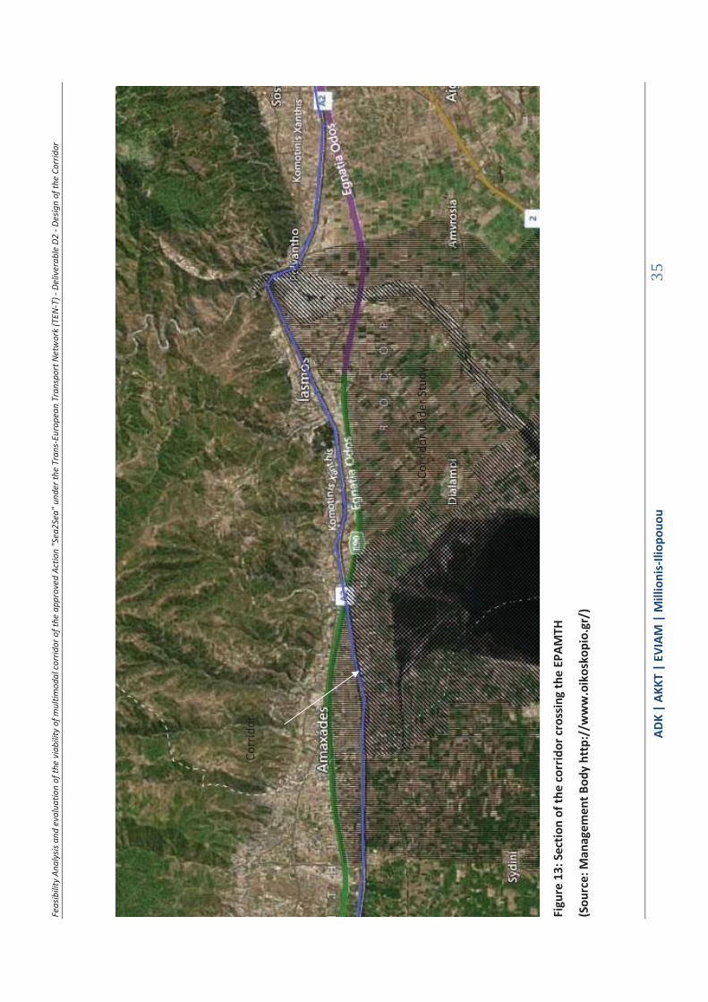
Figure 12: Zones EPAMTH
(Source: Management Body http://www.fd-nestosvistonis.gr/)
Within the area of the National Park there are established protected areas A (A1, A2, A3, A4, A5), B (B1, B2, B3, B4, B5) and C (C1, C2), which are described in detail in relevant GG of their operation. The envisaged corridor passes through areas of the Park B (B1-2,B2-1, B3-6), C (G1-2, G1-3 G1-4) and D (D1) (Regional Zone).
Besides other activities and projects described in detail in the parks operation related GG, there are allowed the following, which relate to the functioning of the corridor:
"...II.1. Zone B1 (the surounding of the river Nestos)
...The maintenance, improvement and expansion of existing projects and infrastructure
networks.
...Lawfully existing buildings or structures permitted to retain the use of which are been
constructed ..."
"...II.2. Zone B2 (Sections of Rivers and riparian physiques)
Zones Α1 to Α4
Zones Β1 and Β2
Zone Β3
Zones Β4 and Β5
Zone Γ1
Zone Γ2
Zone Α5
Feasibility Analysis and evaluation of the viability of multimodal corridor of the approved Action "Sea2Sea" under the Trans-European Transport Network (TEN-T) - Deliverable D2 - Design of the Corridor
ΑDΚ | AKKT | ΕVΙΑΜ | Millionis-Iliopouou 34
...The maintenance, improvement and expansion of existing projects and infrastructure
networks, as referred to in paragraph I.1.8 ..
"II.3.Zone B3 (Rest land area) ...
...The Maintenance - modernization, expansion and creation of new networks and
infrastructure (ports, electricity, etc. pipes), as indicated in paragraph I.1.8. ...
...Lawfully existing buildings or structures permitted to retain the use of which are been
constructed. The change of use is allowed, as referred to in paragraph I.1.17... "
"...Zone C.
...The maintenance, improvement and expansion of existing projects and infrastructure
networks and creation of new, as indicated in paragraph I.1.8. ... »
Feas
ibili
ty A
naly
sis a
nd e
valu
atio
n of
the
viab
ility
of m
ultim
odal
corr
idor
of t
he a
ppro
ved
Actio
n "S
ea2S
ea" u
nder
the
Tran
s-Eu
rope
an T
rans
port
Net
wor
k (T
EN-T
) - D
eliv
erab
le D
2 - D
esig
n of
the
Corr
idor
ΑDΚ
| AK
KT |
ΕVΙΑΜ
| M
illio
nis-
Iliop
ouou
35
Figu
re 1
3: S
ectio
n of
the
corr
idor
cros
sing
the
EPAM
TH
(Sou
rce:
Man
agem
ent B
ody
http
://w
ww
.oik
osko
pio.
gr/)
C
orrid
or u
nder
Stu
dy
Co
rrid
or
Feas
ibili
ty A
naly
sis a
nd e
valu
atio
n of
the
viab
ility
of m
ultim
odal
corr
idor
of t
he a
ppro
ved
Actio
n "S
ea2S
ea" u
nder
the
Tran
s-Eu
rope
an T
rans
port
Net
wor
k (T
EN-T
) - D
eliv
erab
le D
2 - D
esig
n of
the
Corr
idor
ΑDΚ
| AK
KT |
ΕVΙΑΜ
| M
illio
nis-
Iliop
ouou
36
Figu
re 1
4: W
ildlif
e Re
fuge
s
(Sou
rce:
Man
agem
ent B
ody
http
://w
ww
.oik
osko
pio.
gr/)
Feasibility Analysis and evaluation of the viability of multimodal corridor of the approved Action "Sea2Sea" under the Trans-European Transport Network (TEN-T) - Deliverable D2 - Design of the Corridor
ΑDΚ | AKKT | ΕVΙΑΜ | Millionis-Iliopouou 37
1.3.3 Section 2 - Alexandroupolis - Ormenio - Protected Areas along the studied corridor and its improvements
TABLE 1.8: CORRIDORS PROTECTED AREAS - SECTION 2
s / n Code Category Name Area (ha)
AREAS NATURA
GR1110006 SPA Delta Evrou 12558.4524
GR1110007 SCI Delta Evrou 12558.4524
GR1110005 SCI Mountains Evrou 42372.5
GR1110008 SPA Riparian Forest North Evrou and Arda
42372.5
National park
National Wetland Park Evros Delta
Dadia Forest
GR1110007 and GR1110006 Evros Delta

Feasibility Analysis and evaluation of the viability of multimodal corridor of the approved Action "Sea2Sea" under the Trans-European Transport Network (TEN-T) - Deliverable D2 - Design of the Corridor
ΑDΚ | AKKT | ΕVΙΑΜ | Millionis-Iliopouou 38
Figure 15: Evros Delta and West Arm (Natura 2000 Network)
(Source: http://natura2000.eea.europa.eu/))
GR1110005 Evros Mountains
Figure 16: Mountains Evros (Natura 2000 Network)
Corridor
Corridor
Corridor
Corridor
Corridor
Feasibility Analysis and evaluation of the viability of multimodal corridor of the approved Action "Sea2Sea" under the Trans-European Transport Network (TEN-T) - Deliverable D2 - Design of the Corridor
ΑDΚ | AKKT | ΕVΙΑΜ | Millionis-Iliopouou 39
(Source: http://natura2000.eea.europa.eu/)
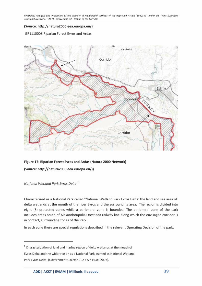
GR1110008 Riparian Forest Evros and Ardas
Figure 17: Riparian Forest Evros and Ardas (Natura 2000 Network)
(Source: http://natura2000.eea.europa.eu/))
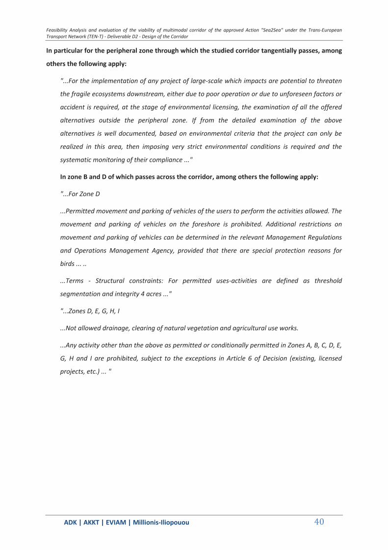
National Wetland Park Evros Delta 2
Characterized as a National Park called "National Wetland Park Evros Delta' the land and sea area of delta wetlands at the mouth of the river Evros and the surrounding area. The region is divided into eight (8) protected zones while a peripheral zone is bounded. The peripheral zone of the park includes areas south of Alexandroupolis-Orestiada railway line along which the envisaged corridor is in contact, surrounding zones of the Park
In each zone there are special regulations described in the relevant Operating Decision of the park.
2 Characterization of land and marine region of delta wetlands at the mouth of
Evros Delta and the wider region as a National Park, named as National Wetland
Park Evros Delta. (Government Gazette 102 / A / 16.03.2007).
Corridor
Corridor
Corridor
Feasibility Analysis and evaluation of the viability of multimodal corridor of the approved Action "Sea2Sea" under the Trans-European Transport Network (TEN-T) - Deliverable D2 - Design of the Corridor
ΑDΚ | AKKT | ΕVΙΑΜ | Millionis-Iliopouou 40
In particular for the peripheral zone through which the studied corridor tangentially passes, among
others the following apply:
"...For the implementation of any project of large-scale which impacts are potential to threaten
the fragile ecosystems downstream, either due to poor operation or due to unforeseen factors or
accident is required, at the stage of environmental licensing, the examination of all the offered
alternatives outside the peripheral zone. If from the detailed examination of the above
alternatives is well documented, based on environmental criteria that the project can only be
realized in this area, then imposing very strict environmental conditions is required and the
systematic monitoring of their compliance ..."
In zone B and D of which passes across the corridor, among others the following apply:
"...For Zone D
...Permitted movement and parking of vehicles of the users to perform the activities allowed. The
movement and parking of vehicles on the foreshore is prohibited. Additional restrictions on
movement and parking of vehicles can be determined in the relevant Management Regulations
and Operations Management Agency, provided that there are special protection reasons for
birds ... ..
...Terms - Structural constraints: For permitted uses-activities are defined as threshold
segmentation and integrity 4 acres ..."
"...Zones D, E, G, H, I
...Not allowed drainage, clearing of natural vegetation and agricultural use works.
...Any activity other than the above as permitted or conditionally permitted in Zones A, B, C, D, E,
G, H and I are prohibited, subject to the exceptions in Article 6 of Decision (existing, licensed
projects, etc.) ... "
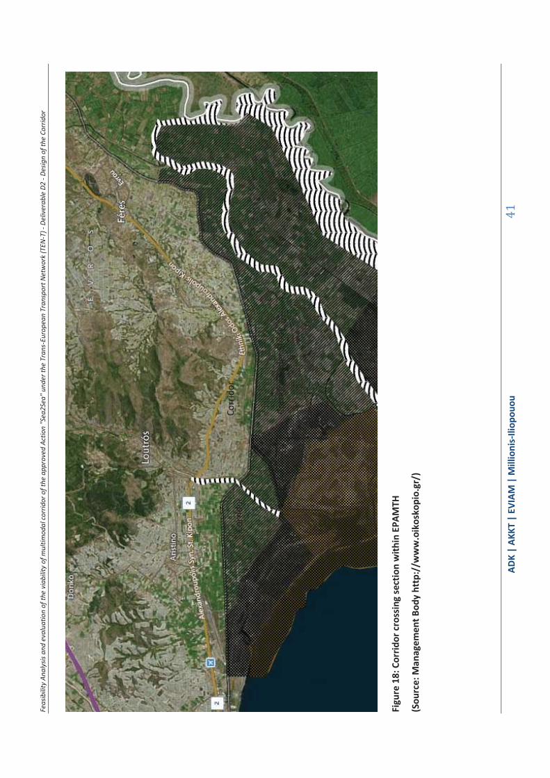
Feas
ibili
ty A
naly
sis a
nd e
valu
atio
n of
the
viab
ility
of m
ultim
odal
corr
idor
of t
he a
ppro
ved
Actio
n "S
ea2S
ea" u
nder
the
Tran
s-Eu
rope
an T
rans
port
Net
wor
k (T
EN-T
) - D
eliv
erab
le D
2 - D
esig
n of
the
Corr
idor
ΑDΚ
| AK
KT |
ΕVΙΑΜ
| M
illio
nis-
Iliop
ouou
41
Figu
re 1
8: C
orrid
or c
ross
ing
sect
ion
with
in E
PAM
TH
(Sou
rce:
Man
agem
ent B
ody
http
://w
ww
.oik
osko
pio.
gr/)
Corr
idor
und
er S
tudy
Co
rrid
or
Co
rrid
or
Feasibility Analysis and evaluation of the viability of multimodal corridor of the approved Action "Sea2Sea" under the Trans-European Transport Network (TEN-T) - Deliverable D2 - Design of the Corridor
ΑDΚ | AKKT | ΕVΙΑΜ | Millionis-Iliopouou 42
National Park Forest Dadia-Lefkimi-Soufli
Park Forest area includes total area 428.000str., Which is the forest complex Dadia-Lefkimis- Soufliou
IP Evros. Within the National Park are designated areas A and B, as follows:
Within the area A, the total area 78.000str. about, characterized as a nature reserve
designated Zones A1, A2.
Within the area B, the total area 350.000str. approximately, are defined Zones B1, B2,
B2a, B2b and B3.
Throughout the National Park Dadia - Lefkimi - Soufli, as defined under Article 2 of Decision (Official Gazette 911 / 13.10.2006), are determined by zone and area the terms and conditions and restrictions imposed on them and protective measures .
Among others, the following apply, which relate to the operation of the corridor:
General Park terms
a. Forests and woodlands maintain their forest nature and are governed by the
applicable forest law.
You may not change the use and destination of forests and woodlands.
Sustainable management in the A region and in Zones B1, B2, and B3 B2b of the
National Park is done under the prescribed by forest law managerial studies (Special
Administrative Region of nuclear A and for other areas Managing Regional Study Area
Complex). 3
j. For all authorized projects and activities that fall within the categories of
no. 15393/232/2002 (B 1022) joint ministerial decision and whatever category they
fall, is required the preparation and approval of the Environmental Impact Study (EIS),
and its installation is possible, if there are no significant effects on the conservation of
protected areas and its objects. 4
k. Any other activity that is not permitted by the provisions of this article is prohibited
without prejudice relating to Article 6 of the JMD 35633 (Government Gazette 911 /
10.13.2006) ..."
Especially for the B2-B zone where the corridor adjoins, the following apply:
3 "EVALUATION, REVIEW AND EXPERTISE REGIONAL FRAMEWORK SPATIAL PLANNING AND SUSTAINABLE DEVELOPMENT REGION OF EASTERN MACEDONIA AND THRACE" - Phase Stage A1 - 2012 4 "EVALUATION, REVIEW AND EXPERTISE REGIONAL FRAMEWORK SPATIAL PLANNING AND SUSTAINABLE DEVELOPMENT REGION OF EASTERN MACEDONIA AND THRACE" - Phase Stage A1 - 2012

Feasibility Analysis and evaluation of the viability of multimodal corridor of the approved Action "Sea2Sea" under the Trans-European Transport Network (TEN-T) - Deliverable D2 - Design of the Corridor
ΑDΚ | AKKT | ΕVΙΑΜ | Millionis-Iliopouou 43
"...In zones B2, B2a and B2b all existing legally uses and activities are permitted and
specific conditions for the following uses and activities as well as for the establishment or
expansion of existing uses and activities as follows ...
n. Is allowed the maintenance and modernization of existing networks and infrastructure
projects....".
Figure 19: Map of the National Park Dadia - Protected Areas
(Source: Management Agency National Park Dadia http://dadianp.maps.arcgis.com/)
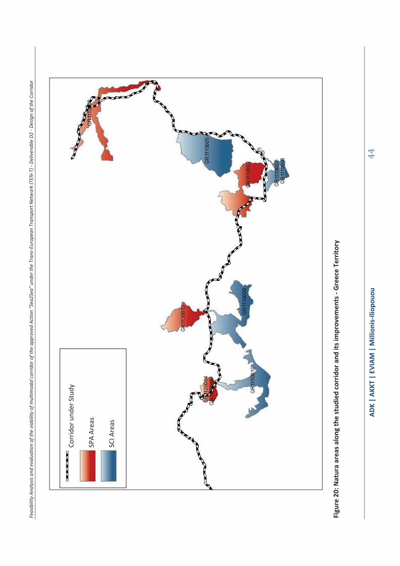
Feas
ibili
ty A
naly
sis a
nd e
valu
atio
n of
the
viab
ility
of m
ultim
odal
corr
idor
of t
he a
ppro
ved
Actio
n "S
ea2S
ea" u
nder
the
Tran
s-Eu
rope
an T
rans
port
Net
wor
k (T
EN-T
) - D
eliv
erab
le D
2 - D
esig
n of
the
Corr
idor
ΑDΚ
| AK
KT |
ΕVΙΑΜ
| M
illio
nis-
Iliop
ouou
44
Figu
re 2
0: N
atur
a ar
eas a
long
the
stud
ied
corr
idor
and
its i
mpr
ovem
ents
- Gr
eece
Ter
ritor
y
Co
rrid
or u
nder
Stu
dy
SP
A Ar
eas
SC
I Are
as

Feasibility Analysis and evaluation of the viability of multimodal corridor of the approved Action "Sea2Sea" under the Trans-European Transport Network (TEN-T) - Deliverable D2 - Design of the Corridor
ΑDΚ | AKKT | ΕVΙΑΜ | Millionis-Iliopouou 45
1.3.4 Summary data - conclusions
The above protected areas are separated into two main categories: Category A - areas from which the corridor passes, and Class B - areas in contact with the corridor, ie the threshold is along the corridor and affects the habitat only during the operation of the corridor and not during the construction phase of any improvements works. Of these areas, those belonging to category A, are the most important and of special importance during the final phase of the study of the corridor.
Bold fonts are used to show the areas with special protection status and having an operator, ie essentially the National Parks. The most important of these protected areas are included within.
TABLE 1.9: PROTECTED AREAS OF THE STUDIED CORRIDOR - AREAS A -
Category A: Protected areas from which the studied corridor passes
s / n Code Category Name
Section 1
1. GR1110009 NATURA SPA South Forestry Complex Evrou
2 GR1130009 NATURA SPA Lakes and Lagoons of Thrace -Wider Territory an seaside zone
3 GR1130012 NATURA SPA Kompsatou Valley
4 GR1150010 NATURA SPA Delta Nestou and Lagoons Keramotis -Wider Territory an seaside zone
5 GR1120004 NATURA SPA Nestou Gorge
6 GR1120005 NATURA SPA Aesthetic Forest of Nestos
7 K26 Wildlife Refuge Nestos Gorge - Left Riverside Nestos
8 Aesthetic Forest Gorge of Nestos Kavala Xanthi
9 National park National Park of East Macedonia and Thrace
Section 2
10 GR1110006 NATURA SCI Delta Evrou and West Arm
11 GR1110007 NATURA SPA Delta Evrou and West Arm
12 GR1110008 NATURA SPA Riparian Forest North Evrou and Arda

Feasibility Analysis and evaluation of the viability of multimodal corridor of the approved Action "Sea2Sea" under the Trans-European Transport Network (TEN-T) - Deliverable D2 - Design of the Corridor
ΑDΚ | AKKT | ΕVΙΑΜ | Millionis-Iliopouou 46
13 National park National Wetland Park Evros Delta
TABLE 1.10: PROTECTED AREAS WHICH ABUT THE STUDIED CORRIDOR - AREAS B-
Category B: Protected areas in which the studied corridor abuts
s / n Code Category Name
Section 1
14 Wildlife Refuge K802 Panagia Kalamous Archangels
15 Wildlife Refuge K808 Kechrou Kerasias
16 Wildlife Refuge K59 Agios Timotheos Koupia
Section 2
17 GR1110005 NATURA SCI Mountains of Evros
18 National park Dadia Forest
Key conclusions
I. Within the path of the studied corridor and its interventions, there are
protected areas that include zones - areas through two of the most important
National Parks of Greece: the National Park of East Macedonia and Thrace and
the National Wetland Park Evros, generated by the important habitats created
by rivers Nestos and Evros, respectively. The transit of the corridor through
these areas makes it, in the sections it passes internally and / or tangential,
especially environmentally vulnerable. Any interventions - optimizations to
these parts should follow the restrictions and prohibitions imposed by the
relevant legislation of establishment and operation of parks and naturally go
through the approval of their operator.
II. The NATURA areas from which the corridor passes are mostly related to the
National Parks or habitats of river Nestos and Evros, through which the corridor
passes. The exception is the major Dadia Forest, part 2, the Valley of River
Kompsatos, Evros mountains and some wildlife refuges.
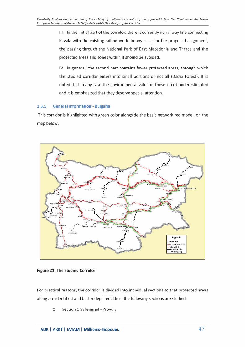
Feasibility Analysis and evaluation of the viability of multimodal corridor of the approved Action "Sea2Sea" under the Trans-European Transport Network (TEN-T) - Deliverable D2 - Design of the Corridor
ΑDΚ | AKKT | ΕVΙΑΜ | Millionis-Iliopouou 47
III. In the initial part of the corridor, there is currently no railway line connecting
Kavala with the existing rail network. In any case, for the proposed allignment,
the passing through the National Park of East Macedonia and Thrace and the
protected areas and zones within it should be avoided.
IV. In general, the second part contains fewer protected areas, through which
the studied corridor enters into small portions or not all (Dadia Forest). It is
noted that in any case the environmental value of these is not underestimated
and it is emphasized that they deserve special attention.
1.3.5 General information - Bulgaria
This corridor is highlighted with green color alongside the basic network red model, on the
map below.
Figure 21: The studied Corridor
For practical reasons, the corridor is divided into individual sections so that protected areas
along are identified and better depicted. Thus, the following sections are studied:
Section 1 Svilengrad - Provdiv
Feasibility Analysis and evaluation of the viability of multimodal corridor of the approved Action "Sea2Sea" under the Trans-European Transport Network (TEN-T) - Deliverable D2 - Design of the Corridor
ΑDΚ | AKKT | ΕVΙΑΜ | Millionis-Iliopouou 48
Section 2 Provdiv - Stara Zagora
Section 3 Stara Zagora - Burgas
Section 4 Stara Zagora - Varna
Section 5 Gorna Orjahovica - Ruse
Section 6 Karnobat - Sindel
The data presented in the following paragraphs was collected -among other sources listed
below- from the website of the Network Natura ( http://natura2000.eea.europa.eu/), the
official website of the Ministry of Environment of Bulgaria (HTTP: / /eea.government.bg/)
combined with data from the website of the Ramsar Organisation and the managing body of
the Balgarka Natural Park.
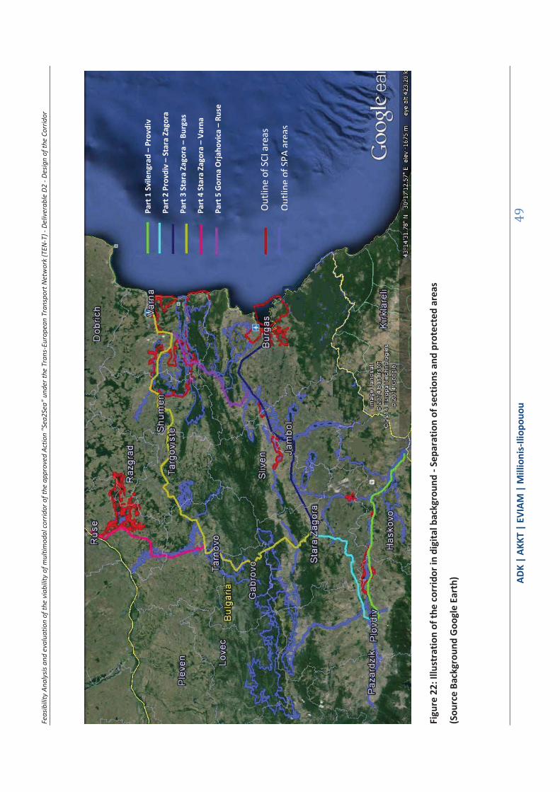
Feas
ibili
ty A
naly
sis a
nd e
valu
atio
n of
the
viab
ility
of m
ultim
odal
corr
idor
of t
he a
ppro
ved
Actio
n "S
ea2S
ea" u
nder
the
Tran
s-Eu
rope
an T
rans
port
Net
wor
k (T
EN-T
) - D
eliv
erab
le D
2 - D
esig
n of
the
Corr
idor
ΑDΚ
| AK
KT |
ΕVΙΑΜ
| M
illio
nis-
Iliop
ouou
49
Figu
re 2
2: Il
lust
ratio
n of
the
corr
idor
in d
igita
l bac
kgro
und
- Sep
arat
ion
of se
ctio
ns a
nd p
rote
cted
are
as
(Sou
rce
Back
grou
nd G
oogl
e Ea
rth)
Part
1 S
vile
ngra
d –
Prov
div
Part
2 P
rovd
iv –
Sta
ra Z
agor
a
Part
3 S
tara
Zag
ora
– Bu
rgas
Part
4 S
tara
Zag
ora
– Va
rna
Part
5 G
orna
Orja
hovi
ca –
Rus
e
Out
line
of S
CI a
reas
Out
line
of S
PA a
reas
Feasibility Analysis and evaluation of the viability of multimodal corridor of the approved Action "Sea2Sea" under the Trans-European Transport Network (TEN-T) - Deliverable D2 - Design of the Corridor
ΑDΚ | AKKT | ΕVΙΑΜ | Millionis-Iliopouou 50
Note that the Natura 2000 Network is a European network of ecological areas, which host natural
habitat types and habitats of species that are important at European level. It consists of two types of
areas: the "Special Protection Areas (SPAs)» for Birds, as defined in Directive 79/409 /EK, and the
"Sites of Community Importance (SCI)» as defined in Directive 92/43 / EC. The SPA, following their
designation by the Member States, are automatically integrated in the Natura 2000 Network, and
their management follows the provisions of Article 6 of Directive 92/43 / EC. In contrast, for the
integration of SCI a scientific evaluation and negotiation between the Members States and the
European Commission is done, according to the results of each ecological unit biogeographical
seminars.
1.3.6 Section 1 - Svilengrad - Provdiv Protected Areas along the studied corridor and its improvements
TABLE 1.11: PROTECTED AREAS OF THE STUDIED CORRIDOR - SECTION 1
s / n Code Category Name Area (ha)
NATURA AREAS
BG0000578 SCI Reka Maritsa * 14696.0750
BG0001034 SCI SPA Ostar kamak 15994.3100
BG0002103 SPA Zlato Pole 16003.3317
BG0002081 SPA Maritsa - Parvomay 11512.8258
BG0000194 SCI Reka Chaya 650.6424
Natural Monuments
311 Nahodishte Na Blatno Kokiche - Mestnost Sazlaka
10.2000
276 Fosilni Nahodki 9100.0000
* An area that extends to sections 2 and 3
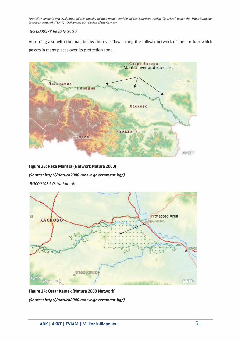
Feasibility Analysis and evaluation of the viability of multimodal corridor of the approved Action "Sea2Sea" under the Trans-European Transport Network (TEN-T) - Deliverable D2 - Design of the Corridor
ΑDΚ | AKKT | ΕVΙΑΜ | Millionis-Iliopouou 51
BG 0000578 Reka Maritsa
According also with the map below the river flows along the railway network of the corridor which
passes in many places over its protection zone.
Figure 23: Reka Maritsa (Network Natura 2000)
(Source: http://natura2000.moew.government.bg/)
BG0001034 Ostar kamak
Figure 24: Ostar Kamak (Natura 2000 Network)
(Source: http://natura2000.moew.government.bg/)
Maritsa river protected area
Protected Area
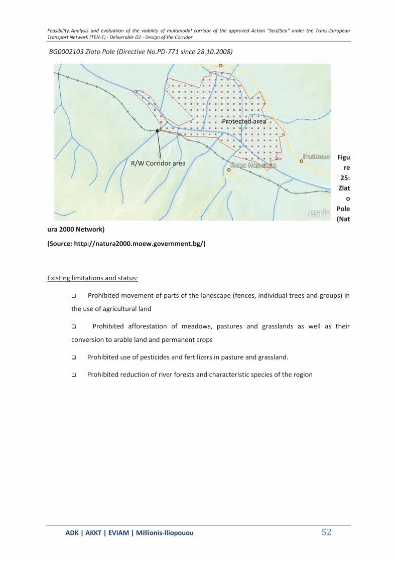
Feasibility Analysis and evaluation of the viability of multimodal corridor of the approved Action "Sea2Sea" under the Trans-European Transport Network (TEN-T) - Deliverable D2 - Design of the Corridor
ΑDΚ | AKKT | ΕVΙΑΜ | Millionis-Iliopouou 52
BG0002103 Zlato Pole (Directive No.PD-771 since 28.10.2008)
Figure
25: Zlat
o Pole (Nat
ura 2000 Network)
(Source: http://natura2000.moew.government.bg/)
Existing limitations and status:
Prohibited movement of parts of the landscape (fences, individual trees and groups) in
the use of agricultural land
Prohibited afforestation of meadows, pastures and grasslands as well as their
conversion to arable land and permanent crops
Prohibited use of pesticides and fertilizers in pasture and grassland.
Prohibited reduction of river forests and characteristic species of the region
Protected area
R/W Corridor area

Feasibility Analysis and evaluation of the viability of multimodal corridor of the approved Action "Sea2Sea" under the Trans-European Transport Network (TEN-T) - Deliverable D2 - Design of the Corridor
ΑDΚ | AKKT | ΕVΙΑΜ | Millionis-Iliopouou 53
BG0002081 Maritsa Parvomay (No Directive.PD-909 since 21.12.2008)
Figure 26: Maritsa Parvomay (Natura 2000 Network)
(Source: http://natura2000.moew.government.bg/)
Existing limitations and status:
Prohibited movement of parts of the landscape (fences, individual trees and groups) in
the use of agricultural land
Prohibited afforestation of meadows, pastures and grasslands as well as their
conversion to arable land and permanent crops
Prohibited use of pesticides and fertilizers in pasture and grassland.
Prohibited burning of sugarcane and riparian vegetation
Prohibited reduction of river forests and species characteristic of the region
BG0000195 Reka Chaya (Decision No.122 since 2.3.2007)
Protected Area

Feasibility Analysis and evaluation of the viability of multimodal corridor of the approved Action "Sea2Sea" under the Trans-European Transport Network (TEN-T) - Deliverable D2 - Design of the Corridor
ΑDΚ | AKKT | ΕVΙΑΜ | Millionis-Iliopouou 54
According also with the map below the river flows along the railway network of the corridor which
passes in many places over its protection zone.
Figure 27: Reka Chaya (Natura 2000 Network)
(Source: http://natura2000.moew.government.bg/)
Figure 28: Fosilni Nahodki
(Source: http://natura2000.eea.europa.eu/)
Chaya river protected area
R/W Corridor under study
R/W Corridor Under Study
Protected Area
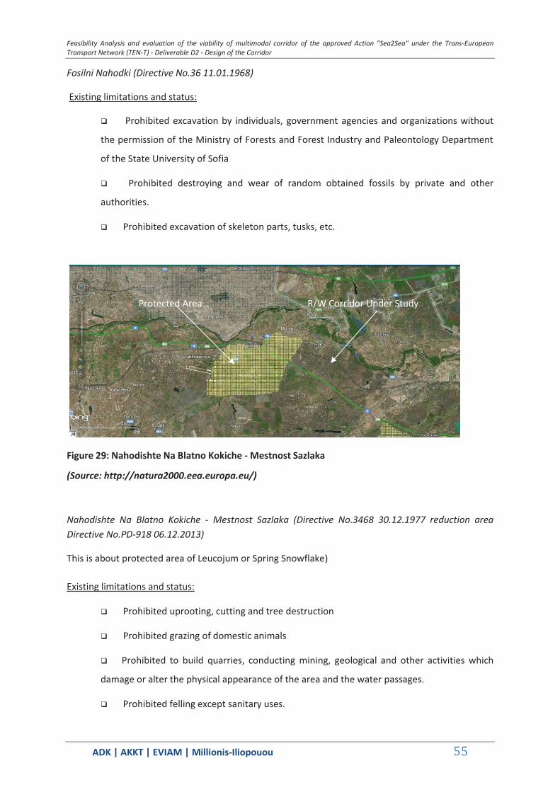
Feasibility Analysis and evaluation of the viability of multimodal corridor of the approved Action "Sea2Sea" under the Trans-European Transport Network (TEN-T) - Deliverable D2 - Design of the Corridor
ΑDΚ | AKKT | ΕVΙΑΜ | Millionis-Iliopouou 55
Fosilni Nahodki (Directive No.36 11.01.1968)
Existing limitations and status:
Prohibited excavation by individuals, government agencies and organizations without
the permission of the Ministry of Forests and Forest Industry and Paleontology Department
of the State University of Sofia
Prohibited destroying and wear of random obtained fossils by private and other
authorities.
Prohibited excavation of skeleton parts, tusks, etc.
Figure 29: Nahodishte Na Blatno Kokiche - Mestnost Sazlaka
(Source: http://natura2000.eea.europa.eu/)
Nahodishte Na Blatno Kokiche - Mestnost Sazlaka (Directive No.3468 30.12.1977 reduction area Directive No.PD-918 06.12.2013)
This is about protected area of Leucojum or Spring Snowflake)
Existing limitations and status:
Prohibited uprooting, cutting and tree destruction
Prohibited grazing of domestic animals
Prohibited to build quarries, conducting mining, geological and other activities which
damage or alter the physical appearance of the area and the water passages.
Prohibited felling except sanitary uses.
R/W Corridor Under Study Protected Area
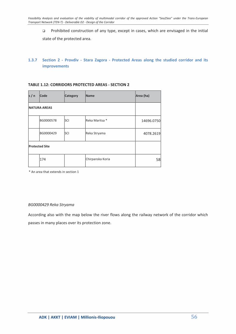
Feasibility Analysis and evaluation of the viability of multimodal corridor of the approved Action "Sea2Sea" under the Trans-European Transport Network (TEN-T) - Deliverable D2 - Design of the Corridor
ΑDΚ | AKKT | ΕVΙΑΜ | Millionis-Iliopouou 56
Prohibited construction of any type, except in cases, which are envisaged in the initial
state of the protected area.
1.3.7 Section 2 - Provdiv - Stara Zagora - Protected Areas along the studied corridor and its improvements
TABLE 1.12: CORRIDORS PROTECTED AREAS - SECTION 2
s / n Code Category Name Area (ha)
NATURA AREAS
BG0000578 SCI Reka Maritsa * 14696.0750
BG0000429 SCI Reka Stryama 4078.2619
Protected Site
174 Chirpanska Koria 58
* An area that extends in section 1
BG0000429 Reka Stryama
According also with the map below the river flows along the railway network of the corridor which
passes in many places over its protection zone.

Feasibility Analysis and evaluation of the viability of multimodal corridor of the approved Action "Sea2Sea" under the Trans-European Transport Network (TEN-T) - Deliverable D2 - Design of the Corridor
ΑDΚ | AKKT | ΕVΙΑΜ | Millionis-Iliopouou 57
Figure 30: Reka Stryama (Natura 2000 Network)
(Source: http://natura2000.moew.government.bg/)
Figure 31: Chirpanska Koria
(Source: http://natura2000.eea.europa.eu/)
Chirpanska Koria (Directive No.33384 8.12.1966 reclassification - Directive No. 850 09.18.2002)
Stryama river protected area
Protected Area
R/W Corridor Under Study

Feasibility Analysis and evaluation of the viability of multimodal corridor of the approved Action "Sea2Sea" under the Trans-European Transport Network (TEN-T) - Deliverable D2 - Design of the Corridor
ΑDΚ | AKKT | ΕVΙΑΜ | Millionis-Iliopouou 58
The protected area is in contact with the rail and it is an oak forest protected area.
Existing limitations and status:
Prohibited uprooting, cutting and destruction of trees and plants
Prohibited hunting of wild animals and their small and destruction of nests and dens
Prohibited to build quarries, conducting mining, geological and other activities which
damage or alter the physical appearance of the area and the water passages.
1.3.8 Section 3 - Stara Zagora - Burgas- Protected Area along the studied corridor and its improvements
TABLE 1.13: PROTECTED AREAS OF THE STUDIED CORRIDOR - SECTION 3
s / n Code Category Name Area (ha)
NATURA AREAS
BG0000192 SCI Reka Tundzha 1 * 9502.9987
BG0002094 SCI Adata Tundzha 5636.2998
BG0000196 SCI Reka Mochuritsa * 8702.8302
BG0000205 SCI SPA Straldzha 882.0200
BG0002028 SPA Kompleks Straldzha 2872.9714
BG0000273 SCI SPA Burgasko ezero 3066.9026
Ramsar Sites
Vaya Lake 2900.00
* An area that extends in Section 4
BG0000192 Reka Tundzha 1
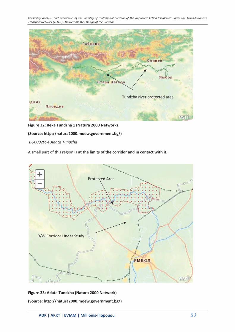
Feasibility Analysis and evaluation of the viability of multimodal corridor of the approved Action "Sea2Sea" under the Trans-European Transport Network (TEN-T) - Deliverable D2 - Design of the Corridor
ΑDΚ | AKKT | ΕVΙΑΜ | Millionis-Iliopouou 59
Figure 32: Reka Tundzha 1 (Natura 2000 Network)
(Source: http://natura2000.moew.government.bg/)
BG0002094 Adata Tundzha
A small part of this region is at the limits of the corridor and in contact with it.
Figure 33: Adata Tundzha (Natura 2000 Network)
(Source: http://natura2000.moew.government.bg/)
Tundzha river protected area
Protected Area
R/W Corridor Under Study
Feasibility Analysis and evaluation of the viability of multimodal corridor of the approved Action "Sea2Sea" under the Trans-European Transport Network (TEN-T) - Deliverable D2 - Design of the Corridor
ΑDΚ | AKKT | ΕVΙΑΜ | Millionis-Iliopouou 60
Existing limitations and status:
Prohibited movement of parts of the landscape (fences, individual trees and groups) in
the use of agricultural land
Prohibited afforestation of meadows, pastures and grasslands as well as their
conversion to arable land and permanent crops
Prohibited use of pesticides and fertilizers in pasture and grassland.
Prohibited reduction of river forests and characteristic species of the region
Prohibited extraction of materials from the river Tundga
Prohibited replacement of housing for the forest next to the species of the river trees
with non-residential, in a range of less than 50 meters in water levels
Prohibited waste storage
Prohibited amending of the banks of the river outside the settlements, drainage and
overdrying of flood plains and other wet areas / zones
Prohibited use of unselected items for the preventive control of pests in agriculture
Prohibited mowing meadows from the periphery to the center with fast-moving
equipment before 15 July.
BG0000196 Reka Mochuritsa
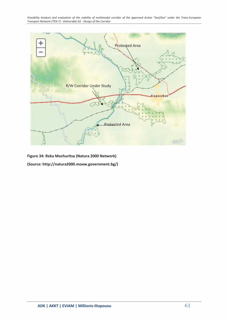
Feasibility Analysis and evaluation of the viability of multimodal corridor of the approved Action "Sea2Sea" under the Trans-European Transport Network (TEN-T) - Deliverable D2 - Design of the Corridor
ΑDΚ | AKKT | ΕVΙΑΜ | Millionis-Iliopouou 61
Figure 34: Reka Mochuritsa (Natura 2000 Network)
(Source: http://natura2000.moew.government.bg/)
Protected Area
R/W Corridor Under Study
Protected Area
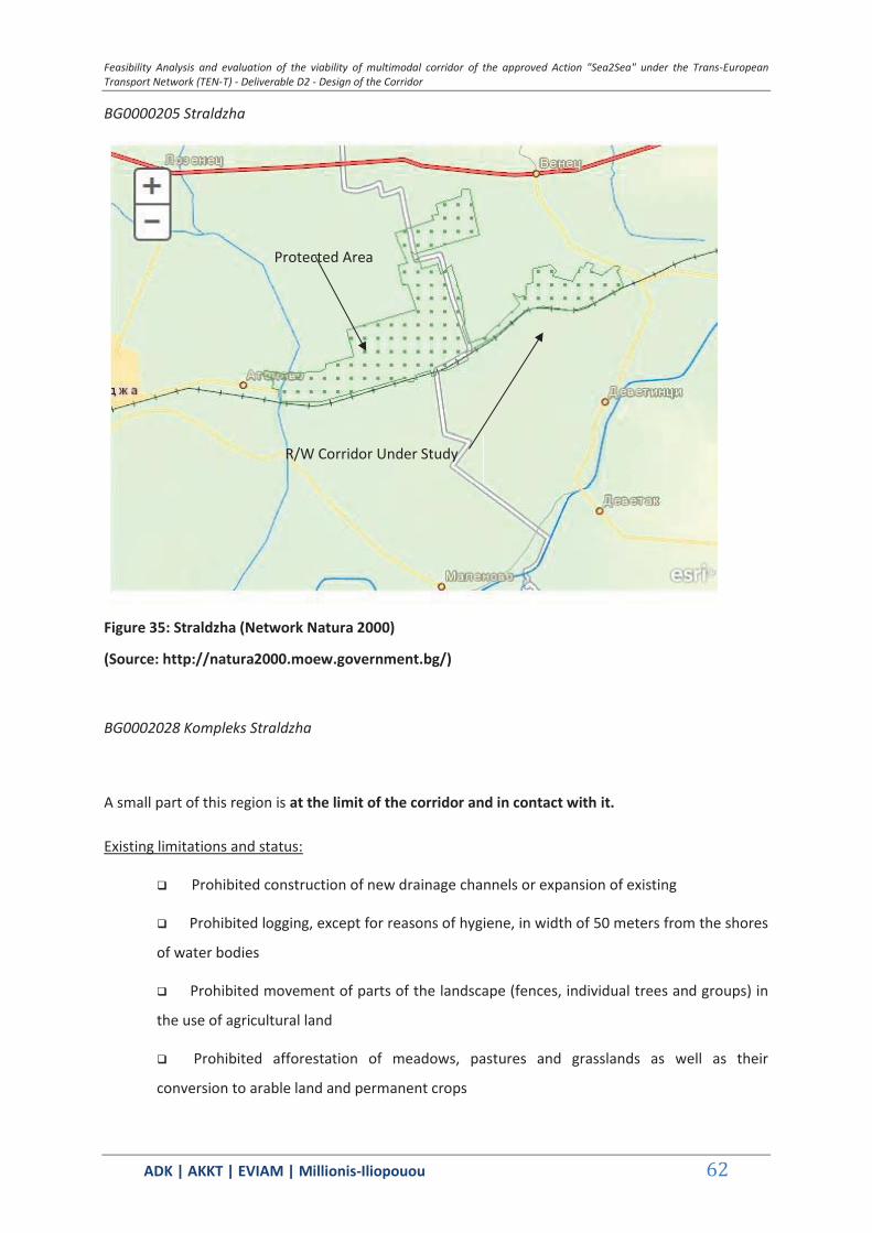
Feasibility Analysis and evaluation of the viability of multimodal corridor of the approved Action "Sea2Sea" under the Trans-European Transport Network (TEN-T) - Deliverable D2 - Design of the Corridor
ΑDΚ | AKKT | ΕVΙΑΜ | Millionis-Iliopouou 62
BG0000205 Straldzha
Figure 35: Straldzha (Network Natura 2000)
(Source: http://natura2000.moew.government.bg/)
BG0002028 Kompleks Straldzha
A small part of this region is at the limit of the corridor and in contact with it.
Existing limitations and status:
Prohibited construction of new drainage channels or expansion of existing
Prohibited logging, except for reasons of hygiene, in width of 50 meters from the shores
of water bodies
Prohibited movement of parts of the landscape (fences, individual trees and groups) in
the use of agricultural land
Prohibited afforestation of meadows, pastures and grasslands as well as their
conversion to arable land and permanent crops
Protected Area
R/W Corridor Under Study
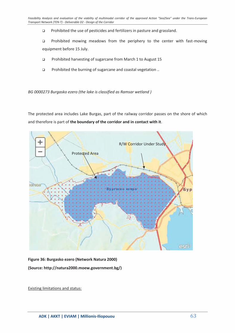
Feasibility Analysis and evaluation of the viability of multimodal corridor of the approved Action "Sea2Sea" under the Trans-European Transport Network (TEN-T) - Deliverable D2 - Design of the Corridor
ΑDΚ | AKKT | ΕVΙΑΜ | Millionis-Iliopouou 63
Prohibited the use of pesticides and fertilizers in pasture and grassland.
Prohibited mowing meadows from the periphery to the center with fast-moving
equipment before 15 July.
Prohibited harvesting of sugarcane from March 1 to August 15
Prohibited the burning of sugarcane and coastal vegetation ..
BG 0000273 Burgasko ezero (the lake is classified as Ramsar wetland )
The protected area includes Lake Burgas, part of the railway corridor passes on the shore of which
and therefore is part of the boundary of the corridor and in contact with it.
Figure 36: Burgasko ezero (Network Natura 2000)
(Source: http://natura2000.moew.government.bg/)
Existing limitations and status:
Protected Area
R/W Corridor Under Study
Feasibility Analysis and evaluation of the viability of multimodal corridor of the approved Action "Sea2Sea" under the Trans-European Transport Network (TEN-T) - Deliverable D2 - Design of the Corridor
ΑDΚ | AKKT | ΕVΙΑΜ | Millionis-Iliopouou 64
Prohibited afforestation of meadows, pastures and grasslands as well as their conversion
to arable land and permanent crops
Prohibited use of pesticides and fertilizers in pasture and grassland.
Prohibited harvest of sugarcane from March 1 to August 15
Prohibited burning of sugarcane and coastal vegetation. .
1.3.9 Section 4 - Stara Zagora - Varna Protected Areas along the studied corridor and that improvements
TABLE 1.14: PROTECTED AREAS OF THE STUDIED CORRIDOR - SECTION 4
s / n Code Category Name Area (ha)
NATURA AREAS
BG0000192 SCI Reka Tundzha 1 * 9502.9987
BG0001493 SCI Tsentralen Balkan Bufer
138353.6175
BG0000399 SCI SPA Bulgarka 23996.7500
BG0000282 SCI Dryanovska Reka 1381460.0000
BG0000214 SCI Dryanovski Manastir
2987.6707
BG0000213 SCI Tarnovski Visochini
4434.3584
BG0000610 SCI Reka Yantra 13907.5505
BG0000432 SCI Golyama Reka 7456.8446
BG0000279 SCI Stara Reka 146.1587
BG0000104 SCI Provadiosko Royasko Plato
50198.0929

Feasibility Analysis and evaluation of the viability of multimodal corridor of the approved Action "Sea2Sea" under the Trans-European Transport Network (TEN-T) - Deliverable D2 - Design of the Corridor
ΑDΚ | AKKT | ΕVΙΑΜ | Millionis-Iliopouou 65
BG0002038 SPA Provadiosko Royasko Plato
84631.7767
BG0000138 SCI Kamenitsa 1455.6890
BG0000191 SPA Varnesko Beloslavo Ezero
4686.7767
Ramsar sites
Atanasovsko Lake (Partially Maintained Reserve)
1404.0000
Natural Parks
10 Balgarka 21772.1600
Protected Sites
209 Dryanovski Manastir
314.1400
8 Kalpunar 12.0000
* Area stretching in to Section 3
BG0001493 Tsentralen Balkan - Bufer

Feasibility Analysis and evaluation of the viability of multimodal corridor of the approved Action "Sea2Sea" under the Trans-European Transport Network (TEN-T) - Deliverable D2 - Design of the Corridor
ΑDΚ | AKKT | ΕVΙΑΜ | Millionis-Iliopouou 66
Figure 37: Tsentralen Balkan - Bufer (Natura 2000 Network)
(Source: http://natura2000.moew.government.bg/)
BG0000399 Bulgarka and Balgarka Nature Park (Directive No.PD-775 09.08.2002
Existing limitations and status (NATURA area):
Prohibited afforestation of meadows, pastures and grasslands as well as their
conversion to arable land and permanent crops
Prohibited use of pesticides and fertilizers in pasture and grassland.
Prohibited mowing meadows from the periphery to the center with fast-moving
equipment before 15 July.
Protected Area

Feasibility Analysis and evaluation of the viability of multimodal corridor of the approved Action "Sea2Sea" under the Trans-European Transport Network (TEN-T) - Deliverable D2 - Design of the Corridor
ΑDΚ | AKKT | ΕVΙΑΜ | Millionis-Iliopouou 67
Figure 38: Bulgarka (Natura 2000 Network)
(Source: http://natura2000.moew.government.bg/)
Figure 39: Park Map Balgarka
(Source: http://www.ppbulgarka.net/ )
Protected Area
Part of R/W corridor in the area

Feasibility Analysis and evaluation of the viability of multimodal corridor of the approved Action "Sea2Sea" under the Trans-European Transport Network (TEN-T) - Deliverable D2 - Design of the Corridor
ΑDΚ | AKKT | ΕVΙΑΜ | Millionis-Iliopouou 68
Figure 40: Park Map Balgarka - railway network transit area
(Source: http://www.ppbulgarka.net/ )
Existing limitations and status (Nature Park area):
Prohibited felling for cleaning in high forest, except poplar forests and shrubland - an
area larger than three hectares
Prohibited the import of plant and animal species that are not representative of the
area
Prohibited grazing to domestic animals outside the designated areas.
Prohibited collection of fossils and minerals, with destruction of rocks
Prohibited contamination of waters and soils with domestic, industrial and other waste
Prohibited camping and fire outside the designated areas
Prohibited export of metals using the open method
Prohibited export and processing of metallic minerals by applying chemicals and
bacteriologicals
Prohibited execution of all the activities and structures, which are not authorized by the
directives and regulations of the park, the park management plan, and the management and
technical plans and projects
Part of R/W Corridor passing
through Park
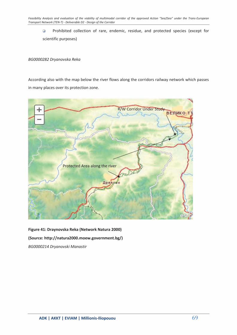
Feasibility Analysis and evaluation of the viability of multimodal corridor of the approved Action "Sea2Sea" under the Trans-European Transport Network (TEN-T) - Deliverable D2 - Design of the Corridor
ΑDΚ | AKKT | ΕVΙΑΜ | Millionis-Iliopouou 69
Prohibited collection of rare, endemic, residue, and protected species (except for
scientific purposes)
BG0000282 Dryanovska Reka
According also with the map below the river flows along the corridors railway network which passes
in many places over its protection zone.
Figure 41: Draynovska Reka (Network Natura 2000)
(Source: http://natura2000.moew.government.bg/)
BG0000214 Dryanovski Manastir
R/W Corridor Under Study
Protected Area along the river
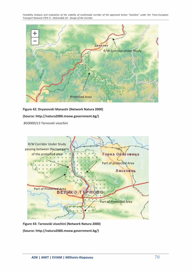
Feasibility Analysis and evaluation of the viability of multimodal corridor of the approved Action "Sea2Sea" under the Trans-European Transport Network (TEN-T) - Deliverable D2 - Design of the Corridor
ΑDΚ | AKKT | ΕVΙΑΜ | Millionis-Iliopouou 70
Figure 42: Dryanovski Manastir (Network Natura 2000)
(Source: http://natura2000.moew.government.bg/)
BG0000213 Tarnovski visochini
Figure 43: Tarnovski visochini (Network Natura 2000)
(Source: http://natura2000.moew.government.bg/)
R/W Corridor Under Study
Protected Area
R/W Corridor Under Study passing between the two parts
of the protected area
Part of Protected Area
Part of protected Area
Part of Protected Area
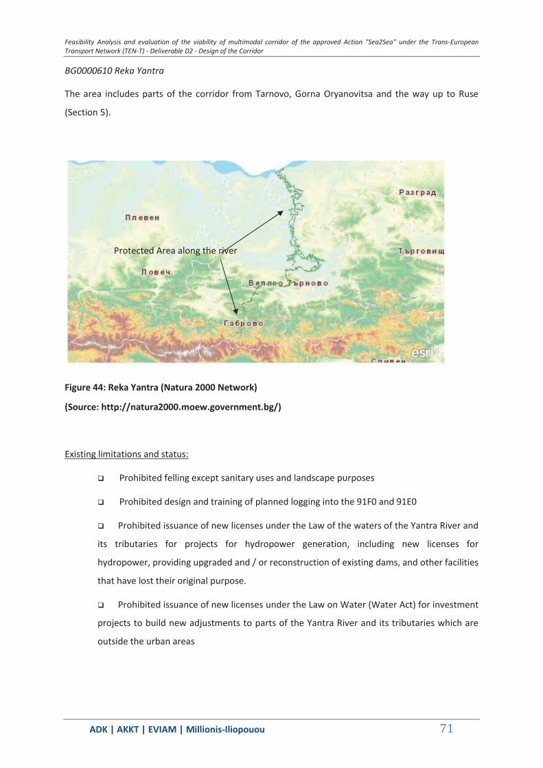
Feasibility Analysis and evaluation of the viability of multimodal corridor of the approved Action "Sea2Sea" under the Trans-European Transport Network (TEN-T) - Deliverable D2 - Design of the Corridor
ΑDΚ | AKKT | ΕVΙΑΜ | Millionis-Iliopouou 71
BG0000610 Reka Yantra
The area includes parts of the corridor from Tarnovo, Gorna Oryanovitsa and the way up to Ruse
(Section 5).
Figure 44: Reka Yantra (Natura 2000 Network)
(Source: http://natura2000.moew.government.bg/)
Existing limitations and status:
Prohibited felling except sanitary uses and landscape purposes
Prohibited design and training of planned logging into the 91F0 and 91E0
Prohibited issuance of new licenses under the Law of the waters of the Yantra River and
its tributaries for projects for hydropower generation, including new licenses for
hydropower, providing upgraded and / or reconstruction of existing dams, and other facilities
that have lost their original purpose.
Prohibited issuance of new licenses under the Law on Water (Water Act) for investment
projects to build new adjustments to parts of the Yantra River and its tributaries which are
outside the urban areas
Protected Area along the river
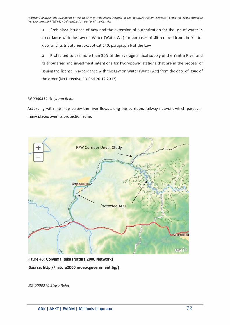
Feasibility Analysis and evaluation of the viability of multimodal corridor of the approved Action "Sea2Sea" under the Trans-European Transport Network (TEN-T) - Deliverable D2 - Design of the Corridor
ΑDΚ | AKKT | ΕVΙΑΜ | Millionis-Iliopouou 72
Prohibited issuance of new and the extension of authorization for the use of water in
accordance with the Law on Water (Water Act) for purposes of silt removal from the Yantra
River and its tributaries, except cat.140, paragraph 6 of the Law
Prohibited to use more than 30% of the average annual supply of the Yantra River and
its tributaries and investment intentions for hydropower stations that are in the process of
issuing the license in accordance with the Law on Water (Water Act) from the date of issue of
the order (No Directive.PD-966 20.12.2013)
BG0000432 Golyama Reka
According with the map below the river flows along the corridors railway network which passes in
many places over its protection zone.
Figure 45: Golyama Reka (Natura 2000 Network)
(Source: http://natura2000.moew.government.bg/)
BG 0000279 Stara Reka
R/W Corridor Under Study
Protected Area
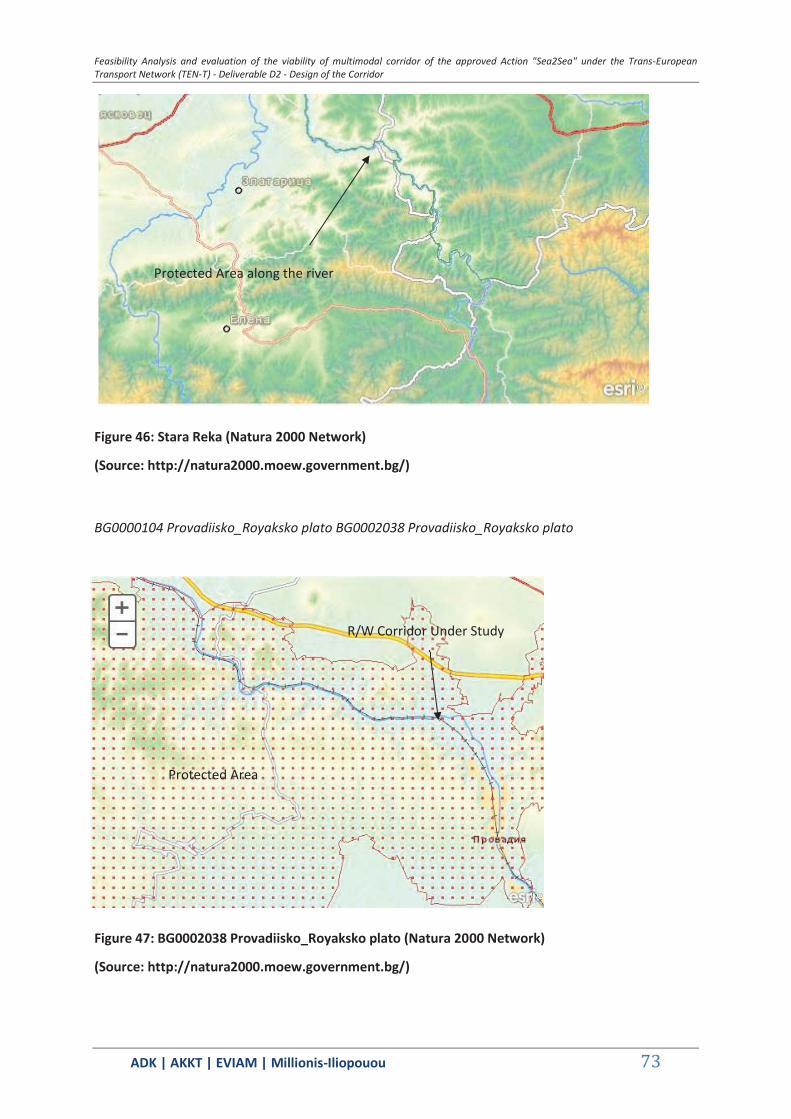
Feasibility Analysis and evaluation of the viability of multimodal corridor of the approved Action "Sea2Sea" under the Trans-European Transport Network (TEN-T) - Deliverable D2 - Design of the Corridor
ΑDΚ | AKKT | ΕVΙΑΜ | Millionis-Iliopouou 73
Figure 46: Stara Reka (Natura 2000 Network)
(Source: http://natura2000.moew.government.bg/)
BG0000104 Provadiisko_Royaksko plato BG0002038 Provadiisko_Royaksko plato
Figure 47: BG0002038 Provadiisko_Royaksko plato (Natura 2000 Network)
(Source: http://natura2000.moew.government.bg/)
Protected Area along the river
Protected Area
R/W Corridor Under Study
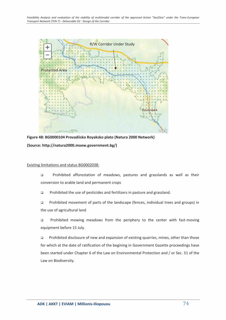
Feasibility Analysis and evaluation of the viability of multimodal corridor of the approved Action "Sea2Sea" under the Trans-European Transport Network (TEN-T) - Deliverable D2 - Design of the Corridor
ΑDΚ | AKKT | ΕVΙΑΜ | Millionis-Iliopouou 74
Figure 48: BG0000104 Provadiisko Royaksko plato (Natura 2000 Network)
(Source: http://natura2000.moew.government.bg/)
Existing limitations and status BG0002038:
Prohibited afforestation of meadows, pastures and grasslands as well as their
conversion to arable land and permanent crops
Prohibited the use of pesticides and fertilizers in pasture and grassland.
Prohibited movement of parts of the landscape (fences, individual trees and groups) in
the use of agricultural land
Prohibited mowing meadows from the periphery to the center with fast-moving
equipment before 15 July.
Prohibited disclosure of new and expansion of existing quarries, mines, other than those
for which at the date of ratification of the begining in Government Gazette proceedings have
been started under Chapter 6 of the Law on Environmental Protection and / or Sec. 31 of the
Law on Biodiversity.
Protected Area
R/W Corridor Under Study

Feasibility Analysis and evaluation of the viability of multimodal corridor of the approved Action "Sea2Sea" under the Trans-European Transport Network (TEN-T) - Deliverable D2 - Design of the Corridor
ΑDΚ | AKKT | ΕVΙΑΜ | Millionis-Iliopouou 75
Figure 49: Kamenitsa (Natura 2000 Network)
(Source: http://natura2000.moew.government.bg/)
BG0000138 Kamenitsa
According also with the above map the river flows along the corridors railway network which passes in many places over its protection zone.
BG0000191 and Ramsar Site Varnesko Beloslavo Ezero -
Protected Area along river
R/W Corridor Under Study
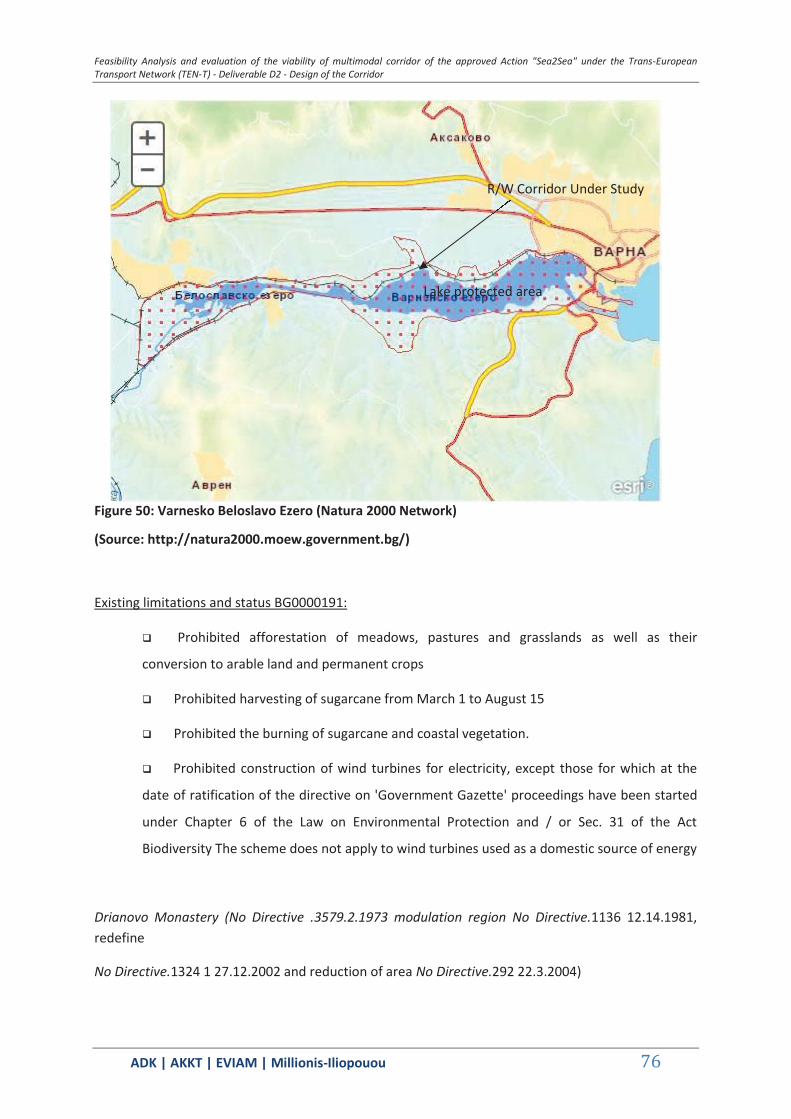
Feasibility Analysis and evaluation of the viability of multimodal corridor of the approved Action "Sea2Sea" under the Trans-European Transport Network (TEN-T) - Deliverable D2 - Design of the Corridor
ΑDΚ | AKKT | ΕVΙΑΜ | Millionis-Iliopouou 76
Figure 50: Varnesko Beloslavo Ezero (Natura 2000 Network)
(Source: http://natura2000.moew.government.bg/)
Existing limitations and status BG0000191:
Prohibited afforestation of meadows, pastures and grasslands as well as their
conversion to arable land and permanent crops
Prohibited harvesting of sugarcane from March 1 to August 15
Prohibited the burning of sugarcane and coastal vegetation.
Prohibited construction of wind turbines for electricity, except those for which at the
date of ratification of the directive on 'Government Gazette' proceedings have been started
under Chapter 6 of the Law on Environmental Protection and / or Sec. 31 of the Act
Biodiversity The scheme does not apply to wind turbines used as a domestic source of energy
Drianovo Monastery (No Directive .3579.2.1973 modulation region No Directive.1136 12.14.1981, redefine
No Directive.1324 1 27.12.2002 and reduction of area No Directive.292 22.3.2004)
Lake protected area
R/W Corridor Under Study
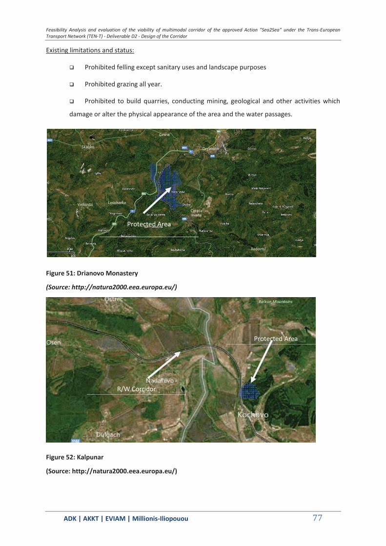
Feasibility Analysis and evaluation of the viability of multimodal corridor of the approved Action "Sea2Sea" under the Trans-European Transport Network (TEN-T) - Deliverable D2 - Design of the Corridor
ΑDΚ | AKKT | ΕVΙΑΜ | Millionis-Iliopouou 77
Existing limitations and status:
Prohibited felling except sanitary uses and landscape purposes
Prohibited grazing all year.
Prohibited to build quarries, conducting mining, geological and other activities which
damage or alter the physical appearance of the area and the water passages.
Figure 51: Drianovo Monastery
(Source: http://natura2000.eea.europa.eu/)
Figure 52: Kalpunar
(Source: http://natura2000.eea.europa.eu/)
Protected Area
Protected Area
R/W Corridor
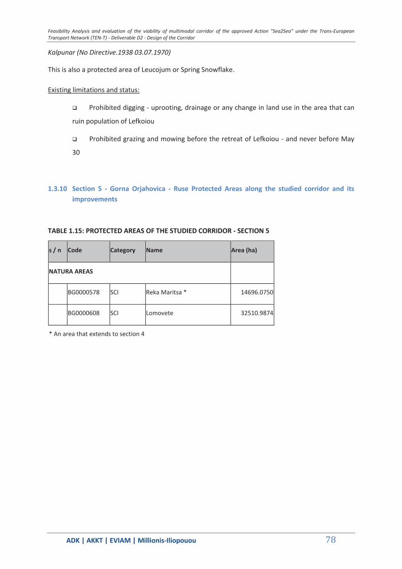
Feasibility Analysis and evaluation of the viability of multimodal corridor of the approved Action "Sea2Sea" under the Trans-European Transport Network (TEN-T) - Deliverable D2 - Design of the Corridor
ΑDΚ | AKKT | ΕVΙΑΜ | Millionis-Iliopouou 78
Kalpunar (No Directive.1938 03.07.1970)
This is also a protected area of Leucojum or Spring Snowflake.
Existing limitations and status:
Prohibited digging - uprooting, drainage or any change in land use in the area that can
ruin population of Lefkoiou
Prohibited grazing and mowing before the retreat of Lefkoiou - and never before May
30
1.3.10 Section 5 - Gorna Orjahovica - Ruse Protected Areas along the studied corridor and its improvements
TABLE 1.15: PROTECTED AREAS OF THE STUDIED CORRIDOR - SECTION 5
s / n Code Category Name Area (ha)
NATURA AREAS
BG0000578 SCI Reka Maritsa * 14696.0750
BG0000608 SCI Lomovete 32510.9874
* An area that extends to section 4
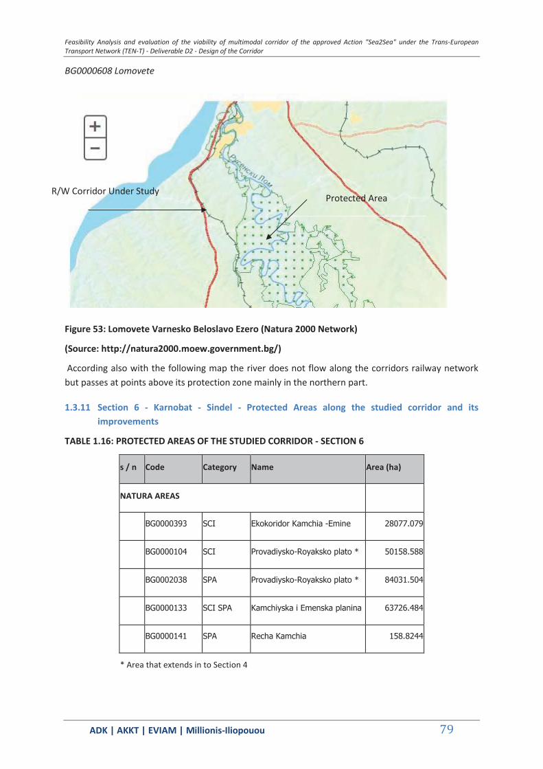
Feasibility Analysis and evaluation of the viability of multimodal corridor of the approved Action "Sea2Sea" under the Trans-European Transport Network (TEN-T) - Deliverable D2 - Design of the Corridor
ΑDΚ | AKKT | ΕVΙΑΜ | Millionis-Iliopouou 79
BG0000608 Lomovete
Figure 53: Lomovete Varnesko Beloslavo Ezero (Natura 2000 Network)
(Source: http://natura2000.moew.government.bg/)
According also with the following map the river does not flow along the corridors railway network but passes at points above its protection zone mainly in the northern part.
1.3.11 Section 6 - Karnobat - Sindel - Protected Areas along the studied corridor and its improvements
TABLE 1.16: PROTECTED AREAS OF THE STUDIED CORRIDOR - SECTION 6
s / n Code Category Name Area (ha)
NATURA AREAS
BG0000393 SCI Ekokoridor Kamchia -Emine 28077.079
BG0000104 SCI Provadiysko-Royaksko plato * 50158.588
BG0002038 SPA Provadiysko-Royaksko plato * 84031.504
BG0000133 SCI SPA Kamchiyska i Emenska planina 63726.484
BG0000141 SPA Recha Kamchia 158.8244
* Area that extends in to Section 4
Protected Area R/W Corridor Under Study
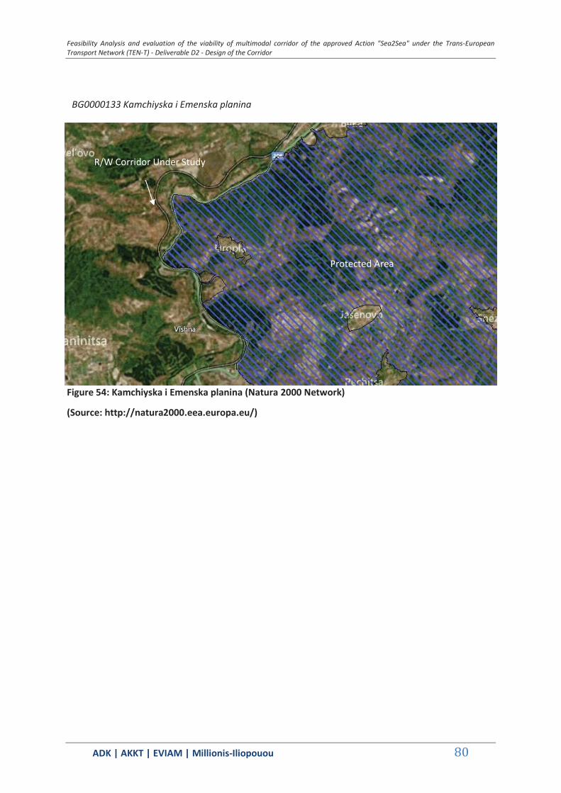
Feasibility Analysis and evaluation of the viability of multimodal corridor of the approved Action "Sea2Sea" under the Trans-European Transport Network (TEN-T) - Deliverable D2 - Design of the Corridor
ΑDΚ | AKKT | ΕVΙΑΜ | Millionis-Iliopouou 80
BG0000133 Kamchiyska i Emenska planina
Figure 54: Kamchiyska i Emenska planina (Natura 2000 Network)
(Source: http://natura2000.eea.europa.eu/)
Protected Area
R/W Corridor Under Study
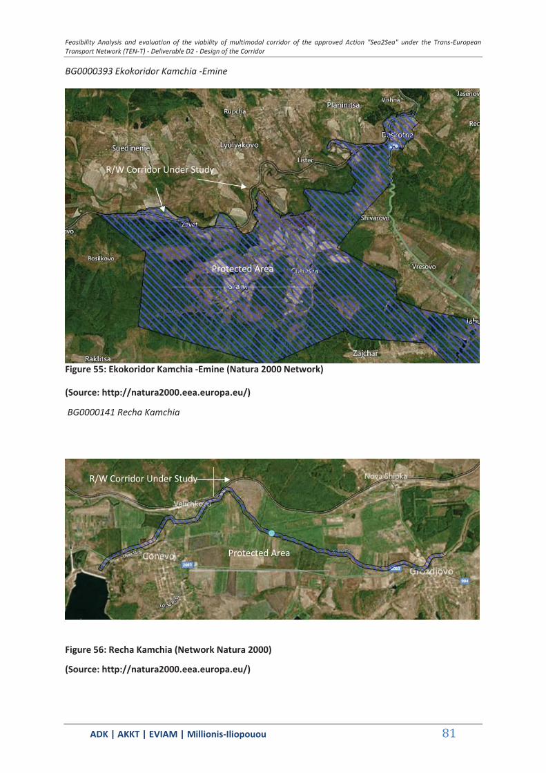
Feasibility Analysis and evaluation of the viability of multimodal corridor of the approved Action "Sea2Sea" under the Trans-European Transport Network (TEN-T) - Deliverable D2 - Design of the Corridor
ΑDΚ | AKKT | ΕVΙΑΜ | Millionis-Iliopouou 81
BG0000393 Ekokoridor Kamchia -Emine
Figure 55: Ekokoridor Kamchia -Emine (Natura 2000 Network)
(Source: http://natura2000.eea.europa.eu/)
BG0000141 Recha Kamchia
Figure 56: Recha Kamchia (Network Natura 2000)
(Source: http://natura2000.eea.europa.eu/)
Protected Area
R/W Corridor Under Study
Protected Area
R/W Corridor Under Study

Feas
ibili
ty A
naly
sis a
nd e
valu
atio
n of
the
viab
ility
of m
ultim
odal
corr
idor
of t
he a
ppro
ved
Actio
n "S
ea2S
ea" u
nder
the
Tran
s-Eu
rope
an T
rans
port
Net
wor
k (T
EN-T
) - D
eliv
erab
le D
2 - D
esig
n of
the
Corr
idor
ΑDΚ
| AK
KT |
ΕVΙΑΜ
| M
illio
nis-
Iliop
ouou
82
Fi
gure
57:
Nat
ura
area
s alo
ng th
e st
udie
d co
rrid
or a
nd it
s im
prov
emen
ts (e
xclu
ding
sect
ion
6 Ka
rnob
at -
Sind
el)
Co
rrid
or U
nder
Stu
dy
SP
A Ar
eas
SC
I Are
as
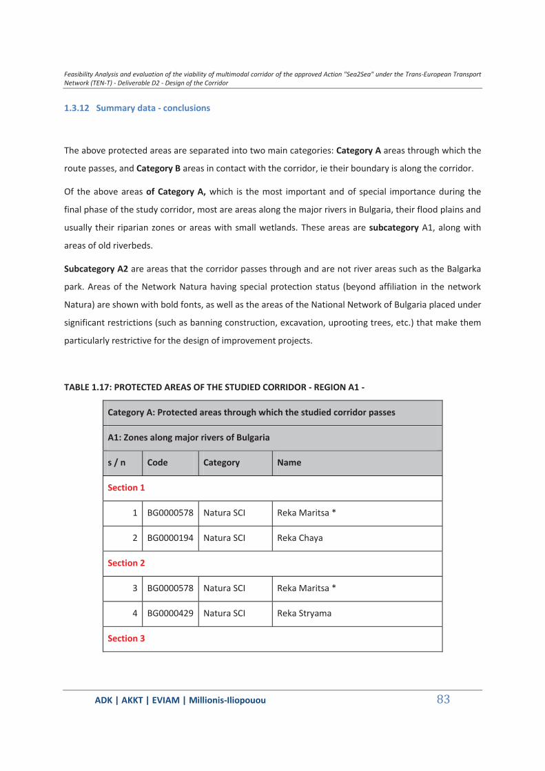
Feasibility Analysis and evaluation of the viability of multimodal corridor of the approved Action "Sea2Sea" under the Trans-European Transport Network (TEN-T) - Deliverable D2 - Design of the Corridor
ΑDΚ | AKKT | ΕVΙΑΜ | Millionis-Iliopouou 83
1.3.12 Summary data - conclusions
The above protected areas are separated into two main categories: Category A areas through which the
route passes, and Category B areas in contact with the corridor, ie their boundary is along the corridor.
Of the above areas of Category A, which is the most important and of special importance during the
final phase of the study corridor, most are areas along the major rivers in Bulgaria, their flood plains and
usually their riparian zones or areas with small wetlands. These areas are subcategory A1, along with
areas of old riverbeds.
Subcategory A2 are areas that the corridor passes through and are not river areas such as the Balgarka
park. Areas of the Network Natura having special protection status (beyond affiliation in the network
Natura) are shown with bold fonts, as well as the areas of the National Network of Bulgaria placed under
significant restrictions (such as banning construction, excavation, uprooting trees, etc.) that make them
particularly restrictive for the design of improvement projects.
TABLE 1.17: PROTECTED AREAS OF THE STUDIED CORRIDOR - REGION A1 -
Category A: Protected areas through which the studied corridor passes
A1: Zones along major rivers of Bulgaria
s / n Code Category Name
Section 1
1 BG0000578 Natura SCI Reka Maritsa *
2 BG0000194 Natura SCI Reka Chaya
Section 2
3 BG0000578 Natura SCI Reka Maritsa *
4 BG0000429 Natura SCI Reka Stryama
Section 3
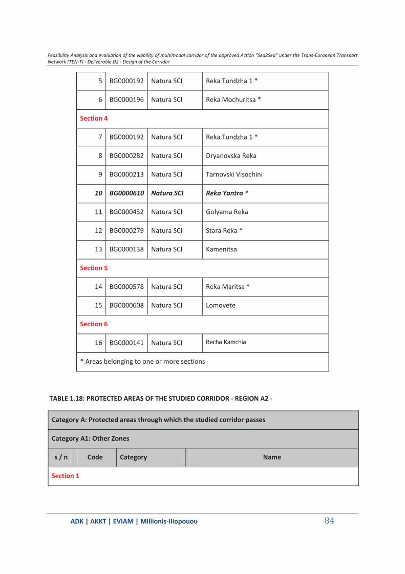
Feasibility Analysis and evaluation of the viability of multimodal corridor of the approved Action "Sea2Sea" under the Trans-European Transport Network (TEN-T) - Deliverable D2 - Design of the Corridor
ΑDΚ | AKKT | ΕVΙΑΜ | Millionis-Iliopouou 84
5 BG0000192 Natura SCI Reka Tundzha 1 *
6 BG0000196 Natura SCI Reka Mochuritsa *
Section 4
7 BG0000192 Natura SCI Reka Tundzha 1 *
8 BG0000282 Natura SCI Dryanovska Reka
9 BG0000213 Natura SCI Tarnovski Visochini
10 BG0000610 Natura SCI Reka Yantra *
11 BG0000432 Natura SCI Golyama Reka
12 BG0000279 Natura SCI Stara Reka *
13 BG0000138 Natura SCI Kamenitsa
Section 5
14 BG0000578 Natura SCI Reka Maritsa *
15 BG0000608 Natura SCI Lomovete
Section 6
16 BG0000141 Natura SCI Recha Kamchia
* Areas belonging to one or more sections
TABLE 1.18: PROTECTED AREAS OF THE STUDIED CORRIDOR - REGION A2 -
Category A: Protected areas through which the studied corridor passes
Category A1: Other Zones
s / n Code Category Name
Section 1

Feasibility Analysis and evaluation of the viability of multimodal corridor of the approved Action "Sea2Sea" under the Trans-European Transport Network (TEN-T) - Deliverable D2 - Design of the Corridor
ΑDΚ | AKKT | ΕVΙΑΜ | Millionis-Iliopouou 85
17 BG0001034 Natura SCI SPA Ostar kamak
18 311 Natural Monument Nahodishte Na Blatno Kokiche - Mestnost Sazlaka
19 276 Natural Monument Fosilni Nahodki
Section 3
20 BG0000205 Natura SCI SPA Straldzha
Section 4
21 BG0001493 Natura SCI Tsentralen Balkan Bufer
22 BG0000399 Natura SCI SPA Bulgarka
23 BG0000214 Natura SCI Dryanovski Manastir
24 BG0000104 Natura SCI Provadiosko Royasko Plato *
25 BG0002038 Natura SPA Provadiosko Royasko Plato *
26 BG0000191 Natura SPA Varnesko Beloslavo Ezero
27 Ramsar Site Atanasovsko Lake
28 10 Natural Park Balgarka
29 209 Protected Site Dryanovski Manastir
Section 6
30 BG0000393 Natura SCI Ekokoridor Kamchia -Emine
* Areas belonging to one or more sections
TABLE 1.19: PROTECTED AREAS WHICH ABUTS THE STUDIED CORRIDOR - REGION B -
Category B: Protected areas in which the studied corridor abuts
s / n Code Category Name

Feasibility Analysis and evaluation of the viability of multimodal corridor of the approved Action "Sea2Sea" under the Trans-European Transport Network (TEN-T) - Deliverable D2 - Design of the Corridor
ΑDΚ | AKKT | ΕVΙΑΜ | Millionis-Iliopouou 86
Section 1
31 BG0002103 Natura SPA Zlato Pole
32 174 Protected Site Chirpanska Koria
Section 3
33 BG0002028 Natura SPA Kompleks Straldzha
34 BG0000273 Natura SCI SPA Burgasko ezero
35 BG0002094 Natura SPA Adata Tundzha
36 Ramsar Site Vaya Lake
Section 4
37 Protected Site Kalpunar
Section 6
38 BG0000133 Natura SCI SPA Kamchiyska i Emenska planina
* Areas belonging to one or more sections
Key conclusions
V. Within the path of the studied corridor and its interventions, protected areas exist that
include zones - areas along Bulgaria's major rivers (eg Reka Maritsa, Reka Yantra), their flood
plain and usually their riparian zone or areas along side. In many of these areas the river
flows along the corridors railway network, which passes at several points over its protection
area.
VI. The corridor passes through seven seven regions of the Natura network and the
National Network of Bulgaria which have special protection status (beyond affiliation with
network Natura) and regions of the National Network of Bulgaria placed under significant
restrictions (such as banning construction, excavation, uprooting trees, etc.) that make it
particularly restrictive for the design of improvement projects. Such areas is the area of the
Park Balgarka, the corresponding Natura Bulgarka, the Natura Provadiosko Royasko Plato,
Feasibility Analysis and evaluation of the viability of multimodal corridor of the approved Action "Sea2Sea" under the Trans-European Transport Network (TEN-T) - Deliverable D2 - Design of the Corridor
ΑDΚ | AKKT | ΕVΙΑΜ | Millionis-Iliopouou 87
the Natura Reka Yantra etc. (See relevant Table). Particular attention should be given to the
region Nahodishte Na Blatno Kokiche - Mestnost Sazlaka and in other areas of protection of
Leucojum aestivum, because the constraints are particularly stringent.
VII. One of the most important protected areas is in the central part of the corridor, the
Natural Park Balgarka and included in it also the Natura areas Bulgarka and Tsentralen
Balkan Bufer (buffer zone of the largest National Park of Bulgaria Tsentralen Balkan Park).
These areas are very important ecosystems for the Balkan Brown Bear.
VIII. In the interior part of the corridor, from Stara Zagora to Varna (Section 4) the most and
larger protected areas are found.

Feasibility Analysis and evaluation of the viability of multimodal corridor of the approved Action "Sea2Sea" under the Trans-European Transport Network (TEN-T) - Deliverable D2 - Design of the Corridor
ΑDΚ | AKKT | ΕVΙΑΜ | Millionis-Iliopouou 88
2 FORMULATION OF IMPROVEMENT PROJECT MIX AND ACTION PLAN
The Consultant attempts to prioritize the interventions based on parameters such as (not limited to) the study results on the feasibility of the corridor, the parts of it that demonstrate greater potential, the estimated environmental and socioeconomic impacts, the availability and readiness of funding and their state within the scheduled framework programmes.
2.1 Administrative and preparatory actions
The Action Plan [AP] emphasizes on the necessary actions to be taken in order to initialize the steps forward to the development of the Sea2Sea corridor service. The actions to be taken include the creation of coordination/supervision administrative units covering both sides of the corridor, and the preparatory actions which are prerequisites to allow corridor operations after the completion of Stage 1 investments.
The administrative steps which should be made refer to the total process of corridor implementation. Given the very early phase of corridor market development, all structures must be flexible, to allow for adjustments in the future.
The development of the corridor (as a result of coordinated planning and operations of the two rail systems and of cooperation and optimization of custom procedures), is a decision which is definitely strongly supported by the goals of the TEN-T network policy. However, at this planning stage, as it is indicated from the demand analysis and transport modeling carried out in D.1 of the project, the potential of the SEA2SEA corridor, defined as potential shift container traffic demand from the Bosporus Straights to a land bridge connecting the Greek ports with the Bulgarian ones, is not definitely identified (whilst it is more probable that container traffic to/from South East Bulgaria may shift to Alexandroupolis port, and, consequently, the financial analysis of the project is based on that estimate). The Action Plan for the implementation of the future steps of the corridor must be left flexible, to be determined and adjusted by/to the market developments.
The proposed actions on infrastructure improvement coincide with plans which are either planned or implemented by the national authorities and the respective organizations at both sides of the corridor. Most of the infrastructure improvements which are identified as necessary for the operation of the corridor refer to priority axes of the TEN-T network. In the Bulgarian side, most of the projects of Stage 1 are already in advanced construction phase, whilst, in the Greek side, the decision to improve the Alexandroupolis – Ormenio line and the rail connection to the port of Kavala are made as part of the next generation of major rail infrastructure projects. These developments indicate that the SEA2SEA concept can easily be facilitated on existing or planned infrastructures, thus, it doesn’t require major additional investments. However, for the purposes of this report and the sustainability test, it is supposed that the Alexandroupolis – Ormenio project should be attributed to the SEA2SEA implementation plan, since in the present preparation stage by ERGOSE, alternative line freight demand is not indicated.

Feasibility Analysis and evaluation of the viability of multimodal corridor of the approved Action "Sea2Sea" under the Trans-European Transport Network (TEN-T) - Deliverable D2 - Design of the Corridor
ΑDΚ | AKKT | ΕVΙΑΜ | Millionis-Iliopouou 89
The future potential of the corridor will be tested in the “real” container market world. It will highly depend on external factors, related with the regional container transport economics, the competition among regional ports – with which the ports of the corridor compete - and the strategies of the container transporters and forwarders. It is strongly suggested that the planning of implementation of Stages 2 to 4, as far as those actions which are not part of the ongoing planning by the part of the national authorities at each side, must be made in a next stage, based on the grounds of factual achievements of corridor operations.
The technical provisions of the Action Plan are better defined as far as the preparation of Stage 1 of the corridor. All Stage 1 actions are planned to be part of the 2014-20 programming period. Some actions which are classified as parts of the next implementation stages have a good possibility to be part of the 2014-20 period as well.
As necessary actions which must be launched for the implementation of the SEA2SEA corridor are considered:
Administrative Actions (2014-20 Programming Period)
1. The establishment of an Executive Committee [ExC] at Ministerial level by the Greek Ministry of Infrastructure, Transport and Networks and the Bulgarian Ministry of Transportation. The ExC will be the political body to coordinate planning and implementation efforts and to take political decisions which will create a positive environment for the corridor and support its potential.
2. The establishment of a Steering Committee [SC] at the highest administrative level, including representatives from the planning units of the respective Ministries, the rail planning, construction and maintenance bodies, rail operators, port administrators and port operators, as well as custom officers, of both sides. The SC will prepare plans and schedules, will develop proposals on technical issues, referring to the improvement of infrastructure, the optimization of operations, the scheduling, the budgeting and the financing of actions.
3. The establishment of unilateral Coordination SEA2SEA corridor Units [CU] at the suitable strategic planning level by each side, responsible to prepare alternatives, plans and proposals at national level, to be introduced in the SC.
Preparatory Actions (2014-20 Programming Period)
As necessary preparatory actions measures that must be taken within the early times of the 2014-20 programming period are defined. Most of them refer to the Greek side, since the Bulgarian rail system is more developed, offers higher capacity and is well connected with the ports.
Necessary preparatory actions to make possible the launching of SEA2SEA operations are the followings:
The development of an operational container terminal at the port of Alexandroupolis, - following the completion of the dredging works which are in progress – including the addition of handling equipment and building facilities. The issue is highly political, since the decision on the ownership and operational status of the port (and consequently of the terminal) has been made at the government level and is part of the followed privatization policies, but, by all estimates,

Feasibility Analysis and evaluation of the viability of multimodal corridor of the approved Action "Sea2Sea" under the Trans-European Transport Network (TEN-T) - Deliverable D2 - Design of the Corridor
ΑDΚ | AKKT | ΕVΙΑΜ | Millionis-Iliopouou 90
there will be quite some time before any final outcome of the tendering procedures takes place. Since it may take considerable time, the issue represents a factor of high risk as far as the launching of operations of the corridor within the 2014-20 period.
The preparation of the rail operator in the Greek side – for the time being TRAINOSE – to launch regular service from the Greek ports to the borders. This preparation includes the provision for the supply of rolling equipment, the development of fare policy for full customer support from the container yard to the “dry port” station in the neighboring countries, and the agreement with the rail operators of the destination countries as far as the cross-border operations. (It is encouraging that TRAINOSE is currently preparing such a policy as part of its plans to connect the port of Thessaloniki with Skopje).
The provision for completion of the container terminal at the new port of Kavala and the rail connection to Toxotes.
2.2 Scheduling of interventions
In order to present the description and scheduling of the interventions which compose the Action Plan of the SEA2SEA project, an “intervention form” is used, to allow comparability. The form contains a description of the intervention, the context of the intervention and the anticipated impacts, external benefits and costs, as well as estimated cost, possible sources of financing and time scheduling (where it is possible or safe).
The individual forms with the information referring to each intervention are presented in the followings.

Feasibility Analysis and evaluation of the viability of multimodal corridor of the approved Action "Sea2Sea" under the Trans-European Transport Network (TEN-T) - Deliverable D2 - Design of the Corridor
ΑDΚ | AKKT | ΕVΙΑΜ | Millionis-Iliopouou 91
2.2.1 Stage 1 - Improvement of the Alexandroupolis – Ormenio railway line
STAGE 1
TITLE Core Sea2Sea route
DESCRIPTION At this stage, a connection is established between Alexandroupolis and Plovdiv. It includes the part of the corridor which is interregional between Greece and Bulgaria and necessary for the formulation of the corridor and its continuation to the Bulgarian ports of the Black Sea and the transport cooperation among the two countries
INTERVENTION 1.1
Description Improvement of the 180km single track line with electrification and advanced equipment of signaling
Bottleneck addressed Lack of electrification and modern signaling of the Alexandroupolis - Ormenio railway line
STATE OF THE ART
Current conditions
The 180km single track rail line between Alexandroupoli and Ormenio/Bulgarian border has been recently renovated.
Nevertheless, there is lack of electrification infrastructure and advanced signaling equipment.
The passenger demand is serviced by three trains per day in each direction, leaving excess capacity for the freight trains.
Environmental considerations
Main environmental considerations are:
GR1110006 & GR1110007 located at the Delta of Evros river
Feasibility Analysis and evaluation of the viability of multimodal corridor of the approved Action "Sea2Sea" under the Trans-European Transport Network (TEN-T) - Deliverable D2 - Design of the Corridor
ΑDΚ | AKKT | ΕVΙΑΜ | Millionis-Iliopouou 92
GR1110005 at Evros massif GR1110008 at the river margin,
ecosystem of Nothern Evros and Ardas
National Wetland Park of Evros Delta
National Forest Park of Dadia
Context provisions
Main policy objective
Development of safe, consistent and interoperable railway system of high reliance and quality of service
Spatial Planning
Improvement of the quality of the existing transport infrastructure and the relevant services throughout the country, in order to increase the level of accessibility, reduce the time and cost of transport services, increase the safety of transport / transport services (General Framework of Spatial Planning and Sustainable Development - GR)
Emphasis on the interoperability / interconnectivity of the Greek network with those in Bulgaria … (in the context of upgrading the role of rail) (Regional Framework of Spatial Planning and Sustainable Development of the Region of East Macedonia and Thrace - GR)
Integration of East Macedonia and Thrace in wider international transport networks – it depends on the upgrading of the Alexandroupolis - Ormenio axis (road and rail) and its connection with PETC IX (Regional Framework of Spatial Planning and Sustainable Development of the Region of East Macedonia and Thrace - GR)
Improvement of the rail axis Alexandroupolis – Ormenio and its connection with the port of Alexandroupolis - it is characterized as ‘high priority’, since it contributes to the development of the Rail-Road Terminal of Alexandroupolis (Regional Framework of Spatial Planning and Sustainable Development of the Region of East Macedonia and Thrace - GR)
Development programming
Development of safe, consistent and interoperable railway system of high reliance and quality of service (Strategic Investment Programme for Transport 2014-2025 - GR)
Upgrading of the railway network of the Region of East Macedonia and Thrace and completion of connections with the other regions and neighboring states (Strategic Investment Programme for Transport 2014-2025 - GR)
Suggested project ‘Upgrading of certain segments of the Alexandroupolis - Ormenio (Bulgarian border) rail line, renovation of the railway stations at Pythion and Ormenio, full electrification and deployment of automated control system’ (Strategic Transport Investment Plan 2014-2025 (May 2014) - GR)
BUDGETING AND FINANCING
Estimated budget Approx. 85 million €
Potential sources of National Strategic Framework of Greece for the programming
Feasibility Analysis and evaluation of the viability of multimodal corridor of the approved Action "Sea2Sea" under the Trans-European Transport Network (TEN-T) - Deliverable D2 - Design of the Corridor
ΑDΚ | AKKT | ΕVΙΑΜ | Millionis-Iliopouou 93
financing period 2014-2020: Structural Funds
IMPLEMENTATION
Implementation body Hellenic Railways Organization (OSE) - ERGOSE
Key parameters none
Preconditions none
Implementation schedule
The project is under study / proposed potential delivery 2018
ANTICIPATED IMPACTS
Anticipated service benefits
The electrification of this part of the railway network and the upgrading of the signaling systems can improve the interoperability of the corridor, its capacity and safety.
The intervention is expected to increase the commercial speed of the freight trains by 20-30% and the capacity of each freight train due to the increase of the traction power following the electrification of the line.
Along with the implementation of a central management system, the intervention is expected, additionally, to increase safety of rail transport and improve operating conditions, line capacity and service reliability.
The operation and maintenance costs will be significantly reduced.
Anticipated external benefits
Direct and indirect employment for the construction and operation of the project.
Indirect employment impacts in the shipping industry related to the provision of services at the port of Alexandroupolis.
Transport cost savings.
Main anticipated impacts
Railways have a low emission impact on the environment. Due to the presence of significant environmental areas (River Evros Delta, Dadia forest) project EIA should address possible adverse impacts such us ecological encroachment, reduction of the biodiversity, destruction of the vegetation cover, loss of forest products (fuel wood, timber, non timber forest products, perturbation of wildlife habitats and migration and isolation of animal populations).
Anticipated external costs
The external cost of railway is lower than other modes of transport but the electrification brings it down further if it is sustainable. The lower cost of energy from well to wheel and the
Feasibility Analysis and evaluation of the viability of multimodal corridor of the approved Action "Sea2Sea" under the Trans-European Transport Network (TEN-T) - Deliverable D2 - Design of the Corridor
ΑDΚ | AKKT | ΕVΙΑΜ | Millionis-Iliopouou 94
ability to reduce pollution and greenhouse gas in the atmosphere according to the Kyoto Protocol is an advantage.
Based on the main findings on the positive and negative environmental and social/socio-economic impacts and their assessment, measures to avoid, prevent, mitigate or compensate the adverse impacts must be identified and proposed. The mitigation measures proposed must be based on the relevant national, EU and international standards and good practice. At the current conceptual design stage it is estimated that measures will mainly consist of:
a perimeter of protection around sensitive ecosystems, wetlands and unique habitats sheltering endangered species especially during construction works
minimization of construction works in reproduction areas during the reproduction periods.
minimization of sedimentation in spawning grounds downstream.
installation of wide aprons to facilitate animal traction. minimization of the disruption of fish habitat by installing
proper culverts and maintaining regular water flow all-year round.
minimization of land clearing areas. In order to guarantee that the measures are implemented and perform adequately, target and evaluation criteria were developed for each measure and incorporated into a Management and Monitoring Programme defining the specific parameters that will be monitored, their method of checking, their monitoring time, period, and frequency, their location, their threshold levels, and the responsible person/institution in charge of the monitoring.
Mitigation and monitoring measures are expected to take up to 15% of the overall project budget.
Sources of information:
General Framework of Spatial Planning and Sustainable Development – GR Regional Framework of Spatial Planning and Sustainable Development of the Region of East
Macedonia and Thrace – GR Strategic Investment Programme for Transport 2014-2025 – GR Strategic Transport Investment Plan 2014-2025 (May 2014) - GR Railway Gazette International, Oct 2014 "UK Network Rail electrification strategy Report", May 2010 EIB Environmental and Social Handbook Carl E. Hanson, David A. Towers, and Lance D. Meister, (2006) FTA Noise and Vibration Assessment
Manual, 2006 Vegetation Management Guidelines for Rail Corridors, Victorian Rail Industry Environmental Forum,2007
Feasibility Analysis and evaluation of the viability of multimodal corridor of the approved Action "Sea2Sea" under the Trans-European Transport Network (TEN-T) - Deliverable D2 - Design of the Corridor
ΑDΚ | AKKT | ΕVΙΑΜ | Millionis-Iliopouou 95
ERM GmbH & ELCR Group Ltd: Environmental and Social Impact Assessment for the Eurasia Tunnel Project Istanbul, Turkey, 2011
European Bank for Reconstruction and Development: ENVIRONMENTAL AND SOCIAL POLICY, London, 2008
International Union of Railways: Railway Noise in Europe. A 2010 Report in the State of Art, 2010 Rail Net Denmark: Noise, Vibrations and Electromagnetic Fields, Technical Note, 2011 EBRD: A Checklist guide to Evaluating Environmental and Social impact Assessments , 2009
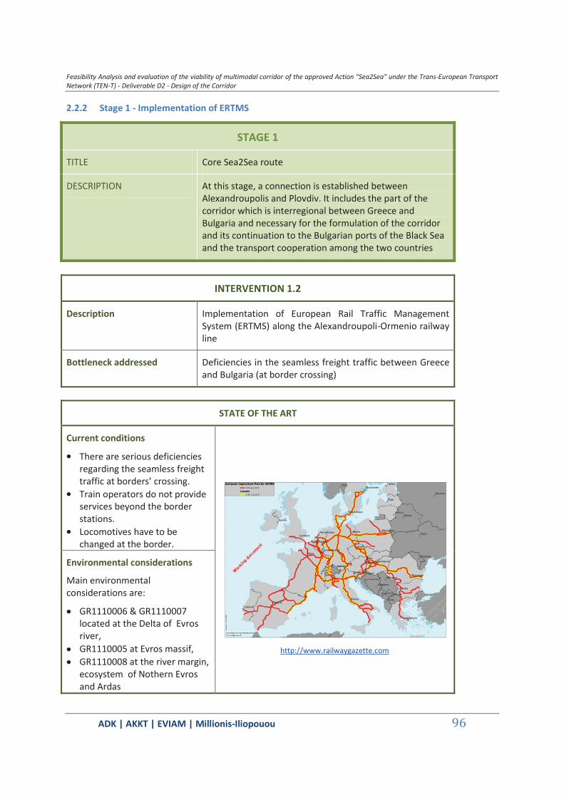
Feasibility Analysis and evaluation of the viability of multimodal corridor of the approved Action "Sea2Sea" under the Trans-European Transport Network (TEN-T) - Deliverable D2 - Design of the Corridor
ΑDΚ | AKKT | ΕVΙΑΜ | Millionis-Iliopouou 96
2.2.2 Stage 1 - Implementation of ERTMS
STAGE 1
TITLE Core Sea2Sea route
DESCRIPTION At this stage, a connection is established between Alexandroupolis and Plovdiv. It includes the part of the corridor which is interregional between Greece and Bulgaria and necessary for the formulation of the corridor and its continuation to the Bulgarian ports of the Black Sea and the transport cooperation among the two countries
INTERVENTION 1.2
Description Implementation of European Rail Traffic Management System (ERTMS) along the Alexandroupoli-Ormenio railway line
Bottleneck addressed Deficiencies in the seamless freight traffic between Greece and Bulgaria (at border crossing)
STATE OF THE ART
Current conditions
There are serious deficiencies regarding the seamless freight traffic at borders’ crossing.
Train operators do not provide services beyond the border stations.
Locomotives have to be changed at the border.
http://www.railwaygazette.com
Environmental considerations
Main environmental considerations are:
GR1110006 & GR1110007 located at the Delta of Evros river,
GR1110005 at Evros massif, GR1110008 at the river margin,
ecosystem of Nothern Evros and Ardas
Feasibility Analysis and evaluation of the viability of multimodal corridor of the approved Action "Sea2Sea" under the Trans-European Transport Network (TEN-T) - Deliverable D2 - Design of the Corridor
ΑDΚ | AKKT | ΕVΙΑΜ | Millionis-Iliopouou 97
National Wetland Park of Evros Delta
National Forest Park of Dadia
Context provisions
Main policy objective
Improvement of the quality / modernisation of the transport infrastructure Improvement of connectivity and integration in the wider international transport
networks
Spatial Planning
Improvement of the quality of the existing transport infrastructure and the relevant services throughout the country, in order to increase the level of accessibility, reduce the time and cost of transport services, increase the safety of transport / transport services (General Framework of Spatial Planning and Sustainable Development - GR)
Optimum exploitation and targeted development of transport infrastructure and cross-border links of the region through its integration in the wider international transport networks, … (Evaluation, Revision and Specification of the approved Regional Framework of Spatial Planning and Sustainable Development of the Region of East Macedonia – Thrace - GR)
Development programming
Develop safe, consistent and interoperable railway system of high reliance and quality of service (Strategic Investment Programme for Transport 2014-2025 – GR)
BUDGETING AND FINANCING
Estimated budget Infrastructure equipment needed for the installation of the ERTMS system on the core Sea2Sea route: The approx. cost of 150,000 € per railway kilometer is commonly attached to the budget of the railway upgrade projects.
On board equipment needed for the operation of the ERTMS system on the core Sea2Sea route: Approx. 2 million €
Potential sources of financing
1. ΙΝΕΑ Call (submission on Feb 2015), 2. National Strategic Frameworks for the programming period 2014-2020: Structural Funds, 3. Cohesion Funds 2014-2020
IMPLEMENTATION
Implementation body Hellenic Railways Organization (OSE) - ERGOSE
Key parameters none
Preconditions none
Feasibility Analysis and evaluation of the viability of multimodal corridor of the approved Action "Sea2Sea" under the Trans-European Transport Network (TEN-T) - Deliverable D2 - Design of the Corridor
ΑDΚ | AKKT | ΕVΙΑΜ | Millionis-Iliopouou 98
Implementation schedule
to be planned / potential delivery 2018
ANTICIPATED IMPACTS
Anticipated service benefits
The intervention will remove the bottleneck at border crossing for the Sea2Sea corridor.
It will enhance cross-border interoperability o remove cross-border bottleneck o build missing cross-border connection o promote modal integration and interoperability
It will bring considerable benefits in addition to interoperability: o Increased capacity on existing lines and a greater ability to
respond to growing transport demands o Higher speeds o Higher reliability rates o Lower production costs o Reduced maintenance costs o An opened supply market o Reduced contract lead time due to the significant reduction
of process engineering o Efficient infrastructure use from using advanced telematics
applications o Enhance safety o Strengthen territorial, economic and social cohesion
Main anticipated impacts
Railways have a low impact on the environment, particularly in comparison with other transport modes and most notably, roads. Due to the presence of significant environmental areas (River Evros Delta, Dadia forest) project EIA should address possible adverse impacts such us ecological encroachment, reduction of the biodiversity, destruction of the vegetation cover, loss of forest products (fuel wood, timber, non timber forest products, perturbation of wildlife habitats and migration and isolation of animal populations where line refurbishment is required.
No adverse impacts ancticipated due to ERTMS system radio waves.
Anticipated external costs
The external cost of railway is lower than other modes of transport but the electrification brings it down further if it is sustainable. Minimization of the bottleneck for the seamless freight traffic between Greece and Bulgaria conserves energy and resources.
Based on the main findings on the positive and negative environmental and social/socio-economic impacts and their
Feasibility Analysis and evaluation of the viability of multimodal corridor of the approved Action "Sea2Sea" under the Trans-European Transport Network (TEN-T) - Deliverable D2 - Design of the Corridor
ΑDΚ | AKKT | ΕVΙΑΜ | Millionis-Iliopouou 99
assessment, measures to avoid, prevent, mitigate or compensate the adverse impacts must be identified and proposed. The mitigation measures proposed must be based on the relevant national, EU and international standards and good practice. At the current conceptual design stage it is estimated that measures will mainly during installation/implementation of ERTMS system on the line infrastructure, consist of:
a perimeter of protection around sensitive ecosystems, wetlands and unique habitats sheltering endangered species especially during construction works
minimization of construction works in reproduction areas during the reproduction periods.
minimization of sedimentation in spawning grounds downstream.
installation of wide aprons to facilitate animal traction. minimization of the disruption of fish habitat by installing
proper culverts and maintaining regular water flow all-year round.
minimization of land clearing areas. Management and Monitoring can be combined with the Programme installed.
Mitigation and monitoring measures can be combined with measures proposed for the electrification of Alexandroupoli – Ormenio reducing cost up to 10% of the overall project budget.
Sources of information:
http://www.ertms.net/?page_id=44 General Framework of Spatial Planning and Sustainable Development – GR Evaluation, Revision and Specification of the approved Regional Framework of Spatial Planning
and Sustainable Development of the Region of East Macedonia – Thrace – GR Strategic Investment Programme for Transport 2014-2025 – GR Railway Gazette International, Oct 2014. "UK Network Rail electrification strategy Report", May 2010 EIB Environmental and Social Handbook Carl E. Hanson, David A. Towers, and Lance D. Meister, (2006) FTA Noise and Vibration Assessment
Manual, 2006 Vegetation Management Guidelines for Rail Corridors, Victorian Rail Industry Environmental
Forum,2007 ERM GmbH & ELCR Group Ltd: Environmental and Social Impact Assessment for the Eurasia
Tunnel Project Istanbul, Turkey, 2011 European Bank for Reconstruction and Development: ENVIRONMENTAL AND SOCIAL POLICY,
London, 2008 International Union of Railways: Railway Noise in Europe. A 2010 Report in the State of Art, 2010 Rail Net Denmark: Noise, Vibrations and Electromagnetic Fields, Technical Note, 2011 EBRD: A Checklist guide to Evaluating Environmental and Social impact Assessments , 2009
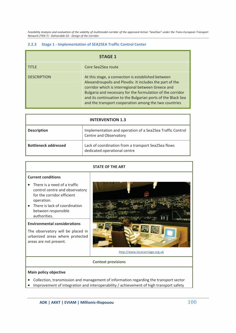
Feasibility Analysis and evaluation of the viability of multimodal corridor of the approved Action "Sea2Sea" under the Trans-European Transport Network (TEN-T) - Deliverable D2 - Design of the Corridor
ΑDΚ | AKKT | ΕVΙΑΜ | Millionis-Iliopouou 100
2.2.3 Stage 1 - Implementation of SEA2SEA Traffic Control Center
STAGE 1
TITLE Core Sea2Sea route
DESCRIPTION At this stage, a connection is established between Alexandroupolis and Plovdiv. It includes the part of the corridor which is interregional between Greece and Bulgaria and necessary for the formulation of the corridor and its continuation to the Bulgarian ports of the Black Sea and the transport cooperation among the two countries
INTERVENTION 1.3
Description Implementation and operation of a Sea2Sea Traffic Control Centre and Observatory
Bottleneck addressed Lack of coordination from a transport Sea2Sea flows dedicated operational centre
STATE OF THE ART
Current conditions
There is a need of a traffic control centre and observatory for the corridor efficient operation.
There is lack of coordination between responsible authorities.
http://www.lococarriage.org.uk
Environmental considerations
The observatory will be placed in urbanized areas where protected areas are not present.
Context provisions
Main policy objective
Collection, transmission and management of information regarding the transport sector Improvement of integration and interoperability / achievement of high transport safety

Feasibility Analysis and evaluation of the viability of multimodal corridor of the approved Action "Sea2Sea" under the Trans-European Transport Network (TEN-T) - Deliverable D2 - Design of the Corridor
ΑDΚ | AKKT | ΕVΙΑΜ | Millionis-Iliopouou 101
and security
Spatial Planning
Development of information and communication technologies (for South-Eastern Region - National Regional Development Strategy (NRDS) of the Republic of Bulgaria for the period 2012-2022 - BG)
Achievement of high transport safety and security – Improvement of the connectivity and integration of Bulgarian regions on a national and international scale (National Development Programme: Bulgaria 2020 - BG)
… creation of nodes at points where optimum performance of the modes can be achieved, … electronic systems for the collection, transmission and management of information regarding the transport sector, in real time (In respect to the creation of integrated intermodal transport systems - General Framework of Spatial Planning and Sustainable Development - GR)
Connection of transport nodes (ports, airports, freight transport centers) through autonomously –as far as possible- transport networks (road and/or rail), in order to avoid congestion (conflict with urban land-uses) (General Framework of Spatial Planning and Sustainable Development - GR)
The infrastructures which will be promoted in the region will be those which … contribute to the increase of trade flows in a targeted way (Evaluation, Revision and Specification of the approved Regional Framework of Spatial Planning and Sustainable Development of the Region of East Macedonia – Thrace - GR)
Emphasis should be placed on the interoperability / interconnectivity of the Greek network with those in Bulgaria (Evaluation, Revision and Specification of the approved Regional Framework of Spatial Planning and Sustainable Development of the Region of East Macedonia – Thrace - GR)
Development programming
The strategy for Bulgarian transport aims to … large-scale application of information and telecommunication technologies (Strategy for the Development of the Transport System of the Republic of Bulgaria until 2020 - BG)
Integration of the Bulgarian transport system into the European transport system (OP "Transport 2007-13" - BG)
Development of safe, consistent and interoperable railway system of high reliance and quality of service (Strategic Investment Programme for Transport 2014-2025 – GR)
Improvement of the connections of the Regions to the international trade, production and urban centers (Strategic Investment Programme for Transport 2014-2025 – GR)
Reduction of traffic bottlenecks (Strategic Investment Programme for Transport 2014-2025 – GR)
BUDGETING AND FINANCING
Estimated budget Approx. 0,7 million €
Potential sources of financing
1. ΙΝΕΑ Call (submission on Feb 2015), 2. National Strategic Framework for the programming period 2014-2020: Structural Funds.
Feasibility Analysis and evaluation of the viability of multimodal corridor of the approved Action "Sea2Sea" under the Trans-European Transport Network (TEN-T) - Deliverable D2 - Design of the Corridor
ΑDΚ | AKKT | ΕVΙΑΜ | Millionis-Iliopouou 102
IMPLEMENTATION
Implementation body Hellenic Railways Organization (OSE) – ERGOSE
Key parameters none
Preconditions none
Implementation schedule
to be planned
ANTICIPATED IMPACTS
Anticipated service benefits
The TCC will be responsible for monitoring the Sea2Sea traffic. It will integrate monitoring information on the rail operation,
the port terminal operation, and will optimize operations, capacity allocation and traffic management.
It will provide co-ordination of the authorities and the operators involved in the corridor.
It will function as an Observatory of the Sea2Sea corridor.
Anticipated external benefits
Direct and indirect employment for the construction and operation of the project.
Indirect employment impacts in the shipping industry related to the provision of services at the port of Alexandroupolis.
Transport cost savings.
Anticipated external costs
Minimization of the railway external costs due to the enhancement of its sustainability.
During land clearing, it is essential to ensure an archaeological surveillance in the potential areas containing artifacts and in case of a discovery, advise concerning authorities a cost that will be covered by project’s budget contingency reserve.
Sources of information:
National Regional Development Strategy (NRDS) of the Republic of Bulgaria for the period 2012-2022 – BG
National Development Programme: Bulgaria 2020 – BG General Framework of Spatial Planning and Sustainable Development – GR Evaluation, Revision and Specification of the approved Regional Framework of Spatial Planning
and Sustainable Development of the Region of East Macedonia – Thrace – GR Strategy for the Development of the Transport System of the Republic of Bulgaria until 2020 – BG OP "Transport 2007-13" – BG Strategic Investment Programme for Transport 2014-2025 – GR
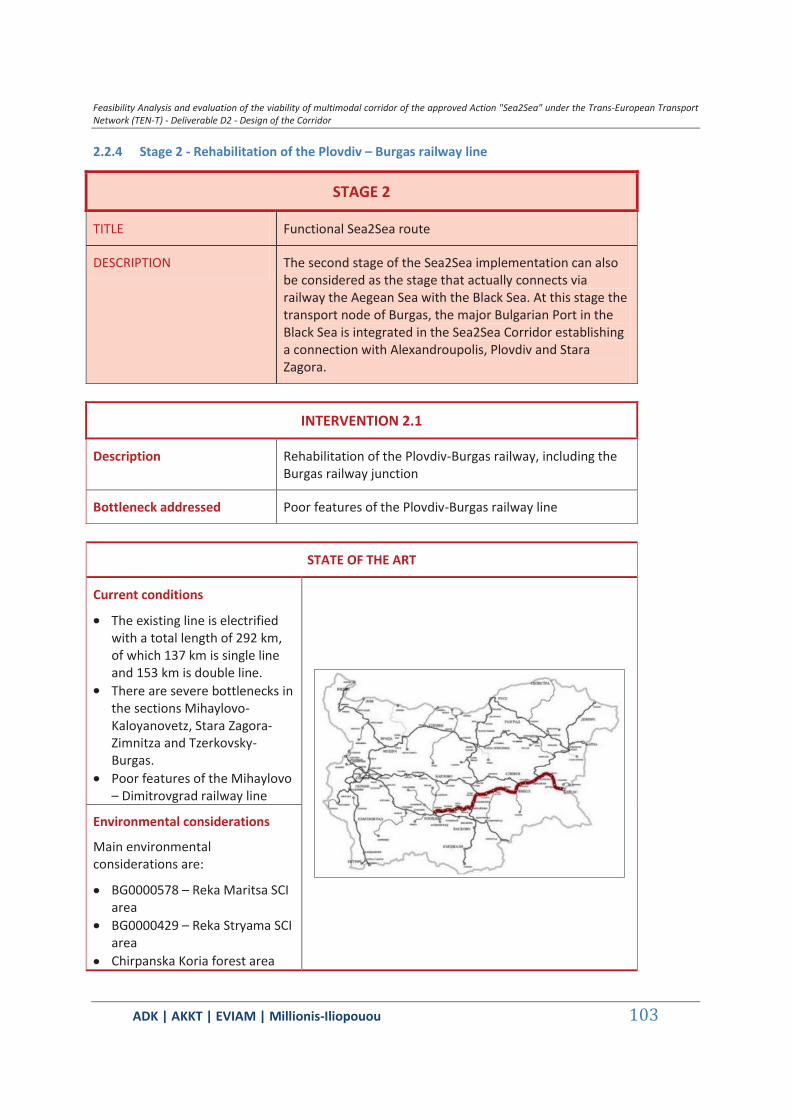
Feasibility Analysis and evaluation of the viability of multimodal corridor of the approved Action "Sea2Sea" under the Trans-European Transport Network (TEN-T) - Deliverable D2 - Design of the Corridor
ΑDΚ | AKKT | ΕVΙΑΜ | Millionis-Iliopouou 103
2.2.4 Stage 2 - Rehabilitation of the Plovdiv – Burgas railway line
STAGE 2
TITLE Functional Sea2Sea route
DESCRIPTION The second stage of the Sea2Sea implementation can also be considered as the stage that actually connects via railway the Aegean Sea with the Black Sea. At this stage the transport node of Burgas, the major Bulgarian Port in the Black Sea is integrated in the Sea2Sea Corridor establishing a connection with Alexandroupolis, Plovdiv and Stara Zagora.
INTERVENTION 2.1
Description Rehabilitation of the Plovdiv-Burgas railway, including the Burgas railway junction
Bottleneck addressed Poor features of the Plovdiv-Burgas railway line
STATE OF THE ART
Current conditions
The existing line is electrified with a total length of 292 km, of which 137 km is single line and 153 km is double line.
There are severe bottlenecks in the sections Mihaylovo-Kaloyanovetz, Stara Zagora-Zimnitza and Tzerkovsky-Burgas.
Poor features of the Mihaylovo – Dimitrovgrad railway line
Environmental considerations
Main environmental considerations are:
BG0000578 – Reka Maritsa SCI area
BG0000429 – Reka Stryama SCI area
Chirpanska Koria forest area
Feasibility Analysis and evaluation of the viability of multimodal corridor of the approved Action "Sea2Sea" under the Trans-European Transport Network (TEN-T) - Deliverable D2 - Design of the Corridor
ΑDΚ | AKKT | ΕVΙΑΜ | Millionis-Iliopouou 104
BG0000192 – Reka Tundzha SCI area
BG0002094 – Adata Tundzha SCI area
BG0000196 – Reka Mochuritsa SCI area
BG0000205 – Straldzha SCI/SPA area
BG0002028 – Kompleks Straldzha SPA area
BG0000273 – Kompleks Straldzha SCI/SPA area
Vaya Lake
Context provisions
Main policy objective
Modernization and development of the transport infrastructure Improvement of the domestic and international connections – Development of Pan-
European Transport Corridors
Spatial Planning
Improvement of connectivity of regions in an international context (National Regional Development Strategy (NRDS) of the Republic of Bulgaria for the period 2012-2022 – BG)
Development of the European Transport Corridors, road and railway infrastructure (National Regional Development Strategy (NRDS) of the Republic of Bulgaria for the period 2012-2022 – BG)
Development of Pan-European Transport Corridors No. 4, No. 8 and No. 9 (National Regional Development Strategy (NRDS) of the Republic of Bulgaria for the period 2012-2022 – BG)
Development of transport networks that are related mainly to the most important axes of the Trans-European Transport Network (TEN-T) and the connections with the neighboring countries and regions, as well as with the directions of the pan-European corridors (National Concept for Spatial Development for the period 2013-2025 – BG)
Construction and reconstruction of transport infrastructure and establishing optimal conditions for economic development, improved market access, … (National Development Programme 2020 – BG)
Effective maintenance, modernization and development of the transport infrastructure (National Development Programme 2020 – BG)
Improvement of the connectivity and integration of Bulgarian regions on a national and international scale (National Development Programme 2020 – BG)
Construction of railway connections with ports and airports in the country - Priority project for investments: ‘Renovation of sections of railway line Plovdiv – Burgas’ (National Development Programme 2020 – BG)
Development programming
Development and modernization of the transport infrastructure (Strategy for the Development of the Transport System of the Republic of Bulgaria until 2020 - BG)
Development of railway infrastructure along the major national and pan-European

Feasibility Analysis and evaluation of the viability of multimodal corridor of the approved Action "Sea2Sea" under the Trans-European Transport Network (TEN-T) - Deliverable D2 - Design of the Corridor
ΑDΚ | AKKT | ΕVΙΑΜ | Millionis-Iliopouou 105
transport axes (OP "Transport 2007-13" – BG) Upgrading the railway line along the railway line Plovdiv-Burgas – project included in the
OP "Transport 2007-13" (BG) Completion of the rehabilitation and upgrading of the line Plovdiv-Burgas – project
included in the OP "Transport 2014-2020" (BG)
BUDGETING AND FINANCING
Estimated budget Approx. 340 million €
Potential sources of financing
1. National Strategic Framework of Bulgaria for the programming period 20014-2020: Structural Funds, 2. Cohesion Funds 2014-2020.
IMPLEMENTATION
Implementation body National Railway Infrastructure Company (NRIC)
Key parameters none
Preconditions Upgrade of the Mihaylovo-Dimitrovgrad section
Implementation schedule
Under construction / 80% completion, completion phase 2 in 2019
ANTICIPATED IMPACTS
Anticipated service benefits
Five stations will be delivered with new signaling together with the 177 km of improved rail track.
The upgraded line will enable passenger trains to travel at up to 160km/h and freight trains with 120km/h.
The line’s capacity will increase and this will result in significantly shorter journey times for both freight and passenger traffic.
The intervention will benefit the Sea2Sea corridor with the added value of connecting to the TRASECA corridor.
The operation of the Aegean-Black Sea2Sea corridor is expected to contribute in decongestion of the Bosporus strait.
Anticipated external benefits
Direct and indirect employment for the construction and operation of the project.
Indirect employment impacts in the shipping industry related to the provision of services at the port.
Transport cost savings.
Main anticipated The project is under construction and all potential beneficial and

Feasibility Analysis and evaluation of the viability of multimodal corridor of the approved Action "Sea2Sea" under the Trans-European Transport Network (TEN-T) - Deliverable D2 - Design of the Corridor
ΑDΚ | AKKT | ΕVΙΑΜ | Millionis-Iliopouou 106
impacts adverse Impacts are examined thoroughly in the EIA.
Anticipated external costs
The project is under construction. Plodiv-Burgas railway line external cost is expected to decrease (energy and resources conservation, reduction in CO2 and greenhouse gases footprint etc).
Sources of information:
National Regional Development Strategy (NRDS) of the Republic of Bulgaria for the period 2012-2022 – BG
National Concept for Spatial Development for the period 2013-2025 – BG National Development Programme 2020 – BG Strategy for the Development of the Transport System of the Republic of Bulgaria until 2020 – BG OP "Transport 2007-13" – BG OP "Transport 2014-2020" – BG

Feasibility Analysis and evaluation of the viability of multimodal corridor of the approved Action "Sea2Sea" under the Trans-European Transport Network (TEN-T) - Deliverable D2 - Design of the Corridor
ΑDΚ | AKKT | ΕVΙΑΜ | Millionis-Iliopouou 107
2.2.5 Stage 3 – Doubling and electrification of the Karnobat – Sindel railway line
STAGE 3
TITLE Full operation Sea2Sea route
DESCRIPTION With the completion of this stage the Sea2Sea corridor will be close to its full operation potential in connecting via railway the Aegean and Mediterranean Sea with the Black Sea. At this stage the Port of Varna in the Black Sea is integrated in the Sea2Sea Corridor.
INTERVENTION 3.1
Description Doubling and electrification of Karnobat-Sindel railway
Bottleneck addressed Poor features of the Karnobat - Sindel (close to Varna) railway line.
STATE OF THE ART
Current conditions
The railway line Karnobat – Sindel is the shortest land connection between the two biggest Black sea ports – Varna and Burgas, with a lenght of 123 km.
71 km of the total railway line alignment are doubled and electrified. The rest 52 km are one-way electrified railway line along the existing alignment.
Environmental considerations
Main environmental considerations are:
BG0000393 - Ekokoridor Kamchia – Emine SCI area
BG0000104 - Provadiysko-Royaksko plato SCI area
BG0002038 - Provadiysko-Royaksko plato SPA area
Feasibility Analysis and evaluation of the viability of multimodal corridor of the approved Action "Sea2Sea" under the Trans-European Transport Network (TEN-T) - Deliverable D2 - Design of the Corridor
ΑDΚ | AKKT | ΕVΙΑΜ | Millionis-Iliopouou 108
BG0000133 - Kamchiyska i Emenska planina SCI/SPA area
BG0000141 - Recha Kamchia SPA areas
Context provisions
Main policy objective
Constructing sustainable railway transport system through sector reforms Improving the connectivity and integration of Bulgarian regions on a national and
international scale
Spatial Planning
The line, as part of PETC 8, is included in the European Agreement on the most important routes for international combined Transport (AGTC).
(Strategy for the Development of the Transport System of the Republic of Bulgaria until 2020 – BG)
Development programming
The line’s improvement plays an important role for the development of the region and the operation of the national transport system as a link between Burgas - Varna, Varna - east of the Black Sea and the port of Ruse, and between the European transport Corridor 7 and 8. (Regional Plan for the Development of the Southeastern Region for the period of 2014 – 2020 – BG).
Improving transport connectivity and access to markets (National Development Programme: Bulgaria 2020 – BG)
BUDGETING AND FINANCING
Estimated budget 180 million €
Potential sources of financing
Cohesion Funds 2014-2020
IMPLEMENTATION
Implementation body National Railway Infrastructure Company (NRIC)
Key parameters none
Preconditions none
Implementation schedule
Construction forthcoming when funding is available
ANTICIPATED IMPACTS
Feasibility Analysis and evaluation of the viability of multimodal corridor of the approved Action "Sea2Sea" under the Trans-European Transport Network (TEN-T) - Deliverable D2 - Design of the Corridor
ΑDΚ | AKKT | ΕVΙΑΜ | Millionis-Iliopouou 109
Anticipated service benefits
The doubling and electrification of the line will improve the connectivity and integration of Bulgarian regions on a national and international scale.
The interoperability of the corridor, its capacity and safety will be improved.
The operation of the Aegean-Black Sea2Sea corridor is expected to contribute in decongestion of the Bosporus strait.
Anticipated external benefits
Direct and indirect employment for the construction and operation of the project.
Transport cost savings.
Main anticipated impacts
The project is under construction and all potential beneficial and adverse impacts are examined thoroughly in the EIA.
Anticipated external costs
The project is under construction. Plodiv-Burgas railway line external cost is expected to decrease (energy and resources conservation, reduction in CO2 and greenhouse gases footprint etc).
Sources of information:
National Development Programme: Bulgaria 2020 – BG Strategy for the Development of the Transport System of the Republic of Bulgaria until 2020 – BG Regional Plan for the Development of the Southeastern Region for the period of 2014-2020 – BG
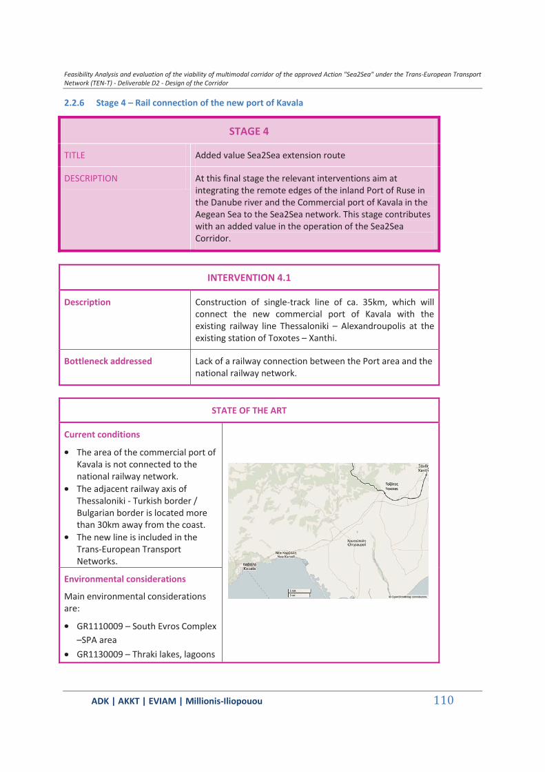
Feasibility Analysis and evaluation of the viability of multimodal corridor of the approved Action "Sea2Sea" under the Trans-European Transport Network (TEN-T) - Deliverable D2 - Design of the Corridor
ΑDΚ | AKKT | ΕVΙΑΜ | Millionis-Iliopouou 110
2.2.6 Stage 4 – Rail connection of the new port of Kavala
STAGE 4
TITLE Added value Sea2Sea extension route
DESCRIPTION At this final stage the relevant interventions aim at integrating the remote edges of the inland Port of Ruse in the Danube river and the Commercial port of Kavala in the Aegean Sea to the Sea2Sea network. This stage contributes with an added value in the operation of the Sea2Sea Corridor.
INTERVENTION 4.1
Description Construction of single-track line of ca. 35km, which will connect the new commercial port of Kavala with the existing railway line Thessaloniki – Alexandroupolis at the existing station of Toxotes – Xanthi.
Bottleneck addressed Lack of a railway connection between the Port area and the national railway network.
STATE OF THE ART
Current conditions
The area of the commercial port of Kavala is not connected to the national railway network.
The adjacent railway axis of Thessaloniki - Turkish border / Bulgarian border is located more than 30km away from the coast.
The new line is included in the Trans-European Transport Networks.
Environmental considerations
Main environmental considerations are:
GR1110009 – South Evros Complex –SPA area
GR1130009 – Thraki lakes, lagoons
Feasibility Analysis and evaluation of the viability of multimodal corridor of the approved Action "Sea2Sea" under the Trans-European Transport Network (TEN-T) - Deliverable D2 - Design of the Corridor
ΑDΚ | AKKT | ΕVΙΑΜ | Millionis-Iliopouou 111
and coastal areas– SCI area GR1130012 – Kompsatou valley GR1150010 – Nestos Delta &
keramoti lagoon – SCI area GR1120005 – Nestos Forest – SCI
area Κ802, Κ26, Κ808, Κ59- Wildlife
refuges Forest of Nestos Kavala Ksanthi National Park of Eastern
Macedonia & Thraki
Context provisions
Main policy objective
Improvement of the connections of the Regions to the international trade, production and urban centers
Optimum exploitation and targeted development of transport infrastructure and cross-border links through the integration in the wider international transport networks
Spatial Planning
This railway connection is required so that Kavala’s port can grow into a transit port, complementary / competitive to that of Thessaloniki (Regional Framework of Spatial Planning and Sustainable Development of the Region of East Macedonia and Thrace – GR)
Development programming
Completion of projects that concern the strengthening of Kavala’s role as a secondary national pole of trans-regional range and as gateway of trans-regional range with international role (Regional Framework of Spatial Planning and Sustainable Development of the Region of East Macedonia and Thrace – GR)
Upgrading of the railway network of the Region and completion of connections with the other regions and neighboring states (Strategic Investment Programme for Transport 2014-2025 – GR)
BUDGETING AND FINANCING
Estimated budget 250 million €
Potential sources of financing
National Strategic Reference Framework (NSRF) for the programming period 2014-2020: Structural Funds
IMPLEMENTATION
Implementation body Hellenic Railways Organization (OSE) - ERGOSE
Feasibility Analysis and evaluation of the viability of multimodal corridor of the approved Action "Sea2Sea" under the Trans-European Transport Network (TEN-T) - Deliverable D2 - Design of the Corridor
ΑDΚ | AKKT | ΕVΙΑΜ | Millionis-Iliopouou 112
Key parameters none
Preconditions none
Implementation schedule
The project is under study / seeking funding
ANTICIPATED IMPACTS
Anticipated service benefits
This connection is one of the important projects that must be implemented in order for the rail transport in Greece to be able to play a new role.
The port of Kavala will be connected to the international market and strengthen its role.
Anticipated external benefits
Direct and indirect employment for the construction and operation of the project.
Indirect employment impacts in the shipping industry related to the provision of services at the port.
Transport cost savings.
Main anticipated impacts
Railways have a low impact on the environment, particularly in comparison with other transport modes and most notably, roads. Electrification is the backbone of the environmental record of railways as it reduces CO2 and other greenhouse gases footprint as well as ambient noise. Due to the presence of significant environmental areas (Evros Complex, National Park of Eastern Macedonia & Thraki, Nestos Delta etc) project EIA should address possible adverse impacts such us ecological encroachment, reduction of the biodiversity, destruction of the vegetation cover, loss of forest products (fuel wood, timber, non timber forest products, perturbation of wildlife habitats and migration and isolation of animal populations.
Anticipated external costs
The external cost of railway is lower than other modes of transport but the electrification brings it down further if it is sustainable. The lower cost of energy from well to wheel and the ability to reduce pollution and greenhouse gas in the atmosphere according to the Kyoto Protocol is an advantage.
Based on the main findings on the positive and negative environmental and social/socio-economic impacts and their assessment, measures to avoid, prevent, mitigate or compensate the adverse impacts must be identified and proposed. The mitigation measures proposed must be based on the relevant national, EU and international standards and good practice. At the current conceptual design stage it is estimated that measures will mainly consist of:
Feasibility Analysis and evaluation of the viability of multimodal corridor of the approved Action "Sea2Sea" under the Trans-European Transport Network (TEN-T) - Deliverable D2 - Design of the Corridor
ΑDΚ | AKKT | ΕVΙΑΜ | Millionis-Iliopouou 113
a perimeter of protection around sensitive ecosystems, wetlands and unique habitats sheltering endangered species especially during construction works
minimization of construction works in reproduction areas during the reproduction periods.
minimization of sedimentation in spawning grounds downstream.
installation of wide aprons to facilitate animal traction. minimization of the disruption of fish habitat by installing
proper culverts and maintaining regular water flow all-year round.
minimization of land clearing areas. In order to guarantee that the measures are implemented and perform adequately, target and evaluation criteria were developed for each measure and incorporated into a Management and Monitoring Programme defining the specific parameters that will be monitored, their method of checking, their monitoring time, period, and frequency, their location, their threshold levels, and the responsible person/institution in charge of the monitoring.
Mitigation and monitoring measures are expected to take up to 15% of the overall project budget.
Sources of information:
Strategic Investment Programme for Transport 2014-2025 – GR Regional Framework of Spatial Planning and Sustainable Development of the Region of East
Macedonia and Thrace – GR Railway Gazette International, Oct 2014 "UK Network Rail electrification strategy Report", May 2010 EIB Environmental and Social Handbook Carl E. Hanson, David A. Towers, and Lance D. Meister, (2006) FTA Noise and Vibration Assessment
Manual, 2006 Vegetation Management Guidelines for Rail Corridors, Victorian Rail Industry Environmental
Forum,2007 ERM GmbH & ELCR Group Ltd: Environmental and Social Impact Assessment for the Eurasia
Tunnel Project Istanbul, Turkey, 2011 European Bank for Reconstruction and Development: ENVIRONMENTAL AND SOCIAL POLICY,
London, 2008 International Union of Railways: Railway
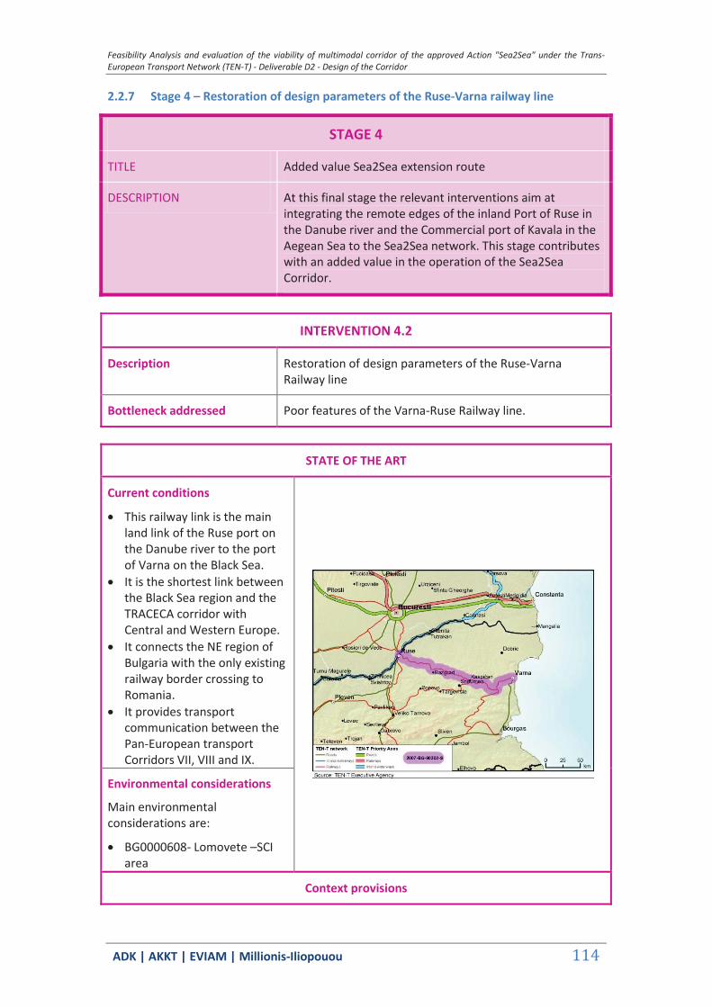
Feasibility Analysis and evaluation of the viability of multimodal corridor of the approved Action "Sea2Sea" under the Trans-European Transport Network (TEN-T) - Deliverable D2 - Design of the Corridor
ΑDΚ | AKKT | ΕVΙΑΜ | Millionis-Iliopouou 114
2.2.7 Stage 4 – Restoration of design parameters of the Ruse-Varna railway line
STAGE 4
TITLE Added value Sea2Sea extension route
DESCRIPTION At this final stage the relevant interventions aim at integrating the remote edges of the inland Port of Ruse in the Danube river and the Commercial port of Kavala in the Aegean Sea to the Sea2Sea network. This stage contributes with an added value in the operation of the Sea2Sea Corridor.
INTERVENTION 4.2
Description Restoration of design parameters of the Ruse-Varna Railway line
Bottleneck addressed Poor features of the Varna-Ruse Railway line.
STATE OF THE ART
Current conditions
This railway link is the main land link of the Ruse port on the Danube river to the port of Varna on the Black Sea.
It is the shortest link between the Black Sea region and the TRACECA corridor with Central and Western Europe.
It connects the NE region of Bulgaria with the only existing railway border crossing to Romania.
It provides transport communication between the Pan-European transport Corridors VII, VIII and IX.
Environmental considerations
Main environmental considerations are:
BG0000608- Lomovete –SCI area
Context provisions

Feasibility Analysis and evaluation of the viability of multimodal corridor of the approved Action "Sea2Sea" under the Trans-European Transport Network (TEN-T) - Deliverable D2 - Design of the Corridor
ΑDΚ | AKKT | ΕVΙΑΜ | Millionis-Iliopouou 115
Main policy objective
Development of the national transport infrastructure as part of the Trans-European Transport Network (TEN-T), which ensures integration in the European space and connections with the major urban centers of neighboring countries
Spatial Planning
Through the development of transport networks that are related mainly to the most important axes of the Trans-European Transport Network (TEN-T) and the connections with the neighboring countries and regions the national transport network will gain a more rational spatial organization, ensuring links between different European countries via the territory of the country, connections of Bulgaria with neighboring countries and connections between the main urban centers (National Concept for Regional Development for the period 2013-2025 – BG)
Development programming
The improvement of the connection will ensure the international connections of the country with the neighboring and other EU Member States (National Concept for Regional Development for the period 2013-2025-BG-)
The development of the railway infrastructure will lead to the successful inclusion of the Port of Varna in the increasing freight turnover in the Black Sea making it one of the main logistics and distribution centers connecting Pan-European Transport Corridors VII, VIII, ІХ and TRACECA (National Regional Development Strategy (NRDS) for the period 2012-2022 – BG)
BUDGETING AND FINANCING
Estimated budget 305 million €
Potential sources of financing
Cohesion Funds 2014-2020
IMPLEMENTATION
Implementation body National Railway Infrastructure Company (NRIC)
Key parameters none
Preconditions none
Implementation schedule
Construction forthcoming when funding is available
ANTICIPATED IMPACTS
Anticipated service benefits
The project will reduce travel times and increase reliability and safety of transportation, which contributes to attract traffic from road transport to rail transport.
The improved railway line will contribute to eliminating bottlenecks in the interconnections in the southeastern region
Feasibility Analysis and evaluation of the viability of multimodal corridor of the approved Action "Sea2Sea" under the Trans-European Transport Network (TEN-T) - Deliverable D2 - Design of the Corridor
ΑDΚ | AKKT | ΕVΙΑΜ | Millionis-Iliopouou 116
of the EU, as well as those in neighbouring EU countries. The project contributes to an optimal combination and
integration of the various modes of transport and improvement in the capacity and efficiency of the existing railway line.
Anticipated external benefits
Direct and indirect employment for the construction and operation of the project.
Indirect employment impacts in the shipping industry related to the provision of services at the ports.
Transport cost savings.
Main anticipated impacts
The project’s construction is about to begin (late 2014) and all potential beneficial and Adverse Impacts are examined thoroughly in the EIA.
Anticipated external costs
The project’s construction is about to begin (late 2014). Varna -Ruse railway line external cost is expected to decrease (energy and resources conservation, reduction in CO2 and greenhouse gases footprint etc).
Sources of information:
National Concept for Regional Development for the period 2013-2025 – BG National Regional Development Strategy (NRDS) for the period 2012-2022 – BG

Feasibility Analysis and evaluation of the viability of multimodal corridor of the approved Action "Sea2Sea" under the Trans-European Transport Network (TEN-T) - Deliverable D2 - Design of the Corridor
ΑDΚ | AKKT | ΕVΙΑΜ | Millionis-Iliopouou 117
2.2.8 Stage 4 – Improvement of the Ruse – Stara Zagora rail line
STAGE 4
TITLE Added value Sea2Sea extension route
DESCRIPTION At this final stage the relevant interventions aim at integrating the remote edges of the inland Port of Ruse in the Danube river and the Commercial port of Kavala in the Aegean Sea to the Sea2Sea network. This stage contributes with an added value in the operation of the Sea2Sea Corridor.
INTERVENTION 4.3
Description Improvement of the rail section Ruse - Stara Zagora with reconstruction of the line and advanced signaling equipment.
Bottleneck addressed Lack of modern signaling of the RR section Ruse–Stara Zagora.
STATE OF THE ART
Current conditions
This specific connection forms the major Bulgarian part of corridor IX.
The line is part of the central vertical axis of the country.
The route is currently in poor condition with significant capacity restrictions.
Environmental considerations
Main environmental considerations are:
BG0000608 – Lomovete – SCI area
BG0000578 – Reka Maritsa – SCI area
BG0000213 - Tarnovski visochini – SCI area
BG0000214 – Dryanovski manastir – SCI area
BG0000399 – Bulgarka –
Feasibility Analysis and evaluation of the viability of multimodal corridor of the approved Action "Sea2Sea" under the Trans-European Transport Network (TEN-T) - Deliverable D2 - Design of the Corridor
ΑDΚ | AKKT | ΕVΙΑΜ | Millionis-Iliopouou 118
SCI/SPA area BG0000192 – Reka Tundzha 1–
SCI area
Context provisions
Main policy objective
Improvement of the connectivity between regions and, above all, their links with the major European urban centers
Creation of unbroken, continuous and permanent transport networks, ensuring rapid and safe travel at longer distances
Spatial Planning
Development of the road and railway infrastructure of the European transport corridors is promoted (National Regional Development Strategy (NRDS) for the period 2012-2022 – BG)
Expanding the cross-border, interregional and transnational cooperation will enable communication with the Central and Western European and Asian countries. (National Regional Development Strategy (NRDS) for the period 2012-2022 – BG)
The railway line contributes to the integration of the region with the country's railway network and the Southeast Europe (Regional Plan for the Development of the South-central Region for the period of 2014- 2020 – BG)
Development programming
The modernization of the railway line along this major central “north-south” axis will ensure its comprehensive operation (connections of the country with the important urban centers Bucharest, Kiev, Moscow, St. Petersburg and Helsinki to the north and Alexandroupolis to the south). (National Concept for Spatial Development for the period 2013-2025 (NCSD) – BG)
BUDGETING AND FINANCING
Estimated budget approx. 170 million €
Potential sources of financing
1. National Strategic Reference Framework (NSRF) for the programming period 2014-2020: Structural Funds, 2. Cohesion Funds 2014-2020
IMPLEMENTATION
Implementation body National Railway Infrastructure Company (NRIC)
Key parameters none
Preconditions none
Implementation schedule
under consideration

Feasibility Analysis and evaluation of the viability of multimodal corridor of the approved Action "Sea2Sea" under the Trans-European Transport Network (TEN-T) - Deliverable D2 - Design of the Corridor
ΑDΚ | AKKT | ΕVΙΑΜ | Millionis-Iliopouou 119
ANTICIPATED IMPACTS
Anticipated service benefits
The electrification and upgrade of this line (located on the strategic N–S axis and utilizing the existing crossing of the Danube to Romania) will improve access to the growing markets in Turkey.
The electrification and upgrade of the line will contribute to the integration of the region with the country's railway network and the Southeast Europe.
Anticipated external benefits
Direct and indirect employment for the construction and operation of the project.
Indirect employment impacts in the shipping industry related to the provision of services at the ports.
Transport cost savings.
Main anticipated impacts
Railways have a low impact on the environment, particularly in comparison with other transport modes and most notably, roads. Electrification is the backbone of the environmental record of railways as it reduces CO2 and other greenhouse gases footprint as well as ambient noise. Due to the presence of significant environmental areas project EIA should address possible adverse impacts such us ecological encroachment, reduction of the biodiversity, destruction of the vegetation cover, loss of forest products (fuel wood, timber, non timber forest products, perturbation of wildlife habitats and migration and isolation of animal populations.
Anticipated external costs
The external cost of railway is lower than other modes of transport but the electrification brings it down further if it is sustainable. The lower cost of energy from well to wheel and the ability to reduce pollution and greenhouse gas in the atmosphere according to the Kyoto Protocol is an advantage.
Based on the main findings on the positive and negative environmental and social/socio-economic impacts and their assessment, measures to avoid, prevent, mitigate or compensate the adverse impacts must be identified and proposed. The mitigation measures proposed must be based on the relevant national, EU and international standards and good practice. At the current conceptual design stage it is estimated that measures will mainly consist of:
a perimeter of protection around sensitive ecosystems, wetlands and unique habitats sheltering endangered species especially during construction works
minimization of construction works in reproduction areas during the reproduction periods.
Minimization of sedimentation in spawning grounds downstream.
Installation of wide aprons to facilitate animal traction. minimization of the disruption of fish habitat by installing
proper culverts and maintaining regular water flow all-year
Feasibility Analysis and evaluation of the viability of multimodal corridor of the approved Action "Sea2Sea" under the Trans-European Transport Network (TEN-T) - Deliverable D2 - Design of the Corridor
ΑDΚ | AKKT | ΕVΙΑΜ | Millionis-Iliopouou 120
round. minimization of land clearing areas.
In order to guarantee that the measures are implemented and perform adequately, target and evaluation criteria were developed for each measure and incorporated into a Management and Monitoring Programme defining the specific parameters that will be monitored, their method of checking, their monitoring time, period, and frequency, their location, their threshold levels, and the responsible person/institution in charge of the monitoring.
Mitigation and monitoring measures are expected to take up to 15% of the overall project budget.
Sources of information:
National Regional Development Strategy (NRDS) for the period 2012-2022-BG Regional Plan for the Development of the South-central Region for the period of 2014 – 2020-BG Railway Gazette International, Oct 2014. "UK Network Rail electrification strategy Report", May 2010 EIB Environmental and Social Handbook Carl E. Hanson, David A. Towers, and Lance D. Meister, (2006) FTA Noise and Vibration Assessment
Manual, 2006 Vegetation Management Guidelines for Rail Corridors, Victorian Rail Industry Environmental
Forum,2007 ERM GmbH & ELCR Group Ltd: Environmental and Social Impact Assessment for the Eurasia
Tunnel Project Istanbul, Turkey, 2011 European Bank for Reconstruction and Development: ENVIRONMENTAL AND SOCIAL POLICY,
London, 2008 International Union of Railways: Railway Noise in Europe. A 2010 Report in the State of Art, 2010 Rail Net Denmark: Noise, Vibrations and Electromagnetic Fields, Technical Note, 2011 EBRD: A Checklist guide to Evaluating Environmental and Social impact Assessments, 2009
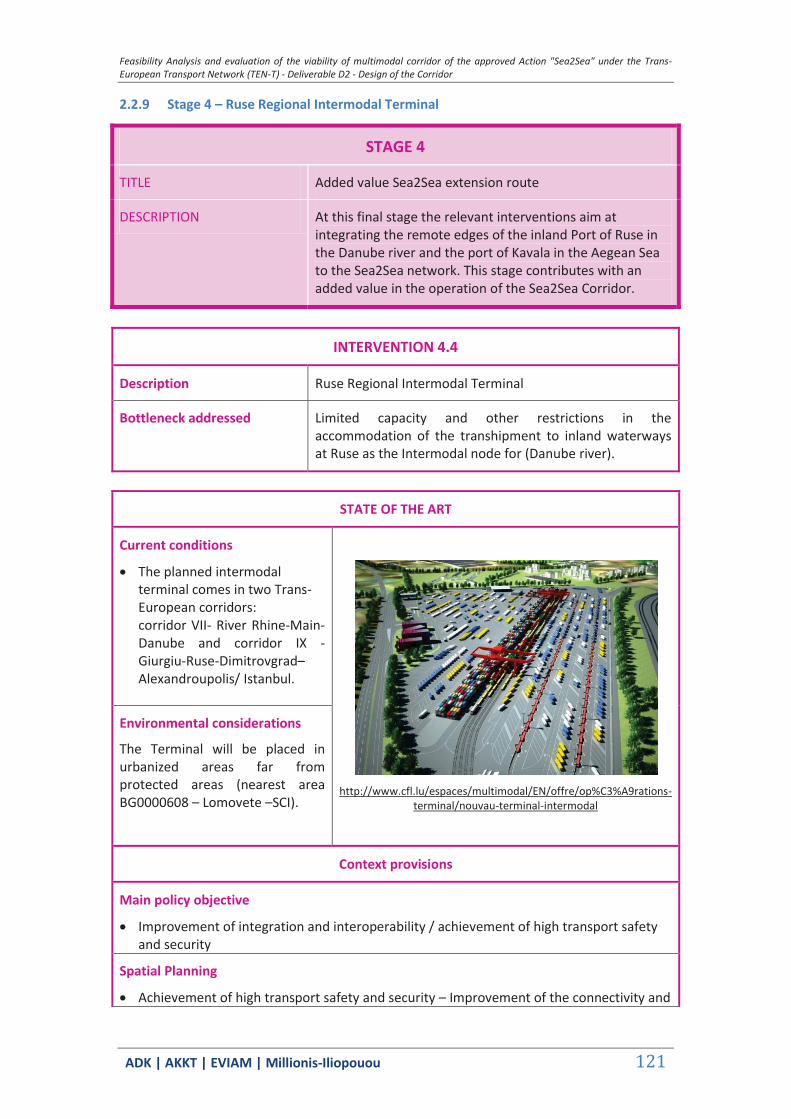
Feasibility Analysis and evaluation of the viability of multimodal corridor of the approved Action "Sea2Sea" under the Trans-European Transport Network (TEN-T) - Deliverable D2 - Design of the Corridor
ΑDΚ | AKKT | ΕVΙΑΜ | Millionis-Iliopouou 121
2.2.9 Stage 4 – Ruse Regional Intermodal Terminal
STAGE 4
TITLE Added value Sea2Sea extension route
DESCRIPTION At this final stage the relevant interventions aim at integrating the remote edges of the inland Port of Ruse in the Danube river and the port of Kavala in the Aegean Sea to the Sea2Sea network. This stage contributes with an added value in the operation of the Sea2Sea Corridor.
INTERVENTION 4.4
Description Ruse Regional Intermodal Terminal
Bottleneck addressed Limited capacity and other restrictions in the accommodation of the transhipment to inland waterways at Ruse as the Intermodal node for (Danube river).
STATE OF THE ART
Current conditions
The planned intermodal terminal comes in two Trans-European corridors: corridor VII- River Rhine-Main- Danube and corridor IX - Giurgiu-Ruse-Dimitrovgrad– Alexandroupolis/ Istanbul.
http://www.cfl.lu/espaces/multimodal/EN/offre/op%C3%A9rations-
terminal/nouvau-terminal-intermodal
Environmental considerations
The Terminal will be placed in urbanized areas far from protected areas (nearest area BG0000608 – Lomovete –SCI).
Context provisions
Main policy objective
Improvement of integration and interoperability / achievement of high transport safety and security
Spatial Planning
Achievement of high transport safety and security – Improvement of the connectivity and
Feasibility Analysis and evaluation of the viability of multimodal corridor of the approved Action "Sea2Sea" under the Trans-European Transport Network (TEN-T) - Deliverable D2 - Design of the Corridor
ΑDΚ | AKKT | ΕVΙΑΜ | Millionis-Iliopouou 122
integration of Bulgarian regions on a national and international scale (National Development Programme: Bulgaria 2020 - BG)
Expansion of the European network of cities of national/trans-national functions by the inclusion of major cities such as Ruse (National Regional Development Strategy (NRDS) for the period 2012-2022 – BG)
Development programming
Improvement of the connectivity of regions in an international context, with major urban centers in neighboring countries (National Regional Development Strategy (NRDS) for the period 2012-2022 – BG)
Integration of the Bulgarian transport system into the European transport system (OP "Transport 2007-13" - BG)
Development of transport networks that are related mainly to the most important axes of the Trans-European Transport Network (TEN-T) and the connections with the neighboring countries and regions, as well as with the directions of the pan-European corridors (National Concept for Spatial Development for the period 2013-2025 (NCSD) – BG)
BUDGETING AND FINANCING
Estimated budget approx. 25 million €
Potential sources of financing
1. National Strategic Reference Framework (NSRF) for the programming period 2014-2020: Structural Funds, 2. Cohesion Funds 2014-2020
IMPLEMENTATION
Implementation body To be identified
Key parameters n/a
Preconditions n/a
Implementation schedule
The project is currently under discussion and preliminary studies have been completed.
ANTICIPATED IMPACTS
Anticipated service benefits
The project in association with the railway connection of Ruse -Varna, will facilitate and improve intermodality in the south-eastern region of the EU.
It will facilitate international transport to/from the countries of the region, the TRACECA countries and the countries of Central and Western Europe, providing better quality service for freight transport.
The port of Ruse on the Danube is between the European transport Corridor 7 and 8 and is included in European Agreement on the most important routes for international combined Transport (AGTC). Its role will be improved.
Feasibility Analysis and evaluation of the viability of multimodal corridor of the approved Action "Sea2Sea" under the Trans-European Transport Network (TEN-T) - Deliverable D2 - Design of the Corridor
ΑDΚ | AKKT | ΕVΙΑΜ | Millionis-Iliopouou 123
The project enhances the interoperability and interconnection of the Sea2Sea corridor with the greater Pan European freight corridors.
Anticipated external benefits
Strengthening of Ruse’s role in the European network of cities of national/trans-national functions.
Main anticipated impacts
No adverse impacts anticipated.
Anticipated external costs
Minimization of the railway external costs due to the enhancement its sustainability.
During land clearing, it is essential to ensure an archaeological surveillance in the potential areas containing artefacts and in case of a discovery, advise concerning authorities a cost that will be covered by project’s budget contingency reserve.
Sources of information:
National Development Programme: Bulgaria 2020 - BG National Regional Development Strategy (NRDS) for the period 2012-2022 – BG National Concept for Spatial Development for the period 2013-2025 (NCSD) – BG
2.3 Comments and conclusions
The Action Plan [AP] emphasizes on the necessary actions to be taken in order to initialize the steps forward to the development of the Sea2Sea corridor service. The actions to be taken include the creation of coordination/supervision administrative units covering both sides of the corridor, and the preparatory actions which are prerequisites to allow corridor operations after the completion of Stage 1 investments. Given the very early phase of corridor market development, all structures must be flexible, to allow for adjustments in the future.
At this planning stage, the potential of the SEA2SEA corridor (defined as potential shift container traffic demand from the Bosporus Straights to a land bridge of the Greek ports to the Bulgarian ones), is not definitely identified. There is a potential of the port of Alexandroupolis for attracting container traffic to/from South East Bulgaria The Action Plan for the implementation of the future steps of the corridor must be left flexible, to be determined and adjusted by/to the market developments.
The proposed actions on infrastructure improvement coincide with plans which are either planned or implemented by the national authorities and the respective organizations at both sides of the corridor. Most of the infrastructure improvements which are identified as necessary for the operation of the corridor refer to priority axes of the TEN-T network. These developments indicate that the SEA2SEA concept can easily be facilitated on existing or planned infrastructures, thus, it doesn’t require major additional investments.
The future potential of the corridor will be tested in the “real” container market world. It will highly depend on external factors, related with the regional container transport economics,
Feasibility Analysis and evaluation of the viability of multimodal corridor of the approved Action "Sea2Sea" under the Trans-European Transport Network (TEN-T) - Deliverable D2 - Design of the Corridor
ΑDΚ | AKKT | ΕVΙΑΜ | Millionis-Iliopouou 124
the competition among regional ports – with which the ports of the corridor compete - and the strategies of the container transporters and forwarders. It is strongly suggested that the planning of implementation of Stages 2 to 4, as far as those actions which are not part of the ongoing planning by the part of the national authorities at each side, must be made in a next stage, based on the grounds of factual achievements of corridor operations.
The technical provisions of the Action Plan are better defined as far as the preparation of Stage 1 of the corridor. All Stage 1 actions are planned to be part of the 2014-20 programming period. Some actions which are classified as parts of the next implementation stages have a good possibility to be part of the 2014-20 period as well.
As necessary administrative provisions actions which must be launched for the implementation of the SEA2SEA corridor, the following are considered:
The establishment of an Executive Committee [ExC] at Ministerial level by the Greek Ministry of Infrastructure, Transport and Networks and the Bulgarian Ministry of Transportation.
The establishment of a Steering Committee [SC] at the highest administrative level, including representatives from the planning units of the respective Ministries, the rail planning, construction and maintenance bodies, rail operators, port administrators and port operators, as well as custom officers, of both sides.
The establishment of unilateral Coordination SEA2SEA corridor Units [CU] at the suitable strategic planning level by each side.
Necessary preparatory actions to make possible the launching of SEA2SEA operations are:
The development of an operational container terminal at the port of Alexandroupolis, an issue which is highly political, since the decision on the ownership and operational status of the port has been made at the government level but there will be quite some time before any final outcome. Since a final result may take considerable time, the issue represents a factor of high risk as far as the launching of operations of the corridor within the 2014-20 period.
The preparation of the rail operator in the Greek side – for the time being TRAINOSE – to launch regular service from the Greek ports to the borders. This preparation includes the provision for the supply of rolling equipment, the development of fare policy for full customer support from the container yard to the “dry port” station in the neighboring countries, and the agreement with the rail operators of the destination countries as far as the cross-border operations.
The provision for completion of the container terminal at the new port of Kavala and the rail connection to Toxotes.
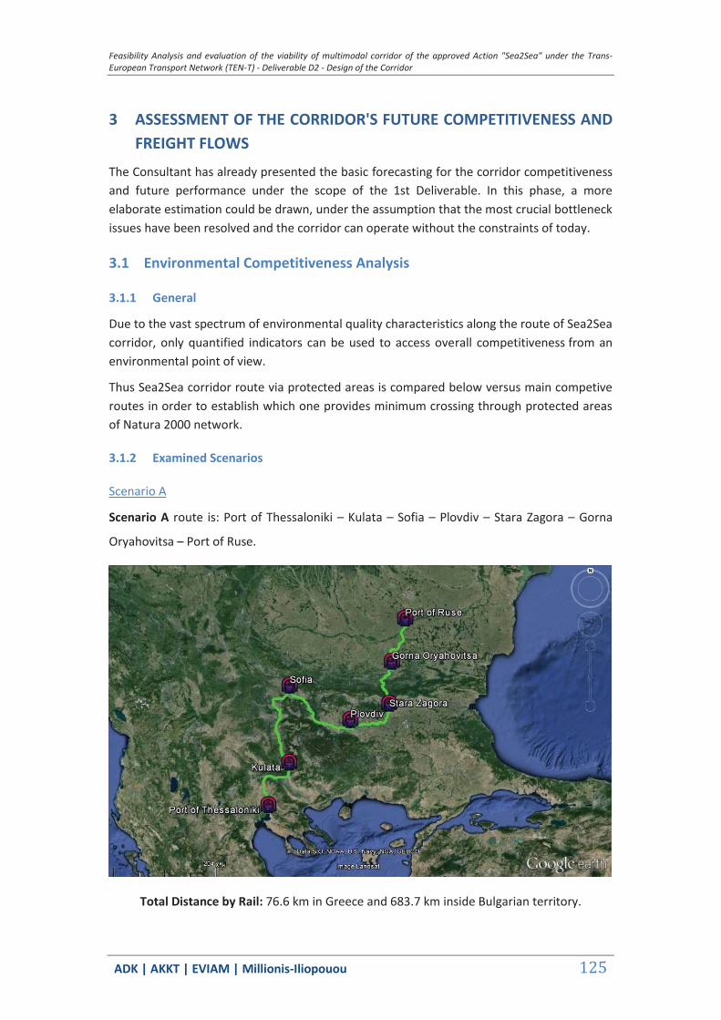
Feasibility Analysis and evaluation of the viability of multimodal corridor of the approved Action "Sea2Sea" under the Trans-European Transport Network (TEN-T) - Deliverable D2 - Design of the Corridor
ΑDΚ | AKKT | ΕVΙΑΜ | Millionis-Iliopouou 125
3 ASSESSMENT OF THE CORRIDOR'S FUTURE COMPETITIVENESS AND FREIGHT FLOWS
The Consultant has already presented the basic forecasting for the corridor competitiveness and future performance under the scope of the 1st Deliverable. In this phase, a more elaborate estimation could be drawn, under the assumption that the most crucial bottleneck issues have been resolved and the corridor can operate without the constraints of today.
3.1 Environmental Competitiveness Analysis
3.1.1 General
Due to the vast spectrum of environmental quality characteristics along the route of Sea2Sea corridor, only quantified indicators can be used to access overall competitiveness from an environmental point of view.
Thus Sea2Sea corridor route via protected areas is compared below versus main competive routes in order to establish which one provides minimum crossing through protected areas of Natura 2000 network.
3.1.2 Examined Scenarios
Scenario Α
Scenario A route is: Port of Thessaloniki – Kulata – Sofia – Plovdiv – Stara Zagora – Gorna
Oryahovitsa – Port of Ruse.
Total Distance by Rail: 76.6 km in Greece and 683.7 km inside Bulgarian territory.
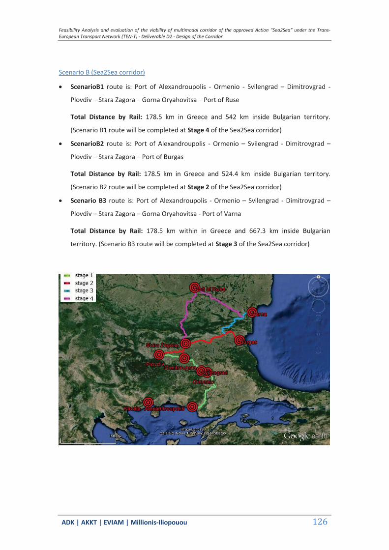
Feasibility Analysis and evaluation of the viability of multimodal corridor of the approved Action "Sea2Sea" under the Trans-European Transport Network (TEN-T) - Deliverable D2 - Design of the Corridor
ΑDΚ | AKKT | ΕVΙΑΜ | Millionis-Iliopouou 126
Scenario B (Sea2Sea corridor)
ScenarioΒ1 route is: Port of Alexandroupolis - Ormenio - Svilengrad – Dimitrovgrad -
Plovdiv – Stara Zagora – Gorna Oryahovitsa – Port of Ruse
Total Distance by Rail: 178.5 km in Greece and 542 km inside Bulgarian territory.
(Scenario B1 route will be completed at Stage 4 of the Sea2Sea corridor)
ScenarioΒ2 route is: Port of Alexandroupolis - Ormenio – Svilengrad - Dimitrovgrad –
Plovdiv – Stara Zagora – Port of Burgas
Total Distance by Rail: 178.5 km in Greece and 524.4 km inside Bulgarian territory.
(Scenario B2 route will be completed at Stage 2 of the Sea2Sea corridor)
Scenario Β3 route is: Port of Alexandroupolis - Ormenio – Svilengrad - Dimitrovgrad –
Plovdiv – Stara Zagora – Gorna Oryahovitsa - Port of Varna
Total Distance by Rail: 178.5 km within in Greece and 667.3 km inside Bulgarian
territory. (Scenario B3 route will be completed at Stage 3 of the Sea2Sea corridor)
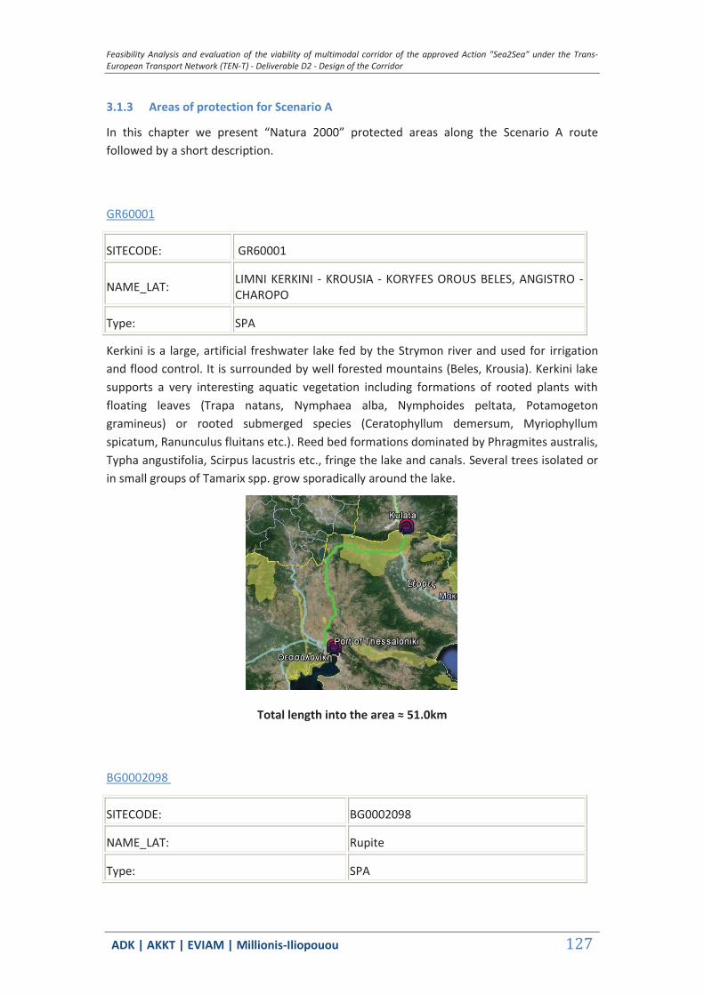
Feasibility Analysis and evaluation of the viability of multimodal corridor of the approved Action "Sea2Sea" under the Trans-European Transport Network (TEN-T) - Deliverable D2 - Design of the Corridor
ΑDΚ | AKKT | ΕVΙΑΜ | Millionis-Iliopouou 127
3.1.3 Areas of protection for Scenario A
In this chapter we present “Natura 2000” protected areas along the Scenario A route followed by a short description.
GR60001
SITECODE: GR60001
NAME_LAT: LIMNI KERKINI - KROUSIA - KORYFES OROUS BELES, ANGISTRO - CHAROPO
Type: SPA
Kerkini is a large, artificial freshwater lake fed by the Strymon river and used for irrigation and flood control. It is surrounded by well forested mountains (Beles, Krousia). Kerkini lake supports a very interesting aquatic vegetation including formations of rooted plants with floating leaves (Trapa natans, Nymphaea alba, Nymphoides peltata, Potamogeton gramineus) or rooted submerged species (Ceratophyllum demersum, Myriophyllum spicatum, Ranunculus fluitans etc.). Reed bed formations dominated by Phragmites australis, Typha angustifolia, Scirpus lacustris etc., fringe the lake and canals. Several trees isolated or in small groups of Tamarix spp. grow sporadically around the lake.
Total length into the area ≈ 51.0km
BG0002098
SITECODE: BG0002098
NAME_LAT: Rupite
Type: SPA
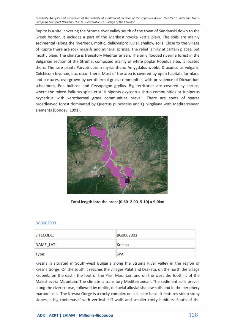
Feasibility Analysis and evaluation of the viability of multimodal corridor of the approved Action "Sea2Sea" under the Trans-European Transport Network (TEN-T) - Deliverable D2 - Design of the Corridor
ΑDΚ | AKKT | ΕVΙΑΜ | Millionis-Iliopouou 128
Rupite is a site, covering the Struma river valley south of the town of Sandanski down to the Greek border. It includes a part of the Marikostinovska kettle plain. The soils are mainly sedimental (along the riverbed), moltic, delluvialprolluvial, shallow soils. Close to the village of Rupite there are rock massifs and mineral springs. The relief is hilly at certain places, but mostly plain. The climate is transitory Mediterranean. The only flooded riverine forest in the Bulgarian section of the Struma, composed mainly of white poplar Populus alba, is located there. The rare plants Parvotricetum myrianthum, Amygdalus webbi, Dracunculus vulgaris, Colchicum bivonae, etc. occur there. Most of the area is covered by open habitats farmland and pastures, overgrown by xerothermal grass communities with prevalence of Dichantium schaemum, Poa bulbosa and Crysopogon gryllus. Big territories are covered by shrubs, where the mixed Paliurus spina-cristi-Juniperus oxycedrus shrub communities or Juniperus oxycedrus with xerothermal grass communities prevail. There are spots of sparse broadleaved forest dominated by Quercus pubescens and Q. virgiliana with Mediterranean elements (Bondev, 1991).
Total length into the area: (0.60+2.90+5.10) ≈ 9.0km
BG0002003
SITECODE: BG0002003
NAME_LAT: Kresna
Type: SPA
Kresna is situated in South-west Bulgaria along the Struma River valley in the region of Kresna Gorge. On the south it reaches the villages Palat and Drakata, on the north the village Krupnik, on the east - the foot of the Pirin Mountain and on the west the foothills of the Maleshevska Mountain. The climate is transitory Mediterranean. The sediment soils prevail along the river course, followed by moltic, delluvial alluvial shallow soils and in the periphery maroon soils. The Kresna Gorge is a rocky complex on a silicate base. It features steep stony slopes, a big rock massif with vertical cliff walls and smaller rocky habitats. South of the
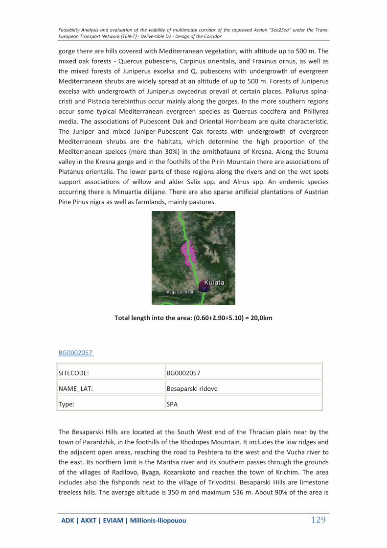
Feasibility Analysis and evaluation of the viability of multimodal corridor of the approved Action "Sea2Sea" under the Trans-European Transport Network (TEN-T) - Deliverable D2 - Design of the Corridor
ΑDΚ | AKKT | ΕVΙΑΜ | Millionis-Iliopouou 129
gorge there are hills covered with Mediterranean vegetation, with altitude up to 500 m. The mixed oak forests - Quercus pubescens, Carpinus orientalis, and Fraxinus ornus, as well as the mixed forests of Juniperus excelsa and Q. pubescens with undergrowth of evergreen Mediterranean shrubs are widely spread at an altitude of up to 500 m. Forests of Juniperus excelsa with undergrowth of Juniperus oxycedrus prevail at certain places. Paliurus spina-cristi and Pistacia terebinthus occur mainly along the gorges. In the more southern regions occur some typical Mediterranean evergreen species as Quercus coccifera and Phillyrea media. The associations of Pubescent Oak and Oriental Hornbeam are quite characteristic. The Juniper and mixed Juniper-Pubescent Oak forests with undergrowth of evergreen Mediterranean shrubs are the habitats, which determine the high proportion of the Mediterranean speices (more than 30%) in the ornithofauna of Kresna. Along the Struma valley in the Kresna gorge and in the foothills of the Pirin Mountain there are associations of Platanus orientalis. The lower parts of these regions along the rivers and on the wet spots support associations of willow and alder Salix spp. and Alnus spp. An endemic species occurring there is Minuartia dilijane. There are also sparse artificial plantations of Austrian Pine Pinus nigra as well as farmlands, mainly pastures.
Total length into the area: (0.60+2.90+5.10) ≈ 20,0km
BG0002057
SITECODE: BG0002057
NAME_LAT: Besaparski ridove
Type: SPA
The Besaparski Hills are located at the South West end of the Thracian plain near by the town of Pazardzhik, in the foothills of the Rhodopes Mountain. It includes the low ridges and the adjacent open areas, reaching the road to Peshtera to the west and the Vucha river to the east. Its northern limit is the Maritsa river and its southern passes through the grounds of the villages of Radilovo, Byaga, Kozarskoto and reaches the town of Krichim. The area includes also the fishponds next to the village of Trivoditsi. Besaparski Hills are limestone treeless hills. The average altitude is 350 m and maximum 536 m. About 90% of the area is
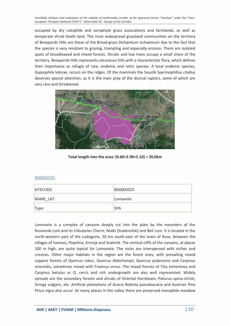
Feasibility Analysis and evaluation of the viability of multimodal corridor of the approved Action "Sea2Sea" under the Trans-European Transport Network (TEN-T) - Deliverable D2 - Design of the Corridor
ΑDΚ | AKKT | ΕVΙΑΜ | Millionis-Iliopouou 130
occupied by dry calciphile and xerophyte grass associations and farmlands, as well as temperate shrub heath land. The most widespread grassland communities on the territory of Besaparski Hills are these of the Bread-grass Dichantium ischaemum due to the fact that the species is very resistant to grazing, trampling and especially erosion. There are isolated spots of broadleaved and mixed forests. Shrubs and low trees occupy a small share of the territory. Besaparski Hills represents calcareous hills with a characteristic flora, which defines their importance as refugia of rare, endemic and relict species. A local endemic species, Gypsophila tekirae, occurs on the ridges. Of the mammals the Souslik Spermophillus citellus deserves special attention, as it is the main prey of the diurnal raptors, some of which are very rare and threatened.
Total length into the area: (0.60+2.90+5.10) ≈ 20,0km
BG0002025
SITECODE: BG0002025
NAME_LAT: Lomovete
Type: SPA
Lomovete is a complex of canyons deeply cut into the plain by the meanders of the Russenski Lom and its tributaries Cherni, Malki (Svalenishki) and Beli Lom. It is located in the north-western part of the Ludogorie, 20 km south-east of the town of Ruse, between the villages of Ivanovo, Pepelina, Krivnja and Svalenik. The vertical cliffs of the canyons, at places 100 m high, are quite typical for Lomovete. The rocks are interspersed with niches and crevices. Other major habitats in the region are the forest ones, with prevailing mixed coppice forests of Quercus robur, Quercus dalechampii, Quercus pubescens and Carpinus orientalis, sometimes mixed with Fraxinus ornus. The mixed forests of Tilia tomentosa and Carpinus betulus or Q. cerris and rich undergrowth are also well represented. Widely spreads are the secondary forests and shrubs of Oriental Hornbeam, Paliurus spina-christi, Siringa vulgaris, etc. Artificial plantations of Acacia Robinia pseudoacacia and Austrian Pine Pinus nigra also occur. At many places in the valley there are preserved mesophile meadow

Feasibility Analysis and evaluation of the viability of multimodal corridor of the approved Action "Sea2Sea" under the Trans-European Transport Network (TEN-T) - Deliverable D2 - Design of the Corridor
ΑDΚ | AKKT | ΕVΙΑΜ | Millionis-Iliopouou 131
associations and xerothermal grasslands of Dichantium ischaemum, Poa bulbosa, etc. (Bondev 1991; Georgiev 1993). The riverbanks are overgrown with different willow species Salix spp., Black Poplar Populus nigra and White Poplar Populus alba. Along the valley, mainly around the settlements, there are agricultural plots too.
Total length into the area≈ 2.50km
BG0001023
SITECODE: BG0001023
NAME_LAT: Rupite - Strumeshnitsa
Type: SCI
The SCI includes the valley of the Struma River with adjacent low hills (some of them with vulcanic origin), before the river enters in Greece. The big tributary Strumeshnitza is included in its entire Bulgarian course as well as the small creeks coming from the Belasitza Mountain.
The SCI by itself contains important and representative habitats, but also is an uninterrupted biocorridor by the rivers connecting the higher mountains around. The site contains the most representative area with habitat 92A0 in West Bulgaria.
Here 92A0 is represented with a very old Populus alba forest by the Struma River, that in the past dominated the whole south Struma River valley but has suffered greatly from cutting and artificial forests plantations.
The site also conserves some century-old Platanus orientalis forests on the upper Strumeshnitza River and its tributaries one of the three most representative areas for protecting the 92C0 habitat in Bulgaria.
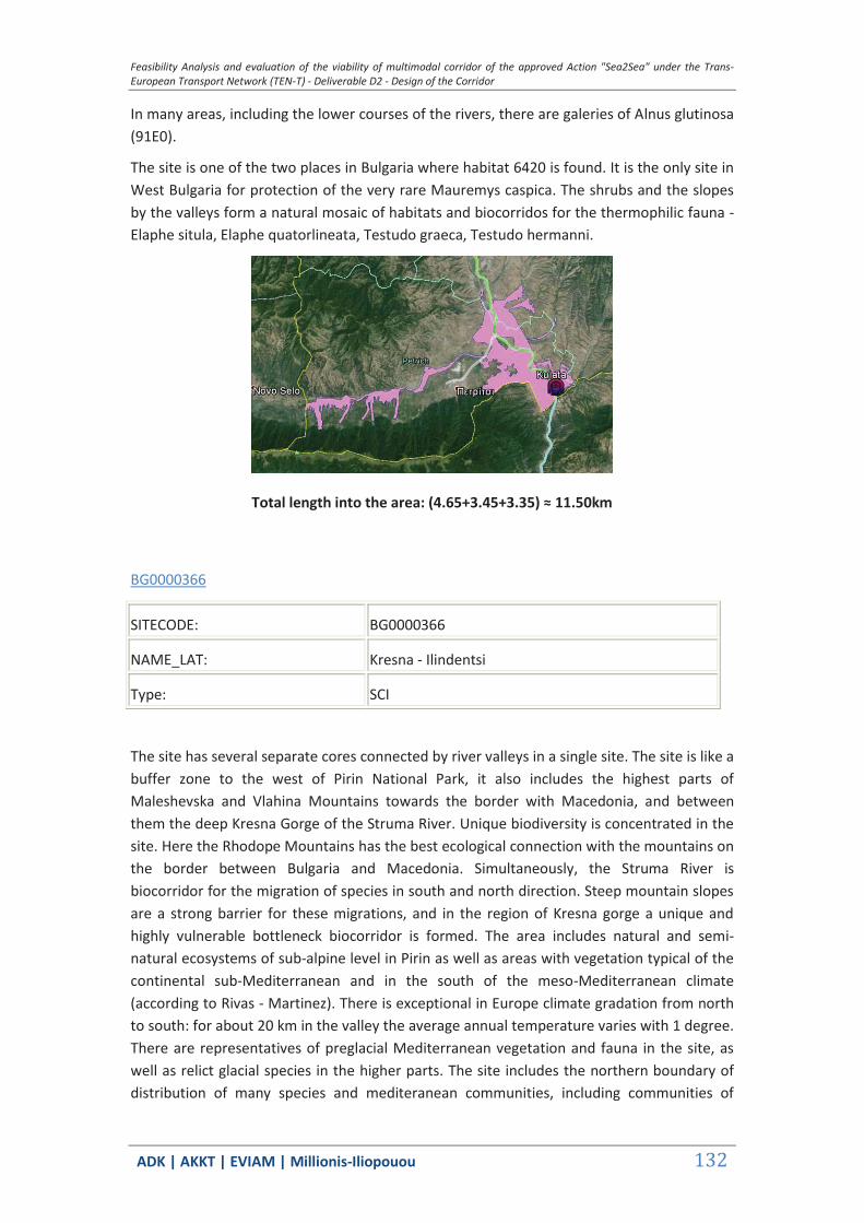
Feasibility Analysis and evaluation of the viability of multimodal corridor of the approved Action "Sea2Sea" under the Trans-European Transport Network (TEN-T) - Deliverable D2 - Design of the Corridor
ΑDΚ | AKKT | ΕVΙΑΜ | Millionis-Iliopouou 132
In many areas, including the lower courses of the rivers, there are galeries of Alnus glutinosa (91E0).
The site is one of the two places in Bulgaria where habitat 6420 is found. It is the only site in West Bulgaria for protection of the very rare Mauremys caspica. The shrubs and the slopes by the valleys form a natural mosaic of habitats and biocorridos for the thermophilic fauna - Elaphe situla, Elaphe quatorlineata, Testudo graeca, Testudo hermanni.
Total length into the area: (4.65+3.45+3.35) ≈ 11.50km
BG0000366
SITECODE: BG0000366
NAME_LAT: Kresna - Ilindentsi
Type: SCI
The site has several separate cores connected by river valleys in a single site. The site is like a buffer zone to the west of Pirin National Park, it also includes the highest parts of Maleshevska and Vlahina Mountains towards the border with Macedonia, and between them the deep Kresna Gorge of the Struma River. Unique biodiversity is concentrated in the site. Here the Rhodope Mountains has the best ecological connection with the mountains on the border between Bulgaria and Macedonia. Simultaneously, the Struma River is biocorridor for the migration of species in south and north direction. Steep mountain slopes are a strong barrier for these migrations, and in the region of Kresna gorge a unique and highly vulnerable bottleneck biocorridor is formed. The area includes natural and semi-natural ecosystems of sub-alpine level in Pirin as well as areas with vegetation typical of the continental sub-Mediterranean and in the south of the meso-Mediterranean climate (according to Rivas - Martinez). There is exceptional in Europe climate gradation from north to south: for about 20 km in the valley the average annual temperature varies with 1 degree. There are representatives of preglacial Mediterranean vegetation and fauna in the site, as well as relict glacial species in the higher parts. The site includes the northern boundary of distribution of many species and mediteranean communities, including communities of

Feasibility Analysis and evaluation of the viability of multimodal corridor of the approved Action "Sea2Sea" under the Trans-European Transport Network (TEN-T) - Deliverable D2 - Design of the Corridor
ΑDΚ | AKKT | ΕVΙΑΜ | Millionis-Iliopouou 133
Platanus orientalis, Querqus coccifera, Phyllirea media, Juniperus excelsa. Some areas of forest monocultures are excluded from the site. "Zandana" (N 41 39 02.2 E 23 15 15.6 WGS 84, alt. 490 m) is a complex of 3 caves situated between the villages of Ploski and Ilindentsi. Breeding colonies of horseshoe bats and migratory groups/colonies of other bat species were observed in these caves. Other species of bats are known to live in rock fissures.
Total length into the area: (2.35+16.8) ≈ 20km
BG0001022
SITECODE: BG0001022
NAME_LAT: Oranovski prolom - Leshko
Type: SCI
The SCI has to main core areas: the first is Oranovski Gorge on small part of Struma River and the other is the top of the mountain range at the FYROM border both linked by the river valley of Stara Reka.
The SCI is the only suitable direct bio-corridor for bear migration between Rila mountain and the mountains situated west of Struma river. The zone is important for conservation of both species of land tortoises, as a stepping stones bio-corridor and for achieving necessary coverage in the network. In the SCI are found the highest localities of tortoises in middle part of Bulgaria (around 1000 masl) in various habitats: grasslands on the border of oak forests (ecotone between 91M0 and 6210) and dry pine forests with shrubs of junipers (9530 and 5210).
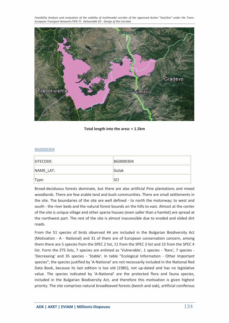
Feasibility Analysis and evaluation of the viability of multimodal corridor of the approved Action "Sea2Sea" under the Trans-European Transport Network (TEN-T) - Deliverable D2 - Design of the Corridor
ΑDΚ | AKKT | ΕVΙΑΜ | Millionis-Iliopouou 134
Total length into the area: ≈ 1.5km
BG0000304
SITECODE: BG0000304
NAME_LAT: Golak
Type: SCI
Broad-deciduous forests dominate, but there are also artificial Pine plantations and mixed woodlands. There are few arable land and bush communities. There are small settlements in the site. The boundaries of the site are well defined - to north the motorway; to west and south - the river beds and the natural forest bounds on the hills to east. Almost at the center of the site is unique village and other sparse houses (even saller than a hamlet) are spread at the northwest part. The rest of the site is almost inaccessible due to eroded and slided dirt roads.
From the 51 species of birds observed 44 are included in the Bulgarian Biodiversity Act (Motivation - A - National) and 31 of them are of European conservation concern, among them there are 5 species from the SPEC 2 list, 11 from the SPEC 3 list and 15 from the SPEC 4 list. Form the ETS lists, 7 species are enlisted as 'Vulnerable', 1 species - 'Rare', 7 species - 'Decreasing' and 35 species - 'Stable'. In table "Ecological Information - Other Important species", the species justified by 'A-National' are not necessarily included in the National Red Data Book, because its last edition is too old (1985), not up-dated and has no legislative value. The species indicated by 'A-National' are the protected flora and fauna species, included in the Bulgarian Biodiversity Act, and therefore this motivation is given highest priority. The site comprises natural broadleaved forests (beech and oak), artificial coniferous
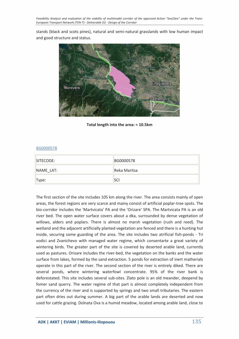
Feasibility Analysis and evaluation of the viability of multimodal corridor of the approved Action "Sea2Sea" under the Trans-European Transport Network (TEN-T) - Deliverable D2 - Design of the Corridor
ΑDΚ | AKKT | ΕVΙΑΜ | Millionis-Iliopouou 135
stands (black and scots pines), natural and semi-natural grasslands with low human impact and good structure and status.
Total length into the area: ≈ 10.5km
BG0000578
SITECODE: BG0000578
NAME_LAT: Reka Maritsa
Type: SCI
The first section of the site includes 105 km along the river. The area consists mainly of open areas, the forest regions are very scarce and mainy consist of artificial poplar-tree spots. The bio-corridor includes the 'Martvicata' PA and the 'Orizare' SPA. The Martvicata PA is an old river bed. The open water surface covers about a dka, surrounded by dense vegetation of willows, alders and poplars. There is almost no marsh vegetation (rush and reed). The wetland and the adjacent artificially planted vegetation are fenced and there is a hunting hut inside, securing some guarding of the area. The site includes two atrificial fish-ponds - Tri vodici and Zvanichevo with managed water regime, which consentarte a great variety of wintering birds. The greater part of the site is covered by deserted arable land, currently used as pastures. Orizare includes the river-bed, the vegetation on the banks and the water surface from lakes, formed by the sand extraction. 5 ponds for extraction of inert matherials operate in this part of the river. The second section of the river is entirely diked. There are several ponds, where wintering waterfowl concentrate. 95% of the river bank is deforestated. This site includes several sub-sites. Zlato pole is an old meander, deepend by fomer sand querry. The water regime of that part is almost completely independent from the currency of the river and is supported by springs and two small tributaries. The eastern part often dries out during summer. A big part of the arable lands are deserted and now used for cattle grazing. Dolnata Ova is a humid meadow, located among arable land, close to
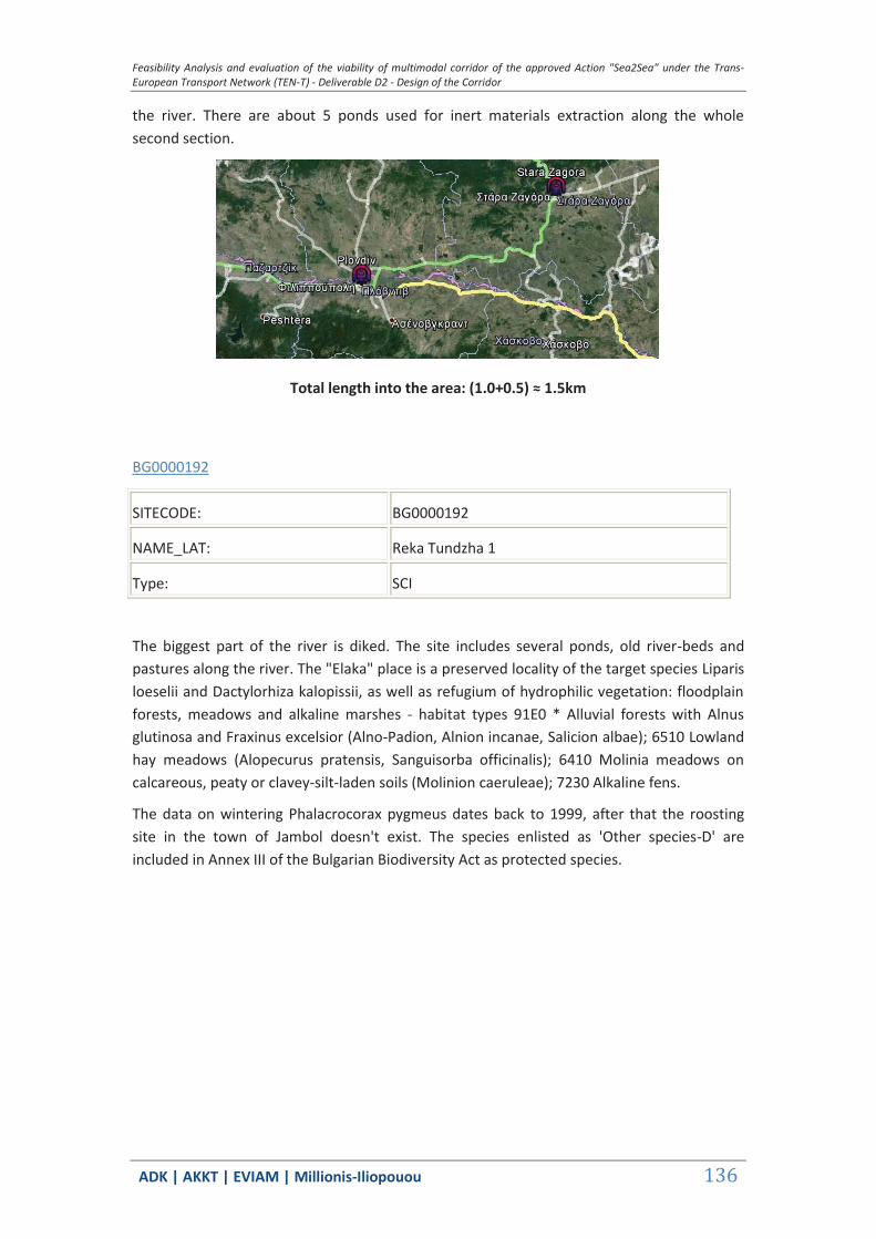
Feasibility Analysis and evaluation of the viability of multimodal corridor of the approved Action "Sea2Sea" under the Trans-European Transport Network (TEN-T) - Deliverable D2 - Design of the Corridor
ΑDΚ | AKKT | ΕVΙΑΜ | Millionis-Iliopouou 136
the river. There are about 5 ponds used for inert materials extraction along the whole second section.
Total length into the area: (1.0+0.5) ≈ 1.5km
BG0000192
SITECODE: BG0000192
NAME_LAT: Reka Tundzha 1
Type: SCI
The biggest part of the river is diked. The site includes several ponds, old river-beds and pastures along the river. The "Elaka" place is a preserved locality of the target species Liparis loeselii and Dactylorhiza kalopissii, as well as refugium of hydrophilic vegetation: floodplain forests, meadows and alkaline marshes - habitat types 91E0 * Alluvial forests with Alnus glutinosa and Fraxinus excelsior (Alno-Padion, Alnion incanae, Salicion albae); 6510 Lowland hay meadows (Alopecurus pratensis, Sanguisorba officinalis); 6410 Molinia meadows on calcareous, peaty or clavey-silt-laden soils (Molinion caeruleae); 7230 Alkaline fens.
The data on wintering Phalacrocorax pygmeus dates back to 1999, after that the roosting site in the town of Jambol doesn't exist. The species enlisted as 'Other species-D' are included in Annex III of the Bulgarian Biodiversity Act as protected species.

Feasibility Analysis and evaluation of the viability of multimodal corridor of the approved Action "Sea2Sea" under the Trans-European Transport Network (TEN-T) - Deliverable D2 - Design of the Corridor
ΑDΚ | AKKT | ΕVΙΑΜ | Millionis-Iliopouou 137
Total length into the area: ≈ 0.5km
BG0000399
SITECODE: BG0000399
NAME_LAT: Bulgarka
Type: SPA&SCI
Bulgarka Nature Park covers 21 772 ha in the Central Balkan Mountains. Its area comprises the ridge parts and northern slopes of the Shipchenska and Trevnenska Mountains as well as parts of the adjacent Predbalkan Mountains, the springs of the Yantra River and main tributaries in their upper parts. The site also includes the Hristo Smirneski Reservoir and comprises the lands of 9 settlements. The relief of the area is crossed and represents a series of small valleys, cut by gulches and ravines, narrow hills and ridges with steep slopes. The relief forms are complicated by modern erosion processes causing the development of slopes, embankments, alluvia and terraces, formed by human activities. The low parts of the park until the settlements are mainly deserted orchards. Traditionally, the region has been an orchard, as gardens have been maintained on grass. Therefore it now partially preserves some local orchard sorts. In addition to the classical habitats, where Oaks (Fagus sylvatica L.) dominate, beach species such as Taxus baccata and Ilex aquifolium are also spread. The relict habitat formed by Laorocerasus officinalis also covers significant areas. The territory of Bulgarka NP combines four floristic regions and three physical geographical belts, what results in many transitional plant formations and typical habitats, rare for other areas.
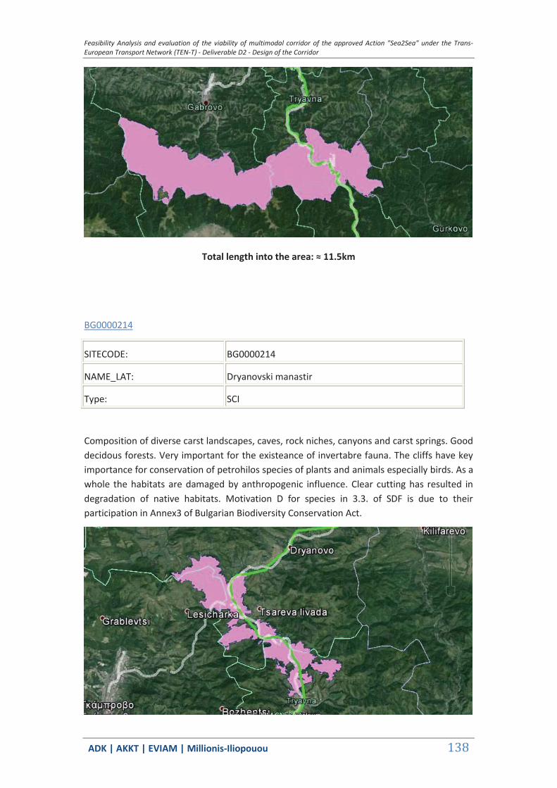
Feasibility Analysis and evaluation of the viability of multimodal corridor of the approved Action "Sea2Sea" under the Trans-European Transport Network (TEN-T) - Deliverable D2 - Design of the Corridor
ΑDΚ | AKKT | ΕVΙΑΜ | Millionis-Iliopouou 138
Total length into the area: ≈ 11.5km
BG0000214
SITECODE: BG0000214
NAME_LAT: Dryanovski manastir
Type: SCI
Composition of diverse carst landscapes, caves, rock niches, canyons and carst springs. Good decidous forests. Very important for the existeance of invertabre fauna. The cliffs have key importance for conservation of petrohilos species of plants and animals especially birds. As a whole the habitats are damaged by anthropogenic influence. Clear cutting has resulted in degradation of native habitats. Motivation D for species in 3.3. of SDF is due to their participation in Annex3 of Bulgarian Biodiversity Conservation Act.
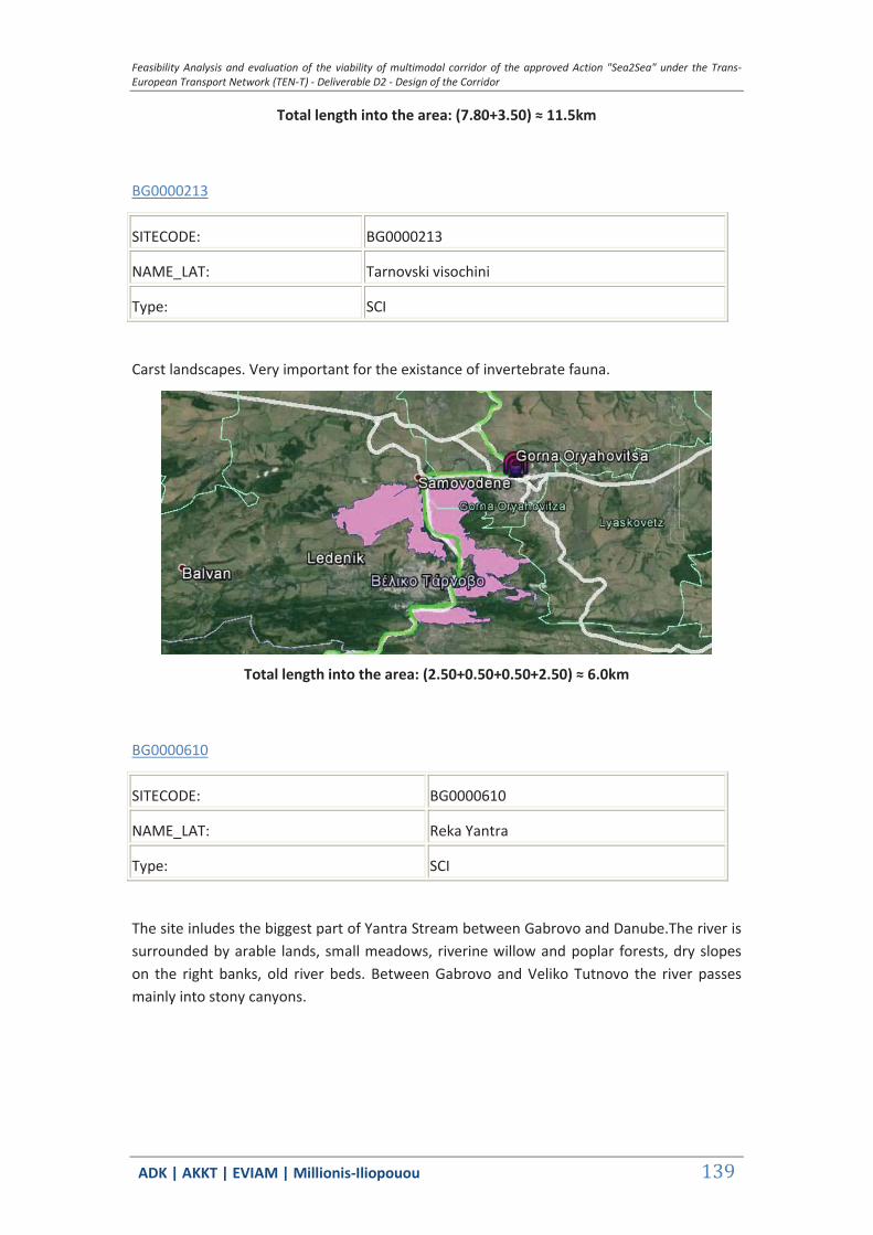
Feasibility Analysis and evaluation of the viability of multimodal corridor of the approved Action "Sea2Sea" under the Trans-European Transport Network (TEN-T) - Deliverable D2 - Design of the Corridor
ΑDΚ | AKKT | ΕVΙΑΜ | Millionis-Iliopouou 139
Total length into the area: (7.80+3.50) ≈ 11.5km
BG0000213
SITECODE: BG0000213
NAME_LAT: Tarnovski visochini
Type: SCI
Carst landscapes. Very important for the existance of invertebrate fauna.
Total length into the area: (2.50+0.50+0.50+2.50) ≈ 6.0km
BG0000610
SITECODE: BG0000610
NAME_LAT: Reka Yantra
Type: SCI
The site inludes the biggest part of Yantra Stream between Gabrovo and Danube.The river is surrounded by arable lands, small meadows, riverine willow and poplar forests, dry slopes on the right banks, old river beds. Between Gabrovo and Veliko Tutnovo the river passes mainly into stony canyons.

Feasibility Analysis and evaluation of the viability of multimodal corridor of the approved Action "Sea2Sea" under the Trans-European Transport Network (TEN-T) - Deliverable D2 - Design of the Corridor
ΑDΚ | AKKT | ΕVΙΑΜ | Millionis-Iliopouou 140
Total length into the area: (0.30+0.10+0.20+0.50+0.30+3.80+0.5+11.0) ≈ 17.0km
BG0000608
SITECODE: BG0000608
NAME_LAT: Lomovete
Type: SCI
Calcareous cliffs along the canyons of Rousenski Lom River valley and its tributaries in North-Eastern Bulgaria. Stony river canyon, covered with deciduous bushes, trees and grass.
Calcareous cliffs along the canyons of Rousenski Lom River valley and its tributaries in North-Eastern Bulgaria. Stony river canyon, covered with deciduous bushes, trees and grass. The Lomovete Rivers take seventh place among all Bulgarian Danube tributaries by fish diversity. Very important for the existence of invertebrate fauna.
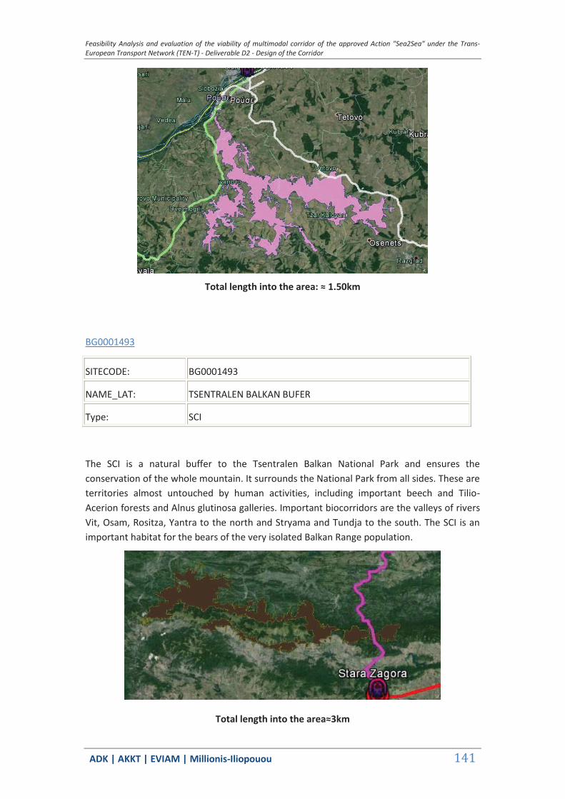
Feasibility Analysis and evaluation of the viability of multimodal corridor of the approved Action "Sea2Sea" under the Trans-European Transport Network (TEN-T) - Deliverable D2 - Design of the Corridor
ΑDΚ | AKKT | ΕVΙΑΜ | Millionis-Iliopouou 141
Total length into the area: ≈ 1.50km
BG0001493
SITECODE: BG0001493
NAME_LAT: TSENTRALEN BALKAN BUFER
Type: SCI
The SCI is a natural buffer to the Tsentralen Balkan National Park and ensures the conservation of the whole mountain. It surrounds the National Park from all sides. These are territories almost untouched by human activities, including important beech and Tilio-Acerion forests and Alnus glutinosa galleries. Important biocorridors are the valleys of rivers Vit, Osam, Rositza, Yantra to the north and Stryama and Tundja to the south. The SCI is an important habitat for the bears of the very isolated Balkan Range population.
Total length into the area≈3km

Feasibility Analysis and evaluation of the viability of multimodal corridor of the approved Action "Sea2Sea" under the Trans-European Transport Network (TEN-T) - Deliverable D2 - Design of the Corridor
ΑDΚ | AKKT | ΕVΙΑΜ | Millionis-Iliopouou 142
BG0000282
SITECODE: BG0000282
NAME_LAT: DRYANOVSKA REKA
Type: SCI
The Draynovska reka is a river in the Northern Bulgaria a left tributary of the Belitsa River. It takes its sources from the Shipchensko-Trevnenska Mountains. Its middle current crosses the Eastern part of the Strandja height and forms a picturesque gorge. The river length is 59,3 km. The site represents limestone and marl rock basis. The currency runs through cross-country and hilly area. The river has a narrow rocky river-bed.
Total length into the area≈1.5km
3.1.4 Areas of protection for Scenario B
In this chapter we present “Natura 2000” protected areas along the Scenario B. No short desciotion is provided since in deliverable D.2.1. all protected areas along Sea2Sea corridor are presented with detail.
GR1110006 & GR1110007
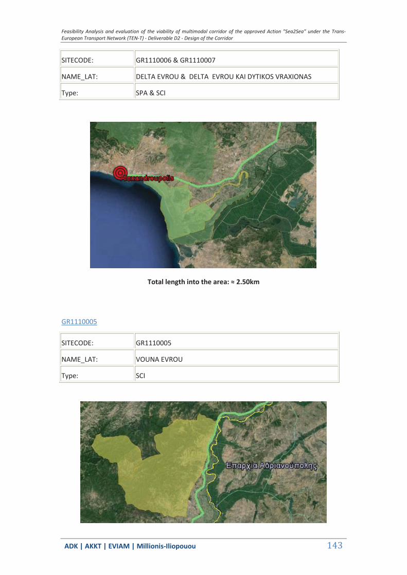
Feasibility Analysis and evaluation of the viability of multimodal corridor of the approved Action "Sea2Sea" under the Trans-European Transport Network (TEN-T) - Deliverable D2 - Design of the Corridor
ΑDΚ | AKKT | ΕVΙΑΜ | Millionis-Iliopouou 143
SITECODE: GR1110006 & GR1110007
NAME_LAT: DELTA EVROU & DELTA EVROU KAI DYTIKOS VRAXIONAS
Type: SPA & SCI
Total length into the area: ≈ 2.50km
GR1110005
SITECODE: GR1110005
NAME_LAT: VOUNA EVROU
Type: SCI

Feasibility Analysis and evaluation of the viability of multimodal corridor of the approved Action "Sea2Sea" under the Trans-European Transport Network (TEN-T) - Deliverable D2 - Design of the Corridor
ΑDΚ | AKKT | ΕVΙΑΜ | Millionis-Iliopouou 144
Total length into the area: ≈ 5.50km
GR1110008
SITECODE: GR1110008
NAME_LAT: PARAPOTAMIO DASOS VOREIOU EVROU KAI ARDA
Type: SPA
Total length into the area: ≈ 40km
BG0000578
SITECODE: BG0000578
NAME_LAT: REKA MARITSA
Type: SCI

Feasibility Analysis and evaluation of the viability of multimodal corridor of the approved Action "Sea2Sea" under the Trans-European Transport Network (TEN-T) - Deliverable D2 - Design of the Corridor
ΑDΚ | AKKT | ΕVΙΑΜ | Millionis-Iliopouou 145
Total length into the area: (4.0+1.0+0.5+0.85+1.10+0.25)≈8km
BG0001034
SITECODE: BG0001034
NAME_LAT: REKA MARITSA OSTAR KAMAK
Type: SCI
Total length into the area: (4.0+1.0+0.5+0.85+1.10+0.25)≈150m
BG0002103
SITECODE: BG0002103
NAME_LAT: ZLATO POLE
Type: SPA

Feasibility Analysis and evaluation of the viability of multimodal corridor of the approved Action "Sea2Sea" under the Trans-European Transport Network (TEN-T) - Deliverable D2 - Design of the Corridor
ΑDΚ | AKKT | ΕVΙΑΜ | Millionis-Iliopouou 146
Total length into the area: ≈500m
BG0002081
SITECODE: BG0002081
NAME_LAT: MARITSA - PARVOMAY
Type: SPA
Total length into the area: (6.5+6.5) ≈13km
BG0000194
SITECODE: BG0000194
NAME_LAT: REKA CHAYA
Type: SCI
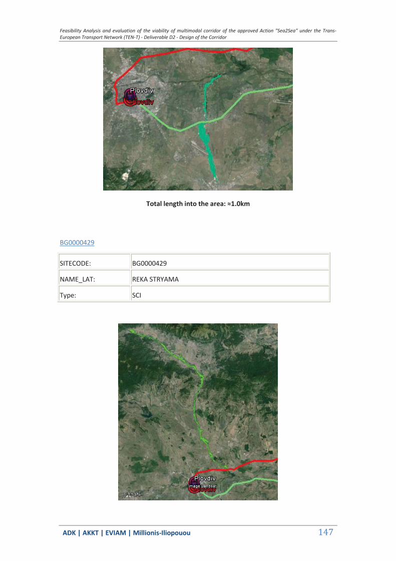
Feasibility Analysis and evaluation of the viability of multimodal corridor of the approved Action "Sea2Sea" under the Trans-European Transport Network (TEN-T) - Deliverable D2 - Design of the Corridor
ΑDΚ | AKKT | ΕVΙΑΜ | Millionis-Iliopouou 147
Total length into the area: ≈1.0km
BG0000429
SITECODE: BG0000429
NAME_LAT: REKA STRYAMA
Type: SCI

Feasibility Analysis and evaluation of the viability of multimodal corridor of the approved Action "Sea2Sea" under the Trans-European Transport Network (TEN-T) - Deliverable D2 - Design of the Corridor
ΑDΚ | AKKT | ΕVΙΑΜ | Millionis-Iliopouou 148
Total length into the area: ≈150m
BG0000192
SITECODE: BG0000192
NAME_LAT: REKA TUNDZHA 1
Type: SCI
Total length into the area: (4.0 [stage 2]+ 1.5 [stage 4])≈6.5km
BG0002094
SITECODE: BG0002094
NAME_LAT: ADATA TUNDZHA
Type: SCI
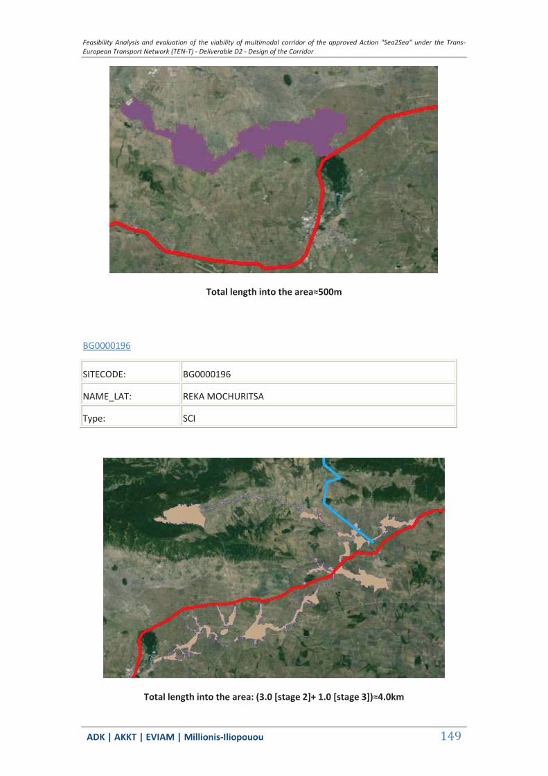
Feasibility Analysis and evaluation of the viability of multimodal corridor of the approved Action "Sea2Sea" under the Trans-European Transport Network (TEN-T) - Deliverable D2 - Design of the Corridor
ΑDΚ | AKKT | ΕVΙΑΜ | Millionis-Iliopouou 149
Total length into the area≈500m
BG0000196
SITECODE: BG0000196
NAME_LAT: REKA MOCHURITSA
Type: SCI
Total length into the area: (3.0 [stage 2]+ 1.0 [stage 3])≈4.0km
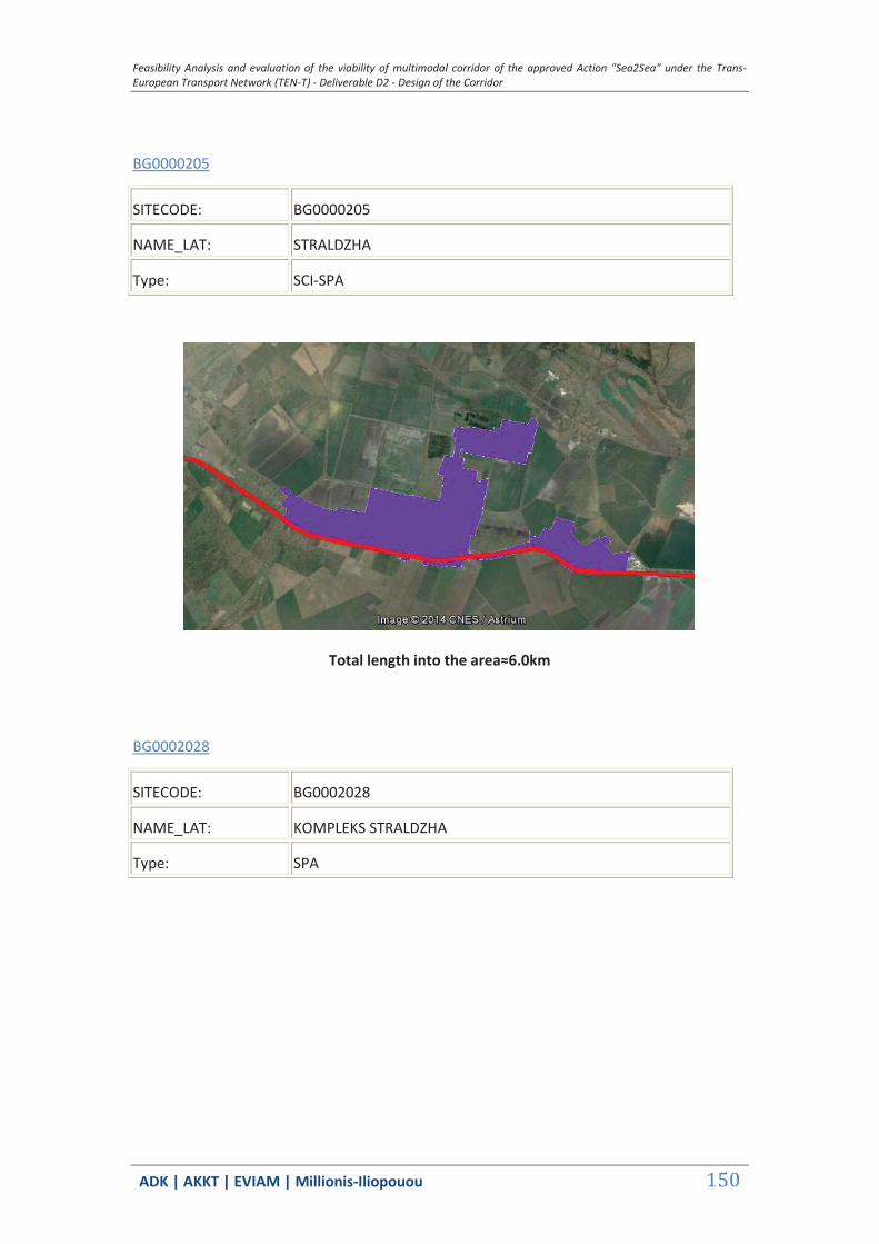
Feasibility Analysis and evaluation of the viability of multimodal corridor of the approved Action "Sea2Sea" under the Trans-European Transport Network (TEN-T) - Deliverable D2 - Design of the Corridor
ΑDΚ | AKKT | ΕVΙΑΜ | Millionis-Iliopouou 150
BG0000205
SITECODE: BG0000205
NAME_LAT: STRALDZHA
Type: SCI-SPA
Total length into the area≈6.0km
BG0002028
SITECODE: BG0002028
NAME_LAT: KOMPLEKS STRALDZHA
Type: SPA

Feasibility Analysis and evaluation of the viability of multimodal corridor of the approved Action "Sea2Sea" under the Trans-European Transport Network (TEN-T) - Deliverable D2 - Design of the Corridor
ΑDΚ | AKKT | ΕVΙΑΜ | Millionis-Iliopouou 151
Total length into the area≈3.0km
BG0000273
SITECODE: BG0000273
NAME_LAT: BURGASKO EZERO
Type: SCI-SPA
Total length into the area≈1.5km
BG0001493
SITECODE: BG0001493
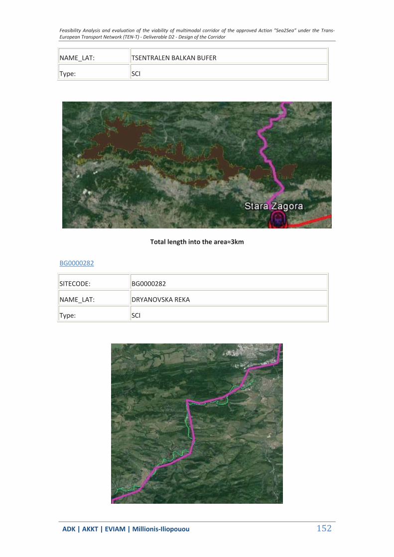
Feasibility Analysis and evaluation of the viability of multimodal corridor of the approved Action "Sea2Sea" under the Trans-European Transport Network (TEN-T) - Deliverable D2 - Design of the Corridor
ΑDΚ | AKKT | ΕVΙΑΜ | Millionis-Iliopouou 152
NAME_LAT: TSENTRALEN BALKAN BUFER
Type: SCI
Total length into the area≈3km
BG0000282
SITECODE: BG0000282
NAME_LAT: DRYANOVSKA REKA
Type: SCI
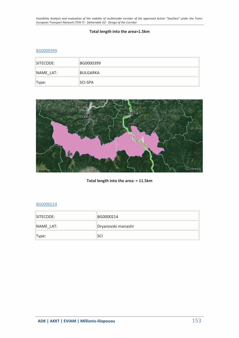
Feasibility Analysis and evaluation of the viability of multimodal corridor of the approved Action "Sea2Sea" under the Trans-European Transport Network (TEN-T) - Deliverable D2 - Design of the Corridor
ΑDΚ | AKKT | ΕVΙΑΜ | Millionis-Iliopouou 153
Total length into the area≈1.5km
BG0000399
SITECODE: BG0000399
NAME_LAT: BULGARKA
Type: SCI-SPA
Total length into the area: ≈ 11.5km
BG0000214
SITECODE: BG0000214
NAME_LAT: Dryanovski manastir
Type: SCI

Feasibility Analysis and evaluation of the viability of multimodal corridor of the approved Action "Sea2Sea" under the Trans-European Transport Network (TEN-T) - Deliverable D2 - Design of the Corridor
ΑDΚ | AKKT | ΕVΙΑΜ | Millionis-Iliopouou 154
Total length into the area: (7.80+3.50) ≈ 11.5km
BG0000213
SITECODE: BG0000213
NAME_LAT: Tarnovski visochini
Type: SCI
Total length into the area: (2.50+0.50+0.50+2.50) ≈ 6.0km
BG0000610
SITECODE: BG0000610

Feasibility Analysis and evaluation of the viability of multimodal corridor of the approved Action "Sea2Sea" under the Trans-European Transport Network (TEN-T) - Deliverable D2 - Design of the Corridor
ΑDΚ | AKKT | ΕVΙΑΜ | Millionis-Iliopouou 155
NAME_LAT: Reka Yantra
Type: SCI
Total length into the area: (0.30+0.10+0.20+0.50+0.30+3.80+0.5+11.0) ≈ 17.0km
BG0000104
SITECODE: BG0000104
NAME_LAT: Provadiosko Royasko Plato
Type: SCI
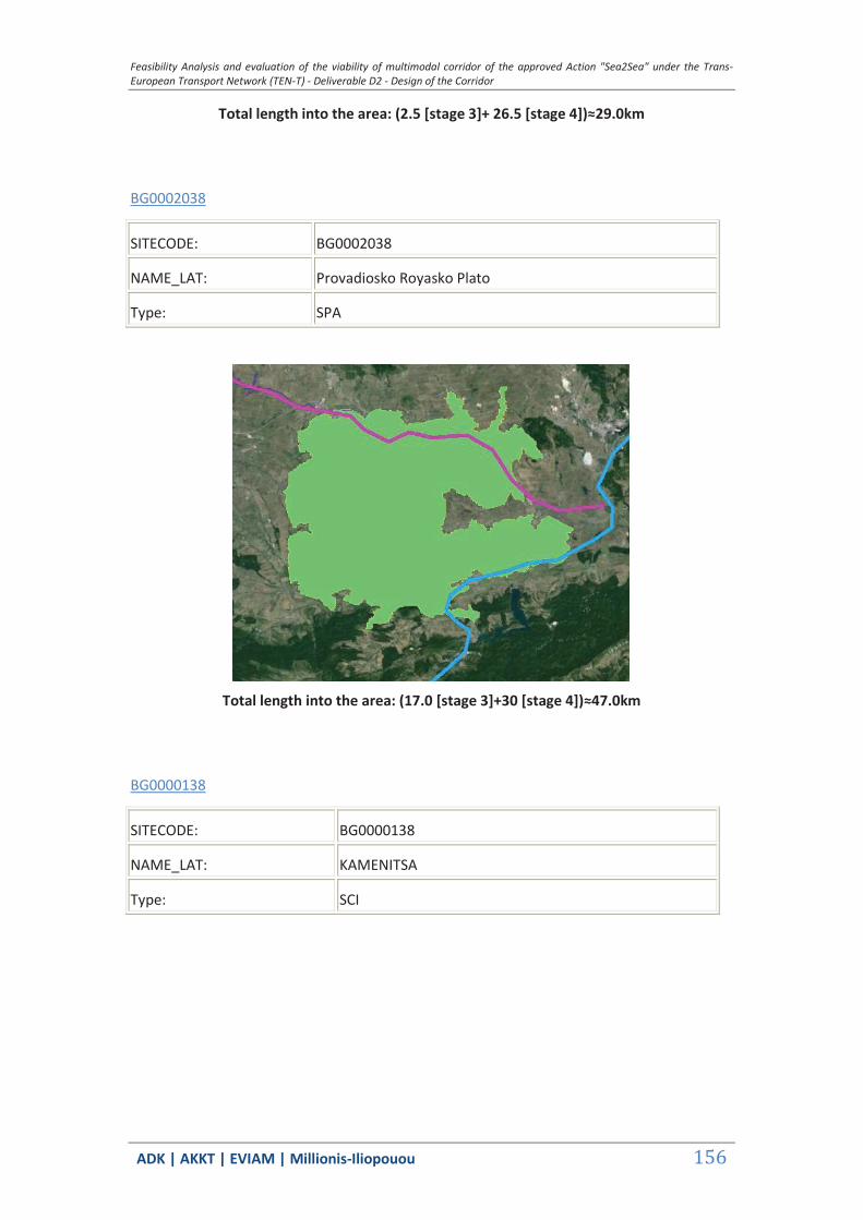
Feasibility Analysis and evaluation of the viability of multimodal corridor of the approved Action "Sea2Sea" under the Trans-European Transport Network (TEN-T) - Deliverable D2 - Design of the Corridor
ΑDΚ | AKKT | ΕVΙΑΜ | Millionis-Iliopouou 156
Total length into the area: (2.5 [stage 3]+ 26.5 [stage 4])≈29.0km
BG0002038
SITECODE: BG0002038
NAME_LAT: Provadiosko Royasko Plato
Type: SPA
Total length into the area: (17.0 [stage 3]+30 [stage 4])≈47.0km
BG0000138
SITECODE: BG0000138
NAME_LAT: KAMENITSA
Type: SCI

Feasibility Analysis and evaluation of the viability of multimodal corridor of the approved Action "Sea2Sea" under the Trans-European Transport Network (TEN-T) - Deliverable D2 - Design of the Corridor
ΑDΚ | AKKT | ΕVΙΑΜ | Millionis-Iliopouou 157
Total length into the area: ≈2.5km
BG0000191
SITECODE: BG000091
NAME_LAT: VARNESKO BELOSLAVO EZERO
Type: SPA
Total length into the area: ≈9.5km
BG0000608
SITECODE: BG0000608
NAME_LAT: LOMOVETE
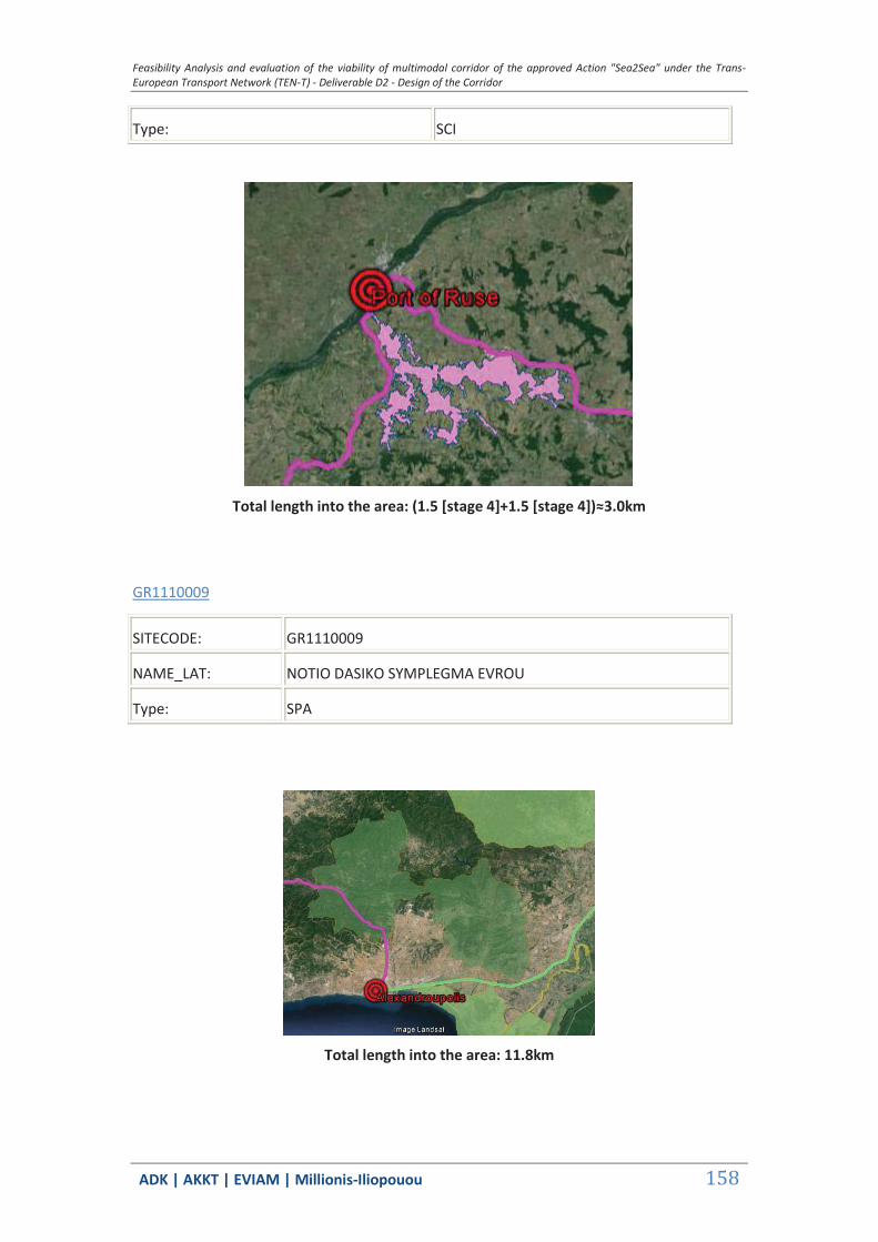
Feasibility Analysis and evaluation of the viability of multimodal corridor of the approved Action "Sea2Sea" under the Trans-European Transport Network (TEN-T) - Deliverable D2 - Design of the Corridor
ΑDΚ | AKKT | ΕVΙΑΜ | Millionis-Iliopouou 158
Type: SCI
Total length into the area: (1.5 [stage 4]+1.5 [stage 4])≈3.0km
GR1110009
SITECODE: GR1110009
NAME_LAT: NOTIO DASIKO SYMPLEGMA EVROU
Type: SPA
Total length into the area: 11.8km
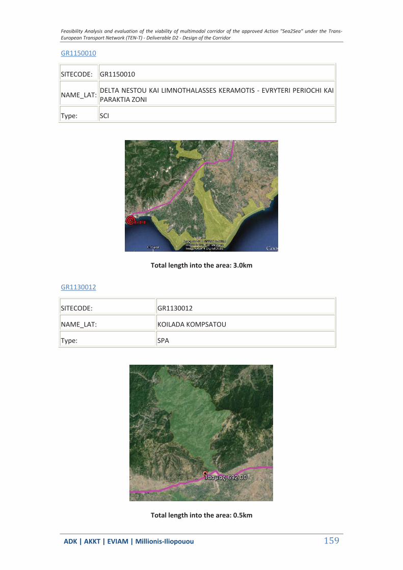
Feasibility Analysis and evaluation of the viability of multimodal corridor of the approved Action "Sea2Sea" under the Trans-European Transport Network (TEN-T) - Deliverable D2 - Design of the Corridor
ΑDΚ | AKKT | ΕVΙΑΜ | Millionis-Iliopouou 159
GR1150010
SITECODE: GR1150010
NAME_LAT: DELTA NESTOU KAI LIMNOTHALASSES KERAMOTIS - EVRYTERI PERIOCHI KAI PARAKTIA ZONI
Type: SCI
Total length into the area: 3.0km
GR1130012
SITECODE: GR1130012
NAME_LAT: KOILADA KOMPSATOU
Type: SPA
Total length into the area: 0.5km
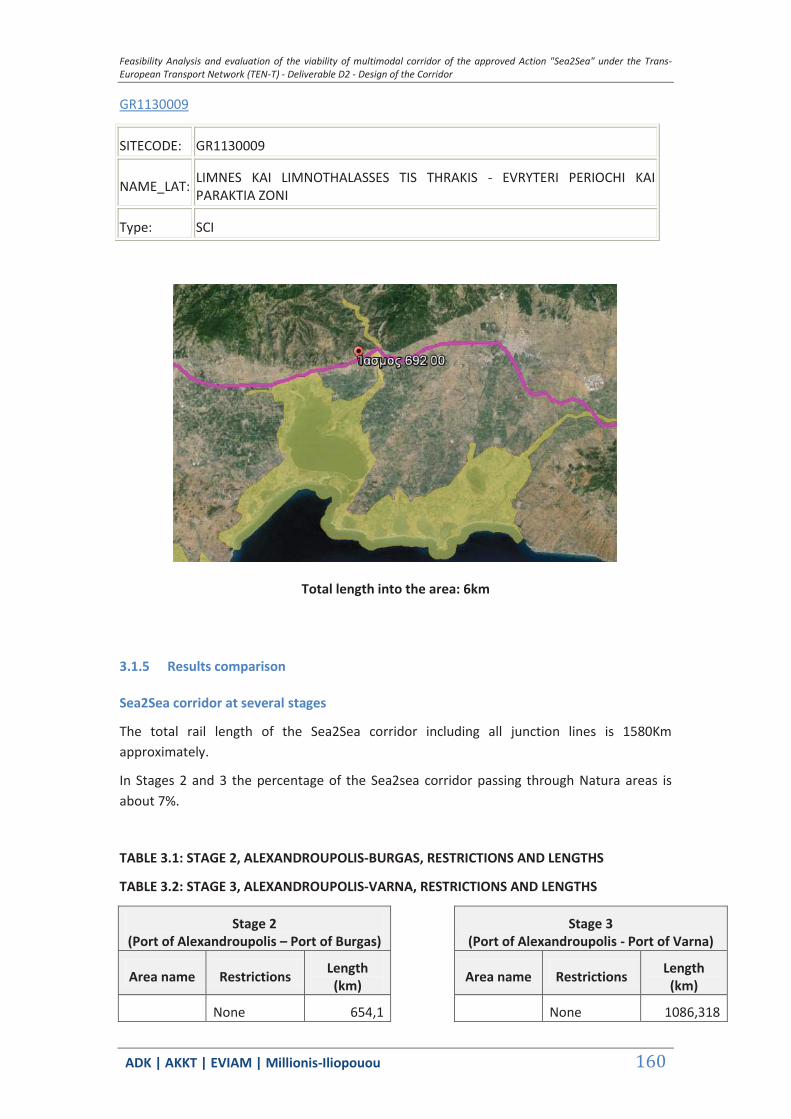
Feasibility Analysis and evaluation of the viability of multimodal corridor of the approved Action "Sea2Sea" under the Trans-European Transport Network (TEN-T) - Deliverable D2 - Design of the Corridor
ΑDΚ | AKKT | ΕVΙΑΜ | Millionis-Iliopouou 160
GR1130009
SITECODE: GR1130009
NAME_LAT: LIMNES KAI LIMNOTHALASSES TIS THRAKIS - EVRYTERI PERIOCHI KAI PARAKTIA ZONI
Type: SCI
Total length into the area: 6km
3.1.5 Results comparison
Sea2Sea corridor at several stages
The total rail length of the Sea2Sea corridor including all junction lines is 1580Km approximately.
In Stages 2 and 3 the percentage of the Sea2sea corridor passing through Natura areas is about 7%.
TABLE 3.1: STAGE 2, ALEXANDROUPOLIS-BURGAS, RESTRICTIONS AND LENGTHS
TABLE 3.2: STAGE 3, ALEXANDROUPOLIS-VARNA, RESTRICTIONS AND LENGTHS
Stage 2 (Port of Alexandroupolis – Port of Burgas)
Stage 3 (Port of Alexandroupolis - Port of Varna)
Area name Restrictions Length (km) Area name Restrictions Length
(km)
None 654,1 None 1086,318
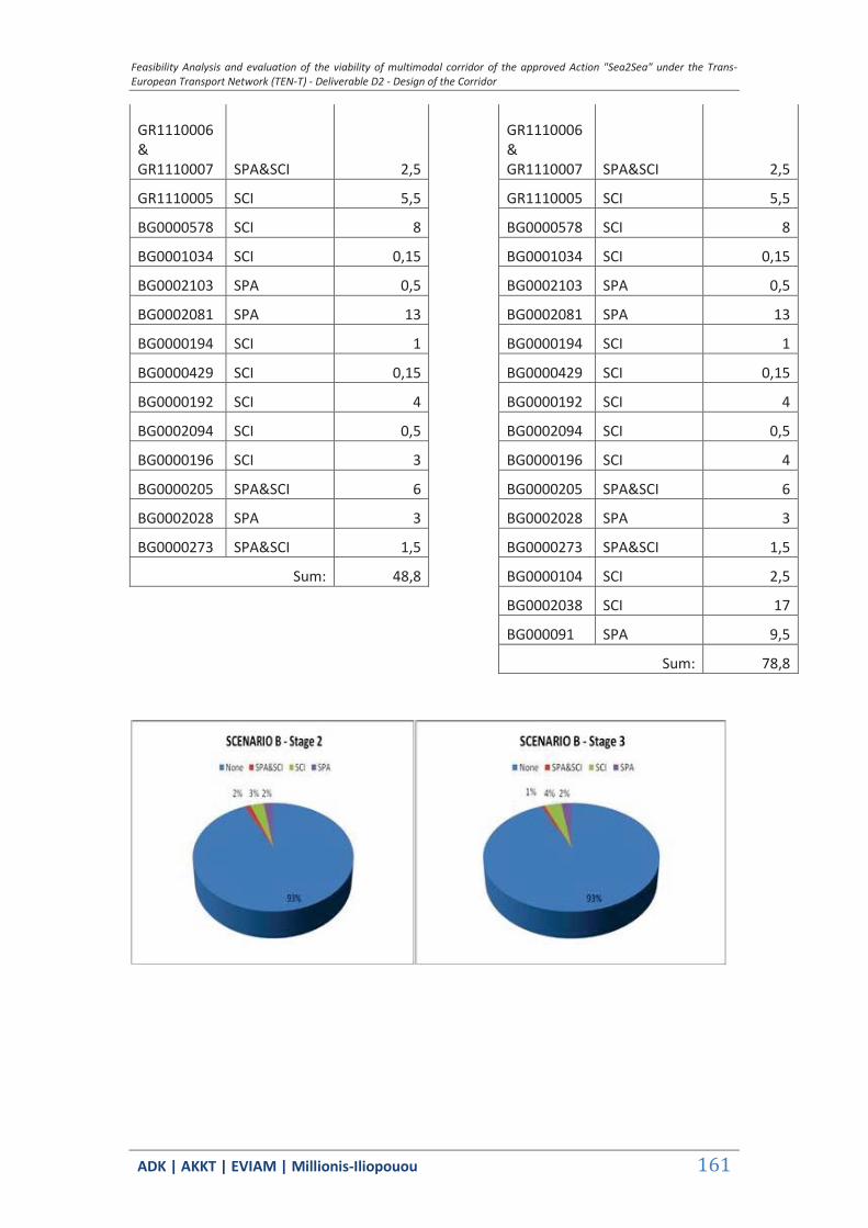
Feasibility Analysis and evaluation of the viability of multimodal corridor of the approved Action "Sea2Sea" under the Trans-European Transport Network (TEN-T) - Deliverable D2 - Design of the Corridor
ΑDΚ | AKKT | ΕVΙΑΜ | Millionis-Iliopouou 161
GR1110006 & GR1110007 SPA&SCI 2,5
GR1110006 & GR1110007 SPA&SCI 2,5
GR1110005 SCI 5,5 GR1110005 SCI 5,5
BG0000578 SCI 8 BG0000578 SCI 8
BG0001034 SCI 0,15 BG0001034 SCI 0,15
BG0002103 SPA 0,5 BG0002103 SPA 0,5
BG0002081 SPA 13 BG0002081 SPA 13
BG0000194 SCI 1 BG0000194 SCI 1
BG0000429 SCI 0,15 BG0000429 SCI 0,15
BG0000192 SCI 4 BG0000192 SCI 4
BG0002094 SCI 0,5 BG0002094 SCI 0,5
BG0000196 SCI 3 BG0000196 SCI 4
BG0000205 SPA&SCI 6 BG0000205 SPA&SCI 6
BG0002028 SPA 3 BG0002028 SPA 3
BG0000273 SPA&SCI 1,5 BG0000273 SPA&SCI 1,5
Sum: 48,8 BG0000104 SCI 2,5
BG0002038 SCI 17
BG000091 SPA 9,5
Sum: 78,8

Feasibility Analysis and evaluation of the viability of multimodal corridor of the approved Action "Sea2Sea" under the Trans-European Transport Network (TEN-T) - Deliverable D2 - Design of the Corridor
ΑDΚ | AKKT | ΕVΙΑΜ | Millionis-Iliopouou 162
In Stages 4 the percentage of the Sea2sea corridor passing through Natura areas is doubled at about 14% due to the new junction routes leading to Kavala and Ruse.
TABLE 3.3: STAGE 4, KAVALA-RUSE, RESTRICTIONS AND LENGTHS
Stage 4 (Port of Kavala– Port of Ruse)
Area name Restrictions Length (km)
None 1367,76
GR1110009 SPA 11,80
GR1150010 SCI 3,00
GR1130012 SPA 0,50
GR1130009 SCI 6,00
GR1110006 & GR1110007 SPA&SCI 2,5
GR1110005 SCI 5,5
BG0000578 SCI 8
BG0001034 SCI 0,15
BG0002103 SPA 0,5
BG0002081 SPA 13
BG0000194 SCI 1
BG0000429 SCI 0,15
BG0000192 SCI 6,5
BG0002094 SCI 0,5
BG0000196 SCI 4
BG0000205 SPA&SCI 6
BG0002028 SPA 3
BG0000273 SPA&SCI 1,5
BG0000104 SCI 29
BG0002038 SCI 47
BG000091 SPA 9,5
BG0001493 SCI 3
BG0000282 SCI 1,5
BG0000399 SPA&SCI 11,5
BG0000214 SCI 11,5
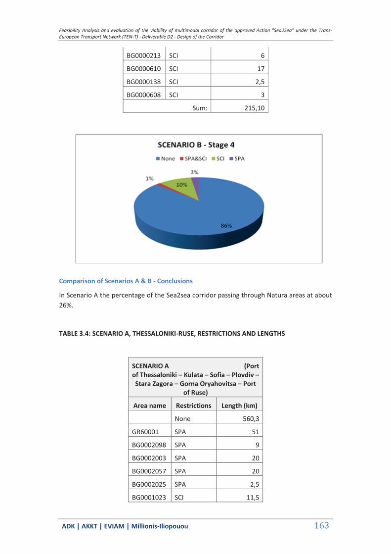
Feasibility Analysis and evaluation of the viability of multimodal corridor of the approved Action "Sea2Sea" under the Trans-European Transport Network (TEN-T) - Deliverable D2 - Design of the Corridor
ΑDΚ | AKKT | ΕVΙΑΜ | Millionis-Iliopouou 163
BG0000213 SCI 6
BG0000610 SCI 17
BG0000138 SCI 2,5
BG0000608 SCI 3
Sum: 215,10
Comparison of Scenarios A & B - Conclusions
In Scenario A the percentage of the Sea2sea corridor passing through Natura areas at about 26%.
TABLE 3.4: SCENARIO A, THESSALONIKI-RUSE, RESTRICTIONS AND LENGTHS
SCENARIO A (Port of Thessaloniki – Kulata – Sofia – Plovdiv – Stara Zagora – Gorna Oryahovitsa – Port
of Ruse)
Area name Restrictions Length (km)
None 560,3
GR60001 SPA 51
BG0002098 SPA 9
BG0002003 SPA 20
BG0002057 SPA 20
BG0002025 SPA 2,5
BG0001023 SCI 11,5

Feasibility Analysis and evaluation of the viability of multimodal corridor of the approved Action "Sea2Sea" under the Trans-European Transport Network (TEN-T) - Deliverable D2 - Design of the Corridor
ΑDΚ | AKKT | ΕVΙΑΜ | Millionis-Iliopouou 164
BG0000366 SCI 20
BG0001022 SCI 1,5
BG0000304 SCI 10,5
BG0000578 SCI 1,5
BG0000192 SCI 0,5
BG0000399 SPA&SCI 11,5
BG0000214 SCI 11,5
BG0000213 SCI 6
BG0000610 SCI 17
BG0000608 SCI 1,5
BG0001493 SCI 3
BG0000282 SCI 1,5
Sum: 200
As we can observe main competitive Scenario A is not an environmentally friendlier alternative route to the Sea2Sea corridor as it practically has a similar footprint.
Scenario A passes through 200km of Natura protected areas a difference very small compared to the Sea2Sea corridor which affects about 215km at its full length at Stage 4 and including all junctions to Burgas, Varna and Kavala.
The difference is visible in absolute numbers since only 14% of the Sea2Sea corridor passes through SCI & SCA areas versus Scenario A corridor percentage at 26%.
Feasibility Analysis and evaluation of the viability of multimodal corridor of the approved Action "Sea2Sea" under the Trans-European Transport Network (TEN-T) - Deliverable D2 - Design of the Corridor
ΑDΚ | AKKT | ΕVΙΑΜ | Millionis-Iliopouou 165
3.2 Flows Forecast
Two are the main determinants of an economically sustainable overland rail bridge to Bulgaria through a Greek entry port.
The first refers to the competitiveness of a new route involving a carry-on rail transport leg as opposed to a well established shipping route through the Bulgarian ports of Varna and Burgas.
The second refers to the ability or the Greek ports to leverage their location in order to gain advantage in the port selection strategies of international shipping lines.
While the former seems more attainable once the rail-bridge option is decided and the parties involved commit themselves to the necessary investments and service improvements, the second has a lesser probability to be an upfront factor of the success story, as the shipping sailing patterns and distribution practices are highly volatile, depending to a large degree on the interplay of demand and supply, price fluctuations and freight structures.
Certainly, what is invested and built on the land side will influence the shipping lines into their route decisions, as a well equipped, competitive port with good carry-on overland connections to the final destinations of cargoes will open an opportunity window to international shipping. But nothing is guaranteed and the land side will always bear the risk of finding customers to pay for their investments.
3.2.1 The Model
The purpose of this mathematical model is to describe the container ship round trip. A criterion is then suggested by which the economic choice between ship diversions and the use of inland transport links may be made.
Two models may be considered. For the first, a key assumption is made that for reasons of policy the line operated a constant number of ships on the route, irrespective of the precise itinerary. For the second it is assumed that the number of ships is adjusted in line with the itinerary so as to operate each ship at an optimal load factor.
An alternative way of putting this is to assume that demand for transport capacity arises at a port hitherto unserved by the line (e.g. a in the case of the port of Alexandroupolis). Then, in the former case we may assume that sufficient spare capacity exists in existing ships so that the line is able to carry the additional cargo without increasing the number of ships on the route. In the latter case no spare capacity exists and the line must increase the number of ships in order to carry the incremental cargo.
In this study we will choose the former model as the second will require a lot of assumptions on the shipping side which we have little or no control and therefore there is no point into entering into the complexities of shipping decision process and fleet management.
Let’s assume that the line operates a fleet of M identical ships on an N port round trip. These ports may be classified into two sets which may be conveniently be thought of as a set of ports of ‘origin’, P1={p1, …, pk}, and a set of ports of ‘destination’, P2={pk+1, …, pn}. Finally, Rij
will denote the container freight rate, Rij, between any piєP1 and any pjєP2.

Feasibility Analysis and evaluation of the viability of multimodal corridor of the approved Action "Sea2Sea" under the Trans-European Transport Network (TEN-T) - Deliverable D2 - Design of the Corridor
ΑDΚ | AKKT | ΕVΙΑΜ | Millionis-Iliopouou 166
Given this common freight rate, it is assumed that there is a particular annual (monthly, or weekly, or daily) demand for container ship space to/from each port on the route. Furthermore, demand is such that there is always a balanced container exchange at each port and no containers are ever carried simply between ports belonging to the same set. Let:
q= Total daily demand in TEU’s for transport capacity in each direction between P1 and P2.
Q= Common ship size in TEU’s
V= Common ship speed in nautical miles per day (24 hours)
H= Common container handling rate at each port in TEU’s per day
K= Time required (expressed in days) at each port for pilotage, tug operations, berthing and de-berthing, etc.
ℓ = Common load factor for each ship on a particular itinerary.
αi xi = Sea distance in nautical miles between two consecutive ports on the round trip; Xi is the ‘straight line’ distance and αi is a convexity factor which takes into account any features of geography which obviate ‘straight line’ sailing. Clearly, αi ≥1 for every i, and αi =1 will probably hold for several i.
Constant fleet size round trip model
Suppose that between ports pN-1 and pN there exists a convenient inland transport network and that the sea distance between these ports, αN-1xN-1 say, is characterized by a ‘high’ convexity factor (αN-1).
Now we will consider the following two alternative itineraries:
Alternative A. Each ship calls at N ports; the inland transport link is not utilized. Thus total round trip time (RTTA) in days is given by
(sailing time + cargo handling time + access, etc., time)
which leads to (1) below:
(days)
Alternative B. Each ship calls at ports 1 to N-1 (proceeding directly from port N-1 to port 1) and containers are transported to/from port N to port N-1 by the inland transport link. Thus,
leading to (2) below:
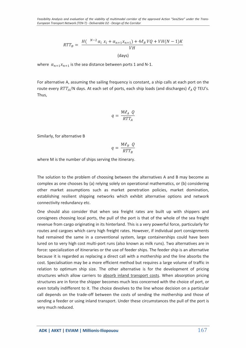
Feasibility Analysis and evaluation of the viability of multimodal corridor of the approved Action "Sea2Sea" under the Trans-European Transport Network (TEN-T) - Deliverable D2 - Design of the Corridor
ΑDΚ | AKKT | ΕVΙΑΜ | Millionis-Iliopouou 167
(days)
where is the sea distance between ports 1 and N-1.
For alternative A, assuming the sailing frequency is constant, a ship calls at each port on the route every N days. At each set of ports, each ship loads (and discharges) TEU’s. Thus,
Similarly, for alternative B
where M is the number of ships serving the itinerary.
The solution to the problem of choosing between the alternatives A and B may become as complex as one chooses by (a) relying solely on operational mathematics, or (b) considering other market assumptions such as market penetration policies, market domination, establishing resilient shipping networks which exhibit alternative options and network connectivity redundancy etc.
One should also consider that when sea freight rates are built up with shippers and consignees choosing local ports, the pull of the port is that of the whole of the sea freight revenue from cargo originating in its hinterland. This is a very powerful force, particularly for routes and cargoes which carry high freight rates. However, if individual port consignments had remained the same in a conventional system, large containerships could have been lured on to very high cost multi-port runs (also known as milk runs). Two alternatives are in force: specialization of itineraries or the use of feeder ships. The feeder ship is an alternative because it is regarded as replacing a direct call with a mothership and the line absorbs the cost. Specialisation may be a more efficient method but requires a large volume of traffic in relation to optimum ship size. The other alternative is for the development of pricing structures which allow carriers to absorb inland transport costs. When absorption pricing structures are in force the shipper becomes much less concerned with the choice of port, or even totally indifferent to it. The choice devolves to the line whose decision on a particular call depends on the trade-off between the costs of sending the mothership and those of sending a feeder or using inland transport. Under these circumstances the pull of the port is very much reduced.
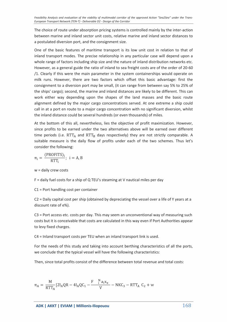
Feasibility Analysis and evaluation of the viability of multimodal corridor of the approved Action "Sea2Sea" under the Trans-European Transport Network (TEN-T) - Deliverable D2 - Design of the Corridor
ΑDΚ | AKKT | ΕVΙΑΜ | Millionis-Iliopouou 168
The choice of route under absorption pricing systems is controlled mainly by the inter-action between marine and inland sector unit costs, relative marine and inland sector distances to a postulated diversion port, and the consignment size.
One of the basic features of maritime transport is its low unit cost in relation to that of inland transport modes. The precise relationship in any particular case will depend upon a whole range of factors including ship size and the nature of inland distribution networks etc. However, as a general guide the ratio of inland to sea freight costs are of the order of 20-60 /1. Clearly if this were the main parameter in the system containerships would operate on milk runs. However, there are two factors which offset this basic advantage: first the consignment to a diversion port may be small, (it can range from between say 5% to 25% of the ships' cargo); second, the marine and inland distances are likely to be different. This can work either way depending upon the shapes of the land masses and the basic route alignment defined by the major cargo concentrations served. At one extreme a ship could call in at a port en route to a major cargo concentration with no significant diversion, whilst the inland distance could be several hundreds (or even thousands) of miles.
At the bottom of this all, nevertheless, lies the objective of profit maximization. However, since profits to be earned under the two alternatives above will be earned over different time periods (i.e. and days respectively) they are not strictly comparable. A suitable measure is the daily flow of profits under each of the two schemes. Thus let’s consider the following:
w = daily crew costs
F = daily fuel costs for a ship of Q TEU’s steaming at V nautical miles per day
C1 = Port handling cost per container
C2 = Daily capital cost per ship (obtained by depreciating the vessel over a life of Y years at a discount rate of e%).
C3 = Port access etc. costs per day. This may seem an unconventional way of measuring such costs but it is conceivable that costs are calculated in this way even if Port Authorities appear to levy fixed charges.
C4 = Inland transport costs per TEU when an inland transport link is used.
For the needs of this study and taking into account berthing characteristics of all the ports, we conclude that the typical vessel will have the following characteristics:
Then, since total profits consist of the difference between total revenue and total costs:
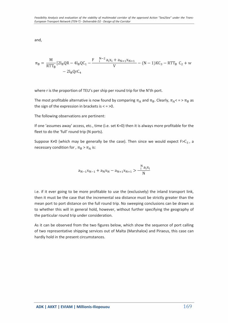
Feasibility Analysis and evaluation of the viability of multimodal corridor of the approved Action "Sea2Sea" under the Trans-European Transport Network (TEN-T) - Deliverable D2 - Design of the Corridor
ΑDΚ | AKKT | ΕVΙΑΜ | Millionis-Iliopouou 169
and,
where r is the proportion of TEU’s per ship per round trip for the N’th port.
The most profitable alternative is now found by comparing and . Clearly, < = > as the sign of the expression in brackets is < = >0.
The following observations are pertinent:
If one ‘assumes away’ access, etc., time (i.e. set K=0) then it is always more profitable for the fleet to do the ‘full’ round trip (N ports).
Suppose K≠0 (which may be generally be the case). Then since we would expect F> , a necessary condition for , > is:
i.e. if it ever going to be more profitable to use the (exclusively) the inland transport link, then it must be the case that the incremental sea distance must be strictly greater than the mean port to port distance on the full round trip. No sweeping conclusions can be drawn as to whether this will in general hold, however, without further specifying the geography of the particular round trip under consideration.
As it can be observed from the two figures below, which show the sequence of port calling of two representative shipping services out of Malta (Marshalox) and Piraeus, this case can hardly hold in the present circumstances.
Feasibility Analysis and evaluation of the viability of multimodal corridor of the approved Action "Sea2Sea" under the Trans-European Transport Network (TEN-T) - Deliverable D2 - Design of the Corridor
ΑDΚ | AKKT | ΕVΙΑΜ | Millionis-Iliopouou 170
Figure 58: CMA –CGN Black Sea Line
Figure 59: Shipping line through Turkey ports: Piraeus Black-Sea Express (PBX)
In order to test ex post this premise, i.e. that freight volumes from Bulgarian ports could use a land-bridge connection to Mediterranean ports, we applied the above model for two representative ports, Varna and Alexandroupolis. Since there are currently no regular shipping lines calling at the port of Alexandroupolis, we modified the Piraeus Black-Sea Express (PBX) to include this port as the first port of call and Varna as its last. The table below shows the published transit times of the original PBX service. The new round trip time would now be 13 days.
TABLE 3.5: PBX TRANSIT TIME (DAYS) From / To
Piraeus W
Novorossiys E
Odessa E
Constanta E
Varna E
Novorossiys E Odessa E Constanta E Varna E Istanbul AE Piraeus E
3 5 7 8 10 12
1 3 4 6 8
9 1 2 5 6
7 9 0 3 4
7 9 11 2 4

Feasibility Analysis and evaluation of the viability of multimodal corridor of the approved Action "Sea2Sea" under the Trans-European Transport Network (TEN-T) - Deliverable D2 - Design of the Corridor
ΑDΚ | AKKT | ΕVΙΑΜ | Millionis-Iliopouou 171
Istanbul AE
4 6 8 9 1
We assumed a typical vessel of 2000 TEU capacity, whose characteristics are shown in the table below. We also assumed a flat freight rate of 710€/TEU, a loading/unloading charge of 55 €/TEU, a container handling rate of 160 movements per shift, a Bosporus crossing tariff (both ways) of 4380€, a rail land-bridge Varna – Alexandoupolis freight cost of 580,15 €/TEU and two ships serving the line.
The results of the model, shown as profits comparison, are shown in the figures below, as a function of r: the proportion of TEU’s per ship per round trip for the N’th port (Varna). The diagram on the left shows the difference in monetary terms (€), whereas the one on the right as a percentage (%).
One can easily observe that below a percentage value of r= 13 % (0,13) bound for the N’th port, a shipping line could find it expedient to use a rail bridge, if one existed , with competitive service characteristics.
TABLE 3.6: TYPICAL STUDY CONTAINERSHIP
Vessel Size (TEU) 2,000 Average draft (m): 10.5 Cost elements USD Daily capital charge 20,242 Operating costs 5,751 Fuel at sea 22,395 Fuel in port 1,380 Daily costs at sea/TEU: 24.19 Daily costs in port/TEU: 13.69 [assumes USD467/t – Heavy Fuel Oil (HFO) ; USD690/t – Marine Diesel Oil (MDO) and no slow steaming] [Source: Ocean Shipping Consultants Ltd.]

Feasibility Analysis and evaluation of the viability of multimodal corridor of the approved Action "Sea2Sea" under the Trans-European Transport Network (TEN-T) - Deliverable D2 - Design of the Corridor
ΑDΚ | AKKT | ΕVΙΑΜ | Millionis-Iliopouou 172
Graph 3-1: Profit comparisons between alternatives A (all ports call) and B (rail land bridge)
This percentage is in excess of Bulgaria’s sea-born container traffic share of 6,8% for 2014, as calculated from the previous Table of Black Sea: Forecast Total Container Handling Demand (Source: Ocean Shipping Consultants. Total traffic to Varna and Burgas was estimated to be equal to 0,21 mTEU’s compared to 3,11 mTEU’s for the whole of Black Sea. This percentage, nevertheless, may not represent the actual container share on every ship of every shipping line calling at the ports of Black Sea.
The implementation of efficient and sustainable intermodal services generally requires a critical mass of regular ‘guaranteed’ shipments to and from a catchment area surrounding an intermodal terminal. Sufficient volumes can occur either due to agglomerations of people resulting in strong demand for consumer goods or when major large-scale distribution centers are present in the area or it is heavily industrialized, which generates a high level of inbound and outbound shipments of industrial products such as prefabricates, semi-finished goods or consumer goods, or through a combination of all these elements.
In this context our investigation into the future of intermodal traffic in Bulgaria should be particularly focused on the analysis and evaluation of multiple socio-economic factors such as those mentioned above, which essentially impact on opportunities for intermodal transport.
Consequently, there is vast theoretical market potential on international trade lanes. The size and regional distribution of population have a major influence on total freight traffic as well as on the logistic patterns and modal choice in particular with regard to opportunities for consolidating volumes. What is much more important for potential demand for transport services is population distribution. There is a clear concentration of population in Bulgaria in and around Sofia. About 18 per cent of all inhabitants live in this area, in the whole South- Western region it is about 28 per cent of the population. All other districts have far less inhabitants and some are rural areas. This is also reflected in the fact that the next biggest cities, except for Plovdiv and Burgas, have populations of 150,000 to 200,000.
Unfortunately it was not possible to collect any Origin- Destination (O-D) data, mainly because such data is not readily available or not disclosed for trade competition reasons. But by analyzing all shipping services to the area, it has become quite clear that almost all of the containerized traffic originates at a transshipment port in the Mediterranean. This is an
0 0.05 0.1 0.15 0.233 1041
22 1041
11 1041
0
1 1041
2 1041
Pa Pb r( )P
r0 0.05 0.1 0.15 0.2
202
101
0
10
Diff r( )
r
Feasibility Analysis and evaluation of the viability of multimodal corridor of the approved Action "Sea2Sea" under the Trans-European Transport Network (TEN-T) - Deliverable D2 - Design of the Corridor
ΑDΚ | AKKT | ΕVΙΑΜ | Millionis-Iliopouou 173
important element for our cost calculations, as any information about the final destination or origin of the cargo would only have a marginal beneficial effect in our analysis.
Our scenarios, which assume that the Sea2Sea corridors are basically nominal, i.e. define transport axes of interest but not necessarily trade flows, whereas sub-corridors such as those connecting the ports to Plovdiv, are more realistic and also compatible with the concept of the Project, lead us to consider carry-on inland costs as shown in the table below.
TABLE 3.7: RAIL TRANSPORT COSTS (€/TEU)
From/To Plovdiv Ruse Alexandroupolis 322,05 519,15 Thessaloniki 435,65 632,65 Burgas 220,40 Varna 258,10 173,00
As it can be seen, the Ports of Varna and Burgas maintain for the present a competitive advantage. Certainly, one key deciding factor will be inventory cost of imports/exports to/from the mainland, as the time advantage offered by the Greek ports is sizeable and up to a week compared to the ports of Black Sea. This may give an estimated annual flow of 20000 TEU’s to/from the South - Central Bulgaria, i.e. 10 percent of total sea-born traffic.
Nevertheless, the remaining issue is that for now there exists no regular container traffic to the ports of northeastern Greece (Eastern Macedonia/Thrace) and the list of assumptions is still long as it involves not only minimum start-up (guaranteed) volumes but also near-to-medium term preparedness of port and rail facilities in the ports and beyond.
3.2.2 The rail network
At this stage we assume that the rail network has been upgraded so that forwarders could guarantee same day (or within 24 hours) delivery of cargos to the weighted average location of Plovdin rail station. As a reminder, this would have had entail a series of improvements, least of which would be a minimum of rail sidings of 700m and speeds equal or in excess of 160 km/h5.
Assuming the use of typical UIC 571-4 type-1 or type-2 flat wagons, each block (unit) train would be made up of either 38 type-1 wagons carrying 38 40-foot containers or 76 TEU’s, or 31 type-2 wagons carrying a maximum of 31 X (one 40’ and one 20’) = 93 TEUs.
Assuming, further, a once a day, 360 days/year rail service, the annual transit volume amounts to 27,000 – 33,000 TEU’s per direction.
3.2.3 The Shipping Lines
5 Today, the rail line from Alexandroupolis to Ormenio is a single , not electrified line with sidings of 350m and maximum speed of <80km/h. The line from Svilengrad to Dimitrovgrad is also single, non-electrified, with sidings of 568m and maximum speed of 85km/h. The line from Dimitrovgrad to Plovdin is electrified (25 KV AC, 50 Hz), sidings of 700m and maximum speed of 160km/h.

Feasibility Analysis and evaluation of the viability of multimodal corridor of the approved Action "Sea2Sea" under the Trans-European Transport Network (TEN-T) - Deliverable D2 - Design of the Corridor
ΑDΚ | AKKT | ΕVΙΑΜ | Millionis-Iliopouou 174
As already mentioned, shipping routes and cargo routing are influenced by profit maximization decisions, which determine ship size selection, frequency of service, port selection, ship loading policies and freight rate structuring. If a port’s technical data do not match those of the ship type, the port is left out of direct port call services and is served with feeder ships.
Figures below demonstrate the abovementioned shipping practice.
Figure 60: Black Sea Express (BSX)
Haifa - Antalya - Piraeus - Constanta - Gemlik - Izmir - Piraeus - Thessaloniki - Mersin - Haifa
TABLE 3.8: BLACK SEA EXPRESS (BSX) TRANSIT TIME (DAYS)
From / To Antalya
W
Piraeus
W
Constanta
E
Gemlik
E
Izmir
E
Piraeus
E
Thessaloniki
E
Mersin
E
Haifa
E
Haifa W 1 3 6 8 10 11 13 16 18
Antalya W 1 4 6 8 9 11 14 16
Piraeus W 15 3 4 6 8 9 12 14
Constanta E 12 14 17 1 3 4 6 9 11
Gemlik E 10 12 15 17 1 3 4 7 9
Izmir E 9 11 14 16 18 1 2 6 8
Piraeus E 7 9 12 14 16 17 1 4 6
Thessaloniki E 5 7 10 12 14 15 17 2 4
Mersin E 2 4 7 9 11 12 14 17 1
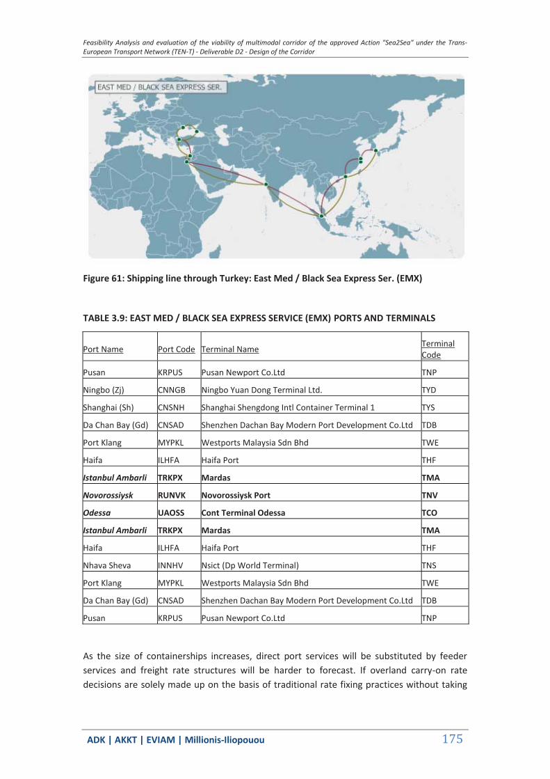
Feasibility Analysis and evaluation of the viability of multimodal corridor of the approved Action "Sea2Sea" under the Trans-European Transport Network (TEN-T) - Deliverable D2 - Design of the Corridor
ΑDΚ | AKKT | ΕVΙΑΜ | Millionis-Iliopouou 175
Figure 61: Shipping line through Turkey: East Med / Black Sea Express Ser. (EMX)
TABLE 3.9: EAST MED / BLACK SEA EXPRESS SERVICE (EMX) PORTS AND TERMINALS
Port Name Port Code Terminal Name
Terminal Code
Pusan KRPUS Pusan Newport Co.Ltd TNP
Ningbo (Zj) CNNGB Ningbo Yuan Dong Terminal Ltd. TYD
Shanghai (Sh) CNSNH Shanghai Shengdong Intl Container Terminal 1 TYS
Da Chan Bay (Gd) CNSAD Shenzhen Dachan Bay Modern Port Development Co.Ltd TDB
Port Klang MYPKL Westports Malaysia Sdn Bhd TWE
Haifa ILHFA Haifa Port THF
Istanbul Ambarli TRKPX Mardas TMA
Novorossiysk RUNVK Novorossiysk Port TNV
Odessa UAOSS Cont Terminal Odessa TCO
Istanbul Ambarli TRKPX Mardas TMA
Haifa ILHFA Haifa Port THF
Nhava Sheva INNHV Nsict (Dp World Terminal) TNS
Port Klang MYPKL Westports Malaysia Sdn Bhd TWE
Da Chan Bay (Gd) CNSAD Shenzhen Dachan Bay Modern Port Development Co.Ltd TDB
Pusan KRPUS Pusan Newport Co.Ltd TNP
As the size of containerships increases, direct port services will be substituted by feeder services and freight rate structures will be harder to forecast. If overland carry-on rate decisions are solely made up on the basis of traditional rate fixing practices without taking

Feasibility Analysis and evaluation of the viability of multimodal corridor of the approved Action "Sea2Sea" under the Trans-European Transport Network (TEN-T) - Deliverable D2 - Design of the Corridor
ΑDΚ | AKKT | ΕVΙΑΜ | Millionis-Iliopouou 176
into account the shipping rates with which they are combined as an alternative service, then the prospect of the rail bridge will be seriously jeopardized.
The problem is that shipping rates, as opposed to rail rates, are highly volatile as they are influenced by world trade fluctuations, see for example Graph 3-2 and TABLE 3.10, TABLE 3.11 below.
Graph 3-2: Growth of demand and supply in container shipping, 2000–2013 (Annual growth rates)
Source: Compiled by the UNCTAD secretariat on the basis of data from Clarkson Container Intelligence Monthly, various issues.
TABLE 3.10: CONTAINER FAR EAST– MEDITERRANEAN EUROPE FREIGHT MARKET RATES
Freight market 2009 2010 2011 2012
Far East–Europe (Dollars per TEU)
Shanghai–Mediterranean 1 397 1 739 973 1 336
Percentage change 24.49 -44.05 37.31
Source: Various issues of Container Intelligence Monthly, Clarkson Research Services.
Currently (on 7/11/2014) the freight rate for a 20’ container from Shanghai to any of the three ports, i.e. Varna (BG), Ambarli (TR) or Thessaloniki (TR) ranges from USD 1,322 - USD 1,461.

Feasibility Analysis and evaluation of the viability of multimodal corridor of the approved Action "Sea2Sea" under the Trans-European Transport Network (TEN-T) - Deliverable D2 - Design of the Corridor
ΑDΚ | AKKT | ΕVΙΑΜ | Millionis-Iliopouou 177
These quotations clearly demonstrate how important and decisive is the role of competitive rail freight rates in diverting cargo volumes to the corridor.
It should be reminded that in our analysis, we have only examined one of many hypotheses, i.e. that of the constant fleet size. In this case factors favoring ship diversions seem fairly strong and this is probably to be expected.
Graph 3-3: Time series of the Shanghai Containerized Freight Index (USD/TEU) 2012-14
Note: The freight rate includes ocean freight and surcharges / {Issued by SSE}
TABLE 3.11: COMPOSITION OF SHANGHAI CONTAINERIZED FREIGHT INDEX
Description Unit Weighting
Weekly Index
2014-11-07
Comprehensive Index 1062.46
Line Service:
Europe (Base port) USD/TEU 20.0% 1175.0
Mediterranean (Base port) USD/TEU 10.0% 1305.0
USWC (Base port) USD/FEU 20.0% 1927.0
USEC (Base port) USD/FEU 7.5% 3941.0
Persian Gulf and Red Sea (Dubai) USD/TEU 7.5% 999.0
Austrlian/New Zealand (Melbourne) USD/TEU 5.0% 770.0
East/West Africa (Lagos) USD/TEU 2.5% 1774.0
South Africa (Duban) USD/TEU 2.5% 1048.0
South America (Santos) USD/TEU 2.5% 1250.0
West Japan (Base port) USD/TEU 5.0% 143.0
East Japan (Base port) USD/TEU 5.0% 204.0
Southeast Asia (Singapore) USD/TEU 5.0% 241.0
Korea (Pusan) USD/TEU 2.5% 176.0
Feasibility Analysis and evaluation of the viability of multimodal corridor of the approved Action "Sea2Sea" under the Trans-European Transport Network (TEN-T) - Deliverable D2 - Design of the Corridor
ΑDΚ | AKKT | ΕVΙΑΜ | Millionis-Iliopouou 178
Taiwan (Kaohsiung) USD/TEU 2.5% 218.0
Hong Kong (Hong Kong) USD/TEU 2.5% 57.0
Base Port: Report Freight Rates of Base Ports
MediterraneanSea—Barcelona/Valencia/Genoa/Naples Europe—Hamburg/Antwerp/Felixtowe/LeHavre USWC—LosAngeles/LongBeach/Oakland USEC—NewYork/Savannah/Norfolk/Charleston West Japan—Osaka/Kobe East Japan—Tokyo/Yokohama
{Issued by SSE}
Presumably, changes in the port time to sea time ratio are also important but nothing concrete can be said about this since, for the diversion option, both port time and sea time increase.
Therefore, all previous assumptions hold and we will base our best estimates on a constant percentage of the future time series of container handling demands published by Ocean Shipping Consultants (see Graph 3-4).
This graph depicts three assumptions, that of the Base Case, the Enhanced- Recovery Case and the Continued- Instability Case which are defined as follows:
Base Case – a consensus view, which envisages a return to trend growth over 2011-13 for most economies, though with a slowdown in 2012.
Enhanced-Recovery Case – this assumes a stronger upturn in 2011 and more positive subsequent development, followed by a somewhat higher rate of economic expansion in the medium term.
Continued-Instability Case – recovery is slower and weaker, and is followed by a slower pace of expansion in the medium term. Continued uncertainty, posed in particular by financial instability in parts of the euro area, manifests in a sharper downturn in 2012.
In all three cases, it is envisaged that economic and trade recovery will be gradual, rather than surging, due to anticipated continued restraints on credit, as banks rebuild their balance sheets, and the dampening effect that fiscal measures to repay government debt exert on consumer expenditure growth.
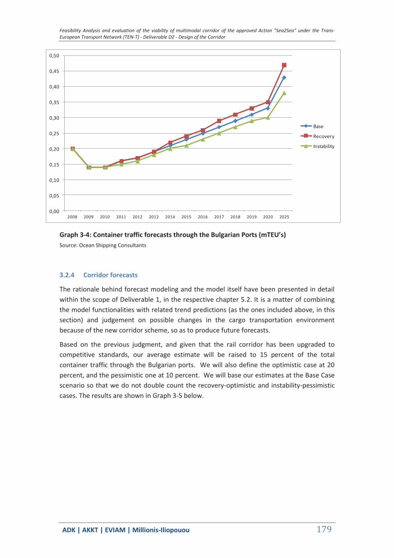
Feasibility Analysis and evaluation of the viability of multimodal corridor of the approved Action "Sea2Sea" under the Trans-European Transport Network (TEN-T) - Deliverable D2 - Design of the Corridor
ΑDΚ | AKKT | ΕVΙΑΜ | Millionis-Iliopouou 179
Graph 3-4: Container traffic forecasts through the Bulgarian Ports (mTEU’s) Source: Ocean Shipping Consultants
3.2.4 Corridor forecasts
The rationale behind forecast modeling and the model itself have been presented in detail within the scope of Deliverable 1, in the respective chapter 5.2. It is a matter of combining the model functionalities with related trend predictions (as the ones included above, in this section) and judgement on possible changes in the cargo transportation environment because of the new corridor scheme, so as to produce future forecasts.
Based on the previous judgment, and given that the rail corridor has been upgraded to competitive standards, our average estimate will be raised to 15 percent of the total container traffic through the Bulgarian ports. We will also define the optimistic case at 20 percent, and the pessimistic one at 10 percent. We will base our estimates at the Base Case scenario so that we do not double count the recovery-optimistic and instability-pessimistic cases. The results are shown in Graph 3-5 below.
0,00
0,05
0,10
0,15
0,20
0,25
0,30
0,35
0,40
0,45
0,50
2008 2009 2010 2011 2012 2012 2014 2015 2016 2017 2018 2019 2020 2025
Base
Recovery
Instability
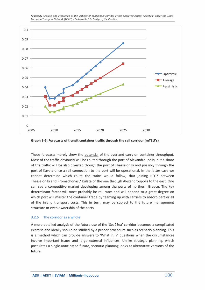
Feasibility Analysis and evaluation of the viability of multimodal corridor of the approved Action "Sea2Sea" under the Trans-European Transport Network (TEN-T) - Deliverable D2 - Design of the Corridor
ΑDΚ | AKKT | ΕVΙΑΜ | Millionis-Iliopouou 180
Graph 3-5: Forecasts of transit container traffic through the rail corridor (mTEU’s)
These forecasts merely show the potential of the overland carry-on container throughput. Most of the traffic obviously will be routed through the port of Alexandroupolis, but a share of the traffic will be also diverted though the port of Thessaloniki and possibly through the port of Kavala once a rail connection to the port will be operational. In the latter case we cannot determine which route the trains would follow, that joining RFC7 between Thessaloniki and Promachonas / Kulata or the one through Alexandroupolis to the east. One can see a competitive market developing among the ports of northern Greece. The key determinant factor will most probably be rail rates and will depend to a great degree on which port will master the container trade by teaming up with carriers to absorb part or all of the inland transport costs. This in turn, may be subject to the future management structure or even ownership of the ports.
3.2.5 The corridor as a whole
A more detailed analysis of the future use of the ‘Sea2Sea’ corridor becomes a complicated exercise and ideally should be studied by a proper procedure such as scenario planning. This is a method which can provide answers to ‘What if...?’ questions when the circumstances involve important issues and large external influences. Unlike strategic planning, which postulates a single anticipated future, scenario planning looks at alternative versions of the future.
0
0,01
0,02
0,03
0,04
0,05
0,06
0,07
0,08
0,09
0,1
2005 2010 2015 2020 2025 2030
Optimistic
Average
Pessimistic
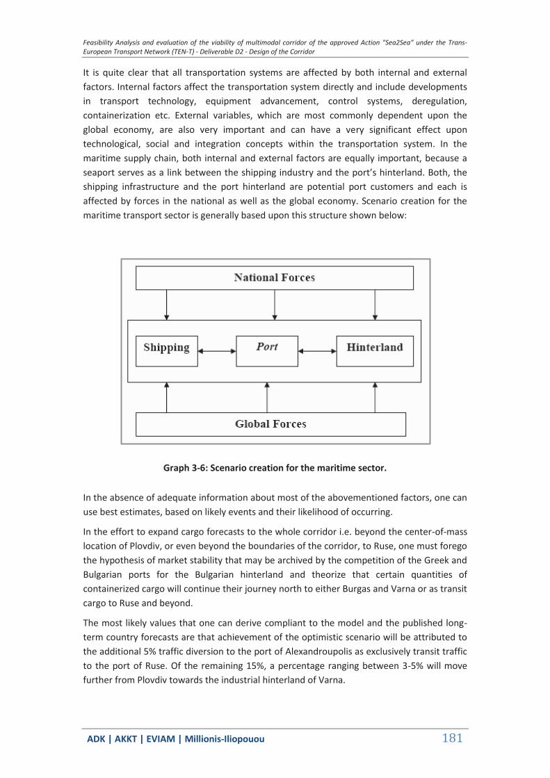
Feasibility Analysis and evaluation of the viability of multimodal corridor of the approved Action "Sea2Sea" under the Trans-European Transport Network (TEN-T) - Deliverable D2 - Design of the Corridor
ΑDΚ | AKKT | ΕVΙΑΜ | Millionis-Iliopouou 181
It is quite clear that all transportation systems are affected by both internal and external factors. Internal factors affect the transportation system directly and include developments in transport technology, equipment advancement, control systems, deregulation, containerization etc. External variables, which are most commonly dependent upon the global economy, are also very important and can have a very significant effect upon technological, social and integration concepts within the transportation system. In the maritime supply chain, both internal and external factors are equally important, because a seaport serves as a link between the shipping industry and the port’s hinterland. Both, the shipping infrastructure and the port hinterland are potential port customers and each is affected by forces in the national as well as the global economy. Scenario creation for the maritime transport sector is generally based upon this structure shown below:
Graph 3-6: Scenario creation for the maritime sector.
In the absence of adequate information about most of the abovementioned factors, one can use best estimates, based on likely events and their likelihood of occurring.
In the effort to expand cargo forecasts to the whole corridor i.e. beyond the center-of-mass location of Plovdiv, or even beyond the boundaries of the corridor, to Ruse, one must forego the hypothesis of market stability that may be archived by the competition of the Greek and Bulgarian ports for the Bulgarian hinterland and theorize that certain quantities of containerized cargo will continue their journey north to either Burgas and Varna or as transit cargo to Ruse and beyond.
The most likely values that one can derive compliant to the model and the published long-term country forecasts are that achievement of the optimistic scenario will be attributed to the additional 5% traffic diversion to the port of Alexandroupolis as exclusively transit traffic to the port of Ruse. Of the remaining 15%, a percentage ranging between 3-5% will move further from Plovdiv towards the industrial hinterland of Varna.
Feasibility Analysis and evaluation of the viability of multimodal corridor of the approved Action "Sea2Sea" under the Trans-European Transport Network (TEN-T) - Deliverable D2 - Design of the Corridor
ΑDΚ | AKKT | ΕVΙΑΜ | Millionis-Iliopouou 182
3.3 Economic Analysis
3.3.1 General
Given the considerations set out in Deliverable 1 (D1), Chapter (Ch.) 5 , the only appreciable traffic flows directly arising from operation of the ‘Corridor’ are those between Alexandroupolis and Plovdiv. The following subsections present the cost/benefit analysis of the corridor project under the circumstances defined in D1, Chapter 5 above. The costs of the project include the costs pertaining to investment expenditure on improvements to railway infrastructure on the route between Alexandroupoli and Plovdiv. The required investments for the Alexandroupolis port facility and the Svilengrad - Plovdiv rail link are not considered to accrue to this project, since they have been agreed and are in the planning stages, or have already been carried out independently of the operation of the Corridor.
Tariffs to be paid by carriers for the transport of goods between Alexandroupolis and Plovdiv are considered a benefit of the project.
3.3.2 Investment costs
The planned improvements to the rail infrastructure between Alexandroupolis and Plovdiv are the following:
Upgrading – Modernisation of the Alexandroupolis Ormenio line
These works primarily involve electrification, signalling and automation of the line, and have budget provisions of EUR 85 million.
Border crossing equipment
This equipment will be installed on the rolling stock crossing the borders between Greece and Bulgaria and seeks to avoid delays at border crossing points. It has a projected budget of EUR 2m.
Corridor Traffic Coordination Centre
This project has an allocated budget of EUR 700 000.
It should be clarified again here that the Svilengrad - Plovdiv rail network modernisation project, which has a budget of EUR 400m, is not to be treated as a burden on this project.
The table below provides a summary description of the scheduled investment expenditure.
TABLE 3.12 : PLANNED LEVEL OF INVESTMENT & TIME SCHEDULE FOR EXPENDITURE (IN EUR, 2014 PRICES)
Total 2015 2016 2017 2018
Alexandroupolis – Ormenio Line 85 000 000 0 5 000 000 40 000 000 40 000 000
Border Crossing Equipment 2 000 000 0 0 0 2 000 000
Feasibility Analysis and evaluation of the viability of multimodal corridor of the approved Action "Sea2Sea" under the Trans-European Transport Network (TEN-T) - Deliverable D2 - Design of the Corridor
ΑDΚ | AKKT | ΕVΙΑΜ | Millionis-Iliopouou 183
Coordination Centre 700 000 0 0 0 700 000
Total 87 700 000 0 5 000 000 40 000 000 42 700 000
3.3.3 Forecast traffic
Taking the factors set out D1, Chapter 5 into account, and assuming that the increase in container traffic through Bulgaria over the period 2025 to 2039 will be equivalent to that seen in the period 2020 to 2025, i.e. 5 44% p.a., then the predicted level of traffic on the Alexandroupoli - Plovdiv Line will be as indicated in the following table.
TABLE 3.13 : FORECAST CONTAINER TRAFFIC (TEU)
YEAR BULGARIA (TOTAL) ALEXANDROUPOLIS - PLOVDIV 2015 230.000 0 2016 250.000 0 2017 270.000 0 2018 290.000 0 2019 310.000 46.500 2020 330.000 49.500 2021 347.952 52.193 2022 366.881 55.032 2023 386.839 58.026 2024 407.883 61.182 2025 430.000 64.500 2026 453.392 68.009 2027 478.057 71.708 2028 504.063 75.609 2029 531.484 79.723 2030 560.397 84.059 2031 590.882 88.632 2032 623.026 93.454 2033 656.919 98.538 2034 692.655 103.898 2035 730.336 109.550 2036 770.066 115.510 2037 811.957 121.794 2038 856.128 128.419 2039 902.701 135.405

Feasibility Analysis and evaluation of the viability of multimodal corridor of the approved Action "Sea2Sea" under the Trans-European Transport Network (TEN-T) - Deliverable D2 - Design of the Corridor
ΑDΚ | AKKT | ΕVΙΑΜ | Millionis-Iliopouou 184
3.3.4 Estimated revenue
In accordance with the considerations set out in D1, Chapter 4, the cost of transport between the Port of Alexandroupolis and Plovdiv, which constitutes the revenue of this project, is estimated at EUR 322.05 for loaded containers and EUR 243.73 for empty ones. Taking into consideration the fact that empty containers represent approximately 10% of the throughput, revenues are calculated as shown in the table below.
TABLE 3.14 : ESTIMATED REVENUE (EUR, 2014 PRICES)
CONTAINER TRAFFIC) YEAR TOTAL LADEN UNLADEN REVENUE (EUR) 2015 0 0 0 0 2016 0 0 0 0 2017 0 0 0 0 2018 0 0 0 0 2019 46.500 41.850 4.650 14.611.137 2020 49.500 44.550 4.950 15.553.791 2021 52.193 46.974 5.219 16.399.917 2022 55.032 49.529 5.503 17.292.092 2023 58.026 52.223 5.803 18.232.767 2024 61.182 55.064 6.118 19.224.627 2025 64.500 58.050 6.450 20.267.061 2026 68.009 61.208 6.801 21.369.589 2027 71.708 64.538 7.171 22.532.095 2028 75.609 68.048 7.561 23.757.841 2029 79.723 71.750 7.972 25.050.267 2030 84.059 75.654 8.406 26.413.002 2031 88.632 79.769 8.863 27.849.869 2032 93.454 84.109 9.345 29.364.902 2033 98.538 88.684 9.854 30.962.353 2034 103.898 93.508 10.390 32.646.705 2035 109.550 98.595 10.955 34.422.685 2036 115.510 103.959 11.551 36.295.279 2037 121.794 109.614 12.179 38.269.743 2038 128.419 115.577 12.842 40.351.617 2039 135.405 121.865 13.541 42.546.745
3.3.5 Forecast expenditures
The table below indicates expenditure for this project.
Feasibility Analysis and evaluation of the viability of multimodal corridor of the approved Action "Sea2Sea" under the Trans-European Transport Network (TEN-T) - Deliverable D2 - Design of the Corridor
ΑDΚ | AKKT | ΕVΙΑΜ | Millionis-Iliopouou 185
For the purposes of clarification of the data presented in the table the following should be noted6:
The division of revenues between rail transfer and port handling is based on the information presented in D1, Chapter 4, and the assumption that empty containers account for 10% of the total.
The operating cost of rail transport is considered equivalent to 79.36% of revenue, according to TRAINOSE’s itemised “Statement of Comprehensive Income" for freight transport in the year 2013 and the assumption is that similar results will likely apply with respect to rail freight transport on both the Bulgarian and Greek sides throughout the period in question.
The port handling costs are considered to be equivalent to an average of EUR 100 per container, based on the ‘Feasibility Study & Cost-Benefit Analysis for the Port of Alexandroupolis Container Terminal Project’, prepared by the consulting firms EVIAM Ltd & Metron in October 2013.
The operating costs of the Coordination Centre are considered negligible, since it is estimated that its operation will be supported by existing TRAINOSE and/or BDZ staff as appropriate.
TABLE 3.15 : ESTIMATED EXPENDITURE (EUR, 2014 PRICES)
REVENUE EXPENDITURE YEAR TOTAL TRAIN PORT TOTAL TRAIN PORT
2015 0 0 0 0 0 0 2016 0 0 0 0 0 0 2017 0 0 0 0 0 0 2018 0 0 0 0 0 0 2019 14.611.137 10.823.930 3.787.207 13.239.871 8.589.871 4.650.000 2020 15.553.791 11.522.248 4.031.543 14.094.056 9.144.056 4.950.000 2021 16.399.917 12.149.059 4.250.859 14.860.773 9.641.493 5.219.280 2022 17.292.092 12.809.982 4.482.110 15.669.217 10.166.002 5.503.215 2023 18.232.767 13.506.833 4.725.933 16.521.608 10.719.023 5.802.585 2024 19.224.627 14.241.604 4.983.023 17.420.382 11.302.137 6.118.245 2025 20.267.061 15.013.839 5.253.222 18.364.982 11.914.982 6.450.000 2026 21.369.589 15.830.592 5.538.997 19.364.038 12.563.158 6.800.880 2027 22.532.095 16.691.776 5.840.319 20.417.441 13.246.593 7.170.848 2028 23.757.841 17.599.808 6.158.032 21.528.150 13.967.208 7.560.942
6 Project Costs include all payments made from the moment the cargo leaves Mediterranean Sea until it reaches at Plovdiv. These include port handling costs plus train transport costs (Port handling costs are expenditure or outflow).
At the table 4.5 page 173 of Deliverable1 it is defined, that the cost of port handling is 84 € & 48 € (total) for full and empty containers respectively. Therefore the port revenue is:
(84/322,05)*0,9 + (48/243,73)*0,1 = 0,26 of the total revenue. The rest is “train revenue”.
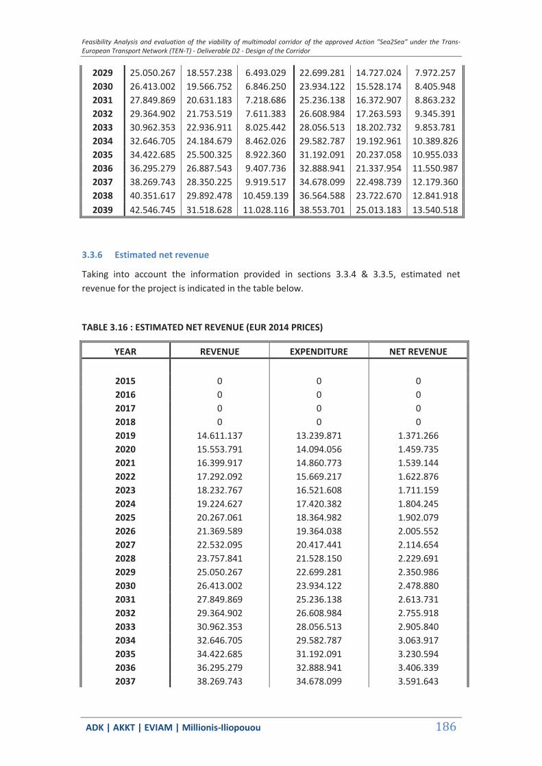
Feasibility Analysis and evaluation of the viability of multimodal corridor of the approved Action "Sea2Sea" under the Trans-European Transport Network (TEN-T) - Deliverable D2 - Design of the Corridor
ΑDΚ | AKKT | ΕVΙΑΜ | Millionis-Iliopouou 186
2029 25.050.267 18.557.238 6.493.029 22.699.281 14.727.024 7.972.257 2030 26.413.002 19.566.752 6.846.250 23.934.122 15.528.174 8.405.948 2031 27.849.869 20.631.183 7.218.686 25.236.138 16.372.907 8.863.232 2032 29.364.902 21.753.519 7.611.383 26.608.984 17.263.593 9.345.391 2033 30.962.353 22.936.911 8.025.442 28.056.513 18.202.732 9.853.781 2034 32.646.705 24.184.679 8.462.026 29.582.787 19.192.961 10.389.826 2035 34.422.685 25.500.325 8.922.360 31.192.091 20.237.058 10.955.033 2036 36.295.279 26.887.543 9.407.736 32.888.941 21.337.954 11.550.987 2037 38.269.743 28.350.225 9.919.517 34.678.099 22.498.739 12.179.360 2038 40.351.617 29.892.478 10.459.139 36.564.588 23.722.670 12.841.918 2039 42.546.745 31.518.628 11.028.116 38.553.701 25.013.183 13.540.518
3.3.6 Estimated net revenue
Taking into account the information provided in sections 3.3.4 & 3.3.5, estimated net revenue for the project is indicated in the table below.
TABLE 3.16 : ESTIMATED NET REVENUE (EUR 2014 PRICES)
YEAR REVENUE EXPENDITURE NET REVENUE
2015 0 0 0 2016 0 0 0 2017 0 0 0 2018 0 0 0 2019 14.611.137 13.239.871 1.371.266 2020 15.553.791 14.094.056 1.459.735 2021 16.399.917 14.860.773 1.539.144 2022 17.292.092 15.669.217 1.622.876 2023 18.232.767 16.521.608 1.711.159 2024 19.224.627 17.420.382 1.804.245 2025 20.267.061 18.364.982 1.902.079 2026 21.369.589 19.364.038 2.005.552 2027 22.532.095 20.417.441 2.114.654 2028 23.757.841 21.528.150 2.229.691 2029 25.050.267 22.699.281 2.350.986 2030 26.413.002 23.934.122 2.478.880 2031 27.849.869 25.236.138 2.613.731 2032 29.364.902 26.608.984 2.755.918 2033 30.962.353 28.056.513 2.905.840 2034 32.646.705 29.582.787 3.063.917 2035 34.422.685 31.192.091 3.230.594 2036 36.295.279 32.888.941 3.406.339 2037 38.269.743 34.678.099 3.591.643

Feasibility Analysis and evaluation of the viability of multimodal corridor of the approved Action "Sea2Sea" under the Trans-European Transport Network (TEN-T) - Deliverable D2 - Design of the Corridor
ΑDΚ | AKKT | ΕVΙΑΜ | Millionis-Iliopouou 187
2038 40.351.617 36.564.588 3.787.029 2039 42.546.745 38.553.701 3.993.043
3.3.7 Forecast cash flows
General
Estimates of forecasted cash flows for the project involved calculation of their Net Present Value (NPV)7, the Net Present Value of Expenditures (C)8 and Net Revenues (R), where:
DNR = NPV Revenues - NPV Operating Expenses + NPV
Residual Value
The following should also be taken into account:
The residual value of the investment project in the final year of the accounting period Discount rate of 5% (fixed prices) Time horizon 2015 – 2039
Residual value
The residual value of the investment in the year 2039, i.e. after 21 years of actual operation is calculated in the table below. It should also be noted in the interests of clarity that investment expenditure on improvements to the line between Alexandroupolis and Ormenio is considered to consist of 80% for electromechanical equipment and 20% for construction works, while investment in border crossing equipment and the coordination centre involves 100% of investment expenditure allocated to electromechanical equipment.
TABLE 3.17 : RESIDUAL VALUE IN THE YEAR 2039 (EUR, 2014 PRICES)
ACQUISITION USEFUL
RESIDUAL
TYPE OF EXPENDITURE VALUE LIFE VALUE
(YEARS) 2039
RAIL LINE ELECTROMECHANICAL INSTALLATIONS 68 000 000 30 20 400 000
7 The present value of project cash flows is hereinafter referred to as DNR (discounted net revenue).
8 The present value of the investment cost will hereinafter be referred to as DIC (discounted investment
cost)

Feasibility Analysis and evaluation of the viability of multimodal corridor of the approved Action "Sea2Sea" under the Trans-European Transport Network (TEN-T) - Deliverable D2 - Design of the Corridor
ΑDΚ | AKKT | ΕVΙΑΜ | Millionis-Iliopouou 188
RAIL TRACK (STRUCTURAL) 17 000 000 50 9 860 000
BORDER CROSSING EQUIPMENT 2 000 000 30 600 000
COORDINATION CENTRE 700 000 30 210 000
TOTAL 87 700 000 - 31 070 000
Cash Flows
Given the above projected cash flows, the Net Present Value and the ratios DNR/DIC and B/C for the project are presented in the following tables.
TABLE 3.18 : CASH FLOWS (EUR), PRESENT VALUE (NPV) & DNR/DIC FOR THE PROJECT
INVESTMENT NET RESIDUAL EXPENDITURE REVENUE VALUE CASH FLOW
2015 0 0 0 0 2016 5.000.000 0 0 -5.000.000 2017 40.000.000 0 0 -40.000.000 2018 42.700.000 0 0 -42.700.000 2019 0 1.371.266 0 1.371.266 2020 0 1.459.735 0 1.459.735 2021 0 1.539.144 0 1.539.144 2022 0 1.622.876 0 1.622.876 2023 0 1.711.159 0 1.711.159 2024 0 1.804.245 0 1.804.245 2025 0 1.902.079 0 1.902.079 2026 0 2.005.552 0 2.005.552 2027 0 2.114.654 0 2.114.654 2028 0 2.229.691 0 2.229.691 2029 0 2.350.986 0 2.350.986 2030 0 2.478.880 0 2.478.880 2031 0 2.613.731 0 2.613.731 2032 0 2.755.918 0 2.755.918 2033 0 2.905.840 0 2.905.840 2034 0 3.063.917 0 3.063.917 2035 0 3.230.594 0 3.230.594 2036 0 3.406.339 0 3.406.339 2037 0 3.591.643 0 3.591.643 2038 0 3.787.029 0 3.787.029 2039 0 3.993.043 31.070.000 35.063.043
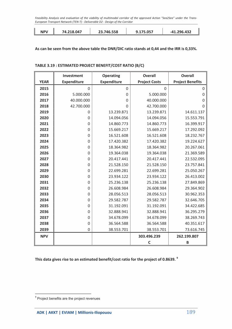
Feasibility Analysis and evaluation of the viability of multimodal corridor of the approved Action "Sea2Sea" under the Trans-European Transport Network (TEN-T) - Deliverable D2 - Design of the Corridor
ΑDΚ | AKKT | ΕVΙΑΜ | Millionis-Iliopouou 189
NPV 74.218.047 23.746.558 9.175.057 -41.296.432
As can be seen from the above table the DNR/DIC ratio stands at 0,44 and the IRR is 0,33%.
TABLE 3.19 : ESTIMATED PROJECT BENEFIT/COST RATIO (Β/C)
2015 0 0 0 0 2016 5.000.000 0 5.000.000 0 2017 40.000.000 0 40.000.000 0 2018 42.700.000 0 42.700.000 0 2019 0 13.239.871 13.239.871 14.611.137 2020 0 14.094.056 14.094.056 15.553.791 2021 0 14.860.773 14.860.773 16.399.917 2022 0 15.669.217 15.669.217 17.292.092 2023 0 16.521.608 16.521.608 18.232.767 2024 0 17.420.382 17.420.382 19.224.627 2025 0 18.364.982 18.364.982 20.267.061 2026 0 19.364.038 19.364.038 21.369.589 2027 0 20.417.441 20.417.441 22.532.095 2028 0 21.528.150 21.528.150 23.757.841 2029 0 22.699.281 22.699.281 25.050.267 2030 0 23.934.122 23.934.122 26.413.002 2031 0 25.236.138 25.236.138 27.849.869 2032 0 26.608.984 26.608.984 29.364.902 2033 0 28.056.513 28.056.513 30.962.353 2034 0 29.582.787 29.582.787 32.646.705 2035 0 31.192.091 31.192.091 34.422.685 2036 0 32.888.941 32.888.941 36.295.279 2037 0 34.678.099 34.678.099 38.269.743 2038 0 36.564.588 36.564.588 40.351.617 2039 0 38.553.701 38.553.701 73.616.745 NPV 303.496.239 262.199.807
C B
This data gives rise to an estimated benefit/cost ratio for the project of 0.8639. 9
9 Project benefits are the project revenues
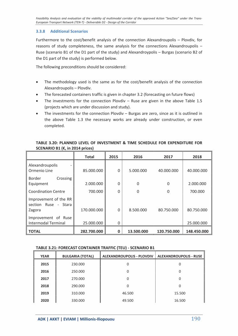
Feasibility Analysis and evaluation of the viability of multimodal corridor of the approved Action "Sea2Sea" under the Trans-European Transport Network (TEN-T) - Deliverable D2 - Design of the Corridor
ΑDΚ | AKKT | ΕVΙΑΜ | Millionis-Iliopouou 190
3.3.8 Additional Scenarios
Furthermore to the cost/benefit analysis of the connection Alexandroupolis – Plovdiv, for reasons of study completeness, the same analysis for the connections Alexandroupolis – Ruse (scenario B1 of the D1 part of the study) and Alexandroypolis – Burgas (scenario B2 of the D1 part of the study) is performed below.
The following preconditions should be considered:
The methodology used is the same as for the cost/benefit analysis of the connection
Alexandroupolis – Plovdiv. The forecasted containers traffic is given in chapter 3.2 (forecasting on future flows) The investments for the connection Plovdiv – Ruse are given in the above Table 1.5
(projects which are under discussion and study). The investments for the connection Plovdiv – Burgas are zero, since as it is outlined in
the above Table 1.3 the necessary works are already under construction, or even completed.
TABLE 3.20: PLANNED LEVEL OF INVESTMENT & TIME SCHEDULE FOR EXPENDITURE FOR SCENARIO B1 (€, in 2014 prices)
Total 2015 2016 2017 2018
Alexandroupolis - Ormenio Line 85.000.000 0 5.000.000 40.000.000 40.000.000
Border Crossing Equipment 2.000.000 0 0 0 2.000.000
Coordination Centre 700.000 0 0 0 700.000
Improvement of the RR section Ruse - Stara Zagora 170.000.000 0 8.500.000 80.750.000 80.750.000
Improvement of Ruse Intermodal Terminal 25.000.000 0 25.000.000
TOTAL 282.700.000 0 13.500.000 120.750.000 148.450.000
TABLE 3.21: FORECAST CONTAINER TRAFFIC (TEU) - SCENARIO B1
YEAR BULGARIA (TOTAL) ALEXANDROUPOLIS - PLOVDIV ALEXANDROUPOLIS - RUSE
2015 230.000 0 0
2016 250.000 0 0
2017 270.000 0 0
2018 290.000 0 0
2019 310.000 46.500 15.500
2020 330.000 49.500 16.500

Feasibility Analysis and evaluation of the viability of multimodal corridor of the approved Action "Sea2Sea" under the Trans-European Transport Network (TEN-T) - Deliverable D2 - Design of the Corridor
ΑDΚ | AKKT | ΕVΙΑΜ | Millionis-Iliopouou 191
2021 347.952 52.193 17.398
2022 366.881 55.032 18.344
2023 386.839 58.026 19.342
2024 407.883 61.182 20.394
2025 430.000 64.500 21.500
2026 453.392 68.009 22.670
2027 478.057 71.708 23.903
2028 504.063 75.609 25.203
2029 531.484 79.723 26.574
2030 560.397 84.059 28.020
2031 590.882 88.632 29.544
2032 623.026 93.454 31.151
2033 656.919 98.538 32.846
2034 692.655 103.898 34.633
2035 730.336 109.550 36.517
2036 770.066 115.510 38.503
2037 811.957 121.794 40.598
2038 856.128 128.419 42.806
2039 902.701 135.405 45.135
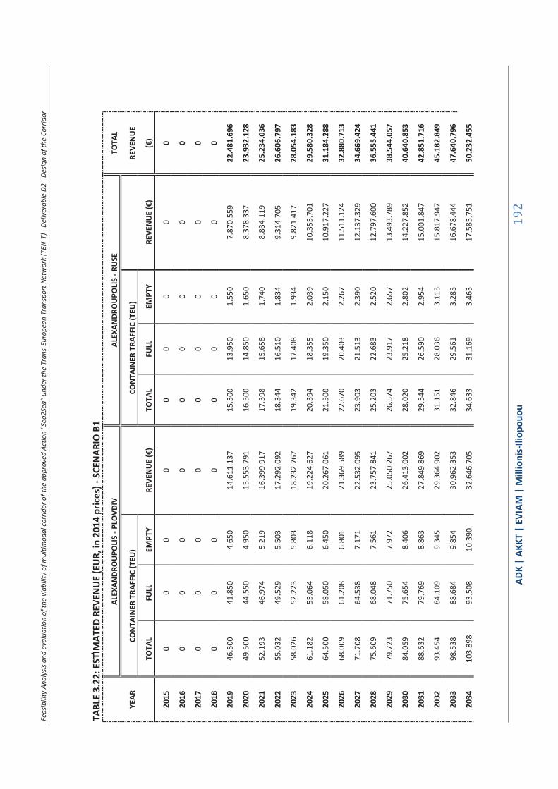
Feas
ibili
ty A
naly
sis a
nd e
valu
atio
n of
the
viab
ility
of m
ultim
odal
corr
idor
of t
he a
ppro
ved
Actio
n "S
ea2S
ea" u
nder
the
Tran
s-Eu
rope
an T
rans
port
Net
wor
k (T
EN-T
) - D
eliv
erab
le D
2 - D
esig
n of
the
Corr
idor
ΑDΚ
| AK
KT |
ΕVΙΑΜ
| M
illio
nis-
Iliop
ouou
192
TABL
E 3.
22: E
STIM
ATED
REV
ENU
E (E
UR,
in 2
014
pric
es) -
SCE
NAR
IO B
1
AL
EXAN
DRO
UPO
LIS
- PLO
VDIV
AL
EXAN
DRO
UPO
LIS
- RU
SE
TOTA
L
YEAR
CO
NTA
INER
TRA
FFIC
(TEU
)
CON
TAIN
ER T
RAFF
IC (T
EU)
RE
VEN
UE
TO
TAL
FULL
EM
PTY
REVE
NU
E (€
) TO
TAL
FULL
EM
PTY
REVE
NU
E (€
) (€
)
2015
0
0 0
0 0
0 0
0 0
2016
0
0 0
0 0
0 0
0 0
2017
0
0 0
0 0
0 0
0 0
2018
0
0 0
0 0
0 0
0 0
2019
46
.500
41
.850
4.
650
14.6
11.1
37
15.5
00
13.9
50
1.55
0 7.
870.
559
22.4
81.6
96
2020
49
.500
44
.550
4.
950
15.5
53.7
91
16.5
00
14.8
50
1.65
0 8.
378.
337
23.9
32.1
28
2021
52
.193
46
.974
5.
219
16.3
99.9
17
17.3
98
15.6
58
1.74
0 8.
834.
119
25.2
34.0
36
2022
55
.032
49
.529
5.
503
17.2
92.0
92
18.3
44
16.5
10
1.83
4 9.
314.
705
26.6
06.7
97
2023
58
.026
52
.223
5.
803
18.2
32.7
67
19.3
42
17.4
08
1.93
4 9.
821.
417
28.0
54.1
83
2024
61
.182
55
.064
6.
118
19.2
24.6
27
20.3
94
18.3
55
2.03
9 10
.355
.701
29
.580
.328
2025
64
.500
58
.050
6.
450
20.2
67.0
61
21.5
00
19.3
50
2.15
0 10
.917
.227
31
.184
.288
2026
68
.009
61
.208
6.
801
21.3
69.5
89
22.6
70
20.4
03
2.26
7 11
.511
.124
32
.880
.713
2027
71
.708
64
.538
7.
171
22.5
32.0
95
23.9
03
21.5
13
2.39
0 12
.137
.329
34
.669
.424
2028
75
.609
68
.048
7.
561
23.7
57.8
41
25.2
03
22.6
83
2.52
0 12
.797
.600
36
.555
.441
2029
79
.723
71
.750
7.
972
25.0
50.2
67
26.5
74
23.9
17
2.65
7 13
.493
.789
38
.544
.057
2030
84
.059
75
.654
8.
406
26.4
13.0
02
28.0
20
25.2
18
2.80
2 14
.227
.852
40
.640
.853
2031
88
.632
79
.769
8.
863
27.8
49.8
69
29.5
44
26.5
90
2.95
4 15
.001
.847
42
.851
.716
2032
93
.454
84
.109
9.
345
29.3
64.9
02
31.1
51
28.0
36
3.11
5 15
.817
.947
45
.182
.849
2033
98
.538
88
.684
9.
854
30.9
62.3
53
32.8
46
29.5
61
3.28
5 16
.678
.444
47
.640
.796
2034
10
3.89
8 93
.508
10
.390
32
.646
.705
34
.633
31
.169
3.
463
17.5
85.7
51
50.2
32.4
55

Feas
ibili
ty A
naly
sis a
nd e
valu
atio
n of
the
viab
ility
of m
ultim
odal
corr
idor
of t
he a
ppro
ved
Actio
n "S
ea2S
ea" u
nder
the
Tran
s-Eu
rope
an T
rans
port
Net
wor
k (T
EN-T
) - D
eliv
erab
le D
2 - D
esig
n of
the
Corr
idor
ΑDΚ
| AK
KT |
ΕVΙΑΜ
| M
illio
nis-
Iliop
ouou
193
2035
10
9.55
0 98
.595
10
.955
34
.422
.685
36
.517
32
.865
3.
652
18.5
42.4
16
52.9
65.1
01
2036
11
5.51
0 10
3.95
9 11
.551
36
.295
.279
38
.503
34
.653
3.
850
19.5
51.1
23
55.8
46.4
03
2037
12
1.79
4 10
9.61
4 12
.179
38
.269
.743
40
.598
36
.538
4.
060
20.6
14.7
04
58.8
84.4
47
2038
12
8.41
9 11
5.57
7 12
.842
40
.351
.617
42
.806
38
.526
4.
281
21.7
36.1
44
62.0
87.7
61
2039
13
5.40
5 12
1.86
5 13
.541
42
.546
.745
45
.135
40
.622
4.
514
22.9
18.5
90
65.4
65.3
35

Feas
ibili
ty A
naly
sis a
nd e
valu
atio
n of
the
viab
ility
of m
ultim
odal
corr
idor
of t
he a
ppro
ved
Actio
n "S
ea2S
ea" u
nder
the
Tran
s-Eu
rope
an T
rans
port
Net
wor
k (T
EN-T
) - D
eliv
erab
le D
2 - D
esig
n of
the
Corr
idor
ΑDΚ
| AK
KT |
ΕVΙΑΜ
| M
illio
nis-
Iliop
ouou
194
TABL
E 3.
23: E
STIM
ATED
EXP
ENDI
TURE
(€, i
n 20
14 p
rices
) - S
CEN
ARIO
B1
AL
EXAN
DRO
UPO
LIS
- PLO
VDIV
AL
EXAN
DRO
UPO
LIS
- RU
SE
TOTA
L
YEAR
RE
VEN
UES
EX
PEN
SES
REVE
NU
ES
EXPE
NSE
S EX
PEN
CES
TO
TAL
TRAI
N
PORT
TO
TAL
TRAI
N
PORT
TO
TAL
TRAI
N
PORT
TO
TAL
TRAI
N
PORT
(€
)
2015
0
0 0
0 0
0 0
0 0
0 0
0 0
2016
0
0 0
0 0
0 0
0 0
0 0
0 0
2017
0
0 0
0 0
0 0
0 0
0 0
0 0
2018
0
0 0
0 0
0 0
0 0
0 0
0 0
2019
14
.611
.137
10
.823
.930
3.
787.
207
13.2
39.8
71
8.58
9.87
1 4.
650.
000
7.87
0.55
9 5.
547.
957
2.32
2.60
2 5.
952.
859
4.40
2.85
9 1.
550.
000
19.1
92.7
30
2020
15
.553
.791
11
.522
.248
4.
031.
543
14.0
94.0
56
9.14
4.05
6 4.
950.
000
8.37
8.33
7 5.
905.
890
2.47
2.44
7 6.
336.
914
4.68
6.91
4 1.
650.
000
20.4
30.9
70
2021
16
.399
.917
12
.149
.059
4.
250.
859
14.8
60.7
73
9.64
1.49
3 5.
219.
280
8.83
4.11
9 6.
227.
170
2.60
6.94
8 6.
681.
642
4.94
1.88
2 1.
739.
760
21.5
42.4
15
2022
17
.292
.092
12
.809
.982
4.
482.
110
15.6
69.2
17
10.1
66.0
02
5.50
3.21
5 9.
314.
705
6.56
5.93
6 2.
748.
769
7.04
5.13
1 5.
210.
726
1.83
4.40
5 22
.714
.348
2023
18
.232
.767
13
.506
.833
4.
725.
933
16.5
21.6
08
10.7
19.0
23
5.80
2.58
5 9.
821.
417
6.92
3.11
7 2.
898.
300
7.42
8.38
0 5.
494.
185
1.93
4.19
5 23
.949
.988
2024
19
.224
.627
14
.241
.604
4.
983.
023
17.4
20.3
82
11.3
02.1
37
6.11
8.24
5 10
.355
.701
7.
299.
733
3.05
5.96
7 7.
832.
483
5.79
3.06
8 2.
039.
415
25.2
52.8
65
2025
20
.267
.061
15
.013
.839
5.
253.
222
18.3
64.9
82
11.9
14.9
82
6.45
0.00
0 10
.917
.227
7.
695.
553
3.22
1.67
4 8.
257.
191
6.10
7.19
1 2.
150.
000
26.6
22.1
74
2026
21
.369
.589
15
.830
.592
5.
538.
997
19.3
64.0
38
12.5
63.1
58
6.80
0.88
0 11
.511
.124
8.
114.
191
3.39
6.93
3 8.
706.
382
6.43
9.42
2 2.
266.
960
28.0
70.4
20
2027
22
.532
.095
16
.691
.776
5.
840.
319
20.4
17.4
41
13.2
46.5
93
7.17
0.84
8 12
.137
.329
8.
555.
603
3.58
1.72
6 9.
180.
010
6.78
9.72
7 2.
390.
283
29.5
97.4
51
2028
23
.757
.841
17
.599
.808
6.
158.
032
21.5
28.1
50
13.9
67.2
08
7.56
0.94
2 12
.797
.600
9.
021.
028
3.77
6.57
2 9.
679.
402
7.15
9.08
8 2.
520.
314
31.2
07.5
52
2029
25
.050
.267
18
.557
.238
6.
493.
029
22.6
99.2
81
14.7
27.0
24
7.97
2.25
7 13
.493
.789
9.
511.
772
3.98
2.01
7 10
.205
.961
7.
548.
542
2.65
7.41
9 32
.905
.243
2030
26
.413
.002
19
.566
.752
6.
846.
250
23.9
34.1
22
15.5
28.1
74
8.40
5.94
8 14
.227
.852
10
.029
.213
4.
198.
639
10.7
61.1
66
7.95
9.18
3 2.
801.
983
34.6
95.2
88
2031
27
.849
.869
20
.631
.183
7.
218.
686
25.2
36.1
38
16.3
72.9
07
8.86
3.23
2 15
.001
.847
10
.574
.802
4.
427.
045
11.3
46.5
73
8.39
2.16
3 2.
954.
411
36.5
82.7
12
2032
29
.364
.902
21
.753
.519
7.
611.
383
26.6
08.9
84
17.2
63.5
93
9.34
5.39
1 15
.817
.947
11
.150
.071
4.
667.
876
11.9
63.8
27
8.84
8.69
6 3.
115.
130
38.5
72.8
11
2033
30
.962
.353
22
.936
.911
8.
025.
442
28.0
56.5
13
18.2
02.7
32
9.85
3.78
1 16
.678
.444
11
.756
.635
4.
921.
809
12.6
14.6
59
9.33
0.06
5 3.
284.
594
40.6
71.1
72

Feas
ibili
ty A
naly
sis a
nd e
valu
atio
n of
the
viab
ility
of m
ultim
odal
corr
idor
of t
he a
ppro
ved
Actio
n "S
ea2S
ea" u
nder
the
Tran
s-Eu
rope
an T
rans
port
Net
wor
k (T
EN-T
) - D
eliv
erab
le D
2 - D
esig
n of
the
Corr
idor
ΑDΚ
| AK
KT |
ΕVΙΑΜ
| M
illio
nis-
Iliop
ouou
195
2034
32
.646
.705
24
.184
.679
8.
462.
026
29.5
82.7
87
19.1
92.9
61
10.3
89.8
26
17.5
85.7
51
12.3
96.1
96
5.18
9.55
5 13
.300
.896
9.
837.
621
3.46
3.27
5 42
.883
.684
2035
34
.422
.685
25
.500
.325
8.
922.
360
31.1
92.0
91
20.2
37.0
58
10.9
55.0
33
18.5
42.4
16
13.0
70.5
49
5.47
1.86
7 14
.024
.465
10
.372
.788
3.
651.
678
45.2
16.5
56
2036
36
.295
.279
26
.887
.543
9.
407.
736
32.8
88.9
41
21.3
37.9
54
11.5
50.9
87
19.5
51.1
23
13.7
81.5
87
5.76
9.53
6 14
.787
.396
10
.937
.067
3.
850.
329
47.6
76.3
37
2037
38
.269
.743
28
.350
.225
9.
919.
517
34.6
78.0
99
22.4
98.7
39
12.1
79.3
60
20.6
14.7
04
14.5
31.3
05
6.08
3.39
9 15
.591
.830
11
.532
.044
4.
059.
787
50.2
69.9
30
2038
40
.351
.617
29
.892
.478
10
.459
.139
36
.564
.588
23
.722
.670
12
.841
.918
21
.736
.144
15
.321
.808
6.
414.
336
16.4
40.0
26
12.1
59.3
87
4.28
0.63
9 53
.004
.614
2039
42
.546
.745
31
.518
.628
11
.028
.116
38
.553
.701
25
.013
.183
13
.540
.518
22
.918
.590
16
.155
.314
6.
763.
276
17.3
34.3
63
12.8
20.8
57
4.51
3.50
6 55
.888
.065
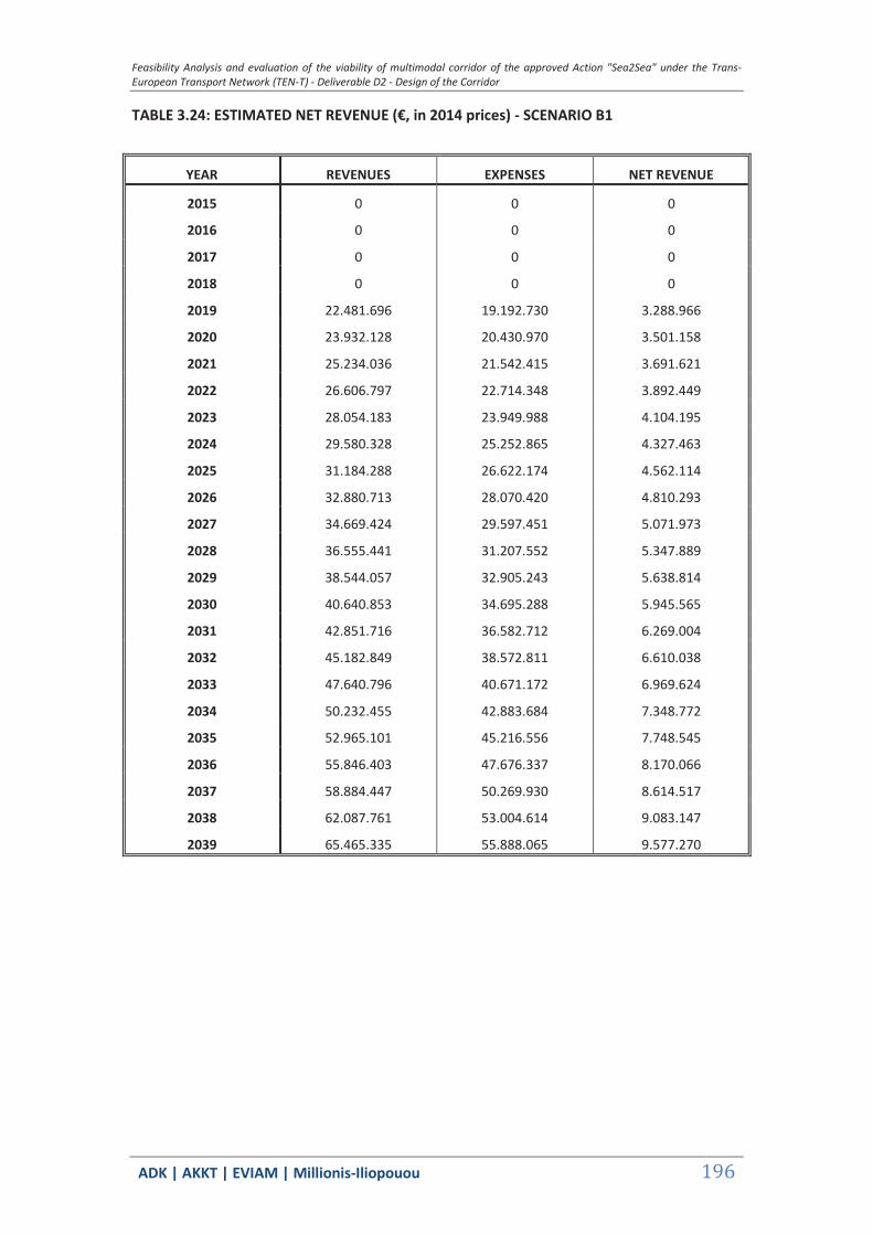
Feasibility Analysis and evaluation of the viability of multimodal corridor of the approved Action "Sea2Sea" under the Trans-European Transport Network (TEN-T) - Deliverable D2 - Design of the Corridor
ΑDΚ | AKKT | ΕVΙΑΜ | Millionis-Iliopouou 196
TABLE 3.24: ESTIMATED NET REVENUE (€, in 2014 prices) - SCENARIO B1
YEAR REVENUES EXPENSES NET REVENUE
2015 0 0 0
2016 0 0 0
2017 0 0 0
2018 0 0 0
2019 22.481.696 19.192.730 3.288.966
2020 23.932.128 20.430.970 3.501.158
2021 25.234.036 21.542.415 3.691.621
2022 26.606.797 22.714.348 3.892.449
2023 28.054.183 23.949.988 4.104.195
2024 29.580.328 25.252.865 4.327.463
2025 31.184.288 26.622.174 4.562.114
2026 32.880.713 28.070.420 4.810.293
2027 34.669.424 29.597.451 5.071.973
2028 36.555.441 31.207.552 5.347.889
2029 38.544.057 32.905.243 5.638.814
2030 40.640.853 34.695.288 5.945.565
2031 42.851.716 36.582.712 6.269.004
2032 45.182.849 38.572.811 6.610.038
2033 47.640.796 40.671.172 6.969.624
2034 50.232.455 42.883.684 7.348.772
2035 52.965.101 45.216.556 7.748.545
2036 55.846.403 47.676.337 8.170.066
2037 58.884.447 50.269.930 8.614.517
2038 62.087.761 53.004.614 9.083.147
2039 65.465.335 55.888.065 9.577.270

Feasibility Analysis and evaluation of the viability of multimodal corridor of the approved Action "Sea2Sea" under the Trans-European Transport Network (TEN-T) - Deliverable D2 - Design of the Corridor
ΑDΚ | AKKT | ΕVΙΑΜ | Millionis-Iliopouou 197
TABLE 3.25: RESIDUAL VALUE IN THE YEAR 2039 (€, in 2014 prices) - SCENARIO B1
ACQUISITION USEFUL RESIDUAL
TYPE OF EXPENDITURE VALUE LIFE VALUE
(YEARS) 2039
RAIL LINE ELECTROMECHANICAL INSTALLATIONS 204.000.000 30 61.200.000
RAIL LINE (STRUCTUAL) 51.000.000 50 29.580.000
IMPROVEMENT OF RUSE INTERMODAL TRANSPORT 25.000.000 50 14.500.000
BORDER CROSSING EQUIPMENT 2.000.000 30 600.000
COORDINATION CENTRE 700.000 30 210.000
TOTAL 282.700.000 - 106.090.000
TABLE 3.26: CASH FLOW (€), NPV (€) &DNR/DIC FOR SCENARIO B1 OF THE PROJECT - SCENARIO B1
INVESTMENT NET RESIDUAL
YEAR EXPENDITURE REVENUE VALUE CASH FLOW
2015 0 0 0 0
2016 13.500.000 0 0 -13.500.000
2017 120.750.000 0 0 -120.750.000
2018 148.450.000 0 0 -148.450.000
2019 0 3.288.966 0 3.288.966
2020 0 3.501.158 0 3.501.158
2021 0 3.691.621 0 3.691.621
2022 0 3.892.449 0 3.892.449
2023 0 4.104.195 0 4.104.195
2024 0 4.327.463 0 4.327.463
2025 0 4.562.114 0 4.562.114
2026 0 4.810.293 0 4.810.293
2027 0 5.071.973 0 5.071.973
2028 0 5.347.889 0 5.347.889
2029 0 5.638.814 0 5.638.814
2030 0 5.945.565 0 5.945.565
2031 0 6.269.004 0 6.269.004
2032 0 6.610.038 0 6.610.038
2033 0 6.969.624 0 6.969.624
2034 0 7.348.772 0 7.348.772
2035 0 7.748.545 0 7.748.545
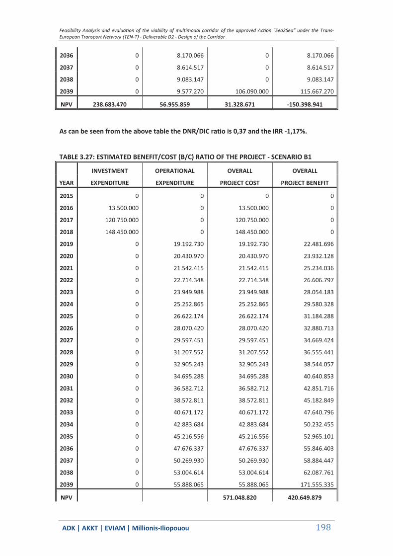
Feasibility Analysis and evaluation of the viability of multimodal corridor of the approved Action "Sea2Sea" under the Trans-European Transport Network (TEN-T) - Deliverable D2 - Design of the Corridor
ΑDΚ | AKKT | ΕVΙΑΜ | Millionis-Iliopouou 198
2036 0 8.170.066 0 8.170.066
2037 0 8.614.517 0 8.614.517
2038 0 9.083.147 0 9.083.147
2039 0 9.577.270 106.090.000 115.667.270
NPV 238.683.470 56.955.859 31.328.671 -150.398.941
As can be seen from the above table the DNR/DIC ratio is 0,37 and the IRR -1,17%.
TABLE 3.27: ESTIMATED BENEFIT/COST (B/C) RATIO OF THE PROJECT - SCENARIO B1
INVESTMENT OPERATIONAL OVERALL OVERALL
YEAR EXPENDITURE EXPENDITURE PROJECT COST PROJECT BENEFIT
2015 0 0 0 0
2016 13.500.000 0 13.500.000 0
2017 120.750.000 0 120.750.000 0
2018 148.450.000 0 148.450.000 0
2019 0 19.192.730 19.192.730 22.481.696
2020 0 20.430.970 20.430.970 23.932.128
2021 0 21.542.415 21.542.415 25.234.036
2022 0 22.714.348 22.714.348 26.606.797
2023 0 23.949.988 23.949.988 28.054.183
2024 0 25.252.865 25.252.865 29.580.328
2025 0 26.622.174 26.622.174 31.184.288
2026 0 28.070.420 28.070.420 32.880.713
2027 0 29.597.451 29.597.451 34.669.424
2028 0 31.207.552 31.207.552 36.555.441
2029 0 32.905.243 32.905.243 38.544.057
2030 0 34.695.288 34.695.288 40.640.853
2031 0 36.582.712 36.582.712 42.851.716
2032 0 38.572.811 38.572.811 45.182.849
2033 0 40.671.172 40.671.172 47.640.796
2034 0 42.883.684 42.883.684 50.232.455
2035 0 45.216.556 45.216.556 52.965.101
2036 0 47.676.337 47.676.337 55.846.403
2037 0 50.269.930 50.269.930 58.884.447
2038 0 53.004.614 53.004.614 62.087.761
2039 0 55.888.065 55.888.065 171.555.335
NPV 571.048.820 420.649.879
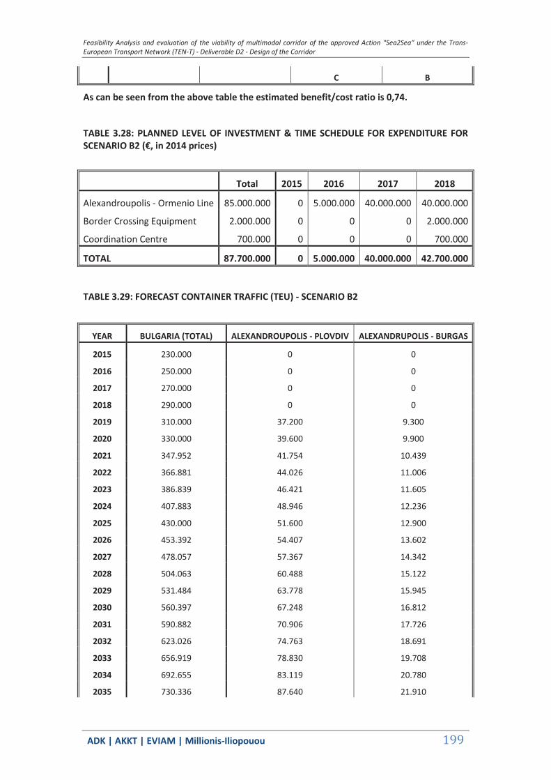
Feasibility Analysis and evaluation of the viability of multimodal corridor of the approved Action "Sea2Sea" under the Trans-European Transport Network (TEN-T) - Deliverable D2 - Design of the Corridor
ΑDΚ | AKKT | ΕVΙΑΜ | Millionis-Iliopouou 199
C B
As can be seen from the above table the estimated benefit/cost ratio is 0,74.
TABLE 3.28: PLANNED LEVEL OF INVESTMENT & TIME SCHEDULE FOR EXPENDITURE FOR SCENARIO B2 (€, in 2014 prices)
Total 2015 2016 2017 2018
Alexandroupolis - Ormenio Line 85.000.000 0 5.000.000 40.000.000 40.000.000
Border Crossing Equipment 2.000.000 0 0 0 2.000.000
Coordination Centre 700.000 0 0 0 700.000
TOTAL 87.700.000 0 5.000.000 40.000.000 42.700.000
TABLE 3.29: FORECAST CONTAINER TRAFFIC (TEU) - SCENARIO B2
YEAR BULGARIA (TOTAL) ALEXANDROUPOLIS - PLOVDIV ALEXANDRUPOLIS - BURGAS
2015 230.000 0 0
2016 250.000 0 0
2017 270.000 0 0
2018 290.000 0 0
2019 310.000 37.200 9.300
2020 330.000 39.600 9.900
2021 347.952 41.754 10.439
2022 366.881 44.026 11.006
2023 386.839 46.421 11.605
2024 407.883 48.946 12.236
2025 430.000 51.600 12.900
2026 453.392 54.407 13.602
2027 478.057 57.367 14.342
2028 504.063 60.488 15.122
2029 531.484 63.778 15.945
2030 560.397 67.248 16.812
2031 590.882 70.906 17.726
2032 623.026 74.763 18.691
2033 656.919 78.830 19.708
2034 692.655 83.119 20.780
2035 730.336 87.640 21.910
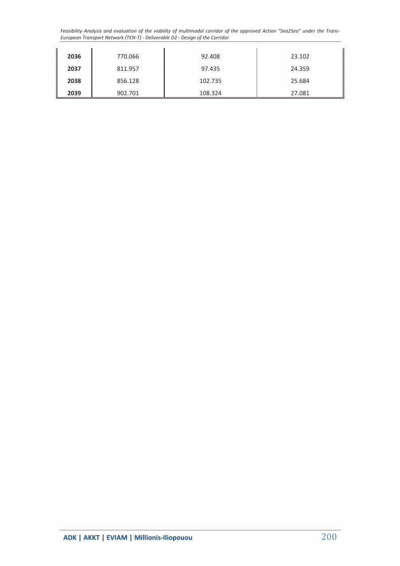
Feasibility Analysis and evaluation of the viability of multimodal corridor of the approved Action "Sea2Sea" under the Trans-European Transport Network (TEN-T) - Deliverable D2 - Design of the Corridor
ΑDΚ | AKKT | ΕVΙΑΜ | Millionis-Iliopouou 200
2036 770.066 92.408 23.102
2037 811.957 97.435 24.359
2038 856.128 102.735 25.684
2039 902.701 108.324 27.081
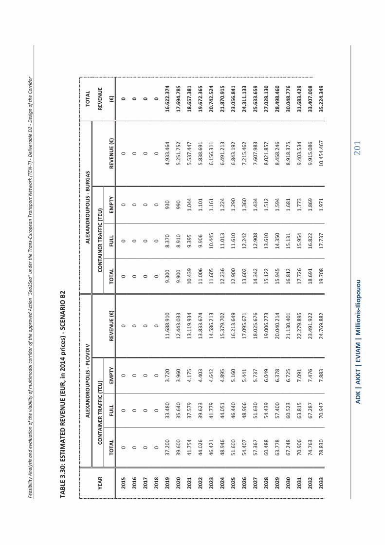
Feas
ibili
ty A
naly
sis a
nd e
valu
atio
n of
the
viab
ility
of m
ultim
odal
corr
idor
of t
he a
ppro
ved
Actio
n "S
ea2S
ea" u
nder
the
Tran
s-Eu
rope
an T
rans
port
Net
wor
k (T
EN-T
) - D
eliv
erab
le D
2 - D
esig
n of
the
Corr
idor
ΑDΚ
| AK
KT |
ΕVΙΑΜ
| M
illio
nis-
Iliop
ouou
201
TABL
E 3.
30: E
STIM
ATED
REV
ENU
E (E
UR,
in 2
014
pric
es) -
SCE
NAR
IO B
2
AL
EXAN
DRO
UPO
LIS
- PLO
VDIV
AL
EXAN
DRO
UPO
LIS
- BU
RGAS
TO
TAL
YEAR
CO
NTA
INER
TRA
FFIC
(TEU
)
CON
TAIN
ER T
RAFF
IC (T
EU)
RE
VEN
UE
TO
TAL
FULL
EM
PTY
REVE
NU
E (€
) TO
TAL
FULL
EM
PTY
REVE
NU
E (€
) (€
)
2015
0
0 0
0 0
0 0
0 0
2016
0
0 0
0 0
0 0
0 0
2017
0
0 0
0 0
0 0
0 0
2018
0
0 0
0 0
0 0
0 0
2019
37
.200
33
.480
3.
720
11.6
88.9
10
9.30
0 8.
370
930
4.93
3.46
4 16
.622
.374
2020
39
.600
35
.640
3.
960
12.4
43.0
33
9.90
0 8.
910
990
5.25
1.75
2 17
.694
.785
2021
41
.754
37
.579
4.
175
13.1
19.9
34
10.4
39
9.39
5 1.
044
5.53
7.44
7 18
.657
.381
2022
44
.026
39
.623
4.
403
13.8
33.6
74
11.0
06
9.90
6 1.
101
5.83
8.69
1 19
.672
.365
2023
46
.421
41
.779
4.
642
14.5
86.2
13
11.6
05
10.4
45
1.16
1 6.
156.
311
20.7
42.5
24
2024
48
.946
44
.051
4.
895
15.3
79.7
02
12.2
36
11.0
13
1.22
4 6.
491.
213
21.8
70.9
15
2025
51
.600
46
.440
5.
160
16.2
13.6
49
12.9
00
11.6
10
1.29
0 6.
843.
192
23.0
56.8
41
2026
54
.407
48
.966
5.
441
17.0
95.6
71
13.6
02
12.2
42
1.36
0 7.
215.
462
24.3
11.1
33
2027
57
.367
51
.630
5.
737
18.0
25.6
76
14.3
42
12.9
08
1.43
4 7.
607.
983
25.6
33.6
59
2028
60
.488
54
.439
6.
049
19.0
06.2
73
15.1
22
13.6
10
1.51
2 8.
021.
857
27.0
28.1
30
2029
63
.778
57
.400
6.
378
20.0
40.2
14
15.9
45
14.3
50
1.59
4 8.
458.
246
28.4
98.4
60
2030
67
.248
60
.523
6.
725
21.1
30.4
01
16.8
12
15.1
31
1.68
1 8.
918.
375
30.0
48.7
76
2031
70
.906
63
.815
7.
091
22.2
79.8
95
17.7
26
15.9
54
1.77
3 9.
403.
534
31.6
83.4
29
2032
74
.763
67
.287
7.
476
23.4
91.9
22
18.6
91
16.8
22
1.86
9 9.
915.
086
33.4
07.0
08
2033
78
.830
70
.947
7.
883
24.7
69.8
82
19.7
08
17.7
37
1.97
1 10
.454
.467
35
.224
.349

Feas
ibili
ty A
naly
sis a
nd e
valu
atio
n of
the
viab
ility
of m
ultim
odal
corr
idor
of t
he a
ppro
ved
Actio
n "S
ea2S
ea" u
nder
the
Tran
s-Eu
rope
an T
rans
port
Net
wor
k (T
EN-T
) - D
eliv
erab
le D
2 - D
esig
n of
the
Corr
idor
ΑDΚ
| AK
KT |
ΕVΙΑΜ
| M
illio
nis-
Iliop
ouou
202
2034
83
.119
74
.807
8.
312
26.1
17.3
64
20.7
80
18.7
02
2.07
8 11
.023
.190
37
.140
.554
2035
87
.640
78
.876
8.
764
27.5
38.1
48
21.9
10
19.7
19
2.19
1 11
.622
.852
39
.161
.000
2036
92
.408
83
.167
9.
241
29.0
36.2
24
23.1
02
20.7
92
2.31
0 12
.255
.135
41
.291
.358
2037
97
.435
87
.691
9.
743
30.6
15.7
94
24.3
59
21.9
23
2.43
6 12
.921
.814
43
.537
.608
2038
10
2.73
5 92
.462
10
.274
32
.281
.293
25
.684
23
.115
2.
568
13.6
24.7
61
45.9
06.0
54
2039
10
8.32
4 97
.492
10
.832
34
.037
.396
27
.081
24
.373
2.
708
14.3
65.9
48
48.4
03.3
44
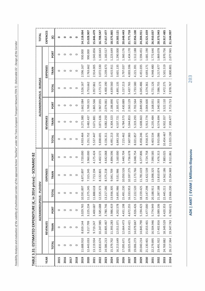
Feas
ibili
ty A
naly
sis a
nd e
valu
atio
n of
the
viab
ility
of m
ultim
odal
corr
idor
of t
he a
ppro
ved
Actio
n "S
ea2S
ea" u
nder
the
Tran
s-Eu
rope
an T
rans
port
Net
wor
k (T
EN-T
) - D
eliv
erab
le D
2 - D
esig
n of
the
Corr
idor
ΑDΚ
| AK
KT |
ΕVΙΑΜ
| M
illio
nis-
Iliop
ouou
203
TABL
E 3.
31: E
STIM
ATED
EXP
ENDI
TURE
(€, i
n 20
14 p
rices
) - S
CEN
ARIO
B2
AL
EXAN
DRO
UPO
LIS
- PLO
VDIV
AL
EXAN
DRO
UPO
LIS
- BU
RGAS
TO
TAL
YEAR
RE
VEN
UES
EX
PEN
SES
REVE
NU
ES
EXPE
NSE
S EX
PEN
CES
TO
TAL
TRAI
N
PORT
TO
TAL
TRAI
N
PORT
TO
TAL
TRAI
N
PORT
TO
TAL
TRAI
N
PORT
(€
)
2015
0
0 0
0 0
0 0
0 0
0 0
0 0
2016
0
0 0
0 0
0 0
0 0
0 0
0 0
2017
0
0 0
0 0
0 0
0 0
0 0
0 0
2018
0
0 0
0 0
0 0
0 0
0 0
0 0
2019
11
.688
.910
8.
659.
144
3.02
9.76
5 10
.591
.897
6.
871.
897
3.72
0.00
0 4.
933.
464
3.27
1.38
0 1.
662.
084
3.52
6.16
7 2.
596.
167
930.
000
14.1
18.0
64
2020
12
.443
.033
9.
217.
799
3.22
5.23
4 11
.275
.245
7.
315.
245
3.96
0.00
0 5.
251.
752
3.48
2.43
7 1.
769.
315
3.75
3.66
2 2.
763.
662
990.
000
15.0
28.9
07
2021
13
.119
.934
9.
719.
247
3.40
0.68
7 11
.888
.618
7.
713.
194
4.17
5.42
4 5.
537.
447
3.67
1.88
1 1.
865.
566
3.95
7.86
1 2.
914.
005
1.04
3.85
6 15
.846
.479
2022
13
.833
.674
10
.247
.985
3.
585.
688
12.5
35.3
73
8.13
2.80
1 4.
402.
572
5.83
8.69
1 3.
871.
636
1.96
7.05
5 4.
173.
173
3.07
2.53
0 1.
100.
643
16.7
08.5
47
2023
14
.586
.213
10
.805
.467
3.
780.
746
13.2
17.2
86
8.57
5.21
8 4.
642.
068
6.15
6.31
1 4.
082.
250
2.07
4.06
1 4.
400.
190
3.23
9.67
3 1.
160.
517
17.6
17.4
77
2024
15
.379
.702
11
.393
.283
3.
986.
419
13.9
36.3
05
9.04
1.70
9 4.
894.
596
6.49
1.21
3 4.
304.
323
2.18
6.89
0 4.
639.
560
3.41
5.91
1 1.
223.
649
18.5
75.8
65
2025
16
.213
.649
12
.011
.071
4.
202.
578
14.6
91.9
86
9.53
1.98
6 5.
160.
000
6.84
3.19
2 4.
537.
721
2.30
5.47
1 4.
891.
135
3.60
1.13
5 1.
290.
000
19.5
83.1
21
2026
17
.095
.671
12
.664
.473
4.
431.
198
15.4
91.2
30
10.0
50.5
26
5.44
0.70
4 7.
215.
462
4.78
4.57
3 2.
430.
889
5.15
7.21
3 3.
797.
037
1.36
0.17
6 20
.648
.443
2027
18
.025
.676
13
.353
.421
4.
672.
255
16.3
33.9
53
10.5
97.2
75
5.73
6.67
8 7.
607.
983
5.04
4.85
3 2.
563.
129
5.43
7.76
5 4.
003.
596
1.43
4.17
0 21
.771
.718
2028
19
.006
.273
14
.079
.847
4.
926.
426
17.2
22.5
20
11.1
73.7
66
6.04
8.75
4 8.
021.
857
5.31
9.29
3 2.
702.
564
5.73
3.58
0 4.
221.
391
1.51
2.18
8 22
.956
.100
2029
20
.040
.214
14
.845
.790
5.
194.
423
18.1
59.4
25
11.7
81.6
19
6.37
7.80
6 8.
458.
246
5.60
8.66
3 2.
849.
583
6.04
5.48
6 4.
451.
035
1.59
4.45
1 24
.204
.911
2030
21
.130
.401
15
.653
.401
5.
477.
000
19.1
47.2
98
12.4
22.5
39
6.72
4.75
8 8.
918.
375
5.91
3.77
4 3.
004.
600
6.37
4.36
1 4.
693.
171
1.68
1.19
0 25
.521
.659
2031
22
.279
.895
16
.504
.946
5.
774.
949
20.1
88.9
11
13.0
98.3
25
7.09
0.58
5 9.
403.
534
6.23
5.48
4 3.
168.
051
6.72
1.12
6 4.
948.
480
1.77
2.64
6 26
.910
.037
2032
23
.491
.922
17
.402
.816
6.
089.
106
21.2
87.1
88
13.8
10.8
74
7.47
6.31
3 9.
915.
086
6.57
4.69
4 3.
340.
393
7.08
6.75
5 5.
217.
677
1.86
9.07
8 28
.373
.943
2033
24
.769
.882
18
.349
.529
6.
420.
353
22.4
45.2
11
14.5
62.1
86
7.88
3.02
5 10
.454
.467
6.
932.
357
3.52
2.11
0 7.
472.
275
5.50
1.51
9 1.
970.
756
29.9
17.4
85
2034
26
.117
.364
19
.347
.743
6.
769.
621
23.6
66.2
30
15.3
54.3
69
8.31
1.86
1 11
.023
.190
7.
309.
477
3.71
3.71
3 7.
878.
767
5.80
0.80
1 2.
077.
965
31.5
44.9
97
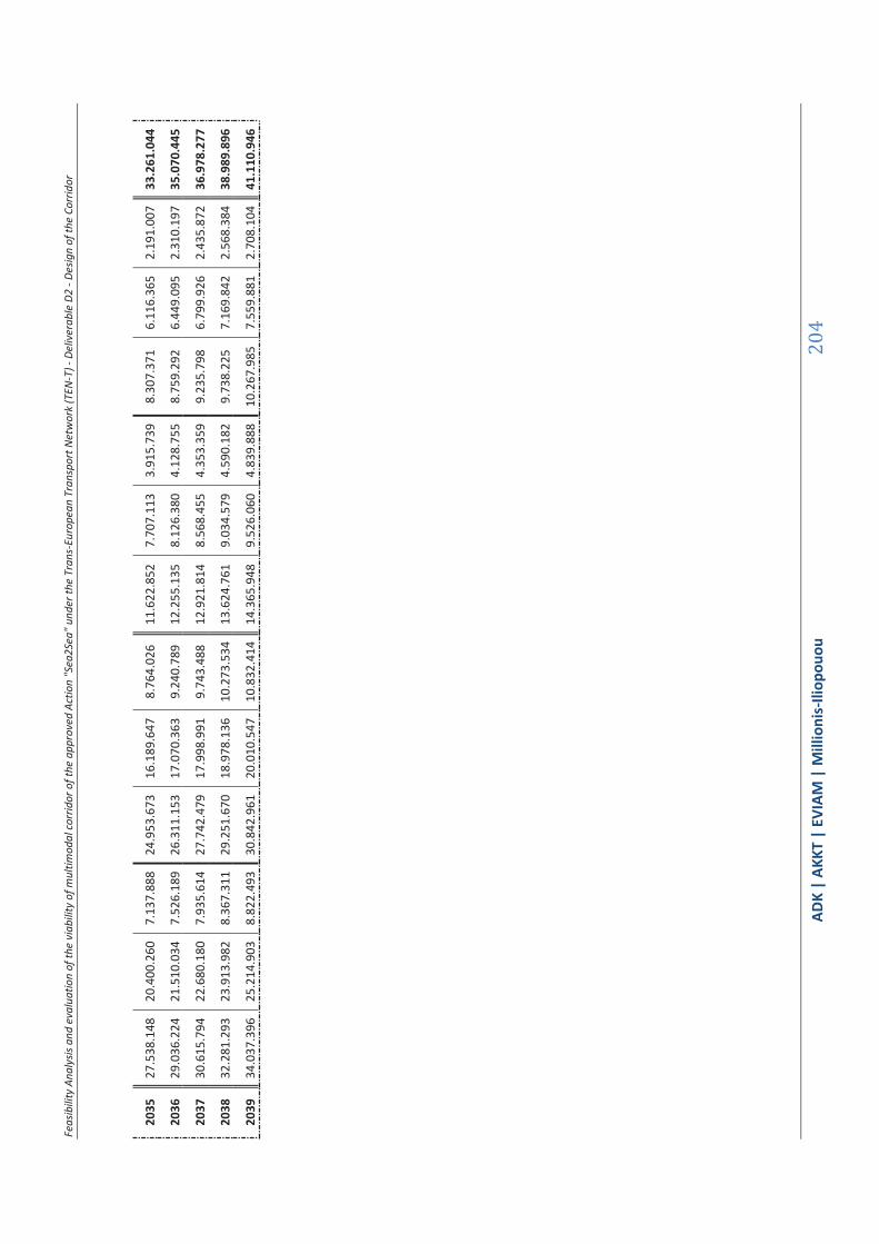
Feas
ibili
ty A
naly
sis a
nd e
valu
atio
n of
the
viab
ility
of m
ultim
odal
corr
idor
of t
he a
ppro
ved
Actio
n "S
ea2S
ea" u
nder
the
Tran
s-Eu
rope
an T
rans
port
Net
wor
k (T
EN-T
) - D
eliv
erab
le D
2 - D
esig
n of
the
Corr
idor
ΑDΚ
| AK
KT |
ΕVΙΑΜ
| M
illio
nis-
Iliop
ouou
204
2035
27
.538
.148
20
.400
.260
7.
137.
888
24.9
53.6
73
16.1
89.6
47
8.76
4.02
6 11
.622
.852
7.
707.
113
3.91
5.73
9 8.
307.
371
6.11
6.36
5 2.
191.
007
33.2
61.0
44
2036
29
.036
.224
21
.510
.034
7.
526.
189
26.3
11.1
53
17.0
70.3
63
9.24
0.78
9 12
.255
.135
8.
126.
380
4.12
8.75
5 8.
759.
292
6.44
9.09
5 2.
310.
197
35.0
70.4
45
2037
30
.615
.794
22
.680
.180
7.
935.
614
27.7
42.4
79
17.9
98.9
91
9.74
3.48
8 12
.921
.814
8.
568.
455
4.35
3.35
9 9.
235.
798
6.79
9.92
6 2.
435.
872
36.9
78.2
77
2038
32
.281
.293
23
.913
.982
8.
367.
311
29.2
51.6
70
18.9
78.1
36
10.2
73.5
34
13.6
24.7
61
9.03
4.57
9 4.
590.
182
9.73
8.22
5 7.
169.
842
2.56
8.38
4 38
.989
.896
2039
34
.037
.396
25
.214
.903
8.
822.
493
30.8
42.9
61
20.0
10.5
47
10.8
32.4
14
14.3
65.9
48
9.52
6.06
0 4.
839.
888
10.2
67.9
85
7.55
9.88
1 2.
708.
104
41.1
10.9
46

Feasibility Analysis and evaluation of the viability of multimodal corridor of the approved Action "Sea2Sea" under the Trans-European Transport Network (TEN-T) - Deliverable D2 - Design of the Corridor
ΑDΚ | AKKT | ΕVΙΑΜ | Millionis-Iliopouou 205
TABLE 3.32: ESTIMATED NET REVENUE (€, in 2014 prices) - SCENARIO B2
YEAR REVENUES EXPENSES NET REVENUE
2015 0 0 0
2016 0 0 0
2017 0 0 0
2018 0 0 0
2019 16.622.374 14.118.064 2.504.310
2020 17.694.785 15.028.907 2.665.878
2021 18.657.381 15.846.479 2.810.902
2022 19.672.365 16.708.547 2.963.818
2023 20.742.524 17.617.477 3.125.047
2024 21.870.915 18.575.865 3.295.049
2025 23.056.841 19.583.121 3.473.720
2026 24.311.133 20.648.443 3.662.690
2027 25.633.659 21.771.718 3.861.940
2028 27.028.130 22.956.100 4.072.030
2029 28.498.460 24.204.911 4.293.548
2030 30.048.776 25.521.659 4.527.117
2031 31.683.429 26.910.037 4.773.393
2032 33.407.008 28.373.943 5.033.065
2033 35.224.349 29.917.485 5.306.864
2034 37.140.554 31.544.997 5.595.557
2035 39.161.000 33.261.044 5.899.956
2036 41.291.358 35.070.445 6.220.913
2037 43.537.608 36.978.277 6.559.331
2038 45.906.054 38.989.896 6.916.159
2039 48.403.344 41.110.946 7.292.398
TABLE 3.33: RESIDUAL VALUE IN THE YEAR 2039 (€, in 2014 prices) - SCENARIO B2
ACQUISITION USEFUL RESIDUAL
TYPE OF EXPENDITURE VALUE LIFE VALUE
(YEARS) 2039
RAIL LINE ELECTROMECHANICAL INSTALLATIONS 68.000.000 30 20.400.000
RAIL LINE (STRUCTUAL) 17.000.000 50 9.860.000
BORDER CROSSING EQUIPMENT 2.000.000 30 600.000

Feasibility Analysis and evaluation of the viability of multimodal corridor of the approved Action "Sea2Sea" under the Trans-European Transport Network (TEN-T) - Deliverable D2 - Design of the Corridor
ΑDΚ | AKKT | ΕVΙΑΜ | Millionis-Iliopouou 206
COORDINATION CENTRE 700.000 30 210.000
TOTAL 87.700.000 - 31.070.000
TABLE 3.34: CASH FLOW (€), NPV (€) &DNR/DIC FOR SCENARIO B1 OF THE PROJECT - SCENARIO B2
INVESTMENT NET RESIDUAL
YEAR EXPENDITURE REVENUE VALUE CASH FLOW
2015 0 0 0 0
2016 5.000.000 0 0 -5.000.000
2017 40.000.000 0 0 -40.000.000
2018 42.700.000 0 0 -42.700.000
2019 0 2.504.310 0 2.504.310
2020 0 2.665.878 0 2.665.878
2021 0 2.810.902 0 2.810.902
2022 0 2.963.818 0 2.963.818
2023 0 3.125.047 0 3.125.047
2024 0 3.295.049 0 3.295.049
2025 0 3.473.720 0 3.473.720
2026 0 3.662.690 0 3.662.690
2027 0 3.861.940 0 3.861.940
2028 0 4.072.030 0 4.072.030
2029 0 4.293.548 0 4.293.548
2030 0 4.527.117 0 4.527.117
2031 0 4.773.393 0 4.773.393
2032 0 5.033.065 0 5.033.065
2033 0 5.306.864 0 5.306.864
2034 0 5.595.557 0 5.595.557
2035 0 5.899.956 0 5.899.956
2036 0 6.220.913 0 6.220.913
2037 0 6.559.331 0 6.559.331
2038 0 6.916.159 0 6.916.159
2039 0 7.292.398 31.070.000 38.362.398
NPV 74.218.047 43.367.762 9.175.057 -21.675.228
As can be seen from the above table the ratio DNR/DIC is 0,71 and the IRR 2,44%.

Feasibility Analysis and evaluation of the viability of multimodal corridor of the approved Action "Sea2Sea" under the Trans-European Transport Network (TEN-T) - Deliverable D2 - Design of the Corridor
ΑDΚ | AKKT | ΕVΙΑΜ | Millionis-Iliopouou 207
TABLE 3.35: ESTIMATED BENEFIT/COST (B/C) RATIO OF THE PROJECT - SCENARIO B2
INVESTMENT OPERATIONAL OVERALL OVERALL
YEAR EXPENDITURE EXPENDITURE PROJECT COST PROJECT BENEFIT
2015 0 0 0 0
2016 5.000.000 0 5.000.000 0
2017 40.000.000 0 40.000.000 0
2018 42.700.000 0 42.700.000 0
2019 0 14.118.064 14.118.064 16.622.374
2020 0 15.028.907 15.028.907 17.694.785
2021 0 15.846.479 15.846.479 18.657.381
2022 0 16.708.547 16.708.547 19.672.365
2023 0 17.617.477 17.617.477 20.742.524
2024 0 18.575.865 18.575.865 21.870.915
2025 0 19.583.121 19.583.121 23.056.841
2026 0 20.648.443 20.648.443 24.311.133
2027 0 21.771.718 21.771.718 25.633.659
2028 0 22.956.100 22.956.100 27.028.130
2029 0 24.204.911 24.204.911 28.498.460
2030 0 25.521.659 25.521.659 30.048.776
2031 0 26.910.037 26.910.037 31.683.429
2032 0 28.373.943 28.373.943 33.407.008
2033 0 29.917.485 29.917.485 35.224.349
2034 0 31.544.997 31.544.997 37.140.554
2035 0 33.261.044 33.261.044 39.161.000
2036 0 35.070.445 35.070.445 41.291.358
2037 0 36.978.277 36.978.277 43.537.608
2038 0 38.989.896 38.989.896 45.906.054
2039 0 41.110.946 41.110.946 79.473.344
NPV 318.704.127 297.028.899
C B
As can be seen in the above table the benefit/cost ratio is 0,93.

Feasibility Analysis and evaluation of the viability of multimodal corridor of the approved Action "Sea2Sea" under the Trans-European Transport Network (TEN-T) - Deliverable D2 - Design of the Corridor
ΑDΚ | AKKT | ΕVΙΑΜ | Millionis-Iliopouou 208
4 PRELIMINARY ASSESSMENT OF THE SOCIOECONOMIC IMPACT OF THE CORRIDOR
The operation of the corridor under the new scheme will undoubtedly bring a new socioeconomic and environmental reality in the wider area and the communities in contact with the corridor nodes or network links. The Consultant will be estimating the effects of this new scheme, at a preliminary level and in more detail where possible
4.1 Preliminary assessment and evaluation of environmental impact
After combining elements of the current state of the environment there goes the evaluation of the likely significant effects expected from the operation of the corridor and construction of improvements and new segments projects. These points should be given special attention when preparing the next steps of the runway and the installation of the environmental monitoring system.
More specifically the report describes, assesses and evaluates in principle level and based on references or by analogy with other similar projects or activities, the significant impacts that the corridor may cause to the environment from the use of natural resources, the emission of pollutants, the creation of nuisances, waste disposal, etc., during implementation (improvement projects and new lines) and operation.
Regarding the operation of the corridor, it is indicated that the proposed use with this - function is mainly existing in both rail network level and at the level of ports. Any consequences will result from the increase of trains and thus traffic inland and installation of electric system and telematics along the existing network and the establishment of the Control Centre.
Today the traffic volumes for the proposed corridor is relatively limited and almost non-existent in terms of the movement of goods from Greece to the Bulgarian ports of interest via the R/W network. Especially the railway line Alexandroupolis - Ormenio is almost at non-functional state. According to the forecast prepared in step deliverable D1 and this report, the annual carryings of the studied corridor is approximately 200.000 TEUS, or around 10% in traffic by sea and is expected to reach 15% -25% in 2020.The above carryings corresponds to 2 shipments per day with electric trains of approximately 600 m., like the existing trains in Bulgaria.
Regarding the implementation of the corridor projects, in general, railways required for part of Bulgaria are under construction or at the design stage, so the effects of the construction and operation have been tested or are being examined. The exception is the connection Burgas - Varna (through the line Karnobat - Sindel) where network upgrade projects are pending (electric, telematic system etc.) (see.Stages of Implementation of the corridor stage 3). Therefore, at the present, in terms of the portion of the corridor in Bulgaria, we will examine the impact of the operation and installation of Control Centers in Bulgarian territory. On a second level, since it is not a priority project, the Consultant considers indicative possible effects of the improvement works of the network segment Karnobat - Sindel.

Feasibility Analysis and evaluation of the viability of multimodal corridor of the approved Action "Sea2Sea" under the Trans-European Transport Network (TEN-T) - Deliverable D2 - Design of the Corridor
ΑDΚ | AKKT | ΕVΙΑΜ | Millionis-Iliopouou 209
In Greek territory, for the implementation of the corridor, the completion of the study and authorization of upgrading Alexandroupolis section Ormenio, namely the electrification of the existing network and the installation of telecommanding and signaling system (stage 1) is a top priority. Section Kavala- Alexandroupolis through existing line Thessaloniki - Xanthi is not a first priority project for implementation of the corridor because there is no programming from the sideTRENOSE for its implementation and falls in step 4 (see. Stages of Implementation of the corridor). Therefore, there is a review of the impact that is expected to address the integration of the existing line improvement projects, operation of the corridor and the installation of control centers. Similarly with new projects in Bulgaria, considered at a secondary level, there are the works of the 4th stage, namely the upgrading of Alexandroupolis line - Xanthi - Drama and Kavala new line - Archers.
The principle assessment and evaluation of key environmental components which will be differences changes or effects listed below.
4.1.1 Impact on the natural environment
In areas of national and international system of protected areas - in forests and woodlands and in other important natural areas
As discussed in deliverable D2.1 within the path of the studied corridor and that interventions there exist various types of protected areas, especially in the segment of the corridor passing through Bulgarian territory.
In western Bulgaria much of protected areas include zones - areas along the major rivers in Bulgaria (eg Reka Maritsa, Reka Yantra), their flood plains and usually their riparian zone or across these areas. In many of these areas the river flows along the R/W network of existing corridor which passes in many places over the protection zone. In Greece, equivalent areas are the Nestos and Evros rivers, which should be of focus on the next stage of the EIA and the environmental monitoring system of the corridor.
The corridor in the Bulgarian region passes also through 7 seven Natura regions and the National Network of special protection status (beyond affiliation network Natura) and the areas of the National Network of Bulgaria with significant restrictions (such as banning construction, excavation, uprooting trees, etc.) that make it particularly restrictive for the design of improvement projects.Such areas is the area of the Park Balgarka, the corresponding Natura Bulgarka, the Natura Provadiosko Royasko Plato, the Natura Reka Yantra etc. (See. Table on deliverable D 2.1).Particular attention should be paid to the area Nahodishte Na Blatno Kokiche - Mestnost Sazlaka and in other areas of protection of Lefkoiou (Leucojum aestivum), as the constraints are very strict.
Within the path of the studied corridor and its interventions, protected areas exist that include zones - areas through two of the most important National Parks of Greece: the National Park of East Macedonia and Thrace and the National Wetland Park Evros, major habitats created by rivers Nestos and Evros, respectively. Respectively in Bulgaria one of the most important protected areas are in the central part of the runway Natural Park Balgarka and included in it Natura area Bulgarka and Tsentralen Balkan Bufer (buffer zone of the largest National Park of Bulgaria Tsentralen Balkan Park). These areas are very important
Feasibility Analysis and evaluation of the viability of multimodal corridor of the approved Action "Sea2Sea" under the Trans-European Transport Network (TEN-T) - Deliverable D2 - Design of the Corridor
ΑDΚ | AKKT | ΕVΙΑΜ | Millionis-Iliopouou 210
ecosystems. Therefore, the transit corridor through these areas makes it especially environmentally vulnerable, in the sections passes internally and / or tangential, Any interventions - optimizations to these parts should follow the restrictions and prohibitions imposed by the relevant legislation establishment and operation of parks and naturally go through the approval of such operator.
During the construction phase of improvement works of the telematics system and electrification and new rail corridor, there are expected effects on vegetation and fauna of larger areas passed through by the network, of high or low intensity, depending on the size of the interventions and the portion of the corridor passing through ecosystems - habitats.
The expected, albeit temporary, abandonment of the area by species of fauna that live and breed near the banks of rivers and in the other habitats during construction of the improvement projects can be mitigated if the functions are interrupted in the spring or the period coinciding with the breeding season of most fauna.
Maintaining the balance of sensitive wetland ecosystems and habitats which are passed through by the corridor and their as far as possible uninterrupted operation of these requires special treatment. Ensuring water quality along the entire length of the path of the rivers traversing the corridor, (in Greece the Evros and Nestos while the number of Bulgarian river), should be a major concern both during the construction of improvement projects runway and during operation of the project.
A further problem that could be identified during the project operation phase is the potential further isolation of the free movement of wildlife. But this can be overcome by providing passageways through technical projects, existing or new ones.
Finally it is noted that, both during operation of the rail portion of the runway and during the operation of the connection ports, there will be given special consideration and attention to important wetlands of the port of Lake Varna and Burgas (lakes Varnesko, Burgasko etc.)
The flora and fauna
The expected impact on flora and fauna (other than those mentioned in protection areas) during operation of the corridor and construction of improvement projects are:
Artificial lighting: Light from passing trains is expected to make impact on
nocturnal species, especially birds, causing disorientation and possible deterioration
of their populations.
During operation, the project shows small risk of fire from the lines of
electrification for which there should be appropriate placement of pillars, with
possible standard tree parts in the vicinity of the line.
With the installation of electric the risk of conflict fauna with wires is reduced
since the overhead line will replace the existing
In any case these effects are not expected to be major.
Feasibility Analysis and evaluation of the viability of multimodal corridor of the approved Action "Sea2Sea" under the Trans-European Transport Network (TEN-T) - Deliverable D2 - Design of the Corridor
ΑDΚ | AKKT | ΕVΙΑΜ | Millionis-Iliopouou 211
Regarding the construction of new railway lines (step 4), apart from the above, low-intensity impact is expected on vegetation and greater fauna of the region, which in any case would not necessarily have a supra and may be reversible.
More specifically, it is anticipated:
Reclamation - Removal of trees and shrubs.From the areas seized by the
infrastructure of rail lines and new auxiliary roadworks there will be removed locally
existing vegetation. The most important places where this impact comes into are the
spaces of interchanges, bridges, embankments and trenches. The removal of
vegetation is nesting and feeding area for the fauna of the region will further strain
their natural animal populations. It will exacerbate the problem of habitat
fragmentation.
Deforestation and squatting for the installation of the construction site,
opening access roads and creation of spaces deposition of aggregates (impact on
short and reversible)
Intense human presence and noise in the project area.
The main problem that could be identified during the project operation phase is the potential further isolation of the free movement of wildlife. Briefly, species that suffer the greatest impacts are species which: live in relatively homogenous habitats, are vulnerable to human presence, are in low populations, approach roads for zestama- thermoregulation (reptiles) or food, or require large living space which kermatizetai.
In the natural landscape
The first and immediate effect on the construction of railways are shown on the landscape. The restoration of the landscape is a prerequisite to undo the negative effects both from the destruction of natural vegetation, and the rate of natural areas bring a rail axis, and aims to ecological and aesthetic harmonization of an infrastructure project on the environment of the area through which it passes. 10
The impacts come from the geometric configuration (alignment - location) of the projects and involve:
"Injury" on the landscape
Destruction of the existing situation
Changes in topography
10 Alexander Technological Educational Institute DEPARTMENT OF CIVIL INFRASTRUCTURE "INVESTIGATION OF ENVIRONMENTAL IMPACTS ON RAILWAY LINE THESSALONIKI - Seen" Maropoulos STABILITY OCTOBER 2009
Feasibility Analysis and evaluation of the viability of multimodal corridor of the approved Action "Sea2Sea" under the Trans-European Transport Network (TEN-T) - Deliverable D2 - Design of the Corridor
ΑDΚ | AKKT | ΕVΙΑΜ | Millionis-Iliopouou 212
Changes in runoff of surface waters.
In the case of the proposed corridor the main line (excluding section of R/W of the 4th stage) is existent, however it is proposed to have a package of improvements projects - interventions in length.Therefore any intervention is expected to be small and the aesthetic impact in most cases reversible.
A) Implementation of improvement projects and new railway corridor lines
The influence of the aesthetics of the landscape in the alignment of the project covers the natural environment, the operation of the project and soil erosion (decrease or disappearance of flora).
The categories of technical projects that require the application of technical land reclamation infrastructure projects and possibly apply in the case of improvement projects and new rail corridor are:
Supporting access roads during the construction of the project
Construction site installation spaces.
Borrow pits
Places of mining of aggregates
Slopes trenching or embankments
Entry Positions - tunnel exit
High bridges or viaducts, valley bridges
Additional access road during construction of the project
All categories of works produce immediate effects on the ecological environment of the region.
The goal of landscape rehabilitation techniques applicable to these projects is to minimize the environmental impact, the integration of landscape environment to the existing character of the landscape, creating landscapes with new character (eg in deprived areas) and restore the landscape in its original form.
B) Mode R/W corridor
The changes bring the work to the landscape are not significant. Because of the multiannual existence and operation, the railway line has now been integrated into the landscape of the region, and has no disruptive visual impact. The main visual impact mainly in manufacturing support pillars of overhead cables. The new elements introduced in the landscape by the electrical signaling and telecommanding as light signals and the equipment necessary for determining indications of signals (devices, appliances, wiring, operating panel and visual inspection) is not expected to adversely affect landscape.
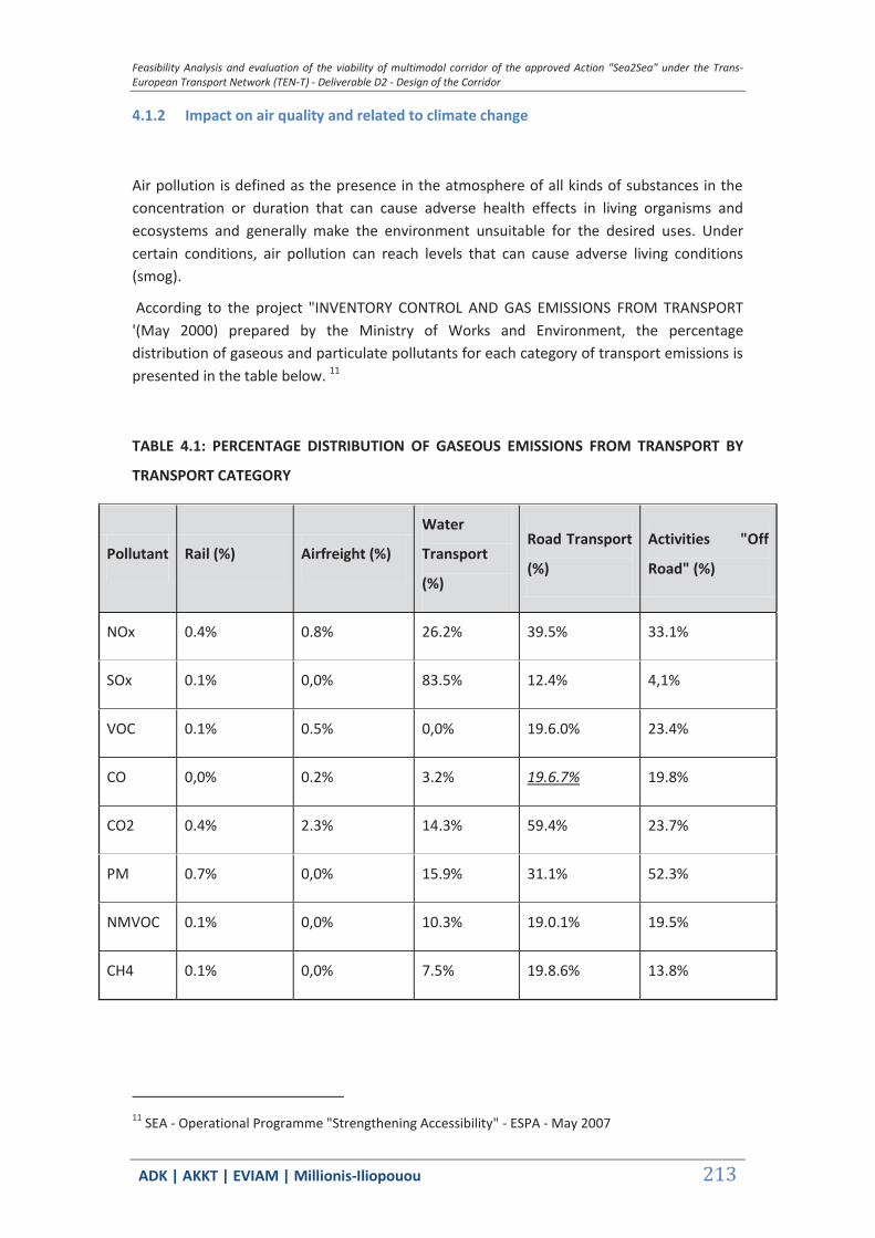
Feasibility Analysis and evaluation of the viability of multimodal corridor of the approved Action "Sea2Sea" under the Trans-European Transport Network (TEN-T) - Deliverable D2 - Design of the Corridor
ΑDΚ | AKKT | ΕVΙΑΜ | Millionis-Iliopouou 213
4.1.2 Impact on air quality and related to climate change
Air pollution is defined as the presence in the atmosphere of all kinds of substances in the concentration or duration that can cause adverse health effects in living organisms and ecosystems and generally make the environment unsuitable for the desired uses. Under certain conditions, air pollution can reach levels that can cause adverse living conditions (smog).
According to the project "INVENTORY CONTROL AND GAS EMISSIONS FROM TRANSPORT '(May 2000) prepared by the Ministry of Works and Environment, the percentage distribution of gaseous and particulate pollutants for each category of transport emissions is presented in the table below. 11
TABLE 4.1: PERCENTAGE DISTRIBUTION OF GASEOUS EMISSIONS FROM TRANSPORT BY
TRANSPORT CATEGORY
Pollutant Rail (%) Airfreight (%)
Water
Transport
(%)
Road Transport
(%)
Activities "Off
Road" (%)
NOx 0.4% 0.8% 26.2% 39.5% 33.1%
SOx 0.1% 0,0% 83.5% 12.4% 4,1%
VOC 0.1% 0.5% 0,0% 19.6.0% 23.4%
CO 0,0% 0.2% 3.2% 19.6.7% 19.8%
CO2 0.4% 2.3% 14.3% 59.4% 23.7%
PM 0.7% 0,0% 15.9% 31.1% 52.3%
NMVOC 0.1% 0,0% 10.3% 19.0.1% 19.5%
CH4 0.1% 0,0% 7.5% 19.8.6% 13.8%
11 SEA - Operational Programme "Strengthening Accessibility" - ESPA - May 2007

Feasibility Analysis and evaluation of the viability of multimodal corridor of the approved Action "Sea2Sea" under the Trans-European Transport Network (TEN-T) - Deliverable D2 - Design of the Corridor
ΑDΚ | AKKT | ΕVΙΑΜ | Millionis-Iliopouou 214
Also, transport is also associated with 28% of CO2 emissions (which is eminently cause of global warming), of which 84% was due to road transport
A) Impacts during construction-implementation of improvement projects and new lines
To assess the impact on the environment during the construction of the improvement projects and new lines it is necessary to take into account the type and number of equipment and vehicles to be used at key stages of its construction. During the construction phase there are amounts of conventional gas emitted from the site installations and dust from both site installations as during transport excavation and construction materials with heavy goods vehicles and during the project.
At this stage it is not possible to form an accurate registry data of the operation of construction sites (eg types of machines, the actual operating time, construction schedules of projects, etc.). This therefore does not allow conclusions with absolute precision as regards the impact on air quality during construction.
As an estimate of the type of equipment and vehicles to be used in a "representative" site, without limitation, during construction of the new corridor improvement projects and the construction of new lines, we could mention the following:
Pusher type D8 or equivalent
Mechanical Excavator
Air compressor
Dumpers of various payload (4)
Loaders
Concrete Mixer
Based on the above data, the emission factors and assumptions about the composition and operation time of the worksite and accurate computational methods it will be a matter of the next steps to calculate the levels of greenhouse gas emissions in worksite areas and perform a comparison with the statutory limits each area.
To reduce air pollution in the wider area from dust during construction, the following measures are proposed:
Systematic wetting of open spaces and aggregates to reduce the concentration
of suspended particles.
Ensure drainage of rainwater to avoid the resuspended by falling particles.
Avoid dispersal of dust and especially waste materials, rubbish etc. In adjacent
areas to the organization of appropriate collection crews.

Feasibility Analysis and evaluation of the viability of multimodal corridor of the approved Action "Sea2Sea" under the Trans-European Transport Network (TEN-T) - Deliverable D2 - Design of the Corridor
ΑDΚ | AKKT | ΕVΙΑΜ | Millionis-Iliopouou 215
Frequent wetting and coverage of excavated material and in the shortest
possible transportation area will be reused in the areas with adequate
characteristics for their reception.
Frequent wetting of spoil and backfill areas.
Coverage for vehicles carrying excavated material and construction materials
(main base, sub-base, asphalt layers).
All machinery and equipment used in construction should be in good condition,
meet the manufacturer's specifications, be well maintained to minimize dust
emissions and other air pollutants.
The setting of the engine must be such that the emission of gaseous and
particulate pollutants shall not exceed the limit values MD 28342/2447(4 grCO /
kwh, 1,1 grVOC / kwh, 7 grNOx / kwh, 0,15 gr particles / kwh) on measures to reduce
the emission of gaseous and particulate pollutants from Diesel engines for use in
vehicles in accordance with Directive 88/77/ EEC and 91/542 / EEC (harmonization
with GG 53 6 / 08.25.1992)
B) Impact during operation of the project
B1) Effect of Vessel Traffic
The ports of interest -at their complete development- serve multiple uses and ships in the vast majority are motorized, like ships that will be used to implement the envisaged corridor. With regard to emissions of these vessels, these are mainly due to combustion of the fuel used for their movement. Emissions from a ship are a function of many variables which can be classified into variables associated with sailing conditions (speed) and variables associated with the ship characteristics (age, engine power, etc.) and operating conditions (engine load, temperature, fuel quality). The main feature for those emissions is that they occur during the phase of the journey and not binding board quay; for that matter, they are considered non-evaluable.
In general, investigations that have so far taken place at international level, have shown that shipping derived pollutants are sulfur dioxide (SO2), nitrogen oxides (NOx), carbon monoxide (CO), hydrocarbons (HC) and smoke (TSP). These pollutants occur especially increased when used as fuel diesel. In the following table, emission factors adapted to the Greek reality are shown, as given in the literature (I.Englezou, V.S.Tselentis, E.Tzannatos and G.Th.Amanatidis, "Estimation of atmospheric pollution loads from the shipping activity in the harbor of Piraeus ", Technical Journal, 2, 1992).
TABLE 4.2: SHIP EMISSION FACTORS

Feasibility Analysis and evaluation of the viability of multimodal corridor of the approved Action "Sea2Sea" under the Trans-European Transport Network (TEN-T) - Deliverable D2 - Design of the Corridor
ΑDΚ | AKKT | ΕVΙΑΜ | Millionis-Iliopouou 216
SHIP TYPE CO NOx HC SO2 TSP
MARINE VESSELS> 1600 GRT
3.8 8.7 1.2 4.0 0.5
MARINE VESSELS <1600 GRT
2.6 8.7 1.2 4.0 0.5
FISHERY 2.6 8.7 1.2 1.3 0.5
FERRYBOATS 4.2 7.4 1.1 1.3 0.5
PORT SHIPS 4.2 7.4 1.1 1.3 0.5
HIGH SPEED 4.2 10.1 5.4 1.3 0.5
FERRIES 2.9 8.4 1.2 1.3 0.5
The calculation of emission vessels in port for each of these pollutants can be done using the following formula:
Ei, j = ei * Rj * TJ
where Ei, j, is the emission of pollutant i from the ship j, when it moves to the port area for time TJ with effect Rj.
B2) Effect of the operation of RW corridor - train movements
During operation of the R/W network it is not apparent to have negative impact on the air since no air pollutants are produced by electrically powered trains.Conversely, expected impact is positive because there are no longer dirt power-trains thereby reducing the atmoshperic pollution derived by the drive system with diesel.
4.1.3 Effects of noise
A) Worksite noise
During the implementation of improvements (work of electrification, signaling, etc.) and the
construction of new lines there is expected a local increase of the noise level in the vicinity
of the respective sites which should be located as far as possible outside protected areas and
residential areas and distance from the noise receivers in order to minimize the impact.
In any case, any impact is expected to be reversible and lasting as long as the works are underway.
Feasibility Analysis and evaluation of the viability of multimodal corridor of the approved Action "Sea2Sea" under the Trans-European Transport Network (TEN-T) - Deliverable D2 - Design of the Corridor
ΑDΚ | AKKT | ΕVΙΑΜ | Millionis-Iliopouou 217
More specifically, during the construction phase of new lines and upgrading of existing non-electrified lines, there are expected impacts from noise generated at the site and these are mainly from:
the operation of the construction machinery,
the movement of heavy vehicles to and from the site and
road traffic from moving staff to and from worksite.
Of these noise sources, the ones deemed important are those resulting from industrial machinery (trucks, mining machinery, etc.). The noise from the movement of heavy vehicles and vehicles of workers, on the roads of the area are of lesser importance.
The railway line passes through urban areas therefore there are expected impacts during the construction phase of the proposed projects. In phase of preparation of the environmental studies and the system monitoring existing and under construction projects, there should be an assessment of noise in residential areas and protected areas, relating to the construction phase and a proposal of relevant measures to deal with it
C) Train noise
Generally, there are three different sources of railway noise identified :
Engine Noise
Rolling Noise
Aerodynamic noise.
Railway noise is largely a problem created by freight trains and those involving older wagons or engines and is a particularly serious problem during the night. Rolling noise is generally higher when derived from railway vehicles with poor maintenance and from trains running on infrastructures with poor maintenance.
The aerodynamic noise is particularly associated with high-speed lines where, in most cases, mitigation measures, such as noise barriers that reduce the impact of road noise, but is usually too low to have any effect in terms of noise coming from the pantograph. The engine noise is usually associated with lower speeds up to 30 km / h, the rolling noise at speeds above 30 km / h and aerodynamic noise dominates at speeds exceeding 200 km. / H.The most important noise source is rolling noise, which refers to all kinds of trains.
To reduce the noise from railways, passive measures -taken at the place where the nuisance is caused- are differentiated from active measures taken at the source. The most important passive methods used to reduce rail noise in the environment are noise protection walls and

Feasibility Analysis and evaluation of the viability of multimodal corridor of the approved Action "Sea2Sea" under the Trans-European Transport Network (TEN-T) - Deliverable D2 - Design of the Corridor
ΑDΚ | AKKT | ΕVΙΑΜ | Millionis-Iliopouou 218
insulating windows, and for the most part action plans and investments of Member States focus on these methods. 12
Overall if the operation of the corridor where the entire network is electric, it is estimated that the electric trains produce less noise as electric locomotives make less noise than diesel engines.
C) Berthing Noise
The noise coming from the berthing area is mainly due to the engines of motor boats.
The noise level in the engine room of a ship is 120 db. In new ships, the engine room space is fully automated and function checks are done by pressing keys by a special control room.
Noise levels emitted by motor boats are governed by the European Directives 94/25 / EC and 2003/44 / EU which provide that motorized vessels should be constructed to achieve the following noise levels.
TABLE 4.3: NOISE LEVELS FROM MOTORBOATS UNDER DIRECTIVE 2003/44 / EU
Single Engine Power In kW Maximum Sound Pressure Level = LpASmax In dB
Pn <10kW 34
10 <Pn <40 19.2
Pn> 40 19.5
10kW = 15 hp 40kW = 54 hp
Pn = rated engine power in kW at rated speed and LpSmax = maximum sound pressure levels in dB
Therefore, it is expected to have mild charge of settlements and conservation areas from noise especially during the construction phase of the project, which deserves investigation in subsequent stages of the environmental report.
During the operational phase of the project it should be assessed whether there will be an increase in the current average level of noise particularly in urban areas and in ports. However, it is initially estimated that the noise impacts from the operation of the project is not expected to be particularly significant.
12 EUROPEAN PARLIAMENT - GENERAL FOR INTERNAL POLICIES POLICY DEPARTMENT B: STRUCTURAL AND COHESION POLICIES TRANSPORT AND TOURISM REDUCING ICHORYPANSIS BY RAILWAYS - IP / B / TRAN / FWC / 2010-006 / Lot1 / C1 / SC2 2012

Feasibility Analysis and evaluation of the viability of multimodal corridor of the approved Action "Sea2Sea" under the Trans-European Transport Network (TEN-T) - Deliverable D2 - Design of the Corridor
ΑDΚ | AKKT | ΕVΙΑΜ | Millionis-Iliopouou 219
4.1.4 Effects of vibrations
Among the environmental impacts of railway works there are the sources of nuisance for residents of urban areas, and are induced by the movement of trains, shocks and vibrations in buildings. As happens with the noise, so is with the vibrations that are immediately perceived as unpleasant sensations and additional vibration cause extra nuisance because of fear of causing damage to buildings. 13
There are two ways in which buildings are affected by vibrations and shocks:
- Through Soil: The vibrations propagate through the ground and stimulate the
building through the foundation.
- By air: Sounds (mainly low frequencies) that spread through the air entering the
openings (windows, doors) and stimulate their structural parts.
Trains transmit the ground vibrations due both to different forces coming from the engine, the drive system in the wheels and their contact with the rails, and which are carried by the suspension of the vehicles of the train on the pavement or in Infrastructure, and in reaction forces of the wheels and suspension during movement. These vibrations can be random and strong (due to a puddle, railway level crossing, expansion joints etc.) or to have a more continuous and periodic form (for example due to uniform wavy deformations of pavement). They are transmitted through the base and subbase to the ground in the form of seismic waves as (lateral, longitudinal and Rayleigh).
In Greece there is still no legislation that relates to vibration limits of the construction and operation of infrastructure projects, particularly rail. The basic safety net to prevent damage is the value of the vibration velocity (vibration) of the particle to not exceed 50 mm / sec in the surface soil (TRRL Laboratory Report 860). Under "Blasting vibrations and their effects on structures" (HR Nichols, CF Johnson, WI Duval - US Bureau of Mines) all major damage to buildings and 94% of smaller losses (minor damage points) has been observed for vibration velocities> 50mm / sec.
The average transit speed of the train is the dominant factor that contributes to a vibration. The following table is derived from a relative publication of the US Ministry of Transportation ("High Speed Ground Transportation Noise and Vibration Impact Assessment", US Dept. of Transportation, 1998) and provides the maximum distances which may create nuisances.
TABLE 4.4: MAXIMUM DISTANCE FOR NUISANCE FROM TRAIN VIBRATIONS
Land Use Routes Density Speed V
V <100 mph
Speed V 100 <V <200
Speed V up to 300 mph
13 ERGOSE SA 2013 "DESIGN ENVIRONMENTAL IMPACT OF PROJECT ILEKTROKINISIS RAILWAY LINE PIRAEUS ATHENS THESSALONIKI SECTION PALAIOFARSALOS - KALAMPAKA"
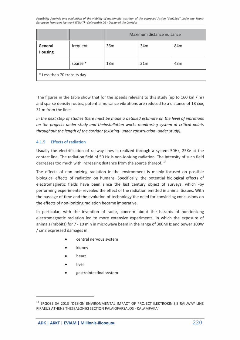
Feasibility Analysis and evaluation of the viability of multimodal corridor of the approved Action "Sea2Sea" under the Trans-European Transport Network (TEN-T) - Deliverable D2 - Design of the Corridor
ΑDΚ | AKKT | ΕVΙΑΜ | Millionis-Iliopouou 220
Maximum distance nuisance
General Housing
frequent 36m 34m 84m
sparse * 18m 31m 43m
* Less than 70 transits day
The figures in the table show that for the speeds relevant to this study (up to 160 km / hr) and sparse density routes, potential nuisance vibrations are reduced to a distance of 18 έως 31 m from the lines.
In the next step of studies there must be made a detailed estimate on the level of vibrations on the projects under study and theinstallation works monitoring system at critical points throughout the length of the corridor (existing- under construction -under study).
4.1.5 Effects of radiation
Usually the electrification of railway lines is realized through a system 50Hz, 25Kv at the contact line. The radiation field of 50 Hz is non-ionizing radiation. The intensity of such field decreases too much with increasing distance from the source thereof. 14
The effects of non-ionizing radiation in the environment is mainly focused on possible biological effects of radiation on humans. Specifically, the potential biological effects of electromagnetic fields have been since the last century object of surveys, which -by performing experiments- revealed the effect of the radiation emitted in animal tissues. With the passage of time and the evolution of technology the need for convincing conclusions on the effects of non-ionizing radiation became imperative.
In particular, with the invention of radar, concern about the hazards of non-ionizing electromagnetic radiation led to more extensive experiments, in which the exposure of animals (rabbits) for 7 - 10 min in microwave beam in the range of 300MHz and power 100W / cm2 expressed damages in:
central nervous system
kidney
heart
liver
gastrointestinal system
14 ERGOSE SA 2013 "DESIGN ENVIRONMENTAL IMPACT OF PROJECT ILEKTROKINISIS RAILWAY LINE PIRAEUS ATHENS THESSALONIKI SECTION PALAIOFARSALOS - KALAMPAKA"

Feasibility Analysis and evaluation of the viability of multimodal corridor of the approved Action "Sea2Sea" under the Trans-European Transport Network (TEN-T) - Deliverable D2 - Design of the Corridor
ΑDΚ | AKKT | ΕVΙΑΜ | Millionis-Iliopouou 221
Since then research the subject continued and the results were topics in scientific journals, which eventually gathered in the special issue of IEEE Press "Biological effects of electromagnetic radiation" [1984].
The impacts due to the emission of non-ionizing radiation on human health are estimated from the degree of absorption of the microwave energy in the various tissues of the body.
To study the effects caused, the Specific Absorption Rate is defined, or briefly SAR.
The SAR is a measure of the energy absorbed by a body and is defined as the amount of wave energy absorbed by an animal tissue per unit time per unit mass and expressed in W / Kg.
The SAR is different for each tissue of the body and also depends on the frequency of the wave and the orientation of the body. So for an animal tissue density p (gr / cm3) and specific heat C (cal / gr.grad), the SAR (Watt / cm3) is calculated by:
4166 X p X C CHDT At
by measuring the irradiation time (At, in sec) and the temperature rise of the web (Temp Diff in grad).
The conclusions arising from the theoretical study of the subject and experiments in human models, found that SAR value takes the maximum value when the axis of the body is parallel to the wave vector and has a length equal to 4/10 of the length wavelength radiation.
From theoretical calculations of SAR, and also simulations in the human body, the following conclusions are drawn:
The human body absorbs wave energy by choice, ie. different at each
frequency. Thus, the maximum receptivity (coordination) is shown in the frequency
range between 30MHz and 300MHz z where the SAR takes the maximum value, and
so has the highest epikindynopita (eg frequency broadcasting)
Maximum receptivity is shown by certain points of the human body such as
neck, limbs, wherein the SAR exceeds the total average value by 5-10 times.Similar
areas are the abdomen and genitals.
The risk limits have been made under the criterion that the maximum SAR value does not exceed the value of 0.4 W kg ", summed average within six minutes of the 24 hour and for whole body exposure, or alternatively the price of 4 W kg" 1 summed within 6 minutes for each gram of tissue.The above limit concerns the workplace, but for the reason that the common population is exposed to 24 hours (not 8-hour), we set the limit to 0.08 W kg "and 0.8 W kg" respectively.
In connection with the above, to protect the public from non-ionizing radiation, reference values are proposed by the European Council to apply (Directive 1999/519 / CE), with which there has been harmonization of Greek legislation in line with the CMD 3060, 238 (Government Gazette 512 / B / 25.4.2002) "Precautionary Measures of public from emitting of low frequency electromagnetic fields."
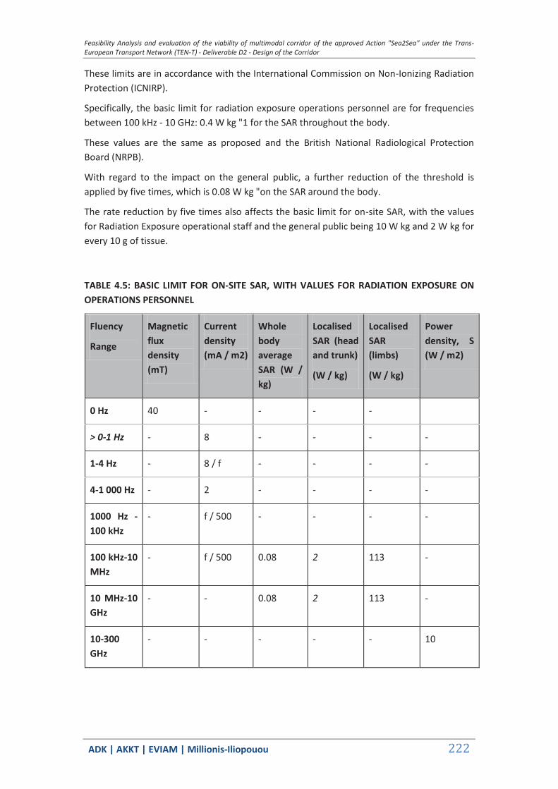
Feasibility Analysis and evaluation of the viability of multimodal corridor of the approved Action "Sea2Sea" under the Trans-European Transport Network (TEN-T) - Deliverable D2 - Design of the Corridor
ΑDΚ | AKKT | ΕVΙΑΜ | Millionis-Iliopouou 222
These limits are in accordance with the International Commission on Non-Ionizing Radiation Protection (ICNIRP).
Specifically, the basic limit for radiation exposure operations personnel are for frequencies between 100 kHz - 10 GHz: 0.4 W kg "1 for the SAR throughout the body.
These values are the same as proposed and the British National Radiological Protection Board (NRPB).
With regard to the impact on the general public, a further reduction of the threshold is applied by five times, which is 0.08 W kg "on the SAR around the body.
The rate reduction by five times also affects the basic limit for on-site SAR, with the values for Radiation Exposure operational staff and the general public being 10 W kg and 2 W kg for every 10 g of tissue.
TABLE 4.5: BASIC LIMIT FOR ON-SITE SAR, WITH VALUES FOR RADIATION EXPOSURE ON OPERATIONS PERSONNEL
Fluency
Range
Magnetic flux density (mT)
Current density (mA / m2)
Whole body average SAR (W / kg)
Localised SAR (head and trunk)
(W / kg)
Localised SAR (limbs)
(W / kg)
Power density, S (W / m2)
0 Hz 40 - - - -
> 0-1 Hz - 8 - - - -
1-4 Hz - 8 / f - - - -
4-1 000 Hz - 2 - - - -
1000 Hz - 100 kHz
- f / 500 - - - -
100 kHz-10 MHz
- f / 500 0.08 2 113 -
10 MHz-10 GHz
- - 0.08 2 113 -
10-300 GHz
- - - - - 10
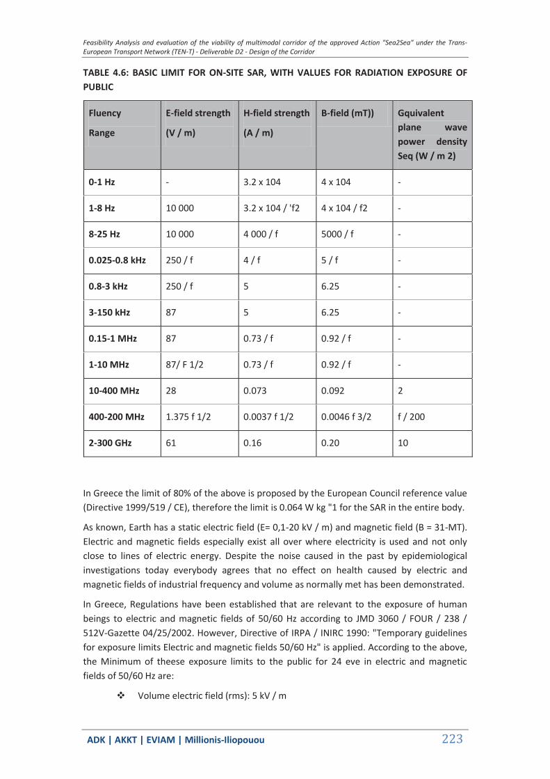
Feasibility Analysis and evaluation of the viability of multimodal corridor of the approved Action "Sea2Sea" under the Trans-European Transport Network (TEN-T) - Deliverable D2 - Design of the Corridor
ΑDΚ | AKKT | ΕVΙΑΜ | Millionis-Iliopouou 223
TABLE 4.6: BASIC LIMIT FOR ON-SITE SAR, WITH VALUES FOR RADIATION EXPOSURE OF PUBLIC
Fluency
Range
E-field strength
(V / m)
H-field strength
(A / m)
B-field (mT)) Gquivalent plane wave power density Seq (W / m 2)
0-1 Hz - 3.2 x 10⁴ 4 x 10⁴ -
1-8 Hz 10 000 3.2 x 10⁴ / 'f2 4 x 10⁴ / f2 -
8-25 Hz 10 000 4 000 / f 5000 / f -
0.025-0.8 kHz 250 / f 4 / f 5 / f -
0.8-3 kHz 250 / f 5 6.25 -
3-150 kHz 87 5 6.25 -
0.15-1 MHz 87 0.73 / f 0.92 / f -
1-10 MHz 87/ F 1/2 0.73 / f 0.92 / f -
10-400 MHz 28 0.073 0.092 2
400-200 MHz 1.375 f 1/2 0.0037 f 1/2 0.0046 f 3/2 f / 200
2-300 GHz 61 0.16 0.20 10
In Greece the limit of 80% of the above is proposed by the European Council reference value (Directive 1999/519 / CE), therefore the limit is 0.064 W kg "1 for the SAR in the entire body.
As known, Earth has a static electric field (E= 0,1-20 kV / m) and magnetic field (B = 31-MT). Electric and magnetic fields especially exist all over where electricity is used and not only close to lines of electric energy. Despite the noise caused in the past by epidemiological investigations today everybody agrees that no effect on health caused by electric and magnetic fields of industrial frequency and volume as normally met has been demonstrated.
In Greece, Regulations have been established that are relevant to the exposure of human beings to electric and magnetic fields of 50/60 Hz according to JMD 3060 / FOUR / 238 / 512V-Gazette 04/25/2002. However, Directive of IRPA / INIRC 1990: "Temporary guidelines for exposure limits Electric and magnetic fields 50/60 Hz" is applied. According to the above, the Minimum of theese exposure limits to the public for 24 eve in electric and magnetic fields of 50/60 Hz are:
Volume electric field (rms): 5 kV / m
Feasibility Analysis and evaluation of the viability of multimodal corridor of the approved Action "Sea2Sea" under the Trans-European Transport Network (TEN-T) - Deliverable D2 - Design of the Corridor
ΑDΚ | AKKT | ΕVΙΑΜ | Millionis-Iliopouou 224
Magnetic Flow density (rms): 100 MT
These limits it is not dangers limits but include great safety buffer. Also, for lesser times of for exposure, the limits that correspond are broadened (E = 10 kV / m, B = 1000 MT).
The elecrification of lines usually results in the creation of the entire length of the track cable evaeriou height of measures 5.5-6.5. The negative effects caused on bids by the existence of overhead cables are internationally known, although that has not become possible to date to accurately determine the effect on different kinds of birds, in respect to the parameters that affect them therein (voltage, cable thickness, magnetic field, spacing, etc.).
There are admittedly sure some bird groups that are more sensitive to collisions with cables. Accordance with research of Paul Rose and Stephen Baillie 1988 (R.T. Research Report No. 42) the biggest and fastest kinds have greater sensitivity to conflicts of cables. (For the fastest species, most conflicts with cables are fatal). In conclusion and in accordance with Chris Mead (B.T.O. News) the biggest and most aesthetically ugly (overt remotely) networks of overhead cables may be summarized as less dangerous for the bird fauna. Therefore, the contact line that in its longest part is chain-shaped becomes more overt than just overhead cables, with possibly less impact on bird fauna.
Finally, John Kirby after long term observations states (BTO News 3-4 / 1992) that birds feel "changes in" power close to live conductors, thus not coming close. Also, for conductor power failure, the relationship between voltage and bird behavior is presented, as follows:
11 kV all bird kinds nest in conductors with this or with lower voltage.
33 kV Birds of the pigeon-sized or larger rare nest in conductors of this
voltage.Contrary, smaller birds can be nesting.
66 kV Large birds not nesting on conductor, while the smaller ones very rarely
do.Birds usually fly through the conductors with this voltage.
132 kV None of the birds nest for more than a few seconds on the conductor
and very small birds fly through.
275 kV No bird approaching the conductor but neither do they fly through at
this voltage or greater. Bigger birds, eg of the size of a gull, gradually fly higher as
they come closer to conductor.
400 kV Besides birds that are close to the ground, very few fly under the
conductor.
In the next stage of the corridor improvement projects studies, the Volume of the electric field (E), the magnetic Flow density (B) in increasing distance from the contact line will be assessed. The field intensities should be calculated on the worst case in terms of electric load and layout of the overhead electric cables in train stations.
Feasibility Analysis and evaluation of the viability of multimodal corridor of the approved Action "Sea2Sea" under the Trans-European Transport Network (TEN-T) - Deliverable D2 - Design of the Corridor
ΑDΚ | AKKT | ΕVΙΑΜ | Millionis-Iliopouou 225
Also, there will be an installation of a monitoring network of radiation emitted by the electrified traffic and the operation of the signaling system and remote management of the line segments / positions in relation to the under electrification or to-be electrified network that passes close to residential areas and protected areas and also at the positions where there will be Centres of network management and control installed.
4.1.6 Effects on water
A) Impact on ground and surface water
The construction of new projects (lines and improvements) and operation of the rail part of the corridor project is not expected to cause significant impacts to groundwater or surface waters of the region.
The effects that could potentially occur mainly on the stage of construction of new lines - and projects include:
Changes in currents or changes in the course or direction of movement of
any kind of surface liquid
Changes in the rate of absorption in the drainage channels or the rate and
amount of leaching of the soil.
Changes in the flow path of water from flooding.
Change in the amount of groundwater either by direct addition of water or
extraction thereof or by inhibiting the underground supply of water into cuts
or excavations.
These effects are expected to be reversible and low intensity.
B) Impact on ports waters
As for the port areas of interest, as the construction of new projects is not recommended in these, the main impacts relate to the operational phase of the corridor and include impacts from the accommodation of ships that will transport containers.
The main impacts from the operation of a port project, which may find application in the ports of interest, Kavala, Alexandroupolis, Varna and Burgas on the marine environment include:
Effects on water quality, due mainly to say port users, namely -in case of the
corridor- the ships
Impacts on marine organisms, as a result of this dynamic situation
More specifically, impacts may come out of the following:

Feasibility Analysis and evaluation of the viability of multimodal corridor of the approved Action "Sea2Sea" under the Trans-European Transport Network (TEN-T) - Deliverable D2 - Design of the Corridor
ΑDΚ | AKKT | ΕVΙΑΜ | Millionis-Iliopouou 226
Movement of ships
The movement of ships at sea is conducted primarily with motor boats, the traffic of
which may cause the following effects:
Corrosion of beach if moving at high speed near the coast
Cut off marine flora
Disturbance of bottom sediments
Killing fish by hits with the propeller
The size of the above effects depend on various factors such as the size of migrant ships and boats, cruising speed, the presence of marine flora and fauna, the depth of the basin.
The above impact is mainly identified in shallow water, less than three meters and at high cruising speeds. Within the basin of test ports the movement of ships is at low speeds while the marine environment within them is rather degraded due to long port use. In conclusion it can be seen that the impact of the movement of ships is mainly confined within the basin.
Accidental pollution
With regard to accidental pollution of the marine recipient, all kinds of ships are at risk of accidents that can be summarized in the following categories.
impact (with another vessel or on a port, etc.)
stranding (in shallow water or reef)
fire (total or partial)
sinking (however caused)
mixed forms of the above (such as collision and sinking, fire
and sinking, collision and fire etc.)
The pollution concerns all maritime traffic. To counter their effects, general measures can be applied in each case whether they fall within international navigation rules, either determined by the requirements of national and international law. To deal with such pollution, the respective operating port must have a "Plan of Emergency Response to Marine Pollution - Contigency Plan».Based on national legislation the Greek ports have such plans.
Evacuation of ballast water
Draining of the water added to the hulls of ships to enable them to acquire the respective desired buoyancy is one of the most important environmental problems of navigation. The problem arises because, together with the seawater, organisms and other materials found in levitation are also sucked. In case of total or partial emptying of these tanks in different sea areas than those of the original origin of ballast, an introduction into the marine environment of harmful marine organisms, pathogenic or toxic yet may occur. The

Feasibility Analysis and evaluation of the viability of multimodal corridor of the approved Action "Sea2Sea" under the Trans-European Transport Network (TEN-T) - Deliverable D2 - Design of the Corridor
ΑDΚ | AKKT | ΕVΙΑΜ | Millionis-Iliopouou 227
International Maritime Organization - IMO of the United Nations has issued a series of decisions and instructions for the safe management of water ballast. The proposed procedures and actions are related to boat captains, managers of ports and mostly in a state authority, which must cover the legal problem by specifying procedures to protect the marine environment while not endanger ships.
4.2 Key findings and environmental measures
4.2.1 Methodology of environmental studies for planned next stages
The evaluation of the data of the previous chapter helps identify the major environmental issues that should be given special attention when preparing the next stage project studies, including:
the main environmental issues that must be addressed as a priority and in
depth, ie levels of radiation, noise and vibration in critical populated areas
and protected areas - sensitive ecosystems,
proposed methodologies impact assessment,
proposals for specialized studies or scientific documentation necessary to be
prepared and submitted at a later stage, such as the drafting -if necessary-
of a Special Ecological Evaluation in the network of Natura areas that will
likely be work.
Size of the area of impact assessment
To determine the extent of the study area we will have to take into account the type and size of projects in relation to their area of influence, as well as the fact that parts of the existing rail network improvement projects are located in areas of the Natura 2000 Network within the National Parks area.Considering the above, as a study area in construction Environmental Impact Study and operation of the projects it is expected to set a wider area located more than 5 km from the occupation zones of the proposed interventions.
It is clarified here that, with regard to anthropogenic elements that should be included in the EIS / Environmental Assessment , the area of the respective municipalities will be used as a reference.Where deemed appropriate for completeness and scientific approach of the information, the analysis may be extrapolated and at a Regional Unity level in Greece and Bulgarian Province level in Bulgaria.
View of the area of study will be presented also in the maps that accompany the EIS / Environmental Assessment.
Timeframe of Impact Assessment
The impact assessment of the planned interventions will take place for a period of 10 years, as that is provided for the period of validity of the decision approving environmental conditions (see Art. 2, par. 8 of Law. 4014/2011) in the Greek area. In sections within the Bulgarian borders there are no legistlation limitations as to the impact assessment year and
Feasibility Analysis and evaluation of the viability of multimodal corridor of the approved Action "Sea2Sea" under the Trans-European Transport Network (TEN-T) - Deliverable D2 - Design of the Corridor
ΑDΚ | AKKT | ΕVΙΑΜ | Millionis-Iliopouou 228
for this reason it is proposed to follow initially uniform design, ie the time frame of the decade.
Main environmental issues in the next stage and impact assessment methodology
The main environmental issues to be addressed in the next stage of the Environmental Impact Study / Environmental Impact Assessment are set out in Annex II of N.4014 / 2011 and Environmental Protection Act (EPA), - 91/2002 (and their latest amendments) respectively for lots of improvement projects in Greece and Bulgaria. Examples mentioned below:
Non biotic characteristics
Climatic and bioclimatic characteristics.
Morphological and topological characteristics.
Geological, tectonic and soil characteristics.
Habitat
Terrestrial flora and fauna.
Marine flora.
Marine fauna.
Protected areas.
Human environment
Land uses.
Built environment.
Historical and cultural environment.
Socio-economic environment.
Technical infrastructure.
Atmospheric environment.
Acoustic environment, vibrations, radiation.
Surface and ground waters.
For all the above parameters there will be proposed specific measures to address the
impact, if in assessing the impact on the construction and operation phases of the project
resulting effects are estimated.
It is also worth mentioning that the proposed measures will probably be within the limits
(and / or in contact with them) areas of the Network Natura 2000, and given the
environmental sensitivity of the area, there should be performed and appropriate assessment
of the implications of the project, according with the provisions of Article 6 of Directive 92/43
/ EC.
In the appropriate assessment of the impacts there will be references to the following:

Feasibility Analysis and evaluation of the viability of multimodal corridor of the approved Action "Sea2Sea" under the Trans-European Transport Network (TEN-T) - Deliverable D2 - Design of the Corridor
ΑDΚ | AKKT | ΕVΙΑΜ | Millionis-Iliopouou 229
IX. The habitats of Annex I to Directive 92/43 / EC.
X. In the fauna of Annex II of Directive 92/43 / EC.
XI. In bird species of Annex I of Directive 2009/147/ EC.
Emphasis will also be given to sensitive species that may be found in the respective areas crosses the corridor.
Finally, any abnormal situations that may arise during the construction of the proposed interventions and / or discharge of substances / materials from the machines that will perform the work will also be taken into account when assessing the impact.
It is clarified here that the impact assessment will take into account the provisions of Directive 2011/92 / EC and the latest national institutional framework for environmental licensing of projects / activities (see. N.4014 / 2011, etc.).
It will take into account the following guidance documents of the EU:
EC 2001. «Assessment of plans and projects significan tly affecting Natura
2000 sites»,
EC 2000. «Managing Natura 2000 sites: the provision of article 6 of the
habitats directive 92/43 / EEC », and
EC 2007. «Guidance document on article 6 (4) of the habitats directive 92/43
/ EEC: clarification of the concepts of alternative solutions, imperative
reasons for overriding public interest, compensatory measures, overall
coherence, opinion of the Commission ».
Finally, if the corridor and improvement projects pass through areas of the Network Natura 2000 (Special Area of Conservation of Directive 92/43 / EC and / or Special Protection Area for Birds of Directive 2009/147/ EC) it might be necessary to draft a Special Ecological Assessment.
4.2.2 Monitoring system of the corridor operation
The environmental monitoring program refers to those actions which ensure accurate assessment and monitoring of the environmental situation.Continuous and accurate knowledge of the environmental situation enables assessment of the effectiveness of the terms, limitations measures and interventions proposed to minimize the impacts caused by the operation of the corridor.
The environmental monitoring program may be amended or supplemented, aiming mainly on stronger monitoring of those environmental media most affected. The data collected by the environmental monitoring program will be recorded and filed.
Actions relating to the management of the corridor and environmental monitoring during the operation include the following:
Installation of monitoring and measuring system: the level of noise, vibration and radiation at critical points along the railway line.
Feasibility Analysis and evaluation of the viability of multimodal corridor of the approved Action "Sea2Sea" under the Trans-European Transport Network (TEN-T) - Deliverable D2 - Design of the Corridor
ΑDΚ | AKKT | ΕVΙΑΜ | Millionis-Iliopouou 230
Monitoring of water and energy consumption and reassessment every year of water and energy policy of the runway in order to reduce consumption.
Monitoring depth of the basin ports of interest to identify any accumulation of sediments.
Monitoring with sample collection or machine-water quality of the basin and ports of interest and the sea area near the project, for example in the areas of major water systems of lakes of Burgas and Varna.
Making measurements of the quality of rainwater that flow into the sea during the rain season.The monitoring is carried out once a year. It is proposed that the analysis includes measuring the suspended solid content, number of microorganisms, content of phosphorus and nitrogen and lubricants.
Monitoring and recording of the marine biological environment of areas inside and outside the basin to assess the impact of the operation of the corridor.
Below, the parameters of the monitoring program are presented.
Noise and vibration monitoring
The measurements that will relate the intensity of noise and vibration are -not limited to- proposed:
the perimeter of the ports of interest especially during the summer season, in place of cargo ships wagons.
in residential areas near the line (the exact distance will be determined by the following stages)
in areas where the line passes or abuts sensitive - protected ecosystems (eg. Evros Delta, Dadia Forest Park Balgarka, lakes Burgas Varna)
in the locations of control centers of the corridor system
Not limited to, the vibration monitoring system consists of sensors, transmitters, central Monitor and software for PC.The proximity sensors can measure the vibration of a shaft and eccentricity. In the body of the train engine there are adapted piezoelectric sensors that will detect vibrations. The signals provided by these sensors using transmitters, will be gathered in central Monitor which is planned to issue alerts and warnings. This data should be recoverable by computer for imaging by specialized software.
Radiation Measurements
Measurements of the -responsible for radiation protection and radiological and nuclear safety- "Atomic Energy Commission" are made in order to record the levels of electromagnetic radiation and to verify compliance or not with the exposure limits to the public.In Greece, this is defined in paragraphs 9 and 10 (if applicable) of Article 31 of Law 3431 (Government Gazette 13 / A / 03.02.2006) and Articles 2-4 of No.53571/3839 (Government Gazette 1105 / B / 6.9.2000) joint decision of the Ministers of Development, Environment, Planning and Public Works, Health and Welfare, Transport and Communications.

Feasibility Analysis and evaluation of the viability of multimodal corridor of the approved Action "Sea2Sea" under the Trans-European Transport Network (TEN-T) - Deliverable D2 - Design of the Corridor
ΑDΚ | AKKT | ΕVΙΑΜ | Millionis-Iliopouou 231
Autopsy should be conducted on critical areas in order for monitoring systems installation positions to be decided. Positions - points will be around the current source in the region of interest (indicative 20-50m radius). Using substantively enacted by the state safe exposure limits, there will be a study to determine the critical areas around the emission source. The intensity of the electric field and the magnetic field and power density will be measured, and there will be an assessment whether they fit within the stated limits.
These measurements will be made in accordance with international standards. The equipment to be used include -not limited to- meter or spectrum analyzer, suitable for the frequencies under consideration source, connected to corresponding recording software.
These results are proposed to be depicted in histograms wherein it is shown on a logarithmic scale the intensity of the electric field, the magnetic field intensity and power density at the points where measurements were made
Measurements will be performed (not limitation to):
in residential areas near the line (the exact distance will assess the final design of the monitoring system)
in areas where the line passes or abuts sensitive - protected ecosystems (eg. Evros Delta, Dadia Forest Park Balgarka, lakes Burgas Varna)
the area around the corridor control centers
Monitoring the Marine Environment
Measurements of sea water
Seawater measurements will relate to the physicochemical characteristics and microbiological parameters. Sampling will be done by the maritime area within the basin ports interested phi EPON.Also, it is suggested to collect control samples (blank samples) from adjacent areas, eg within 500m by each port in order to provide information on the concentrations of the natural background of the area.
Measurements of bottom sediments
Measurements of bottom sediment will relate to Heavy Metals in Total fats and oils (Grease and Oils), the total petroleum hydrocarbon (Total Petroleum Hydrocardons), the aromatic hydrocarbons, the PAHs and the polychlorinated biphenyls.
Sampling will be out οf the bottom front of the platforms.Also, it is suggested to collect control samples (blank samples) from adjacent areas (eg within 500m from each port) to provide information on the concentrations of the natural background of the area, as shown in the following table.The sampling is performed with dredge from the bottom surface and in-depth layer of about 0-30 cm.
Also proposed is sampling bottom material for screening, identification and registration of benthos in the marine area of the project.
Sampling will take place within the basin ports of interest and 200 meters across these.

Feasibility Analysis and evaluation of the viability of multimodal corridor of the approved Action "Sea2Sea" under the Trans-European Transport Network (TEN-T) - Deliverable D2 - Design of the Corridor
ΑDΚ | AKKT | ΕVΙΑΜ | Millionis-Iliopouou 232
TABLE 4.7: DATA FROM MONITORING SYSTEM - MEASURING FREQUENCY Type of
environmental media
Type of measurement Analysis Sampling frequency
Atmosphere Radiation radiation gauge To be specified where
appropriate and species
protection Noise Noise
Vibrations meter Noise -
Vibration -ntesimpelometro
To be specified where
appropriate and by species
protection *
Sediment bottom / bottom
material
Heavy Metals
Hg: CV-AAS, As: HG-AAS Cr, Ni, Mn, Cu, Zn, Pb,
Fe: FLAME AAS or GF -Aas
Recommended 1 time every
two years
Sediment bottom / bottom
material
Total sadness and oils (Grease and Oils), total petroleum hydrocarbons
hydrocarbons (Total Petroleum Hydrocardons)
SME WW 5520 / B or D and FEd 21st
Recommended 1 time every
two years
Sediment bottom / bottom
material
Aromatic Hydrocarbons: Benzene, Toluene, Ethyl Benzene, Xylene isomers
GPA 5030 B Recommended
1 time every two years
Sediment bottom / bottom
material
Polyaromatic hydrocarbons (PAH 'S): Benzo (b) fluranthene, Benzo (k)
fluranthene, Benzo (a) pyrene, Benzo (g, h, i) perylene GPA8272
Recommended 1 time every
two years
Sediment bottom / bottom
material
Polychlorinated biphenyls (PCB's): Aroclor
1016/1221/1232/1242/1248/1254/1260 GPA 8082
Recommended 1 time every
two years
Sediment bottom / bottom
material
Benthos
Sorting AND IDENTIFICATION
organizations sieve microscope
Recommended 1 time every
two years
Feasibility Analysis and evaluation of the viability of multimodal corridor of the approved Action "Sea2Sea" under the Trans-European Transport Network (TEN-T) - Deliverable D2 - Design of the Corridor
ΑDΚ | AKKT | ΕVΙΑΜ | Millionis-Iliopouou 233
Seawater in particular
berth
Microbiological "Coliforms" - "Escherichia coli "and" Enterococci "-"
Intestinal enterococci "
According to the laboratory methods
described in Annex I of
Directive 2006/7/ EC
Recommended 1 time per year
Seawater in particular
berth
Temperature, Conductivity, pH, dissolved oxygen, turbidity *
thermometer, conductivity
gauge, pH meter, oximeter,
Recommended 2 times a year
March-September
Seawater in particular
berth
Particulate concentrations metals Pb, Cr, Ni, Cu, Zn, Cd, Sn, Co, Fe, Mn
The equipment laboratory for
analyzes (indicatively
hotplate, spectrometer) **
Recommended 1 time every
two years
* Depends on the direction and intensity of winds, temperature and humidity
** The measurement of the haze will be realized by the use of Secchi disk.
Preliminary recommendations - guidelines - environmental protection measures
In this phase there is a first estimate of the necessary environmental measures. The following are indicatively mentioned as (not limited to):
In later stages of study of the improvement projects, under the Environmental Studies predictions should be made using modern methods and / or software for predicting the level of noise, vibration and radiation at critical points along the railway line. Indicative examples:
Residential areas near the line (the exact distance will be determined by the next stage studies)
Areas where the line passes through or abuts sensitive - protected ecosystems (eg. Evros Delta, Dadia Forest)
Installation Locations of corridor control Centres.
Work sites should be installed outside the conservation area, in areas without perennial natural vegetation. Sites which have no direct relation to the rivers from which the corridor passes should be preferred, to avoid even inadvertent leaching of pollutants.
If judged necessary to construct support worksite in areas of protection (if the facility provided by the relevant legislation and is not contrary to the limitations of the site), it should be kept to a minimum, avoiding placing even temporary structures for any kind of work that can be done on the main site, which will be located outside of Zones and Areas Protection.
Feasibility Analysis and evaluation of the viability of multimodal corridor of the approved Action "Sea2Sea" under the Trans-European Transport Network (TEN-T) - Deliverable D2 - Design of the Corridor
ΑDΚ | AKKT | ΕVΙΑΜ | Millionis-Iliopouou 234
Furthermore, regarding the operation of construction sites, preferably, no work should be done in the spring season or any other time that coincides with the breeding season of the species of fauna and flora, in each habitat.
Ensure non-rejection excavated materials and construction (concrete, etc) and other materials (oils etc.) in rivers through which the corridor passes and streams that lead to them, at MIP vegetation areas and in any position other organized by areas will be restored after completion of the work.
Machinery and Construction of devices should meet the relevant emission legislations. To limit the emission to the atmosphere from the work of the site, there should be diligent regulation and engine maintenance of the machinery to be used, and the use of high quality fuels. These measures will help ensure compliance limits.
Attention should be paid to compliance with the noise emission limits of construction plant and equipment to reduce noise in accordance with applicable legislation, combined with the regular maintenance of all operating machinery of the worksite. During the hours of siesta time the movement of heavy vehicles will be stopped if they pass through residential areas. Pets are not allowed in the work area and the use of machinery without the European Union approval certificate on noise.
The use of explosives for the construction of new lines and of the corridor improvements works should be avoided.
After completion of construction work of the new lines (eg Kavala -Toxotes) and corridor improvement projects there will be complete restoration of the natural landscape with a special Study Rehabilitation Natural Landscape, in accordance with the provisions and provisions of national laws of both countries.
For the restoration of the landscape native flora must be used, which is essential for the restoration of natural habitats beyond the interests of uniformity of the landscape, helping with the restore of balance and quick repopulation by native species of micro and macro fauna.
Where possible, in order to reduce the visual impact of the bird fauna, it is essential to seek planting either side of the R/W, consisting of various forest species, grown in the area. This measure mitigates the phenomena of erosion of the banks of ditches and embankments of the line and will help the natural growth of vegetation.
To address the problem of the possible isolation of the free movement of wildlife during the construction and operation of projects there should, where necessary, be provided with the construction of corridors through technical projects.
In residential areas or in environmentally sensitive locations - Protected Areas through which the rail line passes or is nearby, there will be explored the need for manufacturing special technical projects (eg noise barriers), to protect against noise pollution.
If any disturbance from vibration in adjacent to the project buildings or habitats emerges from the monitoring system, there should be developed a special study for Shock Protection, in order to implement measures to reduce vibrations at certain points. Such measures might include reducing speed train traffic while crossing the specific points, placing continuous

Feasibility Analysis and evaluation of the viability of multimodal corridor of the approved Action "Sea2Sea" under the Trans-European Transport Network (TEN-T) - Deliverable D2 - Design of the Corridor
ΑDΚ | AKKT | ΕVΙΑΜ | Millionis-Iliopouou 235
welded rail in these positions (if there is or is not already provided), improving subbase rail etc.
4.3 Sosioeconomic Analysis
4.3.1 General
The socioeconomic benefit arising from the execution of the proposed project is comprised of the following:
Quantitative Socioeconomic Benefit
- The benefit arising from the direct and indirect creation of jobs due to construction and operation of the project.
Non-quantifiable Socioeconomic Benefit
- The benefit arising from the indirect creation of more jobs for the local workforce in the shipping industry related to the provision of services for additional ships passing through the Port of Alexandroupolis.
It goes without saying that the socioeconomic analysis presupposes the translation of financial (market) project cost prices and Net Differential Revenue derived therefrom, to equivalent estimated social welfare values.
4.3.2 Socioeconomic Investment Cost Breakdown
Calculation of the socioeconomic costs of the investment takes into account the following:
Assuming financial cost is equivalent to 100 units before VAT
The contractor's profit amounts to 18% (of the price before VAT), thus:
Contractor’s profit = (100/1.18) x 0.18 = 15.25 units
Less tax (26%) on contractor’s profit, therefore:
Project Contractor’s Tax = Contractor’s Profit = x 0.26 = 15.25 x 0.26 = 3.97 units
Therefore, the Financially Adjusted Cost of the project is equal to:
Financial Adjusted Project Cost = Cost before VAT – Contractor’s Tax = 100 - 3.97 = 96.03 units
Labour costs of the project are assumed in fiscal value terms to amount to 30% of contractors' costs before profit, thus:
Labour Costs (Wages at Market Rates) = 0.3 x (100 – 15.25) = 25.43 units
For the purposes of calculation of the basic wage rate, the following applies:
Virtual Basic Wage = Going Market Wage Rate x (1 – Unemployment) x (1 – Social Insurance Contributions – Employment Taxes)

Feasibility Analysis and evaluation of the viability of multimodal corridor of the approved Action "Sea2Sea" under the Trans-European Transport Network (TEN-T) - Deliverable D2 - Design of the Corridor
ΑDΚ | AKKT | ΕVΙΑΜ | Millionis-Iliopouou 236
We assume unemployment to be equivalent to 25% and the employee tax rate to be 15% on income before payment of social insurance contributions, a tax charge of [100 – 15.5] x 0.15 = 12.675 units. 15 The following therefore:
Virtual Wage = 25.43 x (100 - 25) / 100 x (100 – 40.06 – 12.675)/100 = 8.41 units
Therefore, the socioeconomic costs of the investment are equal to the following:
Socioeconomic Cost = Adjusted Financial Cost - Labour Costs (Market Rate) + Virtual Labour Cost = 96.03 - 25.43 + 8.41 = 79.40 units, or 79.01% of the financial costs before VAT
4.3.3 Socioeconomic Operating Costs Breakdown
Labour costs
The method indicated above is used to calculate the basic (virtual) wage.
Energy costs
As far as energy costs are concerned, it is assumed that they will be addressed, in the absence of indices and other statistical data, in the same way as investment costs, i.e. the socioeconomic costs of energy expenditure is assumed to be equal to 79.01% of the financial costs.
Maintenance costs
Given that maintenance costs are directly related to the level of investment, the socioeconomic costs are calculated as a percentage of investment cost, i.e. equivalent to the socioeconomic costs equalling 79.01% of the financial investment.
Other expenses
Other costs included in operating costs mainly comprise network leasing and rolling stock, paid by TRAINOSE to OSE, as well as insurance, third party fees, etc. As far as these expenses are concerned, socioeconomic costs are assumed to coincide with financial costs.
Calculation of Socioeconomic Operating Costs
Calculation of the socioeconomic operating costs first of all requires information pertaining to the distribution of total financial costs, as calculated in its component parts in previous sections. Thus use is again made of TRAINOSE’s 2013 Financial Statements, and specifically the “Statement of Comprehensive Income”. The distributed costs are summarised in the table below. 16
TABLE 4.8: TRAINOSE FREIGHT TRANSPORT SERVICE OPERATING COST BREAKDOWN
15 15,5% of the gross wage is the social security payments made by the employee (own contribution), which is deductible from taxation 16 factoring of labour, maintenance and energy is best estimation based on available statistical data
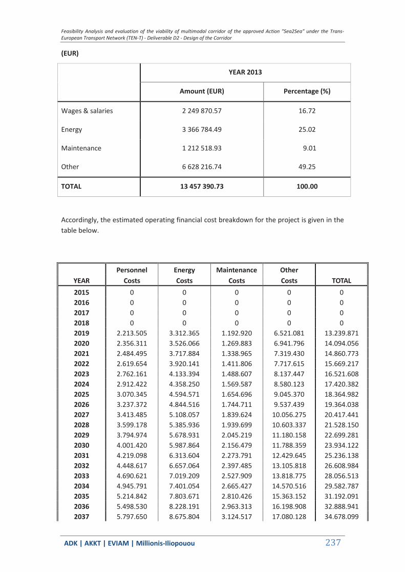
Feasibility Analysis and evaluation of the viability of multimodal corridor of the approved Action "Sea2Sea" under the Trans-European Transport Network (TEN-T) - Deliverable D2 - Design of the Corridor
ΑDΚ | AKKT | ΕVΙΑΜ | Millionis-Iliopouou 237
(EUR)
YEAR 2013
Amount (EUR) Percentage (%)
Wages & salaries 2 249 870.57 16.72
Energy 3 366 784.49 25.02
Maintenance 1 212 518.93 9.01
Other 6 628 216.74 49.25
TOTAL 13 457 390.73 100.00
Accordingly, the estimated operating financial cost breakdown for the project is given in the table below.
2015 0 0 0 0 0 2016 0 0 0 0 0 2017 0 0 0 0 0 2018 0 0 0 0 0 2019 2.213.505 3.312.365 1.192.920 6.521.081 13.239.871 2020 2.356.311 3.526.066 1.269.883 6.941.796 14.094.056 2021 2.484.495 3.717.884 1.338.965 7.319.430 14.860.773 2022 2.619.654 3.920.141 1.411.806 7.717.615 15.669.217 2023 2.762.161 4.133.394 1.488.607 8.137.447 16.521.608 2024 2.912.422 4.358.250 1.569.587 8.580.123 17.420.382 2025 3.070.345 4.594.571 1.654.696 9.045.370 18.364.982 2026 3.237.372 4.844.516 1.744.711 9.537.439 19.364.038 2027 3.413.485 5.108.057 1.839.624 10.056.275 20.417.441 2028 3.599.178 5.385.936 1.939.699 10.603.337 21.528.150 2029 3.794.974 5.678.931 2.045.219 11.180.158 22.699.281 2030 4.001.420 5.987.864 2.156.479 11.788.359 23.934.122 2031 4.219.098 6.313.604 2.273.791 12.429.645 25.236.138 2032 4.448.617 6.657.064 2.397.485 13.105.818 26.608.984 2033 4.690.621 7.019.209 2.527.909 13.818.775 28.056.513 2034 4.945.791 7.401.054 2.665.427 14.570.516 29.582.787 2035 5.214.842 7.803.671 2.810.426 15.363.152 31.192.091 2036 5.498.530 8.228.191 2.963.313 16.198.908 32.888.941 2037 5.797.650 8.675.804 3.124.517 17.080.128 34.678.099
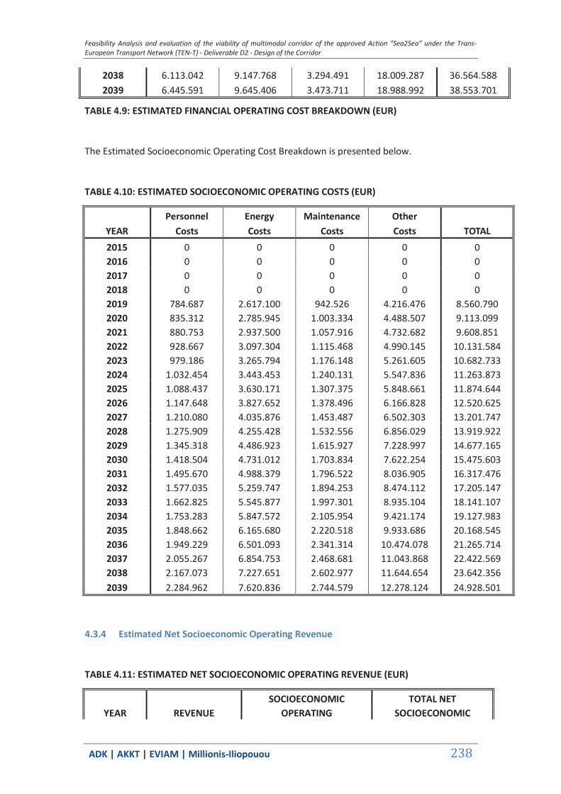
Feasibility Analysis and evaluation of the viability of multimodal corridor of the approved Action "Sea2Sea" under the Trans-European Transport Network (TEN-T) - Deliverable D2 - Design of the Corridor
ΑDΚ | AKKT | ΕVΙΑΜ | Millionis-Iliopouou 238
TABLE 4.9: ESTIMATED FINANCIAL OPERATING COST BREAKDOWN (EUR)
The Estimated Socioeconomic Operating Cost Breakdown is presented below.
TABLE 4.10: ESTIMATED SOCIOECONOMIC OPERATING COSTS (EUR)
2015 0 0 0 0 0 2016 0 0 0 0 0 2017 0 0 0 0 0 2018 0 0 0 0 0 2019 784.687 2.617.100 942.526 4.216.476 8.560.790 2020 835.312 2.785.945 1.003.334 4.488.507 9.113.099 2021 880.753 2.937.500 1.057.916 4.732.682 9.608.851 2022 928.667 3.097.304 1.115.468 4.990.145 10.131.584 2023 979.186 3.265.794 1.176.148 5.261.605 10.682.733 2024 1.032.454 3.443.453 1.240.131 5.547.836 11.263.873 2025 1.088.437 3.630.171 1.307.375 5.848.661 11.874.644 2026 1.147.648 3.827.652 1.378.496 6.166.828 12.520.625 2027 1.210.080 4.035.876 1.453.487 6.502.303 13.201.747 2028 1.275.909 4.255.428 1.532.556 6.856.029 13.919.922 2029 1.345.318 4.486.923 1.615.927 7.228.997 14.677.165 2030 1.418.504 4.731.012 1.703.834 7.622.254 15.475.603 2031 1.495.670 4.988.379 1.796.522 8.036.905 16.317.476 2032 1.577.035 5.259.747 1.894.253 8.474.112 17.205.147 2033 1.662.825 5.545.877 1.997.301 8.935.104 18.141.107 2034 1.753.283 5.847.572 2.105.954 9.421.174 19.127.983 2035 1.848.662 6.165.680 2.220.518 9.933.686 20.168.545 2036 1.949.229 6.501.093 2.341.314 10.474.078 21.265.714 2037 2.055.267 6.854.753 2.468.681 11.043.868 22.422.569 2038 2.167.073 7.227.651 2.602.977 11.644.654 23.642.356 2039 2.284.962 7.620.836 2.744.579 12.278.124 24.928.501
4.3.4 Estimated Net Socioeconomic Operating Revenue
TABLE 4.11: ESTIMATED NET SOCIOECONOMIC OPERATING REVENUE (EUR)
SOCIOECONOMIC TOTAL NET YEAR REVENUE OPERATING SOCIOECONOMIC
2038 6.113.042 9.147.768 3.294.491 18.009.287 36.564.588 2039 6.445.591 9.645.406 3.473.711 18.988.992 38.553.701
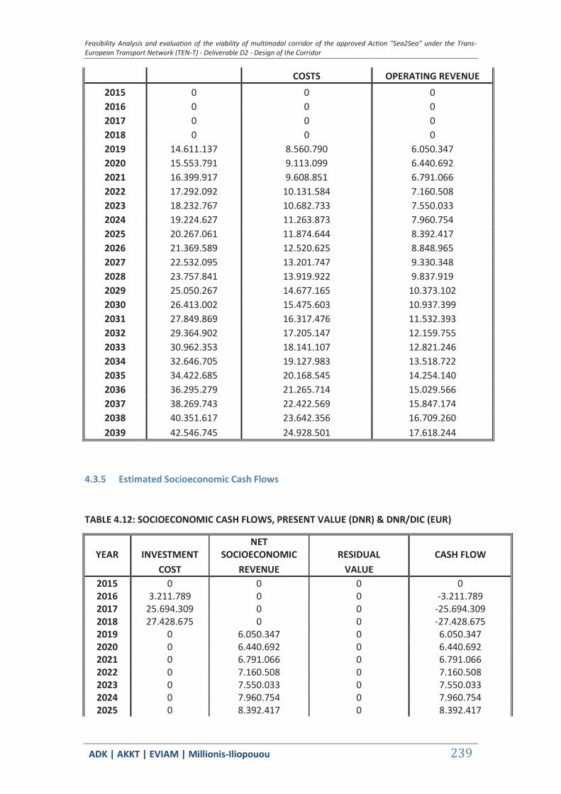
Feasibility Analysis and evaluation of the viability of multimodal corridor of the approved Action "Sea2Sea" under the Trans-European Transport Network (TEN-T) - Deliverable D2 - Design of the Corridor
ΑDΚ | AKKT | ΕVΙΑΜ | Millionis-Iliopouou 239
COSTS OPERATING REVENUE 2015 0 0 0 2016 0 0 0 2017 0 0 0 2018 0 0 0 2019 14.611.137 8.560.790 6.050.347 2020 15.553.791 9.113.099 6.440.692 2021 16.399.917 9.608.851 6.791.066 2022 17.292.092 10.131.584 7.160.508 2023 18.232.767 10.682.733 7.550.033 2024 19.224.627 11.263.873 7.960.754 2025 20.267.061 11.874.644 8.392.417 2026 21.369.589 12.520.625 8.848.965 2027 22.532.095 13.201.747 9.330.348 2028 23.757.841 13.919.922 9.837.919 2029 25.050.267 14.677.165 10.373.102 2030 26.413.002 15.475.603 10.937.399 2031 27.849.869 16.317.476 11.532.393 2032 29.364.902 17.205.147 12.159.755 2033 30.962.353 18.141.107 12.821.246 2034 32.646.705 19.127.983 13.518.722 2035 34.422.685 20.168.545 14.254.140 2036 36.295.279 21.265.714 15.029.566 2037 38.269.743 22.422.569 15.847.174 2038 40.351.617 23.642.356 16.709.260 2039 42.546.745 24.928.501 17.618.244
4.3.5 Estimated Socioeconomic Cash Flows
TABLE 4.12: SOCIOECONOMIC CASH FLOWS, PRESENT VALUE (DNR) & DNR/DIC (EUR)
YEAR INVESTMENT NET
SOCIOECONOMIC RESIDUAL CASH FLOW COST REVENUE VALUE
2015 0 0 0 0 2016 3.211.789 0 0 -3.211.789 2017 25.694.309 0 0 -25.694.309 2018 27.428.675 0 0 -27.428.675 2019 0 6.050.347 0 6.050.347 2020 0 6.440.692 0 6.440.692 2021 0 6.791.066 0 6.791.066 2022 0 7.160.508 0 7.160.508 2023 0 7.550.033 0 7.550.033 2024 0 7.960.754 0 7.960.754 2025 0 8.392.417 0 8.392.417
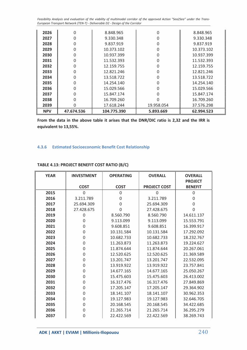
Feasibility Analysis and evaluation of the viability of multimodal corridor of the approved Action "Sea2Sea" under the Trans-European Transport Network (TEN-T) - Deliverable D2 - Design of the Corridor
ΑDΚ | AKKT | ΕVΙΑΜ | Millionis-Iliopouou 240
2026 0 8.848.965 0 8.848.965 2027 0 9.330.348 0 9.330.348 2028 0 9.837.919 0 9.837.919 2029 0 10.373.102 0 10.373.102 2030 0 10.937.399 0 10.937.399 2031 0 11.532.393 0 11.532.393 2032 0 12.159.755 0 12.159.755 2033 0 12.821.246 0 12.821.246 2034 0 13.518.722 0 13.518.722 2035 0 14.254.140 0 14.254.140 2036 0 15.029.566 0 15.029.566 2037 0 15.847.174 0 15.847.174 2038 0 16.709.260 0 16.709.260 2039 0 17.618.244 19.958.054 37.576.298 NPV 47.674.536 104.775.390 5.893.669 62.994.523
From the data in the above table it arises that the DNR/DIC ratio is 2,32 and the IRR is equivalent to 13,55%.
4.3.6 Estimated Socioeconomic Benefit Cost Relationship
TABLE 4.13: PROJECT BENEFIT COST RATIO (B/C)
YEAR INVESTMENT OPERATING OVERALL OVERALL
COST COST PROJECT COST PROJECT BENEFIT
2015 0 0 0 0 2016 3.211.789 0 3.211.789 0 2017 25.694.309 0 25.694.309 0 2018 27.428.675 0 27.428.675 0 2019 0 8.560.790 8.560.790 14.611.137 2020 0 9.113.099 9.113.099 15.553.791 2021 0 9.608.851 9.608.851 16.399.917 2022 0 10.131.584 10.131.584 17.292.092 2023 0 10.682.733 10.682.733 18.232.767 2024 0 11.263.873 11.263.873 19.224.627 2025 0 11.874.644 11.874.644 20.267.061 2026 0 12.520.625 12.520.625 21.369.589 2027 0 13.201.747 13.201.747 22.532.095 2028 0 13.919.922 13.919.922 23.757.841 2029 0 14.677.165 14.677.165 25.050.267 2030 0 15.475.603 15.475.603 26.413.002 2031 0 16.317.476 16.317.476 27.849.869 2032 0 17.205.147 17.205.147 29.364.902 2033 0 18.141.107 18.141.107 30.962.353 2034 0 19.127.983 19.127.983 32.646.705 2035 0 20.168.545 20.168.545 34.422.685 2036 0 21.265.714 21.265.714 36.295.279 2037 0 22.422.569 22.422.569 38.269.743
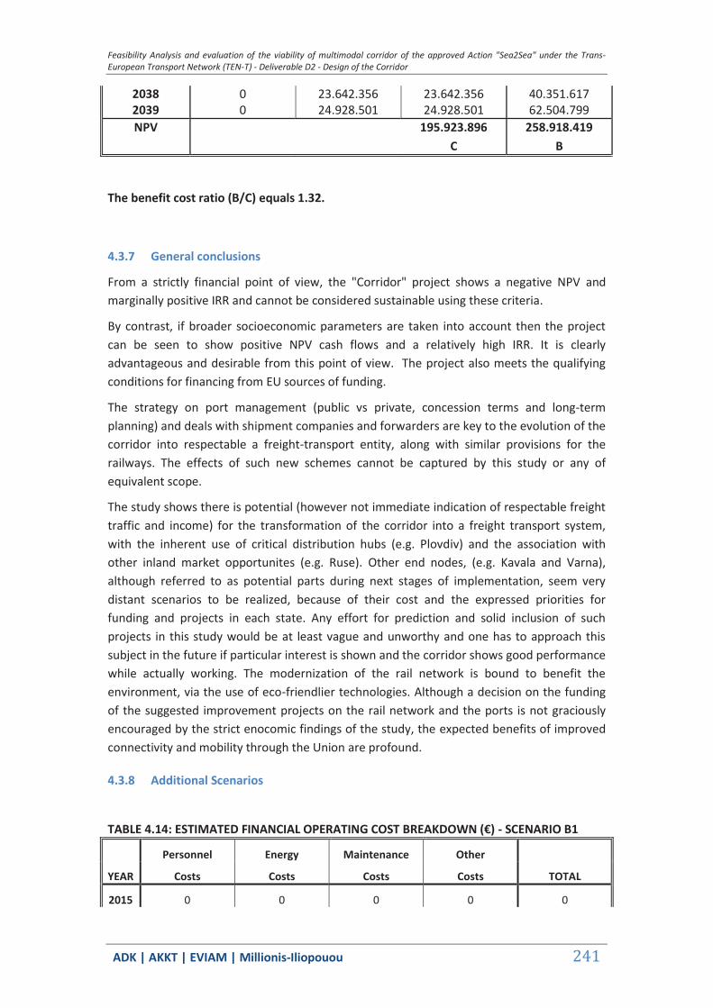
Feasibility Analysis and evaluation of the viability of multimodal corridor of the approved Action "Sea2Sea" under the Trans-European Transport Network (TEN-T) - Deliverable D2 - Design of the Corridor
ΑDΚ | AKKT | ΕVΙΑΜ | Millionis-Iliopouou 241
2038 0 23.642.356 23.642.356 40.351.617 2039 0 24.928.501 24.928.501 62.504.799 NPV 195.923.896 258.918.419
C B
The benefit cost ratio (B/C) equals 1.32.
4.3.7 General conclusions
From a strictly financial point of view, the "Corridor" project shows a negative NPV and marginally positive IRR and cannot be considered sustainable using these criteria.
By contrast, if broader socioeconomic parameters are taken into account then the project can be seen to show positive NPV cash flows and a relatively high IRR. It is clearly advantageous and desirable from this point of view. The project also meets the qualifying conditions for financing from EU sources of funding.
The strategy on port management (public vs private, concession terms and long-term planning) and deals with shipment companies and forwarders are key to the evolution of the corridor into respectable a freight-transport entity, along with similar provisions for the railways. The effects of such new schemes cannot be captured by this study or any of equivalent scope.
The study shows there is potential (however not immediate indication of respectable freight traffic and income) for the transformation of the corridor into a freight transport system, with the inherent use of critical distribution hubs (e.g. Plovdiv) and the association with other inland market opportunites (e.g. Ruse). Other end nodes, (e.g. Kavala and Varna), although referred to as potential parts during next stages of implementation, seem very distant scenarios to be realized, because of their cost and the expressed priorities for funding and projects in each state. Any effort for prediction and solid inclusion of such projects in this study would be at least vague and unworthy and one has to approach this subject in the future if particular interest is shown and the corridor shows good performance while actually working. The modernization of the rail network is bound to benefit the environment, via the use of eco-friendlier technologies. Although a decision on the funding of the suggested improvement projects on the rail network and the ports is not graciously encouraged by the strict enocomic findings of the study, the expected benefits of improved connectivity and mobility through the Union are profound.
4.3.8 Additional Scenarios
TABLE 4.14: ESTIMATED FINANCIAL OPERATING COST BREAKDOWN (€) - SCENARIO B1
Personnel Energy Maintenance Other
YEAR Costs Costs Costs Costs TOTAL
2015 0 0 0 0 0

Feasibility Analysis and evaluation of the viability of multimodal corridor of the approved Action "Sea2Sea" under the Trans-European Transport Network (TEN-T) - Deliverable D2 - Design of the Corridor
ΑDΚ | AKKT | ΕVΙΑΜ | Millionis-Iliopouou 242
2016 0 0 0 0 0
2017 0 0 0 0 0
2018 0 0 0 0 0
2019 1.475.670 4.801.658 1.729.276 9.453.064 19.192.730
2020 1.570.874 5.111.442 1.840.843 10.062.939 20.430.970
2021 1.656.330 5.389.505 1.940.984 10.610.363 21.542.415
2022 1.746.436 5.682.700 2.046.576 11.187.579 22.714.348
2023 1.841.441 5.991.834 2.157.908 11.796.173 23.949.988
2024 1.941.615 6.317.789 2.275.298 12.437.884 25.252.865
2025 2.046.897 6.660.364 2.398.674 13.112.314 26.622.174
2026 2.158.248 7.022.688 2.529.162 13.825.624 28.070.420
2027 2.275.657 7.404.722 2.666.748 14.577.738 29.597.451
2028 2.399.452 7.807.539 2.811.819 15.370.767 31.207.552
2029 2.529.983 8.232.269 2.964.782 16.206.937 32.905.243
2030 2.667.614 8.680.104 3.126.066 17.088.594 34.695.288
2031 2.812.732 9.152.302 3.296.124 18.018.214 36.582.712
2032 2.965.744 9.650.187 3.475.433 18.998.405 38.572.811
2033 3.127.081 10.175.158 3.664.497 20.031.918 40.671.172
2034 3.297.194 10.728.686 3.863.845 21.121.654 42.883.684
2035 3.476.561 11.312.327 4.074.039 22.270.672 45.216.556
2036 3.665.686 11.927.717 4.295.666 23.482.197 47.676.337
2037 3.865.100 12.576.585 4.529.351 24.759.628 50.269.930
2038 4.075.361 13.260.751 4.775.747 26.106.552 53.004.614
2039 4.297.061 13.982.136 5.035.548 27.526.748 55.888.065
TABLE 4.15: ESTIMATED SOCIOECONOMIC OPERATING COSTS (€) - SCENARIO B1
Personnel Energy Maintenance Other
YEAR Costs Costs Costs Costs TOTAL
2015 0 0 0 0 0
2016 0 0 0 0 0
2017 0 0 0 0 0
2018 0 0 0 0 0
2019 523.125 3.793.790 1.366.301 9.453.064 15.136.280
2020 556.875 4.038.550 1.454.450 10.062.939 16.112.814
2021 587.169 4.258.248 1.533.572 10.610.363 16.989.351
2022 619.112 4.489.901 1.617.000 11.187.579 17.913.592

Feasibility Analysis and evaluation of the viability of multimodal corridor of the approved Action "Sea2Sea" under the Trans-European Transport Network (TEN-T) - Deliverable D2 - Design of the Corridor
ΑDΚ | AKKT | ΕVΙΑΜ | Millionis-Iliopouou 243
2023 652.791 4.734.148 1.704.963 11.796.173 18.888.075
2024 688.302 4.991.685 1.797.713 12.437.884 19.915.585
2025 725.625 5.262.354 1.895.192 13.112.314 20.995.485
2026 765.099 5.548.626 1.998.291 13.825.624 22.137.639
2027 806.720 5.850.471 2.106.998 14.577.738 23.341.927
2028 850.606 6.168.737 2.221.618 15.370.767 24.611.728
2029 896.879 6.504.316 2.342.474 16.206.937 25.950.606
2030 945.669 6.858.151 2.469.905 17.088.594 27.362.319
2031 997.113 7.231.234 2.604.268 18.018.214 28.850.829
2032 1.051.356 7.624.613 2.745.940 18.998.405 30.420.314
2033 1.108.550 8.039.392 2.895.319 20.031.918 32.075.179
2034 1.168.855 8.476.735 3.052.824 21.121.654 33.820.069
2035 1.232.441 8.937.869 3.218.898 22.270.672 35.659.880
2036 1.299.486 9.424.089 3.394.006 23.482.197 37.599.778
2037 1.370.178 9.936.760 3.578.640 24.759.628 39.645.206
2038 1.444.716 10.477.320 3.773.318 26.106.552 41.801.905
2039 1.523.308 11.047.286 3.978.586 27.526.748 44.075.929
TABLE 4.16: ESTIMATED NET SOCIOECONOMIC OPERATING REVENUE (€) - SCENARIO B1
SOCIOECONOMIC TOTAL NET
YEAR REVENUE OPERATING SOCIOECONOMIC
COSTS OPERATING REVENUE
2015 0 0 0
2016 0 0 0
2017 0 0 0
2018 0 0 0
2019 22.481.696 15.136.280 7.345.416
2020 23.932.128 16.112.814 7.819.314
2021 25.234.036 16.989.351 8.244.685
2022 26.606.797 17.913.592 8.693.205
2023 28.054.183 18.888.075 9.166.108
2024 29.580.328 19.915.585 9.664.743
2025 31.184.288 20.995.485 10.188.803
2026 32.880.713 22.137.639 10.743.074
2027 34.669.424 23.341.927 11.327.497
2028 36.555.441 24.611.728 11.943.713
2029 38.544.057 25.950.606 12.593.451
2030 40.640.853 27.362.319 13.278.535
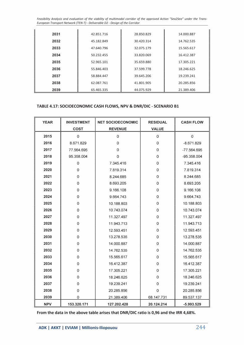
Feasibility Analysis and evaluation of the viability of multimodal corridor of the approved Action "Sea2Sea" under the Trans-European Transport Network (TEN-T) - Deliverable D2 - Design of the Corridor
ΑDΚ | AKKT | ΕVΙΑΜ | Millionis-Iliopouou 244
2031 42.851.716 28.850.829 14.000.887
2032 45.182.849 30.420.314 14.762.535
2033 47.640.796 32.075.179 15.565.617
2034 50.232.455 33.820.069 16.412.387
2035 52.965.101 35.659.880 17.305.221
2036 55.846.403 37.599.778 18.246.625
2037 58.884.447 39.645.206 19.239.241
2038 62.087.761 41.801.905 20.285.856
2039 65.465.335 44.075.929 21.389.406
TABLE 4.17: SOCIOECONOMIC CASH FLOWS, NPV & DNR/DIC - SCENARIO B1
YEAR INVESTMENT NET SOCIOECONOMIC RESIDUAL CASH FLOW
COST REVENUE VALUE
2015
2016
2017
2018
2019
2020
2021
2022
2023
2024
2025
2026
2027
2028
2029
2030
2031
2032
2033
2034
2035
2036
2037
2038
2039
NPV 153.320.171 127.202.428 20.124.214 -5.993.529
From the data in the above table arises that DNR/DIC ratio is 0,96 and the IRR 4,68%.

Feasibility Analysis and evaluation of the viability of multimodal corridor of the approved Action "Sea2Sea" under the Trans-European Transport Network (TEN-T) - Deliverable D2 - Design of the Corridor
ΑDΚ | AKKT | ΕVΙΑΜ | Millionis-Iliopouou 245
TABLE 4.18: SOCIOECONOMIC BENEFIT COST (B/C) RATIO - SCENARIO B1
YEAR INVESTMENT OPERATING OVERALL OVERALL
COST COST PROJECT COST PROJECT BENEFIT
2015
2016
2017
2018
2019
2020
2021
2022
2023
2024
2025
2026
2027
2028
2029
2030
2031
2032
2033
2034
2035
2036
2037
2038
2039
NPV 415.438.951 409.445.422
C B
The benefit to cost ratio equals 0,99.
TABLE 4.19: ESTIMATED FINANCIAL OPERATING COST BREAKDOWN (€) - SCENARIO B2
Personnel Energy Maintenance Other
YEAR Costs Costs Costs Costs TOTAL
2015 0 0 0 0 0
2016 0 0 0 0 0

Feasibility Analysis and evaluation of the viability of multimodal corridor of the approved Action "Sea2Sea" under the Trans-European Transport Network (TEN-T) - Deliverable D2 - Design of the Corridor
ΑDΚ | AKKT | ΕVΙΑΜ | Millionis-Iliopouou 246
2017 0 0 0 0 0
2018 0 0 0 0 0
2019 1.475.670 3.532.072 1.272.046 6.953.621 14.118.064
2020 1.570.874 3.759.948 1.354.113 7.402.241 15.028.907
2021 1.656.330 3.964.489 1.427.777 7.804.923 15.846.479
2022 1.746.436 4.180.162 1.505.450 8.229.520 16.708.547
2023 1.841.441 4.407.559 1.587.345 8.677.199 17.617.477
2024 1.941.615 4.647.330 1.673.697 9.149.237 18.575.865
2025 2.046.897 4.899.326 1.764.451 9.645.345 19.583.121
2026 2.158.248 5.165.850 1.860.437 10.170.051 20.648.443
2027 2.275.657 5.446.872 1.961.645 10.723.302 21.771.718
2028 2.399.452 5.743.182 2.068.358 11.306.650 22.956.100
2029 2.529.983 6.055.611 2.180.877 11.921.732 24.204.911
2030 2.667.614 6.385.036 2.299.517 12.570.274 25.521.659
2031 2.812.732 6.732.382 2.424.610 13.254.097 26.910.037
2032 2.965.744 7.098.624 2.556.509 13.975.119 28.373.943
2033 3.127.081 7.484.789 2.695.583 14.735.366 29.917.485
2034 3.297.194 7.891.961 2.842.223 15.536.970 31.544.997
2035 3.476.561 8.321.284 2.996.840 16.382.181 33.261.044
2036 3.665.686 8.773.962 3.159.868 17.273.372 35.070.445
2037 3.865.100 9.251.265 3.331.765 18.213.043 36.978.277
2038 4.075.361 9.754.534 3.513.013 19.203.833 38.989.896
2039 4.297.061 10.285.181 3.704.121 20.248.521 41.110.946
TABLE 4.20: ESTIMATED SOCIOECONOMIC OPERATING COSTS (€) - SCENARIO B2
Personnel Energy Maintenance Other
YEAR Costs Costs Costs Costs TOTAL
2015 0 0 0 0 0
2016 0 0 0 0 0
2017 0 0 0 0 0
2018 0 0 0 0 0
2019 523.125 2.790.690 1.005.044 6.953.621 11.272.479
2020 556.875 2.970.735 1.069.885 7.402.241 11.999.736
2021 587.169 3.132.343 1.128.087 7.804.923 12.652.522
2022 619.112 3.302.746 1.189.456 8.229.520 13.340.834
2023 652.791 3.482.413 1.254.161 8.677.199 14.066.563

Feasibility Analysis and evaluation of the viability of multimodal corridor of the approved Action "Sea2Sea" under the Trans-European Transport Network (TEN-T) - Deliverable D2 - Design of the Corridor
ΑDΚ | AKKT | ΕVΙΑΜ | Millionis-Iliopouou 247
2024 688.302 3.671.855 1.322.388 9.149.237 14.831.783
2025 725.625 3.870.958 1.394.093 9.645.345 15.636.020
2026 765.099 4.081.538 1.469.931 10.170.051 16.486.619
2027 806.720 4.303.573 1.549.896 10.723.302 17.383.491
2028 850.606 4.537.688 1.634.210 11.306.650 18.329.153
2029 896.879 4.784.538 1.723.111 11.921.732 19.326.259
2030 945.669 5.044.817 1.816.848 12.570.274 20.377.608
2031 997.113 5.319.255 1.915.685 13.254.097 21.486.150
2032 1.051.356 5.608.622 2.019.898 13.975.119 22.654.996
2033 1.108.550 5.913.732 2.129.780 14.735.366 23.887.428
2034 1.168.855 6.235.439 2.245.640 15.536.970 25.186.904
2035 1.232.441 6.574.646 2.367.803 16.382.181 26.557.072
2036 1.299.486 6.932.307 2.496.612 17.273.372 28.001.776
2037 1.370.178 7.309.425 2.632.427 18.213.043 29.525.073
2038 1.444.716 7.707.057 2.775.631 19.203.833 31.131.237
2039 1.523.308 8.126.321 2.926.626 20.248.521 32.824.776
TABLE 4.21: ESTIMATED NET SOCIOECONOMIC OPERATING REVENUE (€) - SCENARIO B2
SOCIOECONOMIC TOTAL NET
YEAR REVENUE OPERATING SOCIOECONOMIC
COSTS OPERATING REVENUE
2015 0 0 0
2016 0 0 0
2017 0 0 0
2018 0 0 0
2019 16.622.374 11.272.479 5.349.894
2020 17.694.785 11.999.736 5.695.049
2021 18.657.381 12.652.522 6.004.859
2022 19.672.365 13.340.834 6.331.531
2023 20.742.524 14.066.563 6.675.960
2024 21.870.915 14.831.783 7.039.132
2025 23.056.841 15.636.020 7.420.821
2026 24.311.133 16.486.619 7.824.514
2027 25.633.659 17.383.491 8.250.167
2028 27.028.130 18.329.153 8.698.976
2029 28.498.460 19.326.259 9.172.201
2030 30.048.776 20.377.608 9.671.168
2031 31.683.429 21.486.150 10.197.280
2032 33.407.008 22.654.996 10.752.012
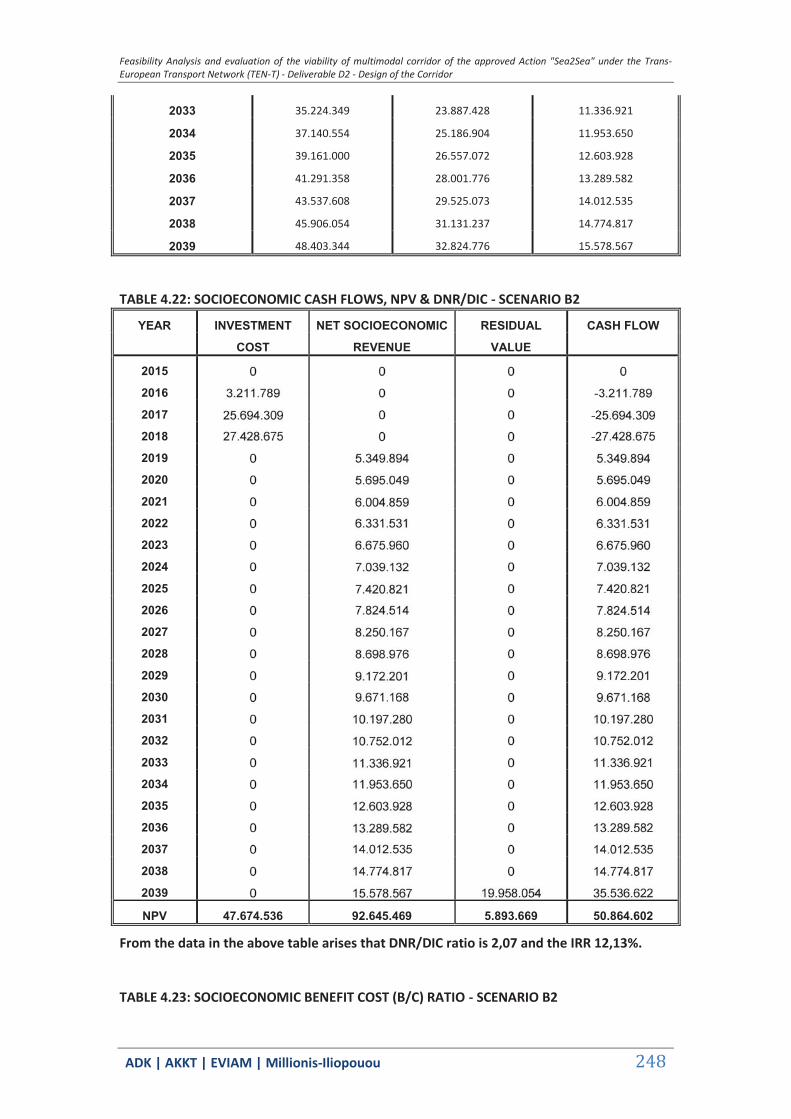
Feasibility Analysis and evaluation of the viability of multimodal corridor of the approved Action "Sea2Sea" under the Trans-European Transport Network (TEN-T) - Deliverable D2 - Design of the Corridor
ΑDΚ | AKKT | ΕVΙΑΜ | Millionis-Iliopouou 248
2033 35.224.349 23.887.428 11.336.921
2034 37.140.554 25.186.904 11.953.650
2035 39.161.000 26.557.072 12.603.928
2036 41.291.358 28.001.776 13.289.582
2037 43.537.608 29.525.073 14.012.535
2038 45.906.054 31.131.237 14.774.817
2039 48.403.344 32.824.776 15.578.567
TABLE 4.22: SOCIOECONOMIC CASH FLOWS, NPV & DNR/DIC - SCENARIO B2
YEAR INVESTMENT NET SOCIOECONOMIC RESIDUAL CASH FLOW
COST REVENUE VALUE
2015
2016
2017
2018
2019
2020
2021
2022
2023
2024
2025
2026
2027
2028
2029
2030
2031
2032
2033
2034
2035
2036
2037
2038
2039
NPV 47.674.536 92.645.469 5.893.669 50.864.602
From the data in the above table arises that DNR/DIC ratio is 2,07 and the IRR 12,13%.
TABLE 4.23: SOCIOECONOMIC BENEFIT COST (B/C) RATIO - SCENARIO B2

Feasibility Analysis and evaluation of the viability of multimodal corridor of the approved Action "Sea2Sea" under the Trans-European Transport Network (TEN-T) - Deliverable D2 - Design of the Corridor
ΑDΚ | AKKT | ΕVΙΑΜ | Millionis-Iliopouou 249
YEAR INVESTMENT OPERATING OVERALL OVERALL
COST COST PROJECT COST PROJECT BENEFIT
2015
2016
2017
2018
2019
2020
2021
2022
2023
2024
2025
2026
2027
2028
2029
2030
2031
2032
2033
2034
2035
2036
2037
2038
2039
NPV 242.882.909 293.747.511
C B
The benefit to cost ratio equals 1,21.
4.3.9 Final Remarks
The summary results of the financial and socioeconomic analysis of all three examined scenarios (connections) are presented in the Tables below.
TABLE 4.24: SUMMARY OF FINANCIAL RESULTS
ALEXANDROUPOLIS -
PLOVDIV ALEXANDROUPOLIS -
RUSE ALEXANDROUPOLIS -
BURGAS
NPV (€) -41.296.432 -150.398.941 -21.675.228
IRR (%) 0,33 -1,17 2,44
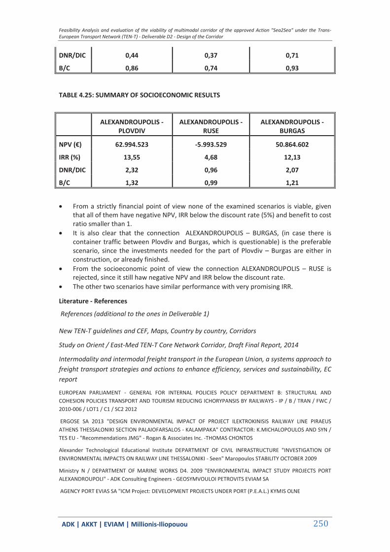
Feasibility Analysis and evaluation of the viability of multimodal corridor of the approved Action "Sea2Sea" under the Trans-European Transport Network (TEN-T) - Deliverable D2 - Design of the Corridor
ΑDΚ | AKKT | ΕVΙΑΜ | Millionis-Iliopouou 250
DNR/DIC 0,44 0,37 0,71
B/C 0,86 0,74 0,93
TABLE 4.25: SUMMARY OF SOCIOECONOMIC RESULTS
ALEXANDROUPOLIS -
PLOVDIV ALEXANDROUPOLIS -
RUSE ALEXANDROUPOLIS -
BURGAS
NPV (€) 62.994.523 -5.993.529 50.864.602
IRR (%) 13,55 4,68 12,13
DNR/DIC 2,32 0,96 2,07
B/C 1,32 0,99 1,21
From a strictly financial point of view none of the examined scenarios is viable, given
that all of them have negative NPV, IRR below the discount rate (5%) and benefit to cost ratio smaller than 1.
It is also clear that the connection ALEXANDROUPOLIS – BURGAS, (in case there is container traffic between Plovdiv and Burgas, which is questionable) is the preferable scenario, since the investments needed for the part of Plovdiv – Burgas are either in construction, or already finished.
From the socioeconomic point of view the connection ALEXANDROUPOLIS – RUSE is rejected, since it still haw negative NPV and IRR below the discount rate.
The other two scenarios have similar performance with very promising IRR.
Literature - References
References (additional to the ones in Deliverable 1)
New TEN-T guidelines and CEF, Maps, Country by country, Corridors
Study on Orient / East-Med TEN-T Core Network Corridor, Draft Final Report, 2014
Intermodality and intermodal freight transport in the European Union, a systems approach to freight transport strategies and actions to enhance efficiency, services and sustainability, EC report
EUROPEAN PARLIAMENT - GENERAL FOR INTERNAL POLICIES POLICY DEPARTMENT B: STRUCTURAL AND COHESION POLICIES TRANSPORT AND TOURISM REDUCING ICHORYPANSIS BY RAILWAYS - IP / B / TRAN / FWC / 2010-006 / LOT1 / C1 / SC2 2012
ERGOSE SA 2013 "DESIGN ENVIRONMENTAL IMPACT OF PROJECT ILEKTROKINISIS RAILWAY LINE PIRAEUS ATHENS THESSALONIKI SECTION PALAIOFARSALOS - KALAMPAKA" CONTRACTOR: K.MICHALOPOULOS AND SYN / TES EU - "Recommendations JMG" - Rogan & Associates Inc. -THOMAS CHONTOS
Alexander Technological Educational Institute DEPARTMENT OF CIVIL INFRASTRUCTURE "INVESTIGATION OF ENVIRONMENTAL IMPACTS ON RAILWAY LINE THESSALONIKI - Seen" Maropoulos STABILITY OCTOBER 2009
Ministry N / DEPARTMENT OF MARINE WORKS D4. 2009 "ENVIRONMENTAL IMPACT STUDY PROJECTS PORT ALEXANDROUPOLI" - ADK Consulting Engineers - GEOSYMVOULOI PETROVITS EVIAM SA
AGENCY PORT EVIAS SA "ICM Project: DEVELOPMENT PROJECTS UNDER PORT (P.E.A.L.) KYMIS OLNE
Feasibility Analysis and evaluation of the viability of multimodal corridor of the approved Action "Sea2Sea" under the Trans-European Transport Network (TEN-T) - Deliverable D2 - Design of the Corridor
ΑDΚ | AKKT | ΕVΙΑΜ | Millionis-Iliopouou 251
"ENVIRONMENTAL MANAGEMENT AND REHABILITATION IN MAJOR INFRASTRUCTURE. EXAMPLES OF THE APPLICATION OF LINEAR LARGE PROJECTS BY ERGOSE SA ('RAILWAY Pathe') AND E.O.A.E. ('Via Egnatia') "DR. K. ZAFEIRIADIS METALLEIOLOGOS ENGINEER - DR. N.T. TZORTZI LANDSCAPE ARCHITECT
AMERICAN BUS ASSOCIATION «COMPARISON OF ENERGY USE & CO2 EMISSIONS FROM DIFFERENT TRANSPORTATION MODES »MAY 2007 - MJ BRADLEY & ASSOCIATES
Gazette 135B / 2014 ECO 170225 'SPECIFICATION OF CONTENTS OF ENVELOPES ENVIRONMENTAL LICENSING PROJECTS AND ACTIVITIES OF CLASS A DECISION OF THE MINISTER OF ENVIRONMENT, ENERGY AND CLIMATE CHANGE WITH NO. 1958/2012 (B 21) AS APPLICABLE, IN ACCORDANCE WITH ARTICLE 11 OF LAW. 4014 / 2011 (A 209), AND ALL OTHER RELATED DETAIL "
GG 77/ 2002 Biological Diversity Act
OG 133/1998 Protected Areas Act,
DIRECTIVE 92/43 / EEC ON THE CONSERVATION OF NATURAL HABITATS AND OF WILD FAUNA AND FLORA.
GC 2001. «ASSESSMENT OF PLANS AND PROJECTS SIGNIFICANTLY AFFECTING NATURA 2000 SITES »,
GC 2000. «MANAGING NATURA 2000 SITES: THE PROVISION OF ARTICLE 6 OF THE HABITATS DIRECTIVE 92/43 / EEC»
GC 2007. «GUIDANCE DOCUMENT ON ARTICLE 6 (4) OF THE HABITATS DIRECTIVE 92/43 / EEC: CLARIFICATION OF THE CONCEPTS OF ALTERNATIVE SOLUTIONS, IMPERATIVE REASONS FOR OVERRIDING PUBLIC INTEREST, COMPENSATORY MEASURES, OVERALL COHERENCE, OPINION OF THE COMMISSION»