Eagle Road Corridor - City of Boise
135
September 30, 2016 Multi-Use Pathway Improvements Eagle Road Corridor Project Development
-
Upload
khangminh22 -
Category
Documents
-
view
1 -
download
0
Transcript of Eagle Road Corridor - City of Boise

September 30, 2016
Multi-Use Pathway Improvements
Eagle Road CorridorProject Development
Eagle Road Corridor
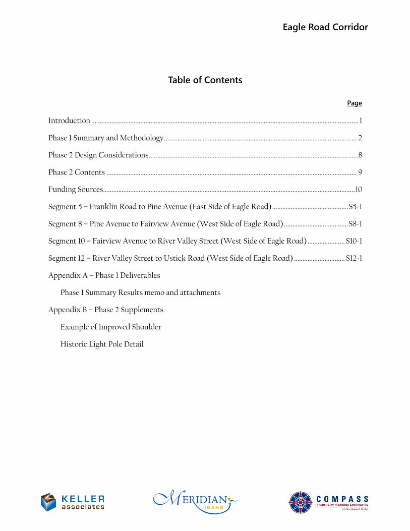
Table of Contents
Page Introduction .............................................................................................................................................................. 1
Phase 1 Summary and Methodology .................................................................................................................. 2
Phase 2 Design Considerations ............................................................................................................................8
Phase 2 Contents .................................................................................................................................................... 9
Funding Sources ..................................................................................................................................................... 10
Segment 5 – Franklin Road to Pine Avenue (East Side of Eagle Road) ............................................. S5-1
Segment 8 – Pine Avenue to Fairview Avenue (West Side of Eagle Road) ...................................... S8-1
Segment 10 – Fairview Avenue to River Valley Street (West Side of Eagle Road) ...................... S10-1
Segment 12 – River Valley Street to Ustick Road (West Side of Eagle Road) .............................. S12-1
Appendix A – Phase 1 Deliverables
Phase 1 Summary Results memo and attachments
Appendix B – Phase 2 Supplements
Example of Improved Shoulder
Historic Light Pole Detail
Eagle Road Corridor
INTRODUCTION This project addresses a need for bicycle and pedestrian facilities along Eagle Road; many gaps exist in the sidewalks between Overland Road and Chinden Blvd, and there are no bike lanes. Bicyclists currently use Eagle Road even though the posted speed limits are up to 55 miles per hour. The Cities of Boise and Meridian have adopted a standard of providing separated 10-foot-wide, multi-use paths along both sides of Eagle Road, for both pedestrians and bicyclists. In addition, the City of Boise has adopted a standard of eight-foot minimum separation between a pathway and adjacent roadway.
The goal of this project is to determine the feasibility of pathway construction along the various segments of Eagle Road, and to develop application-ready concept reports for when funding becomes available. The project was broken up into two phases.
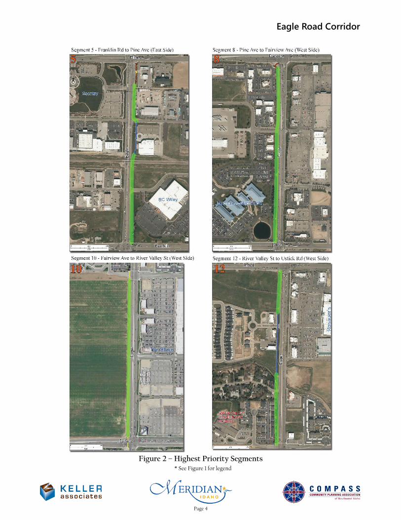
Phase 1 identified and prioritized pathway needs within the Eagle Road corridor. This consisted of dividing the corridor into approximate half-mile project segments and developing an evaluation matrix to aid in prioritizing project segments with the most immediate pathway improvement needs. COMPASS, City of Meridian, City of Boise, and Idaho Transportation Department (ITD) District 3 staff selected the four highest priority project segments for further development in Phase 2. From south to north along Eagle Road, these segments are:
• Segment 5 – Franklin Road to Pine Avenue (east side of Eagle Road) • Segment 8 – Pine Avenue to Fairview Avenue (west side of Eagle Road) • Segment 10 – Fairview Avenue to River Valley Street (west side of Eagle Road) • Segment 12 – River Valley Street to Ustick Road (west side of Eagle Road)
Phase 2 took the needs identified in Phase 1 and developed specific, programmable pathway projects. Pre-concept designs were developed for continuous separated 10-foot pathways along each of the four segments. This report presents the Phase 2 pre-concept designs, each in a separate, stand-alone chapter. The following information is included for each project:
• Executive Summary Sheet • Site Photos • Environmental Discussion • Concept Plan View Figure • Planning-Level Cost Estimates • ITD 1150 Form (Cost Estimate) • ITD 2839 Form (Right-of-Way) • ITD 0332 Form (Project Charter) • Preliminary Construction Schedule
Page 1
Eagle Road Corridor
PHASE 1 SUMMARY AND METHODOLOGY Phase 1 consisted of dividing the Eagle Road corridor into approximate half-mile project segments, conducting an environmental scan of the corridor, formulating opinions of probable construction cost, and developing an evaluation matrix to aid in prioritizing project segments with the most immediate improvement needs.
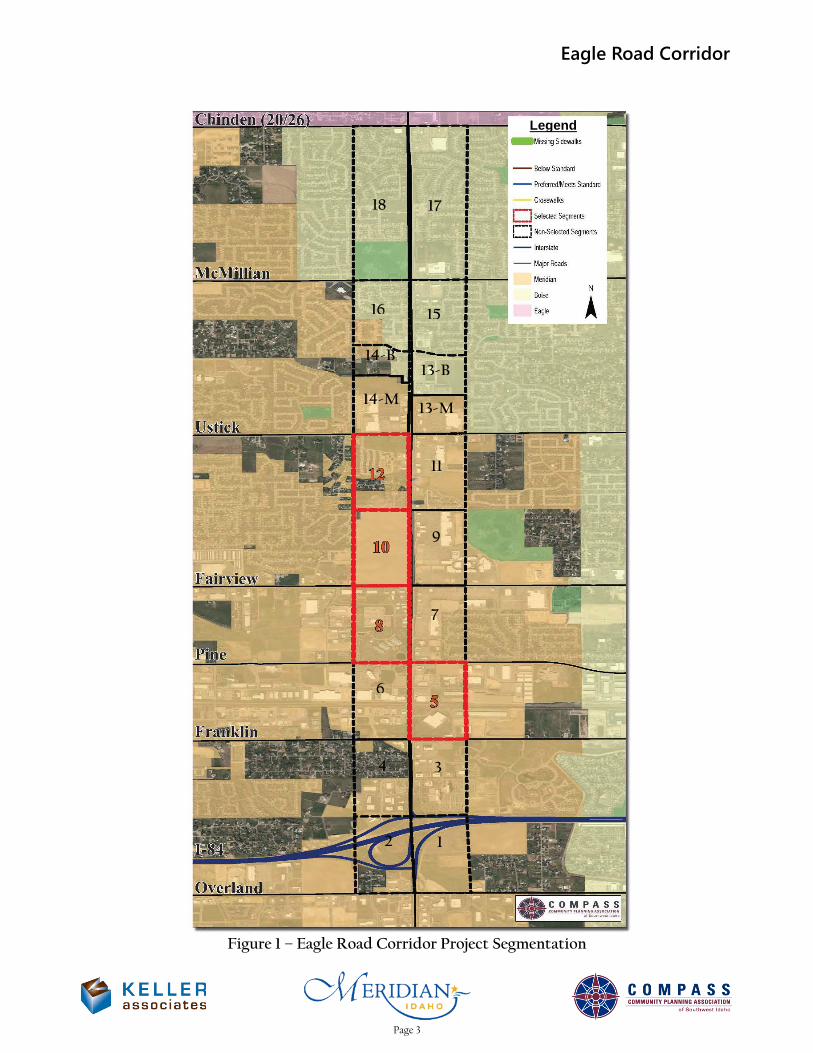
Project Segmentation COMPASS, the City of Meridian, the City of Boise, and Keller Associates staff performed corridor and project segmentation. The five-mile Eagle Road corridor was initially broken up into half-mile segments on each side of the road, resulting in 20 potential project segments. Dividing the corridor into half-mile segments ensures that no improvement projects would terminate in a dead-end, because signalized crossings are spaced at predominantly half-mile intervals along Eagle Road. Project segmentation maps are shown in Figures 1 and 2 on the next two pages, as well as included in Appendix A.
Segments 17 and 18 were later changed to one mile in length because they already feature continuous (though non-compliant) sidewalks and similar residential conditions along their entire length. Also, the signalized intersection of Eagle Road & Bristol Heights Drive/Hobble Creek Drive is not spaced at the half-mile. Dividing the segments at this intersection would have resulted in two short segments that do not warrant separate evaluation due to their similar conditions.
Segments 13 and 14 were later split into four segments (13-M, 13-B, 14-M, and 14-B), each between 0.2 and 0.3 miles long. They were divided along the Boise-Meridian city limits to allow the two municipalities to work on them separately.
Environmental Scan Keller Associates completed a windshield survey of the Eagle Road corridor during Phase 1 for potential environmental concerns (included in Appendix A). Minor notes include several canal crossings, possible underground tanks on a vacant agricultural lot in Segment 6, and possible ground contamination from old cars and equipment on a residential site in Segment 11. No fatal flaws were observed in the scan. Further research, including an environmental database search, was performed in Phase 2.
Opinions of Probable Construction Cost Probable construction cost was used as a subjective measure of estimated cost per unit length of improved pathway during Phase 1. Therefore, segments with the shortest length of non-compliant pathway received relatively higher cost ratings due to economies of scale. Costs such as administration, mobilization, and design fees are required for every project regardless of size.
Other factors that increased cost per length included possible right-of-way conflicts/acquisitions, utility or sign relocations, structures required for canal crossings or grade separations, earthwork, slopes, design complexity, and railroad crossings. Detailed planning-level cost estimates were prepared in Phase 2. Justifications for opinions of probable construction cost for each segment are included in Appendix A. All costs are in 2016 dollars, and assume ITD administration of the projects.
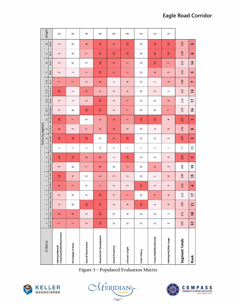
Evaluation Criteria, Point Ranges, and Weights The primary deliverable of Phase 1 was an evaluation matrix (shown in Figure 3 and Appendix A) that prioritizes project segments with most immediate improvement needs. Keller Associates established evaluation criteria, point ranges, and weights before populating the evaluation matrix with data. After populating the matrix, an iterative approach of adjusting the criteria/points/weighting and evaluating results was used to optimize the matrix. Keller Associates attempted to balance the number of qualitative and quantitative criteria. Care was taken to avoid representing the same concepts in multiple criteria. The evaluation criteria, point ranges, and weights were reviewed by the City of Meridian, City of Boise, COMPASS, and ITD prior to their finalization.
Page 2
Eagle Road Corridor
Figure 1 – Eagle Road Corridor Project Segmentation
1 2
3 4
6
7
9
11
13-M 14-M
13-B 14-B
15 16
17 18
Legend
Page 3
Eagle Road Corridor
Figure 2 – Highest Priority Segments
* See Figure 1 for legend
Page 4
Eagle Road Corridor
The number of points available for each criteria ranged from 0 to 10 and were designed so that a wide range of points would be given to the various segments for any given criteria (as opposed to all the segments getting a similar score in a criterion). This maximizes the strength of each criteria. Point ranges were also designed to be valid for future use of the evaluation matrix.
The development of each criteria is summarized below.
• Existing Sidewalk Presence/Width/Attachment This criteria evaluates the non-compliant conditions along the segment and is weighted by length. Areas absent of sidewalk were given 10 points, while existing but non-compliant pathways were assigned lower scores of one to three points.
Compliant pathways are not included in the calculation; for example, Segment 14-M has 1,600 feet of compliant pathway and a 100-foot gap, and would therefore receive 10 points because the only non-compliant section of pathway is a gap. Compliant pathways were originally included in the calculation but were removed after adding the Percentage of Gaps criteria (described next), in order to avoid redundant criteria.
• Percentage of Gaps This criteria was created to emphasize the importance of filling gaps in the pathway system over improving existing pathways. Points are assigned based on the percentage of segment length with gaps.
• Ease of Construction This criteria prioritizes straight-forward projects over those with potential of being delayed due to environmental, permitting, utilities, right-of-way, or design complexity; each of the five categories are assigned zero to two points, for a maximum of 10 points. This measures ease or difficulties that would not have an effect on construction cost.
• Potential for Development This criteria was created to reduce the priority of improvements that are likely to be constructed in the near future by a private developer. Points were awarded on an inverse scale compared to other criteria, with 10 representing low potential and zero representing high potential for development.
• School Proximity This criteria prioritizes segments near schools to provide safe routes to school and potentially reduce the need for safety busing. Initially, points were assigned to schools based on a distance of up to a mile away from Eagle Road, but the distance was lowered to ½ mile, as that was found to be the furthest distance from any segment to a school property.
• Cost per Length This criteria was created to quantify and prioritize the most cost-effective improvements. Opinions of Probable Cost, discussed previously, were used as input data for this criteria. Originally, this criteria was measured in total cost per segment to prioritize projects with low total cost for adoption into the STIP. It was later changed to cost per unit length of non-compliant sidewalk in order to prioritize improvements that would provide the best “bang for the buck.”
• Crash History This criteria was created to quantify and prioritize segments that would be made safer by adding separated, 10-foot pathways. Crash History was weighted relatively low because crashes involving pedestrians or bicycles were found to be rare along Eagle Road, and therefore may be anomalies rather than true representations of safety issues.
Page 5

Eagle Road Corridor
• Existing Ped/Bike Usage This criteria was created to prioritize segments that currently see the most pedestrian and bicycle use, as measured by recorded Strava trips within the segments.
• Future Ped/Bike Demand This criteria was created to prioritize segments that are likely to see the largest increase in pedestrian and bicycle use in the future. Future travel was estimated by creating origin-destination pairs of planned origins (residential) and destination land uses (activity centers) within ¼ mile of each other.
Results The final evaluation matrix is shown in Figure 3 on the next page. From highest to lowest rank, the four highest-scoring segments in the evaluation matrix were:
• Segment 12 – River Valley Street to Ustick Road (west side of Eagle Road) • Segment 8 – Pine Avenue to Fairview Avenue (west side of Eagle Road) • Segment 10 – Fairview Avenue to River Valley Street (west side of Eagle Road) • Segment 5 – Franklin Road to Pine Avenue (east side of Eagle Road)
COMPASS, the City of Meridian, the City of Boise, and ITD reached a consensus to approve these four segments for further evaluation in Phase 2 of the project. The following Phase 1 deliverables are included Appendix A:
• Summary of Phase 1 Results memo, including o Project segmentation map o Environmental windshield survey summary o Opinions of probable construction cost o Evaluation criteria, points, and weighting summary o Data input summary o Evaluation matrix results o Individual segment worksheets
Page 6
Eagle Road Corridor
Figure 3 – Populated Evaluation Matrix
Page 7
Eagle Road Corridor
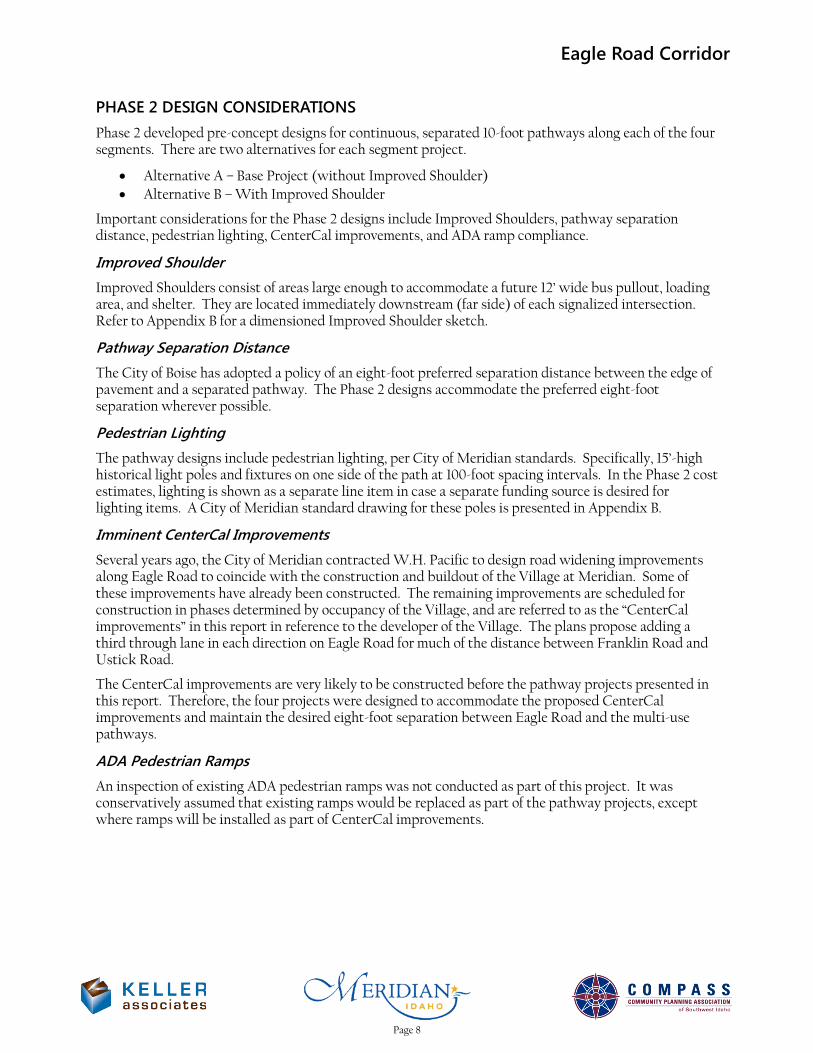
PHASE 2 DESIGN CONSIDERATIONS Phase 2 developed pre-concept designs for continuous, separated 10-foot pathways along each of the four segments. There are two alternatives for each segment project.
• Alternative A – Base Project (without Improved Shoulder) • Alternative B – With Improved Shoulder
Important considerations for the Phase 2 designs include Improved Shoulders, pathway separation distance, pedestrian lighting, CenterCal improvements, and ADA ramp compliance.
Improved Shoulder Improved Shoulders consist of areas large enough to accommodate a future 12’ wide bus pullout, loading area, and shelter. They are located immediately downstream (far side) of each signalized intersection. Refer to Appendix B for a dimensioned Improved Shoulder sketch.
Pathway Separation Distance The City of Boise has adopted a policy of an eight-foot preferred separation distance between the edge of pavement and a separated pathway. The Phase 2 designs accommodate the preferred eight-foot separation wherever possible.
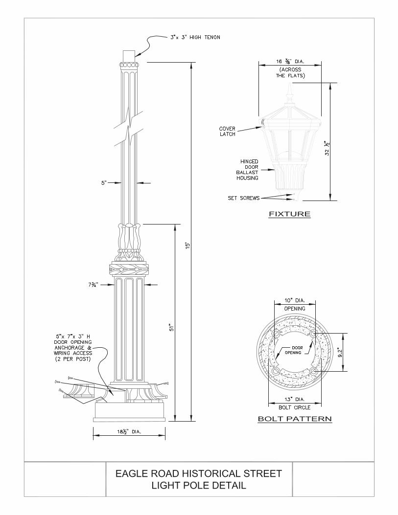
Pedestrian Lighting The pathway designs include pedestrian lighting, per City of Meridian standards. Specifically, 15’-high historical light poles and fixtures on one side of the path at 100-foot spacing intervals. In the Phase 2 cost estimates, lighting is shown as a separate line item in case a separate funding source is desired for lighting items. A City of Meridian standard drawing for these poles is presented in Appendix B.
Imminent CenterCal Improvements Several years ago, the City of Meridian contracted W.H. Pacific to design road widening improvements along Eagle Road to coincide with the construction and buildout of the Village at Meridian. Some of these improvements have already been constructed. The remaining improvements are scheduled for construction in phases determined by occupancy of the Village, and are referred to as the “CenterCal improvements” in this report in reference to the developer of the Village. The plans propose adding a third through lane in each direction on Eagle Road for much of the distance between Franklin Road and Ustick Road.
The CenterCal improvements are very likely to be constructed before the pathway projects presented in this report. Therefore, the four projects were designed to accommodate the proposed CenterCal improvements and maintain the desired eight-foot separation between Eagle Road and the multi-use pathways.
ADA Pedestrian Ramps An inspection of existing ADA pedestrian ramps was not conducted as part of this project. It was conservatively assumed that existing ramps would be replaced as part of the pathway projects, except where ramps will be installed as part of CenterCal improvements.
Page 8

Eagle Road Corridor
PHASE 2 CONTENTS The information below is presented for each project in the following chapters of this report:
• Executive Summary Sheet – Contains the segment number, name, project description, beginning and ending mileposts, an overview map of the project, project background narrative, Eagle Road traffic and safety data, scope of work, and summarized cost estimate.
• Site Photos – Contains field visit photos showing the existing state of the segment.
• Environmental Discussion – Contains a discussion of environmental considerations and/or requirements before construction begins.
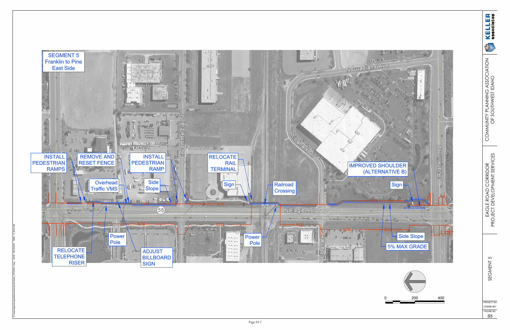
• Concept Plan View Figure – Contains a plan view concept drawing of the proposed pathway, with callouts noting the location of construction items and tasks. Action items are denoted with all-caps callouts, while informational notes are denoted with sentence-case callouts.
• Planning-Level Cost Estimates – Contains two itemized planning-level cost estimates: one for Alternative A and one for Alternative B.
• ITD 1150 Form (Cost Estimate) – Contains an ITD 1150 Cost Estimate form, filled out with planning-level cost estimate amounts for Alternative A.
• ITD 2839 Form (Right-of-Way) – Contains an ITD 2839 Right-of-Way form, filled out with right-of-way quantities and costs for Alternative A.
• ITD 0332 Form (Project Charter) – Contains an ITD 0332 Project Charter form. This form is
essentially a simple concept report required by ITD before a project can be programmed into the Idaho Transportation Investment Program (ITIP). The charter contains a detailed project description, environmental concerns, design standards, and anticipated budgets for construction, right-of-way, and project development. The project charter has replaced the ITD 0280 Feasibility Study form.
• Preliminary Construction Schedule – Contains a planning-level, critical path method (CPM) construction schedule for Alternative A. The schedule shows major tasks in the ITD project development process, including milestones, and is a potential timeline for completion if funding is secured.
Page 9
Eagle Road Corridor
FUNDING SOURCES It is recommended that the City of Meridian, partnering with COMPASS, apply for federal and/or state funding sources to fund the design and construction of a multi-use path as the needs are identified along the Eagle Road Corridor. Potential funding sources include the following:
Surface Transportation Program-Transportation Management Areas (STP-TMA) 1 STP-TMA is applied for and programmed by COMPASS with ITD oversight of design and construction. Local agencies supply a match of at least 7.34% of the project cost. These funds could be used for design and construction of the multi-use path.
• Application Due: Typically February-March, for inclusion in COMPASS’ draft Regional Transportation Improvement Program for the following fiscal year. Public comment period is usually mid-July to mid-August, with COMPASS Board adoption in mid-September. It is advised to apply early to get on the program, as new projects are typically placed at the end of the existing five-year transportation program.
• Funding Amount: Approximately $8.8 million annually for all projects in the COMPASS metropolitan area
Transportation Alternatives Program-Transportation Management Area (TAP-TMA) 2 Local agencies will supply a match of at least 7.34% of the project cost. As the name implies, TAP funds are used for alternative transportation activities, including pedestrian facilities, bicycles and other non-motorized forms of transportation and could be used for design and construction of the Eagle Road multi-use path.
TAP funding could be sought via multiple avenues. The first TAP is applied for and programmed by ITD and funding competition would be from a statewide pool. Funds from the State cannot be used for property or right-of-way acquisition. COMPASS also administers a portion of TAP which emphasizes local projects in the TMA. The City has had success in applying for these regional funds.
• Applications Due: Mid-November • Funding Amount: Individual projects are limited to $500,000
Communities In Motion (CIM) Implementation Grant 3 CIM is managed by COMPASS to support local agencies whose projects are consistent with CIM 2040. Applicant agencies will supply a match of at least 7.34% of the project cost. In-kind contributions of labor/staff time may be included in the project match.
• Applications Due: Early September • Funding Amount: Average $10,000-15,000 per project, up to $40,000 with larger match
percentage
1 Applications and info.: http://www.compassidaho.org/prodserv/transimprovement.htm 2 Applications and info.: http://www.compassidaho.org/documents/prodserv/trans/FY14/COMPASS_TAP_Guide_FY2015-19.pdf 3 Applications and info.: http://www.compassidaho.org/prodserv/reglrtranpl-CIM_implementation_grants.htm
Page 10
Eagle Road Corridor
Community Development Block Grant (CDBG) Entitlement Program 4 Because Meridian is an Entitlement Community, applications for CDBG must be submitted directly to the U.S. Department of Housing and Urban Development (HUD). Funds can be used for activities that follow national objectives for the program: benefit low- and moderate-income persons, prevent or eliminate slums or blight, or address community development needs having a particular urgency because existing conditions pose a serious and immediate threat to the health or welfare of the community for which other funding is not available.
Providing a multi-use path along Eagle Road would benefit low- and moderate-income persons without access to a motor vehicle. Public transit does not currently serve Eagle Road, and for some, biking and walking may be their only way to access services and businesses along the corridor.
• Applications Due: N/A • Funding Amount: Over $350,000 in 2016 to the City and rising in recent years
Other Funding The City of Meridian may also wish to seek out partnerships, private entity donations, foundation grants, and additional match dollars to leverage these grant funds.
4 Applications and info.: https://www.hudexchange.info/programs/cdbg-entitlement/
Page 11
Segment 5 – Franklin Road to Pine Avenue(East Side)
Eagle Road CorridorMulti-Use Pathway
Eagle Road Corridor Segment 5 – Franklin to Pine (East Side)
Table of Contents
Page Executive Summary Sheet ............................................................................................................................... S5-1
Scope of Work and Environmental Considerations ............................................................................... S5-2
Site Photos .......................................................................................................................................................... S5-3
Concept Plan View Figure ............................................................................................................................. S5-7
Planning-Level Cost Estimates ..................................................................................................................... S5-8
ITD-1150 Project Cost Summary ................................................................................................................ S5-10
ITD-2839 Right of Way Cost Estimate ..................................................................................................... S5-11
ITD-0332 Project Charter ............................................................................................................................. S5-12
Preliminary Project Schedule (True Minimum Milestones) .............................................................. S5-20
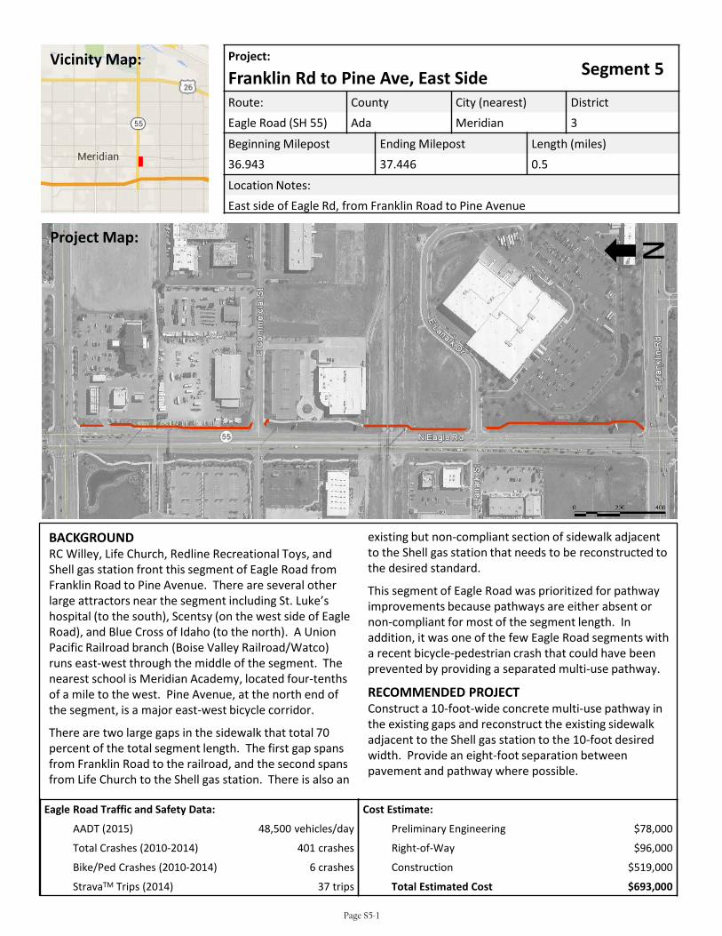
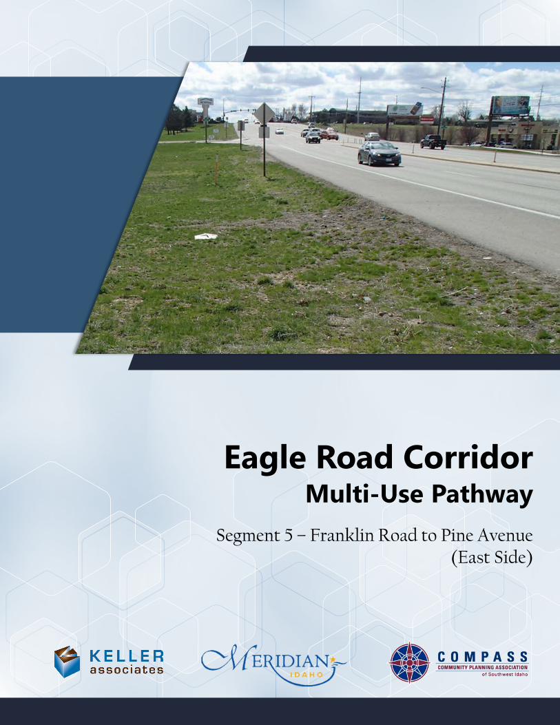
existing but non-compliant section of sidewalk adjacent to the Shell gas station that needs to be reconstructed to the desired standard.
This segment of Eagle Road was prioritized for pathway improvements because pathways are either absent or non-compliant for most of the segment length. In addition, it was one of the few Eagle Road segments with a recent bicycle-pedestrian crash that could have been prevented by providing a separated multi-use pathway.
RECOMMENDED PROJECTConstruct a 10-foot-wide concrete multi-use pathway in the existing gaps and reconstruct the existing sidewalk adjacent to the Shell gas station to the 10-foot desired width. Provide an eight-foot separation between pavement and pathway where possible.
Project:Segment 5Franklin Rd to Pine Ave, East Side
Route: County City (nearest) DistrictEagle Road (SH 55) Ada Meridian 3
Beginning Milepost Ending Milepost Length (miles)36.943 37.446 0.5
Location Notes:East side of Eagle Rd, from Franklin Road to Pine Avenue
Cost Estimate:
Preliminary Engineering $78,000
Right-of-Way $96,000
Construction $519,000
Total Estimated Cost $693,000
BACKGROUNDRC Willey, Life Church, Redline Recreational Toys, and Shell gas station front this segment of Eagle Road from Franklin Road to Pine Avenue. There are several other large attractors near the segment including St. Luke’s hospital (to the south), Scentsy (on the west side of Eagle Road), and Blue Cross of Idaho (to the north). A Union Pacific Railroad branch (Boise Valley Railroad/Watco) runs east-west through the middle of the segment. The nearest school is Meridian Academy, located four-tenths of a mile to the west. Pine Avenue, at the north end of the segment, is a major east-west bicycle corridor.
There are two large gaps in the sidewalk that total 70 percent of the total segment length. The first gap spans from Franklin Road to the railroad, and the second spans from Life Church to the Shell gas station. There is also an
NProject Map:
Vicinity Map:
Eagle Road Traffic and Safety Data:
AADT (2015) 48,500 vehicles/day
Total Crashes (2010-2014) 401 crashes
Bike/Ped Crashes (2010-2014) 6 crashes
StravaTM Trips (2014) 37 trips
Page S5-1
Eagle Road Corridor Segment 5 – Franklin to Pine (East Side)
SCOPE OF WORK The recommended scope of work for the multi-use pathway project is as follows:
• Construct 10-foot concrete sidewalk in the existing gaps and reconstruct the non-compliant sidewalk adjacent to the Shell gas station to the 10-foot standard width. The proposed design achieves the desired eight-foot separation between pavement and pathway along the entire segment, except for 200 feet in front of the Redline rental business that has a three-foot separation at the narrowest point.
• Install ADA compliant pedestrian ramps at the existing right-in access to the Shell gas station and at the Commercial Street intersection. Curb ramps at the Franklin Road and Pine Avenue intersections are scheduled to be replaced to ADA standards as part of CenterCal improvements.
• Coordinate with Union Pacific Railroad (Boise Valley Railroad/Watco) to construct the railroad crossing. Improvements within the railroad right-of-way include installing actuated pedestrian gates and additional planking for the pathway and relocating a rail terminal.
• Design the pathway vertical alignment adjacent to RC Willey to ensure a 5 percent maximum grade.
• Negotiate pathway easements with RC Willey, Redline rentals, and Shell gas station.
• Install historical pedestrian light poles at 100-foot intervals on one side of the pathway along the entire segment, with the exception of the pathway in front of Life Church that already has adequate lighting.
• Alternative B: Construct an improved shoulder in front of RC Willey that includes an area for a future bus pullout, loading area, and shelter.
ENVIRONMENTAL CONSIDERATIONS The project is likely to involve the following environmental considerations and control measures:
• Stream and Wetland Encroachment – There are two canal crossings within Segment 5. One of the canals appears on wetlands mappers, but there doesn’t appear to be any surface water in either location. Coordination with the canal company will be required for these two crossings.
• Runoff Impacts – The additional impervious area will increase the runoff in the project area.
• NPDES – General Permit – A SWPPP will be required during construction of the project.
The following databases were used to research environmental effects of the project:
• NEPAssist Tool (https://www.epa.gov/nepa/nepassist)
• EJSCREEN Tool (https://www.epa.gov/ejscreen)
• Web Soil Survey (http://websoilsurvey.sc.egov.usda.gov/App/HomePage.htm)
• Idaho DEQ Underground Storage Tank Database (http://www2.deq.idaho.gov/waste/ustlust/)
• Idaho Governor’s Office Species Conservation (https://species.idaho.gov/thr_endgr.html)
Page S5-2

Eagle Road CorridorSegment 5 – Franklin to Pine (East Side)
Looking north from the intersection of Eagle Road & Franklin Road
Looking south from the intersection of Eagle Road & Lanark Drive
Page S5-3
Eagle Road CorridorSegment 5 – Franklin to Pine (East Side)
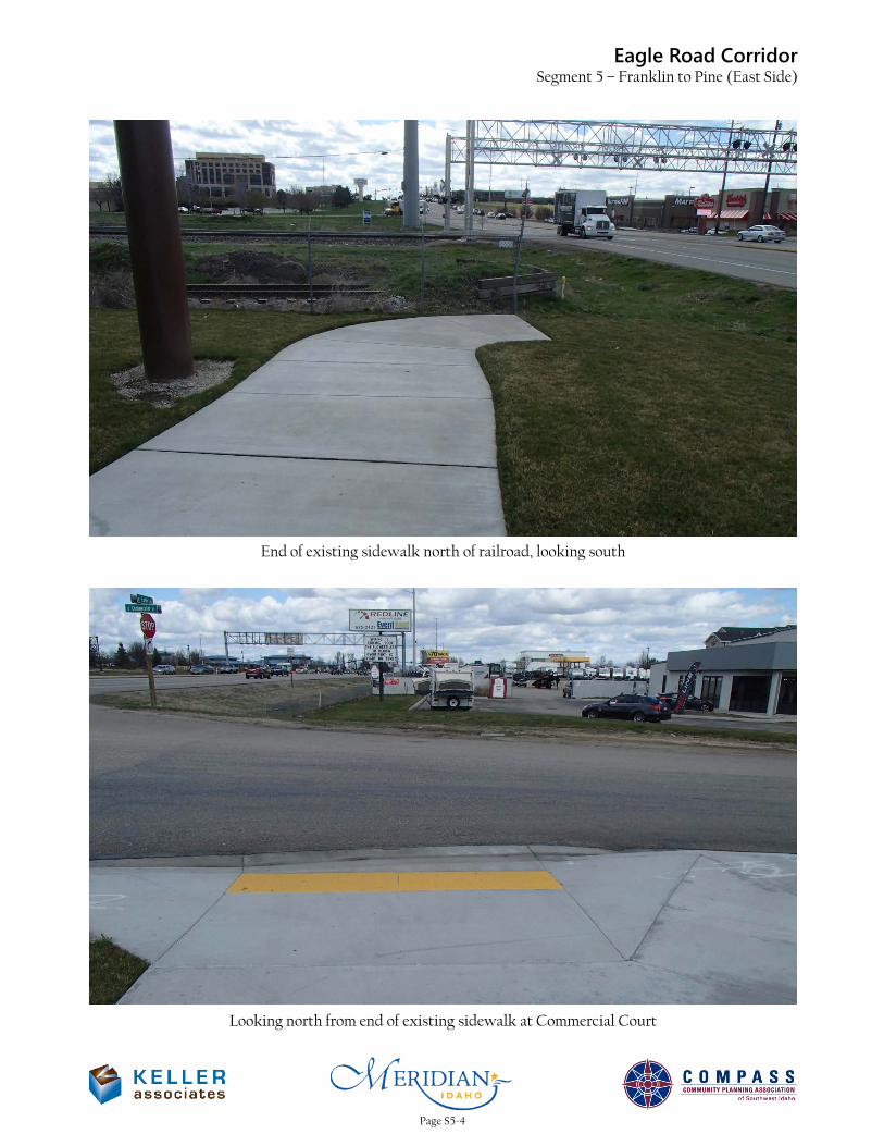
End of existing sidewalk north of railroad, looking south
Looking north from end of existing sidewalk at Commercial Court
Page S5-4

Eagle Road CorridorSegment 5 – Franklin to Pine (East Side)
Looking south next to overhead sign over Eagle Road
End of existing sidewalk adjacent to Shell gas station, looking north
Page S5-5
Eagle Road CorridorSegment 5 – Franklin to Pine (East Side)
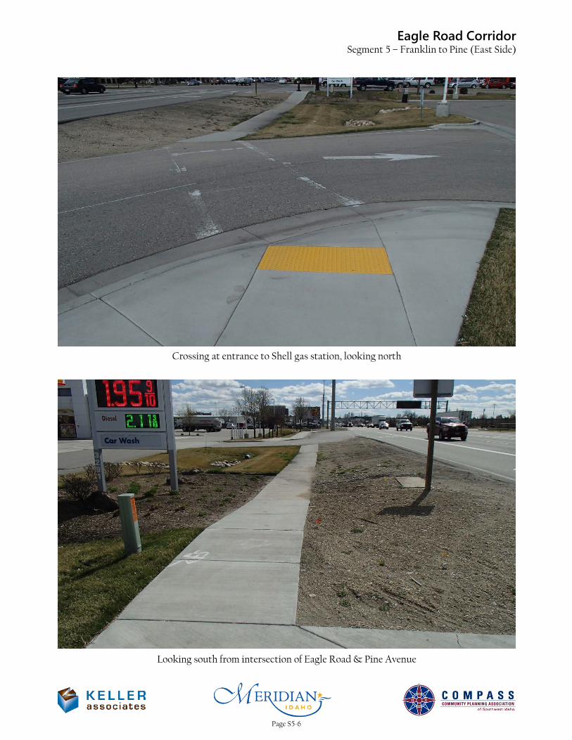
Crossing at entrance to Shell gas station, looking north
Looking south from intersection of Eagle Road & Pine Avenue
Page S5-6
R/W
R/WR/W
R/W
R/WR/W
R/W
R/W
R/WR/W
C:\U
se
rs\a
gro
ve
r\a
pp
da
ta
\lo
ca
l\te
mp
\A
cP
ub
lish
_7
57
2\F
IG
1
.d
wg
D
AT
E: 0
9/1
5/2
01
6 T
IM
E: 1
1:3
0:0
4 A
M
215056-001
S5
FIGURE NO.
PROJECT NO.
0 200 400
SignRailroad
Crossing
Power
Pole
Sign
RELOCATE
RAIL
TERMINAL
Side Slope
Side
Slope
INSTALL
PEDESTRIAN
RAMP
Overhead
Traffic VMS
Power
Pole
INSTALL
PEDESTRIAN
RAMPS
SEG
MEN
T 5
EAG
LE R
OA
D C
ORR
IDO
RPR
OJE
CT
DEV
ELO
PMEN
T SE
RVIC
ESC
OM
MUN
ITY P
LAN
NIN
G A
SSO
CIA
TION
OF
SOUT
HWES
T ID
AHO
SEGMENT 5
Franklin to Pine
East Side
5% MAX GRADE
ADJUST
BILLBOARD
SIGN
RELOCATE
TELEPHONE
RISER
REMOVE AND
RESET FENCE
IMPROVED SHOULDER
(ALTERNATIVE B)
Page S5-7
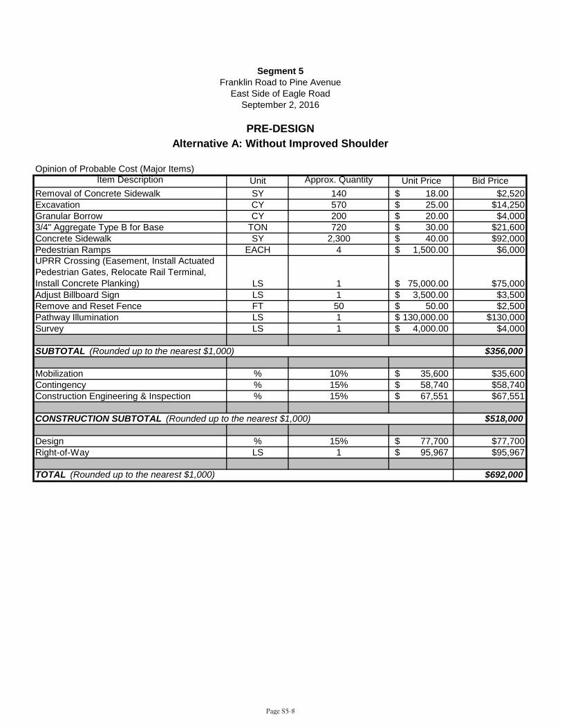
Opinion of Probable Cost (Major Items)Item Description Unit Approx. Quantity Unit Price Bid Price
Removal of Concrete Sidewalk SY 140 18.00$ $2,520Excavation CY 570 25.00$ $14,250Granular Borrow CY 200 20.00$ $4,0003/4" Aggregate Type B for Base TON 720 30.00$ $21,600Concrete Sidewalk SY 2,300 40.00$ $92,000Pedestrian Ramps EACH 4 1,500.00$ $6,000UPRR Crossing (Easement, Install Actuated Pedestrian Gates, Relocate Rail Terminal, Install Concrete Planking) LS 1 75,000.00$ $75,000Adjust Billboard Sign LS 1 3,500.00$ $3,500Remove and Reset Fence FT 50 50.00$ $2,500Pathway Illumination LS 1 130,000.00$ $130,000Survey LS 1 4,000.00$ $4,000
$356,000
Mobilization % 10% 35,600$ $35,600Contingency % 15% 58,740$ $58,740Construction Engineering & Inspection % 15% 67,551$ $67,551
$518,000
Design % 15% 77,700$ $77,700Right-of-Way LS 1 95,967$ $95,967
$692,000TOTAL (Rounded up to the nearest $1,000)
CONSTRUCTION SUBTOTAL (Rounded up to the nearest $1,000)
SUBTOTAL (Rounded up to the nearest $1,000)
Segment 5Franklin Road to Pine Avenue
East Side of Eagle Road
PRE-DESIGN
September 2, 2016
Alternative A: Without Improved Shoulder
Page S5-8

Opinion of Probable Cost (Major Items)Item Description Unit Approx. Quantity Unit Price Bid Price
Removal of Concrete Sidewalk SY 140 18.00$ $2,520Excavation CY 570 25.00$ $14,250Granular Borrow CY 200 20.00$ $4,0003/4" Aggregate Type B for Base TON 720 30.00$ $21,600Concrete Sidewalk SY 2,300 40.00$ $92,000Pedestrian Ramps EACH 4 1,500.00$ $6,000UPRR Crossing (Easement, Actuated Pedestrian Gates, Relocate Rail Terminal, Install Concrete Planking) LS 1 75,000.00$ $75,000Adjust Billboard Sign LS 1 3,500.00$ $3,500Remove and Reset Fence FT 50 50.00$ $2,500Pathway Illumination LS 1 130,000.00$ $130,000Survey LS 1 4,000.00$ $4,000Improved Shoulder LS 1 25,000.00$ $25,000Traffic Control LS 1 5,000.00$ $5,000
$386,000
Mobilization % 10% 38,600$ $38,600Contingency % 15% 63,690$ $63,690Construction Engineering & Inspection % 15% 73,244$ $73,244
$562,000
Design % 15% 84,300$ $84,300Right-of-Way LS 1 101,967$ $101,967
$749,000TOTAL (Rounded up to the nearest $1,000)
CONSTRUCTION SUBTOTAL (Rounded up to the nearest $1,000)
SUBTOTAL (Rounded up to the nearest $1,000)
Segment 5Franklin Road to Pine Avenue
East Side of Eagle Road
PRE-DESIGN
September 2, 2016
Alternative B: With Improved Shoulder
Page S5-9

Round Estimates to Nearest $1,000
2. Right-of-Way:
3. Utility Adjustments: Work Materials By State By Others
No
New Structure
Repair/Widening/Rehabilitation
18. Total Construction Cost (15 + 16 + 17)
19. Total Project Cost ( 1 + 2 + 18)
20. Project Cost Per Mile
9. Traffic Items (Delineators, Signing, Channelization, Lighting, and Signals)
13. Mitigation Measures
% of Item 15
% of Items 15 and 1632.5
$519,000
$36,000
$127,000
Previous ITD 1150
4. Earthwork $21,000
$238,000
7. Railroad Crossing:
Grade/Separation Structure none
Location
$22,000
$75,000
8. Bridges/Grade Separation Structures:
At-Grade Signals
District
Date
7/25/2016
Initial or Revise To
D3
Location
Franklin Rd to Pine Ave, East Side
Key Number
Segment 5
Project Number
Project Cost Summary Sheet ITD 1150 (Rev. 09-13)
37.446
Segment Code
2005
Begin Mile Post End Mile Post
36.943
Prepared By:
Location
Length/Width
16. Mobilization 10
$693,000FALSE
10. Construction Traffic Control (Sign, Pavement Markings, Flagging, and Traffic Separation)
14. Other Items (Roadside Development, Guardrail, Fencing, Sidewalks, Curb and Gutter, C.S.S. Items)
FALSE
$1,386,000
$356,00015. Cost of Constructions (Items 3 through 14)
11. Detours
12. Landscaping
Length/Width
itd.idaho.gov
17. Construction Engineer and Contingencies
Yes
6. Pavement and Base
5. Drainage and Minor Structures
1b. Preliminary Engineering by Consultant (PEC) $78,000
3 Number of RelocationsNumber of Parcels
1a. Preliminary Engineering (PE)
Length in Miles
0.5
$96,000
Page S5-10
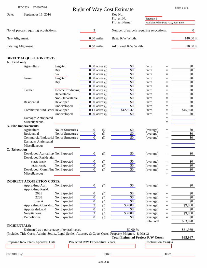
ITD-2839 27-228070-2 Right of Way Cost Estimate Sheet 1 of 1
Date: September 15, 2016 Key No: Project No: Segment 5Project Name: Franklin Rd to Pine Ave, East Side
No. of parcels requiring acquisitions: 3 Number of parcels requiring relocations: 0
New Alignment: 0.50 miles Basic R/W Width: 140.00 ft.
Existing Alignment: 0.50 miles Additional R/W Width: 10.00 ft.
DIRECT ACQUISITION COSTS:A. Land only
Agriculture Irrigated 0.00 acres @ $0 /acre = $0Dry 0.00 acres @ $0 /acre = $0n/a 0.00 acres @ $0 /acre = $0
Graze Irrigated 0.00 acres @ $0 /acre = $0Dry 0.00 acres @ $0 /acre = $0
0.00 acres @ $0 /acre = $0Timber Income Producing 0.00 acres @ $0 /acre = $0
Harvestable 0.00 acres @ $0 /acre = $0Non-Harvestable 0.00 acres @ $0 /acre = $0
Residential Developed 0.00 acres @ $0 /acre = $0Undeveloped 0.00 acres @ $0 /acre = $0
Commercial\Industrial Developed 0.11 acres @ $422,532 /acre = $45,978Undeveloped 0.00 acres @ $0 /acre = $0
Damages Anticipated = Miscellaneous =
B. Site ImprovementsAgriculture No. of Structures 0 @ $0 (average) = $0Residential No. of Structures 0 @ $0 (average) = $0Commercial\Industrial No. of Structures 0 @ $0 (average) = $0Damages AnticipatedMiscellaneous =
C. RelocationDeveloped AgricultureNo. Expected 0 @ $0 (average) = $0Developed Residential
Single Family No. Expected 0 @ $0 (average) = $0Multi-Family No. Expected 0 @ $0 (average) = $0
Developed Comm\IndNo. Expected 0 @ $0 (average) = $0Miscellaneous =
INDIRECT ACQUISITION COSTS:Appra./Imp.Agri. No. Expected 0 @ $0 (average) = $0Appra./Imp.Resid.
2685 No. Expected 0 @ $0 (average) = $02288 No. Expected 0 @ $0 (average) = $0
B & A No. Expected 0 @ $0 (average) = $0Appra./Imp.Com.-Ind. No. Expected 3 @ $3,000 (average) = $9,000Appraisals/Land No. Expected 0 @ $0 (average) = $0Negotiations No. Expected 3 @ $3,000 (average) = $9,000Demolitions No. Expected 0 @ $0 (average) = $0
Sub-Total $63,978INCIDENTALS:
Estimated as a percentage of overall costs. 50.00 % $31,989(Includes Title Costs, Admin. Settle., Legal Settle., Attorney & Court Costs, Property Mngmnt. & Misc.)
Total Estimated Project R/W Costs: $95,967Proposed R/W Plans Approval Date Projected R/W Expenditure Years Contruction Year(s)
Estimtd. By: Title: Date:
Page S5-11

Infrastructure Project Charter Template ITD 0332 (Rev. 09-13) itd.idaho.gov
Use this template to create your charter without going into the PSS.
Page 1 of 8
1. Project Information Key Number Project Name Temporary Key Number Eagle Road 10-foot sidewalk, Franklin Rd to Pine Ave, East Side Segment 5 District Work Authority Funding Year Route(s) D3 Eagle Road (SH 55) Beginning Mile Post(s) Ending Mile Post(s) Current Project Phase Type of Project 36.943 37.446 Evaluation Phase Safety
Program
Highway Local Bridge Local Bridge Off System STP Local Rural STP Local Urban STP Transportation Mgmt. Area TAP Transportation Mgmt. Area
Highway Other Federal Programs High Priority (SAFETEA LU) High Priority (TEA 21) Discretionary Earmarks (carryover) Emergency Relief Federal Lands Access Indian Reservation Roads Other Federal Non Formula
Highway Other State Programs Federal Non-Participating Local Private Partnership
Public Transit Capital Operations
Aeronautics New Airport Facilities Airport Facility Maintenance Airport Planning Aviation System Planning
Highway Planning Metropolitan Planning MPOs State Planning and Research Systems Planning
Highway Safety Rest Area Safety Federal Rail Safety State Rail Safety Statewide
Highway Statewide Competitive CMAQ Recreational Trails Safe Routes to School TAP Urban and Rural
SHS Bridges Bridge Preservation Bridge Restoration
SHS Expansion Early Development Expansion Formula Debt Service plus Fees and Interest
SHS Other State Board Unallocated System Support
SHS Pavements Pavement Preservation Restoration
2. Exit Criteria
Evaluation Phase Development Phase Implementation Phase Temporary Key No. Temporary Key No. Date PS&E Package Delivered Contract Awarded Final Voucher Issued Segment 5 Select Select Select Select
3. Project Organization Chart
Project Sponsor Sponsor Name External Sponsor External Sponsor Name Sponsor Contact Info or Email Project Owner Owner Name External Owner External Owner Name Owner Contact Info or Email Project Manager Project Manager Name Project Manager Contact Info or Email Tom Laws (208) 475-2233
Page S5-12
Infrastructure Project Charter Template ITD 0332 (Rev. 09-13) itd.idaho.gov
Use this template to create your charter without going into the PSS.
Page 2 of 8
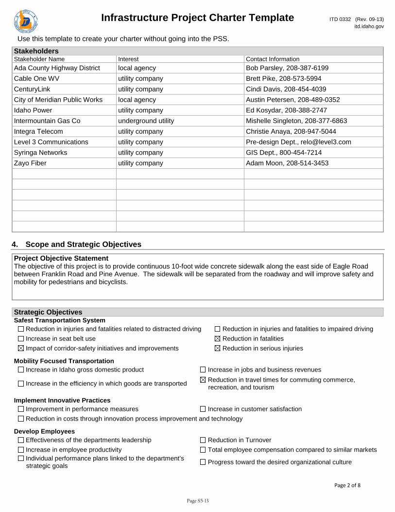
Stakeholders Stakeholder Name Interest Contact Information Ada County Highway District local agency Bob Parsley, 208-387-6199 Cable One WV utility company Brett Pike, 208-573-5994 CenturyLink utility company Cindi Davis, 208-454-4039 City of Meridian Public Works local agency Austin Petersen, 208-489-0352 Idaho Power utility company Ed Kosydar, 208-388-2747 Intermountain Gas Co underground utility Mishelle Singleton, 208-377-6863 Integra Telecom utility company Christie Anaya, 208-947-5044 Level 3 Communications utility company Pre-design Dept., [email protected] Syringa Networks utility company GIS Dept., 800-454-7214 Zayo Fiber utility company Adam Moon, 208-514-3453
4. Scope and Strategic Objectives
Project Objective Statement The objective of this project is to provide continuous 10-foot wide concrete sidewalk along the east side of Eagle Road between Franklin Road and Pine Avenue. The sidewalk will be separated from the roadway and will improve safety and mobility for pedestrians and bicyclists.
Strategic Objectives Safest Transportation System
Reduction in injuries and fatalities related to distracted driving Reduction in injuries and fatalities to impaired driving Increase in seat belt use Reduction in fatalities Impact of corridor-safety initiatives and improvements Reduction in serious injuries
Mobility Focused Transportation Increase in Idaho gross domestic product Increase in jobs and business revenues
Increase in the efficiency in which goods are transported Reduction in travel times for commuting commerce, recreation, and tourism
Implement Innovative Practices Improvement in performance measures Increase in customer satisfaction Reduction in costs through innovation process improvement and technology
Develop Employees Effectiveness of the departments leadership Reduction in Turnover Increase in employee productivity Total employee compensation compared to similar markets Individual performance plans linked to the department’s strategic goals Progress toward the desired organizational culture
Page S5-13

Infrastructure Project Charter Template ITD 0332 (Rev. 09-13) itd.idaho.gov
Use this template to create your charter without going into the PSS.
Page 3 of 8
Scope of Work • Construct 10-foot concrete sidewalk in the existing gaps and reconstruct the non-compliant sidewalk adjacent to the Shell gas station to the 10-foot standard width. The proposed design achieves the desired 8-foot separation between pavement and pathway along the entire segment, except for 200 feet in front of the Redline rental business that has a 3-foot separation at the narrowest point. • Install ADA compliant pedestrian ramps at the existing right-in access to the Shell gas station and at the Commercial Street intersection. Curb ramps at the Franklin Road and Pine Ave intersections are scheduled to be replaced to ADA standards as part of CenterCal improvements. • Coordinate with Union Pacific Railroad (Boise Valley Railroad/Watco) to construct the railroad crossing. Improvements within the railroad right-of-way include installing actuated pedestrian gates and additional planking for the pathway and relocating a rail terminal. • Design vertical alignment adjacent to RC Willey to ensure a 5 percent maximum pathway grade. • Negotiate pathway easements with RC Willey, Redline rentals, and Shell gas station. • Install historical pedestrian light poles at 100-foot intervals on one side of the pathway along the entire segment, with the exception of the pathway in front of Life Church that already has adequate lighting. • Alternative B: Construct an improved shoulder in front of RC Willey that includes an area for a future bus pullout, loading area, and shelter.
5. Environmental Considerations
Project Need Primary Need Secondary Need Safety Capacity
Deficient-standards Deficient-structurally Enhancement Maintenance
Safety System Linkage Traffic Flow Other
Anticipated Major Environmental Deliverables EE/Cat Ex EA/FONSI EIS/ROD Navigable Waters Storm water Yes, Cat Ex ITD Approval
Cultural Archaeological and Historic Survey Report Determination of Adverse Effect Report Field Survey and or Test Investigations Memorandum of Agreement Mitigation
Noise Air Quality and Hazmat
Air Quality Report Barrier Analysis Haz Mat Phase 1
Modeling Noise Report
Section 4F Section 4f Deminimus Section 4f Evaluation Including Alternatives Analysis
Miscellaneous Environmental Justice Report FAA Airspace Intrusion LWCF Recreation Areas 6f Lands Report
Prime Farmland Report Visual Impact Report
Page S5-14
Infrastructure Project Charter Template ITD 0332 (Rev. 09-13) itd.idaho.gov
Use this template to create your charter without going into the PSS.
Page 4 of 8
Wetlands Stream Alteration
Delineation Field Survey Mitigation
Mitigation Plan Permit Application Wetland Report (Jurisdictional Determination)
Species and Habitat Biological Assessment Wildlife Migratory Birds Mag-Ste Fisheries
No Effect Report
Floodway Floodplain
Field Survey Floodplain Encroachment Permit App Floodplain Encroachment Report
Sole Source Aquifer Packet Floodway Encroachment Report
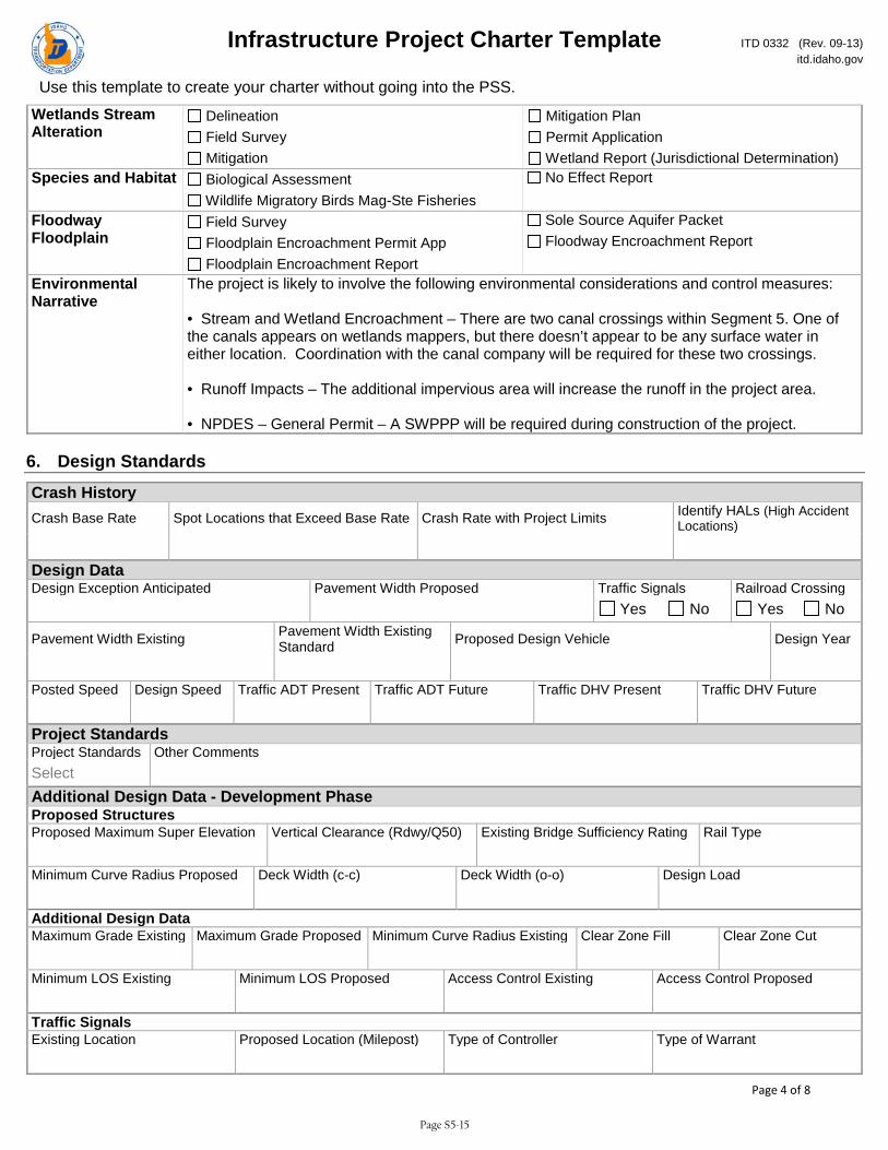
Environmental Narrative
The project is likely to involve the following environmental considerations and control measures: • Stream and Wetland Encroachment – There are two canal crossings within Segment 5. One of the canals appears on wetlands mappers, but there doesn’t appear to be any surface water in either location. Coordination with the canal company will be required for these two crossings. • Runoff Impacts – The additional impervious area will increase the runoff in the project area. • NPDES – General Permit – A SWPPP will be required during construction of the project.
6. Design Standards
Crash History Crash Base Rate Spot Locations that Exceed Base Rate Crash Rate with Project Limits Identify HALs (High Accident
Locations) Design Data Design Exception Anticipated Pavement Width Proposed Traffic Signals Railroad Crossing Yes No Yes No
Pavement Width Existing Pavement Width Existing Standard Proposed Design Vehicle Design Year
Posted Speed Design Speed Traffic ADT Present Traffic ADT Future Traffic DHV Present Traffic DHV Future Project Standards Project Standards Other Comments Select Additional Design Data - Development Phase Proposed Structures Proposed Maximum Super Elevation Vertical Clearance (Rdwy/Q50) Existing Bridge Sufficiency Rating Rail Type Minimum Curve Radius Proposed Deck Width (c-c) Deck Width (o-o) Design Load Additional Design Data Maximum Grade Existing Maximum Grade Proposed Minimum Curve Radius Existing Clear Zone Fill Clear Zone Cut Minimum LOS Existing Minimum LOS Proposed Access Control Existing Access Control Proposed Traffic Signals Existing Location Proposed Location (Milepost) Type of Controller Type of Warrant
Page S5-15
Infrastructure Project Charter Template ITD 0332 (Rev. 09-13) itd.idaho.gov
Use this template to create your charter without going into the PSS.
Page 5 of 8
Railroad Crossing Protection Existing Location (Milepost) Proposed Location (Milepost) Type of Protection Type of Warrant
Design Standards - Development Phase Project Oversight Design Exception District Engineer Approval Date Select Select Design Exception FHWA Approval Date if on NHS Design Exception Committee Date if Applicable Select Select
7. Funding and Cost Summary
Phase Fiscal Year Amount Select Select Select Select Select Select Select
8. Resource Plan and Constraints
Project Constraints Scope Constraint Schedule Constraint Budget Constraint Choose an item. Choose an item. Choose an item. Project Constraints Narrative
Resource Plan Project Design Services Choose an item. Narrative
9. True Minimum Milestones
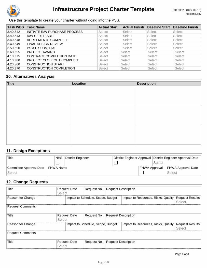
Task WBS Task Name Actual Start Actual Finish Baseline Start Baseline Finish 3.20.Z20 CHARTER APPROVAL Select Select Select Select 3.30.Z30 DESIGN APPROVAL Select Select Select Select 3.30.Z34 PRELIMINARY DESIGN REVIEW Select Select Select Select 3.30.Z36 ENVIRONMENTAL DOCUMENT APPROVAL Select Select Select Select 3.30.Z38 HEARING COMPLETE Select Select Select Select 3.40.Z41 SITUATION & LAYOUT APPROVAL Select Select Select Select
Page S5-16
Infrastructure Project Charter Template ITD 0332 (Rev. 09-13) itd.idaho.gov
Use this template to create your charter without going into the PSS.
Page 6 of 8
Task WBS Task Name Actual Start Actual Finish Baseline Start Baseline Finish 3.40.Z42 INITIATE R/W PURCHASE PROCESS Select Select Select Select 3.40.Z43 R/W CERTIFIABLE Select Select Select Select 3.40.Z48 AGREEMENTS COMPLETE Select Select Select Select 3.40.Z49 FINAL DESIGN REVIEW Select Select Select Select 3.50.Z50 PS & E SUBMITTAL Select Select Select Select 3.60.Z55 PROJECT AWARD Select Select Select Select 4.10.Z75 CONTRACT COMPLETION DATE Select Select Select Select 4.10.Z80 PROJECT CLOSEOUT COMPLETE Select Select Select Select 4.20.Z60 CONSTRUCTION START Select Select Select Select 4.20.Z70 CONSTRUCTION COMPLETION Select Select Select Select
10. Alternatives Analysis Title Location Description
11. Design Exceptions Title NHS District Engineer District Engineer Approval District Engineer Approval Date Select Committee Approval Date FHWA Name FHWA Approval FHWA Approval Date Select Select
12. Change Requests Title Request Date Request No. Request Description Select Reason for Change Impact to Schedule, Scope, Budget Impact to Resources, Risks, Quality Request Results Select Request Comments Title Request Date Request No. Request Description Select Reason for Change Impact to Schedule, Scope, Budget Impact to Resources, Risks, Quality Request Results Select Request Comments Title Request Date Request No. Request Description Select
Page S5-17

Infrastructure Project Charter Template ITD 0332 (Rev. 09-13) itd.idaho.gov
Use this template to create your charter without going into the PSS.
Page 7 of 8
Reason for Change Impact to Schedule, Scope, Budget Impact to Resources, Risks, Quality Request Results Select Request Comments Title Request Date Request No. Request Description Select Reason for Change Impact to Schedule, Scope, Budget Impact to Resources, Risks, Quality Request Results Select Request Comments Title Request Date Request No. Request Description Select Reason for Change Impact to Schedule, Scope, Budget Impact to Resources, Risks, Quality Request Results Select Request Comments
13. Lessons Learned Title Project Type Project Phase Select Select What Worked Well What Could Be Done Differently Action Plan Title Project Type Project Phase Select Select What Worked Well What Could Be Done Differently Action Plan Title Project Type Project Phase Select Select What Worked Well What Could Be Done Differently Action Plan Title Project Type Project Phase Select Select What Worked Well What Could Be Done Differently Action Plan Title Project Type Project Phase Select Select What Worked Well What Could Be Done Differently Action Plan Title Project Type Project Phase Select Select What Worked Well What Could Be Done Differently
Page S5-18

Infrastructure Project Charter Template ITD 0332 (Rev. 09-13) itd.idaho.gov
Use this template to create your charter without going into the PSS.
Page 8 of 8
Action Plan
14. Issues Title Owner Assigned To Status Priority Due Date Select Select Select Discussion Resolution Title Owner Assigned To Status Priority Due Date Select Select Select Discussion Resolution Title Owner Assigned To Status Priority Due Date Select Select Select Discussion Resolution
15. Risks Title Owner Assigned To Status Exposure Due Date Select Select Description Mitigation Plan Title Owner Assigned To Status Exposure Due Date Select Select Description Mitigation Plan Title Owner Assigned To Status Exposure Due Date Select Select Description Mitigation Plan
Page S5-19

IDWBS
Task
Mode
Task Name
Start
Finish
Duration
13
.20
.Z2
0C
ha
rte
r A
pp
rov
al
Mo
n 1
/2/1
7M
on
1/2
/17
1 d
ay
23
.30
.D3
5P
reli
min
ary
Ro
ad
wa
y P
lan
s (P
ath
wa
y)T
ue
1/3
/17
Mo
n 2
/27
/17
40
da
ys
33
.30
.Z3
4P
reli
min
ary
De
sig
n R
evi
ew
Tu
e 2
/28
/17
Tu
e 2
/28
/17
1 d
ay
43
.30
.Z3
0D
esi
gn
Ap
pro
va
lW
ed
4/2
6/1
7T
ue
5/1
6/1
71
5 d
ay
s
53
.30
.E6
0E
nv
iro
nm
en
tal
Ev
alu
ati
on
Tu
e 1
/3/1
7M
on
4/2
4/1
78
0 d
ay
s
63
.30
.Z3
6E
nv
iro
nm
en
tal
Do
cum
en
t A
pp
rov
al
Tu
e 4
/25
/17
Tu
e 4
/25
/17
1 d
ay
73
.30
.I3
4P
ub
lic
Info
rma
tio
n M
ee
tin
gW
ed
3/1
/17
Tu
e 3
/28
/17
20
da
ys
83
.40
.R4
0O
ffic
ial
Rig
ht
of
Wa
y P
lan
sW
ed
5/1
7/1
7T
ue
6/2
0/1
72
5 d
ay
s
93
.40
.Z4
2In
itia
te R
/W P
urc
ha
se P
roce
ssW
ed
6/2
1/1
7T
ue
9/1
2/1
76
0 d
ay
s
10
3.4
0.Z
43
R/W
Ce
rtif
iab
leW
ed
9/1
3/1
7W
ed
9/1
3/1
71
da
y
11
3.4
0.Z
48
Ag
ree
me
nts
Co
mp
lete
We
d 8
/9/1
7T
ue
9/5
/17
20
da
ys
12
3.4
0.X
40
Ra
ilro
ad
Cro
ssin
g A
gre
em
en
tW
ed
5/2
4/1
7T
ue
9/1
2/1
78
0 d
ay
s
13
3.4
0.D
46
Fin
al
Ro
ad
wa
y D
esi
gn
an
d P
lan
sW
ed
5/1
7/1
7T
ue
8/8
/17
60
da
ys
14
3.4
0.Z
49
Fin
al
De
sig
n R
ev
iew
Th
u 9
/14
/17
Th
u 9
/14
/17
1 d
ay
15
3.5
0.Z
50
PS&
E S
ub
mit
tal
Fri
9/1
5/1
7T
hu
9/2
8/1
71
0 d
ay
s
1/2
2/28
4/25
9/13
9/14
9/28
BM
EB
ME
BM
EB
ME
BM
EB
ME
BM
EB
ME
BM
EB
ME
BM
EB
December
January
Feb
ruary
March
April
May
June
July
August
September
October
November
1st Quarter
2nd Quarter
3rd Quarter
4th Quarter
Task
Split
Milestone
Summary
Project Summary
Inactive Task
Inactive M
ilestone
Inactive Summary
Manual Task
Duration-only
Manual Summary Rollup
Manual Summary
Start-only
Finish-only
External Tasks
External Milestone
Deadline
Critical
Critical Split
Progress
Manual Progress
Pa
ge
1
Pro
ject
: S
eg
me
nt
5
Fra
nkl
in t
o P
ine
, E
ast
Sid
e
Da
te:
Th
u 7
/21
/16
Prel
imin
ary
Con
stru
ctio
n Sc
hedu
le
Segm
ent
5: F
rank
lin R
d to
Pin
e A
ve (
Eas
t Si
de)
Page S5-20
Segment 8 – Pine Avenue to Fairview Avenue(West Side)
Eagle Road CorridorMulti-Use Pathway
Eagle Road Corridor Segment 8 – Pine to Fairview (West Side)
Table of Contents
Page Executive Summary Sheet ............................................................................................................................... S8-1
Scope of Work and Environmental Considerations ............................................................................... S8-2
Site Photos .......................................................................................................................................................... S8-3
Concept Plan View Figure ............................................................................................................................. S8-6
Planning-Level Cost Estimates ..................................................................................................................... S8-7
ITD-1150 Project Cost Summary .................................................................................................................. S8-9
ITD-2839 Right of Way Cost Estimate .................................................................................................... S8-10
ITD-0332 Project Charter .............................................................................................................................. S8-11
Preliminary Project Schedule (True Minimum Milestones) .............................................................. S8-19
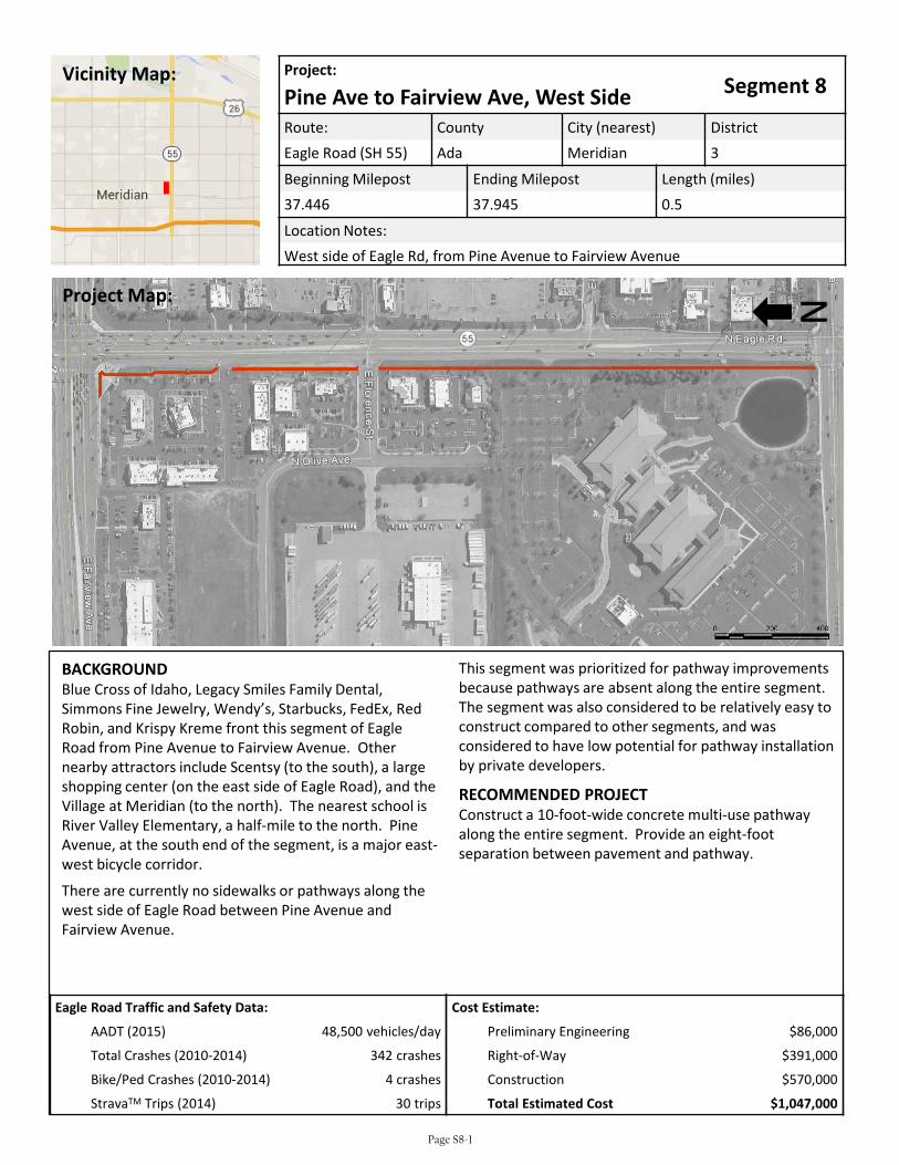
Eagle Road Traffic and Safety Data:
AADT (2015) 48,500 vehicles/day
Total Crashes (2010-2014) 342 crashes
Bike/Ped Crashes (2010-2014) 4 crashes
StravaTM Trips (2014) 30 trips
Project:Segment 8Pine Ave to Fairview Ave, West Side
Route: County City (nearest) DistrictEagle Road (SH 55) Ada Meridian 3
Beginning Milepost Ending Milepost Length (miles)37.446 37.945 0.5
Location Notes:West side of Eagle Rd, from Pine Avenue to Fairview Avenue
BACKGROUNDBlue Cross of Idaho, Legacy Smiles Family Dental, Simmons Fine Jewelry, Wendy’s, Starbucks, FedEx, Red Robin, and Krispy Kreme front this segment of Eagle Road from Pine Avenue to Fairview Avenue. Other nearby attractors include Scentsy (to the south), a large shopping center (on the east side of Eagle Road), and the Village at Meridian (to the north). The nearest school is River Valley Elementary, a half-mile to the north. Pine Avenue, at the south end of the segment, is a major east-west bicycle corridor.
There are currently no sidewalks or pathways along the west side of Eagle Road between Pine Avenue and Fairview Avenue.
This segment was prioritized for pathway improvements because pathways are absent along the entire segment. The segment was also considered to be relatively easy to construct compared to other segments, and was considered to have low potential for pathway installation by private developers.
RECOMMENDED PROJECTConstruct a 10-foot-wide concrete multi-use pathway along the entire segment. Provide an eight-foot separation between pavement and pathway.
NProject Map:
Vicinity Map:
Cost Estimate:
Preliminary Engineering $86,000
Right-of-Way $391,000
Construction $570,000
Total Estimated Cost $1,047,000
Page S8-1
Eagle Road Corridor Segment 8 – Pine to Fairview (West Side)
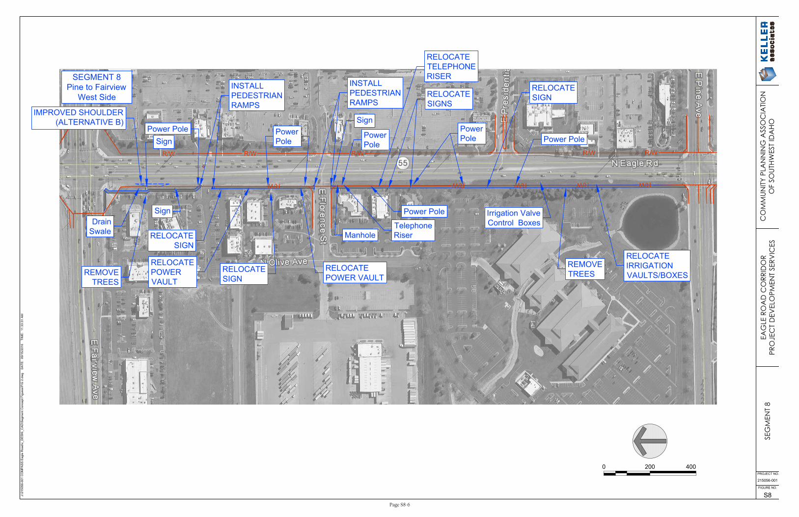
SCOPE OF WORK The recommended scope of work for the multi-use pathway project is as follows:
• Construct 10-foot wide concrete sidewalk along the entire segment. The proposed design achieves the desired eight-foot separation between pavement and pathway along the entire segment.
• Install ADA compliant pedestrian ramps at the existing parking lot access near Red Robin and at the Florence Street intersection. Curb ramps at the Pine Ave and Fairview Avenue intersections are scheduled to be replaced to ADA standards as part of CenterCal improvements.
• Negotiate pathway easements on all nine parcels along the segment.
• Install historical pedestrian light poles at 100-foot intervals on one side of the pathway along the entire segment.
• Alternative B: Construct an improved shoulder in front of Red Robin that includes an area for a future bus pullout, loading area, and shelter.
ENVIRONMENTAL CONSIDERATIONS The project is likely to involve the following environmental considerations and control measures:
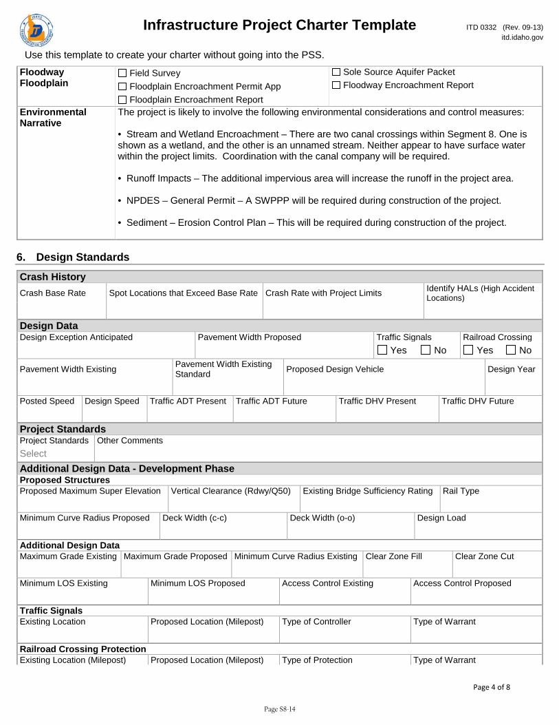
• Stream and Wetland Encroachment – There are two canal crossings within Segment 8. One is shown as a wetland, and the other is an unnamed stream. Neither appear to have surface water within the project limits. Coordination with the canal company will be required.
• Runoff Impacts – The additional impervious area will increase the runoff in the project area.
• NPDES – General Permit – A SWPPP will be required during construction of the project.
• Sediment – Erosion Control Plan – This will be required during construction of the project.
The following databases were used to research environmental effects of the project:
• NEPAssist Tool (https://www.epa.gov/nepa/nepassist)
• EJSCREEN Tool (https://www.epa.gov/ejscreen)
• Web Soil Survey (http://websoilsurvey.sc.egov.usda.gov/App/HomePage.htm)
• Idaho DEQ Underground Storage Tank Database (http://www2.deq.idaho.gov/waste/ustlust/)
• Idaho Governor’s Office Species Conservation (https://species.idaho.gov/thr_endgr.html)
Page S8-2
Eagle Road CorridorSegment 8 – Pine to Fairview (West Side)
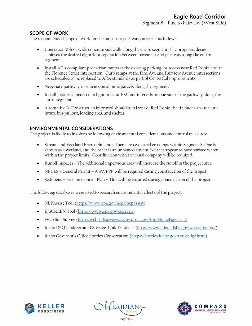
Looking north from the intersection of Eagle Road & Pine Avenue
Looking south adjacent to Blue Cross of Idaho
Page S8-3
Eagle Road CorridorSegment 8 – Pine to Fairview (West Side)
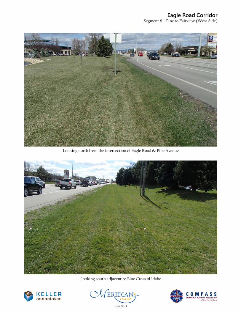
Looking north adjacent to Blue Cross of Idaho
Looking north at the intersection of Eagle Road & Florence Street
Page S8-4
Eagle Road CorridorSegment 8 – Pine to Fairview (West Side)
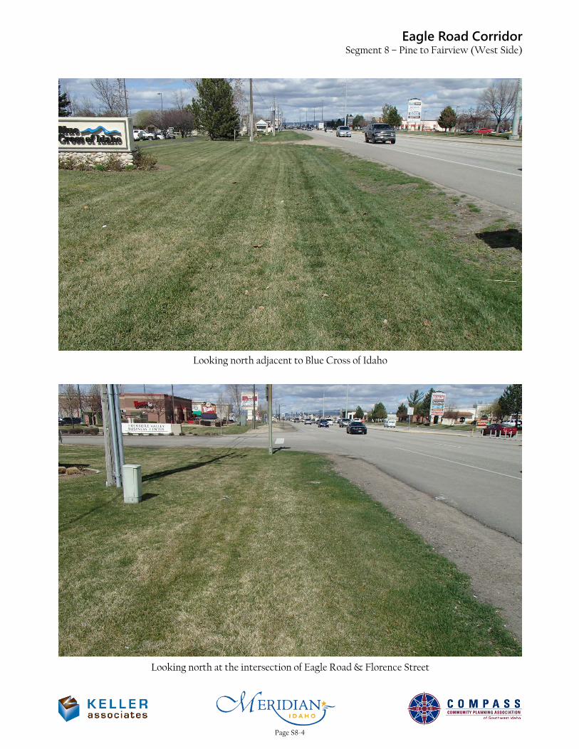
Looking north at the Red Robin access
Looking south from the intersection of Eagle Road & Fairview Avenue
Page S8-5
R/WR/W
R/WR/W R/W
R/WR/WR/WR/W
R/W
J:\215056-001 C
OM
PA
SS
E
agle R
oad\c_D
ES
N\_C
AD
\S
egm
ent C
oncept F
igures\F
IG
2.dw
g D
AT
E: 09/15/2016 T
IM
E: 11:33:31 A
M
215056-001
S8
FIGURE NO.
PROJECT NO.
Irrigation Valve
Control Boxes
INSTALL
PEDESTRIAN
RAMPS
Telephone
Riser
INSTALL
PEDESTRIAN
RAMPS
Power Pole
Sign
Sign
REMOVE
TREES
Drain
Swale
0 200 400
SEG
MEN
T 8
EAG
LE R
OA
D C
ORR
IDO
RPR
OJE
CT
DEV
ELO
PMEN
T SE
RVIC
ESC
OM
MUN
ITY P
LAN
NIN
G A
SSO
CIA
TION
OF
SOUT
HWES
T ID
AHO
SEGMENT 8
Pine to Fairview
West Side
Manhole
RELOCATE
IRRIGATION
VAULTS/BOXES
REMOVE
TREES
Power Pole
RELOCATE
SIGN
Power
Pole
RELOCATE
SIGNS
Power Pole
Sign
Power
Pole
RELOCATE
SIGN
RELOCATE
POWER VAULT
RELOCATE
POWER
VAULT
RELOCATE
TELEPHONE
RISER
RELOCATE
SIGN
IMPROVED SHOULDER
(ALTERNATIVE B)
Power
Pole
Page S8-6
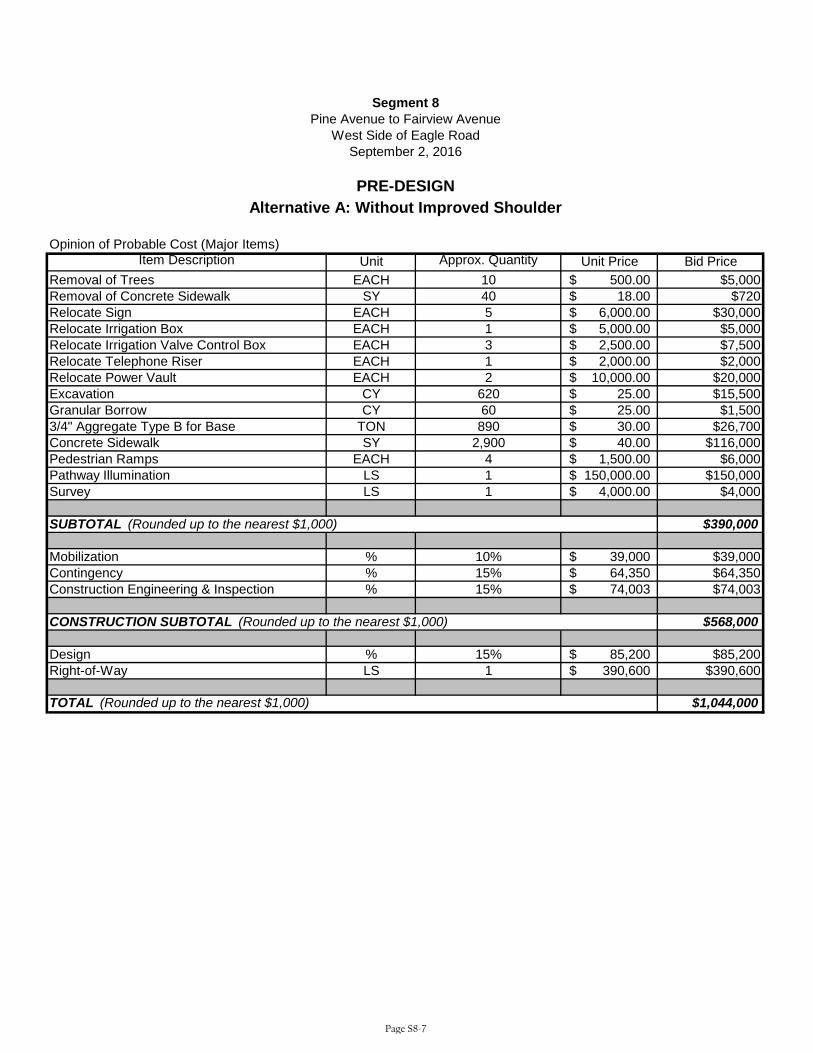
Opinion of Probable Cost (Major Items)Item Description Unit Approx. Quantity Unit Price Bid Price
Removal of Trees EACH 10 500.00$ $5,000Removal of Concrete Sidewalk SY 40 18.00$ $720Relocate Sign EACH 5 6,000.00$ $30,000Relocate Irrigation Box EACH 1 5,000.00$ $5,000Relocate Irrigation Valve Control Box EACH 3 2,500.00$ $7,500Relocate Telephone Riser EACH 1 2,000.00$ $2,000Relocate Power Vault EACH 2 10,000.00$ $20,000Excavation CY 620 25.00$ $15,500Granular Borrow CY 60 25.00$ $1,5003/4" Aggregate Type B for Base TON 890 30.00$ $26,700Concrete Sidewalk SY 2,900 40.00$ $116,000Pedestrian Ramps EACH 4 1,500.00$ $6,000Pathway Illumination LS 1 150,000.00$ $150,000Survey LS 1 4,000.00$ $4,000
$390,000
Mobilization % 10% 39,000$ $39,000Contingency % 15% 64,350$ $64,350Construction Engineering & Inspection % 15% 74,003$ $74,003
$568,000
Design % 15% 85,200$ $85,200Right-of-Way LS 1 390,600$ $390,600
$1,044,000TOTAL (Rounded up to the nearest $1,000)
CONSTRUCTION SUBTOTAL (Rounded up to the nearest $1,000)
SUBTOTAL (Rounded up to the nearest $1,000)
Segment 8Pine Avenue to Fairview Avenue
West Side of Eagle Road
PRE-DESIGN
September 2, 2016
Alternative A: Without Improved Shoulder
Page S8-7
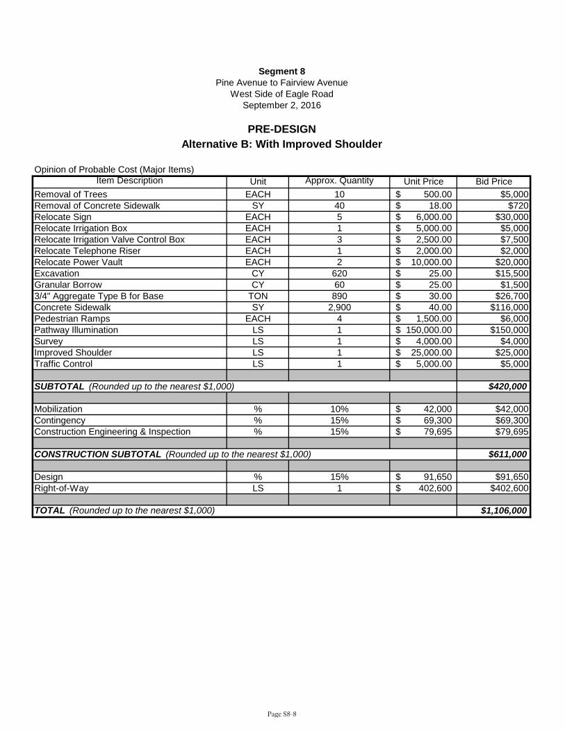
Opinion of Probable Cost (Major Items)Item Description Unit Approx. Quantity Unit Price Bid Price
Removal of Trees EACH 10 500.00$ $5,000Removal of Concrete Sidewalk SY 40 18.00$ $720Relocate Sign EACH 5 6,000.00$ $30,000Relocate Irrigation Box EACH 1 5,000.00$ $5,000Relocate Irrigation Valve Control Box EACH 3 2,500.00$ $7,500Relocate Telephone Riser EACH 1 2,000.00$ $2,000Relocate Power Vault EACH 2 10,000.00$ $20,000Excavation CY 620 25.00$ $15,500Granular Borrow CY 60 25.00$ $1,5003/4" Aggregate Type B for Base TON 890 30.00$ $26,700Concrete Sidewalk SY 2,900 40.00$ $116,000Pedestrian Ramps EACH 4 1,500.00$ $6,000Pathway Illumination LS 1 150,000.00$ $150,000Survey LS 1 4,000.00$ $4,000Improved Shoulder LS 1 25,000.00$ $25,000Traffic Control LS 1 5,000.00$ $5,000
$420,000
Mobilization % 10% 42,000$ $42,000Contingency % 15% 69,300$ $69,300Construction Engineering & Inspection % 15% 79,695$ $79,695
$611,000
Design % 15% 91,650$ $91,650Right-of-Way LS 1 402,600$ $402,600
$1,106,000TOTAL (Rounded up to the nearest $1,000)
CONSTRUCTION SUBTOTAL (Rounded up to the nearest $1,000)
SUBTOTAL (Rounded up to the nearest $1,000)
Segment 8Pine Avenue to Fairview Avenue
West Side of Eagle Road
PRE-DESIGN
September 2, 2016
Alternative B: With Improved Shoulder
Page S8-8
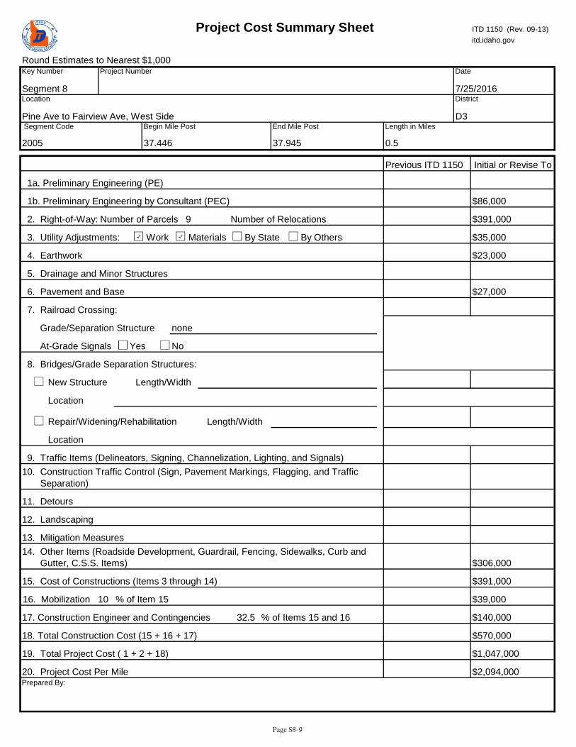
Round Estimates to Nearest $1,000
2. Right-of-Way:
3. Utility Adjustments: Work Materials By State By Others
No
New Structure
Repair/Widening/Rehabilitation
18. Total Construction Cost (15 + 16 + 17)
19. Total Project Cost ( 1 + 2 + 18)
20. Project Cost Per Mile
Length/Width
itd.idaho.gov
17. Construction Engineer and Contingencies
Yes
6. Pavement and Base
5. Drainage and Minor Structures
1b. Preliminary Engineering by Consultant (PEC) $86,000
9 Number of RelocationsNumber of Parcels
1a. Preliminary Engineering (PE)
Length in Miles
0.5
$391,000
Prepared By:
Location
Length/Width
16. Mobilization 10
$1,047,000FALSE
10. Construction Traffic Control (Sign, Pavement Markings, Flagging, and Traffic Separation)
14. Other Items (Roadside Development, Guardrail, Fencing, Sidewalks, Curb and Gutter, C.S.S. Items)
FALSE
$2,094,000
$391,00015. Cost of Constructions (Items 3 through 14)
11. Detours
12. Landscaping
District
Date
7/25/2016
Initial or Revise To
D3
Location
Pine Ave to Fairview Ave, West Side
Key Number
Segment 8
Project Number
Project Cost Summary Sheet ITD 1150 (Rev. 09-13)
37.945
Segment Code
2005
Begin Mile Post End Mile Post
37.446
Previous ITD 1150
4. Earthwork
$35,000
$23,000
$306,000
7. Railroad Crossing:
Grade/Separation Structure none
Location
$27,000
8. Bridges/Grade Separation Structures:
At-Grade Signals
9. Traffic Items (Delineators, Signing, Channelization, Lighting, and Signals)
13. Mitigation Measures
% of Item 15
% of Items 15 and 1632.5
$570,000
$39,000
$140,000
Page S8-9
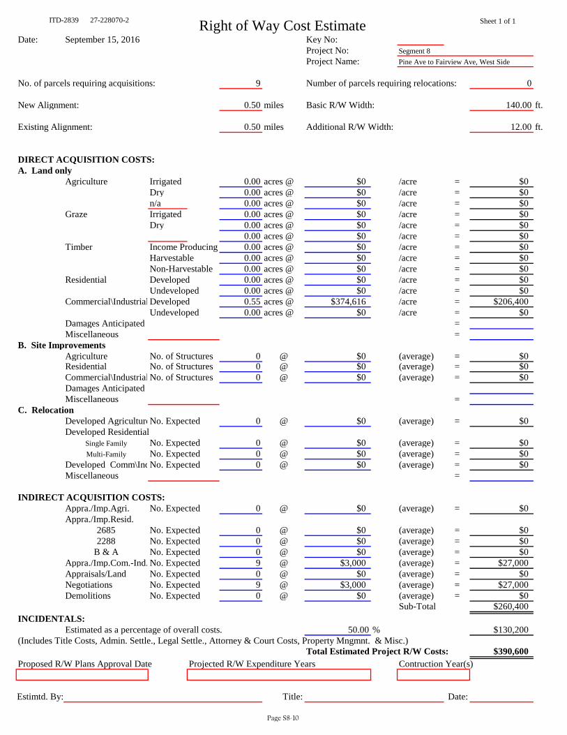
ITD-2839 27-228070-2 Right of Way Cost Estimate Sheet 1 of 1
Date: September 15, 2016 Key No: Project No: Segment 8Project Name: Pine Ave to Fairview Ave, West Side
No. of parcels requiring acquisitions: 9 Number of parcels requiring relocations: 0
New Alignment: 0.50 miles Basic R/W Width: 140.00 ft.
Existing Alignment: 0.50 miles Additional R/W Width: 12.00 ft.
DIRECT ACQUISITION COSTS:A. Land only
Agriculture Irrigated 0.00 acres @ $0 /acre = $0Dry 0.00 acres @ $0 /acre = $0n/a 0.00 acres @ $0 /acre = $0
Graze Irrigated 0.00 acres @ $0 /acre = $0Dry 0.00 acres @ $0 /acre = $0
0.00 acres @ $0 /acre = $0Timber Income Producing 0.00 acres @ $0 /acre = $0
Harvestable 0.00 acres @ $0 /acre = $0Non-Harvestable 0.00 acres @ $0 /acre = $0
Residential Developed 0.00 acres @ $0 /acre = $0Undeveloped 0.00 acres @ $0 /acre = $0
Commercial\Industrial Developed 0.55 acres @ $374,616 /acre = $206,400Undeveloped 0.00 acres @ $0 /acre = $0
Damages Anticipated = Miscellaneous =
B. Site ImprovementsAgriculture No. of Structures 0 @ $0 (average) = $0Residential No. of Structures 0 @ $0 (average) = $0Commercial\Industrial No. of Structures 0 @ $0 (average) = $0Damages AnticipatedMiscellaneous =
C. RelocationDeveloped AgricultureNo. Expected 0 @ $0 (average) = $0Developed Residential
Single Family No. Expected 0 @ $0 (average) = $0Multi-Family No. Expected 0 @ $0 (average) = $0
Developed Comm\IndNo. Expected 0 @ $0 (average) = $0Miscellaneous =
INDIRECT ACQUISITION COSTS:Appra./Imp.Agri. No. Expected 0 @ $0 (average) = $0Appra./Imp.Resid.
2685 No. Expected 0 @ $0 (average) = $02288 No. Expected 0 @ $0 (average) = $0
B & A No. Expected 0 @ $0 (average) = $0Appra./Imp.Com.-Ind. No. Expected 9 @ $3,000 (average) = $27,000Appraisals/Land No. Expected 0 @ $0 (average) = $0Negotiations No. Expected 9 @ $3,000 (average) = $27,000Demolitions No. Expected 0 @ $0 (average) = $0
Sub-Total $260,400INCIDENTALS:
Estimated as a percentage of overall costs. 50.00 % $130,200(Includes Title Costs, Admin. Settle., Legal Settle., Attorney & Court Costs, Property Mngmnt. & Misc.)
Total Estimated Project R/W Costs: $390,600Proposed R/W Plans Approval Date Projected R/W Expenditure Years Contruction Year(s)
Estimtd. By: Title: Date:
Page S8-10

Infrastructure Project Charter Template ITD 0332 (Rev. 09-13) itd.idaho.gov
Use this template to create your charter without going into the PSS.
Page 1 of 8
1. Project Information Key Number Project Name Temporary Key Number Eagle Road 10-foot sidewalk, Pine Ave to Fairview Avenue, West Side Segment 8 District Work Authority Funding Year Route(s) D3 Eagle Road (SH 55) Beginning Mile Post(s) Ending Mile Post(s) Current Project Phase Type of Project 37.446 37.945 Evaluation Phase Safety
Program
Highway Local Bridge Local Bridge Off System STP Local Rural STP Local Urban STP Transportation Mgmt. Area TAP Transportation Mgmt. Area
Highway Other Federal Programs High Priority (SAFETEA LU) High Priority (TEA 21) Discretionary Earmarks (carryover) Emergency Relief Federal Lands Access Indian Reservation Roads Other Federal Non Formula
Highway Other State Programs Federal Non-Participating Local Private Partnership
Public Transit Capital Operations
Aeronautics New Airport Facilities Airport Facility Maintenance Airport Planning Aviation System Planning
Highway Planning Metropolitan Planning MPOs State Planning and Research Systems Planning
Highway Safety Rest Area Safety Federal Rail Safety State Rail Safety Statewide
Highway Statewide Competitive CMAQ Recreational Trails Safe Routes to School TAP Urban and Rural
SHS Bridges Bridge Preservation Bridge Restoration
SHS Expansion Early Development Expansion Formula Debt Service plus Fees and Interest
SHS Other State Board Unallocated System Support
SHS Pavements Pavement Preservation Restoration
2. Exit Criteria
Evaluation Phase Development Phase Implementation Phase Temporary Key No. Temporary Key No. Date PS&E Package Delivered Contract Awarded Final Voucher Issued Segment 8 Select Select Select Select
3. Project Organization Chart
Project Sponsor Sponsor Name External Sponsor External Sponsor Name Sponsor Contact Info or Email Project Owner Owner Name External Owner External Owner Name Owner Contact Info or Email Project Manager Project Manager Name Project Manager Contact Info or Email Tom Laws (208) 475-2233
Page S8-11
Infrastructure Project Charter Template ITD 0332 (Rev. 09-13) itd.idaho.gov
Use this template to create your charter without going into the PSS.
Page 2 of 8
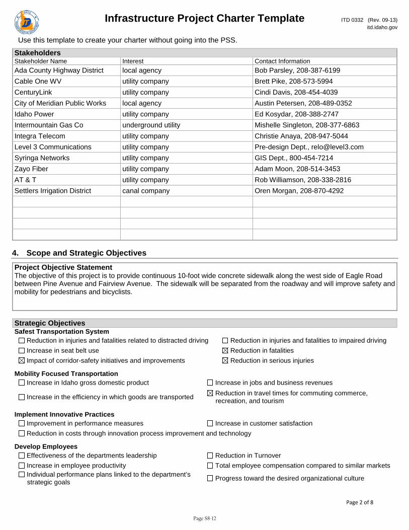
Stakeholders Stakeholder Name Interest Contact Information Ada County Highway District local agency Bob Parsley, 208-387-6199 Cable One WV utility company Brett Pike, 208-573-5994 CenturyLink utility company Cindi Davis, 208-454-4039 City of Meridian Public Works local agency Austin Petersen, 208-489-0352 Idaho Power utility company Ed Kosydar, 208-388-2747 Intermountain Gas Co underground utility Mishelle Singleton, 208-377-6863 Integra Telecom utility company Christie Anaya, 208-947-5044 Level 3 Communications utility company Pre-design Dept., [email protected] Syringa Networks utility company GIS Dept., 800-454-7214 Zayo Fiber utility company Adam Moon, 208-514-3453 AT & T utility company Rob Williamson, 208-338-2816 Settlers Irrigation District canal company Oren Morgan, 208-870-4292
4. Scope and Strategic Objectives
Project Objective Statement The objective of this project is to provide continuous 10-foot wide concrete sidewalk along the west side of Eagle Road between Pine Avenue and Fairview Avenue. The sidewalk will be separated from the roadway and will improve safety and mobility for pedestrians and bicyclists.
Strategic Objectives Safest Transportation System
Reduction in injuries and fatalities related to distracted driving Reduction in injuries and fatalities to impaired driving Increase in seat belt use Reduction in fatalities Impact of corridor-safety initiatives and improvements Reduction in serious injuries
Mobility Focused Transportation Increase in Idaho gross domestic product Increase in jobs and business revenues
Increase in the efficiency in which goods are transported Reduction in travel times for commuting commerce, recreation, and tourism
Implement Innovative Practices Improvement in performance measures Increase in customer satisfaction Reduction in costs through innovation process improvement and technology
Develop Employees Effectiveness of the departments leadership Reduction in Turnover Increase in employee productivity Total employee compensation compared to similar markets Individual performance plans linked to the department’s strategic goals Progress toward the desired organizational culture
Page S8-12
Infrastructure Project Charter Template ITD 0332 (Rev. 09-13) itd.idaho.gov
Use this template to create your charter without going into the PSS.
Page 3 of 8
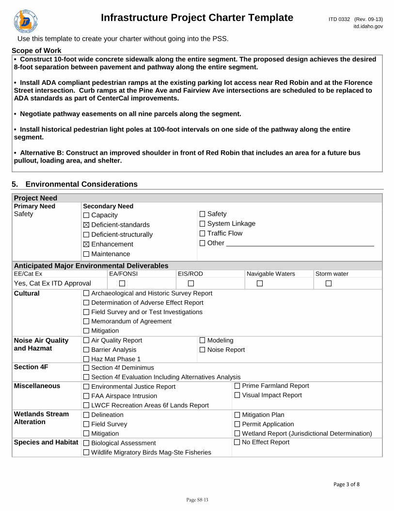
Scope of Work • Construct 10-foot wide concrete sidewalk along the entire segment. The proposed design achieves the desired 8-foot separation between pavement and pathway along the entire segment. • Install ADA compliant pedestrian ramps at the existing parking lot access near Red Robin and at the Florence Street intersection. Curb ramps at the Pine Ave and Fairview Ave intersections are scheduled to be replaced to ADA standards as part of CenterCal improvements. • Negotiate pathway easements on all nine parcels along the segment. • Install historical pedestrian light poles at 100-foot intervals on one side of the pathway along the entire segment. • Alternative B: Construct an improved shoulder in front of Red Robin that includes an area for a future bus pullout, loading area, and shelter.
5. Environmental Considerations
Project Need Primary Need Secondary Need Safety Capacity
Deficient-standards Deficient-structurally Enhancement Maintenance
Safety System Linkage Traffic Flow Other
Anticipated Major Environmental Deliverables EE/Cat Ex EA/FONSI EIS/ROD Navigable Waters Storm water Yes, Cat Ex ITD Approval
Cultural Archaeological and Historic Survey Report Determination of Adverse Effect Report Field Survey and or Test Investigations Memorandum of Agreement Mitigation
Noise Air Quality and Hazmat
Air Quality Report Barrier Analysis Haz Mat Phase 1
Modeling Noise Report
Section 4F Section 4f Deminimus Section 4f Evaluation Including Alternatives Analysis
Miscellaneous Environmental Justice Report FAA Airspace Intrusion LWCF Recreation Areas 6f Lands Report
Prime Farmland Report Visual Impact Report
Wetlands Stream Alteration
Delineation Field Survey Mitigation
Mitigation Plan Permit Application Wetland Report (Jurisdictional Determination)
Species and Habitat Biological Assessment Wildlife Migratory Birds Mag-Ste Fisheries
No Effect Report
Page S8-13
Infrastructure Project Charter Template ITD 0332 (Rev. 09-13) itd.idaho.gov
Use this template to create your charter without going into the PSS.
Page 4 of 8
Floodway Floodplain
Field Survey Floodplain Encroachment Permit App Floodplain Encroachment Report
Sole Source Aquifer Packet Floodway Encroachment Report
Environmental Narrative
The project is likely to involve the following environmental considerations and control measures: • Stream and Wetland Encroachment – There are two canal crossings within Segment 8. One is shown as a wetland, and the other is an unnamed stream. Neither appear to have surface water within the project limits. Coordination with the canal company will be required. • Runoff Impacts – The additional impervious area will increase the runoff in the project area. • NPDES – General Permit – A SWPPP will be required during construction of the project. • Sediment – Erosion Control Plan – This will be required during construction of the project.
6. Design Standards
Crash History Crash Base Rate Spot Locations that Exceed Base Rate Crash Rate with Project Limits Identify HALs (High Accident
Locations) Design Data Design Exception Anticipated Pavement Width Proposed Traffic Signals Railroad Crossing Yes No Yes No
Pavement Width Existing Pavement Width Existing Standard Proposed Design Vehicle Design Year
Posted Speed Design Speed Traffic ADT Present Traffic ADT Future Traffic DHV Present Traffic DHV Future Project Standards Project Standards Other Comments Select Additional Design Data - Development Phase Proposed Structures Proposed Maximum Super Elevation Vertical Clearance (Rdwy/Q50) Existing Bridge Sufficiency Rating Rail Type Minimum Curve Radius Proposed Deck Width (c-c) Deck Width (o-o) Design Load Additional Design Data Maximum Grade Existing Maximum Grade Proposed Minimum Curve Radius Existing Clear Zone Fill Clear Zone Cut Minimum LOS Existing Minimum LOS Proposed Access Control Existing Access Control Proposed Traffic Signals Existing Location Proposed Location (Milepost) Type of Controller Type of Warrant Railroad Crossing Protection Existing Location (Milepost) Proposed Location (Milepost) Type of Protection Type of Warrant
Page S8-14
Infrastructure Project Charter Template ITD 0332 (Rev. 09-13) itd.idaho.gov
Use this template to create your charter without going into the PSS.
Page 5 of 8
Design Standards - Development Phase Project Oversight Design Exception District Engineer Approval Date Select Select Design Exception FHWA Approval Date if on NHS Design Exception Committee Date if Applicable Select Select
7. Funding and Cost Summary
Phase Fiscal Year Amount Select Select Select Select Select Select Select
8. Resource Plan and Constraints
Project Constraints Scope Constraint Schedule Constraint Budget Constraint Choose an item. Choose an item. Choose an item. Project Constraints Narrative
Resource Plan Project Design Services Choose an item. Narrative
9. True Minimum Milestones
Task WBS Task Name Actual Start Actual Finish Baseline Start Baseline Finish 3.20.Z20 CHARTER APPROVAL Select Select Select Select 3.30.Z30 DESIGN APPROVAL Select Select Select Select 3.30.Z34 PRELIMINARY DESIGN REVIEW Select Select Select Select 3.30.Z36 ENVIRONMENTAL DOCUMENT APPROVAL Select Select Select Select 3.30.Z38 HEARING COMPLETE Select Select Select Select 3.40.Z41 SITUATION & LAYOUT APPROVAL Select Select Select Select 3.40.Z42 INITIATE R/W PURCHASE PROCESS Select Select Select Select
Page S8-15

Infrastructure Project Charter Template ITD 0332 (Rev. 09-13) itd.idaho.gov
Use this template to create your charter without going into the PSS.
Page 6 of 8
Task WBS Task Name Actual Start Actual Finish Baseline Start Baseline Finish 3.40.Z43 R/W CERTIFIABLE Select Select Select Select 3.40.Z48 AGREEMENTS COMPLETE Select Select Select Select 3.40.Z49 FINAL DESIGN REVIEW Select Select Select Select 3.50.Z50 PS & E SUBMITTAL Select Select Select Select 3.60.Z55 PROJECT AWARD Select Select Select Select 4.10.Z75 CONTRACT COMPLETION DATE Select Select Select Select 4.10.Z80 PROJECT CLOSEOUT COMPLETE Select Select Select Select 4.20.Z60 CONSTRUCTION START Select Select Select Select 4.20.Z70 CONSTRUCTION COMPLETION Select Select Select Select
10. Alternatives Analysis Title Location Description
11. Design Exceptions Title NHS District Engineer District Engineer Approval District Engineer Approval Date Select Committee Approval Date FHWA Name FHWA Approval FHWA Approval Date Select Select
12. Change Requests Title Request Date Request No. Request Description Select Reason for Change Impact to Schedule, Scope, Budget Impact to Resources, Risks, Quality Request Results Select Request Comments Title Request Date Request No. Request Description Select Reason for Change Impact to Schedule, Scope, Budget Impact to Resources, Risks, Quality Request Results Select Request Comments Title Request Date Request No. Request Description Select Reason for Change Impact to Schedule, Scope, Budget Impact to Resources, Risks, Quality Request Results
Page S8-16
Infrastructure Project Charter Template ITD 0332 (Rev. 09-13) itd.idaho.gov
Use this template to create your charter without going into the PSS.
Page 7 of 8
Select Request Comments Title Request Date Request No. Request Description Select Reason for Change Impact to Schedule, Scope, Budget Impact to Resources, Risks, Quality Request Results Select Request Comments Title Request Date Request No. Request Description Select Reason for Change Impact to Schedule, Scope, Budget Impact to Resources, Risks, Quality Request Results Select Request Comments
13. Lessons Learned Title Project Type Project Phase Select Select What Worked Well What Could Be Done Differently Action Plan Title Project Type Project Phase Select Select What Worked Well What Could Be Done Differently Action Plan Title Project Type Project Phase Select Select What Worked Well What Could Be Done Differently Action Plan Title Project Type Project Phase Select Select What Worked Well What Could Be Done Differently Action Plan Title Project Type Project Phase Select Select What Worked Well What Could Be Done Differently Action Plan Title Project Type Project Phase Select Select What Worked Well What Could Be Done Differently
Page S8-17
Infrastructure Project Charter Template ITD 0332 (Rev. 09-13) itd.idaho.gov
Use this template to create your charter without going into the PSS.
Page 8 of 8
Action Plan
14. Issues Title Owner Assigned To Status Priority Due Date Select Select Select Discussion Resolution Title Owner Assigned To Status Priority Due Date Select Select Select Discussion Resolution Title Owner Assigned To Status Priority Due Date Select Select Select Discussion Resolution
15. Risks Title Owner Assigned To Status Exposure Due Date Select Select Description Mitigation Plan Title Owner Assigned To Status Exposure Due Date Select Select Description Mitigation Plan Title Owner Assigned To Status Exposure Due Date Select Select Description Mitigation Plan
Page S8-18

IDWBS
Task
Mode
Task Name
Start
Finish
Duration
13
.20
.Z2
0C
ha
rte
r A
pp
rov
al
Mo
n 1
/2/1
7M
on
1/2
/17
1 d
ay
23
.30
.D3
5P
reli
min
ary
Ro
ad
wa
y P
lan
s (P
ath
wa
y)T
ue
1/3
/17
Mo
n 2
/27
/17
40
da
ys
33
.30
.Z3
4P
reli
min
ary
De
sig
n R
evi
ew
Tu
e 2
/28
/17
Tu
e 2
/28
/17
1 d
ay
43
.30
.Z3
0D
esi
gn
Ap
pro
va
lW
ed
4/2
6/1
7T
ue
5/1
6/1
71
5 d
ay
s
53
.30
.E6
0E
nv
iro
nm
en
tal
Ev
alu
ati
on
Tu
e 1
/3/1
7M
on
4/2
4/1
78
0 d
ay
s
63
.30
.Z3
6E
nv
iro
nm
en
tal
Do
cum
en
t A
pp
rov
al
Tu
e 4
/25
/17
Tu
e 4
/25
/17
1 d
ay
73
.30
.I3
4P
ub
lic
Info
rma
tio
n M
ee
tin
gW
ed
3/1
/17
Tu
e 3
/28
/17
20
da
ys
83
.40
.R4
0O
ffic
ial
Rig
ht
of
Wa
y P
lan
sW
ed
5/1
7/1
7T
ue
6/2
0/1
72
5 d
ay
s
93
.40
.Z4
2In
itia
te R
/W P
urc
ha
se P
roce
ssW
ed
6/2
1/1
7T
ue
9/1
2/1
76
0 d
ay
s
10
3.4
0.Z
43
R/W
Ce
rtif
iab
leW
ed
9/1
3/1
7W
ed
9/1
3/1
71
da
y
11
3.4
0.Z
48
Ag
ree
me
nts
Co
mp
lete
We
d 8
/9/1
7T
ue
9/5
/17
20
da
ys
12
3.4
0.D
46
Fin
al
Ro
ad
wa
y D
esi
gn
an
d P
lan
sW
ed
5/1
7/1
7T
ue
8/8
/17
60
da
ys
13
3.4
0.Z
49
Fin
al
De
sig
n R
ev
iew
Th
u 9
/14
/17
Th
u 9
/14
/17
1 d
ay
14
3.5
0.Z
50
PS&
E S
ub
mit
tal
Fri
9/1
5/1
7T
hu
9/2
8/1
71
0 d
ay
s
1/2
2/28
4/25
9/13
9/14
9/28
BM
EB
ME
BM
EB
ME
BM
EB
ME
BM
EB
ME
BM
EB
ME
BM
EB
December
January
Feb
ruary
March
April
May
June
July
August
September
October
November
1st Quarter
2nd Quarter
3rd Quarter
4th Quarter
Task
Split
Milestone
Summary
Project Summary
Inactive Task
Inactive M
ilestone
Inactive Summary
Manual Task
Duration-only
Manual Summary Rollup
Manual Summary
Start-only
Finish-only
External Tasks
External Milestone
Deadline
Critical
Critical Split
Progress
Manual Progress
Pa
ge
1
Pro
ject
: S
eg
me
nt
8
Pin
e t
o F
air
vie
w,
We
st S
ide
Da
te:
Th
u 7
/21
/16
Prel
imin
ary
Con
stru
ctio
n Sc
hedu
leSe
gmen
t 8:
Pin
e A
ve t
o Fa
irvi
ew A
ve (
Wes
t Si
de)
Page S8-19
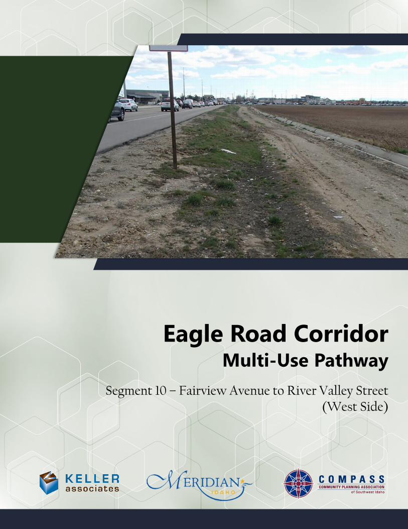
Segment 10 – Fairview Avenue to River Valley Street(West Side)
Eagle Road CorridorMulti-Use Pathway

Eagle Road Corridor Segment 10 – Fairview to River Valley (West Side)
Table of Contents
Page Executive Summary Sheet ............................................................................................................................. S10-1
Scope of Work and Environmental Considerations ............................................................................. S10-2
Site Photos ........................................................................................................................................................ S10-4
Concept Plan View Figure ............................................................................................................................ S10-7
Planning-Level Cost Estimates ................................................................................................................... S10-8
ITD-1150 Project Cost Summary ............................................................................................................... S10-10
ITD-2839 Right of Way Cost Estimate ....................................................................................................S10-11
ITD-0332 Project Charter ............................................................................................................................ S10-12
Preliminary Project Schedule (True Minimum Milestones) ............................................................ S10-20

Eagle Road Traffic and Safety Data:
AADT (2015) 48,000 vehicles/day
Total Crashes (2010-2014) 254 crashes
Bike/Ped Crashes (2010-2014) 1 crash
StravaTM Trips (2014) 27 trips
Project:Segment 10Fairview Ave to River Valley St, West Side
Route: County City (nearest) DistrictEagle Road (SH 55) Ada Meridian 3
Beginning Milepost Ending Milepost Length (miles)37.945 38.434 0.5
Location Notes:West side of Eagle Rd, from Fairview Ave to River Valley St
BACKGROUNDThe parcels adjacent to this segment of Eagle Road are irrigated fields for agricultural use. Nearby attractors include the Village at Meridian and Julius M. KleinerMemorial Park (on the east side of Eagle Road), and River Valley Elementary School (immediately north of the segment). The intersection of Eagle Road and Fairview Avenue is the busiest intersection in Idaho, and is located on the south end of the segment.
There are currently no sidewalks or pathways along the west side of Eagle Road between Fairview Avenue and River Valley Street. Across the street adjacent to the Village, there is already a continuous pathway that meets the desired separated, 10-foot wide standard.
This segment was prioritized for pathway improvements because pathways are absent along the entire segment, and because of its close proximity to River Valley Elementary School. The segment was also considered to be relatively cost-effective and easy to construct compared to other segments. Pathway installation by private developers was considered likely, but not in the immediate future due to high land value.
RECOMMENDED PROJECTConstruct a 10-foot-wide concrete multi-use pathway along the entire segment. Provide an eight-foot separation between pavement and pathway.
NProject Map:
Vicinity Map:
Cost Estimate:
Preliminary Engineering $67,000
Right-of-Way $0
Construction $448,000
Total Estimated Cost $515,000
Page S10-1
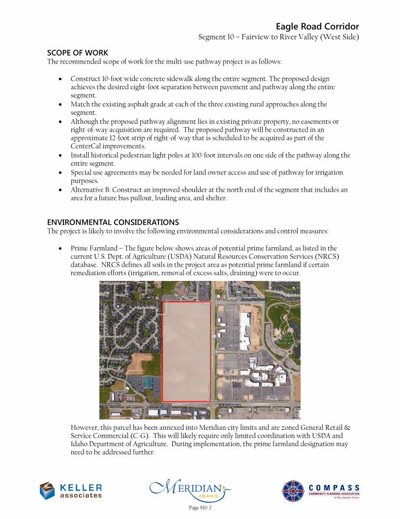
Eagle Road Corridor Segment 10 – Fairview to River Valley (West Side)
SCOPE OF WORK The recommended scope of work for the multi-use pathway project is as follows:
• Construct 10-foot wide concrete sidewalk along the entire segment. The proposed design achieves the desired eight-foot separation between pavement and pathway along the entire segment.
• Match the existing asphalt grade at each of the three existing rural approaches along the segment.
• Although the proposed pathway alignment lies in existing private property, no easements or right-of-way acquisition are required. The proposed pathway will be constructed in an approximate 12-foot strip of right-of-way that is scheduled to be acquired as part of the CenterCal improvements.
• Install historical pedestrian light poles at 100-foot intervals on one side of the pathway along the entire segment.
• Special use agreements may be needed for land owner access and use of pathway for irrigation purposes.
• Alternative B: Construct an improved shoulder at the north end of the segment that includes an area for a future bus pullout, loading area, and shelter.
ENVIRONMENTAL CONSIDERATIONS The project is likely to involve the following environmental considerations and control measures:
• Prime Farmland – The figure below shows areas of potential prime farmland, as listed in the current U.S. Dept. of Agriculture (USDA) Natural Resources Conservation Services (NRCS) database. NRCS defines all soils in the project area as potential prime farmland if certain remediation efforts (irrigation, removal of excess salts, draining) were to occur.
However, this parcel has been annexed into Meridian city limits and are zoned General Retail & Service Commercial (C-G). This will likely require only limited coordination with USDA and Idaho Department of Agriculture. During implementation, the prime farmland designation may need to be addressed further.
Page S10-2
Eagle Road Corridor Segment 10 – Fairview to River Valley (West Side)
• Runoff Impacts – The additional impervious area will increase the runoff in the project area.
• NPDES – General Permit – A SWPPP will be required during construction of the project.
The following databases were used to research environmental effects of the project:
• NEPAssist Tool (https://www.epa.gov/nepa/nepassist)
• EJSCREEN Tool (https://www.epa.gov/ejscreen)
• Web Soil Survey (http://websoilsurvey.sc.egov.usda.gov/App/HomePage.htm)
• Idaho DEQ Underground Storage Tank Database (http://www2.deq.idaho.gov/waste/ustlust/)
• Idaho Governor’s Office Species Conservation (https://species.idaho.gov/thr_endgr.html)
Page S10-3
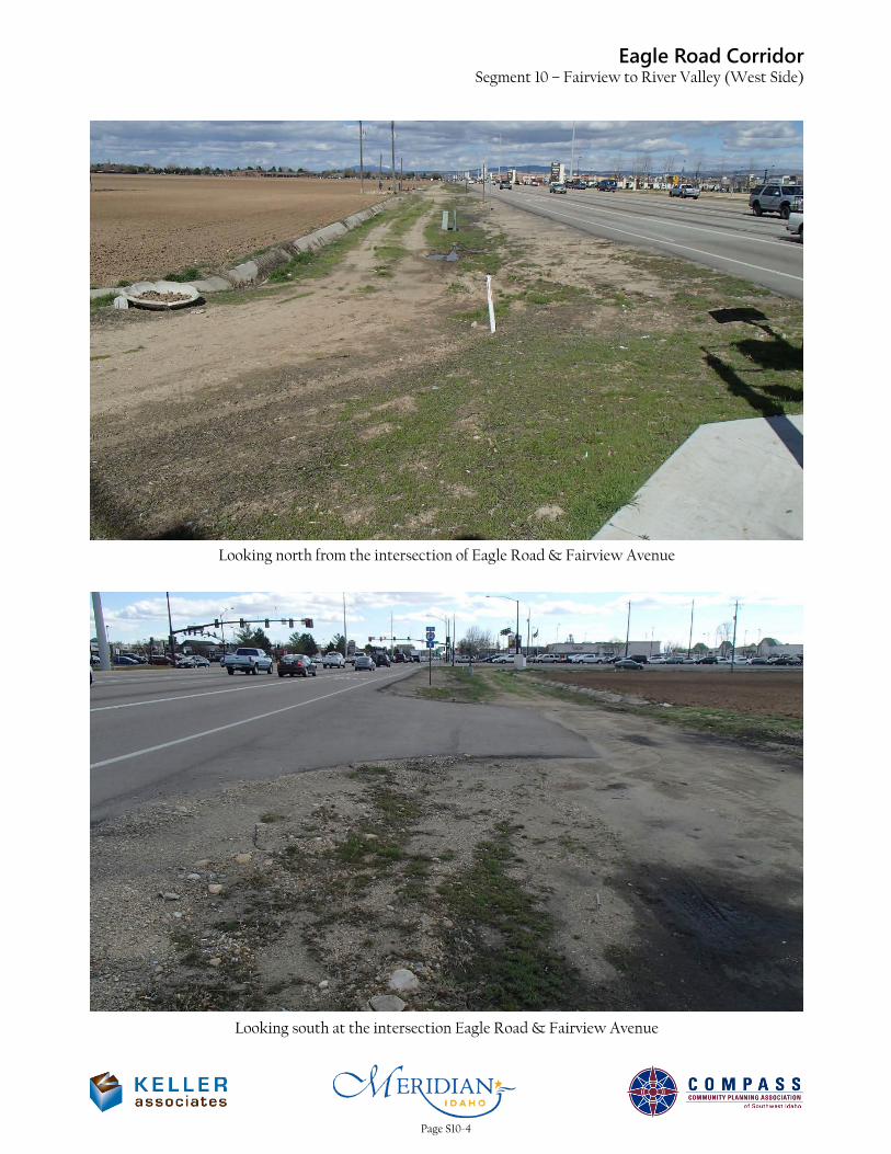
Eagle Road CorridorSegment 10 – Fairview to River Valley (West Side)
Looking north from the intersection of Eagle Road & Fairview Avenue
Looking south at the intersection Eagle Road & Fairview Avenue
Page S10-4
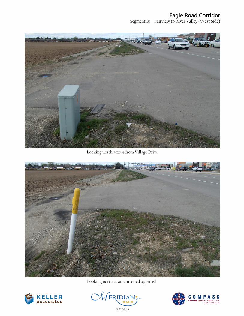
Eagle Road CorridorSegment 10 – Fairview to River Valley (West Side)
Looking north across from Village Drive
Looking north at an unnamed approach
Page S10-5
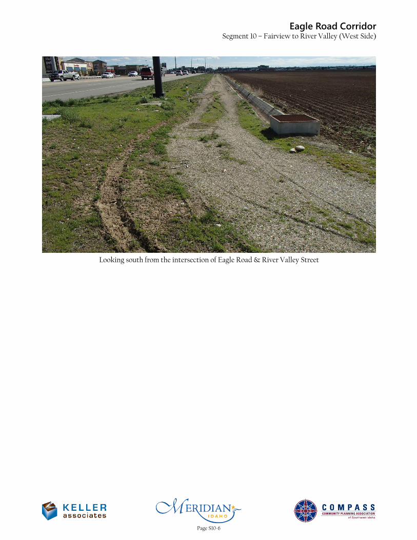
Eagle Road CorridorSegment 10 – Fairview to River Valley (West Side)
Looking south from the intersection of Eagle Road & River Valley Street
Page S10-6

R/W
R/W
R/W
R/W
R/W
R/W
R/W
R/W
R/W
R/W
R/W
R/W
R/W
R/W R/W
R/W
R/W
R/W
R/W
J:\2
15
05
6-0
01
C
OM
PA
SS
E
ag
le
R
oa
d\c_
DE
SN
\_
CA
D\S
eg
me
nt C
on
ce
pt F
ig
ure
s\F
IG
3
.d
wg
D
AT
E: 0
9/1
5/2
01
6 T
IM
E: 1
1:3
6:3
6 A
M
215056-001
S10
FIGURE NO.
PROJECT NO.
MATCH EXISTING
APPROACH GRADE
MATCH EXISTING
APPROACH GRADE
MATCH EXISTING
APPROACH GRADE
0 200 400
SEG
MEN
T 10
EAG
LE R
OA
D C
ORR
IDO
RPR
OJE
CT
DEV
ELO
PMEN
T SE
RVIC
ESC
OM
MUN
ITY P
LAN
NIN
G A
SSO
CIA
TION
OF
SOUT
HWES
T ID
AHO
SEGMENT 10
Fairview to River Valley
West Side
IMPROVED SHOULDER
(ALTERNATIVE B)
Proposed Right-of-Way in
CenterCal Phase III Plans
Page S10-7
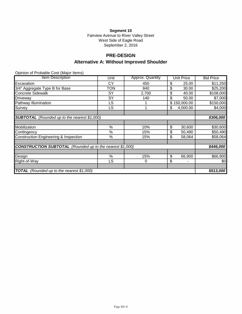
Opinion of Probable Cost (Major Items)Item Description Unit Approx. Quantity Unit Price Bid Price
Excavation CY 450 25.00$ $11,2503/4" Aggregate Type B for Base TON 840 30.00$ $25,200Concrete Sidewalk SY 2,700 40.00$ $108,000Driveway SY 140 50.00$ $7,000Pathway Illumination LS 1 150,000.00$ $150,000Survey LS 1 4,000.00$ $4,000
$306,000
Mobilization % 10% 30,600$ $30,600Contingency % 15% 50,490$ $50,490Construction Engineering & Inspection % 15% 58,064$ $58,064
$446,000
Design % 15% 66,900$ $66,900Right-of-Way LS 0 -$ $0
$513,000
SUBTOTAL (Rounded up to the nearest $1,000)
Segment 10Fairview Avenue to River Valley Street
West Side of Eagle Road
PRE-DESIGN
September 2, 2016
Alternative A: Without Improved Shoulder
TOTAL (Rounded up to the nearest $1,000)
CONSTRUCTION SUBTOTAL (Rounded up to the nearest $1,000)
Page S10-8

Opinion of Probable Cost (Major Items)Item Description Unit Approx. Quantity Unit Price Bid Price
Excavation CY 450 25.00$ $11,2503/4" Aggregate Type B for Base TON 840 30.00$ $25,200Concrete Sidewalk SY 2,700 40.00$ $108,000Driveway SY 140 50.00$ $7,000Pathway Illumination LS 1 150,000.00$ $150,000Survey LS 1 4,000.00$ $4,000Improved Shoulder LS 1 25,000.00$ $25,000Traffic Control LS 1 5,000.00$ $5,000
$336,000
Mobilization % 10% 33,600$ $33,600Contingency % 15% 55,440$ $55,440Construction Engineering & Inspection % 15% 63,756$ $63,756
$489,000
Design % 15% 73,350$ $73,350Right-of-Way LS 0 -$ $0
$563,000
SUBTOTAL (Rounded up to the nearest $1,000)
Segment 10Fairview Avenue to River Valley Street
West Side of Eagle Road
PRE-DESIGN
September 2, 2016
Alternative B: Without Improved Shoulder
TOTAL (Rounded up to the nearest $1,000)
CONSTRUCTION SUBTOTAL (Rounded up to the nearest $1,000)
Page S10-9
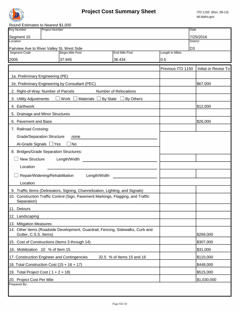
Round Estimates to Nearest $1,000
2. Right-of-Way:
3. Utility Adjustments: Work Materials By State By Others
No
New Structure
Repair/Widening/Rehabilitation
18. Total Construction Cost (15 + 16 + 17)
19. Total Project Cost ( 1 + 2 + 18)
20. Project Cost Per Mile
Length/Width
itd.idaho.gov
17. Construction Engineer and Contingencies
Yes
6. Pavement and Base
5. Drainage and Minor Structures
1b. Preliminary Engineering by Consultant (PEC) $67,000
Number of RelocationsNumber of Parcels
1a. Preliminary Engineering (PE)
Length in Miles
0.5
Prepared By:
Location
Length/Width
16. Mobilization 10
$515,000FALSE
10. Construction Traffic Control (Sign, Pavement Markings, Flagging, and Traffic Separation)
14. Other Items (Roadside Development, Guardrail, Fencing, Sidewalks, Curb and Gutter, C.S.S. Items)
FALSE
$1,030,000
$307,00015. Cost of Constructions (Items 3 through 14)
11. Detours
12. Landscaping
District
Date
7/25/2016
Initial or Revise To
D3
Location
Fairview Ave to River Valley St, West Side
Key Number
Segment 10
Project Number
Project Cost Summary Sheet ITD 1150 (Rev. 09-13)
38.434
Segment Code
2005
Begin Mile Post End Mile Post
37.945
Previous ITD 1150
4. Earthwork $12,000
$269,000
7. Railroad Crossing:
Grade/Separation Structure none
Location
$26,000
8. Bridges/Grade Separation Structures:
At-Grade Signals
9. Traffic Items (Delineators, Signing, Channelization, Lighting, and Signals)
13. Mitigation Measures
% of Item 15
% of Items 15 and 1632.5
$448,000
$31,000
$110,000
Page S10-10
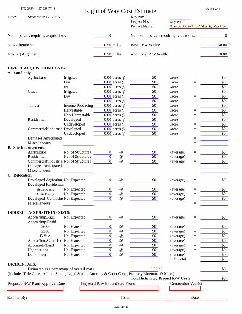
ITD-2839 27-228070-2 Right of Way Cost Estimate Sheet 1 of 1
Date: September 12, 2016 Key No: Project No: Segment 10Project Name: Fairview Ave to River Valley St, West Side
No. of parcels requiring acquisitions: 0 Number of parcels requiring relocations: 0
New Alignment: 0.50 miles Basic R/W Width: 160.00 ft.
Existing Alignment: 0.50 miles Additional R/W Width: 0.00 ft.
DIRECT ACQUISITION COSTS:A. Land only
Agriculture Irrigated 0.00 acres @ $0 /acre = $0Dry 0.00 acres @ $0 /acre = $0n/a 0.00 acres @ $0 /acre = $0
Graze Irrigated 0.00 acres @ $0 /acre = $0Dry 0.00 acres @ $0 /acre = $0
0.00 acres @ $0 /acre = $0Timber Income Producing 0.00 acres @ $0 /acre = $0
Harvestable 0.00 acres @ $0 /acre = $0Non-Harvestable 0.00 acres @ $0 /acre = $0
Residential Developed 0.00 acres @ $0 /acre = $0Undeveloped 0.00 acres @ $0 /acre = $0
Commercial\Industrial Developed 0.00 acres @ $0 /acre = $0Undeveloped 0.00 acres @ $0 /acre = $0
Damages Anticipated = Miscellaneous =
B. Site ImprovementsAgriculture No. of Structures 0 @ $0 (average) = $0Residential No. of Structures 0 @ $0 (average) = $0Commercial\Industrial No. of Structures 0 @ $0 (average) = $0Damages AnticipatedMiscellaneous =
C. RelocationDeveloped AgricultureNo. Expected 0 @ $0 (average) = $0Developed Residential
Single Family No. Expected 0 @ $0 (average) = $0Multi-Family No. Expected 0 @ $0 (average) = $0
Developed Comm\IndNo. Expected 0 @ $0 (average) = $0Miscellaneous =
INDIRECT ACQUISITION COSTS:Appra./Imp.Agri. No. Expected 0 @ $0 (average) = $0Appra./Imp.Resid.
2685 No. Expected 0 @ $0 (average) = $02288 No. Expected 0 @ $0 (average) = $0
B & A No. Expected 0 @ $0 (average) = $0Appra./Imp.Com.-Ind. No. Expected 0 @ $0 (average) = $0Appraisals/Land No. Expected 0 @ $0 (average) = $0Negotiations No. Expected 0 @ $0 (average) = $0Demolitions No. Expected 0 @ $0 (average) = $0
Sub-Total $0INCIDENTALS:
Estimated as a percentage of overall costs. 0.00 % $0(Includes Title Costs, Admin. Settle., Legal Settle., Attorney & Court Costs, Property Mngmnt. & Misc.)
Total Estimated Project R/W Costs: $0Proposed R/W Plans Approval Date Projected R/W Expenditure Years Contruction Year(s)
Estimtd. By: Title: Date:
Page S10-11

Infrastructure Project Charter Template ITD 0332 (Rev. 09-13) itd.idaho.gov
Use this template to create your charter without going into the PSS.
Page 1 of 8
1. Project Information Key Number Project Name Temporary Key Number Eagle Road 10-foot sidewalk, Fairview Ave to River Valley St, West Side Segment 10 District Work Authority Funding Year Route(s) D3 Eagle Road (SH 55) Beginning Mile Post(s) Ending Mile Post(s) Current Project Phase Type of Project 37.945 38.434 Evaluation Phase Safety
Program
Highway Local Bridge Local Bridge Off System STP Local Rural STP Local Urban STP Transportation Mgmt. Area TAP Transportation Mgmt. Area
Highway Other Federal Programs High Priority (SAFETEA LU) High Priority (TEA 21) Discretionary Earmarks (carryover) Emergency Relief Federal Lands Access Indian Reservation Roads Other Federal Non Formula
Highway Other State Programs Federal Non-Participating Local Private Partnership
Public Transit Capital Operations
Aeronautics New Airport Facilities Airport Facility Maintenance Airport Planning Aviation System Planning
Highway Planning Metropolitan Planning MPOs State Planning and Research Systems Planning
Highway Safety Rest Area Safety Federal Rail Safety State Rail Safety Statewide
Highway Statewide Competitive CMAQ Recreational Trails Safe Routes to School TAP Urban and Rural
SHS Bridges Bridge Preservation Bridge Restoration
SHS Expansion Early Development Expansion Formula Debt Service plus Fees and Interest
SHS Other State Board Unallocated System Support
SHS Pavements Pavement Preservation Restoration
2. Exit Criteria
Evaluation Phase Development Phase Implementation PhaseTemporary Key No. Temporary Key No. Date PS&E Package Delivered Contract Awarded Final Voucher Issued Segment 10 Select Select Select Select
3. Project Organization Chart
Project Sponsor Sponsor Name External Sponsor External Sponsor Name Sponsor Contact Info or Email Project Owner Owner Name External Owner External Owner Name Owner Contact Info or Email Project Manager Project Manager Name Project Manager Contact Info or Email Tom Laws (208) 475-2233
Page S10-12
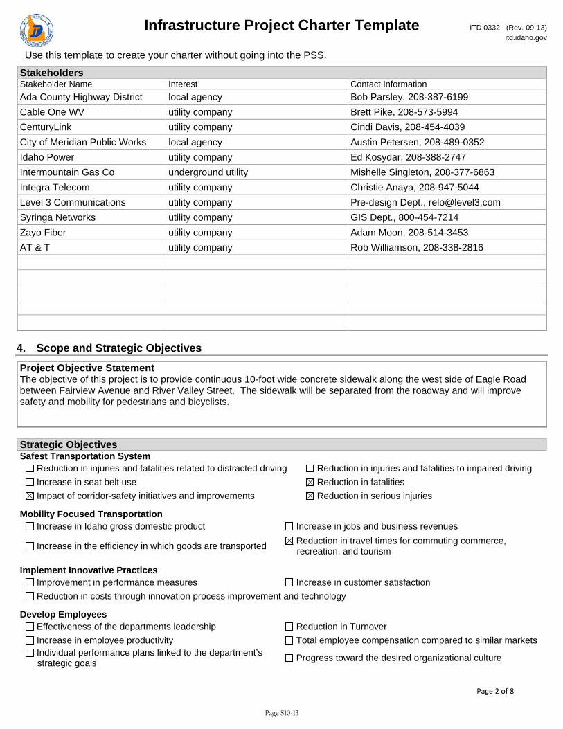
Infrastructure Project Charter Template ITD 0332 (Rev. 09-13) itd.idaho.gov
Use this template to create your charter without going into the PSS.
Page 2 of 8
Stakeholders Stakeholder Name Interest Contact Information Ada County Highway District local agency Bob Parsley, 208-387-6199 Cable One WV utility company Brett Pike, 208-573-5994 CenturyLink utility company Cindi Davis, 208-454-4039 City of Meridian Public Works local agency Austin Petersen, 208-489-0352 Idaho Power utility company Ed Kosydar, 208-388-2747 Intermountain Gas Co underground utility Mishelle Singleton, 208-377-6863 Integra Telecom utility company Christie Anaya, 208-947-5044 Level 3 Communications utility company Pre-design Dept., [email protected] Syringa Networks utility company GIS Dept., 800-454-7214 Zayo Fiber utility company Adam Moon, 208-514-3453 AT & T utility company Rob Williamson, 208-338-2816
4. Scope and Strategic Objectives
Project Objective Statement The objective of this project is to provide continuous 10-foot wide concrete sidewalk along the west side of Eagle Road between Fairview Avenue and River Valley Street. The sidewalk will be separated from the roadway and will improve safety and mobility for pedestrians and bicyclists.
Strategic Objectives Safest Transportation System
Reduction in injuries and fatalities related to distracted driving Reduction in injuries and fatalities to impaired driving Increase in seat belt use Reduction in fatalities Impact of corridor-safety initiatives and improvements Reduction in serious injuries
Mobility Focused Transportation Increase in Idaho gross domestic product Increase in jobs and business revenues
Increase in the efficiency in which goods are transported Reduction in travel times for commuting commerce, recreation, and tourism
Implement Innovative Practices Improvement in performance measures Increase in customer satisfaction Reduction in costs through innovation process improvement and technology
Develop Employees Effectiveness of the departments leadership Reduction in Turnover Increase in employee productivity Total employee compensation compared to similar markets Individual performance plans linked to the department’s strategic goals Progress toward the desired organizational culture
Page S10-13
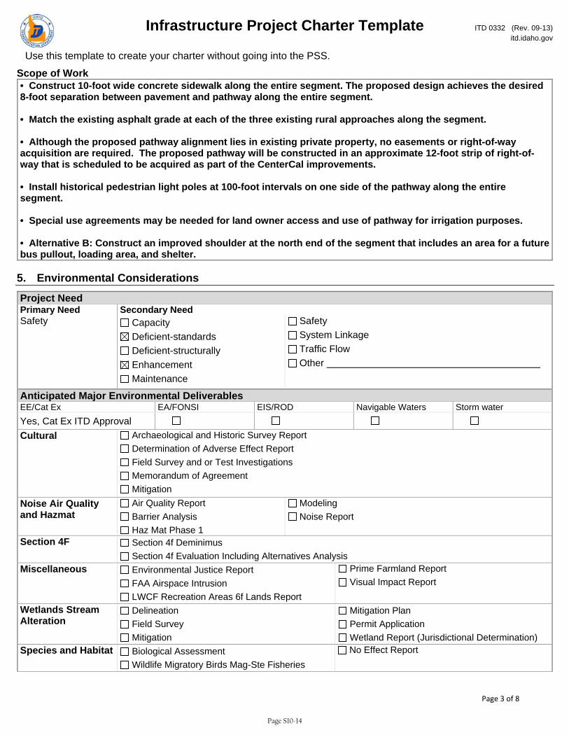
Infrastructure Project Charter Template ITD 0332 (Rev. 09-13) itd.idaho.gov
Use this template to create your charter without going into the PSS.
Page 3 of 8
Scope of Work • Construct 10-foot wide concrete sidewalk along the entire segment. The proposed design achieves the desired 8-foot separation between pavement and pathway along the entire segment. • Match the existing asphalt grade at each of the three existing rural approaches along the segment. • Although the proposed pathway alignment lies in existing private property, no easements or right-of-way acquisition are required. The proposed pathway will be constructed in an approximate 12-foot strip of right-of-way that is scheduled to be acquired as part of the CenterCal improvements. • Install historical pedestrian light poles at 100-foot intervals on one side of the pathway along the entire segment. • Special use agreements may be needed for land owner access and use of pathway for irrigation purposes. • Alternative B: Construct an improved shoulder at the north end of the segment that includes an area for a future bus pullout, loading area, and shelter.
5. Environmental Considerations
Project Need Primary Need Secondary Need Safety Capacity
Deficient-standards Deficient-structurally Enhancement Maintenance
Safety System Linkage Traffic Flow Other
Anticipated Major Environmental DeliverablesEE/Cat Ex EA/FONSI EIS/ROD Navigable Waters Storm water Yes, Cat Ex ITD Approval
Cultural Archaeological and Historic Survey Report Determination of Adverse Effect Report Field Survey and or Test Investigations Memorandum of Agreement Mitigation
Noise Air Quality and Hazmat
Air Quality Report Barrier Analysis Haz Mat Phase 1
Modeling Noise Report
Section 4F Section 4f Deminimus Section 4f Evaluation Including Alternatives Analysis
Miscellaneous Environmental Justice Report FAA Airspace Intrusion LWCF Recreation Areas 6f Lands Report
Prime Farmland Report Visual Impact Report
Wetlands Stream Alteration
Delineation Field Survey Mitigation
Mitigation Plan Permit Application Wetland Report (Jurisdictional Determination)
Species and Habitat Biological Assessment Wildlife Migratory Birds Mag-Ste Fisheries
No Effect Report
Page S10-14
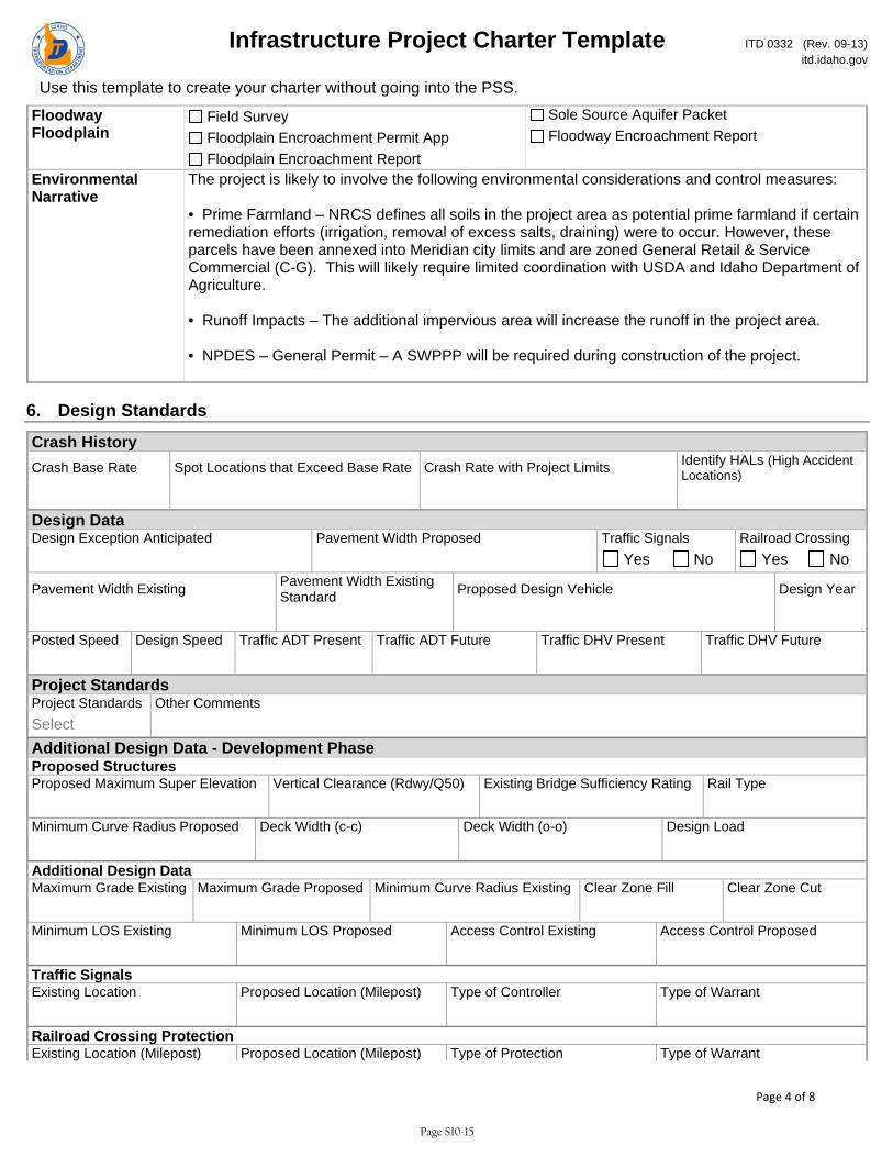
Infrastructure Project Charter Template ITD 0332 (Rev. 09-13) itd.idaho.gov
Use this template to create your charter without going into the PSS.
Page 4 of 8
Floodway Floodplain
Field Survey Floodplain Encroachment Permit App Floodplain Encroachment Report
Sole Source Aquifer Packet Floodway Encroachment Report
Environmental Narrative
The project is likely to involve the following environmental considerations and control measures: • Prime Farmland – NRCS defines all soils in the project area as potential prime farmland if certain remediation efforts (irrigation, removal of excess salts, draining) were to occur. However, these parcels have been annexed into Meridian city limits and are zoned General Retail & Service Commercial (C-G). This will likely require limited coordination with USDA and Idaho Department of Agriculture. • Runoff Impacts – The additional impervious area will increase the runoff in the project area. • NPDES – General Permit – A SWPPP will be required during construction of the project.
6. Design Standards
Crash History Crash Base Rate Spot Locations that Exceed Base Rate Crash Rate with Project Limits Identify HALs (High Accident
Locations) Design Data Design Exception Anticipated Pavement Width Proposed Traffic Signals Railroad Crossing Yes No Yes No
Pavement Width Existing Pavement Width Existing Standard Proposed Design Vehicle Design Year
Posted Speed Design Speed Traffic ADT Present Traffic ADT Future Traffic DHV Present Traffic DHV Future Project Standards Project Standards Other Comments Select Additional Design Data - Development Phase Proposed Structures Proposed Maximum Super Elevation Vertical Clearance (Rdwy/Q50) Existing Bridge Sufficiency Rating Rail Type Minimum Curve Radius Proposed Deck Width (c-c) Deck Width (o-o) Design Load Additional Design Data Maximum Grade Existing Maximum Grade Proposed Minimum Curve Radius Existing Clear Zone Fill Clear Zone Cut Minimum LOS Existing Minimum LOS Proposed Access Control Existing Access Control Proposed Traffic Signals Existing Location Proposed Location (Milepost) Type of Controller Type of Warrant Railroad Crossing Protection Existing Location (Milepost) Proposed Location (Milepost) Type of Protection Type of Warrant
Page S10-15

Infrastructure Project Charter Template ITD 0332 (Rev. 09-13) itd.idaho.gov
Use this template to create your charter without going into the PSS.
Page 5 of 8
Design Standards - Development Phase Project Oversight Design Exception District Engineer Approval DateSelect Select Design Exception FHWA Approval Date if on NHS Design Exception Committee Date if Applicable Select Select
7. Funding and Cost Summary
Phase Fiscal Year Amount Select Select Select Select Select Select Select
8. Resource Plan and Constraints
Project Constraints Scope Constraint Schedule Constraint Budget Constraint Choose an item. Choose an item. Choose an item. Project Constraints Narrative
Resource Plan Project Design Services Choose an item. Narrative
9. True Minimum Milestones
Task WBS Task Name Actual Start Actual Finish Baseline Start Baseline Finish 3.20.Z20 CHARTER APPROVAL Select Select Select Select 3.30.Z30 DESIGN APPROVAL Select Select Select Select 3.30.Z34 PRELIMINARY DESIGN REVIEW Select Select Select Select 3.30.Z36 ENVIRONMENTAL DOCUMENT APPROVAL Select Select Select Select 3.30.Z38 HEARING COMPLETE Select Select Select Select 3.40.Z41 SITUATION & LAYOUT APPROVAL Select Select Select Select 3.40.Z42 INITIATE R/W PURCHASE PROCESS Select Select Select Select
Page S10-16

Infrastructure Project Charter Template ITD 0332 (Rev. 09-13) itd.idaho.gov
Use this template to create your charter without going into the PSS.
Page 6 of 8
Task WBS Task Name Actual Start Actual Finish Baseline Start Baseline Finish 3.40.Z43 R/W CERTIFIABLE Select Select Select Select 3.40.Z48 AGREEMENTS COMPLETE Select Select Select Select 3.40.Z49 FINAL DESIGN REVIEW Select Select Select Select 3.50.Z50 PS & E SUBMITTAL Select Select Select Select 3.60.Z55 PROJECT AWARD Select Select Select Select 4.10.Z75 CONTRACT COMPLETION DATE Select Select Select Select 4.10.Z80 PROJECT CLOSEOUT COMPLETE Select Select Select Select 4.20.Z60 CONSTRUCTION START Select Select Select Select 4.20.Z70 CONSTRUCTION COMPLETION Select Select Select Select
10. Alternatives Analysis Title Location Description
11. Design Exceptions Title NHS District Engineer District Engineer Approval District Engineer Approval Date Select Committee Approval Date FHWA Name FHWA Approval FHWA Approval Date Select Select
12. Change Requests Title Request Date Request No. Request Description Select Reason for Change Impact to Schedule, Scope, Budget Impact to Resources, Risks, Quality Request Results Select Request Comments Title Request Date Request No. Request Description Select Reason for Change Impact to Schedule, Scope, Budget Impact to Resources, Risks, Quality Request Results Select Request Comments Title Request Date Request No. Request Description Select Reason for Change Impact to Schedule, Scope, Budget Impact to Resources, Risks, Quality Request Results
Page S10-17

Infrastructure Project Charter Template ITD 0332 (Rev. 09-13) itd.idaho.gov
Use this template to create your charter without going into the PSS.
Page 7 of 8
Select Request Comments Title Request Date Request No. Request Description Select Reason for Change Impact to Schedule, Scope, Budget Impact to Resources, Risks, Quality Request Results Select Request Comments Title Request Date Request No. Request Description Select Reason for Change Impact to Schedule, Scope, Budget Impact to Resources, Risks, Quality Request Results Select Request Comments
13. Lessons Learned Title Project Type Project Phase Select Select What Worked Well What Could Be Done Differently Action Plan Title Project Type Project Phase Select Select What Worked Well What Could Be Done Differently Action Plan Title Project Type Project Phase Select Select What Worked Well What Could Be Done Differently Action Plan Title Project Type Project Phase Select Select What Worked Well What Could Be Done Differently Action Plan Title Project Type Project Phase Select Select What Worked Well What Could Be Done Differently Action Plan Title Project Type Project Phase Select Select What Worked Well What Could Be Done Differently
Page S10-18

Infrastructure Project Charter Template ITD 0332 (Rev. 09-13) itd.idaho.gov
Use this template to create your charter without going into the PSS.
Page 8 of 8
Action Plan
14. Issues Title Owner Assigned To Status Priority Due Date Select Select Select Discussion Resolution Title Owner Assigned To Status Priority Due Date Select Select Select Discussion Resolution Title Owner Assigned To Status Priority Due Date Select Select Select Discussion Resolution
15. Risks Title Owner Assigned To Status Exposure Due Date Select Select Description Mitigation Plan Title Owner Assigned To Status Exposure Due Date Select Select Description Mitigation Plan Title Owner Assigned To Status Exposure Due Date Select Select Description Mitigation Plan
Page S10-19
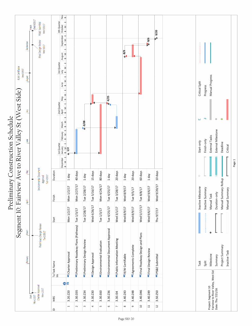
IDWBS
Task
Mode
Task Name
Start
Finish
Duration
13
.20
.Z2
0C
ha
rte
r A
pp
rov
al
Mo
n 1
/2/1
7M
on
1/2
/17
1 d
ay
23
.30
.D3
5P
reli
min
ary
Ro
ad
wa
y P
lan
s (P
ath
wa
y)T
ue
1/3
/17
Mo
n 2
/27
/17
40
da
ys
33
.30
.Z3
4P
reli
min
ary
De
sig
n R
evi
ew
Tu
e 2
/28
/17
Tu
e 2
/28
/17
1 d
ay
43
.30
.Z3
0D
esi
gn
Ap
pro
va
lW
ed
4/2
6/1
7T
ue
5/1
6/1
71
5 d
ay
s
53
.30
.E6
0E
nv
iro
nm
en
tal
Ev
alu
ati
on
Tu
e 1
/3/1
7M
on
4/2
4/1
78
0 d
ay
s
63
.30
.Z3
6E
nv
iro
nm
en
tal
Do
cum
en
t A
pp
rov
al
Tu
e 4
/25
/17
Tu
e 4
/25
/17
1 d
ay
73
.30
.I3
4P
ub
lic
Info
rma
tio
n M
ee
tin
gW
ed
3/1
/17
Tu
e 3
/28
/17
20
da
ys
83
.40
.Z4
3R
/W C
ert
ifia
ble
We
d 8
/9/1
7W
ed
8/9
/17
1 d
ay
93
.40
.Z4
8A
gre
em
en
ts C
om
ple
teW
ed
8/9
/17
Tu
e 9
/5/1
72
0 d
ay
s
10
3.4
0.D
46
Fin
al
Ro
ad
wa
y D
esi
gn
an
d P
lan
sW
ed
5/1
7/1
7T
ue
8/8
/17
60
da
ys
11
3.4
0.Z
49
Fin
al
De
sig
n R
ev
iew
We
d 9
/6/1
7W
ed
9/6
/17
1 d
ay
12
3.5
0.Z
50
PS&
E S
ub
mit
tal
Th
u 9
/7/1
7W
ed
9/2
0/1
71
0 d
ay
s
1/2
2/28
4/25
8/9
9/6
9/20
BM
EB
ME
BM
EB
ME
BM
EB
ME
BM
EB
ME
BM
EB
ME
BM
EB
December
January
Feb
ruary
March
April
May
June
July
August
September
October
November
1st Quarter
2nd Quarter
3rd Quarter
4th Quarter
Task
Split
Milestone
Summary
Project Summary
Inactive Task
Inactive M
ilestone
Inactive Summary
Manual Task
Duration-only
Manual Summary Rollup
Manual Summary
Start-only
Finish-only
External Tasks
External Milestone
Deadline
Critical
Critical Split
Progress
Manual Progress
Pa
ge
1
Pro
ject
: S
eg
me
nt
10
Fa
irvi
ew
to
Riv
er
Va
lle
y,
We
st S
id
Da
te:
Th
u 7
/21
/16
Prel
imin
ary
Con
stru
ctio
n Sc
hedu
le
Segm
ent
10: F
airv
iew
Ave
to
Riv
er V
alle
y St
(W
est
Side
)
Page S10-20
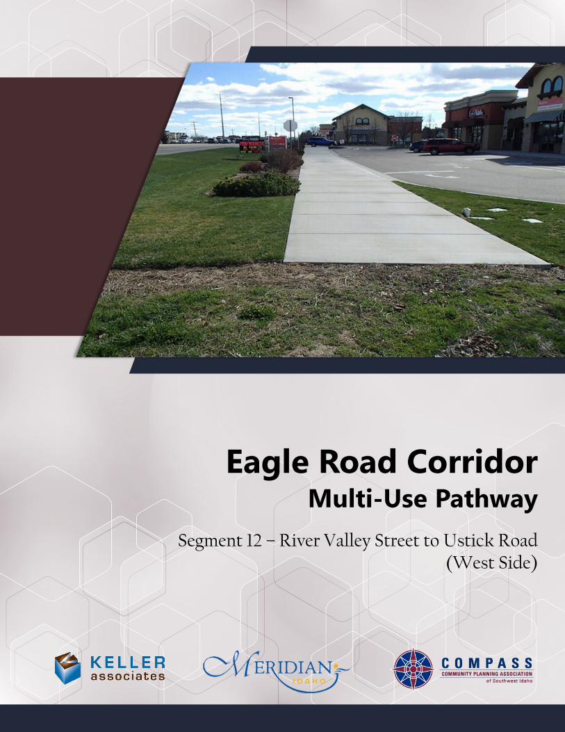
Segment 12 – River Valley Street to Ustick Road(West Side)
Eagle Road CorridorMulti-Use Pathway

Eagle Road Corridor Segment 12 – River Valley to Ustick (West Side)
Table of Contents
Page Executive Summary Sheet ............................................................................................................................. S12-1
Scope of Work and Environmental Considerations ............................................................................. S12-2
Site Photos ........................................................................................................................................................ S12-4
Concept Plan View Figure ........................................................................................................................... S12-8
Planning-Level Cost Estimates ................................................................................................................... S12-9
ITD-1150 Project Cost Summary ................................................................................................................ S12-11
ITD-2839 Right of Way Cost Estimate ................................................................................................... S12-12
ITD-0332 Project Charter ............................................................................................................................ S12-13
Preliminary Project Schedule (True Minimum Milestones) ............................................................. S12-21
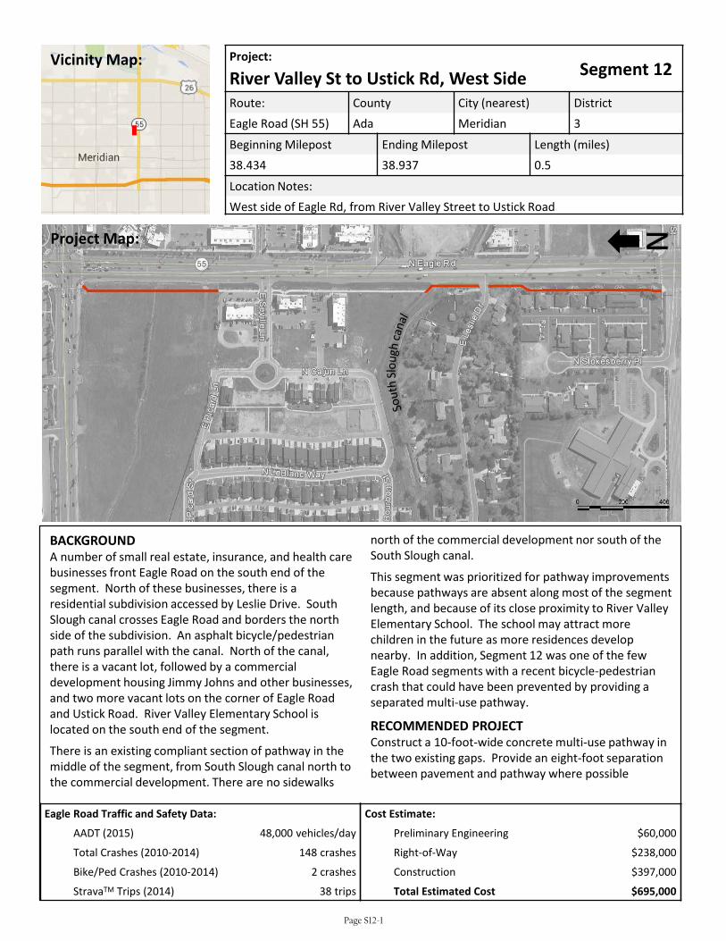
Eagle Road Traffic and Safety Data:
AADT (2015) 48,000 vehicles/day
Total Crashes (2010-2014) 148 crashes
Bike/Ped Crashes (2010-2014) 2 crashes
StravaTM Trips (2014) 38 trips
Project:Segment 12River Valley St to Ustick Rd, West Side
Route: County City (nearest) DistrictEagle Road (SH 55) Ada Meridian 3
Beginning Milepost Ending Milepost Length (miles)38.434 38.937 0.5
Location Notes:West side of Eagle Rd, from River Valley Street to Ustick Road
BACKGROUNDA number of small real estate, insurance, and health care businesses front Eagle Road on the south end of the segment. North of these businesses, there is a residential subdivision accessed by Leslie Drive. South Slough canal crosses Eagle Road and borders the north side of the subdivision. An asphalt bicycle/pedestrian path runs parallel with the canal. North of the canal, there is a vacant lot, followed by a commercial development housing Jimmy Johns and other businesses, and two more vacant lots on the corner of Eagle Road and Ustick Road. River Valley Elementary School is located on the south end of the segment.
There is an existing compliant section of pathway in the middle of the segment, from South Slough canal north to the commercial development. There are no sidewalks
north of the commercial development nor south of the South Slough canal.
This segment was prioritized for pathway improvements because pathways are absent along most of the segment length, and because of its close proximity to River Valley Elementary School. The school may attract more children in the future as more residences develop nearby. In addition, Segment 12 was one of the few Eagle Road segments with a recent bicycle-pedestrian crash that could have been prevented by providing a separated multi-use pathway.
RECOMMENDED PROJECTConstruct a 10-foot-wide concrete multi-use pathway in the two existing gaps. Provide an eight-foot separation between pavement and pathway where possible
NProject Map:
Vicinity Map:
Cost Estimate:
Preliminary Engineering $60,000
Right-of-Way $238,000
Construction $397,000
Total Estimated Cost $695,000
Page S12-1
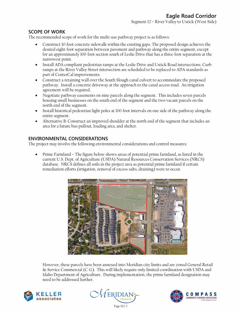
Eagle Road Corridor Segment 12 – River Valley to Ustick (West Side)
SCOPE OF WORK The recommended scope of work for the multi-use pathway project is as follows:
• Construct 10-foot concrete sidewalk within the existing gaps. The proposed design achieves the desired eight-foot separation between pavement and pathway along the entire segment, except for an approximately 100-foot section south of Leslie Drive that has a three-foot separation at the narrowest point.
• Install ADA compliant pedestrian ramps at the Leslie Drive and Ustick Road intersections. Curb ramps at the River Valley Street intersection are scheduled to be replaced to ADA standards as part of CenterCal improvements.
• Construct a retaining wall over the South Slough canal culvert to accommodate the proposed pathway. Install a concrete driveway at the approach to the canal access road. An irrigation agreement will be required.
• Negotiate pathway easements on nine parcels along the segment. This includes seven parcels housing small businesses on the south end of the segment and the two vacant parcels on the north end of the segment.
• Install historical pedestrian light poles at 100-foot intervals on one side of the pathway along the entire segment.
• Alternative B: Construct an improved shoulder at the north end of the segment that includes an area for a future bus pullout, loading area, and shelter.
ENVIRONMENTAL CONSIDERATIONS The project may involve the following environmental considerations and control measures:
• Prime Farmland – The figure below shows areas of potential prime farmland, as listed in the current U.S. Dept. of Agriculture (USDA) Natural Resources Conservation Services (NRCS) database. NRCS defines all soils in the project area as potential prime farmland if certain remediation efforts (irrigation, removal of excess salts, draining) were to occur.
However, these parcels have been annexed into Meridian city limits and are zoned General Retail & Service Commercial (C-G). This will likely require only limited coordination with USDA and Idaho Department of Agriculture. During implementation, the prime farmland designation may need to be addressed further.
Page S12-2
Eagle Road Corridor Segment 12 – River Valley to Ustick (West Side)
• Stream and Wetland Encroachment – There are two canal crossings within Segment 12. Neither
appear to have wetland plant species at the crossing locations. Coordination with the canal company will be required.
• Runoff Impacts – The additional impervious area will increase the runoff in the project area.
• NPDES – General Permit – A SWPPP will be required during construction of the project.
• Sediment – Erosion Control Plan – This will be required during construction of the project.
The following databases were used to research environmental effects of the project:
• NEPAssist Tool (https://www.epa.gov/nepa/nepassist)
• EJSCREEN Tool (https://www.epa.gov/ejscreen)
• Web Soil Survey (http://websoilsurvey.sc.egov.usda.gov/App/HomePage.htm)
• Idaho DEQ Underground Storage Tank Database (http://www2.deq.idaho.gov/waste/ustlust/)
• Idaho Governor’s Office Species Conservation (https://species.idaho.gov/thr_endgr.html)
Page S12-3
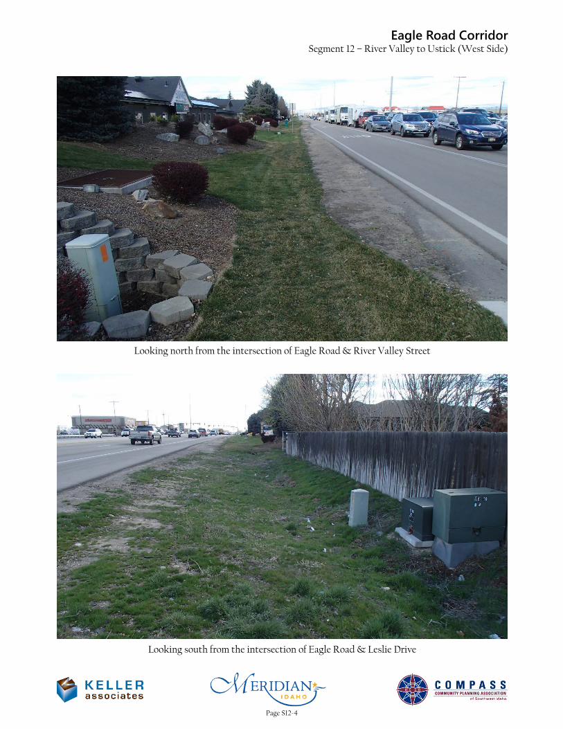
Eagle Road CorridorSegment 12 – River Valley to Ustick (West Side)
Looking north from the intersection of Eagle Road & River Valley Street
Looking south from the intersection of Eagle Road & Leslie Drive
Page S12-4
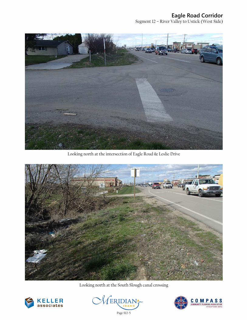
Eagle Road CorridorSegment 12 – River Valley to Ustick (West Side)
Looking north at the intersection of Eagle Road & Leslie Drive
Looking north at the South Slough canal crossing
Page S12-5
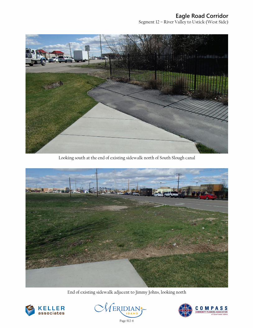
Eagle Road CorridorSegment 12 – River Valley to Ustick (West Side)
Looking south at the end of existing sidewalk north of South Slough canal
End of existing sidewalk adjacent to Jimmy Johns, looking north
Page S12-6
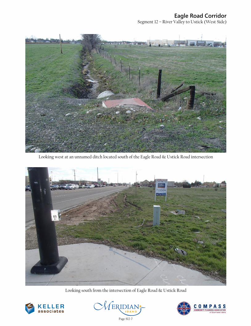
Eagle Road CorridorSegment 12 – River Valley to Ustick (West Side)
Looking west at an unnamed ditch located south of the Eagle Road & Ustick Road intersection
Looking south from the intersection of Eagle Road & Ustick Road
Page S12-7
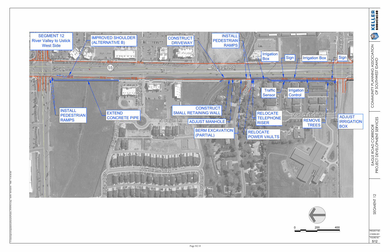
R/W
R/W
R/W
R/WR/W
R/W
R/W
R/W
C:\U
sers\agrover\appdata\local\tem
p\A
cP
ublish_7572\F
IG
4.dw
g D
AT
E: 09/15/2016 T
IM
E: 11:44:39 A
M
215056-001
S12
FIGURE NO.
PROJECT NO.
CONSTRUCT
DRIVEWAY
CONSTRUCT
SMALL RETAINING WALL
RELOCATE
TELEPHONE
RISER
BERM EXCAVATION
(PARTIAL)
Traffic
Sensor
Irrigation
Control
0 200 400
SEG
MEN
T 12
EAG
LE R
OA
D C
ORR
IDO
RPR
OJE
CT
DEV
ELO
PMEN
T SE
RVIC
ESC
OM
MUN
ITY P
LAN
NIN
G A
SSO
CIA
TION
OF
SOUT
HWES
T ID
AHO
SEGMENT 12
River Valley to Ustick
West Side
INSTALL
PEDESTRIAN
RAMPS
EXTEND
CONCRETE PIPE
ADJUST MANHOLE
ADJUST
IRRIGATION
BOX
Sign
REMOVE
TREES
Irrigation BoxSign
Irrigation
Box
RELOCATE
POWER VAULTS
IMPROVED SHOULDER
(ALTERNATIVE B)
INSTALL
PEDESTRIAN
RAMPS
Page S12-8

Opinion of Probable Cost (Major Items)Item Description Unit Approx. Quantity Unit Price Bid Price
Extend 42" Concrete Pipe FT 20 150.00$ $3,000Adjust Irrigation Box EACH 1 3,000.00$ $3,000Removal of Trees EACH 18 500.00$ $9,000Excavation CY 50 25.00$ $1,2503/4" Aggregate Type B for Base TON 560 30.00$ $16,800Concrete Sidewalk SY 1,800 40.00$ $72,000Pedestrian Ramps EACH 4 1,500.00$ $6,000Driveway SY 40 50.00$ $2,000Retaining Wall SF 80 50.00$ $4,000Pathway Illumination LS 1 150,000.00$ $150,000Survey LS 1 4,000.00$ $4,000
$272,000
Mobilization % 10% 27,200$ $27,200Contingency % 15% 44,880$ $44,880Construction Engineering & Inspection % 15% 51,612$ $51,612
$396,000
Design % 15% 59,400$ $59,400Right-of-Way LS 1 237,503$ $237,503
$693,000
SUBTOTAL (Rounded up to the nearest $1,000)
Segment 12River Valley Street to Ustick Road
West Side of Eagle Road
PRE-DESIGN
September 2, 2016
Alternative A: Without Improved Shoulder
TOTAL (Rounded up to the nearest $1,000)
CONSTRUCTION SUBTOTAL (Rounded up to the nearest $1,000)
Page S12-9
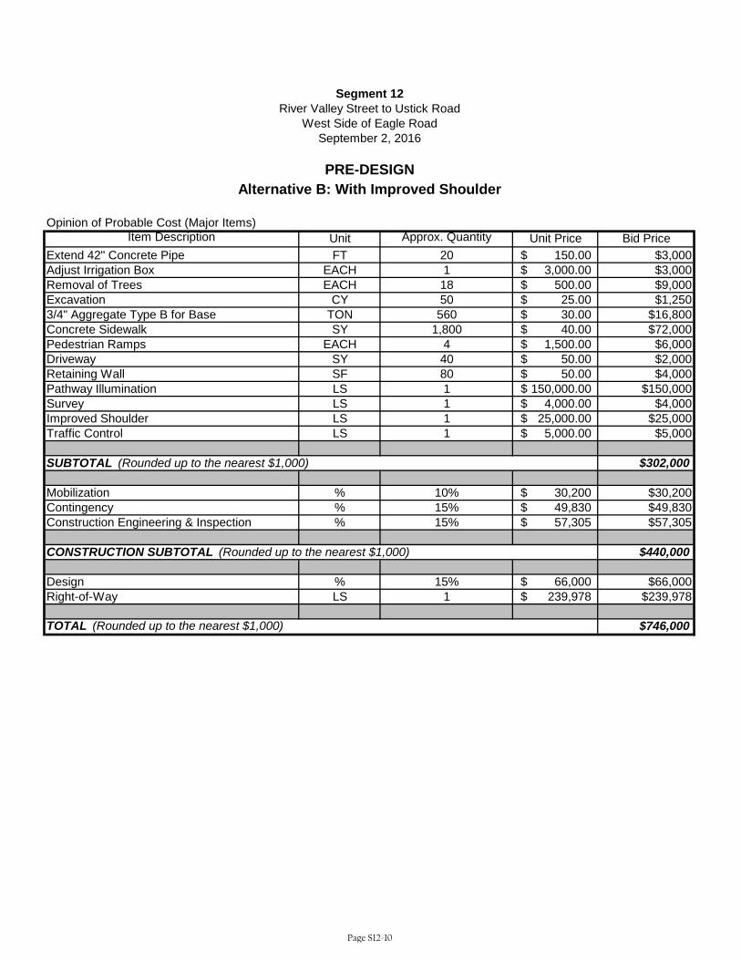
Opinion of Probable Cost (Major Items)Item Description Unit Approx. Quantity Unit Price Bid Price
Extend 42" Concrete Pipe FT 20 150.00$ $3,000Adjust Irrigation Box EACH 1 3,000.00$ $3,000Removal of Trees EACH 18 500.00$ $9,000Excavation CY 50 25.00$ $1,2503/4" Aggregate Type B for Base TON 560 30.00$ $16,800Concrete Sidewalk SY 1,800 40.00$ $72,000Pedestrian Ramps EACH 4 1,500.00$ $6,000Driveway SY 40 50.00$ $2,000Retaining Wall SF 80 50.00$ $4,000Pathway Illumination LS 1 150,000.00$ $150,000Survey LS 1 4,000.00$ $4,000Improved Shoulder LS 1 25,000.00$ $25,000Traffic Control LS 1 5,000.00$ $5,000
$302,000
Mobilization % 10% 30,200$ $30,200Contingency % 15% 49,830$ $49,830Construction Engineering & Inspection % 15% 57,305$ $57,305
$440,000
Design % 15% 66,000$ $66,000Right-of-Way LS 1 239,978$ $239,978
$746,000
SUBTOTAL (Rounded up to the nearest $1,000)
Segment 12River Valley Street to Ustick Road
West Side of Eagle Road
PRE-DESIGN
September 2, 2016
Alternative B: With Improved Shoulder
TOTAL (Rounded up to the nearest $1,000)
CONSTRUCTION SUBTOTAL (Rounded up to the nearest $1,000)
Page S12-10

Round Estimates to Nearest $1,000
2. Right-of-Way:
3. Utility Adjustments: Work Materials By State By Others
No
New Structure
Repair/Widening/Rehabilitation
18. Total Construction Cost (15 + 16 + 17)
19. Total Project Cost ( 1 + 2 + 18)
20. Project Cost Per Mile
Length/Width
itd.idaho.gov
17. Construction Engineer and Contingencies
Yes
6. Pavement and Base
5. Drainage and Minor Structures $7,000
1b. Preliminary Engineering by Consultant (PEC) $60,000
9 Number of RelocationsNumber of Parcels
1a. Preliminary Engineering (PE)
Length in Miles
0.5
$238,000
Prepared By:
Location
Length/Width
16. Mobilization 10
$695,000FALSE
10. Construction Traffic Control (Sign, Pavement Markings, Flagging, and Traffic Separation)
14. Other Items (Roadside Development, Guardrail, Fencing, Sidewalks, Curb and Gutter, C.S.S. Items)
FALSE
$1,390,000
$272,00015. Cost of Constructions (Items 3 through 14)
11. Detours
12. Landscaping
District
Date
7/25/2016
Initial or Revise To
D3
Location
River Valley St to Ustick Rd, West Side
Key Number
Segment 12
Project Number
Project Cost Summary Sheet ITD 1150 (Rev. 09-13)
38.937
Segment Code
2005
Begin Mile Post End Mile Post
38.434
Previous ITD 1150
4. Earthwork
$3,000
$11,000
$234,000
7. Railroad Crossing:
Grade/Separation Structure none
Location
$17,000
8. Bridges/Grade Separation Structures:
At-Grade Signals
9. Traffic Items (Delineators, Signing, Channelization, Lighting, and Signals)
13. Mitigation Measures
% of Item 15
% of Items 15 and 1632.5
$397,000
$28,000
$97,000
Page S12-11

ITD-2839 27-228070-2 Right of Way Cost Estimate Sheet 1 of 1
Date: September 15, 2016 Key No: Project No: Segment 12Project Name: River Valley St to Ustick Rd, West Side
No. of parcels requiring acquisitions: 9 Number of parcels requiring relocations: 0
New Alignment: 0.50 miles Basic R/W Width: 140.00 ft.
Existing Alignment: 0.50 miles Additional R/W Width: 12.00 ft.
DIRECT ACQUISITION COSTS:A. Land only
Agriculture Irrigated 0.00 acres @ $0 /acre = $0Dry 0.00 acres @ $0 /acre = $0n/a 0.00 acres @ $0 /acre = $0
Graze Irrigated 0.00 acres @ $0 /acre = $0Dry 0.00 acres @ $0 /acre = $0
0.00 acres @ $0 /acre = $0Timber Income Producing 0.00 acres @ $0 /acre = $0
Harvestable 0.00 acres @ $0 /acre = $0Non-Harvestable 0.00 acres @ $0 /acre = $0
Residential Developed 0.00 acres @ $0 /acre = $0Undeveloped 0.00 acres @ $0 /acre = $0
Commercial\Industrial Developed 0.31 acres @ $335,412 /acre = $104,335Undeveloped 0.00 acres @ $0 /acre = $0
Damages Anticipated = Miscellaneous =
B. Site ImprovementsAgriculture No. of Structures 0 @ $0 (average) = $0Residential No. of Structures 0 @ $0 (average) = $0Commercial\Industrial No. of Structures 0 @ $0 (average) = $0Damages AnticipatedMiscellaneous =
C. RelocationDeveloped AgricultureNo. Expected 0 @ $0 (average) = $0Developed Residential
Single Family No. Expected 0 @ $0 (average) = $0Multi-Family No. Expected 0 @ $0 (average) = $0
Developed Comm\IndNo. Expected 0 @ $0 (average) = $0Miscellaneous =
INDIRECT ACQUISITION COSTS:Appra./Imp.Agri. No. Expected 0 @ $0 (average) = $0Appra./Imp.Resid.
2685 No. Expected 0 @ $0 (average) = $02288 No. Expected 0 @ $0 (average) = $0
B & A No. Expected 0 @ $0 (average) = $0Appra./Imp.Com.-Ind. No. Expected 9 @ $3,000 (average) = $27,000Appraisals/Land No. Expected 0 @ $0 (average) = $0Negotiations No. Expected 9 @ $3,000 (average) = $27,000Demolitions No. Expected 0 @ $0 (average) = $0
Sub-Total $158,335INCIDENTALS:
Estimated as a percentage of overall costs. 50.00 % $79,168(Includes Title Costs, Admin. Settle., Legal Settle., Attorney & Court Costs, Property Mngmnt. & Misc.)
Total Estimated Project R/W Costs: $237,503Proposed R/W Plans Approval Date Projected R/W Expenditure Years Contruction Year(s)
Estimtd. By: Title: Date:
Page S12-12
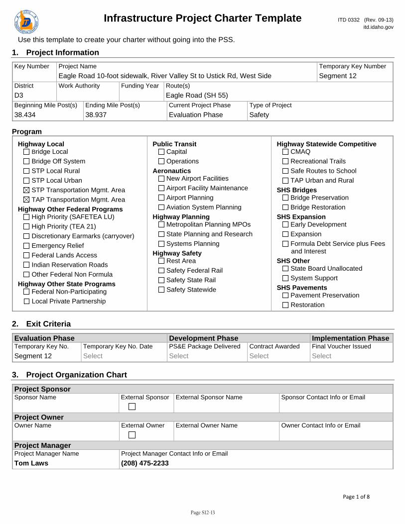
Infrastructure Project Charter Template ITD 0332 (Rev. 09-13) itd.idaho.gov
Use this template to create your charter without going into the PSS.
Page 1 of 8
1. Project Information Key Number Project Name Temporary Key Number Eagle Road 10-foot sidewalk, River Valley St to Ustick Rd, West Side Segment 12 District Work Authority Funding Year Route(s) D3 Eagle Road (SH 55) Beginning Mile Post(s) Ending Mile Post(s) Current Project Phase Type of Project 38.434 38.937 Evaluation Phase Safety
Program
Highway Local Bridge Local Bridge Off System STP Local Rural STP Local Urban STP Transportation Mgmt. Area TAP Transportation Mgmt. Area
Highway Other Federal Programs High Priority (SAFETEA LU) High Priority (TEA 21) Discretionary Earmarks (carryover) Emergency Relief Federal Lands Access Indian Reservation Roads Other Federal Non Formula
Highway Other State Programs Federal Non-Participating Local Private Partnership
Public Transit Capital Operations
Aeronautics New Airport Facilities Airport Facility Maintenance Airport Planning Aviation System Planning
Highway Planning Metropolitan Planning MPOs State Planning and Research Systems Planning
Highway Safety Rest Area Safety Federal Rail Safety State Rail Safety Statewide
Highway Statewide Competitive CMAQ Recreational Trails Safe Routes to School TAP Urban and Rural
SHS Bridges Bridge Preservation Bridge Restoration
SHS Expansion Early Development Expansion Formula Debt Service plus Fees and Interest
SHS Other State Board Unallocated System Support
SHS Pavements Pavement Preservation Restoration
2. Exit Criteria
Evaluation Phase Development Phase Implementation PhaseTemporary Key No. Temporary Key No. Date PS&E Package Delivered Contract Awarded Final Voucher Issued Segment 12 Select Select Select Select
3. Project Organization Chart
Project Sponsor Sponsor Name External Sponsor External Sponsor Name Sponsor Contact Info or Email Project Owner Owner Name External Owner External Owner Name Owner Contact Info or Email Project Manager Project Manager Name Project Manager Contact Info or Email Tom Laws (208) 475-2233
Page S12-13

Infrastructure Project Charter Template ITD 0332 (Rev. 09-13) itd.idaho.gov
Use this template to create your charter without going into the PSS.
Page 2 of 8
Stakeholders Stakeholder Name Interest Contact Information Ada County Highway District local agency Bob Parsley, 208-387-6199 Cable One WV utility company Brett Pike, 208-573-5994 CenturyLink utility company Cindi Davis, 208-454-4039 City of Meridian Public Works local agency Austin Petersen, 208-489-0352 Idaho Power utility company Ed Kosydar, 208-388-2747 Intermountain Gas Co underground utility Mishelle Singleton, 208-377-6863 Integra Telecom utility company Christie Anaya, 208-947-5044 Level 3 Communications utility company Pre-design Dept., [email protected] Syringa Networks utility company GIS Dept., 800-454-7214 Zayo Fiber utility company Adam Moon, 208-514-3453 CTC Telecom utility company Tom Wood, 208-257-8228
4. Scope and Strategic Objectives
Project Objective Statement The objective of this project is to provide continuous 10-foot wide concrete sidewalk along the west side of Eagle Road between River Valley Street to Ustick Road. The sidewalk will be separated from the roadway and will improve safety and mobility for pedestrians and bicyclists.
Strategic Objectives Safest Transportation System
Reduction in injuries and fatalities related to distracted driving Reduction in injuries and fatalities to impaired driving Increase in seat belt use Reduction in fatalities Impact of corridor-safety initiatives and improvements Reduction in serious injuries
Mobility Focused Transportation Increase in Idaho gross domestic product Increase in jobs and business revenues
Increase in the efficiency in which goods are transported Reduction in travel times for commuting commerce, recreation, and tourism
Implement Innovative Practices Improvement in performance measures Increase in customer satisfaction Reduction in costs through innovation process improvement and technology
Develop Employees Effectiveness of the departments leadership Reduction in Turnover Increase in employee productivity Total employee compensation compared to similar markets Individual performance plans linked to the department’s strategic goals Progress toward the desired organizational culture
Page S12-14
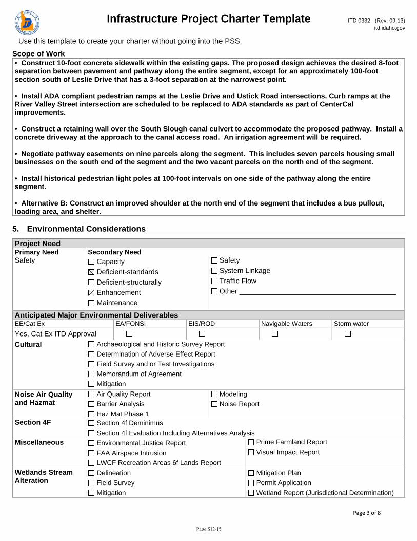
Infrastructure Project Charter Template ITD 0332 (Rev. 09-13) itd.idaho.gov
Use this template to create your charter without going into the PSS.
Page 3 of 8
Scope of Work • Construct 10-foot concrete sidewalk within the existing gaps. The proposed design achieves the desired 8-foot separation between pavement and pathway along the entire segment, except for an approximately 100-foot section south of Leslie Drive that has a 3-foot separation at the narrowest point. • Install ADA compliant pedestrian ramps at the Leslie Drive and Ustick Road intersections. Curb ramps at the River Valley Street intersection are scheduled to be replaced to ADA standards as part of CenterCal improvements. • Construct a retaining wall over the South Slough canal culvert to accommodate the proposed pathway. Install a concrete driveway at the approach to the canal access road. An irrigation agreement will be required. • Negotiate pathway easements on nine parcels along the segment. This includes seven parcels housing small businesses on the south end of the segment and the two vacant parcels on the north end of the segment. • Install historical pedestrian light poles at 100-foot intervals on one side of the pathway along the entire segment. • Alternative B: Construct an improved shoulder at the north end of the segment that includes a bus pullout, loading area, and shelter.
5. Environmental Considerations
Project Need Primary Need Secondary Need Safety Capacity
Deficient-standards Deficient-structurally Enhancement Maintenance
Safety System Linkage Traffic Flow Other
Anticipated Major Environmental Deliverables EE/Cat Ex EA/FONSI EIS/ROD Navigable Waters Storm water Yes, Cat Ex ITD Approval
Cultural Archaeological and Historic Survey Report Determination of Adverse Effect Report Field Survey and or Test Investigations Memorandum of Agreement Mitigation
Noise Air Quality and Hazmat
Air Quality Report Barrier Analysis Haz Mat Phase 1
Modeling Noise Report
Section 4F Section 4f Deminimus Section 4f Evaluation Including Alternatives Analysis
Miscellaneous Environmental Justice Report FAA Airspace Intrusion LWCF Recreation Areas 6f Lands Report
Prime Farmland Report Visual Impact Report
Wetlands Stream Alteration
Delineation Field Survey Mitigation
Mitigation Plan Permit Application Wetland Report (Jurisdictional Determination)
Page S12-15
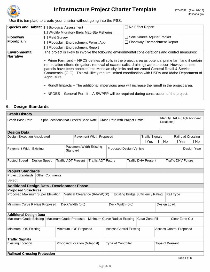
Infrastructure Project Charter Template ITD 0332 (Rev. 09-13) itd.idaho.gov
Use this template to create your charter without going into the PSS.
Page 4 of 8
Species and Habitat Biological Assessment Wildlife Migratory Birds Mag-Ste Fisheries
No Effect Report
Floodway Floodplain
Field Survey Floodplain Encroachment Permit App Floodplain Encroachment Report
Sole Source Aquifer Packet Floodway Encroachment Report
Environmental Narrative
The project is likely to involve the following environmental considerations and control measures: • Prime Farmland – NRCS defines all soils in the project area as potential prime farmland if certain remediation efforts (irrigation, removal of excess salts, draining) were to occur. However, these parcels have been annexed into Meridian city limits and are zoned General Retail & Service Commercial (C-G). This will likely require limited coordination with USDA and Idaho Department of Agriculture. • Runoff Impacts – The additional impervious area will increase the runoff in the project area. • NPDES – General Permit – A SWPPP will be required during construction of the project.
6. Design Standards
Crash History Crash Base Rate Spot Locations that Exceed Base Rate Crash Rate with Project Limits Identify HALs (High Accident
Locations) Design Data Design Exception Anticipated Pavement Width Proposed Traffic Signals Railroad Crossing Yes No Yes No
Pavement Width Existing Pavement Width Existing Standard Proposed Design Vehicle Design Year
Posted Speed Design Speed Traffic ADT Present Traffic ADT Future Traffic DHV Present Traffic DHV Future Project Standards Project Standards Other Comments Select Additional Design Data - Development Phase Proposed Structures Proposed Maximum Super Elevation Vertical Clearance (Rdwy/Q50) Existing Bridge Sufficiency Rating Rail Type Minimum Curve Radius Proposed Deck Width (c-c) Deck Width (o-o) Design Load Additional Design Data Maximum Grade Existing Maximum Grade Proposed Minimum Curve Radius Existing Clear Zone Fill Clear Zone Cut Minimum LOS Existing Minimum LOS Proposed Access Control Existing Access Control Proposed Traffic Signals Existing Location Proposed Location (Milepost) Type of Controller Type of Warrant Railroad Crossing Protection
Page S12-16

Infrastructure Project Charter Template ITD 0332 (Rev. 09-13) itd.idaho.gov
Use this template to create your charter without going into the PSS.
Page 5 of 8
Existing Location (Milepost) Proposed Location (Milepost) Type of Protection Type of Warrant
Design Standards - Development Phase Project Oversight Design Exception District Engineer Approval DateSelect Select Design Exception FHWA Approval Date if on NHS Design Exception Committee Date if Applicable Select Select
7. Funding and Cost Summary
Phase Fiscal Year Amount Select Select Select Select Select Select Select
8. Resource Plan and Constraints
Project Constraints Scope Constraint Schedule Constraint Budget Constraint Choose an item. Choose an item. Choose an item. Project Constraints Narrative
Resource Plan Project Design Services Choose an item. Narrative
9. True Minimum Milestones
Task WBS Task Name Actual Start Actual Finish Baseline Start Baseline Finish 3.20.Z20 CHARTER APPROVAL Select Select Select Select 3.30.Z30 DESIGN APPROVAL Select Select Select Select 3.30.Z34 PRELIMINARY DESIGN REVIEW Select Select Select Select 3.30.Z36 ENVIRONMENTAL DOCUMENT APPROVAL Select Select Select Select 3.30.Z38 HEARING COMPLETE Select Select Select Select 3.40.Z41 SITUATION & LAYOUT APPROVAL Select Select Select Select 3.40.Z42 INITIATE R/W PURCHASE PROCESS Select Select Select Select
Page S12-17
Infrastructure Project Charter Template ITD 0332 (Rev. 09-13) itd.idaho.gov
Use this template to create your charter without going into the PSS.
Page 6 of 8
Task WBS Task Name Actual Start Actual Finish Baseline Start Baseline Finish 3.40.Z43 R/W CERTIFIABLE Select Select Select Select 3.40.Z48 AGREEMENTS COMPLETE Select Select Select Select 3.40.Z49 FINAL DESIGN REVIEW Select Select Select Select 3.50.Z50 PS & E SUBMITTAL Select Select Select Select 3.60.Z55 PROJECT AWARD Select Select Select Select 4.10.Z75 CONTRACT COMPLETION DATE Select Select Select Select 4.10.Z80 PROJECT CLOSEOUT COMPLETE Select Select Select Select 4.20.Z60 CONSTRUCTION START Select Select Select Select 4.20.Z70 CONSTRUCTION COMPLETION Select Select Select Select
10. Alternatives Analysis Title Location Description
11. Design Exceptions Title NHS District Engineer District Engineer Approval District Engineer Approval Date Select Committee Approval Date FHWA Name FHWA Approval FHWA Approval Date Select Select
12. Change Requests Title Request Date Request No. Request Description Select Reason for Change Impact to Schedule, Scope, Budget Impact to Resources, Risks, Quality Request Results Select Request Comments Title Request Date Request No. Request Description Select Reason for Change Impact to Schedule, Scope, Budget Impact to Resources, Risks, Quality Request Results Select Request Comments Title Request Date Request No. Request Description Select Reason for Change Impact to Schedule, Scope, Budget Impact to Resources, Risks, Quality Request Results
Page S12-18
Infrastructure Project Charter Template ITD 0332 (Rev. 09-13) itd.idaho.gov
Use this template to create your charter without going into the PSS.
Page 7 of 8
Select Request Comments Title Request Date Request No. Request Description Select Reason for Change Impact to Schedule, Scope, Budget Impact to Resources, Risks, Quality Request Results Select Request Comments Title Request Date Request No. Request Description Select Reason for Change Impact to Schedule, Scope, Budget Impact to Resources, Risks, Quality Request Results Select Request Comments
13. Lessons Learned Title Project Type Project Phase Select Select What Worked Well What Could Be Done Differently Action Plan Title Project Type Project Phase Select Select What Worked Well What Could Be Done Differently Action Plan Title Project Type Project Phase Select Select What Worked Well What Could Be Done Differently Action Plan Title Project Type Project Phase Select Select What Worked Well What Could Be Done Differently Action Plan Title Project Type Project Phase Select Select What Worked Well What Could Be Done Differently Action Plan Title Project Type Project Phase Select Select What Worked Well What Could Be Done Differently
Page S12-19
Infrastructure Project Charter Template ITD 0332 (Rev. 09-13) itd.idaho.gov
Use this template to create your charter without going into the PSS.
Page 8 of 8
Action Plan
14. Issues Title Owner Assigned To Status Priority Due Date Select Select Select Discussion Resolution Title Owner Assigned To Status Priority Due Date Select Select Select Discussion Resolution Title Owner Assigned To Status Priority Due Date Select Select Select Discussion Resolution
15. Risks Title Owner Assigned To Status Exposure Due Date Select Select Description Mitigation Plan Title Owner Assigned To Status Exposure Due Date Select Select Description Mitigation Plan Title Owner Assigned To Status Exposure Due Date Select Select Description Mitigation Plan
Page S12-20
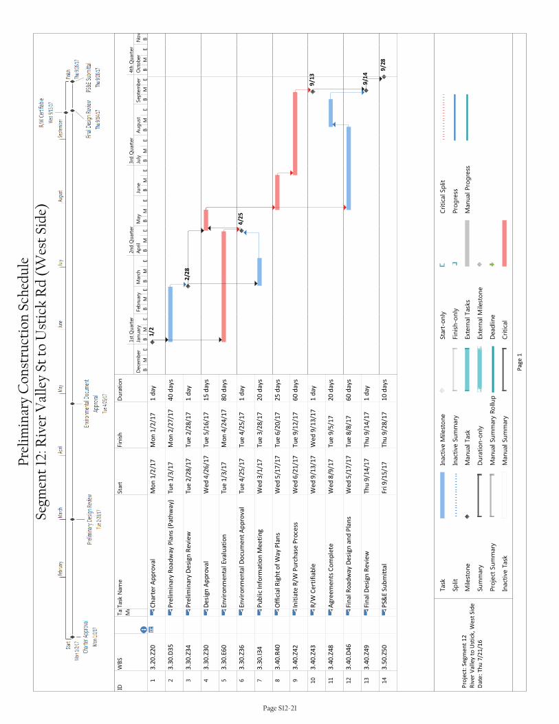
IDWBS
Task
Mode
Task Name
Start
Finish
Duration
13
.20
.Z2
0C
ha
rte
r A
pp
rov
al
Mo
n 1
/2/1
7M
on
1/2
/17
1 d
ay
23
.30
.D3
5P
reli
min
ary
Ro
ad
wa
y P
lan
s (P
ath
wa
y)T
ue
1/3
/17
Mo
n 2
/27
/17
40
da
ys
33
.30
.Z3
4P
reli
min
ary
De
sig
n R
evi
ew
Tu
e 2
/28
/17
Tu
e 2
/28
/17
1 d
ay
43
.30
.Z3
0D
esi
gn
Ap
pro
va
lW
ed
4/2
6/1
7T
ue
5/1
6/1
71
5 d
ay
s
53
.30
.E6
0E
nv
iro
nm
en
tal
Ev
alu
ati
on
Tu
e 1
/3/1
7M
on
4/2
4/1
78
0 d
ay
s
63
.30
.Z3
6E
nv
iro
nm
en
tal
Do
cum
en
t A
pp
rov
al
Tu
e 4
/25
/17
Tu
e 4
/25
/17
1 d
ay
73
.30
.I3
4P
ub
lic
Info
rma
tio
n M
ee
tin
gW
ed
3/1
/17
Tu
e 3
/28
/17
20
da
ys
83
.40
.R4
0O
ffic
ial
Rig
ht
of
Wa
y P
lan
sW
ed
5/1
7/1
7T
ue
6/2
0/1
72
5 d
ay
s
93
.40
.Z4
2In
itia
te R
/W P
urc
ha
se P
roce
ssW
ed
6/2
1/1
7T
ue
9/1
2/1
76
0 d
ay
s
10
3.4
0.Z
43
R/W
Ce
rtif
iab
leW
ed
9/1
3/1
7W
ed
9/1
3/1
71
da
y
11
3.4
0.Z
48
Ag
ree
me
nts
Co
mp
lete
We
d 8
/9/1
7T
ue
9/5
/17
20
da
ys
12
3.4
0.D
46
Fin
al
Ro
ad
wa
y D
esi
gn
an
d P
lan
sW
ed
5/1
7/1
7T
ue
8/8
/17
60
da
ys
13
3.4
0.Z
49
Fin
al
De
sig
n R
ev
iew
Th
u 9
/14
/17
Th
u 9
/14
/17
1 d
ay
14
3.5
0.Z
50
PS&
E S
ub
mit
tal
Fri
9/1
5/1
7T
hu
9/2
8/1
71
0 d
ay
s
1/2
2/28
4/25
9/13
9/14
9/28
BM
EB
ME
BM
EB
ME
BM
EB
ME
BM
EB
ME
BM
EB
ME
BM
EB
December
January
Feb
ruary
March
April
May
June
July
August
September
October
November
1st Quarter
2nd Quarter
3rd Quarter
4th Quarter
Task
Split
Milestone
Summary
Project Summary
Inactive Task
Inactive M
ilestone
Inactive Summary
Manual Task
Duration-only
Manual Summary Rollup
Manual Summary
Start-only
Finish-only
External Tasks
External Milestone
Deadline
Critical
Critical Split
Progress
Manual Progress
Pa
ge
1
Pro
ject
: S
eg
me
nt
12
Riv
er
Va
lle
y t
o U
stic
k,
We
st S
ide
Da
te:
Th
u 7
/21
/16
Prel
imin
ary
Con
stru
ctio
n Sc
hedu
le
Segm
ent
12: R
iver
Val
ley
St t
o U
stic
k R
d (W
est
Side
)
Page S12-21
Eagle Road Corridor
Appendix A Phase 1 Deliverables
TomLawsEagleRoadCorridorPhase1Summary
June29,2016Page2of4
entire length. Also, the signalized intersection of Eagle Road & Bristol Heights Drive/Hobble Creek Drive is not spaced at the half-mile. Dividing the segments at this intersection would have resulted in two short segments that do not warrant separate evaluation due to their similar conditions.
Segments 13 and 14 were later split into four segments (13-M, 13-B, 14-M, and 14-B), each between 0.2 and 0.3 miles long. They were divided along the Boise-Meridian city limits to allow the two municipalities to work on them separately.
Environmental Scan
Keller Associates completed a windshield survey of the Eagle Road corridor for potential environmental problems. Minor notes include several canal crossings, possible underground tanks on a vacant agricultural lot in Segment 6, and possible ground contamination from old cars and equipment on a residential site in Segment 11. No fatal flaws were observed in the environmental scan, and further research will be performed in Phase 2. A summary of the windshield survey is attached to this memo.
Opinions of Probable Construction Cost
Probable construction cost was used as a subjective measure of estimated cost per unit length of improved pathway. Therefore, segments with the shortest length of non-compliant pathway received relatively higher cost ratings due to economies of scale. Costs such as administration, mobilization, and design fees are required for every project regardless of size.
Other factors that increased cost per length included possible right-of-way conflicts/-acquisitions, utility or sign relocations, structures required for canal crossings or grade separations, earthwork, slopes, design complexity, and railroad crossings. A summary of and justification for the opinions of probable cost per segment is attached to this memo.
Evaluation Criteria, Point Ranges, and Weights
Keller Associates established evaluation criteria, point ranges, and weights before populating the evaluation matrix with data. After populating the matrix, an iterative approach of adjusting the criteria/points/weighting and evaluating results was used to optimize the matrix. Keller Associates attempted to balance the number of qualitative and quantitative criteria. Care was taken to avoid representing the same concepts in multiple criteria. The evaluation criteria, point ranges, and weights were reviewed by the City of Meridian, City of Boise, COMPASS, and Idaho Transportation Department prior to their finalization.
The number of points available for each criteria ranged from 0 to 10 and were designed so that a wide range of points would be given to the various segments for any given criteria (as opposed to all the segments getting a similar score in a criterion). This maximizes the strength of each criteria. Point ranges were also designed to be valid for future use of the evaluation matrix.
The development of each criteria is summarized below. The final evaluation matrix, data input, results, and individual segment sheets are attached to this memo. From this matrix, the four highest-ranking segments were selected to proceed into Phase 2 for further examination.
TomLawsEagleRoadCorridorPhase1Summary
June29,2016Page3of4
Stakeholders, the City of Meridian, and the Meridian Transportation Commission reviewed and approved the results prior to Phase 1 conclusion.
Existing Sidewalk Presence/Width/Attachment This criteria evaluates the non-compliant conditions along the segment and is weighted by length. Areas absent of sidewalk were given 10 points, while. Existing but non-compliant pathways were assigned lower scores of one to three points.
Compliant pathways are not included in the calculation; for example, Segment 14-M has 1,600 feet of compliant pathway and a 100-foot gap, and would therefore receive 10 points because the only non-compliant section of pathway is a gap. Compliant pathways were originally included in the calculation but were removed after adding the Percentage of Gaps criteria, in order to avoid redundant criteria.
Percentage of Gaps This criteria was created to emphasize the importance of filling gaps in the pathway system over improving existing pathways. Points are assigned based on the percentage of segment length with gaps.
Ease of Construction This criteria prioritizes straight-forward projects over those with potential of being delayed due to environmental, permitting, utilities, right-of-way, or design complexity; each of the five categories are assigned zero to two points. This measures ease or difficulties that would not have an effect on construction cost.
Potential for Development This criteria was created to reduce the priority of improvements that are likely to be constructed in the near future by a private developer. Points were awarded on an inverse scale compared to other criteria, with 10 representing low potential and zero representing high potential for development.
School Proximity This criteria prioritizes segments near schools to provide safe routes to school and potentially reduce the need for safety busing. Initially, points were assigned to schools based on a distance of up to a mile away from Eagle Road, but the distance was lowered to ½ mile, as that was found to be the furthest distance from any segment to a school property.
Cost per Length This criteria was created to quantify and prioritize the most cost-effective improvements. Opinions of Probable Cost discussed previously were used as input data for this criteria. Originally, this criteria was measured in total cost per segment to prioritize projects with low total cost for adoption into the STIP. It was later changed to cost per unit length of non-compliant sidewalk in order to prioritize improvements that would provide the best “bang for the buck.”
TomLawsEagleRoadCorridorPhase1Summary
June29,2016Page4of4
Crash History This criteria was created to quantify and prioritize segments that would be made safer by adding separated, 10-foot pathways. Crash History was weighted relatively low because crashes involving pedestrians or bicycles were found to be rare, and therefore may be anomalies rather than true representations of safety issues.
Existing Ped/Bike Usage This criteria was created to prioritize segments that currently see the most pedestrian and bicycle use, as reported by reported Strava trips within the segments.
Future Ped/Bike Demand This criteria was created to prioritize segments that are likely to see the largest increase in pedestrian and bicycle use in the future. Future travel was estimated by creating origin-destination pairs of planned origins (residential) and destination land uses (activity centers) within ¼ mile of each other.
Attachments: Project segmentation map (1 page) Environmental windshield survey summary (1 page) Opinions of probable construction cost (1 page) Evaluation criteria, points, and weighting summary (1 page) Data input summary (1 page) Evaluation matrix results (1 page) Individual segment worksheets (20 pages)

9
10
11
1214M
13B
16
17
18
1513M
14B
Chandra
Elm
sprin
gs
Mea
dow
Cre
ek
Elm
sprin
g
Whitepost
Tahi
ti
Linwood
Bottle Brush
Gra
nger
Wainwrig
ht
Petty
Foxboro
IceSprings
Parchment
Milf
ord
OM
era
Van
Oke
r
Bro
adle
af
Can
yon
Cre
ek
Pica
rd
Lesli
e
Joe Robbie
Chapala
Chatterton
Roc
hest
er
Battenberg
Per
sim
mon
Cha
teau
Elm
sprin
gs
Dalspring
Com
isky
TweedbrookPaint
Bou
rbon
Elm
sprin
g
Barclay
Duane
Kanaka
Folia
ge
Leslie
Brooksburg
Draft
Forbes
Graham
Blen
heim
Attleboro
Kensington
Chandra
Bal
dcyp
ress
Steamboat
Gui
nnes
s
Syracuse
Park Meadow
Roc
hest
er
Candlestick
Duane
Bottle Brush
RoyalPark
Har
tford
Rockcress
Rothmans
Rosepoint
Dauphin
Halifa
x
Bel
lflow
er
Rosepoint
Mahogany
Stoc
kwel
l
Talcrest
Brooklet
Arborcrest
Red
wic
k
Leslie
Chelmsford
Bamboo
Lusitano
Cajun
Draft
Wellspring
Tapestry
Newburgh
Sed
ona
Draft
Roc
hest
er
Royal Park
Mea
dow
dale
Papago
Pica
dilly
Chelmsford
Tele
mar
k
Redw
ick
Syracuse
Bilberry
Josie
Wal
dem
ar
McCarthy
Date Palm
Gol
denb
rook
Sed
ona
Applebrook
Lilybrook
Wrig
ley
Elmsprings
Chapala
BottleBrush
Talo
nC
reek
Foxf
ire
Woodspring
Mahoney
Ash
cree
k
Colonial Park
Records
Frin
getre
e
Pav
ilion
Haz
elnu
t
Pai
nt
Ber
nice
Wrig
ley
Applebrook
Buttercup
RosepointRosepoint
Ust
ick
Wai
nwrig
ht
Aud
ra
Milf
ord
Bat
tenb
erg
Papago
Roc
hest
er
Gui
nnes
s
Pas
sage
Hob
ble
Cre
ek
Chat
terto
n
Kettl
e C
reek
Batte
nber
g
Blue
bonn
et
Sto
ckw
ell Marnita
Bristol Heights
Bennington
Heathe
rbroo
k
Dashwood
Borrego
Mea
dow
dale
Whi
te H
awk
Papago
Troon
Bro
adle
af
Ashb
ourn
e
Com
isky
Per
sim
mon
Leslie
Lawsonia
Troon
Bottle Brush
Blue Ash
Riv
er V
alle
y
McM
illan
Justin
Aco
rn
Cortina
Wellspring
Nakano
Papago
Hob
ble
Cre
ek
Lusitano
Chatterton
Mea
dow
dale
EbbettsTa
lon
Cre
ek
Sev
ille
Dom
inio
n
Ebbetts
Legend
Cosworth
Pin
yon
Leslie
Daim
ler
Lacewood
Stokesberry
Fig
Teca
te
Mod
elo
Dahlia
Bun
kerh
ill
Wrig
ley
Sedo
na Rogue River
Woo
dspr
ing
Bal
dcyp
ress
Chadford
Waterloo
Bellecreek
Waterloo
Fern
leaf
Fern
side Records
Lawsonia
Granada
Chatsw
orth
Eagle
Com
isky
Woodspring
Rosepoint
Stone
Kent Ranch
Eden
broo
k
Pala
Mes
aRoyal Park
Scot
field
Wal
dem
ar
Silv
erbr
ook
Tapa
tio
Tweedbrook
Rothmans
Anna
broo
k
Chi
nden
Justin
Jasm
ine
Fig
Leblanc
Sparkford
Eag
le V
iew
Rothmans
Blu
ebel
l
Satinleaf
Witt
enbu
rg
Ford
ham
Enge
lman
n
Villa
ge
Centrepoint
Eagle Corridor Pathway Identification
S:\members\AdaCounty\Boise\Vista_Healthy_Corridors\Eagle_InterstateToChinden_Gap_Analysis.mxd
´
2
3
1
4
5
6
7
8
9
10
11
12
Apr
icot
St L
ukes
Chandra
Pres
iden
tial
Moog
Rosario
Hickory
Jade
Cha
teau
Bonito
Com
mer
cial
Springwood
Chandra
Ber
nice Ravenswood
Fairv
iew
Fran
klin
Records
Spring
wood
Harding
Congressional
Cla
rene
Ony
x
Ove
rland
Aut
umn
84
Montvue
Spr
ingw
ood
Fillmore
Justin
Fillmore
Marnita
Flor
ence
Spr
ingw
ood
Josie
84
Pin
e
Sta
te
Allen
Judi
cial
Touchmark
Gen
try84
Olive
Louis
e
Eagle
Brooklyn
Mag
ic V
iew
Loder
Pro
men
ade
Eagle
Justin
Mon
arch
Sky
Olson
Touchmark
Lana
rk
Long
win
g
Gaudians
Eisenhower
Flor
ence
Riv
er V
alle
y
Aut
umn
Freeway
Villa
ge
Rackham
Jew
el
84
8484
84
0 0.5 1
Miles
Boise
EagleMeridian
´
North
South
N S
Missing Sidewalks
Regional_Centerline
SidewalksMissing Sidewalks
Below Standard
Preferred/Meets Standard
Crosswalks
Segments
City LimitsMeridian
Boise
Eagle
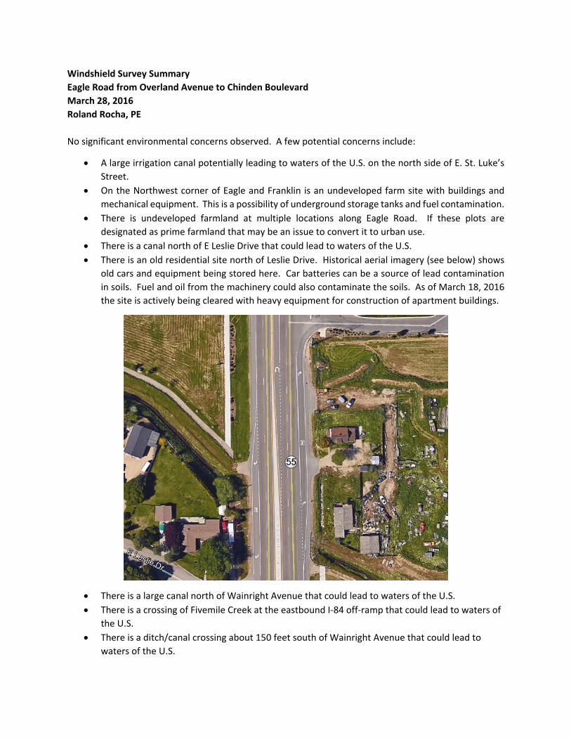
Windshield Survey Summary
Eagle Road from Overland Avenue to Chinden Boulevard
March 28, 2016
Roland Rocha, PE
No significant environmental concerns observed. A few potential concerns include:
A large irrigation canal potentially leading to waters of the U.S. on the north side of E. St. Luke’s
Street.
On the Northwest corner of Eagle and Franklin is an undeveloped farm site with buildings and
mechanical equipment. This is a possibility of underground storage tanks and fuel contamination.
There is undeveloped farmland at multiple locations along Eagle Road. If these plots are
designated as prime farmland that may be an issue to convert it to urban use.
There is a canal north of E Leslie Drive that could lead to waters of the U.S.
There is an old residential site north of Leslie Drive. Historical aerial imagery (see below) shows
old cars and equipment being stored here. Car batteries can be a source of lead contamination
in soils. Fuel and oil from the machinery could also contaminate the soils. As of March 18, 2016
the site is actively being cleared with heavy equipment for construction of apartment buildings.
There is a large canal north of Wainright Avenue that could lead to waters of the U.S.
There is a crossing of Fivemile Creek at the eastbound I‐84 off‐ramp that could lead to waters of
the U.S.
There is a ditch/canal crossing about 150 feet south of Wainright Avenue that could lead to
waters of the U.S.
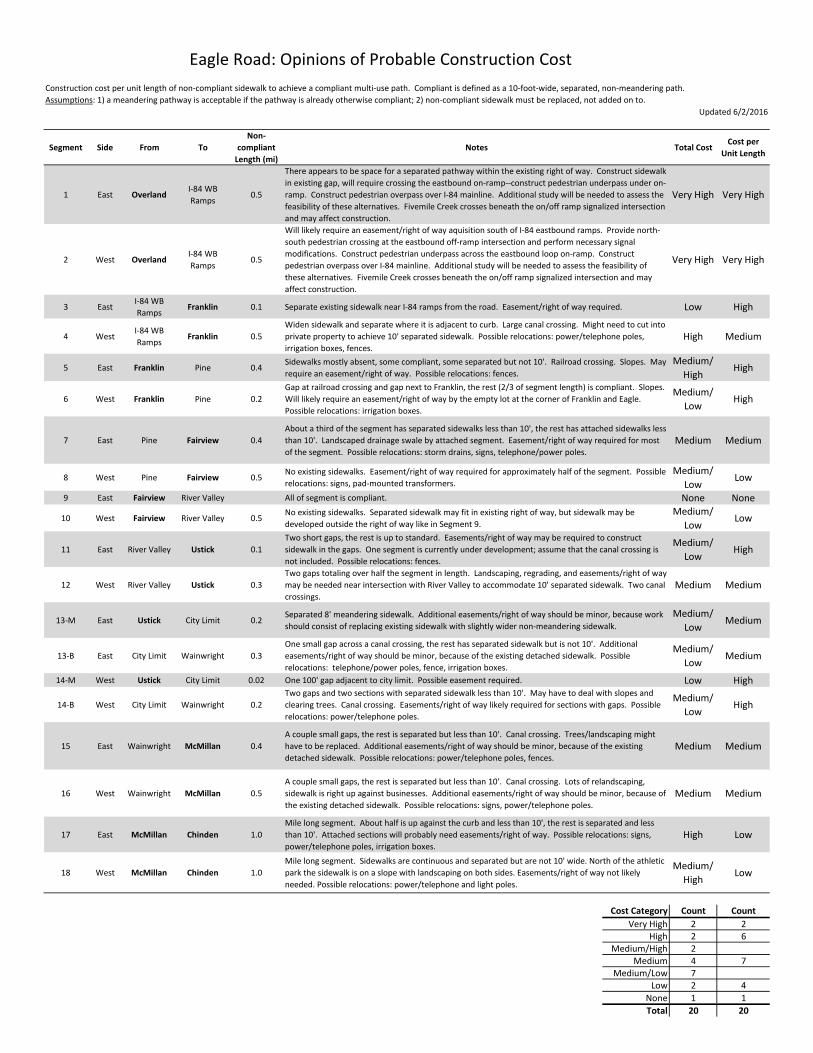
Updated 6/2/2016
Segment Side From To
Non‐
compliant
Length (mi)
Notes Total CostCost per
Unit Length
1 East OverlandI‐84 WB
Ramps0.5
There appears to be space for a separated pathway within the existing right of way. Construct sidewalk
in existing gap, will require crossing the eastbound on‐ramp‐‐construct pedestrian underpass under on‐
ramp. Construct pedestrian overpass over I‐84 mainline. Additional study will be needed to assess the
feasibility of these alternatives. Fivemile Creek crosses beneath the on/off ramp signalized intersection
and may affect construction.
Very High Very High
2 West OverlandI‐84 WB
Ramps0.5
Will likely require an easement/right of way aquisition south of I‐84 eastbound ramps. Provide north‐
south pedestrian crossing at the eastbound off‐ramp intersection and perform necessary signal
modifications. Construct pedestrian underpass across the eastbound loop on‐ramp. Construct
pedestrian overpass over I‐84 mainline. Additional study will be needed to assess the feasibility of
these alternatives. Fivemile Creek crosses beneath the on/off ramp signalized intersection and may
affect construction.
Very High Very High
3 EastI‐84 WB
RampsFranklin 0.1 Separate existing sidewalk near I‐84 ramps from the road. Easement/right of way required. Low High
4 WestI‐84 WB
RampsFranklin 0.5
Widen sidewalk and separate where it is adjacent to curb. Large canal crossing. Might need to cut into
private property to achieve 10' separated sidewalk. Possible relocations: power/telephone poles,
irrigation boxes, fences. High Medium
5 East Franklin Pine 0.4Sidewalks mostly absent, some compliant, some separated but not 10'. Railroad crossing. Slopes. May
require an easement/right of way. Possible relocations: fences.
Medium/
HighHigh
6 West Franklin Pine 0.2
Gap at railroad crossing and gap next to Franklin, the rest (2/3 of segment length) is compliant. Slopes.
Will likely require an easement/right of way by the empty lot at the corner of Franklin and Eagle.
Possible relocations: irrigation boxes.
Medium/
LowHigh
7 East Pine Fairview 0.4
About a third of the segment has separated sidewalks less than 10', the rest has attached sidewalks less
than 10'. Landscaped drainage swale by attached segment. Easement/right of way required for most
of the segment. Possible relocations: storm drains, signs, telephone/power poles.Medium Medium
8 West Pine Fairview 0.5No existing sidewalks. Easement/right of way required for approximately half of the segment. Possible
relocations: signs, pad‐mounted transformers.
Medium/
LowLow
9 East Fairview River Valley All of segment is compliant. None None
10 West Fairview River Valley 0.5No existing sidewalks. Separated sidewalk may fit in existing right of way, but sidewalk may be
developed outside the right of way like in Segment 9.
Medium/
LowLow
11 East River Valley Ustick 0.1
Two short gaps, the rest is up to standard. Easements/right of way may be required to construct
sidewalk in the gaps. One segment is currently under development; assume that the canal crossing is
not included. Possible relocations: fences.
Medium/
LowHigh
12 West River Valley Ustick 0.3
Two gaps totaling over half the segment in length. Landscaping, regrading, and easements/right of way
may be needed near intersection with River Valley to accommodate 10' separated sidewalk. Two canal
crossings.Medium Medium
13‐M East Ustick City Limit 0.2Separated 8' meandering sidewalk. Additional easements/right of way should be minor, because work
should consist of replacing existing sidewalk with slightly wider non‐meandering sidewalk.
Medium/
LowMedium
13‐B East City Limit Wainwright 0.3
One small gap across a canal crossing, the rest has separated sidewalk but is not 10'. Additional
easements/right of way should be minor, because of the existing detached sidewalk. Possible
relocations: telephone/power poles, fence, irrigation boxes.
Medium/
LowMedium
14‐M West Ustick City Limit 0.02 One 100' gap adjacent to city limit. Possible easement required. Low High
14‐B West City Limit Wainwright 0.2
Two gaps and two sections with separated sidewalk less than 10'. May have to deal with slopes and
clearing trees. Canal crossing. Easements/right of way likely required for sections with gaps. Possible
relocations: power/telephone poles.
Medium/
LowHigh
15 East Wainwright McMillan 0.4
A couple small gaps, the rest is separated but less than 10'. Canal crossing. Trees/landscaping might
have to be replaced. Additional easements/right of way should be minor, because of the existing
detached sidewalk. Possible relocations: power/telephone poles, fences.Medium Medium
16 West Wainwright McMillan 0.5
A couple small gaps, the rest is separated but less than 10'. Canal crossing. Lots of relandscaping,
sidewalk is right up against businesses. Additional easements/right of way should be minor, because of
the existing detached sidewalk. Possible relocations: signs, power/telephone poles.Medium Medium
17 East McMillan Chinden 1.0
Mile long segment. About half is up against the curb and less than 10', the rest is separated and less
than 10'. Attached sections will probably need easements/right of way. Possible relocations: signs,
power/telephone poles, irrigation boxes.High Low
18 West McMillan Chinden 1.0
Mile long segment. Sidewalks are continuous and separated but are not 10' wide. North of the athletic
park the sidewalk is on a slope with landscaping on both sides. Easements/right of way not likely
needed. Possible relocations: power/telephone and light poles.
Medium/
HighLow
Cost Category Count Count
Very High 2 2High 2 6
Medium/High 2Medium 4 7
Medium/Low 7Low 2 4
None 1 1
Total 20 20
Eagle Road: Opinions of Probable Construction Cost
Construction cost per unit length of non‐compliant sidewalk to achieve a compliant multi‐use path. Compliant is defined as a 10‐foot‐wide, separated, non‐meandering path.
Assumptions: 1) a meandering pathway is acceptable if the pathway is already otherwise compliant; 2) non‐compliant sidewalk must be replaced, not added on to.
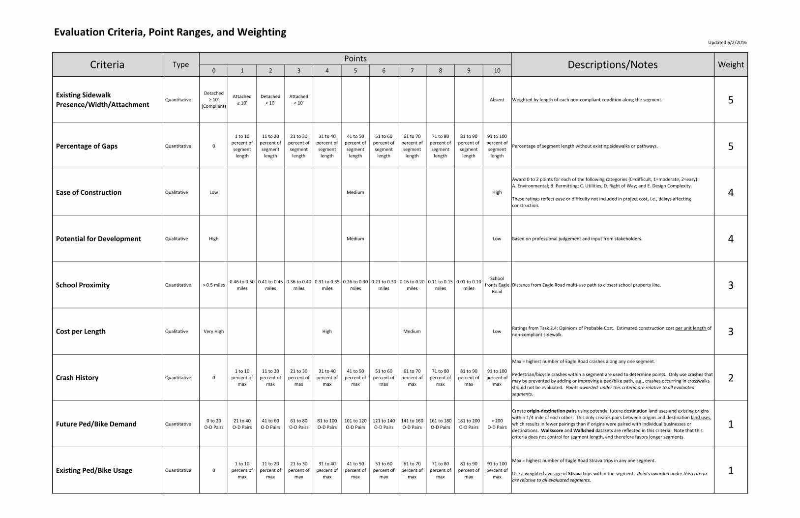
Evaluation Criteria, Point Ranges, and WeightingUpdated 6/2/2016
0 1 2 3 4 5 6 7 8 9 10
Existing Sidewalk
Presence/Width/AttachmentQuantitative
Detached
≥ 10'
(Compliant)
Attached
≥ 10'
Detached
< 10'
Attached
< 10'Absent Weighted by length of each non‐compliant condition along the segment. 5
Percentage of Gaps Quantitative 0
1 to 10
percent of
segment
length
11 to 20
percent of
segment
length
21 to 30
percent of
segment
length
31 to 40
percent of
segment
length
41 to 50
percent of
segment
length
51 to 60
percent of
segment
length
61 to 70
percent of
segment
length
71 to 80
percent of
segment
length
81 to 90
percent of
segment
length
91 to 100
percent of
segment
length
Percentage of segment length without existing sidewalks or pathways. 5
Ease of Construction Qualitative Low Medium High
Award 0 to 2 points for each of the following categories (0=difficult, 1=moderate, 2=easy):
A. Environmental; B. Permitting; C. Utilities; D. Right of Way; and E. Design Complexity.
These ratings reflect ease or difficulty not included in project cost, i.e., delays affecting
construction.
4
Potential for Development Qualitative High Medium Low Based on professional judgement and input from stakeholders. 4
School Proximity Quantitative > 0.5 miles0.46 to 0.50
miles
0.41 to 0.45
miles
0.36 to 0.40
miles
0.31 to 0.35
miles
0.26 to 0.30
miles
0.21 to 0.30
miles
0.16 to 0.20
miles
0.11 to 0.15
miles
0.01 to 0.10
miles
School
fronts Eagle
Road
Distance from Eagle Road multi‐use path to closest school property line. 3
Cost per Length Qualitative Very High High Medium LowRatings from Task 2.4: Opinions of Probable Cost. Estimated construction cost per unit length of
non‐compliant sidewalk. 3
Crash History Quantitative 0
1 to 10
percent of
max
11 to 20
percent of
max
21 to 30
percent of
max
31 to 40
percent of
max
41 to 50
percent of
max
51 to 60
percent of
max
61 to 70
percent of
max
71 to 80
percent of
max
81 to 90
percent of
max
91 to 100
percent of
max
Max = highest number of Eagle Road crashes along any one segment.
Pedestrian/bicycle crashes within a segment are used to determine points. Only use crashes that
may be prevented by adding or improving a ped/bike path, e.g., crashes occurring in crosswalks
should not be evaluated. Points awarded under this criteria are relative to all evaluated segments.
2
Future Ped/Bike Demand Quantitative0 to 20
O‐D Pairs
21 to 40
O‐D Pairs
41 to 60
O‐D Pairs
61 to 80
O‐D Pairs
81 to 100
O‐D Pairs
101 to 120
O‐D Pairs
121 to 140
O‐D Pairs
141 to 160
O‐D Pairs
161 to 180
O‐D Pairs
181 to 200
O‐D Pairs
> 200
O‐D Pairs
Create origin‐destination pairs using potential future destination land uses and existing origins
within 1/4 mile of each other. This only creates pairs between origins and destination land uses,
which results in fewer pairings than if origins were paired with individual businesses or
destinations. Walkscore and Walkshed datasets are reflected in this criteria. Note that this
criteria does not control for segment length, and therefore favors longer segments.
1
Existing Ped/Bike Usage Quantitative 0
1 to 10
percent of
max
11 to 20
percent of
max
21 to 30
percent of
max
31 to 40
percent of
max
41 to 50
percent of
max
51 to 60
percent of
max
61 to 70
percent of
max
71 to 80
percent of
max
81 to 90
percent of
max
91 to 100
percent of
max
Max = highest number of Eagle Road Strava trips in any one segment.
Use a weighted average of Strava trips within the segment. Points awarded under this criteria are relative to all evaluated segments.
1
Criteria TypePoints
Descriptions/Notes Weight
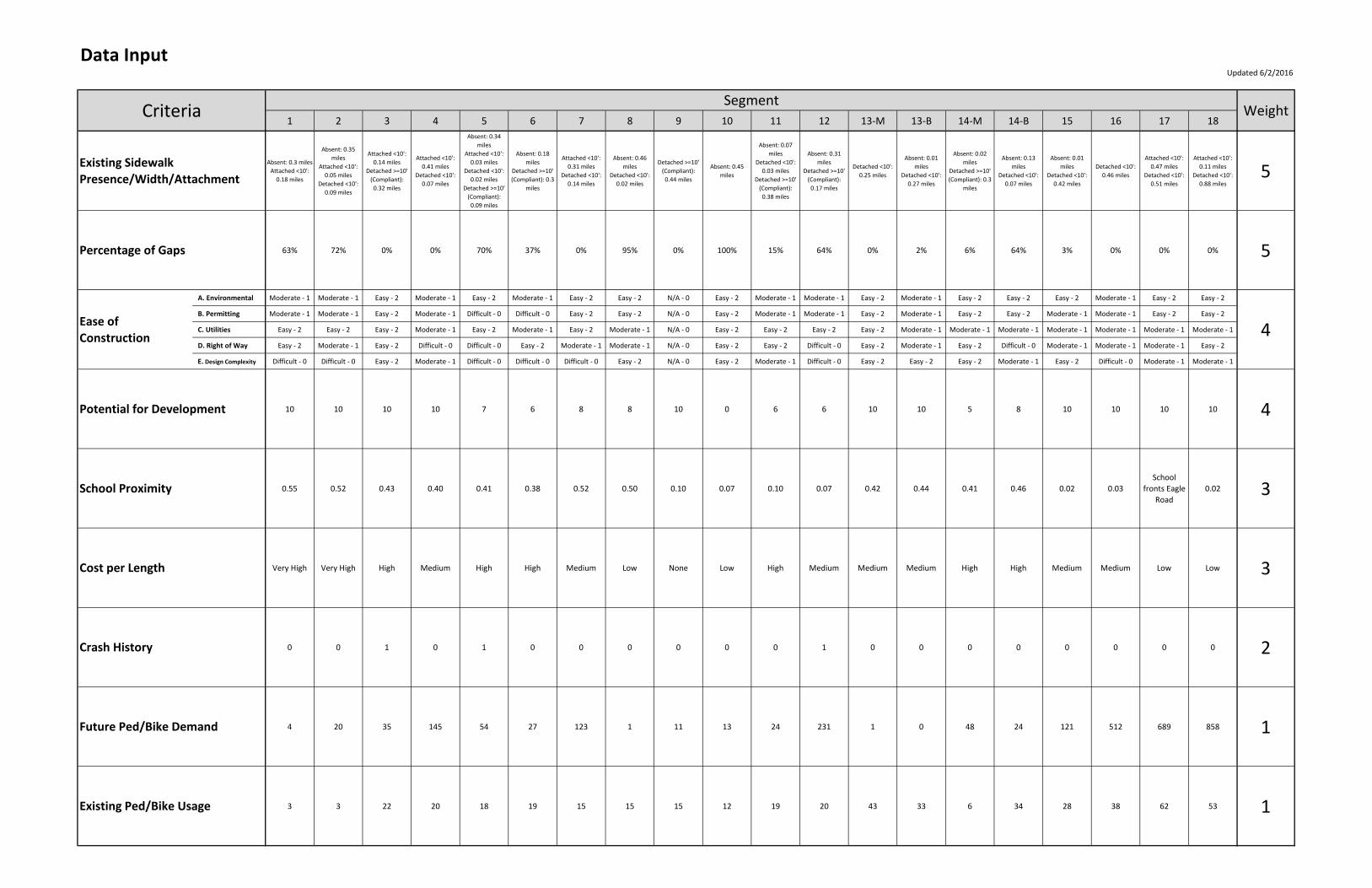
Data InputUpdated 6/2/2016
1 2 3 4 5 6 7 8 9 10 11 12 13‐M 13‐B 14‐M 14‐B 15 16 17 18
Absent: 0.3 miles
Attached <10':
0.18 miles
Absent: 0.35
miles
Attached <10':
0.05 miles
Detached <10':
0.09 miles
Attached <10':
0.14 miles
Detached >=10'
(Compliant):
0.32 miles
Attached <10':
0.41 miles
Detached <10':
0.07 miles
Absent: 0.34
miles
Attached <10':
0.03 miles
Detached <10':
0.02 miles
Detached >=10'
(Compliant):
0.09 miles
Absent: 0.18
miles
Detached >=10'
(Compliant): 0.3
miles
Attached <10':
0.31 miles
Detached <10':
0.14 miles
Absent: 0.46
miles
Detached <10':
0.02 miles
Detached >=10'
(Compliant):
0.44 miles
Absent: 0.45
miles
Absent: 0.07
miles
Detached <10':
0.03 miles
Detached >=10'
(Compliant):
0.38 miles
Absent: 0.31
miles
Detached >=10'
(Compliant):
0.17 miles
Detached <10':
0.25 miles
Absent: 0.01
miles
Detached <10':
0.27 miles
Absent: 0.02
miles
Detached >=10'
(Compliant): 0.3
miles
Absent: 0.13
miles
Detached <10':
0.07 miles
Absent: 0.01
miles
Detached <10':
0.42 miles
Detached <10':
0.46 miles
Attached <10':
0.47 miles
Detached <10':
0.51 miles
Attached <10':
0.11 miles
Detached <10':
0.88 miles
5
63% 72% 0% 0% 70% 37% 0% 95% 0% 100% 15% 64% 0% 2% 6% 64% 3% 0% 0% 0% 5
A. Environmental Moderate ‐ 1 Moderate ‐ 1 Easy ‐ 2 Moderate ‐ 1 Easy ‐ 2 Moderate ‐ 1 Easy ‐ 2 Easy ‐ 2 N/A ‐ 0 Easy ‐ 2 Moderate ‐ 1 Moderate ‐ 1 Easy ‐ 2 Moderate ‐ 1 Easy ‐ 2 Easy ‐ 2 Easy ‐ 2 Moderate ‐ 1 Easy ‐ 2 Easy ‐ 2
B. Permitting Moderate ‐ 1 Moderate ‐ 1 Easy ‐ 2 Moderate ‐ 1 Difficult ‐ 0 Difficult ‐ 0 Easy ‐ 2 Easy ‐ 2 N/A ‐ 0 Easy ‐ 2 Moderate ‐ 1 Moderate ‐ 1 Easy ‐ 2 Moderate ‐ 1 Easy ‐ 2 Easy ‐ 2 Moderate ‐ 1 Moderate ‐ 1 Easy ‐ 2 Easy ‐ 2
C. Utilities Easy ‐ 2 Easy ‐ 2 Easy ‐ 2 Moderate ‐ 1 Easy ‐ 2 Moderate ‐ 1 Easy ‐ 2 Moderate ‐ 1 N/A ‐ 0 Easy ‐ 2 Easy ‐ 2 Easy ‐ 2 Easy ‐ 2 Moderate ‐ 1 Moderate ‐ 1 Moderate ‐ 1 Moderate ‐ 1 Moderate ‐ 1 Moderate ‐ 1 Moderate ‐ 1
D. Right of Way Easy ‐ 2 Moderate ‐ 1 Easy ‐ 2 Difficult ‐ 0 Difficult ‐ 0 Easy ‐ 2 Moderate ‐ 1 Moderate ‐ 1 N/A ‐ 0 Easy ‐ 2 Easy ‐ 2 Difficult ‐ 0 Easy ‐ 2 Moderate ‐ 1 Easy ‐ 2 Difficult ‐ 0 Moderate ‐ 1 Moderate ‐ 1 Moderate ‐ 1 Easy ‐ 2
E. Design Complexity Difficult ‐ 0 Difficult ‐ 0 Easy ‐ 2 Moderate ‐ 1 Difficult ‐ 0 Difficult ‐ 0 Difficult ‐ 0 Easy ‐ 2 N/A ‐ 0 Easy ‐ 2 Moderate ‐ 1 Difficult ‐ 0 Easy ‐ 2 Easy ‐ 2 Easy ‐ 2 Moderate ‐ 1 Easy ‐ 2 Difficult ‐ 0 Moderate ‐ 1 Moderate ‐ 1
10 10 10 10 7 6 8 8 10 0 6 6 10 10 5 8 10 10 10 10 4
0.55 0.52 0.43 0.40 0.41 0.38 0.52 0.50 0.10 0.07 0.10 0.07 0.42 0.44 0.41 0.46 0.02 0.03
School
fronts Eagle
Road
0.02 3
Very High Very High High Medium High High Medium Low None Low High Medium Medium Medium High High Medium Medium Low Low 3
0 0 1 0 1 0 0 0 0 0 0 1 0 0 0 0 0 0 0 0 2
4 20 35 145 54 27 123 1 11 13 24 231 1 0 48 24 121 512 689 858 1
3 3 22 20 18 19 15 15 15 12 19 20 43 33 6 34 28 38 62 53 1
Criteria
Cost per Length
Potential for Development
SegmentWeight
Existing Sidewalk
Presence/Width/Attachment
Percentage of Gaps
Crash History
Existing Ped/Bike Usage
Ease of
Construction 4
Future Ped/Bike Demand
School Proximity

Populated Evaluation MatrixUpdated 6/2/2016
1 2 3 4 5 6 7 8 9 10 11 12 13‐M 13‐B 14‐M 14‐B 15 16 17 18
Existing Sidewalk
Presence/Width/Attachment7 8 3 3 9 10 3 10 0 10 8 10 2 2 10 7 2 2 2 2 5
Percentage of Gaps 7 8 0 0 7 4 0 10 0 10 2 7 0 1 1 7 1 0 0 0 5
Ease of Construction 6 5 10 4 4 4 7 8 0 10 7 4 10 6 9 6 7 4 7 8 4
Potential for Development 10 10 10 10 7 6 8 8 10 0 6 6 10 10 5 8 10 10 10 10 4
School Proximity 0 0 2 3 2 3 0 1 9 9 9 9 2 2 2 1 9 9 10 9 3
Cost per Length 0 0 4 7 2 2 7 10 0 10 4 7 7 7 4 4 7 7 10 10 3
Crash History 0 0 10 0 10 0 0 0 0 0 0 10 0 0 0 0 0 0 0 0 2
Future Ped/Bike Demand 0 0 1 7 2 1 6 0 0 0 1 10 0 0 2 1 6 10 10 10 1
Existing Ped/Bike Usage 1 1 4 4 3 4 3 3 3 2 4 4 7 6 1 6 5 7 10 10 1
Segment Totals 135 141 138 112 161 130 105 200 70 199 146 207 124 112 132 148 142 131 158 159
Rank 12 10 11 17 4 15 19 2 20 3 8 1 16 17 13 7 9 14 6 5
WeightCriteriaPoints by Segment

Segment 1 Overland to I‐84 WB Ramps East Side of Eagle Road Updated 6/2/2016
Absent: 0.3 miles
Attached <10': 0.18 miles 7 5 35
63% 7 5 35 Absent: 0.3 miles
Attached <10': 0.18 miles
A. Environmental Moderate ‐ 1
B. Permitting Moderate ‐ 1
C. Utilities Easy ‐ 2
D. Right of Way Easy ‐ 2
E. Design Complexity Difficult ‐ 0
Low 10 4 40 Entire segment is within ITD right of way. Low likelihood of private development along Eagle
Road south of interchange.
0.55 miles 0 3 0
Very High 0 3 0
There appears to be space for a separated pathway within the existing right of way.
Construct sidewalk in existing gap, will require crossing the eastbound on‐ramp‐‐construct
pedestrian underpass under on‐ramp. Construct pedestrian overpass over I‐84 mainline.
Additional study will be needed to assess the feasibility of these alternatives. Fivemile Creek
crosses beneath the on/off ramp signalized intersection and may affect construction.
0 crashes 0 2 0 Maximum number of ped/bike crashes in any one segment: 1 (Segments 3, 5, & 12)
4 O‐D Pairs 0 1 0 Maximum number of O‐D Pairs in any one segment: 858 (Segment 18)
3 Strava trips 1 1 1 Maximum number of Strava trips in any one segment: 62 (Segment 17)
135/280
12
Total Points
Rank
Weight
4
Existing Ped/Bike Usage
Crash History
Percentage of Gaps
Future Ped/Bike Demand
School Proximity
Cost per Length
Potential for Development
Descriptions/NotesPointsCondition
Ease of Construction
Criteria
Existing Sidewalk Presence/Width/Attachment
6
A. Environmental ‐ Canal crossing
B. Permitting ‐ Canal company
C. Utilities ‐ No major above‐ground utilities
D. Right of Way ‐ Minor or no aquisitions
E. Design Complexity ‐ HAWK installation or tunneling, interstate overpass
Product
24

Segment 2 Overland to I‐84 WB Ramps West Side of Eagle Road Updated 6/2/2016
Absent: 0.35 miles
Attached <10': 0.05 miles
Detached <10': 0.09 miles8 5 40
72% 8 5 40Absent: 0.35 miles
Attached <10': 0.05 miles
Detached <10': 0.09 miles
A. Environmental Moderate ‐ 1
B. Permitting Moderate ‐ 1
C. Utilities Easy ‐ 2
D. Right of Way Moderate ‐ 1
E. Design Complexity Difficult ‐ 0
Low 10 4 40 Most of the segment lies within ITD right of way. There is no apparent incentive for existing
developments to replace the existing sidewalk.
0.52 miles 0 3 0
Very High 0 3 0
Will likely require an easement/right of way aquisition south of I‐84 eastbound ramps.
Provide north‐south pedestrian crossing at the eastbound off‐ramp intersection and perform
necessary signal modifications. Construct pedestrian underpass across the eastbound loop
on‐ramp. Construct pedestrian overpass over I‐84 mainline. Additional study will be needed
to assess the feasibility of these alternatives. Fivemile Creek crosses beneath the on/off
ramp signalized intersection and may affect construction.
0 crashes 0 2 0 Maximum number of ped/bike crashes in any one segment: 1 (Segments 3, 5, & 12)
20 O‐D Pairs 0 1 0 Maximum number of O‐D Pairs in any one segment: 858 (Segment 18)
3 Strava trips 1 1 1 Maximum number of Strava trips in any one segment: 62 (Segment 17)
141/280
10
Total Points
Rank
Weight
4
Existing Ped/Bike Usage
Crash History
Percentage of Gaps
Future Ped/Bike Demand
School Proximity
Cost per Length
Potential for Development
Descriptions/NotesPointsCondition
Ease of Construction
Criteria
Existing Sidewalk Presence/Width/Attachment
5
A. Environmental ‐ Canal crossing
B. Permitting ‐ Canal company
C. Utilities ‐ No major above‐ground utilities
D. Right of Way ‐ One easement required south of interchange, property will need to be
relandscaped
E. Design Complexity ‐ Signal, HAWK installation or tunneling, interstate overpass
Product
20
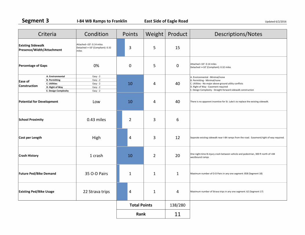
Segment 3 I‐84 WB Ramps to Franklin East Side of Eagle Road Updated 6/2/2016
Attached <10': 0.14 miles
Detached >=10' (Compliant): 0.32
miles3 5 15
0% 0 5 0 Attached <10': 0.14 miles
Detached >=10' (Compliant): 0.32 miles
A. Environmental Easy ‐ 2
B. Permitting Easy ‐ 2
C. Utilities Easy ‐ 2
D. Right of Way Easy ‐ 2
E. Design Complexity Easy ‐ 2
Low 10 4 40 There is no apparent incentive for St. Luke's to replace the existing sidewalk.
0.43 miles 2 3 6
High 4 3 12 Separate existing sidewalk near I‐84 ramps from the road. Easement/right of way required.
1 crash 10 2 20 One night‐time B‐injury crash between vehicle and pedestrian, 300 ft north of I‐84
westbound ramps
35 O‐D Pairs 1 1 1 Maximum number of O‐D Pairs in any one segment: 858 (Segment 18)
22 Strava trips 4 1 4 Maximum number of Strava trips in any one segment: 62 (Segment 17)
138/280
11
Total Points
Rank
Weight
4
Existing Ped/Bike Usage
Crash History
Percentage of Gaps
Future Ped/Bike Demand
School Proximity
Cost per Length
Potential for Development
Descriptions/NotesPointsCondition
Ease of Construction
Criteria
Existing Sidewalk Presence/Width/Attachment
10
A. Environmental ‐ Minimal/none
B. Permitting ‐ Minimal/none
C. Utilities ‐ No major above‐ground utility conflicts
D. Right of Way ‐ Easement required
E. Design Complexity ‐ Straight‐forward sidewalk construction
Product
40
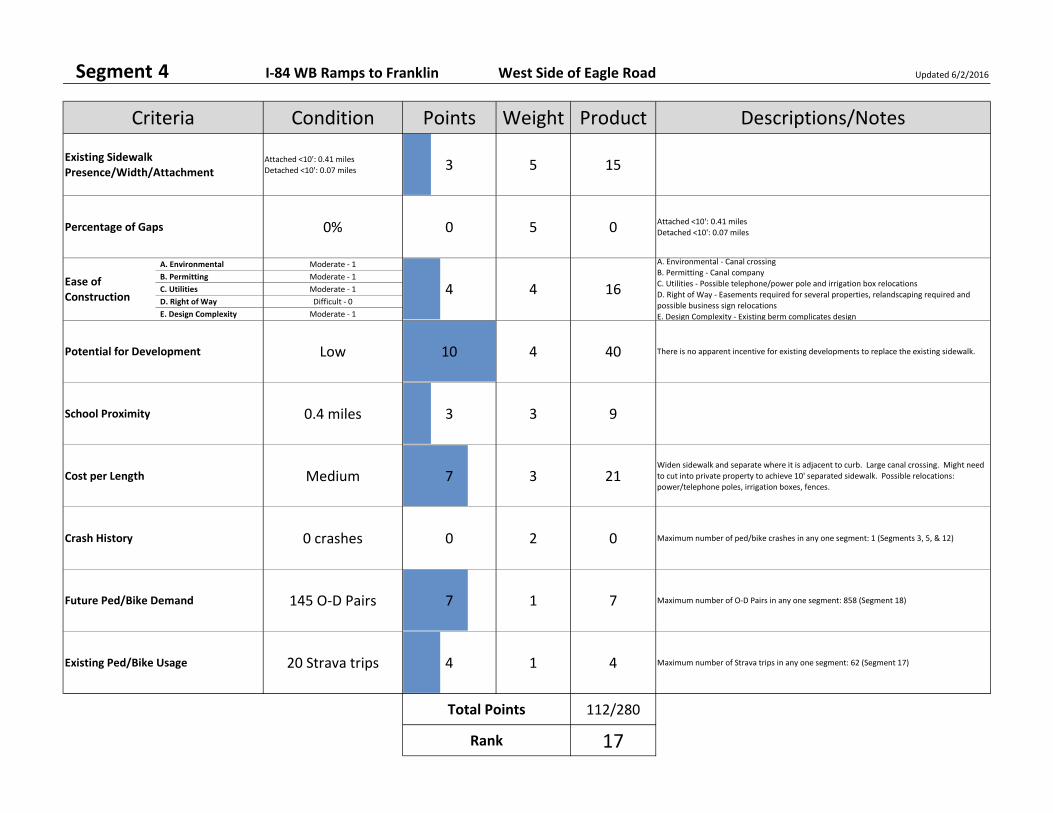
Segment 4 I‐84 WB Ramps to Franklin West Side of Eagle Road Updated 6/2/2016
Attached <10': 0.41 miles
Detached <10': 0.07 miles 3 5 15
0% 0 5 0 Attached <10': 0.41 miles
Detached <10': 0.07 miles
A. Environmental Moderate ‐ 1
B. Permitting Moderate ‐ 1
C. Utilities Moderate ‐ 1
D. Right of Way Difficult ‐ 0
E. Design Complexity Moderate ‐ 1
Low 10 4 40 There is no apparent incentive for existing developments to replace the existing sidewalk.
0.4 miles 3 3 9
Medium 7 3 21Widen sidewalk and separate where it is adjacent to curb. Large canal crossing. Might need
to cut into private property to achieve 10' separated sidewalk. Possible relocations:
power/telephone poles, irrigation boxes, fences.
0 crashes 0 2 0 Maximum number of ped/bike crashes in any one segment: 1 (Segments 3, 5, & 12)
145 O‐D Pairs 7 1 7 Maximum number of O‐D Pairs in any one segment: 858 (Segment 18)
20 Strava trips 4 1 4 Maximum number of Strava trips in any one segment: 62 (Segment 17)
112/280
17
Total Points
Rank
Weight
4
Existing Ped/Bike Usage
Crash History
Percentage of Gaps
Future Ped/Bike Demand
School Proximity
Cost per Length
Potential for Development
Descriptions/NotesPointsCondition
Ease of Construction
Criteria
Existing Sidewalk Presence/Width/Attachment
4
A. Environmental ‐ Canal crossing
B. Permitting ‐ Canal company
C. Utilities ‐ Possible telephone/power pole and irrigation box relocations
D. Right of Way ‐ Easements required for several properties, relandscaping required and
possible business sign relocations
E. Design Complexity ‐ Existing berm complicates design
Product
16

Segment 5 Franklin to Pine East Side of Eagle Road Updated 6/2/2016
Absent: 0.34 miles
Attached <10': 0.03 miles
Detached <10': 0.02 miles
Detached >=10' (Compliant): 0.09
miles
9 5 45
70% 7 5 35Absent: 0.34 miles
Attached <10': 0.03 miles
Detached <10': 0.02 miles
Detached >=10' (Compliant): 0.09 miles
A. Environmental Easy ‐ 2
B. Permitting Difficult ‐ 0
C. Utilities Easy ‐ 2
D. Right of Way Difficult ‐ 0
E. Design Complexity Difficult ‐ 0
Medium/Low 7 4 28Most of the segment is within CenterCal project limits and the City may be able to add
compliant sidewalks to the project scope. Other improvements are needed in railroad right
of way. One vacant parcel without sidewalk.
0.41 miles 2 3 6
High 2 3 6 Sidewalks mostly absent, some compliant, some separated but not 10'. Railroad crossing.
Slopes. May require an easement/right of way. Possible relocations: fences.
1 crash 10 2 20 One B‐injury crash between vehicle and bicycle at Commercial Drive intersection
54 O‐D Pairs 2 1 2 Maximum number of O‐D Pairs in any one segment: 858 (Segment 18)
18 Strava trips 3 1 3 Maximum number of Strava trips in any one segment: 62 (Segment 17)
161/280
4
Total Points
Rank
Weight
4
Existing Ped/Bike Usage
Crash History
Percentage of Gaps
Future Ped/Bike Demand
School Proximity
Cost per Length
Potential for Development
Descriptions/NotesPointsCondition
Ease of Construction
Criteria
Existing Sidewalk Presence/Width/Attachment
4
A. Environmental ‐ Minimal/none
B. Permitting ‐ UPRR
C. Utilities ‐ No major above‐ground utility conflicts
D. Right of Way ‐ Easements required for several properties, possible fence relocations and
parking space removal
E. Design Complexity ‐ Slopes
Product
16
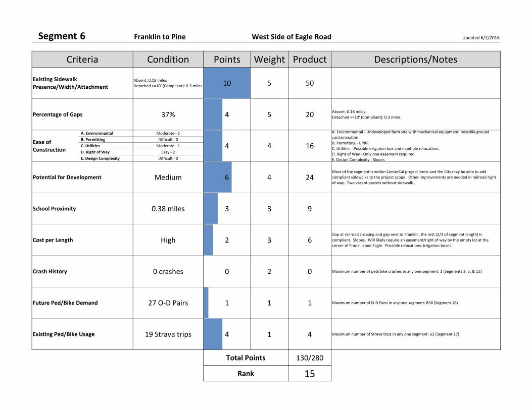
Segment 6 Franklin to Pine West Side of Eagle Road Updated 6/2/2016
Absent: 0.18 miles
Detached >=10' (Compliant): 0.3 miles 10 5 50
37% 4 5 20 Absent: 0.18 miles
Detached >=10' (Compliant): 0.3 miles
A. Environmental Moderate ‐ 1
B. Permitting Difficult ‐ 0
C. Utilities Moderate ‐ 1
D. Right of Way Easy ‐ 2
E. Design Complexity Difficult ‐ 0
Medium 6 4 24Most of the segment is within CenterCal project limits and the City may be able to add
compliant sidewalks to the project scope. Other improvements are needed in railroad right
of way. Two vacant parcels without sidewalk.
0.38 miles 3 3 9
High 2 3 6Gap at railroad crossing and gap next to Franklin, the rest (2/3 of segment length) is
compliant. Slopes. Will likely require an easement/right of way by the empty lot at the
corner of Franklin and Eagle. Possible relocations: irrigation boxes.
0 crashes 0 2 0 Maximum number of ped/bike crashes in any one segment: 1 (Segments 3, 5, & 12)
27 O‐D Pairs 1 1 1 Maximum number of O‐D Pairs in any one segment: 858 (Segment 18)
19 Strava trips 4 1 4 Maximum number of Strava trips in any one segment: 62 (Segment 17)
130/280
15
Total Points
Rank
Weight
4
Existing Ped/Bike Usage
Crash History
Percentage of Gaps
Future Ped/Bike Demand
School Proximity
Cost per Length
Potential for Development
Descriptions/NotesPointsCondition
Ease of Construction
Criteria
Existing Sidewalk Presence/Width/Attachment
4
A. Environmental ‐ Undeveloped farm site with mechanical equipment, possible ground
contamination
B. Permitting ‐ UPRR
C. Utilities ‐ Possible irrigation box and manhole relocations
D. Right of Way ‐ Only one easement required
E. Design Complexity ‐ Slopes
Product
16
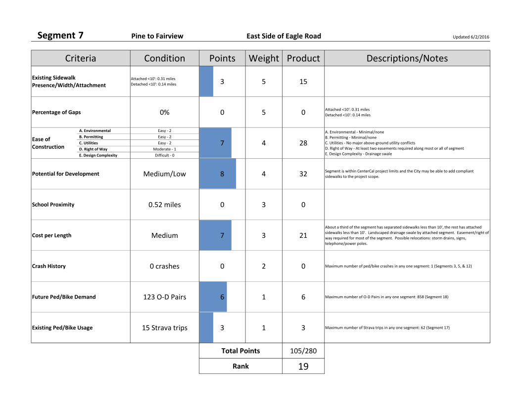
Segment 7 Pine to Fairview East Side of Eagle Road Updated 6/2/2016
Attached <10': 0.31 miles
Detached <10': 0.14 miles 3 5 15
0% 0 5 0 Attached <10': 0.31 miles
Detached <10': 0.14 miles
A. Environmental Easy ‐ 2
B. Permitting Easy ‐ 2
C. Utilities Easy ‐ 2
D. Right of Way Moderate ‐ 1
E. Design Complexity Difficult ‐ 0
Medium/Low 8 4 32 Segment is within CenterCal project limits and the City may be able to add compliant
sidewalks to the project scope.
0.52 miles 0 3 0
Medium 7 3 21About a third of the segment has separated sidewalks less than 10', the rest has attached
sidewalks less than 10'. Landscaped drainage swale by attached segment. Easement/right of
way required for most of the segment. Possible relocations: storm drains, signs,
telephone/power poles.
0 crashes 0 2 0 Maximum number of ped/bike crashes in any one segment: 1 (Segments 3, 5, & 12)
123 O‐D Pairs 6 1 6 Maximum number of O‐D Pairs in any one segment: 858 (Segment 18)
15 Strava trips 3 1 3 Maximum number of Strava trips in any one segment: 62 (Segment 17)
105/280
19
Total Points
Rank
Weight
4
Existing Ped/Bike Usage
Crash History
Percentage of Gaps
Future Ped/Bike Demand
School Proximity
Cost per Length
Potential for Development
Descriptions/NotesPointsCondition
Ease of Construction
Criteria
Existing Sidewalk Presence/Width/Attachment
7
A. Environmental ‐ Minimal/none
B. Permitting ‐ Minimal/none
C. Utilities ‐ No major above‐ground utility conflicts
D. Right of Way ‐ At least two easements required along most or all of segment
E. Design Complexity ‐ Drainage swale
Product
28

Segment 8 Pine to Fairview West Side of Eagle Road Updated 6/2/2016
Absent: 0.46 miles
Detached <10': 0.02 miles 10 5 50
95% 10 5 50 Absent: 0.46 miles
Detached <10': 0.02 miles
A. Environmental Easy ‐ 2
B. Permitting Easy ‐ 2
C. Utilities Moderate ‐ 1
D. Right of Way Moderate ‐ 1
E. Design Complexity Easy ‐ 2
Medium/Low 8 4 32 Segment is within CenterCal project limits and the City may be able to add compliant
sidewalks to the project scope.
0.5 miles 1 3 3
Low 10 3 30 No existing sidewalks. Easement/right of way required for approximately half of the
segment. Possible relocations: signs, pad‐mounted transformers.
0 crashes 0 2 0 Maximum number of ped/bike crashes in any one segment: 1 (Segments 3, 5, & 12)
1 O‐D Pairs 0 1 0 Maximum number of O‐D Pairs in any one segment: 858 (Segment 18)
15 Strava trips 3 1 3 Maximum number of Strava trips in any one segment: 62 (Segment 17)
200/280
2
Total Points
Rank
Weight
4
Existing Ped/Bike Usage
Crash History
Percentage of Gaps
Future Ped/Bike Demand
School Proximity
Cost per Length
Potential for Development
Descriptions/NotesPointsCondition
Ease of Construction
Criteria
Existing Sidewalk Presence/Width/Attachment
8
A. Environmental ‐ Blue Cross pond may require deliberation, otherwise little or no
difficulties
B. Permitting ‐ Minimal/none
C. Utilities ‐ Possible pad‐mounted transformer relocations
D. Right of Way ‐ Several easements required along most or all of segment, business sign
relocations
Product
32
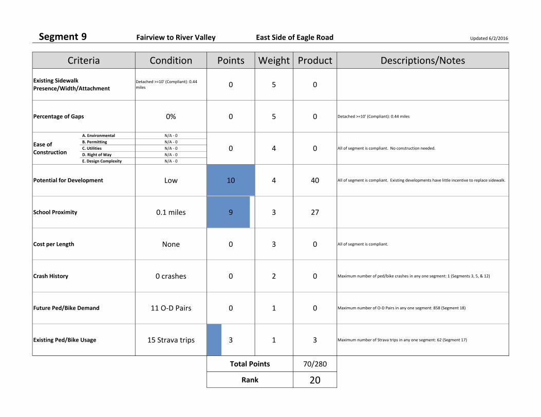
Segment 9 Fairview to River Valley East Side of Eagle Road Updated 6/2/2016
Detached >=10' (Compliant): 0.44
miles 0 5 0
0% 0 5 0 Detached >=10' (Compliant): 0.44 miles
A. Environmental N/A ‐ 0
B. Permitting N/A ‐ 0
C. Utilities N/A ‐ 0
D. Right of Way N/A ‐ 0
E. Design Complexity N/A ‐ 0
Low 10 4 40 All of segment is compliant. Existing developments have little incentive to replace sidewalk.
0.1 miles 9 3 27
None 0 3 0 All of segment is compliant.
0 crashes 0 2 0 Maximum number of ped/bike crashes in any one segment: 1 (Segments 3, 5, & 12)
11 O‐D Pairs 0 1 0 Maximum number of O‐D Pairs in any one segment: 858 (Segment 18)
15 Strava trips 3 1 3 Maximum number of Strava trips in any one segment: 62 (Segment 17)
70/280
20
Total Points
Rank
Weight
4
Existing Ped/Bike Usage
Crash History
Percentage of Gaps
Future Ped/Bike Demand
School Proximity
Cost per Length
Potential for Development
Descriptions/NotesPointsCondition
Ease of Construction
Criteria
Existing Sidewalk Presence/Width/Attachment
0 All of segment is compliant. No construction needed.
Product
0
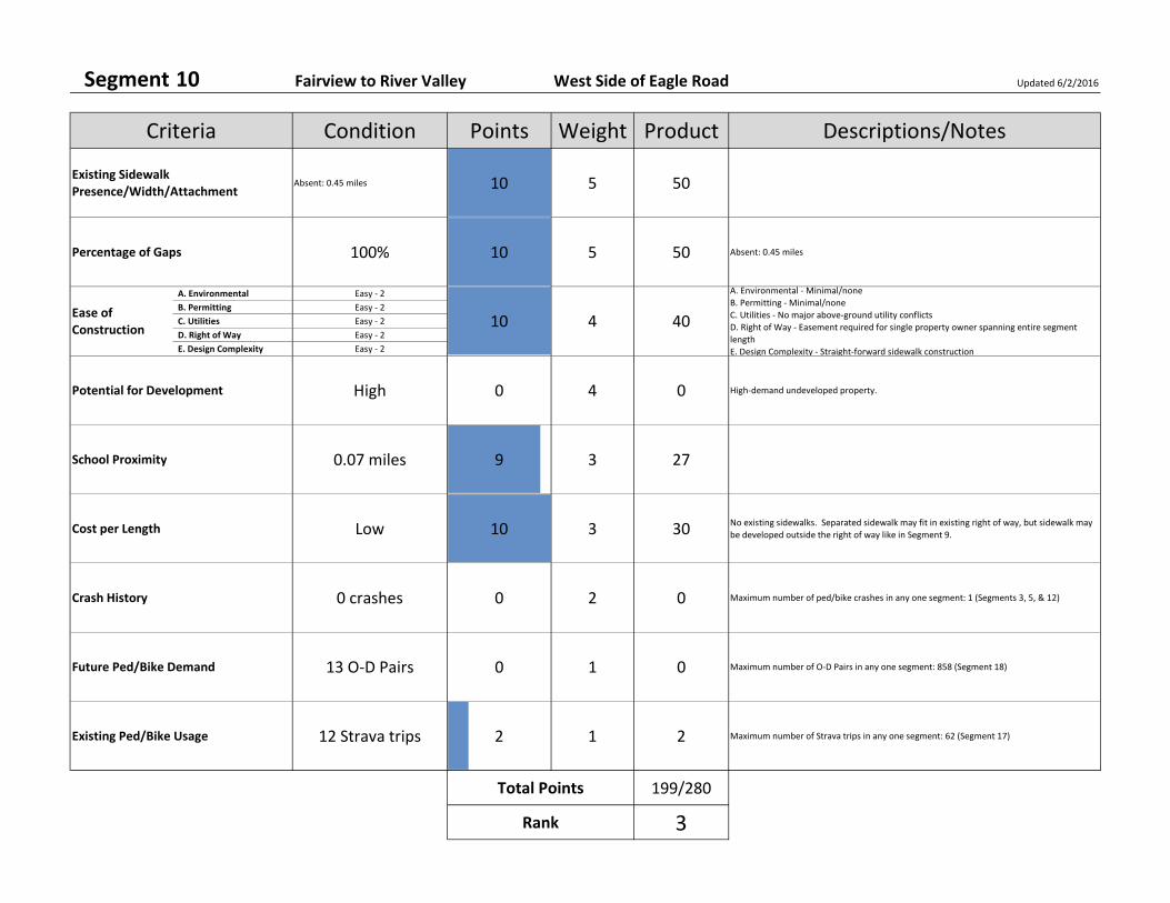
Segment 10 Fairview to River Valley West Side of Eagle Road Updated 6/2/2016
Absent: 0.45 miles 10 5 50
100% 10 5 50 Absent: 0.45 miles
A. Environmental Easy ‐ 2
B. Permitting Easy ‐ 2
C. Utilities Easy ‐ 2
D. Right of Way Easy ‐ 2
E. Design Complexity Easy ‐ 2
High 0 4 0 High‐demand undeveloped property.
0.07 miles 9 3 27
Low 10 3 30 No existing sidewalks. Separated sidewalk may fit in existing right of way, but sidewalk may
be developed outside the right of way like in Segment 9.
0 crashes 0 2 0 Maximum number of ped/bike crashes in any one segment: 1 (Segments 3, 5, & 12)
13 O‐D Pairs 0 1 0 Maximum number of O‐D Pairs in any one segment: 858 (Segment 18)
12 Strava trips 2 1 2 Maximum number of Strava trips in any one segment: 62 (Segment 17)
199/280
3
Total Points
Rank
Weight
4
Existing Ped/Bike Usage
Crash History
Percentage of Gaps
Future Ped/Bike Demand
School Proximity
Cost per Length
Potential for Development
Descriptions/NotesPointsCondition
Ease of Construction
Criteria
Existing Sidewalk Presence/Width/Attachment
10
A. Environmental ‐ Minimal/none
B. Permitting ‐ Minimal/none
C. Utilities ‐ No major above‐ground utility conflicts
D. Right of Way ‐ Easement required for single property owner spanning entire segment
length
E. Design Complexity ‐ Straight‐forward sidewalk construction
Product
40
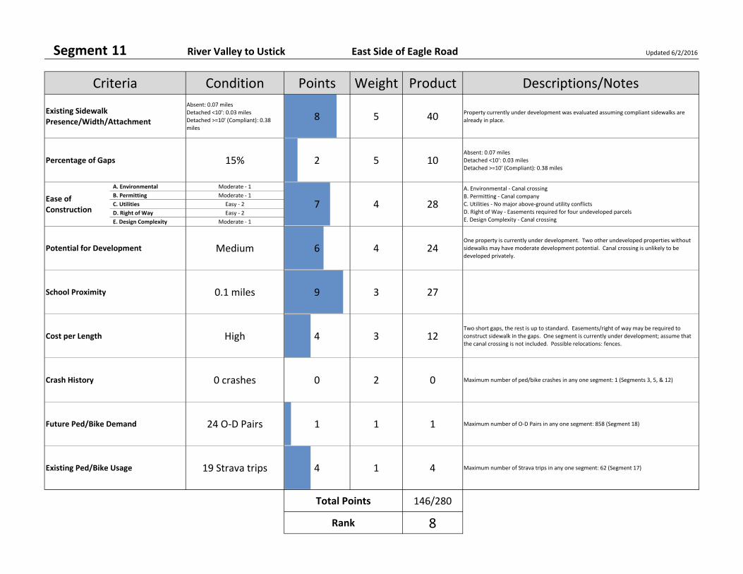
Segment 11 River Valley to Ustick East Side of Eagle Road Updated 6/2/2016
Absent: 0.07 miles
Detached <10': 0.03 miles
Detached >=10' (Compliant): 0.38
miles
8 5 40 Property currently under development was evaluated assuming compliant sidewalks are
already in place.
15% 2 5 10Absent: 0.07 miles
Detached <10': 0.03 miles
Detached >=10' (Compliant): 0.38 miles
A. Environmental Moderate ‐ 1
B. Permitting Moderate ‐ 1
C. Utilities Easy ‐ 2
D. Right of Way Easy ‐ 2
E. Design Complexity Moderate ‐ 1
Medium 6 4 24One property is currently under development. Two other undeveloped properties without
sidewalks may have moderate development potential. Canal crossing is unlikely to be
developed privately.
0.1 miles 9 3 27
High 4 3 12Two short gaps, the rest is up to standard. Easements/right of way may be required to
construct sidewalk in the gaps. One segment is currently under development; assume that
the canal crossing is not included. Possible relocations: fences.
0 crashes 0 2 0 Maximum number of ped/bike crashes in any one segment: 1 (Segments 3, 5, & 12)
24 O‐D Pairs 1 1 1 Maximum number of O‐D Pairs in any one segment: 858 (Segment 18)
19 Strava trips 4 1 4 Maximum number of Strava trips in any one segment: 62 (Segment 17)
146/280
8
Total Points
Rank
Weight
4
Existing Ped/Bike Usage
Crash History
Percentage of Gaps
Future Ped/Bike Demand
School Proximity
Cost per Length
Potential for Development
Descriptions/NotesPointsCondition
Ease of Construction
Criteria
Existing Sidewalk Presence/Width/Attachment
7
A. Environmental ‐ Canal crossing
B. Permitting ‐ Canal company
C. Utilities ‐ No major above‐ground utility conflicts
D. Right of Way ‐ Easements required for four undeveloped parcels
E. Design Complexity ‐ Canal crossing
Product
28
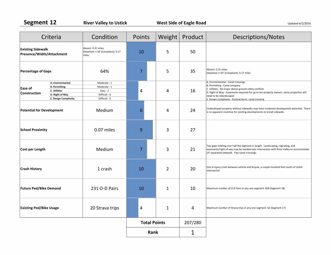
Segment 12 River Valley to Ustick West Side of Eagle Road Updated 6/2/2016
Absent: 0.31 miles
Detached >=10' (Compliant): 0.17
miles10 5 50
64% 7 5 35 Absent: 0.31 miles
Detached >=10' (Compliant): 0.17 miles
A. Environmental Moderate ‐ 1
B. Permitting Moderate ‐ 1
C. Utilities Easy ‐ 2
D. Right of Way Difficult ‐ 0
E. Design Complexity Difficult ‐ 0
Medium 6 4 24 Undeveloped property without sidewalks may have moderate development potential. There
is no apparent incentive for existing developments to install sidewalk.
0.07 miles 9 3 27
Medium 7 3 21Two gaps totaling over half the segment in length. Landscaping, regrading, and
easements/right of way may be needed near intersection with River Valley to accommodate
10' separated sidewalk. Two canal crossings.
1 crash 10 2 20 One A‐injury crash between vehicle and bicycle, a couple hundred feet south of Ustick
intersection
231 O‐D Pairs 10 1 10 Maximum number of O‐D Pairs in any one segment: 858 (Segment 18)
20 Strava trips 4 1 4 Maximum number of Strava trips in any one segment: 62 (Segment 17)
207/280
1
Total Points
Rank
Weight
4
Existing Ped/Bike Usage
Crash History
Percentage of Gaps
Future Ped/Bike Demand
School Proximity
Cost per Length
Potential for Development
Descriptions/NotesPointsCondition
Ease of Construction
Criteria
Existing Sidewalk Presence/Width/Attachment
4
A. Environmental ‐ Canal crossings
B. Permitting ‐ Canal company
C. Utilities ‐ No major above‐ground utility conflicts
D. Right of Way ‐ Easements required for up to ten property owners, some properties will
need to be relandscaped
E. Design Complexity ‐ Existing berm, canal crossing
Product
16

Segment 13‐M Ustick to City Limit East Side of Eagle Road Updated 6/2/2016
Detached <10': 0.25 miles 2 5 10
0% 0 5 0 Detached <10': 0.25 miles
A. Environmental Easy ‐ 2
B. Permitting Easy ‐ 2
C. Utilities Easy ‐ 2
D. Right of Way Easy ‐ 2
E. Design Complexity Easy ‐ 2
Low 10 4 40 There is no apparent incentive for existing developments to replace sidewalk.
0.42 miles 2 3 6
Medium 7 3 21Separated 8' meandering sidewalk. Additional easements/right of way should be minor,
because work should consist of replacing existing sidewalk with slightly wider non‐
meandering sidewalk.
0 crashes 0 2 0 Maximum number of ped/bike crashes in any one segment: 1 (Segments 3, 5, & 12)
1 O‐D Pairs 0 1 0 Maximum number of O‐D Pairs in any one segment: 858 (Segment 18)
43 Strava trips 7 1 7 Maximum number of Strava trips in any one segment: 62 (Segment 17)
124/280
16
Total Points
Rank
Weight
4
Existing Ped/Bike Usage
Crash History
Percentage of Gaps
Future Ped/Bike Demand
School Proximity
Cost per Length
Potential for Development
Descriptions/NotesPointsCondition
Ease of Construction
Criteria
Existing Sidewalk Presence/Width/Attachment
10
A. Environmental ‐ Minimal/none
B. Permitting ‐ Minimal/none
C. Utilities ‐ No major above‐ground utility conflicts
D. Right of Way ‐ Entire segment already has sidewalks in easements; possible business sign
relocations
E. Design Complexity ‐ Straight‐forward sidewalk construction
Product
40
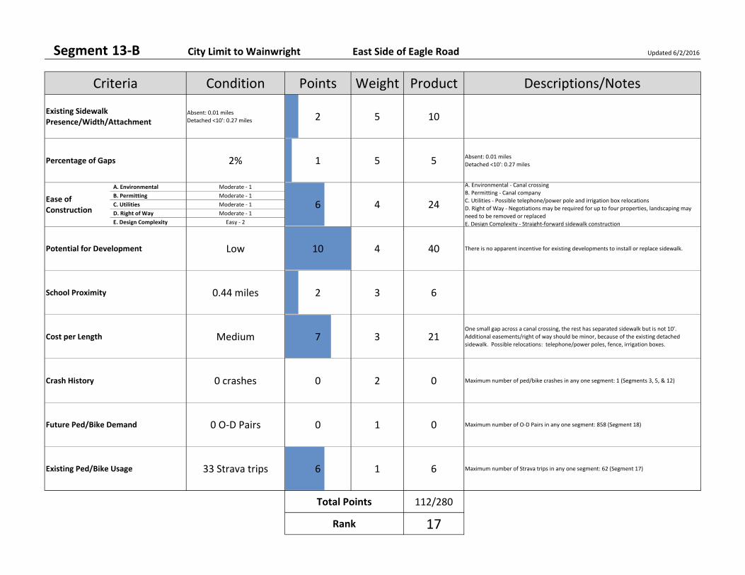
Segment 13‐B City Limit to Wainwright East Side of Eagle Road Updated 6/2/2016
Absent: 0.01 miles
Detached <10': 0.27 miles 2 5 10
2% 1 5 5 Absent: 0.01 miles
Detached <10': 0.27 miles
A. Environmental Moderate ‐ 1
B. Permitting Moderate ‐ 1
C. Utilities Moderate ‐ 1
D. Right of Way Moderate ‐ 1
E. Design Complexity Easy ‐ 2
Low 10 4 40 There is no apparent incentive for existing developments to install or replace sidewalk.
0.44 miles 2 3 6
Medium 7 3 21One small gap across a canal crossing, the rest has separated sidewalk but is not 10'.
Additional easements/right of way should be minor, because of the existing detached
sidewalk. Possible relocations: telephone/power poles, fence, irrigation boxes.
0 crashes 0 2 0 Maximum number of ped/bike crashes in any one segment: 1 (Segments 3, 5, & 12)
0 O‐D Pairs 0 1 0 Maximum number of O‐D Pairs in any one segment: 858 (Segment 18)
33 Strava trips 6 1 6 Maximum number of Strava trips in any one segment: 62 (Segment 17)
112/280
17
Total Points
Rank
Weight
4
Existing Ped/Bike Usage
Crash History
Percentage of Gaps
Future Ped/Bike Demand
School Proximity
Cost per Length
Potential for Development
Descriptions/NotesPointsCondition
Ease of Construction
Criteria
Existing Sidewalk Presence/Width/Attachment
6
A. Environmental ‐ Canal crossing
B. Permitting ‐ Canal company
C. Utilities ‐ Possible telephone/power pole and irrigation box relocations
D. Right of Way ‐ Negotiations may be required for up to four properties, landscaping may
need to be removed or replaced
E. Design Complexity ‐ Straight‐forward sidewalk construction
Product
24
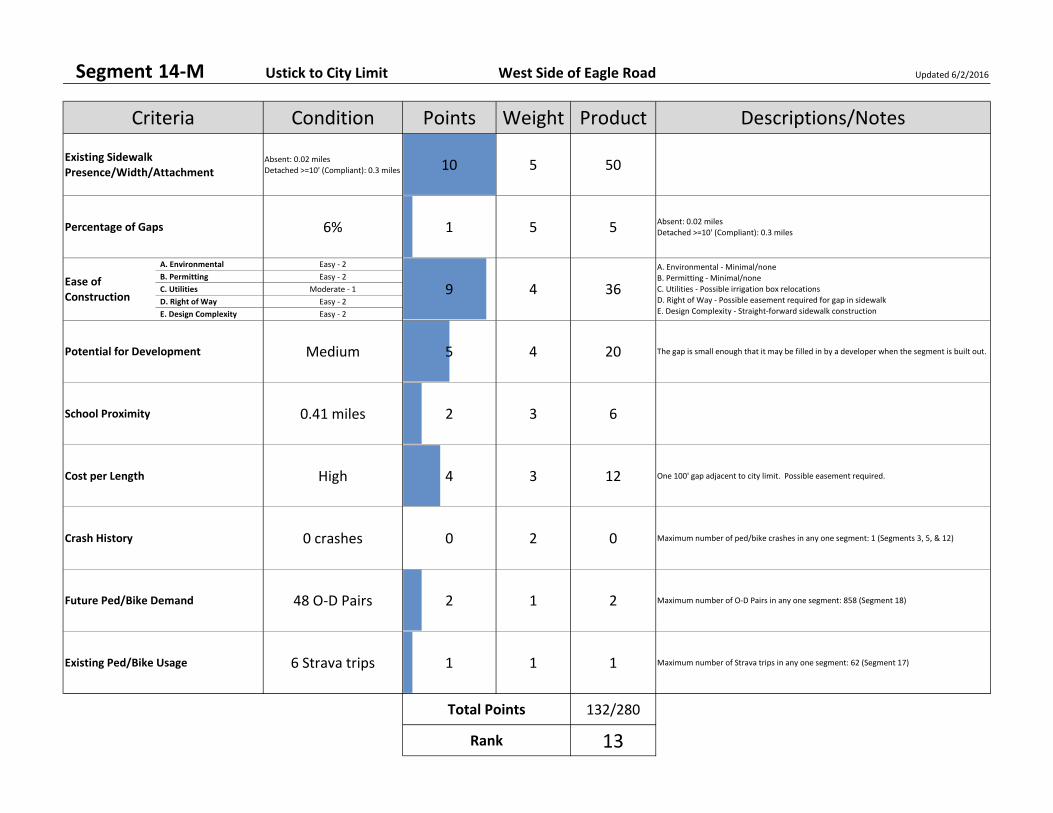
Segment 14‐M Ustick to City Limit West Side of Eagle Road Updated 6/2/2016
Absent: 0.02 miles
Detached >=10' (Compliant): 0.3 miles 10 5 50
6% 1 5 5 Absent: 0.02 miles
Detached >=10' (Compliant): 0.3 miles
A. Environmental Easy ‐ 2
B. Permitting Easy ‐ 2
C. Utilities Moderate ‐ 1
D. Right of Way Easy ‐ 2
E. Design Complexity Easy ‐ 2
Medium 5 4 20 The gap is small enough that it may be filled in by a developer when the segment is built out.
0.41 miles 2 3 6
High 4 3 12 One 100' gap adjacent to city limit. Possible easement required.
0 crashes 0 2 0 Maximum number of ped/bike crashes in any one segment: 1 (Segments 3, 5, & 12)
48 O‐D Pairs 2 1 2 Maximum number of O‐D Pairs in any one segment: 858 (Segment 18)
6 Strava trips 1 1 1 Maximum number of Strava trips in any one segment: 62 (Segment 17)
132/280
13
Total Points
Rank
Weight
4
Existing Ped/Bike Usage
Crash History
Percentage of Gaps
Future Ped/Bike Demand
School Proximity
Cost per Length
Potential for Development
Descriptions/NotesPointsCondition
Ease of Construction
Criteria
Existing Sidewalk Presence/Width/Attachment
9
A. Environmental ‐ Minimal/none
B. Permitting ‐ Minimal/none
C. Utilities ‐ Possible irrigation box relocations
D. Right of Way ‐ Possible easement required for gap in sidewalk
E. Design Complexity ‐ Straight‐forward sidewalk construction
Product
36
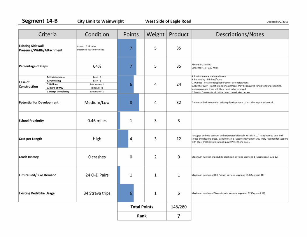
Segment 14‐B City Limit to Wainwright West Side of Eagle Road Updated 6/2/2016
Absent: 0.13 miles
Detached <10': 0.07 miles 7 5 35
64% 7 5 35 Absent: 0.13 miles
Detached <10': 0.07 miles
A. Environmental Easy ‐ 2
B. Permitting Easy ‐ 2
C. Utilities Moderate ‐ 1
D. Right of Way Difficult ‐ 0
E. Design Complexity Moderate ‐ 1
Medium/Low 8 4 32 There may be incentive for existing developments to install or replace sidewalk.
0.46 miles 1 3 3
High 4 3 12Two gaps and two sections with separated sidewalk less than 10'. May have to deal with
slopes and clearing trees. Canal crossing. Easements/right of way likely required for sections
with gaps. Possible relocations: power/telephone poles.
0 crashes 0 2 0 Maximum number of ped/bike crashes in any one segment: 1 (Segments 3, 5, & 12)
24 O‐D Pairs 1 1 1 Maximum number of O‐D Pairs in any one segment: 858 (Segment 18)
34 Strava trips 6 1 6 Maximum number of Strava trips in any one segment: 62 (Segment 17)
148/280
7
Total Points
Rank
Weight
4
Existing Ped/Bike Usage
Crash History
Percentage of Gaps
Future Ped/Bike Demand
School Proximity
Cost per Length
Potential for Development
Descriptions/NotesPointsCondition
Ease of Construction
Criteria
Existing Sidewalk Presence/Width/Attachment
6
A. Environmental ‐ Minimal/none
B. Permitting ‐ Minimal/none
C. Utilities ‐ Possible telephone/power pole relocations
D. Right of Way ‐ Negotiations or easements may be required for up to four properties,
landscaping and trees will likely need to be removed
E. Design Complexity ‐ Existing berm complicates design
Product
24
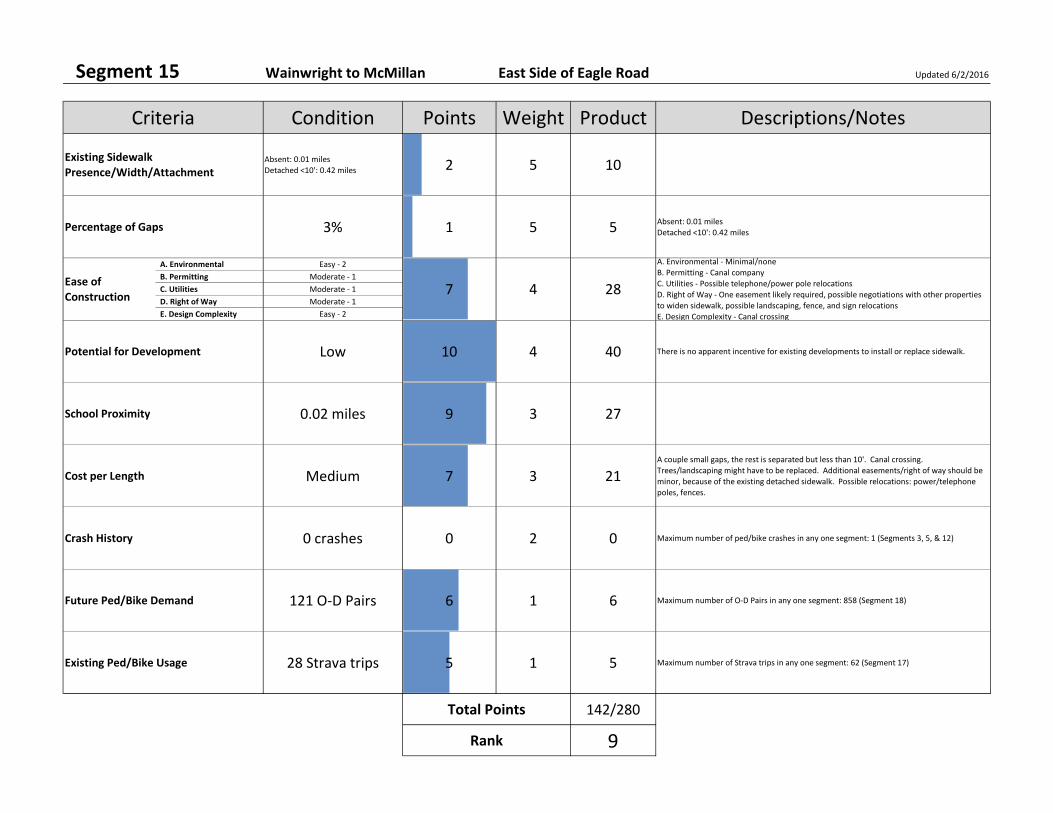
Segment 15 Wainwright to McMillan East Side of Eagle Road Updated 6/2/2016
Absent: 0.01 miles
Detached <10': 0.42 miles 2 5 10
3% 1 5 5 Absent: 0.01 miles
Detached <10': 0.42 miles
A. Environmental Easy ‐ 2
B. Permitting Moderate ‐ 1
C. Utilities Moderate ‐ 1
D. Right of Way Moderate ‐ 1
E. Design Complexity Easy ‐ 2
Low 10 4 40 There is no apparent incentive for existing developments to install or replace sidewalk.
0.02 miles 9 3 27
Medium 7 3 21A couple small gaps, the rest is separated but less than 10'. Canal crossing.
Trees/landscaping might have to be replaced. Additional easements/right of way should be
minor, because of the existing detached sidewalk. Possible relocations: power/telephone
poles, fences.
0 crashes 0 2 0 Maximum number of ped/bike crashes in any one segment: 1 (Segments 3, 5, & 12)
121 O‐D Pairs 6 1 6 Maximum number of O‐D Pairs in any one segment: 858 (Segment 18)
28 Strava trips 5 1 5 Maximum number of Strava trips in any one segment: 62 (Segment 17)
142/280
9
Total Points
Rank
Weight
4
Existing Ped/Bike Usage
Crash History
Percentage of Gaps
Future Ped/Bike Demand
School Proximity
Cost per Length
Potential for Development
Descriptions/NotesPointsCondition
Ease of Construction
Criteria
Existing Sidewalk Presence/Width/Attachment
7
A. Environmental ‐ Minimal/none
B. Permitting ‐ Canal company
C. Utilities ‐ Possible telephone/power pole relocations
D. Right of Way ‐ One easement likely required, possible negotiations with other properties
to widen sidewalk, possible landscaping, fence, and sign relocations
E. Design Complexity ‐ Canal crossing
Product
28
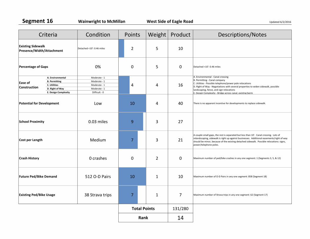
Segment 16 Wainwright to McMillan West Side of Eagle Road Updated 6/2/2016
Detached <10': 0.46 miles 2 5 10
0% 0 5 0 Detached <10': 0.46 miles
A. Environmental Moderate ‐ 1
B. Permitting Moderate ‐ 1
C. Utilities Moderate ‐ 1
D. Right of Way Moderate ‐ 1
E. Design Complexity Difficult ‐ 0
Low 10 4 40 There is no apparent incentive for developments to replace sidewalk.
0.03 miles 9 3 27
Medium 7 3 21A couple small gaps, the rest is separated but less than 10'. Canal crossing. Lots of
relandscaping, sidewalk is right up against businesses. Additional easements/right of way
should be minor, because of the existing detached sidewalk. Possible relocations: signs,
power/telephone poles.
0 crashes 0 2 0 Maximum number of ped/bike crashes in any one segment: 1 (Segments 3, 5, & 12)
512 O‐D Pairs 10 1 10 Maximum number of O‐D Pairs in any one segment: 858 (Segment 18)
38 Strava trips 7 1 7 Maximum number of Strava trips in any one segment: 62 (Segment 17)
131/280
14
Total Points
Rank
Weight
4
Existing Ped/Bike Usage
Crash History
Percentage of Gaps
Future Ped/Bike Demand
School Proximity
Cost per Length
Potential for Development
Descriptions/NotesPointsCondition
Ease of Construction
Criteria
Existing Sidewalk Presence/Width/Attachment
4
A. Environmental ‐ Canal crossing
B. Permitting ‐ Canal company
C. Utilities ‐ Possible telephone/power pole relocations
D. Right of Way ‐ Negotiations with several properties to widen sidewalk, possible
landscaping, fence, and sign relocations
E. Design Complexity ‐ Bridge across canal, existing berm
Product
16
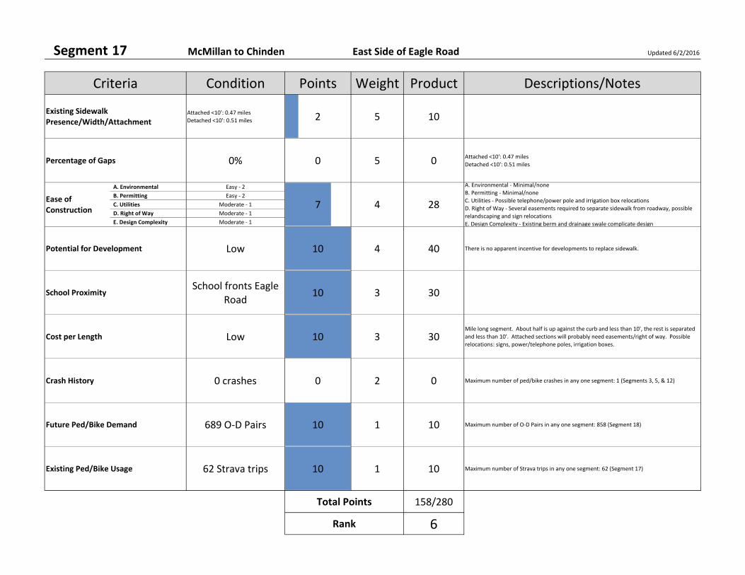
Segment 17 McMillan to Chinden East Side of Eagle Road Updated 6/2/2016
Attached <10': 0.47 miles
Detached <10': 0.51 miles 2 5 10
0% 0 5 0 Attached <10': 0.47 miles
Detached <10': 0.51 miles
A. Environmental Easy ‐ 2
B. Permitting Easy ‐ 2
C. Utilities Moderate ‐ 1
D. Right of Way Moderate ‐ 1
E. Design Complexity Moderate ‐ 1
Low 10 4 40 There is no apparent incentive for developments to replace sidewalk.
School fronts Eagle Road
10 3 30
Low 10 3 30Mile long segment. About half is up against the curb and less than 10', the rest is separated
and less than 10'. Attached sections will probably need easements/right of way. Possible
relocations: signs, power/telephone poles, irrigation boxes.
0 crashes 0 2 0 Maximum number of ped/bike crashes in any one segment: 1 (Segments 3, 5, & 12)
689 O‐D Pairs 10 1 10 Maximum number of O‐D Pairs in any one segment: 858 (Segment 18)
62 Strava trips 10 1 10 Maximum number of Strava trips in any one segment: 62 (Segment 17)
158/280
6
Total Points
Rank
Weight
4
Existing Ped/Bike Usage
Crash History
Percentage of Gaps
Future Ped/Bike Demand
School Proximity
Cost per Length
Potential for Development
Descriptions/NotesPointsCondition
Ease of Construction
Criteria
Existing Sidewalk Presence/Width/Attachment
7
A. Environmental ‐ Minimal/none
B. Permitting ‐ Minimal/none
C. Utilities ‐ Possible telephone/power pole and irrigation box relocations
D. Right of Way ‐ Several easements required to separate sidewalk from roadway, possible
relandscaping and sign relocations
E. Design Complexity ‐ Existing berm and drainage swale complicate design
Product
28

Segment 18 McMillan to Chinden West Side of Eagle Road Updated 6/2/2016
Attached <10': 0.11 miles
Detached <10': 0.88 miles 2 5 10
0% 0 5 0 Attached <10': 0.11 miles
Detached <10': 0.88 miles
A. Environmental Easy ‐ 2
B. Permitting Easy ‐ 2
C. Utilities Moderate ‐ 1
D. Right of Way Easy ‐ 2
E. Design Complexity Moderate ‐ 1
Low 10 4 40 There is no apparent incentive for developments to replace sidewalk.
0.02 miles 9 3 27
Low 10 3 30Mile long segment. Sidewalks are continuous and separated but are not 10' wide. North of
the athletic park the sidewalk is on a slope with landscaping on both sides. Easements/right
of way not likely needed. Possible relocations: power/telephone and light poles.
0 crashes 0 2 0 Maximum number of ped/bike crashes in any one segment: 1 (Segments 3, 5, & 12)
858 O‐D Pairs 10 1 10 Maximum number of O‐D Pairs in any one segment: 858 (Segment 18)
53 Strava trips 10 1 10 Maximum number of Strava trips in any one segment: 62 (Segment 17)
159/280
5
Total Points
Rank
Weight
4
Existing Ped/Bike Usage
Crash History
Percentage of Gaps
Future Ped/Bike Demand
School Proximity
Cost per Length
Potential for Development
Descriptions/NotesPointsCondition
Ease of Construction
Criteria
Existing Sidewalk Presence/Width/Attachment
8
A. Environmental ‐ Minimal/none
B. Permitting ‐ Minimal/none
C. Utilities ‐ Possible lighting or telephone/power pole relocations
D. Right of Way ‐ Entire segment already has sidewalks in easements; minor negotiations
E. Design Complexity ‐ Existing berm complicates design
Product
32
Eagle Road Corridor
Appendix B Phase 2 Supplements
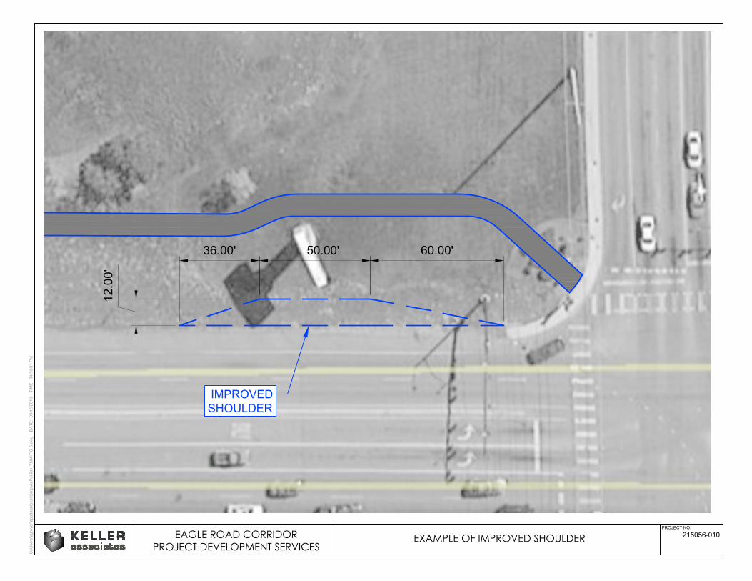
C:\U
sers\agrover\appdata\local\tem
p\A
cP
ublish_7504\F
IG
5.dw
g D
AT
E: 09/15/2016 T
IM
E: 04:56:01 P
M
PROJECT NO:
215056-010
12.00'
36.00' 50.00' 60.00'
IMPROVED
SHOULDER
EAGLE ROAD CORRIDORPROJECT DEVELOPMENT SERVICES
EXAMPLE OF IMPROVED SHOULDER